Planning and Development
Committee
Agenda
5 April 2022
Notice is hereby given, in
accordance with the provisions of the Local Government Act 1993 that a Planning and Development Committee meeting of ORANGE CITY COUNCIL
will be held in the Council Chamber,
Civic Centre, Byng Street, Orange on Tuesday, 5 April 2022.
David
Waddell
Chief Executive Officer
For apologies please
contact Administration on 6393 8106.
1 Introduction
1.1 Declaration
of pecuniary interests, significant non-pecuniary interests and less than
significant non-pecuniary interests
The
provisions of Chapter 14 of the Local Government Act, 1993 (the Act)
regulate the way in which Councillors and designated staff of Council conduct
themselves to ensure that there is no conflict between their private interests
and their public role.
The
Act prescribes that where a member of Council (or a Committee of Council) has a
direct or indirect financial (pecuniary) interest in a matter to be considered
at a meeting of the Council (or Committee), that interest must be disclosed as
soon as practicable after the start of the meeting and the reasons given for declaring
such interest.
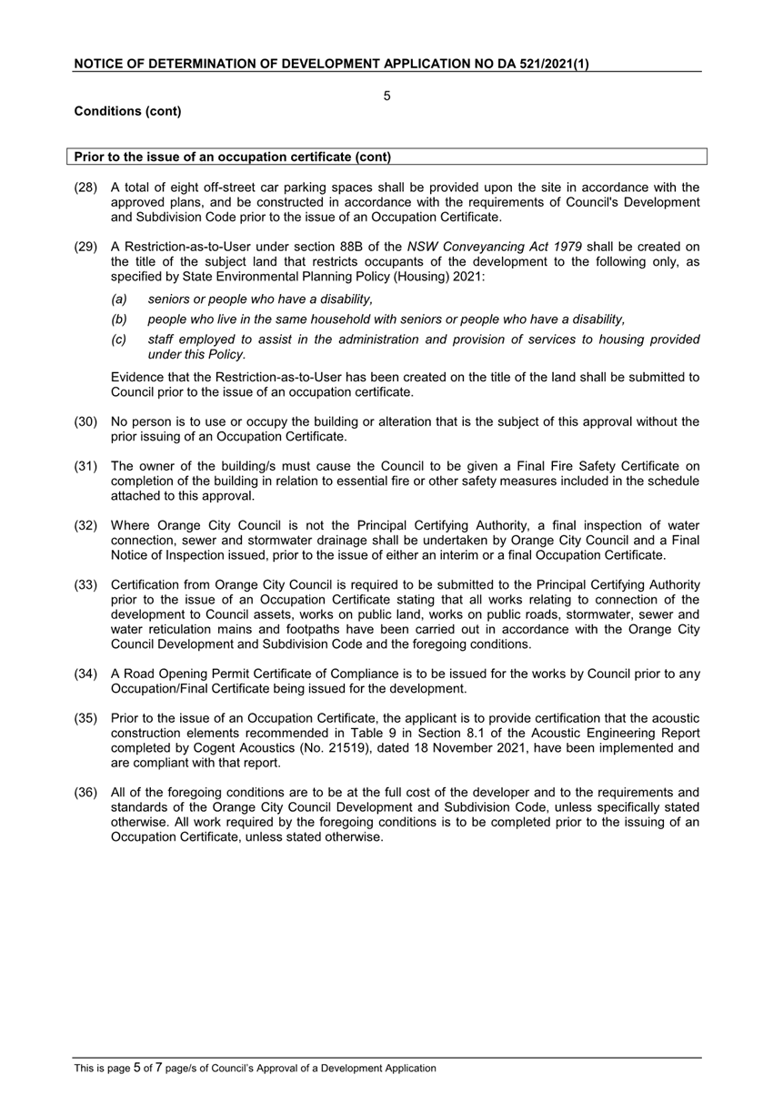
As
members are aware, the provisions of the Local Government Act restrict any
member who has declared a pecuniary interest in any matter from participating
in the discussion or voting on that matter, and requires that member to vacate
the Chamber.
Council’s Code of Conduct provides that if members
have a non-pecuniary conflict of interest, the nature of the conflict must be
disclosed. The Code of Conduct also provides for a number of ways in which a
member may manage non pecuniary conflicts of interest.
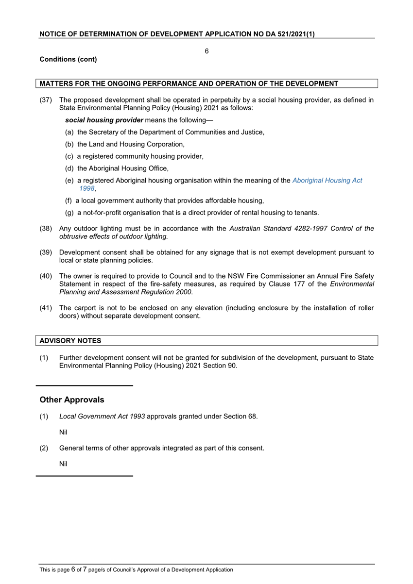
|
Recommendation
It is recommended that Committee Members now disclose any
conflicts of interest in matters under consideration by the Planning and
Development Committee at this meeting.
|
2 General
Reports
2.1 Items
Approved Under the Delegated Authority of Council
RECORD
NUMBER: 2022/241
AUTHOR: Paul
Johnston, Manager Development Assessments
EXECUTIVE Summary
Following is a list of more significant development
applications approved by the Chief Executive Officer under the delegated
authority of Council. Not included in this list are residential scale
development applications that have also been determined by staff under the
delegated authority of Council (see last paragraph of this report for those
figures).
Link To Delivery/OPerational Plan
The recommendation in this report
relates to the Delivery/Operational Plan Strategy “7.1 Preserve - Engage
with the community to develop plans for growth and development that value the
local environment”.
Financial Implications
Nil
Policy and Governance Implications
Nil
|
Recommendation
That Council resolves to
acknowledge the information provided in the report by the Manager Development
Assessments on Items Approved Under the Delegated Authority of Council.
|
further considerations
Consideration has been given to the recommendation’s
impact on Council’s service delivery; image and reputation; political;
environmental; health and safety; employees; stakeholders and project
management; and no further implications or risks have been identified.
|
Reference:
|
DA 171/2007(3)
|
Determination Date:
|
21 February 2022
|
|
PR Number
|
PR2315
|
|
Applicant/s:
|
Mrs TA Fenton
|
|
Owner/s:
|
Mrs TA Fenton
|
|
Location:
|
Lot 4 DP 715252 - 1 Borrodell
Drive, Orange
|
|
Proposal:
|
Modification of development consent
- subdivision (seven lot residential). The modified proposal sought to create
two stages for the construction and release of the lots, by excising the
existing dwelling from the development site as Stage One, and then further
subdivision of the development site as Stage Two. Changes to lot
boundaries are proposed, however, lot yield remains as previously approved.
|
|
Value:
|
N/A
|
|
Reference:
|
DA 405/2017(5)
|
Determination Date:
|
9 March 2022
|
|
PR Number
|
PR10141
|
|
Applicant/s:
|
Orange Evangelical (OEC) Church
Incorporated
|
|
Owner/s:
|
Orange Evangelical (OEC) Church
Incorporated
|
|
Location:
|
Lot 9 DP 746439 - 2 Cottonwood Way,
Orange
(formerly known as 241 Ploughmans
Lane)
|
|
Proposal:
|
Modification of development consent
- place of public worship and business identification sign. The modified
proposal involves amended site entrance treatment, business identification
signage and internal pedestrian paths (levels and location).
|
|
Value:
|
N/A
|
|
Reference:
|
DA 214/2021(2)
|
Determination Date:
|
9 March 2022
|
|
PR Number
|
PR12120
|
|
Applicant/s:
|
Saunders and Staniforth Pty Ltd
|
|
Owner/s:
|
Mr BW and Mrs KL Draper
|
|
Location:
|
Lot 11 DP700977 - 207 Canobolas
Road, Orange
|
|
Proposal:
|
Modification of development consent
– subdivision. The modified proposal involves changes to the equine and
dwelling building envelope on Lot 101. The proposal also involves the
relocation of the access point of Lot 101 to a more central point along
Canobolas Road.
|
|
Value:
|
N/A
|
|
Reference:
|
DA 227/2021(1)
|
Determination Date:
|
7 March 2022
|
|
PR Number
|
PR19769
|
|
Applicant/s:
|
Spectrum Retail Group
|
|
Owner/s:
|
Peter Terry Nominees Pty Limited
|
|
Location:
|
Lot 10 DP1069827 - 2-6 Bathurst
Road, Orange
|
|
Proposal:
|
Demolition (existing buildings and
hardstand area), takeaway food and drink premises (new construction) and
business identification signage
|
|
Value:
|
$1,312,594.00
|
|
Reference:
|
DA 470/2021(1)
|
Determination Date:
|
28 February 2022
|
|
PR Number
|
PR14163
|
|
Applicant/s:
|
Erolwren Pty Limited
|
|
Owner/s:
|
Erolwren Pty Limited
|
|
Location:
|
Lot 1 DP 392443, Lot 1 DP 213505,
Lot 2 DP 213505, Lot 102 DP 562456
85-107 Glenroi Avenue, Orange
|
|
Proposal:
|
Subdivision (consolidation and
boundary adjustment: four lots into three lots)
|
|
Value:
|
N/A
|
|
Reference:
|
DA 499/2021(1)
|
Determination Date:
|
28 February 2022
|
|
PR Number
|
PR25281
|
|
Applicant/s:
|
Voerman and Ratsep
|
|
Owner/s:
|
Housing Plus
|
|
Location:
|
Lot 124 DP 1156423 - 260-266
Phillip Street, Orange
|
|
Proposal:
|
Subdivision (16 lot Strata title)
|
|
Value:
|
N/A
|
|
Reference:
|
DA 501/2021(1)
|
Determination Date:
|
7 March 2022
|
|
PR Number
|
PR7083
|
|
Applicant/s:
|
C/-
Andrew Saunders
|
|
Owner/s:
|
AMP
Pastoral Pty Limited
|
|
Location:
|
Lot 100
DP 1226302
|
|
Proposal:
|
Hotel or motel accommodation
(internal alterations - apartment conversion)
|
|
Value:
|
$18,000
|
|
Reference:
|
DA 522/2021(1)
|
Determination Date:
|
11 March 2022
|
|
PR Number
|
PR21749
|
|
Applicant/s:
|
Housing Plus
|
|
Owner/s:
|
Housing Plus
|
|
Location:
|
Lot 1 DP 1101782 - 72A Icely Road,
Orange
|
|
Proposal:
|
Subdivision (eleven lot Community
title)
|
|
Value:
|
N/A
|
|
Reference:
|
DA 535/2021(1)
|
Determination Date:
|
11 March 2022
|
|
PR Number
|
PR24686
|
|
Applicant/s:
|
Voerman and Ratsep
|
|
Owner/s:
|
Housing Plus
|
|
Location:
|
Lot 101 DP 1160763 - 21-25
Bletchington Street, Orange
|
|
Proposal:
|
Subdivision (12 lot Community
title)
|
|
Value:
|
N/A
|
|
Reference:
|
DA 541/2021(1)
|
Determination Date:
|
28 February 2022
|
|
PR Number
|
PR25813
|
|
Applicant/s:
|
Saunders and Staniforth Pty Ltd
|
|
Owner/s:
|
Mr MA and Mrs H Foley
|
|
Location:
|
Lot 9 DP 1176470 - 2 Atlas Place,
Orange
|
|
Proposal:
|
General Industrial (construction of
nine units)
|
|
Value:
|
$800,000
|
|
Reference:
|
DA 543/2021(1)
|
Determination Date:
|
28 February 2022
|
|
PR Number
|
PR28970
|
|
Applicant/s:
|
Mr B Kattuvallil Garvasees
|
|
Owner/s:
|
Mr B Kattuvallil Garvasees
|
|
Location:
|
Lot 64 DP 1274510 - 4 Mountain
Vista, Orange
|
|
Proposal:
|
Subdivision (two lot Torrens title)
|
|
Value:
|
N/A
|
|
Reference:
|
DA 552/2021(1)
|
Determination Date:
|
28 February 2022
|
|
PR Number
|
PR7212
|
|
Applicant/s:
|
Mrs JL Regan
|
|
Owner/s:
|
Mr KL and Mrs JL Regan
|
|
Location:
|
Lot 58 DP 602098 - 15 Catto Close,
Orange
|
|
Proposal:
|
Demolition (tree removal)
|
|
Value:
|
$2,000
|
|
Reference:
|
DA 15/2022(1)
|
Determination Date:
|
7 March 2022
|
|
PR Number
|
PR25846
|
|
Applicant/s:
|
Source
Architects
|
|
Owner/s:
|
Mr BJ
and Mrs RJ Davis
|
|
Location:
|
Lot 18
DP 1057526- 87 Bargwanna Road, Spring Creek
|
|
Proposal:
|
Dwelling, attached garage, swimming
pool (inground) and pool fencing, tennis court and sheds
|
|
Value:
|
$2,148,900.00
|
|
Reference:
|
DA 34/2022(1)
|
Determination Date:
|
28 February 2022
|
|
PR Number
|
PR14873
|
|
Applicant/s:
|
Caladines Town Planning
|
|
Owner/s:
|
156-160 Summer Street Orange Pty
Ltd
Building F 44-54 Raglan Street
|
|
Location:
|
Lot 1 DP 196052 and Lot C DP 402112
- 156 Summer Street, Orange and
Lot 1 DP 743344, Lot 1 DP
572454, Lot 11 DP 1164287 - 158 Summer Street, Orange
|
|
Proposal:
|
Retail Premises (alterations - shop
fitout)
|
|
Value:
|
$250,000
|
TOTAL
NET* VALUE OF DEVELOPMENTS APPROVED BY THE CEO UNDER DELEGATED AUTHORITY IN
THIS PERIOD: $4,531,494.00
* Net value relates to the value of modifications.
If modifications are the same value as the original DA, then nil is added. If
there is a plus/minus difference, this difference is added or taken out.
Additionally, since the March 2022
meeting report period 17 February to 22 March 2022 to 2022), another 21
development applications were determined under delegated authority by other
Council staff with a combined value of $3,040,785.
2.2 Information
report - Employment Zones Reforms
RECORD
NUMBER: 2022/415
AUTHOR: Craig
Mortell, Senior Planner
EXECUTIVE Summary
The NSW Department of Planning and Environment (DPE) have
advised of an intended change to the standard LEP template with respect to
employment zones. The term ‘employment zones’ encompasses and
combines both the current business zones (B1 – B7) and the industrial
zones (IN1 – IN2). The Department intends to replace these zones with new
E zones and in doing so the number of zones available will be reduced.
This will alter every LEP in the state to one degree or
another and the local effects for Orange are discussed in this report. DPE
advise that a draft SEPP will be exhibited shortly to outline the changes and
provide for public input. It is understood that the exhibition will be
formatted in the style of an explanation of intended effects, rather than a
highly detailed form where the changes of each LEP are essentially finalised.
The finalisation of the employment zone changes is
anticipated to occur toward the end of the current year. The purpose of this
report is to enable Council to give direction and guidance to staff on any
further discussions and representations with DPE as they progress the reforms
to completion.
Link To Delivery/OPerational Plan
The recommendation in this report relates to the
Delivery/Operational Plan strategy “7.1 Preserve - Engage with the
community to develop plans for growth and development that value the local
environment”.
Financial Implications
Nil
Policy and Governance Implications
Nil
|
Recommendation
That Council acknowledge the content of this report and
advise the Department of Planning and Environment of the following concerns;
· The merging
of the B1 and B2 zones creates a risk to the established hierarchy of
commercial activity in Orange, such that it may result in pressure for more
out-of-centre shopping centres and supermarkets, and
· The merging
of the B5, B6 and B7 zones creates a risk to the established hierarchy of
commercial activity in Orange, such that it may result in a scattering of
specialised retail premises (a.k.a. bulky goods premises) across various
parts of Orange in an uncoordinated manner
· That both of
these risks are likely to undermine the trading performance of the Orange
CBD, which is a centre of regional significance providing higher order
services to the sub-region and beyond.
That Council request the Department of Planning and
Environment work with Council staff to identify and draft appropriate local
clauses and other mapping changes, such as
· Floor Space
Ratio limits on the current B1 land to reflect the neighbourhood scale these
sites have always been intended to serve, and limit the potential for out-of-centre
retail shopping.
· GFA limits on
the current B6 and B7 zoned land in relation to:
o Specialised retail
premises
o Landscaping and material
supplies
o Local distribution
centres
o Rural supplies
o Timber yards
|
further considerations
Consideration has been given to the recommendation’s
impact on Council’s service delivery; image and reputation; political;
environmental; health and safety; employees; stakeholders and project
management; and no further implications or risks have been identified.
SUPPORTING INFORMATION
Late last year (1 December) the Department of Planning and
Environment changed the designation of four zones from E (Environmental) to C
(Conservation). That change was negligible since the only change was to the
alphanumeric label for the zone. In all other respects the zones remained the
same, carrying over their objectives and land use tables intact.
In effect that change was a precursor to allow a change,
known as the employment zone reforms, to replace the (B) business and (IN) industrial
zones merging them into a single (E) employment category. However, employment
zone change goes further by reducing the overall number of zones for these
purposes.
Currently there are 12 B and IN zones, of which Orange has
adopted 9, and these are to be replaced with a total of 5 zones. This reduction
means that some zones will be ‘collapsed’ together and as a result
the objectives and land use tables of these zones will not be a direct one to
one conversion.
Some of the affected lands may have the range of permissible
uses broadened as they gain the uses currently limited to other zones.
The proposed reform consists of replacing all current B
(business) and IN (industrial) zones with a total of 5 new zones. The following
table illustrates how the zones in the Orange LEP would be translated.
|
Proposed zone
|
Current Orange LEP zone(s)
|
|
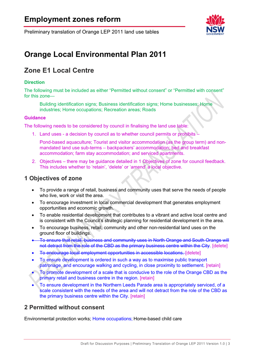
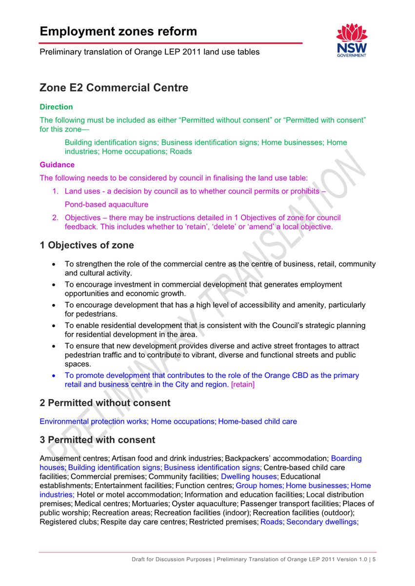
Zone E1 Local Centre
|
B1 and B2
|
|
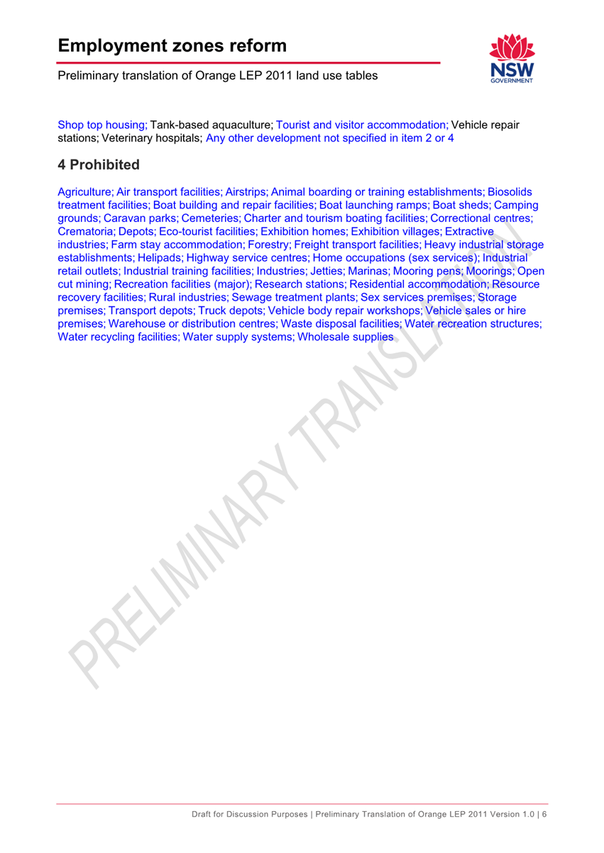
Zone E2 Commercial Centre
|
B3
|
|
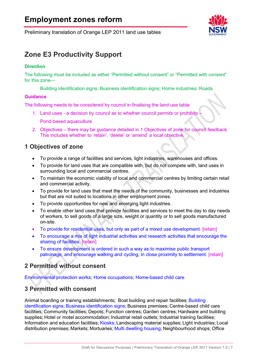
Zone E3 Productivity Support
|
B5, B6 and B7
|
|
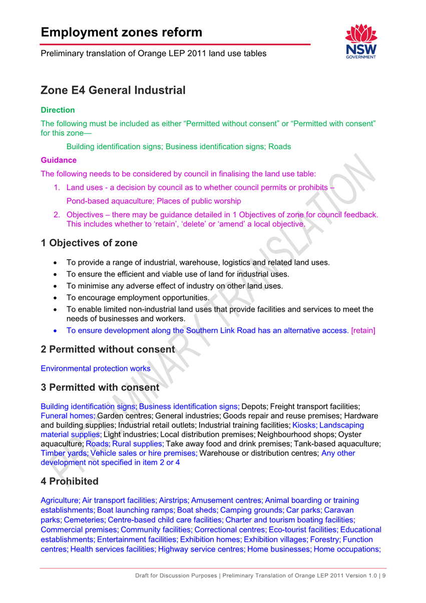
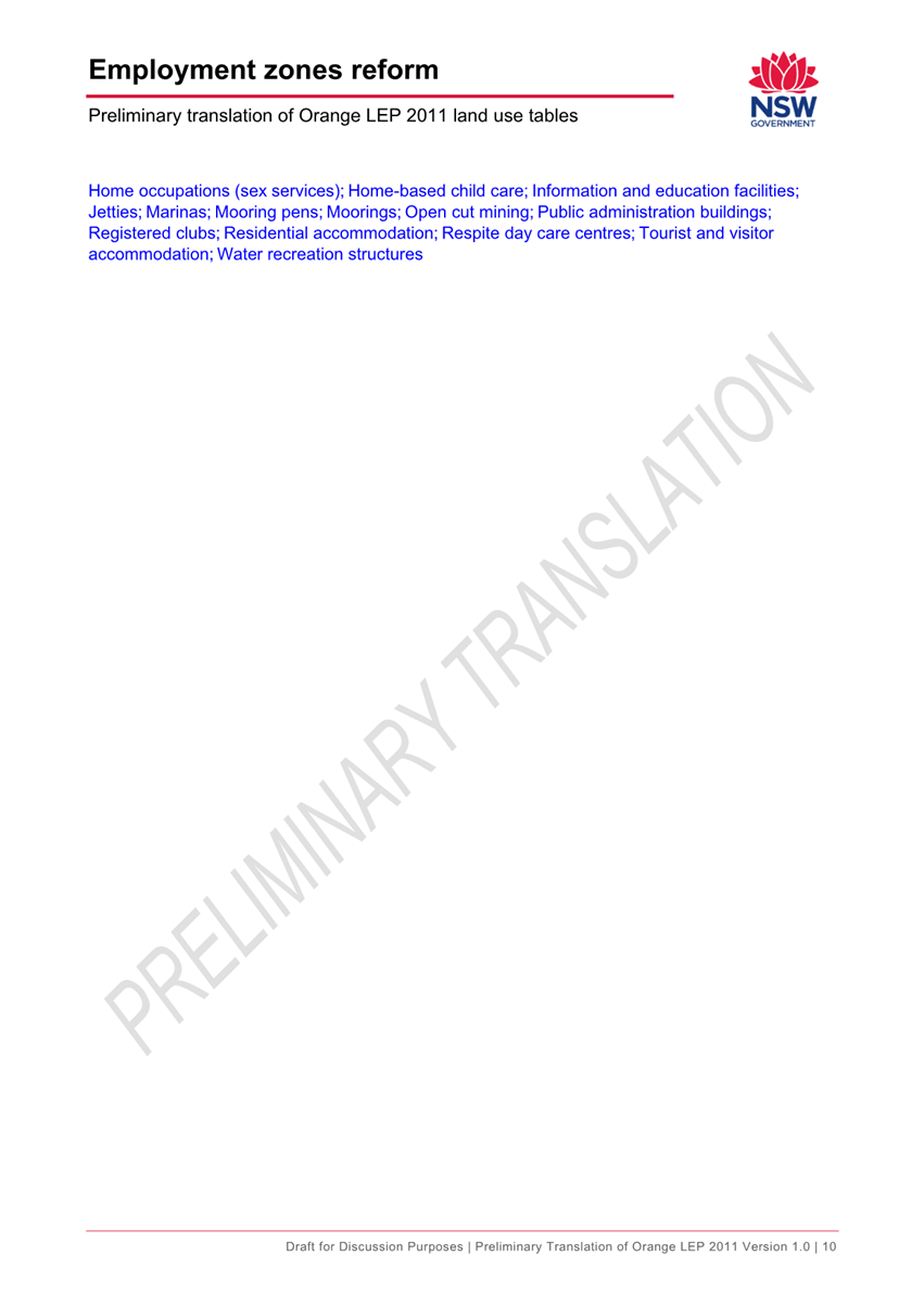
Zone E4 General Industrial
|
IN1 and IN2
|
|
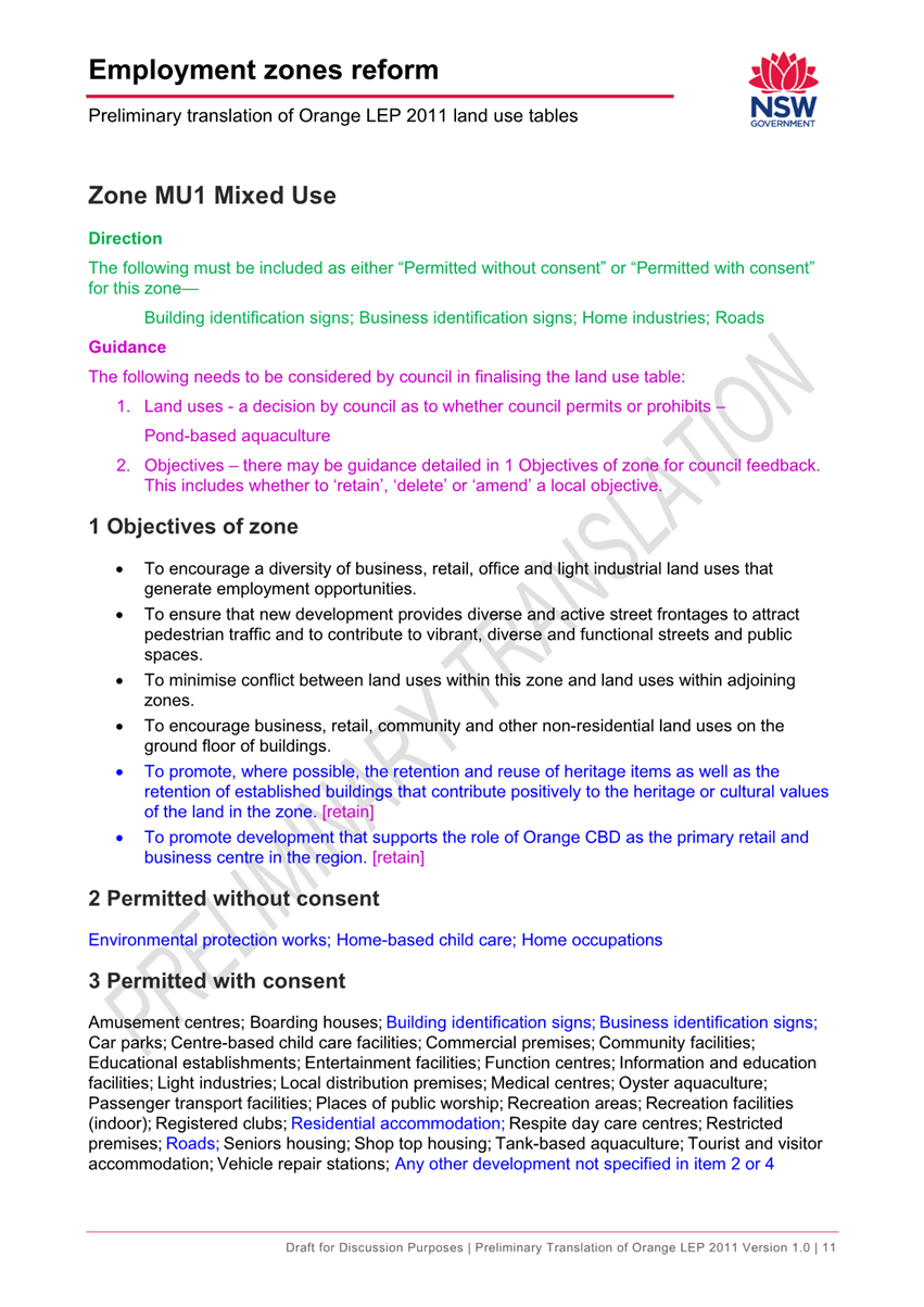
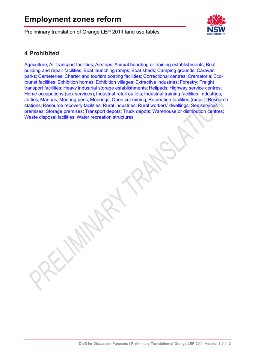
Zone MU1 Mixed Use
|
B4
|
Translation of the B3 into the E2
commercial Centre zone and the translation of the B4 into the MU1 Mixed Use
zone are supported as these zones are only replacing a single zone,
allowing the objectives and land use tables to remain essentially unchanged.
Figure
1 – existing B3 Commercial Core to become proposed E2 Commercial Centre
Zone
Figure
2 – existing B4 Mixed Use zone proposed to become MU1 Mixed Use zone
Translation of the IN1 and IN2
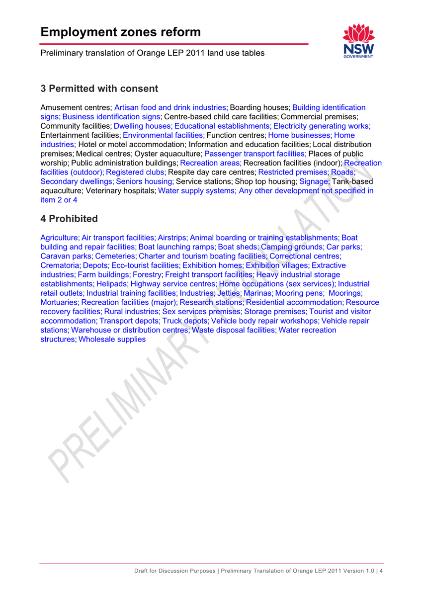
zones into a single E4 General Industrial zone is also supported. The
extent of difference between the IN1 and IN2 zones is minimal. The following
table shows the uses currently prohibited in one but not the other zone.
Figure
3 – Existing IN1 and IN2 zones to become proposed E4 General Industrial Zone
|
IN1 zone prohibitions
|
IN2 zone prohibitions
|
|
Animal
boarding or training establishments; Information and education facilities;
|
Biosolids
treatment facilities; Extractive industries; Heavy industrial storage
establishments; Recreation facilities (major); Recreation facilities
(outdoor); Rural industries; Sewage treatment plants; Sex services premises;
Water recycling facilities; Water supply systems
|
The merging of the IN1 and IN2 zones
into the E4 will broaden the locations where the above uses can occur. The
draft land use tables prepared by DPE suggest that the IN2 prohibitions above
be lifted while the IN1 prohibitions to remain, this reflects that the IN1
prohibitions involve uses that would potentially draw in light vehicle traffic
into areas with significant heavy vehicle movements, whereas the IN2
prohibitions were largely related to potential interface concerns. In most
cases it is considered that market forces will adequately guide site selection
of the above uses.
Translation of the B1 and B2 zones
into the E1 Local Centre zone is problematic as this would result in small
neighbourhood shops such as Greengate, Woodward Street shops and others having
the same zone and status as the north orange shopping centre.
In theory, this could result in a
developer seeking to buy up an existing B1 cluster and proposing to redevelop
with a full line supermarket and specialty shops. If this were to occur it
could undermine the trading performance of the existing CBD. The likelihood of
this occurring is considered minor in most instances as the area of land
available in most B1 zoned areas is relatively small as shown in figure 4.
However larger B1 zones have been
created further out in Shiralee and in a planned subdivision area east of Leeds
Parade, which have areas comparable to the B2 zones at North Orange and on
Forest Road south of the hospital as shown on figure 5. Discussions with
DPE have indicated that Council can seek to have a local clause that would
impose a retail floor space ratio (FSR) limit on the current B1 lands such that
this scenario would be far less likely to occur.
Council could also seek to have
supermarkets prohibited in the new E1 zone (only allowing Neighbourhood
Supermarkets which have a cap of 1000m2) and create an Additional Permitted Use
(APU) over the existing north orange shopping centre to ensure that development
remained permissible.
 Figure 4 – existing B1 zones applying to
traditional neighbourhood shop clusters.
Figure 4 – existing B1 zones applying to
traditional neighbourhood shop clusters.
Figure
5 – map all B1 and B2 zoned areas (Shiralee and Leeds Parade sites
substantially larger)
Translation of the B5, B6 and B7
zones into the E3 Productivity Support zone also raises concerns as this
would create a similar concern in relation to Specialised Retail Premises (also
known as bulky goods premises). Currently the only potential for out-of-centre
specialised retail premises is in the B5 zone, which applies to the Homemaker
Centre, former Prime TV site and a child care centre on the corner of Dalton
and McLachlan Streets.
Figure
6 - current B5 zoned lands
However once the three zones are
combined the new zone would encompass a much broader area of the city. The
current B5 lands are shown in figure 6, while figure 7 shows all
three affected zones that would be combined together into the new E3 zone.
 Figure 7 - current B5, B6 and B7 lands proposed to be
combined into a single E3 Productivity Support zone
Figure 7 - current B5, B6 and B7 lands proposed to be
combined into a single E3 Productivity Support zone
Discussions with DPE have indicated
that Council can seek a local clause to limit the gross floor area for any uses
of concern outside of the current B5 zone. i.e. specialised retail premises
could be limited to 300m2 or 400m2 other than at the established homemaker
centre site.
As an example DPE have indicated the
following (or similar) is likely to be part of the exhibition for a similar
regional council:
A new local provision
will be introduced which will set a maximum gross floor area of 400sqm for landscaping
material supplies, local distribution premises, rural supplies, specialised
retail premises, timber yards and vehicle sales and hire premises in
the E1 zone.
Council staff have indicated to DPE
that Orange may seek a similar provision, particularly in relation to
specialised retail premises. Of the other uses listed most are considered to be
appropriate to be included with the possible exception of vehicle sales and
hire premises as these already exist in the B6 zone and should not be
constrained simply due to the proposed change in zones.
The other uses stated are more
typical within our industrial zones and may not be relevant for the E3 zone in
Orange. However they are not considered to undermine the CBD performance given
that they would typically require a large footprint and would not compete with
other uses for CBD land values.
In view of the above staff have
advised DPE that Orange would likely seek to have some delineation within the
proposed E1 and E3 zones to reflect the above stated concerns. DPE have advised
that the upcoming SEPP exhibition will set out the intended effects (similar to
the above example) rather than the final wording of specific clauses. This will
allow scope for Council, or others, to make submissions to further guide the
final drafting of the changes.
Attachments
1 Draft
Land Use Tables prepared by Department of Planning and Environment, D22/16928⇩
Attachment 1 Draft
Land Use Tables prepared by Department of Planning and Environment
2.3 Development
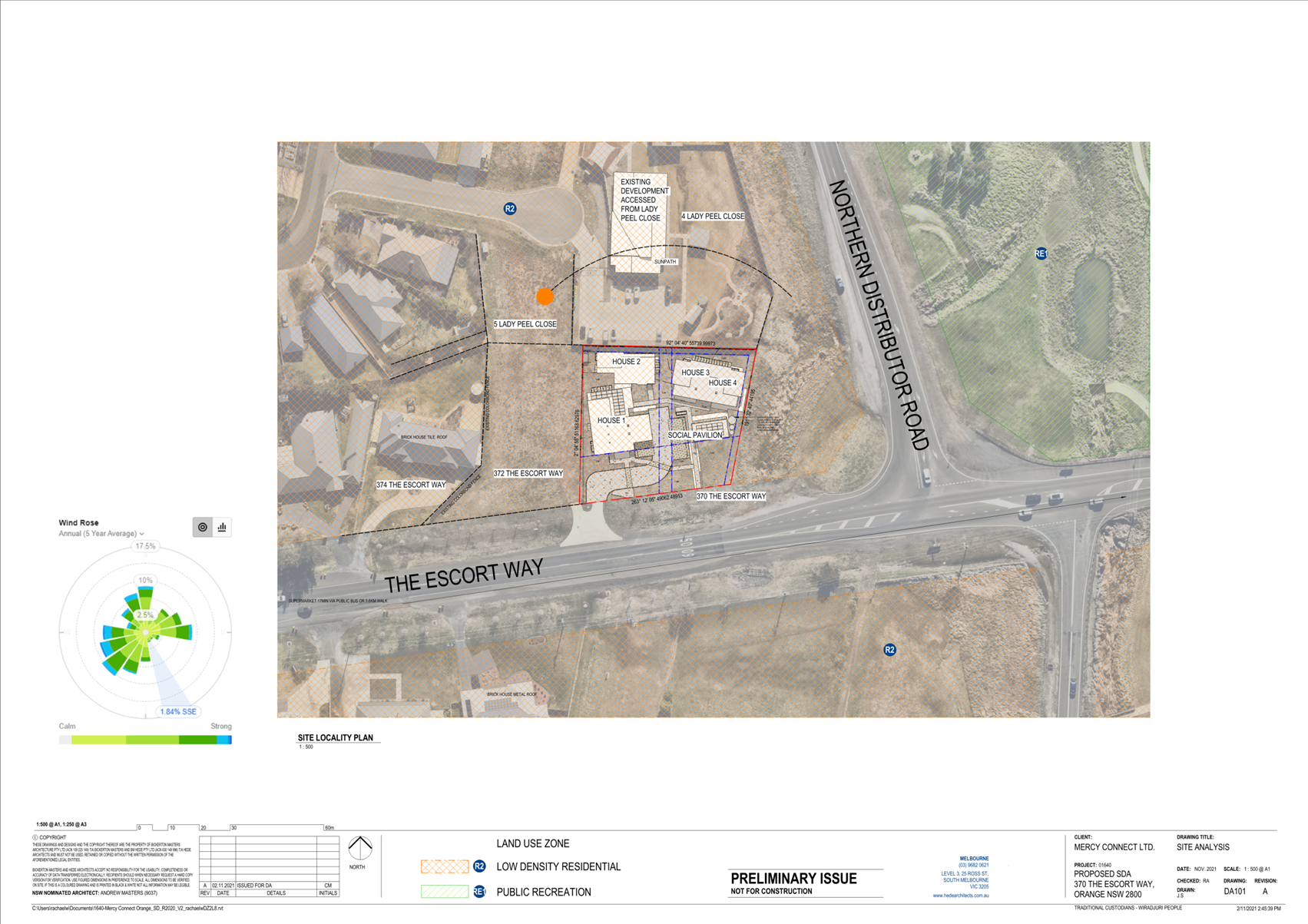
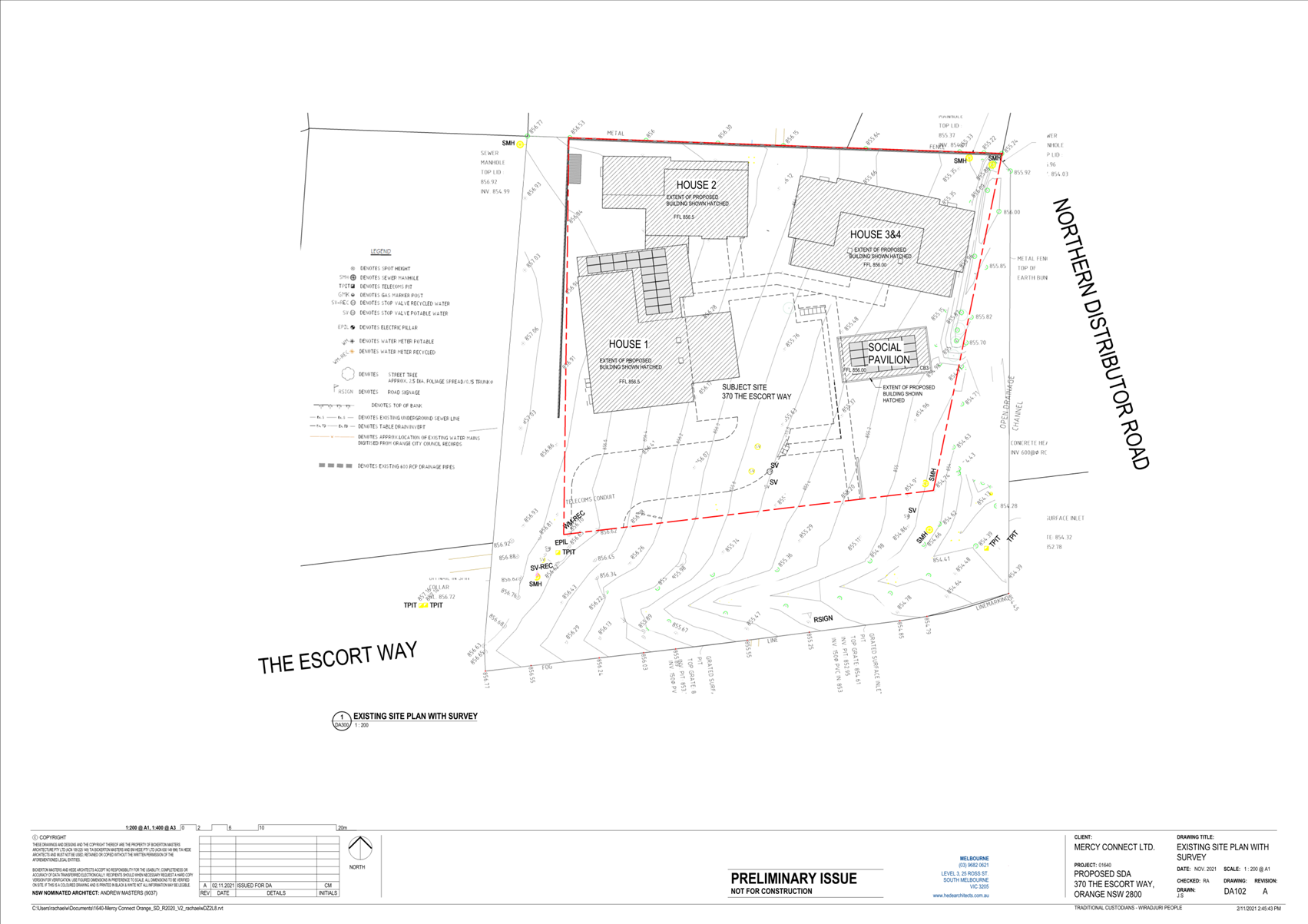
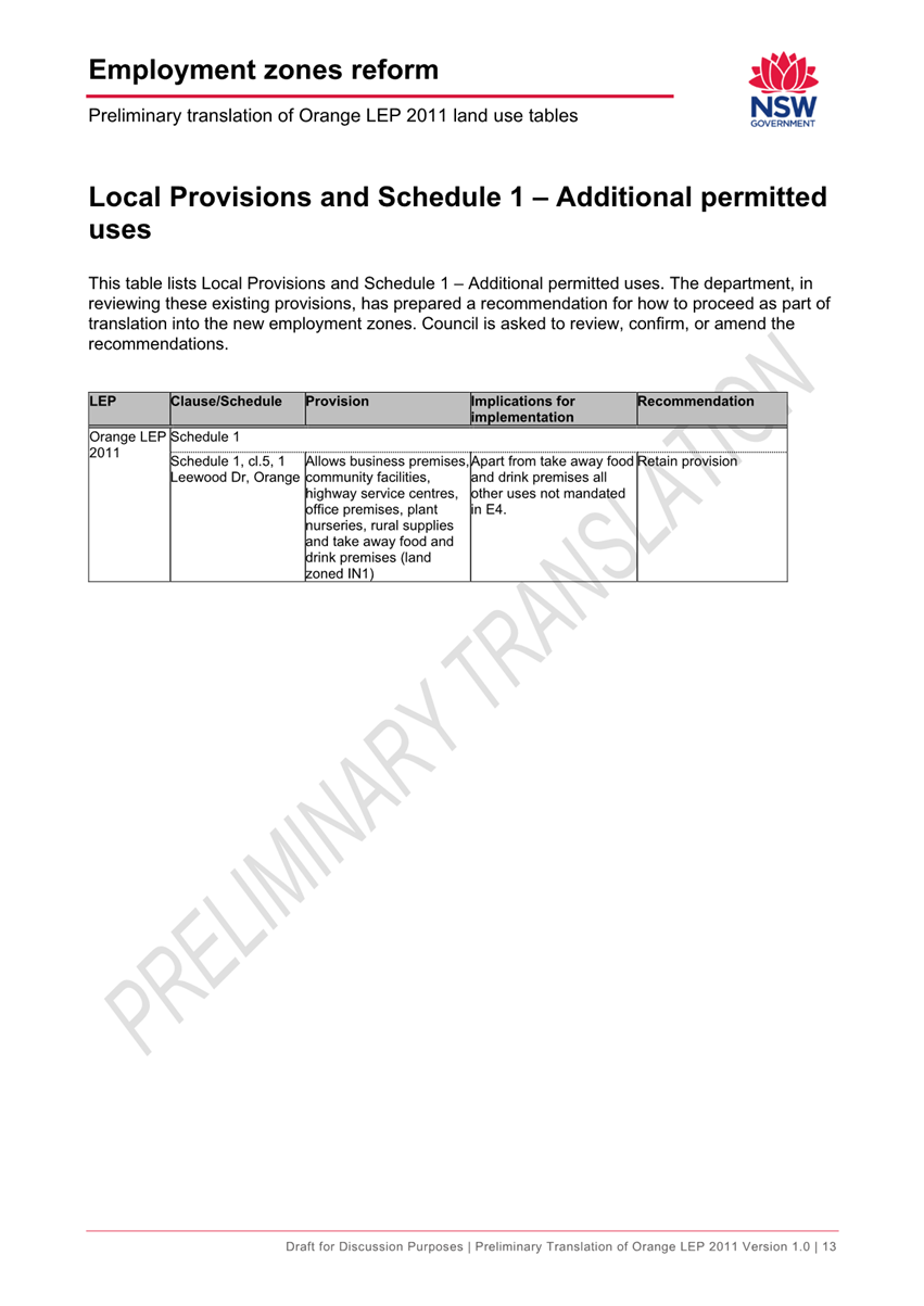
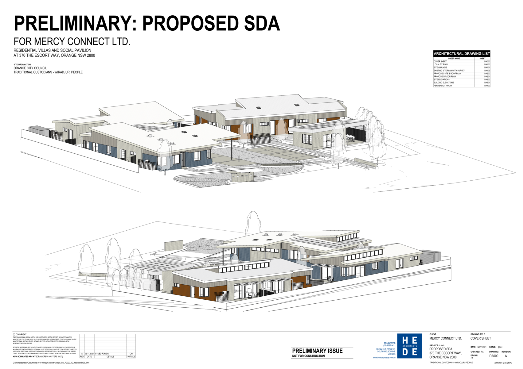
Application DA 521/2021(1) - 370 The Escort Way
RECORD
NUMBER: 2022/423
AUTHOR: Summer
Commins, Senior Planner
EXECUTIVE Summary
|
Application
lodged
|
29
November 2021 – 29 STOP DAYS
|
|
Applicant/s
|
Habitat
Planning
|
|
Owner/s
|
McAuley
Property Limited
|
|
Land
description
|
Lot 206
DP 1257565 - 370 The Escort Way, Orange
|
|
Proposed
land use
|
Seniors
Housing (four dwellings)
|
|
Value of
proposed development
|
$3,730,100.00
|
Council's consent is sought for proposed seniors housing
(four dwellings) at Lot 206 DP 1257565 – 370 The Escort
Way, Orange.
The proposal involves
construction of four self-contained dwellings for supported or independent
living for seniors or people with a disability. A separate social pavilion will
be provided for use by residents. Staff accommodation will be available. The
application is made pursuant to State Environmental Planning Policy (Housing)
2021, Part 5 Housing for Seniors and People with a Disability.
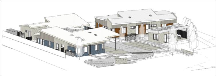
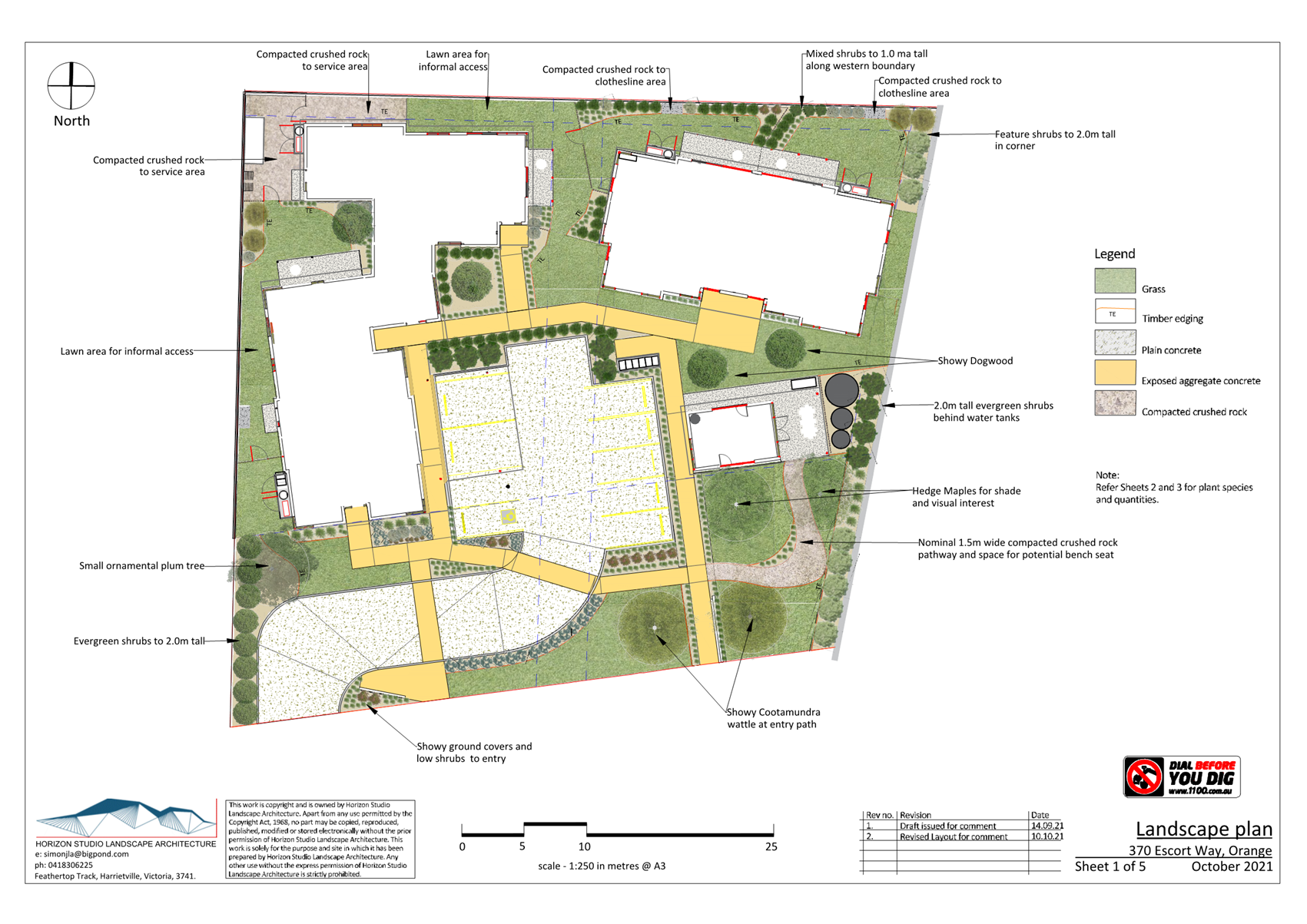
Figure 1 – presentation of the development to
The Escort Way
The proposal comprises advertised
development in accordance with Council’s Community Participation Plan
2019. Written and public notice of the application was given for the prescribed
period. No submissions were received.
As outlined in this report, the proposal is considered to
reasonably satisfy the Local and State planning controls that apply to the
subject land and particular landuse. Impacts of the development will be within
acceptable limit, subject to mitigation conditions.
The Planning and Development Committee have delegation to
approve the application based on the development cost of more than
$2.5million. Approval of the application is recommended.
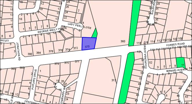
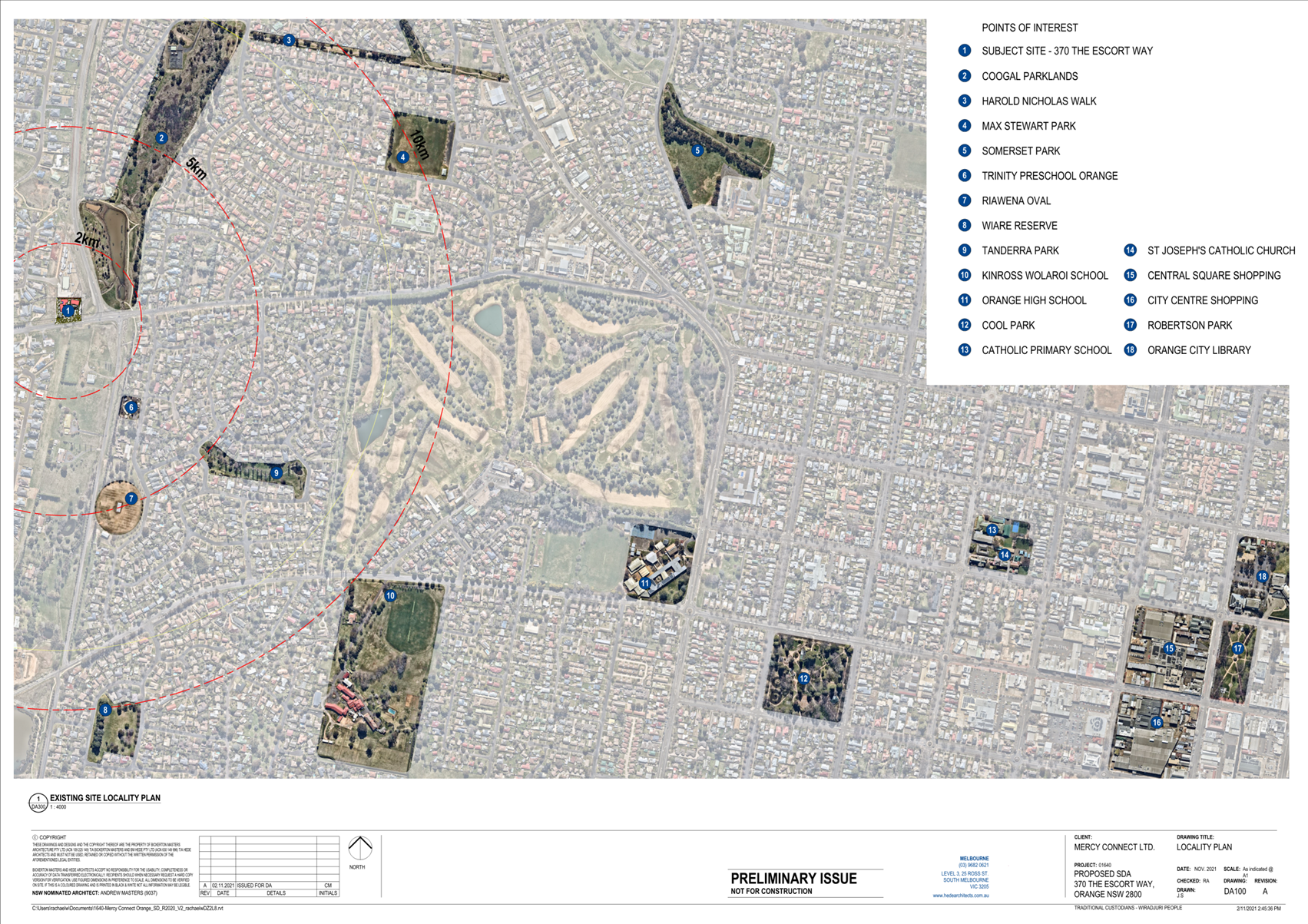
Figure 2 - locality plan
DECISION FRAMEWORK
Development in Orange is governed by two key documents
Orange Local Environment Plan 2011 and Orange Development Control Plan 2004. In
addition the Infill Guidelines are used to guide development, particularly in
the heritage conservation areas and around heritage items.
Orange Local Environment Plan 2011 – The
provisions of the LEP must be considered by the Council in determining the
application. LEPs govern the types of development that are permissible or
prohibited in different parts of the City and also provide some assessment
criteria in specific circumstances. Uses are either permissible or not. The
objectives of each zoning and indeed the aims of the LEP itself are also to be
considered and can be used to guide decision making around appropriateness of
development.
Orange Development Control Plan 2004 – the DCP
provides guidelines for development. In general it is a performance based
document rather than prescriptive in nature. For each planning element there
are often guidelines used. These guidelines indicate ways of achieving the
planning outcomes. It is thus recognised that there may also be other solutions
of merit. All design solutions are considered on merit by planning and building
staff. Applications should clearly demonstrate how the planning outcomes are
being met where alternative design solutions are proposed. The DCP enables
developers and architects to use design to achieve the planning outcomes in
alternative ways.
DIRECTOR’S COMMENT
As alluded to in the above summary, the proposal involves
construction of four self-contained dwellings for supported or independent
living for seniors or people with a disability. Please note that the
application has made pursuant to State Environmental Planning Policy (Housing)
2021, Part 5 Housing for Seniors and People with a Disability and the
requirements of this SEPP have been addressed in this report.
The planning report concludes that the proposal will
reasonably satisfy the Local and State planning controls that apply to the
subject land and particular land use. It is considered that impacts of the
development will be within acceptable limit, subject to mitigation conditions.
Attached is a recommended Notice of
Determination containing conditions of consent considered appropriate to ensure
that the development proceeds in an acceptable manner. It is recommended that
Council supports the subject application.
Link To Delivery/OPerational Plan
The recommendation in this report relates to the
Delivery/Operational Plan strategy “10.1 Preserve -
Engage with the community to ensure plans for growth and development are
respectful of our heritage”.
Financial Implications
Nil
Policy and Governance Implications
Nil
|
Recommendation
That Council consents to
development application DA 521/2021(1)
for Seniors Housing (four dwellings) at Lot 206 DP 1257565 -
370 The Escort Way, Orange pursuant to the
conditions of consent in the attached Notice of Approval.
|
further considerations
Consideration has been given to the
recommendation’s impact on Council’s service delivery; image and
reputation; political; environmental; health and safety; employees;
stakeholders and project management; and no further implications or risks have
been identified.
SUPPORTING INFORMATION
THE PROPOSAL
The proposal involves development of the subject land for
housing for seniors and people with a disability.
Two residential buildings will be constructed each
containing two dwellings (known as Houses 1-4). Each dwelling will
contain two or three bedrooms, two or three bathrooms, open-plan living and
dining areas, and laundry facilities. Private open space will be provided for
each dwelling.
Staff facilities comprising bedroom, bathroom and office and
known as Onsite Overnight Assistance (OOA) will be provided within the western
residential building. A detached social pavilion/games room and associated
outdoor area will provide a communal recreation space for residents.
Shared on grade car parking
will be provided for eight vehicles between the building groups.
A carport will be constructed to two over-wide parking spaces for
ambulance or mini bus. The site will be landscaped, and pedestrian paths
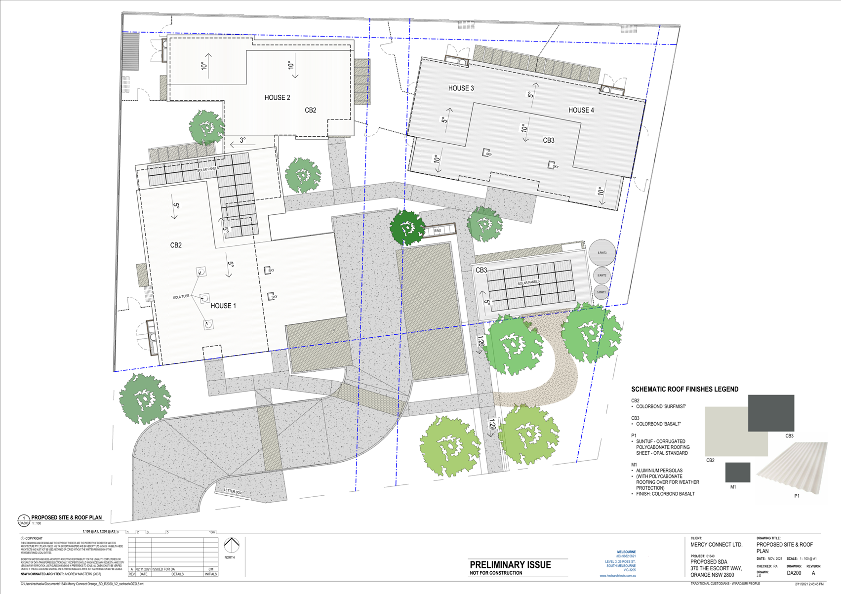
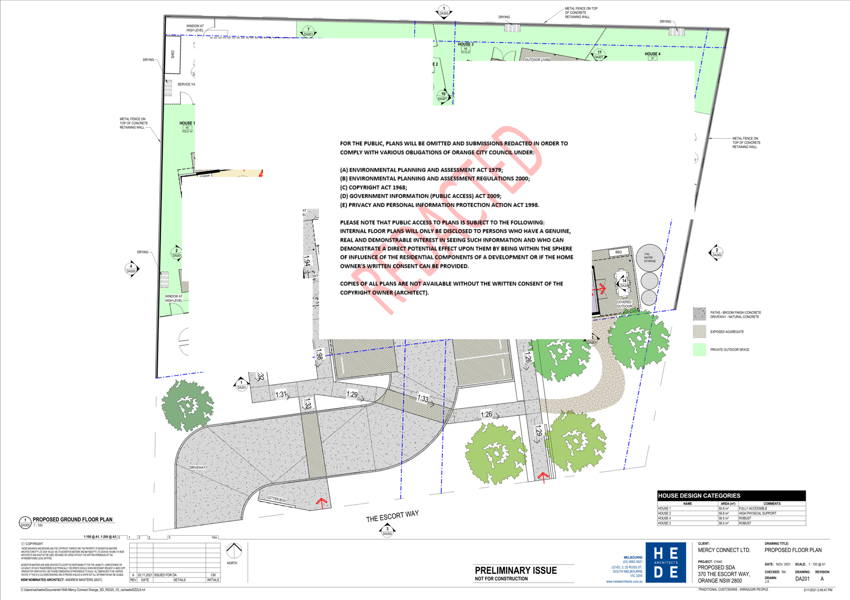
established. The proposed site layout is depicted below (see Figure 3).
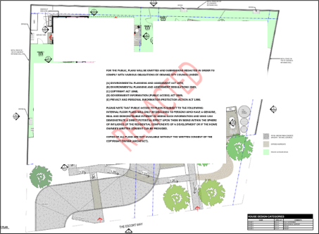
Figure 3 – proposed site plan
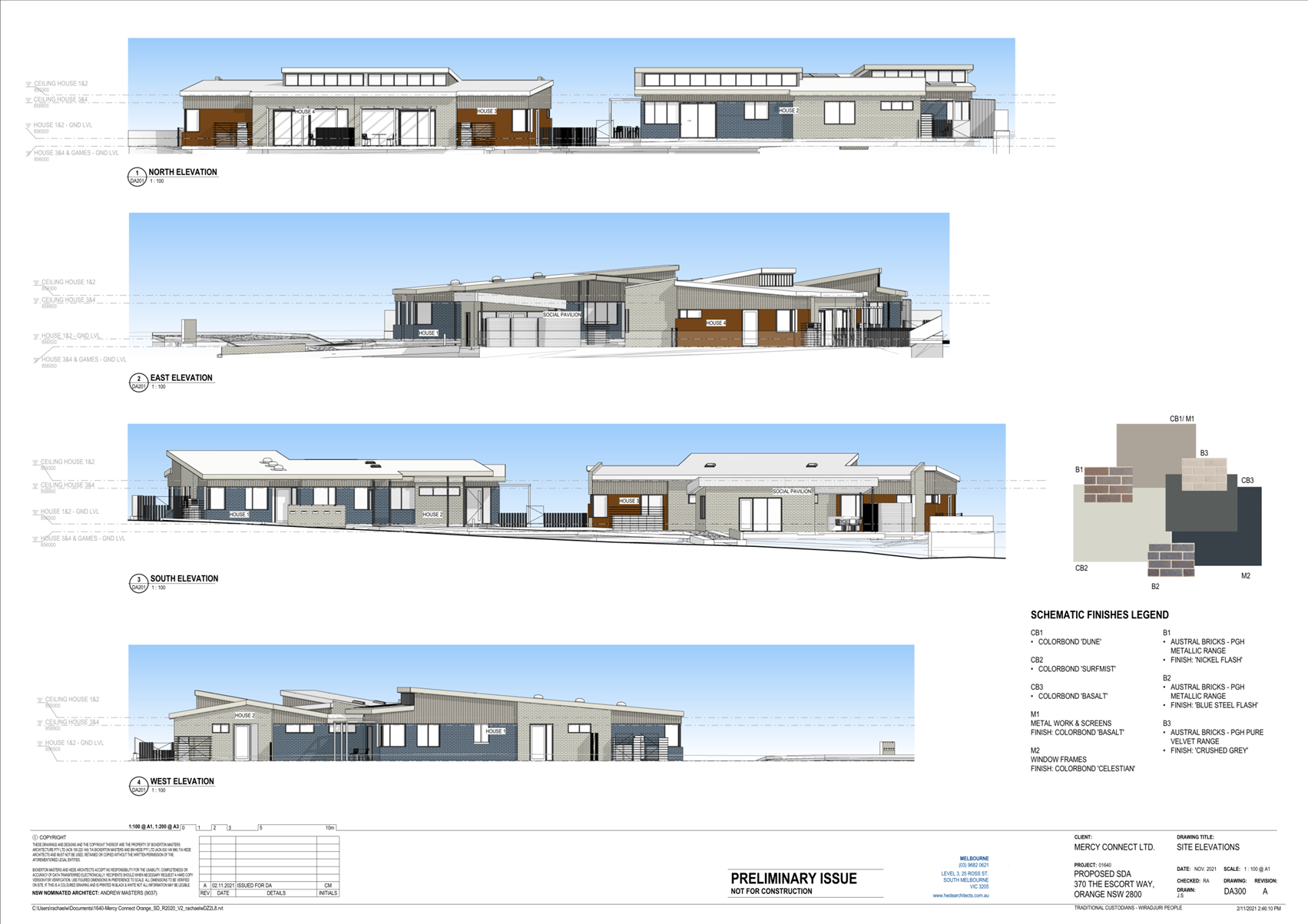
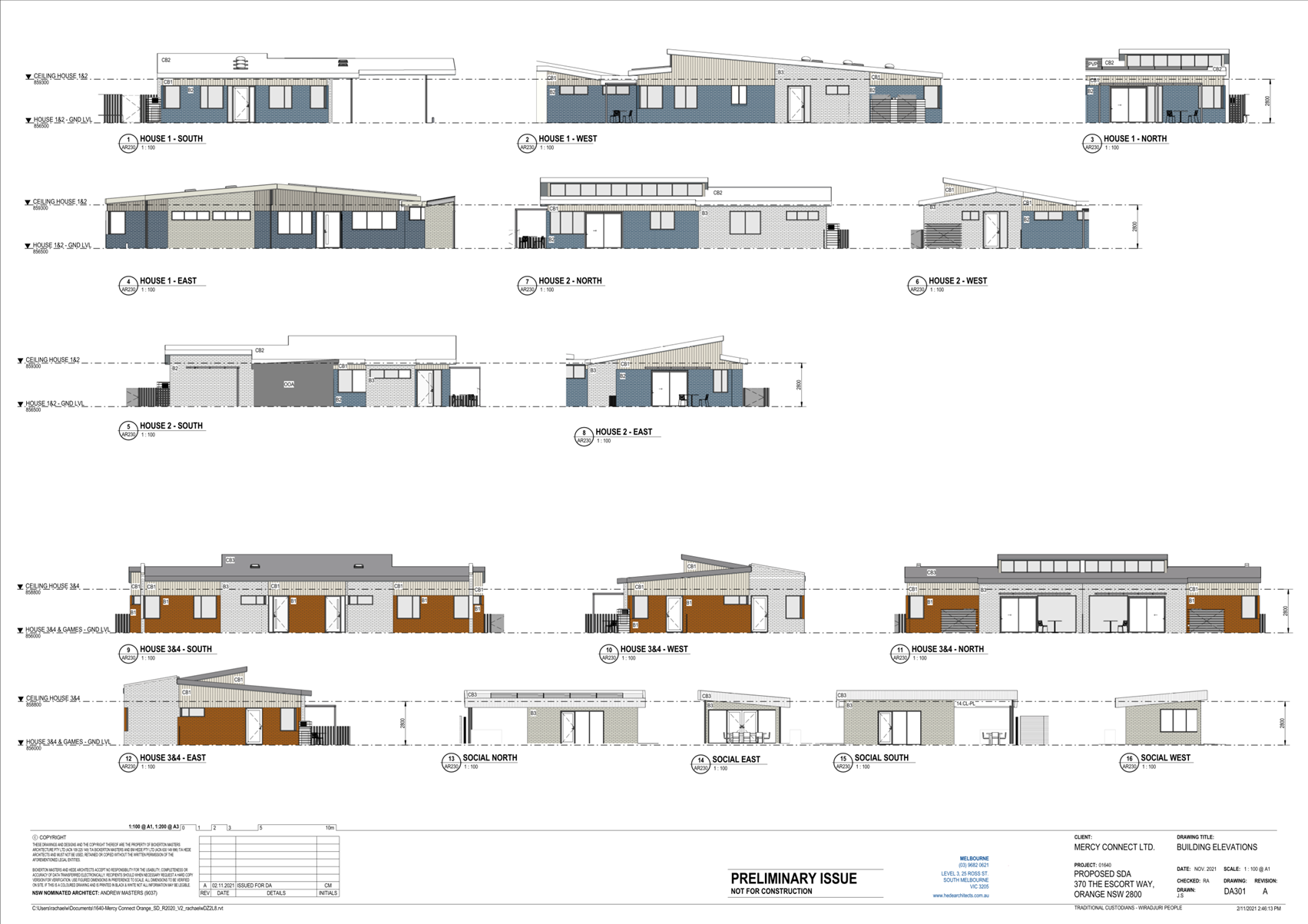
The proposed dwellings will take a contemporary building
form with flat and skillion roof profiles, irregular fenestration, and mixed
finishes. The building design is depicted below (see Figure 4).
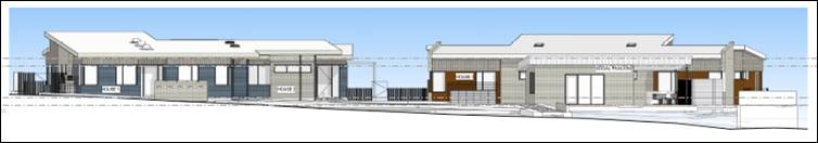
Figure 4 – south elevation to The Escort Way
The proposal will comprise a group of self-contained
dwellings for supported or independent living for seniors or people with a
disability. The dwellings will be designed as ‘fully
accessible’ (House 1); ‘high physical support’ (House 2); or
‘robust living’ (Houses 3 and 4). Residents will be
supported by three staff members 24 hours per day with meals, cleaning
services, personal care, and nursing care.
The application is made pursuant to State Environmental
Planning Policy (Housing) 2021, Part 5 Housing for Seniors and People with a
Disability. The proposed dwellings will comprise Specialist Disability
Accommodation pursuant to the National Disability Insurance Scheme.
MATTERS FOR CONSIDERATION UNDER
THE ENVIRONMENTAL PLANNING AND ASSESSMENT ACT 1979
Section 1.7 - Application of
Part 7 of the Biodiversity Conservation Act 2016 and Part 7A of the
Fisheries Management Act 1994
Pursuant to Section 1.7:
This
Act has effect subject to the provisions of Part 7 of the Biodiversity Conservation Act 2016 and Part 7A of the Fisheries Management Act 1994 that relate to the operation of this Act in connection
with the terrestrial and aquatic environment.
In consideration of this section, the development is not
likely to give rise to any significant impact upon any endangered ecologically
communities, threatened species or their habitat:
· The subject and
adjoining lands are not identified as biodiversity sensitive on the Orange LEP
2011 Terrestrial Biodiversity Map.
· The proposal does
not involve clearing or disturbance of native vegetation; clearing thresholds
prescribed by regulation do not apply.
· The site is
contained within an established urban area and has been highly modified by the
urban landuse pattern. The subject land does not contain known threatened
species or ecological communities.
Based on the foregoing consideration, a Biodiversity
Assessment Report is not required and the proposal suitably satisfies the
relevant matters at Clause 1.7.
Section 4.15 Evaluation
Provisions of any
Environmental Planning Instrument S4.15(1)(a)(i)
Orange Local Environmental Plan
2011
Part 1 - Preliminary
Clause 1.2 Aims of Plan
The
particular aims of Orange LEP 2011 relevant to the proposal include:
(a) to
encourage development which complements and enhances the unique character of
Orange as a major regional centre boasting a diverse economy and offering an
attractive regional lifestyle,
(b) to
provide for a range of development opportunities that contribute to the social,
economic and environmental resources of Orange in a way that allows present and
future generations to meet their needs by implementing the principles for
ecologically sustainable development,
(e) to
provide a range of housing choices in planned urban and rural locations to meet
population growth,
The proposed development will not be averse to the
above-listed Aims, as outlined in this report.
Clause 1.6 Consent Authority
Clause 1.6 is applicable and states:
The consent authority for the purposes of this Plan is
(subject to the Act) the Council.
Clause 1.7 Mapping
The subject site is identified
on the LEP maps in the following manner:
|
Land Zoning Map:
|
Land zoned R2 Low Density
Residential
|
|
Lot Size Map:
|
No minimum lot size
|
|
Heritage Map:
|
Not a heritage item or conservation
area
|
|
Height of Buildings Map:
|
No building height limit
|
|
Floor Space Ratio Map:
|
No floor space limit
|
|
Terrestrial Biodiversity Map:
|
No biodiversity sensitivity on the
site
|
|
Groundwater Vulnerability Map:
|
Groundwater vulnerable
|
|
Drinking Water Catchment Map:
|
Not within the drinking water
catchment
|
|
Watercourse Map:
|
Not within or affecting a defined
watercourse
|
|
Urban Release Area Map:
|
Not within an urban release area
|
|
Obstacle Limitation Surface Map:
|
No restriction on building siting
or construction
|
|
Additional Permitted Uses Map:
|
No additional permitted use applies
|
|
Flood Planning Map:
|
Partly within a flood planning area
|
Those matters that are of
relevance are addressed in detail in the body of this report.
Clause 1.9A Suspension of Covenants,
Agreements and Instruments
Clause 1.9A is applicable and states in part:
(1) For the purpose of enabling
development on land in any zone to be carried out in accordance with this Plan
or with a consent granted under the Act, any agreement, covenant or other
similar instrument that restricts the carrying out of that development does not
apply to the extent necessary to serve that purpose.
In
consideration of this clause, Council staff are not aware of the title of the
subject property being affected by a relevant agreement, covenant, etc.
As a
matter arising, the subject land is affected by easements for water 4 wide
(“D”) and sewer 2 wide (“B”) (see DP extract at Figure
5).
The
proposed dwellings will be sited clear of the easements and will have nil
impact on the operation of the easements. However, based on the proximity of
the dwellings to the easements, Council’s Assistant Development Engineer
has included Conditions requiring structural engineering design of footings,
piers and slabs nearby to water and sewer mains within the easements; and no
earthworks being carried out within the easements except with Council approval.
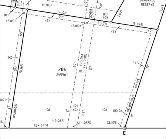
Figure 5 – extract DP 1257565
The site is subject to Restrictions on the Use of Land as
follows:
12. No future domicile/dwelling house
application on the lot burdened will be accepted unless accompanied by a Noise
Assessment Report and certification from an appropriately qualified Acoustic
Consultant Confirming that the design and location of any domicile/dwelling house
complies with the relevant road noise standards applicable…
13. No structures may be erected on any
burdened lot within the area designed (Q) on the plan.
14. No vehicular access to any lot burdened
will be established from the Northern Distributor Road frontage of the burdened
lot.
In
consideration of the Restrictions:
· An Acoustic Engineering Report was submitted in support of
the proposal (Cogent Acoustics 18 November 2021). The report concludes that
subject to acoustic engineering recommendations in relation to construction
methods and materials, the proposed development will satisfy prescribed
acoustic requirements. Council’s Environmental Health Officer (EHO)
concurs with the conclusions. Conditions are included requiring implementation
of the acoustic engineering recommendations for the construction.
· The proposed site layout does not include any structures
within the area designated Q on the Deposited Plan.
· The proposal does not involve access via the Northern
Distributor Road.
Part 2 - Permitted or Prohibited Development
Clause
2.1 Land Use Zones
The
subject land is zoned R2 Low Density Residential.
The
proposal is defined as housing for seniors and people with a disability.
The
proposal is permitted with consent in the R2 Zone, pursuant to Section 81 of
SEPP Housing 2021 (see following sections of this report).
Clause
2.3 Zone Objectives and Land Use Table
The
objectives of the R2 Low Density Residential zone are:
· To provide for
the housing needs of the community within a low density residential
environment.
· To enable other
land uses that provide facilities or services to meet the day to day needs of
residents.
· To ensure
development is ordered in such a way as to maximise public transport patronage
and encourage walking and cycling in close proximity to settlement.
· To ensure that
development along the Southern Link Road has an alternative access.
The proposed development will
satisfy the relevant R2 zone objectives. The proposal will provide additional
housing stock to accommodate housing needs.
Part 3 - Exempt and Complying Development
The application is not exempt or complying development.
Part 4 - Principal Development Standards
The
Principal Development Standards do not apply to the subject land or proposed landuse.
Part 5 - Miscellaneous Provisions
The
Miscellaneous Provisions are not applicable to the proposed development.
Part 6 - Urban Release Area
Not relevant to the application. The subject site is not
located in an Urban Release Area.
Part 7 - Additional Local Provisions
Clause
7.2A Floodplain Risk Management
The land is partly affected by Probable Maximum Flood (PMF)
associated with Ploughman’s Creek (see Figure 6).
Figure 6 – probable maximum flood
hatched yellow
Clause 7.2A is applicable and states in part:
(3) Development
consent must not be granted to development for the following purposes on land
to which this clause applies unless the consent authority is satisfied that the
development will not, in flood events exceeding the flood planning level,
affect the safe occupation of, and evacuation from, the land -
(r) residential
accommodation,
An overland stormwater flow path is located adjacent to the
northern boundary and within adjoining land (4 Lady Peel Close). The PMF
hatching in Figure 6 depicts the overland flows on the northern boundary.
Council’s Development Engineer required (at pre-lodgement) that dwellings
adjoining the northern boundary have a minimum finished floor level 300mm above
natural ground level. The proposed development has been designed to
achieve the required minimum floor level.
The proposed buildings will be located outside of flood
liable land. There are no aspects of the proposal that will affect the safe
occupation or, or evacuation from the land in flood events.
Clause
7.3 Stormwater Management
Clause 7.3 is
applicable. This clause states in part:
(3) Development
consent must not be granted to development on land to which this clause applies
unless the consent authority is satisfied that the development:
(a) is
designed to maximise the use of water permeable surfaces on the land having
regard to the soil characteristics affecting onsite infiltration of water, and
(b) includes,
where practical, onsite stormwater retention for use as an alternative supply
to mains water, groundwater or river water, and
(c) avoids
any significant impacts of stormwater runoff on adjoining downstream
properties, native bushland and receiving waters, or if that impact cannot be
reasonably avoided, minimises and mitigates the impact.
Council’s Assistant Development Engineer has included
conditions to satisfy the requirements of this clause.
Clause 7.6 Groundwater
Vulnerability
The
subject land is identified as ‘Groundwater Vulnerable’ on the Groundwater
Vulnerability Map. Clause 7.6 applies. This clause states in part:
(3) Before
determining a development application for development on land to which this
clause applies, the consent authority must consider:
(a) whether
or not the development (including any onsite storage or disposal of solid or
liquid waste and chemicals) is likely to cause any groundwater contamination or
have any adverse effect on groundwater dependent ecosystems, and
(b) the
cumulative impact (including the impact on nearby groundwater extraction for
potable water supply or stock water supply) of the development and any other
existing development on groundwater.
In consideration of Clause 7.6,
there are no aspects of the proposed development that will impact on
groundwater and related ecosystems.
Clause 7.11 Essential Services
Clause 7.11 applies and states:
Development
consent must not be granted to development unless the consent authority is
satisfied that any of the following services that are essential for the
proposed development are available or that adequate arrangements have been made
to make them available when required:
(a) the supply of water,
(b) the supply of electricity,
(c) the disposal and management of
sewage,
(d) storm water drainage or onsite
conservation,
(e) suitable road access.
In
consideration of this clause:
· The listed utility services at (a)-(d) are available to the
land and adequate for the proposal.
· Existing access (layback and crossover) was provided to the
land in conjunction with subdivision works to create the lot (DA 444/2018
(amended)). The proposal will not alter existing access arrangements to the
classified road.
· A nominated bin store will be provided centrally within the
site nearby to House 3, with kerbside collection to occur. The site has
suitable frontage to accommodate the placement of bins on collection days.
STATE ENVIRONMENTAL PLANNING POLICIES
SEPP 55 Remediation of Land
SEPP 55 was repealed on 28 February 2022 and replaced with
SEPP (Resilience and Hazards) 2021. The repealed SEPP was in force at the date
of lodgement of the application. The applicable parts of the repealed SEPP
are considered here.
(1) A consent
authority must not consent to the carrying out of any development on land
unless (a) it has considered whether the land is contaminated.
Contamination
clearance was given in conjunction with residential subdivision of the parent
parcel pursuant to DA 444/2018 (amended). The land has been assessed as
suitable for residential landuse and further contamination investigation is not
required. Council’s EHO has included a condition of consent requiring
implementation of unexpected finds protocol during construction works.
SEPP (Infrastructure) 2007
SEPP
(Infrastructure) was repealed on 28 February 2022 and replaced with SEPP
(Transport and Infrastructure) 2021. The repealed SEPP was in force at
the date of lodgement of the application. The applicable parts of the
repealed SEPP are considered here.
Division 17 Roads and Traffic
Clause 101 Development with frontage to a classified
road
Clause 101 is applicable and states in part:
(2) The
consent authority must not grant consent to development on land that has a
frontage to a classified road unless it is satisfied that—
(a) where
practicable and safe, vehicular access to the land is provided by a road other
than the classified road, and
(b) the
safety, efficiency and ongoing operation of the classified road will not be adversely
affected by the development as a result of—
(i) the
design of the vehicular access to the land, or
(ii) the
emission of smoke or dust from the development, or
(iii) the
nature, volume or frequency of vehicles using the classified road to gain
access to the land, and
(c) the
development is of a type that is not sensitive to traffic noise or vehicle
emissions, or is appropriately located and designed, or includes measures, to
ameliorate potential traffic noise or vehicle emissions within the site of the
development arising from the adjacent classified road.
The subject land has frontage and existing access to The
Escort Way (a classified road), constructed in conjunction with subdivision
civil works (DA 444/2018 (amended)). The proposal will not alter the
existing layback or crossover.
The proposal will not adversely impact the safety, efficient
or operation of The Escort Way. The vehicular access is existing. All vehicles
associated with the development will enter and exit the site in a forward
direction; sufficient manoeuvring area will be available onsite to accommodate
swept paths.
Sight lines in both directions are
generous. The proposal does not involve emissions. Traffic
generation associated with the proposed development will be imperceptible
within the context of existing traffic volumes along the classified road.
The proposed seniors housing will not be sensitive to
traffic noise or vehicle emissions, subject to Conditional compliance with the
acoustic recommendations in the submitted acoustic assessment (Cogent Acoustics
18 November 2021).
Clause 102 Impact of road
noise or vibration on non-road development
Clause 102 is applicable and states in part:
(1) This clause applies to development
for any of the following purposes that is on land in or adjacent to the road
corridor for a freeway, a tollway or a transitway or any other road with an
annual average daily traffic volume of more than 20,000 vehicles (based on the
traffic volume data published on the website of TfNSW) and that the consent
authority considers is likely to be adversely affected by road noise or
vibration -
(a) residential accommodation,
(b) a place of public worship,
(c) a hospital,
(d) an educational establishment or
centre-based child care facility.
(2) Before determining a development
application for development to which this clause applies, the consent authority
must take into consideration any guidelines that are issued by the Secretary
for the purposes of this clause and published in the Gazette.
In consideration of this clause, the proposal involves
residential accommodation (seniors housing) on land with frontage to The Escort
Way (a classified road). The road has an annual
average daily traffic volume of less than 20,000 vehicles. The noise and
vibration amelioration controls contained in Development near Rail Corridors
and Busy Roads - Interim Guideline (Department of Planning 2008) are not
applicable to the proposal.
The proposed seniors housing will not be sensitive to
traffic noise or vehicle emissions, subject to Conditional compliance with the
acoustic recommendations in the submitted acoustic assessment (Cogent Acoustics
18 November 2021).
SEPP (Housing) 2021
Part 5 Housing for Seniors and
People with a Disability
SEPP Housing 2021 is applicable. The relevant sections
are considered below.
Section 3 Principles of policy
The proposed development will be consistent with the
following particular principles:
(b) encouraging the development
of housing that will meet the needs of more vulnerable members of the
community, including very low to moderate income households, seniors and people
with a disability
(c) ensuring new housing
development provides residents with a reasonable level of amenity
(d) promoting the planning and
delivery of housing in locations where it will make good use of existing and
planned infrastructure and services
(e) minimising adverse climate and environmental
impacts of new housing development
(f) reinforcing the importance
of designing housing in a way that reflects and enhances its locality
Section 79 Land to which Part Applies
The subject land is zoned R2 Low Density Residential, and is
land to which Part 5 applies.
Section 81 Senior Housing Permitted with Consent
Seniors housing is permitted with consent in R2 Low Density
Residential Zone.
Section 82 Definitions
The proposed dwellings will be occupied by ‘seniors,’
which means:
(a) people who are at least 60
years of age,
(b) people who are resident at a
facility at which residential care, within the meaning of the Aged Care Act 1997 of the Commonwealth, is provided,
(c) people who have been
assessed as being eligible to occupy housing for aged persons provided by a
social housing provider.
The proposed development will comprise ‘serviced
self-care housing’ which means:
Seniors
housing comprising independent living units where the following services are
available on the site -
(a) meals,
(b) cleaning services,
(c) personal care,
(d) nursing care.
Section 84 Development standards – general
The proposed development will
satisfy the development standards at Section 84, as follows:
|
Clause
|
Control
|
Proposal
|
Compliance
|
|
84(2)(a)
|
Site area: 1,000m2
|
2,446m2
|
Yes
|
|
84(2)(b)
|
Site frontage: 20m at the building
line
|
47m
|
Yes
|
|
84(2)(c)
|
Height: 9.5m or more than 2 storey
|
6m and single storey
|
Yes
|
Section
85 Development standards for hostels and independent living units
The proposed development may be designed to comply with the
listed standards at Schedule 4. A Condition is included requiring a
Schedule 4 compliance table be provided on the construction drawings.
Section 86 Development standards for seniors housing
– Zones RE2, SP1, SP2, RU5 and R2
The proposed seniors housing will be provided by an operator
(Mercy Connect) as defined in the Retirement Villages Act 1999, consistent with
Section 86(1)(d)(iii). Consent may therefore be granted for seniors housing in
the R2 zone.
Section 88 Restrictions on occupation of seniors
housing
The proposed development will provide accommodation for
seniors or people with a disability; people in the same household; and service
and administration staff, consistent with Section 88. Conditions are
included restricting occupation of the dwellings to those listed in Section 88.
Section 90 Subdivision
Subdivision of seniors housing on land in the R2 Low Density
Residential zone is not permitted, pursuant to Section 90. The proposal
does not involve subdivision. A Condition is included prohibiting future
subdivision consistent with this Section.
Section 91 Fire sprinkler systems in residential care
facilities
The proposed seniors housing will incorporate a fire
sprinkler system as required by Section 91.
Section 93 Location and access to facilities and
services – independent living units
The proposed development will have adequate access to
facilities and services, consistent with Section 93. The operator (Mercy
Connect) will provide a bus services for residents of the development.
The transport service will be operated from within the site (covered car
parking) and will be accessible from all independent living units via suitable
access compliant pathways. The bus service will be available to residents
during daylight hours, Monday to Friday, and will provide access to the Orange
CBD.
Section 95 Water and sewer
The subject land is connected to reticulated sewer and water
in accordance with this Section.
Section 98 Design of seniors housing
The proposed development will satisfy the design principles
at Division 6 (Sections 99-105) as outlined below.
Section 99 Neighbourhood Amenity and Streetscape
The proposed development will complement the existing
neighbourhood character and amenity, as follows:
· The proposal will
satisfy the R2 zone objectives to provide a variety of housing types. Seniors
housing is a permitted and complementary landuse in the zone.
· The development
will relate to the group home on the adjoining northern parcel (4 Lady Peel
Close) in respect of building form and function (assisted residential care).
· The proposed
seniors housing will take a multi-dwelling housing scale and appearance, which
will not be incongruous in this setting.
· The proposed built
form will reflect the design typology in the neighbourhood: single-storey,
generous footprint and massing, contemporary architectural elements.
· The proposed
development will be single storey and will complement the bulk and scale of
adjoining improvements.
· External finishes
(brick and steel) will be generally compatible with adjoining dwellings.
· Proposed House 1
and the social pavilion will comply with the front setback restriction of 15m,
and complement the established streetscape building line. Side and rear
boundary setbacks and associated opposing interfaces will be typical of
residential development.
· Proposed car
parking will not dominate the site frontage. The carport will be located behind
the front building lines for House 1 and the social pavilion. The carport
will be integrated with the building via an extension to the skillion roof
profile. Site landscaping will provide suitable screening and softening of car
parking areas.
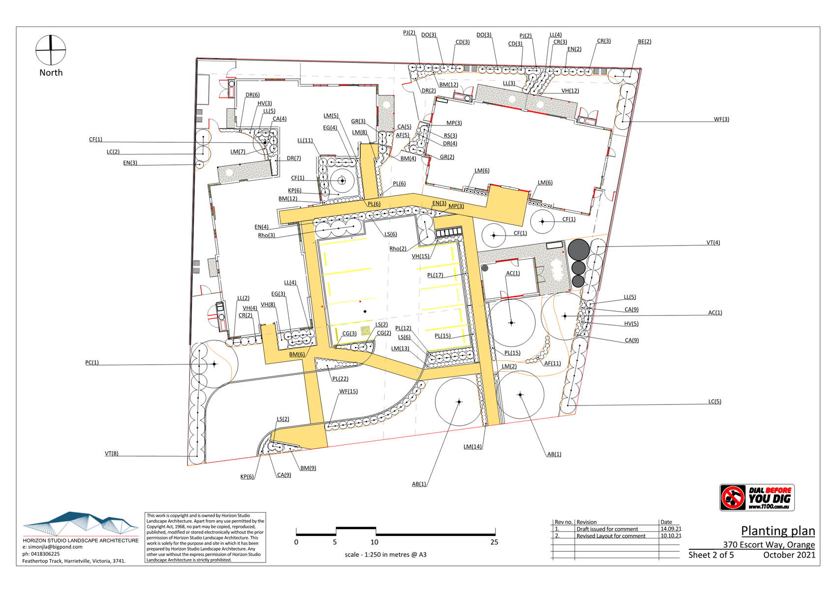
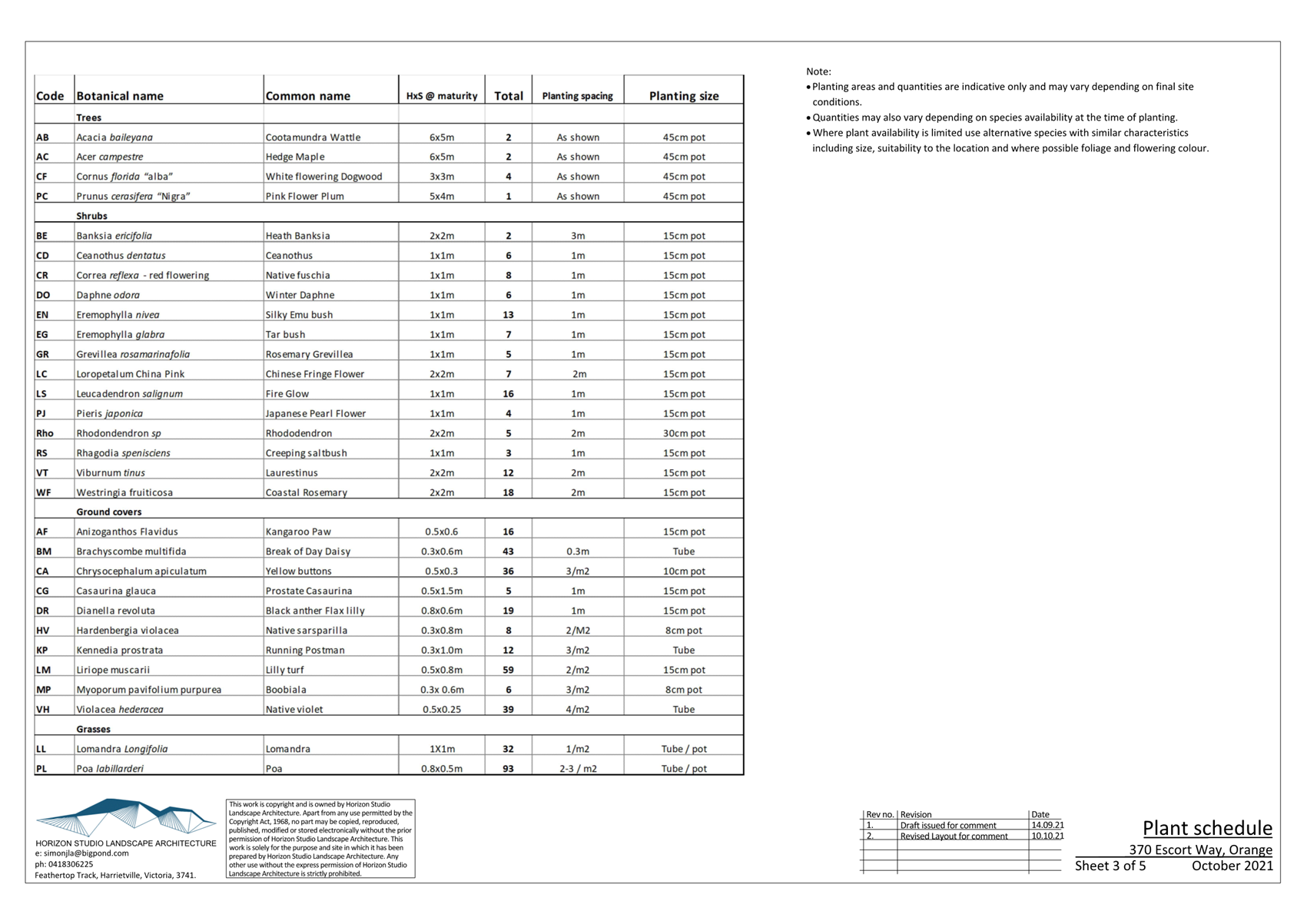
· Landscaping in the
front setback to The Escort Way will be generous and complement private
landscaping to adjoining dwellings. Council’s Manager City
Presentation supports the proposed landscape design subject to minor
Conditional species substitution.
· Site coverage for
the development will comprise some 40%, and complement the site coverage in the
neighbourhood (ie. generally 50% or less, consistent with Orange DCP 2004).
· Front fencing to
The Escort Way will not be erected, consistent with open frontages in this
streetscape.
· Earthworks
(levelling and filling) will be required in the north-eastern extent to provide
a level (and accessible) site. Retaining walls will be erected on the rear
(north) and part side (east and west) boundaries. Retaining walls will
have a height of 500mm (in the north-west corner of the site); and 1350mm (in
the north-east corner of the site). Metal fencing to a height of 1.8m
will be erected atop the retaining walls.
The visual bulk impacts
associated with the wall and fencing will be acceptable in this setting.
The eastern perimeter addresses the NDR road reserve and the wall and fence
will relate to the eastern fencing for the group home. The northern
boundary will address the group home, which is located a sufficient distance
from the common boundary (some 22m) to prevent visual bulk encroachment
impacts.
Section 100 Visual and Acoustic Privacy
The proposed development will provide acceptable visual and
acoustic privacy for residents and neighbours, as follows:
· Perimeter fencing
will be installed.
· The private yards
associated with each dwelling will be enclosed by fencing.
· Internal living
area windows will overlook associated and fenced private yards, and will not be
directly opposing.
· Living room
windows to site perimeters will be reasonably removed from boundaries (a
minimum 2m). Opposing land uses and finished ground levels will not present
privacy impacts.
· The entrance to
each dwelling will be recessed or screened to ensure privacy to residents when
arriving and departing each dwelling.
· Site landscaping
will assist to conceal views and provide buffer opportunities.
· Seniors housing is
not a noise generating landuse and the proposal will not alter the
neighbourhood acoustic setting.
· The proposed
seniors housing will not be sensitive to traffic noise or vehicle emissions
from The Escort Way, subject to Conditional compliance with the acoustic
recommendations in the submitted acoustic assessment (Cogent Acoustics
18 November 2021).
· House 1 bedrooms
will oppose the shared carpark. Driver speeds will be slow and night-time
vehicle movements minimal. The acoustic engineering recommendations above
will assist to provide acoustic privacy to House 1.
Section 101 Solar access and design for climate
A high standard of solar access will be provided to the
proposed seniors housing and adjoining dwellings:
· Houses 1-4 will be
provided with north-facing living room windows.
· The private yard
for Houses 1-4 will have a broad northern exposure.
· The proposed
development will not impact on northern internal or external solar access for
any future/adjoining dwelling.
Section 102 Stormwater
Conditions are included in relation to stormwater management
for the development in order to minimise stormwater disturbance and runoff.
Section 103 Crime Prevention
The proposed development will incorporate Crime
Prevention through Environmental Design Principles in relation to
surveillance, access control, territorial enforcement and space
management. Crime prevention measures in the design response include
habitable openings to public and private areas; clear sightlines between the
dwellings and to the public domain; landscaping that does not conceal;
sensor/security lighting; fencing; and site maintenance.
Section 104 Accessibility
The proposed development will provide clear and safe
pedestrian paths between the dwellings, social pavilion, parking areas, onsite
private transport service and site frontage. Resident access to
facilities (shops, community services, recreation facilities and medical care)
will be met by a private bus service. The onsite carpark will be centrally
located within the building group, and will provide convenient and accessible
parking for residents, staff and visitors.
Section 105 Waste Management
The proposed development will be serviced by Council’s
domestic kerbside waste collection service.
Section 108 Non-discretionary development standards
for independent living units-the Act, s 4.15
The proposed development will
satisfy the non-discretionary development standards for independent living
units, as follows:
|
Clause
|
Control
|
Proposal
|
Compliance
|
|
108(2)(a)
|
Building height: 9.5m or less
|
6m and single-storey
|
Yes
|
|
108(2)(c)
|
FSR: 0.5:1
|
0.27:1
|
Yes
|
|
108(2)(e)
|
Landscape area: 30% of site area
[734m2]
|
31% [750m2] excluding
private open space areas
|
Yes
|
|
108(2)(f)
|
Deep soil zones: 15% of the site
[3672]; minimum dimension 3m
|
Deep soil zones provided to front
setback, communal open space, private open space areas
|
Yes
|
|
108(2)(g)
|
Solar access: 3 hours sunlight to
indoor and outdoor living spaces for 2 hours, to 70% of dwellings
|
All dwellings have north facing
indoor and outdoor habitable spaces and will achieve prescribed
daylighting
|
Yes
|
|
108(2)(h)
|
Private open space: 15m2
per dwelling with a minimum dimension of 3m and accessible from a living room
|
Minimum private open space to each
dwelling is 60.78m2. Open space areas will have a minimum
dimension of 3m, and be accessible from a living room
|
Yes
|
|
108(k)
|
Parking: 0.5 spaces / bedroom [10
bedrooms = 5 car spaces]
|
Eight car spaces will be provided.
|
Yes
|
Provisions of any Draft Environmental Planning
Instrument that has been Placed on Exhibition 4.15(1)(A)(Ii)
There are no Draft EPIs on public exhibition at present.
Provisions of any
Development Control Plan S4.15(1)(A)(Iii)
Development Control Plan 2004
Part 7 Development in Residential
Zones
The proposed development is consistent with the relevant
planning outcomes and guidelines contained in Part 7, as demonstrated in the
assessment under SEPP (Housing) 2021.
DEVELOPMENT CONTRIBUTIONS
Section 7.11 Development
Contributions
Pursuant to the Orange Development
Contributions Plan 2017 Part 2.6.1, the following landuse is exempt from
development contributions:
Seniors housing as defined in
[repealed] SEPP (Housing for Seniors of People with a Disability) 2004 that is
provided by a social housing provider as defined in that policy
Pursuant to in-force SEPP (Housing) 2021, social housing provider means -
(a) the
Secretary of the Department of Communities and Justice,
(b) the
Land and Housing Corporation,
(c) a
registered community housing provider,
(d) the
Aboriginal Housing Office,
(e) a
registered Aboriginal housing organisation within the meaning of the Aboriginal Housing Act 1998,
(f) a
local government authority that provides affordable housing,
(g) a
not-for-profit organisation that is a direct provider of rental housing to
tenants.
The proposed seniors housing will be operated by Mercy
Connect.
Mercy Connect is a registered community housing provider
((c) above); and a not-for-profit organisation that is a direct provider of
rental housing to tenants ((g) above). The proponent has provided details
demonstrating same, including but not limited to Registered Charity Details.
Assessment staff are satisfied that Mercy Connect is a
social housing provider, and that the proposal is exempt from
development contributions under the Orange Development Contributions Plan 2017.
A Condition is included on the attached Notice of Approval requiring perpetual
operation of the development by a registered social housing provider.
For Council’s information,
it is noted that should the proposal NOT be exempt from development
contributions, the following contributions would apply:
|
Open Space and Recreation
|
two x
3br dwellings at 3989.24 +
two x
2br dwellings at 2449.48 less
one
standard lot at 3989.24
|
8,888.20
|
|
Community and Cultural
|
two x
3br dwellings at 1156.86 +
two x
2br dwellings at 710.35 less
one
standard lot at 1156.86
|
2,577.56
|
|
Roads and Traffic Management
|
two x
3br dwellings at 5265.65 +
two x
2br dwellings at 3331.41 less
one
standard lot at 5265.65
|
11,928.47
|
|
Local Area Facilities
|
two x
3br dwellings at 9005.72 +
two x
2br dwellings at 5529.77 less
one standard
lot at 9005.72
|
20,065.26
|
|
Plan Preparation & Administration
|
two x
3br dwellings at 582.53 +
two x
2br dwellings at 357.69 less
one
standard lot at 582.53
|
1,297.91
|
|
TOTAL
|
|
$44,757.40
|
Section 64 Headworks Charges
Headworks charges for water, sewer
and drainage works apply to the proposal. The charges are based on NSW Water
Directorate rates for Nursing Home/Special Care Home as follows:
|
|
ETs
|
Bedrooms
|
Subtotal
|
Less 1
standard lot
|
Total
|
|
Water
|
0.5/bedroom
|
nine bedrooms
|
4.5
|
1.0
|
3.5 w ETs
|
|
Sewer
|
0.75/bedroom
|
nine bedrooms
|
6.75
|
1.0
|
5.75 s ETs
|
Conditions are included requiring
payment of headworks charges prior to issue of a Construction Certificate.
Provisions Prescribed by the
Regulations S4.15(1)(A)(Iv)
Council’s Building Certifier/Environmental Health and
Building Inspector advises that the proposed development will not be contrary
to any matter prescribed by Regulation. The proposal will comply
with the Building Code of Australia. Further details will be required to
demonstrate same at Construction Certificate stage.
The Likely Impacts Of The
Development S4.15(1)(B)
The impacts of the proposed development have been considered
in the foregoing sections of this report and include:
· Setting and
context
o neighbourhood character
and function
o built form
o interface
o presentation
· Visual impacts
o streetscape presentation
o building design and
detailing
o building bulk, height
and siting
o landscape character
· Residential
amenity
o visual privacy
o visual bulk encroachment
o acoustic privacy
o solar access
o accessibility
o private open space
· Traffic matters
o site access
o onsite manoeuvring
o car parking
o network capacity
o traffic generation
· Environmental
impacts
o sediment and erosion
control
o biodiversity
o groundwater
o stormwater management
o contamination
o flooding
· Infrastructure
o availability
o development
contributions
The Suitability Of The Site S4.15(1)(C)
· The proposal is
permitted on the subject land zoning.
· The site has
direct frontage and access to The Escort Way.
· The local road
network has sufficient capacity to accommodate traffic volumes associated with
the proposal.
· Site area,
dimensions and landform / topography are suitable for the proposal.
· There is no known
contamination on the land.
· All utility
services are available and adequate.
· The partial flood
liability of the subject land will not impact the proposed development.
· The subject land
has no particular environmental and conservation values.
Any Submissions Made In Accordance With The Act
S4.15(1)(d)
The proposed development is defined
as "advertised development" pursuant to Council’s Community
Participation Plan 2019. Written and public notice of the application was given
for the prescribed period (10-25 January 2022). At the end of that period, no
written submissions had been received.
Public Interest S4.15(1)(E)
The proposal is not inconsistent
with any relevant policy statements, planning studies, guidelines etc. that
have not been considered in this assessment. The development will provide assisted
long term residential accommodation for aged and/or disabled persons, and is
considered to be in the public interest.
SUMMARY
Consent is sought for proposed
seniors housing pursuant to the SEPP (Housing) 2021. As outlined in this
report, the proposal will satisfy the Local and State planning controls that
apply to the subject land and particular land use. The development is
sited and designed to reasonably integrate in this setting, without adversely
impacting on neighbourhood character or function. Impacts of the development
will be within acceptable limit, subject to mitigation conditions. Approval of
the application is recommended.
COMMENTS
This report and the attached Notice
of Approval have been informed by the following:
· Manager Building
and Environment
· Assistant
Development Engineer
· Manager City
Presentation
· Senior Planner
Attachments
1 Plans,
D22/17638⇩
2 Notice
of Approval, D22/17043⇩
Planning and Development Committee
5 April 2022
Planning
and Development Committee
5 April 2022
Attachment 2 Notice
of Approval
2.4 Part
5 Environmental Assessment Lake Canobolas Water and Sewer Reticulation Project
RECORD
NUMBER: 2022/427
AUTHOR: Ben
Hicks, Senior Planner
EXECUTIVE Summary
Orange City Council is proposing
to construct and operate a new water and sewer reticulation system running
roughly east from a new Sewage Pump Station (SPS) within the Lake Canobolas
Reserve, to terminate near the intersection of Canobolas Road with Racecourse
and Pinnacle Road, on the south-western outskirts of Orange.
The project intends to upgrade
existing water and sewer infrastructure to provide a broad range of health and
environmental benefits to the community. This includes an upgrade to an
existing water main and provision of new connections to all existing customers,
which will deliver better quality water, improve residual water pressure and
offers improved social and health benefits for the community. The installation
of a new sewer main will also provide an opportunity to remove existing onsite
sewage management systems (septics) around the Lake Canobolas Reserve and Scout
Camp areas; it is anticipated that this will improve waterway health and reduce
potential issues associated with downstream water catchments, including
potential for seepage into Cabonne Council’s Molong Creek Dam reservoir.
The proposed route for the
pipeline runs between the fringes of Orange city in the vicinity of Towac Park
(south-west of Orange, within the Orange City Council LGA), to a new sewer
pumping station within the Lake Canobolas Reserve, in the Cabonne Shire (Figure
1).
Pursuant to Clause 106 and 125 of
the State Environmental Planning Policy (Infrastructure 2007) the activity
proposed is a sewage reticulation
system and water
reticulation system, which are defined as:
sewage
reticulation system means a
building or place used for the collection and transfer of sewage to a sewage
treatment plant or water recycling facility for treatment, or transfer of the
treated waste for use or disposal, including associated -
(a) pipelines
and tunnels, and
(b) pumping
stations, and
(c) dosing
facilities, and
(d) odour
control works, and
(e) sewage
overflow structures, and
(f) vent
stacks.
water
reticulation system means a
building or place used for the transport of water, including pipes, tunnels,
canals, pumping stations, related electricity infrastructure and dosing
facilities.
As
Orange City Council is a public authority, the works are permitted without
consent via Clause 106(3B) and Clause 125(1) of the State Environmental
Planning Policy (Infrastructure) (ISEPP), and thus the provisions of the
ISEPP prevail over Part 4 assessment/consent requirements.
Notwithstanding,
Orange City Council has an obligation under Section 5.5 of the Environmental
Planning and Assessment Act 1979 to examine and take into account to the
fullest extent possible all matters affecting or likely to affect the
environment by reason of the proposed activity. In this regard, the proponent
commissioned EnviroFact Pty Ltd to prepare a Review of Environmental
Factors (REF) to address the heads of consideration outlined in Clause 228
of the Environmental Planning and Assessment Regulation 2000 and to inform the
determination process.
The
REF was exhibited for 36 days. Following the closure of the exhibition period,
three public submissions were received. The submissions received represent
those stakeholders with a direct and legitimate interest in the impacts of the
proposed water and sewer reticulation system, particularly adjoining residents.
Principally, the concerns raised by the submission writers relate to impacts
during construction works including noise, property access, excavation works,
vibration and disruption to business. A copy of all submissions received are
included in the attachments.
Extensive
consultation has been undertaken with Cabonne Council during the planning and
design phase of the project. Cabonne Council were also given the opportunity to
formally comment on the final REF during the public exhibition period. No
comments or concerns were received.
The
proposed works will interact with a number of waterways, creek systems and
water bodies. Where works are not exempt, Council will need to seek the
appropriate approvals/permits under the Water Management Act 2000 and Fisheries
Management Act 1994 from the appropriate authority (NRAR, DPIE Fisheries
etc.) before works commence.
The environmental impact
assessment undertaken provides a comprehensive analysis of the impacts in
relation to native vegetation, biodiversity, waterways, air quality, soils and
erosion, heritage and traffic. The REF concluded that the proposed works,
providing all proposed management measures and safeguards are implemented, will
not result in a significant impact on the environment.
These, together with Council's standard conditions, form part of the
determination.
In this respect, it is concluded
that Orange City Council has satisfied its obligations under Part 5 of the
EP&A Act 1979 and that the project can proceed.

Figure 1 –Locality Plan and Pipeline Route
BACKGROUND
INFORMATION
Council intends to expand on the
existing potable water and sewer network to encapsulate additional residences
and businesses along these core growth areas on the outskirts of Orange City.
The purpose of the new infrastructure is to deliver better quality water,
improve residual water pressure and to offer improved social and health
benefits for the community and sewer is to remove existing sewer septic systems
around the Lake Canobolas Reserve and Scout Camp areas improving waterway health
and reducing issues associated with downstream water catchments, including
Cabonne Council’s Molong Creek Dam reservoir.
PROPOSAL
The project includes the
proposed construction of new water and sewer mains from the Lake Canobolas
Reserve to Orange, NSW. A new sewage pump station (SPS) is proposed to be
constructed approximately 140m northeast of Lake Canobolas to service the Lake,
Scout Camp, and Bike Park. The water main will also service the same users,
including residents in proximity to the main within the catchments of Lake
Canobolas Reserve and Molong Creek.
The existing road network and
some private property will be utilized for laying the mains pipelines. Both
water and sewer mains will be constructed below ground, using predominately
trenching or boring techniques. The pump station is proposed to be constructed
underground in an isolated location, with minimal infrastructure above ground
within the Lake Reserve. The proposed pipeline is approximately 7.9 km long and
pipes are expected to be laid on top of each other within a single trench, in
order to reduce overall trench width. The proposed methodology of constructing
the main is predominantly through trenching, using a 1200 mm deep and 900 wide
trench that will house both mains along the majority of the route, however,
exact construction methodologies are open to consideration at time of Tender.
A 20-tonne
excavator is expected to be the maximum size plant for excavation work along
areas with clear/adequate access, with smaller 5-tonne excavators used in more
restricted locations, including sensitive sites such as within the riparian
zone of the tributary of Molong Creek. All disturbed vegetation and
infrastructure, such as roads, road reserves and driveways will be reinstated
and rehabilitated as per the relevant Orange City Council Subdivision Code and
Cabonne Shire Council’s Guidelines for Engineering Works.
DECISION
FRAMEWORK AND STATUTORY OBLIGATIONS
Development in the Orange LGA is
governed by the Environmental Planning and Assessment Act 1979 and the
accompanying Environmental Planning and Assessment Regulations 2000. Sitting
below the Act and Regulations is State-wide Environmental Planning Instruments
(SEPPs) and the Orange Local Environmental Plan (LEP) 2011. There are three
main approval pathways being Exempt Development, Development that needs consent
and Development that does not need consent:
1. Exempt
development – which requires no formal environmental assessment as it
has been identified as having minimal environmental impact.
2. Development
that needs consent – subject to Part 4 of the EP&A Act. This
includes both local and state significant development (Part 4.1). The consent
authority is usually Council.
3. Development
that does not need consent - subject to Part 5 of the EP&A Act, which
requires the full range of environmental impacts associated with an activity to
be considered before it may proceed. The ‘determining authority’ is
usually a public authority, such as Council, planning to undertake the
activity, or whose statutory approval is required.
The proposed activity is defined as a water and sewer
reticulation system. Pursuant to Clause 106(3B) and 125(1) of the State
Environmental Planning Policy (Infrastructure) 2007, development for the purpose of water and sewer
reticulation systems may be carried
out by or on behalf of a public authority without consent on any land. Where
the activity is permitted without consent, there is an obligation under Section
5.5 of the Environmental Planning and Assessment Act 1979 to ‘examine
and take into account to the fullest extent possible all matters affecting or
likely to affect the environment by reason of that activity’. The minimum
statutory requirements that must be considered are set out in Clause 228 of the
Environmental Planning and Assessment Regulation 2000 (EP&A Regulation).
Orange City Council is a public
authority and is the determining authority for all its activities that are
assessed by way of an REF under Part 5 of the EP&A Act. Orange City Council
has developed internal systems to ensure separation and transparency in
decision-making, as outlined by the General Manager's delegation GM004 adopted by
Council on 19 January 2015. This provides that the responsibility for the
final determination of REFs and decisions to proceed with a project are at a
sufficiently senior level, tailored to the size and scale of the project, and
independent of proponent and the person preparing the REF.
The proposed activity was publicly
exhibited for 36 days. All submissions and comments from the public have been
considered in the review of the REF.
Cabonne Council have also been
extensively involved in the planning/design phase and are supportive of the
project. No formal submission was received from Cabonne Council on the final
REF document during the exhibition period.
Council will need to seek the
appropriate approvals under the Water Management
Act 2000 and Fisheries Management Act
1994 from NRAR and DPIE Fisheries where no exemptions apply. Where
required, these approval/permits will need to be obtained prior to the
commencement of works.
Furthermore, the REF has
considered and addressed the relevant provisions of:
· Environmental Planning and Assessment Act 1979
· Environmental Planning and Assessment Regulation 2000
· Biodiversity Conservation Act 2016
· Environmental Protection and Biodiversity Conservation
Act 1999
· Fisheries Management Act 1994
· National Parks and Wildlife Act 1974
· National Parks and Wildlife Regulation 2009
· Heritage Act 1977
· Protection of the Environment Operations Act 1997
· Water Management Act 2000
· Water Act 1912
· Local Government Act 1993
· Roads Act 1993
· State Environmental Planning Policy (Infrastructure) 2007
DIRECTOR’S COMMENT
Development Services staff have completed a peer
review of the REF for the Lake Canobolas Reticulation Project dated 6 December
2021, under Part 5, Division 5.1 of the Environmental Planning and Assessment
Act.
The REF was advertised for the purposes of public
interest. 3 submissions were received and have been adequately considered.
The EnviroFact Pty Ltd Review of Environmental Factors (REF) adequately
addresses the heads of consideration outlined in Clause 228 of the
Environmental Planning and Assessment Regulation 2000 and to inform the
determination process. The REF concludes
that the proposed works are unlikely to have a significant adverse
impact on the environment provided that all proposed management measures and
safeguards are implemented.
It is concluded that Council has
satisfied its obligations under Part 5 of the EP&A Act 1979 and that the
project can proceed. Works cannot commence until the appropriate approvals/permits
are granted by DPIE Fisheries or NRAR.
Link To Delivery/OPerational Plan
The recommendation in this
report relates to the Delivery/Operational Plan Strategy “8.1 Preserve -
Identify and deliver essential water, waste and sewer infrastructure to service
the community into the future”.
Financial Implications
This report and associated REF document relate only to the
assessment of environmental impacts arising from the construction and operation
of the Lake Canobolas water and sewer reticulation project. It does not
consider the financial implications of construction and operation of the
system. This is a matter to be considered at a later date by Council once all
funding opportunities and budgets are determined.
Policy and Governance Implications
Nil
|
Recommendation
That Council approves the Lake Canobolas Water &
Sewer Reticulation Project in accordance with its obligations and powers
under Part 5 of the Environmental Planning & Assessment Act 1979 subject
to:
1. All
safeguards and mitigation measures identified within the REF;
2. Additional
conditions imposed by Council staff outlined in this report; and
Compliance with all other relevant statutory approvals,
licences, permits and authorisations needed to carry out the project.
|
further considerations
Consideration has been given to the recommendation’s
impact on Council’s service delivery; image and reputation; political;
environmental; health and safety; employees; stakeholders and project
management; and no further implications or risks have been identified.
SUPPORTING INFORMATION
Consideration has been given to the recommendation’s
impact on Council’s service delivery; image and reputation; political;
environmental; health and safety; employees; stakeholders and project
management; and no further implications or risks have been identified.
ENVIRONMENTAL IMPACTS & MITIGATION MEASURES
Council
commissioned Premise to prepare a Review of Environmental Factors (REF)
for determination by Council as the proponent and the determining authority
under Part 5 of the Environmental Planning and Assessment Act 1979
(EP&A Act).
As is
required under legislation, the REF has considered impacts as follows:
· Soils
and Erosion
· Waterways
· Noise
· Air
quality
· Non-Aboriginal
Heritage
· Aboriginal
Heritage
· Biodiversity
· Traffic
and Transport
· Socio-economic
· Waste
and Resource Use
· Visual
Amenity
· Climate
Change
The REF
analysis of each of these is summarised below.
Soils and Erosion
The REF advises that the study area travels mainly along
existing road reserves and past/through private property, including cultivated
paddocks towards the western extent. The route was observed to be mostly flat
and subject to historical disturbance, including patches of exposed soils.
However, some native remnant vegetation did occur in patches across the private
land and within the road reserves. The following table provided in the REF
summarizes the impacts on soils as part of the project:
The REF advises that the erosion and soil pollution risks
outlined above are considered to be manageable through the use of best practice
construction methods for erosion and sediment control and the implementation of
appropriate Environmental Safeguards. The erosion and sediment control methods
are considered appropriate for the project and are in line with industry
standards. Monitoring and response actions with regards to ERSED controls will
need to be incorporated within the Construction Environmental Management Plan
(CEMP) for the project.
Waterways
The nearest permanent water source
is Molong Creek, immediately downstream of Lake Canobolas, which is a tributary
of the Bell River. The proposed new pipelines will cross Molong Creek below the
Lake Canobolas dam wall; however, this crossing will be completed using an
existing pipe sleeve, and no excavation of the bed or banks of this waterway
will be undertaken.
A 2nd order unnamed waterway, that
is a tributary to Molong Creek, interacts with the study area where the
pipeline crosses through a private property. 2nd Order streams correspond with
Class 4 waterways, constituting unlikely fish habitat.
However, the section of this waterway within the study area
is mapped as supporting Key Fish Habitat was well vegetated at the time of the
site inspection, with steep banks and a narrow streambed. Other areas mapped as
containing KFH occur within a 5km of the proposal location, including one large
(> 1 ha) farm dam along Mount Pleasant Lane, however, the proposed works
will not impact on these areas.
Potential impacts to downstream
surface waters of Molong Creek and Bell River relate directly to erosion and
increased sedimentation during construction. As the new pipeline alignment is
located close to the dam and crosses a tributary of Molong Creek, there is risk
of sedimentation entering waterways during the construction phase of the
proposal.
The creek crossing will occur on a
2nd order tributary of Molong Creek which will require a Part 7 Permit due to
the nature of the proposed works falling under ‘Dredging and
Reclamation’. All works will need to be undertaken in accordance with the
conditions/requirements of that permit.
The REF
outlines a number of safeguards to be implemented through a Soil and
Water Management Plan developed as part of the CEMP for the project, detailing,
water quality parameters, appropriate monitoring locations and frequency,
location and types of ERSED controls, proposed revegetation and stabilisation
measures to be undertaken, spill response protocols, stockpile management.
Noise and Vibration
The REF outlines that the project area will traverse a
range of settings, including rural paddocks, residential streets and
agricultural properties, with background noise levels arising from traffic,
local wildlife, farming machinery and activities, anthropogenic noises,
livestock and inclement meteorological conditions (rain and wind).
As the route travels alongside roads throughout most of its
length, noise from passing vehicles and houses were the major contributors,
along with farm machinery, livestock, and wildlife (predominantly birds), to
the acoustic environment during the site investigation. Noise levels at the SPS
site consisted mostly of human noises in the form of children playing in the
park and families enjoying the recreational facilities surrounding the lake.
Noise impacts during construction are anticipated to arise
predominantly from heavy vehicle movement and excavation of the compacted road
shoulder to make way for the trench; excavators and other mechanical equipment
will generate noise, including general engine noise and reverse alert beepers,
as well as loud scraping and digging, and dumping of excavated material into
trucks for transportation offsite as required.
Construction will occur in close proximity to sensitive
receivers, including up to 32 private properties. Several homesteads, a golf
club, recreational facilities, Scout Camp, Retirement Village, Bus Depot and
the Racecourse may experience intrusive noise disturbances as a result of
construction works and at the Lake Canobolas precinct. Noise impacts during the
construction of the SPS are likely to generate the most noticeable impact due
to the potential for bedrock and the high use of the area and its closeness to
public amenities.
The safeguards recommended in the REF to minimise the
impact on surrounding receivers during construction include Community consultation i.e., notifying property owners when
works will occur, timing etc, hours of work - daylight hours only and weekend
restrictions and ensuring all vehicles and equipment are operated and
maintained in accordance with the manufacturer’s specifications.
Overall,
the noise impacts associated with the construction of the pipeline are of a
short-term nature and will have no ongoing discernible impacts on sensitive
receivers in the locality.
The operation of the SPS may have some ongoing noise impact;
however, would be minimal. The SPS will be located below ground and enclosed.
Air Quality
Air
emission sources during construction include particulate matter and
plant/vehicle emissions.
Particulate
matter is a result of fugitive dust sources produced during construction from,
clearing of groundcover and topsoil, earthmoving, and transport of construction
materials.
The
quantity of emissions from the construction works are dependent on a range of
factors, including the characterisation of the soil materials (e.g., silt and
moisture content), the construction methods adopted, local wind conditions, and
the presence and density of vegetation in the area. It is noted, however, that
these impacts are likely to be temporary and localised, and best practice
management and mitigation measures can adequately address relevant goals for
dust deposition, and control and minimise potential impacts.
Vehicle
emissions include petrol and diesel-fuelled vehicles and operation of onsite
machinery. The emission rates and impact potential would depend on power output
of combustion engines, quality of fuel and condition of combustion engines.
Odour may be detected close to the source; however, given the short-term nature
of construction works, the potential for odour impacts are minimal.
Provided
the construction contractor meets the requirements of relevant legislation,
regulations, and operates machinery appropriately, the proposed works are
unlikely to result in air quality impacts and are therefore not considered to be
significant.
Aboriginal Heritage
The REF outlines that a visual
pedestrian inspection, examining the Aboriginal archaeological values of the
study area, was undertaken on the 23rd of
March 2020 by Apex Archaeology. An additional site visit was conducted on 5 July 2021. Two additional alignment sections
were assessed via pedestrian survey. This assessment was designed to satisfy
the Due Diligence requirements as outlined in the DECCW 2010 Due Diligence Code of Practice for the
Protection of Aboriginal Objects in New South Wales (the Due Diligence Code of Practice). A search of the
Aboriginal Heritage Information Management System
(AHIMS) register was conducted on 17 February 2020. This search included a 1km buffer, and no registered sites were identified
as occurring within this area.
The REF determined that no
Aboriginal objects or intact archaeological deposits will be harmed and that
works may proceed without further
archaeological investigation, subject to adoption of mitigation measures. These
measures include:
· All
staff and contractors involved in the proposed work should be made aware of the
legislative protection requirements for all Aboriginal sites and objects.
· If
Aboriginal artefacts or skeletal material are noted, all work should cease and
the procedures in the Unanticipated Finds Protocol should be followed.
· Work
crews should undergo cultural heritage induction to ensure they recognise
Aboriginal stone artefacts, particularly those commonly found within the Orange
area and are aware of the legislative protection of Aboriginal objects under
the National Parks and Wildlife Act 1974 and the contents of the Unanticipated
Finds Protocol.
Non-Aboriginal Heritage
The REF outlines that the
heritage sites (SEED, 2020) listed within a 500 m radius of the study area
include the following, the bolded items are those in close proximity to the
study area:
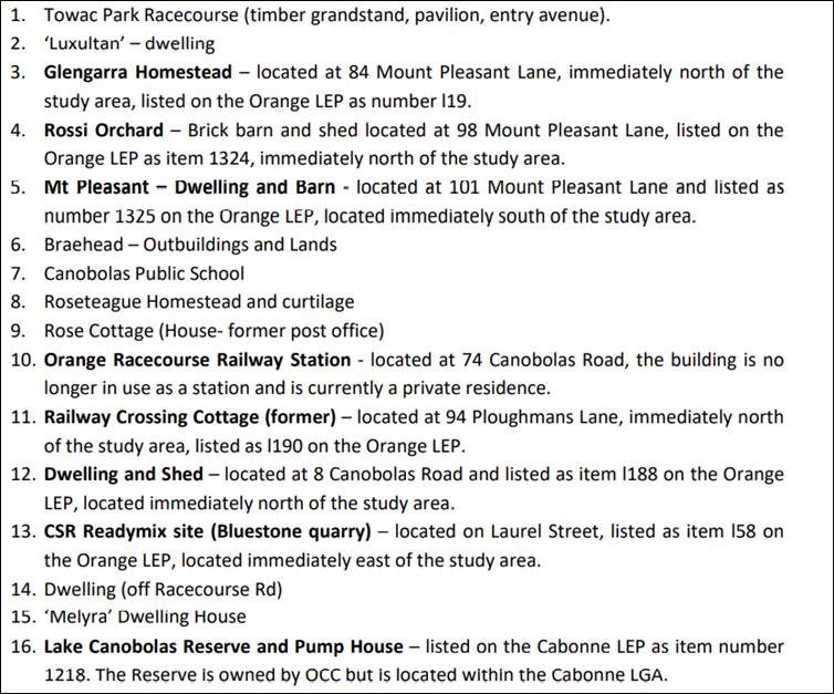
The proposed pipeline route
falls within the road verge in front of all built structures. The REF
provides that the project could impact the front fence of
“Glengarra”, given its proximity to the road, as well as the root
zone of the mature plantings at the front of 74 Canobolas Road; however,
given the pipeline will be closely aligned with the road, the works will not be
within the zone of influence of the fence or major/significant roots of the
plantings fronting 74 Canobolas Road. Figures below show the expected placement
of the pipeline. It is, however, reasonable to require a dilapidation
report to be prepared for the fence and exclusions zones in place during
works to avoid potential damage by machinery.
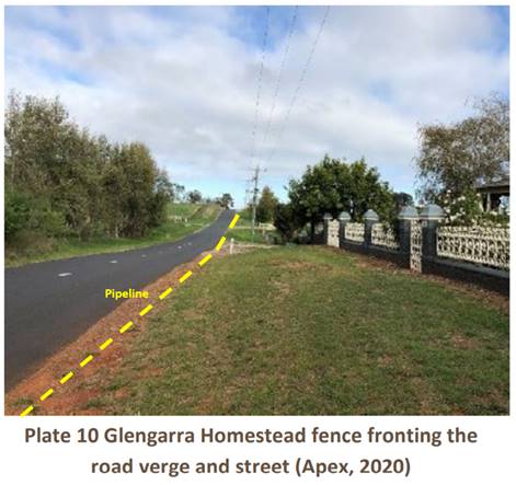
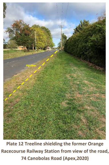
Biodiversity
A detailed terrestrial ecological assessment has been
prepared as part of the REF in accordance with the NSW Biodiversity
Conservation Act 2016 and Commonwealth Environmental Protection
Conservation Act 1999. This report contains details on the survey
methods employed, habitat assessments, threatened species assessment and tests
of significance.
The project includes a 10 m
wide direct impact corridor over a 7.91 km length, from the Lake Canobolas
Reserve to Orange. The REF advises that the proposal would result in the
removal of up to 0.75 ha native vegetation consisting of ground and shrub
cover. No mature native trees will be removed or impacted by the works. Ground-
truthed vegetation occurring within the subject site is shown in the following
table:
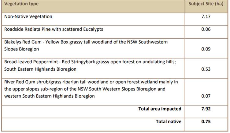
The current road and adjacent private properties heavily
dictate the alignment of the proposed clearing works and as such, no major
alterations to the route can be made. However, amendments have been made to the
route where it crosses private land and waterways, to ensure crossings are
perpendicular to reduce erosion potential, and tracts of native vegetation have
been avoided where possible. The REF advises that the native vegetation that
will impacted by the project is in poor/moderate condition. All disturbed areas
will be required to be suitably revegetated e.g. hydroseed or hydromulch with
native seed mix.
Ecological surveys, including habitat assessments and
incidental flora and fauna recordings were completed during the site visits to
identify important habitat components for any threatened species and ecological
communities recorded, or that may occur, within the locality. The report
advises that a total of 27 fauna species were recorded within the study area.
This included twenty-four (24) bird species, including one (1) exotic and three
(3) mammal species two (2) exotic.
However, the report advises that the
study area supports a limited range of habitat for native wildlife. The study
area contains several native trees that potentially provide shelter, nesting,
and food resources throughout the year. Due to the relative isolation of the
roadside vegetation, most faunal habitat is located towards the western extent
of the study area within the Lake Reserve. Beyond the scattered roadside trees
and vegetation surrounding the lake, the study area consists mostly of cleared
paddocks and land unsuitable for habitation by most native wildlife. Beyond the
road reserve there is little habitat for native wildlife as it is completely
barren, exposing wildlife to predation and providing minimal habitat in terms
of shelter or food resources. Adjacent land consists of ploughed fields devoid
of shelter or other resources. In this regard, the REF advises that the proposal
is unlikely to result in habitat fragmentation.
Indirect impacts caused by the
Proposal will include noise and dust pollution generated by machinery during
clearing and trenching activities. Noise and dust have the potential to travel
long distances and disrupt wildlife outside of the study area. Presence of
vehicles, machinery and staff within and surrounding the study area may also
disturb terrestrial species that feed or breed in the vicinity. Appropriate
sediment controls and hours of work will limit the potential for significant
impact.
In terms of the riparian ecological
impacts, the REF advises that sediment generated and/or emitted during and
following clearing and trenching may migrate downhill of Molong Creek,
disrupting amphibious and or aquatic species through increased sediment
deposition and reduced water quality (increased turbidity). Careful management
of the pipeline crossing at Molong Creek and the unnamed waterway, including
strict erosion and sediment controls and best practice techniques will greatly
reduce any potential impact to creek biodiversity. Council/contractor will also
need to comply with any requirements of approvals/permits issued by NRAR or
DPIE Fisheries before commencing any work in these areas.
Overall, the removal of the
vegetation (grasses and shrubs) within the subject site is unlikely to affect
an ecologically significant proportion of local native populations in the area;
and mobile fauna that can either easily move from the subject site or which
only use resources on a temporary or seasonal basis are highly unlikely to be
injured or killed by the proposal. The strategies/safeguards proposed in the
REF are considered appropriate to ensure minimal impact on biodiversity.
Traffic and Transport
The primary impacts on traffic associated with the proposal
are likely to be disturbance to local traffic movements and access to the site
during construction, including short term lane closures and/or traffic
controls, resulting in commuter delays. No major permanent detours or loss of
access to businesses/properties is expected as a result of works. The pipeline
route occurs along sections of road that can easily be bypassed by locals
travelling through the area. Impacted driveways/accesses will be
replaced/repaired of all damages post-completion of construction in the
immediate vicinity.
A Traffic Management Plan (TMP) will be prepared as part of
the standard safety and site induction materials within the project CEMP, to
ensure that staff undertaking the road works are suitably inducted to site,
that traffic flow is minimally disrupted during the works and that appropriate
traffic safety measures are employed. Residents and businesses will be
notified/consulted in relation to timing of works to avoid any significant
disruption.
Waste
Management
Several types of waste will arise from the project which
will be disposed of and managed in line with legislation.
Socio-Economic Effects
Construction
of the proposed Lake Canobolas Water and Sewer Reticulation mains is
anticipated to have positive long-term socio-economic benefits for the local
community, by giving residents access to reticulated sewerage and water, which
are generally the most effective method for removing and treating waste in an
urban area.
Visual Amenity Impacts
During construction, the proposed
works would affect the visual environment by the presence of machinery and
equipment, excavation and soil disturbance, and temporary excavation of private
property entrances that will be undertaken for pipeline construction. However,
these impacts will be short term and only for the duration of works and all
impacted areas will be suitably rehabilitated.
Further, the proposal will mainly constitute buried
pipelines and a below-ground pump station that would not significantly detract
from the visual environment post installation. The new pump station will not
cause significant impact to visual amenity due to its remoteness, and the
location being surrounded by established trees and the landscaping to accompany
the design and construct. Overall, the proposal is not expected to have a
significant impact on the visual amenity of the site.
Climate Change
The REF has assessed climate change
impacts resulting from the project, however, these are minimal given the nature
of the project. Appropriate resource management will be followed including
avoiding unnecessary resource consumption, followed by appropriate resource
recovery including reuse of materials, reprocessing, recycling and energy
recovery.
STAKEHOLDER ENGAGEMENT
The REF
was exhibited between 20 December 2021 and 25 January 2022 receiving three (3)
public submissions. The submissions received
represent those stakeholders with a direct and legitimate interest in the
impacts of the proposed water and sewer reticulation system, particularly
adjoining residents. Principally, the concerns raised by the submission writers
relate to impacts during construction works including noise, property access,
excavation works, vibration and disruption to business. The concerns raised in
the submissions are addressed below:
Submission
1 response:
At present it is intended to place the pipeline on the
Northern side of Mount Pleasant Lane to minimize the impacts on vegetation
on the southern side of the road. Council is aware of the Power and Optus
infrastructure in this vicinity and will liaise with the relevant authority as
necessary.
Council typically has the construction contractor undertake
a dilapidation report before works commences. Given the age of the
dwelling and wall, Council is also prepared to engage an independent engineer
to undertake this evaluation.
An instruction will also be given to
contractors not to utilize vibration equipment in the vicinity of the
wall. Council is insured and requires all contractors to be
insured. Council will rectify any damage caused to infrastructure on
private land as a result of the works.
Submission
2 response:
Council will ensure the pipe is
located far enough from the structure to ensure its footings are not
compromised. In addition, Council will instruct that vibration equipment
is not used in the vicinity of the property.
With respect to the placement of
the pipe past the dwelling this should only take a few days, however, access
down Pines Lane will be necessary as works progress past 381 Pinnacle
Road.
Council can provide indicative dates
for construction once a contract is let however this would be weather dependent
and could be impacted by COVID or material supply.
Submission
3 response:
The majority of the new water main
does not affect access and will be constructed parallel to the existing water
main falling within the same easement. Consultation will occur to ensure
there is minimal impact on business operations. Consultation with property
owners regarding vegetation rehabilitation over the pipeline will also be
undertaken in due course.
Council initially proposed to run
the sewer main through the property adjacent to the existing water main with a
view that it would have negligible impact upon mature trees.
However, based on the concerns raised, Council has now designed the sewer
main to follow Woods lane. The sewer main is to be placed on the western
side of the road with a view to minimising the impact on mature trees.
Orange City Council will rectify any
damage caused by the sewer and water main construction. However, the upgrading
of roads within Cabonne Shire Council does not form part of this project.
Cabonne
Council
Consultation with Cabonne Shire
Council is ongoing, as a portion of the infrastructure will be constructed and
operated in the Cabonne LGA. Cabonne Council are supportive of the project.
Other
Government agencies
As identified within REF and
discussed in the report, consultation with NSW DPI Fisheries is required to
determine whether a Part 7 Permit under the FM Act is required to be obtained
prior to commencement of works. The 2nd order unnamed creek to be crossed by
the proposal is mapped as supporting Key Fish Habitat, which triggers the need
for further investigation and liaison with Fisheries or NRAR.
CONCLUSION
Under
Section 5.5 of the EP&A Act, Orange City Council is responsible for
assessing all matters affecting or likely to affect the environment from this
activity. In this regard, the proponent commissioned EnviroFact Pty Ltd to prepare a Review of Environmental Factors (REF)
to address the heads of consideration outlined in Clause 228 of the
Environmental Planning and Assessment Regulation 2000 and to inform the
determination process.
The REF provides a comprehensive outline
of the project, neatly summarising pages of analysis as well as clearly
determining that the project will not cause undue impact to the environment. The REF concludes that the proposed works are
unlikely to have a significant adverse impact on the environment provided that all
proposed management measures and safeguards are implemented.
Staff concur with the findings
of the REF. It is concluded that Council has satisfied its obligations under
Part 5 of the EP&A Act 1979 and that the project can proceed. Works
cannot commence until the appropriate approvals/permits are granted by DPIE
Fisheries or NRAR.
CONditions
In addition to the safeguards
and environmental management measures outlined the REF by EnviroFact Pty
Ltd dated 7 December 2021, the following conditions apply:
1. A Construction
Environment Management Plan (CEMP) is to be prepared prior to any construction
works commencing. The CEMP must include all REF Environmental Safeguards and
Mitigation Measures.
2. Works are to be carried
out during normal work hours (7am to 6pm Monday to Friday; 8am to 1pm
Saturdays). No work is permitted to occur on Sundays or public holidays.
3. All personnel working
onsite will receive training to ensure awareness of environment protection
requirements to be implemented during the project. This is to include site
induction and regular 'toolbox' briefings. Site specific training to include
areas of high sensitivity including heritage items, native vegetation etc.
Records of site induction training to be kept by project manager.
4. A dilapidation report prepared
by a suitably qualified engineer is to be submitted to Council’s Director
Development Services addressing the current condition of the front fence and
dwelling at 84 Mount Pleasant Lane, Orange.
5. An exclusion zone is to
be established by fencing or other means adjacent to the front boundary fence
at 84 Mount Pleasant Lane, Orange to ensure avoidance of impacts. Access
by personnel or vehicles/plant and storage of any materials within the
exclusion zone is strictly prohibited.
Attachments
1 Submissions,
D22/16190⇩
2 Site
Plans, D22/16059⇩
Planning
and Development Committee
5 April 2022
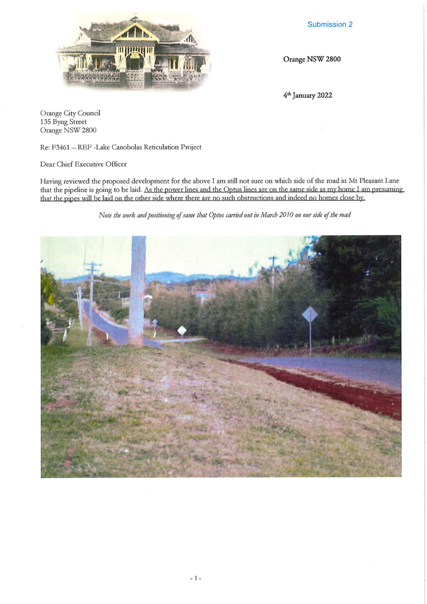
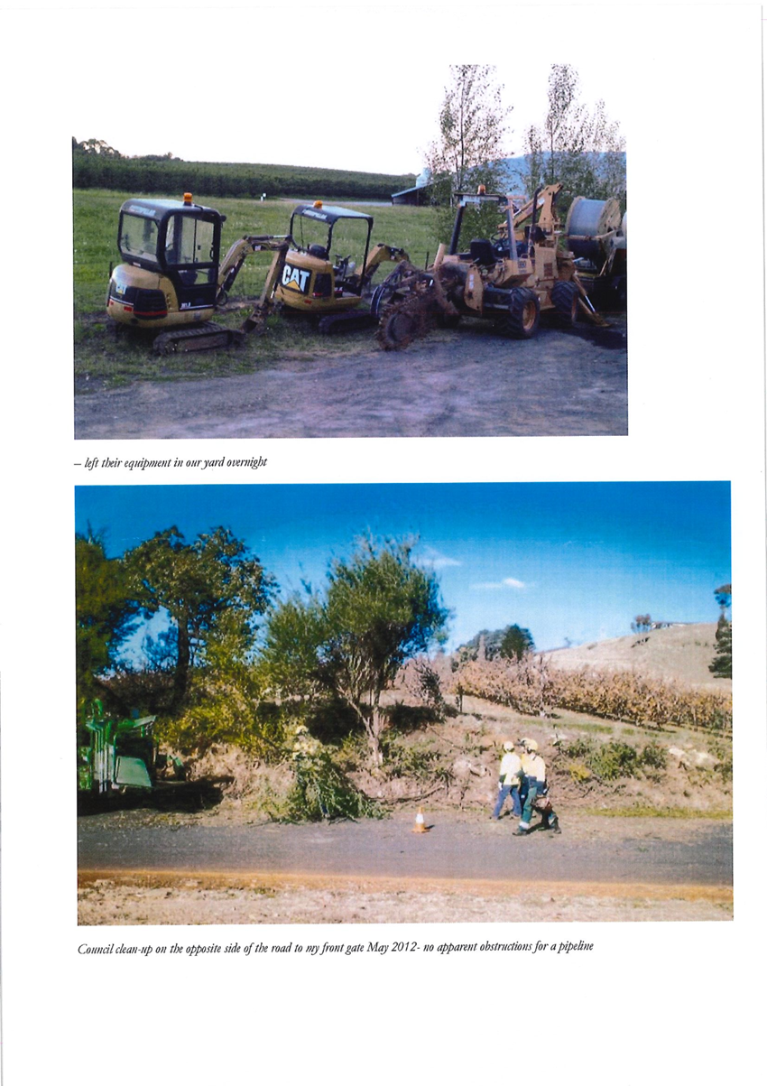
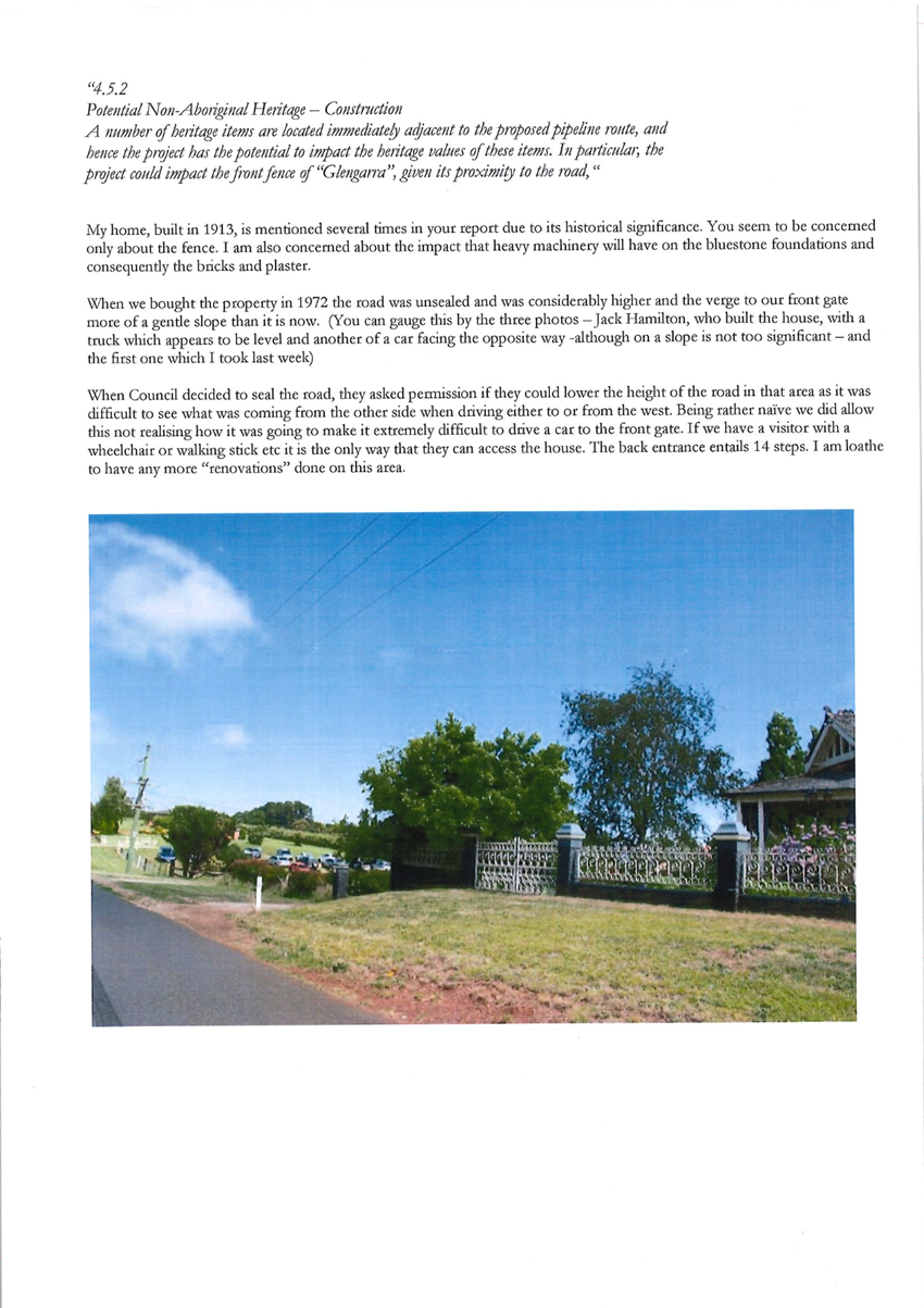
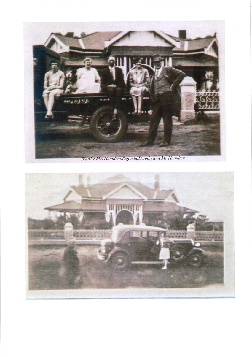
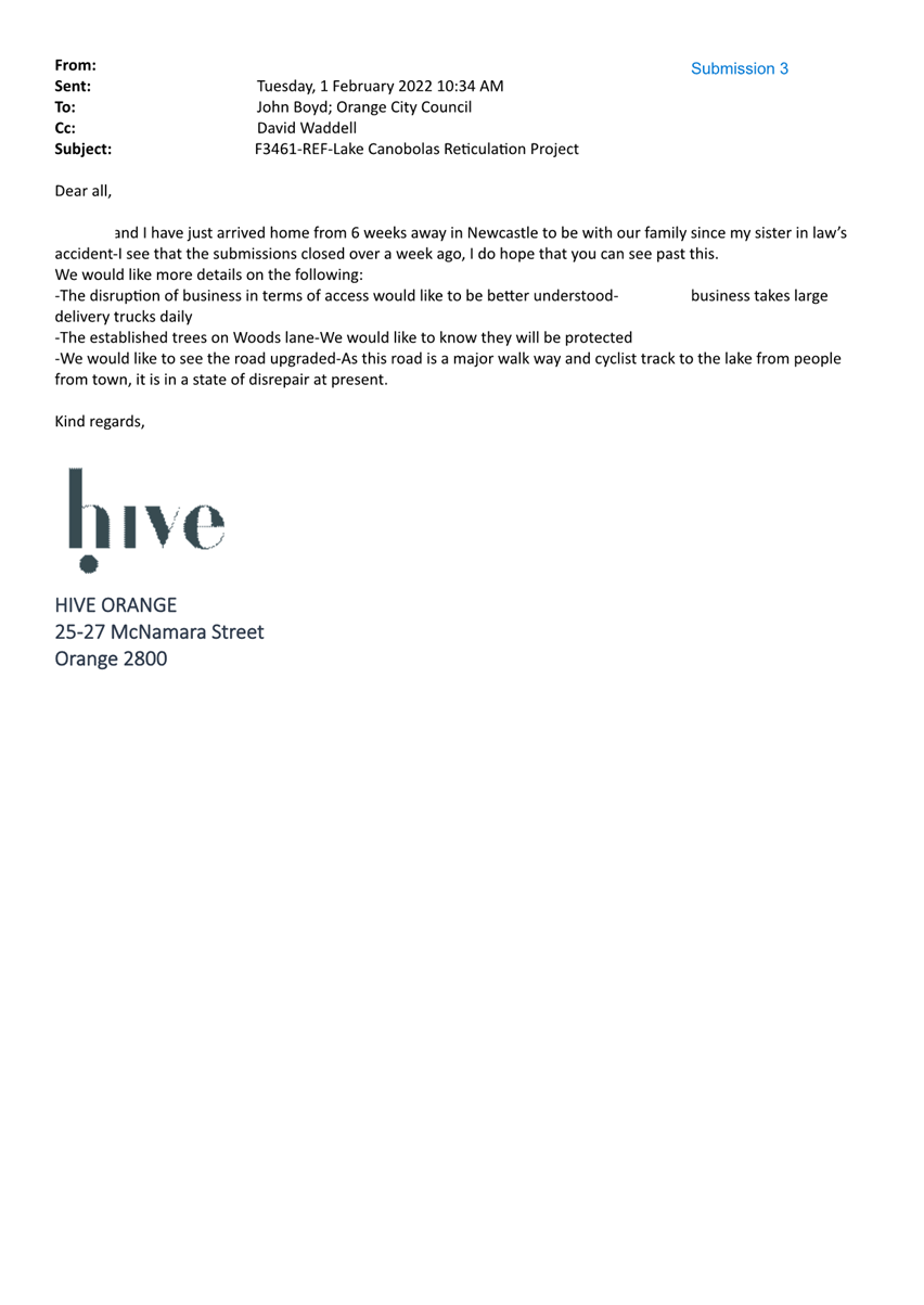
Planning and Development Committee
5 April 2022
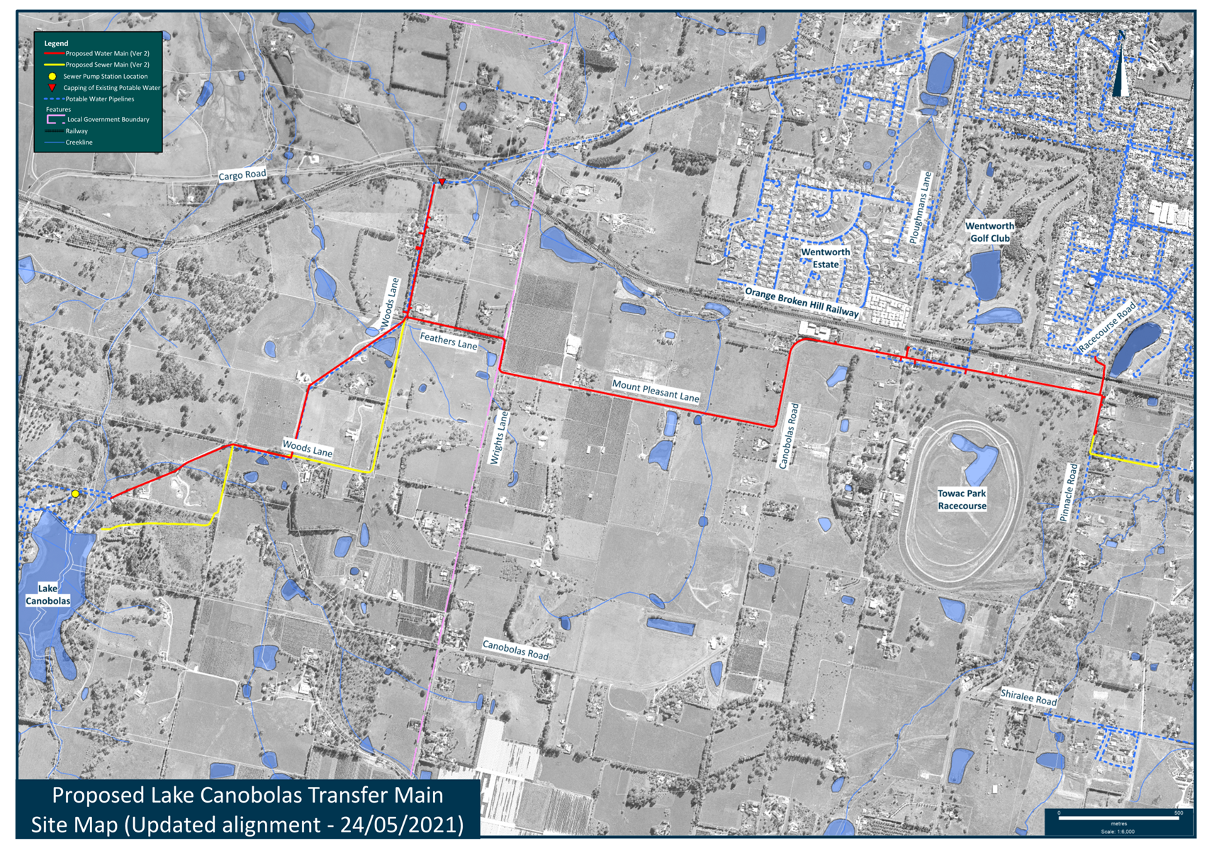
2.5 Development
Application DA 372/2021(1) - 75 Rossi Drive, Clifton Grove
RECORD
NUMBER: 2022/434
AUTHOR: Lucy
McDermott, Town Planner
EXECUTIVE Summary
|
Application
lodged
|
27
August 2021
|
|
Applicant/s
|
Ms E
Stelling
|
|
Owner/s
|
Mr AD
Stelling and Ms CA Rieksen
|
|
Land
description
|
Lot 108
DP 1043048 - 75 Rossi Drive, Clifton Grove
|
|
Proposed
land use
|
Secondary
Dwelling
|
|
Value of
proposed development
|
$191,078
|
Council's consent is sought for a secondary dwelling at 75
Rossi Drive, Clifton Grove - Lot 108 DP 1043048. The proposed secondary
dwelling is a four bedroom dwelling located to the north-east of the primary
dwelling.
The subject site is located within the R5 Large Lot
Residential zone. The proposed development is defined as a secondary dwelling
and is not permitted in this zone under the OLEP 2011 but is permissible under
the SEPP (Housing) 2021. This application is seeking consent under the SEPP (Housing)
2021. The secondary dwelling has a Gross Floor Area of 133.45m2 and
as such the applicant has requested a variation to the maximum area development
standard of 60m² contained with the SEPP (Housing) 2021 for secondary
dwellings. An assessment of this variation has been included in the body of
this report and concludes that the proposed variation is reasonable in the
context of the locality with consideration of the conflicting development
restrictions across the various residential zones within Orange City Council
area.
The applicant has outlined that the secondary dwelling will
be occupied by family.
Approval of the application is
recommended.
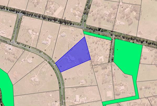
Figure 1 - locality plan
DECISION FRAMEWORK
Development in Orange is governed by two key documents
Orange Local Environment Plan 2011 and Orange Development Control Plan 2004. In
addition the Infill Guidelines are used to guide development, particularly in
the heritage conservation areas and around heritage items.
Orange Local Environment Plan 2011 – The
provisions of the LEP must be considered by the Council in determining the
application. LEPs govern the types of development that are permissible or
prohibited in different parts of the City and also provide some assessment
criteria in specific circumstances. Uses are either permissible or not. The
objectives of each zoning and indeed the aims of the LEP itself are also to be
considered and can be used to guide decision making around appropriateness of
development.
Orange Development Control Plan 2004 – the DCP
provides guidelines for development. In general it is a performance based
document rather than prescriptive in nature. For each planning element there
are often guidelines used. These guidelines indicate ways of achieving the
planning outcomes. It is thus recognised that there may also be other solutions
of merit. All design solutions are considered on merit by planning and building
staff. Applications should clearly demonstrate how the planning outcomes are
being met where alternative design solutions are proposed. The DCP enables
developers and architects to use design to achieve the planning outcomes in
alternative ways.
DIRECTOR’S COMMENT
The major issue in the assessment of this application
relates to the need for a Section 4.6 variation to a development standard. This
has been required due to the poor construction of Section 52(2)(c) of SEPP
(Housing) which enables consent to be granted where:
(c) the total floor area of the secondary
dwelling is -
(i) no more than 60m2,
or
(ii) if a greater
floor area is permitted for a secondary dwelling on the land under another
environmental planning instrument—the greater floor area.
The underlined phrase effectively prevents any application
made under the SEPP from accessing the percentage rule normally available under
Clause 5.4 of the LEP. This is not logical given that if the use were
permissible “on the land” under the LEP the application would not
be made under the SEPP in the first instance.
The proposed secondary dwelling is for use by a family
member and whilst being generous in size, is positioned on the allotment so as
not to adversely impact on the character of Clifton Grove, nor the privacy,
amenity or views of neighbours. In the current housing market, it is not
unforeseen that such applications may be received.
One submission was received objecting to the secondary
dwelling due to amenity concerns. It is considered that the proposal is
not unreasonable and would not adversely impact on neighbours. The
recommendation of approval is supported.
Link To
Delivery/OPerational Plan
The recommendation in this report relates to the Delivery/Operational
Plan strategy “10.1 Preserve - Engage with the community
to ensure plans for growth and development are respectful of our heritage”.
Financial Implications
Nil
Policy and Governance Implications
Nil
|
Recommendation
That Council consents to
development application DA 372/2021(1)
for Secondary Dwelling at Lot 108 DP 1043048 - 75 Rossi Drive,
Clifton Grove pursuant to the conditions of consent
in the attached Notice of Approval.
|
further considerations
Consideration has been given to the
recommendation’s impact on Council’s service delivery; image and
reputation; political; environmental; health and safety; employees;
stakeholders and project management; and no further implications or risks have
been identified.
SUPPORTING INFORMATION
THE APPLICATION
Council's consent is sought for a secondary dwelling at 75
Rossi Drive, Clifton Grove - Lot 108 DP 1043048.
THE PROPOSAL
The proposal involves the construction of a secondary
dwelling which will be located to the north-east (rear) of the main residence.
The secondary dwelling will consist of four bedrooms, open plan living and
kitchen space, and a front wrap-around verandah. The total proposed GFA
area is 133.45m2. The applicant has requested a variation to the minimum
area development standard of 60m² contained with the State Environmental
Planning Policy (Housing) 2021 for secondary dwellings.
The proposed secondary dwelling
is a kit home to be constructed of timber frames and trusses with Colorbond
steel wall and roof cladding and aluminium framed windows.
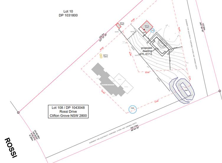
Figure 2 – Site Plan
Figure 3 – proposed Floor Plan
MATTERS
FOR CONSIDERATION
Section 1.7 - Application of Part
7 of the Biodiversity Conservation Act 2016 and Part 7A of the Fisheries
Management Act 1994
Section 1.7 of the EP&A Act
identifies that Part 7 of the Biodiversity Conservation Act 2016
(BC Act) and Part 7A of the Fisheries Management Act 1994 have effect in
connection with terrestrial and aquatic environments.
There are four triggers known to
insert a development into the Biodiversity Offset Scheme (ie the need for
a BDAR to be submitted with a DA):
· Trigger 1:
development occurs in land mapped on the Biodiversity Values Map (OEH)
(clause 7.1 of BC Regulation 2017);
· Trigger 2:
development involves clearing/disturbance of native vegetation above a certain
area threshold (clauses 7.1 and 7.2 of BC Regulation 2017); or
· Trigger 3:
development is otherwise likely to significantly affect threatened species
(clauses 7.2 and 7.3 of BC Act 2016).
The fourth trigger (development
proposed to occur in an Area of Outstanding Biodiversity Value (clause 7.2 of
BC Act 2016) is generally not applicable to the Orange LGA; as no such areas
are known to occur in the LGA. No further comments will be made against the
fourth trigger.
Summary
The site does not occur within land mapped on the
Biodiversity Values Map and no clearing/disturbance is proposed. As the
proposal does not trigger any of the four requirements for insertion into the
BOS, a Biodiversity Development Assessment Report is not required to be lodged
with the application for modified development consent. No other comments are
warranted under this section.
Section 4.15
Section 4.15 of the Environmental
Planning and Assessment Act 1979 requires Council to consider various
matters, of which those pertaining to the application are listed below.
PROVISIONS OF ANY ENVIRONMENTAL
PLANNING INSTRUMENT s4.15(1)(a)(i)
Orange Local Environmental Plan
2011
Part 1 - Preliminary
Clause 1.2 - Aims of Plan
The broad aims of the LEP are set out under Subclause 2.
Those relevant to the application are as follows:
(a) to
encourage development which complements and enhances the unique character of
Orange as a major regional centre boasting a diverse economy and offering an
attractive regional lifestyle,
(b) to
provide for a range of development opportunities that contribute to the social,
economic and environmental resources of Orange in a way that allows present and
future generations to meet their needs by implementing the principles for
ecologically sustainable development,
(d) to
manage rural land as an environmental resource that provides economic and
social benefits for Orange,
(e) to
provide a range of housing choices in planned urban and rural locations to meet
population growth,
(f) to
recognise and manage valued environmental heritage, landscape and scenic
features of Orange.
The application is considered to be consistent with the
relevant aims of the plan.
Clause 1.6 - Consent Authority
This clause establishes that,
subject to the Act, Council is the consent authority for applications made
under the LEP.
Clause 1.7 - Mapping
The subject site is identified on the LEP maps in the
following manner:
|
Land Zoning Map:
|
Land zoned R5 Large Lot Residential
|
|
Lot Size Map:
|
Minimum Lot Size 2Ha
|
|
Heritage Map:
|
Not a heritage item or conservation
area
|
|
Height of Buildings Map:
|
No building height limit
|
|
Floor Space Ratio Map:
|
No floor space limit
|
|
Terrestrial Biodiversity Map:
|
No biodiversity sensitivity on the
site
|
|
Groundwater Vulnerability Map:
|
Groundwater vulnerable
|
|
Drinking Water Catchment Map:
|
Not within the drinking water
catchment
|
|
Watercourse Map:
|
Not within or affecting a defined
watercourse
|
|
Urban Release Area Map:
|
Not within an urban release area
|
|
Obstacle Limitation Surface Map:
|
No restriction on building siting
or construction
|
|
Additional Permitted Uses Map:
|
No additional permitted use applies
|
|
Flood Planning Map:
|
Not within a flood planning area
|
Those matters that are of relevance are addressed in detail
in the body of this report.
Clause 1.9A - Suspension of
Covenants, Agreements and Instruments
This clause provides that
covenants, agreements and other instruments which seek to restrict the carrying
out of development do not apply with the following exceptions.
(a) to
a covenant imposed by the Council or that the Council requires to be imposed,
or
(b) to
any relevant instrument under Section 13.4 of the Crown Land Management Act
2016, or
(c) to
any conservation agreement under the National Parks and Wildlife Act 1974, or
(d) to
any Trust agreement under the Nature Conservation Trust Act 2001, or
(e) to
any property vegetation plan under the Native Vegetation Act 2003, or
(f) to
any biobanking agreement under Part 7A of the Threatened Species Conservation
Act 1995, or
(g) to
any planning agreement under Subdivision 2 of Division 7.1 of the Environmental
Planning and Assessment Act 1979.
It is noted that a Restriction of
the Use of Land existing on the land title. Part of this restriction discusses
that no dual occupancy development is permitted on the site. While it is
acknowledged that dual occupancy remains prohibited within the zone, the
application specifies that the development will be a secondary dwelling. The
proposed dwelling exceeds the size permitted under Clause 52 of the SEPP
(Housing) 2021, and as such requests a 4.6 variation which has been
discussed later in the report.
Part 2 - Permitted or Prohibited
Development
Clause 2.1 - Land Use Zones and Clause
2.3 - Zone Objectives and Land Use Table
The subject site is
located within the R5 Large Lot Residential zone. The proposed development is
defined as a secondary dwelling and is not permitted in this zone under the
OLEP 2011 but is permitted under the SEPP (Housing) 2021. This application is
seeking consent under the SEPP (Housing) 2021.
Clause 2.3 of LEP 2011
references the Land Use Table and Objectives for each zone in LEP 2011.
These objectives for land zoned Large Lot Residential are as follows:
1 -
Objectives of the R5 Large Lot Residential Zone
· To provide
residential housing in a rural setting while preserving, and minimising impacts
on, environmentally sensitive locations and scenic quality.
· To ensure that
large residential lots do not hinder the proper and orderly development of
urban areas in the future.
· To ensure that
development in the area does not unreasonably increase the demand for public
services or public facilities.
· To minimise
conflict between land uses within this zone and land uses within adjoining
zones.
· To provide for
student housing in close proximity to the Charles Sturt University.
· To ensure
development is ordered in such a way as to maximise public transport patronage,
and encourage walking and cycling, in close proximity to settlement.
· To ensure
development along the Southern Link Road has an alternative access.
The proposed secondary dwelling is
not permissible in the R5 Large Lot Residential zone under the Orange LEP
although is permissible under the State Environmental Planning Policy (Housing)
2021. The proposed development is not contrary to the objectives of the zone as
outlined in this report.
Part 3 - Exempt and Complying
Development
The application is not exempt or
complying development.
Part 4 - Principal Development
Standards
Clause 4.6 - Exceptions to Development
Standards
This clause is
applicable as the proposed secondary dwelling has a floor area that is greater
than the maximum size allowed under the State Environmental Planning Policy
(Housing) 2021. Clause 52(2) of the SEPP sets out maximum total floor area
for secondary dwellings, which relevantly states:
(b) the
total floor area of the secondary dwelling is no more than 60 square metres or,
if a greater floor area is permitted in respect of a secondary dwelling on the
land under another environmental planning instrument, that greater floor area.
The proposed
secondary dwelling is situated on land within the R5 Large Lot Residential
zone, where secondary dwellings are prohibited under the Orange LEP 2011,
although they are permissible under Clause 49 of the Housing SEPP.
Accordingly, this
clause identifies that a secondary dwelling cannot have a total floor area
greater than 60m², which the proposed secondary dwelling of this
development exceeds. The proposed total floor area of the secondary dwelling is
133.45m², representing a variation of 122%.
Clause 4.6 is
intended to achieve the following objectives:
(a) provide
an appropriate degree of flexibility in applying certain development standards
(b) achieve
better outcomes for and from development by allowing flexibility in particular
circumstances.
At its core, a Clause
4.6 variation may be supported where it can be shown that the objectives of the
standard are unreasonable and/or unnecessary to apply in this particular case,
and where it can be shown that the objectives of both the plan and the clause
to be varied are achieved notwithstanding the non-compliance with the numerical
value of the standard.
Clause 4.6 may not be
used to routinely seek variation to a standard and may not be used in such a
way as to render a development contrary to the intent of the standard or the
plan that it relates to. Clause 4.6 may also not be used as a de facto rezoning
tool, and cannot be used to bypass permissibility issues that a particular
proposal may have.
There are set
procedures outlined in guidelines published by the NSW Department of
Planning encapsulated in a circular published in 2008, and quite strongly
supported and upheld in the Land & Environment Court. For obvious reasons
the Department advises all Councils to allow variations only where exceptional
circumstances exist and where certain other criteria can be shown to be
achieved.
The Clause 4.6
variation submitted with the application generally achieves those outcomes and
the procedures outlined in the Department’s circulars; and the principals
established by the Courts. The main basis for justification advanced in the
submission is addressed below.
The permissibility of
secondary dwellings in the R5 Large Lot Residential zone was excluded from the
Orange LEP on Departmental advice that such development was already permitted
under the provisions of SEPP (Affordable Rental Housing) 2009, which has subsequently
been replaced by SEPP (Housing) 2021. Although under the provisions of the
SEPP, there are limitations on the floor area allowed for secondary dwellings
(Clause 52(2)) (max 60m² GFA) whereas in the LEP, secondary dwellings
are permissible if they have a total floor area that is not greater than 60sqm,
or do not exceed 50% of the floor area of the principal dwelling.
The applicant has
requested that given the conflicting provisions that apply throughout the city
for this type of development, and Council’s previous approach to the
consideration of same with other requests, that Council determine the
suitability of the proposed development against the secondary dwelling standard
of 50% of the principal dwellings floor area as opposed to the current limitation
of 60m².
The applicant has advised that the GFA of the primary
dwelling is 506.6m2. In this case 50% of the GFA of the main
dwelling equals (<253.3m2). Based on a GFA of 133.45m² the
development represents 26.4% of the main dwelling and would have ordinarily
easily met the standard if it were permissible in the zone under the LEP as
opposed to the SEPP.
The secondary
dwelling development is proposed on a large rural residential parcel (2.01ha)
and will not result in an excessive site coverage as it would if it were to be
constructed on an urban parcel. The proposed site coverage for the development
is considered comparable to that of adjoining rural residential parcels such
that the character of Clifton Grove is preserved. The site coverage proposed
remains far less than the site coverage typical of secondary dwellings
permitted in urban areas, demonstrating that large lot environments have
greater capacity to accommodate larger secondary dwellings with the same or
lesser impacts compared to urban lots.
As a result, Council
may consider including secondary dwellings as permissible in the R5 Large
Lot Residential zone with future amendment to the Orange LEP.
Matters to Address in
an Application
When applicants lodge
development applications and associated requests to vary a development
standard, they must give grounds of objection to the development standard.
Variation of a development standard may be justified where it is consistent
with the objectives that the relevant environmental planning instrument is
attempting to achieve.
The application must
address:
(i) whether
strict compliance with the standard, in the particular case, would be
unreasonable or unnecessary and why,
and
(ii) demonstrate
that there are sufficient environmental planning grounds to justify
contravening the development standard
The applicant has
argued that the minimum lot size is unnecessary and unreasonable in this
instance for the reasons explained below:
· The proposed
secondary dwelling satisfies the relevant Planning Outcomes for residential
development pursuant to Orange DCP 2004 – 06 Rural Development.
· The residential
development is considered a reasonable development for the site as each lot
within the vicinity of the subject site are able to accommodate more buildings
than the primary residence alone.
The lot size can easily accommodate the proposed dwelling
whilst maintaining the low density residential character of the area.
· The proposed
secondary dwelling does not exceed the LEP’s prescribed standard of being
less than 50% of the principal dwellings floor area (<253.3m2),
and therefore would have been approved if it were permissible in the zone under
the LEP.
Further, the applicant has provided numerous examples of
secondary dwellings in the Clifton Grove area. Whilst Council does not accept
the concept of precedents as each application should be assessed on its merits,
it is acknowledged that this may indicate an emerging character of the area.
While some of these examples may have not been approved by Council this is not
required to be considered as part of this application.
There are sufficient environmental planning grounds
cited to support the variation. These are as follows:
· A variation of the
development standard is justified in this case because it can be demonstrated
that the proposal satisfies the objectives of the R5 Large Lot Residential zone
and the objectives of the secondary dwelling standards under the Housing SEPP.
· The secondary
dwelling development has a high degree of compliance with the other relevant
LEP and DCP provisions.
· The proposed
secondary dwelling is considered compatible with the residential land use
pattern in this area. A variation of the minimum floor area to allow the
proposed secondary dwelling to be excised on a large lot allotment does not
diminish this aspect of the development.
· It is demonstrated
that non-compliance with the development standard does not generate
unacceptable impacts in the locality.
Written applications
to vary development standards need to not only address the above matters, but
may also address matters set out in the ‘five part test’
established by the NSW Land and Environment Court. The NSW Department of
Planning strongly advises councils to apply the Five Part Test in their
assessments of Clause 4.6 matters.
The Five Part Test
The Five Part Test is
anchored in Land and Environment Court Planning Principles. The Department
of Planning recommends that consent authorities apply the test in their assessment
of Clause 4.6 variations.
The five part test
embodies the following:
1 the
objectives of the standard are achieved notwithstanding noncompliance with the
standard
2 the
underlying objective or purpose of the standard is not relevant to the development
and therefore compliance is unnecessary
3 the
underlying object or purpose would be defeated or thwarted if compliance was
required and therefore compliance is unreasonable
4 the
development standard has been virtually abandoned or destroyed by the council’s
own actions in granting consents departing from the standard and hence
compliance with the standard is unnecessary and unreasonable
5 the
compliance with development standard is unreasonable or inappropriate due to
existing use of land and current environmental character of the particular
parcel of land. That is, the particular parcel of land should not have been
included in the zone.
With regard to Point
(1), section 52 of SEPP(Housing) does not contain specific objectives, however
the overall principles in section 3 of the SEPP include:
(c) ensuring
new housing development provides residents with a reasonable level of amenity,
(d) promoting
the planning and delivery of housing in locations where it will make good use
of existing and planned infrastructure and services,
(e) minimising
adverse climate and environmental impacts of new housing development,
(f) reinforcing
the importance of designing housing in a way that reflects and enhances its
locality,
It is considered that
the secondary dwelling on a large residential lot in Clifton Grove will provide
residents with reasonable amenity, makes use of existing infrastructure and
services, does not adversely impact the climate and given the relationship to
the overall size of the lot will read as consistent with the character of
Clifton Grove.
With regard to Point
(2), it is considered that a variation of the minimum total floor area for
secondary dwellings is a development standard that may be considered within the
ambit and operation of this clause.
Floor area
requirements for secondary dwellings are a blunt assessment tool aimed at
achieving good design outcomes, whilst at the same time making efficient use of
the land at densities likely to achieve a reasonable return for the development;
and at the same time ensuring that neighbourhood character and amenity is not
excessively compromised.
The variation is
considered acceptable in this case due largely to the size of the rural
residential allotment and the fact that the secondary dwelling would have an
allowable floor area if it were permissible in the zone under the LEP. As the
proposed development is a secondary dwelling and is situated on a parcel of
land that is not typical of an urban area, the variation is considered to be acceptable
in this instance as the effect of the proposal on the surrounding development
will be minimal.
With regard to Point
(3), it is considered that strict compliance with the 60m2 standard
under the SEPP (Housing) 2021 would not necessarily defeat or thwart the
underlying objective or purpose of the development standard. However, the
proposal is considered to be consistent with the objectives of the development
standard.
With regard to Point
(4), the development standard cannot be said to be abandoned. However, it is
considered that other land holdings within close proximity to the subject site
would most likely encounter this issue themselves.
With regard to Point
(5), the zoning of the land is reasonable and appropriate for the proposal. It
is considered that insistence on full compliance with Clause 52(2) for this
site is unreasonable, and unnecessary in this case.
Council may grant
consent only if the concurrence of the Director General of the Department of
Planning has been obtained and Council is satisfied that:
· the written request
has adequately addressed the above, and
· the proposed
development will be in the public interest because of:
- consistency
with the objectives of the particular standard, and
- consistency
with the objectives of the zone applying to the site.
The written request
adequately addresses the variation criteria of the clause.
Department Of Planning’s Circular
This circular sets
out the circumstance and criteria for applying Council’s assumed
concurrence to the determination of development standards under
Clause 4.6. Council has assumed concurrence to assess and process
Clause 4.6 variations of this nature. In this case given the departure
exceeds 10% the decision must be extended to the Council as opposed to a delegate
of the Council.
In accordance with
the requirements of the circular, Council has quarterly reporting obligations
as to the number of times it has used Clause 4.6 and for what purposes.
The Department wants to keep check on the over use of Clause 4.6 to discourage
inappropriate use of the clause on a routine basis. Despite some use of the
clause for development in the Orange City LGA, there has been no expressions of
concern from the department about the overuse of the clause.
There are some
circumstances where Clause 4.6 is prohibited from being used, but this
particular situation is not one of those circumstances.
The land is located
within the R5 Large Lot Residential zone, which has the following objectives:
· To provide
residential housing in a rural setting while preserving, and minimising impacts
on, environmentally sensitive locations and scenic quality.
· To ensure that large
residential lots do not hinder the proper and orderly development of urban
areas in the future.
· To ensure that development
in the area does not unreasonably increase the demand for public services or
public facilities.
· To minimise conflict
between land uses within this zone and land uses within adjoining zones.
· To provide for
student housing in close proximity to the Charles Sturt University.
· To ensure development
is ordered in such a way as to maximise public transport patronage, and
encourage walking and cycling, in close proximity to settlement.
· To ensure development
along the Southern Link Road has an alternative access.
The proposed
development with its non-compliance to Clause 52(2) is not contrary to any
of the objectives for the zone even if it is prohibited under the LEP it is
compliant under the Housing SEPP (subject to the 4.6 variation being granted);
neither does the proposed development significantly contravene
the DCP’s planning outcomes.
Overall, it is
considered that the proposed development does not result in any adverse impact
on the operation of the LEP or the DCP, and would not result in any
significant adverse impact.
It is considered that
the proposal, including the variation sought, is consistent with the above
objectives.
Part 5 - Miscellaneous Provisions
Clause 5.4 - Controls Relating to
Miscellaneous Permissible Uses
This clause contains various
development standards that apply to specific types of development.
Relevantly the clause requires:
· secondary dwellings
to be limited to the greater of 60 square metres or 50% of the floor area of
the principal (main) dwelling
In this regard, the
proposal is inconsistent with the former requirement, as the proposed secondary
dwelling exceeds 60sqm. Although the development does comply with the latter
standard as it does not exceed 50% of the floor area of the principal dwelling.
It must be noted that
due to the development being prohibited in the zone, the secondary dwelling is
being assessed under the SEPP (Housing) 2021, where the former standard
(<60sqm) is applied. Due to the development exceeding this measurement, a
Clause 4.6 variation has been applied to vary Clause 52(2) of the SEPP
(Housing) 2021.
Part 6 - Urban Release Area
Not relevant to the application. The subject site is not
located in an Urban Release Area.
Part 7 - Additional Local Provisions
7.1 - Earthworks
This clause establishes a range of
matters that must be considered prior to granting development consent for any
application involving earthworks, such as:
(a) the likely disruption of, or any
detrimental effect on, existing drainage patterns and soil stability in the
locality of the development
(b) the effect of the development on the
likely future use or redevelopment of the land
(c) the quality of the fill or the soil to be
excavated, or both
(d) the effect of the development on the
existing and likely amenity of adjoining properties
(e) the source of any fill material and the
destination of any excavated material
(f) the likelihood of disturbing relics
(g) the proximity to and potential for adverse
impacts on any waterway, drinking water catchment or environmentally sensitive
area
(h) any measures proposed to minimise or
mitigate the impacts referred to in Paragraph (g).
The earthworks
proposed in the application are limited to the extent of cutting and filling
required for the proposed building or structure. The extent of disruption to
the drainage of the site is considered to be minor and will not detrimentally
affect adjoining properties or receiving waterways.
The extent of the
earthworks will not materially affect the potential future use or redevelopment
of the site that may occur at the end of the proposed development's lifespan.
The site is not known
to be contaminated and conditions may be imposed requiring the use of verified
clean fill only. Excavated materials will be reused onsite as far as possible
and conditions may be imposed to require that surplus materials will disposed
of to an appropriate destination.
The earthworks will be appropriately supported onsite and the
change in ground level is not substantial. Therefore the effect on the amenity
of adjoining properties is considered to be minor.
The site is not known
to contain any Aboriginal, European or Archaeological relics. Previous known
uses of the site do not suggest that any relics are likely to be uncovered.
However, conditions may be imposed to ensure that should site works uncover a
potential relic or artefact, works will be halted to enable proper
investigation by relevant authorities and the proponent required to seek
relevant permits to either destroy or relocate the findings.
The site is not in
proximity to any waterway, drinking water catchment or sensitive area.
Conditions may be imposed to require a sediment control plan, including silt
traps and other protective measures, to ensure that loose dirt and sediment
does not escape the site boundaries.
7.3 - Stormwater Management
This clause applies
to all industrial, commercial and residential zones and requires that Council
be satisfied that the proposal:
(a) is designed to maximise the use of water
permeable surfaces on the land having regard to the soil characteristics
affecting onsite infiltration of water
(b) includes, where practical, onsite
stormwater retention for use as an alternative supply to mains water,
groundwater or river water; and
(c) avoids any significant impacts of
stormwater runoff on adjoining downstream properties, native bushland and
receiving waters, or if that impact cannot be reasonably avoided, minimises and
mitigates the impact.
The proposal has been
designed to include permeable surfaces and includes onsite retention of
stormwater through the use of rainwater tanks/detention basins. It is therefore
considered that the post development runoff levels will not exceed the
predevelopment levels.
7.6 - Groundwater Vulnerability
This clause seeks to protect
hydrological functions of groundwater systems and protect resources from both
depletion and contamination. Orange has a high water table and large areas of
the LGA, including the subject site, are identified with “Groundwater
Vulnerability” on the Groundwater Vulnerability Map. This requires that
Council consider:
(a) whether or not the development (including
any onsite storage or disposal of solid or liquid waste and chemicals) is
likely to cause any groundwater contamination or have any adverse effect on
groundwater dependent ecosystems, and
(b) the cumulative impact (including the
impact on nearby groundwater extraction for potable water supply or stock water
supply) of the development and any other existing development on groundwater.
Furthermore, consent may not be granted unless Council is satisfied that:
(a) the development is designed, sited and
will be managed to avoid any significant adverse environmental impact, or
(b) if that impact cannot be reasonably avoided
- the development is designed, sited and will be managed to minimise that
impact,
(c) if that impact cannot be minimised - the
development will be managed to mitigate that impact.
The proposal is not
anticipated to involve the discharge of toxic or noxious substances and is
therefore unlikely to contaminate the groundwater or related ecosystems. The
proposal does not involve extraction of groundwater and will therefore not
contribute to groundwater depletion. The design and siting of the proposal avoids
impacts on groundwater and is therefore considered acceptable.
Clause 7.11 - Essential
Services
Clause 7.11 applies and states:
Development
consent must not be granted to development unless the consent authority is
satisfied that any of the following services that are essential for the
proposed development are available or that adequate arrangements have been made
to make them available when required:
(a) the supply of water,
(b) the supply of
electricity,
(c) the disposal and
management of sewage,
(d) storm water drainage or
on-site conservation,
(e) suitable road access.
In consideration of this clause, all utility services are
available to the land and adequate for the proposal.
STATE ENVIRONMENTAL PLANNING
POLICIES
State Environmental Planning
Policy (Resilience and Hazards) 2021 – Chp 4 Remediation of Land
State Environmental Planning Policy (Resilience and
Hazards) 2021 – Chapter 4 Remediation of Land is applicable. Pursuant
to Clause 4.6 Contamination and remediation to be considered
in determining development application:
(1) A
consent authority must not consent to the carrying out of any development on
land unless:
(a) it has considered whether the
land is contaminated, and
(b) if the land is
contaminated, it is satisfied that the land is suitable in its contaminated
state (or will be suitable, after remediation) for the purpose for which the
development is proposed to be carried out, and
(c) if the land
requires remediation to be made suitable for the purpose for which the
development is proposed to be carried out, it is satisfied that the land will
be remediated before the land is used for that purpose.
The site has a long established residential
and agricultural land use, therefore contamination of the site is unlikely. The
proposed development is located within the established building envelope and
does not propose a change of use for the site. Inspection of the site does not
indicate any areas or sources of potential contamination.
State Environmental Planning
Policy (Housing) 2021 – Chp 3 Diverse Housing
Chapter 3 Division 2 Clause 49
applies and states:
Development for the purposes
of a secondary dwelling includes the following:
(a) the
erection of, or alterations or additions to, a secondary dwelling
(b) alterations or additions to a principal
dwelling for the purposes of a secondary dwelling.
The proposed secondary dwelling
meets the definition outlined in the SEPP. The secondary dwelling is not
permissible in the R5 Large Lot Residential zone under the Orange LEP although
is permissible under the State Environmental Planning Policy (Housing) 2021.
The proposed development is not contrary to the objectives of the SEPP as
outlined in this report.
Due to the development being
prohibited in the zone, the secondary dwelling is being assessed under the SEPP
(Housing) 2021, where the <60sqm standard is applied. Due to the development
exceeding this measurement, a Clause 4.6 variation has been applied to vary
Clause 52(2) of the SEPP (Housing) 2021 which was addressed above.
PROVISIONS OF ANY DRAFT
ENVIRONMENTAL PLANNING INSTRUMENT THAT HAS BEEN PLACED ON EXHIBITION 4.15(1)(a)(ii)
There are no draft EPI’s that are applicable to this
development or the subject land.
DESIGNATED DEVELOPMENT
The proposed development is not designated development.
INTEGRATED DEVELOPMENT
The proposed development is not integrated development.
PROVISIONS OF ANY DEVELOPMENT
CONTROL PLAN s4.15(1)(a)(iii)
Development Control Plan 2004
DCP 2004 – 06 Rural Development is
considered to be the most relevant to this proposal. An assessment of the
proposed development against the relevant Planning Outcomes (6.10‑2
Rural Dwelling Houses) will be undertaken below.
1. The dwelling house
complies with Council’s Energy Smart Homes Code.
The proposed secondary dwelling is considered to comply with
Councils Energy Smart Homes Code. Further, a compliant BASIX Certificate and
NatHERS Certificate has been submitted to Council.
2. The
dwelling house is sited on land identified as being suitable for construction
and free from contamination, flooding and bushfire risk.
The proposed secondary dwelling is located with the
specified building envelope for the area and is considered free from
contamination, flooding and bushfire risk. The land is therefore considered
acceptable for the proposed development.
3. Privacy
and views of neighbouring houses are retained.
The proposed dwelling is not anticipated to impact on the
views or privacy of adjoining dwellings. The proposed location of the secondary
dwelling on site is considered to be sufficiently distanced from other
dwellings to mitigate any privacy concerns. The dwelling is also not considered
to be within any valuable view corridors, and is surrounded by vegetation to
screen the location from several adjoining dwellings.
4. A
suitable area is available for perpetual on-site disposal of wastes.
A report by Envirowest was provided by the applicant that
recommends a suitable area for on-site disposal of wastes.
5. Substantial
remnant vegetation is protected from disturbance.
The proposed development does not involve the clearing of
any existing vegetation.
6. An
adequate water supply is provided.
Water is anticipated to collect on site and stored in the
existing water tanks to supply onsite water supply.
7. All-weather access to
a public road is provided.
The proposed secondary dwelling will utilise the existing
access and driveway to Rossi Drive.
8. Entry
gateways are set back sufficiently from the front boundary to allow vehicles to
pull up off the public road carriageway.
The proposed secondary dwelling will utilise the existing
access and driveway to Rossi Drive.
9. A buffer area is
established in the vicinity of agricultural operations.
The site is surrounded by established large lot residential
development and is therefore considered to be sufficiently distanced from
agricultural operations in the area.
10. Outbuildings
are located in proximity of and to the rear of the main dwelling house when viewed
from the nearest road.
The proposed
secondary dwelling is positioned behind the existing primary dwelling
DEVELOPMENT CONTRIBUTIONS
Section 7.11 Development Contributions
Development contributions are
applicable to the proposed development, pursuant to Orange Development
Contributions Plan 2017 (Remainder of LGA) as follows:
|
Open
Space and Recreation
|
x one
additional 3 or more bedroom dwelling @ 4,290.56
|
4,290.56
|
|
Community and Cultural
|
x one
additional 3 or more bedroom dwelling @ 1,244.25
|
1,244.25
|
|
Local Area Facilities
|
-
|
-
|
|
Plan Preparation and Administration
|
x one
additional 3 or more bedroom dwelling @ 335.94
|
335.94
|
|
TOTAL:
|
|
$5,870.75
|
These figures are indexed
quarterly, in accordance with the Plan. Conditions of consent are recommended
requiring payment of these development contributions prior to the issuing of a
Construction Certificate.
Section 64 Headworks Charges
Pursuant to the Local Government Act 1993 and the Water
Management Act 2000 headworks charges for water supply, sewerage, and
stormwater also apply to the proposal as previously discussed.
PROVISIONS PRESCRIBED BY THE
REGULATIONS s4.15(1)(a)(iv)
Demolition of a Building (clause 92)
The proposal does not involve the demolition of a building.
Fire Safety Considerations
(clause 93)
The proposal does not involve a change of building use for
an existing building.
Buildings to be Upgraded
(clause 94)
The proposal does not involve the rebuilding, alteration,
enlargement or extension of an existing building.
BASIX Commitments (clause 97A)
A BASIX Certificate has been submitted in support of the
proposed development which demonstrates compliance with water, energy, and
thermal comfort.
THE LIKELY IMPACTS OF THE
DEVELOPMENT s4.15(1)(b)
Generally
The proposed development is unlikely to generate any impacts
that would adversely affect the quality of the environment of the locality;
particularly as the secondary dwelling is considered to reasonably integrate
into the surrounding land use pattern.
Visual Amenity
The visual impact of the proposed secondary dwelling is
considered satisfactory and has been addressed above in the relevant
considerations under the DCP 2004.
The subject land comprises a site
area of approximately 2.01ha. As demonstrated on the site plan, the footprint
of the secondary dwelling does not comprise overdevelopment in the context of
the lot size. This is in conjunction with the generous boundary setbacks to
assist in maintaining the open character of the area.
Existing and Future Amenity of
the Neighbourhood
The potential impact upon the amenity of the neighbourhood
is considered satisfactory and the non-compliance with the development standard
does not generate unacceptable impacts in the locality.
Soil Erosion
Provided that adequate measures are implemented during the
construction phase, the proposed development would not generate adverse impacts
in terms of soil erosion.
Cumulative Impacts
The proposed development will not reduce the open space,
solar access or privacy afforded to neighbouring properties. Similarly, the
site layout and building design will provide a reasonable standard of
residential amenity to the proposed secondary dwelling in terms of open space,
solar access and privacy. Landscaping will be established around the dwelling
and is expected to complement future privacy landscaping in the vicinity.
THE SUITABILITY OF THE SITE
s4.15(1)(c)
It
is considered the site is suitable for the proposal as the site is
appropriately serviced and there are no known physical attributes,
technological or natural hazards, which constrain the site. Electricity
and telephone services are available to the site. The scale of the development
does not require upgrading of any existing services.
ANY SUBMISSIONS MADE IN
ACCORDANCE WITH THE ACT s4.15(1)(d)
The proposed development is defined as "advertised
development" under the provisions of the LEP. The application was
advertised for the prescribed period of 14 days and at the end of that period
one submission was received. The submission raised concerns regarding the
permissibility of secondary dwellings in the R5 Large Lot Residential zone and
the impact on the amenity of the area. While secondary dwellings are not
permitted under the OLEP, the SEPP (Housing) 2021 allows for secondary
dwellings with a floor area of up to 60m2 in the R5 zone. While
the proposed secondary dwelling does not comply with this floor area
requirement it is noted that the application includes a request for a 4.6
variation which has been discussed previously in the report.
Further to this, the applicant justifies this variation with
numerous examples of secondary dwellings in the Clifton Grove area. While Council
does not consider precedents when assessing a development application, it is
considered that these examples indicate an emerging character in the area.
Therefore, it is considered that the proposed development will not unreasonably
impact the amenity of the area. It is considered that the proposed development
is reasonable in the context of the locality.
PUBLIC INTEREST s4.15(1)(e)
The proposed development is considered to be of minor
interest to the wider public due to the relatively localised nature of
potential impacts. The proposal is not inconsistent with any relevant policy
statements, planning studies, guidelines etc that have not been considered in
this assessment.
SUMMARY
The proposed development is permissible with the consent of
Council. The proposed development complies with the relevant aims, objectives
and provisions of Orange LEP 2011 (as amended) and DCP
2004. A Section 4.15 assessment of the development indicates that
the development is acceptable in this instance. Attached is a draft Notice of
Approval outlining a range of conditions considered appropriate to ensure that
the development proceeds in an acceptable manner.
COMMENTS
The requirements of the Environmental Health and Building
Surveyor and the Engineering Development Section are included in the attached
Notice of Approval.
Attachments
1 Plans,
D22/17631⇩
2 Submission,
D22/16734⇩
3 Notice
of Approval, D22/17044⇩
Planning
and Development Committee
5 April 2022
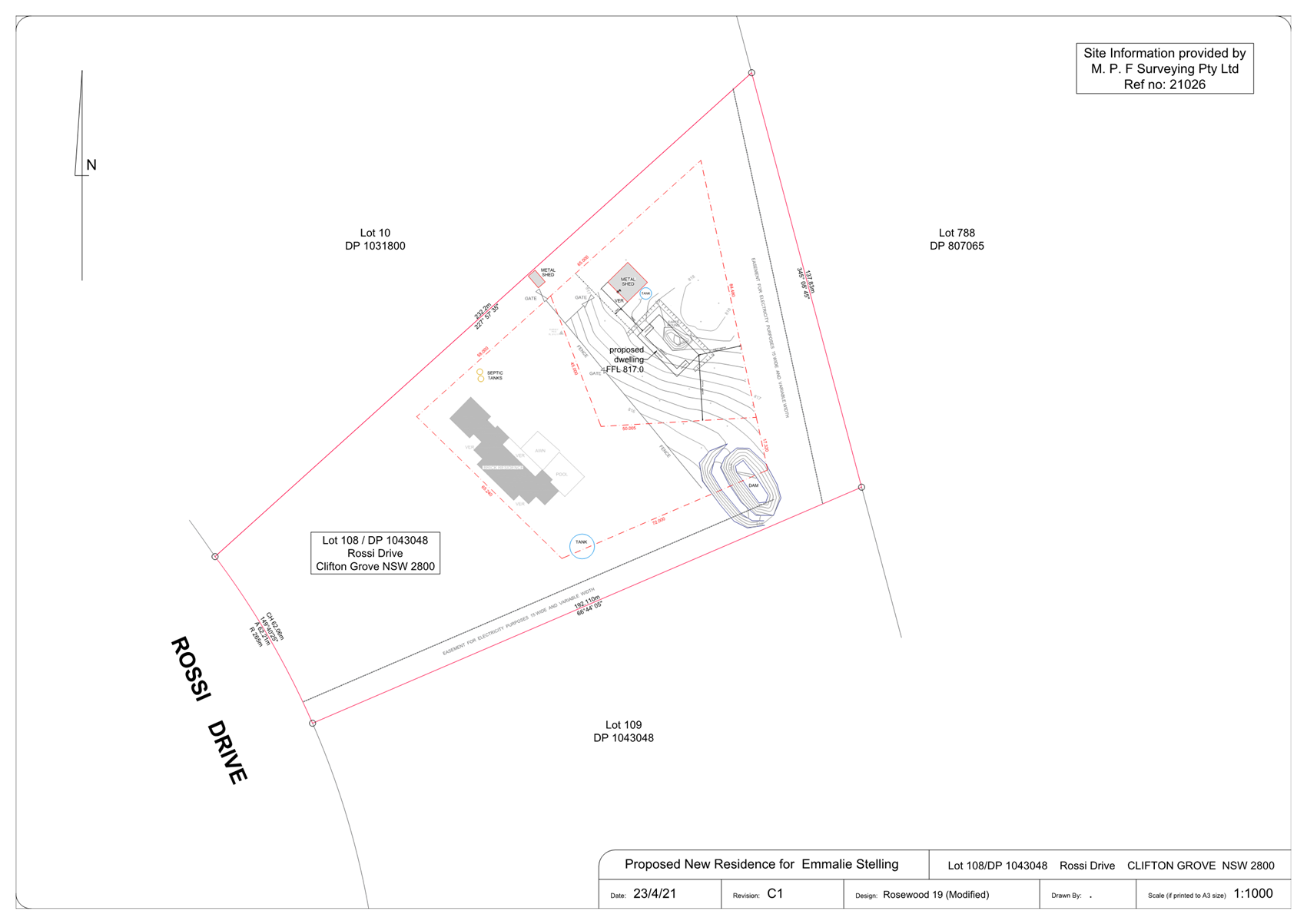
Planning and Development Committee
5 April 2022
Planning
and Development Committee
5 April 2022
Attachment 3 Notice
of Approval