Extraordinary Council Meeting
Agenda
25 March 2022
Notice is hereby given, in
accordance with the provisions of the Local Government Act 1993 that an Extraordinary meeting of ORANGE CITY COUNCIL
will be held in the Council Chamber,
Civic Centre, Byng Street, Orange on Friday, 25 March 2022
commencing at 12.30pm.
David
Waddell
Chief Executive Officer
For apologies please
contact Administration on 6393 8106.
1 Introduction
1.1 Apologies
and Leave of Absence
1.2 Livestreaming
and Recording
This Council Meeting is being livestreamed and
recorded. By speaking at the Council Meeting you agree to being livestreamed
and recorded. Please ensure that if and when you speak at this Council Meeting
that you ensure you are respectful to others and use appropriate language at
all times. Orange City Council accepts no liability for any defamatory or
offensive remarks or gestures made during the course of this Council Meeting. A
recording will be made for administrative purposes and will be available to
Councillors.
1.3 Acknowledgement
of Country
I would like to acknowledge the Traditional Custodians
of the land on which we meet today, the people of the Wiradjuri Nation. I
pay my respects to Elders past and present, and extend those respects to
Aboriginal Peoples of Orange and surrounds, and Aboriginal people here with us
today.
1.4 Declaration
of pecuniary interests, significant non-pecuniary interests and less than
significant non-pecuniary interests
The
provisions of Chapter 14 of the Local Government Act, 1993 (the Act)
regulate the way in which Councillors and designated staff of Council conduct
themselves to ensure that there is no conflict between their private interests
and their public role.
The
Act prescribes that where a member of Council (or a Committee of Council) has a
direct or indirect financial (pecuniary) interest in a matter to be considered
at a meeting of the Council (or Committee), that interest must be disclosed as
soon as practicable after the start of the meeting and the reasons given for
declaring such interest.
As
members are aware, the provisions of the Local Government Act restrict any
member who has declared a pecuniary interest in any matter from participating
in the discussion or voting on that matter, and requires that member to vacate
the Chamber.
Council’s Code of Conduct provides that if members
have a non-pecuniary conflict of interest, the nature of the conflict must be
disclosed. The Code of Conduct also provides for a number of ways in which a
member may manage non pecuniary conflicts of interest.
|
Recommendation
It is recommended that Councillors now disclose any
conflicts of interest in matters under consideration by the Council at this
meeting.
|
COUNCIL
MEETING ADJOURNS FOR THE CONDUCT OF THE OPEN FORUM
COUNCIL MEETING RESUMES
2 General
Reports
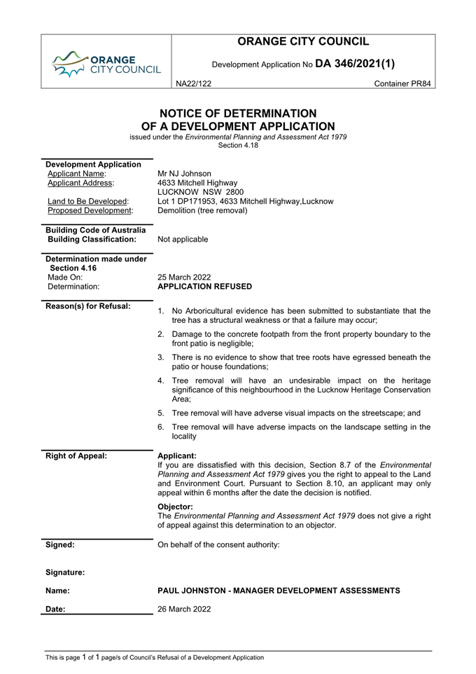
2.1 Development
Application DA 346/2021(1) - 4633 Mitchell Highway, Lucknow
RECORD
NUMBER: 2022/339
AUTHOR: Ben
Hicks, Senior Planner
EXECUTIVE
Summary
|
Application lodged
|
2 August 2021
|
|
Applicant/s
|
Mr NJ Johnson
|
|
Owner/s
|
Mr NJ and Mrs AK Johnson
|
|
Land description
|
Lot 1 DP 171953, 4633 Mitchell Highway, Lucknow
|
|
Proposed land use
|
Demolition (tree removal)
|
|
Value of proposed development
|
$1,500
|
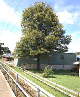
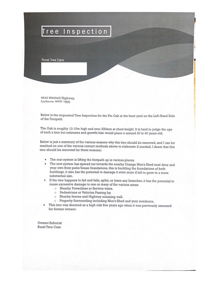
Council's consent is sought for proposed demolition (tree
removal) at 4633 Mitchell Highway, Lucknow. The subject tree is an advanced
Pin Oak (Quercus palustris) and is located at the site frontage to the
Mitchell Highway.
The site is located in the Lucknow Heritage Conservation
Area and is also nearby to heritage items. Due to the heritage setting and type
of tree, Council’s consent is required for its removal.
The application is accompanied by a written statement by an
arborist. The statement recommended removal of the tree. It is submitted that
the subject tree has the potential for limb failure with potential damage to
people and property. Furthermore, the written statement suggests that tree is
causing damage to the buildings on the subject land and adjoining land as well
as adjacent footpaths.
Council’s Manager City Presentation (Qualified
Horticulturalist, Arborist and Environmental Scientist) has assessed the
proposal and does not support removal of the subject tree. The tree is
considered to be a structurally sound specimen and in good health. Furthermore,
there is no conclusive evidence that the tree is causing structural damage to
the building on the subject land or buildings on adjoining land. Damage to the
footpath is considered negligible and does not warrant the removal of the tree.
Furthermore, Council’s Heritage and Design Advisor
concurs that the subject tree should be retained. It is considered that the
tree is of heritage value and compliments the
streetscape within the conservation area.
The applicant was provided the
opportunity to respond to the issues raised by Council staff on multiple
occasions; however, no formal response has been received in relation to these
matters.
It is recommended the
application be refused.
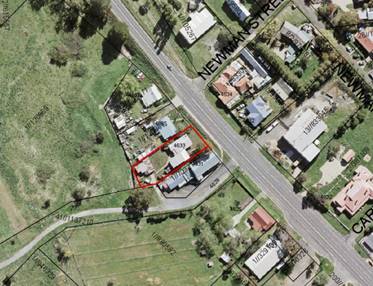
Figure 1 – Locality and Site Context Plan
DECISION FRAMEWORK
Development in Orange is governed by two key documents
Orange Local Environment Plan 2011 and Orange Development Control Plan 2004. In
addition, the Infill Guidelines are used to guide development, particularly in
the heritage conservation areas and around heritage items.
Orange Local Environment Plan 2011 – The
provisions of the LEP must be considered by the Council in determining the
application. LEPs govern the types of development that are permissible or
prohibited in different parts of the City and also provide some assessment
criteria in specific circumstances. Uses are either permissible or not. The
objectives of each zoning and indeed the aims of the LEP itself are also to be
considered and can be used to guide decision making around appropriateness of
development.
Orange Development Control Plan 2004 – the DCP
provides guidelines for development. In general, it is a performance-based
document rather than prescriptive in nature. For each planning element there
are often guidelines used. These guidelines indicate ways of achieving the
planning outcomes. It is thus recognised that there may also be other solutions
of merit. All design solutions are considered on merit by planning and building
staff. Applications should clearly demonstrate how the planning outcomes are
being met where alternative design solutions are proposed. The DCP enables
developers and architects to use design to achieve the planning outcomes in
alternative ways.
DIRECTOR’S COMMENT
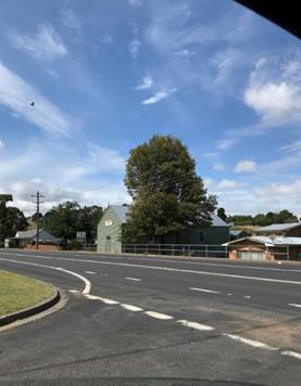
The DA request the removal of an advanced Pin Oak
(Quercus palustris) and is located in the front yard of the house at 4633
Mitchell Highway Lucknow, which adjoins the Lucknow Hall/Men’s Shed to
the west. Lucknow is a Heritage Conservation Area with a number of heritage
items nearby. Lucknow has a very limited number of mature trees, therefore this
tree makes a substantial contribution to the heritage streetscape, particularly
when driving into Lucknow from Orange.
The removal of the tree is not supported by Council’s
Manager City Presentation (Qualified Horticulturalist, Arborist and
Environmental Scientist); Council’s Heritage Advisor and also development
assessment staff. The application states that the tree is 12-15m high, is in
excess of 300mm at chest height and is estimated to be 40 years old.
Whilst the tree is close to the Council Hall/Men’s Shed, it appears not
to be causing any significant damage to the building that warrant removal of
the tree.
The tree is also 9m from the applicant’s house.
Some minor cracking of a private footpath was identified and the presence of
roots near the house was identified by the applicant’s arborist. However,
no evidence of further damage to the house or other assets was provided with
the DA. There are options such as PVC root barriers that could be
installed to protect the building into the future without removing the tree.
The tree has been identified as being in good health and not
presenting a significant safety risk.
The applicant was requested to reconsider the proposal on a
number of occasions. The applicant advised that they did not wish to
withdraw the application during last contact. No changes have been
forthcoming.
It is recommended that the application is refused.
Link To Delivery/OPerational Plan
The recommendation in this report relates to the
Delivery/Operational Plan Strategy “10.1 Preserve -
Engage with the community to ensure plans for growth and development are
respectful of our heritage”.
Financial Implications
The applicant has the right of appeal in
the NSW Land and Environment Court, such an appeal may have budget implications for Council.
Policy and Governance Implications
Consideration has been given during the assessment of this
application to the historic court case involving Timbs v Shoalhaven City
Council [2004] NSWCA 81. In this case, the New South Wales Court of Appeal
found Shoalhaven Council was negligent for its failure to identify a tree as
posing an unacceptable risk (which fell during strong winds, killing a person)
and for failing to take appropriate action, including failing to adequately
inspect the tree. The tree examined in this case was a spotted gum tree (corymbia maculate) which are a
species that have a habit of dropping heavy branches causing damage, injury and
even death.
The tree in question as part of this application is a Pin
Oak (Quercus palustris) and are not known the share the same characteristics
as the species examined in the above court case. Council’s Arboricultural
expert (Manager City Presentation) has inspected the subject tree and considers
the tree to be a structurally sound specimen and in good health. No arboricultural evidence to the contrary has been submitted
to substantiate that the tree has a structural weakness or that a failure may
occur and in the absence of such evidence Council staff are not in the position
to support the removal of the tree.
|
Recommendation
That Council refuses
development application DA346/2021(1)
for Demolition (tree removal) at Lot 1 DP 171953, 4633
Mitchell Highway, Lucknow for the following
reasons:
1. No
Arboricultural evidence has been submitted to substantiate that the tree has
a structural weakness or that a failure may occur.
2. Damage
to the concrete footpath from the front property boundary to the front patio
is negligible.
3. There
is no evidence to show that tree roots have egressed beneath the patio or
house foundations.
4. Tree
removal will have an undesirable impact on the heritage significance of this
neighbourhood in the Lucknow Heritage Conservation Area.
5. Tree
removal will have adverse visual impacts on the streetscape.
6. Tree
removal will have adverse impacts on the landscape setting in the locality.
|
further considerations
Consideration has been given to the
recommendation’s impact on Council’s service delivery; image and
reputation; political; environmental; health and safety; employees;
stakeholders and project management; and no further implications or risks have
been identified.
SUPPORTING INFORMATION
ENVIRONMENTAL PLANNING ASSESSMENT
Section 1.7 - Application of Part
7 of the Biodiversity Conservation Act 2016 and Part 7A of the Fisheries
Management Act 1994
Section 1.7 of the EP&A Act identifies that Part 7 of
the Biodiversity Conservation Act 2016 (BC Act) and Part 7A of the
Fisheries Management Act 1994 have effect in connection with terrestrial and
aquatic environments.
There are four triggers known to
insert a development into the Biodiversity Offset Scheme (ie the need for
a BDAR to be submitted with a DA):
· Trigger 1:
development occurs in land mapped on the Biodiversity Values Map (OEH)
(clause 7.1 of BC Regulation 2017);
· Trigger 2:
development involves clearing/disturbance of native vegetation above a certain
area threshold (clauses 7.1 and 7.2 of BC Regulation 2017); or
· Trigger 3:
development is otherwise likely to significantly affect threatened species
(clauses 7.2 and 7.3 of BC Act 2016).
The Biodiversity Conservation Act 2016 relates only to the
clearing of native vegetation. The tree in question (Pin Oak (Quercus
palustris)) is an exotic species and thus the proposed removal does not
trigger the assessment requirements under the BC Act 2016.
Section 4.15 of the
Environmental Planning and Assessment Act 1979
Section 4.15 of the Environmental Planning and Assessment
Act 1979 requires Council to consider various matters, of which those
pertaining to the application are listed below.
PROVISIONS OF ANY ENVIRONMENTAL
PLANNING INSTRUMENT s4.15(1)(a)(i)
Orange Local Environmental Plan
2011
Part 1 - Preliminary
Clause 1.2 - Aims of Plan
The
particular aims of Orange LEP 2011 relevant to the proposal include:
(a) to encourage development which complements
and enhances the unique character of Orange as a major regional centre boasting
a diverse economy and offering an attractive regional lifestyle,
(b) to
provide for a range of development opportunities that contribute to the social,
economic and environmental resources of Orange in a way that allows present and
future generations to meet their needs by implementing the principles for
ecologically sustainable development,
(f) to
recognise and manage valued environmental heritage, landscape and scenic
features of Orange.
The application is considered to be contrary to the listed
objectives, as outlined in this report.
Clause 1.6 - Consent Authority
This clause establishes that, subject to the Act, Council is
the consent authority for applications made under the LEP.
Clause 1.7 - Mapping
The subject site is identified
on the LEP maps in the following manner:
|
Land Zoning Map:
|
RU5 Village
|
|
Lot Size Map:
|
1000m2
|
|
Heritage Map:
|
Lucknow Heritage Conservation
Area and nearby to heritage items
|
|
Height of Buildings Map:
|
No building height limit
|
|
Floor Space Ratio Map:
|
No floor space limit
|
|
Terrestrial Biodiversity Map:
|
No biodiversity sensitivity on the
site
|
|
Groundwater Vulnerability Map:
|
Groundwater vulnerable
|
|
Drinking Water Catchment Map:
|
Within the drinking water
catchment
|
|
Watercourse Map:
|
Not within or affecting a defined
watercourse
|
|
Urban Release Area Map:
|
Not within an urban release area
|
|
Obstacle Limitation Surface Map:
|
No restriction on building siting
or construction
|
|
Additional Permitted Uses Map:
|
No additional permitted use applies
|
|
Flood Planning Map:
|
Not within a flood planning area
|
Those matters that are of relevance are addressed in detail
in the body of this report.
Clause 1.9A - Suspension of
Covenants, Agreements and Instruments
This clause provides that covenants, agreements and other
instruments which seek to restrict the carrying out of development do not apply
with the following exceptions.
(a) to
a covenant imposed by the Council or that the Council requires to be imposed,
or
(b) to
any relevant instrument under Section 13.4 of the Crown Land Management Act
2016, or
(c) to
any conservation agreement under the National Parks and Wildlife Act 1974, or
(d) to
any Trust agreement under the Nature Conservation Trust Act 2001, or
(e) to
any property vegetation plan under the Native Vegetation Act 2003, or
(f) to
any biobanking agreement under Part 7A of the Threatened Species Conservation
Act 1995, or
(g) to
any planning agreement under Subdivision 2 of Division 7.1 of the Environmental
Planning and Assessment Act 1979.
Council staff are not aware of the title of the subject
property being affected by any of the above.
Part 2 - Permitted or Prohibited Development
Clause 2.1 - Land Use Zones and Clause 2.3 - Zone
Objectives and Land Use Table
The subject site is located within the RU5 Village zone. The
proposed tree removal is defined as ‘demolition’ under LEP 2011,
which means:
Demolish, in
relation to a heritage item or an Aboriginal object, or a building, work, relic
or tree within a heritage conservation area, means wholly or partly destroy,
dismantle or deface the heritage item, Aboriginal object or building, work,
relic or tree.
Demolition is permitted with consent pursuant to Clause 2.7
(see below).
Clause 2.3 of LEP 2011
references the Land Use Table and Objectives for each zone in LEP 2011.
These objectives for land zoned RU5 are as follows:
Objectives
of the RU5 Village Zone
· To provide for
a range of land uses, services and facilities that are associated with a rural
village.
· To enhance and
maintain the unique village character of Lucknow and Spring Hill.
The
proposal is not contrary to the zone objectives.
The
following provisions of the OLEP 2011 have been especially considered in the
assessment of the proposal:
Clause
2.7 – Demolition requires Development Consent - Clause 2.7 of the OLEP 2011 states that the demolition
of a building or work may be carried out only with development consent. Accordingly, the applicant
has applied for development consent (this application) for the
demolition/removal of a Pin Oak tree.
Clause
5.10 Heritage Conservation - Clause
5.10(4) of the Orange Local Environmental Plan 2011 requires the consent
authority, before granting consent under this clause in respect of a heritage
item or heritage conservation area, to consider the effect of the proposed
development on the heritage significance of the item or area concerned.
The
site of the proposed tree removal is within the Lucknow Village Heritage
Conservation Area to nearby to heritage items at 4622 Mitchell Highway
(“Mamhead”) and 7-5 Newman Street (Anglican Church).
Council’s
Heritage Inventory provides the following description and statement of
significance with regard to a conservation area:
Lucknow Village Conservation Area
The Village of Lucknow has
historic and scientific significance for its links with gold mining activity
dating from the very first discovery in 1851 up to the present day. It is a
good representative example of the many small gold mining settlements which
spread throughout the state, and nation, during the mid-late 19th Century. This
significance is enhanced by the degree to which it has retained many key
elements of its original character both above and below ground. The above and
below ground evidence for the Village's early mining activity is both extensive
and varied and the high scientific significance for the Village reflects its
potential to provide information on early gold mining activity, if
appropriately investigated.
The unique and significant
character of the Village is enhanced by the extent of the remaining above
ground mine shaft structures - particularly the steel head frames of the
Wentworth Main and Reform sites - which are rare survivors, both within the
region and the state, and give the Village a striking historic immediacy,
accessible to all, because of their prominent location on the main road.
The historic significance of the
Village is enhanced by the degree to which it has retained elements of its
early layout - particularly the road network - and various early buildings it
has retained, which provide evidence of early residential and associated
activities. Several individual buildings are of high historic and aesthetic
significance - including Mamhead and the Anglican Church - while others are
valuable representative examples of early building styles, and provide evidence
of early development patterns in the Village. The historic and aesthetic
significance of many early dwellings in the Village has been adversely affected
by later alterations and loss of fabric, as well as a more general loss of
early/appropriate architectural context.
The aesthetic significance of the
Village arises in large measure from its attractive siting on the Frederick's
Valley Creek, surrounded by low, rolling hills, and the open, largely
undeveloped, character of this setting. The simple linear character of the
Village itself, with its defined entry points, generally low scale development
and remaining early structures, assist in maintaining the important early
Village identity and character, though this has been notably eroded, and
adversely impacted upon, in recent years, by inappropriate alterations to early
buildings and unsympathetic new developments.
The application was referred to Council’s Heritage
Advisor to comment on the potential heritage impacts resulting from the
removal. Council’s Heritage Advisor provides the following:
The tree is a very tall specimen and dominates views to
and from the adjoining hall.
A claim has been made that the tree is the cause of
localised damage to pavements etc. and may fall leading to consequential
damage. The claim does not appear to be borne out by expert reports.
In terms of heritage significance, the tree is a
contributing element within the streetscape at Lucknow and in the particular
context of the former Lucknow school of arts (now men’s shed). The tree
also serves to screen views to and from the shed and together they produce a
visually attractive combination.
In conclusion, unless there is an expert backed case for
removal, the case for retention due to the contribution the tree makes to the
Shed and this part of Lucknow is sound and removal would not be supported.
Part 7 - Additional Local Provisions
7.6 - Groundwater Vulnerability
This
clause seeks to protect hydrological functions of groundwater systems and protect
resources from both depletion and contamination. Orange has a high-water table
and large areas of the LGA, including the subject site, are identified with
“Groundwater Vulnerability” on the Groundwater Vulnerability Map.
This requires that Council consider:
(a) whether or not the development (including
any onsite storage or disposal of solid or liquid waste and chemicals) is
likely to cause any groundwater contamination or have any adverse effect on
groundwater dependent ecosystems, and
(b) the cumulative impact (including the
impact on nearby groundwater extraction for potable water supply or stock water
supply) of the development and any other existing development on groundwater.
Furthermore, consent may not be granted unless Council is satisfied that:
(a) the development is designed, sited and
will be managed to avoid any significant adverse environmental impact, or
(b) if that impact cannot be reasonably
avoided - the development is designed, sited and will be managed to minimise
that impact,
(c) if that impact cannot be minimised - the
development will be managed to mitigate that impact.
The
proposal is not anticipated to involve the discharge of toxic or noxious
substances and is therefore unlikely to contaminate the groundwater or related
ecosystems. The proposal does not involve extraction of groundwater and will
therefore not contribute to groundwater depletion. However, advanced trees
including the subject tree are known to assist in recharging and enriching
groundwater tables through percolation. The environmental benefit of the tree
on the hydrological functions of the groundwater system would be forfeited in
this regard.
7.7 - Drinking Water
Catchments
(1) The
objective of this clause is to protect drinking water catchments by minimising
the adverse impacts of development on the quality and quantity of water
entering drinking water storages.
(2) This
clause applies to land identified as “Drinking water” on the Drinking Water Catchment Map.
(3) Before
determining a development application for development on land to which this
clause applies, the consent authority must consider whether or not the
development is likely to have any adverse impact on the quality and quantity of
water entering the drinking water storage, having regard to:
(a) the
distance between the development and any waterway that feeds into the drinking
water storage, and
(b) the
onsite use, storage and disposal of any chemicals on the land, and
(c) the
treatment, storage and disposal of wastewater and solid waste generated or used
by the development.
(4) Development
consent must not be granted to development on land to which this clause applies
unless the consent authority is satisfied that:
(a) the
development is designed, sited and will be managed to avoid any significant
adverse impact on water quality and flows, or
(b) if
that impact cannot be reasonably avoided - the development is designed, sited
and will be managed to minimise that impact, or
(c) if
that impact cannot be minimised - the development will be managed to mitigate
that impact.
The proposed development is not
within proximity to ant waterway that feeds into drinking water storage. The
proposal does not involve onsite use, storage or disposal any chemicals on the
land nor does the proposal involves the treatment, storage and disposal of
wastewater. The proposal is acceptable in this regard.
STATE ENVIRONMENTAL PLANNING
POLICIES
State Environmental Planning
Policy (Vegetation in Non-Rural Areas) 2017
This SEPP applies to tree removal where a permit is sought
from Council. A permit system does not apply to this tree removal, as the
subject tree occurs within the Heritage Conservation Area. In this regard,
development consent has been sought via this Development Application for the
removal of the tree, pursuant to the provisions of Orange LEP 2011.
PROVISIONS OF ANY DRAFT
ENVIRONMENTAL PLANNING INSTRUMENT THAT HAS BEEN PLACED ON EXHIBITION
4.15(1)(a)(ii)
There are no draft environmental planning instruments that
apply to the subject land or proposed development.
PROVISIONS OF ANY DEVELOPMENT
CONTROL PLAN s4.15(1)(a)(iii)
Development Control Plan 2004
Development Control Plan 2004 (“the DCP”)
applies to the subject land. An assessment of the proposed development against
the relevant Planning Outcomes will be undertaken below.
DCP 2004-0 Tree Preservation
DCP 2004 – 0.4-2 prescribes the following Interim
Planning Outcomes for Tree Preservation:
1 Trees
prescribed by this DCP must not be ringbarked, cut down, topped, lopped or
wilfully destroyed without the Council’s approval and landowner’s
consent.
2 This
clause applies to Eucalypts of any size belonging to the White Box, Yellow Box
and Blakely’s Red Gum Endangered Ecological Communities, including
species indicated as affected in the tree preservation table.
3 This
clause applies to any tree, native or exotic, with a trunk diameter equal to or
greater than 300mm at breast height.
4 This
clause does not apply to species indicated as exempt in the tree preservation
table.
5 An
application for the Council’s approval must be accompanied by an
appropriately qualified specialist (arborist) report.
In consideration of the planning outcomes, a statement from
Rural Tree Care was submitted in support of the proposal. The information
contained within the statement is restricted in detail and does not accord with
general requirements of an Arboricultural Impact Assessment. The statement
lacks an objective visual inspection of the tree, provides minimal to no
details or assessment of the tree significance, tree retention value or a SULE
(Safe & Useful Life Expectancy) assessment.
A copy of the arborist statement is provided as an attachment
to this report.
Council’s Manager City Presentation has reviewed the
submitted arborist report and inspected the subject tree. Council’s
Manager City Presentation does not support the recommendations of the submitted
report and provides the following [paraphrased] advice:
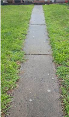
· Damage to the concrete footpath from the front property
boundary to the front patio is negligible and such damage doesn’t warrant
a trees removal as the concrete path can easily be repaired (image of concrete
path attached).
· The Orange Men Shed (a Council property) is built on piers
and tree roots will have no more than a very negligible effect on the brick
piers.
· Statement that the root system has extended to the front
patio and may impact house foundations is unsubstantiated. There is no evidence
to show that tree roots have egressed beneath the patio or house foundations.
If there is a concern of root egress a PVC root barrier installed along the
building foundation will protect the foundations from root travel.
· Statement “If the tree happens to fail and
falls, splits, or loses any branches……’
No Arboricultural evidence has been submitted to substantiate that the
tree has a structural weakness or that a failure may occur. The subject tree
from a visual ground inspection was found to be structurally sound; it is some
9 metres form the closest point of the dwelling located on the subject
property.
Council’s Manager City
Presentation concludes that there is no
compelling Arboricultural evidence that substantiates the need to remove the
subject specimen.
Visual
Tree Assessment
|
|
The canopy has full foliage
consistency. Branch structure to the extremes appears normal and healthy.
|
|
|
The tree
contributes significantly to the streetscape on the western approach
to Lucknow.
|
|
|
Damage to the concrete footpath
is negligible
|
DCP
2004-13 Heritage
DCP 2004-13 prescribes the
following Planning Outcomes for Heritage Development:
1 Development
relates to the significant features of heritage buildings on or near the site,
as reflected in inventory sheets.
2 Development
conforms with recognised conservation principles.
3 Conservation
Management Plans are prepared for development having a significant effect on
heritage sites.
As considered earlier in this report, Council’s
Heritage Advisor does not support the proposal. The subject tree is a landmark
feature for the site and streetscape and contributes to heritage character and
value of the setting. Proposed tree removal will have adverse visual impacts on
the streetscape and landscape setting, and adversely affect the significance of
this neighbourhood in the conservation area. The proposed development is
considered to be contrary to the above planning outcomes.
PROVISIONS PRESCRIBED BY THE
REGULATIONS s4.15(1)(a)(iv)
The proposed development is not inconsistent with any matter
prescribed by Regulation.
THE LIKELY IMPACTS OF THE
DEVELOPMENT s4.15(1)(b)
Visual Impacts and Conservation Significance
The subject tree is located at the frontage of the site and
grows in isolation. The proposed removal of the tree will have adverse impact
on the landscape setting of the site and streetscape as outlined in the
forgoing assessment.
Environmental Impacts
The environmental impacts associated with tree/vegetation
removal are broad and often include impacts on groundwater and stormwater
management, atmospheric/microclimate implications, loss of habitat/ecological
connectivity and UHI effects. While it is proposed to remove only a
single tree, it may contribute to one or more of the above environmental
consequences through a process called ‘progressive nibbling’ i.e.
repetitive, often minor impacts eroding environmental conditions.
THE SUITABILITY OF THE SITE
s4.15(1)(c)
There are no known physical attributes within the site that
would unreasonably constrain the proposed development.
ANY SUBMISSIONS MADE IN
ACCORDANCE WITH THE ACT s4.15(1)(d)
The proposed development was
notified under the provisions of the CPP. No submissions were received.
PUBLIC INTEREST
s4.15(1)(e)
The proposed development is not considered to be in the
public interest, by virtue of the adverse impacts on the streetscape, landscape
setting and conservation area.
SUMMARY
The proposal involves removal of a Pin Oak (Quercus
palustris) at 4633 Mitchell Highway, located in the Lucknow Village
Heritage Conservation Area. Council staff do not support removal of the tree.
The tree is considered to be a structurally sound specimen in good health.
There is no conclusive evidence that the tree is causing structural damage to
the building on the subject land or adjoining land. The tree is of significant value and complements the streetscape
within the conservation area. It is recommended the application be refused.
Attachments
1 Tree
Report, D22/13491⇩
2 Notice
of Refusal, D22/13493⇩
Extraordinary
Council Meeting
25 March 2022
Attachment 2 Notice
of Refusal
2.2 Development
Application DA 17/2022(1) - 13/5295 Mitchell Highway, Orange
RECORD
NUMBER: 2022/340
AUTHOR: Ben
Hicks, Senior Planner
EXECUTIVE
Summary
|
Application
lodged
|
17
January 2021
|
|
Applicant/
Owner
|
Sentinel
Homemaker (Open Ended) Pty Ltd
|
|
Land
description
|
Lot 2
DP270204, 13/5295 Mitchell Highway, Orange
|
|
Proposed
land use
|
Specialised Retail Premises (use
and alterations and additions) and Business Identification Signage
|
|
Value of
proposed development
|
$5,336,889.00
|
Council's consent is sought for the redevelopment of the
former Bunnings Warehouse building located within the Orange Homemaker Centre,
Mitchell Highway. Specifically, the proposal involves dividing up the existing
floor area to create four separate tenancies to be used for specialised retail
purposes. The subject site is zoned ‘B5 Business Development’ with
the proposed development and use being permissible with consent of Council.
Internal alterations and facade changes will be completed to
form the new specialised retail tenancies which will include the removal of the
‘Bunnings Box’ façade, making the building more comparable
with the existing precinct theme. The separate tenancies will have varied floor
areas, however, sufficient to accommodate the future specialised retailers. The
former outdoor garden section on the eastern side of the building will be
converted to a parking area for staff.
The proponent advises that no tenants have been secured for
the proposed development at this time, however, will comprise of speciality
retailers that align with the land use definition as provided in the Orange
Local Environmental Plan 2011. Any future tenants will need to comply with the
requirements contained within the notice of determination attached to this report
with respect to hours of operation, signage, deliveries etc.
The proposal has a capital investment value exceeding $2.5
million ($5.3m). Accordingly, the application has been tabled to an Ordinary
Council Meeting (OCM) for determination, pursuant to Clause 4.10 Delegations of
Orange City Council’s Declaration of Planning and Development
Assessment Procedures and Protocols (Vers 5, 2019).
A Section 4.15 assessment has
been prepared below and is assessed that the proposed development is consistent
with the Orange Local Environmental Plan 2011, Orange Development Control Plan
2004 and all relevant State Environmental Planning Instruments.
The assessment of the proposal concludes the development fits in the
locality and there are no significant impacts on the site or on adjacent lands.
All construction/fit out and operational aspects can be adequately
managed/controlled as per the submitted Development Application (DA)
information, or under recommended conditions of consent.
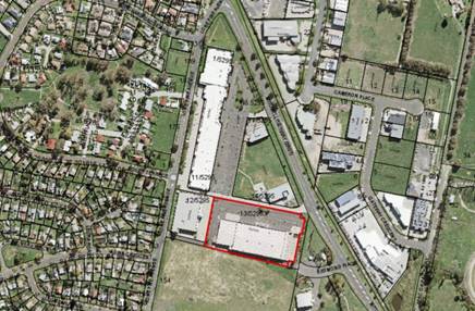
Figure 1 – Site Context and Locality Map
DECISION FRAMEWORK
Development in Orange is governed by two key documents
Orange Local Environment Plan 2011 and Orange Development Control Plan 2004. In
addition, the Infill Guidelines are used to guide development, particularly in
the heritage conservation areas and around heritage items.
Orange Local Environment Plan 2011 – The
provisions of the LEP must be considered by the Council in determining the
application. LEPs govern the types of development that are permissible or
prohibited in different parts of the city and also provide some assessment
criteria in specific circumstances. Uses are either permissible or not. The
objectives of each zoning and indeed the aims of the LEP itself are also to be
considered and can be used to guide decision making around appropriateness of
development.
Orange Development Control Plan 2004 – the DCP
provides guidelines for development. In general, it is a performance-based
document rather than prescriptive in nature. For each planning element there
are often guidelines used. These guidelines indicate ways of achieving the
planning outcomes. It is thus recognised that there may also be other solutions
of merit. All design solutions are considered on merit by planning and building
staff. Applications should clearly demonstrate how the planning outcomes are
being met where alternative design solutions are proposed. The DCP enables
developers and architects to use design to achieve the planning outcomes in
alternative ways.
DIRECTOR’S COMMENT
Council's consent is sought for the redevelopment of the
former Bunnings Warehouse building located within the Orange Homemaker Centre,
Mitchell Highway. The proposal involves dividing up the existing floor area to
create four separate tenancies to be used for specialised retail purposes
(which in simple terms allows for bulky goods type uses). The separate
tenancies will have varied floor areas, however, sufficient to accommodate the
future specialised retailers.
The former Bunnings building has remained vacant for a considerable
amount of time.
The proposed redevelopment is consistent with the zoning
provisions. It is recommended that Council supports the proposal.
Link To Delivery/OPerational Plan
The recommendation in this report
relates to the Delivery/Operational Plan Strategy “10.1
Preserve - Engage with the community to ensure plans for growth and development
are respectful of our heritage”.
Financial Implications
Nil
Policy and Governance Implications
Nil
|
Recommendation
That
Council consents to development application DA17/2022(1) for Specialised Retail Premises (use and
alterations and additions) and Business Identification Signage at Lot 2
DP 270204, 13/5295 Mitchell Highway, Orange pursuant to the conditions of consent in the attached
Notice of Determination.
|
further considerations
Consideration has
been given to the recommendation’s impact on Council’s service
delivery; image and reputation; political; environmental; health and safety;
employees; stakeholders and project management; and no further implications or
risks have been identified.
SUPPORTING INFORMATION
Council's consent is sought for
alterations/additions to an existing commercial building being the former
Bunnings Warehouse within the Orange Homemaker Centre to form four tenancies
(one into four) including a new awning, shopfront glazing and new signage
zones. The proponent is also seeking consent to use the newly formed
tenancies for specialised retail premises. The applicant advises that tenants
are yet to be confirmed. Notwithstanding, overarching conditions of consent
have been included in the draft notice which will control hours of operation,
signage, deliveries etc.
The existing building and associated timber yard and outdoor
nursery areas comprises a gross floor area of 7,838m2. The existing
building is of steel frame and concrete tilt panel construction. The proposed
additions/additions to the external appearance of the building (Figures 2-4)
will involve providing a continuous steel framed awning along
the shopfronts, and providing powder coated aluminium framed shopfront glazing
and doors to each new tenancy. New doors will be provided to the rear of each
tenancy to permit loading and unloading. A neutral colour tone will be applied
to the building façade which is consistent with the approved colour
scheme for the Homemaker Centre.
A slight re-arrangement of the car parking is proposed to
permit the new awning and separate tenancy access. However, this will not
result in any deficiencies in parking at the site for the proposed development.
Additional parking comprising 29 spaces will be provided to the eastern side of
the building in the former nursery section.
The internal changes proposed
are considered relatively modest and will only involve new partition walls to
create the separate tenancies including staff and back of house storage areas
(Figure 5).
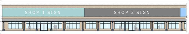
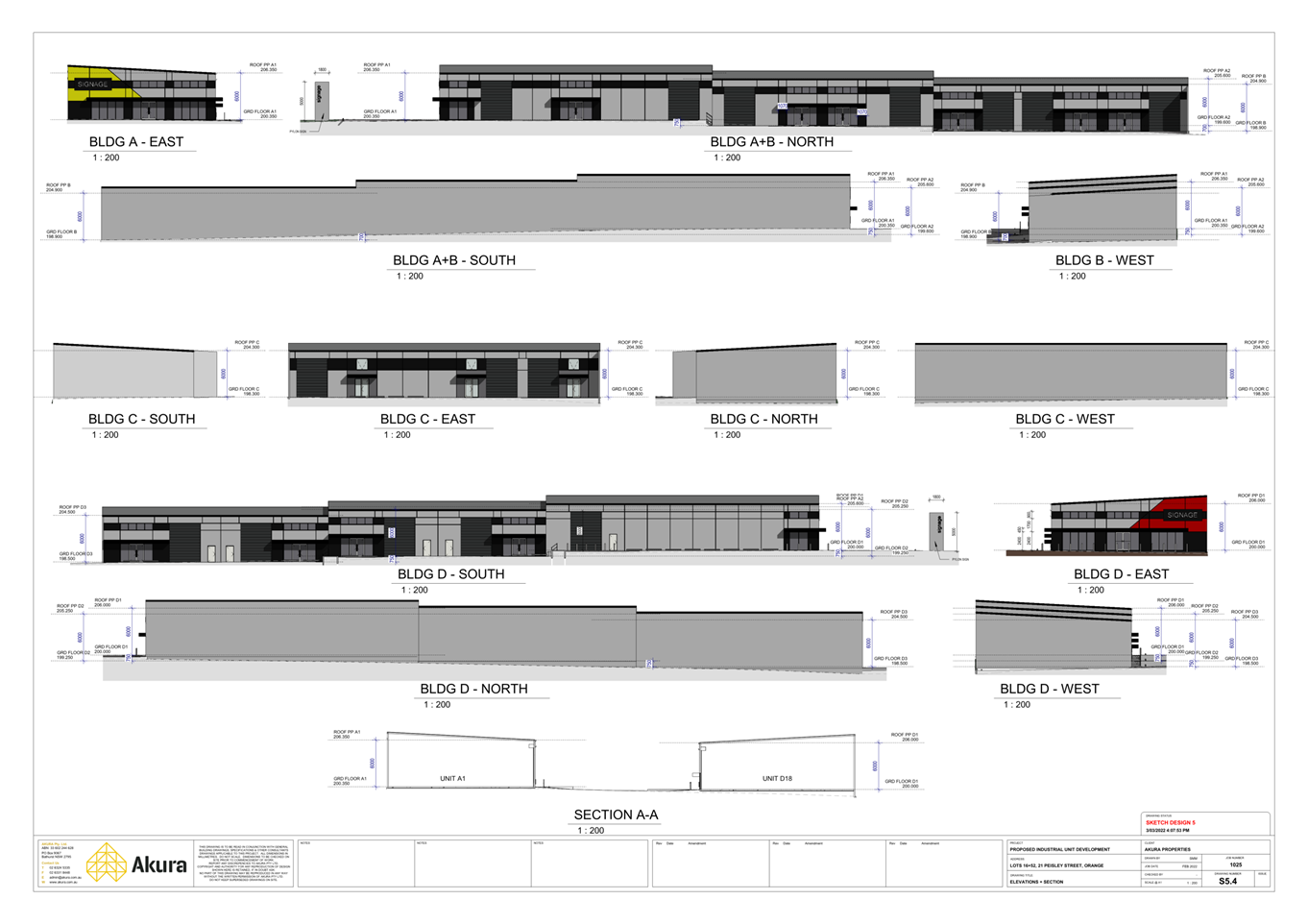
Figure 2 – proposed frontage elevation detail
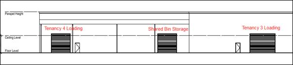
Figure 3 – proposed rear elevation detail
(western end).
Neutral colour to be applied to façade as per
frontage.
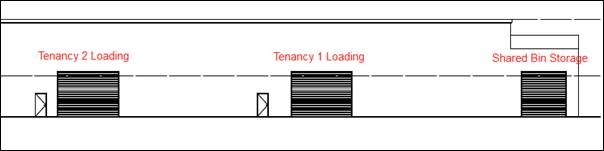 Figure 3 – proposed rear elevation detail
(eastern end).
Figure 3 – proposed rear elevation detail
(eastern end).
Neutral colour to be applied to façade as per
frontage.
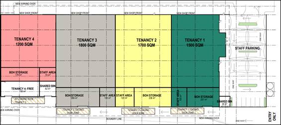
Figure 5 – proposed tenancy layout
BACKGROUND/HISTORY
The subject land is part of an overall
parcel of land zoned to allow for what used to be called ‘bulk
retail’, collectively known as the Eastern Gateway Development. A
number of outlets including Harvey Norman, Spotlight, Fantastic Furniture,
SuperCheap Auto, BCF, Sheridan, Early Settler and Eureka Street Furniture
have already established as part of a community title development.
Consent was granted for Bunnings Warehouse at the site on 4
March 1999 which operated up until the opening of the new Bunnings Warehouse on
the Northern Distributor Road in 2016. Since then, the site has remained
vacant, however, has been used for temporary events on some occasions.
Council granted consent for a Vehicle Sales or Hire
Premises at the site in 2020. It is understood that that the consent for
the Vehicle Sales or Hire Premises has not been acted upon. It therefore may be appropriate for
Council to seek the surrender of the earlier consent pursuant to the Section
4.17 of the Environmental Planning and Assessment Act 1979 especially as the
previous consent and the proposed development cannot work together.
ENVIRONMENTAL PLANNING
ASSESSMENT
Section 1.7 - Application of Part
7 of the Biodiversity Conservation Act 2016 and Part 7A of the Fisheries
Management Act 1994
Section 1.7 of the Environmental
Planning and Assessment Act 1979 identifies that Part 7 of the Biodiversity
Conservation Act 2016 (BC Act) and Part 7A of the Fisheries
Management Act 1994 have effect in connection with terrestrial and aquatic environments.
There are four triggers known to insert a development into
the Biodiversity Offset Scheme (i.e. the need for a BDAR to be submitted
with a DA):
· Trigger 1:
development occurs in land mapped on the Biodiversity Values Map (OEH)
(clause 7.1 of BC Regulation 2017);
· Trigger 2:
development involves clearing/disturbance of native vegetation above a certain
area threshold (clauses 7.1 and 7.2 of BC Regulation 2017); or
· Trigger 3:
development is otherwise likely to significantly affect threatened species (clauses
7.2 and 7.3 of BC Act 2016).
The fourth trigger (development proposed to occur in an Area
of Outstanding Biodiversity Value (clause 7.2 of BC Act 2016) is generally not
applicable to the Orange LGA; as no such areas are known to occur in the LGA.
No further comments will be made against the fourth trigger.
In consideration of these matters, the land is not mapped
high biodiversity values, nor is the land high biodiversity sensitivity land
under Council’s LEP. The development is located in a highly disturbed
urban environment and as such, the development will not have a negative impact
on any endangered ecological communities, threatened species or habitat. In
this regard, no further assessment with respect to biodiversity matters is
considered warranted.
Section 4.15 of the Environmental Planning and Assessment
Act 1979
Section 4.15 of the Environmental Planning and Assessment
Act 1979 requires Council to consider various matters, of which those
pertaining to the application are listed below.
PROVISIONS OF ANY ENVIRONMENTAL
PLANNING INSTRUMENT s4.15(1)(a)(i)
Orange Local Environmental Plan
2011
Part 1 - Preliminary
Clause 1.2 - Aims of Plan
The broad aims of the LEP are
set out under Subclause 2. Those relevant to the application are as follows:
(a) to
encourage development which complements and enhances the unique character of
Orange as a major regional centre boasting a diverse economy and offering an
attractive regional lifestyle,
(b) to
provide for a range of development opportunities that contribute to the social,
economic and environmental resources of Orange in a way that allows present and
future generations to meet their needs by implementing the principles for
ecologically sustainable development,
The application is considered to be consistent with aims (a)
and (b) as listed above.
Clause 1.6 - Consent Authority
This clause establishes that, subject to the Act, Council is
the consent authority for applications made under the LEP.
Clause 1.7 - Mapping
The subject site is identified
on the LEP maps in the following manner:
|
Land Zoning Map:
|
B5 Business Development
|
|
Lot Size Map:
|
No Minimum Lot Size
|
|
Heritage Map:
|
Not a heritage item or conservation
area
|
|
Height of Buildings Map:
|
No building height limit
|
|
Floor Space Ratio Map:
|
No floor space limit
|
|
Terrestrial Biodiversity Map:
|
No biodiversity sensitivity on the
site
|
|
Groundwater Vulnerability Map:
|
Groundwater vulnerable
|
|
Drinking Water Catchment Map:
|
Not within the drinking water
catchment
|
|
Watercourse Map:
|
Not within or affecting a defined
watercourse
|
|
Urban Release Area Map:
|
Not within an urban release area
|
|
Obstacle Limitation Surface Map:
|
No restriction on building siting
or construction
|
|
Additional Permitted Uses Map:
|
No additional permitted use applies
|
|
Flood Planning Map:
|
Not within a flood planning area
|
Those matters that are of relevance
are addressed in detail in the body of this report.
Clause 1.9A - Suspension of Covenants, Agreements and
Instruments
This clause provides that covenants, agreements, and other
instruments which seek to restrict the carrying out of development do not apply
with the following exceptions:
(a) to
a covenant imposed by the Council or that the Council requires to be imposed,
or
(b) to
any relevant instrument under Section 13.4 of the Crown Land Management Act
2016, or
(c) to
any conservation agreement under the National Parks and Wildlife Act 1974, or
(d) to
any Trust agreement under the Nature Conservation Trust Act 2001, or
(e) to
any property vegetation plan under the Native Vegetation Act 2003, or
(f) to
any biobanking agreement under Part 7A of the Threatened Species Conservation
Act 1995, or
(g) to
any planning agreement under Subdivision 2 of Division 7.1 of the Environmental
Planning and Assessment Act 1979.
Council staff are not aware of the
title of the subject property being affected by any of the above.
Notwithstanding the above, the
subject land is burdened by a number of easements; an easement for electricity
purposes is located along the southern boundary of the lot; two rights of
carriageways are located where the eastern boundary adjoins Redmond Place.
The existing car park on Lot 2 is currently
subject to an easement for car parking in favour of the Homemaker Centre, to
formalise the situation where a customer of the former Bunnings would park on
the Bunnings site and then walk to other businesses in the Centre. This
arrangement will remain in place as part of this development.
Part 2 -
Permitted or Prohibited Development
Clause 2.1 -
Land Use Zones and Clause 2.3 - Zone Objectives and Land Use Table
The subject site is located within
the B5 Business Development zone. The proposed development is characterised as Specialised
Retail Premises and Business Identification Signage under OLEP 2011.
Pursuant to OLEP 2011 Specialised Retail Premises is defined below:
specialised
retail premises means a building or place the principal purpose
of which is the sale, hire or display of goods that are of a size, weight or
quantity, that requires -
(a) a large area for handling, display or storage, or
(b) direct vehicular access to the site of the building or
place by members of the public for the purpose of loading or unloading such
goods into or from their vehicles after purchase or hire,
but does
not include a building or place used for the sale of foodstuffs or clothing
unless their sale is ancillary to the sale, hire or display of other goods referred
to in this definition.
Note -
Examples of goods that may be sold at specialised retail
premises include automotive parts and accessories, household appliances and
fittings, furniture, homewares, office equipment, outdoor and recreation equipment,
pet supplies and party supplies.
While no tenants have been
finalised, the development as described in this application is considered to
satisfy the above definition, particularly as the development will provide
tenancies with a large open floor area which will enable occupation by those
retailers stocking a high quantity
of goods or goods of a particular size or weight that requires a large
area for sale, hire, handling, and display. Furthermore, the site layout will
provide for direct vehicular access to each tenancy for the loading and
unloading of such goods. Conditions of consent will require any future tenants
to be consistent with the above definition.
Pursuant to OLEP 2011 Business
Identification Signage is defined below:
business
identification sign means a sign -
(a) that
indicates -
(i) the name of the person or business, and
(ii) the nature of the business carried on by the person
at the premises or place at which the sign is displayed, and
(b) that may include the address of the
premises or place and a logo or other symbol that identifies the business,
but that
does not contain any advertising relating to a person who does not carry-on
business at the premises or place.
The proponent has provided signage zones. Conditions will
require the sign content to be consistent with the above definition.
1 - Objectives of the B5 Business Development Zone
· To enable a mix of business and warehouse
uses, and specialised retail premises that require a large floor area, in
locations that are close to, and that support the viability of, centres.
The development
is not averse to the above listed objects of the B5 Business Development Zone.
Part 7 -
Additional Local Provisions
· Clause 7.6 Groundwater Vulnerability – This clause seeks to protect hydrological functions
of groundwater systems and protect resources from both depletion and
contamination. Orange has a high-water table and large areas of the LGA,
including the subject site, are identified with “Groundwater
Vulnerability” on the Groundwater Vulnerability Map. The proposal is not
anticipated to involve the discharge of toxic or noxious substances and is
therefore unlikely to contaminate the groundwater or related ecosystems. The
proposal does not involve extraction of groundwater and will therefore not
contribute to groundwater depletion. The development is considered satisfactory
in this regard.
· Clause 7.7 Drinking water catchments - This clause is to protect drinking water
catchments by minimising the adverse impacts of development on the quality and
quantity of water entering drinking water storages. The site is partially
covered by this overlay. The proposed development does not introduce additional
impacts upon water quality within the drinking water catchment. The potential
for the development to impact upon water quality is considered minimal.
· Clause
7.11 - Essential Services – This clause stipulates that development
consent must not be granted to development unless the consent authority is
satisfied that any services (water, sewer, electricity, stormwater and road
access) that are essential for the proposed development are available or that
adequate arrangements have been made to make them available when required. It
is considered that all necessary utility
services are available to the land and can be adequate for the proposal.
STATE ENVIRONMENTAL PLANNING POLICIES
State Environmental Planning
Policy (Resilience and Hazards) 2021
State Environmental Planning Policy
(Resilience and Hazards) 2021 is applicable. Pursuant to Clause 4.6 Contamination and remediation to be considered in determining
development application:
(1) A consent authority
must not consent to the carrying out of any development on land unless:
(a) it has considered whether the
land is contaminated, and
(b) if the land is
contaminated, it is satisfied that the land is suitable in its contaminated
state (or will be suitable, after remediation) for the purpose for which the
development is proposed to be carried out, and
(c) if the land requires
remediation to be made suitable for the purpose for which the development is
proposed to be carried out, it is satisfied that the land will be remediated
before the land is used for that purpose.
In consideration of this clause,
the potential for contamination of the site is considered low. The subject land
is well-established for commercial use. The site is not located within an
investigation area and is not known to have been used for a Table 1 purpose to
the contaminated land planning guidelines. Further contamination investigation
as a precursor to potential site remediation is considered unnecessary for the
proposed development.
State Environmental Planning Policy (Transport and
Infrastructure) 2021
Clause 2.118 - Development with Frontage to
Classified Road
The primary objective of this clause is to ensure that new
development does not compromise the effective and ongoing operation and
function of classified roads. The consent authority must not grant consent to
development on land that has a frontage to a classified road unless it is
satisfied that:
(a) where
practicable, vehicular access to the land is provided by a road other than the
classified road, and
(b) the
safety, efficiency and ongoing operation of the classified road will not be
adversely affected by the development as a result of:
(i) the
design of the vehicular access to the land, or
(ii) the
emission of smoke or dust from the development, or
(iii) the
nature, volume or frequency of vehicles using the classified road to gain
access to the land, and
(c) the
development is of a type that is not sensitive to traffic noise or vehicle emissions,
or is appropriately located and designed, or includes measures, to ameliorate
potential traffic noise or vehicle emissions within the site of the development
arising from the adjacent classified road.
In consideration of the above
matters:
· The Mitchell
Highway adjoins the site to the east. The road is classified as a state road
and is under the control of TfNSW. The site has two existing public access
points to the highway and an additional service/delivery vehicle access for the
former Bunnings building. These will be utilised for the proposed development.
· Council’s Technical Services advises that the
existing intersection treatments into the site from the Mitchell Highway were
designed to accommodate traffic associated with the ultimate realisation of the Homemaker
Centre as envisaged throughout the master planning process and thus the
proposed development will not necessitate the upgrading of existing
intersections.
· The development is not of a type that is sensitive to
traffic noise or vehicle emissions.
2.121 - Traffic-Generating Development
This section applies to development
specified in Column 1 of the Table to Schedule 3 that involves -
(a) new
premises of the relevant size or capacity, or
(b) an
enlargement or extension of existing premises, being an alteration or addition
of the relevant size or capacity.
The proposed development does
not meet the criteria/thresholds listed in Schedule 3 requiring referral to
TfNSW. The proposal will utilise an existing vacant commercial building and
will not involve the enlargement or extension of the floor area. Furthermore, whilst the building has been vacant for some years
now, the site has a certain level of traffic already attributed to it due to
its past use by Bunnings Warehouse. The proposed development is not expected to
exceed traffic movements that would have been associated with it previous use.
State Environmental Planning Policy (Industry and
Employment) 2021
The objectives of the policy
aim to ensure that the proposed signage is compatible with the desired amenity
and visual character of the locality, provides effective communication and is
of high quality having regards to both design and finishes. Whilst no specific
signage detail is known at this time, signage panels for future signage have
been identified at this stage. Conditions of consent are recommended to address
the location and future messaging of all future signs.
Chapter
3 of the SEPP require Council to determine consistency with the objectives
stipulated under Clause 3(1)(a) of the aforementioned SEPP and to assess the
proposal against the assessment criteria of Schedule 5. In accordance
with the provisions stipulated under Schedule 5 of the SEPP, the
assessment below is provided.
|
Matters for
Consideration
|
Comment
|
Complies
|
|
1. Character of the area
Is the proposal compatible
with the existing or desired future character of the area or locality in
which it is proposed to be located?
Is the proposal consistent
with a particular theme for outdoor advertising in the area or locality?
|
The
area is characterised as a commercial precinct located on the high-profile
eastern entrance to the City. Signage within the area is mixed, but the
predominant theme is wall, awning signage, window signage and a freestanding
pylon signage (multi‑tenancy pylon sign for the Orange Grove Homemakers
Centre and car yard signage opposite the site). The proposed development provides new signage zones
attached to/flush with the parapet of the building, above each of the proposed
tenancies.
|
Yes
|
|
2. Special areas
Does the proposal detract
from the amenity or visual quality of any environmentally sensitive areas,
heritage areas, natural or other conservation areas, open space areas,
waterways, rural landscapes or residential areas?
|
The
development is not located within a special area. The development is
consistent with this requirement.
|
Yes
|
|
3. Views and vistas
Does the proposal obscure
or compromise important views?
Does the proposal dominate
the skyline and reduce the quality of vistas?
Does the proposal respect
the viewing rights of other advertisers?
|
All
of the proposed signage is attached to the façade of the subject
tenancies. The proposal will not impact on any views within the area, nor
will it dominate the skyline as the signage is proposed to be contained
wholly within the envelope of the structure. No viewing rights of other
advertisers will be affected by the proposed signage.
|
Yes
|
|
Matters for
Consideration
|
Comment
|
Complies
|
|
4. Streetscape, setting or landscape
Is the scale, proportion
and form of the proposal appropriate for the streetscape, setting or
landscape?
Does the proposal
contribute to the visual interest of the streetscape, setting or landscape?
Does the proposal reduce
clutter by rationalising and simplifying existing advertising?
Does the proposal screen
unsightliness?
Does the proposal protrude
above buildings, structures or tree canopies in the area or locality?
|
The
signage zones will need to be reduced to 25% of the façade of each
tenancy to comply with DCP requirements. The new signage for each tenancy may
only comprise business identification signage and as such is expected
to be compatible with the approved signage in the Homemaker Centre.
Furthermore, business identification signage by its very nature is generally
simple in design and detailing and thus expected to have minimal impact on
the streetscape/setting/landscape.
The home maker centre is of
a high design quality and therefore there is no unsightliness to be screened.
The proposed new signage
will be of an appropriate scale for the area and buildings, subject to
compliance with conditions of consent.
|
Yes
|
|
5. Site and
building
Is the proposal compatible
with the scale, proportion and other characteristics of the site or building,
or both, on which the proposed signage is to be located?
Does the proposal respect
important features of the site or building, or both?
Does the proposal show
innovation and imagination in its relationship to the site or building, or
both?
|
The
signage proposed to be installed on the
upper element of the architectural features and relates appropriately to the
scale of the building, and respects and maintains the architectural features
of the building.
|
Yes
|
|
6. Associated devices and logos with advertisement
and advertisement structures
Have any safety devices,
platforms, lighting devices or logos been designed as an integral part of the
signage or structure on which it is to be displayed?
|
The
proposed signage will have the appropriate platform to allow the structure to
be placed on. The proposed parapet signage will be connected to electricity.
|
Yes
|
|
Matters for
Consideration
|
Comment
|
Complies
|
|
7.
Illumination
Would illumination result
in unacceptable glare, affect safety for pedestrians, vehicles or aircraft,
detract from the amenity of any residence or other form of accommodation?
Can the intensity of the
illumination be adjusted, if necessary?
Is the illumination subject
to a curfew?
|
The
signage is not proposed to be illuminated.
|
Yes
|
|
8. Safety
Would the proposal reduce
the safety for any public road, pedestrians, or bicyclists?
Would the proposal reduce
the safety for pedestrians, particularly children, by obscuring sightlines
from public areas?
|
The
proposed signage will not reduce safety for vehicles, pedestrians, and
cyclists due to setback of the building from Mitchell Highway.
|
Yes
|
PROVISIONS
OF ANY DRAFT ENVIRONMENTAL PLANNING INSTRUMENT THAT HAS BEEN
PLACED ON EXHIBITION 4.15(1)(a)(ii)
The proposed development is not
contrary to any matter contained within Draft Amendments currently on
exhibition.
DESIGNATED DEVELOPMENT
The proposed development is not
designated development.
INTEGRATED DEVELOPMENT
The proposed development is not
integrated development.
PROVISIONS OF ANY DEVELOPMENT
CONTROL PLAN s4.15(1)(a)(iii)
Development Control Plan 2004
Development Control Plan 2004
(“the DCP”) applies to the subject land (Part 8.4 Eastern
Gateway Development). An assessment of the proposed development against the
relevant Planning Outcomes will be undertaken below.
Part 8.4 – Eastern Gateway Development
· Applications
clearly demonstrate that the development will not detract from the role of the
CBD as a regional centre.
The proposed development will
utilise an existing vacant commercial building purposely designed for large
format/bulk retailing. The site has remained vacant since 2016 and the proposed
development will facilitate the use of the space for specialised/bulk retail
opportunities within an appropriate employment and retail precinct. This type
of retailing at this location has been supported by a retail development
strategy prepared by Leyshon Consulting in 1997 and is consistent with the
overall masterplan for this area. The proposed specialised retail
tenancies are unlikely to detract from the role of the Central Business
District as the main business centre in the city. The establishment of such
premises within the CBD is somewhat constrained by the lack of large sites that
can provide sufficient floor area for stock and display, parking adjacent to
the premises and satisfactory arrangements for delivery/service vehicles.
· Adequate onsite
parking, manoeuvring and loading facilities are provided.
Car parking for this type of use is
calculated at one space per 50m2 gross floor area. The building has
a gross floor area of 4960m2, requiring 99.2 car parking spaces. The
site currently has in excess of 200 parking spaces. The parking spaces located
along the frontage of the building comprising 24 spaces are proposed to be
removed to facilitate the proposed new shopfronts and awning. An additional 29
parking spaces will be provided to the eastern side of the building (former
nursery). Loading will be undertaken at the rear of the site, as per existing
access arrangements.
· Buildings have a high level of architectural design, with
particular attention given to highway setbacks, façade features,
external materials, colour schemes and advertising.
Detailed consideration was given to
the desired design and presentation of the precinct through the preparation of
the DCP and masterplan. This included requiring development within the precinct
to have consistent architectural features such as towers, recessed wall panels,
awnings and building finishes (neutral colour tones) to ensure a cohesive
complex. The design of the former Bunnings building somewhat departs from these
principals through its architectural features and colours. The re-development
of the site will, however, ensure that consistency with the remainder of the
precinct is achieved. The proposed alterations/additions to the external
appearance of the building will involve providing a continuous steel framed awning along the shopfronts, and providing powder
coated aluminium framed shopfront glazing and doors to each new tenancy. A
neutral colour tone will be applied to the building façade which is
consistent with the approved colour scheme for the Homemaker Centre.
· Building height,
façade features and colour schemes are consistent with the existing
stages of development (i.e., the Orange Homemaker Centre buildings approved
prior to the date of this Plan).
There will be no
change to the overall height, bulk or scale of the existing building. The
proposed materials and finishes as discussed above will complement the other
buildings within the precinct.
· Access
to Mitchell Highway is limited to those entrances established prior to this
Plan coming into effect.
The proposed development will utilise the
existing vehicle accesses into the site.
· Advertising is limited to flush-wall signs wholly contained
within the elevation of the building, with signage comprising up to 25% of the
façade area. There are no additional pole signs fronting the Mitchell
Highway.
The
proposed signage comprises above awning signage panels which will be wholly
contained within the building elevation above each tenancy. The signage is
considered to be ‘flush wall signs’ and are consistent with signage
approvals granted for other premises within the homemaker centre. The signage
will need to comprise less than 25% of the façade area of each tenancy.
Conditions will be included in the consent to this affect.
The
buildings architectural features will not be affected as well as viewing rights
of adjoining tenancies signage. There are no additional pole signs proposed
fronting the Mitchell Highway.
· Appropriate
measures are taken to protect the adjacent water-supply catchment from
pollution.
The proposed development will not adversely impact upon the
water supply catchment as it does not introduce additional impacts upon water
quality within the drinking water catchment. The development will retain the
existing stormwater drainage currently servicing the site. The potential
for the development to impact upon water quality is considered minimal.
· All
sites contain an element of landscaping. Landscaping provided is of a bulk,
scale and height relative to buildings nearest the front property boundary so
as to provide beautification and visual relief to the built form proposed or
existing on the site. The depth of the landscape bed at the site frontage is
sufficient to accommodate the spread of plantings that meet the abovementioned
outcomes but, where practicable, a minimum depth of 3.5m is provided. Plantings
are designed to provide shade for parking areas, to break up large areas of
bitumen, to enhance building preservation and to screen against noise.
Landscaping of the site
currently relies upon landscaped beds to the east, north and west of the site,
with established landscaping on the adjoining Lot 1 along the eastern boundary
of the site, which softens the view of the site from the highway which is
generally in good condition. Internally, a number of small garden beds have
been provided in and around car parking areas, however, these landscaping areas
and plantings within have either severely declined or died due to the lack of maintenance
associated with the vacancy of the building.
In this respect,
it is considered appropriate that a landscaping plan and maintenance strategy
be prepared and implemented as part of any consent granted to reinstate these
areas to an appropriate standard as well as ensure these areas are maintained
in perpetuity.
PROVISIONS PRESCRIBED BY THE
REGULATIONS s4.15(1)(a)(iv)
The development is not inconsistent
with the provisions prescribed by the regulations.
THE LIKELY IMPACTS OF THE
DEVELOPMENT s4.15(1)(b)
Context and Setting
The proposal is located within an existing bulky goods
centre. It is considered that the proposal is appropriate for the location and
will continue to contribute to the neighbourhood character of this sector of
the city.
Visual Impacts
The proposed alterations to the building will be a
significant improvement by comparison to the current façade, which has
been neglected of the past five years. The alterations/additions contribute
positively to the Gateway Precinct by means of contemporary architectural
design with simple square lines, extensive commercial glazing, awning and
neutral colour tone. Roof mounted mechanical plant will be set within
architectural parapet. The ‘back of house’ elements will not be
easily viewed from public areas. The proposed signage is not expected to
detract from the existing development in the locality given it relates to
business identification signage only.
Additional and retained landscaping of the site, as previously
discussed, will create an appropriate standard of visual amenity commensurate
with the site’s high-profile location.
The visual impacts of the proposed development are
considered acceptable.
Access, Parking and Traffic
The potential for traffic impacts relates mainly to the
capacity of the road network to accommodate the increase in traffic levels; and
the ability for vehicles to enter, exit and use the site without disruption to
traffic flow along the Mitchell Highway.
The Mitchell Highway is a classified road under the control
of TfNSW and represents the principal route to and from the Orange Grove
Homemakers Centre. Primary public access to the Orange Grove Homemakers Centre
is provided at two locations along the Mitchell Highway frontage. These access
points provide protected right hand turns into the site; right turns out of the
site; and a slip lane for a left turn into the site at the southern entrance of
the development along the Highway. Secondary entrances to the site are located
on Lone Pine Avenue comprising a roundabout and service-vehicle entry. An
additional access point is available for the former Bunnings building via
Redmond Place which provides the premises with a dedicated access for
deliveries and loading/unloading.
The proposed development does not result in changes to
vehicle access or intersection layout or represents traffic generating
development thus referral to transport for NSW has not been necessary.
Council’s Technical Services
Division advises that the adjoining the road network, particularly the Mitchell
Highway and existing intersection treatments into the site were designed to accommodate
traffic associated with the ultimate realisation of the
Homemaker Centre, as envisaged through the master planning process.
Furthermore, the performance of the
existing bulky goods retailers within this particular Centre reveals traffic
generation is significantly less than figures reported in the earlier version
of Guide to Traffic Generating Developments by the RTA (now TfNSW) which
was used in the planning of this precinct.
Sufficient off-street parking will be provided, and the site
layout allows vehicles to enter and exit the site in a forward direction at all
times. A separate delivery/loading and unloading zone is provided at the rear
of the site via Redmond Place which minimises the interface between customer
areas and service areas. Given there is an increase in tenancies at this
particular site and associated loading/unloading zones, a Vehicle Management
Plan has been devised at the request of Council’s Technical Services to
ensure the efficient operation of the loading facilities and to ensure safety
of employees, suppliers and customer can be managed to minimise risk. The VMP
will need to be provided and agreed to by each tenant as part of the lease
agreement of the individual tenancies.
In consideration of the above, the proposed development is
unlikely to compromise the effective and ongoing operation and function of the
highway or significantly impact parking or loading facilities and vehicle
manoeuvring areas.
Environmental Impacts
The subject site is a highly
modified site of a long-established commercial centre. The proposed
development will not disrupt any significant vegetation or Endangered
Ecological Communities in the locality.
Economic Impacts
The proposed development may generate positive economic
effects associated with construction, employment, local business expansion and
the contribution of the city as a major regional business centre.
Construction Impacts
The proposed development has the potential to create
short-term impacts associated with noise, parking of construction worker
vehicles; deliveries to site etc. These impacts are unavoidable for a
construction of this size in an urban environment, but whilst they are
unavoidable, they are only short-term for the duration of the construction
phase. Notwithstanding this, given the context and setting of the development
site, the construction impacts need to be carefully managed and as such the
conditions of consent will address matters hours of work, dust, noise, waste
etc. to ensure minimal impact on surrounding uses during this period.
THE SUITABILITY OF THE SITE
s4.15(1)(c)
The development is considered to be
suitable for the site. The subject land does not present any known physical
attributes which may constrain the development. The subject site does not
contain remnant vegetation or significant landscape features. It is considered
that the development will relate appropriately to the landform. The land is not
subject to known technological or natural hazards.
ANY SUBMISSIONS MADE IN
ACCORDANCE WITH THE ACT s4.15(1)(d)
The proposed development is not
defined as advertised or notified development under the provisions of the CPP,
and as such no formal exhibition of the application was required.
No submissions have been received in relation to this application.
PUBLIC INTEREST
s4.15(1)(e)
The proposed development is
considered to be of minor interest to the wider public due to the relatively
localised nature of potential impacts. The proposal is not inconsistent with
any relevant policy statements, planning studies, and guidelines etc. that have
been considered in this assessment.
INTERNAL REFERRAL ADVICE
The application was not required to be referred to
Council’s Building Surveyor and Development Engineer. Requirements of the
Building Surveyor and the Development Engineer has been included in Notice of
Determination.
SUMMARY
The proposed development is permissible with the consent of
Council. The proposed development generally complies with the relevant aims,
objectives and provisions of Orange LEP 2011 (as
amended) and DCP 2004. A Section 4.15 assessment of the development
indicates that the development is acceptable in this instance subject to
certain conditions. Attached is a draft Notice of Determination outlining a
range of conditions considered appropriate to ensure that the development
proceeds in an acceptable manner.
Attachments
1 Notice
of Approval, D22/15629⇩
2 Plans,
D22/14496⇩
Extraordinary
Council Meeting
25 March 2022
Attachment 1 Notice
of Approval
Extraordinary Council Meeting
25 March 2022
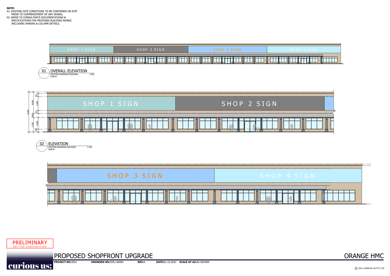
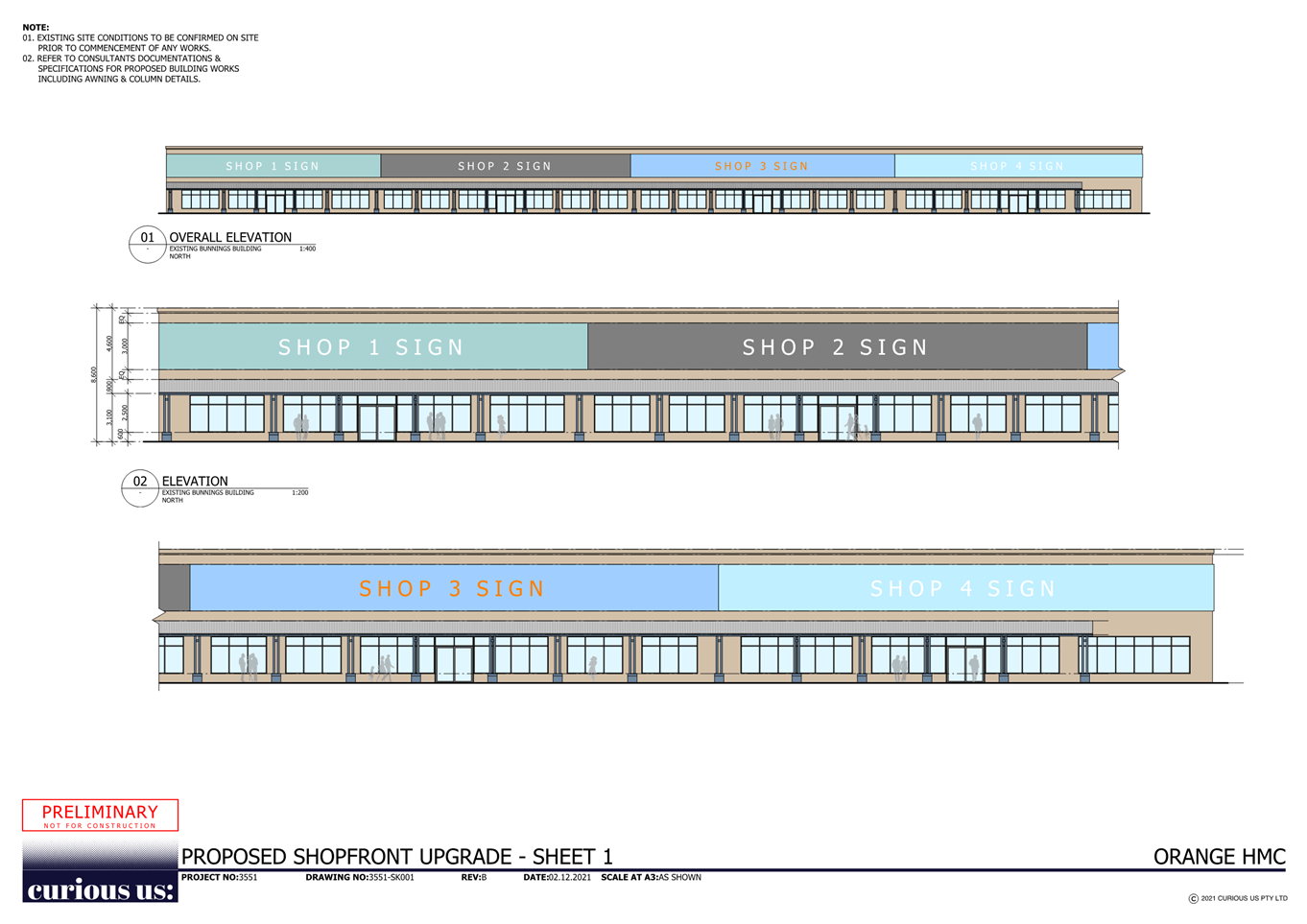
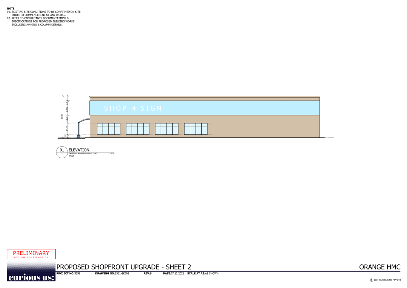
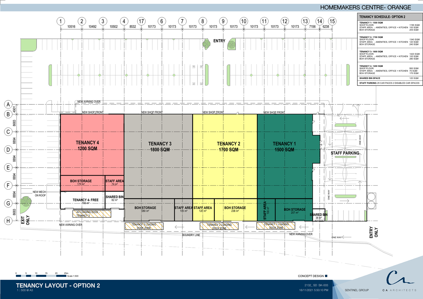
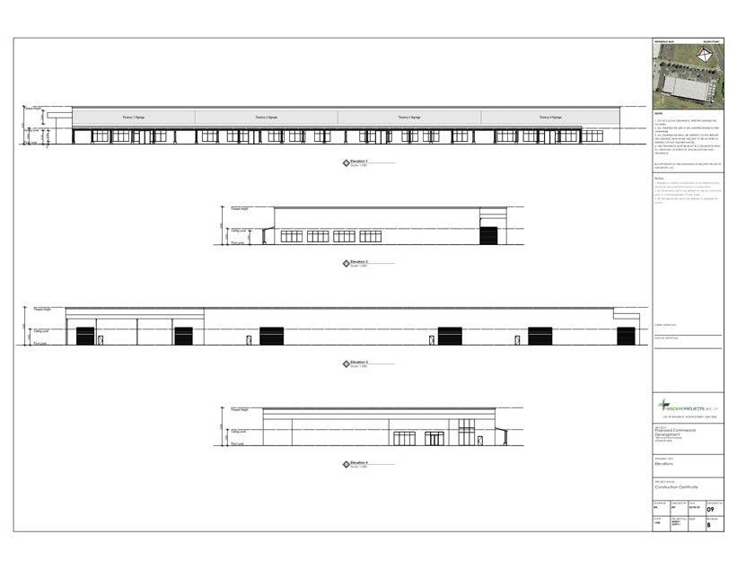
2.3 Development
Application - DA 306/2021(1) - 142-158 Lysterfield Road
RECORD
NUMBER: 2022/161
AUTHOR: Summer
Commins, Senior Planner
EXECUTIVE Summary
|
Application
lodged
|
13 July
2021
Amended
plans submitted 17 November 2021
|
|
Applicant/s
|
Mr T
Miers
|
|
Owner/s
|
Mr WR
and Mrs LM McDonell
Mr DM
and Mrs JM Brus
|
|
Land
description
|
Lot 184
DP 750401 – 142 Lysterfield Road
Lot 1 DP
130391 – 142 Lysterfield Road
Lot 188
DP 750401 – 158 Lysterfield Road
|
|
Proposed
land use
|
Subdivision (Stage 1 - three
residential lots and two development lots;
Stage 2 - 84 residential lots, one
public reserve lot and five roads;
Stage 3 - nine residential lots)
and Demolition (outbuildings and dwellings).
|
|
Value of
proposed development
|
Not
applicable
|
Council's consent is sought for
urban residential subdivision of land in the developing Shiralee urban village.
The proposal relates to three existing rural-residential parcels known as
142-158 Lysterfield Road (see locality at Figure 1 below, NB: 154, 158 &
160 are collectively known as one parcel of land known as 158 Lysterfield Rd).
Figure 1 – locality
The
proposal involves staged residential subdivision of the existing parcels as
follows:
Stage 1: subdivision
to excise three (3) existing dwellings on three separate lots and create two
development lots
Stage 2: subdivision
of the two (2) development lots to create 84 residential lots, one (1)
public reserve lot and five roads
Stage 3: subdivision
of two residential lots created in Stage 1 to create nine (9) residential
lots.
The
completed subdivision is shown below.

Figure 2 – proposed subdivision
The following notable planning matters are considered in
this assessment report:
· The land is partly
subject to a minimum lot size of 700m2 pursuant to Orange Local
Environmental Plan (LEP) 2011. Several proposed lots will depart the prescribed
minimum area. Council’s consent is sought to vary the minimum lot size
development standard in accordance with Clause 4.6 Exceptions to Development
Standards. It is assessed that the proposed subdivision will substantially
depart from the mixed residential density and lot sizes intended in the LEP.
Notwithstanding, the proposed lots will not be incongruous in the developing
residential neighbourhood.
· The proposed
subdivision will also deviate from the Shiralee Development Control Plan (DCP)
2015 and Shiralee Masterplan in relation to lot typologies, lot sizes and road
alignments. The proposed subdivision will be broadly consistent with the DCP
and Masterplan. It is accepted that variations to the Masterplan will
result as development proceeds in the urban village.
· It is proposed to
realign internal roads within the proposed subdivision in order to retain
outbuildings associated with existing dwellings on the parent parcels. The
proposed road realignment will compromise the intersection of Lysterfield Road
and proposed Apple Box Street, and road connections to the adjoining
eastern parcel. After lengthy negotiations between the proponent and Council
staff, Technical Services Division have agreed to a staggered T-intersection
and retention of the impacted outbuildings.
· Stage 3 of the
subdivision involves re-subdivision of parent parcels and demolition of all
improvements, including the impacted outbuildings, above. It is considered
unreasonable to realign Apple Box Street contrary to the intended Shiralee
Masterplan when realignment will not be required at the completion of the
subdivision.
· The proposed
subdivision will result in various outbuildings having frontage to future
public roads. In order to protect the developing residential streetscapes,
Conditions are included requiring demolition or alteration of improvements to
achieve a front setback consistent with the prescribed setback for the lot
typology.
· The subdivision
was latterly amended to include Stage 3 involving re-subdivision of
two (2) of the large residential lots created in Stage 1. The later
amendment has resulted in a conflict in relation to the proposed alignment of
Apple Box Street. Furthermore, contamination investigation has not extended to
proposed Lots 91-99, which are currently rural residential parcels. It is
considered reasonable to deduce that Stage 3 will also be suitable for
residential land use, based on the findings of the submitted contamination
investigation for Stages 1 and 2. However, contamination clearance will be
required for Stage 3 lots prior to subdivision release.
· Council staff in
assessing the proposal have identified an anomaly within the tables contained
within the Council’s contributions plan for Shiralee locality whereby the
area of land proposed for open space under this application and required to be
provided by Council’s DCP has been omitted. Stage 2 involves the creation
of public reserve Lot 90 with site area of 4,068m2.
The proposed public reserve is consistent with the planned public reserve
contained in the Shiralee Masterplan Area H. The public reserve is partly
subject to PMF flooding associated with Blackman’s Swamp Creek. It is
estimated that 1,300m2 of the public reserve lot is unencumbered
land (subject to survey and clarification of definition). The matter pertaining
to compensation for the provision of public open space has been addressed via
planning agreement that has been negotiated with the applicant. Detailed
discussion provided within the report.
The proposed development comprises advertised development in
accordance with Council’s Community Participation Plan 2019. At the
completion of the exhibition period, no submissions had been received.
The proposed subdivision will
facilitate ongoing development of the Shiralee urban village. The development
will depart in some respects from the operative planning controls, however,
will not be incongruous in the emerging residential neighbourhood. Approval of
the application is recommended, subject to conditions to mitigate and manage
arising impacts.
DECISION FRAMEWORK
Development in Orange is governed
by two key documents, the Orange Local Environment Plan 2011 and Orange
Development Control Plan 2004. In addition, the Infill Guidelines are used to
guide development, particularly in the heritage conservation areas and around
heritage items.
Orange Local Environment Plan 2011 – The
provisions of the LEP must be considered by the Council in determining the
application. LEPs govern the types of development that are permissible or
prohibited in different parts of the city and provide some assessment criteria
in specific circumstances.
Uses are either permissible or not.
The objectives of each zoning and indeed the aims of the LEP itself are also to
be considered and can be used to guide decision making around appropriateness
of development.
Orange Development Control Plan 2004 – The DCP
provides guidelines for development. In general, it is a performance-based
document rather than prescriptive in nature. For each planning element there
are often guidelines used. These guidelines indicate ways of achieving the
planning outcomes. It is thus recognised that there may also be other solutions
of merit. All design solutions are considered on merit by planning and building
staff. Applications should clearly demonstrate how the planning outcomes are
being met where alternative design solutions are proposed. The DCP enables
developers and architects to use design to achieve the planning outcomes in
alternative ways.
DIRECTOR’S COMMENT
This application would provide 94 new lots in the southern
portion of the Shiralee estate. In terms of being able to achieve full
compliance with the subdivision layout identified in the Shiralee Master Plan,
this site is somewhat challenging due to the existing houses on the
properties. The result is that the proposal would provide for 13 less
allotments than planned for. Overall, there are no planning issues with
the proposal. It is unreasonable to expect the developer to be able to
achieve provision of all the lots. The loss of 13 lots in the overall
yield will have an impact on the overall developer contributions collected to
provide public services and assets. In order to minimise the impact of
this loss, negotiations have been had with the developer, who has certainly
been amenable to assisting Council.
The applicant has indicated their willingness to enter into
a Planning Agreement to transfer the open space land identified within this
subdivision directly to Council in lieu of charging an open space contribution
amount applicable per lot. The value of the contributions and that of the land
in question is of almost equal value, so this Planning Agreement to transfer
the parkland is simply an administrative process that will provide the
community the Open Space designed for in the Master Plan of this
subdivision. This approach provides an outcome for the applicant and a
good outcome for Council.
The recommendation of approval is supported.
Link To Delivery/OPerational Plan
The recommendation in this report relates to the
Delivery/Operational Plan strategy “10.1 Preserve - Engage with the
community to ensure plans for growth and development are respectful of our
heritage”.
Financial Implications
Nil
Policy and Governance Implications
Nil
|
Recommendation
That Council consents to development application DA
306/2021(1) for Subdivision (Stage 1 – three (3) residential
lots and two (2) development lots; Stage 2 - 84 residential lots, one
(1) public reserve lot and five (5) roads; Stage 3 – nine (9)
residential lots) and Demolition (outbuildings and dwellings) at Lot 184
DP 750401 and Lot 1 DP 130391 – 142 Lysterfield Road, and Lot 188
DP 750401 – 158 Lysterfield Road, Orange, pursuant to the conditions of
consent in the attached Notice of Approval.
|
further considerations
Consideration has been given to the recommendation’s
impact on Council’s service delivery; image and reputation; political;
environmental; health and safety; employees; stakeholders and project
management; and no further implications or risks have been identified.
SUPPORTING INFORMATION
Council's consent is sought for urban residential
subdivision of land at 142-158 Lysterfield Road. The proposal involves
staged subdivision of three existing parcels to create 94 residential
lots, one (1) open space lot and five (5) new roads.
Stage 1
– three (3) residential lots and two (2) development lots
The existing dwellings and
associated outbuildings will be excised on separate lots, and two (2)
development lots will be created. Stage 1 will create the following
parcels:
|
Lot
|
Site
Area
|
Improvements
|
|
85
|
3,930m2
|
Dwelling house and outbuildings
|
|
86
|
2,397m2
|
Dwelling house and outbuildings
|
|
87
|
2.739ha
|
Development lot
|
|
88
|
3.780ha
|
Development lot
|
|
89
|
5689m2
|
Dwelling house and outbuildings
|
Urban
services and upgraded access to the proposed lots will be deferred pending
further subdivision in Stages 2 and 3.
Stage 1 subdivision is depicted
below (see Figure 3).
Figure 3 – proposed Stage 1 subdivision
Stage 2 – 84 residential
lots, one (1) public reserve lot and five (5) new roads
The development lots created in Stage 1 will be further
subdivided to create 84 residential lots. The proposed lots will range in
area between 351m2 and 714m2 and comprise a mix of
Standard, Medium and Compact Lots as defined in the Shiralee DCP 2015.
The lots will be fully serviced to a residential standard.
Lysterfield Road and Sweetheart Drive will be upgraded at
the site frontages to full or half road construction. Five (5) new internal
local streets will be constructed to service the proposed lots. Each lot will
have direct frontage and access to an existing or proposed public road.
A public reserve lot will be created in the northern extent,
and comprise site area of 4,068m2. Various outbuildings on the
development lots will be demolished in conjunction with subdivision civil
works.
The proposed Stage 2 subdivision
is depicted below (see Figure 4).
Figure 4 – proposed Stage 2 subdivision
Stage 3 – nine (9)
residential lots
Proposed Lots 85 and 86 created in Stage 1 will be further
subdivided to create nine residential lots. The proposed lots will range
in area 599m2 and 937m2 and comprise Compact and
Standards lots as defined in the Shiralee DCP 2015.
Existing improvements on the proposed
lots (dwellings, water tanks, sheds and swimming pool) will be
demolished. The proposed lots will be serviced to an urban standard and
have frontage and access to public roads created in Stage 2.
The proposed Stage 3 subdivision
is depicted below (see Figure 5).
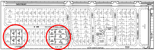
Figure 5 – proposed Stage 3 subdivision
MATTERS FOR CONSIDERATION UNDER
THE ENVIRONMENTAL PLANNING AND ASSESSMENT ACT 1979
Section 1.7 Application of Part 7
of the Biodiversity Conservation Act 2016 and Part 7A of the Fisheries
Management Act 1994
Pursuant to Clause 1.7:
This Act has effect subject to
the provisions of Part 7 of the Biodiversity Conservation Act 2016
and Part 7A of the Fisheries Management Act 1994 that
relate to the operation of this Act in connection with the terrestrial and
aquatic environment.
In consideration of this
section, the development is not likely to impact terrestrial and aquatic
environments. In this regard:
· The subject and
adjoining lands are not identified as biodiversity sensitive on the Orange LEP
2011 Terrestrial Biodiversity Map.
· The proposal does
not involve removal of native vegetation. Clearing thresholds prescribed by
regulation are not relevant to the application.
· The proposal is
not likely to have a significant effect on threatened species, nor impact
endangered ecological communities:
o the site demonstrates a high
degree of disturbance from its natural state
o the proposal does not involve
clearing of native vegetation. Trees to be removed are introduced (non-native)
species
o the development does not
involve removal of natural or built features that would provide habitat for
native fauna.
Based on the foregoing consideration, a Biodiversity
Assessment Report is not required, and the proposal suitably satisfies the
relevant matters at Section 1.7.
Section 4.15 Evaluation
Provisions of any
Environmental Planning Instrument S4.15(1)(A)(I)
Orange Local Environmental Plan
2011
Part 1 - Preliminary
Clause 1.2 Aims of Plan
The particular
aims of the LEP relevant to the proposal include:
(a) to
encourage development which complements and enhances the unique character of
Orange as a major regional centre boasting a diverse economy and offering an
attractive regional lifestyle,
(b) to
provide for a range of development opportunities that contribute to the social,
economic and environmental resources of Orange in a way that allows present and
future generations to meet their needs by implementing the principles for
ecologically sustainable development,
(c) to
conserve and enhance the water resources on which Orange depends, particularly
water supply catchments,
(d) to
manage rural land as an environmental resource that provides economic and
social benefits for Orange,
(e) to
provide a range of housing choices in planned urban and rural locations to meet
population growth,
(f) to
recognise and manage valued environmental heritage, landscape, and scenic
features of Orange.
The proposed development will be
consistent with the above-listed Aims of the LEP, as outlined in this report.
Clause 1.6 Consent Authority
Clause 1.6 is applicable and
states:
The consent authority for the
purposes of this Plan is (subject to the Act) the Council.
Clause 1.7 Mapping
The subject site is identified on the LEP maps as follows:
|
Land
Zoning Map:
|
Land
zoned R1 General Residential and RE1 Public Recreation
|
|
Lot
Size Map:
|
Minimum
Lot Size: 200m2, 400m2 and 700m2
|
|
Heritage
Map:
|
Not
a heritage item or conservation area
|
|
Height
of Buildings Map:
|
No
building height limit
|
|
Floor
Space Ratio Map:
|
No
floor space limit
|
|
Terrestrial
Biodiversity Map:
|
No
biodiversity sensitivity on the site
|
|
Groundwater
Vulnerability Map:
|
Groundwater
vulnerable
|
|
Drinking
Water Catchment Map:
|
Not
within the drinking water catchment
|
|
Watercourse
Map:
|
Not
within or affecting a defined watercourse
|
|
Urban
Release Area Map:
|
Not
within an urban release area
|
|
Obstacle
Limitation Surface Map:
|
No
restriction on building siting or construction
|
|
Additional
Permitted Uses Map:
|
No
additional permitted use applies
|
|
Flood
Planning Map:
|
Within
a flood planning area
|
Those matters that are of relevance
are addressed in detail in the body of this report.
Clause 1.9A Suspension of
Covenants, Agreements and Instruments
Clause 1.9A is applicable and states in part:
(1) For the purpose of enabling
development on land in any zone to be carried out in accordance with this Plan
or with a consent granted under the Act, any agreement, covenant or other
similar instrument that restricts the carrying out of that development does not
apply to the extent necessary to serve that purpose.
In consideration of this clause,
Council staff are not aware of the title of the subject property being affected
by a relevant agreement, covenant, etc.
Part 2 -
Permitted or Prohibited Development
Clause 2.1 Land Use Zones
The subject
land is zoned part R1 General residential and part RE1 Public Recreation
(see Figure 6).
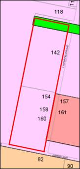
Figure 6 - Zoning Map - Orange LEP 2011
The proposed development is
defined as “subdivision” and “demolition.”
Pursuant to Section 6.2 of the Environmental Planning and
Assessment Act 1979:
Subdivision of land means the
division of land into two or more parts that, after the division, would be
obviously adapted for separate occupation, use or disposition.
Subdivision of land is permitted with consent pursuant to
Clause 2.6 (refer below).
Pursuant to Section 1.5 of the
EPAA 1979, development includes:
(e) the
demolition of a building or work.
Demolition is permitted with consent pursuant to Clause 2.7
(refer below).
Clause 2.3
Zone Objectives
The
objectives for land zoned R1 General Residential are:
· To provide for
the housing needs of the community.
· To provide for
a variety of housing types and densities.
· To enable other
land uses that provide facilities or services to meet the day to day needs of
residents.
· To ensure
development is ordered in such a way as to maximise public transport patronage
and encourage walking and cycling in close proximity to settlement.
· To ensure that
development along the Southern Link Road has an alternative access.
The proposed development will be
consistent with the relevant R1 zone objectives. The proposal involves the
release of residential lots to accommodate housing needs.
The objectives for land zoned RE1
Public Recreation are:
· To enable land
to be used for public open space or recreational purposes.
· To provide a
range of recreational settings and activities and compatible land uses.
· To protect and
enhance the natural environment for recreational purposes.
· To ensure
development is ordered in such a way as to maximise public transport patronage
and encourage walking and cycling in close proximity to settlement.
· To ensure
development along the Southern Link Road has alternative access.
The proposal will satisfy the
RE1 zone objectives. That part of the land zoned RE1 will comprise a public
reserve lot for use as public open space or recreational purposes.
Clause 2.6 Subdivision -
Consent Requirements
Clause 2.6 is applicable and states:
(1) Land
to which this Plan applies may be subdivided but only with development consent.
Consent is sought for a Torrens subdivision of the subject
land in accordance with this clause.
Clause 2.7 Demolition Requires
Development Consent
Clause 2.7 applies and states:
The demolition of a building
or work may be carried out only with development consent.
The proposal involves staged demolition of improvements over
the development site in accordance with this clause.
Part 3 -
Exempt and Complying Development
The application is not exempt or complying development.
Part 4 -
Principal Development Standards
Clause 4.1 - Minimum
Subdivision Lot Size
Clause 4.1 is applicable and
states in part:
(3) The size of any lot resulting from a
subdivision of land to which this clause applies is not to be less than the
minimum size shown on the Lot Size Map in
relation to that land.
Pursuant to the Lot Size Map
(refer below), the development site is subject to three minimum lot sizes:
· 200m2
in areas shaded blue
· 400m2
in areas shaded brown
· 700m2
in areas shaded pink
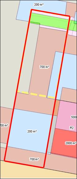
Figure 7 - Minimum Lot Size Map - Orange LEP 2011
A total of 34 lots in Stages 2 and 3 will
depart from the prescribed minimum lot size of 700m2: Lots 1-14,
20-23, 34-41, 46-49, 83-84 and Lots 98-99 (see Figure 8).
Figure 8 – proposed subdivision and overlay MLS
map
The proposal seeks consent to
vary the minimum lot size development standard in Clause 4.1 (see Clause
4.6 below).
Other lots in
the proposed subdivision will comply with the prescribed minimum lot sizes of
200m2 and 400m2.
Clause 4.6 Exception to Development Standards
Clause
4.6 applies and states in part:
(2)
Development consent may, subject to this clause, be granted
for development even though the development would contravene a development
standard imposed by this or any other environmental planning instrument…
(3)
Development consent must not be granted for development that
contravenes a development standard unless the consent authority has considered
a written request from the applicant that seeks to justify the contravention of
the development standard by demonstrating -
(a) that compliance with the development standard
is unreasonable or unnecessary in the circumstances of the case, and
(b)
that there are sufficient environmental planning grounds to
justify contravening the development standard.
(4) Development consent must not be granted for
development that contravenes a development standard unless -
(a) the
consent authority is satisfied that -
(i)
the applicant’s written request has adequately
addressed the matters required to be demonstrated by Subclause (3), and
(ii)
the proposed development will be in the public interest
because it is consistent with the objectives of the particular standard and the
objectives for development within the zone in which the development is proposed
to be carried out, and
(b) the
concurrence of the Planning Secretary has been obtained.
In consideration of Clause
4.6(2), the development standard for which the variation is sought relates to
Clause 4.1 Minimum Subdivision Lot Size. The Lot Size Map prescribes a
minimum lot size of 700m2 for part of the land (refer Figure 7
above).
A total of 34 lots in Stages 2
and 3 will depart from the prescribed minimum lot size of 700m2.
Therefore, 36.5% of all proposed lots will not comply with the LEP development
standard. The greatest variation to the development standard relates to Lots
7-10, each having proposed site area of 423.7m2. The percentage
variation to the development standard is approximately 40%.
The proposal is supported by a written
request pursuant to Clause 4.6(3). It is submitted that compliance with the
development standard is unreasonable or unnecessary; and there are sufficient
environmental planning grounds to justify the departure. The proponent’s
submission to vary the development standard provides as follows:
- Other lots within the proposed subdivision will
substantially exceed the prescribed minimum lot sizes:
o Lots with a prescribed
minimum lot size of 200m2 will range in area between 470-500m2.
o Lots with a prescribed
minimum lot size of 400m2 will range in area between 480-520m2.
- Overall lot yield for the development site will
not exceed the Shiralee Masterplan. The Masterplan provides for 107 lots, and a
maximum of 94 lots will be provided at the completion of Stage 3.
- Retention of the existing dwellings and
residential curtilages (at Stages 1 and 2) has impacted the master-planned
subdivision layout, orientation of lots and proposed lot sizes.
- The proposed lots sizes will not compromise the
orientation or location of internal streets within the subdivision.
- The proposed subdivision layout will be
generally in accordance with the intended layout in the Shiralee Masterplan.
Pursuant to Clause 4.6(4)(1),
the written request to vary the minimum lot size development standard has
considered the matters is Clause 4.6(3). The reasons to vary are acknowledged
and accepted.
Notwithstanding, it is assessed
that the proposed subdivision will be a substantial departure from the mixed
residential density and lot sizes intended in the LEP. The proposed subdivision
layout has had little regard to the prescribed minimum lot sizes across the
subdivision; indeed, the proposed subdivision will involve a mean lot size of
some 500m2 and will not include lots with minimum areas of 200m2
and 400m2 as permitted. Furthermore, more than one-third of the
proposed lots will depart the LEP development standard; and the largest
percentage variation on the development standard will be some 40%.
In consideration of Clause
4.6(4)(b), the elected Council may assume the concurrence of the planning
secretary in varying the development standard, pursuant to Planning Circular
PS 20-002 dated 5 May 2020. Should it be deemed suitable to vary the
development standard, the proposal could be in the public interest as follows:
- The proposal will be consistent with the
objectives of Clause 4.1 Minimum Subdivision Lot Size. The subdivision layout
will reflect emerging lot sizes and patterns in the Shiralee estate; the lots
will have a practical and efficient layout to meet intended use; and the lots
may be fully serviced to an urban residential standard.
- The proposal will not be averse to the
objectives of the R1 General Residential zone, albeit a variety of housing
types and densities will not be created for this proposal.
- The proposed subdivision layout will reasonably
integrate with the emerging Shiralee estate, notwithstanding some variation to
the Shiralee Masterplan and development controls contained in the Shiralee DCP
2015 (see following sections of this report).
- The proposal will not result in unacceptable
impacts on the natural or built environment.
Part 6 -
Urban Release Area
Not relevant to the application. The subject site is not
located in an Urban Release Area.
Part 7 - Additional Local
Provisions
Clause 7.1
Earthworks
The proposal involves ancillary
earthworks. Clause 7.1 is applicable and states in part:
(3) Before
granting development consent for earthworks, the consent authority must
consider the following matters -
(a) the likely
disruption of, or any detrimental effect on, existing drainage patterns and
soil stability in the locality of the development,
(b) the effect of
the development on the likely future use or redevelopment of the land,
(c) the quality of the fill or
the soil to be excavated, or both,
(d) the effect of
the development on the existing and likely amenity of adjoining properties,
(e) the source of any fill material
and the destination of any excavated material,
(f) the likelihood of
disturbing relics,
(g) the proximity
to and potential for adverse impacts on any waterway, drinking water catchment
or environmentally sensitive area,
(h)
any measures proposed to minimise or mitigate the impacts referred
to in paragraph (g).
In consideration of the relevant
matters:
· Conditional
sediment and erosion controls will be installed and maintained during civil
construction works.
· The
proposed earthworks will facilitate the proposed development.
· The
site is not known to have particular cultural values. Conditions are included
to manage and protect unexpected Indigenous or European finds during civil
construction works.
· The
subject land is not within a drinking water catchment; nor identified as an
environmentally sensitive area.
Clause 7.2A
Floodplain Risk Management
The land is affected by Probable
Maximum Flood (PMF) associated with Blackman’s Swamp Creek (see Figure
9).
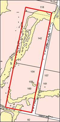
Figure 9 – PMF hatched yellow
Clause 7.2A is applicable and states in part:
(3) Development
consent must not be granted to development for the following purposes on land
to which this clause applies unless the consent authority is satisfied that the
development will not, in flood events exceeding the flood planning level,
affect the safe occupation of, and evacuation from, the land -
(r) residential
accommodation,
Council’s Assistant Development Engineer advises that
constructed stormwater infrastructure for the subdivision will overcome the
flood hazard. Stormwater will be dispersed to adjoining lands and will not be
concentrated onsite. There are no aspects of the proposal that will
affect the safe occupation of, or evacuation from the land in flood events.
Clause 7.3
Stormwater Management
Clause 7.3 is applicable. This
clause states in part:
(3) Development
consent must not be granted to development on land to which this clause applies
unless the consent authority is satisfied that the development:
(a) is
designed to maximise the use of water permeable surfaces on the land having
regard to the soil characteristics affecting onsite infiltration of water, and
(b) includes,
where practical, onsite stormwater retention for use as an alternative supply
to mains water, groundwater or river water, and
(c) avoids
any significant impacts of stormwater runoff on adjoining downstream
properties, native bushland and receiving waters, or if that impact cannot be
reasonably avoided, minimises and mitigates the impact.
Council’s Assistant Development Engineer has included
Conditions to satisfy the requirements of Clause 7.3. Stormwater design for the
subdivision will comply with Council’s Development and Subdivision Code
and Shiralee DCP 2015.
Clause 7.6
Groundwater Vulnerability
The subject land is identified
as Groundwater Vulnerable on the Groundwater Vulnerability Map. Clause
7.6 applies. This clause states in part:
(3) Before determining a development
application for development on land to which this clause applies, the consent
authority must consider:
(a) whether or not the development (including
any onsite storage or disposal of solid or liquid waste and chemicals) is
likely to cause any groundwater contamination or have any adverse effect on
groundwater dependent ecosystems, and
(b) the
cumulative impact (including the impact on nearby groundwater extraction for
potable water supply or stock water supply) of the development and any other
existing development on groundwater.
In consideration of Clause 7.6,
the proposed development is unlikely to cause groundwater contamination or
effect groundwater dependent ecosystems. Urban residential subdivision does not
involve processes or activities that would impact on groundwater resources.
The subject lands will be serviced by reticulated sewer.
Clause 7.11 Essential Services
Clause 7.11 applies and states:
Development consent must not be granted to development
unless the consent authority is satisfied that any of the following services
that are essential for the proposed development are available or that adequate
arrangements have been made to make them available when required:
(a) the supply of water,
(b) the supply of electricity,
(c) the disposal and management of
sewage,
(d) storm water drainage or onsite
conservation,
(e) suitable road access.
In consideration of Clause 7.11,
the listed utility services are available to the land and adequate for the
proposed subdivision. Conditions are included requiring extension, augmentation
and/or upgrading of urban utility services to an urban standard.
State Environmental Planning
Policy 55 Remediation of Land
SEPP 55 is applicable and states in part:
7(1) A consent authority must not consent to
the carrying out of any development on land unless:
(a) it has considered whether the
land is contaminated, and
(b) if the land is contaminated, it
is satisfied that the land is suitable in its contaminated state (or will be
suitable, after remediation) for the purpose for which the development is
proposed to be carried out, and
(c) if the land requires remediation
to be made suitable for the purpose for which the development is proposed to be
carried out, it is satisfied that the land will be remediated before the land
is used for that purpose.
In consideration of the requirements of SEPP 55, a Preliminary
Contamination Investigation was submitted in support of subdivision Stages 1
and 2 (Envirowest Consulting July 2021).
The investigation provides the following contamination
conclusions and recommendations:
· The historical
land use is agriculture (grazing) with the current land use being
rural-residential.
· Soil samples were
collected across the site on a systematic grid pattern and from potential
contamination areas. The soil samples were evaluated for selected
analytes including metals, pesticides, and hydrocarbons.
· No evidence of
orchards, mines, sheep dips, mixing sheds or contaminating industrial
activities are known to have been located on the site from the review of site
history or site walkover. The use of agricultural pesticides over the area is
expected to have occurred in the past.
· The soil sampling
programs did not detect elevated levels of metals, pesticides, or hydrocarbons.
The levels of all substances evaluated were below the adopted thresholds for
residential land use with access to soil.
· The areas
investigated are suitable for proposed residential land use. Additional
sampling is recommended after removal of sheds, slabs etc.
· An unexpected
finds protocol is recommended to be implemented during site development works
to manage potential hazards.
· Onsite wastewater
systems (associated with the existing dwellings) will require decommissioning.
Based on the findings of the contamination investigation,
the land is suitable for proposed Stages 1 and 2 subdivisions. Consistent with
the recommendations, Conditions are including requiring soil sampling
post-outbuilding demolition, implementation of unexpected finds protocol, and
decommissioning of wastewater systems.
The application was latterly amended to include Stage 3.
This stage involves further subdivision of Lots 85 and 86 to create nine
additional residential lots. The contamination investigation did not
extend to proposed residential Lots 85, 86 or 89. Notwithstanding, soil
sampling in the vicinity of the proposed lots was extensive. The parcels have
longstanding residential use, and the proposal will intensify that use. It is
considered reasonable to deduce that lots in Stage 3 will also be suitable for
the residential land use, pursuant to Section 7. Contamination testing
and clearance will be required for proposed Lots 91-99 in Stage 3, prior to
Subdivision Certificate release.
State Environmental Planning
Policy (Vegetation in Non-Rural Areas) 2017
SEPP (Vegetation in Non-Rural Areas) 2017 applies and states
in part:
9 Vegetation
to which Part applies
(1) This
Part applies to vegetation in any non-rural area of the State that is declared
by a development control plan to be vegetation to which this Part applies.
(2) A
development control plan may make the declaration in any manner, including by
reference to any of the following -
(a) the
species of vegetation,
(b) the size of
vegetation,
(c) the
location of vegetation (including by reference to any vegetation in an area
shown on a map or in any specified zone),
(d) the
presence of vegetation in an ecological community or in the habitat of a
threatened species.
10 Council may issue
permit for clearing of vegetation
(1) A
council may issue a permit to a landholder to clear vegetation to which this Part
applies in any non-rural area of the State.
(2) A
permit cannot be granted to clear native vegetation in any non-rural area of
the State that exceeds the biodiversity offsets scheme threshold.
In consideration of the above Sections, tree removal is required
across the development site to facilitate the proposed subdivision. The trees
are variously prescribed trees pursuant to Orange DCP 2004-0 (see following
section of this report), and approval is required for removal.
Council’s Manager City Presentation
advises that ‘tree loss appears to be cultural plantings that have
occurred in the past 15-30 years and offer no significant habitat or
biodiversity value.’ No objection is raised to tree
removal. Conditional street tree planting in accordance with the Shiralee
DCP 2015 will offset vegetation loss.
As a matter arising, it is noted
that a large remnant Eucalypt is located within the road reserve to the east of
proposed public reserve Lot 90 (see Figure 10). Conditions are included
requiring protection and retention of the remnant native.

Figure 10 – aerial photo depicted trees over the
development site; remnant native circled in red
State Environmental Planning
Policy (Infrastructure) 2007
Division 5 Electricity Transmission or Distribution
The subject land contains and adjoins existing overhead
exposed electricity powerlines. Furthermore, the proposal involves replacing
the east-west overhead line through the site with underground powerlines.
Section 45 of SEPP Infrastructure 2007 is applicable and states in part:
(1) This clause applies to a development
application (or an application for modification of a consent) for development
comprising or involving any of the following -
(b) development carried out -
(iii) within 5m of an exposed overhead
electricity power line,
(d) development involving or
requiring the placement of power lines underground, unless an agreement with
respect to the placement underground of power lines is in force between the
electricity supply authority and the council for the land concerned.
(2) Before determining a development
application (or an application for modification of a consent) for development
to which this clause applies, the consent authority must -
(a) give written notice to the
electricity supply authority for the area in which the development is to be
carried out, inviting comments about potential safety risks, and
(b) take into consideration any
response to the notice that is received within 21 days after the notice is
given.
In accordance with this Section, the
proposed development was referred to Essential Energy for consideration and
comment. Essential Energy ‘had no comments to make as to
potential safety risks arising from the proposed development.’ The
electricity authority recommended general conditions of consent, which are
included on the attached Notice of Approval.
Provisions
of any Draft Environmental Planning Instrument That Has Been Placed on
Exhibition 4.15(1)(A)(ii)
There
are no draft EPIs on public exhibition.
Provisions
of any Development Control Plan S4.15(1)(A)(iii)
Development Control Plan 2004
DCP 2004 applies to the subject
land. Parts of the DCP relevant to the proposed subdivision include:
· Part 2 - Natural
Resource Management
· Part 3 - General
Considerations
· Part 4 - Special
Environmental Considerations
· Part 5 - General
Considerations for Zones and Development.
The relevant matters were considered in the foregoing
assessment under Orange LEP 2011. The proposal will satisfy the relevant
planning outcomes and guidelines contained in DCP 2004.
Shiralee Development Control
Plan 2015
Shiralee DCP is applicable to the
proposal. The objectives of the DCP are:
· To guide the
urban expansion of Shiralee, south of the existing Orange urban area
· To promote a
high-quality urban environment with a diversity of housing and recreational
opportunities
· To encourage
alternative modes of transport and healthy lifestyles
· To reduce
traffic congestion by providing for the day to day needs of residents within
the precinct.
As outlined in the following assessment of relevant
controls, the proposed subdivision will not be contrary to the objectives of
the Shiralee DCP.
Part 1.8 Exceptional Circumstances allows some
variation to the plan, provided that the proposal meets or exceeds the listed
aims and principles. It is accepted that variations to the Masterplan will
result as development proceeds in the urban village.
2.0 Desired Future Character
2.4 Subdivision
Controls:
· All subdivision
applications are to be accompanied by a preliminary investigation to identify
any past or present uses that have potential to contaminate the land and a
preliminary assessment of any known contamination. If the results are positive,
or if Council so directs, the application is to undertake a more detailed
investigation.
As outlined in the foregoing sections
of this report, preliminary contamination investigation was undertaken in
support of the proposed subdivision. The investigation determined the land in
Stages 1 and 2 is suitable for residential land use. The contamination
investigation did not extend to Stage 3, which involves existing dwellings on
proposed lots. Conditions are included requiring soil testing and contamination
clearance for proposed Lots 91-99 in Stage 3, prior to issue of a
Subdivision Certificate.
· Subdivision is
to be consistent generally in accordance with the Masterplan design and intent
per the DCP. Legislative requirements and DCP written controls take precedence
over the Masterplan.
The Shiralee Masterplan and
proposed Stage 3 subdivision layout are depicted below (refer Figure 11).
Figure 11 - Shiralee Masterplan Area H -v- proposed
subdivision
As
demonstrated, the proposed subdivision will accord with the Masterplan as
follows:
· a public reserve
will be sited in the northern extent
· the subdivision
layout will be comprised of three (3) x east-west parcel groups and
two (2) x north-south parcel groups
· internal roads
will provide connections to adjoining lands
· lots will have
frontages to perimeter roads (Lysterfield Road and Sweetheart Drive) and
internal roads
· lot orientation
and shape will predominantly accord
· the subdivision
layout will comprise a mix of Standard and Medium Lots.
The proposed subdivision will depart from the Masterplan in
the following ways:
a. The
subdivision does not involve Compact Lots (see Lot Typologies below). With one
or two exceptions, the proposed lots will comprise Medium or Standard Lots
only.
b. Internal
east-west roads will not have a straight alignment, nor connect to the
adjoining eastern lands in the locations intended.
Realignment of the roads is
required in order to order to retain existing improvements (outbuildings and
bore) on Lot 85, and to a lesser extent Lot 89, in Stage 2 of the subdivision
(see Figure 12).
Figure 12 – Apple Box Street realigned clear of
improvements on proposed Lot 85
The realignment of Apple Box
Street will compromise the future roundabout at the intersection of Apple Box
Street and Lysterfield Road, and the road connection to the adjoining subdivision
to the east (DA 403/2021(1)).
After much negotiation with the
proponent, Council’s Technical Services Division have accepted the
revised road alignment and staggered T-intersection on Lysterfield Road as
depicted above (see Figure 13).
As a matter arising, it is noted that Stage 3 involves
further subdivision of Lot 85 to create five (5) residential lots, including
demolition of all improvements (see Figure 13).
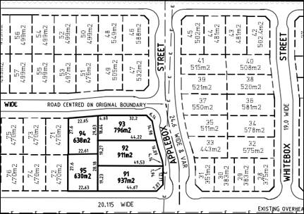
Figure 13 – Stage 3 resubdivision of Lot 85
To this end, it is considered
unreasonable to realign Apple Box Street contrary to the intended Shiralee
Masterplan, when realignment will not be required at the completion of the
subdivision. It is assessed that internal roads should accord with the
Masterplan, and the affected improvements on Lot 85 should be demolished at
Stage 2. Should Council support this assessment, Conditions can be included to
effect same.
· Lot sizes are
to be consistent with or greater than the adopted minimum lot size for the land
under the LEP zoning map.
As outlined in the foregoing
sections of this report, the development site is subject to three minimum lot
sizes: 200m2, 400m2 and 700m2. A number
of lots will depart from the prescribed minimum lot size of 700m2.
The proposal seeks consent to vary the minimum lot size development standard
pursuant to Clause 4.6 Orange LEP 2011. Other lots in the proposed subdivision
will comply with the prescribed minimum lot sizes of 200m2 and 400m2.
· Where an
oversized lot is proposed (substantially greater than the adopted minimum lot
size), plans are to nominate a building envelope.
· Building
envelopes on oversized lots are to be positioned in a manner that clearly
enables future subdivision of the lot to a pattern consistent with the
masterplan layout and adopted minimum lot size for the land.
Oversize lots in the subdivision (Lots 86, 86 and 89 at
Stage 2; and Lot 89 at Stage 3) contain existing dwellings. Building
envelopes will not be required.
· Except for
corner lots and where indicated otherwise on the Large Lot Classification
Table, all residential lots are to have a width to depth ratio of between 1:4
and 1:2.75 with the shorter boundary being the street frontage.
· Residential
corner lots are to have greater width with a ratio of between 1:3.25 and 1:2.5
to allow more opportunity for the subsequent dwelling to address both
frontages.
The proposed allotment layout will achieve a north-south or
east-west long orientation which will maximise solar design opportunities.
Furthermore, the proposed lots will allow appropriate presentation of future
dwellings on the lots to public roads. The intent of the width-to-depth ratio
is thereby satisfied.
· Roads
identified for Bus Routes:
- Intersections
where the bus route turns are to be designed to accommodate full size coaches.
- At
nominated bus stop locations, the road reserve is to be increased by an
addition of 0.5m to allow for passenger congregation and future street
furniture. The front building setbacks of affected lots may be reduced by 0.25m
to help preserve the pattern and rhythm of development.
Lysterfield Road is identified as a secondary bus route in
the Shiralee DCP and Masterplan, and a bus stop is included in the development
site. Council’s Assistant Development Engineer is satisfied with the
proposed road layout. Conditions are included on the attached Notice of
Approval in relation to upgrading of Lysterfield Road at the frontage of the
development site.
2.5 Lot Typologies
Controls:
· Lot typologies
and minimum sizes are to be consistent with the Masterplan, DCP and LEP zoning
maps.
An extract of the Shiralee
Structure Plan and Housing Densities Map is shown below (refer Figure 14).
The structure plan provides for a mix of Standard Lots (700-850m2),
Medium Lots (400-550m2) and Compact Lots (200-350m2) over
the development site.
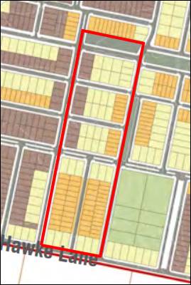
Figure 14 - Shiralee Structure Plan and Housing
Densities
The proposed subdivision departs from the intended
Masterplan lot typologies, as outlined in the following table.
|
Lot
Typology
|
Masterplan
|
Proposed Subdivision Stage 3
|
|
Large
|
0
|
1
|
|
Standard
|
38
|
7
|
|
Medium
|
12
|
86
|
|
Compact
|
57
|
0
|
|
TOTAL
|
107
|
94
|
As
demonstrated, the proposed subdivision is largely comprised of Medium Lots.
While contrary to the intended Masterplan, the subdivision will not be
incongruous in the broader Shiralee context. Indeed, variations to the intended
Masterplan layout and lot typologies are occurring as development in Shiralee
proceeds.
· Any subdivision
which creates more than three lots must not have any oversized lots. Oversized
lots are lots that do not fit within the designated categories.
Proposed Lots 85, 86 and 89
will comprise oversize lots at Stages 1 and 2 of the subdivision. These
lots contain existing dwelling houses and associated residential curtilages.
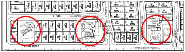
Figure 15 – Stage 2 oversize lots
Lots 85 and 86 will be subsequently subdivided to
Medium and Standard Lots at Stage 3, with Lot 89 to be retained as an oversize
lot.
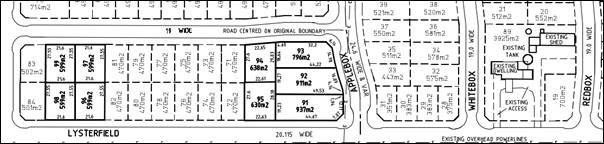
Figure 16 – Stage 3 oversize lot
The oversized lots will be
reflective of the longstanding rural residential use of the land and will
reasonably integrate in the setting. Indeed, oversized lots are intended across
the Shiralee estate generally, albeit not planned for this site.
Notwithstanding, existing outbuildings on oversized Lots 85
and 89 will abut proposed boundaries public roads and have unsuitable visual
bulk encroachments impacts on future residential streetscapes. Conditions are
included requiring outbuildings on Lots 85-89 be demolished or altered to
achieve a minimum setback of 4m to future public road boundaries at Stage 1 of
the subdivision works.
· Specific
requirements for large lots within the Precinct are to be consistent with
Large Lot Classification Diagram and Large Lot Classification Table.
As outlined previously, the proposed subdivision does not
include an oversized lot on the Large Lot Classification Diagram.
· Where
subdivision involves the creation of a lot greater than the maximum for the lot
typology, a building envelope is to be established on the title of the new lot
[consistent with prescribed dimensions].
Building envelopes will not be required on the proposed
lots. Development controls for residential development on Standard and Medium
Lot typologies are contained in the Shiralee DCP 2015 (Appendix B).
· All lots must
have a direct street frontage to ensure good access and property amenity.
All proposed lots will have direct street frontage and
access to an existing or proposed public road.
· Corner lots are
to achieve high quality street frontages on the primary and secondary street.
The proposed subdivision layout is considered suitable to
achieve high quality street frontage to primary and secondary boundaries.
· All compact,
medium and standard lots need to achieve a solar orientation where the long
axis of the lot is:
- for
north-south oriented lots between 20o west of north of 30o
east or north, or
- for
east-west oriented lots between 20o north of east or 30o
south of east.
The proposed lots will comply with the requirements for
solar orientation. Notwithstanding the masterplan departures in relation
to lot sizes and typology mix, the proposed orientation of the lots will be
usually consistent with the Masterplan layout.
3.0 Local Infrastructure
3.1 Infrastructure Provisions
Controls:
· Clause 7.11 of
Orange LEP 2011 establishes that development is required to be provided with
essential services…
· Provision of
essential local infrastructure is at the developers cost and in line with the
Shiralee Development Contributions Plan.
· The design and
placement of local infrastructure is to be in accordance with the relevant
authorities’ requirements.
· All power lines
are to be located underground.
As outlined in the foregoing assessment, utility services
are available to the land and adequate for the proposed subdivision, subject to
extension, augmentation, upgrading and developer contributions. Conditions are
included on the attached Notice of Approval to satisfy the requirements of Part
3.1.
3.2 Ground Levels and Excavation
Controls:
· Cut and fill is
to be minimised with cut materials used onsite as either fill for buildings or
used to even out landforms.
· Any cut is to
be supported by a retaining wall or battered at a gradient of less than 1:4,
provided that gradient is achievable entirely within the site boundaries.
· The design of
any retaining wall greater than 600mm must be accompanied by a statement from
an engineer attesting that the design is fit for purpose.
· Excavation for
the purposes of development must not exceed a maximum depth measured from
ground level (existing) of:
- If
located not more than 2m from any boundary:1m
- If
located more than 2m from any boundary: 2m.
· Notwithstanding
the above, excavation must not be more than 1m below ground level (existing) if
the land is within 40m of a waterbody (natural)…
· Filling, for
the purpose of erecting a dwelling must not exceed 1m above ground level
(existing).
· All excavation
and/or filling that exceeds 600mm in depth/height must be contained by either:
- A
retaining wall or other form of structural support that does not extend more
than 1.5m from:
o external walls of the dwelling
house,
o decking connected to the dwelling
house, or
o principal private open space of
the dwelling house,
o an unprotected sloping embankment
or batter that does not extend from the dwelling house, decking or principal
private open space by more than 3m, in which case the toe of the embankment or
batter must be more than 1m away from a side or rear boundary.
· To facilitate
assessment detailed engineering plans for retaining walls are to be supplied
where the wall is intended to retain more than 600mm or more of material. Note:
for this clause “Principal Private Open Space” means courtyard
space of up to 30m2 that is located behind the main building
alignment and is in close proximity to the living and entertaining spaces of
the dwelling house.
Earthworks will be required in
conjunction with civil and construction works required to create the proposed
lots and new and upgraded roads. The extent of excavation and filling will be
determined at engineering design stage. Notwithstanding, it is considered that
the required earthworks are unlikely to disrupt or have a detrimental effect on
the existing drainage patterns and soil stability of the area, nor
detrimentally affect a future use or redevelopment of the land, nor
detrimentally affect the amenity of adjoining properties, nor or disturb any
relics.
3.3 Public
Domain
Controls:
· Land identified
for the RE1 Public Recreation Zone is to be dedicated to Council as public open
space upon subdivision of the parent lot.
· Compensation
for the dedicated land is to be in accordance with the relevant Section 94
Development Contribution Plan.
Proposed open space Lot 90 will be dedicated to Council at
registration of the parent parcel, with appropriate compensation consistent
with the Land Acquisition (Just Terms Compensation) Act 1991.
· Footpath dining
in the Village Centre is encouraged, although access on the footpath must be
maintained and consideration must be given to access for the vision impaired
and those in wheelchairs.
· Outdoor dining
furniture and signage must be approved by Orange City Council and provide a
positive visual aesthetic to the streetscape.
· Ensure
reasonable pedestrian/wheelchair/pram crossing ability is designed into the
road and median to ensure access into the heart of the village.
The proposed subdivision does not relate to built form
within a Village Centre, and the above controls are not applicable.
3.4 Staging
Controls:
· The Rifle Range
Exclusion Zone may not be subdivided or otherwise developed until the Rifle
Range has been decommissioned…
· The Hawke Dam
Lane exclusion zone may not be subdivided or otherwise developed until the dam
has been decommissioned…
The development site is not located within the Rifle Range
or Hawke Dam Lane exclusion zones.
3.5 Lighting
Controls:
· All lights are
to use energy efficient LED luminaries or equivalent…
· Street lighting
is to be designed to meet the current Australian Standards AS/NZS 1158 series.
· Enhanced levels
of lighting are to be installed at major recreation pedestrian/cycle link
crossings and at pedestrian crossings.
· Street trees
and streetlights are to be staggered so that footpaths maintain sufficient
light levels.
Conditions are included on the attached Notice of Approval
to satisfy the above controls relating to lighting across the subdivision.
5.0 Residential Buildings
Part 5 contains provisions for dwellings, including:
· building form
and layout
· building
typology, design and dwelling mix
· solar access
· reflectivity
· privacy
· universal
design.
The proposal does not involve new residential buildings.
7.0
Public Domain
7.1 Passive and Active Recreation Network
Controls:
· Open spaces and
streets facing open spaces must be provided according to the Masterplan.
The proposed subdivision layout includes an open space lot
(Lot 90) in the northern extent, consistent with the Shiralee DCP and
Masterplan.
· Where a
property adjoins a park or other public space that is not a street or road, any
residential development of that property:
- must
provide at least two windows from habitable rooms to face the public space. The
windows are to be a minimum 2.5m² in size
- may
not place the side or rear walls of sheds and outbuildings any closer than 2.5m
from the boundary with the public space.
· Properties
adjoining a public park or other public space are encouraged to include a
pedestrian gate along the boundary.
The proposed subdivision does not involve the creation of residential
lots adjoining a park or other public space.
7.2 Landscape
Controls:
· Open spaces and
streets facing open spaces must be provided according to the Masterplan.
· Eco link
streets are to have an understory planting layer of native species including
shrubs, groundcovers and grasses of maximum mature height of 1.5m with planting
plans to be submitted for approval by Council.
· Streets with
medians are to have an understory planting layer of species responding to the
tree planting within the median, including shrubs, groundcovers and grasses of
generally maximum mature height of 1.5m and of 1m within 5m of an intersection.
· Footpath verges
within residential areas are to be planted with cool climate turf species, as
approved by Council.
· Footpath verges
and tree planting zones within the village centre, may be planted with robust
groundcover and grass species in keeping with a high-quality street environment
and as approved by Council.
· A developer
shall construct all footpaths, turf all verges and provide all road
infrastructure planting prior to sale of building blocks.
· Orange City
Council will plant all street trees.
· Maximum verge
cross-fall from property boundary to kerb is to be 2%.
· Longitudinal
gradient of verge is to match the gradient of the adjacent kerb. Retaining
walls are to be provided along property boundaries accordingly.
A landscaping plan was not submitted in support of the
proposed subdivision. Conditions are included on the attached Notice of
Approval requiring preparation and implementation of a landscaping plan at
Stages 2 and 3, consistent with the requirements of Part 7.2.
7.4 Street Tree Strategy
Controls:
· A minimum of
one tree per lot for compact lots, two trees for standard lots and three trees
for larger lots, at even spacings along the street.
· Street tree
plantings are to be consistent with the Street Tree Strategy Diagram, Species
List and Planting Detail and as approved by Council.
· Residential
street verges are to be turfed with Council approved species except where
Council requires groundcover planting.
A landscaping plan was not submitted in support of the
proposed development. Conditions are included on the attached Notice of
Approval requiring preparation and implementation of a landscaping plan
incorporating street trees at Stages 2 and 3, consistent with the requirements
of Part 7.4.
As a matter arising, and as outlined above, the existing
remnant Eucalypt in the road reserve to the east of Lot 90 public reserve shall
be retained and protected via Conditions.
8.0 Environmental Management
8.3 Stormwater and Water Sensitive Urban Design (WSUD)
Controls:
· A comprehensive
site wide WSUD strategy is implemented for Shiralee.
· Streets and
public spaces incorporate best practice WSUD elements including swales, rain
gardens and detention/retention basins.
· WSUD elements
are to incorporate native planting.
The proposed subdivision may be designed to comply with the
above controls. Conditions are included on the attached Notice of Approval to
satisfy the requirements of Part 8.3.
8.4 Environmental Hazards
Controls:
· Bushfire,
flooding and other environmental hazards are to be assessed for each
development site to ensure safety and compliance with all relevant codes,
regulations and laws.
The development site is partly affected by Blackmans Swamp
Creek Probable Maximum Flood (PMF) (see Figure 9 above). Council’s
Assistant Development Engineer advises that constructed stormwater
infrastructure for the subdivision will overcome the flood hazard.
Stormwater will be dispersed to adjoining lands and will not be concentrated
onsite.
The site is not subject to other environmental hazards.
9.0 Movement Networks
9.2 Pedestrian and Bicycle Network and Associated
Facilities
Controls:
· A comprehensive
site wide WSUD strategy is implemented for Shiralee.
· A cycle network
is to be implemented in accordance with Figure 64. Cycle Network and be
designed in accordance with Austroads Standards and RMS Guidelines.
· Footpaths to be
provided on both sides of the street consistent with the street sections in
Appendix C.
· Safe road
crossings (e.g. marked crossings) are to be provided according to 9.4 Street
Network Access Controls. Also refer indicative intersection treatments,
Figures 75 and 76.
· Universal
access to be provided throughout the precinct in accordance to AS.1428.1.
· On-road cycle
routes are to be clearly line marked and sign posted.
· Any development
that is assessed as requiring an on-site parking area or at least five (5)
spaces shall also be required to provide bicycle parking.
· Bicycle parking
is to be provided at the ratio of one (1) bicycle space per 15 car parking
spaces (or part thereof).
· All bicycle
spaces are to be provided with a fixed rack or other feature to facilitate
chain locking the bicycle.
· Bicycle spaces
are to be positioned to avoid conflict with car and service vehicle
circulation.
· Bicycle spaces
are to be clearly delineated from other parking areas by means of lane marking
and/or signage.
The development site contains a Cycle Route and On-Road
Cycle Way pursuant to the Shiralee DCP and Masterplan. Conditions are included
requiring road and cycleway construction to satisfy the requirements of Part
9.2.
9.3 Public Transport Network
Controls:
· Bus routes and
stops are to be positioned in accordance with Figure 67 - Bus Network.
· All bus stops
must have a shelter that includes seating with arm rests and lighting.
· Bus shelters
are to be positioned on either side of the street at all stops indicated on
Figure 67 - Bus Network.
· Pedestrian
crossings must be provided within 30m of all stops.
· Continuous
accessible paving must be provided from the shelter to pedestrian crossing.21.
Lysterfield Road is identified as a secondary bus route in
the Shiralee DCP and Masterplan, and a bus stop is included in the development
site. Council’s Assistant Development Engineer is satisfied with the proposed
road layout. Conditions are included on the attached Notice of Approval in
relation to upgrading of Lysterfield Road at the frontage of the development
site.
9.4 Street Network and Access
Controls:
· Other than
where specified in the Masterplan there are to be no cul-de-sacs or no‑thru
roads.
· Where new roads
are aligned along existing property boundaries the first property to develop is
to include stage one of the shared road including any central median reserve.
· All streets
indicated on the Masterplan are to be designed and constructed in accordance
with the relevant street typology diagram.
· Intersections
are to be designed to maximise ease of movement for pedestrians and cyclists
and to slow vehicular traffic. Indicative intersection treatments for four way
and ‘T’ intersections are shown in Figures 75 and 76. Indicative
Intersection Treatments.
· Traffic calming
measures will be implemented in suitable locations to reduce vehicle speeds.
Traffic calming measures include passive measures such as intersection
narrowing, minimising width of road pavements, designation of slow speed
streets and use of rumble strips at pedestrian crossing points and
intersections.
· The principles
of water sensitive urban design are to be incorporated in the road network for
any new streets.
· Driveway
crossovers are to be a maximum of 3m wide and are not to be constructed within
6m of an intersection. Crossover pavement is to match the adjacent footpath
material.
· Garages and
carports on corner lots are to be accessed from the longer street frontage and
the crossover is to be aligned adjacent to the boundary furthest from the
intersection.
· Marked
Crossings, Refuge Islands and/or traffic signals are to be provided at street
intersections on:
- Collector
Streets
- the
Southern Feeder Road, and
- Intersections
of the ‘off road shared cycle and pedestrian path’.
· Two stage
roads:
- On
development of the first stage of a two-stage road, the design shall include a
buffer strip alongside the neighbours existing boundary. This strip is to be
created as a Torrens lot and vested with Council to ensure Council can maintain
control over access arrangements.
- On
development of the second stage of a two-stage road, Council will
convert the buffer strip from a lot to a road reserve to enable the
construction of turning bays as part of the development.
The following comments are provided in consideration of the
proposed street network across the subdivision:
- The
proposed road layout will be generally in accordance with the Shiralee
Masterplan.
- The
proposed subdivision road layout will not comprise cul-de-sacs or no-thru
roads.
- The
proposal involves shared roads on the site perimeters to Sweetheart Drive and
Lysterfield Road. Lots on the perimeters will require adjoining land to be
developed to enable full road construction. Interim traffic measures are
possible to provide adequate short-term access for the affected lots.
Conditions are included requiring Sweetheart Drive be constructed half-road
width; and Lysterfield Road be constructed full-road width north of Apple Box
Street, and half-road width south of Apple Box Street.
- The
internal east-west roads will be realigned in order to retain existing
improvements (outbuildings and bore) on proposed Lot 85, and to a lesser extent
Lot 89 in Stage 2 of the subdivision. The realignment of Apple Box Street will
compromise the future roundabout at the intersection of Apple Box Street and
Lysterfield Road, and the road connection to the adjoining subdivision to the
east (DA 403/2021(1)). After much negotiation with the proponent,
Council’s Technical Services Division have accepted the revised road
alignment and staggered T‑intersection on Lysterfield Road.
Notwithstanding, the realigned
road layout is not considered an optimum planning outcome. The improvements
necessitating the realignment will be demolished in Stage 3 of the
subdivision. It is assessed that internal roads should accord with the
Masterplan, and the affected improvements on Lot 85 should be demolished at
Stage 2. Should Council support this assessment, Conditions can be included to
effect same.
- Conditions
are included to satisfy the road design and construction requirements of Part
9.4.
9.5 Traffic Management
Controls:
· Other than
where specified in the Masterplan there are to be no cul-de-sacs or no‑thru
roads.
· Key
intersections shown on the management plan are to be designed to
Council’s requirements.
· Intersections
along nominated bus routes are to be designed to accommodate the turning arc of
coach buses.
· Marked
crossings, refuge islands and/or traffic signals are to be provided at street
intersections on: Collector streets, the Southern Feeder Road and intersections
of the off-road shared cycle and pedestrian path. This will improve pedestrian
and bicycle safety.
· All streets
except for Collectors and the Southern Feeder Road are to have a maximum 40km
per hour speed limit.
· All street
kerbs are to be upright not roll kerbs. Broken upright kerbs should be used where
required for WSUD function.
As outlined in the foregoing
sections of this report, Council’s Development Engineer advises that
‘the proposed road layout is satisfactory and generally in accordance
with the Shiralee DCP.’ Conditions are included to satisfy the
design requirements of Part 9.5.
SECTION 7.11 - DEVELOPMENT
CONTRIBUTIONS
In accordance with Section 7.11 and Orange Development
Contributions Plan 2017 (Shiralee Release Area), development contributions are
applicable as follows:
Stage 1 – 3 residential
lots and 2 development lots
|
Open
Space and Recreation
|
Two
additional lots at 792.01
|
1,584.02
|
|
Community and Cultural
|
Two
additional lots at 229.68
|
459.36
|
|
Roads and Traffic Management
|
Two
additional lots at 1,045.43
|
2,090.86
|
|
Local Area Facilities
|
Two
additional lots at 17,760.90
|
35,521.80
|
|
Plan Preparation & Administration
|
Two
additional lots at 171.98
|
343.96
|
|
TOTAL
|
|
$40,000
|
Stage 2 – 84
residential lots and 1 public reserve lot
|
Open
Space and Recreation
|
84 additional lots at 792.01 less
two lots at 792.01 created in Stage
1
|
64,944.82
|
|
Community and Cultural
|
84 additional lots at 229.68 less
two lots at 229.68 created in Stage
1
|
18,833.76
|
|
Roads and Traffic Management
|
84 additional lots at 1,045.43 less
two
lots at 1,045.43 created in Stage 1
|
85,725.26
|
|
Local Area Facilities
|
84 additional lots at 17,760.90
less two lots at 17,760.90 created in
Stage 1
|
1,456,394.00
|
|
Plan Preparation & Administration
|
84 additional lots at 171.98 less
two lots at 171.98 created in Stage
1
|
14,102.36
|
|
TOTAL
|
|
$1,640,000.00
|
Stage 3 – 9 residential lots
|
Open
Space and Recreation
|
Nine
additional lots at 792.01
|
7,128.09
|
|
Community and Cultural
|
Nine
additional lots at 229.68
|
2,067.12
|
|
Roads and Traffic Management
|
Nine
additional lots at 1,045.43
|
9,408.87
|
|
Local Area Facilities
|
Nine
additional lots at 17,760.90
|
159,848.10
|
|
Plan Preparation & Administration
|
Nine
additional lots at 171.98
|
1,547.82
|
|
TOTAL
|
|
$180,000
|
The Contributions Plan makes
provision for acquisition of and compensation for public open space in the
Shiralee urban release area. Compensation allowance is made in the Plan
for a maximum of 9.79ha of public open space. Compensation rates vary for
unencumbered land, encumbered land, and land within a riparian corridor
or flood planning area.
Council staff in assessing the proposal have however
identified an anomaly within the tables contained within the Council’s
contributions plan for Shiralee locality whereby the area of land proposed for
open space under this application and required to be provided by
Council’s DCP has been omitted. Stage 2 involves the creation of public
reserve Lot 90 with site area of 4,068m2. The proposed public
reserve is consistent with the planned public reserve contained in the Shiralee
Masterplan Area H. The public reserve is partly subject to PMF flooding
associated with Blackman’s Swamp Creek. It is estimated that 1,300m2
of the public reserve lot is unencumbered land (subject to survey and
clarification of definition).
In order to properly address the matter pertaining to
compensation under this circumstance for that part of the land identified for
future open space within the proposal and progress the matter in the absence of
an amendment to the Contributions plan it is appropriate to negotiate a
mutually agreeable outcome with the applicant via a planning agreement. Section
7 of the Environmental Planning and Assessment Act 1979 provides that a consent authority may require a
planning agreement to be entered into as a condition of a development consent,
but only if it requires a planning agreement that is in the terms of an offer
made by the developer in connection with the development application.
Council staff have negotiated an outcome with the applicant
for Council’s consideration. Council’s CEO has received a letter
from the applicant containing the terms of an offer made with respect to this
matter. In this case the offer provides for the dedication of the proposed open
space to Council following the registration of the plan at the Land and
Property Information Centre in Stage 2 on the basis that the contributions per
lot within each stage of the subdivision as identified in the tables above for
open space and recreation are not charged. The contribution value contained
within the above schedule of payments relating to Open Space and Recreation and
the value of the land in question is considered to be of equal value. It is
recommended on this basis that Council agrees with the terms of the offer made
(see attached) with respect to this matter as the offer is in the benefit of
both Council and the applicant to progress this way. Attached are recommended
conditions of consent that amend the schedule of payments required under the
contributions plans and requires the applicant to prepare and implement the
Planning Agreement consistent with the terms of the offer in a manner
consistent with the requirements of the Environmental Planning and Assessment
Act.
The planning agreement relates only
to the open space and recreation component of the development contributions.
All other components: community and cultural, roads and traffic management,
local area facilities, and plan preparation and administration will be
unaffected by the planning agreement and remain in place as per the
contributions plan.
SECTION 64 (LOCAL GOVERNMENTT
ACT) - WATER AND SEWER HEADWORKS CHARGES
Section 64 water and sewer headworks charges are also
applicable to the proposal, as follows:
Stage 1 – three (3) residential lots and two (2)
development lots
The contributions are based on 5.0 ETs for water supply
headworks and 5.0 ETs for sewerage headworks.
Stage 2 – 84 residential
lots and one (1) public reserve lot
The contributions are based on 89 ETs for water supply
headworks and 89 ETs for sewerage headworks (a credit of 5 ETs for both water
and sewer shall be made at the time of payment to account for proposed lots 85,
86, 87, 88 and 89 released in Stage 1).
Stage 3 – nine (9)
residential lots
The contributions are based on 9 ETs for water supply
headworks and 9 ETs for sewerage headworks (a credit of two ETs for both water
and sewer shall be made at the time of payment to account for proposed lots 85
and 86 released in Stage 1).
Provisions Prescribed by the Regulations
S4.15(1)(a)(iv)
Demolition of a Building (clause 92)
The proposal involves various demolition works at each stage
of the proposed subdivision. Conditions are included in relation to waste
management and demolition works in accordance with applicable standards.
Fire Safety Considerations
(clause 93) and Buildings to be Upgraded (clause 94)
Council’s Building Certifier advises:
The proposal can comply with the BCA. Details are to be
provided with the Subdivision Certificate demonstrating that the existing
buildings on Lots 86, 87 and 88 meet the setback requirements of the BCA from
the proposed boundaries. Assuming the setbacks of existing buildings from
boundaries are compliant with the BCA, no upgrade works should be required to
the existing buildings.
BASIX Commitments (clause 97A)
BASIX is not applicable to the proposed subdivision.
The Likely Impacts of the
Development S4.15(1)(B)
The likely impacts associated with the proposed subdivision
have been outlined in the foregoing sections of this report and include:
Context and setting
· Shiralee
Masterplan and DCP
· Developing urban
release area and emerging neighbourhood character
· Arising positive
social and economic impacts
Traffic impacts
· Network capacity
· Road and
intersection upgrading
· Internal road
layout
· Masterplan
departures
· Cycleways and
public transport
Infrastructure
· Availability
· Augmentation and
extension
· Development
contributions
· Stormwater
infrastructure
· Orange Development
and Subdivision Code
Environmental Values
· Compliance with
biodiversity legislation
· Retention of
remnant vegetation
· Dedication of
public reserve
Landscape Setting
· Retention of
native vegetation
· Landscaped avenues
and street tree planting
· Dedication of
public reserve
Cultural Values
· Unknown cultural
values
· Conditional
protection of unexpected find
Visual Impacts
· Civil and
construction works typical of release area development
· Change of use from
rural residential to general residential
· Vegetation removal
and new landscaping
· Presentation of
existing buildings to proposed public roads
· Developing
residential streetscapes
Amenity Impacts
· Lot design for
solar access
· Lot sizes for
residential accommodation forms
· Retain and
reinforce landscape setting
· Public reserve
consistent with Masterplan
Water Quality
· Construction
controls
· Stormwater
infrastructure
Conditions are included to mitigate and manage arising
impacts to within acceptable limits.
The Suitability of the Site
S4.15(1)(C)
The foregoing assessment demonstrates that the subject land
is suitable for the proposed development:
· The development
site is contained within the developing Shiralee urban village.
· The proposed
subdivision is a permitted land use in the zones.
· The proposed lots
will be of suitable area and dimensions for future residential development,
consistent with the Shiralee DCP and Masterplan (subject to further DA).
· Adjoining land use
is residential or intended for future urban release areas.
· The broader and
internal road network will accommodate traffic generation associated with the
proposal.
· The site terrain
does not present construction or servicing constraints.
· All utility
services are available and adequate subject to augmentation, extension and
upgrading.
· The local road
network is suitable subject to upgrading of existing roads and new roads.
· The land is
identified within the Blackmans Swamp Creek Catchment PMF. Stormwater
infrastructure will suitably overcome flood hazards.
· The contamination
status of the land is below adopted residential land use thresholds.
· The site has no
particular environmental values.
· The subject land
does not have known cultural values.
Any Submissions made in
Accordance with the Act S4.15(1)(D)
The proposed development is defined as advertised
development pursuant to Council’s the Community Participation Plan
2019. The development was advertised in the prescribed manner. At
the completion of the exhibition period, no submissions had been received.
Public Interest
S4.15(1)(E)
The proposal is not inconsistent with any relevant policy
statements, planning studies, guidelines, etc. that have not been considered in
this assessment.
SUMMARY
The proposed development is permissible with the consent of
Council. The proposed development has been assessed as suitable in the context
of the operative planning controls. Approval of the application is recommended,
subject to conditions to mitigate and manage arising impacts.
COMMENTS
This report and the attached Notice of Approval have been
informed by:
· Assistant
Development Engineer
Environmental Health and Building Inspector
Attachments
1 Notice
of Approval, D22/15635⇩
2 Plans,
D22/8188⇩
Extraordinary
Council Meeting
25 March 2022
Attachment 1 Notice
of Approval
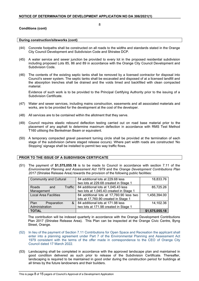
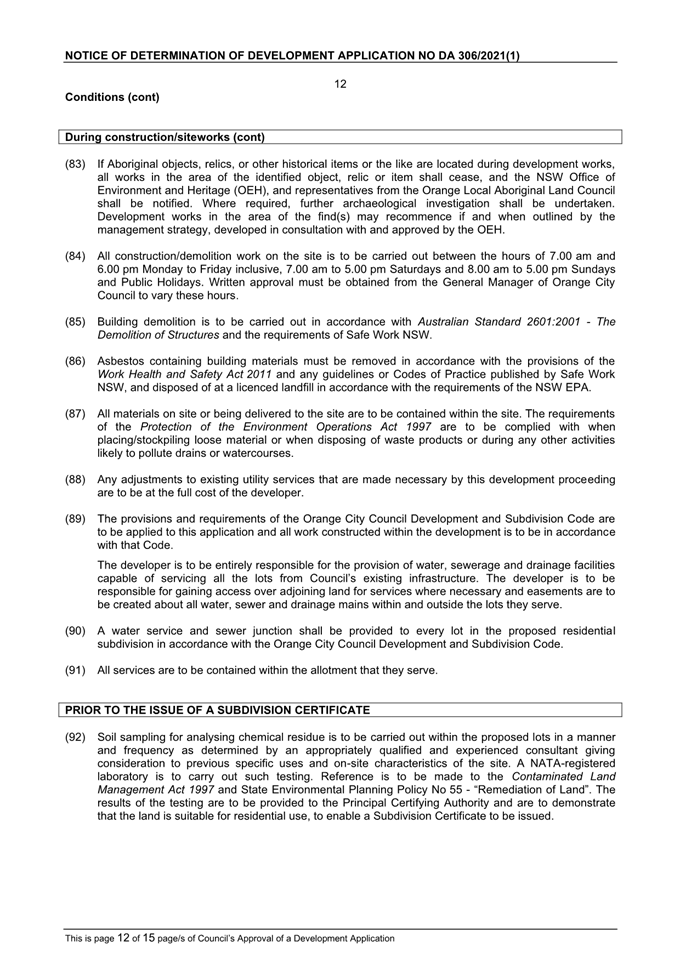
Extraordinary Council Meeting
25 March 2022
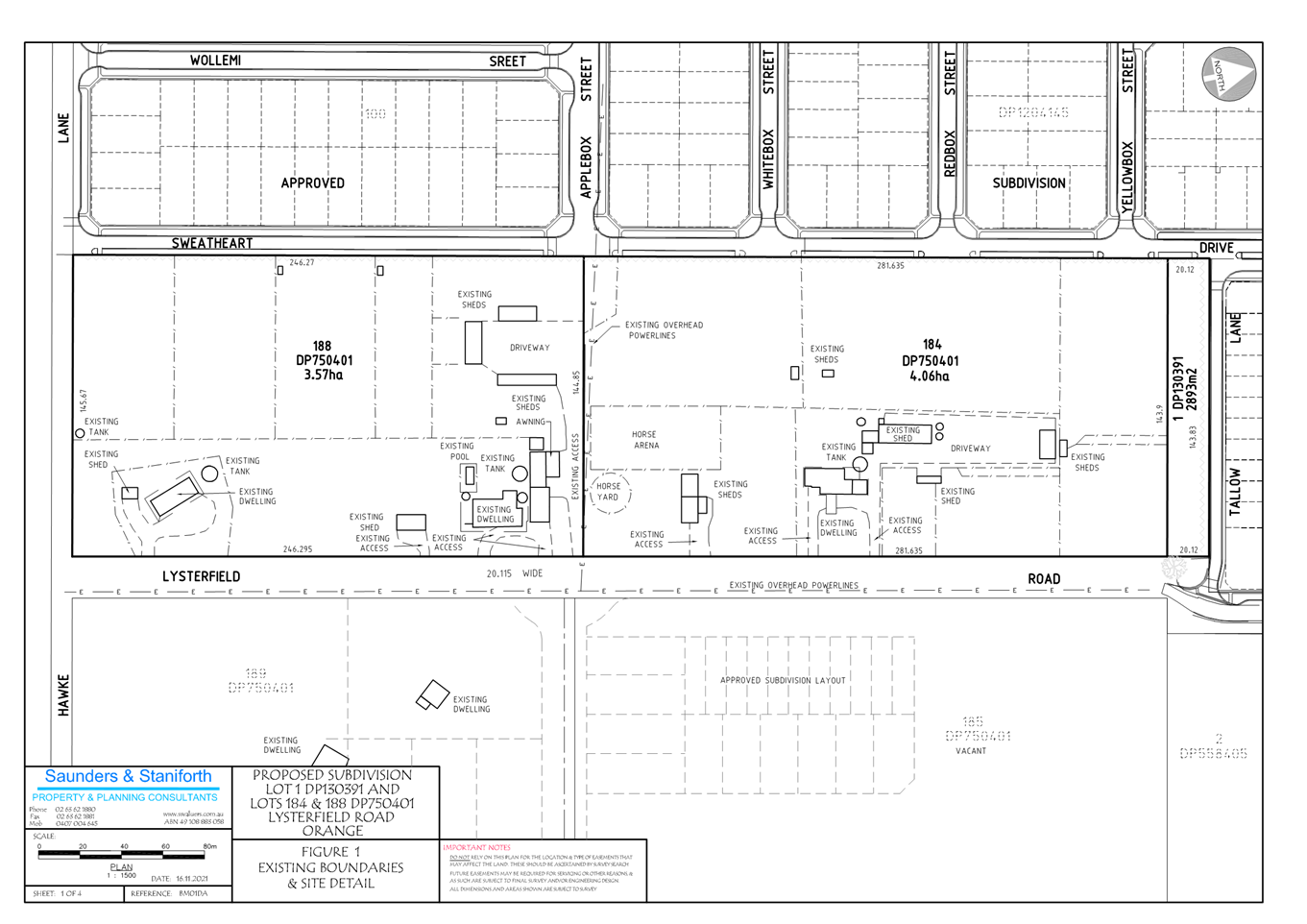


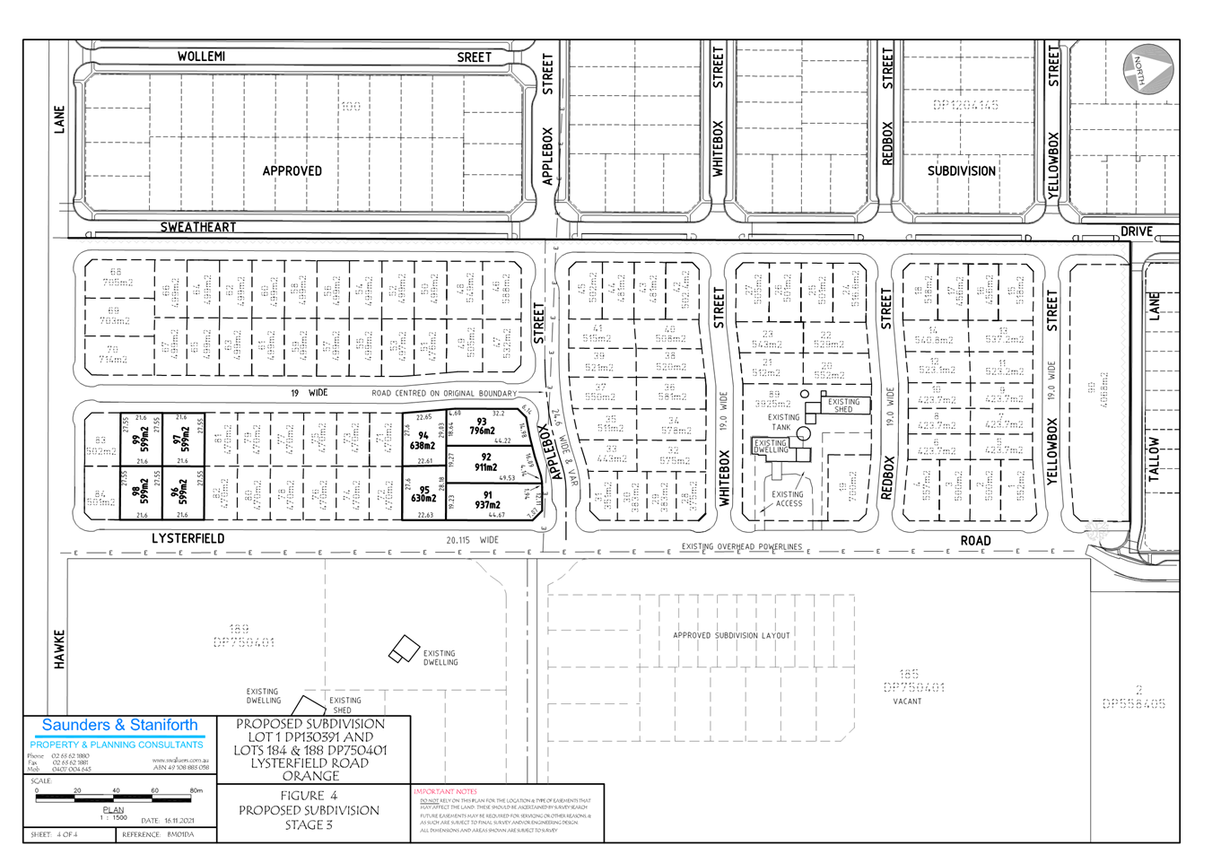
2.4 Development
Application DA 23/2022(1) - 21-25 Peisley Street
RECORD
NUMBER: 2022/384
AUTHOR: Sophie
Currenti, Town Planner
EXECUTIVE Summary
|
Application lodged
|
24 January 2022
|
|
Applicant/s
|
The Trustee for Akura Property Trust
|
|
Owner/s
|
Akura Properties Pty Ltd
|
|
Land description
|
Lot 100
PCE PT DP 1199583 - 21-25 Peisley Street, Orange
|
|
Proposed land use
|
Demolition (existing buildings),
General Industry (industrial unit complex containing 13 units), and
Associated Signage
|
|
Value of proposed development
|
$3,800,000.00
|
Council's consent is sought for the erection of thirteen (13)
individual industrial units at 21-25 Peisley Street, Orange – Lot 100 DP
1199583.
The proposed development involves the following:
· demolition
of existing shed and ancillary office
· erection
of thirteen (13) individual general industrial units ranging in various sizes
from 173m2 to 700m2 - all tenancies will require a
development application for first use and fit out as per the condition of
consent.
· a
combined Gross Floor Area (GFA) of 4291m2
· access
via a proposed 12m wide driveway and construction of an internal road
network/hardstand area that accommodates heavy rigid vehicles
· fifty-eight
(58) carparking spaces including disabled and staff car parking
· an
onsite detention located through the centre of the site - subject to
engineering design. The proposed driveway design basin will reduce stormwater
peak discharges and volumes so as to not impact downstream properties
· proposed
pole signage including a free standing 6m pylon sign approx. 1200mm wide
· the
application was amended on 16 March 2022 to remove a component of the
application. The originally applied for development included a specialised
retail premises, which is prohibited within the zone.
The Planning and Development Committee has delegated
authority to approve the application, based on the cost of the development of
more than $2.5 million.
As outlined in
this report, the proposed development is considered to reasonably satisfy the
Local and State planning controls that apply to the subject land and particular
land use. Impacts of the development will be within acceptable limit, subject
to mitigation conditions. Approval of the application is recommended.
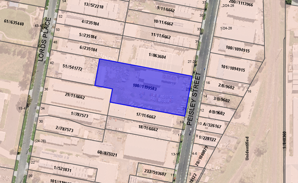 Figure 1 - locality plan
 Figure 2 – existing streetscape
DECISION FRAMEWORK
Development in Orange is governed by two key documents
Orange Local Environment Plan 2011 and Orange Development Control Plan 2004. In
addition, the Infill Guidelines are used to guide development, particularly in
the heritage conservation areas and around heritage items.
Orange Local Environment Plan 2011
– The provisions of the LEP must be considered by the Council in determining
the application. LEPs govern the types of development that are permissible or
prohibited in different parts of the City and also provide some assessment
criteria in specific circumstances. Uses are either permissible or not. The
objectives of each zoning and indeed the aims of the LEP itself are also to be
considered and can be used to guide decision making around appropriateness of
development.
Orange Development Control Plan 2004 – the DCP
provides guidelines for development. In general, it is a performance-based
document rather than prescriptive in nature. For each planning element there
are often guidelines used. These guidelines indicate ways of achieving the
planning outcomes. It is thus recognised that there may also be other solutions
of merit. All design solutions are considered on merit by planning and building
staff. Applications should clearly demonstrate how the planning outcomes are
being met where alternative design solutions are proposed. The DCP enables
developers and architects to use design to achieve the planning outcomes in
alternative ways.
DIRECTOR’S COMMENTS
This proposal relates to the construction of 13 industrial
units. The design is of a modern style and would complement other
buildings in the industrial strip of the south end of Peisley Street. This
development is permissible in this zone, provides ample parking, is compliant
and the overall design will add to the character and streetscape of the
area. Approval of the development is recommended.
Link To Delivery/OPerational Plan
The recommendation in this report relates to the
Delivery/Operational Plan strategy “10.1 Preserve -
Engage with the community to ensure plans for growth and development are
respectful of our heritage”.
Financial Implications
Nil
Policy and Governance Implications
Nil
|
Recommendation
That Council consents to
development application DA 23/2022(1)
for Demolition (existing buildings), General Industry (industrial unit
complex containing 13 units)), and Associated Signage at Lot 100
DP 1199583 - 21-25 Peisley Street, Orange
pursuant to the conditions of consent in the attached Notice of Approval.
|
further considerations
Consideration has been given to the recommendation’s
impact on Council’s service delivery; image and reputation; political;
environmental; health and safety; employees; stakeholders and project
management; and no further implications or risks have been identified.
SUPPORTING INFORMATION
The proposal involves the erection of thirteen (13)
individual industrial units at 21-25 Peisley Street.
The proposed development involves the following:
· demolition
of existing shed and ancillary office
· erection
of thirteen (13) individual general industrial units ranging in various sizes
from 173m2 to 700m2 – all tenancies will require a
development application for first use and fit out as per the condition of
consent
· a
combined Gross Floor Area (GFA) of 4291m2
· access
via a proposed 12m wide driveway and construction of an internal road
network/hardstand area that accommodates heavy rigid vehicles
· fifty-eight
(58) carparking spaces including disabled and staff car parking
· an
onsite detention located through the centre of the site – subject to
engineering design. The proposed driveway design basin will reduce stormwater
peak discharges and volumes so as to not impact downstream properties
· proposed pole
signage including a free standing 6m pylon sign approx. 1200mm wide.
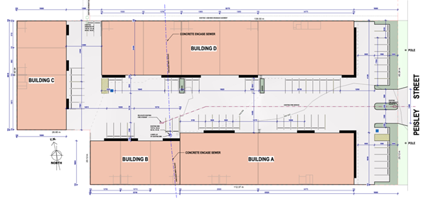
Figure 3 – proposed site plan
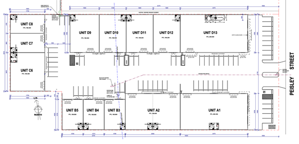
Figure 4 – proposed floor plan
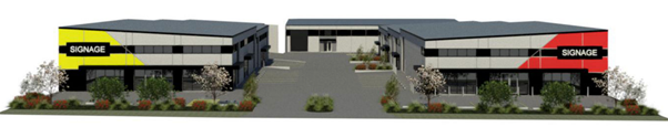
Figure 5 – proposed streetscape elevation
MATTERS FOR CONSIDERATION
Section 1.7 - Application of
Part 7 of the Biodiversity Conservation Act 2016 and Part 7A of the
Fisheries Management Act 1994
Section 1.7 of the EP&A Act identifies that Part 7 of
the Biodiversity Conservation Act 2016 (BC Act) and Part 7A of the Fisheries
Management Act 1994 have effect in connection with terrestrial and aquatic
environments.
There are four triggers known to insert a development into
the Biodiversity Offset Scheme (i.e. the need for a BDAR to be submitted
with a DA):
· Trigger 1: development
occurs in land mapped on the Biodiversity Values Map (OEH) (clause 7.1 of
BC Regulation 2017);
· Trigger 2:
development involves clearing/disturbance of native vegetation above a certain
area threshold (clauses 7.1 and 7.2 of BC Regulation 2017); or
· Trigger 3:
development is otherwise likely to significantly affect threatened species
(clauses 7.2 and 7.3 of BC Act 2016).
The fourth trigger (development
proposed to occur in an Area of Outstanding Biodiversity Value (clause 7.2 of
BC Act 2016) is generally not applicable to the Orange LGA; as no such areas
are known to occur in the LGA. No further comments will be made against the
fourth trigger.
SUMMARY
The site does not
occur within land mapped on the Biodiversity Values Map and no
clearing/disturbance is proposed. As the proposal does not trigger any of the four requirements
for insertion into the BOS, a Biodiversity Development Assessment Report is not
required to be lodged with the application for development consent. No other
comments are warranted under this section.
Section 4.15
Section 4.15 of the Environmental Planning and Assessment
Act 1979 requires Council to consider various matters, of which those
pertaining to the application are listed below.
PROVISIONS OF ANY ENVIRONMENTAL
PLANNING INSTRUMENT s4.15(1)(a)(i)
Orange Local Environmental Plan 2011
Part 1 - Preliminary
Clause 1.2 - Aims of Plan
The
broad aims of the LEP are set out under subclause 2. Those relevant to the
application are as follows:
(a) to encourage development which complements
and enhances the unique character of Orange as a major regional centre boasting
a diverse economy and offering an attractive regional lifestyle,
(b) to provide for a range of development
opportunities that contribute to the social, economic and environmental
resources of Orange in a way that allows present and future generations to meet
their needs by implementing the principles for ecologically sustainable
development,
(c) to conserve and enhance the water
resources on which Orange depends, particularly water supply catchments,
(f) to recognise and manage valued
environmental heritage, landscape and scenic features of Orange.
The application is considered to be consistent with the
applicable aims of the plan.
Clause 1.6 - Consent Authority
This clause establishes that, subject to the Act, Council is
the consent authority for applications made under the LEP.
Clause 1.7 - Mapping
The subject site is identified on the LEP maps in the
following manner:
|
Land Zoning Map:
|
Land zoned IN1 General Industrial
|
|
Lot Size Map:
|
Minimum Lot Size 1000m2
|
|
Heritage Map:
|
Not a heritage item or conservation
area
|
|
Height of Buildings Map:
|
No building height limit
|
|
Floor Space Ratio Map:
|
No floor space limit
|
|
Terrestrial Biodiversity Map:
|
No biodiversity sensitivity on the
site
|
|
Groundwater Vulnerability Map:
|
Groundwater vulnerable
|
|
Drinking Water Catchment Map:
|
Not within the drinking water
catchment
|
|
Watercourse Map:
|
Not within or affecting a defined
watercourse
|
|
Urban Release Area Map:
|
Not within an urban release area
|
|
Obstacle Limitation Surface Map:
|
No restriction on building siting
or construction
|
|
Additional Permitted Uses Map:
|
No additional permitted use applies
|
|
Flood Planning Map:
|
Minor PMF mapping
|
Those matters that are of relevance are addressed in detail
in the body of this report.
Clause 1.9A - Suspension of
Covenants, Agreements and Instruments
This clause provides that
covenants, agreements and other instruments which seek to restrict the carrying
out of development do not apply with the following exceptions.
(a) to
a covenant imposed by the Council or that the Council requires to be imposed,
or
(b) to
any relevant instrument under Section 13.4 of the Crown Land Management Act
2016, or
(c) to
any conservation agreement under the National Parks and Wildlife Act 1974, or
(d) to
any Trust agreement under the Nature Conservation Trust Act 2001, or
(e) to
any property vegetation plan under the Native Vegetation Act 2003, or
(f) to
any biobanking agreement under Part 7A of the Threatened Species Conservation
Act 1995, or
(g) to
any planning agreement under Subdivision 2 of Division 7.1 of the Environmental
Planning and Assessment Act 1979.
Council staff are not aware of the title of the subject
property being affected by any of the above. A sewer main exists on the land,
relevant engineering conditions have been added to address any issues that may
arise.
Part 2 - Permitted or Prohibited
Development
Clause 2.1 - Land Use Zones and Clause
2.3 - Zone Objectives and Land Use Table
The subject site is located within the
IN1 General Industrial zone. The proposed development is defined as General
Industry and Business Identification Signage under OLEP 2011 and is
permitted with consent for this zone. This application is seeking consent. The
objectives for the land zoning are as follows:
1 - Objectives
of the IN1 General Industrial Zone
· To provide
a wide range of industrial and warehouse land uses.
· To encourage
employment opportunities.
· To minimise any
adverse effect of industry on other land uses.
· To support and
protect industrial land for industrial uses.
· To ensure
development along the Southern Link Road has an alternative access.
There are no aspects of the
proposed development that are adverse to the zone objectives. In this regard:
· The proposal is
permissible within the IN1 General Industrial Zone. As such, it enhances
the range of land uses within this zone.
· The proposal is
situated within an established industrial area and is thus unlikely to
adversely affect other (more sensitive) land uses. As detailed throughout this
report, there are no aspects of the proposed development that would adversely
impact more sensitive land uses.
· The development of
the site will have no impact upon the supply of industrial land within the
locality as the proposal continues the use of industrial land for a use that is
permissible within the IN1 General Industrial Zone.
Clause 2.7 - Demolition
Requires Development Consent
The proposal involves demolition of the existing structures on
the subject site and the applicant is seeking the consent of council. The
demolition works proposed will have no significant impact on adjoining lands,
streetscape or public realm. Conditions may be imposed in respect of hours of
operation, dust suppression and the need to investigate for, and appropriate
manage the presence of, any materials containing asbestos.
Part 3 - Exempt and
Complying Development
The application is not exempt or complying development.
Part 4 - Principal Development
Standards
Clause 4.1 - Minimum Subdivision Lot
Size
This clause requires the subdivision
of land to be equal to or greater than the size nominated for the land under
the Minimum Lot Size Map. In relation to this site, the map nominates a minimum lot size of
1000m². No subdivision is proposed within this application.
Part 5 - Miscellaneous Provisions
Not relevant to the application.
Part 6 - Urban Release Area
Not relevant to the application. The subject site is not
located in an Urban Release Area.
Part
7 - Additional Local Provisions
7.1 –
Earthworks
The earthworks that are to
be undertaken for the proposed development include driveway/hardstand area
construction; trenching for service installations; and significant land shaping.
The disruption to the site drainage is considered minor and will not
detrimentally affect adjoining properties or receiving waterways. The
earthworks are not expected to affect the potential future use or redevelopment
of the site. The site is not known to contain any Aboriginal, European, or
Archaeological relics nor is it in proximity to any waterway, drinking water
catchment or sensitive area. Sedimentation controls will be required throughout
construction as a condition of consent.
7.2a – Flood Plain Risk
Management
This clause applies to land identified
between the flood planning level and the level of the probable maximum flood.
Before granting consent, Council must be satisfied that the proposal will not
affect the safe occupation of, and evacuation from, the land in flood events
(industrial development). The development is considered not to, in flood events
exceeding the flood planning level, affect the safe occupation of and
evacuation from, the changed mixed land use. The proposed development is
unlikely to change flood planning regimes on or off the site and would be
unlikely to cause or contribute to erosion, siltation or reduce riparian
vegetation, and is therefore unlikely to create a cost burden on the community
or neighbours.
7.3 – Stormwater Management
This clause applies
to all industrial, commercial and residential zones and requires that Council
be satisfied that the proposal meets the relevant clauses. Stormwater will be disposed into
Council’s existing stormwater infrastructure located along the bitumen
access road that services the development. Overland flow will be directed to
the onsite detention basin located to the south-eastern corner of the
development site and is subject to final engineering design. The proposed
detention basin will reduce stormwater peak discharges and volumes so as to not
impact the downstream properties.
7.6 – Groundwater Vulnerability
The
site has been mapped as being groundwater vulnerable. The proposal is
not anticipated to involve the discharge of toxic or noxious substances and is therefore
unlikely to contaminate the groundwater or related ecosystems. The proposal
does not involve extraction of groundwater and therefore will not contribute to
groundwater depletion.
7.11 – Essential Services
In consideration of this clause, all utility services are
available to the land and adequate for the proposal. The subject land is
serviced by Council’s reticulated water and sewerage network. The site
has access to electricity and telecommunications. Stormwater will be disposed
of at a legal point of discharge with any overland flow being directed into the
proposed onsite stormwater detention system incorporated in the parking and
driveway areas. This will be subject to civil design.
STATE ENVIRONMENTAL PLANNING
POLICIES
State Environmental Planning Policy Resilience and
Hazards 2021
State Environmental Planning Policy Resilience and Hazards
2021 is applicable. Pursuant to that part of the SEPP relating to Contamination and remediation Council is required to consider the
following in determining development application:
(1) A
consent authority must not consent to the carrying out of any development on
land unless:
(a) it has considered whether the
land is contaminated, and
(b) if the land is
contaminated, it is satisfied that the land is suitable in its contaminated
state (or will be suitable, after remediation) for the purpose for which the
development is proposed to be carried out, and
(c) if the land requires
remediation to be made suitable for the purpose for which the development is
proposed to be carried out, it is satisfied that the land will be remediated
before the land is used for that purpose.
Investigation of past use and visual site inspection of the
property did not give rise to any concerns surrounding contamination. No
underground tanks or stained soil/gravel is evident on site. A check of the NSW
EPA Contaminated Land Record and List of NSW Contaminated Sites notified to the
EPA did not identify any contaminated sites on or near the proposed
development. Considering the proposed use and the site being sealed with
buildings and driveway and parking areas, no further analysis is considered
justified.
State Environmental Planning
Policy (Infrastructure) 2007
Clause 104 of the Infrastructure
SEPP relates to traffic-generating development. The clause applies to
development specified in Column 1 of the Table to Schedule 3 that involves new
premises of the relevant size or capacity. Although the use of industry
is listed, the clause is not applicable to the proposal at hand as the
size/capacity is not exceeded in Column 2 of the Table to Schedule 3 (Clause
2(a)). As a result, formal referral to the Roads and Maritime Service is not
required as the development is not deemed to be traffic generating development.
State Environmental Planning
Policy – Industry and Employment SEPP
State Environmental Planning Policy Industry and Employment
applies to the subject development. The controls that specifically relate to
signage are provided below.
3 Aims,
Objectives etc
(1) This
Policy aims:
(a) to
ensure that signage (including advertising):
(i) is
compatible with the desired amenity and visual character of an area, and
(ii) provides
effective communication in suitable locations, and
(iii) is
of high-quality design and finish, and
(8) Granting
of Consent to Signage
A consent authority must not
grant development consent to an application to display signage unless the
consent authority is satisfied:
(a) that
the signage is consistent with the objectives of this Policy as set out in
Clause 3 (1) (a), and
(b) that
the signage the subject of the application satisfies the assessment criteria
specified in Schedule 1.
The signage content is not
known at this stage. The proposed signage includes a pylon sign at the frontage
of the site together with signage panels on the building. An assessment of the proposed
signage against Schedule 1 has been undertaken below.
1 - Character of the Area
· Is
the proposal compatible with the existing or desired future character of the
area or locality in which it is proposed to be located?
· Is
the proposal consistent with a particular theme for outdoor advertising in the
area or locality?
The proposed signage will be consistent with other signage
along this industrial area of Peisley Street. A mix of attached wall signage
and freestanding signs are common in the local area.
2 - Special Areas
· Does the
proposal detract from the amenity or visual quality of any environmentally
sensitive areas, heritage areas, natural or other conservation areas, open
space areas, waterways, rural landscapes, or residential areas?
The proposed signage and locality do not conflict with
special areas relating to heritage, open space, waterways, residential areas or
conservation precincts.
3 - Views and Vistas
· Does the
proposal obscure or compromise important views?
· Does the
proposal dominate the skyline and reduce the quality of vistas?
· Does the
proposal respect the viewing rights of other advertisers?
The pylon
sign will not dominate the skyline being of a vertical rather than wide
structure. The level landform also ensures the signage does not dominate any
longer vistas. The signage will not block signage exposure to other businesses,
largely due to the wide land frontage onto Peisley Street.
4 - Streetscape, Setting or
Landscape
· Is the scale,
proportion and form of the proposal appropriate for the streetscape, setting or
landscape?
· Does the
proposal contribute to the visual interest of the streetscape, setting or
landscape?
· Does the
proposal reduce clutter by rationalising and simplifying existing advertising?
· Does the
proposal screen unsightliness?
· Does the
proposal protrude above buildings, structures or tree canopies in the area or
locality?
· Does the
proposal require ongoing vegetation management?
The proposed signage is considered within normal commercial
expectations for the environment with a cluster of corporate images and design
features common place in the locality. The size and scale of the signage locations
are considered reasonable in comparison to the size and scale of buildings and
their industrial theme. The free-standing sign will be set away from the
proposed buildings therefore not critical in terms of protrusions against
rooflines or nearby structures. The proposal does not require ongoing
vegetation management.
5 - Site and Building
· Is the proposal
compatible with the scale, proportion and other characteristics of the site or
building, or both, on which the proposed signage is to be located?
· Does the
proposal respect important features of the site or building, or both?
· Does the
proposal show innovation and imagination in its relationship to the site or
building, or both?
The proposal is within scale and overall dimension
relationship with the proposed height and width of the building.
6 - Associated Devices and
Logos with Advertisements and Advertising Structures
· Have any safety
devices, platforms, lighting devices or logos been designed as an integral part
of the signage or structure on which it is to be displayed?
There are currently no known tenancies at this stage.
7 - Illumination
· Would
illumination result in unacceptable glare?
· Would
illumination affect safety for pedestrians, vehicles or aircraft?
· Would
illumination detract from the amenity of any residence or other form of
accommodation?
· Can the
intensity of the illumination be adjusted, if necessary?
· Is the
illumination subject to a curfew?
No illumination is proposed.
8 - Safety
· Would the
proposal reduce the safety for any public road?
· Would the proposal
reduce the safety for pedestrians or bicyclists?
· Would the
proposal reduce the safety for pedestrians, particularly children, by obscuring
sightlines from public areas?
The proposal is not considered to reduce the safety for any
public road, pedestrians or cyclists. The proposal will not obscure sightlines
from public areas.
PROVISIONS OF ANY DRAFT
ENVIRONMENTAL PLANNING INSTRUMENT THAT HAS BEEN PLACED ON EXHIBITION
4.15(1)(a)(ii)
There are no draft EPI’s that relate to the proposed
development or subject site.
DESIGNATED DEVELOPMENT
The proposed development is not designated development.
INTEGRATED DEVELOPMENT
The proposed development is not integrated development.
PROVISIONS OF ANY DEVELOPMENT
CONTROL PLAN s4.15(1)(a)(iii)
Development Control Plan 2004
The following parts of DCP 2004 are applicable to the
proposed development:
· Part 2 –
Natural Resource Management
· Part 3 –
General Considerations
· Part 4 –
Special Environmental Considerations
· Part 9 –
Development in the Employment and Industrial Zone
· Part 14 –
Advertisements
· Part 15 –
Car Parking
The relevant matters in Parts 2, 3, 4 and 14 were considered
in the foregoing assessment under Orange LEP 2011 and SEPP 64. An assessment of
the relevant provisions within Part 9 and 15 have been undertaken below.
09 – Development in the
Industry and Employment Zone
The DCP prescribes the following
applicable planning outcomes for Industrial Site Development.
- Buildings are set back
a minimum of 10m from front boundaries (5m to a secondary boundary on a corner
lot) for lots greater than 1,000m2 or 5m for lots less than
1,000m2 or otherwise to a setback consistent with existing
setbacks in established areas.
The subject land comprises an area
greater than 1,000sqm, therefore requires a setback minimum of 10m from the
boundary. The new buildings will be sited at least 16m from the Peisley Street
frontage. This setback allows for a sufficient landscaping strip to be
established between the building and its frontage to Peisley Street to soften
visual bulk. Side setbacks will comply with the BCA as concrete walls.
- Buildings cover up to
50% of the site area (excluding the area of accessways for battleaxe lots)
Based on the site area being 7864sqm,
and the proposed buildings footprint of 4291.9sqm, the site coverage of the
development is 54.5%. Although this proposed site coverage exceeds the 50%
maximum by less than a 10% variation, the proposal is considered to be
satisfactory. Due to the large size of the site, and all other design criteria
being satisfied, including setbacks, driveways, parking and landscaping, the
greater site coverage is considered acceptable.
- Landscaping is
provided along boundaries fronting roads including trees with an
expected mature height at least comparable to the height of buildings
on the site. All sites contain an element of landscaping.
Landscaping will be provided along
the street frontage as a 3m wide landscaping bed. The proposed landscaping will
incorporate plantings that are endemic to the area and commensurate with the
height of the proposed building.
- Architectural features
are provided to the front building façade to provide relief using such
elements as verandahs, display windows, indented walls, etc.
- External materials
consist of non-reflective materials.
The proposed finishes are provided
in non-reflective finish as encouraged by the DCP. The proposed
development will be constructed of painted fibre cement panels and painted
concrete tilt panel being neutral in colour of dark and light grey or cream/Dulux
dune or similar. The architectural design of the building includes awnings as
well as a variation to the height of the roofline that will provide relief to
the front façade.
- Adequate parking and
onsite manoeuvring is provided.
An assessment of parking and manoeuvring
has been completed under Chapter 15.
- Advertising involves
business identification signs within the front façade and/or by a pole
sign comparable to the relative height to the main building on the site.
The assessment under SEPP 64
provided in this report demonstrates that the proposed signage is satisfactory
in terms of the above outcome.
- Security fencing
is located or designed in a manner that does not dominate the visual setting of
the area.
Security fencing is existing and is located around the
permitter of the site. The fencing does not dominate the visual setting of the
area.
15 – Car Parking
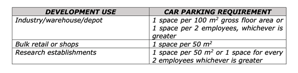 The DCP requires
on-site parking for industries to be provided at the rate of 1 space per 100sqm
of gross floor area. Based on the DCP rate, the parking requirements for the
development are calculated as 42.9 car parking spaces. The proposed development
proposes a total of 58 car parking spaces including spaces for staff and
disabled parking. The proposal is therefore compliant.
The DCP requires
on-site parking for industries to be provided at the rate of 1 space per 100sqm
of gross floor area. Based on the DCP rate, the parking requirements for the
development are calculated as 42.9 car parking spaces. The proposed development
proposes a total of 58 car parking spaces including spaces for staff and
disabled parking. The proposal is therefore compliant.
Ingress and
egress to the site will occur on the centre of the eastern frontage. There is
sufficient area for rigid vehicles to enter and exit the site in a forward
direction without having to reverse onto or from a public road.
The sealed
right of access at its intersection with Peisley Street provides a suitable
sight distance. Peisley Street appears to be of a sufficient capacity to
accommodate the additional traffic generated as a result of this development.
No upgrades to Peisley Street are envisaged.
PROVISIONS PRESCRIBED BY THE
REGULATIONS s4.15(1)(a)(iv)
Demolition of a Building (clause 92)
The proposal involves the demolition of the existing structures
on site. A condition is attached requiring the demolition to be carried out in
accordance with Australian Standard AS2601 - 2001: The Demolition of
Structures and the requirements of Safe Work NSW.
Fire Safety Considerations
(clause 93)
The proposal does not involve a change of building use for
an existing building.
Buildings to be Upgraded
(clause 94)
The proposal does not involve the rebuilding, alteration,
enlargement, or extension of an existing building.
BASIX Commitments (clause 97A)
BASIX is not applicable to the proposed development.
THE LIKELY IMPACTS OF THE
DEVELOPMENT s4.15(1)(b)
The subject site is located in an
area characterised by industrial activities and service retail and it is
therefore considered that the proposal is consistent with the development in
the area and is not expected to create significant impacts on the context and
setting of the area. The proposed development is permissible in the IN1 General
Industrial zone and the development of the site is unlikely to generate any
adverse environmental impacts within the vicinity of the development. The
impacts of the industrial units are to be assessed under separate development
applications prior to their first use and fit out.
Traffic levels are expected to be
consistent with levels associated with industrial development. The development
incorporates a hardstand area which also allows for a heavy rigid vehicle to
enter and exit the site in a forward direction. The design also provides 58 car
parking spaces for staff, customers, and disabled persons.
THE SUITABILITY OF THE SITE s4.15(1)(c)
The overall bulk and scale of the
development is not considered to be averse to the zone objectives and is
consistent with the surrounding development in the locality. Development of the
site will not create significant adverse impacts on the context and setting of
the area.
It is considered the site is
suitable for the proposal as the site is appropriately serviced and there are
no known physical attributes, technological or natural hazards, which constrain
the site.
ANY SUBMISSIONS MADE IN ACCORDANCE WITH THE ACT
s4.15(1)(d)
The proposed development is not
defined as advertised development under the provisions of the CPP, and as such
no formal exhibition of the application was required. No submissions have been
received in relation to this application.
PUBLIC INTEREST s4.15(1)(e)
The proposed development is
considered to be of minor interest to the wider public due to the relatively
localised nature of potential impacts. The proposal is not inconsistent with
any relevant policy statements, planning studies, guidelines etc that have not
been considered in this assessment.
SUMMARY
The proposed development is
permissible with the consent of Council. The proposed development complies with
the relevant aims, objectives and provisions of Orange
LEP 2011 (as amended) and DCP 2004. A Section 4.15 assessment
of the development indicates that the development is acceptable in this
instance. Attached is a draft Notice of Approval outlining a range of
conditions considered appropriate to ensure that the development proceeds in an
acceptable manner.
COMMENTS
The requirements of the
Environmental Health and Building Surveyor and the Engineering Development
Section are included in the attached Notice of Approval.
Attachments
1 Plans,
D22/11623⇩
2 Notice
of Approval, D22/15640⇩
Extraordinary
Council Meeting
25 March 2022
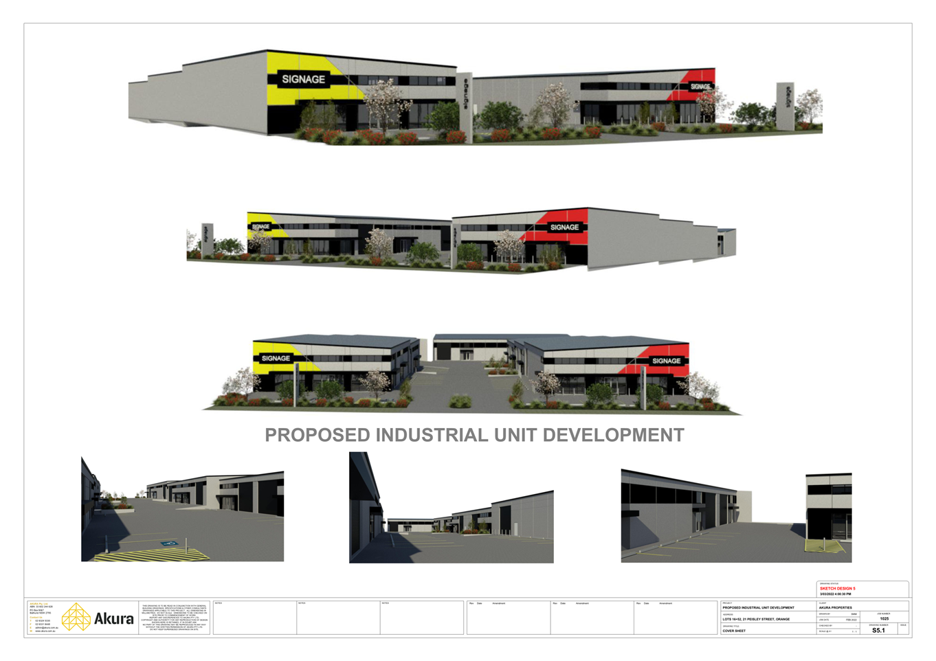
Extraordinary
Council Meeting
25 March 2022
Attachment 2 Notice
of Approval