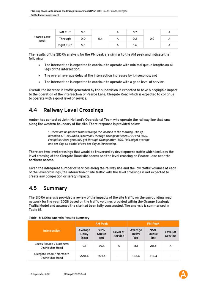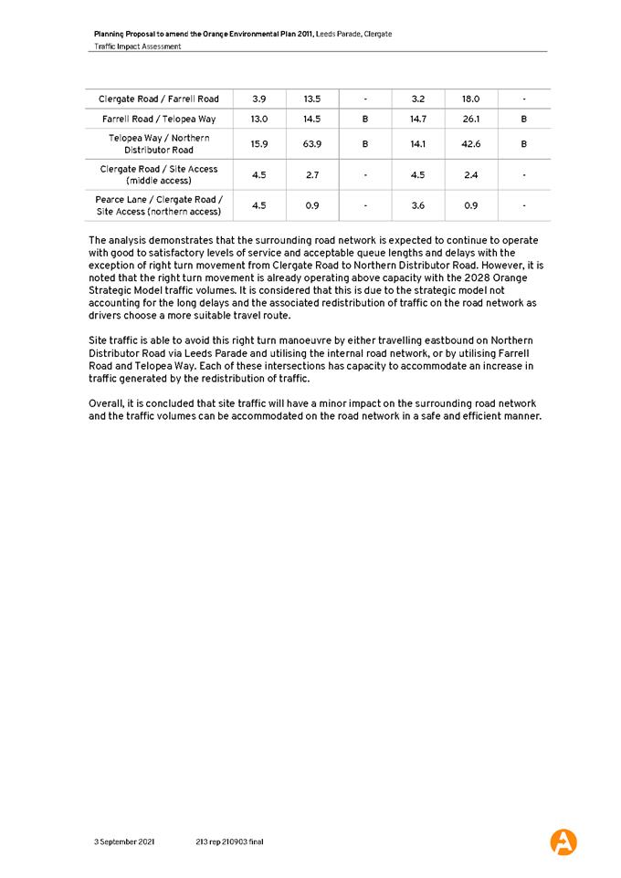
Planning and Development
Committee
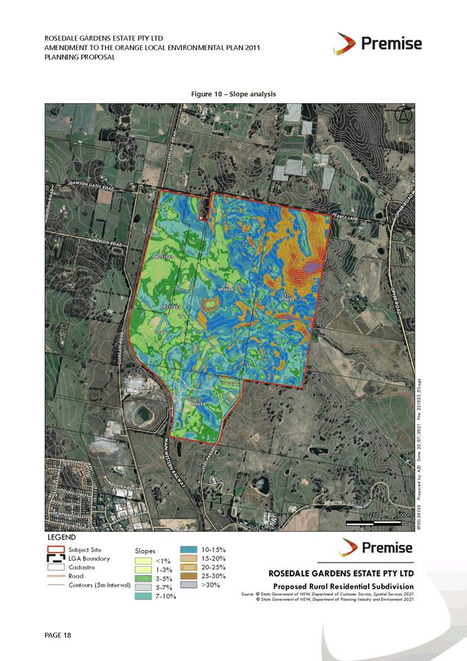
Agenda
2 November 2021
Notice is hereby given, in
accordance with the provisions of the Local Government Act 1993 that a Planning and Development Committee meeting of ORANGE CITY COUNCIL
will be held at OCTEC, CORNER OF BYNG STREET AND ANSON STREET, Orange on Tuesday, 2
November 2021.
David
Waddell
Chief Executive Officer
For apologies please
contact Administration on 6393 8106.
1 Introduction
1.1 Declaration
of pecuniary interests, significant non-pecuniary interests and less than
significant non-pecuniary interests
The
provisions of Chapter 14 of the Local Government Act, 1993 (the Act)
regulate the way in which Councillors and designated staff of Council conduct
themselves to ensure that there is no conflict between their private interests
and their public role.
The
Act prescribes that where a member of Council (or a Committee of Council) has a
direct or indirect financial (pecuniary) interest in a matter to be considered
at a meeting of the Council (or Committee), that interest must be disclosed as
soon as practicable after the start of the meeting and the reasons given for
declaring such interest.
As
members are aware, the provisions of the Local Government Act restrict any
member who has declared a pecuniary interest in any matter from participating
in the discussion or voting on that matter, and requires that member to vacate the
Chamber.
Council’s Code of Conduct provides that if members
have a non-pecuniary conflict of interest, the nature of the conflict must be
disclosed. The Code of Conduct also provides for a number of ways in which a
member may manage non pecuniary conflicts of interest.
|
Recommendation
It is recommended that Committee Members now disclose any
conflicts of interest in matters under consideration by the Planning and
Development Committee at this meeting.
|
2 General
Reports
2.1 Items
Approved Under the Delegated Authority of Council
RECORD
NUMBER: 2021/2210
AUTHOR: Paul
Johnston, Manager Development Assessments
EXECUTIVE Summary
Following is a list of more significant development
applications approved by the Chief Executive Officer under the delegated
authority of Council. Not included in this list are residential scale
development applications that have also been determined by staff under the
delegated authority of Council (see last paragraph of this report for those
figures).
Link To Delivery/OPerational Plan
The recommendation in this report
relates to the Delivery/Operational Plan strategy “7.1 Preserve - Engage
with the community to develop plans for growth and development that value the
local environment”.
Financial Implications
Nil
Policy and Governance Implications
Nil
|
Recommendation
That Council resolves to
acknowledge the information provided in the report by the Manager Development
Assessments on Items Approved Under the Delegated Authority of Council.
|
further considerations
Consideration has been given to the
recommendation’s impact on Council’s service delivery; image and
reputation; political; environmental; health and safety; employees;
stakeholders and project management; and no further implications or risks have
been identified.
|
Reference:
|
DA 284/2012(5)
|
Determination Date:
|
30 September 2021
|
|
PR Number
|
PR26859
|
|
Applicant/s:
|
Geolyse Pty Ltd - Attn: Mr D Walker
|
|
Owner/s:
|
Australian AC Partners Property Pty
Ltd
Allity Gosling Creek
|
|
Location:
|
Lot 200 DP 1202634 - 1501 Forest
Road, Orange
|
|
Proposal:
|
Modification of development consent
- demolition (existing dwelling/cafe and garage), subdivision (five lot
Community title) and seniors housing (retirement village). The modified
proposal related to the unconstructed south-west wing of the aged care home
(known as Stage 2), and involved floor plan amendments and a reduced building
footprint.
|
|
Value:
|
Not
Applicable
|
|
Reference:
|
DA 111/2020(3)
|
Determination Date:
|
13 October 2021
|
|
PR Number
|
PR4818
|
|
Applicant/s:
|
Bassmann Drafting Services
|
|
Owner/s:
|
Mr MJ and Mrs JE Truloff
|
|
Location:
|
Lot 2 DP 413484 - 12 Green Lane,
Orange
|
|
Proposal:
|
Modification of development consent
- dwelling house (two storey), attached garage, retaining walls and tree
removal. The modified development increases the front setback of the attached
double garage by 2m, in order to achieve the required vehicle cross-over and
driveway gradients. The finished garage floor level and room layouts at
ground and first floor will be slightly amended to suit the proposed garage
location.
|
|
Value:
|
Not Applicable
|
|
Reference:
|
DA 140/2020(2)
|
Determination Date:
|
30 September 2021
|
|
PR Number
|
PR3565
|
|
Applicant/s:
|
Planning Potential
|
|
Owner/s:
|
JCI Group Pty Ltd
|
|
Location:
|
Lot 2 DP 544083, Lot 501 DP 1122616
and Lot 11 DP 575694 - 5-17 and 46‑60 Edward Street, Orange
|
|
Proposal:
|
Modification of development consent
- mixed use development; general industry (aluminium extrusion and powder
coating industry) and warehouse or distribution centre. Application pertained
to the administrative/slight adjusted of Condition 14 that provided for
carparking on the former Electrolux site.
|
|
Value:
|
Not
Applicable
|
|
Reference:
|
DA 328/2020(2)
|
Determination Date:
|
12 October 2021
|
|
PR Number
|
PR12072
|
|
Applicant/s:
|
Central West Property Projects Pty
Ltd
|
|
Owner/s:
|
Lollback Family Property Pty Ltd
|
|
Location:
|
Lot 16 DP 258976 - 13-29 Torulosa
Way, Orange
|
|
Proposal:
|
Modification of development consent
- subdivision (33 lot residential). The modification sought to amend the
drainage of the land with bulk earthworks, and proposed a number of retaining
walls to facilitate appropriate drainage of the site.
|
|
Value:
|
Not
Applicable
|
|
Reference:
|
DA 487/2020(2)
|
Determination Date:
|
30 September 2021
|
|
PR Number
|
PR29025
|
|
Applicant/s:
|
Fenton Developments Pty Ltd
|
|
Owner/s:
|
Fenton Developments Pty Ltd
|
|
Location:
|
Lot 100 DP 1274611, Lot 101 DP
1274611, Lot 1 DP 1254889 - 6 and 6A Yackerboon Place, Orange
|
|
Proposal:
|
Modification of development consent
- demolition (tree removal) and subdivision (12 lot residential). The
modified proposal sought to include Plan DA04A(B) in the list of approved
plans for the development as originally intended by Council assessment staff.
|
|
Value:
|
Not
Applicable
|
|
Reference:
|
DA 165/2021(1)
|
Determination Date:
|
30 September 2021
|
|
PR Number
|
PR25457
|
|
Applicant/s:
|
Integrated Consulting Pty Ltd
|
|
Owner/s:
|
Mr WD and Mrs JE Stephens
|
|
Location:
|
Lot 110 DP 1169358 - 42 Valencia
Drive, Orange
|
|
Proposal:
|
Secondary dwelling, BBQ area and
detached garage
|
|
Value:
|
$226,183
|
|
Reference:
|
DA 270/2021(1)
|
Determination Date:
|
30 September 2021
|
|
PR Number
|
PR8036
|
|
Applicant/s:
|
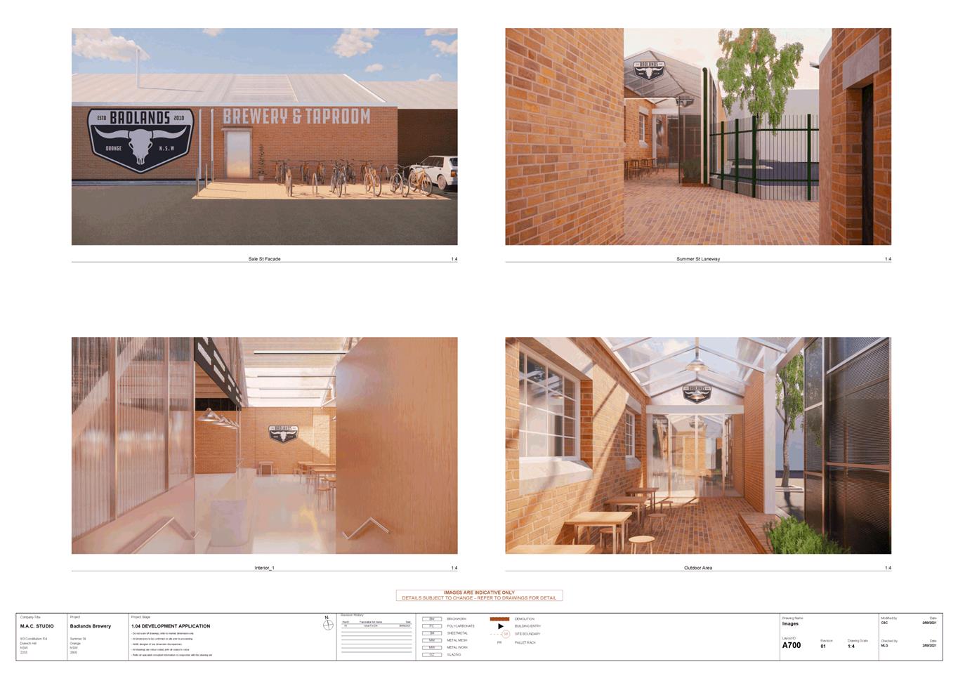
Mr MJ Fabar
|
|
Owner/s:
|
Mr JA and Mrs AM Fabar
|
|
Location:
|
Lot 4 DP 222029 - 1A Maxwell
Avenue, Orange
|
|
Proposal:
|
Subdivision (two lot residential
Torrens), carport and demolition (shed)
|
|
Value:
|
$10,000
|
|
Reference:
|
DA 281/2021(1)
|
Determination Date:
|
15 September 2021
|
|
PR Number
|
PR25478
|
|
Applicant/s:
|
Mr SW Rosser
|
|
Owner/s:
|
Mr SW Rosser
|
|
Location:
|
Lot 2 DP 1168899 - 1
Callistemon Place, Orange
|
|
Proposal:
|
Dwelling (two storey) and attached
garage
|
|
Value:
|
$350,000
|
|
Reference:
|
DA 322/2021(1)
|
Determination Date:
|
12 October 2021
|
|
PR Number
|
PR5187
|
|
Applicant/s:
|
Source Architects
|
|
Owner/s:
|
Mr LA and Mrs ME Knight
|
|
Location:
|
Lot 3 Section 12 DP 9575, 156 Hill
Street, Orange
|
|
Proposal:
|
Demolition (shed, carport and tree
removal); subdivision (two lot Torrens title); dwelling alterations and
additions; and subdivision (three lot community title)
|
|
Value:
|
$385,000
|
|
Reference:
|
DA 324/2021(1)
|
Determination Date:
|
12 October 2021
|
|
PR Number
|
PR28325
|
|
Applicant/s:
|
Orange Motor Group
|
|
Owner/s:
|
Adtec Pty Ltd & JA & RA
Eastham Pty Ltd
|
|
Location:
|
Lot 34 DP 270446 - 8- 14 Gateway Crescent,
Orange
|
|
Proposal:
|
Signage (three pylon signs and
replacement fascia signs)
|
|
Value:
|
$140,000
|
|
Reference:
|
DA 336/2021(1)
|
Determination Date:
|
30 September 2021
|
|
PR Number
|
PR6912
|
|
Applicant/s:
|
Mrs R Houghton
|
|
Owner/s:
|
Dr DV Houghton
|
|
Location:
|
Lot B DP 940220 - 123 Lords Place,
Orange
|
|
Proposal:
|
Demolition (tree removal)
|
|
Value:
|
$4,000
|
|
Reference:
|
DA 356/2021(1)
|
Determination Date:
|
12 October 2021
|
|
PR Number
|
PR16208
|
|
Applicant/s:
|
Mr R Fahy
|
|
Owner/s:
|
Roweth Investments Pty Limited
|
|
Location:
|
Lot 7 DP 855526 - 22 Scott Place,
Orange
|
|
Proposal:
|
Vehicle repair station (change of
use)
|
|
Value:
|
Nil
|
|
Reference:
|
DA 363/2021(1)
|
Determination Date:
|
12 October 2021
|
|
PR Number
|
PR28634
|
|
Applicant/s:
|
James Richmark Pty Ltd
|
|
Owner/s:
|
James Richmark Pty Ltd
|
|
Location:
|
Lot 4 DP 271257 - 1533 Forest Road,
Orange
|
|
Proposal:
|
Major project ancillary works (car
parking and bin store)
|
|
Value:
|
$400,000
|
|
Reference:
|
DA 365/2021(1)
|
Determination Date:
|
28 September 2021
|
|
PR Number
|
PR4112
|
|
Applicant/s:
|
Orange Ex-Services Club Limited
|
|
Owner/s:
|
Orange Ex-Services Club Country
Club
|
|
Location:
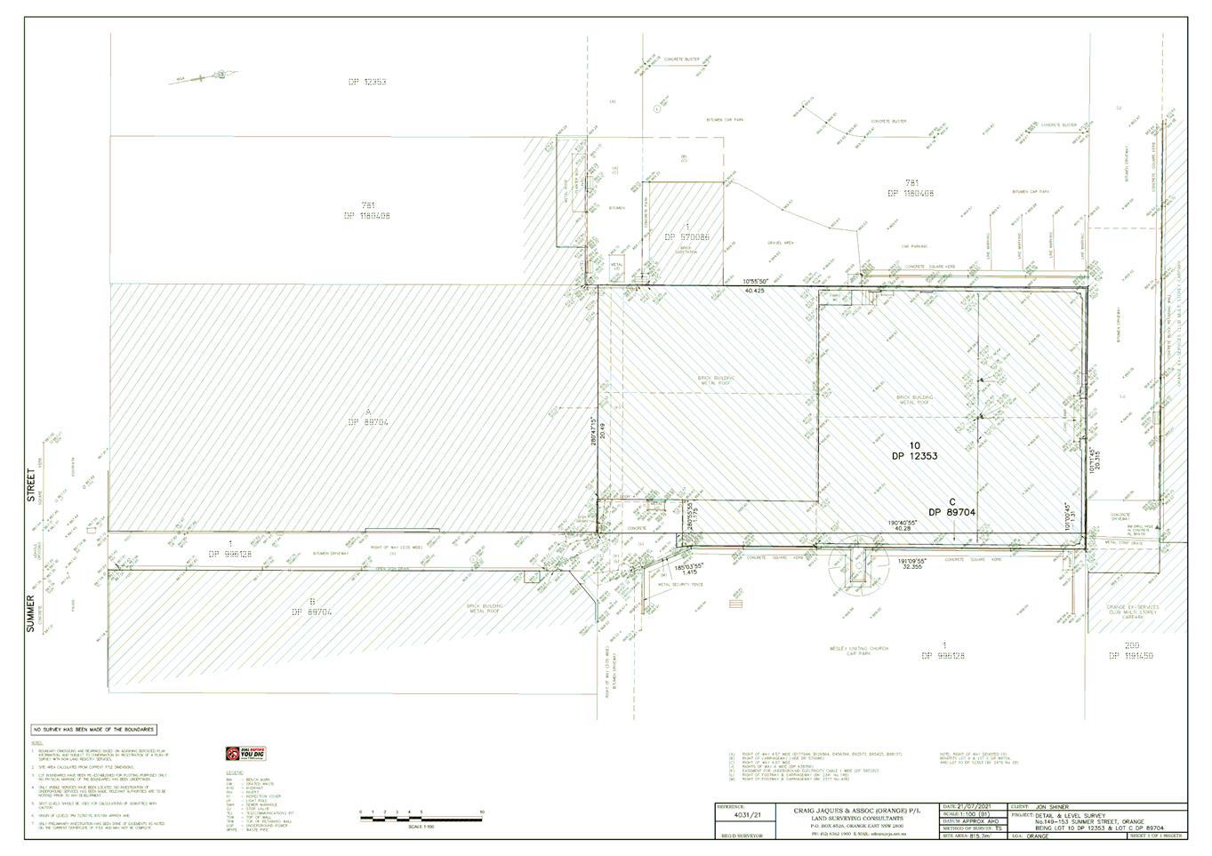
|
Lot 205 DP 42900 - 1584 Forest
Road, Orange
|
|
Proposal:
|
Recreation facility (outdoor)
(contraction of existing bowling green)
|
|
Value:
|
$35,000
|
|
Reference:
|
DA 366/2021(1)
|
Determination Date:
|
7 October 2021
|
|
PR Number
|
PR24835
|
|
Applicant/s:
|
Orange Ex-Services Club Limited
|
|
Owner/s:
|
Wentworth Golf Club
|
|
Location:
|
Lot 181 DP 1154782 - Ploughmans
Lane, Orange
|
|
Proposal:
|
Recreation facility (outdoor) (golf
course adjustments, pump shed and tree removal)
|
|
Value:
|
$90,000
|
|
Reference:
|
DA 379/2021(1)
|
Determination Date:
|
13 October 2021
|
|
PR Number
|
PR28388
|
|
Applicant/s:
|
Jo Really Does Know Pty Ltd
|
|
Owner/s:
|
Mr BA and Mrs LA Parianos
|
|
Location:
|
Lot 100 DP 1245408 - 18-20
McNamara Street, Orange
|
|
Proposal:
|
Serviced apartments (change of use)
|
|
Value:
|
$110,000
|
TOTAL NET* VALUE OF DEVELOPMENTS APPROVED BY THE CEO UNDER
DELEGATED AUTHORITY IN THIS PERIOD: $1,750,183
* Net value relates to the
value of modifications. If modifications are the same value as the original DA,
then nil is added. If there is a plus/minus difference, this difference is
added or taken out.
Additionally, since the September 2021 meeting report
period (23 September to 20 October 2021), another 37 development applications
were determined under delegated authority by other Council staff with a
combined value of $7,003,782.
2.2 Development
Application DA 242/2021(1) - 98 Dalton Street
RECORD
NUMBER: 2021/1498
AUTHOR: Sophie
Currenti, Student Planner
EXECUTIVE
Summary
|
Application
lodged
|
3 June
2021
|
|
Applicant/s
|
Premise
|
|
Owner/s
|
Mrs JM
Granger
|
|
Land
description
|
Lot 6 DP
1932 - 98 Dalton Street, Orange
|
|
Proposed
land use
|
Dual Occupancy (change of use from
existing dwelling), Secondary Dwelling and Subdivision (two lot residential)
|
|
Value of
proposed development
|
$0
|
Council's consent is sought for a change of use and Torrens
Title subdivision at 98 Dalton Street, Orange – Lot 6 DP 1932.
The proposal intends to:
· Change of use from
residential dwelling and secondary dwelling to a dual occupancy; and
· Torrens Title
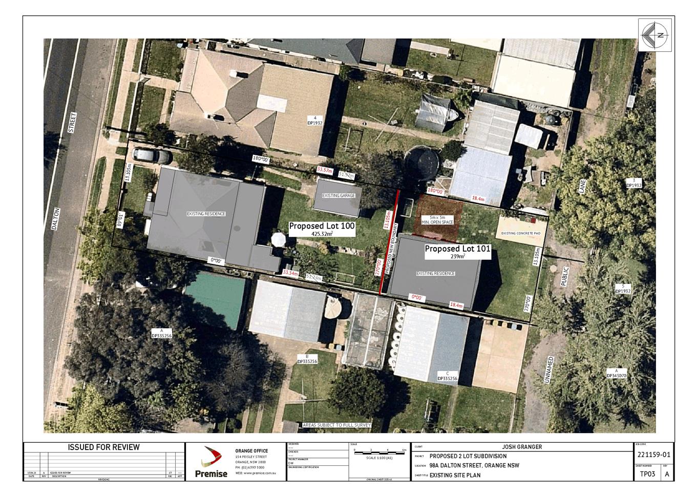
subdivision of the lot into two (2) allotments consisting of:
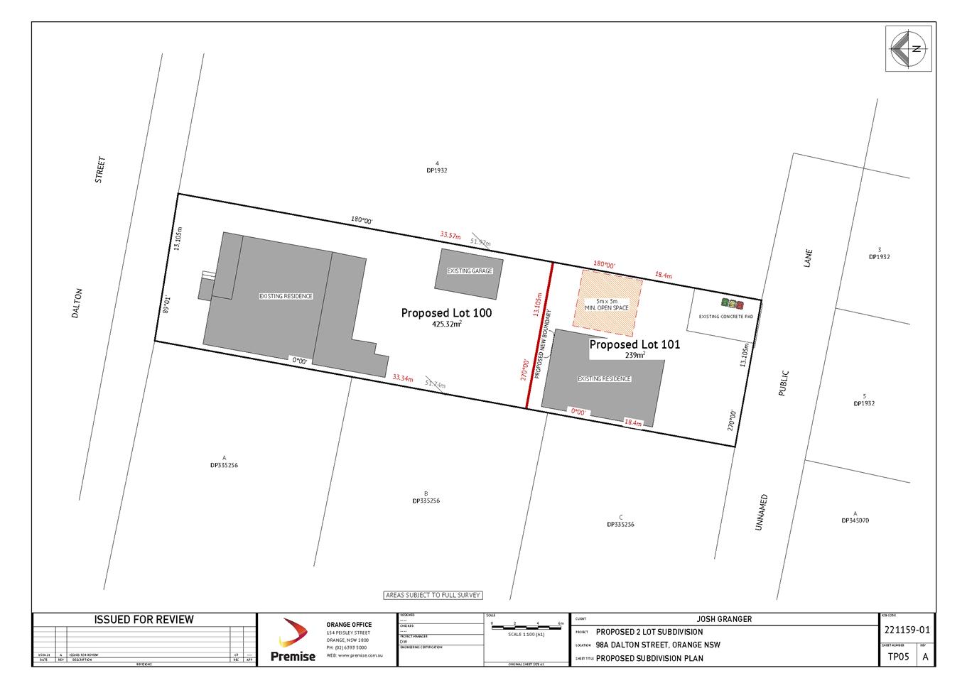
o proposed Lot 100 being 452.32m2
comprising the existing primary dwelling
o proposed Lot 101 being 239m2
comprising the existing secondary dwelling.
A secondary dwelling on the land was approved in December
2015 via DA308/2015(1). The definition of a secondary dwellings states
that they are to be located on the same lot of land as the principal dwelling,
hence this application intends to change the use of these dwellings to a dual
occupancy development within Stage 1, to legally allow for a two lot
subdivision within Stage 2.
The applicant has submitted a Clause 4.6 variation to Clause
4.1b of the OLEP in support of the application, as the minimum allotment size
is below the minimum area of 800m² for a dual occupancy development. The
subject land has an approximate site area of 664.32m², representing a
variation of 16.96%.
As outlined in this report, the
proposed development is considered to reasonably satisfy the Local and State
planning controls that apply to the subject land and particular land use.
Impacts of the development will be within acceptable limit, subject to
mitigation conditions. As no built form changes are proposed within this
application, there is no effect on the existing environment. Approval of the
application is recommended.
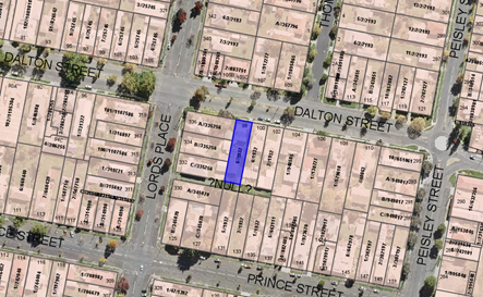
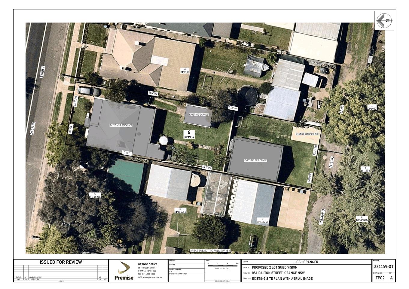
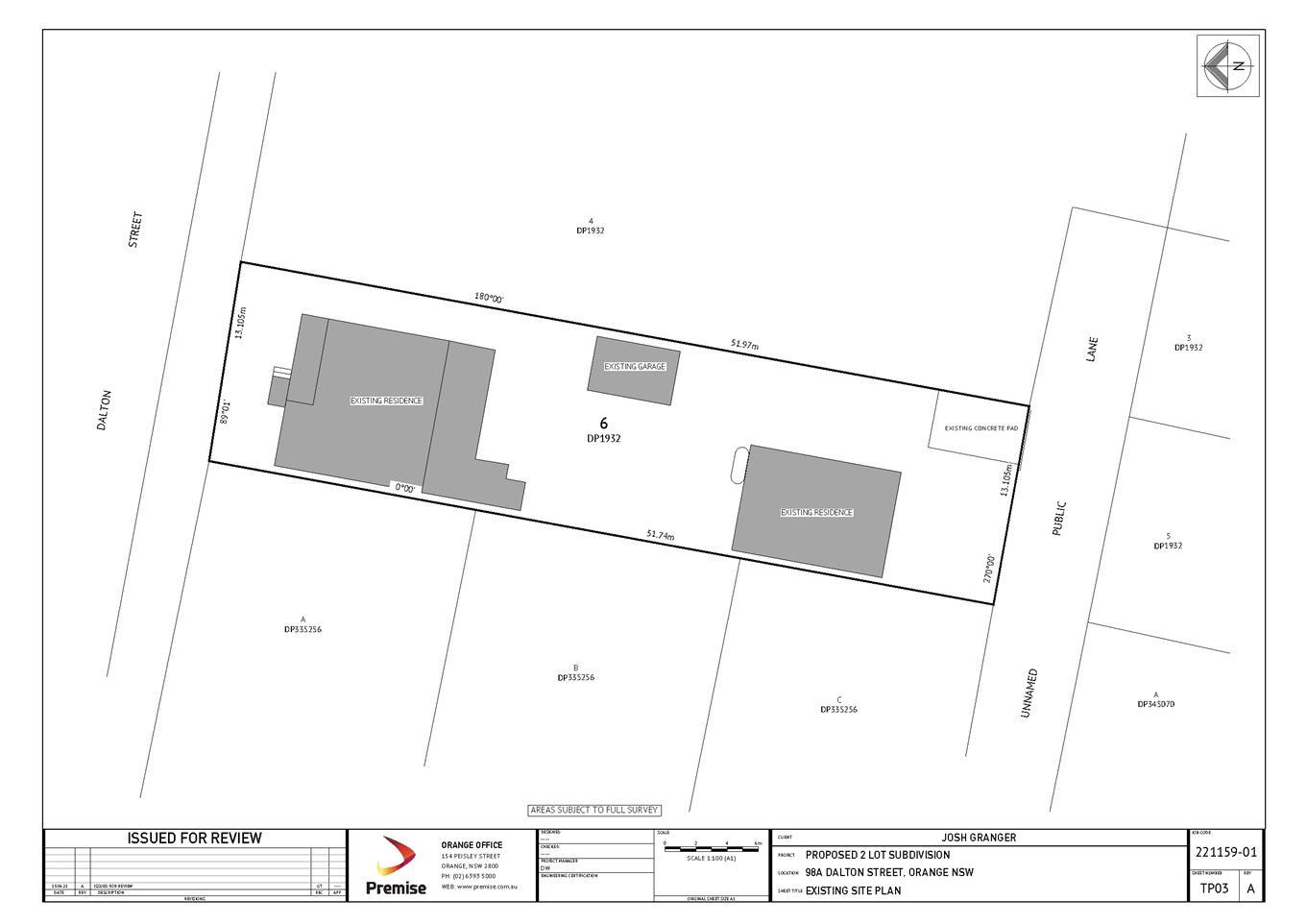
Figure 1 - locality plan
DECISION FRAMEWORK
Development in Orange is governed by two key documents
Orange Local Environment Plan 2011 and Orange Development Control Plan 2004. In
addition the Infill Guidelines are used to guide development, particularly in
the heritage conservation areas and around heritage items.
Orange Local Environment Plan 2011 – The
provisions of the LEP must be considered by the Council in determining the
application. LEPs govern the types of development that are permissible or
prohibited in different parts of the City and also provide some assessment
criteria in specific circumstances. Uses are either permissible or not. The
objectives of each zoning and indeed the aims of the LEP itself are also to be
considered and can be used to guide decision making around appropriateness of
development.
Orange Development Control Plan 2004 – the DCP
provides guidelines for development. In general it is a performance based
document rather than prescriptive in nature. For each planning element there
are often guidelines used. These guidelines indicate ways of achieving the
planning outcomes. It is thus recognised that there may also be other solutions
of merit. All design solutions are considered on merit by planning and building
staff. Applications should clearly demonstrate how the planning outcomes are
being met where alternative design solutions are proposed. The DCP enables
developers and architects to use design to achieve the planning outcomes in
alternative ways.
DIRECTOR’S COMMENT
Council's consent is sought to change the use of approved
secondary dwelling to a dual occupancy so as to facilitate a two lot
residential subdivision of the property at 98 Dalton Street. Under the LEP
definition of secondary dwelling subdivision is not permitted hence the reason
for the proposed change in use in this case. The applicant has submitted a
Clause 4.6 variation seeking support to vary the minimum area requirement of
800m² for a dual occupancy development. The subject land has an
approximate site area of 664.32m², representing a variation of 16.96%.
There are some engineering access and servicing requirements
that will be necessary to ensure that the proposed subdivision meets the
requirements of Council’s Subdivision and Development Code. These matters
have been addressed by recommended conditions of consent.
It is recommended that Council supports the proposal subject
to the adoption of the attached Notice of Determination.
LINk To Delivery/OPerational Plan
The recommendation in this report
relates to the Delivery/Operational Plan strategy “10.1 Preserve - Engage
with the community to ensure plans for growth and development are respectful of
our heritage”.
Financial Implications
Nil
Policy and Governance Implications
Nil
|
Recommendation
That
Council consents to development application DA 242/2021(1) for Dual Occupancy (change of use from existing
dwelling and Secondary Dwelling) and Subdivision (two lot residential) at
Lot 6 DP 1932 - 98 Dalton Street, Orange
pursuant to the conditions of consent in the attached Notice of Approval.
|
further considerations
Consideration has been given to the
recommendation’s impact on Council’s service delivery; image and
reputation; political; environmental; health and safety; employees;
stakeholders and project management; and no further implications or risks have
been identified.
SUPPORTING INFORMATION
The proposal involves a change of
use and Torrens Title subdivision at 98 Dalton Street, Orange. The proposal
intends to:
· Change of use from
residential dwelling and secondary dwelling to a dual occupancy; and
· Torrens Title
subdivision of the lot into two (2) allotments consisting of:
o proposed Lot 100 being 452.32m2
and hosting the existing primary dwelling
o proposed
Lot 101 being 239m2 hosting the existing secondary dwelling.
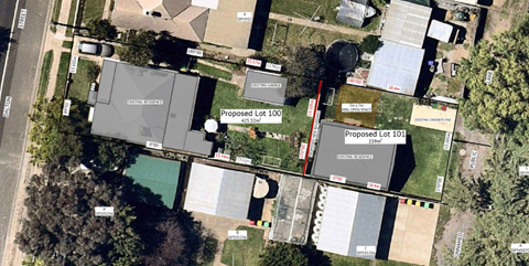
Figure 2 – proposed subdivision plan
MATTERS FOR CONSIDERATION
Section 1.7 - Application of Part
7 of the Biodiversity Conservation Act 2016 and Part 7A of the Fisheries
Management Act 1994
Section 1.7 of the EP&A Act
identifies that Part 7 of the Biodiversity Conservation Act 2016
(BC Act) and Part 7A of the Fisheries Management Act 1994 have effect in
connection with terrestrial and aquatic environments.
There are four triggers known to
insert a development into the Biodiversity Offset Scheme (ie the need for
a BDAR to be submitted with a DA):
· Trigger 1:
development occurs in land mapped on the Biodiversity Values Map (OEH)
(clause 7.1 of BC Regulation 2017);
· Trigger 2:
development involves clearing/disturbance of native vegetation above a certain
area threshold (clauses 7.1 and 7.2 of BC Regulation 2017); or
· Trigger 3:
development is otherwise likely to significantly affect threatened species
(clauses 7.2 and 7.3 of BC Act 2016).
The fourth trigger (development
proposed to occur in an Area of Outstanding Biodiversity Value (clause 7.2 of
BC Act 2016) is generally not applicable to the Orange LGA; as no such areas
are known to occur in the LGA. No further comments will be made against the
fourth trigger.
Summary
The site does not occur within land
mapped on the Biodiversity Values Map and no clearing/disturbance is proposed.
As the proposal does not trigger any of the four requirements for insertion
into the BOS, a Biodiversity Development Assessment Report is not required to
be lodged with the application for development consent. No other comments are
warranted under this section.
Section 4.15
Section 4.15 of the Environmental
Planning and Assessment Act 1979 requires Council to consider various
matters, of which those pertaining to the application are listed below.
PROVISIONS OF ANY ENVIRONMENTAL
PLANNING INSTRUMENT s4.15(1)(a)(i)
Orange Local Environmental Plan
2011
Part 1 - Preliminary
Clause 1.2 - Aims of Plan
The
broad aims of the LEP are set out under Subclause 2. Those relevant to the
application are as follows:
(a) to
encourage development which complements and enhances the unique character of
Orange as a major regional centre boasting a diverse economy and offering an
attractive regional lifestyle,
(b) to
provide for a range of development opportunities that contribute to the social,
economic and environmental resources of Orange in a way that allows present and
future generations to meet their needs by implementing the principles for
ecologically sustainable development,
(e) to
provide a range of housing choices in planned urban and rural locations to meet
population growth,
(f) to
recognise and manage valued environmental heritage, landscape and scenic
features of Orange.
The application is considered to be
consistent with the applicable aims of the plan.
Clause 1.6 - Consent Authority
This clause establishes that,
subject to the Act, Council is the consent authority for applications made
under the LEP.
Clause 1.7 - Mapping
The subject site is identified on the LEP maps in the
following manner:
|
Land Zoning Map:
|
Land zoned R1 General Residential
|
|
Lot Size Map:
|
No Minimum Lot Size
|
|
Heritage Map:
|
Within draft heritage conservation
area
|
|
Height of Buildings Map:
|
No building height limit
|
|
Floor Space Ratio Map:
|
No floor space limit
|
|
Terrestrial Biodiversity Map:
|
No biodiversity sensitivity on the
site
|
|
Groundwater Vulnerability Map:
|
Groundwater vulnerable
|
|
Drinking Water Catchment Map:
|
Not within the drinking water
catchment
|
|
Watercourse Map:
|
Not within or affecting a defined
watercourse
|
|
Urban Release Area Map:
|
Not within an urban release area
|
|
Obstacle Limitation Surface Map:
|
No restriction on building siting
or construction
|
|
Additional Permitted Uses Map:
|
No additional permitted use applies
|
|
Flood Planning Map:
|
Not within a flood planning area
|
Those matters that are of relevance
are addressed in detail in the body of this report.
Clause 1.9A - Suspension of Covenants, Agreements and
Instruments
This clause provides that
covenants, agreements and other instruments which seek to restrict the carrying
out of development do not apply with the following exceptions.
(a) to
a covenant imposed by the Council or that the Council requires to be imposed,
or
(b) to
any relevant instrument under Section 13.4 of the Crown Land Management Act
2016, or
(c) to
any conservation agreement under the National Parks and Wildlife Act 1974, or
(d) to
any Trust agreement under the Nature Conservation Trust Act 2001, or
(e) to
any property vegetation plan under the Native Vegetation Act 2003, or
(f) to
any biobanking agreement under Part 7A of the Threatened Species Conservation
Act 1995, or
(g) to
any planning agreement under Subdivision 2 of Division 7.1 of the Environmental
Planning and Assessment Act 1979.
Council staff are not aware of the title of the subject
property being affected by any of the above.
Part
2 - Permitted or Prohibited Development
Clause 2.1 - Land Use Zones and Clause
2.3 - Zone Objectives and Land Use Table
The subject site is located within the R1 General
Residential zone. The proposed development is defined as dual occupancy and
subdivision under OLEP 2011 and is permitted with consent for this zone.
This application is seeking consent.
Clause 2.3 of LEP 2011 references the Land Use
Table and Objectives for each zone in LEP 2011. These objectives for land zoned R1 General
Residential are as
follows:
1 - Objectives of the R1
General Residential Zone
· To provide for
the housing needs of the community.
· To provide for
a variety of housing types and densities.
· To enable other
land uses that provide facilities or services to meet the day to day needs of
residents.
· To ensure
development is ordered in such a way as to maximise public transport patronage
and encourage walking and cycling in close proximity to settlement.
· To ensure that
development along the Southern Link Road has an alternative access.
The proposed development is not inconsistent with the objectives
of the zone. The proposed development would act to provide separate
housing stock within the City. The proposed development will continue to
provide a variation of housing type and density for the City. The subject
site is within close proximity to routes used by public transport and is also
in close proximity to shops and services.
Clause 2.6 - Subdivision -
Consent Requirements
This clause triggers the need for development consent for
the subdivision of land. Additionally, the clause prohibits subdivision of land
on which a secondary dwelling is situated if the subdivision would result in
the principal and secondary dwellings being located on separate lots. The
proposed change of use will facilitate the opportunity for a two lot
subdivision of the dual occupancy. The application is seeking development
consent for subdivision.
Part 3 - Exempt and
Complying Development
The application is not exempt or complying development.
Part 4 - Principal
Development Standards
Clause 4.1B - Minimum
Lot Sizes for Dual Occupancy, Multi Dwelling Housing and Residential Flat
Buildings
This clause
establishes the minimum lot size required for dual occupancies and multi
dwelling housing in the R1, R2 and R3 zones. The proposed dual occupancy
project is situated on land within the R1 General Residential zone.
Accordingly, this clause requires the site to have a minimum area of
800m². This subject land is 664.32m² and therefore inconsistent with
this clause. The applicant has submitted a Clause 4.6 variation request to the
minimum area requirement of 800m².
Clause 4.6 - Exceptions to Development Standards
This clause is
applicable in this case as the lot in which the dual occupancy is proposed is
smaller than the required minimum size. Clause 4.1b sets out minimum lot
sizes for dual occupancy, multi dwelling housing and residential flat
buildings, which relevantly states:
(1) The
objective of this clause is to achieve planned residential density in certain
zones.
(2) Development
consent may be granted to development on a lot in a zone shown in Column 2 of
the Table to this clause for a purpose shown in Column 1 of the Table opposite
that zone, if the area of the lot is equal to or greater than the area
specified for that purpose and shown in Column 3 of the Table.
(3) This
clause does not apply to land in the Shiralee Urban Release Area.
The proposed dual
occupancy project is situated on land within the R1 General Residential zone
that is not identified on the Minimum Lot Size Map. Accordingly, the above described
table requires the site to have a minimum area of 800m², which the lot
size of this property does not meet. The proposed lot has a site area of
664.32m², representing a variation of 16.96%.
Clause 4.6 is
intended to achieve the following objectives:
(a) provide
an appropriate degree of flexibility in applying certain development standards
(b) achieve
better outcomes for and from development by allowing flexibility in particular
circumstances.
At its core, a Clause
4.6 variation may be supported where it can be shown that the objectives of the
standard are unreasonable and/or unnecessary to apply in this particular case,
and where it can be shown that the objectives of both the plan and the clause
to be varied are achieved notwithstanding the non-compliance with the numerical
value of the standard.
Clause 4.6 may not be
used to routinely seek variation to a standard and may not be used in such a
way as to render a development contrary to the intent of the standard or the
plan that it relates to. Clause 4.6 may also not be used as a de facto rezoning
tool, and cannot be used to bypass permissibility issues that a particular
proposal may have.
There are set
procedures outlined in guidelines published by the NSW Department of
Planning encapsulated in a circular published in 2008, and quite strongly
supported and upheld in the Land & Environment Court. For obvious reasons
the Department advises all Councils to allow variations only where exceptional
circumstances exist and where certain other criteria can be shown to be
achieved.
The Clause 4.6
variation submitted with the application generally achieves those outcomes and
the procedures outlined in the Department’s circulars; and the principals
established by the Courts. The main basis for justification advanced in the
submission is that the proposed dual occupancy meets all other objectives of
the OLEP, notwithstanding the technical non-compliance. It also states that the
proposal is considered to be an orderly and economic use of the land as it is
currently being used as a dwelling and a secondary dwelling. Secondary
dwellings have traditionally been considered as separate residential
accommodation (granny flat style development) which acts as an extension to the
main dwelling that can have shared parking and open space areas.
Matters to Address in
an Application
When applicants lodge
development applications and associated requests to vary a development
standard, they must give grounds of objection to the development
standard. Variation of a development standard may be justified
where it is consistent with the objectives that the relevant environmental
planning instrument is attempting to achieve.
The application must
address:
(i) whether
strict compliance with the standard, in the particular case, would be unreasonable
or unnecessary and why,
and;
(ii) demonstrate
that there are sufficient environmental planning grounds to justify
contravening the development standard.
The applicant has
argued that the minimum lot size is unnecessary and unreasonable in this
instance for the reasons explained below:
· The proposed
dwelling satisfies the relevant Planning Outcomes for dual occupancy
development pursuant to Orange DCP 2004 - 07 Development in Residential Areas.
· The residential
development is considered a reasonable development for the site as dual occupancies
are permissible within the zone.
· As the proposal
relates to an existing dwelling onsite, it is considered that the lot size is
able to accommodate the low relatively low-density residential character of the
area.
· The proposal is
unlikely to lead to the setting of an undesirable precedent which could be used
as a justification for other developments of this nature, on the basis it
represents a legitimate project that is permissible under planning framework.
· Strict compliance
with the standard would result in an inflexible and unfair application of
policy. It does not serve any purpose that is outweigh by the positive outcomes
of the development.
It is considered that
there are sufficient environmental planning grounds cited by the
applicant to support the variation. These are as follows:
· A variation of the
development standard is justified in this case because it can be demonstrated
that the proposal satisfies the objectives of the R1 General Residential zone
and the objectives of the MLS.
· The residential
development has a high degree of compliance with the relevant LEP and DCP
provisions.
· The proposed dual
occupancy is considered compatible with the residential land use pattern in
this area. A variation of the MLS to allow the existing secondary dwelling to
be excised on a conventional allotment does not diminish this aspect of the
development.
· It is demonstrated
that non-compliance with the MLS development standard does not generate
unacceptable impacts in the locality.
Written applications
to vary development standards need to not only address the above matters, but
may also address matters set out in the ‘five part test’
established by the NSW Land and Environment Court. The NSW Department of
Planning strongly advises councils to apply the Five Part Test in their
assessments of Clause 4.6 matters.
The Five Part Test
The Five Part Test is
anchored in Land and Environment Court Planning Principles. The Department
of Planning recommends that consent authorities apply the test in their assessment
of Clause 4.6 variations.
The five part test
embodies the following:
1 the
objectives of the standard are achieved notwithstanding noncompliance with the
standard
2 the
underlying objective or purpose of the standard is not relevant to the development
and therefore compliance is unnecessary
3 the
underlying object or purpose would be defeated or thwarted if compliance was
required and therefore compliance is unreasonable
4 the
development standard has been virtually abandoned or destroyed by the
council’s own actions in granting consents departing from the standard
and hence compliance with the standard is unnecessary and unreasonable
5 the
compliance with development standard is unreasonable or inappropriate due to
existing use of land and current environmental character of the particular
parcel of land. That is, the particular parcel of land should not have been
included in the zone.
With regard to Point
(1), a clear aim of Clause 4.6 is for flexibility in the application of a
planning control where it can be demonstrated that strict compliance is
unreasonable and unnecessary. This proposal relies on such flexibility to have
the dual occupancy development approved at the existing lot size presented in
the DA. Flexibility in this matter would result in a better outcome for and
from the development for the reasons outlined below.
With regard to Point
(2), it is considered that a variation of the minimum lot size for dual
occupancies is a development standard that may be considered within the ambit
and operation of this clause.
Minimum lot size
requirements are a blunt assessment tool aimed at achieving good design
outcomes, whilst at the same time making efficient use of the land at densities
likely to achieve a reasonable return for the development; and at the same time
ensuring that neighbourhood character and amenity is not excessively
compromised.
The variation is
considered acceptable in this case due largely to the fact that each dwelling
will have separate and independent access arrangements. As the proposed
development does not involve any changes to the built form onsite and relates
to existing dwelling structures, the variation is considered to be acceptable
in this instance as the effect of the proposal on the surrounding development will
be minimal. It will be necessary however that the applicant provides for one
undercover parking space at the rear of the property to support the dwelling in
the rear yard to be consistent with the DCP requirements. No specific details
have been submitted with the application but a recommended condition of consent
will require such to be provided prior to the issue of a subdivision
certificate. The applicant will need to either submit a separate application
for this element of the development or alternatively ensure that the structure
satisfies the exempt development criteria.
With regard to Point
(3), it is considered that strict compliance with the 800m2 MLS
would not necessarily defeat or thwart the underlying objective or purpose of
the development standard. However, the proposal is considered to be consistent
with the objectives of the development standard.
With regard to Point
(4), the development standard cannot be said to be abandoned. However, it is
considered that other land holdings within close proximity to the subject site
would most likely to be deficient in area themselves.
With regard to Point (5), the zoning of the land is
reasonable and appropriate for the proposal. It is considered that insistence
on full compliance with Clause 4.1B for this site is unreasonable, and
unnecessary in this case.
Council may grant
consent only if the concurrence of the Director General of the Department of
Planning has been obtained and Council is satisfied that:
· the written request
has adequately addressed the above, and
· the proposed
development will be in the public interest because of:
- consistency
with the objectives of the particular standard, and
- consistency
with the objectives of the zone applying to the site.
The written request adequately
addresses the variation criteria of the clause.
Department Of
Planning’s Circular
This circular sets
out the circumstance and criteria for applying Council’s assumed
concurrence to the determination of development standards under Clause 4.6.
Council has assumed concurrence to assess and process Clause 4.6
variations of this nature. In the event that the variation sought does not
exceed 10% of the development standard the concurrence issued by the Department
may extend to a delegate of the Council.
In accordance with
the requirements of the circular, Council has quarterly reporting obligations
as to the number of times it has used Clause 4.6 and for what purposes.
The Department wants to keep check on the over use of Clause 4.6 to
discourage inappropriate use of the clause on a routine basis. Despite some use
of the clause for development in the Orange City LGA, there has been no
expressions of concern from the department about the overuse of the clause.
There are some
circumstances where Clause 4.6 is prohibited from being used, but this
particular situation is not one of those circumstances.
The land is located
within the R1 General Residential zone, which has the following objectives:
· To provide for the
housing needs of the community.
· To provide for a
variety of housing types and densities.
· To enable other land
uses that provide facilities or services to meet the day to day needs of
residents.
· To ensure development
is ordered in such a way as to maximise public transport patronage and
encourage walking and cycling in close proximity to settlement.
· To ensure that
development along the Southern Link Road has an alternative access.
The proposed
development with its non-compliance to Clause 4.1 is not contrary to any
of the objectives for the zone; neither does the proposed development
significantly contravene the DCP’s planning outcomes.
Overall it is
considered that the proposed development does not result in any adverse impact
on the operation of the LEP or the DCP, and would not result in any
significant adverse impact.
It is considered that
the proposal, including the variation sought, is consistent with the above
objectives.
Part 5 - Miscellaneous Provisions
5.10 - Heritage Conservation
(1) Objectives
The objectives of this clause are
as follows:
(a) to
conserve the environmental heritage of Orange,
(b) to
conserve the heritage significance of heritage items and heritage conservation
areas, including associated fabric, settings and views,
(c) to
conserve archaeological sites,
(d) to
conserve Aboriginal objects and Aboriginal places of heritage significance.
(4) Effect
of Proposed Development on Heritage Significance
The consent authority must,
before granting consent under this clause in respect of a heritage item or
heritage conservation area, consider the effect of the proposed development on
the heritage significance of the item or area concerned. This subclause applies
regardless of whether a heritage management document is prepared under
Subclause (5) or a heritage conservation management plan is submitted under
Subclause (6).
The proposal does not
seek to alter the environmental heritage of Orange. The subject property being
within the general heritage conservation area but is not a heritage item.
The proposed change of use and subdivision have no effect on the existing
built form of the site. There are no changes to the Dalton Street dwellings
street presentation, therefore having no effect on the existing streetscape and
its heritage significance.
Part 6 - Urban Release Area
Not relevant to the application. The subject site is not
located in an Urban Release Area.
Part 7 - Additional Local Provisions
7.2a – Floodplain Risk
Management
This clause applies to land identified
on the probable maximum flood mapping as a Flood Planning Area
and requires that, before any consent is issued, Council must be satisfied that
the proposal:
(1) The
objectives of this clause are as follows -
(a) to enable
evacuation of land subject to flooding in events exceeding the flood planning
level,
(b) to protect
the operational capacity of emergency response facilities and critical
infrastructure during extreme flood events.
(2) This
clause applies to land between the flood planning level and the level of the probable
maximum flood, but does not apply to land at or below the flood planning level.
(3) Development
consent must not be granted to development for the following purposes on land
to which this clause applies unless the consent authority is satisfied that the
development will not, in flood events exceeding the flood planning level,
affect the safe occupation of, and evacuation from, the land -
(r) residential
accommodation
The development is considered to not,
in flood events exceed the flood planning level, affect the safe occupation of,
and evacuation from, the changed land use of a dual occupancy. The proposed development
is unlikely to change flooding regimes on or off the site and would be unlikely
to cause or contribute to erosion, siltation or reduce riparian vegetation, and
is therefore unlikely to create
a cost burden on the community or neighbours.
7.3 - Stormwater Management
This clause applies
to all industrial, commercial and residential zones and requires that Council
be satisfied that the proposal:
(a) is designed to maximise the use of water
permeable surfaces on the land having regard to the soil characteristics
affecting onsite infiltration of water
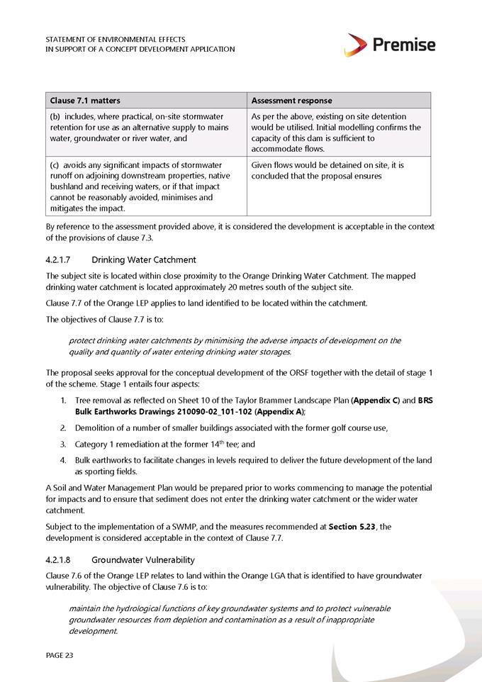
(b) includes, where practical, onsite
stormwater retention for use as an alternative supply to mains water,
groundwater or river water; and
(c) avoids any significant impacts of
stormwater runoff on adjoining downstream properties, native bushland and
receiving waters, or if that impact cannot be reasonably avoided, minimises and
mitigates the impact.
The proposal has been designed to
include permeable surfaces and includes onsite retention of stormwater through the use of
rainwater tanks. It is therefore considered that the post development runoff
levels will not exceed the pre-development
levels.
7.6 - Groundwater Vulnerability
This clause seeks to protect
hydrological functions of groundwater systems and protect resources from both
depletion and contamination. Orange has a high water table and large areas of
the LGA, including the subject site, are identified with “Groundwater
Vulnerability” on the Groundwater Vulnerability Map. This requires that
Council consider:
(a) whether or not the development (including
any onsite storage or disposal of solid or liquid waste and chemicals) is
likely to cause any groundwater contamination or have any adverse effect on
groundwater dependent ecosystems, and
(b) the cumulative impact (including the
impact on nearby groundwater extraction for potable water supply or stock water
supply) of the development and any other existing development on groundwater.
Furthermore, consent may not be granted unless Council is satisfied that:
(a) the development is designed, sited and
will be managed to avoid any significant adverse environmental impact, or
(b) if that impact cannot be reasonably
avoided - the development is designed, sited and will be managed to minimise
that impact,
(c) if that impact cannot be minimised - the
development will be managed to mitigate that impact.
The proposal is not
anticipated to involve the discharge of toxic or noxious substances and is
therefore unlikely to contaminate the groundwater or related ecosystems. The
proposal does not involve extraction of groundwater and will therefore not
contribute to groundwater depletion. The existing design and siting of the
proposal avoids impacts on groundwater and is therefore considered acceptable.
Clause 7.11 - Essential
Services
Clause 7.11 applies and states:
Development
consent must not be granted to development unless the consent authority is
satisfied that any of the following services that are essential for the
proposed development are available or that adequate arrangements have been made
to make them available when required:
(a) the supply of water,
(b) the supply of electricity,
(c) the disposal and management of
sewage,
(d) storm water drainage or onsite
conservation,
(e) suitable road access.
In consideration of this clause, all utility services are
available to the land and adequate for the proposal.
STATE ENVIRONMENTAL PLANNING
POLICIES
State Environmental Planning Policy 55 Remediation of
Land
State Environmental Planning Policy 55 - Remediation of
Land (SEPP 55) is applicable. Pursuant to Clause 7 Contamination and
remediation to be considered in determining development application:
(1) A consent
authority must not consent to the carrying out of any development on land
unless:
(a) it has considered whether the
land is contaminated, and
(b) if the land is contaminated, it
is satisfied that the land is suitable in its contaminated state (or will be
suitable, after remediation) for the purpose for which the development is
proposed to be carried out, and
(c) if the land requires
remediation to be made suitable for the purpose for which the development is
proposed to be carried out, it is satisfied that the land will be remediated
before the land is used for that purpose.
The subject land is well established as a residential
property with lawn areas, shrubs and garden beds. The current and previous land
use history of the site is not known to have been used for any of the
potentially contaminating activities listed in Table 1 of Managing Land
Contamination Planning Guidelines SEPP 55 –Remediation of Land.
The site is therefore unlikely to be
contaminated. In this regard, the subject land is considered to be suitable in
its current form and no further investigations regarding potential
contamination are required.
PROVISIONS OF ANY DRAFT
ENVIRONMENTAL PLANNING INSTRUMENT THAT HAS BEEN PLACED ON EXHIBITION
4.15(1)(a)(ii)
Draft Orange Local Environmental
Plan 2011 (Amendment 28) – Heritage Amendment
Draft Orange LEP 2011 (Amendment 28) involves new heritage
conservation areas; expansion to existing heritage conservation areas; and new
heritage items. The Draft Plan has no effect for the proposed development.
Draft Orange Local Environmental Plan 2011 (Amendment 29)
– Park and Rifle Range Roads, Shiralee
Draft Orange LEP 2011 (Amendment 29) relates to the rezoning
and amendment of minimum lot size for various sites at Park and Rifle Range
Roads, Shiralee. The Draft Plan has no affect for the proposed development.
Draft Remediation of Land State Environmental Planning
Policy
Draft Remediation of Land SEPP has been publicly exhibited.
The Draft SEPP will repeal and replace SEPP 55 Remediation of Land. Of
particular note, the Draft SEPP requires consideration of the contamination
status of nearby and neighbouring properties, and its impact on the proposed
use. Residential land adjoining the site is not identified or considered
to be contaminated.
DESIGNATED DEVELOPMENT
The proposed development is not designated development.
INTEGRATED DEVELOPMENT
The proposed development is not integrated development.
PROVISIONS OF ANY DEVELOPMENT
CONTROL PLAN s4.15(1)(a)(iii)
Development Control Plan 2004
Orange DCP 2004-07 - Development in Residential Areas
is relevant to this proposal. The provisions of Part 7 are considered below.
7.2-1 - Urban Residential Subdivision
The DCP sets the following (applicable) Planning Outcomes in
regard to urban residential subdivision:
· Lots
below 500m² indicate a mandatory side setback to provide for solar access
and privacy.
The proposed lots will comprise areas
of 425.32m² and
239m² respectively. The size and shape of the proposed lots will retain
reasonable residential amenity in terms of privacy and solar access. An
assessment of the existing dwellings on each proposed lot has been carried out
below under the heading “Part 7 - Design Elements for Residential Development”.
· Lots are fully
serviced and have direct frontage and access to a public road.
The proposed lots will each have direct street frontage and
legal and practical access to Dalton Street and the unnamed lane respectively
(subject to addressing conditions of consent). Separate access will be provided
to the proposed lots via vehicle crossings and driveways. Council’s
Technical Services Division have advised of no objections to the proposed
access arrangements, although have outlined the need to upgrade the unnamed
lane as per conditions of consent.
· Design and
construction complies with the Orange Development and Subdivision Code.
The subdivision design and construction will be required to
comply with the Orange Development and Subdivision Code. Attached is a
condition of consent addressing this issue.
PART 7 - DESIGN ELEMENTS FOR
RESIDENTIAL DEVELOPMENT
The DCP sets the following Planning Outcomes in regard to
Urban Residential Development.
Residential Design
Objectives
· To
ensure that the development fits into its setting and environmental features of
the locality.
· To
ensure that the appearance of housing is of a high visual quality, enhances the
streetscape and complements good quality surrounding development.
· To
ensure that new development complements places with heritage significance and
their settings in a contemporary way.
· To
develop a sense of place with attractive street frontages.
· To
encourage visually appealing cohesive streetscapes.
· To
create a safe and secure environment.
· To provide
consistent design elements that protect private investment.
The development is not antipathetic
to the relevant objectives of this section of the DCP as detailed below.
The DCP sets the following Planning Outcomes in regard to
Neighbourhood Character:
· Site
layout and building design enables the:
- creation
of attractive residential environments with clear character and identity
- use
of site features such as views, aspect, existing vegetation and landmarks.
· Buildings
are designed to complement the relevant features and built form that are
identified as part of the desired neighbourhood character.
· The
streetscape is designed to encourage pedestrian access and use.
The proposed development is considered
to meet the objectives related to neighbourhood character. The development has
been designed to provide a reasonable amount of open space and privacy between
the dwellings within the site and in relation to the adjoining residential
development. The interface between the adjoining residential development and
the subject land is assisted through fencing and landscape treatments.
Whilst the proposal now also includes subdivision, the built
form onsite is not altered. It should be noted however that a car port
structure will be required to ensure that each site has at least one undercover
parking space. The provision of a car port structure accessed via the rear lane
will not have an adverse impact on streetscape given the positioning of other
buildings along this lane. The proposal does not diminish the solar access or
visual privacy of the existing dwelling or adjoining residential development.
The presentation of the existing detached dwelling to Dalton Street is
retained and therefore the proposed development would have minimal effect on
the streetscape of Dalton Street.
The proposal will not diminish the function of Dalton Street
for pedestrian access and use. The increase in traffic movements because of the
creation of one additional lot/dwelling is expected to be modest in the context
of the broader traffic environment and will not detrimentally increase traffic
movements beyond the current residential levels. Council have previously
authorised a secondary dwelling in the rear yard. There is no proposal to alter
the size of the dwelling at the rear of the property.
Building Appearance
The DCP sets the following Planning Outcomes in regard to
Building Appearance:
· The building
design, detailing and finishes relate to the desired neighbourhood character,
complement the residential scale of the area, and add visual interest to the
street.
· The frontages
of buildings and their entries face the street.
· Garages and car
parks are sited and designed so that they do not dominate the street frontage.
The
proposal would not alter the existing typography or character of the area. No
built form changes are proposed which would impede on surrounding and existing
dwellings. To the external observer there would be no change to the
nature of the use of the site. The existing dwelling and its entrance will
still address Dalton Street. Its siting and frontage remain consistent with
adjoining dwellings.
The car parking of the existing secondary dwelling will not
satisfy the DCP in respect of design and siting. The proposed parking space for
the existing secondary dwelling is provided via an existing concrete pad. A
condition of consent has been added requiring the construction of a carport to
allow for a covered parking space for the use of the dwelling. Although front
of the building line, a future car port is unlikely to dominate the laneway
given the positioning of adjoining outbuildings in this location. All other
aspects of the DCP will be met.
The proposed development would have minimal effect on the
streetscape due to the following:
- Retention
of the existing dwelling maintains the existing pattern of single detached
dwellings that characterise this area of Dalton Street.
- Due
to separate access, the existing secondary dwelling at the rear of the site
would not be detected in views along Dalton Street.
Setbacks
The DCP sets the following Planning Outcomes in regard to
Setbacks:
· Street setbacks
contribute to the desired neighbourhood character, assist with the integration
of new development and make efficient use of the site.
· Street setbacks
create an appropriate scale for the street considering all other streetscape
components.
The existing setbacks remain for both dwellings. There are
no objections to the existing setbacks. Consideration of a future car port will
be the subject of a separate assessment.
Bulk and Scale Objectives
· To
allow flexibility in siting buildings and to ensure that the bulk and scale of
new development reasonably protects the amenity of neighbouring properties and
maintains appropriate neighbourhood character.
· To
allow adequate daylight, sunlight and ventilation to living areas and private
open spaces of new and neighbouring developments.
· To
encourage the sharing of views, while considering the reasonable development of
the site.
The development in not inconsistent with the above
objectives as detailed below.
The DCP sets the following Planning Outcome in regard to
Visual Bulk:
· Built form
accords with the desired neighbourhood character of the area with:
- side
and rear setbacks progressively increased to reduce bulk and overshadowing
- site
coverage that retains the relatively low density landscaped character of
residential areas
- building
form and siting that relates to landform, with minimal land shaping
(cut and fill)
- building
height at the street frontage that maintains a comparable scale with the
predominant adjacent development form
- building
to the boundary where appropriate.
In consideration of the DCP Guidelines, with the proposal
not altering any built form onsite, the dwellings remain acceptable in terms of
visual bulk. There is no proposal to alter the existing dwellings. The rear
dwelling will remain single storey, consistent with the development form of
residential development in the locality.
There are no changes to the existing and compliant site
coverage of the allotment.
The DCP sets the following Planning Outcome in regard to
Walls and Boundaries:
· Building to the
boundary is undertaken to provide for efficient use of the site taking into
account:
- the
privacy of neighbouring dwellings and private open space
- the
access to daylight reaching adjoining properties
- the
impact of boundary walls on neighbours.
The existing boundary fencing and
landscaping will continue to preserve the privacy of neighbouring dwellings and
private open space.
Daylight and Sunlight
The DCP sets the following Planning Outcome in regard to
Daylight and Sunlight:
· Buildings are
sited and designed to ensure:
- daylight
to habitable rooms in adjacent dwellings is not significantly reduced
- overshadowing
of neighbouring secluded open spaces or main living area windows is not
significantly increased
- consideration
of Council’s Energy Efficiency Code.
The siting of the existing dwellings and with no changes to
the built form on the land, the daylight and sunlight afforded to both the
existing lot and neighbouring allotments does not change. In consideration of
the DCP Guidelines, the proposal is considered to be satisfactory.
The DCP sets the following Planning Outcomes in regard to
Views:
· Building form
and design allow for residents from adjacent properties to share prominent
views where possible.
· Views including
vistas of heritage items or landmarks are not substantially affected by the
bulk and scale of the new development.
The subject site is not within an important view corridor.
The existing dwellings do not unreasonably diminish views for other properties
in the vicinity.
Privacy and Security
Objective
· To
ensure that the siting and design of buildings provide privacy for residents
and neighbours in their dwellings and principal private open space.
The development is not inconsistent with the above objective
as detailed below.
The DCP sets the following Planning Outcome in regard to
Visual Privacy:
· Direct
overlooking of principal living areas and private open spaces of other
dwellings is minimised firstly by:
- building
siting and layout
- location
of windows and balconies
and secondly
by:
- design
of windows or use of screening devices and landscaping.
The exiting dwellings are single storey and do not overlook
principal living areas of adjacent properties. Landscaping and fences will
continue to separate each allotment.
Acoustic Privacy
The DCP sets the following Planning Outcome in regard to
Acoustic Privacy:
· Site layout and
building design:
- protect
habitable rooms from excessively high levels of external noise
- minimise
the entry of external noise to private open space for dwellings close to major
noise sources
- minimise
transmission of sound through a building to affect other dwellings.
In consideration of the DCP Guidelines the proposal is
considered to be satisfactory. The site is located in an area where ambient
noise levels are expected to be low due to the predominant residential land use
pattern. The existing dwellings are detached, thus limiting the potential for
sound penetration between them.
The DCP sets the following Planning Outcomes in regard to
Security:
· The site layout
enhances personal safety and minimises the potential for crime, vandalism and
fear.
· The design of dwellings
enables residents to survey streets, communal areas and approaches to dwelling
entrances.
The proposal is considered acceptable in regard to safety
and security as follows:
- The
design of the dwellings will offer reasonable opportunities for surveillance of
public roads, driveway, front yards and private open space areas.
- The
site has reasonable access control due to perimeter and internal fencing.
- The
landscape design will not restrict sight lines.
Site Access and Circulation
Objectives
· To
provide convenient and safe access and parking that meets the needs of all
residents and visitors.
· To
encourage the integrated design of access and parking facilities to minimise
visual and environmental impacts.
The development is not inconsistent with the above
objectives as detailed below.
The DCP sets the following Planning Outcome in regard to
Circulation and Design:
· Accessways and
parking areas are designed to manage stormwater.
· Accessways,
driveways and open parking areas are suitably landscaped to enhance amenity
while providing security and accessibility to residents and visitors.
· The site layout
allows people with a disability to travel to and within the site between car
parks, buildings and communal open space.
Dwellings 1 and 2 have direct street frontages to Dalton
Street and the unnamed lane at the rear respectively. Separate access will be
provided to the proposed lots via vehicle crossings and driveways. The proposed
driveways are well separated from the intersection of Lords Place. Reverse
egress will be required for both dwellings, consistent with vehicle manoeuvring
arrangements for single dwellings throughout the City.
The DCP sets the following Planning Outcomes in regard to
Car Parking:
· Parking
facilities are provided, designed and located to:
- enable
the efficient and convenient use of car spaces and accessways within the site
- reduce
the visual dominance of car parking areas and accessways.
· Car parking is
provided with regard to the:
- the
number and size of proposed dwellings
- requirements
of people with limited mobility or disabilities.
In consideration of the DCP Guidelines, the proposal is
considered to be satisfactory. According to the car parking table in the DCP,
the development generates a further parking requirement of 1.2 off-street space
(based on 1.2 spaces for the two bedroom dwelling (existing secondary
dwelling)). The existing principal dwelling has
adequate parking provided onsite to meet the requirements (the provision of two
spaces, accessible from Dalton Street, with no changes to this arrangement
proposed.
The existing secondary dwelling at the rear of the site is a
two- bedroom dwelling, and this will require the provision of 1.2 spaces. A
concrete parking pad is existing onsite, accessed from the unnamed lane way at
the rear. One parking space is considered sufficient for this building. Albeit,
given this parking space is provided forward of the building line, the DCP
requirements have been met. A condition of consent has been added to construct
a carport over this existing concrete pad providing for an undercover parking
space. Improved landscaping elements are recommended to soften this hardstand
space. There are no further objections to the proposed parking arrangements.
The DCP sets the following Planning Outcomes in regard to
Private Open Space:
· Private open
space is clearly defined for private use.
· Private open
space areas are of a size, shape and slope to suit the reasonable requirements
of residents including some outdoor recreational needs and service functions.
· Private open
space is:
- capable
of being an extension of the dwelling for outdoor living, entertainment and
recreation
- accessible
from a living area of the dwelling
- located
to take advantage of outlooks; and to reduce adverse impacts of overshadowing
or privacy from adjoining buildings
- Orientated
to optimise year round use.
All private open space is provided
behind the front building line. The site plan confirms that the private open
space for each dwelling will have a minimum dimension of 3m and the yards are
able to provide an area of at least 5m x 5m with access to northern sun,
consistent with the requirements of the DCP. The internal living area for each
dwelling will connect to its respective area of private open space. It is
recommended that the rear lot incorporate further landscaping to delineate
between their private open space and front yard.
Open Space and Landscaping
The DCP sets the following Planning Outcomes in regard to
Open Space and Landscaping:
· The site layout
provides open space and landscaped areas which:
- contribute
to the character of the development by providing buildings in a landscaped
setting
- provide
for a range of uses and activities including stormwater management
- allow
cost effective management.
· The landscape
design specifies landscape themes consistent with the desired neighbourhood
character; vegetation types and location, paving and lighting provided for
access and security.
· Major existing
trees are retained and protected in a viable condition whenever practicable
through appropriate siting of buildings, accessways and parking areas.
· Paving is
applied sparingly and integrated in the landscape design.
Existing vegetation onsite is to be retained. It is
recommended that the rear lot incorporate further landscaping to delineate
between their private open space and front yard. A landscaping plan will
be required to be submitted prior to the issuing of a subdivision certificate.
Water and Soil Management
Objectives
· To control and
minimise the impact of stormwater run-off and soil erosion on adjoining land
and downstream.
· To encourage reduced
water wastage by reusing, recycling and harvesting stormwater.
The development is not inconsistent with the above
objectives as detailed below.
Stormwater
The DCP sets the following Planning Outcomes in regard to
Stormwater:
· Onsite drainage
systems are designed to consider:
- downstream
capacity and need for onsite retention, detention and re-use
- scope
for onsite infiltration of water
- safety
and convenience of pedestrians and vehicles
- overland
flowpaths.
· Provision is
made for onsite drainage which does not cause damage or nuisance flows to
adjoining properties.
Relevant conditions of consent are attached to the notice in
relation to stormwater management of the site.
DEVELOPMENT CONTRIBUTIONS PLAN
Contributions for a 2 bedroom dwelling were initially levied
on the secondary dwelling development. No further Section 7.11 Development
Contributions are applicable to this development as they were paid via
DA308/2015(1) for the secondary dwelling proposal at the time.
INFILL GUIDELINES
Development in a heritage setting must be assessed against
Council’s Infill Guidelines. There is no proposal to alter the built form
of the development. The proposal is not contrary to Council’s Infill
Guidelines.
PROVISIONS PRESCRIBED BY THE REGULATIONS
s4.15(1)(a)(iv)
Demolition of a Building (clause
92)
The proposal does not involve the demolition of a building.
Fire Safety Considerations
(clause 93)
The proposal involves a change of building use for an
existing building. Council is satisfied that the fire protection and structural
capacity of the building are appropriate for the proposed new building use.
Relevant conditions are attached.
Buildings to be Upgraded
(clause 94)
The proposal does not involve the rebuilding, alteration,
enlargement or extension of an existing building.
BASIX Commitments (clause 97A)
BASIX is not relevant to this proposal as buildings are
existing and compliant.
THE LIKELY IMPACTS OF THE
DEVELOPMENT s4.15(1)(b)
Generally
The proposed development is unlikely to generate any impacts
that would adversely affect the quality of the environment of the locality;
particularly as such development is considered to be consistent with the zone
objectives and would achieve reasonable integration with the existing land use
pattern.
Traffic Impacts
The proposal is considered to be satisfactory in terms of
traffic impacts due to the following:
- The
proposal involves the creation of only 1 additional lot that is required to be
serviced by an upgraded road system.
- The
provision of adequate off-street parking will assist to maintain traffic
amenity.
- The
access arrangements for each dwelling are satisfactory; the reverse egress for
the existing dwelling is consistent with manoeuvring arrangements for the majority
of dwellings in this neighbourhood.
- The
existing secondary dwelling already gains access via the laneway.
- Upgrading
of the unnamed lane will ensure that the road network will be sufficient to
accommodate existing and new development.
Neighbourhood Amenity
The proposed dwelling will provide
and retain a reasonable standard of residential amenity for the proposed dual
occupancy and development on adjoining lands in respect of solar access,
privacy etc. The proposed development will provide for a continuation of
residential landuse and will not alter the function of the neighbourhood. The
development will not have adverse impacts on neighbourhood amenity.
Cumulative Impacts
The proposal is considered to be
satisfactory in terms of cumulative impact. The proposed development does not
alter the interface between the development site and neighbouring properties.
The development will have a satisfactory level of impact upon adjoining land
and is unlikely to adversely affect its future development.
The development will complement the
residential density of the broader residential area comprises of single
dwellings, and interspersed infill development consisting of dual occupancies
and multi dwelling housing. The proposal will maintain the pattern of single
storey detached dwellings at the street frontage that characterise this
neighbourhood.
Existing and Future Amenity of the Neighbourhood
The potential impact upon the
amenity of the neighbourhood is considered satisfactory and has been addressed
above in the relevant considerations under DCP 2004.
THE SUITABILITY OF THE SITE
s4.15(1)(c)
Servicing
Council’s Technical Services Division advises that all
utility services will be required to be upgraded to service the proposed
additional lot. Attached are conditions of consent addressing this issue.
Physical Attributes
The subject site is considered to be suitable for the
proposed development. There are no physical attributes within the site that
would unreasonably constrain the development. With no changes to the existing
built form on the land, the proposal of subdivision is considered suitable.
ANY SUBMISSIONS MADE IN ACCORDANCE
WITH THE ACT s4.15(1)(d)
The proposed development is defined as "advertised
development" under the provisions of the LEP. The application was
advertised for the prescribed period of 14 days and at the end of that period
one (1) submission was received. The submitter has raised concerns suggesting
that the driveway and garage currently serving 98 Dalton Street have been constructed
across the dividing boundary and that it was originally intended (verbal
agreement with previous owner) that the access would serve both properties. The
submitter has requested that the boundary between the two properties be
investigated and clarified in conjunction with this proposal.
A review of Council’s mapping system suggests that the
driveway and garage are located wholly within the property at 98 Dalton Street.
A further search of records indicates that the property is not affected by any
Right of Carriageway easement or the like that would allow access to the
adjoining land. Notwithstanding, a condition will be included in the Notice of
Determination requiring the submission of a survey of the land showing the
distance of existing buildings to boundaries prior to the issuing of a
subdivision certificate to ensure compliance. It is considered that the matters
raised in regard to shared driveway arrangements will not be affected by this
proposal.
PUBLIC INTEREST
s4.15(1)(e)
The proposed development is considered to be of minor
interest to the wider public due to the relatively localised nature of
potential impacts. The proposal is not inconsistent with any relevant policy
statements, planning studies, guidelines etc that have not been considered in
this assessment.
SUMMARY
The proposed development is permissible with the consent of
Council. The proposed development complies with the relevant aims, objectives
and provisions of Orange LEP 2011 (as amended) and DCP 2004. A
Section 4.15 assessment of the development indicates that the development
is acceptable in this instance. Attached is a draft Notice of Approval
outlining a range of conditions considered appropriate to ensure that the
development proceeds in an acceptable manner.
COMMENTS
The requirements of the Environmental Health and Building
Surveyor and the Engineering Development Section are included in the attached
Notice of Approval.
Attachments
1 Notice
of Approval, D21/65200⇩
2 Plans,
D21/43936⇩
3 Submission,
D21/64644⇩
Attachment 1 Notice
of Approval
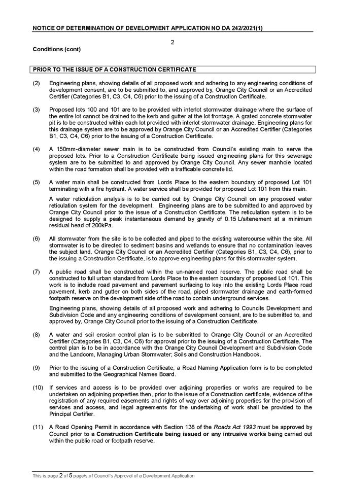
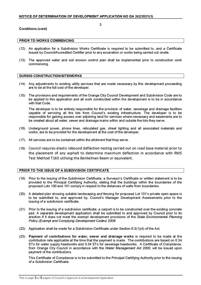
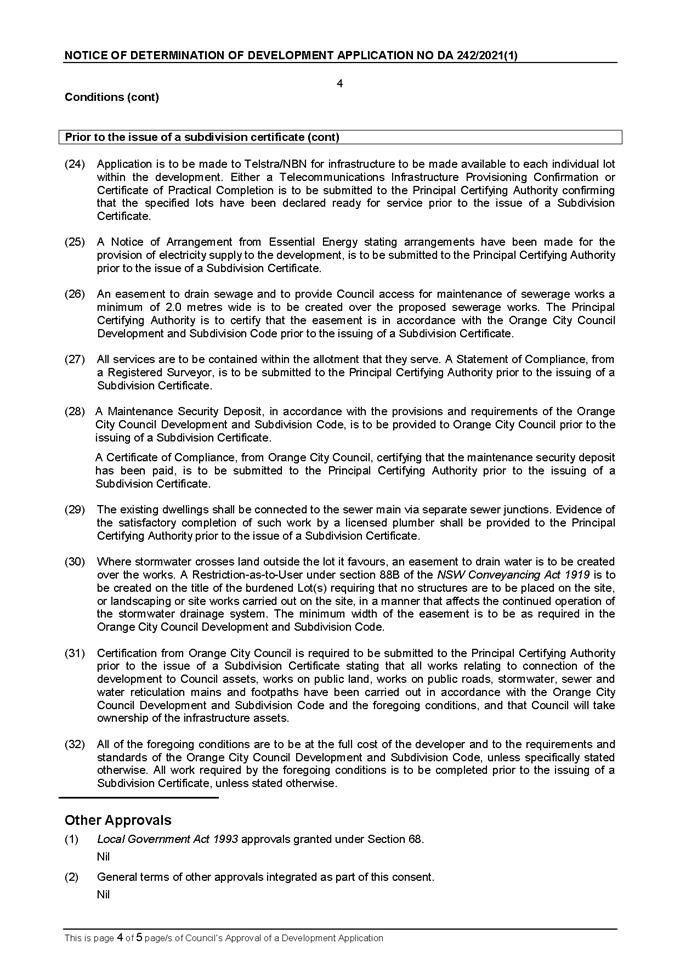
Planning and Development Committee
2 November 2021
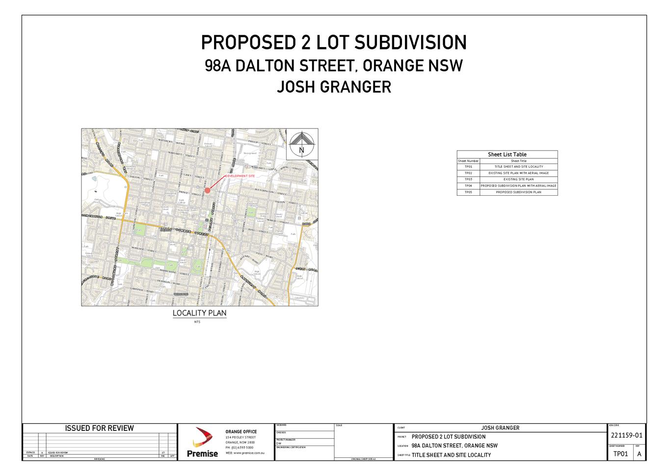
Planning
and Development Committee
2 November 2021
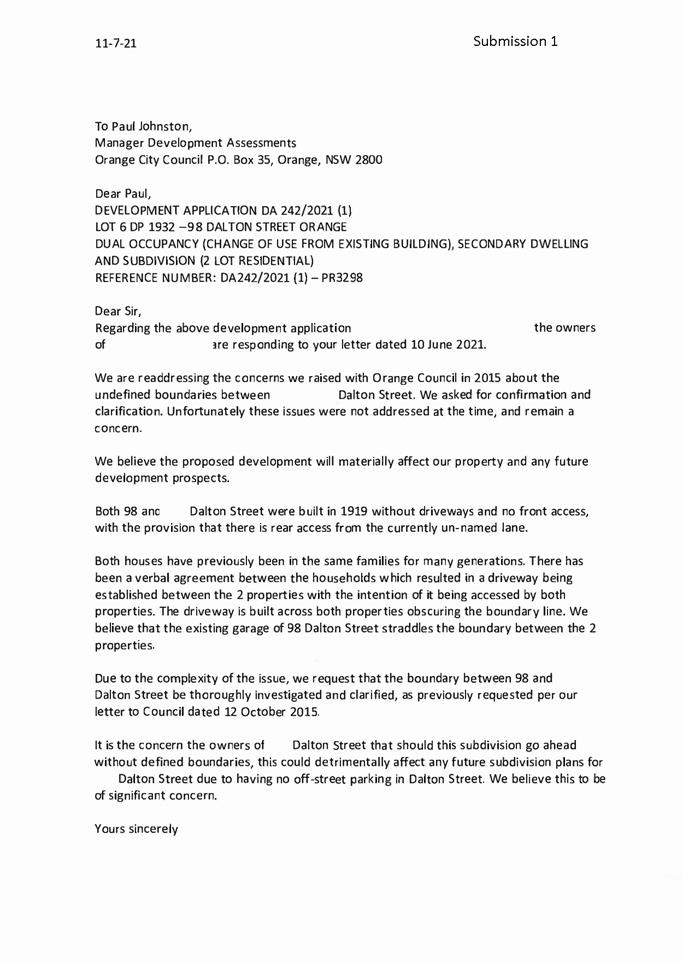
2.3 Development
Application DA 423/2019(3) - 643 Mitchell Highway
RECORD
NUMBER: 2021/2012
AUTHOR: Ben
Hicks, Planner
EXECUTIVE
Summary
Application has been made to modify development consent DA
423/2019(1) for the proposed Electricity Generating Works (solar farm)
at Lot 200 DP 1194585, 643 Mitchell Highway, Orange to extend the maximum
period of the lifespan of the approved solar farm from 25 years to 35 years. The
approved development involves the construction and operation of electricity
generating works comprising a 5MW solar energy facility. The application
was approved by the Western Regional Planning Panel on 8 December 2020.
Council is advised that modification application will be
tabled for the determination of the Western Regional Planning Panel (WRPP) pursuant to Section 123BA(2) of the
Environmental Planning and Assessment Regulation 2000, which requires an
application to modify a development consent made under Section 4.55(2) of the
Environmental Planning and Assessment Act 1979 not to be determined by Council
on behalf of the Regional Planning Panel where the modification seeks to amend a condition that was imposed by or amended by the
Regional Planning Panel.
It is likely that the Panel would consider the application
later this year, after this Council has entered the caretaker mode leading up
to the Local Government elections.
This report provides the Council with an update on the
progress of the assessment report and process moving forward. Whilst the
assessment of this proposal by staff for reporting to the Western Region
Planning Panel is not as yet complete, the option remains open for the Council
itself to separately make a submission to the Western
Regional Planning Panel prior to entering the caretaker mode.
FINANCIAL IMPLICATIONS
Nil
POLICY/GOVERNANCE IMPLICATIONS
Nil
further considerations
Consideration has been given to the recommendation’s
impact on Council’s service delivery; image and reputation; political;
environmental; health and safety; employees; stakeholders and project
management; and no further implications or risks have been identified.
|
Recommendation
That Council:
1 1 Determine
whether or not it makes a submission on the application to the Western Regional
Planning Panel.
|
DIRECTORS NOTE
This report provides the Council with an update on the
progress and process moving forward regarding the application to modify development
consent DA 423/2019(1) for the proposed Electricity Generating Works (solar
farm) at Lot 200 DP 1194585, 643 Mitchell Highway, Orange. The application
seeks to extend the maximum period of the lifespan of the approved solar farm
from 25 years to 35 years. Council staff are in the process of preparing a
planning report on this application which is to be tabled before the Western
Region Planning Panel. The final assessment report is not yet complete. However,
it is open for Council to make a submission to the
Western Regional Planning Panel. I am aware that historically Council
has expressed significant objection to the Panel with regard to the location of
this proposal being on the edge of the City and within an identified urban
growth area. Attached to this report is a copy of the application.
THE REPORT
Application has been made to modify development consent DA
423/2019(1) for the proposed Electricity Generating Works (solar farm)
at Lot 200 DP 1194585, 643 Mitchell Highway, Orange to extend the maximum
period of the lifespan of the approved solar farm from 25 years to 35 years. The
approved development involves the construction and operation of electricity generating
works comprising a 5MW solar energy facility. The application was approved
by the Western Regional Planning Panel on 8 December 2020.
Council is advised that the abovementioned modification
application is required to be tabled for the determination of the Western
Regional Planning Panel (WRPP) pursuant
to Section 123BA(2) of the Environmental Planning and Assessment Regulation
2000, which requires an application to modify a development consent made under
Section 4.55(2) of the Environmental Planning and Assessment Act 1979 not to be
determined by Council on behalf of the Regional Planning Panel where the
modification seeks to amend a condition that was imposed by or amended by the
Regional Planning Panel.
The proposal comprised advertised and notified development
in accordance with the Environmental Planning and Assessment Regulation 2000.
At the completion of the exhibition period 22 submissions were received - 11
objections and 11 in support.
A report is being finalised by Council assessment staff
which will be provided directly to the panel in due course.
Council may make a submission on a
development application that is to be determined by the Western Regional
Planning Panel. Should Council wish to make a submission to the WRPP,
Council will need to nominate specific planning matters to be addressed so that
arrangements may be made for a letter to be tabled for the consideration of the
WRPP.
It should be noted that in accordance with the Sydney
& Regional Planning Panels Operational Procedures, a council submission
cannot be specifically referenced in the assessment report or recommendations
prepared by the council staff.
Supporting information is attached to assist Council in
making a submission on the matter.
Attachments
1 Statement
of Environmental Effects (SoEE), D21/67748⇩
Planning
and Development Committee
2 November 2021
Attachment 1 Statement
of Environmental Effects (SoEE)
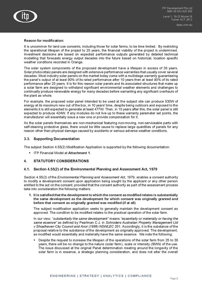
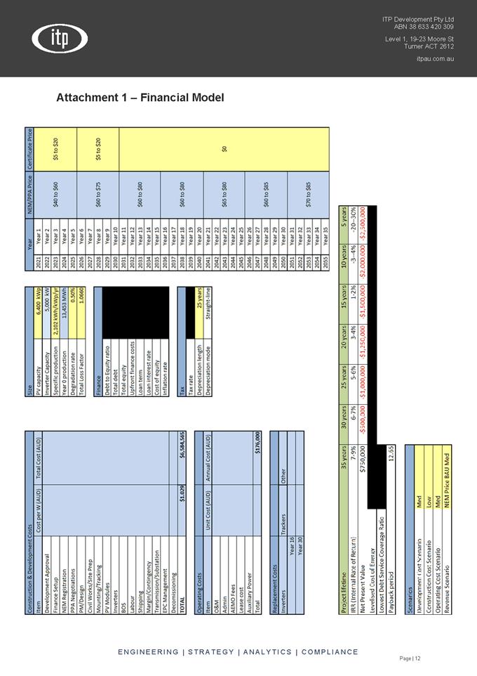
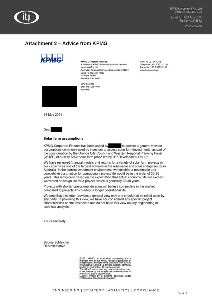
2.4 Orange
Local Environmental Plan - Amendment 33 - Rosedale Gardens
RECORD
NUMBER: 2021/2345
AUTHOR: Craig
Mortell, Senior Planner
EXECUTIVE Summary
Council is in receipt of a draft Planning Proposal to rezone
land 463 Leeds Parade and 440 Clergate Road, Orange. Referred to as Rosedale
Gardens the site encompasses the former abattoir and adjoining farmland and was
previously rezoned under Amendment 13. Following a review of the residential
market the landowner is now requesting a further change to increase the number
of lots by reducing the minimum lot size on the land and simplifying the zoning
pattern.
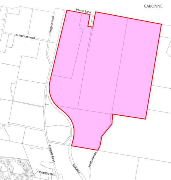
This matter relates to the draft Orange Local Housing
Strategy (OLHS) previously reported to Council on 19 October 2021. If
adopted the overall lot yield for Rosedale Gardens would increase from 450 lots
to 700 lots representing 1 additional year of supply. With such an increase
added to the supply the OLHS would remain within the intended 20 year planning
horizon.
Link To Delivery/OPerational Plan
The recommendation in this report relates to the
Delivery/Operational Plan strategy “7.1 Preserve - Engage with the
community to develop plans for growth and development that value the local
environment”.
Financial Implications
Nil
Policy and Governance Implications
Council has recently resolved to place the draft OLHS on
public exhibition. There is a degree of overlap between this proposal and the
draft OLHS, the public may question why this proposal can proceed before the
draft OLHS has been resolved. This proposal is not considered to be
inconsistent with the draft OLHS and will still need to obtain a gateway
determination from the NSW Department of Planning, Industry and Environment (DPIE)
before exhibition can occur, however exhibition may still overlap with the
exhibition period of the draft OLHS.
DIRECTORS NOTE
This report relates to draft Planning Proposal to rezone
land 463 Leeds Parade and 440 Clergate Road, Orange known as Rosedale Gardens.
The subject land encompasses the former abattoir and adjoining farmland that
was previously rezoned under Amendment 13 to Orange LEP 2011 in 2019 to provide
for 450 large lot residential lots. The proposal now before Council seeks to
increase the number of lots by reducing the minimum lot size on the land and simplifying
the zoning pattern to provide for a residential development capped at a maximum
of 700 large lots.
It is considered that the planning proposal as presented has
merit and may be progressed to Gateway with the Department, however it should
be noted that there remains several significant issues that will require
further work by the proponent to resolve as discussed in the body of this
report. It is recommended that the Planning Proposal retains the Urban Release
Area designation at this stage pending preparation and adoption of a site
specific Development Control Plan incorporating the matters in the attached
Rosedale Gardens DCP scope of works required document, and a site specific
Development Contributions Plan to address infrastructure requirements.
|
Recommendation
1 That
Council advise the proponent of the need for the Planning Proposal to retain
the Urban Release Area designation pending preparation and adoption of the
following documents that must address the matters raised in this report to
the satisfaction of Council:
· A site
specific Development Control Plan incorporating the matters in the attached
Rosedale Gardens DCP scope of works required document, and
· A site
specific Development Contributions Plan or inclusion within a review of the
LGA wide contributions plan
2 That
staff forward the Planning Proposal to the Department of Planning, Industry
and Environment requesting a Gateway Determination, with the recommendation
that:
· The Planning
Proposal be required to retain the current Urban Release Area designation,
· The steepest
portions of the site, being areas with a slope exceeding 20%, be added to
Schedule 5 of SEPP (Exempt and Complying Development Codes) to reduce the
risk of landslip potential arising from inappropriate development, and
· Council
requests any Gateway Determination confirm the preferred mechanism for
capping the site at 700 residential lots (excluding any lots created for
non-residential purposes, such as open space dedications and the like).
· Should the
Gateway seek substantive changes to the proposal that Council be provided the
opportunity to further review and consider such changes before proceeding
further.
3 That
upon receipt of a Gateway Determination staff proceed with any relevant
conditions, consultations and exhibitions required before reporting the
matter back to Council.
|
further considerations
Consideration has been given to the recommendation’s
impact on Council’s service delivery; image and reputation; political;
environmental; health and safety; employees; stakeholders and project
management; and no further implications or risks have been identified.
SUPPORTING INFORMATION
Background
On 1 March 2016 Council first considered a report for a
planning proposal that became Amendment 13, to rezone the former abattoir site
in Leeds Parade and associated farmland to the north of the abattoir to allow
for a potential residential lifestyle estate of approximately 450 lots, mainly
1 acre (4000m2) with some 2 acre (8000m2) lots.
Originally called Clergate Hills by the proponent the project was subsequently
renamed ‘Rosedale Gardens’.
After a lengthy process related to the drafting of Blayney
Cabonne Orange sub-regional Rural and Industrial strategy (BCO)
amendment 13 was ultimately exhibited between 4 October 2019 and 1 November
2019 and endorsed by Council in December 2019, subject to the site becoming an
Urban Release Area requiring preparation of a Development Control Plan to
address a range of matters.
Land use zones
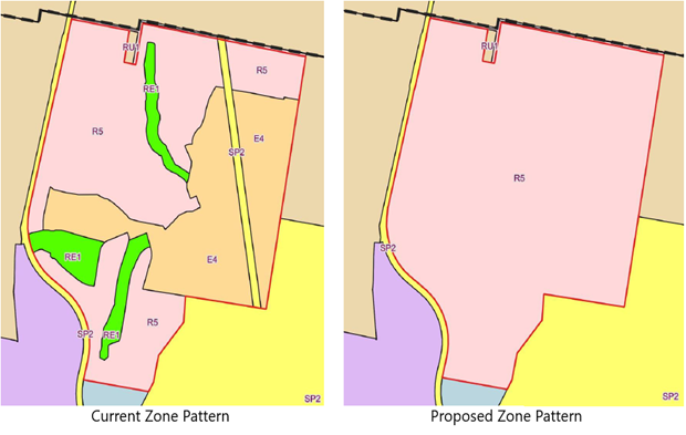
Amendment 13 changed the site from IN1 General Industrial
and RU1 Primary Production to a mix of zones R5 Large Lot Residential, E4
Environmental Living, RE1 Public Recreation and SP2 Electrical Transmission
Line. This responded to a conceptual plan for 450 residential lots between
4,000m2 and 8,000m2 in size. The current proposal seeks
to increase the R5 Large Lot Residential zone to encompass the entire site.
Subdivision - Minimum Lot Size
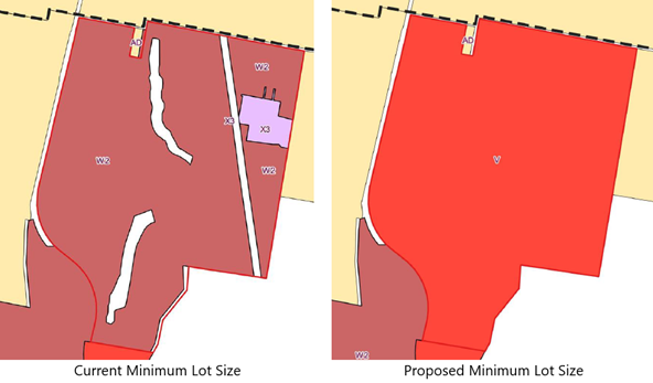
Similarly, amendment 13 established a combination of minimum
lot sizes, predominantly W2 (4,000m2) with some X3 (8,000m2)
and the current proposal is seeking to establish a uniform 2,000m2
across the entire site to allow for greater flexibility in designing the final
subdivision layout.
Urban Release Area
Under the LEP a site may be mapped as an Urban Release Area
(URA). The effect of URA mapping is to allow the rezoning of a site to
proceed but prevent actual development until such time as a range of matters in
Part 6 of the LEP are satisfied. Clause 6.1 relates to State public
infrastructure, clause 6.2 relates to public utility infrastructure and clause
6.3 relates to the need for a Development Control Plan.
Flexibility in design – Lot Yield Cap
The proposal has nominated a simplification of the zone and
lot size maps to allow for increased flexibility in the final design. A single
zone of R5 is proposed with a single minimum lot size of 2,000m2 and a local
clause to control the overall number of lots to be developed across the estate.
While this has some merit in allowing the design to adapt to
market needs and any constraints emerging from further survey work, it does
create concern for scope creep that could degrade urban design and ecological
outcomes. The proposed clause for controlling the number of lots in the estate has
been modelled on a similar clause in the Cessnock LEP and would have wording
similar to the following:
7.X Certain land at Leeds Parade, Clergate
Road and Pearces Lane, Orange
1) This clause applies
to land at 440 Clergate Road and 463 Leeds Parade, Orange being Lots 2 & 3,
DP 255983 and Lots 14, 15 and 25 DP 6694, as shown edged heavy black, shaded
pink and identified as “Item 6” on the Additional
Permitted Uses Map.
2) Development consent
must not be granted to any development on the land to which this clause applies
if the granting of that consent would result in the total number of residential
allotments on that land exceeding 700.
3) This clause does not
prescribe a development standard that may be varied under this Plan.
There are some vulnerabilities of this approach. For
instance if an early stage of the estate creates lot(s) of 4,000m2
or greater and the estate is yet to be completed then buyers of such lots could
seek a two lot subdivision on the basis that the estate has not yet reached the
cap of 700 lots. This would potentially reduce the number of lots that can be
approved in the final stage(s) of the estate.
Presumably early stage larger lots would be created in
response to site constraints and/or as a method of protecting significant flora
and fauna in the yards of larger lots where building envelopes act to prevent
clearing. The push to allow small two lot subdivisions could erode these
outcomes. This issue will be need further analysis as a part of the preparation
of the DCP.
Development Control Plan
A site specific Development Control Pan required under
section 6.3 of the LEP must address the matters below listed (a) to
(j):
(a) a
staging plan for the timely and efficient release of urban land, making
provision for necessary infrastructure and sequencing,
(b) an
overall transport movement hierarchy showing the major circulation routes and
connections to achieve a simple and safe movement system for private vehicles,
public transport, pedestrians and cyclists,
(c) an
overall landscaping strategy for the protection and enhancement of riparian
areas and remnant vegetation, including visually prominent locations, and
detailed landscaping requirements for both the public and private domain,
(d) a
network of passive and active recreational areas,
(e) stormwater
and water quality management controls,
(f) amelioration
of natural and environmental hazards, including bush fire, flooding and site
contamination and, in relation to natural hazards, the safe occupation of, and
the evacuation from, any land so affected,
(g) detailed
urban design controls for significant development sites,
(h) measures
to encourage higher density living around transport, open space and service
nodes,
(i) measures
to accommodate and control appropriate neighbourhood commercial and retail
uses,
(j) suitably
located public facilities and services, including provision for appropriate
traffic management facilities and parking.
Attached to this report is a preliminary scope of works
required for the preparation of a Rosedale Gardens specific Development Control
Plan. This scope has included the matters raised by staff across a range of
issues and is structured to align with the matters listed in section 6.3 of the
LEP above.
Development Contributions Plan
Council staff are currently reviewing the section 7.11
contributions plans for the entire LGA, which is anticipated to be presented to
Council around March / April 2022. Preparation of that plan is aware of this
site having existing potential for 450 lots and that the proponent is seeking
to increase this to 700 lots.
Given the timing of this planning proposal it is likely that
Council will be considering exhibition of the new contributions plan at around
the time that it may also be considering a post exhibition report for this
planning proposal.
In that event, the development control plan for the site
would be expected to include provision for the dedication to Council of such
infrastructure and facilities as are wholly required by the development itself
and a separate standalone contributions plan if required.
Alternatively, finalisation of this planning proposal could
be made conditional upon the adoption of the new LGA-wide contributions plan.
Relationship to Orange Local
Housing Strategy (OLHS)
While the site totals 293.45ha the proposal nominates a local
clause to cap subdivision of the site at 700 lots. Without such a clause the
proposed minimum lot size could in theory result in roughly 1,027 lots
(293.45ha – 30% constraints and roads = 205.41ha / 2000m2). In
practice some lots on steeper land will always need to be larger and this would
reduce the yield below the 1,027 figure.
Given the proposed cap, the draft OLHS has factored in the 700
lots proposed in the land supply calculations.
Water supply and security
The DCP masterplan will need to include provision for trunk
water main(s) installation with the western crossing of the railway and the
potential requirement for a water storage reservoir at a high point of
elevation on or adjacent to the land, subject to further investigation to
ensure appropriate water pressure is achieved.
The Planning Proposal mentions stormwater harvesting in
section 4.2 stating
Harvesting of water for potable purposes would be
developed in conjunction with Orange City Council to augment the Council water
supply and offset the additional demand generated by the development of the
land
Council’s water and sewerage strategic manager advises
that there would not be enough run-off generated to make this a viable secure
yield option when stacked against cost. It does not currently form part of
OCC’s long-term secure yield strategy and if this were to proceed then it
would be at the full cost of the developer.
In view of the above it is considered that the stormwater
management approach to the estate should be explored further as part of the DCP
masterplan process. While stormwater harvesting may not be economically viable
at this time there remains some logic to designing the estate in a manner that
could enable such harvesting at a future point should the need arise.
Transgrid Transmission Line
The proponent advises that they have commenced negotiations
with Transgrid to place the existing overhead 132kVA transmission line
underground and re-oriented along proposed internal roads. A letter from the
Central West Power Construction (CWPC) to Premise is attached to this
report that confirms the negotiations are underway and that the proponent is
aware of the costs and time involved and is willing to proceed and cover the
costs involved.
This approach can work, but can also be costly and
time-consuming to arrange the necessary Transgrid approvals. At the time of
writing this report there is no definitive advice from Transgrid on this
matter. While it is likely that they will support the undergrounding for the
reasons outlined in the CWPC advice this is not a matter that Council can
control. From a planning perspective staff support the undergrounding of the
transmission line, again for the reasons outlined in the CWPC letter provided
it is at no cost to Council and is the sole responsibility of the developer.
Should the proposal fail to achieve Transgrid approval, for
any reason, the conceptual layout would need to be altered and the SP2
Electrical Transmission Zone retained or relocated to any new overhead path.
Roads could still be placed across the SP2 zone but would need to be located
clear of any towers or other assets. In such a circumstance ongoing maintenance
of the SP2 zone would be a matter for the developer to resolve with Transgrid
and it is not proposed that Council should acquire the land (and maintenance
costs) for a transmission line easement.
Early stages of the estate would be unaffected by this issue
and it may lead to the matter being deferred, in that instance the SP2 zone
should be retained until such time as Council has advice from Transgrid that
alternative arrangements are satisfactory to them have been confirmed.
Given the above it is likely that any gateway determination
will require consultation with Transgrid to confirm the status of the
transmission line, should this result in the power line remaining overhead or
repositioned then the proposed zone for the land would need to be adjusted to
include an SP2 corridor over the transmission line prior to public exhibition.
Rail corridor
The proponent has consulted with John Holland Rail (JHR),
current manager of the Country Regional Network (CRN) owned by Transport
Asset Holding Entity (TAHE), while Transport for NSW (TfNSW) is
the rail authority for the CRN. The JHR contract is due to expire with UGL
taking over in the new year.
JHR/UGL are responsible for reviewing the development to
ensure potential impacts on rail operations (current and future) are considered
and addressed. The Proposal for a rural subdivision requires two separate
processes such as the DA review and an approval process for upgrading of the
level crossings.
Attached is advice from JHR to the proponent in terms of the
process without expressing a view on whether or not the level crossing upgrades
sought would be achievable or supportable by JHR or TfNSW.
Accordingly it is considered that any Gateway Determination
will require consultation with JHR/UGL and TfNSW prior to public exhibition to
confirm all requirements in relation to level crossing upgrades. In the event
that upgrading and use of the rail level crossings is not attainable the
proponent would be expected to submit a revised traffic study as part of the
DCP master-planning process.
Ecological Values
The planning proposal states:
A preliminary biodiversity analysis was completed in
support of the original planning proposal applying to the land. That assessment
was prepared to address the requirements of the (then) Native Vegetation Act
2003. The inception of the NSW Biodiversity Conservation Act, 2016 (BC Act)
means that any development application that would result in the clearing of
native vegetation must consider whether the Biodiversity Offset Scheme (BOS)
applies.
Future subdivision of the land will trigger the BOS due
to the presence of native vegetation on the site and the anticipated level of
clearing. Any future Development Application to subdivide the land will
therefore need to be accompanied by a Biodiversity Development Assessment Report
(BDAR), which will assess the potential impact on biodiversity in accordance
with the Biodiversity Assessment Method (BAM) established under the BC Act.
An accredited assessor must implement the BAM and prepare
a BDAR in accordance with part 6 of the BC Act. A preliminary site visit to the
property was completed by Premise ecologists on the 8-9 April 2021. Further
vegetation surveys are required to satisfy the requirements of the BAM to
adequately identify PCTs (Plant Community Types) and collect quantitative data
for input into the BAM Calculator to determine any offset liability.
Database searches have predicted the presence of
threatened flora, fauna and ecological communities to occur on the site. 13
threatened flora species, 40 threatened fauna species and 2 threatened
ecological communities are possible on the site.
Whilst further fauna and flora surveys need to be
completed to finalise the biodiversity strategy for the planned subdivision
(ahead of any future DA lodgement), the proposal is considered capable of
complying with the provisions of the Biodiversity Conservation Act 2016.
Council’s
City Presentation Manager has advised that the proposal should retain all of
the native vegetation in the south western portion of Lot 3 DP 255983 located
between the existing property access track (from the railway) to the southern
boundary as either public lands, estate managed public open space or on
individual allotments with building envelopes (encompassing dwellings, detached
garages and sheds) identified for each individual property minimising native
tree removals. Furthermore, remnant vegetation along the existing water courses
should be retained with no earthworks permitted within the Tree Protection
Zones.
To achieve the
intended living environment proposed it would be more achievable if the
subdivision was managed as a private residential estate with private open space
areas, managed and maintained as part of the estate. Council’s
involvement should be limited to managing the road reserve and roadside street
tree planting with all other landscaping and water features managed by the
estate.
This outcome
would need to be a requirement of any DCP masterplan for the estate. The
proponent response to this matter confirms that the intent for the area of vegetation
mentioned is that a portion of the native woodland be retained as public land.
Further assessment will be made at the DCP masterplan and DA stages, this will
allow for final flora and fauna mapping and surveys to be completed and an
overall assessment of the biodiversity strategy for the estate.
The proponent
asserts that the detailed assessment is unlikely to impact on the road and open
space corridor but that an adjustment of lot sizes is a possible outcome. While
this approach could work it is considered that there is a high probability that
a gateway determination may require additional studies and design responses
prior to public exhibition.
Topography and slope analysis
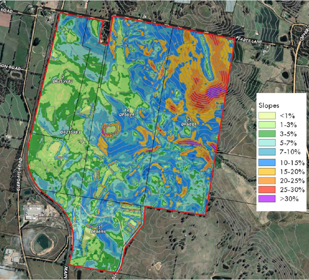
The site ranges from relatively flat areas in the west through
to extremely steep areas in the north-eastern corner of the site. The extent of
earthworks likely to be required for a residential subdivision relates to the
lot sizes involved. Larger lots typically require less land shaping at the
subdivision stage to produce lots that have viable building sites. In this
regard it is likely that the north-eastern areas of the site will need to be
larger in size to account for the steep topography.
Roads should ideally avoid the steepest areas of the site to
reduce the risk of landslip. Geotechnical investigations and engineering
solutions can enable development on steep lands, but at an increased cost for
retaining walls and the like. While largely a matter for DA assessment it
should be highlighted in the DCP masterplan as an issue that needs to be
addressed.
As part of seeking a gateway determination Council should
request the Department of Planning, Industry and Environment to exclude the
steepest areas, from SEPP (Exempt and Complying Development Codes) to further
mitigate the risk arising from inappropriate development on steeply sloping
areas.
Interface with adjoining lands
To the north of the site is Cabonne Shire and lands used
predominantly for horticulture and agriculture. This pattern continues to the
north eastern boundary where an orchard spans across the LGA boundary. To the
west the site is bounded by the railway line and to the south the site meets
lands owned by Charles Sturt University. Each of these interfaces need to be
carefully designed to
· Minimise
disruption to primary production,
· Prevent
rail vibrations from damaging buildings, and
· Preserving
the operations of a public university.
By maintaining the URA mapping Council can require appropriate
interface treatments as part of the Development Control Plan. This can comprise
larger lots with increased depth and placement of building envelopes away from
the estate edge to allow for greater physical separation. Additionally
significant landscaping requirements around the estate edge to limit issues of
odour and spray drift from creating conflicts between neighbours.
Traffic and access
Council staff have reviewed the traffic portion of the
planning proposal and confirm the numbers and assessment are appropriate and
consistent with expectations. The volumes generated do warrant upgrading of the
following intersections:
· Leeds
Parade and the Northern Distributor Road
· Clergate
Road and the Northern Distributor Road,
· Clergate
Road and Farrell Road
These upgrades will be included in the Section 7.11 Developer
Contributions Plan currently being worked on by staff. However it is likely
that the contributions plan may not have the capacity to fully fund all of
these works and the proponent may therefore be required to enter into a
planning agreement with Council to address these off site aspects.
Should approval to use the level crossing(s) onto Clergate
Road be denied by the rail authority it will impact which intersections will
require upgrading.
Road design and construction
The Planning Proposal states an intention to use table-drains
rather than kerb and guttering. This is not presently supported by staff,
especially in terms of roads in steeper areas of the site and will need to be
revisited as part of the DCP masterplan exercise.
Conceptual Layout
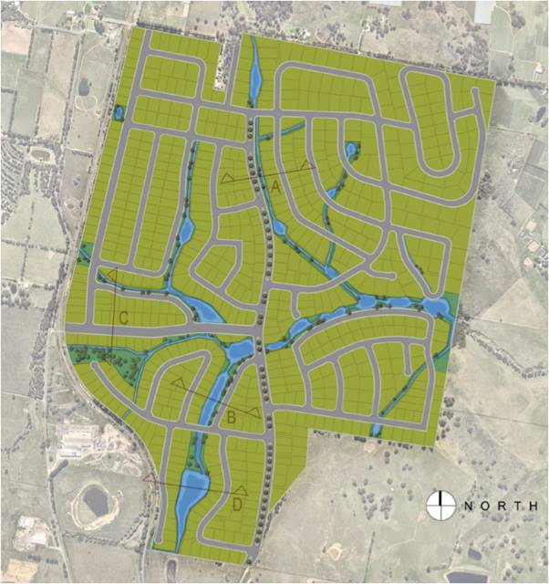 Although the layout supplied
in the Planning Proposal is purely for illustrative purposes staff have
identified a number of concerns and issues that would need to be resolved
during the DCP masterplan process.
Although the layout supplied
in the Planning Proposal is purely for illustrative purposes staff have
identified a number of concerns and issues that would need to be resolved
during the DCP masterplan process.
· A
loop road in the north east corner of the proposal should remove the section of
road adjoining Pearces Lane as it is a duplication and would require removal of
significant remnant vegetation.
· The
road running along the eastern boundary could be redesigned with a better
outcome both in terms of slope and retaining vegetation
· Pedestrian/cyclist
bridges over the creek lines and waterways should be considered as a means of
reducing travel distances for alternative travel modes; particularly where
streets or cul-de-sacs face each other across a section of open space.
· Active transport
connections to and from North Orange and beyond. Clergate Road is already a key
loop for cyclists and can be hazardous given the industrial uses to the south
and current residential traffic. Separate active transport routes need to be
considered given the increased traffic movements (as per the TIA).
· Overall
block lengths between intersections should be capped at 300m to encourage
permeability.
· Irregular shaped
blocks should be minimised, or have appropriate building envelopes nominated.
· Visual privacy
between lots on steeply sloping land needs to be carefully managed and
subdivision design should be amended or supported by a visual impact analysis
to demonstrate that lower lying lots will not be overly monitored by higher
neighbours – 9m separation is not considered sufficient in highly sloping
conditions.
· Additional
information and assessment of lot layouts having regard to existing vegetation
on the property. To this end the future Master Planning for the precinct is to
be accompanied by a detailed landscape assessment showing existing trees, trees
proposed to be removed and an overall landscape concept plan for the
subdivision layout.
Consistency with Regional Plan
The
Central West and Orana Regional Plan 2036 is the NSW Government’s
strategy for guiding land use planning decisions for the Central West and Orana
Region for the next 20 years. At its heart is a core vision for the region
supported by four supporting goals:
o The
most diverse regional economy in NSW
o A
stronger, healthier environment and diverse heritage
o Quality
freight, transport and infrastructure networks
o Dynamic,
vibrant and healthy communities.
The proposal is considered to be
generally consistent with the objectives and actions of the Plan. More detail
is available in Table 1 of section 4.3 of the planning proposal.
Consistency with SEPPs
The Planning Proposal has examined and responded to the
following State Environmental Planning Policies
SEPP 55 – Remediation of Lands
A preliminary site investigation was performed as part of the
previous rezoning of this site (Amendment 13) which found the site was suitable
for residential use. The current proposal relies upon those findings and the
increased yield does not affect those conclusions.
SEPP (Infrastructure) 2007
In recognition of the increased density from Amendment 13 the
current proposal has been supported by a revised Traffic Impact Assessment
(TIA) – refer appendix C of the planning proposal. The revised TIA
found:
· The
development is expected to generate approximately 5,180 vehicle movements per
day, and 546 and 497 vehicle movements (two-way total) in the morning and
evening peak hours respectively;
· Site
traffic will have a minor impact on the surrounding road network, with modest
increases to queue lengths and delays, and the traffic volumes can be
accommodated on the road network in a safe and efficient manner;
· The
access locations allow traffic to be distributed on the road network and they
are not expected to create any operational or safety issues at the nearby
railway level crossings;
· Car
parking for the individual lots is to be provided in accordance with the DCP,
with on-street parking provided for visitors; and
· It
is recommended that future consideration be given to providing sustainable
transport facilities within the site that link with existing bus routes and
shared paths.
On the basis of the above the TIA supported the proposal.
Council engineers have reviewed the TIA and found its assumptions and numbers
to be well founded. Clearly if the proponent is unable to achieve support from
the rail authorities for the level crossing upgrades then a revised TIA would
be required to inform the DCP masterplan exercise.
SEPP (Vegetation in Non Rural Areas) 2017
The Planning Proposal acknowledges the role of the SEPP
in regulating tree removal on smaller residential lots where the Biodiversity
Conservation Act does not apply. The proposal states that a site specific DCP
would be prepared to further address vegetation protection and that on this
basis consistency with the SEPP can be achieved. Staff support this view.
Ministerial Directions
Under section 9.10 of the Environmental Planning and
Assessment Act the Minister can provide directions that must be taken into
account, where relevant, during the preparation of any LEP amendment. In this
respect the Planning Proposal has identified and responded to the following
Ministerial Directions
Direction 2.1 Environmental Protection Zones
The objective of the direction is to protect and conserve environmentally
sensitive areas. Where the direction applies, a relevant planning authority
must ensure that:
(4) A planning proposal must include
provisions that facilitate the protection and conservation of environmentally
sensitive areas.
(5) A planning proposal that applies
to land within an environment protection zone or land otherwise identified for
environment protection purposes in a LEP must not reduce the environmental
protection standards that apply to the land (including by modifying development
standards that apply to the land). This requirement does not apply to a change
to a development standard for minimum lot size for a dwelling in accordance
with clause (5) of Direction 1.5 “Rural Lands”.
Part of the land is currently zoned E4 – Environmental Living which
was created to provide additional protections for remnant vegetation. The lot
size applying to the E4 lands is consistent with the adjoining R5 lands and the
Planning Proposal regards the vegetation SEPP as providing the appropriate
mechanism to safeguard the vegetation.
In the view of staff the more significant areas of remnant / native
vegetation should be either provided in a communal open space managed by the
estate under a community title arrangement or alternatively incorporated within
the yards of larger lots subject to building envelope restrictions. Accordingly
staff agree, subject to the DCP masterplan, that the objective of Direction 2.1
can be satisfied.
Direction 3.1 Residential Zones
The objectives of this direction are:
· to
encourage a variety and choice of housing types to provide for existing and
future housing needs,
· to
make efficient use of existing infrastructure and services and ensure that new
housing has appropriate access to infrastructure and services, and
· to
minimise the impact of residential development on the environment and resource
lands.
Direction 3.1 is applicable where:
(a) an existing or proposed
residential zone (including the alteration of any existing residential zone
boundary),
(b) any other zone in which
significant residential development is permitted or proposed to be permitted.
The Planning Proposal seeks to expand the area of the R5 zone (at the
expense of the E4 and SP2 zones) and will be adequately serviced. Potential
impacts of the residential development on the environment and resource lands
are considered to be minor given the current residential status of the site and
does not reduce the permissible density of the land.
Direction 3.4 Integrating Land Use and Public
Transport
The objectives of this direction are to:
· ensure
that urban structures, building forms, land use locations, development designs,
subdivision and street layouts achieve the following planning objectives:
o improving
access to housing, jobs and services by walking, cycling and public transport,
and increasing the choice of available transport and reducing dependence on
cars, and
o reducing
travel demand including the number of trips generated by development and the
distances travelled, especially by car, and
o supporting the efficient and viable
operation of public transport services, and (e) providing for the efficient
movement of freight.
The indicative concept plan demonstrates that there is
potential to provide interconnected pedestrian and cycle networks that have the
capacity to be linked to the existing networks accessing the Charles Sturt
University Campus and future networks throughout the North Orange residential
areas. Road connections are designed to support public transport (if required).
This would meet the objectives of current transport guidelines and planning
policies, and therefore the proposal is not inconsistent with the direction.
Direction 4.4 Planning for Bushfire Protection
This direction applies when a relevant planning authority
prepares a planning proposal that will affect, or is in proximity to land
mapped as bushfire prone land.
The Site contains a small portion of land identified as
being bushfire prone. This portion of the site was understood to have been
mapped as bushfire prone due to the existence of a stand of pine trees in the
mapped area. These pine trees were cleared by the property owner several years
ago however the bushfire prone land map has not been updated. Given the threat
vegetation has been removed, and the very minor extent of mapped bushfire prone
land, it is not considered likely that the proposal will result in any adverse
impact on future residential development of the land,
Direction 5.10 Implementation of Regional Plans
Direction
5.10 seeks to give legal effect to the vision, land use strategy, goals,
directions and actions contained in Regional Plans.
The
direction applies to land to which a Regional Plan has been released by the
Minister of Planning. The Central West and Orana Regional Plan has been
approved and applies to the Orange LGA.
The
Vision of the Regional Plan is:
A unique part of Western NSW with a diverse economy,
supported by the right infrastructure, an exceptional natural environment and
resilient communities.
The Vision of the Regional Plan is delivered by four key goals and 29
specific directions. Relevant to this planning proposal are a number of goals
and directions, outlined and discussed in Table 1 of the draft planning
proposal.
Direction 6.1 Approval and Referral Requirements
Ministerial Direction
6.1 – Approval and Referral Requirements applies to all planning
proposals forwarded for Gateway Determination by a local authority.
To be compliant with
Direction 6.1, a planning proposal must be consistent with the following
provisions;
“A planning
proposal must:
(a) Minimise the inclusion of provisions
that require the concurrence, consultation or referral of development
applications to a Minister or public authority, and
(b) Not contain provisions requiring
concurrence, consultation or referral of a Minister or public authority unless
the relevant planning authority has obtained the approval of:
(i) The appropriate Minister or
public authority, and
(ii) The Director-General of the
Department of Planning (or an officer of the Department nominated by the
Director-General), prior to undertaking community consultation in satisfaction
of section 57 of the Act, and
(c) Not identify development as
designated development unless the relevant planning authority:
(i) Can satisfy the
Director-General of the Department of Planning (or an officer of the Department
nominated by the Director-General) that the class of development is likely to
have a significant impact on the environment, and
(ii) Has obtained the approval of
the Director-General of the Department of Planning (or an officer of the
Department nominated by the Director-General) prior to undertaking community
consultation in satisfaction of section 57 of the Act”.
The
proposed planning proposal does not generate the need for any explicit
concurrence, consultation or referral to the Minister or public authority and
is therefore consistent with Direction 6.1.
Direction 6.3 Site Specific Provisions
Ministerial
Direction 6.3 – Site Specific Provisions applies to all planning
proposals forwarded for Gateway Determination by a local authority.
To be
compliant with Direction 6.3, a planning proposal must be consistent with the
following provisions:
(a) A planning proposal that would amend
another environmental planning instrument in order to allow a particular
development proposal to be carried out must either:
o Allow that land use to be carried out in the
zone the land is situated on, or
o Rezone the site to an existing zone already
applying in the environmental planning instrument that allows that land use
without imposing any development standards or requirements in addition to those
already contained in that zone, or
o Allow that land use on the relevant land
without imposing any development standards or requirements in addition to those
already contained in the principal environmental planning instrument being
amended.
(b) A planning proposal must not contain
or refer to drawings that show details of the development proposal.
The
planning proposal is consistent with the above.
Conclusion
While the planning proposal as presented is considered to have
merit and may be progressed, several significant issues will require further
work by the proponent to resolve. If submitted to the Department of Planning,
Industry and Environment for a gateway determination there is a distinct
possibility that any determination will require additional studies and
resubmission to the department prior to being allowed to progress to public
exhibition. Notwithstanding this the site is already zoned for up to 450
residential lots and the increase in density to 700 lots is unlikely to raise
entirely new or unresolvable issues. The proponent is aware of the need to
obtain the support of the rail authority and transgrid in order to progress and
that Council is not able to override any objections those authorities may have.
Accordingly, Council may support the proposal at this time on the understanding
that the Gateway process may confirm additional works and potential changes to
project. Should such changes be substantial the matter may need to be reviewed
further and reported back to Council.
Attachments
1 Draft
Planning Proposal - Rosedale Gardens - 250 additional lots, D21/68753⇩
2 Rosedale
Gardens DCP - scope of work required, D21/67523⇩
3 email
between John Holland Rail and proponent - advice on rail crossing upgrades,
D21/68757⇩
4 Central
West Power Construction - Advice on undergrounding the transmission line,
D21/67457⇩
Planning
and Development Committee
2 November 2021
Attachment 1 Draft
Planning Proposal - Rosedale Gardens - 250 additional lots
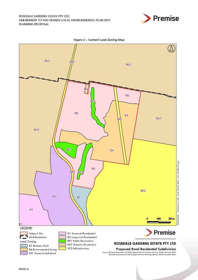
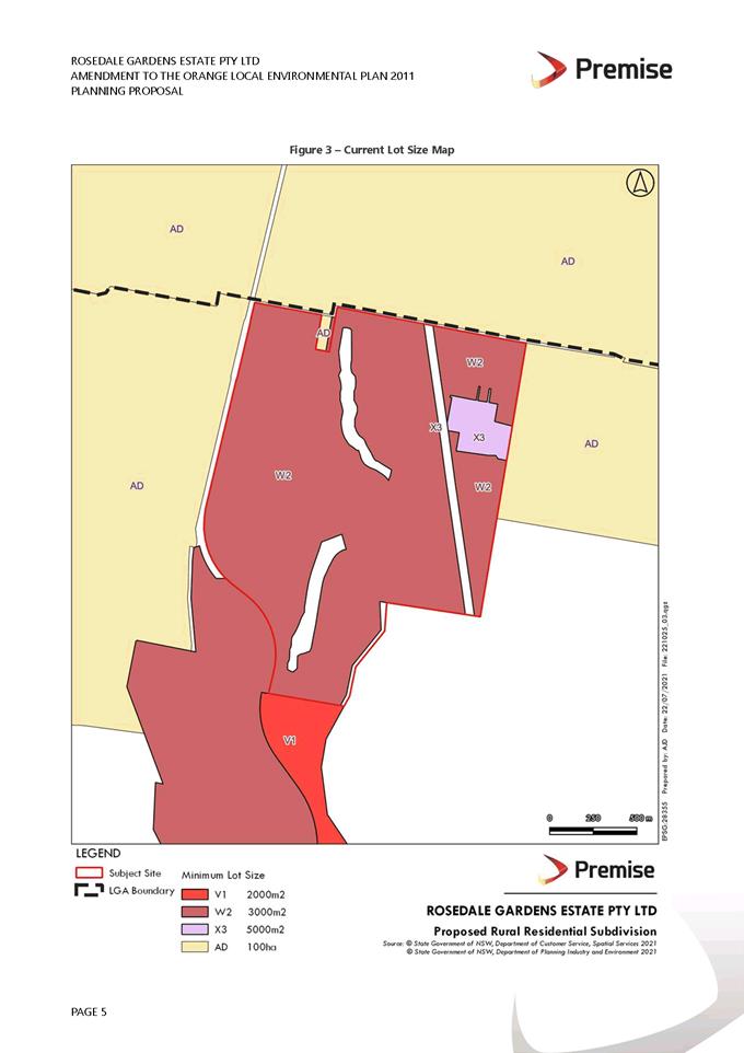
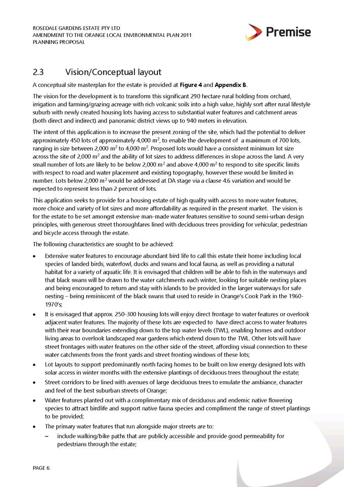
Planning
and Development Committee
2 November 2021
Attachment 2 Rosedale
Gardens DCP - scope of work required
Planning and Development Committee
2 November 2021
Attachment 3 email
between John Holland Rail and proponent - advice on rail crossing upgrades
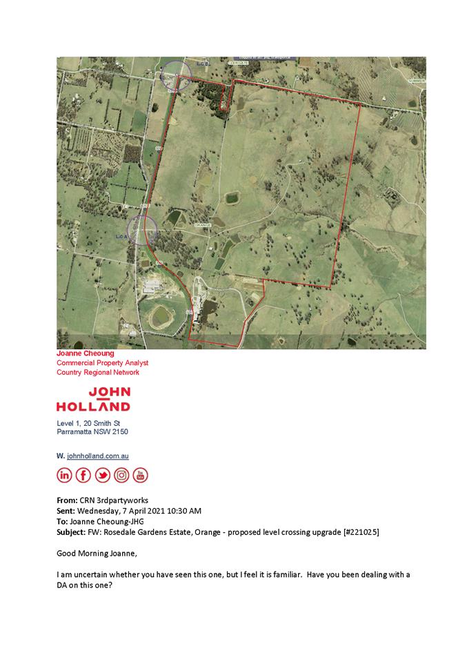
Planning and Development Committee
2 November 2021
Attachment 4 Central
West Power Construction - Advice on undergrounding the transmission line
2.5 Changes
to short-term rental accommodation (STRA) Report/Fact Sheet
RECORD
NUMBER: 2021/2155
AUTHOR: Sophie
Currenti, Student Planner
EXECUTIVE Summary
Earlier this year, the NSW Government announced a new
state-wide policy for short-term rental accommodation (STRA), such as
those provided through Airbnb and Stayz, targeted at providing consistency in
respect of such accommodation across the State. Short-term Rental Accommodation
(STRA) refers to a dwelling used by the ‘host’ to provide
accommodation in the dwelling on a commercial basis for a temporary or
short-term period.
These amendments will allow homeowners to access the benefits
of the sharing economy while providing certainty and safety for communities and
visitors. The proposed changes result in STRA becoming exempt development
provided it meets all requirements of the applicable legislation that was
formally introduced on the 1 November 2021.
The following report provides a brief summary of the
proposed changes and requests Council to consider the number of days in which a
non- hosted dwelling may be used within the City for short term accommodation
in any one given 12 month period.
Link To Delivery/OPerational Plan
The recommendation in this report relates to the
Delivery/Operational Plan strategy “10.1 Preserve - Engage with the
community to ensure plans for growth and development are respectful of our
heritage”.
Financial Implications
Nil
Policy and Governance Implications
Nil
|
Recommendation
1 That
the contents of the report be noted.
2 That
Council permit the opportunity for non-hosted short term rental accommodation
to operate within the City 365 days a year.
|
further considerations
Consideration has been given to the recommendation’s
impact on Council’s service delivery; image and reputation; political;
environmental; health and safety; employees; stakeholders and project
management; and no further implications or risks have been identified.
SUPPORTING INFORMATION
|
CHANGES TO SHORT TERM RENTAL ACCOMMODATION
|
Earlier this year, the NSW Government announced a new
state-wide policy for short-term rental accommodation (STRA), such as
those provided through Airbnb and Stayz, targeted at providing consistency in
respect of such accommodation across the State. Short-term Rental Accommodation
(STRA) refers to a dwelling used by the ‘host’ to provide
accommodation in a dwelling on a commercial basis for a temporary or short-term
period.
These amendments will allow homeowners to access the benefits
of the sharing economy while providing certainty and safety for communities and
visitors. The proposed changes result in STRA becoming exempt development
provided it meets all requirements of the applicable legislation that commenced
on the 1 November 2021.
The new planning framework includes:
1. A new
planning policy for STRA in State Environmental Planning Policy (Affordable
Rental Housing) 2009 (Affordable Rental Housing SEPP), that:
· introduces
a new definition for short-term rental accommodation, hosted STRA and
non-hosted STRA
· introduces
an exempt development approval pathway for hosted and non-hosted STRA,
facilitating:
- hosted
STRA as exempt development in a dwelling, 365 days per year
- non-hosted
STRA as exempt development in a dwelling, 180 days per in Greater Sydney and
nominated regional NSW LGAs, and 365 days per year in all other locations; and
provides an exemption of bookings of 21 consecutive days or more from the 180
day limit on non-hosted STRA.
2. An
amendment to the Environmental Planning and Assessment Regulation 2000
(EP&A Regulation) to:
· introduce
new fire safety standards for dwellings used for STRA and associated penalty
notice offences for non-compliance.
· create
a new Government-run STRA Register that will ensure compliance with the new
fire safety standards, as well track the day limits of each STRA dwelling.
In relation to the matters above please note that day limits
apply for some non-hosted STRA activities, subject to its locality. Hosted STRA
is not restricted by any day limits and can be carried out 365 days per year.
Non-hosted STRA will be restricted to a maximum of 180 days a year in Greater Sydney
and nominated regional councils local government areas (LGA). To date Orange
City Council has not made a decision with respect to the number of days in
which a non-hosted STRA may operate and therefore it currently reverts to 365
days a year.
The definition
for non-hosted STRA, being for not more than 180 days in a 365 day period, is
not fixed to a calendar year may cause a compliance headache for local
Council’s and property owners alike should a limitation on the use be
adopted. It should be noted that where a host is not present (i.e. non-hosted
STRA) and the booking is for 21 or more consecutive days, the booking will not
count towards the above day limits. Under tenancy legislation, a STRA booking
cannot last more than 3 months.
Council’s Tourism Manager has indicated that there
would be no major benefit limiting the number of days in which a non-hosted
dwelling may be used for STRA and could negatively affect our tourism industry.
A review of the Department of Planning Portal for STRA indicates that Orange
currently has over 160 properties registered for short term accommodation. It
is recommended that Council allow non hosted premises be used for short term
overnight accommodation for 365 days a year and let the market determine the
availability and demand for residential accommodation within the City.
STRA can be undertaken in lawfully constructed dwellings
used for the purpose of residential accommodation in all land use zones in
which dwellings are currently permissible. Typical residential accommodation
dwelling types include:
- a
dwelling house (e.g. a detached house)
- an
attached dwelling
- a
dual occupancy
- multi
dwelling housing
- a
residential flat building (e.g. a unit in a block of flats)
- a
secondary dwelling (e.g. a granny flat)
- a
semi-detached dwelling
- shop
top housing.
For clarity, STRA is not
permissible in the following dwelling types:
- a
boarding house
- a
group home
- a
hostel
- a
rural workers’ dwelling
- seniors
housing
- moveable
dwellings
- camping
grounds
- a
caravan park
- an
eco-tourist facility
- refuge
or crisis accommodation
- tourist
and visitor accommodation.
The changes to the legislation require new fire safety
standards be implemented to reduce risks to guests though enhanced early
warning, additional safety measures and education. The EP&A Regulation
prohibits the use of a dwelling for the purposes of STRA unless it complies
with the requirements of the fire safety standard. A fine may be issued for a
breach of this provision. A short term Rental Accommodation Register has been
established on the NSW Planning Portal which is aimed at ensuring compliance
with the new Fire Safety Standard.
The new provisions also introduce a mandatory Code of
Conduct (the Code) which applies to all STRA industry participants, including
online accommodation platforms, letting agents, hosts and guests. The Code
addresses impacts like noise levels, disruptive guests and effects on shared
neighbourhood amenities. The Code of Conduct also includes the requirement
restricting booking platforms from listing STRA properties unless they are
registered on the Department’s STRA Premises Register. Non-compliance with this code can lead to being
placed on the ‘exclusion register.
The exclusion register is managed by NSW Fair Trading, and
there does not appear to be a link between being placed on their
‘exclusion register’ and the STRA Register at this point in time.
However, as this develops, there may be a link between the two registers which
would potentially add to the regulatory burden of councils.
2.6 Development
Application DA 408/2021(1) - 149-153 Summer Street
RECORD
NUMBER: 2021/2368
AUTHOR: Sophie
Currenti, Student Planner
EXECUTIVE
Summary
|
Application
lodged
|
16
September 2021
|
|
Applicant/s
|
Mr J Shiner
|
|
Owner/s
|
Belippi
Pty Limited
|
|
Land
description
|
Lot 10
DP 12353, Lot C DP 89704, Lot 1 DP 996128, Lot 781 DP 11804048 -
149-153 Summer Street, 215-223 Anson Street and 40 Sale Street, Orange
|
|
Proposed
land use
|
Artisan Food and Drink Industry
(brewery and taproom; change of use, minor demolition, construction and
fitout works); Business Identification Signage (wall sign) and alterations to
the public car park.
|
|
Value of
proposed development
|
$580,192
|
Council's consent is sought for
an artisan food and drink industry (brewery and taproom; change of use, minor
demolition, construction and fit out works), business identification signage
(wall sign) and alterations to the public carpark. The proposed artisan food
and drink industry is to be operated by Badlands Brewery, currently operational
at their premises on Mitchell Highway.
The subject tenancy was
previously used for the purposes of a workshop in association with the motor
dealership and has been vacant for a number of years. The building on the land
is a large industrial style building, primarily constructed with masonry walls,
save for a small narrow section of the building in the southeast corner that is
constructed from corrugated iron sheets, and built to the boundary.
The subject lands industrial
roots and unique location in the CBD lends itself well to an artisan food and
drink industry use, also aligning well with the Orange Future City project. The
proposed use is transforming a dilapidated, vacant premises into a unique,
contemporary use, stimulating the CBD.
The brewery will be relatively small in scale, producing
approximately 370lt per day on average. With appropriate hours of operation for
both the brewery and taproom, the likely impacts associated with the
development have been assessed and are considered acceptable.
Servicing (loading/unloading) arrangements for the brewery
will occur via the proposed loading zone within the Sale Street carpark. The
proposal seeks approval for an alteration to the internal configuration of the
Council car park to facilitate a loading bay, pedestrian access and bicycle
parking area. Access to the rear of the brewery will be provided by the
driveway on the adjoining land to the north of the site. The subject land
benefits from a right of way over the adjoining land. The loading zone would be
available for use by all nearby commercial businesses. The area of the carpark
where the loading zone is proposed, despite having some lined marked car
parking spaces, is not formally recognised as parking spaces within the
approved design of the carpark layout at this time.
Notable planning matters for
this application include car parking requirements associated with the new use;
changes to the layout of the Council car park; amenity impacts by reason of
noise and odour emissions; and the contribution that the development makes to
the emerging food and drink industries within the City.
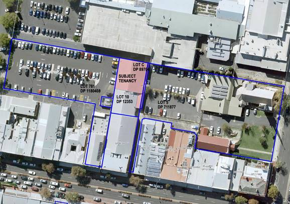 \
\
Figure 1 - locality plan
DECISION FRAMEWORK
Development in Orange is governed by two key documents
Orange Local Environment Plan 2011 and Orange Development Control Plan 2004. In
addition the Infill Guidelines are used to guide development, particularly in
the heritage conservation areas and around heritage items.
Orange Local Environment Plan 2011
– The provisions of the LEP must be considered by the Council in
determining the application. LEPs govern the types of development that are
permissible or prohibited in different parts of the City and also provide some
assessment criteria in specific circumstances. Uses are either permissible or
not. The objectives of each zoning and indeed the aims of the LEP itself are
also to be considered and can be used to guide decision making around
appropriateness of development.
Orange Development Control Plan 2004 – the DCP
provides guidelines for development. In general it is a performance based
document rather than prescriptive in nature. For each planning element there
are often guidelines used. These guidelines indicate ways of achieving the
planning outcomes. It is thus recognised that there may also be other solutions
of merit. All design solutions are considered on merit by planning and building
staff. Applications should clearly demonstrate how the planning outcomes are
being met where alternative design solutions are proposed. The DCP enables
developers and architects to use design to achieve the planning outcomes in
alternative ways.
DIRECTOR’S COMMENT
Council's consent is sought for
an artisan food and drink industry (brewery and taproom; change of use, minor
demolition, construction and fit out works), and business identification
signage (wall sign). The development will positively contribute and strengthen
the City’s reputation as a regional tourist destination. The subject
building has been vacant for a number of years.
It is considered that the
identified impacts associated with the development can be suitably managed and
have been addressed through recommended conditions of consent. The proposed
changes to the Council car park to facilitate a loading bay, secondary access
to the building, bicycle parking area is supported. The use of the undeveloped
portion of the Council Carpark for access and also to provide a delivery area
(that can be used by others) is not dissimilar to that in other Council
carparks, including Woolworths and McNamarra Street. The implementation
of these changes to the car park layout will benefit other business, who may
also use the area and also will rejuvenate a large vacant industrial style
building in the CBD.
It is recommended that Council
supports the application subject to the adoption of the recommended Notice of
Determination.
Link To Delivery/OPerational Plan
The recommendation in this report relates to the
Delivery/Operational Plan strategy “10.1 Preserve - Engage with the
community to ensure plans for growth and development are respectful of our
heritage”.
Financial Implications
Nil
Policy and Governance Implications
Nil
|
Recommendation
That Council consents to
development application DA 408/2021(1)
for Artisan Food and Drink Industry (brewery and taproom; change of use,
minor demolition, construction and fitout works); Business Identification
Signage (wall sign) at Lot 10 DP 12353, Lot C DP 89704, Lot 1 DP
996128, Lot 781 DP 11804048 149-153 Summer Street, 215-223 Anson Street and
40 Sale Street, Orange pursuant to the conditions
of consent in the attached Notice of Approval.
|
further considerations
Consideration has been given to the recommendation’s
impact on Council’s service delivery; image and reputation; political;
environmental; health and safety; employees; stakeholders and project
management; and no further implications or risks have been identified.
SUPPORTING INFORMATION
THE SITE
The site is a unique parcel of
commercial land. It is effectively land locked with access dependent on
historic rights of way. The land joins a laneway in the southeast corner that
runs between the subject land and the adjoining property to the east and
connect with the northern side of Summer Street. The laneway is part of the
Orange Uniting Church land which is also the carpark that abuts the subject
tenancy to the east. The Orange Ex-Services’ Club is located to the north
with the egress road of the multi-storey carpark running along the northern
boundary. This egress road is burdened by a 6m wide right of way which is in
favour of the subject land of this application (also favours Council’s
Sale Street carpark of which is to the west of the site). To the south of the
subject tenancy, there is the adjoining tenancy located on Lot 10 and beyond
that tenancy, there are two storey commercial shops facing Summer Street.
THE PROPOSAL
The proposal involves a change of use of the building (see
plans attached) at Lot 10 DP 12353, Lot C DP 89704, Lot 1 DP 996128 and Lot 781
DP 11804048 known as 149-153 Summer Street, 215-223 Anson Street and 40 Sale
Street, Orange to facilitate an artisan food and drink industry (brewery and
taproom; minor demolition, construction and fit out works), and business
identification signage (wall sign) and changes to the public car park. The
proposal has been outlined under each component below.
1. Demolition
It is proposed to demolish the existing toilet (south-west
corner) and the lean-to in the south-eastern corner of the site that connects
with the laneway to Summer Street. It is also proposed to remove a portion of
roof sheeting and replace it with polycarbonate sheeting for natural light over
the taproom. The extent of demolition is shown in the provided demolition plan.
2. Construction/Fit Out
The construction/ fit-out works will involve:
· new wet floor in
brewhouse and associated drainage
· construction of
mezzanine level
· construction of
central cool room
· new BCA compliant
recessed PA door, northern elevation
· assembly of
brewhouse equipment (relocated from existing Badlands Brewery on the Mitchell
Highway)
· new western access
with accessible ramp and amenities
· bar and
retail/tasting area within the taproom
· construction of
masonry blade wall along the eastern boundary for fire separation
· fire-rated infill
to portion off south facing gable end
· new polycarbonate
roof sheeting over a portion of the taproom
· new light-weight
steel structure at southern entrance
· resurfacing
laneway from Summer Street
· adjustment to the
Sale Street carpark to provide new public loading zone and bicycle parking
· installation of
steam vent; and
· painted wall
signage (western elevation).
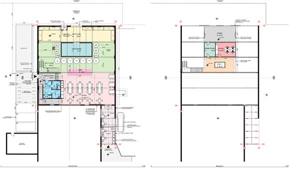
Figure 2 – ground floor plan and mezzanine floor
plan
3. Artisan Food and Drink
Industry
The artisan food and drink industry will comprise a brewery
with:
· dry floor area
with pallet racking for storage and handling of raw materials, packaging, waste
storage and oxygen and carbon dioxide storage
· brewhouse/wet
floor area comprising the brewing equipment
· central cool room.
Above the brewery will be a mezzanine level with storage
area accessible by forklift from the dry floor below, grain store, office and
staff room. The mezzanine will be accessible by stairs located in the southwest
corner of the wet floor.
A central bar will divide the brewery space from the
public/retail and tasting area (the taproom). In addition to the bar area,
the retail sales and tasting area will include tables, retail beer fridges and
amenities.
The southern entrance will comprise an open roofed structure
with tables. The entrance to the retail area will be provided via the laneway
from Summer Street and a new entrance in the western elevation will be provided
via the Sale Street carpark. There is a change in level between the carpark and
internal floor area of the retail space which will be addressed via the
installation of an accessible ramp.
LOADING/UNLOADING
The proposal seeks approval for alterations to the layout of
the Council car park to facilitate a loading bay, bicycle parking area and a
secondary pedestrian access. The loading zone would be available for use by all
nearby commercial businesses.
The loading/unloading for the brewery will occur from the
proposed loading zone and into the rear (northern elevation) of the brewery
through the existing large roller door via the Orange Ex-Services' Club land
which the subject tenancy benefits from a right of way over. A management plan
for the use of the loading bay has been submitted in support of the
application.
STAFFING
Badlands Brewery existing operations employ 4 full time
equivalent (FTE) staff. It is expected that the same number of staff will be
required for this development. The taproom will employ 3 to 6 (FTE)
additional/new staff.
HOURS OF OPERATION
The typical hours of operation are to be as follows:
Brewery
Badlands Brewery currently operate Monday to Friday 6am-6pm.
Initially, these arrangements will continue for this development. However, in
the long term, there is the potential for an increase in production to Monday
to Saturday 6am-9pm. The applicant has requested that any condition imposed on
hours of operation are to be Monday to Saturday 6am-9pm. With the justification
that this would allow for occasional production increases to meet demand/larger
orders in the immediate term, as well as the flexibility to increase production
levels over time.
Retail/Bar
Bar/Tastings (taproom)
The typical hours of operation for the taproom will be:
- Wednesday
to Saturday (inclusive) - 10am–midnight.
- Sundays
- 10am–10pm.
- Public
holidays (that fall on Monday, Tuesday or Wednesday) - 10am–midnight.
- Occasional
private functions/events (Monday-Wednesday - 10am–midnight.
FOOD TRUCKS
Separate approval will be sought
for a local food truck to be parked in the adjoining Uniting Church carpark
under a separate arrangement with the church on Fridays and Saturdays. Formal
details of this arrangement are still being negotiated. The arrangement within
the design allows for a food truck to park directly in line with the east
facing gate under the southern entrance pergola. It is envisaged that customers
will simply go up to the food truck, order, pay and collect their food to
consume at a table within the taproom (at all times staying within the brewery
site - standing in the outside section).
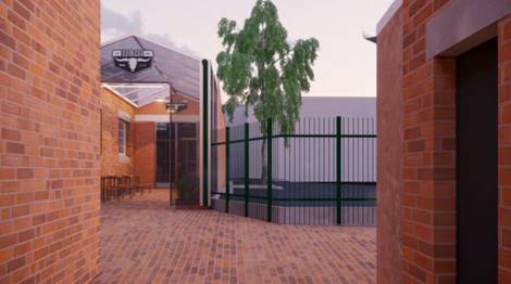
Figure 3 – render of proposed southern entrance
(looking from the end of laneway)
4. Business
Identification Signage
A traditional-style painted wall
sign displaying the Badlands Brewery logo and description of the business
carried on “BREWERY & TAPROOM” is proposed to be applied to the
western elevation of the tenancy.
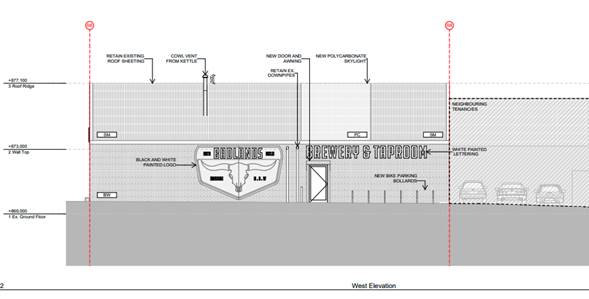
Figure 4 – proposed business identification signage
(western elevation)
MATTERS FOR CONSIDERATION
Section 1.7 - Application of
Part 7 of the Biodiversity Conservation Act 2016 and Part 7A of the
Fisheries Management Act 1994
Section 1.7 of the EP&A Act identifies that Part 7 of
the Biodiversity Conservation Act 2016 (BC Act) and Part 7A of the
Fisheries Management Act 1994 have effect in connection with terrestrial and
aquatic environments.
There are four triggers known to insert a development into
the Biodiversity Offset Scheme (ie the need for a BDAR to be submitted
with a DA):
· Trigger 1:
development occurs in land mapped on the Biodiversity Values Map (OEH)
(clause 7.1 of BC Regulation 2017);
· Trigger 2:
development involves clearing/disturbance of native vegetation above a certain
area threshold (clauses 7.1 and 7.2 of BC Regulation 2017); or
· Trigger 3:
development is otherwise likely to significantly affect threatened species
(clauses 7.2 and 7.3 of BC Act 2016).
The fourth trigger (development proposed to occur in an Area
of Outstanding Biodiversity Value (clause 7.2 of BC Act 2016) is generally not
applicable to the Orange LGA; as no such areas are known to occur in the LGA.
No further comments will be made against the fourth trigger.
SUMMARY
The site does not occur within land mapped on the
Biodiversity Values Map and no clearing/disturbance is proposed. As the
proposal does not trigger any of the four requirements for insertion into the
BOS, a Biodiversity Development Assessment Report is not required to be lodged
with the application for development consent. No other comments are warranted
under this section.
Section 4.15
Section 4.15 of the Environmental Planning and Assessment
Act 1979 requires Council to consider various matters, of which those
pertaining to the application are listed below.
PROVISIONS OF ANY ENVIRONMENTAL
PLANNING INSTRUMENT s4.15(1)(a)(i)
Orange Local Environmental Plan 2011
Part 1 - Preliminary
Clause 1.2 - Aims of Plan
The
broad aims of the LEP are set out under Subclause 2. Those relevant to the
application are as follows:
(a) to encourage development which complements
and enhances the unique character of Orange as a major regional centre boasting
a diverse economy and offering an attractive regional lifestyle,
(b) to provide for a range of development
opportunities that contribute to the social, economic and environmental
resources of Orange in a way that allows present and future generations to meet
their needs by implementing the principles for ecologically sustainable
development,
(f) to recognise and manage valued
environmental heritage, landscape and scenic features of Orange.
It is considered that the proposal will complement and
enhance the unique character of Orange and offer further choice for residents
and visitors to the City and reinforce Orange as an important regional tourist
destination. The application is considered to be consistent with the applicable
aims of the LEP.
Clause 1.6 - Consent Authority
This clause establishes that, subject to the Act, Council is
the consent authority for applications made under the LEP.
Clause 1.7 - Mapping
The subject site is identified
on the LEP maps in the following manner:
|
Land Zoning Map:
|
Land zoned B3 Commercial Core
|
|
Lot Size Map:
|
No Minimum Lot Size
|
|
Heritage Map:
|
Within heritage conservation area
(and laneway forms part of land that is identified as heritage item)
|
|
Height of Buildings Map:
|
Building height limit 12m
|
|
Floor Space Ratio Map:
|
Floor space limit 1.5:1
|
|
Terrestrial Biodiversity Map:
|
No biodiversity sensitivity on the
site
|
|
Groundwater Vulnerability Map:
|
Groundwater vulnerable
|
|
Drinking Water Catchment Map:
|
Not within the drinking water
catchment
|
|
Watercourse Map:
|
Not within or affecting a defined
watercourse
|
|
Urban Release Area Map:
|
Not within an urban release area
|
|
Obstacle Limitation Surface Map:
|
No restriction on building siting
or construction
|
|
Additional Permitted Uses Map:
|
No additional permitted use applies
|
|
Flood Planning Map:
|
Within a flood planning area - PMF
|
Those matters that are of relevance are addressed in detail
in the body of this report.
Clause 1.9A - Suspension of Covenants,
Agreements and Instruments
This clause provides that covenants, agreements and other
instruments which seek to restrict the carrying out of development do not apply
with the following exceptions.
(a) to
a covenant imposed by the Council or that the Council requires to be imposed,
or
(b) to
any relevant instrument under Section 13.4 of the Crown Land Management Act
2016, or
(c) to
any conservation agreement under the National Parks and Wildlife Act 1974, or
(d) to
any Trust agreement under the Nature Conservation Trust Act 2001, or
(e) to
any property vegetation plan under the Native Vegetation Act 2003, or
(f) to
any biobanking agreement under Part 7A of the Threatened Species Conservation
Act 1995, or
(g) to
any planning agreement under Subdivision 2 of Division 7.1 of the Environmental
Planning and Assessment Act 1979.
The subject land and adjoining land comprise a complex
arrangement of easements and rights of way as shown on the accompanying
detailed site survey plan. The subject land benefits from numerous rights of
way over the laneway from Summer Street which is part of the adjoining Orange
Uniting Church land. These include:
· right of way
denoted (x) on the attached survey (BK 2479 No. 28)
· right of footway
and carriage way (BK 2341 No. 148); and
· right of footway
and carriage way (BK 2377 No. 418).
The subject land also benefits from a
right of way denoted (J) 6m wide (DP 638356) over the adjoining land to the
north, relating to the driveway of the Orange Ex-Services Club’s multi‑storey
carpark. The land is burdened by an easement for underground electricity 1m
wide (DP 585282). This easement runs along the southern wall of the adjoining
tenancy. The proposed development has been designed having regard to these
restrictions.
Part 2 - Permitted or Prohibited Development
Clause 2.1 - Land Use Zones and Clause 2.3 - Zone
Objectives and Land Use Table
The subject site is located within
the B3 Commercial Core zone. The principal
purpose of the development is defined as an ‘artisan food and drink
industry’, business identification signage and demolition under OLEP
2011 and is permitted with consent for this zone. Alterations to the public car
park are also permissible subject to receiving consent.
An artisan food and drink industry
is defined as:
a building or place the
principal of which is the making or manufacture of boutique, artisan or craft
food or drink products only. It must also include at least one of the following
-
(a) a
retail area for the sale of the products,
(b) a
restaurant or cafe,
(c) facilities
for holding tastings, tours or workshops.
The proposed development involves the manufacture of craft
beer with the establishment of a brewery. The development also includes a
retail area for the sale and onsite tasting of the craft beer made on the
premises. The development therefore achieves the requirements of the
definition.
Clause
2.3 of LEP 2011 references the Land Use
Table and Objectives for each zone in LEP 2011. These objectives
for land zoned B3 Commercial Core are as follows:
1 -
Objectives of the B3 Commercial Core Zone
· To provide
a wide range of retail, business, office, entertainment, community and other
suitable land uses that serve the needs of the local and wider community.
· To encourage
appropriate employment opportunities in accessible locations.
· To maximise
public transport patronage and encourage walking and cycling.
· To promote
development that contributes to the role of the Orange CBD as the primary
retail and business centre in the City and region.
The development is considered to
be consistent as the proposed land-use provides retail, hospitality and tourism
uses in the CBD along with an appropriate and compatible small‑scale
light industrial use. The development will provide opportunities for employment
within the hospitality sector with the introduction of taproom/retail portion
of the proposal directly creating 3-6 full time equivalent jobs. The central
CBD location will allow for good connections with public transport with two bus
stops located within 185m of the site and the site is in close proximity to the
taxi rank in Anson Street. Also, as part of the project, the applicant is
providing bicycle parking adjacent to the western wall of the subject tenancy
within the Council car park. This bicycle parking will be publicly available
and is consistent with Council’s Active Travel Plan. The style and
materials used for the area of bicycle parking will be consistent with
Council’s Future City program.
The proposed development will
further strengthen the primacy role of the CBD whilst providing an appropriate
re-use of an underutilised commercial building and at the same time adding to
the existing list of hospitality and tourism offerings in the CBD.
Clause 2.7 - Demolition
Requires Development Consent
This clause triggers the need for development consent in
relation to a building or work. The proposal involves demolition and the
applicant is seeking the consent of Council. The demolition works proposed
will have no significant impact on adjoining lands, streetscape or public
realm. Conditions may be imposed in respect of hours of operation, dust
suppression and the need to investigate for, and appropriate manage the
presence of, any materials containing asbestos.
Part 3 - Exempt and Complying Development
The application is not exempt or complying development.
Part 4 - Principal Development Standards
Clause
4.3 - Height of Buildings
This
clause limits the height of buildings (HoB) on land identified on the Height of
Buildings Map. The subject land is identified on the Map as having a HoB
limit of 12m. The only new external built form
relates to the southern entrance pergola and the steam vent which is attached
to the kettle within the brewhouse. The new pergola structure sits well below
the ridgeline of the existing building and will be approximately 4m in height.
The steam vent extends 500mm above the ridge line of the building. As noted in
the definition of height of building, the steam vent would be excluded.
Notwithstanding,
as observed on the attached plans, the vent as well as the pergola structure
are well below the 12m height control.
Clause 4.4 - Floor Space Ratio
The
subject land is identified on the Map as having an FSR of 1.5:1. The
site (Lot 10 DP 12353 and Lot C DP 89704) area has been calculated
under Clause 4.5 as 860.8m2, meaning the site may have up to 1291.2m2
of floor space. The two buildings/tenancies on the land have a combined gross
floor area of 841m2. This means there is an additional 450.2m2
of floor area available within the site. The proposed development includes
additional floor area as part of the mezzanine level. The mezzanine has a floor area of 110.51m2. The site, as a result of the
proposed development, will comprise an FSR of 1.1:1. The development is
therefore below the applicable development standard.
Part 5 - Miscellaneous Provisions
5.10 - Heritage
Conservation
(1) Objectives
The objectives of this clause are
as follows:
(a) to
conserve the environmental heritage of Orange,
(b) to
conserve the heritage significance of heritage items and heritage conservation
areas, including associated fabric, settings and views,
(c) to
conserve archaeological sites,
(d) to
conserve Aboriginal objects and Aboriginal places of heritage significance.
(4) Effect
of Proposed Development on Heritage Significance
The consent authority must,
before granting consent under this clause in respect of a heritage item or
heritage conservation area, consider the effect of the proposed development on
the heritage significance of the item or area concerned. This subclause applies
regardless of whether a heritage management document is prepared under
Subclause (5) or a heritage conservation management plan is submitted under
Subclause (6).
The subject building is located
within the central heritage conservation area and is adjacent to the Orange
Uniting Church which is a local heritage item. It is noted that the laneway
that forms part of the application is listed as a heritage item in Schedule 5;
the laneway, however, is excluded from the heritage maps.
A heritage impact assessment was
provided by the applicant comprising sufficient justification that the proposal
will have an acceptable level of impact upon the HCA and adjoining heritage
items.
The existing building will
remain largely unchanged and intact as part of the development. The industrial
use proposed under this application will be consistent with the historic
industrial origins of the site as a repair workshop, and the traditional
painted wall sign is appropriate for the heritage setting.
Given the minor changes to the
exterior of the building, in addition to its spatial context being surrounded
on three sides by car parking, and situated behind a row of two storey
commercial buildings in Summer Street, there are no aspects of the development
that would give rise to unsatisfactory impacts to either the conservation area
or adjoining heritage items. The development is considered acceptable as to
having little to no impact upon the significance of the Central Heritage
Conservation Area and adjoining heritage items.
Part 6 - Urban Release Area
Not relevant to the application. The subject site is not
located in an Urban Release Area.
Part 7 - Additional Local Provisions
7.2a
– Floodplain Risk Management
This clause applies to land identified on the probable
maximum flood mapping as a Flood Planning Area and requires that,
before any consent is issued, Council must be satisfied that the proposal:
(1) The objectives of this clause
are as follows -
(a) to enable evacuation of land
subject to flooding in events exceeding the flood planning level,
(b) to protect the operational
capacity of emergency response facilities and critical infrastructure during
extreme flood events.
(2) This clause applies to land
between the flood planning level and the level of the probable maximum flood,
but does not apply to land at or below the flood planning level.
(3) Development
consent must not be granted to development for the following purposes on land
to which this clause applies unless the consent authority is satisfied that the
development will not, in flood events exceeding the flood planning level,
affect the safe occupation of, and evacuation from, the land -
(o) industries,
The development is considered to not, in flood events
exceeding the flood planning level, affect the safe occupation of, and
evacuation from, the changed land use of an artisan food and drink premises.
The proposed development will not change flooding regimes on or off the
site and would not contribute to erosion, siltation or reduce riparian
vegetation, and is therefore unlikely to create a
cost burden on the community or neighbours.
7.6
- Groundwater Vulnerability
This
clause seeks to protect hydrological functions of groundwater systems and
protect resources from both depletion and contamination. Orange has a high water
table and large areas of the LGA, including the subject site, are identified
with “Groundwater Vulnerability” on the Groundwater Vulnerability
Map. This requires that Council consider:
(a) whether or not the development (including
any onsite storage or disposal of solid or liquid waste and chemicals) is
likely to cause any groundwater contamination or have any adverse effect on
groundwater dependent ecosystems, and
(b) the cumulative impact (including the
impact on nearby groundwater extraction for potable water supply or stock water
supply) of the development and any other existing development on groundwater.
Furthermore, consent may not be granted unless Council is satisfied that:
(a) the development is designed, sited and
will be managed to avoid any significant adverse environmental impact, or
(b) if that impact cannot be reasonably
avoided - the development is designed, sited and will be managed to minimise
that impact,
(c) if that impact cannot be minimised - the
development will be managed to mitigate that impact.
The proposal
is not anticipated to involve the discharge of toxic or noxious substances and
is therefore unlikely to contaminate the groundwater or related ecosystems.
The development does not involve the discharge
of any toxic waste materials nor will it require groundwater. It is noted that
a Trade Waste Agreement with Council will be required. As such, the development
is consistent with the above-referenced clause.
Clause 7.11 - Essential Services
Clause 7.11 applies and states:
Development consent must not be granted to development
unless the consent authority is satisfied that any of the following services
that are essential for the proposed development are available or that adequate
arrangements have been made to make them available when required:
(a) the supply of water,
(b) the supply of electricity,
(c) the disposal and management of
sewage,
(d) storm water drainage or on-site
conservation,
(e) suitable road access.
In consideration of this clause, all utility services are
available to the land and adequate for the proposal.
In relation to (a) water supply and (c) sewage disposal, the
beer production will use the existing sites 1 ET credit for water.
Council’s Technical Services Department advise that due to the increased
activity of an artisan food and drink premises, the applicant is to be charged
1.27 ETs for water supply headworks and 0.27 ETs for sewerage headworks. All
other services are available to the subject premises. Conditions are included
on the attached Notice of Approval to address the above matters.
STATE ENVIRONMENTAL PLANNING
POLICIES
State Environmental Planning Policy 55 Remediation of
Land
State Environmental Planning Policy 55 - Remediation of
Land (SEPP 55) is applicable. Pursuant to Clause 7 Contamination and
remediation to be considered in determining development application:
(1) A consent
authority must not consent to the carrying out of any development on land
unless:
(a) it has considered whether the
land is contaminated, and
(b) if the land is contaminated, it
is satisfied that the land is suitable in its contaminated state (or will be
suitable, after remediation) for the purpose for which the development is
proposed to be carried out, and
(c) if the land requires
remediation to be made suitable for the purpose for which the development is
proposed to be carried out, it is satisfied that the land will be remediated
before the land is used for that purpose.
The subject tenancy comprises a concrete slab floor that is
in intact and good condition for its age. There are no obvious signs of
contamination, other than a small area of oil staining that is not of a size or
extent that would warrant further investigation. There are no bunded areas that
would indicate a chemical storage area and there are no pits or other below
ground areas. Given the intact concrete slab floor, any oil spills or the like
that may have occurred as part of the previous historic use would have been
contained by the concrete slab and would not have become mobile in the soil
below the slab.
In regard to Clause 7, the subject land is not considered to
be contaminated. The previous use dating back to E.C. Cameron’s as a
workshop relating to the motor dealership is not considered a contaminating use
as listed in the contamination guidelines. Moreover, the new use is not a
sensitive use listed in Subclause 4, but rather retains an industrial and
commercial use for the site.
In any event, a new wet floor will be installed over the top
of the existing slab for part of the brewery that will effectively cap the
small area of oil stained concrete.
A small amount of ground penetration
beyond the slab will be required for drainage works as part of the construction
of the wet floor. Council’s standard precautionary principle relating to
unexpected finds will be added as a condition of consent.
Given the foregoing assessment, the site is not considered
to be contaminated a preliminary site investigation is not considered necessary
for the development.
State Environmental Planning
Policy No 33 – Hazardous and Offensive Development
State Environmental Planning Policy No 33 –
Hazardous and Offensive Development manages developments that involve the
storage of hazardous or offensive products that may cause harm to human health
or the environment. The assessment relates to products and materials classed as
dangerous goods under the Australian Dangerous Goods (ADG) Register.
The processes involved with the brewery necessitate the use,
and thus the storage of CO2 and (compressed) O2. The
development involves the storage of the following:
- CO2
– 6 ‘G’ sized cylinders totalling 186kg – ADG
code 2.2
- Compressed
O2 – 2 ‘G’ sized O2 cylinders (8.0m3)
– ADG code 2.2 and 5.1.
With reference to ‘Applying SEPP 33 Guideline’
ADG class 2.2 products are excluded from the SEPP. In relation to Class 5.1
goods, the threshold under table 3 is 5 tonnes. Accordingly, the development
will not exceed any thresholds under SEPP 33 and as such, the SEPP does not
apply to the development and subsequently a Preliminary Hazard Analysis is not
required.
State Environmental Planning Policy 64 - Advertising and
Signage
State Environmental Planning Policy 64 - Advertising and
Signage (SEPP 64) is applicable and states in part:
3 Aims,
Objectives etc
(1) This
Policy aims:
(a) to
ensure that signage (including advertising):
(i) is
compatible with the desired amenity and visual character of an area, and
(ii) provides
effective communication in suitable locations, and
(iii) is
of high quality design and finish, and
(8) Granting
of Consent to Signage
A consent authority must not
grant development consent to an application to display signage unless the
consent authority is satisfied:
(a) that
the signage is consistent with the objectives of this Policy as set out in
Clause 3 (1) (a), and
(b) that
the signage the subject of the application satisfies the assessment criteria
specified in Schedule 1.
The application seeks consent for business identification
signage as a painted wall sign to be applied to the western elevation
addressing the car park. Other signage is proposed at the southern entry of the
brewery and taproom, however, this will not be visible from a public place and
as such does not require consent.
The proposed business identification signage will display
Badlands’ logo and the wordmark: BREWERY & TAPROOM. The proposed
signage is as per below.
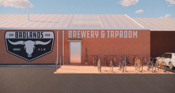
Figure 5 – proposed signage (Sale Street
carpark)
The proposed signage will be a
traditional painted wall sign which is considered appropriate for the heritage
setting. In addition to this, the following assessment against the
Schedule 1 – assessment criteria is provided below.
1 -
Character of the Area
· Is
the proposal compatible with the existing or desired future character of the
area or locality in which it is proposed to be located?
· Is
the proposal consistent with a particular theme for outdoor advertising in the
area or locality?
In respect to the above, there is no distinct theme of
signage in the immediate locality. Notwithstanding this, the proposed painted
wall sign is a traditional style of advertising in a heritage conservation
area, and particularly so given the proposed use for beverage manufacturing.
Large bold painted wall signs have been the typical signage style for such
manufacturers over time, and this proposal seeks to pay homage to, and
continue, that traditional style. The signage is thus appropriate for the
character of the area.
2 - Special Areas
· Does the
proposal detract from the amenity or visual quality of any environmentally
sensitive areas, heritage areas, natural or other conservation areas, open
space areas, waterways, rural landscapes or residential areas?
The subject land is located in the heritage conservation
area and as such, all signage is limited to business identification signage.
The proposed signage is considered to be consistent with the above criterion.
3 - Views and Vistas
· Does the
proposal obscure or compromise important views?
· Does the
proposal dominate the skyline and reduce the quality of vistas?
· Does the
proposal respect the viewing rights of other advertisers?
In respect to views and vistas within the locality, the
proposed signage is a painted wall sign and as such will not impact upon views
or protrude above a building, nor will the proposed signage impinge on the
viewing rights of other signage in the locality.
4 - Streetscape, Setting or Landscape
· Is the scale,
proportion and form of the proposal appropriate for the streetscape, setting or
landscape?
· Does the
proposal contribute to the visual interest of the streetscape, setting or
landscape?
· Does the
proposal reduce clutter by rationalising and simplifying existing advertising?
· Does the
proposal screen unsightliness?
· Does the
proposal protrude above buildings, structures or tree canopies in the area or
locality?
· Does the
proposal require ongoing vegetation management?
The proposed signage will have an appropriate level of
streetscape compatibility, noting that the subject building is set well back
from Sale Street. The proposed signage adds visual interest and partly screens
what is currently a blank brick wall with inconsistent brickwork, bricked-up
former doorways, exposed pipes, etc. The proposed signage will be well inside
the envelope of the building and does not protrude above any structures or
trees.
5 - Site and Building
· Is the proposal
compatible with the scale, proportion and other characteristics of the site or
building, or both, on which the proposed signage is to be located?
· Does the
proposal respect important features of the site or building, or both?
· Does the
proposal show innovation and imagination in its relationship to the site or
building, or both?
The proposed signage is appropriately proportioned for the
building. Given the style of signage being ‘super-graphic’
traditional painted wall sign, the proportions of the signage and the logo in
particular are consistent with this style of traditional heritage signage.
6 - Associated Devices and Logos with Advertisements and
Advertising Structures
· Have any safety
devices, platforms, lighting devices or logos been designed as an integral part
of the signage or structure on which it is to be displayed?
Not applicable to this proposal.
7 - Illumination
· Would
illumination result in unacceptable glare?
· Would
illumination affect safety for pedestrians, vehicles or aircraft?
· Would
illumination detract from the amenity of any residence or other form of
accommodation?
· Can the
intensity of the illumination be adjusted, if necessary?
· Is the
illumination subject to a curfew?
The proposed signage is not proposed to be illuminated,
however, the western entrance will be illuminated for security and safety
purposes. Given the site's context and the separation distance from sensitive
receivers, illumination would not be considered a problem.
8 - Safety
· Would the
proposal reduce the safety for any public road?
· Would the
proposal reduce the safety for pedestrians or bicyclists?
· Would the
proposal reduce the safety for pedestrians, particularly children, by obscuring
sightlines from public areas?
The proposed signage will not give rise to any safety
concerns. Given the foregoing assessment, the proposed business identification
signage in the traditional painted style is appropriate for the proposed use
and appropriate in the heritage setting.
PROVISIONS OF ANY DRAFT
ENVIRONMENTAL PLANNING INSTRUMENT THAT HAS BEEN PLACED ON EXHIBITION
4.15(1)(a)(ii)
Draft Orange Local
Environmental Plan 2011 (Amendment 28) – Heritage Amendment
Draft Orange LEP 2011
(Amendment 28) involves new heritage conservation areas; expansion to existing
heritage conservation areas; and new heritage items. The Draft Plan has no
effect for the proposed development.
Draft Orange Local Environmental Plan 2011 (Amendment 29)
– Park and Rifle Range Roads, Shiralee
Draft Orange LEP 2011
(Amendment 29) relates to the rezoning and amendment of minimum lot size for
various sites at Park and Rifle Range Roads, Shiralee. The Draft Plan has no
affect for the proposed development.
Draft Remediation of Land
State Environmental Planning Policy
Draft Remediation of Land
SEPP has been publicly exhibited. The Draft SEPP will repeal and replace SEPP
55 Remediation of Land. Of particular note, the Draft SEPP requires consideration
of the contamination status of nearby and neighbouring properties, and its
impact on the proposed use. Commercial land adjoining the site is not
identified or considered to be contaminated.
DESIGNATED DEVELOPMENT
The Environmental Planning and Assessment Regulations (the
Regs) provide provisions for certain large scale or offensive development to be
categorised as designated development. With reference to schedule 3 within the
Regs, breweries and distilleries are listed as follows:
Breweries or distilleries producing alcohol or alcoholic
products:
(a) that
have an intended production capacity of more than 30 tonnes per day or 10,000
tonnes per year, or
(b) that
are located within 500m of a residential zone and are likely, in the opinion of
the consent authority, to significantly affect the amenity of the neighbourhood
by reason of odour, traffic or waste, or
(c) that
release effluent or sludge-
(i) in
or within 100m of a natural waterbody or wetland, or
(ii) in
an area of high water table, high permeable soils or acid sulphate, sodic or
saline soils.
In consideration of the provisions, particularly (b), the
subject land is located within 500mm of residential land as such this clause is
applicable. The clause is discretionary and allows Council to decide as to
whether the development ought to be treated as designated development.
For the reasons outlined throughout this report and listed
below, it is considered that the development will have an acceptable level of
impact in terms of odour, traffic and waste.
- The
proposed development for brewery will be relatively small in scale, producing
approximately 370lt per day on average or 130-550 tonnes per year, and not
exceed the production capacity at (a) above.
- The
proposed brewery is located within the commercial core of Orange. Residential
zoned land is located approximately 177m to the west and 205m to the north of
the development site. As outlined in the following sections of this report, the
scale of the proposed use is unlikely to result in offsite arising impacts (b)
above).
- The
proposed development will not involve release of effluent or sludge in listed
environmentally sensitive locations, in compliance with (c) above.
Notwithstanding the above, the Department of Planning,
Industry and Environment have recently exhibited a suite of changes to the
EP&A Regulations, one of which seeks to insert the following into the above
clause.
(4)[d] Subclause
(2)[b]* does not apply to artisan food and drink industries, within the meaning
of the Standard Instrument.
* the numbering of the clause has
been amended in the draft.
This application is for the purposes
of an artisan food and drink industry, and as such, there is an express
intention that the development sought in this application would be excluded
from the above-referenced clause.
On this basis, Council can retain an even greater level of
satisfaction that Council could form the opinion that that the development
would not significantly affect the amenity of the neighbourhood by reason of
odour, traffic or waste and thus, the development would therefore not trigger
the designated development provisions. Conditions are included on the attached
Notice of Approval in relation to production capacity, emissions control and
waste management to mitigate impacts.
INTEGRATED DEVELOPMENT
The proposed development is not integrated development.
PROVISIONS OF ANY DEVELOPMENT
CONTROL PLAN s4.15(1)(a)(iii)
Development Control Plan 2004
The following parts of DCP 2004 are applicable to the
proposed development:
· Part 3 - General
Considerations
· Part 4 - Special
Environmental Considerations
· Part 5 - General
Considerations for Zones and Development
· Part 8 –
Development in Business Zones.
· Part 15 –
Car Parking
The relevant matters in Parts 3 and 4 were considered in the
foregoing assessment under Orange LEP 2011. The relevant matters in Part 5
are addressed below (refer Any Submissions). The proposal will
reasonably satisfy the relevant planning outcomes in Part 8 and Part 15 as
outlined in the following assessment.
CHAPTER 8 – DEVELOPMENT
IN BUSINESS ZONES
PO 8.1-1 PLANNING OUTCOMES – CENTRAL BUSINESS
DISTRICT
1. Buildings
have a high level of urban design to contribute to the regional status of the
City’s Central Business District with attention given to façade
features, external materials, colour and advertising.
The development relates to the adaptive re-use of an
existing building and as such will not alter the building form, save for the
new entrance via the laneway and new western access. The proposal will
positively contribute to the regional status of Orange and its CBD, improving
the buildings presentation and its interaction with public space.
2. Urban
design demonstrates a clear reference to the CBD Strategic Action Plan.
The proposed development is not incongruous with the CBD
Strategic Action Plan. Whilst not a site specifically referenced within the
plan, the proposed development will meet the underlying intent of the Action
Plan by activating what is currently a bland and lifeless part of the CBD. The
development will positively contribute to the further activation and vitality
of the CBD.
3. Provision
of adequate fire-safety measures and facilities for disabled persons (according
to the BCA) are addressed at the application stage (relevant for all
development but particularly important where converting residential buildings
for business use).
An adequate BCA Assessment Report has been provided.
Conditions of consent have been included to satisfy fire safety requirements.
4. Land
use complements the role of the CBD as a regional centre for commerce and
services.
The development is considered to meet the objectives of the
zone with the proposed land use complementing the CBD. The proposed development
will further strengthen the primacy role of the CBD whilst providing an
appropriate re-use of an underutilised commercial building and at the same time
adding to the existing list of hospitality and tourism offerings in the CBD.
5. The
reinstatement of verandahs on posts over footpaths is encouraged.
Not relevant to this
application.
6. Car
parking is provided to meet demand either as on-site parking areas or through
contributions towards public parking in and adjacent to the CBD.
Refer to Chapter 15 assessment in relation to parking below.
7. Advertising
comprise business identification signs in accordance with SEPP 64.
The proposed advertising is in accordance with SEPP 64.
Refer to SEPP 64 assessment above.
8. Loading
areas are provided for developments requiring access by large trucks in a
manner that doesn’t reduce active frontages for important pedestrian
pathways.
Given the site location and the existing access points,
loading within the development site itself is not possible. The proposal seeks
approval for the provision of a loading bay within Council car park. Details of
the loading and unloading requirements for the brewery, in terms of the types
of articles loaded/unloaded, frequency, method of loading/unloading and the
vehicles used has been outlined within the documents accompanying the
application.
The submitted plans show a 13m length loading facility
in the north-western corner of the site, where there are currently three (3)
car parking spaces. The three (3) car parking spaces are proposed to be relocated
toward the south such that there is no net loss in public car parking. Waste
collection for all components of the development will be completed from the
loading and servicing area provided on-site for private waste contractors for
the commercial waste.
The loading bay can be accessed by vehicles up to and
including a 12.5m length Heavy Rigid Vehicle (HRV), although this will be a
rare vehicle size for the proposed development. Swept path diagrams are
provided in support of the application show a 12.5m length HRV successfully
accessing the loading facility. The materials will be loaded using hand trucks
and/or forklifts. A loading/delivery management plan has been submitted in
support of the development detailing the nature of the deliveries, the number
of deliveries to be undertaken, the likely time frames, the manner in which the
forklift would be used, use of witches’ hats, the use of a spotter and
the like. The proposed servicing arrangements for the development are
considered satisfactory in this regard. A condition of consent requires the
loading and unloading Plan of Management to be implemented at all times.
9. Where
possible, new buildings or external alterations in the CBD include an element
of landscaping.
Not relevant to this application.
CHAPTER 15 – CAR PARKING
Orange Development Control Plan 2004 does not provide a
specific parking rate for an artisan food and drink industry. Where such a
circumstance arises the DCP states for development not listed above, the number
of parking spaces required will be determined by Council taking into account
the likely peak-parking demand that will be generated from the development.
Council may require a professionally-prepared report detailing peak-parking
accumulation for the development. As a result, MTE were engaged by the
applicant to prepare a Traffic and Parking Impact Assessment.
A review of the historic property files indicate that the
subject land and the adjoining land to the south (as a whole historic property)
is recognised as having a substantial parking credit of 51.08 spaces attributed
to the land being 149-153 Summer Street.
On 18 September 1985, Council considered a development
application for the creation of three shops fronting Summer Street. In the
planning report that dealt with the DA it was determined that the various uses
within the land at that time comprised a parking demand of 33.19 spaces (of the
available credit of 51.08 spaces). This was distributed as follows:
· Shops within
Summer Street (adjoining land to the subject land under this application)
generated a demand of 13.69 spaces plus 7.2 spaces relating to the storage area
at the rear of the shops.
· The warehouse
(adjacent tenancy on Lot 10) generated a demand of 3.9 spaces.
· The workshop
(subject tenancy) generated a demand of 8.4 spaces.
The total parking demand of uses as of 18 September 1985 was
33.19 spaces. This meant that of the recognised 51.08 parking space
credits, 17.89 spaces remained available as unused parking credits.
The left-over credits are to be split evenly across the two
parcels, equating to an 8.95 space surplus attributed to the land known as Lot
10 DP 12353 and Lot C DP 89704 (land where subject tenancy is located).
The land known as Lot 10 DP 12353 and Lot C DP 8970)
therefore have a total parking credit of 8.4 + 3.9 + 8.9 = 21.2 spaces
(across both tenancies).
When the 8.9 space surplus is split equitably across the two
tenancies based on proportion of floor area, the subject tenancy where the
development is proposed has a total parking credit of:
8.4 (existing demand for
workshop) + 3.7 (proportion of surplus credit) = 12.1 spaces.
MTE have provided the following parking assessment:
Council DCP Parking
Requirements
Reference is made to the
Orange Council’s Development Control Plan Part 15.4 which designates the
following parking rates applicable to the proposed development:
Hotels (in the CBD)
1 space per 25m2 of bar, restaurant, entertainment, or function room
areas.
Industry
One (1) space per 100m2 GFA or one (1)
space for every two employees whichever is greater.
The Table below presents the parking requirements
of the proposal according to the Council’s above car parking rates.
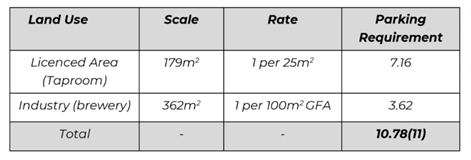
As shown above, strict
application of the DCP requires a total eleven (11) car parking spaces.
As discussed in Section 2.3 [also above], the site has the benefit of 12
parking spaces in terms of historical car parking credits. These credits are
sufficient to satisfy the site’s car parking demand in accordance with
Council’s DCP parking requirements.
In addition to this, the
nature of the proposed use lends itself to peaks on evenings and during
weekends. This is offset to the peak periods for the surrounding developments;
therefore, the proposal is an efficient use of the surrounding public parking
facilities within the area.
Parking Demand Profiles
As discussed previously, the
proposed brewery bar area is expected to be open for business between the hours
of 10am and 12am Wednesday-Sunday as a maximum [occasionally operating outside
of these days relating to a public holiday or for private functions/events. The
bar (and therefore the development) is expected to experience its peak in the
evening, with a minor peak in the midday. For comparison purposes, a review was
conducted of Google Popular Times data of similar breweries and pubs in
Regional NSW to determine expected patronage profile to apply to the proposal.
There are currently no operational breweries in the Orange CBD, so comparison
is made to a pub within the Orange CBD and a brewery in Mudgee CBD. The
following sites were reviewed in this process:
· Pub in Orange:
The Metropolitan Hotel, 107 Byng Street, Orange NSW;
· Breweries in
Regional NSW CBDs; Three Tails Brewery, 13 Lewis Street, Mudgee NSW
From the above sites, the maximum average peak
weekday and weekend patronage profile for each development type was deduced
using Google Popular Times data and is shown in the below figures.
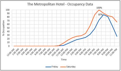
Figure 6 – Occupancy Data at The Metropolitan
Hotel (Source: MTE)
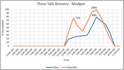
Figure 7 – Occupancy Data at Three Tails Brewery
(Source: MTE)
It can be seen that both the
weekday and weekend peak periods fall after 5pm for both the Orange pub and the
Mudgee brewery. The Mudgee brewery experiences a minor peak at 1pm on Saturday,
whilst the Orange pub does not experience a discernible midday peak. This is
offset to the peak periods for the surrounding developments, being generally
retail, cafes, medical offices, cleaners, professional offices etc; therefore,
the proposal is an efficient use of the surrounding public parking facilities
within the area.
The above parking analysis is considered to be acceptable in
this case. The proposed development will not result in a nett increase in
parking demand based on historical credits. It is considered that the proposal
will not generate an adverse impact on parking and traffic in the locality. The
development in this instance will benefit from the existing public car park
adjacent to the development.
On a separate but related matter it should be noted that the
proposal also includes changes to the configuration of the Council car park
adjacent to the western wall of the subject tenancy. A site inspection confirms
that the area of the carpark immediately adjacent to the building currently
comprises three marked car parking spaces and an unsealed area that is
currently used for informal car parking. Council has no immediate plans for
redevelopment of this space. It is acknowledged however that the undeveloped
area within the car park adjacent this site could accommodate parking for up to
eight (8) small informal car parking spaces.
The proposed reconfiguration of the public car park seeks to
maintain the three currently marked spaces whilst facilitating provision for a
loading bay, bicycle parking area and clear area for customer access from the
car park to the development. The three existing car parking spaces are
proposed to be relocated to the northern side of the electrical substation
which is currently unsealed so as to facilitate the loading area closer to the
access door and right of carriageway at the rear of the property. The proposed
reconfiguration of this space to facilitate the changed location of the parking
spaces, loading bay and bicycle parking area would limit opportunity to provide
additional formal parking spaces in the future within this part of the car
park. Having said this, the car park will remain in Council ownership and it
would be open for Council to revisit the configuration of the car park should
it wish to in the future.
The proposed loading bay is considered to be an improvement
for this precinct and will not be exclusively available for this business but
rather a loading area that would be available for other businesses in the
vicinity of this precinct to also use. Similarly, the provision of the bicycle
parking area will be provided for the general public and will be a Council
asset and has been offered by the applicant in this case.
The loading/unloading for the brewery will occur from the
proposed loading zone and into the rear (northern elevation) of the brewery
through the existing large roller door via the Orange Ex-Services' Club land
which the subject tenancy benefits from a right of way over.
It is recommended that Council supports the reconfiguration
of the public car park in the manner proposed. Conditions of consent have been
included in the attached Notice of Determination requiring the applicant
upgrade the car park area with line marking, signage and sealing in accordance
with the proposed plan.
As demonstrated above, the proposed development meets the
requirements of the DCP and does not result in a net increase in parking.
Additionally, the peak parking demands for the development will not conflict
with the majority of existing uses in the locality; this coupled with the
availability and proximity to the Sale Street carpark, will result in an
acceptable development with respect to car parking. The
development is compliant with Chapter 15 of the DCP.
PROVISIONS PRESCRIBED BY THE
REGULATIONS s4.15(1)(a)(iv)
Demolition of a Building (clause 92)
The proposal involves demolition. A condition is attached
requiring the demolition to be carried out in accordance with Australian
Standard AS2601 - 2001: The Demolition of Structures and the requirements
of Safe Work NSW.
Fire Safety Considerations (clause
93)
The proposal involves a change of building use for an
existing building. Council is satisfied that the fire protection and structural
capacity of the building are appropriate for the proposed new building use.
Relevant conditions are attached.
Buildings to be Upgraded (clause 94)
Upgrading of the building will be required to ensure the
existing building is brought into partial or total conformity with the Building
Code of Australia. Conditions are attached in relation to the required
upgrading works.
BASIX Commitments (clause 97A)
BASIX is not applicable to the proposed development.
THE LIKELY IMPACTS OF THE
DEVELOPMENT s4.15(1)(b)
The following sections provide an assessment of the likely
impacts of the development.
Context and Setting
The subject land is a commercial parcel with a brick
building built to the boundary. The land is centrally located within the CBD
block that is bound by Summer, Anson, Byng and Sale Streets. The land is
surrounded by car parking on three boundaries and is located behind the row of
commercial shops fronting Summer Street. Given these characteristics, the
development is considered suitable for its context and setting.
Visual Impacts
The development will essentially, save for the minor changes
to the western elevation, the installation of the steam vent and the minor
changes to the southern entrance.
Given the relatively minor changes to the built form and the
proximity of the site being well separated from the public realm, the
development is not expected to generate any adverse visual impacts in the
locality. Moreover, the changes to the western elevation in particular will
result in an improved visual appearance to the current condition, which is
considered a positive outcome.
Traffic Impacts
The RTA Guide to Traffic
Generating Developments (2002) does not provide reliable traffic generation
rates for breweries. In the absence of any reliable traffic generation rates it
is considered reasonable to consider an analysis of the likely traffic demand
in a prepared traffic assessment. The applicant has submitted a traffic impact
assessment in support of the subject development. The assessment of vehicle
traffic generation has been estimated by the applicant using a first principles
assessment as follows:
4.2
First Principles Assessment
· The brewery is
expected to demand 11 car parking spaces. As a worst case, it is assumed that
the car spaces will turn over in one (1) hour, resulting in a traffic
generation of 22 vehicle trips (one for both arrival and departure). This
equated to approximately one (1) vehicle trip every 3 minutes.
This level of traffic will
have no adverse effect on any nearby intersections and can be readily
accommodated within the existing road network with minimal impact in terms of traffic
flow efficiency and road safety considerations.
Indeed, the computer models
that are available to assess these impacts are not sensitive to such small
changes and it may be concluded that the road network will operate with no
change in the existing levels of service. In this regard, the proposed use of
the site is a low- order traffic use and the proposed development is
supportable in terms of its traffic impacts.
As indicated above under Chapter 15 of the DCP, the proposed
development satisfies the relevant car parking requirements under the DCP.
Additionally, the peak demands for the development will be such that adequate
parking resources are available within close proximity to the site (i.e. Sale
Street carpark). Council’s Technical Services Department have evaluated
the Traffic Impact Assessment submitted in support of the application and
advises that the traffic impacts of the development will be acceptable.
In addition it should also be noted that the applicant is
also proposing to install an area of pavement that can accommodate 20 bicycle
parking spaces as a community benefit and in line with Council’s Active
Travel Plan.
Pedestrian Safety impacts
The proposed development will provide two public access
points to the taproom. The main entrance will be provided along the southern
boundary via the laneway to Summer Street. The second access point will be from
the west via the Sale Street carpark. The development is not expected to
generate any adverse impacts on the locality.
The applicant’s consultant undertook an assessment of
the adequacy of the laneway from Summer Street for pedestrian access in terms
of safety and have assessed the gradient, width and traffic volumes to inform a
risk assessment.
MTE provided the following:
Pedestrian access is proposed
from the laneway to the south. The gradient within this area is a maximum of 6%
which is sufficient for pedestrian access. The laneway is between 3.0-3.4m in
width and also services up to eight (8) car parking spaces.
Therefore, any pedestrian
access via the laneway to the subject site would be shared with vehicular
traffic. This is an inherent risk, but MTE is of the opinion that it can be
managed safely from a safety perspective, subject to the following works:
· Resurfacing of
the pavement to remove trip hazards.
· Provision of a
convex mirror on the 90-degree corner to improve sightlines to pedestrians. The
mirror should allow a minimum of 2.2m headroom underneath.
· Implementation
of a 10km/h shared zone, whether formally or informally, by provision of 10km/h
line marking along the laneway.
· Adequate
lighting along the laneway.
· Stop line for
vehicles exiting the laneway onto Summer Street.
· Line marked
900mm width pedestrian refuge at the widest point of the lane.
Despite these works, the
likelihood of conflict between pedestrians and vehicles is extremely low. Staff
parking is likely to turn over during daytime hours, whilst pedestrian traffic
to the site is expected to be later in the evening and on weekends. Given
improved sightlines, a vehicle and a pedestrian can physically pass one another
along the laneway should a conflict arise. If necessary, a security guard can
be given the responsibility to monitor pedestrian activity along the laneway
during peak times.
Council’s Technical
Services Department agree with the findings of the analysis prepared by MTE.
Despite the narrow width of the access the likely conflict between pedestrians
and vehicles will be extremely low. Conditions of consent have been included in
the attached Notice of Determination to require upgrading of the surface within
the driveway, provision of a pedestrian refuge, signage and improved lighting
to assist with the safe use of this space. The proposed concept plan showing
the pedestrian refuge location is provided in the figure below.
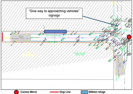
Figure 8 – proposed works to the laneway
Western Pedestrian Entrance from Carpark
Access from the Council carpark is also proposed with a new
doorway in the western elevation. Minor adjustments will be required to the
kerb within the carpark to achieve the necessary grade. Also, MTE have
recommended the installation of bollards to separate the loading zone from the
pedestrian access point. The finished surface level of the carpark is higher
than the finished floor levels of the taproom. To accommodate the change in
levels and to avoid the need for more extensive works in the carpark, an accessible
ramp is proposed within the taproom. Provision of direct pedestrian access onto
the car park is not dissimilar to the many and varied arrangements that exist
within the CBD and is considered acceptable in this case. Approval of this
arrangement ought not however be construed as being the granting of a right of
carriageway or easement for access and may be subject to change in the future
should any further redevelopment of the carpark be contemplated by Council.
Waste Management
The brewery activities will generate limited waste. A trade
waste agreement will be entered into in relation to waste that enters Council's
sewerage system. Solid and liquid waste from the brewing process relates to
spent grain and small quantities of liquid waste which will be collected by a
local primary producer as feed for livestock. These are the current
arrangements for Badlands Brewery’s existing facility.
The retail/bar component will generate waste, and adequate
arrangements have been included in the design. Based on the EPA guideline
‘Better Practice Guidelines for Waste Management and Recycling in
Commercial and Industrial Facilities’ the development will generate
the following waste requirements. The guideline recommends 80L of general waste
generation and 30L of recyclable waste per 100m2 for hotels, bars
and pubs. The brewery retail area is 179m2. This equates to 143.2L
per day of general waste and 53.7L of recycling per day. Based on 5 days of
trade - 716L/week of general waste and 268.5L/week of recycling.
Notwithstanding the above, it is acknowledged that this
development differs from how a pub operates as there is no commercial kitchen,
the service of food will be limited to bar snacks or the occasional food truck
on the adjoining private land. As such, the likely waste generation will be
significantly less than a pub. The submitted plans show sufficient area for the
storage of waste receptacles. The proponent will enter into a commercial waste
contract with a local waste provider. The bins will be moved to the loading
area on bin collection days and returned to the dedicated bin storage area once
emptied. These arrangements are considered to be acceptable from a traffic
engineering perspective.
Heritage Impacts
The impacts upon heritage significance are assessed in this
report under Clause 5.10 of the LEP.
Noise Impacts
Noise associated with the development relates to processes
within the brewhouse (i.e. cleaning, filling tanks, boiling wort, kegging,
bottling, canning, etc.) and loading / unloading activities, truck noise,
forklift warning beepers, etc.
Nearby sensitive receivers are:
- Shop-top
housing at 157-159 Summer Street.
- Shop-top
housing at 161-165 Summer Street.
- Shop-top
housing at 167-171 Summer Street.
Aside from the loading activities, the brewery processes are
wholly contained within the masonry building and as such are unlikely to
generate excessive noise that would exceed noise criteria goals for the
locality, particularly considering the CBD location and the background noise
levels of the CBD.
In addition to the fact that the noise generating activities
will be confined to inside the building, the operation of the brewery will be
during day-time hours (as defined in the EPA’s Noise Policy for
Industry), except for a one hour period before 7am.
The applicants advise that the types of activities that will
occur between 6am and 7am are preparatory for the day and do not result in high
noise levels, notwithstanding this, the doors will remain closed during this
time and no loading or unloading outside the premises will occur.
Noise associated with the taproom will be typical of other
hospitality venues in the CBD. The small area of outdoor seating at the
southern entrance will generate noise typical of conversation and the like,
however, the proposed blade wall (required for fire safety under the BCA) and
the northern portion of the adjoining building to the east, will effectively
shield the nearby residential receivers to the east. It is therefore considered
that the development will not give rise to any unsatisfactory noise impacts in
the locality.
Air Quality (Odour) Impacts
A detailed assessment on the potential odour impacts was
provided within the Statement of Environmental Effects and is considered to
provide sufficient justification as to the cause and mitigation measures to be
implemented.
The development does have the potential to generate odours
as part of the brewery process which the applicants submit are comparable to
odours emitted from a bakery whilst baking. Although such an odour is not
considered malodorous and cannot be compared to an offensive odour attributed
to a sewage treatment plant or nitric acid manufacture for example; it is
nonetheless necessary to carry out an assessment of the likely odour impacts associated
with the development on nearby neighbouring properties. It is noted that the
development is bounded by car parking on two sides with Orange Ex Services Club
being located to the immediate north of the property.
Within the supporting SEE, Badlands Brewery Head Brewer
provided detailed comments in relation to odour associated with their existing
brewery on the Mitchell Highway to assist with the assessment.
The analysis outlined an overview of odour within the brewing process and
explained the volatile odour emitted from the kettle flue during wort
production, making the following comments:
· Odours emitted
from the kettle flue are of a pleasant, bready/grainy aroma akin to bakery
smells.
· The current
location adjoins a residential property, to the knowledge of Badlands staff,
there have been no owners of nearby residential properties having recorded a
complaint regarding brewery odour.
· Kettle usage
will only be Monday to Friday at the following times:
o current production levels:
Average 2hrs 20 minutes per week all before 12pm
o maximum production levels:
Average 7hrs 20 minutes per week (with approximately 5hrs being before
12pm and 2hrs 20 minutes being before 5.30pm) This will minimise any impact to
the adjoining Greenhouse development within the OESC.
· The
installation of a Condenser unit will require significant retrofitting work on
Badlands’ equipment and significantly increase work hazards. E.g. the
work hatch on our kettle will require sealing as condenser units require the
boiling wort to be held under positive pressure in order to force the steam
through the unit.
· The operation
of a condenser will significantly increase water usage. At Badlands we have
been on a continual sustainability drive seeking to minimise our water and
waste usage. In our original DA submission for our current site we estimated
water usage: beer ratio of 4x-5x (around the current industry average). We have
honed this to around 2.5x-3x over the years. The addition of a condenser will
add a minimum 1 x water usage to our water:beer ratio. This impacts
both supply and treatment volumes.
· The applicant
proposes to install the kettle flue 500mm above the ridgeline of the subject
building such that there are no dead spaces and air circulation will quickly
disperse any aromas.
· There are many
breweries operating in NSW with kettle flues and no other odour management.
These include breweries next-door to residences and breweries within inner-city
suburbs with high residential density.
· The applicant
can find no recording of odour complaints in regard to kettle emitting odours
from any brewery, anywhere.
· Brewing odour
through the kettle flue omits a pleasant, inoffensive and harmless odour, it is
short-lived and will be produced at a place and time where minimal numbers of
people will be able to detect.
The applicant submits that the maximum average number of
brews per week that Badlands will be able to achieve at the proposed site,
given the space available for tanks, is 6.2. Council is advised that the
applicant’s current production levels (outside of current reduced
production Covid times) is around 2.0. It is understood that odours would be
emitted only during the wort boil process which is of 70 minutes duration per
batch. The submission indicates that on single-brew days wort boiling would
typically occur for a period of 70 minutes between a window of 10am and 1pm. In
the event that production increases necessitate double-brew days in the future
(maximum of two per week) then wort boiling is envisaged to occur for a period
of 70 minutes firstly between 9.30am-11am and then between 4pm and 5.30pm.
A review of the use of condenser units to manage odour
confirmed that these systems are generally only installed on breweries with a
production rate far in excess of that which is proposed. It is therefore
considered unnecessary and indeed unreasonable to require the installation of
such a unit.
Consideration of the location and height of the proposed
kettle flue has been given taking into account EPA guidance on woodsmoke.
This guidance suggests that when a flue extends 500mm above the ridge of a
roof, air turbulence is adequate to avoid a woodsmoke nuisance. It is
considered that using this same guidance that is centred on air flow and
dissipation, along with the mitigation measures detained in the Statement of
Environmental Effects, the proposal is unlikely to result in the production of
offensive odours.
Environmental Impacts
It is considered that the development will not give rise to
any adverse environmental impacts. The subject land is best described as a
fully developed commercial parcel with no existing vegetation or habitat
opportunities present.
The development will emit a relatively small amount of steam
into the atmosphere as part of the wort boiling process. The steam vent has
been designed to be 500mm. higher than the ridgeline of the building so as to
ensure the steam continues up into the atmosphere. The boiling process
will only be for a short period time on a day where brewing occurs and as such,
will not result in any unsatisfactory environmental impacts in the locality.
Safety, Security and Crime
Prevention
The application was forwarded to the Canobolas Local Area
Police command for review. No formal submission has been received. Council
staff have however spoken with a representative from the Local Area Command who
have verbally indicated no objections to the proposal and have requested the
provision of CCTV installation in instance. The provision of CCTV has been
included in the draft conditions of consent.
Security and crime prevention considerations for a
development have been assessed using the crime prevention through environmental
design (CPTED) principles of natural surveillance, access control, territorial
reinforcement and space management as follows:
Natural Surveillance
Natural surveillance opportunities for the site are limited
given the spatial characteristics of the site and the building being built to
the boundary. Notwithstanding, natural surveillance of the site can occur from
the west and north, and the southern entrance can be monitored by adjoining
residence and people using the church car park.
Exterior lighting of the main entrances and the laneway will
be installed to ensure the safety of patrons and the community, but also provide
surveillance opportunities at all times, and to deter antisocial behaviour in
the vicinity of the site when the brewery is closed. Additionally, CCTV cameras
will be installed at the three entrance points as recommended by the Local Area
Command with systems incorporated that allow footage to be recorded and stored
as required. A back to base security system with sensor detectors, etc. will
also be installed.
Access Control
Access to the site is well defined with only two access
points accessible to the public, being the southern and western entrances. The
access points will be clearly identifiable with signage and pavement treatment.
Given the characteristics of the site, there is limited opportunities to access
the building other than the two entrances referenced above.
The brewery entrances (PA door and roller door –
northern elevation) will be secured once the brewery closes for the day, and
access into the brewery area will be limited to staff only.
Territorial Reinforcement
The building itself, being effectively built to the boundary
(save for the southern entrance) will provide an appropriate level of security
for the premises.
Space Management
The exterior of the building will be well maintained and
well presented. Any occurrences of graffiti will be promptly removed, and
exterior lighting will be repaired as soon as practicable. The proposed
development presents an acceptable level of safety, security and crime prevention.
Economic Impacts
The development will have positive economic impacts for the
city both directly (through the employment of staff) and indirectly through the
use of couriers, food truck owners, cleaners, and the like.
Social Impacts
The development will provide positive social impacts within
the city. The development will provide an additional hospitality venue in the
city where people can gather and socialise. Whilst the development does involve
the production and sale of alcohol, the taproom will be managed in such a way
as to prevent antisocial behaviour occurring in the vicinity of the site
through measures such as RSA trained staff and security during peak periods.
The development is not expected to give rise to any adverse social impacts.
Cumulative Impacts
Cumulative impacts of a development can arise under four
typical scenarios, namely:
· time crowded
effects where individual impacts occur so close in time that the initial impact
is not dispersed before the proceeding occurs
· space crowded
where impacts are felt because they occur so close in space, they have a
tendency to overlap
· nibbling effects
occur where small, often minor impacts, act together to erode the environmental
condition of a locality; and
· synergistic
effects, where a mix of heterogeneous impacts interact such that the combined
impacts are greater than the sum of the separate effects.
There are no other similar activities occurring in the
vicinity of this development, and there are no processes within the brewing process
that are likely to lead to any of the above scenarios occurring. As such, it is
unlikely that any of the above scenarios would occur as a result of this
development and thus the development will not result in any unsatisfactory
cumulative impacts in the locality.
THE SUITABILITY OF THE SITE
s4.15(1)(c)
The site is considered suitable for the following reasons:
· Artisan Food and
Drink Industries are permissible in the B3 Commercial Core Zone.
· The industrial
style of the subject building is perfectly suited to a light industrial use.
· Appropriate safety
measures will be implemented to ensure the safety of patrons entering and
leaving the premises.
· Appropriate
loading and unloading arrangements are proposed to cater for the development
and surrounding commercial businesses.
· Appropriate odour
mitigation measures will be implemented as part of the development through the
design and operational management of the development.
· The development is
appropriately designed and sited so as to ensure minimal impacts in the
locality.
· Council are not
aware of any natural, physical or technological hazards that would unduly
constrain the development.
· The proposed
development will support an existing successful local business, increase
employment opportunities within the city and introduce a new hospitality venue
in the CBD. As such, this development will provide a positive contribution to
the Orange economy and provide positive social impacts within the city.
ANY SUBMISSIONS MADE IN
ACCORDANCE WITH THE ACT s4.15(1)(d)
As per the Orange Community Participation Plan, the
neighbouring allotments were notified of the proposal. The application was
advertised for the prescribed period of 14 days and at the end of that period
no submissions were received.
PUBLIC INTEREST
s4.15(1)(e)
The proposed development is considered to be of minor
interest to the wider public due to the relatively localised nature of
potential impacts. The proposal is not inconsistent with any relevant policy
statements, planning studies, and guidelines etc that have not been considered
in this assessment.
SUMMARY
The proposed development is permissible with the consent of
Council. The proposed development complies with the relevant aims, objectives
and provisions of Orange LEP 2011 (as amended) and DCP 2004. A
Section 4.15 assessment of the development indicates that the development
is acceptable in this instance. Attached is a draft Notice of Approval
outlining a range of conditions considered appropriate to ensure that the development
proceeds in an acceptable manner.
COMMENTS
The requirements of the Environmental Health and Building
Surveyor and the Engineering Development Section are included in the attached
Notice of Approval.
Attachments
1 Notice
of Approval, D21/68751⇩
2 Plans
and detailed Site Survey, D21/67570⇩
3 Pre-submission
- Management Plan - Loading and Unloading, D21/67577⇩
4 Traffic
and Parking Impact Assessment Report, D21/67581⇩
Planning
and Development Committee
2 November 2021
Attachment 1 Notice
of Approval
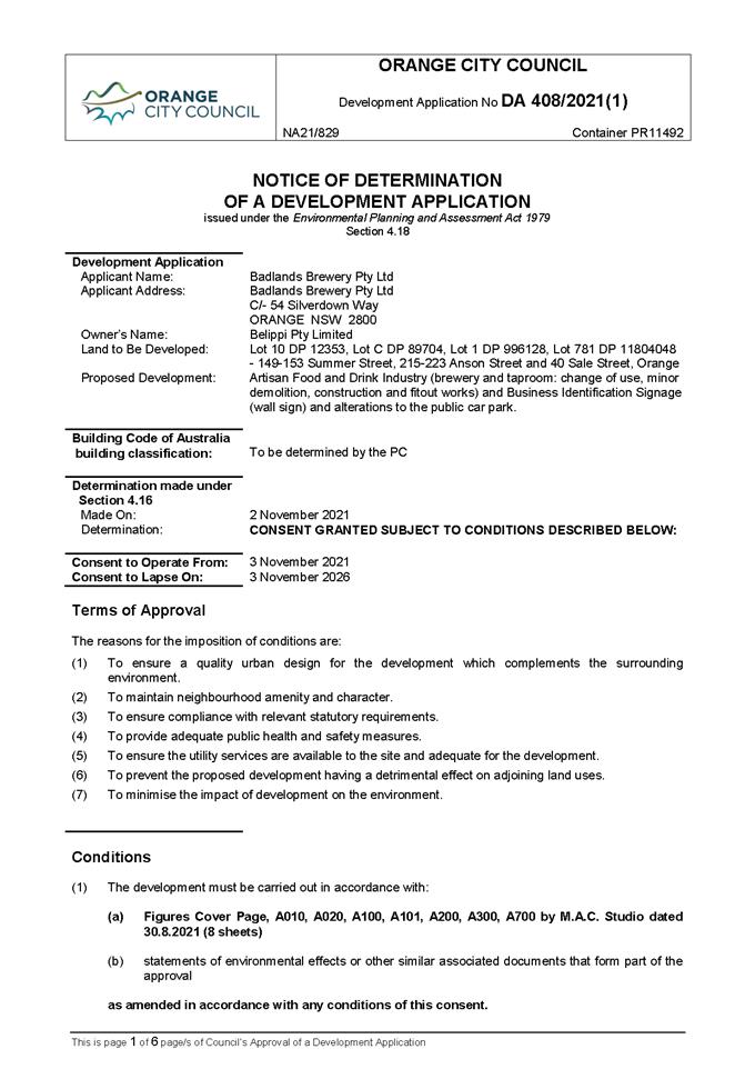
Planning and Development Committee
2 November 2021
Attachment 2 Plans
and detailed Site Survey
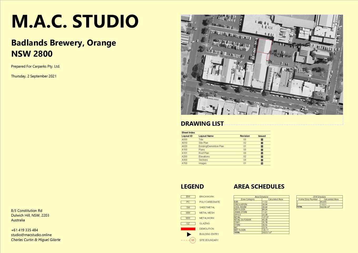
Planning
and Development Committee
2 November 2021
Attachment 3 Pre-submission
- Management Plan - Loading and Unloading
Planning and Development Committee
2 November 2021
Attachment 4 Traffic
and Parking Impact Assessment Report
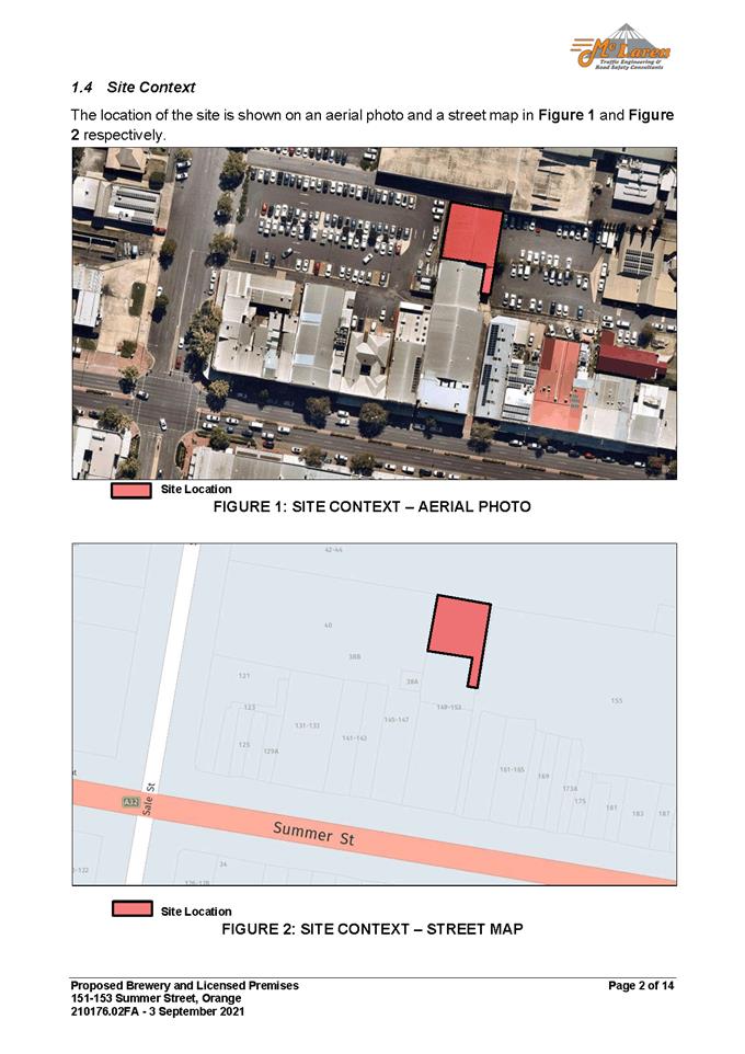
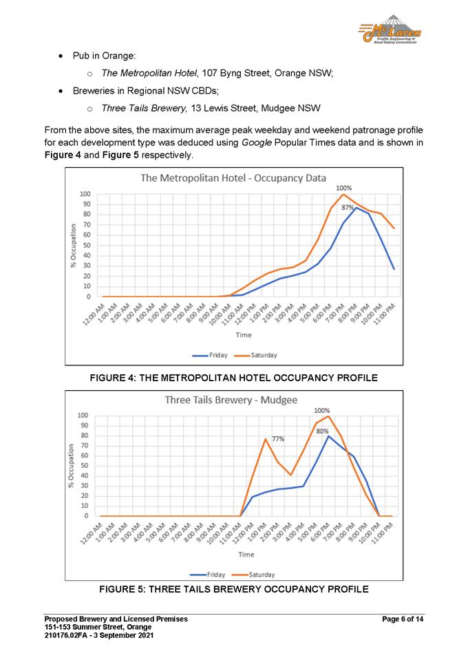
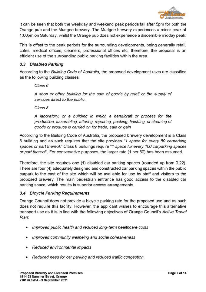
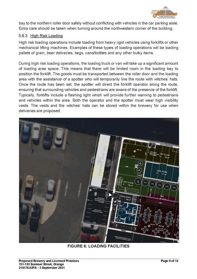
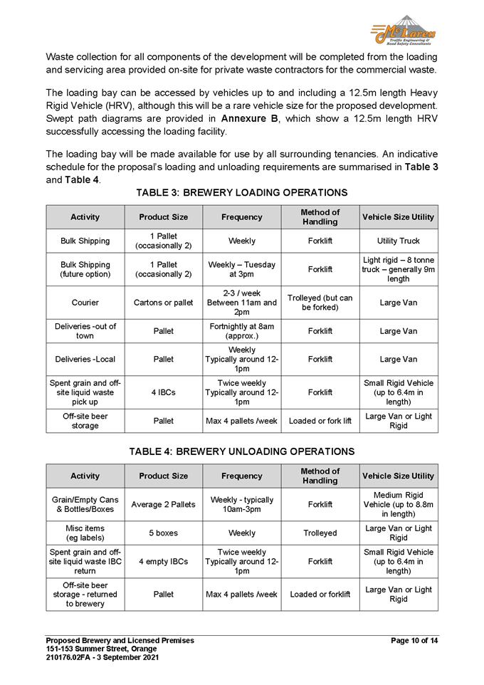
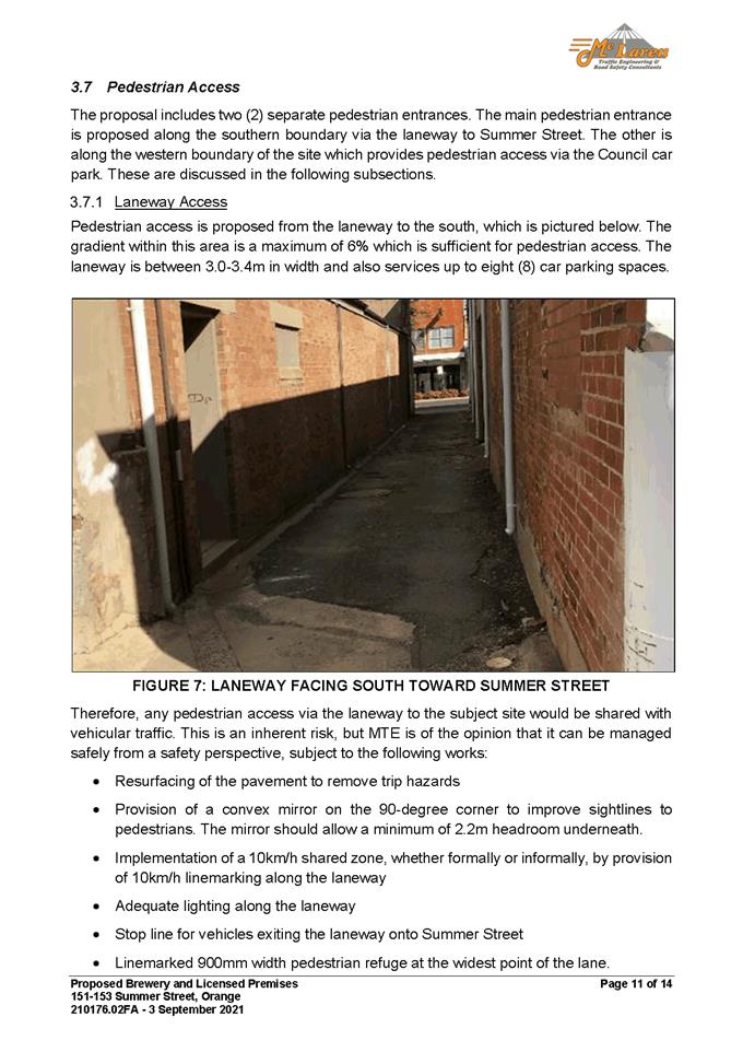
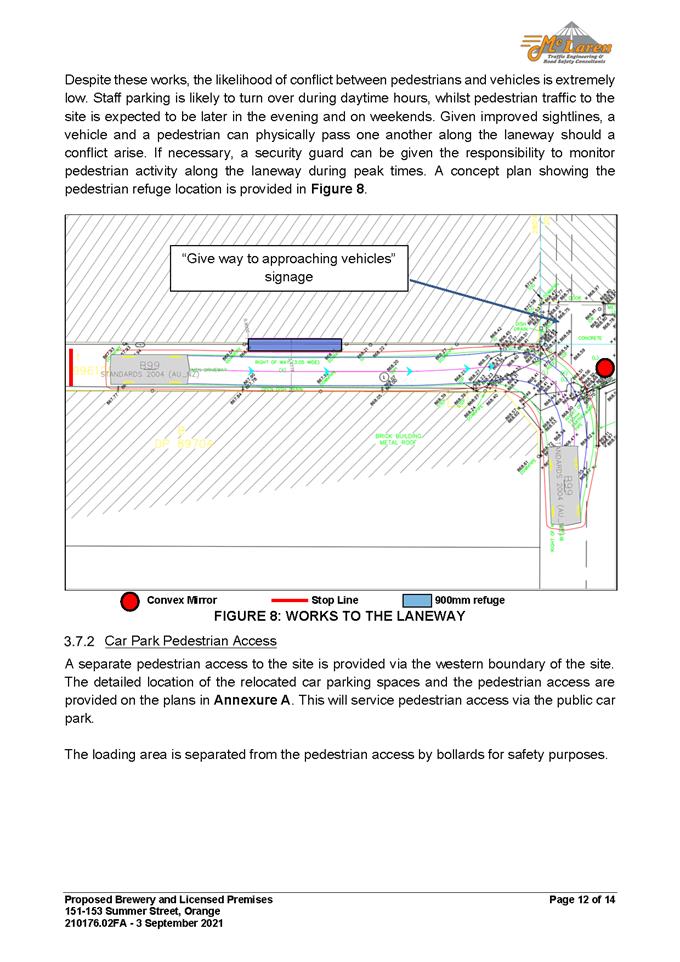
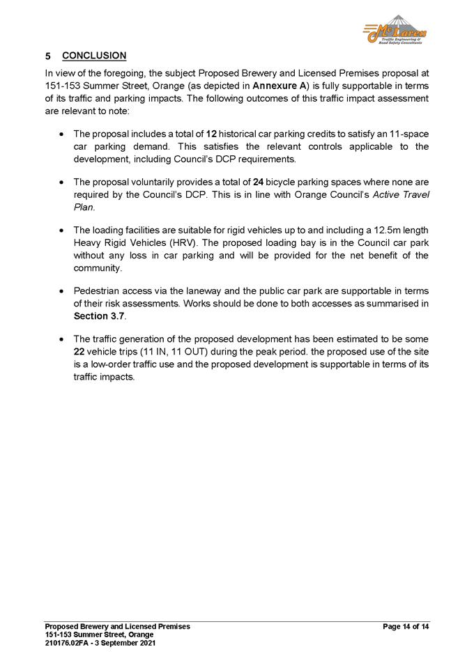

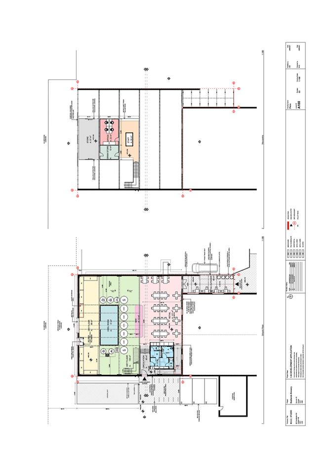
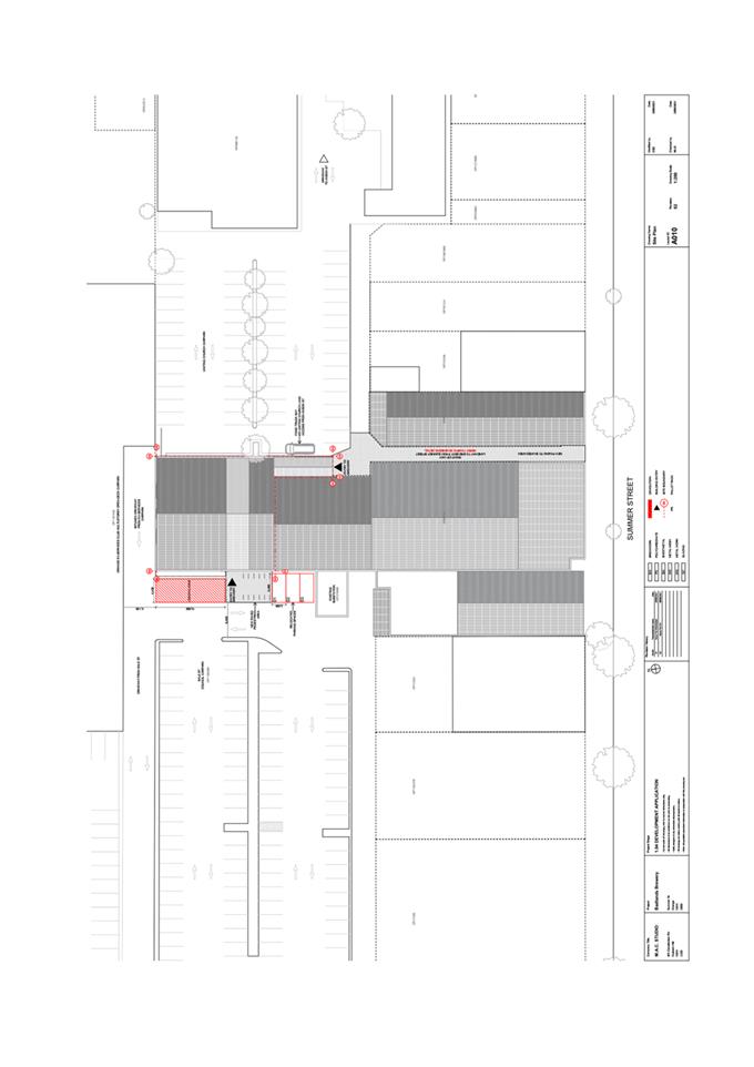

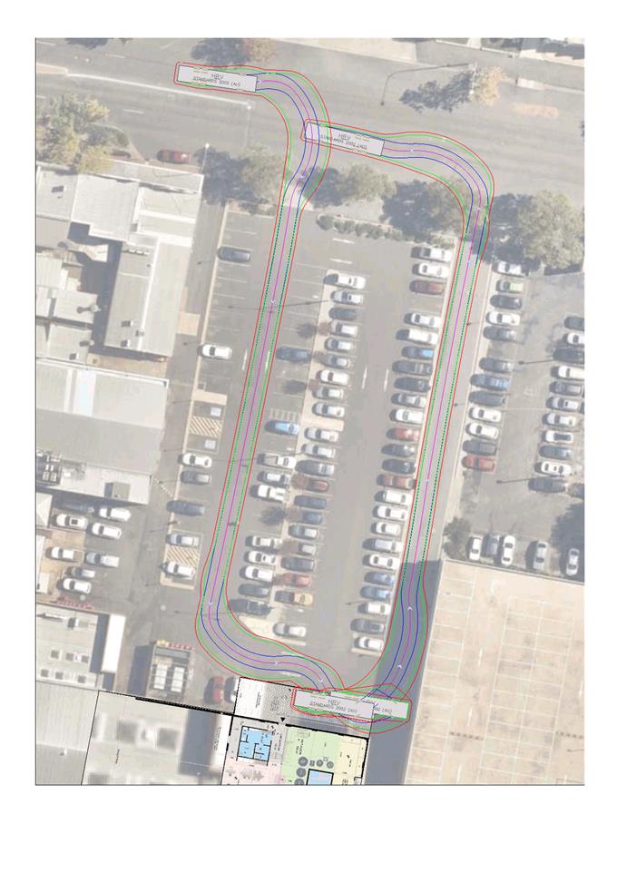
2.7 Development
Application DA 368/2021(1) - 24 Cedar Street
RECORD
NUMBER: 2021/2369
AUTHOR: Summer
Commins, Senior Planner
EXECUTIVE
Summary
|
Application
lodged
|
24
August 2021
|
|
Applicant/s
|
RTEC
(NSW) Pty Ltd
|
|
Owner/s
|
Mr MP
and Mrs KA Andrew
|
|
Land
description
|
Lot 13
DP 271090 - 24 Cedar Street, Orange
|
|
Proposed
land use
|
Dwelling,
Attached Carport and Detached Garage
|
|
Value of
proposed development
|
$950,000
|
Council's consent is sought for a proposed dwelling house,
attached carport and detached double garage at Community Lot 13 DP 271090
– 24 Cedar Street, Orange.
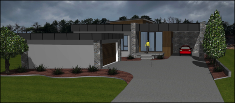
Figure 1 – artist’s impression
The proposal departs from the
planning controls in DCP 2004 in relation to garage presentation and visual
bulk. The departures are considered to be within reasonable limit, subject to
mitigation conditions. The proposed dwelling design and detailing will be
suitable for the site and setting, and will complement the developing
neighbourhood character.
The proposal is notified
development in accordance with Council’s Community Participation Plan
2019. The DA was notified in the prescribed manner. No submissions were
received. Furthermore, the Community Association for DP 271090 raised no
objection to the proposed dwelling design.
Approval of the application is recommended.
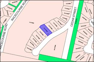
Figure 2 – locality plan
DECISION FRAMEWORK
Development in Orange is governed by two key documents
Orange Local Environment Plan 2011 and Orange Development Control Plan 2004. In
addition the Infill Guidelines are used to guide development, particularly in
the heritage conservation areas and around heritage items.
Orange Local Environment Plan 2011 – The
provisions of the LEP must be considered by the Council in determining the
application. LEPs govern the types of development that are permissible or
prohibited in different parts of the City and also provide some assessment
criteria in specific circumstances. Uses are either permissible or not. The
objectives of each zoning and indeed the aims of the LEP itself are also to be
considered and can be used to guide decision making around appropriateness of
development.
Orange Development Control Plan 2004 – the DCP
provides guidelines for development. In general it is a performance based
document rather than prescriptive in nature. For each planning element there
are often guidelines used. These guidelines indicate ways of achieving the
planning outcomes. It is thus recognised that there may also be other solutions
of merit. All design solutions are considered on merit by planning and building
staff. Applications should clearly demonstrate how the planning outcomes are
being met where alternative design solutions are proposed. The DCP enables
developers and architects to use design to achieve the planning outcomes in
alternative ways.
DIRECTOR’S COMMENT
The proposal involves the
construction of a dwelling house, attached carport and detached double garage
at Lot 13 DP 271090 – 24 Cedar Street, Orange. The proposal departs from
the planning controls in DCP 2004 in relation to garage presentation and visual
bulk. The departures are discussed in the body of this report and are
considered to be within reasonable limit, subject to mitigation conditions. The
proposed dwelling design and detailing will be suitable for the site and
setting, and will complement the developing neighbourhood character of this
precinct. It is recommended that Council supports the proposal subject to the
adoption of the attached Notice of Determination.
Link To Delivery/OPerational Plan
The recommendation in this report relates to the
Delivery/Operational Plan Strategy “10.1 Preserve - Engage with the
community to ensure plans for growth and development are respectful of our
heritage”.
Financial Implications
Nil
Policy and Governance Implications
Nil
|
Recommendation
That
Council consents to development application DA 368/2021(1) for Dwelling, Attached Carport and Detached Garage
at Lot 13 DP 271090 – 24 Cedar Street, Orange, pursuant to the conditions of consent in the attached
Notice of Approval.
|
further considerations
Consideration has been given to the
recommendation’s impact on Council’s service delivery; image and reputation;
political; environmental; health and safety; employees; stakeholders and
project management; and no further implications or risks have been identified.
SUPPORTING INFORMATION
The proposal involves construction
of a dwelling house, attached carport and detached double garage on the subject
land.
The dwelling will be single-storey
and contain three (3) bedrooms, two (2) bathrooms, open-plan
living/dining/kitchen zone, alfresco and attached single carport. A detached
double garage will be located in the front setback.
The dwelling will be of contemporary
design and detailing, with a rectangular building form, flat and skillion roof
profile, fascia detail and mixed wall finishes (timber, stone, cladding and
blockwork). The proposed site layout and building design are depicted below.
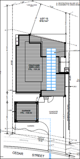
Figure 3 – proposed site plan
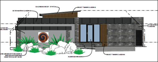
Figure 4 – east elevation (street view)
Figure 5 – north elevation (side view)
MATTERS FOR CONSIDERATION UNDER
THE ENVIRONMENTAL PLANNING AND ASSESSMENT ACT 1979
Section 1.7 Application of Part 7
of the Biodiversity Conservation Act 2016 and Part 7A of the Fisheries
Management Act 1994
Pursuant to Clause 1.7:
This
Act has effect subject to the provisions of Part 7 of the Biodiversity Conservation Act 2016 and Part 7A of the Fisheries Management Act 1994 that relate to the operation of this Act in connection
with the terrestrial and aquatic environment.
In consideration of this section, the proposed development
is not likely to significantly affect a threatened species:
· The subject and
adjoining lands are not identified as biodiversity sensitive on the Orange LEP
2011 Terrestrial Biodiversity Map.
· The proposal does
not involve vegetation removal. Clearing thresholds prescribed by regulation
are not applicable.
· The site is
contained within a developing urban area and has been highly modified by the
urban landuse pattern. The subject land does not contain known threatened
species or ecological communities.
Based on the foregoing consideration, a Biodiversity
Assessment Report is not required and the proposal suitably satisfies the
relevant matters at Clause 1.7.
Section
4.15 Evaluation
Provisions of any Environmental Planning Instrument
S4.15(1)(A)(I)
Orange Local Environmental Plan 2011
Part 1 - Preliminary
Clause 1.2 Aims of Plan
The
particular aims of Orange LEP 2011 relevant to the proposal include:
(b) to provide for a range of development
opportunities that contribute to the social, economic and environmental
resources of Orange in a way that allows present and future generations to meet
their needs by implementing the principles for ecologically sustainable
development,
(e) to provide a range of housing choices in
planned urban and rural locations to meet population growth,
(f) to recognise and manage valued
environmental heritage, landscape and scenic features of Orange.
The proposed development will not be contrary to the
above-listed Aims, as outlined in this report.
Clause 1.6 Consent Authority
Clause 1.6 is applicable and states:
The consent authority for the
purposes of this Plan is (subject to the Act) the Council.
Clause 1.7 Mapping
The subject site is identified
on the LEP maps in the following manner:
|
Land Zoning Map:
|
Land zoned R1 General Residential
|
|
Lot Size Map:
|
No minimum lot size
|
|
Heritage Map:
|
Parent parcel is a Local heritage
item: Item 58 - Bluestone Quarry
|
|
Height of Buildings Map:
|
No building height limit
|
|
Floor Space Ratio Map:
|
No floor space limit
|
|
Terrestrial Biodiversity Map:
|
No biodiversity sensitivity on the
site
|
|
Groundwater Vulnerability Map:
|
Groundwater vulnerable
|
|
Drinking Water Catchment Map:
|
Not within the drinking water
catchment
|
|
Watercourse Map:
|
Not within or affecting a defined
watercourse
|
|
Urban Release Area Map:
|
Not within an urban release area
|
|
Obstacle Limitation Surface Map:
|
No restriction on building siting
or construction
|
|
Additional Permitted Uses Map:
|
No additional permitted use applies
|
|
Flood Planning Map:
|
Not within a flood planning area
|
Those matters that are of relevance are addressed in detail
in the body of this report.
Clause 1.9A Suspension of
Covenants, Agreements and Instruments
Clause 1.9A is applicable and
states in part:
(1) For the purpose of enabling
development on land in any zone to be carried out in accordance with this Plan
or with a consent granted under the Act, any agreement, covenant or other
similar instrument that restricts the carrying out of that development does not
apply to the extent necessary to serve that purpose.
In consideration of this clause, Council staff are not
aware of the title of the subject property being affected by a relevant
agreement, covenant or similar instrument.
As a matter
arising, the site is subject to a Restriction on the Use of Land: building
exclusion zone- variable width (see Figure 6 below). The proposed dwelling
will be wholly located outside of the restricted area. Furthermore, a sewage
easement traverses the front boundary of the land (noted “H”). The
proposed development will be sited clear of the easement and have nil impact on
the operation of the easement.
Figure 6 – extract DP 2271090
– see Lot 13
Whilst not relevant to
Council’s assessment it should be noted that Council has received advice
from the Community Association for DP 271090 who have indicated no objection to
the proposed dwelling design.
Part 2 - Permitted or Prohibited Development
Clause 2.1 Land Use Zones
The
subject land is zoned R1 General Residential.
The
proposal is defined as a dwelling house.
The
proposal is permitted with consent in the R1 zone.
Clause 2.3 Zone Objectives
The objectives of the R1 General Residential zone are:
· To provide for
the housing needs of the community.
· To
provide for a variety of housing types and densities.
· To enable other
land uses that provide facilities or services to meet the day to day needs of
residents.
· To ensure
development is ordered in such a way as to maximise public transport patronage
and encourage walking and cycling in close proximity to settlement.
· To ensure that
development along the Southern Link Road has an alternative access.
The proposed development will not be contrary to the
relevant zone objectives. Dwelling houses are a permitted and complementary
land use in the zone.
Part 3 - Exempt and Complying Development
The application is not exempt or complying development.
Part 4 - Principal Development Standards
The
Part 4 Development Standards do not relate to the subject land or proposed
development.
Part 5 - Miscellaneous Provisions
Clause 5.10 Heritage Conservation
The parent parcel of the development site is a listed Local
heritage item under Orange LEP 2011: Item 58 [former] CSR Readymix site
(Bluestone quarry).
Figure 7 – Orange LEP 2011 Heritage
Map
Clause 5.10 is applicable and states in part:
(4) The
consent authority must, before granting consent under this clause in respect of
a heritage item or heritage conservation area, consider the effect of the
proposed development on the heritage significance of the item or area
concerned.
In consideration of this clause, the
proposed dwelling will not adversely impact on the significance of the heritage
item. The development will be suitable in relation to character, siting, design
and detailing:
· The contemporary
building design and detailing will complement recent dwellings in the emerging
streetscape.
· The proposed
street setback will complement the developing streetscape building line.
· The proposed
dwelling will be single-storey and of consistent height and massing with nearby
dwellings in Cedar Street.
· Proposed colours
and materials will reference the nearby quarry and the emerging colour palette
in the streetscape.
Part 6 - Urban Release Area
Not relevant to the application. The subject site is not
located in an Urban Release Area.
Part 7 - Additional Local Provisions
Clause
7.1 Earthworks
Clause
7.1 applies. This clause states in part:
(3) Before granting development
consent for earthworks, the consent authority must consider the following
matters:
(a) the likely disruption of, or
any detrimental effect on, existing drainage patterns and soil stability in the
locality of the development,
(b) the effect of the development
on the likely future use or redevelopment of the land,
(c) the quality of the fill or the
soil to be excavated, or both,
(d) the effect of the development
on the existing and likely amenity of adjoining properties,
(e) the source of any fill material
and the destination of any excavated material,
(f) the likelihood of
disturbing relics,
(g) the proximity to and potential
for adverse impacts on any waterway, drinking water catchment or
environmentally sensitive area,
(h) any measures proposed to
minimise or mitigate the impacts referred to in paragraph (g).
Minor earthworks will be
required for dwelling construction and ancillary site works. The proposal is considered to be acceptable in the
context of requirements at Clause 7.1:
· Appropriate
drainage infrastructure will be provided within the development to ensure
earthworks and finished levels will not impact on adjoining properties or
receiving waterways.
· Earthworks
will not involve fill material or excavation.
· The
site is not known to be contaminated.
· The site is not known to contain
any Aboriginal, European or archaeological relics.
· The
site is not in close proximity to any waterway, drinking water catchment or
sensitive area. Conditional sediment and erosion
controls will be installed and maintained during construction.
Clause 7.3 Stormwater Management
Clause 7.3 is
applicable. This clause states in part:
(3) Development
consent must not be granted to development on land to which this clause applies
unless the consent authority is satisfied that the development:
(a) is
designed to maximise the use of water permeable surfaces on the land having
regard to the soil characteristics affecting onsite infiltration of water, and
(b) includes,
where practical, onsite stormwater retention for use as an alternative supply
to mains water, groundwater or river water, and
(c) avoids
any significant impacts of stormwater runoff on adjoining downstream
properties, native bushland and receiving waters, or if that impact cannot be
reasonably avoided, minimises and mitigates the impact.
The proposed
development will satisfy the requirements of Clause 7.3. Stormwater will be
directed to Cedar Street.
Clause 7.6 Groundwater Vulnerability
The subject land is identified as Groundwater Vulnerable on
the Groundwater Vulnerability Map. Clause 7.6 applies. This clause
states in part:
(3) Before
determining a development application for development on land to which this
clause applies, the consent authority must consider:
(a) whether
or not the development (including any onsite storage or disposal of solid or
liquid waste and chemicals) is likely to cause any groundwater contamination or
have any adverse effect on groundwater dependent ecosystems, and
(b) the
cumulative impact (including the impact on nearby groundwater extraction for
potable water supply or stock water supply) of the development and any other
existing development on groundwater.
In
consideration of Clause 7.6, there are no aspects of the proposal will not impact on groundwater and related ecosystems.
Clause 7.11 Essential Services
Clause 7.11 applies and states in
part:
(3) Development consent must not be
granted to development unless the consent authority is satisfied that any of
the following services that are essential for the proposed development are
available or that adequate arrangements have been made to make them available
when required:
(a) the supply of water,
(b) the supply of electricity,
(c) the disposal and management of
sewage,
(d) storm water drainage or on-site
conservation,
(e) suitable road access.
In consideration of this clause, the
above-listed utility services are available to the land and adequate for the
proposal. In relation to (e), Council’s Road Opening Permit Officer
raised no objection to the proposed driveway gradient and access via Cedar
Street. Conditional road opening permit and certification will be required.
STATE ENVIRONMENTAL PLANNING
POLICIES
State Environmental Planning Policy 55 Remediation of
Land
SEPP 55 Remediation of Land is applicable. Clause 7 states
in part:
(1) A consent
authority must not consent to the carrying out of any development on land
unless:
(a) it has considered whether the
land is contaminated, and
Contamination clearance was
provided in conjunction with subdivision of the parent parcel (DA 263/2013
amended). The land is suitable for residential landuse from a contamination
perspective. Since its creation as a residential lot, the subject land has
remained vacant. Site inspection does not reveal any areas of concern. Further
contamination investigation is considered unnecessary in support of the
proposal.
State Environmental Planning
Policy (Building Sustainability Index: BASIX) 2004
The BASIX SEPP is applicable. Pursuant to Clause 6:
(1) This
Policy applies to buildings arising from the following development:
(a) proposed BASIX affected development
for which the regulations under the Act require a BASIX certificate to
accompany a development application or an application for a complying
development certificate or construction certificate,
In consideration of this clause, the proposed dwelling house
comprises BASIX affected development. A BASIX Certificate was submitted in
support of the amended proposal. The proposed dwelling will comply with the
provisions of BASIX is respect of water, thermal comfort and energy.
Provisions of any draft
environmental planning instrument that has been placed on exhibition
4.15(1)(A)(Ii)
The
following Draft EPIs have been placed on public exhibition:
· Draft Orange LEP
2011 (Amendment 28) – Heritage Amendment
· Draft Orange LEP
2011 (Amendment 29) – Park and Rifle Range Roads, Shiralee
· Draft Orange LEP
2011 (Amendment 31) – Eastside Precinct
Amendment 28 relevantly relates to the proposal. The Draft
Plan involves, in part, amendment to Schedule 5 and the Heritage Map relating
to the heritage listing of the Bluestone Quarry (Item 58). It is proposed that
the heritage listing relate to the quarry only, and not the recently created
adjoining child parcels, including the subject land.
The heritage listing shall
relate to Lot 1 DP 217090, comprising the lake only (see Figure 8). The
development site will not be covered by a heritage listing under draft
Amendment 28.
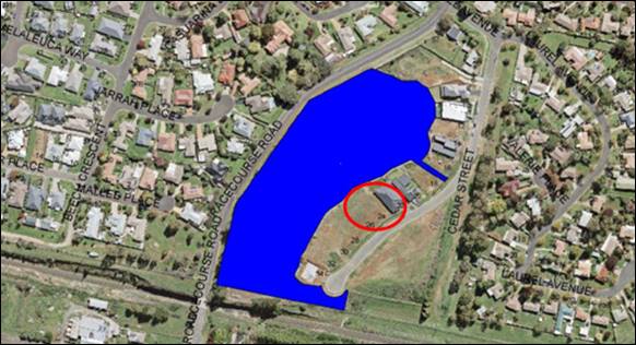
Figure 8 – heritage listing under Draft Orange
LEP 2011 (Amendment 28)
Draft Amendments 29 and
31 have no effect for the proposed development.
Provisions of any
Development Control Plan S4.15(1)(a)(iii)
Development Control Plan 2004
DCP 2004-7 Development in
Residential Areas
Neighbourhood Character
Site layout and building design enables the:
· creation of
attractive residential environments with clear character and identity
· use of site
features such as views, aspect, existing vegetation and landmarks
· buildings are
designed to complement the relevant features and built form that are identified
as part of the desired neighbourhood character
· the streetscape
is designed to encourage pedestrian access and use.
The Cedar Street residential neighbourhood is comprised of
substantial single-storey dwellings, of contemporary design and detailing. The
proposed dwelling will complement the emerging neighbourhood character in built
form and function.
Building Appearance
· the building
design, detailing and finishes relate to the desired neighbourhood character,
complement the residential scale of the area, and add visual interest to the
street
· the frontages
of buildings and their entries face the street
· garages and car
parks are sited and designed so that they do not dominate the street frontage.
The proposed dwelling will be
single-storey and complement the height and massing of nearby dwellings in this
streetscape. External materials, finishes and colours for the proposed dwelling
will complement those prevailing in this streetscape. The dwelling will present
an active frontage to Cedar Street with entry door, portico treatment and
openings. The attached single carport will be integrated with the dwelling
design.
The detached double garage will be located in the front setback,
forward of the dwelling house. The garage siting will depart from the DCP
Guidelines which require garages be integrated to the dwelling design; set
behind the building façade; or project up to 3m in front of the main
façade. Despite the DCP variations, the proposed garage may be
supported due to the following:
- The
garage will be set forward of the dwelling by 3.4m. If the garage was attached
to the dwelling on the front façade, it would satisfy the DCP
Guidelines. Visual impacts on the setting and streetscape in this situation
would be comparable with the proposed detached siting.
- Garage
design and detailing will match the dwelling in form (rectangular), roof
profile (flat), finishes (rendered, stone, timber) and details (fascia
element).
- The
garage will be set back a typical distance from the front boundary (4.5m) to
reduce visual encroachment on the street.
- The
proponent has nominated artwork to the east/street elevation of the proposed
garage. In order to improve articulation and provide an active frontage to
Cedar Street, a Condition is included requiring window fenestration /openings
to the east elevation.
- Landscaping
of the front setback will assist to integrate and screen the garage in the
front setback. Conditions are included requiring preparation and implementation
of a landscape plan.
Setbacks
· street setbacks
contribute to the desired neighbourhood character, assist with the integration
of new development and make efficient use of the site
· street setbacks
create an appropriate scale for the street considering all other streetscape
components.
A stepped street setback is
proposed, comprising 4.5m for the garage and 14.6m for the dwelling house.
Stepped front dwelling façades and varied setbacks are a feature in
Cedar Street. The proposed development will suitably integrate within the
developing streetscape building line in relation to setbacks.
Front Fences and Walls
The DCP sets the following Planning Outcomes in regard to
Fences and Walls:
· Front fences
and walls:
- assist in highlighting
entrances and creating a sense of identity within the streetscape
- are
constructed of materials compatible with associated housing and with fences
visible from the site that positively contribute to the streetscape
- provide for
facilities in the street frontage area such as mail boxes.
The proposal does not involve a front
fence to Cedar Street. The open front setback will complement other dwellings
in this streetscape.
Visual
Bulk
The DCP sets the following Planning Outcome in regard to Visual
Bulk:
· Built form
accords with the desired neighbourhood character of the area with:
- side and rear setbacks progressively increased to
reduce bulk and overshadowing
- site coverage that retains the relatively low
density landscaped character of residential areas
- building form and siting that relates to landform,
with minimal land shaping (cut and fill)
- building height at the street frontage that
maintains a comparable scale with the predominant adjacent development form
- building to the boundary where appropriate.
The
visual bulk associated with the proposed development will be suitable as
considered below:
· The proposed
dwelling will be single-storey. The greater part of the dwelling will have a
height of 4.4m, with the central skillion element to have a maximum building
height of 4.7m. Dwelling height will be comparable with the adjoining northern
dwelling at 22 Cedar Street, and indeed nearby dwellings in Cedar Street.
· The detached
garage will have a height of 3.2m. Notwithstanding the siting of the garage in
the front setback, the dwelling will remain the dominant structure on the site.
· As considered
above, street setbacks for the dwelling and garage will relate to the
developing streetscape building line, and be suitable in the context of the
building heights.
· The development
will have side boundary setbacks of 1.1m (south) and 1.2m (north). The side
setbacks will be typical to the residential setting, and consistent with the
siting of dwellings on adjoining lands.
· Negligible
earthworks will be required. Finished floor levels (101.35 dwelling and 100.52
garage) will relate to existing natural ground level and be less than 1.5m
above pre-development ground level.
· The proposed
dwelling and garage will have a total building footprint of 377.19m2.
Based on site area of 918.1m2, the development will have site
coverage of 41% in compliance with the maximum 60% prescribed for single
dwellings.
· The proposed
dwelling will encroach within the DCP-prescribed visual bulk envelope plane
when projected from the side boundaries.
The encroachment within the VBE plane
when projected from the southern boundary is shown here:

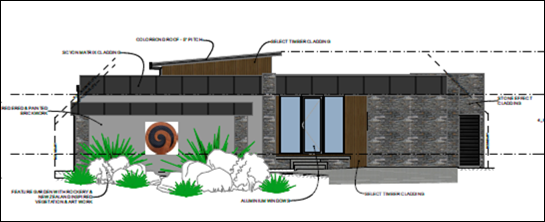
Figure 9 – VBE encroachment on the southern
boundary
As depicted, the encroachment
relates to part of the dwelling fascia detail, and will extend for the majority
of the south dwelling facade. A pitched roof profile would overcome the
encroachment, however, a flat and skillion roof profile is typical to the
streetscape and contemporary architectural styling. The adjoining land to the
south is undeveloped. It is a reasonable expectation that a future dwelling on
the adjoining southern parcel will be removed from the common boundary, to
optimise indoor and outdoor solar access. On this basis, the proposed dwelling
is unlikely to result in visual bulk encroachment impacts for a future dwelling
to the south.
The encroachment within the VBE
plane when projected from the northern boundary is shown here:
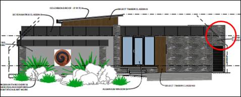
Figure 10 – VBE encroachment on the northern
boundary
The encroachment relates to a
blockwork wall which extends between the dwelling and side boundary as depicted
below. The northern façade of the proposed dwelling will otherwise be
contained within the prescribed VBE.
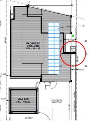
Figure 11a – wall encroaching VBE plane
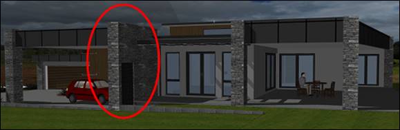
Figure 11b – wall encroaching VBE plane
The subject wall will be
constructed to the common boundary with 22 Cedar Street. The wall will have a
height of 4.3m and complement the height of the greater part of the dwelling.
It is considered that block wall will not result in unreasonable visual bulk
encroachment impacts for the opposing dwelling at 22 Cedar Street. The wall
will relate to 0.5m of the common boundary. Internal and external living spaces
for the dwelling at 22 Cedar Street are oriented to the north and west, and
will not oppose the proposed dwelling or blockwork wall.
VBE encroachments are
considered, therefore, to be within reasonable limit.
Walls and Boundaries
The DCP sets the following Planning Outcome in regard to
Walls and Boundaries:
· Building to the
boundary is undertaken to provide for efficient use of the site taking into
account:
- the privacy of
neighbouring dwellings and private open space
- the access to
daylight reaching adjoining properties
- the impact of
boundary walls on neighbours.
The proposal does not involve building to any boundary. As
outlined in this report, the site layout and building design will not adversely
impact on future/adjoining dwellings in respect of privacy, solar access or
visual bulk.
Daylight
and Sunlight
The DCP sets the following Planning
Outcome in regard to Daylight and Sunlight:
· Buildings are
sited and designed to ensure:
- daylight to
habitable rooms in adjacent dwellings is not significantly reduced
- overshadowing
of neighbouring secluded open spaces or main living area windows is not
significantly increased
- consideration
of Council’s Energy Efficiency Code.
Internal and external solar access will be provided to the
proposed dwelling and future/adjoining dwellings in accordance with the DCP
Guidelines.
Views
The DCP sets the following Planning Outcomes in regard to
Views:
· building form
and design allow for residents from adjacent properties to share prominent
views where possible
· views including
vistas of heritage items or landmarks are not substantially affected by the
bulk and scale of the new development.
Views to the west of the bluestone lake will not be
adversely impacted for adjoining dwellings. The proposed dwelling design and
detailing will complement adjoining dwellings in the developing streetscape
view corridor.
Visual Privacy
The DCP sets the following Planning Outcome in regard to
Visual Privacy:
· Direct
overlooking of principal living areas and private open spaces of other
dwellings is minimised firstly by:
- building
siting and layout
- location of
windows and balconies
and
secondly by:
- design of
windows or use of screening devices and landscaping.
The proposed site layout and building
design will provide acceptable visual privacy for the subject and adjoining
dwellings:
- Habitable
room windows will be oriented to the rear and side alfresco and garden; and
well-removed from site boundaries (minimum 3.5m).
- Outdoor
habitable spaces will be enclosed by perimeter fencing and gates.
- Indoor
and outdoor habitable spaces will oppose bedroom and wet areas (ie.
non-habitable spaces) in the opposing dwelling at 22 Cedar Street.
Acoustic Privacy
The DCP sets the following Planning Outcome in regard to
Acoustic Privacy:
· Site layout and
building design:
- protect
habitable rooms from excessively high levels of external noise
- minimise the
entry of external noise to private open space for dwellings close to major
noise sources
- minimise
transmission of sound through a building to affect other dwellings.
The subject land is contained in a residential area, where
ambient noise levels are low. The proposal will not alter the existing
acoustic environment for the subject and adjoining dwellings.
Security
The DCP sets the following Planning Outcomes in regard to
Security:
· the site layout
enhances personal safety and minimises the potential for crime, vandalism and
fear
· the design of
dwellings enables residents to survey streets, communal areas and approaches to
dwelling entrances.
The proposal is considered acceptable in regard to safety
and security as follows:
· openings in the
dwelling will provide for surveillance of Cedar Street, the driveway and rear
yard
· the landscape
design will not restrict sight lines
· the dwelling will
have internal access via the carport
· side boundary
fencing will be installed/maintained.
Circulation and Design
The DCP sets the following Planning Outcome in regard to
Circulation and Design:
· accessways and
parking areas are designed to manage stormwater
· accessways,
driveways and open parking areas are suitably landscaped to enhance amenity
while providing security and accessibility to residents and visitors
· the site layout
allows people with a disability to travel to and within the site between car parks,
buildings and communal open space.
The subject land has frontage and
proposed access to Cedar Street. Onsite manoeuvring area will be provided
between the garage and carport to support forward-direction egress to Cedar
Street. Council’s Road Opening Permit Officer raised no objection to the
proposed driveway gradient and access. Conditional road opening permit and
certification will be required. The local street is of suitable capacity to
accommodate traffic volumes associated with the proposed dwelling.
Car
Parking
The DCP sets the following Planning
Outcomes in regard to Car Parking:
· Parking
facilities are provided, designed and located to:
- enable the
efficient and convenient use of car spaces and access ways within the site
- reduce the
visual dominance of car parking areas and access ways.
· Car parking is
provided with regard to the:
- the number and
size of proposed dwellings
- requirements
of people with limited mobility or disabilities.
Pursuant to DCP 2004, onsite
parking is required for 3+ bedroom dwellings at a rate of 1.5 spaces per
dwelling. A detached double garage and attached single carport will be provided
for the proposed dwelling in compliance with the DCP.
Private Open Space
The DCP sets the following Planning
Outcomes in regard to Private Open Space:
Private open space is clearly
defined for private use.
· Private open
space areas are of a size, shape and slope to suit the reasonable requirements
of residents including some outdoor recreational needs and service functions.
· Private open
space is:
- capable of
being an extension of the dwelling for outdoor living, entertainment and
recreation
- accessible
from a living area of the dwelling
- located to
take advantage of outlooks; and to reduce adverse impacts of overshadowing or
privacy from adjoining buildings
- orientated to
optimise year round use.
Private open space for the proposed dwelling will comply
with the DCP Guidelines in relation to minimum area, dimension,
orientation, solar access and connectivity.
Open Space and Landscaping
The DCP sets the following Planning Outcomes in regard to
Open Space and Landscaping:
· the site layout
provides open space and landscaped areas which:
- contribute to
the character of the development by providing buildings in a landscaped setting
- provide for a
range of uses and activities including stormwater management
- allow cost
effective management.
· the landscape
design specifies landscape themes consistent with the desired neighbourhood
character; vegetation types and location, paving and lighting provided for
access and security
· major existing
trees are retained and protected in a viable condition whenever practicable
through appropriate siting of buildings, access ways and parking areas
· paving is
applied sparingly and integrated in the landscape design.
Conditions are included requiring preparation and
implementation of a landscaping plan to assist with screening and integration
of the dwelling and detached garage in the streetscape.
Stormwater
The DCP sets the following Planning Outcomes in regard to
Stormwater:
· Onsite drainage
systems are designed to consider:
- downstream
capacity and need for onsite retention, detention and re-use
- scope for
onsite infiltration of water
- safety and
convenience of pedestrians and vehicles
- overland flow
paths.
· Provision is
made for onsite drainage which does not cause damage or nuisance flows to adjoining
properties.
Stormwater will be directed to Cedar Street.
Erosion
and Sedimentation
The DCP sets the following Planning Outcome in regard to
Erosion and Sedimentation:
· Measures
implemented during construction to ensure that the landform is stabilised and
erosion is controlled.
Conditional sediment and erosion controls will be installed
and maintained during construction.
Provisions Prescribed by the
Regulations S4.15(1)(A)(Iv)
The proposal is not inconsistent with any matter prescribed
by Regulation.
The Likely Impacts of the
Development S4.15(1)(B)
The impacts of the proposed development have been considered
in the foregoing sections of this report and include:
· Setting, context
and neighbourhood character.
· Visual impacts (streetscape
presentation, building design and detailing, visual bulk, landscaping, visual
bulk).
· Traffic matters
(site access, car parking and manoeuvring, traffic generation).
· Residential
amenity (onsite and on adjoining lands, solar access, acoustic and visual
privacy, outdoor spaces, visual bulk).
· Crime prevention.
· Environmental
impacts (biodiversity, groundwater, stormwater management, sediment control).
The impacts of the development are considered to be within
reasonable limit. Conditions are included on the attached Notice of approval to
mitigate and managing arising impacts.
The Suitability Of The Site
S4.15(1)(C)
The subject land is considered to be suitable for the
proposed development due to the following:
· The proposal is permitted
on the subject land.
· Utility services
are available and adequate.
· The land has
suitable road access.
· The local road
network is of sufficient capacity.
· The land is not
subject to known technological or natural hazards.
· The site has no particular
environmental values.
Any Submissions Made In
Accordance With The Act S4.15(1)(D)
The proposal is a notified development pursuant to
Council’s Community Participation Plan 2019. At the completion of the
notification period, no submissions had been received in relation to the
application.
Public Interest
S4.15(1)(E)
The proposal is not inconsistent with any relevant policy
statements, planning studies and guidelines etc. that have not been considered
in this assessment.
SUMMARY
The proposal involves a dwelling
house, attached carport and detached double garage at 24 Cedar
Street, located within the developing Bluestone Lake Estate. The proposed
development departs from the planning controls in DCP 2004 in relation to
garage presentation and visual bulk. Notwithstanding, the departures are
considered to be within reasonable limit, and will not have adverse arising
impacts for the setting and streetscape. No submissions were received and the
dwelling design is supported by the Community Association for DP 271090.
Approval of the application is recommended.
Attachments
1 Notice
of Approval, D21/66706⇩
2 Plans,
D21/66387⇩
Planning
and Development Committee
2 November 2021
Attachment 1 Notice
of Approval
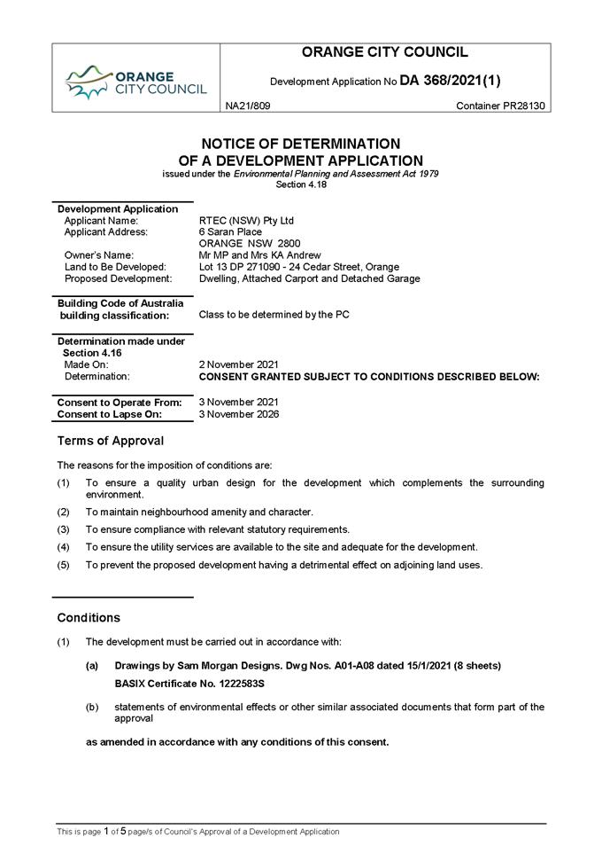
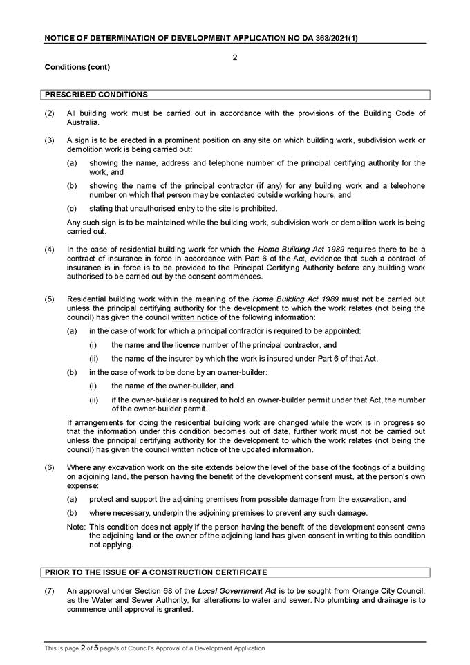
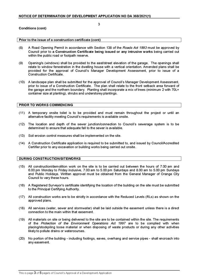
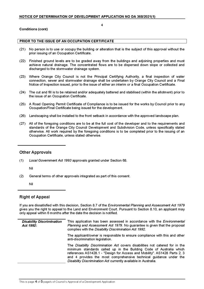
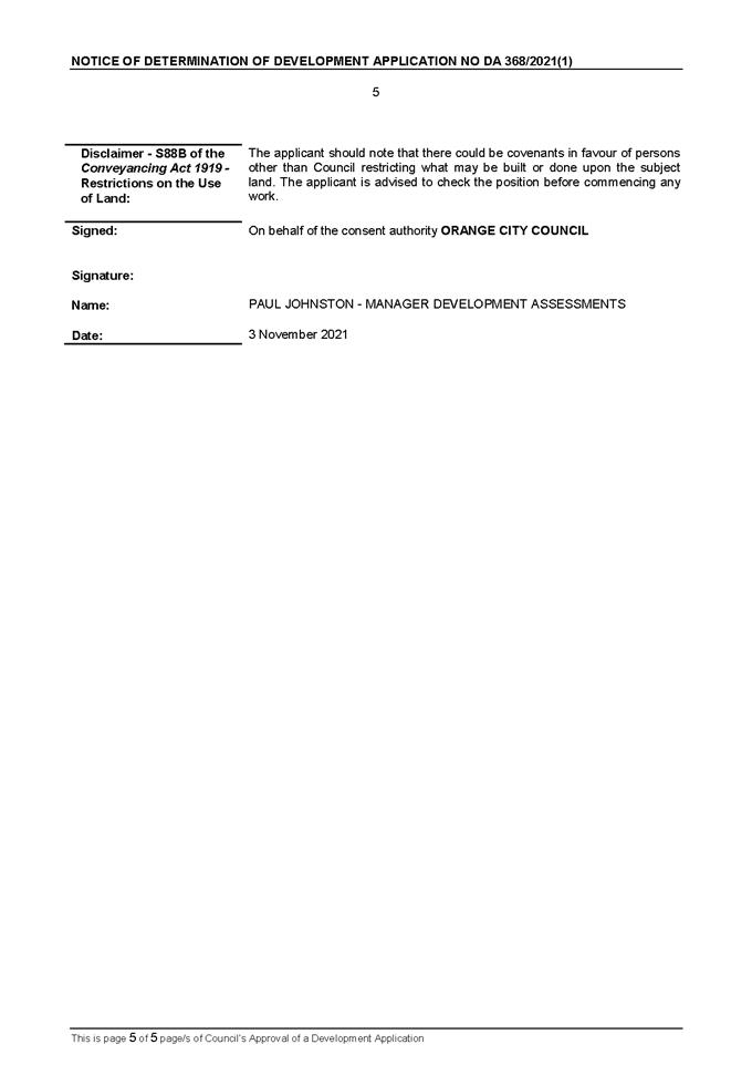
Planning and Development Committee
2 November 2021
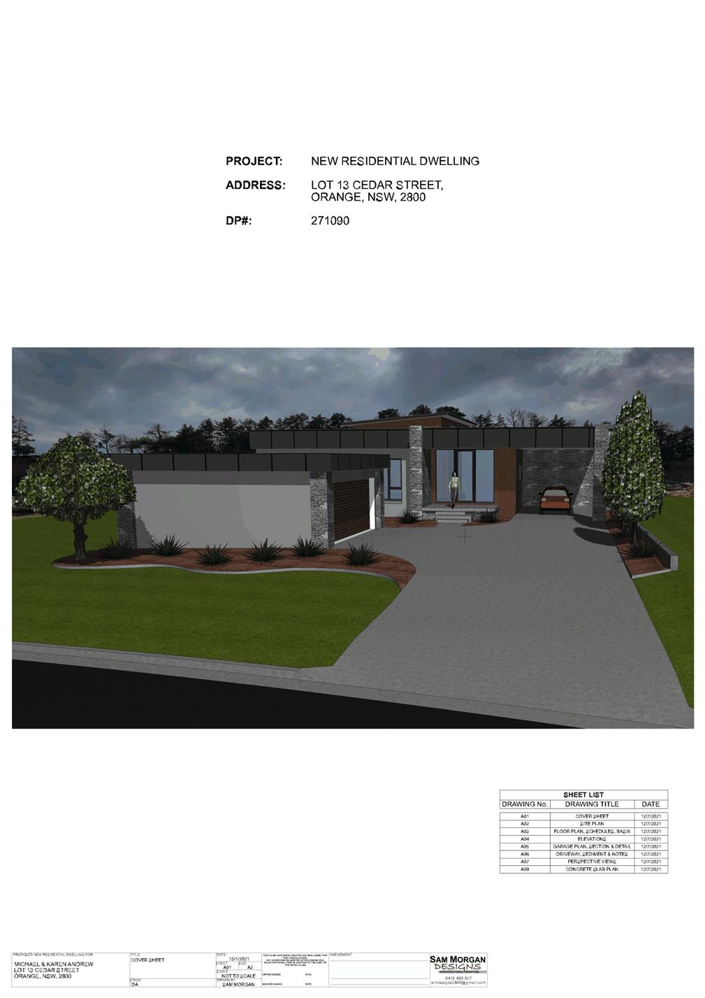
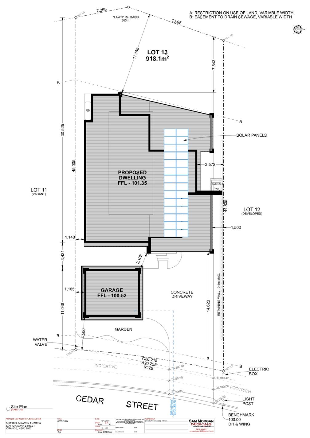


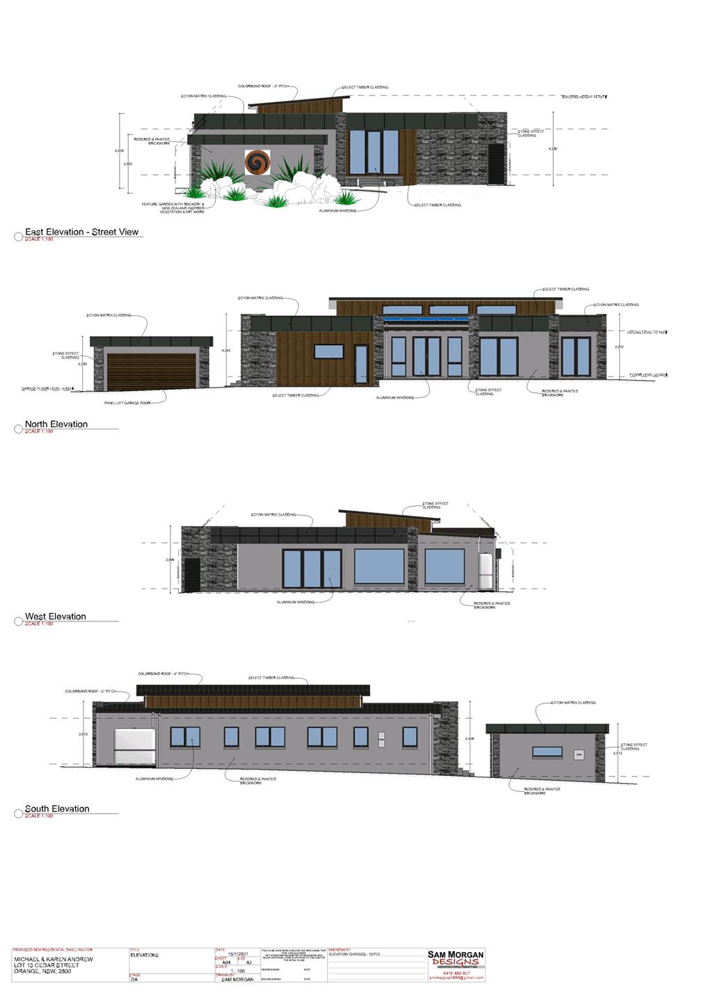
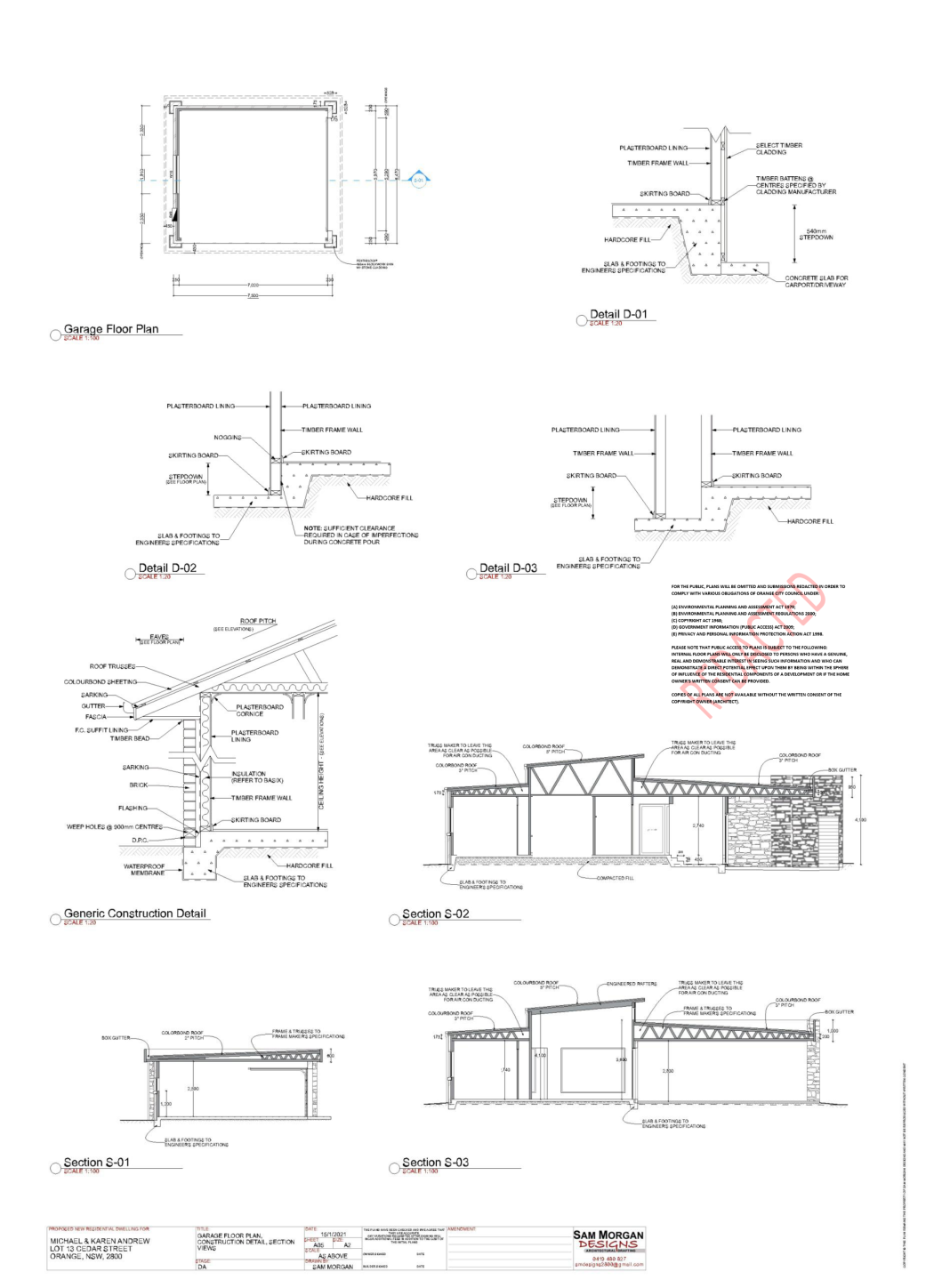
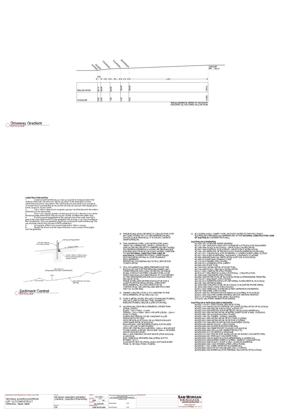
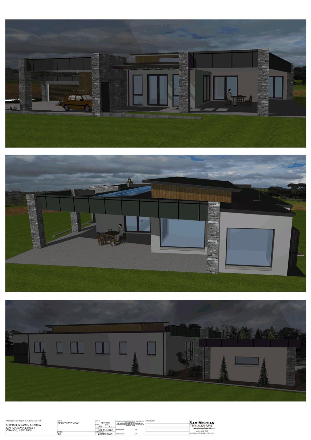


2.8 Development
Application DA 390/2021(1) - 1610 and Lot 209 Forest Road
RECORD
NUMBER: 2021/2372
AUTHOR: Ben
Hicks, Planner
EXECUTIVE Summary
Council is in receipt of a concept development application
for the carrying out of a three stage project associated with the development
of the proposed Orange Regional Sporting Facility located at 1584 and 1610
Forest Road, Orange.
The application provides an overarching concept for the
sporting facility which sets out key design parameters for how the site will be
developed, together with full details for Stage 1 of the project. Stages 2 and
3 will be addressed by future development applications. Staging of the scheme
is outlined as follows:
Stage 1 - Bulk earthworks,
tree clearing, building demolition and category 1 remediation;
Stage 2 - Athletics
stadium and car parking; and
Stage 3 - Main stadium and
residual works.
Due to the value of the overall concept development, the
Western Regional Planning Panel will be the determining authority of this
proposal, not Council. It is likely that the Panel would consider the
application later this year, after this Council has entered the caretaker mode
leading up to the Local Government elections.
This report provides the Council with an update on the
progress of the assessment report and process moving forward. Whilst the
assessment of this proposal by staff for reporting to the Western Region
Planning Panel is not as yet complete, the option remains open for the Council
itself to separately make a submission to the Western
Regional Planning Panel prior to entering the caretaker mode.
Link To
Delivery/OPerational Plan
The recommendation in this report
relates to the Delivery/Operational Plan strategy “10.1 Preserve - Engage
with the community to ensure plans for growth and development are respectful of
our heritage”.
further considerations
Consideration has been given to the recommendation’s
impact on Council’s service delivery; image and reputation; political;
environmental; health and safety; employees; stakeholders and project
management; and no further implications or risks have been identified.
Financial Implications
Nil
Policy and Governance Implications
Nil
|
Recommendation
That Council:
1 Determine
whether or not it makes a submission on the application to the Western Regional
Planning Panel.
|
DIRECTORS NOTE
This report provides the Council with an update on the
progress and process moving forward regarding the Development Application for
the Orange Sporting precinct. Council staff are in the process of preparing a
planning report on this application which is to be tabled before the Western
Region Planning Panel. The final assessment report is not yet complete.
However, it is open for Council to make a submission
in support (or otherwise) of the development application that is to be
considered by the Western Regional Planning Panel. Attached to this
report is a copy of the application and supporting plans.
THE REPORT
Council is in receipt of a concept development application
for the carrying out of a three stage project associated with the development
of the proposed Orange Regional Sporting Facility located at 1584 and 1610
Forest Road, Orange.
The application provides an overarching concept for the
sporting facility which sets out key design parameters for how the site will be
developed, together with full details for Stage 1 of the project. Stages 2 and
3 will be addressed by future development applications. Staging of the scheme
is outlined as follows:
Stage 1 - Bulk earthworks,
tree clearing, building demolition and category 1 remediation;
Stage 2 - Athletics
stadium and car parking; and
Stage 3 - Main stadium and
residual works.
Council is advised that the application will be tabled for
the determination of the Western Regional Planning Panel due to the value of
the proposal and Council’s interest in the matter.
The application has been referred to Transport for NSW,
Heritage NSW and Essential Energy in accordance with prescribed concurrence and
referral requirements. Formal advice has been received from Transport for NSW
and Essential Energy in support of the application subject to conditions.
Heritage NSW have requested the submission of additional information and the
applicant is in the process of furnishing this information in response to the
request.
The application was also exhibited and also notified to
adjoining landowners for a period of 28 days closing 13 October 2021. A total
of 33 written submissions have been received during the exhibition period a
copy of which have been forwarded to NSW Heritage in accordance with the
Integrated Development requirements. The submissions both for and against the
project raise similar issues to those raised in the initial assessment of the
DA for tree removal from this site. A detailed analysis of the issues raised in
the submissions will be required in the planning report to the Joint Regional
Planning Panel.
A report is being prepared by Council assessment staff which
will be provided directly to the panel once advice and General Terms of
Approval have been received from NSW Heritage. It is likely at this stage
that the planning report will be tabled for consideration by the Joint Regional
Planning Panel in the intervening period of when the caretaker mode commences
for the Local Government elections are held and the first available meeting of
the new Council in February/March 2022.
As a separate matter to the
assessment of the application by staff, this Council may resolve to make a
submission to the WRPP relating to this development application.
The provision of a submission by Council directly to the
WRPP is permitted within the Sydney & Regional Planning Panels
Operational Procedures.
Historically, Council have made submissions in the past to
the WRPP to express its own opinions of development proposals before the
Panel. There is no requirement to wait until the staff assessment is
completed, as a Council submission is not referenced in the assessment report
nor in any recommendations made by the Council staff.
Plans and supporting information are attached to assist
Council in making a submission on the matter.
Attachments
1 Plans,
D21/67622⇩
2 Statement
of Environmental Effects (SoEE), D21/67624⇩
Planning
and Development Committee
2 November 2021
Planning
and Development Committee
2 November 2021
Attachment 2 Statement
of Environmental Effects (SoEE)