Planning and Development
Committee
Agenda
5 October 2021
Notice is hereby given, in
accordance with the provisions of the Local Government Act 1993 that a Planning and Development Committee meeting of ORANGE CITY COUNCIL
will be held in the Council Chamber,
Civic Centre, Byng Street, Orange on Tuesday, 5 October
2021.
David
Waddell
Chief Executive Officer
For apologies please
contact Administration on 6393 8106.
1 Introduction
1.1 Declaration
of pecuniary interests, significant non-pecuniary interests and less than
significant non-pecuniary interests
The
provisions of Chapter 14 of the Local Government Act, 1993 (the Act)
regulate the way in which Councillors and designated staff of Council conduct
themselves to ensure that there is no conflict between their private interests
and their public role.
The
Act prescribes that where a member of Council (or a Committee of Council) has a
direct or indirect financial (pecuniary) interest in a matter to be considered
at a meeting of the Council (or Committee), that interest must be disclosed as
soon as practicable after the start of the meeting and the reasons given for
declaring such interest.
As
members are aware, the provisions of the Local Government Act restrict any
member who has declared a pecuniary interest in any matter from participating
in the discussion or voting on that matter, and requires that member to vacate
the Chamber.
Council’s Code of Conduct provides that if members
have a non-pecuniary conflict of interest, the nature of the conflict must be
disclosed. The Code of Conduct also provides for a number of ways in which a
member may manage non pecuniary conflicts of interest.
|
Recommendation
It is recommended that Committee Members now disclose any
conflicts of interest in matters under consideration by the Planning and
Development Committee at this meeting.
|
2 General
Reports
2.1 Items
Approved Under the Delegated Authority of Council
RECORD
NUMBER: 2021/1947
AUTHOR: Paul
Johnston, Manager Development Assessments
EXECUTIVE Summary
Following is a list of more significant development
applications approved by the Chief Executive Officer under the delegated
authority of Council. Not included in this list are residential scale
development applications that have also been determined by staff under the
delegated authority of Council (see last paragraph of this report for those
figures).
Link To Delivery/OPerational Plan
The recommendation in this report
relates to the Delivery/Operational Plan strategy “7.1 Preserve - Engage
with the community to develop plans for growth and development that value the
local environment”.
Financial Implications
Nil
Policy and Governance Implications
Nil
|
Recommendation
That Council resolves to
acknowledge the information provided in the report by the Manager Development
Assessments on Items Approved Under the Delegated Authority of Council.
|
further considerations
Consideration has been given to the
recommendation’s impact on Council’s service delivery; image and
reputation; political; environmental; health and safety; employees;
stakeholders and project management; and no further implications or risks have
been identified.
|
Reference:
|
DA 431/2012(6)
|
Determination Date:
|
9 September 2021
|
|
PR Number
|
PR29023
|
|
Applicant/s:
|
Icewand Pty Ltd
|
|
Owner/s:
|
Icewand Pty Ltd
|
|
Location:
|
Lot 31 DP 1272282 - Scarborough
Street, Orange (in the subdivision of land formerly known as Lot 210 DP
1177178).
|
|
Proposal:
|
Modification of development consent
- subdivision (94 lot residential). The modified proposal sought to adjust
the boundaries of seven (7) residential lots to reflect the adjusted site
boundary. One (1) additional lot is also proposed.
|
|
Value:
|
$0
|
|
Reference:
|
DA 111/2020(2)
|
Determination Date:
|
26 August 2021
|
|
PR Number
|
PR4818
|
|
Applicant/s:
|
Bassmann Drafting Services
|
|
Owner/s:
|
Mr MJ and Mrs JE Truloff
|
|
Location:
|
Lot 2 DP 413484 - 12 Green Lane,
Orange
|
|
Proposal:
|
Modification of development consent
- dwelling (two storey), attached garage, retaining walls and tree removal.
The modified proposal sought to correct a typographical error relating to the
consent lapsing date on the Notice of Approval.
|
|
Value:
|
$0
|
|
Reference:
|
DA 117/2020(2)
|
Determination Date:
|
30 August 2021
|
|
PR Number
|
PR19435
|
|
Applicant/s:
|
Lindfield Family Trust
|
|
Owner/s:
|
MLPL Investments Pty Ltd
|
|
Location:
|
Lot 106 DP 1067744 - 1 Ralston
Drive, Orange
|
|
Proposal:
|
Modification of development consent
- self-storage units. The modified proposal involved minor reconfiguration to
site layout and building design. Works included an additional site
access via Ralston Drive; part-covered internal driveway; two additional
storage units; changes to storage unit areas; and revised roof pitches. The
modified development complied with planning controls applicable to the
subject land and proposed land use.
|
|
Value:
|
$0
|
|
Reference:
|
DA 174/2020(2)
|
Determination Date:
|
8 September 2021
|
|
PR Number
|
PR10758
|
|
Applicant/s:
|
Mrs DM Swiatkiwsky
|
|
Owner/s:
|
Mr SW and Mrs DM Swiatkiwsky
|
|
Location:
|
Lot 23 DP 770810 - 79 Sampson
Street, Orange
|
|
Proposal:
|
Modification of development consent
- dwelling alterations and additions, fencing (front boundary fencing) and
detached garage with attached carport. The modified proposal sought to alter
the roof form of the approved rear garage, by using a hip roof at the back
end (western elevation) of the garage, instead of the approved gable end.
|
|
Value:
|
$0
|
|
Reference:
|
DA 382/2020(2)
|
Determination Date:
|
24 August 2021
|
|
PR Number
|
PR26334
|
|
Applicant/s:
|
Source Architects
|
|
Owner/s:
|
MLPL Investments Pty Ltd
|
|
Location:
|
Lot 202 DP 1190831 - 7 McNamara
Street, Orange
|
|
Proposal:
|
Modification of development consent
- retail premises and shop top housing. The modified proposal related to
approved Apartment 02 and involved a loft addition, inclusion of a pool in
the north terrace, new openings and minor internal layout changes.
|
|
Value:
|
$0
|
|
Reference:
|
DA 10/2021(3)
|
Determination Date:
|
19 August 2021
|
|
PR Number
|
PR20436
|
|
Applicant/s:
|
Orange City Council
|
|
Owner/s:
|
Orange City Council
|
|
Location:
|
Lot 1 DP 1085646, Lot 1 DP 1275359,
and
Lot 2 DP 1275359 - 298
Clergate Road, Orange.
|
|
Proposal:
|
Modification of development consent
- revised - subdivision (43 lots comprising 40 industrial lots, two lots
for stormwater management and one public reserve lot). The modified proposal
sought to amend the approved layout via the consolidation of proposed Lots
37, 38, 39 and 40. The change is considered minor, and the overall
development is considered substantially the same as the approved development.
|
|
Value:
|
$0
|
|
Reference:
|
DA 141/2021(1)
|
Determination Date:
|
26 August 2021
|
|
PR Number
|
PR27563
|
|
Applicant/s:
|
Mr JR Noller
|
|
Owner/s:
|
Mr JR and Mrs KE Noller
|
|
Location:
|
Lot 401 DP 1228050 - 22 Buckland
Drive, Orange
|
|
Proposal:
|
Subdivision (two lot Torrens title)
and dwelling houses (two)
|
|
Value:
|
$520,000
|
|
Reference:
|
DA 160/2021(2)
|
Determination Date:
|
15 September 2021
|
|
PR Number
|
PR23464
|
|
Applicant/s:
|
MAAS Group Properties
|
|
Owner/s:
|
Excelsior Housing 2 Pty Ltd
|
|
Location:
|
Lot 122 DP 1139920 - 87 Diamond
Drive, Orange
|
|
Proposal:
|
Modification of development consent
- group home (permanent). The modified proposal involved deletion of
Condition 9 which required laundry facilities be removed from each
accommodation unit.
|
|
Value:
|
$0
|
|
Reference:
|
DA 189/2021(2)
|
Determination Date:
|
15 September 2021
|
|
PR Number
|
PR28824
|
|
Applicant/s:
|
MAAS Group Properties
|
|
Owner/s:
|
Westhaven Limited
|
|
Location:
|
Lot 301 DP 1268612 - 63 Buckland
Drive, Orange
|
|
Proposal:
|
Modification of development consent
- group home (permanent). The modified proposal involved deletion of
Condition 8 which required laundry facilities be removed from each
accommodation unit.
|
|
Value:
|
$0
|
|
Reference:
|
DA 202/2021(1)
|
Determination Date:
|
21 September 2021
|
|
PR Number
|
PR26080
|
|
Applicant/s:
|
West Orange Holdings Pty Ltd
|
|
Owner/s:
|
West Orange Holdings Pty Limited
|
|
Location:
|
Lot 102 DP 1187463 - 22-34 Forbes
Road, Orange
|
|
Proposal:
|
Vehicle sales or hire premises
(vehicle shelter)
|
|
Value:
|
$220,000
|
|
Reference:
|
DA 225/2021(1)
|
Determination Date:
|
7 September 2021
|
|
PR Number
|
PR2034
|
|
Applicant/s:
|
Southwell Design Drafting
|
|
Owner/s:
|
Mr WS and Mrs EL Starr
|
|
Location:
|
Lot 6 DP 12699 - 284 Byng Street,
Orange
|
|
Proposal:
|
Subdivision (two lot Torrens title)
|
|
Value:
|
$40,000
|
|
Reference:
|
DA 234/2021(1)
|
Determination Date:
|
21 September 2021
|
|
PR Number
|
PR3401
|
|
Applicant/s:
|
Mr M Dwyer
|
|
Owner/s:
|
Mr MC Dwyer
|
|
Location:
|
Lot B DP 391205 - 219 Dalton
Street, Orange
|
|
Proposal:
|
Subdivision (two lot residential),
multi dwelling housing (three dwellings), alterations and additions to
existing dwelling, and subdivision (four lot Community title)
|
|
Value:
|
$650,000
|
|
Reference:
|
DA 238/2021(1)
|
Determination Date:
|
21 September 2021
|
|
PR Number
|
PR8839
|
|
Applicant/s:
|
Mr I Zhang
|
|
Owner/s:
|
Mrs JM Zhang
|
|
Location:
|
Lot 3 DP 226927 - 2 Moulder Street,
Orange
|
|
Proposal:
|
Dual occupancy (alterations and
additions to existing dwelling and one new dwelling), subdivision (two lot
residential) and demolition (garage)
|
|
Value:
|
$300,000
|
|
Reference:
|
DA 244/2021(1)
|
Determination Date:
|
15 September 2021
|
|
PR Number
|
PR25686
|
|
Applicant/s:
|
Cancer Care Western NSW Inc
|
|
Owner/s:
|
Health Administration Corporation
|
|
Location:
|
Lot 500 DP 1175440 - 1582 Forest
Road, Orange
|
|
Proposal:
|
Fence (perimeter of Western Care
Lodge)
|
|
Value:
|
$20,000
|
|
Reference:
|
DA 248/2021(1)
|
Determination Date:
|
26 August 2021
|
|
PR Number
|
PR26462
|
|
Applicant/s:
|
Access Recycling
|
|
Owner/s:
|
Orange City Council
|
|
Location:
|
Lot 105 DP 1194589 - 30 Astill
Drive, Orange
|
|
Proposal:
|
Resource transfer station (scrap
metal)
|
|
Value:
|
$739,882
|
|
Reference:
|
DA 281/2021(1)
|
Determination Date:
|
15 September 2021
|
|
PR Number
|
PR25478
|
|
Applicant/s:
|
Mr SW Rosser
|
|
Owner/s:
|
Mr SW Rosser
|
|
Location:
|
Lot 2 DP 1168899 - 1
Callistemon Place, Orange
|
|
Proposal:
|
Dwelling (two storey) and attached
garage
|
|
Value:
|
$350,000
|
|
Reference:
|
DA 286/2021(1)
|
Determination Date:
|
7 September 2021
|
|
PR Number
|
PR19100
|
|
Applicant/s:
|
Ihire Northwest Pty Ltd
|
|
Owner/s:
|
Orange Alpine Investments Pty Ltd
|
|
Location:
|
Lot 2 SP 33395 - 2/175 Dalton
Street, Orange
|
|
Proposal:
|
Business premises (fitout for
commercial laundry) (change of use)
|
|
Value:
|
$10,000
|
|
Reference:
|
DA 299/2021(1)
|
Determination Date:
|
9 September 2021
|
|
PR Number
|
PR21525
|
|
Applicant/s:
|
Australian Postal Corporation
|
|
Owner/s:
|
Rotom Holdings Pty Limited
|
|
Location:
|
Lot 100 DP 1110802 - 8 Strathgrove
Way Orange
|
|
Proposal:
|
Warehouse or distribution centre (extension
of approved operating hours to 24/7 operation)
|
|
Value:
|
$0
|
|
Reference:
|
DA 301/2021(1)
|
Determination Date:
|
7 September 2021
|
|
PR Number
|
PR18569
|
|
Applicant/s:
|
Mr D Tracey
|
|
Owner/s:
|
Mr RJ and Mrs DG Carmichael
|
|
Location:
|
Lot 3 SP 80235 - 1/26 Sale Street,
Orange
|
|
Proposal:
|
Restaurant or cafe (alterations to
shopfront)
|
|
Value:
|
$35,000
|
|
Reference:
|
DA 307/2021(1)
|
Determination Date:
|
31 August 2021
|
|
PR Number
|
PR10595
|
|
Applicant/s:
|
Orthodontics Exclusively
|
|
Owner/s:
|
Baptist Churches of New South Wales
Property Trust
|
|
Location:
|
Lot 2 DP 302443 - 57 Sale
Street, Orange
|
|
Proposal:
|
Medical centre (change of use from
office premises)
|
|
Value:
|
$300,000
|
|
Reference:
|
DA 315/2021(1)
|
Determination Date:
|
21 September 2021
|
|
PR Number
|
PR6662
|
|
Applicant/s:
|
L-CON Building and Construction
|
|
Owner/s:
|
Roweth Investments Pty Limited
|
|
Location:
|
Lot 53 DP 255071 - 10 Leewood
Drive, Orange
|
|
Proposal:
|
General Industry, Business
Identification Signage
|
|
Value:
|
$1,211,498
|
|
Reference:
|
DA 332/2021(1)
|
Determination Date:
|
9 September 2021
|
|
PR Number
|
PR6237
|
|
Applicant/s:
|
The Scouts Association Of Australia
|
|
Owner/s:
|
Orange Group Scouts
|
|
Location:
|
Lots 14 and 15 DP 758817 - 94 Kite
Street, Orange
|
|
Proposal:
|
Community facility (alterations and
additions to Scout Hall)
|
|
Value:
|
$15,950
|
|
Reference:
|
DA 343/2021(1)
|
Determination Date:
|
9 September 2021
|
|
PR Number
|
PR18456
|
|
Applicant/s:
|
Mr MJ Ryan
|
|
Owner/s:
|
Mr MJ and Mrs SM Ryan
|
|
Location:
|
Lot 67 DP 1043952 - 25 McCarron
Place, Orange
|
|
Proposal:
|
Secondary dwelling and deck (part garage
conversion)
|
|
Value:
|
$35,000
|
|
Reference:
|
DA 354/2021(1)
|
Determination Date:
|
9 September 2021
|
|
PR Number
|
PR26308
|
|
Applicant/s:
|
Source Architects
|
|
Owner/s:
|
The Uniting Church in Australia
Property Trust (NSW)
|
|
Location:
|
Lot 30 DP 1190518 - 59-67 Bathurst
Road, Orange
|
|
Proposal:
|
School (alterations to existing
covered learning area and new awning)
|
|
Value:
|
$299,134
|
|
Reference:
|
DA 370/2021(1)
|
Determination Date:
|
7 September 2021
|
|
PR Number
|
PR29027
|
|
Applicant/s:
|
JKMR Layton Property
|
|
Owner/s:
|
Orange City Council
|
|
Location:
|
Lot 1 DP 1275359 - Clergate Road,
Orange
|
|
Proposal:
|
Earthworks (ancillary retaining
walls)
|
|
Value:
|
$50,000
|
TOTAL NET* VALUE OF DEVELOPMENTS APPROVED BY THE CEO UNDER
DELEGATED AUTHORITY IN THIS PERIOD: $4,796,464.00
* Net value relates to the
value of modifications. If modifications are the same value as the original DA,
then nil is added. If there is a plus/minus difference, this difference is
added or taken out.
Additionally, since the August 2021 meeting report period
(25 August to 22 September 2021), another 24 development applications were
determined under delegated authority by other Council staff with a combined
value of $8,722,957.
2.2 Development
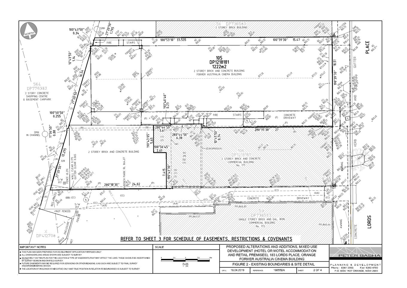
Application DA 416/2019(1) - 183 Lords Place
RECORD
NUMBER: 2021/2150
AUTHOR: Summer
Commins, Senior Planner
EXECUTIVE
Summary
|
Application
lodged
|
10
December 2019
Amended
proposal submitted 9 January 2020
563 STOP
DAYS
|
|
Applicant/s
|
Ref
Group Pty Ltd
|
|
Owner/s
|
Ref
Group Pty Ltd
|
|
Land
description
|
Lot 105
DP 1218181 - 183 Lords Place, Orange
|
|
Proposed
land use
|
Mixed Use Development (hotel or
motel accommodation and retail premises (shop)) and Demolition
|
|
Value of
proposed development
|
$4,350,000.00
|
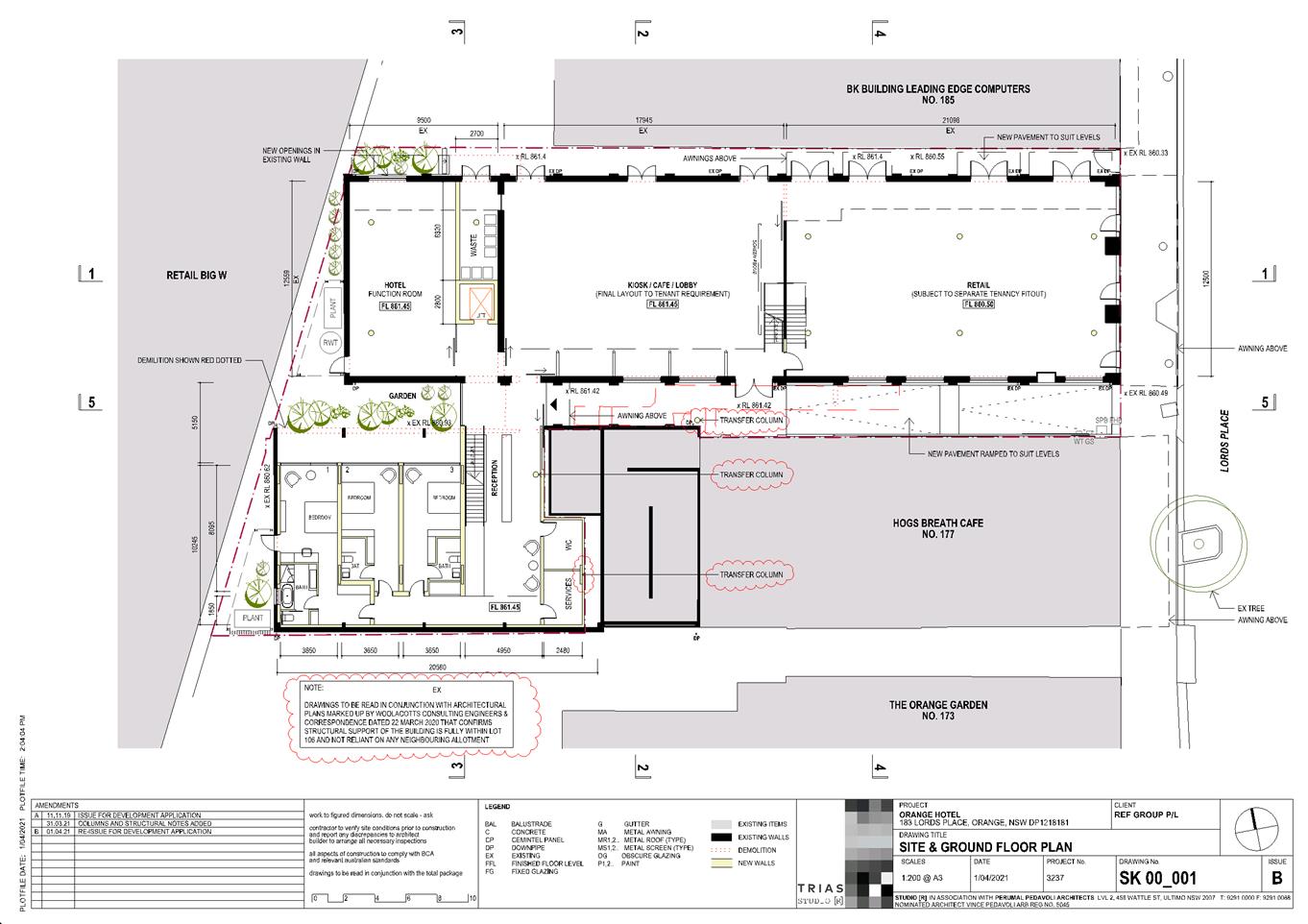
This development application relates to the former Australia
Cinema at 183 Lords Place, and involves new use of the building for hotel or
motel accommodation and retail premises.
The proposal involves building alterations, additions and
external works to make the premises suitable for the new uses. The building
will contain:
· 31 accommodation
rooms over three (3) levels.
· Hotel reception,
kiosk/café and function room at ground level.
· Retail space and
shopfront to Lords Place.
The adjoining laneway and
pathway will be activated via new openings, awning and pavement. The
development does not involve onsite car parking.
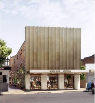
Figure 1 – artist impression - Lords Place
elevation
The following notable planning
matters are considered in this assessment report:
· The proposed works
will be fully self-supported from within the subject land and will not rely on
existing structures or easement through neighbouring lots.
· The proposed
building addition will exceed the prescribed maximum building height for the
land. The proposal is supported by a Clause 4.6 Exception to Development
Standards.
· The site is
contained within the Central Orange Heritage Conservation Area. The building is
not a listed heritage Item, though does have particular heritage value.
· The proposed
development has been subject to extensive assessment by Council’s
Heritage Advisor. The proponent and Heritage Advisor have reached agreement on
a number of design recommendations, however there are three outstanding matters
of contention. Conditions are included in relation to façade detailing.
· The subject land
is contained within a flood planning area and subject to inundation during
flood events.
· Onsite car parking
will not be provided, and the development will rely on historic car parking
credits.
The proposed development comprises
advertised development in accordance with Council’s Community
Participation Plan 2019. At the completion of the exhibition period, one (1)
submission was received. The submission maintains that the Australia Cinema
should be a listed heritage item as the building is of significance in the
social, political, religious and entertainment evolution of Orange. These
matters have been addressed in the report.
The proposed development will satisfy the Local and State
planning controls that apply to the subject land and particular land use.
Impacts of the development will be within acceptable limit subject to
mitigation conditions. Approval of the application is recommended.
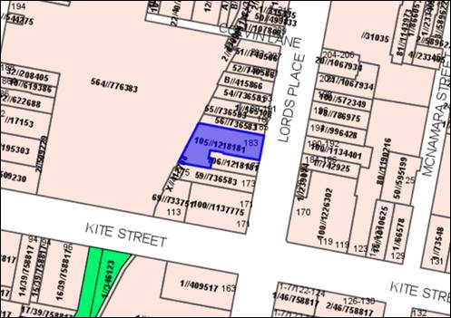
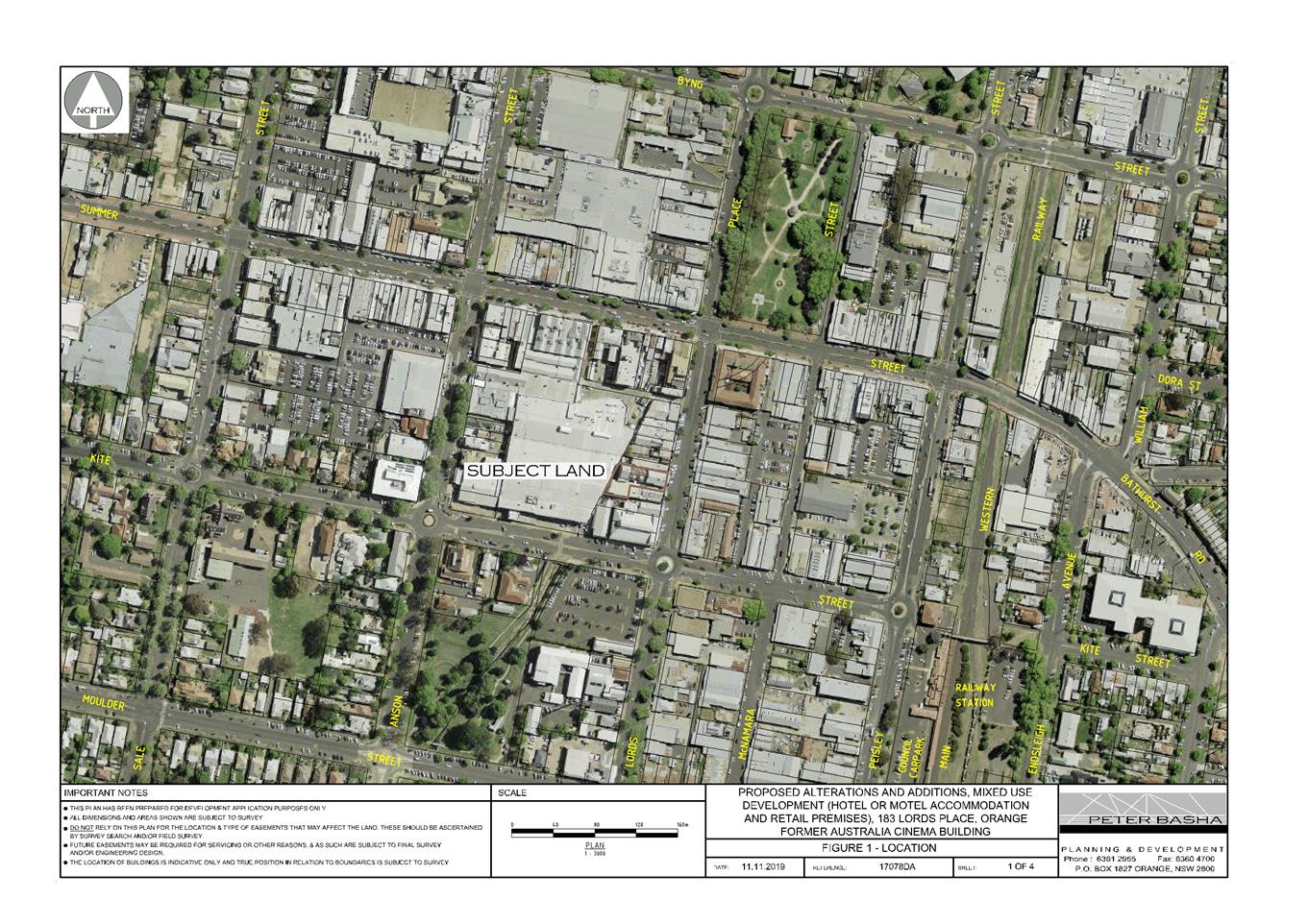
Figure 2 - locality plan
DECISION FRAMEWORK
Development in Orange is governed by two key documents
Orange Local Environment Plan 2011 and Orange Development Control Plan 2004. In
addition the Infill Guidelines are used to guide development, particularly in
the heritage conservation areas and around heritage items.
Orange Local Environment Plan 2011 – The
provisions of the LEP must be considered by the Council in determining the
application. LEPs govern the types of development that are permissible or
prohibited in different parts of the City and also provide some assessment
criteria in specific circumstances. Uses are either permissible or not. The
objectives of each zoning and indeed the aims of the LEP itself are also to be
considered and can be used to guide decision making around appropriateness of
development.
Orange Development Control Plan 2004 – the DCP
provides guidelines for development. In general it is a performance based
document rather than prescriptive in nature. For each planning element there
are often guidelines used. These guidelines indicate ways of achieving the
planning outcomes. It is thus recognised that there may also be other solutions
of merit. All design solutions are considered on merit by planning and building
staff. Applications should clearly demonstrate how the planning outcomes are
being met where alternative design solutions are proposed. The DCP enables
developers and architects to use design to achieve the planning outcomes in
alternative ways.
DIRECTOR’S COMMENT
This development application relates to the former Australia
Cinema at 183 Lords Place, and involves new use of the building for hotel or
motel accommodation and retail premises. The proposal involves
building alterations, additions and external works to make the premises
suitable for the new uses and will comprise 31 accommodation rooms over three
(3) levels, hotel reception, kiosk/café and function room at ground
level and retail space and shopfront to Lords Place.
Notable planning issues for consideration
include height of building (application supported by a Clause 4.6 variation to
the standard), heritage, flooding and car parking. Council has received 1
written submission during the exhibition period which has also been considered
in the report.
Impacts of the development are considered to be within
acceptable limit subject to mitigation conditions. The proposal will contribute
to the activation and vitality of the CBD and have positive impacts on the
heritage setting. Conditions are included to mitigate and manage arising
impacts. Approval of the application is recommended subject to the adoption of
the Attached draft Notice of Determination.
Link To
Delivery/OPerational Plan
The recommendation in this report relates to the
Delivery/Operational Plan strategy “10.1 Preserve - Engage with the
community to ensure plans for growth and development are respectful of our
heritage”.
Financial Implications
Nil
Policy and Governance Implications
Nil
|
Recommendation
That Council consents to
development application DA 416/2019(1)
for Mixed Use Development (hotel or motel accommodation and retail
premises (shop)) and Demolition at Lot 105 DP 1218181 - 183 Lords
Place, Orange pursuant to the conditions of consent
in the attached Notice of Approval.
|
further considerations
Consideration has been given to the recommendation’s
impact on Council’s service delivery; image and reputation; political;
environmental; health and safety; employees; stakeholders and project
management; and no further implications or risks have been identified.
SUPPORTING INFORMATION
There are two matters of relevance
to the proposed development:
1. Amended
Proposal
This assessment report is based on
an amended proposal. The development as originally submitted involved an
amended building design that relied on existing load bearing structures and
easements through adjoining property airspace (stratum Lot 106 DP 1218181
– 177 Lords Place, occupied by Hogs Breath Café). Legal
opinion confirmed Lot 106 included land to which the original development
relates; and the consent of the landowner of Lot 106 would be required.
Following a protracted period,
owners’ consent was not obtained, and the development was subsequently
amended. The current proposal will be wholly contained/fully supported within
the development site.
2. Previous
DA
The land has development consent
for a place of public worship pursuant to DA 347/2013(1) approved on 1
April 2014. The development involved change of use and building alterations,
including remodelling of the Lords Place façade with new cladding and
glazing (see Figure 3 below). The development did not proceed and has the
consent has lapsed.
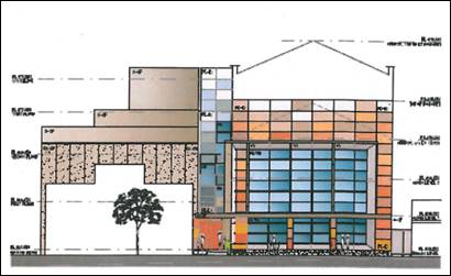
Figure 3 – lapsed DA 347/2013(1) – Lords
Place façade
THE PROPOSAL
The proposal involves alterations, additions and external
works to make the building suitable for new use as hotel or motel
accommodation and retail premises.
Proposed works include:
· Demolition of some
building elements and structures.
· A building
addition to the rear (south-west) to form two new floors for hotel or motel
accommodation.
· Removal of
internal walls and construction of new internal walls to form the proposed
spaces within the building.
· Alterations to
openings on the side and rear facades, including new openings, reinstatement of
existing openings and removal of openings.
· New roof sheeting
including part-operable roof over internal void.
· New façade
to Lords Place including awning reconstruction, above awning metal screen and
ground level shopfronts.
· New paving to
pedestrian laneways on the north and south of the building.
· New and renovated
external finishes including:
- aluminium-framed
shopfront glazing and painted surrounds to Lords Place
- a
fluted profile perforated metal screen over the existing façade above
the awning to Lords Place
- lightweight
construction (Cemintel Panel) to the building addition
- aluminium
framed glazing
- face
brick walls (existing or removed render).
The proposed elevations to Lords Place and the northern
laneway are depicted below (see Figures 4 and 5).
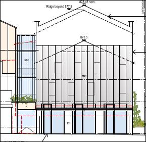
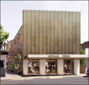
Figure 4 – Lords Place elevation
Figure 5 - proposed north elevation
The
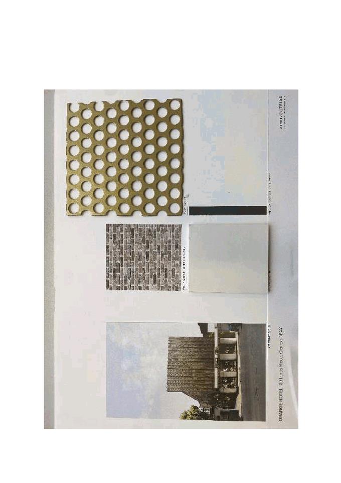
proposed finishes board is shown below and attached.
Figure 6 – proposed finishes
Internal spaces within the building will comprise the
following:
At ground level (see Figure 7).
· A retail space at
the site frontage to address Lords Place and the laneways. Use of the retail
space will be subject to separate DA.
· A
kiosk/café/lobby with frontage to the laneways, containing a three
storey void and operable roof. Use of this space will be subject to separate
DA.
· Hotel reception
accessed by the southern laneway, function room and plant/utilities etc.
· Hotel rooms 1-3.
Figure 7 – proposed ground floor
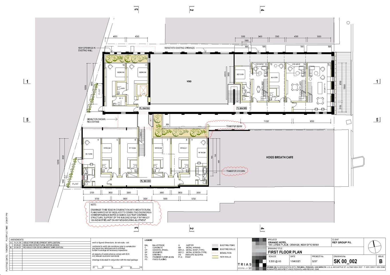
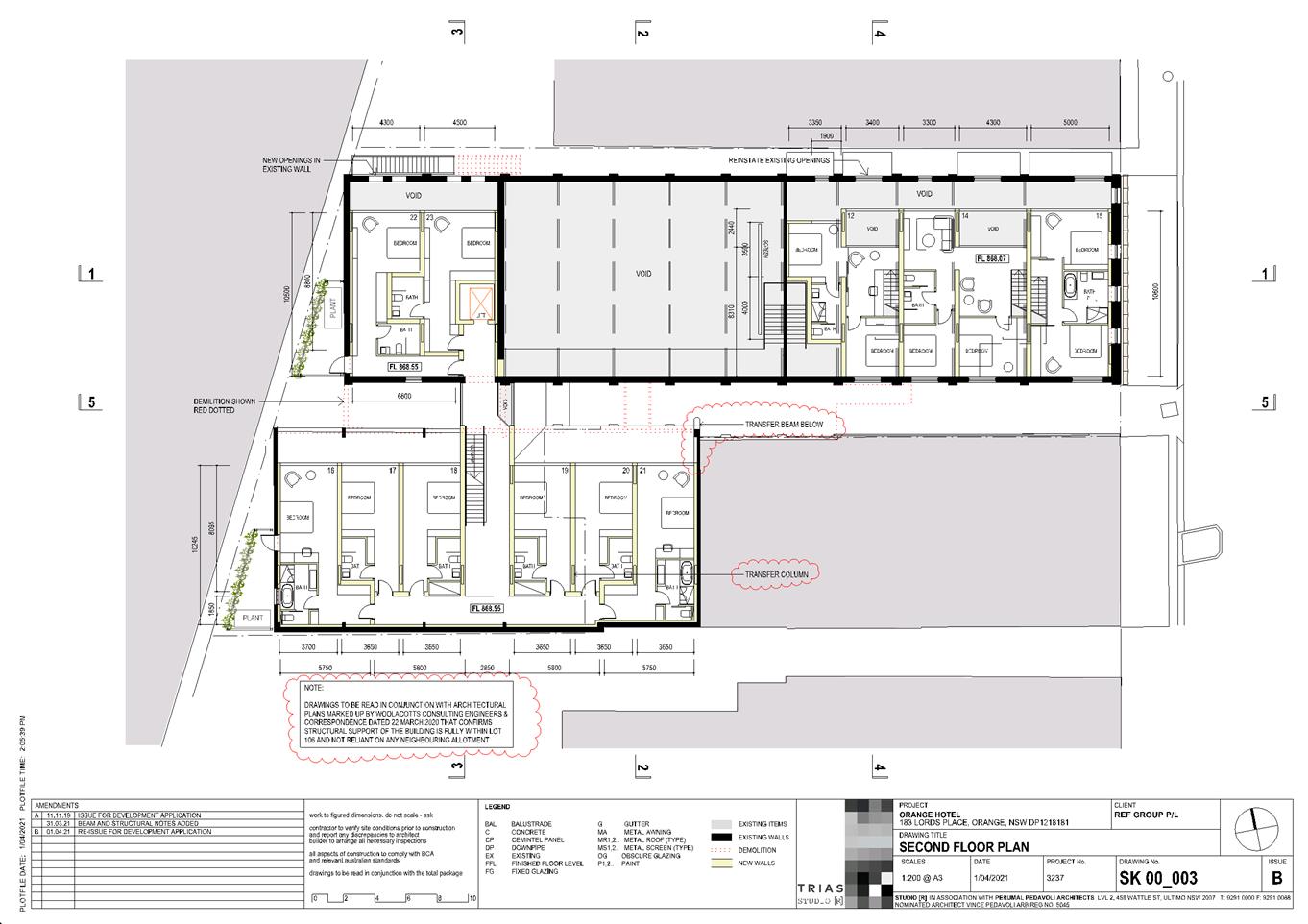
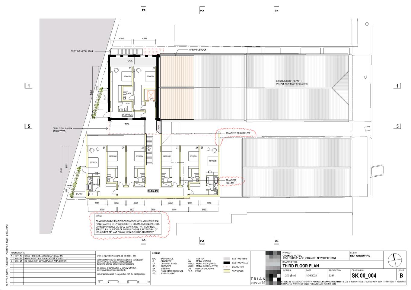
The first, second and third
floors will accommodate hotel rooms 4 to 31. Hotel rooms will comprise a mix of
single rooms, one (1) bedroom or two (2) bedroom apartments. The proposed
first floor (and typical floor plan) is shown here (see Figure 8).
Figure 8 – proposed first floor
MATTERS FOR CONSIDERATION UNDER
THE ENVIRONMENTAL PLANNING AND ASSESSMENT ACT 1979
Section 1.7 - Application of Part
7 of the Biodiversity Conservation Act 2016 and Part 7A of the Fisheries
Management Act 1994
Pursuant to Section 1.7:
This
Act has effect subject to the provisions of Part 7 of the Biodiversity Conservation Act 2016 and Part 7A of the Fisheries Management Act 1994 that relate to the operation of this Act in connection
with the terrestrial and aquatic environment.
In consideration of this section, the development is not
likely to give rise to any significant impact upon any endangered ecologically
communities, threatened species or their habitat. The site is a longstanding
and highly disturbed urban setting, devoid of vegetation. A Biodiversity
Assessment Report is not required, and the proposal suitably satisfies the
relevant matters at Section 1.7.
Section 4.15 Evaluation
Provisions of any
Environmental Planning Instrument S4.15(1)(a)(i)
Orange Local Environmental Plan
2011
Part 1 - Preliminary
Clause 1.2 Aims of Plan
The
particular aims of Orange LEP 2011 relevant to the proposal include:
(a) to encourage development which complements
and enhances the unique character of Orange as a major regional centre boasting
a diverse economy and offering an attractive regional lifestyle,
(b) to
provide for a range of development opportunities that contribute to the social,
economic and environmental resources of Orange in a way that allows present and
future generations to meet their needs by implementing the principles for
ecologically sustainable development,
(c) to
conserve and enhance the water resources on which Orange depends, particularly
water supply catchments,
(d) to
manage rural land as an environmental resource that provides economic and
social benefits for Orange,
(e) to
provide a range of housing choices in planned urban and rural locations to meet
population growth,
(f) to
recognise and manage valued environmental heritage, landscape and scenic
features of Orange.
The application is considered to be consistent with the
above-listed Aims, as outlined in this report.
Clause 1.6 Consent Authority
Clause 1.6 is applicable and states:
The consent authority for the purposes of this Plan is
(subject to the Act) the Council.
Clause 1.7 Mapping
The subject site is identified
on the LEP maps in the following manner:
|
Land Zoning Map:
|
Land zoned B3 Commercial Core
|
|
Lot Size Map:
|
No minimum lot size
|
|
Heritage Map:
|
Within a conservation area and
nearby to heritage items
|
|
Height of Buildings Map:
|
Building height limit 16m
|
|
Floor Space Ratio Map:
|
Floor space limit 2:1
|
|
Terrestrial Biodiversity Map:
|
No biodiversity sensitivity on the
site
|
|
Groundwater Vulnerability Map:
|
Groundwater vulnerable
|
|
Drinking Water Catchment Map:
|
Not within the drinking water
catchment
|
|
Watercourse Map:
|
Within or affecting a defined watercourse
|
|
Urban Release Area Map:
|
Not within an urban release area
|
|
Obstacle Limitation Surface Map:
|
No restriction on building siting
or construction
|
|
Additional Permitted Uses Map:
|
No additional permitted use applies
|
|
Flood Planning Map:
|
Within a flood planning area
|
Those matters that are of relevance are addressed in detail
in the body of this report.
Clause 1.9A Suspension of
Covenants, Agreements and Instruments
Clause 1.9A is applicable and states in part:
(1) For the purpose of enabling development
on land in any zone to be carried out in accordance with this Plan or with a
consent granted under the Act, any agreement, covenant or other similar
instrument that restricts the carrying out of that development does not apply
to the extent necessary to serve that purpose.
In
consideration of this clause, Council staff are not aware of the title of the
subject property being affected by a relevant agreement, covenant, etc.
As a
matter arising, the subject land overhangs and underlies the rear of the
building at Lot 106 DP 1218181 – 177 Lords Place (Hog’s Breath
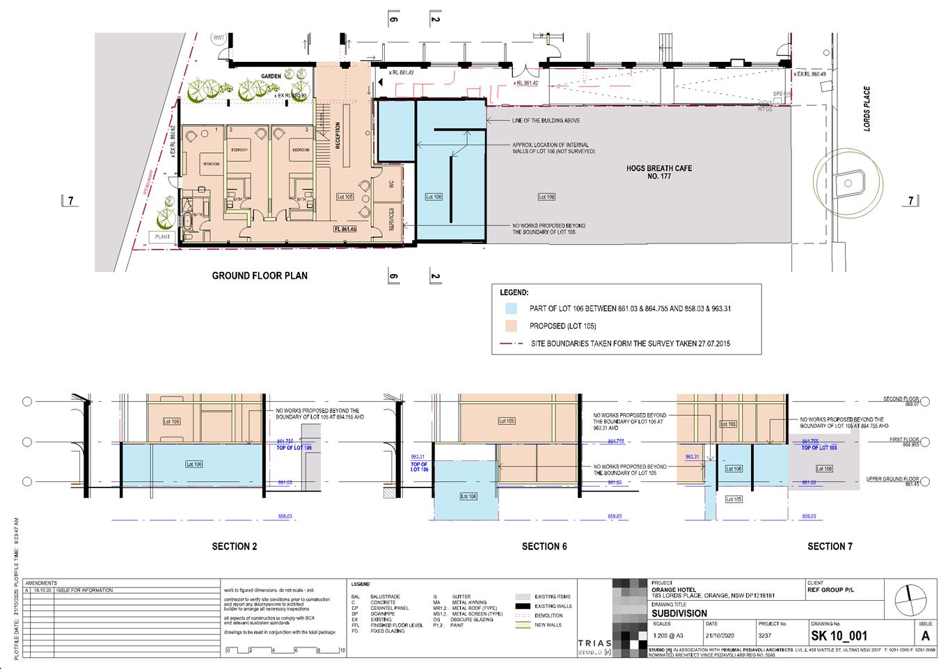
Café) in a stratum (ie. airspace) arrangement. The stratum extent is
referred to as notations (x) and (y) on DP 1218181 and shown below (see Figure
9).

Figure 9 – existing building overhang
within adjoining Lot 106
The
proposed development has been designed so that the building addition will be
fully self-supported from within the subject land (Lot 105 DP 1218181) via
transfer columns and beams. The proposed development will be wholly contained
within Lot 105, and will not rely on the existing load bearing structures or
easements that pass through adjoining Lot 106.
This arrangement is demonstrated in the attached
architectural drawings and specifically Drawing No. SK 10_001 A (Issue A)
(extract below at Figure 10). A supporting engineer’s statement is also
provided (Woolacott’s 22 March 2021) demonstrating the structural
feasibility of the proposal.
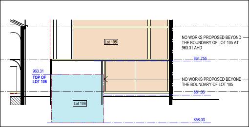
Figure 10 – proposed works wholly
within Lot 105
There
are various easements, restrictions and covenants that apply to the land
pursuant to DP 1218181 in relation to access, servicing, overhangs and support.
The proposed development will not be contrary to the listed restrictions.
Part 2 - Permitted or Prohibited Development
Clause
2.1 Land Use Zones
The
subject land is zoned B3 Commercial Core.
The
proposal is defined as ‘mixed use development’ comprising ‘hotel
or motel accommodation’ and ‘retail premises (shop);’
and demolition.
The
proposal is permitted with consent in the B3 zone.
Clause 2.3 Zone Objectives and Land Use Table
The
objectives of the B3 Commercial Core Zone are:
· To provide a
wide range of retail, business, office, entertainment, community and other
suitable land uses that serve the needs of the local and wider community.
· To encourage
appropriate employment opportunities in accessible locations.
· To maximise
public transport patronage and encourage walking and cycling.
· To promote
development that contributes to the role of the Orange CBD as the primary retail
and business centre in the City and region.
The proposed development will satisfy the B3 zone
objectives:
- The
proposal involves new and complementary commercial uses that will serve the
needs of the local and wider community.
- The
proposal will generate additional employment opportunities in an accessible
location, both during and post-construction.
- The
building is centrally located in the CBD and accessible via public transport,
walking and cycling.
- Adaptive
reuse and renewal of vacant premises will contribute to the role of the CBD as
the primary retail and business centre for the region.
Clause 2.7 Demolition Requires
Development Consent
Clause 2.7 is applicable and states:
The demolition of a building or work may be carried out
only with development consent.
The proposal involves demolition of some elements of the
existing building in accordance with this clause.
Part 3 - Exempt and Complying Development
The application is not exempt or complying development.
Part 3 - Exempt and Complying Development
The application is not exempt or complying development.
Part 4 - Principal Development
Standards
Clause
4.3 Height of Buildings
Clause
4.3 applies and states in part:
(2) The height of a
building on any land is not to exceed the maximum height shown for the land on
the Height of Buildings Map.
The Height
of Buildings Map prescribes a maximum height of 16m for the subject land.
As demonstrated in the attached architectural drawings (SK 00_006 Issue
A), the proposed south-west addition will have a maximum height of 17.81m. The
proposed development will exceed the prescribed maximum building height by
1.81m, being a departure of some 11%. A variation to the height limit is sought
pursuant to Clause 4.6 (see below).
Clause 4.4 Floor Space Ratio
Clause 4.4 applies and states in part:
(2) The maximum floor
space ratio for a building on any land is not to exceed the floor space ratio
shown for the land on the Floor Space Ratio Map.
The Floor
Space Ratio Map prescribes a maximum floor space ratio of 2:1 for the
subject land. The land comprises site area of 1,222m2 on ground, and
106m2 of stratum airspace. Total developable area is therefore
1,328m2. As demonstrated in the attached Drawing No. A00_000 Issue
A, the proposed mixed use development will comprise gross floor area of
2,351.4m2. FSR for the development will therefore be 1:1.77 in
compliance with Clause 4.4.
Clause 4.6 Exception to Development
Standards
Clause 4.6 applies and states in part:
(2) Development consent
may, subject to this clause, be granted for development even though the
development would contravene a development standard imposed by this or any
other environmental planning instrument…
(3) Development consent
must not be granted for development that contravenes a development standard
unless the consent authority has considered a written request from the
applicant that seeks to justify the contravention of the development standard
by demonstrating -
(a) that compliance with
the development standard is unreasonable or unnecessary in the circumstances of
the case, and
(b) that there are
sufficient environmental planning grounds to justify contravening the
development standard.
(4) Development consent
must not be granted for development that contravenes a development standard unless-
(a) the consent authority is satisfied
that -
(i) the
applicant’s written request has adequately addressed the matters required
to be demonstrated by Subclause (3), and
(ii) the proposed development will be in
the public interest because it is consistent with the objectives of the
particular standard and the objectives for development within the zone in which
the development is proposed to be carried out, and
(b) the concurrence
of the Planning Secretary has been obtained.
In
consideration of Clause 4.6:
The
development standard for which the variation is sought relates to Clause 4.3
Height of Buildings. The LEP prescribes a building height limit of 16m, and
the proposed building addition will have a maximum height of 17.81m. The
percentage variation to the development standard is approximately 11%.
The
proposal is supported by a written request pursuant to Clause 4.6(3). It is
submitted that compliance with the development standard is unreasonable or
unnecessary due to the following:
- The rear section of
the existing building already exceeds the 16m height control.
- The proposed addition
will sit adjacent to the tall element of the existing building.
- The addition will be
set back sufficiently from the site frontage and will not be prominent in
general streetscape views.
- The pitched roof form
will cause the height limit variation. The roof form will match the existing
building roof profile and is considered a better design response for uniformity
and symmetry.
- The height limit
variation is not associated with overdevelopment with reference to FSR
compliance.
- The building addition
will not affect the amenity of neighbouring properties or the public domain.
It is
further submitted that there are sufficient environmental planning grounds to
justify the departure from the development standard, as follows:
- The proposed building
addition will achieve design uniformity and symmetry with the existing
building.
- The proposal will
satisfy the objectives of the B3 Commercial Core Zone and the objective of
Clause 4.3 Height of Buildings.
- The proposal will
satisfy Planning Controls in DCP-2004 Part 8 Development in Business Zones.
- The proposal will not
have unacceptable impacts in terms of overshadowing, visual bulk or view loss.
- Building height will
not rise unreasonably above building height in Lords Place.
It is
considered that the written request to vary the height of buildings development
standard has adequately addressed the matters is Clause 4.6(3). It is
acceptable to vary the development standard based onsite circumstances, the
surrounding landuse pattern and streetscape built form. The proposal will not
be adverse to the Zone objectives or Clause 4.3 objectives.
In consideration of Clause 4.6(4)(b), the elected Council
may assume the concurrence of the planning secretary in varying the development
standard, pursuant to Planning Circular PS 20-002 dated 5 May 2020.
Part 5 - Miscellaneous Provisions
Clause 5.10 Heritage Conservation
The subject land is located in
the Central Orange Heritage Conservation Area and nearby to local heritage
items (see Figure 11).
Figure 11 – Conservation Area (red hatching) and
listed items (brown)
The former Australia Cinema is not a listed heritage item
under the LEP, but is nonetheless located within the Central Heritage
Conservation Area and the building is considered to have local significance for
the City. The Orange Heritage Inventory provides the following Statement of
Significance for the building:
A prominent place of private
entertainment from the early use as a theatre and later adaption as a cinema,
the building retains the social and historical values, complement the
streetscape and contributes to the conservation area.
Early photographs of the building are depicted below.
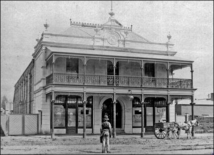
Figure 12 – Australia
Cinema circa 1890 (courtesy public submission)
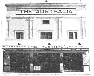
Figure 13 – Australia Cinema circa 1928
(courtesy public submission & Heritage Advisor)
Clause 5.10 is applicable and states in part:
(4) The
consent authority must, before granting consent under this clause in respect of
a heritage item or heritage conservation area, consider the effect of
the proposed development on the heritage significance of the item or area
concerned…
In consideration of this Clause, the proposed development
has been subject to extensive assessment by Council’s Heritage Advisor
(HA).
The HA supports the adaptive re-use
of the former cinema building. The proposed development is considered to
generally satisfy Council’s DCP Infill Guidelines; and is assessed as
suitable in accordance with Statement of Heritage Impact Guidelines
(NSW Heritage Office).
Notwithstanding, mitigation conditions are required to
ensure “the character and significance of the conservation area are
complemented; and the traditional character and social value of the former
cinema are celebrated and interpreted in the works.”
The HA conditions/recommendations in relation to building
design and detailing were supplied to the proponent. Agreement has been reached
on a number of recommendations, however, there are three outstanding matters of
contention.
1. Lords
Place Facade
The HA does not support the false façade/perforated
metal screen to Lords Place above the awning.
It is the proponent’s preference to retain the
proposed metal screen/false façade. It is submitted that there are no
original details in the current façade that remain for interpretation.
The proposed screen will unify the façade and add architectural
interest. The screen will be a ‘contemporary intervention that
will create a layered treatment.’ The façade will be
reminiscent of cinema architecture and acknowledge the historic use of the
building. The applicant notes that the above-awning façade was of less
importance in the assessment of DA 347/2013(1).
The HA advises that the metal screen is unacceptable in the
heritage conservation area and on such a substantial building. There is no
contemporary precedent for covering facades. Typical facades in the
conservation area have external elevations which reflect their internal
functions with associated practical fenestration.
The HA further comments that the above-awning façade
approved for the place of worship pursuant to DA 347/2013(1) was arrived at
after extended consultation and a number of alternatives. The elevation was
resolved with strong elements which modelled the large façade; framed
the bulk; addressed the practical requirements for the building interior; and
included detailing that was sympathetic to the dominant ground floor.
The HA concludes ‘the proposed false facade does
not articulate the bulk and scale of the building; does not have any elements
which could be regarded as interpreting traditional character in the setting;
has no relationship with the practical requirements and functions of the
interior; and no comparable examples of significance in the heritage
conservation area.’
To this end, a Condition is included requiring an alternative above-awning elevation to Lords Place
incorporating rendered/masonry wall finish; a well-configured set of steel
framed windows; and protruding string courses. Amended façade details
shall be required for the approval of Council’s HA prior to issue of a
Construction Certificate.
2. Removal
of render
The HA does not support the removal of render from the
original building.
It is the proponent’s preference to remove the render
and expose the brickwork. The proponent submits that should removal of the
render cause exfoliation of the brickwork, the render will be retained.
The HA advises that the tradition of
period commercial buildings in the City used rendered and detailed facades, as
is noted on adjoining commercial buildings in Lords Place. Expressed brickwork
is not appropriated for the building or context. The existing render should be
refurbished with new details to interpret the traditional character.
Conditions are included requiring
retention of the render; and any render removal shall be for the purpose of
conservation and replaced on a like-for-like basis.
3. Lords
Place Shopfront
The HA provides that the DA includes limited details in relation
to the shopfront design and detailing to Lords Place.
The proponent advises that these details will be considered
at subsequent DA stage for the shop fitout when a tenant is secured.
The HA advises that high quality presentation to the
streetscape is necessary for the site and setting. The value of quality
shopfronts is demonstrated in the recent development of the Myer building in
Summer Street. Standard aluminium commercial shopfronts are not appropriate.
Design and detailing at street level need to be well-considered in relation to
materials, details, and potential for interpretation of the former cinema
character and style.
To this end, Conditions are included requiring the new shopfronts to comprise traditional steel framing
with restoration of the perimeter rendered walls and entry details. Amended
façade details shall be required for the approval of Council’s HA
prior to issue of a Construction Certificate. A further Condition will be
included requiring the future shop fitout DA consider the particular heritage
design objectives applying to the building for any façade/entry
alterations.
Based on the foregoing commentary,
it is assessed that the proposed development will have favourable impacts on
the significance of the building and conservation setting, pursuant to Clause
5.10(4). In addition to the mitigation Conditions above, other Conditions are included in relation to archival recording,
interpretive panels, colour schemes and building materials.
Clause 5.21 Flood Planning
The subject land is located within a flood planning area and
Clause 5.21 applies. This clause states in part:
(2) Development
consent must not be granted to development on land the consent authority
considers to be within the flood planning area unless the consent authority is
satisfied the development -
(a) is
compatible with the flood function and behaviour on the land, and
(b) will
not adversely affect flood behaviour in a way that results in detrimental
increases in the potential flood affectation of other development or
properties, and
(c) will
not adversely affect the safe occupation and efficient evacuation of people or
exceed the capacity of existing evacuation routes for the surrounding area in
the event of a flood, and
(d) incorporates
appropriate measures to manage risk to life in the event of a flood, and
(e) will
not adversely affect the environment or cause avoidable erosion, siltation,
destruction of riparian vegetation or a reduction in the stability of river
banks or watercourses.
In
consideration of Clause 5.21, Council’s Assistant Development Engineer
(ADE) advises that the proposed development will be compatible with the flood
function and behaviour of the land; and will not adversely affect localised
flood behaviour. This assessment is based on Council’s recently updated
flood data and the findings of a flood report submitted in support of the
proposal (Wollacott’s 15 November 2019). Conditions are included in
relation to minimum floor levels above the 1% AEP flood level; building materials;
heights for electrical connections; and preparation of a flood safety
management (evacuation) plan.
Part 7 Additional Local Provisions
Clause
7.2A Flood Planning
The
land is contained between the flood planning level and the level of the
probable maximum flood. Clause 7.2A applies and states in part:
(3) Development consent
must not be granted to development for the following purposes on land to which
this clause applies unless the consent authority is satisfied that the
development will not, in flood events exceeding the flood planning level,
affect the safe occupation of, and evacuation from, the land -
(e) commercial premises
(t) tourist and visitor
accommodation
In
consideration of this clause, Council’s ADE has included a Condition
requiring preparation of a flood safety management plan to ensure the safe
occupation and evacuation from the land.
Clause 7.3 Stormwater Management
Clause 7.3 is
applicable. This clause states in part:
(3) Development
consent must not be granted to development on land to which this clause applies
unless the consent authority is satisfied that the development:
(a) is
designed to maximise the use of water permeable surfaces on the land having
regard to the soil characteristics affecting onsite infiltration of water, and
(b) includes,
where practical, onsite stormwater retention for use as an alternative supply
to mains water, groundwater or river water, and
(c) avoids
any significant impacts of stormwater runoff on adjoining downstream
properties, native bushland and receiving waters, or if that impact cannot be
reasonably avoided, minimises and mitigates the impact.
In consideration of this clause, the proposal will not
increase the existing imperious area over the subject land. Council’s ADE
had no comments to make on stormwater management associated with the
development. Existing stormwater arrangements that service the land are
suitable, subject to retention and upgrading of those arrangements in
conjunction with site redevelopment.
Clause 7.5 Riparian Land and
Watercourse
The subject land contains a sensitive waterway on the Watercourse
Map. Clause 7.5 applies and states in part:
(3) Before
determining a development application to carry out development on land to which
this clause applies, the consent authority must consider whether or not the
development -
(a) is
likely to have any adverse impact on the following -
(i) the
water quality and flows within a watercourse,
(ii) aquatic and
riparian species, habitats and ecosystems of the watercourse,
(iii) the stability of
the bed and banks of the watercourse,
(iv) the
free passage of fish and other aquatic organisms within or along the
watercourse,
(v) any future
rehabilitation of the watercourse and its riparian areas, and
(b) is
likely to increase water extraction from the watercourse.
The
proposal is not contrary to the requirements of Clause 7.5. The subject
waterway comprises a piped underground stormwater system. The proposed
development will have nil impact on stormwater infrastructure.
Clause 7.6 Groundwater Vulnerability
The
subject land is identified as ‘Groundwater Vulnerable’ on the Groundwater
Vulnerability Map. Clause 7.6 applies. This clause states in part:
(3) Before
determining a development application for development on land to which this
clause applies, the consent authority must consider:
(a) whether
or not the development (including any onsite storage or disposal of solid or
liquid waste and chemicals) is likely to cause any groundwater contamination or
have any adverse effect on groundwater dependent ecosystems, and
(b) the
cumulative impact (including the impact on nearby groundwater extraction for
potable water supply or stock water supply) of the development and any other
existing development on groundwater.
In consideration of Clause 7.6,
there are no aspects of the proposed development that will impact on
groundwater and related ecosystems.
Clause 7.11 Essential Services
Clause 7.11 applies and states:
Development consent must not be
granted to development unless the consent authority is satisfied that any of
the following services that are essential for the proposed development are
available or that adequate arrangements have been made to make them available
when required:
(a) the
supply of water,
(b) the
supply of electricity,
(c) the
disposal and management of sewage,
(d) storm
water drainage or on-site conservation,
(e) suitable
road access.
The listed utility services are available to the land and
adequate for the proposal.
In relation to (e) suitable road access, the subject
land has frontage to Lords Place. The proposal involves closure of the
existing gutter and layback crossing that serves the southern laneway. The
laneway will comprise a pedestrian access to the hotel and café/kiosk,
and vehicular access will not be provided to the subject land.
As a matter arising, the local road network is of suitable
capacity to accommodate traffic associated with the proposed development.
Carriageway widths, trafficable lanes and intersection controls in the CBD road
network are satisfactory to carry large traffic volumes. The development site
has historic traffic generation associated with the former cinema use. Traffic
generated by the development will be absorbed within the existing road network,
and will not exceed environmental goals for Lords Place and surrounding
streets. Council’s Technical Services Division had no comments to make on
this matter.
Waste management for the hotel or motel accommodation will
be in accordance with Better Practice Guidelines for Waste management and
Recycling in Commercial and Industrial Facilities (NSW EPA). The requisite
number of waste and recycling bins will be stored in the dedicated waste store
on the ground floor. Kerbside collection on Lords Place during non-peak periods
will occur, consistent with other CBD premises.
STATE ENVIRONMENTAL PLANNING
POLICIES
State Environmental Planning
Policy 55 Remediation of Land
SEPP 55 is applicable and states in part:
7(1) A consent authority must not consent to the carrying
out of any development on land unless:
(a) it
has considered whether the land is contaminated, and
(b) if
the land is contaminated, it is satisfied that the land is suitable in its
contaminated state (or will be suitable, after remediation) for the purpose for
which the development is proposed to be carried out, and
(c) if
the land requires remediation to be made suitable for the purpose for which the
development is proposed to be carried out, it is satisfied that the land will
be remediated before the land is used for that purpose.
In consideration of this clause, the potential for
contamination of the site is considered low. The subject land is
well-established for commercial use. The majority of the site is covered by the
existing building which has a long history as a cinema or public gathering
space. The site is not located within an investigation area and is not
known to have been used for a Table 1 purpose to the contaminated land planning
guidelines. Further contamination investigation as a precursor to potential
site remediation is considered unnecessary for the proposal.
Provisions of any Draft
Environmental Planning Instrument that has been Placed on Exhibition
4.15(1)(A)(Ii)
Draft
Orange Local Environmental Plan 2011 (Amendment 28) – Heritage Amendment
Draft Orange LEP 2011 (Amendment
28) involves new heritage conservation areas; expansion to existing heritage
conservation areas; and new heritage items. The subject land is already
included within a heritage conservation area. The Draft Plan has no effect for
the proposed development.
Draft Orange Local Environmental Plan 2011 (Amendment 29)
– Park and Rifle Range Roads, Shiralee
Draft Orange LEP 2011 (Amendment
29) relates to the rezoning and amendment of minimum lot size for various sites
at Park and Rifle Range Roads, Shiralee. The Draft Plan has no affect for the
proposed development.
Draft
Orange Local Environmental Plan (Amendment 31) – Eastside Precinct
Draft Orange LEP 2011 (Amendment
31) relates to the Eastside Precinct, comprising land to the east of the
railway line and south of Bathurst Road. The Draft Plan seeks to include
additional permitted uses in the precinct including residential accommodation;
and amend the permitted height of
buildings from 12m to 16m. The Draft Plan has no affect for the proposed
development.
Draft Remediation of Land State
Environmental Planning Policy
Draft Remediation of Land SEPP has been publicly exhibited.
The Draft SEPP will repeal and replace SEPP 55 Remediation of Land. Of
particular note, the Draft SEPP requires consideration of the contamination
status of nearby and neighbouring properties, and its impact on the proposed
use. Commercial land adjoining the site is not identified or considered to be
contaminated.
Provisions of any
Development Control Plan S4.15(1)(A)(Iii)
DCP 2004 Orange Development Control Plan
DCP 2004-4A Flood Affected Land
The subject land is contained
within a Flood Planning Area, pursuant to Part 4A
(see Figure 14).
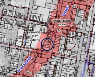
Figure 14 – Part 4A Flood Planning Map
The following criterion apply to the proposed development:
Step 1: The
subject land is within a Floodway (Main Stream Flooding).
Step 2: The
relevant landuse category relating to the proposed development comprises Commercial.
Step 3: The
Flood Response Development Controls applicable to Commercial landuse
within a Floodway include:
Floor Levels
· Habitable floor
level to be greater to or equal than the 1% AEP flood level with 0.5m
freeboard.
Building
Components
· All structures
to have flood compatible building and components below the 1% AEP flood level.
Structural
Soundness
· Engineers
report to certify that any structure can withstand the forces of floodwater,
debris and buoyancy up to and including the 1% AEP flood level
· Applicant to
demonstrate that any structure can withstand the forces of floodwater, debris
and buoyancy up to and including the 1% AEP flood level.
· Geotechnical
engineers report required to specify appropriate filling/earthworks…
Evacuation
· The development
is to be consistent with any relevant flood evacuation strategy.
Flood Affectation
· Engineers
report required to certify that the development will not increase flood
affectation elsewhere.
Management and Design
· Applicant to
demonstrate that area is available to store goods above the 1% AEP floor level
plus 0.5m freeboard.
· No external
storage of materials below the design floor level which may cause pollution or
be potentially hazardous during a flood.
As outlined in the foregoing section of this report (see
Orange LEP 2011 Clause 5.21 Flood Planning), Conditions are included to satisfy
development controls above in relation to floor levels, building materials,
engineering certification, and evacuation management.
Part 8 Development in Business Zones
The proposal
will satisfy the Planning Outcomes applicable to the Central Business District:
· Buildings have
a high level of urban design to contribute to the regional status of the CBD
with attention given to façade features, external materials, colour and advertising.
This Planning Outcome was considered in the foregoing
section of this report (see Orange LEP 2011 Clause 5.10 Heritage
Conservation). Subject to mitigation Conditions, the building design and
detailing will be of a high standard, and commensurate with the conservation
setting and regional centre status of the CBD.
· Urban design
demonstrates a clear reference to the CBD Strategic Action Plan.
The proposal will be consistent with the principals of the
CBD Strategic Action Plan and the more recent Future City project. The
development will provide an active frontage to Lords Place and the adjoining
laneways with façade variations and new openings. The
laneways could offer opportunities for street art. Pedestrian amenity to
and adjacent the site will be improved. The proposal will contribute to the
activation and vitality of the CBD.
As a matter arising, the development is considered suitable
in terms of Crime Prevention Through Environmental Design principles. The
laneways will be activated. Passive surveillance will be improved by new
openings and pedestrian connections. External and sensor lighting will be
installed. The building will be maintained and upkept.
· Provision of
adequate fire-safety measures and facilities for disabled persons (according to
the BCA) are addressed at the application stage (relevant for all development
but particularly important where converting residential buildings for business
use).
A NCC (BCA) Compliance Report was submitted in support of
the proposal (Steve Watson & Partners, 12 November 2019). The report
confirms the proposed building design is capable of achieving compliance with
the BCA in relation to fire-safety measures and facilities for disabled
persons. Further details will be required, and assessment undertaken at
Construction Certificate stage. Council’s Building Certifier concurs with
the report findings.
· Land use
complements the role of the CBD as a regional centre for commerce and services.
The proposal involves new and complementary commercial use
for tourist accommodation and retail premises. Adaptive reuse of the building,
and renewal and expansion of vacant premises will contribute to the role of the
CBD as the primary retail and business centre for the region. The proposal will
incorporate elements that are inconsistent with the objectives of the Future
City project (pedestrian amenity, CBD vitality and activation).
· The
reinstatement of verandahs on posts over the footpath is encouraged.
The proposal does not involve a verandah on posts over the Lords
Place footpath. The existing awning over the footpath will be removed and
reconstructed with similar detail and lighting as an interpretation of the
original building. This is considered a suitable design outcome and supported
by Council’s HA.
· Car parking is
provided to meet demand either as onsite parking areas or through contributions
towards public parking in and adjacent to the CBD.
Car parking is addressed below under ‘Part 15 - Car
Parking’.
· Advertising
comprises business identification signs in accordance with SEPP 64.
The proposal does not involve advertising. Conditions are included requiring further development
consent be obtained for signage. The proposal involves retention/renewal of the
existing AUSTRALIA CINEMA wordmark on the awning fascia in recognition of the
historic use of the building. A Condition is included to effect this intention.
· Where possible,
new buildings or external alterations in the CBD include an element of
landscaping.
There is no opportunity for landscaping at the site frontage
with the existing zero boundary setback to Lords Place to be retained. Small
garden areas will be provided at the rear of the building; however, these will
not be visible in the public domain. Some landscape softening of the southern
laneway could be provided via pots, if favoured by the proponent.
· Loading areas
are provided for developments requiring access by large trucks in a manner that
doesn’t reduce active frontages for important pedestrian pathways.
A dedicated loading area will not be provided for the
proposed development; indeed, vehicular access is not available to the subject
land. It is proposed that the Lords Place road formation and public parking at
the site frontage provide an informal on-street loading zone. Service vehicles
associated with the development are likely to comprise small commercial
vehicles. The proposed un/loading arrangement will be consistent with other
commercial developments nearby the site in Lords Place and is considered to be
acceptable.
Part 13 Heritage
· Development
relates to the significant features of heritage buildings on or near the site,
as reflected in inventory sheets.
· Development
conforms with recognised conservation principles.
· Conservation
Management Plans are prepared for development having a significant effect on
heritage site.
As outlined above (see Orange LEP 2011 Clause 5.10 Heritage
Conservation), the proposal has been subject to extensive heritage assessment
and consultation. It is considered that the proposed development will not have
adverse impact on the significance of the heritage setting, subject to
mitigation Conditions. A conservation management plan is not required for the
proposal.
Infill Guidelines
The
infill design objectives contained in the Infill Guidelines include:
· Retention of
appropriate visual setting.
· To ensure new
buildings respond to and enhance the character and appearance of the
streetscapes of the heritage conservation area.
· To ensure
contributory heritage items retain their prominence and are not dominated by
new development within a heritage conservation area and do not compromise the
heritage values of the existing area.
· To ensure that
new buildings do not adversely affect the significance, character or appearance
of the heritage conservation area or heritage items.
· To allow for
reasonable change within a heritage conservation area while ensuring all other
heritage objectives are met.
· To ensure that
new development facilitates the retention of significant vegetation…
The
Infill Guidelines contain five Assessment Criteria for development within an
established historic setting, including Character; Scale and Form; Siting;
Materials and Colour; and Detailing. As variously outlined in the foregoing
sections of this report, the proposed building
alterations, additions and external works will be consistent with the listed
design objectives. The infill development will be suitable in this context with
regard to height, massing, setbacks and Conditional colours and detailing.
Part 15 Car Parking
· Adequate
off-street car parking is provided in accordance with the Table, or
alternatively, according to an assessment that demonstrates peak parking demand
based on recognised research.
The subject land has a parking credit of 74 spaces
associated with its historic use as a cinema and restaurant. Parking credits
for the site were calculated and accepted in conjunction with DA 347/2013(1)
for proposed place of worship.
Pursuant to DCP 2004, onsite parking is applicable to the
net increase in parking associated with a development, whether for change of
use or building additions. The proposed development for hotel or motel
accommodation and retail premises (shop) will generate parking
demand for 50 car spaces, as follows:
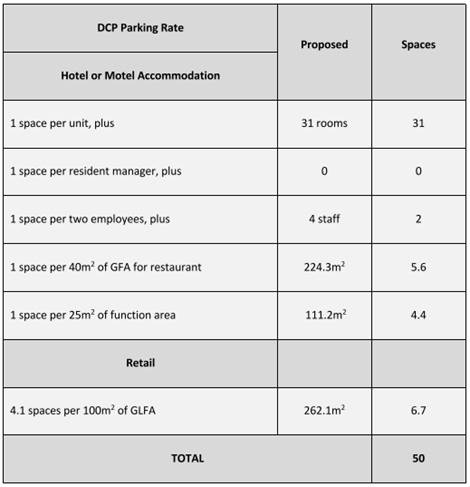
As such, the proposed development will not generate a net
increase in parking requirements. Parking credit of 24 spaces will remain with
the land.
Notwithstanding, the benefit of parking credit does not
preclude the need to formally assess the overall environmental impact on
parking availability in the locality. Whilst it would be always desirable to
provide at least one parking space per accommodation room for a development of
this type, the nature of this particular development being the reuse of a
former cinema building will not have car parking available on site. The lack of
parking on-site ought not necessarily preclude the ability to consider the
possible reuse of the subject building as proposed given the significant
credits that have previously been attributed to the site. In order to ensure
the proper and functional operation of the development under these
circumstances the following parking arrangements are proposed:
· ‘Hotel
guests will be encouraged to use the nearby Council (Ophir) car park, which is
located approximately 100m to the south at the corner of Kite Street and Lords
Place. In this regard, the hotel will purchase parking vouchers from Council
and hand them to guests on arrival (currently free of charge).
· To facilitate
parking prior to check-in, the applicant proposes to enter into a long-term
lease to have two parking spaces immediately at the frontage of the subject
land reserved for hotel use.
This would encourage guests to arrive,
check-in and then move their car to the public car park. One of these spaces
can be created as a new space by deleting the existing kerb layback and
footpath crossing that presently serve the driveway along the southern side of
the building.’
It is neither Council policy nor practice to dedicate
on-street car parking spaces for nearby developments. It
may be appropriate instead, to alter the existing timed parking on Lords Place
at the site frontage from 1 hour to 15 minutes. This would facilitate high
turnover car parking, and may free up parking for guests to check‑in.
This arrangement is subject to the approval of Council’s Traffic
Committee. An Advisory Note is included on the attached Notice of
Approval to this effect.
In the interim, it is considered
that the existing public car parking on Lords Place and in the nearby Ophir
carpark will facilitate reasonably functional parking arrangements associated
with check-in, hotel stay, and retail use for this development. Ophir car park
is likely to be underutilised during the overnight period when car parking
associated with the accommodation component of the development is required.
Ophir car park is conveniently located in relatively close proximity to the
subject development. The proposed development in this regard is unlikely to
have an adverse impact upon parking in the locality.
DEVELOPMENT CONTRIBUTIONS
Section 7.11 Development
Contributions
Development contributions not
applicable to tourist and visitor accommodation including hotel and
motel accommodation pursuant to Orange Development Contributions Plan 2017.
Section 64 Headworks Charges
Headworks charges for water, sewer
and drainage works apply to the proposed hotel or motel accommodation.
The contributions are based on 13.6 ETs for water supply headworks and 18.8 ETs
for sewerage headworks. Conditions are included requiring payment of
contributions prior to issue of Construction Certificate.
Provisions Prescribed by the
Regulations S4.15(1)(A)(Iv)
Demolition of a Building (clause
92)
The proposal does not involve the
demolition of a building.
Fire Safety Considerations (clause 93)
Council’s EHBS advises:
A preliminary BCA assessment
report and fire engineering report have been provided. When the CC assessment
occurs, there will be approximately nine fire engineered performance solutions
to be considered. The preliminary fire engineering report does not go into
detail about how the non-compliances raised will be addressed – the
acceptability of the performance solutions will need to be determined by the
Certifier.
Buildings to be Upgraded (clause 94)
Council’s EHBS advises:
The building will be
substantially altered as part of this proposal, particularly as it involves a
change of use from a Class 9b cinema to a Class 3 and 6 motel and retail shop
building.
BASIX Commitments (clause 97A)
BASIX is not applicable. A Section J report will be required
at Construction Certificate stage.
The Likely Impacts Of The Development S4.15(1)(B)
The impacts of the proposed development have been considered
in the foregoing sections of this report and include:
· Setting and
context
- heritage
conservation area
- commercial
character and function
- interface
and public domain
- pedestrian access
· Heritage values
- design
and detailing in heritage conservation area
- interpretation
of the original building
- mitigation
conditions to maintain significance
· Visual impacts
- streetscape
presentation
- building
design and detailing, bulk and scale
- quality
urban design
· Traffic matters
- car
parking
- un/loading
arrangements
- network
capacity
· Environmental
impacts
- biodiversity
- groundwater
- stormwater
management
- contamination
- waste
(construction and operational)
· Social and
economic impacts
- regional
centre status
- employment
opportunities
- adaptive
reuse
- crime
prevention
It is considered that the impacts of the proposed
development will be within reasonable limit. Conditions are included on the
attached Notice of Approval to mitigate and manage arising impacts.
The Suitability Of The Site
S4.15(1)(C)
The subject land is suitable for the proposed development
due to the following:
· the proposal is
permitted on the subject land zoning
· the proposal is a
complementary landuse within the CBD
· the site is
located in a heritage conservation area and contains an important historic
building
· the
existing commercial building is vacant and underutilised
· all utility
services are available
· the site is
located in a flood planning area, but may be developed subject to mitigation
conditions
· the site is not
subject to other known natural hazards
· the land has no
particular environmental values
· the local road
network has sufficient capacity to accommodate additional traffic volumes
· nearby parking
resources will be suitable
· there is no known
contamination on the land.
Any Submissions Made In
Accordance With The Act S4.15(1)(d)
The proposal comprises advertised development in accordance
with Council’s Community Participation Plan 2019. At the completion of
the exhibition period, one (1) submission was received.
The submission rejects the proponent’s contention that
the subject building is not a listed heritage item. The submission
provides evidence and justification to support the listing of the Australia
Cinema as a heritage item. It is submitted that the building is of heritage
significance in the social, political, religious and entertainment evolution
of Orange.
Furthermore, the submission rejects the proposed above
awning façade treatment/screen; and supports retention of the Australia
Cinema/Theatre wordmark on the awning and footpath.
In response to the submission, the following comments are
provided:
· The subject site
is not a listed Heritage item, pursuant to Schedule 5 Environmental Heritage,
contained in Orange LEP 2011.
· The land is
contained within the Central Orange Heritage Conservation Area, pursuant to the
Orange LEP 2011 Heritage Map.
· The site/building
is included within the Orange Heritage Inventory, which includes an inventory
of heritage items and other buildings located generally in the Central Orange
Heritage Conservation Area. The Orange Heritage Inventory is an advisory and
information document. Inclusion in the Inventory does not infer a heritage
listing under Orange LEP 2011.
· It is concurred
that former Australia Cinema is an important historical building that
contributes to the heritage setting.
· The provisions
contained in Clause 5.10 of Orange LEP 2011 are suitable to protect the
heritage values of the building. As outlined in this report, the impact of the
proposal on the significance of the site and setting has been a major
consideration in the assessment of the proposed development.
· Mitigation
Conditions are included on the attached Notice of Approval to maintain the
significance of the site and setting.
· Listing of the
building as a heritage item in Schedule 5 would require an amendment to Orange
LEP 2011. It is noted that Draft Orange LEP 2011 Amendment 28 comprises a
heritage amendment and includes new heritage items and conservation areas.
Amendment 28 is near to being adopted. Separate amendment would be required for
proposed inclusion of the Australia Cinema as a heritage item in the LEP.
· Conditions are
included requiring an alternative above-awning façade to Lords Place;
and retention or reinstatement of the wordmarks to the footpath and awning
fascia.
Public Interest
S4.15(1)(E)
The proposal is not inconsistent with any relevant policy
statements, planning studies, guidelines etc. that have not been considered in
this assessment. The proposal involves sympathetic and adaptive reuse of an
important historic building in the CBD and heritage conservation area. The
proposal will contribute to the activation and vitality of the CBD.
The proposed development is considered to be in the public interest.
SUMMARY
This development application relates to the former Australia
Cinema at 183 Lords Place, and involves new use of the building for hotel or
motel accommodation and retail premises. The proposal involves
building alterations, additions and external works to make the premises
suitable for the new uses. The development is subject to particular constraints
associated with planning controls and site circumstances. As outlined in
this report, the proposal will satisfy the Local and State planning controls
that apply to the subject land and particular landuse. The proposal will
contribute to the activation and vitality of the CBD and have positive impacts
on the heritage setting. Conditions are included to mitigate and manage arising
impacts. Approval of the application is recommended.
COMMENTS
This report and the attached Notice of Approval have been
partly informed by the following:
· Director
Development Services
· Assistant
Development Engineer
· Environmental
Health and Building Inspector
· Heritage Advisor
Attachments
1 Notice
of Approval, D21/62351⇩
2 Plans,
D21/61026⇩
3 Submission,
D21/61034⇩
Attachment 1 Notice
of Approval
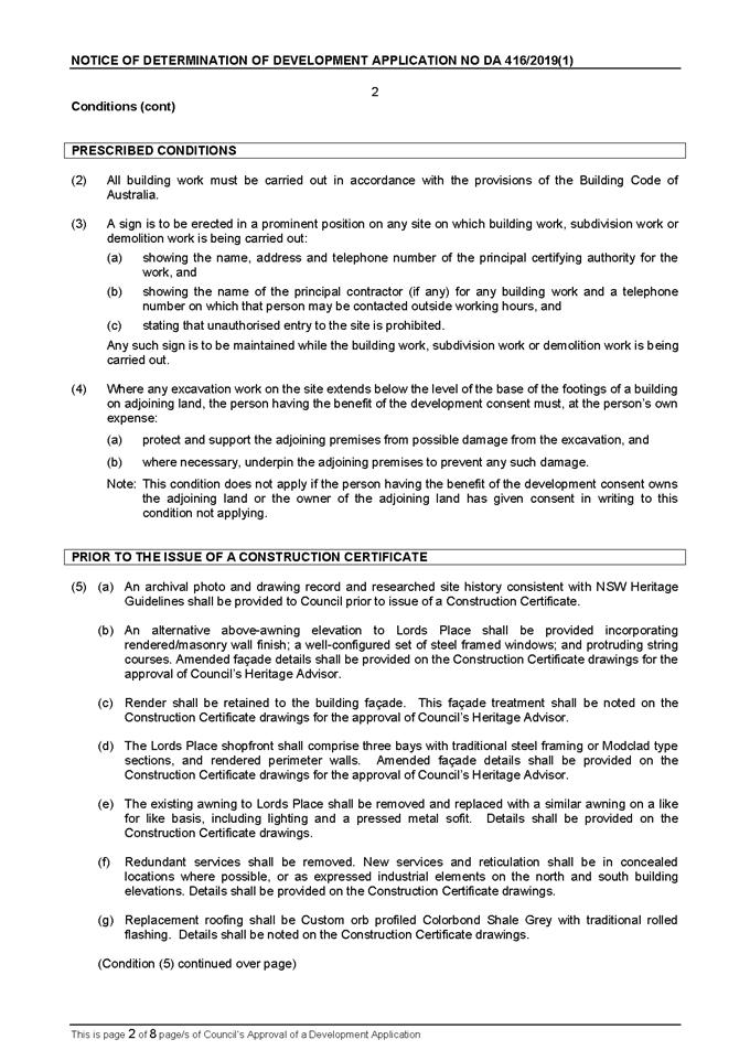


Planning and Development Committee
5 October 2021
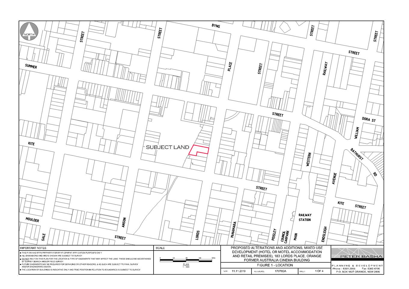
Planning
and Development Committee
5 October 2021

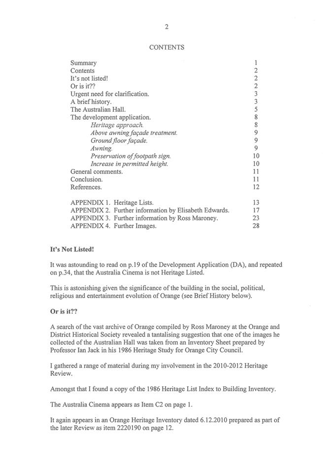
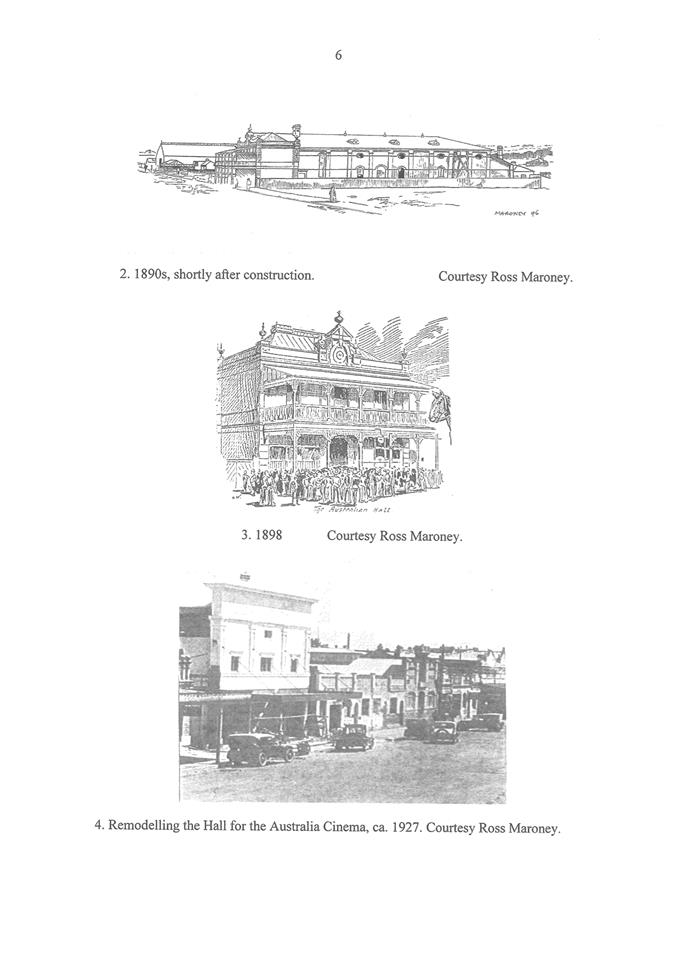
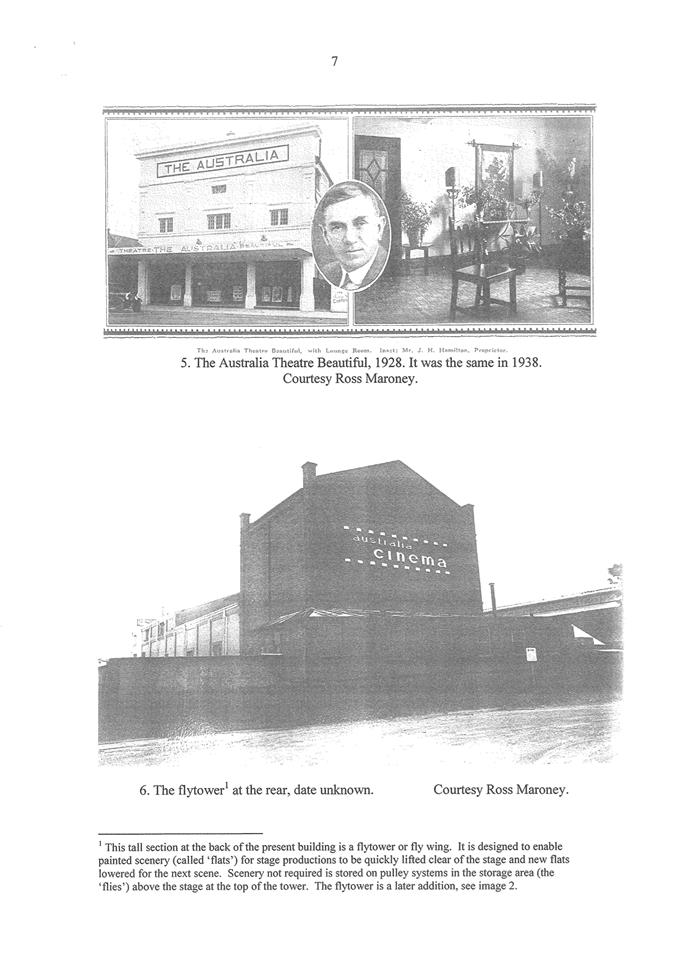
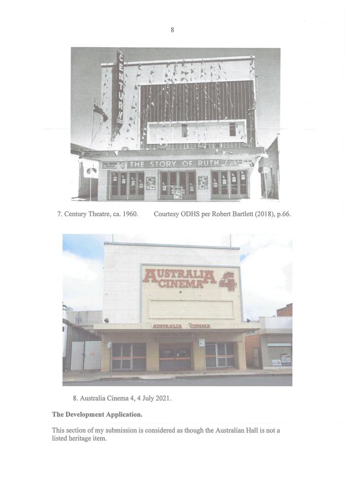
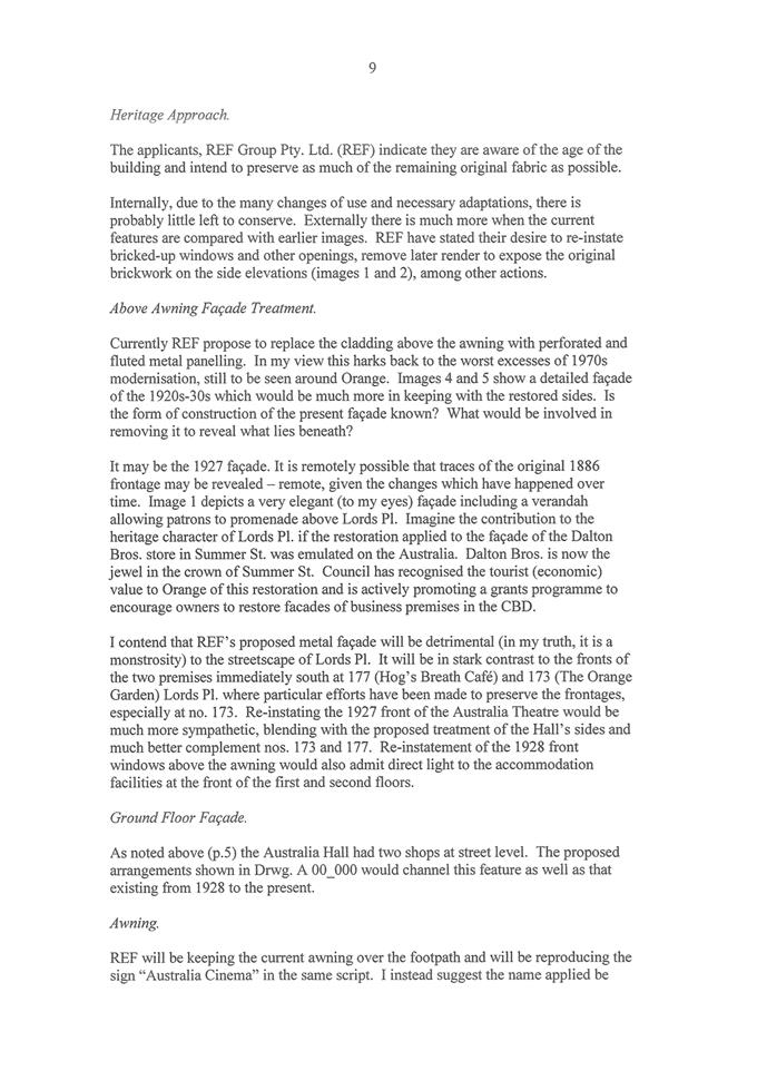
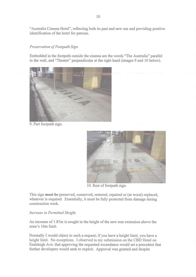
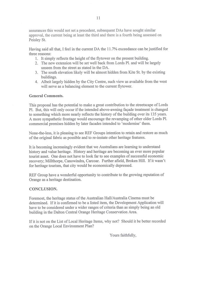


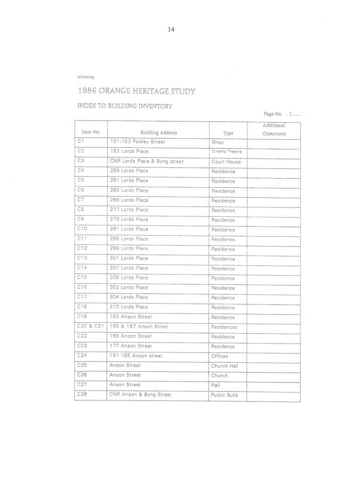
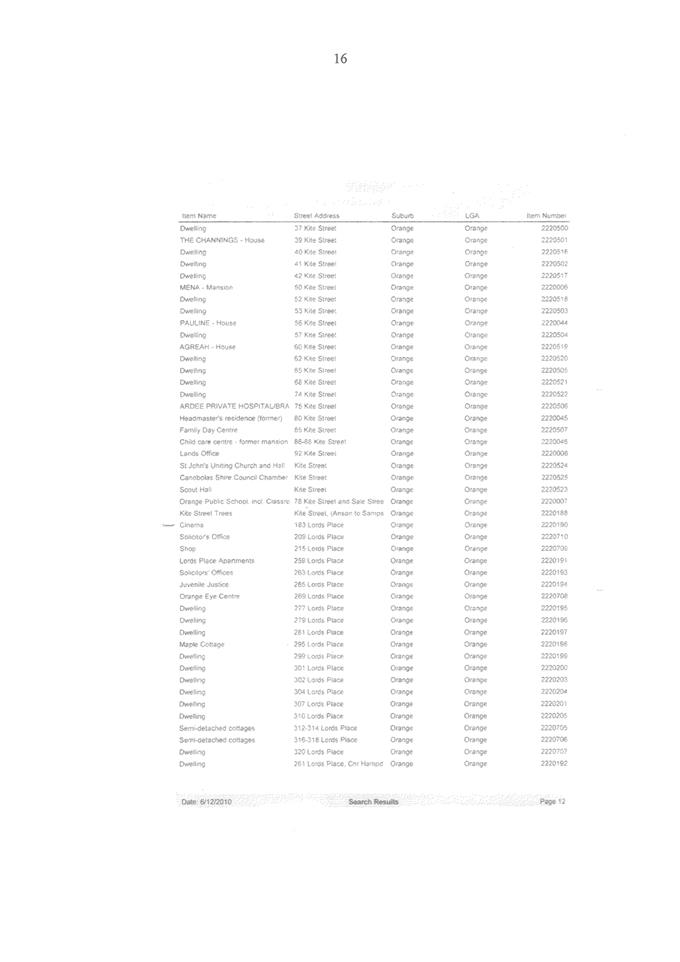

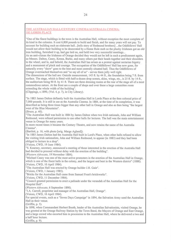
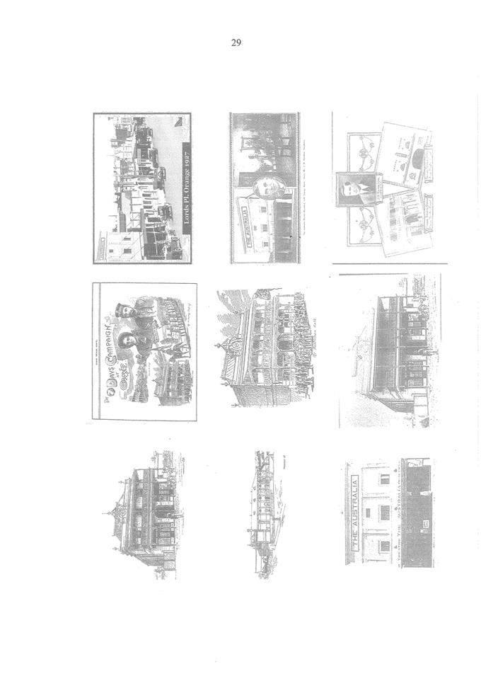
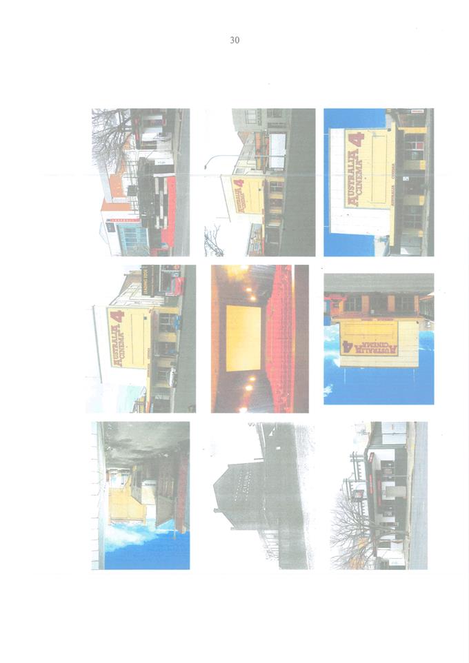
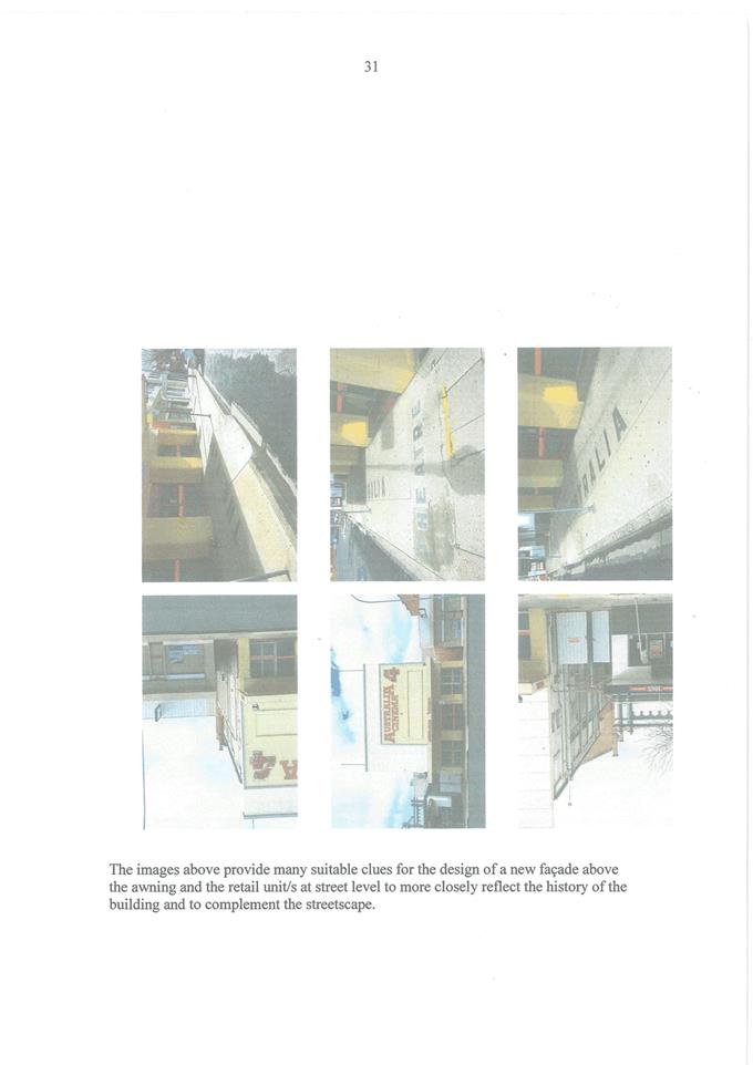
2.3 Development
Application DA 201/2021(1) - 68-70 Peisley Street
RECORD
NUMBER: 2021/2158
AUTHOR: Ben
Hicks, Planner
EXECUTIVE
Summary
|
Application
lodged
|
13 May
2021
|
|
Applicant/s
|
Mr R
Felli
|
|
Owner/s
|
Amica
Property Group Pty Ltd
|
|
Land
description
|
Lot 100
DP 1178894, 68-70 Peisley Street, Orange
|
|
Proposed
land use
|
Office
Premises (four offices) and Serviced Apartments (22 apartments)
|
|
Value of
proposed development
|
$2,800,000.00
|
Council's consent is sought for an Office Premises
and Serviced Apartments at 68-70 Peisley Street, Orange (see locality at
Figure 1).
The proposed development will involve the construction of a
multi storey building comprising of four (4) offices and 22 serviced apartments
on the subject land. The apartments are designed to be self-sufficient to
cater for short and long-term corporate stays and tourist and visitor
accommodation. The proposal will also include onsite car parking, site
landscaping and signage.
A variation to the Height of Building (HoB) and Floor Space
Ratio (FSR) development standards are requested as part of this Development
Application. Specifically, a 6.74% variation is sought for the building height
and a 9.73% variation is sought for FSR. The use of Clause 4.6 to enable an
exception to these development controls is considered appropriate in this
instance and Council can be satisfied that all requirements of Clause 4.6 have
been fulfilled in terms of the overall merits of the proposed development.
The proposal comprised
advertised and notified development pursuant to Council’s Community
Participation Plan 2019 for a period of 14 days. At the completion of the
advertisement/notification period, two (2) submissions had been received. Key
concerns raised include car parking, waste management, construction impacts and
vehicle access. Concerns raised in submissions can be satisfactorily addressed
via conditions of consent.
In accordance with the State Environmental Planning Policy
(Infrastructure) 2007, advice and concurrence were sought from Transport for
NSW (TfNSW) in relation to works within proximity to the rail corridor as well
as works within a classified road. TfNSW raise no significant concerns with the
proposal subject to imposition of recommended conditions.
The proposal has a capital
investment value exceeding $2.5 million ($2.8m). Accordingly, the application
has been tabled to Council for determination, pursuant to Clause 4.10
Delegations of Orange City Council’s Declaration of Planning and
Development Assessment Procedures and Protocols (Vers 5, 2019).
Overall, the application
provides a development that is consistent with the zoning of the land and will
ultimately provide Orange with a quality designed development that will
contribute to employment and economic improvements for the City. The
application has demonstrated compliance with most of the relevant controls, and
where variations exist, has demonstrated that no significant amenity or
environmental impacts will arise, and as such the application is recommended
for approval.
Figure 1 - Locality and Site Context Plan
DECISION FRAMEWORK
Development in Orange is governed by two key documents
Orange Local Environment Plan 2011 and Orange Development Control Plan 2004. In
addition, the Infill Guidelines are used to guide development, particularly in
the heritage conservation areas and around heritage items.
Orange Local Environment Plan 2011 – The
provisions of the LEP must be considered by the Council in determining the
application. LEPs govern the types of development that are permissible or
prohibited in different parts of the city and also provide some assessment
criteria in specific circumstances. Uses are either permissible or not. The
objectives of each zoning and indeed the aims of the LEP itself are also to be
considered and can be used to guide decision making around appropriateness of
development.
Orange Development Control Plan 2004 – the DCP
provides guidelines for development. In general, it is a performance-based
document rather than prescriptive in nature. For each planning element there are
often guidelines used. These guidelines indicate ways of achieving the planning
outcomes. It is thus recognised that there may also be other solutions of
merit. All design solutions are considered on merit by planning and building
staff. Applications should clearly demonstrate how the planning outcomes are
being met where alternative design solutions are proposed. The DCP enables
developers and architects to use design to achieve the planning outcomes in
alternative ways.
DIRECTOR’S COMMENT
The proposed development will involve the construction of a
multi storey building comprising of four (4) offices and 22 serviced apartments
on the subject land.
The apartments are designed to
be self-sufficient to cater for short and long-term corporate stays and tourist
and visitor accommodation. The proposal will also include onsite car parking,
site landscaping and signage.
Key planning issues involved with this application include
consideration of car parking, access and specific development standards
relating to Height of Building (HoB) and Floor Space Ratio (FSR). The use of
Clause 4.6 to enable an exception to these development standards is considered
appropriate in this instance, as proposal is only 694mm above the height
controls of this site, this exceedance would be neither noticeable, nor would
it adversely impact on the surrounds.
Two (2) submissions were
received during the exhibition period, which raised include car parking, waste
management, construction impacts and vehicle access. These matters have been
with conditions of consent.
It is recommended that Council
supports the subject application.
Link To Delivery/OPerational Plan
The recommendation in this report relates to the
Delivery/Operational Plan Strategy “10.1 Preserve - Engage with the
community to ensure plans for growth and development are respectful of our
heritage”.
Financial Implications
Nil
Policy and Governance Implications
Nil
|
Recommendation
That Council consents to
development application DA201/2021(1)
for Office Premises (four offices) and Serviced Apartments (22
apartments) at Lot 100 DP 1178894, 68‑70 Peisley
Street, Orange pursuant to the conditions of
consent in the attached Notice of Determination.
|
further considerations
Consideration has been given to the recommendation’s
impact on Council’s service delivery; image and reputation; political;
environmental; health and safety; employees; stakeholders and project
management; and no further implications or risks have been identified.
SUPPORTING INFORMATION
Use/Operational Details
Development Consent is sought for
the construction of a three-storey building and subsequent use as a serviced
apartments and office premises comprising 22 serviced apartments and four (4)
offices.
Supporting material submitted with
the development application, provides that the apartments are primarily
designed for short- and long-term corporate stays and tourist and visitor
accommodation. All apartments are designed to be self-sufficient. The
apartments are one (1) bedroom, one (1) bath with either a combined kitchenette
and sitting area or separate kitchen and sitting areas. All apartments have
access to either a private balcony or courtyard.
The office premises combined offer a leasable area of 528.39m2.
Each office space will contain a kitchenette and will have access to shared
sanitary facilities.
The applicant advises that private waste collection
contractors will be responsible for providing a waste removal service for the
serviced apartments and offices, including the supply and maintenance of all
equipment and the coordination of this service with the cleaning service.
Ancillary car parking, site landscaping and building
identification signage also forms part of the proposal.
Composition of the
Development/Built Form
The development consists of the
following:
|
Level
|
Use
/Detail
|
|
Basement
|
32 car parking spaces, storage
areas. laundry and linen room, plant/services, lift and stairs
|
|
Ground
Level
|
17 car parking spaces, site
landscaping, three (3) apartments including one accessible, two (2) offices,
shared amenities
|
|
Level 1
|
Eleven (11) apartments including
one accessible, two (2) offices, shared amenities
|
|
Level 2
|
Eight (8) apartments including one
accessible
|
The proposed building has been
designed in a contemporary style (Figure 2). The building is well-articulated
through the use of balconies, awnings, and staggered façade. The
building is also positively presented to Peisley Street incorporating a mix of
material including brick, glazing, metal screens and cladding material. The
varied palette and materiality are also used to provide a clear identity for
the development as well as to define the differing components of the building. The
building will have a flat roof and incorporates a parapet extending above the
roofline and screening the roof top from the street. This parapet will ensure
that no visual impact occurs as a result of the plant platform and lift overrun
to be located on the roof.
Landscaping will also assist in providing an appropriate
level of visual interest and activation within the streetscape.
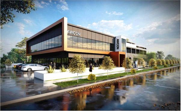
Figure 2 – perspective illustration
ENVIRONMENTAL PLANNING
ASSESSMENT
Section 1.7 - Application of Part
7 of the Biodiversity Conservation Act 2016 and Part 7A of the Fisheries
Management Act 1994
Section 1.7 of the EP&A Act
identifies that Part 7 of the Biodiversity Conservation Act 2016
(BC Act) and Part 7A of the Fisheries Management Act 1994 have effect in
connection with terrestrial and aquatic environments.
There are four triggers known to insert a development into
the Biodiversity Offset Scheme (i.e., the need for a BDAR to be submitted
with a DA):
· Trigger 1:
development occurs in land mapped on the Biodiversity Values Map (OEH)
(clause 7.1 of BC Regulation 2017).
· Trigger 2:
development involves clearing/disturbance of native vegetation above a certain
area threshold (clauses 7.1 and 7.2 of BC Regulation 2017); or
· Trigger 3:
development is otherwise likely to significantly affect threatened species
(clauses 7.2 and 7.3 of BC Act 2016).
The fourth trigger (development
proposed to occur in an Area of Outstanding Biodiversity Value (clause 7.2 of
BC Act 2016) is generally not applicable to the Orange LGA; as no such areas are
known to occur in the LGA. No further comments will be made against the fourth
trigger.
Having regard to the relevant
provisions and based on an inspection of the subject property, it is considered
that the proposed development is not likely to significantly affect a
threatened species. A Biodiversity Development Assessment Report is not
required in this instance.
Section 4.15 of the Environmental
Planning and Assessment Act 1979
Section 4.15 of the Environmental Planning and Assessment
Act 1979 requires Council to consider various matters, of which those
pertaining to the application are listed below.
PROVISIONS OF ANY ENVIRONMENTAL
PLANNING INSTRUMENT s4.15(1)(a)(i)
Orange Local Environmental Plan
2011
Part 1 - Preliminary
Clause 1.2 - Aims of Plan
The
broad aims of the LEP are set out under Subclause 2. Those relevant to the
application are as follows:
(a) to
encourage development which complements and enhances the unique character of
Orange as a major regional centre boasting a diverse economy and offering an
attractive regional lifestyle,
(b) to
provide for a range of development opportunities that contribute to the social,
economic and environmental resources of Orange in a way that allows present and
future generations to meet their needs by implementing the principles for
ecologically sustainable development,
The proposed development is considered to be consistent with
the relevant aims of Orange LEP 2011. In particular, the proposed
development will assist in reinforcing Orange as a major regional centre; and
will contribute to the social and economic development of the City.
Clause 1.6 - Consent Authority
This clause establishes that, subject to the Act, Council is
the consent authority for applications made under the LEP.
Clause 1.7 - Mapping
The subject site is identified
on the LEP maps in the following manner:
|
Land Zoning Map:
|
B4 Mixed Use
|
|
Lot Size Map:
|
No minimum lot size
|
|
Heritage Map:
|
Not a heritage item or conservation
area
|
|
Height of Buildings Map:
|
9m
|
|
Floor Space Ratio Map:
|
0.75:1
|
|
Terrestrial Biodiversity Map:
|
No significant biodiversity
sensitivity on the site.
|
|
Groundwater Vulnerability Map:
|
Groundwater vulnerable
|
|
Drinking Water Catchment Map:
|
Not within the drinking water
catchment
|
|
Watercourse Map:
|
No mapped watercourse
|
|
Urban Release Area Map:
|
Not within an urban release area
|
|
Obstacle Limitation Surface Map:
|
No restriction
on building siting or construction
|
|
Additional Permitted Uses Map:
|
No additional permitted use applies
|
|
Flood Planning Map:
|
Blackmans Swamp PMF
|
Those matters that are of relevance are addressed in detail
in the body of this report.
Clause 1.9A - Suspension of
Covenants, Agreements, and Instruments
This clause provides that covenants, agreements and other
instruments which seek to restrict the carrying out of development do not apply
with the following exceptions:
(a) to
a covenant imposed by the Council or that the Council requires to be imposed,
or
(b) to
any relevant instrument under Section 13.4 of the Crown Land Management Act 2016,
or
(c) to
any conservation agreement under the National Parks and Wildlife Act 1974, or
(d) to
any Trust agreement under the Nature Conservation Trust Act 2001, or
(e) to
any property vegetation plan under the Native Vegetation Act 2003, or
(f) to
any biobanking agreement under Part 7A of the Threatened Species Conservation
Act 1995, or
(g) to
any planning agreement under Subdivision 2 of Division 7.1 of the Environmental
Planning and Assessment Act 1979.
Council staff are not aware of the title of the subject
property being affected by any of the above.
Part 2 - Permitted or Prohibited
Development
Clause
2.1 - Land Use Zones and Clause 2.3 - Zone Objectives and Land Use Table
The site of the proposed development
is zoned B4 Mixed Use under the Orange Local Environmental Plan 2011. The Land
Use Table for the B4 Mixed Use zone permits the proposal with consent of
Council. The proposal is defined as Office Premises and Serviced Apartments
under the Orange LEP:
serviced apartment
means a building (or part of a building) providing self-contained accommodation
to tourists or visitors on a commercial basis and that is regularly serviced or
cleaned by the owner or manager of the building or part of the building or the
owner’s or manager’s agents.
office premises
means a building or place used for the purpose of administrative, clerical,
technical, professional or similar activities that do not include dealing with
members of the public at the building or place on a direct and regular basis,
except where such dealing is a minor activity (by appointment) that is
ancillary to the main purpose for which the building or place is used.
Clause 2.3(2) of the Orange Local Environmental Plan (OLEP)
2011 provides that the Council shall have regard to the objectives for
development in a zone when determining a development application in respect of
land within the zone. The objectives of the B4 Mixed Use zone are:
· To provide a
mixture of compatible land uses.
· To integrate
suitable business, office, residential, retail and other development in
accessible locations so as to maximise public transport patronage and encourage
walking and cycling.
· To
promote, where possible, the retention and reuse of heritage items as well as
the retention of established buildings that contribute positively to the
heritage or cultural values of the land in the zone.
· To promote
development that supports the role of Orange Central Business District (CBD) as
the primary retail and business centre in the region.
The proposal is not adverse to the relevant B4 zone
objectives. Infill development is a complementary land use in this spatial
setting. The proposal represents the continued redevelopment and upgrading of
the Peisley Street precinct and thereby strengthening the social and economic
role of Orange City in the region.
The following provisions of the OLEP
2011 have been especially considered in the assessment of the proposal:
· Clause 4.3 – Height of Buildings
– The Height of
Buildings Map prescribes a maximum height of 9m for the subject land. The
proposed building has a maximum height of 9.694m. This represents a variation
of 7%. The height exceedance is a result of the lift over-run and site levels.
The applicant has made application to vary the development standard pursuant to
Clause 4.6 of the LEP.
· Clause 4.4 – Floor Space Ratio
– The Floor
Space Ratio Map prescribes a maximum floor space limit of 0.75:1 for the
subject land. As demonstrated in the plan-set and supporting information, the
proposed building will have gross floor area of 1,411.61m2. Based
onsite area of 1719m2, the building will have FSR of 0.821:1
exceeding the allowable GFA by 9.73%. The applicant has made application to
vary the development standard pursuant to Clause 4.6 of the LEP.
· Clause 4.6 – Exceptions to
development standards - Clause
4.6 exceptions to development standards of the Orange Local Environmental Plan
2011 provides flexibility in the application of certain development standards
in particular circumstances, where compliance with a development standard is
unreasonable and unnecessary. In the context of this application, consideration
of Clause 4.6 is necessary because of exceedances to prescribed height and
floor space limitations.
In determining whether development
consent may be granted, the Consent Authority must consider a written objection
by the applicant to the development standard. The written objection must
demonstrate:
a) that
compliance with the development standard is unreasonable or unnecessary in the
circumstances of the case, and
b) that
there are sufficient environmental planning grounds to justify contravening the
development standard.
Council may grant consent only if the
concurrence of the Director General of the Department of Planning and
Infrastructure has been obtained and Council is satisfied that:
· the written
request has adequately addressed the above, and
· the proposed
development will be in the public interest because of:
- consistency
with the objectives of the particular standard, and
- consistency with
the objectives of the zone applying to the site.
The DA is accompanied by a Clause 4.6
request to vary the lot size development standard.
The reasons listed by the applicant
justifying why the development standard is unreasonable/unnecessary in this
circumstance and that there are sufficient environmental planning grounds to
support the proposal are described below:
Height of Buildings
· The
non-compliance is within the centre of the building and will not be seen from
the street.
· The development
remains consistent with the objectives of the B4 zone.
· The development
is generally consistent with the provisions of the Orange Development Control
Plan 2004.
· The standard
unreasonably restricts effective utilisation of the land to achieve the
objectives of the zone.
· The standard
unreasonably restricts the maximisation of infill development and utilisation
of existing infrastructure resources.
· The standard
will unnecessarily restrict the achievement of highest and best yield of the
land resource.
· The standard
unnecessarily restricts the transitioning of the land to a locally significant
landmark.
Floor Space Ratio
· The development
remains consistent with the objectives of the zone.
· The development
is consistent with the provisions of the Orange Development Control Plan.
· The variation
sought is relatively minor (9.73%).
· There is
significant amount of landscaping proposed on the site.
· The number of
car parks provided far exceeds DCP requirements.
· The standard
will unreasonably prevent accommodation and office space supply to be provided
into the local market close to the CBD.
· The standard
unreasonably restricts effective utilisation of the land to achieve the
objectives of the zone.
· The standard
unreasonably restricts the maximisation of infill development and utilisation
of existing infrastructure resources.
· The standard
will unnecessarily restrict the achievement of highest and best yield of the
land resource.
Assessment of Clause 4.6 request
Height limits are one control used to
define the size of a building. Height limits are important because they help
shape the character of an area while the FSR standard endeavours to control the
scale and bulk of development so as to reduce the likelihood of adverse impact
on streetscape/character of the area. FSR controls work somewhat in tandem with
the applicable height controls. The FSR standard determines how much floor
space is appropriate on the land and the height controls determine how the
floor space can be distributed on the land in a vertical plane from a design
point of view. These controls also ensure that sufficient area is provided
onsite for car parking, manoeuvring, and landscaping.
The
applicant’s argument for the additional height and floor space is that
the proposed building height achieves the objectives of the height of building
clause, the B4 zone, DCP provisions and that the variation is appropriate in
its context.
The
extent of the non-compliance in relation to height is shown in Figures 3 and 4
below. Figure 5 shows the height of the proposed building in the context of
adjoining properties/developments.
Figure 3 – extent of HoB non-compliance (Height
Blanket)
Figure 4 – extent of HoB non-compliance (section
view)

Figure 5 – general building heights relative to
ground levels
on the eastern side of Peisley Street
In considering the submitted
documentation and inspection of the site, compliance is unnecessary in this
circumstance given:
· The development
responds appropriately to the topography of the site and surrounds, as well as
height and setbacks established by adjoining development north and south.
· The proposed lift
overrun does not derogate from the design quality of the building and will not
be visible from the public domain at ground level.
· The subject site
has the capacity to absorb the modest increase in density without compromising
the character of the area.
· The bulk and scale
of the building is adequately resolved by breaking up the building mass and in
articulated building facades.
· The careful
spatial arrangement of built and landscape elements has demonstrated that an
alternative floor space ratio is appropriate.
· The increased
floor space beyond the control does not result in any additional adverse impact
on the adjoining properties or the public domain e.g., shadowing, parking,
privacy etc.
Furthermore,
there are sufficient environmental grounds to justify the non-compliance as:
· The proposal is
consistent with the objectives of the zone.
· The proposal is
consistent with the Orange Development Control Plan 2004.
· The policy
framework for dealing with variations to development standards is geared to
enable minor departures from development standards.
· The extent of the variations
have been kept to a minimum, sufficient only to enable a practical and
compliant site design and to ensure a viable development.
· The proposal
demonstrates no unacceptable amenity impacts.
In summary,
the variation to the development standards is considered acceptable in this
instance. The applicant has made a written request in which justification is
presented as to the reasons why it is unreasonable or unnecessary to insist
upon compliance with the development standards. Consideration of the variation
against the objects of the applicable standards and the relevant zone indicates
that the development is not manifestly inconsistent with either set of
objectives; and consideration of the concurrence requirements also suggests
that the variation is acceptable.
· Clause 7.1 Earthworks – Clause 7.1 of the OLEP aims to ensure that earthworks for
which development consent is required will not have a detrimental impact on
environmental functions and processes, neighbouring uses, cultural or heritage
items or features of the surrounding land.
The proposal includes the construction of
basement parking (one level) which will require approximately 4,377.6m3
of excavated material. Appropriate conditions regarding excavation,
dilapidation/shoring are included in the recommended conditions of consent to
ensure minimal impact.
Conditions of consent will ensure appropriate
stormwater management of the site.
The site is not known to be contaminated as
demonstrated by the submitted preliminary contamination investigation.
Notwithstanding this, in line with Council’s standard procedures a
precautionary condition is recommended in relation to an unexpected finds
protocol. Excavated materials will be reused onsite as far as possible.
The site is not known to contain any Aboriginal,
European or Archaeological relics. Previous known uses of the site do not
suggest that any relics are likely to be uncovered.
Overall, the extent of the earthworks are not expected
to materially affect the potential future use or redevelopment of the site that
may occur at the end of the proposed development's lifespan and appropriate
sediment controls, including silt traps and other protective measures will be
required to protect adjoining lands during construction works.
· Clause 7.2A – Floodplain risk management - The site has been identified on the flood planning map as
being within the Blackmans Swamp Creek PMF and listed as a land use requiring
Council to be satisfied that the development will not, in flood events exceeding the flood planning level,
affect the safe occupation of, and evacuation from, the land. While
Council’s Technical Service raise no concerns with flooding, it is
considered appropriate to require the proponent to prepare and implement a
flood emergency response plan in the event of a flood exceeding the flood
planning level to ensure the safe evacuation of occupiers from the
site and to protect the operational capacity of emergency response facilities
in such events.
· Clause 7.3 - Stormwater Management – The development of the site will involve a
significant increase of impervious surfaces and therefore it is essential that
the engineering design results in post development stormwater levels that are
equal to or less than pre-development levels. Council’s Technical
Services Division have attached conditions of consent in this regard.
· Clause 7.6 - Groundwater Vulnerability – The site has been mapped as being groundwater vulnerable.
The proposal is not anticipated to involve the discharge of toxic or noxious
substances and is therefore unlikely to contaminate the groundwater or related
ecosystems. The proposal does not involve extraction of groundwater and will
therefore not contribute to groundwater depletion.
· Clause
7.11 - Essential Services – All utility services are available to the
land. These utility services will however need to be made adequate for the
proposal. Additional water and sewer headwork charges are also applicable to
this development. Council’s Technical Services Division have attached
conditions of consent in relation to upgrading of services and contributions.
TfNSW have also requested that certain road upgrades to Peisley Street to
accommodate to the proposed development. These matters have been included as
conditions of consent.
STATE ENVIRONMENTAL PLANNING
POLICIES
The following State Environmental Planning Instruments
(SEPPs) apply to the Orange Local Government Area:
· SEPP
21 - Caravan Parks
· SEPP
33 - Hazardous and Offensive Development
· SEPP
36 - Manufactured Home Estates
· SEPP
50 - Canal Estate Development
· SEPP
55 - Remediation of Land
· SEPP
64 - Advertising and Signage
· SEPP
65 - Design Quality of Residential Flat Development
· SEPP
70 – Affordable Rental Housing (Revised Schemes)
· SEPP
(Affordable Rental Housing) 2009
· SEPP
(Building Sustainability Index: BASIX) 2004
· SEPP
(Concurrences and Consents) 2018
· SEPP
(Educational Establishments and Child Care Facilities) 2017
· SEPP
(Exempt and Complying Development Codes) 2008
· SEPP
(Housing for Seniors or People with a Disability) 2004
· SEPP
(Infrastructure) 2007
· SEPP
(Mining, Petroleum Production and Extractive Industries) 2007
· SEPP
(Primary Production and Rural Development) 2019
· SEPP
(State and Regional Development) 2011
· SEPP
(Vegetation in Non-Rural Areas) 2017
The following SEPPs are specifically relevant to the
assessment of the proposed development:
SEPP 55 Remediation of Land - State Environmental
Planning Policy 55 - Remediation of Land (SEPP 55) requires that a consent
authority must not consent to the carrying out of development of land unless it
has considered whether the land is contaminated, is satisfied that the land is
suitable in its contaminated state for the development that is proposed, and if
the land requires remediation to be made suitable for the proposed development
it is satisfied that the land will be remediated before the land is used for
that purpose.
Furthermore, SEPP 55 requires that before determining an
application for consent to carry out development that would involve a change of
use on any of the land specified in Subclause 4, the consent authority
must consider a report specifying findings of a preliminary investigation of the
land concerned.
A preliminary hazard investigation was prepared by GCA to
determine the soil contamination status and suitability of the site for the
proposed land-use. The report concludes that based on the site investigation
and laboratory testing results at the selected locations within the site, the
land is considered suitable for its proposed use. The report also recommends
that:
· Any soils
requiring excavation, onsite reuse and/or removal must be classified in
accordance with “Waste Classification Guidelines Part 1: Classifying
Waste” NSW EPA (2014).
· A site specific
‘Unexpected Finds Protocol’ is to be made available for reference
for all occupants and/or site workers in the event unanticipated contamination
is discovered, including asbestos.
These recommendations have been reinforced in the conditions
of development consent.
Council’s EHO has also reviewed the proposal and site
and confirms that there little to no risk of extensive contamination that would
require remediation works in order to be suitable for the development.
State Environmental Planning
Policy 55 (Infrastructure) 2007
Division 15 of the ISEPP provides commentary regarding
development involving railways. As the site is located adjacent to the
Main Western Railway corridor, Clause 85 and 86 of the ISEPP are to be
considered. Clause 85 states:
1) This
clause applies to development on land that is in or adjacent to a rail
corridor, if the development -
a) is
likely to have an adverse effect on rail safety, or
b) involves
the placing of a metal finish on a structure and the rail corridor concerned is
used by electric trains, or
c) involves
the use of a crane in air space above any rail corridor, or
d) is
located within 5m of an exposed overhead electricity power line that is used
for the purpose of railways or rail infrastructure facilities.
In consideration of these matters:
a) The
proposal is unlikely to have an adverse effect on rail safety and will not
involve placing a metal finish on a structure where the rail corridor is used
by electric trains.
b) The
use of cranes is expected as part of construction works. The proposal was
referred to TfNSW who advised that in the event of use of cranes and equipment
in the air space over the rail corridor, the applicant must submit an
application to John Holland Rail (JHR), the Rail Infrastructure Manager of
Country Regional Network (CRN), for approval of Transport Asset Holding Entity
of New South Wales (TAHE) prior to any use of cranes and equipment in the air
space over the rail corridor. Furthermore, TfNSW advise that the use of cranes
and equipment must be in accordance with the AS 2550 series of Australian
Standards, Cranes, Hoist and Winches, including AS2550 15-1994 Cranes –
Safe Use - Concrete Placing Equipment. These matters have been addressed via
conditions of consent.
c) The
site is not located within 5m of an exposed overhead electricity power line
that is used for the purpose of railways or rail infrastructure facilities
Furthermore, Clause 86 of the SEPP states:
1) This
clause applies to development (other than development to which Clause 88
applies) that involves the penetration of ground to a depth of at least 2m
below ground level (existing) on land -
a) within,
below or above a rail corridor, or
b) within
25m (measured horizontally) of a rail corridor, or
c) within
25m (measured horizontally) of the ground directly below a rail corridor, or
d) within
25m (measured horizontally) of the ground directly above an underground rail
corridor.
The plans submitted with the Development Application
identify that the extent of earthworks associated with the development are in
the order of 2m cut from the existing Natural Ground level (NGL) within
25m of the rail corridor. In this regard, the proposal was referred to TfNSW.
TfNSW provided its concurrence, subject to a number of conditions relating to
the proposed earthworks.
Clause 87 of the SEPP requires the
consent authority to consider the likely impact of noise and vibration from
rail operations on sensitive developments. While the proposed office premises
and serviced apartments are not specifically listed as a development requiring
consideration of this clause, a noise and vibration assessment has been
prepared for the development. That assessment found that vibration impacts are
within acceptable levels and no further action is required. The report however
recommends that measures be undertaken to ensure noise is within acceptable
limits. This includes requirements for external wall construction, glazing,
doors, and seals. Conditions will be included requiring the construction of the
building to be undertaken in accordance with the noise and vibration report.
Clause 101 of SEPP Infrastructure states that a Consent
Authority must not grant consent to development on land that has a frontage to a
classified road unless it is satisfied that:
a) where
practicable and safe, vehicular access to the land is provided by a road other
than the classified road, and;
b) the
safety, efficiency and ongoing operation of the classified road will not be adversely
affected by the development as a result of -
i. the
design of the vehicular access to the land, or
ii. the
emission of smoke or dust from the development, or
iii. the
nature, volume or frequency of vehicles using the classified road to gain access
to the land, and;
c) the
development is of a type that is not sensitive to traffic noise or vehicle
emissions, or is appropriately located and designed, or includes measures, to
ameliorate potential traffic noise or vehicle emissions within the site of the
development arising from the adjacent classified road.
In consideration of the above matters:
· The site is
bounded by Peisley Street to the west which is
classified a regional road and a rail corridor to the east. Therefore, access
can only be obtained from Peisley Street. The site has one existing vehicular
access, which will be altered as part of this proposal. An additional access
point is also proposed.
· TfNSW is the road
authority and as such the application was referred to TfNSW for concurrence. Concurrence
was granted pursuant to Section 138(2) of the Roads Act 1993 subject to a range
of conditions to ensure access to the site is appropriate and the safety and
efficiency of the road network is not adversely affected.
· A Traffic Impact
Assessment was prepared to support the proposal which confirms that Peisley
Street has the capacity to accommodate the increase in traffic generated by the
proposed development.
· The development is
not of a type that is sensitive to traffic noise or vehicle emissions.
Construction activities will however need to be managed to ensure safety and
efficiency of the road is not adversely affected.
State Environmental Planning
Policy 64 - Advertising and Signage
State Environmental Planning Policy 64
- Advertising and Signage applies to the subject development. This SEPP aims to ensure that outdoor
advertising and signage is compatible with the desired amenity and visual
character of an area, provides effective communication in suitable locations
and is of high-quality design and finish.
The policy is structured such that the
general heads of consideration are listed in Clause 13 of the policy. This
clause for the purposes of the assessments acts to enable assessment against
the criteria set out in schedule 1 of the policy. The general assessment
standards applicable to all signage affected by this policy are set out in
Schedule 1.
In addition, the policy has provisions
that apply to certain types of signs, making it important to classify the signs
before making an assessment of them. Not all sign types have additional
assessment criteria applied to them. Moreover, certain definitions have
overlapping meanings that can be applied. The proposed signs to be erected on the building are
consistent with the definition of business identification signs, meaning:
a sign -
(a) that indicates-
(i) the name of the person or
business, and
(ii) the nature of
the business carried on by the person at the premises or place at which the
sign is displayed, and
(b) that may include the
address of the premises or place and a logo or other symbol that identifies the
business, but that does not contain any advertising relating to a person who
does not carry on business at the premises or place.
The proposed
development involves the erection of four Business Identification Signs
to be located on the northern and western elevations of the proposed building.
Two signs display the text: AWCON and one displaying the text: AMICA
APARTMENTS.
The proposed Business
identification signs are consistent with the intent of the assessment
criteria set out in Schedule 1 Assessment Criteria of SEPP 64 as discussed
below:
Schedule 1 Assessment Criteria
1 -
Character of the Area
· Is
the proposal compatible with the existing or desired future character of the
area or locality in which it is proposed to be located?
· Is
the proposal consistent with a particular theme for outdoor advertising in the
area or locality?
The character of the
area is mixed containing both commercial and residential development. Most of
the signage in the area comprises flush wall signs, or window signage. The
proposed signage associated with this application is consistent with theme of
lawful signage in the area and is not expected to detract from the character of
the area.
2 - Special Areas
· Does the
proposal detract from the amenity or visual quality of any environmentally
sensitive areas, heritage areas, natural or other conservation areas, open
space areas, waterways, rural landscapes or residential areas?
The location is considered to be a
sensitive area as there are residential dwelling houses located directly
opposite the site. However, as noted above the proposed signs are similar to
those which they replace, and as such will not detract from the amenity or
visual quality of the area.
3 - Views and Vistas
· Does the
proposal obscure or compromise important views?
· Does the
proposal dominate the skyline and reduce the quality of vistas?
· Does the
proposal respect the viewing rights of other advertisers?
The proposed signage will be wall mounted and therefore will
not dominate the skyline or reduce the quality of vistas. No viewing rights of
other advertisers will be affected by the proposed signage.
4 - Streetscape, Setting or Landscape
· Is the scale,
proportion and form of the proposal appropriate for the streetscape, setting or
landscape?
· Does the
proposal contribute to the visual interest of the streetscape, setting or
landscape?
· Does the
proposal reduce clutter by rationalising and simplifying existing advertising?
· Does the proposal
screen unsightliness?
· Does the
proposal protrude above buildings, structures or tree canopies in the area or
locality?
· Does the
proposal require ongoing vegetation management?
The scale of the proposed signage is considered appropriate
in relation to the host building and will result in reasonable streetscape
compatibility. The signage is expected to increase the amenity of the building
façade and contribute to the visuals along Peisley Street.
5 - Site and Building
· Is the proposal
compatible with the scale, proportion and other characteristics of the site or
building, or both, on which the proposed signage is to be located?
· Does the
proposal respect important features of the site or building, or both?
· Does the
proposal show innovation and imagination in its relationship to the site or
building, or both?
The proposed signage is of suitable scale for the site,
building and the surrounding land uses. It is not considered to be out of
proportion with the surrounding locality and an acceptable way of identifying
the business/building. The signage is also considered acceptable in its design
and material selection.
6 - Associated Devices and Logos with Advertisements and
Advertising Structures
· Have any safety
devices, platforms, lighting devices or logos been designed as an integral part
of the signage or structure on which it is to be displayed?
No safety devices, platforms, lighting devices or logos are
proposed.
7 - Illumination
· Would
illumination result in unacceptable glare?
· Would illumination
affect safety for pedestrians, vehicles or aircraft?
· Would
illumination detract from the amenity of any residence or other form of
accommodation?
· Can the
intensity of the illumination be adjusted, if necessary?
· Is the
illumination subject to a curfew?
The signage is not proposed to be illuminated.
8 - Safety
· Would the
proposal reduce the safety for any public road?
· Would the
proposal reduce the safety for pedestrians or bicyclists?
· Would the
proposal reduce the safety for pedestrians, particularly children, by obscuring
sightlines from public areas?
The proposed signage is appropriately located within the
site and sits flush with the building, so it will not reduce pedestrian access
or public safety, or restrict sightlines for vehicles, bicyclists or
pedestrians.
PROVISIONS OF ANY DRAFT
ENVIRONMENTAL PLANNING INSTRUMENT THAT HAS BEEN PLACED ON EXHIBITION
4.15(1)(a)(ii)
The proposed development is not contrary to any matter
contained within Draft Amendments currently on exhibition.
PROVISIONS OF ANY DEVELOPMENT
CONTROL PLAN s4.15(1)(a)(iii)
Development Control Plan 2004
The following parts of DCP 2004 are applicable to the
proposed development:
· Chapter
0 – Transitional Provisions
· Chapter 2 -
Natural Resource Management
· Chapter 4 - Special
Environmental Considerations
· Chapter 5 –
General Considerations for Zones and Development
· Chapter 8 –
Development in Business Zones
· Chapter 15 - Car
Parking
The relevant matters in Chapters 2 and 4 were considered in
the foregoing assessment under Orange LEP 2011. The relevant matters in Parts 5
are addressed under the Any Submissions section of this report. The
relevant matters contained under Chapters 0, 8 and 15 are addressed below:
Chapter 0 - Tree Preservation
The DCP prescribes the following Interim Planning Outcomes
for Tree Preservation:
1. Trees
prescribed by this DCP must not be ringbarked, cut down, topped, lopped or
wilfully destroyed without the Council’s approval and landowner’s
consent.
2. This
clause applies to Eucalypts of any size belonging to the White Box, Yellow Box
and Blakely’s Red Gum Endangered Ecological Communities, including
species indicated as affected in the tree preservation table.
3. This
clause applies to any tree, native or exotic, with a trunk diameter equal to or
greater than 300mm at breast height.
4. This
clause does not apply to species indicated as exempt in the tree preservation
table.
5. An
application for the Council’s approval must be accompanied by an
appropriately qualified specialist (arborist) report.
The applicant has sought approval for the removal of two (2)
Eucalypt Street trees on the Peisley Street frontage of the subject
property for vehicle access. The request was referred to Council’s
Manager City Presentation who advises:
I
support the removal of the two Eucalypt street trees on the Peisley Street
frontage of the subject property. Refer to the attached image which clearly
shows one of the trees in serious decline.
The
following condition of consent shall be imposed on the development:
The
applicant shall plant three (3) new 150 litre container sized street trees on
the Peisley Street frontage of the site; two (2) trees in locations as marked
on Drawing LPDA21-280 drawn by Conzept Landscape Architects and a third tree to
the southern end between the driveway and the property’s southern
boundary. Species is to be determined in consultation with Council’s
Manager City Presentation. Note that Nyssa sylvatica (Tupelo) have not grown
successfully in the Orange climate and will not necessarily be the species
chosen.
Chapter 8 -
Business Services Areas
· Applications
clearly demonstrate that the development will not detract from the role of the
CBD as a regional centre.
The use of the land as an office
premises and serviced apartments in a peripheral CBD location. The proposed
offices premises and serviced apartments are complementary land uses in the
fringe CBD precinct, and will reinforce the role of the CBD as a regional
centre for commerce and services. The core CBD is retained for primary retail
functions. The development is consistent with the above planning outcome.
· Provision of
adequate fire-safety measures and facilities for disabled persons (according to
the BCA) is addressed at the application stage (relevant for all development
but particularly important where converting residential buildings for business
use).
Relevant conditions are attached
in this regard.
· Heritage
streetscapes are conserved and enhanced through adaptive re-use of heritage
buildings, restrained advertising and landscaped gardens.
Not applicable. The site is not
within or adjoining heritage conservation area, listed heritage item.
· Areas on the
main roads into and out of Orange (such as Molong Road and Bathurst Road)
provide a high level of architectural design to enhance the visual character of
the City entrances.
The subject land is not located
on a main road. Notwithstanding this, the development presents a sophisticated
design approach that, by and large, responds positively in the context and
setting.
· All sites
contain an element of landscaping. Landscaping provided is of a bulk, scale and
height relative to buildings nearest the front property boundary so as to
provide beautification and visual relief to the built form proposed or existing
on the site. The depth of the landscape bed at the site frontage is sufficient
to accommodate the spread of plantings that meet the abovementioned outcomes
but, where practicable, a minimum depth of 3m is provided. Plantings are
designed to provide shade for parking areas, to break up large areas of
bitumen, to enhance building preservation and to screen against noise.
A detailed landscaping plan has
been prepared by Conzept Landscape Architects. Landscaping is in scale
and context with the proposed development, street, other buildings, and
landscape elements within the streetscape. The proposed landscaping beds at the
site frontage range from 3.8m to 2.5m in width containing a mix of trees,
shrubs and ground covers. Plantings are also proposed along the entire length
of the rear boundary. Council’s Manager City Presentation has reviewed
the proposed landscaping plan and advises that Anigozanthos sp (Kangaroo
Paws) do not grow successfully in the Orange climate and as such should be
substituted for another form of accent plant. This matter has been addressed
via conditions of consent.
Furthermore, it is proposed to remove two existing Eucalypt street trees
on the Peisley Street frontage of the subject property for vehicle access.
Council’s Manager City Presentation raises no objections on the basis
they are replaced by suitable species. A condition is included addressing
this matter.
Overall, the proposed
landscaping is acceptable within the context of the locality, will improve and
enhance the overall space, provide integration, and will serve to activate a
section of street frontage.
Chapter 15 - Car Parking
The DCP prescribes the following applicable Planning Outcome
for Car Parking:
· Adequate
off-street car parking is provided in accordance with the Table, or alternatively,
according to an assessment that demonstrates peak parking demand based on
recognised research.
· Car-parking
areas are designed according to Australian Standard.
· Car-park areas
include adequate lighting and landscaping
· Bicycle-parking
facilities are provided according to the relevant Australian Standard.
· Facilities for
loading and unloading of commercial vehicles are provided according to the
relevant Australian Standard.
Pursuant to DCP 2004, the proposed development will generate
demand for 35 onsite parking spaces as follows:
|
Land Use
|
DCP
2004 Minimum Requirement
|
Proposed
Development
|
Carparking
spaces required
|
|
Serviced
apartment
|
1
space/apartment
|
22
apartments
|
22
spaces
|
|
Office
premises
|
1
space/40m2 GFA
|
528.39m2
of office space
|
13.2
spaces
|
|
TOTAL
|
|
35.2
spaces
|
Parking for a total of 49 cars is
proposed, provided at grade (17) and within a basement car park (32). Onsite
parking for the development will comply with the provisions of the DCP.
Parking, access, and manoeuvring areas including loading
facilities have been designed to the applicable standards. The standards have
been reinforced via conditions of consent.
PROVISIONS PRESCRIBED BY THE
REGULATIONS s4.15(1)(a)(iv)
Demolition of a Building (Clause 92)
The proposal does not involve the demolition of any
structures.
Fire Safety Considerations
(Clause 93)
The proposal does not involve a change of building use for
an existing building.
Buildings to be Upgraded
(Clause 94)
The proposal does not involve the rebuilding, alteration,
enlargement or extension of an existing building.
BASIX Commitments (Clause 97A)
BASIX is not applicable to the proposed development.
THE LIKELY IMPACTS OF THE
DEVELOPMENT s4.15(1)(b)
Context and Setting
The subject site currently vacant land. The surrounding
locality is characterised by various commercial, health and residential
development typical of a mixed-use/transitional zone. The proposed development
is consistent with the objectives of the zone and is reflective of the locality
which provides a broad range of land uses within a mixed-use setting. It is not
expected that the office premises and serviced apartment complex will create
significant impacts on the context and setting of the area. The design responds
appropriately to the context and setting through the materiality and site
design.
Access, Traffic and Parking
The potential traffic impacts of the development relate to
traffic generation; capacity of the road system; access arrangements; internal
layout and servicing; and parking provision.
Peisley Street is the road system that services the subject
site. Peisley Street is a collector road which runs in a north-south direction
between Phillip Street and Forest Road providing generally one lane in each
direction and kerbside parking.
The road serves a mixed-use precinct
comprising residential, commercial, and industrial development and connects the
Orange urban centre to major land uses to the south including the Leewood
Industrial Estate; the Orange Base Hospital; sporting fields; and the Cadia
mines.
A Traffic Impact Assessment (TIA) which included traffic
counts and swept path analysis was prepared by Safeway Traffic Management
Solutions to support the proposed development. This assessment shows that the proposed office component will generate 58 daily vehicle
trips while the serviced apartment component (assuming each apartment is
occupied) will generate 66 vehicle movements per day. In total the
proposed development would generate 15.14 movements in the PM peak which
equates to one (1) vehicle movement every four (4) minutes. Of these movements,
it is assumed that 50% travel north and 50% travel south along Peisley Street.
This results in an additional eight (8) vehicles traveling in each direction
during the peak hour. However, the report concludes
that the additional traffic generated by the development is considered
negligible and is not expected to have notable impact on the surrounding road
network. The report also provides that due to the serviceability of the site
some employees and visitors are expected to utilise alternate transport
measures such as public transport, cycling and walking. Based on the
conclusions of the TIA, it is considered that the traffic generated by the
proposed commercial premises would integrate reasonably with established
traffic levels along Peisley Street and the immediate road network.
Council’s Technical Services Division and Transport for NSW also raise no
concerns with the additional traffic generated by the development.
Access to the site will be via two (2) new driveways from
Peisley Street. TfNSW advise that the southern access will need to be
restricted to left in left out due to the existing concrete median prohibiting
the right turning movements into and out of the site, they also advise that lane
markings for the centre lane in Peisley Street will be altered to the
satisfaction of Orange City Council (as the Road Manager) to provide for both
directions turning from the centre lane in Peisley Street.
Sufficient off-street parking will be provided for
development and the site layout allows vehicles to enter and exit the site in a
forward direction at all times. Council’s Technical Services division has
reviewed the internal layout, manoeuvring and servicing arrangements for the
development and advise that they are adequate, provided that the one-way ramp
is provided with a traffic light system (prioritising cars entering the
underground car park) and an automated car park space numbers available sign in
lieu of the proposed convex mirror arrangement.
Noise and Vibration
The ambient noise levels of the locality are considered to
be typical of an area that lies in a mixed-use precinct and along a key
transport routes (road and rail). Construction of the development is likely to
be disruptive in the vicinity of the subject site. Any impacts will be
temporary and short term and there are no long-term impacts from construction
that raise concern. Given the nature of the proposed development (Office and
Serviced apartments), it is not expected there will be any ongoing impacts in
the locality in relation noise and vibration. Council’s Environmental
Health Officer has advised that air conditioning units are enclosed and well
separated from the boundaries/adjoining properties. The location of the other
mechanical plant is also considered appropriate by the EHO.
Noise and vibration impacts resulting
from the operation of the adjoining rail corridor have been considered by the
proponent and noise attenuation measures are proposed to be incorporated into
the design/construction of the building. These measures will be reinforced via
conditions of consent.
Air & Microclimate
The construction phase of the development may generate some
dust. Dust suppression and sediment controls will need to be in place during
works to ensure minimal impact to adjoining properties and public during this
period. Because of the specific nature of the proposed use, it is not expected
that there will be any ongoing issues relating to air quality in the locality.
Social Impacts
The development is likely to have a neutral effect on the
social cohesion of the city. There are no aspects of the development that would
lead to unacceptable social impacts.
Economic Impacts
The development will present a
boost to the economy through job creation and economic stimulation during the
construction phase. On post-construction the development has the potential to
create jobs related to the office use as well as stimulating and supporting the Orange tourism sector
through the serviced apartments. There are no aspects of the development
that would result in unacceptable economic impacts in the locality.
Construction Impacts
The proposed development has the potential to create
short-term impacts associated with noise, dust, parking of construction worker
vehicles; deliveries to site etc. These impacts are unavoidable for a
construction of this size in an urban environment, but whilst they are
unavoidable, they are only short-term for the duration of the construction
phase. Notwithstanding this, given the context and setting of the development
site, the construction impacts need to be carefully managed and as such a
condition is attached that requires a construction management plan to be
prepared that addresses such things as parking of construction workers; site
deliveries; dust mitigation etc.
Cumulative Impacts
Cumulative impacts of a development can arise under four
typical scenarios, namely:
· time crowded
effects where individual impacts occur so close in time that the initial impact
is not dispersed before the proceeding occurs
· space crowded
where impacts are felt because they occur so close in space they have a
tendency to overlap
· nibbling effects
occur where small, often minor impacts, act together to erode the environmental
condition of a locality and
· synergistic
effects, where a mix of heterogeneous impacts interact such that the combined
impacts are greater than the sum of the separate effects.
The construction phase of the development could potentially
create one or more of the above situations; however, appropriate conditions are
attached to ensure the development occurs in a satisfactory manner.
The development, once operational, is
not expected to result in any of the above scenarios that would lead to
unsatisfactory environmental impacts. This is due to the design, operation, and
relevant conditions of consent.
THE SUITABILITY OF THE SITE
s4.15(1)(c)
The proposed development is located in the B4 Mixed Use zone
and is permissible with the consent of Council. The subject land is considered
to be suitable to undertake the proposed development due to the following:
· The development is
permissible and compliant with the relevant provisions of the LEP.
· The development is
considered to be satisfactory in regard to Section 4.15 of the Environmental
Planning and Assessment Act 1979.
· The potential
impacts of the development can be managed appropriately through the conditions
of consent.
· The development of
the site will not create significant adverse impacts on the context and setting
of the area.
· The development of
the site will not detrimentally affect adjoining land and is unlikely to lead
to land use conflicts.
· All utility
services are or can be made available, including suitable road access.
· The subject land
has no significant biodiversity or habitat value.
ANY SUBMISSIONS MADE IN
ACCORDANCE WITH THE ACT s4.15(1)(d)
The proposed development was advertised and notified to
adjoining landowners for a period of 14 days under the provisions of
Council’s Community Participation Plan 2019. Following the closure of the
exhibition period, two (2) submissions were received. Details of the public
submissions received are identified below, followed by a Council planning
assessment response:
Issue: Floor Space Ratio and Height of Building
Assessment Response: it is noted that the submission
supports the FSR and HOB exemption requests.
Issue: Carparking, Basement
Carparking Construction, Driveways
Assessment Response: Submissions raise the concern
that the construction of the basement car park will undermine the structural
integrity of adjoining buildings. Submission’s question what level of
protection is there for adjoining buildings in the event that a vehicle has an
accident and collides with the adjoining building. Concerns have also been
raised in relation to the amount of car parking needed for the development (too
many provided) and driveway positioning.
In response to these concerns, any
works associated with the construction of the driveway and basement car park
will be in accordance with geotechnical and structural engineering
recommendations to ensure the structural integrity of neighbouring buildings
are not compromised.
Standard
conditions of consent will also ensure that dilapidation/shoring measures are
in place during works to ameliorate
any impact on adjoining buildings.
Furthermore, the entrance down into the
underground car park is a ramp that will have appropriate kerbs included to
ensure that the potential for damage to the neighbouring building is
alleviated. The applicant also advises that there will be also a structural
wall comprising of piles, capping beam and shotcrete concrete wall which will
be in between the ramp and the neighbouring building. This wall will be minimum
400mm thick. The car park will also be a low-speed environment which further
reduces risk of collision.
In relation to car parking, the development
will comply with the minimum amount of onsite parking needed for such a
development with an appropriate surplus. The applicant submits that the
provision of additional spaces is considered a positive especially considered
issues previously made with parking congestion within the general Peisley
Street precinct between Warrendine Street and Franklin Road.
Lastly, a submission suggests that one of the driveways
should be removed due to the potential collision zones between pedestrians and
vehicles. Council’s Technical Services Division and TfNSW raise no
concerns with the two access points proposed – they are well separated
from each other and adjoining driveways and will achieve appropriate sight
distances.
Issue: Construction Impacts
(Parking, Noise etc)
Assessment Response: In relation to construction
impacts, the proposed development has the potential to create short-term
impacts associated with noise, dust, parking of construction worker vehicles;
deliveries to site etc. These impacts are unavoidable for a construction of
this size in an urban environment, but whilst they are unavoidable, they are
only short-term for the duration of the construction phase. Notwithstanding
this, given the context and setting of the development site, the construction
impacts need to be carefully managed and as such a condition is attached that
requires a construction management plan to be prepared that addresses such
things as parking of construction workers; site deliveries; dust, noise
mitigation etc.
Issue: Waste Management
Assessment Response: Conditions of consent will
require bins bays to be appropriately enclosed/screened, as well as having
waste removed and the area cleaned on a regular basis.
PUBLIC INTEREST
s4.15(1)(e)
The proposal is assessed to pose no significant impacts on
the public interest.
DEVELOPMENT CONTRIBUTIONS
Section 64 Local Government Act 1993
Council’s Assistant
Development Engineer advises:
1. Development
contributions for water, sewer and drainage works are applicable to the
proposed development;.
2. The subject land has one
(1) ET credit which will be allocated to the development.
3. Headworks
charges will apply to the proposed serviced apartments and offices as follows:
- Serviced
Apartments - 6.6 ETs for water and 9.9 ETs for sewer
- Office
premises - 5.2 ETs for water and 5.2 ETs for sewer
Conditions are included on the
attached Notice of Determination requiring payment of applicable contributions
prior to CC.
SUMMARY
The proposed development is permissible with the consent of
Council. The proposed development complies with the relevant aims, objectives
and provisions of Orange LEP 2011 (as amended) and DCP 2004, save for the
contravention of the applicable FSR and HOB development standards under the
LEP. Notwithstanding the contravention of the aforementioned standards, the
applicant has made application to vary the standard pursuant to Clause 4.6 of
the LEP and, as outlined above the variation is considered acceptable.
A Section 4.15 assessment of the development indicates that
the development is acceptable. Attached is a draft Notice of Approval outlining
a range of conditions considered appropriate to ensure that the development
proceeds in an acceptable manner. It is recommended that Council supports the
application subject to the adoption of the attached Notice of Determination.
Attachments
1 Notice
of Approval and Annexure A, D21/61723⇩
2 Plans,
D21/61329⇩
3 Acoustic
Report, D21/61338⇩
4 Submissions
- public, D21/61120⇩
5 TfNSW
(Rail and Traffic) Concurrence Advice, D21/61169⇩
Planning
and Development Committee
5 October 2021
Attachment 1 Notice
of Approval and Annexure A
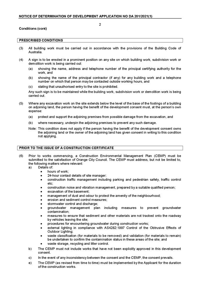
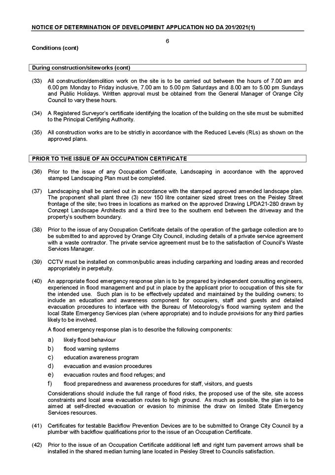


Planning
and Development Committee
5 October 2021
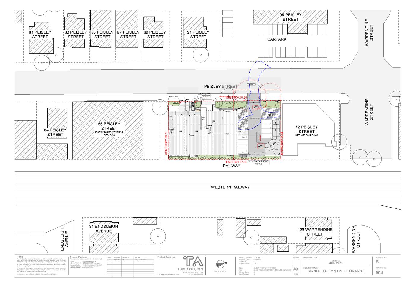
Planning
and Development Committee
5 October 2021
Attachment 3 Acoustic
Report

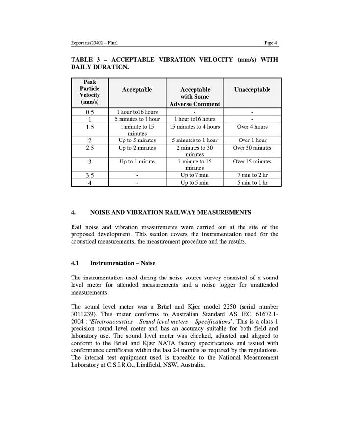
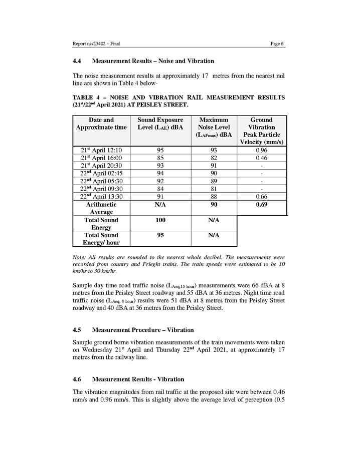
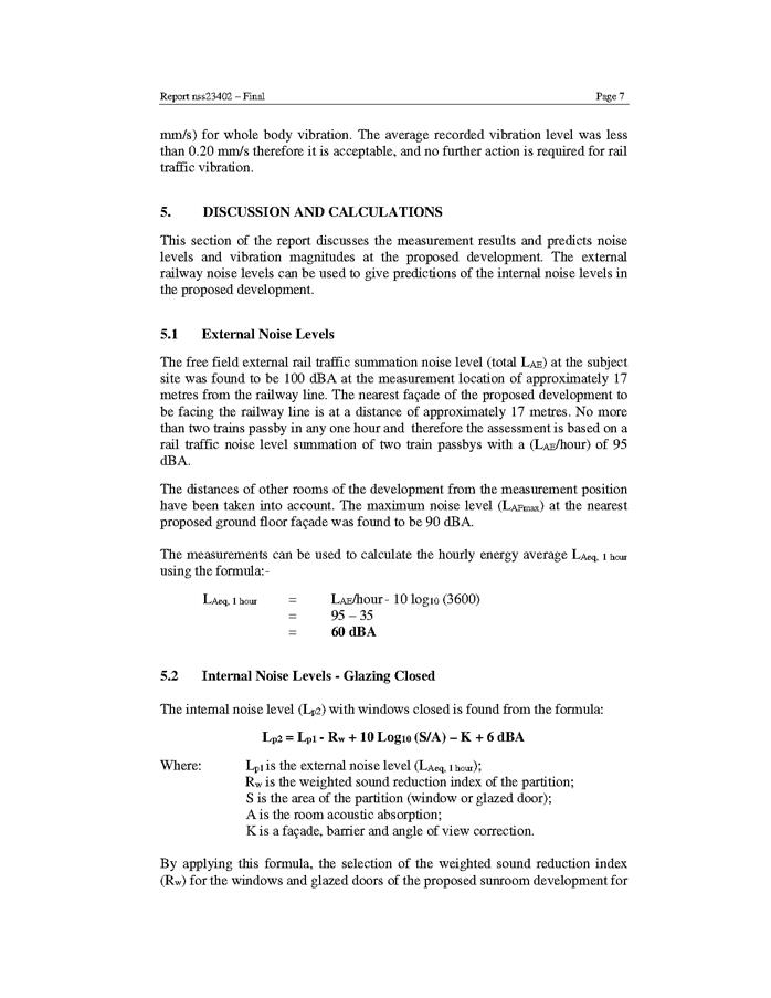
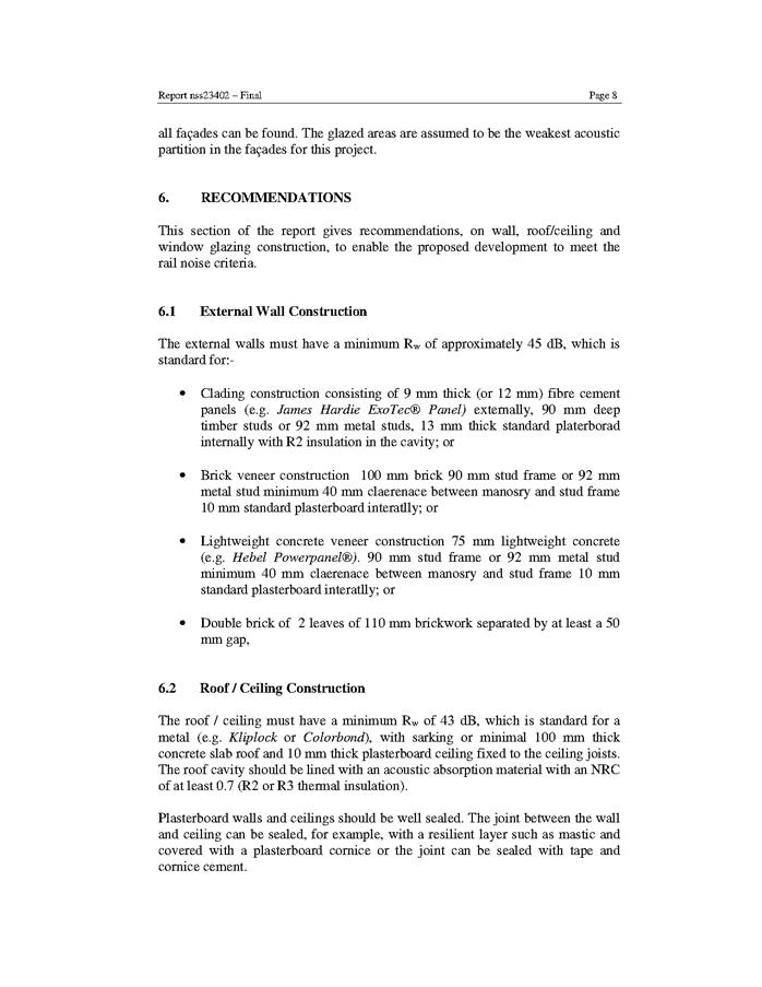
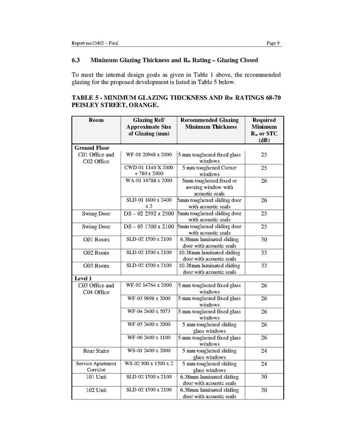
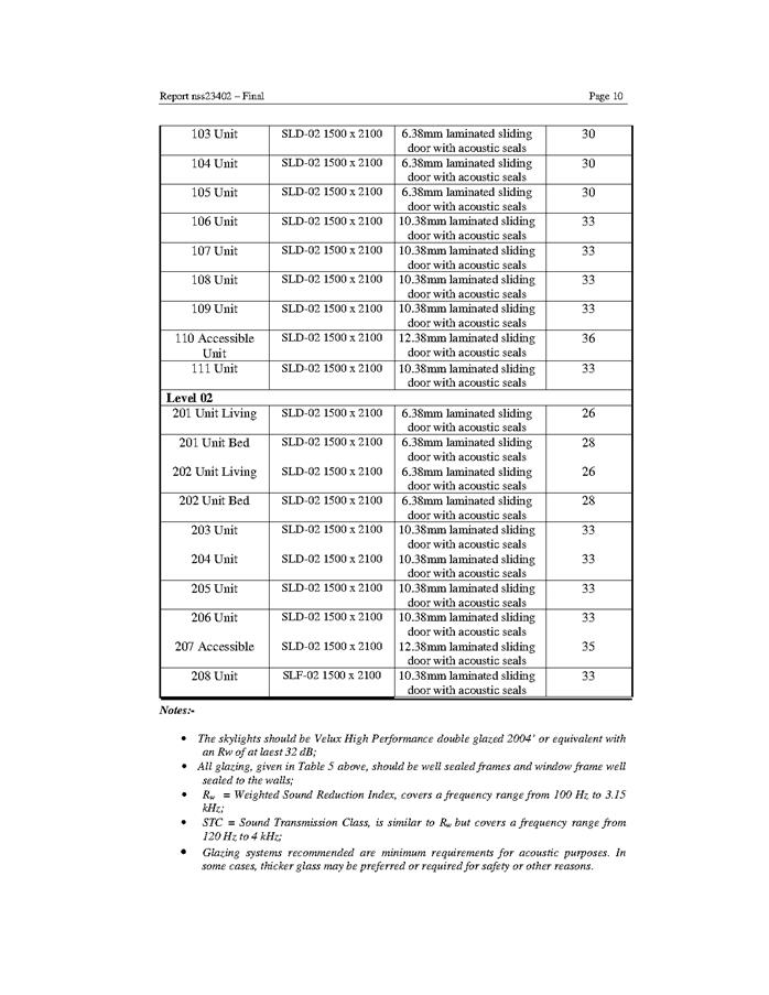
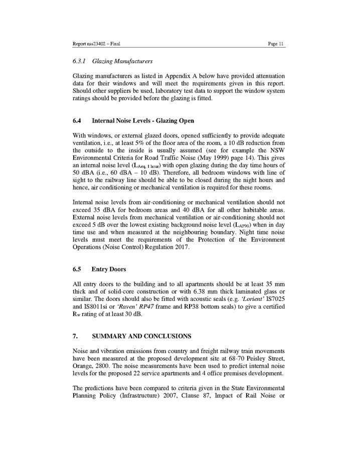
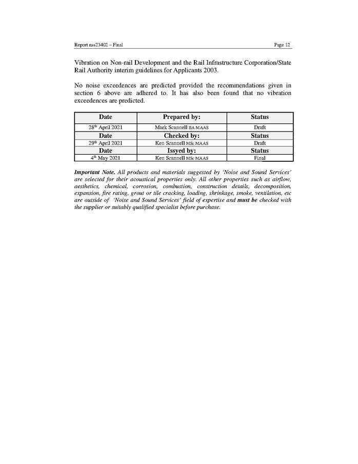
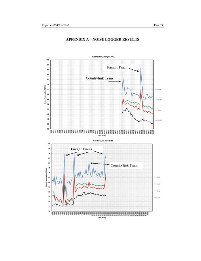
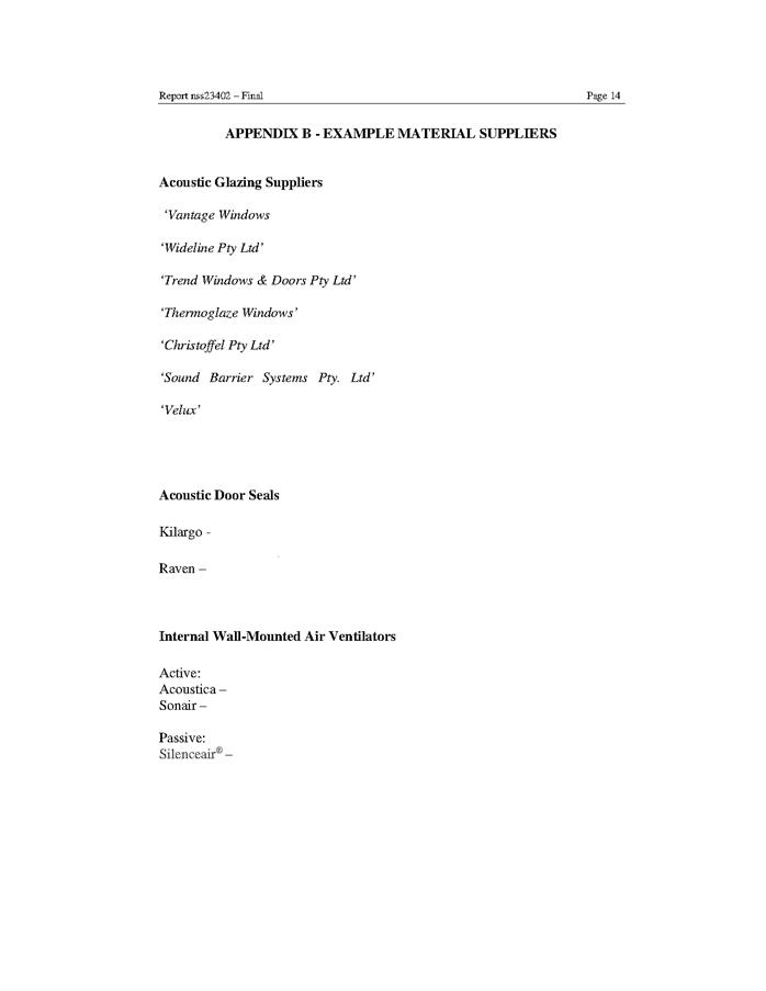
Planning and Development Committee
5 October 2021
Attachment 4 Submissions
- public
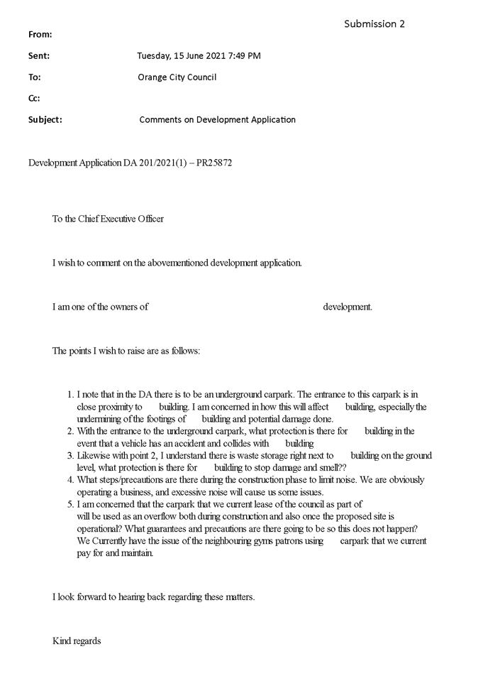
Planning and Development Committee
5 October 2021
Attachment 5 TfNSW
(Rail and Traffic) Concurrence Advice
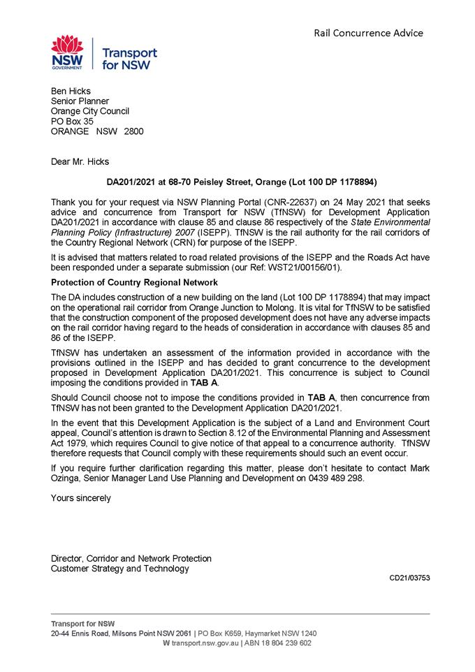
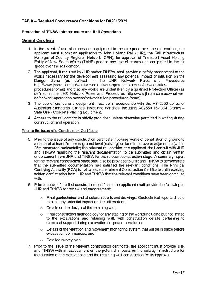
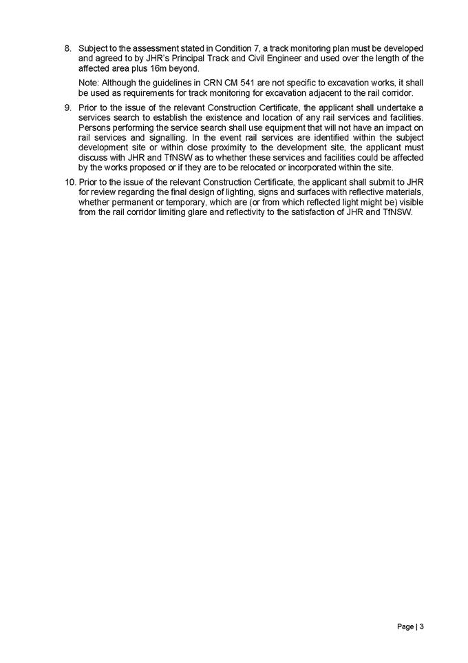
2.4 Development
Application DA 357/2021(1) - 38 Astill Drive
RECORD
NUMBER: 2021/2159
AUTHOR: Ben
Hicks, Planner
EXECUTIVE
Summary
|
Application
lodged
|
11
August 2021
|
|
Applicant/s
|
Orange
City Council
|
|
Owner/s
|
Orange
City Council
|
|
Land
description
|
Lot 806
DP 1240445, 38 Astill Drive, Orange
|
|
Proposed
land use
|
Subdivision
(four industrial lots and one residue lot) and Earthworks
|
|
Value of
proposed development
|
Not
applicable
|
Council's consent is sought for a five (5) lot industrial
subdivision of land and bulk earthworks at 38 Astill Drive, Orange, described
as Lot 806 DP 1240445 (refer to Figure 1).
The proposal comprises four industrial allotments and one
residue lot. Bulk earthworks will be undertaken as part of the subdivision
works to ensure the new lots to achieve appropriate site levels for their
future development. The industrial lots will have access to a public road,
reticulated sewer and water.
The applicant has submitted a written request in accordance
with Clause 4.6 of the LEP to vary the development standard relating to the
minimum lot size provision set out in Clause 4.1 of the LEP. The proposed
lots will be of a regular configuration and the applicant has demonstrated that
the lots can accommodate the larger building footprints and vehicle turn paths
that are typically associated with development in the General Industrial zone.
The use of Clause 4.6 to enable an exception to these development controls is
therefore considered appropriate in this instance.
The application is reported to
the Planning and Development Committee pursuant to Council’s Declaration
of Planning Procedures and Protocols that requires the determination of the
application to be made by Council for ‘any significant Council
development where Council will be financial beneficiary’.
The assessment of the proposal
concludes the development fits in the locality and there are no significant
impacts on the site or on adjacent lands. All construction aspects can be
adequately managed/controlled as per the submitted Development
Application (DA) information, or under recommended conditions of consent.
Figure 1 - Locality and Site Context Plan
DECISION FRAMEWORK
Development in Orange is governed by two key documents
Orange Local Environment Plan 2011 and Orange Development Control Plan 2004. In
addition, the Infill Guidelines are used to guide development, particularly in
the heritage conservation areas and around heritage items.
Orange Local Environment Plan 2011 – The
provisions of the LEP must be considered by the Council in determining the
application. LEPs govern the types of development that are permissible or
prohibited in different parts of the city and also provide some assessment
criteria in specific circumstances. Uses are either permissible or not. The
objectives of each zoning and indeed the aims of the LEP itself are also to be
considered and can be used to guide decision making around appropriateness of
development.
Orange Development Control Plan 2004 – the DCP
provides guidelines for development. In general, it is a performance-based
document rather than prescriptive in nature. For each planning element there
are often guidelines used. These guidelines indicate ways of achieving the
planning outcomes. It is thus recognised that there may also be other solutions
of merit. All design solutions are considered on merit by planning and building
staff. Applications should clearly demonstrate how the planning outcomes are
being met where alternative design solutions are proposed. The DCP enables
developers and architects to use design to achieve the planning outcomes in
alternative ways.
DIRECTOR’S COMMENT
Council's consent is sought for a five (5) lot industrial
subdivision of land and bulk earthworks at 38 Astill Drive, Orange, described
as Lot 806 DP 1240445. Bulk earthworks will be undertaken as part of the
subdivision works to ensure the new lots achieve appropriate site levels for
their future development.
A minor variation to the 2000
square metre minimum lot size development standard is sought by the applicant
for proposed Lots 400 and 401. The subject Lots 400 and 401 represent a
negligible numerical non-compliance of 4.4% and 4.85% respectively. The
development standard is considered to be unreasonable and unnecessary in this
circumstance. A detailed assessment of the proposed variation has been provided
in the body of this report.
The application is reported to
the Planning and Development Committee pursuant to Council’s Declaration
of Planning Procedures and Protocols that requires the determination of the
application to be made by Council for ‘any significant Council
development where Council will be financial beneficiary’. It is
recommended that Council supports the application subject to the adoption of
the draft Notice of Determination.
Link To Delivery/OPerational Plan
The recommendation in this report relates to the
Delivery/Operational Plan strategy “10.1 Preserve - Engage with the
community to ensure plans for growth and development are respectful of our
heritage”.
Financial Implications
Nil
Policy and Governance Implications
Nil
|
Recommendation
That
Council consents to development application DA 357/2021(1) for Subdivision
(four industrial lots and one residue lot) and Earthworks at Lot 806
DP 1240445, 38 Astill Drive, Orange pursuant to the conditions of consent in
the attached Notice of Determination.
|
further considerations
Consideration has been given to the recommendation’s
impact on Council’s service delivery; image and reputation; political;
environmental; health and safety; employees; stakeholders and project
management; and no further implications or risks have been identified.
APPLICATION/PROPOSAL
The proposed subdivision involves the creation of four
industrial parcels and one residue lot and provision of Council and Non-Council
services. No new roads are proposed. The proposed lots are depicted
diagrammatically in Figure 2 and described below:
· Lot 400 is a
regular rectangle shape with a spayed corner and has an area of 1912m2.
This lot will be located on the corner of Elwin Drive and the future extension
of Astill Drive.
· Lot 401 is regular
rectangle shape and will have an area of 1903m2 with frontage to
Elwin Drive.
· Lot 402 will have
an area of 2301.6m2 with frontage to the cul-de-sac bowl in Astill
Drive. The lot will be wedge shape widening out to the rear.
· Lot 403 will have
an area of 2808m2 with frontage to the cul-de-sac bowl in Astill
Drive. The lot will be wedge shape widening out to the rear.
· Lot 404 is the
residue lot and will make up the balance of land and will be approximately
3.84ha. Legal access will be maintained to the residue via Astill Drive in the
north-west corner of the site.
Bulk earthworks are proposed at the subdivision stage to
provide level building pads and appropriate access arrangements for each lot.
The applicant advises that the amount of material required to be excavated to
achieve the desired design levels is in the order of approximately 8800m3
of surplus material. The greatest extent of cut is in the order of 3.1m, with
an average cut depth of nominally 1m. The maximum amount of fill required is
minimal at 0.4m with an average of 0.039m fill as required within the site. All
surplus material will be kept within the subject land and
redistributed/stockpiled within Lot 404 as required.
This application also seeks
approval to set design levels of RL 871 AHD across the north-western portion of
proposed Lot 404 in anticipation of future subdivision stages of the residue
lot. The applicant advises that achieving the proposed design levels (RL
871AHD) within Lot 404 may require additional VENM imported to the site from
other Council projects.
Figure 2 – proposed lot layout
ENVIRONMENTAL PLANNING
ASSESSMENT
Section 1.7 - Application of
Part 7 of the Biodiversity Conservation Act 2016 and Part 7A of the
Fisheries Management Act 1994
Section 1.7 of the EP&A Act identifies that Part 7 of
the Biodiversity Conservation Act 2016 (BC Act) and Part 7A of the
Fisheries Management Act 1994 have effect in connection with terrestrial and
aquatic environments.
There are four triggers known to insert a development into
the Biodiversity Offset Scheme (i.e., the need for a BDAR to be submitted
with a DA):
· Trigger
1: development occurs in land mapped on the Biodiversity Values
Map (OEH) (clause 7.1 of BC Regulation 2017);
· Trigger 2:
development involves clearing/disturbance of native vegetation above a certain
area threshold (clauses 7.1 and 7.2 of BC Regulation 2017); or
· Trigger 3:
development is otherwise likely to significantly affect threatened species
(clauses 7.2 and 7.3 of BC Act 2016).
The fourth trigger (development proposed to occur in an Area
of Outstanding Biodiversity Value (clause 7.2 of BC Act 2016) is generally not
applicable to the Orange LGA; as no such areas are known to occur in the LGA.
No further comments will be made against the fourth trigger.
The site is highly disturbed and has been dominated by
historical agricultural use and land clearing and is currently zoned for
industrial land uses. Adjoining parcels have been subdivided and developed for
industrial purposes. Having regard to the relevant provisions, historical and
adjoining uses, and an inspection of the subject property, it is considered
that the proposed development is not likely to significantly affect a
threatened species or ecological communities, or their habitats. A Biodiversity
Development Assessment Report is not required in this instance.
Section 4.15 of the
Environmental Planning and Assessment Act 1979
Section 4.15 of the Environmental Planning and Assessment
Act 1979 requires Council to consider various matters, of which those
pertaining to the application are listed below.
PROVISIONS OF ANY ENVIRONMENTAL
PLANNING INSTRUMENT s4.15(1)(a)(i)
Orange Local Environmental Plan 2011
Part 1 - Preliminary
Clause 1.2 - Aims of Plan
The
broad aims of the LEP are set out under Subclause 2. Those relevant to the
application are as follows:
(a) to encourage development which complements
and enhances the unique character of Orange as a major regional centre boasting
a diverse economy and offering an attractive regional lifestyle,
(b) to provide for a range of development
opportunities that contribute to the social, economic and environmental
resources of Orange in a way that allows present and future generations to meet
their needs by implementing the principles for ecologically sustainable
development,
The proposed development is considered to be consistent with
the relevant aims of Orange LEP 2011. In particular, the proposed
development will assist in reinforcing Orange as a major regional centre; will
contribute to the social and economic development of the city.
Clause 1.6 - Consent Authority
This clause establishes that, subject to the Act, Council is
the consent authority for applications made under the LEP.
Clause 1.7 - Mapping
The subject site is identified
on the LEP maps in the following manner:
|
Land Zoning Map:
|
IN1 General Industrial
|
|
Lot Size Map:
|
2000m2
|
|
Heritage Map:
|
Not a heritage item or conservation
area
|
|
Height of Buildings Map:
|
N/A
|
|
Floor Space Ratio Map:
|
N/A
|
|
Terrestrial Biodiversity Map:
|
No significant biodiversity
sensitivity on the site.
|
|
Groundwater Vulnerability Map:
|
Groundwater vulnerable
|
|
Drinking Water Catchment Map:
|
Not within the drinking water
catchment
|
|
Watercourse Map:
|
No mapped watercourse
|
|
Urban Release Area Map:
|
Not within an urban release area
|
|
Obstacle Limitation Surface Map:
|
No restriction
on building siting or construction
|
|
Additional Permitted Uses Map:
|
No additional permitted use applies
|
|
Flood Planning Map:
|
Not within flood planning map
|
Those matters that are of relevance are addressed in detail
in the body of this report.
Clause 1.9A - Suspension of
Covenants, Agreements, and Instruments
This clause provides that covenants, agreements and other
instruments which seek to restrict the carrying out of development do not apply
with the following exceptions:
(a) to
a covenant imposed by the Council or that the Council requires to be imposed,
or
(b) to
any relevant instrument under Section 13.4 of the Crown Land Management Act 2016,
or
(c) to
any conservation agreement under the National Parks and Wildlife Act 1974, or
(d) to
any Trust agreement under the Nature Conservation Trust Act 2001, or
(e) to
any property vegetation plan under the Native Vegetation Act 2003, or
(f) to
any biobanking agreement under Part 7A of the Threatened Species Conservation
Act 1995, or
(g) to
any planning agreement under Subdivision 2 of Division 7.1 of the Environmental
Planning and Assessment Act 1979.
Council staff are not aware of the title of the subject
property being affected by any of the above.
Part 2 - Permitted or Prohibited
Development
Clause
2.1 - Land Use Zones and Clause 2.3 - Zone Objectives and Land Use Table
The subject site is located within the
IN1 General Industrial Zone. The proposed development is defined as a
subdivision under OLEP 2011 and is permitted with consent for this zone. This
application is seeking consent. Pursuant to Section 6.2 of the Environmental
Planning and Assessment Acts 1979:
Subdivision of land means the division
of land into two or more parts that, after the division, would be obviously
adapted for separate occupation, use or disposition.
Clause 2.3(2) of the Orange Local Environmental Plan (OLEP)
2011 provides that the Council shall have regard to the objectives for
development in a zone when determining a development application in respect of
land within the zone. The objectives of the IN1 General Industrial Zone
are:
· To provide a
wide range of industrial and warehouse land uses.
· To encourage
employment opportunities.
· To minimise any
adverse effect of industry on other land uses.
· To support and
protect industrial land for industrial uses.
· To ensure
development along the Southern Link Road has an alternative access.
There are no aspects of the proposed subdivision that are
adverse to the zone objectives, in this regard:
· The proposed lots
would provide separate sites that are suitable for the range of land uses
permitted in the IN1 Zone.
· Future development
within the proposed lots may generate employment opportunities.
· The proposed
subdivision itself does not adversely affect other land uses.
· The proposal
increases the number of sites that may be used for industrial purposes.
· Direct access to
the Southern Link Road isn’t relevant to the proposal.
The following provisions of the OLEP
2011 have been especially considered in the assessment of the proposal:
· Clause 2.6 – Subdivision – Clause 2.6 is applicable and
states:
Land to which this Plan applies may be
subdivided, but only with development consent.
Consent is sought for subdivision of
the subject land in accordance with this clause.
· Clause 4.1 – Minimum Lot Size
– This clause
requires the subdivision of land to be equal to or greater than the size
nominated for the land under the Minimum Lot Size Map.
In relation to this site, the map
nominates a minimum lot size of 2,000m2. Two of the proposed lots
proposed are below this lot size requirement being Lot 400 (1912m2)
and Lot 401 (1903m2). This represents a 4.4% and 4.85% variation
respectively to the minimum lot size. As such, the application seeks a
variation to this standard, which is addressed under Clause 4.6 below.
· Clause 4.6 – Exceptions to
development standards – Clause
4.6 exceptions to development standards of the Orange Local Environmental Plan
2011 provides flexibility in the application of certain development standards
in particular circumstances, where compliance with a development standard is
unreasonable and unnecessary. A minor variation to the 2000 square metre minimum
lot size development standard is sought by the applicant for proposed Lots 400
and 401.
In determining whether development
consent may be granted, the Consent Authority must consider a written objection
by the applicant to the development standard and be satisfied that the
objectives of both the development standard and the IN1 General Industrial zone
will be achieved as a result of the subdivision.
In determining whether development
consent may be granted, the Consent Authority must consider a written objection
by the applicant to the development standard. The written objection must
demonstrate:
a) that
compliance with the development standard is unreasonable or unnecessary in the
circumstances of the case, and
b) that
there are sufficient environmental planning grounds to justify contravening the
development standard.
Council may grant consent only if the
concurrence of the Director General of the Department of Planning and
Infrastructure has been obtained and Council is satisfied that:
· the written
request has adequately addressed the above, and
· the proposed
development will be in the public interest because of:
- consistency with
the objectives of the particular standard, and
- consistency with
the objectives of the zone applying to the site.
The DA is accompanied by a Clause 4.6
request to vary the lot size development standard. The reasons listed by the
applicant for the subdivision justifying why the development standard is
unreasonable/unnecessary and there are sufficient environmental planning
grounds to support the proposal are:
Minimum Lot Size
· The objects of the
development standard will still be achieved despite the non‑compliance.
To this end:
- The proposed lots
are of a size and shape commensurate with the surrounding development pattern,
albeit slightly smaller.
- The lots will
accommodate a variety of future industrial and warehouse uses, noting that not
every industrial development requires building with large floor areas.
- Despite the strict
non-compliance, appropriately designed and sited developments, that meet all of
the relevant DCP requirements are achievable on the lots. This demonstrated in
the below conceptual layouts.
· The subject Lots
400 and 401 represent a negligible numerical non-compliance of 4.4% and 4.85%
respectively.
· The lot layout of
the proposed subdivision has been predetermined by the previously approved lots
and road layout.
· Strict
compliance could be achieved by pushing the eastern boundary further to the
east by approximately 3m. However, doing so will create an irregular shaped lot
when the residue lot is developed in the future. Insisting upon strict
compliance under this application would hinder the obtainment of the MLS
objective of future applications for subdivision.
Assessment
of Clause 4.6 request
Minimum lot size is one control used
in industrial zoned areas to ensure that sufficient area is available for
the viable redevelopment of sites including the provision of parking,
landscaping etc and to accommodate reasonable relationships with buildings on
adjoining sites. The
exception request considers that the standard is unreasonable or unnecessary in
the context of the application and justifies this via consideration of the
provisions of Clause 4.6. The applicant states that the development as proposed
is as a result of previous subdivision and road layout decisions and the minor
reduction in site area still achieves the objectives of the clause and the IN1
zone as well as the provisions of the DCP.
In considering the submitted
documentation, compliance is considered unnecessary in this circumstance given the development responds appropriately
to the existing road and subdivision pattern and a variation is deemed
unavoidable. Furthermore, there are sufficient environmental grounds to justify
the non-compliance. Specifically:
· The variation is
minor and will not have a significant impact on the spatial pattern of the
wider subdivision layout (regular configuration maintained).
· The proposed
variation is required to achieve an orderly and economic use of the subject
land in accordance with the site’s zoning and the underlying objectives
of the Environmental Planning and Assessment Act 1979.
· It is considered
that the proposed numerical variation is an appropriate degree of flexibility
and results in two suitable vacant lots that can support industrial development
in accordance with the DCP as demonstrated through the submitted conceptual
layouts (see Figure 3).
· The applicant has
demonstrated that the proposed development is consistent with the objectives of
the zone and lot size standard.
· The requested
contravention of the development standard does not raise any matter of
significance for State or regional environmental planning; there is no
detrimental impact on the public benefit of maintaining the development
standard.
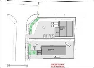
Figure 3 – conceptual layouts
On the basis of
the above assessment, it is considered that the applicant has provided
sufficient information to enable Council to be satisfied that the request for
an exception to a development standard via Clause 4.6 may be supported.
Consideration of the concurrence requirements which is geared toward minor
departures also suggests that the variation is acceptable.
· Clause 7.1 Earthworks – Clause 7.1 of the OLEP aims to ensure that earthworks for
which development consent is required will not have a detrimental impact on
environmental functions and processes, neighbouring uses, cultural or heritage
items or features of the surrounding land.
Earthworks will be required in conjunction
with civil and construction works required to create the proposed lots,
installation of services etc. The extent of disruption to the drainage of the
site is considered to be reasonable. Existing overland/natural stormwater flows
will be redirected to underground stormwater infrastructure and managed through
Council’s stormwater network. Therefore, the disruption to natural
overland flow paths is not expected detrimentally affect adjoining properties
or receiving waterways.
The site is located where there is a
potential for naturally occurring asbestos to be found. Appropriate precautions
are to be taken while works are taken onsite in accordance with Council’s
policy. Further, in line with Council’s standard procedures a
precautionary condition is recommended in relation to an unexpected finds
protocol concerning contaminants.
The site is not known to contain any
Aboriginal, European or Archaeological relics. Previous known uses of the site
do not suggest that any relics are likely to be uncovered.
Overall, the extent of the earthworks is
not expected to materially affect the potential future use or redevelopment of
the site, rather it is expected to facilitate the future development of the
land. Appropriate sediment controls, including silt traps and other protective measures
be required to protect adjoining lands during subdivision works as a condition
of development consent.
· Clause 7.3 - Stormwater Management – Council’s Assistant Development Engineer has
recommended conditions requiring the provision of stormwater infrastructure to
each new lot. The proposal does not involve creating hardstand areas,
and as such post-development runoff levels will not exceed the pre-development
levels at this stage. Stormwater will be further assessed in detail when future
applications are made for the development of each site.
· Clause 7.6 - Groundwater Vulnerability – The site has been mapped as being groundwater vulnerable.
The proposal is not anticipated to involve the discharge of toxic or noxious
substances and is therefore unlikely to contaminate the groundwater or related
ecosystems. The proposal does not involve extraction of groundwater and will
therefore not contribute to groundwater depletion. Any future development and
use of these lots would be the subject of separate assessment to ensure any use
would be acceptable in the context of the groundwater constraints.
· Clause
7.11 - Essential Services – All utility services will be augmented to
the land and made adequate for the proposal. All lots will have frontage and
access to existing road networks. Electricity will be provided as per Essential
Energy’s requirements. Appropriate stormwater management infrastructure
will be provided to the required allotments.
STATE ENVIRONMENTAL PLANNING
POLICIES
The following State Environmental Planning Instruments
(SEPPs) apply to the Orange Local Government Area:
· SEPP
21 - Caravan Parks
· SEPP
33 - Hazardous and Offensive Development
· SEPP
36 - Manufactured Home Estates
· SEPP
50 - Canal Estate Development
· SEPP
55 - Remediation of Land
· SEPP
64 - Advertising and Signage
· SEPP
65 - Design Quality of Residential Flat Development
· SEPP
70 – Affordable Rental Housing (Revised Schemes)
· SEPP
(Affordable Rental Housing) 2009
· SEPP
(Building Sustainability Index: BASIX) 2004
· SEPP
(Concurrences and Consents) 2018
· SEPP
(Educational Establishments and Child Care Facilities) 2017
· SEPP
(Exempt and Complying Development Codes) 2008
· SEPP
(Housing for Seniors or People with a Disability) 2004
· SEPP
(Infrastructure) 2007
· SEPP
(Mining, Petroleum Production and Extractive Industries) 2007
· SEPP
(Primary Production and Rural Development) 2019
· SEPP
(State and Regional Development) 2011
· SEPP
(Vegetation in Non-Rural Areas) 2017
The following SEPPs are specifically relevant to the
assessment of the proposed development:
SEPP 55 Remediation of Land - State Environmental
Planning Policy 55 - Remediation of Land (SEPP 55) requires that a consent
authority must not consent to the carrying out of development of land unless it
has considered whether the land is contaminated, is satisfied that the land is
suitable in its contaminated state for the development that is proposed, and if
the land requires remediation to be made suitable for the proposed development
it is satisfied that the land will be remediated before the land is used for
that purpose.
This application is for subdivision of land for industrial
purposes only, and Council’s records demonstrate that the contamination
status of the subject and adjoining lands is suitable for industrial
development. There are no previous known uses of the site which may have caused
contamination or evidence of any structures or sheep
dips, and no hotspots at neighbouring sites. As such, no further enquiry
is warranted. It is however considered appropriate to require a condition
relating to unexpected finds of contamination during
earthworks.
Furthermore, the site is located within
or near an area identified as containing naturally occurring asbestos and thus
a condition is attached for the development on the site to be carried out in
accordance with Orange City Council’s Naturally Occurring Asbestos
Planning Procedures.
State Environmental Planning Policy 55 (Infrastructure)
2007
Clause 45 of SEPP Infrastructure requires a consent
authority to consider any development application (or an application for
modification of consent) for any development carried out:
· Within or immediately
adjacent to an easement for electricity purposes (whether or not the
electricity infrastructure exists).
· Immediately
adjacent to an electricity substation.
· Within 5m of an
overhead power line.
· Includes
installation of a swimming pool any part of which is: within 30m of a structure
supporting an overhead electricity transmission line and/or within 5m of an
overhead electricity power line.
· Placement of power
lines underground.
Proposed Lot 402 is located immediately adjacent to an
electrical substation and therefore the application was referred to Essential
Energy. Essential Energy’s requirements have been included as conditions
of consent.
PROVISIONS OF ANY DRAFT
ENVIRONMENTAL PLANNING INSTRUMENT THAT HAS BEEN PLACED ON EXHIBITION
4.15(1)(a)(ii)
The proposed development is not contrary to any matter
contained within Draft Amendments currently on exhibition.
PROVISIONS OF ANY DEVELOPMENT
CONTROL PLAN s4.15(1)(a)(iii)
Development Control Plan 2004
The following parts of DCP 2004 are applicable to the
proposed development:
· Chapter
2 - Natural Resource Management
· Chapter
4 - Special Environmental Considerations
· Chapter
5 – General Considerations for Zones and Development
· Chapter
9 – Development in Industry and Employment Zone
The relevant matters in Chapters 2 and 4 were considered in
the foregoing assessment under Orange LEP 2011. The relevant matters contained
under Chapters 5 and 8 are addressed below:
Chapter 5 - Planning Outcomes
for Certifying Subdivision
· All subdivision
works are designed and undertaken in accordance with Council’s adopted
standards as outlined in the Orange City Development and Subdivision Code.
Subdivision works will be done in accordance with the Orange
City Development and Subdivision Code.
Chapter 9 - Industrial Subdivision
· The subdivision
provides for a range of lot sizes consistent with the existing or proposed
character of the industrial locality (with reference to the above table).
The development seeks to provide a lot sizes generally
consistent with the character of the industrial locality. The estate comprises
a mix of allotment sizes generally around 2000m2 or above. Whilst
two of the lots proposed are below the minimum lot size requirement under the
LEP, the applicant has suitably demonstrated that the lot size and shape of the
lots proposed are capable of accommodating future industrial development
including site manoeuvring, car parking and the like. To this end, the
development is considered consistent with the above.
· Lots have a
regular shape to facilitate the establishment of large industrial buildings
The proposed subdivision complies with this outcome. Each of
the proposed lots is provided with a regular configuration with reasonable
width and depth. The configuration of each lot is of sufficient dimensions to
accommodate the larger building footprints and vehicle turn paths that are
typically associated with industrial development.
· The subdivision
is designed and constructed according to the Development and Subdivision Code.
This planning outcome will be met as part of the
Construction Certificate and Subdivision Certificate phases of the development.
Attached is a condition of consent addressing this issue.
· The land is
adequately serviced for industrial development.
The proposal will comply with this planning outcome. Due to
the existing development pattern, all utilities services including sewer,
water, stormwater, electricity, and telephone are in reasonable proximity to
enable connection to the proposed lots.
· Buildings are
set back a minimum of 10m from front boundaries (5m to a secondary boundary on
a corner lot) for lots greater than 1,000m2 or 5m for lots less than
1,000m2 or otherwise to a setback consistent with existing setbacks
in established areas. A 10m setback applies to lots that have frontage to
Clergate Road.
Appropriate setbacks will be achievable within the proposed
lots.
· Buildings cover
up to 50% of the site area (excluding the area of accessways for battleaxe
lots).
The applicant has demonstrated that the smaller Lots (400
and 401) are suitably sized to allow for a substantially sized industrial
building to be erected whilst covering less than 50% of the site.
· Landscaping is
provided along boundaries fronting roads including trees with an expected
mature height at least comparable to the height of buildings on the site.
All sites contain an element of landscaping. Landscaping provided is of a
bulk, scale and height relative to buildings nearest the front property
boundary so as to provide beautification and visual relief to the built form
proposed or existing on the site.
The depth of the landscape
bed at the site frontage is sufficient to accommodate the spread of plantings
that meet the abovementioned outcomes but, where practicable, a minimum
depth of 3.5m is provided. Plantings are designed to provide shade for
parking areas, to break up large areas of bitumen, to enhance building
preservation and to screen against noise.
No landscaping is proposed at the subdivision stage of
development. Landscaping will be addressed in the consideration of future
Applications for development.
· Adequate
parking and onsite manoeuvring is provided.
The proposed lots allow for suitable parking and
manoeuvrability.
PROVISIONS PRESCRIBED BY THE
REGULATIONS s4.15(1)(a)(iv)
Demolition of a Building (Clause 92)
The proposal does not involve the demolition of any
structures.
Fire Safety Considerations
(Clause 93)
The proposal does not involve a change of building use for
an existing building.
Buildings to be Upgraded
(Clause 94)
The proposal does not involve the rebuilding, alteration,
enlargement or extension of an existing building.
BASIX Commitments (Clause 97A)
BASIX is not applicable to the proposed development.
THE LIKELY IMPACTS OF THE
DEVELOPMENT s4.15(1)(b)
Context and Setting
A subdivision of this nature is permissible in the zone and
the creation of the proposed lots is unlikely to generate any impacts that
would adversely affect the context of the locality. The proposed subdivision is
considered to be largely consistent with the surrounding development pattern
and acts as a natural continuation of industrial land and will facilitate
industrial development which is expected in the within this precinct.
Potential visual impacts by future development within the
proposed lots will require consideration on a case-by-case basis and will be
required to meet the relevant planning outcomes within the DCP.
Access, Traffic and Parking
The subject land is well serviced by the existing road
network within the existing industrial precinct. The applicant has suitably
demonstrated that future development on the subject lots will have adequate
area for manoeuvring and parking. Council’s Technical Services Division
has not raised objections to the proposed subdivision in terms of access to the
subject lots. While the development may result in an increase traffic in the
locality; Council’s Technical Services also advise that the surrounding
street network will be capable of serving the additional traffic load and does
not require upgrading.
Environmental Impacts
The subject land is a highly modified industrial parcel of
land within a well-established industrial precinct. To this end, the subject
land is not likely to contain any threatened species, endangered ecological
communities, or their habitats. The development is not likely to present any
environmental impacts.
Air and Microclimate
Subdivision works may generate some impacts in the immediate
locality including the emissions of dust and odour/fumes from earthmoving
equipment, construction vehicles entering and existing the site and so on.
However, these impacts will be short term and only for the duration of
subdivision construction works. The proposal is not expected to have any
long-term discernible impact on air quality or on the microclimate of the
locality. Conditions of consent are recommended for dust suppression during
subdivision works to protect the air and microclimate.
Economic Impacts
The proposed development is consistent with Council's long
term industrial land use strategy identifying the Narrambla Estate as an
industrial growth area. The proposed subdivision will promote the growth and
investment in industrial development in a serviceable area of Orange and thus
is expected to have positive economic stimulus and reinforce Orange as a hub
for industry and employment within the wider region.
THE SUITABILITY OF THE SITE
s4.15(1)(c)
In terms of its physical attributes, the site is considered
to be suitable for the proposed subdivision. The constraints and opportunities
relevant to this development have been discussed throughout this report.
The surrounding roads provide acceptable access
opportunities for the proposed subdivision and future uses within the proposed
lots. The existing industrial road network does not require upgrading to
accommodate the proposed subdivision.
The site allows the creation of new lots that are of a
regular configuration and with reasonable width.
Due to the existing development pattern all urban utilities
including sewer, town water, stormwater, electricity, and telephone are in
reasonable proximity to enable the proposed lots to be serviced without undue
burden upon the subdivider or the community.
ANY SUBMISSIONS MADE IN
ACCORDANCE WITH THE ACT s4.15(1)(d)
The proposed development was not required to be advertised
or notified under the provisions of Council’s Community Participation
Plan 2019; therefore, no submissions received.
PUBLIC INTEREST
s4.15(1)(e)
The proposal is assessed to pose no significant impacts on
the public interest.
DEVELOPMENT CONTRIBUTIONS
Section 64 Local Government
Act 1993
Council’s Assistant
Development Engineer advises:
1. Development
contributions for water, sewer and drainage works are applicable to the
proposed development.
2. Headworks charges of
four (4) ETs for water and four (4) ETs for sewer will apply to the proposed
development.
Conditions are included on the
attached Notice of Determination requiring payment of applicable contributions
prior to CC.
SUMMARY
The proposed development is permissible with the consent of
Council. The proposed development complies with the relevant aims, objectives
and provisions of Orange LEP 2011 (as amended) and DCP 2004, excepting the
contravention of the minimum lot size development standard under the LEP.
Notwithstanding the contravention of the aforementioned standard, the applicant
has made application to vary the standard pursuant Clause 4.6 of the LEP and,
as outlined above the variation is considered acceptable.
A Section 4.15 assessment of the development indicates that
the development is acceptable. Attached is a draft Notice of Approval outlining
a range of conditions considered appropriate to ensure that the development
proceeds in an acceptable manner.
Attachments
1 Notice
Of Approval, D21/62100⇩
2 Plans,
D21/61826⇩
Planning
and Development Committee
5 October 2021
Attachment 1 Notice
Of Approval
Planning
and Development Committee
5 October 2021
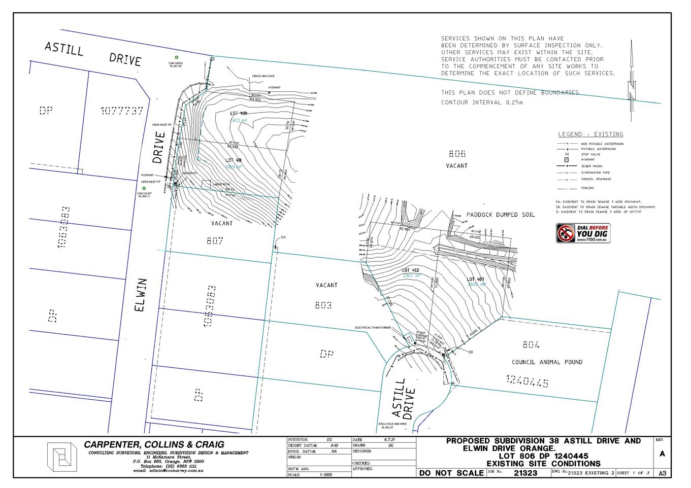
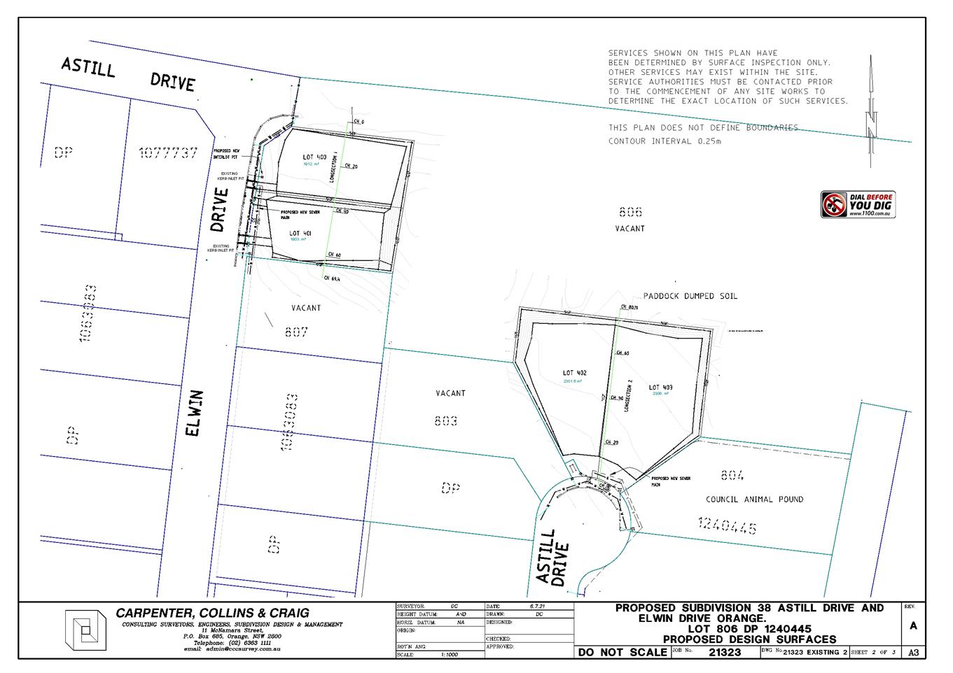
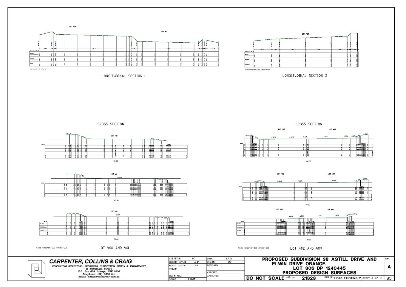
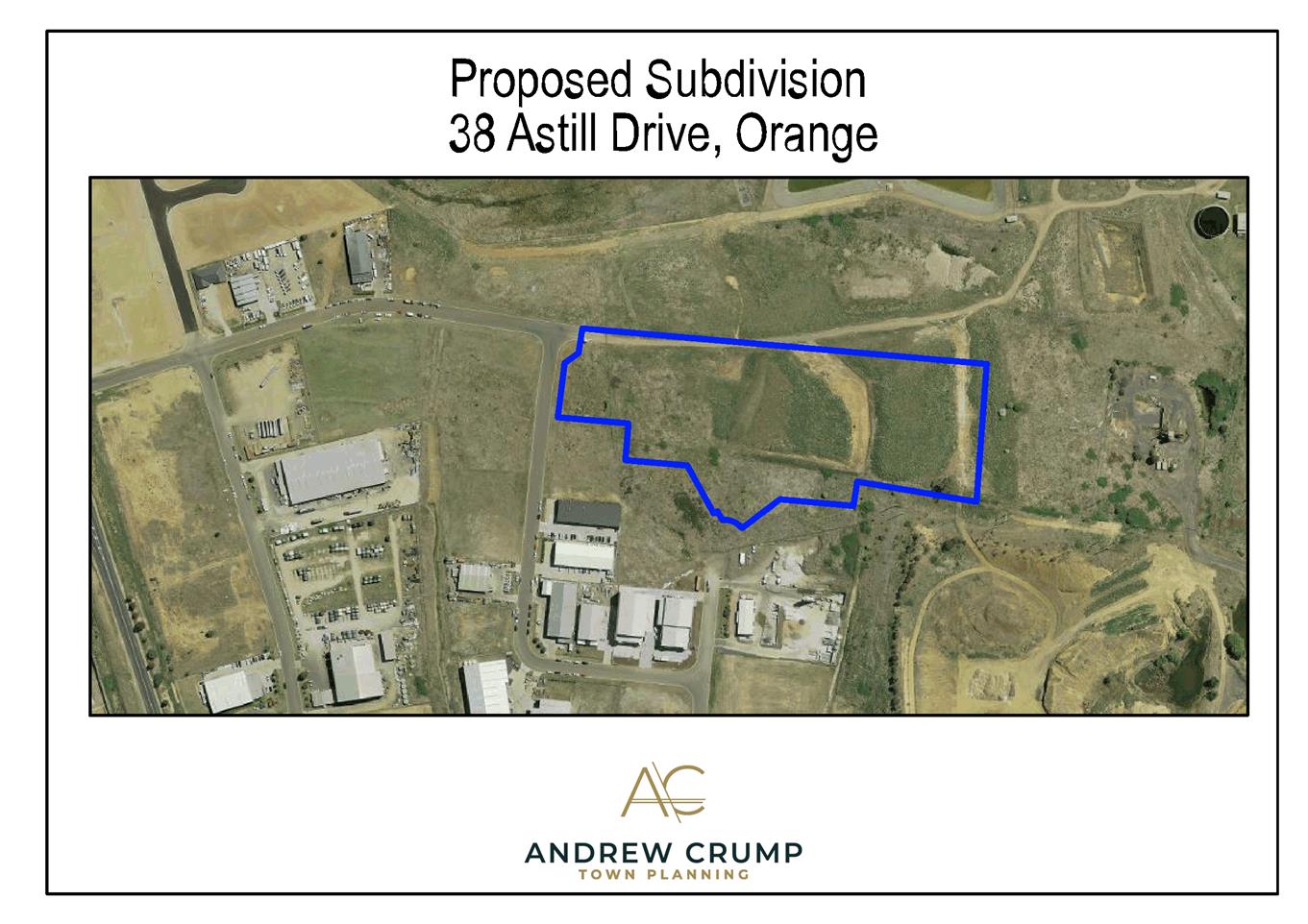
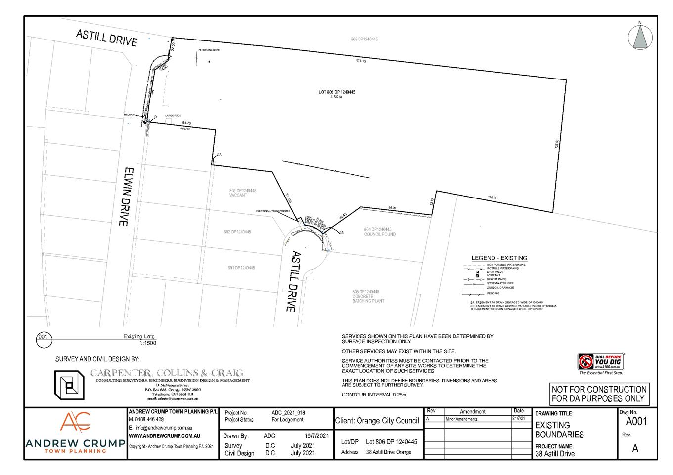
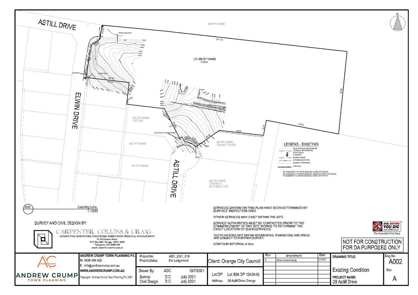
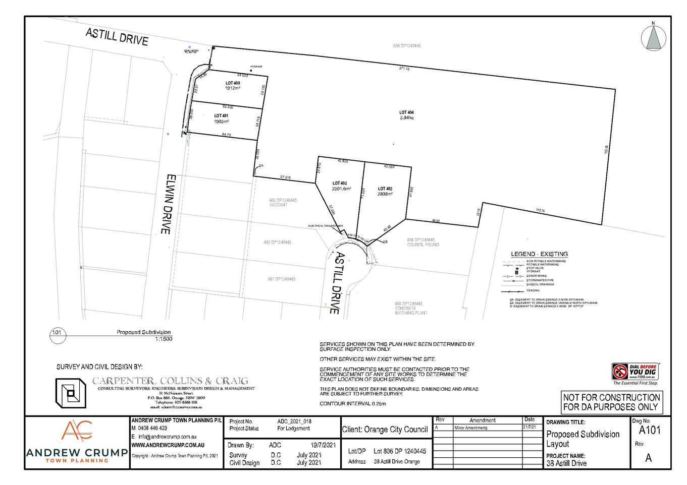

2.5 Development
Application DA 234/2018(1) - 129-133 Sale Street(Caldwell House)
RECORD
NUMBER: 2021/2200
AUTHOR: Mark
Hodges, Director Development Services
EXECUTIVE Summary
In July 2020 Council considered a Development Application
from Health Infrastructure for the demolition of all of the buildings making up
the former Nurses Quarters at 129-131 Sale Street Orange. Council
resolved to approve the application, subject to retention of the main
significant heritage buildings on this site. The applicant, being the
Crown did not agree to the draft approval of Council, so the applicant applied
to the Western Region Planning Panel for a review of the Application.
The Planning Panel considered the Application in February
2021 and after asking for additional information on economic development
options for the site, agreed with the position of Council, then referring the
Application to the Minister’s Office for review (as the Panel, like
Council could not determine the application).
It is understood that the Minister’s Office requested
an independent review of the Council assessment report by the Department of
Planning Industry and Environment (DPIE). The report suggested that the
Planning Panel had not given consideration of the State Environmental Planning
Policy – Remediation of Land (SEPP 55) during its deliberations in
February. The Department has requested the Panel reconsider the
Development Application.
The Western Region Planning Panel are convening a meeting to
review the application on 12 October 2021. The Chairman of the Planning
Panel has advised Council of this as a matter of courtesy and extended an offer
to consider responding to the DPIE assessment.
Staff have reviewed the DPIE assessment report and consider
that there is a critical error in its conclusions. The contamination
provisions referred to in the DPIE report as being central to the suggested
mandated demolition of all of the buildings on the site are simply
irrelevant and do not apply to this development proposal. It is
considered that the original Council assessment report has correctly
characterised and assessed this development.
It is recommended that Council make a submission to the
Western Region Planning Panel advising that Council has undertaken an analysis
of the DPIE report and consider that the findings of this report are
incorrect. Furthermore that Council reaffirms its position that the
buildings previously identified in Council’s assessment as having
significant cultural and architectural heritage value, are of such significance
to the City that they should not demolished.
Link To Delivery/OPerational Plan
The recommendation in this report relates to the
Delivery/Operational Plan strategy “7.1 Preserve - Engage with the
community to develop plans for growth and development that value the local
environment”.
Financial Implications
Any legal proceedings that may arise from a Development
Application that is determined by the Planning Panel decision are required to
be defended by Council.
Policy and Governance Implications
Governance matters relating to errors within the DPIE report
that may amount to critical errors have been considered within this
report.
|
Recommendation
1 That
Council make a submission to the Western Region Planning Panel advising that
Council has undertaken an analysis of the DPIE report and consider that the
findings of this report are incorrect.
2 That
Council reaffirms its position that the buildings previously identified in
Council’s assessment as having significant cultural and architectural
heritage value, are of such significance to the City that they should not
demolished.
|
further considerations
Consideration has been given to the recommendation’s
impact on Council’s service delivery; image and reputation; political;
environmental; health and safety; employees; stakeholders and project
management; and no further implications or risks have been identified.
SUPPORTING INFORMATION
The Department of Planning Industry
and Environment (DPIE) have carried out a review of the Development Application
made by Health Infrastructure for the demolition of all buildings on the site
of the former Nurses Quarters, including Caldwell House at 129-133 Sale Street
Orange.
Staff have analysed the DPIE report
and consider that its conclusions that the report has made an error in the
characterisation of the development, and the application of clause 9(e) and
clause 12 of the State Environmental Planning Policy – Remediation of
Land (SEPP 55).
The DPIE report incorrectly applies
firstly clause 9(e) of the SEPP, suggesting that the Caldwell House site is
within an ‘area or zone’ on environmental protection.
Certainly Orange is located on land identified as having groundwater
vulnerability, however this attribute is a feature, rather than an ‘area
or zone’. Simply put, the presence of asbestos in a building, would
have no impact on ground water vulnerability, and further as the groundwater
vulnerability of the site is a feature rather than an actual landuse zone,
neither the development nor the site, fit this provisions of clause 9(e).
Following on from this error, the
report then further suggests that the remediation work proposed by the
Application are ‘Category 1’, which would only apply if the
site was within an area or zone of environmental protection. The reason
why this is significant is that a consent authority cannot refuse development
consent for Category 1 remediation works (clause 12). It is considered that
the development proposal fails to meet the test for the work to be Category 1
remediation. It is also important to note, that Council did not resolve
to refuse the application. Council approved the removal of some buildings
and the retention of the significant heritage buildings.
The DPIE report did not raise any
other points of variance in the assessment of Council for this development
proposal.
With the contamination matters aside,
the basis of the assessment of the development proposal remains around the
merit of the proposal to demolish a heritage item within the City of
Orange.
Council’s original assessment
report correctly characterised the development as demolition and then made a
sound decision to approve the demolition of some of the buildings on the
site. Following this, the Western Region Planning Panel also reviewed the
assessment, clearly understanding the value of these buildings by effectively
concluding the same determination should apply as that previously resolved by Council.
Attached for Council’s
information is the DPIE Assessment Report and letter to the Western Region
Planning Panel requesting they reconsider the Development Application.
These documents were obtained from the Planning Panel website and are public
documents.
Attachments
1 Caldwell
PPSWES - Letter to Panel Chair 15 Sept 2021 - 129-133 Sale Street, D21/62514⇩
2 Caldwell
Attachment 1 Independent Assessment Report 15 Sept 2021 (2) - 129-133 Sale
Street, D21/62515⇩
3 Caldwell
Crown Consent Review Attachment 2 Conditions 15 Sept 2021 - 129-133 Sale
Street, D21/62516⇩
Planning
and Development Committee
5 October 2021
Attachment 1 Caldwell
PPSWES - Letter to Panel Chair 15 Sept 2021 - 129-133 Sale Street
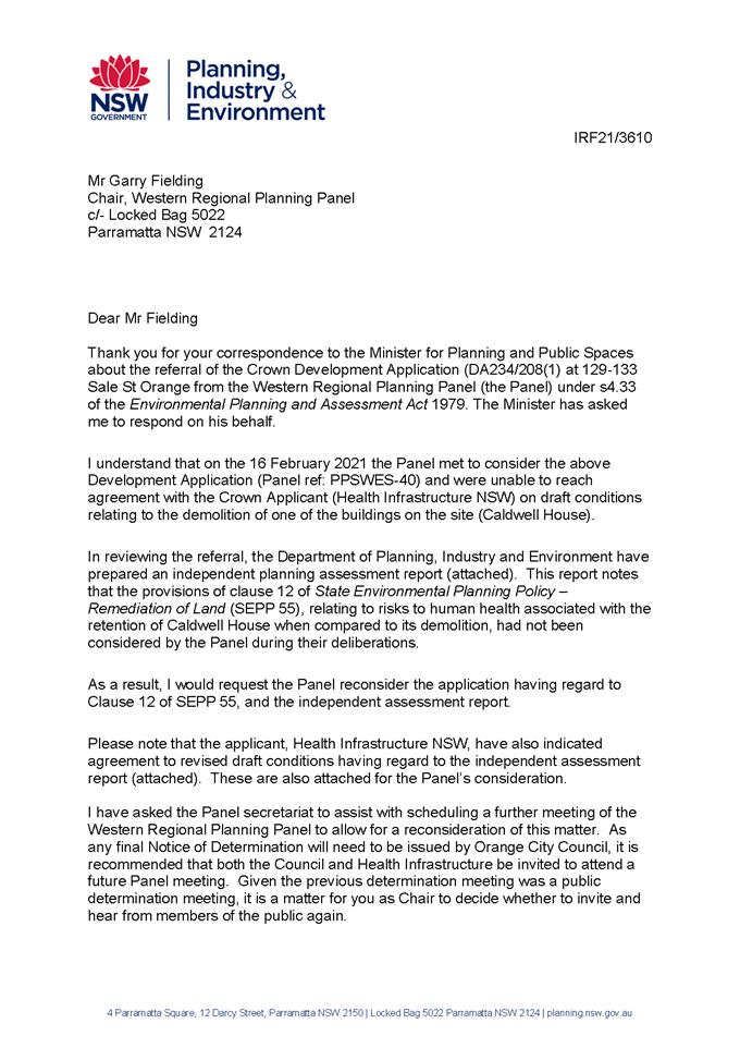
Planning and Development Committee
5 October 2021
Attachment 2 Caldwell
Attachment 1 Independent Assessment Report 15 Sept 2021 (2) - 129-133 Sale
Street
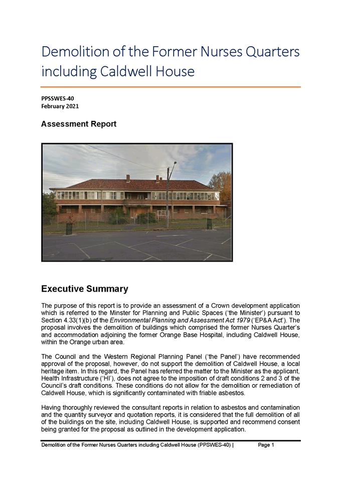
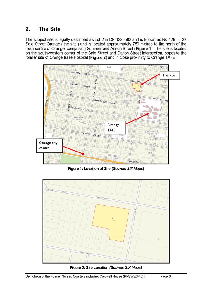
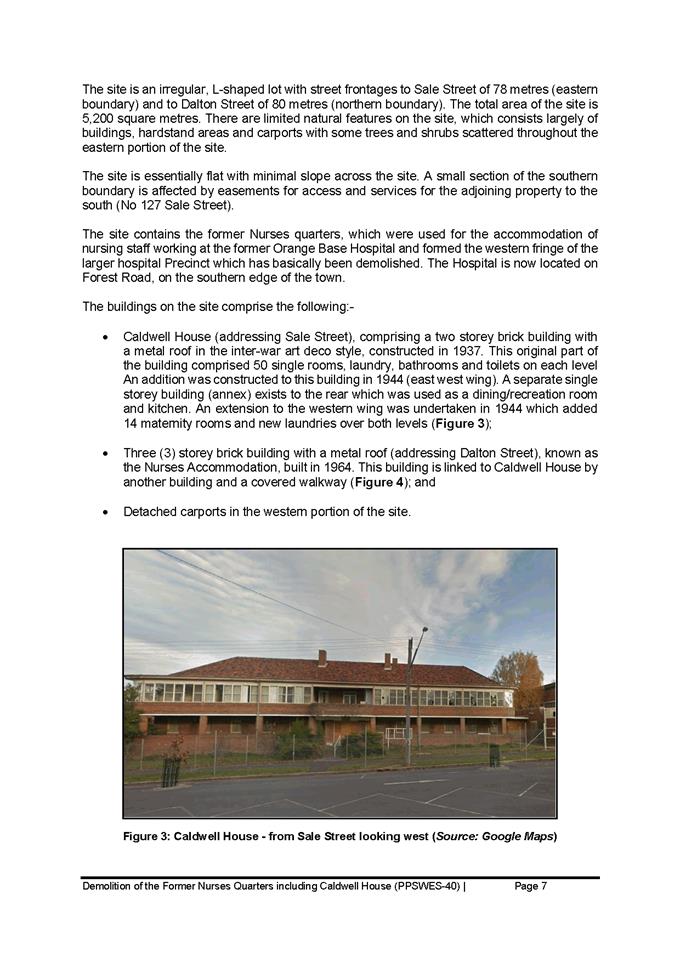
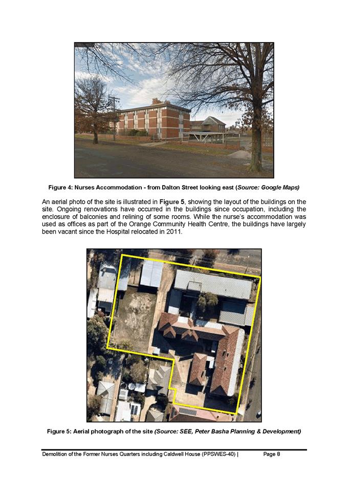
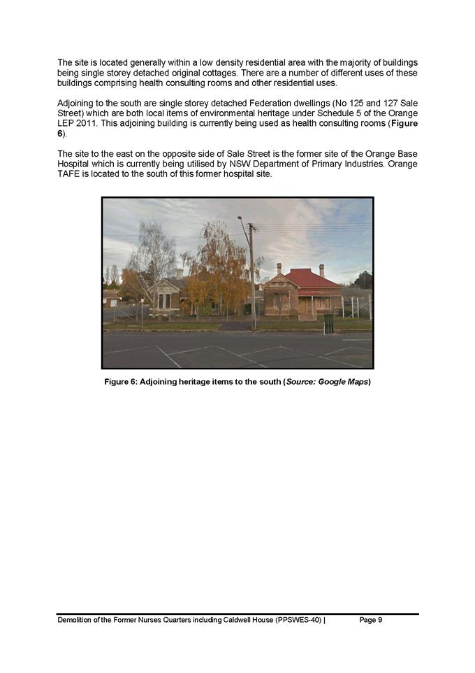
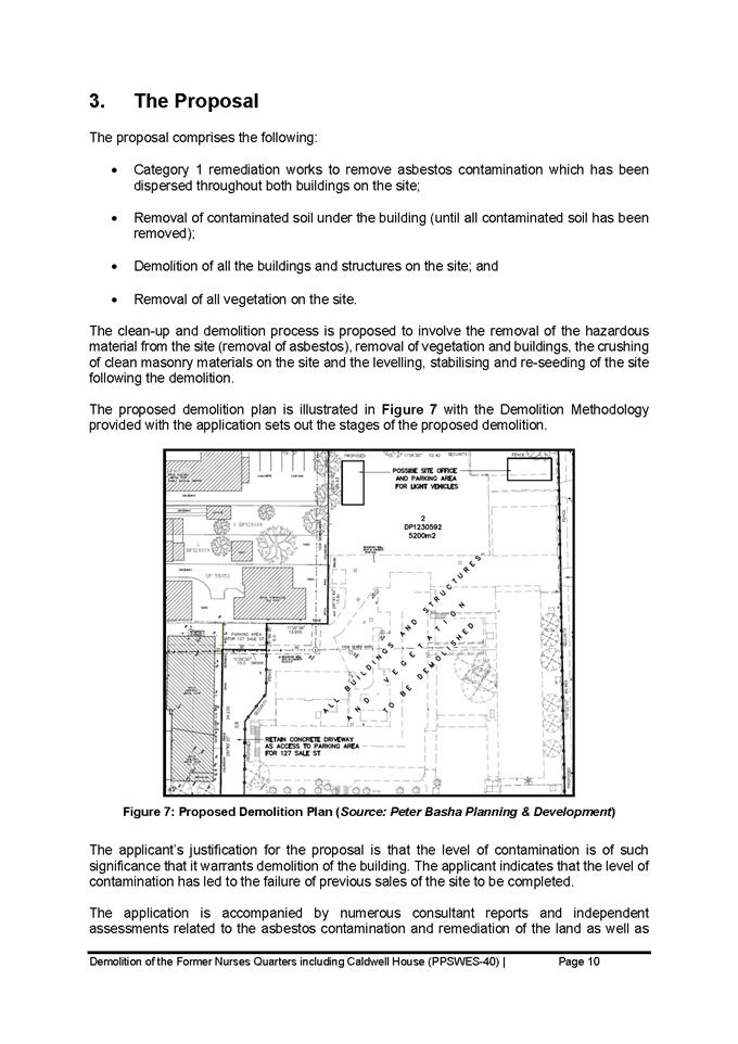

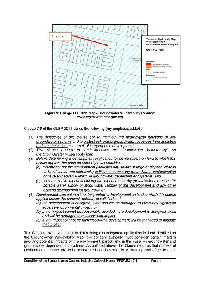
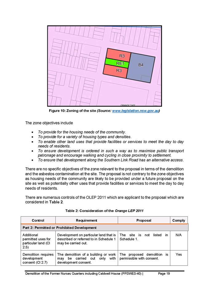
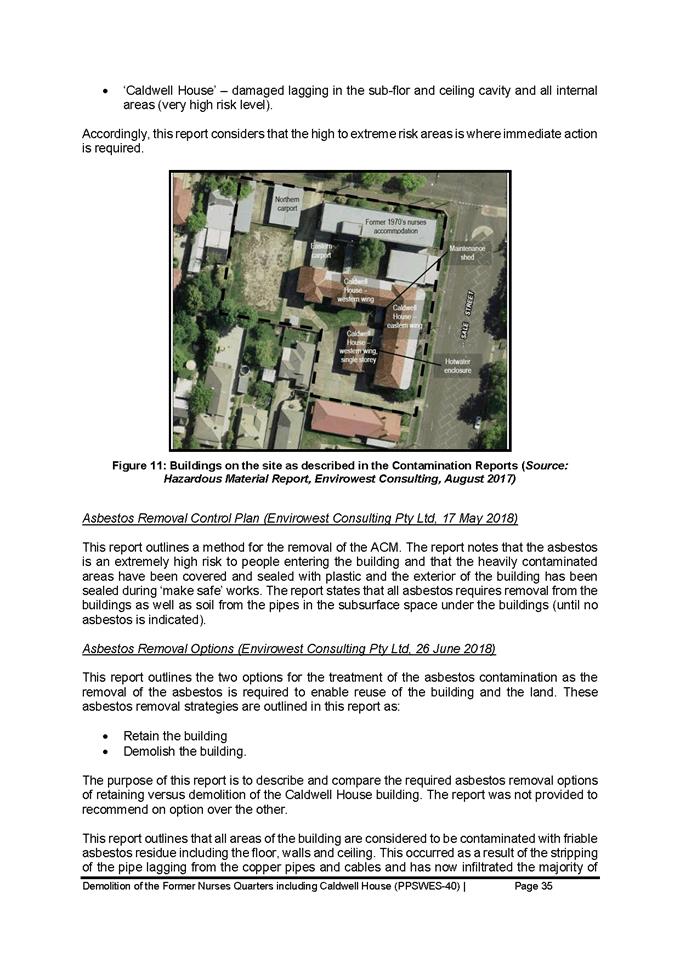
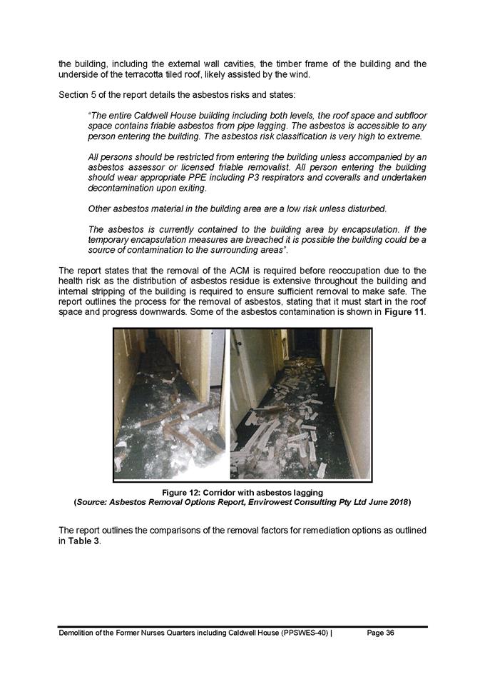
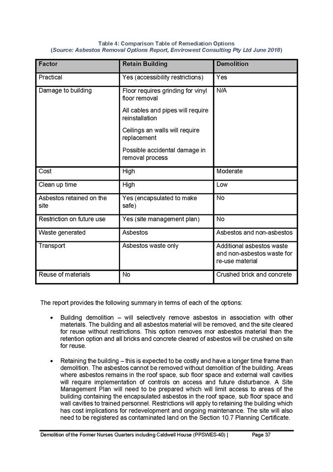
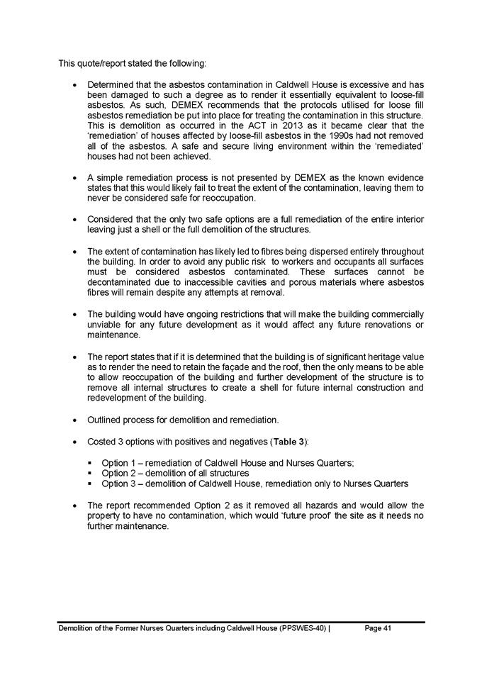
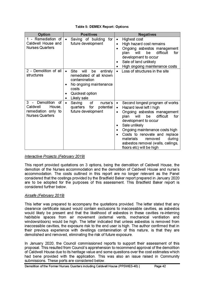
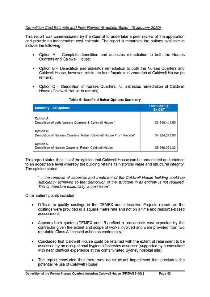
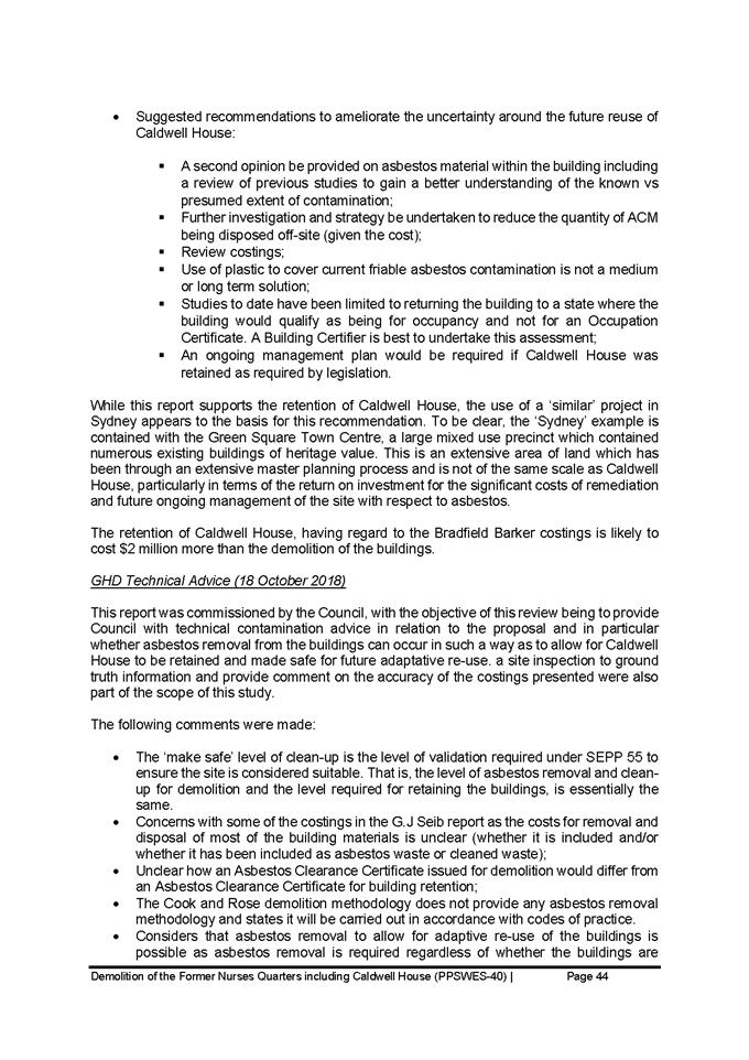
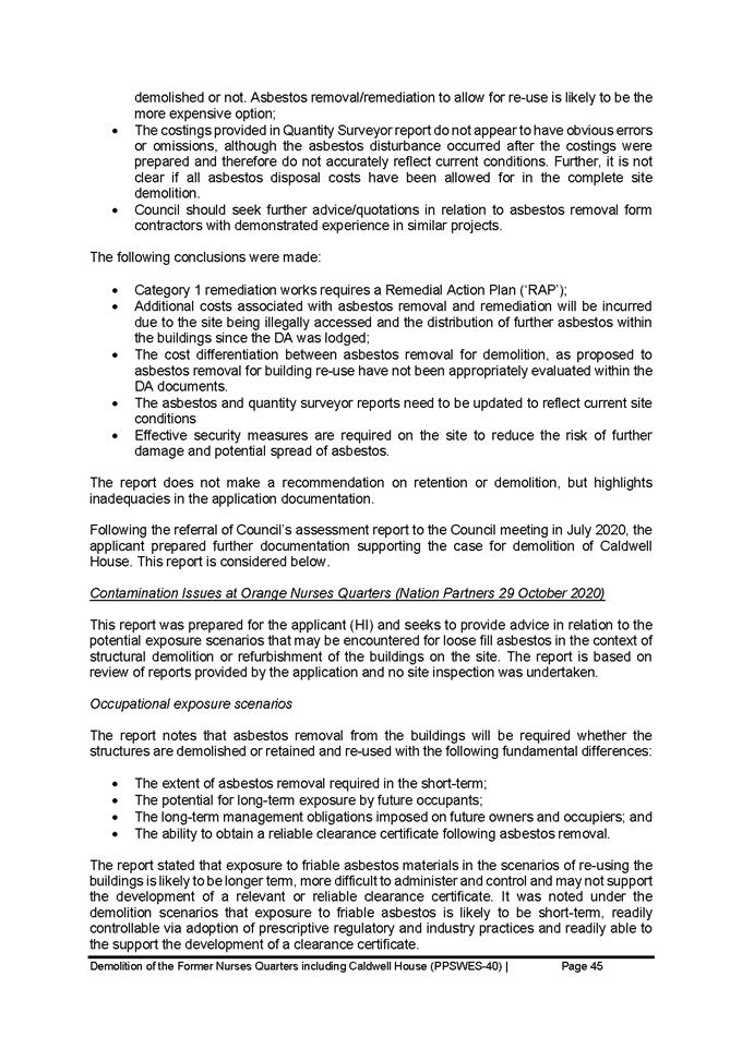
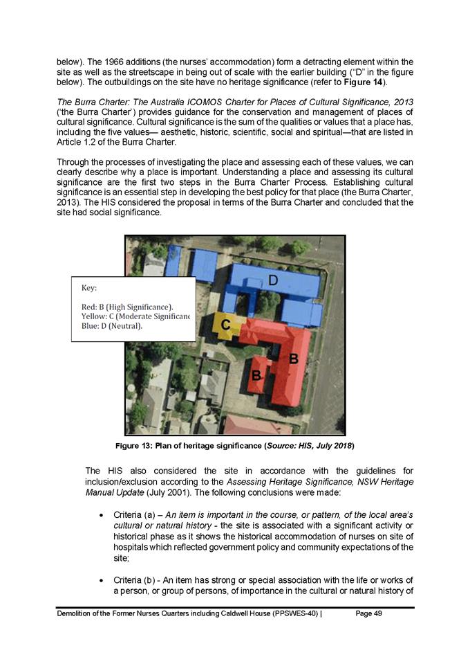
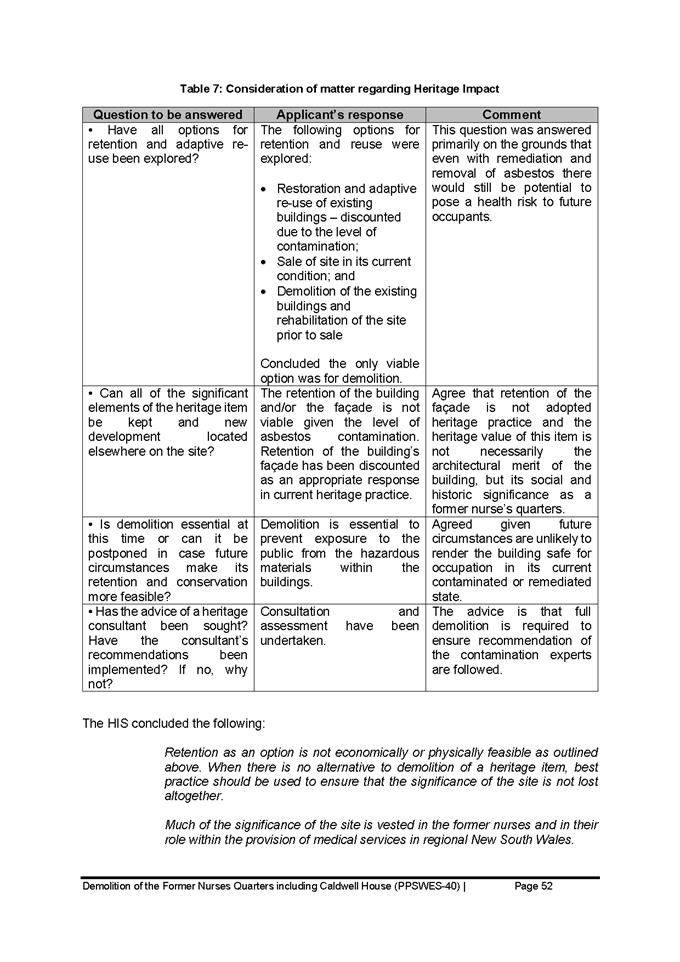
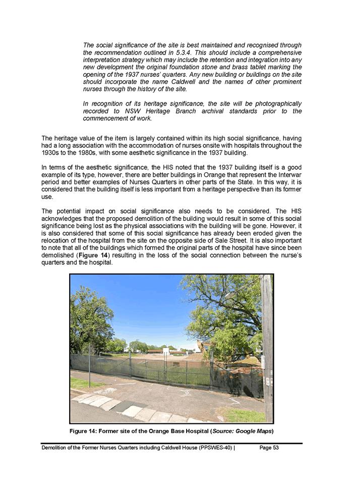
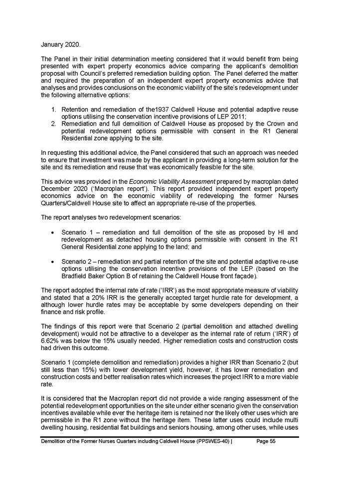
Planning and Development Committee
5 October 2021
Attachment 3 Caldwell
Crown Consent Review Attachment 2 Conditions 15 Sept 2021 - 129-133 Sale Street