Extraordinary Council Meeting
Agenda
27 July 2021
Notice is hereby given, in
accordance with the provisions of the Local Government Act 1993 that an Extraordinary meeting of ORANGE CITY COUNCIL
will be held via the Online
conferencing platform ZOOM due to COVID-19 requirements on
Tuesday, 27 July 2021 commencing at 7.00pm.
David
Waddell
Chief Executive Officer
For apologies please
contact Administration on 6393 8218.
2 Mayoral
Minutes
2.1 Grieving Mother
Statue
RECORD
NUMBER: 2021/1620
Mayoral Minute
|
Recommendation
That
Orange City Council in conjunction with the Heritage Committee, Heritage Society
and the RSL investigate the future possibility of a suitable bronze Statue as
a tribute to all the mothers who have had family go off in service of their
Country.
|
Reg
Kidd
Mayor
3 CONFIRMATION OF MINUTES
OF PREVIOUS MEETING
RECOMMENDATION
That the Minutes of the Ordinary
Meeting of Orange City Council held on 6 July 2021 (copies of which were
circulated to all members) be and are herebyu confirmed as a true and accurate
record of the proceedings of the Council Meeting held on 6 July 2021.
ATTACHMENTS
1 Minutes of the Ordinary Meeting
of Orange City Council held on 6 July 2021
3 CONFIRMATION OF
MINUTES OF PREVIOUS MEETING RECOMMENDATION That the Minutes of the Ordinary
Meeting of Orange City Council held on 6 July 2021 (copies of which were
circulated to all members) be and are hereby confirmed as a true and accurate
records of the proceedings of the Council meeting held on 6 July 2021.
ATTACHMENTS 1 Minutes of the Ordinary Meeting of Orange City Council held on 6
July 2021
4 Notices
of Motion/Notices of Rescission
4.1 Ageism - EveryAGE
Counts Campaign
RECORD
NUMBER: 2021/1458
I, CR Kevin Duffy wish to move the
following Notice of Motion at the Council Meeting of 27 July 2021:
|
Motion
That Council resolves:
1 That Council agrees that we are deeply concerned about the profound
impact of ageism on our communities. We recognise that ageism can negatively
impact the job prospects, confidence, health, quality of life and control
over life decisions of our constituents. Ageism can limit people from
participating in our communities as full citizens. Ageism also has proven
negative impacts on the physical health, mental health and longevity of our
constituents.
2 To support the EveryAGE Counts
campaign to end ageism and join with others in our communities to create a
society where every person is valued, connected and respected, regardless of
age.
3 To Take the Pledge to stand for a
world without ageism where all people of all ages are valued and respected,
and their contributions are acknowledged. We commit to speak out and take
action to ensure older people can participate on equal terms with others in
all aspects of life.
4 To Encourage Council staff to Take
the Pledge and to create opportunities in our communities to build awareness
of ageism and its impacts.
5 To Promote Council’s signing of
the pledge to end ageism amongst residents and raise awareness of the impacts
of ageism.
6 To Inform relevant Federal and State parliamentarians of
our support for EveryAGE Counts and that we have taken the pledge to end
ageism.
|
Background
Ageism is not benign or harmless. It is a big problem
because it impacts on individuals confidence, quality of life, job prospects,
health, and control over life decisions.
It is pervasive but often hidden. It can distort
our attitudes to older people and ageing and have profound negative impacts on
our personal experience of growing older. The impacts of ageism can
prevent or limit us from contributing and participating in our communities
– socially, economically, and as full citizens – and even impact
our physical health and longevity.
As well as its individual impacts, ageism can also deny
society the enormous range of benefits that can flow, economically and
socially, from the full participation of older people.
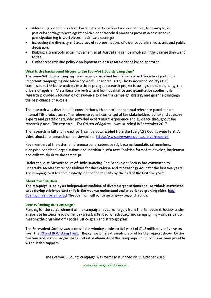
EveryAGE Counts is an advocacy campaign aimed at
tackling ageism against older Australians.
The EveryAGE Counts coalition is organised around
building:
· a national coalition for action
· an active, broad-based social movement
· effective advocacy and political engagement
· a stronger policy, research, and evidence base
· powerful responses to structural ageism and
discrimination in
o employment
o healthcare
o aged care
o housing
o digital inclusion
o economic security
· effective communications and marketing
Signed
Cr Kevin Duffy
Financial Implications
Staff time.
POLICY AND GOVERNANCE IMPLICATIONS
Nil.
Attachments
1 EveryAGE
Counts - Information Sheet, D21/44061⇩
Attachment 1 EveryAGE
Counts - Information Sheet

4.2 Timaru
Council
RECORD
NUMBER: 2021/1459
I, CR Kevin Duffy wish to move the
following Notice of Motion at the Council Meeting of 27 July 2021:
|
Motion
That Orange City Council take up the numerous offers we have
had from Timaru Council to have a Return visit.
|
Background
Timaru have
always acted in good faith.
Timaru Council
have visited Orange City Council several times with their Mayor, Councillors
and senior staff.
Signed
Cr Kevin Duffy
STAFF COMMENT
Orange City Council has a signed
an MOU with Timaru District Council for a staff exchange. The first exchanges
were to take place in March and October last year. They were cancelled due to
COVID-19 and due to ongoing uncertainty have not been rescheduled.
Financial Implications
Cost of travel for staff and/or Councillors, to be
determined.
POLICY AND GOVERNANCE IMPLICATIONS
The current Councillor Payment of Expenses and Provision of
Facilities Policy includes the following:
6.5.
Council will scrutinise the value and need for Councillors to undertake overseas
travel. Councils should avoid interstate, overseas and long distance intrastate
trips unless direct and tangible benefits can be established for the Council
and the local community. This includes travel to sister and friendship cities.
6.6. Total interstate, overseas
and long distance intrastate travel expenses for all Councillors will be capped
at a maximum of $4000 per year.
6.8. Councillors seeking
approval for any overseas travel must submit a case to, and obtain the approval
of, a full Council meeting prior to travel.
6.9. The case should include:
· objectives
to be achieved in travel, including an explanation of how the travel aligns
with current Council priorities and business, the community benefits which will
accrue as a result, and its relevance to the exercise of the Councillor’s
civic duties
· duration
and itinerary of the travel
· who
is to take part in the travel
· a
detailed budget including a statement of any amounts expected to be reimbursed
by the participant/s.
5 General
Reports
5.1 Recommendations
and Resolutions from Policy Committees
TRIM
REFERENCE: 2020/2576
AUTHOR: Rachelle
Robb, Director Corporate & Commercial Services
EXECUTIVE SUMMARY
Council’s Policy Committees (Planning and Development
Committee, Employment and Economic Development Policy Committee, Infrastructure
Policy Committee, Sport and Recreation Policy Committee, Environmental
Sustainability Policy Committee, Finance Policy Committee and Services Policy
Committee) have delegation to determine matters before those Committees, with
the exception of items that impact on Council’s Delivery Operational
Plan.
This report provides minutes of the Policy Committees held
since the last meeting. Resolutions made by the Committees are for noting, and
Recommendations are presented for adoption or amendment by Council.
Link To Delivery/OPerational Plan
The recommendation in this report relates to the
Delivery/Operational Plan strategy “17.1 Collaborate - Provide
representative, responsible and accountable community governance”.
Financial Implications
Nil
Policy and Governance Implications
Nil
|
Recommendation
1 That
the resolutions made by the Planning and Development Committee at its meeting
held on 6 July 2021 be noted.
2 That
the resolutions made by the Employment and Economic Development Policy
Committee at its meeting held on 6 July 2021 be noted.
3 That
the resolutions made by the Infrastructure Policy Committee at its meeting
held on 6 July 2021 be noted.
2 That
the resolutions made by the Sport and Recreation Policy Committee at its
meeting held on 6 July 2021 be noted.
4 That
the resolutions made by the Environmental Sustainability Policy Committee at
its meeting held on 6 July 2021 be noted.
5 That the resolutions
made by the Finance Policy Committee at its meeting held on 6 July 2021
be noted.
6 That
the resolutions made by the Services Policy Committee at its meeting held on
6 July 2021 be noted.
|
further considerations
Consideration has been given to the recommendation’s
impact on Council’s service delivery; image and reputation; political;
environmental; health and safety; employees; stakeholders and project
management; and no further implications or risks have been identified.
SUPPORTING INFORMATION
Planning
and Development Committee
At the Planning and Development
Committee meeting held on 6 July 2021, all resolutions were made under
delegation, and the minutes are presented for noting.
Employment
and Economic Development Committee
At the Employment and Economic
Development Committee meeting held on 6 July 2021, all resolutions were made
under delegation, and the minutes are presented for noting.
Infrastructure
Policy Committee
At the Infrastructure Policy
Committee meeting held on 6 July 2021, all resolutions were made under
delegation, and the minutes are presented for noting.
Sport
and Recreation Policy Committee
At the Sport and Recreation Policy
Committee meeting held on 6 July 2021, all resolutions were made under
delegation, and the minutes are presented for noting.
Environmental
Sustainability Policy Committee
At the Environmental Sustainability
Policy Committee meeting held on 6 July 2021, all resolutions were made under
delegation, and the minutes are presented for noting.
Finance Policy Committee
At the Finance Policy Committee
meeting held on 6 July 2021, all resolutions were made under delegation, and
the minutes are presented for noting.
Services
Policy Committee
At the Services Policy Committee
meeting held on 6 July 2021, all resolutions were made under delegation, and
the minutes are presented for noting.
Attachments
1 Planning
and Development Committee Minutes 6 July 2021, 2021/1462⇩
2 Employment
and Economic Development Committee Meeting Minutes 6 July 2021, 2021/1440⇩
3 Infrastructure
Policy Committee Meeting Minutes 6 July 2021, 2021/1463⇩
4 Sport
and Recreation Policy Committee Meeting Minutes 6 July 2021, 2021/1464⇩
5 Environment
Sustainability Policy Committee Meeting 6 July 2021, 2021/1441⇩
6 Finance
Policy Committee Meeting Minutes 6 July 2021, 2021/1465⇩
7 Service
Policy Committee Meeting Minutes 6 July 2021, 2021/1466⇩
Planning
and Development Committee
27 July 2021
Attachment 1 Planning
and Development Committee Minutes 6 July 2021
ORANGE CITY COUNCIL
MINUTES OF THE
Planning and Development
Committee
HELD IN Council Chamber, Civic Centre, Byng Street, Orange
ON 6 July 2021
COMMENCING AT 7.45pm
1 Introduction
Cr R Turner (Chairperson), Cr R Kidd (Mayor), Cr G Taylor
(Deputy Mayor), Cr K Duffy, Cr J Hamling, Cr J McRae, Cr T Mileto, Cr S Munro,
Cr S Nugent, Cr S Romano, Cr J Whitton
Chief Executive Officer, Director Corporate and Commercial
Services, Director Development Services, Director Community, Recreation and
Cultural Services, Director Technical Services, Manager Corporate Governance,
Executive Support Manager, Executive Support Officer.
Nil.
1.1 DECLARATION
OF PECUNIARY INTERESTS, SIGNIFICANT NON-PECUNIARY INTERESTS AND LESS THAN
SIGNIFICANT NON-PECUNIARY INTERESTS
Nil.
2 General
Reports
2.1 Items
Approved Under the Delegated Authority of Council
TRIM Reference: 2021/1156
|
|
RESOLVED - 21/201 Cr
J Whitton/Cr S Munro
That Council resolves to
acknowledge the information provided in the report by the Manager Development
Assessments on Items Approved Under the Delegated Authority of Council.
|
For: Cr Kidd, Cr Duffy, Cr Hamling,
Cr McRae, Cr Munro, Cr Nugent, Cr Taylor, Cr Turner, Cr Romano, Cr Whitton, Cr
Mileto
Against: Nil
Absent: Nil
2.2 Development
Application DA 128/2021(1) - 1 Scarborough Street
TRIM Reference: 2021/1193
|
|
RESOLVED - 21/202 Cr
J Whitton/Cr S Munro
That Council consents to
development application DA 128/2021(1) for
Subdivision (two Lot Torrens title) and construction of two Dwelling
Houses at Lot 129 DP 1237871 – 1 Scarborough Street, Orange pursuant to the conditions of consent in the attached
Notice of Approval.
|
For: Cr Kidd, Cr Duffy, Cr Hamling,
Cr McRae, Cr Munro, Cr Nugent, Cr Taylor, Cr Turner, Cr Romano, Cr Whitton, Cr
Mileto
Against: Nil
Absent: Nil
2.3 Orange
Local Environmental Plan - Amendment 29 - Park and Rifle Range Roads Post Exhibition
Report
TRIM Reference: 2021/1413
|
|
RESOLVED - 21/203 Cr
J Whitton/Cr K Duffy
That Council adopt Amendment 29 to the Orange Local
Environmental Plan 2011 as exhibited.
|
For: Cr Kidd, Cr Duffy, Cr Hamling,
Cr McRae, Cr Munro, Cr Nugent, Cr Taylor, Cr Turner, Cr Romano, Cr Whitton, Cr
Mileto
Against: Nil
Absent: Nil
Cr Duffy
asked if a discussion had been had with the Rifle Range and if it would
jeopardise their activity in any way.
The
Director Development Services stated that all adjoining neighbours were
contacted and notified about the Planning Proposal, including the Rifle Range
and Crown Lands. All activities impacted by the development have already been
identified in the DCP.
Cr Kidd
stated that Council met with Rifle Range Road residents on a number of
occasions where concerns were discussed.
The
Director Development Services stated that the Planning Proposal is a response
to site constraints. The proposal reflects a more appropriate use of the land;
shaping of the blocks to suit the topography and properly accommodating roads
so that they feed in to the adjoining subdivision(s). The applicant had been in
discussion with the neighbours.
|
QUESTION
TAKEN ON NOTICE Cr
R Kidd
Cr Kidd asked if the old cottage on the crest of the hill
with the bull nose verandah and chimney on one end is part of an identified
item in the heritage conservation plan.
|
2.4 Development
Application DA 284/2020(1) - 4 Kearneys Drive
TRIM Reference: 2021/1422
|
|
RESOLVED - 21/204 Cr
K Duffy/Cr T Mileto
That the attached Notice of Determination in relation to
DA 284/2020(1) for demolition (existing dwelling and outbuildings)
and Centre-based Child Care Facility at Lot A DP 365443 –
4 Kearneys Drive, Orange and the reasons for refusal therein as
expressed by Councillors in the Planning Development Committee meeting held
on 15 June 2021 be endorsed.
|
For: Cr Kidd, Cr Duffy, Cr Hamling,
Cr McRae, Cr Munro, Cr Nugent, Cr Taylor, Cr Turner, Cr Romano, Cr Whitton, Cr
Mileto
Against: Nil
Absent: Nil
2.5 Orange
Development Control Plan - 185 Leeds Parade
TRIM Reference: 2021/1426
|
|
RESOLVED - 21/205 Cr
J Whitton/Cr J Hamling
That Council resolves:
1 That
Council acknowledge the attached site specific development controls and
resolve to place the controls on exhibition for a period of 28 days with the
development controls updated to include:
Pylon signage around the site frontages (Leeds Parade and
Northern Distributor Road) may be permitted as follows:
- One free-standing sign pylon along
the Northern Distributor Road frontage of the site, east of the new road
intersection (already approved in DA 322/2019).
- Two free-standing sign pylon signs
along the Northern Distributor Road frontage of the site, west of the new
road intersection
- One free-standing sign pylon sign
at the southern end of the site between Leeds Parade and the new road
intersection.
- The maximum height of the above
pylon signs is 8 metres. The maximum width is 3 metres.
Pylon or free standing signs are permitted within the site
and are to be subject to the following requirements:
- For single tenancy buildings/sites
– 1 sign only; maximum height of 4.5 metres and maximum width of 1.5
metres
- For multi-tenancy buildings/sites
– 1 sign only as a directory panel which allows each tenant to identify
their business. Maximum height of 6 metres and maximum width of 2 metres.
Building
signage is to integrate with the architectural design. Signage must not
obliterate architectural features or project beyond the silhouette of the
building.
2 That
the draft Development Control Plans be provided to John Holland Rail and
Transport for New South Wales.
3 That
post exhibition the matter return to Council for consideration of submissions
with a view to amending the Orange Local Environmental Plan 2004.
|
For: Cr Kidd, Cr Duffy, Cr Hamling, ,
Cr Munro, Cr Taylor, Cr Turner, Cr Romano, Cr Whitton
Against: Cr Mileto, Cr McRae, Cr
Nugent
Absent: Nil
Cr Nugent asked for clarification on
the difference in the free standing pylons and why John Holland Rail and TfNSW
was to be notified.
The Chief Executive Officer
stated that 2 x 8m signs have been requested, where Council had provided for 1
and on the buildings 6m height is requested where Council provided for 4m.
Development that is near a railway line goes to John Holland for them to
consider.
The Meeting
Closed at 8.04PM
Employment and Economic Development
Policy Committee
27 July 2021
Attachment 2 Employment
and Economic Development Committee Meeting Minutes 6 July 2021
ORANGE CITY COUNCIL
MINUTES OF THE
Employment and Economic
Development Policy Committee
HELD IN Council Chamber, Civic Centre, Byng Street, Orange
ON 6 July 2021
COMMENCING AT 8.05pm
1 Introduction
Cr T Mileto (Chairperson), Cr R Kidd (Mayor), Cr G Taylor
(Deputy Mayor), Cr K Duffy, Cr J Hamling, Cr J McRae, Cr S Munro, Cr S Nugent,
Cr S Romano, Cr R Turner, Cr J Whitton
Chief
Executive Officer, Director Corporate and Commercial Services, Director
Development Services, Director Community, Recreation and Cultural Services,
Director Technical Services, Manager Corporate Governance, Executive Support
Manager, Executive Support Officer.
APOLOGIES AND LEAVE OF ABSENCE
Nil
1.1 DECLARATION OF PECUNIARY INTERESTS,
SIGNIFICANT NON-PECUNIARY INTERESTS AND LESS THAN SIGNIFICANT NON-PECUNIARY
INTERESTS
Nil
2 Committee
Minutes
2.1 Minutes
of the Economic Development Community Committee meeting held 12 May 2021
TRIM Reference: 2021/1141
|
|
RESOLVED - 21/206 Cr
R Kidd/Cr S Munro
1 That
Council acknowledge the reports presented to the Economic Development
Community Committee at its meeting held on 12 May 2021.
2 That
the minutes of the Economic Development Community Committee at its meeting
held on 12 May 2021 be adopted.
|
For: Cr Kidd, Cr Duffy, Cr Hamling,
Cr McRae, Cr Munro, Cr Nugent, Cr Taylor, Cr Turner, Cr Romano, Cr Whitton, Cr
Mileto
Against: Nil
Absent: Nil
3 General
Reports
3.1 Future
City Events - Future Tunes and Future Flix
TRIM Reference: 2021/1252
|
|
RESOLVED - 21/207 Cr
R Kidd/Cr S Nugent
That Council resolve to fund up to $20,000 towards Future
City events to be held in local businesses located in the Future City CBD
area.
|
For: Cr Kidd, Cr Duffy, Cr Hamling,
Cr McRae, Cr Munro, Cr Nugent, Cr Taylor, Cr Turner, Cr Romano, Cr Whitton, Cr
Mileto
Against: Nil
Absent: Nil
3.2 2022
Squeeze Music Festival Venue Confirmed
TRIM Reference: 2021/1446
|
|
RESOLVED - 21/208 Cr
S Nugent/Cr S Munro
That Council provide $10,000 funding to Chugg
Entertainment Pty Ltd for 2022 Squeeze Music Festival to be held at Heifer
Station in Orange.
|
For: Cr Kidd, Cr Duffy, Cr Hamling,
Cr McRae, Cr Munro, Cr Nugent, Cr Taylor, Cr Turner, Cr Romano, Cr Whitton, Cr
Mileto
Against: Nil
Absent: Nil
The Meeting
Closed at 8.07PM
Infrastructure Policy Committee
27 July 2021
Attachment 3 Infrastructure
Policy Committee Meeting Minutes 6 July 2021
ORANGE CITY COUNCIL
MINUTES OF THE
Infrastructure Policy
Committee
HELD IN Council Chamber, Civic Centre, Byng Street, Orange
ON 6 July 2021
COMMENCING AT 8.07Pm
1 Introduction
Cr J Whitton (Chairperson), Cr R Kidd (Mayor), Cr G Taylor
(Deputy Mayor), Cr K Duffy, Cr J Hamling, Cr J McRae, Cr T Mileto, Cr S Munro,
Cr S Nugent, Cr S Romano, Cr R Turner
Chief Executive Officer, Director Corporate and Commercial
Services, Director Development Services, Director Community, Recreation and
Cultural Services, Director Technical Services, Manager Corporate Governance,
Executive Support Manager, Executive Support Officer
APOLOGIES AND LEAVE OF ABSENCE
Nil
1.1 DECLARATION OF PECUNIARY INTERESTS,
SIGNIFICANT NON-PECUNIARY INTERESTS AND LESS THAN SIGNIFICANT NON-PECUNIARY
INTERESTS
Nil
2 Committee
Minutes
2.1 Minutes
of the Meeting of the City of Orange Traffic Committee - 8 June 2021
TRIM Reference: 2021/1311
|
|
RESOLVED - 21/209 Cr
G Taylor/Cr R Turner
1 That
Council acknowledge the reports presented to the City of Orange Traffic
Committee at its meeting held on 8 June 2021.
2 That
Council determine recommendations 3.1, 3.2, 3.3, 3.4, 3.5, 3.6, 3.7
from the minutes of the City of Orange Traffic Committee meeting of 8 June
2021.
3.1
That Council approve the Newcrest Orange Challenge event
on 11 and 12 September 2021 subject to the attached Conditions of
Consent.
3.2
That Council approve the closure of Byng Street (McNamara
Street to Lords Place) on 1 October 2021 between 11.00am and 11.00pm in
accordance with the Conditions of Consent for the Orange Wine Week Night
Markets.
3.3
1 That the 2021
Altitude event to be held on Saturday 30 October 2021 be approved.
2 That
the following condition be added to the Conditions of Consent:
That
the TCP shows a speed reduction to 40kph for vehicles where the pedestrians
are crossing.
3.4
That Council approves the 2021 NAIDOC March subject to the
attached Conditions of Consent.
3.5
That Council adopt the new line marking for Lone Pine
Avenue, from Icely Road to Bathurst Road, as shown in the attached plan.
3.6
That Council endorse the CP00066 Lines and Signs layout
for the intersection of March and Peisley Streets.
3.7 That
Council install Give Way signs, hold lines and 30m of BB lines on Valencia
Drive, Braeburn Crescent and Sunburst Street at the intersection with
Jonathon Road, Orange.
3 That
the remainder of the minutes of the City of Orange Traffic Committee at its
meeting held on 8 June 2021 be adopted.
|
For: Cr Kidd, Cr Duffy, Cr Hamling,
Cr McRae, Cr Munro, Cr Nugent, Cr Taylor, Cr Turner, Cr Romano, Cr Whitton, Cr
Mileto
Against: Nil
Absent: Nil
2.2 Minutes
of the Airport Community Committee Meeting - 9 June 2021
TRIM Reference: 2021/1315
|
|
RESOLVED - 21/210 Cr
J Whitton/Cr S Nugent
1 That
Council acknowledge the reports presented to the Airport Community Committee
at its meeting held on 9 June 2021.
2 That
the minutes of the Airport Community Committee at its meeting held on 9 June
2021 be adopted.
|
For: Cr Kidd, Cr Duffy, Cr Hamling,
Cr McRae, Cr Munro, Cr Nugent, Cr Taylor, Cr Turner, Cr Romano, Cr Whitton, Cr
Mileto
Against: Nil
Absent: Nil
3 General
Reports
|
TRIM Reference: 2021/1312
|
|
RESOLVED - 21/211 Cr
J Hamling/Cr S Munro
That the information provided in the report on Current
Works be acknowledged.
|
For: Cr Kidd, Cr Duffy, Cr Hamling,
Cr McRae, Cr Munro, Cr Nugent, Cr Taylor, Cr Turner, Cr Romano, Cr Whitton, Cr
Mileto
Against: Nil
Absent: Nil
Cr Taylor
congratulated Council staff and contractors for the work on the Southern Feeder
Road.
|
QUESTION
TAKEN ON NOTICE Cr
K Duffy
Cr Duffy asked if a report can be provided to Council on
the current status of the asset renewal program and whether there needs to be
an adjustment to the budget to allow for the grading of country roads.
|
The Meeting
Closed at 8.14PM
Sport and Recreation Policy
Committee
27 July 2021
Attachment 4 Sport
and Recreation Policy Committee Meeting Minutes 6 July 2021
ORANGE CITY COUNCIL
MINUTES OF THE
Sport and Recreation Policy
Committee
HELD IN Council Chamber, Civic Centre, Byng Street, Orange
ON 6 July 2021
COMMENCING AT 8.14pm
1 Introduction
Cr J Hamling (Chairperson), Cr R Kidd (Mayor), Cr G Taylor
(Deputy Mayor), Cr K Duffy, Cr J McRae, Cr T Mileto, Cr S Munro, Cr S Nugent,
Cr S Romano, Cr R Turner, Cr J Whitton
Chief Executive Officer, Director Corporate and Commercial
Services, Director Development Services, Director Community, Recreation and
Cultural Services, Director Technical Services, Manager Corporate Governance,
Executive Support Manager, Executive Support Officer.
APOLOGIES AND LEAVE OF ABSENCE
Nil
1.1 DECLARATION OF PECUNIARY INTERESTS,
SIGNIFICANT NON-PECUNIARY INTERESTS AND LESS THAN SIGNIFICANT NON-PECUNIARY
INTERESTS
Nil
2 General
Reports
2.1 Outcome
of the Public Exhibition of the Lake Canobolas Precinct Master Plan
TRIM Reference: 2021/1308
|
|
RESOLVED - 21/212 Cr
R Kidd/Cr S Munro
That Council resolves:
1 To
note the concerns of owners of adjacent properties
2 To
adopt a position of passive appropriation of alternative access to Lake
Canobolas
3 To
adopt the balance of the plan as presented.
|
For: Cr Kidd, Cr Duffy, Cr Hamling,
Cr McRae, Cr Munro, Cr Nugent, Cr Taylor, Cr Turner, Cr Romano, Cr Whitton, Cr
Mileto
Against: Nil
Absent: Nil
Cr Nugent asked after the plan is
adopted, what happens in regards to timeframes for implementations, what is the
likelihood of grant funding and are there any chances for increased
accessibility to the loop of the lake.
The Chief Executive Officer stated
that Council staff are currently focusing on the Scout Camp after receiving a
grant and are also working with the Local Aboriginal Lands Council on an
aboriginal piece. Themes established through the master plan will now work
towards detailed projects, which will then become grant projects. There is a
regular fund for the maintenance of the lake but there is no capital investment
plan, it will be grant based. If the Council of the time wants us to work with
accessibility then we will start with that.
Cr Hamling asked what was happening
with the café at the lake.
The Chief Executive Officer stated
that there will be a new operator in place in the next 2 weeks to open the
kiosk then follow on with re-opening the restaurant.
The
Meeting Closed at 8.22PM
Environmental Sustainability Policy
Committee
27 July 2021
Attachment 5 Environment
Sustainability Policy Committee Meeting 6 July 2021
ORANGE CITY COUNCIL
MINUTES OF THE
Environmental Sustainability
Policy Committee
HELD IN Council Chamber, Civic Centre, Byng Street, Orange
ON 6 July 2021
COMMENCING AT 8.23pm
1 Introduction
Cr S Nugent (Chairperson), Cr R Kidd (Mayor), Cr G Taylor
(Deputy Mayor), Cr K Duffy, Cr J Hamling, Cr J McRae, Cr T Mileto, Cr S Munro,
Cr S Romano, Cr R Turner, Cr J Whitton
Chief Executive Officer, Director
Corporate and Commercial Services, Director Development Services, Director
Community, Recreation and Cultural Services, Director Technical Services,
Manager Corporate Governance, Executive Support Manager, Executive Support
Officer
APOLOGIES AND LEAVE OF ABSENCE
Nil
1.1 DECLARATION OF PECUNIARY INTERESTS,
SIGNIFICANT NON-PECUNIARY INTERESTS AND LESS THAN SIGNIFICANT NON-PECUNIARY
INTERESTS
Nil
2 Committee
Minutes
2.1 Minutes
of the Companion Animals Community Committee - 10 May 2021
TRIM Reference: 2021/1162
|
|
RESOLVED - 21/213 Cr
J Whitton/Cr K Duffy
1 That
Council acknowledge the reports presented to the Companion Animals Community
Committee at its meeting held on 10 May 2021.
2 That
Council determine recommendations 3.2,3.3 and 3.4 from the minutes of
the Companion Animals Community Committee meeting of 10 May 2021.
3.2 That the report be accepted and that a visit for Committee members be
organised.
3.3 That the report be accepted and further summarised parts of the Companion
Animals Act be included at the next meeting.
3.4
I. That
Council investigate the position of the gate and seating at Anzac Park off
leash.
II. That
Council proceed with the off leash fencing area on Ridley Oval adjoining
Little Warrendine Street including seating and tree planting.
3 That
the remainder of the minutes of the Companion Animals Community Committee at
its meeting held on 10 May 2021 be adopted.
|
For: Cr Kidd, Cr Duffy, Cr Hamling,
Cr McRae, Cr Munro, Cr Nugent, Cr Taylor, Cr Turner, Cr Romano, Cr Whitton, Cr
Mileto
Against: Nil
Absent: Nil
3 General
Reports
3.1 Council's
Community Engagement Program
TRIM Reference: 2021/929
|
|
RESOLVED - 21/214 Cr
R Kidd/Cr J Whitton
That Council note the report and attached presentation on
Council’s Community Engagement Program.
|
For: Cr Kidd, Cr Duffy, Cr Hamling,
Cr McRae, Cr Munro, Cr Nugent, Cr Taylor, Cr Turner, Cr Romano, Cr Whitton, Cr
Mileto
Against: Nil
Absent: Nil
Cr Kidd congratulated the Natural
Resources Coordinator, Roger Smith, and his team for the work undertaken on
this item.
|
MATTER
ARISING Cr
G Taylor
Cr Taylor asked that
staff inspect and repair the Lone Pine memorial.
|
Cr Duffy asked after the status of a
fallen tree in William Maker Drive on a day care centre.
The Chief Executive Officer stated
that Council will look at that issue in order to rectify it.
The Meeting
Closed at 8.30pm
Finance Policy Committee
27 July 2021
Attachment 6 Finance
Policy Committee Meeting Minutes 6 July 2021
ORANGE CITY COUNCIL
MINUTES OF THE
Finance Policy Committee
HELD IN Council Chamber, Civic Centre, Byng Street, Orange
ON 6 July 2021
COMMENCING AT 8.30pm
1 Introduction
Cr K Duffy (Chairperson), Cr R Kidd (Mayor), Cr G Taylor
(Deputy Mayor), , Cr J Hamling, Cr J McRae, Cr T Mileto, Cr S Munro, Cr S
Nugent, Cr S Romano, Cr R Turner, Cr J Whitton
Chief Executive Officer, Director
Corporate and Commercial Services, Director Development Services, Director
Community, Recreation and Cultural Services, Director Technical Services,
Manager Corporate Governance, Executive Support Manager, Executive Support
Officer
APOLOGIES AND LEAVE OF ABSENCE
Nil.
1.1 DECLARATION OF PECUNIARY INTERESTS,
SIGNIFICANT NON-PECUNIARY INTERESTS AND LESS THAN SIGNIFICANT NON-PECUNIARY
INTERESTS
Cr McRae declared a Non-Significant,
Non-Pecuniary Interest in Item 2.3 – Orange Business Chamber Financial
Assistance Request – 2021 Orange Business Awards – as she is an
ordinary member of the Orange Business Chamber.
2 General
Reports
2.1 Low
interest loan - Orange Indoor Tennis Club Incorporated
TRIM Reference: 2021/1006
|
|
RESOLVED - 21/215 Cr
R Kidd/Cr R Turner
That Council resolves
1 That
Council provides Orange Indoor Tennis Club Incorporated a loan of a maximum
of $55,000.00 unsecured at an interest rate of 1.5% repayable over a five
year term in quarterly instalments.
2 That
the loan be funded from Councils unrestricted cash.
3 This
application be placed on public exhibition for a minimum of 28 days.
4 That
the Chief Executive Officer be authorised to execute all relevant documents.
5 That
approval be granted for use of the Council Seal on all relevant documents if
required.
|
For: Cr Kidd, Cr Duffy, Cr Hamling,
Cr McRae, Cr Munro, Cr Nugent, Cr Taylor, Cr Turner, Cr Romano, Cr Whitton, Cr
Mileto
Against: Nil
Absent: Nil
2.2 Small
Donations Program 2021/2022 - Round 1 Requests for Financial Assistance
TRIM Reference: 2021/1227
|
|
RESOLVED - 21/216 Cr
S Nugent/Cr G Taylor
That Council resolves:
1 That
a donation of $2,500.00 be made from the Small Donations Program to
The Shepherd Centre for Community Service (Reach Out and Connect Program
2021).
2 That
a donation of $2,500.00 be made from the Small Donations Program to Zonta
Club of Orange for Community Service (Supporting Local Women - tertiary
education, breast cancer and domestic violence)).
3 That
a donation of $1,000.00 be made from the Small Donations Program to
Bloomfield Hospital Auxiliary for Community Service (supporting mental
health/drug and alcohol patients).
4 That
a donation of $2,500.00 be made from the Small Donations Program to Orange
Regional Malayalee Association for Community Event (Onam - South Indian
Festival).
5 That
a donation of $11,464.55 be made from the Small Donations Program to Lifeline
Centre West for Community Event (services to the vulnerable in the Orange
community).
6 That
a donation of $500.00 be made from the Small Donations Program to Australian
War Widows NSW (on behalf of Orange War Widows Guild Social Club) for
Community Service (Members Outings, Lunches and Events).
7 That
a donation of $384.45 be made from the Small Donations Program to Orange
Legacy Appeals Fund for Community Service (supporting the families and widows
of ex-service persons).
8 That
a donation of $500.00 be made from the Small Donations Program to City of
Orange Eisteddfod for Prize Giving (Junior Strings Scholarship) 2021.
9 That
a donation of $1,151.00 be made from the Small Donations Program to Friday
Night Gaming for Community Event (Battle in the Bush (BTB) Warhammer 40,000
Tournament).
10 That
a donation of $2,500.00 be made from the Small Donations Program to City of
Orange Brass Band for Community Service (equipment for community band
performances).
|
For: Cr Kidd, Cr Duffy, Cr Hamling,
Cr McRae, Cr Munro, Cr Nugent, Cr Taylor, Cr Turner, Cr Romano, Cr Whitton, Cr
Mileto
Against: Nil
Absent: Nil
2.3 Orange
Business Chamber Financial Assistance Request - 2021 Orange Business Awards
TRIM Reference: 2021/1407
|
|
Cr McRae declared a
Non-Significant, Non-Pecuniary Interest this item as she is an ordinary
member of the Orange Business Chamber.
|
|
RESOLVED - 21/217 Cr
J Whitton/Cr S Nugent
That Council resolves to fund Orange Business Chamber
$2,000 for the 2021 Orange Business Awards.
|
For: Cr Kidd, Cr Duffy, Cr Hamling,
Cr McRae, Cr Munro, Cr Nugent, Cr Taylor, Cr Turner, Cr Romano, Cr Whitton, Cr
Mileto
Against: Nil
Absent: Nil
The Meeting
Closed at 8.41pm
Services Policy Committee
27 July 2021
Attachment 7 Service
Policy Committee Meeting Minutes 6 July 2021
ORANGE CITY COUNCIL
MINUTES OF THE
Services Policy Committee
HELD IN Council Chamber, Civic Centre, Byng Street, Orange
ON 6 July 2021
COMMENCING AT 8.42pm
1 Introduction
Cr S Munro (Chairperson), Cr R Kidd (Mayor), Cr G Taylor
(Deputy Mayor), Cr K Duffy Cr J Hamling, Cr J McRae, Cr T Mileto, Cr S Nugent,
Cr S Romano, Cr R Turner, Cr J Whitton
Chief Executive Officer, Director Corporate and Commercial
Services, Director Development Services, Director Community, Recreation and
Cultural Services, Director Technical Services, Manager Corporate Governance, Executive
Support Manager, Executive Support Officer.
APOLOGIES AND LEAVE OF ABSENCE
Nil.
1.1 DECLARATION OF PECUNIARY INTERESTS,
SIGNIFICANT NON-PECUNIARY INTERESTS AND LESS THAN SIGNIFICANT NON-PECUNIARY
INTERESTS
Nil.
2 Committee
Minutes
2.1 Minutes
of the Clifton Grove Community Committee held on 12 May 2021
TRIM Reference: 2021/1159
|
|
RESOLVED - 21/218 Cr
J Whitton/Cr R Turner
1 That
Council acknowledge the reports presented to the Clifton Grove Community
Committee at its meeting held on 12 May 2021.
2 That
Council determine recommendation 4.1.4 from the minutes of the Clifton
Grove Community Committee meeting of 12 May 2021.
4.1.4 That Council purchase
seating for placement at the Clifton Grove Mud Hut.
3 That
the remainder of the minutes of the Clifton Grove Community Committee at its
meeting held on 12 May 2021 be adopted.
|
For: Cr Kidd, Cr Duffy, Cr Hamling,
Cr McRae, Cr Munro, Cr Nugent, Cr Taylor, Cr Turner, Cr Romano, Cr Whitton, Cr
Mileto
Against: Nil
Absent: Nil
2.2 Minutes
of the Orange Health Liaison Committee held on 14 May 2021
TRIM Reference: 2021/1317
|
|
RESOLVED - 21/219 Cr
R Kidd/Cr J Whitton
1 That
Council acknowledge the reports presented to the Orange Health Liaison
Committee at its meeting held on 14 May 2021.
2 That
the minutes of the Orange Health Liaison Committee at its meeting held on 14
May 2021 be adopted.
|
For: Cr Kidd, Cr Duffy, Cr Hamling,
Cr McRae, Cr Munro, Cr Nugent, Cr Taylor, Cr Turner, Cr Romano, Cr Whitton, Cr
Mileto
Against: Nil
Absent: Nil
2.3 Minutes
of the Ageing and Access Community Committee held on 26 May 2021
TRIM Reference: 2021/1290
|
|
RESOLVED - 21/220 Cr
K Duffy/Cr S Nugent
1 That
Council acknowledge the reports presented to the Ageing and Access Community
Committee at its meeting held on 26 May 2021.
2 That
Council determine recommendations 4.1 and 4.2 from the minutes of the Ageing
and Access Community Committee meeting of 26 May 2021.
4.1 That
the Ageing and Access Community Committee Action Plan be reviewed and
updated.
4.2 (1)
That the need for additional accessible car parking spaces in Byng Street be
investigated following the installation of the accessible ramps at the Orange
Civic Theatre and Orange Civic Centre.
(2) That the Ageing and
Access Community Committee endorse the new accessibility ramps shown in the
attached plan.
3 That
the remainder of the minutes of the Ageing and Access Community Committee at
its meeting held on 26 May 2021 be adopted.
|
For: Cr Kidd, Cr Duffy, Cr Hamling,
Cr McRae, Cr Munro, Cr Nugent, Cr Taylor, Cr Turner, Cr Romano, Cr Whitton, Cr
Mileto
Against: Nil
Absent: Nil
|
MATTER
ARISING Cr
G Taylor
Cr Taylor asked if staff could keep an eye on sandwich
boards on footpaths in the CBA which are creating ongoing access issues.
|
2.4 Minutes
of the NAIDOC Week Community Committee held on 6 May 2021
TRIM Reference: 2021/1134
|
|
RESOLVED - 21/221 Cr
S Nugent/Cr R Kidd
1 That
Council acknowledge the reports presented to the NAIDOC Week Community
Committee at its meeting held on 6 May 2021.
2 That
the remainder of the minutes of the NAIDOC Week Community Committee at its
meeting held on 6 May 2021 be adopted.
|
For: Cr Kidd, Cr Duffy, Cr Hamling,
Cr McRae, Cr Munro, Cr Nugent, Cr Taylor, Cr Turner, Cr Romano, Cr Whitton, Cr
Mileto
Against: Nil
Absent: Nil
2.5 Minutes
of the NAIDOC Week Community Committee held on 3 June 2021.
TRIM Reference: 2021/1376
|
|
RESOLVED - 21/222 Cr
J Whitton/Cr S Nugent
1 That
Council acknowledge the reports presented to the NAIDOC Week Community
Committee at its meeting held on 3 June 2021.
2 That
the minutes of the NAIDOC Week Community Committee at its meeting held on 3
June 2021 be adopted.
|
For: Cr Kidd, Cr Duffy, Cr Hamling,
Cr McRae, Cr Munro, Cr Nugent, Cr Taylor, Cr Turner, Cr Romano, Cr Whitton, Cr
Mileto
Against: Nil
Absent: Nil
The Meeting
Closed at 8.49pm
5.2 Update
on Outstanding Resolutions of Council including Questions Taken on Notice and
Notices of Motions.
TRIM
REFERENCE: 2021/246
AUTHOR: Rachelle
Robb, Director Corporate & Commercial Services
EXECUTIVE Summary
Council previously
received separate reports for Questions Taken on Notice, progress of Councillor
Notices of Motions, and outstanding Council Resolutions. A list of updates on
each of these are now provided together. Only matters requiring action to be
taken are noted in this report including outstanding items from the start of the
Council term. After completion, these items will be removed from this listing,
however will be available for administrative purposes.
Link To Delivery/OPerational Plan
The recommendation in this report relates to the
Delivery/Operational Plan strategy “17.1 Collaborate - Provide
representative, responsible and accountable community governance”.
Financial Implications
Nil
Policy and Governance Implications
Nil
|
Recommendation
That the information provided in
the report by the Director Corporate and Commercial Services on Outstanding
and Completed Notices of Motion, Questions of Notice and Matters arising be
acknowledged.
|
further considerations
Consideration has been given to the recommendation’s
impact on Council’s service delivery; image and reputation; political;
environmental; health and safety; employees; stakeholders and project
management; and no further implications or risks have been identified.
SUPPORTING INFORMATION
Attached is a listing of tasks requiring action or follow up
by Council staff from the commencement of the Council term. This list
identifies progress on decisions of Council, including Councillor Notices of
Motion and Questions Taken on Notice. Upon completion, items will be noted as
such and removed after production to Council.
Attachments
1 Completed
Actions, D21/44077⇩
2 Outstanding
Resolutions, D21/44078⇩
Extraordinary
Council Meeting
27 July 2021
Attachment 1 Completed
Actions
|
Meeting
and Date
|
Resolution
|
Action Taken
|
|
|
Council 1/12/2020
|
RESOLVED - 20/445 Cr
R Turner
That
Council adopt the Blackmans Swamp Creek and Ploughmans Creek Floodplain Risk
Management Study and Plan, October 2020 but defer the planning and
development controls shown in Section 5.9 of the report until such time that
the Department of Planning Industry and Environment allows flood controls on
land above the 1% flood.
|
Final
Report submitted to DPIE. Complete.
|
|
|
Services Policy Committee 6/04/2021
|
MATTER ARISING Cr
G Taylor
Cr
Taylor requested that an audit of footpaths be undertaken where bollards have
been installed to ensure mobility scooter access can be maintained and, where
identified, bollards are replaced or removed to ensure said access can occur.
|
Audit
scheduled.
|
|
|
Planning and Development Committee 6/04/2021
|
RESOLVED - 21/092 Cr
S Munro
That
Council resolves:
1 To
endorse the attached scope of the Planning Proposal for the Eastside Precinct
to amend the Orange Local Environmental Plan 2011.
2 Submit
the attached Planning Proposal to the NSW Department of Planning and
Environment to seek a Gateway Determination in accordance with Section 3.34
of the Environmental Planning and Assessment Act 1979.
3 That
staff proceed to address any conditions or requirements of the
Gateway Determination and then place the draft Planning
Proposal on public exhibition in accordance with the Gateway determination.
|
Submitted
for Gateway. On public Exhibition until 21 June 2021.
Action
completed.
|
|
|
Planning and Development Committee 6/04/2021
|
RESOLVED - 21/096 /Cr
S Nugent
That
Council resolves:
1 To
endorse the attached Planning Proposal relating to the Heritage Amendment to
the Orange Local Environmental Plan 2011
2 That
staff finalise inventory sheets before seeking a Gateway Determination
3 To
submit the Planning Proposal to the NSW Department of Planning and
Environment to seek a Gateway Determination in accordance with Section 3.34
of the Environmental Planning and Assessment Act 1979
4 That
staff proceed to address any conditions or requirements of the Gateway
Determination and then place the draft Planning Proposal on public exhibition
in accordance with the Gateway determination.
|
Submitted
for Gateway. Exhibition until 21 June 2021.
Action
completed.
|
|
|
Council 4/05/2021
|
RESOLVED - 21/137 n/Cr
T Mileto
That the
CEO be delegated to finalise the contract and enter into an option for the
sale of industrial land at 298 Clergate Road as per the detail in this
report.
|
Action
completed.
|
|
|
Council 4/05/2021
|
RESOLVED - 21/138 on/Cr
K Duffy
1 That
Council sell 30 Astill Drive Orange for the sum of $377,440 inc GST.
2 That
permission be granted for the use of the Council Seal on any relevant
documentation.
|
Documents
sent to solicitor for preparation of contract for sale.
Contract
issued to purchaser.
Action
completed.
|
|
|
Council 18/05/2021
|
RESOLVED
- 21/136 Cr K Duffy/Cr R
Kidd
1. That
Council endorse the following recommendation:
a)
the total floor area of the dwelling, excluding any area used for parking,
must not exceed—
i. 50%
of the total floor area of the principal dwelling, and
b)
the distance between the secondary dwelling and the principal dwelling must
not exceed 60 metres, where practicable.
2. That
Council direct staff to provide Council’s resolution for the provisions
for secondary dwellings on land in rural zones to the Department of Planning
Industry and Environment.
|
Action
completed.
|
|
|
Council 1/06/2021
|
RESOLVED - 21/173 g/Cr
S Munro
That
Council resolves to:
1 Approve
the Chief Executive Officer, or his nominee, to enter into a standard
contract with Work Control Pty Ltd for the provision of traffic management
services;
2 Grant
permission to the Chief Executive Officer or nominee to do such things as may
be necessary or convenient to give effect to this decision, including
affixing the Council Seal to all relevant documents if required.
|
Action
completed.
|
|
|
Council 1/06/2021
|
RESOLVED - 21/174 ae/Cr
R Kidd
That
Council does not approve the reduction in costs or charges for the 2020/2021
water or sewerage charges for 1-7 Torpy Street, Orange.
|
Action
completed.
|
|
|
Council 1/06/2021
|
RESOLVED - 21/175 r/Cr
K Duffy
That this item be deferred to obtain
further specifics.
|
Report
to the Council Meeting of 20 July 2021
|
|
|
Council 1/06/2021
|
RESOLVED - 21/176 r/Cr
J Hamling
That this item be deferred to obtain
further specifics.
|
Report
to the Council Meeting of 20 July 2021.
|
|
|
Council 15/06/2021
|
RESOLVED - 21/170 ng/Cr
G Taylor
That staff bring back an instrument of
refusal to the next Council meeting for development application DA
284/2020(1) for demolition (existing dwelling and outbuildings) and
Centre-based Child Care Facility at Lot A DP 365443 – 4 Kearneys
Drive, Orange, based on reasons for refusal including traffic impacts,
amenity, noise, safety and appropriateness of the site.
|
Prepared
for Planning & Development Committee - 6 July 2021.
|
|
|
Council 1/06/2021
|
RESOLVED - 21/178 Cr
K Duffy
That
Council resolves:
1 That the report by the Acting Director of
Corporate and Commercial Services be acknowledged.
2 That
the land transfer proceed as part of the Crown Land Negotiation Program and
as per the details in this report.
|
Action
completed.
|
|
|
Council 1/06/2021
|
RESOLVED
- 21/179
That
Council resolves to:
1 Approve
the Chief Executive Officer, or his nominee, to enter into a standard
contract with Bitupave Ltd for the supply and delivery of bitumen emulsion.
2 Grant
permission to the Chief Executive Officer or nominee to do such things as may
be necessary or convenient to give effect to this decision, including
affixing the Council Seal to all relevant documents if required.
|
Action
completed.
|
|
|
Council 1/06/2021
|
RESOLVED
- 21/180
That
Council resolves:
1 To
enter into a Contract with Advisian Pty Ltd for the Gosling Creek Dam
Geotechnical Investigation for the amount of $163,533 subject to the mutual
agreement of the terms and conditions of contract.
2 That
the Chief Executive Officer be authorised to negotiate the terms and
conditions of contract.
|
Action
completed.
|
|
|
Council 1/06/2021
|
MATTER ARISING Cr
J McRae
Cr McRae asked that a report be
provided to Council on Code of Conduct Complaints per year for the last terms
of Council in order to provide a comparison.
|
Report
provided to the Council Meeting of 6 July 2021.
Action
completed.
|
|
|
Environmental Sustainability Policy Committee
1/06/2021
|
RESOLVED
- 21/160
That
Council resolves:
1 That
Council note the Report on Council Electricity Procurement;
2 That
Council note the alignment between the advice in this report and
Council’s renewable energy plan, energy targets and the NSW
Government’s aspirations for Net Zero;
3 That
Council contribute a minimum of 50% of Council’s electricity load to a
renewable energy power purchase agreement where the pricing is lower than the
existing contracted price; and
4 That
staff advise Central NSW Joint Organisation of Council’s decision.
|
Action
completed.
|
|
|
Environmental Sustainability Policy Committee
1/06/2021
|
RESOLVED
- 21/161
That
Council resolves:
1 To
place Strategic Policy – ST149 – Single Use Plastics on public
exhibition for a period of 28 days.
2 That
Council acknowledge the Single Use Plastics Implementation Plan.
|
Policy
on Exhibition until 5 July 2021.
Action
completed.
|
|
|
Planning and Development Committee 1/06/2021
|
RESOLVED - 21/150 /Cr
S Nugent
That DA
284/2020(1) for Demolition
(existing dwelling and outbuildings) and Centre-based Child Care
Facility at Lot A DP 365443 – 4 Kearneys Drive, Orange be
deferred to allow for a site inspection.
|
Deferred
for Site Inspection, returned to Council 15 June 2021.
Action
completed.
|
|
|
Infrastructure Policy Committee 1/06/2021
|
QUESTION TAKEN ON NOTICE Cr
J Hamling
Cr Hamling asked for information regarding the
continuation of the footpath on Ploughmans Lane from Forbes Road and whether
it will continue along Cargo Road.
|
A shared
path will continue along Ploughmans Lane to Cargo Road via Riawena Oval in
stages as funding permits. Council allocation for shared use pathways
is $50,000 annually which should allow for the pathway to be completed in 4
stages.
Action
completed.
|
|
|
Finance Policy Committee 1/06/2021
|
RESOLVED - 21/164 d/Cr
G Taylor
That
Council resolves:
1 That
funding of $5,000 inclusive of Showground Hire be made from the Event
Sponsorship Program to Rotary Club of Orange Inc. for the Orange Sustainable
Living Expo Event.
2 That
funding of $1,000 be made from the Event Sponsorship Program to Dairy Hill Designs
for the Artwork Orange Pop Up Exhibition Event.
3 That
Council's intention to donate $1,000 to Dairy Hill Designs be placed on
public exhibition for 28 days.
4 That
Council's Chief Executive Officer be given delegation to finalise
determination for the Event Sponsorship to Dairy Hill Designs post
exhibition.
|
Orange
Show Society notified and the Agreement Letter sent.
Dairy
Hill Designs application public exhibition period finished on 6.7.21. CEO
approved through delegation.
Dairy
Hill Design notified and funding agreement letter sent 7.6.21.
Action
completed.
|
|
|
Council 15/06/2021
|
RESOLVED - 21/164 d/Cr
G Taylor
That
Council investigate the feasibility of allowing Fusion Orange to make
contingency arrangements to meet the additional homeless requirements through
the use of the Church Hall and Carpark, as they arise during winter.
|
Action
completed.
|
|
|
Council 15/06/2021
|
RESOLVED - 21/166 /Cr
G Taylor
That staff investigate the possibility of utilising automatic
shopping trolley wheel shut off technology at carpark exits and that
supermarkets be requested to investigate other methods for the prevention of
dumping shopping trolleys.
|
Smart
devices can be fitted to trolleys using a geofencing system. This system
triggers and alert or action when a trolley leaves a defined area. These
devices can trigger a wheel-locking mechanism that stops the trolley. Council
cannot require any business to install this type of system. Council staff
have contacted the local businesses with regard to abandoned trolleys not
being picked up on a regular basis and any trolleys regarded as being
abandoned (and in an area that is regarded as being unsafe for the community)
are being impounded by Councils Rangers.
Action
completed.
|
|
|
Council 15/06/2021
|
RESOLVED - 21/171 /Cr
T Mileto
That Council consents to development application DA 42/2021(1) for
Demolition (existing structures) and Centre-based Child Care Facility at
Lot 2 DP 1202010 - 64 Valencia Drive, Orange,
pursuant to the conditions of consent in the attached Notice of Approval.
|
Action
completed.
|
|
|
Council 15/06/2021
|
RESOLVED - 21/172 S
Romano
That
Council consents to development application DA 339/2020(1) for Boarding House
(change of use) and Alterations and Additions at Lots E and F DP 18925
– 3 and 5 Curran Street, Orange pursuant to the conditions of consent in
the attached Notice of Approval.
|
Action
completed.
|
|
|
Council 15/06/2021
|
RESOLVED - 21/173 Cr
R Kidd
That
Council resolves:
1 That
the information contained in the report for development application DA
86/2021(1) for proposed General Industry and Business Identification
Signage at Lot 1 DP 1085646, 298 Clergate Road, Orange, be acknowledged.
2 That
Council makes a positive submission on the application to the Western
Regional Planning Panel.
|
Action
completed.
|
|
|
Council 15/06/2021
|
RESOLVED - 21/175 n/Cr
G Taylor
That
Council resolves to:
1 Direct
staff to make a submission requesting the replacement of clause 7.2A
Floodplain risk management with the optional clause 5.22 Special Flood
Considerations to the Department of Planning, Industry and Environment.
|
Action
completed.
|
|
|
Council 15/06/2021
|
RESOLVED
- 21/176
1 That
Council note the contents of this report and forwards a copy of the draft LEP
documentation (Amendment No 27) to the Department for finalisation consistent
with the Gateway determination.
2 That
staff prepare the Development Control Plan/masterplan for the site for
exhibition as a separate process to the finalisation of the draft LEP.
|
Action
completed.
|
|
|
Council 15/06/2021
|
RESOLVED - 21/180 Cr
S Romano
That
Council resolves to:
1 Approve
the Event Sponsorship Program Round 2 opening date to be 16 June and closing
dates to be 16 July 2021.
2 Approve
Council's Chief Executive Officer to be given delegation to finalise
determination for the Event Sponsorship Round 2 applications post exhibition.
|
Advertisement
advising change of date placed in Newspaper.
All past
applicants have been advised of the date change. Also included on
Councils website, social media and advert in CWD.
Action
completed.
|
|
|
Council 15/06/2021
|
RESOLVED - 21/186 er/Cr
K Duffy
That
Council take part in the proceedings by making a formal offer as detailed in
this report.
|
Action
completed.
|
|
|
Council 15/06/2021
|
MATTER
ARISING Cr
R Turner
Cr
Turner asked that all of the trolleys located at the Resource Recovery Centre
(RRC) inside the front gate to be sent to the steel recycling centre when not
collected by supermarkets, in a bid to clean up the entrance to the facility.
|
Action
completed.
|
|
|
Council 15/06/2021
|
RESOLVED - 21/184 y/Cr
J Whitton
That
Council resolves to:
1 Approve
the Chief Executive Officer, or his nominee, to enter into a standard
contract with Midwest Traffic Management (Orange) Pty Ltd for the provision
of traffic management services;
2 Grant
permission to the Chief Executive Officer or nominee to do such things as may
be necessary or convenient to give effect to this decision, including
affixing the Council Seal to all relevant documents if required.
|
Successful
tenderer notified.
Contract
executed 1 July 2021.
Action
completed.
|
|
|
Environmental Sustainability Policy Committee
6/07/2021
|
RESOLVED - 21/213 ton/Cr
K Duffy
1 That
Council acknowledge the reports presented to the Companion Animals Community
Committee at its meeting held on 10 May 2021.
2 That
Council determine recommendations 3.2,3.3 and 3.4 from the minutes of
the Companion Animals Community Committee meeting of 10 May 2021.
3.2 That the report be accepted and
that a visit for Committee members be organised.
3.3 That the report be accepted and further summarised parts of the Companion
Animals Act be included at the next meeting.
3.4
I. That
Council investigate the position of the gate and seating at Anzac Park off
leash.
II. That
Council proceed with the off leash fencing area on Ridley Oval adjoining
Little Warrendine Street including seating and tree planting.
3 That
the remainder of the minutes of the Companion Animals Community Committee at
its meeting held on 10 May 2021 be adopted.
|
Action completed.
|
|
|
Finance Policy Committee 6/07/2021
|
RESOLVED - 21/216 t/Cr
G Taylor
That Council resolves:
1 That
a donation of $2,500.00 be made from the Small Donations Program to
The Shepherd Centre for Community Service (Reach Out and Connect Program
2021).
2 That
a donation of $2,500.00 be made from the Small Donations Program to Zonta
Club of Orange for Community Service (Supporting Local Women - tertiary
education, breast cancer and domestic violence)).
3 That
a donation of $1,000.00 be made from the Small Donations Program to
Bloomfield Hospital Auxiliary for Community Service (supporting mental
health/drug and alcohol patients).
4 That
a donation of $2,500.00 be made from the Small Donations Program to Orange
Regional Malayalee Association for Community Event (Onam - South Indian
Festival).
5 That
a donation of $11,464.55 be made from the Small Donations Program to Lifeline
Centre West for Community Event (services to the vulnerable in the Orange
community).
6 That
a donation of $500.00 be made from the Small Donations Program to Australian
War Widows NSW (on behalf of Orange War Widows Guild Social Club) for
Community Service (Members Outings, Lunches and Events).
7 That
a donation of $384.45 be made from the Small Donations Program to Orange
Legacy Appeals Fund for Community Service (supporting the families and widows
of ex-service persons).
8 That
a donation of $500.00 be made from the Small Donations Program to City of
Orange Eisteddfod for Prize Giving (Junior Strings Scholarship) 2021.
9 That
a donation of $1,151.00 be made from the Small Donations Program to Friday
Night Gaming for Community Event (Battle in the Bush (BTB) Warhammer 40,000
Tournament).
10 That
a donation of $2,500.00 be made from the Small Donations Program to City of
Orange Brass Band for Community Service (equipment for community band
performances).
|
Applicants
advised of Council's determination of their applications on 8 July 2021.
Payment details to Creditors on 12 July 2021.
Action
completed.
|
|
Extraordinary Council Meeting
27 July 2021
Attachment 2 Outstanding
Resolutions
|
Meeting
and Date
|
Resolution
|
Action Taken
|
|
|
Council 1/10/2019
|
RESOLVED - 19/504
1 That
the report by the Manager of Corporate and Community Relations be
acknowledged.
2 That
Council continues to support the establishment of an asphalt plant in Orange
when opportunities arise.
3 That
discussion take place between the Chief Executive Officer, Director Technical
Services, Cr R Kidd and Cr J Whitton.
|
Meeting to be scheduled. Also meeting Downer this
week and Boral have shown renewed interest in submitting a DA for a plant at
Shadforth's.
|
|
|
Council 17/12/2019
|
RESOLVED - 19/638
That
Council resolves not to write off the debt for Debtor Account 150 008 804,
and the Chief Executive Officer be authorised to agree on a satisfactory
payment plan.
|
To be finalised.
|
|
|
Council 17/12/2019
|
RESOLVED - 19/639
That
Council resolves not to write off the debt for Debtor Account 150 008 083,
and the Chief Executive Officer be authorised to agree on a satisfactory
payment plan.
|
To be finalised.
|
|
|
Council 18/08/2020
|
QUESTION TAKEN ON NOTICE
Cr
Mileto requested a risk audit report be provided to Council on the risk for
all Council owned sporting amenity facilities with fibro/asbestos risks
identifying a capital works list for repair.
|
Report to be provided.
|
|
|
Council 6/10/2020
|
MATTER ARISING
Cr Duffy
requested that Council be provided with an update in relation to indigenous
street names being added to signs.
|
Report to be drafted outlining GNB Guidelines.
|
|
|
Council 20/10/2020
|
RESOLVED - 20/365
1 That Council prepare a report on options
available to achieve greater use of recycled materials in our roads and
pavements, with particular reference to Local Government NSW’s
publication Recycled Materials in Roads and Pavements: A Guide for Local
Councils.
2 That
Council requests the Central NSW Joint Organisation to research ‘Paving
the Way’, the biggest local government-led procurement of recycled
road-making materials in NSW history through a collaboration of 15 Sydney
metropolitan councils led by the Southern Sydney Regional Organisation of
Councils, and determine the relevance and applicability for the Central NSW
JO.
|
Report to be provided to Council.
|
|
|
Council 2/02/2021
|
RESOLVED - 21/028
1 That
Council investigate options for additional promotion of the Botanic Gardens
and Adventure Playground precinct as a premier rest stop for travellers on
the Northern Distributor.
2 That
Council prepare a report on options for the triangular block of land to the
west of the new Hill Street extension including the possibility of further tree
plantings with the aim of enhancing and complementing the Botanic Gardens and
Adventure Playground precinct.
|
Report to be provided.
|
|
|
Council 16/02/2021
|
RESOLVED - 21/044
That
staff investigate the feasibility of a safe off road or shoulder cycle loop
on Huntley and Forest Roads.
|
To be investigated.
|
|
|
Council 16/02/2021
|
RESOLVED - 21/043
1 That
Council investigate the feasibility, viability, costs and funding options for
the construction of a roundabout to replace the current traffic lights on the
corner of the Northern Distributor Road and Telopea Way.
2 That
a report be provided to Council, inclusive of a pedestrian access option.
|
To be investigated.
|
|
|
Council 2/03/2021
|
RESOLVED - 21/063
That
Council;
1 Create
community awareness location maps of existing Automated External
Defibrillators (AEDs).
2 Investigate
a location app for AEDs.
3 Arrange
community promotion to have businesses and other groups locate AED in their
business or facilities for community access.
4 Investigate
funding opportunities to assist in placing AEDs in strategic locations where
there are zero AEDs nearby / community high use location in the accessible
areas.
|
Investigations pending.
|
|
|
Council 6/04/2021
|
RESOLVED
- 21/120
That Council
resolves to:
1 Endorse
the taxi rank remaining in its existing position and the marked zebra
pedestrian crossing being moved to midblock in Lords Place.
2 Endorse
removing the proposed new loading zone, reducing the pop-up shops to one and
removing a number of street trees from the design to minimise the loss of
parking in McNamara Street.
|
Finalisation of arrangements.
|
|
|
Council 20/04/2021
|
MATTER ARISING
Cr Kidd requested that a public awareness campaign
be run on pedestrian safety using the islands and traffic awareness of the
new islands.
|
This matter to be investigated.
|
|
|
Employment and Economic Development Policy Committee
4/05/2021
|
QUESTION TAKEN ON NOTICE
Cr Duffy
asked how the city faired with the Job Keeper payments and what the impact
has been on Council as well as if Council received any money from these
payments.
|
Report to be provided.
|
|
|
Infrastructure Policy Committee 4/05/2021
|
RESOLVED - 21/130
That
staff review the need for traffic lights on Bathurst Road between the Wellness
Centre on Allenby Road and Glenroi Avenue intersections and the need for the
existing traffic lights in front of Kinross Wolaroi School.
|
Investigation underway.
|
|
|
Council 18/05/2021
|
RESOLVED - 21/130
That Council investigate the logistics,
costs and community interest in establishing a youth art trail around Orange
including the following considerations:
· promotion of a diversity of
youth-led public art by First Nations young people and people from a variety
of cultural backgrounds
· mapping of existing
youth-led/youth-supported public art works including the murals at the John
Lomas Skate Park and Orange headspace, as well as the painted rocks in
Glenroi’s Cootes Park
· input from existing youth advisory
groups such as Council’s Youth Action Council, Orange headspace’s
Youth Reference Group and the Skate Park Committee
· input from the Youth Services
Interagency
· identification of possible
locations for additional youth-led/youth-supported public art works
· consideration of a youth art trail
‘virtual tour’ with direction and videography by interested young
people
· consideration of a youth art trail
brochure that would be available from the Visitors Centre.
|
To be prepared.
|
|
|
Council 18/05/2021
|
QUESTION TAKEN ON NOTICE
Cr Mileto asked how many parks and reserves are in
the Orange Local Government area and the total sizes of each.
|
Information to be provided.
|
|
|
Council 18/05/2021
|
QUESTION TAKEN ON NOTICE
Cr Kidd asked for further clarification on internal
garbage charges and would like to confirm the actual amount below budget.
QUESTION TAKEN ON NOTICE
Cr Kidd asked for further clarification on internal
garbage charges and would like to confirm the actual amount below budget.
|
Information to be provided.
|
|
|
Services Policy Committee 1/06/2021
|
RESOLVED - 21/170
1 That
Council develop plans and obtain detailed cost estimates for the
establishment of a Native regeneration zone and walking / cycling trails on
the eastern portion of the Lot 101 DP 1224248 as identified in 2019 Concept
Masterplan;
2 Council
make application for participation in the Emissions Reduction Fund;
3 A
report on the outcome be provided to Council.
|
To be investigated
|
|
|
Council 15/06/2021
|
RESOLVED - 21/174
That Council defers development application DA 126/2021(1) for
Landscaping Material Supplies at Lot 640 DP 789668 - 16 Old Forbes
Road, Orange, to allow for a site inspection.
|
Matter deferred to a later date.
|
|
|
Council 15/06/2021
|
RESOLVED - 21/163
That Council write to Edwina Bone congratulating her
on her recent selection in the Australian Womens Hockey Team for the Tokyo
Olympic Games.
|
Draft completed for Mayor's original signature.
|
|
|
Council 15/06/2021
|
QUESTION
TAKEN ON NOTICE
Cr Kidd
asked that staff investigate the installation of CCTV in Matthews Park to
deter vandalism.
|
To be investigated.
|
|
|
Council 15/06/2021
|
MATTER
ARISING
Cr Munro
asked that staff investigate options to secure the storm water drain in
Matthews Park to make it safer for visitors to the park.
|
To be investigated.
|
|
|
Council 15/06/2021
|
MATTER
ARISING
Cr
Whitton asked that a Real Estate sign placed on the road verge on Forest Road
be inspected and action taken to move the signage as it is obstructing the
view of traffic at the intersection.
|
To be inspected.
|
|
5.3 Policy
Review - Post Exhibition - Single-Use Plastics
RECORD
NUMBER: 2021/1535
AUTHOR: Lindsay
Hall, Sustainability Officer
EXECUTIVE Summary
At the Environmental Sustainability Policy Committee of 1
June 2021, Council resolved:
|
2.2 Single-use
Plastics Policy
TRIM Reference: 2021/1053
|
|
RESOLVED - 21/161 Cr
J Hamling/Cr R Turner
That Council resolves:
1 To
place Strategic Policy – ST149 – Single Use Plastics on public
exhibition for a period of 28 days.
2 That
Council acknowledge the Single Use Plastics Implementation Plan.
|
The strategic policy was placed on public exhibition for a
period of 28 days (12 June – 12 July 2021). There were no submissions
received by Council during this period. It is recommended that Council now
adopt Strategic Policy – ST149 – Single Use Plastics.
Link To Delivery/OPerational Plan
The recommendation in this report relates to the Delivery/Operational
Plan strategy “7.1 Preserve - Engage with the community to develop plans
for growth and development that value the local environment”.
Financial Implications
Based on single-use plastics (SUPs) data from Councils
internal survey a majority of SUPs are from stationary orders and packaging.
Therefore supplementing these items with available alternatives does not
represent a major financial investment for Council. In addition, the
implementation plan factors in a 4 year timeframe to meet Policy objectives.
Policy and Governance Implications
Nil
|
Recommendation
That Council resolves to adopt Strategic Policy
– ST149 – Single Use Plastics without amendment.
|
further considerations
Consideration has been given to the recommendation’s
impact on Council’s service delivery; image and reputation; political;
environmental; health and safety; employees; stakeholders and project
management; and no further implications or risks have been identified.
Attachments
1 FOR
ADOPTION - Strategic Policy - ST149 - Single Use Plastics, D21/16557⇩
Extraordinary
Council Meeting
27 July 2021
Attachment 1 FOR
ADOPTION - Strategic Policy - ST149 - Single Use Plastics
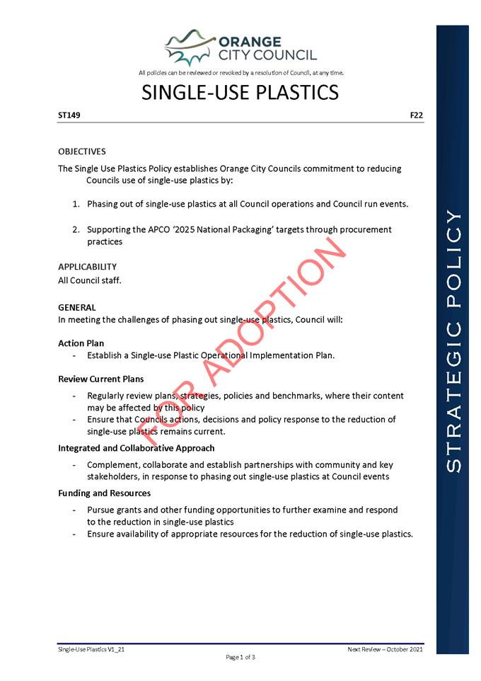
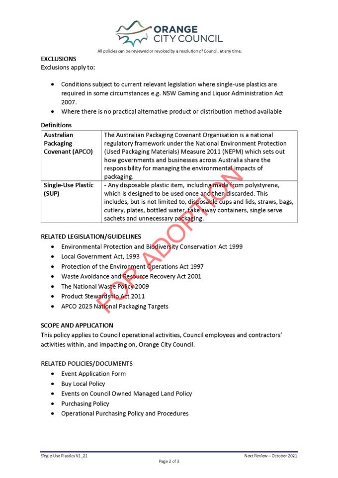
5.4 Pesticide
Notification Plan - Adoption
RECORD
NUMBER: 2021/1532
AUTHOR: Roger
Smith, Natural Resources Coordinator
EXECUTIVE Summary
At the Council meeting held on the 20 April 2021 Council
resolved to place a draft Pesticide Use Notification Plan on public exhibition
for 28 days. The aim of the Plan is to provide information to the public about
pesticide applications made in public places that are owned or controlled by
Council. This period has expired with 2 submissions received regarding the
plan.
Several changes have been made to the plan which is now
ready for adoption by Council. The plan was revised with input from the NSW
EPA. Once adopted a copy of the plan will be sent to the EPA and a copy placed
on the Orange City Council website and in the local newspaper.
Link To Delivery/OPerational Plan
The recommendation in this report relates to the
Delivery/Operational Plan strategy “14.1 Collaborate - Deliver
communication that is open, accessible, meaningful and regular across a range
of media”.
Financial Implications
Nil
Policy and Governance Implications
Once the Plan is adopted by Council notice in writing must
be given to the NSW Environment Protection Authority specifying the area in
which the plan is to operate and where copies of the plan will be displayed.
Council must make the plan available for inspection free of charge at the Civic
Centre and on its website.
|
Recommendation
That Council resolves to adopt the Pesticide
Notification Plan as tabled.
|
further considerations
Consideration has been given to the recommendation’s
impact on Council’s service delivery; image and reputation; political;
environmental; health and safety; employees; stakeholders and project
management; and no further implications or risks have been identified.
SUPPORTING INFORMATION
When making changes to the draft Pesticide Notification Plan
which was placed on public exhibition, under the advice from the NSW EPA,
careful attention was made to the requirements of sections 39 – 44 of the
Pesticides Regulation 2017. These requirements which include:
· obligations
of public authorities using pesticides,
· the
contents of the plan,
· consultation
on a draft pesticide use notification plan
· giving
notice of a finalised pesticide use notification plan
· future
amendments of the plan
have all been addressed in the plan or will be addressed
upon adoption of the plan by Council.
Attachments
1 Draft
Pesticide Use Notification Plan, D21/44296⇩
2 Submissions,
D21/44346⇩
Extraordinary
Council Meeting
27 July 2021
Attachment 1 Draft
Pesticide Use Notification Plan
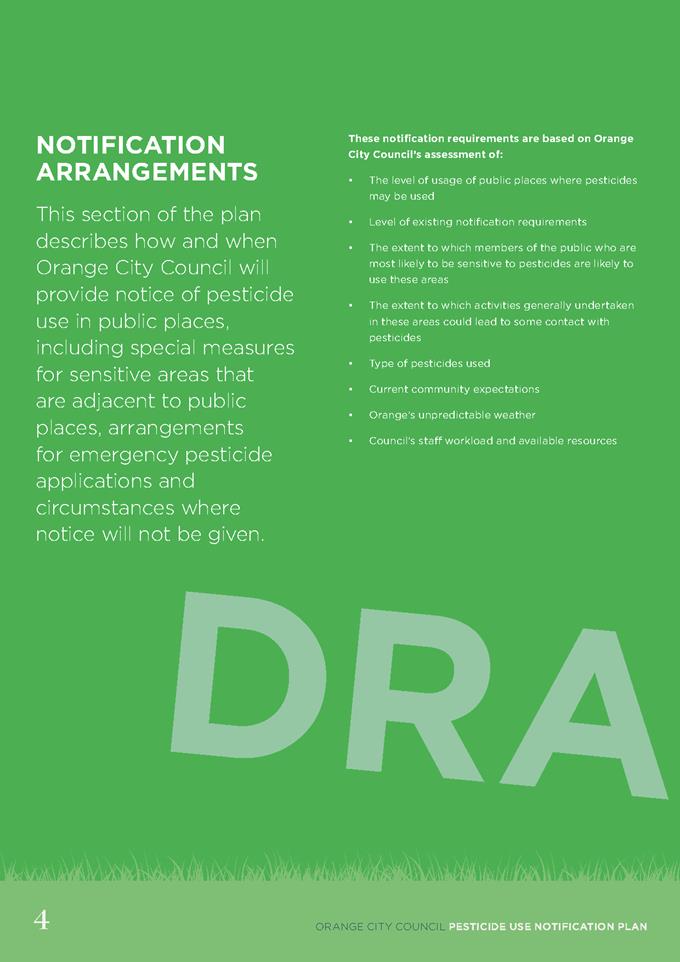
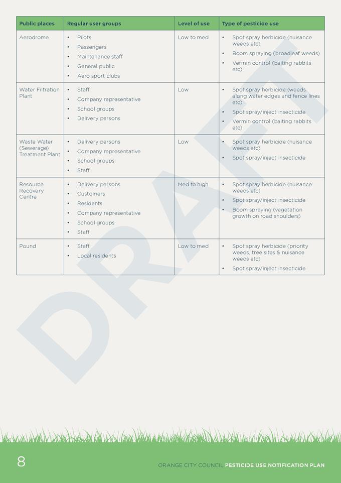
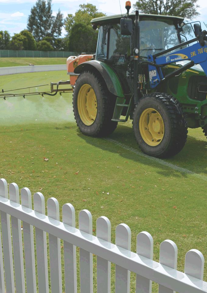
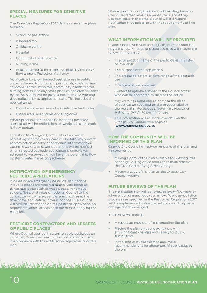

Extraordinary Council Meeting
27 July 2021
5.5 Projects
Activities July 2021
RECORD
NUMBER: 2021/1454
AUTHOR: David
Waddell, Chief Executive Officer
EXECUTIVE Summary
This report provides information, updated monthly, on the
numerous projects that staff are working on. This includes major projects and
works projects.
The Executive has brought together the total project list
for the 2020-2023 years in a consolidated form to assist with resourcing and to
understand the sequence required to deliver our ambitious capital budget for
the year.
Link To Delivery/OPerational Plan
The recommendation in this report relates to the
Delivery/Operational Plan strategy “17.1 Collaborate - Provide representative,
responsible and accountable community governance”.
Financial Implications
Nil
Policy and Governance Implications
Nil
|
Recommendation
That the information in the report on Projects be
acknowledged.
|
further considerations
Consideration has been given to the recommendation’s
impact on Council’s service delivery; image and reputation; political;
environmental; health and safety; employees; stakeholders and project
management; and no further implications or risks have been identified.
SUPPORTING INFORMATION
The attached tables show the overall
project database of current, complete and planned projects.
The tables will be progressively
updated to inform Council and the Community.
Attachments
1 Works
Overview July 2021, D21/42815⇩
2 Projects
Overview - July 2021, D21/42813⇩
Extraordinary
Council Meeting
27 July 2021
Attachment 1 Works
Overview July 2021
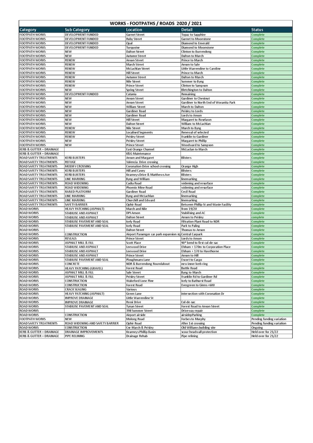
Extraordinary
Council Meeting
27 July 2021
Attachment 2 Projects
Overview - July 2021
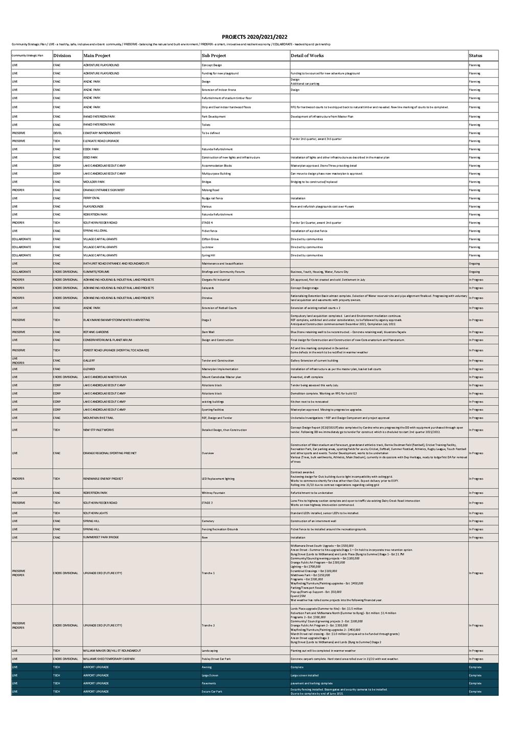
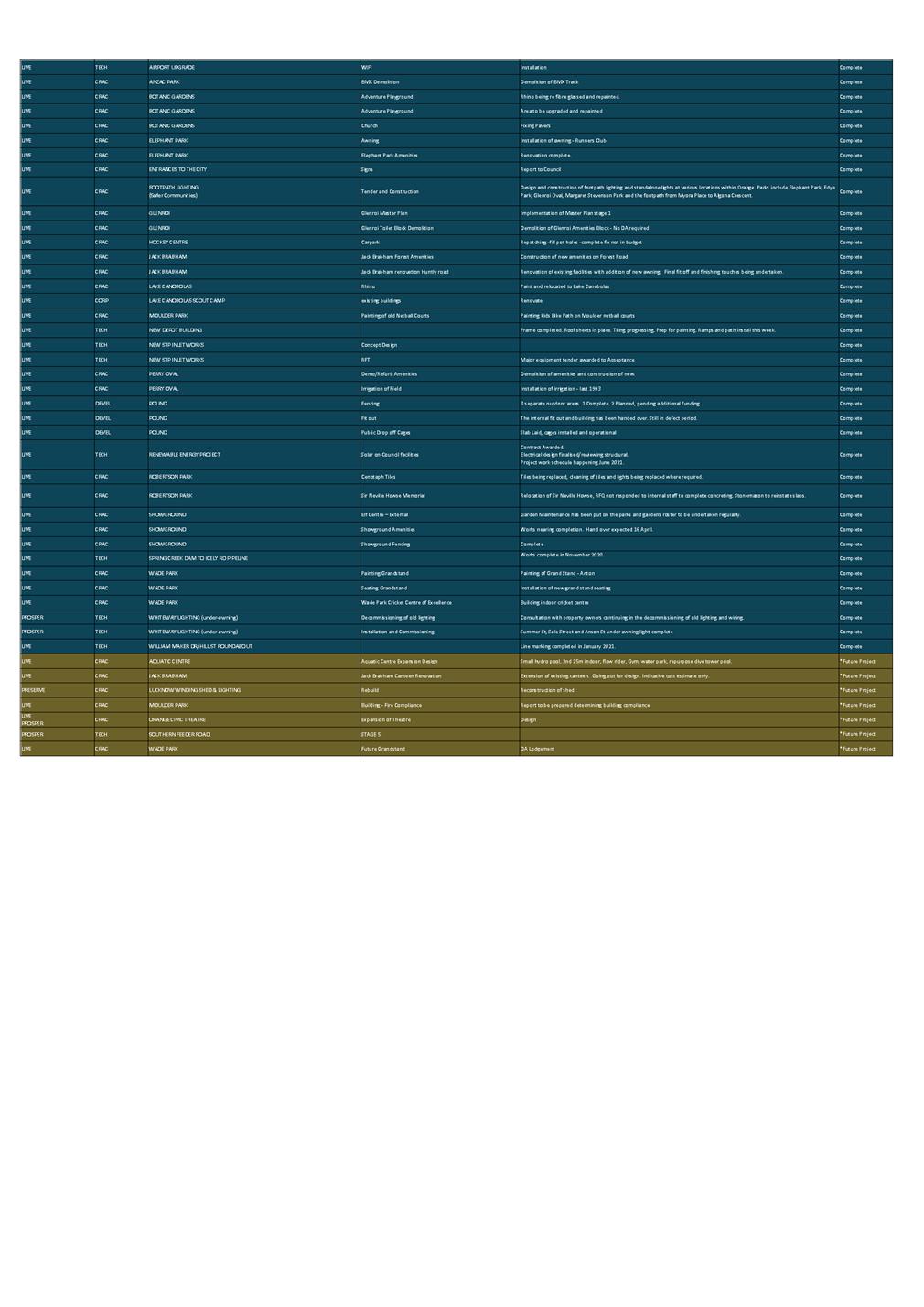
5.6 Biz
HQ
RECORD
NUMBER: 2021/1404
AUTHOR: David
Waddell, Chief Executive Officer
EXECUTIVE Summary
Central NSW Business HQ (BizHQ) is seeking approval from its
member Councils to convert the organisation from a NSW Incorporated Association
(IA) to a Public Company Limited by Guarantee (PCLG), with a new fit for
purpose constitution.
Link To Delivery/OPerational Plan
The recommendation in this report relates to the
Delivery/Operational Plan strategy “12.1 Prosper - Attract and grow
strategic investment”.
Financial Implications
Nil
Policy and Governance Implications
Prior to the new organisation commencing staff will be
seeking a full governance review.
|
Recommendation
That Council note the report on the proposed conversion
of the Business Enterprise Centre from a NSW Incorporated Association to a
Public Company Limited by Guarantee.
|
further considerations
As a founding member of the Business Enterprise Centre
– Cabonne, Orange and Blayney Incorporated; Council has an interest in
the recommended changes to the governance model of BizHQ.
Consideration has been given to the recommendation’s
impact on Council’s service delivery; image and reputation; political;
environmental; health and safety; employees; stakeholders and project
management; and no further implications or risks have been identified.
SUPPORTING INFORMATION
The Business Enterprise Centre – Cabonne, Orange,
Blayney Incorporated (trading as Central NSW Business HQ) (BEC) was founded in
1991 as an incorporated association (IA) with Cabonne, Orange and Blayney
Councils as founding members
The BEC has previously been a tax-exempt charity, however
its endorsement was revoked in 2015, due to failing to lodge annual returns
with ACNC. The ATO recommended that the BEC should apply to be
re-instated as a charity.
The BEC applied for reinstatement as a charity, with such
reinstatement to be backdated to 2015. The application was withdrawn based on
advice from ACNC that BEC’s current structure and constitution were not
appropriate for registration as a charity.
Advice from a specialist legal practice, was sought and the
BEC Board have accepted the recommendation to convert the organisation from a
New South Wales IA to a PCLG, with a new fit for purpose constitution.
The steps involved are outlined in the attached
timeline.
A general meeting of members was held on 15th June 2021
which was attended by Council’s Representative, Heather Ferguson.
At this meeting, the members approved the following:
a) Converting
the incorporated association to a company; and
b) The
company’s new name
The draft constitution was provided
after approval at the board meeting held on 22 June 2021. Under his delegation,
the CEO signed the draft Constitution along with the General Managers of
Cabonne and Blayney.
Given Council elections in September,
the Annual General Meeting will be late October when Council delegates have
been nominated.
Attachments
1 Key
Events and Timeline, D21/44351⇩
Extraordinary
Council Meeting
27 July 2021
Attachment 1 Key
Events and Timeline
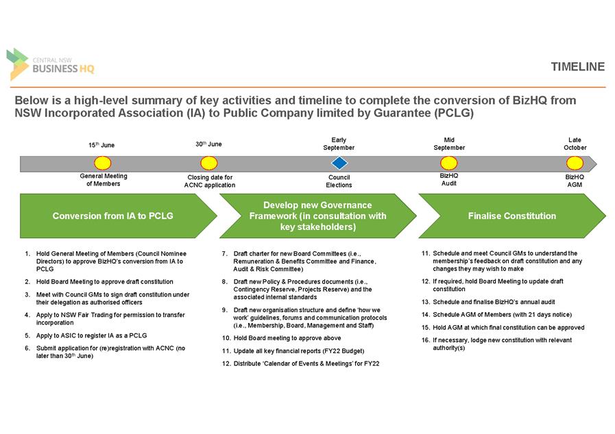
5.7 Statement
of Investments - June 2021
TRIM
REFERENCE: 2021/1405
AUTHOR: Julie
Murray, Financial Accountant
EXECUTIVE SUMMARY
The purpose of this report is to provide a statement of
Council’s investments held as at 30 June 2021.
Link To Delivery/OPerational Plan
The recommendation in this report relates to the
Delivery/Operational Plan strategy “17.2 Collaborate - Ensure financial
stability and support efficient ongoing operation”.
Financial Implications
Nil
Policy and Governance Implications
Nil
|
Recommendation
That Council resolves:
1 To note the Statement
of Investments as at 30 June 2021.
2 To
adopt the certification of the Responsible Accounting Officer.
|
further considerations
Consideration has been given to the recommendation’s
impact on Council’s service delivery; image and reputation; political;
environmental; health and safety; employees; stakeholders and project
management; and no further implications or risks have been identified.
SUPPORTING INFORMATION
Section 212(1) of the Local Government (General) Regulation
2005 requires that a written report be presented each month at an Ordinary
Meeting of the Council detailing all money that Council has invested under
Section 625 of the Local Government Act 1993.
As at 30 June 2021, the investments held by Council in each
fund is shown below:
|
|
30/06/2021
|
31/05/2021
|
|
General
Fund
|
71,093,680.85
|
68,935,438.25
|
|
Water
Fund
|
66,401,978.22
|
65,108,818.59
|
|
Sewer Fund
|
57,772,656.23
|
56,859,126.27
|
|
Total
Funds
|
$195,268,315.30
|
$190,803,383.11
|
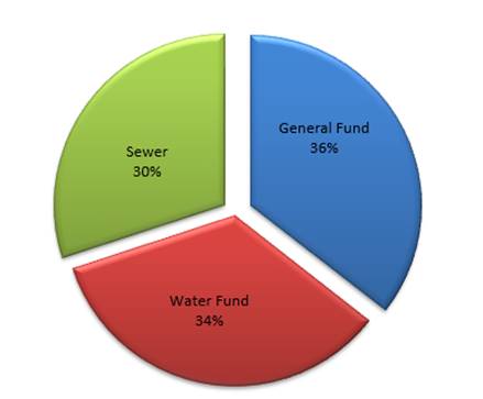
A reconciliation of Council’s investment portfolio
provides a summary of the purposes for which Council’s investments are
being held. The summary is as follows:
|
30/06/2021
|
31/05/2021
|
|
Externally
Restricted
|
|
|
|
- General Fund
|
30,212,309.42
|
30,002,666.95
|
|
- Water Fund
|
66,401,978.22
|
65,108,818.59
|
|
- Sewer Fund
|
57,772,656.23
|
56,759,126.27
|
|
Internally
Restricted
|
27,304,520.65
|
24,691,137.44
|
|
Unrestricted
|
13,576,850.78
|
14,241,633.86
|
|
Total
Funds
|
$195,268,315.30
|
$190,803,383.11
|
Externally restricted funds are those funds that have been
received for a specific purpose and may only be used for the purpose that they
have been received, for example, the money received for Water access and usage
charges by legislation ae only available to be spent for the operation,
maintenance and expansion of the Water supply network.
Internally restricted funds are those that Council has
earmarked for a particular purpose but Council also has the ability to have
that purpose changed.
Unrestricted funds are those available for use to continue the
day to day operations of Council, made up of General Fund investments and cash
only.
The increase in the internally restricted funds during June is
due mainly to the prepayment of 50% of the Financial Assistance grant for the
2022 Financial year ($2,422,814.00).
The unrestricted cash position movements during the month
are normal as projects commence and income is received. Movements may also
arise following processing of income received between funds or into restricted
assets to appropriately allocate for the purposes Council has determined. Council’s
cash flow is monitored on a daily basis and some investments may be redeemed
rather than rolled over to support operational requirements.
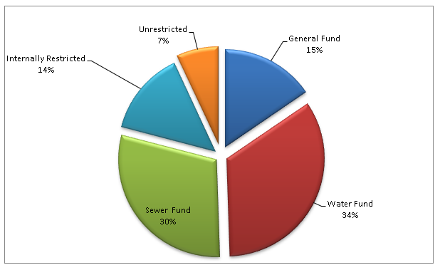
Portfolio Advice
Council utilises the services of an
independent investment advisor in maintaining its portfolio of investments.
Council’s current investment advisor is Imperium Markets, an independent
asset consultant that works with wholesale investors to develop, implement and
manage their investment portfolio. Imperium Markets is a leading provider of
independent investment consulting services to a broad range of institutional
investors including government agencies, superannuation funds and
not-for-profit organisations.
Imperium Markets major services
provided to Council include:
· Quarterly
portfolio summary reports
· Advice
on investment opportunities, in particular Floating Rate Note products
· Advice
on policy construction
· Year-end
market values for Floating Note Rate products held by Council.
Portfolio Performance
Council’s current Long Term Financial Plan establishes
the benchmark for Council’s interest on investments at “75 basis
points above the current cash rate”. The cash rate as at 30 June 2021
remained at 0.10 per cent. The weighted average interest rate of
Council’s investment portfolio at the same reporting date was 0.88 per
cent which continues to exceed Council’s benchmark i.e. the cash rate of
0.10 per cent plus 0.75 per cent (or 85 basis points).
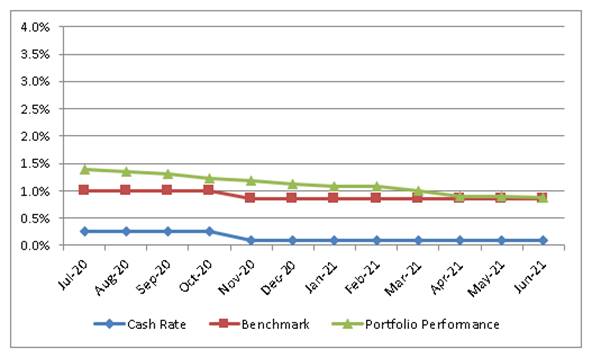
Council has also utilised the AusBond Bank Bill Index to
provide a further benchmark focused towards long term investments. As at 30
June 2021, the AusBond rate was 0.90 per cent. The weighted average interest
rate of Council’s investment portfolio at the same reporting date was
0.88 per cent.
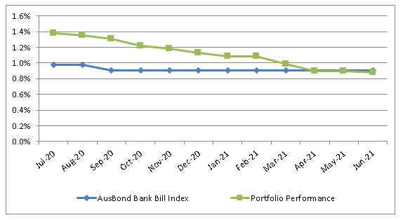
Council’s Investment Policy establishes limits in
relation to the maturity terms of Council’s investments as well as the
credit ratings of the institutions with whom Council can invest.
The following tables provide a dissection of Council’s
investment portfolio as required by the Policy. The Policy identifies the
maximum amount that can be held in a variety of investment products or with
institutions based on their respective credit ratings.
Table 1 shows the percentage held by Council (holdings) and
the additional amount that Council could hold (capacity) for each term to
maturity allocation in accordance with limits established by Council’s
Policy.
Table
1: Maturity – Term Limits
|
Term to Maturity Allocation
|
Maximum
|
Holding
|
Remaining Capacity
|
|
0 - 3 Months
|
100.00%
|
10.07%
|
89.93%
|
|
3 - 12 Months
|
100.00%
|
50.03%
|
49.97%
|
|
1 - 2 Years
|
70.00%
|
11.22%
|
58.78%
|
|
2 - 5 Years
|
50.00%
|
28.69%
|
21.31%
|
|
>5 Years
|
25.00%
|
0.00%
|
25.00%
|
Table 2 shows the total amount held, and the weighted
average interest rate (or return on investment), by credit rating. The credit
rating is an independent opinion of the capability and willingness of a
financial institution to repay its debts, or in other words, the
providers’ financial strength or creditworthiness. The rating is
typically calculated as the likelihood of a failure occurring over a given
period, with the higher rating (AAA) being superior due to having a lower chance
of default. However, it is generally accepted that this lower risk will be
accompanied by a lower return on investment.
The level of money held in the bank accounts has been added
to the table to illustrate the ability of Council to cover the operational
liabilities that typically occur (for example payroll, materials and contracts,
utilities).
Table 2: Credit Rating Limits
|
Credit
Rating
|
Maximum
|
Holding
|
Remaining
Capacity
|
Value
|
Return
on Investment
|
|
Bank
Accounts
|
100.00%
|
9.96%
|
90.04%
|
$19,444,910.12
|
0.10%
|
|
AAA
|
100.00%
|
0.00%
|
100.00%
|
N/A
|
N/A
|
|
AA
|
100.00%
|
43.66%
|
56.34%
|
$85,256,160.00
|
0.87%
|
|
A
|
60.00%
|
19.15%
|
40.85%
|
$37,400,000.00
|
0.87%
|
|
BBB
& NR
|
40.00%
|
27.23%
|
12.77%
|
$53,167,245.18
|
1.14%
|
|
Below
BBB
|
0.00%
|
0.00%
|
0.00%
|
N/A
|
N/A
|
Certification
by Responsible Accounting Officer
I, Jason Cooke, hereby certify that all investments have
been made in accordance with Section 625 of the Local Government Act 1993,
Clause 212 of the Local Government (General) Regulation 2005 and
Council’s Investment Policy.
5.8 Mt
Canobolas Mountain Bike Trail
RECORD
NUMBER: 2021/1435
AUTHOR: Roxanne
Betts, Project and Corporate Information Officer
EXECUTIVE Summary
This report is to advise Council on the progress to-date
undertaken for the Mt Canobolas Mountain Bike Trail and the project approval
pathway.
Link To Delivery/OPerational Plan
The recommendation in this report relates to the
Delivery/Operational Plan strategy “1.1 Live - Engage with the community
to ensure recreation opportunities and facilities meet changing needs”.
Financial Implications
Council adopted in the 2020/2021 financial year budget
$500,000 to undertake the investigations and design of the trail. A September
budget review will be undertaken to cover costs of any additional
investigations required to be undertaken in accordance Environmental Impact
Assessment approval process.
Policy and Governance Implications
Nil
|
Recommendation
That the report on the Mt Canobolas Mountain Bike Trail
be noted.
|
further considerations
Consideration has been given to the recommendation’s
impact on Council’s service delivery; image and reputation; political;
environmental; health and safety; employees; stakeholders and project
management; and no further implications or risks have been identified.
SUPPORTING INFORMATION
On the 3 November 2020, Council resolved to engage The
Environmental Factor (TEF) to undertake the Development of the Environmental
Impact Assessment and Design for Construction of the Mountain Bike Trail. Works
commenced shortly thereafter and a summary is provided below.
· Stakeholder
engagement,
· Preliminary
constraints identification and design overview,
· Preliminary trail Design
· Ground truthing of
detailed trail alignments,
· Preliminary
Environmental Impact Assessment
· Permits and
approvals, and finalization of Master Plan
· Approvals support
CONSULTATION TO DATE
Council held a public forum on the 25 February 2021, the
forum was well received with over 100 participants in attendance. The forum
addressed what investigations were being undertaken, the environmental impacts
that constructed tracks had on the environment, cultural heritage impacts and
identified no go (exclusion) zones in the State Conservation Area (SCA).
Council have also presented to Cabonne Council on two occasions to answer any
questions and to keep them up to date on the progress of the proposal.
Orange City Council have also formed an Agency Stakeholder
Working Group (ASWG) which includes members from Cabonne and Orange Councils,
National Parks and Wildlife, Forestry Corporation of NSW, Dep of Planning,
Industry and Environment, Crown Lands, Orange Local Aboriginal Land Council,
Heritage NSW and The Environmental Factor and it’s consultants. The
purpose of this Group is to engage with each department on the progress to-date
and to receive any feedback. This committee has met on three occasions.
Further to the ASWG, TEF have liaised with a wide range of community
groups and individuals that provided input or data on the area, including
interest group Canobolas Conservation Alliance (CCA). Council will continue to
engage with Stakeholders throughout the process.
STAGES OF THE PROJECT
The initial stages of the project involved TEF combining all
of the known constraints into a mapping system from data collated from their
investigations and investigations undertaken and provided by third parties.
Constraints are items such as cultural and archaeological significant
artefacts, threatened and other significant species, fauna habitats, lichen,
waterways etc.
This enabled DirtArt to attend site and develop a network of
trails using the constraints mapping. Each trail was reviewed and both TEF and
DirtArt marked up locations to avoid the constraints and modified trails to
avoid constraints. The key objectives when selecting trails were to:
· avoid all
‘no go areas’ and areas of high sensitivity as defined by the
ecological and cultural heritage constraints mapping
· develop a strong
network focus on shuttle uplift riding with a variety of descending trails to
cater for a broad demographic
· provide
opportunities for a wide range of riding styles, abilities, and distances and
to develop a stacked loop trail system where possible
· place higher
impact trails such as freeride/jump trails in areas with lower environmental
value or previously disturbed
· place trails in
areas with reduced social conflicts
· minimise crossings
of existing roads and tracks
· place trails in
areas that provide cost effective construction conditions; and
· provide active
connections with the local mountain bike club’s trail development –
including existing trails currently under construction and planned for the
future.
The design of the Concept Trail Plan takes into
consideration feedback from community and stakeholder groups wishing to see a
more environmentally sympathetic design developed, as well as opportunities to
construct a route which appeals to a wider audience and highlights the unique
scenic qualities of the location.
A crucial component of the project was the continued identification
of the constraints. During the mapping process where areas of concern where
further identified through new information, the trail design was amended to
reflect those new constraints.
The below example shows where additional Orchid Hotspots
were identified where some of the concept trails pass through three of the
features in the NE corner in the Crown lands at Trail Hub A, east near Track
C14 and west near Track C12. These Tracks were then altered or removed
and the No-Go Constraints combined datasets were updated.

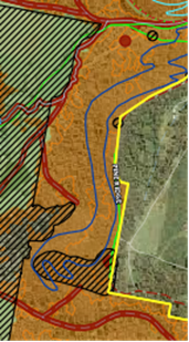
PROPOSED TRAILS
Council propose that 104.4 km of new mountain bike trails
will be submitted as part of the request for the project’s approval. This
is broken into 71.7 km within the Mt Canobolas State Conservation Area, 27 km
in Glenwood State Forest, and the remaining 6.3 km in land managed by Cabonne
Council. The diverse network of trails will suit every level and type of rider
from beginner through to expert. The proposed trail skill level is broken into
four skill levels, Green Circle (33.3 km trail network), Blue Square (40.7 km
trail network), Black Diamond (22.7 km trail network) and Double Black Diamond
(7.8 km trail network). A map of the network is enclosed in this report for
Council’s information.
WEED INFESTATION
During site investigations, access
was impeded by weed infestation, particularly Blackberry (Rubus fruticosis spp.
agg.). This made flagging the concept trail routes much slower than
anticipated, and resulted in numerous minor injuries and delays. Walking the
assessment corridor for Aboriginal heritage and ecological constraints
identification was also difficult, with staff completing long days on site
navigating the Blackberry within a set corridor. Images below show the width
and height of black berries and ivy patches in the SCA among other identified
weeds. This also highlights the need to address weed incursion in the SCA and
surrounding areas.

Many locations were also damaged by
pigs. An image of pig damage follows.
OPPORTUNITY FOR PROJECT TO IMPROVE ENVIRONMENTAL OUTCOMES
As evidenced above the project team
encountered significant unmanaged weed infestations.
This was not surprising as the areas
that the project team were predominately in to identify possible trails were by
definition those areas with low environmental constraints and no cultural
heritage constraints. With the resulting low visitation and no walking paths
these areas have been left unattended and weed proliferation has occurred.
A positive outcome of the proposal
should it succeed will see weeds in these areas managed to support the
operation and maintenance of the trail network.
FUTURE PROCESS FOR PROJECT APPROVAL
With the preliminary investigations undertaken, proposed
trail selected and the preliminary environmental impact assessment near
completion, Council will be ready to begin the process of project approval. The
following outlines the process of how this is achieved.
At the time of this report being written, a Preliminary
Environmental Impact Assessment (PEIA) report is being finalised by The
Environmental Factor to support an application to the Secretary of the
Department of Planning, Industry and Environment (DPIE) to request a
Secretary’s Environmental Assessment Requirements (SEARs) to guide the
preparation of an Environmental Impact Statement (EIS) for the proposed
construction and operation of a network of mountain bike trails and the
development of ancillary infrastructure on Mount Canobolas.
The proposal involves submitting a development application
(DA) for the Proposal under Division 4.7, section 4.36 of the Environmental
Planning and Assessment Act 1975 (EP&A Act). The proposal is regarded as
State Significant Development (SSD) through the effect of Schedule 1, clause
13(2)(b) of State Environmental Planning Policy (State and Regional
Development) 2011 (SRD SEPP), being a recreational facility development with a
capital investment value of more than $10 million and is located in an
environmentally sensitive area of state significance.
This PEIA considers the potential environmental impacts that
may result from the proposed works and proposes preliminary safeguards to
avoid, minimise, mitigate or offset these impacts.
To support the preparation of this PEIA, a review of
previous reports, databases and stakeholder-sourced information and assessments
has been carried out. This PEIA is intended to guide the development of the EIS
during the preparation of all planning approval documentation to be undertaken
at a later date.
The PEIA requests the Secretary prepare the Environmental
Assessment Requirements (SEARs) to guide preparation of an Environmental Impact
Statement for a State Significant Development (SSD) Application.
A flowchart is provided below showing the process that
Council will follow to obtain a project approval. The process is approximately
45 weeks from the date of lodgement and additional six weeks where an
application is referred to the NSW Independent Planning Commission.
The Draft EIA and Trail Masterplan will become publicly
available once the report is lodged which will allow submissions to be received
from the public.
Attachments
1 DRAFT-
Mt Canobolas Trail Master Plan - Trail concept Overview Map, D21/43596⇩
2 Mt
Canobolas Constraints Summary Report, IC21/15889⇩
Extraordinary
Council Meeting
27 July 2021
Attachment 1 DRAFT-
Mt Canobolas Trail Master Plan - Trail concept Overview Map
Extraordinary Council Meeting
27 July 2021
Attachment 2 Mt
Canobolas Constraints Summary Report
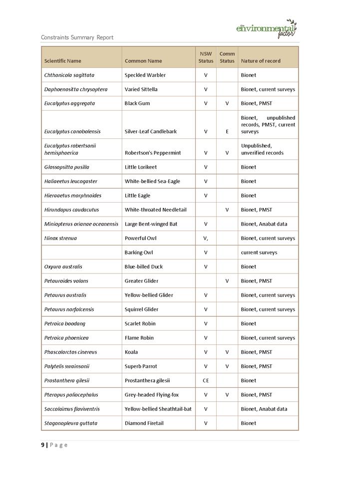
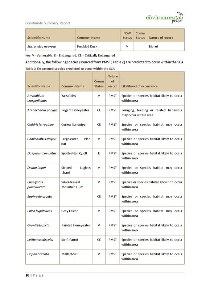
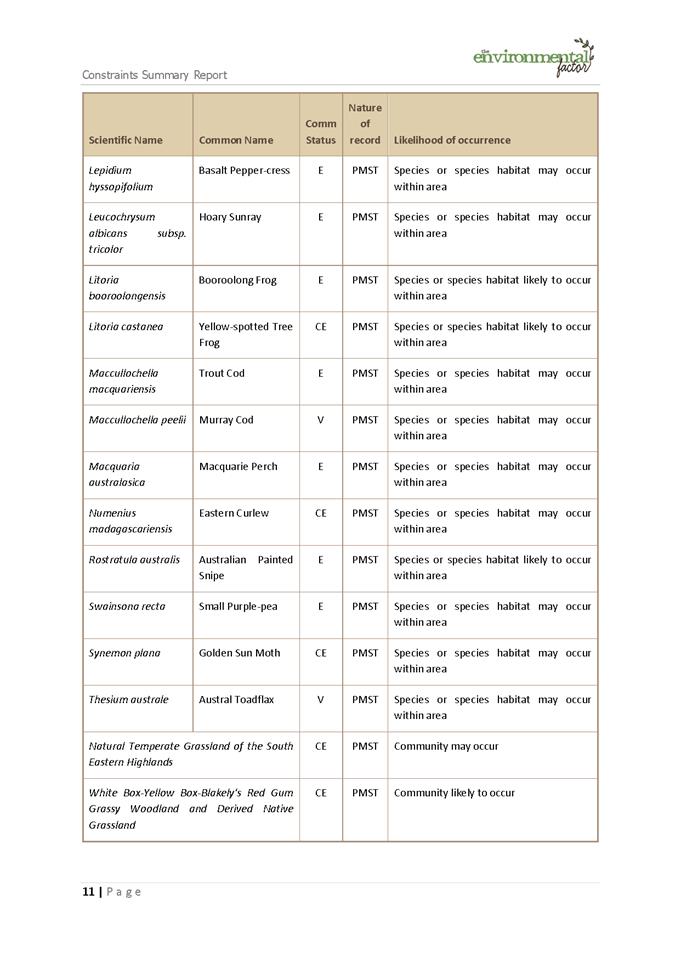
5.9 Orange
Regional Sports Precinct - Next Steps
RECORD
NUMBER: 2021/1564
AUTHOR: Scott
Maunder, Director Community, Recreation and Cultural Services
EXECUTIVE Summary
This report provides Council with an update on the next
stages of the Orange Regional Sports Precinct project.
Link To Delivery/OPerational Plan
The recommendation in this report relates to the
Delivery/Operational Plan strategy “2.1 Live - Identify and deliver sport
and recreation facilities to service the community into the future”.
Financial Implications
Nil.
Policy and Governance Implications
Nil.
|
RecommendationS
That Council note the report on the on the next stages
of the Orange Regional Sports Precinct project.
|
further considerations
Consideration has been given to the recommendation’s
impact on Council’s service delivery; image and reputation; political;
environmental; health and safety; employees; stakeholders and project
management; and no further implications or risks have been identified.
SUPPORTING INFORMATION
At its meeting of 28 June 2021
Council resolved to consent to development application DA 464/2020(1) for
Demolition (tree removal) at Lot 1 DP 1142713 and Lot 209 DP 42900, 1610 Forest
Road, Orange pursuant to the conditions of consent.
This consent enabled to Council to
commence the process for the construction of the Orange Regional Sports
Precinct.
Following the issue of the Consent on
29 June 2021 Council submitted its application with Heritage NSW for the
issuing of a permit to commence works on the site. To enable the request to be
considered, Heritage NSW required a detailed plan to identify the proposed
works consistent with the general terms of approval issued by Heritage NSW.
This information was prepared and provided on 8 July 2021. See attachment 1.
Council is now awaiting the issuing
of the permit prior to the commencement of works. The statutory timeframe for
s60 applications is 40 days from when a complete application is accepted by
Heritage NSW. Heritage NSW advised Council that the application was accepted on
9 July 2021.
Heritage NSW have indicated that this
application will be fast tracked however a date was unable to be provided as to
when the permit would be issued.
On receipt of the permit
Council’s appointed contractor will commence works pending any COVID19
constraints.
FUTURE STAGES AND APPROVALS
The future stages of the project
consist of:
a. Removal
of remainder of vegetation
b. Conduct
of civil works for the project site
c. Construction
of multipurpose fields
d. Construction
of main sports stadium and construction of Athletics Stadium
e. Construction
of carparks and amenities
f. Landscaping
to complete site.
To enable the conduct of the works
Council in accordance with Heritage NSW request will submit a Concept
Development Application for the entire project. This will formally provide Heritage
NSW with detailed information on the site including aspects such as final
layout and landscaping.
All future development applications
are then considered in the context of the Concept Development Application.
The planning pathway for Concept
Development Application is:
1. Public
exhibition for 28 days
2. Referral
to Heritage NSW together with submissions
3. Heritage
NSW to consider the application at an Approval Committee meeting (held monthly)
4. Issuing
of general terms of approval
5. Referral
to Western Region Planning Panel (Orange City Council to determine if a
submission is made to the Western Region Planning Panel).
6. Approval
by Western Regional Planning Panel.
The estimated timing for the above
process is:
· 19 July –
Lodgement of Concept Development Application including seeking approval for
Civil works
· 23 August –
Referral to Heritage NSW for consideration and preparation of report to
Approvals Committee
· 5 October –
Consideration by Heritage NSW Approvals Committee
· 11 October –
issuing of general terms of Approval from Heritage Committee
· 22 November
– Determination by Western Regional Planning Panel
· 29 November
– Commencement of civil works
Council has continued to develop
plans for the main stadium and the landscape plans. The grandstand plans to
date at attached to this report.
Attachments
1 Orange
Regional Sports Precinct - Tree Removal Plans, D21/44241⇩
2 Orange
Regional Sports Precinct - Site Plan, D21/44258⇩
3 Orange
Regional Sports Precinct - Aerial View - Grandstand, D21/44265⇩
4 Orange
Regional Sports Precinct - View From Field, D21/44266⇩
5 Orange
Regional Sports Precinct - Grandstand - Plan Lower Level, D21/44255⇩
6 Orange
Regional Sports Precinct - Grandstand - Plan - Second Level, D21/44256⇩
7 Orange
Regional Sports Precinct - Grandstand - Section & Elevation, D21/44257⇩
Extraordinary
Council Meeting
27 July 2021
Attachment 1 Orange
Regional Sports Precinct - Tree Removal Plans
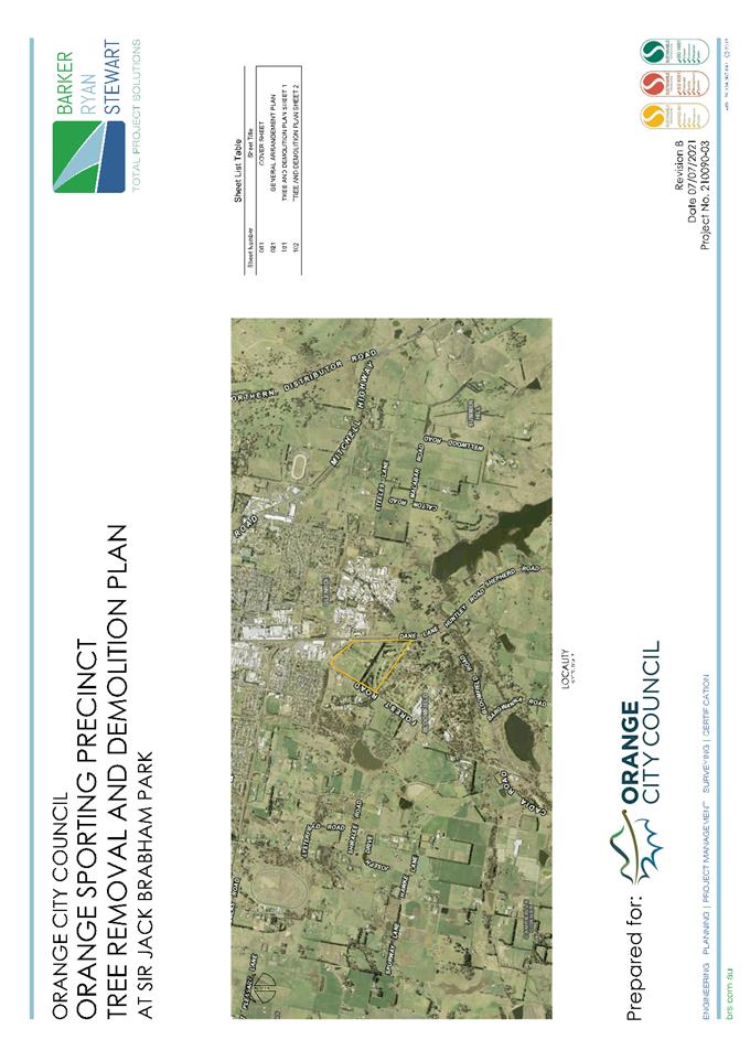
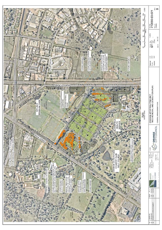
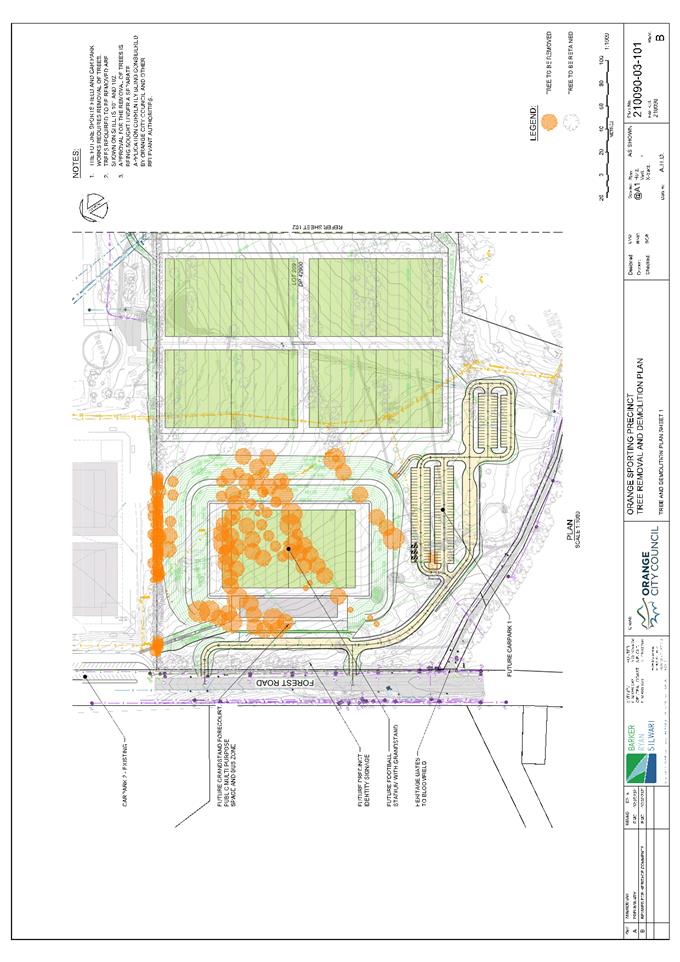
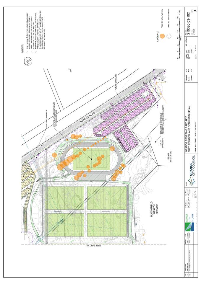
Extraordinary Council Meeting
27 July 2021
Attachment 2 Orange
Regional Sports Precinct - Site Plan
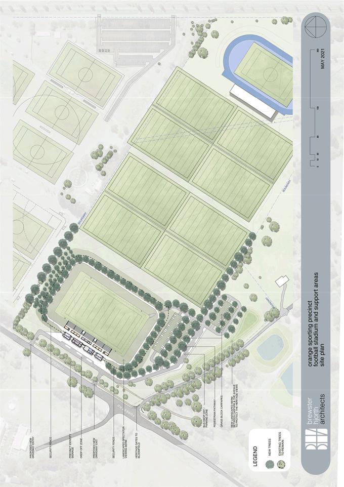
Extraordinary
Council Meeting
27 July 2021
Attachment 3 Orange
Regional Sports Precinct - Aerial View - Grandstand
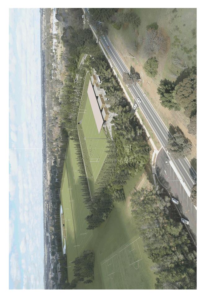
Extraordinary
Council Meeting
27 July 2021
Attachment 4 Orange
Regional Sports Precinct - View From Field
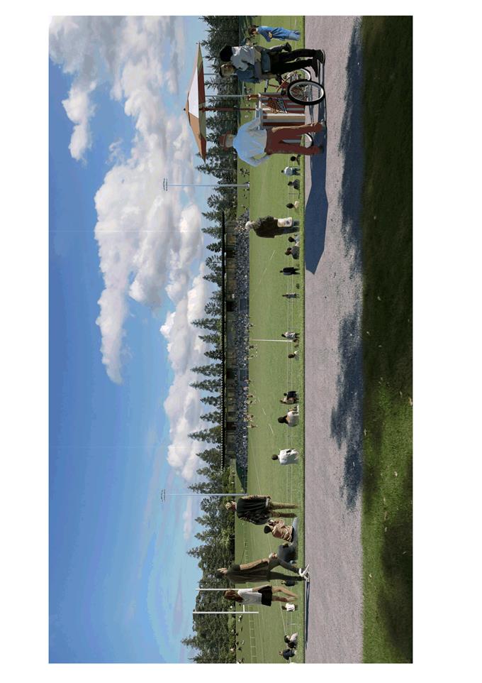
Extraordinary
Council Meeting
27 July 2021
Attachment 5 Orange
Regional Sports Precinct - Grandstand - Plan Lower Level
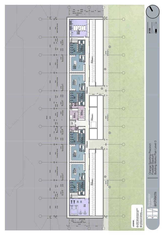
Extraordinary
Council Meeting
27 July 2021
Attachment 6 Orange
Regional Sports Precinct - Grandstand - Plan - Second Level
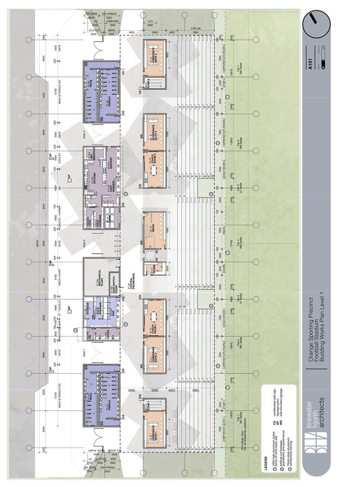
Extraordinary
Council Meeting
27 July 2021
Attachment 7 Orange
Regional Sports Precinct - Grandstand - Section & Elevation
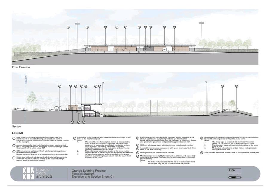
5.10 Library
Overdue Fines
RECORD
NUMBER: 2021/1563
AUTHOR: Roslyn
Cousins, Manager Central West Libraries
EXECUTIVE Summary
It is proposed to increase the accessibility of library
services by removing the barrier of overdue fines for items returned after the
due date. These fines contribute a small amount to the Council’s
income but often lead to families making the decision not to make further use
the library’s resources.
Link To Delivery/OPerational Plan
The recommendation in this report relates to the
Delivery/Operational Plan strategy “1.1 Live - Engage with the community
to ensure recreation opportunities and facilities meet changing needs”.
Financial Implications
Overdue fines accrue at 60 cents or $1 per day per item,
with the higher fee for DVDs. The overdue fines have a maximum of $30 per item.
Pre-Covid, in 2018/19 the library’s income from fees
and fines was $17,329, and this level of income has been consistent for several
years.
Based on a review of the banking data it is estimated that
30% of this income relates to overdue fees, rather than lost item and
interlibrary loan fees.
Potential lost income, in a non-Covid affected year is
estimated at $5,200.
Policy and
Governance Implications
Charges for lost and damaged items will remain.
Incentive to return items on time will continue with the current practise of
prohibiting further loans of library materials until overdue items are
returned.
|
Recommendation
That Council resolves:
1 To
abolish fees for overdue library materials from 1 August 2021;
2 Waive
any existing overdue fees for library materials from 1 August 2021; and
3 For
borrowers who lose, damage or keep library materials, the existing fine
structure will continue to recoup the cost of both the item and the
processing cost.
|
further considerations
Consideration has been given to the recommendation’s
impact on Council’s service delivery; image and reputation; political;
environmental; health and safety; employees; stakeholders and project
management; and no further implications or risks have been identified.
SUPPORTING INFORMATION
Overdue fines are intended to encourage the positive
behaviour of returning library materials on time, so that they can be used by
other library members. Data from the library management system shows that
many people choose to stop using the library rather than pay outstanding fines.
Currently the library has 39,850 members
· Of these 9,447
have outstanding overdue fines (23%) varying from 60 cents to over $400
· 8,510 borrowers,
who have overdue fines, have not used the library for over twelve months.
The system of overdue fines particularly effects families
who borrow children’s books on multiple membership cards. At a
maximum fine of $30 per item with loan limits of 29 items per card, it is all
too possible to have library overdue fines greater than the average weekly
grocery bill of $141.
On most occasions having overdue library items is a result
of disorganisation rather than ill intent. The current overdue fees put many
vulnerable residents in the position of having to make choices about whether to
allocate scarce resources on being able to continue to use the library.
The proposal to waive fees will also particularly benefit to
people who cannot afford to purchase their own reading materials.
For those borrowers with outstanding fines and overdue
books, borrowers who return their overdue library items will be permitted to
immediately borrow again. Should they not return their overdue items they will
not be able to borrow unless the items are returned or replaced.
For borrowers who lose, damage or keep library materials,
the existing fine structure will continue to recoup the cost of both the item
and the processing cost. Once paid, borrowers will be permitted to borrow
again.
5.11 Part 5 Environmental
Assessment East Orange Harvesting Wetland
RECORD
NUMBER: 2021/1560
AUTHOR: Ben
Hicks, Planner
EXECUTIVE Summary
Orange
City Council is proposing to construct and operate Stage 2 of the Blackmans
Swamp Creek Stormwater Harvesting Scheme (BSCSH) as part of the City’s
raw water scheme.
The
proposal involves the construction of an off line wetland upstream of the
existing harvesting weir (Stage 1) near the intersection of Jilba and Phillip
Streets (Figure 1). The proposal is designed to extract specific
flows from the Blackmans Swamp Creek. These specific flows will be diverted
from the creek system through a constructed swampy meadow and filtered through
reed beds into a deep pool designed to store 13 megalitres (ML) of water
permanently. An additional area (air space) with the capacity of 30ML will
surround the deep water pool. This area will be utilised for capturing a
portion of the high flows into Blackmans Swamp Creek during storm events to be
then transferred into the nearby Suma Park Dam to add to the City’s water
supply.
In
addition to the stormwater harvesting component of the project, Orange City
Council identified that there was an opportunity to incorporate additional
functional aspects of the wetland to provide broader cultural, educational and
recreational benefits for the community. This has been achieved through the
provision of raised boardwalks, walking trails, meeting places, viewing
platforms, seating, touch pool and BBQ areas around the wetland area (Figure
2).
Pursuant
to Clause 110 of the State Environmental Planning Policy (Infrastructure 2007)
the activity proposed is a stormwater management system, which is defined as:
- works
for the collection, detention, harvesting, distribution or discharge of stormwater
(such as channels, aqueducts, pipes, drainage works, embankments, detention
basins and pumping stations), and
- stormwater
quality control systems (such as waste entrapment facilities, artificial
wetlands, sediment ponds and riparian management), and
- Stormwater
reuse schemes.
As
Orange City Council is a public authority, the works are permitted without
consent via Clause 111 of the Infrastructure State Environmental Planning
Policy (ISEPP), and the provisions of the ISEPP prevail.
Notwithstanding,
Orange City Council has an obligation under Section 5.5 of the Environmental
Planning and Assessment Act 1979 to examine and take into account to the
fullest extent possible all matters affecting or likely to affect the
environment by reason of the proposed activity. In this regard, the proponent
commissioned Premise Pty Ltd to prepare a Review of Environmental
Factors (REF) to address the heads of consideration outlined in Clause 228
of the Environmental Planning and Assessment Regulation 2000 and to inform the
determination process.
Whilst
not required, the REF was exhibited for 28 days. Following the closure of the
exhibition period, five public submissions were received. The submissions
received represent a range of stakeholders with a direct and legitimate
interest in the impacts of the proposed wetland.
These
include downstream water licence holders and rural land owners with basic
rights to water; the Summer Hill Creek Landcare Inc., Ophir Reserve Trust;
Orange and Region Water Security Association, and Environmentally Concerned
Citizens of Orange (ECCO). Principally, the concerns raised by the
submission writers relate to impacts on the downstream environment including
water flows and quality and aquatic and terrestrial ecology including habitat.
A copy of all submissions received are included in the attachments.
The REF
was also externally referred to the Department of Primary Industries
(Fisheries) and the Natural Resources Access Regulator (NRAR) for comment.
These agencies provided comments/advice relating to the REF assessment on Key
Fish Habitat, hydrology, aquatic ecology, geomorphology and
monitoring/maintenance components. These matters have been addressed by the
proponent’s environmental consultants via an addendum report. It needs to
be noted that some of the comments received by NRAR and DPI Fisheries relate to
requirements for approvals/permits under the Water Management Act 2000
and Fisheries Management Act 1994 which are required to be obtained
following the determination of the REF.
In addition
to Council’s Development Services staff and government agencies reviewing
the adequacy of the REF, water consulting firm Entura was engaged to provide a
high level review of the REF and public submissions. The review by Entura has
been included as an attachment to this report.
The REF
and associated addendum reports and briefing notes concludes that no
significant adverse downstream impacts of the proposed stormwater harvesting
wetland is likely, subject to the recommended mitigation measures and operational
rules as outlined in these documents. These, together with Council's standard
conditions, form part of the determination.
It is concluded that Orange City
Council has satisfied its obligations under Part 5 of the EP&A Act 1979 and
that the project can proceed.
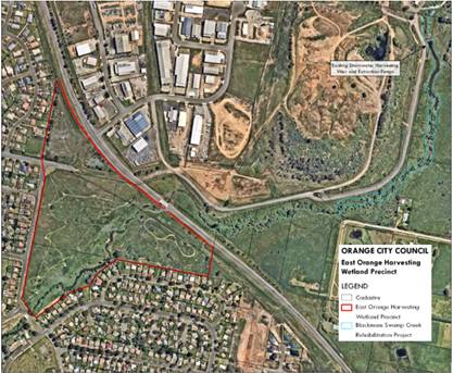
Figure 1 – Site Context and Locality Plan
(Premise)
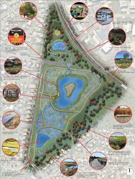
Figure 2 – Wetland Concept (Premise)
BACKGROUND
INFORMATION
Council’s Integrated Water
Cycle Management Evaluation Study in 2013 identified the potential to expand
the Blackmans Swamp Creek Stormwater Harvesting Scheme (BSCSHS) with Stage 2
being an off-line wetland in East Orange providing permanent water storage with
harvesting capacity. Since then, the concept has been advanced through the
completion of field studies, the conduct of community consultation and
workshops and calibrated hydrological modelling to assist in determining
whether the proposal is likely to have a significant effect on the environment.
Orange City Council completed
construction of the Blackmans Swamp Creek Stormwater Harvesting Scheme (BSCSHS)
Stage 1 in March 2009. The project was the first large scale stormwater
harvesting scheme in Australia which intentionally harvests stormwater for
drinking water supplies.
The Blackmans Swamp Creek Stormwater
Harvesting project was a direct response to the Millennium drought (2000-2010)
when the City’s combined water storages reached a record low of 23% in
2007/08. The scheme harvested its first stormwater in April 2009 and continues
to play an important role in supplementing the City’s water needs.
Furthermore, the multi-year rainfall deficiencies that
accumulated over the period 2017‑2020 saw drought conditions again return
to Orange. This had a significant impact on the City’s raw water storage
supplies. Although the City has had a steady
recovery from this drought since La Niña started to develop in
mid−2020, a more variable climate with cycles of prolonged dry spells and acute water shortage
is anticipated, and while Council continues to pursue non-structural water saving
initiatives, such as water restrictions, rainwater tank subsidy, installation
of water saving devices, community education and compliance initiatives
in an effort to reduce water usage, additional structural resources are also
needed to alleviate threats to the City’s water security now, and into
the future, and to support the growth and development of Orange.
Following the successful demonstrations of Blackmans Swamp
Creek Stormwater Harvesting Scheme (Stage 1) and the Ploughman’s Creek Harvesting
scheme, it is clear that stormwater harvesting from an urbanised catchment is a
sensible option to supplement the City’s water supply needs, given the
City’s location high in the catchment, the lack of any substantial river
system and limited groundwater supplies. Therefore, the proposed stormwater
harvesting wetland represents an important extension of the City’s
stormwater harvesting system and water supply network.
PROPOSAL
It is proposed to construct a stormwater management system
for the purposes of harvesting stormwater from the urban catchment to
supplement the City’s water supply. From a structural and operational
perspective, the stormwater management system will include the following
components:
· Construction of an
artificial off-line wetland (constructed wetland) that would incorporate:
- an inlet zone
- a swampy grass
meadow zone that would only be periodically inundated
- shallow
macrophyte zones
- open water zones
- an outlet zone.
· The wetland would
have a permanent water volume of 13ML and 30 ML airspace above the wetland
normal water level that provides the stormwater harvesting capacity. The
airspace is the volume above the normal water level to the spillway level.
· A second off-line
pond will be provided to the north of the main wetland that would be used to
recirculate water. Water would be drawn from the main wetland and pumped to the
offline pond from where it would then return to the main wetland via an open
rocked lined man-made creek. This would provide water aeration and turnover of
the stored wetland water.
· Construction
of an inlet control structure that controls water flow along Blackmans Swamp
Creek and into the wetland. This would include:
- a compound weir in the creek that has a central
v-notch section and level crest
- a lateral weir with level crest to control flow
into the wetland
· Construction
of an outlet control structure consisting of a box inlet pit (the top of the
pit would control the wetland normal water level), a 375mm diameter outlet pipe
with control valve and a rock lined overflow spillway and channel to direct
wetland spill back to Blackmans Swamp Creek.
The REF provides that the proposed
wetland would form part of the existing Blackmans Swamp Creek Stormwater
Harvesting Scheme providing a ‘storage component’ to the existing
system. This is to compensate for the change that was required during the
approval process to meet (the then) NSW office of Water licensing requirements.
To the meet these requirements, the volume of the on-stream storage was reduced
and this impacted directly on the volume of the scheme could harvest. The
capacity of the harvest pumps were then increased to accommodate for the loss
in on-stream storage.
The REF specifies that having
storage as part of an urban stormwater harvesting scheme improves the harvest
capacity. Most runoff events from urban catchments have short hydrographs which
reduces the time that harvest pumps can operate. If a portion of the runoff
hydrograph can be captured it can then be harvested over a longer period
following the runoff event. Otherwise, extremely large capacity pumps are
required to extract water as the hydrograph passes downstream. This effect was
observed in the initial operation of the BSCSHS. Specifically, it was
recognised that providing storage in the system improves the harvest capability
for short runoff events. It also allows smaller extraction pumps to be used.
The elements of the Orange raw
water supply system are shown schematically in Figure 3.
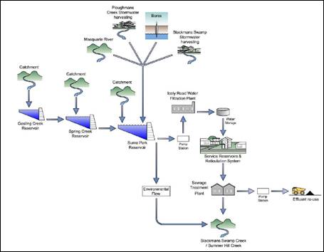
Figure 3 – Orange Raw Water Supply System
(Premise)
DECISION
FRAMEWORK & STATUTORY OBLIGATIONS
Development in the Orange LGA is governed by the
Environmental Planning and Assessment Act 1979 and the accompanying
Environmental Planning and Assessment Regulations 2000. Sitting below the Act
and Regulations is State-wide Environmental Planning Instruments (SEPPs) and
the Orange Local Environmental Plan (LEP) 2011. There are three main approval
pathways being Exempt Development, Development that needs consent and Development
that does not need consent:
1. Exempt
development – which requires no formal environmental assessment as it
has been identified as having minimal environmental impact.
2. Development
that needs consent – subject to Part 4 of the EP&A Act. This
includes both local and state significant development (Part 4.1). The consent
authority is usually Council.
3. Development
that does not need consent - subject to Part 5 of the EP&A Act, which
requires the full range of environmental impacts associated with an activity to
be considered before it may proceed. The ‘determining authority’ is
usually a public authority, such as Council, planning to undertake the
activity, or whose statutory approval is required.
The proposed activity is defined as a stormwater management
system. Pursuant to Clause 111 of the State Environmental Planning Policy
(Infrastructure) 2007, development
for the purpose of stormwater management systems may be carried out by or on
behalf of a public authority without consent on any land. Where the activity is
permitted without consent, there is an obligation under Section 5.5 of the
Environmental Planning and Assessment Act 1979 to ‘examine and
take into account to the fullest extent possible all matters affecting or
likely to affect the environment by reason of that activity’. The minimum
statutory requirements that must be considered are set out in Clause 228 of the
Environmental Planning and Assessment Regulation 2000 (EP&A Regulation).
Orange City Council is a public authority and is the determining
authority for all its activities that are assessed by way of an REF under Part
5 of the EP&A Act. Orange City Council has developed internal systems to
ensure separation and transparency in decision-making, as outlined by the
General Manager's delegation GM004 adopted by Council 19 January 2015.
This provides that the responsibility for the final determination of REFs and
decisions to proceed with a project are at a sufficiently senior level,
tailored to the size and scale of the project, and independent of proponent and
the person preparing the REF.
Although not required, the proposed activity was publicly
exhibited for 28 days and referred to the
Department of Primary Industries (Fisheries) and the Natural Resources Access
Regulator (NRAR). All submissions and comments have been considered in the
review of this REF.
While Council is the
determining authority for the REF, works cannot commence until NRAR issues a
Water Supply Works Approval under the Water Management Act 2000 and DPI
Fisheries issue a permit under the Fisheries Management Act 1994. Furthermore,
given the proposed activity will be undertaken in a high-risk environment
(watercourse and residential receptors) there is a
potential for pollution (air, water, and noise) to occur resulting from
construction works.
Therefore,
as a precautionary measure, Council will require the contractor undertaking the
works to secure an Environmental Protection Licence (EPL) under the provisions
of Section 47(d) of the Protection of the Environment Operations Act 1997
from the New South Wales
Environment Protection Authority before works commence.
Furthermore, the REF has
considered and addressed the relevant provisions of:
· Environmental Planning and Assessment Act 1979
· Environmental Planning and Assessment Regulation 2000
· Biodiversity Conservation Act 2016
· Environmental Protection and Biodiversity Conservation
Act 1999
· Fisheries Management Act 1994
· National Parks and Wildlife Act 1974
· National Parks and Wildlife Regulation 2009
· Heritage Act 1977
· Protection of the Environment Operations Act 1997
· Water Management Act 2000
· Water Act 1912
· Local Government Act 1993
· Roads Act 1993
· State Environmental Planning Policy (Infrastructure) 2007
· State Environmental Planning Policy 55 –
Remediation of Land
Link To Delivery/OPerational Plan
The recommendation in this report relates to the
Delivery/Operational Plan Strategy “8.1 Preserve - Identify and deliver
essential water, waste and sewer infrastructure to service the community into
the future”.
Financial Implications
This report relates only to the assessment of environmental
impacts arising from the construction and operation of the East Orange
Harvesting Wetland (EOHW). It does not consider the financial implications of
construction and operation of the EOHW. This is a matter to be considered at a
later date by Council once all funding opportunities and budgets are
determined.
Policy and Governance Implications
Nil
|
Recommendation
That Council approves the East Orange Harvesting
Wetland (EOHW) in accordance with its obligations and powers under Part 5 of
the Environmental Planning & Assessment Act 1979, subject to
inclusion of additional recommendations of Entura dated 2 & 3 June 2021.
|
further considerations
Consideration has been given to the recommendation’s
impact on Council’s service delivery; image and reputation; political;
environmental; health and safety; employees; stakeholders and project
management; and no further implications or risks have been identified.
ENVIRONMENTAL IMPACTS & MITIGATION MEASURES
Council
commissioned Premise to prepare a Review of Environmental Factors (REF)
for determination by Council as the proponent and the determining authority
under Part 5 of the Environmental Planning and Assessment Act 1979
(EP&A Act). A high-level review of the REF was also undertaken by water
consulting firm Entura.
As is
required under legislation, the REF has considered impacts as follows:
· Hydrology including water quality, groundwater and
flooding.
· Aquatic Ecology.
· Terrestrial Ecology.
· Topography, geology, soils & geomorphic assessment.
· Air quality.
· Noise and vibration.
· Aboriginal heritage.
· Non-Aboriginal heritage.
· Waste management.
· Socio-economic effects.
The REF analysis of each of
these is summarised below.
Hydrology
The headwaters of Blackmans
Swamp Creek rise in the foothills of Mount Canobolas. The creek flows for
approximately 5km and enters the urban area where it is then channelised and
piped. There is very little of this creek remaining in its natural state
through the City until it reaches down stream of Dalton Street where it reverts
to a semi-formal channel through to Jilba Street where it returns to
informal/natural creek system (location of proposed wetland). The creek continues
to flow through Orange in a generally north‑easterly direction before
joining Summer Hill Creek just north of the City limits, just below the first
crossing on Ophir Road, and then ultimately flows into the Macquarie River
forming part of the Macquarie Bogan Catchment.
Whether
there is a likelihood for significant adverse downstream impact with respect to
water flows once the wetland is operational was a key factor for consideration
in the REF. Harvesting of too much stormwater at inappropriate times, has the
potential to cause a significant impact downstream. However, the REF provides
that the proposed wetland will be subject to a series of operating controls to
ensure general river health including water flows and quality, riparian health
and associated wildlife corridors are maintained and other water users are not
affected as specified in Section 3.2.4.3 EOHW Operation and
Section 8 Operations Mitigation of the REF.
Notwithstanding, following a review of the
operational impacts of the proposed wetland by Entura, it was identified that
additional operational controls were necessary to make certain that
environmental values are maintained (and where possible enhanced) downstream
and that there is no long term, significant impact of the EOHW would occur. The
additional operating controls recommended by Entura will form part of the
determination of the REF. It should also be noted that the
existing operating controls for the Blackmans Swamp Creek Stormwater Harvesting
Scheme (BSCSH) Stage 1 will remain
unchanged.
Furthermore,
the REF identifies that bulk earthworks will be required for the construction
of the wetland, and given the proximity to the creek system, it represents a water pollution risk; albeit a manageable
one. Appropriate controls and safeguards can
prevent such water pollution from happening. Prior
to works commencing, the contractor undertaking these works will be required to
do the following to ensure its proposed controls and safeguards are adequate:
· Provide
construction detail on how the works will be undertaken in accordance with
DPI–Fisheries (Update 2013) Policy and guidelines for fish habitat
conservation and management and NRAR’s (2018) Guidelines for
controlled activities on waterfront land Riparian corridors to the
satisfaction of Fisheries and NRAR respectively.
· Secure
an environment protection licence (EPL) to ‘control the carrying out of a
non‑scheduled activity for the purpose of regulating water
pollution’ pursuant to Section 122 of the Protection of the
Environment Operations Act 1997.
· Amongst
other requirements, the EPL application will need to include a Soil and Water
Management Plan consistent with the Blue Book (Managing Urban Stormwater: Soils
and construction, Landcom, 4th Edition, 2004), to the satisfaction of the EPA.
· Prepare
and submit for Council approval a Construction Environmental Management Plan
(CEMP).
Flood modelling has been undertaken to define
existing flooding patterns in the vicinity of the EOHW site for a full range of
design flood events. The results of this modelling indicate no significant
impact off-site in terms of flow velocity or inundation in the 1%, 2%, 5%, 10%
and 18% AEP storm events.
Lastly,
the REF has considered the impact on groundwater. The REF does not consider an aquifer to be present at the
site of the EOHW. Further, the report advises that the construction and
commissioning of the EOHW is not considered to require assessment as an
'aquifer interference activity' based on the following hydrogeological aspects:
· Deeper excavations of the EOHW are to be lined with low
hydraulic conductivity material (e.g. compacted clay with conductivity less
than 10-9m/second).
· The hydraulic conductivity of geology underlying the EOHW
has been recorded to be in the order of 10-11m/second.
· Based on liner hydraulic conductivity, the footprint of
deeper excavation areas (~7000m2), and effective porosity of
compacted clay (2%), annual flux between surface water ponds and the underlying
strata is estimated at less than 0.005 ML/year.
· Groundwater bearing zones proximal to the site have not
been recorded to exist at depths less than 17m below ground level.
Aquatic Ecology
The
REF includes a detailed aquatic ecology assessment including Key Fish Habitat
assessment, aquatic flora and fauna and threatened species analysis. The
assessment included initial desktop studies by way of database searches,
mapping tools and literature searches. This was followed by onsite surveys.
With respect to Key Fish Habitat and aquatic fauna, the
REF identifies that Blackmans Swamp Creek is an extensively modified
watercourse. It has numerous in-stream structures (built and natural) that
prevent fish passage. Within the reach of the proposed EOHW, this includes two
concrete weirs, a concrete encased sewage pipe traversing the creek, and
culvert under the Northern Distributor. Further downstream, there is the
existing harvesting weir with 300mm diameter unrestricted through pipe and
pumps associated with the Blackmans Swamp Creek stormwater harvesting, and
beyond this (but above the confluence with Summer Hill Creek) a 5-6m high rock
waterfall. All of Blackmans Swamp Creek is mapped as Key Fish Habitat (Figure
4).
Figure 4 – mapped Key Fish Habitat (Premise)
location of proposed EOHW indicated in red
Following onsite surveys at nine
key sites along the Blackmans Swamp Creek system (Figure 5), the REF
concluded that:
· Although
BSC is classified as Type 2 Moderately Sensitive Key Fish Habitat and
Class 3 Minimal Fish Habitat according to NSW Fisheries Policy and Guidelines,
BSC in the study area is not considered Key Fish Habitat due to its degraded
habitat and disconnection from viable populations of fish.
Notwithstanding, comments
received by DPI Fisheries suggests that despite the waterway having a number of
fish barriers present and consisting of an extensively modified watercourse, it
still contains habitat features of TYPE 2 (Moderate Sensitivity) CLASS 3
Minimal Key Fish Habitat.
DPI Fisheries
advise that should fish passage mitigation be required, suitable fish passage
mitigation strategies are to be developed to the satisfaction of NSW DPI
Fisheries that align with the Policy and Guidelines for Fish Habitat
Conservation and Management (2013) including the potential for fish
passage offsets (generally within the same catchment). No works can
commence on the proposed wetland until DPI Fisheries issues a permit under the
Fisheries Management Act 1994 and this approval process will assess the need
for any fish passage mitigation strategies.
In terms of
threatened fauna species, the REF provides that database searches and
DPI Fisheries distribution mapping indicate six (6) threatened aquatic
fauna species within 50km of the study area, including the Southern Purple-spotted
Gudgeon (Morgunda adspersa), Trout Cod (Maccullochella
macquariensis), Murray Cod (Maccullochella peelii), Macquarie
Perch (Macquaria australasica), a population of Eel-tailed Catfish (Tandanus
tandanus) and Silver Perch (Bidyanus bidyanus). However, following
onsite aquatic surveys, the REF states that none of the species are considered
likely to occur in Blackmans Swamp Creek between Dalton Street and the
confluence with Summer Hill Creek due to the degraded aquatic habitat and
barriers to fish passage at the natural waterfall and at the Harvesting Weir.
The report advises that no aquatic fauna were observed in the water during
site visits on 21 April and 25 May 2020.
Figure 5 – location of aquatic site assessment
(Premise)
With regard to aquatic flora,
the REF provides that a total of 56 flora species were identified in the
riparian area of Blackmans Swamp Creek in the study area during the field
survey on 25 May 2020, including 41 introduced species and 15 native species.
The REF confirms that there are no threatened flora species or vulnerable
ecological communities are listed in the study area under the Fisheries
Management Act 2000 or the Environment Protection and Biodiversity
Conservation Act 1999.
Terrestrial Ecology
A detailed terrestrial
ecological assessment including a Five Part Test has been prepared as part of
the REF in accordance with the NSW Biodiversity Conservation Act 2016
and Commonwealth Environmental Protection Conservation Act 1999.
The assessment provides that a
total of 86 flora species were recorded over the study area, of which ten (10)
(11.6%) are native, six (6) are planted native (7%) and 70 (81.4%) are
introduced species. The study area has been cleared historically for
agriculture and is now a vacant block dominated by exotic grassland, with some
native trees on the eastern side of BSC and native plantings in the northern
section and along a small section of the riparian area. The riparian area
is dominated by exotic trees and grasses, with some native reeds and instream
aquatic flora (Figure 6).
The report
identifies that Blackmans Swamp Creek was most likely once vegetated by
PCT 1100 Ribbon Gum-Snow Gum grassy forest on damp flats, eastern South
Eastern Highlands Bioregion, which falls under the EEC Monaro Tableland Cool Temperate
Grassy Woodland in the South Eastern Highlands Bioregion classified as
Critically Endangered under the EPBC Act. The vegetation within the study area
has been degraded to the extent that it is no longer representative of these
plant communities. The study area contains a mix of exotic and native in-stream
vegetation and predominantly exotic species along the creek banks and flats.
The report advises that no Threatened Ecological Communities are considered
present on the study area.
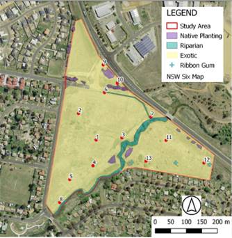
Figure 6 – Terrestrial Ecology Study Area,
Sample Locations and Vegetation types (Premise)
In terms of terrestrial fauna
and habitat, the REF states that the study area has been highly modified from
its original form via 200 years of European occupation.
There were no
hollow-bearing trees with large or small hollows observed within the study
area, nor were there logs or fallen branches, cliffs or rocky outcrops. There
were some surface rocks at the base of the remnant Ribbon Gum trees to the east
of the site, however, these provide very little habitat value for reptiles as
they are shadowed by very tall exotic grasses. The drainage line running from
the end of Phillip Street to Blackmans Swamp Creek provides limited habitat for
amphibians due to choking by reeds and grasses. One frog species was heard
calling onsite, identified as the Common Eastern Froglet (Crinia signifera).
Tall seeding grasses were present on the site, which provide important food
resources for parrots. There was no mistletoe observed on the study area.
Introduced fruit trees, likely garden escapees from nearby gardens, were
producing apples and pears at the time of survey in February 2021. These fruits
would provide food for parrots and possums.
Notwithstanding, three (3)
threatened fauna species were identified which may have suitable habitat on the
study area. These include the Blue-billed Duck, Superb Parrot and Grey‑headed
Flying Fox. The REF provides the following significance assessment:
· The
Blue-billed Duck relies on large permanent water bodies with dense reeds and
rushes for shelter and nesting. While Blackmans Swamp Creek is not a large dam
or lake the species has been recorded from Spring Creek Reservoir near Orange.
The species is partly migratory and there is potential for the species to
use the creek on the study area while travelling between overwintering and
breeding sites.
· Superb
Parrots inhabit eucalypt woodlands and open forests and require tree hollows
for nesting and breeding. Their diet consists of grass seeds, nectar, fruits
and herbaceous plants. The species has been recorded many times in urban areas
of Orange where it forages particularly in dry periods. There is no breeding or
nesting habitat available for the species on the study area.
· The
Grey-headed Flying Fox has a resident population in Cook Park in Orange.
Flowering eucalypts are present on the study area, and close proximity to a
water source is a feature of camp sites used by the species. However, the lack
of native flowering shrubs such as Banksia., Callistemon or species which
produce soft, fleshy fruit means that the site is unlikely to be a permanent
‘camp site’ and will only provide seasonal forage when trees are in
flower.
In addition, the impact of the proposed
activity has been assessed using the five part test and it was concluded that
the proposed Activity is not considered likely to have an adverse impact on the
life cycle or habitat of any of the three threatened species. Nor will the
proposed activity remove, modify or fragment the habitat of the subject
species. A Species Impact Statement or triggering of the Biodiversity Offsets
Scheme is not required for any of the three fauna species.
Lastly, REF has
recommended that the following strategies are employed to ensure minimal impact
on biodiversity:
· Machinery
will be stored away from riparian areas to minimise compaction and disturbance
of riparian vegetation where possible.
· Machinery,
equipment and materials will be stored away from the base of trees and beyond
the drip line of trees where practical.
· Retain
the three mature Eucalyptus trees identified in the area east of the Creek to
be utilised for placement of surplus excavation from construction of the
wetland.
· Topsoil
will be stockpiled onsite to be reinstated at the completion of works.
· Fauna
searches will be conducted prior to earthmoving (inspection of trees, timber on
the ground, rocks). Any fauna identified or injured will be handled by WIRES.
· Dust
suppression measures will be put in place during earthworks.
· Excavated
material will be transported to the overburden sites using designated tracks.
· Ground
exposed during construction will have topsoil replaced and be planted with
native species to stabilise the soil and assist with restoration of native
groundcovers.
Topography, Geology, Soils & Geomorphic Assessment
Whilst
there will be a substantial volume of soil excavated and moved as a result of
the proposed wetland, the REF concludes that no significant impacts are
foreseen, and safeguards and mitigation measures including sediment and erosion
control are include in the project plan.
Furthermore,
a geomorphic assessment of Blackmans Swamp Creek and Summer Hill Creek is
proposed as part of the EOHW operations. This assessment will be undertaken to
determine the magnitude of fresh required to mobilise sediment, scour algae and
maintain habitat in lower reaches of the Summer Hill Creek system.
A Preliminary Site Investigation has also
been undertaken on the western side of the creek where excavation will occur
pursuant to State Environmental Planning Policy 55 – Remediation of Land.
Asbestos material was identified in an area of 40m x 60m (Figure 7). Remediation
of asbestos-contaminated soil is required to be conducted in accordance with
the requirements for removal of friable asbestos (based on the weathered
condition of fragments), as documented in Section 7.1 ‘Removing
asbestos-contaminated soil’ of the SafeWork NSW (August 2019) ‘Code
of Practice – How to safely remove asbestos’. Following remediation
of asbestos impacted soil, a clearance inspection of the remediation area is
required to confirm the residual soil surface is consistent with VENM, or that
no asbestos fibres/fragments are present in validation samples collected from
the residual soil surface.
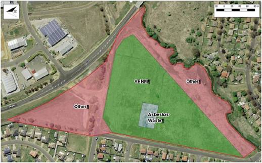
Figure 7 – Site
Investigation
Naturally
occurring asbestos has been assessed in an area surrounding the site. The REF
advises that geotechnical investigations being undertaken across the site have
identified traces of serpentinite rock at depths of greater than 2.2m toward
the southern end of the site. In accordance with the Work Health and Safety Act
and Regulation, and also Section 3 of the Orange City Council’s Asbestos
Management Plan (2014), a site specific Asbestos Management Plan is to be
required to be developed and implemented prior to the commencement of any works
on the site.
With the exception of the
presence of asbestos, the REF advises that concentrations of chemicals of
potential concern (COPC) in soil and sediment samples across the site were less
than the assessment criteria for the respective analyses. The soil
investigation levels for this investigation are consistent with those described
within the National Environment Protection Council (NEPC), Amended National
Environment Protection (Assessment of Site Contamination) Measure 1999 (Amended
ASC NEPM) 2013.
Air Quality
Air
emission sources during construction include particulate matter and
plant/vehicle emissions. Particulate matter is a result of fugitive dust
sources produced during construction from, clearing of groundcover and topsoil,
earthmoving and transport of construction materials.
The
quantity of emissions from the construction works are dependent on a range of
factors, including the characterisation of the soil materials (e.g. silt and
moisture content), the construction methods adopted, local wind conditions, and
the presence and density of vegetation in the area. It is noted, however, that
these impacts are likely to be temporary and localised, and best practice
management and mitigation measures can adequately address relevant goals for
dust deposition, and control and minimise potential impacts.
Vehicle
emissions include petrol and diesel-fuelled vehicles and operation of onsite
machinery. The emission rates and impact potential would depend on power output
of combustion engines, quality of fuel and condition of combustion engines.
Odour may be detected close to the source; however, given the short term nature
of construction works, the potential for odour impacts are minimal.
Provided
the construction contractor meets the requirements of relevant legislation,
regulations, and operates in accordance with the Environmental Protection
Licence, the proposed works are unlikely to result in air quality impacts and
are therefore not considered to be significant.
Noise and vibration
Wetland construction works will
entail the operation of various earthmoving plant and equipment, including
scrapers, dozers, excavators, graders and haul trucks. Given residential
receptors on two sides of the site of the proposed works, there may be some
community reaction to noise. In this regard, the REF provides the following
mitigation measures to ensure noise impacts are kept at a minimum:
· No
works outside the recommended standard hours.
· The
contractor, based on its construction program, submit a Noise Management Plan
consistent with the ICNG, for inclusion in the CEMP and EPL application.
· Inform
all potentially impacted residents of the nature of works to be carried out,
the expected noise levels and duration, as well as contact details for
reporting complaints.
It is also noted
that securing an EPL from the EPA will contain licence conditions with respect
to noise.
Aboriginal Heritage
An archaeological survey of the
site was undertaken by OZArk Environmental and Heritage Management (OzArk),
Premise Pty Ltd and with participation by the Orange Local Aboriginal Land
Council (OLALC), consistent with the requirements of the Due Diligence Code of
Practice for the Protection of Aboriginal Objects in New South Wales.
The report advises that visual
inspection did not record any Aboriginal sites or identify any landforms that
have potential to contain subsurface archaeological deposits. Further, there
are no previously recorded sites that will be harmed by the activity. The
archaeological assessment concluded that there is a low likelihood that the
proposed work will adversely harm Aboriginal cultural heritage items or sites.
Furthermore, the REF determined
that no Aboriginal objects or intact archaeological deposits will be
harmed and that works may proceed without
further archaeological investigation, subject to adoption of mitigation
measures. These measures include
· All
staff and contractors involved in the proposed work should be made aware of the
legislative protection requirements for all Aboriginal sites and objects.
· If
Aboriginal artefacts or skeletal material are noted, all work should cease and
the procedures in the Unanticipated Finds Protocol should be followed.
· Work
crews should undergo cultural heritage induction to ensure they recognise
Aboriginal stone artefacts, particularly those commonly found within the Orange
area and are aware of the legislative protection of Aboriginal objects under
the National Parks and Wildlife Act 1974 and the contents of the Unanticipated
Finds Protocol.
Non-Aboriginal Heritage
An inspection of the area within
the immediate vicinity of the proposed wetland did not reveal any significant
non-Aboriginal heritage items. Furthermore, a review of the online
NSW Heritage Database, which encompasses items listed under the
NSW Heritage Register, does not list any heritage items within the immediate
vicinity of the site.
The REF, however, advises that an
extant partial structure is located onsite within Lot 101 DP 857925. A
review of historic aerial imagery shows that several buildings had been
constructed in this lot as early as 1954, consisting of a dwelling and
agricultural use sheds, with associated access roads and tracks. These
structures were relatively still intact up until 1989, however, some buildings
have been demolished between 1993 -2003. By 2014 the structures are mostly
gone, with only the partial structural remnants extant on the land today. The historic built fabric in this area does not retain
any heritage significance and is in poor condition. This structure is
scheduled to be demolished in conjunction with construction of proposed
wetland. The removal of this structure will need to be undertaken in
accordance with Australian Standard AS 2601—1991: The
Demolition of Structures.
There were no other heritage
items were observed during the inspection and the potential for discovering other
non-heritage items in this area is relatively low. Notwithstanding, a
precautionary principle must apply.
The entire NSW Heritage Act
protects heritage, but historical archaeological remains are additionally
protected from being moved or excavated through the ‘relics’
provisions. The provisions protect unidentified ‘relics’ which
may form part of the State’s environmental heritage, but which have not
been listed on the State Heritage Register. An archaeological site is an
area of land which is the location of one or more archaeological
‘relics’. Section 4(1) of the Heritage Act (as amended
2009) defines ‘relic’ as follows:
any
deposit, artefact, object or material evidence that; (a) relates to the
settlement of the area that comprises New South Wales, not being Aboriginal
settlement, and (b) is of State or local heritage significance.(OEH, 2009).
The following safeguards are to
be implemented to minimise potential disturbance by the proposed bridge
demolition and construction works:
· All land-disturbing activities must be confined within
the assessed proposal. Should project impacts change such that the area to be
impacted is altered, then additional assessment may be required.
· While no items of historic heritage were identified, work
crew employed in ground disturbing work within the impact footprint should be
made aware of the legislative protection of historic sites and relics.
· In the even any historic relics are discovered during
excavation or drilling, work will cease immediately at the specific location
and the NSW Heritage Council contacted for further directions.
Waste Management
Several types of waste will arise from the project which
will be disposed of and managed in line with legislation.
Socio-Economic Effects
Construction of the proposed
East Orange Harvesting Wetland would result in a change in land use, with the
land currently being undeveloped open grassland. However, post‑construction,
and as the landscaping and amenities across the precinct become established,
the ecological, cultural, educational and
recreational values in the locality will be enhanced with benefits for the community.
STAKEHOLDER ENGAGEMENT
The
REF was exhibited between 27 March 2021 and 26 April 2021 receiving
five (5) public submissions. The
submissions received represent a range of stakeholders with a direct and
legitimate interest in the impacts of the proposed wetland. These include
downstream water licence holders and rural land owners with basic rights to
water; the Summer Hill Creek Landcare Inc., Ophir Reserve Trust; Orange and
Region Water Security Association, and Environmentally Concerned Citizens of
Orange. (ECCO). Principally, the concerns raised by the submission writers
relate to impacts on the downstream environment, including water flows and
quality and aquatic and terrestrial ecology including habitat. A copy of all
submissions received are included in the attachments.
The
Department of Primary Industries (Fisheries) and
the Natural Resource Access Regulator were also consulted.
These
agencies provided comments/advice relating to the REF assessment on Key Fish
Habitat, hydrology, aquatic ecology, geomorphology and monitoring/maintenance
components. It needs to be noted that some of the comments received by NRAR and
DPI Fisheries relate to requirements for approvals/permits under the Water
Management Act 2000 and Fisheries Management Act 1994 which are
required to be obtained following the determination of the REF. A copy of the
advice received from these agencies are included as attachments.
The
matters raised by public and government agencies have been addressed by the
proponent’s environmental consultants via an addendum report (attached).
CONCLUSION
Under
Section 5.5 of the EP&A Act, Orange City Council is responsible for
assessing all matters affecting or likely to affect the environment from this
activity. In this regard, the proponent commissioned Premise Pty Ltd to prepare
a Review of Environmental Factors (REF) to address the heads of
consideration outlined in Clause 228 of the Environmental Planning and
Assessment Regulation 2000 and to inform the determination process.
The REF provides a comprehensive
outline of the project, neatly summarising pages of analysis as well as clearly
determining that the project will not cause undue impact to the downstream
environment. The REF concludes that
it’s “not likely” there will be a significant adverse
downstream impact because:
· Low
flows in Blackmans Swamp Creek will continue to be protected.
· There
is no need or intent to change the current operating rules that regulate the
existing Blackmans Swamp Creek Stormwater Harvesting Scheme.
· The
(wetland) will enhance Council’s capacity to provide the licensed
environmental flow releases into Summer Hill Creek from Suma Park Dam.
· Spills
from Suma Park Dam into Summer Hill Creek will be more frequent as a result of
the EOHW.
· The
wetland will be subject to monitoring, reporting and adaptive management as
part of the Orange Raw Water Supply Operation Environmental Management Plan
(OEMP). This management plan incorporates a decision making framework that sets
out specific actions that may be required to be implemented in order to reduce
impacts identified as a result of the required monitoring.
Council is
required to implement reasonable and feasible mitigation measures where the
need for action is identified through the monitoring programs. One of the
specific objectives of the approved Adaptive Management Strategy forming part
of the OEMP is to determine if environmental flow releases maintain or enhance
the key values of water quality, aquatic biodiversity, river health and the
general ecological condition of Summer Hill Creek. These requirements are
visible and enforceable and provide the capacity, science and obligation for
Council to operate the wetland in a manner that avoids a significant downstream
impact.
The REF
also recommends mitigation measures to minimise impacts and to protect the
environment. These, together with Council's standard conditions, form part of
the determination.
Staff concur with the findings
of the REF. It is concluded that Council has satisfied its obligations under
Part 5 of the EP&A Act 1979 and that the project can proceed.
However, works cannot commence until NRAR issues a Water Supply Works Approval
under the Water Management Act 2000 and DPI Fisheries issue a permit under the
Fisheries Management Act 1994. An Environmental Protection Licence will also
need to be secured.
Attachments
1 Entura
Review and Addendum, D21/44106⇩
2 DPI
Fisheries comments, D21/44114⇩
3 NRAR
comments, D21/44116⇩
4 Response
to NRAR comments, D21/44118⇩
5 Submissions,
D21/44130⇩
Extraordinary
Council Meeting
27 July 2021
Attachment 1 Entura
Review and Addendum
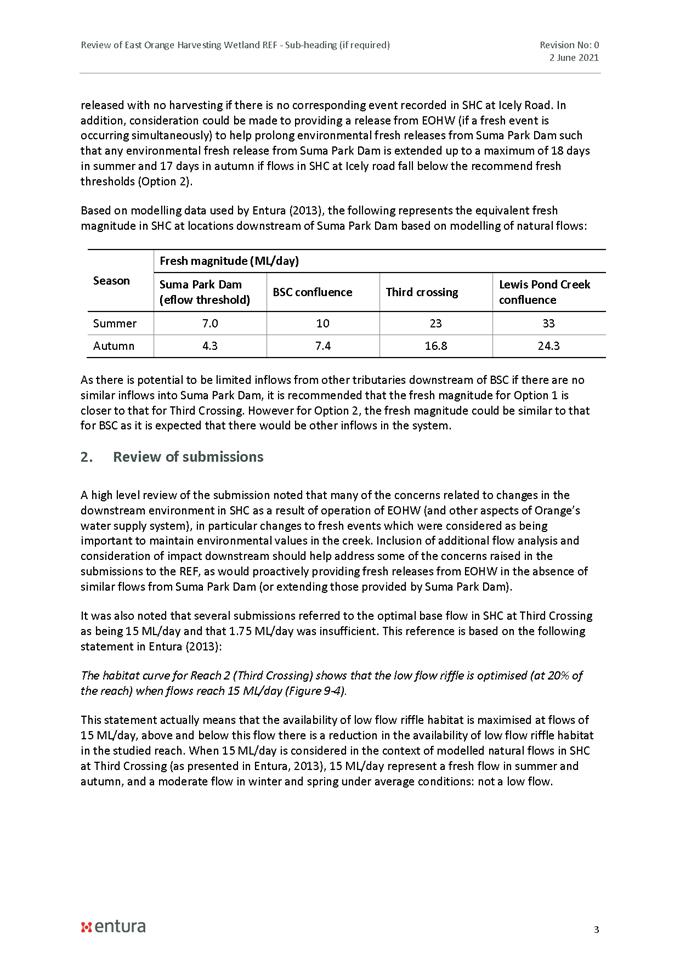
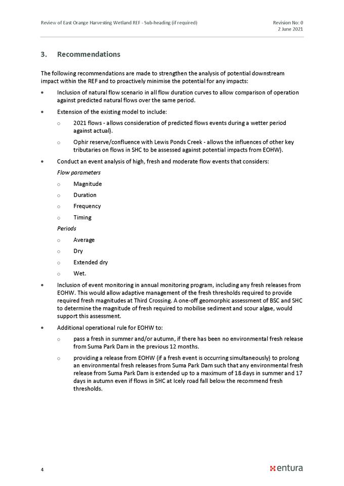
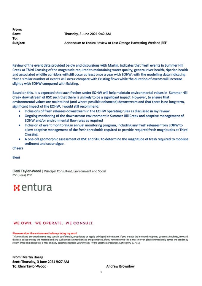
Extraordinary Council Meeting
27 July 2021
Attachment 2 DPI
Fisheries comments
Extraordinary Council Meeting
27 July 2021
Attachment 3 NRAR
comments
Extraordinary Council Meeting
27 July 2021
Attachment 4 Response
to NRAR comments
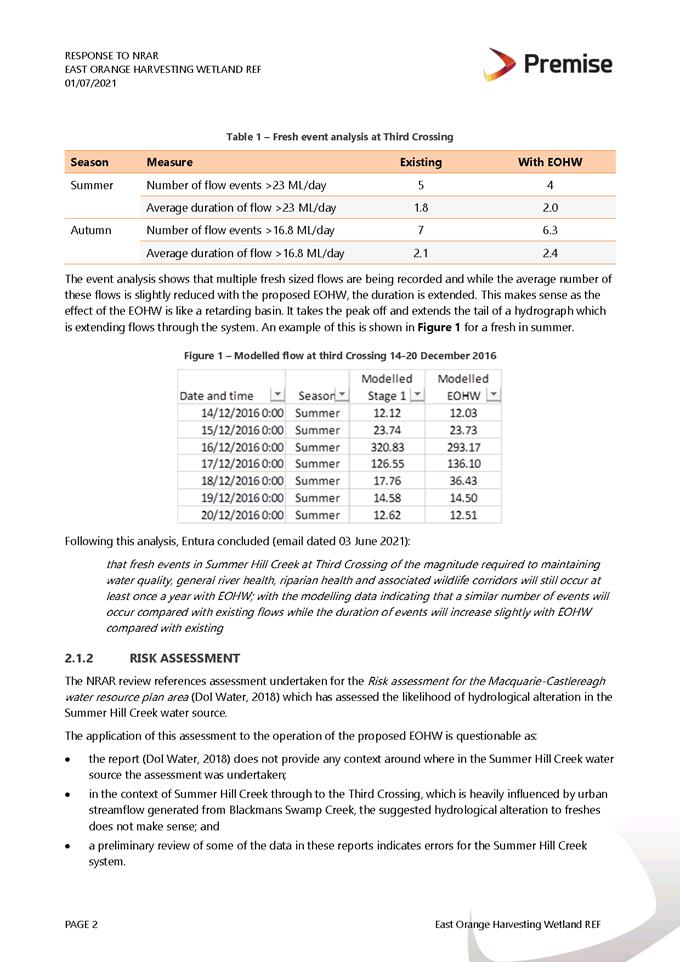
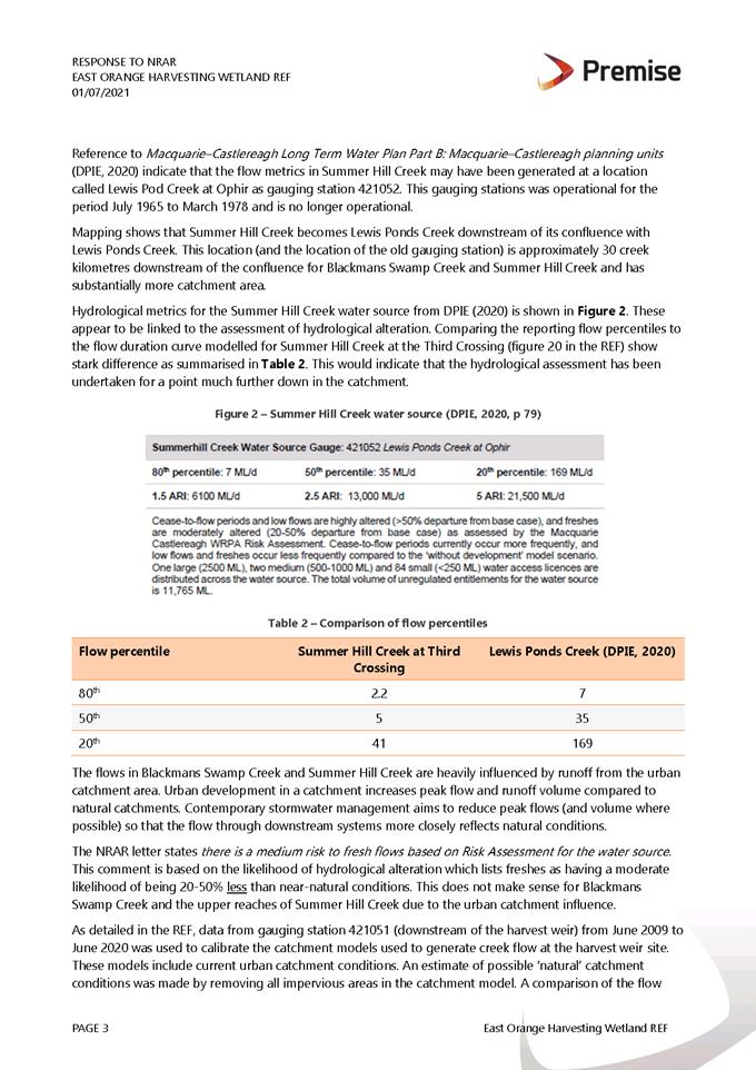
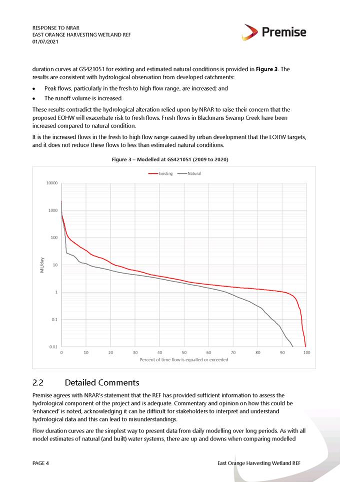
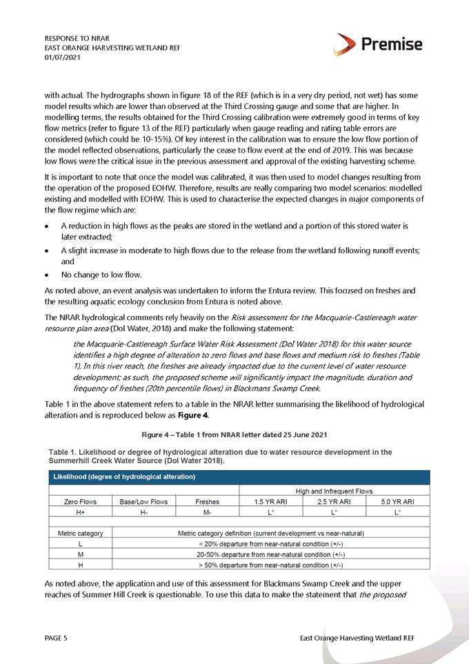
Extraordinary Council Meeting
27 July 2021
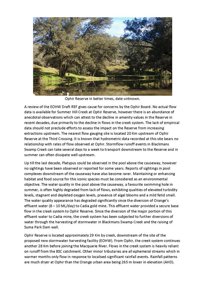
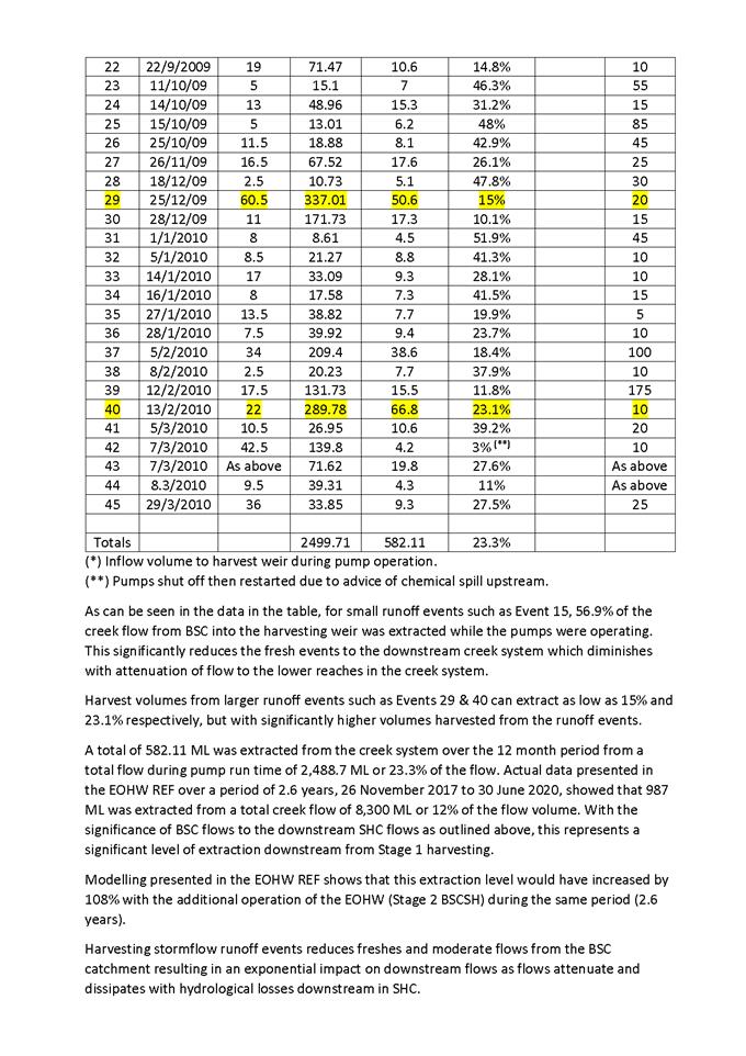
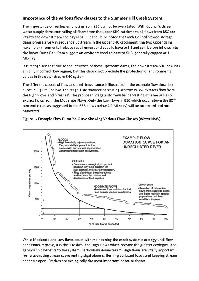
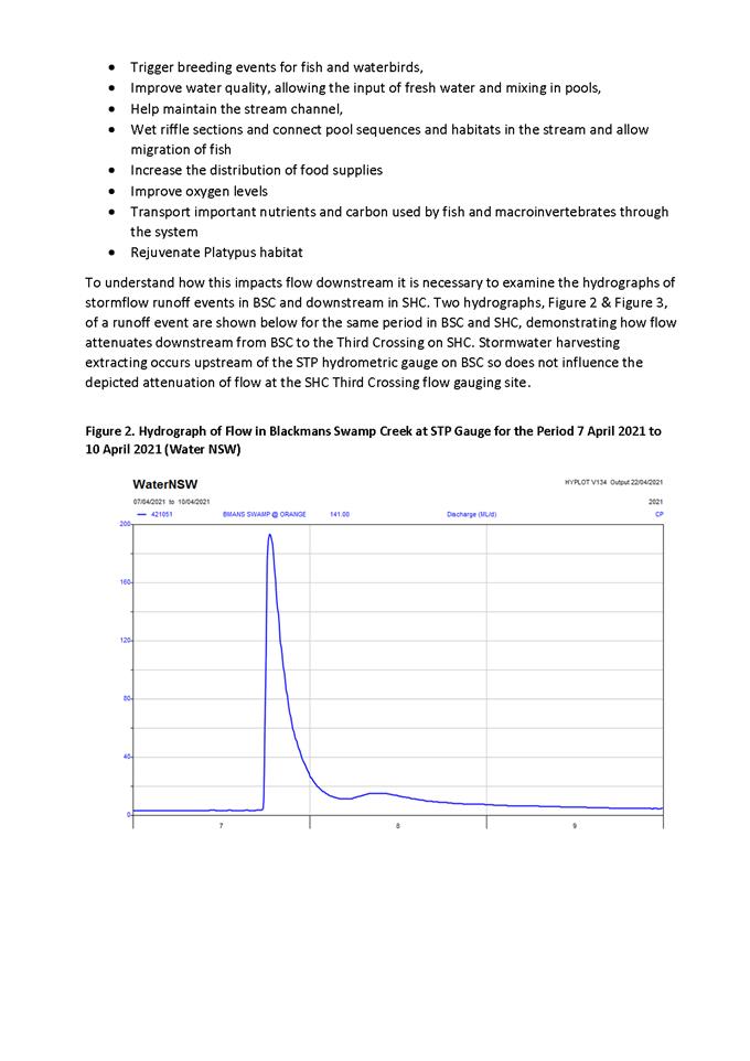
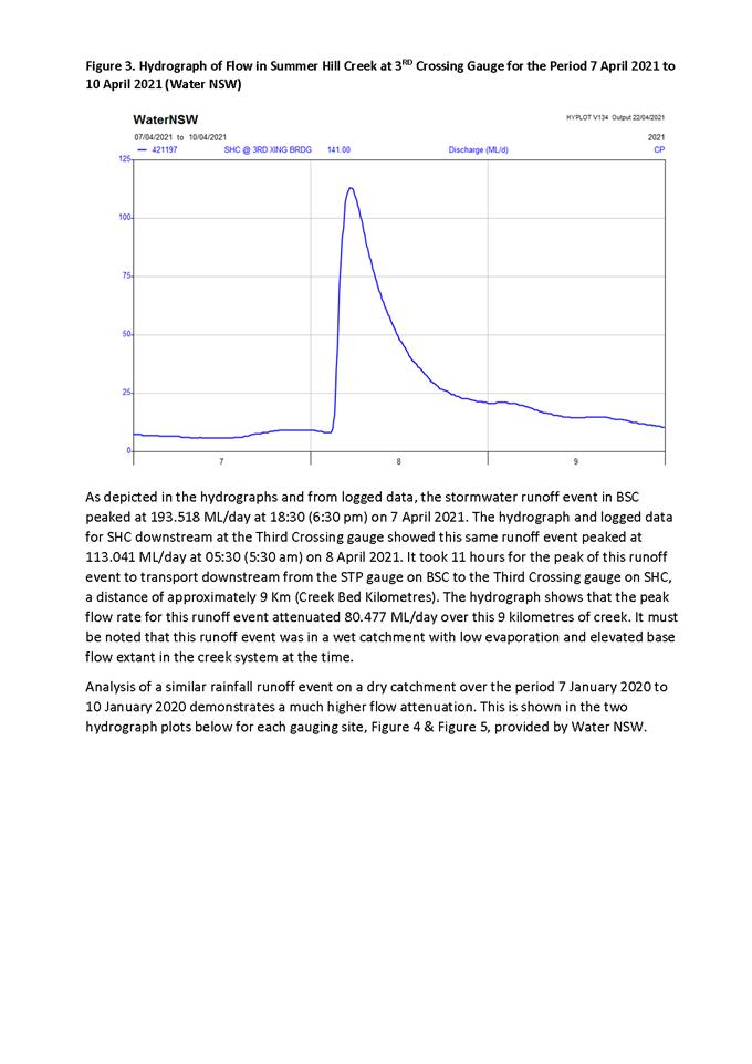
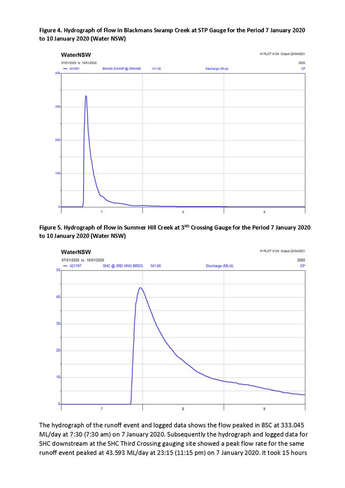
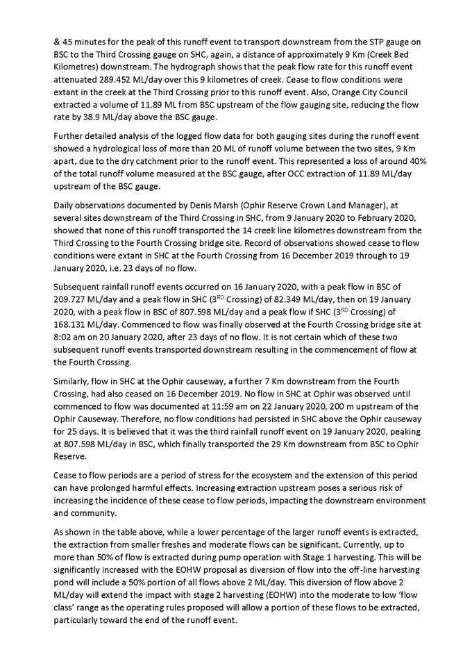
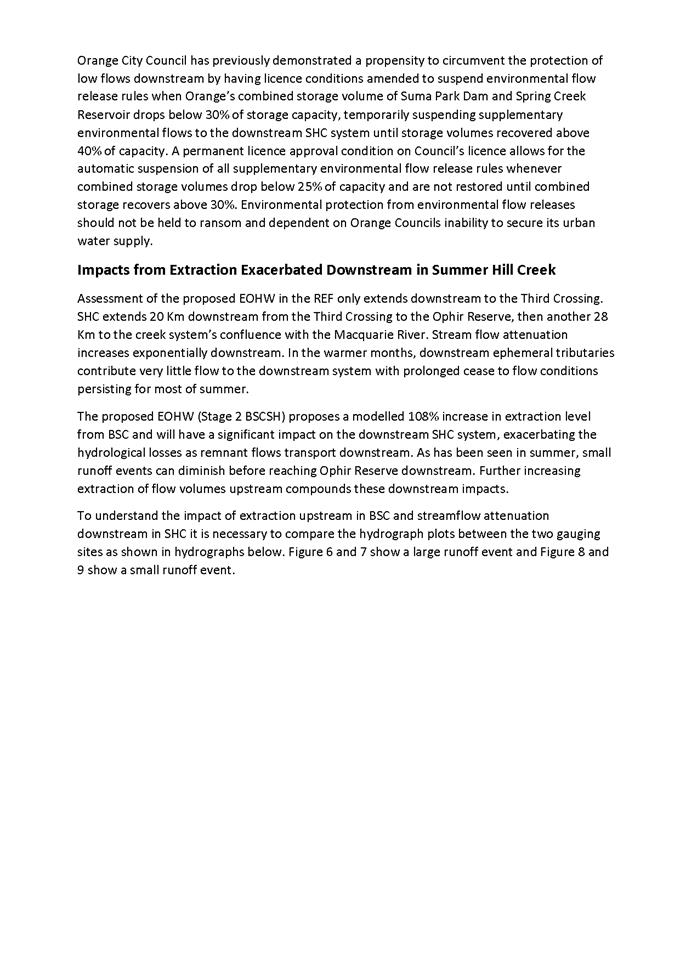
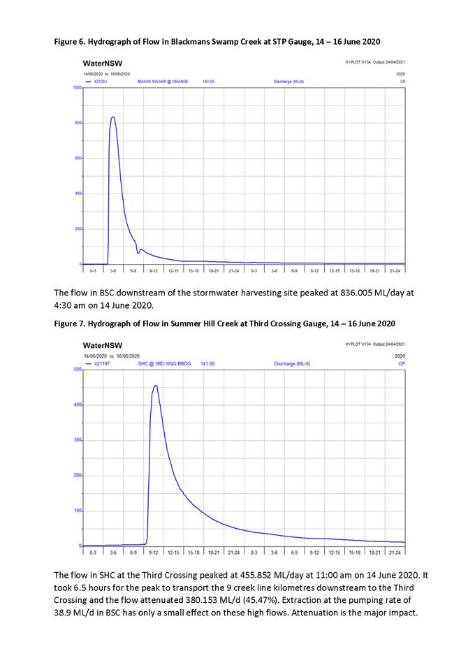
5.12 Development
Application DA 138/2021(1) - 85-87 March Street
RECORD
NUMBER: 2021/1411
AUTHOR: Summer
Commins, Senior Planner
EXECUTIVE
Summary
|
Application
lodged
|
7 April
2021
|
|
Applicant/s
|
Southwell
Design Drafting
|
|
Owner/s
|
Mr SJ
Alford and Miss TL Harrison
|
|
Land
description
|
Lot 1 DP
779381 – 85 March Street, Orange
|
|
Proposed
land use
|
Dwelling Alterations and Additions
(change of use from restaurant), Subdivision (two lot Torrens title), and
Dwelling and Attached Garage (new construction - two storey)
|
|
Value of
proposed development
|
$1,200,000.00
|
Council's consent is sought for
redevelopment of the site and building known as the former 1870 Restaurant
at 85 March Street.
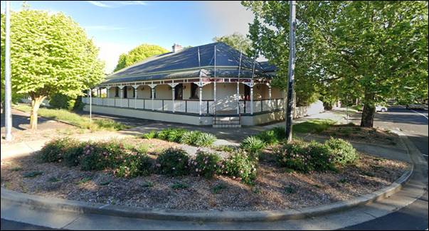
Figure 1 – subject building
The proposal involves the
following works:
· Change of use of
the restaurant to a dwelling house, including part demolition, internal
alterations and a pavilion addition to the west with frontage to March Street.
· Two lot Torrens
subdivision of the land to excise the dwelling (former restaurant) on a
separate parcel, and create a vacant development lot with frontage to Hill
Street.
· Construction of a
dwelling house on the development lot, containing three (3) bedrooms, two
(2) bathrooms and basement level double garage.
The proposal comprises advertised development pursuant to
Council’s Community Participation Plan 2019.
At the completion of the public
notice and exhibition period, three (3) submissions had been received. The
issues raised in the submissions generally relate to the suitability of the
building design for the proposed and converted/extended dwelling.
The subject building is a Local heritage item, and located
in the Central Orange Heritage Conservation Area. Council’s Heritage
Advisor has assessed the proposal and considers that the development is
acceptable subject to minor mitigation measures. The proponent is amenable to
the recommendations, which are included as Conditions.
As outlined in this report, the
proposal is considered to reasonably satisfy the Local and State planning
controls that apply to the subject land and particular landuse. Impacts of the
development will be within acceptable limit, subject to mitigation conditions.
Approval of the application is recommended.
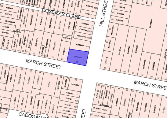
Figure 2 – locality plan
DECISION FRAMEWORK
Development in Orange is governed by two key documents Orange
Local Environment Plan 2011 and Orange Development Control Plan 2004. In
addition the Infill Guidelines are used to guide development, particularly in
the heritage conservation areas and around heritage items.
Orange Local Environment Plan 2011 – The provisions
of the LEP must be considered by the Council in determining the application.
LEPs govern the types of development that are permissible or prohibited in
different parts of the City and also provide some assessment criteria in
specific circumstances. Uses are either permissible or not. The objectives of
each zoning and indeed the aims of the LEP itself are also to be considered and
can be used to guide decision making around appropriateness of development.
Orange Development Control Plan
2004 – the DCP provides guidelines for development. In general
it is a performance based document rather than prescriptive in nature. For each
planning element there are often guidelines used. These guidelines indicate
ways of achieving the planning outcomes. It is thus recognised that there may
also be other solutions of merit. All design solutions are considered on merit
by planning and building staff. Applications should clearly demonstrate how the
planning outcomes are being met where alternative design solutions are
proposed. The DCP enables developers and architects to use design to achieve
the planning outcomes in alternative ways.
DIRECTOR’S COMMENT
The proposal involves redevelopment of the heritage site and
building known as the former 1870 Restaurant at 85 March Street. The existing
heritage building is proposed to be converted and extended to a dwelling,
subdivision is proposed to create an additional lot and the construction of a
new dwelling on the new vacant parcel. Council staff together have assessed the
proposal and consider that the development is acceptable subject to the
inclusion of additional minor design features. The applicant is amenable to the
design features. The garage and house additions that front March Street is
similar in design to other houses in the area, as is the proposed cottage
fronting Hill Street.
Three (3) public submissions were received objecting to the
DA. The issues raised in the submissions generally relate to the
suitability of the building design and detailing. The matters raised in the
submissions have been addressed in the report. Impacts of the development will
be within acceptable limits, subject to mitigation conditions being adopted.
Approval of the application is recommended.
Link To Delivery/OPerational Plan
The recommendation in this report relates to the
Delivery/Operational Plan strategy “10.1 Preserve - Engage with the
community to ensure plans for growth and development are respectful of our
heritage”.
Financial Implications
Nil
Policy and Governance Implications
Nil
|
Recommendation
That Council consents to
development application DA 138/2021(1)
for Dwelling Alterations and Additions (change of use from restaurant),
Subdivision (two lot Torrens title), and Dwelling and Attached Garage (new
construction – two storey) at Lot 1 DP 779381 –
85 March Street, Orange pursuant to the conditions
of consent in the attached Notice of Approval.
|
further considerations
Consideration has been given to the recommendation’s
impact on Council’s service delivery; image and reputation; political;
environmental; health and safety; employees; stakeholders and project
management; and no further implications or risks have been identified.
SUPPORTING INFORMATION
THE PROPOSAL
Consent is sought for a staged residential development of
the subject land as follows.
Stage 1
The proposal involves change of use of the former restaurant
to a dwelling, and alterations and additions to the building.
The northern (recent) portion of the building will be demolished
and internal commercial fittings and fixtures removed. A metal shed and
hardstand carpark in the northern portion of the site will also be removed.
The original building will be converted to a dwelling house.
The building will be extended to the north at the Hill Street frontage to
provide a new bedroom and bathroom. A pavilion addition on the west side with
frontage to March Street will connect to the original building via a link, and
contain a double garage, bedrooms and wet areas.
The converted and extended dwelling will contain five (5)
bedrooms, three (3) bathrooms and living spaces.
Stage 2
The proposal involves two lot Torrens subdivision of the
land.
The converted and extended dwelling will be excised on
proposed Lot 1b. This lot will comprise site area of 669m2. The
parcel will have access and primary frontage to March Street, and
secondary frontage to Hill Street.
Proposed Lot 1a will be created as a vacant development lot.
The parcel will have site area of 523m2, and access and frontage to
Hill Street.
Stage 3
The proposal involves construction of a dwelling house on
proposed Lot 1a. The dwelling will contain a basement double garage, and ground
level accommodation including three (3) bedrooms, two (2) bathrooms,
separate guest/study and open plan living spaces.
The dwelling will present a traditional form at the site
frontage with hip and gable roof profile, verandah decoration and symmetrical
openings. The rear portion of the dwelling will be contemporary in styling with
skillion roof profile and expansive northern glazing.
The proposed site layout and
building designs are depicted below.
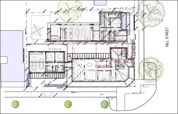
Figure 3 – proposed site layout

Figure 4 – proposed March Street
elevation – pavilion addition to the left of image

Figure 5 – proposed Hill Street
elevation – new dwelling on Lot 1a
MATTERS FOR CONSIDERATION UNDER
THE ENVIRONMENTAL PLANNING AND ASSESSMENT ACT 1979
Section 1.7 - Application of
Part 7 of the Biodiversity Conservation Act 2016 and Part 7A of the
Fisheries Management Act 1994
Pursuant to Section 1.7:
This
Act has effect subject to the provisions of Part 7 of the Biodiversity Conservation Act 2016 and Part 7A of the Fisheries Management Act 1994 that relate to the operation of this Act in connection
with the terrestrial and aquatic environment.
In consideration of this section, the development is not
likely to give rise to any significant impact upon any endangered ecologically
communities, threatened species or their habitat. The subject and adjoining
lands are not identified as biodiversity sensitive on the Orange LEP 2011 Terrestrial
Biodiversity Map. The proposal does not involve removal of native
vegetation. The land is a highly disturbed urban environment. A Biodiversity
Assessment Report is not required in support of the proposal.
Section 4.15 Evaluation
Provisions of any Environmental Planning Instrument
S4.15(1)(a)(i)
Orange Local Environmental Plan 2011
Part 1 - Preliminary
Clause 1.2 Aims of Plan
The
particular aims of Orange LEP 2011 relevant to the proposal include:
(a) to encourage development which complements
and enhances the unique character of Orange as a major regional centre boasting
a diverse economy and offering an attractive regional lifestyle,
(b) to provide for a range of development
opportunities that contribute to the social, economic and environmental resources
of Orange in a way that allows present and future generations to meet their
needs by implementing the principles for ecologically sustainable development,
(e) to provide a range of housing choices in
planned urban and rural locations to meet population growth,
(f) to recognise and manage valued
environmental heritage, landscape and scenic features of Orange.
It is considered that the proposed development will not be
adverse to the above-listed Aims, as outlined in this report.
Clause 1.6 Consent Authority
Clause 1.6 is applicable and
states:
The consent authority for the purposes of this Plan is
(subject to the Act) the Council.
Clause 1.7 Mapping
The subject site is identified
on the LEP maps in the following manner:
|
Land Zoning Map:
|
Land zoned R1 General Residential
|
|
Lot Size Map:
|
No Minimum Lot Size
|
|
Heritage Map:
|
A Local heritage item, nearby to
other Local heritage items and within the Central Orange Heritage
Conservation Area
|
|
Height of Buildings Map:
|
No building height limit
|
|
Floor Space Ratio Map:
|
No floor space limit
|
|
Terrestrial Biodiversity Map:
|
No biodiversity sensitivity on the
site
|
|
Groundwater Vulnerability Map:
|
Groundwater vulnerable
|
|
Drinking Water Catchment Map:
|
Not within the drinking water
catchment
|
|
Watercourse Map:
|
Not within or affecting a defined
watercourse
|
|
Urban Release Area Map:
|
Not within an urban release area
|
|
Obstacle Limitation Surface Map:
|
No restriction on building siting
or construction
|
|
Additional Permitted Uses Map:
|
No additional permitted use applies
|
|
Flood Planning Map:
|
Not within a flood planning area
|
Those matters that are of relevance are addressed in detail
in the body of this report.
Clause 1.9A Suspension of
Covenants, Agreements and Instruments
Clause 1.9A is applicable and states in part:
(1) For the purpose of enabling
development on land in any zone to be carried out in accordance with this Plan
or with a consent granted under the Act, any agreement, covenant or other
similar instrument that restricts the carrying out of that development does not
apply to the extent necessary to serve that purpose.
In
consideration of this clause, Council staff are not aware of the title of the
subject property being affected by a relevant agreement, covenant, etc.
Part 2 - Permitted or Prohibited Development
Clause
2.1 Land Use Zones
The
subject land is zoned R1 General Residential.
The
proposal is defined as:
· Dwelling house (change
of use, and alterations and additions)
· Subdivision of
land
· Dwelling house (new
construction).
The
proposal is permitted with consent in the R1 zone.
Clause 2.3 Zone Objectives and Land Use Table
The objectives of the R1 General Residential zone are:
· To provide for
the housing needs of the community.
· To provide for
a variety of housing types and densities.
· To enable other
land uses that provide facilities or services to meet the day to day needs of
residents.
· To ensure
development is ordered in such a way as to maximise public transport patronage
and encourage walking and cycling in close proximity to settlement.
· To ensure that
development along the Southern Link Road has an alternative access.
The proposed development will
satisfy the relevant R1 zone objectives. The proposal will provide additional
housing stock to accommodate housing needs. Infill housing represents orderly
development of land. Infill housing nearby to the CBD is good planning
practice.
Clause 2.6 Subdivision -
Consent Requirements
Clause 2.6 is applicable and
states:
(1) Land
to which this plan applies may be subdivided, but only with development
consent.
Consent is sought for a two (2) lot Torrens subdivision of
the land in accordance with this clause.
Clause 2.7 Demolition Requires
Development Consent
Clause 2.7 is applicable and
states:
The demolition of a building or work may be carried out
only with development consent.
Consent is sought for part demolition of the former
restaurant (later additions) and detached shed in accordance with this clause.
Conditions are included in relation to waste management and compliance with
applicable Standards.
Part 3 - Exempt and Complying Development
The application is not exempt or complying development.
Part 4 - Principal Development Standards
The
Principal Development Standards do not apply to the subject land or proposed
development.
It is
noted that the proposal involves Torrens subdivision. The land is not subject
to a minimum lot size on the Lot Size Map pursuant to Clause 4.1.
Part 5 - Miscellaneous Provisions
Clause 5.10 Heritage
Conservation
The development site and building comprise a Local heritage
item: Item 31 – Restaurant (former inn). Furthermore, the subject
land is located within the Central Orange Heritage Conservation Area, and
nearby to other Local heritage items.
Clause 5.10 is applicable and states
in part:
(4) The
consent authority must, before granting consent under this clause in respect of
a heritage item or heritage conservation area, consider the effect of the
proposed development on the heritage significance of the item or area
concerned…
The
proposed development was referred to Council’s Heritage Advisor (HA)
for advice. The HA provided the following paraphrased comments in relation to
each element of the proposed development:
· Change of use
to a dwelling house is supported.
· Non-significant
(recent) elements of the former restaurant will be removed during demolition
works.
· The design of
the western pavilion addition offers mitigation in the form of supplementary
planting and traditional pergola. Garages at the street frontage feature in
this streetscape.
· Minor design
modifications are required to the proposed dwelling at the Hill Street
frontage, in order for the dwelling to be understood as a contemporary design.
· Landscaping is
required on the northern boundary (and elsewhere) to screen the contemporary
character of the proposed dwelling within the conservation setting.
The
Heritage Advisor considers that the proposed development will not adversely
impact on the significance of the site or setting, subject to the following
mitigation measures:
· Archival recording
of the former restaurant prior to part-demolition.
· In relation to the
converted and extended dwelling:
- a colour scheme
appropriate to the period and style shall be nominated on the drawings
- traditional rolled
flashings with painted timber fascia, smooth unperforated quad gutters in
galvanised steel shall be nominated on the drawings
- circular downpipes
painted to match the wall colour shall be nominated on the drawings
- windows on Hill
Street façade to be timber construction.
· In relation to the
western pavilion addition:
- driveway to be
gravel-finished concrete driveway surface
- pergola detailing to
include timber battens beneath the main cross beams
- the garage doors to
comprise painted timber
- the roof to be hipped
at the two ends
- windows on the March
Street elevation to be timber construction.
· In relation to the
new dwelling to Hill Street:
- the garage door to
comprise painted timber
- windows on the Hill
Street facade to be timber construction
- verandah balustrade
to comprise simple steel flats
- window canopy to
comprise a contemporary frame without replica details
- alternative detail to
sheeted gable
- window fenestration
to gable on Hill Street façade to comprise three (3) contemporary
windows.
· Preparation and
implementation of a landscape plan relating to the site perimeters,
particularly the street frontages and on the northern boundary adjoining the
dwelling at 115 Hill Street.
Conditions
are included on the attached Notice of Approval to reflect the specific
requirements of the Heritage Advisor, as they relate to materials, colours,
finishes and landscaping. The proponent is amenable to the above-listed
recommendations.
Subject to compliance with conditions, it is considered that
the proposed development will not adversely impact on the significance of the
heritage site or setting pursuant to Clause 5.10(4). Furthermore, the
proposed development will satisfy the Assessment Criteria contained in the DCP
Infill Guidelines as they relate to Character; Scale and Form; Siting;
Materials and Colour; and Detailing.
Part 6 - Urban Release Area
Not relevant to the application. The subject site is not
located in an Urban Release Area.
Part 7 - Additional Local Provisions
Clause 7.3 Stormwater Management
Clause 7.3 is
applicable. This clause states in part:
(3) Development
consent must not be granted to development on land to which this clause applies
unless the consent authority is satisfied that the development:
(a) is
designed to maximise the use of water permeable surfaces on the land having
regard to the soil characteristics affecting onsite infiltration of water, and
(b) includes,
where practical, onsite stormwater retention for use as an alternative supply
to mains water, groundwater or river water, and
(c) avoids
any significant impacts of stormwater runoff on adjoining downstream
properties, native bushland and receiving waters, or if that impact cannot be
reasonably avoided, minimises and mitigates the impact.
Council’s Assistant Development Engineer has
recommended conditions to satisfy the requirements of Clause 7.3.
Clause 7.6 Groundwater
Vulnerability
The
subject land is identified as ‘Groundwater Vulnerable’ on the Groundwater
Vulnerability Map. Clause 7.6 applies. This clause states in part:
(3) Before
determining a development application for development on land to which this
clause applies, the consent authority must consider:
(a) whether
or not the development (including any onsite storage or disposal of solid or
liquid waste and chemicals) is likely to cause any groundwater contamination or
have any adverse effect on groundwater dependent ecosystems, and
(b) the
cumulative impact (including the impact on nearby groundwater extraction for
potable water supply or stock water supply) of the development and any other
existing development on groundwater.
In consideration of Clause 7.6,
there are no aspects of the proposed development that will impact on
groundwater and related ecosystems.
Clause 7.11 Essential Services
Clause 7.11 applies and states:
Development consent must not be granted to development
unless the consent authority is satisfied that any of the following services
that are essential for the proposed development are available or that adequate
arrangements have been made to make them available when required:
(a) the supply of water,
(b) the supply of electricity,
(c) the disposal and management of
sewage,
(d) storm water drainage or onsite
conservation,
(e) suitable road access.
In
consideration of this clause, the listed utility services are available to the
land and adequate for the proposal.
State Environmental Planning
Policy 55 Remediation of Land
SEPP
55 is applicable and states in part:
(1) A consent
authority must not consent to the carrying out of any development on land
unless (a) it has considered whether the land is contaminated.
It is
unlikely that the subject land is contaminated. The site has historic use for
the purposes of an inn and restaurant. The land is not known to have been used
for a Table 1 listed purposes to the Contaminated Land Planning Guidelines; and
is not contained within an investigation area. Further investigation is not
warranted.
Provisions of any Draft
Environmental Planning Instrument that has been Placed on Exhibition
4.15(1)(A)(Ii)
Draft Orange Local Environmental Plan 2011 (Amendment 28)
– Heritage Amendment
Draft Orange
LEP 2011 (Amendment 28) involves new heritage conservation areas; expansion to
existing heritage conservation areas; and new heritage items. The Draft Plan
has no effect for the proposed development. The subject land is already located
in the Central Orange heritage conservation area, and contains a Local heritage
item.
Draft Orange Local Environmental Plan 2011 (Amendment 29)
– Park and Rifle Range Roads, Shiralee
Draft Orange
LEP 2011 (Amendment 29) relates to the rezoning and amendment of minimum lot
size for various sites at Park and Rifle Range Roads, Shiralee (part Lot 11
DP 750401 and part Lot 88 DP 750401). The Draft Plan has not effect for
the proposed development.
Draft Orange
Local Environmental Plan (Amendment 31) – Eastside Precinct
Draft Orange LEP 2011 (Amendment
31) relates to the Eastside Precinct, comprising land to the east of the
railway line and south of Bathurst Road. The Draft Plan seeks to include
additional permitted uses in the precinct including multi
dwelling housing, residential flat buildings, attached dwellings, secondary
dwellings, seniors housing and centre-based
child care facilities. It is also proposed to amend the permitted height of
buildings from 12m to 16m. The Draft Plan has not effect for the
proposed development.
Draft Remediation of Land State
Environmental Planning Policy
Draft Remediation of Land SEPP has been publicly exhibited.
The Draft SEPP will repeal and replace SEPP 55 Remediation of Land. Of
particular note, the Draft SEPP requires consideration of the contamination
status of nearby and neighbouring properties, and its impact on the proposed
use. Residential land adjoining the site is not identified or considered to be
contaminated.
Provisions of any
Development Control Plan S4.15(1)(A)(Iii)
Development Control Plan 2004
DCP 2004-7.2 Residential
Subdivision
The DCP sets the following (applicable) Planning Outcomes in
regard to urban residential subdivision:
· Subdivision
layouts… are generally in accordance with the applicable plan maps…
· Lots are
oriented to maximise energy-efficiency principles.
· Lots below 500m2
indicate a mandatory side setback to provide for solar access and privacy.
· Lots are fully
serviced and have direct frontage and access to a public road.
· Design and
construction complies with the Orange Development and Subdivision Code.
The proposal will satisfy the above planning outcomes as
follows:
- The
proposed subdivision layout will complement the residential cadastre in March
and Hill Streets; and have nil impact on the existing road network.
- Proposed
Lots 1a and 1b will be within the acceptable orientation range to provide
reasonable internal and external solar access to the proposed dwellings.
- As
outlined in the following sections of this report, the proposed lots will be of
suitable area and dimensions to provide a high standard of residential amenity
to the proposed dwellings.
- All
utility services are available to the proposed lots. Legal access will be
provided to Lot 1a via Hill Street; and to Lot 1b via March Street.
- The
subdivision design and construction will comply with the Orange Development and
Subdivision Code, as required by conditions.
DCP 2004-7.7 Design Elements for
Residential Development
Neighbourhood Character
Site layout and building design
enables the:
· creation of
attractive residential environments with clear character and identity
· use of site
features such as views, aspect, existing vegetation and landmarks
· buildings are
designed to complement the relevant features and built form that are identified
as part of the desired neighbourhood character
· the streetscape
is designed to encourage pedestrian access and use.
The proposal involves infill development on a heritage site
within an established residential neighbourhood in the Central Orange Heritage
Conservation Area. The prevailing development form comprises historic dwellings
circa 1900-1920 on separate lots. The built form is generally single-storey,
with hip and gable roof profiles of steep pitches, verandah decoration,
symmetrical fenestration and chimneys. As outlined in this report, the design,
detailing and massing of the new dwelling and additions to the converted
dwelling are considered to be suitable in this setting. The prominence and
profile of the heritage dwelling will be maintained.
Building Appearance
· the building
design, detailing and finishes relate to the desired neighbourhood character,
complement the residential scale of the area, and add visual interest to the
street
· the frontages
of buildings and their entries face the street
· garages and car
parks are sited and designed so that they do not dominate the street frontage.
The design and detailing for the proposed dwelling will
relate to adjoining improvements in relation to roof height and pitch, external
finishes and decorative treatment. As outlined above, Council’s Heritage
Advisor has recommended minor design modifications to the front façade,
in order that the dwelling may be understood as a contemporary design.
Furthermore, Conditional landscaping in the rear yard will provide softening
and screening of the contemporary rear skillion element in the conservation
setting.
The proposed additions to the converted dwelling will be
sited and designed so as to maintain the prominence and profile of the heritage
building. The link will provide a separation between the historic building and
new addition. The pavilion will contain design elements that relate to the
historic building including symmetrical openings to March Street, pergola
across the front façade (quasi verandah) and Conditional roof profile.
The proposed and converted dwellings will each feature
double garages to address the public roads. As outlined above, Council’s
Heritage Advisor accepts the garage presentation subject to design mitigation
amendments. Both garages will be set back behind the front building
façade for each dwelling, and be integrated within the dwelling design.
It is noted that the adjoining dwelling at 83 March Street features a double
garage visible at the site frontage.
Setbacks
· street setbacks
contribute to the desired neighbourhood character, assist with the integration
of new development and make efficient use of the site
· street setbacks
create an appropriate scale for the street considering all other streetscape
components.
The heritage building at the corner has existing zero lot
boundaries to March and Hill Street.
The small northern addition to the heritage building will be
set back 3m from the Hill Street frontage. Similarly, the proposed new
dwelling will have a minimum setback of 3m to Hill Street. The proposed
new improvements at the Hill Street frontage will suitably integrate within the
streetscape building line. Furthermore, the siting of the addition and new
dwelling will not dominate the heritage building.
The pavilion addition on the west side of the heritage
dwelling will be set back 5.2m from the March Street frontage. The addition
will be set behind the heritage dwelling and the adjoining dwelling to the west
at 83 March Street. The recessed addition will not dominate the site frontage
or heritage dwelling. Existing hedge plantings on the street boundary forward
of the pavilion addition (excluding the access and garage) will be retained.
Garages for the new dwelling and pavilion addition will be
sited to permit tandem car parking wholly within the subject lots.
Front Fences and Walls
The DCP sets the following Planning
Outcomes in regard to Fences and Walls:
· Front fences
and walls:
- assist in highlighting entrances and creating a
sense of identity within the streetscape
- are constructed of materials compatible with
associated housing and with fences visible from the site that positively
contribute to the streetscape
- provide for facilities in the street frontage area
such as mail boxes.
The proposal does not involve new fencing to March or Hill
Streets. The existing low retaining wall to March Street and rendered and brick
walls to Hill Street will be retained.
Visual Bulk
The DCP sets the following Planning
Outcome in regard to Visual Bulk:
· Built form
accords with the desired neighbourhood character of the area with:
- side and rear setbacks progressively increased to
reduce bulk and overshadowing
- site coverage that retains the relatively low
density landscaped character of residential areas
- building form and siting that relates to landform,
with minimal land shaping (cut and fill)
- building height at the street frontage that
maintains a comparable scale with the predominant adjacent development form
- building to the boundary where appropriate.
The visual bulk associated with the proposed development
will be suitable as considered below:
· The proposed dwelling will have a height and massing
consistent with the adjoining dwelling to the north at 115 Hill Street (see
below).
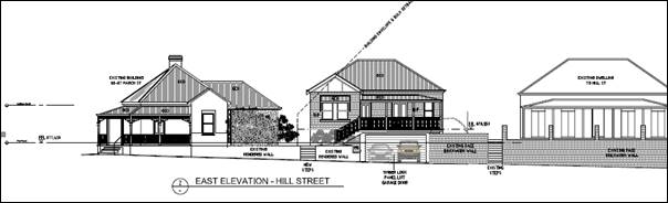
Figure 6
– Hill Street elevation
· Similarly, the proposed pavilion addition will complement
the bulk and scale for the adjoining dwelling to the west at 83 March Street
(see figure below).
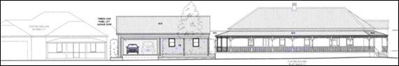
Figure 7
– March Street elevation
· The DCP prescribes the following visual bulk envelope
plane:
Buildings are contained within an envelope generated by
planes projected at 45o over the site, commencing 2.5m above
existing ground level from each side and rear boundary.
As demonstrated in the submitted elevation drawings
(see Figure 8), the proposed pavilion addition will encroach the VBE plane on
the south elevation, when projected from the western boundary.
Figure 8
– VBE encroachment
As outlined above, a Condition is included requiring the
roof of the pavilion addition to be hipped. A hip roof would contain the
building addition within the prescribed bulk plane, comply with the DCP and
minimise impacts on the March St neighbour.
In relation to
the proposed dwelling on Hill Street, the submitted section drawings
demonstrate that the front portion of the building with traditional hip and
gable roof profile will encroach within the VBE plane projected from the side
(north and south) boundaries. The rear skillion element, however, will be wholly
contained with the bulk plane (see Figure 9).
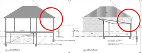
Figure 9 – proposed dwelling within
VBE plane
The proposed departure from the DCP control is considered
to be minor and within reasonable limit. Arising visual bulk encroachment
impacts for adjoining dwellings are unlikely. In this regard, the adjoining
dwelling to the north at 115 Hill Street will be largely offset from the VBE
encroachment, as the adjoining northern dwelling has a greater front setback to
Hill Street. Habitable spaces and openings within the converted
Harrison’s dwelling to the south will be well set back (some 7m) from the
encroaching portion of the proposed new dwelling.
· Site coverage for the proposed extended dwelling on Lot 1b,
and new dwelling on Lot 1a will not exceed 50% site coverage in compliance
with the DCP.
|
Dwelling
|
Floor Area (m2)
|
Site Area (m2)
|
Site Coverage
|
|
Harrison’s Extended/
Converted Dwelling
|
319
|
669 (Lot 1b)
|
47.7%
|
|
Proposed Dwelling
|
211
|
523 (Lot 1a)
|
40.3%
|
· Negligible earthworks will be required.
Walls and Boundaries
The DCP sets the following Planning
Outcome in regard to Walls and Boundaries:
· Building to the
boundary is undertaken to provide for efficient use of the site taking into
account:
- the privacy of neighbouring dwellings and private
open space
- the access to daylight reaching adjoining
properties
- the impact of boundary walls on neighbours.
The proposal does not involve
building to any boundary. As outlined in this report, the site layout and
building design will not adversely impact on adjoining dwellings in respect of
privacy, solar access or visual bulk.
Daylight
and Sunlight
The DCP sets the following Planning Outcome in regard to
Daylight and Sunlight:
· Buildings are
sited and designed to ensure:
- daylight to habitable rooms in adjacent dwellings
is not significantly reduced
- overshadowing of neighbouring secluded open spaces
or main living area windows is not significantly increased
- consideration of Council’s Energy Efficiency
Code.
Overshadowing of Private Open Space
Pursuant to the DCP Guidelines:
Sunlight is to be available to
at least 40% of required open space for dwellings within the development and
those on adjoining lands for at least three hours between 9am and 3pm.
As demonstrated in the submitted
shadow diagrams and as outlined in the following table:
· On-ground
solar access will be provided to the proposed dwelling consistent with the DCP
Guidelines.
· On-ground
solar access to the converted Harrison’s dwelling will not comply
with the DCP. Sunlight will be available to some 25% of the required open space
area for the prescribed time.
|
Dwelling
|
GFA / POS required (m2)
|
40% POS (m2)
|
Solar access (m2)
|
DCP Compliance
|
|
Proposed Dwelling
|
211 / 105.5
|
42.2
|
>50 between 11am and 2pm
|
Yes
|
|
Harrison’s Extended /Converted Dwelling
|
272 / 136
|
55
|
10.30am: 24 (or 18%)
11.30am: 33 (or 24%)
12.30pm: 37 (or 27%)
1.30pm: 34 (or 25%)
|
No
|
[It is noted that the proponent
has provided unshaded calculations based on dwelling footprint (319m2),
rather than GFA (272m2). The numbers shown in the table above relate
to GFA as prescribed in the DCP.]
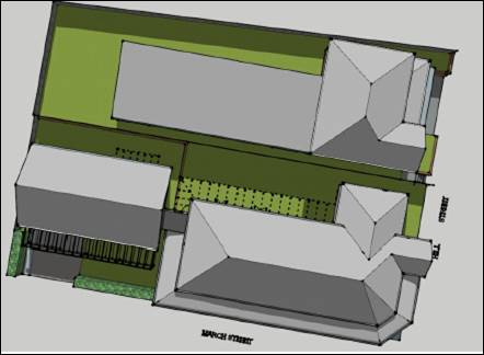
Figure 10 – noon shadow – unshaded POS
Notwithstanding the DCP
non-compliance relating to on-ground solar access for the converted dwelling,
it is considered that reasonable amenity will be provided to this space. The
sunny portion of the rear yard will have a broad northern aspect. On-ground
solar access will be immediately adjacent to the dwelling and its northern
openings, rather than dislocated. Furthermore, the sunny portion will be
useable, functional and private.
As outlined in this report, the proposal involves adaptive
reuse of a heritage building that will reinstate the original use of the
building. The proposal is not considered to be over‑development of the
site. Concessions that will not compromise residential amenity are considered
reasonable in this regard. The depicted shadows represent those cast on-ground
on the winter solstice, and will progressively improve throughout the year.
Lot orientation will not result in unreasonable
overshadowing of private open spaces for other dwellings beyond the development
site.
Overshadowing of Dwellings
Pursuant to the DCP Guidelines:
Sunlight to at least 75%
of north-facing living area windows within the development and on adjoining
land is to be provided for a minimum of four hours on 21 June; or not further
reduced than existing where already less.
The converted and proposed
dwellings will each contain generous north-facing living room windows. As
demonstrated in the submitted shadow diagrams, internal solar access will be
provided to the dwellings consistent with the DCP Guidelines.
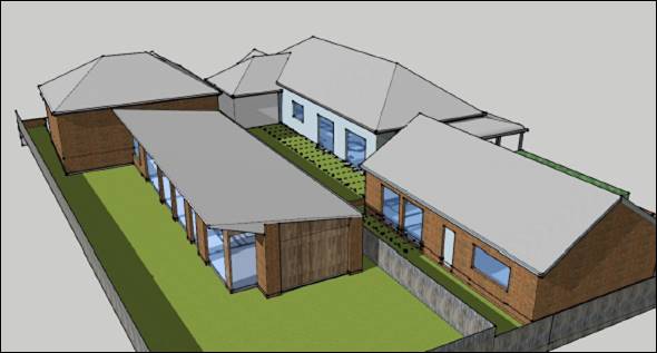
Figure 11 – noon shadow – unshaded
northern windows
Lot orientation will not result in
overshadowing of northern living room windows for other dwellings beyond the development
site.
Views
The DCP sets the following Planning Outcomes in regard to
Views:
· building form
and design allow for residents from adjacent properties to share prominent
views where possible
· views including
vistas of heritage items or landmarks are not substantially affected by the
bulk and scale of the new development.
Views of the corner heritage building will be retained. The
proposed dwelling and additions will suitably integrate within the streetscape
view corridors.
Visual Privacy
The DCP sets the following Planning Outcome in regard to
Visual Privacy:
· Direct
overlooking of principal living areas and private open spaces of other
dwellings is minimised firstly by:
- building
siting and layout
- location of
windows and balconies
and
secondly by:
- design of
windows or use of screening devices and landscaping.
The proposed site layout and building design will provide
acceptable visual privacy for the subject and adjoining dwellings.
In relation to the proposed dwelling:
· Negligible
earthworks will be required.
· Perimeter fencing
to proposed Lot 1a will be retained/installed.
· Habitable room
windows will be set back some 5m from the northern boundary, and well-removed
from the south-façade openings in the opposing dwelling at 115 Hill Street.
An established tree on the adjoining parcel between the dwellings will assist
to disrupt views between the dwellings.
· Habitable room
windows will overlook the north-facing private open space area.
· Openings to the
south façade will comprise narrow windows and/or be associated with
bedrooms or wet areas.
· Finished levels
will relate to existing natural ground level and will not result in overlooking
of adjoining dwellings.
In relation to the extended
heritage dwelling:
· Negligible earthworks
will be required.
· Perimeter fencing
to proposed Lot 1b will be retained/installed.
· Habitable room
windows will be set back some 5.7m from the northern boundary, and
well-separated from the non-habitable openings in the south façade in
the opposing proposed dwelling.
· Habitable room
windows will overlook the north-facing private open space area.
· The pavilion
addition will not contain any openings in the west façade opposing the
dwelling at 83 March Street.
· Finished levels
will relate to existing natural ground level and will not result in overlooking
of adjoining dwellings.
Acoustic Privacy
The DCP sets the following Planning Outcome in regard to
Acoustic Privacy:
· Site layout and
building design:
- protect
habitable rooms from excessively high levels of external noise
- minimise the
entry of external noise to private open space for dwellings close to major
noise sources
- minimise
transmission of sound through a building to affect other dwellings.
The subject land is contained in a residential area, where
ambient noise levels are low. The proposal will not alter the existing
acoustic environment for the subject and adjoining dwellings.
Security
The DCP sets the following Planning
Outcomes in regard to Security:
· the site layout
enhances personal safety and minimises the potential for crime, vandalism and
fear
· the design of
dwellings enables residents to survey streets, communal areas and approaches to
dwelling entrances.
The proposal is considered acceptable
in regard to safety and security as follows:
· openings in the
proposed and extended dwelling will provide for surveillance of the public
roads and rear yard
· the landscape
design will not restrict sight lines
· the dwellings will
have internal access via the garages
· perimeter fencing
will be installed/maintained.
Circulation and Design
The DCP sets the following Planning Outcome in regard to
Circulation and Design:
· accessways and
parking areas are designed to manage stormwater
· accessways,
driveways and open parking areas are suitably landscaped to enhance amenity
while providing security and accessibility to residents and visitors
· the site layout
allows people with a disability to travel to and within the site between car
parks, buildings and communal open space.
The existing vehicle crossing and driveway on March Street
will be relocated slightly to the west to provide access for the extended
dwelling. The existing crossover and driveway on Hill Street will be retained
in the current location. Conditional upgrading of the concrete kerb and gutter
layback and footpaths shall be undertaken.
Reverse egress to the public roads will be required for both
dwellings, consistent with vehicle arrangements for single dwellings throughout
the city. Traffic volumes associated with one additional dwelling will be
imperceptible within the context of existing vehicle movements in this setting.
Car
Parking
The DCP sets the following Planning Outcomes in regard to
Car Parking:
· Parking
facilities are provided, designed and located to:
- enable the
efficient and convenient use of car spaces and access ways within the site
- reduce the
visual dominance of car parking areas and access ways.
· Car parking is
provided with regard to the:
- the number and
size of proposed dwellings
- requirements
of people with limited mobility or disabilities.
Pursuant to DCP 2004, onsite parking is required for three
plus (3+) bedroom dwellings at a rate of 1.5 spaces per dwelling. An
attached double garage will be provided for the proposed and extended dwellings
in compliance with the DCP.
Private Open Space
The DCP sets the following Planning Outcomes in regard to
Private Open Space:
Private open space is clearly defined for private use.
· Private open
space areas are of a size, shape and slope to suit the reasonable requirements
of residents including some outdoor recreational needs and service functions.
· Private open
space is:
- capable of
being an extension of the dwelling for outdoor living, entertainment and
recreation
- accessible from
a living area of the dwelling
- located to
take advantage of outlooks; and to reduce adverse impacts of overshadowing or
privacy from adjoining buildings
- orientated to
optimise year round use.
Private open space for the heritage dwelling and proposed
dwelling will comply with the DCP Guidelines in relation to minimum area,
dimension, orientation, solar access and connectivity.
· Each
of the proposed dwellings will be provided with open space that complies with
the minimum requirement in terms of area (ie. 50% of the gross floor area of
the dwelling):
|
Dwelling
|
GFA (m2)
|
POS Required (m2)
|
POS Provided (m2)
|
DCP Compliance
|
|
Extended / converted dwelling
|
272
|
136.2
|
197
|
Yes
|
|
Proposed dwelling
|
211
|
105.5
|
209
|
Yes
|
· Private open space
for each dwelling will have a minimum dimension of 3m.
· Private
open space for each dwelling will accommodate an area of 5m x 5m.
· Private open space
for the dwellings will be located behind the building line and be provided with
a northerly aspect.
· The private open
space areas will have access to northern sunlight.
Open Space and Landscaping
The DCP sets the following Planning Outcomes in regard to
Open Space and Landscaping:
· the site layout
provides open space and landscaped areas which:
- contribute to
the character of the development by providing buildings in a landscaped setting
- provide for a
range of uses and activities including stormwater management
- allow cost
effective management.
· the landscape
design specifies landscape themes consistent with the desired neighbourhood
character; vegetation types and location, paving and lighting provided for
access and security
· major existing
trees are retained and protected in a viable condition whenever practicable
through appropriate siting of buildings, access ways and parking areas
· paving is
applied sparingly and integrated in the landscape design.
As outlined in the foregoing sections of this report,
Conditional site landscaping will be required to complement the neighbourhood
character and heritage setting.
Stormwater
The DCP sets the following Planning Outcomes in regard to
Stormwater:
· Onsite drainage
systems are designed to consider:
- downstream
capacity and need for onsite retention, detention and re-use
- scope for
onsite infiltration of water
- safety and
convenience of pedestrians and vehicles
- overland flow
paths.
· Provision is
made for onsite drainage which does not cause damage or nuisance flows to
adjoining properties.
Council’s Assistant Development Engineer has included
Conditions in relation to stormwater infrastructure to service proposed Lots 1a
and 1b.
Erosion
and Sedimentation
The DCP sets the following Planning Outcome in regard to
Erosion and Sedimentation:
· Measures
implemented during construction to ensure that the landform is stabilised and
erosion is controlled.
Conditional sediment and erosion controls will be employed
during construction.
DEVELOPMENT CONTRIBUTIONS
Section 7.11 Development
Contributions and Section 64 Headworks Charges
Development contributions are
applicable to the proposed development, pursuant to Orange Development
Contributions Plan 2017 (LGA).
The contributions are based on
the net increase of one (1) additional residential lot, as follows:
|
Open
Space and Recreation
|
One additional
lot at 4,168.54
|
4,168.54
|
|
Community and Cultural
|
One additional lot at 1,208.86
|
1,208.86
|
|
Roads and Traffic Management
|
One additional lot at 5,502.32
|
5,502.32
|
|
Local Area Facilities
|
-
|
|
|
Plan Preparation & Administration
|
One additional lot at 326.39
|
326.39
|
|
TOTAL:
|
|
$11,206.11
|
Headworks charges will also apply to the proposal. The
contributions are based on 1.0 additional ET for water supply and sewerage
services.
Conditions are included requiring payment of applicable
development contributions.
Provisions Prescribed by the
Regulations S4.15(1)(A)(Iv)
Demolition of a Building (clause
92)
The proposal involves demolition of an existing outbuilding
and part of the former restaurant. Conditions are included requiring
preparation and implementation of a waste management plan; and demolition works
to be carried out in accordance with Australian Standard AS2601 - 2001: The
Demolition of Structures and the requirements of Safe Work NSW.
Fire Safety Considerations
(clause 93)
Council’s Building Certifier advises:
The proposed buildings will be adequately setback from
existing and proposed boundaries to satisfy BCA requirements.
Buildings to be Upgraded
(clause 94)
Council’s Building Certifier advises:
Some fire services that were in the former restaurant can
be removed as part of the renovations. The building will need to be fitted with
domestic smoke alarms in appropriate locations.
BASIX Commitments (clause 97A)
A compliant BASIX Certificate has been submitted for the
proposed dwellings.
The Likely Impacts Of The
Development S4.15(1)(B)
The impacts of the proposed development have been considered
in the foregoing sections of this report and include:
· Heritage Values
- impact
on significance
- design
suitability
- mitigation
conditions
· Setting and
context
- public
domain
- landuse
- interface
- presentation
· Visual impacts
- neighbourhood
character
- streetscape
presentation
- building
design and detailing
- landscape
character
· Neighbourhood
amenity
- acoustic
privacy
- visual
privacy
- solar
access
- crime
prevention
· Traffic matters
- site
access
- manoeuvring
- car
parking
- traffic
generation
- network
capacity
· Environmental
impacts
- waste
management
- sediment
and erosion control
- biodiversity
- groundwater
- stormwater
management
- cultural
values
- contamination.
It is considered that the impacts of the proposed
development will be within reasonable limit. Conditions are included on the
attached Notice of Approval to mitigate and manage arising impacts.
The Suitability Of The Site
S4.15(1)(C)
· The proposal is
permitted on the subject land zoning.
· The site has
direct frontage and access to Hill and March Streets.
· The local road
network has sufficient capacity to accommodate additional traffic volumes
associated with one additional dwelling.
· There is no known
contamination on the land.
· All utility
services are available and adequate.
· The site is not
subject to natural hazards.
· The subject land
has no particular environmental values.
Any Submissions Made In
Accordance With The Act S4.15(1)(d)
The proposed development is defined as "advertised
development" pursuant to Council’s Community Participation Plan
2019. Written and public notice of the application was given for the prescribed
period. At the end of that period, three (3) written submissions had been received,
with a total of five (5) signatures). The issues raised in the submissions are
considered below.
The proposed lots are too small
and inconsistent with lots sizes in the area.
The proposed lots will comprise
site areas of 523m2 (Lot 1a) and 669m2 (Lot 1b). The
subject land and neighbourhood are not subject to minimum lot sizes pursuant to
Orange LEP 2011.
The residential cadastre in the
vicinity of the site is comprised of a range of lot sizes, as depicted below
(see Figure 12). Parcels in March and Hill Streets nearby to the site range
between 270m2-1205m2; furthermore, lots in the order of
500m2 prevail in the neighbourhood.
The proposed lots will not be incongruous with the prevailing
allotment layout or area. It is noted that an objective of the R1 General
Residential zone is to ‘provide for a variety of housing types and
densities.’ The proposed development will satisfy this objective.
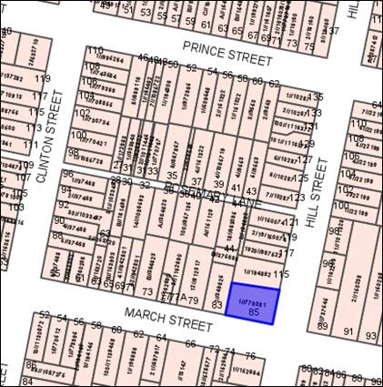
Figure 12 – cadastre nearby the development site
The proposed building density will not complement the neighbourhood
character.
As outlined above, the proposed
subdivision layout will complement the residential cadastre nearby to the site
in March and Hill Streets. Site coverage for the proposed dwellings on the
proposed lots will be less than 50%, and not exceed the maximum site coverage
of 60% for single dwellings, pursuant to DCP 2004-7.7-6.
The proposed building design
will be consistent with the heritage area, particularly the basement garage to
the proposed dwelling on Hill Street.
As outlined in the foregoing
sections of this report, Council’s Heritage Advisor considers the design
for the proposed dwelling will be suitable; however, minor design
modifications will be required in order for the dwelling to be understood as a
contemporary design. Conditions are included to this effect.
Council’s Heritage Advisor
raised no objection to the front elevation garage, noting that Council has
consented to other garage doors in the conservation area in recent times.
Insufficient private open
space area will be provided for the proposed dwellings.
Private open space for the proposed dwellings will exceed
the minimum area required, pursuant to DCP 2004-7.7-16.
A northern aspect is
essential for residential amenity.
North-facing internal and external habitable spaces will be
provided for the proposed dwellings.
The garage in the pavilion
addition will be inconsistent with the streetscape.
As outlined in the foregoing
sections of this report, Council’s Heritage Advisor considers the design
and siting for the garage will be acceptable in the streetscape, subject to
mitigation conditions relating to detailing. It is noted that the adjoining
dwelling at 83 March Street has an example of a standard suburban garage door
(see below).
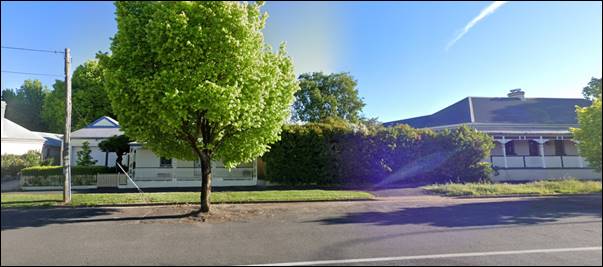
Figure 13 – garage at 83 March Street
Existing landscaping at the
March Street frontage is required to screen the pavilion addition garage.
The proposal involves part removal of the hedge at the March
Street frontage (see Figure 8 above) to facilitate access to the proposed
pavilion garage. The hedge will be removed for a distance of 5m to support a 5m
wide driveway at the front of the double garage.
A hip roof should be
provided to the pavilion addition to complement adjoining roof profiles.
Council’s Heritage Advisor concurs with this
submission. A Condition is included to this effect.
Public Interest
S4.15(1)(E)
The proposal is not inconsistent with any relevant policy
statements, planning studies, guidelines etc. that have not been considered in
this assessment. The proposal involves adaptive reuse of a Local heritage item
and is considered to be in the public interest.
SUMMARY
The proposal involves redevelopment of the heritage site and
building known as the former 1870 Restaurant at 85 March Street. A new dwelling
will be constructed, and the existing heritage building will be converted and
extended to a dwelling. Council’s Heritage Advisor has assessed the
proposal and considers that the development is acceptable subject to minor
mitigation measures. The proponent is amenable to the recommendations, which
are included as Conditions. Three (3) public submissions were received
objecting to the DA. The issues raised in the submissions generally relate
to the suitability of the building design and detailing. As outlined in
foregoing sections of this report, the proposal is considered to reasonably
satisfy the Local and State planning controls that apply to the subject land
and particular landuse. Impacts of the development will be within acceptable
limit, subject to mitigation conditions. Approval of the application is
recommended.
COMMENTS
The requirements of the following experts are included in
the attached Notice of Approval:
· Environmental
Health and Building Inspector
· Assistant
Development Engineer
· Environmental
Health Officer
· Manager City
Presentation
· Heritage Advisor
· Senior Planner
– Development Assessment
Attachments
1 Notice
of Approval, D21/38840⇩
2 Plans,
D21/43222⇩
3 Submissions,
D21/38828⇩
Extraordinary
Council Meeting
27 July 2021
Attachment 1 Notice
of Approval
|

|
ORANGE CITY COUNCIL
Development
Application No DA
138/2021(1)
NA21/474 Container
PR7456
|
NOTICE OF DETERMINATION
OF A DEVELOPMENT
APPLICATION
issued under the Environmental
Planning and Assessment Act 1979
Section 4.18
|
Development
Application
|
|
|
Applicant
Name:
|
Southwell Design
Drafting
|
|
Applicant
Address:
|
35 Crowson Street
MILTHORPE
NSW 2798
|
|
Owner’s
Name:
|
Mr SJ Alford and Miss
TL Harrison
|
|
Land
to Be Developed:
|
Lot 1 DP 779381 -
85-87 March Street, Orange
|
|
Proposed
Development:
|
Dwelling Alterations
and Additions (change of use from restaurant), Subdivision (two lot Torrens
title), and Dwelling and Attached Garage (new construction - two storey)
|
|
|
|
|
Building Code of
Australia
building
classification:
|
Class to be
determined by the PC
|
|
|
|
|
Determination made
under
Section 4.16
|
|
|
Made
On:
|
20 July 2021
|
|
Determination:
|
CONSENT GRANTED
SUBJECT TO CONDITIONS DESCRIBED BELOW:
|
|
|
|
|
Consent to Operate
From:
|
21 July 2021
|
|
Consent to Lapse On:
|
21 July 2026
|
Terms
of Approval
The reasons for the imposition of conditions
are:
(1) To ensure a quality
urban design for the development which complements the surrounding environment.
(2) To maintain
neighbourhood amenity and character.
(3) To ensure compliance
with relevant statutory requirements.
(4) To provide adequate
public health and safety measures.
(5) Because the development
will require the provision of, or increase the demand for, public amenities and
services.
(6) To ensure the utility
services are available to the site and adequate for the development.
(7) To prevent the proposed
development having a detrimental effect on adjoining land uses.
(8) To minimise the impact
of development on the environment.
Conditions
(1) The development must be
carried out in accordance with:
(a) Drawings by Southwell
Design and Drafting Drawing Nos. A03-DA01: 01(B), 02(A), 03(A), 04(A), 05(A),
06(A), 07(A), 08(A), 09(B), 10(A), 11(A), 12(A), 13(A), 14(B), 15(A) dated
29/03/2021 (15 sheets)
(b) statements
of environmental effects or other similar associated documents that form part
of the approval
as amended in
accordance with any conditions of this consent.
(2) All building work must
be carried out in accordance with the provisions of the Building Code of Australia.
(3) A sign is to be erected
in a prominent position on any site on which building work, subdivision work or
demolition work is being carried out:
(a) showing
the name, address and telephone number of the principal certifying authority
for the work, and
(b) showing
the name of the principal contractor (if any) for any building work and a
telephone number on which that person may be contacted outside working hours,
and
(c) stating
that unauthorised entry to the site is prohibited.
Any such sign is to be maintained while the
building work, subdivision work or demolition work is being carried out.
(4) In
the case of residential building work for which the Home Building Act 1989
requires there to be a contract of insurance in force in accordance with Part 6
of the Act, evidence that such a contract of insurance is in force is to be
provided to the Principal Certifying Authority before any building work
authorised to be carried out by the consent commences.
(5) Residential
building work within the meaning of the Home Building Act 1989 must not
be carried out unless the principal certifying authority for the development to
which the work relates (not being the council) has given the council written
notice of the following information:
(a) in
the case of work for which a principal contractor is required to be appointed:
(i) the
name and the licence number of the principal contractor, and
(ii) the
name of the insurer by which the work is insured under Part 6 of that Act,
(b) in
the case of work to be done by an owner-builder:
(i) the
name of the owner-builder, and
(ii) if
the owner-builder is required to hold an owner-builder permit under that Act,
the number of the owner-builder permit.
If arrangements for doing the residential
building work are changed while the work is in progress so that the information
under this condition becomes out of date, further work must not be carried out
unless the principal certifying authority for the development to which the work
relates (not being the council) has given the council written notice of the
updated information.
(6) Where any excavation
work on the site extends below the level of the base of the footings of a
building on adjoining land, the person having the benefit of the development
consent must, at the person’s own expense:
(a) protect
and support the adjoining premises from possible damage from the excavation,
and
(b) where
necessary, underpin the adjoining premises to prevent any such damage.
Note: This
condition does not apply if the person having the benefit of the development
consent owns the adjoining land or the owner of the adjoining land has given
consent in writing to this condition not applying.
STAGE 1 - ALTERATIONS/ADDITIONS TO
EXISTING DWELLING
|
PRIOR TO THE ISSUE OF A CONSTRUCTION
CERTIFICATE
|
(7) Prior to demolition
works commencing, the building is to be photographically recorded in accordance
with ‘Photographic Recording of Heritage Items Using Film or Digital
Capture’ (Heritage Office 2006). The photographic record shall
be provided to Council prior to issue of a Construction Certificate.
(8) The following details
shall be provided on the Construction Certificate drawings to the satisfaction
of the Manager Development Assessment:
· In relation to the
converted and extended dwelling (former restaurant):
- A colour scheme
appropriate to the period and style shall be nominated on the drawings.
- Traditional rolled
flashings with painted timber fascia, smooth unperforated quad gutters in
galvanised steel shall be nominated on the drawings.
- Circular downpipes
painted to match the wall colour shall be nominated on the drawings.
- Windows on Hill Street
façade to be timber construction.
· In relation to the
western pavilion addition:
- Driveway to be
gravel-finished concrete driveway surface
- Pergola detailing to
include timber battens beneath the main cross beams
- The garage doors to
comprise painted timber
- The roof to be hipped
at the two ends
- Windows on the March
Street elevation to be timber construction
(9) An
approval under Section 68 of the Local Government Act is to be sought
from Orange City Council, as the Water and Sewer Authority, for alterations to
water and sewer. No plumbing and drainage is to commence until approval is
granted.
(10) The applicant is to
submit a waste management plan that describes the nature of wastes to be
removed, the wastes to be recycled and the destination of all wastes. All
wastes from the demolition and construction phases of this project are to be
deposited at a licensed or approved waste disposal site.
(11) A
Road Opening Permit in accordance with Section 138 of the Roads Act 1993
must be approved by Council prior to a Construction Certificate being issued
or any intrusive works being carried out within the public road or footpath
reserve.
|
PRIOR TO WORKS COMMENCING
|
(12) A
Construction Certificate application is required to be submitted to, and issued
by Council/Accredited Certifier prior to any excavation or building works being
carried out onsite.
(13) A
temporary onsite toilet is to be provided and must remain throughout the
project or until an alternative facility meeting Council’s requirements
is available onsite.
(14) Soil
erosion control measures shall be implemented on the site.
|
DURING CONSTRUCTION/SITEWORKS
|
(15) All
construction/demolition work on the site is to be carried out between the hours
of 7.00 am and 6.00 pm Monday to Friday inclusive, 7.00 am to
5.00 pm Saturdays and 8.00 am to 5.00 pm Sundays and Public
Holidays. Written approval must be obtained from the General Manager of Orange
City Council to vary these hours.
(16) A
Registered Surveyor’s Certificate identifying the location of the
building on the site must be submitted to the Principal Certifying Authority.
(17) All materials on site
or being delivered to the site are to be contained within the site. The
requirements of the Protection of the Environment Operations Act 1997
are to be complied with when placing/stockpiling loose material or when
disposing of waste products or during any other activities likely to pollute
drains or watercourses.
(18) Building demolition is
to be carried out in accordance with Australian Standard 2601:2001 –
The Demolition of Structures and the requirements of Safe Work NSW.
(19) Asbestos containing building materials must be
removed in accordance with the provisions of the Work Health and Safety
Act 2011 and any guidelines or Codes of Practice published by Safe
Work NSW, and disposed of at a licenced landfill in accordance with the
requirements of the NSW EPA.
(20) Any adjustments to
existing utility services that are made necessary by this development
proceeding are to be at the full cost of the developer.
(21) The provisions and
requirements of the Orange City Council Development and Subdivision Code are to
be applied to this application and all work constructed within the development
is to be in accordance with that Code.
The developer is to be entirely responsible for
the provision of water, sewerage and drainage facilities capable of servicing
the development from Council’s existing infrastructure. The developer is
to be responsible for gaining access over adjoining land for services where
necessary and easements are to be created about all water, sewer and drainage mains
within and outside the lots they serve.
(22) All driveway and
parking areas are to be sealed with bitumen, hot mix or concrete and are to be
designed for all expected loading conditions (provided however that the minimum
pavement depth for gravel and flush seal roadways is 200mm) and be in
accordance with the Orange City Council Development and Subdivision Code.
(23) A concrete kerb and
gutter layback and footpath crossing is to be constructed in the position shown
on the plan submitted with the Construction Certificate application. The works
are to be carried out to the requirements of the Orange City Council
Development and Subdivision Code and Road Opening Permit.
(24) The existing kerb and
gutter layback that is not proposed to be used shall be replaced with standard
concrete kerb and gutter and the concrete / bitumen footpath reinstated to the
requirements in the Orange City Council Development and Subdivision Code.
|
PRIOR TO THE ISSUE OF AN OCCUPATION
CERTIFICATE
|
(25) No
person is to use or occupy the building or alteration that is the subject of
this approval without the prior issuing of an Occupation Certificate.
(26) Where
Orange City Council is not the Principal Certifying Authority, a final
inspection of water connection, sewer and stormwater drainage shall be
undertaken by Orange City Council and a Final Notice of Inspection issued,
prior to the issue of either an interim or a final Occupation Certificate.
(27) A
Road Opening Permit Certificate of Compliance is to be issued for the works by
Council prior to any Occupation/Final Certificate being issued for the
development.
(28) All
of the foregoing conditions are to be at the full cost of the developer and to
the requirements and standards of the Orange City Council Development and Subdivision
Code, unless specifically stated otherwise. All work required by the foregoing
conditions is to be completed prior to the issuing of an Occupation or
Subdivision Certificate, unless stated otherwise.
STAGE 2 - TWO LOT SUBDIVISION
|
PRIOR TO THE ISSUE OF A CONSTRUCTION
CERTIFICATE
|
(29) A 150mm-diameter sewer
junction, interlot stormwater pit, and water service shall be constructed from
Council’s existing sewer, stormwater and water mains to serve proposed
lots 1A and 1B. Prior to a Construction Certificate being issued engineering
plans for this work shall be submitted to and approved by Orange City Council.
(30) A
Road Opening Permit in accordance with Section 138 of the Roads Act 1993
must be approved by Council prior to a Construction Certificate being issued
or any intrusive works being carried out within the public road or footpath
reserve.
|
PRIOR TO WORKS COMMENCING
|
(31) An
application for a Subdivision Works Certificate is required to be submitted to,
and a Certificate issued by Council/Accredited Certifier prior to any
excavation or works being carried out onsite.
|
DURING CONSTRUCTION/SITEWORKS
|
(32) Any adjustments to
existing utility services that are made necessary by this development
proceeding are to be at the full cost of the developer.
(33) The provisions and
requirements of the Orange City Council Development and Subdivision Code are to
be applied to this application and all work constructed within the development
is to be in accordance with that Code.
The developer is to be entirely responsible for
the provision of water, sewerage and drainage facilities capable of servicing
all the lots from Council’s existing infrastructure. The developer is to
be responsible for gaining access over adjoining land for services where necessary
and easements are to be created about all water, sewer and drainage mains
within and outside the lots they serve.
(34) All services are to be
contained within the allotment that they serve.
|
PRIOR TO THE ISSUE OF A SUBDIVISION
CERTIFICATE
|
(35) The payment of $11,206.11 is to be made to
Council in accordance with section 7.11 of the Act and the Orange Development
Contributions Plan 2017 (LGA Remainder) towards the provision of the following
public facilities:
|
Open Space and Recreation
|
One additional lot at
4,168.54
|
4,168.54
|
|
Community
and Cultural
|
One additional lot at 1,208.86
|
1,208.86
|
|
Roads and
Traffic Management
|
One additional lot at 5,502.32
|
5,502.32
|
|
Local
Area Facilities
|
-
|
|
|
Plan
Preparation & Administration
|
One additional lot at 326.39
|
326.39
|
|
TOTAL:
|
|
$11,206.11
|
The contribution will be indexed quarterly in
accordance with the Orange Development Contributions Plan 2017 (LGA Remainder).
This Plan can be inspected at the Orange Civic Centre, Byng Street, Orange.
(36) Prior to the issuing of
the Subdivision Certificate, a Surveyor’s Certificate or written
statement is to be provided to the Principal Certifying Authority, stating that
the buildings within the boundaries of the proposed Lot 1b comply in respect to
the distances of walls from boundaries.
(37) Application shall be
made for a Subdivision Certificate under Section 6.3(1)(d) of the Act.
(38) Payment
of contributions for water, sewer and drainage works is required to be made
at the contribution rate applicable at the time that the payment is made.
The contributions are based on 1.0 ETs for water supply headworks and 1.0
ETs for sewerage headworks. A Certificate of Compliance, from Orange City
Council in accordance with the Water Management Act 2000, will be issued
upon payment of the contributions.
This Certificate of Compliance is to be
submitted to the Principal Certifying Authority prior to the issuing of a
Subdivision Certificate.
(39) Application is to be
made to Telstra/NBN for infrastructure to be made available to each individual
lot within the development. Either a Telecommunications Infrastructure
Provisioning Confirmation or Certificate of Practical Completion is to be
submitted to the Principal Certifying Authority confirming that the specified
lots have been declared ready for service prior to the issue of a Subdivision
Certificate.
(40) A Notice of Arrangement
from Essential Energy stating arrangements have been made for the provision of
electricity supply to the development, is to be submitted to the Principal
Certifying Authority prior to the issue of a Subdivision Certificate.
(41) An easement to drain
sewage and to provide Council access for maintenance of sewerage works a
minimum of 2.0 metres wide is to be created over the proposed sewerage works.
The Principal Certifying Authority is to certify that the easement is in
accordance with the Orange City Council Development and Subdivision Code prior
to the issuing of a Subdivision Certificate.
(42) All services are to be
contained within the allotment that they serve. A Statement of Compliance, from
a Registered Surveyor, is to be submitted to the Principal Certifying Authority
prior to the issuing of a Subdivision Certificate.
(43) The existing dwelling
on proposed Lot 1B shall be connected to the sewer. Evidence of the
satisfactory completion of such work by a licensed plumber shall be provided to
the Principal Certifying Authority prior to the issue of a Subdivision
Certificate.
(44) Where stormwater
crosses land outside the lot it favours, an easement to drain water is to be
created over the works. A Restriction-as-to-User under section 88B of the NSW
Conveyancing Act 1979 is to be created on the title of the burdened Lot(s)
requiring that no structures are to be placed on the site, or landscaping or
site works carried out on the site, in a manner that affects the continued
operation of the interlot drainage system. The minimum width of the easement is
to be as required in the Orange City Council Development and Subdivision Code.
(45) Certification from
Orange City Council is required to be submitted to the Principal Certifying
Authority prior to the issue of a Subdivision Certificate stating that all
works relating to connection of the development to Council assets, works on
public land, works on public roads, stormwater, sewer and water reticulation
mains and footpaths have been carried out in accordance with the Orange City
Council Development and Subdivision Code and the foregoing conditions, and that
Council will take ownership of the infrastructure assets.
(46) All
of the foregoing conditions are to be at the full cost of the developer and to
the requirements and standards of the Orange City Council Development and
Subdivision Code, unless specifically stated otherwise. All work required by
the foregoing conditions is to be completed prior to the issuing of an
Occupation or Subdivision Certificate, unless stated otherwise.
STAGE 3 - DWELLING
|
PRIOR TO THE ISSUE OF A CONSTRUCTION
CERTIFICATE
|
(47) The
following details shall be provided on the Construction Certificate drawings to
the satisfaction of the Manager Development Assessment:
- The garage door to
comprise painted timber
- Windows on the Hill
Street facade to be timber construction
- Verandah balustrade to
comprise simple steel flats
- Window canopy to
comprise a contemporary frame without replica details
- Alternative detail to
sheeted gable
- Window fenestration to
gable on Hill Street façade to comprise 3 contemporary windows
(48) A detailed landscaping
plan prepared by a suitably qualified professional shall be submitted for the
approval of Council’s Manager Development Assessment.
Landscaping shall be
established at the street frontages to March and Hill Streets; and on the
northern boundary (adjoining 115 Hill Street). Planting on the northern
boundary shall be of a type and size sufficient to provide screening of the
proposed dwelling from the adjoining northern dwelling.
The landscape design (including
vegetation type and location) shall be consistent with the landscape character
in the setting.
(49) An
approval under Section 68 of the Local Government Act is to be sought
from Orange City Council, as the Water and Sewer Authority, for water, sewer
and stormwater connection. No plumbing and drainage is to commence until
approval is granted.
(50) Prior to the issue of a
Construction Certificate evidence shall be provided to the Principal
Certifying Authority that
proposed Lot 1A has been registered with NSW Land and Property Information.
(51) A
Road Opening Permit in accordance with Section 138 of the Roads Act 1993
must be approved by Council prior to a Construction Certificate being issued
or any intrusive works being carried out within the public road or footpath
reserve.
|
PRIOR TO WORKS COMMENCING
|
(52) A
Construction Certificate application is required to be submitted to, and issued
by Council/Accredited Certifier prior to any excavation or building works being
carried out onsite.
(53) The tree immediately
adjoining to the north in close proximity to the common boundary of Lot 1
DP194882 and the subject site shall have a tree protection zone (TPZ) in
accordance with AS4970 – 2009 established upon the development site.
Where works that have been identified on the submitted plans are proposed to
occur within the TPZ, the TPZ fencing shall be established at the maximum limit
(distance from the centre of the trees trunk) to enable such works to be
enacted. Should excavation be required within the TPZ a project arborist must
be engaged to oversee such excavation work and ensure that any tree roots
greater than 50mm in diameter are pruned on the side of attachment to the tree
in accordance with AS4373 – 2007. TPZ fencing must be inspected by
Council’s Manager City Presentation prior to works commencing.
(54) A
temporary onsite toilet is to be provided and must remain throughout the
project or until an alternative facility meeting Council’s requirements
is available onsite.
(55) Soil
erosion control measures shall be implemented on the site.
|
DURING CONSTRUCTION/SITEWORKS
|
(56) All
construction/demolition work on the site is to be carried out between the hours
of 7.00 am and 6.00 pm Monday to Friday inclusive, 7.00 am to
5.00 pm Saturdays and 8.00 am to 5.00 pm Sundays and Public
Holidays. Written approval must be obtained from the General Manager of Orange
City Council to vary these hours.
(57) A
Registered Surveyor’s Certificate identifying the location of the
building on the site must be submitted to the Principal Certifying Authority
prior to the pouring of the slab or footings.
(58) All materials on site
or being delivered to the site are to be contained within the site. The
requirements of the Protection of the Environment Operations Act 1997
are to be complied with when placing/stockpiling loose material or when
disposing of waste products or during any other activities likely to pollute
drains or watercourses.
(59) Any adjustments to
existing utility services that are made necessary by this development
proceeding are to be at the full cost of the developer.
|
PRIOR TO THE ISSUE OF AN OCCUPATION
CERTIFICATE
|
(60) Landscaping
shall be installed in accordance with the approved plans and shall be
permanently maintained to the satisfaction of Council's Manager Development
Assessments.
(61) No
person is to use or occupy the building or alteration that is the subject of
this approval without the prior issuing of an Occupation Certificate.
(62) Where
Orange City Council is not the Principal Certifying Authority, a final
inspection of water connection, sewer and stormwater drainage shall be
undertaken by Orange City Council and a compliance certificate issued, prior to
the issue of either an interim or a final Occupation Certificate.
(63) A
Road Opening Permit Certificate of Compliance is to be issued for the works by
Council prior to any Occupation/Final Certificate being issued for the
development.
(64) All of the foregoing conditions are
to be at the full cost of the developer and to the requirements and standards
of the Orange City Council Development and Subdivision Code, unless
specifically stated otherwise. All work required by the foregoing conditions is
to be completed prior to the issuing of an Occupation or Subdivision
Certificate, unless stated otherwise.
Other
Approvals
(1) Local
Government Act 1993 approvals granted under Section 68.
Nil
(2) General
terms of other approvals integrated as part of this consent.
Nil
Right
of Appeal
If you are dissatisfied with this decision,
Section 8.7 of the Environmental Planning and Assessment Act 1979
gives you the right to appeal to the Land and Environment Court. Pursuant to
Section 8.10, an applicant may only appeal within 6 months after the date the
decision is notified.
|
Disability
Discrimination Act 1992:
|
This application has been assessed in
accordance with the Environmental Planning and Assessment Act 1979. No
guarantee is given that the proposal complies with the Disability
Discrimination Act 1992.
The applicant/owner is responsible to ensure
compliance with this and other anti-discrimination legislation.
The Disability Discrimination Act
covers disabilities not catered for in the minimum standards called up in the
Building Code of Australia which references AS1428.1 - "Design for
Access and Mobility". AS1428 Parts 2, 3 and 4 provides the most
comprehensive technical guidance under the Disability Discrimination Act
currently available in Australia.
|
|
|
|
|
Disclaimer
- S88B of the Conveyancing Act 1919 - Restrictions on the Use of Land:
|
The applicant should note that there could be
covenants in favour of persons other than Council restricting what may be
built or done upon the subject land. The applicant is advised to check the
position before commencing any work.
|
|
|
|
|
Signed:
|
On behalf of the consent authority ORANGE
CITY COUNCIL
|
|
Signature:
|
|
|
Name:
|
PAUL
JOHNSTON - MANAGER DEVELOPMENT ASSESSMENTS
|
|
Date:
|
21
July 2021
|
Extraordinary Council Meeting
27 July 2021
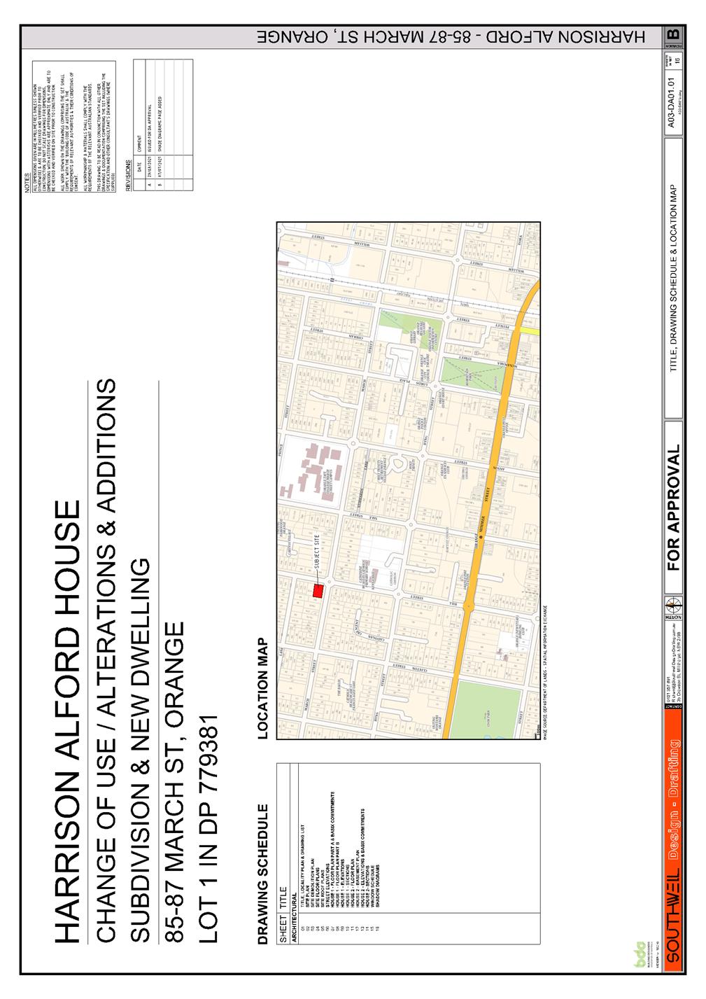
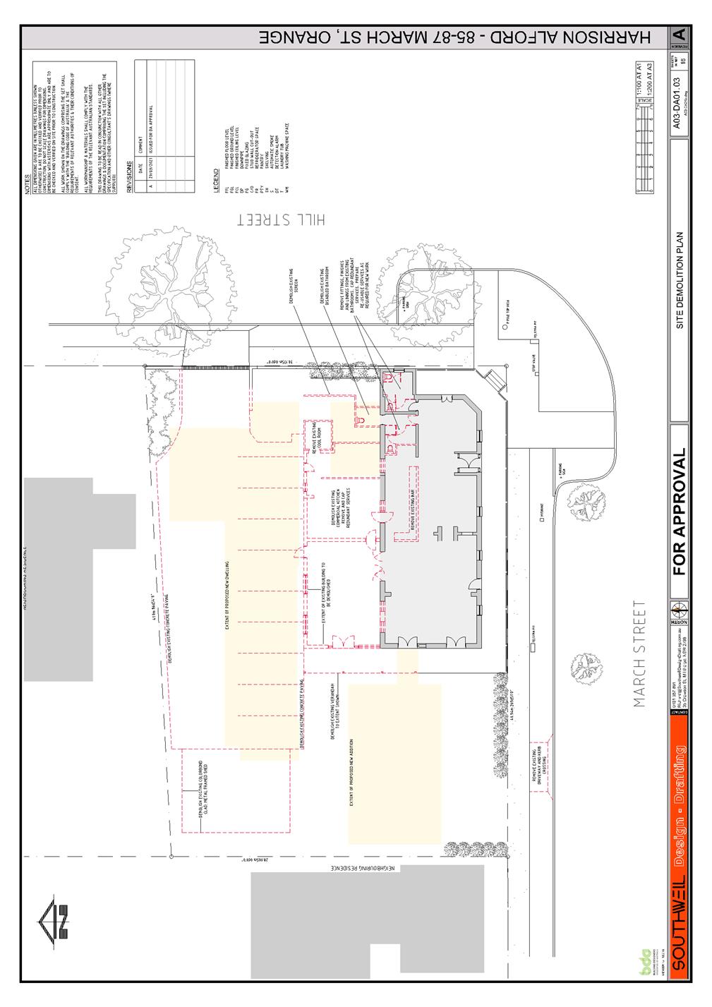

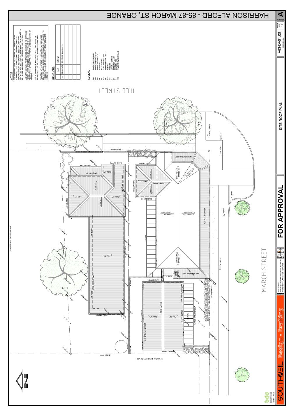
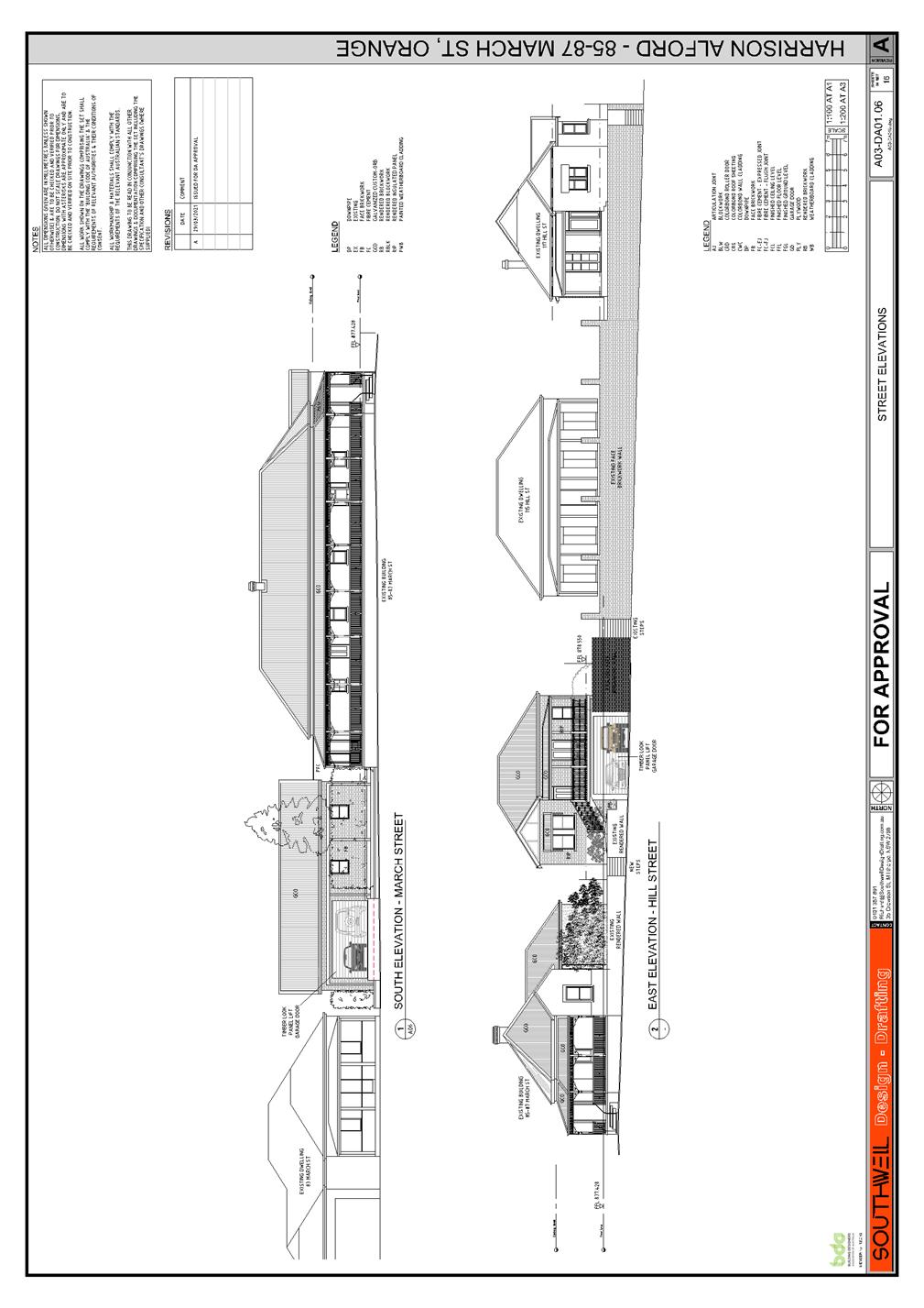


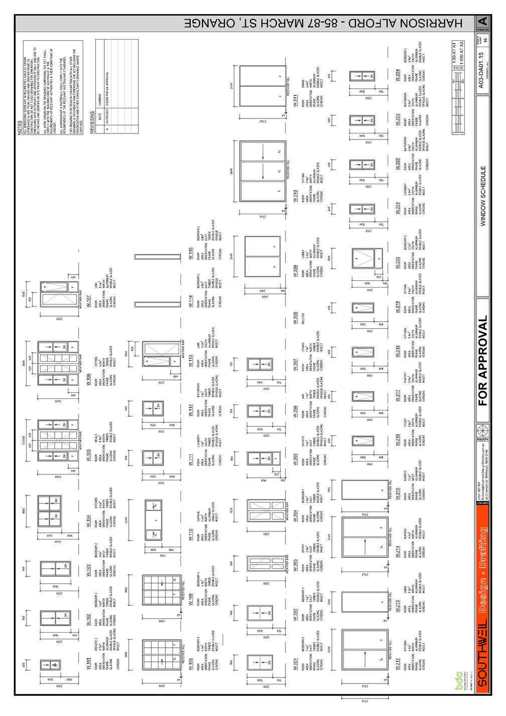
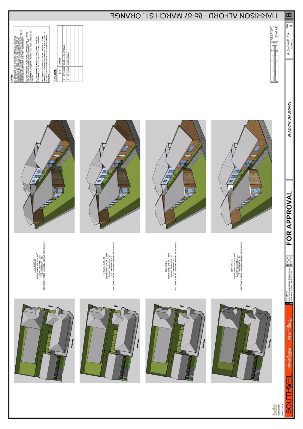
Extraordinary Council Meeting
27 July 2021
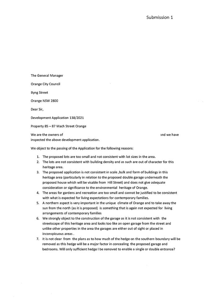

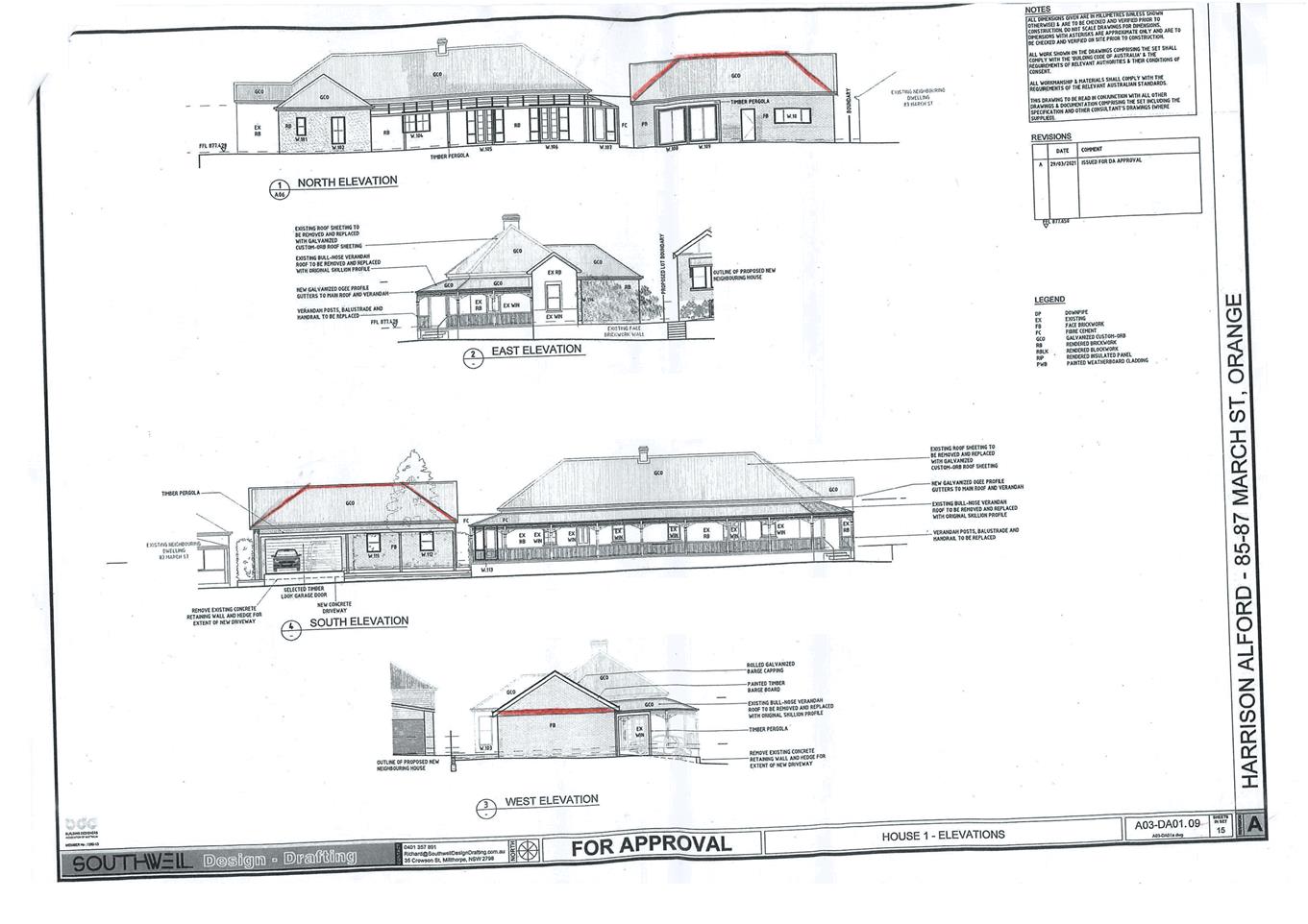
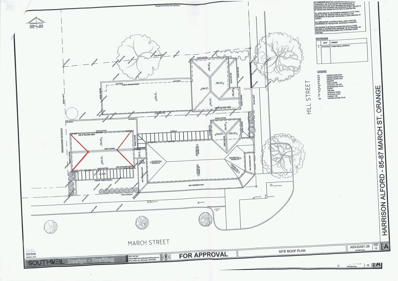
5.13 Development
Application DA 67/2021(1) - 11 Borrodell Drive
RECORD
NUMBER: 2021/1417
AUTHOR: Ben
Hicks, Planner
EXECUTIVE
Summary
|
Application
lodged
|
24
February 2021
Additional
Information received 19 May 2021
|
|
Applicant/s
|
Developed
Pty Ltd
|
|
Owner/s
|
Mr MG
and Mrs T Sangster
|
|
Land
description
|
Lot 3
DP264431, 11 Borrodell Drive, Orange
|
|
Proposed
land use
|
Subdivision
(11 lot Torrens title and 5 lot Community title)
|
|
Value of
proposed development
|
Not
applicable
|
Council's consent is sought to subdivide land described as
Lot 3 DP264431 known as 11 Borrodell Drive, Orange. The application seeks
to subdivide the aforementioned land into eleven (11) Torrens title residential
lots and five (5) Community title lots. The development presents a range of
lots sizes varying from 850m2 up to 1,538m2 for the
Torrens title lots and lot sizes of around 1000m2 for the Community
title lots. Ancillary works will also be undertaken to facilitate the
subdivision including earthworks, provision of utility services and road
construction. The applicant proposes to carry out the
development in two stages. Stage 1 comprising the subdivision of the existing
dwelling and the creation of a development lot and Stage 2 relating to the
remainder of the subdivision.
The proponent seeks a departure to the Conceptual
Subdivision Layout for Area 3 Ploughmans Valley under the Orange
Development Control Plan 2004. The proponent is also seeking a variation to the
minimum lot size under the Orange Local Environmental Plan 2011; therefore, the
application has been tabled to Council for determination.
The departure to these instruments is to accommodate an
anomaly between the mapped minimum lot size zones in the LEP and the Conceptual
Subdivision Layout for Area 3 Ploughmans Valley in the DCP. The minimum
lot size zones as mapped do not correspond with the intended subdivision layout/property
boundaries and thus the mapped minimum lot sizes do not allow the intended
subdivision pattern to be sensibly achieved and strict compliance would result
in a poor planning outcome. The variation is therefore supported in this
instance.
The applicant also proposes to increase the lot yield along
the western fringe of the property by one (1) additional lot. Council in
considering the intended lot layout for this area purposely limited the number
of lots on the western fringe to ensure the future development on the land integrates
with the scenic qualities of the locality. This increase in lot yield and
subsequent reduction in lot sizes (Community Title lots) will increase the
density of development in this locality, potentially impacting the landscape character
and scenic values of the area. Thus, the variation for an increase in lot yield
along the western fringe of the site is not supported. It is recommended that
the number of Community Title lots is reduced by one (1) lot.
Approval of the application is recommended subject to
conditions of consent as outlined in the attached Notice of Determination.
Figure 1 - locality and site context plan
DECISION FRAMEWORK
Development in Orange is governed by two key documents
Orange Local Environment Plan 2011 and Orange Development Control Plan 2004. In
addition the Infill Guidelines are used to guide development, particularly in
the heritage conservation areas and around heritage items.
Orange Local Environment Plan 2011 – The
provisions of the LEP must be considered by the Council in determining the
application. LEPs govern the types of development that are permissible or
prohibited in different parts of the City and also provide some assessment
criteria in specific circumstances. Uses are either permissible or not. The
objectives of each zoning and indeed the aims of the LEP itself are also to be
considered and can be used to guide decision making around appropriateness of
development.
Orange Development Control Plan 2004 – the DCP
provides guidelines for development. In general it is a performance based
document rather than prescriptive in nature. For each planning element there
are often guidelines used. These guidelines indicate ways of achieving the
planning outcomes. It is thus recognised that there may also be other solutions
of merit. All design solutions are considered on merit by planning and building
staff. Applications should clearly demonstrate how the planning outcomes are
being met where alternative design solutions are proposed. The DCP enables developers
and architects to use design to achieve the planning outcomes in alternative
ways.
DIRECTOR’S COMMENT
The proposal seeks to alter the adopted concept plan for
this precinct and the minimum lot size pertaining to the subject land. The
proposal has a mixture of Torrens title and Community Title allotments. The
alteration to the Torrens title lots is considered to be acceptable and would
provide more appropriately shaped allotments fronting the proposed new road. As
the subdivision moves westward, up the hill (where the community title lots
are), the visual impacts arising from the density of the estate become more
significant. Visual impacts in such areas are managed by maintaining
larger allotments on the hillside. To provide adequate scenic protection
to this precinct, it is recommended that the number of Community title lots
proposed along the western fringe of the development be reduced by one (1)
allotment. It is considered that the slight reduction of lots would provide for
appropriate/economic development and use of land, whilst protecting the desired
character of the area beyond this individual subdivision. It is
recommended that Council supports the proposed development subject to the
adoption of the attached Notice of determination.
Link To Delivery/OPerational Plan
The recommendation in this report
relates to the Delivery/Operational Plan Strategy “10.1 Preserve - Engage
with the community to ensure plans for growth and development are respectful of
our heritage”.
FINANCIAL IMPLICATIONS
Nil
POLICY/GOVERNANCE IMPLICATIONS
Nil
|
Recommendation
That
Council consents to development application DA67/2021(1) for Subdivision (11 lot Torrens title and
5 lot Community title) at Lot 3
DP264431, 11 Borrodell Drive, Orange pursuant
to the conditions of consent in the attached Notice of Determination.
|
further considerations
Consideration has been given to the recommendation’s
impact on Council’s service delivery; image and reputation; political;
environmental; health and safety; employees; stakeholders and project
management; and no further implications or risks have been identified.
SUPPORTING INFORMATION
Section 1.7 - Application of Part
7 of the Biodiversity Conservation Act 2016 and Part 7A of the Fisheries
Management Act 1994
Section 1.7 of the EP&A Act
identifies that Part 7 of the Biodiversity Conservation Act 2016
(BC Act) and Part 7A of the Fisheries Management Act 1994 have effect in
connection with terrestrial and aquatic environments.
There are four triggers known to
insert a development into the Biodiversity Offset Scheme (ie the need for
a BDAR to be submitted with a DA):
· Trigger 1:
development occurs in land mapped on the Biodiversity Values Map (OEH)
(clause 7.1 of BC Regulation 2017);
· Trigger 2:
development involves clearing/disturbance of native vegetation above a certain
area threshold (clauses 7.1 and 7.2 of BC Regulation 2017); or
· Trigger 3:
development is otherwise likely to significantly affect threatened species
(clauses 7.2 and 7.3 of BC Act 2016).
The fourth trigger (development proposed to occur in an Area
of Outstanding Biodiversity Value (clause 7.2 of BC Act 2016) is generally not
applicable to the Orange LGA; as no such areas are known to occur in the LGA.
No further comments will be made against the fourth trigger.
Trigger 1
The subject land is not identified
as biodiversity sensitive on the Orange LEP 2011 Terrestrial Biodiversity Map
or mapped on the Biodiversity Values Map.
Trigger 2
The prescribed clearing threshold for the site is 0.25ha
(based on minimum lot size for the subject land of less than 1ha (Cl. 7.2
Biodiversity Conservation Regulation 2017). The environment assessment
prepared by Envirowest Pty Ltd confirms that surface cover across the site
consists of pasture grasses and broadleaved weeds. Ornamental trees are located
in the northern section surrounding the existing dwelling. The proposed
development will not the removal of any native vegetation including trees or
grasses and therefore will not trigger the prescribed clearing thresholds.
Trigger 3
The subject land is contained within an established urban area
and
developing residential release area. The development site does not contain or adjoin mapped biodiversity sensitive lands. The natural state of the site and surrounding area have been highly modified by the urban landuse pattern. The development is unlikely to adversely fragment or disturb the
biodiversity structure or ecological functions of the development site or
surrounding lands. Although subdivision is considered to be a key threatening
process, there are no known or
threatened ecological communities on the land, nor is it likely to contain any habitat for
such species or communities.
In summary, a BDAR is not required and the proposal suitably
satisfies the relevant matters at Clause 1.7 EPAA 1979.
Section 4.15 of the
Environmental Planning and Assessment Act 1979
Section 4.15 of the Environmental
Planning and Assessment Act 1979 requires Council to consider various
matters, of which those pertaining to the application are listed below.
PROVISIONS OF ANY ENVIRONMENTAL
PLANNING INSTRUMENT s4.15(1)(a)(i)
Orange Local Environmental Plan
2011
Part 1 - Preliminary
Clause 1.2 - Aims of Plan
The
broad aims of the LEP are set out under Subclause 2. Those relevant to the
application are as follows:
(a) to
encourage development which complements and enhances the unique character of
Orange as a major regional centre boasting a diverse economy and offering an
attractive regional lifestyle,
(e) to
provide a range of housing choices in planned urban and rural locations to meet
population growth,
(f) to
recognise and manage valued environmental heritage, landscape and scenic
features of Orange.
In consideration of the above, the
application is considered to be consistent with objectives of the LEP. The
proposed subdivision will provide for additional residential lots for dwelling
stock that will accommodate for the housing needs of the community. The
proposed lot size and layout is appropriate for the setting and will have
negligible environmental impact.
Clause 1.6 - Consent Authority
This clause establishes that,
subject to the Act, Council is the consent authority for applications made
under the LEP.
Clause 1.7 - Mapping
The subject site is identified on the LEP maps in the
following manner:
|
Land Zoning Map:
|
R2 Low Density Residential
|
|
Lot Size Map:
|
Minimum Lot Size 850m2
and 1500m2
|
|
Heritage Map:
|
Not a heritage item or conservation
area
|
|
Height of Buildings Map:
|
No building height limit
|
|
Floor Space Ratio Map:
|
No floor space limit
|
|
Terrestrial Biodiversity Map:
|
No significant biodiversity
sensitivity on the site.
|
|
Groundwater Vulnerability Map:
|
Groundwater vulnerable
|
|
Drinking Water Catchment Map:
|
Not within the drinking water
catchment
|
|
Watercourse Map:
|
No mapped watercourse
|
|
Urban Release Area Map:
|
Not within an urban release area
|
|
Obstacle Limitation Surface Map:
|
No restriction
on building siting or construction
|
|
Additional Permitted Uses Map:
|
No additional permitted use applies
|
|
Flood Planning Map:
|
Not mapped on flood planning map
|
Those matters that are of relevance are addressed in detail
in the body of this report.
Clause 1.9A - Suspension of Covenants,
Agreements and Instruments
This clause provides that covenants, agreements and other
instruments which seek to restrict the carrying out of development do not apply
with the following exceptions:
(a) to
a covenant imposed by the Council or that the Council requires to be imposed,
or
(b) to
any relevant instrument under Section 13.4 of the Crown Land Management Act
2016, or
(c) to
any conservation agreement under the National Parks and Wildlife Act 1974, or
(d) to
any Trust agreement under the Nature Conservation Trust Act 2001, or
(e) to
any property vegetation plan under the Native Vegetation Act 2003, or
(f) to
any biobanking agreement under Part 7A of the Threatened Species Conservation
Act 1995, or
(g) to
any planning agreement under Subdivision 2 of Division 7.1 of the Environmental
Planning and Assessment Act 1979.
Council staff are not aware of the
title of the subject property being affected by any of the above.
Part 2 - Permitted or Prohibited Development
Clause
2.1 - Land Use Zones and Clause 2.3 - Zone Objectives and Land Use Table
The site of the proposed development is zoned R2 Low
Density Residential under the Orange Local Environmental Plan 2011. The Land
Use Table for the R2 Low Density Residential zone permits the proposal with
consent of Council. The proposal is defined as subdivision of land,
which means:
The division of land into two or more parts that, after the
division, would be obviously adapted for separate occupation, use or disposition (Section 6.2 Environmental Planning and
Assessment Act 1979).
Clause 2.3(2) of the Orange Local Environmental Plan (OLEP)
2011 provides that the Council shall have regard to the objectives for
development in a zone when determining a development application in respect of
land within the zone. The objectives of the R1 General Residential are:
· To provide for
the housing needs of the community within a low density residential
environment.
· To enable other
land uses that provide facilities or services to meet the day to day needs of
residents.
· To ensure
development is ordered in such a way as to maximise public transport patronage
and encourage walking and cycling in close proximity to settlement.
· To ensure that
development along the Southern Link Road has an alternative access.
The development is considered to be
generally consistent with the objectives of the R2 Low Density Residential
zone. It is recommended however that the number of Community Title lots be
reduced by 1 allotment so as to ensure that the development remains consistent
with the intended development outcome envisaged under the Ploughman’s
valley DCP. The subdivision will provide for additional lots for dwelling stock
to accommodate the housing needs of the community.
The subject land is located between
recently established residential developments and will integrate with the
existing road and transport networks, including public transport services. The
land is accessible to open space linkages for walking and cycling in the area.
The proposed lot sizes and resulting pattern of development is generally
consistent with that of the locality and surrounding residential development.
The development is not located adjacent to the Southern
Link Road.
The following provisions of the OLEP 2011 have been
especially considered in the assessment of the proposal:
· Clause 2.6 - Subdivision - Consent Requirements – Clause 2.6 subdivision of the
OLEP 2011 states that the subdivision of land may be permitted, but only
with development consent. As such, the applicant has applied for development
consent via Development Application DA 67/2021(1) for the subdivision of land.
· Clause 4.1 – Minimum Subdivision Lot Size – Clause 4.1 minimum subdivision lot size of the OLEP states
that the size of any lot resulting from the subdivision of land is not to be
less than the minimum lot size shown on the lot size map in relation to that
land. The subject allotment is zoned R2 Low Density Residential, and there
is a in a minimum lot size of 850m2 and 1500m2 (Figure
2). The 850m2 lot size applies along the eastern and southern fringe
of the land while the 1500m2 lot size applies to the more elevated
western section of the property.
· The applicant seeks recourse to Clause 4.6 of the LEP to
allow the 1,500m2 development standard to be varied. Clause 4.6
allows development consent to be granted for development even though the
development would contravene a development standard. The variation has been
addressed in detail below under Clause 4.6. It should be noted that the
proposed Community title lots (under the Community Land Development Act
1989) are not subject to a minimum lot size pursuant to Clause 4.1(4)(b).

Figure 2 – minimum lot size areas
· Clause 4.6 – Exceptions to development standards - Clause 4.6 exceptions to development standards of the
Orange Local Environmental Plan 2011 provides flexibility in the application of
certain development standards in particular circumstances, where compliance
with a development standard is unreasonable and unnecessary. In the context of
this application, consideration of Clause 4.6 is necessary because Stage 2
subdivision works will involve the creation of Torrens title lots that have an
area below the minimum lot size being 1500m2.
In determining whether development consent may be granted,
the Consent Authority must consider a written objection by the applicant to the
development standard. The written objection must demonstrate:
(a) that
compliance with the development standard is unreasonable or unnecessary in the
circumstances of the case, and
(b) that
there are sufficient environmental planning grounds to justify contravening the
development standard.
Council may grant consent only if the concurrence of the
Director General of the Department of Planning and Infrastructure has been
obtained and Council is satisfied that:
· the written
request has adequately addressed the above, and
· the
proposed development will be in the public interest because of:
- consistency with the
objectives of the particular standard, and
- consistency with the
objectives of the zone applying to the site.
The DA is
accompanied by a Clause 4.6 request to vary the lot size development standard.
The proposed variations are summarized in the table below and indicated
diagrammatically on Figure 3:
|
Lot
|
Area
|
Comment
|
Compliance
|
|
201
|
851m2
|
This lot fits
the pattern of having 850m2 lots front Borrodell Drive. The
majority of this lot is within the 850m2 MLS. However a slight
intrusion (3.4%) of the 1,500m2 MLS causes a slight
non-compliance.
|
Non-compliance with 1,500m2 MLS.
Clause 4.6 variation required.
|
|
202
|
1201m2
|
This lot fits
the pattern of having 850m2 lots front Borrodell Drive. The
majority of this lot is within the 850m2 MLS. However a slight
intrusion (4%) of the 1,500m2 MLS causes a slight non-compliance.
|
Non-compliance with 1,500m2 MLS. Clause 4.6
variation required.
|
|
204
|
856m2
|
This lot fits
the pattern of having 850m2 lots front Centennial Crescent.
However, approximately 75% of this lot is within the 1,500m2 MLS
zone.
|
Non-compliance with 1,500m2 MLS.
Clause 4.6 variation required.
|
|
205
|
857m2
|
This lot fits
the pattern of having 850m2 lots front Centennial Crescent.
However, approximately 65% of this lot is within the 1,500m2 MLS
zone.
|
Non-compliance with 1,500m2 MLS.
Clause 4.6 variation required
|
|
207
|
850m2
|
This lot fits
the pattern of having 850m2 lots front Centennial Crescent.
However, approximately 10‑20% of this lot is within the 1,500m2
MLS zone
|
Non-compliance with 1,500m2 MLS.
Clause 4.6 variation required.
|
|
208
|
850m2
|
This lot fits
the pattern of having 850m2 lots front Centennial Crescent. However,
approximately 10‑20% of this lot is within the 1,500m2 MLS
zone.
|
Minor non-compliance with 1,500m2 MLS.
Clause 4.6 variation required.
|
|
209
|
1253m2
|
This lot fits
the pattern of having 850m2 lots front Borrodell Drive and
complies with the 850m2 MLS. However a slight intrusion of the
1,500m2 MLS Zone (approximately 20% of the lot) causes a slight
non-compliance in that regard.
|
Minor non-compliance with 1,500m2 MLS.
Clause 4.6 variation required.
|
|
210
|
1251m2
|
This lot fits
the pattern of having 850m2 lots front Borrodell Drive and
complies with the 850m2 MLS. However a slight intrusion of the
1,500m2 MLS Zone (approximately 20% of the lot) causes a slight
non-compliance in that regard.
|
Minor non-compliance with 1,500m2 MLS.
Clause 4.6 variation required.
|
Figure 3 –subdivision layout superimposed over
MLS map
Assessment of Clause 4.6 request
Clause 4.6(3)(a) - Is the compliance with the development
standard unreasonable or unnecessary in the circumstances of the case?
Compliance with the development standard is unreasonable
and unnecessary in this circumstance due to the following:
(a) There
is an anomaly between the minimum lot size mapping and the property
boundaries/DCP Masterplan. The MLS zones as mapped do not allow the lot layout
in the DCP Masterplan to be achieved and strict adherence to the MLS zones
would result in a poor subdivision layout and insufficient use of land and
infrastructure.
(b) The
DCP Masterplan sets the Centennial Crescent extension entirely within the
subject land and as a result consumes much of the land that could otherwise
have been developed to comply with the minimum lot under the LEP.
(c) The proposed lot
layout will generally achieve the original objective of the Ploughman’s
Valley Masterplan Area 3 in that the proposal will create lot sizes of 850m2
+ at the front of the new public road (Centennial Crescent) and will continue
the pattern of regular frontages, consistent building setbacks and landscaped
front yards that characterise the Ploughman’s Valley residential area.
(d) The
DCP Masterplan intended larger lots along the elevated western fringe to
preserve the landscape character and scenic values of the area.
In doing so, Council planned to only
have four (4) large lots along this section of the property. The applicant has
however proposed to introduce an additional lot to this area. This has created
four (4) community title lots with a land area of around 1000m2
each. Whilst the minimum allotment size of 1500m² technically does not
apply to this style of lot the increase in density is expected to have an
undesirable impact on the scenic amenity as a result of reduced setbacks, space around
properties/landscaped areas/opportunities, site coverage, views etc. Therefore,
the increase in lot yield for the proposed Community Title lots is not
supported. It is recommended that the community title lots are reduced to three
(3) and increased in land area to be more compatible with the intended
Masterplan outcomes. This matter has been addressed via conditions of consent.
(e) The
proposal is unlikely to significantly impact on the desired future character of
the area, provided that the number of lots within the community title is
reduced and lot sizes increased.
Clause 4.6(3)(b) - Are there sufficient environmental
planning grounds to justify contravening the development standard?
It is considered that there is sufficient environmental
planning grounds to justify the non-compliance due the following:
(a) A
variation of the development standard is justified in this case because it can
be demonstrated that the proposal satisfies the objectives of the R2 Low
Density Residential zone and the objectives of the MLS.
(b) The
proposal does not introduce lot sizes that cannot be found elsewhere within the
R2 Zone for the ploughman’s Valley Area 3.
(c) The
development is generally compliant with the DCP provisions that apply for urban
residential subdivision (notwithstanding the proposed departure to the DCP
Layout for Area 3).
(d) Non-compliance
with the standard does
not generate unacceptable impacts in the locality, discounting the proposed
increase in lot yield as discussed above.
Clause
4.6(4)(a)(ii) - Is the proposed development in the public interest because it
is consistent with the objectives of the particular standard and objectives
within the zone in which the development is proposed to be carried out?
The
objectives of the minimum lot size are as follows:
(a) to
ensure that new subdivisions reflect existing lot sizes and patterns in the
surrounding locality,
(b) to
ensure that lot sizes have a practical and efficient layout to meet intended
use,
(c) to
ensure that lot sizes do not undermine the land’s capability to support
rural development,
(d) to
prevent the fragmentation of rural lands,
(e) to
provide for a range of lot sizes reflecting the ability of services available
to the area,
(f) to
encourage subdivision designs that promote a high level of pedestrian and
cyclist connectivity and accommodate public transport vehicles.
In terms of
the objective (a) the proposed subdivision is partly consistent with the
desired/existing lot pattern. Specifically, the proposal reflects the broader
850m2 MLS urban residential pattern that was originally planned for
the eastern fringe of the site. Lower density lots are however encouraged along
the more elevated western ridge. The proposed subdivision layout does not meet
this intended outcome.
The applicant
has proposed to increase the density on the elevated western ridge by an
additional lot. While it is acknowledged that a different design response has been
required, the increase in lot yield is beyond what Council originally planned
for and the increase in density is expected to have a negative impact on the
landscape and scenic values of the area. It is therefore recommended that the
lots within the community title subdivision be reduced to three and increased
in size (excluding the lot for the access road) to be more compatible with the
intended subdivision layout for this area.
In terms of
objective (b) it is considered each lot is of appropriate width and depth to
enable a future dwelling to be reasonably located and orientated to achieve
privacy, effective solar access and satisfactory residential amenity.
Generally, the lots will contribute to the diversity and housing options that
are encouraged for the area. However, the increase density of the lots along
the western fringe of the property is expected to compromise landscape and
scenic character and thus not supported as outlined above.
Objectives
(c) and (d) are not relevant as the subject land is not within a rural zone.
In relation
to objective (e) it is considered that strict adherence to the development
standard would hinder the ability to meet this particular objective. The
proposed variation of the MLS would satisfy this objective to a more effective
extent than the current DCP layout, excepting the increase in lot yield along
the western fringe of the property, which is not supported due to landscape and
scenic amenity reasons.
In relation
the final objective, the lot will have satisfactory access to a public road for
servicing and vehicle and pedestrian access and connectivity.
With regard to the zone
objectives, the development has been previously assessed as meeting the
requirements of the zone in that it will provide for additional lots for
dwelling stock to accommodate the housing needs of the community, while integrating
with the existing road and transport networks, including public transport
services. The lots within the proposed subdivision will be accessible to
open space linkages for walking and cycling in the area. Furthermore, the
proposed lot sizes and resulting pattern of development is also generally
consistent with that of the locality and surrounding residential development.
In accordance with Clause
4.6(4)(b), concurrence of the Planning Secretary has been obtained via PS
20-002 dated 21 February 2018. The assumed concurrence notice stipulates
Council staff have assumed concurrence to assess and determine Clause 4.6
variations where the variation sought does not exceed 10% of the development.
Where the variation is greater than 10% of the standard, the application is to
be determined by full Council. In this case, the application will be tabled to
a Council meeting for determination.
In summary, the proposed departure
from the development standard is not likely to result in an unacceptable
precedent where supported. The proposed lots logically recognise the existing
constraints of the site and anomaly between mapping, function and servicing
requirements.
· Clause 5.10 Heritage Conservation - The site is
not identified as a Heritage Item or within a Heritage Conservation Area. The development
site is however adjacent to two local Heritage Items, namely Item 196 (Packing
Sheds) and Item 194 (dwelling).
The proposed subdivision is
not expected to cause any unreasonable impact on these items. Specifically, the
proposed subdivision does not involve any works or structures that would
interrupt views to or from the identified heritage items and therefore will not
diminish public appreciation of the identified heritage items. A reasonable
curtilage will also be maintained for these items.
· Clause 7.1 Earthworks – Earthworks will be required in conjunction with
civil and construction works required to create the proposed lots, new roads,
installation of services etc. The extent of
disruption to the drainage of the site is considered to be reasonable. Existing
overland/natural stormwater flows will be redirected to underground stormwater
infrastructure and managed through Council’s stormwater network.
Therefore the disruption to natural overland flow paths are not expected
detrimentally affect adjoining properties or receiving waterways.
The site is not known to be
contaminated as demonstrated by the submitted preliminary contamination
investigation. Notwithstanding this, in line with Council’s standard
procedures a precautionary condition is recommended in relation to an
unexpected finds protocol. Excavated materials will be reused onsite as far as
possible.
The site is not known to contain any
Aboriginal, European or Archaeological relics. Previous known uses of the site
do not suggest that any relics are likely to be uncovered.
Overall, the extent of the earthworks
are not expected to materially affect the potential future use or redevelopment
of the site that may occur at the end of the proposed development's lifespan
and appropriate sediment controls, including silt traps and other protective
measures be required to protect adjoining lands during subdivision works as a
condition of development consent.
· 7.3 - Stormwater Management – The applicant will be required to contribute to the
provision of an onsite stormwater system for the development to limit post
development peak flows to that of pre-development peak flows. The applicants
have proposed an onsite underground basin located on Lots 209 and 210 with a
s88B restriction on the title of the lots requiring the OSD to remain in place
and operational until a suitable alternative site can be located downstream to
the satisfaction of Council. Council’s Director Technical Services has
advised that the stormwater detention basin will not become a Council asset.
· Clause 7.6 - Groundwater Vulnerability – The site has been mapped as being groundwater vulnerable.
The proposal is not anticipated to involve the discharge of toxic or noxious
substances and is therefore unlikely to contaminate the groundwater or related
ecosystems. The proposal does not involve extraction of groundwater and will
therefore not contribute to groundwater depletion.
· Clause
7.11 - Essential Services – All utility services will be augmented to
the land and made adequate for the proposal. The development, including the
existing dwelling, will be required to connect to Council’s reticulated
water system and gravity sewerage system.
The proposed road layout is
satisfactory, allows adjoining land to be developed and is generally in
accordance with DCP 2004. The applicant will
be required to construct Borrodell Drive and Centennial Crescent half road
width including kerb and gutter, piped stormwater, footpaths and asphalt
sealing for the full frontage of the development.
Electricity will be provided as
per Essential Energy’s requirements. Appropriate stormwater management
infrastructure will be provided to the required allotments and the proponent
will be required to contribute to the provision of off-site stormwater
detention through Section 7.11 Contributions.
STATE ENVIRONMENTAL PLANNING
POLICIES
The following State Environmental Planning Instruments (SEPPs)
apply to the Orange Local Government Area:
· SEPP
21 - Caravan Parks
· SEPP
33 - Hazardous and Offensive Development
· SEPP
36 - Manufactured Home Estates
· SEPP
50 - Canal Estate Development
· SEPP
55 - Remediation of Land
· SEPP
64 - Advertising and Signage
· SEPP
65 - Design Quality of Residential Flat Development
· SEPP
70 – Affordable Rental Housing (Revised Schemes)
· SEPP
(Affordable Rental Housing) 2009
· SEPP
(Building Sustainability Index: BASIX) 2004
· SEPP
(Concurrences and Consents) 2018
· SEPP
(Educational Establishments and Child Care Facilities) 2017
· SEPP
(Exempt and Complying Development Codes) 2008
· SEPP
(Housing for Seniors or People with a Disability) 2004
· SEPP
(Infrastructure) 2007
· SEPP
(Mining, Petroleum Production and Extractive Industries) 2007
· SEPP
(Primary Production and Rural Development) 2019
· SEPP
(State and Regional Development) 2011
· SEPP
(Vegetation in Non-Rural Areas) 2017
The following SEPPs are specifically relevant to the
assessment of the proposed development:
SEPP 55 Remediation of Land - State Environmental
Planning Policy 55 - Remediation of Land (SEPP 55) requires that a consent
authority must not consent to the carrying out of development of land unless it
has considered whether the land is contaminated, is satisfied that the land is
suitable in its contaminated state for the development that is proposed, and if
the land requires remediation to be made suitable for the proposed development
it is satisfied that the land will be remediated before the land is used for
that purpose.
Furthermore, SEPP 55 requires that
before determining an application for consent to carry out development that
would involve a change of use on any of the land specified in
Subclause (4), the consent authority must consider a report specifying
findings of a preliminary investigation of the land concerned.
A preliminary hazard investigation was prepared by
Envirowest Consulting to determine the soil contamination status and
suitability of the site for residential land-use. The report provides that:
· The site has a
land use history of mixed agriculture and rural-residential yard. The site
contained an orchard prior to 1993. No buildings were located in the investigation
area while is operated as an orchard. Orchard trees were removed and the site
formed part of a rural-residential property.
· General refuse was
identified along the western boundary of the site. The refuse included
equipment, rubbish bins and associated rubbish.
· No surface
staining or odours were detected on the site. There is no evidence of mines,
sheep dips, mixing sheds or contaminating industrial activities on the site
from the review of site history or site walkover. The use of agricultural
pesticides over the area in the past is expected to be low.
· The final soil
sampling program did not detect elevated levels of the analysed metals or
persistent pesticides across the site or potential hotspot locations. The
levels of all substances evaluated were below the adopted thresholds for
residential land-use with access to soil.
· The investigation
area is suitable for proposed residential land-use.
Based on the evidence and findings provided in the
preliminary contamination investigation the site is not considered to be
contaminated and is suitable for residential land use. The report
recommends the refuse be removed from an amenity point of view and does not
suggest it causing any other issues. This matter has been addressed via a
condition of development consent.
Council’s EHO assessment of the proposal and site
inspection has identified that the onsite sewerage management system that
services the existing dwelling is faulty and leaking onto the surface. The
applicant will be required to remove the existing effluent management facility
and suitably rehabilitate the site. The system will require weekly pumping until
it is connected to sewer. This matter has been addressed via a condition of
development consent.
PROVISIONS OF ANY DRAFT
ENVIRONMENTAL PLANNING INSTRUMENT THAT HAS BEEN PLACED ON EXHIBITION
4.15(1)(a)(ii)
Draft Amendment No 28 to Orange LEP 2011 has been placed on
public exhibition. The draft plan includes several amendments to Schedule 5
Environmental Heritage of the LEP and associated mapping. In particular the
draft amendment deals with extending existing heritage conservation areas,
establishing new heritage conservation areas and listing new heritage items.
The proposed development is not affected by this draft amendment.
PROVISIONS OF ANY DEVELOPMENT
CONTROL PLAN s4.15(1)(a)(iii)
Development Control Plan 2004
Development Control Plan 2004 (“the DCP”)
applies to the subject land. The relevant chapters are:
· Part 0.4
(Interim Planning Outcomes) – Scenic Areas establishes site specific
controls for the subject property.
· Part 7
(Development in Residential Areas) is relevant as it establishes the urban
design principles on which to assess the layout of the proposed subdivision.
PO 0.4-1 Interim Planning
Outcomes – Scenic Area
· Development
blends into the landscape though the use of appropriate siting, design,
external materials and colours, retention of trees including remnant
vegetation, establishing of new trees, and enhancing the skyline when viewed
either from the urban area of Orange or from public places in the vicinity of
the land.
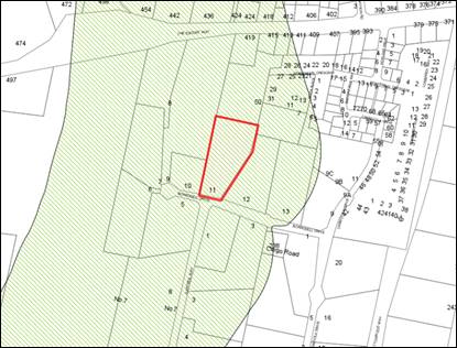
Figure 4 – scenic protection overlay
The site is located within the Scenic Protection Area as
identified in Figure 4 above. Before granting consent for development of land within
a scenic area, Council is required to be satisfied that the proposed
development will blend into the landscape through the use of appropriate siting
and design, external materials and colours, and by retaining existing trees
including remnant vegetation, and enhancing the skyline when viewed either from
the urban area of Orange or from public places in the vicinity of the land.
The proposed subdivision proposes
to introduce an additional lot along the elevated western fringe of the
property. The increase in density in this area is expected to impact upon the
scenic qualities of the area. While Council will have the opportunity to
consider the design of any future residential development within the proposed
subdivision so as to ensure that such development integrates with the scenic
qualities of the locality with respect to the suitability of the design
(building height, materials and colours etc.).
It is recommended that conditions of
consent to place restrictions on the titles of the community title lots to
require:
(a) buildings
to present to their respective roads as single storey in height to prevent
skylining of buildings along the ridgeline;
(b) a
maximum site coverage of 35% of the lot size to increase the opportunity for
landscaping of the site; and
(c) the
provision of a landscape plan approved by Council prior to the construction of
any structure (dwelling or outbuilding) indicating species selection with a
mature height greater than the height of any structures proposed, and able to
screen a minimum 50% of the width of the front and rear of all proposed
structures.
It is considered that the combination of these three
requirements, in addition to reducing the number of lots on the western side of
the property as discussed above, will protect the importance of the of the
property for its scenic value.
Part 7 - Development in
Residential Areas
· The allotment
layout is generally in accordance with the Conceptual Subdivision Layout at
Appendix 16.7.
The subdivision pattern is not strictly in accordance with
the relevant Conceptual Subdivision Layout for the Ploughman’s Valley
Area 3 (Figure 5). Strict compliance is constrained as a result of an anomaly
between the minimum lot size zones as mapped and Masterplan/property
boundaries. This inconsistency has required a different design response for the
subject land. Although the proposed subdivision layout does not strictly accord
with the conceptual layout, it generally maintains the intent of the conceptual
layout, excepting the increase in lot yield as discussed above.
The principal objectives of the Masterplan were to provide
larger lots along dominant ridgelines to protect the scenic amenity and maintain
the rural residential character of the locality and to provide 850m2
lots with regular frontages in the remaining areas to allow for landscaped
front yards and consistent building setbacks. In this case, the DCP Masterplan
envisaged a total of nine (9) lots to achieve the objectives. This included
four large lots along the western elevated section of the property with the
remaining medium sized lots positioned along the eastern and southern section
of the site.
While the proposed subdivision layout incorporates larger
allotments on the western section of the property, the introduction of an additional
lot increases the density substantially and will have flow on implications i.e.
setbacks, landscaped areas, number of structures, views etc. It has therefore
been recommended that number of Community title lots is reduced by 1 allotment.
The remaining allotments proposed comprise a minimum of 850m² along the
eastern and southern sections of the property. The lots will be of a reasonable
size and of regular configuration with acceptable frontage to depth ratio.
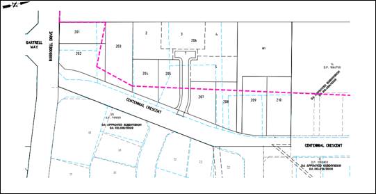
Figure 5 - plan of subdivision (black line)
superimposed over
Ploughman’s Valley Area 3 Masterplan (blue line)
· Subdivision
design and construction complies with the Orange City Development and
Subdivision Code.
Relevant conditions are attached in this regard.
· The allotment
layout provides a high standard of residential amenity.
- In
Areas 2, 3 and 4, lots have a minimum allotment size of 850m2.
The proposed lots range in area between 851m² and
1538m². Proposed Lot 101 seeks to excise the existing dwelling on an
allotment of 2838m². The proposed allotment layout is expected high
standard of residential amenity. In accordance with the DCP, the proposed lots
have been designed to achieve a minimum area of 850m². The majority of
proposed lots will be vacant and will be created for the purpose of future
residential development.
· Lots are
oriented to maximise energy-efficiency principles. Where practicable, lots are
rectangular rather than splay shaped and oriented to provide the long axis
within the range N200W to N300E or E200N to E300S.
The lots are orientated such that solar access principles
for future residential development on the resultant lots is achievable.
· Subdivision
design retains significant landscape features and minimises disturbance to
natural vegetation, landform and overland flowpaths.
The property is generally clear of trees except those that
are located around the existing dwelling on proposed Lot 101. The remainder of
the property is vegetated with pasture grasses. A row of mature Pine trees
exists on the adjoining land to the west which is visible from many parts of
the Ploughman’s Valley. These trees formed part of a wind break
associated with a former orchard that existed on the land.
Whilst these trees are located on the
adjoining property they are nonetheless protected by a condition of consent
which requires the placement of a Restriction-as-to-User under Section 88B of
the Conveyancing Act on the title of all future allotments to the immediate
west of this property so as to maintain their longevity. These trees form a
significant backdrop to the subject land. In this regard, tree protection
measures will be included as a condition of consent during civil works for the
subdivision. Further, the subdivision design will facilitate excellent
opportunity for the establishment of large landscaped gardens which is
encouraged under the DCP.
It is considered that there will be little need to carry out
significant earthworks to effect the proposed subdivision as the natural
landform is considered to be well suited to residential development. It is
anticipated, however, that some earthworks will be required for the
construction of roads, installation of services etc. Notwithstanding earthworks
are expected to have minimal impact on natural vegetation, landform overland
flow paths.
· The road layout
comprises a modified grid layout with restrained use of cul-de-sacs, generally
in accordance with the Conceptual Subdivision Layout.
The creation of a shared access road for the Community title
lots effectively represents a cul-de-sac. The creation of one additional
cul-de-sac is considered acceptable in the context of the broader
Ploughman’s Valley Masterplan and will facilitate an acceptable
development outcome along this edge of the valley. It is recommended that the
number of community title lots is reduced by 1 allotment to maintain the
intended development outcome for this area.
· Lots have
direct frontage or access to a public road.
The proposed Torrens lots each
have direct access to the new road (Centennial Crescent) or Borrodell Drive. Most
of these lots are likely to require reverse exit onto the street, consistent
with most single residential development within the new and established areas
of the City. The proposed Community title lots will be served by a shared access
road. This road allows forward movement from Centennial Crescent and to
each of the proposed Community lots. Where vehicles do not enter a Community
Lot, the hammer head arrangement at the termination of the shared access road
will enable vehicles to manoeuvre and exit onto Centennial Crescent in a
forward direction.
· Stormwater
runoff from the site is consistent with pre-development stormwater patterns.
The applicant will be required
to contribute to the provision of an onsite stormwater system for the
development to limit post development peak flows to that of pre-development
peak flows. The applicants have proposed an onsite underground basin located on
Lots 209 and 210 with a s88B restriction on the title of the lots requiring the
OSD to remain in place and operational until a suitable alternative site can be
located downstream to the satisfaction of Council.
· All utility
services are provided to the proposed lots.
The developer will be entirely responsible for the provision
of water, sewerage and drainage facilities capable of servicing all the lots
from Council’s existing infrastructure.
The developer is to be responsible
for gaining access over adjoining land for services where necessary and
easements are to be created about all water, sewer and drainage mains within
and outside the lots they service. The shared access road for the Community
title lots will need to include a shared bin bay and an area for mail boxes.
This matter has been addressed via conditions of development consent.
· Public
open-space linkages are provided across the subdivision. Approximately 1ha of
public open spaces for each development area is provided in the form of local
parks, drainage paths and creek corridors. Public open space provides
opportunities for passive and active recreation.
The DCP for this locality provides for separate areas of
open space within the valley. The DCP does not require the physical
provision of open space to be provided within the subject land and, as such, a
development contribution towards the provision of open space will be required
in accordance Council’s 7.11 Contribution Plan. Attached is a condition
of consent to this effect.
PROVISIONS PRESCRIBED BY THE
REGULATIONS s4.15(1)(a)(iv)
Demolition of a Building (Clause
92)
The proposal does not involves the demolition of any
structures.
Fire Safety Considerations
(Clause 93)
The proposal does not involve a change of building use for
an existing building.
Buildings to be Upgraded
(Clause 94)
The proposal does not involve the
rebuilding, alteration, enlargement or extension of an existing building.
BASIX Commitments (Clause 97A)
BASIX is not applicable to the
proposed development.
THE LIKELY IMPACTS OF THE
DEVELOPMENT s4.15(1)(b)
Context and Setting
The subject land is located in an
urban residential locality and has been zoned for residential purposes for many
years. The proposed subdivision is expected to alter the character and amenity
of the area by increasing the population density, upgrading and providing new
residential roads, and altering the landscape with the provision of a possible
thirteen new dwellings with ancillary structures; however this renewed
character and amenity is to be expected in this area as originally planned for.
As discussed above, the subject
land is located within an area affected by Scenic Protection Area. The proposed
subdivision proposes to introduce an additional lot along the elevated western
fringe of the property. The increase in density in this area is expected to
impact upon the scenic qualities of the area. While Council will have the
opportunity to consider the design of any future residential development within
the proposed subdivision so as to ensure that such development integrates with
the scenic qualities of the locality with respect to the suitability of the
design (building height, materials and colours etc.).
Conditions have been recommended to
place restrictions on the titles of the community title lots to require single
storey construction, maximum site coverage and minimum landscaped areas to main
scenic qualities of the area in addition to reducing the number of lots in this
area.
Traffic and Access
The proposal is considered to be
satisfactory in regard to traffic impacts. The proposed lots have appropriate
connectivity to the existing road network through Borrodell Drive and
Centennial Crescent (New Road). The development will result in additional
traffic in the locality given the increases in residential density at the
completion of the subdivision; however, the street network (existing and
proposed) will be capable of serving the additional traffic load. The
development is considered satisfactory in regards to traffic impacts.
Surface Water and Groundwater
The site is identified on the
groundwater vulnerable land map. All lots will be serviced by reticulated water
and sewerage and no impacts on the groundwater table have been identified as a
result of the proposed development. Matters in relation to stormwater
management for the site will be addressed as a part engineering plan approval
process post consent.
Air and Microclimate
Subdivision works may generate some
impacts in the immediate locality including the emissions of dust and
odour/fumes from earthmoving equipment, construction vehicles entering and
existing the site and so on.
However, these impacts will be short term and only for the
duration of subdivision construction works. The proposal is not expected to
have any long‑term discernible impact on air quality or on the
microclimate of the locality. Conditions of consent are recommended for dust
suppression during subdivision works to protect the air and microclimate.
Economic Impacts
The proposed development is consistent with Council's long
term land use strategy identifying the Ploughman’s Valley as a
residential growth area. The proposed subdivision will promote the growth and
investment in residential development in a serviceable area of Orange and thus
is expected to have positive economic stimulus to the construction and building
sector of Orange.
Cumulative Impacts
The proposed subdivision is considered to be largely
consistent with the intended development pattern and acts as a natural
continuation of residential land from the north-east. The cumulative impacts of
the proposed development have been considered throughout the foregoing report
and are considered to be acceptable.
THE SUITABILITY OF THE SITE
s4.15(1)(c)
The proposed development is located in the R2 Low Density
Residential zone and is permissible with the consent of Council. The subject
land is considered to be suitable to undertake the proposed development due to
the following:
· The development is
permissible and compliant with the relevant provisions of the LEP.
· The development is
considered to be satisfactory in regard to Section 4.15 of the Environmental
Planning and Assessment Act 1979.
· The potential
impacts of the development can be managed appropriately through the conditions
of consent.
· The development of
the site will not create significant adverse impacts on the context and setting
of the area.
· The development of
the site will not detrimentally affect adjoining land and is unlikely to lead
to land use conflicts.
· All utility
services are or can be made available, including suitable road access.
· The subject land
has no significant biodiversity or habitat value.
ANY SUBMISSIONS MADE IN
ACCORDANCE WITH THE ACT s4.15(1)(d)
The proposed development was advertised and notified to
adjoining landowners for a period of 14 days under the provisions of Council’s
Community Participation Plan 2019. Following the closure of the exhibition
period, five submissions were received. Details of the issues raised in the
public submissions are noted below, followed by a Council planning assessment
response:
Issue: Road Construction,
Traffic and Access
Assessment Response: In response to the concerns
raised about traffic associated with the development, the proposed subdivision
generally integrates with the planned road network for Area 3 of the
Ploughman’s Valley DCP Layout. While development will result in
additional traffic in the locality given the increases in residential density
at the completion of the subdivision, this was anticipated and calculated for
in the master planning for the area. Further, Council’s Technical
Services advise that the street network (existing and proposed) will be capable
of serving the additional traffic load associated with the proposed lots.
Concerns were also raised about access onto Borrodell Drive for proposed Lots
201 and 202 and their potential conflict with the intersection with Gartrell
Way. The positioning of these lots are in accordance with the Masterplan.
Reverse egress will be required to the Borrodell Drive for these lots and this
is consistent with vehicle manoeuvring arrangements for individual lots/single
dwellings throughout the city. Council’s Technical Services raises no
concerns.
Lastly, concerns have been raised about the ability of the
Community title access road to service the Community lots. This access road
will only service a modest number of lots i.e. three (3) and is of
sufficient width to allow the passing of vehicles in opposite directions.
The access also includes two turning bays which will allow vehicles to
enter an exit in a forward direction.
Issue: Vegetation Clearing and
Tree Protection
Assessment Response: It has
been raised that a number of established native trees were removed from the
site last year. This is not a matter for consideration under Section 4.15 of
the Environmental Planning and Assessment Act 1979. The issue of illegal tree
clearing is a matter for Council's planning regulatory/compliance staff to
investigate through reporting of such incidents to Council as they occur.
A few submissions raise the concern
that the proposed development will impact the pine trees located adjacent to
the western boundary of the property. These trees are considered to form a
significant backdrop to the subject land and are also considered to provide
substantial visual amenity to the area. These trees are located on the
adjoining property they are nonetheless protected by a condition of consent
which requires the placement of a Restriction-as-to-User under Section 88B of
the Conveyancing Act on the title of all future allotments to the immediate
west of this property so as to maintain their longevity. Subdivision will have
no impact on these trees. Tree protection measures will be included as a
condition of consent during civil works for the subdivision.
Issue: Minimum Lot Size,
Subdivision Layout and Community title lots
Assessment Response: Submissions
raise that that the proposed subdivision does not comply with the LEP minimum
lot size. As discussed in the foregoing report, the applicant seeks recourse to
Clause 4.6 of the LEP to allow the minimum lot size standard to be varied.
Clause 4.6 allows development consent to be granted for development even though
the development would contravene a development standard. The variation has been
addressed in detail and determined that compliance would be unreasonable in the
circumstances of this case and that there are sufficient environmental planning
grounds to support the variation.
The proposed Community title lots
(under the Community Land Development Act 1989) are not subject to a
minimum lot size pursuant to Clause 4.1(4)(b). Lastly, while the subdivision
pattern is not strictly in accordance with the relevant Conceptual Subdivision
Layout for the Ploughman’s Valley Area 3, a different design response was
necessary to deal with the inconsistency between the minimum lot size zones as
mapped and Masterplan/property boundaries. It is considered that the proposed
subdivision layout maintains the principal objectives of the Masterplan. Staff
have also recommended that the community title lots are reduced to three (3)
and increased in land area to ensure development in this area matches the
intended development direction. In addition recommended restrictions relating
to maximum site coverage, minimum landscaped areas etc. to maintain the scenic
amenity will ensure that future development integrates with the intended
development outcome.
Issue: Visual Impacts
Assessment Response: As
discussed in the foregoing report, the subject land is located within an area
affected by Scenic Protection Area. The proposal itself will not have an
adverse impact upon the scenic qualities of the area. Council will have the
opportunity to consider the design of any future residential development within
the proposed subdivision so as to ensure that such development integrates with
the scenic qualities of the locality. In this regard Council will be able to
consider the suitability of the design with respect to building height,
materials and colours etc.
Issue: Groundwater, water
catchment area and water resources
Assessment Response: Submissions raise that
significant impact on ground water and surface water will occur as a result of
the subdivision. The site has been mapped as being groundwater vulnerable.
However, the proposal is not anticipated to involve the discharge of toxic or
noxious substances and is therefore unlikely to contaminate the groundwater or
related ecosystems. The proposal does not involve extraction of groundwater and
will therefore not contribute to groundwater depletion. The site is also not
within a mapped drinking water catchment area. Matters in relation to
stormwater management for the site will be addressed as a part engineering plan
approval process post consent. While the subdivision will increase the demand
on council’s potable water supply, this was anticipated and calculated
for in Council’s growth servicing plan when the area was rezoned for
higher density residential use.
Issue: Heritage
Assessment Response: In regard to the potential
impacts upon the identified heritage items, the proposed subdivision is not
expected to cause any unreasonable impact on these items. Specifically, the
proposed subdivision does not involve any works or structures that would
interrupt views to or from the identified heritage items and therefore will not
diminish public appreciation of the identified heritage items. A reasonable
curtilage will also be maintained for these items. The site is not known to
contain any Aboriginal, European or Archaeological relics. Previous known uses
of the site do not suggest that any relics are likely to be uncovered;
notwithstanding, in line with Council’s standard procedures a
precautionary condition will be imposed in relation to an unexpected finds
protocol.
Issue: Contamination
Assessment Response: Based on the evidence and
findings provided in the preliminary contamination investigation by Envirowest
Pty Ltd, the site is not considered to be contaminated and is suitable for
residential land use.
The report recommends the refuse be removed from an amenity
point of view and does not suggest it causing any other issues. This matter has
been addressed via a condition of development consent.
Issue: Utility Services,
Easements and Infrastructure
Assessment Response: The provisions and requirements
of the Orange City Council Development and Subdivision Code are to be applied
to this proposal and all work constructed within the development is to be in
accordance with that Code. The developer is to be entirely responsible for the
provision of water, sewerage and drainage facilities capable of servicing all
the lots from Council’s existing infrastructure. The developer will be
responsible for gaining access over adjoining land for services where necessary
and easements are to be created about all water, sewer and drainage mains
within and outside the lots they service. Existing services/easement that are
no longer necessary will also be required to be removed. These matters have
been addressed via conditions of development consent.
Issue: Biodiversity
Assessment Response: The subject land is contained within an established urban area
and
developing residential release area. The development site does not contain or adjoin mapped biodiversity sensitive lands. The natural state of the site and surrounding area have been highly modified by the urban landuse pattern/past
uses. The development is unlikely to adversely fragment or disturb the biodiversity structure or ecological functions of the development site or surrounding lands.
Although subdivision is considered to be a
key
threatening
process, there are no known or
threatened ecological communities on the land, nor is it likely to contain any habitat for
such species or communities.
Issue: Fencing
Assessment Response: Conditions of consent will
require the western boundary to be fenced following a boundary identification
survey. Fencing will be required to be rural type fencing to maintain the
character of the area.
PUBLIC INTEREST
s4.15(1)(e)
The proposed development is considered to be of minor
interest to the wider public due to the relatively localised nature of
potential impacts. The proposal is not inconsistent with any relevant policy
statements, planning studies, and guidelines etc. that have been considered in
this assessment.
DEVELOPMENT CONTRIBUTIONS
The proposed development is
subject to Section 7.11 Contributions (Ploughman’s Valley Urban Release
Area) and Section 64 Headworks Charges. The contributions are based on eleven
(11) Torrens title lots and three (3) Community title lots. A credit is
applicable to the existing allotment/dwelling; however, Section 64 headwork
charges for the connection of the property to sewer will be applicable.
The applicant has requested that Council allow the creation of
proposed Lots 101 and 102 (Stage 1) pursuant to Council’s Policy
D16/10684 Subdivision in Greenfield Urban Development Area.
This policy allows a subdivision of this type by enabling
certain servicing and access works to be deferred via a monetary bond.
Council’s Technical Services have agreed to allow the provision of
essential services and contributions to be deferred by the application of an
engineering bond. As per the policy, a Restriction as to User under
Section 88 of the Conveyancing Act will be placed on the title of Lots 101
and 102 restricting the further subdivision of the land until such time
applicable works are completed and contributions paid. This matter has been
addressed via conditions of development consent.
Contributions will be applied as
follows:
Section 7.11 Contributions (Stage 1)
|
Open
Space and Recreation
|
One additional lot @ 3,989.24
|
3,989.24
|
|
Community and Cultural
|
One additional lot @ 1,156.85
|
1,156.85
|
|
Roads and Traffic Management
|
One additional lot @ 5,265.65
|
5,265.65
|
|
Local Area Facilities
|
One
additional lot @ 9,005.73
|
9,005.73
|
|
Plan Preparation & Administration
|
One additional lot @ 582.53
|
582.53
|
|
TOTAL:
|
|
$20,000.00
|
Section 64 Headworks (Stage
1)
Payment of contributions for
water, sewer and drainage works are based on 1.0 ETs for water supply and 2.0
ETs for sewerage headworks.
Section 7.11 Contributions (Stage 2)
|
Open
Space and Recreation
|
$3,989.24 per subdivided lot x 12
|
47,870.88
|
|
Community and Cultural
|
$1,156.85 per subdivided lot x 12
|
13,882.20
|
|
Roads and Traffic Management
|
$5,265.65 per subdivided lot x 12
|
63,187.80
|
|
Local Area Facilities
|
$9,005.73
per subdivided lot x 12
|
108,068.76
|
|
Plan Preparation & Administration
|
$582.53 per subdivided lot x 12
|
6,990.36
|
|
SUBTOTAL:
|
|
$240,000.00
|
|
|
Less 1 standard lot (Stage 1)
$20,000.00
|
|
|
TOTAL:
|
|
$220,000.00
|
Section 64 Headworks (Stage 2)
Payment of contributions for water, sewer and drainage works
are based on 11.0 ETs for water supply and 11.0 ETs for sewerage headworks.
SUMMARY
The proposed development is permissible with the consent of
Council. The proposed development complies with the relevant aims, objectives
and provisions of Orange LEP 2011 (as amended) and DCP 2004. A
Section 4.15 assessment of the development indicates that the development
is acceptable in this instance. Attached is a draft Notice of Determination
outlining a range of conditions considered appropriate to ensure that the
development proceeds in an acceptable manner.
Attachments
1 Notice
of Approval, D21/38962⇩
2 Plans,
D21/38972⇩
3 Submissions,
D21/38978⇩
Extraordinary
Council Meeting
27 July 2021
Attachment 1 Notice
of Approval
|

|
ORANGE CITY COUNCIL
Development
Application No DA
67/2021(1)
NA21/472 Container
PR4023
|
NOTICE OF DETERMINATION
OF A DEVELOPMENT
APPLICATION
issued under the Environmental
Planning and Assessment Act 1979
Section 4.18
|
Development
Application
|
|
|
Applicant
Name:
|
Developed Pty Ltd
|
|
Applicant
Address:
|
C/- Peter Basha
Planning & Development
PO Box 1827
ORANGE
NSW 2800
|
|
Owner’s
Name:
|
Mr MG and Mrs T
Sangster
|
|
Land
to Be Developed:
|
Lot 3 DP 264431 11
Borrodell Drive, Orange
|
|
Proposed
Development:
|
Subdivision (11 Lot
Torrens title and 5 lot Community title)
|
|
|
|
|
Building Code of
Australia
building
classification:
|
Not applicable
|
|
|
|
|
Determination made
under
Section 4.16
|
|
|
Made
On:
|
20 July 2021
|
|
Determination:
|
CONSENT GRANTED SUBJECT
TO CONDITIONS DESCRIBED BELOW:
|
|
|
|
|
Consent to Operate
From:
|
21 July 2021
|
|
Consent to Lapse On:
|
21 July 2026
|
Terms
of Approval
The reasons for the imposition of conditions
are:
(1) To ensure a quality
urban design for the development which complements the surrounding environment.
(2) To maintain
neighbourhood amenity and character.
(3) To ensure compliance
with relevant statutory requirements.
(4) To provide adequate
public health and safety measures.
(5) Because the development
will require the provision of, or increase the demand for, public amenities and
services.
(6) To ensure the utility
services are available to the site and adequate for the development.
(7) To prevent the proposed
development having a detrimental effect on adjoining land uses.
(8) To minimise the impact
of development on the environment.
Conditions
(1) The development must be
carried out in accordance with:
(a) Plans
prepared by Heath Consulting Engineers, dated December 2020, Revision C (17 sheets)
(b) Statements
of environmental effects or other similar associated documents that form part
of the approval as amended in accordance with any conditions of this
consent.
(2) All building work must
be carried out in accordance with the provisions of the Building Code of
Australia.
(3) A sign is to be erected
in a prominent position on any site on which building work, subdivision work or
demolition work is being carried out:
(a) showing
the name, address and telephone number of the principal certifying authority
for the work, and
(b) showing
the name of the principal contractor (if any) for any building work and a
telephone number on which that person may be contacted outside working hours,
and
(c) stating
that unauthorised entry to the site is prohibited.
Any such sign is to be maintained while the
building work, subdivision work or demolition work is being carried out.
(4) Where any excavation
work on the site extends below the level of the base of the footings of a
building on adjoining land, the person having the benefit of the development
consent must, at the person’s own expense:
(a) protect
and support the adjoining premises from possible damage from the excavation,
and
(b) where
necessary, underpin the adjoining premises to prevent any such damage.
Note: This
condition does not apply if the person having the benefit of the development
consent owns the adjoining land or the owner of the adjoining land has given
consent in writing to this condition not applying.
STAGE ONE - TWO LOT SUBDIVISION
|
DURING CONSTRUCTION/SITEWORKS
|
(5) Any adjustments to
existing utility services that are made necessary by this development
proceeding are to be at the full cost of the developer.
|
PRIOR TO THE ISSUE OF A SUBDIVISION
CERTIFICATE
|
(6) Application
shall be made for a Subdivision Certificate under Section 6.3(1)(d) of the Act.
(7) The payment of $20,000.00
is to be made to Council in accordance with Section 7.11 of the Environmental
Planning and Assessment Act 1979 and the Orange Development Contributions Plan
2017 (Ploughman’s Valley) towards the provision of the following public
facilities:
|
Open Space and Recreation
|
One
additional lot @ 3,989.24
|
3,989.24
|
|
Community and Cultural
|
One
additional lot @ 1,156.85
|
1,156.85
|
|
Roads and Traffic Management
|
One
additional lot @
5,265.65
|
5,265.65
|
|
Local Area Facilities
|
One additional lot @ 9,005.73
|
9,005.73
|
|
Plan Preparation & Administration
|
One
additional lot @ 582.53
|
582.53
|
|
TOTAL:
|
|
$20,000.00
|
The contribution will be indexed quarterly in
accordance with the Orange Development Contributions Plan 2017
(Ploughman’s Valley). This Plan can be inspected at the Orange
Civic Centre, Byng Street, Orange.
(8) Payment
of contributions for water, sewer and drainage works is required to be made
at the contribution rate applicable at the time that the payment is made.
The contributions are based on 1.0 ETs for water supply headworks and 2.0 ETs
for sewerage headworks. A Certificate of Compliance, from Orange City
Council in accordance with the Water Management Act 2000, will be issued
upon payment of the contributions.
This Certificate of Compliance is to be
submitted to the Principal Certifying Authority prior to the issuing of a
Subdivision Certificate.
(9) Application is to be
made to Telstra/NBN for infrastructure to be made available to each individual
lot within the development. Either a Telecommunications Infrastructure
Provisioning Confirmation or Certificate of Practical Completion is to be
submitted to the Principal Certifying Authority confirming that the specified
lots have been declared ready for service prior to the issue of a Subdivision
Certificate.
(10) A Notice of Arrangement
from Essential Energy stating arrangements have been made for the provision of
electricity supply to the development, is to be submitted to the Principal
Certifying Authority prior to the issue of a Subdivision Certificate.
(11) All services are to be
contained within the allotment that they serve. A Statement of Compliance, from
a Registered Surveyor, is to be submitted to the Principal Certifying Authority
prior to the issuing of a Subdivision Certificate.
(12) An easement shall be
established over the existing septic tank absorption trenches including an appropriate
buffer to ensure full containment of the effluent disposal area.
(13) A
Restriction-as-to-User under section 88B of the NSW Conveyancing Act is
to be created on the title of proposed Lot 101 which states that:
Proposed Lot 101 may not be subdivided or
further developed unless the following works are carried out to the
satisfaction of Orange City Council:
· All infrastructure
services (water, sewer, stormwater drainage, gas, electricity, phone lines) as
required by the Orange City Council Development and Subdivision Code are
provided to Lot 101; and
· The developer of
proposed Lot 101 is responsible for gaining access over adjoining land for
services as necessary. Easements are to be created about all service mains
within and outside the lots they serve; and
· Contributions are paid
as required by the development contributions plan applicable at the time of
development and Water and Sewer charges as required by Orange City Council in
accordance with Division 5 of Part 2 of Chapter 6 of the Water Management act
2000; and
· Borrodell Drive
frontage is constructed in accordance with the Orange City Council Development
and Subdivision Code as half road width including kerb and gutter on the
development side of the road.
(14) A
Restriction-as-to-User under Section 88B of the NSW Conveyancing Act is
to be created on the title of proposed Lot 102 which states that:
Proposed Lot 102 may not be subdivided or
further developed and may not be used for residential purposes unless the
following works are carried out to the satisfaction of Orange City Council:
· All infrastructure
services (water, sewer, stormwater drainage, stormwater detention, gas,
electricity, phone lines) as required by the Orange City Council Development
and Subdivision Code are provided to Lot 102; and
· The developer of
proposed Lot 102 is responsible for gaining access over adjoining land for
services as necessary. Easements are to be created about all service mains
within and outside the lots they serve; and
·
Contributions are paid as required by the development contributions plan
applicable at the time of development and Water and Sewer charges as required
by Orange City Council in accordance with Division 5 of Part 2 of Chapter 6 of
the Water Management act 2000; and
· Borrodell Drive
frontage is constructed in accordance with the Orange City Council Development
and Subdivision Code as half road width including kerb and gutter on the
development side of the road.
(15) Prior to the issue of a
Subdivision Certificate a right of way a minimum of 5.0m wide shall be
established over the full length of the driveway serving proposed Lot 101.
Easements shall be created over all underground services.
(16) The onsite wastewater
management system connected to the existing residence in proposed Lot 101 shall
be pumped out by a suitably qualified person on a weekly basis until such time
as the property is connected to Council’s sewer network. Evidence of this
arrangement being in place is to be submitted to Council.
(17) All
of the foregoing conditions are to be at the full cost of the developer and to
the requirements and standards of the Orange City Council Development and
Subdivision Code, unless specifically stated otherwise. All work required by
the foregoing conditions is to be completed prior to the issuing of an
Occupation or Subdivision Certificate, unless stated otherwise.
STAGE TWO – TORRENS TITLE AND
COMMUNITY TITLE SUBDIVISIONS
|
PRIOR TO THE ISSUE OF A CONSTRUCTION
CERTIFICATE
|
(18) The
community title subdivision shall only comprise three (3) lots (excluding the
lot for the access road). The three lots within the community title subdivision
are to have a minimum land area of approximately 1,300m2. Revised
plans shall be provided to and approved by Council’s Manager Development
prior to the issue of a Construction Certificate.
(19) Engineering
plans, showing details of all proposed work and adhering to any engineering
conditions of development consent, are to be submitted to, and approved by,
Orange City Council or an Accredited Certifier (Categories B1, C3, C4, C6)
prior to the issuing of a Construction Certificate.
The following Orange City Council engineering
design and construction requirements shall be used in addition to, or taking
precedence over, the Orange City Council Development and Subdivision
Code:-
- Council requires
elastic rebound deflection testing carried out on road base material prior to
the placement of any asphalt to determine maximum deflection in accordance with
RMS Test Method T160 utilising the Benkelman Beam or equivalent;
- All road reserves
between the back of kerb and property boundary, and areas of public land shall
be either hydro mulched or turfed prior to the issue of a Subdivision
Certificate. All allotments shall be spread with topsoil and seed;
- Thorn R2L2 lighting
fixtures shall be used for street lighting within the Shiralee DCP area;
- Asphaltic cement
wearing surface shall not be included in road pavement depth calculations;
- A 10 day soaked CBR
test shall be used for road subgrade pavement evaluations;
- All stormwater drainage
design shall be based on the most recent version of Australian Rainfall and
Runoff calculations allowing +20% for climate change factor.
(20) The community title
subdivision shall include a suitable area within proposed Lot 1 (access road)
for bin placement and letter boxes for the community title lots. Details of
compliance shall be submitted to, and approved by, Orange City Council or an
Accredited Certifier.
(21) A
Soil and Water Management Plan (SWMP) is to be submitted to Orange City Council
or an Accredited Certifier (Categories B1, C3, C4, C6) for approval prior to
the issuing of a Construction Certificate. The control plan is to be in
accordance with the Orange City Council Development and Subdivision Code and
the Landcom, Managing Urban Stormwater; Soils and Construction Handbook.
(22) The
development’s stormwater design is to include stormwater detention within
the development, designed to limit peak outflows from the land to the pre-existing
natural outflows up to the 100 year ARI frequency, with sufficient allowance in
overflow spillway design capacity to safely pass flows of lower frequency (that
is, a rarer event) without damage to downstream developments. Where
appropriate, the spillway design capacity is to be determined in accordance
with the requirements of the Dam Safety Committee.
The design of the detention storage is to be
undertaken using the ILSAX/DRAINS rainfall-runoff hydrologic model or an
approved equivalent capable of assessing runoff volumes and their temporal
distribution as well as peak flow rates. The model is to be used to calculate
the flow rates for the existing and post-development conditions. The developed
flows are to be routed through the proposed storage within the model so that
the outflows obtained are no greater than the flows obtained for the
pre-existing natural flows. A report detailing the results of the analysis,
which includes:
· catchment plan showing
sub-catchments under existing and developed conditions;
· schematic diagram of
the catchment model showing sub areas and linkages;
· tabulation detailing
the elevation, storage volume and discharge relationships; and
· tabulation for the
range of frequencies analysed, the inflows, outflows and peak storage levels
for both existing and developed conditions;
together with copies of the data files for the
model and engineering design plans of the required drainage system are to be
submitted to Orange City Council upon application for a Construction Certificate.
(23) Proposed
lots are to be provided with interlot stormwater drainage, including those lots
abutting public land, where the surface of the entire lot cannot be drained to
the kerb and gutter at the lot frontage. A grated stormwater pit is to be
constructed within each lot provided with interlot stormwater drainage.
Engineering plans for this drainage system are to be approved by Orange City
Council or an Accredited Certifier (Categories B1, C3, C4, C6) prior to the
issuing of a Construction Certificate.
(24) A
150mm-diameter sewer main is to be constructed from Council’s existing
main to serve the proposed lots. Prior to a Construction Certificate being
issued engineering plans for this sewerage system are to be submitted to and
approved by Orange City Council.
(25) A
water reticulation analysis is to be carried out by Orange City Council on any
proposed water reticulation system for the development. Engineering plans
are to be submitted to and approved by Orange City Council prior to the issue
of a Construction Certificate.
The reticulation system is to be designed to
supply a peak instantaneous demand by gravity of 0.15 L/s/tenement at a
minimum residual head of 200kPa.
The existing private water supply shall be decommissioned
and the easement extinguished. Details of disconnection details shall be
included in the water reticulation plans.
(26) If
services and access is to be provided over adjoining properties or works are
required to be undertaken on adjoining properties then, prior to the issue of a
Construction certificate, evidence of the registration of any required
easements and rights of way over adjoining properties for the provision of
services and access, and legal agreements for the undertaking of work shall be
provided to the Principal Certifier.
(27) Engineering
plans providing complete details of the proposed water, sewer and stormwater
services for the Community Title subdivision of Lot 206 are to be submitted to
Orange City Council or an Accredited Certifier (Categories B1, C3, C4, C6) upon
application for a Construction Certificate.
Internal sewer lines servicing each lot from
the Council sewer main shall be constructed as private sewer mains constructed
to Australian Standard AS/NZS 3500.
A single common potable
water meter and single common non-potable water meter shall be located in the
common property driveway. Internal water mains servicing each lot from the common
water meters shall be constructed as private water mains constructed to Australian
Standard AS/NZS 3500. The size of the common water meters shall be determined
by a practicing engineer.
The proposed community
title lots and the common property Lot 1 shall be provided with interlot
stormwater drainage. A grated concrete stormwater pit is to be constructed
within each lot. Internal stormwater lines servicing the development from the
Council stormwater system shall be constructed as private stormwater mains
constructed to Australian Standard AS/NZS 3500.
|
PRIOR TO WORKS COMMENCING
|
(28) If Aboriginal objects,
relics, or other historical items or the like are located during development
works, all works in the area of the identified object, relic or item shall
cease, and the NSW Office of Environment and Heritage (OEH), and representatives
from the Orange Local Aboriginal Land Council shall be notified. Where
required, further archaeological investigation shall be undertaken. Development
works in the area of the find(s) may recommence if and when outlined by the
management strategy, developed in consultation with and approved by
the OEH.
(29) All trees immediately
adjoining to the west in close proximity to the common boundary of Lots 1 and 2
DP1140633 and the subject site shall have tree protection zones (TPZ) in
accordance with AS4970 – 2009 established upon the development site.
Where civil works that have been identified on the submitted plans are proposed
to occur within the TPZ, the TPZ fencing shall be established at the maximum
limit (distance from the centre of the trees trunk) to enable such works to be
enacted. Should excavation be required within the TPZ a project arborist must
be engaged to oversee such excavation work and ensure that any tree roots
greater than 50mm in diameter are pruned on the side of attachment to the tree
in accordance with AS4373 – 2007. All TPZ fencing must be inspected by
Council staff prior to works commencing.
(30) Soil
erosion control measures shall be implemented on the site.
(31) An
application for a Subdivision Works Certificate is required to be submitted to,
and a Certificate issued by Council/Accredited Certifier prior to any
excavation or works being carried out onsite.
|
DURING CONSTRUCTION/SITEWORKS
|
(32) Any adjustments to
existing utility services that are made necessary by this development
proceeding are to be at the full cost of the developer.
(33) The entire western
boundary shall be fenced following a boundary identification survey. All fencing shall be
erected using rural type fencing less the barb wire component. Timber posts and
rail with wire netting is acceptable.
(34) The provisions and
requirements of the Orange City Council Development and Subdivision Code are to
be applied to this application and all work constructed within the development
is to be in accordance with that Code.
The developer is to be entirely responsible for
the provision of water, sewerage and drainage facilities capable of servicing
all the lots from Council’s existing infrastructure. The developer is to
be responsible for gaining access over adjoining land for services where
necessary and easements are to be created about all water, sewer and drainage
mains within and outside the lots they serve.
(35) Centennial Crescent is
to be constructed as half road width for the full frontage of the proposed development.
This work is to include road pavement and pavement surfacing to the centreline,
kerb and gutter construction and earth-formed footpath on the development side
of the road. Boxing out and pavement construction of the roadway on the
opposite side of the development is to also be carried out.
Borrodell Drive is to be constructed as half
road width for the full frontage of the proposed development. This work is to
include road pavement and pavement surfacing to the centreline, kerb and gutter
construction and earth-formed footpath on the development side of the road.
Road pavement and kerb and gutter shall be extended as necessary to tie into
the existing road formation.
Centennial Crescent shall
be constructed full width including kerb and gutter at the intersection of
Borrodell Drive and constructed a suitable distance to provide safe traffic
movements within and adjacent to the intersection.
A temporary turn circle shall be constructed at
the northern end of Centennial Crescent including a chevron board.
(36) Proposed battleaxe lots
101 and 206 shall be provided with a heavy duty concrete kerb layback and
footpath crossing to a minimum width of 3.0m (Lot 101) and 6.0m (Lot 206) and
to the requirements and standards of the Orange City Council Development and
Subdivision Code.
Proposed Lot 206 shall be provided with a 6.0m
wide heavy duty concrete driveway serving proposed Community Title Lots. The
driveway shall be constructed to the requirements and standards of the Orange
City Council Development and Subdivision Code.
(37) Dual water and sewerage
reticulation is to be provided to every lot in the proposed residential
subdivision in accordance with the Orange City Council Development and
Subdivision Code.
(38) Concrete
footpaths, a minimum of 1.2 metres wide, are to be constructed on the western
side of Centennial Crescent and full frontage to Borrodell Drive.
Construction work is to be to the requirements
and standards of the Orange City Council Development and Subdivision Code.
(39) The
existing residence shall be connected to the reticulated sewer by a licensed
plumber. The contents of the existing septic tank are to be removed by a
licensed contractor for disposal into Council’s sewer system. The septic
tank is to be excavated and disposed of at a licensed landfill and the
absorption trench is to be drained and the voids limed and backfilled with
clean compacted material.
|
PRIOR TO THE ISSUE OF A SUBDIVISION
CERTIFICATE
|
(40) Application
shall be made for a Subdivision Certificate under Section 6.3(1)(d) of the
Act.1
(41) The payment of $220,000.00 is to be made
to Council in accordance with Section 7.11 of the Environmental Planning and
Assessment Act 1979 and the Orange Development Contributions Plan 2017
(Ploughman’s Valley) towards the provision of the following public
facilities:
|
Open Space and
Recreation
|
$3,989.24 per subdivided lot x 12
|
47,870.88
|
|
Community
and Cultural
|
$1,156.85 per subdivided lot x 12
|
13,882.20
|
|
Roads and
Traffic Management
|
$5,265.65 per subdivided lot x 12
|
63,187.80
|
|
Local
Area Facilities
|
$9,005.73 per
subdivided lot x 12
|
108,068.76
|
|
Plan
Preparation & Administration
|
$582.53 per subdivided lot x 12
|
6,990.36
|
|
SUBTOTAL:
|
|
$240,000.00
|
|
|
Less 1 standard lot (Stage 1) $20,000.00
|
|
|
TOTAL:
|
|
$220,000.00
|
The contribution will be indexed quarterly in
accordance with the Orange Development Contributions Plan 2017
(Ploughman’s Valley). This Plan can be inspected at the Orange
Civic Centre, Byng Street, Orange.
(42) Payment
of contributions for water, sewer and drainage works is required to be made
at the contribution rate applicable at the time that the payment is made.
The contributions are based on 11 ETs for water supply headworks and 11
ETs for sewerage headworks. A Certificate of Compliance, from Orange City
Council in accordance with the Water Management Act 2000, will be issued
upon payment of the contributions.
This Certificate of Compliance is to be
submitted to the Principal Certifying Authority prior to the issuing of a
Subdivision Certificate.
(43) A
Restriction as to User under Section 88B of the NSW Conveyancing Act
shall be created on the title of each community title lot (excluding the lot
for the access road) requiring:
(a) Buildings (including all dwellings and
outbuildings) shall comprise single storey height limit only.
(b) A maximum building site coverage of 35% for
each lot.
(c) The provision of a landscape plan approved by
Council prior to the construction of any structure (dwelling or outbuilding)
indicating species selection with a mature height greater than the height of
any structures proposed, and to screen a minimum 50% of the width of the front
and rear of all proposed structures. Full implementation of the approved landscaping
is required prior to the issue of an Occupation Certificate, and retention and
maintenance of such landscaping required thereafter.
(d) Buildings shall be constructed using
predominantly non-reflective external materials that reflect the darker
recessive natural colours of the setting i.e. shades of natural green and brown
predominating over brighter colours. Zincalume roof surfaces are not permitted.
(44) Prior
to the issuing of the Community Title Subdivision Certificate, a service agreement
with Council’s waste contractor for the collection of garbage, recycling,
and organic waste associated with the proposed community title lots, shall be
prepared and incorporated into the Community Management Statement. The waste
service agreement shall not be amended or deleted without the agreement of
Orange City Council.
(45) Evidence from a
registered NATA laboratory is to be submitted prior to the issuing of a
Subdivision Certificate stating that the filling of all dams and low-lying
areas has been carried out in accordance with Australian Standard 3798-2007.
(46) Application is to be
made to Telstra/NBN for infrastructure to be made available to each individual
lot within the development. Either a Telecommunications Infrastructure
Provisioning Confirmation or Certificate of Practical Completion is to be
submitted to the Principal Certifying Authority confirming that the specified
lots have been declared ready for service prior to the issue of a Subdivision
Certificate.
(47) A Notice of Arrangement
from Essential Energy stating arrangements have been made for the provision of
electricity supply to the development, is to be submitted to the Principal
Certifying Authority prior to the issue of a Subdivision Certificate.
(48) An easement to drain sewage
and to provide Council access for maintenance of sewerage works a minimum of
2.0 metres wide is to be created over the proposed sewerage works. The
Principal Certifying Authority is to certify that the easement is in accordance
with the Orange City Council Development and Subdivision Code prior to the
issuing of a Subdivision Certificate.
(49) All services are to be
contained within the allotment that they serve. A Statement of Compliance, from
a Registered Surveyor, is to be submitted to the Principal Certifying Authority
prior to the issuing of a Subdivision Certificate.
(50) A Certificate of
Compliance, from a Qualified Engineer, stating that the stormwater detention
basin complies with the approved engineering plans is to be submitted to the
Principal Certifying Authority prior to the issuing of a Subdivision
Certificate.
(51) A
Maintenance Security Deposit, in accordance with the provisions and
requirements of the Orange City Council Development and Subdivision Code, is to
be provided to Orange City Council prior to the issuing of a Subdivision
Certificate.
A Certificate of Compliance, from Orange City
Council, certifying that the maintenance security deposit has been paid, is to
be submitted to the Principal Certifying Authority prior to the issuing of a
Subdivision Certificate.
(52) The existing dwelling
on proposed Lot 101 shall be connected to the sewer. Evidence of the
satisfactory completion of such work by a licensed plumber shall be provided to
the Principal Certifying Authority prior to the issue of a Subdivision
Certificate.
(53) The contents of the
existing septic tank are to be removed by a licensed contractor for disposal
into Council’s sewer system. The septic tank is to be excavated and
disposed of at a licensed landfill and the absorption trench is to be drained
and the voids limed and backfilled with clean compacted material. Evidence of
such work is to be provided to the Principal Certifying Authority prior to the
issuing of a Subdivision Certificate.
(54) Where stormwater crosses
land outside the lot it favours, an easement to drain water is to be created
over the works. A Restriction-as-to-User under section 88B of the NSW
Conveyancing Act 1919 is to be created on the title of the burdened Lots
requiring that no structures are to be placed on the site, or landscaping or
site works carried out on the site, in a manner that affects the continued
operation of the interlot drainage system. The minimum width of the easement is
to be as required in the Orange City Council Development and Subdivision Code.
(55) Prior to the issue of a
Subdivision Certificate for the Community Title subdivision of Lot 206 the
following conditions ‘a’ to ‘e’ must be included in the
Community Title Management statement:
(a) water, stormwater and sewer
mains constructed as private services by the
developer must accord with at least the National
Plumbing Code standards; and
(b) Orange City Council
makes no representation that the private water, stormwater and sewer related
services provided to the development are suitable; and
(c) if a
request is made at any time in the future by the
developer or future owner to Orange City Council to extend the private services
for any reason, then such extension shall be at Orange City Council standards
including appropriate easements and must be constructed, funded and transferred
by the applicant; and
(d) Orange City Council
will not provide maintenance services to the private services; and
(e) Clauses a-e shall not
be deleted, varied or modified without the written consent of Orange City
Council.
(56) All redundant easements
for services and rights of way shall be extinguished as part of the issuing of
a Subdivision Certificate.
(57) The existing private
water supply shall be decommissioned and the easement over adjoining allotments
shall be extinguished.
(58) A stormwater easement
shall be established over the underground stormwater detention system including
an appropriate buffer to ensure full containment of the system within proposed
Lots 209 and 210. A
Restriction-as-to-User under section 88B of the NSW Conveyancing Act is
to be created on the title of proposed Lots 209 and 210 which states that:
(a) The underground
stormwater detention system contained within Lots 209 and 210 shall remain in
place and fully operational until such time that stormwater detention
arrangements are provided downstream to the satisfaction of Orange City
Council.
(59) Certification from
Orange City Council is required to be submitted to the Principal Certifying Authority
prior to the issue of a Subdivision Certificate stating that all works relating
to connection of the development to Council assets, works on public land, works
on public roads, stormwater, sewer and water reticulation mains and footpaths
have been carried out in accordance with the Orange City Council Development
and Subdivision Code and the foregoing conditions, and that Council will take
ownership of the infrastructure assets.
(60) All
of the foregoing conditions are to be at the full cost of the developer and to
the requirements and standards of the Orange City Council Development and
Subdivision Code, unless specifically stated otherwise. All work required by
the foregoing conditions is to be completed prior to the issuing of an
Occupation or Subdivision Certificate, unless stated otherwise.
|
ESSENTIAL ENERGY REQUIREMENTS
|
(1) As part of the
subdivision, an easement/s are/is created for any existing electrical
infrastructure. The easement/s is/are to be created using Essential
Energy’s standard easement terms current at the time of registration of
the plan of subdivision;
(2) If the proposed
development changes, there may be potential safety risks and it is recommended
that Essential Energy is consulted for further comment;
(3) Any existing
encumbrances in favour of Essential Energy (or its predecessors) noted on the
title of the above property should be complied with; and
(4) A Notification of
Arrangement (confirming satisfactory arrangements have been made for the
provision of power) is issued by Essential Energy with respect to all proposed
lots which will form part of the subdivision, prior to Council releasing the
Subdivision Certificate. It is the Applicant’s responsibility to make the
appropriate application with Essential Energy for the supply of electricity to
the subdivision, which may include the payment of fees and contributions.
(5) Essential
Energy’s records indicate there is electricity infrastructure located
within the property. Any activities within this location must be undertaken in
accordance with the latest industry guideline currently known as ISSC 20 Guideline
for the Management of Activities within Electricity Easements and Close to
Infrastructure.
(6) Prior to carrying out
any works, a “Dial Before You Dig” enquiry should be undertaken in
accordance with the requirements of Part 5E (Protection of Underground
Electricity Power Lines) of the Electricity Supply Act 1995 (NSW).
(7) Given there is
electricity infrastructure in the area, it is the responsibility of the
person/s completing any works around powerlines to understand their safety
responsibilities. SafeWork NSW (www.safework.nsw.gov.au) has publications that
provide guidance when working close to electricity infrastructure. These
include the Code of Practice – Work near Overhead Power Lines and Code
of Practice – Work near Underground Assets.
Other
Approvals
(1) Local
Government Act 1993 approvals granted under Section 68.
Nil
(2) General
terms of other approvals integrated as part of this consent.
Nil
Right
of Appeal
If you are dissatisfied with this decision,
Section 8.7 of the Environmental Planning and Assessment Act 1979
gives you the right to appeal to the Land and Environment Court. Pursuant to
Section 8.10, an applicant may only appeal within 6 months after the date the
decision is notified.
|
Disability
Discrimination Act 1992:
|
This application has been assessed in
accordance with the Environmental Planning and Assessment Act 1979. No
guarantee is given that the proposal complies with the Disability
Discrimination Act 1992.
The applicant/owner is responsible to ensure
compliance with this and other anti-discrimination legislation.
The Disability Discrimination Act
covers disabilities not catered for in the minimum standards called up in the
Building Code of Australia which references AS1428.1 - "Design for
Access and Mobility". AS1428 Parts 2, 3 and 4 provides the most
comprehensive technical guidance under the Disability Discrimination Act
currently available in Australia.
|
|
|
|
|
Disclaimer
- S88B of the Conveyancing Act 1919 - Restrictions on the Use of Land:
|
The applicant should note that there could be
covenants in favour of persons other than Council restricting what may be
built or done upon the subject land. The applicant is advised to check the
position before commencing any work.
|
|
|
|
|
Signed:
|
On behalf of the consent authority ORANGE
CITY COUNCIL
|
|
Signature:
|
|
|
Name:
|
PAUL JOHNSTON - MANAGER DEVELOPMENT
ASSESSMENTS
|
|
Date:
|
21 July 2021
|
Extraordinary Council Meeting
27 July 2021
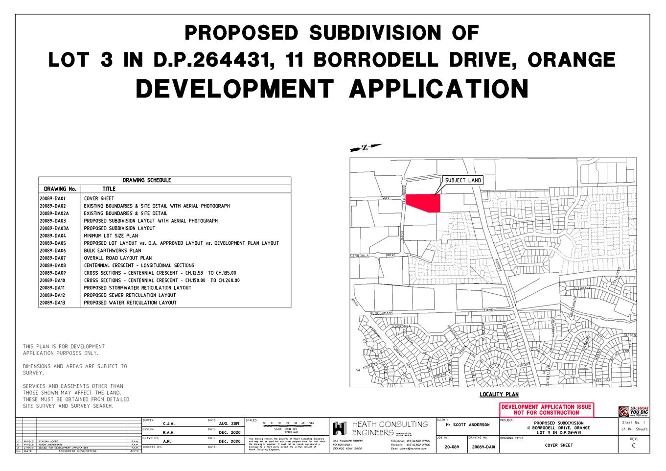
Extraordinary
Council Meeting
27 July 2021
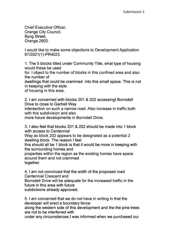

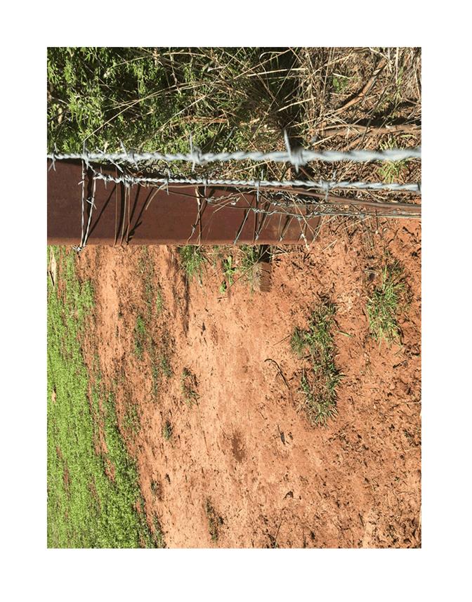
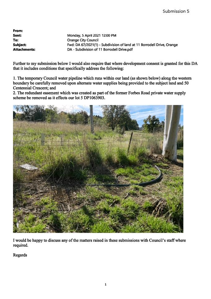
5.14 Development
Application DA 121/2021(1) - 46 Kite Street
RECORD
NUMBER: 2021/1497
AUTHOR: Kelly
Walker, Senior Planner
EXECUTIVE Summary
|
Application
lodged
|
23 March
2021
(additional
information received 16 April 2021)
|
|
Applicant/s
|
Mr DI
Audley
|
|
Owner/s
|
Mrs MM
Audley
|
|
Land
description
|
Lot 1 DP
84714 - 46 Kite Street, Orange
|
|
Proposed
land use
|
Carport
Alterations (replace gate with roller door)
|
|
Value of
proposed development
|
$2,500
|
Council's consent is sought to
carry out alterations and additions to the existing carport at Lot 1 DP 84714,
known as 46 Kite Street, Orange (see Figure 1 for locality).
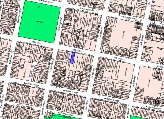 Figure 1 - locality plan
The proposal involves replacing the existing carport gates
with a metal roller door. The existing carport is located at the side of
the dwelling house, at the front building line. A B&D
‘Roll-A-Door Deluxe’ door is proposed, which is of contemporary
style, constructed in a metal grooved squareline profile, and painted Colorbond
Paperbark.
Neighbouring properties were notified of the proposal
pursuant to Council’s Community Participation Plan 2019 (“CPP”).
Two (2) submissions were received objecting to the proposal. The application
was also referred to Council’s Heritage Advisor who does not support the
proposal. These objections are discussed in detail in the main body of this
report.
It is considered that the proposed
roller door is too close to the street, and its siting and design are
inconsistent with the established neighbourhood character, which will result in
considerable adverse impacts on the heritage significance of the surrounds, the
streetscape, and on neighbouring dwellings. Furthermore, the addition of a
roller door will result in the carport not complying with the Building Code
of Australia (BCA) and Regulations with regards to fire safety, increasing
the risk of fire spread for the subject dwelling (i.e. it is too close to the
boundary and there are not enough openings). The proposal also has the
potential to result in adverse stormwater runoff and noise impacts, which have
not been addressed in the application or by the proposed design.
It is noted that the applicant undertook pre-lodgement
discussions with Council’s Heritage Advisor in August 2019, and was
advised that a roller door would not be appropriate for the setting. Following
lodgement of this application, Council staff reiterated this position and advised
that the proposal could not be supported. Suggested alternatives were provided
to the applicant, including installing new gates which extend higher than the
existing gates (to increase security, which is the identified need for the
roller door), or install a new carport or garage with roller door set back
further from the frontage of the dwelling and street.
The applicant argues that the proposal is similar to other
roller doors in the surrounding area. Council staff disagree, where examples of
roller doors in the front areas of properties in the immediate surrounds are
very rare. Furthermore, as established in case law, discordant and undesirable
elements should not emulated or used to justify further impacts on local
character.
The applicant still wishes to pursue the application in its
current form, and suggests mitigating measures including further additions and
alterations to the house and front garden area such as rendering, painting,
landscaping, increasing the height of front boundary wall, etc. Details of
these measures have not been provided, and such changes would need further
assessment and development consent from Council. While these suggestions may
improve the overall visual appearance of the property, they are unlikely to
mitigate the adverse impacts of the roller door to a satisfactory level.
Council staff do not have any suitable suggestions with regards to mitigating
factors or conditions of consent that could render the proposal to be more
acceptable.
Overall, the proposal development is inconsistent and
incompatible with the immediate context and heritage setting. In its current
form the proposal provides no opportunity to suitably mitigate adverse impacts.
The proposal is likely to have a detrimental adverse impact on the heritage
setting, and would detract from the significance of the surrounding State and
locally listed heritage items, contrary to applicable planning policies, and
Section 4.15 of the Environmental Planning and Assessment Act 1979
(“the EP&A Act”).
As such, it is recommended that Council refuse the
application, as set out in the following report and attached draft Notice of
Refusal.
DECISION FRAMEWORK
Development in Orange is governed by two key documents Orange
Local Environment Plan 2011 (“LEP”) and Orange Development
Control Plan 2004 (“DCP”). In addition Council’s Infill Guidelines
are used to guide development, particularly in the heritage conservation areas
and around heritage items.
Orange Local Environment Plan 2011
– The provisions of the LEP must be considered by the Council in
determining the application. LEPs govern the types of development that are
permissible or prohibited in different parts of the City and also provide some
assessment criteria in specific circumstances. Uses are either permissible or
not. The objectives of each zoning and indeed the aims of the LEP itself are
also to be considered and can be used to guide decision making around
appropriateness of development.
Orange Development Control Plan 2004 – the DCP
provides guidelines for development. In general it is a performance based
document rather than prescriptive in nature. For each planning element there
are often guidelines used. These guidelines indicate ways of achieving the
planning outcomes. It is thus recognised that there may also be other solutions
of merit. All design solutions are considered on merit by planning and building
staff. Applications should clearly demonstrate how the planning outcomes are
being met where alternative design solutions are proposed. The DCP enables
developers and architects to use design to achieve the planning outcomes in
alternative ways.
DIRECTOR’S COMMENT
Council’s consent is sought for the installation of a
roller door to the existing carport at the frontage of 46 Kite Street, Orange.
The subject land is located in the Central Orange Heritage Conservation Area,
and is surrounded by State and locally listed heritage items which are highly
valued by the community. Council staff and Council’s Heritage Advisor do
not support the proposal on the grounds that it is not compatible with the
heritage setting. The proposal will have adverse visual, heritage, and
cumulative impacts; and it will compromise the heritage listed items in the
surrounds. Approval of the application would also have implications in terms of
BCA fire compliance and require fire walls along the neighbours boundary.
Two objections were received from neighbours. The applicant was requested
to redesign the proposal but declined. It is recommended that Council does not
support the proposal and refuses the application.
Link To Delivery/OPerational Plan
The recommendation in this report relates to the
Delivery/Operational Plan strategy “10.1 Preserve - Engage with the
community to ensure plans for growth and development are respectful of our
heritage”.
Financial Implications
Nil
Policy and Governance Implications
Nil
|
Recommendation
That Council refuses
development application DA 121/2021(1)
for Carport Alterations (replace gate with roller door) at Lot 1 DP
84714 - 46 Kite Street, Orange pursuant to
the reasons in the attached Notice of Refusal.
|
further considerations
Consideration has been given to the recommendation’s
impact on Council’s service delivery; image and reputation; political;
environmental; health and safety; employees; stakeholders and project
management; and no further implications or risks have been identified.
SUPPORTING INFORMATION
THE PROPOSAL
The proposal involves replacing the existing carport gates
with a garage-style roller door. The existing carport is located at the side of
the dwelling house, at the front building line. A B&D
‘Roll-A-Door Deluxe’ is proposed, which is of contemporary style,
and constructed in a metal grooved squareline profile (see example in Figure
2). It is proposed to finish the roller door in Colorbond Paperbark (or Cream,
Dune, or Surfmist).

Figure 2 – example of a B&D Roll-A-Door (not
subject dwelling house)
MATTERS FOR CONSIDERATION
Section 1.7 - Application of Part
7 of the Biodiversity Conservation Act 2016 and Part 7A of the Fisheries
Management Act 1994
Section 1.7 of the EP&A Act identifies that Part 7 of
the Biodiversity Conservation Act 2016 (BC Act) and Part 7A of
the Fisheries Management Act 1994 have effect in connection with
terrestrial and aquatic environments.
There are four triggers known to insert a development into
the ‘Biodiversity Offset Scheme’ (i.e. the need for a
Biodiversity Development Assessment Report to be submitted with a DA) as follows:
· Trigger 1:
development occurs in land mapped on the Biodiversity Values Map (OEH)
(clause 7.1 of BC Regulation 2017).
· Trigger 2:
development involves clearing/disturbance of native vegetation above a certain
area threshold (clauses 7.1 and 7.2 of BC Regulation 2017).
· Trigger 3:
development is otherwise likely to significantly affect threatened species
(clauses 7.2 and 7.3 of BC Act 2016).
· Trigger 4:
development proposed to occur in an Area of Outstanding Biodiversity Value
(clause 7.2 of BC Act 2016).
In consideration of Triggers 1 and 4, the site is not within
land mapped on the Biodiversity Values Map or LEP Biodiversity Map, or in an
Area of Outstanding Biodiversity Value. In consideration of Trigger 2, the
proposal does not involve the clearing of any vegetation. Overall, and in
regards to Trigger 3, it is considered that the development is unlikely to
significantly affect any threatened species or communities.
Section 4.15
Section 4.15 of the Environmental
Planning and Assessment Act 1979 requires Council to consider various
matters, of which those pertaining to the application are listed below.
PROVISIONS OF ANY ENVIRONMENTAL
PLANNING INSTRUMENT s4.15(1)(a)(i)
Orange Local Environmental Plan
2011
Part 1 - Preliminary
Clause 1.2 - Aims of Plan
The broad aims of the LEP are set out under Subclause 2.
Those relevant to the application are as follows:
(a) to
encourage development which complements and enhances the unique character of
Orange as a major regional centre boasting a diverse economy and offering an
attractive regional lifestyle,
(b) to
provide for a range of development opportunities that contribute to the social,
economic and environmental resources of Orange in a way that allows present and
future generations to meet their needs by implementing the principles for ecologically
sustainable development,
(f) to
recognise and manage valued environmental heritage, landscape and scenic
features of Orange.
The application is considered to be
inconsistent with the above aims as the design and siting of the proposed development
is not compatible the character of the surrounding heritage conservation area,
and is likely to result in adverse impacts on the highly valued heritage
setting, as addressed in the main body of this report.
Clause 1.6 - Consent Authority
This clause establishes that,
subject to the Act, Council is the consent authority for applications made
under the LEP.
Clause 1.7 - Mapping
The subject site is identified on the LEP maps in the
following manner:
|
Land
Zoning Map:
|
Land
zoned R1 General Residential
|
|
Lot
Size Map:
|
No
Minimum Lot Size
|
|
Heritage
Map:
|
Located
in a heritage conservation area, not a listed heritage item
|
|
Height
of Buildings Map:
|
No
building height limit
|
|
Floor
Space Ratio Map:
|
No
floor space limit
|
|
Terrestrial
Biodiversity Map:
|
No
biodiversity sensitivity on the site
|
|
Groundwater
Vulnerability Map:
|
Groundwater
vulnerable
|
|
Drinking
Water Catchment Map:
|
Not
within the drinking water catchment
|
|
Watercourse
Map:
|
Not
within or affecting a defined watercourse
|
|
Urban
Release Area Map:
|
Not
within an urban release area
|
|
Obstacle
Limitation Surface Map:
|
No
restriction on building siting or construction
|
|
Additional
Permitted Uses Map:
|
No
additional permitted use applies
|
|
Flood
Planning Map:
|
Not
within a flood planning area
|
Those matters that are of relevance
are addressed in detail in the body of this report.
Clause 1.9A - Suspension of
Covenants, Agreements and Instruments
This clause provides that covenants, agreements and other instruments
which seek to restrict the carrying out of development do not apply with the
following exceptions.
(a) to
a covenant imposed by the Council or that the Council requires to be imposed,
or
(b) to
any relevant instrument under Section 13.4 of the Crown Land Management Act
2016, or
(c) to
any conservation agreement under the National Parks and Wildlife Act 1974, or
(d) to
any Trust agreement under the Nature Conservation Trust Act 2001, or
(e) to
any property vegetation plan under the Native Vegetation Act 2003, or
(f) to
any biobanking agreement under Part 7A of the Threatened Species Conservation
Act 1995, or
(g) to
any planning agreement under Subdivision 2 of Division 7.1 of the Environmental
Planning and Assessment Act 1979.
Council staff are not aware of the title of the subject
property being affected by any of the above.
Part 2 - Permitted or Prohibited Development
Clause 2.1 - Land Use Zones and Land Use Table
The subject site is located within the R1 General
Residential zone. The proposed development is defined as a ‘dwelling
house’ (additions and alterations to existing carport) under the LEP, and
is permitted with consent for this zone. This application is seeking consent.
Clause
2.3 - Zone Objectives
Clause
2.3 of the LEP references the Land Use
Table and Objectives for each zone in LEP 2011. The objectives for
land zoned R1 General Residential are as follows:
· To provide for
the housing needs of the community.
· To provide for
a variety of housing types and densities.
· To enable other
land uses that provide facilities or services to meet the day to day needs of
residents.
· To ensure development
is ordered in such a way as to maximise public transport patronage and
encourage walking and cycling in close proximity to settlement.
· To ensure that
development along the Southern Link Road has an alternative access.
The proposal does not conflict
with the above zone objectives.
Part 3 - Exempt and Complying Development
The application is not exempt or complying development.
Part 4 - Principal Development Standards
The principal development standards of the LEP are not
relevant to this application.
Part 5 - Miscellaneous Provisions
5.10 - Heritage Conservation
Clause 5.10 of the LEP applies, and states in part:
(1) The objectives of this
clause are as follows:
(a) to
conserve the environmental heritage of Orange,
(b) to
conserve the heritage significance of heritage items and heritage conservation
areas, including associated fabric, settings and views,
(c) to
conserve archaeological sites,
(d) to
conserve Aboriginal objects and Aboriginal places of heritage significance.
(4) Effect
of Proposed Development on Heritage Significance
The consent authority must,
before granting consent under this clause in respect of a heritage item or
heritage conservation area, consider the effect of the proposed development on
the heritage significance of the item or area concerned. This subclause applies
regardless of whether a heritage management document is prepared under
Subclause (5) or a heritage conservation management plan is submitted under
Subclause (6).
The subject land is located within the Central Orange
Heritage Conservation Area (“HCA”), and within the vicinity of
numerous heritage listed items, as shown in Figure 3, including:
· Cook Park –
24-26 Summer Street/corner Kite and Clinton Streets – State heritage
listed Victorian era park, and listing includes trees, plantings, paths,
bandstand, fountains, lodge, conservatory, fernery, ponds, aviaries, artillery
pieces, and gates.
· Newstead (former
bowling club) – 47-49 Hill Street/corner Kite Street – locally
listed former mansion, and listing includes trees and formal garden.
· 37 Kite Street
– locally listed dwelling.
· The Channings - 39
Kite Street – locally listed dwelling.
· Mena (mansion) -
50 Kite Street - locally listed dwelling built by Dalton family.
· 52 Kite Street
– locally listed dwelling of Sir Charles and Lady Cutler (former Minister
for Education, and Duty Premier of NSW).
· 56 Kite Street
– locally listed dwelling, designed by architect John Hale for J.M. Paul
(former Mayor of Orange).
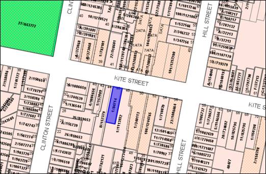
Figure 3 – nearby listed Heritage Items (in
beige hashing)
The subject land is considered to be within a
“heritage setting” which are highly valued by the community, and
the Council is committed to conserving their character while supporting
sympathetic infill development. In order to consider the effect the proposal
has on the significance of the heritage setting pursuant to Clause 5.10(4) of
the LEP, an assessment of character needs to be undertaken.
Character of the Local Area
In defining the relevant character of the local area,
reference tools include the LEP, DCP, Council’s Infill Guidelines,
the Burra Charter, ‘Design in Context:
Guidelines for Infill Development in the Historic Environment’
(NSW Heritage Office and Royal Australian Institute of Architects, 2005), relevant
Case Law in regards to character, and comments from Council’s Urban
Design and Heritage Advisor.
‘Design in Context’ states that character
is defined by the combination of the particular characteristics or qualities of
a place, and the qualitative interplay of factors including:
· the underlying
natural landform and topographic characteristics
· distinctive
landscape elements and vegetation (e.g. trees and foliage)
· the date and style
of the buildings, including materials, colours, building techniques,
detailing etc
· the scale and form
of the buildings, including proportions of openings
· street and
subdivision patterns, including setbacks, building to space pattern of
buildings, curtilage, fencing, landscaping, servicing etc
· fabric
· views, vistas, and
skylines.
It is considered that the local character of the surrounding
area is made up of the following elements:
· Generally level
topography.
· Significant mature
vegetation in wide tree lined streets, established public and private landscaped
gardens, and areas of public open space.
· Surrounding
suburban area has a historic context comprising a generally unified pattern of
development and character of traditional, detached single-storey dwellings,
incorporating:
- modelled
roofs with hips and gables, chimneys, and verandahs
- brick
or rendered finishes
- side
setbacks and dwelling curtilages with view corridors to rear
- uniform
front setbacks and landscaped front and rear gardens
- traditional
low front fences and hedging.
· Heritage listed
Cook Park nearby comprising generous public open space and significant mature
trees.
· Heritage listed
buildings in the vicinity comprising distinctive original architectural
features set within landscaped gardens.
It is noted there is a lack of front/side carports and
garages in the surrounds, with the exception of a few mid-Century infill
dwellings. Some of these have been set back behind the main building line, or
are obscured by substantial plantings (such as the immediate eastern
neighbour). The few roller doors that front the street (such as those opposite
Cook Park) are considered discordant with the established neighbourhood
character.
It is also noted there are new dwellings currently being
constructed behind the former Newstead Bowling Club (diagonally opposite the
subject site). While contemporary in their form, the established character and
heritage setting was taken into account with regards to their scale, setbacks,
openings, colours, detailing, etc. Of particular note is their garages have
been designed so that they do not front the street.
With regards to the subject land, while the dwelling house
appears to be a more recent addition to the street, the original heritage
dwelling is contained behind an infill development to its front. The subject
carport to the side of this frontage was also a later addition.
Character as Applied by the Court
Relevant case law as to whether a development is
‘compatible with the character of the local area’ includes:
· Stebbing
& Anor v Byron Shire Council [2012] NSWLEC 1129, which provides
authority that a development can be refused where the bulk and scale of a
building, its siting on the land, and appearance will result in discordant
elements in the local area, and where a development is an exception to the
predominant character of the local area.
· Pingola Pty Ltd
and Anor v Parramatta City Council [2012] NSWLEC 1270, which provides
authority that the design of the development should respond to the desirable
elements of the character of the area, and that undesirable elements should not
be emulated. This is a consideration in relation to any discordant elements in
the surrounding area.
Character and Heritage Assessment of the Proposal
‘Design in Context’ states
that to achieve a successful infill design the following design criteria
applies:
· character - new
development must harmonise with their surroundings
· scale - size in
relation to surrounding buildings or landscape
· form - overall
shape and volume, and the arrangement of its parts
· siting - should
add sympathetically to the local streetscape and the grain of the area
· materials and colour
- should recognise characteristic materials, textures and colours used locally
and in adjacent buildings
· detailing - common
details that contribute to the special character of an area should be
identified, and inform or inspire design.
The application was referred to
Council’s Urban Design and Heritage Advisor, who makes the following
comments:
· The impact of
the installation of the (roller) door on the streetscape and the adjoining
heritage listed properties will be considerable.
· The Advisor has
(previously) offered alternatives which would attend to the issues nominated by
the applicant as the primary reasons behind the need for security (e.g. higher
gates).
· The impacts are
considered as follows:
- the
garage door is such a substantial sized element
- the
location is at the front of the building
- the
building has a character and style which detracts from its own significance
visually and that of the streetscape given the cream brick facade added to the
earlier late Victorian house
- the
location means that screening is not possible
- no
mitigating options or works have been nominated.
Furthermore, the submissions
received objecting to the proposed development raise the issues of
neighbourhood character and heritage impacts, which are discussed in greater
detail later in this report.
Based on the foregoing, it is
considered that the proposed development is inconsistent with the established
character of the local area and will have a detrimental effect on the
surrounding valued buildings and setting for the following reasons:
· the
roller door will result in a building frontage that appears visually greater in
scale and bulk compared to the existing partially open carport (as well as
compared with the scale of neighbouring dwellings), and will be an overly
dominant and discordant element in the streetscape and setting
· the roller door
will make the carport appear as a garage from the street, and its form and
setback in relation to the site frontage is inconsistent with the surrounding
character and grain (i.e. the carport is too close to the street)
· the spacing to the
side of the dwelling will be lost (i.e. vistas between dwellings, currently
partially visible through the front opening of the carport), which is discordant
with the pattern of surrounding development
· the design,
materials and detailing of the roller door do not suitably recognise or
interpret the characteristic and traditional elements of the surrounding built
form, resulting in a visual appearance which would be discordant with the
buildings around it, and incompatible with the surrounding heritage setting
(i.e. the proposed modern metal finish is inappropriate).
Consideration has been given to the few other examples of
roller doors in the site frontage in the nearby area (i.e. on Kite Street
opposite Cook park, one block to the west of the subject site). These are
considered to be discordant elements, and although they adversely impact on the
streetscape and setting, the rarity of these examples means the overall
heritage setting has remained intact. Furthermore, as established by the courts
discordant elements such as these should not be emulated, nor used to justify
further impacts on local character. Other examples of roller doors in the wider
HCA are too far removed from the subject site to be considered
‘local’, and most are not good examples of appropriate design in a
heritage context, therefore cannot be used to justify the proposed development.
Consideration has also been given to the fact that the
additions and alterations previously carried out to the front of the subject
dwelling are already discordant elements, and do not contribute to the heritage
setting. Notwithstanding this, current planning and heritage policies, as well
as relevant case law, seek to ensure that all new buildings and works in a
heritage setting provide continuity in the built form and harmonize with the
established and desired character of an area. It is considered that the
addition of a roller door to the existing carport will not harmonize with the
setting, and will result in greater visual and heritage impacts to the street,
neighbouring dwellings, and wider HCA as discussed above.
The applicant has offered mitigating measures in an attempt
to reduce impacts as follows:
- render
to soften blonde brickwork at front of house and carport
- increase
height of front boundary wall and add render to match the house
- hedge
planting to front boundary to increase privacy and improve street presentation
- painting
of front bay windows, gutters, downpipes, capping, and roller door in matching
Colorbond Paperbark.
Details of these measures have not been provided with the
application, and such changes would need further assessment and development
consent from Council. While these additions and alterations may improve the
overall visual appearance of the property, they are unlikely to mitigate the
adverse impacts of the roller door to a satisfactory level. In particular, the
lack of setback means there is insufficient space to provide suitable screening
from the street, and a higher front wall and hedge are not considered desirable
for visual, heritage, and security reasons.
Council staff do not have any suggestions with regards to
mitigating factors or conditions of consent that would enable the roller door
to be more acceptable based on the current proposal. Staff recommend that the
applicant either install higher gates on the carport to increase security
(albeit using an open design similar to the existing gates), or construct a new
carport/garage further back from the frontage of the site (i.e. remove the
current carport and build a new one) with a roller door design that is more
compatible with the surrounds. Either of these alternatives are likely to
result in far lesser impacts on the street, neighbours, and heritage setting.
Overall, the proposal development is inconsistent with the
immediate context and heritage setting. In its current form the proposal
provides no opportunity to suitably mitigate adverse impacts. As established in
relevant case law, undesirable elements in the surrounding area should not be
emulated. The proposal is likely to have a detrimental effect on the heritage
setting, and would detract from the significance of the surrounding listed items
and HCA, contrary to the objectives of LEP Clause 5.10.
Part 6 - Urban Release Area
Not relevant to the application. The subject site is not
located in an Urban Release Area.
Part 7 - Additional Local Provisions
7.3 - Stormwater Management
This clause requires that
Council be satisfied that the proposal:
(a) is designed to maximise the use of water
permeable surfaces on the land having regard to the soil characteristics
affecting onsite infiltration of water
(b) includes, where practical, onsite stormwater
retention for use as an alternative supply to mains water, groundwater or river
water; and
(c) avoids any significant impacts of
stormwater runoff on adjoining downstream properties, native bushland and
receiving waters, or if that impact cannot be reasonably avoided, minimises and
mitigates the impact.
At
present rainwater runs from the driveway down to the street, however the
installation of a roller door on the carport is likely to impede stormwater
runoff within the site and/or divert runoff into the western neighbour’s
property. The application does not include details of how stormwater will be
managed as part of proposal. It is considered that the proposal has not been
designed to take into account stormwater runoff, and thus Clause 7.3 has not
been satisfied.
7.6 - Groundwater Vulnerability
This
clause seeks to protect hydrological functions of groundwater systems and
protect resources from both depletion and contamination. Orange has a high
water table and large areas of the LGA, including the subject site, are
identified with “Groundwater Vulnerability” on the Groundwater
Vulnerability Map. This requires that Council consider:
(a) whether or not the development (including
any onsite storage or disposal of solid or liquid waste and chemicals) is
likely to cause any groundwater contamination or have any adverse effect on
groundwater dependent ecosystems, and
(b) the cumulative impact (including the
impact on nearby groundwater extraction for potable water supply or stock water
supply) of the development and any other existing development on groundwater.
Furthermore ,consent may not be granted unless Council is satisfied that:
(a) the development is designed, sited and
will be managed to avoid any significant adverse environmental impact, or
(b) if that impact cannot be reasonably
avoided - the development is designed, sited and will be managed to minimise
that impact,
(c) if that impact cannot be minimised - the
development will be managed to mitigate that impact.
The proposal does not involve
extraction of groundwater, and is not anticipated to involve the discharge of
toxic or noxious substances and is therefore unlikely to contribute to
groundwater depletion or contaminate the groundwater or related ecosystems.
Clause 7.11 - Essential
Services
Clause 7.11 applies and states:
Development
consent must not be granted to development unless the consent authority is
satisfied that any of the following services that are essential for the
proposed development are available or that adequate arrangements have been made
to make them available when required:
(a) the supply of water,
(b) the supply of electricity,
(c) the disposal and management of
sewage,
(d) storm water drainage or onsite
conservation,
(e) suitable road access.
In consideration of this clause,
all utility services are available to the land, however the drainage of
stormwater runoff from paved surfaces (i.e. the driveway, which is also the
base of the carport) has not been addressed in the application.
STATE ENVIRONMENTAL PLANNING
POLICIES
There are no State Planning Policies that are applicable to
this development.
PROVISIONS OF ANY DRAFT
ENVIRONMENTAL PLANNING INSTRUMENT THAT HAS BEEN PLACED ON EXHIBITION
4.15(1)(a)(ii)
Draft Amendment No 29 is currently on public exhibition. The
draft amendment relates to the heritage controls for the City. The subject land
is already located within a heritage conservation area and therefore heritage
controls already apply to the subject development.
DESIGNATED DEVELOPMENT
The proposed development is not designated development.
INTEGRATED DEVELOPMENT
The proposed development is not integrated development.
PROVISIONS OF ANY DEVELOPMENT
CONTROL PLAN s4.15(1)(a)(iii)
Development Control Plan 2004
Development Control Plan 2004 (“DCP”) applies to
the subject land. An assessment of the proposed development against the
relevant Planning Outcomes will be undertaken below.
Chapter 7 - Development in
Residential Areas
The following Chapter 7 Planning Outcomes are considered
relevant to the proposal:
Neighbourhood Character and Heritage
Neighbourhood character and heritage have been discussed
extensively in the LEP Clause 5.10 Heritage assessment above, where it is
considered the proposed roller door is not compatible with the surrounding
heritage setting or neighbourhood character. Thus the proposal is contrary to
these DCP objectives.
Building Appearance
With regards to building appearance, the DCP requires
garages, carports and parking to be sited and designed so that they do not
dominate the street frontage; and for design, detailing and finishes to
complement the area and add visual interest to the street. As previously
discussed, it is considered that the proposal will dominate the street and is
not of an appropriate scale, design, or appearance for the area. As such, the
proposal is contrary to these outcomes.
Setbacks
With regards to setbacks, the roller door will exacerbate
the visual and streetscape impacts the existing carport has on the street (as
previously discussed), and will not contribute to, or result in an appropriate
scale, within the street. The proposal does not meet the DCP setback planning
outcomes.
Visual Bulk and Views
As previously discussed, the proposed roller door will
result in additional visual bulk to the frontage of the building/site, and will
reduce spacing and vistas between buildings, which will not be of a comparable
scale to the street or adjacent development and established built form.
Further, the vistas of the heritage streetscape along Kite Street will be
substantially affected by the addition of another discordant element to the
site. Overall, it is considered that the visual impacts in terms of bulk and
views are contrary to the DCP planning outcomes.
Acoustic Privacy
The application does not give regard to the operation of the
roller door motor immediately adjacent to the western neighbour. Usually roller
door motors are contained within a garage/building, however in this case, the
carport is partially open to the side and rear nearest to the neighbouring
property. The proposal may result in adverse noise impacts, contrary to these
planning outcomes.
Car Parking
The DCP planning outcomes for car
parking requires that development reduce the visual dominance of parking areas
(including garages and carports). As previously discussed, the proposed roller
door will visually dominate the street and result in adverse impacts, and as
such, is contrary to this planning outcome.
Circulation Design and Stormwater
The DCP requires that access ways
and parking areas are designed to manage stormwater onsite so that it does not
cause damage or nuisance flows to adjoining properties, and to consider safety
for pedestrians and vehicles, as well as overland flow paths. As discussed
previously, this matter has not been adequately addressed in the application,
and as such, the proposal is contrary to these DCP outcomes.
Chapter 13 - Heritage
Heritage has been discussed
extensively in the previous LEP Clause 5.10 Heritage assessment, where it is
considered the proposed roller door is not compatible with the surrounding
heritage setting and will result in substantial adverse impacts on surrounding
listed heritage items. The proposal is thus contrary to these DCP objectives.
INFILL GUIDELINES
The DCP Infill Guidelines
are relevant to the proposal, and its objectives are as follows:
· Retention of
appropriate visual setting (Article 8 Burra Charter).
· To ensure new
buildings respond to and enhance the character and appearance of the
streetscapes of the Heritage Conservation Areas.
· To ensure
contributory heritage items retain their prominence and are not dominated by
new development within a Heritage Conservation Area and do not compromise the
heritage values of the existing area.
· To ensure new
buildings do not adversely affect the significance, character or appearance of
the Heritage Conservation Area or heritage items.
· To allow for
reasonable change within a Heritage Conservation Area while ensuring all other
heritage objectives are met.
· To ensure new
development facilitates the retention of significant vegetation that
contributes to the tree canopy, especially within the Central Orange Heritage
Conservation Area.
The proposed development does not
meet these objectives, where the visual and heritage setting will be adversely
affected. As previously discussed, the proposed roller door will not respond to
or enhance the character of the local area, and adjacent and nearby heritage
items will be adversely affected, thereby compromising the immediate and wider
heritage setting.
In particular the proposed
development departs from the assessment criteria contained in the Infill
Guidelines as follows:
Scale and Form: the proposal
is inconsistent with the prevailing residential form and scale. The few
examples of roller doors within the site frontage are not consistent with the
character of the area, and should not be used to justify further impacts on
local character.
Siting: the carport does not
have a suitable setback from the street, and the addition of a roller door will
exacerbate its impacts. Furthermore, the spacing/vistas between buildings will
be lost.
Materials and detailing:
the contemporary materials and profile of the roller door do not complement the
neighbourhood character or relate to the traditional context of the area.
Infill buildings and works should aim to provide continuity
in the built form, and make reference to the established and valued setting by
responding to its historic context through an understanding and informed
analysis of its character and quality, including elements such as its grain,
existing patterns of development, important views, scale, materials and detailing.
The proposed development fails to achieve this as set out above.
Council staff consider there are more suitable alternatives
available that would result in a more acceptable change to the site, without
conceding on the heritage objectives (as previously discussed).
PROVISIONS PRESCRIBED BY THE
REGULATIONS s4.15(1)(a)(iv)
Demolition of a Building (clause
92)
The proposal does not involve the demolition of a building,
although the gates are proposed to be removed.
Fire Safety Considerations
(clause 93) and Buildings to be Upgraded (clause 94)
The proposal is not considered acceptable with regards to
fire safety. As the carport is located immediately adjacent to the site
boundary (western side), and the roller door will enclose the front of the
carport, it will not comply with the Building Code of Australia (BCA).
Council’s Environmental Health and Building Surveyor notes that the
existing carport does not comply with BCA as the front opening is too tight and
the roof is too close to the boundary, however the roller door will exacerbate
fire safety concerns (i.e. fire spread to the subject dwelling house).
Furthermore, the Regulations require upgrades when making
changes to non-complying structures (i.e. fire rate the carport). Such upgrades
would require further building works to be undertaken, which are likely to
compound the adverse impacts of the proposal discussed in the assessment
sections of this report.
BASIX Commitments (clause 97A)
BASIX is not applicable to the proposed development.
THE LIKELY IMPACTS OF THE
DEVELOPMENT s4.15(1)(b)
As discussed extensively throughout this report, the
proposed roller door is likely to result in substantial adverse impacts as
follows:
· Significant visual
bulk and dominance of the carport, including lack of setbacks and spacing -
adverse streetscape impacts, adverse heritage impacts, adverse visual impacts
to immediate neighbours, and detrimental impacts on surrounding heritage listed
items.
· Incompatible
visual appearance within the heritage context, including inappropriate use of
contemporary materials, detailing, etc. - adverse impacts to the local and
wider heritage setting, and detrimental impacts on surrounding heritage listed
items.
· Setting a
precedent for/adding to undesirable development in a significant heritage
setting - adverse cumulative impacts.
· Non-compliance
with BCA and Regulations - increased fire risk to subject property (note:
necessary upgrades are likely to cause further adverse visual and heritage impacts
to those noted in this section).
· Potential adverse
stormwater impacts on the subject property, neighbouring property to the west,
and footpath/street.
· Potential adverse
noise impacts to neighbouring property to the west.
THE SUITABILITY OF THE SITE
s4.15(1)(c)
It is considered that the site is not suitable for the
proposed development for the following reasons:
· the proposal will
adversely impact on the heritage setting, including compromising surrounding
heritage listed buildings
· the proposal will
adversely impact on the streetscape, the neighbourhood, and neighbouring
properties
· mitigation is not
possible based on the current site layout and design
· increased fire
risk resulting from non-compliance with the BCA
· potential
stormwater impacts to the subject site, neighbours, and the street.
ANY SUBMISSIONS MADE IN
ACCORDANCE WITH THE ACT s4.15(1)(d)
Neighbouring properties were notified of the proposal due to
likely impacts to the streetscape and neighbourhood and heritage character, in
accordance with Council’s CPP. The application was notified for the
prescribed period of 14 days and at the end of that period two (2) submissions
were received. Both submissions oppose the development, and reasons are
summarised below:
· Existing additions
are unsympathetic to original home, and presents a stark frontage.
· Existing house and
carport already dominate the frontage (90%) and a roller door will have huge
negative impact on streetscape and heritage area.
· New development at
Newstead had to alter their plans to have no garages at the frontage to remove
visual impact, and this should be maintained (i.e. for other development).
· There are no other
garages visible in this block. Garages should not face Kite Street.
· Many homes in the
block which are listed, noted, or a fine example of their era and the heritage
landscape should not be further eroded.
· There are already
two adequate lock up garages at the rear of the site.
· Posts have been
erected near the eastern boundary of the subject site (shade sail) and the
neighbour requests that they be removed.
Staff comment: These matters have been addressed in
the main body of the report. Council staff agree that garages should not be
installed close to the street frontage in this area, and that the proposed
roller door will have substantial adverse impacts on the heritage setting. With
regards to the shade structure erected on the subject land, State
Environmental Planning Policy (Exempt and Complying Development Codes) 2008 allows
for shade structures up to a certain size, and it is not clear if the subject
structure meets these standards or not. This matter is not relevant to this
application, and will be dealt with under separate cover.
PUBLIC INTEREST
s4.15(1)(e)
The proposed development is considered to be of interest to
the wider public due to the nature of potential heritage and cumulative impacts
as discussed in the main body of this report. Overall, the proposal is
considered to be inconsistent with relevant policies, guidelines, etc. as set
out in the above assessment.
SUMMARY
Council’s consent is sought for the installation of a
roller door to the existing carport at the frontage of number 46 Kite Street,
Orange. The subject land is located in the Central Orange Heritage Conservation
Area, and is surrounded by State and locally listed heritage items which are
highly valued by the community. Council staff and Council’s Heritage
Advisor do not support the proposal on the grounds that it is not compatible
with the heritage setting; it will have considerable adverse visual, heritage,
and cumulative impacts; and it will compromise the heritage listed items in the
surrounds.
Overall, it is considered that the proposal will adversely
impact on character of the area, the heritage significance of the setting, and
neighbouring amenity pursuant to Clause 5.10 of Orange LEP 2011,
Chapters 7 and 13 of Council’s DCP, and Council’s Infill
Guidelines.
It is recommended that Council does not support the proposal
and refuses the application. Attached is a draft Notice of Refusal.
Attachments
1 Notice
of Refusal, D21/44155⇩
2 Plans,
D21/43960⇩
3 Submissions,
D21/43961⇩
Extraordinary
Council Meeting
27 July 2021
Attachment 1 Notice
of Refusal
|

|
ORANGE CITY COUNCIL
Development
Application No DA
121/2021(1)
NA21/517 Container
PR6259
|
NOTICE OF DETERMINATION
OF A DEVELOPMENT APPLICATION
issued under the Environmental
Planning and Assessment Act 1979
Section 4.18
|
Development Application
|
|
|
Applicant Name:
|
Mr D I Audley
|
|
Applicant Address:
|
46 Kite Street
ORANGE
NSW 2800
|
|
Land to Be Developed:
|
Lot 1 DP 84714 - 46 Kite Street, Orange
|
|
Proposed Development:
|
Carport Alterations (replace gate with roller
door)
|
|
|
|
|
Building Code of Australia
Building Classification:
|
Not applicable
|
|
|
|
|
Determination made under
Section 4.16
|
|
|
Made On:
|
20 July 2021
|
|
Determination:
|
APPLICATION REFUSED
|
|
|
|
|
Reason(s) for Refusal:
|
1 The
proposed development will have adverse visual impacts on the surrounding
neighbourhood, streetscape, and adjacent neighbouring properties.
2 The
proposed development will have detrimental heritage impacts on the heritage
setting, neighbourhood, streetscape, adjacent neighbouring properties, and
surrounding heritage items.
3 The
proposed development will have adverse cumulative impacts on the surrounding
neighbourhood and heritage setting.
|
|
|
|
|
Right of Appeal:
|
Applicant:
If
you are dissatisfied with this decision, Section 8.7 of the Environmental
Planning and Assessment Act 1979 gives you the right to appeal to
the Land and Environment Court. Pursuant to Section 8.10, an applicant may
only appeal within 6 months after the date the decision is notified.
Objector:
The
Environmental
Planning and Assessment Act 1979 does not give a right of appeal against this
determination to an objector.
|
|
|
|
|
Signed:
|
On behalf of the consent authority:
|
|
Signature:
|
|
|
Name:
|
PAUL JOHNSTON - MANAGER DEVELOPMENT
ASSESSMENTS
|
|
Date:
|
21 July 2021
|
Extraordinary Council Meeting
27 July 2021
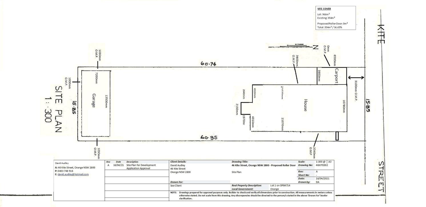
Extraordinary
Council Meeting
27 July 2021
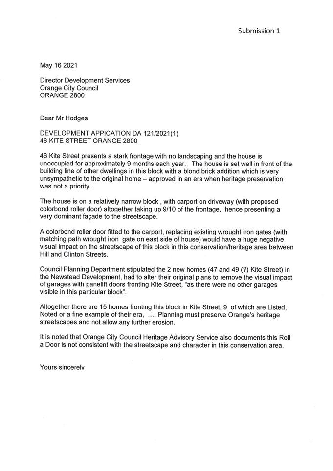
5.15 Development
Application DA 196/2021(1) - 147 Lords Place
RECORD
NUMBER: 2021/1529
AUTHOR: Sophie
Currenti, Student Planner
EXECUTIVE
Summary
|
Application
lodged
|
10 May
2021
|
|
Applicant/s
|
Ms A
Rasmussen
|
|
Owner/s
|
Wheeler
Industries Pty Limited
|
|
Land
description
|
Lot A DP
394144 - 147 Lords Place, Orange
|
|
Proposed
land use
|
Artisan
Food and Drink Industry (change of use)and signage.
|
|
Value of
proposed development
|
$50,000
|
Council's consent is sought for a change of use of the
property at 147 Lords Place, Orange – Lot A DP 394144 from a
warehouse to an artisan food and drink industry.
The proposal includes the following
components:
· Change of use from
a vacant warehouse premises to an artisan food and drink industry premises.
· Installation of
brewing equipment and storage
o proposed scale of the brewing
operation anticipates a production level of 130‑550 tonnes of alcohol per
annum .
· Installation of a
bar area for tastings and coffee, cool room, and furniture.
· Minimal
constructions works; new entrance door, internal fitout of brewing equipment,
bar area, tables and chairs, rear exit door and access ramp.
· Minor upgrades for
fire safety, including new fire exits, bollards, emergency lighting, fire
extinguishers and smoke detectors.
· Business
identification signage to reflect the new operation on the existing flagpole
and new signage on the front building elevation.
A Licensing Plan is provided to identify the areas for both
production and consumption. Licensing through NSW Liquor and Gaming will be
undertaken separately.
Signage includes business identification signage on the
Lords Place street frontage and on an existing sign pole located within the
street setback. Proposed signage is consistent with the types, size and
locations of the surrounding locality.
Notable planning matters for this application include car
parking requirements associated with the new use; amenity impacts by reason of
noise and odour emissions; and the contribution of emerging food industries to
the City’s regional centre status.
As outlined in the report, insufficient onsite car parking
is available and in accordance with Council policy, when additional car parking
demand cannot be met onsite, the net increase is required to be met by a car
parking contribution. The proponent has requested that contributions be waived
in this case. It has been assessed that a portion of the contributions be
waived to facilitate the proposed development.
 The
proposed development is considered to satisfy the Local and State planning
controls that apply to the subject land and particular landuse. Impacts of the
development will be within reasonable limit, subject to mitigation conditions.
Approval of the application is recommended.
The
proposed development is considered to satisfy the Local and State planning
controls that apply to the subject land and particular landuse. Impacts of the
development will be within reasonable limit, subject to mitigation conditions.
Approval of the application is recommended.
Figure 1 - locality plan
DECISION FRAMEWORK
Development in Orange is governed by two key documents
Orange Local Environment Plan 2011 and Orange Development Control Plan 2004. In
addition the Infill Guidelines are used to guide development, particularly in
the heritage conservation areas and around heritage items.
Orange Local Environment Plan 2011 – The
provisions of the LEP must be considered by the Council in determining the
application. LEPs govern the types of development that are permissible or
prohibited in different parts of the City and also provide some assessment
criteria in specific circumstances. Uses are either permissible or not. The objectives
of each zoning and indeed the aims of the LEP itself are also to be considered
and can be used to guide decision making around appropriateness of development.
Orange Development Control Plan 2004 – the DCP
provides guidelines for development. In general it is a performance based
document rather than prescriptive in nature. For each planning element there
are often guidelines used. These guidelines indicate ways of achieving the
planning outcomes. It is thus recognised that there may also be other solutions
of merit. All design solutions are considered on merit by planning and building
staff. Applications should clearly demonstrate how the planning outcomes are
being met where alternative design solutions are proposed. The DCP enables
developers and architects to use design to achieve the planning outcomes in
alternative ways.
DIRECTOR’S COMMENT
The proposal involves the establishment Artisan Food and
Drink industry in a vacant commercial premises in Lords Place. Artisan Food and
Drink industries are new type of development encouraged within the City.
Notable planning matters for this application include car parking requirements
associated with the new use; amenity impacts by reason of noise and odour
emissions; and the contribution of emerging food industries to the City’s
regional centre status.
The development results in a net shortfall of parking. The
net increase in parking demand may be met by a car parking contribution of
around $39,000. The proponent has requested that contributions be waived for
various reasons that have been outlined in the report. Whilst the financial
impacts on a new business are noted and there is a desire to support this new
tourism growth sector, (a use that doesn’t really line up with the
parking plan) it’s considered staff cannot recommend the waiver of a such
a substantial contribution, as that would undermine a strategic policy set by
the Council. This is a matter for Council to determine.
Link To
Delivery/OPerational Plan
The recommendation in this report relates to the
Delivery/Operational Plan strategy “10.1 Preserve - Engage with the
community to ensure plans for growth and development are respectful of our
heritage”.
Financial Implications
Nil
Policy and Governance Implications
Nil
|
Recommendation
That Council consents to
development application DA 196/2021(1)
for Artisan Food and Drink Industry (change of use)and signage at Lot
A DP 394144 - 147 Lords Place, Orange
pursuant to the conditions of consent in the attached Notice of Approval.
|
further considerations
Consideration has been given to the recommendation’s
impact on Council’s service delivery; image and reputation; political;
environmental; health and safety; employees; stakeholders and project
management; and no further implications or risks have been identified.
SUPPORTING INFORMATION
The proposal involves a change of use of an existing vacant
warehouse building to an artisan food and drink industry at 147 Lords Place,
Orange. The proposal includes the following components:
· Installation of
brewing equipment (tanks, still, bottling, packaging and storage).
· Installation of a
bar area for tastings and coffee.
· Moveable furniture
for inside seating, and courtyard seating.
· Minor upgrades for
fire safety, including new fire exits, bollards, emergency lighting, fire
extinguishers and smoke detectors.
· New door (western
elevation) and access ramp to courtyard area.
Food provision will be limited to pre-prepared food/catering
and or delivery of food from other venues. The proposed scale of the brewing
operation anticipates a production level of 0.5-2 tonnes of alcohol per day or
130-550 tonnes per annum.
The main brewing processes include:
- Receipt
and preparation of raw materials.
- Fermentation.
- Distillation.
- Bottling
and packaging.
The proposed microbrewery will consist of the following
processes:
- Grain
milling.
- The
milled grain is mixed with warm water in the mash vessel, steeped for 1 hour
producing sweet ‘wort’.
- Wort
is pumped with portable pump to electric kettle.
- Grain
husks left behind in the mash vessel are shovelled the following day into used
grain bags and removed off site. The grain husks by product are left to dry
overnight, packed and used for stock feed or composting off site.
- Wort
is boiled in the kettle with hops added for a 90 minute period, cooled and then
pumped to the sealed fermentation tanks.
- Beer
is then kegged after 14-30 days.
Main hours of operation for the brewing will be standard
business type hours:
- Monday
to Friday 8am to 5pm
Coffee will be available:
- Monday
to Friday 5.30am to 2pm
- Saturdays
and Sundays 7am to 2pm
A bar area will also operate Monday to Sunday. Proposed
hours for the tastings/bar include:
- Monday–Wednesday
5pm–10pm
- Thursday
12pm–10pm
- Friday–Saturday
11am–11pm
- Sunday
11am–8pm
Whilst it is anticipated the tastings and bar will operate
primarily Friday to Sunday, the operators wish to have the flexibility for
extended operational hours during tourism events such as F.O.O.D Week, Wine
Week and Fire Festival. This further supports the regions development of local
and regional tourism.
A Licensing Plan is provided to identify the areas for both
production and consumption. Licensing through NSW Liquor & Gaming will be
undertaken separately.
Street frontage (within the front setback) is also intended
for licensing and use; however only outside of core business hours from 5pm
Monday to Friday. For Saturday and Sunday trading, this area will be utilised
from 11am.
Proposed staff numbers include three (3) FTE for the brewery
and two to three (2-3) staff for the bar/tastings/coffee components.
Signage includes business identification signage on the
Lords Place street frontage and on an existing sign pole located within the street
setback. Proposed signage is consistent with the types, size and locations of
the surrounding locality.
 The
existing site is connected to all essential services being reticulated water
and sewer, electricity, gas and telecommunications.
The
existing site is connected to all essential services being reticulated water
and sewer, electricity, gas and telecommunications.
Figure 2 – site plan
Figure 3 – proposed floor plan
 Figure 4 – proposed licensing
plan
Figure 4 – proposed licensing
plan
MATTERS FOR CONSIDERATION
Section 1.7 - Application of Part
7 of the Biodiversity Conservation Act 2016 and Part 7A of the Fisheries
Management Act 1994
Section 1.7 of the EP&A Act identifies that Part 7 of
the Biodiversity Conservation Act 2016 (BC Act) and Part 7A of the
Fisheries Management Act 1994 have effect in connection with terrestrial and
aquatic environments.
There are four triggers known to insert a development into
the Biodiversity Offset Scheme (ie the need for a BDAR to be submitted
with a DA):
· Trigger 1:
development occurs in land mapped on the Biodiversity Values Map (OEH)
(clause 7.1 of BC Regulation 2017);
· Trigger 2:
development involves clearing/disturbance of native vegetation above a certain
area threshold (clauses 7.1 and 7.2 of BC Regulation 2017); or
· Trigger 3:
development is otherwise likely to significantly affect threatened species
(clauses 7.2 and 7.3 of BC Act 2016).
The fourth trigger (development proposed to occur in an Area
of Outstanding Biodiversity Value (clause 7.2 of BC Act 2016) is generally not
applicable to the Orange LGA; as no such areas are known to occur in the LGA.
No further comments will be made against the fourth trigger.
Summary
The site does not occur within land mapped on the
Biodiversity Values Map and no clearing/disturbance is proposed. As the
proposal does not trigger any of the four requirements for insertion into the
BOS, a Biodiversity Development Assessment Report is not required to be lodged
with the application for development consent. No other comments are warranted
under this section.
Section 4.15
Section 4.15 of the Environmental Planning and Assessment
Act 1979 requires Council to consider various matters, of which those
pertaining to the application are listed below.
PROVISIONS OF ANY ENVIRONMENTAL
PLANNING INSTRUMENT s4.15(1)(a)(i)
Orange Local Environmental Plan
2011
Part 1 - Preliminary
Clause 1.2 - Aims of Plan
The
broad aims of the LEP are set out under subclause 2. Those relevant to the
application are as follows:
(a) to
encourage development which complements and enhances the unique character of
Orange as a major regional centre boasting a diverse economy and offering an
attractive regional lifestyle,
(b) to
provide for a range of development opportunities that contribute to the social,
economic and environmental resources of Orange in a way that allows present and
future generations to meet their needs by implementing the principles for
ecologically sustainable development,
(f) to
recognise and manage valued environmental heritage, landscape and scenic
features of Orange.
The application is considered to be
consistent with the applicable aims of the plan. Orange has a diverse economy
and the proposed artisan food and drink premises will add to the range of food
and drink opportunities available within the City and strengthen the
City’s regional status.
Clause 1.6 - Consent Authority
This clause establishes that,
subject to the Act, Council is the consent authority for applications made
under the LEP.
Clause 1.7 - Mapping
The subject site is identified on the LEP maps in the
following manner:
|
Land
Zoning Map:
|
Land
zoned B3 Commercial Core
|
|
Lot
Size Map:
|
No
Minimum Lot Size
|
|
Heritage
Map:
|
Not
a heritage item or conservation area
|
|
Height
of Buildings Map:
|
Building
height limit 12m
|
|
Floor
Space Ratio Map:
|
Floor
space limit 1.5:1
|
|
Terrestrial
Biodiversity Map:
|
No
biodiversity sensitivity on the site
|
|
Groundwater
Vulnerability Map:
|
Groundwater
vulnerable
|
|
Drinking
Water Catchment Map:
|
Not
within the drinking water catchment
|
|
Watercourse
Map:
|
Not
within or affecting a defined watercourse
|
|
Urban
Release Area Map:
|
Not
within an urban release area
|
|
Obstacle
Limitation Surface Map:
|
No
restriction on building siting or construction
|
|
Additional
Permitted Uses Map:
|
No
additional permitted use applies
|
|
Flood
Planning Map:
|
Not
within a flood planning area
|
Those
matters that are of relevance are addressed in detail in the body of this
report.
Clause 1.9A - Suspension of
Covenants, Agreements and Instruments
This clause provides that covenants, agreements and other
instruments which seek to restrict the carrying out of development do not apply
with the following exceptions:
(a) to
a covenant imposed by the Council or that the Council requires to be imposed,
or
(b) to
any relevant instrument under Section 13.4 of the Crown Land Management Act
2016, or
(c) to
any conservation agreement under the National Parks and Wildlife Act 1974, or
(d) to
any Trust agreement under the Nature Conservation Trust Act 2001, or
(e) to
any property vegetation plan under the Native Vegetation Act 2003, or
(f) to
any biobanking agreement under Part 7A of the Threatened Species Conservation
Act 1995, or
(g) to
any planning agreement under Subdivision 2 of Division 7.1 of the Environmental
Planning and Assessment Act 1979.
Council staff are not aware of the title of the subject property
being affected by any of the above.
Part 2 - Permitted or Prohibited Development
Clause 2.1 -
Land Use Zones and Clause 2.3 - Zone Objectives and Land Use Table
The subject site is located within the B3 Commercial Core
zone. The proposed development is defined as an ‘artisan food and
drink industry’ under OLEP 2011 and is permitted with consent for
this zone. This application is seeking consent.
The standard instrument defines artisan food and drink
industry as a building or place the principal purpose of which is the
making or manufacture of boutique, artisan or craft food or drink products
only. It must also include at least one of the following:
(a) a
retail area for the sale of the products,
(b) a
restaurant or cafe,
(c) facilities
for holding tastings, tours or workshops.
Artisan food and drink industry’ is a subset of the
‘light industry’ land use; however the land use is expressly
permitted in the B3 land use table subject to development consent.
The primary or dominant use of the land on the site will be
used for the manufacture of beer through the Micro-Brewery. There is a
designated area for holding tastings, tours, workshops and masterclasses. The
proposal is consistent with the standard instrument definition.
Clause 2.3 of LEP 2011
references the Land Use Table and Objectives for each zone in LEP 2011.
These objectives for land zoned B3 Commercial Core are as follows:
1 -
Objectives of the B3 Commercial Core Zone
· To provide a
wide range of retail, business, office, entertainment, community and other
suitable land uses that serve the needs of the local and wider
community.
· To encourage
appropriate employment opportunities in accessible locations.
· To maximise
public transport patronage and encourage walking and cycling.
· To promote
development that contributes to the role of the Orange CBD as the primary
retail and business centre in the City and region.
The proposed development is consistent with the listed
objectives above.
- The
proposed artisan food and drink industry is a suitable land use that will serve
the needs of the local and wider community.
- The
proposal will generate employment opportunities in an accessible location.
- The
premises is centrally located in the CBD and accessible via public transport,
walking and cycling.
- The
proposed artisan food and drink industry is one of the first land uses of its
type in the City (since inclusion in the Standard Instrument). The proposal
will contribute to the role of the CBD as the primary retail and business
centre for the region.
- The
proposed development aims to support the local tourism industry by enhancing
the range of food and drink experiences available within the Orange region. The
development of a craft beer trail in the Central West aims to further support
tourism to the locality.
- The
site is well situated for commercial activity.
Part 3 - Exempt and Complying Development
The application is not exempt or complying development.
Part 4 - Principal Development Standards
Clause 4.3 - Height of Buildings
This clause limits the height of
buildings (HoB) on land identified on the Height of Buildings Map. The subject
land is identified on the Map as having a HoB limit of 12m. The proposed
development will be wholly located within the existing building with no change to the height of the subject building.
Clause 4.4 - Floor Space Ratio
The subject land is identified on the Map as having
an FSR of 1.5:1. The proposed development does not include any increase in
floor area of the building. The proposal is consistent with the FSR
requirements.
Part 5 -
Miscellaneous Provisions
Clause 5.4 Controls Relating to
Miscellaneous Permissible Uses
Clause 5.4(10) applies to artisan
food and drink industries. This clause states:
If development for the
purpose of an artisan food and drink industry is permitted under this Plan in an
industrial or rural zone, the floor area for retail sales (not including
any café or restaurant area) must not exceed:
(a) 20%
of the gross floor area of the industry, or
(b) 400
square meters,
whichever
is the lesser.
The controls at Clause 5.4(10) are not applicable as the
subject land is zoned B3 Commercial Core.
Clause 5.10 Heritage
Conservation
The subject land is located near a Local heritage item: the
Kelly’s Rugby Hotel at 133 Lords Place (Item 214). Clause 5.10 is
applicable and states in part:
(4) The
consent authority, must, before granting consent under this clause in respect
of a heritage item or heritage conservation area, consider the effect of the
proposed development on the heritage significance of the item or area
concerned.
In consideration
of this clause, the proposed development will not have adverse impact on the
significance of the nearby listed item. The subject building is spatially
removed from the listed pub due to its siting a few lots down. The proposed
works will not alter the bulk, massing or profile of the building, and how it
relates within the setting. Site redevelopment for a complementary use will
assist to revitalise the precinct, and may improve the appreciation of the
nearby heritage listed pub.
Part 6 - Urban Release Area
Not relevant to the application. The subject site is not
located in an Urban Release Area.
Part 7 - Additional Local Provisions
7.3
- Stormwater Management
This clause applies to all
industrial, commercial and residential zones and requires that Council be
satisfied that the proposal:
(a) is designed to maximise the use of water
permeable surfaces on the land having regard to the soil characteristics
affecting onsite infiltration of water
(b) includes, where practical, onsite
stormwater retention for use as an alternative supply to mains water,
groundwater or river water; and
(c) avoids any significant impacts of
stormwater runoff on adjoining downstream properties, native bushland and
receiving waters, or if that impact cannot be reasonably avoided, minimises and
mitigates the impact.
The
proposal does not include any construction works to the existing buildings that
would require changes or upgrades to current stormwater provisions on the site.
The proposal is considered to be acceptable in regard to stormwater management.
It is therefore considered that the post development runoff levels will
not exceed the predevelopment levels.
7.6 - Groundwater Vulnerability
This
clause seeks to protect hydrological functions of groundwater systems and
protect resources from both depletion and contamination. Orange has a high
water table and large areas of the LGA, including the subject site, are
identified with “Groundwater Vulnerability” on the Groundwater
Vulnerability Map. This requires that Council consider:
(a) whether or not the development (including
any onsite storage or disposal of solid or liquid waste and chemicals) is
likely to cause any groundwater contamination or have any adverse effect on
groundwater dependent ecosystems, and
(b) the cumulative impact (including the
impact on nearby groundwater extraction for potable water supply
or stock water supply) of the development and any other existing development on
groundwater.
Furthermore consent may not be granted unless Council is satisfied that:
(a) the development is designed, sited and
will be managed to avoid any significant adverse environmental impact, or
(b) if that impact cannot be reasonably
avoided - the development is designed, sited and will be managed to minimise
that impact,
(c) if that impact cannot be minimised - the
development will be managed to mitigate that impact.
The proposal is not anticipated
to involve the discharge of toxic or noxious substances and is therefore
unlikely to contaminate the groundwater or related ecosystems. The proposal
does not involve extraction of groundwater and will therefore not contribute to
groundwater depletion. The design and siting of the proposal avoids impacts on
groundwater and is therefore considered acceptable.
Clause 7.11 - Essential
Services
Clause 7.11 applies and states:
Development consent must not be granted to development
unless the consent authority is satisfied that any of the following services
that are essential for the proposed development are available or that adequate
arrangements have been made to make them available when required:
(a) the supply of water,
(b) the supply of electricity,
(c) the disposal and management of
sewage,
(d) storm water drainage or on-site
conservation,
(e) suitable road access.
In consideration of this clause, all utility services are
available to the land and adequate for the proposal. New fire safety measures
in the building include a new fire exit, fire extinguishers, emergency exit
lights and smoke alarms.
In relation to (a) water supply, due to an increase in
annual production, the applicant is to be charged 1 ET for the additional water
usage. Conditions are included on the attached Notice of Approval to this
effect.
State Environmental Planning Policy 55 Remediation of
Land
State Environmental Planning Policy 55 - Remediation of
Land (SEPP 55) is applicable. Pursuant to Clause 7 Contamination and
remediation to be considered in determining development application:
(1) A consent
authority must not consent to the carrying out of any development on land
unless:
(a) it has considered whether the
land is contaminated, and
(b) if the land is contaminated, it
is satisfied that the land is suitable in its contaminated state (or will be
suitable, after remediation) for the purpose for which the development is
proposed to be carried out, and
(c) if the land requires remediation
to be made suitable for the purpose for which the development is proposed to be
carried out, it is satisfied that the land will be remediated before the land
is used for that purpose.
The site is not located within an investigation area, and is
not listed on contaminated land registers held by Council or EPA. Further
contamination investigation as a precursor to potential site remediation is
considered unnecessary for the proposed change of commercial use.
State Environmental Planning Policy 64 - Advertising and
Signage
State Environmental Planning Policy 64 - Advertising and
Signage (SEPP 64) is applicable and states in part:
3 Aims,
Objectives etc
(1) This
Policy aims:
(a) to
ensure that signage (including advertising):
(i) is
compatible with the desired amenity and visual character of an area, and
(ii) provides
effective communication in suitable locations, and
(iii) is
of high quality design and finish, and
(8) Granting
of Consent to Signage
A consent authority must not grant
development consent to an application to display signage unless the consent
authority is satisfied:
(a) that
the signage is consistent with the objectives of this Policy as set out in
clause 3 (1) (a), and
(b) that
the signage the subject of the application satisfies the assessment criteria
specified in Schedule 1.
Consent is sought for business identification signage which
is located on the Lords Place frontage and shown on the submitted site
plan. The sign post is existing, with new signage identifying the business only
and having dimensions of 1500mm x 1500mm. The content is not for advertising
purposes and is for business identification with the content including the
business name and logo. Business identification is also proposed for the buildings
street elevation with dimensions of 7640mm x 600mm.
As such, SEPP 64 applies to the
development. The proposed business identification signage is not located along
a major transport route, is not illuminated and does not reduce vehicular and
pedestrian safety.
Figure 5 – proposed sign post signage
Figure 6 – proposed building signage (east
elevation)
1 -
Character of the Area
· Is
the proposal compatible with the existing or desired future character of the
area or locality in which it is proposed to be located?
· Is
the proposal consistent with a particular theme for outdoor advertising in the
area or locality?
The character of the surrounding area is predominantly
commercial/business with the site having been used historically as a warehouse.
Advertising signage within the vicinity generally consists of business
identification. The signage will not be inconsistent.
2 - Special Areas
· Does the
proposal detract from the amenity or visual quality of any environmentally
sensitive areas, heritage areas, natural or other conservation areas, open
space areas, waterways, rural landscapes or residential areas?
The proposal does not involve the establishment of any
advertising signage within a special area.
3 - Views and Vistas
· Does the
proposal obscure or compromise important views?
· Does the
proposal dominate the skyline and reduce the quality of vistas?
· Does the
proposal respect the viewing rights of other advertisers?
The proposed signage does not dominate the landscape or
obstruct views and vistas. The signage will not detract from the amenity
of the area.
4 - Streetscape, Setting or
Landscape
· Is the scale,
proportion and form of the proposal appropriate for the streetscape, setting or
landscape?
· Does the
proposal contribute to the visual interest of the streetscape, setting or
landscape?
· Does the
proposal reduce clutter by rationalising and simplifying existing advertising?
· Does the
proposal screen unsightliness?
· Does the
proposal protrude above buildings, structures or tree canopies in the area or
locality?
· Does the
proposal require ongoing vegetation management?
The signage integrates with the existing environment. The
proposed signage will not obscure or compromise important views nor will it
dominate the skyline and reduce the quality of vistas. The scale and the size
of the proposed signage, both on the front elevation and on the signage pole
are considered acceptable forms of business identification within the
streetscape.
5 - Site and Building
· Is the proposal
compatible with the scale, proportion and other characteristics of the site or
building, or both, on which the proposed signage is to be located?
· Does the
proposal respect important features of the site or building, or both?
· Does the
proposal show innovation and imagination in its relationship to the site or
building, or both?
The signage is compatible with the scale, proportion and
form to the area and it is not considered to be unreasonable or unexpected for
the proposed building use.
6 - Associated Devices and
Logos With Advertisements and Advertising Structures
· Have any safety
devices, platforms, lighting devices or logos been designed as an integral part
of the signage or structure on which it is to be displayed?
The signage does not require safety devices or platforms.
7 - Illumination
· Would
illumination result in unacceptable glare?
· Would
illumination affect safety for pedestrians, vehicles or aircraft?
· Would
illumination detract from the amenity of any residence or other form of accommodation?
· Can the
intensity of the illumination be adjusted, if necessary?
· Is the
illumination subject to a curfew?
The proposed signage will not be illuminated.
8 - Safety
· Would the
proposal reduce the safety for any public road?
· Would the proposal
reduce the safety for pedestrians or bicyclists?
· Would the
proposal reduce the safety for pedestrians, particularly children, by obscuring
sightlines from public areas?
The proposed signage will not reduce vehicular and
pedestrian safety as the sign is set well back from the road frontage.
PROVISIONS OF ANY DRAFT
ENVIRONMENTAL PLANNING INSTRUMENT THAT HAS BEEN PLACED ON EXHIBITION
4.15(1)(a)(ii)
Draft Orange Local Environmental
Plan 2011 (Amendment 28)
Draft Orange LEP 2011 Amendment 28
is currently on public exhibition. The Draft Plan involves the inclusion of new
heritage conservation areas, expansions to some existing heritage conservation
areas and new heritage items to be included in the Orange Local Environmental
Plan 2011. The subject site is located in the extension of the Dalton Heritage
Conservation Area. The development is not contrary to any matter contained in
the Draft Plan.
DESIGNATED DEVELOPMENT
Pursuant to Clause 6 to Schedule 3 of the Environmental
Planning and Assessment Regulation 2000, breweries or distilleries are
declared to be designed development:
Breweries
or distilleries producing alcohol or alcoholic products:
(a) that
have an intended production capacity of more than 30 tonnes per day or 10,000
tonnes per year, or
(b) that
are located within 500m of a residential zone and are likely, in the opinion of
the consent authority, to significantly affect the amenity of the neighbourhood
by reason of odour, traffic or waste, or
(c) that
release effluent or sludge-
(i) in
or within 100m of a natural waterbody or wetland, or
(ii) in
an area of high water table, high permeable soils or acid sulphate, sodic or
saline soils.
In consideration of the provisions:
· The proposed
development for distillery/brewery will produce 0.5–2 tonnes of alcohol
per day or 130-550 tonnes per year, and not exceed the production capacity at
(a) above.
· The proposed
brewery is located within the commercial core of Orange. Residential zoned land
is located approximately 110m to the south and 235m to the west of the
development site. As outlined in the following sections of this report, the
scale of the proposed use is unlikely to result in offsite arising impacts (b)
above).
· The proposed
development will not involve release of effluent or sludge in listed
environmentally sensitive locations, in compliance with (c) above.
The proposed development is not considered to be designated
development. Conditions are included on the attached Notice of Approval in
relation to production capacity, emissions control and waste management.
INTEGRATED DEVELOPMENT
The proposed development is not integrated development.
PROVISIONS OF ANY DEVELOPMENT
CONTROL PLAN s4.15(1)(a)(iii)
Orange Development Control Plan 2004
The following parts of DCP 2004 are applicable to the
proposed development:
· Part 2 - Natural
Resource Management
· Part 3 - General
Considerations
· Part 4 - Special
Environmental Considerations
· Part 8 – Development
in Business Zones
· Part 15 - Car
Parking
The relevant matters in Parts 2, 3 and 4 were considered in
the foregoing assessment.
The proposal will reasonably satisfy the relevant planning
outcomes in Parts 8 and 15, as outlined in the following assessment.
DCP 2004 – Chapter 8
– Development in Business Zones
· Buildings have
a high level of urban design to contribute to the regional status of the CBD
with attention given to façade features, external materials, colour and
advertising.
Minor internal and external upgrades are proposed for the
existing building. The proposed development will not alter the bulk, massing or
profile of the building and how it relates within the CBD setting.
Notwithstanding, the proposal will positively affect the subject building and
its presence within the streetscape.
The proposed application would not detract from the role or
viability of the Orange CBD as a vibrant regional centre, it will reinforce the
continued role of the CBD with the use of building that is currently empty and
vacant. It will support a new and emerging business and continues to support
the importance of local and regional tourism elements.
· Urban design
demonstrates a clear reference to the CBD Strategic Action Plan.
The subject site is not specifically categorised within the
CBD Strategic Action Plan. Notwithstanding the subject site is located within
the 400m radius from the Orange Post Office and contributes to the CBD. The
proposal is considered to be consistent with the principals of the Plan:
- The
proposed artisan food and drink industry is a complementary land use within the
CBD.
- The
existing building will be retained, albeit with an activated use and an
improved façade featuring business signage.
- The
site frontage to Lords Place will be reactivated by new use of the vacant
warehouse on the land.
- Pedestrian
amenity within the site and on the footpath at the site frontage will be
maintained.
· Provision of
adequate fire-safety measures and facilities for disabled persons (according to
the BCA) are addressed at the application stage (relevant for all development
but particularly important where converting residential buildings for business
use).
The proposed development will incorporate adequate fire
safety measures. Fire safety measures and facilities for disabled persons will
be provided for the new use. Minimal building works are proposed and are
restricted to a new fire exit at the front of the building (Lords Place
frontage), and new external door and access ramp to the rear courtyard. Internal
works are non-structural and are for internal fitout for the brewery production
and bar area and include brewing, bottling, packaging and storage, new bar
area, cool room, tables and chairs. Accessible amenities will be provided.
· Land use
complements the role of the CBD as a regional centre for commerce and services.
The proposed artisan food and drink industry is a
complementary land use in this precinct. Take-up of vacant premises for
emerging food industries will reinforce the role of the CBD as a regional
centre for commerce and services.
· Car parking is
provided to meet demand either as onsite parking areas or through contributions
towards public parking in and adjacent to the CBD.
Car parking is addressed below under ‘Part 15 - Car
Parking’.
· Advertising
comprise business identification signs in accordance with SEPP 64.
As considered previously, the proposal involves business
identification signs that is in accordance with SEPP 64.
· Where possible,
new buildings or external alterations in the CBD include an element of
landscaping.
There is no opportunity for landscaping at the site frontage
to Lords Place as the area in front of the subject building is hardstand
existing vehicle areas. Landscaped area is not available.
· Loading areas
are provided for developments requiring access by large trucks in a manner that
doesn’t reduce active frontages for important pedestrian pathways.
Loading and unloading will take place on site within a
designated area as shown on the submitted plans. The onsite unloading area will
be available at the front (east) of the subject building, or within the
building via roller door access. The existing onsite vehicle areas will be
suitable to accommodate service vehicle access, unloading and manoeuvring.
DCP 2004 – Chapter 15
– Car Parking
· Adequate
off-street car parking is provided in accordance with the Table, or
alternatively, according to an assessment that demonstrates peak parking demand
based on recognised research.
BACKGROUND
It is noted that historic records applying to the land are
not explicit with regards to car parking for the original warehouse use on the
site. Historical plans show a hatched parking area to the front of the
building, but without designated spaces. Although this area has been used for
the parking of vehicles in the past, it is considered that these are not formal
spaces. Furthermore, Council’s Development Engineer has safety concerns
about using this area for ongoing vehicle parking (discussed in more detail
below). Based on the floor area of the previous warehouse (317m2), and current
DCP parking rates for warehouse uses (1 space per 100m2), this would create a
demand and credit of 3.17 spaces.
ASSESSMENT
Demand for onsite parking will be increased as a result of
the proposed development, as café and bar uses generate a higher
rate/demand for car parking compared with industrial/warehouse uses.
Council’s Development Engineer has made the following comments and
recommendations in regards to the initial proposal:
· The existing
southern driveway is to be removed and the footpath be reinstated. It is
recommend that no onsite parking be permitted other than in the existing
northern driveway (only for temporary parking of service/delivery vehicles outside
general hours of operation).
· The proposed
on-site disabled person’s parking space is not supported due to the high
risk of conflict with pedestrians accessing the site or pedestrians using the
adjacent public footpath.
· It is
recommended that no footpath dining occurs. Alfresco dining is to be located
onsite in the area originally proposed to be used as an on-site disabled
person’s parking space.
The plans were amended to address the above comments. As a
result of this outcome, the reinstated footpath will result in an additional
three (3) parking spaces being available on the street, as shown on the plan
below (Figure 7).
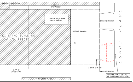
Figure 7 –
proposed parking arrangements
The DCP does not prescribe specific parking requirements for
artisan food and drink premises. The manufacturing/brewing process is best
aligned with light industry with parking based on 1 space per 100m2
or 1 space for every 2 employees (whichever is the greater). The café
use best aligns with the parking provisions of a restaurant (within the CBD)
i.e. 1 space per 40m2. The tastings and bar component align with the
parking provisions of a small bar i.e. 1 space per 25m2.
In the absence of a car parking
requirement for artisan food and drink industry, car parking for the
best-fit uses (light industry, café, and small bar)
are considered under the DCP as follows:
|
OPERATION
|
LAND USE
|
DCP CONTROL
|
FLOOR AREA
|
PARKING REQUIRED
|
|
Monday – Friday
|
Light industry
|
1 space per
100m²
|
119m2
|
1.19 spaces
|
|
Monday –Sunday
|
Café
|
1 space per 40m2
|
190m2
|
4.75 spaces
|
|
Monday – Sunday
|
Small bar
|
1 space per 25m²
|
251m2
(licensed area)
|
10.04 spaces
|
Based on the proposed operation of the activities:
- A
total of 3.17 spaces can be credited to the site and historical use.
- Production
(brewing) will generate a demand of 1.19 space.
- The café and small bar
utilise the same space/floor area both at separate times and at the same time
(depending on the day of the week), and as such, it is not reasonable to apply
both parking rates to the premises. In lieu of any actual parking demand data
being provided by the applicant, it is considered that the higher bar rate
should be applied, being a demand of 10.04 spaces. Further, it is noted the
above café rate only addresses the parking demand generated by the
internal floor area, where the outdoor dining areas to the front and rear of
the building would generate additional parking demand. If using the DCP
café table rate of 1 space for every 3 outdoor seats, this would
generate an additional 13.33 spaces to be required over and above the 4.75
spaces. Notwithstanding, it is still considered more appropriate to use the bar
rate.
Therefore peak demand for the proposal is 1.19 (industry)
+ 10.04 (bar/café) – 3.17 (historical credits) = 8.06
parking spaces
As there is no opportunity to provide additional parking on
the site, both due to site constraints and the informal area to the front of
the building not being safe for continued car parking, the proposed development
results in a shortfall of 8.06 spaces.
The site is located within the mapped car parking
contributions area, and Orange Car Parking Contributions Plan 2015 allows
for the payment of contributions in lieu of providing parking onsite, that is,
to make up any shortfall on the site by financially contributing to the
purchasing of land and ongoing maintenance for public car parking in the CBD.
Based on the change of use car parking contribution rates to 31 August 2021
(quarterly indexing applies), this would result in a payable contribution of $61,872.67.
The Applicant requests that Council considers waiving the
parking contributions based on the following arguments:
- The
proposed development for artisan food and drink premises does not have a
prescribed parking requirement under the DCP provisions,
- The
industry component which operates during core business hours complies with
parking requirements for industry,
- The
tastings component is an ancillary element to the craft beer production,
- The
tasting component of the development will mainly have a shortfall during core
business hours on Thursday and Fridays. Essentially the bar/tastings component
aims to capture its clientele during late afternoon/evenings and on weekends
when surrounding businesses are not operational,
- The
development is a complementary land use in the commercial core,
- The
development aims to support the economic vitality of the commercial core as
well as providing a new and emerging tourism attraction for locals and visitors
to the region,
- The
onsite parking deficit may be counter balanced by the availability of on-street
parking and a public carpark on the corner of Lords Place and Kite Street,
- Consideration
of the imposition of developer contributions to a small and emerging young
business enterprise.
Council staff make the following comments with regards to
this request:
1 The application
seeks to convert the vacant premises to an artisan food and drink premises,
being an intensified use of the site. As discussed, this proposed use does not
have a prescribed minimum parking requirement under the DCP; with the most
appropriate applicable uses being light industry and bar. These
uses introduce additional customers to the site, therefore increasing the
demand for onsite parking.
2 With the
reinstated kerb parking on Lords Place, an additional three (3) spaces can be
provided on the street, the shortfall of 8.06 spaces becomes less significant
than encompassing the whole of the demand. Notwithstanding, in accordance with
Council policy, when additional car parking demand cannot be met onsite, the
net increase is required to be met by a car parking contribution.
3 Whilst it is
anticipated the development will generate additional traffic, the proposed
operational hours of the small bar extend into the evening and weekends when
other businesses in the vicinity are not operational (with the exception of
operation during core business hours on Thursdays and Fridays).
4 Parking would
be available in in the form of on-street parking (on both the eastern and
western sides of Lords Place) and in nearby Council car park facilities. While
it cannot be relied upon to offset the requirements of the development, it does
exist as a parking resource, and may be utilised without adversely impacting on
traffic amenity in the locality.
5 The proposed
development is considered to meet and exceed the objectives of the Orange
Future City program. The artisan food and drink premises is consistent with the
redevelopment of this area of the CBD whilst it reactivates a vacant premises
and provides an economic opportunity that can further drive tourism growth and
enhance the liveability of the region. Each component of the mixed use
development will stimulate both the day time and night time economy of the
City, positively contributing to the Orange region.
As a result, the following options are available to Council
in determining the application:
1. Review
the Determination and require the payment $61,872.67 for the shortfall of 8.04
car parking spaces in accordance with Council’s Car Parking Contribution
Plan, based on an intensified use of the subject land
2. Review
the Determination and require the payment of $38,843.14 for the shortfall of
5.06 car parking spaces in accordance with Council’s Car Parking
Contribution Plan, based on an intensified use of the subject land and being
satisfied to credit the three new on-street spaces being made available with
reinstatement of the kerb and gutter.
3. Review
the Determination and waive the requirement of payment for any car parking
contributions.
It is recommended that Option 2 is adopted. Relevant
conditions are included on the attached Notice of Approval. Any decision to
waive the recommended contribution as alluded to in Option 3 above may only be
made by the Council.
DEVELOPMENT CONTRIBUTIONS
Section 64 Headworks Charges
Water
and sewer headworks charges are applicable to the proposal. The proposed use
will operate with greater demand for water than the former retail use. The
headworks charges are based on 1ET for water supply headworks. Conditions
are included on the attached Notice of Approval to this effect.
PROVISIONS PRESCRIBED BY THE
REGULATIONS s4.15(1)(a)(iv)
Demolition of a Building (clause
92)
The proposal does not involve the demolition of a building.
Fire Safety Considerations
(clause 93)
The proposal involves a change of building use for an
existing building. Council is satisfied that the fire protection and structural
capacity of the building are appropriate for the proposed new building use. Relevant
conditions are attached.
Buildings to be Upgraded (clause
94)
Upgrading of the building will be required to ensure the
existing building is brought into partial or total conformity with the Building
Code of Australia. Conditions are attached in relation to the required
upgrading works.
BASIX Commitments (clause 97A)
BASIX is not applicable to the proposed development.
THE LIKELY IMPACTS OF THE
DEVELOPMENT s4.15(1)(b)
Setting and Context
The land is located within central Orange and forms a part
of the commercial core. The proposed development includes the use of the
building in its current layout. Minimal building works are required mainly
consisting of the new internal fitout for the bar and brewery areas. Changes at
the streetscape level are limited to new business identification signage. The
building and its contribution to the streetscape and locality will be retained.
The surrounding locality is typified by a mixture of both commercial type uses
including retail, office, and pub.
Visual Impacts
The streetscape integrity of both the building and the site
is to be retained. As the development involves minor building works; there is
no adverse visual impact upon the building or the surrounding locality. A
temporary food and drink facility (shipping container) was recently placed in
the frontage of the property. The applicant will be required to remove this
facility to accommodate the planned outdoor dining area. Conditions of consent
are included in the attached notice requiring removal of the shipping
container. The proposed signage is considered to be an appropriate design
response for the business. Visual impacts are considered to be acceptable and
will be contained within the site.
Heritage Values
As outlined in the foregoing
sections of this report, the development is sited and designed and will operate
without adverse impact on the significance of the existing and draft
Conservation Area or any nearby heritage items.
Traffic
Matters
The proposed development will have an acceptable impact on
local traffic levels and amenity due to the following:
· The subject
commercial land represents a well-established component of the local traffic
regime.
· Vehicle
arrangements associated with the site are longstanding, and operate without
conflict to vehicle movements along Lords Place.
· Traffic generation
rates for artisan food and drink industries have not been the subject of
survey. The Guide to Traffic Generating Development updated
Traffic Surveys (RMS August 2013), estimate 7.83 daily vehicle trips for
business parks and industrial estates, being the nearest fit landuse to the
proposal. The capacity of the local road network will be sufficient to cater
for traffic associated with the development.
· The proposals
altered site access is considered to be a safer and more suitable outcome for
the site and locality.
· Proposed and
conditional parking arrangements for the development will be satisfactory, as
outlined in the foregoing sections of this report.
· Existing onsite
vehicle areas will be suitable to accommodate service vehicle access, unloading
and manoeuvring.
Crime and Anti-Social Behaviour
The proposal is consistent with the principles of Crime
Prevention through Environmental Design. In particular, the existing building
provides casual surveillance with entrances clearly identifiable from the
street. Access to and from the site is assisted with adequate lighting for
evening patronage. The premise will be licensed by the Liquor & Gaming NSW.
Specific licenses are granted for their production in addition retail sales and
tastings.
Safety of patrons are ensured through safe arrival and
departures, encouragement of the use of pedestrian walking, carpooling,
implementation of RSA measures, obligations under licencing agreements and ensuring
staff are appropriately trained to implement safety and security measures.
Recommendations to mitigate crime and anti-social behaviour include the
installation of CCTV and external lighting. Conditions are included on the
attached Notice of Approval to this effect.
Economic Impacts
The proposed artisan food and drink industry is a
complementary land use in this precinct. Take-up of vacant premises for
emerging food industries will reinforce the role of the CBD as a regional
centre for commerce and services, with positive economic flow-on effects.
Residential Amenity
The subject land is located nearby to tourist accommodation
and residential zoned land. Potential impacts of the proposed development on
residential amenity are considered below.
Noise
The proposed development will generate the following
internal noise sources:
· Operation of plant
and equipment.
· Patrons in the
bar.
Additionally, the proposed development will generate the
following external noise sources:
· Operation of plant
and equipment.
· Patrons arriving
and departing the site.
· Waste collection
and movement of bins.
The property is centrally located within a long established
and built-up area used for a variety of commercial type activities. Most
businesses within the locality operate typically within daylight hours so the
extended hours of operation in the evenings and on weekends have negligible
adverse impact upon the site, surrounding locality or existing operations. The
site is distanced from any sensitive residentially zoned land being
approximately 100m to the south (Moulder Street) and 200m to the west (Anson
Street). Land to the north and east is located within the commercial zone.
Internal noise sources are considered to be within
reasonable limit. The EPA’s Noise Policy for Industry 2017 adopts an
amenity criteria of 65dB(A) for commercial properties for all time periods. As
noted, the proposed site would operate during core commercial hours for the
purposes of production and light industrial purposes and no later than 11pm for
the sale of food and alcohol.
As noted in the lodged SEE, anticipated sound power levels
from plant and equipment (cool room and tanks) would be 73 dB(A) and 70
dB(A) at a distance of three and one metres respectively. This equipment would
be inside the building and shielded by the concrete walls.
It is common via relevant noise standards to adopt a 10
dB(A) reduction in noise levels from outside to inside with windows open and a
20-25 dB(A) reduction with windows closed. Adopting the above quoted sound
power levels for plant and equipment, and assuming open doors/windows at one,
but not both, the subject property and the residential and holiday
accommodation receivers, results in maximum noise levels of 43 dB(A) from plant
and equipment. This level demonstrates compliance with the adopted amenity
criteria for all time periods.
Furthermore, it is considered external noise impacts will
not be unreasonable in the context of the CBD setting; site proximity to
restaurants and pub; and ambient noise levels in the locality (traffic,
pedestrian and plant noise). The operator is to institute a plan of management
to control external patron noise, which will variously involve compliance with
Council consent conditions regarding operating hours and emission levels;
management of noise complaints; signage for patrons to maintain neighbourhood
amenity when departing, etc.
Various conditions are included on the attached Notice of
Approval to mitigate and manage noise impacts associated with the development.
Odour
The potential for odour sources from the proposed
microbrewery include odour from the fermentation and distillation processes to
create beer. Whilst there are no locally operating breweries of a similar
nature and size to reference, the likelihood of offensive odour being created
is minimal. Odours if any, will be generated during the boiling of raw products
which occurs for up to 90 minutes during each brewing batch. Odours will be
captured by a kettle flue. It is considered that odour emissions will not be
unreasonable based on the following:
· The proposal will
be a small scale operation/microbrewery, with production frequency dependent
upon demand.
· The production
process will largely contain odour within the equipment (still) or premises.
· Odour generating
activities will be contained within the building.
· Ambient odour
levels in the locality associated with the operation of restaurants and pubs.
Council’s Environmental Health Officer has reviewed
the submitted odour details and is satisfied that emissions will not be
unreasonable. Conditions are included on the attached Notice of Approval to
mitigate and manage odour emissions.
Environmental Impacts
The proposed development will not involve any processes or
activities that would adversely impact on the natural environment.
Biodiversity, groundwater and stormwater management were considered in the
foregoing assessment.
In terms of waste management:
· Liquid waste will
be conditioned prior to discharge to sewer in accordance with a conditional
trade waste agreement.
· Solid waste will
be disposed of via commercial waste collection.
· Organic waste from
the brewing process will either be used onsite in the courtyard landscaping or
be transferred offsite for use as cattle feed.
· The artisan product
will be packaged in recyclable material where possible, thereby minimising
waste.
Conditions are included on the attached Notice of Approval
in relation to waste disposal.
THE SUITABILITY OF THE SITE
s4.15(1)(c)
The subject land is considered to be suitable for the
proposed development due to the following:
· The proposal is
permitted on the subject land and appropriate within the commercial setting.
· Utility services
are available and adequate.
· The local road
network is suitable to support the proposal.
· The land is not
subject to known technological or natural hazards.
· The site has no
particular environmental values.
ANY SUBMISSIONS MADE IN
ACCORDANCE WITH THE ACT s4.15(1)(d)
The proposed development is defined as "advertised
development" under the provisions of the LEP. The application was
advertised for the prescribed period of 14 days and at the end of that period
no submissions were received.
PUBLIC INTEREST
s4.15(1)(e)
The proposed development is considered to be of minor
interest to the wider public due to the relatively localised nature of
potential impacts. The proposal is not inconsistent with any relevant policy
statements, planning studies, and guidelines etc that have not been considered
in this assessment.
SUMMARY
The proposed development is permissible with the consent of
Council. The proposed development complies with the relevant aims, objectives
and provisions of Orange LEP 2011 (as amended) and DCP 2004. A
Section 4.15 assessment of the development indicates that the development
is acceptable in this instance. Attached is a draft Notice of Approval
outlining a range of conditions considered appropriate to ensure that the
development proceeds in an acceptable manner.
COMMENTS
The requirements of the Environmental Health and Building
Surveyor and the Engineering Development Section are included in the attached
Notice of Approval.
Attachments
1 Notice
of Approval, D21/43072⇩
2 Plans,
D21/43114⇩
Extraordinary
Council Meeting
27 July 2021
Attachment 1 Notice
of Approval
|

|
ORANGE CITY COUNCIL
Development
Application No DA
196/2021(1)
D21/43072 Container
PR6921
|
NOTICE OF DETERMINATION
OF A DEVELOPMENT
APPLICATION
issued under the Environmental
Planning and Assessment Act 1979
Section 4.18
|
Development
Application
|
|
|
Applicant
Name:
|
Ms A Rasmussen
|
|
Applicant
Address:
|
PO Box 2512
ORANGE
NSW 2800
|
|
Owner’s
Name:
|
Wheeler Industries
Pty Limited
|
|
Land
to Be Developed:
|
Lot A DP 394144 - 147
Lords Place, Orange
|
|
Proposed
Development:
|
Artisan Food and
Drink Industry (change of use) and signage
|
|
|
|
|
Building Code of
Australia
building
classification:
|
Change of use to
Class 6 and 8
|
|
|
|
|
Determination made
under
Section 4.16
|
|
|
Made
On:
|
20 July 2021
|
|
Determination:
|
CONSENT GRANTED
SUBJECT TO CONDITIONS DESCRIBED BELOW:
|
|
|
|
|
Consent to Operate
From:
|
21 July 2021
|
|
Consent to Lapse On:
|
21 July 2026
|
Terms
of Approval
The reasons for the imposition of conditions
are:
(1) To ensure a quality
urban design for the development which complements the surrounding environment.
(2) To maintain
neighbourhood amenity and character.
(3) To ensure compliance
with relevant statutory requirements.
(4) To provide adequate
public health and safety measures.
(5) To ensure the utility
services are available to the site and adequate for the development.
(6) To prevent the proposed
development having a detrimental effect on adjoining land uses.
(7) To minimise the impact
of development on the environment.
Conditions
(1) The development must be
carried out in accordance with:
(a) Plans
numbered: 01, 02, 03, 04, 05 by McKinnon Design dated May 2021, unnamed signage
plan undated (6 sheets)
(b) statements
of environmental effects or other similar associated documents that form part
of the approval
as amended in
accordance with any conditions of this consent.
(2) All building work must
be carried out in accordance with the provisions of the Building Code of
Australia.
(3) A sign is to be erected
in a prominent position on any site on which building work, subdivision work or
demolition work is being carried out:
(a) showing
the name, address and telephone number of the principal certifying authority
for the work, and
(b) showing
the name of the principal contractor (if any) for any building work and a
telephone number on which that person may be contacted outside working hours,
and
(c) stating
that unauthorised entry to the site is prohibited.
Any such sign is to be maintained while the
building work, subdivision work or demolition work is being carried out.
|
PRIOR TO THE ISSUE OF A CONSTRUCTION
CERTIFICATE
|
(4) A Liquid Trade Waste
Application is to be submitted to Orange City Council prior to the issuing of a
Construction Certificate. The application is to be in accordance with
Orange City Council’s Liquid Trade Waste Policy. Engineering plans
submitted as part of the application are to show details of all proposed liquid
trade waste pre-treatment systems and their connection to sewer.
Where applicable, the applicant is to enter
into a Liquid Trade Waste Service Agreement with Orange City Council in
accordance with the Orange City Council Liquid Trade Waste Policy.
(5) Payment
of contributions for water, sewer and drainage works is required to be made
at the contribution rate applicable at the time that the payment is made.
The contributions are based on 1.0 ETs for water supply headworks. A
Certificate of Compliance, from Orange City Council in accordance with the Water
Management Act 2000, will be issued upon payment of the contributions.
This Certificate of Compliance is to be
submitted to the Principal Certifying Authority prior to the issuing of a
Construction Certificate.
(6) The
payment of $38,843.14 shall be made to Council in accordance with Section 7.11
of the Act and Orange Car Parking Development Contributions Plan 2015 in lieu
of the physical provision of adequate on-site car parking spaces. Payment must
be made prior to the issue of any certificate under Part 4A of the Act.
The contribution shall be indexed quarterly in
accordance with the Orange Car Parking Development Contributions Plan 2015,
which may be inspected on Council’s website or at the Orange Civic
Centre, Byng Street, Orange.
(7) Backflow
Prevention Devices are to be installed to AS3500 and in accordance with Orange
City Council Backflow Protection Guidelines. Details of the Backflow Prevention
Devices are to be submitted to Orange City Council prior to the issuing of a
Construction Certificate.
(8) A
Road Opening Permit in accordance with Section 138 of the Roads Act 1993
must be approved by Council prior to a Construction Certificate being issued
or any intrusive works being carried out within the public road or footpath
reserve.
|
DURING CONSTRUCTION/SITEWORKS
|
(9) Any adjustments to
existing utility services that are made necessary by this development
proceeding are to be at the full cost of the developer.
(10) The southernmost
footpath crossing shall be replaced with standard concrete kerb and gutter and
the concrete footpath reinstated to the requirements in the Orange City Council
Development and Subdivision Code.
(11) All
construction/demolition work on the site is to be carried out between the hours
of 7.00 am and 6.00 pm Monday to Friday inclusive, 7.00 am to
5.00 pm Saturdays and 8.00 am to 5.00 pm Sundays and Public
Holidays. Written approval must be obtained from the General Manager of Orange
City Council to vary these hours.
(12) All materials on site
or being delivered to the site are to be contained within the site. The
requirements of the Protection of the Environment Operations Act 1997
are to be complied with when placing/stockpiling loose material or when
disposing of waste products or during any other activities likely to pollute
drains or watercourses.
(13) The
fit-out of the food preparation and storage areas are to be installed in
accordance with the requirements of Food Safety Standard 3.2.3 "Food
Premises and Equipment" of the Australian New Zealand Food Standards Code
and Australian Standard 4674-2004 "Design and construction and fitout of
food premises".
|
PRIOR TO THE ISSUE OF AN OCCUPATION
CERTIFICATE
|
(14) Prior
to the issue of an occupation certificate, the shipping container currently placed on
the land, for the use of a mobile food and drink outlet, must be removed
from the site.
(15) Certificates
for testable Backflow Prevention Devices are to be submitted to Orange City
Council by a plumber with backflow qualifications prior to the issue of an
Occupation Certificate.
(16) A
Road Opening Permit Certificate of Compliance is to be issued for the works by
Council prior to any Occupation/Final Certificate being issued for the
development.
(17) No
person is to use or occupy the building or alteration that is the subject of
this approval without the prior issuing of an Occupation Certificate.
(18) The
owner of the building/s must cause the Council to be given a Final Fire Safety
Certificate on completion of the building in relation to essential fire or
other safety measures included in the schedule attached to this approval.
(19) All solid waste
generated from the operation of the business, including solid waste from the
brewing/distilling processes, is to be regularly disposed of at a licensed
landfill.
(20) A plan of management to
mitigate and manage external patron noise shall be submitted to Council for
approval, prior to issue of an Occupation Certificate. The plan of
management shall include but not be limited to:
· Compliance with hours
of operation
· Staff responsibilities
to ensure patrons depart the site in good order and in a timely manner
· Erection of internal
and external ‘neighbourhood amenity’ signage
· Complaints handling and
resolution
(21) A loading bay as per
the stamped approved plans shall be provided upon the site in accordance with
the approved plans, the provisions of Development Control Plan 2004, and be
constructed in accordance with the requirements of Council's Development and
Subdivision Code prior to the issue of an Occupation Certificate.
|
MATTERS FOR THE ONGOING PERFORMANCE AND
OPERATION OF THE DEVELOPMENT
|
(22) Emitted noise shall not exceed 5dB(A) above background
sound level measured at the nearest affected residence.
(23) The
owner is required to provide to Council and to the NSW Fire Commissioner an
Annual Fire Safety Statement in respect of the fire-safety measures, as
required by Clause 177 of the Environmental Planning and Assessment
Regulation 2000.
(24) Any outdoor lighting
must be in accordance with the Australian Standard 4282-1997 Control of the
obtrusive effects of outdoor lighting.
(25) Any odour generated
from the brewing/distilling processes must not be detectable at adjoining
premises.
(26) Outdoor storage is not
permitted on approved car parking spaces or outdoor dining areas.
Trafficable area shall remain unimpeded at all times.
(27) The plan of management
relating to external patron noise shall remain operational for the duration of
the development.
(28) Hours of operation shall
not exceed:
1. Production
processes: 8am to 5pm, Monday to Friday.
2. Café:
5:30am to 2pm, Monday to Friday, 7am to 2pm, Saturday and Sunday.
3. Small
Bar: 5pm to 10pm, Monday to Wednesday, 12pm to 10pm, Thursday, 11am to
11pm, Friday and Saturday, 11am to 8pm, Sunday.
(29) The
applicant shall ensure that the style and finish of all outdoor furniture in
the front setback area of the site is of reasonable quality at all times.
Details of the style and finish of outdoor furniture shall be submitted to and
be approved by the Manager Development Assessments prior to use.
(30) All
of the foregoing conditions are to be at the full cost of the developer and to
the requirements and standards of the Orange City Council Development and
Subdivision Code, unless specifically stated otherwise. All work required by
the foregoing conditions is to be completed prior to the issuing of an
Occupation Certificate, unless stated otherwise.
Other
Approvals
(1) Local
Government Act 1993 approvals granted under Section 68.
Nil
(2) General
terms of other approvals integrated as part of this consent.
Nil
Right
of Appeal
If you are dissatisfied with this decision,
Section 8.7 of the Environmental Planning and Assessment Act 1979
gives you the right to appeal to the Land and Environment Court. Pursuant to
Section 8.10, an applicant may only appeal within 6 months after the date the
decision is notified.
|
Disability
Discrimination Act 1992:
|
This application has been assessed in accordance
with the Environmental Planning and Assessment Act 1979. No guarantee
is given that the proposal complies with the Disability Discrimination Act
1992.
The applicant/owner is responsible to ensure
compliance with this and other anti-discrimination legislation.
The Disability Discrimination Act
covers disabilities not catered for in the minimum standards called up in the
Building Code of Australia which references AS1428.1 - "Design for
Access and Mobility". AS1428 Parts 2, 3 and 4 provides the most
comprehensive technical guidance under the Disability Discrimination Act
currently available in Australia.
|
|
|
|
|
Disclaimer
- S88B of the Conveyancing Act 1919 - Restrictions on the Use of
Land:
|
The applicant should note that there could be
covenants in favour of persons other than Council restricting what may be
built or done upon the subject land. The applicant is advised to check the
position before commencing any work.
|
|
|
|
|
Signed:
|
On behalf of the consent authority ORANGE
CITY COUNCIL
|
|
Signature:
|
|
|
Name:
|
PAUL JOHNSTON - MANAGER DEVELOPMENT
ASSESSMENTS
|
|
Date:
|
21 July 2021
|
Extraordinary Council Meeting
27 July 2021
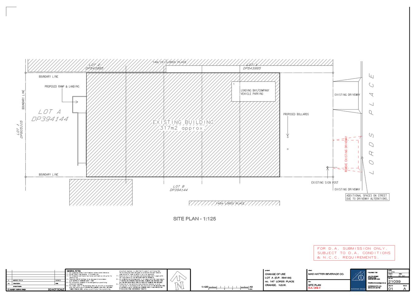
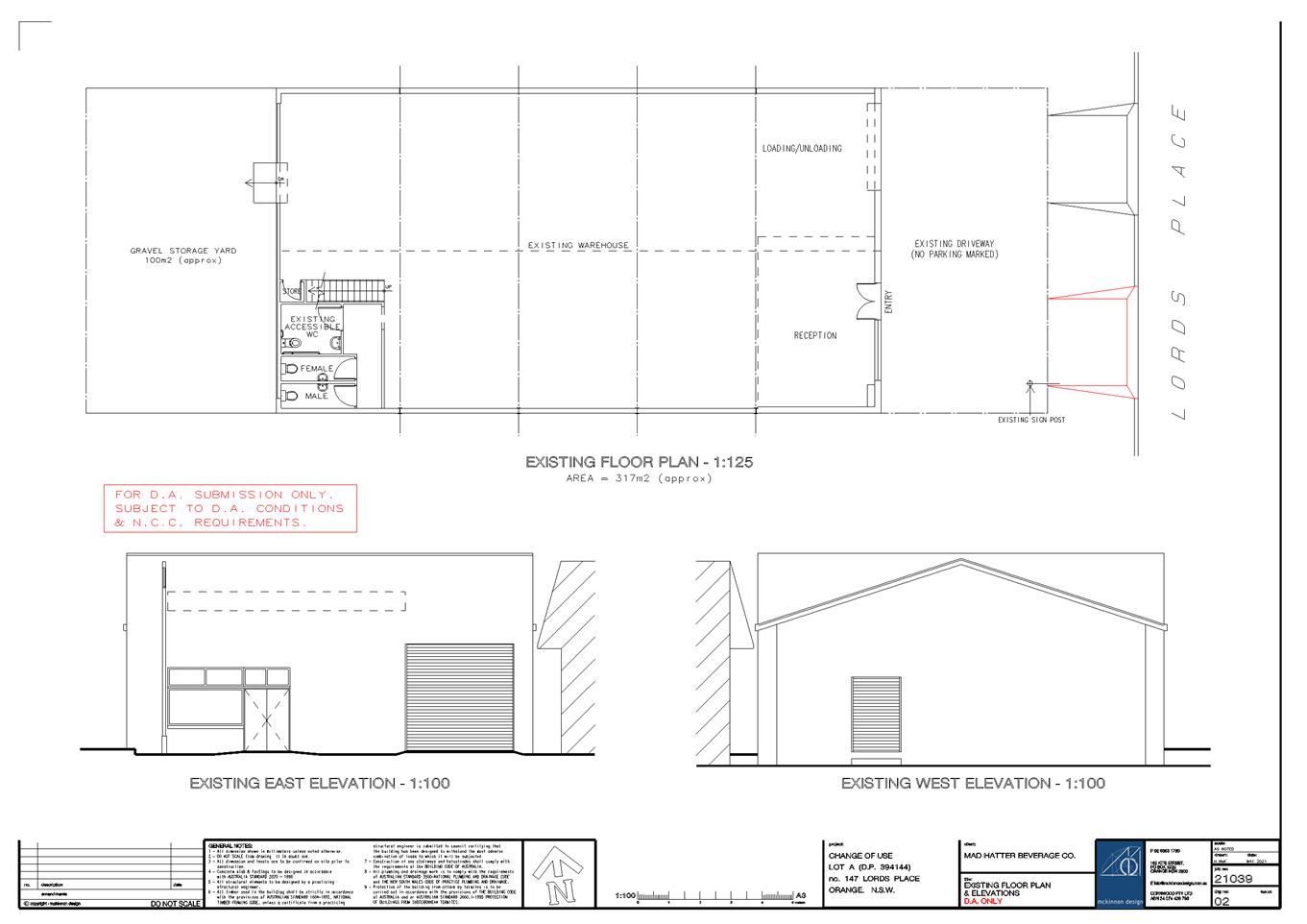
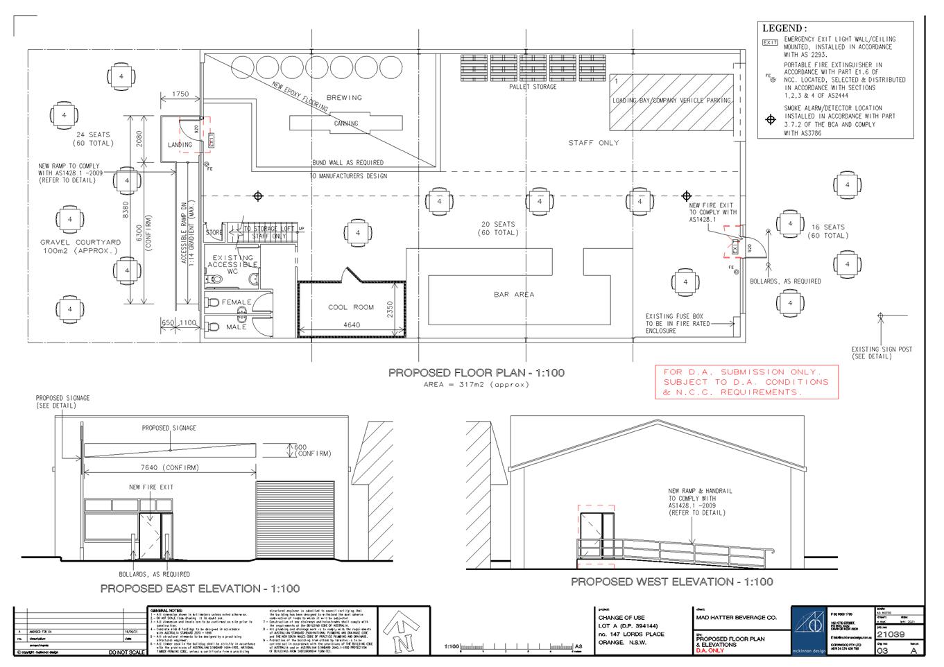
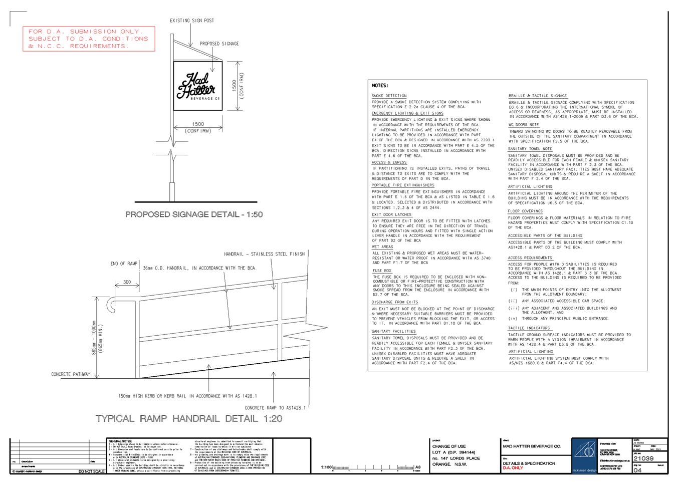
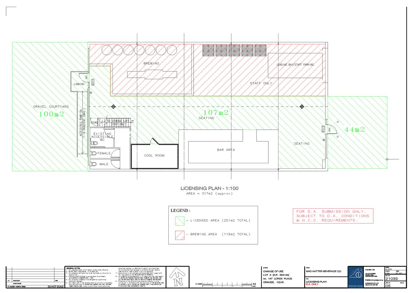
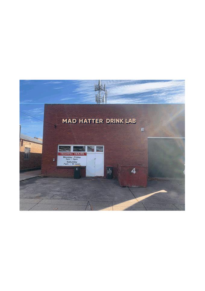
6 Closed Meeting
- See Closed Agenda
The Chief Executive Officer will advise the Council if any
written submissions have been received relating to any item advertised for
consideration by a closed meeting of Orange City Council.
The Mayor will extend an invitation to any member of the
public present at the meeting to make a representation to Council as to whether
the meeting should be closed for a particular item. In accordance with the
Local Government Act 1993, and the Local Government (General) Regulation 2005,
in the opinion of the General Manager, the following business is of a kind as
referred to in Section 10A(2) of the Act, and should be dealt with in a
Confidential Session of the Council meeting closed to the press and public.
|
Recommendation
That Council adjourn into a Closed Meeting and members of
the press and public be excluded from the Closed Meeting, and access to the
correspondence and reports relating to the items considered during the course
of the Closed Meeting be withheld unless declassified by separate resolution.
This action is taken in accordance with Section 10A(2) of the Local
Government Act, 1993 as the items listed come within the following
provisions:
6.1 2019-2021
Water Consumption Charges - 3 Lone Pine Avenue Spring Creek
This item is classified CONFIDENTIAL under the
provisions of Section 10A(2) of the Local Government Act 1993, which permits
the meeting to be closed to the public for business relating to (b) the
personal hardship of any resident or ratepayer.
6.2 2020/2021
Second and Third Quarter Water/Sewerage Charges - 36-40 Lords Place, Orange
This item is classified CONFIDENTIAL under the provisions
of Section 10A(2) of the Local Government Act 1993, which permits the meeting
to be closed to the public for business relating to (b) the personal hardship
of any resident or ratepayer.
6.3 2020/2021
Second and Third Quarter Water/Sewerage Charges - 212 Anson Street, Orange
This item is classified CONFIDENTIAL under the
provisions of Section 10A(2) of the Local Government Act 1993, which permits
the meeting to be closed to the public for business relating to (b) the
personal hardship of any resident or ratepayer.
6.4 Environmental
Upgrade Agreements
This item is classified CONFIDENTIAL under the
provisions of Section 10A(2) of the Local Government Act 1993, which permits
the meeting to be closed to the public for business relating to (d)i commercial
information of a confidential nature that would, if disclosed prejudice the
commercial position of the person who supplied it, (d)ii information that
would, if disclosed, confer a commercial advantage on a competitor of the
council and (d)iii information that would, if disclosed, reveal a trade
secret.
6.5 Sale
and Development - 103 Prince Street, Orange
This item is classified CONFIDENTIAL under the
provisions of Section 10A(2) of the Local Government Act 1993, which permits
the meeting to be closed to the public for business relating to (d)i
commercial information of a confidential nature that would, if disclosed
prejudice the commercial position of the person who supplied it.
6.6 Tender
for Detailed Design of the Conservatorium and Planetarium
This item is classified CONFIDENTIAL under the
provisions of Section 10A(2) of the Local Government Act 1993, which permits
the meeting to be closed to the public for business relating to (c)
information that would, if disclosed, confer a commercial advantage on a
person with whom the Council is conducting (or proposes to conduct) business.
6.7 Tender
for the construction of an ablutions block at the Canobolas Scout Camp
This item is classified CONFIDENTIAL under the
provisions of Section 10A(2) of the Local Government Act 1993, which permits
the meeting to be closed to the public for business relating to (c)
information that would, if disclosed, confer a commercial advantage on a
person with whom the Council is conducting (or proposes to conduct) business.
6.8 Submission
Redactions
This item is classified CONFIDENTIAL under the
provisions of Section 10A(2) of the Local Government Act 1993, which permits
the meeting to be closed to the public for business relating to (e)
information that would, if disclosed, prejudice the maintenance of law.
6.9 Industrial
Land Sale
This item is classified CONFIDENTIAL under the
provisions of Section 10A(2) of the Local Government Act 1993, which permits
the meeting to be closed to the public for business relating to (c) information
that would, if disclosed, confer a commercial advantage on a person with whom
the Council is conducting (or proposes to conduct) business.
|
6.1 2019-2021
Water Consumption Charges - 3 Lone Pine Avenue Spring Creek
RECORD
NUMBER: 2021/1531
AUTHOR: Matt
Dean, Clerical Assistant - Water Billing
Reason for Confidentiality
This item is classified CONFIDENTIAL
under the provisions of Section 10A(2) of the Local Government Act 1993, which
permits the meeting to be closed to the public for business relating to (b) the
personal hardship of any resident or ratepayer.
6.2 2020/2021
Second and Third Quarter Water/Sewerage Charges - 36-40 Lords Place, Orange
RECORD
NUMBER: 2021/1521
AUTHOR: Matt
Dean, Clerical Assistant - Water Billing
Reason for
Confidentiality
This item is classified CONFIDENTIAL
under the provisions of Section 10A(2) of the Local Government Act 1993, which
permits the meeting to be closed to the public for business relating to (b) the
personal hardship of any resident or ratepayer.
6.3
2020/2021 Second and Third Quarter Water/Sewerage Charges - 212 Anson Street,
Orange
RECORD
NUMBER: 2021/1536
AUTHOR: Matt
Dean, Clerical Assistant - Water Billing
Reason for
Confidentiality
This item is classified CONFIDENTIAL
under the provisions of Section 10A(2) of the Local Government Act 1993, which
permits the meeting to be closed to the public for business relating to (b) the
personal hardship of any resident or ratepayer.
6.4 Environmental
Upgrade Agreements
RECORD
NUMBER: 2021/1526
AUTHOR: Lindsay
Hall, Sustainability Officer
Reason for
Confidentiality
This item is classified CONFIDENTIAL
under the provisions of Section 10A(2) of the Local Government Act 1993, which
permits the meeting to be closed to the public for business relating to (d)i commercial
information of a confidential nature that would, if disclosed prejudice the
commercial position of the person who supplied it, (d)ii information that
would, if disclosed, confer a commercial advantage on a competitor of the
council and (d)iii information that would, if disclosed, reveal a trade secret.
6.5 Sale
and Development - 103 Prince Street, Orange
RECORD
NUMBER: 2021/1488
AUTHOR: Nick
Redmond, Manager Corporate & Community Relations
Reason for
Confidentiality
This item is classified CONFIDENTIAL
under the provisions of Section 10A(2) of the Local Government Act 1993, which
permits the meeting to be closed to the public for business relating to (d)i
commercial information of a confidential nature that would, if disclosed
prejudice the commercial position of the person who supplied it.
6.6 Tender
for Detailed Design of the Conservatorium and Planetarium
RECORD
NUMBER: 2021/1399
AUTHOR: Lucy
Gorton, Project Officer
Reason for
Confidentiality
This item is classified CONFIDENTIAL
under the provisions of Section 10A(2) of the Local Government Act 1993, which
permits the meeting to be closed to the public for business relating to (c)
information that would, if disclosed, confer a commercial advantage on a person
with whom the Council is conducting (or proposes to conduct) business.
6.7 Tender
for the construction of an ablutions block at the Canobolas Scout Camp
RECORD
NUMBER: 2021/1581
AUTHOR: Tony
Boland, Business Projects Officer
Reason for
Confidentiality
This item is classified CONFIDENTIAL
under the provisions of Section 10A(2) of the Local Government Act 1993, which
permits the meeting to be closed to the public for business relating to (c)
information that would, if disclosed, confer a commercial advantage on a person
with whom the Council is conducting (or proposes to conduct) business.
6.8 Submission
Redactions
RECORD
NUMBER: 2021/1445
AUTHOR: Rachelle
Robb, Director Corporate & Commercial Services
Reason for Confidentiality
This item is classified CONFIDENTIAL
under the provisions of Section 10A(2) of the Local Government Act 1993, which
permits the meeting to be closed to the public for business relating to (e)
information that would, if disclosed, prejudice the maintenance of law.
6.9 Industrial
Land Sale
RECORD
NUMBER: 2021/1621
AUTHOR: Nick
Redmond, Manager Corporate & Community Relations
Reason for
Confidentiality
This item is classified CONFIDENTIAL
under the provisions of Section 10A(2) of the Local Government Act 1993, which
permits the meeting to be closed to the public for business relating to (c)
information that would, if disclosed, confer a commercial advantage on a person
with whom the Council is conducting (or proposes to conduct) business.