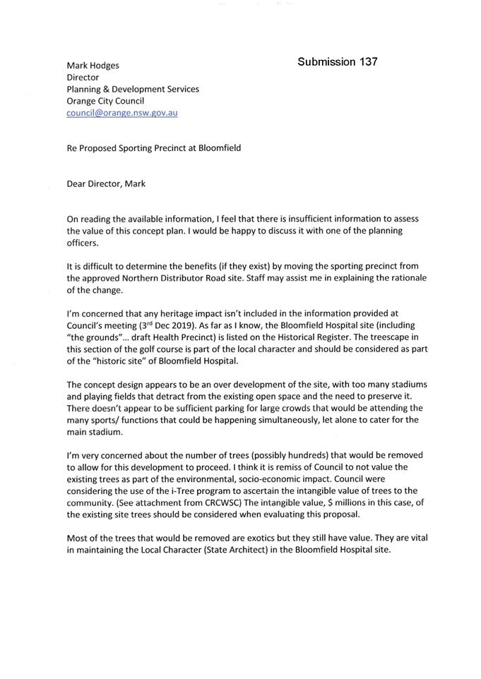
2 General
Reports
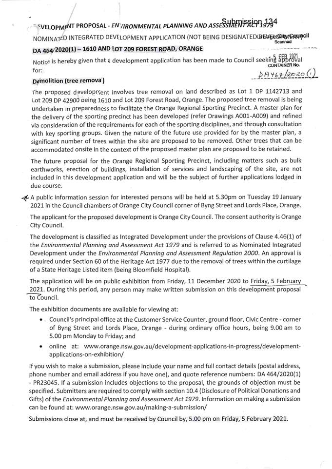
2.1 Development
Application DA 464/2020(1) - 1610 and Lot 209 Forest Road (Bloomfield Sporting
Precinct)
RECORD
NUMBER: 2021/1189
AUTHOR: Ben
Hicks, Planner
EXECUTIVE
Summary
|
Application
lodged
|
27
November 2020
|
|
Applicant/s
|
Orange
City Council
|
|
Owner/s
|
Orange
City Council
|
|
Land description
|
Lot 1 DP 1142713 and Lot 209 DP 42900
1610 Forest Road, Orange
|
|
Proposed
land use
|
Demolition
(tree removal)
|
|
Value of
proposed development
|
$250,000
|
This Development Application seeks Council's consent for demolition
(tree removal) at Lot 1 DP 1142713 and Lot
209 DP 42900, 1610 Forest Road, Orange. The site is currently occupied by Sir
Jack Brabham Park sporting fields (Lot 1) and the former Orange Ex-Services
Country Golf Club (Lot 209). Lot 209 forms part of the state significant Orange
Bloomfield Hospital Site (State Heritage Register Number 01745) and is listed
via Schedule 5 of the Orange Local Environmental Plan 2011 as item I21. The
site is Crown Land. The Crown has consented to the lodgement of the DA.
This development
application seeks Council's consent for tree removal to facilitate the delivery
of the Orange Regional Sporting Facility (ORSF). The actual construction of the
future sporting facility on this site, including works such as bulk
earthworks, erection of buildings, installation of services, landscaping,
vehicle access/car parking etc. would be the subject of a separate development
application(s).
In terms of the proposed tree removal, vegetation surveys at
the site confirm that the land contains 1,028 trees and shrubs. Of these, 794
are trees and the remainder 234 are shrubs. All shrubs are proposed to be
removed. Of the 794 trees, 513 have been identified for removal and 281 for
retention. The 513 trees identified for removal contain 55 native planted
trees, nine remnant native trees and the remainder 449 trees are exotic
species. It should be noted that although the environmental assessment
considers the removal of all 513 trees, where possible suitable trees will be
transplanted/relocated to suitable locations on the site or to other Council
managed parks/reserves.
The removal of the trees from
within the bounds of a state heritage listed site triggers the requirement for
an approval under Section 60 of the Heritage Act 1977 from Heritage NSW
- Department of Premier and Cabinet. In this regard, the applicant has elected
to have the application treated as integrated development pursuant to Section
4.46 of the Environmental Planning and Assessment Act 1979 with the application
being referred to Heritage NSW to obtain their General Terms of Approval. The
Heritage Council of NSW resolved at its meeting on 1 June 2021 to grant their
general terms of approval (copy attached). It is noted that as part of the
issuance of the general terms of approval, the heritage office has only
approved tree removal in the immediate area of the indicative stadiums. It is
estimated this “immediate area” may contain approximately half of
the trees identified by the DA for removal. The removal of the remainder of the
trees across the wider site is subject to the provision of a detailed landscape
Masterplan to be provided as part of the development application for the wider
civil works across the site.
The proposal comprises advertised development pursuant to
Schedule 1 of the Environmental Planning and Assessment Act 1979 requiring
advertisement for a minimum of 28 days. This application was however advertised
for 2 months (11 December to 5 February 2021) and a public forum held on 9
January 2021. At the completion of the notification period, 177 submissions had
been received. The issues raised in the submissions that relate to visual
impacts, environmental concerns, social impacts, and heritage impacts. It should
be noted that many submissions relate to the future sport facility (traffic,
noise, built form, etc.) These issues are technically not applicable to this
application, as the application under consideration is for tree removal only.
Principally, there are three
critical aspects of the assessment of this application for tree removal; namely
the environmental impacts (biodiversity, air and microclimate), the
visual/amenity implications; and social impacts. These matters are discussed in
detail in the body of the report.
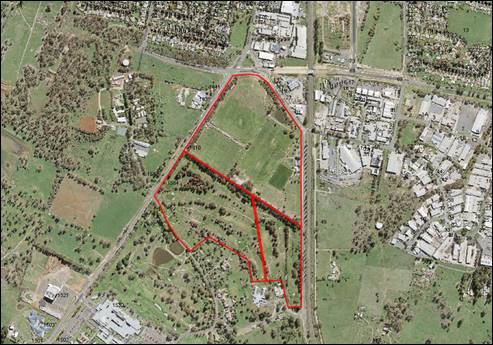
Figure 1 -
Locality and Site Context Plan
BACKGROUND INFORMATION
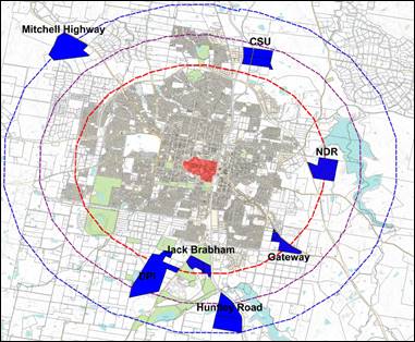
Since 2018 Orange City Council and its consultants have been
investigating, through schematic design and constraint assessment, potential
sites within the Orange Local Government Area to host a purpose-built sporting
precinct. A total of seven (7) sites were identified and analysed to identify
the development constraints and opportunities. The sites included the Northern
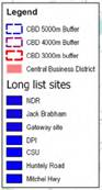
Distributor, Gateway, Huntley Road, Jack Brabham, DPI, Mitchell Highway and CSU
(Figure 2).
Figure
2 – Candidate Sites
A list of key site characteristics and deliverables were
developed to assist in informing site section. These included:
(a) The site
must have access to a high-volume road network within 300-500 metres and
capable of accommodating up to 5000 vehicles during peak periods.
(b) The site
must have access to services of a required standard (water, sewer, electrical
etc.).
(c) Be in a
location that enables field lighting to be operated i.e. not within 500m of
residential properties.
(d) Be proximal
to the city of Orange.
(e) Have
adequate land area and be developable to host:
- One main rectangular field suitable for the conduct
of International Rugby League, Rugby Union and Football (soccer) incorporating
a 1,500-seat grandstand with disability access, change rooms, amenities,
broadcast facilities, staff and storage areas and completion lighting for night
games. Field to be hybrid field and for ground capacity to a minimum of 10,000.
- A “Number 1” field suitable for the
conduct of International Rugby League, Rugby Union, and Football (soccer)
adjacent to the main field. Field to be hybrid field.
- Four (4) multipurpose fields suitable for the conduct
of International Rugby League, Rugby Union, and Football (soccer) for summer
and winter sports competition.
- Amenities.
- Food outlets.
- Parking.
- Public transport bays.
- Storage.
- Works shed.
- Circulation tracks for walking and cycling.
A weighted assessment of each site against the above
selection criteria was undertaken as well as utilising GIS software and other
relevant data to determine the most suitable sites. Consultation with a number
of key Orange sporting organisations in 2019 also assisted in site selection
and option testing.
Following this, Council originally resolved to progress
concept design of the sporting precinct at the northern distributor site.
However, in the wake of the amalgamation of the Orange Ex-Services Country Golf Club with Wentworth
Golf Club and subsequent termination of golfing activities at the Bloomfield
Reserve, the former Golf Club was identified
as the preferred and most logical option due to the following:
(a) It would
allow for expansion of existing operations i.e., proximity to sporting fields
at Sir Jack Brabham park, providing economies of scale for the maintenance and
operation of sporting facilities.
(b) Access to
existing and adequate power and water services.
(c) Adjacent
to the Southern Feeder Road and medical precinct.
(d) Reduced
establishment costs (geography of the land, proximity to services, facilities
etc.)
It must be noted that the Bloomfield reserve site was not
originally considered for the sporting precinct due to an existing lease agreement
with Orange Ex-Services Club to use the site for a period of 20 years, which
was due to expire 31 December 2025.
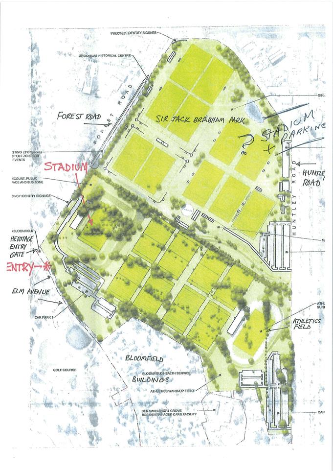
THE APPLICATION/PROPOSAL
This development application seeks Council's consent for tree removal to
facilitate the delivery of the Orange Regional Sporting Facility (ORSF). Note the design of the precinct includes
grandstands, sports fields, and other facilities will be the subject of further
development applications lodged in due course. Specifically, this application
will involve the following:
(a) Removal of 513 trees including 55 native
planted trees, nine remnant native trees and 449 exotic tree species.
(b) Removal of 234 shrubs.
(c) All trees to be removed will be felled and
chipped. Sound smaller examples may be transplanted to other sites, or
elsewhere within the site, for reuse, particularly the ornamental species such
as Liquidambar Pin Oak, Elm and Silver Birch trees. However, this will be
subject to health of the individual trees.
(d) 281 trees will be retained including trees on
the southern edge, forming an avenue along the internal road access to the
Bloomfield Health Campus, and the trees lining the Forest Road and Huntley Road
boundaries.
Figure 3 below provides graphical representation of the
trees to be removed and the trees to remain. It is also worth noting that as
part of the Masterplan for the sporting precinct, significant tree replanting
will occur within the site, providing somewhat of an offset to the tree removal
as well as assisting in some visual relief and integration of the future sports
precinct within the area. Figure 4 shows indicative tree planting which will
occur with the future development of the land.
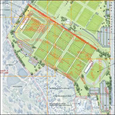
Figure 3 –
trees to be removed and retained
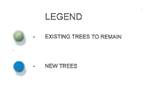
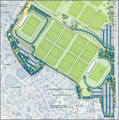
Figure 4 –
proposed tree replanting
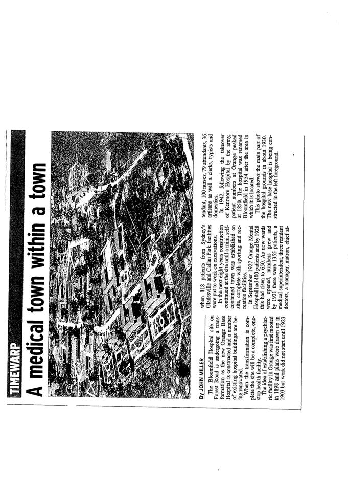
THE LAND AND HISTORY
The subject site is located approximately 1.5 kilometres to
the south of Orange City Centre and just north of the new Orange Hospital
precinct. The site spans between Forest Road and Huntley Road and encompasses a
nine-hole golf course and part of Sir Jack Brabham Park. The land was formally
part of a large area of land dedicated to a psychiatric hospital.
Development of the site for an aerodrome begun in the 1930s
and was completed in 1937. The aerodrome closed following the opening of an
airport at Spring Hill 1961. Redevelopment of the site was undertaken between
1954 and 1974 to create a recreational area comprising sporting fields now
known as Sir Jack Brabham Park. During this time, a racing circuit was
also established around the site between 1952-1953, which incorporated the
roads bounding the park (Huntley Road and Forest Road).
The establishment of the nine-hole golf course on the
subject site followed some years later (late 70s early 80s). Bloomfield Country
Club Ltd held a lease over land from around 1982 up until 2019 when the club
amalgamated with Wentworth Golf Club.
Since the site ceased being used for golf in 2019, the land
has been accessed by walkers and people practicing golf.

Figure 5 –
1972 aerial photograph (NSW Spatial Services)
The above aerial photograph was
taken in 1972 and shows that the subject site (indicated by a red circle) was
largely cleared of trees at this time. The nine-hole golf course constructed by
the patients of Bloomfield Hospital is shown in the bottom of the picture
(indicated by a blue circle). There is an avenue of Elms along the entry road
to the golf club - the first entry road when coming from the town along Forest
Road (indicated by a green circle).
DECISION FRAMEWORK
Development in the Orange LGA is governed by The
Environmental Planning and Assessment Act 1979 and the accompanying
Environmental Planning and Assessment Regulations 2008. Sitting below the Act
and Regulations is the Orange LEP 2011 and other State-wide Environmental
Planning Instruments (SEPPs). Subordinate to the LEP and SEPPs is the Orange
Development Control Plan 2004 which is a guiding document used to inform
decision making. In addition, the Infill Guidelines are used to guide development,
particularly in the heritage conservation areas and around heritage items.
The development (tree removal) is local development for the
purposes of the Environmental Planning and Assessment Act 1979 and Orange City
Council is the consent authority for the application. The proposed development
is not designated development as defined under Schedule 3 of the Environmental
Planning and Assessment Regulation 2000. The proposal is also not defined as
Regionally Significant Development pursuant to Schedule 7 of the State
Environmental Planning Policy (State and Regional Development) 2011, in that
the proposal has a capital investment value less than $5 million for Council
related development.
The application is integrated development pursuant to
Section 4.46 EP&A Act requiring approval under Section 60 of the Heritage
Act 1977.
The Development Application was neighbour notified and
publicly exhibited in accordance with the Orange City Council Community
Participation Plan 2019 (CPP). A public information session was also held for
interested persons. A total of 177 submissions were received during the
exhibition period.
The proposal is considered to be of ‘significant
public interest’ based on the number of submissions received.
Accordingly, the application has been tabled to an Ordinary Council Meeting
(OCM) for determination, pursuant to Clause 4.10 Delegations of Orange City
Council’s Declaration of Planning and Development Assessment
Procedures and Protocols (Vers 5, 2019).
DIRECTOR’S COMMENT
This development
application seeks Council's consent for the removal of 513 trees. The removal
of the trees would facilitate the delivery of the future construction of the
Orange Regional Sporting Facility (ORSF). The future sporting facility
on the land including bulk earthworks, erection of buildings, installation of
services, landscaping, vehicle access/car parking etc. will be subject to a
separate development application process.
Most of
the trees identified for removal were planted in the late 1970’s-80s as
part of a golf course. Part of the development site is within the bounds of a
state heritage listed site (Bloomfield Hospital precinct) so technical
procedures are triggered involving the Heritage NSW, who have provided
their General Terms of Approval (GTA’s). It is noted that the GTA’s
(copy attached), has only approved tree removal in the immediate area of the
indicative stadiums at this point in time. Discussions have been had with
Heritage NSW to determine what the “immediate area” is. Based on
these discussions, staff have sketched the areas that Heritage NSW have
indicated may be considered. The detail of this will have to be determined by
the applicant and Heritage NSW at the time of obtaining the Section 60 Heritage
approval to commence the works. So Council can understand the extent of this
area, likely to be considered “immediate” by the GTA’s, I
attach the indicative sketch, please note however, that the area ultimately
determined by Heritage NSW as “immediate” may be larger or smaller
than that in the sketch.
The Council planning report
considers the tree removal proposal across the entire site, as that is what the
DA proposes. However given the wording of the NSW Heritage GTA’s, the
removal of the remainder of the trees outside the immediate area of the indicative
stadiums will need to the subject of a separate DA for the wider civil works
across the site and also need to be accompanied by a detailed landscape master
plan.
177 submissions had been received during the advertising
period of this DA. The issues raised in the submissions that relate to visual
impacts, environmental concerns, social impacts, and heritage impacts. It
should be noted that many submissions relate to the future sport facility
(traffic, noise, built form, etc.) and should be considered in that context.
Principally, there are three critical aspects of the
assessment of this application; namely the environmental impacts (biodiversity,
air and microclimate), the visual/amenity implications; and social impacts.
Whilst being beyond the scope of the application before
Council to consider, the applicant has provided some additional commentary on
traffic matters in response to queries raised in the submissions. This is
provided as an attachment to this report for clarity, but as it is beyond the
scope of the DA, does not form part of the assessment.
It is recommended that Council supports the subject
development proposal and continues to work closely with NSW Heritage and
Transport for NSW regarding the overall design of the future sporting precinct.
Link To Delivery/OPerational Plan
The recommendation in this report relates to the
Delivery/Operational Plan strategy “10.1 Preserve - Engage with the
community to ensure plans for growth and development are respectful of our heritage”.
Financial Implications
Nil
Policy and Governance Implications
Nil
|
Recommendation
That Council consents to
development application DA 464/2020(1) for Demolition (tree removal) at
Lot 1 DP 1142713 and Lot 209 DP 42900, 1610 Forest Road, Orange pursuant
to the conditions of consent in the attached Notice of Determination.
|
further considerations
Consideration has been given to the recommendation’s
impact on Council’s service delivery; image and reputation; political;
environmental; health and safety; employees; stakeholders and project
management; and no further implications or risks have been identified.
ENVIRONMENTAL PLANNING
ASSESSMENT
Section 1.7 - Application of
Part 7 of the Biodiversity Conservation Act 2016 and Part 7A of the
Fisheries Management Act 1994
Section 1.7 of the EP&A Act identifies that Part 7 of
the Biodiversity Conservation Act 2016 (BC Act) and Part 7A of the
Fisheries Management Act 1994 have effect in connection with terrestrial and
aquatic environments.
Biodiversity Conservation Act 2016 and Regulation 2017
There are four triggers known to insert a development into
the Biodiversity Offset Scheme (ie the need for a BDAR to be submitted
with a DA):
· Trigger 1:
development occurs in land mapped on the Biodiversity Values Map (OEH)
(clause 7.1 of BC Regulation 2017);
· Trigger 2:
development involves clearing/disturbance of native vegetation above a certain
area threshold (clauses 7.1 and 7.2 of BC Regulation 2017); or
· Trigger 3:
development is otherwise likely to significantly affect threatened species
(clauses 7.2 and 7.3 of BC Act 2016).
The fourth trigger (development proposed to occur in an Area
of Outstanding Biodiversity Value (clause 7.2 of BC Act 2016) is generally not
applicable to the Orange LGA; as no such areas are known to occur in the LGA.
No further comments will be made against the fourth trigger.
Trigger 1 (Vegetation Mapping)
The subject land is not mapped
on the OEH Biodiversity Values Map (Figure 4) and is also not identified as
biodiversity sensitive on the Orange Local Environmental Plan 2011 Terrestrial
Biodiversity Map.
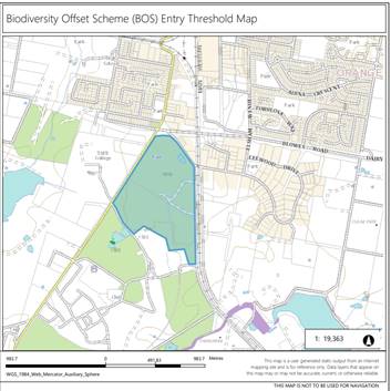
Figure 6 - excerpt
from OEH Biodiversity Values Report
Trigger 2 (Clearing Thresholds)
The land is zoned RE1 Public
Recreation (Sir Jack Brabham Park) and RE2 Private Recreation (Former Country
Club) and does not carry a minimum lot size under the Orange Local
Environmental Plan 2011. Given that the land does not carry a minimum lot size,
Clause 7.2 of the Biodiversity Conservation Regulation 2017 provides that the
actual size of the allotment of land on which the proposed development is to be
carried out is to be used. In this case, Sir Jack Brabham Park and the former
golf course have a combined land area of 65.53 hectares and therefore the
prescribed native vegetation clearing threshold for land over 40ha in size but
less than 1,000ha is 1ha (10,000sqm):
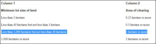
Figure 5 –
clearing thresholds (C7.2 BC Reg 2017)
While it is proposed to remove 513 trees from the site, only
64 trees are classified as remnant or cultivated native vegetation. The
remaining 449 trees are exotic species and are not captured by the Biodiversity
Offset Scheme. The removal of the 64 native trees does not trigger the clearing
threshold (i.e., clearing below 1ha) established under the Biodiversity
Conservation Regulation 2017. Furthermore, ground cover over the site is
dominated by exotic grasses sown in order to produce fairways and putting
greens for the golf course. Weedy forbs are also present throughout the site.
The composition of the ground cover indicates that the study area does not
comprise native vegetation and thus clearing of ground cover is also not
captured by the Biodiversity Offset Scheme.
Trigger 3 (Threatened
Species)
Regardless of whether or not the development has triggered
entry into the Biodiversity offset scheme under the forgoing thresholds, a Test
of Significance is required to be undertaken in accordance with Section 7.3 of
the Biodiversity Conservation Act 2016 to determine if the proposal
would have a significant impact on any threatened species and determine if
there is a need to undertake a Species Impact Statement or Biodiversity
Assessment Method (BAM). In this regard, Orange City Council commissioned Dr
Colin Bower (Premise Pty Ltd) to prepare a Biodiversity Assessment Report to
assess the ecological impacts associated with the proposed tree removal
inclusive of a Test of Significance in accordance with Section 7.3 of the Biodiversity
Conservation Act 2016. The assessment included an initial desktop study and
field surveys. The desktop study involved searches of online databases and
review of various other information sources to identify the likely biodiversity
values, vegetation types, threatened species and threatened ecological
communities that may occur within the study area.
The report outlines that the database searches returned
eleven (11) threatened flora species and thirty-nine (39) threatened fauna
species have the potential to occur within the broader region around the study
area. Through a process of habitat filtering, the number of potential
threatened flora species that may occur on the site was reduce to (1) being the
Eucalyptus canobolensis (Silver-leaf Candlebark). Similarly, six (6)
fauna species being the Glossopsitta pusilla (Little Lorikeet), Polytelis
swainsonii (Superb Parrot), Ninox connivens (Barking owl), Petroica
boodang (Scarlet Robin), Petroica phoenicea (Flame Robin) and Pteropus
poliocephalus (Grey-headed Flying Fox) were identified to potentially occur
on the study site.
Onsite surveys undertaken during September 2020 by Premise
confirmed that there were no individuals of the threatened Eucalyptus canobolensis
(Siver-leaf Candlebark) present at the site. In addition, there were no
confirmed sightings of the six identified fauna species. Notwithstanding, the
report confirmed that it is expected that these species are likely to forage
occasionally on the project footprint throughout the year as part of much
larger foraging ranges; however, are unlikely to breed there due to unsuitable
habitat conditions. During site surveys, it was identified that there were
primarily four (4) habitat types occurring on the subject site including the
ornamental amenity plantings, scattered planted/cultivated and remnant eucalypt
trees, mown exotic grassland/forbland and a Pond. The report provides the
following assessment against these habitat types:
Ornamental amenity plantings
Ornamental plantings dominate the
study area and mostly comprise tall mature Monterey Pines. There are also a
variety of other coniferous species and deciduous ornamental trees. These have
relatively low value for native wildlife, providing little or no food resources
and few nesting opportunities, since they lack hollows.
Scattered planted and remnant
eucalypt trees
The planted and remnant native
trees are mostly scattered or planted in rows or open patches that provide
little shelter for terrestrial wildlife. They may provide food in the form of
insects and nectar for native birds and flying foxes. However, only one remnant
tree has hollows suitable for nesting or roosting. Birds that nest amongst
foliage may find breeding opportunities in the denser foliaged species, such as
Narrow-leaved Black Peppermint, but the foliage is too open in most. The
habitat lacks a shrub layer and there is no dense ground cover habitat either.
Structural habitat diversity is also lacking; there being no fallen branches,
logs or surface rocks. In addition, the linear nature of this habitat and its
isolation in the landscape mean it is unsuitable for native species requiring
large areas of continuous woodland habitat. The native habitat on the study
area is suitable only for a few generalist species that thrive in open and
disturbed environments.
Mown exotic grassland/
forbland
Open mown grassland comprising
mainly exotic grass and forb species is prominent on the study area. Fauna
habitat features are poor in this habitat type, which caters only for species
with preferences for open spaces. Fallen timber, hollow logs and surface rocks
are absent.
Pond
A small dam in the south east
corner of the study area provides water for wildlife, refuge for some water
birds and potential habitat for the Long-necked Turtle, Chelodina
longicollis.
The environmental report acknowledges that the removal of
vegetation from the site would result in the reduction in habitat and foraging
areas for the identified fauna species; however, this reduction would be minor
in the context of the poor quality of the existing environment and considering
the amount of higher quality habitat that would remain in the local area for
potential foraging for these species. The expert report also confirms that the
reduction in the potential foraging habitat would not significantly affect
local population of the six threatened fauna species, should they occur.
Accordingly, a Species Impact Statement is not required to be prepared for
further consideration for these six fauna species.
Furthermore, the report advises that the nine (9) remnant
native trees that remain on the site are from the original woodland that
covered the site prior to European settlement. These tree types comprise three
Apple Box, five Ribbon Gum and one Candlebark (Eucalyptus rubida). These
remnant trees indicate the original vegetation belonged to Plant Community Type
732 or similar - Broad-leaved Peppermint - Ribbon Gum grassy open forest in
the north east of the South Eastern Highlands Bioregion. The Office of
Environment and Heritage Vegetation Information System database indicates that
Plant Community Type 732 is not part of any listed Threatened Ecological
Community in New South Wales. Nor is it listed nationally. The report concluded
that no ecologically viable remnants of this community remain on the study
area.
Of the fifty-five (55) planted/cultivated eucalypt trees,
thirty-three (33) represent species that are threatened in their natural
habitats. These include 25 Wallangara White Gums (Eucalyptus scoparia) and eight
Narrow-leaved Black Peppermints (Eucalyptus nicholii). The Eucalyptus
nicholii is listed as Vulnerable and the E scoparia is listed as
Endangered under the Biodiversity Conservation Act 2016.
The Office of Environment and Heritage database specifies that
the Wallangarra White Gum is known in the wild from only three locations near
Tenterfield in NSW, including Bald Rock National Park and some other locations
within Queensland, while the Narrow-leaved Black Peppermint is sparsely
distributed but widespread on the New England Tablelands from Nundle to north
of Tenterfield, being most common in central portions of its range. The report
acknowledges that these species should be maintained and protected wherever
possible; however, the development would affect only cultivated trees and their
removal does not directly impact on the viability of natural populations in the
wild. Consequently, the action would not place any viable local wild
populations at risk of extinction and a Species Impact Statement is not required
for further assessment.
Based on the foregoing consideration and supporting
ecological assessment by Dr Colin Bower, a Species Impact Statement
or Biodiversity Assessment Method is not required to be undertaken. The
proposal suitably satisfies the relevant matters under Clause 1.7 EPAA
1979 and is acceptable in the context of the Biodiversity Conservation Act
2016. Notwithstanding, the environmental assessment has recommended a number of
measures that should be implemented to offset the impacts of the project
including:
(a) Where
possible, valuable ornamental species would be removed and transplanted on
other OCC parklands.
(b) The
trunk of the old growth Ribbon Gum tree with wildlife hollows would be utilised
for wildlife habitat in another reserve where it would be stood vertically
against a sound tree.
(c) It
is recommended that offset plantings be made of the Wallangarra White Gum and
Narrow-leaved Black Peppermint to replace the losses of these threatened
species from the project area. It is recommended that plantings be made at a
ratio of three to one to ensure survival of an equivalent number of trees to
those that would be lost.
Council assessment staff consider the above measures to be
satisfactory and are included as conditions of development consent.
Section 4.15 of the Environmental Planning and Assessment
Act 1979
Section 4.15 of the Environmental Planning and Assessment
Act 1979 requires Council to consider various matters, of which those
pertaining to the application are listed below.
PROVISIONS OF ANY ENVIRONMENTAL
PLANNING INSTRUMENT s4.15(1)(a)(i)
Orange Local Environmental Plan
2011
Part 1 - Preliminary
Clause 1.2 - Aims of Plan
The
broad aims of the LEP are set out under Subclause 2. Those relevant to the
application are as follows:
(a) to
encourage development which complements and enhances the unique character of
Orange as a major regional centre boasting a diverse economy and offering an
attractive regional lifestyle,
(b) to
provide for a range of development opportunities that contribute to the social,
economic and environmental resources of Orange in a way that allows present and
future generations to meet their needs by implementing the principles for
ecologically sustainable development,
(f) to
recognise and manage valued environmental heritage, landscape and scenic
features of Orange.
Although the proposal relates only to the removal of trees,
it will facilitate the delivery of the Orange Regional Sporting Precinct which
is appropriate to the use of the land in both the open space zones (Private and
Public Recreation). The use of the land for a sporting facility will enhance
and augment the function of the land as a recreation area, and in this way will
contribute to the social wellbeing of the community whilst having a neutral
effect in terms of the environment and economic issues. The proposed
development will not have any impact on the site's importance as an element of
the City's heritage.
Clause 1.6 - Consent Authority
This clause establishes that, subject to the Act, Council is
the consent authority for applications made under the LEP.
Clause 1.7 - Mapping
The subject site is identified
on the LEP maps in the following manner:
|
Land Zoning Map:
|
RE1 Public Recreation and RE2
Private Recreation
|
|
Lot Size Map:
|
No Minimum Lot Size
|
|
Heritage Map:
|
Old Aerodrome, Sir Jack Brabham
Park – Gnoo Blas and curtilage of the Bloomfield Hospital site
|
|
Height of Buildings Map:
|
No building height limit
|
|
Floor Space Ratio Map:
|
No floor space limit
|
|
Terrestrial Biodiversity Map:
|
No mapped biodiversity
|
|
Groundwater Vulnerability Map:
|
Groundwater vulnerable
|
|
Drinking Water Catchment Map:
|
Not within the drinking water
catchment
|
|
Watercourse Map:
|
Not within a mapped watercourse
|
|
Urban Release Area Map:
|
Not within an urban release area
|
|
Obstacle Limitation Surface Map:
|
No restriction
on building siting or construction
|
|
Additional Permitted Uses Map:
|
No additional permitted use applies
|
|
Flood Planning Map:
|
Not within a flood planning area
|
Those matters that are of relevance are addressed in detail
in the body of this report.
Clause 1.9A - Suspension of
Covenants, Agreements and Instruments
This clause provides that covenants, agreements and other
instruments which seek to restrict the carrying out of development do not apply
with the following exceptions:
(a) to
a covenant imposed by the Council or that the Council requires to be imposed,
or
(b) to
any relevant instrument under Section 13.4 of the Crown Land Management Act
2016, or
(c) to
any conservation agreement under the National Parks and Wildlife Act 1974, or
(d) to
any Trust agreement under the Nature Conservation Trust Act 2001, or
(e) to
any property vegetation plan under the Native Vegetation Act 2003, or
(f) to
any biobanking agreement under Part 7A of the Threatened Species Conservation
Act 1995, or
(g) to
any planning agreement under Subdivision 2 of Division 7.1 of the Environmental
Planning and Assessment Act 1979.
Council staff are not aware of the title of the subject
property being affected by any of the above.
Part 2 - Permitted or Prohibited Development
Clause 2.1 - Land Use Zones and
Clause 2.3 - Zone Objectives and Land Use Table
The site of the proposed development is zoned RE1 Public
Recreation and RE2 Private Recreation under the Orange Local Environmental Plan
2011. The proposed tree removal is defined as ‘demolition’ under
LEP 2011, which means:
Demolish, in
relation to a heritage item or an Aboriginal object, or a building, work, relic
or tree within a heritage conservation area, means wholly or partly destroy,
dismantle or deface the heritage item, Aboriginal object or building, work,
relic or tree.
Demolition is permitted with consent pursuant to Clause 2.7
(see below).
Clause 2.3(2) of the Orange Local Environmental Plan (OLEP)
2011 provides that the Council shall have regard to the objectives for
development in a zone when determining a development application in respect of
land within the zone. The objectives of the RE1 Public Recreation and RE2
Private Recreation are:
Objectives
of the RE1 Public Recreation Zone (Sir Jack Brabham Park)
· To enable
land to be used for public open space or recreational purposes.
· To provide a
range of recreational settings and activities and compatible land uses.
· To protect and
enhance the natural environment for recreational purposes.
· To ensure
development is ordered in such a way as to maximise public transport patronage
and encourage walking and cycling in close proximity to settlement.
· To ensure
development along the Southern Link Road has alternative access.
Objectives of the RE2 Private
Recreation Zone (Former Orange Ex-Services Country Golf Club)
· To enable land
to be used for private open space or recreational purposes.
· To provide a
range of recreational settings and activities and compatible land uses.
· To protect and
enhance the natural environment for recreational purposes.
· To ensure
development is ordered in such a way as to maximise public transport patronage
and encourage walking and cycling in close proximity to settlement.
· To ensure
development along the Southern Link Road has alternative access.
The development is consistent with the objectives RE1 Public
Recreation and RE2 Private Recreation zones. The proposed tree removal
will facilitate the future development of the site for an outdoor recreation
facility being the proposed Orange
Regional Sporting Facility, which is expected to include multiple playing
fields, amenities, walking and cycling tracks etc. Eventually, the site
will provide high level sporting amenities to users of the public and relevant
local, regional, and state level sporting organisations in an appropriate and
accessible location.
Additionally, the assessment that has been undertaken has
had a central focus on the natural environmental aspects of the reserve
particularly in relation to the removal of vegetation and its associated
consequences.
The
following provisions of the OLEP 2011 have been especially considered in the
assessment of the proposal:
Clause
2.7 – Demolition requires Development Consent - Clause 2.7 of the OLEP 2011 states that the demolition
of a building or work may be carried out only with development consent. Accordingly, the applicant
has applied for development consent (DA464/2020) for the demolition/removal of
513 trees from the site. Impacts associated with the proposed tree removal have
been addressed in detail throughout this report.
Clause
5.10 Heritage Conservation - Clause
5.10(4) of the Orange Local Environmental Plan 2011 requires the consent
authority, before granting consent under this clause in respect of a heritage
item or heritage conservation area, to consider the effect of the proposed
development on the heritage significance of the item or area concerned.
The
site of the proposed tree removal contains two locally listed heritage items
pursuant to Schedule 5 of the Orange Local Environmental Plan 2011 being Sir
Jack Brabham Park – Gnoo Blas (I173) and the former Aerodrome (I172).
Additionally, the land also forms part of the curtilage of the state listed
Bloomfield Hospital site, SHR item no 01745.
Council’s
Heritage Inventory and the State Heritage Register provides the following
description and statement of significance with regard to these heritage items:
I172 Former Aerodrome (Council
depot)
The Aerodrome site retains relics
sufficient to identify and interpret the use and provides an historic and rare
example of the first formal air transport activity form the late 1930s.
A landscaped area approximately 60m x 30m, divided by a cyclone fence,
which encloses a depot area used by Council for storage of equipment and
materials. The area also includes mature trees which have been allowed to grow
through the area previously dedicated as an aerial identification sign with
concrete lettering.
I173 Sir Jack Brabham Park
(Gnoo Blas)
The site has historic and social
value for the motor racing groups and associated history within Australia, is
named to celebrate Sir Jack Brabham and is worthy of further interpretation.
The site consists of grassed landscapes set out as sporting fields. A sign
panel describes the historic use. There are no known [original] structures on
the site. The steel pedestrian over-bridge from the site was relocated to
another park site in central Orange.
State Heritage Item
01745 Bloomfield Hospital
The
Bloomfield Hospital is of State heritage significance. It has high historic,
associative and aesthetic significance as an example of a mental hospital
designed according to the philosophy and treatment regimens of the late
Nineteenth and early Twentieth Century. It was the last of the large
purpose-built mental hospitals in NSW and one of only three built in rural
areas. It has remained largely intact with regard to its original intention and
layout as little development of the site has occurred since the completion of
the original hospital buildings.
The
Hospital has a strong association with Frederick Norton Manning and Eric
Sinclair who were pioneers in the treatment and management of mental health in NSW
in the late Nineteenth and early Twentieth Centuries. It is a landmark in the
area as a fine ensemble of buildings in a village-like landscape setting and
demonstrates through its physical fabric, layout and park-like setting, a
humane method for the treatment of the mentally ill that is no longer carried
out on such a large scale.
Its
continual use as a place of treatment for the mentally ill also makes the place
significant as does its tradition of promoting a close association with the
local community through social, cultural and sporting activities.
Remnants of the former aerodrome
is mostly confined to one part of the site, located approximately in the centre
between Sir Jack Brabham Park and the golf course (Figure 6). The proposed tree
removal will have no impacts on the remaining aerodrome relics being the aerial
identification sign in concrete lettering. The
removal of trees is expected to enhance the heritage values of Sir Jack Brabham
Park as it will reinstate a cleared area of land that would have been a key
landscape characteristic of the Orange aerodrome.

Figure 7 – aerodrome site relics
The Gnoo Blas circuit encompasses
the subject site and potentially the land area further to the south towards the
Bloomfield hospital precinct. The description of Gnoo Blas in the heritage
inventory sheet indicates that the site holds more archaeological potential
rather than built-heritage potential. The proposed tree removal will not
impact on the roads that previously formed part of the Gnoo Blas car racing
circuit. Most of the existing trees post-date the active years of the racing
circuit, the circuit having closed in 1961 and the formation of the golf course
believed to have occurred some years later (late 70s early 80s). Thus, the
historic values of the Gnoo Blas circuit are expected to be retained.
The
relationship between the golf course and the state listed Bloomfield Hospital
site has been examined within the Heritage Impact Statement (HIA) submitted
with the application. Following a review of historical photographs, the
Bloomfield Conversation Management Plan, site visit and review other relevant
documentation, the HIA provides that the golf course:
(a) is
not part of Bloomfield Hospital Primary Heritage Curtilage and does not provide
any understanding of the history to mental health treatment in Australia
(b) is
not part of the structural layout of Bloomfield Hospital
(c) does
not demonstrate the role of landscape in treatment of mental health - it is not
part of the parkland setting of the hospital buildings
(d) has
no association with a significant person as it was an area excluded from the
hospital (as was the area further to the north).
Furthermore,
the State Government’s Bloomfield Hospital Site Conversation
Management Plan 2020 states that although the surrounding land to the north
of hospital site formed part of the original land allocation set aside for the
hospital, the area does not contain any structures or landscape features of
particular heritage significance and does not provide a visual setting for the
Hospital. It is also not intrusive on the significance of the Hospital. As
such, the land is a neutral space in terms of the overall heritage significance
of the place.
The
Heritage Impact Statement also provides that the proposed tree removal is
expected to have minimal impact on the surrounding heritage setting due to the
following:
· The proposed removal of trees (for future playing fields)
is consistent with this part of the original Bloomfield Hospital land having a
number of uses that modified a previous landscape. The land was largely cleared
by 1903 of native vegetation, it was the site of an aerodrome (an improvement
completed in 1938) which required the extensive removal of additional trees.
· The removal of the golf course will reinstate heritage
values lost by its introduction, as it will reinstate the original (nineteenth
century) philosophical approach to isolating and segregating mental patients
from the broader community. The creation of a golf course on the subject site
in the 1980s caused the grounds of the hospital to "bleed" out into
the surrounding area rather than for Bloomfield Hospital to remain contained
within its historic borders.
· The avenue of Elm trees along the entry road to the golf
club (the first road when coming from town) will be retained.
· The sense of gentle enclosure of buildings in Bloomfield
North by the surrounding landscape will be retained.
· Sufficient area will remain around the buildings of
Bloomfield North to provide an outlook to trees and grassed expanses; and
· Views from the buildings of Bloomfield North over the
institutional parklands will remain.
In
addition to the above, the planting of additional trees to increase tree canopy
around the periphery of the site will also assist in reducing any visual
impacts associated with the removal of large trees from the site.
Council’s heritage advisor has recommended some proposed changes to the
Masterplan design, mainly in the form of additional tree avenues, connecting paths
and interpretive spaces. These have been incorporated into the consent or
advisory notes as appropriate.
It
should also be noted that the NSW Office of Environment and Heritage (OEH) have
undertaken extensive assessment of the application. Although the heritage
office has only granted consent for the removal of trees within the immediate
vicinity of the indicative stadiums at this stage, the heritage office has
indicated general support for the removal of the remainder of the trees subject
to the provision of a satisfactory landscape plan which is to be provided to
the Heritage Office with the application for civil works at the site.
Clause
7.1 Earthworks – The proposed
tree removal is expected to involve significant ground disruption to the extent
of removing the trees, stump, and root systems. However, it is expected that
the earthworks associated with the removal of the trees can be appropriately
supported onsite without disrupting existing overland stormwater flows or
impacting adjoining properties.
The
site is not known to be contaminated. However, standard cautionary conditions
of consent have been attached in the event of an unexpected find. It is
understood that no soil material will be removed from the site as part of this
application.
The
site is not known to contain any Aboriginal, European, or Archaeological
relics. Previous known uses of the site do not suggest that any relics are
likely to be uncovered. However, conditions may be imposed to ensure that
should site works uncover a potential relic or artefact, works will be halted
to enable proper investigation by relevant authorities and the proponent
required to seek relevant permits to either destroy or relocate the findings.
Lastly,
the site is not in proximity to any mapped waterway, drinking water
catchment or sensitive area under the Orange Local Environmental Plan 2011.
Notwithstanding there is an ephemeral drainage line that runs approximately
through the middle of the site. This drainage line is fed largely by the
large dams located on the southern section of former golf course and is only
generally active during large storm events capturing overflow from the nearby
dams. The drainage line is not expected to be altered by the proposed tree
removal. A detailed stormwater management plan will however be required for the
subsequent stages of the development where disruption to drainage lines would
be expected.
Clause 7.6 - Groundwater
Vulnerability – The site has been
mapped as being groundwater vulnerable. The proposal is not anticipated
to involve the discharge of toxic or noxious substances and is therefore
unlikely to contaminate the groundwater or related ecosystems. The proposal
does not involve extraction of groundwater and will therefore not contribute to
groundwater depletion.
STATE ENVIRONMENTAL PLANNING
POLICIES
The following State Environmental Planning Instruments
(SEPPs) apply to the Orange Local Government Area:
· SEPP
21 - Caravan Parks
· SEPP
33 - Hazardous and Offensive Development
· SEPP
36 - Manufactured Home Estates
· SEPP
50 - Canal Estate Development
· SEPP
55 - Remediation of Land
· SEPP
64 - Advertising and Signage
· SEPP
65 - Design Quality of Residential Flat Development
· SEPP
70 – Affordable Rental Housing (Revised Schemes)
· SEPP
(Affordable Rental Housing) 2009
· SEPP
(Building Sustainability Index: BASIX) 2004
· SEPP
(Concurrences and Consents) 2018
· SEPP
(Educational Establishments and Child Care Facilities) 2017
· SEPP
(Exempt and Complying Development Codes) 2008
· SEPP
(Housing for Seniors or People with a Disability) 2004
· SEPP
(Infrastructure) 2007
· SEPP
(Mining, Petroleum Production and Extractive Industries) 2007
· SEPP
(Primary Production and Rural Development) 2019
· SEPP
(State and Regional Development) 2011
· SEPP
(Vegetation in Non-Rural Areas) 2017
The following SEPPs are specifically relevant to the
assessment of the proposed development:
SEPP 55 Remediation of Land - State Environmental
Planning Policy 55 - Remediation of Land (SEPP 55) requires that a consent
authority must not consent to the carrying out of development of land unless it
has considered whether the land is contaminated, is satisfied that the land is
suitable in its contaminated state for the development that is proposed, and if
the land requires remediation to be made suitable for the proposed development
it is satisfied that the land will be remediated before the land is used for
that purpose.
The historical land-use of the site is recreation with a
golf course in the southern section and soccer fields in the northern section.
Prior to the current use of the land for recreation purposes, the land was used
as an aerodrome.
A preliminary site contamination assessment has been
completed by Envirowest Pty Ltd. Initial findings of the investigation
indicated elevated levels of a number of Copper, lead, and zinc. Soil testing
confirms these materials were identified in a layer of fill used within the
construction of the green on golf hole 14, while Zinc impacted material was
identified in a layer of fill used within the construction of the tee box on
golf hole 4.
The tree removal work is not expected to disturb the soil around
these areas; however, they will require remediation as a component of the
project and will need to be addressed in relation to a future development
application in relation to civil works.
Furthermore, the report advises water pipes containing
asbestos are known to be located within the adjoining Sir Jack Brabham Park and
potential exists for asbestos cement pipes to be present within the
investigation area; however, the location of the pipes have not been mapped. In
this regard, an unexpected finds protocol is recommended to be implemented in
the event that asbestos or other contaminants are suspected during works.
SEPP (Vegetation in Non-Rural Areas) 2017 -
The provisions of State Environmental Planning Policy (Vegetation in
Non-Rural Areas) 2017 is applicable to the subject development as the proposal
requests consent to demolish (remove) trees in non-rural areas of the State.
Part 3 of the SEPP applies to vegetation in any non-rural
area of the State that is declared by a Development Control Plan to be
vegetation that Council can issue a permit to a landholder to be cleared.
Clause 26 of the SEPP (Vegetation in Non-Rural Areas) 2017 outlines that a
Development Control Plan (DCP) that is in force on the commencement of this
Policy can establish the process, such as requiring a permit or development
consent, for the clearing of vegetation.
Chapter 0 Transitional Provisions of the Orange DCP 2004
(the DCP) prescribes the kinds of trees and other vegetation that are subject
to Clause 10 of the SEPP (Vegetation in Non‑Rural Areas) 2017. The
vegetation that would be impacted by the proposed demolition is of a size that
would trigger the requirements outlined in these provisions.
The demolition/removal is also to occur within a heritage setting and in
this regard development consent is to be sought.
This application is requesting consent to remove this
vegetation. It is therefore considered that the requirements of the SEPP
(Vegetation in Non-Rural Areas) 2017 have been met and the proposal is
consistent with the provisions as outlined in the Policy and the DCP.
SEPP (State and Regional Development) 2011 - The
proposal does not meet the criterion for regionally significant development
under part 4 of State Environmental Planning Policy (State and Regional Development)
2011, in that the development does not have a Capital Investment Value (CIV)
exceeding $5 Million for Council related development. Accordingly, this
application is to be determined by Council under Part 4 of the Environmental
Planning and Assessment Act 1979 and relevant provisions under the
Environmental Planning and Assessment Regulation 2000. Consideration of this
SEPP will need to be given to any future development applications lodged for
the subsequent stages of the proposal.
PROVISIONS OF ANY DRAFT
ENVIRONMENTAL PLANNING INSTRUMENT THAT HAS BEEN PLACED ON EXHIBITION
4.15(1)(a)(ii)
There are no draft environmental planning instruments that
apply to the subject land or proposed development
INTEGRATED DEVELOPMENT
The applicant elected to nominate the development
application as Integrated Development pursuant to Section 4.46 of the EP&A
Act because of the need to seek approval under Section 60 of the Heritage Act
1977 from Heritage NSW - Department of Premier and Cabinet for the removal of the trees from within the bounds of a state
heritage listed site being the Bloomfield Hospital. Heritage NSW have
issued General Terms of Approval which are attached to the consent. The General
Terms of Approval specify that the extent of the tree removal is to only occur
in the immediate area of the indicative stadiums shown on the Masterplan to
support the associated civil works. The removal of the remainder of the trees
across the wider site is subject to the provision of a landscape Masterplan to
be provided as part of the DA for the proposed civil works for approval by
Heritage NSW.
PROVISIONS OF ANY DEVELOPMENT
CONTROL PLAN s4.15(1)(a)(iii)
Development Control Plan 2004
Development Control Plan 2004 (“DCP 2004”)
applies to the subject property. Chapters of the DCP relevant to the proposed
use and development include:
· Chapter 0 -
Transitional Provisions;
· Chapter 2 -
Natural Resource Management;
· Chapter 11 –
Land Used for Open Space and Recreation; and
· Chapter 13 –
Heritage
Chapter 0 - Transitional Provisions
Section 0.2 provides that any reference to a zone under
Orange Local Environmental Plan 2000 is to be a reference to the corresponding
zones in the zone conversion table.
Zone 6 of the Orange LEP 2000 corresponds to both the RE1 Public
Recreation and RE2 Private Recreation zones of Orange LEP 2011.
This chapter of the DCP also establishes a number of
provisions concerning the preservation of certain trees and vegetation within
the LGA. Specifically, the DCP prescribes the following:
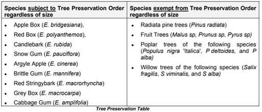
1. Trees
prescribed by this DCP must not be ringbarked, cut down, topped, lopped or
wilfully destroyed without the Council’s approval and landowner’s
consent.
2. This
clause applies to Eucalypts of any size belonging to the White Box, Yellow Box
and Blakely’s Red Gum Endangered Ecological Communities, including
species indicated as affected in the tree preservation table.
3. This
clause applies to any tree, native or exotic, with a trunk diameter equal to or
greater than 300mm at breast height.
4. This
clause does not apply to species indicated as exempt in the tree preservation
table.
5. An application for
the Council’s approval must be accompanied by an appropriately qualified
specialist (arborist) report.
In consideration of these matters, an arborist report has
been prepared by Council’s Nigel Hobden, Manager City Presentation.
The report provides a detailed assessment of the value (environmental,
historical, and social), health and opportunity for retention of trees on the
Bloomfield Golf Course northern precinct. The arborist assessment provides the
following:
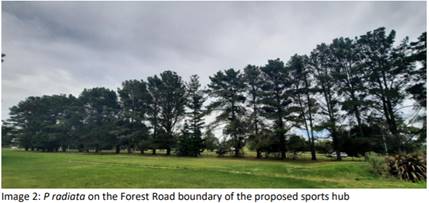
The northern precinct, that
proposed for a sports hub, has a dominant tree canopy across the site of
Monterey Pine (Pinus radiata) with in the order of 423 specimens (+ 10%)
estimated to have been planted between 1975 and 1984. Aerial images obtained by
Premise depict little to no tree canopy on the northern precinct (i.e., the
area between the Bloomfield Hospital Campus Access Road and Sir Jack Brabham
Sports Field).
Key features notable in the 1973
Aerial Image in the Premise SoEE Report [Page 29 Figure 7 –
Aerial Photo from 1973 (Source: NSW Government Historical Imagery)] are the
remnant Apple Box (Eucalyptus bridgesiana) in the south eastern corner of the
proposed sports hub and the border of trees along the northern boundary of the
Tallowood Complex of Buildings (pres. mainly to be Cupressus glabra).
In Figure 8 [page 30 Premise SoEE
Aerial Photo from 1984 (Source: NSW Government Historical Imagery)] the
boundary planting of Monterey Pines between the ‘northern section of the
Bloomfield Golf Course’ complex and Sir Jack Brabham Park (SJBP) is
clearly visible as are the returns of these Monterey Pine plantings along
Forest Road in a north south direction from the common boundary. When a
comparison of the northern golf course precinct and the southern golf course
area (south of the Bloomfield Hospital Campus Drive) is made the aerial imagery
clearly shows the more advanced and historically established tree plantings on
the southern golf course area. This latter area has a more diverse and
interesting collection of tree species than the northern precinct.
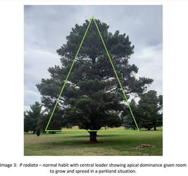
Monterey Pine (Pinus radiata) has
traditionally been grown as windrow or wind break plantings or a softwood
plantation timber for the timber industry (house frames, pulp wood). The
species has very little to no ecological value and is known to supress the
growth of other tree species as a result of leaching of toxins from the needles
and root system. The planting of Pinus radiata along the common boundary of the
Bloomfield Hospital Precinct (BHP) and Sir Jack Brabham Park is akin to that of
a softwood plantation planting but in many instances individual specimens are
planted in much closer proximity; that is at a much higher density. This has
led to vertically elongated growth as the trees compete with each other for
light.
As a result of the growing environment, growth
habits and recent environmental conditions (Millennium drought, drought of
2019/2020) many of these trees are very poor specimen’s often carrying
codominant leadership, where naturally the radiata pine have one dominant
leader. Codominance is a structural weakness which often results in the failure
of one leader and then compromising the integrity of the remaining leader.
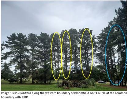
Each of the trees circled in
yellow have codominant leaders representing points of future failure. Note the
density of plantings on the right-hand side of image and the haphazard growth
with stems leaning away from each other.
Due to the compact planting
(space between trees), especially along the common boundary of BHP and SJBP,
the trees are dependent on each other for support (wind buffering) and the
removal of some portion of the row will expose others to elements that they are
not established to withstand. Those trees that are protected will have less
well-developed root structures to support the individual specimens in strong
wind events. Removal of some trees in exposing other will predispose those left
standing to the high probability of wind failure.
The proposed future sporting
complex would require substantial volumes of cut and fill across the site and
in the north western corner of the BHP where the proposed stadium would be
constructed. The placement of fill will have significant impacts on the root
system of the boundary tree planting. The placement of fill on top of the
natural ground surface will smoother and suffocate both feeding and structural
roots, in effect inflicting a slow decline and eventual death to the trees if
they are not removed as the first stage in the redevelopment of the site to
playing fields.
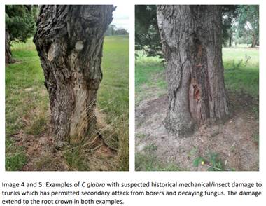
Along the southern boundary of
the site with the Tallowood Complex, the proposed project will require
substantial cut to enable sports field playing surfaces to be constructed.
Within this area a collection of juveniles to semi-mature Atlantic and
Himalayan Cedar occurs (Cedus atlantica and C deodara), isolated native trees
such as Ribbon Gum (Eucalyptus viminalis) on the northern side of the Tallowood
boundary fence and on the southern side are over mature Arizona Cypress
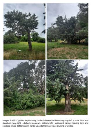
(Cupressus glabra). Many of the C. glabra are in poor condition (refer to
Images 4 to 9).
|
|
 |
There is an
opportunity to transplant in the order of 12 trees on the site as their age and
structure will permit lifting out of the ground and relocation. These trees can
be planted to reinforce the boundary plantings along the eastern alignment of
Bloomfield Heath Service Tallowood Complex and in front of the Benjamin Short
Grove Residential Age Care Facility (Age Care Facility). There are a number of
Ornamental Pears and Simon’s Poplars that will be transplanted
during earth works stages to retain and maintain tree canopy surrounding the
adjoining complexes.
A collection
of Narrow-leaved Black Peppermint (Eucalyptus nicholii), Ribbon Gum (Eucalyptus
viminalis), Ironbark (E sideroxylon) and Willow Gum (E scoparia) totalling
11 individual trees immediately to the north of the Age Care Facility will
be retained and can be reinforced with additional plants of suitable species.
Species that currently exist across the proposed sports hub area such as
Cedrus atlantic, C deodara, Quercus palustris and Liquidambar styraciflua
would be appropriate.
Of importance
as trees to be retained on the subject site are two remnant Apple Box
(Eucalyptus bridgesiana) located in the south eastern corner of the site and a
cluster of Ribbon Gum (Eucalyptus viminalis) on the Huntley Road frontage of
the site.
Each of the
above trees to be retained shall have tree protection zone (TPZ) fencing as per
AS4970 – 2009 erected prior to site occupancy and prior to any tree
removal or earth works. The area within the TPZ fencing shall be covered with a
layer of 100mm thick mulch derived from Council tree maintenance operations or
similar i.e. it shall be a combination of woodchip and leaf. Tree protection
shall include the establishment of TPZ for the avenue of Elm Trees (Ulmus sp)
along the Hospital Drive entrance road.
The project
arborist (or Council Manager City Presentation) will be required to approve TPZ
fencing. Adjustments may need to be made for individual trees based on the
balance, shape and form of the canopy and growing environment. Where possible
trees shall be grouped within TPZ fencing to aid in protection and exclusion of
construction activities.
Chapter 2 - Natural Resource
Management
The
matters required to be considered under Section 2.3 - Vegetation and Section
2.4 - Flora, Fauna and Biodiversity have previously been addressed under
“Section 1.7 - Application of Part 7 of the Biodiversity Conservation Act 2016 and
Part 7A of the Fisheries
Management Act 1994” of this report.
The development is considered satisfactory with regards to
flora, fauna, and biodiversity matters.
Chapter
11 - Land Used for Open Space and Recreation
Principally, the relevant Planning Outcome arising from this
part of the DCP is to consider the provisions of any relevant Plan of
Management applicable to the site. Council’s Manager City Presentation
has advised that there is no specific Plan of Management for the former Orange
Ex-Services Country Golf Club as it is in Crown land ownership and been
historically used for private recreation purposes. In this regard, the planning
outcomes contained in Chapter 11 of the DCP are considered irrelevant to
the assessment of this application.
Notwithstanding, Council has at various times resolved to
prepare overarching plans (i.e., Plans of Management) for all land held in
its ownership, care, control, and management. To this end, Council some years
ago adopted a generic Plan of Management that applies to all its parks and
reserves. Should the subject land be re-purposed for public recreation under
the management of Orange City Council in the future, Council’s Manager
City Presentation has advised the land will be included in the generic Plan of
Management as an addendum. The inclusion of the land in the generic Plan of
Management will provide strategic planning direction and governance for the
management and use of land with respect to landscape preservation, protection
of native vegetation, equipment, access, neighbourhood amenity and risk
management.
Chapter 13 – Heritage
The land is identified as a Heritage Item of Local
significance. The significance arises because of the site's previous use as an
aerodrome and road racing circuit. The site is also within the curtilage of the
historic Bloomfield Hospital site. Heritage impacts have been addressed
in detail above under the heading “5.10 - Heritage Conservation”.
The development will not have a detrimental effect on the significance of the
locally listed Heritage Items or the adjoining Bloomfield hospital site. The
development has the support of Council’s Heritage Advisor and General
Terms of Approval have been issued by NSW Heritage.
PROVISIONS PRESCRIBED BY THE
REGULATIONS s4.15(1)(a)(iv)
Demolition of a Building (Clause 92)
The proposal is for tree removal only and does not involve
the demolition of any built structures.
Fire Safety Considerations
(Clause 93)
The proposal does not involve a change of building use for
an existing building.
Buildings to be Upgraded
(Clause 94)
The proposal does not involve the rebuilding, alteration,
enlargement or extension of an existing building.
BASIX Commitments (Clause 97A)
BASIX is not applicable to the proposed development.
THE LIKELY IMPACTS OF THE
DEVELOPMENT s4.15(1)(b)
In determining an application, a consent authority must take
into consideration the likely impacts of the development, including impacts on
both the natural and built environments, and social and economic impacts in the
locality. The former NSW Department of Urban Affairs and Planning (DUAP)
practice note provides a number of primary matters and specific considerations
that can be referred to in order to assess the likely impacts of a development.
The relevant primary matters and specific considerations have been identified
and assessed as follows:
Context and Setting
The site sits primarily within a parkland setting south of
the Orange CBD. The reserve comprises a former nine-hole golf course over an
area of some 28ha. An extensive number of tree plantings have been used to mark
out fairways and golf greens and also to provide screening and protection along
the periphery of the site. These plantings mainly comprise radiata pine;
however, other ornamental species also exist along with a few isolated remanent
native vegetation. Apart from the fairway and periphery plantings, the land
consists of improved pastures, cart tracks and sand bunkers. A starters hut is
located in the south western corner of the site.
Surrounding uses are mixed and include recreation lands,
health services facilities educational establishments and industrial lands. The
nearest residential properties are located on the northern side of Jack Brabham
Park some 500m from the subject site. The site will continue to be used
for recreational purposes thus is not considered to be incompatible with the
context and setting of the area.
Visual Impacts and Landscape Character
The proposal to remove 513 mature trees from the site, which
will also include ground disturbance, material stockpiling, fencing and storing
of equipment, is expected to have some degree of impact on the landscape
setting of the site and streetscape. Thus, consideration needs to be given
to the landscape sensitivity and its ability to absorb the proposed change, the
viewers’ sensitivity/susceptibility to the change and the overall visual
effects of the proposal to determine the extent of the impact including the
appropriateness/suitability of the proposal.
Relevant visual impact assessment guidelines provide that
visual sensitivity relates to the qualities of the area and the importance of
views to receptors at a certain location and is informed by the type of
receptor and the activity with which they are engaged. This considers the
extent to which receptors’ attention or interest is focused on the view
or visual amenity. For example, residents in their home, walkers whose interest
is likely to be focused on the landscape or a particular view, or visitors at
an attraction where views are an important part of the experience often indicate
a higher level of sensitivity/susceptibility. Whereas receptors occupied in
outdoor sport where views are not important or at their place of work are often
considered less susceptible to change.
Landscape
sensitivity/susceptibility is determined with reference to the three-point
scale and criteria outlined below:
|
LANDSCAPE
SENSITIVITY AND VISUAL SUSCEPTIBILITY
|
CLASSIFICATION
CRITERIA
|
|
High
|
Landscape of particularly
highly valued character and scenic quality, considered very susceptible to
relatively small changes e.g., within a designated Scenic Area, National
Park, designed Landscape/garden or recognised as an iconic or important
feature of the landscape. Receptors for which the view is of primary
importance and are likely to notice even minor change.
|
|
Medium
|
Landscape of regional or local
value, quality, or rarity, exhibiting some distinct features, considered
tolerant of some degree of change e.g., within a locally designated landscape
or with landscape elements of local importance.
Receptors for which the view is important but not the primary focus
and are tolerant of some change.
|
|
Low
|
Landscape of lower scenic
quality, with few distinctive elements or valued characteristics and
considered tolerant of a large degree of change e.g., out with any designated
areas or within a degraded landscape. Receptors
for which the view is incidental or unimportant and is tolerant of a high
degree of change.
|
The sensitivity and susceptibility of the landscape and its
viewers to absorb the impact of the proposal is considered to fall within the Low-Medium
Sensitivity category on the three-point scale on the basis of the
following:
a) The
site not has not been recognised as being of high scenic quality. The land does
not comprise an area of scenic value per Council’s Scenic Protection Map
2011, is not a national park, an architecturally designed landscape or
associated with any significant person.
b) The
golf course was not part of the setting of the adjoining hospital precinct nor
part of the designed landscape as evidenced by historic photographs by NSW
Spatial Services.
c) The
trees on the land are primarily exotic species, mainly radiata pine which are
not considered to be a high quality or rare species. The radiata pine is a
fast-growing tree species in Australia and as a result they are typically used
for timber production and large-scale wind breaks. Notwithstanding, the trees
at the site have matured to a size and scale that are considered to provide
some aesthetic value to the immediately locality.
d) Based
on the surrounding land uses, visual receivers are largely considered to be
transit in nature i.e., those traveling by vehicle along Forest and Huntley
Roads, and those in the area for limited periods for work or recreation
purposes. These receivers are considered to have low sensitivity to the change
in the landscape as their visit to the area is generally not focused on the
landscape or view. The residential properties located on the northern side of
Sir Jack Brabham Park are screened by vegetation and have no direct view of the
site or tree canopy. These properties are also considered to have low
sensitivity to the proposed tree removal. Those who utilise the area for
walking may have a medium level of sensitivity to the tree removal where their
interest is likely to be focused on the landscape.
In addition, a viewpoint assessment has been carried out by
Council strategic planning staff to determine the visual effect of the tree
removal on the landscape. The viewpoint assessment also includes an indicative
envelope of the proposed sports stadium for context. Viewpoints have been
selected to be representative of a few key views around the study area
including from within the Bloomfield north site and Forest and Huntley Roads.
It needs to be noted that the viewpoint assessment has been undertaken with the
information provided as part of the development application. Survey information,
proposed levels and further resolution of the design will be required to
understand the visual impacts of the proposed stadium buildings. Further
analysis should be undertaken at the design phase.
The extent of the visual effects of a proposal is determined
by the magnitude of landscape change. The magnitude of landscape change refers
to the extent to which the proposed developments would alter the existing
characteristics of the landscape and combines judgements on; size or scale of
effect, geographical extent of the area influenced, duration/reversibility and
its proximity to the viewer.
Changes to
landscape characteristics can be both direct and indirect. Visual effects are
considered to be direct effects as the magnitude of change within an existing
view will be determined by the extent of the visibility of the proposed tree
removal. The following criteria is used to determine the magnitude of visual
change:
|
MAGNITUDE
|
CLASSIFICATION
CRITERIA
|
|
Negligible
|
The development will cause a
barely discernible change in the existing view
|
|
Low
|
The
development will cause very minor changes to the view over a wide area or
minor changes over a limited area
|
|
Moderate
|
The
development will cause minor changes to the existing view over a wide area or
noticeable change over a limited area
|
|
High
|
The
development will cause a considerable change in the existing view over a wide
area or a significant change over a limited area
|
|
Viewpoint Assessment
|
|
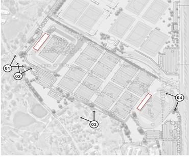
|
Reference Plan
|
|
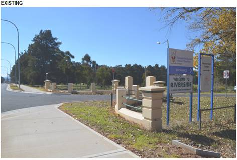
|
View 01: Forest Road (Existing)
|
|
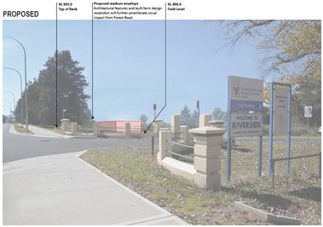
|
View 01: Forest Road (Proposed).
Views
into the site from Forest Road will be largely screened by the existing periphery
vegetation. It is likely that there will be little to no impact upon the
existing landscape character for this streetscape if the development were to
proceed.
Magnitude of change: Moderate
|
|
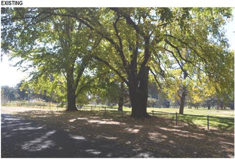
|
View 02: Bloomfield Entry Road (Existing)
|
|
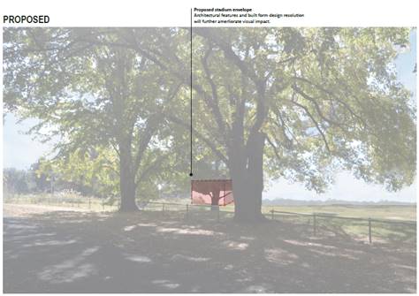
|
View 02: Bloomfield Entry Road (Proposed).
Views into the site from this location is
considered to result in the site being viewed as a continuation of the
existing Jack Brabham Park in the medium term while additional tree plantings
along the boundary mature.
Magnitude of change: Moderate
|
|
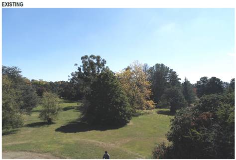
|
View 03: Bloomfield North Site (Existing)
|
|
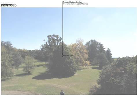
|
View 03: Bloomfield North Site (Proposed)
Due to the separation between the site of the
tree removal and intervening vegetation on the Bloomfield north site, it is
not considered that the proposed development will have a significant adverse
impact on the landscape, views or scenic quality.
Magnitude of change: Negligible
|
|
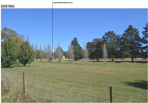
|
View 04: Huntley Road (Existing)
|
|
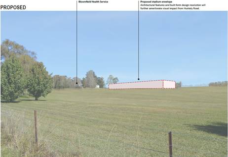
|
View 04: Huntley Road (Proposed)
The extent of the tree removal from this location would be more
noticeable due to limited boundary vegetation. Receivers at this location
would be transit in nature. Again, additional boundary plantings will be
provided.
Magnitude of change: Moderate-High
|
In summary, the foregoing assessment demonstrates that the
aesthetics and values of the landscape can tolerate the loss of the vegetation
while still retaining a reasonable standard of visual amenity. Replacement
plantings will be provided as indicated on the Masterplan, which will mitigate
much of the vegetation loss and associated visual impacts in the medium-long
term. The retention of the periphery plantings particularly along Forest and
Huntley Roads and the boundary with the Bloomfield health precinct will retain
substantial tree canopy in the streetscape/landscape in the short term while
new plantings mature. Design resolution through the use of architectural
features and varying materiality will need to be further developed and assessed
in subsequent development applications to ensure visual impact of the sports
stadium is limited.
Air and Microclimate
Microclimate is defined as the small-scale aspect of
climate; that is, the climatic conditions that exist in an area that may only
be of a relatively small expanse. Microclimate concerns temperature; heat
reflection, air turbulence, areas exposed to or sheltered from sunlight wind,
frost or fog and can be altered by many factors including vegetation cover and
the built environment.
Microclimate regulation and Urban Heat Island Effect
mitigation are considered to be two of the most important services of
vegetation in an urban environment. It is widely acknowledged, as reported
through scientific studies and literature, that urban greenery, especially
trees, can positively affect outdoor microclimate and moderate the urban heat
island effect in the summer. The
shade of trees or taller shrubs can attenuate solar radiation which can
decrease air temperature and reduce considerably the solar radiation income of
the ground and other surfaces in the shade, thereby altering local climates and comfort levels[1].
It has been a major concern of many submission writers that
the removal of a large proportion trees/vegetation from the site would
significantly disrupt the microclimate (and the Orange climate in general)
as well as exacerbating the Urban Heat Island Effect. However, it is expected
that the proposed vegetation removal would have a neutral impact on climate and
the urban heat island effect as discussed in detail below.
The NSW Office of Environment and Heritage Urban Green Cover
Technical Guidelines define the UHI Effect as:
The localised warming due to the
increase in the large amounts of paved and dark coloured surfaces like roads,
roofs, and car parks as a result of urban development. The sun’s heat is
absorbed, not reflected, and causes the surface and ambient temperatures to
rise. Anthropogenic heat production, such as the heat produced through car
engines and air conditioners also contribute to the Urban Heat Island Effect.
Therefore, the main features that modify radiant heat levels
and contribute to the UHI relate largely to the change of nature and
composition of surface materials within the environment. This is of a
particular concern in built up areas
e.g., residential estates, industrial areas, and town centres where buildings
and hard surfaces absorb the sun’s heat and then radiate it back into
their surroundings. Retaining and establishing tree canopies and vegetation in
these areas is particularly important as they intercept and dissipate incoming
solar radiation, cooling surrounding air temperature thereby improving human
comfort levels and reduction of the need to utilise mechanical cooling or
heating.
However, the proposed development would not considerably
change the nature and composition of the surface materials at the site i.e.,
the future sports facility will not involve the construction of vast amounts of
paved and dark coloured surfaces. While the Masterplan indicates a total of
five (5) hardstand carpark surfaces, internal access roads and roof surfaces
for the stadium buildings, this only represents approximately 2.2% of the site
area with the balance remaining as green open space and tree cover.
Notwithstanding, the site in its current state is expected
to contribute to some cooling benefits for the immediate locality. This is
known as the Park Cool Island (PCI) Effect. While extent of this effect depends
on the type and amount of vegetation and whether or not irrigation is used,
studies have shown that a medium sized park (26ha) can have a cooling effect
for a distance if up to 860m from its boundaries in the morning and up to 200m
in the afternoon and evening[2].
Although there will be a reduction in the overall tree cover at the subject
site in the medium-long term, it only represents 4.8% of the total substantial
tree canopy cover within approximately 1km radius of the site (Figure 7).
Consequently, the trees to be removed are expected to have a negligible
influence on the cooling benefits that would otherwise be produced by the
significant vegetation cover/tree canopy that will remain in the locality. The
introduction of new trees at the site is also expected to offset any potential
air and microclimate effects over time resulting in a neutral impact.
It is also worth noting that the Environmental Protection
Agency Reducing Urban Heat Islands: Compendium of Strategies report
provides that open sporting fields (grassed areas with reduced tree canopy)
still produce cooling benefits between 1 and 2oC cooler than over
boarding areas.
Lastly, emissions of dust and odour/ fumes from the use of
tree removal equipment is expected; however, these impacts would be relatively
localised, short term and only for the duration of the works. Conditions of
consent are recommended for dust suppression during demolition works to protect
the air and microclimate. Long-term discernible impacts on air quality or on
the microclimate of the locality is not expected.
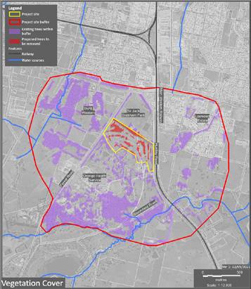
Figure 8 –
Substantial Tree Cover in the Locality
Social Impacts
Social impacts are the consequences that people experience
when a new project brings change. This may involve changes to people’s way of life; community; access to
services; culture; health and wellbeing; surroundings; personal and property
rights; decision-making systems; and fears and aspirations about one or more of
these things, or the future of their community.
The health and
wellbeing and social equity aspect are of particular importance to the community
as evidenced by the high number of submissions received concerning these
matters. Social equity is a concept concerned with the fair and equitable
provision and implementation of services/facilities, programs, and policies. It
is largely perceived that the proposed tree removal and the future conversion
of the site to a structured sporting facility would result in the loss
of informal and unstructured green open space/parkland for passive exercise,
play and socialising within the City. However, it is necessary to point out
that the land has historically been
used for private recreational purposes since the 1980s i.e., available
only to those who held exclusive membership with the orange ex-services country
club and has not been available to the public for any passive recreational
purposes. Therefore, the community is expected to benefit from the proposed
future redevelopment of the site, which will provide greater accessibility and
useability for all members of the community. Although the Masterplan indicates that the site
will primarily cater for active recreational users, the Masterplan also
provides pathways around the perimeter, which encourages passive recreation
such as walking, jogging etc. The advantage of having different
opportunities (or activations) within a single larger park means the space can
cater for a range of needs and attract a broader user base, which in turn helps
to create a sense of community, encourages interaction/social participation and
social cohesion. Furthermore, the immediate locality includes a number of
unstructured public recreation spaces such as Gosling Creek, Hinton Park and
Black Sallee Reserve which are available for those seeking passive recreation
opportunities.
The health and
wellbeing concerns primarily relate to impacts on hospital patients, visitors
and staff and their access to green open space and parkland for mental and
physical health e.g. psychological relaxation, stress alleviation, physical
activity etc. However, it must be emphasised that the extent of the proposed
tree removal will be located on the northern side of the entry road that
formally divided the golf course (the area immediately adjoining JB Park);
thus, the proposal has minimal interaction with the hospital precinct and will
not reduce the amount of greenspace/parkland that has normally been available
to hospital users prior to the closure of the golf course. Furthermore,
views/outlook to vegetated areas from the hospital building will be maintained
as evidenced by the visual analysis undertaken above.
In summary, the proposal is not anticipated to have any
adverse impacts on people’s way of life, their health and wellbeing,
culture or sense of community and access to recreation facilities.
Economic Impacts
The economic benefits and costs
of the tree removal would have minimal implications in terms of employment or
business generation, economic income etc. It is noted that it is now possible
to determine the economic values of trees utilising various formula or software
programs. However, Council has not adopted policy for an appraisal system for
valuing trees at this stage, and thus further consideration on this matter is
not warranted.
THE SUITABILITY OF THE SITE
s4.15(1)(c)
The subject land is considered to be suitable to undertake
the proposed development due to the following:
· The development is
permissible and compliant with the relevant provisions of the LEP.
· The development is
considered to be satisfactory in regard to Section 4.15 of the Environmental
Planning and Assessment Act 1979.
· The potential
impacts of the development can be managed appropriately through the conditions
of consent.
· The development of
the site will not create significant adverse impacts on the context and setting
of the area.
· The development of
the site will not detrimentally affect adjoining land and is unlikely to lead
to land use conflicts.
· The subject land
has no significant biodiversity or habitat value.
ANY SUBMISSIONS MADE IN
ACCORDANCE WITH THE ACT s4.15(1)(d)
The development was notified to adjoining landowners and
publicly advertised from 11 December 2020 to 5 February 2021 in accordance
with the Orange Community Participation Plan 2019. During the
notification/exhibition period 177 submissions were received –
163 objections and 14 in support. The submissions have been considered by
Council officers and key themes have been identified as either concerns from
those submissions that are in opposition to the development, and comments of
support for those submissions in support of the development. This analysis of
submissions is shown in the attached submissions consideration matrix.
Submissions in Support of the Proposal
The issues raised in the supporting submissions are
summarised as follows:
· Economic benefits
– increased visitor numbers to the city which in turn will see increased
spending in local businesses – food, drink, accommodation etc.
· Site suitability
and compatibility - location, proximity to services/other complementary
recreation facilities, accessibility, and convenience.
· Opportunity to
provide much needed sporting facilities for the City.
The issues raised in support of the proposal are noted by
Council staff.
Submissions Against the
Proposal
The issues raised in the opposing submissions are summarised
and addressed below as key themes:
Theme 1 – Site Selection/Alternate Sites
The vast majority of submissions
objecting to the development raised poor site selection as an issue and
suggested that alternative sites should be considered for the future sports
stadium in an effort to retain the established trees on the subject site.
On this matter, Council staff
can only assess the development before it, which is tree removal.
Notwithstanding, even if the proposed sporting facility were before Council,
justification of need and exploration of alternative sites would not be
required to be undertaken. Proponents are only required to provide assessment
of any alternatives where an Environmental Impact Statement (EIS) is required
– the future sporting facility would not require an EIS. Council only
needs to be satisfied that the site is suitable for the proposed development
and not consider if there are better/more desirable locations. For the purposes
of general information, the background information section of this report
provides a brief outline as to how and why the site was selected for the future
sporting precinct.
Theme 2 – Impacts upon Landscape Character, Views,
Aesthetics and Amenity
Impacts on the landscape character, views, aesthetics, and
amenity have been considered in the forgoing assessment under s4.15(1)(b)
likely impact of the development – visual impact and landscape character.
The analysis found that the proposal would result in a low-medium level of
impact in terms of the sensitivity and susceptibility of the landscape and its
viewers to absorb the proposed change. This was largely based on the fact that
visual receivers were transit in nature (those traveling by vehicle along
Forest and Huntley Roads, and those in the area for limited periods for work or
recreation purposes), distance to residential land, and significance and
quality of the vegetation. Furthermore, the viewpoint assessment concluded that
the aesthetics and values of the landscape can tolerate the loss of the
vegetation while still retaining a reasonable standard of visual amenity. The
retention of the trees along the periphery and the proposed replanting are
considered to be sufficient measures to mitigate the visual impacts.
Theme 3 – Alternative Use/Additional Activations
A high number of submissions stipulate that the land should
be utilised for unstructured/passive recreation due to the limited number of
passive recreation facilities within the City. The submissions also state that
there is an opportunity to take advantage of the established vegetation on the
site and grow the site into another park similar to Cook Park in the
Orange CBD or Centennial Park in Sydney.
On this matter, Council staff can only assess the development
before it. Investigation of alternative uses of the site is not a matter for
consideration under Section 4.15 of the Environmental Planning and Assessment
Act 1979. It should however be noted that although the Masterplan for the site
indicates that the land would principally accommodate organised sport and
structured activity, there is an element of the proposal that can cater for
informal recreational activities in the form of pathways that can be utilised
for walking, jogging etc.
Theme 4 – Reduction/loss of greenspace and parkland
It is largely perceived that the removal of the trees on the
site and the future development of the land to a structured sporting facility,
would result in the reduction or loss of the City’s publicly
available green open space and parkland. However, this is not considered to be
the case. Parkland refers to land that has been reserved for the purpose of
formal and informal sport and recreation and/or preservation of natural
environments such as bushland, wetlands, river, and coastal foreshore systems.
Therefore, even though the land is expected to be repurposed as a structured
sporting facility in the future, it will remain as parkland/open space.
Furthermore, the proposed future re-development of the site would effectively
increase the amount of public space within the City and recreational
opportunities for the general public due to fact the land has been privately
leased since the 1980s and not open to the general public.
Theme 5 – Traffic, Parking and Transport Impacts
Traffic, parking, and transportation issues have been raised
in many submissions. The primary concerns are that the future sporting
precinct will significantly exacerbate existing traffic problems along Forest
Road, including delaying emergency vehicles and insufficient onsite parking
facilities to accommodate major events resulting in parking deficiency at the
hospital site. These are valid concerns and will need to be addressed by the
proponent in any forthcoming development application for the sporting facility.
This will need to include a comprehensive Traffic Impact Assessment (TIA) and
stakeholder engagement with Transport for NSW, NSW Health, and other relevant
parties.
Theme 6 – Environmental Impacts
The bulk of submissions objecting to the development raised
environmental impacts as a major concern resulting from the tree removal
particularly in relation to impacts on microclimate, air temperature, and urban
heat island effect. The impact of the tree removal concerning these maters have
been addressed in the forgoing assessment under s4.15(1)(b) likely impact of
the development – air and microclimate. The assessment found that the
trees to be removed only represents 4.8% of the total substantial tree canopy
cover in the area and their removal would not adversely alter the air
temperature and microclimate including any cooling benefits provided by the
vegetation within the locality. It was considered that any impacts can be
suitably offset by the proposed replanting. Further, the analysis looked at the
issue of urban heat island effect and it was determined that the main features
that contribute to this phenomenon is the change in surface materials within
the urban environment e.g., paved, and dark coloured surfaces like roads,
roofs, and car parks. It was noted the change in surface materials and
introduction of built form at the site for the future sports precinct
represents only 2.2% of the total site area and thus considered to have
negligible influence on the urban heat island effect.
Theme 7 – Impact on Biodiversity
Concerns have been raised that the removal of the trees
would have a significant impact on flora and fauna species including habitat
loss. A comprehensive biodiversity assessment report has been prepared by
ecologist Dr Colin Bower to assess the impacts of the proposal on these
matters. The report concluded that the proposal would not have an adverse
impact on fauna or flora species and associated habitats.
Theme 8 – Contamination
Matters concerning contamination have been addressed in the
assessment report and via conditions of development consent.
Theme 9 – Noise
Noise impacts have been raised in some submissions. The
concerns raised relate to the operation of the future sporting facility. These
are valid concerns; however, this DA relates only to tree removal. Noise
impacts will need to be addressed in the forthcoming development application
lodged for the sporting facility. The proponent will be required to prepare a
Noise Impact Assessment (NIA) in line with NSW EPA Guidelines and Australian
standards and demonstrate that operational noise would be within reasonable
levels and or provide suitable mitigation measures.
Theme 10 – Heritage
Submissions received concerning heritage matters relate
principally to the perceived significance of the trees. Many are concerned that
the trees to be removed are those within institutional parkland that forms the
primary setting of the hospital precinct. However, this is not the case. The
trees to be removed are located on
the northern side of the entry road that formally divided the golf course (the
area immediately adjoining JB Park). The trees identified to be removed were
planted to mark out fairways and golf greens and to provide screening
and protection along the periphery of the site for golfing activities. These
trees are believed to have been planted in the late 70s and early 80s and
comprise mainly radiata pine. The Heritage Impact Statement submitted with the
development application confirms that these trees have no heritage value. The Elm trees located along the northern
entry road which are considered to have heritage value will be retained and
will be protected by tree protection zones during works.
Furthermore, the
subject development was treated as integrated development pursuant to Clause
4.46 of the Environmental Planning and Assessment Act 1979 requiring approval
from Heritage NSW. Following a rigorous assessment by the heritage office,
general support was given to the removal of the trees from the site; however,
the heritage approvals committee resolved at this stage to only grant approval
for the removal of trees in the immediate area of the indicative stadiums. The
removal of the reminder of the trees is subject to the submission of a
satisfactory landscape plan. This was to ensure the new buildings, civil
works and landscape design respects the heritage character of the place without
dominating the landscape setting that contributes to the state heritage listed
Bloomfield hospital precinct
Theme 11 – Economic Impacts
Submissions received on this issue request that an economic
valuation to be undertaken to determine the monetary value of the trees, taking
into consideration their historic importance, quality and state of health, the
social and environmental benefits they afford, and the cost associated with
their removal against the cost associated with maintain them. As discussed in
the forgoing assessment, Council has not adopted a policy for an appraisal
system for valuing trees at this stage, and thus is not a matter that requires
consideration as part of the Council’s assessment process.
Notwithstanding, matters concerning historic importance, health, social and environmental
issues have been addressed elsewhere in the report.
Theme 12 – Social Impacts
Social Impacts have been addressed under the forgoing
assessment under s4.15(1)(b) likely impact of the development –
social impacts. The proposal is not anticipated to have any adverse impacts
on people’s way of life, their health and wellbeing, culture or sense of
community and access to recreation facilities.
Theme 13 – Water Security
A few submissions suggest that state government grant money
should be spent on water storage infrastructure instead of a sporting facility.
Determining where grant funding should or should not spent is not a matter of
consideration under Section 4.15 of the Environmental Planning and Assessment
Act 1979. Other submissions raise concern that the sporting facility would
require significant water resources and given current deficiency in the
City’s water security, a high-water use development should not be
permitted. The current application is for tree removal only and will have
nil impact on Council’s water supply. Notwithstanding, Council’s
parklands are generally supported by recycled or bore water sources and water
supply for domestic, commercial, or industrial consumption is not affected.
Theme 14 – Permissibility, Conflict of Interest,
Community Participation
A few submissions contend that the tree removal should not
be considered as a standalone development application when it is clearly a
stage of a larger development (as referenced in SoEE) and thus one Development
Application should have been lodged that covers all aspects of the intended
development on the land to completely understand the entirety of the impacts
(traffic, noise etc.) associated with such a development, for consideration and
approval by the independent planning panel. Other submissions also raise lack
of community consultation regarding the project and conflict of interest
(Council as both proponent and assessor and perceived pre-determination).
Although the proposed tree removal is inevitably linked to a
proposed future sporting facility, the sporting precinct is only a concept at
this time and may change following consultation with relevant stakeholders. The
inclusion of the Masterplan for the future sporting facility in the current DA
was necessary to provide some context for the proposed tree removal, however
not a requirement. Despite that the documentation submitted with the
application suggests that the DA is a stage of the sporting facility, the
application before Council is not a ‘staged development’ pursuant
to the Environmental Planning and Assessment Act 1979. The proponent has only
sought development consent for demolition (tree removal) which is a permitted
activity in its own right. While some submission also argue that without
involving the future sporting precinct in the application, there is no
plausible or valid reason to remove the trees; however, Council does not need to consider if there is a
‘valid reason’ for a development to occur, Council need only to
consider the relevant heads of consideration under the Section 4.15 of the
Environmental Planning and Assessment 1979 of which a ‘valid
reason’ is not one. The relevant matters concerning this DA have been
assessed in the forgoing report with a particular emphasis on the environmental
impacts. Consideration of matters including traffic, noise, built form, visuals
etc. that have been raised concerning the future sports precinct will need to
be considered once an application has been lodged for that development.
Lastly, the
proposed tree removal does not represent regionally significant development in
it is own right and thus Orange City Council is considered to be the consent
authority for this application. Should any subsequent development application
lodged for a sporting facility on the land that meets the threshold for
regionally significant development, the Western Regional Planning Panel will be
the determining authority for that application.
With regards to community consultation, Council encourages
proponents to liaise with adjoining property owners, community groups or other
affected parties in the planning and design of a development proposal; however,
there is nothing in legislation that requires a proponent to carry out such
consultation. The current development application was notified and advertised
in accordance with Council’s Community Participation Plan for development
applications of this nature. A public forum was also held.
For matters concerning conflict of interest, due process has
been followed where Council is both the proponent and assessor. This included
an independent consultant to prepare the DA documentation, public notification
and advertisement, referrals to relevant government agencies, internal
assessment by Council’s town planning staff including consideration of
public submissions and report with recommendations to a Council meeting for
consideration and determination.
PUBLIC INTEREST
s4.15(1)(e)
The proposed development is
considered to be of moderate to high interest to the wider public due to the
volume of public submissions received and the nature of the concerns raised.
Notwithstanding this, the foregoing detailed assessment has demonstrated that
the proposed development has demonstrated compliance
with all of the relevant controls and has demonstrated that no significant
amenity or environmental impacts will arise.
SUMMARY
This development application seeks Council's consent for demolition
(tree removal) at Lot 1 DP 1142713 and Lot
209 DP 42900, 1610 Forest Road, Orange. The site is currently occupied by Sir
Jack Brabham Park sporting fields (Lot 1) and the former Orange Ex-Services
Country Golf Club (Lot 209). The tree removal is
to facilitate the delivery of the Orange Regional Sporting Facility (ORSF). The
future sporting facility on the land including bulk earthworks,
erection of buildings, installation of services, landscaping, vehicle
access/car parking etc. would be subject to separate development approval.
The development
was treated as integrated development pursuant to Clause 4.46 of the
Environmental Planning and Assessment Act 1979 requiring approval from Heritage
NSW for the removal of trees within the bounds of a state heritage listed site. Following
a rigorous assessment by the heritage office, general support was given to the
removal of the trees from the site; however, the heritage approvals committee
resolved at this stage to only grant approval for the removal of trees in the
immediate area of the indicative stadiums at this time, and the removal of the
reminder of the trees is subject to the submission of a satisfactory landscape
plan. This was to ensure the new buildings, civil works and
landscape design respects the heritage character of the place without
dominating the landscape setting that contributes to the state heritage listed
Bloomfield hospital precinct.
The removal of the remainder of the trees outside
the immediate area of the indicative stadiums will need to be the subject of
a separate DA for the wider civil works across the site. That DA will need to
be accompanied by a detailed landscape master plan for further consideration by
Heritage NSW.
Notwithstanding, this assessment report has considered the
tree removal proposal across the entire site, with key considered given to the
environmental impacts (biodiversity, air and microclimate), the visual/amenity
implications; and social impacts. The assessment found that the tree removal
across the entire site would not result in any adverse impacts, subject to
compliance with recommended conditions of consent.
It is recommended that Council supports the subject
development proposal and continues to work closely with NSW Heritage, Transport
for NSW, NSW Health and other key stakeholders regarding the overall design of
the future sporting precinct.
Attachments
1 Notice
of Approval and NSW General Terms of Approval (amended), D21/37328⇩
2 Plan,
D21/36336⇩
3 Indicative
Plan - "Immediate Area of Stadiums", D21/37224⇩
4 Response
from Applicant Regarding Traffic Concerns, D21/36682⇩
5 Submissions
Matrix, D21/37284⇩
6 Submissions,
D21/36109⇩