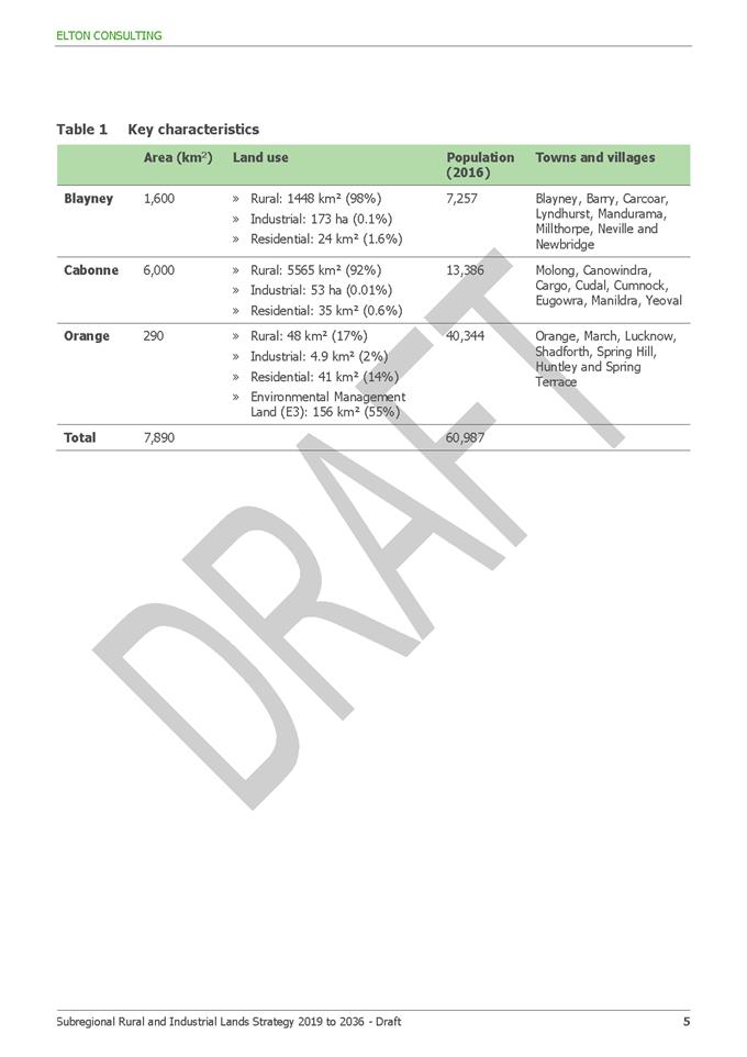
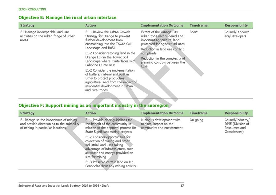
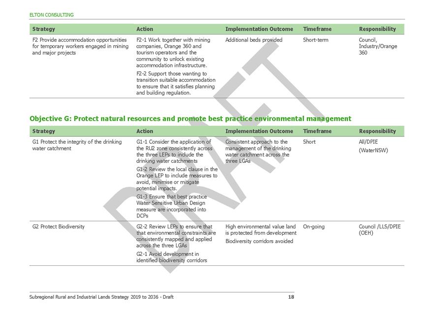
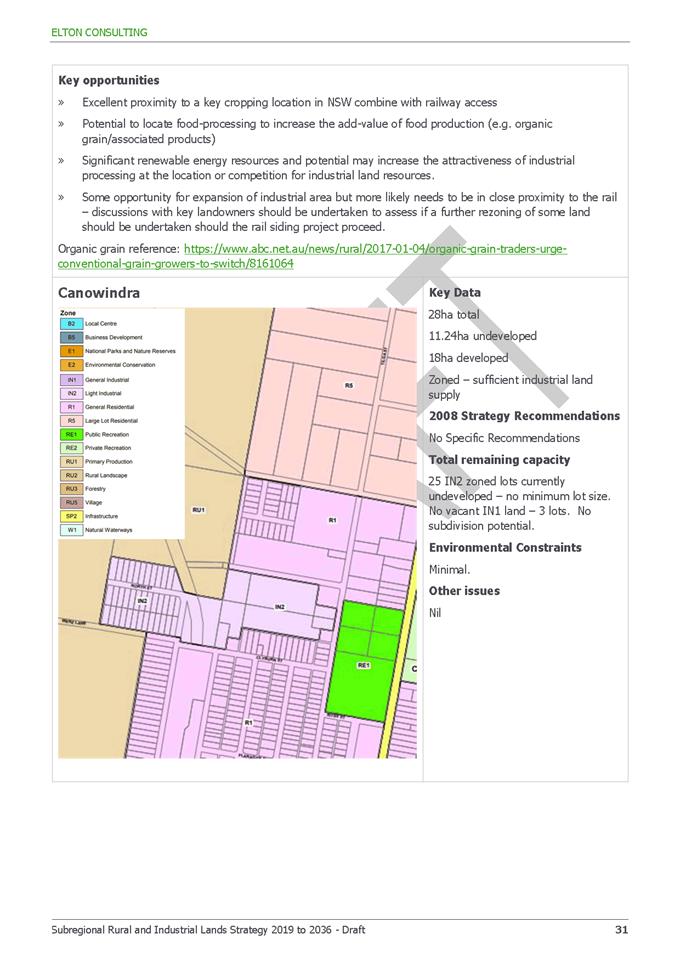
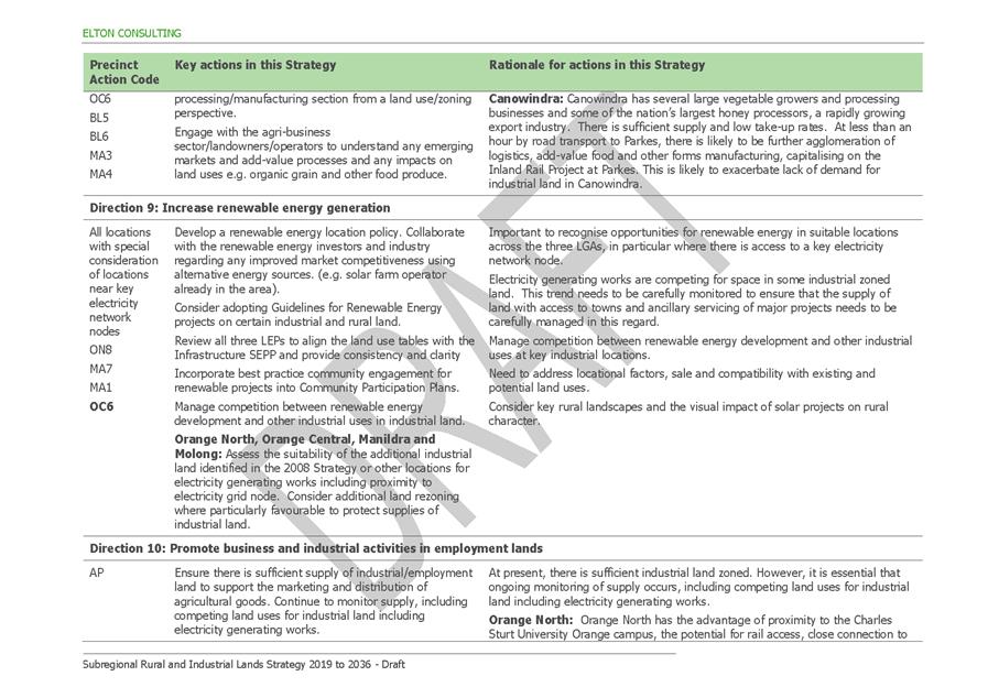
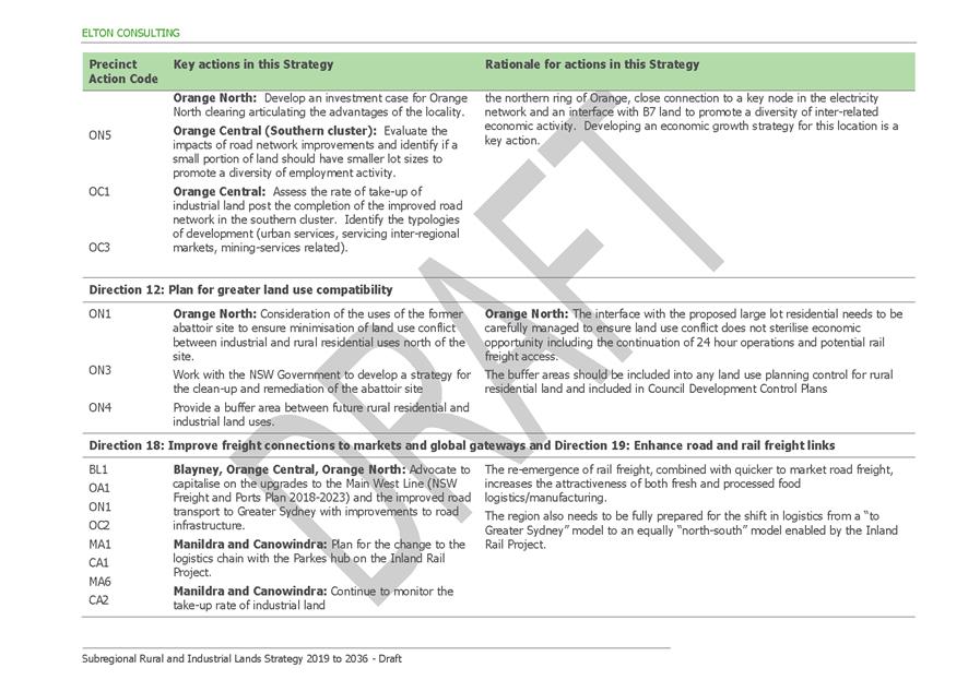
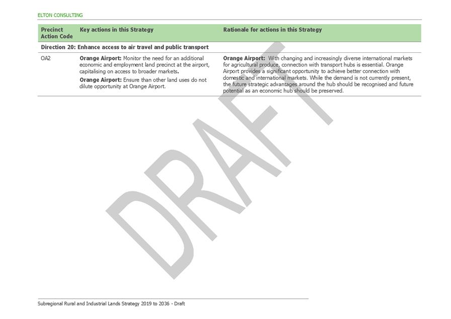
2.6 Development
Application DA 191/2020(1) - 4613 Mitchell Highway, Lucknow
RECORD
NUMBER: 2020/1885
AUTHOR: Summer
Commins, Senior Planner
EXECUTIVE Summary
|
Application
lodged
|
22 May
2020
|
|
Applicant/s
|
Brothers
Three Pty Ltd
|
|
Owner/s
|
Brothers
Three Pty Ltd
|
|
Land
description
|
Lot 101
DP 1053642 - 4613 Mitchell Highway, Lucknow
|
|
Proposed
land use
|
Service Station (removal of
existing fuel dispensers, fill points, underground fuel tanks and pipework;
construction of a two dispenser covered vehicle fuelling area, new
underground fuel tanks and forecourt pollution control system) and Business
Identification Signage
|
|
Value of
proposed development
|
$620,000
|
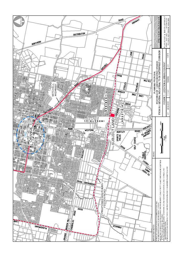
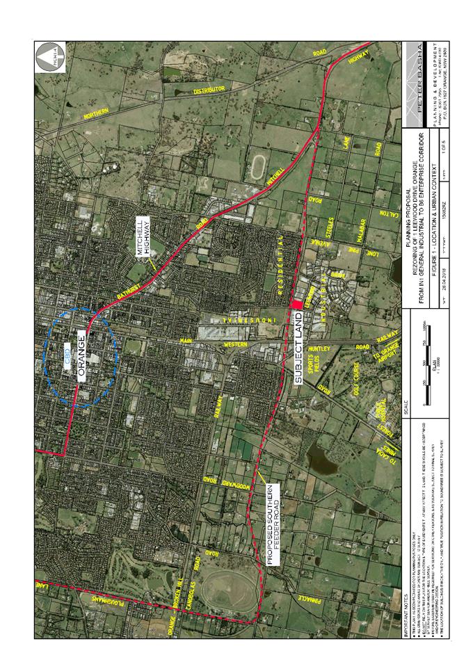
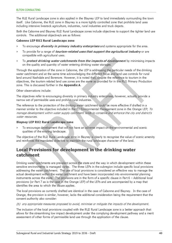
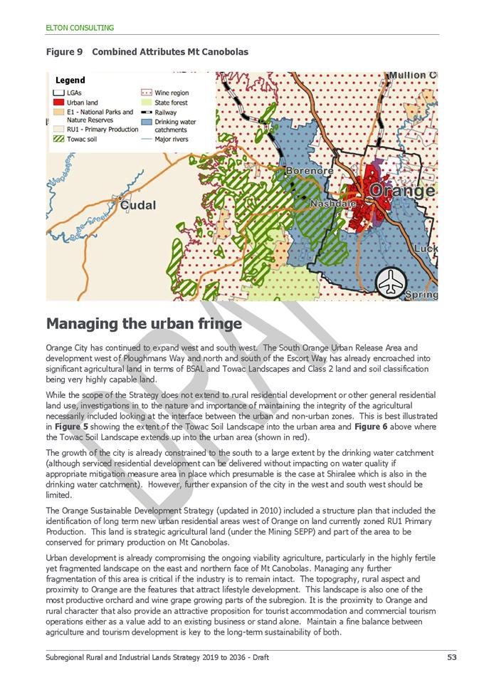
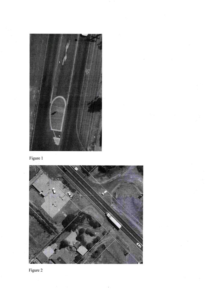
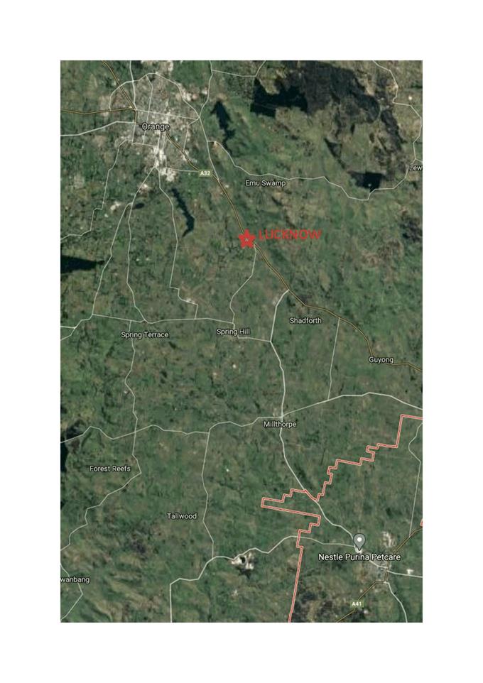
Council's consent is sought for service station upgrade at
4613 Mitchell Highway, Lucknow (see locality at Figure 1) after resolution
for deferral was determined for a site visit.
The proposal involves removal and replacement of existing
underground fuel storage tanks and fuel pumps; construction of a refuelling
canopy; and upgraded forecourt works for stormwater treatment.
Notable planning matters for this application include the
suitability of the local road network to accommodate traffic associated with
the service station; the impacts on the proposal on nearby residential amenity;
and the constraints imposed by the Village character and conservation setting.
The development application was referred to Transport for
NSW (TfNSW) for consideration and comment. Service stations are traffic
generating development pursuant to State Environmental Planning Policy
(Infrastructure) 2007; and TfNSW concurrence is required for works within
the road reserve at the site frontage under Section 138 of the Roads Act 1993.
TfNSW raised no objection to the proposal. Minor upgrading works within the
road reserve have been recommended in conjunction with Council’s
Development Engineers.
The proposal comprises Notified Development pursuant to
Council’s Community Participation Plan 2019. At the completion of the
notification period, two submissions had been received from one neighbour. The
issues raised in the submissions relate to residential amenity (noise, light
and odour); and traffic arrangements (site access and highway upgrade).
As outlined in this report, the proposed development is
considered to satisfy the Local and State planning controls that apply to the
subject land and particular landuse. Impacts of the development will be within
reasonable limit subject to mitigation conditions. Approval of the application
is recommended.
Figure 1 - locality plan
DECISION FRAMEWORK
Development in Orange is governed
by two key documents Orange Local Environment Plan 2011 and Orange
Development Control Plan 2004. In addition the Infill Guidelines are used to
guide development, particularly in the heritage conservation areas and around
heritage items.
Orange Local Environment Plan
2011 – The provisions of the LEP must be considered by the Council in
determining the application. LEPs govern the types of development that are
permissible or prohibited in different parts of the City and also provide some
assessment criteria in specific circumstances. Uses are either permissible or
not. The objectives of each zoning and indeed the aims of the LEP itself are also
to be considered and can be used to guide decision making around
appropriateness of development.
Orange Development Control Plan
2004 – the DCP provides guidelines for development. In general
it is a performance based document rather than prescriptive in nature. For each
planning element there are often guidelines used. These guidelines indicate
ways of achieving the planning outcomes. It is thus recognised that there may
also be other solutions of merit. All design solutions are considered on merit by
planning and building staff. Applications should clearly demonstrate how the
planning outcomes are being met where alternative design solutions are
proposed. The DCP enables developers and architects to use design to achieve
the planning outcomes in alternative ways.
DEVELOPMENT SERVICES
DIRECTOR’S COMMENT
The proposed service station
upgrade is permitted with consent. This proposal ultimately involves an
environmental upgrade of an existing Service Station. The key planning issues
considered in this report include the suitability of the local road network to
accommodate traffic associated with the development; the impacts on the
proposal on nearby residential amenity; and the constraints associated with the
Village character and conservation setting. It is recommended that Council
supports the proposed development and the accompanying Notice of Determination.
TECHNICAL SERVICES
DIRECTOR’S COMMENT
The key planning matters have been
covered within the body of the report and the proposed service station development
remains a renewal of existing infrastructure. I note that the bowser numbers
remains unchanged from the existing two bowsers able to service a total of four
vehicles at a time, however the variety of fuels and hence number of hoses has
increased to 5 each side and a total of 20 to service a wider variety of
customers. I note the adjoining neighbours’ concerns and have spoken to
him previously onsite, a number of the concerns have been addressed within the
condition of consent.
I have reviewed the correspondence
between Council and Transport for NSW, and concur with their recommendations on
the basis that the traffic generation could be validated and checked for safety
against the Austroads warrants for intersection treatments. The
developer’s traffic engineering consultant was asked to expand on his
report to provide further detail and break down of turning traffic for the peak
hour flows (see attached). On the basis of the low volume of right turning
traffic (5 in) and the existing high volume of peak through traffic (817)
during the evening peak hour, this does not exceed the Austroads warrants for a
channelised right turn lane.
This was also discussed with the
TfNSW Senior Manager. Their considered opinion was that TfNSW had made an
independent determination referencing the Guide for Traffic Generating
Developments and reconsidered the conditions of consent on that basis. A number
of improvements were warranted but the CHR (Channelised Right) turn treatment
was no longer warranted.
There are conditions of consent
which include no stopping, entry and exit signage limiting access to vehicles
under 12.5m long, replaced and formalised concrete footpath, kerb and gutter,
drainage and access ramps that all improve the safety of the existing
development. On this basis and the additional information provided by the
applicant I support the recommendation to Council.
Link To Delivery/OPerational Plan
The recommendation in this report relates to the
Delivery/Operational Plan strategy “10.1 Preserve - Engage with the
community to ensure plans for growth and development are respectful of our
heritage”.
Financial Implications
Nil
Policy and Governance Implications
Nil
|
Recommendation
That Council consents to
development application DA 191/2020(1)
for Service Station (removal of existing fuel dispensers, fill points,
underground fuel tanks and pipework; construction of a two dispenser covered
vehicle fuelling area, new underground fuel tanks and forecourt pollution
control system) and Business Identification Signage at Lot 101
DP 1053642 - 4613 Mitchell Highway, Lucknow, pursuant to the conditions of consent in the attached
Notice of Approval.
|
further considerations
Consideration has been given to the recommendation’s
impact on Council’s service delivery; image and reputation; political;
environmental; health and safety; employees; stakeholders and project
management; and no further implications or risks have been identified.
SUPPORTING INFORMATION
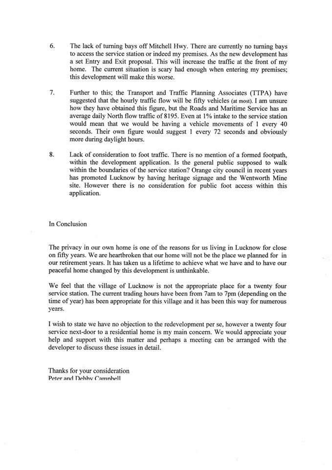
The site is the subject of
recent development consent for a larger service station re‑development
(DA 33/2018(1) approved 18 December 2018).
The approved development involves demolition/removal of all
improvements on the site, and replacement with new underground tanks; fuel
dispensing bowsers; three service channels (rows of pumps); and convenience
store with floor area of 200m2. An extract of the approved plans is
shown below (see Figures 2 and 3).
Figure 2 – approved site plan DA 33/2018(1)
Figure 3 – approved sales building DA 33/2018(1)
The applicant has advised that the approved development will
not proceed. Conditions are included on the attached Notice of Approval
requiring DA 33/2018(1) be surrendered in accordance with Section 4.17(5)
of the Environmental Planning and Assessment Act 1979, prior to issue of a Construction
Certificate for the current proposal.
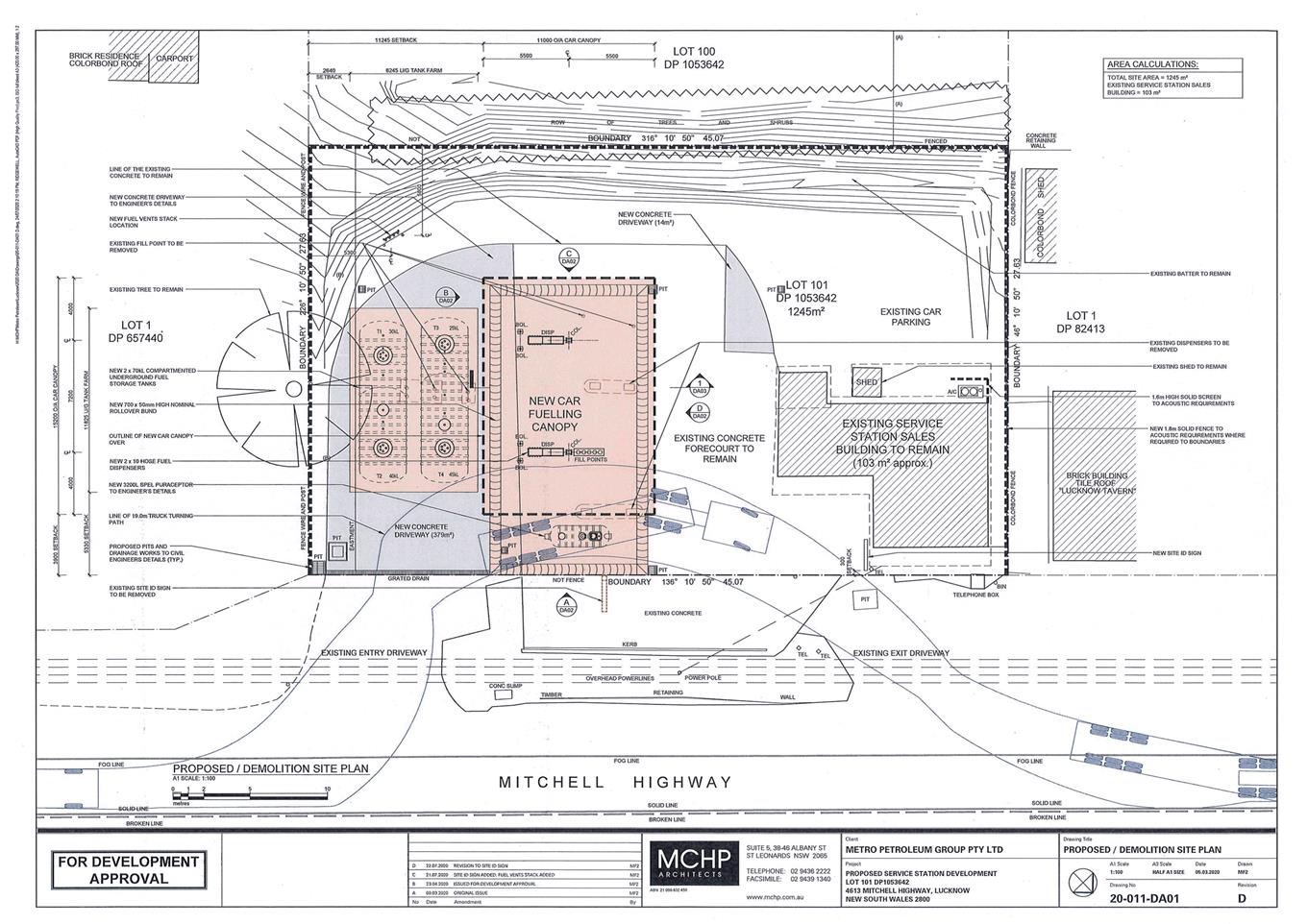
THE PROPOSAL
The new proposal involves upgrading of the existing service
station on the subject land. Proposed works include:
· demolition
of existing fuel dispensers, fill points, underground fuel tanks and associated
pipe works
· installation
of two x 70,000L underground fuel storage tanks
· installation
of two fuel dispensers, each with ten hoses
· construction
of a refuelling canopy of dimensions 11m x 15m, with height of 5.4m
· extension
of concrete forecourt vehicle areas
· installation
of pollution control requirements (puraceptor and bunding)
· removal
of existing pylon sign on the footpath at the site frontage
· installation
of brand signage, comprising fascia signage to canopy and 6m freestanding pylon
sign.
The existing sales building will be retained in its current
form. The location of existing site accesses via the Mitchell Highway will not
be altered. Proposed hours of operation are 7am to 10pm, 7 days per week.
The proposed site layout, canopy
design and pylon sign are depicted below (see Figures below).
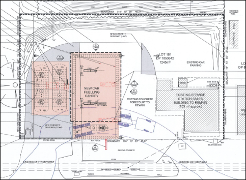
Figure 4 – proposed site layout
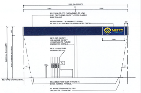
Figure 5 – canopy (North Eastern elevation to
Mitchell Highway)
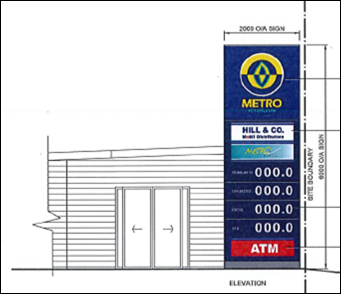
Figure 6 – proposed pylon sign
MATTERS FOR CONSIDERATION UNDER
THE ENVIRONMENTAL PLANNING AND ASSESSMENT ACT 1979
Section 1.7 - Application of
Part 7 of the Biodiversity Conservation Act 2016 and Part 7A of the
Fisheries Management Act 1994
Pursuant to Clause 1.7:
This
Act has effect subject to the provisions of Part 7 of the Biodiversity Conservation Act
2016 and Part 7A of the Fisheries Management Act 1994 that relate to the operation of this Act in connection
with the terrestrial and aquatic environment.
In consideration of this section, the proposed development
is not likely to significantly affect a threatened species:
· The
subject and adjoining lands are not identified as biodiversity sensitive on the
Orange LEP 2011 Terrestrial Biodiversity Map.
· The
proposal does not involve clearing or disturbance of native vegetation;
clearing thresholds prescribed by regulation do not apply.
· The
site is contained within an established urban area and has been highly modified
by the urban landuse pattern. The subject land does not contain known
threatened species or ecological communities.
Based on the foregoing consideration, a Biodiversity
Assessment Report is not required and the proposal suitably satisfies the
relevant matters at Clause 1.7.
Section 4.15 Evaluation
Provisions of any
Environmental Planning Instrument S4.15(1)(A)(I)
Orange Local Environmental Plan
2011
Part 1 – Preliminary
Clause 2.1
Aims of Plan
The particular aims of Orange LEP 2011 relevant to the
proposal include:
(a) to
encourage development which complements and enhances the unique character of
Orange as a major regional centre boasting a diverse economy and offering an
attractive regional lifestyle,
(b) to
provide for a range of development opportunities that contribute to the social,
economic and environmental resources of Orange in a way that allows present and
future generations to meet their needs by implementing the principles for ecologically
sustainable development,
(c) to
conserve and enhance the water resources on which Orange depends, particularly
water supply catchments,
(f) to
recognise and manage valued environmental heritage, landscape and scenic
features of Orange.
The proposed development is
considered to be consistent with the above-listed LEP Aims.
· The
proposal involves upgrading of a derelict site, with positive impacts on
village character and function, and flow-on effects for the local economy and
regional centre status.
· The
proposed development is not considered to be adverse to ESD principles.
The proposal involves environmental upgrade of the existing facility,
incorporating contemporary quality standards.
· As
outlined in this report, the proposed service station upgrade will be sited,
designed and managed to protect water resources.
· As
outlined in the following sections of this report, the proposal will not
adversely impact on the conservation values of the setting.
Clause 1.6 Consent Authority
Clause 1.6 is applicable and
states:
The
consent authority for the purposes of this Plan is (subject to the Act) the
Council.
Clause 1.7 Mapping
The subject site is identified on the LEP maps in the
following manner:
|
Land
Zoning Map:
|
Land
zoned RU5 Village
|
|
Lot
Size Map:
|
Minimum
Lot Size 1,000m2
|
|
Heritage
Map:
|
Within
a heritage conservation area
|
|
Height
of Buildings Map:
|
No
building height limit
|
|
Floor
Space Ratio Map:
|
No
floor space limit
|
|
Terrestrial
Biodiversity Map:
|
No
biodiversity sensitivity on the site
|
|
Groundwater
Vulnerability Map:
|
Groundwater
vulnerable
|
|
Drinking
Water Catchment Map:
|
Within
the drinking water catchment
|
|
Watercourse
Map:
|
Not
within or affecting a defined watercourse
|
|
Urban
Release Area Map:
|
Not
within an urban release area
|
|
Obstacle
Limitation Surface Map:
|
No
restriction on building siting or construction
|
|
Additional
Permitted Uses Map:
|
No
additional permitted use applies
|
|
Flood
Planning Map:
|
Not
within a flood planning area
|
Those matters that are of relevance
are addressed in detail in the body of this report.
Clause 1.9A Suspension of
Covenants, Agreements and Instruments
Clause 1.9A is applicable and
states in part:
(1) For the purpose of enabling
development on land in any zone to be carried out in accordance with this Plan
or with a consent granted under the Act, any agreement, covenant or other
similar instrument that restricts the carrying out of that development does not
apply to the extent necessary to serve that purpose.
(2) This clause does not apply:
(a) to a covenant
imposed by the Council or that the Council requires to be imposed, or
(b) to
any prescribed instrument within the meaning of section 183A of the Crown Lands Act 1989, or
(c) to
any conservation agreement within the meaning of the National Parks and Wildlife Act 1974,
or
(d) to
any Trust agreement within the meaning of the Nature Conservation Trust Act 2001, or
(e) to
any property vegetation plan within the meaning of the Native Vegetation Act 2003, or
(f) to
any biobanking agreement within the meaning of Part 7A of the Threatened Species Conservation Act 1995,
or
(g) to
any planning agreement within the meaning of Division 6 of Part 4 of the Act.
In consideration of this clause,
Council staff are not aware of the title of the subject property being affected
by any of the above. Easements relating to the allocation of parking for
adjacent development will remain in place.
Part 2 - Permitted or Prohibited Development
Clause 2.1 - Land Use Zones
The subject land is zoned RU5 Village.
The proposed development is defined as a ‘service
station’, which means:
A building or place used for the
sale by retail of fuels and lubricants for motor vehicles, whether or not the
building or place is also used for any one or more of the following –
(a) the
ancillary sale by retail of spare parts and accessories for motor vehicles,
(b) the
cleaning of motor vehicles,
(c) installation
of accessories,
(d) inspecting,
repairing and servicing of motor vehicles (other than body building, panel
beating, spray painting, or chassis restoration),
(e) the
ancillary retail selling or hiring of general merchandise or services or both.
Service stations are permitted with consent in the RU5
Village zone.
Clause
2.3 Zone Objectives and Land Use Table
The objectives of the RU5 Village
zone are:
· To
provide for a range of land uses, services and facilities that are associated
with a rural village.
· To enhance
and maintain the unique village character of Lucknow and Spring Hill.
The proposal will not be adverse to
the zone objectives. Services stations are a permitted and complementary land
use in the RU5 zone. The use of the land as a service station is a longstanding
and accepted component of the village. Upgrading of the site will have positive
impacts on village character and function. Mitigation conditions will minimise
offsite arising impacts for adjoining properties.
Clause 2.7 Demolition Requires
Development Consent
Clause 2.7 is applicable and states:
‘The demolition of a building or work may be
carried out only with development consent’
Consent is sought for demolition/removal of existing fuel
dispensers, fill points, underground fuel tanks and infrastructure, and pylon
sign in accordance with this clause.
Part 3 - Exempt and Complying Development
The application is not exempt or
complying development.
Part 4 - Principal Development Standards
The Development Standards at Part 4 are not applicable to
the subject land or proposed development.
Part 5 - Miscellaneous Provisions
Clause
5.10 Heritage Conservation
The
subject site is located within the Lucknow Heritage Conservation Area. Clause
5.10 is applicable and states in part:
(4) The
consent authority must, before granting consent under this clause in respect of
a heritage item or heritage conservation area, consider the effect of the
proposed development on the heritage significance of the item or area
concerned…
In
consideration of this clause, the proposed development was referred to
Council’s Heritage Advisor for consideration and comment. He advises:
‘The use of standard
structures and the corporate colour scheme is accepted on the condition that
suitable mitigation is provided for the impact of the contemporary structure
within the historic setting.
The condition of the existing
service building is poor. There are elements of the structure and paint finish
which appear to produce hazards and these include loose lead based paint,
damaged structures and loose building fabric.
In addition the site
management is poor with the placement of signs on public land, the placement of
rubbish bins on the site frontage and an insecure site perimeter. These aspects
of the site reflect poorly on the business operator, reflect poorly on the
business brand and indirectly reflect poorly on the local Lucknow community and
businesses. ‘
The Heritage Advisor has
provided a number of recommendations to ensure that the visual impact of the
works will be acceptable within the heritage setting. The recommendations and
staff comments are tabulated below.
|
Heritage Advisor Recommendation
|
Staff Response
|
|
The steel-framed canopy structure
shall be painted Dulux Shale Grey
|
A condition is included.
|
|
The fuel canopy soffit shall be
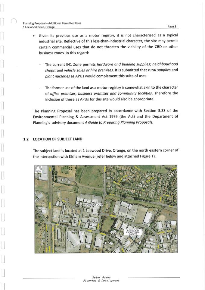
painted / finished Dulux Shale Grey
|
A condition is included.
|
|
A lighting study shall be prepared
to ensure glare and light spill from the canopy complies with relevant
standards
|
Pre-construction and operational
conditions are included.
|
|
Standard rural fencing shall be
erected to site boundaries
|
This is considered to be
unreasonable/unnecessary. The front (north) boundary is affected by extensive
vehicle crossovers. Solid fencing is required to side and rear boundaries for
noise attenuation.
|
|
A landscape plan shall be prepared,
including hedge screen to side boundaries
|
A condition is included.
|
|
Existing signage shall be removed
and replaced with proposed signage in the DA
|
A condition is included.
|
|
New concrete driveways shall be
through-coloured using a charcoal oxide
|
A condition is included requiring a
consistent concrete coloured finish over the site.
|
|
The acoustic screen to the side
(east) boundary shall be approved prior to construction
|
A condition is included requiring
the acoustic screen be constructed of lapped and capped timber palings and
have a height of 1-.8m - 2.1m.
|
As noted above, the proposed
development does not involve any works to the existing sales building. Site
inspection indicates that the building is in a state of disrepair and
renovation works will likely be required (see photo at Figure 7).
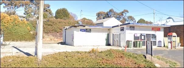
Figure 7 – existing sales building (Google maps)
Conditions are included on the attached Notice of Approval
that further consent will be required for any works that are not exempt
development pursuant to SEPP (Exempt and Complying Development Codes) 2008.
Subject to compliance with the mitigation conditions above,
it is considered that the proposal will not have adverse impact on the
significance of the Lucknow Heritage Conservation Area, pursuant to Clause
5.10(4). Site upgrading will have positive impacts on the village character and
may increase appreciation of the heritage setting.
Part 7 - Additional Local Provisions
Clause 7.3 Stormwater Management
Clause 7.3 is applicable and states in part:
(3) Development consent must not be
granted to development on land to which this clause applies unless the consent
authority is satisfied that the development:
(a) is designed to maximise the use
of water permeable surfaces on the land having regard to the soil
characteristics affecting onsite infiltration of water, and
(b) includes, where practical,
onsite stormwater retention for use as an alternative supply to mains water,
groundwater or river water, and
(c) avoids any significant impacts
of stormwater runoff on adjoining downstream properties, native bushland and
receiving waters, or if that impact cannot be reasonably avoided, minimises and
mitigates the impact.
Council’s Assistant Development Engineer has included
conditions to satisfy the requirements of Clause 7.3. The design and
construction of the conditional stormwater treatment system for the upgraded
site shall ensure stormwater runoff achieves standardised and contemporary
stormwater quality targets.
Clause 7.6 Groundwater Vulnerability
The
subject land is identified as Groundwater Vulnerable on the Groundwater
Vulnerability Map. Clause 7.6 applies. This clause states in part:
(3) Before
determining a development application for development on land to which this
clause applies, the consent authority must consider:
(a) whether or not the development (including
any onsite storage or disposal of solid or liquid waste and chemicals) is
likely to cause any groundwater contamination or have any adverse effect on
groundwater dependent ecosystems, and
(b) the cumulative impact (including the
impact on nearby groundwater extraction for potable water supply or stock water
supply) of the development and any other existing development on groundwater.
In consideration of Clause 7.6, there are no aspects of the
proposal that will impact on groundwater and related ecosystems. The design and
construction of the underground fuel tanks and onsite pollution control and
containment measures will be suitable to prevent any groundwater contamination.
Clause 7.7 Drinking Water
Catchments
The subject land is identified as ‘drinking
water’ on the Drinking Water Catchment Map. Clause 7.7 is
applicable and states in part:
(3) Before
determining a development application for development on land to which this
clause applies, the consent authority must consider whether or not the
development is likely to have any adverse impact on the quality and quantity of
water entering the drinking water storage, having regard to:
(a) the
distance between the development and any waterway that feeds into the drinking
water storage, and
(b) the
onsite use, storage and disposal of any chemicals on the land, and
(c) the
treatment, storage and disposal of waste water and solid waste generated or
used by the development.
In consideration of this clause, the proposed service
station upgrade is unlikely to impact on the quality and quantity of water
entering the drinking water catchment. The conditional stormwater design will
ensure runoff complies with standardised targets. Underground fuel tank storage
will be designed and constructed in accordance with contemporary standards.
Pollution control and containment measures will be installed onsite.
Clause 7.11 Essential Services
Clause 7.11 applies and states:
Development consent must not be
granted to development unless the consent authority is satisfied that any of
the following services that are essential for the proposed development are
available or that adequate arrangements have been made to make them available
when required:
(a) the
supply of water,
(b) the
supply of electricity,
(c) the
disposal and management of sewage,
(d) storm
water drainage or onsite conservation,
(e) suitable
road access.
In consideration of this clause, the listed utility services
are available and suitable subject to augmentation.
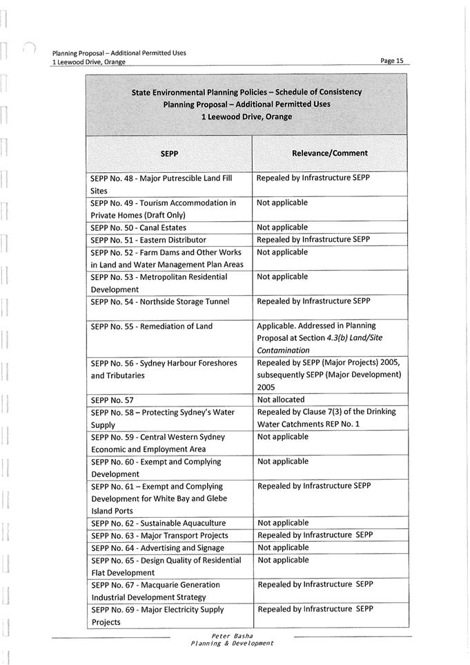
STATE ENVIRONMENTAL PLANNING
POLICIES
State Environmental Planning
Policy No 55 Remediation of Land
SEPP 55 Remediation of Land is
applicable. Pursuant to Clause 7 Contamination and remediation to be
considered in determining development application:
(1) A
consent authority must not consent to the carrying out of any development on
land unless:
(a) it
has considered whether the land is contaminated, and
(b) if
the land is contaminated, it is satisfied that the land is suitable in its
contaminated state (or will be suitable, after remediation) for the purpose for
which the development is proposed to be carried out, and
(c) if
the land requires remediation to be made suitable for the purpose for which the
development is proposed to be carried out, it is satisfied that the land will
be remediated before the land is used for that purpose.
The subject land has longstanding
use as a service station; indeed Council’s records suggest this use dates
back to the 1940s. Service stations are a “Table 1” listed use in
the Contaminated Land Planning Guidelines (DUAP & EPA 1998), ie. use of
land that is likely to cause contamination.
Environmental Site Assessment was
submitted in support of the proposal (NEO Consulting (November 2017). The NEO
concluded:
Laboratory
analysis of each soil sample taken at the site indicates the site is well
within the acceptable contamination and had no evidence of reaching any health
based investigation levels. Based on these results, the site is suitable to
continue as its current landuse as a fuel service site.
NEO recommendations for ongoing
monitoring for site contamination included:
· Installation
of at least three onsite water monitoring wells consistent with the Protection
of the Environment Operations (Underground Petroleum Storage Systems)
Regulation 2019; and
· Monthly
Statistical Inventory Reconciliation Analysis (SIRA) of deliveries, sales and
dips of petroleum products, consistent with EPA Guidelines.
Council’s Environmental
Health Officer concurs with the findings and recommendations of the
Environmental Site Assessment. The recommendations listed above are included as
conditions of consent on the attached Notice of Approval.
It is noted that the submitted
Environmental Site Assessment does not include soil samples in the vicinity of
/underneath the existing underground fuel storage tanks, as these are yet to be
removed. Conditions are included requiring contamination testing and
appropriate disposal of excavated material from the site; and contamination
validation at the completion of excavation.
State Environmental Planning
Policy No 33 Hazardous and Offensive Development
SEPP 33 is applicable where it is determined that the
proposal is hazardous or offensive development. The relevant aims and objectives
of the Policy at Clause 2 include:
(2) Aims,
objectives etc
This Policy aims -
(d) to
ensure that in determining whether a development is a hazardous or offensive
industry, any measures proposed to be employed to reduce the impact of the development
are taken into account, and
(e) to
ensure that in considering any application to carry out potentially hazardous
or offensive development, the consent authority has sufficient information to
assess whether the development is hazardous or offensive and to impose
conditions to reduce or minimise any adverse impact.
In order to determine whether the proposed development is
potentially hazardous or offensive, a Risk Screening Test is applied,
pursuant to Hazardous and Offensive Development Application Guidelines -
Applying SEPP 33 (SEPP 33 Guidelines) (Department of Planning 2011).
The following details are required to inform the Risk
Screening Test:
· Hazardous
materials: motor spirit products - petrol, diesel.
· Dangerous
goods classification: Class 3 PG II.
· Mode
of storage: underground tanks.
· Maximum
quantity stored: 140,000KL % 5 for underground storage = 28,000L or approx. 23
tonnes.
· Distance
of filling/dispensing point to nearest boundary: 12.3m.
· Weekly
and annual deliveries: three per week/150 per year.
With reference to the graph at
Figure 9 of the SEPP 33 Guidelines, the proposed development will not
exceed the volume and distance threshold (see graph below).
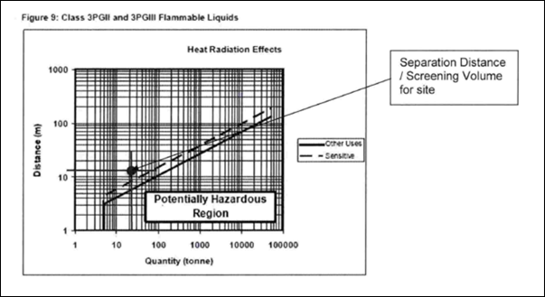
Figure 8 – screening graph – applying SEPP
33
Similarly, with reference to Table 2 of the SEPP 33
Guidelines, the proposed development will not exceed the maximum transportation
threshold of 750 annual deliveries for Class 3 PG II hazardous
materials. Conditions are included to ensure that development remains below
this threshold in the future.
As the screening threshold tests were not exceeded, the
proposal does not comprise potentially hazardous development and SEPP 33 is not
applicable.
Notwithstanding, a preliminary hazard analysis (PHA) has
been submitted in support of the proposed development as a matter of
completeness (MCHP Architects May 2020). The qualitative risk analysis
confirms that the societal risk associated with the proposed development will
be negligible, subject to compliance with applicable standards and safeguards
during design, construction and operation. Conditions are included on the
attached Notice of Approval to ensure same.
The proposed development will be acceptable in terms of the
requirements of SEPP 33 requirements.
State Environmental Planning
Policy Infrastructure 2007
Division 17 Roads and Traffic
Clause 101 Development
with Frontage to a Classified Road
The subject land has frontage to a classified road (Mitchell
Highway) and Clause 101 Development with Frontage to a Classified Road
applies. This clause states in part:
(2) The
consent authority must not grant consent to development on land that has a
frontage to a classified road unless it is satisfied that:
(a) where
practicable, vehicular access to the land is provided by a road other than the
classified road, and
(b) the
safety, efficiency and ongoing operation of the classified road will not be
adversely affected by the development as a result of:
(i) the
design of the vehicular access to the land, or
(ii) the
emission of smoke or dust from the development, or
(iii) the
nature, volume or frequency of vehicles using the classified road to gain
access to the land, and
(c) the
development is of a type that is not sensitive to traffic noise or vehicle
emissions, or is appropriately located and designed, or includes measures, to
ameliorate potential traffic noise or vehicle emissions within the site of the
development arising from the adjacent classified road.
In consideration of Clause 101:
· Existing
dual access to the subject land via the Mitchell Highway will be retained in
its current locations. The subject land does not have alternative site access
via another road.
· The
proposal will not adversely impact on the safety, efficiency and operation of
the classified road due to the following:
- All
vehicles will enter the site via the eastern crossover and driveway, and exit
the site via the western crossover and driveway. Conditions are included
requiring erection of signage to effect these arrangements.
- Site
entrances will be upgraded. Conditions are included requiring reconstruction of
both existing footpath crossings, suitable to accommodate the turn path of a
19m articulated vehicle.
- NO
STOPPING signage shall be installed along both sides of the Mitchell Highway
at the site frontage, and for a distance of at least 60m on approach and 60m on
departure from the turning points into the site. Conditions are included to
effect these arrangements.
- The
existing concrete slab and pylon sign in the road reserve at the site frontage
will be removed, and the area reinstated as public footpath.
- All
un/loading activities shall be carried out within the subject land. Service
deliveries shall be undertaken outside peak hours of patronage, as required by
conditions.
- Site
access will not be available for vehicles longer than 12.5m, excepting semi‑trailers
for fuel resupply. Signage will be installed at the site entrances to limit
vehicle size.
- The
development does not involve emissions.
- The
site has longstanding use as a service station, and traffic associated with
this use is an accepted component of the local traffic network (notwithstanding
that the site is presently non-operational).
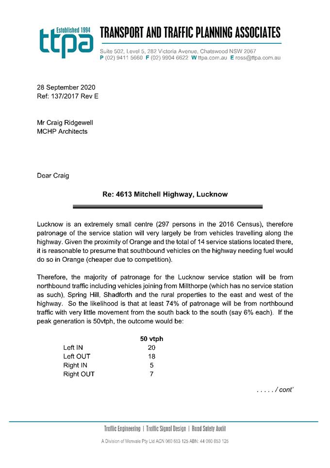
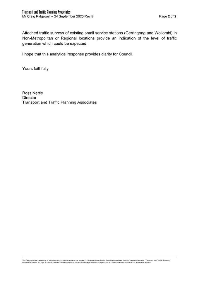
The various formulae useful for
estimating traffic demand in the RTA Guide to Traffic Generating
Developments (2002) and the RMS Trip Generation Surveys – Service
Stations (TEF, 2013) rely on parameters including site area, convenience
store floor area, and number of service channels (rows of pumps). The proposal
does not involve alteration to any of these components, and is therefore not
considered to be an intensification of the existing use.
On this basis, it is the assessment of
Council staff and Transport for NSW (TfNSW) that the proposal will not generate
additional traffic volumes; nor result in a nexus for substantial highway
intersection upgrades. The low-cost, contemporary safety and amenity
improvements enquired by conditions above, will be suitable to maintain the
safety, efficiency and operation of the classified road. Subsequent approval
from TfNSW will be required for works within the road reserve under Section 138
of the Roads Act 1993.
Traffic generation associated with the
development will be imperceptible within the context of existing traffic
volumes. The capacity of the local road network will be suitable to cater for
additional volumes.
· The
proposed development is not sensitive to traffic noise or vehicle emissions.
Clause 104
Traffic-generating Development
A service station
is a listed traffic-generating development pursuant to Clause 104 and Schedule
3 of SEPP Infrastructure 2007. This clause states in part:
(3) Before determining a
development application for development to which this clause applies, the
consent authority must -
(a) give written notice of the application
to RMS within 7 days after the application is made, and
(b) take into consideration -
(i) any submission that RMS
provides in response to that notice within 21 days after the notice was given
(unless, before the 21 days have passed, RMS advises that it will not be making
a submission), and
(ii) the accessibility of the site
concerned, including -
(A) the efficiency of movement of
people and freight to and from the site and the extent of multi-purpose trips,
and
(B) the potential to minimise the need
for travel by car and to maximise movement of freight in containers or bulk
freight by rail, and
(iii) any potential traffic safety, road
congestion or parking implications of the development.
The proposed
development was referred to TfNSW for consideration and comment.
No objection was raised to the proposal, subject to conditions (referred
to under Clause 101 above) which are included in the attached Notice of
Approval.
As outlined in the foregoing
section of this report, the proposed development will not adversely impact on
traffic safety or road congestion.
State Environmental Planning
Policy 64 Advertising and Signage
The proposal involves installation of brand signage to
fascia canopy and a 6m high freestanding pylon sign adjacent to the existing
sales building. SEPP 64 Advertising and Signage is applicable and states in
part:
3 Aims,
Objectives etc
(1) This
Policy aims:
(a) to
ensure that signage (including advertising):
(i) is
compatible with the desired amenity and visual character of an area, and
(ii) provides
effective communication in suitable locations, and
(iii) is
of high quality design and finish, and
(8) Granting
of Consent to Signage
A consent authority must not
grant development consent to an application to display signage unless the
consent authority is satisfied:
(a) that
the signage is consistent with the objectives of this Policy as set out in
Clause 3 (1) (a), and
(b) that
the signage the subject of the application satisfies the assessment criteria
specified in Schedule 1.
The following comments are provided in response to the
relevant matters.
1 -
Character of the Area
· Is
the proposal compatible with the existing or desired future character of the
area or locality in which it is proposed to be located?
· Is
the proposal consistent with a particular theme for outdoor advertising in the
area or locality?
Pylon signs are a typical advertising form in Lucknow,
associated with ribbon commercial development along the highway. The proposed
pylon sign will complement and reinforce this pattern. It is noted that a pylon
sign associated with the service station is a longstanding visual element in
the village. The existing sign will be removed and replaced with another
smaller structure nearer to the sales building. The proposed fascia signage to
the fuel canopy is a typical and expected form of signage associated with a
service station.
2 - Special Areas
· Does the
proposal detract from the amenity or visual quality of any environmentally
sensitive areas, heritage areas, natural or other conservation areas, open
space areas, waterways, rural landscapes or residential areas?
The subject land is located within a
village and conservation setting and adjoins a dwelling house to the east. The
site is located within the business core of the village near the intersection
of Mitchell Highway/Phoenix Mine. The proposed signage will complement other
signage nearby and will be generally suitable in this setting (see comments
below in relation to height).
Council’s Heritage Advisor
raised no objection to the proposed signage scheme, subject to removal of
existing signs on the site. Conditions are included to this effect. It is
considered that limited onsite advertising as proposed, will be suitable in the
heritage setting.
In order to minimise the impacts of
signage for the adjoining dwelling to the east, conditions are included
requiring an illumination curfew consistent with service station trading hours.
3 - Views and Vistas
· Does the
proposal obscure or compromise important views?
· Does the
proposal dominate the skyline and reduce the quality of vistas?
· Does the
proposal respect the viewing rights of other advertisers?
Other pylon signs in the Lucknow
streetscape are lower in height, and generally relate to the height of
improvements on the land. A condition is included limiting the overall height
of the pylon sign to 5.4m, consistent with the height of the proposed fuel
canopy. The proposed signage scheme will not impact on viewing rights of
adjoining businesses along the highway. Views in the streetscape corridor will
be maintained.
4 - Streetscape, Setting or
Landscape
· Is the
scale, proportion and form of the proposal appropriate for the streetscape,
setting or landscape?
· Does the
proposal contribute to the visual interest of the streetscape, setting or
landscape?
· Does the
proposal reduce clutter by rationalising and simplifying existing advertising?
· Does the
proposal screen unsightliness?
· Does the
proposal protrude above buildings, structures or tree canopies in the area or
locality?
· Does the
proposal require ongoing vegetation management?
The proposed pylon sign will be
consistent with the streetscape pattern for freestanding pylon signs.
Conditional reduction in the height of the pylon sign will ensure the structure
will not protrude above existing improvements on the land. The proposed signage
scheme will have nil impact onsite vegetation. Removal of the existing concrete
pad and pylon sign in road reserve at site frontage, and reinstatement of
footpath will improve street presentation of the site.
5 - Site and Building
· Is the
proposal compatible with the scale, proportion and other characteristics of the
site or building, or both, on which the proposed signage is to be located?
· Does the
proposal respect important features of the site or building, or both?
· Does the
proposal show innovation and imagination in its relationship to the site or
building, or both?
The proposed pylon sign will be
located nearby to the existing sales building, and be visually associated with
the commercial building group on this site and the adjoining western site
(Lucknow Tavern). Signage will be removed from the adjoining dwelling to the
east. The proposed fascia signage to canopy will be wholly located within
the building envelope and will not dominate each fascia elevation. The overall
signage scheme is considered to a minor and acceptable duplication of
advertising content. Conditions are included requiring removal of existing
onsite advertising; and further development consent be obtained for additional
signage that is not exempt development.
6 - Associated Devices and
Logos with Advertisements and Advertising Structures
· Have any
safety devices, platforms, lighting devices or logos been designed as an
integral part of the signage or structure on which it is to be displayed?
Not applicable.
7 - Illumination
· Would
illumination result in unacceptable glare?
· Would
illumination affect safety for pedestrians, vehicles or aircraft?
· Would
illumination detract from the amenity of any residence or other form of
accommodation?
· Can the
intensity of the illumination be adjusted, if necessary?
· Is the
illumination subject to a curfew?
The proposed pylon sign will be
internally illuminated. The precinct is already subject to high ambient
illuminance associated with street lighting and external lighting to nearby
commercial premises. In order to maintain amenity for the adjoining dwellings,
conditions are included requiring an illumination curfew consistent with
trading hours; no flashing or moving signage content; and signage lighting to
comply with AS 4282-1997 Control of the Obtrusive Effects of Outdoor
Lighting.
8 - Safety
· Would the
proposal reduce the safety for any public road?
· Would the
proposal reduce the safety for pedestrians or bicyclists?
· Would the
proposal reduce the safety for pedestrians, particularly children, by obscuring
sightlines from public areas?
The proposed signage will be wholly
located within the subject land, and will not conflict with the movement of
vehicles, pedestrians or cyclists. Conditions are included requiring no
flashing or moving signage content; and compliance with Transport Corridor
Outdoor Advertising and Signage Guidelines (DPE 2017).
Provisions of any Draft
Environmental Planning Instrument that has been Placed on Exhibition
4.15(1)(A)(Ii)
State
Environmental Planning Policy Draft Remediation of Land
Draft Remediation of Land SEPP is applicable.
The Draft SEPP requires in part that consideration be given to potential
contamination on nearby or neighbouring properties and groundwater.
The complete contamination status of
adjoining lands is unknown, however, contamination is usually a relevant matter
for consideration in the village of Lucknow. The proposed development is, of
itself, a Table 1 purpose. The contamination status of the adjoining lands will
not impact on the proposed development.
Draft Orange Local
Environmental Plan 2011 (Amendment 24)
Draft Amendment 24 is with the
Department of Planning for finalisation. The Draft Plan involves various
administrative amendments to the LEP including updated maps, and new and
amended clauses. The proposed development is not contrary to any matter
contained in the Draft Plan.
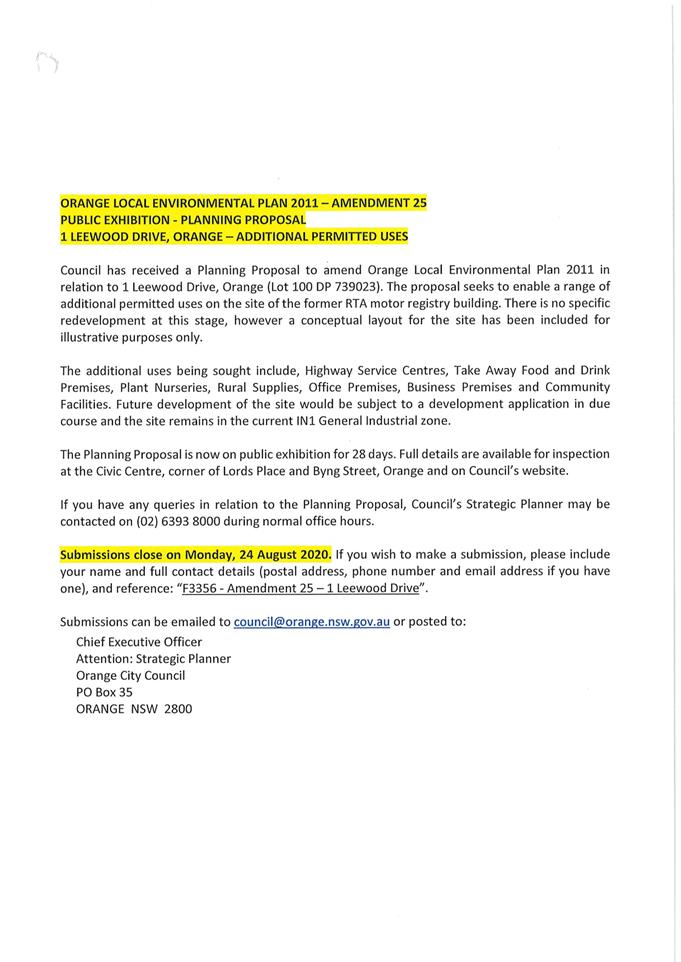
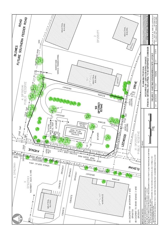
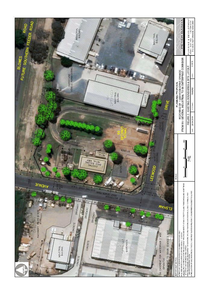
Draft Orange Local Environmental Plan 2011 (Amendments 25
and 26)
Draft Orange LEP 2011 Amendments 25
and 26 are currently on public exhibition (August 2020). The Draft Plans
relate to land at 1 Leewood Drive and 185 Leeds Parade respectively, and
have no impact for the proposed development.
DESIGNATED DEVELOPMENT
‘Service stations’
are not listed as designated development pursuant to Part 1 Schedule 3 of
the Environmental Planning and Assessment Regulation (EPAR) 2000.
The nearest listed landuse in
Schedule 3 comprises ‘petroleum works.’ Neither the Standard
Instrument nor EPAR 2000 define ‘petroleum works.’
‘Petroleum related
works’ are defined in SEPP (Mining, Petroleum Production and
Extractive Industries) 2007 as:
Any works, structures or equipment that are ancillary or
incidental to petroleum production and includes all works, structures and
equipment that a production lease under the Petroleum (Onshore) Act 1991, or a production licence under the Petroleum (Submerged Lands) Act 1982, entitles the lease or licence holder to construct,
maintain or execute.
The proposed development involves
the storage and retail sale of liquid fuel products and is outside of the
definition, scope and scale ‘petroleum works’/‘petroleum
related works.’ The proposed development is not designated
development.
INTEGRATED DEVELOPMENT
The proposed development is not
integrated development.
Provisions of any Development Control Plan S4.15(1)(A)(Iii)
Development Control Plan 2004
The following parts of DCP 2004 are
applicable to the proposed development:
· Part 0
– Transitional Provisions – 0.4-11 Transport Routes
· Part 2 -
Natural Resource Management
· Part 3 -
General Considerations
· Part 4 -
Special Environmental Considerations
· Part 7
– Development in Residential Area
· Part 13
– Heritage Development
· Part 15
– Car Parking
The
relevant matters in Parts 0, 2, 3, 4 and Infill Guidelines were considered in
the foregoing assessment under Orange LEP 2011 and SEPP Infrastructure
2007.
The relevant matters in Parts 7, 13 and 15 and are addressed
below.
Part 0.4-7 Lucknow & Part
7.13 Development in the Village of Lucknow
The relevant Planning Outcomes at Parts 0.4-7 and 7.13 are
considered below:
· A geotechnical
report, prepared by a suitably quality consultant is provided to Council…
addressing the suitability of the land for the development, taking into account
the effect of the proposal upon mine shafts…
· Development
proposals involving new buildings or works on or near land identified as being
subject to former mine activity include sufficient information to demonstrate
that the land is suitable for the development…
The subject land has longstanding use a service station and
is not known to have been subject to former mine activity. Notwithstanding, a
condition is including requiring preparation and submission of a geotechnical
report, certifying the site is suitable for upgrading works, having regard to
mine subsidence.
· A report
identifying that the land is suitable for development after being investigated
for potential land contamination…
As outlined in the foregoing sections of this report,
Environmental Site Assessment was submitted in support of the proposal (NEO
Consulting November 2017). The assessment concludes that the site is suitable
for continued use as a fuel service site. It is noted that the submitted
Environmental Site Assessment does not include soil samples in the vicinity
of/underneath the existing underground fuel storage tanks, as these are yet to
be removed. Conditions are included requiring contamination testing and appropriate
disposal of excavated material from the site; and contamination validation at
the completion of excavation.
· Commercial
development is located with the established business core of the Village
centred on the Mitchell Highway/Phoenix Mine intersection. Buildings and
associated signage are designed to relate to the traditional mining character
of the Village to reinforce the mining history of the Village.
The subject land is located within the established business
core of the Village, nearby the intersection of the Mitchell Highway/Phoenix
Mine Road. The proposed development does not relate to the existing sales
building, which will be retained in its current form. Further consent will be
required for upgrading of this building, excepting works that are exempt
development. As outlined above, the proposed signage scheme is considered
suitable subject to conditions in relation to height, content and illumination
curfew.
As considered in the foregoing sections of this report,
Council’s Heritage Advisor provides that ‘the use of standard
structures [canopy] and the corporate colour scheme is accepted on the
condition that suitable mitigation is provided for the impact of the
contemporary structure within the historic setting.’ Mitigation
conditions are included in relation to colours, signage and advertising.
· The
development is serviced by the public sewerage and water reticulation system,
taking into account the planned capacity of these systems.
The subject land is connected to
Council’s reticulated sewer and water infrastructure. Council’s
Assistant Development Engineer advises that sewer and water headworks charges
are not applicable to the proposal, as there will be no increase in fuel
bowsers.
Part 13.3 Heritage
Consideration for Development
The relevant Planning Outcomes at
Part 13.3 include:
· Development
relates to significant features of heritage buildings on or near the site.
· Development
conforms with recognised conservation principles.
The proposal is not adverse to the above Planning Outcomes.
As outlined in the foregoing sections of this report, Council’s Heritage
Advisor raised no objection to the proposal subject to mitigation conditions.
Part 15.6 Off-street Car
Parking
The relevant Planning Outcomes at Part 15.6 include:
· Adequate
off-street car parking is provided in accordance with the table...
· Car
parking areas are designed according to Australian Standard.
The proposed development will satisfy the above Planning
Outcomes. Pursuant to the DCP, onsite parking is required for service stations
at a rate of three (3) spaces per workbay and one (1) space per 25m2
of shop, convenience store or payment area.
The proposed service station does not involve workbays and
the existing sales building comprises floor area of 103m2.
Therefore, 4.12 spaces will be required. Informal car parking is available on
the land at the rear of the existing sales building, sufficient to accommodate
the required number of spaces. Conditions are included requiring construction
of the carpark consistent with Council’s Development and Subdivision
Code. Sufficient manoeuvring area will be available within the carpark to allow
a reverse manoeuvring from parking spaces; onsite manoeuvring; and forward
direction egress through the site to the highway.
Provisions Prescribed By The
Regulations S4.15(1)(A)(Iv)
Demolition of a Building (clause
92)
The proposal involves the removal
of existing underground storage tanks. Conditions are included requiring the
works to be carried out in accordance with applicable standards; and
preparation and implementation of a waste management plan.
Fire Safety Considerations (clause 93)
The proposal does not involve a change of building use for
an existing building. The proposed fuel canopy will be located more than
3m from buildings and boundaries.
Buildings to be Upgraded (clause 94)
The proposal does not involve the rebuilding, alteration,
enlargement or extension of an existing building. Upgrading of the existing
sales building is not required in conjunction with the proposed works.
BASIX Commitments (clause 97A)
Not applicable.
The Likely Impacts of the
Development S4.15(1)(B)
The following likely impacts of the proposed development
have been considered in the foregoing sections of this report and include:
· Setting,
context and neighbourhood character.
· Visual
impacts (streetscape presentation, landscaping, signage).
· Traffic
matters (site access, onsite vehicle areas, car parking and manoeuvring,
traffic generation and network capacity).
· Environmental
impacts (biodiversity, groundwater, stormwater management, sediment control,
waste management).
· Cultural
significance (conservation setting, streetscape).
Other likely impacts are considered below.
Residential Amenity
Dwelling houses adjoin the site to the east and south, and are
located opposite the site on the north side of the highway. The potential
impacts on residential amenity associated with the proposal, and measures to
mitigate those impacts are considered below.
Noise Impacts
An Operational Noise Assessment was submitted in support of
the proposal (Rodney Stevens Acoustics May 2020). The assessment concludes that
‘noise emissions from the operation of the service station including
the proposed mechanical plant comply with the Noise Policy for Industry (EPA
2017).’
The noise assessment provides a number of recommendations to
maintain acoustic privacy for adjoining residential receivers including (but
not limited to) solid fencing to the side and rear site boundaries; and
screening of the air compressor enclosure.
Council’s Environmental Health Officer concurs with
the findings and recommendations of the submitted noise assessment. Conditions
are included to reflect the recommendations, together with additional
conditions in relation to hours of operation (7am to 10pm); fuel delivery times
(7am to 6pm); and noise emissions (5dB(A)).
Privacy
The proposed service station will not impact on privacy for
the adjoining dwellings as follows:
· Perimeter
fencing to side and rear boundaries will be upgraded.
· Conditional
site landscaping to boundaries will provide additional screening and
separation.
· The entrance
to the existing sales building is removed from and will not oppose any
adjoining dwelling.
Solar Access
The proposal will not alter internal or external solar
access for any adjoining dwelling.
Air Quality
Tank fill points will be located
beneath the canopy adjacent to the front bowser (circled in blue below); and
the fuel vent stacks will be located in the south-east portion of the site,
opposing the dwelling at 4609 Mitchell Highway (circled in red below) (see
Figure 9).
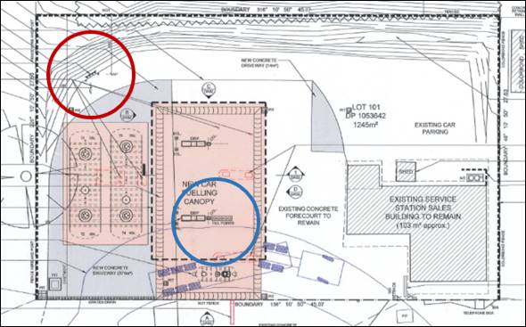
Figure 9 – fill points and tank vents
Council’s Environmental Health Officer advises that
the proposed development is unlikely to result in odour emissions. It is
acknowledged that fuel odour emissions have likely been associated with
historic service station use of the land. However, the proposed replacement
tanks and infrastructure are of a contemporary design and specification, with
internal odour containment measures including vapour recovery. Odour
containment and monitoring will be consistent with the requirements of the
Protection of the Environment Operations (Clean Air) Amendment (Vapour
Recovery) Regulation 2009.
Fencing and landscaping to the site perimeters and change in
ground levels between the service station and opposing dwellings will also
assist to limit other emissions (eg onsite vehicles) beyond the site.
Lighting
In order to limit light spill from the subject land to
adjoining dwellings, conditions are included requiring a curfew for illuminated
signage consistent with hours of operation (7am to 10pm); no flashing or
moving signage content; and all external lighting of the site and building be
designed and installed to comply with AS 4282-1997 Control of the Obtrusive
Effects of Outdoor Lighting.
Visual Amenity
The following proposed and conditional measures will improve
the presentation of the site for opposing dwellings:
· New fencing
to rear and side site boundaries.
· Implementation
of site landscaping.
· Reconstructed
footway crossings and new concrete driveways.
· Removal of
concrete pad and pylon sign in the road reserve at the site frontage.
· Preparation
and implementation of a Litter Patrol Management Plan.
Security
The proposed development was referred to NSW Police for consideration
and comment. No objection was raised to the proposal subject to
installation of CCTV, external lighting and duress alarm/panic button.
Conditions are included to effect these requirements.
Social and Economic Effects
The proposed development is unlikely to generate a negative
social or economic impact within the locality. The use of the land as a service
station is a longstanding and accepted component of the village. The proposal
involves upgrading of a derelict site, with positive impacts on village
character and function, and flow-on effects for the local economy and regional
centre status.
The Suitability of the Site
S4.15(1)(C)
The subject land is suitable for the proposed development
due to the following:
· The proposed
development is permitted on the subject land zoning.
· The site is
located within the business core of the Village.
· The proposal
comprises an environmental upgrade of the longstanding service station use of
the land.
· All utility
services are available and adequate.
· Sufficient
onsite car parking and manoeuvring area will be available.
· The local
road network is suitable to support the proposal without upgrade.
· The
contamination status of the land is suitable for the proposed development; further
validation of excavated material will occur during works.
· The land may
be affected by naturally occurring asbestos; suitable management will be
required during construction works.
· The land may
be affected by subsidence associated with former mining use in the village.
Conditional geotechnical investigation will confirm suitability.
· The land is
not subject to other known natural hazards.
· The site is
contained within a conservation area, and sympathetic site upgrading is
appropriate.
· The site has
no particular environmental values.
Any Submissions Made In
Accordance With The Act S4.15(1)(D)
The proposed development comprises "notified
development" pursuant to Council’s Community Participation Plan
2019.
Written notice of the application was given for the
prescribed period. At the end of that period, two submissions had been received
from the adjoining owner to the east (at 4609 Mitchell Highway). The
issues raised in those submissions are considered below.
The proposal will devalue the adjoining dwelling
This is not a valid consideration in the assessment of a
development application pursuant to the Environmental Planning and Assessment
Act 1979. Notwithstanding, there is no evidence to suggest that complementary
non-residential uses will devalue nearby dwellings. Site and premises upgrading
as proposed may result in favourable impacts on property values nearby to the
site.
The proposal will have unreasonable noise impacts
(vehicles, plant)
Various conditions are included to ensure noise emissions
associated with the development will comply with the Noise Policy for
Industry (EPA 2017). These conditions include:
· Trading
hours of 7am to 10pm.
· Fuel
delivery hours of 7am to 6pm.
· Physical screening
of mechanical plant.
· Sound
barrier solid fencing to side and rear boundaries.
· Noise
emissions not to exceed 5dB(A).
Illumination of signage will
cause nuisance glare
Various conditions are include to minimise light spill from
signage and other external lighting. These conditions include:
· Signage
illumination curfew consistent with trading hours (7am to 10pm).
· Signage
content shall not include flashing or moving content.
· External
lighting to comply with AS 4282-1997 Control of the Obtrusive Effects of
Outdoor Lighting.
Fumes from the tank vents
cause air pollution
As outlined in the foregoing sections of this report,
Council’s Environmental Health Officer considers that fuel odour
emissions will be negligible. The proposed fuel tanks and associated
infrastructure are a contemporary design and specification to the existing
facility, with odour containment measures including vapour recovery.
Night-time refuelling of
tanks is unreasonable
Conditions are included limiting fuel delivery hours to 7am
to 6pm.
Turning lanes are required on
the highway at the site frontage to access the site
As outlined in the foregoing sections of this report, it is
the assessment of Council staff and TfNSW that the proposal does not involve an
intensification of the existing use of the land. The proposal will not alter
existing site area, convenience store floor area or service channels (rows of
pumps). The development will not generate additional traffic volumes nor result
in a nexus for substantial highway intersection upgrades.
The proposal does not
consider the movement of pedestrians
Conditions are included requiring reinstatement of the
public footpath at the site frontage.
Twenty-four hour operation
is unreasonable in the Village
A condition is included limited trading hours to 7am to
10pm.
Access driveways should be
designed Entry (eastern driveway) and Exit (western driveway)
The proposed access arrangements involve vehicle entry via
the eastern driveway, and egress via the western driveway. TfNSW has included
conditions requiring the provision of signage at the driveways to enforce these
arrangements.
Measures are required to
protect stormwater infrastructure at the site frontage of 4609 Mitchell
Highway
A condition is included requiring reconstruction of the
subject stormwater outlet clear of the driveway reconstruction works, and
including a concrete end wall or enclosure to protect the outlet.
A dual centre turning lane
is required to access the site when turning across the highway from Orange
As outlined, Council staff and
TfNSW consider that highway intersection upgrades will not be required for the
proposed development. Conflicts between vehicles turning into the site and
travelling east will be reduced by new NO STOPPING zones at the site frontage (see
Figure 10 below). NO STOPPING zones will enable standing vehicles to be safely
passed in the road shoulder. Conditions are included to effect these
arrangements.
over page/
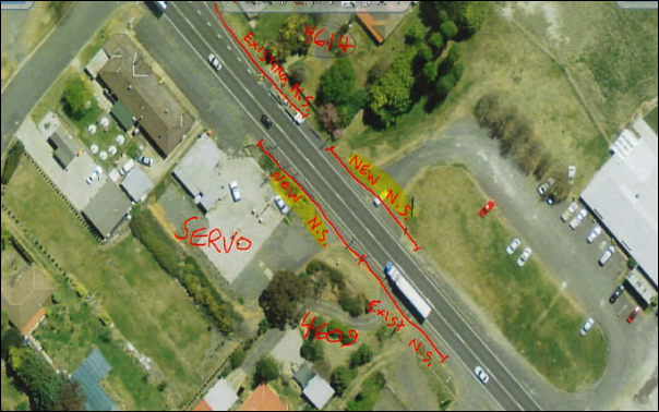
Figure 10 – conditional NO STOPPING zones at the
site frontage
Noise proof fencing, 2.1m in
height should be erected on the common boundary
Conditions are included requiring erection of 2.1m high
lapped and capped timber palings on the common boundary with 4609 Mitchell
Highway. It is noted that the submitted noise assessment requires a 1.8m high
solid fence on this boundary. It is considered to be a reasonable low-cost
amenity improvement for the nearest adjoining dwelling to provide additional
height for improved visual and acoustic outcomes.
PUBLIC INTEREST
s4.15(1)(e)
The proposal is not inconsistent with any relevant policy
statements, planning studies, guidelines etc that have not been considered in
this assessment. Site upgrading, with improved environmental protection works,
will have positive impacts on village character and function, and flow-on
effects for the local economy and regional centre status. The proposal is
considered to be in the public interest.
SUMMARY
The proposed service station upgrade is permitted with
consent. Notable planning matters considered in this report include the
suitability of the local road network to accommodate traffic associated with
the development; the impacts on the proposal on nearby residential amenity; and
the constraints associated with the Village character and conservation setting.
Two (2) public submissions were received, which raised
concerns in relation to residential amenity (noise, light and odour); and
traffic arrangements (site access and highway upgrade).
On balance, it is considered that the
proposed development satisfies the Local and State planning provisions
applicable to the site and particular landuse. Approval of the application is
recommended. Conditions of consent are included in the attached Notice of
Approval to mitigate and manage arising impacts associated with the
development.
COMMENTS
The attached Notice of Approval includes conditions from:
· Environmental
Health and Building Inspector
· Environmental
Health Officer
· Assistant
Development Engineer
· Heritage
Advisor
· Transport
for NSW
· Manager City
Presentation
· NSW Police
Attachments
1 Notice
of Approval, D20/60093⇩
2 Plans,
D20/50803⇩
3 Submissions,
D20/50802⇩
4 Letter
from Transport and Traffic Planning Associates - 4613 Mitchell Highway,
D20/60096⇩