Planning and Development
Committee
Agenda
1 September 2020
Notice is hereby given, in
accordance with the provisions of the Local Government Act 1993 that a Planning and Development Committee meeting of ORANGE CITY COUNCIL
will be held in the Council Chamber,
Civic Centre, Byng Street, Orange WITH AN OPTION OF ONLINE CONFERENCING
PLATFORM ZOOM DUE TO COVID-19 REQUIREMENTS on Tuesday, 1 September
2020.
David
Waddell
Chief Executive Officer
For apologies please
contact Administration on 6393 8218.
1 Introduction
1.1 Declaration
of pecuniary interests, significant non-pecuniary interests and less than
significant non-pecuniary interests
The
provisions of Chapter 14 of the Local Government Act, 1993 (the Act)
regulate the way in which Councillors and designated staff of Council conduct
themselves to ensure that there is no conflict between their private interests
and their public role.
The
Act prescribes that where a member of Council (or a Committee of Council) has a
direct or indirect financial (pecuniary) interest in a matter to be considered
at a meeting of the Council (or Committee), that interest must be disclosed as
soon as practicable after the start of the meeting and the reasons given for
declaring such interest.
As
members are aware, the provisions of the Local Government Act restrict any
member who has declared a pecuniary interest in any matter from participating
in the discussion or voting on that matter, and requires that member to vacate
the Chamber.
Council’s Code of Conduct provides that if members
have a non-pecuniary conflict of interest, the nature of the conflict must be
disclosed. The Code of Conduct also provides for a number of ways in which a
member may manage non pecuniary conflicts of interest.
|
Recommendation
It is recommended that Committee Members now disclose any
conflicts of interest in matters under consideration by the Planning and
Development Committee at this meeting.
|
2 General
Reports
2.1 Item
Approved Under the Delegated Authority of Council
RECORD
NUMBER: 2020/1297
AUTHOR: Paul
Johnston, Manager Development Assessments
EXECUTIVE Summary
Following is a list of more
significant development applications approved by the Chief Executive Officer under
the delegated authority of Council. Not included in this list are residential
scale development applications that have also been determined by staff under
the delegated authority of Council (see last paragraph of this report for those
figures).
Link To Delivery/OPerational Plan
The recommendation in this report
relates to the Delivery/Operational Plan strategy “7.1 Preserve - Engage
with the community to develop plans for growth and development that value the
local environment”.
Financial Implications
Nil
Policy and Governance Implications
Nil
|
Recommendation
That Council resolves to
acknowledge the information provided in the report by the Manager Development
Assessments on Items Approved Under the Delegated Authority of Council.
|
further considerations
Consideration has been given to the recommendation’s
impact on Council’s service delivery; image and reputation; political;
environmental; health and safety; employees; stakeholders and project
management; and no further implications or risks have been identified.
|
Reference:
|
DA 527/2003(5)
|
Determination Date
|
14 August 2020
|
|
PR Number
|
PR20410
|
|
Applicant/s:
|
Mr A Harvey
|
|
Owner/s:
|
Harvandi Pty Limited
|
|
Location:
|
Lot 102 DP 1084285 – 159A
Sale Street, Orange
|
|
Proposal:
|
Modification of development consent
- subdivision (three lot residential), subdivision (two lot residential),
demolition (two garages), medium density development (eight residential
units) and subdivision (nine lot Community title). The modification involves
introducing a two lot subdivision as Stage 2 and changing the Strata
subdivision to Community title.
|
|
Value:
|
$0
|
|
Reference:
|
DA 114/2016(3)
|
Determination Date
|
6 August 2020
|
|
PR Number
|
PR27143
|
|
Applicant/s:
|
Orange Waratah Sports Club Limited
|
|
Owner/s:
|
Crown Land (Lot 210 DP 1209495) c/-
Orange City Council and Orange Waratahs Sports Club Ltd
(Lot 31 DP 1215943)
|
|
Location:
|
Lot 210 DP 1209495 and Lot 31 DP
1215943 – 36 Telopea Way, Orange
|
|
Proposal:
|
Modification of development consent
- recreation facility (proposed sports field and earthworks), alterations and
additions to existing building (storage shed). The modification involves
changes to the shed element of the original consent; including making the
extension larger to provide toilets and change rooms, internal alterations to
the floor layout, adding a mezzanine level to the extension, and adding
external awnings to the shed.
|
|
Value:
|
$0
|
|
Reference:
|
DA 203/2016(2)
|
Determination Date
|
29 July 2020
|
|
PR Number
|
PR27615
|
|
Applicant/s:
|
Rawson Homes Pty Ltd
|
|
Owner/s:
|
Rawson Homes Pty Ltd
|
|
Location:
|
Lot 105 DP 1225229, Lot 41 DP
1195966 - 33 William Maker Drive, Orange
|
|
Proposal:
|
Modification of development consent
- exhibition home and business identification sign. The modification involves
amending Condition 38 of the original consent to allow for extended use.
|
|
Value:
|
$0
|
|
Reference:
|
DA 203/2016(3)
|
Determination Date
|
10 August 2020
|
|
PR Number
|
PR27615
|
|
Applicant/s:
|
Rawson Homes Pty Ltd
|
|
Owner/s:
|
Rawson Homes Pty Ltd
|
|
Location:
|
Lot 105 DP 1225229, Lot 41 DP 1195966
- 33 William Maker Drive, Orange
|
|
Proposal:
|
Modification of development consent
- exhibition home and business identification sign. The modification involves
amending the hours of the exhibition home a. This will be achieved by
amending Condition 37 of the latest development application consent.
|
|
Value:
|
$0
|
|
Reference:
|
DA 29/2019(2)
|
Determination Date
|
20 August 2020
|
|
PR Number
|
PR20239
|
|
Applicant/s:
|
Canobolas Diesel and Turbo
|
|
Owner/s:
|
Mr CB and Mrs KM Naveau
|
|
Location:
|
Lot 71 DP 1077737 – 57 Astill
Drive, Orange
|
|
Proposal:
|
Modification of development consent
– vehicle repair station and business identification signage. The
modification involves removing a condition of consent relating to a water and
sewer contribution for the wash bay.
|
|
Value:
|
$0
|
|
Reference:
|
DA 81/2019(2)
|
Determination Date
|
4 August 2020
|
|
PR Number
|
PR2678
|
|
Applicant/s:
|
Mr PK Bromley
|
|
Owner/s:
|
Mr PK Bromley
|
|
Location:
|
Lot 1 DP 196341 – 111 Clinton
Street, Orange
|
|
Proposal:
|
Modification of development consent
- demolition of garage, carport, and swimming pool; partial demolition and
replacement of western portion of existing dwelling house; partial demolition
and replacement of boundary fencing; new detached garage (ground floor) with
secondary dwelling (first floor). The modification alters the style and
building materials of the fence.
|
|
Value:
|
$0
|
|
Reference:
|
DA 102/2020(1)
|
Determination Date
|
19 August 2020
|
|
PR Number
|
PR27608
|
|
Applicant/s:
|
Boffa Robertson Group
|
|
Owner/s:
|
Mission Australia
|
|
Location:
|
Lot 101 DP 1225276 – 130
Huntley Road, Orange
|
|
Proposal:
|
Seniors Housing (boundary fence)
|
|
Value:
|
$85,000
|
|
Reference:
|
DA 135/2020(1)
|
Determination Date
|
23 July 2020
|
|
PR Number
|
PR26080
|
|
Applicant/s:
|
West Orange Holdings Pty Ltd
|
|
Owner/s:
|
West Orange Holdings Pty Limited
|
|
Location:
|
Lot 102 DP 1187463 - 22-34 Forbes
Road, Orange
|
|
Proposal:
|
Vehicle sales or hire premises
(alterations and additions to existing buildings and change of use) and
business identification signage
|
|
Value:
|
$250,000
|
|
Reference:
|
DA 202/2020(1)
|
Determination Date
|
12 August 2020
|
|
PR Number
|
PR17764
|
|
Applicant/s:
|
Anson
Street School
|
|
Owner/s:
|
Anson
Street School
|
|
Location:
|
Lot 5 DP
602502 - 94 Anson Street, Orange
|
|
Proposal:
|
Business
identification sign
|
|
Value:
|
$0
|
|
Reference:
|
DA 214/2020(1)
|
Determination Date
|
4 August 2020
|
|
PR Number
|
PR22175
|
|
Applicant/s:
|
Mr P Van Der Boon
|
|
Owner/s:
|
Mr P and Mrs L Van Der Boon
|
|
Location:
|
Lot 1 DP 1107969 – 774
Burrendong Way, Orange
|
|
Proposal:
|
Secondary dwelling
|
|
Value:
|
$100,000
|
|
Reference:
|
DA 227/2020(1)
|
Determination Date
|
3 August 2020
|
|
PR Number
|
PR28314 and PR28312
|
|
Applicant/s:
|
Verde Orange Pty Ltd
|
|
Owner/s:
|
Verde Orange Pty Ltd
|
|
Location:
|
Lots 500 and 502 DP 1249083 - 105
Prince Street and 291 Anson Street, Orange
|
|
Proposal:
|
Subdivision (boundary adjustment
and right-of-way access)
|
|
Value:
|
$0
|
|
Reference:
|
DA 234/2020(1)
|
Determination Date
|
19 August 2020
|
|
PR Number
|
PR1189
|
|
Applicant/s:
|
Mr A Blyth
|
|
Owner/s:
|
Mr A Blyth and Ms DL Chappel
|
|
Location:
|
Lot 4 DP 19613 – 126 Bathurst
Road, Orange
|
|
Proposal:
|
Medical centre (change of use)
|
|
Value:
|
$80,000
|
|
Reference:
|
DA 237/2020(1)
|
Determination Date
|
5 August 2020
|
|
PR Number
|
PR18279
|
|
Applicant/s:
|
Mr P Layton
|
|
Owner/s:
|
Astill Pty Ltd
|
|
Location:
|
Lot 31 DP 1035913 – 2/ 25
Astill Drive, Orange
|
|
Proposal:
|
Warehouse or distribution centre
and kiosk
|
|
Value:
|
$20,000
|
|
Reference:
|
DA 240/2020(1)
|
Determination Date
|
12 August 2020
|
|
PR Number
|
PR7086
|
|
Applicant/s:
|
PL on 4 Pty Ltd ATF Lords Place
Property Trust
|
|
Owner/s:
|
PL on 4 Pty Ltd
|
|
Location:
|
Lot 20 DP 11439 – 146-148
Lords Place, Orange
|
|
Proposal:
|
Office premises (alterations to
existing building – demolition and reinstatement of awnings, and
repainting of façade)
|
|
Value:
|
$20,000
|
|
Reference:
|
DA 245/2020(1)
|
Determination Date
|
3 August 2020
|
|
PR Number
|
PR12025
|
|
Applicant/s:
|
Mr MA Lukic
|
|
Owner/s:
|
Mr MA Lukic and Ms D Racic
|
|
Location:
|
Lots 26 and 25 DP35002 - 39 and 41
Tobruk Crescent, Orange
|
|
Proposal:
|
Subdivision (boundary adjustment)
|
|
Value:
|
$10,000
|
|
Reference:
|
DA 253/2020(1)
|
Determination Date
|
7 August 2020
|
|
PR Number
|
PR20524
|
|
Applicant/s:
|
Mr MP and Mrs LM Molloy
|
|
Owner/s:
|
Mr MP and Mrs LM Molloy
|
|
Location:
|
Lot 100 DP1092868, 360 Phoenix Mine
Road, Huntley
|
|
Proposal:
|
Recreation facility (outdoor)
(tennis court)
|
|
Value:
|
$105,000
|
|
Reference:
|
DA 257/2020(1)
|
Determination Date
|
23 July 2020
|
|
PR Number
|
PR28646
|
|
Applicant/s:
|
Ross Hill Wine Group Pty Ltd
|
|
Owner/s:
|
Sweetwater Grapes Pty Ltd, Ross
Hammond Pty Ltd and Tynie Pty Ltd
|
|
Location:
|
Lot 101 DP 1261108 - 132 Wallace
Lane, Canobolas
|
|
Proposal:
|
Cellar door premises (amenities
addition)
|
|
Value:
|
$31,000
|
TOTAL NET* VALUE OF 17 DEVELOPMENTS APPROVED BY THE CEO
UNDER DELEGATED AUTHORITY IN THIS PERIOD: $701,000
*
Net value relates to the value of modifications. If modifications are
the same value as the original DA, then nil is added. If there is a plus/minus
difference, this difference is added or taken out.
Additionally, since the August PDC meeting report periods
(23 July to 24 August 2020), a total of 40 development applications were
determined under delegated authority by other Council staff with a combined
value of $8,296,575.
2.2 Development
Application DA 187/2020(1) - Byng, March and Peisley Streets, and Lords Place
(Orange Civic Precinct)
RECORD
NUMBER: 2020/980
AUTHOR: Kelly
Walker, Senior Planner
EXECUTIVE
Summary
|
Application
lodged
|
18 May
2020
|
|
Applicant/s
|
Orange
City Council
|
|
Owner/s
|
Orange
City Council
|
|
Land
description
|
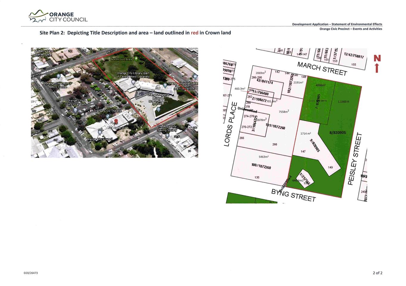
Lot 1 DP
257566 - 151 and 151A Byng Street;
Lot 11
DP 706480 - 284 Lords Place;
Lot Z DP
108472 - 282 Lords Place;
Lots 7,
8, and 9 DP 820905 - 147-149 Byng Street, March Street, Peisley Street,
and Byng Street;
Lot 42
42 PCE C DP 841174 - 286-290 Lords Place;
Lot 3
PCE PT and Lot 3 PCE PT SEC 43 DP 1064225 – 270‑276 Lords Place;
Lots
100, 101 and 102 DP 1072260 - 135 Byng Street, 266 and 278-280 Lords Place,
142-148 March Street; 270-276, 282, and 284 Lords Place
|
|
Proposed
land use
|
Mixed Use Development (community
facility, entertainment facility, information and education facility, markets
and other uses)
|
|
Value of
proposed development
|
$0
|
Council's consent is sought to
formalise the use of Council’s Civic Centre Precinct for events, on land
bordered by March, Byng and Peisley Streets, and Lords Place (see
Figure 1). The land currently has existing buildings including the Orange
Regional Art Gallery, Orange Regional Museum, Orange City Library,
Orange Visitor Information Centre, Council’s Civic Centre
offices, Orange Civic Theatre, Giyalang Ganya offices, and various other
Council community services buildings. There is also a large car park accessed
off Lords Place, as well as open space areas known as
‘Northcourt’, ‘Southcourt’, and the museum roof. The
eastern portion of the precinct (Lots 7, 8 and 9 DP820905, and Lot 1
DP257566) is owned by Crown Lands, but is managed by Council.
The buildings and spaces are used
for a variety of Council and community activities, including administration,
community services, arts and cultural services, community events and
fundraisers, etc. Some of these activities are carried out directly by, or on
behalf of, Council, and the subject buildings and areas are also leased out for
community events and the likes. This application seeks to formalise the
community, recreation, entertainment, and market uses of these buildings and
spaces, where previous consents do not cover all of the different uses this
precinct is now used for.
This application does not involve
any changes to the existing buildings or layout of the land, and no works are
proposed to be carried out. Hours of operation, patron/attendee numbers, staffing,
security, etc. will depend on the event itself, which are managed through a
separate user/hire agreement with Council to use the land. As such, the
granting of this consent will not negate the need for third parties to enter
into the usual agreement with Council.
These agreements come with their own set of requirements
(separate to the DA process and the assessment of this application), and
are assessed on a case-by-case basis by relevant Council officers. Any
structures to be erected as part of any event or use of the land, such as
cinema screens, stages, marquees, etc. need to meet the exempt planning
requirements, or will require separate development consent, as this application
does not cover the erection of such structures. Other approvals may also be
required, such as Liquor Licence to sell/serve alcohol, Section 68 Approval for
amusement devices, etc.
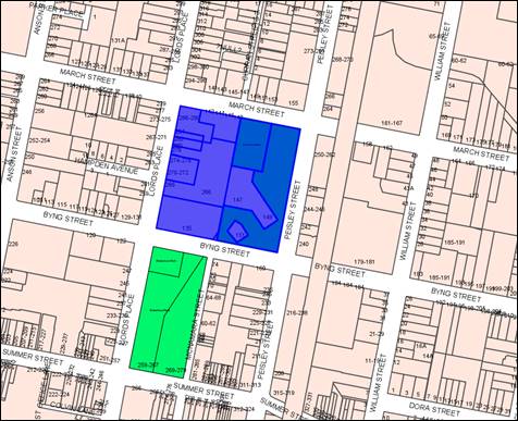
Figure 1 - locality plan
It is noted that the Orange Conservatorium-Planetarium
project, which involves a combined Arts, Education, and Science facility,
comprised of a Conservatorium, Recital Hall, and Planetarium, is
currently being assessed by Council. The project proposes a new public building
to be constructed on the Northcourt and open space areas on the northern part
of the site, which will limit the extent of events that can be carried out on
this part of the land in the future (i.e. once the new building is
constructed). Large scale events in particular are likely to be relocated to
another site following the implementation of that project.
Overall it is considered that the proposal meets the
relevant planning provisions, and the current Plan of Management (PoM) for the
land, therefore approval of the application is recommended. A draft Notice of
Approval is attached.
DECISION FRAMEWORK
Development in Orange is governed by two key documents Orange
Local Environment Plan 2011 (LEP) and Orange Development Control
Plan 2004 (DCP). In addition the Infill Guidelines are used to guide
development, particularly in the heritage conservation areas and around
heritage items.
Orange Local Environment Plan 2011
– The provisions of the LEP must be considered by the Council in
determining the application. LEPs govern the types of development that are
permissible or prohibited in different parts of the City and also provide some
assessment criteria in specific circumstances. Uses are either permissible or
not. The objectives of each zoning and indeed the aims of the LEP itself are
also to be considered and can be used to guide decision making around appropriateness
of development.
Orange Development Control Plan 2004 – the DCP
provides guidelines for development. In general it is a performance based
document rather than prescriptive in nature. For each planning element there
are often guidelines used. These guidelines indicate ways of achieving the
planning outcomes. It is thus recognised that there may also be other solutions
of merit. All design solutions are considered on merit by planning and building
staff. Applications should clearly demonstrate how the planning outcomes are
being met where alternative design solutions are proposed. The DCP enables
developers and architects to use design to achieve the planning outcomes in
alternative ways.
DIRECTOR’S COMMENT
This Development Application simply
formalises the longstanding public activities and events that have been
conducted within the Civic Precinct as ‘ancillary development’ for
many years. It is understood that restrictions associated with other Government
approvals (liquor) warrant the need to have a formal development consent
document in place. This Application will provide the required formality to
permit licencing to continue. There is no other material change to the use this
space under this proposal.
Link To Delivery/OPerational Plan
The recommendation in this report relates to the
Delivery/Operational Plan strategy “10.1 Preserve - Engage with the
community to ensure plans for growth and development are respectful of our
heritage”.
Financial Implications
Nil
Policy and Governance Implications
Nil
|
Recommendation
That Council consents to
development application DA 187/2020(1)
for Mixed Use Development (community facility, entertainment
facility, information and education facility, markets and other uses) at Lot
1 DP 257566 – 151 and 151A Byng Street; Lot 11 DP 706480
– 284 Lords Place; Lot Z DP 108472 - 282 Lords Place; Lots 7, 8, and 9
DP 820905 - 147-149 Byng Street, March Street, Peisley Street, and Byng
Street; Lot 42 42 PCE C DP 841174 - 286-290 Lords Place; Lot 3 PCE
PT and Lot 3 PCE PT SEC 43 DP 1064225 – 270‑276 Lords Place; Lots
100, 101 and 102 DP 1072260 – 135 Byng Street, 266 and 278‑280
Lords Place, and 142-148 March Street; and 270-276, 282, and 284
Lords Place pursuant to the conditions
of consent in the attached Notice of Approval.
|
further considerations
Consideration has been given to the recommendation’s
impact on Council’s service delivery; image and reputation; political;
environmental; health and safety; employees; stakeholders and project
management; and no further implications or risks have been identified.
SUPPORTING INFORMATION
The proposal involves formalising a variety of uses within
the Council’s Civic Centre Precinct, on land bordered by March, Byng and
Peisley Streets, and Lords Place (see Figure 1). The land includes
existing buildings and open space areas as discussed previously.
Proposed uses for the Civic Centre precinct (excluding the
March Street buildings, which will be continued to be used for administration
and community services) include the following range of proposed events and
activities:
· Community
and Entertainment - including, but not limited to; outdoor cinemas,
concerts, performances, poetry readings, fundraising and awareness activities,
information sessions, barbeques, Christmas parties and carols,
cultural festivals, sporting activities, community events and festivals,
days of significance (e.g. Sorry Day, R U OK Day etc.), event
headquarters (centralised location of information for events such as food
week), music and film events, firework displays, etc.
· Information
and Education – including, but not limited to; exhibition openings
and educational events such as art workshops, craft workshops, author readings,
promotional exhibitions of art, produce, education and recreation, etc.
· Markets
- including, but not limited to; local produce markets, community markets,
festival markets, fundraising markets, etc.
· Recreation
- including, but not limited to; sporting activities, ice skating, dancing,
etc.
It is noted that many events can be categorised under more
than one type of overarching use, such as a community fundraiser that involves
markets, information displays, educational workshops, entertainment, and
recreational activities all in the same event. The activity/event organiser
can include Orange City Council, local or regional community groups, local
businesses, not-for-profit organisations, and Government entities. As noted
previously, all third parties need to enter into a user/hire agreement with
Council to use the land.
Hours of operation, staffing, patron/attendance numbers, and
parking requirements are all dependent on each event or activity. Generally
Council has two different types of event categories: Category 1 involves small
events such as a wedding ceremony, small school sports event, etc. that is not
open to the public, and involves no more than 150 people or the selling of
food/alcohol. Category 2 is for larger events such as festivals, markets and
fundraisers that tend to have more than 150 people, are open to the public,
sell food/alcohol, and may involve amusement rides, temporary structures
etc. Specific events details are managed through Council’s events
application and user/hire agreement process.
This application does not involve any changes to the
existing buildings or layout of the land, and no works are proposed to be
carried out.
MATTERS FOR CONSIDERATION
Section 1.7 - Application of Part
7 of the Biodiversity Conservation Act 2016 and Part 7A of the Fisheries
Management Act 1994
Section 1.7 of the EP&A Act identifies
that Part 7 of the Biodiversity Conservation Act 2016 (BC Act) and
Part 7A of the Fisheries Management Act 1994 have effect in connection with
terrestrial and aquatic environments.
There are four triggers known to insert a development into
the Biodiversity Offset Scheme (i.e. the need for a BDAR to be submitted
with a DA):
· Trigger
1: development occurs in land mapped on the Biodiversity Values
Map (OEH) (clause 7.1 of BC Regulation 2017);
· Trigger
2: development involves clearing/disturbance of native vegetation above a
certain area threshold (clauses 7.1 and 7.2 of BC Regulation 2017); or
· Trigger
3: development is otherwise likely to significantly affect threatened
species (clauses 7.2 and 7.3 of BC Act 2016).
·
Trigger 4: development proposed to occur in an Area of Outstanding
Biodiversity Value (clause 7.2 of BC Act 2016). This is not applicable to
Orange, as no such areas are known to occur in the area. As such, no further
comments will be made against the fourth trigger.
In consideration of the above, the
site is not within land mapped on the Biodiversity Values Map or LEP
Terrestrial Biodiversity Map and is located in a highly disturbed area of the
CBD; the proposal does not involve clearing or disturbance of vegetation; and
overall is unlikely to significantly affect threatened species listed in the BC
Act 2016. As such, a Biodiversity Development Assessment Report is not required
in this instance.
Section 4.15
Section 4.15 of the Environmental
Planning and Assessment Act 1979 requires Council to consider various
matters, of which those pertaining to the application are listed below.
PROVISIONS OF ANY ENVIRONMENTAL
PLANNING INSTRUMENT s4.15(1)(a)(i)
Orange Local Environmental Plan
2011
Part 1 - Preliminary
Clause 1.2 - Aims of Plan
The broad aims of the LEP are set out under Subclause 2.
Those relevant to the application are as follows:
(a) to
encourage development which complements and enhances the unique character of
Orange as a major regional centre boasting a diverse economy and offering an
attractive regional lifestyle,
(b) to
provide for a range of development opportunities that contribute to the social,
economic and environmental resources of Orange in a way that allows present and
future generations to meet their needs by implementing the principles for
ecologically sustainable development,
(f) to
recognise and manage valued environmental heritage, landscape and scenic
features of Orange.
The application is considered to be
generally consistent with these objectives, as outlined in this report.
Clause 1.6 - Consent Authority
This clause establishes that,
subject to the Act, Council is the consent authority for applications made
under the LEP.
Clause 1.7 - Mapping
The subject site is identified on the LEP maps in the following
manner:
|
Land Zoning Map:
|
RE1 Public Recreation and B4 Mixed
Use
|
|
Lot Size Map:
|
No Minimum Lot Size
|
|
Heritage Map:
|
Not a heritage item or conservation
area
|
|
Height of Buildings Map:
|
Building height limits of 9m, 12m,
and 16m
|
|
Floor Space Ratio Map:
|
Floor space limits of 0.75:1, 1:1,
1.5:1 and 2:1
|
|
Terrestrial Biodiversity Map:
|
No biodiversity sensitivity on the
site
|
|
Groundwater Vulnerability Map:
|
Groundwater vulnerable
|
|
Drinking Water Catchment Map:
|
Not within the drinking water
catchment
|
|
Watercourse Map:
|
Partly sensitive waterway
|
|
Urban Release Area Map:
|
Not within an urban release area
|
|
Obstacle Limitation Surface Map:
|
No restriction on building siting
or construction
|
|
Additional Permitted Uses Map:
|
No additional permitted use applies
|
|
Flood Planning Map:
|
Partly within a flood planning area
|
Those matters that are of relevance
are addressed in detail in the body of this report.
Clause 1.9A - Suspension of
Covenants, Agreements and Instruments
This clause provides that
covenants, agreements and other instruments which seek to restrict the carrying
out of development do not apply with the following exceptions:
· a
covenant imposed by the Council or that the Council requires to be imposed, or
· any
relevant instrument under Section 13.4 of the Crown Land Management Act 2016,
or
· any
conservation agreement under the National Parks and Wildlife Act 1974,
or
· any
Trust agreement under the Nature Conservation Trust Act 2001, or
· any
property vegetation plan under the Native Vegetation Act 2003, or
· any
biobanking agreement under Part 7A of the Threatened Species Conservation
Act 1995, or
· any
planning agreement under Subdivision 2 of Division 7.1 of the Environmental
Planning and Assessment Act 1979.
As noted previously, part of the
subject site is owned by Crown Lands NSW. These four parcels of land have title
notifications stating that the land is a ‘reserve’ under the
historical Crown Lands Act 1989 (now the Crown Land Management Act
2016).
A Plan of Management (PoM) was
prepared for the land in 2014, as required by the previous Act. Pursuant to the
Acts, the reserves have gazetted purposes including ‘public
buildings’, ‘public recreation’, ‘urban
services’, and ‘tourist information centre’. The proposed
uses are consistent with the gazetted uses and the current PoM, which is
discussed in detail in the DCP assessment later in this report.
It is noted that Orange City Council is the Reserve Trust
Manager for this land, and is acting as land owner for the purposes of this
application, pursuant to Section 2.23 of the Crown Land Management Act 2016.
Part 2 - Permitted or Prohibited
Development
Clause 2.1 - Land Use Zones and
The subject site is located within the RE1 Public Recreation
and B4 Mixed Use zones (see Figure 2).
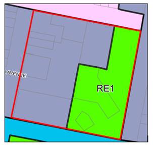
Figure 2 – extract of LEP Land Zoning Map
(Key: blue-grey = B4, green = RE1, red line = subject
site)
Pursuant to the LEP, the various
proposed uses are defined as follows:
community facility means a building or
place:
(a) owned or
controlled by a public authority or non-profit community organisation, and
(b) used for
the physical, social, cultural or intellectual development or welfare of the
community,
but does not include an educational establishment,
hospital, retail premises, place of public worship or residential
accommodation.
entertainment facility means a theatre,
cinema, music hall, concert hall, dance hall and the like, but does not include
a pub or registered club.
information and education
facility means a building or place used for providing information or
education to visitors, and the exhibition or display of items, and includes an
art gallery, museum, library, visitor information centre and the like.
market means an
open-air area, or an existing building, that is used for the purpose of
selling, exposing or offering goods, merchandise or materials for sale by
independent stall holders, and includes temporary structures and existing
permanent structures used for that purpose on an intermittent or occasional
basis.
recreation area
means a place used for outdoor recreation that is normally open to the public,
and includes:
(a) a
children’s playground, or
(b) an
area used for community sporting activities, or
(c) a
public park, reserve or garden or the like,
and any ancillary buildings,
but does not include a recreation facility (indoor), recreation facility
(major) or recreation facility (outdoor).
recreation facility (major)
means a building or place used for large-scale sporting or recreation
activities that are attended by large numbers of people whether regularly or
periodically, and includes theme parks, sports stadiums, showgrounds,
racecourses and motor racing tracks.
recreation facility
(outdoor) means a building or place (other than a recreation area)
used predominantly for outdoor recreation, whether or not operated for the
purposes of gain, including a golf course, golf driving range, mini-golf
centre, tennis court, paint-ball centre, lawn bowling green, outdoor swimming
pool, equestrian centre, skate board ramp, go-kart track, rifle range,
water-ski centre or any other building or place of a like character used for
outdoor recreation (including any ancillary buildings), but does not include an
entertainment facility or a recreation facility (major).
It is noted that many of these uses already take place
within their respective buildings, such as author readings in the library, art
workshops in the gallery, and performances in the theatre. These activities
already have consent to occur under their respective DAs, and this application
seeks to extend these activities to the adjacent outdoor areas within the
precinct, and to allow for other similar uses by the community and other
related parties.
The proposed uses are permitted with consent in these zones,
with the exception of the recreation uses, which are not permitted in the B4
zone. Events that fall within these definitions are only proposed to be carried
out on the RE1 zoned land.
Some activities are not considered to fit within these
definitions, such as local businesses promoting their retail sales, trades,
etc. which are more of a commercial type of activity rather than any of the
above or other permitted uses. Notwithstanding this, these types of uses can be
carried out on a ‘temporary’ use basis pursuant to LEP Clause 2.8.
Consent is sought for these temporary uses, as discussed in greater detail
below.
Clause
2.3 - Zone Objectives and Land Use Table
Clause 2.3 of LEP 2011 references the Land Use Table
and Objectives for each zone in LEP 2011. The objectives for land zoned RE1 and B4 are as follows:
Objectives
of the B4 Mixed Use Zone
· To
provide a mixture of compatible land uses.
· To
integrate suitable business, office, residential, retail and other development
in accessible locations so as to maximise public transport patronage and
encourage walking and cycling.
· To
promote, where possible, the retention and reuse of heritage items as well as
the retention of established buildings that contribute positively to the
heritage or cultural values of the land in the zone.
· To
promote development that supports the role of Orange CBD as the primary retail
and business centre in the region.
The proposal is
not inconsistent with the objectives of the B4 zone. Most of the proposed uses
will be carried out within the RE1 zone, where the B4 zone will be used
ancillary to the events, such as for administration, access, car parking,
amenities, etc.
Objectives
of the RE1 Public Recreation Zone
· To
enable land to be used for public open space or recreational purposes.
· To
provide a range of recreational settings and activities and compatible land
uses.
· To
protect and enhance the natural environment for recreational purposes.
· To
ensure development is ordered in such a way as to maximise public transport
patronage and encourage walking and cycling in close proximity to settlement.
· To
ensure development along the Southern Link Road has alternative access.
It is
considered that the proposal is consistent with the objectives of the RE1 zone,
allowing for a wide range of recreational and community uses of the land. The
site is located on the edge of the CBD and near to public transport, and is not
in the vicinity of the Southern Link Road.
Clause 2.8 - Temporary Use of
Land
The proposal seeks to use the RE1
zoned parts of the site for the third party events that are not of a community
or recreational nature, such as the promotion of local businesses
(e.g. showcasing the food of a new restaurant, marketing local retail and
trade businesses, celebrating the opening of a new store, etc.) which are
considered commercial in nature, and are usually prohibited in the RE1 zone.
LEP Clause 2.8 enables Council to
provide consent for the temporary use of land, provided it is satisfied that:
· the
temporary use will not prejudice the subsequent development of the land in
accordance with the LEP, and
· the
temporary use will not adversely impact on any adjoining land or the amenity of
the neighbourhood, and
· the
temporary use and location of any structures involved will not adversely impact
on environmental attributes or features, or increase the risk of natural
hazards affecting the land, and
· that
at the end of the temporary use period, the land will as far as practicable,
be restored to the condition it was previously in.
Furthermore, the Clause states that temporary uses must be
limited to no more than 52 days (whether or not consecutive) in any twelve
month period.
It is considered that these types of temporary events can be
undertaken without detriment to the neighbourhood, adjoining lands,
environmental attributes, features and values of the land, and will not elevate
the risk of natural hazards in the area. Furthermore, the proposed temporary
uses will not compromise future development of the land. The applicant has
committed to limiting these types of uses to no more than 52 days over a total
period of twelve months. It is noted that these temporary events need to
fit in with the booked schedule of events that take place on the land, whether
they be regular annual events such as Cancer Council fundraising, Banjo
Patterson Festival, Food Week, etc. or one-off ad-hoc events. As such, these
commercial type of events are likely to happen only a few times a year. These
uses are also subject to the Council’s event application process and
conditions, which requires the land to be restored to its current condition
upon cessation of the temporary use, in accordance with this clause.
Overall, it is considered that these temporary events are
considered acceptable, subject to further case-by-case scrutiny during
Council’s events application process, and compliance with the user/hire
agreement terms and conditions. An operational condition of consent is
recommended to this effect.
Part 3 - Exempt and Complying
Development
The application is not exempt or complying development. As
noted previously, structures and infrastructure that does not meet the exempt
development provisions will require a separate DA. An Advisory Note is recommended
to this effect.
Part 4 - Principal Development
Standards
Clause 4.3 - Height of Buildings
This clause limits the height of
buildings (HoB) on land identified on the Height of Buildings Map. The subject
land is identified on the Map as having various height limits, being 9m, 12m, and 16m. No changes are
proposed to the heights of existing buildings, and no new structures are
proposed as part of this application.
Clause 4.4 - Floor Space Ratio
This clause limits the floor space
ratio (FSR) permitted on land identified on the Floor Space Ratio Map. The
subject land is identified on the Map as having various FSRs of 0.75:1, 1:1, 1.5:1 and 2:1. No changes
to floor areas of existing buildings are proposed, and no additional floor area
is proposed.
Part
5 - Miscellaneous Provisions
5.10 - Heritage Conservation
Cause 5.10 applies to the subject proposal as the land is
located opposite a heritage conservation area and local heritage listed items.
Clause 5.10 states in part:
(1) Objectives
The objectives of this clause
are as follows:
(a) to
conserve the environmental heritage of Orange,
(b) to
conserve the heritage significance of heritage items and heritage conservation
areas, including associated fabric, settings and views,
(c) to
conserve archaeological sites,
(d) to
conserve Aboriginal objects and Aboriginal places of heritage significance.
(4) Effect
of Proposed Development on Heritage Significance
The consent authority must,
before granting consent under this clause in respect of a heritage item or heritage
conservation area, consider the effect of the proposed development on the
heritage significance of the item or area concerned. This subclause applies
regardless of whether a heritage management document is prepared under
Subclause (5) or a heritage conservation management plan is submitted under
Subclause (6).
The proposal does not involve any alterations to the
existing buildings or site, other than temporary use of land, which must be
returned to its former state after use, as discussed previously. As there are
no changes to the fabric of the building or the site, it is considered that the
proposal will have negligible impact on the immediate or wider heritage
setting.
Part 6 - Urban Release Area
Not relevant to the application. The subject site is not
located in an Urban Release Area.
Part 7 - Additional Local Provisions
7.2 - Flood Planning
This clause applies to land identified
on the Flood Planning Map as a Flood Planning Area and requires that, before
any consent is issued, Council must be satisfied that the proposal:
(a) is compatible with the flood hazard of the
land, and
(b) is not likely to significantly adversely
affect flood behaviour resulting in detrimental increases in the potential
flood affectation of other development or properties, and
(c) incorporates appropriate measures to
manage risk to life from flood, and
(d) is not likely to significantly adversely
affect the environment or cause avoidable erosion, siltation, destruction of
riparian vegetation or a reduction in the stability of river banks or
watercourses, and
(e) is not likely to result in unsustainable
social and economic costs to the community as a consequence of flooding.
Part
of the site is identified as flood affected on the LEP Flood Planning Map. As
the proposal involves temporary use of the land for events and no physical
works or changes to the site are proposed, flooding regimes on or off the site
are unlikely to be changed as a result of this application, and stormwater run-off from the site will remain
unchanged. Likewise, the proposal is unlikely to cause or contribute to erosion,
siltation, or reduce riparian vegetation, and is therefore unlikely to create a
cost burden on the community or neighbours.
Council’s Development Engineer
recommends a condition of consent for events applicants/organisers to undertake
a flood risk assessment prior to each event to comply with the Blackmans Swamp
Creek Floodplain Risk Management Plan, including having procedures in place to
ensure that there is no increase in the risk of loss of life, no increase in
flood affectation on adjoining development or properties likely to occur on the
floodplain; and reliable access is available for the evacuation from the area.
Overall, the proposal is
consistent with LEP Clause 7.2.
7.5 - Riparian Land and Watercourses
This clause seeks to preserve both
water quality and riparian ecological health. The clause applies to land
identified as a “Sensitive Waterway” on the Watercourse Map, and
Council must consider whether or not the proposal:
(a) is likely to have any adverse impact on
the following:
(i) the water quality and flows within a
watercourse
(ii) aquatic and riparian species, habitats
and ecosystems of the watercourse
(iii) the stability of the bed and banks of the
watercourse
(iv) the free passage of fish and other aquatic
organisms within or along the watercourse
(v) any future rehabilitation of the
watercourse and its riparian areas, and
(b) is
likely to increase water extraction from the watercourse.
Additionally, consent may not be
granted until Council is satisfied that:
(a) the development is designed, sited and
will be managed to avoid any significant adverse environmental impact, or
(b) if that impact cannot be reasonably
avoided - the development is designed, sited and will be managed to minimise
that impact, or
(c) if that impact cannot be minimised - the
development will be managed to mitigate that impact.
Part of the subject site
contains a sensitive waterway, being Blackmans Swamp Creek.
This waterway runs underground, beneath the site, and as such the proposal
is unlikely to impact on its flow, stability, free passage of species, or
future rehabilitation, nor involve any water extraction. As the proposal does
not involve any works, run off from the site will remain unchanged.
While there will
always remain a risk to the waterway under extreme circumstances such as record
storms and the like, it is considered that the risk of adverse impact can be
appropriately managed to an acceptable level of risk. Overall, the proposal is
consistent with LEP Clause 7.5.
7.6 - Groundwater Vulnerability
The
subject land is identified as Groundwater Vulnerable on the Groundwater
Vulnerability Map, and as such, LEP Clause 7.6 applies. This clause states in
part:
(3) Before determining a
development application for development on land to which this clause applies,
the consent authority must consider:
(a) whether or not the
development (including any onsite storage or disposal of solid or liquid waste
and chemicals) is likely to cause any groundwater contamination or have any
adverse effect on groundwater dependent ecosystems, and
(b) the cumulative impact
(including the impact on nearby groundwater extraction for potable water supply
or stock water supply) of the development and any other existing development on
groundwater.
In consideration of
Clause 7.6, there are no aspects of the proposed development that will impact
on groundwater and related ecosystems.
Clause 7.11 - Essential
Services
Clause 7.11 applies and states:
Development consent must not be
granted to development unless the consent authority is satisfied that any of
the following services that are essential for the proposed development are
available or that adequate arrangements have been made to make them available
when required:
(a) the
supply of water,
(b) the
supply of electricity,
(c) the
disposal and management of sewage,
(d) storm
water drainage or onsite conservation,
(e) suitable
road access.
In consideration of this clause, all utility services are
available to the land and adequate for the proposal. No changes are proposed to
existing services, access arrangements etc. Overall the proposal is
consistent with LEP Clause 7.11.
STATE ENVIRONMENTAL PLANNING
POLICIES
State Environmental Planning Policy 55 - Remediation of
Land
State Environmental Planning Policy 55 - Remediation of
Land (SEPP 55) is applicable. Pursuant to Clause 7 Contamination and
remediation to be considered in determining development application:
(1) A consent authority must not consent to
the carrying out of any development on land unless:
(a) it
has considered whether the land is contaminated, and
(b) if
the land is contaminated, it is satisfied that the land is suitable in its
contaminated state (or will be suitable, after remediation) for the purpose for
which the development is proposed to be carried out, and
(c) if
the land requires remediation to be made suitable for the purpose for which the
development is proposed to be carried out, it is satisfied that the land will
be remediated before the land is used for that purpose.
The subject land has longstanding
use for public buildings, and community and recreational purposes. There is
some known levels of contamination on the site from previous uses of the site.
Testing of this land has confirmed that the continued use of the land for
events and public activities is permissible as the event activities do not
include any earthworks or excavation. The land is considered to be suitable in
its current state for the proposed development, pursuant to Clause 7 of SEPP
55.
PROVISIONS OF ANY DRAFT
ENVIRONMENTAL PLANNING INSTRUMENT THAT HAS BEEN PLACED ON EXHIBITION
4.15(1)(a)(ii)
Draft Orange Local Environmental
Plan 2011 (Amendment 24)
Draft Orange LEP 2011 Amendment 24
has recently completed public exhibition. The Draft Plan involves various
administration amendments to the LEP including updated maps; and new and
amended clauses. Relevantly, Amendment 24 contains amendments to flood planning
controls to reflect updated flood data pursuant to Council’s Floodplain
Risk Management Study and Plan 2017.
The subject land is partially
affected by flooding, which has been discussed in detail in the above LEP
Clause 7.2 assessment. The proposed development will not be adverse to
this part of Amendment 24.
Draft Remediation of Land State Environmental Planning
Policy
The Draft Remediation of Land SEPP is applicable, and
requires in part that consideration be given to potential contamination on
nearby or neighbouring properties and groundwater. It is considered that
the contamination status of adjoining residential and commercial lands will not
impact on the proposed development.
DESIGNATED DEVELOPMENT
The proposed development is not
designated development.
INTEGRATED DEVELOPMENT
The proposed development is not
integrated development.
PROVISIONS OF ANY DEVELOPMENT
CONTROL PLAN s4.15(1)(a)(iii)
Development Control Plan 2004
The following chapters of the Orange
Development Control Plan 2004 (DCP) are applicable to the proposed
development:
· Chapter 2 -
Natural Resource Management
· Chapter 3 -
General Considerations
· Chapter 4 -
Special Environmental Considerations
· Chapter - Land
Used for Open Space and Recreation
The
relevant matters in Parts 2, 3, and 4 were considered in the foregoing LEP
assessment. The controls at Chapter 11 relate to the RE1 zoning of the land,
and are considered below. It is noted that while DCP Chapter 8 applies to
the B4 zoning of the land, the proposed temporary uses and events will not be
carried out directly on this part of the land, and as such, the provisions of
Chapter 8 are not relevant to this application.
Chapter 11 - Land Used for Open
Space and Recreation
Chapter 11 of the DCP prescribes the following Planning
Outcome for the RE1 zoned land:
· Land
is used in accordance with the relevant adopted plan of management.
As noted previously, the RE1 part of the site is Crown
Reserve land under the Crown Land Management Act 2016, and Orange City
Council is the designated Trust Manager for the whole of the reserve. The site
is subject to the ‘Orange Civic Precinct Plan of Management’
(March, 2014) (PoM), which was prepared under the previous Crown Lands Act
1989.
The revised Act requires a new PoM to be prepared for the
reserves, which is currently being drafted by Council. In the interim, the
current PoM applies to this application. It is noted that the PoM contains
references to historical legislation and policies that have been amended,
repealed, or replaced since its preparation, including minor changes to the
zoning of the land, which has been taken into account in the following
assessment.
Orange Civic Precinct Plan of Management (Lantz
Marshall) (March, 2014)
1.4. The Orange Civic Precinct Plan of Management Vision
The proposal is considered to be wholly consistent with the
vision of the PoM, which is:
“to guarantee that
Orange Civic Precinct remains as community space for the use of the public in a
diverse range of roles – open space, recreation, cultural, educational,
tourism.”
2.6 Leases and Licences
The PoM sets out that there are no existing leases or
licences applying specifically to the Civic Precinct, and that temporary hire
agreements can be issued to parties or organisations, subject to hirer
conditions. This proposal is consistent with the examples of users and
activities set out in the PoM (e.g. Farmers Markets, FOOD week, NAIDOC Week,
Carols by Candlelight, etc). The conditions for using the land are set out in
the appendices of the PoM, and are included in each individual user/hire
agreement.
3.2.2 Crown Lands Act 1989 - Purposes for which the
reserve can be used
The notification of reservation sets out the purposes for
which that reserve may be used, and a reserve's use needs to be consistent
with/or supporting the purposes stated in the reservation. Where possible,
multiple uses of reserves are encouraged, where those uses are consistent with
the purpose of the reserve.
As noted previously, the reserves have gazetted purposes
including ‘public buildings’,
‘public recreation’, ‘urban services’, and
‘tourist information centre’. It is considered that the proposed
uses are generally consistent with or support the gazetted purposes, most of
which fall within the ‘public recreation’ use. The proposal
encourages multiple uses of the land to benefit the community, which is consistent
with the PoM.
4. Planning and management for the
future
The PoM derives planning and management of the reserves from
four sources: Community Values, Site Analysis, Identified future works, and
Opportunities and Constraints. The proposal is considered to be consistent
with these outcomes. It is noted that many of the future works have already
been carried out on the site, such as the construction of the Orange Regional
Museum, and the proposal is consistent with these projects. The proposal will
also complement other upcoming projects including an extension to the art
gallery building, and the new Conservatorium-Planetarium building. As noted
previously, these future projects may limit the capacity of future events set
out in this application (number of patrons, placement of temporary structures,
access arrangements, etc.), however this does not affect the assessment of this
subject proposal, nor the granting of consent.
6.3 Future use and development
The PoM states that activities and development must comply
with the Crown Lands Act 1989 (now historical), the requirements for a lease or
licence if appropriate, with the public purpose for the reserve, may require
approval under the LEP, and are subject to Landowners Consent pursuant to the
relevant Acts. This application is applying for consent to use the land in a
manner that is consistent with the PoM, relevant Acts, and the LEP,
as discussed in the foregoing assessments. As noted previously,
Council’s events applications process will ensure that each event/use is assessed
on a case-by-case basis, to ensure it is a suitable use of the land, as well as
giving landowners consent to carry out the temporary activity on the reserve.
Overall the proposal is consistent with the PoM as required
by Chapter 11 of the DCP.
PROVISIONS PRESCRIBED BY THE
REGULATIONS s4.15(1)(a)(iv)
The proposed development is not contrary to any matters
prescribed by the Regulations.
THE LIKELY IMPACTS OF THE
DEVELOPMENT s4.15(1)(b)
Visual Impacts
Visual impacts for the site will be temporary during the
events, after which the land will be returned to its former condition. Although
this is a condition of the user/hire agreement, it is recommended this
also forms a condition of development consent. Overall, adverse visual impacts
are considered unlikely.
Traffic Impacts
For the most part, the proposed events will have negligible
traffic impacts for the site and setting. The proposal will not alter existing
site accesses or onsite vehicle or parking areas; and will have imperceptible
impacts on traffic generation and network capacity. While large scale events
will result in a noticeable increase in traffic movements and overspill parking
from the site into surrounding streets, these events do not occur frequently,
and they serve the wider community (e.g. monthly Farmers Market, the
Council’s annual Christmas Carols event). The Category 2 events
application process requires a Traffic Management Plan and Traffic Control Plan
to be submitted for approval by the City of Orange Traffic Committee, which
must be adhered to during the event. A condition of consent is also recommended
by Council’s Development Engineer to this effect.
It is noted that Council’s
Future City project involves a review of car parking in the immediate surrounds
and wider CBD, and it is likely that changes and improvements in parking
arrangements will be carried out in the near future to benefit the ongoing use
of the Civic Centre precinct, as well as the CBD. Overall, adverse traffic and
parking impacts are considered unlikely.
Residential Amenity
The proposed development seeks to formalise uses and
activities that, for the most part, already take place on the land. Most events
are small in scale, and only run for a short time period, therefore are
unlikely to adversely affect nearby residential properties. While large events
have the potential to generate noise impacts, Council’s hire/user
agreement sets out conditions in relation to noise, amplified music/PA system,
etc. Overall, these events are infrequent and benefit the local and wider
community.
Impacts on Public Recreation
The proposal is ancillary to the existing uses, functions,
and operation of the land, and will complement and improve the site. The PoM
encourages a wide range of recreational and community activities on the land,
and the proposal is consistent with its vision, aims, objectives, etc. as
discussed in the main body of this report. The proposal will not adversely
impact on the potential future use of the land, nor the upcoming future
projects intended for the site, also discussed previously.
Environmental Impacts
Adverse environmental impacts
are not anticipated as a result of the proposal. As discussed in the LEP
assessment section of this report, adverse impacts to flooding, the underground
waterway, and groundwater are unlikely.
THE SUITABILITY OF THE SITE
s4.15(1)(c)
The subject land is considered to be suitable for the
proposed development due to the following:
· The
proposal is for permitted uses in the B4 and RE1 Zones, with the exception of
a few temporary events that are commercial in nature and permitted via
the LEP temporary use provisions;
· The
proposed development is complementary and ancillary to the longstanding and
developing use of the land for public buildings, public recreation, and
community use, and is consistent with the gazetted reserves uses and Plan of
Management for the land;
· The
proposal is unlikely to adversely affect the site in regards to flood planning,
waterway sensitivity, or groundwater vulnerability; and
· The
use of the land is temporary in nature, where the land can be restored to its
former condition following the event.
ANY SUBMISSIONS MADE IN ACCORDANCE
WITH THE ACT s4.15(1)(d)
The proposed development is not defined as "advertised
development" under the provisions of the Orange Community
Participation Plan 2019 (CPP), however the proposed temporary uses of the
land are required to be neighbour notified pursuant to the CPP.
The application was exhibited for the prescribed period of 14 days, and at
the end of that period no submissions were received.
PUBLIC INTEREST
s4.15(1)(e)
The proposed development is considered to be of minor
interest to the wider public due to the community use of the land, and
relatively localised nature of potential impacts. The proposal is not
inconsistent with any relevant policy statements, planning studies, guidelines,
etc. that have not been considered in this assessment.
SUMMARY
The proposed development is permissible with the consent of
Council. The proposed development complies with the relevant aims, objectives
and provisions of Orange LEP 2011 (as amended) and DCP 2004. A
Section 4.15 assessment of the development indicates that the development
is acceptable in this instance. Attached is a draft Notice of Approval
outlining a range of conditions considered appropriate to ensure that the
development proceeds in an acceptable manner.
COMMENTS
The requirements of the Environmental Health and Building
Surveyor and the Engineering Development Section are included in the attached
Notice of Approval.
Attachments
1 Notice
of Approval, D20/51471⇩
2 Plans,
D20/36690⇩
Attachment 1 Notice
of Approval
|

|
ORANGE CITY COUNCIL
Development
Application No DA
187/2020(1)
NA20/ Container
PR9697
|
NOTICE OF DETERMINATION
OF A DEVELOPMENT
APPLICATION
issued under the Environmental
Planning and Assessment Act 1979
Section 4.18
|
Development
Application
|
|
|
Applicant
Name:
|
Orange City Council
|
|
Applicant
Address:
|
PO Box 35
ORANGE
NSW 2800
|
|
Owner’s
Name:
|
Orange City Council
|
|
Land
to Be Developed:
|
Lot 1 DP 257566
– 151 and 151A Byng Street;
Lot 11 DP 706480
– 284 Lords Place;
Lot Z DP 108472
– 282 Lords Place;
Lots 7, 8, and 9 DP
820905 - 147-149 Byng Street, March Street, Peisley Street, and Byng Street;
Lot 42 PCE C DP
841174 - 286-290 Lords Place;
Lot 3 PCE PT and Lot
3 PCE PT Sec 43 DP 1064225 – 270-276 Lords Place;
Lots 100, 101 and 102
DP 1072260 - 135 Byng Street, 266 and 278-280 Lords Place, and 142-148 March
Street; and 270-276, 282, and 284 Lords Place
|
|
Proposed
Development:
|
Mixed Use Development
(community facility, entertainment facility, information and education
facility, markets and other uses)
|
|
|
|
|
Building Code of
Australia
building
classification:
|
Not applicable
|
|
|
|
|
Determination made
under
Section 4.16
|
|
|
Made
On:
|
1 September 2020
|
|
Determination:
|
CONSENT GRANTED
SUBJECT TO CONDITIONS DESCRIBED BELOW:
|
|
|
|
|
Consent to Operate
From:
|
2 September 2020
|
|
Consent to Lapse On:
|
2 September 2025
|
Terms
of Approval
The
reasons for the imposition of conditions are:
(1) To maintain
neighbourhood amenity and character.
(2) To ensure compliance
with relevant statutory requirements.
(3) To provide adequate
public health and safety measures.
(4) To minimise the impact
of development on the environment.
Conditions
(1) The development must be
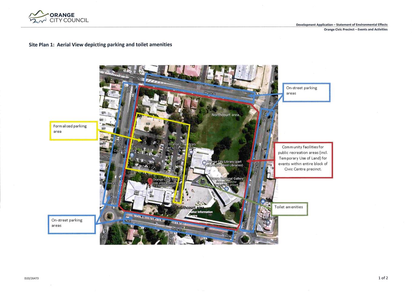
carried out in accordance with:
(a) Plans numbered: Site Plan 1, prepared
by Orange City Council, reference D20/26473 (1 sheet)
(b) statements
of environmental effects or other similar associated documents that form part
of the approval
as amended in
accordance with any conditions of this consent.
(2) All building work must
be carried out in accordance with the provisions of the Building Code of
Australia.
|
PRIOR TO ANY EVENT COMMENCING
|
(3) Prior
to any event, the event’s organiser shall prepare and submit an Events
Application to Council. The event shall be carried out in accordance with the
approved agreement.
(4) Prior to an event
commencing, adequate sanitary facilities must be in place to accommodate the
number of persons attending.
(5) Any proposed changes to
traffic arrangements for an event shall be approved by Orange City Council. The
events applicant/organiser shall submit a Traffic Management Plan and Traffic
Control Plan to Orange City Council and obtain approval prior to setting up any
event (see Events Form for further information). The approved Traffic
Management Plan and Traffic Control Plan shall be implemented in accordance
with the issued approval.
(6) Prior to any event
taking place within the area of the Flood Planning Level the events
applicant/organiser shall undertake a flood risk assessment of the event in
order to comply with the Blackmans Swamp Creek Floodplain Risk Management Plan.
The assessment shall ensure there are procedures in place to ensure that:
- there is no increase in
the risk of loss of life; and
- no increase in flood
affectation on adjoining development or properties likely to occur on the
floodplain; and
- reliable access is
available for the evacuation from the area.
(7) Any adjustments to
existing utility services that are made necessary by this development
proceeding are to be at the full cost of the developer.
(8) All
of the foregoing conditions are to be at the full cost of the developer and to
the requirements and standards of the Orange City Council Development and
Subdivision Code, unless specifically stated otherwise. All work required by
the foregoing conditions is to be completed prior to the issuing of an
Occupation Certificate, unless stated otherwise.
|
MATTERS FOR THE ONGOING PERFORMANCE AND
OPERATION OF THE DEVELOPMENT
|
(9) Any outdoor lighting
shall be in accordance with the Australian Standard 4282-1997 Control of the
obtrusive effects of outdoor lighting.
(10) The recreational uses
hereby approved can only be carried out on the RE1 zoned parts of the subject
site. Ancillary aspects of such events (e.g. administration, car parking, etc.)
may be carried out on the B4 zoned parts of the subject site.
(11) Events shall be carried
out in accordance with all other relevant approvals, including but not limited
to Council’s user/hire agreement for the event, Traffic Management Plan,
Traffic Control Plan, Liquor Licence, Section 68 approval, Food Permit,
Suspension of Alcohol Free Zone, etc.
(12) Temporary events (i.e.
those that do not fit within the definitions of ‘community
facility’, ‘entertainment facility’, ‘information and
education facility’, ‘markets’, and ‘recreation’
uses) are limited to a maximum of 52 days in any 12 month period.
(1) This consent does not
approve the erection of any structures and the likes, which must comply with
the relevant exempt provisions of State Environmental Planning Policy
(Exempt and Complying Development Codes) 2008, or separate development
consent is required.
Other
Approvals
(1) Local
Government Act 1993 approvals granted under Section 68.
Nil
(2) General
terms of other approvals integrated as part of this consent.
Nil
Right
of Appeal
If you are dissatisfied with this decision,
Section 8.7 of the Environmental Planning and Assessment Act 1979
gives you the right to appeal to the Land and Environment Court. Pursuant to
Section 8.10, an applicant may only appeal within 6 months after the date the
decision is notified.
|
Disability
Discrimination Act 1992:
|
This application has been assessed in
accordance with the Environmental Planning and Assessment Act 1979. No
guarantee is given that the proposal complies with the Disability Discrimination
Act 1992.
The
applicant/owner is responsible to ensure compliance with this and other
anti-discrimination legislation.
The
Disability Discrimination Act covers disabilities not catered for in
the minimum standards called up in the Building Code of Australia which
references AS1428.1 - "Design for Access and Mobility". AS1428
Parts 2, 3 and 4 provides the most comprehensive technical guidance under the
Disability Discrimination Act currently available in Australia.
|
|
|
|
|
Disclaimer
- S88B of the Conveyancing Act 1919 - Restrictions on the Use of
Land:
|
The applicant should note that there could be
covenants in favour of persons other than Council restricting what may be
built or done upon the subject land. The applicant is advised to check the position
before commencing any work.
|
|
|
|
|
Signed:
|
On behalf of the consent authority ORANGE
CITY COUNCIL
|
|
Signature:
|
|
|
Name:
|
PAUL JOHNSTON - MANAGER DEVELOPMENT
ASSESSMENTS
|
|
Date:
|
2 September 2020
|
Planning and Development Committee
1 September 2020
2.3 Development
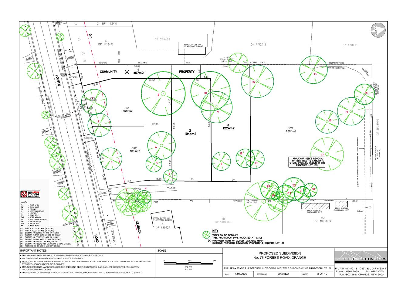
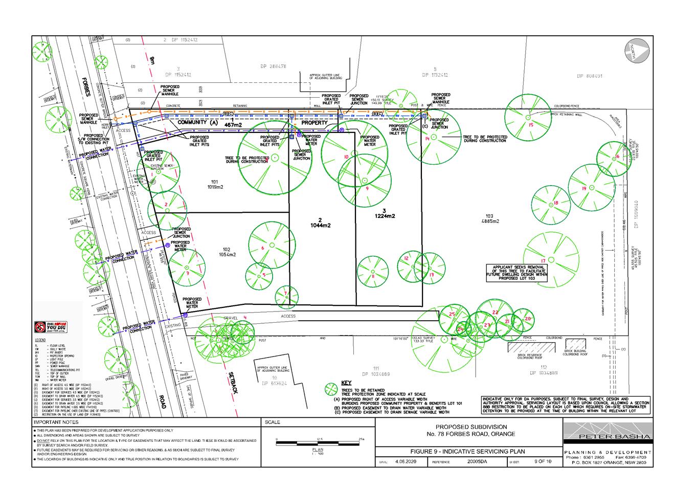
Application DA 221/2020(1) - 78 Forbes Road
RECORD
NUMBER: 2020/1457
AUTHOR: Rishelle
Kent, Senior Planner
EXECUTIVE
Summary
|
Application
lodged – Section 8.2A Review of Determination
|
17 June
2020
|
|
Applicant/s
|
Mr TM
and Mrs CJ Cranfield
|
|
Owner/s
|
Mr TM
and Mrs CJ Cranfield
|
|
Land
description
|
Lot 3 DP
1112473, Lot A DP 334156 -78 Forbes Road, Orange
|
|
Proposed
land use
|
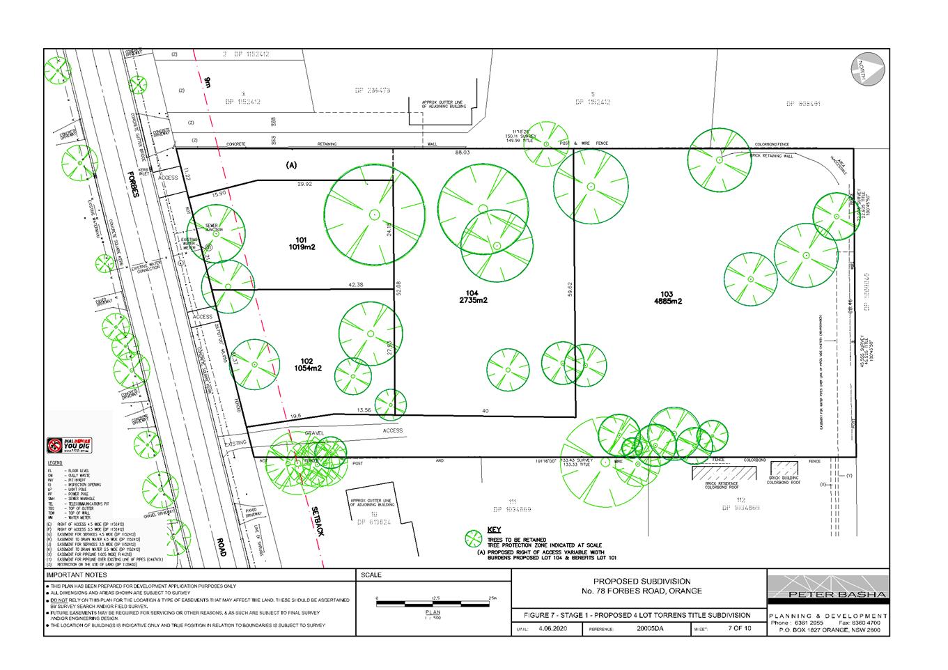
Demolition
(dwelling and tree removal) and Subdivision (four lot Torrens title and three
lot Community title)
|
|
Value of
proposed development
|
$150,000
|
Council's consent is sought for Demolition (dwelling and
tree removal) and Subdivision (four lot Torrens title and three lot
Community title) at 78 Forbes Road, Orange.
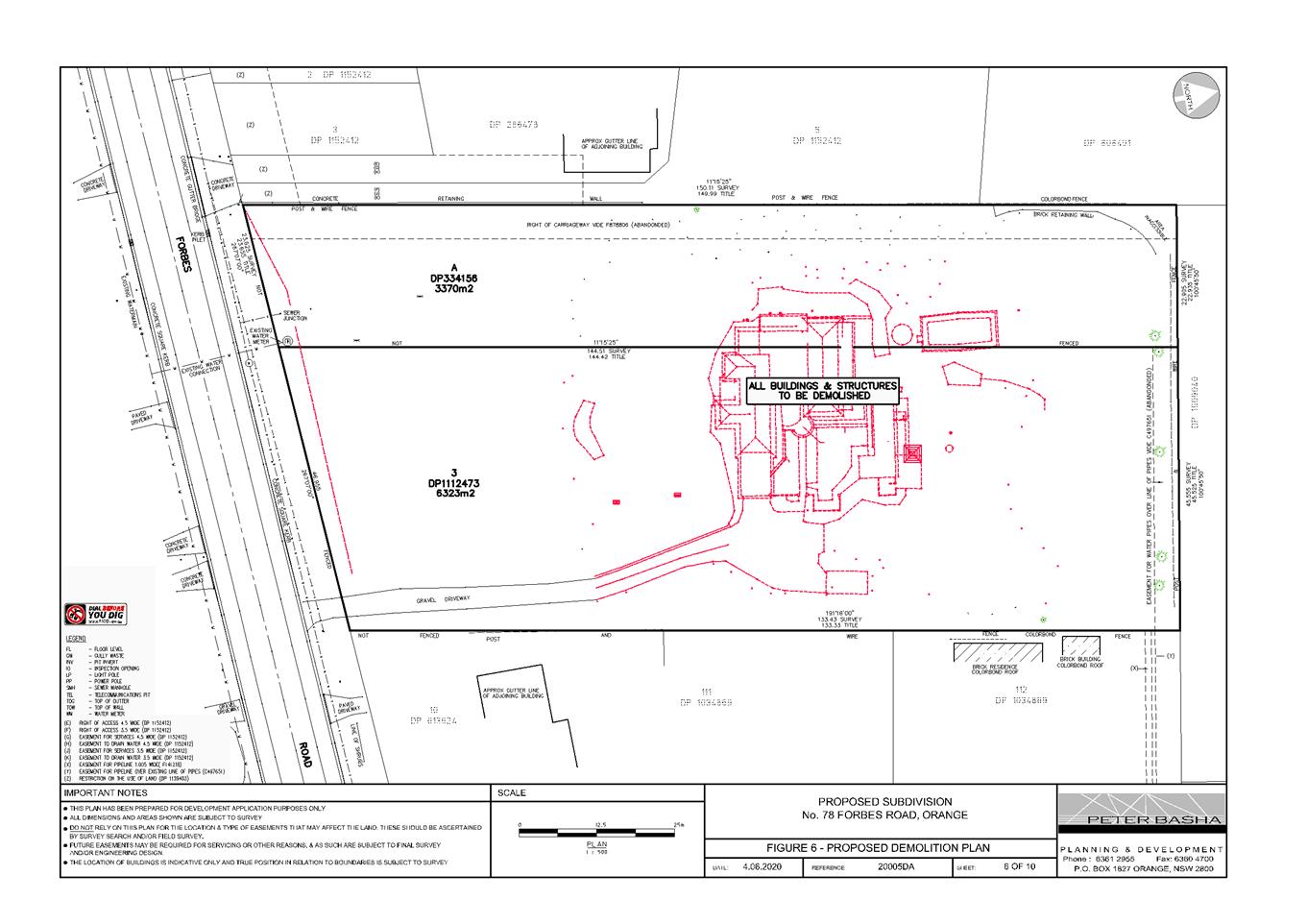
The proposal involves demolition of
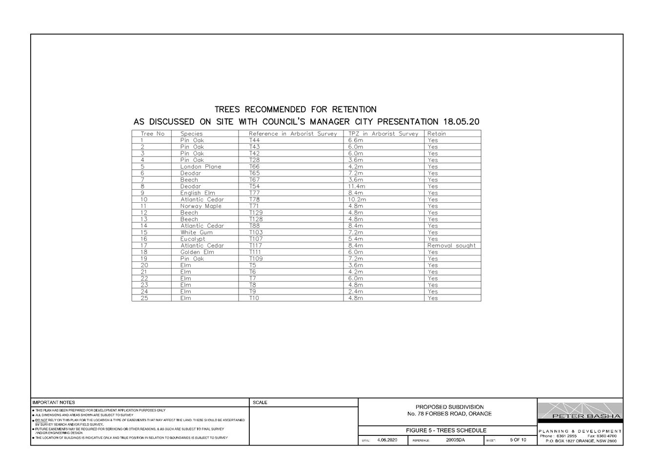
the existing dwelling, pool and ancillary structures, and removal of trees as
identified on the plan. Twenty four trees will be retained upon the site.
It is further proposed to carry out
a four lot Torrens title subdivision of the development lot, followed by a
three lot Community title subdivision of the middle allotment (Lot 104),
resulting in five residential allotments.
The proposal comprises advertised
development in accordance with Council’s Community Participation Plan
2019 (public interest). Public and written notice of the application was given.
Two submissions have been received, concerned with the removal of trees and the
resulting lack of privacy.
As outlined in this report, the
proposed development is considered to reasonably satisfy the Local and State
planning controls that apply to the subject land and particular land use.
Impacts of the development will be within acceptable limit, subject to
mitigation conditions. Approval of the application is recommended.
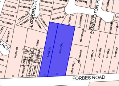
Figure 1 - locality plan
DECISION FRAMEWORK
Development in Orange is governed by two key documents
Orange Local Environment Plan 2011 and Orange Development Control Plan 2004.
Orange Local Environment Plan 2011 – The
provisions of the LEP must be considered by the Council in determining the
application. LEPs govern the types of development that are permissible or
prohibited in different parts of the City and also provide some assessment
criteria in specific circumstances. Uses are either permissible or not. The
objectives of each zoning and indeed the aims of the LEP itself are also to be
considered and can be used to guide decision making around appropriateness of development.
Orange Development Control Plan 2004 – the DCP
provides guidelines for development. In general it is a performance based
document rather than prescriptive in nature. For each planning element there
are often guidelines used. These guidelines indicate ways of achieving the
planning outcomes. It is thus recognised that there may also be other solutions
of merit. All design solutions are considered on merit by planning and building
staff. Applications should clearly demonstrate how the planning outcomes are
being met where alternative design solutions are proposed. The DCP enables
developers and architects to use design to achieve the planning outcomes in
alternative ways.
DIRECTOR’S COMMENT
The proposal involves demolition of
the existing dwelling, pool and ancillary structures, removal of trees as
identified on the plan and the subsequent 5 lot residential subdivision of the
land. Twenty four trees are proposed to be retained upon the site following the
completion of the development. Key issues addressed in the planning report
relate to tree removal/tree protection in order to facilitate the subdivision,
neighbourhood character and access. The proposed subdivision has been designed
in a manner to fit the character of the surrounding area. Council’s Senior
Planner and City Presentations Manager have worked closely with the applicant
in an attempt to retain as many of the more significant trees on the site. The
attached recommended Notice of Determination includes conditions that require
the protection of certain identified trees during and after the proposed
subdivision of the land. It is recommended that Council supports the subject
development.
Link To Delivery/OPerational Plan
The recommendation in this report relates to the
Delivery/Operational Plan strategy “10.1 Preserve - Engage with the
community to ensure plans for growth and development are respectful of our
heritage”.
Financial Implications
Nil
Policy and Governance Implications
Nil
|
Recommendation
That
Council consents to development application DA 221/2020(1) for Demolition (dwelling and tree removal) and
Subdivision (four lot Torrens title and three lot Community title) at Lot
3 DP 1112473, Lot A DP 334156 - 78 Forbes Road, Orange pursuant to the conditions of consent in the attached
Notice of Approval.
|
further considerations
Consideration has been given to the recommendation’s
impact on Council’s service delivery; image and reputation; political;
environmental; health and safety; employees; stakeholders and project
management; and no further implications or risks have been identified.
SUPPORTING INFORMATION
Council's consent is sought to
subdivide the land to create five residential allotments. Stage 1 involves
demolition of the dwelling and ancillary structures, removal of vegetation
(excepting the 24 trees as shown below), and carrying out a four lot Torrens
title subdivision. Stage 2 will consist of a three lot Community title
subdivision of Lot 104.
The residential allotments will vary at 1019m²,
1054m², 1044m², 1224m² and 4885m² in size, with an access
handle of 467m² along the western boundary (refer to Figure 2 below).
Access will be provided to the
site from Forbes Road via a Community Title access along the western boundary
serving Lots 101, 2 and 3, the existing gravel driveway along the eastern
boundary serving Lot 103 and direct access to Forbes Road for Lot 102.
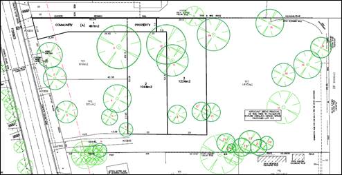
Figure 2 - locality plan
MATTERS FOR CONSIDERATION
Section 1.7 - Application of Part
7 of the Biodiversity Conservation Act 2016 and Part 7A of the Fisheries
Management Act 1994
Pursuant to Clause 1.7:
This Act has effect subject to
the provisions of Part 7 of the Biodiversity
Conservation Act 2016 and Part 7A of the Fisheries
Management Act 1994 that relate to the operation of
this Act in connection with the terrestrial and aquatic environment.
In consideration of this section,
the proposed development is not likely to significantly affect a threatened
species:
· The
subject and adjoining lands are not identified as biodiversity sensitive on the
Orange LEP 2011 Terrestrial Biodiversity Map.
· The
proposal does not involve clearing or disturbance of native vegetation;
clearing thresholds prescribed by regulation do not apply.
· The
site is contained within an established urban area and has been highly modified
by the urban landuse pattern. The subject land does not contain known
threatened species or ecological communities.
Based on the foregoing
consideration, a Biodiversity Assessment Report is not required and the
proposal suitably satisfies the relevant matters at Clause 1.7.
Section 4.15
Section 4.15 of the Environmental
Planning and Assessment Act 1979 requires Council to consider various
matters, of which those pertaining to the application are listed below.
PROVISIONS OF ANY ENVIRONMENTAL
PLANNING INSTRUMENT s4.15(1)(a)(i)
Orange Local Environmental Plan
2011
Clause 1.2 - Aims of Plan
The particular aims of the LEP relevant to the proposal
include:
(a) to
encourage development which complements and enhances the unique character of
Orange as a major regional centre boasting a diverse economy and offering an
attractive regional lifestyle,
(b) to
provide for a range of development opportunities that contribute to the social,
economic and environmental resources of Orange in a way that allows present and
future generations to meet their needs by implementing the principles for
ecologically sustainable development,
(e) to
provide a range of housing choices in planned urban and rural locations to meet
population growth,
(f) to
recognise and manage valued environmental heritage, landscape and scenic
features of Orange.
The proposed development is
considered to be consistent with the above listed aims, as outlined in the
following sections of this report.
Clause 1.6 - Consent Authority
This clause establishes that,
subject to the Act, Council is the consent authority for applications made
under the LEP.
Clause 1.7 - Mapping
The subject site is identified on the LEP maps in the
following manner:
|
Land
Zoning Map:
|
Land
zoned R1 General Residential
|
|
Lot
Size Map:
|
No
Minimum Lot Size
|
|
Heritage
Map:
|
Not
a heritage item or conservation area
|
|
Height
of Buildings Map:
|
No
building height limit
|
|
Floor
Space Ratio Map:
|
No
floor space limit
|
|
Terrestrial
Biodiversity Map:
|
No
biodiversity sensitivity on the site
|
|
Groundwater
Vulnerability Map:
|
Groundwater
vulnerable
|
|
Drinking
Water Catchment Map:
|
Not
within the drinking water catchment
|
|
Watercourse
Map:
|
Not
within or affecting a defined watercourse
|
|
Urban
Release Area Map:
|
Not
within an urban release area
|
|
Obstacle
Limitation Surface Map:
|
No
restriction on building siting or construction
|
|
Additional
Permitted Uses Map:
|
No
additional permitted use applies
|
|
Flood
Planning Map:
|
Not
within a flood planning area
|
Those matters that are of relevance
are addressed in detail in the body of this report.
Clause 1.9A - Suspension of
Covenants, Agreements and Instruments
This clause provides that covenants, agreements and other
instruments which seek to restrict the carrying out of development do not apply
with the following exceptions.
(a) to
a covenant imposed by the Council or that the Council requires to be imposed,
or
(b) to
any relevant instrument under Section 13.4 of the Crown Land Management Act
2016, or
(c) to
any conservation agreement under the National Parks and Wildlife Act 1974, or
(d) to
any Trust agreement under the Nature Conservation Trust Act 2001, or
(e) to
any property vegetation plan under the Native Vegetation Act 2003, or
(f) to
any biobanking agreement under Part 7A of the Threatened Species Conservation
Act 1995, or
(g) to
any planning agreement under Subdivision 2 of Division 7.1 of the Environmental
Planning and Assessment Act 1979.
Council staff are not aware of the title of the subject
property being affected by any of the above.
Part 2 - Permitted or Prohibited Development
Clause 2.1 Land Use Zones
The subject land is zoned R1 General
Residential.
The proposed
development is defined as “subdivision of land” and
“demolition”.
The proposal is
permitted with consent in the R1 General Residential zone.
Clause 2.3 Zone Objectives and Landuse
Table
The objectives of the R1 General
Residential zone are:
· To
provide for the housing needs of the community.
· To
provide for a variety of housing types and densities.
· To
enable other land uses that provide facilities or services to meet the day to
day needs of residents.
· To
ensure development is ordered in such a way as to maximise public transport
patronage and encourage walking and cycling in close proximity to settlement.
· To
ensure that development along the Southern Link Road has an alternative access.
The proposal will be consistent
with the relevant R1 zone objectives:
- the
proposed development will in future provide additional housing stock to
accommodate the housing needs of the community
- the
development will contribute to the variety of housing types and densities, and
complement the developed subdivision pattern
- the
proposal involves residential land use only
- the
area is serviced by public transport
- the
site does not have frontage or access to the Southern Link Road.
Clause 2.6 Subdivision - Consent
Requirements
Clause 2.6 is applicable and states:
(1) Land
to which this Plan applies may be subdivided but only with development consent.
Consent is sought for subdivision in accordance with this
clause.
Clause 2.7 - Demolition
Requires Development Consent
This clause triggers the need for development consent in
relation to a building or work.
The proposal involves demolition and the applicant is
seeking the consent of council. The demolition works proposed will have no
significant impact on adjoining lands, streetscape or public realm. Conditions
may be imposed in respect of hours of operation, dust suppression and the need
to investigate for, and appropriately manage the presence of, any materials containing
asbestos.
Part 7 - Additional Local Provisions
7.1 - Earthworks
This clause establishes a range of
matters that must be considered prior to granting development consent for any
application involving earthworks, such as:
(a) the likely disruption of, or any
detrimental effect on, existing drainage patterns and soil stability in the
locality of the development
(b) the effect of the development on the
likely future use or redevelopment of the land
(c) the quality of the fill or the soil to be
excavated, or both
(d) the effect of the development on the
existing and likely amenity of adjoining properties
(e) the source of any fill material and the
destination of any excavated material
(f) the likelihood of disturbing relics
(g) the proximity to and potential for adverse
impacts on any waterway, drinking water catchment or environmentally sensitive
area
(h) any measures proposed to minimise or
mitigate the impacts referred to in Paragraph (g).
In consideration of this clause, the
proposal is considered to be acceptable.
The site slopes towards Forbes Road,
with the existing dwelling situated on a slight rise. Due to the
relatively gentle terrain, the subdivision will not require significant
earthworks.
Conditional drainage
infrastructure will be provided within the development to ensure earthworks and
finished levels will not impact on adjoining properties or receiving waterways.
The site is not known
to be contaminated, nor is the site known to contain any Aboriginal, European
or archaeological relics. The site is not in proximity to any waterway,
drinking water catchment or sensitive area. Conditional sediment controls will
be implemented onsite during construction.
7.3 - Stormwater Management
This clause applies
to all industrial, commercial and residential zones and requires that Council
be satisfied that the proposal:
(a) is designed to maximise the use of water
permeable surfaces on the land having regard to the soil characteristics
affecting onsite infiltration of water
(b) includes, where practical, onsite
stormwater retention for use as an alternative supply to mains water,
groundwater or river water; and
(c) avoids any significant impacts of
stormwater runoff on adjoining downstream properties, native bushland and
receiving waters, or if that impact cannot be reasonably avoided, minimises and
mitigates the impact.
The proposal has been designed to
include permeable surfaces and will require stormwater detention within the
development. It is therefore considered that the post-development runoff levels
will not exceed the predevelopment levels.
Clause 7.6 Groundwater
Vulnerability
The subject land is identified as
‘Groundwater Vulnerable’ on the Groundwater Vulnerability Map.
Clause 7.6 applies. This clause states in part:
(3) Before
determining a development application for development on land to which this
clause applies, the consent authority must consider:
(a) whether or not the development (including
any onsite storage or disposal of solid or liquid waste and chemicals) is
likely to cause any groundwater contamination or have any adverse effect on
groundwater dependent ecosystems, and
(b) the cumulative impact (including the
impact on nearby groundwater extraction for potable water supply or stock water
supply) of the development and any other existing development on groundwater.
In consideration of
Clause 7.6, there are no aspects of the proposed residential development that
will impact on groundwater and related ecosystems.
Clause 7.11 - Essential
Services
Clause 7.11 applies and states:
Development consent must not be
granted to development unless the consent authority is satisfied that any of
the following services that are essential for the proposed development are
available or that adequate arrangements have been made to make them available when
required:
(a) the
supply of water,
(b) the
supply of electricity,
(c) the
disposal and management of sewage,
(d) storm
water drainage or onsite conservation,
(e) suitable
road access.
In
consideration of this clause, the listed utility services are available to the
land and adequate for the proposal. Conditions
are included on the attached Notice of Approval requiring extension,
augmentation and/or upgrading of urban utility services to the standards
required to service the proposed lots.
In relation to waste management, it is
Council’s practice to require a waste storage facility/bin bay be
provided onsite for multi dwelling housing (three plus dwellings). While the
proposal involves subdivision for five allotments, it is proposed there is
sufficient street frontage for proposed Lot 1 to allow bins from Lots 2 and 3
to stand on collection days without unreasonable encroachment upon the frontage
of adjacent properties.
Similarly, mail boxes will be provided
at the street frontage of Lots 101, 102 and 103, with sufficient frontage in
Lot 1 to accommodate mailboxes for proposed Lots 2 and 3. These matters will be
further addressed with future applications.
STATE ENVIRONMENTAL PLANNING POLICIES
State Environmental Planning
Policy 55 Remediation of Land
State Environmental Planning
Policy 55 - Remediation of Land (SEPP 55) is applicable. Pursuant to Clause
7 Contamination and remediation to be considered in determining development
application:
(1) A
consent authority must not consent to the carrying out of any development on
land unless:
(a) it
has considered whether the land is contaminated, and
(b) if
the land is contaminated, it is satisfied that the land is suitable in its
contaminated state (or will be suitable, after remediation) for the purpose for
which the development is proposed to be carried out, and
(c) if
the land requires remediation to be made suitable for the purpose for which the
development is proposed to be carried out, it is satisfied that the land will
be remediated before the land is used for that purpose.
The subject land has a long history of
being used for residential development. A site inspection confirms that there
are no obvious signs of contamination on the land. Council’s
Environmental Health and Building Surveyor has recommended soil sampling for
chemical residue be undertaken prior to subdivision release to ensure the land
is suitable for residential use.
State Environmental Planning Policy –
Infrastructure
State Environmental Planning Policy
– Infrastructure is
applicable to the development. Clause 101 of the SEPP relates to development
having frontage to a classified Road. Forbes Road is defined as a
classified road for the purposes of this assessment. Council in determining
this application is required to be satisfied of the following:
(a) where
practicable and safe, vehicular access to the land is provided by a road other
than the classified road, and
(b) the
safety, efficiency and ongoing operation of the classified road will not be
adversely affected by the development as a result of -
(i) the
design of the vehicular access to the land, or
(ii) the
emission of smoke or dust from the development, or
(iii) the
nature, volume or frequency of vehicles using the classified road to gain
access to the land, and
(c) the
development is of a type that is not sensitive to traffic noise or vehicle
emissions, or is appropriately located and designed, or includes measures, to
ameliorate potential traffic noise or vehicle emissions within the site of the
development arising from the adjacent classified road.
Council’s Technical Services
Department have evaluated the subject development against the above criteria
contained within SEPP Infrastructure and have indicated no objections to the
proposed subdivision. Recommended conditions of consent have been included on
the draft Notice of Determination to address access issues.
PROVISIONS OF ANY DRAFT
ENVIRONMENTAL PLANNING INSTRUMENT THAT HAS BEEN PLACED ON EXHIBITION
4.15(1)(a)(ii)
Draft Orange Local Environmental Plan 2011 (Amendments
24 to 27)
Draft Orange LEP 2011 Amendment 24 to 27 has either
completed public exhibition or currently on exhibition. Amendment 24 involves
various administration amendments to the LEP including updated maps; and new
and amended clauses. Amendment 25 relates to 1 Leewood Drive. Amendment 26
relates to the Bloomfield Hospital site. Amendment 27 concerns 185 Leeds
Parade. The proposed development will not be contrary to any matter contained
in the draft Plans.
Draft Remediation of Land State Environmental Planning
Policy
Draft Remediation of Land SEPP is applicable. The Draft SEPP
requires in part that consideration be given to potential contamination on
nearby or neighbouring properties and groundwater. The contamination status of
adjoining residential lands will not impact on the proposed development.
DESIGNATED DEVELOPMENT
The proposed development is not designated development.
INTEGRATED DEVELOPMENT
The proposed development is not integrated development.
PROVISIONS OF ANY DEVELOPMENT
CONTROL PLAN s4.15(1)(a)(iii)
Development Control Plan 2004
The following parts of DCP 2004 are
applicable to the proposed development:
· Part 0
– Tree Preservation
· Part 2
- Natural Resource Management
· Part 3
- General Considerations
· Part 4
- Special Environmental Considerations
· Part 5
- General Considerations for Zones and Development
· Part 7
– Development in Residential Zones.
The relevant matters in Parts 2, 3 and 4 were considered in
the foregoing assessment under Orange LEP 2011.
The relevant matters in Part 5 are addressed below (refer Any
Submissions).
The proposal will reasonably satisfy
the relevant planning outcomes in Part 0 and 7 as outlined in the following
assessment.
DCP 2004-0 Tree Preservation
DCP 2004 – 0.4-2 prescribes
the following Interim Planning Outcomes for Tree Preservation:
1 Trees
prescribed by this DCP must not be ringbarked, cut down, topped, lopped or
wilfully destroyed without the Council’s approval and landowner’s
consent.
2 This
clause applies to Eucalypts of any size belonging to the White Box, Yellow Box
and Blakely’s Red Gum Endangered Ecological Communities, including
species indicated as affected in the tree preservation table.
3 This
clause applies to any tree, native or exotic, with a trunk diameter equal to or
greater than 300mm at breast height.
4 This
clause does not apply to species indicated as exempt in the tree preservation
table.
5 An
application for the Council’s approval must be accompanied by an
appropriately qualified specialist (arborist) report.
In consideration of the planning outcomes, the proposal was
referred to Council’s Manager City Presentation for consideration and
comment. He advises:
I would have to say Peter has
sought to retain as many structurally well-formed and healthy trees as could be
reasonably expected when the aim of this proposal is to undertake infill
development. I can concede the loss of Tree 17 Atlantic Cedar (T117) as identified
in the submitted drawings.
· The approval
should identify that building envelopes are as per Figure 10 – Conceptual
Layout plan only drawn 4 June 2020. With a building envelope provided for Lot
103.
· Tree protection
zones shall be established prior to site occupancy for demolition works as per
Figure 5 – Tree Schedule and in accordance with AS4970-2009 Protection of
trees on development sites.
· Hard surfaces
to be constructed within the TPZ of trees identified in the Tree Schedule
(Figure 5) shall be of a porous/permeable material.
In response to the above, it is
considered more appropriate to establish Tree Protection Zones via an 88B
instrument to ensure the viability of the remaining trees, rather than
prescriptive building envelopes based on indicative footprints on vacant
residential allotments. The provision of a building envelope was considered to
be excessively restrictive in this case. As such, the following condition has
been drafted in consultation with Council’s Manager City Presentation,
and will be applied to the consent:
A Restriction as to User under
Section 88B of the NSW Conveyancing Act 1919 shall be created on the title of
Lots 101, 102, 103 and 104, to advise that the trees identified as being
retained in Figures 4 and 5 are subject to Tree Protection Zones in accordance
with the requirements of AS4970 – 2009. The 88B instrument shall require:
· Buildings
shall not be constructed within the Structural Root Zone.
· Where
buildings are to be constructed within 10% the Tree Protection Zone, an
arborist report must be submitted outlining the potential impacts of the
encroachments and actions to mitigate loss of tree health and vigour in
accordance with AS4970-2009.
· Where
buildings are to be constructed with an encroachment of greater than 10% within
the Tree Protection Zone, an arborist report with detailed investigations must
be submitted demonstrating that the tree will remain viable in accordance with
AS4970-2009.
· Vehicle
access requirements within the Tree Protection Zone shall be either suspended
above the existing ground surface with pier holes hand excavated or excavated
using vacuum trenching technology from outside the Structural Root Zone or the
use of permeable pavements constructed above natural ground level.
· No
roots shall be severed and piers shall be located as required to maintain the
integrity of all structural roots.
· Hard
surfaces to be constructed within the TPZ of trees identified in the
Tree Schedule (Figures 4 and 5) shall be of a porous/permeable material.
DCP 2004-7.2 Residential
Subdivision
The DCP sets the following (applicable) Planning Outcomes in
regard to urban residential subdivision:
· lots
below 500m2 indicate a mandatory side setback to provide for solar
access and privacy
· lots
are fully serviced and have direct frontage and access to a public road
· design
and construction complies with the Orange Development and Subdivision Code.
· Battleaxe
lots provide an adequate accessway width for the number of dwellings proposed
to be served in order to allow for vehicle and pedestrian access and location
of services.
The proposal will satisfy the above planning outcomes as
follows:
- All
of the proposed lots are defined as Standard Lots (>500m2).
Indicative building footprints demonstrate dwellings of suitable area,
dimensions and orientation to provide a reasonable standard of residential
amenity.
- Proposed
Lot 102 will have access and frontage to Forbes Road. A shared driveway will be
constructed and reciprocal access rights created to serve Lots 101, 2 and
3 along the western boundary of the development lot. Lot 103 will maintain
the existing gravel driveway along the eastern boundary. Access widths are
considered appropriate.
- The
proposed development will be connected to urban utility services.
The subdivision design and construction will comply with the Orange
Development and Subdivision Code, as required by conditions.
- To
ensure suitable setbacks to Forbes Road for future residential development a
Section 88B Restriction on the title of Proposed lots 101 and 102 requiring a
9m setback is recommended. Condition attached.
DEVELOPMENT CONTRIBUTIONS
Section 7.11 Development
Contributions & Section 64 Headworks Charges
Development contributions are
applicable to the proposed development, pursuant to Orange Development
Contributions Plan 2017 (Rest of Orange).
The development lot currently
consists of two allotments. The following contributions are based on the net
residential increase of three additional lots, as follows:
|
Open
Space and Recreation
|
Three
additional lots at 4,042.03
|
12,126.09
|
|
Community
and Cultural
|
Three additional lots at 1,172.18
|
3,516.54
|
|
Roads
and Traffic Management
|
Three additional lots at 5,335.34
|
16,006.02
|
|
Plan
Preparation & Administration
|
Three additional lots at 316.49
|
949.47
|
|
TOTAL:
|
|
$32,598.12
|
Headworks charges will also apply to the proposal. The
contributions are based on three additional ET’s for water supply
and sewerage services.
Conditions are included on the
attached Notice of Approval requiring payment of development contributions.
PROVISIONS PRESCRIBED BY THE
REGULATIONS s4.15(1)(a)(iv)
Demolition of a Building (clause
92)
The proposal involves the
demolition of the dwelling, pool and ancillary structures. A condition is
attached requiring the demolition to be carried out in accordance with Australian
Standard AS2601 - 2001: The Demolition of Structures and the requirements
of Safe Work NSW.
Fire Safety Considerations (clause 93)
The proposal does not involve a
change of building use for an existing building.
Buildings to be Upgraded (clause 94)
The proposal does not involve the
rebuilding, alteration, enlargement or extension of an existing building.
THE LIKELY IMPACTS OF THE
DEVELOPMENT S4.15(1)(B)
Visual Impacts
The proposal will alter the
landscape setting of the site and streetscape. Notwithstanding, tree removal is
warranted in order to enable infill development. A total of 24 trees will be
retained upon the site to preserve the tree canopy of the locality, with a
condition of consent and an 88B instrument required to ensure their protection
against future development.
Environmental Impacts
The subject property is unlikely to
have any biodiversity or habitat value due to the use of the site for
residential purposes in an urban area. Inspections by Council staff did not
indicate any habitat within the subject trees to be removed. The proposal will
not impact on groundwater or stormwater. As such, the proposal is unlikely to
have adverse impacts on the environment.
Construction
In order to minimise construction
impacts on the residential setting, conditions are included on the attached
Notice of Approval requiring demolition work be carried out within prescribed
hours of operation.
Residential amenity
The proposed subdivision offers
lots of suitable sizing to facilitate large dwellings with ample opportunity
for solar access, privacy, landscaping and the like.
Traffic matters
The provisions of the Infrastructure
SEPP requires the consent authority to be satisfied of certain traffic
assessment criteria (see SEPP Infrastructure assessment above) prior to
determination. The provisions of the SEPP do not specifically require formal
referral of this type of application to TfNSW. Council’s Technical
Services Department have advised that they are satisfied Forbes Road has adequate capacity for
the traffic generation expected as a result of this proposal (following the
construction of dwellings) and that the site has suitable access to Forbes
Road, with adequate areas for onsite access, parking and manoeuvring subject to
suitable building footprints.
Traffic impacts are anticipated to
therefore be acceptable.
The suitability of the site s4.15(1)(c)
The subject land is considered to
be suitable for the proposed development due to the following:
· The
proposal is permitted on the subject land.
· Utility
services are available and adequate.
· The
land has suitable road access.
· The
local road network is of sufficient capacity to support the proposal.
· The
land is not subject to known technological or natural hazards.
· The
site has no particular environmental or conservation values.
ANY SUBMISSIONS MADE IN
ACCORDANCE WITH THE ACT S4.15(1)(D)
The proposed development is defined
as "advertised development" pursuant to Council’s Community
Participation Plan 2019 (public interest). Written and public notice of the
application was given for the prescribed period. At the end of that period, two
submissions were received, with the following concerns:
· ‘..listing
24-25 trees for retention seems somewhat disingenuous. Once the lots are sold
off, there is no measure in place which would protect these trees at later
dates from future owners/builders. (The site) continues to significantly
contribute to limiting the urban heat island effect in the area, provides
feeding and nesting site for fauna.. Are tree protection measures enforceable?’
A condition of consent will ensure the retention of the
nominated trees. Furthermore, an additional condition of consent requires an
88B instrument to ensure future landowners are notified of the requirements
associated with development within proximity to these trees, such as no
building within the structural root zones, and the need for an arborist report
when developing within the tree protection zone.
Tree protection matters are
enforceable. Works undertaken in contravention to the conditions may be in
breach of the Environmental Planning and Assessment Act 1979 and
therefore subject to Council’s Enforcement Policy.
Habitat for fauna is discussed
below.
· ‘We
need to be limiting infill development outside of the CBD’.
The subject site is not limited by a minimum lot size
pursuant to the LEP 2011, and is therefore compliant with density provisions.
· ‘The
visual amenity and privacy of our outdoor space will be negatively
impacted’.
It is agreed that visual privacy will be detrimentally
impacted given the existing post and wire fence presently erected. The
development will be required to erect a 1.8m high solid fence to ensure privacy
for all adjoining neighbours, a condition has been attached to this effect.
With regard to amenity of neighbouring allotments, views
into neighbouring allotments are not protected by Case Law, and thus Council is
not in a position to maintain this view corridor. Additionally, there is
nothing to stop the landowner from erecting a solid screen fence for their own
visual privacy, regardless of this application before Council.
·
‘Tree removal will impact on bird life and amenity’.
Evidence to support this statement has not been received.
The retention of 24 trees upon the site is recommended by Council’s City
Presentation Manager.
· “We
would like to point out that any future proposed multi-unit development would
not be in alignment with the current estimated traffic movements’.
It is acknowledged that the proposal shows indicative single
dwellings, and given the R1 zoning of the site a higher density of
residential development may eventuate. An increase in traffic movements
would be assessed at the time that development is proposed for the site.
PUBLIC INTEREST
s4.15(1)(e)
The site has previously garnered a
lot of interest in the past with contentious land use proposals, therefore it
was considered in the best interest of the public to notify of the proposed
development. As a result of the exhibition period, it can now be considered
that the development is of minor interest to the wider public due to the
relatively localised nature of potential impacts. The proposal is not
inconsistent with any relevant policy statements, planning studies, guidelines
etc that have not been considered in this assessment.
SUMMARY
The proposed development is
permissible with the consent of Council. The proposed development complies with
the relevant aims, objectives and provisions of Orange LEP 2011 (as amended)
and DCP 2004. A Section 4.15 assessment of the development indicates that
the development is acceptable in this instance. Attached is a draft Notice of
Approval outlining a range of conditions considered appropriate to ensure that
the development proceeds in an acceptable manner.
COMMENTS
The requirements of the Environmental Health and Building
Surveyor and the Engineering Development Section are included in the attached
Notice of Approval.
Attachments
1 Notice
of Approval, D20/48935⇩
2 Plans,
D20/48984⇩
3 Submissions,
D20/49024⇩
Planning
and Development Committee
1 September 2020
Attachment 1 Notice
of Approval
|

|
ORANGE CITY COUNCIL
Development
Application No DA
221/2020(1)
NA20/ Container
PR22379
|
NOTICE OF DETERMINATION
OF A DEVELOPMENT
APPLICATION
issued under the Environmental
Planning and Assessment Act 1979
Section 4.18
|
Development
Application
|
|
|
Applicant
Name:
|
Mr TM and Mrs CJ
Cranfield
|
|
Applicant
Address:
|
C/- Peter Basha
Planning & Development
PO Box 1827
ORANGE NSW 2800
|
|
Owner’s
Name:
|
Mr TM and Mrs CJ
Cranfield
|
|
Land
to Be Developed:
|
Lot 3 DP 1112473, Lot
A DP 334156 - 78 Forbes Road, Orange
|
|
Proposed
Development:
|
Demolition (dwelling
and tree removal) and Subdivision (four lot Torrens title and three lot
Community title)
|
|
|
|
|
Building Code of
Australia
building
classification:
|
Not applicable
|
|
|
|
|
Determination made
under
Section 4.16
|
|
|
Made
On:
|
1 September 2020
|
|
Determination:
|
CONSENT GRANTED
SUBJECT TO CONDITIONS DESCRIBED BELOW:
|
|
|
|
|
Consent to Operate
From:
|
2 September 2020
|
|
Consent to Lapse On:
|
2 September 2025
|
Terms
of Approval
The reasons for the imposition of conditions
are:
(1) To ensure a quality
urban design for the development which complements the surrounding environment.
(2) To maintain
neighbourhood amenity and character.
(3) To ensure compliance
with relevant statutory requirements.
(4) To provide adequate
public health and safety measures.
(5) Because the development
will require the provision of, or increase the demand for, public amenities and
services.
(6) To ensure the utility
services are available to the site and adequate for the development.
(7) To prevent the proposed
development having a detrimental effect on adjoining land uses.
(8) To minimise the impact
of development on the environment.
Conditions
(1) The development must be
carried out in accordance with:
(a) Plans numbered Peter Basha Planning
and Development Reference 20005DA Figures 4 to 9 inclusive (6 sheets)
(b) statements
of environmental effects or other similar associated documents that form part
of the approval
as amended in
accordance with any conditions of this consent.
(2) All building work must
be carried out in accordance with the provisions of the Building Code of
Australia.
STAGE 1 - FOUR LOT TORRENS TITLE
SUBDIVISION AND DEMOLITION
|
PRIOR TO THE ISSUE OF A CONSTRUCTION
CERTIFICATE
|
(3) The applicant is to
submit a waste management plan that describes the nature of wastes to be
removed, the wastes to be recycled and the destination of all wastes. All
wastes from the demolition and construction phases of this project are to be
deposited at a licensed or approved waste disposal site.
(4) Engineering plans,
showing details of all proposed work and adhering to any engineering conditions
of development consent, are to be submitted to, and approved by, Orange City
Council or an Accredited Certifier (Categories B1, C3, C4, C6) prior to the
issuing of a Construction Certificate.
(5) A water and soil
erosion control plan is to be submitted to Orange City Council or an Accredited
Certifier (Categories B1, C3, C4, C6) for approval prior to the issuing of a
Construction Certificate. The control plan is to be in accordance with the
Orange City Council Development and Subdivision Code and the Landcom, Managing
Urban Stormwater; Soils and Construction Handbook.
(6) The development’s
stormwater design is to include stormwater detention within the development,
designed to limit peak outflows from the land to the pre-existing natural
outflows up to the 100 year ARI frequency, with sufficient allowance in
overflow spillway design capacity to safely pass flows of lower frequency (that
is, a rarer event) without damage to downstream developments. Where
appropriate, the spillway design capacity is to be determined in accordance
with the requirements of the Dam Safety Committee.
The design of the detention storage is to be
undertaken using the ILSAX/DRAINS rainfall-runoff hydrologic model or an
approved equivalent capable of assessing runoff volumes and their temporal
distribution as well as peak flow rates. The model is to be used to calculate
the flow rates for the existing and post-development conditions. The developed
flows are to be routed through the proposed storage within the model so that
the outflows obtained are no greater than the flows obtained for the
pre-existing natural flows. A report detailing the results of the analysis,
which includes:
· catchment plan showing
sub-catchments under existing and developed conditions;
· schematic diagram of
the catchment model showing sub areas and linkages;
· tabulation detailing
the elevation, storage volume and discharge relationships; and
· tabulation for the
range of frequencies analysed, the inflows, outflows and peak storage levels
for both existing and developed conditions;
together with copies of the data files for the
model and engineering design plans of the required drainage system are to be
submitted to Orange City Council upon application for a Construction
Certificate.
Impervious areas for stormwater detention
design calculations shall be based on all residential lots in stages 1 and 2
being fully developed including access driveways.
(7) Proposed Lot 103 shall
have a 3.0m wide concrete footpath crossing and 104 shall have a 5.5m wide
concrete footpath crossing constructed for vehicle access to each lot.
Engineering plans providing complete details of the footpath crossings are to
be submitted to Orange City Council or an Accredited Certifier (Categories B1,
C3, C4, C6) upon application for a Construction Certificate. These plans are to
provide details of levels, cross falls of all pavements, proposed sealing
materials and proposed drainage works and are to be in accordance with Orange
City Council Development and Subdivision Code and Road Opening Permit.
(8) Proposed lots 101 to
104 are to be provided with interlot stormwater drainage, including those lots
abutting public land, where the surface of the entire lot cannot be drained to
the kerb and gutter at the lot frontage. A grated concrete stormwater pit is to
be constructed within each lot provided with interlot stormwater drainage.
Engineering plans for this drainage system are to be approved by Orange City
Council or an Accredited Certifier (Categories B1, C3, C4, C6) prior to the
issuing of a Construction Certificate.
(9) A 150mm-diameter sewer
main shall be constructed from Council’s existing main in Forbes Road to
serve the proposed lots. Prior to a Construction Certificate being issued
engineering plans for this sewerage system are to be submitted to and approved
by Orange City Council.
(10) A
Road Opening Permit in accordance with Section 138 of the Roads Act 1993
must be approved by Council prior to a Construction Certificate being issued
or any intrusive works being carried out within the public road or footpath
reserve.
|
PRIOR TO WORKS COMMENCING
|
(11) Where any existing
fencing at the perimeter of the site needs to be removed, or is of a type which
does not ensure the occupants of any adjoining residence adequate privacy, new
fencing shall be erected prior to any building or construction work being carried
out upon this development. In this regard, 1.8m high solid screen fencing shall
be erected on the rear (northern) and side (eastern and western) boundaries up
to the 9m front setback.
(12) Tree protection zones
shall be established prior to site occupancy for demolition and construction
works as per approved plans - Figures 4 and 5 – Tree Schedule and in
accordance with AS4970-2009 Protection of trees on development sites.
(13) Soil
erosion control measures shall be implemented on the site.
(14) An
application for a Subdivision Works Certificate is required to be submitted to,
and a Certificate issued by Council/Accredited Certifier prior to any
excavation or works being carried out onsite.
|
DURING CONSTRUCTION/SITEWORKS
|
(15) All
construction/demolition work on the site is to be carried out between the hours
of 7.00 am and 6.00 pm Monday to Friday inclusive, 7.00 am to
5.00 pm Saturdays and 8.00 am to 5.00 pm Sundays and Public
Holidays. Written approval must be obtained from the General Manager of Orange
City Council to vary these hours.
(16) All materials on site
or being delivered to the site are to be contained within the site. The
requirements of the Protection of the Environment Operations Act 1997
are to be complied with when placing/stockpiling loose material or when
disposing of waste products or during any other activities likely to pollute
drains or watercourses.
(17) Building demolition is
to be carried out in accordance with Australian Standard 2601:2001 - The Demolition
of Structures and the requirements of Safe Work NSW.
(18) Asbestos containing
building materials must be removed in accordance with the provisions of the Work
Health and Safety Act 2011 and any guidelines or Codes of Practice
published by Safe Work NSW, and disposed of at a licenced landfill in
accordance with the requirements of the NSW EPA.
(19) Any adjustments to
existing utility services that are made necessary by this development
proceeding are to be at the full cost of the developer.
(20) The provisions and
requirements of the Orange City Council Development and Subdivision Code are to
be applied to this application and all work constructed within the development
is to be in accordance with that Code.
The developer is to be entirely responsible for
the provision of water, sewerage and drainage facilities capable of servicing
all the lots from Council’s existing infrastructure. The developer is to
be responsible for gaining access over adjoining land for services where
necessary and easements are to be created about all water, sewer and drainage
mains within and outside the lots they serve.
(21) Heavy-duty concrete
footpath crossings are to be constructed in the positions shown on the plan
submitted with the Construction Certificate application. The works are to be
carried out to the requirements of the Orange City Council Development and
Subdivision Code and Road Opening Permit.
(22) A water service and
sewer junction is to be provided to every lot in the proposed residential
subdivision in accordance with the Orange City Council Development and
Subdivision Code.
(23) The water and sewerage
services to the existing building, where they are not proposed to be used as
part of this development, are to be sealed off at their respective Council mains.
(24) All services are to be
contained within the allotment that they serve.
(25) A concrete footpath, a
minimum of 1.2 metres wide, shall be constructed for the full frontage of the
development on Forbes Road.
Construction work is to be to the requirements
and standards of the Orange City Council Development and Subdivision Code.
|
PRIOR TO THE ISSUE OF A SUBDIVISION
CERTIFICATE
|
(26) A
Restriction as to User under Section 88B of the NSW Conveyancing Act 1919 shall
be created on the title of Lots 101, 102, 103 and 104, to advise that the trees
identified as being retained in Figures 4 and 5 of the approved plans are
subject to Tree Protection Zones in accordance with the requirements of AS4970
– 2009. The 88B instrument shall require:
· Buildings shall not be
constructed within the Structural Root Zone.
· Where buildings or any
works/services are to be constructed within 10% of the Tree Protection Zone, an
arborist report must be submitted to Council for approval outlining the
potential impacts of the encroachments and actions to mitigate loss of tree
health and vigour in accordance with AS4970-2009.
· Where buildings are to
be constructed with an encroachment of greater than 10% within the Tree
Protection Zone, an arborist report with detailed investigations must be
submitted to Council for approval demonstrating that the tree will remain
viable in accordance with AS4970-2009.
· Vehicle access
requirements within the Tree Protection Zone shall be either suspended above
the existing ground surface with pier holes hand excavated or excavated using
vacuum trenching technology from outside the Structural Root Zone or the use of
permeable pavements constructed above natural ground level.
· No roots shall be
severed and piers shall be located as required to maintain the integrity of all
structural roots.
· Hard surfaces to be
constructed within the TPZ of trees identified in the Tree Schedule (Figures 4
and 5 of the approved plans) shall be of a porous / permeable material.
(27) The payment of $21,732.08 is to be made to
Council in accordance with section 94 of the Act and the Orange Development
Contributions Plan 2017 (rest of Orange) towards the provision of the following
public facilities:
|
Open Space and
Recreation
|
@ 4,042.03 x two
additional lots
|
8,084.06
|
|
Community and
Cultural
|
@ 1,172.18 x two
additional lots
|
2,344.36
|
|
Roads and Traffic
Management Facilities
|
@ 5,335.34 x two
additional lots
|
10,670.68
|
|
Plan Preparation
& Administration
|
@ 316.49 x two
additional lots
|
632.98
|
|
TOTAL:
|
|
$21,732.08
|
The contribution will be indexed quarterly in
accordance with the Orange Development Contributions Plan 2017 (rest of
Orange). This Plan can be inspected at the Orange Civic Centre, Byng
Street, Orange.
(28) Soil sampling for
analysing chemical residue is to be carried out within the proposed Lots in a
manner and frequency as determined by an appropriately qualified and
experienced consultant giving consideration to previous specific uses and
on-site characteristics of the site. A NATA registered laboratory is to
carry out such testing. Reference is to be made to the Contaminated Land
Management Act 1997 and State Environmental Planning Policy No 55 -
“Remediation of Land”. The results of the testing are to be
provided to the Principal Certifying Authority and are to demonstrate that the
land is suitable for residential use, to enable a Subdivision Certificate to be
issued.
(29) Application
shall be made for a Subdivision Certificate under Section 6.3(1)(d) of the Act.
(30) Payment
of contributions for water, sewer and drainage works is required to be made
at the contribution rate applicable at the time that the payment is made.
The contributions are based on 3 ETs for water supply headworks and 3 ETs for
sewerage headworks. A Certificate of Compliance, from Orange City Council
in accordance with the Water Management Act 2000, will be issued upon
payment of the contributions.
This Certificate of Compliance is to be
submitted to the Principal Certifying Authority prior to the issuing of a
Subdivision Certificate.
(31) Application is to be
made to Telstra/NBN for infrastructure to be made available to each individual
lot within the development. Either a Telecommunications Infrastructure
Provisioning Confirmation or Certificate of Practical Completion is to be submitted
to the Principal Certifying Authority confirming that the specified lots have
been declared ready for service prior to the issue of a Subdivision
Certificate.
(32) A Notice of Arrangement
from Essential Energy stating arrangements have been made for the provision of
electricity supply to the development, is to be submitted to the Principal
Certifying Authority prior to the issue of a Subdivision Certificate.
(33) A
Restriction-as-to-User under section 88B of the NSW Conveyancing Act
1919 is to be registered on the Deed of Title of proposed Lot 101 where
vehicular access is to be denied to Forbes Road from the southern boundary.
(34) A
Restriction-as-to-User under section 88B of the NSW Conveyancing Act
1919 is to be registered on the Deed of Title of proposed Lot 101 and 102
restricting the front building setback to a minimum of 9m from Forbes Road.
(35) An easement to drain
sewage and to provide Council access for maintenance of sewerage works a
minimum of 2.0 metres wide is to be created over the proposed sewerage works.
The Principal Certifying Authority is to certify that the easement is in
accordance with the Orange City Council Development and Subdivision Code prior
to the issuing of a Subdivision Certificate.
(36) All services are to be contained
within the allotment that they serve. A Statement of Compliance, from a
Registered Surveyor, is to be submitted to the Principal Certifying Authority
prior to the issuing of a Subdivision Certificate.
(37) A Certificate of
Compliance, from a Qualified Engineer, stating that the stormwater detention
basin complies with the approved engineering plans is to be submitted to the
Principal Certifying Authority prior to the issuing of a Subdivision
Certificate.
(38) A
Maintenance Security Deposit, in accordance with the provisions and
requirements of the Orange City Council Development and Subdivision Code, is to
be provided to Orange City Council prior to the issuing of a Subdivision
Certificate.
A Certificate of Compliance, from Orange City
Council, certifying that the maintenance security deposit has been paid, is to
be submitted to the Principal Certifying Authority prior to the issuing of a
Subdivision Certificate.
(39) Where stormwater
crosses land outside the lot it favours, an easement to drain water is to be
created over the works. A Restriction-as-to-User under section 88B of the NSW
Conveyancing Act 1919 is to be created on the title of the burdened lots(s)
requiring that no structures are to be placed on the site, or landscaping or
site works carried out on the site, in a manner that affects the continued
operation of the interlot drainage system. The minimum width of the easement is
to be as required in the Orange City Council Development and Subdivision Code.
(40) Prior to the issue of a
Subdivision Certificate a reciprocal right of way as per the stamped approved
plans shall be established over the shared access handle serving proposed Lots
101 and 104.
(41) Certification from
Orange City Council is required to be submitted to the Principal Certifying
Authority prior to the issue of a Subdivision Certificate stating that all
works relating to connection of the development to Council assets, works on
public land, works on public roads, stormwater, sewer and water reticulation
mains and footpaths have been carried out in accordance with the Orange City
Council Development and Subdivision Code and the foregoing conditions, and that
Council will take ownership of the infrastructure assets.
(42) All
of the foregoing conditions are to be at the full cost of the developer and to
the requirements and standards of the Orange City Council Development and
Subdivision Code, unless specifically stated otherwise. All work required by
the foregoing conditions is to be completed prior to the issuing of an Occupation
or Subdivision Certificate, unless stated otherwise.
|
MATTERS FOR THE ONGOING PERFORMANCE AND
OPERATION OF THE DEVELOPMENT
|
(43) The
trees identified as being retained in Figures 4 and 5 of the approved plans are
subject to Tree Protection Zones in accordance with the requirements of AS4970
– 2009.
Hard surfaces to be
constructed within the TPZ of trees identified in Figures 4 and 5 of the
approved plans shall be of a porous/permeable material.
STAGE 2 – THREE LOT COMMUNITY
TITLE SUBDIVISION
|
PRIOR TO THE ISSUE OF A CONSTRUCTION
CERTIFICATE
|
(44) Engineering plans,
showing details of all proposed work and adhering to any engineering conditions
of development consent, are to be submitted to, and approved by, Orange City
Council or an Accredited Certifier (Categories B1, C3, C4, C6) prior to the
issuing of a Construction Certificate.
(45) A water and soil
erosion control plan is to be submitted to Orange City Council or an Accredited
Certifier (Categories B1, C3, C4, C6) for approval prior to the issuing of a
Construction Certificate. The control plan is to be in accordance with the
Orange City Council Development and Subdivision Code and the Landcom, Managing
Urban Stormwater; Soils and Construction Handbook.
(46) Engineering plans
providing complete details of the proposed driveway and car parking areas are
to be submitted to Orange City Council or an Accredited Certifier (Categories
B1, C3, C4, C6) upon application for a Construction Certificate. These plans
are to provide details of levels, cross falls of all pavements, proposed
sealing materials and proposed drainage works and are to be in accordance with
Orange City Council Development and Subdivision Code.
(47) A 150mm-diameter sewer
main is to be constructed from Council’s existing main to serve the
proposed lots. Prior to a Construction Certificate being issued engineering
plans for this sewerage system are to be submitted to and approved by Orange
City Council.
(48) A single common water
service and meter shall be located in the community property lot. Engineering
plans of the meter location and size shall be submitted to Orange City Council
for approval prior to the issuing of a Construction Certificate.
Internal water mains servicing the development
from the common water meter shall be constructed as private water mains.
|
PRIOR TO WORKS COMMENCING
|
(49) Soil
erosion control measures shall be implemented on the site.
(50) An
application for a Subdivision Works Certificate is required to be submitted to,
and a Certificate issued by Council/Accredited Certifier prior to any
excavation or works being carried out onsite.
(51) Tree
protection zones shall be established prior to site occupancy for demolition
and construction works as per Figure 5 – Tree Schedule and in accordance
with AS4970-2009 Protection of trees on development sites.
|
DURING CONSTRUCTION/SITEWORKS
|
(52) All services are to be
contained within the allotment that they serve.
(53) All
construction/demolition work on the site is to be carried out between the hours
of 7.00 am and 6.00 pm Monday to Friday inclusive, 7.00 am to
5.00 pm Saturdays and 8.00 am to 5.00 pm Sundays and Public
Holidays. Written approval must be obtained from the General Manager of Orange
City Council to vary these hours.
(54) All materials on site
or being delivered to the site are to be contained within the site. The
requirements of the Protection of the Environment Operations Act 1997
are to be complied with when placing/stockpiling loose material or when
disposing of waste products or during any other activities likely to pollute
drains or watercourses.
(55) Any adjustments to
existing utility services that are made necessary by this development
proceeding are to be at the full cost of the developer.
(56) The provisions and
requirements of the Orange City Council Development and Subdivision Code are to
be applied to this application and all work constructed within the development
is to be in accordance with that Code.
The developer is to be entirely responsible for
the provision of water, sewerage and drainage facilities capable of servicing
all the lots from Council’s existing infrastructure. The developer is to
be responsible for gaining access over adjoining land for services where
necessary and easements are to be created about all water, sewer and drainage
mains within and outside the lots they serve.
(57) All driveway and
parking areas are to be sealed with bitumen, hot mix or concrete and are to be
designed for all expected loading conditions (provided however that the minimum
pavement depth for gravel and flush seal roadways is 200mm) and be in
accordance with the Orange City Council Development and Subdivision Code.
(58) Water and sewerage
reticulation is to be provided to each lot in the proposed residential
subdivision in accordance with the Orange City Council Development and
Subdivision Code.
|
PRIOR TO THE ISSUE OF A SUBDIVISION
CERTIFICATE
|
(59) Soil sampling for
analysing chemical residue is to be carried out within the proposed Lots in a
manner and frequency as determined by an appropriately qualified and
experienced consultant giving consideration to previous specific uses and
on-site characteristics of the site. A NATA‑registered laboratory is to
carry out such testing. Reference is to be made to the Contaminated Land
Management Act 1997 and State Environmental Planning Policy No 55 -
“Remediation of Land”. The results of the testing are to be provided
to the Principal Certifying Authority and are to demonstrate that the land is
suitable for residential use, to enable a Subdivision Certificate to be issued.
(60) A
Restriction as to User under Section 88B of the NSW Conveyancing Act 1919 shall
be created on the title of Lots 2 and 3 to advise that the trees identified as
being retained in Figure 4 and 5 of the stamped approved plans are subject to
Tree Protection Zones in accordance with the requirements of AS4970 –
2009. The 88B instrument shall require:
· Buildings shall not be
constructed within the Structural Root Zone.
· Where buildings or any
works/services are to be constructed within 10% the Tree Protection Zone, an
arborist report must be submitted to Council for approval outlining the potential
impacts of the encroachments and actions to mitigate loss of tree health and
vigour in accordance with AS4970-2009.
· Where buildings are to
be constructed with an encroachment of greater than 10% within the Tree
Protection Zone, an arborist report with detailed investigations must be
submitted to Council for approval demonstrating that the tree will remain
viable in accordance with AS4970-2009.
· Vehicle access
requirements within the Tree Protection Zone shall be either suspended above
the existing ground surface with pier holes hand excavated or excavated using
vacuum trenching technology from outside the Structural Root Zone or the use of
permeable pavements constructed above natural ground level.
· No roots shall be
severed and piers shall be located as required to maintain the integrity of all
structural roots.
· Hard surfaces to be
constructed within the TPZ of trees identified in the Tree Schedule (Figures 4
and 5) shall be of a porous/permeable material.
(61) The payment of $10,866.04 is to be made to
Council in accordance with section 94 of the Act and the Orange Development
Contributions Plan 2017 (rest of Orange) towards the provision of the following
public facilities:
|
Open Space and
Recreation
|
@ 4,042.03 x one
additional lot
|
4,042.03
|
|
Community and
Cultural
|
@ 1,172.18 x one
additional lot
|
1,172.18
|
|
Roads and Traffic
Management Facilities
|
@ 5,335.34 x one
additional lot
|
5,335.34
|
|
Plan Preparation
& Administration
|
@ 316.49 x one
additional lot
|
316.49
|
|
TOTAL:
|
|
$10,866.04
|
The contribution will be indexed quarterly in
accordance with the Orange Development Contributions Plan 2017 (rest of
Orange). This Plan can be inspected at the Orange Civic Centre, Byng
Street, Orange.
(62) Application
shall be made for a Subdivision Certificate under Section 6.3(1)(d) of the Act.
(63) Payment
of contributions for water, sewer and drainage works is required to be made
at the contribution rate applicable at the time that the payment is made.
The contributions are based on 1.0 ETs for water supply headworks and 1.0 ETs
for sewerage headworks. A Certificate of Compliance, from Orange City
Council in accordance with the Water Management Act 2000, will be issued
upon payment of the contributions.
This Certificate of Compliance is to be
submitted to the Principal Certifying Authority prior to the issuing of a
Subdivision Certificate.
(64) Application is to be
made to Telstra/NBN for infrastructure to be made available to each individual
lot within the development. Either a Telecommunications Infrastructure
Provisioning Confirmation or Certificate of Practical Completion is to be
submitted to the Principal Certifying Authority confirming that the specified
lots have been declared ready for service prior to the issue of a Subdivision
Certificate.
(65) A Notice of Arrangement
from Essential Energy stating arrangements have been made for the provision of
electricity supply to the development, is to be submitted to the Principal
Certifying Authority prior to the issue of a Subdivision Certificate.
(66) An easement to drain
sewage and to provide Council access for maintenance of sewerage works a
minimum of 2.0 metres wide is to be created over the proposed sewerage works.
The Principal Certifying Authority is to certify that the easement is in
accordance with the Orange City Council Development and Subdivision Code prior
to the issuing of a Subdivision Certificate.
(67) All services are to be
contained within the allotment that they serve. A Statement of Compliance, from
a Registered Surveyor, is to be submitted to the Principal Certifying Authority
prior to the issuing of a Subdivision Certificate.
(68) Where stormwater
crosses land outside the lot it favours, an easement to drain water is to be
created over the works. A Restriction-as-to-User under section 88B of the NSW
Conveyancing Act 1919 is to be created on the title of the burdened lot(s)
requiring that no structures are to be placed on the site, or landscaping or
site works carried out on the site, in a manner that affects the continued
operation of the interlot drainage system. The minimum width of the easement is
to be as required in the Orange City Council Development and Subdivision Code.
(69) Prior to the issue of a
Subdivision Certificate the following conditions ‘a’ to
‘e’ must be included in the Community Title Management statement:
a water
and sewer mains constructed as private services by the developer must
accord with at least the National Plumbing Code standards; and
b Orange
City Council makes no representation that the private water and sewer related
services provided to the development are suitable; and
c. if
a request is made at any time in the future by the
developer or future owner to Orange City Council to extend the private services
for any reason, then such extension shall be at Orange City Council standards
including appropriate easements and must be constructed, funded and transferred
by the applicant; and
d. Orange
City Council will not provide maintenance services to the private services; and
e. clauses
a-e shall not be deleted, varied or modified
without the written consent of Orange City Council.
(70) Certification from
Orange City Council is required to be submitted to the Principal Certifying
Authority prior to the issue of a Subdivision Certificate stating that all
works relating to connection of the development to Council assets, works on
public land, works on public roads, stormwater, sewer and water reticulation
mains and footpaths have been carried out in accordance with the Orange City
Council Development and Subdivision Code and the foregoing conditions, and that
Council will take ownership of the infrastructure assets.
(71) All
of the foregoing conditions are to be at the full cost of the developer and to
the requirements and standards of the Orange City Council Development and
Subdivision Code, unless specifically stated otherwise. All work required by
the foregoing conditions is to be completed prior to the issuing of an
Occupation or Subdivision Certificate, unless stated otherwise.
|
MATTERS FOR THE ONGOING PERFORMANCE AND
OPERATION OF THE DEVELOPMENT
|
(72) The
trees identified as being retained in Figures 4 and 5 of the approved plans are
subject to Tree Protection Zones in accordance with the requirements of AS4970
– 2009.
Hard surfaces to be
constructed within the TPZ of trees identified in the Tree Schedule (Figures 4
and 5) shall be of a porous/permeable material.
Other
Approvals
(1) Local
Government Act 1993 approvals granted under Section 68.
Nil
(2) General
terms of other approvals integrated as part of this consent.
Nil
Right
of Appeal
If you are dissatisfied with this decision,
Section 8.7 of the Environmental Planning and Assessment Act 1979
gives you the right to appeal to the Land and Environment Court. Pursuant to
Section 8.10, an applicant may only appeal within 6 months after the date the
decision is notified.
|
Disability
Discrimination Act 1992:
|
This application has been assessed in
accordance with the Environmental Planning and Assessment Act 1979. No
guarantee is given that the proposal complies with the Disability
Discrimination Act 1992.
The applicant/owner is responsible to ensure
compliance with this and other anti-discrimination legislation.
The Disability Discrimination Act
covers disabilities not catered for in the minimum standards called up in the
Building Code of Australia which references AS1428.1 - "Design for
Access and Mobility". AS1428 Parts 2, 3 and 4 provides the most
comprehensive technical guidance under the Disability Discrimination Act
currently available in Australia.
|
|
|
|
|
Disclaimer
- S88B of the Conveyancing Act 1919 - Restrictions on the Use of Land:
|
The applicant should note that there could be
covenants in favour of persons other than Council restricting what may be built
or done upon the subject land. The applicant is advised to check the position
before commencing any work.
|
|
|
|
|
Signed:
|
On behalf of the consent authority ORANGE
CITY COUNCIL
|
|
Signature:
|
|
|
Name:
|
PAUL JOHNSTON - MANAGER DEVELOPMENT
ASSESSMENTS
|
|
Date:
|
2 September 2025
|
Planning and Development Committee
1 September 2020
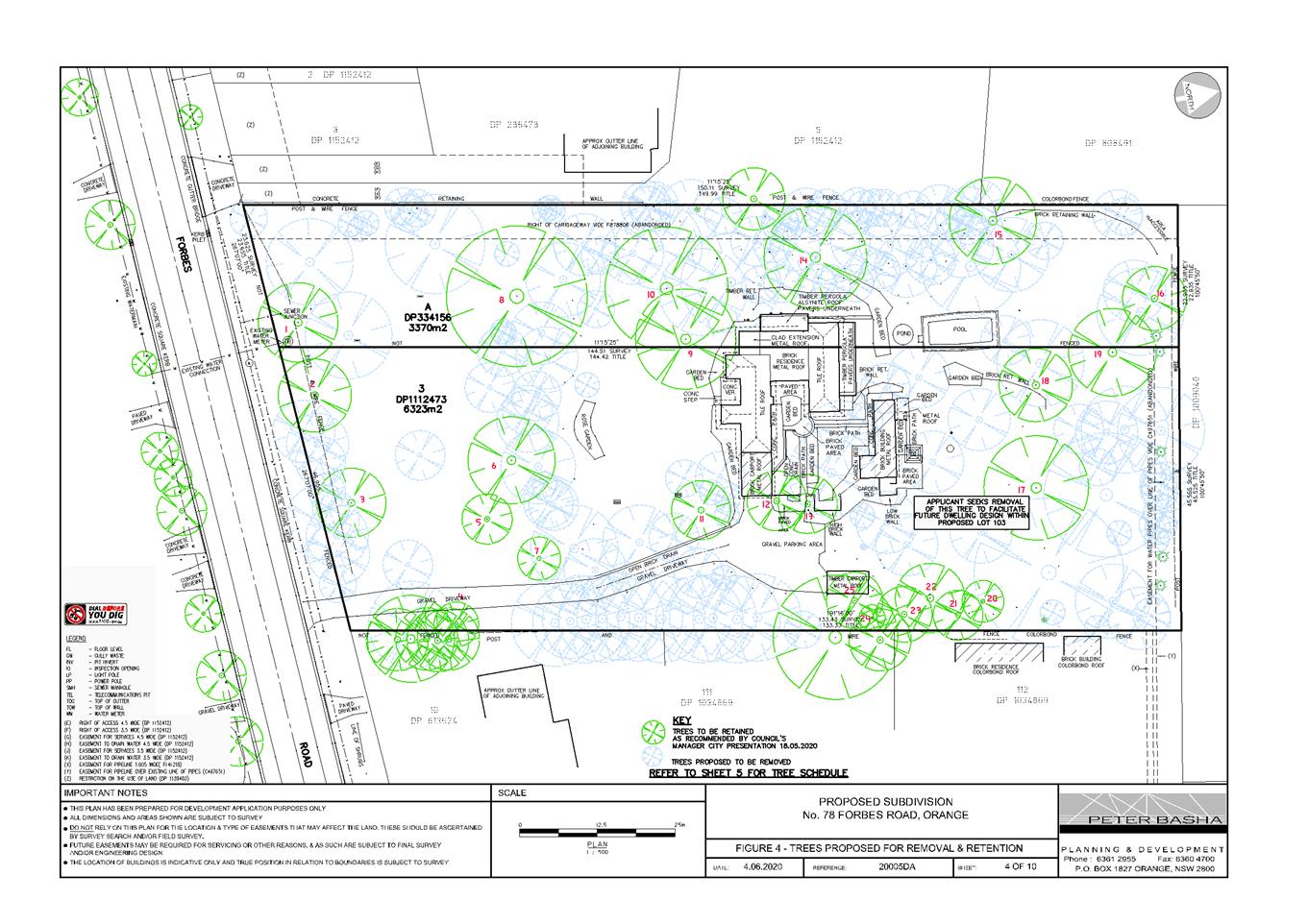
Planning
and Development Committee
1 September 2020
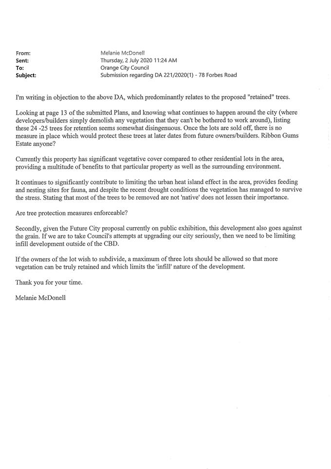
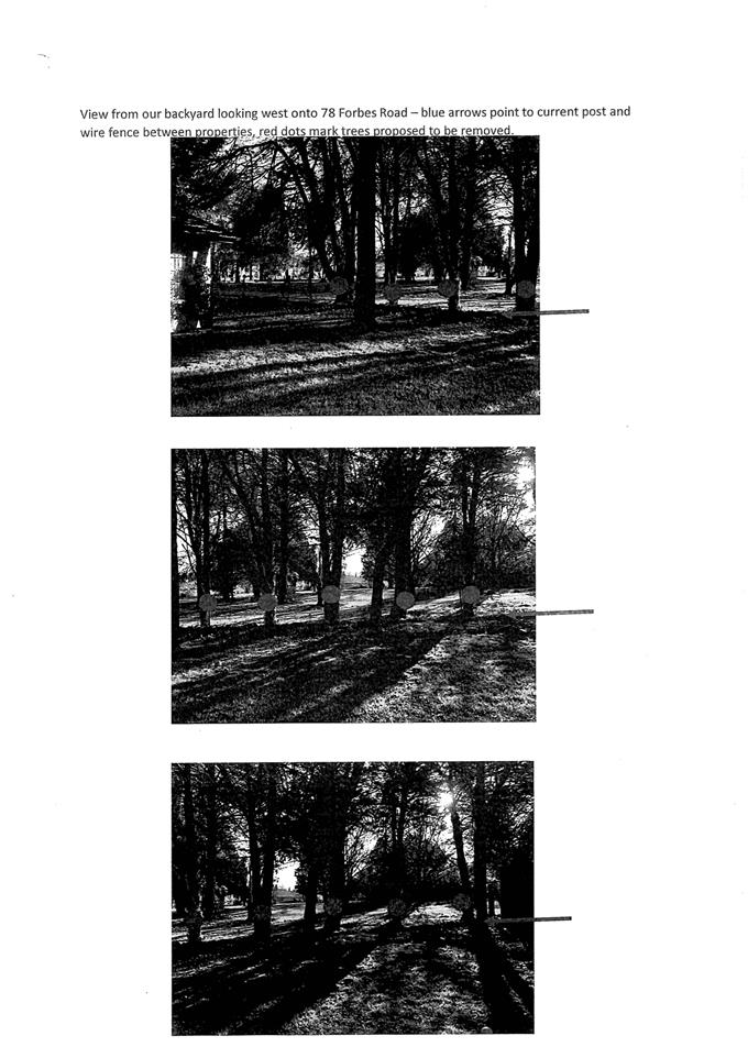
2.4 Development
Application DA 191/2020(1) - 4613 Mitchell Highway, Lucknow
RECORD
NUMBER: 2020/1531
AUTHOR: Summer
Commins, Senior Planner
EXECUTIVE
Summary
|
Application
lodged
|
22 May
2020
|
|
Applicant/s
|
Brothers
Three Pty Ltd
|
|
Owner/s
|
Brothers
Three Pty Ltd
|
|
Land
description
|
Lot 101
DP 1053642 - 4613 Mitchell Highway, Lucknow
|
|
Proposed
land use
|
Service Station (removal of
existing fuel dispensers, fill points, underground fuel tanks and pipework;
construction of a two dispenser covered vehicle fuelling area, new
underground fuel tanks and forecourt pollution control system) and Business
Identification Signage
|
|
Value of
proposed development
|
$620,000
|
Council's consent is sought for service station upgrade at
4613 Mitchell Highway, Lucknow (see locality at Figure 1).
The proposal involves removal and replacement of existing
underground fuel storage tanks and fuel pumps; construction of a refuelling
canopy; and upgraded forecourt works for stormwater treatment.
Notable planning matters for this application include the
suitability of the local road network to accommodate traffic associated with
the service station; the impacts on the proposal on nearby residential amenity;
and the constraints imposed by the Village character and conservation setting.
The development application was referred to Transport for
NSW (TfNSW) for consideration and comment. Service stations are traffic
generating development pursuant to State Environmental Planning Policy
(Infrastructure) 2007; and TfNSW concurrence is required for works within
the road reserve at the site frontage under Section 138 of the Roads Act 1993.
TfNSW raised no objection to the proposal. Minor upgrading works within the
road reserve have been recommended in conjunction with Council’s
Development Engineers.
The proposal comprises Notified Development pursuant to
Council’s Community Participation Plan 2019. At the completion of the
notification period, two submissions had been received from one neighbour. The
issues raised in the submissions relate to residential amenity (noise, light
and odour); and traffic arrangements (site access and highway upgrade).
As outlined in this report, the proposed development is
considered to satisfy the Local and State planning controls that apply to the
subject land and particular landuse. Impacts of the development will be within
reasonable limit subject to mitigation conditions. Approval of the application
is recommended.
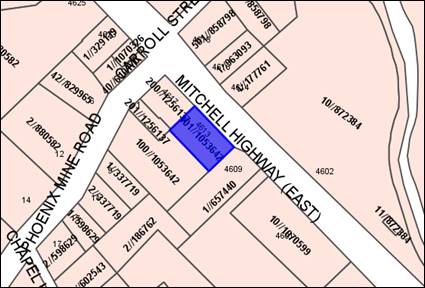
Figure 1 - locality plan
DECISION FRAMEWORK
Development in Orange is governed
by two key documents Orange Local Environment Plan 2011 and Orange
Development Control Plan 2004. In addition the Infill Guidelines are used to
guide development, particularly in the heritage conservation areas and around
heritage items.
Orange Local Environment Plan
2011 – The provisions of the LEP must be considered by the Council in
determining the application. LEPs govern the types of development that are
permissible or prohibited in different parts of the City and also provide some
assessment criteria in specific circumstances. Uses are either permissible or
not. The objectives of each zoning and indeed the aims of the LEP itself are
also to be considered and can be used to guide decision making around
appropriateness of development.
Orange Development Control Plan
2004 – the DCP provides guidelines for development. In general
it is a performance based document rather than prescriptive in nature. For each
planning element there are often guidelines used. These guidelines indicate
ways of achieving the planning outcomes. It is thus recognised that there may
also be other solutions of merit. All design solutions are considered on merit
by planning and building staff. Applications should clearly demonstrate how the
planning outcomes are being met where alternative design solutions are
proposed. The DCP enables developers and architects to use design to achieve
the planning outcomes in alternative ways.
DIRECTOR’S COMMENT
The proposed service station
upgrade is permitted with consent. This proposal ultimately involves an
environmental upgrade of an existing Service Station. The key planning issues
considered in this report include the suitability of the local road network to
accommodate traffic associated with the development; the impacts on the
proposal on nearby residential amenity; and the constraints associated with the
Village character and conservation setting. It is recommended that Council
supports the proposed development and the accompanying Notice of Determination.
Link To Delivery/OPerational Plan
The recommendation in this report
relates to the Delivery/Operational Plan strategy “10.1 Preserve - Engage
with the community to ensure plans for growth and development are respectful of
our heritage”.
Financial Implications
Nil
Policy and Governance Implications
Nil
|
Recommendation
That
Council consents to development application DA 191/2020(1) for Service Station (removal of existing fuel
dispensers, fill points, underground fuel tanks and pipework; construction of
a two dispenser covered vehicle fuelling area, new underground fuel tanks and
forecourt pollution control system) and Business Identification Signage
at Lot 101 DP 1053642 - 4613 Mitchell Highway, Lucknow, pursuant to the conditions of consent in the attached
Notice of Approval.
|
further considerations
Consideration has been given to the
recommendation’s impact on Council’s service delivery; image and
reputation; political; environmental; health and safety; employees;
stakeholders and project management; and no further implications or risks have
been identified.
SUPPORTING INFORMATION
The site is the subject of
recent development consent for a larger service station re‑development
(DA 33/2018(1) approved 18 December 2018).
The approved development involves demolition/removal of all
improvements on the site, and replacement with new underground tanks; fuel
dispensing bowsers; three service channels (rows of pumps); and convenience
store with floor area of 200m2. An extract of the approved plans is
shown below (see Figures 2 and 3).
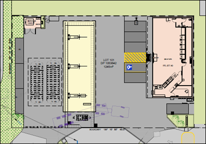
Figure 2 – approved site plan DA 33/2018(1)
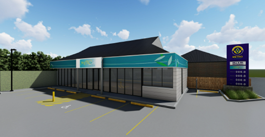
Figure 3 – approved sales building DA 33/2018(1)
The applicant has advised that the approved development will
not proceed. Conditions are included on the attached Notice of Approval
requiring DA 33/2018(1) be surrendered in accordance with Section 4.17(5)
of the Environmental Planning and Assessment Act 1979, prior to issue of
a Construction Certificate for the current proposal.
THE PROPOSAL
The new proposal involves upgrading of the existing service
station on the subject land. Proposed works include:
· demolition
of existing fuel dispensers, fill points, underground fuel tanks and associated
pipe works
· installation
of two x 70,000L underground fuel storage tanks
· installation
of two fuel dispensers, each with ten hoses
· construction
of a refuelling canopy of dimensions 11m x 15m, with height of 5.4m
· extension
of concrete forecourt vehicle areas
· installation
of pollution control requirements (puraceptor and bunding)
· removal
of existing pylon sign on the footpath at the site frontage
· installation
of brand signage, comprising fascia signage to canopy and 6m freestanding pylon
sign.
The existing sales building will be retained in its current
form. The location of existing site accesses via the Mitchell Highway will not
be altered. Proposed hours of operation are 7am to 10pm, 7 days per week.
The proposed site layout, canopy
design and pylon sign are depicted below (see Figures below).
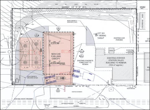
Figure 4 – proposed site layout
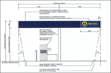
Figure 5 – canopy (North Eastern elevation to
Mitchell Highway)
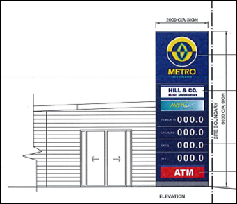
Figure 6 – proposed pylon sign
MATTERS FOR CONSIDERATION UNDER
THE ENVIRONMENTAL PLANNING AND ASSESSMENT ACT 1979
Section 1.7 - Application of
Part 7 of the Biodiversity Conservation Act 2016 and Part 7A of the
Fisheries Management Act 1994
Pursuant to Clause 1.7:
This
Act has effect subject to the provisions of Part 7 of the Biodiversity Conservation Act
2016 and Part 7A of the Fisheries Management Act 1994 that relate to the operation of this Act in connection
with the terrestrial and aquatic environment.
In consideration of this section, the proposed development
is not likely to significantly affect a threatened species:
· The
subject and adjoining lands are not identified as biodiversity sensitive on the
Orange LEP 2011 Terrestrial Biodiversity Map.
· The
proposal does not involve clearing or disturbance of native vegetation;
clearing thresholds prescribed by regulation do not apply.
· The
site is contained within an established urban area and has been highly modified
by the urban landuse pattern. The subject land does not contain known
threatened species or ecological communities.
Based on the foregoing consideration, a Biodiversity
Assessment Report is not required and the proposal suitably satisfies the
relevant matters at Clause 1.7.
Section 4.15 Evaluation
Provisions of any
Environmental Planning Instrument S4.15(1)(A)(I)
Orange Local Environmental Plan
2011
Part 1 – Preliminary
Clause 2.1
Aims of Plan
The particular aims of Orange LEP 2011 relevant to the
proposal include:
(a) to
encourage development which complements and enhances the unique character of
Orange as a major regional centre boasting a diverse economy and offering an
attractive regional lifestyle,
(b) to
provide for a range of development opportunities that contribute to the social,
economic and environmental resources of Orange in a way that allows present and
future generations to meet their needs by implementing the principles for
ecologically sustainable development,
(c) to
conserve and enhance the water resources on which Orange depends, particularly
water supply catchments,
(f) to
recognise and manage valued environmental heritage, landscape and scenic
features of Orange.
The proposed development is
considered to be consistent with the above-listed LEP Aims.
· The
proposal involves upgrading of a derelict site, with positive impacts on
village character and function, and flow-on effects for the local economy and
regional centre status.
· The
proposed development is not considered to be adverse to ESD principles.
The proposal involves environmental upgrade of the existing facility,
incorporating contemporary quality standards.
· As
outlined in this report, the proposed service station upgrade will be sited,
designed and managed to protect water resources.
· As
outlined in the following sections of this report, the proposal will not
adversely impact on the conservation values of the setting.
Clause 1.6 Consent Authority
Clause 1.6 is applicable and
states:
The
consent authority for the purposes of this Plan is (subject to the Act) the
Council.
Clause 1.7 Mapping
The subject site is identified on the LEP maps in the
following manner:
|
Land
Zoning Map:
|
Land
zoned RU5 Village
|
|
Lot
Size Map:
|
Minimum
Lot Size 1,000m2
|
|
Heritage
Map:
|
Within
a heritage conservation area
|
|
Height
of Buildings Map:
|
No
building height limit
|
|
Floor
Space Ratio Map:
|
No
floor space limit
|
|
Terrestrial
Biodiversity Map:
|
No
biodiversity sensitivity on the site
|
|
Groundwater
Vulnerability Map:
|
Groundwater
vulnerable
|
|
Drinking
Water Catchment Map:
|
Within
the drinking water catchment
|
|
Watercourse
Map:
|
Not
within or affecting a defined watercourse
|
|
Urban
Release Area Map:
|
Not
within an urban release area
|
|
Obstacle
Limitation Surface Map:
|
No
restriction on building siting or construction
|
|
Additional
Permitted Uses Map:
|
No
additional permitted use applies
|
|
Flood
Planning Map:
|
Not
within a flood planning area
|
Those matters that are of relevance
are addressed in detail in the body of this report.
Clause 1.9A Suspension of
Covenants, Agreements and Instruments
Clause 1.9A is applicable and
states in part:
(1) For the purpose of enabling
development on land in any zone to be carried out in accordance with this Plan
or with a consent granted under the Act, any agreement, covenant or other
similar instrument that restricts the carrying out of that development does not
apply to the extent necessary to serve that purpose.
(2) This clause does not apply:
(a) to a covenant
imposed by the Council or that the Council requires to be imposed, or
(b) to
any prescribed instrument within the meaning of section 183A of the Crown Lands Act 1989, or
(c) to
any conservation agreement within the meaning of the National Parks and Wildlife Act 1974,
or
(d) to
any Trust agreement within the meaning of the Nature Conservation Trust Act 2001, or
(e) to
any property vegetation plan within the meaning of the Native Vegetation Act 2003, or
(f) to
any biobanking agreement within the meaning of Part 7A of the Threatened Species Conservation Act 1995,
or
(g) to
any planning agreement within the meaning of Division 6 of Part 4 of the Act.
In consideration of this clause,
Council staff are not aware of the title of the subject property being affected
by any of the above. Easements relating to the allocation of parking for
adjacent development will remain in place.
Part 2 - Permitted or Prohibited Development
Clause 2.1 - Land Use Zones
The subject land is zoned RU5 Village.
The proposed development is defined as a ‘service
station’, which means:
A building or place used for the
sale by retail of fuels and lubricants for motor vehicles, whether or not the
building or place is also used for any one or more of the following –
(a) the
ancillary sale by retail of spare parts and accessories for motor vehicles,
(b) the
cleaning of motor vehicles,
(c) installation
of accessories,
(d) inspecting,
repairing and servicing of motor vehicles (other than body building, panel
beating, spray painting, or chassis restoration),
(e) the
ancillary retail selling or hiring of general merchandise or services or both.
Service stations are permitted with consent in the RU5
Village zone.
Clause
2.3 Zone Objectives and Land Use Table
The objectives of the RU5 Village
zone are:
· To
provide for a range of land uses, services and facilities that are associated
with a rural village.
· To
enhance and maintain the unique village character of Lucknow and Spring Hill.
The proposal will not be adverse to
the zone objectives. Services stations are a permitted and complementary land
use in the RU5 zone. The use of the land as a service station is a longstanding
and accepted component of the village. Upgrading of the site will have positive
impacts on village character and function. Mitigation conditions will minimise
offsite arising impacts for adjoining properties.
Clause 2.7 Demolition Requires
Development Consent
Clause 2.7 is applicable and states:
‘The demolition of a building or work may be
carried out only with development consent’
Consent is sought for demolition/removal of existing fuel
dispensers, fill points, underground fuel tanks and infrastructure, and pylon
sign in accordance with this clause.
Part 3 - Exempt and Complying Development
The application is not exempt or
complying development.
Part 4 - Principal Development Standards
The Development Standards at Part 4 are not applicable to
the subject land or proposed development.
Part 5 - Miscellaneous Provisions
Clause
5.10 Heritage Conservation
The
subject site is located within the Lucknow Heritage Conservation Area. Clause
5.10 is applicable and states in part:
(4) The
consent authority must, before granting consent under this clause in respect of
a heritage item or heritage conservation area, consider the effect of the
proposed development on the heritage significance of the item or area
concerned…
In
consideration of this clause, the proposed development was referred to
Council’s Heritage Advisor for consideration and comment. He advises:
‘The use of standard
structures and the corporate colour scheme is accepted on the condition that
suitable mitigation is provided for the impact of the contemporary structure
within the historic setting.
The condition of the existing
service building is poor. There are elements of the structure and paint finish
which appear to produce hazards and these include loose lead based paint,
damaged structures and loose building fabric.
In addition the site
management is poor with the placement of signs on public land, the placement of
rubbish bins on the site frontage and an insecure site perimeter. These aspects
of the site reflect poorly on the business operator, reflect poorly on the
business brand and indirectly reflect poorly on the local Lucknow community and
businesses. ‘
The Heritage Advisor has
provided a number of recommendations to ensure that the visual impact of the
works will be acceptable within the heritage setting. The recommendations and
staff comments are tabulated below.
|
Heritage Advisor Recommendation
|
Staff Response
|
|
The steel-framed canopy structure
shall be painted Dulux Shale Grey
|
A condition is included.
|
|
The fuel canopy soffit shall be
painted / finished Dulux Shale Grey
|
A condition is included.
|
|
A lighting study shall be prepared
to ensure glare and light spill from the canopy complies with relevant
standards
|
Pre-construction and operational
conditions are included.
|
|
Standard rural fencing shall be
erected to site boundaries
|
This is considered to be
unreasonable/unnecessary. The front (north) boundary is affected by extensive
vehicle crossovers. Solid fencing is required to side and rear boundaries for
noise attenuation.
|
|
A landscape plan shall be prepared,
including hedge screen to side boundaries
|
A condition is included.
|
|
Existing signage shall be removed
and replaced with proposed signage in the DA
|
A condition is included.
|
|
New concrete driveways shall be
through-coloured using a charcoal oxide
|
A condition is included requiring a
consistent concrete coloured finish over the site.
|
|
The acoustic screen to the side
(east) boundary shall be approved prior to construction
|
A condition is included requiring
the acoustic screen be constructed of lapped and capped timber palings and
have a height of 1-.8m - 2.1m.
|
As noted above, the proposed
development does not involve any works to the existing sales building. Site
inspection indicates that the building is in a state of disrepair and
renovation works will likely be required (see photo at Figure 7).
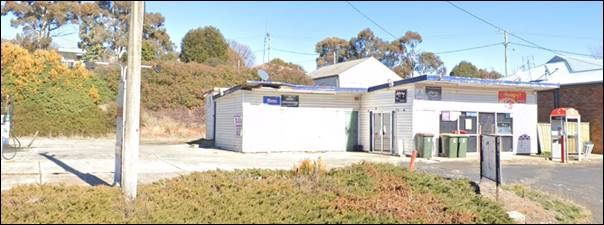
Figure 7 – existing sales building (Google maps)
Conditions are included on the attached Notice of Approval
that further consent will be required for any works that are not exempt development
pursuant to SEPP (Exempt and Complying Development Codes) 2008.
Subject to compliance with the
mitigation conditions above, it is considered that the proposal will not have
adverse impact on the significance of the Lucknow Heritage Conservation Area,
pursuant to Clause 5.10(4). Site upgrading will have positive impacts on the
village character and may increase appreciation of the heritage setting.
Part 7 - Additional Local Provisions
Clause 7.3 Stormwater Management
Clause 7.3 is applicable and states in part:
(3) Development consent must not be
granted to development on land to which this clause applies unless the consent
authority is satisfied that the development:
(a) is designed to maximise the use
of water permeable surfaces on the land having regard to the soil
characteristics affecting onsite infiltration of water, and
(b) includes, where practical,
onsite stormwater retention for use as an alternative supply to mains water,
groundwater or river water, and
(c) avoids any significant impacts
of stormwater runoff on adjoining downstream properties, native bushland and
receiving waters, or if that impact cannot be reasonably avoided, minimises and
mitigates the impact.
Council’s Assistant Development Engineer has included
conditions to satisfy the requirements of Clause 7.3. The design and
construction of the conditional stormwater treatment system for the upgraded
site shall ensure stormwater runoff achieves standardised and contemporary
stormwater quality targets.
Clause 7.6 Groundwater Vulnerability
The
subject land is identified as Groundwater Vulnerable on the Groundwater
Vulnerability Map. Clause 7.6 applies. This clause states in part:
(3) Before
determining a development application for development on land to which this
clause applies, the consent authority must consider:
(a) whether or not the development (including
any onsite storage or disposal of solid or liquid waste and chemicals) is
likely to cause any groundwater contamination or have any adverse effect on
groundwater dependent ecosystems, and
(b) the cumulative impact (including the
impact on nearby groundwater extraction for potable water supply or stock water
supply) of the development and any other existing development on groundwater.
In consideration of Clause 7.6, there are no aspects of the
proposal that will impact on groundwater and related ecosystems. The design and
construction of the underground fuel tanks and onsite pollution control and
containment measures will be suitable to prevent any groundwater contamination.
Clause 7.7 Drinking Water
Catchments
The subject land is identified as ‘drinking
water’ on the Drinking Water Catchment Map. Clause 7.7 is
applicable and states in part:
(3) Before
determining a development application for development on land to which this clause
applies, the consent authority must consider whether or not the development is
likely to have any adverse impact on the quality and quantity of water entering
the drinking water storage, having regard to:
(a) the
distance between the development and any waterway that feeds into the drinking
water storage, and
(b) the
onsite use, storage and disposal of any chemicals on the land, and
(c) the
treatment, storage and disposal of waste water and solid waste generated or
used by the development.
In consideration of this clause, the proposed service
station upgrade is unlikely to impact on the quality and quantity of water
entering the drinking water catchment. The conditional stormwater design will
ensure runoff complies with standardised targets. Underground fuel tank storage
will be designed and constructed in accordance with contemporary standards.
Pollution control and containment measures will be installed onsite.
Clause 7.11 Essential Services
Clause 7.11 applies and states:
Development consent must not be
granted to development unless the consent authority is satisfied that any of
the following services that are essential for the proposed development are
available or that adequate arrangements have been made to make them available
when required:
(a) the
supply of water,
(b) the
supply of electricity,
(c) the
disposal and management of sewage,
(d) storm
water drainage or onsite conservation,
(e) suitable
road access.
In consideration of this clause, the listed utility services
are available and suitable subject to augmentation.
STATE ENVIRONMENTAL PLANNING
POLICIES
State Environmental Planning
Policy No 55 Remediation of Land
SEPP 55 Remediation of Land is
applicable. Pursuant to Clause 7 Contamination and remediation to be
considered in determining development application:
(1) A
consent authority must not consent to the carrying out of any development on
land unless:
(a) it
has considered whether the land is contaminated, and
(b) if
the land is contaminated, it is satisfied that the land is suitable in its
contaminated state (or will be suitable, after remediation) for the purpose for
which the development is proposed to be carried out, and
(c) if
the land requires remediation to be made suitable for the purpose for which the
development is proposed to be carried out, it is satisfied that the land will
be remediated before the land is used for that purpose.
The subject land has
longstanding use as a service station; indeed Council’s records suggest
this use dates back to the 1940s. Service stations are a “Table 1”
listed use in the Contaminated Land Planning Guidelines (DUAP & EPA 1998),
ie. use of land that is likely to cause contamination.
Environmental Site Assessment was
submitted in support of the proposal (NEO Consulting (November 2017). The NEO
concluded:
Laboratory
analysis of each soil sample taken at the site indicates the site is well
within the acceptable contamination and had no evidence of reaching any health
based investigation levels. Based on these results, the site is suitable to
continue as its current landuse as a fuel service site.
NEO recommendations for ongoing
monitoring for site contamination included:
· Installation
of at least three onsite water monitoring wells consistent with the Protection
of the Environment Operations (Underground Petroleum Storage Systems)
Regulation 2019; and
· Monthly
Statistical Inventory Reconciliation Analysis (SIRA) of deliveries, sales and
dips of petroleum products, consistent with EPA Guidelines.
Council’s Environmental
Health Officer concurs with the findings and recommendations of the
Environmental Site Assessment. The recommendations listed above are included as
conditions of consent on the attached Notice of Approval.
It is noted that the submitted
Environmental Site Assessment does not include soil samples in the vicinity of
/underneath the existing underground fuel storage tanks, as these are yet to be
removed. Conditions are included requiring contamination testing and
appropriate disposal of excavated material from the site; and contamination
validation at the completion of excavation.
State Environmental Planning
Policy No 33 Hazardous and Offensive Development
SEPP 33 is applicable where it is determined that the
proposal is hazardous or offensive development. The relevant aims and objectives
of the Policy at Clause 2 include:
(2) Aims,
objectives etc
This Policy aims -
(d) to
ensure that in determining whether a development is a hazardous or offensive
industry, any measures proposed to be employed to reduce the impact of the
development are taken into account, and
(e) to
ensure that in considering any application to carry out potentially hazardous
or offensive development, the consent authority has sufficient information to
assess whether the development is hazardous or offensive and to impose
conditions to reduce or minimise any adverse impact.
In order to determine whether the proposed development is
potentially hazardous or offensive, a Risk Screening Test is applied,
pursuant to Hazardous and Offensive Development Application Guidelines -
Applying SEPP 33 (SEPP 33 Guidelines) (Department of Planning 2011).
The following details are required to
inform the Risk Screening Test:
· Hazardous
materials: motor spirit products - petrol, diesel.
· Dangerous
goods classification: Class 3 PG II.
· Mode
of storage: underground tanks.
· Maximum
quantity stored: 140,000KL % 5 for underground storage = 28,000L or approx. 23
tonnes.
· Distance
of filling/dispensing point to nearest boundary: 12.3m.
· Weekly
and annual deliveries: three per week/150 per year.
With reference to the graph at
Figure 9 of the SEPP 33 Guidelines, the proposed development will not
exceed the volume and distance threshold (see graph below).
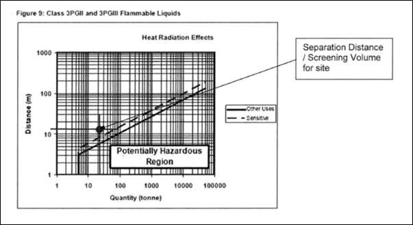
Figure 8 – screening graph – applying SEPP
33
Similarly, with reference to Table 2 of the SEPP 33
Guidelines, the proposed development will not exceed the maximum transportation
threshold of 750 annual deliveries for Class 3 PG II hazardous
materials. Conditions are included to ensure that development remains below
this threshold in the future.
As the screening threshold tests were not exceeded, the
proposal does not comprise potentially hazardous development and SEPP 33 is not
applicable.
Notwithstanding, a preliminary hazard analysis (PHA) has
been submitted in support of the proposed development as a matter of
completeness (MCHP Architects May 2020). The qualitative risk analysis
confirms that the societal risk associated with the proposed development will
be negligible, subject to compliance with applicable standards and safeguards
during design, construction and operation. Conditions are included on the
attached Notice of Approval to ensure same.
The proposed development will be acceptable in terms of the
requirements of SEPP 33 requirements.
State Environmental Planning
Policy Infrastructure 2007
Division 17 Roads and Traffic
Clause 101 Development
with Frontage to a Classified Road
The subject land has frontage to a classified road (Mitchell
Highway) and Clause 101 Development with Frontage to a Classified Road
applies. This clause states in part:
(2) The
consent authority must not grant consent to development on land that has a
frontage to a classified road unless it is satisfied that:
(a) where
practicable, vehicular access to the land is provided by a road other than the
classified road, and
(b) the
safety, efficiency and ongoing operation of the classified road will not be
adversely affected by the development as a result of:
(i) the
design of the vehicular access to the land, or
(ii) the
emission of smoke or dust from the development, or
(iii) the
nature, volume or frequency of vehicles using the classified road to gain
access to the land, and
(c) the
development is of a type that is not sensitive to traffic noise or vehicle
emissions, or is appropriately located and designed, or includes measures, to
ameliorate potential traffic noise or vehicle emissions within the site of the
development arising from the adjacent classified road.
In consideration of Clause 101:
· Existing
dual access to the subject land via the Mitchell Highway will be retained in
its current locations. The subject land does not have alternative site access
via another road.
· The
proposal will not adversely impact on the safety, efficiency and operation of
the classified road due to the following:
- All
vehicles will enter the site via the eastern crossover and driveway, and exit
the site via the western crossover and driveway. Conditions are included
requiring erection of signage to effect these arrangements.
- Site
entrances will be upgraded. Conditions are included requiring reconstruction of
both existing footpath crossings, suitable to accommodate the turn path of a
19m articulated vehicle.
- NO
STOPPING signage shall be installed along both sides of the Mitchell Highway
at the site frontage, and for a distance of at least 60m on approach and 60m on
departure from the turning points into the site. Conditions are included to
effect these arrangements.
- The
existing concrete slab and pylon sign in the road reserve at the site frontage
will be removed, and the area reinstated as public footpath.
- All
un/loading activities shall be carried out within the subject land. Service
deliveries shall be undertaken outside peak hours of patronage, as required by
conditions.
- Site
access will not be available for vehicles longer than 12.5m, excepting semi‑trailers
for fuel resupply. Signage will be installed at the site entrances to limit
vehicle size.
- The
development does not involve emissions.
- The
site has longstanding use as a service station, and traffic associated with
this use is an accepted component of the local traffic network (notwithstanding
that the site is presently non-operational).
The various
formulae useful for estimating traffic demand in the RTA Guide to Traffic
Generating Developments (2002) and the RMS Trip Generation Surveys
– Service Stations (TEF, 2013) rely on parameters including site
area, convenience store floor area, and number of service channels (rows of
pumps). The proposal does not involve alteration to any of these components,
and is therefore not considered to be an intensification of the existing use.
On this basis,
it is the assessment of Council staff and Transport for NSW (TfNSW) that the
proposal will not generate additional traffic volumes; nor result in a nexus
for substantial highway intersection upgrades. The low-cost, contemporary
safety and amenity improvements enquired by conditions above, will be suitable
to maintain the safety, efficiency and operation of the classified road. Subsequent
approval from TfNSW will be required for works within the road reserve under
Section 138 of the Roads Act 1993.
Traffic
generation associated with the development will be imperceptible within the
context of existing traffic volumes. The capacity of the local road network
will be suitable to cater for additional volumes.
· The
proposed development is not sensitive to traffic noise or vehicle emissions.
Clause 104
Traffic-generating Development
A service station
is a listed traffic-generating development pursuant to Clause 104 and Schedule
3 of SEPP Infrastructure 2007. This clause states in part:
(3) Before determining a
development application for development to which this clause applies, the
consent authority must -
(a) give written notice of the
application to RMS within 7 days after the application is made, and
(b) take into consideration -
(i) any submission that RMS
provides in response to that notice within 21 days after the notice was given
(unless, before the 21 days have passed, RMS advises that it will not be making
a submission), and
(ii) the accessibility of the site
concerned, including -
(A) the efficiency of movement of
people and freight to and from the site and the extent of multi-purpose trips,
and
(B) the potential to minimise the
need for travel by car and to maximise movement of freight in containers or
bulk freight by rail, and
(iii) any potential traffic safety, road
congestion or parking implications of the development.
The proposed
development was referred to TfNSW for consideration and comment.
No objection was raised to the proposal, subject to conditions (referred
to under Clause 101 above) which are included in the attached Notice of
Approval.
As outlined in the foregoing
section of this report, the proposed development will not adversely impact on
traffic safety or road congestion.
State Environmental Planning
Policy 64 Advertising and Signage
The proposal involves installation of brand signage to
fascia canopy and a 6m high freestanding pylon sign adjacent to the existing
sales building. SEPP 64 Advertising and Signage is applicable and states in
part:
3 Aims,
Objectives etc
(1) This
Policy aims:
(a) to
ensure that signage (including advertising):
(i) is
compatible with the desired amenity and visual character of an area, and
(ii) provides
effective communication in suitable locations, and
(iii) is
of high quality design and finish, and
(8) Granting
of Consent to Signage
A consent authority must not
grant development consent to an application to display signage unless the
consent authority is satisfied:
(a) that
the signage is consistent with the objectives of this Policy as set out in
Clause 3 (1) (a), and
(b) that
the signage the subject of the application satisfies the assessment criteria
specified in Schedule 1.
The following comments are provided in response to the
relevant matters.
1 -
Character of the Area
· Is
the proposal compatible with the existing or desired future character of the
area or locality in which it is proposed to be located?
· Is
the proposal consistent with a particular theme for outdoor advertising in the
area or locality?
Pylon signs are a typical advertising form in Lucknow,
associated with ribbon commercial development along the highway. The proposed
pylon sign will complement and reinforce this pattern. It is noted that a pylon
sign associated with the service station is a longstanding visual element in
the village. The existing sign will be removed and replaced with another
smaller structure nearer to the sales building. The proposed fascia signage to
the fuel canopy is a typical and expected form of signage associated with a
service station.
2 - Special Areas
· Does
the proposal detract from the amenity or visual quality of any environmentally
sensitive areas, heritage areas, natural or other conservation areas, open
space areas, waterways, rural landscapes or residential areas?
The subject land is located within a
village and conservation setting and adjoins a dwelling house to the east. The
site is located within the business core of the village near the intersection
of Mitchell Highway/Phoenix Mine. The proposed signage will complement other
signage nearby and will be generally suitable in this setting (see comments
below in relation to height).
Council’s Heritage Advisor raised
no objection to the proposed signage scheme, subject to removal of existing
signs on the site. Conditions are included to this effect. It is considered
that limited onsite advertising as proposed, will be suitable in the heritage
setting.
In order to minimise the impacts of
signage for the adjoining dwelling to the east, conditions are included
requiring an illumination curfew consistent with service station trading hours.
3 - Views and Vistas
· Does
the proposal obscure or compromise important views?
· Does
the proposal dominate the skyline and reduce the quality of vistas?
· Does
the proposal respect the viewing rights of other advertisers?
Other pylon signs in the Lucknow
streetscape are lower in height, and generally relate to the height of improvements
on the land. A condition is included limiting the overall height of the pylon
sign to 5.4m, consistent with the height of the proposed fuel canopy.
The proposed signage scheme will not impact on viewing rights of adjoining
businesses along the highway. Views in the streetscape corridor will be
maintained.
4 - Streetscape, Setting or
Landscape
· Is
the scale, proportion and form of the proposal appropriate for the streetscape,
setting or landscape?
· Does
the proposal contribute to the visual interest of the streetscape, setting or
landscape?
· Does
the proposal reduce clutter by rationalising and simplifying existing
advertising?
· Does
the proposal screen unsightliness?
· Does
the proposal protrude above buildings, structures or tree canopies in the area
or locality?
· Does
the proposal require ongoing vegetation management?
The proposed pylon sign will be
consistent with the streetscape pattern for freestanding pylon signs.
Conditional reduction in the height of the pylon sign will ensure the structure
will not protrude above existing improvements on the land. The proposed signage
scheme will have nil impact onsite vegetation. Removal of the existing concrete
pad and pylon sign in road reserve at site frontage, and reinstatement of
footpath will improve street presentation of the site.
5 - Site and Building
· Is
the proposal compatible with the scale, proportion and other characteristics of
the site or building, or both, on which the proposed signage is to be located?
· Does
the proposal respect important features of the site or building, or both?
· Does
the proposal show innovation and imagination in its relationship to the site or
building, or both?
The proposed pylon sign will be
located nearby to the existing sales building, and be visually associated with
the commercial building group on this site and the adjoining western site
(Lucknow Tavern). Signage will be removed from the adjoining dwelling to the
east. The proposed fascia signage to canopy will be wholly located within
the building envelope and will not dominate each fascia elevation. The overall
signage scheme is considered to a minor and acceptable duplication of
advertising content. Conditions are included requiring removal of existing
onsite advertising; and further development consent be obtained for additional
signage that is not exempt development.
6 - Associated Devices and
Logos with Advertisements and Advertising Structures
· Have
any safety devices, platforms, lighting devices or logos been designed as an
integral part of the signage or structure on which it is to be displayed?
Not applicable.
7 - Illumination
· Would
illumination result in unacceptable glare?
· Would
illumination affect safety for pedestrians, vehicles or aircraft?
· Would
illumination detract from the amenity of any residence or other form of
accommodation?
· Can
the intensity of the illumination be adjusted, if necessary?
· Is
the illumination subject to a curfew?
The proposed pylon sign will be
internally illuminated. The precinct is already subject to high ambient
illuminance associated with street lighting and external lighting to nearby
commercial premises. In order to maintain amenity for the adjoining dwellings,
conditions are included requiring an illumination curfew consistent with
trading hours; no flashing or moving signage content; and signage lighting to
comply with AS 4282-1997 Control of the Obtrusive Effects of Outdoor
Lighting.
8 - Safety
· Would
the proposal reduce the safety for any public road?
· Would
the proposal reduce the safety for pedestrians or bicyclists?
· Would
the proposal reduce the safety for pedestrians, particularly children, by
obscuring sightlines from public areas?
The proposed signage will be wholly
located within the subject land, and will not conflict with the movement of
vehicles, pedestrians or cyclists. Conditions are included requiring no
flashing or moving signage content; and compliance with Transport Corridor
Outdoor Advertising and Signage Guidelines (DPE 2017).
Provisions of any Draft
Environmental Planning Instrument that has been Placed on Exhibition
4.15(1)(A)(Ii)
State
Environmental Planning Policy Draft Remediation of Land
Draft Remediation of Land SEPP is
applicable. The Draft SEPP requires in part that consideration be given to
potential contamination on nearby or neighbouring properties and groundwater.
The complete contamination status of
adjoining lands is unknown, however, contamination is usually a relevant matter
for consideration in the village of Lucknow. The proposed development is, of
itself, a Table 1 purpose. The contamination status of the adjoining lands will
not impact on the proposed development.
Draft Orange Local
Environmental Plan 2011 (Amendment 24)
Draft Amendment 24 is with the
Department of Planning for finalisation. The Draft Plan involves various
administrative amendments to the LEP including updated maps, and new and
amended clauses. The proposed development is not contrary to any matter
contained in the Draft Plan.
Draft Orange Local Environmental Plan 2011 (Amendments 25
and 26)
Draft Orange LEP 2011 Amendments 25
and 26 are currently on public exhibition (August 2020). The Draft Plans
relate to land at 1 Leewood Drive and 185 Leeds Parade respectively, and
have no impact for the proposed development.
DESIGNATED DEVELOPMENT
‘Service stations’
are not listed as designated development pursuant to Part 1 Schedule 3 of
the Environmental Planning and Assessment Regulation (EPAR) 2000.
The nearest listed landuse in
Schedule 3 comprises ‘petroleum works.’ Neither the Standard
Instrument nor EPAR 2000 define ‘petroleum works.’
‘Petroleum related
works’ are defined in SEPP (Mining, Petroleum Production and
Extractive Industries) 2007 as:
Any works, structures or equipment that are ancillary or
incidental to petroleum production and includes all works, structures and
equipment that a production lease under the Petroleum (Onshore) Act 1991, or a production licence under the Petroleum (Submerged Lands) Act 1982, entitles the lease or licence holder to construct,
maintain or execute.
The proposed development involves
the storage and retail sale of liquid fuel products and is outside of the definition,
scope and scale ‘petroleum works’/‘petroleum related
works.’ The proposed development is not designated development.
INTEGRATED DEVELOPMENT
The proposed development is not
integrated development.
Provisions of any Development Control Plan S4.15(1)(A)(Iii)
Development Control Plan 2004
The following parts of DCP 2004 are
applicable to the proposed development:
· Part 0
– Transitional Provisions – 0.4-11 Transport Routes
· Part 2
- Natural Resource Management
· Part 3
- General Considerations
· Part 4
- Special Environmental Considerations
· Part 7
– Development in Residential Area
· Part
13 – Heritage Development
· Part
15 – Car Parking
The relevant matters in Parts 0, 2,
3, 4 and Infill Guidelines were considered in the foregoing assessment under Orange
LEP 2011 and SEPP Infrastructure 2007.
The relevant matters in Parts 7, 13 and 15 and are addressed
below.
Part 0.4-7 Lucknow & Part
7.13 Development in the Village of Lucknow
The relevant Planning Outcomes at Parts 0.4-7 and 7.13 are
considered below:
· A geotechnical
report, prepared by a suitably quality consultant is provided to Council…
addressing the suitability of the land for the development, taking into account
the effect of the proposal upon mine shafts…
· Development
proposals involving new buildings or works on or near land identified as being
subject to former mine activity include sufficient information to demonstrate
that the land is suitable for the development…
The subject land has longstanding use a service station and
is not known to have been subject to former mine activity. Notwithstanding, a
condition is including requiring preparation and submission of a geotechnical
report, certifying the site is suitable for upgrading works, having regard to
mine subsidence.
· A
report identifying that the land is suitable for development after being
investigated for potential land contamination…
As outlined in the foregoing sections of this report,
Environmental Site Assessment was submitted in support of the proposal (NEO
Consulting November 2017). The assessment concludes that the site is suitable
for continued use as a fuel service site. It is noted that the submitted
Environmental Site Assessment does not include soil samples in the vicinity
of/underneath the existing underground fuel storage tanks, as these are yet to
be removed. Conditions are included requiring contamination testing and
appropriate disposal of excavated material from the site; and contamination
validation at the completion of excavation.
· Commercial
development is located with the established business core of the Village
centred on the Mitchell Highway/Phoenix Mine intersection. Buildings and
associated signage are designed to relate to the traditional mining character
of the Village to reinforce the mining history of the Village.
The subject land is located within the established business
core of the Village, nearby the intersection of the Mitchell Highway/Phoenix
Mine Road. The proposed development does not relate to the existing sales
building, which will be retained in its current form. Further consent will be
required for upgrading of this building, excepting works that are exempt
development. As outlined above, the proposed signage scheme is considered
suitable subject to conditions in relation to height, content and illumination
curfew.
As considered in the foregoing sections of this report,
Council’s Heritage Advisor provides that ‘the use of standard
structures [canopy] and the corporate colour scheme is accepted on the
condition that suitable mitigation is provided for the impact of the
contemporary structure within the historic setting.’ Mitigation
conditions are included in relation to colours, signage and advertising.
· The
development is serviced by the public sewerage and water reticulation system,
taking into account the planned capacity of these systems.
The subject land is connected to
Council’s reticulated sewer and water infrastructure. Council’s
Assistant Development Engineer advises that sewer and water headworks charges
are not applicable to the proposal, as there will be no increase in fuel
bowsers.
Part 13.3 Heritage
Consideration for Development
The relevant Planning Outcomes at
Part 13.3 include:
· Development
relates to significant features of heritage buildings on or near the site.
· Development
conforms with recognised conservation principles.
The proposal is not adverse to the above Planning Outcomes.
As outlined in the foregoing sections of this report, Council’s Heritage
Advisor raised no objection to the proposal subject to mitigation conditions.
Part 15.6 Off-street Car
Parking
The relevant Planning Outcomes at Part 15.6 include:
· Adequate
off-street car parking is provided in accordance with the table...
· Car
parking areas are designed according to Australian Standard.
The proposed development will satisfy the above Planning
Outcomes. Pursuant to the DCP, onsite parking is required for service stations
at a rate of three (3) spaces per workbay and one (1) space per 25m2
of shop, convenience store or payment area.
The proposed service station does not involve workbays and
the existing sales building comprises floor area of 103m2.
Therefore, 4.12 spaces will be required. Informal car parking is available on
the land at the rear of the existing sales building, sufficient to accommodate
the required number of spaces. Conditions are included requiring construction
of the carpark consistent with Council’s Development and Subdivision
Code. Sufficient manoeuvring area will be available within the carpark to allow
a reverse manoeuvring from parking spaces; onsite manoeuvring; and forward
direction egress through the site to the highway.
Provisions Prescribed By The
Regulations S4.15(1)(A)(Iv)
Demolition of a Building (clause
92)
The proposal involves the removal
of existing underground storage tanks. Conditions are included requiring the
works to be carried out in accordance with applicable standards; and
preparation and implementation of a waste management plan.
Fire Safety Considerations (clause 93)
The proposal does not involve a change of building use for
an existing building. The proposed fuel canopy will be located more than
3m from buildings and boundaries.
Buildings to be Upgraded (clause 94)
The proposal does not involve the rebuilding, alteration,
enlargement or extension of an existing building. Upgrading of the existing
sales building is not required in conjunction with the proposed works.
BASIX Commitments (clause 97A)
Not applicable.
The Likely Impacts of the
Development S4.15(1)(B)
The following likely impacts of the proposed development
have been considered in the foregoing sections of this report and include:
· Setting,
context and neighbourhood character.
· Visual
impacts (streetscape presentation, landscaping, signage).
· Traffic
matters (site access, onsite vehicle areas, car parking and manoeuvring,
traffic generation and network capacity).
· Environmental
impacts (biodiversity, groundwater, stormwater management, sediment control,
waste management).
· Cultural
significance (conservation setting, streetscape).
Other likely impacts are considered below.
Residential Amenity
Dwelling houses adjoin the site to the east and south, and
are located opposite the site on the north side of the highway. The potential
impacts on residential amenity associated with the proposal, and measures to
mitigate those impacts are considered below.
Noise Impacts
An Operational Noise Assessment was submitted in support of
the proposal (Rodney Stevens Acoustics May 2020). The assessment concludes that
‘noise emissions from the operation of the service station including
the proposed mechanical plant comply with the Noise Policy for Industry (EPA
2017).’
The noise assessment provides a number of recommendations to
maintain acoustic privacy for adjoining residential receivers including (but
not limited to) solid fencing to the side and rear site boundaries; and
screening of the air compressor enclosure.
Council’s Environmental Health Officer concurs with
the findings and recommendations of the submitted noise assessment. Conditions
are included to reflect the recommendations, together with additional
conditions in relation to hours of operation (7am to 10pm); fuel delivery times
(7am to 6pm); and noise emissions (5dB(A)).
Privacy
The proposed service station will not impact on privacy for
the adjoining dwellings as follows:
· Perimeter
fencing to side and rear boundaries will be upgraded.
· Conditional
site landscaping to boundaries will provide additional screening and
separation.
· The
entrance to the existing sales building is removed from and will not oppose any
adjoining dwelling.
Solar Access
The proposal will not alter internal or external solar
access for any adjoining dwelling.
Air Quality
Tank fill points will be located
beneath the canopy adjacent to the front bowser (circled in blue below); and
the fuel vent stacks will be located in the south-east portion of the site,
opposing the dwelling at 4609 Mitchell Highway (circled in red below) (see
Figure 9).
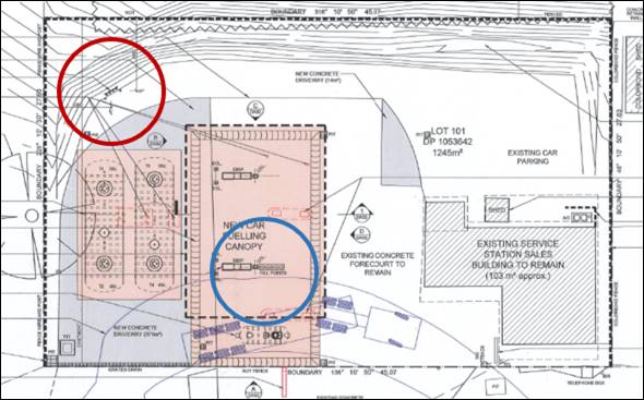
Figure 9 – fill points and tank vents
Council’s Environmental Health Officer advises that
the proposed development is unlikely to result in odour emissions. It is
acknowledged that fuel odour emissions have likely been associated with
historic service station use of the land. However, the proposed replacement
tanks and infrastructure are of a contemporary design and specification, with
internal odour containment measures including vapour recovery. Odour
containment and monitoring will be consistent with the requirements of the
Protection of the Environment Operations (Clean Air) Amendment (Vapour
Recovery) Regulation 2009.
Fencing and landscaping to the site perimeters and change in
ground levels between the service station and opposing dwellings will also
assist to limit other emissions (eg onsite vehicles) beyond the site.
Lighting
In order to limit light spill from the subject land to
adjoining dwellings, conditions are included requiring a curfew for illuminated
signage consistent with hours of operation (7am to 10pm); no flashing or
moving signage content; and all external lighting of the site and building be
designed and installed to comply with AS 4282-1997 Control of the Obtrusive
Effects of Outdoor Lighting.
Visual Amenity
The following proposed and conditional measures will improve
the presentation of the site for opposing dwellings:
· New
fencing to rear and side site boundaries.
· Implementation
of site landscaping.
· Reconstructed
footway crossings and new concrete driveways.
· Removal
of concrete pad and pylon sign in the road reserve at the site frontage.
· Preparation
and implementation of a Litter Patrol Management Plan.
Security
The proposed development was referred to NSW Police for
consideration and comment. No objection was raised to the proposal subject
to installation of CCTV, external lighting and duress alarm/panic button.
Conditions are included to effect these requirements.
Social and Economic Effects
The proposed development is unlikely to generate a negative
social or economic impact within the locality. The use of the land as a service
station is a longstanding and accepted component of the village. The proposal
involves upgrading of a derelict site, with positive impacts on village
character and function, and flow-on effects for the local economy and regional
centre status.
The Suitability of the Site
S4.15(1)(C)
The subject land is suitable for the proposed development
due to the following:
· The
proposed development is permitted on the subject land zoning.
· The
site is located within the business core of the Village.
· The
proposal comprises an environmental upgrade of the longstanding service station
use of the land.
· All
utility services are available and adequate.
· Sufficient
onsite car parking and manoeuvring area will be available.
· The
local road network is suitable to support the proposal without upgrade.
· The
contamination status of the land is suitable for the proposed development;
further validation of excavated material will occur during works.
· The
land may be affected by naturally occurring asbestos; suitable management will
be required during construction works.
· The
land may be affected by subsidence associated with former mining use in the
village. Conditional geotechnical investigation will confirm suitability.
· The
land is not subject to other known natural hazards.
· The site
is contained within a conservation area, and sympathetic site upgrading is
appropriate.
· The
site has no particular environmental values.
Any Submissions Made In
Accordance With The Act S4.15(1)(D)
The proposed development comprises "notified development"
pursuant to Council’s Community Participation Plan 2019.
Written notice of the application was given for the
prescribed period. At the end of that period, two submissions had been received
from the adjoining owner to the east (at 4609 Mitchell Highway). The
issues raised in those submissions are considered below.
The proposal will devalue the adjoining dwelling
This is not a valid consideration in the assessment of a
development application pursuant to the Environmental Planning and Assessment
Act 1979. Notwithstanding, there is no evidence to suggest that complementary
non-residential uses will devalue nearby dwellings. Site and premises upgrading
as proposed may result in favourable impacts on property values nearby to the
site.
The proposal will have unreasonable noise impacts
(vehicles, plant)
Various conditions are included to ensure noise emissions
associated with the development will comply with the Noise Policy for
Industry (EPA 2017). These conditions include:
· Trading
hours of 7am to 10pm.
· Fuel
delivery hours of 7am to 6pm.
· Physical
screening of mechanical plant.
· Sound
barrier solid fencing to side and rear boundaries.
· Noise
emissions not to exceed 5dB(A).
Illumination of signage will
cause nuisance glare
Various conditions are include to minimise light spill from
signage and other external lighting. These conditions include:
· Signage
illumination curfew consistent with trading hours (7am to 10pm).
· Signage
content shall not include flashing or moving content.
· External
lighting to comply with AS 4282-1997 Control of the Obtrusive Effects of
Outdoor Lighting.
Fumes from the tank vents
cause air pollution
As outlined in the foregoing sections of this report,
Council’s Environmental Health Officer considers that fuel odour emissions
will be negligible. The proposed fuel tanks and associated infrastructure are a
contemporary design and specification to the existing facility, with odour
containment measures including vapour recovery.
Night-time refuelling of
tanks is unreasonable
Conditions are included limiting fuel delivery hours to 7am
to 6pm.
Turning lanes are required on
the highway at the site frontage to access the site
As outlined in the foregoing sections of this report, it is
the assessment of Council staff and TfNSW that the proposal does not involve an
intensification of the existing use of the land. The proposal will not alter
existing site area, convenience store floor area or service channels (rows of
pumps). The development will not generate additional traffic volumes nor result
in a nexus for substantial highway intersection upgrades.
The proposal does not
consider the movement of pedestrians
Conditions are included requiring reinstatement of the
public footpath at the site frontage.
Twenty-four hour operation
is unreasonable in the Village
A condition is included limited trading hours to 7am to
10pm.
Access driveways should be
designed Entry (eastern driveway) and Exit (western driveway)
The proposed access arrangements involve vehicle entry via
the eastern driveway, and egress via the western driveway. TfNSW has included
conditions requiring the provision of signage at the driveways to enforce these
arrangements.
Measures are required to
protect stormwater infrastructure at the site frontage of 4609 Mitchell
Highway
A condition is included requiring reconstruction of the
subject stormwater outlet clear of the driveway reconstruction works, and
including a concrete end wall or enclosure to protect the outlet.
A dual centre turning lane
is required to access the site when turning across the highway from Orange
As outlined, Council staff and
TfNSW consider that highway intersection upgrades will not be required for the
proposed development. Conflicts between vehicles turning into the site and
travelling east will be reduced by new NO STOPPING zones at the site frontage
(see Figure 10 below). NO STOPPING zones will enable standing vehicles to be
safely passed in the road shoulder. Conditions are included to effect these
arrangements.
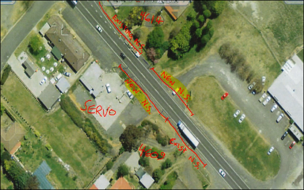
Figure 10 – conditional NO STOPPING zones at the
site frontage
Noise proof fencing, 2.1m in
height should be erected on the common boundary
Conditions are included requiring erection of 2.1m high
lapped and capped timber palings on the common boundary with 4609 Mitchell
Highway. It is noted that the submitted noise assessment requires a 1.8m high
solid fence on this boundary. It is considered to be a reasonable low-cost
amenity improvement for the nearest adjoining dwelling to provide additional
height for improved visual and acoustic outcomes.
PUBLIC INTEREST
s4.15(1)(e)
The proposal is not inconsistent with any relevant policy
statements, planning studies, guidelines etc that have not been considered in
this assessment. Site upgrading, with improved environmental protection works,
will have positive impacts on village character and function, and flow-on
effects for the local economy and regional centre status. The proposal is
considered to be in the public interest.
SUMMARY
The proposed service station upgrade is permitted with consent.
Notable planning matters considered in this report include the suitability of
the local road network to accommodate traffic associated with the development;
the impacts on the proposal on nearby residential amenity; and the constraints
associated with the Village character and conservation setting.
Two (2) public submissions were received, which raised
concerns in relation to residential amenity (noise, light and odour); and
traffic arrangements (site access and highway upgrade).
On balance, it is considered that the
proposed development satisfies the Local and State planning provisions
applicable to the site and particular landuse. Approval of the application is
recommended. Conditions of consent are included in the attached Notice of
Approval to mitigate and manage arising impacts associated with the
development.
COMMENTS
The attached Notice of Approval includes conditions from:
· Environmental
Health and Building Inspector
· Environmental
Health Officer
· Assistant
Development Engineer
· Heritage
Advisor
· Transport
for NSW
· Manager
City Presentation
· NSW
Police
Attachments
1 Notice
of Approval, D20/51386⇩
2 Plans,
D20/50803⇩
3 Submissions,
D20/50802⇩
Planning
and Development Committee
1 September 2020
Attachment 1 Notice
of Approval
|

|
ORANGE CITY COUNCIL
Development
Application No DA
191/2020(1)
NA20/ Container
PR18810
|
NOTICE OF DETERMINATION
OF A DEVELOPMENT
APPLICATION
issued under the Environmental
Planning and Assessment Act 1979
Section 4.18
|
Development
Application
|
|
|
Applicant
Name:
|
Brothers Three Pty
Ltd
|
|
Applicant
Address:
|
C/- MCHP Architects
Pty Ltd
Suite 5, 38-46 Albany
Street
ST LEONARDS
NSW 2065
|
|
Owner’s
Name:
|
Brothers Three Pty
Ltd
|
|
Land
to Be Developed:
|
Lot 101 DP 1053642 -
4613 Mitchell Highway, Lucknow
|
|
Proposed
Development:
|
Service Station (removal of existing fuel
dispensers, fill points, underground fuel tanks and pipework; construction of
a two dispenser covered vehicle fuelling area, new underground fuel tanks and
forecourt pollution control system) and Business Identification Signage
|
|
|
|
|
Building Code of
Australia
building
classification:
|
To be determined by
the PC
|
|
|
|
|
Determination made
under
Section 4.16
|
|
|
Made
On:
|
1 September 2020
|
|
Determination:
|
CONSENT GRANTED
SUBJECT TO CONDITIONS DESCRIBED BELOW:
|
|
|
|
|
Consent to Operate
From:
|
2 September 2020
|
|
Consent to Lapse On:
|
2 September 2025
|
Terms
of Approval
The reasons for the imposition of conditions
are:
(1) To ensure a quality
urban design for the development which complements the surrounding environment.
(2) To maintain
neighbourhood amenity and character.
(3) To ensure compliance
with relevant statutory requirements.
(4) To provide adequate
public health and safety measures.
(5) To ensure the utility
services are available to the site and adequate for the development.
(6) To prevent the proposed
development having a detrimental effect on adjoining land uses.
(7) To minimise the impact
of development on the environment.
Conditions
(1) The development must be
carried out in accordance with:
(a) Drawings by MCHP
Architects dated 05.03.2020,
Drawing Nos 20-011-DA01
Rev D; 20-011-DA02 Rev B; 20-011-DA03 Rev D (3 sheets)
(b) statements
of environmental effects or other similar associated documents that form part
of the approval
as amended in
accordance with any conditions of this consent.
(2) All building work must
be carried out in accordance with the provisions of the Building Code of
Australia.
(3) A sign is to be erected
in a prominent position on any site on which building work, subdivision work or
demolition work is being carried out:
(a) showing
the name, address and telephone number of the principal certifying authority
for the work, and
(b) showing
the name of the principal contractor (if any) for any building work and a
telephone number on which that person may be contacted outside working hours,
and
(c) stating
that unauthorised entry to the site is prohibited.
Any such sign is to be maintained while the
building work, subdivision work or demolition work is being carried out.
(4) Where any excavation
work on the site extends below the level of the base of the footings of a
building on adjoining land, the person having the benefit of the development
consent must, at the person’s own expense:
(a) protect
and support the adjoining premises from possible damage from the excavation,
and
(b) where
necessary, underpin the adjoining premises to prevent any such damage.
Note: This
condition does not apply if the person having the benefit of the development
consent owns the adjoining land or the owner of the adjoining land has given
consent in writing to this condition not applying.
|
PRIOR TO THE ISSUE OF A CONSTRUCTION
CERTIFICATE
|
(5) DA
33/2018(1) shall be surrendered prior to issue of a Construction Certificate.
(6) The
steel frame and soffit to the fuelling canopy shall be painted Dulux Shale Grey,
and noted on the Construction Certificate drawings.
(7) The
pylon sign shall have a maximum height of 5.4m, and be noted on the
Construction Certificate Drawings.
(8) A
landscape plan shall be submitted for the approval of the Manager Development Assessments.
The plan shall include:
· Hedge screening to side
(east) and rear (south) boundaries; and
· A minimum (2) trees in
the south-east rear corner of the site with minimum 70L container size at
planting, and mature height of 6m.
(9) A
geotechnical report shall be submitted and approved by Council’s Manager
Development Assessments, which certifies that the site is not at risk from mine
subsidence and that the site is suitable for the development having regard to
mine subsidence.
(10) The applicant is to
submit a waste management plan that describes the nature of wastes to be
removed, the wastes to be recycled and the destination of all wastes. All
wastes from the demolition and construction phases of this project are to be
deposited at a licensed or approved waste disposal site.
(11) The
applicant shall prepare and submit a Litter Patrol Management Plan for the
approval of the Manager of Building and Environment prior to the issue of a
construction certificate. The Litter Patrol Management Plan shall detail
the commitments required to be undertaken by the operator of the premises to
suitably manage the pick-up of rubbish from the site and the surrounding street
network and open spaces.
(12) Engineering plans
providing complete details of the proposed driveway and car parking areas are
to be submitted to Orange City Council or an Accredited Certifier (Categories
B1, C3, C4, C6) upon application for a Construction Certificate. These plans
are to provide details of levels, cross falls of all pavements, proposed
sealing materials, proposed drainage works, line marking and signage and are to
be in accordance with Orange City Council Development and Subdivision Code.
The plans shall detail the removal of all signs
and the concrete slab located in the area of road reserve between the two
driveways. This area shall be reinstated as public footpath to the standards
and requirements of the Orange City Council Development and Subdivision Code.
The existing bitumen sealed footpath crossings
are to be reconstructed to a heavy duty concrete or bitumen sealed standard for
both entrances to the development. The reconstruction of the laybacks and
footpath crossings shall accommodate the turn path of a 19m articulated
vehicle. The driveway shall be constructed to the standards stated in the
Orange City Council Development and Subdivision Code and TfNSW requirements.
The sewer inspection shaft for the property
shall be located and raised to the finished level of the driveway and fitted
with a trafficable gas tight lid.
(13) All stormwater from the
impervious forecourt, manoeuvring and parking areas of the site (both existing
and proposed) shall be collected and piped to a stormwater treatment system.
The design and construction of the stormwater treatment system for the subject
land shall ensure that the quality of stormwater leaving the developed site
achieves the following stormwater quality targets:
· 90% reduction in the
post development average annual gross pollutant (>5 millimetres) load.
· 85% reduction in the
post development mean annual load of Total Suspended Solids (TSS);
· 65% reduction in the
post development mean annual load of Total Phosphorus (TP);
· 45% reduction in the
post development mean annual load of Total Nitrogen loads (TN);
· No observable
Hydrocarbons present in stormwater discharge (<10ppm).
Orange City Council is to approve engineering
plans for this stormwater system prior to the issuing of a Construction
Certificate. The applicant shall undertake comprehensive water quality modelling
on for the site, using an accredited assessment tool (recommended using
Music™ or other approved assessment tool) and shall include copies of the
electronic data files. Treated stormwater shall be piped to the existing
roadside inlet pit.
The existing roadside inlet pit shall be
reconstructed as a surcharge pit with a grated inlet.
(14) A water and soil
erosion control plan is to be submitted to Orange City Council or an Accredited
Certifier (Categories B1, C3, C4, C6) for approval prior to the issuing of a
Construction Certificate. The control plan is to be in accordance with the
Orange City Council Development and Subdivision Code and the Landcom, Managing
Urban Stormwater; Soils and Construction Handbook.
(15) Backflow
Prevention Devices are to be installed to AS3500 and in accordance with Orange
City Council Backflow Protection Guidelines. Details of the Backflow Prevention
Devices are to be submitted to Orange City Council prior to the issuing of a
Construction Certificate.
|
PRIOR TO WORKS COMMENCING
|
(16) A detailed site plan
shall be submitted to Council prior to works commencing. The site plan
shall accurately show the location where excavated material will be stockpiled,
identify all drainage channels (natural or constructed) within the site and show
the measures that will be implemented to prevent sediment from entering the
drainage channels.
(17) Soil
erosion control measures shall be implemented on the site.
(18) A
Construction Certificate application is required to be submitted to, and issued
by Council/Accredited Certifier prior to any excavation or building works being
carried out onsite.
(19) A
temporary onsite toilet is to be provided and must remain throughout the
project or until an alternative facility meeting Council’s requirements
is available onsite.
|
DURING CONSTRUCTION/SITEWORKS
|
(20) All
construction/demolition work on the site is to be carried out between the hours
of 7.00 am and 6.00 pm Monday to Friday inclusive, 7.00 am to
5.00 pm Saturdays and 8.00 am to 5.00 pm Sundays and Public
Holidays. Written approval must be obtained from the General Manager of Orange
City Council to vary these hours.
(21) A
Registered Surveyor’s certificate identifying the location of the
building on the site must be submitted to the Principal Certifying Authority.
(22) All
construction works are to be strictly in accordance with the Reduced Levels
(RLs) as shown on the approved plans.
(23) All materials on site
or being delivered to the site are to be contained within the site. The
requirements of the Protection of the Environment Operations Act 1997
are to be complied with when placing/stockpiling loose material or when
disposing of waste products or during any other activities likely to pollute
drains or watercourses.
(24) Building demolition is to
be carried out in accordance with Australian Standard 2601:2001 - The
Demolition of Structures and the requirements of Safe Work NSW.
(25) Any excavated material
removed from the site shall be tested for contamination and a record in
accordance with current procedures applicable in NSW made and submitted to both
the EPA and Council. The destination of the removed material is to be
accurately recorded and passed on to Council and the EPA. The receiver of waste
material must be licensed by the NSW Environment Protection Authority to
receive that waste. If a non-licensed premises is intended to receive waste
from the site then an approved notice within the meaning of Section 143(4) of
the Protection of the Environment Operations Act 1997 (Section 143 Notice) must
be supplied prior to removal of the material from the remediation site. Details
of material removed including volume, mass, classification, destination and any
Section 143 Notices are to be submitted to Council and the EPA.
(26) Soil disturbance activities
must not cause any environmental harm outside the site. The soil disturbance
area is to be fully bunded, fenced and dust suppression measures implemented
during the excavation and construction phases. Erosion and sediment controls
must be in place to prevent any soil leaving the remediation site. Runoff from
areas of potential contaminated soil, whether in situ, stockpiled or in
excavation pits, must not be permitted to leave the site without relevant
testing or treatment.
(27) Further validation is
required after completion of the excavation, but prior to the excavation being
filled, or new tanks installed, that certifies there is no risk from residual
contaminants to groundwater or the water table from the site. This
further validation shall be carried out in accordance with current reporting
standards. In the event that the excavated site reveals levels of contamination
that are either a risk to human health or at risk of entering the water table
or groundwater sources, further remediation (requiring separate development
consent) is required to be carried out prior to further work on the site under
this development consent proceeding.
(28) Any adjustments to
existing utility services that are made necessary by this development
proceeding are to be at the full cost of the developer.
(29) The provisions and
requirements of the Orange City Council Development and Subdivision Code are to
be applied to this application and all work constructed within the development
is to be in accordance with that Code.
The developer is to be entirely responsible for
the provision of water, sewerage and drainage facilities capable of servicing
the development from Council’s existing infrastructure. The developer is
to be responsible for gaining access over adjoining land for services where
necessary and easements are to be created about all water, sewer and drainage
mains within and outside the lots they serve.
(30) All driveway, vehicle
manoeuvring and parking areas are to be sealed with bitumen, hot mix or concrete
and are to be designed for all expected loading conditions (provided however
that the minimum pavement depth for gravel and flush seal roadways is 200mm)
and be in accordance with the Orange City Council Development and Subdivision
Code.
(31) Heavy-duty concrete
kerb and gutter laybacks and footpath crossings are to be constructed for the
entrances to the proposed development. The location and construction of the
laybacks and footpath crossings shall accommodate the turn path of a 19m
articulated vehicle. The driveway shall be constructed to the standards stated
in the Orange City Council Development and Subdivision Code.
(32) A 1.2m wide concrete
pathway shall be constructed between the 2 driveways on the property frontage.
The footpath shall be constructed to the standards stated in the Orange City
Council Development and Subdivision Code.
(33) All services are to be
contained within the allotment that they serve.
(34) The
site is located within an area identified as containing serpentinite rock
formations, which can contain chrysotile, a naturally occurring asbestos.
Therefore the applicant or person with management or control of the site shall
ensure that a written plan (an Asbestos Management Plan) for the
site is prepared in accordance with the provisions of the Work Health and
Safety Act 2011 and Work Health and Safety Regulation 2011.
To assist applicants with developing an
Asbestos Management Plan, applicants are encouraged to access the ‘Asbestos
Management Plan for Orange City Council 2014’, which is
available on Council’s website: www.orange.nsw.gov.au
|
PRIOR TO THE ISSUE OF AN OCCUPATION
CERTIFICATE
|
(35) Landscaping
shall be installed in accordance with approved plan and permanently maintained
to the satisfaction of Council’s Manager Development Assessments.
(36) Acoustic
fencing shall be erected to side and rear boundaries of the land, in accordance
with the requirements of the Operational Noise Assessment (Rodney Stevens
Acoustics May 2020).
Fencing shall comprise lapped and capped
hardwood timber palings, to a height of 1.8m to rear (south) and side (west)
boundary; and to a height of 2.1m to side (east) boundary. The height of
the fence shall be measured from the highest finished ground level adjacent to
each part of that fence.
(37) A
total of four (4) car spaces shall be provided on the site in the existing car
parking area noted on Drawing No. 20-011-DA01 Rev D. The parking spaces
shall be constructed in accordance with the requirements of Council’s
Development and Subdivision Code.
(38) All existing advertising
signage and structures on the land shall be removed.
Brand signage shall be installed in accordance
with the approved plans. The pylon sign shall have a maximum height of
5.4m.
(39) A
consistent coloured concrete finish shall be provided over existing and
proposed driveway areas and forecourt.
(40) The
Closed Circuit Television (CCTV) system, lighting and duress alarm as required
by NSW Police (see conditions below) shall be installed and made operational
prior to the issue of an Occupation Certificate.
(41) No
person is to use or occupy the building or alteration that is the subject of
this approval without the prior issuing of an Occupation Certificate.
(42) The
owner of the building/s must cause the Council to be given a Final Fire Safety
Certificate on completion of the building in relation to essential fire or
other safety measures included in the schedule attached to this approval.
(43) The following noise
mitigation measures are to be implemented (in the locations marked on figure
6-1 of the Operational Noise Assessment Report (R180137R1 – Revision 5))
prepared by Rodney Stevens Acoustics, prior to issue of an Occupation
Certificate:
· The air vents in the
air compressor enclosure must be reviewed and approved for use by an acoustic
consultant prior to installation
· The doors in the air
compressor enclosure must not have any airgaps and door seals must be installed
around the perimeter and threshold of the door
· The air conditioning
unit is to be installed at ground level. A 1.6 metre screen must be erected to
minimise the noise transmission from the proposed air conditioning unit.
The screen must extend at least 1 metre from either side of the air
conditioning unit.
(44) A
minimum of three water monitoring wells are to be installed on the site to
assess potential offsite migration of contamination and potential contamination
of surrounding water bodies, in compliance with UPSS Regulation. Location
of monitoring wells is to be determined by a suitably qualified person.
(45) A Certificate of
Compliance, from a Qualified Engineer, stating that the stormwater treatment
system complies with the approved engineering plans is to be submitted to the
Principal Certifying Authority prior to the issuing of an Occupation
Certificate.
(46) Certification from
Orange City Council is required to be submitted to the Principal Certifying
Authority prior to the issue of an Occupation Certificate stating that all
works relating to connection of the development to Council assets, works on
public land, works on public roads, stormwater, sewer and water reticulation
mains and footpaths have been carried out in accordance with the Orange City
Council Development and Subdivision Code and the foregoing conditions, and that
Council will take ownership of the infrastructure assets.
(47) Certification
of the installation and commissioning of testable Backflow Prevention Devices
shall be submitted to Orange City Council by a plumber with backflow
qualifications prior to the issue of an Occupation Certificate.
(48) All
of the foregoing conditions are to be at the full cost of the developer and to
the requirements and standards of the Orange City Council Development and
Subdivision Code, unless specifically stated otherwise. All work required by
the foregoing conditions is to be completed prior to the issuing of an
Occupation Certificate, unless stated otherwise.
|
MATTERS FOR THE ONGOING PERFORMANCE AND
OPERATION OF THE DEVELOPMENT
|
(49) The
service station shall be operated (in perpetuity) in a manner that is
consistent with the Preliminary Hazard Analysis prepared by MCHP Architects
(May 2020).
(50) The
Closed Circuit Television (CCTV) system, lighting and duress alarm as required
by NSW Police (see conditions below) shall be maintained and implemented at all
times.
(51) The hours of operation
of the service station shall not exceed 7am to 10pm, Monday to Sunday.
(52) Illuminated signage
shall have an illumination curfew of 7am to 10pm.
(53) Illuminated
signage and external lighting of the site and building shall comply with AS
4282-1997: Control of the obtrusive effects of outdoor lighting.
(54) Further
development consent shall be obtained prior to the erection of any additional
advertising structures or signs of a type that are not exempt development
pursuant to SEPP (Exempt and Complying Development Codes) 2008. No sandwich
boards, A-frame signs or similar shall be placed on Council’s
footpath. Flashing or moving advertising structures or signage content is
not permitted.
(55) The
maximum number of annual fuel deliveries shall not exceed 150 deliveries.
(56) Any
ancillary light fittings fitted to the exterior of the buildings are to be
shielded or mounted in a position to minimise glare to adjoining properties.
(57) Statistical
Inventory Reconciliation Analysis (SIRA) of deliveries, sales and dips of
petroleum product is to be undertaken on a monthly basis in accordance with the
Environment Protection Authority Guidelines.
(58) Emitted
noise shall not exceed 5dB(A) above background sound level measured at the
nearest affected residence.
(59) The
“beep” signal installed on the tyre inflation device is to be
disabled during the night time period (6.00pm to 7.00am)
(60) Deliveries, including
deliveries made by petrol tankers, will be limited to daytime hours only (7.00
am to 6.00 pm)
(61) Copies of
maintenance records for servicing of the approved stormwater treatment system
shall be forwarded to Council on 1 December annually.
(62) The
owner is required to provide to Council and to the NSW Fire Commissioner an
Annual Fire Safety Statement in respect of the fire-safety measures, as required
by Clause 177 of the Environmental Planning and Assessment Regulation 2000.
CONDITIONS FROM NSW
POLICE
(1) Closed
circuit television (CCTV) shall be installed to monitor the store and
forecourt, sufficient to capture images of drivers and vehicle
registrations.
(2) CCTV
shall be recorded digitally.
(3) Staff shall
be trained in the operation of CCTV.
(4) CCTV images
shall be kept for a minimum of 28 days and be of high quality.
(5) Lighting
shall be installed to support the operation of CCTV and to allow surveillance
from passing traffic.
(6) Duress alarms
shall be installed in the store and key holder details shall be provided to NSW
Police.
CONDITIONS FROM
TRANSPORT FOR NSW
(1) Prior
to any Occupation Certificate, the developer shall complete all works within
the road reserve required by the DA consent.
(2) Prior
to construction commencing within the road reserve, concurrence to the detailed
design shall be obtained from TfNSW under Section 138 of the Roads Act 1993.
The design shall include the following works or acceptable alternatives to the
satisfaction of, and at no cost to, Council and TfNSW:
- Removal of the pylon
sign and concrete slab encroachment within the road reserve and reinstatement
to verge. The new pylon sign shall be contained entirely within private
property.
- Provision of a new
public concrete pedestrian footpath for the full frontage of the site.
- Replacement of both
existing driveway crossovers with new sealed (bitumen or concrete) crossovers.
A private run-off apron shall be provided at the northwest-bound left turn into
the site and outside the concrete table drain as part of the driveway renewal,
to cater for public truck traffic up to 12.5m and fuel resupply trucks up to
19m, with swept paths to be shown on design plans. The minimum width of seal is
to be 6m measured from the highway centre line, for 5m distance before the
start of the driveway plus a 5m long taper, in accordance with Figure 8.2 of
Austroads Guide to Road Design Part 4A.
- Reconstruction of the
stormwater outlet serving 4609 Mitchell Highway, so it is clear of the driveway
work and including a concrete end wall or enclosure to protect the outlet.
- Provision of ‘NO
STOPPING’ (R5-400) signage to extend no stopping zones along both sides
of the highway at the site frontage, for a distance of at least 60m on approach
and 60m on departure from the turning points into site.
- Provision of ‘NO
ENTRY’ (R2-4) signage on the property boundary at the entry (facing into
site) and egress (facing highway) driveways.
- Provision of ‘NO
ENTRY’ (R2-4), ‘VEHICLES OVER 12.5m’ (R9-223) and
‘AUTHORISED VEHICLES EXCEPTED’ (R9-229) signage on the property
boundary at the entry driveway (facing highway). Signage sizes and positions
are to be shown on the plans and shall be clearly readable from both highway
approaches. The signage may be subject to a site inspection by and to the satisfaction
of TfNSW.
- Connection of the site
stormwater discharge to Council’s stormwater pit.
- TfNSW concurrence and
any DA consent shall not alter existing maintenance responsibilities of TfNSW
for any road or road-related infrastructure. Maintenance of infrastructure
located outside the painted edge lines (fog lines) of the highway
through-lanes, including but not limited to existing road shoulders or
driveways, shall be at no cost to TfNSW.
- Prior to Roads Act
Section 138 approval for works within the road reserve required as part of this
DA, the landowner shall surrender DA 33/2018 in accordance with Section 4.17(5)
of the Environmental Planning and Assessment Act 1979. Alternatively, prior to
any works within the road reserve being authorised under DA33/2018, this
development consent shall be surrendered.
- Landscaping, signage
and the like are not to impede sight lines of traffic within or when passing,
entering or departing from the site. Safe Intersection Sight Distance (SISD)
requirements outlined in Austroads Guide to Road Design Part 4A are to be
maintained in both directions at the intersections of driveways with the
Mitchell Highway.
- Prior to the
commencement of construction works, the proponent is to contact the TfNSW Field
Traffic Manager to determine if a Road Occupancy Licence (ROL) is required. In
the event that an ROL is required, the proponent is to obtain the ROL prior to
works commencing within three (3) metres of the travel lanes on the Mitchell
Highway.
- Signage is to be in
accordance with the Transport Corridor Outdoor Advertising and Signage
Guidelines (Department of Planning and Environment, 2017) and is not to flash,
move or be objectionably glaring or luminous.
- A Registered Surveyor's
Certificate identifying that the existing building and eaves are entirely
within the site is to be submitted with the Section 138 application. Nothing in
this consent permits encroachment of any structure within the road reserve.
- During operation, all
activities including loading and unloading of goods associated with the
development are to be carried out entirely within the site boundary and in a
forwards-only direction. Vehicles longer than 12.5m shall not be permitted to
access the site, other than semi-trailers for the purpose of fuel resupply.
Service deliveries, including fuel decanting are to be undertaken outside peak
hours of patronage.
Other
Approvals
(1) Local
Government Act 1993 approvals granted under Section 68.
Stormwater
(2) General
terms of other approvals integrated as part of this consent.
(3) All
stormwater is to be disposed of in a manner suitable to the site.
Right
of Appeal
If you are dissatisfied with this decision,
Section 8.7 of the Environmental Planning and Assessment Act 1979
gives you the right to appeal to the Land and Environment Court. Pursuant to
Section 8.10, an applicant may only appeal within 6 months after the date the
decision is notified.
|
Disability
Discrimination Act 1992:
|
This application has been assessed in
accordance with the Environmental Planning and Assessment Act 1979. No
guarantee is given that the proposal complies with the Disability
Discrimination Act 1992.
The applicant/owner is responsible to ensure
compliance with this and other anti-discrimination legislation.
The Disability Discrimination Act
covers disabilities not catered for in the minimum standards called up in the
Building Code of Australia which references AS1428.1 - "Design for
Access and Mobility". AS1428 Parts 2, 3 and 4 provides the most
comprehensive technical guidance under the Disability Discrimination Act
currently available in Australia.
|
|
Disclaimer
- S88B of the Conveyancing Act 1919 - Restrictions on the Use of
Land:
|
The applicant should note that there could be
covenants in favour of persons other than Council restricting what may be
built or done upon the subject land. The applicant is advised to check the
position before commencing any work.
|
|
|
|
|
Signed:
|
On behalf of the consent authority ORANGE
CITY COUNCIL
|
|
Signature:
|
|
|
Name:
|
PAUL JOHNSTON - MANAGER DEVELOPMENT
ASSESSMENTS
|
|
Date:
|
2 September 2020
|
Planning and Development Committee
1 September 2020
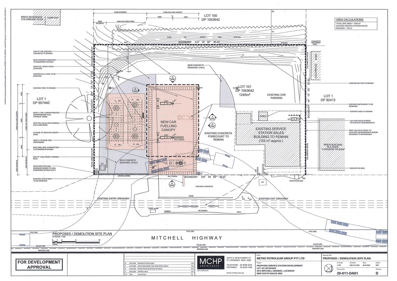
Planning
and Development Committee
1 September 2020