Planning and Development
Committee
Agenda
11 August 2020
Notice is hereby given, in
accordance with the provisions of the Local Government Act 1993 that a Planning and Development Committee meeting of ORANGE CITY COUNCIL
will be held in the Council Chamber,
Civic Centre, Byng Street, Orange WITH AN OPTION OF ONLINE CONFERENCING
PLATFORM ZOOM DUE TO COVID-19 REQUIREMENTS on Tuesday, 11 August
2020.
David
Waddell
Chief Executive Officer
For apologies please
contact Administration on 6393 8218.
1 Introduction
1.1 Declaration
of pecuniary interests, significant non-pecuniary interests and less than
significant non-pecuniary interests
The
provisions of Chapter 14 of the Local Government Act, 1993 (the Act)
regulate the way in which Councillors and designated staff of Council conduct
themselves to ensure that there is no conflict between their private interests
and their public role.
The
Act prescribes that where a member of Council (or a Committee of Council) has a
direct or indirect financial (pecuniary) interest in a matter to be considered
at a meeting of the Council (or Committee), that interest must be disclosed as
soon as practicable after the start of the meeting and the reasons given for
declaring such interest.
As
members are aware, the provisions of the Local Government Act restrict any
member who has declared a pecuniary interest in any matter from participating
in the discussion or voting on that matter, and requires that member to vacate
the Chamber.
Council’s Code of Conduct provides that if members
have a non-pecuniary conflict of interest, the nature of the conflict must be
disclosed. The Code of Conduct also provides for a number of ways in which a
member may manage non pecuniary conflicts of interest.
|
Recommendation
It is recommended that Committee Members now disclose any
conflicts of interest in matters under consideration by the Planning and
Development Committee at this meeting.
|
2 General
Reports
2.1 Item
Approved Under the Delegated Authority of Council
RECORD
NUMBER: 2020/1287
AUTHOR: Paul
Johnston, Manager Development Assessments
EXECUTIVE Summary
Following is a list of more
significant development applications approved by the Chief Executive Officer
under the delegated authority of Council. Not included in this list are
residential scale development applications that have also been determined by
staff under the delegated authority of Council.
Since the July PDC meeting report periods (26 June to 22
July 2020), a combined total of 22 development applications have been
determined under delegation (CEO and staff) with a combined value of $3,314,504.
Link To Delivery/OPerational Plan
The recommendation in this report
relates to the Delivery/Operational Plan strategy “7.1 Preserve - Engage
with the community to develop plans for growth and development that value the
local environment”.
Financial Implications
Nil
Policy and Governance Implications
Nil
|
Recommendation
That Council resolves to
acknowledge the information provided in the report by the Manager Development
Assessments on Items Approved Under the Delegated Authority of Council.
|
further considerations
Consideration has been given to the
recommendation’s impact on Council’s service delivery; image and
reputation; political; environmental; health and safety; employees;
stakeholders and project management; and no further implications or risks have
been identified.
|
Reference:
|
DA 694/2000(3)
|
Determination Date
|
3 July 2000
|
|
PR Number
|
PR18432
|
|
Applicant/s:
|
Mr RO and Mrs NE Hoskin
|
|
Owner/s:
|
Mr RO and Mrs NE Hoskin
|
|
Location:
|
Lot 431 DP 1037421 - 669 Pinnacle
Road, Orange
|
(DA 694/2000(3) continued over page)
|
Proposal:
|
Modification of development consent
- home business (furniture manufacture and ancillary sawmill) and associated
advertising signage. The modification involves the following:
Stage 1: Upgrading of
entrance to showroom and office area (existing) with garden entrance,
retaining wall and new awning.
Stage 2: Additions to
existing shed of 156m² (135m² new/additional assembly area and
21m² for staff area).
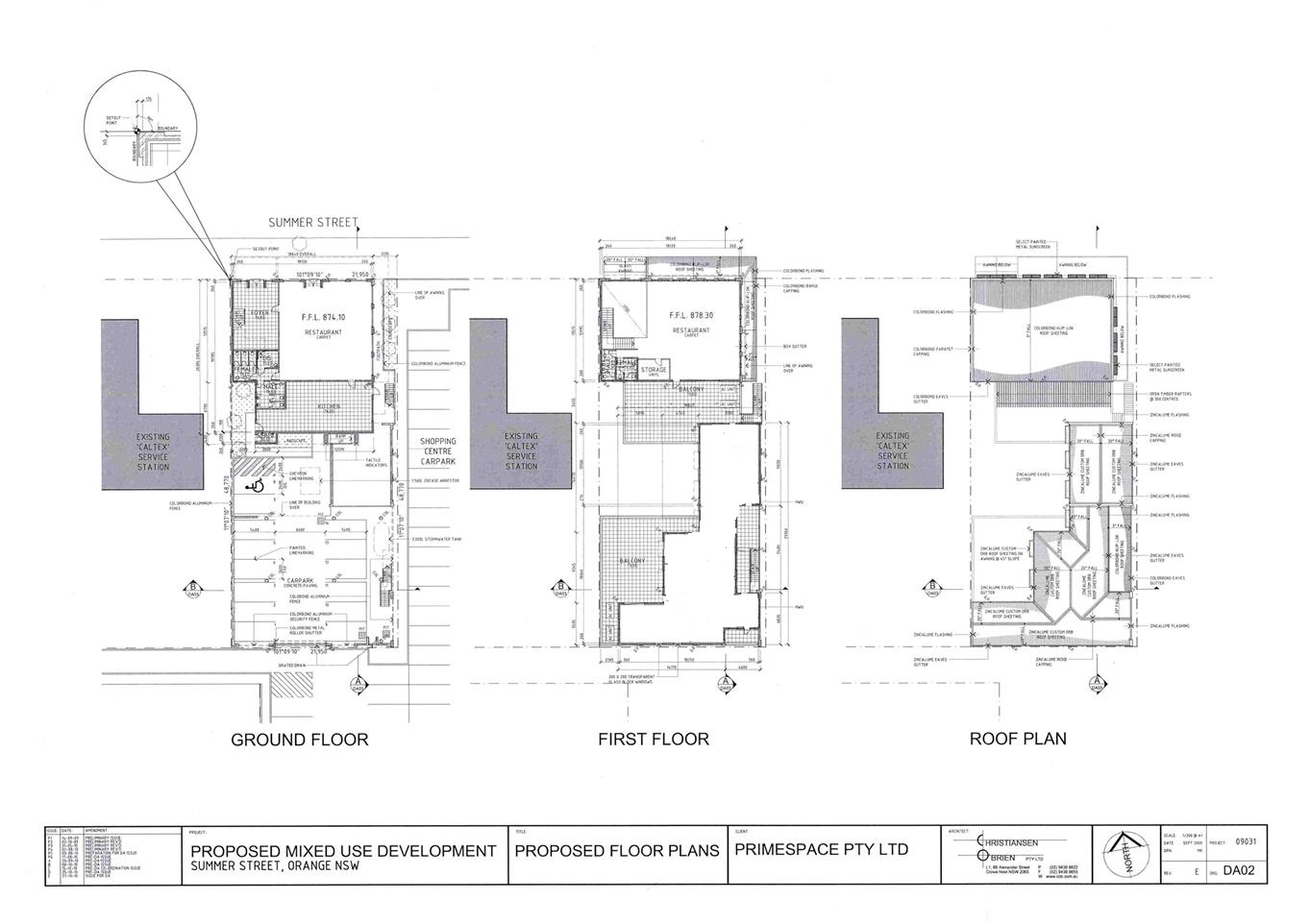
Stage 3: Enclose existing
awning area (266m²) (shown in below image) and removal of existing
window on southern elevation of existing workshop area for new door and
landing.
Stage 4: New water tank
(100,000L).
|
|
Value:
|
N/A
|
|
Reference:
|
DA 367/2008(2)
|
Determination Date
|
19 June 2020
|
|
PR Number
|
PR28460
|
|
Applicant/s:
|
Mr MA and Mrs BM Crombie
|
|
Owner/s:
|
Mr MA and Mrs BM Crombie
|
|
Location:
|
Lot 100 DP 1257871 – 5A Ploughmans
Lane, Orange
|
|
Proposal:
|
Modification of development consent
– demolition (existing building) and outbuilding (new construction).
The modification involves regularising unauthorised works (conversion of an
open plan office space to a series of rooms, and the installation of a single
window for the new rooms on each of the southern, western and northern
facades).
|
|
Value:
|
N/A
|
|
Reference:
|
DA372/2018(4)
|
Determination Date
|
15 July 2020
|
|
PR Number
|
PR16982
|
|
Applicant/s:
|
Ramsay Health Care Pty Ltd
|
|
Owner/s:
|
HCOA Operations (Australia) Pty
Limited
|
|
Location:
|
Lot 62 DP 877808 and Lots 1-5 SP
57262 - 261 March Street, Orange
|
|
Proposal:
|
Modification of development consent
- hospital (alterations and additions). The modified proposal seeks to make
amendments to the approved development, including locating air conditioning
units under the sub-floor, which requires acoustic screening; increased
number of roof lights; and widened access off Wolsley Street, as set out in
“The Proposal” section of this report
|
|
Value:
|
N/A
|
|
Reference:
|
DA 411/2018(1)
|
Determination Date
|
18 June 2020
|
|
PR Number
|
PR4553
|
|
Applicant/s:
|
Zhang Building and Development Pty
Ltd
|
|
Owner/s:
|
Zhang Building and Development Pty
Ltd
|
|
Location:
|
Lot 22 DP 522405 - 101 Gardiner
Road, Orange
|
|
Proposal:
|
Demolition (existing dwelling,
ancillary structures, vegetation) multi dwelling housing (six dwellings)
subdivision (four lot residential Torrens Title) subdivision (four lot
residential Community Title)l
|
|
Value:
|
$800,000
|
|
Reference:
|
DA 381/2019(2)
|
Determination Date
|
26 June 2020
|
|
PR Number
|
PR1010
|
|
Applicant/s:
|
Mr R Tyquin
|
|
Owner/s:
|
Mr R Tyquin
|
|
Location:
|
Lot 1 DP 199430, Lot 101 DP 817293,
Lot 4 DP 744354,Lot 1 DP 745927, 101-107 Autumn Street, Orange
|
|
Proposal:
|
Modification of development consent
- subdivision (five lot residential), demolition (outbuildings) and carports
(two). It is proposed to amend approved Lots 100 and 101 and reposition the
proposed carport in Lot 101 to improve the vehicle access arrangements.
|
|
Value:
|
N/A
|
|
Reference:
|
DA 29/2020(1)
|
Determination Date
|
25 June 2020
|
|
PR Number
|
PR9676
|
|
Applicant/s:
|
Mad Hatter Beverage Co Pty Ltd
|
|
Owner/s:
|
Mr MR Hardman
|
|
Location:
|
Lot 1 DP 779074 - 137-139 Peisley
Street, Orange
|
|
Proposal:
|
Artisan food and drink industry
|
|
Value:
|
$35,000
|
|
Reference:
|
DA 117/2020(1)
|
Determination Date
|
8 July 2020
|
|
PR Number
|
PR19435
|
|
Applicant/s:
|
Lindfield Family Trust
|
|
Owner/s:
|
MLPL Investments Pty Ltd
|
|
Location:
|
Lot 106 DP 1067744 - 1 Ralston
Drive, Orange
|
|
Proposal:
|
Self-storage units
|
|
Value:
|
$600,000
|
|
Reference:
|
DA 148/2020(1)
|
Determination Date
|
28 June 2020
|
|
PR Number
|
PR2356
|
|
Applicant/s:
|
Robert Close
|
|
Owner/s:
|
Mr RC Close and Ms LC Schipp
|
|
Location:
|
Lot 6 Section 14 DP1249530, 61 Casey Street, Orange
|
|
Proposal:
|
Demolition (part of existing patio
and tree removal), multi dwelling housing (three dwellings) and carport and
garage (new construction), subdivision (two lot Torrens), subdivision (four
lot community)
|
|
Value:
|
$678,000
|
|
Reference:
|
DA 165/2020(1)
|
Determination Date
|
19 June 2020
|
|
PR Number
|
PR28460
|
|
Applicant/s:
|
Mr MA and Mrs BM Crombie
|
|
Owner/s:
|
Mr MA and Mrs BM Crombie
|
|
Location:
|
Lot 100 DP 1257871 – 5A
Ploughmans Lane, Orange
|
|
Proposal:
|
Secondary dwelling (partial
conversion from outbuilding)
|
|
Value:
|
$10,000
|
|
Reference:
|
DA 179/2020(1)
|
Determination Date
|
15 July 2020
|
|
PR Number
|
PR26464
|
|
Applicant/s:
|
BJM International Ferry Services
Pty Ltd
|
|
Owner/s:
|
Orange City Council
|
|
Location:
|
Lot 200 DP 1195298 - 136 Aerodrome
Road, Huntley
|
|
Proposal:
|
Airport (bulk fuel tank and
refuelling facility)
|
|
Value:
|
$150,000
|
|
Reference:
|
DA 181/2020(1)
|
Determination Date
|
6 July 2020
|
|
PR Number
|
PR26591
|
|
Applicant/s:
|
Integral Scaffolding
|
|
Owner/s:
|
Kenna Street Pty Ltd
|
|
Location:
|
Lot 12 DP1198903, 49 Leewood Drive,
Orange
|
|
Proposal:
|
Industrial training facility (two
portable buildings)
|
|
Value:
|
$22,500
|
|
Reference:
|
DA 183/2020(1)
|
Determination Date
|
29 June 2020
|
|
PR Number
|
PR26448
|
|
Applicant/s:
|
Mr IY Zhang
|
|
Owner/s:
|
I & J Australia Pty Ltd
|
|
Location:
|
Lot 207 DP 1194620 - 29 Clem McFawn
Place, Orange
|
|
Proposal:
|
Subdivision (two lot Torrens title)
and dwelling houses (two)
|
|
Value:
|
$500,000
|
|
Reference:
|
DA 199/2020(1)
|
Determination Date
|
22 June 2020
|
|
PR Number
|
PR7529
|
|
Applicant/s:
|
Orange City Council
|
|
Owner/s:
|
Orange City Council
|
|
Location:
|
Lots 1 and 2 DP 526194 –
March Street, Orange
|
|
Proposal:
|
Recreation area (demolition and
earthworks)
|
|
Value:
|
$20,000
|
TOTAL NET* VALUE OF DEVELOPMENTS APPROVED BY THE CEO UNDER
DELEGATED AUTHORITY IN THIS PERIOD: $2,815,500
*
Net value relates to the value of modifications. If modifications are
the same value as the original DA, then nil is added. If there is a plus/minus
difference, this difference is added or taken out.
Since the July PDC meeting report periods (26 June to 22
July 2020), a combined total of 22 development applications have been
determined under delegation (CEO and staff) with a combined value of $3,314,504.
2.2 Development
Application DA 155/2020(1) - 7 William Maker Drive
RECORD
NUMBER: 2020/1208
AUTHOR: Ben
Hicks, Planner
EXECUTIVE Summary
|
Application
lodged
|
28 April
2020
|
|
Applicant/s
|
Central
West Development Trust
|
|
Owner/s
|
Mrs J
Blattman
|
|
Land
description
|
Lot 1
DP366693, 7 William Maker Drive, Orange
|
|
Proposed
land use
|
Subdivision
(13 lot residential and drainage reserve), Demolition (outbuilding and tree
removal), Earthworks and Category 1 Remediation Works
|
|
Value of
proposed development
|
Not
applicable
|
Council's consent is sought to subdivide land described as
Lot 1 DP 366693, known as 7 William Maker Drive, Orange. The application
seeks to subdivide the aforementioned land into 13 residential lots. The
development presents a range of lots sizes varying from 444m2 up to
1,516m2. Approval is also sought for demolition (outbuilding and
tree removal), Earthworks and Category 1 Remediation Works. The applicant
proposes to carry out the development in two stages. Stage 1 comprising the
subdivision of the existing dwelling and the creation of a development lot and
Stage 2 relating to the remainder of the subdivision.
The proposal is consistent with the objectives and controls
in the Orange Local Environmental Plan 2011 and relevant State Environmental
Planning Policies; however, the proponent seeks a departure to the approved
Waratah Area Masterplan under the Orange Development Control Plan 2004 by way
of increasing the lot yield and thus the application has been tabled to Council
for determination. The departure to the DCP is to partly accommodate previous
departures made to the Waratah Area Masterplan by Council under preceding
development applications for subdivisions in the area. Those particular
applications sought to re-position the connecting road (Geraldton Road) to
William Maker Drive further south so as to accommodate safe access and align
the road having regard to the access considerations for a possible future
school site opposite the subject land. The agreed realignment of the road meant
that a slightly different design response was required for the subject land.
The proposed variation is pertinent only to the subject land and will have nil
consequence for the remainder of the Waratah Area Masterplan area, and in this
regard, the proposed variation is supported.
The applicant elected to nominate the development
application as Integrated Development because of the presence of a mapped
watercourse within subject allotment. As a result, the application was referred
to the Natural Resources Access Regulator (NRAR) to obtain their General Terms
of Approval. However, NRAR have since advised that despite the presence of a
mapped watercourse, the site no longer possesses the attributes of waterfront
land, and as such a controlled activity approval is not required under the
Water Management Act 2000.
Council staff raise no
objections to the proposed development, and as such the application is
recommended for approval.
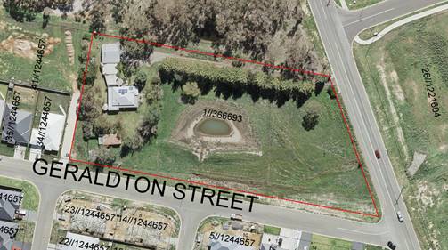
Figure 1 - Locality and Site Context Plan
DECISION FRAMEWORK
Development in Orange is governed by two key documents
Orange Local Environment Plan 2011 and Orange Development Control Plan 2004. In
addition the Infill Guidelines are used to guide development, particularly in
the heritage conservation areas and around heritage items.
Orange Local Environment Plan 2011 – The
provisions of the LEP must be considered by the Council in determining the
application. LEPs govern the types of development that are permissible or
prohibited in different parts of the City and also provide some assessment
criteria in specific circumstances. Uses are either permissible or not. The
objectives of each zoning and indeed the aims of the LEP itself are also to be
considered and can be used to guide decision making around appropriateness of
development.
Orange Development Control Plan 2004 – the DCP
provides guidelines for development. In general it is a performance based
document rather than prescriptive in nature. For each planning element there
are often guidelines used. These guidelines indicate ways of achieving the
planning outcomes. It is thus recognised that there may also be other solutions
of merit. All design solutions are considered on merit by planning and building
staff. Applications should clearly demonstrate how the planning outcomes are
being met where alternative design solutions are proposed. The DCP enables
developers and architects to use design to achieve the planning outcomes in
alternative ways.
DIRECTOR’S COMMENT
The proposal seeks to alter the adopted concept plan for
this precinct. The design response, however, is the direct result of previous
Council decisions whereby Geraldton Road was agreed to be positioned
further south than initially planned. The design response is considered to
be acceptable in this case. The proposed variation is pertinent only to the
subject land and will have nil consequence for the remainder of the Waratah
Area Masterplan. It is recommended that Council supports the proposed
development.
Link To Delivery/OPerational Plan
The recommendation in this report relates to the
Delivery/Operational Plan strategy “10.1 Preserve - Engage with the
community to ensure plans for growth and development are respectful of our
heritage”.
Financial Implications
Nil
Policy and Governance Implications
Nil
|
Recommendation
That Council consents to
development application DA155/2020(1)
for Subdivision (13 lot residential and drainage reserve), Demolition
(outbuilding and tree removal), Earthworks and Category 1 Remediation Works
at Lot 1 DP 366693, 7 William Maker Drive, Orange pursuant to the conditions of consent in the attached
Notice of Determination.
|
further considerations
Consideration has been given to the recommendation’s
impact on Council’s service delivery; image and reputation; political;
environmental; health and safety; employees; stakeholders and project
management; and no further implications or risks have been identified.
SUPPORTING INFORMATION
Section 1.7 - Application of
Part 7 of the Biodiversity Conservation Act 2016 and Part 7A of the
Fisheries Management Act 1994
Section 1.7 of the EP&A Act identifies that Part 7 of
the Biodiversity Conservation Act 2016 (BC Act) and Part 7A of the
Fisheries Management Act 1994 have effect in connection with terrestrial and
aquatic environments.
There are four triggers known to insert a development into
the Biodiversity Offset Scheme (ie the need for a BDAR to be submitted
with a DA):
· Trigger 1:
development occurs in land mapped on the Biodiversity Values Map (OEH)
(clause 7.1 of BC Regulation 2017);
· Trigger 2:
development involves clearing/disturbance of native vegetation above a certain
area threshold (clauses 7.1 and 7.2 of BC Regulation 2017); or
· Trigger 3:
development is otherwise likely to significantly affect threatened species
(clauses 7.2 and 7.3 of BC Act 2016).
The fourth trigger (development proposed to occur in an Area
of Outstanding Biodiversity Value (clause 7.2 of BC Act 2016) is generally not
applicable to the Orange LGA; as no such areas are known to occur in the LGA.
No further comments will be made against the fourth trigger.
Trigger 1
The subject land is not identified
as biodiversity sensitive on the Orange LEP 2011 Terrestrial Biodiversity Map
or mapped on the Biodiversity Values Map.
Trigger 2
The prescribed clearing threshold
for the site is 0.25ha (based on minimum lot size for the subject land of less
than 1ha (Cl. 7.2 Biodiversity Conservation Regulation 2017). It is proposed to
remove three native trees as well as approximately 100m2. The area
to be cleared is less than threshold for native vegetation clearing.
Trigger 3
The subject land is contained
within an established urban area and developing residential release area. The
development site does not contain any threatened vegetation species; however,
the site does adjoin an ecological reserve containing a Blakely’s red gum
community. The natural state of the site has been highly modified by previous
land-use activities and surrounding recent urban development. A Preliminary
Flora and Fauna Assessment prepared by Envirowest Consulting confirms that the
development is unlikely to adversely fragment or disturb the biodiversity
structure or ecological functions of the development site or surrounding lands.
Based on the foregoing
consideration and supporting Preliminary Flora and Fauna Assessment Report, a
BDAR is not required and the proposal suitably satisfies the relevant matters
at Clause 1.7 EPAA 1979.
Section 4.15 of the
Environmental Planning and Assessment Act 1979
Section 4.15 of the Environmental Planning and Assessment
Act 1979 requires Council to consider various matters, of which those
pertaining to the application are listed below.
PROVISIONS OF ANY ENVIRONMENTAL
PLANNING INSTRUMENT s4.15(1)(a)(i)
Orange Local Environmental Plan
2011
Part 1 - Preliminary
Clause 1.2 - Aims of Plan
The
broad aims of the LEP are set out under Subclause 2. Those relevant to the
application are as follows:
(a) to
encourage development which complements and enhances the unique character of
Orange as a major regional centre boasting a diverse economy and offering an
attractive regional lifestyle,
(e) to
provide a range of housing choices in planned urban and rural locations to meet
population growth,
(f) to
recognise and manage valued environmental heritage, landscape and scenic features
of Orange.
In consideration of the above, the
application is considered to be consistent with objectives of the LEP. The
proposed subdivision will provide for additional residential lots for dwelling
stock that will accommodate for the housing needs of the community. The
proposed lot size and layout is appropriate for the setting and will have
negligible environmental impact.
Clause 1.6 - Consent Authority
This clause establishes that, subject to the Act, Council is
the consent authority for applications made under the LEP.
Clause 1.7 - Mapping
The subject site is identified
on the LEP maps in the following manner:
|
Land Zoning Map:
|
R1 General Residential
|
|
Lot Size Map:
|
No Minimum Lot Size
|
|
Heritage Map:
|
Not a heritage item or conservation
area
|
|
Height of Buildings Map:
|
No building height limit
|
|
Floor Space Ratio Map:
|
No floor space limit
|
|
Terrestrial Biodiversity Map:
|
No significant biodiversity
sensitivity on the site. Adjoins Council’s Ecological Woodland Reserve
to the north
|
|
Groundwater Vulnerability Map:
|
Groundwater vulnerable
|
|
Drinking Water Catchment Map:
|
Not within the drinking water
catchment
|
|
Watercourse Map:
|
Mapped watercourse under WM
(General) Regulation 2018
|
|
Urban Release Area Map:
|
Not within an urban release area
|
|
Obstacle Limitation Surface Map:
|
No restriction
on building siting or construction
|
|
Additional Permitted Uses Map:
|
No additional permitted use applies
|
|
Flood Planning Map:
|
Within a flood planning area
|
Those matters that are of relevance are addressed in detail
in the body of this report.
Clause 1.9A - Suspension of
Covenants, Agreements and Instruments
This clause provides that covenants, agreements and other
instruments which seek to restrict the carrying out of development do not apply
with the following exceptions:
(a) to
a covenant imposed by the Council or that the Council requires to be imposed,
or
(b) to
any relevant instrument under Section 13.4 of the Crown Land Management Act
2016, or
(c) to
any conservation agreement under the National Parks and Wildlife Act 1974, or
(d) to
any Trust agreement under the Nature Conservation Trust Act 2001, or
(e) to
any property vegetation plan under the Native Vegetation Act 2003, or
(f) to
any biobanking agreement under Part 7A of the Threatened Species Conservation
Act 1995, or
(g) to
any planning agreement under Subdivision 2 of Division 7.1 of the Environmental
Planning and Assessment Act 1979.
Council staff are not aware of the title of the subject
property being affected by any of the above.
Part
2 - Permitted or Prohibited Development
Clause 2.1 - Land Use Zones and
Clause 2.3 - Zone Objectives and Land Use Table
The site of the proposed development is zoned R1 General
Residential under the Orange Local Environmental Plan 2011. The Land Use Table
for the R1 General Residential zone permits the proposal with consent of
Council.
Clause 2.3(2) of the Orange Local Environmental Plan (OLEP)
2011 provides that the Council shall have regard to the objectives for
development in a zone when determining a development application in respect of
land within the zone. The objectives of the R1 General Residential are:
· To provide for
the housing needs of the community.
· To provide for
a variety of housing types and densities.
· To enable other
land uses that provide facilities or services to meet the day to day needs of
residents.
· To ensure
development is ordered in such a way as to maximise public transport patronage
and encourage walking and cycling in close proximity to settlement.
· To ensure that
development along the Southern Link Road has an alternative access.
The development is considered to be consistent with the
objectives of the R1 General Residential zone. The subdivision will provide for
additional lots for dwelling stock to accommodate the housing needs of the
community.
The subject land is located between recently established
residential developments and will integrate with the existing road and
transport networks, including public transport services. The land is accessible
to open space linkages for walking and cycling in the Waratah area. The
proposed lot size and resulting pattern of development is generally consistent
with that of the locality and surrounding residential development.
The development is not located
adjacent to the Southern Link Road.
The following provisions of the OLEP
2011 have been especially considered in the assessment of the proposal:
· Clause 2.6 - Subdivision - Consent Requirements – Clause
2.6 subdivision of the OLEP 2011 states that the subdivision of land may
be permitted, but only with development consent. As such, the applicant has
applied for development consent via Development Application DA 155/2020(1) for
the subdivision of land.
· Clause 2.7 – Demolition requires
Development Consent - Clause
2.7 of the OLEP 2011 states that the demolition of a building or work may
be carried out only with development consent. Accordingly,
the applicant has applied for development consent (DA 155/2020(1)) for the
demolition of an outbuilding and the removal of trees. The demolition
works proposed are not expected to have a significant impact on adjoining
lands, streetscape or public realm. Conditions may be imposed in respect of
hours of operation, dust suppression and the need to investigate for, and appropriate
management of the presence of, any materials containing asbestos.
· Clause 4.1 – Minimum Subdivision
Lot Size – Clause
4.1 minimum subdivision lot size of the OLEP states that the size of any lot
resulting from the subdivision of land is not to be less than the minimum lot
size shown on the lot size map in relation to that land. The subject
allotment is zoned R1 General Residential, and there is no minimum lot size
applying to the land. Council’s adopted Development Control Plan provides
controls around lot sizes and is addressed in under s4.15(1)(a)(iii) of this
report.
· Clause 7.1 Earthworks – Earthworks are required to facilitate the use of
the land for residential development. The earthworks will involve cutting and
filling across the entire site to achieve appropriate site surface levels for
future residential allotments including filling of the existing dam. Earthworks
will also extend to the installation of sewer, water and utility services.
The extent of disruption to the drainage of the site
is considered to be reasonable. Overland/natural stormwater flows will be
redirected to underground stormwater infrastructure and managed through
Council’s stormwater network. Therefore the disruption to natural
overland flow paths are not expected detrimentally affect adjoining properties
or receiving waterways. Comments were also sought from the
Natural Resource Regulator (NRAR) as the site contains a mapped
watercourse. NRAR advised that the site no longer possesses the attributes
of waterfront plan and as such no approvals are required under the Water
Management Act 2000.
A small area of contamination has been identified on
the site associated with a former sheep dip adjacent to an existing shed in the
western section of the site. Remediation of the impacted soil will be required
in accordance with the Remediation Action Plan prepared by Envirowest
Consulting. Contaminated soil is proposed to be removed from the site and
disposed of at an approved landfill facility, clean fill will be introduced to
the site as needed.
The site is not known to contain any Aboriginal,
European or Archaeological relics. Previous known uses of the site do not
suggest that any relics are likely to be uncovered. Notwithstanding, a
condition will be imposed to ensure appropriate procedures are followed in the
event that unexpected heritage items are uncovered during subdivision works.
Overall, the extent of the earthworks are not expected
to materially affect the potential future use or redevelopment of the site that
may occur at the end of the proposed development's lifespan and appropriate
sediment controls, including silt traps and other protective measures be
required to protect adjoining lands during subdivision works as a condition of
development consent.
· Clause 7.2 Flood Planning – The 2019 Flood Study Report has identified
that the central, eastern and southern parts of the lot is affected by overland
stormwater flows. Council’s Assistant Development Engineer has confirmed
this flow will be accommodated during the construction stage of the
development, and has been conditioned accordingly. In this regard, the
proposed development is unlikely to change flooding regimes on or off the site
and would be unlikely to cause or contribute to erosion and siltation and is
therefore unlikely to create a cost burden on the community or neighbours.
· 7.3 - Stormwater Management - An overland flow path
runs north-south through the site and the existing onsite dam is proposed to be
filled. In this regard, the overland flow path will need to be directed to a
surface pit and piped to Geraldton Street. Inter‑allotment drainage will
need to be provided to all new allotments where lots are unable to drain
directly to kerb and gutter at the lot frontage. The applicant will also be
required to contribute to the provision of off-site stormwater detention system
for the development via Section 7.11 Contributions.
· Clause 7.6 - Groundwater Vulnerability – The site has been mapped as being groundwater vulnerable.
The proposal is not anticipated to involve the discharge of toxic or noxious
substances and is therefore unlikely to contaminate the groundwater or related
ecosystems. The proposal does not involve extraction of groundwater and will
therefore not contribute to groundwater depletion.
· Clause
7.11 - Essential Services – All utility services will be augmented to
the land and made adequate for the proposal. The development, including the
existing dwelling, will be required to connect to Council’s reticulated water
system and gravity sewerage system. Suitable public road access to the new
allotments are existing via William Maker Drive and Geraldton Street (subject
to necessary upgrades). Electricity will be provided as per Essential
Energy’s requirements. Appropriate stormwater management infrastructure
will be provided to the required allotments and the proponent will be required
to contribute to the provision of off-site stormwater detention through
Section 7.11 Contributions.
STATE ENVIRONMENTAL PLANNING
POLICIES
The following State Environmental Planning Instruments
(SEPPs) apply to the Orange Local Government Area:
· SEPP
21 - Caravan Parks
· SEPP
33 - Hazardous and Offensive Development
· SEPP
36 - Manufactured Home Estates
· SEPP
50 - Canal Estate Development
· SEPP
55 - Remediation of Land
· SEPP
64 - Advertising and Signage
· SEPP
65 - Design Quality of Residential Flat Development
· SEPP
70 – Affordable Rental Housing (Revised Schemes)
· SEPP
(Affordable Rental Housing) 2009
· SEPP
(Building Sustainability Index: BASIX) 2004
· SEPP
(Concurrences and Consents) 2018
· SEPP
(Educational Establishments and Child Care Facilities) 2017
· SEPP
(Exempt and Complying Development Codes) 2008
· SEPP
(Housing for Seniors or People with a Disability) 2004
· SEPP
(Infrastructure) 2007
· SEPP
(Koala Habitat Protection) 2019
· SEPP
(Mining, Petroleum Production and Extractive Industries) 2007
· SEPP
(Primary Production and Rural Development) 2019
· SEPP
(State and Regional Development) 2011
· SEPP
(Vegetation in Non-Rural Areas) 2017
The following SEPPs are specifically
relevant to the assessment of the proposed development:
SEPP 55 Remediation of Land - State
Environmental Planning Policy 55 - Remediation of Land (SEPP 55) requires that
a consent authority must not consent to the carrying out of development of land
unless it has considered whether the land is contaminated, is satisfied that
the land is suitable in its contaminated state for the development that is
proposed, and if the land requires remediation to be made suitable for the
proposed development it is satisfied that the land will be remediated before
the land is used for that purpose. Furthermore, SEPP 55 requires that before
determining an application for consent to carry out development that would
involve a change of use on any of the land specified in Subclause (4), the
consent authority must consider a report specifying findings of a preliminary
investigation of the land concerned.
A preliminary hazard investigation
was prepared by Envirowest Consulting to determine the soil contamination
status and suitability of the site for residential land-use. The report
identified that the property has historically been used for grazing which may
have resulted in the application of pesticides and contaminating activities. A
sheep dip was identified in the western section of the site. The soil sampling
program conducted as part of the assessment detected levels of arsenic
exceeding the health investigation levels around the area of the sheep dip. The
elevated levels of contamination were identified at depths of less than 300mm.
Levels of nickel and zinc were detected above the adopted
Ecological Investigation Levels (EILs) for residential land-use in two
samples collected from around the sheep dip depths between 100mm and 300mm.
Pathways for exposure to contaminants by potential receptors (vegetation and
aquatic ecosystems) were assessed and found to be incomplete and the levels are
not expected to impact on the environment. The levels of all substances evaluated
in the remaining samples were below the adopted thresholds for residential
land-use with access to soil.
The report concluded that
remediation of the arsenic impacted soil is required to enable suitability of
the site for residential use and works should be undertaken in accordance with
a Remediation Action Plan. A Remediation Action Plan (RAP) accompanied the
development application. The RAP explored a number of remediation options and
suggested that excavation and off-site disposal is the preferred option for
remediation of the arsenic, nickel and zinc impacted soil.
Council’s Environmental
Health Officer, considered the RAP and the suggested remediation option
acceptable. A condition is attached that obligates the beneficiary of the
consent to undertake the remediation works in accordance with the RAP. A
further condition is attached which requires a validation report to be
furnished to Council prior to the issue of a subdivision certificate.
At the completion
of the remediation works the site will be suitable for the purposes of
residential development.
PROVISIONS OF ANY DRAFT
ENVIRONMENTAL PLANNING INSTRUMENT THAT HAS BEEN PLACED ON EXHIBITION
4.15(1)(a)(ii)
Draft Amendment No 24 to Orange LEP
2011 has been placed on public exhibition. The draft plan includes several
amendments to the LEP. In particular the draft deals with flooding across the
City. Council’s Technical Services Department have included conditions in
the notice of determination addressing matters in relation to flooding and stormwater
issues.
INTEGRATED DEVELOPMENT
The applicant elected to nominate the development
application as Integrated Development because of the need to seek permits under
the Water Management Act 2000 for works within 40m of a defined
creek system. As a result, the application was advertised for an
extended period and the application referred to the NRAR. However, NRAR have
advised Council that the site no longer contains the attributes of waterfront
land and therefore the proposal does not constitute a controlled activity under
the Water Management Act 2000.
PROVISIONS OF ANY DEVELOPMENT
CONTROL PLAN s4.15(1)(a)(iii)
Development Control Plan 2004
Development Control Plan 2004 (“the DCP”)
applies to the subject land (Part 7 - Development in Residential Areas).
An assessment of the proposed development against the relevant Planning
Outcomes (applicable) will be undertaken below:
· The subdivision
layout is generally in accordance with the Conceptual Subdivision Layout
(Appendix 16.6).
The subdivision pattern is not strictly in accordance with
the relevant Conceptual Subdivision Layout for the Waratah area (Figure 2). However,
past surrounding subdivisions and road layout changes have resulted in the land
being of such a shape and size that requires further variations to the DCP
Masterplan. In particular the re-positioning of Geraldton Road further south
than initially envisaged has required a different design response for the
subject land.
The applicant proposes to
increase the lot yield from four large lots to 13 smaller residential lots,
three of which are proposed as battleaxe allotments. The proposed lots are of
reasonable size and of regular configuration with acceptable frontage to depth
ratio and similar to the adopted lot size and configuration on adjoining lands.
The road frontages are of a sensible width and only a modest number of
battleaxe shaped allotments are proposed in this layout. The battleaxe
allotments benefit from the public reserve north and will have independent views
to this area instead of other private properties.
It must also be noted that the
proposed variation is pertinent only to the subject land and will have nil
consequence for the remainder of the Waratah Area Masterplan, and in this
regard, the proposed variation is supported.
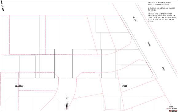
Figure 2 - Plan of subdivision superimposed over
Waratah Concept Plan
· Subdivision
design and construction complies with the Orange City Development and
Subdivision Code.
Relevant conditions are attached in this regard.
· Lots are
oriented to maximise energy-efficiency principles. Where practicable, lots are
rectangular rather than splay shaped and oriented to provide the long axis
within the range N200W to N300E or E200N to E300S.
The lots are orientated such that solar access principles
for future residential development on the resultant lots is achievable.
· Battleaxe lots
have a minimum area of 650m2, excluding the access handle. Access
handles have a minimum width of 4.5m incorporating a 3m wide driveway.
The development comprises three battleaxe lots, identified
as Lots 200 (existing dwelling), 203 and 205. Each battleaxe allotment
will have sufficient area such that it will comply with the above.
· Local collector
roads connect to the Northern Distributor Road, Clergate Road and Farrell Road
generally at the locations shown on the Conceptual Subdivision Layout. Future
road connections to adjoining land are located generally in accordance with the
Conceptual Subdivision Layout.
The proposed subdivision does not require direct connection
to the above listed roads.
· Residential
lots have direct frontage and access to a public road. Access is not available
to the Northern Distributor Road and Clergate Road for adjoining lots.
Each new allotment will have direct frontage or access to a
public road being William Maker Drive or Geraldton Street. William Maker Drive
will be required to be widened by 2m along the eastern frontage of the site
including the provision of kerb and gutter, footpaths and bitumen sealing to
permit vehicle access for proposed Lots 209-212.
· Footpath
cycleways (4.5m wide) are provided in the locations shown on the Conceptual
Subdivision Layout.
Relevant conditions are attached in this regard.
· Onsite
stormwater detention basins and drainage reserves are provided.
The applicant will be required to contribute to the
provision of off-site stormwater detention.
· All utility
services are provided to the proposed lots. The capacity for sewer reticulation
to lots to the west of the ridgeline is investigated at development application
stage.
All the proposed lots will be required to be connected to
Council’s existing reticulated dual water supply and sewer. Relevant
conditions area attached in this regard.
· Significant
landscape features are retained and disturbance to natural vegetation, landform
and overland-flow paths is minimised.
The site is not considered to contain any significant
landscape features. All vegetation is proposed to be removed from the site as
part of this application. Council’s Manager City Presentation, Nigel
Hobden confirmed the vegetation on the site comprises mainly of introduced
species and has no ecological importance to the site or adjoining woodland
reserve. There is one red gum eucalypt from the adjoining woodland reserve
occurring on the subject property; however, given the isolated nature of the
tree and the hostility of the surrounding environment (cleared, introduced
species, weeds, evidence of contamination) the removal of the eucalypt is
expected to have nil impact on the survival and ecological processes and
interactions of the adjoining Blakely’s red gum community. A native
single Silky Oak tree and Finger Hakea tree have been identified onsite and are
likely to have planted as an ornamental tree. The removal of these trees will
have no significant environmental implications. A preliminary flora and fauna
assessment prepared by Envirowest Consulting also confirms that the removal of
the native vegetation on the site will have no significant ecological impacts.
Bulk earthworks are also required to facilitate the use of
the land for residential development. The earthworks are expected to have some
disruption to the natural landform and overland stormwater flow paths. Overland/natural
stormwater flows will be redirected to underground stormwater infrastructure
and managed through Council’s stormwater network to avoid any impacts on
adjoining properties and any receiving waterways.
· Public open
space areas are sited in accordance with the Conceptual Subdivision Layout.
Public open space contains significant trees/tree groups, threatened species,
populations, ecological communities or their habitats. Public open space areas
incorporate stormwater detention basins where required.
Existing public open space within the Waratah area will be
maintained as part of this application.
· An assessment
under Section 5A of the Environmental Planning and Assessment Act 1979 is
submitted at development application stage to identify the effect of
subdivision on threatened species, ecological communities or their habitats.
An assessment under the Biodiversity Conservation Act 2016
was prepared by Envirowest Consulting to identify the impacts of the
subdivision on threatened species, ecological communities or their habitats.
The assessment found that the vegetation on the site had been highly disturbed
through historical clearing and agricultural practices such as
stock grazing, and introduction of weeds, herbicides and fertilisers, and
as a result, the site mostly comprised of introduced vegetation species
(pasture grasses, cypress trees and broadleaved weeds). Some native vegetation
species were identified including a single red gum eucalypt, silky oak tree and
finger hakea tree. No threatened or endangered flora was identified. Faunal
habitat of the site comprises of limited nesting areas, including a dam and
shelter provided by tall grasses. Insects, berries, seeds, aquatic
invertebrates and grazing fodder were identified as potential food sources. No
threatened or endangered fauna species were observed within the site.
Notwithstanding, the report identified that faunal species within South Eastern
Highlands Bioregion (refer to Appendix 2 of the Flora and Fauna Assessment
prepared by Envirowest) have the potential to occur onsite due to the habitat features;
however, the faunal species with the potential to occur are considered to be
highly mobile species and are expected to populate in other nearby areas such
as the adjoining ecological reserve, given that the habitat features on the
subject site represents only a small proportion of potential habitat for the
species.
Overall, the report concluded that the proposed development
is not expected to have a significant impact on the long term survival of
threatened species (flora or fauna) and communities in the South Eastern
Highlands Bioregion.
PROVISIONS PRESCRIBED BY THE
REGULATIONS s4.15(1)(a)(iv)
Demolition of a Building (Clause 92)
The proposal involves the demolition of an outbuilding shed.
A condition is attached requiring the demolition to be carried out in
accordance with Australian Standard AS2601 - 2001: The Demolition of
Structures and the requirements of Safe Work NSW.
Fire Safety Considerations
(Clause 93)
The proposal does not involve a change of building use for
an existing building.
Buildings to be Upgraded
(Clause 94)
The proposal does not involve the rebuilding, alteration,
enlargement or extension of an existing building.
BASIX Commitments (Clause 97A)
BASIX is not applicable to the proposed development.
THE LIKELY IMPACTS OF THE
DEVELOPMENT s4.15(1)(b)
Context and Setting - The subject land is located in
an urban residential locality and has been zoned for residential purposes for
many years. The site is surrounded by residential development and lot sizes
that are similar to that of the proposed development. The development is
consistent with the predominant development pattern that has occurred recently
and is not incongruous with the setting and context of the area.
It is not anticipated that the development will create any
significant adverse impacts on the neighbourhood amenity of the area. The
proposal will not have any negative impacts regarding limiting views or solar
access to adjoining properties. The proposed lots will all be of a size, shape
and slope capable of providing a reasonable standard of residential amenity for
future occupants.
Traffic and Access - The proposal is considered to be
satisfactory in regard to traffic impacts. The proposed lots have appropriate
connectivity to the existing road network through William Maker Drive and
Geraldton Street. The development will result in additional traffic in the
locality given the increases in residential density at the completion of the
subdivision; however, the surrounding street network will be capable of serving
the additional traffic load. The development is considered satisfactory in
regards to traffic impacts.
Flora and Fauna - The site has been mostly cleared
and used for livestock grazing purposes for many years. Only a few native trees
remain on the site and are proposed to be removed. The property adjoins an
ecological woodland reserve. The information in support of the application has
not identified any threatened species of flora or fauna that may be impacted by
the proposal and also identified that the proposal is unlikely to fragment,
diminish or disturb the biodiversity structure, ecological functions and
composition and habitat connectivity with the adjoining reserve.
Surface Water and Groundwater - The site is
identified on the groundwater vulnerable land map and contains an overland
stormwater flow path. All lots will be serviced by reticulated water and
sewerage and no impacts on the groundwater table have been identified as a
result of the proposed development. Matters in relation to stormwater management
for the site will be addressed as a part engineering plan approval process post
consent.
Air and Microclimate - Subdivision works, removal
vegetation etc. may generate some impacts in the immediate locality including
the emissions of dust and odour/fumes from earthmoving equipment, the use of
tree removal equipment, construction vehicles entering and existing the site
and so on. However, these impacts will be short term and only for the duration
of subdivision construction works. The proposal is not expected to have any
long‑term discernible impact on air quality or on the microclimate of the
locality. Conditions of consent are recommended for dust suppression during
subdivision works to protect the air and microclimate.
Noise and Vibration - Some noise and vibration is
expected to occur during subdivision construction works and therefore it is
considered appropriate to limit the time work can be carried out as a condition
of development consent.
Economic Impacts - The
proposed development is consistent with Council's long term land use strategy
identifying the Waratah area as a residential growth area. The proposed
subdivision will promote the growth and investment in residential development
in a serviceable area of Orange and thus is expected to have positive economic
stimulus to the construction and building sector of Orange.
Cumulative Impacts - The proposed subdivision is
considered to be largely consistent with the surrounding development pattern
and acts as a natural continuation of residential land from the south and west.
The cumulative impacts of the proposed development have been considered
throughout the foregoing report and are considered to be acceptable.
THE SUITABILITY OF THE SITE
s4.15(1)(c)
The proposed development is located in the R1 General
Residential zone and is permissible with the consent of Council. The subject
land is considered to be suitable to undertake the proposed development due to
the following:
· The development is
permissible and compliant with the relevant provisions of the LEP.
· The development is
considered to be satisfactory in regard to Section 4.15 of the Environmental
Planning and Assessment Act 1979.
· The potential
impacts of the development can be managed appropriately through the conditions
of consent.
· The development of
the site will not create significant adverse impacts on the context and setting
of the area.
· The development of
the site will not detrimentally affect adjoining land and is unlikely to lead
to land use conflicts.
· All utility
services are or can be made available, including suitable road access.
· The subject land
has no significant biodiversity or habitat value.
ANY SUBMISSIONS MADE IN
ACCORDANCE WITH THE ACT s4.15(1)(d)
The proposed development was advertised and notified to
adjoining landowners for a period of 28 days under the provisions of the
Environmental Planning and Assessment Regulations and SEPP 55. Following the
closure of the exhibition period, no submissions were received.
PUBLIC INTEREST
s4.15(1)(e)
The proposed development is considered
to be of minor interest to the wider public due to the relatively localised
nature of potential impacts. The proposal is not inconsistent with any relevant
policy statements, planning studies, and guidelines etc. that have been
considered in this assessment.
DEVELOPMENT CONTRIBUTIONS
The proposed development is subject to Section 7.11
Contributions (Waratah Urban Release area) and Section 64 Headworks Charges.
The contributions are based on a 13 lot residential subdivision. A credit
is applicable to the existing allotment and as such the monetary contribution
for 12 lots will be applied as follows:
|
Open
Space and Recreation
|
$3,876.55 per subdivided lot x 12
|
46,518.60
|
|
Community
and Cultural
|
$1,124.18 per subdivided lot x 12
|
13,490.16
|
|
Roads
and Traffic Management
|
$5,116.91 per subdivided lot x 12
|
61,402.92
|
|
Local
Area Facilities
|
$9,299.83
per subdivided lot x 12
|
111,597.96
|
|
Plan
Preparation & Administration
|
$582.53 per subdivided lot x 12
|
6,990.36
|
|
TOTAL:
|
|
$240,000.00
|
Section 64 headwork charges for
the development have been calculated at 13.0 Equivalent Tenements (ETs) for
water supply and 13.0 ETs for sewerage supply.
SUMMARY
The proposed development is permissible with the consent of
Council. The proposed development complies with the relevant aims, objectives
and provisions of Orange LEP 2011 (as amended) and DCP 2004. A
Section 4.15 assessment of the development indicates that the development
is acceptable in this instance. Attached is a draft Notice of Approval
outlining a range of conditions considered appropriate to ensure that the
development proceeds in an acceptable manner.
Attachments
1 Notice
of Approval, D20/43157⇩
2 Plans,
D20/43163⇩
Attachment 1 Notice
of Approval
|

|
ORANGE
CITY COUNCIL
Development
Application No DA 155/2020(1)
NA20/ Container
PR5848
|
NOTICE OF
DETERMINATION
OF A
DEVELOPMENT APPLICATION
issued under
the Environmental Planning and Assessment Act 1979
Section 4.18
|
Development
Application
|
|
|
Applicant Name:
|
Central
West Development Trust
|
|
Applicant Address:
|
C/-
Peter Basha Planning & Development
PO
Box 1827
ORANGE
NSW 2800
|
|
Owner’s Name:
|
Mrs
J Blattman
|
|
Land to Be Developed:
|
Lot
1 DP 366693 - 7 William Maker Drive, Orange
|
|
Proposed Development:
|
Subdivision
(13 lot residential and drainage reserve), Demolition (outbuilding and tree
removal), Earthworks and Category 1 Remediation Works
|
|
|
|
|
Building
Code of Australia
building
classification:
|
Not
applicable
|
|
|
|
|
Determination
made under
Section 4.16
|
|
|
Made On:
|
4
August 2020
|
|
Determination:
|
CONSENT
GRANTED SUBJECT TO CONDITIONS DESCRIBED BELOW:
|
|
|
|
|
Consent
to Operate From:
|
5
August 2020
|
|
Consent
to Lapse On:
|
5
August 2025
|
Terms of Approval
The reasons for the
imposition of conditions are:
(1) To ensure a
quality urban design for the development which complements the surrounding
environment.
(2) To maintain
neighbourhood amenity and character.
(3) To ensure
compliance with relevant statutory requirements.
(4) To provide
adequate public health and safety measures.
(5) Because the
development will require the provision of, or increase the demand for, public
amenities and services.
(6) To ensure
the utility services are available to the site and adequate for the
development.
(7) To prevent
the proposed development having a detrimental effect on adjoining land uses.
(8) To minimise
the impact of development on the environment.
Conditions
(1) The
development must be carried out in accordance with:
(a) Plans
prepared by Heath Consulting Engineers, numbered 1-6 (6 sheets), Revision B and
dated 8 April 2020
(b) statements
of environmental effects or other similar associated documents that form part
of the approval
as
amended in accordance with any conditions of this consent.
(2) All
building work must be carried out in accordance with the provisions of the
Building Code of Australia.
STAGE 1 - TWO LOT
SUBDIVISION
|
PRIOR TO
THE ISSUE OF A CONSTRUCTION CERTIFICATE
|
(3) The
applicant is to submit a waste management plan that describes the nature of
wastes to be removed, the wastes to be recycled and the destination of all wastes.
All wastes from the demolition and construction phases of this project are to
be deposited at a licensed or approved waste disposal site.
(4) A Road
Opening Permit in accordance with Section 138 of the Roads Act 1993 must
be approved by Council prior to a Construction Certificate being issued or
any intrusive works being carried out within the public road or footpath
reserve.
|
DURING
CONSTRUCTION/SITEWORKS
|
(5) If
Aboriginal objects, relics, or other historical items or the like are located during
development works, all works in the area of the identified object, relic or
item shall cease, and the NSW Office of Environment and Heritage (OEH), and
representatives from the Orange Local Aboriginal Land Council shall be
notified. Where required, further archaeological investigation shall be
undertaken. Development works in the area of the find(s) may recommence if and
when outlined by the management strategy, developed in consultation with and
approved by the OEH.
(6) All
construction/demolition work on the site is to be carried out between the hours
of 7.00 am and 6.00 pm Monday to Friday inclusive, 7.00 am to
5.00 pm Saturdays and 8.00 am to 5.00 pm Sundays and Public
Holidays. Written approval must be obtained from the General Manager of Orange
City Council to vary these hours.
(7) Any
adjustments to existing utility services that are made necessary by this
development proceeding are to be at the full cost of the developer.
(8) A
heavy-duty concrete kerb and gutter layback and footpath crossing is to be
constructed to serve proposed Lot 100. The works are to be carried out to the
requirements of the Orange City Council Development and Subdivision Code and
Road Opening Permit.
(9) All
services are to be contained within the allotment that they serve.
|
PRIOR TO
THE ISSUE OF A SUBDIVISION CERTIFICATE
|
(10) Application
shall be made for a Subdivision Certificate under Section 6.3(1)(d) of the Act.
(11) Prior
to issue of a Subdivision Certificate, the area identified
as being contaminated (former sheep dip location) in Clause 7 and Figures 1 and
2 of Remediation Action Plan (RAP) prepared by Envirowest Consulting Pty Ltd
R11554rap, dated 17 March 2020, shall be remediated in accordance with the
Remediation Action Plan.
(12) Prior to
issue of a Subdivision Certificate, a Validation Report for the remediation
works confirming that the land is suitable for residential development shall be
prepared by an appropriately qualified consultant, and a copy of this Report is
to be provided to Council.
(13) Payment of
contributions for water, sewer and drainage works is
required to be made at the contribution rate applicable at the time that the
payment is made. The contributions are based on 2.0 ETs for water supply
headworks and 2.0 ETs for sewerage headworks. A Certificate of
Compliance, from Orange City Council in accordance with the Water Management
Act 2000, will be issued upon payment of the contributions.
This Certificate of Compliance is
to be submitted to the Principal Certifying Authority prior to the issuing of a
Subdivision Certificate.
(14) The payment
of $20,000.00 is to be made to Council in accordance with Section 7.11
of the Environmental Planning and Assessment Act 1979 and the Orange
Development Contributions Plan 2017 (Waratah Urban Release area) towards the
provision of the following public facilities:
|
Open
Space and Recreation
|
$3,876.55 per subdivided lot x 1
|
3,876.55
|
|
Community
and Cultural
|
$1,124.18 per subdivided lot x 1
|
1,124.18
|
|
Roads and
Traffic Management
|
$5,116.91 per subdivided lot x 1
|
5,116.91
|
|
Local
Area Facilities
|
$9,299.83
per subdivided lot x 1
|
9,299.83
|
|
Plan
Preparation & Administration
|
$582.53 per subdivided lot x 1
|
582.53
|
|
TOTAL:
|
|
$20,000.00
|
The contribution will be indexed
quarterly in accordance with the Orange Development Contributions Plan 2017
(Waratah Urban Release area). This Plan can be inspected at the Orange Civic
Centre, Byng Street, Orange.
(15) Application
is to be made to Telstra/NBN for infrastructure to be made available to each
individual lot within the development. Either a Telecommunications Infrastructure
Provisioning Confirmation or Certificate of Practical Completion is to be
submitted to the Principal Certifying Authority confirming that the specified
lots have been declared ready for service prior to the issue of a Subdivision
Certificate.
(16) A Notice of
Arrangement from Essential Energy stating arrangements have been made for the
provision of electricity supply to the development, is to be submitted to the
Principal Certifying Authority prior to the issue of a Subdivision Certificate.
(17) An easement
shall be established over the existing septic tank absorption trenches
including an appropriate buffer to ensure full containment of the effluent
disposal area where the absorption trenches are located outside proposed Lot
100.
(18) All
services are to be contained within the allotment that they serve. A Statement
of Compliance, from a Registered Surveyor, is to be submitted to the Principal
Certifying Authority prior to the issuing of a Subdivision Certificate.
(19) Prior to
the issue of a Subdivision Certificate William Maker Drive shall be widened by
2.0 metres and dedicated as Public Road at no cost to Council. A 5m splay shall
be created on the boundary intersection of Geraldton Street and William Maker
Drive.
(20) The
applicant shall provide Orange City Council with either a bond (supported by
cash or an undated and unconditional guarantee) or full payment to cover the
cost of the following works to service proposed Lot 100:
· Extension
of the following infrastructure to service Lot 100 (as required):
o water mains
o sewer mains
o electricity
o stormwater
drainage
o gas
o telecommunications
· Geraldton
Street frontage is constructed in accordance with the Orange City Council
Development and Subdivision Code; and
· Preparation
of engineering plans for Council approval and issue of a construction
certificate for all civil infrastructure works noted above.
(21) A
Restriction-as-to-User under Section 88B of the NSW Conveyancing Act
1919 is to be created on the title of proposed Lot 100 which requires
the bonded works to be completed within 6 months of being requested by Orange
City Council.
(22) A
Restriction-as-to-User under Section 88B of the NSW Conveyancing Act
1919 is to be created on the title of proposed Lot 100 which
states that:
Proposed Lot 100 may not be
subdivided or further developed unless the following works are carried out to
the satisfaction of Orange City Council:
· All
infrastructure services (water, sewer, stormwater drainage, gas, electricity,
phone lines) as required by the Orange City Council Development and Subdivision
Code are provided to Lot 100; and
· The
developer of proposed Lot 100 is responsible for gaining access over adjoining
land for services as necessary. Easements are to be created about all service
mains within and outside the lots they serve; and
· Geraldton
Street frontage is constructed in accordance with the Orange City Council
Development and Subdivision Code; and
· Section
7.11 Contributions are paid as required by the development contributions plan applicable
at the time of development and Water and Sewer charges as required by Orange
City Council in accordance with Division 5 of Part 2 of Chapter 6 of the Water
Management act 2000.
(23) A
Restriction-as-to-User under Section 88B of the NSW Conveyancing Act is
to be created on the title of proposed Lot 101 which states that:
Proposed Lot 101 may not be
subdivided or further developed and may not be used for residential purposes
unless the following works are carried out to the satisfaction of Orange City
Council:
· All
infrastructure services (water, sewer, stormwater drainage, stormwater
detention, gas, electricity, phone lines) as required by the Orange City
Council Development and Subdivision Code are provided to Lot 101; and
· The
developer of proposed Lot 101 is responsible for gaining access over adjoining
land for services as necessary. Easements are to be created about all service
mains within and outside the lots they serve; and
· Contributions
are paid as required by the development contributions plan applicable at the
time of development and Water and Sewer charges as required by Orange City
Council in accordance with Division 5 of Part 2 of Chapter 6 of the Water
Management act 2000; and
· Geraldton
Street and William Maker Drive frontages shall be constructed in accordance
with the Orange City Council Development and Subdivision Code as half road
width including kerb and gutter on the development side of the road.
(24) Certification
from Orange City Council is required to be submitted to the Principal
Certifying Authority prior to the issue of a Subdivision Certificate stating
that all works relating to connection of the development to Council assets,
works on public land, works on public roads, stormwater, sewer and water
reticulation mains and footpaths have been carried out in accordance with the
Orange City Council Development and Subdivision Code and the foregoing
conditions, and that Council will take ownership of the infrastructure assets.
(25) All
of the foregoing conditions are to be at the full cost of the developer and to
the requirements and standards of the Orange City Council Development and
Subdivision Code, unless specifically stated otherwise. All work required by
the foregoing conditions is to be completed prior to the issuing of an
Occupation or Subdivision Certificate, unless stated otherwise.
STAGE 2 –
ELEVEN LOT SUBDIVISION
|
PRIOR TO
THE ISSUE OF A CONSTRUCTION CERTIFICATE
|
(26) Engineering
plans, showing details of all proposed work and adhering to any engineering conditions
of development consent, are to be submitted to, and approved by, Orange City
Council or an Accredited Certifier (Categories B1, C3, C4, C6) prior to the
issuing of a Construction Certificate.
Geraldton Street and William Maker
Drive shall be constructed to full urban standard for the frontage of proposed
Lots 100 and 101. This work is to include road pavement and pavement surfacing
to key into the existing road pavement, kerb and gutter, piped stormwater
drainage and earth-formed footpath reserve on the development side of the road.
(27) A soil and
water management plan is to be submitted to Orange City Council or an
Accredited Certifier (Categories B1, C3, C4, C6) for approval prior to the
issuing of a Construction Certificate. The soil and water management plan is to
be in accordance with the Orange City Council Development and Subdivision Code
and the Landcom, Managing Urban Stormwater; Soils and Construction Handbook.
(28) A Road
Opening Permit in accordance with Section 138 of the Roads Act 1993 must
be approved by Council prior to a Construction Certificate being issued or
any intrusive works being carried out within the public road or footpath
reserve.
(29) Proposed
lots are to be provided with interlot stormwater drainage, including those lots
abutting public land, where the surface of the entire lot cannot be drained to
the kerb and gutter at the lot frontage. A grated stormwater pit is to be
constructed within each lot provided with interlot stormwater drainage.
Engineering plans for this drainage system are to be approved by Orange City
Council or an Accredited Certifier (Categories B1, C3, C4, C6) prior to the
issuing of a Construction Certificate.
(30) Stormwater
from within the site and William Maker Drive shall be piped to the existing
stormwater pit in Geraldton Street. Engineering plans of this drainage system
are to be approved by Orange City Council or by an Accredited Certifier
(Categories B1, C3, C4, C6) prior to the issuing of a Construction Certificate.
A licence from the Department of Planning Infrastructure and Natural Resources
is required for any work within 30 metres of a defined watercourse.
Stormwater overflow from the dam
located on adjoining Lot 238 DP 1238394 shall be directed to a surface inlet
pit located within Lot 238. Stormwater shall be piped to the existing pit in
Geraldton Street. Engineering plans for the drainage works within Lot 238 shall
be submitted to and approved by Councils Manager of City Presentation prior to
the issue of a Construction Certificate.
Prior to the
issue of a Construction Certificate the plans shall be amended
to delete proposed Lot 213. Lot 213 shall be consolidated into adjoining Lots
203 and 205. An easement for storm water drainage 8.0m wide shall be located
centrally over the storm water pipe and the ground levels within the easement
shaped to contain storm water flows.
(31) A
150mm-diameter sewer main is to be constructed from Council’s existing
main to serve the proposed lot. Prior to a Construction Certificate being
issued engineering plans for this sewerage system are to be submitted to and be
approved by Orange City Council.
(32) A water
reticulation analysis is to be carried out by Orange City Council on any
proposed water reticulation system for the development. Engineering plans
are to be submitted to and approved by Orange City Council prior to the issue
of a Construction Certificate.
The reticulation system is to be
designed to supply a peak instantaneous demand by gravity of
0.15 L/s/tenement at a minimum residual head of 200kPa.
(33) The
existing residence on Lot 100 shall be connected to the proposed reticulated
sewer. The existing septic tank is to be accurately located and indicated on
the submitted engineering plans.
(34) Prior to
the issue of a construction certificate evidence shall be provided to the
Principal Certifying Authority that proposed Lots 100 and 101 have been
registered with NSW Land and Property Information.
|
PRIOR TO
WORKS COMMENCING
|
(35) Soil
erosion control measures shall be implemented on the site.
(36) A
Subdivision Works Construction Certificate application is required to be
submitted to, and issued by Council/Accredited Certifier prior to any
excavation or building works being carried out onsite.
|
DURING
CONSTRUCTION/SITEWORKS
|
(37) Any
adjustments to existing utility services that are made necessary by this
development proceeding are to be at the full cost of the developer.
(38) The
provisions and requirements of the Orange City Council Development and
Subdivision Code are to be applied to this application and all work constructed
within the development is to be in accordance with that Code.
The developer is to be entirely
responsible for the provision of water, sewerage and drainage facilities
capable of servicing all the lots from Council’s existing infrastructure.
The developer is to be responsible for gaining access over adjoining land for
services where necessary and easements are to be created about all water, sewer
and drainage mains within and outside the lots they serve.
(39) A
heavy-duty concrete kerb and gutter layback and footpath crossing is to be
constructed in the position shown on the plan submitted with the Construction
Certificate application. The works are to be carried out to the requirements of
the Orange City Council Development and Subdivision Code.
(40) All
proposed residential lots adjacent to the stormwater easement are to have a
minimum freeboard above the 1-in-100-year flood level in accordance with the
Orange City Council Development and Subdivision Code and the Floodplain Risk
Management Plan.
(41) Dual water
and sewerage reticulation is to be provided to every lot in the proposed
residential subdivision in accordance with the Orange City Council Development
and Subdivision Code.
(42) All
services are to be contained within the allotment that they serve.
(43) The
contents of the existing septic tank serving Lot 100 shall be removed by a
licensed contractor for disposal into Council’s sewer system. The septic tank
is to be excavated and disposed of at a licensed landfill and the absorption
trench is to be drained and the voids limed and backfilled with clean compacted
material. The existing dwelling shall be connected to the sewer by a licensed
plumber.
(44) If
Aboriginal objects, relics, or other historical items or the like are located
during development works, all works in the area of the identified object, relic
or item shall cease, and the NSW Office of Environment and Heritage (OEH), and
representatives from the Orange Local Aboriginal Land Council shall be
notified. Where required, further archaeological investigation shall be
undertaken. Development works in the area of the find(s) may recommence if and
when outlined by the management strategy, developed in consultation with and
approved by the OEH.
|
PRIOR TO
THE ISSUE OF A SUBDIVISION CERTIFICATE
|
(45) Application
shall be made for a Subdivision Certificate under Section 6.3(1)(d) of the Act.
(46) Prior
to the issuing of the Subdivision Certificate, a Surveyor’s Certificate
or written statement is to be provided to the Principal Certifying Authority,
stating that the buildings within the boundaries of the proposed Lot 200 comply
in respect to the distances of walls from boundaries.
(47) Payment of contributions
for water, sewer and drainage works is required to be made at the
contribution rate applicable at the time that the payment is made. The
contributions are based on 11 ETs for water supply headworks and 11 ETs
for sewerage headworks. A Certificate of Compliance, from Orange City
Council in accordance with the Water Management Act 2000, will be issued
upon payment of the contributions.
This Certificate of Compliance is
to be submitted to the Principal Certifying Authority prior to the issuing of a
Subdivision Certificate.
(48) The payment
of $220,000.00 is to be made to Council in accordance with Section 7.11
of the Environmental Planning and Assessment Act 1979 and the Orange
Development Contributions Plan 2017 (Waratah Urban Release area) towards the
provision of the following public facilities:
|
Open
Space and Recreation
|
$3,876.55 per subdivided lot x 11
|
42,642.05
|
|
Community
and Cultural
|
$1,124.18 per subdivided lot x 11
|
12,365.98
|
|
Roads and
Traffic Management
|
$5,116.91 per subdivided lot x 11
|
56,286.01
|
|
Local
Area Facilities
|
$9,299.83
per subdivided lot x 11
|
102,298.13
|
|
Plan
Preparation & Administration
|
$582.53 per subdivided lot x 11
|
6,407.83
|
|
TOTAL:
|
|
$220,000.00
|
The contribution will be indexed
quarterly in accordance with the Orange Development Contributions Plan 2017
(Waratah Urban Release area). This Plan can be inspected at the Orange Civic
Centre, Byng Street, Orange.
(49) Evidence
from a registered NATA laboratory is to be submitted prior to the issuing of a
Subdivision Certificate stating that the filling of all dams and low-lying
areas has been carried out in accordance with Australian Standard 3798-2007.
(50) Application
is to be made to Telstra/NBN for infrastructure to be made available to each
individual lot within the development. Either a Telecommunications
Infrastructure Provisioning Confirmation or Certificate of Practical Completion
is to be submitted to the Principal Certifying Authority confirming that the
specified lots have been declared ready for service prior to the issue of a
Subdivision Certificate.
(51) A Notice of
Arrangement from Essential Energy stating arrangements have been made for the
provision of electricity supply to the development, is to be submitted to the
Principal Certifying Authority prior to the issue of a Subdivision Certificate.
(52) An easement
to drain sewage and to provide Council access for maintenance of sewerage works
a minimum of 2.0 metres wide is to be created over the proposed sewerage works.
The Principal Certifying Authority is to certify that the easement is in
accordance with the Orange City Council Development and Subdivision Code prior
to the issuing of a Subdivision Certificate.
(53) All
services are to be contained within the allotment that they serve. A Statement
of Compliance, from a Registered Surveyor, is to be submitted to the Principal
Certifying Authority prior to the issuing of a Subdivision Certificate.
(54) A
Maintenance Security Deposit, in accordance with the provisions and
requirements of the Orange City Council Development and Subdivision Code, is to
be provided to Orange City Council prior to the issuing of a Subdivision
Certificate.
A Certificate of Compliance,
from Orange City Council, certifying that the maintenance security deposit has
been paid, is to be submitted to the Principal Certifying Authority prior to
the issuing of a Subdivision Certificate.
(55) Where
stormwater crosses land outside the lot it favours, an easement to drain water
is to be created over the works. A Restriction-as-to-User under Section 88B of
the NSW Conveyancing Act 1919 shall be created on the title of the
burdened lot(s) requiring that no structures are to be placed on the site, or
landscaping or site works carried out on the site, in a manner that affects the
continued operation of the interlot drainage system. The minimum width of the
easement is to be as required in the Orange City Council Development and
Subdivision Code.
(56) The
existing dwelling on proposed Lot 100 shall be connected to the sewer. Evidence
of the satisfactory completion of such work by a licensed plumber shall be
provided to the Principal Certifying Authority prior to the issue of a
Subdivision Certificate.
(57) Certification
from Orange City Council is required to be submitted to the Principal
Certifying Authority prior to the issue of a Subdivision Certificate stating
that all works relating to connection of the development to Council assets,
works on public land, works on public roads, stormwater, sewer and water
reticulation mains and footpaths have been carried out in accordance with the Orange
City Council Development and Subdivision Code and the foregoing conditions, and
that Council will take ownership of the infrastructure assets.
(58) All
of the foregoing conditions are to be at the full cost of the developer and to
the requirements and standards of the Orange City Council Development and
Subdivision Code, unless specifically stated otherwise. All work required by
the foregoing conditions is to be completed prior to the issuing of an
Occupation or Subdivision Certificate, unless stated otherwise.
Other Approvals
(1) Local
Government Act 1993 approvals granted under Section 68.
Nil
(2) General
terms of other approvals integrated as part of this consent.
Nil
Right of Appeal
If you are
dissatisfied with this decision, Section 8.7 of the Environmental Planning
and Assessment Act 1979 gives you the right to appeal to the Land and
Environment Court. Pursuant to Section 8.10, an applicant may only appeal
within 6 months after the date the decision is notified.
|
Disability Discrimination
Act 1992:
|
This application has been
assessed in accordance with the Environmental Planning and Assessment Act
1979. No guarantee is given that the proposal complies with the Disability
Discrimination Act 1992.
The
applicant/owner is responsible to ensure compliance with this and other
anti-discrimination legislation.
The Disability
Discrimination Act covers disabilities not catered for in the minimum
standards called up in the Building Code of Australia which references
AS1428.1 - "Design for Access and Mobility". AS1428 Parts 2, 3 and
4 provides the most comprehensive technical guidance under the Disability
Discrimination Act currently available in Australia.
|
|
|
|
|
Disclaimer - S88B of the Conveyancing
Act 1919 - Restrictions on the Use of Land:
|
The applicant should note
that there could be covenants in favour of persons other than Council
restricting what may be built or done upon the subject land. The applicant is
advised to check the position before commencing any work.
|
|
|
|
|
Signed:
|
On behalf of the consent
authority ORANGE CITY COUNCIL
|
|
Signature:
|
|
|
Name:
|
PAUL JOHNSTON - MANAGER
DEVELOPMENT ASSESSMENTS
|
|
Date:
|
5 August 2020
|
Planning and Development Committee
11 August 2020
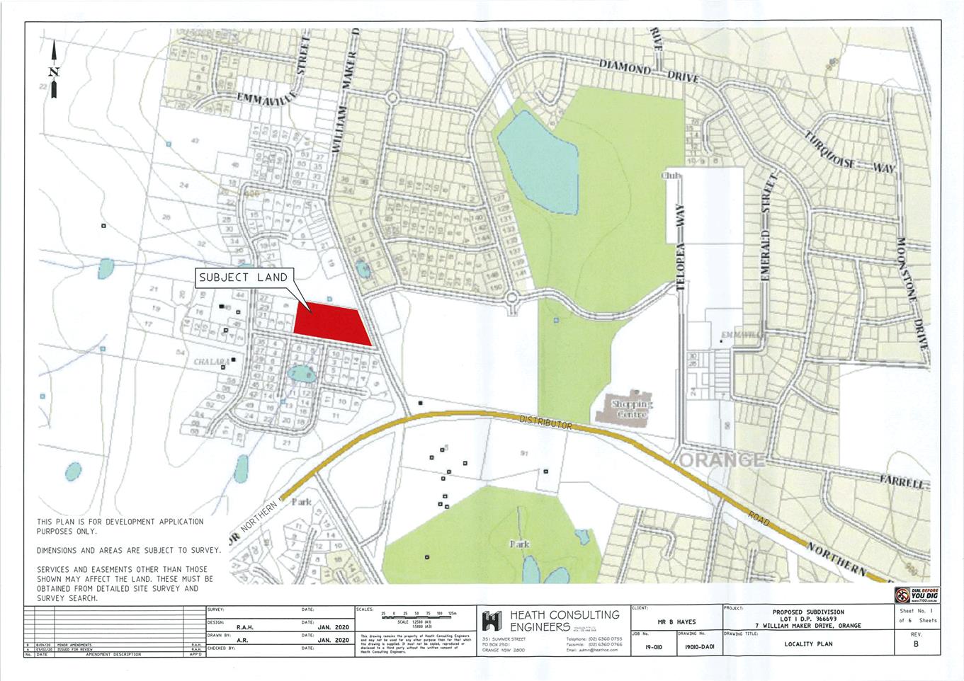
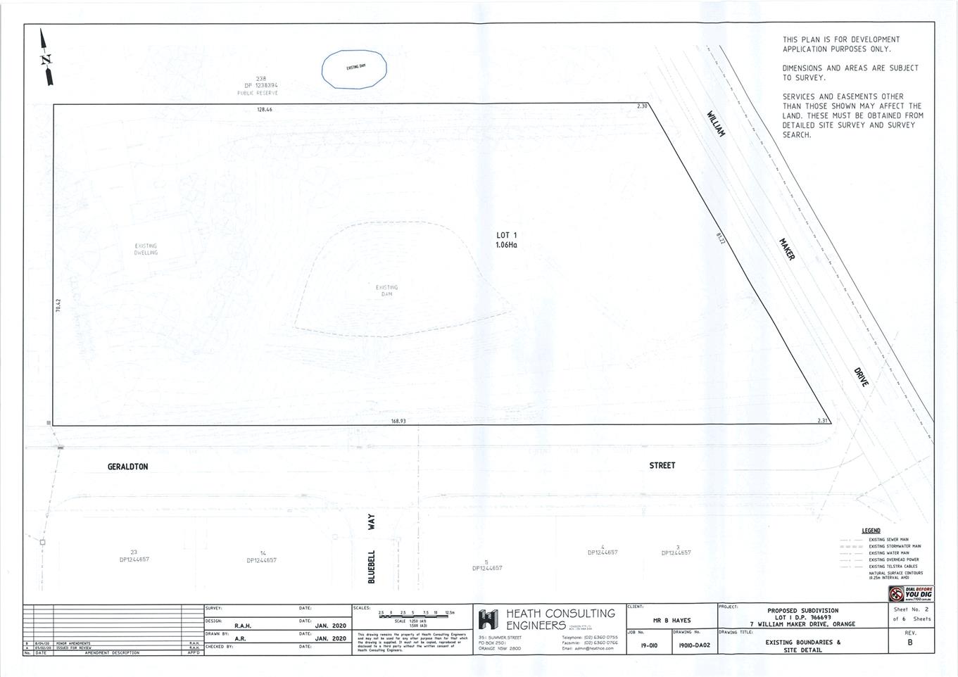
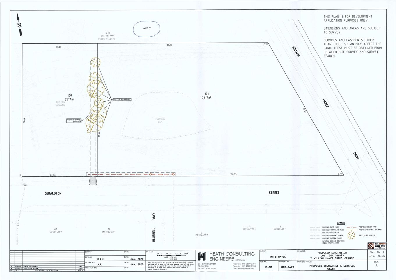
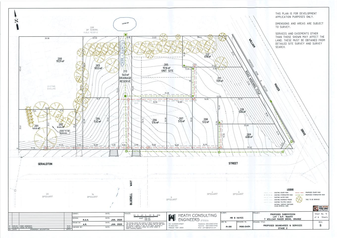
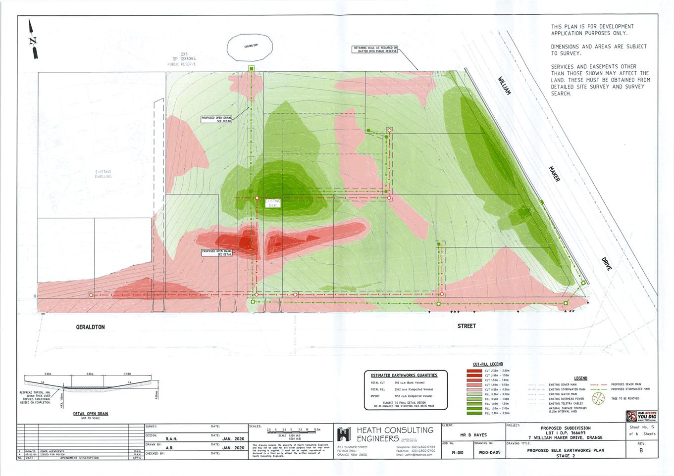
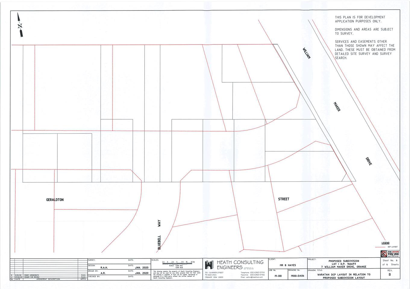
2.3 Electronic
lodgement of planning applications on the NSW Planning Portal
RECORD
NUMBER: 2020/1209
AUTHOR: Paul
Johnston, Manager Development Assessments
EXECUTIVE Summary
NSW Government recently passed
the Environmental Planning and Assessment
Amendment (Planning Portal) Regulation (2020) (the Regulation). This amendment impacts on how all Councils across the state receive and
process planning applications. The
amendment makes the use of the NSW
Planning Portal mandatory for the lodgement of certain planning applications
(in particular, development applications including modifications, applications
for complying development certificates (CDCs) and for certificates under Part 5
of the Environmental Planning and Assessment Act 1979), the assessment
of those applications, as well as the issue of any relevant consents, CDCs and
certificates.
In order to successfully transition to the NSW Department of
Planning portal, Council staff will be undertaking several projects in house to
refine assessment processes, improve internal integration of electronic systems
and suitably educate developers, various consultants and the general community
alike of the upcoming changes.
The information contained in the report is recommended to be
acknowledged.
Link To Delivery/OPerational Plan
The recommendation in this report relates to the
Delivery/Operational Plan strategy “10.1 Preserve - Engage with the
community to ensure plans for growth and development are respectful of our
heritage”.
Financial Implications
The proposed changes will require internal system changes
and the eventual introduction of integration modules to link Council’s
electronic records management system with Council’s property management
system and the NSW Planning Portal. In addition it will also be necessary to
introduce and purchase electronic assessment tools to assist with the
assessment of applications online. These integration modules and electronic
assessment tools will be planned and budgeted for through Council’s IT
Department.
Policy and Governance Implications
NSW Government recently passed the Environmental Planning
and Assessment Amendment (Planning Portal) Regulation (2020) (the Regulation).
The amendment makes the use of the NSW Planning Portal mandatory for the
lodgement of certain planning applications.
|
Recommendation
That the information contained in the report by the
Manager Development Assessments on ePlanning – Electronic lodgement of
planning applications on the NSW Planning Portal be acknowledged.
|
further considerations
Consideration has been given to the recommendation’s
impact on Council’s service delivery; image and reputation; political;
environmental; health and safety; employees; stakeholders and project
management; and no further implications or risks have been identified. The
required change has been legislated by the State Government.
SUPPORTING INFORMATION
NSW Government recently passed
the Environmental Planning and Assessment
Amendment (Planning Portal) Regulation (2020) (the Regulation). This amendment impacts on how all Councils across the state receive and
process planning applications. The amendment represents an important step in the implementation of the
Premier’s mandate of ePlanning Digital Services, which was announced in
November 2019.
The amendment makes the use of the NSW Planning Portal mandatory for
the lodgement of certain planning applications (in particular, development
applications including modifications, applications for complying development
certificates (CDCs) and for certificates under Part 5 of the Environmental
Planning and Assessment Act 1979), the assessment of those applications, as
well as the issue of any relevant consents, CDCs and certificates.
Details on the implementation of
the Premier’s mandate and the amendment to the Regulation can be found on
the NSW Planning Portal,
including a full list of when each Council is required to commence using
ePlanning Digital Services (https://www.planningportal.nsw.gov.au/eplanning-mandate).
In order to successfully transition to the NSW Department of
Planning portal, Council staff will be undertaking several projects in house to
refine assessment processes, improve internal integration of electronic systems
and suitably educate developers, various consultants and the general community
alike of the upcoming changes.
Council staff are proposing a soft implementation for the
electronic lodgement of applications in September/October 2020. This will
involve an invitation to the key planning and engineering consultants and
various building companies who operate within the region to transition to use
the ePlanning portal in the first instance. This will provide an opportunity
for Council staff to receive feedback and refine systems prior to the mandated
requirement for 100% use of the portal, by 1 July 2021.
2.4 Development
Application DA 41/2020(1) - 72 Hill Street
RECORD
NUMBER: 2020/1245
AUTHOR: Rishelle
Kent, Senior Planner
EXECUTIVE
Summary
|
Application
lodged – Section 8.2A Review of Determination
|
29 May
2020
|
|
Applicant/s
|
Mr DA
and Mrs JL Player
|
|
Owner/s
|
Tantara
Property Holding Pty Ltd
|
|
Land
description
|
Lot 100
DP 1103216 - 72 Hill Street, Orange
|
|
Proposed
land use
|
Hotel or
Motel Accommodation (conversion of manager’s residence to guest room)
|
|
Value of
proposed development
|
Not
applicable
|
This application seeks to review the determination of DA
41/2020(1) for a hotel or motel accommodation (conversion of manager’s
residence to guest room) at 72 Hill Street, Orange. The site is known
locally as the De Russie Boutique Hotel. The original application was approved
on 26 March 2020 subject to conditions of consent.
A Review of Determination under the legislation is to be
taken as a review of the previous decision made in its entirety. Council in
determining the review of the determination has the ability to confirm or
change the terms of the previously issued determination or decision.
The proponent has requested Council to reconsider the
imposition of Condition 4 of the previously issued determination, relating to
the requirement for a car parking contribution of $7,421.30 in lieu of the
physical provision of 0.5 onsite car parking spaces.
A formal review of the determination has been undertaken by
staff pursuant to Sections 8 and 4.15 of the Environmental
Planning and Assessment Act 1979. Council can be satisfied that the
original assessment and the conditions of consent were not issued in error.
With specific reference to the requirement for a car parking
contribution, Council is advised that the demand for parking exceeds the
recommended number of car parking spaces available upon the site by 0.5 spaces
as per Council’s DCP. Accordingly the requirement of a monetary
contribution in lieu of onsite parking is consistent with Council’s
policy.
In
accordance with Section 8.4 of the Act, it is recommended that Council confirms
the determination previously made by a delegate of Council including the
previously issued Notice of Determination.
Figure 1 - locality plan
DECISION FRAMEWORK
Development in Orange is governed by two key documents
Orange Local Environment Plan 2011 and Orange Development Control Plan 2004.
Orange Local Environment Plan 2011 – The
provisions of the LEP must be considered by the Council in determining the
application. LEPs govern the types of development that are permissible or
prohibited in different parts of the City and also provide some assessment
criteria in specific circumstances. Uses are either permissible or not. The
objectives of each zoning and indeed the aims of the LEP itself are also to be
considered and can be used to guide decision making around appropriateness of
development.
Orange Development Control Plan 2004 – the DCP
provides guidelines for development. In general it is a performance based
document rather than prescriptive in nature. For each planning element there
are often guidelines used. These guidelines indicate ways of achieving the
planning outcomes. It is thus recognised that there may also be other solutions
of merit. All design solutions are considered on merit by planning and building
staff. Applications should clearly demonstrate how the planning outcomes are
being met where alternative design solutions are proposed. The DCP enables
developers and architects to use design to achieve the planning outcomes in
alternative ways.
DIRECTOR’S COMMENT
This report is formal Review of Council’s previous
approval (March 2020) to convert a motel manager’s room into a room
available to guests at the De Russie Boutique Hotel. The applicant was
dissatisfied with the condition that required a monetary contribution to
parking. In short the applicant wants the condition requiring parking
contributions deleted from the consent.
Council in determining the review of the determination has
the ability to confirm or change the terms of the previously issued
determination or decision.
The demand for parking will exceed the recommended car
parking spaces available upon the site by 0.5 spaces as per
Council’s DCP hence the requirement for the contribution.
Council has a history of applying parking requirements to
motels in this precinct. Therefore, for consistency, it is recommended
that Council confirms the previous planning assessment and Notice of
Determination.
Link To Delivery/OPerational Plan
The recommendation in this report relates to the
Delivery/Operational Plan strategy “10.1 Preserve - Engage with the
community to ensure plans for growth and development are respectful of our
heritage”.
Financial Implications
Nil
Policy and Governance Implications
Nil
|
Recommendation
That Council confirms the
previous decision made in relation to DA 41/2020(1) for Hotel or Motel Accommodation (conversion of
manager’s residence to guest room) at Lot 100 DP 1103216
- 72 Hill Street, Orange, as per the previously
issued Notice of Determination (attached).
|
further considerations
Consideration has been given to the recommendation’s
impact on Council’s service delivery; image and reputation; political;
environmental; health and safety; employees; stakeholders and project
management; and no further implications or risks have been identified.
SUPPORTING INFORMATION
The application seeks to review the previous determination
of DA 41/2020(1) made by Council on 26 March 2020. The application sought
consent to convert the manager’s residence to an additional guest room,
thereby reducing the hours to which the manager would be onsite (7am to 9pm)
and increase the number of guests onsite.
The application was approved in March
subject to conditions including the provision of a Plan of Management (POM) and
a contribution for the deficiency of onsite car parking spaces. A POM has
not been received to date.
Whilst a complete review of the application is required by
the legislation, the applicant has requested specific re-consideration of
Condition 4 of the consent which requires a car parking contribution of
$7,421.30 (figure subject to indexing).
Reasons provided by the applicant include:
· Prior to Covid
there was ample parking for guests even when occupancy was at over 90%
· We see the
Council rate of one space per managers unit being replaced by one space per
motel unit as a logical and practical approach.
· The one for one
requirement under the DCP appears reasonable.
· As occupancy is
not at 100% all of the time and the manager is no longer parking in the spot
overnight, we have actually increased the availability of parking.
· All of our
staff are instructed to park in the car park behind the motel at all times.
· Under normal
occupancy patterns, many of our guests arrive via air and taxi and therefore do
not park onsite.
· Quest have less
than 1 space per room and (we) would ask that a consistent parking approach be
adopted.
It is noted that the business will still operate with an
onsite manager, however the hours of this position will be 7am to 9pm.
MATTERS FOR CONSIDERATION
Section 8 of the Environmental
Planning and Assessment
A development approval issued by
a local Council can be subject to a review pursuant to Section 8.2(1)(a) of the
Act, and lodged in accordance with Section 8.3 of the Act. The application
has not been amended subject to Section 8.3(3). The review of an application
previously made by a delegate of Council must be reviewed by a Council subject
to Section 8.4 of the Act, and therefore this application must be
determined by virtue of a Council Meeting. After
conducting its review of a determination or decision, the Council may confirm
or change the determination.
Section 1.7 - Application of
Part 7 of the Biodiversity Conservation Act 2016 and Part 7A of the
Fisheries Management Act 1994
Section 1.7 of the EP&A Act identifies that Part 7 of
the Biodiversity Conservation Act 2016 (BC Act) and Part 7A of the
Fisheries Management Act 1994 have effect in connection with terrestrial and
aquatic environments.
The development will not trigger the provisions which
require the need for a BDAR. The subject land is characterised as a highly
disturbed urban site with no native vegetation present of the site.
Additionally, the development relates to the use of an existing building with
no further works being proposed that could disturb threated species or their
habitats.
The development is considered acceptable with regards
to the above provisions.
Section 4.15
Section 4.15 of the Environmental
Planning and Assessment Act 1979 requires Council to consider various
matters, of which those pertaining to the application are listed below.
PROVISIONS OF ANY ENVIRONMENTAL
PLANNING INSTRUMENT s4.15(1)(a)(i)
Orange Local Environmental Plan
2011
Part 1 - Preliminary
Clause 1.2 - Aims of Plan
The broad aims of the LEP are set out under Subclause 2.
Those relevant to the application are as follows:
(a) to
encourage development which complements and enhances the unique character of
Orange as a major regional centre boasting a diverse economy and offering an
attractive regional lifestyle,
(b) to
provide for a range of development opportunities that contribute to the social,
economic and environmental resources of Orange in a way that allows present and
future generations to meet their needs by implementing the principles for
ecologically sustainable development,
(c) to
conserve and enhance the water resources on which Orange depends, particularly
water supply catchments,
(f) to recognise and manage valued
environmental heritage, landscape and scenic features of Orange.
The application is considered to be
consistent with the aims listed above.
Clause 1.6 - Consent Authority
This clause establishes that,
subject to the Act, Council is the consent authority for applications made
under the LEP.
Clause 1.7 - Mapping
The subject site is identified on the LEP maps in the
following manner:
|
Land Zoning Map:
|
Land zoned B3 Commercial Core
|
|
Lot Size Map:
|
No Minimum Lot Size
|
|
Heritage Map:
|
Heritage Conservation Area
|
|
Height of Buildings Map:
|
Building height limit: 9m
|
|
Floor Space Ratio Map:
|
Floor space limit: 0.5:1
|
|
Terrestrial Biodiversity Map:
|
No biodiversity sensitivity on the
site
|
|
Groundwater Vulnerability Map:
|
Groundwater vulnerable
|
|
Drinking Water Catchment Map:
|
Not within the drinking water
catchment
|
|
Watercourse Map:
|
Not within or affecting a defined
watercourse
|
|
Urban Release Area Map:
|
Not within an urban release area
|
|
Obstacle Limitation Surface Map:
|
No restriction on building siting
or construction
|
|
Additional Permitted Uses Map:
|
No additional permitted use applies
|
|
Flood Planning Map:
|
Not within a flood planning area
|
Those matters that are of relevance
are addressed in detail in the body of this report. It is noted that building
height limit and floor space limit are not relevant as the proposed application
does not involve additional floor space or building works.
Clause 1.9A - Suspension of
Covenants, Agreements and Instruments
Council staff are not aware of the title of the subject
property being affected by any of the excepted instruments as listed in 1.9A.
Clause 2.1 - Land Use Zones and Clause
2.3 - Zone Objectives and Land Use Table
The subject site is located within the B3 Commercial Core
zone. The proposed development is characterised as hotel or motel accommodation
under OLEP 2011 which is defined as:
a building or place (whether
or not licensed premises under the Liquor Act 2007) that provides temporary or
short-term accommodation on a commercial basis and that:
(a) comprises
rooms or self-contained suites, and
(b) may
provide meals to guests or the general public and facilities for the parking of
guests’ vehicles,
but does not include
backpackers’ accommodation, a boarding house, bed and breakfast
accommodation or farm stay accommodation.
Hotel or motel accommodation is permitted with consent in
the B3 Commercial Core zone.
Clause 2.3 of LEP 2011
references the Land Use Table and Objectives for each zone in LEP 2011.
These objectives for land zoned insert relevant zone are as follows:
1 -
Objectives of the B3 Commercial Core Zone
· To provide a
wide range of retail, business, office, entertainment, community and other
suitable land uses that serve the needs of the local and wider community.
· To encourage
appropriate employment opportunities in accessible locations.
· To maximise
public transport patronage and encourage walking and cycling.
· To promote
development that contributes to the role of the Orange CBD as the primary
retail and business centre in the City and region.
The development is not inconsistent
with object of the zone.
5.10 - Heritage Conservation
The subject land is located in the Central Orange Heritage
Conservation Area and adjoins a heritage item to the north (68 Byng Street).
The development is not contrary to the
objectives of the clause. No building work or changes to the exterior
appearance of the building is proposed.
7.6 - Groundwater Vulnerability
The proposal will not
involve the discharge of toxic or noxious substances and is therefore unlikely
to contaminate the groundwater or related ecosystems. The proposal does not
involve extraction of groundwater and will therefore not contribute to
groundwater depletion. The design and siting of the proposal avoids impacts on
groundwater and is therefore considered acceptable.
Clause 7.11 - Essential Services
In consideration of this clause,
all utility services are available to the land and adequate for the proposal.
STATE ENVIRONMENTAL PLANNING
POLICIES
State Environmental Planning Policy 55 - Remediation of
Land
The site has a
long standing history of residential landuse, both as residential units and
motel accommodation. This development will not alter that use, nor will it
involve ground disturbance. As such, the land is unlikely to be contaminated
and there are no previous uses to suggest otherwise. Additionally, the
development does not represent a change of use.
PROVISIONS OF ANY DRAFT
ENVIRONMENTAL PLANNING INSTRUMENT THAT HAS BEEN PLACED ON EXHIBITION
4.15(1)(a)(ii)
From 31 January to13 April 2018 the Department of
Planning and Environment publically exhibited an Explanation of Intended Effect
(EIE) and Draft Planning Guidelines for the proposed Remediation of Land SEPP,
which will repeal and replace State Environmental Planning Policy 55 –
Remediation of Land (SEPP 55).
There are no known contaminated sites immediately adjoining
the subject land. Additionally, the application does not involve ground
disturbance, thereby removing the likelihood of encountering a new
contamination pathway from adjoining sites.
DRAFT AMENDMENT NO 24
Amendment No 24 to Orange LEP 2011
has been placed on public exhibition. The draft plan includes several
amendments to the plan. The proposed development is not inconsistent with the
draft plan.
DESIGNATED DEVELOPMENT
The proposed development is not
designated development.
INTEGRATED DEVELOPMENT
The proposed development is not
integrated development.
PROVISIONS OF ANY DEVELOPMENT
CONTROL PLAN s4.15(1)(a)(iii)
Development Control Plan 2004
Development Control Plan 2004
(“the DCP”) applies to the subject land (Chapter 8 - Development
in business zones, Chapter 13 - Heritage and Chapter 15 - Car Parking).
An assessment of the proposed development against the relevant Planning
Outcomes will be undertaken below, excepting matters relating to heritage which
has been previously addressed.
Chapter 8 - Development in
Business Zones
Development consent was sought for
the change in use of one room. The room was initially approved to be used as a
managers residence, the March 2020 consent granted approval for this room to be
used by motel guests.
Compliance with onsite parking will
be addressed in detail below.
Chapter 15 - Car Parking
The DCP requires parking for motels at the rate of:
One space per unit/bedroom/tent or caravan site
One space for every three
beds (hostel accommodation)
+ one space for each resident manager
+ one space for every two employees
+ 1 space for every three
seats in the restaurant
+ one space per 10m² of entertainment or function
room areas
Background
The original approval of the motel
in 2006 required the provision of 25 onsite car parking spaces (21 spaces
provided onsite and a contribution for the deficiency of four spaces).
The applicant modified that consent, by providing an additional two car
parking spaces onsite, thereby reducing the levied contribution to two car
parking spaces. With the provision of 23 spaces onsite and the
contributions paid for two spaces; 25 spaces were recognised for the
development and satisfied Council’s parking requirement.
In 2014 Council granted consent to an application to convert
an indoor pool to a bridal suite, which required a monetary car parking
contribution to be paid for the additional car parking space generated by the
additional unit. The applicant subsequently lodged a modification to have the
condition removed, which the Council agreed to at the February 2015 Sustainable
Development Committee.
In summary, development history of the site provides for 23
physical spaces, two spaces have been accounted for via monetary contribution,
and the contribution for one space has been waived by Council.
Car Parking Assessment
DA 41/2020(1) sought to convert
the manager’s residence to one additional guest room. Based on the
information submitted at the time, the staff numbers were to remain as
previously approved (being one manager and two staff), however, the
‘resident manager’ was redescribed as ‘staff’ under the
car parking definitions above. Therefore the car parking calculation relevant
to the proposed development was:
One space for an
additional room
Less one space for
the ‘resident manager’
Plus 0.5 space for an
‘employee’
And therefore a contribution of 0.5 spaces, being $7,421.30,
was conditioned in accordance with the provisions of the DCP.
The applicant has provided the following justification to
remove the car parking contribution:
· Prior to Covid
there was ample parking for guests even when occupancy was at over 90%
· We see the Council
rate of one space per managers unit being replaced by one space per motel unit
as a logical and practical approach.
· The one for one
requirement under the DCP appears reasonable.
· As occupancy is
not at 100% all of the time and the manager is no longer parking in the spot
overnight, we have actually increased the availability of parking.
· All of our
staff are instructed to park in the car park behind the motel at all times.
· Under normal
occupancy patterns, many of our guests arrive via air and taxi and therefore do
not park onsite.
· Quest have less
than one space per room and (we) would ask that a consistent parking approach
be adopted.
In response:
1. The
application seeks to convert a manager’s residence to guest
accommodation. The manager will be onsite from 7am to 9pm and therefore
require onsite parking. The guest accommodation will introduce additional
customers to the site, therefore increasing demand for onsite parking.
2. Under
the DCP car parking requirement, the ‘resident manager’ requirements
was downgraded to ‘employee’ car parking requirements as the
manager would not require onsite parking between the hours of 9pm and 7am. An
‘employee’ is calculated at a lesser rate (0.5 space per employee
compared to one space for ‘resident manager’) even though in this
instance the manager’s hours would overlap with customer parking and
therefore increase demand for onsite parking.
3. The
advice that “staff are instructed to park in the carpark behind the
motel at all times” is testament to the demand for availability of
car parking upon the site.
4 In
accordance with Council policy, when additional car parking demand cannot be
met onsite, the net increase is required to be met by a car parking
contribution. This is particularly relevant given the use of Council’s
car park to facilitate parking for this business. Such car parks are directly
paid for by way of recouped funds via Council’s Car Parking Contribution
Plan.
As a result, the following options are available to Council
in review of the application:
1. Review
the Determination and confirm the previously issued conditions of consent
requiring the payment of 0.5 car parking spaces in accordance with
Council’s Car Parking Contribution Plan, based on an increase in guest
accommodation and the manager being present onsite between the hours of 7am to
9pm (RECOMMENDATION).
2. Review
the Determination and change the conditions of consent.
It should be noted that Council’s Contribution Plan
provides a 50% discount for a change of land use application, however this
application is not defined as a change of land use, rather a modification to
the operation of the site. An example of a change of land use is shop to
office, or other example where the land use definition changes.
INFILL GUIDELINES
The proposed development will not impact upon
Council’s Infill Development.
PROVISIONS PRESCRIBED BY THE
REGULATIONS s4.15(1)(a)(iv)
Demolition of a Building (clause 92)
The proposal does not involve the demolition of a building.
Fire Safety Considerations (clause
93)
The proposal involves a change of building use for an
existing building. Council is satisfied that the fire protection and structural
capacity of the building are appropriate for the proposed new building use.
Buildings to be Upgraded
(clause 94)
The proposal does not involve the rebuilding, alteration,
enlargement or extension of an existing building.
BASIX Commitments (clause 97A)
Not applicable.
THE LIKELY IMPACTS OF THE
DEVELOPMENT s4.15(1)(b)
The Review of Determination relates
to the issue of car parking demand only. No other issues are addressed as it is
considered they have been adequately assessed.
Context and Setting
The land is situated within the CBD of Orange and adjoins
residential properties and a Council owned car park. The development to convert
the manager’s residence to a guest room will not dramatically change the
nature of the existing motel and as such the development remains consistent
with the context and setting of the locality.
Access, Traffic and Parking
Existing access and traffic
arrangements remain unchanged and are considered to remain satisfactory for the
development. The demand for parking exceeds the recommended car parking spaces
available upon the site as per Council’s DCP, and therefore it is
recommended that the net increase be catered for by means of car parking
contribution as per Council’s Car Parking Contributions Plan.
Cumulative Impacts
With the requirement for the
monetary compensation for the deficiency in onsite parking, the development is
not expected to give rise to any unacceptable cumulative impacts.
THE SUITABILITY OF THE SITE
s4.15(1)(c)
The site has a relatively long
history being used for the purposes of hotel or motel accommodation. This
application will not alter that longstanding use. The development is considered
suitable for the site.
ANY SUBMISSIONS MADE IN
ACCORDANCE WITH THE ACT s4.15(1)(d)
The proposed development is defined
as "advertised development" under the provisions of the Act. The
application was advertised for the prescribed period of 14 days and at the end
of that period no submissions were received.
PUBLIC INTEREST s4.15(1)(e)
The proposed development is considered to be of minor
interest to the wider public due to the relatively localised nature of
potential impacts. The proposal is not inconsistent with any relevant policy
statements, planning studies, guidelines etc that have not been considered in
this assessment. Public submissions have not been received in regard to this
review.
SUMMARY
The proposed development remains permissible with the
consent of Council. The development complies with the relevant aims,
objectives and provisions of Orange LEP 2011 (as amended) and DCP
2004 pursuant to the previously issued conditions of consent. A Section 4.15
and Section 8 assessment of the development indicates that the development is
acceptable in this instance. Attached is the Notice of Approval previously
issued imposing conditions considered appropriate to ensure that the
development proceeds in an acceptable manner without detrimental impact to the
surrounding environment.
COMMENTS
The requirements of the Environmental Health and Building
Surveyor and the Engineering Development Section are included in the attached
Notice of Approval.
Attachments
1 Notice
of Approval, D20/44106⇩
2 Plans,
D20/44115⇩
Planning
and Development Committee
11 August 2020
Attachment 1 Notice
of Approval
|

|
ORANGE
CITY COUNCIL
Development
Application No DA
41/2020(1)
NA20/182 Container
PR21874
|
NOTICE OF DETERMINATION
OF A DEVELOPMENT
APPLICATION
issued under the Environmental
Planning and Assessment Act 1979
Section 4.18
|
Development
Application
|
|
|
Applicant Name:
|
Tantara
Property Holding Pty Ltd
|
|
Applicant Address:
|
72 Hill
Street
ORANGE
NSW 2800
|
|
Owner’s Name:
|
Tantara
Property Holding Pty Ltd
|
|
Land to Be Developed:
|
Lot 100 DP
1103216 - 72 Hill Street, Orange
|
|
Proposed Development:
|
Hotel or Motel
Accommodation (conversion of manager’s residence to guest room)
|
|
|
|
|
Building
Code of Australia
building
classification:
|
Class 3
|
|
|
|
|
Determination
made under
Section 4.16
|
|
|
Made On:
|
26 March
2020
|
|
Determination:
|
CONSENT
GRANTED SUBJECT TO CONDITIONS DESCRIBED BELOW:
|
|
|
|
|
Consent to
Operate From:
|
26 March
2020
|
|
Consent to
Lapse On:
|
26 March
2025
|
Terms of Approval
The reasons for the imposition of
conditions are:
(1) To ensure a quality
urban design for the development which complements the surrounding environment.
(2) To maintain
neighbourhood amenity and character.
(3) To ensure compliance
with relevant statutory requirements.
(4) To provide adequate
public health and safety measures.
(5) Because the development
will require the provision of, or increase the demand for, public amenities and
services.
(6) To prevent the proposed
development having a detrimental effect on adjoining land uses.
(7) To minimise the impact
of development on the environment.
Conditions
(1) The
development must be carried out in accordance with:
(a) Plans
by McKinnon Design job no. 20005 sheets 1 and 2 dated January 2020 (2 sheets)
(b) statements
of environmental effects or other similar associated documents that form part
of the approval
as amended
in accordance with any conditions of this consent.
(2) All building work must
be carried out in accordance with the provisions of the Building Code of
Australia.
|
DURING
CONSTRUCTION/SITEWORKS
|
(3) Any adjustments to
existing utility services that are made necessary by this development
proceeding are to be at the full cost of the developer.
|
PRIOR TO THE ISSUE OF
AN OCCUPATION CERTIFICATE
|
(4) The payment of $7,421.30
shall be made to Council in accordance
with Section 7.11 of the Act and Orange Car Parking
Development Contributions Plan 2015 in lieu of the physical provision of
adequate on-site car parking spaces.
PAYMENT MUST BE MADE PRIOR TO THE
ISSUE OF ANY CERTIFICATE under part 4A of
the Act.
The contribution shall be indexed
quarterly in accordance with the Orange Car Parking Development Contributions
Plan 2015, which may be inspected at the Orange Civic Centre, Byng Street,
Orange.
(5) Prior to the issue of
any Occupation Certificate a detailed Plan of Management (POM) for the
development shall be prepared and submitted to Council for approval. The POM
shall address how the operation of the motel will be managed outside of staffed
hours. The POM as a minimum must provide measures for the following situations:
· security measures,
· staff responsibilities,
· noise minimisation and
dealing with complaints,
· management of
anti-social behaviour,
· management of
unsolicited large gatherings within guest rooms and common areas,
· fire alarm procedure,
· procedures for medical
emergencies,
· late check-in
procedures,
· lock out procedures,
· etc.
The POM shall also include a complaints
register and an incident log that may be made available for the NSW Police or
Council officers caring out their duties under the EP and A Act.
(6) No
person is to use or occupy the building or alteration that is the subject of
this approval without the prior issuing of an Occupation Certificate.
(7) The
owner of the building/s must cause the Council to be given a Final Fire Safety
Certificate on completion of the building in relation to essential fire or
other safety measures included in the schedule attached to this approval.
(8) All
of the foregoing conditions are to be at the full cost of the developer and to
the requirements and standards of the Orange City Council Development and
Subdivision Code, unless specifically stated otherwise. All work required by
the foregoing conditions is to be completed prior to the issuing of an
Occupation Certificate, unless stated otherwise.
|
MATTERS FOR THE
ONGOING PERFORMANCE AND OPERATION OF THE DEVELOPMENT
|
(9) The
owner is required to provide to Council and to the NSW Fire Commissioner an
Annual Fire Safety Statement in respect of the fire-safety measures, as
required by Clause 177 of the Environmental Planning and Assessment
Regulation 2000.
Other Approvals
(1) Local
Government Act 1993 approvals granted under Section 68.
Nil
(2) General
terms of other approvals integrated as part of this consent.
Nil
Right of Appeal
If you are dissatisfied with this
decision, Section 8.7 of the Environmental Planning and Assessment
Act 1979 gives you the right to appeal to the Land and Environment
Court. Pursuant to Section 8.10, an applicant may only appeal within 6 months
after the date the decision is notified.
|
Disability Discrimination Act
1992:
|
This application has been assessed in
accordance with the Environmental Planning and Assessment Act 1979. No
guarantee is given that the proposal complies with the Disability
Discrimination Act 1992.
The applicant/owner is responsible to
ensure compliance with this and other anti-discrimination legislation.
The Disability Discrimination Act
covers disabilities not catered for in the minimum standards called up in the
Building Code of Australia which references AS1428.1 - "Design for
Access and Mobility". AS1428 Parts 2, 3 and 4 provides the most
comprehensive technical guidance under the Disability Discrimination Act
currently available in Australia.
|
|
|
|
|
Disclaimer - S88B of the Conveyancing
Act 1919 - Restrictions on the Use of Land:
|
The applicant should note that there
could be covenants in favour of persons other than Council restricting what
may be built or done upon the subject land. The applicant is advised to check
the position before commencing any work.
|
|
|
|
|
Signed:
|
On behalf of the consent authority ORANGE
CITY COUNCIL
|
|
Signature:
|
|
|
Name:
|
PAUL JOHNSTON - MANAGER DEVELOPMENT ASSESSMENTS
|
|
Date:
|
26 March 2020
|
Planning and Development Committee
11 August 2020
2.5 Development
Application DA 210/2020(1) - 80 Summer Street
RECORD
NUMBER: 2020/1266
AUTHOR: Sophie
Currenti, Student Planner
EXECUTIVE Summary
|
Application
lodged
|
11 June
2020
|
|
Applicant/s
|
Mrs MC
Cubitt
|
|
Owner/s
|
Mr EWK
and Mrs SK Ko
|
|
Land
description
|
Lot 2 DP
1181850 - 80 Summer Street, Orange
|
|
Proposed
land use
|
Recreation
Facility (indoor) (change of use)
|
|
Value of
proposed development
|
Not
applicable
|
Council's consent is sought for the change of use from a
restaurant to an indoor recreational facility (to be a used as a dance studio)
within part of the existing building at 80 Summer Street – Lot 2
DP1181850.
The dance studio is to be located on the first floor of the
existing building, replacing a space which was originally intended for further
restaurant dining by the ground floor premises. The ground floor is to remain a
restaurant. The dance studio will be accessed through the shared foyer on the
ground floor.
The hours of operation are to be
from 3.30pm–8.30pm on Monday to Friday and from 9am‑3pm on
Saturdays. There will be three staff operating the 80 students, although there
will only be approximately 5 to 15 students on the premises at one time.
The proposed change of use generates a theoretical increase
in parking demand of six spaces. There is no ability to accommodate
additional parking onsite. It is noted that the subject land is contained
within the car parking development contributions area, and a
contribution in lieu could be imposed by condition. The contribution in this
case would equate to $44,661.48. The applicant requests a waiver for this
contribution. The requirement for a contribution in this case is
considered unreasonable for the reasons outlined in the body of this report.
Council’s records show that Council has consented to other dance
studios/gymnasiums in and around the city where onsite car parking provision
has departed from the DCP requirements and a contribution was not sought on the
basis of conditions being included which restricted the hours of operation and
student/patrons numbers and the like.
Being an application with a request
to waive contributions over $20,000, delegation falls to the Planning and
Development Committee. It is recommended that Council supports the
recommendation as articulated in the report and the accompanying Notice of
Determination.
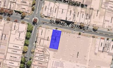
Figure 1 - locality plan
DECISION FRAMEWORK
Development in Orange is governed
by two key documents Orange Local Environment Plan 2011 and Orange Development
Control Plan 2004. In addition the Infill Guidelines are used to guide
development, particularly in the heritage conservation areas and around
heritage items.
Orange Local Environment Plan
2011 – The provisions of the LEP must be considered by the Council in
determining the application. LEPs govern the types of development that are
permissible or prohibited in different parts of the City and also provide some
assessment criteria in specific circumstances. Uses are either permissible or
not. The objectives of each zoning and indeed the aims of the LEP itself are
also to be considered and can be used to guide decision making around
appropriateness of development.
Orange Development Control Plan
2004 – the DCP provides guidelines for development. In general
it is a performance based document rather than prescriptive in nature. For each
planning element there are often guidelines used. These guidelines indicate
ways of achieving the planning outcomes. It is thus recognised that there may
also be other solutions of merit. All design solutions are considered on merit
by planning and building staff. Applications should clearly demonstrate how the
planning outcomes are being met where alternative design solutions are
proposed. The DCP enables developers and architects to use design to achieve
the planning outcomes in alternative ways.
DIRECTOR’S COMMENT
The dance studio is to be located
on the first floor of the existing Canton building, replacing a space which was
originally intended for further restaurant dining by the ground floor premises.
The main issue of this development is parking. The proposed change of use
generates a theoretical increase in parking demand of six spaces and given that
there is no ability to accommodate additional parking on the land a
contribution could be requested by Council. The applicant requested a waiver
for this contribution due to small dance student numbers, hours of operation
and high turnover. The justification seems reasonable and consistent with other
dance studio operations in the City. It is recommended that Council supports
the recommendation of approval with the waiver of parking contributions.
Link To Delivery/OPerational Plan
The recommendation in this report relates to the
Delivery/Operational Plan strategy “10.1 Preserve - Engage with the
community to ensure plans for growth and development are respectful of our
heritage”.
Financial Implications
Nil
Policy and Governance Implications
Nil
|
Recommendation
That Council consents to
development application DA 210/2020(1)
for Recreation Facility (indoor) (change of use) at Lot 2 DP 1181850 -
80 Summer Street, Orange pursuant to the conditions
of consent in the attached Notice of Approval.
|
further considerations
Consideration has been given to the recommendation’s
impact on Council’s service delivery; image and reputation; political;
environmental; health and safety; employees; stakeholders and project
management; and no further implications or risks have been identified.
SUPPORTING INFORMATION
The proposal involves the change of use from a restaurant to
an indoor recreational facility (to be a used as a dance studio) within part of
the building at 80 Summer Street. The proposal does not involve any
construction works and purely relates to the change of use.
The dance studio is to be located on the first floor of the
existing building, replacing a space which was originally intended for further
restaurant dining by the ground floor premises. The ground floor is to remain a
restaurant. The dance studio will be accessed through the shared foyer on the
ground floor.
The hours of operation are to be from 3.30pm–8.30pm on
Monday to Friday and from 9am‑3pm on Saturdays. There will be three staff
operating the 80 students, although there will only be approximately 5 to 15
students on the premises at one time. The applicant has stated that majority of
the students will be arriving via a school bus or parent drop off and will walk
to the premises.
Figure 2 – first floor space
Figure 3 - first floor space
MATTERS FOR CONSIDERATION
Section 1.7 - Application of
Part 7 of the Biodiversity Conservation Act 2016 and Part 7A of the
Fisheries Management Act 1994
Section 1.7 of the EP&A Act identifies that Part 7 of
the Biodiversity Conservation Act 2016 (BC Act) and Part 7A of the
Fisheries Management Act 1994 have effect in connection with terrestrial and
aquatic environments.
There are four triggers known to insert a development into
the Biodiversity Offset Scheme (ie the need for a BDAR to be submitted
with a DA):
· Trigger 1:
development occurs in land mapped on the Biodiversity Values Map (OEH)
(clause 7.1 of BC Regulation 2017);
· Trigger 2:
development involves clearing/disturbance of native vegetation above a certain
area threshold (clauses 7.1 and 7.2 of BC Regulation 2017); or
· Trigger 3:
development is otherwise likely to significantly affect threatened species
(clauses 7.2 and 7.3 of BC Act 2016).
The fourth trigger (development proposed to occur in an Area
of Outstanding Biodiversity Value (clause 7.2 of BC Act 2016) is generally not
applicable to the Orange LGA; as no such areas are known to occur in the LGA.
No further comments will be made against the fourth trigger.
The site does not occur within land mapped on the
Biodiversity Values Map and no clearing/disturbance is proposed. As the
proposal does not trigger any of the four requirements for insertions into the
BOS, a Biodiversity Development Assessment Report is not required to be lodged
with the application for development consent. No other comments are warranted
under this section.
Section 4.15
Section 4.15 of the Environmental Planning and Assessment
Act 1979 requires Council to consider various matters, of which those
pertaining to the application are listed below.
PROVISIONS OF ANY ENVIRONMENTAL
PLANNING INSTRUMENT s4.15(1)(a)(i)
Orange Local Environmental Plan 2011
Part 1 - Preliminary
Clause 1.2 - Aims of Plan
The
broad aims of the LEP are set out under Subclause 2. Those relevant to the
application are as follows:
(a) to encourage development which complements
and enhances the unique character of Orange as a major regional centre boasting
a diverse economy and offering an attractive regional lifestyle,
(b) to provide for a range of development
opportunities that contribute to the social, economic and environmental
resources of Orange in a way that allows present and future generations to meet
their needs by implementing the principles for ecologically sustainable
development,
(f) to
recognise and manage valued environmental heritage, landscape and scenic
features of Orange.
The application is considered to be consistent with the applicable
aims of the plan.
Clause 1.6 - Consent Authority
This clause establishes that,
subject to the Act, Council is the consent authority for applications made
under the LEP.
Clause 1.7 - Mapping
The subject site is identified
on the LEP maps in the following manner:
|
Land Zoning Map:
|
Land zoned B3 Commercial Core
|
|
Lot Size Map:
|
No Minimum Lot Size
|
|
Heritage Map:
|
Within the conservation area
|
|
Height of Buildings Map:
|
Building height limit 12m
|
|
Floor Space Ratio Map:
|
Floor space limit 1.5-1.8:1
|
|
Terrestrial Biodiversity Map:
|
No biodiversity sensitivity on the
site
|
|
Groundwater Vulnerability Map:
|
Groundwater vulnerable
|
|
Drinking Water Catchment Map:
|
Not within the drinking water
catchment
|
|
Watercourse Map:
|
Not within or affecting a defined watercourse
|
|
Urban Release Area Map:
|
Not within an urban release area
|
|
Obstacle Limitation Surface Map:
|
No restriction on building siting
or construction
|
|
Additional Permitted Uses Map:
|
No additional permitted use applies
|
|
Flood Planning Map:
|
Not within a flood planning area
|
Those matters that are of relevance are addressed in detail
in the body of this report.
Clause 1.9A - Suspension of
Covenants, Agreements and Instruments
This clause provides that covenants, agreements and other
instruments which seek to restrict the carrying out of development do not apply
with the following exceptions.
(a) to
a covenant imposed by the Council or that the Council requires to be imposed,
or
(b) to
any relevant instrument under Section 13.4 of the Crown Land Management Act
2016, or
(c) to
any conservation agreement under the National Parks and Wildlife Act 1974, or
(d) to
any Trust agreement under the Nature Conservation Trust Act 2001, or
(e) to
any property vegetation plan under the Native Vegetation Act 2003, or
(f) to
any biobanking agreement under Part 7A of the Threatened Species Conservation
Act 1995, or
(g) to
any planning agreement under Subdivision 2 of Division 7.1 of the Environmental
Planning and Assessment Act 1979.
Council staff are not aware of the title of the subject
property being affected by any of the above.
Part 2 - Permitted or
Prohibited Development
Clause 2.1 - Land Use Zones and Clause
2.3 - Zone Objectives and Land Use Table
The subject site is located within the B3 Commercial Core
zone. The proposed development is defined as a ‘recreation facility
(indoor)’ under OLEP 2011 and is permitted with consent for this
zone. This application is seeking consent.
Clause 2.3 of LEP 2011 references the Land Use Table and Objectives for
each zone in LEP 2011. These objectives for land zoned B3 Commercial Core
are as follows:
1 -
Objectives of the B3 Commercial Core Zone
· To provide a
wide range of retail, business, office, entertainment, community and other
suitable land uses that serve the needs of the local and wider community.
· To encourage
appropriate employment opportunities in accessible locations.
· To maximise
public transport patronage and encourage walking and cycling.
· To promote
development that contributes to the role of the Orange CBD as the primary
retail and business centre in the City and region.
The proposal is
considered to be consistent with the objectives of the zone. The proposed dance
studio will not be altering the built environment of the locality as it is
relating to the internal space of an existing building. The change of use
provides another form of business within the zone and enhances the role of the
Orange CBD.
Part 3 - Exempt and Complying
Development
The application is not exempt or complying development.
Part 4 - Principal Development
Standards
Clause 4.3 - Height of Buildings
This clause limits the height of
buildings (HoB) on land identified on the Height of Buildings Map. The subject
land is identified
on the Map as having a HoB limit of 12m. This proposal does not intend to alter
the current building height from its compliant height. Therefore is consistent
with the established height limit.
Clause 4.4 - Floor Space Ratio
This clause limits the floor space
ratio (FSR) permitted on land identified on the Floor Space Ratio Map. Clause 4.5 is
associated with this clause and establishes the rules for calculating the site
area and FSR of any proposal. These rules exclude certain parts of a site and
development such as:
· excluding any part of
the site upon which the development is prohibited (ie if the site is split
zoned only the zone in which the development is permissible may be considered)
· excluding community
land and most public places
· lots in a strata
scheme wholly or partly above other lots in the scheme do not increase the site
area (ie the site area is the ground level of the scheme only)
· adjoining lots in the
same ownership do not form part of the site area unless significant parts of
the development are proposed on that land
· the floor area of
existing buildings is to be included in the FSR calculation
· any covenant
restricting floor space on the lot, due to floor space having been considered
as part of the development of another lot, is to be taken into account.
The
subject land is identified on the Map as having an FSR of 1.5-1.8:1. Due to there
being no alterations to the building itself, the existing FSR is not changing,
and is therefore consistent with the FSR requirements.
Part 5 - Miscellaneous Provisions
5.10 - Heritage
Conservation
(1) Objectives
The objectives of this clause are as
follows:
(a) to
conserve the environmental heritage of Orange,
(b) to
conserve the heritage significance of heritage items and heritage conservation areas,
including associated fabric, settings and views,
(c) to
conserve archaeological sites,
(d) to
conserve Aboriginal objects and Aboriginal places of heritage significance.
(4) Effect
of Proposed Development on Heritage Significance
The consent authority must, before
granting consent under this clause in respect of a heritage item or heritage
conservation area, consider the effect of the proposed development on the
heritage significance of the item or area concerned. This subclause applies
regardless of whether a heritage management document is prepared under
Subclause (5) or a heritage conservation management plan is submitted under
Subclause (6).
(5) Heritage
Assessment
The consent authority may,
before granting consent to any development:
(a) on
land on which a heritage item is located, or
(b) on
land that is within a heritage conservation area, or
(c) on
land that is within the vicinity of land referred to in paragraph (a) or (b),
require a heritage management
document to be prepared that assesses the extent to which the carrying out of
the proposed development would affect the heritage significance of the heritage
item or heritage conservation area concerned.
The proposed change of use is
occurring within a building located in the Orange Conservation Area. Due to
there being no additions or alterations to the development itself, and the
proposal is related to the internal state of the building, it is considered
that there will be a minimal impact on the heritage significance of the area.
Part 6 - Urban Release Area
Not relevant to the application.
The subject site is not located in an Urban Release Area.
Part 7 - Additional Local Provisions
7.6 - Groundwater Vulnerability
This clause seeks to protect
hydrological functions of groundwater systems and protect resources from both
depletion and contamination. Orange has a high water table and large areas of
the LGA, including the subject site, are identified with “Groundwater
Vulnerability” on the Groundwater Vulnerability Map. This requires that
Council consider:
(a) whether or not the development (including
any onsite storage or disposal of solid or liquid waste and chemicals) is
likely to cause any groundwater contamination or have any adverse effect on
groundwater dependent ecosystems, and
(b) the cumulative impact (including the
impact on nearby groundwater extraction for potable water supply or stock water
supply) of the development and any other existing development on groundwater.
Furthermore, consent may not be granted unless Council is satisfied that:
(a) the development is designed, sited and
will be managed to avoid any significant adverse environmental impact, or
(b) if that impact cannot be reasonably
avoided - the development is designed, sited and will be managed to minimise
that impact,
(c) if that impact cannot be minimised - the
development will be managed to mitigate that impact.
This proposal is not altering any part
of the designated building, therefore the proposal is not anticipated to
involve effects on groundwater and is considered acceptable.
Clause 7.11 - Essential
Services
Clause 7.11 applies and states:
Development consent must not be
granted to development unless the consent authority is satisfied that any of
the following services that are essential for the proposed development are
available or that adequate arrangements have been made to make them available
when required:
(a) the
supply of water,
(b) the
supply of electricity,
(c) the
disposal and management of sewage,
(d) storm
water drainage or onsite conservation,
(e) suitable
road access.
In consideration of this clause, all utility services are
available to the land and adequate for the proposal.
STATE ENVIRONMENTAL PLANNING
POLICIES
State Environmental Planning Policy 55 Remediation of
Land
State Environmental Planning Policy 55 - Remediation of
Land (SEPP 55) is applicable. Pursuant to Clause 7 Contamination and
remediation to be considered in determining development application:
(1) A consent authority must not consent to
the carrying out of any development on land unless:
(a) it
has considered whether the land is contaminated, and
(b) if
the land is contaminated, it is satisfied that the land is suitable in its
contaminated state (or will be suitable, after remediation) for the purpose for
which the development is proposed to be carried out, and
(c) if
the land requires remediation to be made suitable for the purpose for which the
development is proposed to be carried out, it is satisfied that the land will
be remediated before the land is used for that purpose.
There are no known uses for the subject site which undertook
practices that result in contaminated land. It is concluded that the likelihood
of contamination is significantly low.
PROVISIONS OF ANY DRAFT
ENVIRONMENTAL PLANNING INSTRUMENT THAT HAS BEEN PLACED ON EXHIBITION
4.15(1)(a)(ii)
From 31 January to13 April 2018 the Department of
Planning and Environment publically exhibited an Explanation of Intended Effect
(EIE) and Draft Planning Guidelines for the proposed Remediation of Land SEPP,
which will repeal and replace State Environmental Planning Policy 55 –
Remediation of Land (SEPP 55). Of particular note, the Draft Planning
Guidelines state:
“In undertaking an initial evaluation, a
planning authority should consider whether there is any known or potential
contamination on nearby or neighbouring properties, or in nearby groundwater,
and whether that contamination needs to be considered in the assessment and
decision making process.”
“If the planning authority knows that
contamination of nearby land is present but has not yet been investigated, it
may require further information from the applicant to demonstrate that the
contamination on nearby land will not adversely affect the subject land having
regard to the proposed use.” (Proposed
Remediation of Lands SEPP - Draft Planning Guidelines, Page 10).
Land adjoining the site is identified to be contaminated.
Testing would have been undertaken on the subject site when the original
building was developed. As such, the provisions of the draft EPI are considered
to have been addressed.
DESIGNATED DEVELOPMENT
The proposed development is not designated development.
INTEGRATED DEVELOPMENT
The proposed development is not integrated development.
PROVISIONS OF ANY DEVELOPMENT
CONTROL PLAN s4.15(1)(a)(iii)
Development Control Plan 2004
Orange DCP 2004 – Chapter 8 Development in Business
Zones is relevant to this proposal. The provisions of Part 1-1 of Chapter 8
are related to the Central Business District although due to the proposal being
related to the use of the existing building rather than works to the building
itself, there are minimal controls that are applicable to the development
application. The below are considered applicable:
· Provision of adequate
fire-safety measures and facilities for disabled persons (according to the BCA)
are addressed at the application stage (relevant for all development but
particularly important where converting residential buildings for business
use).
The proposal is considered to meet
the fire-safety measures and disability access as addressed under s4.15(1)(c)
the suitability of the site.
· Land use complements
the role of the CBD as a regional centre for commerce and services.
The proposed change of use is considered to meet the aims of
the zone, complementing the role of the CBD, through increasing its
productivity by providing further services for the community.
· Car parking is
provided to meet demand either as onsite parking areas or through contributions
towards public parking in and adjacent to the CBD.
Fourteen (14) car parking spaces are provided onsite for the
existing restaurant and dual occupancy, approved under DA 344/2010
(amended). It is noted that the proposed land uses generate demand for 18
parking spaces, however, Council agreed to dispense with the requirement for
four parking spaces (based on historical use of the site; proposed hours of
operation; and proximity to parking in the Summer Centre car park).
The proposed dance studio will comprise floor area of 197m2.
The approved restaurant use of this space generates a requirement for 4.92 (5)
spaces, based on one space per 40m2 GFA. The proposed dance studio
will generate a requirement for 15 spaces, based on 7.5 spaces per 100m2
GFA for this type of use. The net increase in parking required for the proposed
development will therefore be ten spaces.
It is considered that the dispensation of four parking
spaces approved in DA 344/2010 (amended) should carry over to the proposed
part change of use to dance studio. On this, the proposed change of use generates
a theoretical increase in parking demand of six spaces. It is not possible
to provide additional parking onsite. It is noted that the subject land is
contained within the car parking development contributions area, and a
contribution in lieu could be imposed by Council as a condition of consent. The
contribution in this case would equate to $44,661.48.
The applicant requested a waiver for this contribution on
the basis that the specific use would be limited to certain periods of the day
and that only 5-15 students would be in attendance at the premises at any one
time during those periods. It is considered that the proposed development will
not adversely impact on parking amenity in the locality due to the following:
· With majority of
students arrive via public transport, parent drop-off or walk from school,
there will not be a high demand for parking spaces.
· Timetables for
classes are generally back-to-back, and as students attend more than one class,
children will not all be dropped off and picked up at the same time.
· Staff and student
numbers are low, and most classes are held outside of business hours of the
neighbouring restaurant, being in the afternoons and on Saturdays.
· On-street parking
is available in Summer Street, which will be readily available during afternoon
and weekend classes when children need to be picked up and carers require
parking for the duration of the class.
The requirement for a contribution in
this case is considered unreasonable for the reasons outlined above. Council’s
records show that Council has consented and agreed to waive certain
contributions on other dance studios/gymnasiums in and around the city where
onsite car parking provision had departed from the DCP requirements. In each of
those cases conditions were specifically included on the notice of
determination to restrict the hours of operation and student/patrons numbers to
minimise the impact on parking reserves. The same approach is recommended in
this case. A condition has been included to limit hours of operation to that
proposed by the applicant with a limitation on the maximum number of students
permitted on the premises for classes at any one time to 15 students.
It is recommended that Council
supports the recommendation as articulated in the report and the accompanying
Notice of Determination.
INFILL GUIDELINES
The proposed change of use is not
affected by Council’s Infill Guidelines.
PROVISIONS PRESCRIBED BY THE
REGULATIONS s4.15(1)(a)(iv)
Demolition of a Building (clause
92)
The proposal does not involve the
demolition of a building.
Fire Safety Considerations (clause 93)
The proposal involves a change of
building use for an existing building. Council is satisfied that the fire
protection and structural capacity of the building are appropriate for the
proposed new building use. Relevant conditions are attached.
Buildings to be Upgraded (clause 94)
The proposal does not involve the
rebuilding, alteration, enlargement or extension of an existing building.
BASIX Commitments (clause 97A)
BASIX is not applicable to the
proposed development.
THE LIKELY IMPACTS OF THE
DEVELOPMENT s4.15(1)(b)
The proposed change of use is
unlikely to generate any impacts that would adversely affect the quality of the
environment of the locality; particularly as such development is considered to
be consistent with the zone objectives and would achieve reasonable integration
with the surrounding land use pattern.
THE SUITABILITY OF THE SITE
s4.15(1)(c)
The proposed development is not
considered to be unreasonably constrained by the identified physical features
associated with the subject building and land. The proposed change of use to a
part of an existing building is considered a suitable outcome for the vacant
space. The surrounding development demonstrates the suitability of this style
of development within the CBD.
Fire Safety Assessment
The applicant will need to ensure
compliance prior to occupation with the required Fire Safety Schedule. Council
is satisfied that the fire protection and structural capacity of the building
are appropriate for the proposed new building use. Relevant conditions are
attached.
Disability Access
The Disability (Access to
Premises – Buildings) Standards 2010 seeks to describe the minimum
level of access that must be achieved to meet the requirements of the DDA
without causing unjustifiable hardship.
The exiting premises warranted
disability access through having the same use on both the ground floor and
first floor. Therefore, preliminary analysis into this application suggested
that due to the change of use, disability access would need to be provided.
Where an existing building is
modified or extended in a way that triggers the requirement for a building
approval, the Premises Standards will generally require an upgrade of the
‘affected part’ of the building. This would entail the provision of
a continuous accessible path of travel between the principal pedestrian
entrance and the new part of the building. Through investigating the Guideline
on the Application of the Premises Standards (Version 2 February 2013),
Section 4.3 provides a limited concession from this requirement.
Section 4.3 Lessees states
that; “where a building is occupied by a number of lessees, i.e., by
two or more lessees, and an application for approval of building work is made
by one of the lessees for work on the area of the building that they lease,
there is no requirement on the lessee or any other person to provide a
continuous accessible path of travel to the area of new work which the person
leases”.
Based upon the above provision, the
proposed change of use does not need to provide further disability access
within the building and is therefore considered compliant.
ANY SUBMISSIONS MADE IN ACCORDANCE WITH THE ACT
s4.15(1)(d)
The proposed development is not
defined as advertised development under the provisions of the LEP, and as such
no formal exhibition of the application was required. No submissions have
been received in relation to this application.
PUBLIC INTEREST s4.15(1)(e)
The proposed development is
considered to be of minor interest to the wider public due to the relatively
localised nature of potential impacts. The proposal is not inconsistent with
any relevant policy statements, planning studies, guidelines etc that have not
been considered in this assessment.
SUMMARY
The proposed development is
permissible with the consent of Council. The proposed development complies with
the relevant aims, objectives and provisions of Orange LEP 2011 (as
amended) and DCP 2004. A Section 4.15 assessment of the development indicates
that the development is acceptable in this instance. Attached is a draft Notice
of Approval outlining a range of conditions considered appropriate to ensure
that the development proceeds in an acceptable manner.
COMMENTS
The requirements of the Environmental
Health and Building Surveyor and the Engineering Development Section are
included in the attached Notice of Approval.
Attachments
1 Notice
of Approval, D20/43731⇩
2 Plan,
D20/43748⇩
Planning
and Development Committee
11 August 2020
Attachment 1 Notice
of Approval
|
|
ORANGE
CITY COUNCIL
Development
Application No DA
210/2020(1)
NA20/ Container
PR26085
|
NOTICE OF DETERMINATION
OF A DEVELOPMENT
APPLICATION
issued under the Environmental
Planning and Assessment Act 1979
Section 4.18
|
Development
Application
|
|
|
Applicant Name:
|
Mrs M C
Cubitt
|
|
Applicant Address:
|
PO Box
8500
ORANGE
NSW 2800
|
|
Owner’s Name:
|
Mr EWK and
Mrs S K Ko
|
|
Land to Be Developed:
|
Lot 2 DP
1181850 - 80 Summer Street, Orange
|
|
Proposed Development:
|
Recreation
Facility (indoor) (change of use)
|
|
|
|
|
Building
Code of Australia
building
classification:
|
Class to
be determined by the PC
|
|
|
|
|
Determination
made under
Section 4.16
|
|
|
Made On:
|
4 August
2020
|
|
Determination:
|
CONSENT
GRANTED SUBJECT TO CONDITIONS DESCRIBED BELOW:
|
|
|
|
|
Consent to
Operate From:
|
5 August
2020
|
|
Consent to
Lapse On:
|
5 August
2025
|
Terms of Approval
The reasons for the imposition of
conditions are:
(1) To ensure a quality
urban design for the development which complements the surrounding environment.
(2) To maintain
neighbourhood amenity and character.
(3) To ensure compliance
with relevant statutory requirements.
(4) To provide adequate
public health and safety measures.
(5) To ensure the utility
services are available to the site and adequate for the development.
(6) To prevent the proposed
development having a detrimental effect on adjoining land uses.
(7) To minimise the impact
of development on the environment.
Conditions
(1) The
development must be carried out in accordance with:
(a) Plan
numbered – DA02
(b) statements
of environmental effects or other similar associated documents that form part
of the approval
as amended
in accordance with any conditions of this consent.
(2) All building work must
be carried out in accordance with the provisions of the Building Code of
Australia.
|
PRIOR TO THE ISSUE OF
AN OCCUPATION CERTIFICATE
|
(3) No
person is to use or occupy the building or alteration that is the subject of
this approval without the prior issuing of an Occupation Certificate.
(4) The
owner of the building/s must cause the Council to be given a Final Fire Safety
Certificate on completion of the building in relation to essential fire or
other safety measures included in the schedule attached to this approval.
(5) All
of the foregoing conditions are to be at the full cost of the developer and to
the requirements and standards of the Orange City Council Development and
Subdivision Code, unless specifically stated otherwise. All work required by
the foregoing conditions is to be completed prior to the issuing of an
Occupation Certificate, unless stated otherwise.
|
MATTERS FOR THE
ONGOING PERFORMANCE AND OPERATION OF THE DEVELOPMENT
|
(6) A separate Development
Application shall be submitted to and approved by Council prior to the erection
of any advertising structures or signs of a type that do not meet the exempt
development provisions of Orange Local Environmental Plan 2011 (amended) and
Development Control Plan 2004.
(7) The hours of
operation of the premises shall not exceed Monday to Friday 3.30pm to 8.30pm
and Saturday 9.00am to 3.00pm.
(8) During
the hours of operation the use of the tenancy is limited to a maximum
intensity of 15 students (excluding staff) on-site at any one time. Notwithstanding
this, classes catering for children can have siblings, parents, carers and the
likes in addition to this number. The scheduling of classes during these hours
shall have at least a 10 minute period between each class to allow for car
parking turnover.
Other Approvals
(1) Local
Government Act 1993 approvals granted under Section 68.
Nil
(2) General
terms of other approvals integrated as part of this consent.
Nil
Right of Appeal
If you are dissatisfied with this
decision, Section 8.7 of the Environmental Planning and Assessment
Act 1979 gives you the right to appeal to the Land and Environment
Court. Pursuant to Section 8.10, an applicant may only appeal within 6 months
after the date the decision is notified.
|
Disability Discrimination Act
1992:
|
This application has been assessed in
accordance with the Environmental Planning and Assessment Act 1979. No
guarantee is given that the proposal complies with the Disability
Discrimination Act 1992.
The applicant/owner is responsible to
ensure compliance with this and other anti-discrimination legislation.
The Disability Discrimination Act
covers disabilities not catered for in the minimum standards called up in the
Building Code of Australia which references AS1428.1 - "Design for
Access and Mobility". AS1428 Parts 2, 3 and 4 provides the most
comprehensive technical guidance under the Disability Discrimination Act
currently available in Australia.
|
|
|
|
|
Disclaimer - S88B of the Conveyancing
Act 1919 - Restrictions on the Use of Land:
|
The applicant should note that there
could be covenants in favour of persons other than Council restricting what
may be built or done upon the subject land. The applicant is advised to check
the position before commencing any work.
|
|
|
|
|
Signed:
|
On behalf of the consent authority ORANGE
CITY COUNCIL
|
|
Signature:
|
|
|
Name:
|
PAUL JOHNSTON - MANAGER DEVELOPMENT
ASSESSMENTS
|
|
Date:
|
5 August 2020
|
Planning and Development Committee
11 August 2020