Planning and Development
Committee
Agenda
7 July 2020
Notice is hereby given, in
accordance with the provisions of the Local Government Act 1993 that a Planning and Development Committee meeting of ORANGE CITY COUNCIL
will be held in the Via online video
conferencing platform zoom, Orange on Tuesday, 7 July 2020.
David
Waddell
Chief Executive Officer
For apologies please
contact Administration on 6393 8218.
1 Introduction
1.1 Declaration
of pecuniary interests, significant non-pecuniary interests and less than
significant non-pecuniary interests
The
provisions of Chapter 14 of the Local Government Act, 1993 (the Act)
regulate the way in which Councillors and designated staff of Council conduct
themselves to ensure that there is no conflict between their private interests
and their public role.
The
Act prescribes that where a member of Council (or a Committee of Council) has a
direct or indirect financial (pecuniary) interest in a matter to be considered
at a meeting of the Council (or Committee), that interest must be disclosed as
soon as practicable after the start of the meeting and the reasons given for declaring
such interest.
As
members are aware, the provisions of the Local Government Act restrict any
member who has declared a pecuniary interest in any matter from participating
in the discussion or voting on that matter, and requires that member to vacate
the Chamber.
Council’s Code of Conduct provides that if members
have a non-pecuniary conflict of interest, the nature of the conflict must be
disclosed. The Code of Conduct also provides for a number of ways in which a
member may manage non pecuniary conflicts of interest.
|
Recommendation
It is recommended that Committee Members now disclose any
conflicts of interest in matters under consideration by the Planning and
Development Committee at this meeting.
|
2 General
Reports
2.1 Items Approved
Under the Delegated Authority of Council
RECORD
NUMBER: 2020/866
AUTHOR: Paul
Johnston, Manager Development Assessments
EXECUTIVE Summary
Following is a list of more
significant development applications approved by the Chief Executive Officer
under the delegated authority of Council. Not included in this list are
residential scale development applications that have also been determined by
staff under the delegated authority of Council.
Since the June PDC Meeting report periods (21 May to 25
June), a combined total of 50 Development Applications have been determined
under delegation (CEO and staff) with a combined value of $9,651,365.
Link To Delivery/OPerational Plan
The recommendation in this report
relates to the Delivery/Operational Plan strategy “7.1 Preserve - Engage
with the community to develop plans for growth and development that value the
local environment”.
Financial Implications
Nil
Policy and Governance Implications
Nil
|
Recommendation
That Council resolves to
acknowledge the information provided in the report by the Manager Development
Assessments on Items Approved Under the Delegated Authority of Council.
|
further considerations
Consideration has been given to the
recommendation’s impact on Council’s service delivery; image and
reputation; political; environmental; health and safety; employees;
stakeholders and project management; and no further implications or risks have
been identified.
|
Reference:
|
DA 130/2007(2)
|
Determination Date
|
9 June 2020
|
|
PR Number
|
PR13267
|
|
Applicant/s:
|
Mandagery Constructions
|
|
Owner/s:
|
Mr GC Barrett
|
|
Location:
|
Lot 40 DP 810916 - 99 Bathurst Road,
Orange
Lot 41 DP 810916 – 101
Bathurst Road, Orange
|
|
Proposal:
|
Modification of development consent
- demolition (existing shed), residential units and subdivision. The modified
development involves minor changes to approved Units 6 and 7 (within the converted
dwelling house); and provision of two additional onsite car parking spaces at
the site frontage within common property.
|
|
Value:
|
Not applicable
|
|
Reference:
|
DA 367/2008(2)
|
Determination Date
|
19 June 2020
|
|
PR Number
|
PR28460
|
|
Applicant/s:
|
Mr MA and Mrs BM Crombie
|
|
Owner/s:
|
Mr MA and Mrs BM Crombie
|
|
Location:
|
Lot 100 DP 1257871- 5A Ploughmans
Lane, Orange
|
|
Proposal:
|
Modification of development consent
- demolition (existing building) and outbuilding (new construction). The
modification application seeks approval to regularise the unauthorised works.
|
|
Value:
|
Not applicable
|
|
Reference:
|
DA 101/2016(3)
|
Determination Date
|
19 June 2020
|
|
PR Number
|
PR2313
|
|
Applicant/s:
|
Mrs BJ Maurice and Mr CA and
Mrs CE Bailey
|
|
Owner/s:
|
Mr CA and Mrs CE Bailey
|
|
Location:
|
Lots 1 and 2 DP 715252 – 1
and 3 Carwoola Drive, Orange
|
|
Proposal:
|
Modification of development consent
- subdivision (21 lot residential). The modified proposal will modify
Condition 29 of the development consent. This will remove the requirement to
construct the concrete footpath along Cargo Road. A concrete footpath has
already been constructed along the southern side of Cargo Road.
|
|
Value:
|
Not applicable
|
|
Reference:
|
DA 364/2017(3)
|
Determination Date
|
25 May 2020
|
|
PR Number
|
PR8325
|
|
Applicant/s:
|
Mr JA Vandenberg
|
|
Owner/s:
|
Amberlend Pty Limited
|
|
Location:
|
Lot 4 DP 233405 - 45-47 McNamara
Street, Orange
|
|
Proposal:
|
Modification of development consent
- small bar. The modification involves an extension to approved weekend
trading hours. A 1am closure is now proposed on Friday and Saturday nights,
being an extension to trade of 1 hour per night.
|
|
Value:
|
Not applicable
|
|
Reference:
|
DA 417/2017(2)
|
Determination Date
|
3 June 2020
|
|
PR Number
|
PR8327
|
|
Applicant/s:
|
Ryan Stewart
|
|
Owner/s:
|
Mr RJ Stewart
|
|
Location:
|
Lot 1 DP 91037, 72 McNamara Street,
Orange
|
|
Proposal:
|
Modification of development consent
- office premises (alterations and additions to existing building). The
modified proposal seeks minor changes to the internal layout of the building
as well as changes to the external façade in relation to window and
door openings.
|
|
Value:
|
Not applicable
|
|
Reference:
|
DA 411/2018(1)
|
Determination Date
|
18 June 2020
|
|
PR Number
|
PR4533
|
|
Applicant/s:
|
Zhang Building and Development Pty
Ltd
|
|
Owner/s:
|
Zhang Building and Development Pty
Ltd
|
|
Location:
|
Lot 22 DP 522405 - 101 Gardiner
Road, Orange
|
|
Proposal:
|
Demolition (existing dwelling,
ancillary structures, vegetation), multi dwelling housing (six dwellings),
subdivision (four lot residential Torrens Title) subdivision (four lot
residential Community Title)
|
|
Value:
|
$800,000
|
|
Reference:
|
DA 326/2019(1)
|
Determination Date
|
16 June 2020
|
|
PR Number
|
PR13267
|
|
Applicant/s:
|
Mandagery Constructions
|
|
Owner/s:
|
Mr GC Barrett
|
|
Location:
|
Lot 40 DP 810916 – 99
Bathurst Road and
Lot 41 DP 810916 – 101
Bathurst Road
Lot 30 DP 1190518 – 59-67
Bathurst Road
|
|
Proposal:
|
Consolidation (Lots 40 and 41 DP
810916) , multi dwelling housing (three units) and subdivision (four lot
Strata)
|
|
Value:
|
$500,000
|
|
Reference:
|
DA 406/2019(2)
|
Determination Date
|
28 May 2020
|
|
PR Number
|
PR19434
|
|
Applicant/s:
|
Adam Grant Constructions Pty Ltd
|
|
Owner/s:
|
Mrs F Grant
|
|
Location:
|
Lot 105 DP 1067744 - 259 Clergate
Road, Orange
|
|
Proposal:
|
Modification of development consent
- general industry (16 industrial units) and subdivision (17 lot Strata
title). The modified proposal seeks to form a 17 lot Strata Title
subdivision, where the approved development was for a 17 lot Community
Title subdivision.
|
|
Value:
|
Not applicable
|
|
Reference:
|
DA 16/2020(2)
|
Determination Date
|
12 June 2020
|
|
PR Number
|
PR25385
|
|
Applicant/s:
|
Canobolas Hotel Pty Ltd
|
|
Owner/s:
|
Hotel Canobolas Pty Limited
|
|
Location:
|
Lot 18 SP 82891 - 18/266 Summer
Street, Orange
|
|
Proposal:
|
Modification of development consent
- pub (internal alterations). The modified proposal involves reconfiguration
of spaces at ground level, and part louvered infill to existing windows on
the Lords Place western façade.
|
|
Value:
|
Not applicable
|
|
Reference:
|
DA 29/2020(1)
|
Determination Date
|
25 June 2020
|
|
PR Number
|
PR9676
|
|
Applicant/s:
|
Mad Hatter Beverage Co Pty Ltd
|
|
Owner/s:
|
Mr MR Hardman
|
|
Location:
|
Lot 1 DP 779074 - 137-139 Peisley
Street, Orange
|
|
Proposal:
|
Artisan food and drink industry
|
|
Value:
|
$35,000
|
|
Reference:
|
DA 52/2020(1)
|
Determination Date
|
1 June 2020
|
|
PR Number
|
PR2631
|
|
Applicant/s:
|
Mr D Farr
|
|
Owner/s:
|
Mr RJ and Mrs DM Barnes
|
|
Location:
|
Lot 6 DP 362829 - 148 Clergate
Road, Orange
|
|
Proposal:
|
Dwelling house and depot (ancillary
office (former dwelling) and industrial shed)
|
|
Value:
|
$650,000
|
|
Reference:
|
DA 93/2020(2)
|
Determination Date
|
28 May 2020
|
|
PR Number
|
PR28396
|
|
Applicant/s:
|
Hibbards Pty Ltd
|
|
Owner/s:
|
Hibbards Pty Ltd
|
|
Location:
|
Lot 5 DP 1255866 - 8 Catherine
Place, Orange
|
|
Proposal:
|
Modification of development consent
- dual occupancy and subdivision (two lot residential). It is proposed to
modify the consent, specifically Stage 2 of the approved development, to
effect a strata subdivision of the attached dual occupancy. The approved
development was for a Torrens lot subdivision of the dual occupancy. The lot
sizes will be altered very slightly, Lot 1 is proposed at 410.4m2
(approved 410.3m2), and Lot 2 is proposed at 568.5m2
(approved 568.6m2).
|
|
Value:
|
Not applicable
|
|
Reference:
|
DA 96/2020(1)
|
Determination Date
|
19 May 2020
|
|
PR Number
|
PR24012
|
|
Applicant/s:
|
Mr J Benson
|
|
Owner/s:
|
J & M Benson Properties Pty Ltd
|
|
Location:
|
Lot 17 DP 1147595 - 13 Scott Place,
Orange
|
|
Proposal:
|
Depot
|
|
Value:
|
$60,000
|
|
Reference:
|
DA 130/2020(1)
|
Determination Date
|
|
|
PR Number
|
PR27838
|
|
Applicant/s:
|
Peter Basha Planning and
Development
|
|
Owner/s:
|
Hibbards Pty Ltd
|
|
Location:
|
Lot 527 DP1233683, 25 Young Street,
Orange
|
|
Proposal:
|
Dual occupancy (attached) and
subdivision (two lot strata)
|
|
Value:
|
$420,000
|
|
Reference:
|
DA 132/2020(1)
|
Determination Date
|
27 May 2020
|
|
PR Number
|
PR8422
|
|
Applicant/s:
|
Designs@M
|
|
Owner/s:
|
Ms NL Fogarty
|
|
Location:
|
Lot 7 DP 259055 - 14 Mitchell
Parade, Orange
|
|
Proposal:
|
Dwelling additions and secondary
dwelling
|
|
Value:
|
$120,000
|
|
Reference:
|
DA 134/2020(1)
|
Determination Date
|
5 June 2020
|
|
PR Number
|
PR26308
|
|
Applicant/s:
|
Kinross Wolaroi School
|
|
Owner/s:
|
The Uniting Church in Australia
Property Trust (NSW)
|
|
Location:
|
Lot 30 DP 1190518 - 59-67 Bathurst
Road, Orange
|
|
Proposal:
|
School (new metalwork building) and
demolition (shed and tree removal)
|
|
Value:
|
$2,500,000
|
|
Reference:
|
DA 159/2020(1)
|
Determination Date
|
16 June 2020
|
|
PR Number
|
PR1725
|
|
Applicant/s:
|
David Carey Town Planning and
Development
|
|
Owner/s:
|
Mr JD Burns
|
|
Location:
|
Lot 1 DP 215365 - 6 Breen Street,
Orange
|
|
Proposal:
|
Secondary dwelling (conversion from
outbuilding) and carport
|
|
Value:
|
$14,000
|
|
Reference:
|
DA 165/2020(1)
|
Determination Date
|
19 June 2020
|
|
PR Number
|
PR28460
|
|
Applicant/s:
|
Mr MA and Mrs BM Crombie
|
|
Owner/s:
|
Mr MA and Mrs BM Crombie
|
|
Location:
|
Lot 100 DP 1257871 - 5A Ploughmans
Lane, Orange
|
|
Proposal:
|
Change of Use of part of the
existing outbuilding to secondary dwelling
|
|
Value:
|
$10,000
|
|
Reference:
|
DA 182/2020(1)
|
Determination Date
|
9 June 2020
|
|
PR Number
|
PR11517
|
|
Applicant/s:
|
McPickelway Properties Orange Pty
Ltd
|
|
Owner/s:
|
Ms V Kourtis and Mrs M Pertsoulis
|
|
Location:
|
Lot 10 DP 203590, Lot 351 DP 625439
–
249 and 251-257 Summer Street,
Orange
|
|
Proposal:
|
Pub (alterations and additions and change
of use)
|
|
Value:
|
$25,000
|
|
Reference:
|
DA 199/2020(1)
|
Determination Date
|
22 June 2020
|
|
PR Number
|
PR7529
|
|
Applicant/s:
|
Orange City Council
|
|
Owner/s:
|
Orange City Council
|
|
Location:
|
Lots 1 and 2 DP 526194 - March
Street, Orange
|
|
Proposal:
|
Recreation area (demolition and
earthworks)
|
|
Value:
|
$20,000
|
|
Reference:
|
DA 205/2020(1)
|
Determination Date
|
11 June 2020
|
|
PR Number
|
PR27675
|
|
Applicant/s:
|
Sandy June Pty Ltd
|
|
Owner/s:
|
Sandy June Pty Ltd
|
|
Location:
|
Lot 110 DP 1229500 - 48 Molong Road
, Orange
|
|
Proposal:
|
Fencing (replacement of front
boundary fence)
|
|
Value:
|
$3,500
|
TOTAL NET*
VALUE OF DEVELOPMENTS APPROVED BY THE CEO UNDER DELEGATED AUTHORITY IN THIS
PERIOD: $5,157,500.00
*
Net value relates to the value of modifications. If modifications are
the same value as the original DA, then nil is added. If there is a plus/minus
difference, this difference is added or taken out.
Since the June PDC Meeting report periods (21 May to 25
June), a combined total of 50 Development Applications have been determined
under delegation (CEO and staff) with a combined value of $9,651,365.
2.2 Development
Application DA 234/2018(1) - 129-133 Sale Street (Caldwell House)
RECORD
NUMBER: 2020/294
AUTHOR: Andrew
Crump, Senior Planner
EXECUTIVE
Summary
|
Application
lodged
|
4 July
2018
|
|
Applicant/s
|
Health
Infrastructure on behalf of Health Administration Corporation
|
|
Owner/s
|
Health
Administration Corporation
|
|
Land
description
|
Lot 2 DP
1230592 - 129-133 Sale Street, Orange
|
|
Proposed
land use
|
Demolition
of a Heritage Item (all buildings, structures and vegetation to be removed)
and Category 1 Remediation (asbestos removal)
|
|
Value of
proposed development
|
$1,800,000.00
(as originally submitted)
$3,945,295.00
(revised application)
|
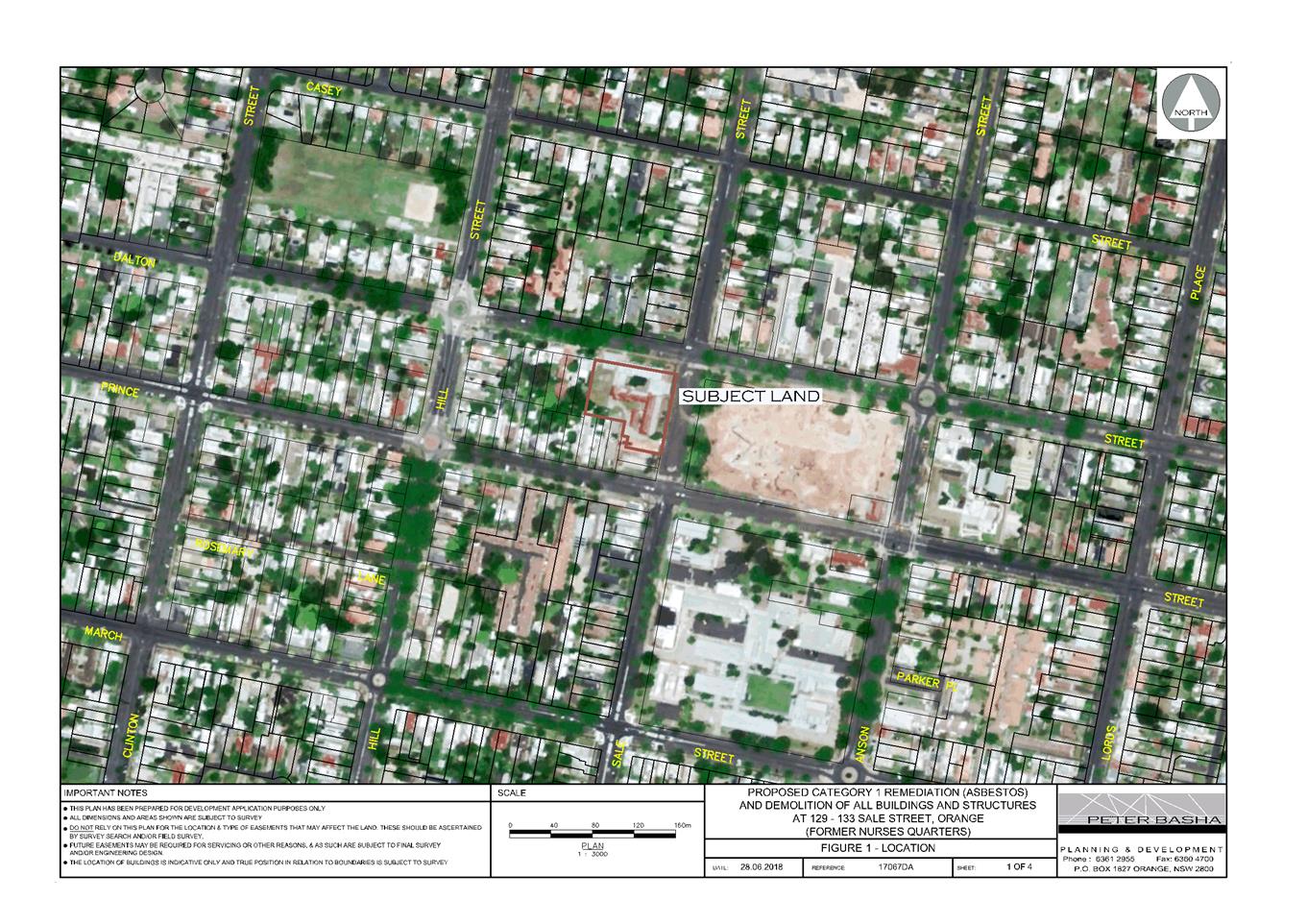
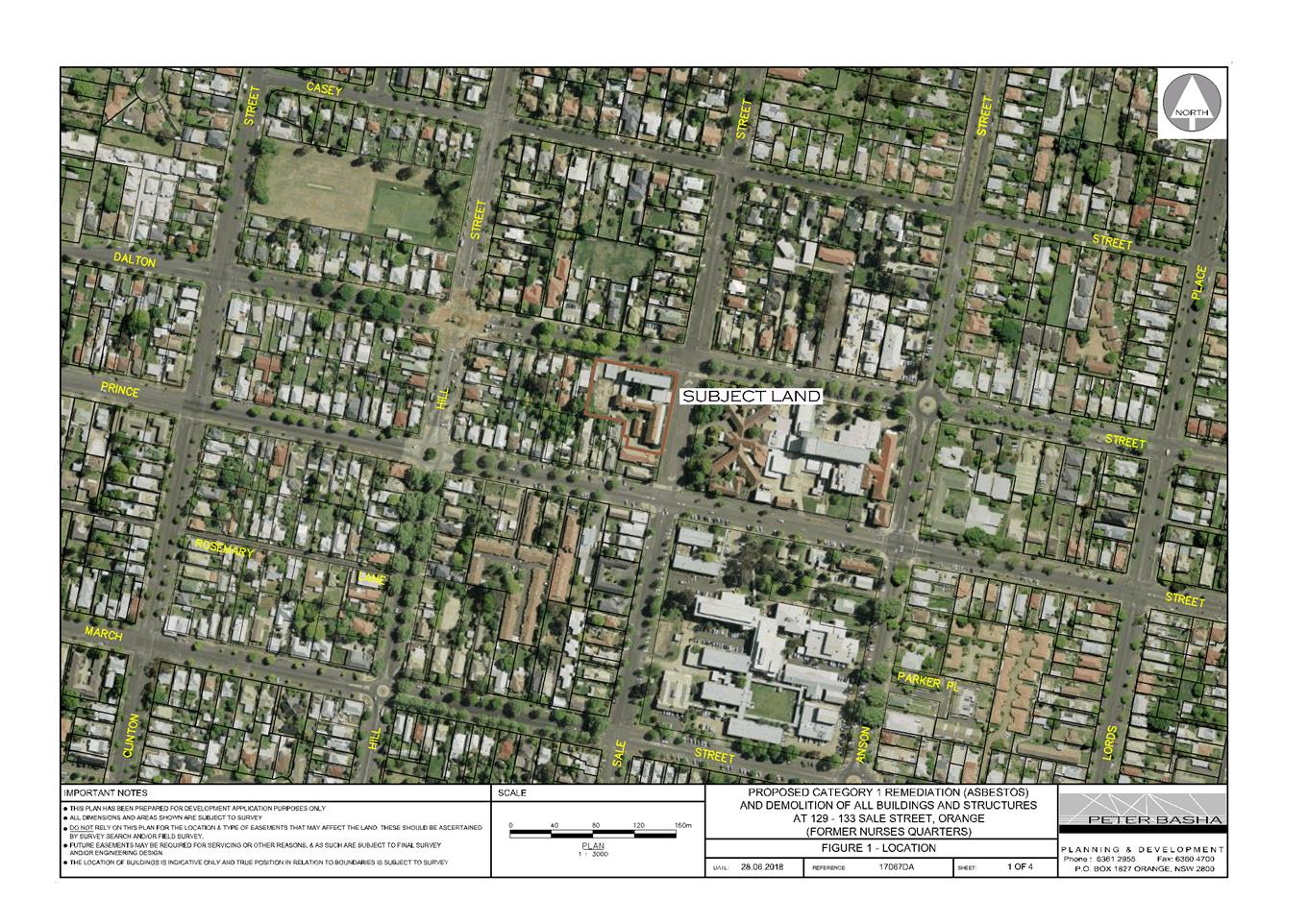
Council's consent is sought to
demolish all buildings, structures and vegetation on the subject land, known as
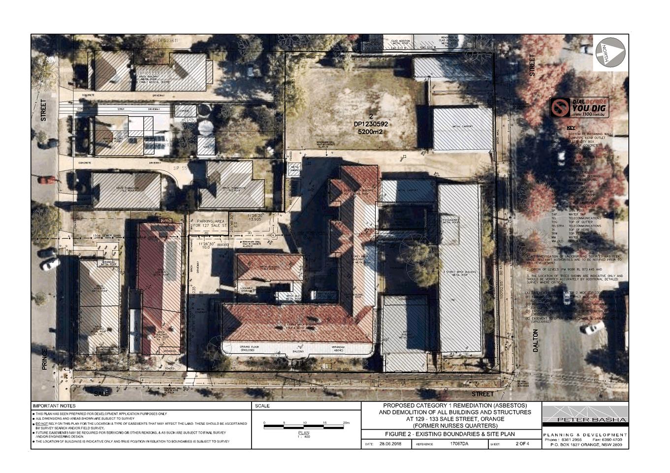
129-133 Sale Street, Orange (refer Figure 1).
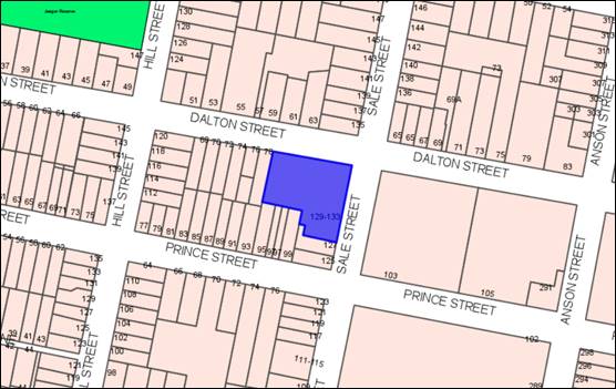
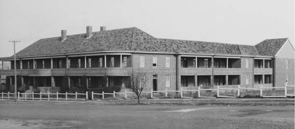
Figure 1 – locality plan
The subject land contains Caldwell House (former nurses
quarters) and the more recent nurses quarters on the corner of Sale and Dalton
Streets.
The buildings have been vacant for a number of years and
have been neglected in more recent times. Over the course of the last decade or
so the buildings have been subject to numerous break and enters, with
perpetrators searching for copper wire and other materials of value left in the
buildings upon them being vacated. In the process of illegally obtaining the
copper wire and other material, friable asbestos has been disturbed and has
been distributed throughout the buildings.
The applicant has presented a case
purporting that the buildings would be unable to be occupied for future
adaptive re-use as a result of asbestos contamination; or, in the event that
the buildings could be successfully cleaned and encapsulated, the buildings
would be subject to ongoing asbestos management plans, making the buildings
undesirable to future occupants.
In addition to this, the applicant has suggested that the
cost of remediating Caldwell House would be substantially more expensive than a
full demolition option, resulting in any future adaptive re-use of the buildings
being financially unviable.
The applicant is not contesting the heritage significance of
Caldwell House – indicating that, if it were possible, they would prefer
to see the building remain and be adaptively reused.
It is important to note that it is understood from the
application that Health Infrastructure (NSW Health) have no intention of
carryout the work, but are rather seeking consent for demolition so that the
property can be divested and another party can carry out the work if so
desired.
Council staff have scrutinised the claims presented within
the application with the assistance of a contamination expert and a consultant
engineer. Council’s experts were directed to focus their advice on the
heritage significant Caldwell House as it is accepted by Council staff that the
more recent nurse’s quarters (located in the north-eastern corner of the
site) has only low levels of heritage significance.
The expert advice obtained by Council staff concluded that:
1. Caldwell
House could be successfully remediated and occupied under an ongoing asbestos
management plan[1].
Council’s expert notes that the building is required to be cleaned
under all the scenarios presented by the applicant.
2. The
building is structurally adequate to the extent that the necessary remediation
steps suggested as being necessary by the applicant (such as lifting the floor,
removing internal wall linings etc) could be safely undertaken.
It should be noted that one of the
submissions from Adaptive Architects offers a methodology for cleaning and
encapsulating that meets heritage conservation principles. Such a methodology
would need to be fully resolved when Caldwell House is remediated.
3. Retention
of Caldwell House would be approximately 33% more expensive than the complete
demolition option. Noting that the additional cost purported by the application
does not factor in the cost of a complete re-development of the site
incorporating an adaptive re-use of Caldwell House.
It is important to reiterate, that under all possible
scenarios, the asbestos must be removed from the building prior to it being
demolished or adaptively re-used as required by Clause 452 of the Work
Health and Safety Regulation 2017 and the Safe Work Australia‘s
Demolition Code of Practice. In other words, the building needs to be cleaned
of asbestos or asbestos-containing material in any case.
It is also important to note that at the moment, the land
with the significant heritage building still retained on the land, benefits
from Council’s generous incentives clause within the LEP. This clause
effectively allows an impermissible use on the land such as offices or retail;
or even a pub for instance provided that Council can be satisfied amongst other
things that conservation of the heritage item was facilitated by the granting
of a consent and that any proposal was in accordance with a heritage management
document approved by the consent authority. Should it be agreed that the
building can be demolished, the ability to rely on this clause evaporates.
The economic arguments presented within the application and
discussed in detail below within the report, fail to account for this. That is,
the demolition of Caldwell House would have a far greater negative impact on
the value of the land than if the building was retained and the highest and
best use sought for the land.
DECISION FRAMEWORK
Development in the Orange LGA is governed by The
Environmental Planning and Assessment Act 1979 and the accompanying
Environmental Planning and Assessment Regulations 2008. Sitting below the Act
and Regulations is the Orange LEP 2011 and other State wide Environmental
Planning Instruments (SEPP). Subordinate to the LEP and SEPPs is the Orange
Development Control Plan 2004 which is a guiding document used to inform
decision making. In addition the Infill Guidelines are used to guide
development, particularly in the heritage conservation areas and around
heritage items.
Orange Local Environment Plan 2011 – The
provisions of the LEP must be considered by the Council in determining the
application. LEPs govern the types of development that are permissible or
prohibited in different parts of the City and also provide some assessment
criteria in specific circumstances. Uses are either permissible or not. The
objectives of each zoning and indeed the aims of the LEP itself are also to be
considered and can be used to guide decision making around appropriateness of
development.
Orange Development Control Plan 2004 – the DCP
provides guidelines for development. In general it is a performance based document
rather than prescriptive in nature. For each planning element there are often
guidelines used. These guidelines indicate ways of achieving the planning
outcomes. It is thus recognised that there may also be other solutions of
merit. All design solutions are considered on merit by planning and building
staff. Applications should clearly demonstrate how the planning outcomes are
being met where alternative design solutions are proposed. The DCP enables
developers and architects to use design to achieve the planning outcomes in
alternative ways.
DIRECTOR’S COMMENT
This application relates to the
heritage item “Caldwell House” and the associated nurse’s
quarters.
The applicant has presented a
number of reasons to support their intent to demolish the buildings on the land
which have been scrutinised in detail by Council’s consultants and
planning staff. The justification presented by the applicant is considered to
be based on flawed logic; and accordingly is not supported by staff.
Due to the technicalities of this
proposal in terms of heritage, demolition and remediation, staff engaged
independent experts to provide practical advice regarding the
application. Council’s experts suggest that the buildings can be
saved and adequately remediated. This advice is at odds with the claims
of the applicant’s experts. Whilst the applicant offered to have
the consultants meet to debate the conclusions of both sides, this offer was
not taken up as the Council experts suggested such meetings generally are not
fruitful.
It
is extremely disappointing that the buildings on this site, as significant to
the community as they are, have been left by the owners to become accessible to
vandals and as a result, dilapidated.
This DA is a Crown Development,
therefore Council cannot determine the application without the concurrence of
the Applicant or Minister. This process would follow Council’s advice on
how it would like to progress this application. Council cannot refuse the
application (it would have to be referred to the Western Regional Planning
Panel).
Ten submissions were received from
residents and community groups relating to this proposal. A small number
(2) supported the proposal, whilst the majority oppose the application due
mostly to the loss of a significant heritage item.
Staff recommend that demolition
only be permitted of the later nurse’s quarters and other
less-significant buildings on the land, not of Caldwell House itself.
I support the recommendations
within the report.
Link To Delivery/OPerational Plan
The recommendation in this report relates to the
Delivery/Operational Plan strategy “10.1 Preserve - Engage with the
community to ensure plans for growth and development are respectful of our
heritage”.
Financial Implications
Nil
Policy and Governance Implications
Nil
|
Recommendation
With respect to development
application DA 234/2018(1) for Demolition
of a Heritage Item (all buildings, structures and vegetation to be removed)
and Category 1 Remediation (asbestos removal) at Lot 2 DP 1230592 -
129-133 Sale Street, Orange it is recommended that Council:
1 Note the
contents of the planning report and the recommendations therein.
2 Accept the
terms of the draft notice of determination.
3 Direct
Council staff to obtain the concurrence of either the applicant or the
Minister as required by Section 4.33 of the Environmental Planning and
Assessment Act.
4 That Council
delegate the authority to determine Development Application DA 234/208(1) to
the Chief Executive Officer subject to the receipt of concurrence from the
Crown.
|
further considerations
Consideration has been given to the recommendation’s
impact on Council’s service delivery; image and reputation; political;
environmental; health and safety; employees; stakeholders and project
management; and no further implications or risks have been identified.
SUPPORTING INFORMATION
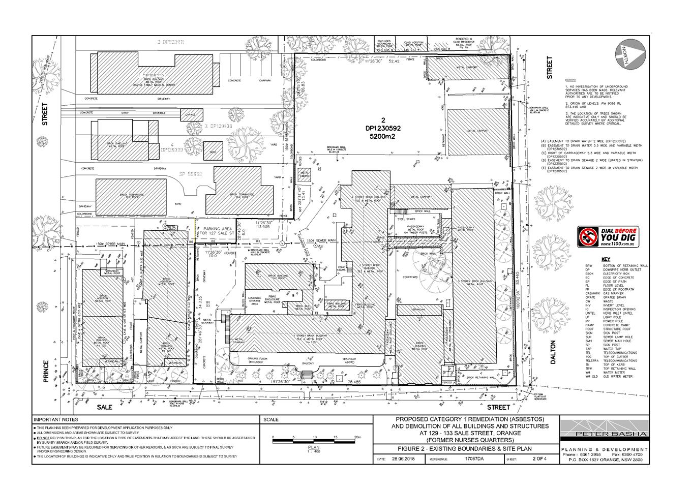
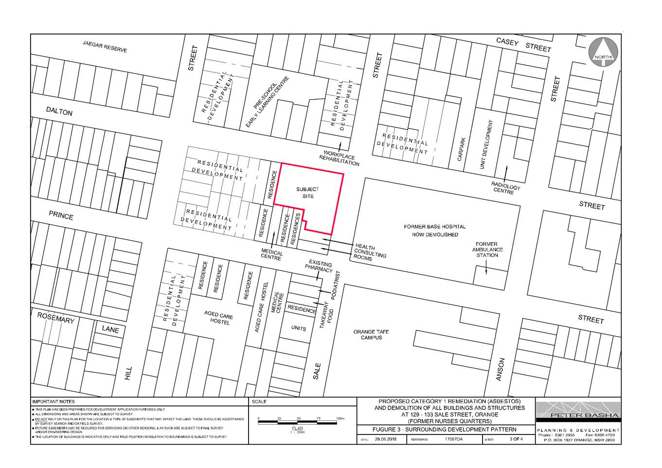
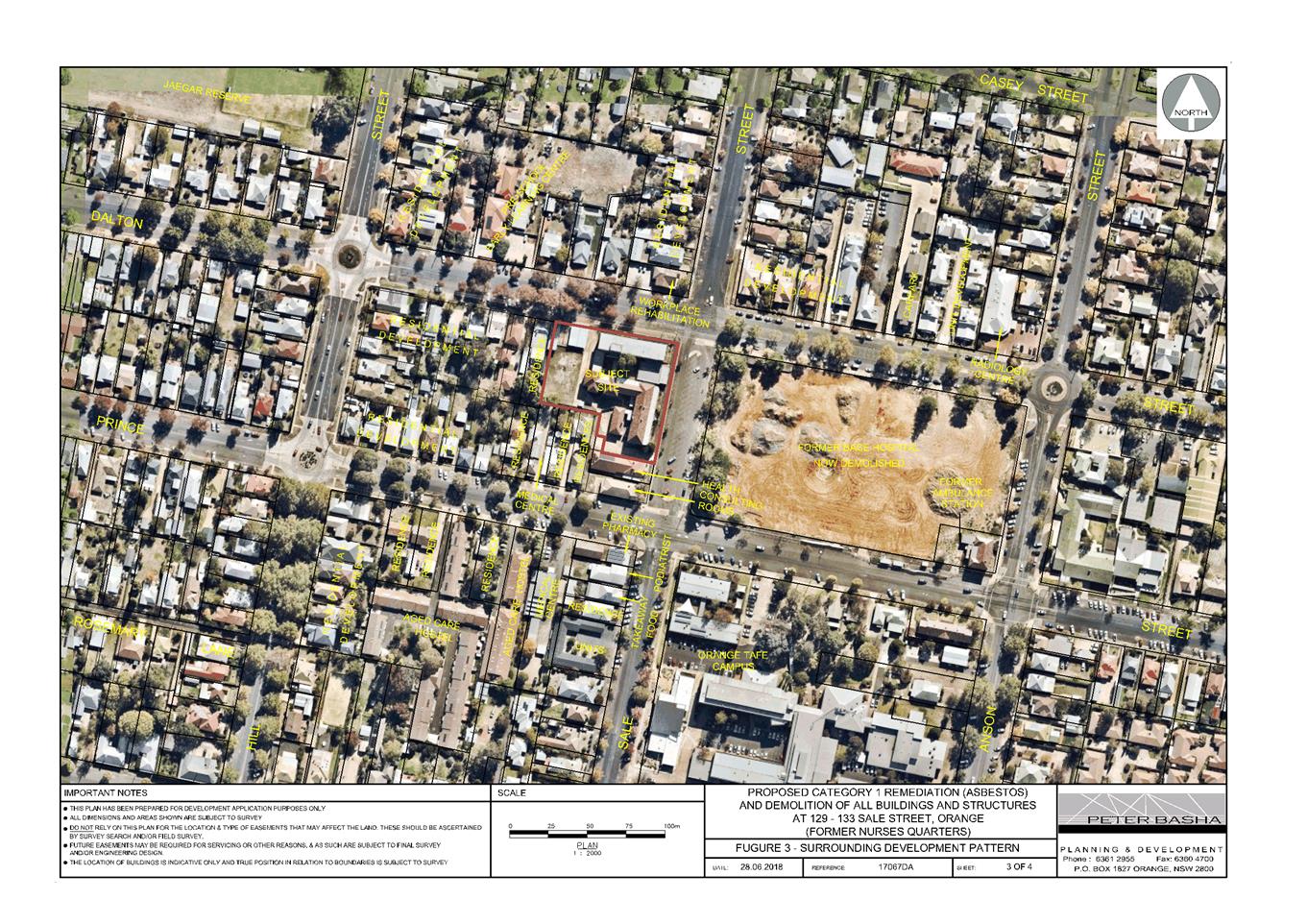
THE LAND
The land is a large residentially zoned parcel of land to
west of the former base hospital site. The land is described as Lot 2 DP
1230592, known as 129-133 Sale Street, Orange. The land is identified as a
Local heritage item as it contains Caldwell House (former nurses quarters). The
site also contains the more recent former nurses quarters on the north-eastern
corner of the site.
The land is located on the (south-western) corner of the
Dalton and Sale Streets intersection. The land adjoining to the west is
residentially zoned and contains a single storey dwelling house. To the south
of the land, part of the southern boundary shares a boundary with a former
dwelling that been converted into health consulting rooms, and then a number of
residential properties adjoin for the balance of the southern boundary.
The land across from Caldwell House is the former Orange
Base Hospital site which is now three separate lots; the lot closest to the
subject land is vacant, while the adjoining lot to the east comprises the
partially constructed office building that will house the Department of
Industries, and the third lot comprises the former ambulance station.
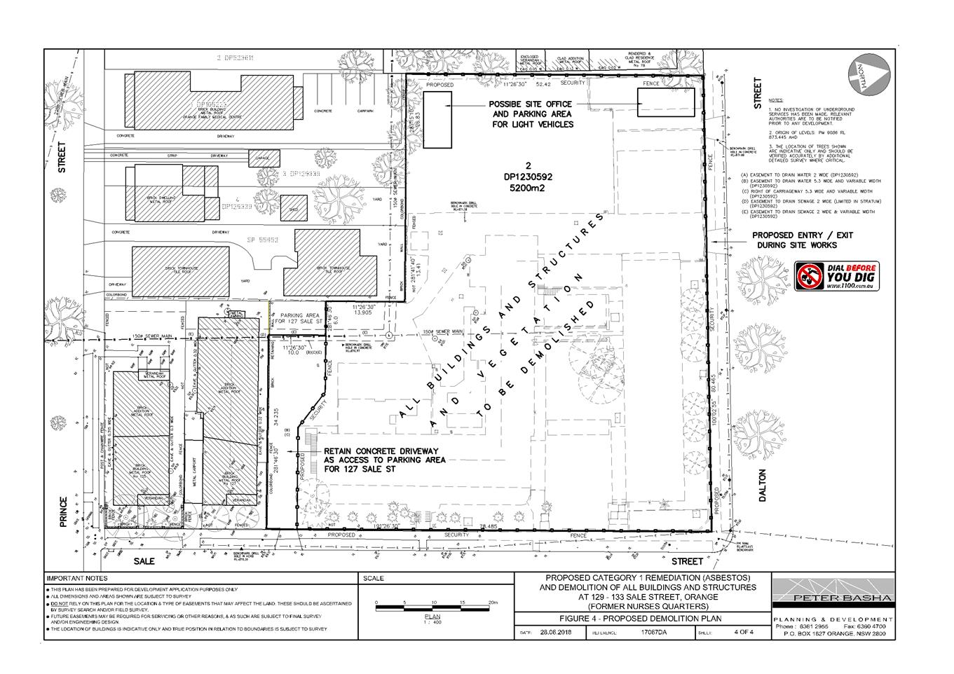
THE APPLICATION/PROPOSAL
Council's consent is sought to demolish all buildings, structures and vegetation on land described as
Lot 2 DP 1230592, known as 129-133 Sale Street, Orange. As part of the
demolition, the site would be remediated and made good for future development.
BACKGROUND
The subject land contains two primary buildings (Caldwell
House and the later former nurse’s quarters). It is accepted by Council
staff that the later constructed former nurses quarters holds limited heritage
significance, and therefore the proposal to demolish that particular building
is accepted by Council staff and relevant conditions of consent are attached
addressing the asbestos clean-up and other measures such as the control of dust
and noise.
The other building on the land, Caldwell House, has been
vacant since c2011. This is around the time the hospital moved to the
Bloomfield Campus; at this time Community Health (the most recent
occupants of the building) moved to the new hospital also.
The applicant advises that in:
June 2016 an EOI sales campaign
for the site culminated in a commercial offer from a developer of aged care.
The offer was accepted subject to Health Administration Corporation’s
(HAC) registration of a subdivision and the approval of the developer’s
DA for that aged care facility.
In
late 2016 and again in mid-2017, whilst in final negotiations, there was forced
entry, theft and a vandalism attack on the buildings, resulting in significant
damage. The vandalism involved the forced removal of copper pipes and wiring.
This has caused damage to ceilings and lagging which has resulted in asbestos
being dispersed throughout the buildings.
CHRONOLOGY
OF APPLICATION
The application was originally
lodged on 4 July 2018. Shortly after receipt of the application, Council
exhibited the material and engaged relevant experts.
Additional information was
requested on 25 September 2018 which requested a revised Heritage Impact
Statement (HIS) that provided a more detailed analysis of options and also
provided heritage significance mapping. Council expert advice was provided
along with the submission received.
Additional information was received
19 August 2019. The additional information purported that the extent of
asbestos contamination was underestimated in the original application and that
the cost of all options presented originally would be significantly more
expensive than first suggested - in the order of approximately double the cost.
Further asbestos audits were undertaken, a revised HIS was provided and
additional expert advice was presented from Dr Ian Gardiner.
The revised material, along with
the original material, was publicly exhibited on 30 September 2019 for a
period of in excess of 30 days.
OPTIONS ANALYSIS
The applicant provides the
following options analysis of a range of possible scenarios for the use of the
site. The options include:
1 Asbestos
remediation and clean-up; and complete demolition of all buildings, structures
and vegetation (this is the applicant’s preferred option).
2 Asbestos
remediation and clean-up; with retention of front facade (and section of return
side walls) of Caldwell House only.
3 Asbestos
remediation and clean-up; demolition of later nurses quarters and ancillary
structures, retention of main Caldwell House as shown red below labelled
“B”.
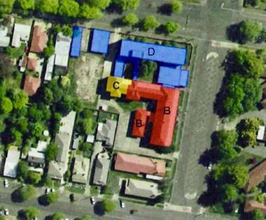
Figure 2 - extract from HIS – heritage
significance mapping (B represents High Heritage Significance, C represents
Moderate Heritage Significance and D represents Low Heritage Significance)
DEMOLITION METHODOLOGY
The applicant submits that the demolition will occur as
follows:
Stage 1 – Site Establishment
· Site facilities
to be located in the western side of the site.
· Provide
security fencing around the site perimeter and manage the site against
unauthorised entry.
· Provide an
access and egress route, connecting all undemolished floors to the nearest
street and identify it as an emergency exit.
Stage 2 – Removal of Hazardous Substances
· Prior to any
stripping out or demolition, remove hazardous substances as outlined in the
Hazard Material Survey by Envirowest Consulting (refer Annexure D).
· Prior to any
stripping out or demolition, remove asbestos or materials containing asbestos
in accordance with Asbestos Removal Control Plan by Envirowest Consulting
(refer Annexure C).
Stage 3 – Removal of Single Storey
Structures
· Use 1.8m high
temporary fencing panels with appropriate signage to establish an exclusion
zone around the immediate work area in accordance with AS 2601.
· Disconnect
services at each building.
· Manually remove
salvageable material.
· Remove
miscellaneous ground structures (light poles, signs etc).
· Use 25-tonne
excavator with grab attachment to pull down structures.
· Wet down work
face continually to minimise potential impact of raised dust within the site
and upon adjoining properties.
· Sort and
stockpile materials for recycling.
· Concrete/masonry
waste may be crushed onsite or removed off-site for recycling
· Scrap metal
stored and for removal from site.
· Clean up Stage
3 work area before commencing the removal of the multi storey buildings.
Stage 4 – Removal of Multi Storey Buildings
· Demolish
Caldwell House first to allow greater access to the three-storey Nurses
Accommodation building.
· Establish an
exclusion zone around the immediate work area in accordance with AS 2601.
· Disconnect
services at each building.
· Manually remove
salvageable material.
· Remove
miscellaneous ground structures (light poles, signs etc).
· Use 38-47 tonne
excavator with grab attachment to pull down Caldwell House. A hammer
attachment will likely be required for the demolition of the suspended first
floor slab. The work face should be sprayed continuously during the demolition
to minimise and dust being generated that may affect the subject site and
adjoining properties. It is anticipated that demolition work will commence at
the western end of Caldwell House and progress towards the eastern, Sale Street
end.
· During the
demolition works for Caldwell House, rubble should be progressively dropped to
the ground by the excavator, and not stockpiled on the suspended concrete slab.
Once rubble has been deposited on the ground, the area is to be made safe and
the rubble moved to a designated stockpile area.
· Clean up the
Caldwell House work area before commencing the removal of the 3-storey Nurses
Accommodation building.
· Use 38-47 tonne
excavator with grab attachment to pull down For the Nurses Accommodation
building. Temporary work platforms constructed with compacted fill material may
be required to be constructed along the southern side of the Nurses
Accommodation Quarters to ensure that the entire structure can be safely
demolished from the southern side of the building. A hammer attachment will
likely be required for the demolition of the suspended first and second floor
slabs. The work face should be sprayed continuously during the demolition to
minimise and dust being generated that may affect the subject site and
adjoining properties;
· During the
demolition works rubble should be progressively dropped to the ground by the
excavator, and not stockpiled on the suspended concrete slabs. Once rubble has
been deposited on the ground the area is to be made safe and the rubble moved
to a designated stockpile area;
· Once the above
ground structure of the Nurse’s Quarters has been demolished work can then
commence on the demolition of slabs on ground, foundations and concrete
hardstands. The excavator, with hammer attachment should pulverize the concrete
foundations and any adjacent hardstand;
· Following the
completion of demolition works on the multi storey buildings any remaining
hardstand should be demolished by the excavator using conventional means;
· Any recyclable
materials should be separated from the demolition waste and stockpiled.
Concrete and masonry may be crushed onsite or carted off-site for recycling;
· Any scrap metal
should be demolished and stored in a designated lay-down area for removal from
site;
· Once all
buildings and structures have been demolished a general clean-up of the site
should be completed, with the site generally levelled to approximate natural
ground levels.
Stage 5 – Demobilisation of Site
· Following the
completion of all demolition, remediation works and site clearance the
contractor shall be responsible for the removal of all plant equipment and
rubbish generated throughout the demolition works. The site shall then be
returned to the client upon completion of this stage.
· Any
certifications required by Council should be provided to the client during the
final handover of the site. This is likely to include certification from the
environmental consultant that all asbestos has been cleared from the site, and
certification from a geotechnical consultant that any earthworks, particularly
and backfill on basement areas, has been carried out in accordance with
Australian Standard AS 3798 – Guidelines on earthworks for commercial and
residential developments.
Stage 6 – Stabilisation of Site
The surface of the site is to
be reasonably levelled and sown with appropriate grass seeds. Erosion and
sediment controls should be placed as required.
Stage 7 – Final Handover
Following the completion of
the Stage 6 works the site shall then be returned to the client. Any
certifications required by Council should be provided to the client during the
final handover of the site.
This is likely to include
certification from the environmental consultant that all asbestos has been
cleared from the site, and certification from a geotechnical consultant that
any earthworks, particularly and backfill on basement areas, has been carried
out in accordance with Australian Standard AS 3798 –Guidelines on
earthworks for commercial and residential developments.
REMEDIATION COMPARISION
The
submitted material by the applicant provides the following list of works that
are suggested to be required to clean the site under either the demolition
scenario and retain Caldwell House scenario:
|
Roof
space
|
|
Works
required if Building Retained
|
Works
required if Building Demolished
|
|
· Collect lagging and vacuum dust
· Remove all pipes, cables, other contents
· Remove roof tiles and clean and replace
· Vacuum all timber trusses and paint to encapsulate
remaining fibres
· Remove original ceiling and suspended ceiling as
contaminated waste
· Works undertaken to avoid damage to frame
· Remove residue in wall cavity as practical then
drench with dilute paint to encapsulate fibres
· Manual labour including bagging of waste
for removal
|
· Collection of lagging
· Wet and seal all contents for later demolition
· Removal comprises combination of manual removal and
machines
|
|
Ground
and First Floor
|
|
Works required if Building Retained
|
Works required if Building Demolished
|
|
· Remove external pipes
· Collect lagging and vacuum asbestos residue
dust
· Remove all asbestos material in walls, ceiling,
doors
· Remove vinyl floor. Will require grinding of
floor for complete removal
· Manual labour including bagging
of waste for removal
· Cleaning of all surfaces required after
removal of asbestos contaminated waste
|
· Collection of lagging
· Remove all asbestos material in walls,
ceiling, suspended ceiling
· Wet and seal all contents for later
demolition
· Removal comprises combination of manual
removal and machines
|
|
Sub
floor Space
|
|
Works required if
Building Retained
|
Works required if
Building Demolished
|
|
· Remove pipes and lagging residue
· Remove all cables and remaining pipes
· Alternative is to clean pipes and cables but
this incurs higher labour charge
· Remove all other contents including vinyl
floor
· All access to subfloor to be via existing
access doors
· Limited working height to be considered
· All sub floor space requires covering with
50mm concrete slab to encapsulate residual asbestos on soil
· Manual labour including bagging
of waste for removal
|
· Collect pipes and lagging residue
· Wet and seal all contents for later
demolition
· Removal comprises combination of manual
removal and machines
· Excavation of 100mm of soil as asbestos
waste
|
|
Clean
Up
|
|
Works required if Building
Retained
|
Works required if Building
Demolished
|
|
· After removal of asbestos containing material
cleaning would to be undertaken. The preferred method is washing to a
collection area where the water is filtered before discharge.
· The final structure retains the concrete and
brick with timber roof frame.
· Roof tiles will be replaced after
cleaning.
· All remaining timber in the roof frame and sub
floor space potentially contains asbestos and spraying with a dilute plastic
paint is required for encapsulation.
· Treatment of the external wall cavity is
required to seal asbestos lagging residue.
|
· After building demolition surface soil will be
removed and transported to landfill as asbestos waste.
|
|
Waste
and Traffic
|
|
Works
required if Building Retained
|
Works
required if Building Demolished
|
|
· Asbestos waste will require disposal at a landfill
licenced to accept friable asbestos waste.
· Some asbestos cement material and vinyl may be
removed as non-friable waste if not contaminated with lagging.
· The waste will be wrapped prior to
transport.
· The quantity of waste has not been accurately
determined however only asbestos contaminated waste will be removed and
transported off-site.
|
· Asbestos waste will be removed from the building
prior to demolition.
· Separate removal of asbestos will enable reuse
or recycling of material not containing asbestos.
· Material with hard surfaces will be cleaned
then classified as non-asbestos waste.
· Non-asbestos waste such as bricks and concrete
will be crushed onsite and sold for reuse as fill.
· The demolition option will generate additional
asbestos waste from all timber surfaces and soil excavations.
· The demolition option will produce
asbestos and non-asbestos wastes. A demolition management plan will
be prepared describing the process
|
|
Future
Restrictions and Management
|
|
Works
required if Building Retained
|
Works
required if Building Demolished
|
|
· Asbestos cannot be completely removed from the
building due to impact on porous surfaces and inaccessible location in voids.
All timber in the roof and timber in sub floor space will remain and is
impacted with asbestos fibres. Asbestos in the exterior wall cavity is also
impacted with asbestos fibres. The asbestos on all timber surface and the
wall cavities will be made safe by sealing with paint.
· Asbestos will also remain in the soil under
the building after the removal works. Due to the nature of the asbestos in
the soil it is unlikely it can be removed. The preferred make safe method of
remediation is sealing with 50mm of concrete to encapsulate the asbestos
residue.
· The site will need to be registered as contaminated
land on the section 149 certificate for the land title deed. The land-use
will be subject to implementation of a site management plan which restrict
disturbance of the capping layer. The plan will need to be managed by the
land owner and enforced by local council as a contaminated site. Restrictions
will apply to retaining the building which has cost implications for
redevelopment and ongoing maintenance.
|
· No restriction on the land–use following
demolition and clearance by hygienist/environmental scientist.
|
|
· A site management plan will be required to be
prepared for any works potentially breaching the encapsulation layers in the
ceiling or sub floor space. The plan will recommend breaches to the
encapsulated material are classified as friable asbestos works. Works on
friable asbestos is required to be undertaken by a licensed asbestos
removalist with SafeWork NSW class A licence.
|
|
|
Uncertainties
It
is possible unidentified asbestos is present in the building due to location
in inaccessible areas or covered by renovations over time. Asbestos lagged
pipes in the walls have not been identified however they may be present which
will not be known until the area is disturbed. The location of unidentified
asbestos will require management at the time of identification.
|
It is important to note that a large amount of the
identified disturbed material is assumed to be asbestos based on the submitted
asbestos audits (testing has not been carried out to positively identify all
material as asbestos – the audit relies mostly on visual inspection); and
a large proportion of the identified asbestos is intact and not damaged. It is
therefore possible that not all of the disturbed material is asbestos and the
extent of contamination may be overstated by the applicant.
Further
to the above; the Asbestos Removal Options report provides the below
table which compares the removal factors for the scenarios of the building
being retained and the building being demolished.
|
Factor
|
Retain Building
|
Demolition
|
Staff comment
|
|
Practical
|
Yes (accessibility restrictions)
|
Yes
|
Noted – both options are practically possible.
|
|
Damage to building
|
Floor requires grinding for vinyl floor
removal
All
cable and pipes will require reinstallation
Ceilings
and walls will require replacement
Possible
accidental damage in removal process
|
N/A
|
The damage to the
building could easily be managed through recognised conservation principles.
These have not been
explored as part of the submitted Heritage Impact Statement.
|
|
Cost
|
High
|
Moderate
|
33% additional cost for retention of Caldwell House
is not considered exorbitant.
Particularly in consideration of how the building
has been irresponsibly managed over the last decade.
|
|
Clean-up Time
|
High
|
Low
|
Noted. This could have been dramatically reduced had
the building been managed more responsibly.
|
|
Asbestos retained onsite
|
Yes (encapsulated to make safe)
|
No
|
This is easily managed through a site specific
management plan. This is not uncommon for a building of this era.
|
|
Waste generated
|
Asbestos
|
Asbestos and non-asbestos
|
NOTED. Retention of Caldwell House is far better for
the environment and presents a much more sustainable option.
|
|
Transport
|
Asbestos waste only
|
Asbestos waste & non-asbestos waste
for re-use material
|
Noted. As with above, retention presents a much better
outcome for the environment.
|
|
Reuse of materials
|
No
|
Crushed brick/concrete
|
There is reuse of materials under the retention
option as the build materials will remain as part of the building.
|
The above table does not clearly articulate the significant
embodied energy[2]
costs of the demolition scenario. The demolition scenario would have a far
greater impact on the environment then the retention option through the
additional embodied energy generated as a result of demolition of all buildings
and redeveloping the site with all new buildings.
The embodied energy costs would be reduced significantly if
only the later 1950s nurse’s quarters were to be demolished.
Thus, the full demolition option is fundamentally
inconsistent with the objects of the Act, which seeks to:
facilitate ecologically sustainable development by
integrating relevant economic, environmental and social considerations in
decision-making about environmental planning and assessment.
Relying solely on
an economic argument is contrary to the intent of the above object of the Environmental
Planning & Assessment Act.
JUSTIFCATION
The applicant submits that the building is contaminated
beyond being able to be made habitable; and even if it were able to be occupied
it would be cost prohibitive and the stigma attached to the building as a
consequence of the contamination makes the building undesirable.
In response to the presented justification by the Applicant,
Council staff make the following comments:
· The building is a
listed Heritage Item.
· The extent of
asbestos disturbed within the building is a direct consequence of the poor
management of the building by the owners.
· The exact extent
of asbestos or asbestos-containing material distributed within the building is
based on supposition rather than laboratory testing of all disturbed material.
· All asbestos must
be removed from the building prior to it being demolished as required by Clause
452 of the Work Health and Safety Regulation 2017 and the Safe Work
Australia‘s Demolition Code of Practice. In other words, the building
needs to be cleaned of asbestos or asbestos-containing material in any case.
· The building can
be made fit for purpose and can be adaptively reused retaining the heritage
significance of the place.
· The highest and
best use of the property will only be achieved with retention of the heritage
building and having the benefit of Council’s generous heritage incentives
clause under the LEP. The ability to use the incentives clause will evaporate
if the heritage item is removed from the site.
· The cost analysis
presented by the applicant is based on flawed logic – it only accounts
for the redevelopment of the site to a point that stops at the demolition phase
and not the complete redevelopment of the site; where at a point in time the
(comparative) additional cost in retaining the building would be recouped by
the mere fact that there is a building on the land that does not need to be
rebuilt.
MATTERS FOR CONSIDERATION
Section 1.7 - Application of
Part 7 of the Biodiversity Conservation Act 2016 and Part 7A of the
Fisheries Management Act 1994
Section 1.7 of the EP&A Act identifies that Part 7 of
the Biodiversity Conservation Act 2016 (BC Act) and Part 7A of the
Fisheries Management Act 1994 have effect in connection with terrestrial and
aquatic environments.
There are four triggers known to insert a development into
the Biodiversity Offset Scheme (ie the need for a BDAR to be submitted
with a DA):
· Trigger 1:
development occurs in land mapped on the Biodiversity Values Map (OEH)
(clause 7.1 of BC Regulation 2017);
· Trigger 2:
development involves clearing/disturbance of native vegetation above a certain
area threshold (clauses 7.1 and 7.2 of BC Regulation 2017); or
· Trigger 3:
development is otherwise likely to significantly affect threatened species
(clauses 7.2 and 7.3 of BC Act 2016).
The fourth trigger (development proposed to occur in an Area
of Outstanding Biodiversity Value (clause 7.2 of BC Act 2016) is generally not
applicable to the Orange LGA; as no such areas are known to occur in the LGA.
No further comments will be made against the fourth trigger.
In relation to the above triggers; the subject land is not
within an area of mapped high biodiversity value and there is no clearing of
native vegetation proposed.
In terms of a test of significance pursuant to section 7.3
of the Biodiversity Conservation Act, given the disturbed urban
environment, the development is not likely to significantly affect any threaten
species, habitats or endanger ecological communities.
CROWN DEVELOPMENT
Section 4.32 of the Environmental Planning and Assessment
Act defines a Crown Development Application as: a development
application made by or on behalf of the Crown. The Crown includes a public
authority. The EP&A Act defines a public authority as
including a statutory body representing the Crown. The application was lodged
by Health Administration Corporation. Health Administration Corporation as
established by S9(1) of the Health Administration Act. According to
s9(2)(f): The Corporation … is, for the purpose of any Act, a
statutory body representing the Crown.
The Crown Development provisions preclude Council from
imposing a condition of consent to this development, except with the written
approval of the Minister or the applicant. These same provisions also
preclude Council from refusing to grant a consent for a Crown Development
Application except with the written approval of the Minister (having first put
the application before the Western Regional Planning Panel as the consent
authority).
As the application is a Crown Development Application, the
following process is recommended to be followed by Council:
With
respect to development application DA 234/2018(1) for Demolition of a Heritage Item (all buildings,
structures and vegetation to be removed) and Category 1 Remediation (asbestos
removal) at Lot 2 DP 1230592 - 129-133 Sale Street, Orange it is
recommended that Council:
1 Note the
contents of the planning report and the recommendations therein.
2 Accept the
terms of the draft notice of determination.
3 Direct Council
staff to obtain the concurrence of either the applicant or the Minister as
required by Section 4.33 of the Environmental Planning and Assessment Act.
4 Council provide
delegated Authority to the Chief Executive Officer that upon concurrence being
obtained, that the Development Application be determined (approved) based on
the draft consent considered by Council (with minor amendments permitted as
part of the concurrence process). Alternatively, a report would have to
be prepared to Council for development consent to be granted.
Section
4.15
Section 4.15 of the Environmental Planning and Assessment
Act 1979 requires Council to consider various matters, of which those
pertaining to the application are listed below.
PROVISIONS OF ANY ENVIRONMENTAL
PLANNING INSTRUMENT s4.15(1)(a)(i)
Orange Local Environmental Plan 2011
Part 1 - Preliminary
Clause 1.2 - Aims of Plan
The
broad aims of the LEP are set out under Subclause 2. Those relevant to the
application are as follows:
(f) to recognise and manage valued
environmental heritage, landscape and scenic features of Orange.
The development, specially the
demolition of Caldwell House is fundamentally inconsistent with above aim of
the plan.
Clause 1.6 - Consent Authority
This clause establishes that, subject to the Act, Council is
the consent authority for applications made under the LEP.
Clause 1.7 - Mapping
The subject site is identified
on the LEP maps in the following manner:
|
Land Zoning Map:
|
Land zoned R1 General
Residential
|
|
Lot Size Map:
|
No Minimum Lot Size
|
|
Heritage Map:
|
Heritage item
|
|
Height of Buildings Map:
|
No building height limit
|
|
Floor Space Ratio Map:
|
No floor space limit
|
|
Terrestrial Biodiversity Map:
|
No biodiversity sensitivity on the
site
|
|
Groundwater Vulnerability Map:
|
Groundwater vulnerable
|
|
Drinking Water Catchment Map:
|
Not within the drinking water
catchment
|
|
Watercourse Map:
|
Not within or affecting a defined
watercourse
|
|
Urban Release Area Map:
|
Not within an urban release area
|
|
Obstacle Limitation Surface Map:
|
No restriction on building siting
or construction
|
|
Additional Permitted Uses Map:
|
No additional permitted use applies
|
|
Flood Planning Map:
|
Not within a flood planning area
|
Those matters that are of relevance are addressed in detail
in the body of this report.
Clause 1.9A - Suspension of
Covenants, Agreements and Instruments
This clause provides that covenants, agreements and other
instruments which seek to restrict the carrying out of development do not apply
with the following exceptions:
covenants
imposed or required by Council
· prescribed instruments
under Section 183A of the Crown Lands Act 1989
· any conservation
agreement under the National Parks and Wildlife Act 1974
· any trust
agreement under the Nature Conservation Trust Act 2001
· any property
vegetation plan under the Native Vegetation Act 2003
· any biobanking
agreement under Part 7A of the Threatened Species Conservation Act 1995
· any planning
agreement under Division 6 of Part 4 of the Environmental Planning and
Assessment Act 1979.
Council staff are not aware of the title of the subject
property being affected by any of the above.
Part 2 - Permitted or Prohibited Development
Clause
2.1 - Land Use Zones and Clause 2.3 - Zone Objectives and Land Use Table
The subject site is located within the R1 General
Residential zone. If the subject land was still being used for the purposes of
Community Health Services (as community health [being a directorate within NSW
Health] was the most recent occupant of the building), the current land-use
would be characterised as a health services facility which is defined as:
health services facility means
a building or place used to provide medical or other services relating to the
maintenance or improvement of the health, or the restoration to health, of
persons or the prevention of disease in or treatment of injury to persons, and
includes any of the following—
(a) a
medical centre,
(b) community
health service facilities,
(c) health
consulting rooms,
(d) patient
transport facilities, including helipads and ambulance facilities,
(e) hospital.
Health services facilities are permissible in the R1
General Residential zone.
Notwithstanding the above, the
applicant is not seeking consent for a health services facility, but rather the
demolition of the existing buildings. Accordingly, the demolition provisions
are addressed below.
Clause 2.3 of LEP 2011
references the Objectives for each zone in LEP 2011. These objectives for
land zoned R1 General Residential are as follows:
1 -
Objectives of the R1 General Residential Zone
· To provide for
the housing needs of the community.
· To provide for
a variety of housing types and densities.
· To enable other
land uses that provide facilities or services to meet the day to day needs of
residents.
· To ensure
development is ordered in such a way as to maximise public transport patronage
and encourage walking and cycling in close proximity to settlement.
· To ensure that
development along the Southern Link Road has an alternative access.
Retention of Caldwell House would be consistent with
the objectives of the zone in so far as an adaptive re-use of the building
could accommodate a future use that provides facilities or services to meet the
day-to-day needs of the occupants of surrounding residential properties. Or
alternately, Caldwell House could be adaptively re-used for residential
purposes, adding to the diversity of the existing housing market.
Clause 2.7 - Demolition
Requires Development Consent
This clause triggers the need for development consent in
relation to a building or work.
The applicant is seeking consent to demolish all buildings
and structures upon the land. The development requires consent given the
heritage listing of the site, and the applicant has sought consent.
Part 3 - Exempt and Complying Development
The application is not exempt or complying development.
Part 5 - Miscellaneous Provisions
5.10 - Heritage Conservation
The subject land is identified as a heritage item pursuant
to Schedule 5 of Orange LEP 2011. The relevant heritage inventory for the
property provides the following statement of significance:
The 1937
Nurses Home is an historically and socially important element of the Orange
Hospital which has retained the distinctive original character, including the
Sale Street wing with art deco influences, complements the streetscape and contributes
to the City as a heritage item.
(1) Objectives
The
objectives of this clause are as follows:
(a) to
conserve the environmental heritage of Orange,
(b) to
conserve the heritage significance of heritage items and heritage conservation
areas, including associated fabric, settings and views,
(c) to
conserve archaeological sites,
(d) to
conserve Aboriginal objects and Aboriginal places of heritage significance.
The development, specifically the proposal to demolish
Caldwell House, is fundamentally antipathetic to the above objects of this
clause, specifically objects (a) and (b). The development will result in
the loss of a highly significant heritage item.
The demolition of
Caldwell House is also antipathetic with the objects of the Environmental
Planning and Assessment Act, specifically object (f) which seeks :
To promote the sustainable management of
built and cultural heritage (including Aboriginal cultural heritage),
Allowing
the demolition of Caldwell House is not an example of sustainable management of
a significant heritage item; and accordingly the demolition of Caldwell House
is not supported.
(2) Requirement
for Consent
Development
consent is required for any of the following:
(a) demolishing
or moving any of the following or altering the exterior of any of the following
(including, in the case of a building, making changes to its detail, fabric,
finish or appearance):
(i) a
heritage item,
The development involves the demolition of a heritage item,
and as such development consent is required, which the applicant has sought.
(4) Effect
of Proposed Development on Heritage Significance
The
consent authority must, before granting consent under this clause in respect of
a heritage item or heritage conservation area, consider the effect of the
proposed development on the heritage significance of the item or area
concerned. This subclause applies regardless of whether a heritage management
document is prepared under Subclause (5) or a heritage conservation management
plan is submitted under Subclause (6).
As mentioned above, if demolition of Caldwell House was
agreed to it would have a substantial detrimental effect on the heritage
significance of the site, effectively removing the significance entirely.
Council’s Heritage Advisor has strongly opposed the
development and has prepared detailed advice to Council. This was provided to
the applicant, who in turn provided a detailed response. The heritage advice
received by Council (bold and paraphrased in the applicant’s
response) and applicant’s response (italics) is provided below:
In regard to
the heritage value of Caldwell House, it is noted that:
1. The
potential exists for the building to be converted to many uses as facilitated
by the heritage conservation incentives of Orange LEP 2011; and
2. The
preferred approach would be for the building to be remediated (in terms of
asbestos) and adaptively re-used.
However, the ability to pursue
the above is significantly constrained by the environmental risks to future
occupants and the economic burden and risk outlined earlier.
In response to the matters
raised in the Summary and Recommendations sections of the heritage
advisor’s report dated July 2018, we advise as follows:
1. The
heritage advisor states that the HIS is not consistent with the NSW Heritage
template or guide.
The
Heritage Impact Statement (HIS) by Weir Phillips Heritage has been revised and
a copy is attached.
2. The
heritage advisor is concerned that appropriate expert heritage advice has not
been used to pursue appropriate options for the site. In response to this:
a) Despite
the fact that the HIS could not recommend retention of the building; it is our
submission that Weir Phillips has provided “appropriate expert heritage
advice”. The HIS has assessed the proposal in the context of the
following heritage publications:
· NSW Heritage Office,
Statements of Heritage Significance (2002 update)
· NSW Heritage Office,
Statements of Heritage Significance (2002)
In
particular, Sections 5.3.3 and 5.4 of the revised HIS consider sympathetic
solutions and explain why they have been discounted in terms of heritage
values.
b) The
conclusion reached in the HIS (essentially that there is no alternative but to
demolish the building) is reflective of the well supported argument, that the
environmental risks and the economic burden associated with asbestos
remediation and demolition/retention of the building outweigh the heritage
values.
3. Orange
Council’s heritage advisor is concerned that the SoEE and HIS draw
erroneous conclusions of non-viability related to decontamination costs which
are unrelated to heritage options.
The process
of having specialist contractors (in conjunction with asbestos assessors)
provide detailed quotations has demonstrated that:
a) The
level of asbestos contamination is greater and more complicated than what was
expressed in the original DA documentation, particularly in terms of the
difficulty in treating inaccessible areas and minimising the risk of airborne
fibres for future occupants.
b) The
cost of remediation is far greater than the estimates that were provided in the
original DA documentation.
4. The
heritage advisor is concerned that the justification for the demolition of the
last remaining buildings associated with the Orange Base Hospital are not borne
out by the evidence presented.
It is suggested that the additional
information provided in this document would address any concerns in this
regard.
5. The
heritage advisor is concerned that the proposal does not include an end use and
built form which would replace the existing development of the site.
We agree; however, it is considered
appropriate for Council to allow demolition without having this information
provided due to the following:
a) The
circumstances around the asbestos situation suggest that demolition of the
building is required (particularly for environmental reasons) regardless of
future development plans for the site.
b) It
is difficult to practically nominate “an end use and built form”
option as part of this development application. In this regard, there is a
range of future development options for the site, but none are known at this
stage; and there is no obligation to pursue any option that may be put forward
at this stage.
c) Once
a development option is determined, the appropriateness and impact of such
development will be guided, assessed and addressed as part of the DA process.
6. The
heritage advisor recommends that:
The Applicant is encouraged
to engage with skilled and experienced heritage architects who can develop
options for the adaptive re-use of the original East wing known as Caldwell
House and the sympathetic development of the remainder of the site in accord
with market indicators and use of the incentive clauses under the Orange LEP.
The options should then be
costed in relation to the related decontamination and structural issues and
reviewed with Council and following suitable discussions and market testing an
application be prepared and lodged.
We
appreciate the intent of the recommendation; however, our response is as
follows:
a) Before
considering heritage appropriate options for re-use of the East wing, the first
step is to address concerns regarding the asbestos contamination.
b) In
pursuit of point (a), both specialist contractors (with their respective
assessors) were asked to consider the following scenarios:
· Undertake the
asbestos remediation of Caldwell House and retain front façade and
verandah only. In this regard:
- DEMEX/ERS provided a quotation
which has been provided to Council as commercial-in-confidence. In short, the
cost is unrealistic; impractical; and prohibitive. This also should be regarded
as a theoretical price only as a clearance certificate cannot be issued for the
retained elements.
- IP/Airsafe refused to offer a
quotation.
· Undertake the
asbestos remediation of Caldwell House and retain the sale Street building
(i.e. the east wing as referred to by the heritage advisor). In this regard
both DEMEX/ERS and IP/Airsafe refused to offer a quotation because neither were
confident that the remaining building would achieve a satisfactory standard of
asbestos clean-up and could not obtain a clearance certificate.
c) Given
that a satisfactory situation is unlikely to be achieved in terms of asbestos
remediation, we don’t think that engaging a “skilled and
experienced heritage architect” to consider adaptive re-use options for
the East wing is necessary. It is recognised that the Orange LEP 2011 heritage
conservation incentives facilitate a broad range of adaptive re-use options for
Caldwell House. However, the highest and best land use will always be
constrained by the asbestos situation and it is likely that the building and
site will remain undeveloped and boarded up for the foreseeable future.
The justification presented within the application is not
centred on a proposition that the building is not heritage significant. The
applicant fully acknowledges this by stating: The preferred approach would
be for the building to be remediated (in terms of asbestos) and adaptively
re-used.
The applicant’s
justification rather centres on the proposition that the building has
deteriorated (although not expressly acknowledged by the applicant; the
deterioration has occurred as a direct consequence of the neglect and
inattention given to one of NSW Health’s assets) to the point where
it is unsalvageable/unusable; and therefore this results in it being acceptable
to lose one of the City’s valued heritage assets: a building that is
effectively the only remnant health related building in an area of the City
that has provided significant health care to the community within the region,
an area much broader than just the Orange LGA.
Therefore, given that Council staff and the applicant are in
agreement that the building is an important heritage item and should be
retained, and given that the applicant has not categorically ruled out that the
building cannot be cleaned-up, there is very little justification to support
the demolition of Caldwell House.
With the proposition put forward by the applicant that the
building is required to be demolished due to the deteriorated state (again
caused directly by the neglect of the owners) refuted; it is then necessary to
explore the applicant’s secondary argument around the financial
imposition of retention of the significant heritage item.
The applicant suggests that retaining the building following
remediation would be cost prohibitive. Of the three options referred to above,
retention is the most expensive. However, the applicant indicated that
their consultant/contractors were not prepared to price the option of retention
as they were of the view it could not be successfully achieved.
As indicated above, Council’s experts disagree with
the assertion that the building cannot be appropriately cleaned and occupied.
Council engaged engineering consultants Bradford Barker to complete a peer
review of the submitted material, carry out a basic inspection of Caldwell
House in terms of its structural adequacy, and finally provide the missing
costings that the applicant was unwilling to provide.
Bradford Barker concluded that:
· they agree with
findings of Council’s Contamination Expert;
· that the building
would be structurally adequate to enable the necessary remediation works to be
carried out; and
· that the option to
retain Caldwell House is approximately 33% more expensive than the
applicant’s preferred option of complete demolition.
There is an important observation to make at this point. The
applicant’s cost argument is somewhat flawed. The focus of cost has been
entirely focused only on the cost of demolition. But as indicated in the
application, Health Infrastructure are not intending on carrying out the work.
It is understood that their interests to date are simply in divesting the
property with the consent in place.
Therefore, when a new party comes to acquire the land, it is
very unlikely that they would stop at the completion of the demolition, but
rather they would continue to develop the land to its highest and best use[3].
What has been provided by the applicant is only an analysis
of the demolition cost, not a realistic cost to redevelop the site. It is
highly likely that the 33% additional cost at the remediation stage
(to retain the building) would be partly or fully recouped by the mere fact
that there was an existing building on the land that could be simply adapted
for the desired highest and best use; albeit with the necessary upgrades
required under the NCC.
The point being, the additional cost at the remediation
stage to retain the building would not be the actual additional cost when
accounting for the total redevelopment of the site.
In the absence of such a detailed, realistic and rigorous
cost analysis of the complete redevelopment of the site, the cost argument is
not one that could be supported.
So in summary:
· Caldwell House is
a significant heritage item, a remnant of the historic and significant use of
this locality as a regional medical precinct.
· Caldwell House is
capable of being successfully remediated, albeit with an ongoing management
plan (again such a document is not uncommon).
· The cost analysis
provided by the applicant provides an incomplete picture of the total
redevelopment cost of developing the subject land.
On this basis, allowing the demolition of Caldwell House
would be fundamentally contrary to the objects of the Environmental Planning
and Assessment Act, the aims of the LEP and the objects of this clause. Thus,
demolition of Caldwell House should not be supported.
(5) Heritage Assessment
The
consent authority may, before granting consent to any development:
(a) on
land on which a heritage item is located, or
(b) on
land that is within a heritage conservation area, or
(c) on
land that is within the vicinity of land referred to in paragraph (a) or (b),
require
a heritage management document to be prepared that assesses the extent to which
the carrying out of the proposed development would affect the heritage
significance of the heritage item or heritage conservation area concerned.
A heritage
management document as defined in the LEP means:
(a) a
heritage conservation management plan, or
(b) a
heritage impact statement, or
(c) any
other document that provides guidelines for the ongoing management and
conservation of a heritage item, Aboriginal object, Aboriginal place of
heritage significance or heritage conservation area.
A heritage impact statement has been submitted in support of
the application.
(6) Heritage
Conservation Management Plans
The
consent authority may require, after considering the heritage significance of a
heritage item and the extent of change proposed to it, the submission of a
heritage conservation management plan before granting consent under this
clause.
At present there is no Conservation Management Plan prepared
for the land. Given the recommendation for the retention of Caldwell House, it
is appropriate to require that a Conservation Management Plan be prepared to
guide future adaptive reuse along with the ongoing maintenance and management
of Caldwell House.
(7) Archaeological
Sites
The
consent authority must, before granting consent under this clause to the
carrying out of development on an archaeological site (other than land listed
on the State Heritage Register or to which an interim heritage order under the Heritage Act 1977
applies):
(a) notify
the Heritage Council of its intention to grant consent, and
(b) take
into consideration any response received from the Heritage Council within 28
days after the notice is sent.
The site is not a known archaeological site. Notwithstanding
this, as the development will involve extensive ground disturbance with the
demolition of the red brick (more recent) nurses quarters, there is a high
likelihood of encountering an aboriginal object or archaeological relic. As
such, Council’s standard precautionary condition is attached that
specifies a process to follow in the event an object or relic is discovered.
(8) Aboriginal
Places of Heritage Significance
The
consent authority must, before granting consent under this clause to the
carrying out of development in an Aboriginal place of heritage significance:
(a) consider
the effect of the proposed development on the heritage significance of the
place and any Aboriginal object known or reasonably likely to be located at the
place by means of an adequate investigation and assessment (which may involve
consideration of a heritage impact statement), and
(b) notify
the local Aboriginal communities, in writing or in such other manner as may be
appropriate, about the application and take into consideration any response
received within 28 days after the notice is sent.
The subject land is not an Aboriginal Place of Heritage Significance.
An AHIMS search confirms that the site has no Aboriginal sites or places
recorded against it.
(9) Demolition
of Nominated State Heritage Items
The
consent authority must, before granting consent under this clause for the
demolition of a nominated State heritage item:
(a) notify
the Heritage Council about the application, and
(b) take
into consideration any response received from the Heritage Council within
28 days after the notice is sent.
The subject land is not a Nominated State Heritage Item.
(10) Conservation
Incentives
The
consent authority may grant consent to development for any purpose of a
building that is a heritage item or of the land on which such a building is
erected, or for any purpose on an Aboriginal place of heritage significance,
even though development for that purpose would otherwise not be allowed by this
Plan, if the consent authority is satisfied that:
(a) the
conservation of the heritage item or Aboriginal place of heritage significance
is facilitated by the granting of consent, and
(b) the
proposed development is in accordance with a heritage management document that
has been approved by the consent authority, and
(c) the
consent to the proposed development would require that all necessary
conservation work identified in the heritage management document is carried
out, and
(d) the
proposed development would not adversely affect the heritage significance of
the heritage item, including its setting, or the heritage significance of the
Aboriginal place of heritage significance, and
(e) the
proposed development would not have any significant adverse effect on the
amenity of the surrounding area.
The conservation incentives clause
could be relied upon for adaptive re-use of Caldwell House whilst ever
Caldwell House remained on the land. A land-use could be contemplated that is
impermissible in the R1 General Residential zone, such as a commercial office
building.
The ability to rely upon the incentives clause would be lost
if Caldwell House was demolished.
Part 6 - Urban Release Area
Not relevant to the application. The subject site is not
located in an Urban Release Area.
Part 7 - Additional Local Provisions
7.3 - Stormwater Management
This clause applies to all
industrial, commercial and residential zones and requires that Council be
satisfied that the proposal:
(a) is designed to maximise the use of water
permeable surfaces on the land having regard to the soil characteristics
affecting onsite infiltration of water
(b) includes, where practical, onsite
stormwater retention for use as an alternative supply to mains water,
groundwater or river water; and
(c) avoids any significant impacts of
stormwater runoff on adjoining downstream properties, native bushland and
receiving waters, or if that impact cannot be reasonably avoided, minimises and
mitigates the impact.
Relevant conditions are attached in relation to the
disconnection of services to the buildings approved to be demolished. A soil
and erosion control plan will be required to be installed whilst any approved
demolition works are undertaken.
7.6 - Groundwater Vulnerability
This
clause seeks to protect hydrological functions of groundwater systems and
protect resources from both depletion and contamination. Orange has a high
water table and large areas of the LGA, including the subject site, are
identified with “Groundwater Vulnerability” on the Groundwater
Vulnerability Map. This requires that Council consider:
(a) whether or not the development (including
any onsite storage or disposal of solid or liquid waste and chemicals) is
likely to cause any groundwater contamination or have any adverse effect on
groundwater dependent ecosystems, and
(b) the cumulative impact (including the
impact on nearby groundwater extraction for potable water supply or stock water
supply) of the development and any other existing development on groundwater.
Furthermore, consent may not be granted unless Council is satisfied that:
(a) the development is designed, sited and
will be managed to avoid any significant adverse environmental impact, or
(b) if that impact cannot be reasonably
avoided - the development is designed, sited and will be managed to minimise
that impact,
(c) if that impact cannot be minimised - the
development will be managed to mitigate that impact.
The proposal is not anticipated
to involve the discharge of toxic or noxious substances and is therefore
unlikely to contaminate the groundwater or related ecosystems. Measures will
need to be implemented to ensure that dust and sediment do not escape the site.
The proposal does not involve extraction of groundwater and will therefore not
contribute to groundwater depletion.
Clause 7.11 - Essential
Services
Clause 7.11 applies and states:
Development consent must not be
granted to development unless the consent authority is satisfied that any of
the following services that are essential for the proposed development are
available or that adequate arrangements have been made to make them available
when required:
(a) the
supply of water,
(b) the
supply of electricity,
(c) the
disposal and management of sewage,
(d) storm
water drainage or onsite conservation,
(e) suitable
road access.
In consideration of this clause, all utility services are
available to the land. Disconnection to the red brick (more recent) nurses
quarters will need to occur as part of the demolition.
STATE ENVIRONMENTAL PLANNING
POLICIES
State Environmental Planning Policy 55 - Remediation of
Land
Application has been made for a Category 1 remediation and
as such SEPP 55 – Remediation of Land is applicable to the assessment of
the application. The applicant has sought to treat the application as a
Category 1 remediation due to the extent of asbestos material within the
buildings.
The application is accompanied by the following documents
related to the remediation of the land:
· Hazardous
Materials Survey.
· Asbestos Removal
Options.
· Asbestos Removal
Control Plan.
· Preliminary
Contamination Investigation.
· Asbestos Audit.
The asbestos will need to be removed from the site and
transported to an appropriate facility. The transport of asbestos-containing
material falls within the jurisdiction of the EPA. The Asbestos Removal Control
Plan provides a detailed explanation and protocols for the removal of asbestos.
The other accompanying documentation (Hazardous Materials Survey and Asbestos
Audits) inform the Asbestos Removal Control Plan.
Relevant conditions are attached regarding the need for the
asbestos removal to be in accordance with the Asbestos Removal Control Plan.
Separate specific conditions are attached that obligate the beneficiary of the
consent to implement appropriate air monitoring during the clean-up and
demolition of the buildings permitted to be demolished. These conditions only
relate to the buildings permitted to be demolished. There are also conditions
attached obligating the beneficiary of the consent to furnish Council with all
necessary clearance certificates for the works.
The Preliminary Contamination Investigation analysed samples
taken from the site and tested them for heavy metals and organochlorine
pesticides. The sampling returned slightly elevated levels of copper, zinc and
lead, but all were below the residential land-use thresholds (noting that
commercial uses have a lower threshold). Accordingly, there is no contamination
within the site (save for the asbestos within the buildings) that would prevent
the land being used for residential or commercial land-uses.
State Environmental
Planning Policy (infrastructure)
State Environmental Planning
Policy (infrastructure) is applicable to the application given the
proximity of overhead power lines to the subject site in Dalton Street,
specifically Clause 45 of the SEPP. This clause requires that
Council, where applicable (such as in this case), consult with the
electricity supply authority - in this case Essential Energy.
Council staff consulted with Essential Energy during the
assessment process. Essential Energy did not raise any objections to the
development but did provide Council with their standard requirements for
developments within the vicinity of overhead powerlines. These have been
included in the draft notice of approval.
PROVISIONS OF ANY DRAFT
ENVIRONMENTAL PLANNING INSTRUMENT THAT HAS BEEN PLACED ON EXHIBITION
4.15(1)(a)(ii)
From 31 January to13 April 2018 the Department of Planning
and Environment publically exhibited an Explanation of Intended Effect (EIE)
and Draft Planning Guidelines for the proposed Remediation of Land SEPP, which
will repeal and replace State Environmental Planning Policy 55 –
Remediation of Land (SEPP 55). Of particular note, the Draft Planning
Guidelines state:
“In undertaking an
initial evaluation, a planning authority should consider whether there is any
known or potential contamination on nearby or neighbouring properties, or in
nearby groundwater, and whether that contamination needs to be considered in
the assessment and decision making process.”
“If the planning
authority knows that contamination of nearby land is present but has not yet
been investigated, it may require further information from the applicant to
demonstrate that the contamination on nearby land will not adversely affect the
subject land having regard to the proposed use.” (Proposed
Remediation of Lands SEPP - Draft Planning Guidelines, Page 10).
Council staff are not aware of any contamination on
adjoining sites.
DESIGNATED DEVELOPMENT
The applicant suggest that onsite
crushing of the material may occur or it may be transported off-site. In any
event, if the material is processed onsite it would be considered ancillary to
the demolition and not a stand-alone use of the land, and as such would not be
deemed designated development.
INTEGRATED DEVELOPMENT
The applicant has not indicated that the application
requires any further approvals from other Government Agencies.
PROVISIONS OF ANY DEVELOPMENT
CONTROL PLAN s4.15(1)(a)(iii)
Development Control Plan 2004
Development Control Plan 2004 (“the DCP”)
applies to the subject land (Part 0 – LEP, Part 3 – General
Considerations, Part 4 – Special Environmental Considerations and Chapter
13 – Heritage). An assessment of the proposed development against the
relevant Planning Outcomes will be undertaken below.
Pursuant to Planning Outcome 0.2-1 Interim Planning Outcomes
- Conversion of Zones:
· Throughout this
Plan, any reference to a zone in Orange LEP 2000 is to be taken to be a
reference to the corresponding zone(s) in the zone conversion table.
The corresponding zone to zone 2a (Orange LEP 2000) is zone
R1 General Residential (Orange LEP 2011). As such, Orange DCP 2004 – 7
– Development in Residential Areas would ordinarily be the principle
part applicable. However, given the application relates to purely demolition,
part 7 is not relevant and the other relevant parts are addressed below.
Part 3 – General Considerations
Part 3 provides planning outcomes
of a general nature. Those of relevance to this assessment relate to cumulative
impacts and waste generation. These are both addressed below under the heading
“Likely Impacts”. The other matters within Part 3 not listed here
are not relevant to the assessment.
Part 4 – Special Environmental Considerations
Part 4 deal with inter alia,
contaminated land. This matter is considered above under the SEPP 55
considerations. The other matters within Part 4 not listed here are not
relevant to the assessment.
Part 13 – Heritage
Part 13 deals with heritage
considerations and specially deals with demolition of a heritage item; and
requires that applications for demolition are well founded and sufficiently
justified. Part 13 also requires that for application involving demolition,
applicants must include details of the proposed
development requiring the demolition of the heritage-significant building or
site.
In
regards to the above, Council staff are of the view that the applicant has not
sufficiently demonstrated that the demolition is justified or well founded.
Hence the rationale behind the recommendations contained within this report. In
relation to the DCP requirement for the applicant to provide details of the
development that necessitates the demolition, this is addressed above in the
applicant’s response to Council’s Heritage Advisor’s
commentary on the application. The absence of such information is considered as
further reasons for the unsoundness of the applicant’s justification.
INFILL GUIDELINES
Despite the land being identified
as a heritage item, given there are no building works involved, the Infill
Guidelines are not applicable in the assessment of this application.
PROVISIONS PRESCRIBED BY THE
REGULATIONS s4.15(1)(a)(iv)
Demolition of a Building (clause
92)
The proposal involves the
demolition of all buildings and structures on the land. A condition is attached
requiring the demolition to be carried out in accordance with Australian
Standard AS2601 - 1991: The Demolition of Structures.
Fire Safety Considerations
(clause 93)
The proposal does not involve a
change of building use for an existing building.
Buildings to be Upgraded
(clause 94)
The proposal does not involve the
rebuilding, alteration, enlargement or extension of an existing building.
BASIX Commitments (clause 97A)
Not applicable.
THE LIKELY IMPACTS OF THE
DEVELOPMENT s4.15(1)(b)
Context and Setting
The subject land is one of the last
remnants of the former hospital site. It contains the heritage significant
Caldwell House. The proposal to demolish Caldwell House is contrary to the
context and setting given the land’s heritage status, and as such should
not be supported.
Heritage Impacts
As described above, the development
as proposed would result in the loss of an important heritage item. Council
staff, through the use of experts in various fields relevant to the proposal,
have concluded that there is insufficient grounds to warrant the demolition of
the listed heritage item.
As described above, relevant conditions are attached that
preclude works of any nature to occur to the Caldwell House building as part of
this application.
Noise and Vibration Impacts
Noise
Impacts
A Noise
and Vibration Assessment has been prepared by Wilkinson Murray Pty Ltd
(refer Annexure L). The assessment identified the nearest sensitive receivers
as the following dwellings:
· R1 67 Dalton
Street Residence
· R2 137 Sale Street
Residence
· R3 63 Dalton
Street Residence
· R4 61 Dalton
Street Residence
· R5 59 Dalton
Street Residence
· R6 78 Dalton
Street Residence
· R7 97 Prince
Street Residence
· R8 99 Prince
Street Residence
· M1 65 Dalton
Street Women’s Health Orange
· M2 135 Sale Street
Recovery Rehabilitation Services
· M3 95 Prince
Street Cerebral Palsy Alliance
· M4 127 Sale Street
Health Consulting
· M5 125 Sale Street
Health Consulting (vacant)
· C1 123 Prince
Street Hogan’s Pharmacy
· TAFE March Street
Orange College of TAFE
The sensitive receivers are indicated below in the aerial
plan extract (Source – Applicants submission) from the Noise and
Vibration Assessment.
The
construction Noise assessment submitted in support of the subject development adopted
the following noise management levels (NMLs):
Surrounding Residential
Receivers
· Monday to Friday 50dBA
· Saturday 50dBA
· Highly noise
affected 75dBA
Surrounding Non-Residential
Receivers
· Consulting Suites 65dBA
· TAFE 65dBA
The assessment considered the
noise generated at each scenario of the demolition process (based on the
demolition stages outlined in the Demolition Methodology by Cook &
Roe). The assessment predicted noise levels at the most potentially sensitive
receivers. The predicted LAeq 15min noise levels associated with the
proposed works exceed the NML at all of the most potentially affected receivers
during at least one of the works scenarios. During demolition of multi storey
buildings (being those authorised by the consent to be demolished) (the most
noise intensive scenario) the predicted LAeq 15min noise levels at residential
receivers R6, R7 and R8 exceed the highly affected level of 75 dBA by up to
33dBA at the most effected receiver (99 Prince Street). The applicants submit
that these exceedances are primarily due to the use of an excavator with a
hammer attachment and also onsite concrete crushing.
It is noted that the
development, being demotion of a building is not a permanent activity on the
site and as such the impacts are experienced over a relatively short period.
Notwithstanding this, to ensure
the impacts remain within acceptable levels, relevant conditions are attached
to require a management plan to mitigate the potential noise impacts. This is
discussed below under the summary of Noise and Vibration Impacts heading below.
It should be noted that the
recommendation of this report to not allow demolition of Caldwell House which
effectively reduces the extent of demolition and, as a consequence, will reduce
the environmental impacts in the locality.
Finally, it is noted that the
demolition of the former base hospital (which occurred opposite the subject
land) relied on a comparable demolition methodology, using comparable
demolition equipment. This particular development had similar exceedances of
the noise management levels; which were addressed via a similar requirement for
a management plan. Council staff are recommending a consistent approach with
this application.
Vibration impacts
According to the Wilkinson
Murray report, the assessment of vibration requires consideration of two
components:
· Human exposure to
vibration.
· The potential for
building damage by vibration.
The applicant indicates
depending upon the size of the hydraulic hammer, there is a likelihood that the
safe working distances for both cosmetic damage and human response cannot be
maintained. On this basis consideration should be given to completing the works
with a smaller machine so that safe working distances can be met. If the works
cannot be conducted with a smaller machine, the works should not proceed
without accompanying vibration monitoring to ensure compliance with the
vibration standards. Additionally, dilapidation surveys should be considered to
establish the condition of nearby structures prior to vibration intensive
activities being carried out.
Summary of Noise and
Vibration Impacts.
It is recommended in order to
address impacts associated with noise and vibration that a Demolition Noise and
Vibration Management Plan (DNVMP) be developed prior to works commencing. The
DNVMP should address all reasonable and feasible measures to mitigate noise and
vibration levels at nearby receivers. During demolition works best practice
management strategies must implemented to minimise any potential noise impact.
These would include but are not limited to restricting hours of operation (7am
to 6pm Monday to Friday and 8am to 1pm Saturdays. No work will occur on Sundays
and Public Holidays), scheduling noisy works where practicably possible to the
least sensitive time of day for the closest receivers, scheduling construction
to minimise multiple use of the noisiest equipment or plant items where
practicable, strategic positioning of plant items and work areas to reduce the
noise emission to noise sensitive receptors, ensuring construction machinery is
well maintained, awareness training for contractors in environmental noise
issues and community consultation with local residents/businesses to assist in
the alleviation of community concerns.
The attached Notice of
Determination includes recommended conditions to address Noise and Vibration
impacts.
Traffic Impacts
Traffic impacts associated with the development will be
limited to trucks delivering machinery and trucks removing material from site,
along with passenger vehicles related to people working onsite. The subject
land benefits from its proximity to a section of Sale Street (between Dalton
and Prince Streets) which has traffic calming devices at the northern and
southern ends of the block to reduce traffic speed; as well as on-street
parking down the centre of Sale Street which would be able to accommodate workers’
vehicles. Both Sale and Dalton Streets are capable of dealing with the
additional traffic movements, particularly heavy vehicles carting waste
material from the site.
The development is not expected to generate any unreasonable
traffic impacts during the proposed development, particularly given the short
term nature of the development.
Air Quality
There is a high likelihood that air quality could be
impacted by the demolition of the former nurses quarters, particularly given
the presence of asbestos and asbestos-containing material. As such, a condition
is attached that requires air quality monitoring by independent and suitably
qualified person/s during the entire development, from site establishment
through to final clearance.
Environmental Impacts
The site does not contain any native vegetation. There are a
number of mature introduced deciduous trees that are proposed to be removed,
along with a number of small shrubs. The subject trees are not likely to
provide habitat to any threatened species and, as such the removal of the
subject vegetation is not likely to give rise to any unsatisfactory
environmental impacts.
Waste Generation
The development will obviously generate waste. A condition
is attached that requires a waste management plan to be submitted. The
transport of waste falls within the jurisdiction of the EPA. The waste
contractor is obligated to take the waste to appropriate facilities for
disposal or re-processing.
Cumulative Impacts
Cumulative impacts of a development can arise under four
typical scenarios, namely:
· time crowded
effects where individual impacts occur so close in time that the initial impact
is not dispersed before the proceeding occurs
· space crowded
where impacts are felt because they occur so close in space they have a
tendency to overlap
· nibbling effects
occur where small, often minor impacts, act together to erode the environmental
condition of a locality and
· synergistic
effects, where a mix of heterogeneous impacts interact such that the combined
impacts are greater than the sum of the separate effects.
There is strong likelihood that one or more of the above
scenarios may arise, owing to the demolition methodology and the machinery
intended to be used. However, the extent of such scenarios are ameliorated as
far as practicable through the recommended conditions of consent.
THE SUITABILITY OF THE SITE
s4.15(1)(c)
The site is unsuitable for the proposed development. The
retention of the heritage item on the site is strongly recommended for the
reasons outlined above.
ANY SUBMISSIONS MADE IN
ACCORDANCE WITH THE ACT s4.15(1)(d)
The proposed development is defined as "advertised
development" under the provisions of SEPP 55 and the Environmental
Planning & Assessment Regulations. The application was advertised for the prescribed
period of 30 days on two separate occasions. Due to the extent of additional
information submitted by the applicant, it was determined that the new
information materially changed the application from what was originally
submitted, so the application was publicly exhibited following a second
advertisement in the local newspaper. Given the two exhibition periods, the
submissions are grouped depending on which submission period they were received
in.
Initial Exhibition Period
Submission 1 – Steve Adams – 145 Sale Street
The submission is in support of the application and suggests
that the building has become a public disgrace. The submission also commends
Council on their initiative to purchase and demolish the former base hospital.
Council staff comment
Whilst the building has been left to decay and has been
mismanaged, this is not sufficient grounds to warrant its demolition.
Submission 2 – Orange
Historical Society
The submission strongly objects to the application. The
submission provides a detailed history of the evolution of the site and its
relationship with the former hospital site. The submission also makes the
points that the building is required to be cleaned prior to demolition and that
the extent of disturbance to the building would be far less if the building was
properly managed and kept secure.
Council staff comment
Council staff are in full agreement with the points raised
in the submission, as articulated in the foregoing assessment.
Submission 3 – Kara
Jennison – 78 Dalton Street
The submission is from the owner of the property that shares
a common boundary with the subject land, namely part of the western boundary.
The submission raises three main concerns: dividing fencing, noise and
vibration, and the demolition of Caldwell House.
Dividing Fence – The submitter shares a
boundary with the subject land. On the boundary is a structure that is proposed
to be removed. The structure has a solid wall running along or close to the
boundary. Removing the structure would effectively remove part of the wall that
acts as the dividing fence.
The submitter has requested that the fence be removed by
manual means as opposed to machinery, and that a suitable replacement fence of
similar materials and height be constructed prior to the structure being
removed. The requests are reasonable, however, given the proximity of the
structure on the boundary it may not be possible to construct a preplacement
fence until after the structure is removed.
Conditions are attached that require the wall on the common
boundary between the subject land and 78 Dalton Street to be removed by manual
labour as far as practicable. A further condition is attached that
requires a replacement fence of similar materials and of a similar height to be
installed on the common boundary within 28 days of the structure being removed.
Noise and Vibration – The
submitter requests that dilapidation reports be prepared for all immediately
surround structures. The submitter also requests that given the noise
exceedances, Council impose a condition that requires the demolition contractor
to consult with adjoining neighbours prior to periods of noise occurring.
Council staff comment
Council staff have recommended that a condition be imposed
that requires dilapidation reports to be prepared for adjoining properties
where those owners are happy for the persons preparing the report to enter
their land.
In relation to noise impacts, Council staff have recommended
that a condition be imposed that requires a Demolition Noise and Vibration Management
Plan be prepared prior to works commencing on the land. As part of the
Demolition Noise and Vibration Management Plan, the demolition contractor will
be required to consult with adjoining owners to advise when the higher noise
level activities will occur as part of the demolition. Additionally, the
Demolition Noise and Vibration Management Plan will stipulate the protocols for
a complaints register. In addition to this, the recommendations out of the
acoustic report will be recommended as conditions of consent.
Caldwell House – The submitter raises
concerns in relation to the demolition of the heritage listed Caldwell House.
Council staff comment
Council staff agree with the comments made within the
submission, hence the reason why the report recommends that no works occur to
Caldwell House.
Submission 4 – Euan Greer
– 21 Lawson Crescent
The author of the submission strongly opposes the
application and raises numerous valid points in support of the retention of
Caldwell House.
Council staff comment
Council staff agree with the comments made and points raised
in the submission, and as such Council staff are not supporting the demolition
of Caldwell House.
Submission 5 – Adaptive
Architects (James Nicholson)
The author of the submission is strongly opposed to the
demolition of Caldwell House. The author provides a very detailed and highly
technical critical analysis of the application and raises many similar points
that have been raised by Council staff, such as the fact that the building is
required to have all asbestos removed prior to any demolition works occurring
on the land. The author also provides a detailed list of how the removal of
asbestos could occur in line with heritage conservation principles.
The author of the submission also interrogates the costings
provided within the application as originally submitted and rebuts numerous
other claims within the application; such as the claim that the building would
need to be classed as a type A construction for non-residential uses, or that
the undersized rooms preclude adaptive re-use.
The submission is also accompanied by a very detailed
concept plan that provides an example of how the building could be redeveloped
as Hotel or Motel Accommodation.
Council staff comment
The submission is very detailed and provides a high level
technical critique of the application as originally submitted. Council staff
concur with much of what has been raised in the submission, and thus Council
staff do not support the demolition of Caldwell House.
Subsequent Exhibition Period
Submission 1 – Steve and Kay Adams (same author as
submission 1 received during the initial exhibition period)
The authors of the submission are
in support of the application and suggest that the applicant’s
proposition is the only viable option.
Council staff comment
Council staff disagree with the author and the applicant.
Council staff have engaged experts who have concluded that Caldwell House can
be successfully remediated and safely occupied.
Submission 2 – Anne Salter
The author of the submission strongly opposes the demolition
of Caldwell House, raises the point that the building requires the asbestos to
be removed prior to demolition, and also raises concerns in relation to the
environmental cost of allowing the demolition of Caldwell House.
Council staff comment
Council staff agree with the comments raised in the
submission. Council staff are not supporting the demolition of Caldwell House
for the reasons raised in the forgoing assessment.
Submission 3 – Euan Greer
(same author as submission 4 received during the initial exhibition period)
The author of the submission highlights in considerable
detail inconsistencies and errors within the amended material, particularly
relating to the submitted amended costings. The author also questions the
veracity of the assessed extent of asbestos, stating that the level of
contamination is based on supposition rather than clear knowledge of
contamination levels. Additionally, the author questions the recommendations
made in the HIS and the reliance on the other expert reports to arrive at the
conclusion presented within the HIS. The author of the submission also
provides examples of similar buildings that have been successfully adaptively
re-used and provides commentary around the possible options.
Council staff comment
In relation to the costings, Council staff generally agreed
that there was missing information, hence why Council engaged Bradford Barker
to complete a peer review of the costings and also provide Council with a
realistic figure for the retention of Caldwell House. Council staff agree with
the comments made in relation to the exact extent of asbestos or
asbestos-containing material. Comments have been made in the report in relation
to this issue.
The commentary around the heritage issues of the proposal
are acknowledged, much of which Council staff agree with; and as such Council
staff are not in support of the demolition of Caldwell House.
Submission 4 – Adaptive Architects (same author as
submission 5 received during the initial exhibition period)
The author of the submission expresses their strong
opposition to the application, specifically the demolition of Caldwell House.
The author of the submission presents a detailed critical analysis of the
material relied upon to arrive at the conclusion that the building ought to be
demolished, and suggests that in arriving at this position the various experts,
particularly the author of the HIS, has relied on flawed logic. The submission
provides a detailed interrogation of the costings presented and questions the
impartiality of the various contractors that have provided quotes.
The submission rebukes the claims made within the additional
material that draws a correlation between the asbestos contamination within
this application and the “Mr Fluffy” scenario in the ACT.
The author provides a very detailed analysis of how the
building could be practically cleaned and encapsulated, whilst ensuring
heritage conservation principles are observed and significant heritage fabric
is retained. It is important to point out that the author of the submission
comes with the authority of being a registered architect and also being listed
on the NSW Office of Environment and Heritage – heritage consultant
register.
The author also provides rebutting remarks in relation to
the claims made around issuance of clearance certificates, insurance
implications, and the alleged stigma attached to the building as a result of
“continually raising the stakes of the asbestos risk”.
Council staff comment
The submission is extremely detailed and provides a very
high level critical review of the technical aspects of the proposal. Council
staff are essentially in general agreement with much of what is presented in
the submission. The submission echoes a critical concern that Council staff
hold, that being the HIS does not present a detailed analysis of how the
building could realistically be cleaned and made fit for purpose using
techniques that align with the Burra Charter. The HIS simply accepts the methodology
presented by the other experts and does not challenge or offer alternative ways
of cleaning and encapsulating the asbestos within Caldwell House to align with
accepted heritage conservation principles.
It is for this reason that Council staff have recommended
the imposition of a condition that precludes any works to Caldwell House. When
the time comes to clean Caldwell House it will need to be predicted on
conservation principles.
Submission 5 Gloria Murray
– 81 Prince Street (received outside of the exhibition period)
The submission questions who Health Infrastructure is,
queries the built form of the future building and highlights the possible
impacts.
Council staff comment
As detailed above, Health Infrastructure sits within the
Health Administration Corporation which is a Crown body with the NSW Health
Ministry.
In response to the building form and likely impacts, this is
not possible to say as the application only seeks consent to demolish the
buildings - there is no intent within the application to construct a building.
PUBLIC INTEREST s4.15(1)(e)
The proposed development is considered to be of moderate to
high interest to the wider public due to the level of heritage significance of
the subject building, particularly the social significance attributed to the
building, as well as the fact that this is a public building.
Given what the proposal is seeking, it is considered that
the proposed development is not in the public interest, and therefore the
demolition of Caldwell House should not be supported.
SUMMARY
A Section 4.15 assessment of the development
application indicates that the certain parts of the proposed development are
not acceptable. The report and recommendations as outlined above do not support
the demolition of the heritage listed building being “Caldwell
House”. The recommendation by Council staff is
to allow the later nurse’s quarters and other non-significant buildings
on the land to be demolished; however, the draft consent does not authorise the
demolition of Caldwell House itself.
The applicant has presented a
number of reasons to support their intent to demolish the buildings on the land
which have been scrutinised in detail by Council’s consultants and
planning staff. A detailed assessment of such has been provided within
the report.
Attached is a draft Notice of Determination outlining a
range of conditions considered appropriate to ensure that the development
proceeds in an acceptable manner.
The rationale presented by the applicant for the demolition
of this significant heritage item is considered to be unfounded for the reasons
given above.
COMMENTS
The requirements of the Environmental Health and Building
Surveyor and the Engineering Development Section are included in the attached
Notice of Approval.
Attachments
1 Notice
of Approval, D20/37499⇩
2 Plans,
D20/37404⇩
3 Submissions,
D20/37464⇩
Attachment 1 Notice
of Approval
|

|
ORANGE CITY COUNCIL
Development
Application No DA
234/2018(1)
NA20/ Container
PR27695
|
DRAFT NOTICE OF
DETERMINATION
OF A DEVELOPMENT
APPLICATION
issued under the Environmental
Planning and Assessment Act 1979
Section 4.18
|
Development
Application
|
|
|
Applicant
Name:
|
Health Infrastructure
on behalf of Health Administration Corporation
|
|
Applicant
Address:
|
C/- Peter Basha
Planning and Development
PO Box 1827
ORANGE
NSW 2800
|
|
Owner’s
Name:
|
Health Administration
Corporation
|
|
Land
to Be Developed:
|
Lot 2 DP 1230592 -
129-133 Sale Street, Orange
|
|
Proposed
Development:
|
Demolition of a
Heritage Item (all buildings, structures and vegetation to be removed) and
Category 1 Remediation (asbestos removal)
|
|
|
|
|
Building Code of
Australia
building
classification:
|
Class to be
determined by Certifier
|
|
|
|
|
Determination made
under
Section 4.16
|
|
|
Made
On:
|
To be advised
|
|
Determination:
|
CONSENT GRANTED
SUBJECT TO CONDITIONS DESCRIBED BELOW:
|
|
|
|
|
Consent to Operate
From:
|
To be advised
|
|
Consent to Lapse On:
|
To be advised
|
Terms
of Approval
The reasons for the imposition of conditions
are:
(1) To
ensure a quality urban design for the development which complements the
surrounding environment.
(2) To
maintain neighbourhood amenity and character.
(3) To
ensure compliance with relevant statutory requirements.
(4) To
provide adequate public health and safety measures.
(5) To
ensure the utility services are suitably managed during demolition of authorised
buildings.
(6) To
prevent the proposed development having a detrimental effect on adjoining land
uses.
(7) To
minimise the impact of development on the environment.
Conditions
(1) The
development must be carried out in accordance with:
(a) Plans
by Peter Basha Planning and Development – Reference 17067DA – Dated
28.06.2018 sheets 1 – 4 (inc. aerials) (8 sheets)
(b) statements
of environmental effects or other similar associated documents that form part
of the approval
as amended in accordance
with any conditions of this consent.
(2) This consent DOES
NOT AUTHORISE ANY WORKS to occur to the portion of Caldwell House as
shown in figure 1 below, shown in red and labelled "B". For the
avoidance of doubt, this condition prevents the removal of asbestos, asbestos
containing material or any other fabric from Caldwell House, being that portion
of the building as shown in figure 1 below, shown in red and labelled
"B". Separate approval is required for the clean-up/remediation of
this part of this site.
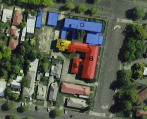
Figure
1 - significant buildings shown red and labelled "B"
(3) The
portion of Caldwell House as shown in figure 1 above shown in red and labelled
"B" is not to be demolished.
(4) A
sign is to be erected in a prominent position on any site on which building
work, subdivision work or demolition work is being carried out:
(a) showing
the name, address and telephone number of the principal certifying authority
for the work, and
(b) showing
the name of the principal contractor (if any) for any building work and a
telephone number on which that person may be contacted outside working hours,
and
(c) stating
that unauthorised entry to the site is prohibited.
Any such sign is to be maintained while the
building work, subdivision work or demolition work is being carried out.
|
PRIOR TO WORKS COMMENCING
|
(5) A
Demolition Noise and Vibration Management Plan (DNVMP) shall be prepared
for the authorised demolition works. The DNVMP shall include the following
“Management Measures” (as detailed in the Demolition Noise and
Vibration Assessment by Wilkinson Murray Report no. 18085 Version B dated July
2018):
· Demolition activities
which are noise or vibration intensive shall only occur during normal
construction hours i.e. between 7.00am – 6.00pm Monday to Friday, and
8.00am – 1.00pm Saturday, with no work on Sundays or public holidays.
· Where practicable any
particularly noisy works shall be staged with consideration to the least
sensitive time of day for the closest receivers, providing respite periods as
necessary.
· Scheduling demolition
activities to minimise multiple use of the noisiest equipment or plant items
where practicable.
· Strategic positioning
of plant items and work areas to reduce the noise emission to noise sensitive
receptors, where possible.
· Ensuring demolition
machinery engine covers are closed, equipment is well maintained and
silencers/mufflers are used, including routine maintenance for major items of
demolition equipment that are significant demolition noise contributors.
· Provision of awareness
training for contractors in environmental noise issues, as described above.
· Community consultation
with local residents/businesses shall be undertaken to assist in the
alleviation of community concerns. This shall occur prior to works commencing
and again prior to each intensive noise generating event where noise management
levels are likely to be exceeded.
· Maintaining a suitable
complaints register. Should noise complaints be received, they must be
immediately investigated and where appropriate, noise monitoring shall be
undertaken at the locations concerned to determine compliance with the
determined demolition noise limits. Reasonable and feasible measures would need
to be implemented to reduce any noise impacts.
The DNVMP shall be submitted to Council's
Director of Development Services for approval prior to works commencing on the
site.
(6) Air
quality monitoring shall be undertaken in accordance with the Asbestos Removal
Control Plan (ARCP) Air Monitoring Program submitted with the application and
include (as a minimum) the following measures:
· Daily air monitoring
(control monitoring) shall be undertaken on the site during removal works.
· The monitoring shall be
undertaken in accordance with the Guidance Note on the Membrane Filter Method
for Estimating Airborne Asbestos Dust, 2nd Edition [NOHSC:3003(2005)].
· Air monitoring shall be
undertaken by an independent asbestos assessor at fixed locations along
boundaries representative of the work areas as determined by the independent
asbestos assessor.
· The frequency of
control monitoring shall be daily for the duration of the asbestos removal
work. Exposure (personal) monitoring will not be undertaken.
· Clearance air
monitoring shall be undertaken after removal works have been completed in the
removal areas, decontamination area and loading bay.
· Effectiveness and
action of the monitoring results shall be undertaken in accordance with the
Criteria for Asbestos Fibres Action Levels (SafeWork Australia 2011) (refer
below insert for more detail).
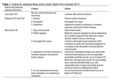
(7) Soil
erosion control measures shall be implemented on the site prior to demolition
works commencing.
(8) Prior
to the demolition works commencing, the applicant is to obtain an approval
under Section 68 of the Local Government Act for the temporary
closure of any footpath or roadway. A pedestrian/vehicle management plan
is to accompany the application. Details are to be provided of the protective
hoardings, fences and lighting that are to be used during demolition, excavation
and building works in accordance with the requirements of the Occupational
Health & Safety Act 2000, Australian Standard AS3798-1996
(Guidelines on Earthworks for Commercial and Residential Developments) and the
WorkCover Authority.
Note: On corner
properties particular attention is to be given to the provision of adequate
sight distances.
(9) Prior
to demolition works commencing, the applicant is to submit a waste management
plan that describes the nature of wastes to be removed, the wastes to be
recycled and the destination of all wastes. All wastes from the demolition
phase of this project are to be deposited at a licensed or approved waste
disposal site.
(10) A
temporary onsite toilet is to be provided and must remain throughout the
project or until an alternative facility meeting Council’s requirements
is available onsite.
(11) Due
to the extensive nature of the demolition works and their proximity to the
public footpath, the applicant is to provide public liability and public risk
insurance cover for a minimum of $10,000,000, endorsed to cover Council
for its respective rights and interests. Evidence of valid insurance cover must
be submitted to Council prior to works commencing on-site.
(12) A
dilapidation report(s) shall be prepared by a suitably qualified engineer and
shall be submitted to Council prior to works commencing on-site. The report(s)
shall address the current condition of all buildings that exist on land that is
immediately adjoining the development site. A dilapidation report shall also be
prepared for the existing building that is to remain on the subject land as
part of this development.
This condition shall not apply in the event
that access is refused by those property owners.
|
DURING DEMOLITION / SITEWORKS
|
(13) The
removal of all asbestos and asbestos containing material as authorised by this
consent shall be carried out in accordance with the Asbestos Removal
Control Plan – report no. R7040arcp2 prepared by EnviroWest dated 17
May 2018 and in accordance with Clause 452 of the Work Health and Safety
Regulation 2017.
(14) All
necessary asbestos clearance certificates shall be furnished to Council within
7 days of being issued.
(15) All
demolition work on the site is to be carried out in accordance with the
Demolition Noise and Vibration Assessment report (Reference 18085 Version B)
dated July 2018 prepared by Wilkinson Murray.
(16) The
wall that is proposed to be removed (forms part of existing carport) on
the western boundary that is the common boundary of no. 78 Dalton Street shall
be removed by manual labour as far as practicable.
(17) A
replacement fence on the western boundary shared by no. 78 Dalton Street shall
be constructed in similar materials and to a height commensurate with the wall
that was removed. The construction of the fence shall commence within 28 Days
from the date that the existing wall is removed and be completed within four
weeks from the date of works commencing on the new wall.
(18) If
Aboriginal objects, relics, or other historical items or the like are located
during development works, all works in the area of the identified object, relic
or item shall cease, and the NSW Office of Environment and Heritage (OEH), and
representatives from the Orange Local Aboriginal Land Council shall be
notified. Where required, further archaeological investigation shall be
undertaken. Development works in the area of the find(s) may recommence if and
when outlined by the management strategy, developed in consultation with and
approved by the OEH.
(19) In
the event of an unexpected find during works such as (but not limited to) the
presence of undocumented waste, odorous or stained soil, asbestos (above
expected levels as detailed in the submitted documentation), structures such as
underground storage tanks, slabs, or any contaminated or suspect material, all
work on site must cease immediately. The beneficiary of the consent must
discuss with Council the appropriate process that should be followed
therein. Works on site must not resume unless the express permission of
the Director Development Services is obtained in writing.
(20) All
construction/demolition work on the site is to be carried out between the hours
of 7.00 am and 6.00 pm Monday to Friday inclusive, 7.00 am to
5.00 pm Saturdays and 8.00 am to 5.00 pm Sundays and Public
Holidays. Written approval must be obtained from the General Manager of Orange
City Council to vary these hours.
(21) Building
demolition is to be carried out in accordance with Australian Standard
2601:2001 - The Demolition of Structures and the requirements of Safe Work
NSW.
(22) Asbestos containing
building materials must be removed in accordance with the provisions of the Work
Health and Safety Act 2011 and any guidelines or Codes of Practice
published by Safe Work NSW, and disposed of at a licenced landfill in
accordance with the requirements of the NSW EPA.
(23) Any
adjustments to existing utility services that are made necessary by this
development proceeding are to be at the full cost of the developer.
(24) The
existing sewer connections to the buildings authorised to be demolished are to
be capped off at the sewer main by Council at Developer’s cost.
(25) The
existing water services to the buildings authorised to be demolished are to be
sealed off at their respective Council mains by Council at the
developer’s cost.
(26) All
of the foregoing conditions are to be at the full cost of the developer and to
the requirements and standards of the Orange City Council Development and
Subdivision Code, unless specifically stated otherwise.
REQUIREMENTS OF
ESSENTIAL ENERGY
(1) If
the proposed development changes, there may be potential safety risks and it is
recommended that Essential Energy is consulted for further comment;
(2) Any
existing encumbrances in favour of Essential Energy (or its predecessors) noted
on the title of the above property should be complied with;
(3) Essential
Energy’s records indicate there is electricity infrastructure located
within the property. Any activities within this location must be undertaken in
accordance with the latest industry guideline currently known as ISSC 20
Guideline for the Management of Activities within Electricity Easements and
Close to Infrastructure.
(4) Prior
to carrying out any works, a “Dial Before You Dig” enquiry should
be undertaken in accordance with the requirements of Part 5E (Protection of
Underground Electricity Power Lines) of the Electricity Supply Act 1995 (NSW).
(5) Given
there is electricity infrastructure in the area, it is the responsibility of
the person/s completing any works around powerlines to understand their safety
responsibilities. SafeWork NSW (www.safework.nsw.gov.au) has publications that
provide guidance when working close to electricity infrastructure. These
include the Code of Practice – Work near Overhead Power Lines and Code of
Practice – Work near Underground Assets.
Other
Approvals
(1) Local
Government Act 1993 approvals granted under Section 68.
Nil
(2) General
terms of other approvals integrated as part of this consent.
Nil
Right
of Appeal
If you are dissatisfied with this decision,
Section 8.7 of the Environmental Planning and Assessment Act 1979
gives you the right to appeal to the Land and Environment Court. Pursuant to
Section 8.10, an applicant may only appeal within 6 months after the date the
decision is notified.
|
Disability
Discrimination Act 1992:
|
This application has been assessed in
accordance with the Environmental Planning and Assessment Act 1979. No
guarantee is given that the proposal complies with the Disability Discrimination
Act 1992.
The applicant/owner is responsible to ensure
compliance with this and other anti-discrimination legislation.
The Disability Discrimination Act
covers disabilities not catered for in the minimum standards called up in the
Building Code of Australia which references AS1428.1 - "Design for
Access and Mobility". AS1428 Parts 2, 3 and 4 provides the most
comprehensive technical guidance under the Disability Discrimination Act
currently available in Australia.
|
|
Disclaimer
- S88B of the Conveyancing Act 1919 - Restrictions on the Use of
Land:
|
The applicant should note that there could be
covenants in favour of persons other than Council restricting what may be
built or done upon the subject land. The applicant is advised to check the position
before commencing any work.
|
|
|
|
|
Signed:
|
On behalf of the consent authority ORANGE
CITY COUNCIL
|
|
Signature:
|
|
|
Name:
|
PAUL JOHNSTON - MANAGER DEVELOPMENT
ASSESSMENTS
|
|
Date:
|
To be advised
|
Planning and Development Committee
7 July 2020
Planning
and Development Committee
7 July 2020

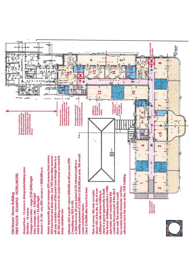
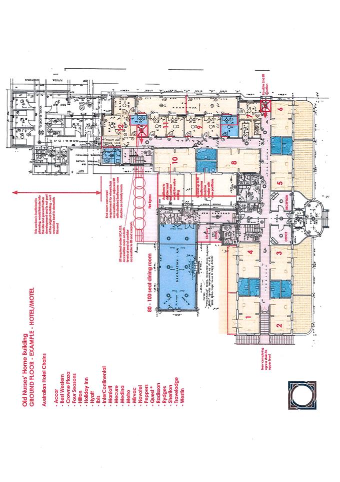
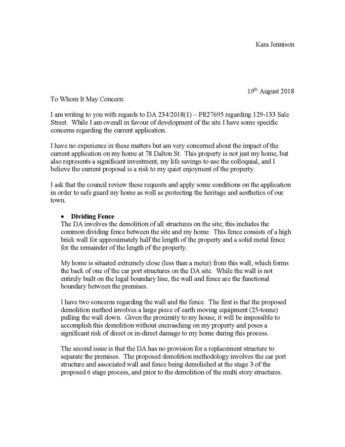
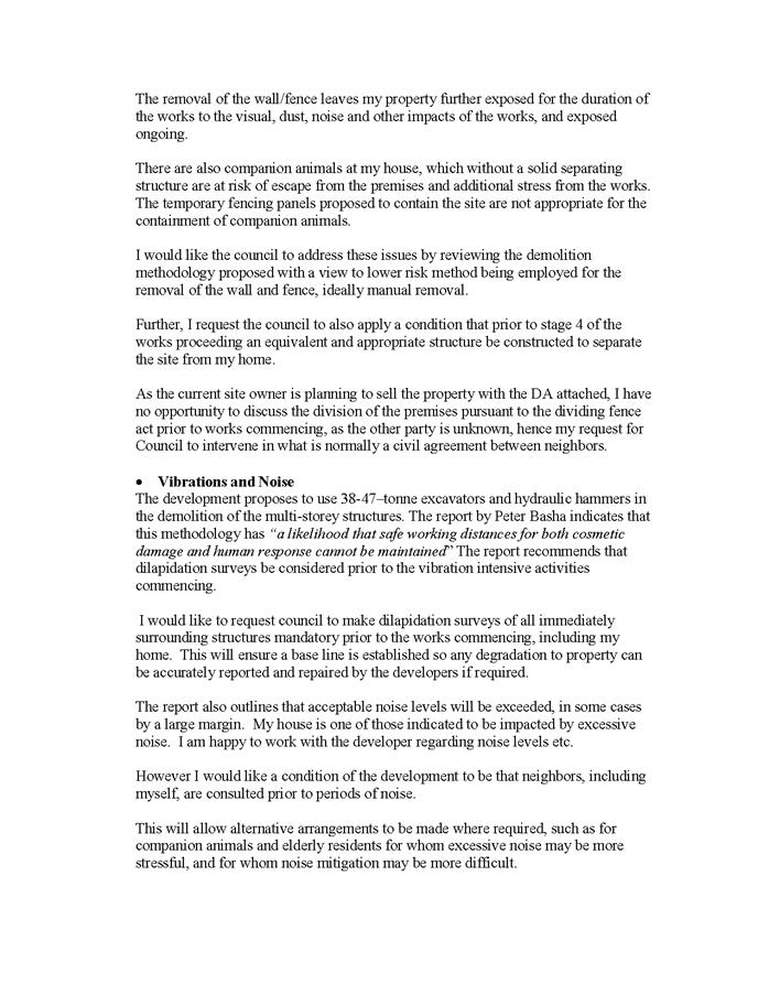
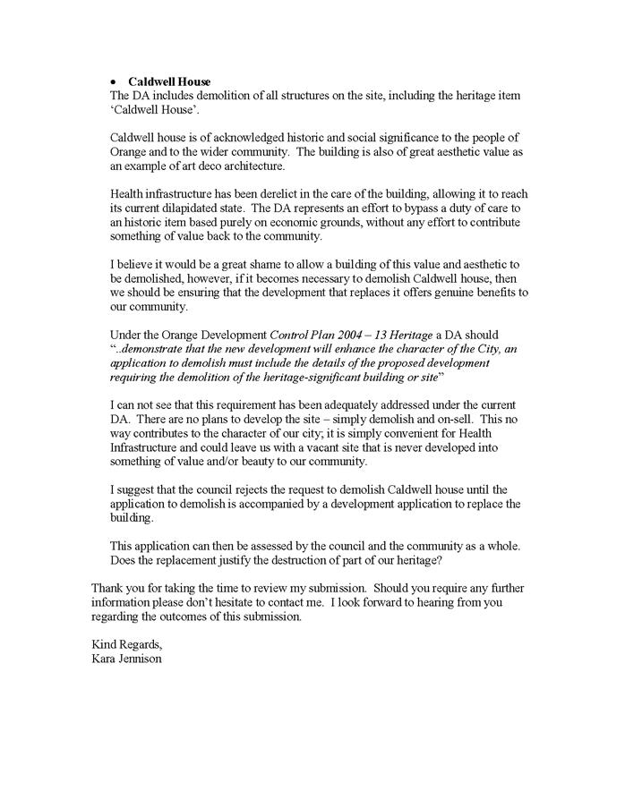

2.3 Development
Application DA 120/2020(1) - 52-54 Bathurst Road, and 25 and 27 Eyles Street
(Taco Bell)
RECORD
NUMBER: 2020/1005
AUTHOR: David
Paine, Senior Planner
EXECUTIVE
Summary
|
Application
lodged
|
25 March
2020
|
|
Applicant/s
|
McDuck
Properties Pty Limited
|
|
Owner/s
|
Thomsons
Corner Pty Limited
|
|
Land
description
|
Lot
507 DP 712206, Lots 3 and 4 DP 37362 – 52‑54 Bathurst Road,
and 25 and 27 Eyles Street, Orange
|
|
Proposed
land use
|
Takeaway
Food and Drink Premises and Signage
|
|
Value of
proposed development
|
$1,100,000
|
Council's consent is sought for the construction of a
Takeaway Food and Drink Premises and associated Signage on land described as
Lot 507, DP 712206 and Lots 3 and 4, and DP 37362. The land is known
as 52–54 Bathurst Road, and 25 and 27 Eyles Street, Orange. The subject
site is known as the former Thompson’s Nursery site.
A previous Development Application was approved by
Council’s Sustainable Development Committee Meeting on 1 April 2014 (DA
134/2013 (1)). The previous application was for a business premises (car wash),
restaurant or café (two tenancies), subdivision and signage. The consent
remains valid because of physical commencement that has been undertaken to
activate the consent.
This application involves the construction of a Takeaway
Food and Drink Premises and comprises of the following scope of works:
construction of Takeaway Food and Drink Premises with seating for 42 seats;
construction of an at-grade car park for 24 vehicles including three (3) staff
parking spaces; drive-thru facility, including queuing for nine (9)
vehicles; acoustic fence constructed along the southern and western boundary
and removal of a street tree on Eyles Street.
The proposal is seeking consent to operate from Sunday to
Thursday from 10am to 10pm and from 10am to 11pm on Friday and Saturday.
The proposed development was publicly notified and
advertised in accordance with the Council’s Community Participation Plan
and one submission was received in response.
The subject land is located within the high profile eastern
entry to the business area of the City; the subject land also adjoins the rear
yards of properties within the heritage conservation area and is opposite the
heritage item, Memory Park.
With the above in mind it is considered the development will
present appropriately to the street and will not unreasonably impact upon the
heritage significance of both the adjoining conservation area and the heritage
item opposite the site.
Council sought the concurrence of Transport for NSW
(previously knowns as RMS) which has been obtained and their requirements have
been integrated as conditions of consent within the attached notice.
As such, the development is
recommended for approval.
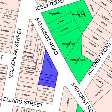
Figure 1 - locality plan
DECISION FRAMEWORK
Development in Orange is governed by two key documents: the
Orange Local Environment Plan 2011 and the Orange Development Control Plan
2004. In addition, the Infill Guidelines are used to guide development,
particularly in the heritage conservation areas and around heritage items.
Orange Local Environment Plan 2011 – The
provisions of the LEP must be considered by the Council in determining the
application. LEPs govern the types of development that are permissible or
prohibited in different parts of the City and also provide some assessment
criteria in specific circumstances. Uses are either permissible or not. The
objectives of each zoning and the aims of the LEP itself are also to be
considered and can be used to guide decision making around appropriateness of
development.
Orange Development Control Plan 2004 – The DCP
provides guidelines for development. In general, it is a performance based
document rather than prescriptive in nature. For each planning element there
are often guidelines used. These guidelines indicate ways of achieving the
planning outcomes. It is thus recognised that there may also be other solutions
of merit. All design solutions are considered on merit by planning and building
staff. Applications should clearly demonstrate how the planning outcomes are
being met where alternative design solutions are proposed. The DCP enables
developers and architects to use design to achieve the planning outcomes in
alternative ways.
Director’s comments
Key issues in the assessment of this application relate to
traffic and noise impacts, signage and how the development fits generally
within the streetscape and surrounding locality. Some of these issues are
highlighted more in this case as the commercial site adjoins residential
land. The issues have been addressed in the body of this report and
conditions of consent to mitigate identified issues have been recommended by
staff.
It is recommended that Council
supports the proposal subject to the adoption of the attached Notice of
Determination.
Link To
Delivery/OPerational Plan
The recommendation in this report relates to the
Delivery/Operational Plan strategy “10.1 Preserve - Engage with the
community to ensure plans for growth and development are respectful of our
heritage”.
Financial Implications
Nil
Policy and Governance Implications
Nil
|
Recommendation
That Council consents to
Development Application DA 120/2020(1)
for Takeaway Food and Drink Premises and Signage at Lot 507 DP 712206,
and Lots 3 and 4 DP 37362 – 52‑54 Bathurst Road,
Orange, and 25 and 27 Eyles Street, Orange pursuant
to the conditions of consent in the attached Notice of Approval.
|
further considerations
Consideration has been given to the recommendation’s
impact on Council’s service delivery; image and reputation; political;
environmental; health and safety; employees; stakeholders and project
management; and no further implications or risks have been identified.
SUPPORTING INFORMATION
Council's consent is sought for a Takeaway Food and Drink
Premises and associated Signage at Lot 507 DP 712206,
and Lots 3 and 4 DP 37362. The land is known as 52–54 Bathurst
Road, and 25 and 27 Eyles Street, Orange.
THE PROPOSAL
The development involves the construction of a Takeaway food
and drink premise and comprises of the following scope of works:
· clearing
the site
· construction
of Takeaway Food and Drink Premises with seating for 42 seats
· construction
of an at-grade car park for 24 vehicles including three (3) staff parking
spaces
· drive-thru
facility, including queuing for nine (9) vehicles
· acoustic
fence constructed along the southern and western boundaries
· associated
signage
· vehicle
access will be via the existing driveway on Bathurst Road and via a new entry
driveway on Eyles Street
· removal
of a street tree on Eyles Street
· loading
dock facilities
· site
landscaping.
The proposal is seeking consent to
operate from Sunday to Thursday from 10am to 10pm and 10am to 11pm on Friday
and Saturday.
MATTERS FOR CONSIDERATION
Section 1.7 - Application of
Part 7 of the Biodiversity Conservation Act 2016 and Part 7A of the
Fisheries Management Act 1994
Section 1.7 of the EP&A Act identifies that Part 7 of
the Biodiversity Conservation Act 2016 (BC Act) and Part 7A of the
Fisheries Management Act 1994 have effect in connection with terrestrial and
aquatic environments.
There are four triggers known to insert a development into
the Biodiversity Offset Scheme (i.e. the need for a BDAR to be
submitted with a DA):
· Trigger 1:
development occurs in land mapped on the Biodiversity Values Map (OEH)
(clause 7.1 of BC Regulation 2017);
· Trigger 2:
development involves clearing/disturbance of native vegetation above a certain
area threshold (clauses 7.1 and 7.2 of BC Regulation 2017); or
· Trigger 3:
development is otherwise likely to significantly affect threatened species
(clauses 7.2 and 7.3 of BC Act 2016).
The fourth trigger (development proposed to occur in an Area
of Outstanding Biodiversity Value (clause 7.2 of BC Act 2016) is generally not
applicable to the Orange LGA; as no such areas are known to occur in the LGA.
No further comments will be made against the fourth trigger.
Trigger 1
The site is not mapped on the
Biodiversity Values Map.
Trigger 2
In consideration of the second
trigger, the prescribed clearing threshold for the site is 0.25 hectares
pursuant to Clause 7.2 of the Biodiversity Conservation Regulation 2016. The
site does not contain any significant vegetation and does not require the
clearing of native vegetation.
Trigger 3
The subject land has been zoned for
commercial purposes and does not contain or adjoin any land that has been
mapped as containing biodiversity significance. The development is unlikely to
adversely fragment or disturb the biodiversity structure or ecological
functions of the development site or surrounding lands.
Section 4.15
Section 4.15 of the Environmental
Planning and Assessment Act 1979 requires Council to consider various
matters, of which those pertaining to the application are listed below.
PROVISIONS OF ANY ENVIRONMENTAL
PLANNING INSTRUMENT s4.15(1)(a)(i)
Orange Local Environmental Plan
2011
Part 1 - Preliminary
Clause 1.2 - Aims of Plan
The broad aims of the LEP are set out under subclause 2.
Those relevant to the application are as follows:
(a) to
encourage development which complements and enhances the unique character of
Orange as a major regional centre boasting a diverse economy and offering an
attractive regional lifestyle,
(b) to
provide for a range of development opportunities that contribute to the social,
economic and environmental resources of Orange in a way that allows present and
future generations to meet their needs by implementing the principles for
ecologically sustainable development,
(f) to
recognise and manage valued environmental heritage, landscape and scenic
features of Orange.
The application is considered to be
consistent with aims (a), (b) and (f) listed above.
Clause 1.6 - Consent Authority
This clause establishes that,
subject to the Act, Council is the consent authority for applications made
under the LEP.
Clause 1.7 - Mapping
The subject site is identified on the LEP maps in the
following manner:
|
Land Zoning Map:
|
Land zoned B6 Enterprise Corridor
Zone.
|
|
Lot Size Map:
|
No Minimum Lot Size
|
|
Heritage Map:
|
Not a heritage item or within a
conservation area
|
|
Height of Buildings Map:
|
No building height limit
|
|
Floor Space Ratio Map:
|
No floor space limit
|
|
Terrestrial Biodiversity Map:
|
No biodiversity sensitivity on the
site
|
|
Groundwater Vulnerability Map:
|
Groundwater vulnerable
|
|
Drinking Water Catchment Map:
|
Not within the drinking water
catchment
|
|
Watercourse Map:
|
Not within or affecting a defined
watercourse
|
|
Urban Release Area Map:
|
Not within an urban release area
|
|
Obstacle Limitation Surface Map:
|
No restriction on building siting
or construction
|
|
Additional Permitted Uses Map:
|
No additional permitted use applies
|
|
Flood Planning Map:
|
Within a flood planning area
|
Those matters that are of relevance
are addressed in detail in the body of this report.
Clause 1.9A - Suspension of
Covenants, Agreements and Instruments
This clause provides that covenants, agreements and other
instruments which seek to restrict the carrying out of development do not apply
with the following exceptions:
· covenants imposed
or required by Council
· prescribed
instruments under Section 183A of the Crown Lands Act 1989
· any conservation
agreement under the National Parks and Wildlife Act 1974
· any trust
agreement under the Nature Conservation Trust Act 2001
· any property
vegetation plan under the Native Vegetation Act 2003
· any biobanking
agreement under Part 7A of the Threatened Species Conservation Act 1995
· any
planning agreement under Division 6 of Part 4 of the Environmental Planning
and Assessment Act 1979.
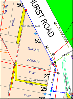
Figure 2 – sewer line
A sewer main traverses the
subject property along the northern boundary of Lot 3. The design of
the development is such that all of the building will avoid the sewer main.
However, it may be necessary for the buildings closest to the sewer main to
require piers. An easement traverses the centre and rear of Lot 4 and part of
the rear of Lot 3. This easement was established to cater for the
redirection of the sewer main under the former development that was previously
approved. It will be necessary for this easement to be extinguished. The title
of the subject property is not affected by any of the above.
Part 2 - Permitted or Prohibited Development
Clause
2.1 - Land Use Zones and Clause 2.3 - Zone Objectives and Land Use Table
The subject site is located within the B6 Enterprise
Corridor Zone. The proposed development is defined as a Takeaway Food and Drink
Premises and signage under OLEP 2011 and is permitted with consent for
this zone.
Pursuant to the LEP dictionary;
Take away food and drink premises means
premises that are predominantly used for the preparation and retail sale of
food or drink (or both) for immediate consumption away from the premises.
Signage means any sign, notice, device,
representation or advertisement that advertises or promotes any goods, services
or events and any structure or vessel that is principally designed for, or that
is used for, the display of signage, and includes any of the following:
(a) an advertising structure,
(b) a building identification sign,
(c) a business identification sign,
but does not include a traffic sign or traffic control
facilities.
Clause
2.3 of LEP 2011 references the Objectives
for each zone in LEP 2011. These objectives for land zoned B6 Enterprise
Corridor are as follows:
1 - Objectives of the B6 Enterprise Corridor Zone
· To promote
businesses along main roads and to encourage a mix of compatible uses.
· To provide a
range of employment uses (including business, office, retail and light
industrial uses).
· To maintain the
economic strength of centres by limiting retailing activity.
· To provide for
residential uses, but only as part of a mixed use development.
The development
is considered appropriate within the zone and will allow for additional
employment in the hospitality sector within the City (associated with the
Takeaway Food and Drink Premises uses). The development will not jeopardise the
economic strength of the CBD with the retail component limited to food and
drink premise uses which are not atypical for the locality.
No residential uses are proposed
as part of this development.
Clause 2.6 Subdivision
– consent requirements
This clause triggers the need for development consent for
the subdivision of land. Whilst the proposal has not specifically nominated
that the subject land will be consolidated, this issue has been discussed with
the applicant and is standard practice when development is occurring over separate
parcels of land. A number of conditions are recommended to ensure that proof of
lodgement for registration of a survey plan of consolidation of Lot 507,
DP 712206, Lots 3 and 4 DP 37362 with NSW Government Land and Property
Information has been undertaken prior to the issue of a Construction
Certificate, with formal registration of the plan to occur prior to the issue
of an Occupation Certificate.
Part 3 - Exempt and Complying Development
The application is not exempt or
complying development.
Part 4 - Principal Development Standards
The LEP Principal Development
Standards do not apply to this application.
Part 5 - Miscellaneous Provisions
5.10 - Heritage
Conservation
(1) Objectives
The
objectives of this clause are as follows:
(a) to
conserve the environmental heritage of Orange,
(b) to
conserve the heritage significance of heritage items and heritage conservation
areas, including associated fabric, settings and views,
(c) to
conserve archaeological sites,
(d) to
conserve Aboriginal objects and Aboriginal places of heritage significance.
The development
is not located within a heritage conservation area, nor is the land identified
as a heritage item or draft heritage item. The land does, however, adjoin the
rear of properties within the Glenroi Heritage Conservation Area and is
opposite a Heritage Item identified as Memory Park, with other heritage Items
in the vicinity including Bowen Terrace, Wolaroi and 171 Edward Street. As
such, it is important to assess the likely impact upon the heritage significance
of the conservation area and primarily the heritage item opposite the subject
land. Council’s Heritage Advisor has provided the following advice in
relation to the proposed development.
Glenroi
HCA
In terms of the
impacts to the heritage conservation area the proposed development is likely to
have a minimal impact. The development is located to the rear of the properties
within the conservation area and the development will not be overly visible
from within McLachlan Street, nor will it unreasonably impact upon the heritage
significance of individual dwellings within the conservation area.
Memory
Park
Orange Heritage Inventory describes the significance of
Memory Park as follows:
An
important visual and historic landscape on the main road and one of the key
entry points to the City, the park includes mature tree planting, a watercourse
and a range of civic improvements valued by the local community.
The heritage advice centred on a
number of minor design suggestions intended to improve the presentation of the
development and its relationship to the heritage item and the highway.
It is important
to make the point that the development has been designed around an attempt to
achieve the required noise criterion so there is a balance to be weighed between
heritage considerations and allowing commercial development to occur on a
commercially zoned site which adjoins sensitive residential receivers.
Heritage Advisor’s Recommendations
1. The pylon sign (S01) is in very
close proximity to the proposed building and its two identical taco bell
graphics and the sign/pylon height is very similar to the building. The pylon
sign therefore duplicates the graphic of the taco bell applied to the building
and adds complexity to the bulk and scale of the building in the vicinity. It
is therefore recommended that the pylon sign be deleted from the proposal.
Applicant’s Response
The pylon sign is integral to
the branding and marketing of the Taco Bell which does not rely solely on
building façade signage. Its location and size (ie: height) was
influenced by the existing signage (including existing pylon signs) along
Bathurst Road. It is considered that the proposed signage is compatible with
the desired character of the area and is consistent with the current signage in
the immediate precinct along Bathurst Road including.
(i) the
existing pylon signage on the adjacent BP Service Station site
(ii) the
pylon sign and associates signage for McDonalds
(iii) the pylon
sign and associated signage for KFC
(iv) the pylon
sign and associated signage for Red Rooster
(v) the
pylon sign and associated signage for 7-Eleven Service Station
(vi) the pylon sign and associated signage for
Hungry Jacks.
Planning Officer’s
Response
The proposed pylon sign
certainly adds to the complexity of the bulk and scale of the building. The
subject sign extends above the height of the subject building which is of some
concern. The applicant argues that the proposed pylon sign has been designed to
be integrated into the building and forms part of the overall building design.
Despite the bulk of this particular element, it is considered acceptable in
this case on the basis that building and associated signage is well setback
from Bathurst Road frontage, is recessive in colour and partly screened by the
existing street trees in Bathurst Road and Eyles Street. Further, it is
acknowledged that the submitted plans show that the pylon sign only contains an
image of a bell and a small amount of written text. Overall, the signage design
is considered to be consistent with the overall height of other pylon type
signs in the locality and is therefore acceptable in this context.
Heritage Advisor’s Recommendations
2. Pedestrian access is a feature
of Orange and the footpaths are immediately available on both sides of Bathurst
Road. Memory Park is a common destination opposite the subject site. It is
recommended that consideration is given to a pedestrian access from Bathurst
Road in the location next to the Taco Bell porch entry with the banner sign
(S02) being relocated to the north western portion of the site. The pedestrian
access is to be provided with appropriate rumble or similar safety measures to
protect pedestrians from vehicles.
Planning
Officer’s Comments:
The plans have been amended to
include a pedestrian access from Bathurst Road. The internal driveway design
should ensure low speed traffic movements to facilitate pedestrian safety from
Bathurst Road into the site.
Heritage Advisor’s Recommendations
3. Replica materials are not
supported in the Orange Conservation Areas and in areas with urban design
quality and visual prominence. The integrity of materials and in particular
timber from which many traditional buildings are fabricated is valued and
protected.
An
alternate plain powder coat or anodised finish for the aluminium cladding
proposed for the North and East elevations is an option as is another/alternate
wood composite board cladding type product such as Urbanline Euro dark cedar
Selkta or equal.
Applicant’s
Response:
A number of high quality
products were considered for the project with the final mix notated on the
architectural plans. The nominated materials are standard for all Taco Bell
stores and represent the best and most durable materials that are available. In
order to maintain consistence for the brand, Council can appreciate that this
is to be reflected in the selected materials which are also being implemented
in the proposed Bathurst store (which is in a Heritage Conservation Area) and the
proposed Tamworth store (which has been approved).
Planning Officer’s
Comments:
The material and colours
proposed by the applicant are considered “corporate materials”.
Whilst not ideal given the location of the site in a high profile area and
positioned on the fringe of the heritage conservation area, the fact that the
building incorporates recessive colours, is well setback from Bathurst Road by
around 9m and partly screened by the existing street trees in Bathurst Road
renders the design acceptable. Adequate landscaping will assist with
integrating the building within the streetscape. The material and colour
proposed are considered acceptable in this setting.
Heritage
Advisor’s Recommendations
4. The
colour for the perimeter fencing should be similar to Windspray to best reflect
and background the adjoining planting.
Planning Officer’s
Comments:
A condition has been included in
the draft conditions to ensure compliance with this request.
Heritage
Advisor’s Recommendations
5. An additional tree should be provided
to the northern end of the Eyles Street boundary planting at a similar spacing
to the adjoining two proposed trees with the objective of screening the car
park and loading bay areas in the vicinity.
Applicant’s
Response:
An additional tree is not
supported as this would screen and obscure the building from the street.
Planning Officer’s
Comments:
The landscape plan and
recommended conditions incorporates tree planting that would assist in reducing
the perceived bulk of the development and would provide for increased screening
for adjoining properties. On balance, it is considered that the proposed
landscaping for the site as amended by conditions of consent will ensure a good
quality design which will complement the aesthetic quality and amenity for the
development and surrounds.
Heritage
Advisor’s Recommendations
6. An additional tree should be
provided in the northern corner of the lawn space next to the Plant screen
space, so as to increase the tall background planting to the south and west of
the site and building while improving the screening to the service spaces.
Applicant’s
Response:
The landscape plan will be
amended to add the additional tree.
Planning Officer’s
Comments:
A condition has been included in
the draft conditions of consent that requires the planting of an additional
tree. The landscape plan incorporates tree planting that would assist in
reducing the perceived bulk of the development and would provide for increased
screening for adjoining properties. On balance, it is considered that the
proposed landscaping for the site is of a good quality design and would
complement the aesthetic quality and amenity for the development and surrounds.
Heritage
Advisor’s Recommendations
8. The driveway surfaces including
the new apron crossovers to Bathurst and Eyles Streets are to utilize
Charcoal pigment to produce a dark grey coloured concrete consistent with the
traditional Basalt colour in Orange.
Applicant’s
Response:
The internal car park will be
bitumen sealed and therefore pigmenting is not an option. The crossovers will
be concrete but should not be pigmented as they will clash with the existing
concrete footpaths and kerb and gutter.
Planning Officer’s
Comments:
It is considered that the
proposed bitumen seal would provide a dark colouring which is adequate for this
development in its heritage context.
Part 7 - Additional Local Provisions
7.1 - Earthworks
This clause establishes a range of matters that must be
considered prior to granting development consent for any application involving
earthworks, such as:
(a) the likely disruption of, or any
detrimental effect on, existing drainage patterns and soil stability in the
locality of the development
(b) the effect of the development on the
likely future use or redevelopment of the land
(c) the quality of the fill or the soil to be
excavated, or both
(d) the effect of the development on the
existing and likely amenity of adjoining properties
(e) the source of any fill material and the
destination of any excavated material
(f) the likelihood of disturbing relics
(g) the proximity to and potential for adverse
impacts on any waterway, drinking water catchment or environmentally sensitive
area
(h) any measures proposed to minimise or
mitigate the impacts referred to in paragraph (g).
The earthworks
proposed in the application are limited to the extent of cutting and filling
required for the proposed Takeaway Food and Drink Premise and associated site
works. The extent of disruption to the drainage of the site is considered
to be minor and will not detrimentally affect adjoining properties or receiving
waterways.
The
extent of the earthworks will not materially affect the potential future use or
redevelopment of the site that may occur at the end of the proposed
development's lifespan.
The site
is not known to be contaminated, nor is the site known to contain any
Aboriginal, European or Archaeological relics. Previous known uses of the site
do not suggest that any relics are likely to be uncovered. However, conditions
are imposed to ensure that should site works uncover a potential relic or
artefact, works will be halted to enable proper investigation by relevant
authorities and the proponent required to seek relevant permits to either
destroy or relocate the findings.
The
earthworks will be appropriately supported onsite and the change in ground
level is not substantial. Therefore the effect on the amenity of adjoining
properties is considered to be minor.
The
site is not in proximity to any waterway, drinking water catchment or sensitive
area. Conditions will be imposed to require a sediment control plan, including
silt traps and other protective measures, to ensure that loose dirt and
sediment does not escape the site boundaries.
7.2 - Flood Planning
This
clause applies to land identified on the Flood Planning Map as a Flood Planning
Area and requires that, before any consent is issued, Council must be satisfied
that the proposal:
(a) is compatible with the flood hazard of the
land, and
(b) is not likely to significantly adversely
affect flood behaviour resulting in detrimental increases in the potential
flood affectation of other development or properties, and
(c) incorporates appropriate measures to
manage risk to life from flood, and
(d) is not likely to significantly adversely
affect the environment or cause avoidable erosion, siltation, destruction of
riparian vegetation or a reduction in the stability of river banks or
watercourses, and
(e) is not likely to result in unsustainable
social and economic costs to the community as a consequence of flooding.
A
flood level and freeboard were established as part of the assessment of the
previously approved business premise and have been used as part of this
development for the building. Council’s Technical Services Division have
recommended a condition of consent be attached to the notice of approval that
requires the plans to be amended to reduce the height of the proposed car park
to the existing natural surface levels. This will ensure that the proposed
development is unlikely to change flooding regimes on or off the site and would
be unlikely to cause or contribute to erosion, siltation or reduce riparian
vegetation. Revised building and engineering plans with amended levels
will therefore need to be submitted with any construction certificate. The
revised levels will need to address any resultant grade changes so as to
maintain appropriate access.
7.3 - Stormwater Management
This clause
applies to all industrial, commercial and residential zones and requires that
Council be satisfied that the proposal:
(a) is designed to maximise the use of water
permeable surfaces on the land having regard to the soil characteristics
affecting onsite infiltration of water
(b) includes, where practical, onsite
stormwater retention for use as an alternative supply to mains water,
groundwater or river water; and
(c) avoids any significant impacts of
stormwater runoff on adjoining downstream properties, native bushland and
receiving waters, or if that impact cannot be reasonably avoided, minimises and
mitigates the impact.
The
proposal has been designed to include permeable surfaces and includes onsite
retention of stormwater through the use of detention basins. It is therefore
considered that stormwater management is satisfactory.
7.6 - Groundwater Vulnerability
This
clause seeks to protect hydrological functions of groundwater systems and
protect resources from both depletion and contamination. Orange has a high
water table and large areas of the LGA, including the subject site, are
identified with “Groundwater Vulnerability” on the Groundwater
Vulnerability Map. This requires that Council consider:
(a) whether or not the development (including
any onsite storage or disposal of solid or liquid waste and chemicals) is
likely to cause any groundwater contamination or have any adverse effect on
groundwater dependent ecosystems, and
(b) the cumulative impact (including the
impact on nearby groundwater extraction for potable water supply or stock water
supply) of the development and any other existing development on groundwater.
Furthermore, consent may not be granted unless Council is satisfied that:
(a) the development is designed, sited and
will be managed to avoid any significant adverse environmental impact, or
(b) if that impact cannot be reasonably
avoided - the development is designed, sited and will be managed to minimise
that impact,
(c) if that impact cannot be minimised - the
development will be managed to mitigate that impact.
The proposal is not anticipated to
involve the discharge of toxic or noxious substances and is therefore unlikely
to contaminate the groundwater or related ecosystems. The proposal does not
involve extraction of groundwater and will therefore not contribute to
groundwater depletion. The design and siting of the proposal has sought to
avoid impacts on groundwater and is therefore considered acceptable.
The applicant will be required to
enter into a trade waste agreement with Council in relation to the discharge of
liquids associated with the Takeaway food and drink premise.
Clause 7.11 - Essential
Services
Clause 7.11 applies and states:
Development consent must not be
granted to development unless the consent authority is satisfied that any of
the following services that are essential for the proposed development are
available or that adequate arrangements have been made to make them available
when required:
(a) the
supply of water,
(b) the
supply of electricity,
(c) the
disposal and management of sewage,
(d) storm
water drainage or onsite conservation,
(e) suitable
road access.
In consideration of this clause, all utility services are
available to the land and are adequate for the proposal.
STATE ENVIRONMENTAL PLANNING
POLICIES
State Environmental Planning Policy 55 Remediation of
Land
State Environmental Planning Policy 55 - Remediation of
Land (SEPP 55) is applicable. Pursuant to Clause 7 Contamination and
remediation to be considered in determining development application:
(1) A consent authority must not consent to
the carrying out of any development on land unless:
(a) it
has considered whether the land is contaminated, and
(b) if
the land is contaminated, it is satisfied that the land is suitable in its
contaminated state (or will be suitable, after remediation) for the purpose for
which the development is proposed to be carried out, and
(c) if
the land requires remediation to be made suitable for the purpose for which the
development is proposed to be carried out, it is satisfied that the land will
be remediated before the land is used for that purpose.
The previous use of 52-54
Bathurst Road and 27 Eyles Street was for the purpose of a plant nursery,
locally known as Thomson’s Nursery. The previous use is not considered to
raise any concerns regarding potential contamination. The proposal is considered
acceptable under the above policy.
State Environmental Planning
Policy 64 - Advertising and Signage
State Environmental Planning Policy 64 - Advertising and
Signage (SEPP 64) is applicable and states in part:
3 Aims,
Objectives etc
(1) This
Policy aims:
(a) to
ensure that signage (including advertising):
(i) is
compatible with the desired amenity and visual character of an area, and
(ii) provides
effective communication in suitable locations, and
(iii) is
of high quality design and finish, and
(8) Granting
of Consent to Signage
A consent authority must not
grant development consent to an application to display signage unless the
consent authority is satisfied:
(a) that
the signage is consistent with the objectives of this Policy as set out in
Clause 3 (1) (a), and
(b) that
the signage the subject of the application satisfies the assessment criteria
specified in Schedule 1.
The proposal includes a banner sign
and two illuminated entry signs for each access on both Bathurst Road and Elyes
Street. The four illuminated entry signs (2.1m high – two at each
entry/exit point) and the proposed banner sign along the Bathurst Road street
frontage will result in a proliferation of signage along the street frontages
and is therefore not supported.
Further, Council’s Technical
Services Division have supported this position and have advised that the
proposed entry/exit signage in particular should be removed due to traffic
safety concerns indicating that all signage at these points should be limited
to traffic directional signage that is approved by Transport for NSW. The
submitted plans show that the banner signage has no content at this stage and
is likely to be used for product advertising over time which is prohibited in
any event under the provisions of the SEPP. In order to restrain the extent of
signage on what is an important site on the entrance to the CBD attached is a
condition of consent that requires the entry exit signage and the banner sign
along Bathurst Road frontage to be removed. Given that the pylon sign and
branding of the building have been supported, it is considered that the
deletion of the entry signs and the banner is appropriate for the site.
The amended signage subject to the adoption of the
recommendation are considered to consistent with the aims and objectives of the
plan.
1 -
Character of the Area
· Is
the proposal compatible with the existing or desired future character of the
area or locality in which it is proposed to be located?
· Is
the proposal consistent with a particular theme for outdoor advertising in the
area or locality?
The area is characterised as a mix of commercial and
established residential properties with signage primarily associated with the
commercial uses and some educational uses such as Wolaroi school signage. The
character of the area is also influenced by the proximity of the Glenroi
Heritage Conservation Area and the nearby heritage items (particularly
Memory Park opposite). The character of the land is further influenced by
its high profile location on the entrance to the business area of the City.
Given the above, it is considered
important to protect the character of the area by ensuring that any signage is
consistent with the requirements of the SEPP. The proposed signage subject to
the adoption of the recommended conditions of consent discussed above will
ensure that the signage is consistent with existing character of the area.
2 - Special Areas
· Does the
proposal detract from the amenity or visual quality of any environmentally
sensitive areas, heritage areas, natural or other conservation areas, open
space areas, waterways, rural landscapes or residential areas?
Whilst the subject land is not within a residential zoning,
nor is it within a heritage conservation area or a listed item, the land does
adjoin a residential zoning and is located between a heritage conservation area
and a heritage item.
Therefore, it is the opinion of Council staff that the land,
in terms of the application of the SEPP, is considered a special area by virtue
of the land’s proximity to the residential land and heritage conservation
area and heritage item. To this end, the signage within the development is to
be limited to business identification signage only. This is consistent with the
provisions of the DCP in relation to this site. Further the recommended
conditions will ensure that signage is acceptable for this precinct.
3 - Views and Vistas
· Does the
proposal obscure or compromise important views?
· Does the
proposal dominate the skyline and reduce the quality of vistas?
· Does the
proposal respect the viewing rights of other advertisers?
The proposed signage, apart from the 8.3m pylon and other
signage discussed above is shown to be limited to flush wall signage and, as
such will not obscure or compromise important views, nor will it dominate the
skyline or jeopardise the viewing rights of other signs in the area. In terms
of the 8.3m pylon sign, the sign is sited in a manner that will not impact upon
views and is a height commensurate with the height of the proposed building and
other pylon signage located along Bathurst Road. It is considered that
proposed pylon signage will not dominate the skyline, nor reduce the quality of
important view corridors.
4 - Streetscape, Setting or
Landscape
· Is the scale,
proportion and form of the proposal appropriate for the streetscape, setting or
landscape?
· Does the
proposal contribute to the visual interest of the streetscape, setting or
landscape?
· Does the
proposal reduce clutter by rationalising and simplifying existing advertising?
· Does the
proposal screen unsightliness?
· Does the
proposal protrude above buildings, structures or tree canopies in the area or
locality?
· Does the
proposal require ongoing vegetation management?
As indicated above, the proposal included a banner sign and
four large directional signage on both the Bathurst Road and Eyles Street
entry/exist. A condition has been included in the attached Notice to remove the
banner sign and entry exit signs completely. The overall scale, proportions and
forms of the remaining signage are appropriate within the context of the
setting.
Landscaping on the site has been designed as part of the
overall proposal, and low maintenance vegetation and grasses will be planted
around the pylon signage.
5 - Site and Building
· Is the proposal
compatible with the scale, proportion and other characteristics of the site or
building, or both, on which the proposed signage is to be located?
· Does the
proposal respect important features of the site or building, or both?
· Does the
proposal show innovation and imagination in its relationship to the site or
building, or both?
As discussed above the proposed
entry/exit signage and the banner sign along Bathurst Road are not supported.
The remaining signage is considered to be compatible with the scale, proportion
and other characteristics of the site and proposed buildings on the land.
The proposed level of signage subject to the adoption of the recommended
conditions is not unreasonable for this type of land use.
6 - Associated Devices and
Logos with Advertisements and Advertising Structures
· Have any safety
devices, platforms, lighting devices or logos been designed as an integral part
of the signage or structure on which it is to be displayed?
The proposed signage does not
include any safety devices, platforms or lighting devices that form an integral
part of the signage or structure on which it is to be displayed. The proposed
signage includes a corporate logo in the design, which meets the definition of
business identification signage.
7 - Illumination
· Would
illumination result in unacceptable glare?
· Would
illumination affect safety for pedestrians, vehicles or aircraft?
· Would
illumination detract from the amenity of any residence or other form of
accommodation?
· Can the
intensity of the illumination be adjusted, if necessary?
· Is the
illumination subject to a curfew?
The proposed illumination is
considered acceptable. Attached is a condition of consent which requires all
lighting associated with the signage to be designed in accordance with
AS4282 1997 - Control of the Obtrusive Effects of Outdoor Lighting.
The illumination of signage is
unlikely to create an adverse impact for users of Bathurst Road, nor existing
dwellings in the vicinity of the subject land.
8 - Safety
· Would the proposal
reduce the safety for any public road?
· Would the
proposal reduce the safety for pedestrians or bicyclists?
· Would the
proposal reduce the safety for pedestrians, particularly children, by obscuring
sightlines from public areas?
Council’s Technical Services
Division advise that the two illuminated entry/exit signs located on both
Bathurst Road and Eyles Street are not supported given that they have the
potential to obstruct movement, obscure sightlines, or reduce the safety along
the public road. Council’s Technical Services Division have recommended
that such signage is removed from the plans with all directional signage
required for the site to be submitted for separate approval by both Orange City
Council and Transport for NSW. Conditions attached to this effect.
STATE ENVIRONMENTAL PLANNING
POLICIES
The following State Environmental
Planning Policies apply to the subject development:
State Environmental Planning
Policy Infrastructure 2007
Clauses 101 and 104 of this SEPP
are applicable to this development, and are discussed below. Concurrence with
the Transport NSW (TfNSW) is required for this proposal.
101 - Development with Frontage to Classified
Road
The primary objective of this clause is to ensure that new
development does not compromise the effective and ongoing operation and
function of classified roads. The consent authority must not grant consent to
development on land that has a frontage to a classified road unless it is
satisfied that:
(a) where
practicable, vehicular access to the land is provided by a road other than the
classified road, and
(b) the
safety, efficiency and ongoing operation of the classified road will not be
adversely affected by the development as a result of:
(i) the
design of the vehicular access to the land, or
(ii) the
emission of smoke or dust from the development, or
(iii) the
nature, volume or frequency of vehicles using the classified road to gain
access to the land, and
(c) the
development is of a type that is not sensitive to traffic noise or vehicle
emissions, or is appropriately located and designed, or includes measures, to
ameliorate potential traffic noise or vehicle emissions within the site of the
development arising from the adjacent classified road.
104 - Traffic-Generating Development
This clause applies to a takeaway food and drink premise of
any size where it has direct vehicular or pedestrian access to a classified
road or to a road that connects to a classified road where the access is within
90m of the connection. It requires the consent authority to give written notice
of the application to the Transport NSW and take their response into
consideration, as well as consider the accessibility of the site concerned, and
any potential traffic safety, road congestion or parking implications of the development.
The requirements of the Transport NSW have been
integrated into the notice of approval as conditions of consent, and are as
follows:
· The proposed
driveway via the Mitchell Highway is to be undertaken via a left in and left
out only arrangement.
· Construction of
the driveway located along the Mitchell Highway may be subject to the developer
and TfNSW entering into a Works Authorisation Deed (WAD) for the developer to
undertake private financing and construction of any works along the State classified
road network. The WAD is to be entered into prior to the commencement of
demolition works.
· A detailed
design is to be submitted by the proponent to TfNSW and Council for approval
for the concrete layback driveway prior to construction. The driveway is to be
designed to provide good sight lines between pedestrians and motorists, match
road levels and not interfere with drainage.
· The design is
to also include relevant signage, line marking and a concrete splay or similar
in the driveway along the Mitchell Highway to advise customers that all egress
from the site into the Mitchell Highway is left turn only.
· The current
line marking arrangement in the shoulder of the Mitchell Highway near the
proposed driveway will be subject to TfNSW concurrence as part of the detailed
design process.
· All vehicular
movements to and from the site are to be undertaken in a forward movement.
· Prior to the
issuance of an Occupation Certificate, any redundant kerb layback crossing
accessed along the Mitchell Highway servicing the land are to be removed and
replaced with kerb and gutter to match existing kerb and gutter. Driveways are
to be designed and maintained to provide good sight lines between pedestrians
and motorists, match road levels and not interfere with drainage.
· Landscaping,
signage and fencing are not to impede the sight lines of traffic within or when
passing, entering or departing the site. Safe Intersection Sight Distance
(SISD) requirements outlined in Austroads Guide to Road Design Part 4A is to be
provided in both directions at the intersection of the driveway and the
Mitchell Highway.
· It was noted
there are various mature trees located along the frontage of the site, any
removal of vegetation required to be undertaken to meet requirements is subject
to the relevant consent and does not form part of TfNSW concurrence.
· Any current
arrangement of on-street parking along the site frontage of the Mitchell
Highway is to be replaced by ‘No Stopping’ signage (R5-400) at
minimum, either side of the driveway within the Mitchell Highway, by the
proponent prior to occupation of the premises. Relevant and timely
communication to adjoining land owners impacted as a result of this change
should be managed by the consent authority.
· Adequate
turning circles, storage room and vertical clearances are to be provided within
the site for the largest type of vehicle (9m) that will need to access the site
during construction and operation.
· All demolition
works are to be undertaken within the bounds of the site only.
· Prior to the
commencement of construction works, the proponent is to contact TfNSW Field
Traffic Manager on 1300 656 371 to determine if a Road Occupancy Licence (ROL)
is required. In the event that an ROL is required, the proponent is to obtain
the ROL prior to works commencing within 3m of the travel lanes in the Mitchell
Highway.
· Prior to the
issue of an Occupation Certificate, all works required to facilitate the
development shall be completed.
It is considered that the site has been appropriately
designed to ensure that access points, car parking, queuing, loading and
manoeuvring arrangements are sufficient for the proposed take away premise, and
will not adversely impact on the surrounding road network, or on neighbouring
properties. It should be noted that access egress to Bathurst Road will be
limited to a left in left out manoeuvre meaning that traffic travelling towards
Bathurst would be required to access the development via Eyles Street.
PROVISIONS OF ANY DRAFT
ENVIRONMENTAL PLANNING INSTRUMENT THAT HAS BEEN PLACED ON EXHIBITION
4.15(1)(a)(ii)
From 31 January to 13 April 2018 the Department of Planning
and Environment publically exhibited an Explanation of Intended Effect (EIE)
and Draft Planning Guidelines for the proposed Remediation of Land SEPP, which
will repeal and replace State Environmental Planning Policy 55 –
Remediation of Land (SEPP 55). Of particular note, the Draft Planning
Guidelines state:
“In undertaking an
initial evaluation, a planning authority should consider whether there is any
known or potential contamination on nearby or neighbouring properties, or in
nearby groundwater, and whether that contamination needs to be considered in
the assessment and decision making process.”
“If the planning
authority knows that contamination of nearby land is present but has not yet
been investigated, it may require further information from the applicant to
demonstrate that the contamination on nearby land will not adversely affect the
subject land having regard to the proposed use.” (Proposed
Remediation of Lands SEPP - Draft Planning Guidelines, Page 10).
The Draft Remediation of Land SEPP is
applicable to this proposal. The Draft SEPP requires in part that consideration
be given to potential contamination on nearby or neighbouring properties and
groundwater.
The contaminated status of adjoining lands will not impact
on the proposed development.
DESIGNATED DEVELOPMENT
The proposed development is not designated development.
INTEGRATED DEVELOPMENT
The proposed development is not integrated development
although concurrence was required from Transport for NSW for access in the site
from a classified road. Concurrence has been obtained from
Transport for NSW (see above for details) and their requirements have been
integrated as conditions of consent within the attached notice.
PROVISIONS OF ANY DEVELOPMENT
CONTROL PLAN s4.15(1)(a)(iii)
Development Control Plan 2004
Development Control Plan 2004 (“the DCP”)
applies to the subject land, Chapter 2 – Natural Resource Management,
Chapter 8 - Development in Business Zones, Chapter 13 - Heritage,
Chapter 14 - Advertising and Chapter 15 - Car Parking). An
assessment of the proposed development against the relevant Planning Outcomes
has been undertaken below.
Chapter 2 - Natural Resource Management
Section 2.1 - Water Quality
Section 2.1 - Water Quality identifies that development that
concentrates, redirects flows, increases flow rates or disturbs land in close
proximity to creeks has the potential to affect waterways with associated erosion,
sedimentation and release of nutrients, which combine to affect downstream
water quality.
Section 2.1 also identifies that development involving
groundwater extraction and/or onsite wastewater disposal is deemed to affect
groundwater resources.
The relevant matters have previously been addressed in
detail under the headings “7.3 ‑ Stormwater” and
“7.6 - Groundwater Vulnerability”.
It is considered that the requirements of the DCP have been
adequately addressed by this proposal.
Section 2.2 - Soil Resources
Section 2.2 - Soil Resources identifies that soil
characteristics influence land use and development capability, including the
suitability for building footings, onsite waste disposal, road engineering and
drainage.
Council’s Technical Services Division has recommended
a condition of consent requiring that the development is to be constructed in
accordance with Council’s Development and Subdivision Code. This has been
included in the condition of consent.
Erosion and Sedimentation
The DCP sets the following Planning Outcome in regard to
Erosion and Sedimentation:
· Measures
implemented during construction to ensure that the landform is stabilised and
erosion is controlled.
An erosion and sediment control plan will be required in
conjunction with the engineering design plans for the development. A condition
is recommended in relation to this matter.
It is considered that the requirements of the DCP have been
adequately addressed.
Chapter 8 - Development in
Business Zones
Business Services Areas
· Applications
clearly demonstrate that the development will not detract from the role of the
CBD as a regional centre.
The development is not likely to impact upon the primacy
role of the CBD. This type of development is considered appropriate within the
zone and will appeal to the travelling public.
· Provision of
adequate fire-safety measures and facilities for disabled persons (according to
the BCA) is addressed at the application stage (relevant for all development
but particularly important where converting residential buildings for business
use).
Relevant conditions are attached in relation to fire-safety
and disabled access. These are considerations relevant to the construction
certificate stage of the development.
· Heritage
streetscapes are conserved and enhanced through adaptive reuse of heritage
buildings, restrained advertising and landscaped gardens.
The development is not considered to form part of a heritage
streetscape and is essentially a vacant commercial site, albeit within a high
profile area of the City. The design is considered appropriate for its setting
and zoning.
· Areas on the
main roads into and out of Orange (such as Molong Road and Bathurst Road)
provide a high level of architectural design to enhance the visual character of
the City entrances.
The site is a prominent and high profile site on the eastern
entrance to the City and, as such, the architectural design of the development
is of high importance.
The building is a modern design which has been designed for
a specific use – Takeaway premises and is considered acceptable in terms
of its visual character.
The application was supported by a detailed landscape
plan. The proposed landscaping will ensure that the development is
suitably integrates well with the Bathurst Road streetscape.
· All sites
contain an element of landscaping. Landscaping provided is of a bulk, scale and
height relative to buildings nearest the front property boundary so as to
provide beautification and visual relief to the built form proposed or existing
on the site.
The depth of the landscape bed at
the site frontage is sufficient to accommodate the spread of plantings that
meet the abovementioned outcomes but, where practicable, a minimum depth of 3m
is provided. Plantings are designed to provide shade for parking areas, to
break up large areas of bitumen, to enhance building preservation and to screen
against noise.
A landscape plan has been submitted in support of the
development. The development is considered appropriate in this regard.
The proposal includes the removal of one street tree in Eyles Street to
facilitate the new access. The Street tree is of poor quality and
Council’s City Presentation Manager supports its removal subject to a
number of conditions including a condition to replant the existing blister
within the road reserve on the corner of Bathurst Road and Eyles Street.
A condition is recommended in relation to this matter.
Chapter 13 - Heritage
Development
In The Vicinity Of Heritage Items
· Development
conforms with recognised conservation principles.
Heritage considerations have been addressed in previous
sections of this report.
Chapter 14 - Advertisements
Advertisements
· The location,
size, colour and design of advertisement complement the character of the
locality.
· Advertisements
on buildings fit within the envelope of the building.
As indicated previously in this report, the proposed signage
is considered appropriate for the type of business and its location.
· Free-standing
pole or pylon signs relate to the height of associated buildings in business
and industrial areas.
The applicant is proposing a pylon sign with a height of
8.3m. This is considered an appropriate height, consistent with the scale of
the development and other signage within the vicinity.
High-Profile Areas
· Business
identification Signs complement the character of the locality.
As indicated previously in this
report, the proposed signage is considered appropriate for the type of business
and its location.
Chapter 15 - Car Parking
Off-street car parking spaces are required to be provided at
the following rates for specific land uses:
|
Land Use
|
Minimum Requirements
|
|
Fast Food outlet
|
Development with onsite seating and
drive-through facilities, the greater of:
· One (1) space per two
seats (internal seating)
· One (1) space
per three seats (internal and external seating)
|
|
Plus an extension area for queuing
of cars for a drive-through facility is required (queue length of five (5) to
twelve (12) cars measured from pick-up point). There should also be a minimum
of four (4) car spaces for cars queued from the ordering point.
|
The submitted plans show that the development will
incorporate 42 seats. The applicant has provided a total of 24 onsite spaces
(including one disabled spaces and three spaces dedicated for staff parking) in
compliance with the requirements of the DCP. The proposal incorporates queuing
capacity for up to nine (9) vehicles including a minimum of four (4)
spaces from the order point. The proposal complies with the above requirement.
Provision is to be made onsite or at a convenient location
for the type of delivery or service vehicle appropriate to the type of
development. Consideration is to be given to the type of vehicles that are
likely to service the site. The plans show that an 8.8m delivery vehicle is
able to service the development. Council’s Technical Services Division
have attached a condition that the maximum size vehicle allowed within the site
be 8.8m.
PROVISIONS PRESCRIBED BY THE
REGULATIONS s4.15(1)(a)(iv)
Demolition of a Building (clause
92)
The proposal does not involve the
demolition of a building.
Fire Safety Considerations (clause 93)
The proposal does not involve a
change of building use for an existing building.
Buildings to be Upgraded (clause 94)
The proposal does not involve the
rebuilding, alteration, enlargement or extension of an existing building.
BASIX Commitments (clause 97A)
BASIX is not applicable to the
proposed development. A Section J energy efficiency statement will be required
with the Construction Certificate application.
THE LIKELY IMPACTS OF THE
DEVELOPMENT s4.15(1)(b)
Context and Setting
The context and setting of a particular area is established
by taking into account the surrounding situation having regard for adjoining
land-uses, scenic qualities, scale of surrounding development, previous
land-use, etc.
The locality immediately surrounding
the subject land, as well as the subject land itself is characterised as an
area of mixed land uses including commercial land (i.e. the former use of the
subject land as a nursery and adjacent petrol station for instance),
residential land-uses and public spaces including Memory Park opposite the
site.
In terms of the compatibility with adjoining residential
land-uses, the development is considered acceptable. An acoustic report has
been prepared that indicates the development will achieve the relevant noise
criteria, subject to a number of conditions. The scale of the development
is considered appropriate for the site and its zoning.
Safety and Security
The proposed development provides for passive surveillance
of the street and surrounding area. The internal driveway design should ensure
low speed traffic movements to facilitate pedestrian safety.
Initial discussions with NSW Police recommended that any
approval should include a condition for closed-circuit television (CCTV). A
condition has been included in the draft schedule of conditions.
As such, the proposed development is considered acceptable
in relation to safety and security.
Residential Amenity
The proposed development adjoins residential land-uses on
the southern and western boundaries and consideration of the residential
amenity of these properties is critical to the assessment of the development
and as such has been separated under the following headings.
Noise Impacts
The development is accompanied by an acoustic report
prepared by Day Design Pty Consulting Acoustics Engineer dated December 13
March 2020. The report states that the development will meet the relevant noise
criteria subject to a number of recommendations.
The recommendations from the acoustic consultant include:
· Acoustic fences
should be constructed along the west boundary of the site extending
approximately 35m from the northern most point to the north building line. This
section of fence shall be constructed to a minimum height of 2.4m above the
ground level of the drive-thru driveway.
· Acoustic fences
shall be constructed for the remainder of the west boundary and the southern
boundary to a minimum height of 1.8m above the ground level of the drive-thru
driveway.
· The plant area
should be constructed from an acoustically opaque material, such as Colorbond,
lapped and capped timber, masonry etc, to a height of either 1.8m above ground
level of the plant area or at least 600mm above the tallest item of plant
(whichever is the greater).
Council’s Environmental Health staff have reviewed the
report and recommendations. The above recommendations have been addressed
by appropriate conditions of consent.
Hours
of Operation
The proposal is seeking consent to operate from Sunday to
Thursday from 10am to 10pm and from 10am to 11pm on Friday and Saturday. The
acoustic report indicates that the development will comply with noise
requirements during these times. The proposed hours of operation are considered
acceptable. A relevant condition is attached in relation to the hours of
operation.
Traffic Impacts
The subject land is located
adjacent to the Mitchell Highway which is a classified road. As such,
Transport for NSW has the function of controlling the travels lanes of the
subject road. Council’s officers have undertaken consultation with
Transport for NSW in relation to vehicle access and other related traffic
issues. Council has obtained concurrence of Transport for NSW (previously
knowns as RMS) and their requirements have been integrated as conditions of
consent within the attached notice.
It is considered that the site has
been appropriately designed to ensure that access points, car parking, queuing,
loading and manoeuvring arrangements are sufficient for the proposed take away
premise, and will not adversely impact on the surrounding road network, or on
neighbouring properties. Transport for NSW will require access/egress to
Bathurst Road to be limited to a left in left out manoeuvre meaning that
customers traveling south-east towards Bathurst along the Mitchell Highway will
be required to access the site via the channelized right turn lane into Eyles
Street with egress for those customers travelling towards Bathurst to also be via
Eyles Street and Bathurst Road. The additional traffic generated by the
development is not expected to have any negative impact on the local road
network. Council’s Technical Services Division concur with the
recommendations of Transport for NSW.
Visual Impacts
The development is not likely to
present any unreasonable impacts in terms of visual amenity. The building is
setback from Bathurst Road and partly screened by the existing street trees in
Bathurst Road. Adequate landscaping will assist with integrating the building
within the streetscape.
Public Domain
The proposal includes the removal
of a street tree which is located on Eyles Street, to enable the construction
of the new driveway. The removal of the street tree was supported by
Council’s Manager of City Presentation.
The Manager of City Presentation
also recommended that the blister within the road reserve on the corner of
Bathurst Road and Eyles Street be replanted. A number of conditions have been
included in the notice of determination.
The development is not likely to
unreasonably impact upon any public open space and is considered acceptable.
Waste Impacts
A Waste Management Plan has been
provided with the application. The proposal provides for individual storage
bins. The applicant has demonstrated that a heavy rigid vehicle (HRV) can
access the site and leave in a forward direction.
A
condition of consent has been included to restrict the collection of waste to
specific hours.
The application has provided no
details of the manner in which litter will be suitably managed both onsite and
in the surrounding street network. Attached is a condition of consent which
requires the applicant to submit a litter patrol management plan for the
approval of the Manager of Building and Environment prior to the issue of a
construction certificate. The litter patrol management plan will be required to
detail the commitments required to be undertaken by the operator of the site to
suitably manage the pick-up of rubbish from the site and the surrounding street
network.
Social- economic Impacts
The development has the potential to provide for positive
socio-economic impacts. The development will allow additional employment during
both construction and operational phases of the development.
Economic Impacts
The development has the potential to result in positive
economic impacts for the City. The development will create additional
competition in the Takeaway food market. The development will also
generate employment during the construction phase and ongoing employment within
the hospitality sector.
Cumulative Impacts
The development is not likely to present any unreasonable
cumulative impacts within the locality. The acoustic assessment concludes that
the development is acceptable in terms of noise. The development is also
considered acceptable in terms of traffic, parking and manoeuvring and will not
present any unreasonable environmental impacts within the locality.
THE SUITABILITY OF THE SITE
s4.15(1)(c)
Adequate services are available to the site to facilitate the
proposed development. The site is considered suitable for the proposed
development.
ANY SUBMISSIONS MADE IN
ACCORDANCE WITH THE ACT s4.15(1)(d)
The proposed development is defined as "advertised
development" under the provisions of the LEP. The application was
advertised for the prescribed period of 14 days and, at the end of that period,
one submission was received in response.
Submission
The submission raised concerns
about the location of the proposed driveway off Eyles Street and the potential
impacts on their property due to the close proximity to their driveway.
Other concerns relate to accessing their driveway, increased
traffic along a narrow street and the potential impacts of the development on
their pets.
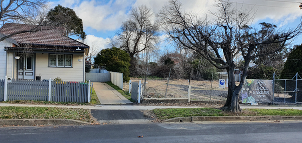
Figure 3 - looking
towards the southern boundary of the site and the location of the proposed
driveway. The existing street tree in Eyles Street will be removed to enable
the construction of the new driveway.
Most of the buildings structures, including the ordering
point, loading bay, main building and plant area, are located well away from
the southern boundary, although it is acknowledged that the drive-thru is
located in close proximity to the southern boundary. The construction of
the acoustic fence (1.8m) and landscaping along with the site’s design
should minimise potential impact on adjoining residents. The submitted
Environmental Noise Assessment Report prepared by Day Design states the
development will meet the relevant noise criteria subject to a number of
recommendations. These recommendations will be addressed by an appropriate
conditions of consent.
The proposal complies with the parking provisions contained
within the DCP. The proposal has provided a total of 24 onsite spaces
(including one disabled spaces and three spaces dedicated for staff parking). The
proposed development is not expected to have a significant impact on the
existing road network.
The application was also supported by a Plan of Management
which outlines Noise Management Practices, Safety and Security Management
Practices and complaint handling procedures, which should ensure that if any
complaints arise during the operation of the business, these complaints should
be appropriately managed by the operator. A condition is recommended
in relation to this matter.
PUBLIC INTEREST
s4.15(1)(e)
The proposed development is considered to be of minor
interest to the wider public due to the relatively localised nature of
potential impacts. The proposal is not inconsistent with any relevant policy
statements, planning studies, and guidelines etc that have not been considered
in this assessment.
SUMMARY
The proposed development is permissible with the consent of Council.
The proposed development complies with the relevant aims, objectives and
provisions of Orange LEP 2011 (as amended) and DCP 2004. A
Section 4.15 assessment of the development indicates that the development
is acceptable in this instance. Attached is a draft Notice of Approval
outlining a range of conditions considered appropriate to ensure that the
development proceeds in an acceptable manner.
COMMENTS
The requirements of the Environmental Health and Building
Surveyor and the Engineering Development Section are included in the attached
Notice of Approval.
Attachments
1 Notice
of Approval, D20/36902⇩
2 Plans,
D20/36904⇩
3 Submission,
D20/35648⇩
Planning
and Development Committee
7 July 2020
Attachment 1 Notice
of Approval
|

|
ORANGE CITY COUNCIL
Development
Application No DA
120/2020(1)
NA20/ Container
PR1206
|
NOTICE OF DETERMINATION
OF A DEVELOPMENT
APPLICATION
issued under the Environmental
Planning and Assessment Act 1979
Section 4.18
|
Development
Application
|
|
|
Applicant
Name:
|
McDuck Properties Pty
Limited
|
|
Applicant
Address:
|
Attention: Mr H
Abbott
300 Rainbow Street
COOGEE
NSW 2023
|
|
Owner’s
Name:
|
Thomsons Corner Pty
Limited
|
|
Land
to Be Developed:
|
Lot 507 DP 712206, Lots 3 and 4 DP 37362
– 52‑54 Bathurst Road, 25 and 27 Eyles Street, Orange
|
|
Proposed
Development:
|
Take Away Food and
Drink Premises and Signage
|
|
|
|
|
Building Code of
Australia
building
classification:
|
As determined by the
Certifier
|
|
|
|
|
Determination made
under
Section 4.16
|
|
|
Made
On:
|
7 July 2020
|
|
Determination:
|
CONSENT GRANTED
SUBJECT TO CONDITIONS DESCRIBED BELOW:
|
|
|
|
|
Consent to Operate
From:
|
8 July 2020
|
|
Consent to Lapse On:
|
8 July 2025
|
Terms
of Approval
The
reasons for the imposition of conditions are:
(1) To ensure a quality
urban design for the development which complements the surrounding environment.
(2) To maintain
neighbourhood amenity and character.
(3) To ensure the utility
services are available to the site and adequate for the development.
(4) To prevent the proposed
development having a detrimental effect on adjoining land uses.
(5) To minimise the impact
of development on the environment.
Conditions
(1) The development must be
carried out in accordance with:
(a) Plans
numbered: DA00
Cover Page and Location Plan,
DA01 Site Plan, DA02 Site Traffic Plan Rev: D,
DA03 Proposed Floor Plan Rev: D, DA04 Roof
Plan,
DA05 Elevation Sheet No 1, DA06 Elevation Sheet
No 2,
DA07 Boundary Elevations, DA08 Sections,
DA09 Signage Plan, DA10 Signage Details Sheet
No 1,
DA11 Signage Details Sheet No 2, DA12 External
Finishes
(b) statements
of environmental effects or other similar associated documents that form part
of the approval
as amended in
accordance with any conditions of this consent.
(2) All building work must
be carried out in accordance with the provisions of the Building Code of
Australia.
(3) A sign is to be erected
in a prominent position on any site on which building work, subdivision work or
demolition work is being carried out:
(a) showing
the name, address and telephone number of the principal certifying authority
for the work, and
(b) showing
the name of the principal contractor (if any) for any building work and a
telephone number on which that person may be contacted outside working hours,
and
(c) stating
that unauthorised entry to the site is prohibited.
Any such sign is to be maintained while the
building work, subdivision work or demolition work is being carried out.
(4) Where any excavation
work on the site extends below the level of the base of the footings of a
building on adjoining land, the person having the benefit of the development
consent must, at the person’s own expense:
(a) protect
and support the adjoining premises from possible damage from the excavation,
and
(b) where
necessary, underpin the adjoining premises to prevent any such damage.
Note: This condition
does not apply if the person having the benefit of the development consent owns
the adjoining land or the owner of the adjoining land has given consent in
writing to this condition not applying.
|
PRIOR TO THE ISSUE OF A CONSTRUCTION
CERTIFICATE
|
(5) The
colour of the all external fencing shall be ‘Windspray’ or a
similar colour. Full details are to be provided prior to the release of the
Construction Certificate.
(6) Prior
to the release of the Construction Certificate the applicant shall submit a
revised signage plan indicating that all of the concrete blade signs shown on the
Bathurst Road and Eyles Street vehicle entry/exits (Signs Numbered S05 and SO8)
are removed. The
proposed banner sign does not form part of this consent and shall be removed
from the revised signage plan.
(7) Traffic
movements into the development from Eyles Street and from the development onto
Bathurst Road (Mitchell Highway SH7) shall be in accordance with the
requirements of Transport for NSW (TfNSW) as articulated in their letter dated
9 June 2020. The TfNSW requirements for the development are:
· The proposed driveway
via the Mitchell Highway is to be undertaken via a left in and left out only
arrangement.
· Construction of the
driveway located along the Mitchell Highway may be subject to the developer and
TfNSW entering into a Works Authorisation Deed (WAD) for the developer to
undertake private financing and construction of any works along the State
classified road network. The WAD is to be entered into prior to the commencement
of demolition works.
· A detailed design is to
be submitted by the proponent to TfNSW and Council for approval for the
concrete layback driveway prior to construction. The driveway is to be designed
to provide good sight lines between pedestrians and motorists, match road
levels and not interfere with drainage.
· The design is to also
include relevant signage, line marking and a concrete splay or similar in the
driveway along the Mitchell Highway to advise customers that all egress from
the site into the Mitchell Highway is left turn only.
· The current line
marking arrangement in the shoulder of the Mitchell Highway near the proposed
driveway will be subject to TfNSW concurrence as part of the detailed design
process.
· All vehicular movements
to and from the site are to be undertaken in a forward movement.
· Adequate turning
circles, storage room and vertical clearances are to be provided within the
site for the largest type of vehicle (9m) that will need to access the site
during construction and operation.
Any removal of vegetation required to be
undertaken to meet the above requirements is subject to the relevant consent
being obtained from Orange City Council and does not form part of TfNSW
concurrence.
Full details of the above requirements shall be
submitted to Orange City Council and Transport for NSW for approval prior to
the release of the Construction Certificate.
(8) A
detailed amended Landscaping Plan shall be submitted to and approved by
Council’s Manager Development Assessments prior to the issue of a
Construction Certificate. The amended landscaping plan shall incorporate
the following:
· One (1) additional tree
in the northern corner of the lawn area next to the plant screen. The subject
trees shall have a mature height commensurate with the height buildings on the
land.
· The Landscape Plan
shall be modified to include the blister within the road reserve on the corner
of Eyles Street and Bathurst Road. The amended Landscape Plan shall
specify a minimum of two deciduous trees attaining a minimum height of 4m and a
maximum height of 6m on maturity (due to close proximity to overhead power
lines). The trees shall have a minimum lot size of 100 litre. Low
understorey/groundcover plants shall also be incorporated into the amended
Landscape Plan.
· A replacement street
tree of the same species of those existing within Eyles Street. The tree
shall be replaced at full cost by the applicant with super-advanced trees of a
species nominated by Council's relevant officer.
The clearing of existing vegetation within the
blister shall be the responsibility of the proponent and undertaken following
Council's WHS procedures.
(9) An
approval under Section 68 of the Local Government Act is to be sought
from Orange City Council, as the Water and Sewer Authority, for alterations to
water and sewer. No plumbing and drainage is to commence until approval is
granted.
(10) Prior
to the issue of the Construction Certificate, evidence shall be submitted to
Council of the lodgement of plans with the Department of Lands and Property
Information to consolidate Lots 3 and 4 in DP 37362 and Lot 507 in DP 712206
into one parcel.
(11) The
applicant shall prepare and submit a Litter Patrol Management Plan for the
approval of the Manager of Development Assessment prior to the issue of a
construction certificate. The Litter Patrol Management plan shall detail the
commitments required to be undertaken by the operator of the premises to
suitably manage the pick-up of rubbish from the site and the surrounding street
network and open spaces.
(12) Engineering plans,
showing details of all proposed work and adhering to any engineering conditions
of development consent, are to be submitted to, and approved by, Orange City
Council or an Accredited Certifier (Categories B1, C3, C4, C6) prior to the
issuing of a Construction Certificate.
(13) A water and soil
erosion control plan is to be submitted to Orange City Council or an Accredited
Certifier (Categories B1, C3, C4, C6) for approval prior to the issuing of a
Construction Certificate. The control plan is to be in accordance with the
Orange City Council Development and Subdivision Code and the Landcom, Managing
Urban Stormwater; Soils and Construction Handbook.
(14) The development’s
stormwater design is to include stormwater detention within the development, designed
to limit peak outflows from the land to the pre-existing natural outflows up to
the 100 year ARI frequency, with sufficient allowance in overflow spillway
design capacity to safely pass flows of lower frequency (that is, a rarer
event) without damage to downstream developments. Where appropriate, the
spillway design capacity is to be determined in accordance with the
requirements of the Dam Safety Committee.
The design of the detention storage is to be
undertaken using the ILSAX/DRAINS rainfall-runoff hydrologic model or an
approved equivalent capable of assessing runoff volumes and their temporal
distribution as well as peak flow rates. The model is to be used to calculate
the flow rates for the existing and post-development conditions. The developed
flows are to be routed through the proposed storage within the model so that
the outflows obtained are no greater than the flows obtained for the
pre-existing natural flows. A report detailing the results of the analysis,
which includes:
· catchment plan showing
sub-catchments under existing and developed conditions;
· schematic diagram of
the catchment model showing sub areas and linkages;
· tabulation detailing
the elevation, storage volume and discharge relationships; and
· tabulation for the
range of frequencies analysed, the inflows, outflows and peak storage levels
for both existing and developed conditions;
together with copies of the data files for the
model and engineering design plans of the required drainage system are to be
submitted to Orange City Council upon application for a Construction
Certificate.
The detention basin design shall allow for
inundation of the site during flood events. Signage to alert users of the
carpark of the risk of flooding shall be installed.
(15) Engineering plans providing
complete details of the proposed driveway and car parking areas are to be
submitted to Orange City Council or an Accredited Certifier (Categories B1, C3,
C4, C6) upon application for a Construction Certificate. These plans are to
provide details of levels, cross falls of all pavements, proposed sealing
materials and proposed drainage works and are to be in accordance with Orange
City Council Development and Subdivision Code.
The submitted plans shall also detail
modifications to the proposed parking, entrance gates and driveway to
accommodate the turn path of a 9.0m heavy vehicle with a minimum 0.3m clearance
to parking spaces, kerbs and other structures.
The parking layout shall be generally as per
the approved plans with the following additional details:
· Parking space
dimensions shall be in accordance with AS2890.1; and
· Parking spaces assigned
to staff parking and general parking to be clearly identified by signage or line
marking; and
· All heavy vehicle
servicing areas shall be clearly identified by signage or line marking; and
· Pedestrian crossing
line marking shall be installed between the front entry area and the Bathurst
Road footpath; and
· The two existing vehicle
laybacks/footpath crossings in Eyles Street shall be removed and the footpath
reserve reinstated; and
· The concrete blade
signs shown on the Bathurst Road and Eyles Street vehicle entry/exits shall be
removed. Signage at the entry/exit points shall be limited to regulatory
signage on posts as required by TfNSW.
(16) A Liquid Trade Waste
Application is to be submitted to Orange City Council prior to the issuing of a
Construction Certificate. The application is to be in accordance with
Orange City Council’s Liquid Trade Waste Policy. Engineering plans
submitted as part of the application are to show details of all proposed liquid
trade waste pre-treatment systems and their connection to sewer.
Where applicable, the applicant is to enter
into a Liquid Trade Waste Service Agreement with Orange City Council in
accordance with the Orange City Council Liquid Trade Waste Policy.
(17) Payment
of contributions for water, sewer and drainage works is required to be made
at the contribution rate applicable at the time that the payment is made.
The contributions are based on 0.30 ETs for water supply headworks and 2.28 ETs
for sewerage headworks. A Certificate of Compliance, from Orange City
Council in accordance with the Water Management Act 2000, will be issued
upon payment of the contributions.
This Certificate of Compliance is to be
submitted to the Principal Certifying Authority prior to the issuing of a
Construction Certificate.
(18) Backflow
Prevention Devices are to be installed to AS3500 and in accordance with Orange
City Council Backflow Protection Guidelines. Details of the Backflow Prevention
Devices are to be submitted to Orange City Council prior to the issuing of a
Construction Certificate.
Certificates for testable Backflow Prevention
Devices are to be submitted to Orange City Council by a plumber with backflow
qualifications prior to the issue of an Occupation Certificate.
(19) A
Road Opening Permit in accordance with Section 138 of the Roads Act 1993
must be approved by Council prior to a Construction Certificate being issued
or any intrusive works being carried out within the public road or footpath
reserve.
(20) The minimum floor level
of the building shall be 866.75m AHD. The Construction Certificate plans shall
be amended to reduce the height of the carpark to existing natural surface
levels. No filling of the site shall occur below the existing 865.9m AHD
contour other than the footprint of the proposed building and pedestrian access
paths. All vehicle manoeuvring areas, carparks and landscaping below the
existing 865.9m AHD contour shall be constructed to the existing natural ground
levels.
(21) Prior to the issue of a
Construction Certificate, written approval shall be obtained from Telstra/NBN
for any relocation or modification works to the existing telecommunications pit
located in the Eyles Street vehicle crossover.
|
PRIOR TO WORKS COMMENCING
|
(22) A
Construction Certificate application is required to be submitted to, and issued
by Council/Accredited Certifier prior to any excavation or building works being
carried out onsite.
(23) A
temporary onsite toilet is to be provided and must remain throughout the
project or until an alternative facility meeting Council’s requirements
is available onsite.
(24) The
location and depth of the sewer junction/connection to Council’s sewerage
system is to be determined to ensure that adequate fall to the sewer is
available.
(25) Soil
erosion control measures shall be implemented on the site.
(26) Prior
to the commencement of construction works, the proponent is to contact TfNSW
Field Traffic Manager on 1300 656 371 to determine if a Road Occupancy Licence
(ROL) is required. In the event that an ROL is required, the proponent is to
obtain the ROL prior to works commencing within 3m of the travel lanes in the
Mitchell Highway.
|
DURING CONSTRUCTION/SITEWORKS
|
(27) All
construction/demolition work on the site is to be carried out between the hours
of 7am and 6pm Monday to Friday inclusive, 7am to 5pm Saturdays and 8am to 5pm
Sundays and Public Holidays. Written approval must be obtained from the General
Manager of Orange City Council to vary these hours.
(28) All materials on site
or being delivered to the site are to be contained within the site. The
requirements of the Protection of the Environment Operations Act 1997
are to be complied with when placing/stockpiling loose material or when
disposing of waste products or during any other activities likely to pollute
drains or watercourses.
(29) No portion of the
building - including footings, eaves, overhang and service pipes - shall
encroach into any easement.
(30) All services (water,
sewer and stormwater) shall be laid outside the easement unless there is a
direct connection to the main within that easement.
(31) Any adjustments to
existing utility services that are made necessary by this development
proceeding are to be at the full cost of the developer.
(32) The provisions and
requirements of the Orange City Council Development and Subdivision Code are to
be applied to this application and all work constructed within the development
is to be in accordance with that Code.
The developer is to be entirely responsible for
the provision of water, sewerage and drainage facilities capable of servicing
the development from Council’s existing infrastructure. The developer is
to be responsible for gaining access over adjoining land for services where
necessary and easements are to be created about all water, sewer and drainage
mains within and outside the lots they serve.
(33) All driveway and
parking areas are to be sealed with hot mix or concrete and are to be designed
for all expected loading conditions (provided however that the minimum pavement
depth for gravel and flush seal roadways is 200mm) and be in accordance with
the Orange City Council Development and Subdivision Code. In the event that
concrete is proposed a “charcoal” pigment to produce a dark grey
coloured concrete finish will be required.
(34) Heavy-duty concrete
kerb and gutter laybacks and footpath crossings are to be constructed for the
entrances to the proposed development. The location and construction of the
laybacks and footpath crossings are to be as required by the Orange City
Council Development and Subdivision Code, Road Opening Permit and TfNSW
requirements.
(35) The existing 150mm
diameter sewer main that crosses the site is to be accurately located. Where
the main is positioned adjacent to any proposed building work, measures are to
be taken in accordance with Orange City Council Policy - Building over and/or
adjacent to sewers ST009.
(36) The water and sewerage
services to the existing allotments, where they are not proposed to be used as
part of this development, are to be sealed off at their respective Council
mains.
(37) The
fit-out of the food preparation and storage areas are to be installed in
accordance with the requirements of Food Safety Standard 3.2.3 "Food
Premises and Equipment" of the Australian New Zealand Food Standards Code
and Australian Standard 4674-2004 "Design and construction and fit-out of food
premises".
(38) In the event of an
unexpected find during works such as (but not limited to) the presence of
undocumented waste, odorous or stained soil, asbestos, structures such a
underground storage tanks, slabs, or any contaminated or suspect material, all
work on site must cease immediately. The beneficiary of the consent must
discuss with Council the appropriate process that should be followed
therein. Works on site must not resume unless the express permission of
the Director Development Services is obtained in writing.
(39) All demolition works are
to be undertaken within the bounds of the site only.
|
PRIOR TO THE ISSUE OF AN OCCUPATION
CERTIFICATE
|
(40) No
person is to use or occupy the building or alteration that is the subject of
this approval without the prior issuing of an Occupation Certificate.
(41) Prior
to the issuance of an Occupation Certificate, any redundant kerb layback
crossing accessed along the Mitchell Highway servicing the land are to be
removed and replaced with kerb and gutter to match existing kerb and gutter.
Driveways are to be designed and maintained to provide good sight lines between
pedestrians and motorists, match road levels and not interfere with drainage.
(42) Landscaping,
signage and fencing shall not to impede the sight lines of traffic within or
when passing, entering or departing the site. Safe Intersection Sight Distance
(SISD) requirements outlined in Austroads Guide to Road Design Part 4A is to be
provided in both directions at the intersection of the driveway and the
Mitchell Highway.
(43) Any
current arrangement of on-street parking along the site frontage of the
Mitchell Highway is to be replaced by ‘No Stopping’ signage
(R5-400) at minimum, either side of the driveway within the Mitchell Highway,
by the proponent prior to occupation of the premises. Relevant and timely
communication to adjoining land owners impacted as a result of this change
should be managed by the consent authority.
(44) Prior
to the issue of an Occupation Certificate, all works required by Transport NSW
to facilitate the development shall be completed.
(46) Finished
ground levels are to be graded away from the buildings and adjoining properties
and must achieve natural drainage. The concentrated flows are to be dispersed
down slope or collected and discharged to the stormwater drainage system.
(47) The
owner of the building/s must cause the Council to be given a Final Fire Safety
Certificate on completion of the building in relation to essential fire or
other safety measures included in the schedule attached to this approval.
(48) A
total of 24 off-street car parking spaces are to be provided upon the site in
accordance with the approved plans and the provisions of Development Control
Plan 2004. The parking spaces are to be constructed in accordance with the
requirements of Council's Development and Subdivision Code, prior to the
issuing of an Occupation Certificate.
(49) Where
Orange City Council is not the Principal Certifying Authority, a final
inspection of water connection, sewer and stormwater drainage shall be
undertaken by Orange City Council and a final Notice of Inspection issued,
prior to the issue of either an interim or a final Occupation Certificate.
(50) The cut and fill is to
be retained and/or adequately battered and stabilised (within the allotment)
prior to the issue of an Occupation Certificate.
Landscaping shall be installed in accordance
with the approved plans and shall be permanently maintained to the satisfaction
of Councils Manager Development Assessments.
(51) A Certificate of
Compliance, from a Qualified Engineer, stating that the stormwater detention
basin complies with the approved engineering plans is to be submitted to the
Principal Certifying Authority prior to the issuing of an Occupation
Certificate.
(52) Certification from
Orange City Council is required to be submitted to the Principal Certifying
Authority prior to the issue of an Occupation Certificate stating that all
works relating to connection of the development to Council assets, works on
public land, works on public roads, stormwater, sewer and water reticulation
mains and footpaths have been carried out in accordance with the Orange City
Council Development and Subdivision Code and the foregoing conditions, and that
Council will take ownership of the infrastructure assets.
(53) A
Road Opening Permit Certificate of Compliance is to be issued for the works by
Council prior to any Occupation/Final Certificate being issued for the
development.
(54) Prior to the issue of
an Occupation Certificate Lot 507 DP 712206, and Lots 3 and 4 DP 37362 shall be
consolidated. An easement, to drain sewage and to provide Council access for
maintenance of sewerage works, a minimum of 2.0m wide is to be created over the
existing sewer main. Evidence that the lots have been consolidated and the
sewer easement has been registered shall be submitted to the Principal
Certifying Authority prior to issuing of an Occupation Certificate.
(55) Certificates for
testable Backflow Prevention Devices are to be submitted to Orange City Council
by a plumber with backflow qualifications prior to the issue of an Occupation
Certificate.
(56) Acoustic fences are to
be constructed along the western boundary of the site extending approximately
35m from the northern most point of the northern building line. This
section of fence shall be constructed of lapped and capped hardwood fencing
(excluding post and rails) to a minimum height of 2.4m above ground level of
the drive-thru driveway. Acoustic fences shall be constructed for the remainder
of the western and southern boundaries to a minimum height of 1.8m above the
ground level of the drive-thru driveway, in accordance with the Environmental
Noise Assessment Report 6934-1.1R, prepared by Day Design Pty Ltd.
(57) The plant area is to be
constructed from an acoustically opaque material, such as Colorbond, lapped and
capped timber, masonry etc, to a height of either 1.8m above ground level of
the plant area or at least 600mm above the tallest item of plant, whichever is
the greater, in accordance with the Environmental Noise Assessment Report
6934-1.1R, prepared by Day Design Pty Ltd.
(58) The total sound power
level of plant installed within the plant area shall not exceed 76 dBA, and the
total sound power level for all rooftop plant shall not exceed 85 dBA, in
accordance with the Environmental Noise Assessment Report 6934-1.1R, prepared
by Day Design Pty Ltd.
(59) All
of the foregoing conditions are to be at the full cost of the developer and to
the requirements and standards of the Orange City Council Development and
Subdivision Code, unless specifically stated otherwise. All work required by
the foregoing conditions is to be completed prior to the issuing of an
Occupation Certificate, unless stated otherwise.
|
MATTERS FOR THE ONGOING PERFORMANCE AND
OPERATION OF THE DEVELOPMENT
|
(60) The proposed
floodlighting of the premises is to be designed, positioned, and installed,
including appropriate shielding and orientation of the lighting fixture, as to
not give rise to obtrusive light, interfere with traffic safety or detract from
the amenity of surrounding properties in accordance with Australian Standard
4282:1997 - Control of the obtrusive effects of outdoor lighting.
(61) An assessment of noise
emissions from the premises is to be provided to Council within three months
from the issue of any Occupation Certificate. This commissioning report is to
indicate noise levels through the monitoring of noise emanating from the normal
peak use of the premises and determine if any necessary noise mitigation
measures are required. Any identified mitigation works shall be carried
out within one month of the commissioning report, and the operation of the
premises shall be carried out in accordance with any recommendations set out in
the report.
(62) Truck deliveries to the
site are to occur only between the hours of 7am and 6pm.
(63) Without
the prior approval of Council, the hours of operation of the premises are not
to exceed Sunday to Monday 10am to 10pm and from 10am to 11pm on Friday and
Saturday.
(64) Restaurant
seating shall be no greater than 42 seats.
(65) The
operational controls contained within the approved Litter Patrol Management
Plan and the Plan of Management must be complied with at all times.
(66) A closed circuit television system
(CCTV), incorporating digital video surveillance cameras and recorders, being
installed and maintained on the premises and car parking area and to be
operated during trading hours. The video surveillance cameras are also to
continue recording for 30 minutes after closure of the premises.
Other
Approvals
(1) Local
Government Act 1993 approvals granted under Section 68.
Nil
(2) General
terms of other approvals integrated as part of this consent.
Nil
Right
of Appeal
If you are dissatisfied with this decision,
Section 8.7 of the Environmental Planning and Assessment Act 1979
gives you the right to appeal to the Land and Environment Court. Pursuant to
Section 8.10, an applicant may only appeal within 6 months after the date the
decision is notified.
|
Disability
Discrimination Act 1992:
|
This application has been assessed in
accordance with the Environmental Planning and Assessment Act 1979. No
guarantee is given that the proposal complies with the Disability Discrimination
Act 1992.
The applicant/owner is responsible to ensure
compliance with this and other anti-discrimination legislation.
The Disability Discrimination Act
covers disabilities not catered for in the minimum standards called up in the
Building Code of Australia which references AS1428.1 - "Design for
Access and Mobility". AS1428 Parts 2, 3 and 4 provides the most
comprehensive technical guidance under the Disability Discrimination Act
currently available in Australia.
|
|
|
|
|
Disclaimer
- S88B of the Conveyancing Act 1919 - Restrictions on the Use of
Land:
|
The applicant should note that there could be
covenants in favour of persons other than Council restricting what may be
built or done upon the subject land. The applicant is advised to check the
position before commencing any work.
|
|
|
|
|
Signed:
|
On behalf of the consent authority ORANGE
CITY COUNCIL
|
|
Signature:
|
|
|
Name:
|
PAUL JOHNSTON - MANAGER DEVELOPMENT
ASSESSMENTS
|
|
Date:
|
8 July 2020
|
Planning and Development Committee
7 July 2020
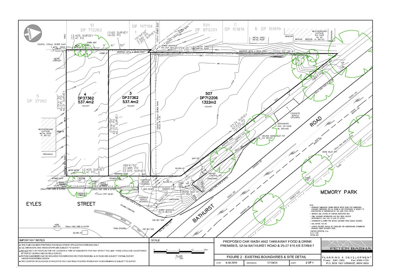
Planning
and Development Committee
7 July 2020