Planning and Development
Committee
Agenda
3 September 2019
Notice is hereby given, in
accordance with the provisions of the Local Government Act 1993 that a Planning and Development Committee meeting of ORANGE CITY COUNCIL
will be held in the Council Chamber,
Civic Centre, Byng Street, Orange on Tuesday, 3 September
2019.
David
Waddell
Acting General Manager
For apologies please
contact Administration on 6393 8218.
1 Introduction
1.1 Declaration
of pecuniary interests, significant non-pecuniary interests and less than
significant non-pecuniary interests
The
provisions of Chapter 14 of the Local Government Act, 1993 (the Act)
regulate the way in which Councillors and designated staff of Council conduct
themselves to ensure that there is no conflict between their private interests
and their public role.
The
Act prescribes that where a member of Council (or a Committee of Council) has a
direct or indirect financial (pecuniary) interest in a matter to be considered
at a meeting of the Council (or Committee), that interest must be disclosed as
soon as practicable after the start of the meeting and the reasons given for declaring
such interest.
As
members are aware, the provisions of the Local Government Act restrict any
member who has declared a pecuniary interest in any matter from participating
in the discussion or voting on that matter, and requires that member to vacate
the Chamber.
Council’s Code of Conduct provides that if members
have a non-pecuniary conflict of interest, the nature of the conflict must be
disclosed. The Code of Conduct also provides for a number of ways in which a
member may manage non pecuniary conflicts of interest.
|
Recommendation
It is recommended that Committee Members now disclose any
conflicts of interest in matters under consideration by the Planning and
Development Committee at this meeting.
|
2 General
Reports
RECORD
NUMBER: 2019/1592
AUTHOR: Paul
Johnston, Manager Development Assessments
EXECUTIVE Summary
Following is a list of development
applications approved under the delegated authority of Council.
Link To Delivery/OPerational Plan
The recommendation in this report relates to the
Delivery/Operational Plan strategy “7.1 Preserve - Engage with the
community to develop plans for growth and development that value the local
environment”.
Financial Implications
Nil
Policy and Governance Implications
Nil
|
Recommendation
That Council resolves to acknowledge the information
provided in the report by the Manager Development Assessments on Items
Approved Under the Delegated Authority of Council.
|
further considerations
Consideration has been given to the
recommendation’s impact on Council’s service delivery; image and
reputation; political; environmental; health and safety; employees;
stakeholders and project management; and no further implications or risks have
been identified.
|
Reference:
|
DA 445/2011(5)
|
Determination Date
|
9 August 2019
|
|
PR Number
|
PR1936
|
|
Applicant/s:
|
Mr J J Norris
|
|
Owner/s:
|
Mr J J Norris
|
|
Location:
|
Lot B DP 152339 – 47 Byng
Street, Orange
|
|
Proposal:
|
Modification of development consent
– restaurant and shop. The modification is in regards to an extension
fronting Clinton Street to enclose the outdoor dining courtyard area, and
involves the addition of an accessibility ramp and steps required to address
the change in levels between the extension approved in the previous
modification and its external adjacent area.
|
|
Value:
|
$150,000 (being the same value as
the original development)
|
|
Reference:
|
DA 285/2018(3)
|
Determination Date
|
31 July 2019
|
|
PR Number
|
PR20233 and PR20234
|
|
Applicant/s:
|
Shed World
|
|
Owner/s:
|
Mr AL Gersbach
|
|
Location:
|
Lots 65 and 66 DP 1077737 –
70 and 72 Astill Drive, Orange
|
|
Proposal:
|
Modification of development consent
- general industry (change of use) and warehouse or distribution centre. The
modification requests consent to delete Condition 6 on the basis that the
condition is superfluous to the development control process.
|
|
Value:
|
$560,000 (being the same value as
the original development)
|
|
Reference:
|
DA 77/2019(1)
|
Determination Date
|
22 July 2019
|
|
PR Number
|
PR25414
|
|
Applicant/s:
|
RCI Group
|
|
Owner/s:
|
Pearl Investment (Aust) Pty Ltd
|
|
Location:
|
Lot 85 DP 1167633 – 5
Hanrahan Place, Orange
|
|
Proposal:
|
Subdivision (two lot Torrens)
|
|
Value:
|
$0
|
|
Reference:
|
DA 124/2019(1)
|
Determination Date
|
24 July 2019
|
|
PR Number
|
PR25962
|
|
Applicant/s:
|
Mr C S Booth
|
|
Owner/s:
|
Mr C S and Mrs R C Booth
|
|
Location:
|
Lot 131 DP 1183180 – 81
Peisley Street, Orange
|
|
Proposal:
|
Health consulting rooms and
associated signage (change of use)
|
|
Value:
|
$30,000
|
|
Reference:
|
DA 140/2019(1)
|
Determination Date
|
30 July 2019
|
|
PR Number
|
PR27959
|
|
Applicant/s:
|
Zhang Building and Development Pty Ltd
|
|
Owner/s:
|
Zhang Building and Development Pty
Ltd
|
|
Location:
|
Lot 221 DP 1238394 – 6
Handford Place, Orange
|
|
Proposal:
|
Dual occupancy (detached) and
subdivision (two lot Torrens title)
|
|
Value:
|
$350,000
|
|
Reference:
|
DA 145/2019(1)
|
Determination Date
|
31 July 2019
|
|
PR Number
|
PR11547
|
|
Applicant/s:
|
Anandmahi Pty Ltd AFT Ravivijay
Unit Trust
|
|
Owner/s:
|
Anandmahi Pty Ltd
|
|
Location:
|
Lot 4 DP 576169 - 312-324 Summer
Street, Orange
|
|
Proposal:
|
Hotel (alterations and additions)
|
|
Value:
|
$50,000
|
|
Reference:
|
DA 150/2019(1)
|
Determination Date
|
7 August 2019
|
|
PR Number
|
PR25812
|
|
Applicant/s:
|
Mr IAK and Mrs LJ Shilling
|
|
Owner/s:
|
Mr IAK and Mrs LI Shilling
|
|
Location:
|
Lot 8 DP 1176470 – 1 Atlas
Place, Orange
|
|
Proposal:
|
Vehicle repair station (additions
to existing building)
|
|
Value:
|
$100,000
|
|
Reference:
|
DA 157/2019(1)
|
Determination Date
|
24 July 2019
|
|
PR Number
|
PR26330
|
|
Applicant/s:
|
Orange Ex-Services Club Limited
|
|
Owner/s:
|
Orange Ex-Services Club Limited
|
|
Location:
|
Lot 200 DP 1191450 - 225-243 Anson
Street, Orange
|
|
Proposal:
|
Registered club (alterations and
additions - smoking terrace)
|
|
Value:
|
$40,000
|
|
Reference:
|
DA 179/2019(1)
|
Determination Date
|
28 July 2019
|
|
PR Number
|
PR20238
|
|
Applicant/s:
|
Mr S O’Dea
|
|
Owner/s:
|
Poonondie Pty Ltd
|
|
Location:
|
Lot 70 DP 1077737 – 55 Astill
Drive, Orange
|
|
Proposal:
|
Depot
|
|
Value:
|
$600,000
|
|
Reference:
|
DA 182/2019(1)
|
Determination Date
|
12 August 2019
|
|
PR Number
|
PR12433
|
|
Applicant/s:
|
Mr M Lofts and Ms M P Grgat
|
|
Owner/s:
|
Mr C D Lofts and Ms M P Grgat
|
|
Location:
|
Lot 3 Sec 2 DP 8196 – 152 Warrendine
Street, Orange
|
|
Proposal:
|
Subdivision (two lot Torrens title)
|
|
Value:
|
$0
|
|
Reference:
|
DA 198/2019(1)
|
Determination Date
|
7 August 2019
|
|
PR Number
|
PR10247
|
|
Applicant/s:
|
Ms K Griffiths
|
|
Owner/s:
|
Mr TM Houghton
|
|
Location:
|
Lot 2 DP 9553 – 62 Prince Street,
Orange
|
|
Proposal:
|
Demolition (tree removal),
replacement of retaining wall, and driveway works)
|
|
Value:
|
$1,700
|
|
Reference:
|
DA 209/2019(1)
|
Determination Date
|
1 August 2019
|
|
PR Number
|
PR11580
|
|
Applicant/s:
|
Laser Clinics Australia Pty Ltd
|
|
Owner/s:
|
Alceon Group Pty Limited
|
|
Location:
|
Lot 564 DP 776383 – 212-220
Summer Street, Orange
|
|
Proposal:
|
Business premises (first use and
fit-out)(Tenancy 48)
|
|
Value:
|
$360,000
|
|
Reference:
|
DA 217/2019(1)
|
Determination Date
|
16 August 2019
|
|
PR Number
|
PR2744
|
|
Applicant/s:
|
Orange Croquet Club Inc
|
|
Owner/s:
|
Orange City Council
|
|
Location:
|
Lot 1 DP 434040 – 149 Hill
Street, Orange
|
|
Proposal:
|
Advertisements
|
|
Value:
|
$2,000
|
|
Reference:
|
DA 231/2019(1)
|
Determination Date
|
2 August 2019
|
|
PR Number
|
PR9813
|
|
Applicant/s:
|
Orange Regional Arts Foundation
|
|
Owner/s:
|
Ms L A Madigan
|
|
Location:
|
Lot 11 DP 800314 - 86-88 Peisley
Street, Orange
|
|
Proposal:
|
Temporary use of land
(entertainment facility)
|
|
Value:
|
$0
|
|
Reference:
|
DA 236/2019(1)
|
Determination Date
|
13 August 2019
|
|
PR Number
|
PR11580
|
|
Applicant/s:
|
Sportsgirl Pty Ltd
|
|
Owner/s:
|
Alceon Group Pty Limited
|
|
Location:
|
Lot 564 DP 776383 - 212-220
Summer Street, Orange
|
|
Proposal:
|
Shop (first use and fit-out)
(tenancy 46)
|
|
Value:
|
$193,000
|
TOTAL NET* VALUE OF ALL
DEVELOPMENTS APPROVED UNDER DELEGATED AUTHORITY IN THIS PERIOD: $1,726,700.00
*
Net value relates to the value of modifications. If modifications are
the same value as the original DA, then nil is added. If there is a plus/minus
difference, this difference is added or taken out.
2.2 Development
Application DA 141/2019(1) - Lot 78 Lantana Place
RECORD
NUMBER: 2019/1787
AUTHOR: Kelly
Walker, Senior Planner
EXECUTIVE Summary
|
Application
lodged
|
14 May
2019
|
|
Applicant/s
|
Housing
Plus
|
|
Owner/s
|
Mr KS
Baker
|
|
Land
description
|
Lot 78
DP 1172183 - Lantana Place, Orange
|
|
Proposed
land use
|
Multi
Dwelling Housing (10 dwellings)
|
|
Value of
proposed development
|
$2,750,000
|
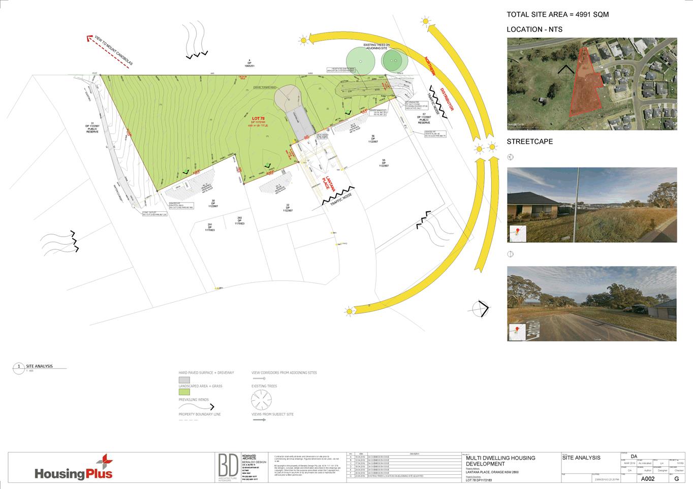
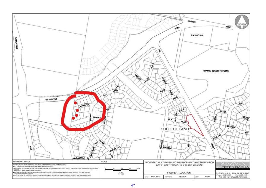
Council's consent is sought for
proposed residential development of land at Lot 78 DP 1172183 – Lantana
Place, Orange (see Figure 1). The proposed development is for a multi housing
development containing 10 dwellings, comprising of a mix of four x 1 bedroom
dwellings and 6 x two bedroom dwellings. The completed development will
consist of five separate buildings, each of which will accommodate two
dwellings in an attached duplex design. The proposed development is being
carried out by Community Housing Provider, Housing Plus, as part of the NSW
government’s ‘Social and Affordable Housing Fund,’ a
key initiative under the ‘Future Directions for Social Housing in
NSW’ strategy.
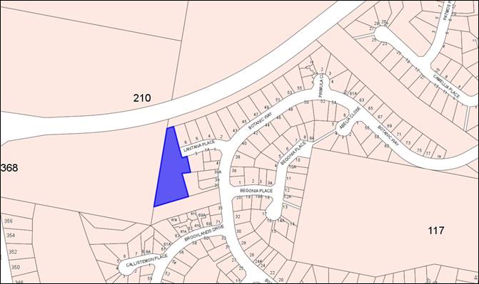
Figure 1 - locality plan
The proposed development is single
storey in height, and predominantly of brick construction. The six dwellings at
the front of the development will address Lantana Place, which will be extended
along to the west and adopted as Council road. The 2 bedroom dwellings have
private entrances, kitchen/dining, living room, bathroom/laundry,
2 bedrooms, and an attached single garage. The 1 bedroom dwellings have
private entrances, kitchen/dining/living, bathroom/laundry, 1 bedroom, and an
adjacent single carport.
The proposal comprises advertised development pursuant to
Clause 5.3 of the Orange Development Control Plan 2004 (DCP). At the
completion of the public notice and exhibition period, 47 submissions were
received in relation to the proposed development, of which 31 oppose the
proposal, and 16 are in support. The submissions generally relate to
overdevelopment of the site and the associated impacts on the neighbourhood
(traffic, servicing, character, etc.). These matters are discussed in detail in
the main body of the report.
It is noted that the application originally proposed an
internal pedestrian ramp down the driveway to the rear. Following the
advertisement of the application, the drawings were changed removing this
aspect, and were submitted to Council as an amended application. It was
considered that the amended proposal did not require re-advertising as it only
involved minor internal site changes that reduce hard surface areas, and
amended minor engineering and landscaping details.
A Section 4.15 assessment demonstrates that the proposal is
consistent with the planning regime that applies to the land, where multi
dwelling housing is permitted with consent in the R1 General Residential zone.
Impacts of the development are considered to be within reasonable limit, are
consistent with applicable standards and policies, and can be addressed by
appropriate conditions of consent. Approval of the application is recommended.
DECISION FRAMEWORK
Development in Orange is governed by two key documents Orange
Local Environment Plan 2011 (LEP) and Orange Development Control Plan
2004 (DCP). In addition the Infill Guidelines are used to guide
development, particularly in the heritage conservation areas and around
heritage items.
Orange Local Environment Plan 2011 – The
provisions of the LEP must be considered by the Council in determining the
application. LEPs govern the types of development that are permissible or
prohibited in different parts of the City and also provide some assessment
criteria in specific circumstances. Uses are either permissible or not. The
objectives of each zoning and indeed the aims of the LEP itself are also to be
considered and can be used to guide decision making around appropriateness of
development.
Orange Development Control Plan 2004 – the DCP
provides guidelines for development. In general it is a performance based
document rather than prescriptive in nature. For each planning element there
are often guidelines used. These guidelines indicate ways of achieving the
planning outcomes. It is thus recognised that there may also be other solutions
of merit. All design solutions are considered on merit by planning and building
staff. Applications should clearly demonstrate how the planning outcomes are
being met where alternative design solutions are proposed. The DCP enables
developers and architects to use design to achieve the planning outcomes in
alternative ways.
DIRECTOR’S COMMENT
This development proposal for 10 dwellings funded through
the Social and Affordable Housing Fund. The proposal is compliant in
terms of state and local planning requirements. 47 submissions were
received with 16 submissions in support and 31 submissions against the
development. 2 Petitions were also received. The proposed
development makes good use of large allotment. The recommendation of
approval is supported.
Link To Delivery/OPerational Plan
The recommendation in this report relates to the
Delivery/Operational Plan strategy “10.1 Preserve - Engage with the
community to ensure plans for growth and development are respectful of our
heritage”.
Financial Implications
Nil
Policy and Governance Implications
Nil
|
Recommendation
That Council resolves to
consent to development application DA 141/2019(1) for Multi Dwelling Housing (10 dwellings) at Lot
78 DP 1172183 - Lantana Place, Orange
pursuant to the conditions of consent in the attached Notice of Approval.
|
further considerations
Consideration has been given to the recommendation’s
impact on Council’s service delivery; image and reputation; political;
environmental; health and safety; employees; stakeholders and project
management; and no further implications or risks have been identified.
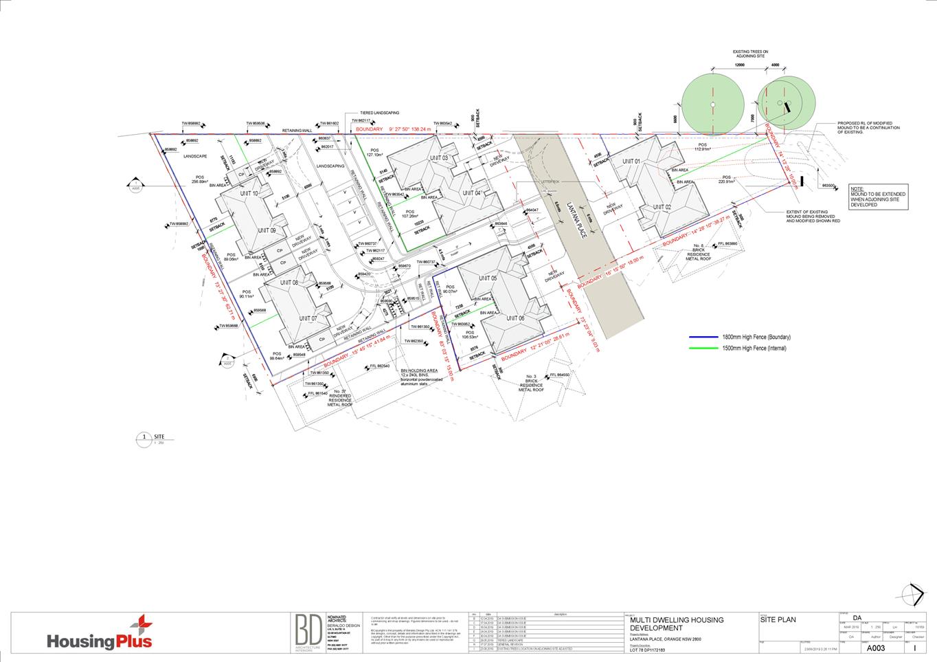
THE APPLICATION/PROPOSAL
Council's consent is sought for proposed multi dwelling
residential development of land at Lot 78 DP 1172183 – Lantana Place,
Orange. The proposal involves the construction of 10 new dwellings, comprising
of a mix of four x 1 bedroom dwellings and six x 2 bedroom dwellings. The
completed development will consist of five separate buildings, each of which
will accommodate two dwellings in an attached duplex design (see Figure 2).
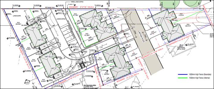
Figure 2 – proposed site plan (from submitted
drawing A003 Rev H)
The proposed development is single storey in height, and
predominantly of brick construction. The six dwellings at the front of the
development will address the street, which will be extended along to the west,
and adopted as public/Council road (see Figure 3). The 2 bedroom dwellings have
private entrances, kitchen/dining, living room, bathroom/laundry, 2 bedrooms,
and an attached single garage. The 1 bedroom dwellings have private entrances,
kitchen/dining/living, bathroom/laundry, 1 bedroom, and an adjacent single
carport. A driveway will extend down to the rear of the site to access the rear
four dwellings, and visitor parking spaces, a bin collection area for these
dwellings, and landscaping are proposed off this driveway (see Figure 4).
Figure 3 – visualisation render Lantana Place
(looking west at front six dwellings)
Figure 4 – visualisation render rear of site
(looking east from rear dwellings)
Proposal Amendments
It is noted that the application originally proposed an
internal pedestrian ramp down the driveway to the rear, however the applicant
deemed this unnecessary, and drawings were amended removing this aspect. The
publically exhibited drawings included this ramp, and it was considered that
the amended proposal did not requiring re-advertising, as they only involved
minor internal site changes that reduced hard surface areas, and amended
engineering and landscaping details accordingly.
Further amended plans were received following a letter to
the applicant requesting further information and asking for issues raised from
Council staff and through neighbouring submissions to be addressed. These
amendments did not alter the fundamental aspects of the proposal, but rather
clarified details, provided further analysis, and resolved minor issues such as
straightening a driveway, providing more suitable tree species, etc. These
matters are discussed in the following assessment.
MATTERS FOR CONSIDERATION
Section 1.7 - Application of
Part 7 of the Biodiversity Conservation Act 2016 and Part 7A of the
Fisheries Management Act 1994
Section 1.7 of the EP&A Act 1979 identifies that Part 7
of the Biodiversity Conservation Act 2016 (BC Act) and Part
7A of the Fisheries Management Act 1994 have effect in connection with
terrestrial and aquatic environments.
There are three applicable triggers in the Orange LGA known
to insert a development within the Biodiversity Offset Scheme, and thereby
require submission of a Biodiversity Development Assessment Report (BDAR):
1. Whether
development occurs within land mapped on the Biodiversity Values Map.
The subject land is not identified as biodiversity sensitive
on the Orange LEP 2011 Terrestrial Biodiversity Map, or the
Biodiversity Values map published by NSW Office of Environment and
Heritage.
2. Whether
development involves clearing/disturbance of native vegetation above prescribed
threshold.
The prescribed clearing threshold for the site is 0.25ha
(based on the total lot size for the subject land being less than 1ha pursuant
to Cl. 7.2 Biodiversity Conservation Regulation 2017). As set out in the
submitted “Ecological Assessment” (prepared by Flora Search, and
dated 16 April 2019), the site is highly disturbed and dominated by introduced
grasses and weeds, and the proposed development does not involve the clearing
or disturbance of native vegetation. This is discussed in greater detail in
point 3 below.
3. Whether
development is likely to affect a threatened species.
With regard to the third trigger, the test for determining
whether proposed development is otherwise likely to significantly affect
threatened species is listed in the BC Act 2016, under s7.3:
(a) in
the case of a threatened species, whether the proposed development or activity
is likely to have an adverse effect on the life cycle of the species such that
a viable local population of the species is likely to be placed at risk of
extinction,
(b) in
the case of an endangered ecological community or critically endangered
ecological community, whether the proposed development or activity:
(i) is
likely to have an adverse effect on the extent of the ecological community such
that its local occurrence is likely to be placed at risk of extinction, or
(ii) is
likely to substantially and adversely modify the composition of the ecological
community such that its local occurrence is likely to be placed at risk of
extinction,
(c) in
relation to the habitat of a threatened species or ecological community:
(i) the
extent to which habitat is likely to be removed or modified as a result of the
proposed development or activity, and
(ii) whether
an area of habitat is likely to become fragmented or isolated from other areas
of habitat as a result of the proposed development or activity, and
(iii) the
importance of the habitat to be removed, modified, fragmented or isolated to
the long-term survival of the species or ecological community in the locality,
(d) whether
the proposed development or activity is likely to have an adverse effect on any
declared area of outstanding biodiversity value (either directly or
indirectly),
(e) whether
the proposed development or activity is or is part of a key threatening process
or is likely to increase the impact of a key threatening process.
Subdivision of land is considered a
‘key threatening process’ and the applicant has submitted an
“Ecological Assessment” in support of the proposal (prepared by
Flora Search, and dated 16 April 2019). An assessment of the site was carried
out in relation to the relevant provisions of the Acts and Regulations, and
found 33 ground cover flora species and one shrub, 9 of which are native to the
site, and the remaining 24 species are introduced pasture plants and weeds. Ground
cover is dominated by introduced grasses and forbs. No animal species, native
or introduced were observed on the site. Almost none of the original native
flora and wildlife habitat exists, and only 4 Silver Wattles remain from the
original tree cover.
The assessment notes that the native vegetation of the area
was formerly dominated by Yellow Box (Eucalyptus melliodora), as
demonstrated by the continued presence of mature trees on adjoining land to the
west. The presence of Yellow Box nearby indicates that the site formerly hosted
Box-Gum Woodland Endangered Ecological Community (EEC), however no visible
remnants of this community now remain on the site. As the site is highly
disturbed (through past use of the land for farming and grazing), and is dominated
by introduced flora species and weeds, which provide poor habitat, there are no
other flora or fauna species, populations, ecological communities or critical
habitat listed under the BC Act or the Environmental Protection and
Biodiversity Conservation Act 1999 that have the potential to occur.
The proposed development has a small potential to impact on
the three Yellow Box trees (Box-Gum Woodland EEC, protected under State and
Commonwealth legislation) on the neighbouring western property at the northern
end of the development footprint. The assessment notes that the largest trees
are approximately 6.6m and 7.0m from the boundary, where the northern most
trees are well clear of proposed Dwelling 1, and are unlikely to be impacted.
The southernmost tree is closest to proposed Dwelling 1, and a branch of this
tree overhangs the boundary, and is likely to require lopping, which is
unlikely to result in a decline in tree health. The root system may extend into
the development area and may suffer minor disturbance as a result of
construction earthworks for proposed Unit 1. The assessment considers that only
a small percentage of the root system would be affected as the building angels
away from the tree, and the trunk is far enough away from the boundary such that
any disturbance would only affect small feeder roots and is unlikely to result
in a decline of the tree.
The assessment concludes that:
- the
site is highly disturbed and is dominated by introduced flora species and weeds
- no
Endangered Ecological Communities (EECs) are present on the site
- ‘native
vegetation’ as defined by the Local Land Services Act 2013 no
longer occurs on the site
- no
other threatened flora or fauna has potential to occur on the site owning to
its high level of disturbance and poor habitat quality
- it
is not considered necessary to conduct flora and fauna surveys on the site
under the BC Act, or to undertake a formal biodiversity impact assessment on
account of threatened biodiversity
- in
order to minimise damage to a Yellow Box tree on the adjoining property to the
west, the proponent undertakes to minimise soil disturbance within the area
below the existing tree canopy as much as practical.
Council staff generally concur with these conclusions,
although the lopping of the overhanging branch is not supported, as the
discriminant removal of a branch often leaves points of decay. Instead it is
recommended the tree is pruned by a qualified arborist. Relevant conditions of
consent are recommended in relation to the protection of the neighbouring tree
during construction works, including only pruning and not lopping, and
establishing a Tree Protection Zone (TPZ) during construction periods. Based on
the foregoing considerations, a BDAR is not required and the proposal satisfies
the relevant Section 1.7 of matters.
Section 4.15
Section 4.15 of the Environmental Planning and Assessment
Act 1979 requires Council to consider various matters, of which those
pertaining to the application are listed below.
PROVISIONS OF ANY ENVIRONMENTAL
PLANNING INSTRUMENT s4.15(1)(a)(i)
Orange Local Environmental Plan 2011
Part 1 - Preliminary
Clause 1.2 - Aims of Plan
The
broad aims of the LEP are set out under Subclause 2. Those relevant to the
application are as follows:
(a) to
encourage development which complements and enhances the unique character of
Orange as a major regional centre boasting a diverse economy and offering an
attractive regional lifestyle
(b) to
provide for a range of development opportunities that contribute to the social,
economic and environmental resources of Orange in a way that allows present and
future generations to meet their needs by implementing the principles for
ecologically sustainable development
(e) to
provide a range of housing choices in planned urban and rural locations to meet
population growth
(f) to
recognise and manage valued environmental heritage, landscape and scenic
features of Orange.
The application is considered to
be consistent with the above objectives as outlined below and in the following
sections in this report:
· there are no
aspects of the proposal that would adversely impact on the character of Orange
as a major regional centre. Indeed, ongoing development of residential lands
will contribute to the role of the City as a major centre,
· there are no
aspects of the proposal that would compromise the principles of ecologically
sustainable development
· the proposal will
contribute to the City’s range and supply of housing choices
· the proposal will
not adversely affect the value of heritage, landscape, and scenic features of
the city, as discussed in the main body of this report.
Clause 1.6 - Consent Authority
This clause establishes that, subject to the Act, Council is
the consent authority for applications made under the LEP.
Clause 1.7 - Mapping
The subject site is identified
on the LEP maps in the following manner:
|
Land Zoning Map:
|
Land zoned R1 General Residential
|
|
Lot Size Map:
|
No Minimum Lot Size
|
|
Heritage Map:
|
Not a heritage item or conservation
area
|
|
Height of Buildings Map:
|
No building height limit
|
|
Floor Space Ratio Map:
|
No floor space limit
|
|
Terrestrial Biodiversity Map:
|
No biodiversity sensitivity on the
site
|
|
Groundwater Vulnerability Map:
|
Groundwater vulnerable
|
|
Drinking Water Catchment Map:
|
Not within the drinking water catchment
|
|
Watercourse Map:
|
Not within or affecting a defined
watercourse
|
|
Urban Release Area Map:
|
Not within an urban release area
|
|
Obstacle Limitation Surface Map:
|
No restriction on building siting
or construction
|
|
Additional Permitted Uses Map:
|
No additional permitted use applies
|
|
Flood Planning Map:
|
Not within a flood planning area
|
Those matters that are of relevance are addressed in detail
in the body of this report.
Clause 1.9A - Suspension of
Covenants, Agreements and Instruments
Clause 1.9A is applicable and states in part:
(1) For the purpose of enabling
development on land in any zone to be carried out in accordance with this Plan
or with a consent granted under the Act, any agreement, covenant or other
similar instrument that restricts the carrying out of that development does not
apply to the extent necessary to serve that purpose.
(2) This clause does not apply:
(a) to
a covenant imposed by the Council or that the Council requires to be imposed,
or
(b) to
any prescribed instrument within the meaning of Section 183A of the Crown
Lands Act 1989, or
(c) to
any conservation agreement within the meaning of the National Parks and
Wildlife Act 1974, or
(d) to
any Trust agreement within the meaning of the Nature Conservation Trust Act
2001, or
(e) to
any property vegetation plan within the meaning of the Native Vegetation Act
2003, or
(f) to
any biobanking agreement within the meaning of Part 7A of the Threatened
Species Conservation Act 1995, or
(g) to
any planning agreement within the meaning of Division 6 of Part 4 of the Act.
The subject lot is benefited by an
easement to drain water to the neighbouring lot to the east (DP1122907), and is
burdened by positive covenants on the title requiring the following:
- all
infrastructure services required by Council’s Development and Subdivision
Code are provided for the lot
- chemical
residue and soil classification tests are provided
- contributions
required by Council’s Contribution plan are paid.
These matters are assessed and discussed in the main body of
this report. Council staff are not aware of the title of the subject property
being affected by any of the other above instruments.
Part 2 - Permitted or Prohibited Development
Clause
2.1 - Land Use Zones
The subject site is located within the R1 General
Residential Zone. The proposed development is defined as ‘multi
dwelling housing’, which pursuant to the LEP means:
“3 or more
dwellings (whether attached or detached) on one lot of land, each with access
at ground level, but does not include a residential flat building”.
Multi dwelling housing is permitted with consent in
the R1 zone.
Clause 2.3 - Zone Objectives and Land Use Table
The objectives for land zoned R1
General Residential are:
· To provide for
the housing needs of the community.
· To provide for
a variety of housing types and densities.
· To enable other
land uses that provide facilities or services to meet the day to day needs of
residents.
· To ensure
development is ordered in such a way as to maximise public transport patronage
and encourage walking and cycling in close proximity to settlement.
· To ensure that
development along the Southern Link Road has an alternative access.
The proposal is not contrary to
the relevant R1 zone objectives as follows:
· the proposed
development will provide additional housing stock to accommodate the housing
needs of the community
· the development
will contribute to the variety of housing types and densities in the precinct,
and complement the developing neighbouring residential density
· the proposal
involves residential land use only
· the surrounding
residential area is serviced by public transport
· the site is not
located in the vicinity of the Southern Link Road.
Part 3 - Exempt and Complying Development
The application is not exempt or complying development.
Part 4 - Principal Development Standards
Clause
4.1B - Minimum Lot Sizes for Dual Occupancy, Multi Dwelling Housing and
Residential Flat Buildings
Clause
4.1B applies and states in part:
(2) Development
consent may be granted to development on a lot in a zone shown in Column 2 of
the Table to this clause for a purpose shown in Column 1 of the Table opposite
that zone, if the area of the lot is equal to or greater that the area
specified for that purpose and shown in Column 3 of the Table.
Column 1 Column
2 Column
3
Multi dwelling housing R1
General Residential 1250m2
In
consideration of this clause, the proposed development is situated on land
zoned R1 General Residential. The subject land comprises site area
of 4,991m2, and exceeds the minimum area of 1,250m2
required for a multi dwelling housing development.
It is
noted that the proposal does not involve subdivision, and the extension of the
road through the lot will result in one Torrens lot split into two areas by the
road, being proposed Dwelling 1 and 2 to the north, and all other proposed
Units to the south. Following the dedication of the road to Council, the
northern part of the site containing Dwellings 1 and 2 will be approximately
790m2 in size, which would be undersized if a dual occupancy (2
dwellings on one lot) was proposed, where the LEP requires a minimum lot size
of 800m2. This standard however is not relevant in this case, as the
proposal does not involve subdivision or a dual occupancy, and the total
overall area is sufficient in size for multi dwelling housing.
Part 5 - Miscellaneous Provisions
The
Part 5 provisions are not applicable to the subject land or proposed
development.
Part 6 - Urban Release Area
Not relevant to the application. The subject site is not
located in an Urban Release Area.
Part 7 - Additional Local Provisions
7.1
- Earthworks
Clause
7.1 applies. This clause states in part:
(3) Before granting development
consent for earthworks, the consent authority must consider the following
matters:
(a) the likely disruption of, or
any detrimental effect on, existing drainage patterns and soil stability in the
locality of the development,
(b) the effect of the development
on the likely future use or redevelopment of the land,
(c) the quality of the fill or the
soil to be excavated, or both,
(d) the effect of the development
on the existing and likely amenity of adjoining properties,
(e) the source of any fill material
and the destination of any excavated material,
(f) the likelihood of
disturbing relics,
(g) the proximity to and potential
for adverse impacts on any waterway, drinking water catchment or
environmentally sensitive area,
(h) any measures proposed to
minimise or mitigate the impacts referred to in paragraph (g).
The site slopes steadily towards the rear of the site
(south), with overall cross fall in the order of some 13m. Considerable
earthworks will be required to create the driveway and parking areas, however
generally the proposal has taken into account the natural slope of the site so
that substantial changes do not need to be made. Retaining walls will be
constructed throughout the site and on side and rear boundaries to achieve
appropriate levels for building pads and outdoor open space areas (see Figure
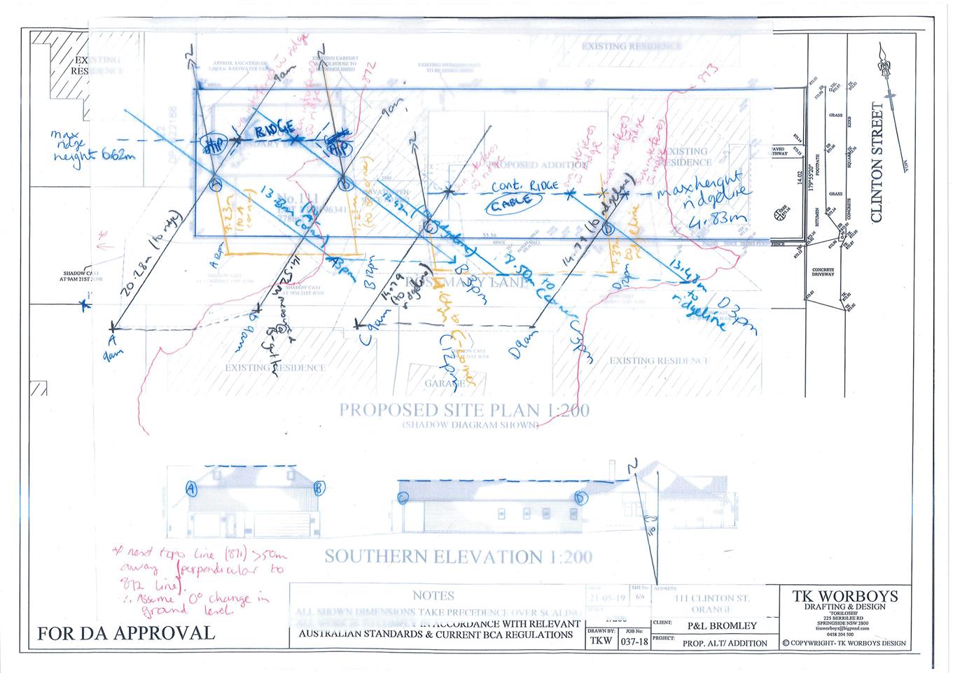
5).
Figure 5 – cross section of the site (looking
west)
Appropriate drainage
infrastructure can be provided within the development to ensure construction
earthworks and finished levels will not impact on adjoining properties or receiving
waterways.
The site is not known to be
contaminated, nor is the site known to contain any Aboriginal, European or
archaeological relics. The site is not in proximity to any waterway, drinking
water catchment or sensitive area. Conditions are recommended that require
sediment control measures to be implemented onsite prior to works commencing to
ensure that loose dirt and sediment does not escape the site boundaries.
Potential contamination and unexpected finds during construction are discussed
in the SEPP 55 assessment later in this report.
In
consideration of this clause, the proposal is considered to be acceptable.
7.3 - Stormwater Management
Clause 7.3 is applicable. This
clause states in part:
(3) Development
consent must not be granted to development on land to which this clause applies
unless the consent authority is satisfied that the development:
(a) is
designed to maximise the use of water permeable surfaces on the land having
regard to the soil characteristics affecting onsite infiltration of water, and
(b) includes,
where practical, onsite stormwater retention for use as an alternative supply
to mains water, groundwater or river water, and
(c) avoids
any significant impacts of stormwater runoff on adjoining downstream properties,
native bushland and receiving waters, or if that impact cannot be reasonably
avoided, minimises and mitigates the impact.
Stormwater from the development will
be directed to the lowest part of the site, being the south-western corner,
where it will be detained before being piped to the adjacent watercourse.
Preliminary interlot stormwater drainage and detention has been designed by the
applicant’s engineer, as set out in the attached drawings. It is noted
that the adjacent watercourse is not a mapped ‘sensitive waterway’
pursuant to the LEP, and the majority of stormwater run-off for the surrounding
residential land and streets is also piped to this watercourse, which feeds
into the Burrendong Way Wetland. When stormwater flows are high, water is pumped
from the wetland into the Ploughman’s Creek Stormwater Harvesting Scheme,
which contributes to the City’s drinking water.
Council’s Development Engineer has reviewed the
proposal and considers that stormwater can be designed to satisfy the
requirements of LEP Clause 7.3. Various conditions of consent are recommended
in relation to this matter, including stormwater design and detention
standards; full engineering plans for stormwater, driveway and car parking
areas, etc. to be assessed prior to the issuing of a Construction Certificate;
and the payment of contributions for water, sewer, and drainage works.
7.6 - Groundwater Vulnerability
The
subject land is identified as ‘Groundwater Vulnerable’ on the Groundwater
Vulnerability Map. Clause 7.6 applies. This clause states in part:
(3) Before determining a
development application for development on land to which this clause applies,
the consent authority must consider:
(a) whether
or not the development (including any onsite storage or disposal of solid or liquid
waste and chemicals) is likely to cause any groundwater contamination or have
any adverse effect on groundwater dependent ecosystems, and
(b) the
cumulative impact (including the impact on nearby groundwater extraction for
potable water supply or stock water supply) of the development and any other
existing development on groundwater.
In consideration of Clause 7.6,
there are no aspects of the proposed residential development that will impact
on groundwater and related ecosystems. It is noted
that the submitted “Detailed Contaminated Site Investigation”
(prepared by EnviroScience, and dated February 2019) demonstrates that the
water table is typically >10m deep, and no natural springs or dampness were
found during field inspections.
Clause 7.11 - Essential
Services
Clause 7.11 applies and states:
Development consent must not be
granted to development unless the consent authority is satisfied that any of
the following services that are essential for the proposed development are
available or that adequate arrangements have been made to make them available
when required:
(a) the
supply of water
(b) the
supply of electricity
(c) the
disposal and management of sewage
(d) storm
water drainage or on-site conservation
(e) suitable
road access.
Conditions of consent are recommended in relation to the
provision of urban utility services to the satisfaction of the appropriate body
(Council, Essential Energy, Telstra, etc.), and easements may need to be
created in relation to drainage services that cannot be contained within the
lot.
Conditions
of consent are also recommended in regards to the proposed extension and
adoption of Lantana Place. It shall be constructed full road width from the end
of the existing road construction to the boundary with adjoining land (Lot 4 DP
1065251). This work is to include road pavement and pavement surfacing, kerb
and gutter construction, and earth-formed footpath on both sides of the road
formation. New street trees are also recommended. A run-cost agreement will
need to be entered into with a waste contractor in relation to waste collection
for the development, which is discussed later in this report.
All
costs associated with the provision and/or upgrade of services is the
responsibility of the proponent. In consideration of this clause, the listed
utility services are available or can be made available to the land and made
adequate for the proposal.
STATE ENVIRONMENTAL PLANNING
POLICIES
State Environmental Planning Policy 55 - Remediation of
Land
State Environmental Planning Policy 55 - Remediation of
Land (SEPP 55) is applicable. Pursuant to Clause 7 Contamination and
remediation to be considered in determining development application:
(1) A consent authority must not consent to
the carrying out of any development on land unless:
(a) it
has considered whether the land is contaminated, and
(b) if
the land is contaminated, it is satisfied that the land is suitable in its
contaminated state (or will be suitable, after remediation) for the purpose for
which the development is proposed to be carried out, and
(c) if
the land requires remediation to be made suitable for the purpose for which the
development is proposed to be carried out, it is satisfied that the land will
be remediated before the land is used for that purpose.
Since
its creation as a residential allotment, the subject land has remained vacant.
Prior to this, the land was used for grazing, and is likely to have contained
gum trees before it was farmed (as discussed in the BC Act assessment earlier
in this report). Previous subdivisions of the original parcel of land
(i.e. the surrounding Botanic Way precinct/Gardens Estate) did not assess this
lot for contamination, and as such, a positive covenant was placed on the title
requiring chemical residue and soil classification tests to be carried out for
any further development of the land.
In
consideration of this covenant, and Clause 7 of SEPP 55, a “Detailed
Contaminated Site Investigation”, prepared by EnviroScience, and dated
February 2019, was undertaken and has been submitted in support of this
application. The investigation examined the history of the site, carried out
soil sampling and testing, and undertook airborne asbestos air monitoring in
accordance with the relevant guidelines.
The investigation concludes that the available history of
the site found no potential contaminants from on-site activities, and soil
samples returned results below the thresholds for residential with
gardens/accessible soil (HIL A Standard), therefore based on the evidence and
current science, the site is suitable for the proposed residential use.
Recommendations
have been made with the investigation, including soil erosion control to
protect the nearby waterway during construction, a waste management plan for
construction which includes measures for classifying and testing waste soils
that need to be removed from the site, and measures should an unexpected find
be discovered during construction (including any Aboriginal or European
heritage artefacts). Conditions of consent are recommended to this effect.
Overall
it is considered that the proposed development meets Clause 7 of SEPP 55.
It is
noted that a “Geotechnical Investigation Report”, prepared by
Barnson, and dated 3.05.2019 has also been submitted in support of the
application. This investigation is a geotechnical assessment of the site in
regards to soil classification and foundation recommendations, to assist in the
engineering and design of the buildings. It is not directly relevant to SEPP
55, however was a requirement of the covenant on the title.
State Environmental Planning Policy No
70—Affordable Housing (Revised Schemes)
State Environmental Planning Policy No
70—Affordable Housing (Revised Schemes) (SEPP 70) sets out:
- the definition for ‘Affordable
Housing’, being very low income households, low income households and
moderate income households whose gross incomes fall within the following ranges
of percentages of the median household income according to the Australian
Bureau of Statistics:
|
Very low income household
|
less than 50%
|
|
Low income household
|
50 or more but less than 80%
|
|
Moderate income household
|
80–120%
|
- identifies that there is a need for
affordable housing across the whole of the State,
- describes
the kinds of households for which affordable housing may be provided,
- makes a
requirement with respect to the imposition of conditions relating to the
provision of affordable housing.
Schedule 2 of SEPP 70 lists the Affordable housing
principles as follows:
1 Where
any of the circumstances described in section 7.32 (1) (a), (b), (c) or (d) of
the Act occur, and a State environmental planning policy or local environmental
plan authorises an affordable housing condition to be imposed, such a condition
should be imposed so that mixed and balanced communities are created.
2 Affordable
housing is to be created and managed so that a socially diverse residential
population representative of all income groups is developed and maintained in a
locality.
3 Affordable
housing is to be made available to very low, low or moderate income households,
or any combination of these.
4 Affordable
housing is to be rented to appropriately qualified tenants and at an
appropriate rate of gross household income.
5 Land
provided for affordable housing is to be used for the purpose of the provision
of affordable housing.
6 Buildings
provided for affordable housing are to be managed so as to maintain their
continued use for affordable housing.
7 Rental
from affordable housing, after deduction of normal landlord’s expenses
(including management and maintenance costs and all rates and taxes payable in
connection with the dwellings), is generally to be used for the purpose of
improving or replacing affordable housing or for providing additional
affordable housing.
8 Affordable
housing is to consist of dwellings constructed to a standard that, in the
opinion of the consent authority, is consistent with other dwellings in the
vicinity.
The proposed development is being carried out by Community
Housing Provider ‘Housing Plus’ as part of the NSW government’s
‘Social and Affordable Housing Fund,’ a key initiative under
the ‘Future Directions for Social Housing in NSW’ strategy.
The proposed dwellings will be occupied by tenants who have been assessed as
eligible under the NSW Housing Pathways Strategy. The proposal is aimed at
meeting the needs of aging women (over 55 years), however, the development
will not necessary be used exclusively by this demographic.
It is considered that the proposal is generally consistent
with the Affordable Housing Principles outlined above. In particular, it is
considered that the proposed dwellings will be constructed to a standard that
is consistent with other dwellings in the vicinity, as discussed in the DCP
assessment of this report. No conditions of consent for affordable housing are
considered necessary in this case.
State Environmental Planning
Policy (Affordable Rental Housing) 2009
State Environmental Planning Policy (Affordable Rental
Housing) 2009 sets out design provisions and standards for affordable
housing in relation to floor space, landscaping, parking, dwelling sizes, etc.
Although the Policy applies to the subject land, the assessment criteria for
affordable housing does not apply to this application, as the subject land is
not within 400m walking distance of land within B2 Local Centre or B4 Mixed Use
zones (land not in the Sydney region) pursuant to Division 1, Clause 10(3). The
subject land is within R1 General Residential zoned land, and is surrounded by
residential, rural and recreational zoned land. The closest local centre (B4
zone) is about 1.5km away in North Orange.
In light of the above, the proposed design will be assessed
against Council’s DCP, set out later in this report. It is noted that the
DCP criteria is generally stricter than the provisions set out in the SEPP,
which allows for lesser standards for affordable housing close to local
centres.
PROVISIONS OF ANY DRAFT
ENVIRONMENTAL PLANNING INSTRUMENT THAT HAS BEEN PLACED ON EXHIBITION
4.15(1)(a)(ii)
Draft Planning Guidelines for the proposed Remediation of
Land SEPP
From 31 January to 13 April 2018 the Department of Planning
and Environment publically exhibited an Explanation of Intended Effect (EIE)
and Draft Planning Guidelines for the proposed Remediation of Land SEPP, which
will repeal and replace State Environmental Planning Policy 55 –
Remediation of Land (SEPP 55). Of particular note, the Draft Planning
Guidelines state:
“In undertaking an
initial evaluation, a planning authority should consider whether there is any
known or potential contamination on nearby or neighbouring properties, or in
nearby groundwater, and whether that contamination needs to be considered in
the assessment and decision making process.”
“If the planning
authority knows that contamination of nearby land is present but has not yet
been investigated, it may require further information from the applicant to
demonstrate that the contamination on nearby land will not adversely affect the
subject land having regard to the proposed use.” (Proposed
Remediation of Lands SEPP - Draft Planning Guidelines, Page 10).
Land adjoining the site is not
identified or considered to be contaminated. Assessments and testing was
undertaken prior to the subdivision of surrounding land within the Botanic Way
precinct/Gardens Estate, which concluded that the land was suitable for
residential use. As discussed in the SEPP 55 assessment above, the subject site
is also considered suitable for residential use, as concluded by recent
sampling and testing. As such, the provisions of the draft EPI are considered
to have been addressed.
Draft Orange Local
Environmental Plan 2011 (Amendment 24)
Draft Orange LEP Amendment 24 is
currently on public exhibition (26 July – 26 August 2019). The
Draft plan involves administrative amendments to the LEP and seeks to:
· Correct anomalies
in the Heritage Map and Schedule 5 Environmental Heritage.
· Amend all LEP maps
to update the cadastre.
· Create several new
entries in Schedule 2 Exempt Development to include additional minor forms of
development; and enable some exempt development of land zoned E3 Environmental
Management.
· Amend the flood
planning controls by linking the LEP with the recent floodplain risk management
plan.
· Adopt a missing
water catchment map tile to fully identify the water catchment area.
· Amend the Combined
Local Map to reflect changes to the Orange Airport Obstacle Limited Surface
area associated with the runway extension.
· Amend Clause 4.1C
to remove ambiguity in relation to multi dwelling housing in Ploughmans Valley.
· Amend Clause 4.2
to include the E3 Environmental Management Zone, and facilitate the transfer of
non-residential rural land holdings between primary producers without creating
additional dwelling entitlements.
· Adopt a new clause
to enable subdivision of land with more than one zone or minimum lot size.
· Adopt a new clause
to enable boundary adjustments of lots already below the minimum lot size,
without creating additional dwelling entitlements.
· Adopt a new clause
to enable small scale cafés in residential areas, and amend Clause 5.4
in relation to size limitations for same.
· Amend the Land
Zoning Map and Lot Size Map to provide for a range of minor rezoning.
Draft Amendment 24 has no effect
for the subject land or proposed development.
DESIGNATED DEVELOPMENT
The proposed development is not designated development.
INTEGRATED DEVELOPMENT
The proposed development is not integrated development.
PROVISIONS OF ANY DEVELOPMENT
CONTROL PLAN s4.15(1)(a)(iii)
Development Control Plan 2004
The following parts of DCP 2004 are applicable to the
proposed development:
· Part 2 - Natural
Resource Management
· Part 3 - General
Considerations
· Part 4 - Special
Environmental Considerations
· Part 5 - General Considerations
for Zones and Development
· Part 7 –
Development in Residential Zones.
The relevant matters in Parts 2, 3, and 4 were considered in
the foregoing assessment under the LEP clause assessments. The relevant
matters in Part 5 are addressed later in this report (refer to the “ANY
SUBMISSIONS” section). The proposal will reasonably satisfy the relevant
planning outcomes in Part 7 as outlined in the following assessment.
DCP 2004-7.7 Design Elements
for Residential Development
Neighbourhood Character
The DCP sets the following Planning Outcomes in regard to
Neighbourhood Character:
Site layout and building design enables the:
· creation of
attractive residential environments with clear character and identity
· use of site
features such as views, aspect, existing vegetation and landmarks
· buildings are
designed to complement the relevant features and built form that are identified
as part of the desired neighbourhood character
· the streetscape
is designed to encourage pedestrian access and use.
In order to consider the effect the proposal has on the
neighbourhood and setting, an assessment of character needs to be undertaken.
In defining the relevant character of the local area, reference tools include
the Orange LEP, Orange DCP, Council’s Infill Guidelines, and
relevant Case Law. The character and identity of a particular area is
influenced by the interrelationship of the public and private realms, taking
into account the qualitative interplay of many factors which contribute to
creating a unique neighbourhood character (‘Design in Context’ NSW
Heritage Office and Royal Australian Institute of Architects, 2005). These
factors include:
· the
underlying natural landform and topographic characteristics, including
landscape elements and vegetation
· the
fabric and style of the buildings, including materials, colours, building
techniques, detailing etc.
· the
scale and form of the buildings, including proportions of openings
· street
and subdivision patterns, including setbacks, building to space pattern of
buildings, curtilage, fencing, landscaping, servicing, etc.
The Botanic Way/Gardens Estate
precinct is characterised by residential dwelling houses set around public
recreational lands, creeks, and a wetland (see Figures 6, 7, and 8).
Surrounding residential development is made up of dwellings, dual occupancies,
and unit developments; all recently built, and contemporary in design.
Dwellings range in size from small to moderate, are mostly single-storey in
scale, and are constructed in brick veneer, with steel or tile hipped roofs.
Lot sizes also vary, which is common in the General Residential zone. An
analysis of the surrounding residentially developed lots shows the average lot
size in the precinct to be around 595m2.
Figure 6 – aerial photograph of surrounding
precinct (from Google Maps)
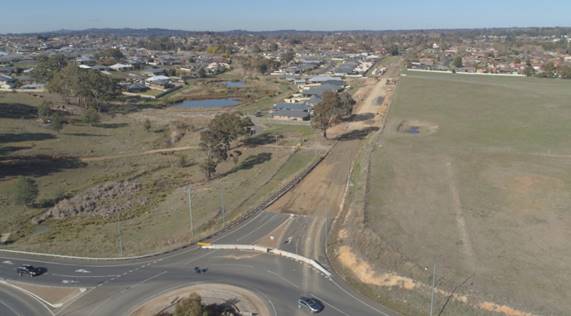
Figure 7 – photograph of Burrendong Way Wetland
and surrounding precinct
(viewed from Burrendong Way/Northern Distributor (NDR)
roundabout)
Relevant case law notes that an assessment of character needs
to take into account not only the existing character, but the future desired
character, as set out in the relevant planning instruments (i.e. LEP zoning and
lot sizes) and Council policies (i.e. the DCP). Land to the west and north of
the subject site is currently rural in character, where the neighbouring land
to the west is still being used for grazing and a rural-residential dwelling
(see Figure 7). However, this land is likely to be subdivided into residential
lots similar in scale to the adjacent precinct, as it is zoned R1 General
Residential (see Figure 8). Land to the north of the NDR is likely to remain
rural, being zoned E4 Environmental Living (see Figure 8).
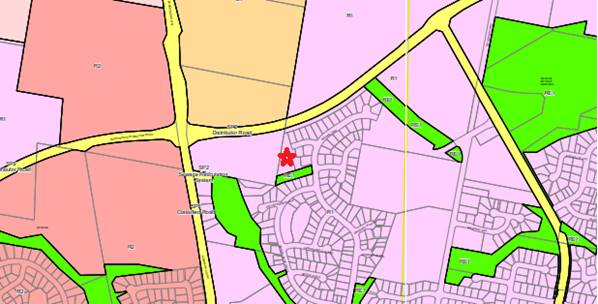
Figure 8 – LEP Zoning Map (KEY: star –
subject site, pink/purple – residential, beige – rural/environmental,
green – public recreation, yellow – infrastructure/major roads)
The proposed dwellings will adopt a building form and finish
typical to the neighbourhood, with use of design elements consistent with the
prevailing development form including contemporary design and finishes,
including brick veneer, front porches, and hipped steel roofs; front elevation
attached garages and dwelling entrances (carports for the rear dwellings); and landscaped
front setbacks and private rear gardens. Although duplex/attached in form, the
scale is similar to single dwelling houses, dual occupancies, and unit
developments in the surrounding area.
Based on the above considerations, and the DCP planning
outcomes for neighbourhood character, it is considered that:
· the proposed bulk,
scale, siting, form, and appearance of the development is consistent with other
dwellings, dual occupancies, and unit developments in the surrounding area,
where it recognises characteristic materials, textures, colours and detailing used
locally and in adjacent buildings, adding sympathetically to the local
streetscape and grain of the area
· the scale,
setbacks, spacing, and layout of the development are consistent with the
existing streetscape and surrounding built form, which will result in an
attractive residential environment, and will continue the clear residential
character of the area
· the extent of
proposed landscaped areas and siting of buildings is consistent with the
surrounding area, and have been designed to complement the existing features of
the site and the surrounding neighbourhood, including views, slope, aspect, and
the adjacent creek and trees
· although the
proposed hard surface coverage (driveways, car parking areas, etc.) is higher
compared with neighbouring lots, it is considered necessary given the slope and
shape constraints of the site. Any development of the site would result in the
need for additional hard surfaces, and the engineered design includes ample
areas of open space and landscaping, as discussed later in the DCP assessment,
and adequately considers stormwater as discussed previously. Furthermore, the
proposal is well below maximum site coverage, also discussed later
· the proposal will
not adversely impact on pedestrian access associated with the residential
street as it currently exists, or when the street is extended to the west. Rear
dwellings will enter and exit the site in a forward direction, and dwellings
fronting the street will reverse into the street in the same manner as adjacent
dwelling houses. Sightlines within Lantana Place are appropriate to avoid
conflict with pedestrians
· neighbourhood
amenity impacts are considered within reasonable limits, as discussed in the
remaining DCP assessment and “Likely Impacts” sections below.
It is contented by neighbours and submitters that a duplex
style unit development and the proposed carports are not the ‘same’
as surrounding development, and therefore should not be supported by Council.
However, the development satisfies the R1 zone objectives to provide a variety
of housing types and densities, and multi dwelling housing is a permitted and
complementary land use in the zone. There are other similar unit developments
in the area, the closest being to the south of the site, on the other side of Brooklands
Reserve that adjoins the southern boundary of the site (see Figure 6). Furthermore,
the courts have established that to be ‘compatible’ does not mean a
development has to be the same as the surrounding neighbourhood; that having
considered whether a proposal's physical impacts on surrounding development are
acceptable, and if the proposal's appearance is in harmony with the buildings
around it, then it can be considered consistent with neighbourhood character.
Overall, it is considered that the development is sited and
designed to reasonably integrate in the immediate context and setting, as well
as the wider local area, without adversely impacting on the neighbourhood
character or function.
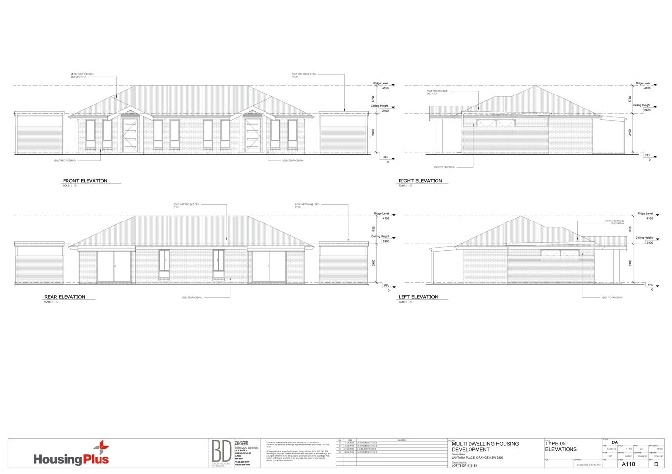
Building Appearance
The DCP sets the following Planning Outcomes in regard to
Building Appearance:
· the building
design, detailing and finishes relate to the desired neighbourhood character,
complement the residential scale of the area, and add visual interest to the
street
· the frontages
of buildings and their entries face the street
· garages and car
parks are sited and designed so that they do not dominate the street frontage.
The design, detailing, and finishes
for the proposed dwellings are appropriate for this neighbourhood, and will
complement recent dwellings on adjoining lands, as discussed in the
“Neighbourhood Character” assessment above.
As shown in the attached
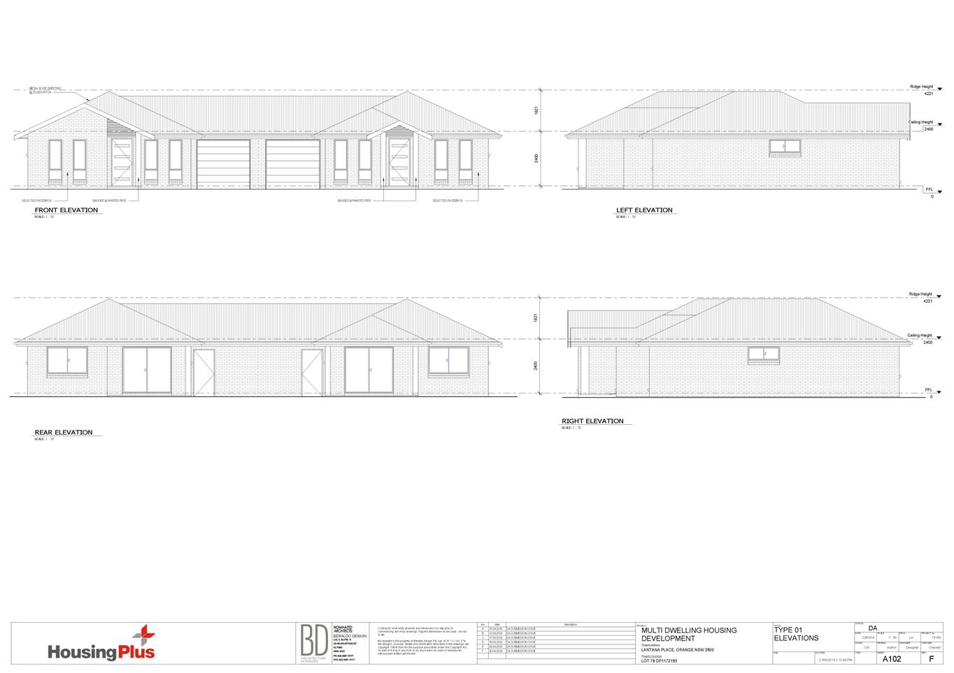
drawings and in Figures 3 and 9, front elevations for proposed Dwellings 1-6
will address the street with front doors, front porches, and attached garages
all fronting an extended Lantana Place. Garages will satisfy the DCP guidelines
in respect of design, sting, and width, and are less than 50% of each of the
frontages, therefore they will not dominate the street. The buildings have been
designed to look similar to a single dwelling with a double garage, where each
duplex has two garage doors, one for each unit. Front landscaping is also
proposed to soften and integrate the buildings into the streetscape.
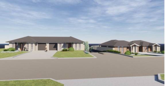
Figure 9 – visualisation render street frontage
(looking south)
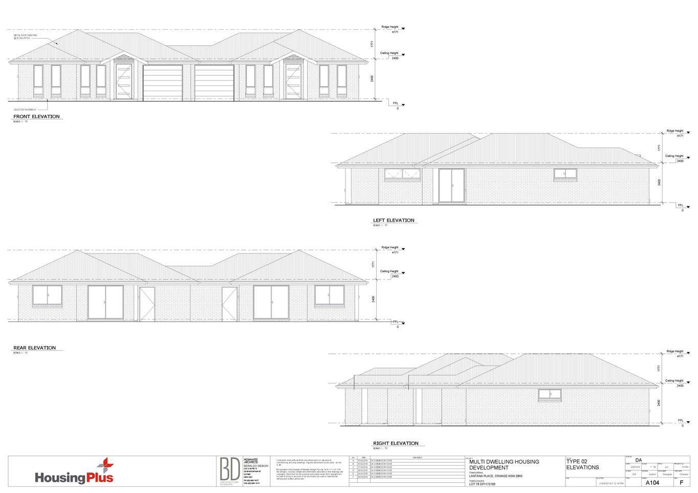
The rear dwellings and visitor car parking spaces will not
be readily visible from the street. Proposed Dwellings 7-10 include front
doors, front porches, and adjacent carports fronting the communal space to the
rear of the site, which includes driveway/manoeuvring areas, visitor parking,
landscaped areas, and bin collection area (see Figure 4). Boundary fencing and
retaining walls means these areas will not be readily visible from neighbouring
properties, nearby streets, or adjacent and nearby areas of public open space
(Brooklands Reserve, Burrendong Way Wetlands, etc.) (see Figure 5).
Heritage
The DCP sets the following Planning Outcomes in regard to
Heritage:
· heritage
buildings and structures are efficiently re-used
· new
development complements and enhances the significance of a heritage item or
place of heritage significance listed in the Orange Heritage Study
· significant
landscape features are retained including original period fences and period
gardens.
The subject land does not contain or
adjoin a heritage item, and is not located within a heritage conservation area.
As such, the heritage planning outcomes are not relevant to this site or
application.
Setbacks
The DCP sets the following Planning Outcomes in regard to
Setbacks:
· street setbacks
contribute to the desired neighbourhood character, assist with the integration
of new development and make efficient use of the site
· street setbacks
create an appropriate scale for the street considering all other streetscape
components.
Proposed Dwellings 1-6 will have frontages to an extended
Lantana Place. The dwellings will be sited a minimum 4.5m from the (future)
street boundaries, and complement the siting of the adjoining dwellings to the
east (being 4m setbacks for numbers 3, 6, and 8 Lantana Place and 5m setback
for number 3 Lantana Place). Proposed Dwelling 3 will be set back a few metres
further from the street than the other dwellings to allow for sufficient
manoeuvring out into the street. This will still be consistent with the general
setbacks for the development and surrounding area. The dwellings fronting the
street will be similar in scale to neighbouring dwellings, and front
landscaping is proposed to integrate the buildings into the streetscape. Street
trees are also recommended, which is discussed later in the DCP assessment.
Single garages at the site frontage for Dwellings 1-6 will
be sited a minimum of 5.5m from the (future) front boundaries, which will allow
for tandem additional/visitor car parking wholly within the subject land.
Visitor spaces for the rear dwellings is provided to the rear of the site, away
from the site frontages.
Overall, visual encroachment impacts on the public road are
not anticipated, given the proposal exceeds the minimum setbacks, and proposed
setbacks and building scale are consistent with neighbouring dwellings.
Front Fences and Walls
The DCP sets the following Planning Outcomes in regard to
Fences and Walls:
· Front fences
and walls:
- assist in
highlighting entrances and creating a sense of identity within the streetscape
- are
constructed of materials compatible with associated housing and with fences
visible from the site that positively contribute to the streetscape
- provide for
facilities in the street frontage area such as mail boxes.
The proposal does not involve the erection of front fencing
to Lantana Place. The open front setback will complement those for nearby
dwellings in the streetscape, as discussed previously. Ample space is available
for landscaping, street trees, mail boxes and the likes.
Visual Bulk
The DCP sets the following Planning Outcome in regard to
Visual Bulk:
· Built form
accords with the desired neighbourhood character of the area with:
- side and rear
setbacks progressively increased to reduce bulk and overshadowing
- site coverage
that retains the relatively low density landscaped character of residential
areas
- building form
and siting that relates to landform, with minimal land shaping (cut and fill)
- building
height at the street frontage that maintains a comparable scale with the
predominant adjacent development form
- building to
the boundary where appropriate.
The
site slopes steadily to the rear/south, with overall cross fall in the order of
some 13m. Considerable earthworks will be required to create the driveway
and parking areas, however generally the proposal has taken into account the
natural slope of the site so that substantial changes in existing levels do not
need to be made. Retaining walls will be constructed throughout the site and on
side and rear boundaries to achieve appropriate levels for building pads and
outdoor open space areas (see Figure 5).
Finished
floor levels will range from 864.5 for proposed Dwellings 1 and 2 at the
highest part of the site (northern side of extended road), to between 859.0 and
859.7 for proposed Dwellings 7-10 at the lowest part of the site (south/rear).
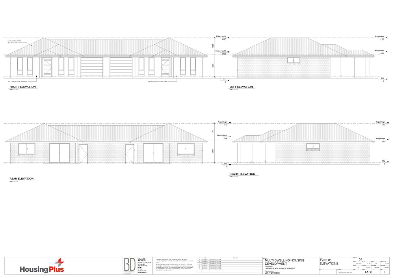
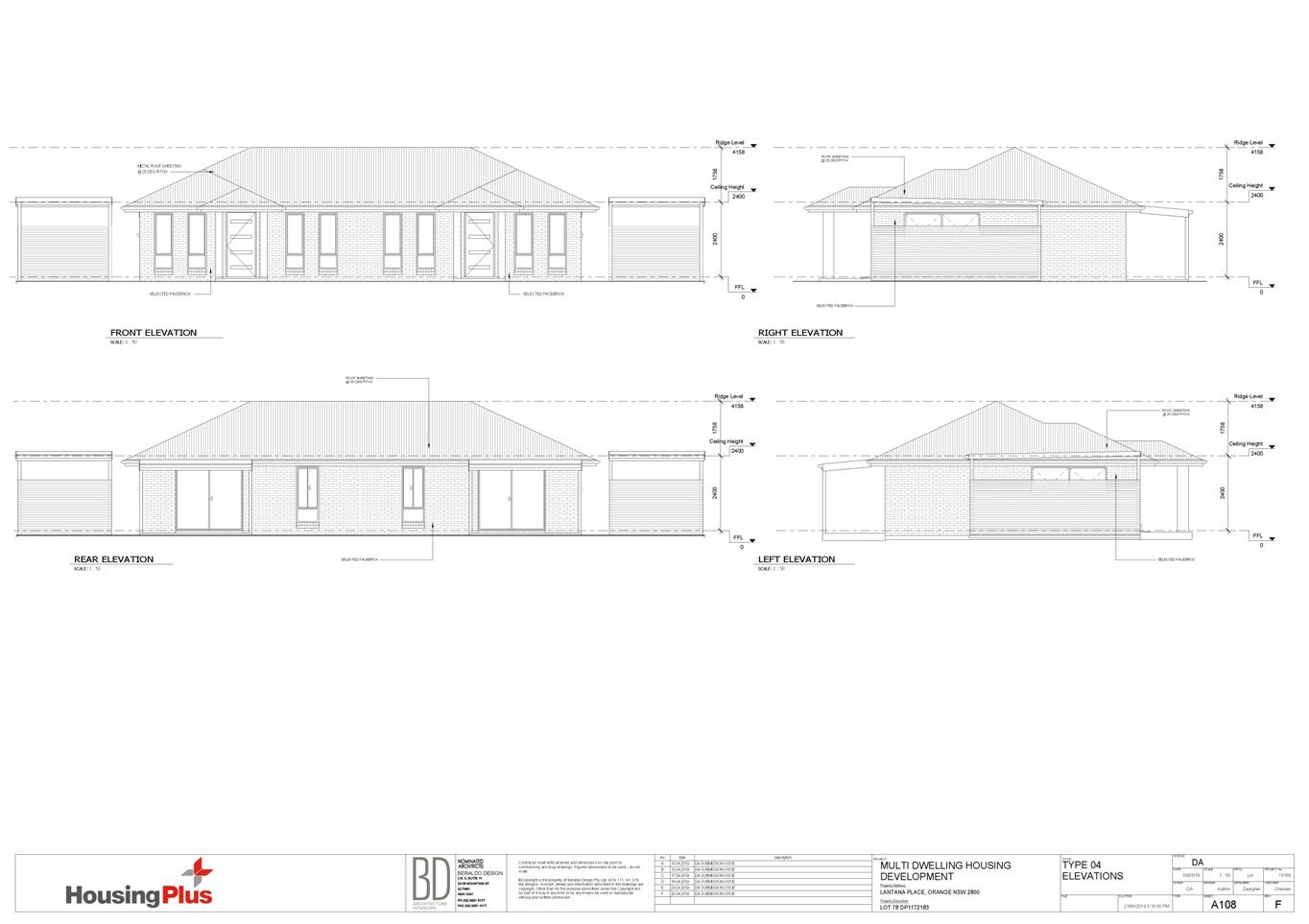
Based on the finished levels, visual bulk
encroachment impacts are not anticipated for adjoining dwellings within or
adjoining the site. The development has been designed so that the bulk of the
proposed dwellings match or are lesser than the bulk of neighbouring dwellings
(i.e. are either in-line with the bulk of neighbouring dwellings, or sit
lower/are smaller than the neighbours). The attached elevations show the
proposed dwellings in relation to the boundaries and in context of neighbouring
dwellings.
The proposed dwellings will be single storey, with
reasonable setbacks from side and rear boundaries. The dwellings will
complement the bulk and scale of dwellings nearby to the site in Lantana Place,
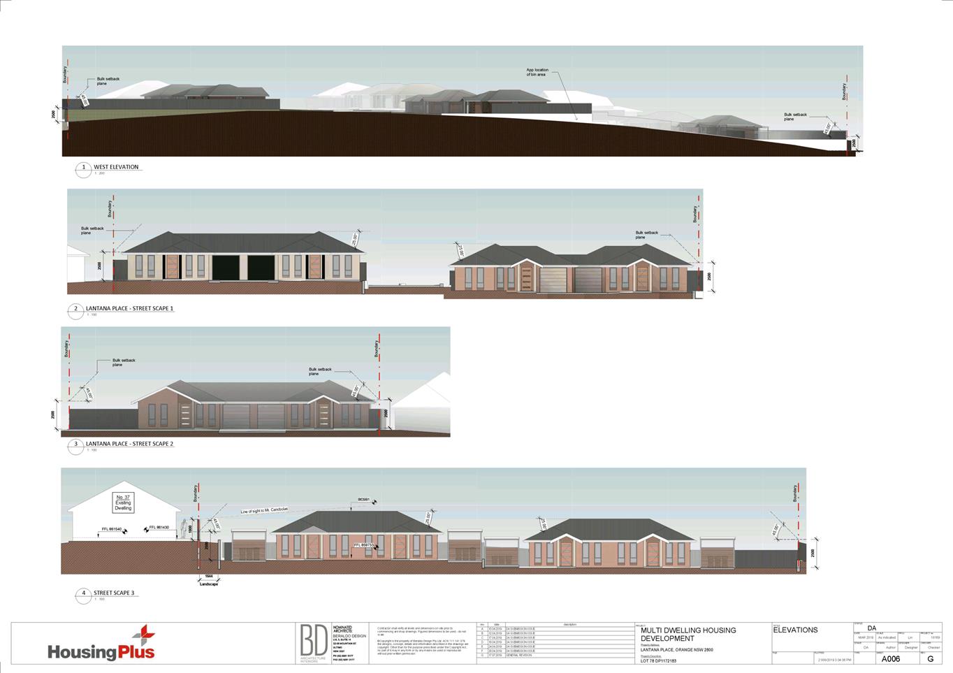
Botanic Way and Brooklands Drive. The proposed dwellings will be contained
within the DCP-prescribed visual bulk envelope planes, as demonstrated in the
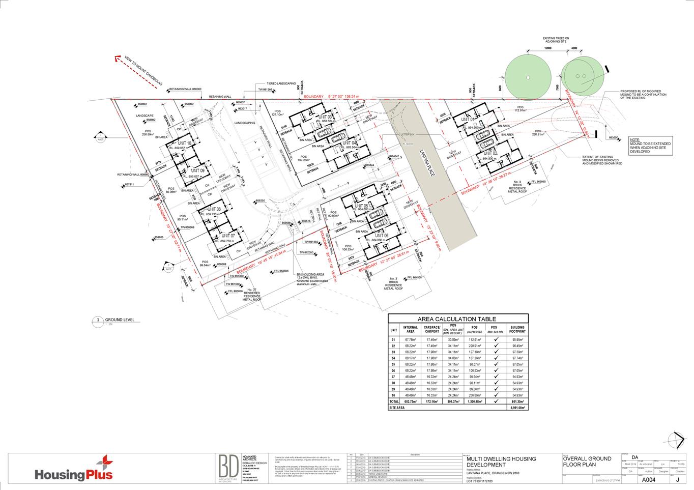
submitted elevation drawings.
The proposed dwellings, attached garages, and adjacent
carports will comprise a total building footprint of 801.35m2. Based
on a site area of 4,991m2 the development will have site coverage of
16.1%, well below the maximum 50% prescribed for multi dwelling housing
development.
Walls and Boundaries
The DCP sets the following Planning Outcome in regard to
Walls and Boundaries:
· Building to the
boundary is undertaken to provide for efficient use of the site taking into
account:
- the privacy of
neighbouring dwellings and private open space
- the access to
daylight reaching adjoining properties
- the impact of
boundary walls on neighbours.
The proposal does not involve the
construction of buildings on the boundary, where minimum 900mm side setbacks
will be maintained for fire safety reasons (pursuant to the Building Code of
Australia/National Construction Code discussed later in this report). This
is a common side setback for new dwellings within the precinct and across the
City. The attached elevations demonstrate that the proposed dwellings, as well
as the proposed boundary/near to boundary retaining walls and fences comply
with the DCP-prescribed visual bulk envelope planes. As discussed throughout
this report, the site layout and building design will not adversely impact on
adjoining dwellings in respect of privacy, solar access, or visual bulk.
Daylight
and Sunlight
The DCP sets the following Planning Outcome in regard to
Daylight and Sunlight:
· Buildings are
sited and designed to ensure:
- daylight to
habitable rooms in adjacent dwellings is not significantly reduced
- overshadowing
of neighbouring secluded open spaces or main living area windows is not
significantly increased
- consideration
of Council’s Energy Efficiency Code.
Overshadowing of Private Open Space
Pursuant to the DCP Guidelines:
Sunlight is to be available to
at least 40% of required open space for dwellings within the development and
those on adjoining lands for at least three hours between 9am and 3pm.
Shadow diagrams and calculations were submitted in support
of the proposal, which demonstrates that all but one of the proposed dwellings
will receive at least 3 hours sunlight to at least 40% of the main area of
private open space midwinter. Proposed Dwelling 6 will receive around half an
hour less than the required 3 hours, where 40% of the private open space area
will be unshaded from around 11.30am to 2pm. The amount of private open space
provided to this proposed dwelling well exceeds the DCP requirements in terms
of area, and the half hour less daylighting will result in only very minor
impacts to the future occupant of that dwelling in winter.
The submitted information also demonstrates that the
proposed development is unlikely to reduce daylight on the private open space
areas of adjoining residential land during the winter. While the adjoining
property at number 37 Botanic Way will be the most overshadowed property, as
demonstrated in the attached shadow diagrams, most of the shadowing comes from
the existing property boundary fence. Shadowing from this fence and daylighting
to the neighbour would have already been considered in the assessment of the
development of that adjoining lot, and the proposal will not worsen the
existing situation, as required by the DCP.
Overall, daylighting to private open space areas for future
dwellings on the subject land, and neighbouring dwellings is considered
acceptable.
Overshadowing of Dwellings
Pursuant to the DCP Guidelines:
Sunlight to at least 75%
of north-facing living area windows within the development and on adjoining
land is to be provided for a minimum of four hours on 21 June; or not further
reduced than existing where already less.
The proposed dwellings will each
contain north-facing living room windows. The attached solar access drawings
demonstrate that daylight will be provided to those windows for a minimum of 4
hours on the winter solstice, consistent with the DCP Guidelines.
The proposed dwellings will not cause
overshadowing of northern living rooms windows for adjoining dwellings due to
the north-south orientation of the site, and the matching of the bulk of the
proposed dwellings to their neighbours.
Furthermore, habitable rooms include windows that are
generally facing private open space areas, the street, the internal communal
landscaped areas, or the reserve to the rear, providing for adequate amenity
and sunlight for future occupants.
Overall it is considered that the proposal is generally in
accordance with the DCP planning outcomes for daylight and sunlight.
Views
The DCP sets the following Planning Outcomes in regard to
Views:
· building form
and design allow for residents from adjacent properties to share prominent
views where possible
· views including
vistas of heritage items or landmarks are not substantially affected by the
bulk and scale of the new development.
While
the subject site is not located within the scenic protection area under
the DCP, it is located within an important view corridor, where the
subject site and some of its neighbours enjoy full or partial views to the southwest
towards Mount Canobolas and Pinnacle (see Figure
10). The DCP includes some guidelines with regard to view
analysis and identifies certain features as providing ‘highly
valued’ views. The DCP identifies Mount Canobolas as
the primary view in Orange. In addition, the rear boundary of the subject land
presents to Brooklands Reserve, which provides for highly valued outlook (see
Figure 10).
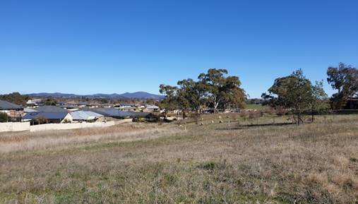
Figure 10 – views towards Mount Canobolas and
Pinnacle (looking south-west from subject site)
As these views are
considered to be significant, the proposed development should be designed to
share them where possible. The proposed development has the potential to
obstruct the partial views from the front windows of the neighbouring
properties to the east at numbers 4, 6, and 8 Lantana Place; and partial and
full views from side and rear windows of the neighbouring properties to the
east at numbers 3 Lantana Place, and 37 Botanic Way.
The Court
has established some planning principles with regard to view loss and view
sharing assessment. The salient principles can be found in Tenacity
Consulting v Warringah Council [2004] NSWLEC 140 in
paragraphs 25-29, as set out below:
25 The notion of view
sharing is invoked when a property enjoys existing views and a proposed development
would share that view by taking some of it away for its own enjoyment. (Taking
it all away cannot be called view sharing, although it may, in some
circumstances, be quite reasonable). To decide whether or not view sharing is
reasonable, I have adopted a four-step assessment.
26 The first step is the
assessment of views to be affected. Water views are valued more highly than
land views. Iconic views (eg of the Opera House,
the Harbour Bridge or North Head) are valued more highly than views
without icons. Whole views are valued more highly than partial
views, eg a water view in which the interface between land and water
is visible is more valuable than one in which it is obscured.
27 The second step is to
consider from what part of the property the views are obtained. For example the
protection of views across side boundaries is more difficult than the
protection of views from front and rear boundaries. In addition, whether the
view is enjoyed from a standing or sitting position may also be relevant.
Sitting views are more difficult to protect than standing views. The
expectation to retain side views and sitting views is often unrealistic.
28 The third step is to
assess the extent of the impact. This should be done for the whole of the
property, not just for the view that is affected. The impact on views from
living areas is more significant than from bedrooms or service areas (though
views from kitchens are highly valued because people spend so much time in
them). The impact may be assessed quantitatively, but in many cases this can be
meaningless. For example, it is unhelpful to say that the view loss is 20% if
it includes one of the sails of the Opera House. It is usually more useful
to assess the view loss qualitatively as negligible, minor, moderate, severe or
devastating.
29 The fourth step is to
assess the reasonableness of the proposal that is causing the impact. A
development that complies with all planning controls would be considered more
reasonable than one that breaches them. Where an impact on views arises as a
result of non-compliance with one or more planning controls, even a moderate
impact may be considered unreasonable. With a complying proposal, the question
should be asked whether a more skillful design could provide the applicant with
the same development potential and amenity and reduce the impact on the views
of neighbours. If the answer to that question is no, then the view impact
of a complying development would probably be considered acceptable and the view
sharing reasonable.
In relation to this four
step assessment, the following observations are made:
· the views towards
Mount Canobolas are considered to be highly valued under the DCP
· the views from
the neighbouring properties are not full or panoramic, as they are partially
obstructed from existing vegetation on other land
· the views from
Lantana Place properties are obtained primarily from the front or rear windows,
and generally from standing positions
· the view from the
neighbour at number 37 Botanic Way is obtained from living room windows, and a
small outdoor patio on the side of the dwelling, from both sitting and standing
positions. As this is a battleaxe site, this boundary could be considered
either the side or rear, however it is the side boundary of the subject lot
· neighbour’s
private outdoor areas are unlikely to enjoy views due to orientation, slope and
boundary fencing
· it is to be
expected that a proportion of views will be reduced as a result of future
residential development on the subject lot, where it is considered
unreasonable to assume that the vacant site would remain so indefinitely
· there is currently
no boundary fence between the subject site and the neighbour at number 37
Botanic Way, presumably to take advantage of the view, and the existing
neighbouring dwelling has been constructed very near to the boundary. It is
considered reasonable to assume a boundary fence would be erected in relation
to future development of the subject land, and that views would be obstructed
given the proximity of existing windows to a future fence.
The applicant has undertaken
an assessment of views, and notes the following:
- “In terms of view sharing consideration
we acknowledge there are view sharing principles established and a balance
should be struck between the right to be able to develop adjoining land versus
the right to maintain views.
- The design has taken into account there may be
long distant views of Mount Canobolas and other smaller hills in the
locality. The design features include ensuring all buildings are (low) single
storey with equal to or less than 25° roof pitches; a low site coverage (at
16%) and buildings generally follow the natural profile of the land so that
views can be maintained.
- In respect to No. 37 Botanic Way we note that no
boundary treatment currently exists between that land and the subject site and
a 1.8m fence has been proposed which may impede some views at lower levels. It
is reasonable to expect that a boundary fence should be (sic) installed
between the properties in this location at a height that can be conditioned
between the parties.
- Notwithstanding this fence height the finished
floor levels for proposed Units 7 -10 are generally below the dwelling at No.
37 Botanic Way and the majority of the unit/s roofline shall be at or below the
expected fence height depending on the point at which you consider on the
property. An adult of average height standing on the deck of the existing
dwelling should still retain views over the fence and unit rooflines across to
Mount Canobolas.
- In respect to Nos. 3, 6 and 8 Lantana Place
their views are interrupted by large trees on adjoining lot/s not related to
the subject site. Building (window) openings on the directly elevations facing
Mount Canobolas also do not lend themselves to capturing the views. The partial
views can be maintained in the case of Nos. 6 and 8 along a corridor at the
front of the subject site, and in the case of No. 3 a corridor exists through
the centre of the proposed development.
Unfortunately,
the trees on the adjoining site shall still block most of the long distant
views and they are outside the developer’s control.
- Landscaping along the boundaries have also
been re-considered to ensure views are maintained.
- Please refer to further details regarding view
sharing on the attached architectural drawings”.
In light of the view sharing
planning principles, Council staff generally concur with the applicant’s
comments. The views from the Lantana Place neighbours are already partially
obscured, and it is reasonable to expect that any future development of the
subject land would further obscure views. The proposal has been designed to
minimise the scale and bulk of the buildings, as discussed earlier in the
report.
It is
also reasonable to expect that the side/rear views obtained from number 37
Botanic Way would also be obstructed from future boundary fencing and
development of the subject land. As demonstrated on the attached elevations and
in Figure 11 below, proposed Dwellings 7-10 are much lower than number 37
Botanic Way. The view analysis carried out on this elevation from the
neighbouring property appears to show the view directly west, however, it is
actually angled south west over/across the proposed carport roof for
Dwelling 7. As such, the potential impact to
this neighbouring property is unlikely to be a total loss of view,
and some degree of view sharing from living room windows is possible.
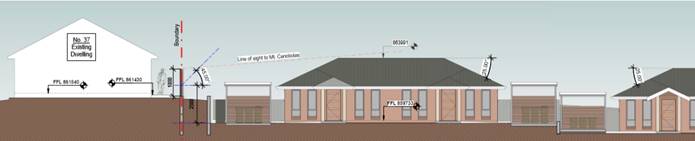
Figure 11 – northern elevations of number 37
Botanic Way and proposed Dwellings 7, 8 and 9
In relation to paragraph 29
of the planning principles for views, the proposed development is consistent
with other planning controls as set out in the LEP and other DCP assessment
sections of this report. Consideration also needs to be given as to
whether a more ‘skillful’ design could reduce the impact on views.
As already discussed, the proposal has been designed to minimise the scale,
bulk, and floor levels of the buildings. It is considered that the roof pitch
of the rear Dwellings (7-10) could be reduced to 22.5 degrees, which would
slightly lower the ridge line of those dwellings, therefore further reducing
the scale of these dwellings and increasing the view sharing potential with the
neighbour at number 37 Botanic Way.
It could be argued that the
number of units proposed on the site increases the impacts of view loss,
however this is not considered to be the case for this site. It is unlikely
that the site was ever intended for a single dwelling or only a few dwellings
due to its expansive size, therefore it is reasonable to expect that there
would be multiple dwellings or lots created in this locality.
Furthermore, pursuant to State
Environmental Planning Policy – Exempt and Complying Development
multiple buildings, such as manor houses, up to 8.5m/two storeys in height
could be constructed on the land without the requirement for a Development
Application to be assessed by Council, thus giving little to no consideration
to views, and likely resulting in a bulkier development with more adverse
impacts and view loss.
Overall, while certain
elements of these views will be impacted after the subject property is
developed, it is not considered that such losses are excessive or unreasonable
as a result of the proposed development. Part of the neighbour’s views
currently enjoyed would be retained, and as such the view loss impact is
considered to be minor-moderate in this circumstance, having regard to the
Court’s planning principles for view sharing and the requirements of
the DCP.
The development proposes to
substantially cut the units into the site as they move down the sloping
site. The development has the potential to impact on views from the
neighbour at 37 Botanic Way. The applicant was therefore required to
install height poles indicating the overall height of the last unit (unit 7) to
allow the assessment of actual impacts. These poles were checked for
accuracy by a registered surveyor (red line has been drawn on the photo below
for clarity of the extent of the roof of the proposed unit). The unit
development will not impact on view from 37 Botanic Way of Mount Canobolas.
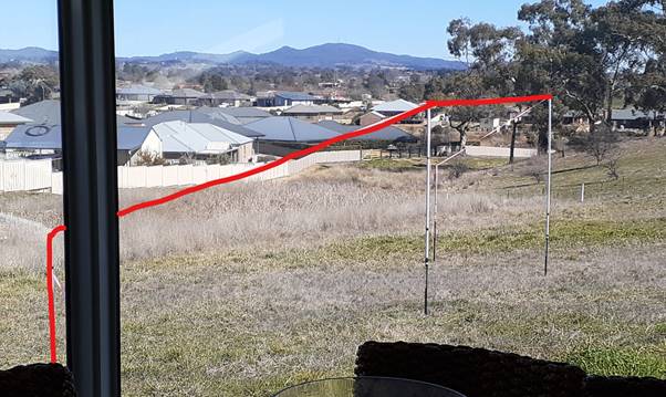
Figure 12 – View from Living Room of 37 Botanic
Way indicating view of Mt Canobolas will be fully retained.
Visual Privacy
The DCP sets the following Planning Outcome in regard to
Visual Privacy:
· Direct
overlooking of principal living areas and private open spaces of other
dwellings is minimised firstly by:
- building
siting and layout
- location of
windows and balconies
and
secondly by:
- design of
windows or use of screening devices and landscaping.
The proposed site layout and building design will provide
acceptable visual privacy for dwellings within the development and those on
adjoining parcels in accordance with the DCP due to the following:
· The proposed
dwellings will primarily overlook their associated private open space areas and
front garden/communal garden areas.
· There will be no
interface between proposed and existing dwelling’s windows and open space
areas due to the orientation and attached design of the buildings.
· Perimeter and
internal fencing and retaining walls will be installed of sufficient height to
minimise overlooking.
· Finished ground
levels have been designed to be similar or be lower than the respective
neighbours, and will not result in overlooking.
Acoustic Privacy
The DCP sets the following Planning Outcome in regard to
Acoustic Privacy:
· Site layout and
building design:
- protect
habitable rooms from excessively high levels of external noise
- minimise the
entry of external noise to private open space for dwellings close to major
noise sources
- minimise
transmission of sound through a building to affect other dwellings.
Proposed Dwellings 1-6 have been designed with their garages
attached rather than their habitable spaces, thus minimising noise transfer
between these units. The rear attached dwellings have habitable bedrooms of the
units adjacent to one another, but can be constructed in a way that minimises
noise disturbance between each unit. These details will be assessed during
Construction Certificate stage, ensuring compliance with the BCA/NCC. The
proposed development has been laid out in a way that it is not expected
neighbouring dwellings will be impacted by sound transmission over and above
usual residential levels.
Concerns have been raised in relation to noise generated
from waste storage and collection, however it is considered that noise
generated from these activities will not be dissimilar to other residential
development in the area, where it is expected that there will be some noise disturbance
to the area on waste collection days. Road noise impacts are assessed in the
“Likely Impacts” section later in this report.
Overall, it is considered that the proposed development
achieves the planning outcomes of the DCP in terms of acoustic privacy.
Security
The DCP sets the following Planning Outcomes in regard to
Security:
· the site layout
enhances personal safety and minimises the potential for crime, vandalism and
fear
· the design of
dwellings enables residents to survey streets, communal areas and approaches to
dwelling entrances.
The proposal is considered acceptable in regards to safety
and security as follows:
· the design of the
dwellings will offer reasonable opportunities for surveillance of Lantana
Place, the internal driveway, communal areas, front yards, and private open
space areas
· the site has
reasonable access control due to internal garages and perimeter and internal
fencing
· the landscape
design has been amended so that it will not restrict sight lines.
It is noted that no external lighting is proposed as part of
the site design, and is considered necessary for night time safety. A condition
of consent is recommended that lighting is installed, and is consistent with
the applicable standards to ensure glare does not impact on adjoining
neighbours.
Circulation and Design
The DCP sets the following Planning Outcome in regard to
Circulation and Design:
· accessways and
parking areas are designed to manage stormwater
· accessways,
driveways and open parking areas are suitably landscaped to enhance amenity
while providing security and accessibility to residents and visitors
· the
site layout allows people with a disability to travel to and within the site
between car parks, buildings and communal open space.
Stormwater management has been engineered down the driveway,
and full details will be assessed during Construction Certificate stage, as
discussed previously in the LEP section of this report. Amended landscaping has
been reviewed in terms of suitability to the site, climate, and for amenity,
and is discussed in detail later in the DCP assessment.
Proposed Dwellings 1-6 will have direct frontage and
separate access to Lantana Place, as well as internal garages providing direct
access to their respective car parking spaces. Reverse egress to the street
will be required for these dwellings, and sufficient manoeuvring area will be
available within the driveway area and roadway, which is considered acceptable
in this case.
The rear dwellings will enter and exit the site in a forward
gear, where sufficient area is provided at the rear of the site for reverse
manoeuvres from carports and visitor spaces, onsite turning, and forward egress
up the driveway. Council’s Development Engineers consider that part of
the driveway needs to be widened to render it sufficient for the 4 rear
dwellings, where an extended double width entry will allow two-way passing of
cars (B85 vehicles) (i.e. entering vehicles can stop and wait at the top if
another vehicle is exiting up the driveway).
Internal roadways for residential development of this scale
are not required to accommodate access and manoeuvring for service vehicles.
Notwithstanding this, the proponent will need to enter into a run-cost
agreement for the collection of waste, and the design of the road and driveway
need to be designed and constructed in accordance with the Orange
Development and Subdivision Code and NSW Fire Brigades Guidelines for
Emergency Vehicle Access.
Conditions of consent are recommended in regards to the
above matters. Overall, the proposal meets the planning outcomes for
circulation design.
Car Parking
The DCP sets the following Planning Outcomes in regard to
Car Parking:
· Parking
facilities are provided, designed and located to:
- enable the
efficient and convenient use of car spaces and access ways within the site
- reduce the
visual dominance of car parking areas and access ways.
· Car parking is
provided with regard to the:
- the number and
size of proposed dwellings
- requirements
of people with limited mobility or disabilities.
Pursuant to Chapters 7 (Residential Development) and 15 (Car
Parking) of the DCP 2004, onsite parking is required for 1 bedroom dwellings at
a rate of 1.0 space per unit, 2 bedroom dwellings at a rate of 1.2 spaces
per unit, and visitor parking at a rate of 0.2 space per unit. Based on 10
dwellings (four x 1 bedroom and six x 2 bedroom), the proposed development will
require 13.2 (i.e. 14) car parking spaces.
The proposal provides 20 car parking spaces for the
development, exceeding the requirements of the DCP as follows:
· six (6) single
garages, one for each of Dwellings 1-6
· four (4) carports,
one for each of Dwellings 7-10
· four (4) onsite
visitor parking spaces to the rear
· six (6) onsite
tandem spaces adjacent to the single garages for Dwellings 1-6 are also
available, although not technically required in terms of minimum numbers.
Private Open Space
The DCP sets the following Planning Outcomes in regard to
Private Open Space:
Private open space is clearly
defined for private use.
· Private open
space areas are of a size, shape and slope to suit the reasonable requirements
of residents including some outdoor recreational needs and service functions.
· Private open
space is:
- capable of
being an extension of the dwelling for outdoor living, entertainment and
recreation
- accessible
from a living area of the dwelling
- located to
take advantage of outlooks; and to reduce adverse impacts of overshadowing or
privacy from adjoining buildings
- orientated to
optimise year round use.
Private open space for the proposed dwellings will generally
comply with the DCP Guidelines as follows:
· Each
of the proposed dwellings will be provided with open space that complies with
the minimum requirement in terms of area (i.e. 50% of the gross floor area of
the dwelling):
|
Proposed
Dwelling
|
GFA
(m2)
|
POS
Required (m2)
|
POS
Provided (m2)
|
DCP
Compliance
|
|
Dwelling
1
|
67.78
|
33.89
|
112.91
|
Yes
|
|
Dwelling
2
|
68.22
|
34.11
|
220.91
|
Yes
|
|
Dwelling
3
|
68.22
|
34.11
|
127.10
|
Yes
|
|
Dwelling
4
|
68.17
|
34.08
|
107.26
|
Yes
|
|
Dwelling
5
|
68.22
|
34.11
|
90.07
|
Yes
|
|
Dwelling
6
|
68.22
|
34.11
|
106.53
|
Yes
|
|
Dwelling
7
|
48.48
|
24.24
|
99.64
|
Yes
|
|
Dwelling
8
|
48.48
|
24.24
|
90.11
|
Yes
|
|
Dwelling
9
|
48.48
|
24.24
|
89.06
|
Yes
|
|
Dwelling
10
|
48.48
|
24.24
|
256.89
|
Yes
|
· Private open space
for each dwelling will have a minimum dimension of 3m and will accommodate a 5m
by 5m area.
· Private open space
for the dwellings will be located behind the building line, will be fully
fenced for privacy, and will be accessed from a main living room area.
· As
outlined previously, the solar access to each area of private open space on the
winter solstice is considered satisfactory.
Open Space and Landscaping
The DCP sets the following Planning Outcomes in regard to
Open Space and Landscaping:
· the site layout
provides open space and landscaped areas which:
- contribute to
the character of the development by providing buildings in a landscaped setting
- provide for a
range of uses and activities including stormwater management
- allow cost
effective management.
· the landscape
design specifies landscape themes consistent with the desired neighbourhood
character; vegetation types and location, paving and lighting provided for
access and security
· major existing
trees are retained and protected in a viable condition whenever practicable through
appropriate siting of buildings, access ways and parking areas
· paving is
applied sparingly and integrated in the landscape design.
Landscape plans have been submitted in support of the
proposal. The original landscape plan included a pedestrian access ramp down
the driveway to the rear part of the site, which the applicant deemed
unnecessary, and subsequently deleted. An amended plan removed the ramp,
however concerns were raised by staff in regards to landscaping beds being
provided in areas of the site intended be adopted as part of the public road
(road reserve areas), landscaping in areas required to be clear of obstacles
for vehicular sightlines, and inappropriate landscaping species in the shaded
retaining wall area to the rear of the site, adjacent to the visitor parking
spaces. In particular, while the spacing between each level of the retaining
walls would be adequate to establish plants, a small tree growing to 5m in
height planted on the top/highest level of the retaining walls would overshadow
the plants to the south/on lower levels of the retaining wall, and they would
receive insufficient sunlight to fully prosper.
A further amended plan has been submitted to Council, and is
considered adequate in terms of species, climate, sightlines, softening of the
development into the surrounds, contributing to vegetation in the area, provide
privacy buffering, etc. Notwithstanding this, it is considered that street
trees would further improve the visual appearance of the development, and
provide for some canopy and additional softening in a street that is currently
lacking in trees. A condition of consent is recommended, requiring a minimum of
three (3) street trees to the satisfaction of Council’s Manager City
Presentation.
Stormwater
The DCP sets the following Planning Outcomes in regard to
Stormwater:
· Onsite drainage
systems are designed to consider:
- downstream
capacity and need for onsite retention, detention and re-use
- scope for
onsite infiltration of water
- safety and
convenience of pedestrians and vehicles
- overland flow
paths.
· Provision
is made for onsite drainage which does not cause damage or nuisance flows to
adjoining properties.
Stormwater management of the development has been discussed
in the LEP assessment section earlier in this report. Subject to the
recommended stormwater conditions of consent, stormwater management will be
adequate and in accordance with the DCP.
Erosion and
Sedimentation
The DCP sets the following Planning Outcome in regard to
Erosion and Sedimentation:
· Measures
implemented during construction to ensure that the landform is stabilised and
erosion is controlled.
An erosion and sediment control plan will be required in
conjunction with the engineering design plans for the development. A condition
is recommended in relation to this matter.
DEVELOPMENT CONTRIBUTIONS
Section 7.11 Development Contributions
Development contributions are
applicable to the proposed development, pursuant to Orange Development
Contributions Plan 2017 (North West Orange Area) as follows:
|
Open
Space and Recreation
|
Six x 2
bedroom dwellings @ $2,273.36 plus four x 1 bed dwellings @ $1,679.68, less
1 x
standard lot @ $3,982.01
|
16,376.90
|
|
Community
and Cultural
|
Six x 2
bedroom dwellings @ $659.27 plus four x 1 bed dwellings @ $487.12, less
1 x
standard lot @ $1,154.78
|
4,749.32
|
|
Roads
and Traffic Management
|
Six x 2
bedroom dwellings @ $3,091.82 plus four x 1 bed dwellings @ $2,473.46, less
1 x
standard lot @ $5,256.12
|
23,188.60
|
|
Local
Area Facilities
|
Six x 2
bedroom dwellings @ $3,693.00 plus four x 1 bed dwellings @ $2,728.57, less
1 x
standard lot @ $6,468.63
|
26,603.70
|
|
Plan
Preparation & Administration
|
Six x 2
bedroom dwellings @ $288.79 plus four x 1 bed dwellings @ $213.26, less
1 x
standard lot @ $505.86
|
2,079.92
|
|
TOTAL:
|
|
$72,998.40
|
These figures are indexed quarterly, in accordance with the
Plan. Conditions are included on the attached Notice of Approval requiring
payment of these development contributions prior to the issuing of a
Construction Certificate.
Section 64 Headworks Charges
Pursuant to the Local Government Act 1993 and the Water
Management Act 2000 headworks charges for water supply, sewerage, and
stormwater also apply to the proposal.
The contributions are based on six
x 2 bedroom dwellings and four x 1 bedroom dwellings (the existing allotment
has a credit equivalent to a single 3 bedroom dwelling which will be applied at
the time of payment). Conditions are recommended requiring payment of these
contributions.
PROVISIONS PRESCRIBED BY THE
REGULATIONS s4.15(1)(a)(iv)
Demolition of a Building (clause 92)
The proposal does not involve the demolition of a building.
Fire Safety Considerations
(clause 93)
The proposal does not involve a change of building use for
an existing building.
Buildings to be Upgraded
(clause 94)
The proposal does not involve the rebuilding, alteration,
enlargement or extension of an existing building.
BASIX Commitments (clause 97A)
A satisfactory BASIX certificate has been submitted with the
application.
THE LIKELY IMPACTS OF THE
DEVELOPMENT s4.15(1)(b)
Neighbourhood Amenity
The proposed development will provide for a continuation of
residential land use, albeit in a more compact form, and will not alter the
function of the neighbourhood. The proposal will provide and retain a
reasonable standard of residential amenity for the proposed dwellings and
existing dwellings on adjoining lands in respect of solar access, privacy,
visual appearance, neighbourhood character, acoustic privacy, etc.
In terms of waste bins, it is considered that each dwelling
has ample room for the storage of three waste bins (general waste, garden
waste, and recycling). Collection can take place on the street for proposed
Dwellings 1-6, which each have street frontage and sufficient space for the
placement of bins on collection days. A communal collection area is proposed to
the rear for proposed Dwellings 7-10, and a private run-cost agreement will
need to be entered into for the collection of these bins. A condition of
consent is recommended to this effect, as well as ensuring this collection area
is only used on collection days, and bins for Dwellings 7-10 are not
placed directly on the street on collection days.
Conditions of consent are recommended to ensure than
neighbourhood amenity for existing and future dwellings is maintained to a
reasonable standard. As discussed in the main body of this report, and subject
to these conditions, the proposed multi dwelling housing development is
unlikely to have adverse impacts on neighbourhood amenity.
Visual Impacts
The visual impacts of the proposed site layout and building
design are considered acceptable, as outlined in the foregoing sections of this
report. Conditions of consent are recommended in relation to landscaping and
street trees, to ensure that a satisfactory level of visual amenity is achieved
in the streetscape and wider area.
Overall, the proposed development has been designed to an
acceptable standard for this locality, and adverse visual impacts are unlikely.
Road Noise Impacts
The site will be exposed to some road noise from the
Northern Distributor Road (NDR), particularly proposed Dwellings 1 and 2, which
are in closer proximity to the NDR. An assessment of the impacts of road noise
has been undertaken by Council staff against all relevant policies, including
“The NSW Road Noise Policy (RNP); and Roads and Maritime Services (RMS)
– “Noise Criteria Guideline” and “Noise
Mitigation Guideline”.
The original development of the Botanic Way/Gardens Estate
precinct carried out detailed noise assessments and recommended noise
mitigation measures. As a result, an engineered noise mound was constructed
between northern most lots and the NDR to provide sound attenuation for future
dwellings. This mound includes a lapped and capped timber fence, is planted
with vegetation and irrigation, with the land being dedicated as a Council
reserve. Since the original noise reporting was carried out, NDR traffic
volumes have increased, and are higher than originally expected, and thus noise
volumes are also higher. Notwithstanding this, the existing mound provides for
effective noise mitigation for current levels. Part of this mound extends from
the reserve to the south into the subject site, to provide sound attenuation
for dwellings to the east.
It is proposed to remove some of the mound from within the
subject site to allow for the construction of the proposed development, as
shown on the attached plans. The applicant provides the following comments in
this regard:
“It is intended to
extend the noise and mound barrier and existing acoustic fence along Lot 57 DP
1122907 (public reserve) to the boundary with Lot 4 DP 1065251, thus providing
similar noise mitigation enjoyed by the existing dwellings on Lantana Place for
the subject site. It is also intended to construct a dividing fence between
Units 1 and 2 which shall help with any potential noise impact. Given the
placement of the proposed dwelling on the subject site and extension of the
acoustic fence it is not anticipated traffic noise impact
shall increase at the existing dwelling on Lot 56 (No. 6 Lantana Place) and
noise impact can be effectively managed for the proposed development”.
The submitted drawings propose the sound mound to be reduced
back, but still extend partly into the subject site. This is not considered
reasonable for future occupants of proposed Dwellings 1 and 2 in terms of
residential amenity. Council’s Acting Director Development Services,
Environmental Health officer, and Manager Engineering have reviewed the proposal
and recommend that the mound be removed from the subject site, and only be
contained within Council’s adjacent reserve (i.e. amended so that none of
the mound is located within the subject lot), and be extended along the full
length of the adjacent reserve. It is also recommended that a 2.5m high solid
fence, in a dark recessive colour (such as Colorbond Monument), be installed
along the western boundary from the top north-western corner of the subject
site, to the front building line of proposed Dwelling 1, to ensure
effective sound attenuation is provided in lieu of the sound mound to be
removed from the subject site. This will protect the proposed dwellings, as
well as the adjacent neighbour to the east at number 8 Lantana Place.
A condition of consent is recommended
to this effect, with an option to provide a noise report demonstrating that a
lower height fence would achieve acceptable attenuation, as well as a provision
that the fence could be lowered to a standard 1.8m high fence once the sound
mound is extended along the NDR to the west following any future development of
the adjacent western lot.
Further conditions of consent are also recommended to ensure
the design and construction details of proposed Dwellings 1 and 2 will comply
with the relevant guidelines for road noise through a noise assessment report;
and that the proponent carries out changes to the mound, and its vegetation and
irrigation, in consultation with Council’s Development Engineer and
Manager City Presentation. A suitable boundary fence can then be erected along
the northern boundary of the subject site to ensure the privacy of future
occupants.
Overall, subject to the above recommended conditions of
consent, it is considered that the proposed development and its immediate
neighbours are unlikely to be affected by adverse road noise impacts from the
NDR.
Traffic and Parking Impacts
The proposal is considered to be satisfactory in terms of
traffic impacts. Traffic generation will increase in the street as a result of
the development, however further development of the vacant lot and future
neighbouring lots to the west were anticipated when Lantana Place was
constructed. As such, traffic volume increases for residential development are
well within the existing road capacity. The extension of Lantana Place to the
west will be carried out in accordance with Council’s standards so that
it can be adopted as a local/public road. The proposed development will not
exceed environmental goals for peak volumes on local streets, nor will it adversely
impact on pedestrian safety.
As outlined previously in this report, site accesses and
onsite manoeuvring areas are appropriate subject to minor changes, and will be
designed to accommodate standard vehicles associated with the development.
Onsite car parking complies with the requirements of the DCP, and as such
adverse impacts on street parking are not anticipated.
Overall it is considered that traffic and parking impacts
resulting from the proposed development are unlikely.
Cumulative Impacts
The proposed dwellings will complement the neighbourhood
built form in respect of bulk, design features, and external finishes. The
proposed development will not reduce the open space, solar access, or privacy
afforded to neighbouring properties. Similarly, the proposed site layout and
building design will provide a reasonable standard of residential amenity for
the future occupants of the dwellings in terms of open space, solar access, and
privacy. The development will contribute to the diversity of housing forms in
the precinct in a manner that is consistent with the
neighbourhood character, and is consistent with the LEP objectives for the
zone, as set out in the main body of this report.
Overall, the proposal is unlikely to result in adverse
cumulative impacts.
Environmental Impacts
The subject land is contained within a developing
residential precinct and comprises vacant, cleared land. Significant
vegetation, threatened species or ecological endangered communities or their
habitats are unlikely to be present. The adjoining property to the west
contains protected Yellow Box trees and the proponent undertakes to minimise
soil disturbance within the area below the existing tree canopy as much as
practical during construction. Conditions of consent are recommended in regards
to this matter, as discussed earlier in this report.
Other than the adjacent biodiversity sensitivity, the site
is not in proximity to any mapped sensitive waterways, drinking water
catchment, or other environmentally sensitive areas. Sediment control measures,
as required by recommended conditions, will prevent loose dirt and sediment
escaping the site and polluting downstream waterways. Environmental protection
recommendations made by the applicant’s consultants in submitted reports,
assessments, and investigations are also recommended as conditions of consent.
Overall, and subject to conditions of consent and
preventative measures undertaken during construction, the proposal is unlikely
to result in adverse environmental impacts.
THE SUITABILITY OF THE SITE
s4.15(1)(c)
The subject land is suitable for the development due to the
following:
· the proposed multi
dwelling housing development is permitted on the subject land R1 General
Residential zoning
· the site is of
sufficient area and dimensions to accommodate multi dwelling housing and
provide a suitable standard of residential amenity
· the site has
direct frontage and access to public street
· there is no known
contamination on the land
· all utility
services are or can be made available and adequate
· the site is not
subject to known natural hazards
· the subject land
has no biodiversity or habitat value, and the adjacent protected trees can be
protected during construction
· the site is not in
close proximity to any mapped waterway, drinking water catchment, or other
sensitive area
· the site is not
known to contain any Aboriginal, European or archaeological relics.
ANY SUBMISSIONS MADE IN
ACCORDANCE WITH THE ACT s4.15(1)(d)
The proposed development is defined as "advertised
development" under the provisions of the DCP. The application was
advertised for the prescribed period of 14 days and at the end of that period
47 submissions were received, 31 opposing the proposed development, and 16 in
support. Two petitions were also received, signed by a total of 125
people, some of whom were also submitters. The issues raised in the submissions
are outlined below, and considered here or in the foregoing sections of this
report.
Oppose Affordable/Cheap Housing
- “unwanted
trouble” and existing problems with nearby social housing in the area
- out
of character
- no
infrastructure for “cheap rental” housing
- social
issues.
Staff comments: the proposed development is defined
as ‘multi dwelling housing’ under the LEP, and the State Government
has identified that affordable housing is required throughout NSW pursuant to
SEPP 70. The proposal is consistent with the general principles set out for
affordable housing in this SEPP, where reasonable amenity can be provided and
maintained, and the development fits into the character of the area, which is
discussed below. Servicing is or can be made sufficient for the proposed
development.
Character
- “ruin”
the quiet and calm nature of the area
- does
not match the “low density” and “semi-rural” nature of
surrounding area
- generally
does not match/complement the character of the area
- proposed
carports do not match character of dwellings with attached garages
- proposed
dwellings are not the same as surrounding houses and “stand-out”
- covenants
on neighbourhood state homes within the estate need to be brick veneer
construction with an attached garage – does this lot have the same
covenant?
- adverse
amenity impacts out of character – Management Plan should be submitted
with the Development Application.
Staff comments: As discussed in the DCP
“Neighbourhood Character” assessment earlier in this report, the
proposed development fits in with the character of the area, and the other DCP
assessment sections demonstrate that adverse neighbourhood/residential amenity
impacts are unlikely. As established by the Courts, a proposal does not have to
be the ‘same’ to be consistent with the surrounding area, and it is
considered that the visual appearance, landscaping, siting, etc. of this
proposal are all consistent with the neighbourhood. It is not considered that
the proposed dwellings will ‘stand out’ from the surrounding
houses, as, although more compact being duplexes, they are similar in scale,
form, colours, materials, detailing, etc. to their neighbours. The fact that
they are duplexes will be visually indiscernible in the streetscape and wider
area, except on close inspection. Furthermore, given the level of landscaping
proposed, and the additional street trees required, the proposed development is
likely to improve the visual appearance of the streetscape. Pursuant to
Section 1.9A of the EP&A Act, covenants placed on titles by developers in
relation to materials are not relevant to Council’s assessment of the
proposal, where instead the DCP requirements have been taken into
consideration, as required by Section 4.15 of the EP&A Act.
Density/over-development
- this
is a “high-density” development - not suitable for the area
- density
too high compared with other smaller unit complexes in the area
- already
many dual occupancy and unit developments in the area (e.g. to South),
increasing traffic, noise, people, cars, etc.
- “…potential
of an additional 60 people living in this small area”
- density
is “3 times” higher than other development in the area
- previous
indicative subdivision plans for the area showed only four lots in the location
of the subject lot, whereas the development proposes 10 units
- does
not match “zoning” of the area.
Staff comments: The density is not considered to be
higher than surrounding development, which although predominately made up of
single dwelling houses, also contains dual occupancies and unit development.
Furthermore, the relative density is much lower than the surrounding area, with
a 16% site coverage proposed, where most new single dwellings range between
30-60% site coverage. Indeed the DCP allows up to 60% site coverage for a
single dwelling. Previous indicative subdivision layouts are not relevant to
this application, which does not propose subdivision. Given the breakdown of
the 10 proposed dwellings, being 6 x 2-beds and 4 x 1 x-beds, the development
is likely to be occupied by between 16‑32 people, not up to 60 as
suggested by submitters. The surrounding road and servicing network is adequate
for the minor increased demand, and Lantana Place will be extended to the
appropriate road standards for the anticipated volume.
As set out in the LEP sections of this report, the zoning
allows for multi dwelling housing on this site, where it well exceeds the
minimum area required. The end use of the proposed buildings are residential
dwellings, which matches all surrounding building uses, also residential
dwellings.
Visual Appearance
- carports
should be garages (poor outlook from Callistemon Pl and Brooklands Drive)
- high
retaining walls can be seen from surrounding neighbourhood
- duplex
design creates “substantial” street frontage
- lack
of details for retaining wall – design, height, appearance, etc.
Staff comments: As discussed in the DCP
“Neighbourhood Character” and “Building Appearance”
assessments earlier in this report, it is considered that the proposed
development fits in with the character of the area and provides for an
acceptable visual appearance. Additional information has been provided in
relation to walls and fences, and the ‘high’ retaining walls are
internal to the site and will not be readily visible from neighbouring
properties as the proposed dwellings and landscaping will buffer views. Perimeter
walls and fencing are moderate in height, and overall the development is
generally in-line or lower than neighbours. The DCP requires parking to be in
the form of ‘covered spaces’ and a carport is considered as such.
Although carports are different to the usual attached garage in the area, they
meet the DCP parking requirements, and have been designed to have an adequate
visual appearance.
Those dwellings fronting Lantana
Place each have an attached garage, and have been designed to an adequate
standard to not dominate the streetscape. The carports are located to the rear
and will not be visible from the street. Boundary fencing will ensure they are
not visually dominate when viewed from the wider surrounding area. Furthermore,
landscaping will soften the built form into the environment, and will provide a
higher standard and greater quantity of landscaping compared with neighbouring
residential land in the area.
Views/Vistas
- impacts
on views to Mount Canobolas.
Staff comments: This matter has been discussed in the DCP
“Views” section of this report, where it was concluded that there
would be some moderate view loss impacts, however they are considered
reasonable impacts, and the proposed development has been designed in a way to
provide for some view sharing by using existing levels where possible, low
profile roofs, view corridors between buildings and vegetation, etc.
Shadowing
- high
retaining walls will overshadow neighbours
- Units
5 and 6 walls and fences will impact north facing living room and garden
(37 Botanic Way).
Staff comments: As discussed in the DCP
“Daylight and Sunlight” section of this report, the proposal
complies with the DCP requirements, and adverse impacts to neighbours are not
likely, as demonstrated in the attached shadow diagrams. It is
acknowledged that the original exhibited shadow diagrams did not show the
extent of shadowing to neighbouring properties, however, Council staff
requested this information and it was provided, demonstrating compliance.
Noise
- construction
noise not addressed and is a concern
- additional
occupancy in street means more people and traffic noise
- noisy
garbage trucks, bin storage, and wheeling bins up and down steep driveway
- removal
of earth banks (sound barrier) will increase noise pollution – not addressed
in application
- previous
consent requirements of sound barrier not addressed
- acoustic
report should be submitted.
Staff comments: Noise has been discussed in the DCP
“Acoustic Privacy” and “Likely Impacts” sections of
this report, where it was concluded that the existing sound mound can be
modified and sound fencing can be installed to ensure adequate sound
attenuation for future occupants of the proposed dwellings, as well as existing
dwellings. Increased NDR traffic volumes and higher traffic noise volumes have
been taken into account in this assessment. Although additional population will
result in additional noise, it was always anticipated that this vacant lot
would contain residential development, and noise from the proposed dwellings is
unlikely to be over and above usual residential noise levels.
A run-cost agreement will need to be
entered into for waste collection, and it is considered reasonable that there
will be some noise pollution in the wider area on collection days, as with collection
arrangements for the current existing dwellings in the street and area.
Safety/Crime
- increased
density means increased crime
- no
street lighting proposed/night time lighting of development
- increased
traffic has safety impacts of children playing in front yards
- snakes
and rats in the wetlands
- drowning
hazard of on-site detention basin
- creates
hazardous habitat for mosquitos, frogs, birds and snakes
- anti-social
and unlawful behaviour affecting safety and security
- high
retaining walls – safety risk and should have a risk mitigation method in
place
- no
provision for emergency vehicles
- the
area has a “very real fire hazard”.
Staff comments: Potential safety impacts relevant to
this proposal can be addressed by conditions of consent, and have been
discussed in the DCP “Security” section of this report. Increased
population and traffic has always been anticipated for this street and site,
and it is not considered that the development of this site would result in
increased crime, or traffic or pedestrian safety. The retaining walls are not
considered particularly high or dangerous, where the highest wall is part of a
tiered arrangement rather than one high wall. It is considered that the
proposed development does not increase the potential for snake, rat, and other
local fauna, any more than other development in the area, and is not relevant
to this assessment. Emergency vehicle access and fire safety will be assessed
in detail at the Construction Certificate stage.
Traffic
- increase
in traffic volumes – number of occupants, plus visitors
- increase
in pressure on roads/congestion
- increased
parking on-street, reducing available road width
- no
visitor parking for units facing the street (units 1-6)
- traffic
safety concerns from increased volumes
- pedestrian
safety concerns – no footpaths
- parking
on-street could obstruct emergency vehicles – no provision for emergency
vehicles within site
- “unfinished”
cul-de-sac – no bell end for turning, how do units 3 and 4 reverse out,
etc.
- “kink”
in driveway – potential access issues
- traffic
count numbers based on Guide to Traffic Generating Developments rather than
actual traffic counts – should have traffic report by traffic engineer
- insufficient manoeuvring area for
unit 10 to reverse out of driveway.
Staff comments: As discussed
in the DCP assessment and “Likely Impacts” sections of this report,
traffic impacts are unlikely, where Lantana Place and the surrounding road
network has been designed for an increased volume of traffic, having
anticipated increased population as lots are developed. Lantana Place will be
extended to the same appropriate standard. Although Lantana Place will be
‘unfinished’ without a turning circle, Council’s Development
Engineers consider this sufficient in the interim, until such time as it is
further extended into the neighbouring future subdivision. The proposal
provides sufficient on-site parking for all dwellings and their visitors.
Although some residents and visitors may choose to park on the street, they can
do so provided they are legally parked, and this situation is no different to
any other residential development in the area and wider City. Drawings have
been amended to provide for sufficient on-site manoeuvring, and ingress and
egress, and the driveway to the rear will require further amendments to render
it sufficient. Conditions of consent are recommended providing for footpaths in
the extended street.
Privacy
- Privacy
impacts to adjoining neighbours
- Privacy
impacts in general from number of units proposed
- Overlooking
to neighbour to South
Staff comments: This matter has been discussed in the
DCP “Visual Privacy” section of this report, where it was concluded
that finished ground and floor levels, and boundary fencing will ensure
adequate visual privacy to neighbouring dwellings, as well as between proposed
dwellings.
Waste
- increase
in pressure on waste services
- number
of bins to be serviced on the street unachievable
- manoeuvring
of waste collection vehicles difficult
- concerns
that bins will not be taken to and from road for collection/storage
- gradient
of driveway too steep for rear units to easily take bins to and from the street
- noise
impacts of taking bins up and down driveway
- waste
management needs to be addressed further
- odour
and noise impacts
- bin
store directly adjacent to neighbouring residential dwellings – odour,
noise, etc.
Staff comments: These matters have been addressed in
various parts of the report, where it is considered that waste storage and
collection impacts will be no greater than anticipated for residential
development of the subject land, or neighbouring land. It is considered
acceptable that proposed Dwellings 1-6 place their bins directly on the street
on collection days, but the rear proposed Dwellings 7-10 will require a
run-cost agreement for private waste collection. As such manoeuvring for
service vehicles is not required on the site. There is ample space available on
the site for the storage of resident’s bins. The proposed communal waste collection
area for the rear units is for collection rather than storage, therefore
impacts to the immediate adjacent neighbour will be limited to one day a week.
It is acknowledged that some
residents fail to bring their bins in following collection, or store or use
their bins in ways that create impacts to neighbours, however the potential for
this is no greater for the proposed development than any other residential
development. It will be the responsibility of the land owner/manager to ensure
impacts are minimised.
Subdivision staging
- should
not be developed until adjacent land (to west) is subdivided/developed
- does
not match original Gardens Estate subdivision plans/outline which showed
three/four separate blocks – should be separate blocks for larger homes
- “such
housing” should be constructed in an area first so other prospective
residents/buyers are aware of the social housing developments.
Staff comments: The proposal does not involve
subdivision of the land, and as such previous indicative subdivision layouts
are not relevant to this application. Any future subdivision of the land will
need to be in accordance with the subdivision provisions of the DCP. There is
no requirement for affordable housing to be built prior to any other
development, and in doing so would render the integration of affordable housing
development into communities more difficult, and inconsistent with the
Affordable Housing SEPPs.
Servicing
- can
the sewer system handle the increase in development?
- can
all other servicing cope with the increased connections – not adequately
addressed in application
- unsafe
and very poor pedestrian access to facilities (shops, public transport,
medical, etc.)
- too
far from CBD for social housing
- no
footpaths or cycle paths
- nearby
bus top is not a “formal designated public bus stop” therefore is
not a reliable form of public transport
- rainwater
tanks should be provided and made mandatory.
Staff comments: This matter has been addressed in the
main body of the report, where urban services are or can be made available and
adequate for the proposal. The upgrading and costs of any services required is
the responsibility of the proponent, in consultation with the relevant
authority. It is acknowledged that the development is not in close/walking proximity
to shops, medical services, etc. however this is no different to all other
existing dwellings in the area, and public transport to these services is
available. There is no mandated requirement for rainwater tanks, where
residential developments need to meet the NSW Government BASIX energy and water
efficiency targets. As noted earlier in the report, a satisfactory BASIX
certificate has been submitted with the application.
Environmental Impacts (Trees,
biodiversity, Flooding/Stormwater, etc.)
- loss
of existing trees on the site – affect existing fauna
- mapped
as high biodiversity area and not addressed (STAFF NOTE: site is not mapped,
but near to a high biodiversity area)
- impacts
to groundwater quality and quantity
- flood
risk from run-off to units 7 and 8
- increased
run-off to ecosystem below – environmental impacts to species in
waterways and downstream high biodiversity area
- not
adequately addressed in application, should submit a biodiversity assessment
report, etc.
- trees
will drop leaves into neighbour’s gutters.
Staff comments: As discussed in the main body of this
report environmental impacts can be adequately mitigated through conditions of
consent. Potential impacts will generally be during construction only, and the
site does not contain any mapped environmental sensitivity. A biodiversity
assessment was provided with the application, and was amended to include the
EEC trees on the adjoining western site, as discussed in the BC Act assessment
earlier in this report. Stormwater run-off is considered adequate, as discussed
throughout the report. Proposed landscaping has been amended, and is considered
adequate.
Alternative locations
- this
type of development should be built in a “more suitable” area such
as a new housing estate
- should
be built somewhere else.
Staff comments: Council has been requested to carry
out an assessment of this particular proposal on the subject land. The EP&A
Act and Regulations do not require local development applications to consider
alternatives, and as such Council’s assessment does not need to address
this matter.
Affects land value
- will
reduce land value
- proposal
has already reduced land value in the area.
Staff comments: Land value is not a planning
consideration, and as such is not relevant to this assessment.
Human/Civil Rights
- respecting
the “basic human rights” of “ordinary citizens”.
Staff comments: It is unclear what is meant by this
comment, however it is considered that the proposal will have a positive impact
on the wider area by providing a mix of residential dwelling types.
Misuse of Public Funds
- costs
of construction on this site are high therefore is not “good value”
for tax payers of NSW.
Staff comments: This matter is not relevant to
Council’s assessment of the application.
Council’s Declaration of
Planning and Development Assessment Procedures and Protocols (2010) sets
out that where at least five submissions objecting to a development
application, and where those issues are capable of negotiation, a meeting will
be offered to all parties in an attempt to resolve issues and find compromise
prior to the application being determined. It is considered that all reasonable
and planning related objections raised can be mitigated through conditions of
consent, as set out in the main body of this report, and as such a negotiation
meeting was not considered necessary in this case.
PUBLIC INTEREST
s4.15(1)(e)
The proposal is not inconsistent with any relevant policy
statements, planning studies, guidelines, etc. that have not been considered in
this assessment.
SUMMARY
The proposed development is permissible with the consent of
Council. The proposed development complies with the relevant aims, objectives
and provisions of Orange LEP 2011 (as amended) and DCP 2004. A
Section 4.15 assessment of the development indicates that the development
is acceptable in this instance. Impacts of the development are considered to be
within reasonable limit, consistent with applicable standards, and can be
addressed by appropriate conditions of development consent. Approval of the
application is recommended.
Attached is a draft Notice of Approval outlining a range of
conditions considered appropriate to ensure that the development proceeds in an
acceptable manner.
COMMENTS
The requirements of Council’s Environmental Health and
Building Surveyor, Engineering Development Section, and Manager City
Presentation are included in the attached Notice of Approval.
Attachments
1 Notice
of Approval, D19/50564⇩
2 Plans
- 23.08.19, D19/51287⇩
3 Submissions,
D19/35824⇩
Attachment 1 Notice
of Approval
|

|
ORANGE CITY COUNCIL
Development
Application No DA
141/2019(1)
NA19/ Container
PR25617
|
NOTICE OF DETERMINATION
OF A DEVELOPMENT
APPLICATION
issued under the Environmental
Planning and Assessment Act 1979
Section 4.18
|
Development
Application
|
|
|
Applicant
Name:
|
Housing Plus
|
|
Applicant
Address:
|
C/- Barnson Pty Ltd
Unit 1, 36 Darling
Street
DUBBO NSW 2830
|
|
Owner’s
Name:
|
Mr KS Baker
|
|
Land
to Be Developed:
|
Lot 78 DP 1172183 -
Lantana Place, Orange
|
|
Proposed
Development:
|
Multi Dwelling
Housing (10 dwellings)
|
|
|
|
|
Building Code of
Australia
building
classification:
|
Class as determined
by certifier
|
|
|
|
|
Determination made
under
Section 4.16
|
|
|
Made
On:
|
3 September 2019
|
|
Determination:
|
CONSENT GRANTED
SUBJECT TO CONDITIONS DESCRIBED BELOW:
|
|
|
|
|
Consent to Operate
From:
|
4 September 2019
|
|
Consent to Lapse On:
|
4 September 2024
|
Terms of
Approval
The
reasons for the imposition of conditions are:
(1) To
ensure a quality urban design for the development which complements the
surrounding environment.
(2) To
maintain neighbourhood amenity and character.
(3) To
ensure compliance with relevant statutory requirements.
(4) To
provide adequate public health and safety measures.
(5) Because
the development will require the provision of, or increase the demand for,
public amenities and services.
(6) To
ensure the utility services are available to the site and adequate for the
development.
(7) To
prevent the proposed development having a detrimental effect on adjoining land
uses.
(8) To
minimise the impact of development on the environment.
Conditions
(1) The
development must be carried out in accordance with:
(a) Plans
numbered A001 Rev E, A002 Rev F, A003 Rev H, A004 Rev I, A005 Rev E, A006 Rev
G, A007 Rev F, A008 Rev F, A101-108 Rev E, A109 and A110 Rev C, prepared by
Beraldo Design, and dated Mar 2019 (18 sheets); Landscaping Plans, prepared by
House of Manuela, and dated 19.7.2019 (3 sheets); Engineering Plans numbered
C0482-C01 Rev A, C02 Rev C, C10 Rev C, C11 Rev A, C20 Rev C, C21 Rev A, and C30
Rev B, prepared by Barnson (7 sheets); and BASIX Certificate number 1009938M.
(b) statements
of environmental effects or other similar associated documents that form part
of the approval
as amended in
accordance with any conditions of this consent.
(2) All
building work must be carried out in accordance with the provisions of the
Building Code of Australia.
(3) A
sign is to be erected in a prominent position on any site on which building
work, subdivision work or demolition work is being carried out:
(a) showing
the name, address and telephone number of the principal certifying authority
for the work, and
(b) showing
the name of the principal contractor (if any) for any building work and a
telephone number on which that person may be contacted outside working hours, and
(c) stating
that unauthorised entry to the site is prohibited.
Any such sign is to be maintained while the
building work, subdivision work or demolition work is being carried out.
(4) In
the case of residential building work for which the Home Building Act 1989
requires there to be a contract of insurance in force in accordance with Part 6
of the Act, evidence that such a contract of insurance is in force is to be
provided to the Principal Certifying Authority before any building work
authorised to be carried out by the consent commences.
(5) Residential
building work within the meaning of the Home Building Act 1989 must not
be carried out unless the principal certifying authority for the development to
which the work relates (not being the council) has given the council written
notice of the following information:
(a) in
the case of work for which a principal contractor is required to be appointed:
(i) the
name and the licence number of the principal contractor, and
(ii) the
name of the insurer by which the work is insured under Part 6 of that Act,
(b) in
the case of work to be done by an owner-builder:
(i) the
name of the owner-builder, and
(ii) if
the owner-builder is required to hold an owner-builder permit under that Act,
the number of the owner-builder permit.
If arrangements for doing the residential
building work are changed while the work is in progress so that the information
under this condition becomes out of date, further work must not be carried out
unless the principal certifying authority for the development to which the work
relates (not being the council) has given the council written notice of the
updated information.
(6) Where any excavation
work on the site extends below the level of the base of the footings of a
building on adjoining land, the person having the benefit of the development
consent must, at the person’s own expense:
(a) protect
and support the adjoining premises from possible damage from the excavation,
and
(b) where
necessary, underpin the adjoining premises to prevent any such damage.
Note: This condition does not apply if
the person having the benefit of the development consent owns the adjoining
land or the owner of the adjoining land has given consent in writing to this
condition not applying.
|
PRIOR TO THE ISSUE OF A CONSTRUCTION
CERTIFICATE
|
(7) Prior
to the issuing of a Construction Certificate, plans shall be amended reducing
the pitch of the roofs of Dwellings 7-10 to a maximum of 22.5 degrees.
(8) Engineering
plans, showing details of all proposed work and adhering to any engineering
conditions of development consent, are to be submitted to, and approved by,
Orange City Council or an Accredited Certifier (Categories B1, C3, C4, C6)
prior to the issuing of a Construction Certificate.
(9) A
water and soil erosion control plan is to be submitted to Orange City Council
or an Accredited Certifier (Categories B1, C3, C4, C6) for approval prior to
the issuing of a Construction Certificate. The control plan is to be in
accordance with the Orange City Council Development and Subdivision Code and
the Landcom, Managing Urban Stormwater; Soils and Construction Handbook.
(10) The
development’s stormwater design is to include stormwater detention within
the development, designed to limit peak outflows from the land to the pre-existing
natural outflows up to the 100 year ARI frequency, with sufficient allowance in
overflow spillway design capacity to safely pass flows of lower frequency (that
is, a rarer event) without damage to downstream developments. Where
appropriate, the spillway design capacity is to be determined in accordance
with the requirements of the Dam Safety Committee.
The design of the detention storage is to be
undertaken using the ILSAX/DRAINS rainfall-runoff hydrologic model or an
approved equivalent capable of assessing runoff volumes and their temporal
distribution as well as peak flow rates. The model is to be used to calculate
the flow rates for the existing and post-development conditions. The developed
flows are to be routed through the proposed storage within the model so that
the outflows obtained are no greater than the flows obtained for the
pre-existing natural flows. A report detailing the results of the analysis,
which includes:
· catchment plan showing
sub-catchments under existing and developed conditions;
· schematic diagram of
the catchment model showing sub areas and linkages;
· tabulation detailing
the elevation, storage volume and discharge relationships; and
· tabulation for the
range of frequencies analysed, the inflows, outflows and peak storage levels
for both existing and developed conditions;
together with copies of the data files for the
model and engineering design plans of the required drainage system are to be
submitted to Orange City Council upon application for a Construction Certificate.
(11) Engineering
plans providing complete details of the proposed driveway and car parking areas
are to be submitted to Orange City Council or an Accredited Certifier
(Categories B1, C3, C4, C6) upon application for a Construction Certificate.
These plans are to provide details of levels, cross falls of all pavements,
proposed sealing materials, structural engineer’s details of the driveway
indicating compliance with the NSW Fire Brigades Guidelines for Emergency
Vehicle Access, proposed drainage works, and are to be in accordance with
Orange City Council Development and Subdivision Code. The driveway serving
units 7 – 10 shall have a minimum clear width of 6.0m for a distance of
10m from the Lantana Place kerb and be designed in accordance with NSW Fire
Brigades Guidelines for Emergency Vehicle Access.
The common driveway serving units 5 and 6 shall
be constructed at 90 degrees to the kerb alignment between the kerb and garage
doors.
(12) Proposed
lots are to be provided with interlot stormwater drainage, including those lots
abutting public land, where the surface of the entire lot cannot be drained to
the kerb and gutter at the lot frontage. A grated concrete stormwater pit is to
be constructed within each lot provided with interlot stormwater drainage.
Engineering plans for this drainage system are to be approved by Orange City
Council or an Accredited Certifier (Categories B1, C3, C4, C6) prior to the
issuing of a Construction Certificate.
(13) Stormwater
from the site is to be piped to the adjacent watercourse, where it is to be
discharged through a standard headwall with appropriate scour protection.
Engineering plans of this required drainage system are to be approved by Orange
City Council or by an Accredited Certifier (Categories B1, C3, C4, C6) and a
licence from the Department of Planning Infrastructure and Natural Resources
for work within 40 metres of the watercourse is to be submitted prior to the
issuing of a Construction Certificate.
(14) A
sewer access chamber and 150mm-diameter sewer junction is to be constructed
from Council’s existing main to serve the proposed development. Internal
sewer lines servicing the development from the sewer junction shall be
constructed as private sewer mains. Prior to a Construction Certificate being issued
engineering plans for this sewerage system are to be submitted to and approved
by Orange City Council.
(15) Payment
of contributions for water, sewer and drainage works is required to be made
at the contribution rate applicable at the time that the payment is made.
The
contributions are based on water supply headworks, sewerage headworks and
stormwater for 6 x two bedroom dwellings and 4 x one bedroom dwellings (the
existing allotment has a credit for a single 3 bedroom dwelling which will be
applied at the time of payment). A Certificate of Compliance, from Orange City
Council in accordance with the Water Management Act 2000, will be issued
upon payment of the contributions.
This Certificate of Compliance is to be
submitted to the Principal Certifying Authority prior to the issuing of a
Construction Certificate.
(16) A
water reticulation analysis is to be carried out by Orange City Council on any
proposed water reticulation system for the development. Engineering plans
of the water mains extension to the boundary of Lot 4 DP 1065251 are to be
submitted to and approved by Orange City Council prior to the issue of a
Construction Certificate.
The reticulation system is to be designed to
supply a peak instantaneous demand by gravity of 0.15 L/s/tenement at a
minimum residual head of 200kPa.
(17) A single common water
service and meter shall be located in the common driveway area of units 1 - 2
and units 3 – 10. Engineering plans of the water reticulation layout and
sizing are to be submitted to Orange City Council for approval prior to the
issuing of a Construction Certificate.
(18) An
approval under Section 68 of the Local Government Act is to be sought
from Orange City Council, as the Water and Sewer Authority, for alterations to
water and sewer. No plumbing and drainage is to commence until approval is
granted.
(19) The
applicant is to submit a waste management plan that describes the nature of
wastes to be removed, the wastes to be recycled and the destination of all
wastes. All wastes from the demolition and construction phases of this project
are to be deposited at a licensed or approved waste disposal site.
(20) Prior to the issuing of a
Construction Certificate, the payment of $72,998.40 shall be made to Council in accordance with Section 7.11 of the Act
and the Orange Development Contributions Plan 2017 (North West
Orange Area) for the provision of the following public facilities:
|
Open
Space and Recreation
|
Six x 2
bedroom dwellings @ $2,273.36 plus four x 1 bed dwellings @ $1,679.68, less
1 x standard
lot @ $3,982.01
|
$16,376.90
|
|
Community
and Cultural
|
Six x 2
bedroom dwellings @ $659.27 plus four x 1 bed dwellings @ $487.12, less
1 x
standard lot @ $1,154.78
|
$4,749.32
|
|
Roads and
Traffic Management
|
Six x 2
bedroom dwellings @ $3,091.82 plus four x 1 bed dwellings @ $2,473.46, less
1 x
standard lot @ $5,256.12
|
$23,188.60
|
|
Local
Area Facilities
|
Six x 2
bedroom dwellings @ $3,693.00 plus four x 1 bed dwellings @ $2,728.57, less
1 x
standard lot @ $6,468.63
|
$26,603.70
|
|
Plan
Preparation & Administration
|
Six x 2
bedroom dwellings @ $288.79 plus four x 1 bed dwellings @ $213.26, less
1 x
standard lot @ $505.86
|
$2,079.92
|
|
TOTAL:
|
|
$72,998.40
|
The contribution shall be indexed
quarterly in accordance with the Orange Development Contributions Plan 2017,
which may be inspected at the Orange Civic Centre, Byng Street, Orange, or on
Council’s website.
|
PRIOR TO WORKS COMMENCING
|
(21) Prior
to works commencing, soil erosion control measures shall be implemented on the
site.
(22) A
Construction Certificate application is required to be submitted to, and issued
by Council/Accredited Certifier prior to any excavation or building works being
carried out onsite.
(23) A temporary onsite
toilet is to be provided and must remain throughout the project or until an
alternative facility meeting Council’s requirements is available onsite.
(24) Prior
to works commencing, a Tree Protection Zone (TPZ) for the two larger remnant
Yellow Box trees (Eucalyptus melliodora) on the adjacent neighbouring site to
the west (Lot 4 DP 1065251) shall be established in accordance with the
relevant Standards, and shall be maintained during construction works, to the
satisfaction of Council’s Manager City Presentation. No fill material
shall be placed closer than 900mm to the boundary or 900mm outside of the
building footprint.
The boundary fence at this location shall be
established as a TPZ fence to prevent disturbance of the soil and the impact on
the trees' root systems.
(25) Prior
to works commencing, the existing sound mound (and its vegetation and
irrigation) shall be relocated from the subject land, and extended along the
full length of the adjacent public reserve (Lot 57 DP 1122907) up to its
western boundary with adjacent Lot 4 DP 1065251. These works shall be carried
out in consultation with Councils Manager City Presentation and Council’s
Development Engineer. The completed development shall not contain any of the
modified sound mound within the subject site.
(26) Prior
to works commencing, a solid 2.5m high fence in a dark recessive colour (such
as Colorbond Monument or similar) shall be erected along the western and
northern boundaries of the subject lot, from the edge of the sound mound,
amended in accordance with Condition (26) near the north-western corner of the
site, to the rear bedroom of Dwelling 1, to the satisfaction of Councils
Director Development Services and Manager City Presentation. Beyond this,
the fence height is as detailed on the approved plans.
Alternatively, the proponent may submit a noise
assessment report, prepared by an appropriately qualified and experienced
Acoustic Consultant, to Councils Director Development Services for approval
which demonstrates that acceptable noise attenuation can be achieved to the
development site and the adjacent residential dwelling at number 8 Lantana
Place using a lower fence height.
As set out in Condition (24), the boundary fence in the
location of the two larger remnant Yellow Box trees (Eucalyptus melliodora) on
the adjacent neighbouring site to the west (Lot 4 DP 1065251) shall be
established as a TPZ fence to prevent disturbance of the soil and the impact on
the trees' root systems.
This condition allows for the 2.5m high fence
to be reduced down to a 1.8m high fence after the Northern Distributor Road
(NDR) sound mound is extended to the west following the future development of
the adjacent land to the west (Lot 4 DP 1065251).
|
DURING CONSTRUCTION/SITEWORKS
|
(27) Any
adjustments to existing utility services that are made necessary by this
development proceeding are to be at the full cost of the developer.
(28) The
provisions and requirements of the Orange City Council Development and Subdivision
Code are to be applied to this application and all work constructed within the
development is to be in accordance with that Code.
The developer is to be entirely responsible for
the provision of water, sewerage and drainage facilities capable of servicing
the development from Council’s existing infrastructure. The developer is
to be responsible for gaining access over adjoining land for services where
necessary and easements are to be created about all water, sewer and drainage
mains within and outside the lots they serve.
(29) Lantana
Place shall be constructed full road width from the end of the existing road
construction to the boundary with Lot 4 DP 1065251.
This work is to include road pavement and pavement surfacing, kerb and gutter
construction and earth-formed footpath on both sides of the road formation.
(30) All
driveway and parking areas are to be sealed with bitumen, hot mix or concrete
and are to be designed for all expected loading conditions (provided however
that the minimum pavement depth for gravel and flush seal roadways is 200mm)
and be in accordance with the Orange City Council Development and Subdivision
Code.
(31) Heavy-duty
concrete kerb and gutter laybacks and footpath crossings are to be constructed
for the entrances to the proposed development. The construction of the laybacks
and footpath crossings shall be in accordance with the approved plans and the
Orange City Council Development and Subdivision Code.
(32) Dual
water and sewerage reticulation is to be provided to every dwelling in the
proposed residential development in accordance with the Orange City Council
Development and Subdivision Code.
(33) All
services are to be contained within the allotment that they serve.
(34) A
concrete footpath, a minimum of 1.2 metres wide, shall be constructed on the
southern side of Lantana Place for the full frontage of the development.
Construction work is to be to the requirements
and standards of the Orange City Council Development and Subdivision Code.
(35) All
construction/demolition work on the site is to be carried out between the hours
of 7.00 am and 6.00 pm Monday to Friday inclusive, 7.00 am to
5.00 pm Saturdays and 8.00 am to 5.00 pm Sundays and Public
Holidays. Written approval must be obtained from the General Manager of Orange
City Council to vary these hours.
(36) A
Registered Surveyor’s certificate identifying the location of the
building on the site must be submitted to the Principal Certifying Authority.
(37) All
materials on site or being delivered to the site are to be contained within the
site. The requirements of the Protection of the Environment Operations Act
1997 are to be complied with when placing/stockpiling loose material or
when disposing of waste products or during any other activities likely to
pollute drains or watercourses.
(38) If
European or Aboriginal objects, relics, or other historical items or the like
are located during development works, all works in the area of the identified
object, relic or item shall cease, and the NSW Office of Environment and
Heritage (OEH), and representatives from the Orange Local Aboriginal Land
Council shall be notified. Where required, further archaeological investigation
shall be undertaken. Development works in the area of the find(s) may recommence
if and when outlined by the management strategy, developed in consultation
with, and approved, by the OEH.
(39) Any
pruning of the Yellow Box trees (Eucalyptus melliodora) on the adjacent
neighbouring site to the west (Lot 4 DP 1065251) required to facilitate
construction activities shall be undertaken by a Qualified Arborist, and in
accordance with AS4373 - 2007. Lopping shall not be undertaken.
(40) Works
shall be carried out in accordance with the submitted “Ecological
Assessment”, prepared by Flora Search, and dated 16 April 2019. Where
conditions of consent provided elsewhere in this Notice are inconsistent with
recommendations set out in the Assessment or any other consultant reports, the
specific condition shall prevail.
(41) Works
shall be carried out in accordance with the submitted “Detailed
Contaminated Site Investigation”, prepared by EnviroScience, and dated
February 2019.
Where conditions of consent provided elsewhere in this Notice are inconsistent
with recommendations set out in the Investigation or any other consultant
reports, the specific condition shall prevail.
|
PRIOR TO THE ISSUE OF AN OCCUPATION
CERTIFICATE
|
(42) A
Certificate of Compliance, from a Qualified Engineer, stating that the
stormwater detention basin complies with the approved engineering plans is to
be submitted to the Principal Certifying Authority prior to the issuing of an
Occupation Certificate.
(43) Certification
from Orange City Council is required to be submitted to the Principal
Certifying Authority prior to the issue of an Occupation Certificate stating
that all works relating to connection of the development to Council assets,
works on public land, works on public roads, stormwater, sewer and water
reticulation mains and footpaths have been carried out in accordance with the
Orange City Council Development and Subdivision Code and the foregoing
conditions, and that Council will take ownership of the infrastructure assets.
(44) No
person is to use or occupy the building or alteration that is the subject of this
approval without the prior issuing of an Occupation Certificate.
(45) Where
Orange City Council is not the Principal Certifying Authority, a final
inspection of water connection, sewer and stormwater drainage shall be
undertaken by Orange City Council and a Final Notice of Inspection issued,
prior to the issue of either an interim or a final Occupation Certificate.
(46) The
cut and fill is to be retained and/or adequately battered and stabilised
(within the allotment) prior to the issue of an Occupation Certificate.
(47) A
1.8m high fence shall be provided around the perimeter of the development,
excluding within the frontages. A 1.5m high fence shall be provided between
each dwelling internal to the site. The height of the fence shall be measured
from the highest finished ground level adjacent to each part of that fence.
(48) Prior
to the issuing of any Occupation Certificate, landscaping shall be installed in
accordance with the approved plans and shall be permanently maintained to the
satisfaction of Council's Manager Development Assessments.
In addition to the
approved landscaping, prior to the dedication of the extension of Lantana Place
as public road, at least three street trees shall be planted within the road
reserve of Lantana Place in consultation with, and to the satisfaction of,
Council's Manager City Presentation.
(49) The
proponent shall enter into a private service agreement with a waste contractor
for the collection of garbage, recycling, and organic waste associated with
Dwellings 7-10 from the rear bin collection area. Details of the service
agreement shall be provided to Council prior to issue of an Occupation
Certificate.
(50) Prior
to the issuing of any Occupation Certificate, outdoor lighting shall be
installed within the development site for safety and security of residents, and
be installed in accordance with the Australian Standard 4282-1997 Control of
the obtrusive effects of outdoor lighting.
(51) Prior
to the issue of an Occupation Certificate evidence shall be provided to the Principal
Certifying Authority that
the extension of Lantana Place through Lot 78 DP 1172183 has been dedicated as
Public Road at no cost to Orange City Council. A new survey plan shall be
prepared for Lot 78 DP 1172183.
(52) Application
is to be made to Telstra/NBN for infrastructure to be made available to each
individual lot within the development. Either a Telecommunications
Infrastructure Provisioning Confirmation or Certificate of Practical Completion
is to be submitted to the Principal Certifying Authority confirming that the
specified lots have been declared ready for service prior to the issue of an
Occupation Certificate.
(53) A
Notice of Arrangement from Essential Energy stating arrangements have been made
for the provision of electricity supply to the development, is to be submitted
to the Principal Certifying Authority prior to the issue of an Occupation
Certificate.
(54) An
easement to drain sewage and to provide Council access for maintenance of
sewerage works a minimum of 2.0 metres wide is to be created over the proposed
sewerage works. The Principal Certifying Authority is to certify that the
easement is in accordance with the Orange City Council Development and
Subdivision Code prior to the issuing of an Occupation Certificate.
(55) All
services are to be contained within the allotment that they serve. A Statement
of Compliance, from a Registered Surveyor, is to be submitted to the Principal
Certifying Authority prior to the issuing of an Occupation Certificate.
(56) A
Maintenance Security Deposit, in accordance with the provisions and
requirements of the Orange City Council Development and Subdivision Code, is to
be provided to Orange City Council prior to the issuing of an Occupation
Certificate.
A Certificate of Compliance, from Orange City
Council, certifying that the maintenance security deposit has been paid, is to
be submitted to the Principal Certifying Authority prior to the issuing of an
Occupation Certificate.
(57) Where
stormwater crosses land outside the lot it favours, an easement to drain water
is to be created over the works. Prior to the issuing of an Occupation
Certificate, a Restriction-as-to-User under section 88B of the NSW
Conveyancing Act 1979 is to be created on the title of the burdened Lot
requiring that no structures are to be placed on the site, or landscaping or
site works carried out on the site, in a manner that affects the continued
operation of the interlot drainage system. The minimum width of the easement is
to be as required in the Orange City Council Development and Subdivision Code.
(58) All
of the foregoing conditions are to be at the full cost of the developer and to
the requirements and standards of the Orange City Council Development and
Subdivision Code, unless specifically stated otherwise. All work required by
the foregoing conditions is to be completed prior to the issuing of an
Occupation Certificate, unless stated otherwise.
|
MATTERS FOR THE ONGOING PERFORMANCE AND
OPERATION OF THE DEVELOPMENT
|
(59) The
carport is not to be enclosed on any elevation (including enclosure by the
installation of roller doors) without separate development consent.
(60) Waste
bins for Dwellings 7-10 shall be placed in the shared onsite waste storage
facility on collection days only, for collection by private contractor. At
other times, bins shall be stored with the respective dwellings. Kerbside
placement of bins in Lantana Place for Dwellings 7-10 is not permitted.
Kerbside placement of bins for Dwellings 1-6 on collection days only is
permitted.
Other
Approvals
(1) Local
Government Act 1993 approvals granted under section 68.
Nil
(2) General
terms of other approvals integrated as part of this consent.
Nil
Right
of Appeal
If you are dissatisfied with this decision,
Section 8.7 of the Environmental Planning and Assessment Act 1979
gives you the right to appeal to the Land and Environment Court. Pursuant to
Section 8.10, an applicant may only appeal within 6 months after the date the
decision is notified.
|
Disability
Discrimination Act 1992:
|
This application has been assessed in
accordance with the Environmental Planning and Assessment Act 1979. No
guarantee is given that the proposal complies with the Disability
Discrimination Act 1992.
The applicant/owner is responsible to ensure
compliance with this and other anti-discrimination legislation.
The Disability Discrimination Act
covers disabilities not catered for in the minimum standards called up in the
Building Code of Australia which references AS1428.1 - "Design for
Access and Mobility". AS1428 Parts 2, 3 and 4 provides the most
comprehensive technical guidance under the Disability Discrimination Act
currently available in Australia.
|
|
|
|
|
Disclaimer
- S88B of the Conveyancing Act 1919 - Restrictions on the Use of
Land:
|
The applicant should note that there could be
covenants in favour of persons other than Council restricting what may be
built or done upon the subject land. The applicant is advised to check the
position before commencing any work.
|
|
|
|
|
Signed:
|
On behalf of the consent authority ORANGE
CITY COUNCIL
|
|
Signature:
|
|
|
Name:
|
PAUL JOHNSTON - MANAGER DEVELOPMENT
ASSESSMENTS
|
|
Date:
|
4 September 2019
|
Planning and Development Committee
3 September 2019
Attachment 2 Plans -
23.08.19
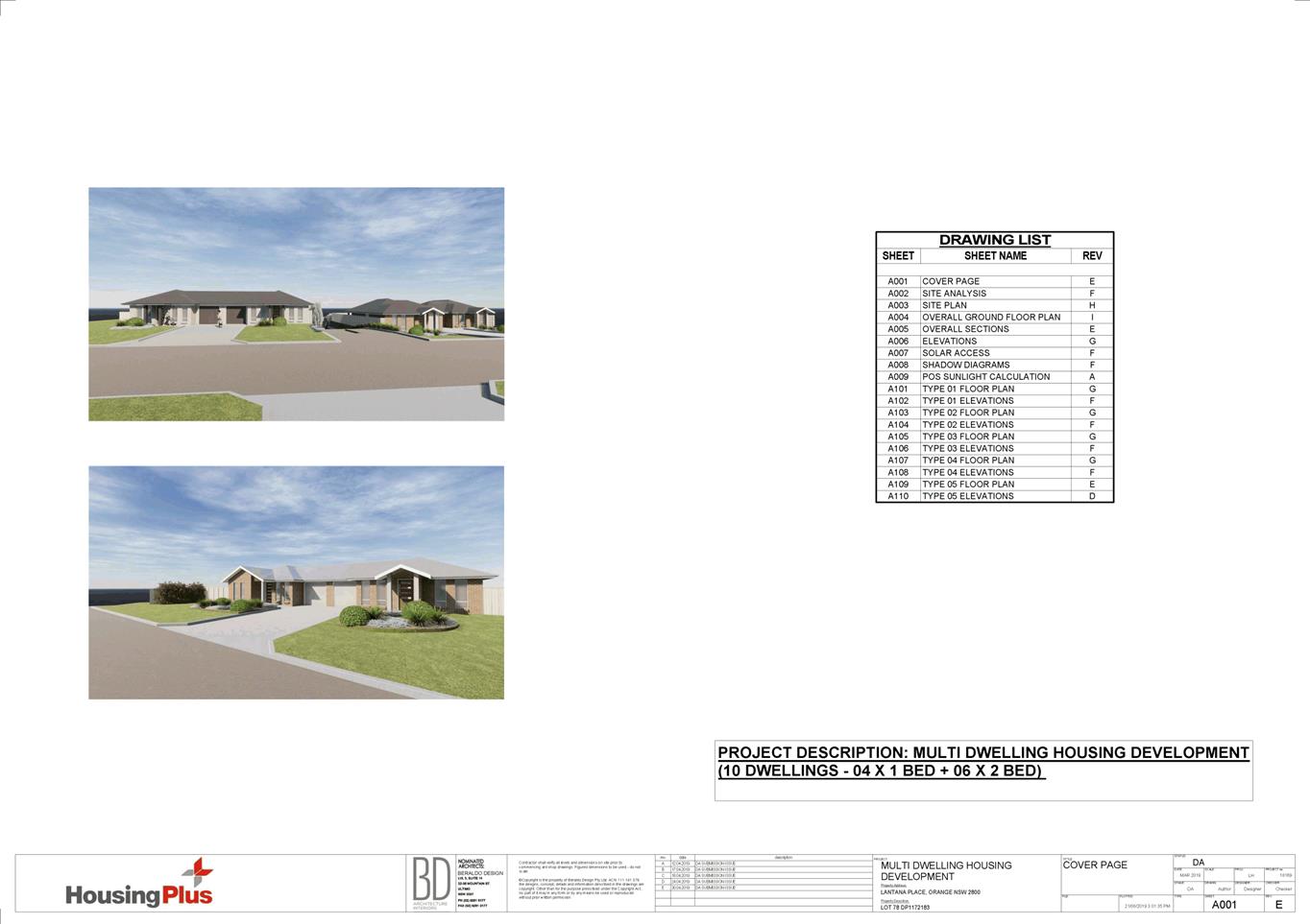
Planning
and Development Committee
3 September 2019


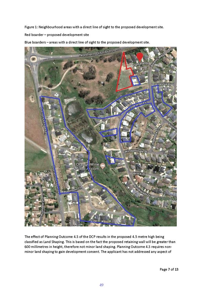


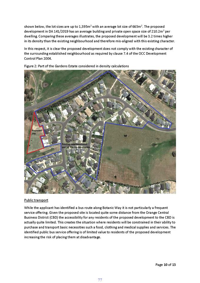

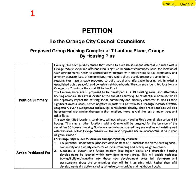
125 signatures were received for this petition.
2.3 Development
Application DA215/2019(1) - 36-40 Turner Crescent (Centre Based Child Care
Facility)
RECORD
NUMBER: 2019/1822
AUTHOR: Summer
Commins, Senior Planner
EXECUTIVE Summary
|
Application
lodged
|
11 July
2019
|
|
Applicant/s
|
Australian
Childcare Solutions Pty Ltd
|
|
Owner/s
|
Australian
Childcare Solutions Pty Ltd
|
|
Land
description
|
Lot 194
DP 1007290 - 36-40 Turner Crescent, Orange
|
|
Proposed
land use
|
Centre
Based Child Care Facility
|
|
Value of
proposed development
|
$2,685,106
|
Council's consent is sought for a proposed centre based
child care facility at Lot 194 DP 1007290 - 36-40 Turner
Crescent, Orange. The proposal involves construction of a purpose-built
facility for use as a long day child care centre; and associated site works
including vehicle areas, external play space, fencing and landscaping. The
facility will provide 94 child care places for children aged between 0-5
years, and operate between the hours of 7am to 6pm Monday to Friday.
The site was the subject of a DA for a larger child centre
in 2017 (DA 63/2017(1)). The DA was refused by Council, and subsequently
dismissed on appeal in the Land and Environment Court. The site layout and
building design for the current proposal have been informed by the judgement of
the previous DA in the Land and Environment Court; and extensive pre-lodgement
consultation with Council staff and advisors.
The proposed development comprises "advertised
development" pursuant to Orange Development Control Plan (DCP) 2004-5.3.
Public and written notice of the application was undertaken consistent with
regulation. At the conclusion of the exhibition period, 14 submissions had
been received. The issues raised in the submissions generally relate to traffic
matters and residential amenity.
The proposal does not
contravene the applicable planning regime applying to the land. Impacts of the
development are considered to be within reasonable limit; consistent with
applicable State and Local standards, and addressed by appropriate conditions
of development consent. Approval of the application is recommended.
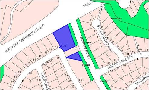
Figure 1 - locality plan
DECISION FRAMEWORK
Development in Orange is governed by two key documents
Orange Local Environment Plan 2011 and Orange Development Control Plan 2004. In
addition the Infill Guidelines are used to guide development, particularly in
the heritage conservation areas and around heritage items.
Orange Local Environment Plan 2011 – The
provisions of the LEP must be considered by the Council in determining the
application. LEPs govern the types of development that are permissible or
prohibited in different parts of the City and also provide some assessment
criteria in specific circumstances. Uses are either permissible or not. The
objectives of each zoning and indeed the aims of the LEP itself are also to be
considered and can be used to guide decision making around appropriateness of
development.
Orange Development Control Plan 2004 – the DCP
provides guidelines for development. In general it is a performance based
document rather than prescriptive in nature. For each planning element there
are often guidelines used. These guidelines indicate ways of achieving the
planning outcomes. It is thus recognised that there may also be other solutions
of merit. All design solutions are considered on merit by planning and building
staff. Applications should clearly demonstrate how the planning outcomes are
being met where alternative design solutions are proposed. The DCP enables
developers and architects to use design to achieve the planning outcomes in
alternative ways.
DIRECTOR’S COMMENT
This new Development Proposal is for
a 94 space childcare centre. Council would recall this site previously
was the subject of a DA that was refused by both Council and the Land and
Environment Court. This application has taken on board all matters raised
by the Court and effectively is very different. The most notable being
the significant reduction of child numbers. The proposal is considered to be a
good response to achieve a compliant development.
Link To Delivery/OPerational Plan
The recommendation in this report relates to the
Delivery/Operational Plan strategy “10.1 Preserve - Engage with the community
to ensure plans for growth and development are respectful of our
heritage”.
Financial Implications
Nil
Policy and Governance Implications
Nil
|
Recommendation
That Council resolves to
consent to development application DA 215/2019(1) for Centre Based Child Care Facility at Lot 194
DP 1007290 - 36-40 Turner Crescent, Orange,
pursuant to the conditions of consent in the attached Notice of Approval.
|
further considerations
Consideration has been given to the recommendation’s
impact on Council’s service delivery; image and reputation; political;
environmental; health and safety; employees; stakeholders and project
management; and no further implications or risks have been identified.
SUPPORTING INFORMATION
Australian Childcare Solutions was the proponent for a
former DA relating to the subject land. DA 63/2017(1) involved construction of
a purpose-built facility for use as a long day child care centre, offering 124
child care places. Thirty one (31) public submissions were received in response
to advertising of the DA. The issues raised in the submissions generally
related to traffic generation and management; and impacts on residential
amenity.
DA 63/2017(1) was considered by the Planning and Development
Committee at its meeting held on 1 August 2017. The application was refused on
the following grounds:
1 The
subject site is not suitable for the proposed development due to the traffic
impacts:
(a) traffic
generation associated with the proposed development will unreasonably alter the
residential character of the locality;
(b) the
proposed site access arrangements are unsuitable to manage traffic conflicts in
Turner Crescent;
(c) the
proposed development will utilise on-street parking resources, with associated
traffic congestion in Turner Crescent;
(d) traffic
impacts associated with the development will adversely impact on pedestrian
safety in the residential setting.
2 The
proposed development will have adverse noise impacts on adjoining dwellings.
3 The
proposed development will have adverse privacy impacts on adjoining dwellings.
4 The
proposed development is inconsistent with the neighbourhood character and
function of the locality.
5 The site is
unsuitable for the proposed development.
Australian Childcare Solutions appealed Council’s refusal
of the DA in the Land and Environment Court (LEC). Proceedings were held
between October and December 2017. The appeal was dismissed by the LEC on 21
December 2017 and the application determined by refusal. The following Final
Remark is made on the Court Judgement:
A lower scale development
would be more respective of residential character. I find that the proposed
development pushes the site beyond its capacity. A less intense use…
would potentially also have the effect of removing children and play equipment
from the front setback, which would increase the development’s
compatibility with the surrounding residential area. A smaller centre would
meet the day to day needs of residents as contemplated by the objectives of the
zoning. It would also allow for more generous parking arrangements, and result
in an overall less intrusive and more compatible development. A smaller, lower,
less bulky building (or buildings) could be placed on the site so as to reduce
visual and other amenity impacts, including traffic movements.
The proponent submits that the current DA has been informed
by the Court judgement relating to the former application; community concerns
on the former application; and pre‑lodgement advice with Council staff
and consultants. The current proposal differs from the former application as
follows:
· The proposed
building will be split-level with domestic architectural forms, and constructed
at existing natural ground levels [DA 63/2017(1) involved a single-level
structure with extensive earthworks and site filling].
· Ninety four (94)
child care places are being offered [DA 63/2017(1) involved 124 places].
· Outdoor play space
will wholly located at the rear of the building [DA 63/2017(1) provided outdoor
play space partly within the Turner Crescent front setback].
· The front setback
to Turner Crescent will be open to the street and landscaped to complement
adjoining residential parcels [DA 63/2017(1) provided outdoor play space and
fencing within the Turner Crescent front setback].
· Onsite parking
will well-exceed the requirements of DCP 2004 [onsite parking for DA 63/2017(1)
met requirements of DCP 2004].
· Traffic generation
will be reduced due to fewer child care places being offered.
THE PROPOSAL
The proposal involves construction of a purpose-built
centre-based child care facility on the subject land.
The proposed building will comprise a
split-level (two-level) structure at existing natural ground level. The
building will be centrally located on the development site, and oriented to the
north-south. The upper level will address Turner Crescent, with the lower level
obscured from view at the Turner Crescent frontage due to the topography. The
building will present to Molong Road as two attached residential forms (refer
Figures 3 and 4 below).
The building will have an overall footprint of some 59m x
22m, and total floor area of 986.8m2. The proposed building will be
of contemporary styling with a mix of roof forms; external finishes; and
opening sizes and orientations.
The upper ground floor level at Turner Crescent will contain
entry foyer, reception, staff amenities, and two age-group specific playrooms
with adjacent bathrooms and sleeping rooms. The lower ground floor level
will address Molong Road and comprise four age-group specific playrooms with
adjacent bathrooms, art room and stores. Both building levels will have
separate outdoor play spaces adjacent to playrooms.
Onsite car parking for 32 vehicles will be provided to the
west of the building at the site frontage, with access via Turner Crescent. The
car park will be at grade, with minor earthworks/filling at the northern end.
Extensive landscaping will be undertaken of the site
perimeter, car park, front setback area and outdoor play spaces.
Perimeter fencing will be constructed, as follows:
· Fencing to the
south and west side boundaries adjoining the existing dwellings will comprise
1.8m high solid fencing (Colorbond or timber palings).
· Fencing to the
north boundary to the Northern Distributor Road (NDR) adjacent the proposed
carpark will comprise 1.8m high solid fencing (timber palings).
· Fencing to the
balance of the north boundary to the NDR and east boundary to Molong Road will
comprise 1.2m-1.5m high timber fencing atop retaining walls. The total height
of the retaining wall and fencing to the public streets will be 1.8m.
The presentation of the site with fencing to the
Molong Road/NDR intersection is depicted below (refer Figure 3).
Consent is not sought for signage for the proposed centre-
based child care facility. Signage will be the subject of a separate
DA. Signage depicted in the plan set and below figures is indicative
only.
The proposed care facility will provide 94 long day child
care places for children aged between 0-5 years, and operate between the hours
of 7am to 6pm Monday to Friday.
The proposed site layout and
building design are depicted below.
Figure 2 – proposed site layout
Figure 3 – presentation to Turner Crescent
Figure 4 – presentation to Molong Road/NDR
MATTERS FOR CONSIDERATION
Environmental Planning and
Assessment Act 1979
Section 1.7 - Application of
Part 7 of the Biodiversity Conservation Act 2016 and Part 7A of the
Fisheries Management Act 1994
Section 1.7 of the EP&A Act identifies that Part 7 of
the Biodiversity Conservation Act 2016 (BC Act) and Part 7A of the
Fisheries Management Act 1994 have effect in connection with terrestrial and
aquatic environments.
There are 3 applicable triggers in the Orange LGA known to
insert a development within the Biodiversity Offset Scheme, and thereby require
submission of a Biodiversity Development Assessment Report (BDAR):
1. Development occurs
within land mapped on the Biodiversity Values Map.
The subject land is not identified as biodiversity sensitive
on the Orange LEP 2011 Terrestrial Biodiversity Map.
2. Development
involves clearing/disturbance of native vegetation above prescribed threshold.
The prescribed clearing threshold for the site is 0.25ha
(based on minimum lot size for the subject land of less than 1ha ((Cl. 7.2
Biodiversity Conservation Regulation 2017). There are no trees within the site
and the predominant surface cover is grass/dirt. The proposal does not involve
clearing/disturbance of native vegetation.
3. Development
is likely to affect a threatened species.
The subject land is contained within an urban residential
subdivision. The development site does not contain or adjoin mapped
biodiversity sensitive lands. There are no trees within the site and the
predominant surface cover is grass/dirt. The natural state of the site and
surrounding area has been highly modified by the urban landuse pattern and
original subdivision works. It is considered that the proposed development will
not adversely affect a threatened species.
Based on the foregoing consideration, a BDAR is not required
and the proposal suitably satisfies the relevant matters at Clause 1.7 EPAA
1979.
Section 4.15
Section 4.15 of the Environmental Planning and Assessment
Act 1979 requires Council to consider various matters, of which those
pertaining to the application are listed below.
PROVISIONS OF ANY ENVIRONMENTAL
PLANNING INSTRUMENT s4.15(1)(a)(i)
Orange Local Environmental Plan 2011
Part 1 - Preliminary
Clause 1.2 - Aims of Plan
The
particular aims of the LEP relevant to the proposal include:
(a) to
encourage development which complements and enhances the unique character of
Orange as a major regional centre boasting a diverse economy and offering an
attractive regional lifestyle,
(b) to provide for a range of development
opportunities that contribute to the social, economic and environmental
resources of Orange in a way that allows present and future generations to meet
their needs by implementing the principles for ecologically sustainable
development,
(f) to recognise and manage valued
environmental heritage, landscape and scenic features of Orange.
The application is considered to be consistent with the
above objectives, as outlined in this report.
Clause 1.6 Consent Authority
Clause 1.6 is applicable and
states:
The
consent authority for the purposes of this Plan is (subject to the Act) the
Council.
Clause 1.7 Mapping
The subject site is identified
on the LEP maps in the following manner:
|
Land Zoning Map:
|
Land zoned R2 Low Density
Residential
|
|
Lot Size Map:
|
No minimum Lot Size
|
|
Heritage Map:
|
Not a heritage item or conservation
area
|
|
Height of Buildings Map:
|
No building height limit
|
|
Floor Space Ratio Map:
|
No floor space limit
|
|
Terrestrial Biodiversity Map:
|
No biodiversity sensitivity on the
site
|
|
Groundwater Vulnerability Map:
|
Ground water vulnerable
|
|
Drinking Water Catchment Map:
|
Not within the drinking water
catchment
|
|
Watercourse Map:
|
Not within or affecting a defined
watercourse
|
|
Urban Release Area Map:
|
Not within an urban release area
|
|
Obstacle Limitation Surface Map:
|
No restriction on building siting
or construction
|
|
Additional Permitted Uses Map:
|
No additional permitted use applies
|
|
Flood Planning Map:
|
Not within a flood planning area
|
Those matters that are of relevance are addressed in detail
in the body of this report.
Clause 1.9A Suspension of
Covenants, Agreements and Instruments
Clause 1.9A is applicable and states in part:
(1) For the purpose of enabling
development on land in any zone to be carried out in accordance with this Plan
or with a consent granted under the Act, any agreement, covenant or other
similar instrument that restricts the carrying out of that development does not
apply to the extent necessary to serve that purpose.
(2) This clause does not apply:
(a) to a covenant
imposed by the Council or that the Council requires to be imposed, or
(b) to
any prescribed instrument within the meaning of Section 183A of the Crown Lands Act 1989, or
(c) to
any conservation agreement within the meaning of the National Parks and Wildlife Act 1974, or
(d) to
any Trust agreement within the meaning of the Nature
Conservation Trust Act 2001, or
(e) to
any property vegetation plan within the meaning of the Native Vegetation Act 2003, or
(f) to
any biobanking agreement within the meaning of Part 7A of the Threatened Species Conservation Act 1995, or
(g) to
any planning agreement within the meaning of Division 6 of Part 4 of the Act.
Council staff are not aware of the title of the subject
property being affected by any of the above.
An easement to drain sewer
traverses the front boundary of the subject land, adjacent to the Turner
Crescent curved frontage (noted as “B” on the deposited plan
below). The proposed development is sited clear of and will not affect the
operation of the easement.
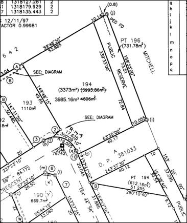
Figure 5 – extract DP 1007290
As depicted above, the development
site is split by a parcel of land described as Lot A DP 381033
– 159 Molong Road. The proposed development does not involve any works on
the landlocked triangular shaped portion to the south.
Part 2 - Permitted or Prohibited Development
Clause
2.1 Land Use Zones
The
subject site is located within the R2 Low Density Residential Zone. The
proposed development is defined as a centre-based child care facility
and is permitted with consent in the zone.
Clause 2.3 Zone Objectives
The
objectives for land zoned R2 Residential are as follows:
· To
provide for the housing needs of the community.
· To
provide for a variety of housing types and densities.
· To
enable other land uses that provide facilities or services to meet the day to
day needs of residents.
· To
ensure development is ordered in such a way as to maximise public transport
patronage and encourage walking and cycling in close proximity to settlement.
· To
ensure that development along the Southern Link Road has an alternative access.
The proposed development is
consistent with the relevant objectives of the R2 zone. The proposal does not
involve residential landuse. The proposed centre-based child care facility will
provide a long-day child care service that will be utilised by local and wider
residents. Centre-based child care facilities are a permitted and complementary
landuse in the R2 zone. The subject residential precinct is serviced by public
transport. The land does not have frontage or access to the Southern Link Road.
Part 3 - Exempt and Complying Development
The application is not exempt or complying development.
Part 4 - Principal Development Standards
The
Part 4 Principal Development Standards do not relate to the subject land or
proposed development.
Part 5 - Miscellaneous Provisions
The
Part 5 Miscellaneous Provisions are not applicable to the proposal.
Part 6 - Urban Release Area
The subject site is not located in an Urban Release Area and
Part 6 does not apply.
Part 7 - Additional Local Provisions
Clause
7.3 Stormwater Management
Clause 7.3 is applicable. This
clause states in part:
(3) Development
consent must not be granted to development on land to which this clause applies
unless the consent authority is satisfied that the development:
(a) is
designed to maximise the use of water permeable surfaces on the land having
regard to the soil characteristics affecting onsite infiltration of water, and
(b) includes,
where practical, onsite stormwater retention for use as an alternative supply
to mains water, groundwater or river water, and
(c) avoids
any significant impacts of stormwater runoff on adjoining downstream
properties, native bushland and receiving waters, or if that impact cannot be
reasonably avoided, minimises and mitigates the impact.
In consideration of Clause 7.3,
conditions are included on the attached Notice of Approval in relation to
stormwater infrastructure associated with the proposed development.
Council’s Assistant Development Engineer advises that stormwater
detention can be provided on the subject land. Compliance with conditions will
ensure that stormwater runoff will not adversely impact on adjoining
properties.
Clause 7.6 Groundwater Vulnerability
The
subject land is identified as Groundwater Vulnerable on the Groundwater
Vulnerability Map. Clause 7.6 applies. This clause states in part:
(3) Before determining a
development application for development on land to which this clause applies,
the consent authority must consider:
(a) whether
or not the development (including any onsite storage or disposal of solid or
liquid waste and chemicals) is likely to cause any groundwater contamination or
have any adverse effect on groundwater dependent ecosystems, and
(b) the
cumulative impact (including the impact on nearby groundwater extraction for
potable water supply or stock water supply) of the development and any other
existing development on groundwater.
In consideration of Clause 7.6,
the proposal is considered to be acceptable. The proposed development does not
involve processes or activities that would impact on groundwater resources. The
centre will be connected to Council’s reticulated sewerage system.
Clause 7.11 Essential Services
Clause 7.11 applies. This clause states:
Development
consent must not be granted to development unless the consent authority is
satisfied that any of the following services that are essential for the
proposed development are available or that adequate arrangements have been made
to make them available when required:
(a) the
supply of water,
(b) the
supply of electricity,
(c) the disposal and management of
sewage,
(d) stormwater
drainage or onsite conservation,
(e) suitable
road access.
In consideration of this clause, all utility services are
available to the site and adequate for the proposed development, as follows:
· the land is
connected to reticulated water supply
· electricity and
telecommunications are available
· the land is
serviced by Council’s reticulated sewerage system
· stormwater
detention will be provided onsite
· the site has
direct frontage and access to Turner Crescent
· kerbside waste
collection will be provided by contractor.
STATE ENVIRONMENTAL PLANNING
POLICIES
State Environmental Planning Policy 55 Remediation of
Land
SEPP
55 is applicable and states in part:
(1) A
consent authority must not consent to the carrying out of any development on
land unless (a) it has considered whether the land is contaminated.
(2) Before
determining an application for consent to carry out development that would
involve a change of use on any of the land specified in Subclause (4), the
consent authority must consider a report specifying the findings of a
preliminary investigation of the land concerned carried out in accordance with
the contaminated land planning guidelines.
(4) The land concerned is:
(c) to
the extent to which it is proposed to carry out development on it for
residential, educational, and recreational or child care purposes, or for the
purposes of a hospital—land:
(i) in relation to which there is no
knowledge (or incomplete knowledge) as to whether development for a purpose
referred to in Table 1 to the contaminated land planning guidelines has been
carried out, and
(ii) on which it would have been lawful to
carry out such development during any period in respect of which there is no
knowledge (or incomplete knowledge).
In
consideration of the provisions above:
· The development
site was created by a subdivision approved under DA L337/98
(20 January 1999). Condition 6 of DA L337/98 requires soil sampling
for chemical residue be undertaken, to demonstrate the suitability of the land
for residential landuse.
· A
Contamination Screening Survey was undertaken and submitted in accordance with
Condition 6 (Terra Sciences February 1999). Six (6) soil samples were taken
from the development site (refer below figure).
Figure 5 – soil samples over the subject land
· The Terra Sciences
assessment concludes “further investigation is not warranted on the
subject site, and that no further specific precautions are required in the use
of the site for residential development.”
· Council may be
satisfied that the contamination investigation status of the development site
is “unrestricted” and therefore suitable for all land uses
including the proposed centre-based child care facility.
· The findings of the
Terra Sciences report (1999) were discussed with Geolyse (former Terra
Sciences) Environmental Scientist, Mr Brendan Stuart, in June 2017. He
confirmed standards today are consistent with or lower than they were in 1999
when the contamination assessment was undertaken. If further sampling was
undertaken today, findings would be consistent with the 1999 assessment.
State Environmental Planning
Policy (Educational Establishments and Child Care Facilities) 2017
SEPP (Educational Establishments and Child Care Facilities)
2017 is applicable. The relevant provisions of the SEPP are considered below.
Clause 5 - Interpretation
· The proposed
development is defined as a “centre-based child care facility”
pursuant to Clause 5.
Clause 22 - Centre-based child
care facility - concurrence of Regulatory Authority required for certain
development
· Indoor
unencumbered floor space will comply with Regulation 107 of the Education
and Care Services National Regulations pursuant to Clause 22. Indoor floor
space of 305.5m2 is required (based on 3.25m2 x 94
children) and 358.48m2 provided over 6 playrooms.
· Outdoor
unencumbered space requirements will comply with Regulation 108 of the
Education and Care Services National Regulations, pursuant to Clause 22.
Outdoor play space of 658m2 is required (based on 7m2
x 94 children) and 846.51m2 provided.
· Based on the
compliance with the Regulations for indoor and outdoor unencumbered floor
space, notice to and concurrence of the Regulatory Authority for NSW under the
Children (Education and Care Services) National Law (NSW) is not required for
the proposed development.
Clause 23 - Centre-based child care facility - matters
for consideration by consent authorities
· The proposed
development complies with the applicable provisions of the Child Care Planning
Guideline (Department of Planning and Environment 2017) pursuant to
Clause 23, as demonstrated below.
CHILD CARE PLANNING GUIDELINE
Part 2 - Design Quality Principles
Principle 1 - Context
· The proposed
building design will respond to the established neighbourhood built form. The
proposed development was referred to Council’s Urban Design Advisor for
consideration. He advises ‘the proposed design is satisfactory in
terms of setbacks; bulk and scale; character; colours and materials; and
details.’
· The development
site is accessible to public transport.
· The site is
well-located to attract facility users in surrounding residential
neighbourhoods.
· Design and
detailing for the proposed building and site works are of a high standard, and
commensurate with the site’s gateway location within the Mitchell Highway
and NDR view corridor.
Principle 2 - Built Form
· The finished
levels for the proposed building will relate to existing natural ground levels;
and finished levels for adjoining dwellings.
· The building
design and detailing will be relate to domestic architectural forms within the
established neighbourhood (hipped roof profiles at the Turner Crescent
frontage, wall height, window fenestration, external finishes).
· The proposed
building will be sited a minimum 21m from the front boundary to Turner
Crescent. The siting of the building will suitably integrate with the
streetscape building line formed by adjoining dwellings to the south and west.
· Landscaping to the
site frontage and perimeter will provide site beautification and integration of
the development in the public realm and streetscapes.
· Council’s
Urban Design Advisor supports the proposed building design and detailing in
this streetscape.
Principle 3 - Adaptive Learning
Spaces
· The proposal will
provide purpose-built indoor learning spaces that are ‘fit-for-purpose,
enjoyable and easy to use.’
· Separate creative
spaces will be provided in addition to indoor playrooms, including art room and
picking yard.
· Outdoor play
spaces will be immediately adjacent and accessible via indoor play rooms.
Principle 4 - Sustainability
· The proposed
building will incorporate energy efficient influences in the design.
Principle 5 - Landscape
· Landscaping to the
Turner Crescent frontage will provide site beautification and integration of
the development in the public realm and streetscape.
· The proposed
landscape design will complement private landscaping in the established
residential neighbourhood.
· A variety of hard
and soft landscaping elements will be provided in outdoor play spaces.
· Council’s
Manager City Presentation supports the proposed landscape design concept for
the site, and advises the ‘plant pallet selection is acceptable for
both climatic appropriateness and asthma awareness for a child care
centre.’
Principle 6 - Amenity
· Learning spaces in
the proposed addition will be efficient and functional, with direct access to
bathrooms, sleep rooms, stores and service areas.
· Indoor playrooms
will provide ideal learning and play environments, with generous natural light,
ventilation and outlook.
· The facility will
provide ‘comfortable, diverse and attractive spaces to learn, play and
socialise.’
· Outdoor play
spaces will be immediately adjacent and accessible via indoor play rooms.
· As outlined in
this report, the proposal will not adversely impact on residential amenity for
adjoining dwellings in Turner Crescent in respect of visual privacy, acoustic
privacy, and solar access or built form encroachment.
Principle 7 - Safety
· The proposed
building design and site works will satisfy the principles of Crime
Prevention through Environmental Design.
· The proposed
development was referred to the Crime Prevention Officer at Central West Police
District. The Crime Prevention Officer raised no objection to the proposal and
did not provide specific recommendations/conditions of consent.
Part 3 - Matters for
Consideration
3.1 - Site Selection and Location
Objective: to ensure that appropriate zone conditions are
assessed when selecting a site
· A Noise Assessment
was submitted in support of the proposal (Wilkinson Murray June 2019).
Noise associated with the
proposed child care facility will be generated by outdoor play, mechanical
plant, traffic noise in the car park, and traffic noise in local streets
generated by vehicles associated with the centre. Furthermore and conversely,
the centre will be affected by traffic noise intrusion from the NDR and Molong
Road.
The submitted noise assessment
confirms that subject to implementation of mitigation measures (eg. solid
fencing, 4mm glazing, treatment to mechanical plant, and hours of operation),
noise emissions from and noise intrusion to the proposed care facility will
comply with the relevant criteria.
Council’s Environmental
Health and Building Inspector concurs with the findings and recommendations of
the noise assessment. Conditions are included on the attached Notice of
Approval in relation to physical and operational mitigation measures. On this
basis, noise impacts are considered to be within reasonable limit.
· The proposed site
layout and building design will provide acceptable visual privacy for adjoining
dwellings to the south and west:
- Finished
floor and ground levels will relate to existing natural ground levels, and
thereby minimise overlooking from the development site to adjoining dwelling.
- 1.8m
high solid perimeter fencing will be installed to the south and west boundaries
adjacent to adjoining dwellings.
- Extensive
landscaping will be provided to the site perimeters.
- South-facing
openings opposing the southern boundary will comprise two windows in sleep and
store rooms. The openings will be located some 3m from the southern boundary of
the site. This separation and use of rooms is considered suitable to prevent
overlooking of the adjoining south dwelling at 159 Molong Road.
- The
proposed building will be sufficiently removed from the western side boundary
to prevent overlooking from within the building of the adjoining western
dwelling at 42 Turner Crescent.
· The refuse store /
bin storage area is located adjacent to the proposed building and well removed
from adjoining dwellings. Odour impacts are not anticipated.
· The proposed
building will be sited a minimum 21m from the front boundary to Turner
Crescent. The siting of the building will suitably integrate with the
streetscape building line formed by adjoining dwellings to the south and west.
Landscaping to the front setback will provide site beautification and
integration of the development in the public realm and streetscapes.
· A Traffic and
Parking Impact Assessment was submitted in support of the proposal (McLaren
Traffic Engineering and Road Safety Consultants April 2019). The Assessment
concludes:
The subject proposal is fully
supportable in terms of its traffic and parking impacts. The following
[paraphrased] outcomes are relevant to note:
- Onsite
car parking will comply with Council’s DCP requirements, with a surplus
of 8 spaces.
- The
proposed parking layout has been assessed against the relevant Australian
Standards… and found to be compliant.
- The
child care centre is expected to generate 75 AM vehicle trips (38 in and 37
out) and 66 PM vehicle trips (33 in and 33 out) at peak periods. This
additional level of traffic has been assessed using SIDRA intersection
analysis… Traffic generation will represent minimal delays and additional
space capacity is maintained.
- The
additional traffic generation of 75 peak AM and 66 peak PM vehicular trips will
result in two-way traffic flow of 165 and 195 vehicles during the AM and PM
peak periods respectively within Turner Crescent. These two-way traffic flows
are below the environmental goal of 200 vehicles per hour and well below the
maximum threshold of 300 vehicles per hour for local streets as specified in
the RMS Guides. The impact upon the collector road of Sieben Drive is also
acceptable.
- The
typical size of vehicles used for small and infrequent deliveries to child care
centres is a B99 utility / courier van, which can access a normal sized car
space. The site can accommodate a delivery vehicle onsite between 9am and 4pm
outside peak times, when car spaces are very likely to be vacant.
- A
queuing analysis has been undertaken for the proposed development…The
provision of 10 parent drop-off/pick-up spaces satisfies the 98th
percentile queue for the parking demand of the proposed 94 place child care
centre.
Council’s Technical Services
Division concur with the findings of the submitted Traffic and Parking Impact
Assessment, and advise as follows:
§ The existing road network has
sufficient capacity to cater for the 2 identified AM and PM traffic peaks. The
90 degree bend in Turner Crescent at the entrance to the development has
previously been identified as a traffic consideration.
§ The anticipated traffic volume
increase is well within the existing road capacity and will not impact on
pedestrian safety. Existing speed humps are considered adequate ‘traffic
calming’ devices.
§ The carpark has sufficient parking
spaces to meet Council’s DCP for both staff and peak time drop
off/pick-ups. As such, there is not expected to be any overflow on-street
parking. Technical Services has previously advised that the carpark requires
parking spaces to suit a high turnover user Class 3A design.
§ ‘No
standing’ signs are not proposed as part of the line marking works in
Turner Crescent.
§ The following local traffic improvements are
required and have been included as conditions of consent on the attached Notice
of Approval:
1. Line
marking for Mastronardi Way.
2. A raised traffic island,
road surfacing and line marking at the corner of Turner Crescent (entry to
child care centre) to reduce the speed of vehicles entering the site and
regulate traffic flows.
3. Amendments
of the carpark dimensions, aisle widths and turn bay to suit user class 3A
under AS 2890.1 are considered adequate to address high-turnover car park
manoeuvring and minimise bottlenecks at peak drop off/pick up times.
4. A concrete footpath is to be
constructed for the full frontage of the development to Turner Crescent
(condition) to cater for pedestrian traffic to the centre.
Objective:
To ensure that the site selected for a proposed child care facility is suitable
for the use
· Surrounding land
uses comprise residential accommodation. The proposal is a permitted and
complementary landuse in the zone and setting.
· The development
site is not subject to environmental risks such as flooding, landslip or
bushfires.
· As outlined in the
assessment under SEPP 55 Remediation of Land above, the site is free from
contaminants and suitable for child care use.
· Lot size,
configuration, dimensions and frontage are suitable for the proposed child care
facility.
· The development
site has shared boundaries with residential properties to the south and west.
The interface between the development and adjoining dwellings is considered
satisfactory (as considered above).
· There are no
incompatible social activities and users in the vicinity of the development
site.
Objective: To
ensure that sites for child care facilities are appropriately located
· The site is
well-located to attract facility users in surrounding residential
neighbourhoods.
· The development
site is serviced by public transport.
Objective: To
ensure that sites for child care facilities do not incur risks from
environmental, health or safety hazards
· The subject land
is not in proximity to land uses with arising adverse environmental conditions
prescribed in the Guideline.
· The site does not
contain any known environmental hazard or risk.
· The site is free
from contamination and suitable for child care use (refer assessment under SEPP
55 Remediation of Land above).
3.2 - Local Character,
Streetscape and the Public Domain Interface
Objective: To
ensure that the child care facility is compatible with the local character and
surrounding streetscape
· The finished
levels for the proposed building will relate to existing natural ground levels;
and finished levels for adjoining dwellings. As such, the building will present
as single storey at Turner Crescent, with the lower level effectively concealed
from street view. The building will present to Molong Road as two attached
residential forms.
· The building
design and detailing will be relate to domestic architectural forms within the
established neighbourhood (hipped roof profiles at the Turner Crescent
frontage, wall height, window fenestration, external finishes).
· The siting of the
building will suitably integrate with the streetscape building line formed by
adjoining dwellings to the south and west.
· Landscaping to the
site frontage and perimeter will provide site beautification and integration of
the development in the public realm and streetscapes.
· The proposed
development was referred to Council’s Urban Design Advisor for
consideration. He advises ‘the proposed design is satisfactory in
terms of setbacks; bulk and scale; character; colours and materials; and
details.’
Objective: To
ensure clear delineation between the child care facility and public spaces
· Landscaping to the
front setback and car park will establish a transition between public and
private spaces.
· The building will
address Turner Crescent for passive surveillance and connectivity with the
public domain.
Objective: To
ensure that front fences and retaining walls respond to and complement the
context and character of the area and do not dominate the public domain
· The proposal does
not involve a front fence to Turner Crescent. The facility will remain visually
permeable in the streetscape.
· Fencing/retaining
walls to the north and west boundaries adjoining Molong Road and NDR will have
an overall height of 1.8m. Fencing materials and perimeter plantings will have
appropriate visual interest and quality at the gateway location.
· Landscaping to the
site frontage to Turner Crescent will complement private landscaping in the
established residential neighbourhood.
3.3 - Building Orientation,
Envelope and Design
Objective: To
respond to the streetscape and site, while optimising solar access and
opportunities for shade
· As outlined
previously, the development will provide acceptable visual and acoustic privacy
for adjoining dwellings to the south and west (with reference to fencing,
landscaping, interface with opposing land uses and finished surface levels).
· Internal and
external play spaces will have access to sunlight.
· A sun study /
shadow diagrams were submitted in support of the proposal. Internal and
external solar access will be provided to the adjoining southern and western
dwellings, in accordance with the requirements of DCP 2004.
· The finished
levels for the proposed building will relate to existing natural ground levels;
and finished levels for adjoining dwellings. As such, the building will present
as single storey at Turner Crescent, with the lower ground level effectively
concealed from street view in the residential streetscape.
Objective: To
ensure that the scale of the child care facility is compatible with adjoining
development and the impact on adjoining buildings is minimised
· The proposed
building will be split level, however will present as single storey at the
Turner Crescent frontage. The proposed building bulk and scale will relate to
the height of dwellings on adjoining parcels.
Objective: To
ensure that setbacks from the boundary of a child care facility are consistent
with the predominant development within the immediate context
· As outlined, the
proposed building street setbacks are considered suitable in this context.
· The public reserve
to the east of the development site will provide a buffer between Molong Road
and the proposed facility.
Objective: To
ensure that the built form, articulation and scale of development relates to
its context and buildings are well designed to contribute to an area’s
character
· The building
design and detailing will be relate to domestic architectural forms within the
established neighbourhood (hipped roof profiles at the Turner Crescent
frontage, wall height, window fenestration, external finishes).
· The development
site has no particular heritage or cultural values.
Objective: To
ensure that buildings are designed to create safe environments for all users
· The proposed
development will achieve ease of access and secure entry to the site and
building.
· Crime prevention
measures are included in the site layout and building design.
· The proposed
development was referred to the Crime Prevention Officer at Central West Police
District. The Crime Prevention Officer raised no objection to the proposal and
did not provide specific recommendations/conditions of consent.
Objective: To
ensure that child care facilities are designed to be accessible by all
potential users
· Accessible design
is achieved via accessibility to and within the facility; ramped pathways to
key areas; and continuous paths of travel to and within the building.
3.4 - Landscaping
Objective: To provide landscape
design that contributes to the streetscape and amenity
· Landscaping to the
Turner Crescent frontage will provide site beautification and integration of
the development in the public realm and streetscape.
· The proposed
landscape design will complement private landscaping in the established
residential neighbourhood.
· Landscaping in the
car park will incorporate shade trees.
· Council’s
Manager City Presentation supports the proposed landscape design concept for
the site, and advises the ‘plant pallet selection is acceptable for
both climatic appropriateness and asthma awareness for a child care
centre.’
3.5 -
Visual and Acoustic Privacy
Objective: To protect the privacy and
security of children attending the facility
· Outdoor play
spaces will be located at the rear (east) of the building and will not be
visible from Turner Crescent. Perimeter fencing and landscaping will prevent
overlooking of indoor and outdoor play spaces from the NDR and Molong Road.
Objective: To
minimise impacts on privacy of adjoining properties
· As outlined
previously, the development will provide acceptable privacy for adjoining
dwellings (with reference to boundary fencing, landscaping, interface with
opposing land uses and finished surface levels).
Objective: To
minimise the impact of child care facilities on the acoustic privacy of
neighbouring residential developments
· As outlined
previously, subject to migration conditions, noise emissions from the proposed
centre will comply with the relevant criteria.
3.6 - Noise and Air Pollution
Objective: To
ensure that outside noise levels on the facility are minimised to accepted
levels
· The subject site
is not located in the vicinity of noise generating infrastructure or land uses
prescribed in the Guideline.
· As outlined, the
proposed development will be subject to traffic noise exposure. Mitigation
measures will be required to ensure compliance with relevant noise criteria in
indoor and outdoor play spaces.
Objective: To
ensure air quality is acceptable where child care facilities are proposed close
to external sources of air pollution such as major roads and industrial development
· The subject land
adjoins the NDR and Molong Road. Council’s Environmental Health and
Building Inspector advises that particular measures to address air quality will
not be required for the development. Perimeter fencing and extensive
landscaping will provide a buffer.
3.7 - Hours of Operation
Objective: To
minimise the impact of the child care facility on the amenity of neighbouring
residential developments
· A condition is
included on the attached Notice of Approval that hours of operation are not to
exceed 7am to 6pm Monday to Friday, consistent with the assessment in the
submitted acoustic report.
3.8 - Traffic, Parking and
Pedestrian Circulation
Objective: To
provide parking that satisfies the needs of users and demand generated by the
centre
· Pursuant to DCP
2004, onsite parking is to be provided for child care centres at a rate
of 1 space per 4 children. The proposed centre will provide 94 child care
places, with 23.5 (ie. 24) parking spaces required. Thirty two (32) onsite car
parking spaces will be provided, including 1 space for disabled drivers, in
compliance with the DCP.
· Car
park design is consistent with AS 2890.1 Off street car parking.
Notwithstanding, Council’s Development Engineer has attached a condition
that will require the applicant to confirm that the car park design
(dimensions, aisle widths and turn bay) will comply 3A (highest) user standard
available under AS 2890.1-2004. This standard is considered adequate to address
car park manoeuvring, including catering for the expected service vehicle
(courier van). Conditions are included on the attached Notice of Approval to
reflect the requirements.
· Based on the
long-day operation of the proposed centre, car park lighting (and other
external lighting) will be required. A condition is included requiring outdoor
lighting comply with AS 4282:1997 Control of the obtrusive effects of
outdoor lighting.
Objective: To
provide vehicle access from the street in a safe environment that does not
disrupt traffic flows
· The subject land
has direct frontage and access to Turner Crescent. A 6m vehicle crossing and
driveway will be constructed to service the site. In order that adequate sight
distances are provided for vehicles turning right into the site (ie. when
travelling north along Turner Crescent), a raised median and line marking will
be provided along Turner Crescent. Conditions are included to this
effect.
Objective: To
provide a safe and connected environment for pedestrians both on and around the
site
· The proposed
development will adopt the following design solutions:
- a
car park layout that will allow vehicles to enter and exit the site in a
forward direction
- fencing
to separate vehicle areas from outdoor play spaces
- provision
of an accessible parking space
- concrete
footpath to the site frontage on Turner Crescent, as required by condition.
Part 4 - Applying the National
Regulations to Development Proposals
The proposed development will satisfy the National
Regulations:
· Regulation 104 -
Fencing or barrier that encloses outdoor spaces
· Regulation 106 -
Laundry and hygiene facilities
· Regulation 107 -
Unencumbered indoor space
· Regulation 108 -
Unencumbered outdoor space
· Regulation 109 -
Toilet and hygiene facilities
· Regulation 110 -
Ventilation and natural light
· Regulation 111 -
Administrative space
· Regulation 112 -
Nappy change facilities
· Regulation 113 -
Outdoor space - natural environment
· Regulation 114 -
Outdoor space - shade
· Regulation 115 -
Premises designed to facilitate supervision
A condition is attached requiring submission of a schedule
demonstrating development compliance with the National Regulations prior to the
issue of a Construction Certificate.
Clause 26 - Centre-based child
care facility - development control plans
· DCP 2004 does not
contain prescribed provisions for centre-based child care facilities (including
operational or management plans; the demonstrated need for child care services;
proximity to other facilities; design considerations, etc.). Notwithstanding,
such provisions would not apply to the proposed development pursuant to
Clause 26.
PROVISIONS OF ANY DRAFT
ENVIRONMENTAL PLANNING INSTRUMENT THAT HAS BEEN PLACED ON EXHIBITION
4.15(1)(a)(ii)
Draft Remediation of Land State Environmental Planning
Policy
From 31 January to 13 April 2018 the Department of Planning
and Environment publically exhibited an Explanation of Intended Effect (EIE)
and Draft Planning Guidelines for the proposed Remediation of Land SEPP, which
will repeal and replace State Environmental Planning Policy 55 –
Remediation of Land (SEPP 55). Of particular note, the Draft Planning Guidelines
state:
“In undertaking an
initial evaluation, a planning authority should consider whether there is any
known or potential contamination on nearby or neighbouring properties, or in
nearby groundwater, and whether that contamination needs to be considered in
the assessment and decision making process.”
“If the planning
authority knows that contamination of nearby land is present but has not yet
been investigated, it may require further information from the applicant to
demonstrate that the contamination on nearby land will not adversely affect the
subject land having regard to the proposed use.” (Proposed
Remediation of Lands SEPP - Draft Planning Guidelines, Page 10).
Land adjoining the site is not
identified or considered to be contaminated. Testing was undertaken pursuant to
the subdivision DA which concluded that this and surrounding sites were
suitable for residential use. As such, the provisions of the draft EPI are
considered to have been addressed.
Draft Orange Local Environmental
Plan 2011 (Amendment 24)
Draft Orange LEP Amendment 24
has recently completed a public exhibition process (26 July – 26 August
2019). The Draft plan involves administrative amendments to the LEP, including
but not limited to updating various maps; amending the flood planning controls;
and adopting or amending clauses in relation to multi dwelling housing, rural
subdivision and new landuses. Draft Amendment 24 has no effect for the
subject land or proposed development.
DESIGNATED DEVELOPMENT
The proposed development is not designated development.
INTEGRATED DEVELOPMENT
The proposed development is not integrated development.
PROVISIONS OF ANY DEVELOPMENT
CONTROL PLAN s4.15(1)(a)(iii)
Development Control Plan 2004
The following parts of DCP 2004 are applicable to the
proposed development:
· Part 2 - Natural
Resource Management
· Part 3 - General
Considerations
· Part 4 - Special
Environmental Considerations
· Part 5 - General
Considerations for Zones and Development
· Part 7 –
Development in Residential Zones.
· Part 15 –
Car Parking
The relevant matters in Parts 2, 3 and 4 were considered in
the foregoing assessment under Orange LEP 2011.
The relevant matters in Part 5 are addressed below (refer Any
Submissions).
The relevant matters in Parts 7 and 15 were considered in
the foregoing assessment under Child Care Planning Guideline (Department
of Environment and Planning 2017).
DEVELOPMENT CONTRIBUTIONS
Development contributions for water, sewer and drainage
works are applicable to the proposed development. The contributions are based
on 4.64 ETs for water supply headworks and 8.4 ETs for sewerage headworks. A
condition is included on the attached Notice of Approval requiring payment of
the applicable contributions.
PROVISIONS PRESCRIBED BY THE
REGULATIONS s4.15(1)(a)(iv)
Demolition of a Building (clause 92)
The proposal does not involve the demolition of a building.
Fire Safety Considerations (clause 93)
Fire protection measures will be required appropriate to the
building class. Fire safety considerations will be addressed at Construction
Certificate stage.
Buildings to be Upgraded
(clause 94)
This matter is not relevant as the subject land is vacant.
BASIX Commitments (clause 97A)
BASIX is not applicable to the proposal. A Section J Energy
Efficiency statement will be required at Construction Certificate stage.
THE LIKELY IMPACTS OF THE
DEVELOPMENT s4.15(1)(b)
The impacts of the proposed development have been considered
in the foregoing assessment and include:
· Visual impacts
(neighbourhood character, design, siting, landscaping).
· Traffic
impacts (traffic generation, road capacity, site access, car parking layout,
service vehicle manoeuvring).
· Amenity impacts
(traffic generation, acoustic privacy, overlooking, solar access, visual bulk
encroachment, lighting).
· Environmental
impacts (waste management, sediment and erosion control, groundwater,
biodiversity values, cultural values, contamination).
It is considered that the impacts of the proposed
development are within reasonable limit and may be addressed by conditions of
consent on the attached Notice of Approval.
THE SUITABILITY OF THE SITE
s4.15(1)(c)
The subject land is suitable for the development due to the
following:
· the proposal is
permitted on the subject land R2 Low Density Residential zoning
· the site is of
sufficient area and dimensions to accommodate building, outdoor play space and
vehicle areas
· the site has
direct frontage and access to Turner Crescent
· the local road
network has sufficient capacity to accommodate additional traffic volumes
· there is no known
contamination on the land
· all utility
services are available and adequate
· the site is not
subject to natural hazards
· the subject land
has no particular environmental values
· the site is not
known to contain any Aboriginal, European or archaeological relics.
ANY SUBMISSIONS MADE IN
ACCORDANCE WITH THE ACT s4.15(1)(d)
The proposed development comprises "advertised
development" pursuant to DCP 2004‑5.3. The application was
advertised for the prescribed period of 14 days. At the conclusion of the
exhibition period, 14 submissions had been received. The issues raised in the
submissions have been considered in the foregoing assessment and/or are
addressed below.
Residential amenity will be adversely impacted
Comment: The development will broaden the function of the
neighbourhood by introducing a non‑residential component. Indeed, the
proposed care facility comprises the only non‑residential landuse in the
residential neighbourhood. Notwithstanding, centre-based child care facilities are
a permitted use in the R2 zone, and the proposal is considered to be
complementary in this setting. As outlined in this report, the proposal
will not adversely impact on residential amenity for adjoining dwellings in
Turner Crescent in respect of visual privacy, acoustic privacy, solar access or
built form encroachment. Impacts of the development are considered to be within
reasonable limits; consistent with applicable standards and environmental
goals; and addressed by appropriate conditions of consent.
Turner Crescent is too narrow to accommodate traffic
volumes and on-street car parking demands, with associated impacts for road and
pedestrian safety
Comment: Council’s Assistant Development Engineer
advises that Turner Crescent has a formed minimum width of 9m within an 18m
road reserve, and comprises an urban local access street pursuant to the
Orange City Development and Subdivision Code.
The particular road design will accommodate on-street car
parking and limited two-way vehicle passing at the speed limited 50km/hr.
It is noted that the curved road formation at the site frontage will
necessitate slower speeds, with potential conflicts between stationary and
moving vehicles further reduced.
It is acknowledged that the residential street will be
altered by traffic volumes associated with the proposed development.
Notwithstanding, as demonstrated in the foregoing assessment, increased traffic
volumes will be within the existing road capacity and below RMS environmental
goals. Council’s Assistant Development Engineer and the proponent’s
traffic consultant concur that road and pedestrian safety will not be impacted.
Access to Turner Crescent and
the development site will be restricted for emergency services and waste
collection vehicles
Comment: Council’s Technical Services Division advises
the proposal will not restrict access to the neighbourhood or the development
site for emergency services vehicles; furthermore, waste collection
arrangements for dwellings in Turner Crescent will not be impacted.
On-street car parking will be
required to accommodate parking demands for visitors and staff
Comment: Onsite parking for the proposed development exceeds
the minimum parking requirements under Orange DCP 2004. A condition is
included on the attached Notice of Approval requiring dedicated staff parking
spaces be provided onsite (car spaces numbered 1-8).
Access to the site via Molong Road or NDR would overcome traffic
concerns
Comment: Consent is not sought for site access via Molong
Road or NDR.
The submitted Traffic and Parking Impact Assessment
contains errors and omissions
Comment: Council’s Technical Services Division concur
with the findings and recommendations of the submitted Traffic and Parking
Impact Assessment.
Recommended traffic management measures will
inconvenience residents in adjacent dwellings, ie. on-street parking is not
permitted within 3m of double centre lines
Comment: The submitted Traffic and Parking Impact Assessment
recommends external traffic management measures including double centre lines
at the intersection of Mastronardi Way and Turner Crescent; and at the
development site frontage in Turner Crescent.
Council’s Assistant Development Engineer advises that
double centre lines will indeed restrict on-street car parking adjacent to the
lines. He considers that the centre line in Turner Crescent near
Mastronardi Way will have limited traffic management effect for the
development, and may be deleted. Furthermore, the double centre lines at the
site frontage may terminate after the centre median at the tangent point of the
inside kerb of Turner Crescent. Conditions are included on the attached
Notice of Approval to delete and terminate the double centre lines. As
such, external traffic management measures will not alter the availability of
on-street parking in the neighbourhood.
Access to the site is on a blind
corner
Comment: as outlined in the foregoing assessment, conditions
are included on the attached Notice of Approval requiring a raised median and
double centre lines be provided at the site frontage in Turner Crescent, in
order to achieve safe access to the development site. A further condition
is included requiring asphalt resealing of Turner Crescent at the site
frontage.
There is potential for traffic
accidents at the Mitchell Highway/NDR intersection to enter the site
Comment: the likelihood of a traffic accident entering the
site via the adjacent intersection of considered to be is low based on vehicle
speeds at the intersection and separation of the site from the formed
carriageway.
Clarification on opening hours
is requested
Comment: A condition is included on the attached Notice of
Approval that hours of operation are not to exceed 7am to 6pm Monday to Friday,
consistent with the assessment in the submitted acoustic report.
The proposed development will
devalue adjoining properties
Comment: This matter is not a relevant consideration in the
assessment of a development application pursuant to the Environmental
Planning and Assessment Act 1979.
What are the waste collection
arrangements for the proposed centre?
Comment: The proposed
development includes a waste storage facility adjacent to the proposed disabled
parking space. The proposed storage enclosure is well separated from adjoining
properties and well setback from Turner Crescent. The applicant’s proposal
involves the storage of waste within this enclosure with staff to place waste
storage bins kerbside on pickup days. The kerbside placement of bins on pickup
days is not supported. Conditions are included on the attached Notice of
approval requiring the bins to be stored within the onsite waste storage
facility for the development with collection of waste to be undertaken from the
site by the waste contractor (‘run cost’ arrangement) on collection
days. This arrangement is a common practice adopted by Council where multiple
bins are required on narrow frontages.
PUBLIC INTEREST
s4.15(1)(e)
The proposed development is considered to be of minor
interest to the wider public due to the relatively localised nature of
potential impacts. The proposal is not inconsistent with any relevant policy
statements, planning studies, guidelines etc that have not been considered in
this assessment.
SUMMARY
The proposed development is permissible with the consent of
Council. The proposed development complies with the relevant aims, objectives
and provisions of Orange LEP 2011 (as amended) and DCP 2004 and relevant
State Environmental Planning Policies. A Section 4.15 assessment of the
development indicates that the development is acceptable in this instance.
Attached is a draft Notice of Approval outlining a range of conditions
considered appropriate to ensure that the development proceeds in an acceptable
manner.
COMMENTS
The requirements of the Environmental Health and Building
Surveyor and the Engineering Development Section are included in the attached
Notice of Approval.
Attachments
1 Notice
of Approval, D19/50931⇩
2 Plans,
D19/50991⇩
3 Submissions,
D19/50783⇩
Planning
and Development Committee
3 September 2019
Attachment 1 Notice
of Approval
|
|
ORANGE CITY COUNCIL
Development
Application No DA
215/2019(1)
NA19/ Container
PR17415
|
NOTICE OF DETERMINATION
OF A DEVELOPMENT
APPLICATION
issued under the Environmental
Planning and Assessment Act 1979
Section 4.18
|
Development
Application
|
|
|
Applicant
Name:
|
Australian Childcare
Solutions Pty Ltd
|
|
Applicant
Address:
|
C/- HCC Planning
26 Riverglade Drive
TAMAHERE, WAIKATO,
NZ 3283
|
|
Owner’s
Name:
|
Australian Childcare
Solutions Pty Ltd
|
|
Land
to Be Developed:
|
Lot 194 DP 1007290 -
36-40 Turner Crescent, Orange
|
|
Proposed
Development:
|
Centre Based Child
Care Facility
|
|
|
|
|
Building Code of Australia
building
classification:
|
Class to be
determined by the PC
|
|
|
|
|
Determination made
under
Section 4.16
|
|
|
Made
On:
|
3 September 2019
|
|
Determination:
|
CONSENT GRANTED
SUBJECT TO CONDITIONS DESCRIBED BELOW:
|
|
|
|
|
Consent to Operate
From:
|
4 September 2019
|
|
Consent to Lapse On:
|
4 September 2024
|
Terms
of Approval
The
reasons for the imposition of conditions are:
(1) To ensure a quality
urban design for the development which complements the surrounding environment.
(2) To maintain
neighbourhood amenity and character.
(3) To ensure compliance
with relevant statutory requirements.
(4) Because the development
will require the provision of, or increase the demand for, public amenities and
services.
(5) To ensure the utility
services are available to the site and adequate for the development.
(6) To prevent the proposed
development having a detrimental effect on adjoining land uses.
(7) To minimise the impact
of development on the environment.
Conditions
(1) The development must be
carried out in accordance with:
(a) Architectural Drawing
Nos:
16004_DA1-100_F;16004_DA1-110_F;16004_DA1-120_F;16004_DA1-200_D;16004_DA1-210_D;16004_DA1-300_C;16004_DA1-500_B
(7 sheets)
Landscape Design Intent
by Larc Collective;LD1-L2 – 11 (Revision E) (10 sheets)
(b) statements
of environmental effects or other similar associated documents that form part
of the approval
as amended in
accordance with any conditions of this consent.
(2) All building work must
be carried out in accordance with the provisions of the Building Code of
Australia.
(3) A sign is to be erected
in a prominent position on any site on which building work, subdivision work or
demolition work is being carried out:
(a) showing
the name, address and telephone number of the principal certifying authority
for the work, and
(b) showing
the name of the principal contractor (if any) for any building work and a
telephone number on which that person may be contacted outside working hours,
and
(c) stating
that unauthorised entry to the site is prohibited.
Any such sign is to be maintained while the
building work, subdivision work or demolition work is being carried out.
(4) Where any excavation
work on the site extends below the level of the base of the footings of a
building on adjoining land, the person having the benefit of the development
consent must, at the person’s own expense:
(a) protect
and support the adjoining premises from possible damage from the excavation,
and
(b) where
necessary, underpin the adjoining premises to prevent any such damage.
Note: This
condition does not apply if the person having the benefit of the development
consent owns the adjoining land or the owner of the adjoining land has given
consent in writing to this condition not applying.
|
PRIOR TO THE ISSUE OF A CONSTRUCTION
CERTIFICATE
|
(5) Compliance with the
requirements of Education and Care Services National Regulations shall be
demonstrated on the detailed construction drawings (including a compliance
schedule format) submitted with the application for a construction certificate.
(6) An
approval under Section 68 of the Local Government Act is to be sought
from Orange City Council, as the Water and Sewer Authority, for alterations to
water and sewer. No plumbing and drainage is to commence until approval is
granted.
(7) Detailed
plans and specifications are to be provided specifying the proposed fitout of
the food preparation and storage areas in accordance with the requirements of
Australian Standard 4674-2004 "Design and construction and fitout of
food premises" and Standard 3.2.3 "Food Premises and
Equipment" of the Australian New Zealand Food Standards Code.
(8) The applicant is to
submit a waste management plan that describes the nature of wastes to be
removed, the wastes to be recycled and the destination of all wastes. All
wastes from the demolition and construction phases of this project are to be
deposited at a licensed or approved waste disposal site.
(9) Engineering plans
providing complete details of the proposed Turner Crescent traffic island, line
marking and pavement resurfacing, Mastronardi Way line marking, childcare
centre driveway and car-parking areas is to be submitted to Orange City Council
upon application for a Construction Certificate. These plans are to provide
details of levels, cross falls of all pavements, proposed sealing materials and
proposed drainage works and be in accordance with the Orange City Council
Development and Subdivision Code. The plans shall also include the following
details:
· Turner Crescent raised
traffic island generally as per McLaren Traffic Engineering plan on sheet 2 of
5 Annexure E from report 18532.01FC dated 16 April 2019 including construction
details, line marking and signage. Centreline marking west of the traffic
island shall terminate at the tangent point of the inside kerb of Turner
Crescent;
· Mastronardi Way and
Turner Crescent line marking details generally as per McLaren Traffic
Engineering plan on sheet 4 of 5 Annexure E from report 18532.01FC dated 16
April 2019. Centreline marking shall be deleted from Turner Crescent;
· Carpark driveway entry
/ exit raised central splitter island including construction details, line
marking and signage;
· A full width reseal in
30mm AC10 asphalt of Turner Crescent for the frontage of the development, as
defined by the kerb tangent points located on the inside of the bend;
· Carpark layout
generally as per drawing number 16004_DA1-100_F (dated 15/08/2019) with the
following amendments:
o Parking spaces numbered
1 to 8 to be clearly identified by signage or line marking as ‘staff
parking only’;
o Turning bay to be
clearly identified by signage and line marking as ‘turning bay’;
o Turning bay to be
widened to 3.6m by including 1.0m central aisle extension;
o Central aisle and
parking spaces 17 to 32 to be constructed to dimensions specified for User
Class 3A in figure 2.2 of AS 2890.1 (using 6.6m aisle width option).
(10) A water and soil
erosion control plan is to be submitted to Orange City Council or an Accredited
Certifier (Categories B1, C3, C4, C6) for approval prior to the issuing of a
Construction Certificate. The control plan is to be in accordance with the
Orange City Council Development and Subdivision Code and the Landcom, Managing
Urban Stormwater; Soils and Construction Handbook.
(11) The development’s
stormwater design is to include stormwater detention within the development,
designed to limit peak outflows from the land to the pre-existing natural
outflows up to the 100 year ARI frequency, with sufficient allowance in
overflow spillway design capacity to safely pass flows of lower frequency (that
is, a rarer event) without damage to downstream developments. Where
appropriate, the spillway design capacity is to be determined in accordance
with the requirements of the Dam Safety Committee.
The design of the detention storage is to be
undertaken using the DRAINS rainfall-runoff hydrologic model or an approved
equivalent capable of assessing runoff volumes and their temporal distribution
as well as peak flow rates. The model is to be used to calculate the flow rates
for the existing and post-development conditions. The developed flows are to be
routed through the proposed storage within the model so that the outflows
obtained are no greater than the flows obtained for the pre-existing natural
flows. A report detailing the results of the analysis, which includes:
· catchment plan showing
sub-catchments under existing and developed conditions;
· schematic diagram of
the catchment model showing sub areas and linkages;
· tabulation detailing
the elevation, storage volume and discharge relationships; and
· tabulation for the
range of frequencies analysed, the inflows, outflows and peak storage levels
for both existing and developed conditions;
together with copies of the data files for the
model and engineering design plans of the required drainage system are to be
submitted to Orange City Council upon application for a Construction
Certificate.
(12) The existing sewer
manhole on the northern boundary is to be raised to the design finished surface
level. Prior to a Construction Certificate being issued engineering plans for
this work are to be submitted to and approved by Orange City Council.
(13) A Liquid Trade Waste
Application is to be submitted to Orange City Council prior to the issuing of a
Construction Certificate. The application is to be in accordance with
Orange City Council’s Liquid Trade Waste Policy. Engineering plans
submitted as part of the application are to show details of all proposed liquid
trade waste pre-treatment systems and their connection to sewer.
Where applicable, the applicant is to enter
into a Liquid Trade Waste Service Agreement with Orange City Council in
accordance with the Orange City Council Liquid Trade Waste Policy.
(14) Payment
of contributions for water, sewer and drainage works is required to be made
at the contribution rate applicable at the time that the payment is made.
The contributions are based on 4.64 ETs for water supply headworks and 8.40 ETs
for sewerage headworks. A Certificate of Compliance, from Orange City
Council in accordance with the Water Management Act 2000, will be issued
upon payment of the contributions.
This Certificate of Compliance is to be
submitted to the Principal Certifying Authority prior to the issuing of a
Construction Certificate.
(15) A
Road Opening Permit in accordance with Section 138 of the Roads Act 1993
must be approved by Council prior to a Construction Certificate being issued
or any intrusive works being carried out within the public road or footpath
reserve.
(16) Prior to the issue of
the Construction Certificate an acoustic report is to be submitted to the
Principal Certifying Authority and to Council, confirming the type and location
of any mechanical plant proposed to be installed. The report shall
confirm that the Leq15min noise level emitted
from the cumulative noise impact of children playing indoors, mechanical plant
and traffic on the site will not exceed 51 dB(A) at
the assessment location. Where mitigation measures are required in order
to achieve this noise goal, details of these measures are also to be provided
within this report.
(17) Minimum 1.8 metre high
solid fences are to be constructed along each of the boundaries of the external
play areas to mitigate external traffic noise intrusion, as well as a minimum
1.8 metre high solid fence to be constructed along the western boundary of the
proposed car parking area, as shown in Figure 6-1 of the Acoustic Assessment
prepared by Wilkinson Murray (Report No. 18428 Version B) dated June
2019. Fences are to consist of standard lapped and capped timber,
colorbond, or the like consistent in design with the approved plans. The
existing 1.8 metre high fence located along boundary with 159 Molong is to be
retained.
(18) Standard 4mm glazing is
to be fitted to all external windows in order to control internal noise levels,
as recommended in the Noise Control Summary (7.1) of the Acoustic Assessment
prepared by Wilkinson Murray (Report No. 18428 Version B) dated June
2019. .
|
PRIOR TO WORKS COMMENCING
|
(19) Where existing fencing
on the west and south boundaries of the site adjoining dwellings needs to be
removed, or is of a type which does not ensure the occupants adequate privacy,
new fencing of the type shown on the approved development application plans, or
as referred to elsewhere in this Notice, shall be erected prior to any
building or construction work being carried out upon this development.
(20) Soil
erosion control measures shall be implemented on the site.
(21) A
Construction Certificate application is required to be submitted to, and issued
by Council/Accredited Certifier prior to any excavation or building works being
carried out onsite.
(22) A
temporary onsite toilet is to be provided and must remain throughout the
project or until an alternative facility meeting Council’s requirements
is available onsite.
|
DURING CONSTRUCTION/SITEWORKS
|
(23) All
construction/demolition work on the site is to be carried out between the hours
of 7.00 am and 6.00 pm Monday to Friday inclusive, 7.00 am to
5.00 pm Saturdays and 8.00 am to 5.00 pm Sundays and Public
Holidays. Written approval must be obtained from the General Manager of Orange
City Council to vary these hours.
(24) A
Registered Surveyor’s certificate identifying the location of the
building on the site must be submitted to the Principal Certifying Authority.
(25) All
construction works are to be strictly in accordance with the Reduced Levels
(RLs) as shown on the approved plans.
(26) All materials on site
or being delivered to the site are to be contained within the site. The
requirements of the Protection of the Environment Operations Act 1997
are to be complied with when placing/stockpiling loose material or when
disposing of waste products or during any other activities likely to pollute
drains or watercourses.
(27) The
fit-out of the food preparation and storage areas are to be installed in
accordance with the requirements of Food Safety Standard 3.2.3 "Food
Premises and Equipment" of the Australian New Zealand Food Standards Code
and Australian Standard 4674-2004 "Design and construction and fit-out of
food premises".
(28) Any adjustments to
existing utility services that are made necessary by this development
proceeding are to be at the full cost of the developer.
(29) The provisions and requirements
of the Orange City Council Development and Subdivision Code are to be applied
to this application and all work constructed within the development is to be in
accordance with that Code.
The developer is to be entirely responsible for
the provision of water, sewerage and drainage facilities capable of servicing
the development from Council’s existing infrastructure. The developer is
to be responsible for gaining access over adjoining land for services where
necessary and easements are to be created about all water, sewer and drainage
mains within and outside the lots they serve.
(30) All driveway and
parking areas are to be sealed with bitumen, hot mix or concrete and are to be
designed for all expected loading conditions (provided however that the minimum
pavement depth for gravel and flush seal roadways is 200mm) and be in
accordance with the Orange City Council Development and Subdivision Code.
(31) A heavy-duty concrete
kerb and gutter layback and footpath crossing is to be constructed in the position
shown on the plan submitted with the Construction Certificate application. The
works are to be carried out to the requirements of the Orange City Council
Development and Subdivision Code and Road Opening Permit.
(32) A 1.2m wide concrete
footpath is to be constructed for the full frontage of the development to
Turner Crescent. The footpath is to be located and constructed in accordance
with the Orange City Council Development and Subdivision Code.
|
PRIOR TO THE ISSUE OF AN OCCUPATION
CERTIFICATE
|
(33) Landscaping
shall be installed in accordance with the approved plans and shall be
permanently maintained to the satisfaction of Council's Manager City
Presentation.
(34) Car parking spaces
shall be provided upon the site in accordance with the approved plans and be
constructed in accordance with the requirements of Council's Development and
Subdivision Code prior to the issue of an Occupation Certificate.
(35) Perimeter
fencing shall be provided in accordance with the approved plans and Acoustic
Assessment (Wilkinson Murray Report No. 18428 June 2019) and as amended as
follows:
· 1.8m high solid fencing
(Colorbond or lapped and capped timber) to the south and west boundaries
adjoining the existing dwellings.
· 1.8m high solid fencing
(lapped and capped timber) to the part north boundary adjacent to the car park.
· 1.2m-1.5m high timber
fencing atop retaining walls to the part north boundary adjacent the outdoor
play area; and east boundary. The total height of the retaining wall and
fencing to external play areas adjacent the roads shall be 1.8m.
The height of fencing shall be measured from
the highest finished ground level adjacent to each part of that fence.
(36) No
person is to use or occupy the building or alteration that is the subject of
this approval without the prior issuing of an Occupation Certificate.
(37) The
owner of the building/s must cause the Council to be given a Final Fire Safety
Certificate on completion of the building in relation to essential fire or
other safety measures included in the schedule attached to this approval.
(38) Where
Orange City Council is not the Principal Certifying Authority, a final
inspection of water connection, sewer and stormwater drainage shall be
undertaken by Orange City Council and a Final Notice of Inspection issued,
prior to the issue of either an interim or a final Occupation Certificate.
(39) The cut and fill is to
be retained and/or adequately battered and stabilised (within the allotment)
prior to the issue of an Occupation Certificate.
(40) A Certificate of
Compliance, from a Qualified Engineer, stating that the stormwater detention
basin complies with the approved engineering plans is to be submitted to the Principal
Certifying Authority prior to the issuing of an Occupation Certificate.
(41) Certification from
Orange City Council is required to be submitted to the Principal Certifying
Authority prior to the issue of an Occupation Certificate stating that all
works relating to connection of the development to Council assets, works on
public land, works on public roads, stormwater, sewer and water reticulation
mains and footpaths have been carried out in accordance with the Orange City
Council Development and Subdivision Code and the foregoing conditions, and that
Council will take ownership of the infrastructure assets.
(42) A
Road Opening Permit Certificate of Compliance is to be issued for the works by
Council prior to any Occupation/Final Certificate being issued for the
development.
(43) The
proponent shall enter into a private service agreement with a waste contractor
for the collection of garage, recycling and organic waste associated the
proposed development. Details of the service agreement shall be provided to
Council prior to issue of an Occupation Certificate.
(44) All
of the foregoing conditions are to be at the full cost of the developer and to
the requirements and standards of the Orange City Council Development and
Subdivision Code, unless specifically stated otherwise. All work required by
the foregoing conditions is to be completed prior to the issuing of an
Occupation Certificate, unless stated otherwise.
|
MATTERS FOR THE ONGOING PERFORMANCE AND
OPERATION OF THE DEVELOPMENT
|
(45) A
separate development application shall be submitted to and approved by Council
prior to the erection of any advertising structures or signs of a type that do
not meet the exempt development provisions of State Environmental Planning
Policy (Exempt and Complying Development Codes) 2008.
(46) Exterior
lighting shall be sited and designed to comply with Australian Standard AS
4282-1997 Control of the obtrusive effects of outdoor lighting.
(47) The
owner is required to provide to Council and to the NSW Fire Commissioner an
Annual Fire Safety Statement in respect of the fire-safety measures, as
required by Clause 177 of the Environmental Planning and Assessment
Regulation 2000.
(48) Hours of operation of
the childcare centre shall be between the hours of 7.00am and 6.00pm, Monday to
Friday.
(49) The physical noise
mitigation measures and operational management plans for the childcare centre
shall be maintained for the duration of the development.
(50) The Leq.15min noise
level emitted from the cumulative noise impact of mechanical plant and traffic
on the site shall not exceed the background noise level by 51 dB(A) at the
assessment location.
(51) The performance of the
development in terms of noise, shall be verified through testing at adjoining
neighbours within six (6) months of the occupation of the Centre. The
applicant shall provide Council with a copy of the Verification Report and also
certification that any additional mitigation works identified in the Report
have been completed.
(52) Waste
bins for the proposed development shall be placed in the onsite waste storage
facility shown on the approved plans. These bins shall be screened from view at
all times. Waste pickup from the site shall be in accordance with the approved
private service agreement for the proposed development. Kerbside placement of
bins in Turner Crescent is not permitted.
Other
Approvals
(1) Local
Government Act 1993 approvals granted under Section 68.
Nil
(2) General
terms of other approvals integrated as part of this consent.
Nil
Right
of Appeal
If you are dissatisfied with this decision,
Section 8.7 of the Environmental Planning and Assessment Act 1979
gives you the right to appeal to the Land and Environment Court. Pursuant to
Section 8.10, an applicant may only appeal within 6 months after the date the
decision is notified.
|
Disability
Discrimination Act 1992:
|
This application has been assessed in accordance
with the Environmental Planning and Assessment Act 1979. No guarantee
is given that the proposal complies with the Disability Discrimination Act
1992.
The applicant/owner is responsible to ensure
compliance with this and other anti-discrimination legislation.
The Disability Discrimination Act
covers disabilities not catered for in the minimum standards called up in the
Building Code of Australia which references AS1428.1 - "Design for
Access and Mobility". AS1428 Parts 2, 3 and 4 provides the most
comprehensive technical guidance under the Disability Discrimination Act
currently available in Australia.
|
|
|
|
|
Disclaimer
- S88B of the Conveyancing Act 1919 - Restrictions on the Use of
Land:
|
The applicant should note that there could be
covenants in favour of persons other than Council restricting what may be
built or done upon the subject land. The applicant is advised to check the
position before commencing any work.
|
|
|
|
|
Signed:
|
On behalf of the consent authority ORANGE
CITY COUNCIL
|
|
Signature:
|
|
|
Name:
|
PAUL JOHNSTON - MANAGER DEVELOPMENT
ASSESSMENTS
|
|
Date:
|
4 September 2019
|
Planning and Development Committee
3 September 2019
Planning
and Development Committee
3 September 2019
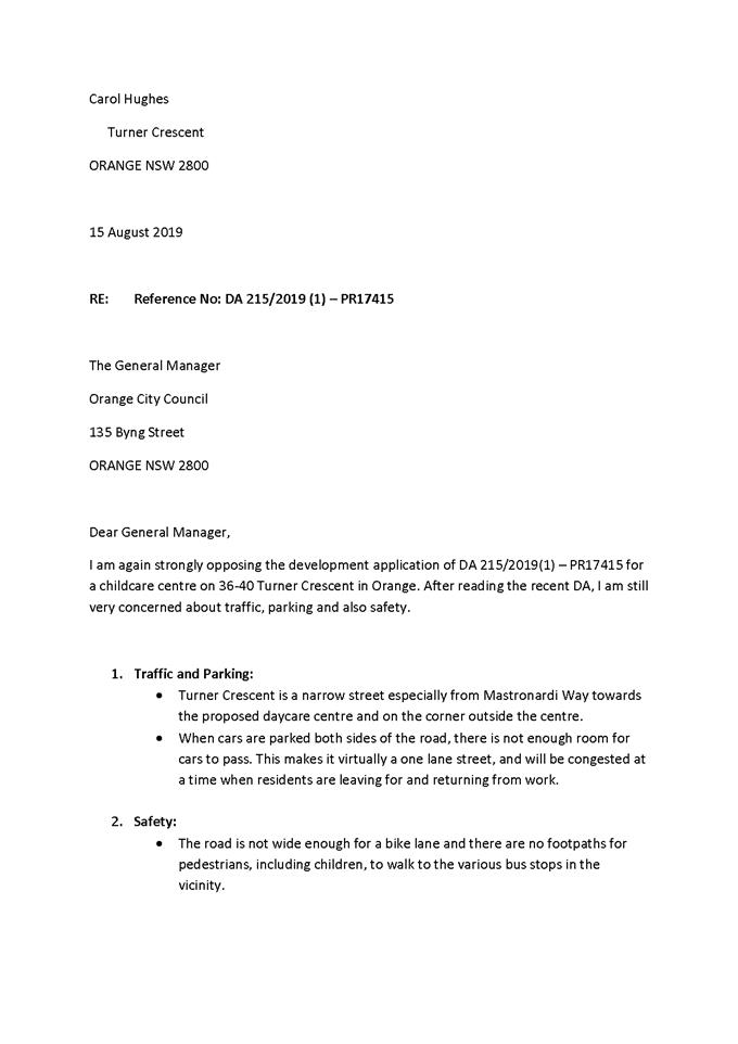
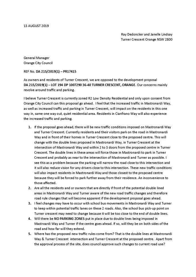
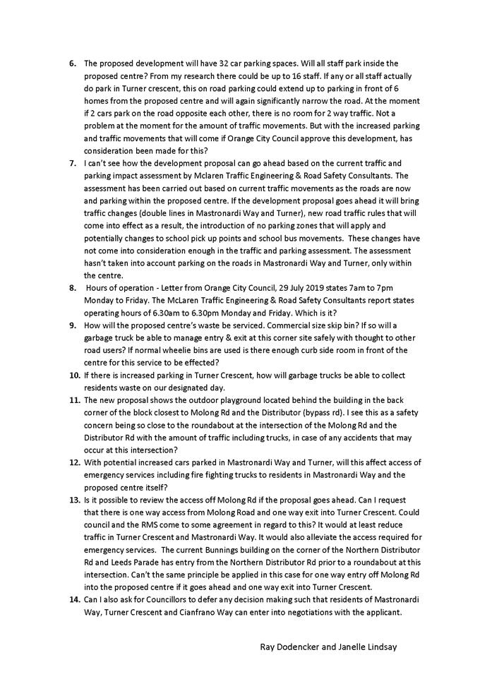


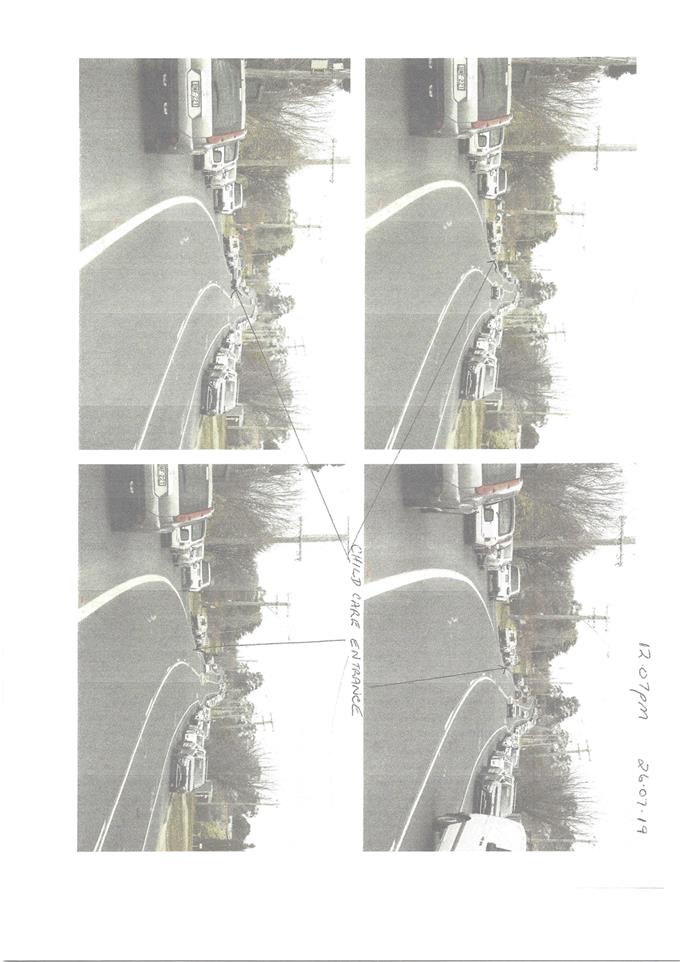
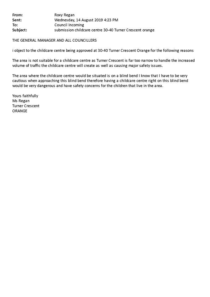
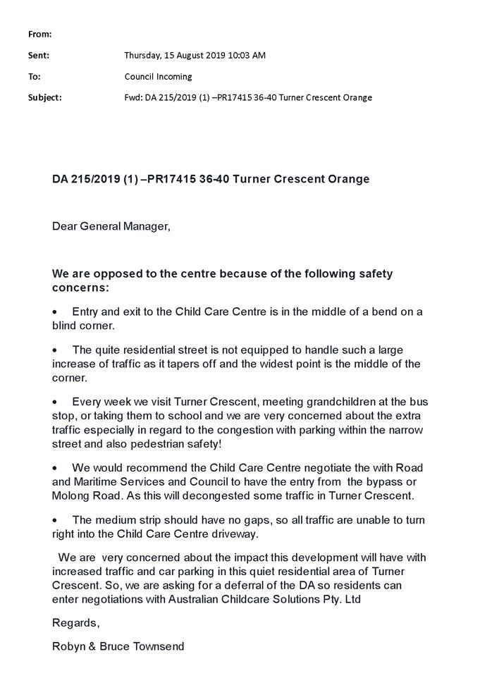
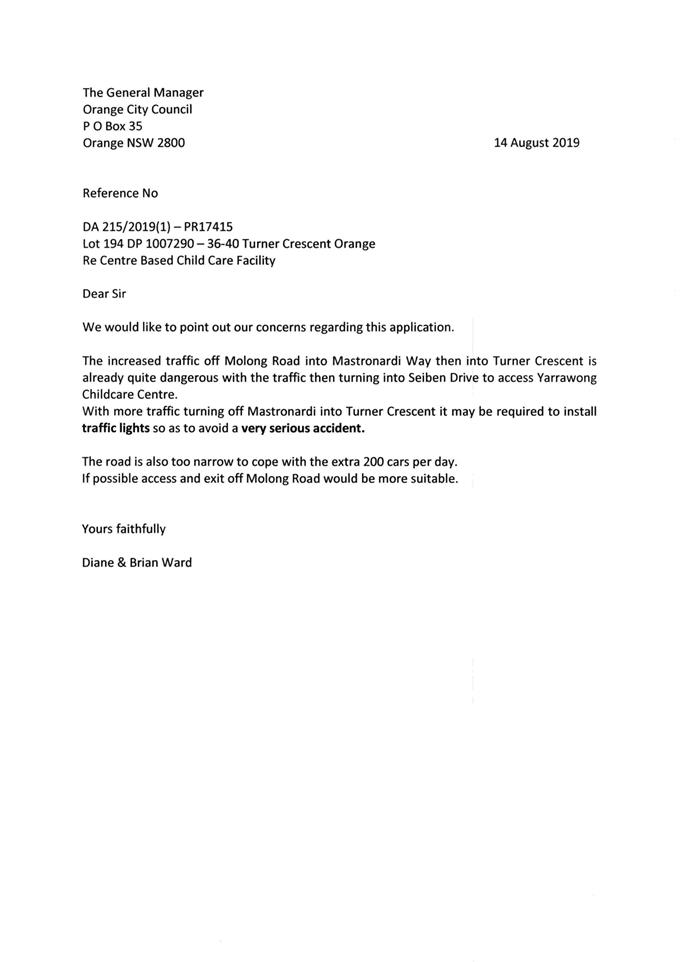
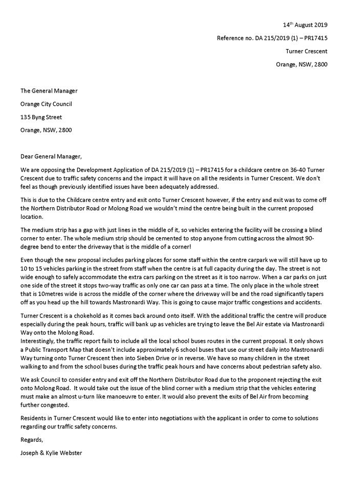
2.4 Development
Application DA 42/2018(3) - 167-177 Peisley Street and 185-187 Peisley Street,
Orange (Aldi Foods Pty Ltd)
RECORD
NUMBER: 2019/1534
AUTHOR: Ella
Wilkinson, Senior Planner
EXECUTIVE Summary
|
Application
lodged
|
15 May
2019
|
|
Applicant/s
|
Stimson
and Baker Planning
|
|
Owner/s
|
Aldi
Foods Pty Limited
|
|
Land
description
|
Lot 500
DP 1033145 - 167-177 Peisley Street, Orange
|
|
Proposed
land use
|
Shop
(alterations and additions to existing building).
|
|
Value of
proposed development
|
$1,364,000
|
Application has been made to modify development consent DA
42/2018(2). The modified proposal will link the recently re-constructed Aldi
car park (Lot 500 DP 1033145 – 167‑177 Peisley
Street) at the northern end to the adjoining Council owned car park to the
south (Lot 96 DP 1190941 – 185-187 Peisley Street).
The proposal will result in the loss of two car parking
spaces within the Aldi site, however, as discussed in the body of this report,
the number of spaces provided on the Aldi site currently exceeds the amount
required pursuant to the Orange Development Control Plan 2004 and as such, will
not cause ongoing traffic and parking issues in this instance. The proposed
link would provide direct access for Aldi customers to access this car park
with limited direct benefit to the operation of the Council carpark. Having
said this the proposed link does not change the existing management
arrangements of the Council car park in terms of timed parking restrictions or
the number of spaces. Further, the proposal does not contemplate the exclusive
use of this car park by Aldi customers and the car park will be available to
all members of the community, under the management of Orange City Council. It
is currently open for Aldi staff and customers to park within the public car
park at any time without the link being provided.
Council in determining this matter is required in part to
consider the impacts of the proposed arrangements on the function and use of
the existing Council car park. As alluded to above Lot 96 DP 1190941
(185-187 Peisley Street) is owned and managed by Orange City Council and
therefore, pursuant to the Local Government Act 1993, is defined as public
land: Public land must be classified by
Council as either “community” or “operational” land to
determine future management requirements. Where land is classified as
“community” land, there are more onerous requirements on the management
of land, because of its use or special features. In this case Council’s
records indicate that the land is classified as operational land, meaning the
land has no special restrictions other than those that may apply to any piece
of land. It is open to Council to consider this proposal.
A Section 4.15 assessment of the development indicates that
the development as modified is acceptable. Attached is an amended Notice of
Approval for Council’s consideration.
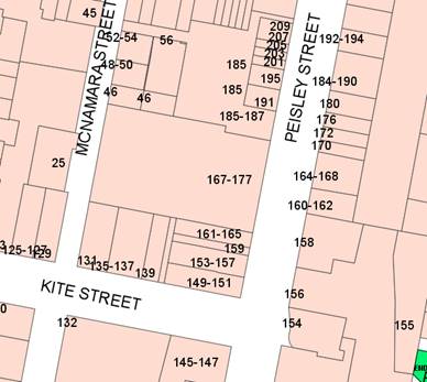
Figure 1 - locality plan
RECENT LEGISLATIVE CHANGES
On 1 March 2018 the Environmental Planning and Assessment
Act 1979 was substantially amended. The most immediate change involves the
restructuring and renumbering of the Act, with other more substantive
changes to be phased in over time. However, for some applications (particularly
where an application was lodged prior to the changes coming into effect) the
supporting documentation may still reference the previous numbering regime. In
the drafting of this report the content and substance of the supporting
material has been considered irrespective of which legislative references were
used.
DIRECTOR’S COMMENT
The proposal would provide a direct link from the private
Aldi carpark into Councils Peisley Street carpark. The proposal generally
complies with Council’s planning controls.
6 written submissions and a petition with over 150 names
were received from nearby businesses who back onto this carpark, indicating a
significant public interest. The submissions and petition object to the
proposal. Whilst the proposal to access Council’s carpark, which is
operational land, would clearly benefit a private business, Council’s
contributions plan does not detail a contribution applicable in this
case. Therefore a contribution for this purpose cannot be charged via the
Contributions Plan.
The existing Aldi carpark provides 91 carparks, but would
forego two parks to provide the direct access to Council’s carpark.
Currently Aldi staff and customers can access the area via the separate public
access point in Peisley Street.
The Council carpark provides approximately 60 spaces (50% all
day; 50% 2 hour). The carpark is very popular with users of the adjoining
shops, with spaces generally full by 8.30am.
Link To Delivery/OPerational Plan
The recommendation in this report relates to the
Delivery/Operational Plan strategy “10.1 Preserve - Engage with the
community to ensure plans for growth and development are respectful of our
heritage”.
Financial Implications
Nil
Policy and Governance Implications
Nil
|
Recommendation
That Council modifies
development consent DA 42/2018(2) for Shop (alterations and additions to existing building) at
Lot 500 DP 1033145 - 167-177 Peisley Street, and Lot 96 DP
1190941 – 185-187 Peisley Street, Orange
pursuant to the conditions of consent in the attached modified Notice of
Approval.
|
further considerations
Consideration has been given to the recommendation’s
impact on Council’s service delivery; image and reputation; political;
environmental; health and safety; employees; stakeholders and project
management; and no further implications or risks have been identified.
SUPPORTING INFORMATION
Application has been made to modify development consent DA
42/2018(2). The modified proposal will link the recently constructed Aldi car
park (Lot 500 DP 1033145 – 167‑177 Peisley Street) at its
the northern end, to the adjoining car park located at Lot 96
DP 1190941 – 185-187 Peisley Street, which is Council owned
property.
To facilitate the development, the existing kerb will be
demolished and a new pavement will be constructed to match existing levels,
which will provide the access driveway from the Aldi car park to the adjoining
lot.
The concrete median located on the entry driveway on Lot 96
DP 1190941 – 185-187 Peisley Street will also be extended by way of a new
kerb and gutter being constructed to match existing.
A Give Way sign will be installed and line marking
undertaken. No other changes are proposed as part of the modification.
The proposal will result in the loss of two car parking
spaces in total in the Aldi car park. The impact of this loss is not considered
significant, given the number of spaces approved on the site currently exceeds
the required number of spaces under Council’s Development Control Plan
2004.
MATTERS FOR CONSIDERATION
Section 4.55 of the Environmental Planning and Assessment
Act 1979 states:
A consent
authority may…modify the consent if:
(a) it
is satisfied that the proposed modification is of minimal environmental impact,
and
(b) it
is satisfied that the development to which the consent as modified relates is
substantially the same development as the development for which the consent was
originally granted and before that consent as originally granted was modified
(if at all), and
(c) it
has notified the application in accordance with:
(i) the
regulations, if the regulations so require, or
(ii) a
development control plan, if the consent authority is a council that has made a
development control plan under section 72 that requires the notification or
advertising of applications for modification of a development consent, and
(d) it
has considered any submissions made concerning the proposed modification within
any period prescribed by the regulations or provided by the development control
plan, as the case may be.
In
consideration of the above, the following comments are made:
(a) The
proposed modification is considered to be of minimal environmental impact for
the following reasons:
- The
additional access is a minor amendment to the approved car park layout and does
not materially change the development as approved under DA 42/2018 (1) (as
modified). As demonstrated by the assessment below, and undertaken as part of
the original assessment for DA 42/2019 (1), the number of car parks
approved onsite exceeds the requirements of the DCP 2004. As such, the loss of
two car parks to provide for the link between the two car parking areas is
considered minor, and the proposal is permissible in regard to this
requirement. An amended site plan was submitted demonstrating the proposed
arrangements on the site, and will supersede the previous approved plan.
- The
proposal does not result in an increase in the capacity of the use on either
lots. Further, the existing number of car parking spaces is not proposed to be
increased on either lot.
(b) In regard to the addition of
land to the consent as part of this modification, reference is made to the Land
and Environment Court ruling in the Scrap Metal v. Botany case. The ruling
stated that, “the power of a consent authority to “modify”
a consent is a power to alter without radical transformation of the
consent”. Further, whilst the consent authorises the carrying out of
development only on the land the subject development is carried out, this does
not preclude the consent being modified to extend the development approved by
the consent on other land. As such, whilst the consent can be modified to
extend the development approved by the consent to other land, the “substantially
the same development” test must be undertaken to determine that the
proposal meets this requirement as established for a modification under s.4.55
of the Act. Assessment against the “substantially the same
development” test is outlined below.
The proposed modification is
considered to be “substantially the same development” as the
work simply relates to improving circulation between two adjacent car parks.
The approved use of the both sites are not proposed to be amended as part of
this application, with the proposed works relating to a small section of each
car park. The use of the two car parks will remain the same, and no
change is proposed that would reduce the effectiveness of the use of either car
park. The proposed works will simply improve traffic arrangements between two
sites and better integrate the two car parks. As the proposed works are not
considered to materially change the use of the sites, nor will it negatively
impact on the effectiveness of the car parking facilities on each site, the
proposal is considered to meet the “substantially the same
development” test.
(c) The
modified development does not effect a condition imposed as a requirement of
concurrence by a Minister, public authority or approval body.
(d) The
modified development does not comprise advertised development pursuant to cl117
of the Environmental Planning and Assessment Regulation 2000 or Orange DCP 2004
– Section 5.3. However, adjoining neighbours were notified of the
modified development.
(e) Six
formal submissions and one petition with 164 signatures were received in
relation to the development as modified. These are outlined in further detail below.
Pursuant to Section 4.55(3) of the EPAA 1979:
In determining an application for modification of a
consent under this section, the consent authority must take into consideration
such of the matters referred to in Section 4.15(1) as are of relevance to
the development the subject of the application.
The relevant matters are considered below.
PROVISIONS OF ANY ENVIRONMENTAL
PLANNING INSTRUMENT s4.15(1)(a)(i)
Orange Local Environmental Plan 2011 (as amended)
The initial development was approved under the provisions of
Orange LEP 2011. The subject land is zoned Zone B3 Commercial Core. The initial
development was defined as Shop (alterations
and additions to an existing building). The proposed works are considered to be
ancillary to the overall use of the land for this purpose. The ongoing use of
the Council car park will remain unchanged.
State Environmental Planning Policy 55 - Remediation of
Land
SEPP 55 was applicable to the original development. The
modified development does not alter the previous assessment under the SEPP.
State Environmental Planning Policy
(Infrastructure) 2007
Clause 101 of the ISEPP states:
The consent authority must not grant consent to
development on land that has frontage to a classified road unless it is
satisfied that:
(a) where practicable and safe,
vehicular access to the land is provided by a road other than the classified
road, and
(b) the
safety and efficiency and ongoing operation of the classified road will not be
adversely affected by the development as a result of:
(i) the
design of the vehicular access to the land, or
(ii) the
emission of smoke or dust from the development, or
(iii) the
nature, volume or frequency of vehicles using the classified road to gain
access to the land, and
(c) the
development is of a type that is not sensitive to traffic noise or vehicle
emissions, or it is appropriately located and designed, or includes measures,
to ameliorate potential traffic noise or vehicle emissions within the site of
the development arising from the adjacent classified road.
In relation to the above, the following comments are made:
· Access from to the
sites are not proposed to change. The existing access arrangements from the
classified road will be maintained.
· The safety and
efficiency and ongoing operation of the classified road is not envisaged to be
affected by the development. In essence, the linking of the two car parks
rationalises an action that is already happening, however, instead of cars
going into the Aldi car park, driving out onto the classified road and then
accessing the car park in the adjoining lot from the classified road. The
proposal will not change the current arrangements or result in an increase in
traffic, instead will simply rationalise an arrangement that is currently
occurring informally. As such, the nature, volume or frequency of vehicles is
not considered to increase over and above that which already occurs,
particularly given the proposal does not result in an increase in parking
spaces or an extension of any uses on either site.
The ISEPP was applicable to the original development (Clause
104 Traffic generating development; and Clause 45 Determination of
development applications – other development).
Clause 104 of the SEPP states:
This clause applies to development specified in Column 1
of the Table to Schedule 3 that involves:
(a) new
premises of the relevant size or capacity; or
(b) an
enlargement or extension of existing premises, being an alteration or addition
of the relevant size or capacity.
The proposal does not result in the construction of a new
premises, nor does it enlarge or extend an existing premises. The original
application for the Aldi redevelopment was referred to RMS, pursuant to the
requirements of the clause. The modified proposal does not alter the previous assessment
under the SEPP given the modification does not request consent to increase
the number of car parking on a site, over and above that already approved. The
proposal relates to works that would provide integration between two car parks,
and as such, does not alter the size or capacity of the shop nor the existing
Council car park on the adjoining site.
The proposal is not considered to trigger the requirements
for referring the proposal to RMS under the SEPP.
Finally, the ISEPP has controls for development adjacent to
rail corridors.
Clause 84 states:
This clause applies to development that involves:
(c) a
new level crossing, or
(d) the
conversion into a public road of a private access road across a level crossing,
or
(e) a
likely significant increase in the total number of vehicles or the number of
trucks using a level crossing as a result of the development.
The proposal is in proximity to the
level crossing that traverses the Mitchell Highway (Summer Street).
Notwithstanding, the proposed modification is not considered to result in a
significant increase in the total number of vehicles or the number of trucks
using this level crossing.
The proposal relates to works that would provide integration
between two car parks, and as such, does not alter the size or capacity of the
shop nor the existing Council car park on the adjoining site. The linking of
the two car parks rationalises an action that is already occurring between the
two lots. The proposal will not change the current arrangements or result in an
increase in traffic, instead will simply rationalise an arrangement that is
currently occurring informally.
A submission was received from John Holland, who manage the
Country Regional Network and have an interest in the rail corridor to the west
of the subject site. The submission indicated that no objection is proposed to
the development, provided that Council consider SEPP (Infrastructure) 2007 and
Development Near Rail Corridors and Busy Roads – Interim Guidelines (2008).
As demonstrated, Council have considered the relevant
provisions of the SEPP (Infrastructure) 2007. In relation to the guidelines,
given the proposed modification relates specifically to the construction of a
driveway to adjoin two parcels and provide internal access between two car
parks, Council officers have reviewed the document and are of the opinion that
the works relating to the modification are not contrary to the guidelines.
Notwithstanding, the construction works are proposed to
occur immediately adjacent to an electricity substation. As such, the proposed
modification was referred to Essential Energy in line with the requirements of
Clause 45. Clause 45 specifies that:
Before
determining a development application (or an application for modification of a
consent) for development to which this clause applies, the consent authority
must:
- give
written notice to the electricity supply authority for the area in which the
development is to be carried out, inviting comments about potential safety risks,
and
- take
into consideration any response to the notice that is received within 21 days
after the notice is given.
Essential Energy have responded and advised that they
have no comments to make as to potential safety risks arising from the proposed
development. The advice received included five advisory notes which have been
attached to the Notice of Determination.
DESIGNATED DEVELOPMENT
The proposed development is not designated development.
INTEGRATED DEVELOPMENT
The proposed development is not integrated development.
PROVISIONS OF ANY DEVELOPMENT
CONTROL PLAN s4.15(1)(a)(iii)
Development Control Plan 2004
The original development was
assessed pursuant to the following chapters in DCP 2004:
· Chapter 0 – Transitional
Provisions
· Chapter 3 – General Considerations
· Chapter 8 – Development in
Business Zones
· Chapter 13 – Heritage
· Chapter 15 – Car parking.
· Infill Guidelines
The proposed modified development
remains generally consistent with the previous assessment under the DCP in
relation to the above chapters. Of particular note in relation to this proposal
is Chapter 15 – Car parking, which is discussed in detail below.
Chapter 15 – Car Parking
According to the previous assessment
carried out for the proposal, a Shop in the CBD generates a requirement
of 4.1 spaces per 100m2 of Gross Leasable Floor Area (GLFA).
The alterations and additions approved
as part of the original consent resulted in the Shop having a GLFA of
1,846m2. As such, a total of 76 car spaces were required. The
assessment indicated that, provided specific conditions of consent were met in
relation to the development, a total of 91 spaces would be provided, exceeding
the required amount by 15 spaces. The second modification approved on 27
August 2018 did not amend the approved car parking layout.
The current proposed amendments to the
car parking layout to provide an access driveway to the adjoining car park on
the adjacent lot will result in the loss of two approved car parking spaces.
Notwithstanding, the loss of two spaces is not considered to result in an
adverse environmental impact as the development will still be able to provide a
total of 89 spaces, which exceeds the required amount by 13 spaces.
PROVISIONS PRESCRIBED BY THE
REGULATIONS s4.15(1)(a)(iv)
The proposed development is not inconsistent with any
provisions prescribed by Regulation.
THE LIKELY IMPACTS OF THE
DEVELOPMENT s4.15(1)(b)
An assessment of the relevant impacts associated with the
development was considered as part of the initial assessment of the development
application. The potential impacts of the development as modified are
considered below.
ENVIRONMENTAL IMPACTS
Visual Impacts
The proposal as modified is satisfactory in terms of visual
impacts as the proposed works are minor in nature. Further landscaping proposed
and approved as part of preceding applications that this modification relates
will serve to mitigate potential impacts.
Traffic and Access
The proposal as modified will serve to provide better
circulation between two car parks. Whilst the construction of the proposed
driveway will reduce car parking on the site, the number of spaces provided as
part of previous applications exceeded the DCP 2004 requirement. As such, the
loss of two spaces does not reduce the functioning of the car park and the
proposed use of the site remains supported by the remaining number of car
parks.
Further, the proposed driveway does not provide additional
access onto Peisley Street. The existing access ways onto public roads will be
maintained. The proposal was reviewed by Council’s Development Engineer
and considered appropriate in this instance.
The engineering referral provided by Council’s
Assistant Development Engineer has required that the proposed barrier kerb
extension between the two traffic islands inside Orange City Councils car park
shall be deleted. Left turn only traffic movements from the driveway link shall
be regulated by a left turn arrow on the pavement and ‘Left Turn
Only’ sign.
The condition further requests engineering plans be provided
to Council or an accredited certifier, showing complete details of the proposed
driveway and car parking areas upon application for a Construction Certificate.
Therefore, at this stage, whilst the Applicant provided three plans, including
the Proposed Site Plan, the Siteworks and Grading Plan and the Soil Erosion
Control Concept Plan, Notes and Details, only the Site Plan has been formally
stamped as part of the issuing of Development Consent. This is because the
design is subject to minor changes that aim to improve traffic and access, to
ensure the proposal is satisfactory to Council’s Assistant Development
Engineer, and construction details will be formally amended in line with the
requirements of the condition.
SOCIAL AND ECONOMIC IMPACTS
Impact on Council owned public car park
The Council owned car park is currently used by staff and
customers of the businesses that are located in the vicinity of this land. The
proposed works including line markings and medians to provide for the
connection of the two car parks has been designed by the Applicant to primarily
improve the parking opportunities available for Aldi customers. Whilst the
proposed arrangements will improve the circulation internally between the two
car parks, the proposed link will provide limited benefit to the current
operation of the Council owned public car park. Having said this, it is
currently open for Aldi staff and their customers to park within the public car
park at any time by accessing the site directly from Peisley Street.
Whilst there are no changes contemplated to the overall
management of the Council car park in terms of timed parking restrictions, it
is recommended that additional signage be installed at the transition between
the two car parks to advise the public that they are entering a public car
park.
Council has recently resolved to enter into a private
parking agreement with Council for patrols of their car park. The patrols will
be designed to align with the existing short term parking restrictions that
currently apply within parts of the Council car park.
THE SUITABILITY OF THE SITE
s4.15(1)(c)
Council has previously determined that the site is suitable
for the proposed development There are no aspects of the site to indicate that
it would be unsuitable to accommodate the modified development.
ANY SUBMISSIONS MADE IN
ACCORDANCE WITH THE ACT s4.15(1)(d)
The proposed development is not defined as advertised
development under the provisions of the LEP, and, as such, no formal exhibition
of the application was required. Notwithstanding, adjoining neighbours were
notified of the proposal. A summary of the submissions received are outlined in
further detail below.
PUBLIC INTEREST
s4.15(1)(e)
Adjoining neighbours were notified of the proposal, due to
the localised nature of potential impacts of the proposed changes. No formal
exhibition was undertaken as the proposed development is considered to be of
minor interest to the wider public. The proposal is not inconsistent with any
relevant policy statements, planning studies, guidelines etc that have not been
considered in this assessment.
Six submissions and one petition were received in relation
to the proposal. The issues raised are summarised below:
· The proposal will limit the car
parking spaces available to the customers and staff of existing businesses.
The proposed management and ownership of the car park is not
proposed to change. Further, the current timing arrangements within the car
park and the number of parking spaces within the car park will not be altered.
The car park will continue to provide spaces for the wider community and will
be available to all members of the community, under the management of Orange
City Council.
· The proposed modification will
negatively affect trading ability and access for existing businesses
undertaking daily operations due to increase in use.
The car park in question provides car parking spaces in a 2
hour time limited, and all day format. The car park is owned and managed by
Council as a public car park. As such, the car park can be accessed by any
member of the public without issue, provided the time limits are observed. The
proposed link would provide direct access for Aldi customers to access this car
park, but does not change the existing management arrangements of the Council
car park in terms of timed parking restrictions or the number of spaces.
Further, the proposal does not contemplate the exclusive use of this car park
by Aldi customers and the car park will be available to all members of the
community, under the management of Orange City Council.
· Proposed modification will impact on
volunteers of United Protestant Association of NSW Ltd accessing existing
businesses in proximity of the Council car park who have mobility challenges.
Council have previously resolved to provide non-profit
organisations with a number of parking permits that waive the short-term car
parking timeframes and prevents parking infringements being issued. United
Protestant Association (UPA) of NSW Ltd were beneficiaries of this arrangement.
· The existing car park is currently at
capacity servicing the existing businesses.
The car park in question provides car parking spaces in a 2
hour time limited, and all day format. The car park is owned and managed by Council
as a public car park. As such, the car park can be accessed by any member of
the public without issue, provided the time limits are observed. The proposed
link would provide direct access for Aldi customers to access this car park,
but does not change the existing management arrangements of the Council car
park in terms of timed parking restrictions or the number of spaces.
Further, the proposal does not contemplate the exclusive use
of this car park by Aldi customers and the car park will be available to all
members of the community, under the management of Orange City Council.
· Car parking spaces should be added in
the vicinity of the CBD before traffic flow is increased to already congested
areas.
This concern raised is considered to be beyond the scope of
a site specific development application. Therefore, this comment is noted.
· The
modification will increase the chances of traffic/pedestrian incidents if
traffic flow is increased in an already busy area.
The proposal was referred to Council’s Technical
Services team who raised no concerns in relation to the safety of the proposal.
· The needs of local, long serving
businesses should come before that of Global Corporations.
This comment is noted, however, is not considered a planning
matter in regard to the provisions of section 4.15 of the Environmental
Planning and Assessment Act 1979.
· The proposed modification is not in
the best interests of the wider community.
This comment is noted. The interests of the wider community
are taken into consideration pursuant to the provisions of section 4.15 of the
Environmental Planning and Assessment Act 1979 relating to the environmental,
economic and social impacts. The merits of the proposal have been assessed
throughout the body of this report, with impacts and submissions tabled for the
consideration of Councillors. Notwithstanding, the proposal is permissible with
the consent of Council.
· Increased traffic movement in the car
park will impact on Peisley Street.
The proposal does not result in the construction of a new
premises, nor does it enlarge or extend an existing premises. The original
application for the Aldi redevelopment was referred to RMS. The modified
proposal does not alter the previous assessment under the SEPP given the
modification does not request consent to increase the number of car parking on
a site, over and above that already approved. The proposal relates to works
that would provide integration between two car parks, and as such, does not
alter the size or capacity of the shop nor the existing Council car park on the
adjoining site. No change is proposed to the existing driveways that are
currently accessible via Peisley Street. Further, the arrangement serves
to formalise an activity that is currently already being undertaken by way of
customers leaving the Aldi car park Peisley Street access, taking a left hand
turn onto Peisley Street and accessing the Council car park via the Peisley
Street driveway. As such, whilst the adjoining driveway may formalise this
arrangement and provide internal access within the site, changing the overall
traffic flow internally, exiting traffic onto Peisley Street will not increase
over and above what is already occurring.
· The new redesigned car park reduced
the number of parking spaces on the Aldi site. The proposal to link the car
parks will mean the decision to reduce the number of car parking spaces on the
Aldi site will affect customers and operations of surrounding businesses.
Whilst the modified proposal for the Aldi redevelopment
resulted in a loss of overall car parking on the site, as demonstrated above,
the car parking provided on the ALDI site exceeds the requirements for the
number of car parking spaces required for the development pursuant to the DCP
2004.
Further, the proposal to link the two car parks is a
formalisation of an arrangement currently being undertaken between the two car
parks. The proposed link would provide direct access for Aldi customers to
access this car park, but does not change the existing management arrangements
of the Council car park in terms of timed parking restrictions or the number of
spaces. Further, the proposal does not contemplate the exclusive use of this
car park by Aldi customers and the car park will be available to all members of
the community, under the management of Orange City Council.
· The proposal will provide space for
Aldi shoppers in the Council car park, but Aldi don’t allow the existing
businesses customers to park in the private Aldi car park.
Council does not have control over how a landowner
undertakes operations and provides access to a privately owned lot. The
proposal does not contemplate the exclusive use of this car park by Aldi
customers and the car park will be available to all members of the community,
under the management of Orange City Council. It is currently open for Aldi
staff and customers to park within the public car park at any time without the
link being provided.
· The proposed modification could mean
that Aldi may apply for a modification of the all-day parking section in
future, amending this to short stay to benefit their customers, meaning the
city losses the all-day parking resource.
The current modified proposal before Council is to construct
a driveway to link the two car parking areas together. There is no request to
amend the current timed parking arrangements within the car park. Further, the
car park will continue to be managed by Orange City Council. Therefore, any
proposal to amend timed parking arrangements will continue to require the
consent of Council.
· The proposal will clash with a
previous offer relating to businesses purchasing a space within the car park.
This comment is noted, however, is not considered a planning
matter in regard to the provisions of Section 4.15 of the Environmental Planning
and Assessment Act 1979.
· Why is Aldi being given use of a
Council owned car park without due compensation to the community.
The proposal does not contemplate the exclusive use of this
car park by Aldi customers and the car park will be available to all members of
the community, under the management of Orange City Council.
SUMMARY
The proposed modification is permissible with the consent of
Council. The proposed development complies with the relevant aims, objectives
and provisions of Orange LEP 2011 (as amended) and DCP 2004. The
modification is consistent with the provisions of the Environmental Planning
and Assessment Act 1979. Section 4.15 assessment of the
development as modified indicates that the development is acceptable in this
instance. Attached is a draft amended Notice of Approval outlining a range of
conditions considered appropriate to ensure that the development proceeds in an
acceptable manner.
COMMENTS
The requirements of the Environmental Health and Building
Surveyor and the Engineering Development Section are included in the attached
amended Notice of Approval.
Attachments
1 Notice
of Approval, D19/49652⇩
2 Plan,
D19/49626⇩
3 Petition,
D19/49653⇩
4 Submissions,
D19/49742⇩
Planning
and Development Committee
3 September 2019
Attachment 1 Notice
of Approval
|
|
ORANGE CITY COUNCIL
Development
Application No DA
42/2018(3)
NA19/ Container
PR18292
|
NOTICE OF DETERMINATION
OF A DEVELOPMENT
APPLICATION
(AS MODIFIED)
issued under the Environmental
Planning and Assessment Act 1979
Section 4.18
|
Development
Application
|
|
|
Applicant
Name:
|
Stimson and Baker
Planning
|
|
Applicant
Address:
|
PO Box 1912
PENRITH
NSW 2751
|
|
Owner’s
Name:
|
Aldi Foods Pty
Limited, Orange City Council
|
|
Land
to Be Developed:
|
Lot 500 DP 1033145 -
167-177 Peisley Street, Orange
Lot 96 DP
1190941 – 185-187 Peisley Street, Orange
|
|
Proposed
Development:
|
Shop (alterations and
additions to existing building)
|
|
|
|
|
Building Code of
Australia
building
classification:
|
As determined by
Certifier
|
|
|
|
|
Determination made
under
Section 4.16
|
|
|
Made
On:
|
3 September 2019
|
|
Determination:
|
CONSENT GRANTED
SUBJECT TO CONDITIONS DESCRIBED BELOW:
|
|
|
|
|
Consent to Operate
From:
|
12 June 2018
|
|
Consent to Lapse On:
|
12 June 2023
|
Terms of
Approval
The
reasons for the imposition of conditions are:
(1) To ensure a quality
urban design for the development which complements the surrounding environment.
(2) To maintain
neighbourhood amenity and character.
(3) To ensure compliance
with relevant statutory requirements.
(4) To provide adequate
public health and safety measures.
(5) To ensure the utility
services are available to the site and adequate for the development.
(6) To prevent the proposed
development having a detrimental effect on adjoining land uses.
(7) To minimise the impact
of development on the environment.
Conditions
(1) The development must be
carried out in accordance with:
(a) P1□310 DA 01 REV
A dated 12/201□, P17310 DA 02 REV B dated 12/2017, P1□310 DA 03 REV
A dated 12/201□, P1□310 DA 04 REV A dated 12/201□, P17310 DA
05 REV B dated 12/2017, P17310 DA 06 REV B dated 12/2017, P17310 DA
07 REV B dated 12/2017, P17310 DA 08 REV B dated 12/2017, P17310 DA 09
REV B dated 12/2017, P1□310 DA 10 REV A dated 12/201□, P1□310
DA 11 REV A dated 12/201□ (11 sheets by Steiner and Richards)
Schedule of Finishes (2 sheets by Steiner and
Richards)
Amending plan: Dwg No P17310 DA 06
(Rev D) dated 14/08/2018
Amending plan: Drawing by Steiner
Richards Architect – Drawing Title Proposed Site Plan, Drawing Number
P17310 DA 06, Revision E, Date 12/2017
(b) statements
of environmental effects or other similar associated documents that form part
of the approval
as amended in
accordance with any conditions of this consent.
(2) All building work must
be carried out in accordance with the provisions of the Building Code of
Australia.
(3) A sign is to be erected
in a prominent position on any site on which building work, subdivision work or
demolition work is being carried out:
(a) showing
the name, address and telephone number of the principal certifying authority
for the work, and
(b) showing
the name of the principal contractor (if any) for any building work and a
telephone number on which that person may be contacted outside working hours,
and
(c) stating
that unauthorised entry to the site is prohibited.
Any such sign is to be maintained while the
building work, subdivision work or demolition work is being carried out.
(4) Where any excavation
work on the site extends below the level of the base of the footings of a
building on adjoining land, the person having the benefit of the development
consent must, at the person’s own expense:
(a) protect
and support the adjoining premises from possible damage from the excavation,
and
(b) where
necessary, underpin the adjoining premises to prevent any such damage.
Note: This
condition does not apply if the person having the benefit of the development
consent owns the adjoining land or the owner of the adjoining land has given
consent in writing to this condition not applying.
|
PRIOR TO THE ISSUE OF A CONSTRUCTION
CERTIFICATE
|
(5) (deleted)
(6) An
approval under Section 68 of the Local Government Act is to be sought
from Orange City Council, as the Water and Sewer Authority, for alterations to
water and sewer. No plumbing and drainage is to commence until approval is
granted.
(7) Prior
to the issue of a Construction Certificate, the applicant is to obtain an
approval under Section 68 of the Local Government Act for the
temporary closure of any footpath or roadway. A pedestrian/vehicle
management plan is to accompany the application. Details are to be provided of
the protective hoardings, fences and lighting that are to be used during
demolition, excavation and building works in accordance with the requirements
of the Occupational Health & Safety Act 2000, Australian
Standard AS3798-1996 (Guidelines on Earthworks for Commercial and Residential
Developments) and the WorkCover Authority.
Note: On corner
properties particular attention is to be given to the provision of adequate
sight distances.
(8) The applicant is to
submit a waste management plan that describes the nature of wastes to be
removed, the wastes to be recycled and the destination of all wastes. All
wastes from the demolition and construction phases of this project are to be
deposited at a licensed or approved waste disposal site.
Prior to the issue of a construction
certificate (cont)
|
(9) Engineering plans
providing complete details of the proposed driveway and car parking areas are
to be submitted to Orange City Council or an Accredited Certifier (Categories
B1, C3, C4, C6) upon application for a Construction Certificate. These plans
are to provide details of levels, cross falls of all pavements, proposed
sealing materials and proposed drainage works and are to be in accordance with
Orange City Council Development and Subdivision Code.
The proposed barrier kerb extension between the
two traffic islands inside Orange City Council’s car park shall be
deleted. Left turn only traffic movements from the driveway link shall be
regulated by a left turn arrow on the pavement and ‘Left Turn Only’
sign.
|
PRIOR TO WORKS COMMENCING
|
(10) Prior
to carrying out any works, a “Dial Before You Dig” enquiry should
be undertaken in accordance with the requirements of Part 5E (Protection of
Underground Electricity Power Lines) of the Electricity Supply Act 1995 (NSW).
(11) Given
there is electricity infrastructure in the area, it is the responsibility of
the person/s completing any works around powerlines to understand their safety
responsibilities. SafeWork NSW (www.safework.nsw.gov.au) has publications that
provide guidance when working close to electricity infrastructure. These
include the Code of Practice – Work near Underground Assets.
(12) A
Construction Certificate application is required to be submitted to, and issued
by Council/Accredited Certifier prior to any excavation or building works being
carried out onsite.
|
DURING CONSTRUCTION/SITEWORKS
|
(13) Essential
Energy’s records indicate there is electricity infrastructure located
within the property and within close proximity of the property. Any activities
within these locations must be undertaken in accordance with the latest
industry guideline currently known as ISSC 20 Guideline for the Management
of Activities within Electricity Easements and Close to Infrastructure.
(14) All
construction/demolition work on the site is to be carried out between the hours
of 7.00 am and 6.00 pm Monday to Friday inclusive, 7.00 am to
5.00 pm Saturdays and 8.00 am to 5.00 pm Sundays and Public
Holidays. Written approval must be obtained from the General Manager of Orange
City Council to vary these hours.
(15) All materials on site
or being delivered to the site are to be contained within the site. The
requirements of the Protection of the Environment Operations Act 1997
are to be complied with when placing/stockpiling loose material or when
disposing of waste products or during any other activities likely to pollute
drains or watercourses.
(16) Building demolition is
to be carried out in accordance with Australian Standard 2601:2001 - The
Demolition of Structures and the requirements of Safe Work NSW.
(17) The
fit-out of the food preparation and storage areas are to be installed in
accordance with the requirements of Food Safety Standard 3.2.3 "Food
Premises and Equipment" of the Australian New Zealand Food Standards Code
and Australian Standard 4674-2004 "Design and construction and fit-out of
food premises".
(18) No portion of the
building - including footings, eaves, overhang and service pipes - shall
encroach into any easement.
(19) Any adjustments to
existing utility services that are made necessary by this development
proceeding are to be at the full cost of the developer.
(20) All driveway and
parking areas are to be sealed with bitumen, hot mix or concrete and are to be
designed for all expected loading conditions (provided however that the minimum
pavement depth for gravel and flush seal roadways is 200mm) and be in
accordance with the Orange City Council Development and Subdivision Code.
|
PRIOR TO THE ISSUE OF AN OCCUPATION
CERTIFICATE
|
(21) No
person is to use or occupy the building or alteration that is the subject of
this approval without the prior issuing of an Occupation Certificate.
(22) Finished
ground levels are to be graded away from the buildings and adjoining properties
and must achieve natural drainage. The concentrated flows are to be dispersed
down slope or collected and discharged to the stormwater drainage system.
(23) The
owner of the building/s must cause the Council to be given a Final Fire Safety
Certificate on completion of the building in relation to essential fire or
other safety measures included in the schedule attached to this approval.
(24) Where
Orange City Council is not the Principal Certifying Authority, a final
inspection of water connection, sewer and stormwater drainage shall be
undertaken by Orange City Council and a Final Notice of Inspection issued,
prior to the issue of either an interim or a final Occupation Certificate.
(25) Certification from
Orange City Council is required to be submitted to the Principal Certifying
Authority prior to the issue of an Occupation Certificate stating that all
works relating to connection of the development to Council assets, works on
public land, works on public roads, stormwater, sewer and water reticulation
mains and footpaths have been carried out in accordance with the Orange City
Council Development and Subdivision Code and the foregoing conditions, and that
Council will take ownership of the infrastructure assets.
(26) Off-street car parking
will be provided in accordance with the amended stamped approved site plan
(Dwg. No. P17310 DA 06 (Rev D) dated 14/08/2018). Replacement tree planting in
the car park will comprise semi-mature Crepe Myrtle Lagerstroemia or Trident
Maple Acer buergerianum (100L container size).
(27) All
of the foregoing conditions are to be at the full cost of the developer and to
the requirements and standards of the Orange City Council Development and
Subdivision Code, unless specifically stated otherwise. All work required by
the foregoing conditions is to be completed prior to the issuing of an Occupation
Certificate, unless stated otherwise.
|
MATTERS FOR THE ONGOING PERFORMANCE AND
OPERATION OF THE DEVELOPMENT
|
(28) Any
existing encumbrances in favour of Essential Energy (or its predecessors) noted
on the title of the above property should be complied with.
(29) The
owner is required to provide to Council and to the NSW Fire Commissioner an
Annual Fire Safety Statement in respect of the fire-safety measures, as
required by Clause 177 of the Environmental Planning and Assessment
Regulation 2000.
(30) Any
ancillary light fittings fitted to the exterior of the building are to be
shielded or mounted in a position to minimise glare to adjoining properties.
(31) Emitted noise shall not exceed 5dB(A) above background
sound level measured at the nearest affected residence.
(32) Site
landscaping will be permanently maintained to the satisfaction of
Council’s Manager Development Assessments.
(33) Pedestrian/customer
access along the northern site boundary is not permitted. This space shall be
practically inaccessible to the general public at all times.
(34) The
applicant shall install signage at the transition between the Council car park
and the Aldi car park advising patrons that they are entering a public carpark.
(1) If
the proposed development changes, there may be potential safety risks and it is
recommended that Essential Energy is consulted for further comment.
(2) Any
existing encumbrances in favour of Essential Energy (or its predecessors) noted
on the title of the above property should be complied with.
(3) In
addition, Essential Energy’s records indicate there is electricity
infrastructure located within the property. Any activities within this location
must be undertaken in accordance with the latest industry guideline currently
known as ISSC 20 Guideline for the Management of Activities within Electricity
Easements and Close to Infrastructure. Approval may be required from Essential
Energy should activities within the property encroach on the electricity
infrastructure. https://energy.nsw.gov.au/sites/default/files/2018-09/ISSC-20-Electricity-Easements.pdf
(4) Prior
to carrying out any works, a “Dial Before You Dig” enquiry should
be undertaken in accordance with the requirements of Part 5E (Protection
of Underground Electricity Power Lines) of the Electricity Supply Act
1995 (NSW).
(5) Given
there is electricity infrastructure in the area, it is the responsibility of
the person/s completing any works around powerlines to understand their safety
responsibilities. SafeWork NSW (www.safework.nsw.gov.au) has publications that
provide guidance when working close to electricity infrastructure. These
include the Code of Practice – Work near Overhead Power Lines and Code of
Practice – Work near Underground Assets.
Other
Approvals
(1) Local
Government Act 1993 approvals granted under Section 68.
Nil
(2) General
terms of other approvals integrated as part of this consent.
Nil
Right
of Appeal
If you are dissatisfied with this decision,
Section 8.7 of the Environmental Planning and Assessment Act 1979
gives you the right to appeal to the Land and Environment Court. Pursuant to
Section 8.10, an applicant may only appeal within 6 months after the date the
decision is notified.
|
Disability
Discrimination Act 1992:
|
This application has been assessed in
accordance with the Environmental Planning and Assessment Act 1979. No
guarantee is given that the proposal complies with the Disability
Discrimination Act 1992.
The applicant/owner is responsible to ensure
compliance with this and other anti-discrimination legislation.
The Disability Discrimination Act
covers disabilities not catered for in the minimum standards called up in the
Building Code of Australia which references AS1428.1 - "Design for
Access and Mobility". AS1428 Parts 2, 3 and 4 provides the most
comprehensive technical guidance under the Disability Discrimination Act
currently available in Australia.
|
|
Disclaimer
- S88B of the Conveyancing Act 1919 - Restrictions on the Use of
Land:
|
The applicant should note that there could be
covenants in favour of persons other than Council restricting what may be
built or done upon the subject land. The applicant is advised to check the
position before commencing any work.
|
|
|
|
|
Signed:
|
On behalf of the consent authority ORANGE
CITY COUNCIL
|
|
Signature:
|
|
|
Name:
|
PAUL JOHNSTON - MANAGER DEVELOPMENT ASSESSMENTS
|
|
Date:
|
4 September 2019
|
Planning and Development Committee
3 September 2019
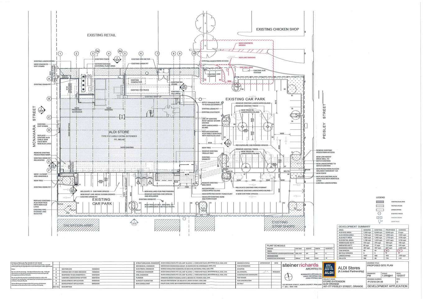
Planning
and Development Committee
3 September 2019
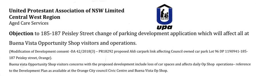
163 signatures were received
for this petition.
Planning and Development Committee
3 September 2019
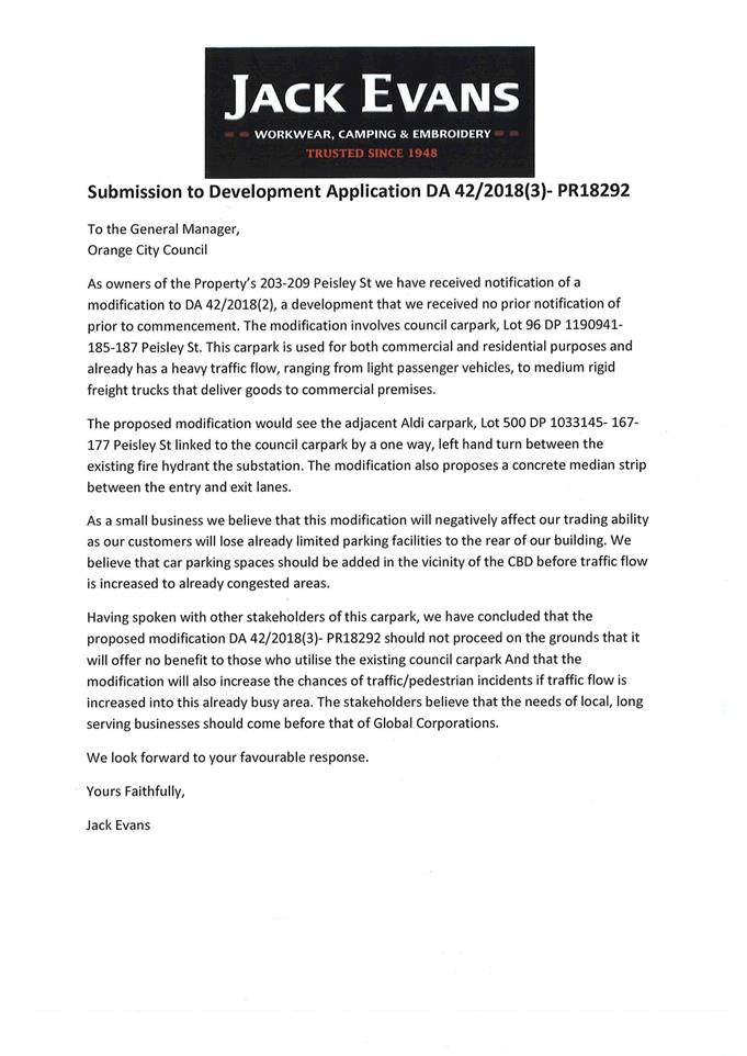
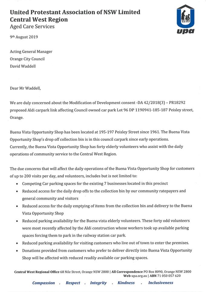
2.5 Development
Application - DA 81/2019(1) - 111 Clinton Street
RECORD
NUMBER: 2019/1692
AUTHOR: Kayla
Clanchy, Town Planner
EXECUTIVE Summary
|
Application
lodged
|
28 March
2019
|
|
Applicant/s
|
Mr PK
Bromley
|
|
Owner/s
|
Mr PK
Bromley
|
|
Land
description
|
Lot 1 DP
196341 - 111 Clinton Street
|
|
Proposed
land use
|
Demolition of Garage, Carport, and
Swimming Pool; Partial demolition and replacement of western portion of
existing Dwelling House; Partial demolition and replacement of boundary
fencing; New detached Garage (ground floor) with Secondary Dwelling (first
floor)
|
|
Value of
proposed development
|
$700,000
|
Council's consent is sought for demolition of some
outbuildings and rear portion of the existing dwelling house on the subject
site – being 111 Clinton Street (Lot 1 DP 196341):
Figure 1 - Locality Plan with subject site outlined in
red
Demolition is proposed in order to make way for a single
storey house extension and two storey detached garage/secondary dwelling.
The proposed secondary dwelling will be located above a three-bay garage, and
comprise one bedroom. The maximum height of this structure to the ridgeline
from natural ground level will be approximately 6.15m. An extension is
proposed to the existing dwelling house on the site, to enhance indoor and
outdoor living areas. The extension will follow existing setbacks of the
dwelling house from property boundaries.
The subject site occurs in the R1
General Residential Zone and central Heritage Conservation Area of Orange, and
is a corner Lot bordered by Clinton Street and a ‘bottleneck’
portion of Rosemary Lane. Therefore, the assessment heavily focusses on
heritage considerations.
A number of submissions were received
from neighbouring properties and the primary concern for most submitters were
issues relating to overshadowing, overlooking, and traffic impacts.
***
Council’s resolution at the 6 August 2019 PDC Meeting:
All of the previous submitters were notified of the above
resolution.
The applicant submitted further design changes to the
two-storey building, including reducing the roof pitch to 30 degrees at all
elevations, lowering the overall height of the structure by at least 250mm (due
in part to altering wall heights of the secondary dwelling and ceiling height
of garage), adding a window on the west elevation wall of the first floor, and
increasing the proportion of external brick so as to make the two-storey
structure appear less top-heavy. These design changes were forwarded to the
objector at 26A Rosemary Lane and a further submission from this objector was
received (see attached). This submission has been addressed together with other
submissions under “Any submissions made in accordance with the act
s4.15(1)(d)”.
To elucidate the intent of the resolution, it is noted that
during the Meeting concerns were raised in relation to private open space,
visual bulk (and setbacks), character considerations, and use of the secondary
dwelling for the purposes of Airbnb accommodation or similar. These concerns
have been explicitly addressed in the body of the report in greater detail and
taking into account the third-round of design changes proposed by the applicant
– see comments under Development Control Plan 2004, Chapter 7: PO
7.7-1, 7.7-6 and PO 7.7-16.
The proposed development is permissible with the consent of
Council. The proposed development complies with the relevant aims, objectives
and provisions of the LEP, DCP, and relevant SEPPs. In short, it is recommended
that Council supports the application. The applicant has made considered and
careful design changes throughout the course of the development assessment
period. The series of changes put forward by the applicant have assisted in
meeting all of the planning outcomes in the DCP.
RECENT LEGISLATIVE CHANGES
On 1 March 2018 the Environmental Planning and Assessment
Act 1979 was substantially amended. The most immediate change involves the
restructuring and renumbering of the Act, with other more substantive
changes to be phased in over time. However, for some applications (particularly
where an application was lodged prior to the changes coming into effect) the
supporting documentation may still reference the previous numbering regime. In
the drafting of this report the content and substance of the supporting
material has been considered irrespective of which legislative references were
used.
DIRECTORS COMMENT
This proposal relates to the construction of additions to
the rear of the existing dwelling, and construction of a detached garage with a
first floor secondary dwelling. This report was considered at the August
PDC. Council deferred determination and requested the applicant consider
alteration to address some of the concerns raised by a neighbour. The
applicant has made substantial changes to the development as requested.
The two storey building has a reduced ceiling and wall weight and also reduced
roof pitch. I suggest that this is very reasonable of the applicant as it
has reduced the amount of usable floor space in the secondary dwelling.
It is considered that no further changes could be practicably be made to this
building. Whilst the fascia of the roof extends outside the bulk
and scale envelope this does not result in adverse impacts on the
neighbours. The development is considered to be compliant and therefore
approval is recommended.
Link To Delivery/OPerational Plan
The recommendation in this report relates to the
Delivery/Operational Plan strategy “10.1 Preserve - Engage with the
community to ensure plans for growth and development are respectful of our
heritage”.
Financial Implications
Nil
Policy and Governance Implications
Nil
|
Recommendation
That Council resolves to consent to development
application DA 81/2019(1) for Demolition of Garage, Carport, and Swimming
Pool; Partial demolition and replacement of western portion of existing
Dwelling House; Partial demolition and replacement of boundary fencing; New
detached Garage (ground floor) with Secondary Dwelling (first floor) at
Lot 1 DP 196341 - 111 Clinton Street, Orange pursuant to the conditions of
consent in the attached Notice of Approval.
|
further considerations
Consideration has been given to the recommendation’s
impact on Council’s service delivery; image and reputation; political;
environmental; health and safety; employees; stakeholders and project
management; and no further implications or risks have been identified.
SUPPORTING INFORMATION
THE APPLICATION/PROPOSAL
Council's consent is sought for demolition of some
outbuildings and rear portion of the existing dwelling house on the subject
site, to make way for a single storey house extension and two storey detached
garage/secondary dwelling.
The proposed secondary dwelling will be located above a
three-bay garage, and comprise one bedroom. The maximum height of this
structure to the ridgeline from natural ground level will be approximately
6.15m.
An extension is proposed to the existing dwelling house on
the site, to enhance indoor and outdoor living areas. The extension will follow
existing setbacks of the dwelling house from property boundaries.
BACKGROUND INFORMATION
|
1982
|
In-ground
swimming pool approved.
|
|
1984
|
Rear alterations and additions to
existing house, new outbuildings, and new carport approved.
|
|
November 2018
|
pre-DA advice
to the applicant from Council for proposed development. This advice focussed
on heritage design considerations for the proposed rear house demolition and
extension, and secondary dwelling.
|
MATTERS FOR CONSIDERATION
Section 1.7 - Application of
Part 7 of the Biodiversity Conservation Act 2016 and Part 7A of the
Fisheries Management Act 1994
Section 1.7 of the EP&A Act identifies that Part 7 of
the Biodiversity Conservation Act 2016 (BC Act) and Part 7A of the
Fisheries Management Act 1994 have effect in connection with terrestrial and
aquatic environments.
There are four triggers known to
insert a development into the Biodiversity Offset Scheme (ie the need for
a BDAR to be submitted with a DA):
· Trigger 1:
development occurs in land mapped on the Biodiversity Values Map (OEH)
(Clause 7.1 of BC Regulation 2017).
· Trigger 2:
development involves clearing/disturbance of native vegetation above a certain
area threshold (Clauses 7.1 and 7.2 of BC Regulation 2017).
· Trigger 3:
development is otherwise likely to significantly affect threatened species
(Clauses 7.2 and 7.3 of BC Act 2016).
The fourth trigger (development proposed to occur in an Area
of Outstanding Biodiversity Value (Clause 7.2 of BC Act 2016) is generally not
applicable to the Orange LGA; as no such areas are known to occur in the LGA.
No further comments will be made against the fourth trigger.
Trigger 1
The site is not identified on the
Biodiversity Values Map.
Trigger 2
The clearing threshold is not exceeded
for the site.
Trigger 3
With regard to the third trigger,
the test for determining whether proposed development is otherwise likely to
significantly affect threatened species is listed in the BC Act 2016,
under s7.3.
Comments against s7.3:
The site is not identified on the high biodiversity
sensitivity LEP map. The land is zoned R1 General Residential and has been
zoned/used this way for several decades. The site and surrounds mostly contain
deciduous, non-native trees and shrubs, typical for the Heritage Conservation
Area. There are no known habitat corridors or linkages at the site or in
proximity to the site. Some outbuildings are proposed to be removed as part of
the proposal. Given the isolation of these outbuildings from any other native
feed trees or roosting areas, it is unlikely these outbuildings provide shelter
for native fauna. No tree removal is proposed on the site. It does appear,
however, that tree removal has been undertaken previously at the site for up to
two trees, when comparing a recent site visit with 2015 Google Streetview. In
any case, tree plantings are proposed as part of the Landscaping Plan for the
development. None of the trees proposed, however, appear to be native species
and have mostly been selected based on heritage character considerations for
the locality.
Based on the above, no direct impacts to threatened
species are likely to occur as a result of the development. Indirect impacts
may be generated through unfettered soil and sedimentation making its way into
receiving waters, and impacting on creek stormwater quality. This indirect
impact can be mitigated by a standard condition of consent requiring an erosion
and sediment control plan and measures to be in place for the life of the
project construction.
Having consulted the ‘Key Threatening Processes’
schedule of the BC Act (sch. 4), no potential threats have been identified as a
result of the development in this location.
Summary
The proposed development is not likely to significantly
affect threatened species.
Section 4.15
Section 4.15 of the Environmental Planning and Assessment
Act 1979 requires Council to consider various matters, of which those
pertaining to the application are listed below.
PROVISIONS OF ANY ENVIRONMENTAL
PLANNING INSTRUMENT s4.15(1)(a)(i)
Orange Local Environmental
Plan 2011
Parts 1, 2, 5, and 7 apply to the development and are
addressed below.
Part 1 - Preliminary
1.2 - Aims of Plan
The broad aims of the LEP are
set out under Subclause 2. Those relevant to the application are as follows:
(b) to provide for a range of development
opportunities that contribute to the social, economic and environmental
resources of Orange in a way that allows present and future generations to meet
their needs by implementing the principles for ecologically sustainable
development,
(e) to
provide a range of housing choices in planned urban and rural locations to meet population
growth,
(f) to recognise and manage valued
environmental heritage, landscape and scenic features of Orange.
With regard to (b), developable land in the Orange LGA is a
limited resource, and allowing infill development in established parts of the
City ensures land resources are being efficiently used with regard to present
and future generations.
With regard to (e), the addition of a secondary dwelling at
the subject location adds variety to the mix of housing and residences
available in proximity to the city centre.
With regard to (f), the design of the proposed development
is sympathetic to the Heritage Conservation Area.
1.6 - Consent Authority
This clause establishes that, subject to the Act, Council is
the consent authority for applications made under the LEP.
1.7 - Mapping
|
Land
Zoning Map:
|
Land
zoned R1 General Residential
|
|
Lot
Size Map:
|
No
Minimum Lot Size
|
|
Heritage
Map:
|
Heritage
conservation area
|
|
Height
of Buildings Map:
|
No
building height limit
|
|
Floor
Space Ratio Map:
|
No
floor space limit
|
|
Terrestrial
Biodiversity Map:
|
No
biodiversity sensitivity on the site
|
|
Groundwater
Vulnerability Map:
|
Groundwater
vulnerable
|
|
Drinking
Water Catchment Map:
|
Not
within the drinking water catchment
|
|
Watercourse
Map:
|
Not
within or affecting a defined watercourse
|
|
Urban
Release Area Map:
|
Not
within an urban release area
|
|
Obstacle
Limitation Surface Map:
|
No
restriction on building siting or construction
|
|
Additional
Permitted Uses Map:
|
No
additional permitted use applies
|
|
Flood
Planning Map:
|
Not
within a flood planning area
|
Those matters that are of relevance are addressed in detail
in the body of this report.
1.9A - Suspension of Covenants,
Agreements and Instruments
This clause provides that covenants, agreements and other
instruments which seek to restrict the carrying out of development do not
apply, with some exceptions. Council staff are not aware of the title of the
subject property being affected by any restrictions that would seek to curb the
development proposed.
Part 2 - Permitted or
Prohibited Development
2.1 - Land Use Zones
and Clause 2.3 - Zone Objectives and Land Use Table
The subject site is located within the R1 General
Residential zone. The proposed development comprises a few elements –
being Demolition of Garage, Carport, and Swimming Pool; Partial demolition and
replacement of western portion of existing Dwelling House; Partial demolition
and replacement of boundary fencing; New detached Garage (ground floor) with
Secondary Dwelling (first floor). All of these elements are permissible in the
zone under the LEP.
Clause 2.3 of LEP 2011
references the Land Use Table and Objectives for each zone in LEP 2011.
Relevant objectives of the Zone are:
· To provide for
the housing needs of the community.
· To provide for
a variety of housing types and densities.
· To ensure
development is ordered in such a way as to maximise public transport patronage
and encourage walking and cycling in close proximity to settlement.
Secondary dwellings are
generally small in area and thus are affordable types of residential
accommodation. Secondary dwellings are subservient to a primary dwelling
occurring on the same site and generally cannot be subdivided off from the main
dwelling. Therefore, secondary dwellings inherently meet the first two relevant
objectives of the General Residential zone. The subject site fronts Clinton
Street, and at this part of Clinton Street, two bus routes (western and
north-western route) are in operation. Furthermore, the subject site occurs
within a locality that is well-serviced by footpaths.
The house extension also accords
with the above objectives.
2.7 - Demolition Requires Development Consent
This clause triggers the need for development consent in
relation to a building or work. This requirement does not apply to any
demolition that is defined as exempt development.
The proposal involves demolition and the applicant is
seeking the consent of council. The demolition works proposed will have no
significant impact on adjoining lands, streetscape or public realm. Conditions
may be imposed in respect of hours of operation, dust suppression and the need
to investigate for, and appropriate manage the presence of, any materials
containing asbestos.
Part 5 -
Miscellaneous Provisions
5.4 - Controls
Relating to Miscellaneous Permissible Uses
This clause contains
various development standards that apply to specific types of development. Of
relevance to the proposal:
(9) Secondary
dwellings
If
development for the purposes of a secondary dwelling is permitted under this
Plan, the total floor area of the dwelling (excluding any area used for
parking) must not exceed whichever of the following is the greater:
(a) 60
square metres,
(b) 50%
of the total floor area of the principal dwelling.
This clause refers to
“total floor area” (no definition in LEP), as opposed to
“gross floor area” (definition in LEP). However, “floor
area” is defined in State Environmental Planning Policy (Affordable
Rental Housing) 2009 (‘Affordable Rental Housing SEPP’) and
this definition is similar to the standard instrument definition of gross floor
area found in the LEP. The “floor area” definition in the
Affordable Rental Housing SEPP excludes calculation of a stairway or void above
a lower storey (Schedule 1 of SEPP).
Given that the
Affordable Rental Housing SEPP administers many provisions to do with secondary
dwellings, and that the SEPP generally overrides any local provisions in an LEP
that may be in conflict with the SEPP (per Clause 8 of the SEPP), the
“floor area” definition as found in the SEPP is applied in
interpreting Clause 5.4 of the LEP.
In light of the
above, the secondary dwelling element of the proposal comprises a “floor
area” of approximately 68.28sqm (excluding stairs/void), which is less
than half the “floor area” of the main dwelling on the site.
5.10 - Heritage Conservation
This clause applies.
(1) Objectives
The objectives of this clause
are as follows:
(a) to
conserve the environmental heritage of Orange,
(b) to
conserve the heritage significance of heritage items and heritage conservation
areas, including associated fabric, settings and views,
(c) to
conserve archaeological sites,
(d) to
conserve Aboriginal objects and Aboriginal places of heritage significance.
(4) Effect of proposed
development on heritage significance
The consent authority must, before granting consent under
this clause in respect of a heritage item or heritage conservation area,
consider the effect of the proposed development on the heritage significance of
the item or area concerned. This subclause applies regardless of whether a
heritage management document is prepared under Subclause (5) or a heritage
conservation management plan is submitted under Subclause (6).
Prior to lodgement of the Development Application, advice
was sought from Council by the applicant for design considerations in a
Heritage Conservation Area (among other things). Council provided pre-lodgement
advice, recommending certain colours, materials, treatments, landscaping, and
built-form principles be observed. This advice was delivered by Council’s
Heritage Planner in conjunction with comments from Council’s External
Heritage Advisor.
Post-lodgement and during the assessment of the proposal, a
referral was sent to Council’s External Heritage Advisor for their
comments on the proposed development. More comments were received from the
Heritage Advisor, and these were delivered to the applicant. The applicant
considered these comments and made further design alterations, particularly
with regard to colours, materials, and roof-forms.
Following the 6 August PDC Meeting, the applicant has
accommodated further design changes that reiterate heritage design principles
and respond to numerical “suggested solutions” standards of the
Development Control Plan.
House extension
Double-hung windows are proposed for the house extension
along prominent elevations, to ensure windows are in keeping with the existing
windows of the house and the general character of the Heritage Conservation
Area. ‘Scyon’ cladding (vertical panelling) is proposed for the
house extension in Murobond ‘Salt’ colour (see Figure 2 below).
Double gable-ended roofing at the western elevation of the house is proposed,
which is sympathetic to the gable projections which occur on other elevations
of the house. Angles of new roofing measured above the horizontal are in
keeping with existing dwelling roofing.
Roof material is proposed to be
custom orb roofing in Colorbond ‘Windspray’ colour (see Figure 3
below). The existing stucco chimney will be retained and slightly relocated in
the roofline which is to be joined with the extension. The alfresco area will
be framed by hardwood timber posts. Gutter and fascia trims are proposed to
match existing gutter and fascia trim colours of the house (being cream fascia
and dark blue gutters).


Figure 2 - wall cladding colour Figure 3 - roof custom orb colour
The assessing officer does not oppose any of these features,
in light of previous advice from Council’s Heritage Advisor.
Garage and secondary dwelling
The two storey structure incorporates face brickwork at the
lower level (similar colour to bricks of existing dwelling), double roller
door, and a separate single roller door. No colour has been nominated for the
roller doors. The upper level wall for the secondary dwelling is proposed to be
clad ‘Scyon’, similar to the house extension cladding but in Dulux
‘Windspray’ (see above, Figure 3). Roof-form is proposed to be
hipped on all sides, with box gutters. Roof pitch is proposed at 30 degrees and
this is considered sympathetic to the roof angles existing and proposed for the
primary dwelling on the land. Roof material and colour is proposed as custom
orb sheeting in ‘Windspray’.
The assessing officer does not oppose any of these features,
however, it is recommended that, in light of previous advice from
Council’s Heritage Advisor, to impose the following condition:
· Garage roller
doors are to be darker in colour than the surrounding brick external walls in
order to make the roller doors appear more recessive at the southern elevation.
Landscaping
The site currently has varying fencing and landscaping
arrangements:
· The frontage to
Clinton Street has a white timber picket fence (up to 900mm in height)
extending west along the side boundary fencing to Rosemary Lane and terminating
in line with entry verandah.
· The side boundary
fencing to Rosemary Lane between the entry verandah and extending west beyond
the front building line of the existing house is brown timber paling (up to
1.5m in height).
· West of this
point, solid brick fencing occurs and is mostly covered with mature hedging
(stepped in height up to 1.8m).
· Further west to
the rear boundary, this brick fencing is solid and exposed (up to 1.8m in
height).
· The dividing fence
between the subject site and 113 Clinton Street is stepped Colorbond (up to
1.8m in height) in varying colours (maroon, blue).
· Variable plantings
in the front setback area to Clinton Street. Hedges, garden beds, shrubs and
turf in backyard area.
The development proposes to alter the above fencing
arrangements by:
· Replacing brown
timber paling at side boundary portion to Rosemary Lane with pickets 900mm in
height and planting Star Jasmine climbing variety on the fence.
· Removing a portion
of hedging and replacing solid brick 1.8m high fencing along portion of
Rosemary Lane to 1.8m high timber paling fence (lapped and capped).
· Retaining hedging
and plantings further west along the boundary to Rosemary Lane, and replacing
1.8m high solid brick fence with brick pillars, low wall, and upright black
metal panel inserts (palisade), and wrapping around the rear boundary:
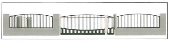
Figure 4 - perspective view of proposed brick pillar
and palisade fencing at western portion of the site, facing out toward Rosemary
Lane
· Replacing
north-west portion of solid brick fencing with Colorbond up to 1.8m high.
· Inserting tension
cables and timber frames as fence toppers (up to 1m additional height) to
facilitate planting of Star Jasmine climbers.
· Introducing
English variety plantings and other species sympathetic to the Heritage
Conservation Area.
The assessing officer is amenable to most of the above
proposed changes as was Council’s Heritage Advisor, with the following
exceptions:
· It is inferred
from the Landscaping Plan that the 1.8m high timber paling fence (lapped and
capped) proposed for a portion of the side boundary to Rosemary Lane will be
painted a dark colour such as Dulux “Monument”. Based on previous advice
from the Heritage Advisor and to ensure this part of the fence is in keeping
with the dwelling on the site and the overall Heritage Conservation Area, it is
recommended to include a condition that stipulates the lapped and capped timber
fencing shall be hardwood natural timber, or no darker than
“Windspray”.
· There is little to
no nature strip or Council verge between the Lot boundary of the site and
carriageway of Rosemary Lane. This situation can pose not only visual amenity
impacts on the locality if fencing is dominant at this interface, but also
sight safety issues for pedestrians and vehicles. On the other hand, fencing at
this location that is too meek or short will result in significant loss of
privacy to users of the subject site. In light of these considerations, it is
recommended to include a condition to the effect that brick pillars proposed as
part of the fencing schedule for the southern and western boundaries shall have
a maximum width and depth of 300mm, and maximum height above natural ground
level (stepped, if necessary) of 1.5m with intervening palisade fencing inserts
not extending above the height of respective enclosing brick pillars.
· The low brick wall
element of this fencing shall not exceed 400mm above natural ground level.
Visual permeability of the intervening palisade fencing shall be at least 75%
(e.g. solid elements 30mm wide will be offset by 90mm wide gaps between solid
elements).
· In order to
preserve solar access and to reduce fence bulk at side boundaries, it is
recommended to include a condition of consent that fence toppers (timber frames
and tension cables) proposed at the north-western corner of the Lot and
northern boundary of the Lot shall result in an overall structure height
between 1.8 to 2.2m above natural ground level. For example, if existing
Colorbond fence height is 1.8m and proposed to be retained, a fence topper
shall not exceed 400mm in height above the top of that Colorbond fence.
Intangible elements
The central Heritage Conservation Area of Orange seeks to
identify and promote the heritage characteristics of these older parts of town.
The locality in which the subject site occurs has an ongoing connection to
vernacular, residential built-forms, ornamental gardens, and leafy
streetscapes. The nature of the proposed development does not interrupt this
ongoing connection with the intrinsic character of the Heritage Conservation
Area.
Summary
In consideration of the above, the design elements of the
development in its revised form are considered satisfactory or can be made
satisfactory through imposition of some clear conditions. Thus, the development
will have a neutral or beneficial impact on the heritage significance of the
Heritage Conservation Area.
Part 7 - Additional
Local Provisions
7.1 - Earthworks
This clause
establishes a range of matters that must be considered prior to granting
development consent for any application involving earthworks.
The proposal involves
earthworks to demolish structures and establish footings. The pool area will be
backfilled with earth and compacted according to Australian Standards.
The extent of
disruption to the drainage of the site is considered to be minor and will not
detrimentally affect adjoining properties or receiving waterways, when properly
managed.
The extent of the
earthworks will not materially affect the potential future use or redevelopment
of the site that may occur at the end of the proposed development's lifespan.
The site is not known
to be contaminated and conditions may be imposed requiring the use of verified
clean fill only. Excavated materials will be reused onsite as far as possible
and conditions may be imposed to require that surplus materials will disposed
of to an appropriate destination.
The earthworks will
be appropriately supported onsite and the change in ground level is not
substantial. Therefore the effect on the amenity of adjoining properties is
considered to be minor.
The site is not known
to contain any Aboriginal, European or Archaeological relics. Previous known
uses of the site do not suggest that any relics are likely to be uncovered. However,
conditions may be imposed to ensure that should site works uncover a potential
relic or artefact, works will be halted to enable proper investigation by
relevant authorities and the proponent required to seek relevant permits to
either destroy or relocate the findings.
7.3 - Stormwater
Management
This clause applies
to all industrial, commercial and residential zones.
The proposal has been
designed to include permeable surfaces and includes onsite retention of
stormwater through the use of a rainwater tank, required to be 5000L per BASIX
requirements. The two storey structure reduces the amount of site coverage and
thus hardstand areas that would have otherwise occurred if the development was
proposed to include the same floor area but across a single storey.
7.6 - Groundwater
Vulnerability
This clause seeks to
protect hydrological functions of groundwater systems and protect resources
from both depletion and contamination. The proposal is not anticipated to
involve the discharge of toxic or noxious substances and is therefore unlikely
to contaminate the groundwater or related ecosystems. The proposal does not
involve extraction of groundwater and will therefore not contribute to
groundwater depletion. The design and siting of the proposal avoids impacts on
groundwater and is therefore considered acceptable.
7.11 - Essential Services
Clause 7.11 applies. In consideration of this clause, all
utility services are available to the land and can be made adequate for the
proposal, subject to conditions of consent as recommended by the Environment
Health & Building team and Technical Services team.
It should be noted that Council does not have an endorsed
lane widening/dedication strategy for established parts of the City. Rosemary
Lane ‘bottlenecks’ at the intersections with Clinton Street and
Sampson Street. Absent a strategy for lane widening and dedication, it is not
appropriate to assert that the development will prejudice future lane widening
opportunities for Rosemary Lane at this location.
State Environmental Planning
Policy No 55 - Remediation of Land
Pursuant to Clause 7, the subject site is not identified on
Council’s Draft Contaminated Land Information System. The property has
been used as a residence, with one detached dwelling, since at least the 1920s.
Having regard to Table 1 of the current Managing Land Contamination Planning
Guidelines from DUAP 1998, no contaminating activities are known to have
occurred prior to the site’s use for residential purposes. The site was
likely previously used for grazing or other agricultural pursuits.
The development will mostly be in the western portion of the
site. The western portion of the site contains some outbuildings such as a
garage, carport, shed, in-ground pool, garden beds, lawn, and driveway. Conditions
will be imposed for caution to be applied during demolition, especially with
respect to asbestos.
It is not considered likely that the land is contaminated,
nor that further consent for remediation works will be required at the site.
State Environmental Planning
Policy (Affordable Rental Housing) 2009
The proposed development is for a secondary dwelling, not
being a manufactured home, and so the SEPP applies.
The subject Lot exceeds 450sqm, and so consent cannot be
refused on the basis that the Lot size is too small (cl. 22).
The secondary dwelling does not need to be serviced by a
dedicated car parking space (cl. 22), and as such there is no mechanism
available to ask for these provisions to be made available for the secondary
dwelling.
A dedicated, separate private open space area does not need
to be provided for the secondary dwelling, as implied by Schedule 1 of the
SEPP. That is to say, in order for a secondary dwelling to be considered
“complying development”, it does not need to have a separate private
open space area from the main dwelling on the land. As such, it follows that a
merits-assessment pursuant to a Development Application should not be more
onerous than this “complying” provision.
Further comments on car parking and private open space provisions
for the development as a whole are included later in this report, under the
Development Control Plan 2004.
PROVISIONS OF ANY DRAFT
ENVIRONMENTAL PLANNING INSTRUMENT THAT HAS BEEN PLACED ON EXHIBITION
4.15(1)(a)(ii)
SEPP No 55 Review
From 31 January to 13 April 2018 the Department of
Planning and Environment publicly exhibited an Explanation of Intended Effect
(EIE) and Draft Planning Guidelines for the proposed Remediation of Land SEPP,
which will repeal and replace SEPP No 55. Of particular note, the Draft
Planning Guidelines state:
“In undertaking an initial evaluation, a
planning authority should consider whether there is any known or potential
contamination on nearby or neighbouring properties, or in nearby groundwater,
and whether that contamination needs to be considered in the assessment and
decision making process.”
“If the planning authority knows that
contamination of nearby land is present but has not yet been investigated, it
may require further information from the applicant to demonstrate that the
contamination on nearby land will not adversely affect the subject land having
regard to the proposed use.” (Proposed
Remediation of Lands SEPP - Draft Planning Guidelines, Page 10).
No nearby land contamination is identified in
Council’s Draft Contaminated Land Information System. The surrounding
properties have been mostly used for residential purposes for several decades.
The likelihood of significant soil and groundwater contamination originating
offsite and migrating onsite is therefore considered low.
LEP Amendment No 24
A housekeeping amendment is proposed to the Orange LEP,
known as Amendment No 24. No aspects of the housekeeping amendment relate to
the site or the proposed development of the site.
PROVISIONS OF ANY DEVELOPMENT
CONTROL PLAN s4.15(1)(a)(iii)
Development Control Plan 2004
The DCP 2004 applies. References to zone 2a throughout the
DCP are taken to be references to zone R1 General Residential, per the current
LEP zone convention. Relevant planning outcomes from relevant chapters are
included below.
DCP03 General Considerations
PO 3.1-1 – Cumulative Impact
See comments under “Likely Impacts of the
Development” per s4.15(1)(b) of the Act later in this report.
PO 3.4-1 – Waste Generation
· Applications
involving demolition indicate measures that will be implemented for reuse and
recycling of waste materials.
· Development
involving demolition is carried out in a manner that optimises reuse and
recycling of waste materials consistent with waste-minimisation principles.
The Building team has recommended a condition of consent for
a Waste Management Plan to be submitted, which shall outline the nature of
wastes to be disposed of or recycled.
DCP05 General Considerations for Zones and Development
Section 5.3 of this Chapter outlines ‘demolition of a
building, work, relic or place within a heritage conservation area’ as
advertised development. Given the scope of works proposed to be undertaken, the
application was advertised and submissions invited for a 14 day period. See
comments under “Any Submissions Made in Accordance with the Act”
per s4.15(1)(d) of the Act later in this report.
DCP07 Development in Residential Areas
PO 7.7-1 Planning Outcomes – Neighbourhood
Character
· Site layout and
building design enables the:
- creation
of attractive residential environments with clear character and identity
- use of site features such as views,
aspect, existing vegetation and landmarks.
· Buildings are
designed to complement the relevant features and built form that are identified
as part of the desired neighbourhood character.
· The streetscape
is designed to encourage pedestrian access and use.
The characterisation of the Heritage Conservation Area and
how the development responds to this characterisation is described under Clause
5.10 of the LEP, earlier in this report. An additional comment is made, being
that the residential character of the neighbourhood includes a mix of single
storey detached homes, two storey additions and attic conversions, and some
multi dwelling housing (units) in Rosemary Lane, Clinton Street, and Sampson
Street.
The proposal will contribute to the long-standing
residential identity of the area and eclectic features of urban laneways. The
proportions, colours, and materials proposed are in keeping with other homes
and buildings in the locality.
As the desired neighbourhood character is intimately linked
to heritage considerations, the proposed development responds well to the
desired neighbourhood character. All aspects of the proposal will incorporate
more heritage-sensitive measures than those already established along Rosemary
Lane. For example, there is an existing dominance of Colorbond fencing and
garage roller doors along Rosemary Lane, between Sampson and Clinton Street:


Figure 5 – Views along Rosemary Lane, noting
other properties’ heritage conservation area anomalies.
Landscaping and fencing features will soften all appearances
to Rosemary Lane, and the two-storey structure will include colours and
materials that make recessive the appearance of proposed garage roller doors.
Limited vegetation exists on the site, and the Landscaping
Plan proposed as part of the development will enhance key elements of the
heritage character of the locality.
The Clinton Street frontage, being the primary frontage,
will be mostly unaltered by the development, save for some enhanced landscaping
elements. The Rosemary Lane frontage will be altered by the development; even
so, the streetscape at this location is not considered likely to be negatively
affected. See further comments on this point under Clause 5.10 of the LEP,
earlier in this report.
PO 7.7-2 Planning Outcomes – Building Appearance
· The building
design, detailing and finishes relate to the desired neighbourhood character,
complement the residential scale of the area and add visual interest to the
street.
· The frontage of
buildings and their entries address the street.
· Garages and car
parks are sited and designed so that they do not dominate the street frontage.
Building appearances at the primary frontage (Clinton
Street) will be mostly unchanged, save for limited views to the upper storey of
the structure proposed at the rear of the subject site (west of the main
dwelling on the Lot).
The secondary street interface will include elements such as
new fencing, the housing extension, and two storey structure. These elements
have been designed, and will be conditioned, to ensure views from Rosemary Lane
are acceptable and do not detract from the streetscape. Considerable thought
has gone into how the details and finishes of the two-storey structure respond
to the desired neighbourhood character – see comments under clause 5.10
of the LEP, PO 7.7-1, and PO 7.7-6.
PO 7.7-3 Planning Outcomes
– Heritage
See analysis under Clause 5.10 of the LEP, earlier in this
report.
PO 7.7-4 Planning Outcomes – Setbacks
· Street setbacks
contribute to the desired neighbourhood character, assist with integration of
new development and make efficient use of the site.
· Street setbacks
create an appropriate scale for the street considering all other streetscape
components.
See comments below under PO 7.7-6
Visual Bulk.
PO 7.7-5 Planning Outcomes – Fences and Walls
See analysis under Clause 5.10 of
the LEP, earlier in this report.
PO 7.7-6 Planning Outcomes – Visual Bulk
· Built form
accords with the desired neighbourhood character of the area with:
- side
and rear setbacks progressively increased to reduce bulk and overshadowing
- site
coverage that retains the relatively low-density, landscaped character of
residential areas
- building
form and siting that relates to land form, with minimal land shaping (cut and
fill)
- building
height at the street frontage that maintains a comparable scale with the
predominant adjacent development form
- building to the boundary where appropriate.
Suggested solutions that correspond to the planning
outcomes:
1. Buildings
are contained within an envelope generated by planes projected at 45° over the site commencing 2.5m above
existing ground level from each side and rear boundary.
2. Buildings
within 15m of the street frontage, in areas of predominantly single storey
houses, are or appear as single storey.
3. Buildings
may cover up to 50% of the site area (except for single dwellings which may
cover up to 60% including outbuildings).
The ‘bulk’ of the development occurs at the rear
of the lot. The two storey structure will encroach slightly – due to roof
guttering – into the suggested solution visual bulk envelope standard of
the DCP. It should be noted that the original built-form proposed for the
secondary dwelling (at lodgement) included high-gable ends to the east and west
elevation, which significantly encroached into the visual bulk envelope
development standard. The applicant was advised to revise this element, and as
such hipped ends were instead proposed for all elevations of the two storey
structure.
This change minimised encroachment into the visual bulk
envelope and resulted in a better design outcome with respect to heritage and
streetscape impacts.
“Street frontage” in the above context for the
second suggested solution refers to the primary street, which is the frontage
to which the 15m setback standard applies. The main dwelling presents to
Clinton Street and as such, Clinton Street is the primary street frontage. The
secondary street interface between the corner allotment and Rosemary Lane is
not a “frontage”. Therefore, the two storey structure meets the
suggested solution for buildings within 15m of the frontage (Clinton Street)
appearing as single storey.
The following southern elevation
(street view from Rosemary Lane) highlights how the overall built-form for the
proposed two storey structure compares to existing and proposed built-form of
the single storey dwelling house on the site:
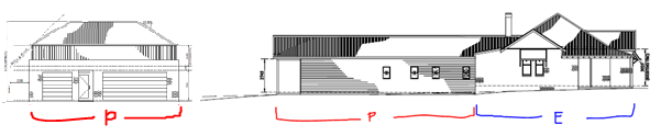
Figure 6 - southern elevation of the subject site (P =
proposed and E = existing development),
as viewed from Rosemary Lane. (Note the ridge height
and overall massing of the secondary dwelling is mostly on par with existing
elements of the main dwelling)
The two storey structure setback to Rosemary Lane (being the
secondary street) is more than that of the main dwelling house on the land. The
two storey structure will be forward of the front building line established by
the neighbouring property to the west, 25 Rosemary Lane, by about 5m.
Therefore, the two storey structure will be visible to road users, travelling
east along Rosemary Lane. The visual prominence and perceived bulk of the two
storey structure at this point will be ameliorated by trees that occur on
western neighbouring land (Lot 122 DP 622188), landscaping proposed within the
site, and decorative fencing proposed for site boundaries. Note that the trees
occurring on neighbouring land (including structural root zones) shall be
protected during construction, per the relevant Australian Standard, as a
condition of consent.
Site coverage as a result of the development will be
approximately 41%, which is within the acceptable range for residential site
coverage per the third suggested solution. Note that site coverage calculations
exclude hardstand areas such as driveways and paving.
In considering the above points, it is submitted that the
development meets the visual bulk planning outcomes of the DCP.
PO 7.7-8 Planning Outcomes – Daylight and Sunlight
· Buildings are
sited and designed to ensure:
- daylight
to habitable rooms in adjacent dwellings is not significantly reduced
- overshadowing
of neighbouring secluded open spaces or main living-area windows is not
significantly increased
- consideration
of Council’s Energy Efficiency Code.
The recommended development standards to meet the planning
outcomes include:
· the provision of
sunlight to at least 40% of the main area of private open space on adjoining
land and within the site being not reduced to less than 3 hours between 9am and
3pm on the winter solstice, and
· provision of 4
hours sunlight to 75% of north-facing living-area windows on adjoining land and
within the site on the winter solstice.
Overshadowing within the site:
The submitted shadow diagrams demonstrate that between 9am
and approximately 1pm on the winter solstice, at least 40% of the private open
space for the subject site will receive sunlight. Furthermore, north-facing
living-area windows within the site will not be impacted as a result of the
development.
Overshadowing to 26A Rosemary Lane and 109 Clinton
Street:
Shadow diagrams were submitted with the application, and
these shadow diagrams were independently and manually checked by the assessing
officer, in light of submitter concerns that overshadowing impacts would be
greater than those alluded to in the applicant’s shadow diagrams. The
independent, manual check of the shadow diagrams included 4 x sample point
checks along the southern elevation of the proposed house addition and two
storey garage/secondary dwelling structure. These sample checks confirmed that
the applicant’s shadow diagrams are an accurate representation of the
likely overshadowing impacts of the development. For reference, the shadow
diagrams and manual check (working copies) are attached at the end of this
report (these shadow diagrams reflect the previously submitted plans and not
the amended plans. The amended plans will have a lesser impact due to the
lowered height of the proposed building).
The shadow diagrams demonstrate that sunlight to living-area
windows for surrounding properties (notably, 26A Rosemary Lane and 109 Clinton
Street) will achieve the development standard outlined in the DCP for planning
outcomes associated with solar access to dwellings. Specifically, no overshadowing
to living-area windows will occur as a result of the development to either 26A
Rosemary Lane or 109 Clinton Street. Of note is the fact that the development
will not result in a cumulative negative impact on solar access to living-area
windows for these properties, when accounting for existing overshadowing
situations to living-area windows. For example, the existing (and to be
retained) built-form of the dwelling on the development site overshadows the
northern wall of 109 Clinton Street in the morning hours. The proposed addition
to the dwelling house will result in a ridgeline lower than the existing
ridgeline, and the shadow diagrams demonstrate that overshadowing to windows
along this same northern wall of 109 Clinton Street will not occur.
Limited private open space area
exists for 26A Rosemary Lane:
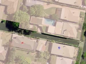
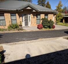
Figure 7 - LEFT: aerial view with translucent parcel
overlay showing 26A Rosemary Lane (red asterisk) and 109 Clinton Street
(blue asterisk) relative to the subject site.
RIGHT: view to part of the frontage area of 26A
Rosemary Lane,
looking south from within the subject site.
It appears that the most useable portion of outdoor area for
this property occurs in the frontage to Rosemary Lane, opposite the subject
site. Overshadowing to the frontage (including driveway and enclosed courtyard)
of 26A Rosemary Lane will occur at 9am and through until 11am. From 11am
through to 3pm, the frontage area of 26A Rosemary Lane will be totally devoid
of overshadowing from the development. The existing built-form at 111 Clinton
Street does not overshadow 26A Rosemary Lane, and as such, the development will
not result in a cumulative negative amount of overshadowing. On this basis, the
proposal meets the development standard outlined in the DCP for planning
outcomes associated with solar access for outdoor areas that function as
private open space.
In a similar vein, overshadowing to a portion of private
open space adjoining the driveway of 109 Clinton Street will occur at 9am and
through until 11am as a result of the development. From 11am through to 3pm,
the private open space of this property will be totally devoid of overshadowing
from the development.
It is understood that the existing (and to be retained)
built-form of the dwelling on the subject site results in some overshadowing to
a small portion of private open space for 109 Clinton Street. On the
whole, however, more than 40% of the main private open space for 109 Clinton
Street will retain solar access between the hours of 11am and 3pm.On this basis,
the proposal meets the development standard outlined in the DCP for planning
outcomes associated with solar access for private open space.
PO 7.7-9 Planning Outcomes – Views
· Building form
and design allow for residents from adjacent properties to share prominent
views where possible.
· Views including
vistas of heritage items or landmarks, are not substantially affected by the
bulk and scale of new development.
Views to prominent areas, landmarks, or heritage items will
not be diminished as a result of the development.
PO 7.7-10 Planning Outcomes – Visual Privacy
· Direct
overlooking of principal living areas and private open spaces of other
dwellings is minimised firstly by:
- building
siting and layout
- location
of windows and balconies.
and secondly by:
- design
of windows or use of screening devices and landscaping.
Overlooking to the subject site
The main private open space area for the subject site will
occur in the centre of the lot, adjacent to the northern boundary and to the
linked alfresco area. These areas are not likely to be subject to overlooking
as a result of the development. Note that ‘overlooking’ between the
primary dwelling and secondary dwelling is not able to be considered a privacy
issue, due to the provisions and intent of the Affordable Rental Housing SEPP.
Overlooking to 113 Clinton
Street
Overlooking to the north is unlikely to be an issue from the
private open space area or house extension. Existing and proposed fence heights
at this dividing fence will be conditioned at 1.8 to 2.2m in height. The
finished floor level of the proposed house extension will be no greater than
300mm above natural ground level. It should be noted that the subject land is
mostly level with the northern property and both sites slope very gradually to
the west. So, the effective fence height above FFL of the dwelling extension
will be 1.5 to 1.9m. This arrangement is satisfactory to prevent direct
overlooking to living areas and private open space of 113 Clinton Street, when
also considering setback distances between the dwellings on each site and
staggered private open space locations.
The secondary dwelling on the first floor of the two storey
structure will contain no windows on the northern elevation wall. Skylights are
proposed for the roof of the secondary dwelling.
The positioning of the skylights
will prevent overlooking to the northern neighbour at 113 Clinton Street. A
small portion of the backyard of 113 Clinton Street is likely to be overlooked
by the bedroom window on the eastern elevation of the secondary dwelling:
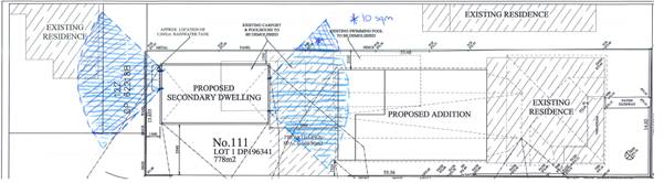
Figure 8 - overlooking diagram for secondary dwelling,
using calculation parameters of
9m horizontal distance measured beyond a 45 degree
angle
from the plane of the wall containing the opening
This overlooked portion will be
approximately 10sqm. Bedrooms are infrequently occupied during the daytime
compared to living rooms/areas of a dwelling. 113 Clinton Street contains
approximately 162sqm of private open space. Accordingly, the total proportion
of overlooked area will be 6.2 percent. This portion of overlooked area
directly adjoins the southern boundary fence of 113 Clinton Street, and that
portion appears to contain trees/shrubs that reduce overlooking exposure:
Figure 9 - looking north to 113 Clinton Street from
within the site.
The tree depicted appears to occur in the area of
overlooked space
that will occur as a result of the development.
For the above reasons, it is not considered likely that
overlooking impacts will be detrimental to the northern neighbour at 113
Clinton Street and specific privacy control measures (such as privacy screens
to a window) do not need to be employed.
Overlooking to 25 Rosemary Lane
No part of the private open space area or house extension
will overlook 25 Rosemary Lane.
With regard to the secondary dwelling, it is noted that Lot
122 DP 622188 appears to be used in conjunction with the dwelling house located
at 25 Rosemary Lane. So, any overlooking of that Lot from the secondary
dwelling (as depicted earlier in Figure 8) is considered to be an area
overlooked in association with 25 Rosemary Lane.
The secondary dwelling on the first floor of the two storey
structure is proposed to contain one kitchen window at the western elevation
wall. The opening of the window is proposed to occur in the range of
approximately 0.96-1.38m above FFL of the first floor of the secondary
dwelling. This low window height range will essentially limit the opportunity
for overlooking from the kitchen to 25 Rosemary Lane, as common practice for
calculating overlooking includes the assumption of eye level being at around
1.5m above FFL.
The applicant has not provided any details on the types of
windows that occur in the eastern and southern elevation of 25 Rosemary Lane.
Mature trees occur between the secondary dwelling and the affected walls of the
dwelling at 25 Rosemary Lane. However, these trees are deciduous and not
sufficient on their own to mitigate any overlooking impacts that may occur.
In light of the above and in adopting a conservative
approach to ensure the planning outcomes for visual privacy are met, it is
considered necessary to require privacy treatments to the western elevation
window as a condition of consent. The privacy treatment shall incorporate fixed
angled external louvres that are designed in such a way that blocks views
towards windows of dwelling at 25 Rosemary Lane.
Overlooking to southern
properties
The house extension will be set back at least 7.5m from the
northern property boundary of 109 Clinton Street. The finished floor level of
the proposed house extension will be no greater than 300mm above natural ground
level. Proposed southern boundary fencing for the subject site that coincides
with southern windows in the proposed extension will be lapped and capped
timber fencing at 1.8m height. No overlooking issues to 109 Clinton Street are
therefore likely to arise as a result of the development.
The secondary dwelling on the first floor of the two storey
structure is not proposed to include any windows in the southern elevation. No
overlooking impacts are likely to occur to 26A Rosemary Lane.
PO 7.7-11 Planning Outcomes
– Acoustic Privacy
· Site layout and
building design:
- protect
habitable rooms from excessively high levels of external noise
- minimise
the entry of external noise to private open space for dwellings close to major
noise sources
- minimise
transmission of sound through a building to affect other dwellings.
There will be limited openings and opportunities for
transfer of noise between the secondary dwelling and surrounding properties.
Further, the house extension and secondary dwelling are residential uses and as
such noise generated from these uses are likely to be within community
expectations for noise levels in a General Residential Zone.
PO 7.7-12 Planning
Outcomes – Security
· The site layout
enhances personal safety and minimises the potential for crime, vandalism and
fear.
· The design of
dwellings enables residents to survey streets, communal areas and approaches to
dwelling entrances.
Passive surveillance from the primary dwelling to both
street frontages will be achieved. Access to the secondary dwelling is proposed
to occur from within the ground floor garage, and so passive surveillance from
the secondary dwelling is not generally possible but nor is it warranted in
this instance.
PO 7.7-14 Planning Outcomes – Circulation Design
· Accessways and
parking areas are designed to manage stormwater.
· Accessways,
driveways and open parking areas are suitably landscaped to enhance amenity
while providing security and accessibility to residents and visitors.
· The site layout
allows people with a disability to travel to and within the site between car
parks, buildings and communal open space.
Development consent will be conditioned to ensure stormwater
is not a nuisance to neighbouring properties and users of Rosemary Lane.
Forward-facing vehicle movements onto Rosemary Lane are not
required as a result of the development. This is because Rosemary Lane is not a
major road in the road hierarchy, and the type of development proposed is not
‘multi dwelling housing’.
Landscaping is proposed and considered adequate for the
site. The driveway width at site entry will not exceed 6m, and laybacks are
existing.
PO 7.7-15 Planning Outcomes – Car Parking
· Parking
facilities are provided, designed and located to:
- enable
the efficient and convenient use of car spaces and accessways within the site
- reduce
the visual dominance of car-parking areas and accessways.
· Car parking is
provided with regard to the:
- number
and size of proposed dwellings
- requirements
of people with limited mobility or disabilities.
Sufficient onsite car parking will be available through
provision of three covered car parking spaces. A Landscaping Plan has been
submitted in support of the development, which helps to soften the appearance
of hardstand areas.
PO 7.7-16 Planning Outcomes – Private Open Space
· Private open
space is clearly defined for private use.
· Private
open space areas are of a size, shape and slope to suit the reasonable
requirements of residents, including some outdoor recreational needs and
service functions.
· Private open
space is:
- capable
of being an extension of the dwelling for outdoor living, entertainment and
recreation
- accessible
from a living area of the dwelling
- located
to take advantage of outlooks and to reduce adverse impacts of overshadowing or
privacy from adjoining buildings
- orientated to optimise year-round
use.
Suggested solutions that correspond to the planning
outcomes:
1 Private
open space at ground level has:
- a
useable area of at least equivalent to 50% of the dwelling floor space (gross)
with a minimum dimension of 3m and including:
at least one area with minimum
dimensions of 5m by 5m directly accessible to a living area, preferably
orientated to the north or east of the dwelling.
Private open space for each
dwelling located above the ground is in the form of a balcony or roof terrace
with:
- convenient
access from the main living area;
- a
minimum area of 8m2 and a minimum dimension of 2m;
- appropriate
solar access/orientation and privacy.
2. Open
space is:
- located
behind the main façade of the dwelling, ie, the primary front wall
excluding decorative elements such as porticoes or similar;
- adjacent
to dwellings; and
- is
allocated to individual units where practicable to minimise the need for
management and maintenance of communal open space.
- Communal
open space may be appropriate for units above ground level. Communal space is
provided at the same rate as for private open space above.
Gross floor area (‘GFA’) of the dwelling
including extension is used with reference to the first suggested solution. The
secondary dwelling floor area is not included in this calculation as this floor
area is not captured by the DCP for private open space and nor is it the
intention of the Affordable Rental Housing SEPP for private space requirements
for secondary dwellings to be based on a per metre rate. Because of this, the
second suggested solution does not apply to secondary dwellings, whether or not
they occur at ground level or first floor level.
When using GFA per the LEP Dictionary definition (which
excludes outdoor areas such as verandahs and alfrescos), the following
break-down of square meterage applies:
Ø GFA of dwelling house and its
extension = 257.18sqm
Ø Half of GFA = 128sqm
Ø Extent of proposed private open
space (‘POS’) = 103.90sqm
Ø It is common practice to include
alfresco areas in the calculation for POS, so this adds another 34.71sqm.
Therefore, total nominated POS for the site will be 138.61sqm,
which exceeds the first suggested solution numerical standard of the DCP.
Further, POS will be able to accommodate a 5m x 5m area and all POS will
achieve at least minimum width of 3m. It is therefore asserted that sufficient
private open space will be retained on the subject site for the primary
dwelling, and shared with the secondary dwelling, and all elements of the
proposal correspond to the suggested solutions for planning outcomes for
private open space such that the proposal is deemed to comply with PO 7.7-16.
PO 7.7-17 Planning Outcomes – Open Space and
Landscaping
See analysis under Clause 5.10 of
the LEP, earlier in this report.
DCP13 Heritage
PO 13.3-1 Planning Outcomes – Heritage Development
See analysis under Clause 5.10 of
the LEP, earlier in this report.
Infill Guidelines
See analysis under Clause 5.10 of
the LEP, earlier in this report.
Development Contributions Plan 2017
As a result of the development,
one extra 1-bedroom dwelling will be available on the site. The site occurs
within the Contributions Plan area for ‘remainder of LGA’ in the
Plan, i.e. not a growth area in North Orange or any other identified locality. Based
on the Table for contributions, the contribution amount for the indexed period
1 September to 30 November 2019 is:
|
Facility
|
Per
1 bedroom dwelling
|
TOTAL
|
|
Open
space and recreation
|
1679.68
|
1 x 1679.68
|
|
Community
and cultural
|
487.12
|
1 x 487.12
|
|
Roads
and traffic management
|
2473.46
|
1 x 2473.46
|
|
Local
area facilities
|
-
|
-
|
|
Plan
preparation and administration
|
131.52
|
1 x 131.52
|
|
$4,771.78
|
Payment of this, prior to issue of a Construction
Certificate, is required.
Section 64 (under the Local Government Act 1993) Water and
Sewer headwork charges may also apply.
ANY PLANNING AGREEMENT OR DRAFT
PLANNING AGREEMENT s4.15(1)(a)(iiia)
No planning agreements, draft or otherwise, are known to
exist in relation to the site or development.
PROVISIONS PRESCRIBED BY THE REGULATIONS
s4.15(1)(a)(iv)
Demolition of a Building (clause 92)
The proposal involves the demolition of structures. A
condition is attached requiring the demolition to be carried out in accordance
with AS2601 (current edition).
Fire Safety
Considerations (clause 93)
The proposal does not involve a change of building use for
an existing building.
Buildings to be Upgraded (clause 94)
Upgrading of the building will be required to ensure the
existing building is brought into partial or total conformity with the Building
Code of Australia. Conditions are attached in relation to the required
upgrading works.
BASIX Commitments (clause 97A)
Two BASIX Certificates have been submitted in support of the
proposed development.
THE LIKELY IMPACTS OF THE
DEVELOPMENT s4.15(1)(b)
Air/odour
Dust suppression measures shall occur during construction to
limit impacts.
Cumulative
Throughout this report, cumulative impacts to do with
overshadowing and privacy have been at the fore. Secondary dwellings are a
popular form of infill development, and cannot be refused on the grounds of
inadequate car parking space availability, among other things (refer to
Affordable Rental Housing SEPP). Therefore, cumulative effects with regard to
traffic and on-street parking in Rosemary Lane and surrounding streets are not
able to be considered in the assessment of the secondary dwelling component.
All other aspects of the development are not likely to
contribute to negative cumulative impacts.
Visual/streetscape
Visual impacts and impacts to the streetscape have been
addressed earlier in this report, under Clause 5.10 of the LEP and planning
outcomes related to visual bulk under the DCP.
Noise
During construction, conditions will be imposed to limit
hours of work. Use of the land for residential accommodation is not likely to
generate unacceptable impacts to the locality.
Traffic
Development of this scale is not likely to have a
significant impact on the local road network.
Impacts on surrounding
properties
Impacts to surrounding properties have been considered
earlier in this report under the LEP and DCP. All impacts are either within an
acceptable range, or will be made to be within an acceptable range as a result
of imposing conditions on the development. Other site specific concerns, as
raised by some neighbouring properties, are addressed later in this report
under “Any Submissions Made in Accordance with the Act” per
s4.15(1)(d) of the Act later in this report.
Waste
A waste management plan will need to be submitted and
implemented during construction, detailing how materials on the site will be
reused or removed.
THE SUITABILITY OF THE SITE
s4.15(1)(c)
The site is considered suitable and able to accommodate the
proposed development.
ANY SUBMISSIONS MADE IN
ACCORDANCE WITH THE ACT s4.15(1)(d)
The proposed development is defined as "advertised
development" under the provisions of the DCP.
The application was advertised for the prescribed period of
14 days, from Friday, 31 May 2019 to Friday, 14 June 2019. Exhibition included
one ad in the Central Western Daily on Thursday, 30 May 2019 and neighbour
notification letters being sent prior to the beginning of the exhibition
period.
Follow-up letters were sent a week later during the
exhibition period to reiterate that the exhibition period closes 14 June 2019,
as the original neighbour notification letter stated a 14 day exhibition period
applied being from “31 May 2019 to 14 May 2019”. The correct
exhibition period was printed in the newspaper ad.
During the exhibition period, six (6) submissions were
received. Following the close of the exhibition period, one (1)
‘supplementary’ submission was received from a previous submitter.
Of the total seven (7) submissions, four (4) submissions originated from the
one neighbour, being 26A Rosemary Lane.
As a result of Council’s resolution from 6 August PDC
Meeting, the opportunity to make further submissions was available for previous
submitters up to 20 August 2019. A key objector from 26A Rosemary Lane was
given a copy of the applicant’s two-storey design changes prior to 20
August 2019. Two (2) further submissions were received from the objector at 26A
Rosemary Lane on the proposed design changes to the two-storey structure.
The collated submissions raised the following planning
matters/issues:
House extension – privacy
issues in relation to 113 Clinton Street
The house extension is a single storey addition to the rear
of the existing dwelling. Privacy issues have been addressed under the DCP
planning outcomes for visual privacy. An analysis was undertaken which
demonstrates that overlooking to 113 Clinton Street from the house extension is
not anticipated, due to existing and proposed fence heights, finished floor
levels, and relatively even ground levels between the subject site and 113
Clinton Street to the north.
Secondary dwelling –
privacy issues in relation to 113 Clinton Street
The secondary dwelling will occur on the first floor of the
detached structure to be located in the rear yard of the subject site. A small
portion of the rear yard of 113 Clinton Street may be overlooked by the bedroom
window of the secondary dwelling – refer Figure 8 earlier in this report.
An analysis of this overlooking impact has been undertaken per the DCP’s
planning outcomes for visual privacy. The 10sqm of overlooked portion currently
contains a tree and other greenery, reducing overlooking exposure. Overlooking
will occur from the bedroom window, and bedrooms are infrequently occupied
during daylight hours in comparison to living rooms/areas. For these reasons,
overlooking to 6.2% of the total private open space of 113 Clinton Street is
considered acceptable.
House extension – overshadowing issues in relation
to 109 Clinton Street
The house extension is a single storey addition to the rear
of the existing dwelling. Overshadowing issues have been addressed under the
DCP planning outcomes for daylight and sunlight. An analysis was undertaken
which demonstrates that overshadowing to 109 Clinton Street from the house
extension will be minor, due to the house extension’s ridgeline height,
and the separation of the house extension from 109 Clinton Street by Rosemary
Lane.
Two storey structure –
overshadowing issues in relation to 26A Rosemary Lane
Shadow diagrams were submitted in support of the
application, and a manual shadow diagram check was undertaken by the assessing
officer. A full analysis of overshadowing was performed for the development,
per the DCP planning outcomes for daylight and sunlight. To summarise, on the
winter solstice – being the shortest day of the year with the longest
shadows cast – no direct overshadowing will occur to living area windows
of 26A Rosemary Lane on the winter solstice between the key hours of 9am and
3pm. Overshadowing will occur to the frontage area (including driveway) of 26A
Rosemary Lane from 9am to 11am only. These outcomes are considered acceptable
impacts, per the DCP.
Two storey structure –
loss of views in relation to 26A Rosemary Lane
Submissions originating from 26A
Rosemary Lane raised concerns about loss of views to the skyline and tree line
to the north, as a result of the two storey structure. This is of particular
importance to the submitters at this address, as they have limited to no views
from within dwelling on the site to the east, south, or west. The
submitter’s provided some photos from within their dwelling to the north,
one of which is included in this report:

Figure 10 - views to the north from within 26A
Rosemary Lane
Consideration of views from 26A Rosemary Lane to the north
must balance reasonable expectations for views to prominent landmarks and
scenic corridors. Views to the north from 26A Rosemary Lane do not include
views to a recognised scenic corridor or recognised landmark that needs to be
protected. Views up and down Rosemary Lane, and the skyline above the secondary
dwelling will be maintained for 26A Rosemary Lane. Tree lines will still be
able to be observed beyond the secondary dwelling and to the east and west of
the secondary dwelling. Therefore, impacts to 26A Rosemary Lane views are
within the acceptable range. In considering Clause 5.10 of the LEP and planning
outcomes for views in the DCP, it is considered that the visual impact of the
two storey structure is acceptable.
Excessive traffic in Rosemary Lane and flow on effects to
Clinton Street
The use of the subject site will be for the purposes of a
primary and secondary dwelling. As the primary dwelling already exists on
the site, an extension to that house for the purpose of providing more living
areas is not likely to impact on traffic generation along Rosemary Lane or
Clinton Street. The primary dwelling will continue to contain 4 bedrooms. A
three space garage is proposed as part of the development, which is considered
more than adequate to service the primary dwelling.
The secondary dwelling component will comprise one bedroom,
and feasibly 1-2 occupants. The definition of “secondary dwelling”
does not extend to the use of a secondary dwelling for the purposes of short
term holiday letting. Although this issue was not explicitly raised in written
submissions, concerns have been expressed on the end-use of the secondary
dwelling through phone conversations with submitters. To address this concern,
an advising note is recommended in the notice of approval that outlines further
consent must be sought in the event that it is proposed to use the
secondary dwelling for short term holiday letting, depending on exempt and
complying provisions of any environmental planning instruments.
Per the Affordable Rental Housing SEPP, dedicated car
parking spaces do not need to be provided for secondary dwellings. Therefore,
the traffic and on-street parking impact associated with the secondary dwelling
is not able to be considered. In any event, on-street car parking would be
available to visitors to the site on Clinton Street adjacent to the front yard
area of the subject site.
Traffic and safety concerns
Rosemary Lane ‘bottlenecks’ at both ends to
Sampson and Clinton Street. Submitters have raised concerns in relation to
reverse vehicle egress onto Rosemary Lane, and the safety implications this
would have on other vehicles and pedestrians.
This concern has been addressed earlier in the report per
DCP planning outcomes for circulation design and LEP Clause 5.10
fencing/landscaping considerations. The ultimate recommendation is for
prescribed fencing height and design in proximity of the driveway to ensure safe
egress onto Rosemary Lane. Per the DCP, Council does not have the capacity to
request onsite manoeuvring for forward-facing vehicle movements onto Rosemary
Lane as a result of the proposed development and also when considering Rosemary
Lane’s position in the road hierarchy.
During construction impacts
Dust, noise, and traffic concerns have been raised for the
construction phase. Conditions of consent are recommended for dust suppression
and restricted construction hours. It may be prudent to require a construction
management plan be submitted prior to construction commencing, detailing
traffic movements and site management matters to alleviate traffic concerns for
Rosemary Lane in particular.
Inaccuracies in the planning application submitted
The supplementary submission raised issues in relation to
the adequacy of the planning application submitted, particularly assertions to
do with current site conditions and landscaping at the subject site. There were
also concerns that the planning application erroneously referred to surrounding
addresses that contain two storey structures in the locality.
Two site visits have been undertaken by the assessing
officer, and the assessing officer is satisfied that although there may be some
inaccuracies in the planning application supporting reports and the like, these
inaccuracies do not hinder the assessment of the development proposed. For
example, site visits confirmed the existing range of landscaping on the site
and that some mature hedging has already been pared back along the southern
boundary of the site. This work would not have required consent and as such
does not materially impede the assessing officer’s assessment.
Whilst the hedges would have contributed to the streetscape
of Rosemary Lane, their loss does not diminish the level of assessment that
goes into analysing an area’s character and how the character may or may
not change as a result of the development.
Creation of a
‘precedent’ for two storey structures
A number of submitters were concerned that by allowing a two
storey structure at this location, momentum would build in the locality for
more two storey structures. It is noted that a number of attic conversion and
two storey additions occur in the locality and are associated with either
primary or secondary dwellings.
All proposed development is considered on a case-by-case
basis, and for this locality, particular scrutiny is paid to how development
responds to the Heritage Conversation Area character and values.
Post-PDC 6 August Meeting submission: Alternatives to
two-storey structure proposal
The further submission by the objector at 26A Rosemary Lane
queries the need for the “granny flat” and why the applicant has
not proposed an extra room or suite of rooms in the main dwelling house.
The planning assessment can only assess the proposal put
forward by the applicant. Notwithstanding this and based on conversations with
the applicant, it is understood that the applicant did not pursue further,
single-storey additions to the main dwelling house due to site coverage
concerns and loss of private open space/yard area, particularly where erection
of a new garage was to be pursued anyway.
Post-PDC 6 August Meeting submission: Split the
application into two parts
The further submission by the objector at 26A Rosemary Lane
requests that the application be split into two parts, meaning separate DAs
would apply to the house extension and the secondary dwelling/garage.
Again, the planning assessment can only assess the proposal
put forward by the applicant. The applicant has requested the full scope of
proposed development to be dealt with in one application. It is not clear what
outcome would be achieved by splitting the application into two DAs, especially
where the secondary dwelling/garage component in its current form complies with
the Council’s DCP requirements. The splitting of the application would
only serve to delay approval of the secondary dwelling/garage.
Post-PDC 6 August Meeting submission: Two-storey
structure – not compliant with planning outcomes and local planning
provisions
The further submissions by and on behalf of the objector at
26A Rosemary Lane assert that the two-storey structure does not meet some
planning outcomes and local planning provisions, particularly in relation to
visual bulk, character and appearance considerations, and private open space
areas. Further, these submissions state that the proposal may alter/redirect
the character of the area in an undesirable way.
Broadly, misconceptions about the “street
frontage” have been addressed earlier in this report under PO 7.7-6. The
two-storey structure results in only a slight encroachment (due to roof
guttering) into the suggested standard visual bulk envelope. Notwithstanding
this, the two-storey structure still meets the overarching planning outcome for
visual bulk. Note that a proposal does need to meet the numerical suggested
standard attached to a planning outcome – the numerical suggested
standards are one way of meeting the planning outcome but not the only
way.
See comments under clause 5.10 of the LEP and PO 7.7-1 of
Chapter 7 of the DCP in relation to neighbourhood character considerations. To
summarise, the proposal responds well to desired future character principles
for the locality and heritage conservation area.
In relation to private open space area controls, see the
breakdown of gross floor areas and private open space requirements under PO
7.7-16. To be brief, the private open space area to be maintained for the
subject site will meet the suggested numerical standard under the private open
space planning outcome of the DCP. This open space area will also meet solar
access requirements, per PO 7.7-8.
PUBLIC INTEREST
s4.15(1)(e)
On balance, approval of the proposed development is
considered to be in the public interest.
The omission of reference to certain planning guidelines,
policies, and SEPPs does not indicate that those documents have not been
considered in this assessment; rather, this omission indicates that those
documents are not relevant to the application or do not require comments to be
made against them.
SUMMARY
The proposed development is permissible with the consent of
Council. The proposed development complies with the relevant aims, objectives
and provisions of the LEP, DCP, and relevant SEPPs. A Section 4.15
assessment of the development indicates that the development is acceptable in
this instance. In short, it is recommended that Council supports the
application. The applicant has made considered and careful design changes
throughout the course of the development assessment period. The series of
changes put forward by the applicant have assisted in meeting all of the
planning outcomes in the DCP.
Attached is a draft Notice of Approval outlining a range of
conditions considered appropriate to ensure that the development proceeds in an
acceptable manner.
Attachments
1 Notice
of Approval, D19/47145⇩
2 Plans,
D19/50953⇩
3 Shadow
Diagram + Manual Check, D19/44675⇩
4 Submissions-
Received During Exhibition Period, D19/50974⇩
5 Submissions
- Received After 6 August PDC Meeting, D19/50969⇩
Planning
and Development Committee
3 September 2019
Attachment 1 Notice
of Approval
|
|
ORANGE CITY COUNCIL
Development
Application No DA
81/2019(1)
NA19/ Container
PR2678
|
NOTICE OF DETERMINATION
OF A DEVELOPMENT
APPLICATION
issued under the Environmental
Planning and Assessment Act 1979
Section 4.18
|
Development
Application
|
|
|
Applicant
Name:
|
Mr P K Bromley
|
|
Applicant
Address:
|
111 Clinton Street
ORANGE
NSW 2800
|
|
Owner’s
Name:
|
Mr P K Bromley
|
|
Land
to Be Developed:
|
Lot 1 DP 196341 - 111
Clinton Street, Orange
|
|
Proposed
Development:
|
Demolition of Garage,
Carport, and Swimming Pool; Partial demolition and replacement of western
portion of existing Dwelling House; Partial demolition and replacement of
boundary fencing; New detached Garage (ground floor) with Secondary Dwelling
(first floor)
|
|
|
|
|
Building Code of
Australia
building
classification:
|
Class To be
determined by Certifying Authority
|
|
|
|
|
Determination made
under
Section 4.16
|
|
|
Made
On:
|
3 September 2019
|
|
Determination:
|
CONSENT GRANTED
SUBJECT TO CONDITIONS DESCRIBED BELOW:
|
|
|
|
|
Consent to Operate
From:
|
4 September 2019
|
|
Consent to Lapse On:
|
4 September 2024
|
Terms of
Approval
The
reasons for the imposition of conditions are:
(1) To ensure a quality
urban design for the development which complements the surrounding environment.
(2) To maintain
neighbourhood amenity and character.
(3) To ensure compliance
with relevant statutory requirements.
(4) To provide adequate
public health and safety measures.
(5) Because the development
will require the provision of, or increase the demand for, public amenities and
services.
(6) To ensure the utility
services are available to the site and adequate for the development.
(7) To prevent the proposed
development having a detrimental effect on adjoining land uses.
(8) To minimise the impact
of development on the environment.
Conditions
(1) The development must be
carried out in accordance with:
(a) Plans prepared by TK
Worboys Drafting & Design (Job no. 037-18) and dated 21-05-19: Site Plan, Demolition
Plan, Proposed Floor Plan, and Proposed Elevations.
Plans
prepared by TK
Worboys Drafting & Design (Job no. 037-18) and dated 16-08-19: Proposed Secondary
Dwelling and Garage.
Landscape
Plan – Project no. 30G – Drawing no. L01 – Revision C –
dated 23/5/19 – Drawn by OT.
BASIX
Certificate no. 995752S_02 dated 21 May 2019 and BASIX Certificate no. A340753
dated 14 February 2019. (8
sheets)
(b) statements
of environmental effects or other similar associated documents that form part
of the approval
as amended in
accordance with any conditions of this consent.
(2) Fulfilment
of commitments listed in BASIX Certificates 995752S_02 and A340753 (or later amendments to
those Certificates) is a prescribed condition of consent, per s97A of the
Environmental Planning and Assessment Regulation 2000.
(3) All
building work must be carried out in accordance with the provisions of the
Building Code of Australia.
(4) A sign is to be erected
in a prominent position on any site on which building work, subdivision work or
demolition work is being carried out:
(a) showing
the name, address and telephone number of the principal certifying authority
for the work, and
(b) showing
the name of the principal contractor (if any) for any building work and a
telephone number on which that person may be contacted outside working hours,
and
(c) stating
that unauthorised entry to the site is prohibited.
Any such sign is to be maintained while the
building work, subdivision work or demolition work is being carried out.
(5) In
the case of residential building work for which the Home Building Act 1989
requires there to be a contract of insurance in force in accordance with Part 6
of the Act, evidence that such a contract of insurance is in force is to be
provided to the Principal Certifying Authority before any building work
authorised to be carried out by the consent commences.
(6) Residential
building work within the meaning of the Home Building Act 1989 must not
be carried out unless the principal certifying authority for the development to
which the work relates (not being the council) has given the council written
notice of the following information:
(a) in
the case of work for which a principal contractor is required to be appointed:
(i) the
name and the licence number of the principal contractor, and
(ii) the
name of the insurer by which the work is insured under Part 6 of that Act,
(b) in
the case of work to be done by an owner-builder:
(i) the
name of the owner-builder, and
(ii) if
the owner-builder is required to hold an owner-builder permit under that Act,
the number of the owner-builder permit.
If arrangements for doing the residential
building work are changed while the work is in progress so that the information
under this condition becomes out of date, further work must not be carried out
unless the principal certifying authority for the development to which the work
relates (not being the council) has given the council written notice of the
updated information.
(7) Where any excavation
work on the site extends below the level of the base of the footings of a
building on adjoining land, the person having the benefit of the development
consent must, at the person’s own expense:
(a) protect
and support the adjoining premises from possible damage from the excavation,
and
(b) where
necessary, underpin the adjoining premises to prevent any such damage.
Note: This condition does not apply if the
person having the benefit of the development consent owns the adjoining land or
the owner of the adjoining land has given consent in writing to this condition
not applying.
|
PRIOR
TO THE ISSUE OF A CONSTRUCTION CERTIFICATE
|
(8) Prior to the issue of a
Construction Certificate, the approved plans shall be amended in the following way:
· Brick pillars proposed
as part of the fencing schedule for the southern and western boundaries shall
have a maximum width and depth of 300mm, and maximum height above natural
ground level (stepped, if necessary) of 1.5m with intervening palisade fencing
inserts not extending above the height of their respective enclosing brick
pillars.
· The low brick wall
element of this fencing shall not exceed 400mm above natural ground level.
· Visual permeability of
the intervening palisade fencing shall be at least 75% (e.g. solid elements
30mm wide will be offset by gaps between solid elements of at least 90mm wide).
Sight distance shall be provided in accordance
with AS2890.1:2004.
(9) Prior to release of a
Construction Certificate, amended plans are to be submitted to the satisfaction
of the Certifying Authority, demonstrating:
· Garage roller doors are
to be darker in colour than the surrounding brick external walls in order to
make the roller doors appear more recessive at the southern elevation.
· The lapped and capped
timber fencing proposed for part of the southern boundary will be hardwood
natural timber, or painted no darker than Dulux ‘Windspray’. This
is required to ensure fencing is in keeping with the primary dwelling on the
site and the overall Heritage Conservation Area.
· Fence toppers (timber
frames and tension cables) proposed at the north-western corner of the Lot and
northern boundary of the Lot will result in an overall structure height between
1.8 to 2.2 metres above natural ground level. For example, existing Colorbond
fence height of 1.8m shall be accompanied by a fence topper not exceeding 400mm
in height above the top of the Colorbond fence. No solid fencing element on the
northern boundary shall be below 1.8m in height as measured from natural ground
level. These limits are required to preserve solar access to the subject site,
reduce fence bulk at side boundaries, and maintain privacy between properties.
(10) AAW04515, being the western
elevation window to the kitchen of the secondary dwelling, shall be treated
with fixed, angled, external louvres that are designed in such a way that
blocks views towards windows of the dwelling at 25 Rosemary Lane. Details shall be
submitted to the satisfaction of the Certifying Authority, prior to release of
a Construction Certificate.
(11) Trees on neighbouring land –
particular those in proximity to the western property boundary – shall be
protected with tree protection zones and structural root zones during
construction, per AS4970 (current version). Details of how this will be
achieved shall be submitted to and approved by the Certifying Authority prior
to release of a Construction Certificate.
(12) The payment of $4,743.31 is
to be made to Council prior to release of Construction Certificate, in
accordance with section 7.11 of the Act and the Orange Development
Contributions Plan 2017 (Remainder LGA) towards the provision of the following
public facilities:
|
Open Space and
Recreation
|
1 x 1 bedroom
dwelling @ $1679.68
|
$1679.68
|
|
Community and
Cultural
|
1 x 1 bedroom
dwelling @ $487.12
|
$487.12
|
|
Roads and Traffic
Management Facilities
|
1 x 1 bedroom
dwelling @ $2473.46
|
$2473.46
|
|
Local Area Facilities
|
-
|
-
|
|
Plan Preparation
& Administration
|
1 x 1 bedroom
dwelling @ $131.52
|
$131.52
|
|
TOTAL:
|
|
$4,771.78
|
The contribution will be indexed quarterly in
accordance with the Orange Development Contributions Plan 2017 (Remainder LGA).
This Plan can be inspected at the Orange Civic Centre, Byng Street, Orange.
(13) A Construction Management Plan shall
be submitted to the satisfaction of the Certifying Authority, prior to the
issue of a Construction Certificate. This is required to ensure work is
undertaken safely and to minimise nuisance to the surrounding areas during all
construction/works on site. This Plan shall include, where possible, provision
for:
· Off-street parking for
employees, contractors, sub-contractors and visitors to the site.
· Site access for
construction vehicles and equipment.
· Construction Traffic
Management Plan.
· Provision of sanitary
amenities and ablution facilities for employees.
· Fencing and security
details, including site hoardings to be provided, safeguarding both contractors
and the public while works are being carried out on any public footpath areas.
Contractor should endeavour to minimise disturbance to pedestrian / vehicle
traffic in the vicinity of the site.
· Details of all
construction-related signs.
· Method of support to
any excavation adjacent to adjoining properties, or the road reserve.
(14) Payment of contributions for
water, sewer and drainage works is required to be made at the contribution
rate applicable at the time that the payment is made. The contributions are
based on water supply headworks, sewerage headworks and stormwater for a one
bedroom dwelling.
A Certificate of Compliance, from Orange City Council in accordance with the Water
Management Act 2000, will be issued upon payment of the contributions.
This
Certificate of Compliance is to be submitted to the Principal Certifying
Authority prior to the issuing of a Construction Certificate.
(15) An approval under Section 68 of the Local
Government Act is to be sought from Orange City Council, as the Water and
Sewer Authority, for alterations to water and sewer. No plumbing and drainage
is to commence until approval is granted.
(16) The applicant is to submit to Council a waste
management plan that describes the nature of wastes to be removed, the wastes
to be recycled and the destination of all wastes. In addition details as to the
proposed pool demolition are to be included. All wastes from the demolition and
construction phases of this project are to be deposited at a licensed or
approved waste disposal site.
(17) A water and soil erosion control plan is to be
submitted to Orange City Council or an Accredited Certifier (Categories B1, C3,
C4, C6) for approval prior to the issuing of a Construction Certificate. The
control plan is to be in accordance with the Orange City Council Development
and Subdivision Code and the Landcom, Managing Urban Stormwater; Soils and
Construction Handbook.
(18) A new 150mm-diameter sewer junction is to be
constructed from Council’s existing sewer main (located parallel to the
western boundary) to serve the existing dwelling and proposed secondary
dwelling. Prior to a Construction Certificate being issued plans for this
sewerage system are to be submitted to and approved by Orange City Council.
The existing sewer connections located on the
Clinton Street and Rosemary Lane frontages shall be capped off.
|
PRIOR
TO WORKS COMMENCING
|
(19) A Construction Certificate
application is required to be submitted to, and issued by Council/Accredited
Certifier prior to any excavation or building works being carried out onsite.
(20) The
location and depth of the sewer junction/connection to Council’s sewerage
system is to be determined to ensure that adequate fall to the sewer is
available.
|
DURING
CONSTRUCTION/SITEWORKS
|
(21) All
works are to be undertaken in accordance with outcome requirements of
conditions 11, 13, 16, and 17.
(22) Any adjustments to
existing utility services that are made necessary by this development
proceeding are to be at the full cost of the developer.
(23) The provisions and
requirements of the Orange City Council Development and Subdivision Code are to
be applied to this application and all work constructed within the development
is to be in accordance with that Code.
The developer is to be entirely responsible for
the provision of water, sewerage and drainage facilities capable of servicing
the development from Council’s existing infrastructure. The developer is
to be responsible for gaining access over adjoining land for services where
necessary and easements are to be created about all water, sewer and drainage
mains within and outside the lots they serve.
(24) All driveway and
parking areas are to be sealed with bitumen, hot mix or concrete and are to be
designed for all expected loading conditions (provided however that the minimum
pavement depth for gravel and flush seal roadways is 200mm) and be in
accordance with the Orange City Council Development and Subdivision Code.
(25) All
construction/demolition work on the site is to be carried out between the hours
of 7.00 am and 6.00 pm Monday to Friday inclusive, 7.00 am to
5.00 pm Saturdays and 8.00 am to 5.00 pm Sundays and Public
Holidays. Written approval must be obtained from the General Manager of Orange
City Council to vary these hours.
(26) All materials on site
or being delivered to the site are to be contained within the site. The
requirements of the Protection of the Environment Operations Act 1997
are to be complied with when placing/stockpiling loose material or when
disposing of waste products or during any other activities likely to pollute
drains or watercourses.
(27) Building demolition is
to be carried out in accordance with Australian Standard 2601:2001 - The
Demolition of Structures and the requirements of Safe Work NSW.
(28) Asbestos
containing building materials must be removed in accordance with the provisions
of the Work Health and Safety Act 2011 and any guidelines or Codes
of Practice published by Safe Work NSW, and disposed of at a licenced landfill
in accordance with the requirements of the NSW EPA.
(29) Effective
dust control measures to be maintained during construction to maintain public
safety/amenity and construction activities are to be restricted solely to the
subject site. Note that failure to take effective action may render the
developer liable to prosecution under the NSW Protection of the Environment Operations
Act.
(30) If Aboriginal objects,
relics, or other historical items or the like are located during development
works, all works in the area of the identified object, relic or item shall
cease, and the NSW Office of Environment and Heritage (OEH), and
representatives from the Orange Local Aboriginal Land Council shall be
notified. Where required, further archaeological investigation shall be
undertaken. Development works in the area of the find(s) may recommence if and
when outlined by the management strategy, developed in consultation with and
approved by the OEH.
|
PRIOR
TO THE ISSUE OF AN OCCUPATION CERTIFICATE
|
(31) No
person is to use or occupy the building or alteration that is the subject of
this approval without the prior issuing of an Occupation Certificate.
(32) Certification from
Orange City Council is required to be submitted to the Principal Certifying
Authority prior to the issue of an Occupation Certificate stating that all
works relating to connection of the development to Council assets, works on
public land, works on public roads, stormwater, sewer and water reticulation
mains and footpaths have been carried out in accordance with the Orange City
Council Development and Subdivision Code and the foregoing conditions.
(33) All
aspects approved in relation to conditions 8, 9, and 10 shall be in place prior
to release of any Occupation Certificate.
(34) Finished
ground levels are to be graded away from the buildings and adjoining properties
and must achieve natural drainage. The concentrated flows are to be dispersed
down slope or collected and discharged to the stormwater drainage system.
(35) Where
Orange City Council is not the Principal Certifying Authority, a final
inspection of water connection, sewer and stormwater drainage shall be
undertaken by Orange City Council and a Final Notice of Inspection issued,
prior to the issue of either an interim or a final Occupation Certificate.
(36) All
of the foregoing conditions are to be at the full cost of the developer and to
the requirements and standards of the Orange City Council Development and
Subdivision Code, unless specifically stated otherwise. All work required by
the foregoing conditions is to be completed prior to the issuing of an
Occupation Certificate, unless stated otherwise.
|
MATTERS
FOR THE ONGOING PERFORMANCE AND OPERATION OF THE DEVELOPMENT
|
(37) Any
ancillary light fittings fitted to the exterior of the building are to be
shielded or mounted in a position to minimise glare to adjoining properties.
(1) Further
consent must be sought in the event that it is proposed to use the secondary
dwelling for short term holiday letting, depending on exempt and complying
provisions of any environmental planning instruments.
(2) Hydromulching
should be considered in lieu of turfing during water restriction periods, to
ensure that when sufficient rain is received, some groundcover will be
produced. Otherwise, the developer or landowner may be liable for pollution of
waterways by unfettered soil and sediment leaving the site.
Other
Approvals
(1) Local Government Act
1993 approvals granted under Section 68.
Nil
(2) General terms of other
approvals integrated as part of this consent.
Nil
Right of
Appeal
If
you are dissatisfied with this decision, Section 8.7 of the Environmental
Planning and Assessment Act 1979 gives you the right to appeal to the
Land and Environment Court. Pursuant to Section 8.10, an applicant may only
appeal within 6 months after the date the decision is notified.
|
Disability
Discrimination Act 1992:
|
This
application has been assessed in accordance with the Environmental
Planning and Assessment Act 1979. No guarantee is given that the proposal
complies with the Disability Discrimination Act 1992.
The
applicant/owner is responsible to ensure compliance with this and other
anti-discrimination legislation.
The
Disability Discrimination Act covers disabilities not catered for in
the minimum standards called up in the Building Code of Australia which
references AS1428.1 - "Design for Access and Mobility". AS1428
Parts 2, 3 and 4 provides the most comprehensive technical guidance under the
Disability Discrimination Act currently available in Australia.
|
|
|
|
|
Disclaimer -
S88B of the Conveyancing Act 1919 - Restrictions on the Use of
Land:
|
The
applicant should note that there could be covenants in favour of persons
other than Council restricting what may be built or done upon the subject
land. The applicant is advised to check the position before commencing any
work.
|
|
|
|
|
Signed:
|
On
behalf of the consent authority ORANGE CITY COUNCIL
|
|
Signature:
|
|
|
Name:
|
PAUL
JOHNSTON - MANAGER DEVELOPMENT ASSESSMENTS
|
|
Date:
|
4
September 2019
|
Planning and Development Committee
3 September 2019

Planning
and Development Committee
3 September 2019
Attachment 3 Shadow
Diagram + Manual Check
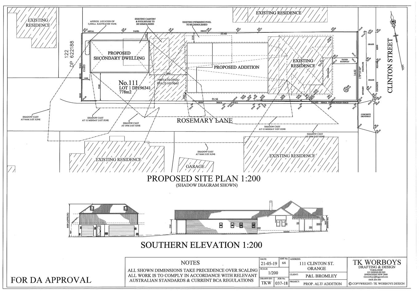
Planning
and Development Committee
3 September 2019
Attachment 4 Submissions-
Received During Exhibition Period
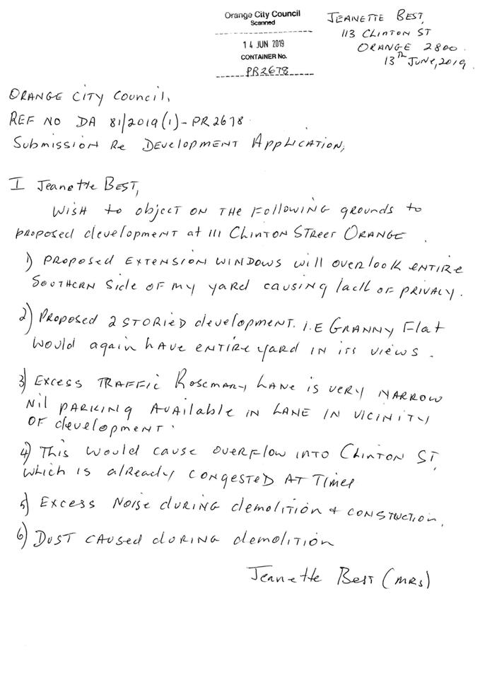
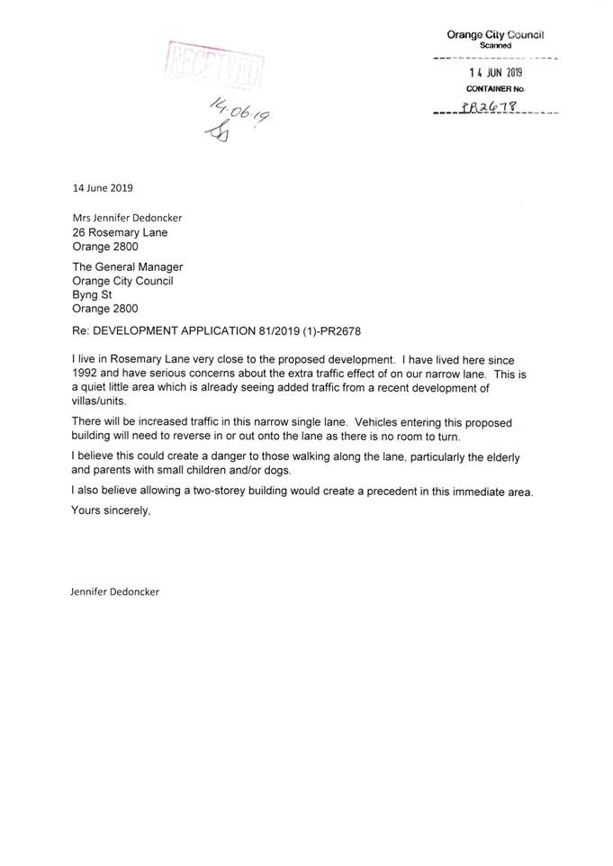
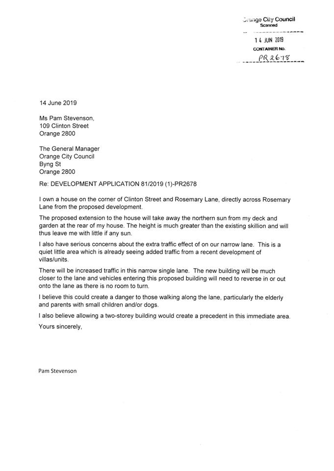
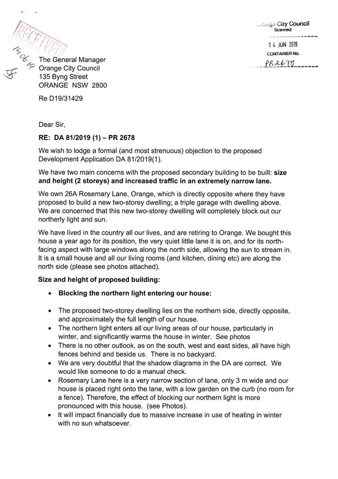
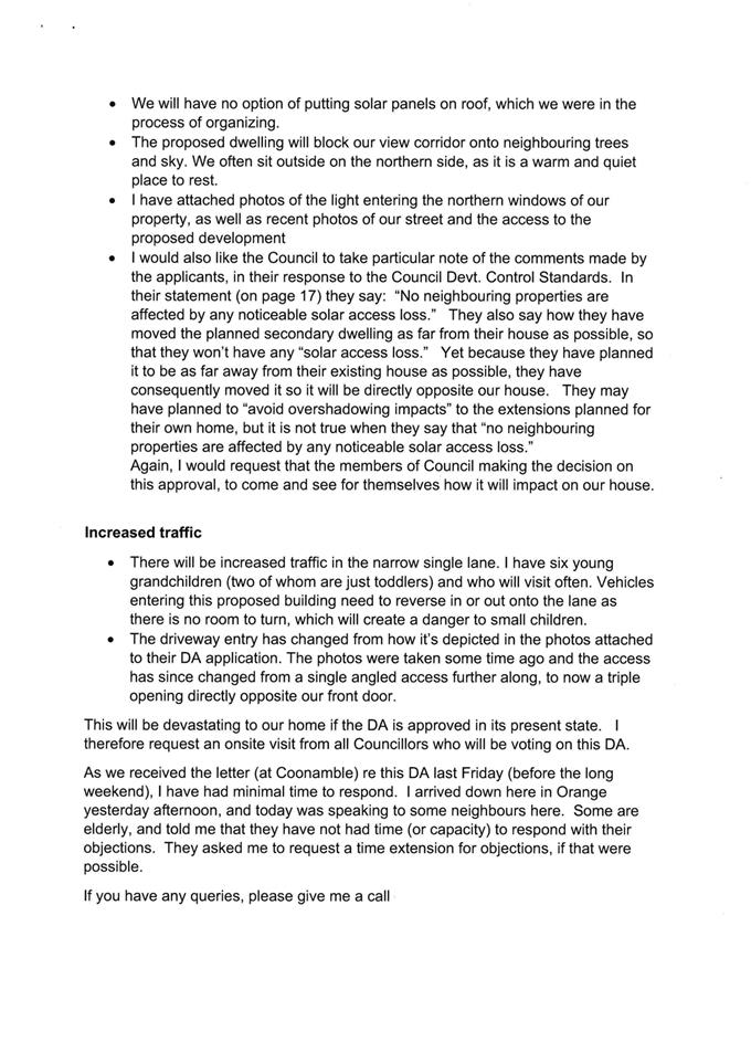

Planning and Development Committee
3 September 2019
Attachment 5 Submissions
- Received After 6 August PDC Meeting
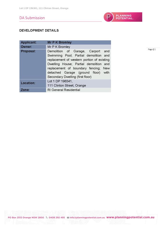
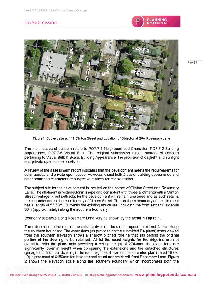
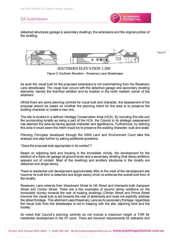
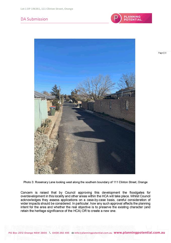
2.6 Planning
Proposal to rezone 1 Leewood Drive from IN1 General Industrial to B6 Enterprise
Corridor
RECORD
NUMBER: 2019/1783
AUTHOR: Craig
Mortell, Senior Planner
EXECUTIVE Summary
Council is in receipt of a
Planning Proposal to rezone Lot 100 DP 739023, known as 1 Leewood Drive.
Situated on the corner of Leewood Drive and Elsham Avenue, this property is the
site of the former motor registry building. To the north beyond the Greenleigh
Walkway is Blowes Road which will become the Southern Feeder Road when it is
constructed in due course.
The proposal requests the site be
rezoned from IN1 General Industrial to B6 Enterprise Corridor. The proposal has
included a conceptual layout of a potential development of the site but
stresses that it is for illustrative purposes only and is not a firm direction
for the site.
As such, rezoning the land to B6 as requested could result
in a future application for any of the uses allowed in the B6 zone. It should
be noted that this would include various forms of both Residential
Accommodation and Tourist and Visitor Accommodation, either of which could
result in a land use conflict whereby noise and traffic complaints against
neighbouring industrial development may arise and ultimately lead to a
restraint on the operation of part of the Leewood estate. i.e. limits on the
hours of operation or additional noise mitigation being required and the like.
The significance of the Leewood Estate to the local economy
should be acknowledged and protected. Currently the nearest residential areas
are 50–70m away, separated by the corridor of Blowes Reserve, Blowes Road
and Greenleigh Walkway. While it is unlikely that residential development would
be sought, a tourist accommodation project may be attracted to the Southern
Feeder Road corridor.
Given the speculative nature of the planning proposal, which
seeks to expand upon the range of uses permissible on the site for future
flexibility, an alternative approach would be to nominate the site for listing
in Schedule 1 of the LEP as an ‘Additional Permitted Use(s)’ site
and explicitly nominate the range of uses that may be acceptable on the site
beyond those permitted in the existing IN1 zone.
Link To Delivery/OPerational Plan
The recommendation in this report relates to the
Delivery/Operational Plan strategy “7.1 Preserve - Engage with the
community to develop plans for growth and development that value the local
environment”.
Financial Implications
Nil
Policy and Governance Implications
Nil
|
Recommendation
1 That
Council advise the proponent that rezoning the land to B6 Enterprise Corridor
is not supported on the grounds that residential accommodation and tourist
and visitor accommodation at 1 Leewood Drive creates an unreasonable
potential for land use conflicts with the adjoining industrial estate.
2 That
Council support a revised planning proposal in relation to 1 Leewood Drive
being sent to the Department of Planning, Industry and Environment for a Gateway
Determination, subject to the following:
· The subject land
is to remain IN1 General Industrial zone.
· An Additional
Permitted Use (APU) listing be drafted for inclusion in schedule 1 in
relation to 1 Leewood Drive.
· The APU listing
is to enable as permissible development: Office Premises; Business Premises;
Community Facilities; Plant
nurseries; Rural supplies; Take away food and drink premises, and Highway
Service Centres.
3 That
Council advise the proponent that subsequent development of 1 Leewood Drive
may be required to contribute towards a pedestrian crossing facility
commensurate with the type and scale of development proposed and that, in
addition to any relevant gateway conditions, a suitable arrangement must be
agreed prior to formal public exhibition being undertaken. Such agreement
shall as a minimum encompass:
· Design and
construction work
· Timing
· Costs and
apportionment
· Appropriate
funding mechanism
|
further considerations
Consideration has been given to the recommendation’s impact
on Council’s service delivery; image and reputation; political;
environmental; health and safety; employees; stakeholders and project
management; and no further implications or risks have been identified.
SUPPORTING INFORMATION
Site History
Formerly home to the RTA Motor Registry for many years the
site is located at the entrance to the Leewood Industrial Estate. Following
closure of the motor registry the site was sold to the current owner in January
2015.
Unauthorised development comprising tree removal was
identified in July 2017. Unauthorised use of the site for motor vehicles
sales and partial erection of a large shade structure was identified in
February 2018. Following correspondence on these matters a Development
Application (209/2018) for a Vehicle Sales or Hire Premises was lodged in
June 2018 but later withdrawn in September 2018. Council has written to
the property owner seeking further explanation as to why tree removal has
occurred without first seeking the relevant approvals.
Currently the site is vacant and
the majority of trees have been removed.
View north through site from Leewood Drive
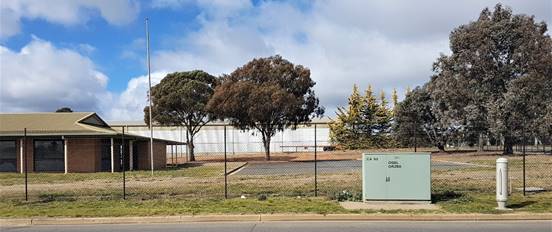
View east across southern end of site from Elsham
Avenue
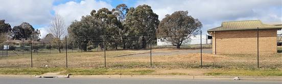
View east across northern end of site from Elsham
Avenue
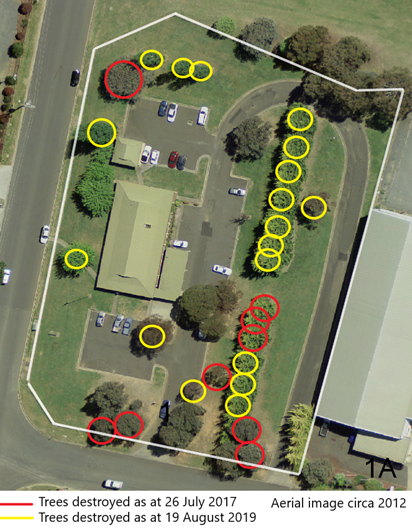
Preferred Form
of Amendment
The proposal
seeks to broaden the range of permissible uses to enable a future redevelopment
of the site. The proposal is supported by a conceptual design to illustrate one
potential outcome – but also stresses that this is not the current intention.
The available mechanisms to achieve the above are to either rezone the
land or to seek listing the site in Schedule 1 as an Additional Permitted Uses
(APU) site and nominate the particular uses that are sought.
Rezoning from IN1
General Industrial to B6 Enterprise Corridor means that the range of
permissible and prohibited uses changes – albeit there is significant
overlap between the zones. Creating an APU listing retains all of the current
uses in the current zone but allows an application for development consent
consistent with any uses specified in the APU listing.
The proponent has nominated a rezoning in preference to an
APU stating that the latter may prove too narrow for the development potential
of the site. This is effectively an appeal for maximum flexibility to enable
the land owner to respond to market opportunities. While that is a legitimate
concern Council must also seek to avoid land use conflicts that may unduly
compromise the ability of surrounding developments to continue their existing
operations.
As stated a rezoning swaps the range of permissible and
prohibited uses such that a development application can be sought for any of
the uses permitted in the new zone. The following land use table comparison
highlights the differences between the two zones. Should there be uses in the
proposed zone that have potential to create a conflict it may be preferable to
consider an APU listing instead.
Land Use Table comparison
The following table outlines the
uses that are permissible in either the current or proposed zone. Bold text
indicates a use that is only permitted in that zone and not the other. Italics
indicates a term that is not explicitly listed in the land use table and
therefore defaults to being permissible due to the zone allowing anything not
specified to be permissible.
|
IN1
General Industrial
|
B6
Enterprise Corridor
|
|
Depots; Freight transport facilities; Garden centres; General
industries; Hardware and building supplies; Industrial training
facilities; Kiosks; Landscaping material supplies; Light
industries; Neighbourhood shops; Oyster aquaculture; Passenger
transport facilities; Places of public worship; Roads; Self-storage
units; Tank-based aquaculture; Timber yards; Vehicle sales
or hire premises; Warehouse or distribution centres.
|
Business premises; Community facilities; Educational Establishments; Freight transport facilities; Garden centres; Hardware and building supplies;
Hotel or motel accommodation; Kiosks; Landscaping material
supplies; Light industries; Multi dwelling housing; Neighbourhood
shops; Oyster aquaculture; Passenger transport facilities; Office
Premises; Plant nurseries; Restaurants or cafes; Roads; Rural
supplies; Self-storage units; Shop top housing; Take away food and
drink premises; Tank-based aquaculture; Timber yards; Tourist and
visitor accommodation; Vehicle sales or hire premises; Warehouse
or distribution centres.
|
Accordingly, rezoning the land to B6
Enterprise Corridor would result in the following uses becoming prohibited on
the site:
Depots;
General industries;
Industrial training facilities;
Places of public worship.
In contrast rezoning the land to B6
Enterprise Corridor would add the following land uses as permissible with
consent:
Business premises;
Community facilities;
Educational establishments;
Hotel or motel accommodation;
Multi dwelling housing;
Office Premises;
Plant nurseries;
Restaurants or cafes;
Rural supplies;
Shop top housing;
Take away food and drink premises;
Tourist and visitor accommodation.
Potential for
Land Use Conflicts
When altering the
range of permissible uses the potential conflict with surrounding development
needs to be considered. By nature of their operation some land uses are
impactful, meaning they generate noise, odour, traffic or other adverse effects
and some land uses are regarded as sensitive receivers, meaning they are
especially likely to object to the impacts generated by the former.
Land use conflict
therefore occurs in two main ways. Impactful developments being approved in
sensitive areas, or sensitive developments being approved in areas adjoining or
in proximity to existing impactful developments. Land use zoning is the primary
tool through which Council can seek to manage and avoid land use conflicts by
ensuring that sensitive uses such as accommodation are segregated from
impactful development with appropriate buffers and separation distances.
From the uses
indicated above, Multi Dwelling Housing and Shop Top Housing (both forms of
Residential Accommodation) as well as Hotel or Motel Accommodation and other
forms of Tourist and Visitor Accommodation (such as bed and breakfast
accommodation, boarding houses, serviced apartments and the like) are
considered to be an incompatible form of development to adjoin an established
industrial estate. The potential for complaints from residents and guests in
relation to noise, traffic and parking strongly argues against enabling these
forms of development on the subject site.
The other uses in the list (Business Premises; Community facilities;
Office Premises; Plant nurseries; Restaurants or cafes; Rural supplies; Take
away food and drink premises and Highway Service Centres) are less sensitive
and therefore less likely to generate complaints related to neighbouring
developments and can be expected to be designed to avoid or mitigate other
issues.
The proposal
states:
“the potential for the land to be used for
residential purposes is somewhat constrained or undesirable due to the adjacent
industrial land use pattern and the proposed Southern Feeder Road.”
However, this
relies upon market forces, rather than planning controls, to prevent what is an
acknowledged ‘undesirable’ outcome.
Conversely, an
APU listing could enable most of the B6 zones, excluding all forms Residential
Accommodation and Tourist and Visitor Accommodation. An APU would provide
greater development potential without creating the potential for a future land
use conflict.
The fact that the
proponent has not solidified their plans for the site is not considered
sufficient grounds to risk the creation of a foreseeable land use conflict
between accommodation and industrial uses.
Site Context
To the north east of the site is the Glenroi residential
area. The nearest convenience shopping for such residents is along Bathurst
Road, approximately 1.5km to the north. Although the site of the former Kurim
shops is zoned B1 Neighbourhood Centre a redevelopment of that location is not
anticipated in the short term.
Ultimately, Council will need to identify a location along
the Southern Feeder Road for convenience facilities. Opportunities for which
currently appear to be limited. Such facilities are not planned or intended
within either Shiralee or the Towac Equine precinct. Outside of the subject
site at 1 Leeds Parade, part of the former saleyard site and potentially the
western edge of the rifle range site could be investigated. However, the latter
would be removed from the industrial and Glenroi area and positioned closer to
Shiralee, which already has an area identified for a B1 zone.
CBD competition
Importantly ‘Retail Premises’, which is a group
term that encompasses various forms from shops to supermarkets and discount
department stores is prohibited in both the IN1 and B6 zones. Therefore, the
proposal does not result in a threat to the trading performance and role of the
Orange CBD. Smaller convenience forms of retail, such as neighbourhood shops,
restaurant or café and takeaway food and drink premises do not act as
major attractors relying instead on passing traffic and local (walking
distance) resident/workforce populations. In planning terms a walkable distance
is typically regarded as being between 400m – 800m when slopes are not excessive.
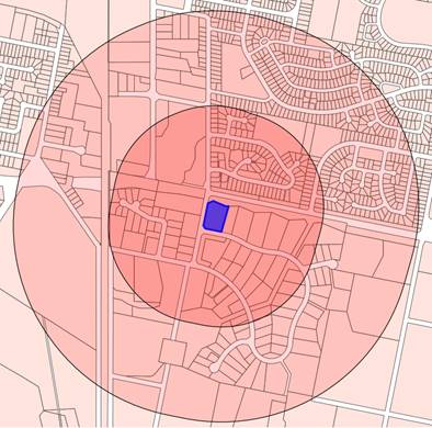
The image above indicates that
large parts of southern Glenroi are within walkable distances of the site. With
the absence of the Kurim shops this area is presently underserved from a
convenience shopping perspective. In contrast to the Kurim shops the subject
land will have the added benefit of greater passive surveillance from passing
traffic as well as the industrial estate workforce to enhance trading
viability. Being located on the edge of the industrial land the site will
therefore not entice light vehicles deep into conflicts with heavier vehicles
servicing industrial premises.
The advantages of 1 Leewood Drive are in terms of being
convenient for through traffic arriving or departing along the Southern Feeder
Road, as well as relatively central to the industrial lands, proximate to the
Glenroi residential area – yet buffered by the road reserve and
parklands. Although residential traffic flows will not be direct.
Navigation
The Southern Feeder Road project is anticipated to alter the
local traffic network by providing a T intersection with a northbound
connection through the former sale yard site to connect with the southern end
of Edward Street. Elsham Avenue is anticipated to be severed with a T
intersection allowing a southbound connection into the Leewood estate. The
northern section of Elsham Avenue, however, will be terminated in a cul-de-sac
and therefore residential traffic from Glenroi will not be able to enter the
Leewood estate at this location as it presently does.
Number 1 Leewood Drive will become a significant gateway
site at the entrance to the employment lands in this area. The Southern Feeder
Road will then provide a direct link out to the Mitchell Highway in the
east.
With the growth of the city to the south there is expected
to be pressure for a service centre along the route of the Southern Feeder
Road, and while service stations are already permissible in the IN1 zone
supporting facilities such as take away food and drink premises are not. A
modest amount of office or business premises on the edge of an industrial
estate may allow for enterprises whose primary client base is more trade
focussed. Additionally, while the Glenroi residential area will not have direct
vehicular access its proximity suggests the site could attract pedestrian
usage.
Pedestrian attraction
As stated the Southern Feeder Road project will divide
Elsham Avenue such that residents in Glenroi would need to either walk or if
driving, divert via McNeilly Avenue and then Edward Street. Should
development of 1 Leewood Drive be of a kind likely to attract significant
pedestrian volumes from Glenroi there may be a need for a pedestrian crossing
to be located at or near this intersection. Such works would be outside of the
property boundaries but necessitated by the development. Without a firm
development concept for the site it is not possible to confirm if this is the
case. However, the potential for this connection and associated expense needs
to be highlighted so that the proponent, or any future buyer of the site, is
fully aware. Therefore, prior to any LEP amendment being placed on exhibition
Council should negotiate with the proponent on this matter to determine an
appropriate cost, apportionment and mechanism to fund such works.
In view of the above it is considered that providing some
additional flexibility of use for the site has potential to improve the
provision of convenience facilities to the local resident and workforce
populations. Additionally, the site is well situated to cater to the future Southern Feeder
Road traffic needs without diverting such traffic flows deeper into the
industrial estate. However, the B6 Enterprise Corridor zone includes some
residential accommodation and tourist and visitor accommodation which if
established on the site would have the potential to generate land use conflicts
that may hinder the orderly operation of an important industrial/employment
precinct. Accordingly, it is recommended that the planning proposal only be
supported on the basis of being amended to an Additional Permitted Use listing
to enable uses that are permissible in the B6 zone with the exception of
residential accommodation and tourist and visitor accommodation and their
respective sub-terms.
Attachments
1 Planning
Proposal to rezone 1 Leewood Drive, D19/49368⇩
2 Planning
Proposal - Site plan and Concept Layout, D19/49370⇩
Planning
and Development Committee
3 September 2019
Attachment 1 Planning
Proposal to rezone 1 Leewood Drive
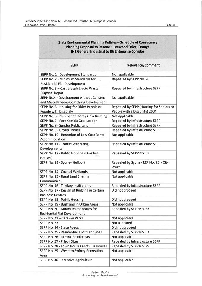
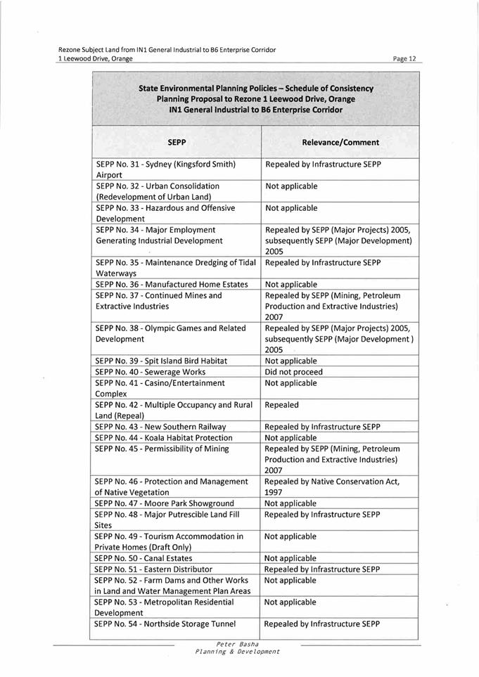
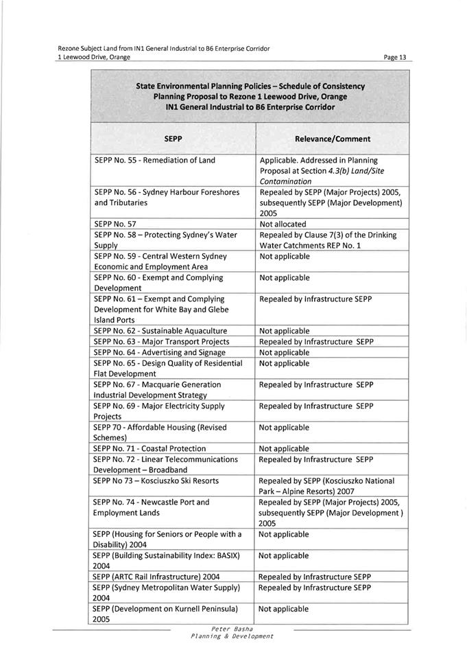
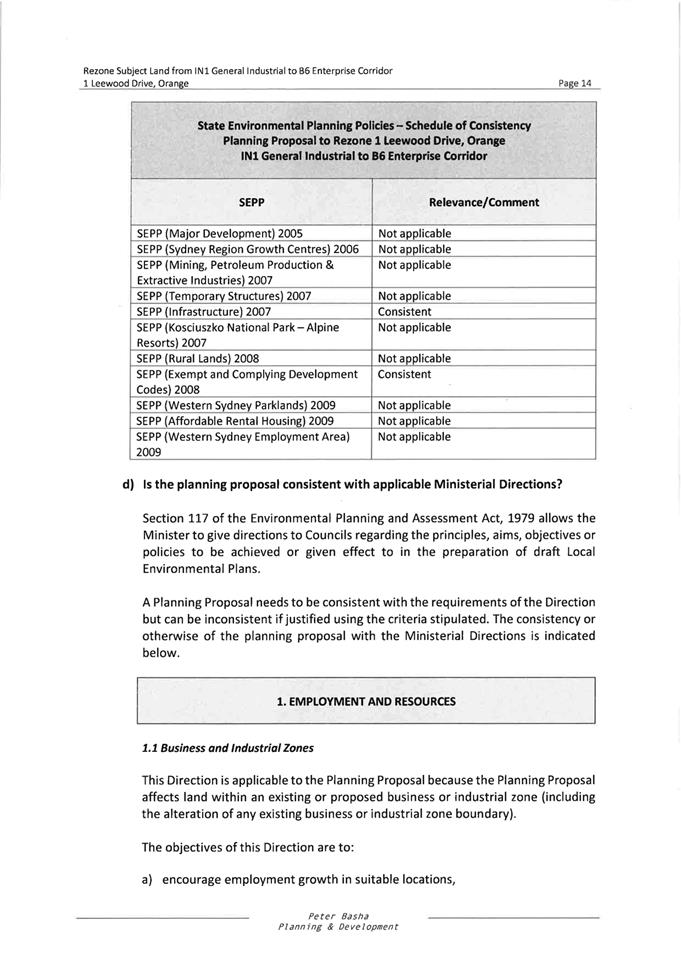
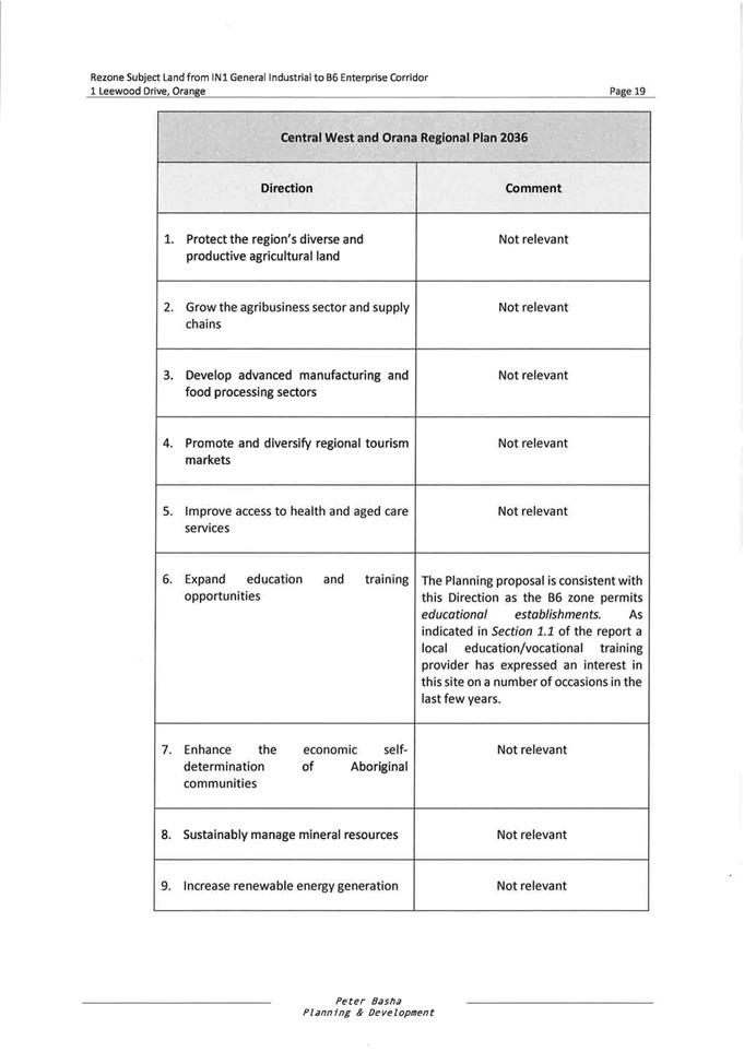
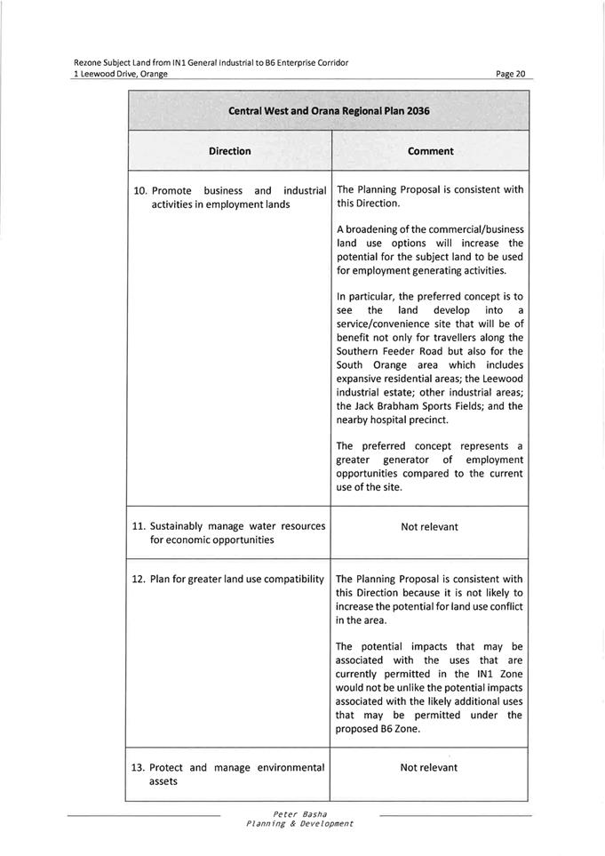
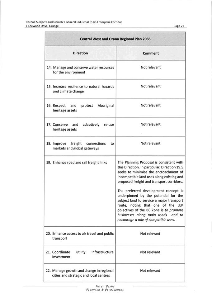
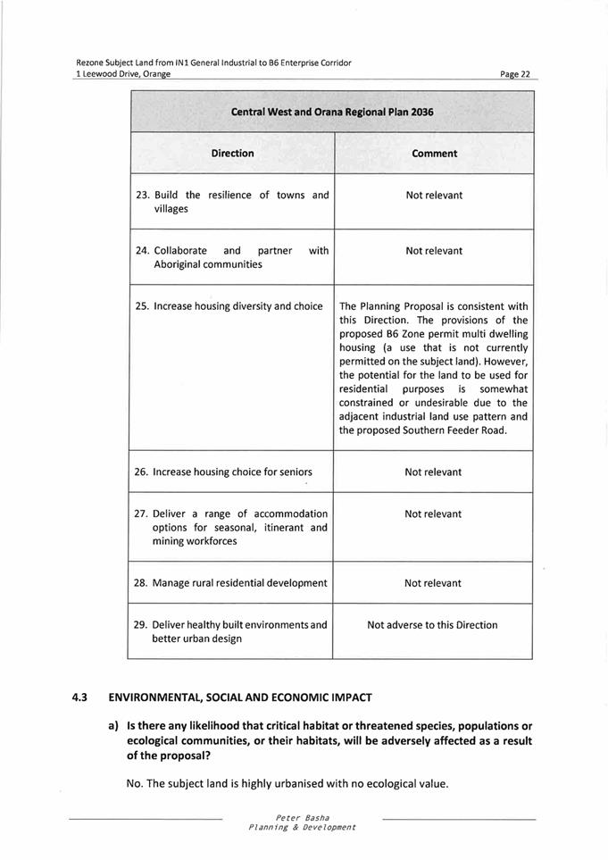
Planning and Development Committee
3 September 2019
Attachment 2 Planning
Proposal - Site plan and Concept Layout
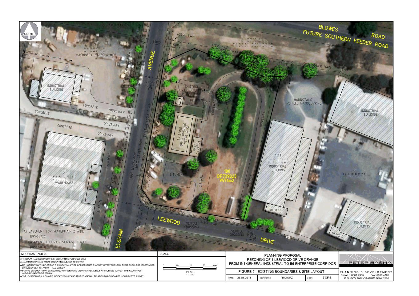
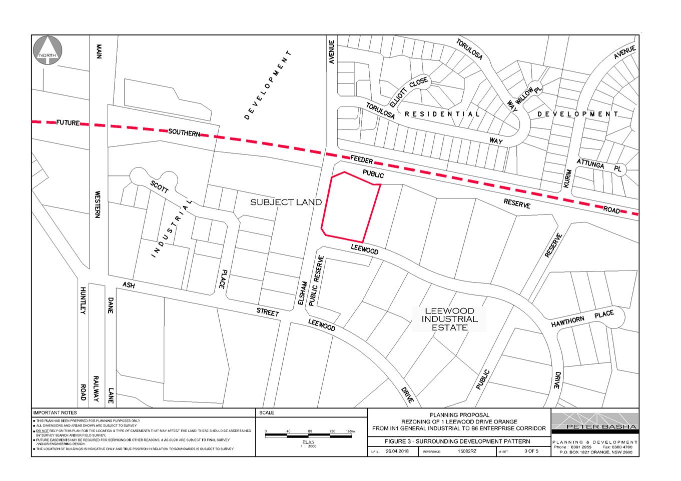
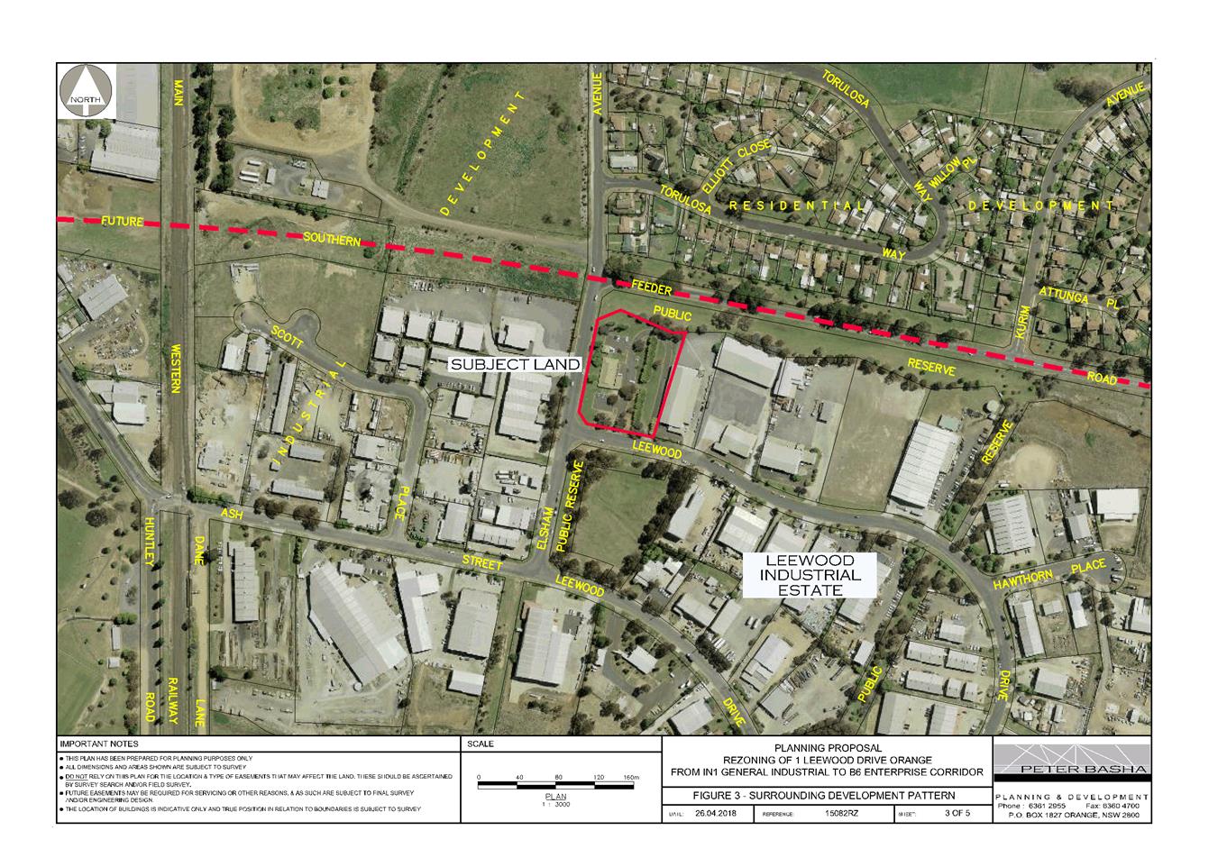
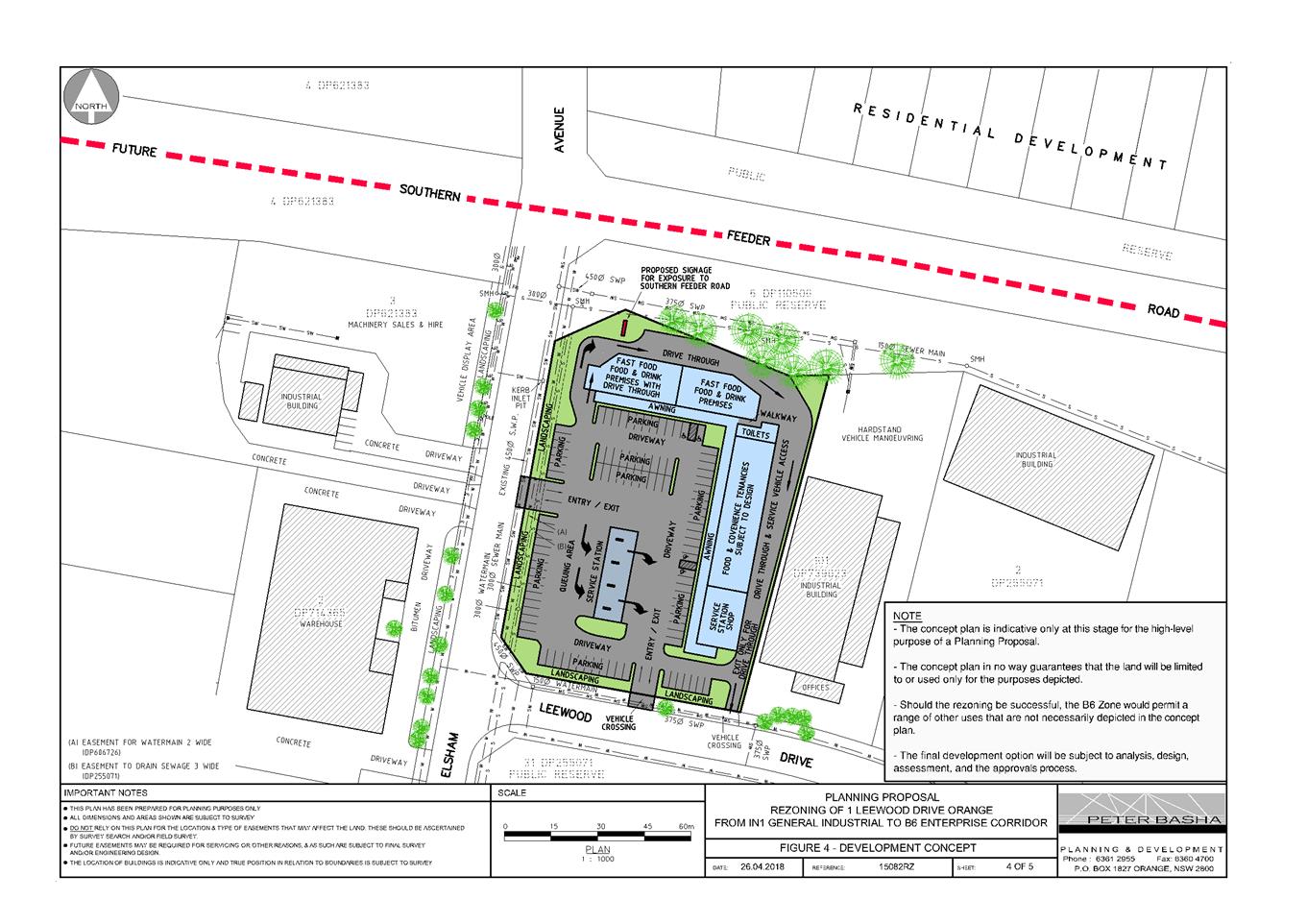
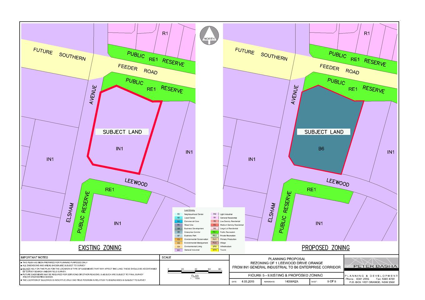
2.7 Draft
Planning and Development: Community Participation Plan
RECORD
NUMBER: 2019/1789
AUTHOR: Kayla
Clanchy, Town Planner
EXECUTIVE Summary
The NSW Department of Planning Industry and Environment
(formerly the Department of Planning) requires all Councils’ develop and
adopt a Community Participation Plan by 1 December 2019. This plan
details Council will engage with the community on matters of environmental and
land-use planning. Before the Community Participation Plan can be finalised, it
must be exhibited to the public and endorsed by Council.
Other peripheral documents will need to be updated or
amended based on the scope of matters covered in the Community Participation
Plan. In reviewing some of these peripheral documents, pragmatic alterations to
planning and development assessment processes are also proposed, with an aim to
deliver better planning outcomes and procedures.
Link To Delivery/OPerational Plan
The recommendation in this report relates to the Delivery/Operational
Plan strategy “14.3 Collaborate - Provide opportunities for widespread
and quality engagement, and where appropriate, shared decision-making.”.
Financial Implications
Implementation of the Plan requires more administrative
measures to be introduced in order to provide well-rounded community
participation opportunities.
Policy and Governance Implications
The Environmental Planning and Assessment Act 1979 (‘the
Act’) requires Council to have a Community Participation Plan finalised
and accessible online through the NSW Planning Portal, by 1 December 2019. This
Plan must be exhibited for at least 28 days.
The provisions of the Development Control Plan 2004 (‘the
DCP’) that relate to exhibition of development applications will
be superseded by the Community Participation Plan.
The attachment to Council’s Strategic Policy No 24
(‘ST024’) known as Declaration of Planning and Development
Assessment Procedures and Protocols will be updated from Version 4 (6 May
2010) to Version 5 in order to align with the Community Participation Plan.
Other pragmatic alterations to administration and delegation procedures have
been proposed in Version 5 of the attachment to ST024. Advice has been received
from the Corporate Services division of Council that updating delegations in
line with the changes proposed in Version 5 of the attachment to ST024 is
possible, subject to follow-up confirmations of delegations being finalised
through appropriate channels.
In light of the above, it is therefore important to
synchronise exhibition and endorsement of the Community Participation Plan,
amendments to the DCP, and amendments to ST024.
|
Recommendation
That Council resolves:
1 To amend Development
Control Plan 2004 (Chapter 5) by removing provisions for exhibition
of development applications, and reference instead the Planning and Development:
Community Participation Plan 2019.
2 To update
the attachment to ST024 being the Declaration of Planning and Development
Assessment Procedures and Protocols from Version 4 to Version 5.
3 To update
ST024 to ensure the Policy references the correct attachment (being Version 5
attachment).
4 To update
delegations in accordance with Version 5 of the attachment to Declaration
of Planning and Development Assessment Procedures and
Protocols.
4 To place
the draft Planning and Development: Community Participation Plan 2019, the
draft Version 5 attachment to ST024, and draft amendment to Development Control
Plan 2004 (Chapter 5) on public exhibition for a period of 28 days.
|
further considerations
Consideration has been given to the recommendation’s
impact on Council’s service delivery; image and reputation; political;
environmental; health and safety; employees; stakeholders and project
management; and no further implications or risks have been identified.
DIRECTORS NOTE
The NSW Department of Planning Industry and Environment
(formerly the Department of Planning) requires all Councils’ develop and
adopt a Community Participation Plan by 1 December 2019. Staff have
drafted a Plan for the purposes of exhibition in accordance with the
requirements of the Department. Council needs to resolve to exhibit this
Plan. After this exhibition the Plan will be reported back to Council for
final review and adoption prior to 1 December 2019.
SUPPORTING INFORMATION
The Planning and Development:
Community Participation Plan 2019 (‘the Plan’) is a strategic
document that sets the parameters for community participation in the
environmental and land-use planning framework of the Orange Local Government
Area (‘LGA’).
The NSW Department of Planning, Industry & Environment
(‘DPIE’) requires a Plan to be in place for each LGA and finalised
by 1 December 2019, in line with the Act reforms.
The Plan must:
· outline when and
how it applies to planning functions,
· incorporate
statutory community participation objectives, and
· identify legislated
minimum exhibition timeframes.
In order to make the Plan a one-stop-doc, local provisions
have been incorporated where possible. For example, the Plan defines the types
of development applications that will routinely be ‘advertised’,
‘neighbour notified’, or subject to no exhibition. The Plan also
includes clear instructions on how and when submissions can be considered for
changes to strategic plans, proposed development, and major Council activities.
More importantly, however, the Plan signals a shift in focus from trying to
resolve community expectations at the development application stage to
focussing engagement efforts more acutely at the strategic plan-making stage.
To accommodate the Plan and the shift in focus for community
engagement, Council’s planning and development procedures need to be
updated. ST024 is known as the Declaration of Planning and Development
Assessment Procedures and Protocols. Attached to ST024 is Version 4 of Declaration
of Planning and Development Assessment Procedures and Protocols (‘the
Declaration’). It is proposed to attach a Version 5 Declaration to ST024
instead. The scope of changes to the Declaration between Version 4 and 5
generally include:
· Community
engagement methods which are to be drawn from, particularly when undertaking
research for (and formulating) strategic plans,
· Creation of a
streamlined scheme for applicants who have demonstrated meaningful
pre-lodgement community consultation with community members who are likely to
be impacted by a development,
· Alterations and
clarifications to the delegation schedule for determination of development
applications, including increasing the monetary threshold from $1.5m to $2.5m
for when DAs will – as a default – be considered by Council at a
Council meeting, and
· Other
administrative tweaks, such as ensuring the Declaration references the Plan.
ST024 itself will need to be amended to ensure the correct
attachment is being referred to (i.e. Version 5 and not Version 4). As for
altering delegations, these changes can be ratified through the appropriate
channels, per advice from Corporate Services.
Another corollary to the introduction of the Plan will be
the need to remove portions of Chapter 5 of the DCP which relate to the types
of proposals that will be advertised or neighbour notified during assessment of
a development application. These provisions have all been reviewed and adapted
for insertion into the Plan. It is therefore proposed to delete those parts of
Chapter 5 of the DCP that will no longer apply as a result of the Plan being
endorsed, and insert instead wording to the effect that the reader shall refer
to the Community Participation Plan for guidance on exhibition procedures for
development applications.
Attachments
1 Draft
Planning and Development Community Participation Plan 2019, D19/49956⇩
2 Version
5 Draft Declaration of Planning and Development Assessment Procedures and
Protocols, D19/49955⇩
3 Edits
to DCP 2004 Chapter 5 - General Considerations for Zones and Development,
D19/50215⇩
Planning and Development Committee
3 September 2019
Attachment 1 Draft
Planning and Development Community Participation Plan 2019
Planning and Development: Community
Participation Plan 2019
Draft version 22 August 2019
Contents
Foreword: Community
participation in the planning system.. 4
Chapter 1: What is the
Plan and how will it be used?. 5
1.1 What is the Plan
and why is it being made now?. 5
1.2 In what circumstances does the Plan apply?. 5
1.3 How to use the
Plan. 6
1.4 Community
participation objectives. 6
Chapter 2: Strategic
planning, plan-making and early engagement 8
Chapter 3: Development
Applications and community views. 9
Chapter 4: Major Council
activities and transparency. 10
Chapter 5: Feedback and
making submissions. 10
5.1 Can I make a submission?. 10
5.2 When can I make my submission?. 10
5.3 What does my submission need to include?. 10
5.4 Before making a submission. 11
5.5 Where to send my submission?. 12
5.6 Acknowledgement of submissions received. 13
5.7 How are submissions considered?. 13
Chapter 6:
Post-determination. 15
6.1 Notices of
determination. 15
·
Strategic
planning and plan-making. 15
·
Development
Applications. 15
·
Council
activities. 15
Chapter 7: Details
– Exhibition procedures and timeframes. 16
7.1 What is meant by
exhibition types ‘advertised’ and ‘neighbour notified’?. 16
7.2 Advertised proposals. 18
7.3 Neighbour notified proposals. 21
7.4 Other proposals – no exhibition. 22
7.5 Timeframes –
advertised and neighbour notified exhibition. 23
Questions?. 24
Links of interest 25
Glossary. 26
List
of Tables
Table 1. What functions
does the Plan apply to?.............................................................................. 5
Table 2. Community
participation objectives and directions............................................................ 7
Table 3. Proposals
– advertised exhibition...................................................................................... 19
Table 4. Proposals
– neighbour notified exhibition......................................................................... 21
Table 5. Minimum exhibition
timeframes....................................................................................... 23
Foreword:
Community participation in the planning system
Orange City Council recognises
community participation throughout the planning system is not only a civic
right, but that it also delivers better planning results for the city of
Orange.
Ultimately, our responsibility
is to deliver on the objectives of various environmental planning documents and
legislation, including the Environmental Planning and Assessment Act 1979 (‘the
Act’), Orange Local Environmental Plan (‘the LEP’), Central
West and Orana Regional Plan 2036, and the forthcoming Local Strategic Planning
Statement. The Planning and Development: Community Participation Plan 2019
(‘the Plan’) is intended to be consistent with the principles of
any in-force Community Engagement Strategy required under the Local
Government Act 1993.
|
Lost already?
The Glossary section contains some quick
definitions for terms commonly used throughout this Plan. Refer to page 26.
|
The planning system of
NSW is shifting focus to enable more meaningful community participation earlier
in the planning process. Because of this, the Plan places greater emphasis and
weight on strategic planning and plan-making phases when trying to gauge
community views on how land and natural resources will be used and protected
into the future.
The Plan also consolidates and
updates advertising and notification requirements for some types of development
proposals, as previously found in Development Control Plans
(‘DCPs’). Council’s policy for planning and development
assessment procedures has been brought into alignment with the Plan.
In terms of engagement with the
community when Council is proposing to undertake major activities or
infrastructure projects, the Plan sets out when we will broadcast proposals for
those types of activities, to ensure greater transparency in our role as a public
authority.
The underpinning community
participation objectives of the Plan can be found in Chapter 1: What is the Plan and how will it be used?. Throughout the Plan, references to the three
major planning functions (strategic planning and plan-making; development
assessment; and Council activities) are made. More information on these three
planning functions is embedded in Chapter 1.
The level and extent of
community participation will vary depending on the planning function, the scope
of the proposal under consideration, and the potential impact of the decision.
The Orange community is dynamic and diverse, so community participation needs
to involve any individuals, groups, or businesses who are likely to be
interested in or affected by planning decisions.
|
Why is community participation
important?
· It builds community confidence in
the planning system
· Community participation creates a
shared sense of purpose, direction, and understanding of the need to balance
environmental changes against amenity considerations
· It provides decision-makers access
to community knowledge, expectations, ideas, and expertise.
|
Chapter 1: What is the Plan and how will it be used?
1.1 What is the Plan and why is it
being made now?
The Planning and
Development: Community Participation Plan 2019 is a strategic
document that sets the parameters for community participation in the
environmental and land-use planning framework of the Orange Local Government
Area (‘LGA’).
The NSW Department of Planning, Industry & Environment
(‘DPIE’) requires a Plan to be in place for each LGA and finalised
by 1 December 2019, in line with the Act reforms.
The Plan must incorporate statutory community participation
objectives, which we will use to guide our approach to community engagement.
1.2 In what circumstances does the Plan apply?
This Plan is a requirement of the Act (see Division 2.6 and
Schedule 1) and applies to the exercise of planning functions by certain
authorities. A break-down of the type of functions that the Plan applies to is
delineated in Table 1:
|
Table 1. What functions
does the Plan apply to?
|
|
Plan-making
|
Strategic planning is an
essential aspect of Council’s planning functions, where the strategic
direction for environmental planning and development is set. This involves
planning for communities which integrates social, environmental, and economic
considerations.
Examples of this work include
amendments to or the creation of the LEP, development control plans,
contribution plans, specific land use strategies, and the like.
|
|
Development Applications
|
The Regional Planning Panel,
the Council, the CEO of the Council, and delegated officers all make planning
decisions on a range of developments (Development Applications). When making
decisions on these developments, consideration is given to whether land use
proposals are in accordance with the strategic priorities of Council, the NSW
Government, relevant legislation, and the public interest.
Proposals assessed may be in
relation to residential, industrial/commercial, rural, and physical or social
infrastructure developments. In these proposals, the planning assessment
phase is just one aspect of the overall project lifecycle. At other phases of
the project, separate community engagement may be undertaken by
proponents/developers, or other government agencies.
Note that this Plan does not
apply to “Complying Development”. Complying Development
provisions are administered by DPIE and these types of development are not
subject to local requirements for exhibition periods, and submissions cannot
be considered on proposed Complying Development.
|
|
Activities
|
Council is oftentimes the
determining authority for its own activities which relate to Council’s
role as a “public authority”, e.g. Council could be the
determining authority and the proponent when undertaking works in a public
park.
Sometimes, these activities
are of such a scale that before the works can occur, an Environmental Impact
Statement (‘EIS’) is required to be prepared in accordance with
DPIE requirements. These EISs are subject to scrutiny from the public, and so
this Plan applies to these types of scenarios.
|
The Plan will be reviewed on a periodic basis to make
sure it is fit for purpose. It should be noted that the Plan has been prepared
with reference to current requirements in the Act and Environmental Planning
and Assessment Regulation 2000 (‘the Regulation’), and
that the parent requirements found in that Act and Regulation may change from
time to time. We will endeavour to keep the Plan as up-to-date and relevant as
possible in light of these broader, State-led changes. Nevertheless, the reader
is encouraged to refer to the current legislation – please see Links of interest section
of this Plan.
1.3 How
to use the Plan
This Plan will be consulted by Council staff who undertake
certain planning functions. The Plan is likely to help inform staff when
analysing:
· What
approaches should be taken in engaging the community,
· The
level of emphasis that should be placed on community participation, relative to
the planning function,
· At
what point in time community participation is of most use to the community and
to Council, and
· The
method and duration of engagement and exhibition.
It is also envisaged that the Plan will be used by the
community to help guide their expectations for when they are likely to be
engaged – and why – in relation to certain planning functions. As a
result, it is anticipated that the Plan will help community members:
· Feel
empowered in understanding the different planning functions that they may be
consulted on,
· Engage
better and more meaningfully with the planning system,
· Understand
how they can use their voice in the planning system, and
· Keep
informed of the planning decisions being made in their area.
1.4 Community participation
objectives
Table 2 on the following page illustrates the community
participation objectives that underpin this Plan, as adapted from the Act. Some
directions have been attributed to each objective.
These objectives have helped inform our approach to community
engagement and will help inform future revisions of this Plan and our policy
for planning and development assessment procedures, especially when analysing
if our community engagement approaches are fit for purpose.
Table 2. Community
participation objectives and directions
|
|
Objectives
|
Directions
|
|
Community participation is open and inclusive
|
· Encourage community participation by keeping the community informed,
promoting participation opportunities, and seeking community input.
· Build strong partnerships with the community.
· Ensure community engagement accurately captures the relevant views of
the community.
· Conduct community engagement opportunities in a safe environment.
|
|
Community participation is easy
|
· Clearly set out the purpose of any engagement and how and when the
community can participate in respect of a planning function.
· Prepare information for the community that is relevant, concise,
written in Plain English and easy to understand.
· Use visual representations to make it easier to understand the
possible impacts of a proposal.
· Ensure information is accessible in order to attract input from
groups who may find it difficult to participate in standard engagement
activities (e.g. young and older people; people with disabilities; Aboriginal
and Torres Strait Islander people; people from a culturally and
linguistically diverse background).
|
|
Community participation is relevant
|
· Clearly establish the purpose for engagement and tailor engagement
activities to match the context (e.g. location; type of application; stage of
the assessment process; previous engagement undertaken), scale and nature of
the proposal and its impacts, level of community interest, and
community’s preference about how they would like to participate.
· Adjust engagement activities (if necessary and/or appropriate) in
response to community input.
|
|
Community participation is timely
|
· Start community engagement as early as possible (subject to proper
documentation being available), and continue this engagement for an
appropriate period.
· Ensure the community has reasonable time to provide input on
proposals.
|
|
Community participation is meaningful
|
· Explain how community input was taken into consideration, and ensure
the response to community input is relevant and proportionate.
· Give genuine and proper consideration to community input.
· Keep accurate records of engagement activities and community input.
· Regularly review the effectiveness of community engagement.
· Integrate community input into the evaluation process.
· Comply with any statutory obligations.
· Protect privacy and respect confidentiality.
|
Chapter 2:
Strategic planning, plan-making and early engagement
Council must create and implement strategic plans for the LGA,
under both the Environmental Planning and Assessment Act 1979 and the Local
Government Act 1993. These plans are informed by overarching State and
Federal strategic plans, policies, and legislation, Census data, spatial and
temporal trends, specialist studies, and local needs and expectations. For the
remainder of this Chapter and the Plan, strategic plans that are referred to do
not include strategic plans required by the Local Government Act 1993.
|
Strategic plans set the
vision for our City into the future – how we will grow and change
(spatially or otherwise), what we will preserve and value, what we need to
provide for our residents, what our land and resource capabilities are, and
how we can use these resources responsibly…
|
Some proponents for creation and implementation of
strategic plans are private actors. For example, amendments to the LEP can be
floated by bodies other than Council, despite Council being the Planning
Proposal Authority. In these instances, proponents are encouraged to look more
broadly at a locality and its development and cohesion. This helps prevent
“spot rezonings” and encourages precinct planning for more
predictable, and less ad-hoc outcomes across the Orange LGA.
In formulating some major strategic plans and particularly
when undertaking research to help inform strategic plans, early engagement with
communities that are likely to be impacted now and into the future is required.
This could involve:
· Neighbourhood
surveys,
· Focus
groups,
· Open-invite
night forums,
· Creation
of podcast series,
· Seeking
specific feedback from community groups and organisations.
How and when these methods might be used are at the discretion
of Council, and will largely depend on the scale, complexity, and nature of the
strategic plan being formulated or amended. Further guidance on this matter is
contained in our policy for planning and development assessment procedures.
When a strategic plan has been drafted, the plan in its
entirety will be exhibited to the public and submissions will be able to be
made on the draft. Because most strategic plans can be somewhat abstract, we
will endeavour during the exhibition process to make available diagrams, maps,
and other visual guides to aid the community in understanding the plan. Council
staff will also be available to answer questions on the intent of the proposal.
For more information on exhibition procedures and timeframes,
see Chapter 7: Details – Exhibition
procedures and timeframes. For more information on making a
submission, see Chapter 5: Feedback and making
submissions.
Chapter 3: Development Applications and community views
Development Applications (‘DAs’) can be made for
land-uses and development types that are ‘permissible with consent’
in an environmental planning instrument, such as Council’s LEP. For more
information on this point, refer to Table 1 earlier in the Plan under Chapter
1: What is the Plan and how will it be used?.
|
Pre-DA community participation – the
proponent’s role
We are exploring options
on how to incentivise proponents to hold community consultation sessions
prior to lodging DAs. This could involve a streamlined scheme – meaning
that where genuine consultation with a locality has occurred before lodging a
DA, that DA may be given priority status in assessment. The proponent would
need to submit evidence of the method for engaging the community, and how
outcomes of the consultation were considered and implemented into the
development’s design.
|
In assessing DAs, assessing staff must have regard to
underpinning land-use plans, policies, and other strategic documents. This is
why the strategic planning and plan-making phase is so important in the
planning process. See Chapter 2: Strategic
planning, plan-making and early engagement
for details on how Council hopes to enhance community participation in
our strategic planning functions.
Assessment of DAs must also take into account community views,
particularly those views expressed in a formal submission to Council during an
exhibition phase for a Development Application. Not all DAs will be exhibited
for public comment, but proposals which are likely to be of interest to the
community and to nearby neighbours (mostly due to potential impacts) will
usually be exhibited. Refer to Chapter 7:
Details – Exhibition procedures and timeframes for guidance on
the types of proposals that will be exhibited, how they will be exhibited, and
for how long.
|
Community expectations
Where a lot of groundwork
has gone into strategic plan(s), the community should have practical
expectations about the types of individual development proposals that might
follow from the making of those plans. If we can get the strategic planning
framework right – and get as much input in this early phase as possible
– we hope that resultant Development Applications will be mostly
understood and accepted by the community.
In particular, our
Development Control Plans are higher order plans which usually sets the
criteria for individual development proposals with respect to built-form,
operational matters, design, and the like. Sometimes, local planning
provisions are overridden by State policies and plans.
It is important that
submitters understand the planning context that applies to each and every
Development Application, so that their expectations for a certain outcome are
realistic and able to be communicated effectively to the assessing officer.
|
If you have not had the chance to
have your say during the strategic planning phase, you may be more inclined to
make submissions on individual DAs during their exhibition. Before making a
submission on a DA, you should be familiar with what the submissions process
involves – see Chapter 5: Feedback and
making submissions.
Chapter 4: Major Council activities and transparency
Council, in undertaking its functions as a public authority,
may from time-to-time propose to do activities or provide infrastructure that
could have significant environmental impacts. More information on this point
can be found under Chapter 1: What is the Plan
and how will it be used?.
If an Environmental Impact Statement (‘EIS’) is
required to be prepared before the activity can occur, the EIS will generally
be placed on exhibition. See Chapter 7: Details
– Exhibition procedures and timeframes
for a break-down on what the exhibition phase involves and how long
exhibition is likely to occur.
The EIS will outline what the activity is, what key
environmental impacts need to be considered, the magnitude and likelihood of
those impacts occurring as a result of the proposed activity, and how the
activity is proposed to occur in such a way that mitigates or minimises those
impacts.
The public can query, make submissions, and generally
scrutinise the EIS during its exhibition. For information on how to make a
submission on an EIS for Council activities, see Chapter
5: Feedback and making submissions below.
Chapter 5: Feedback and making submissions
If you have received a letter in the
mail, or have become aware of a proposal through the local newspaper or
Council’s website, you may wish to make a submission.
5.1 Can I make a
submission?
For proposals undergoing exhibition, anyone can make comments
on these proposals through a written submission addressed to the CEO of
Council. We can give no assurances that submissions received for non-exhibited
proposals will be considered as part of the proposal’s assessment. For a
break-down of the differences between exhibition types and how things will be
exhibited – or what proposals will not be exhibited – see Chapter 7: Details – Exhibition procedures and
timeframes.
5.2 When can I make my
submission?
The exhibition period is also the submissions period for a
proposal. Any submissions received before or after this period may not
necessarily be considered in the making of a decision. If early/late
submissions are considered, they may not be explicitly mentioned in an
assessment report.
5.3 What does my
submission need to include?
Your submission must include the following:
· The
reference numbers and address of the proposal to make it clear which proposal
you are commenting on. These are the numbers that have prefixes such as
‘DA’ or ‘PR’ or ‘F’ in the exhibition
material. The address of the subject site can be found in the exhibition
material.
· A
nominated contact person (you, or someone you trust). This contact person must
be clearly defined with details such as NAME, POSTAL ADDRESS, TELEPHONE NUMBER,
and EMAIL (if applicable). This is so Council can advise the contact person of
the progress and outcome of the application.
Anonymous submissions or submissions using aliases may not be
considered when assessing the proposal, as there is no accountability on the
part of the submitter. Meaning that, the submitter cannot be asked for
information to verify the contents of their submission nor be asked to attend a
Council meeting, should a proposal end up being subject to a Council meeting.
5.4 Before making a submission
A submission may support a proposal, oppose it, request that
amendments be made, or that conditions be imposed. If the matter is complex,
you may engage a consultant to prepare and make a submission on your behalf.
You are not obliged to lodge a submission simply because you have been alerted
of a proposal as a neighbouring property owner.
Please be aware of the following before making a submission:
· In
the context of making a submission, any information provided to, or collected
by, Orange City Council is for the purpose of assessing a proposal.
· The
information supplied to Council in a submission will be made publicly
available.
· The
intended recipients of the information are Council staff, the proponent, the
public, and Councillors.
· The
submitter’s name and general address may be made publicly available.
· Notwithstanding
the above, signatures, personal contact details, personal financial
information, personal medical information, photographs depicting persons, and
other sensitive information will not be made publicly available.
· The
making of any submission is entirely voluntary.
· The
person providing the information has a right to access the information to
correct any personal information supplied.
· The
submission will be placed in Council’s file and a redacted version may
appear on Council’s website during the consideration of the proposal.
· Council’s
file on the proposal may be accessed by any person, subject to an information
request being received and agreed to by Council.
· Comments
of an abusive or offensive nature should be avoided.
Other parties may view comments within a submission as
potentially offensive, slanderous, libellous, or defamatory. In this regard:
· The
views expressed in submissions remain those of the submitter only and do not
reflect the views or position of Council, or of any Councillor, staff member,
or contractor.
· Submitters
should not rely upon Council’s redaction procedures.
· Council
accepts no liability for, or responsibility to defend or protect the authors
of, submissions in respect of any legal proceedings that may arise from the
publication of submissions.
If in doubt, ask a friend or advisor to review your comments
before making a submission.
If you decide to make a submission and object to the proposal,
the reasons for your objection must be included in your submission. Your
reasons should be based on planning matters relating to the impact on your
amenity and environmental outcomes, and not irrelevant considerations. Council
acknowledges that there may be peripheral concerns from neighbours to do with a
proposal, but assessing officers are limited to considering ‘planning
matters’. For example, speculation on devaluation of property or private
market fluctuations are not relevant planning matters; however, concerns about
noise, visual privacy, view loss or other environmental impacts are relevant
planning matters and if raised in your submission, can be considered by
assessing officers.
|
What are ‘planning matters’?
Council’s LEP sets the legislative framework
for a lot of land use objectives and development standards. More fine-grain
planning outcomes for particular types of development are contained in our
Development Control Plans. If a proposal is also relying on the provisions of
a State Environmental Planning Policy to justify the proposal, certain
objectives and development standards in those State policies may override
local plans and policies.
It is important to read the proponent’s own
planning report for cues as to what is a ‘planning matter’ that
you can comment on. The following are all examples of planning matters, and
using these topics to guide your submission is recommended:
· Air/odour impacts
· Biodiversity/ecological impacts
· Land/soil suitability and capability
· Noise/vibration impacts
· Privacy impacts
· Solar access impacts
· Traffic impacts
· Visual/streetscape impacts
· Waste impacts
· Water (surface and ground) impacts.
|
What are not ‘planning matters’?
Anyone wishing to make a submission on a proposal
should be familiar with what is/is not a planning matter. The following are not
planning matters, and cannot be given weight by assessing officers in their
decision-making role:
· Speculation on devaluation of property or private
market fluctuations
· Character assessments of the developer, future
neighbours, or anyone else
· Hearsay as to what other neighbours would or would
not be concerned about
· Assumed bad faith or non-compliance with road rules
or other laws.
|
5.5 Where to send my submission?
There are three ways you can send your submission in to
Council:
1. Mail a copy of your
written submission to:
CEO/General Manager
Orange City Council
PO Box 35
ORANGE NSW 2800
2. Bring a printed version
of your written submission to the Customer Service Counter at 135 Byng Street
(being the corner of Byng Street and Lords Place, opposite Robertson Park),
Orange, with “Attention: CEO or General Manager” included in the
title of the submission.
3. Email a copy of your
written submission to council@orange.nsw.gov.au, making sure
to quote the reference number for the proposal and “Attention: CEO or
General Manager” in the subject heading or in the title of the submission
attachment.
|
Engagement with Councillors
Correspondence with Councillors or other elected
representatives regarding your concerns on a proposal is not a
submission. This is because Councillors are not required to forward correspondence
to the assessing officer and may have a variety of reasons for opting not to.
|
Note that if a submission is not received in any of the
above three (3) modes, the submission is not considered a formal, written
submission for the purposes of the Act and may not be taken into consideration
in the assessment of a proposal. In particular, ‘make a comment’ or
‘leave a reply’ functions on Council’s website or on
Council’s social media platforms such as Facebook page do not constitute
formal, written submissions for the purposes of the Act.
|
How far away are we from accepting submissions online?
We are exploring ways to
receive online submissions, such as through Council’s website or the
NSW Planning Portal. Setting up online receipt of submissions will be subject
to an endorsed works program, and budget/staffing allocations. Until then, however,
submissions can only be made in the above modes.
|
5.6 Acknowledgement of
submissions received
Council will confirm submissions have been received at the end
of the exhibition period, by sending out an acknowledgement letter to the
nominated contact person (submitter). If you are a signatory to a petition, but
not the nominated contact person, you will not receive an
acknowledgement letter.
The acknowledgement letter will not express any opinion on
either the submission or the subject proposal. If further clarification is
sought from a submitter on the content of their submission, the assessing
officer will be in touch separately.
5.7 How are
submissions considered?
Council must balance several heads of consideration when
making a planning decision. One of these heads of consideration is the need to
consider submissions received in relation to a proposal. As noted earlier in
this Chapter, there is a distinction between relevant and irrelevant issues
which may be raised in submissions. Assessing officers’ will turn their
mind to and give greater consideration to relevant issues raised in
submissions.
The number of submissions (or number of signatures attached to
a submission) received in response to a proposal has no bearing on the outcome
of the application. Rather, the quality and content of individual submissions
will be considered.
|
Petitions and duplicate submissions
Adding a signature to a
petition does not fortify the status of a submission. For example, a petition
with pre-amble outlining only 3 planning issues, will be considered 1
submission containing 3 planning issues, regardless of the number of
signatures attached.
Copy and paste submission
letters outlining the same 2 planning issues will be considered duplicate
submissions with duplicate planning issues. We will consider the merits and
significance of the planning issues raised with the same regard, no matter
how many duplications exist.
The content, individual
perspective, and scope of planning issues raised in submissions will be what
the assessing officers’ turn their mind to in considering submissions.
Therefore, different perspectives on the same issue are more likely to benefit
the assessment process than duplication of the same perspective.
|
In the case of strategic planning and plan-making functions,
if many and varied issues are raised through submissions, further consultation
through working groups or forums may occur. The proposed plan may be revised,
amended, postponed, or made as is, depending on the outcome of any further
community consultation and the recommendations of Councillors through a Council
meeting and any relevant advice from DPIE. Submitters may be invited to speak
or make representations at a Council meeting (usually Council’s Planning
& Development Committee meeting), prior to determining whether or not the
plan should be finalised.
For Development Applications, if relevant issues are raised
through submissions and those issues have merit that could reasonably be
negotiated with the proponent, Council will act as neutral negotiator in an
attempt to resolve issues or to find a compromise prior to recommending any
sort of determination on the proposal. In some circumstances and as outlined in
our policy for planning and development assessment procedures, we may offer to
undertake formal mediation sessions with interested parties and the proponent.
Where many and varied relevant issues are raised through
submissions – and negotiation has been exhausted – the proposal
will be assessed and either determined by the General Manager under delegation
or referred to Council depending upon the issues (usually Council’s
Planning & Development Committee meeting) for determination by the
Councillors. If the matter is to be determined by Council’s Planning and
Development Committee the determination recommendation could be either
‘approval’ or ‘refusal’, depending on other factors,
such as whether or not the proposal as a whole complies with the legislation, strategic
plans, and policies.
|
Objecting to proposals
Community expectations
should be realistic when objecting to proposals. If you make a submission on
a proposal objecting to it in principle, this position needs to be clearly
articulated why – see earlier points about “community
expectations” (page 9) and “what are/are not planning
matters” (page 12).
We encourage submitters to
identify what their ideal result would be in relation to a proposal, but to
also list other acceptable middle-ground results in case their ideal result
cannot eventuate.
|
In the case of Council activities that are subject to
advertisement (e.g. where an EIS is required), if many and varied issues are
raised through submissions, the proposed activity may be revised, amended,
postponed, or sent to a separate determining authority for their consideration.
Chapter 6:
Post-determination
Following a determination being made on a proposal, several
different parties will be notified. Detailed post-determination notification to
submitters will take place when proposals have attracted submissions during
their exhibition.
6.1 Notices of determination
Strategic
planning and plan-making
If Council determines that a plan should be made/amended,
submitters will be advised in writing by letter that the plan has been
made/amended.
In most circumstances, a media release will accompany the making
of a plan or an amendment to a plan and these releases will be uploaded to https://www.orange.nsw.gov.au/category/media-releases/
or, for matters relating specifically to the LEP, updates will be posted to https://www.orange.nsw.gov.au/planning-directions-and-policies/local-environmental-plan/ .
Development
Applications
Broadly, all DAs that have been determined will be listed as a
monthly summary in a local newspaper. A ‘notice of determination’
will be sent to the proponent, as well as any submitters that commented on the
DA. This notice will be sent to submitters in writing by letter.
The notice of determination will also be uploaded to the NSW
Planning Portal website, which can be accessed by anyone through https://www.planningportal.nsw.gov.au/
or, if uploads to the Planning Portal is not available, the notice of
determination will be uploaded to Council’s own website. See Links of Interest later in this Plan.
The notice of determination will set out:
· The
result of the determination
· The
reason for the determination (also known as ‘Statement of Reasons’)
· The
reason for imposition of conditions (if the determination is an approval).
The Statement of Reasons will detail how community views were
taken into account in making the decision, as well as touching on the statutory
requirements that applied to making the decision.
Council
activities
If Council determines that an activity – being an
activity subject to an EIS – should be undertaken, submitters will be
advised in writing by letter that the activity will be undertaken. Public
notice of the determination must also occur, and that notice must include:
· The
result of the determination
· The
reason for the determination (also known as ‘Statement of Reasons’)
· The
reason for imposition of conditions (if any apply).
The Statement of Reasons will detail how community views were
taken into account in making the decision, as well as touching on the statutory
requirements that applied to making the decision.
In most circumstances, public notice will occur by way of a
media release through Council’s website https://www.orange.nsw.gov.au/category/media-releases/
.
Chapter 7: Details – Exhibition procedures and timeframes
We encourage open, inclusive, easy, relevant, timely, and
meaningful opportunities for community participation in the planning system.
Proponents for development are encouraged to carry out their own consultation
with the community, prior to lodging a development application, as recommended
by Division 2.6 of the Act – see comments under Chapter 3: Development Applications and community views.
The most common method for involving the community in the
planning system is through inviting feedback on proposals during exhibition
periods for:
· the
preparation of a strategy or plan, such as an amendment to the LEP,
· the
assessment phase of Development Applications, and
· the
determination of certain Council activities.
The community will be invited to view documents and plans
associated with proposals that are on exhibition. If clarification is needed on
any of the exhibited material, Council staff will be available to answer
enquiries in a prompt manner, usually face-to-face, over the phone, or by
email. It should be noted, however, that Council staff are not proponents and
so will not defend/advocate the proposal.
By routinely applying the below exhibition approaches for
‘advertised’ and ‘neighbour notified’ proposals, there
can be acknowledgement that a process was fair with proper and genuine
consideration given to community views and concerns, even where there may not
be community-wide consensus on a decision or outcomes.
|
Safety
To achieve the best
planning results, Council must ensure everyone can participate in a safe and
open manner. All community members, stakeholders, and our staff have the
right to participate in a respectful environment and behave in a manner that
supports everyone’s right to present their point of view.
|
7.1 What is meant by exhibition types
‘advertised’ and ‘neighbour notified’?
The two key exhibition streams for
proposals are advertisement, and neighbour notification. For advertised
proposals, details will be:
· Advertised
in a local newspaper of the region,
· Included
in letters sent out to properties adjoining or forming the land to which the
proposal relates (copies of the proposal documents themselves will not be
included in the letter),
· Available
online through Council’s website, meaning plans and supporting material
will be uploaded to www.orange.nsw.gov.au/development-applications-in-progress/development-applications-on-exhibition/ and
· Available
in hard copy for viewing at the Civic Administration Building located at 135
Byng Street, Orange (being the corner of Byng Street and Lords Place, opposite
Robertson Park).
|
Social media coverage
Council’s
Communications Team may, from time-to-time, broadcast proposals of interest
through social media channels, such as Council’s Facebook page. This
type of broadcasting does not mean that a proposal is
‘advertised’ in accordance with this Plan. Whilst social media
has developed to be a significant communication platform in society, please
be aware that commenting on social media posts is not an acceptable format
for making a formal, written submission. Comments on a social media post are
just that – social commentary. If you would like to make a formal
submission to Council on a proposal so that it comes to the attention of the
CEO, please see Chapter
5: Feedback and making submissions earlier in this
Plan.
|
The other exhibition mechanism for engaging the
community is discretionary neighbour notification of proposals by Council.
This approach is used mostly for some types of Development Applications.
Neighbour notification of proposals is considered
discretionary, as adjoining and adjacent neighbours of a proposed development
may be alerted by a letter or other written notification that a proposal is
with Council for assessment. More clarification on when this discretion will be
exercised is contained later in this Chapter under section 7.3 Neighbour notified proposals.
Neighbour notification involves the following elements:
· Letters
being sent out to properties adjoining or forming the land to which the
proposal relates (copies of the proposal documents themselves will not be
included in the letter),
· Proposal
documents being available online through Council’s website, meaning plans
and supporting material will be uploaded to www.orange.nsw.gov.au/development-applications-in-progress/development-applications-on-exhibition/
and
· Ability
to view proposal documents in hard copy at the Civic Administration Building
located at 135 Byng Street, Orange (being the corner of Byng Street and Lords
Place, opposite Robertson Park).
For neighbour notified proposals, the details of the proposal
will not be advertised in a local newspaper.
|
Which neighbours are notified?
In undertaking
discretionary neighbour notification, only those properties that adjoin or
form the site to which the proposal relates will receive a written
notification of the proposal during the exhibition period. This includes any
properties that would adjoin the site, if it were not for an intervening
road, creek, or the like.
Neighbour notification
letters – for both ‘advertised’ and ‘neighbour
notified’ proposals – will only be sent to the postal address
that Council has for the identified property, i.e. wherever the rates notice
for the property are sent to is where neighbour notification letters will
also be sent.
|
Inherent to the exhibition phase is the ability for
anyone to make a submission on the proposal. More information on how to make a
submission is contained under Chapter 5:
Feedback and making submissions.
7.2 Advertised proposals
Table 3 on the following page describes the types of proposals
that will routinely be advertised. The rationale for inclusion of certain types
of proposals in the below Table is embedded in public interest principles, i.e:
· What
would broadly be of interest to the community?
· What
types of proposals would have a notable impact on the dynamics of the local
economy, environment, or social fabric?
· Is
advertisement in the public interest, when considering the need to balance
timely decision-making and planning outcomes against the ability for the
community to have their say?
Council reserves the right to advertise any other type of
proposal, even if the proposal is not listed in Table 3. The decision to do
this would be based on the scale and nature of the proposal, and whether it is
our view that it serves the public interest to advertise the proposal.
Please note that Table 3 has been compiled mostly using
definitions found in the LEP Dictionary.
|
Table 3. Proposals
– advertised exhibition
|
|
Occurring in all land zones
|
Occurring in residential land zones only
|
Heritage (all zones)
|
|
Consent sought for the purposes of*:
|
|
Airstrip
Air transport facility
Attached dwelling
Backpacker’s accommodation
Boarding house
Caravan park
Correctional centre
Development in relation to clause 4.6 of the LEP,
where variation from a standard exceeds 10%
Development in relation to ‘existing use
rights’
Eco-tourist facility
Educational establishment
Extractive industry
Freight transport facility
Group home
Health services facility
Helipad
Hostel
Hotel or motel accommodation
Mine/Mining
Multi dwelling housing
Place of public worship
Recreation facility (major)
Residential flat building
Seniors housing
Sex services premises
Torrens subdivision which would create
three or more additional lots than what has been planned for, per a prior
endorsed subdivision concept plan (in a DCP)
|
Camping ground
Centre-based child care facility
Community facility
Crematorium
Emergency services facility
Entertainment facility
Function centre
Information and education facility
Neighbourhood supermarket
Oyster aquaculture
Pond-based aquaculture
Recreation facility (indoor)
Recreation facility (outdoor)
Respite day care centre
Shop top housing
Tank-based aquaculture
Veterinary hospital
|
Advertising structure (not building or business identification
signage) in/on heritage item or heritage conservation area
Conservation works which would otherwise be prohibited (clause
5.10(10) of LEP)
Demolition (whole or part) of a building or object, and that building
or object contributes to the significance of a heritage item
Tree removal for tree that is or forms part of a heritage item, being
a tree of significance or with trunk diameter greater than 300mm at breast height
|
|
Modifications to consent, made under s4.55(2) or
s4.56 of the EP&A Act, are to be exhibited in the same manner that the
original development application was exhibited.
|
|
*Generally excludes consent sought for modest
alterations/additions or other works to an already approved land use, except
in the case of development relating to ‘existing use rights’.
|
There may be other types of proposals that need to be
advertised, per overarching legislation that we do not administer.
Council wishes to advise that legislation is dynamic, and the requirements for
exhibition/advertising are dynamic. That is to say, the below list is
indicative of the types of proposals that – at the time of writing
– would be required to be advertised:
· Designated
development. The method of exhibiting designated development is contained
in the Act and Regulation. Broadly, more in-depth reports from the proponent
must accompany a Development Application of this type and these reports are
subject to public scrutiny.
· Nominated
integrated development. This refers to certain development types that
require other approvals under different Acts or from different government
bodies. In particular, some approvals that need to be obtained under the Heritage
Act 1977, the Water Management Act 2000, and the Protection of
the Environment Operations Act 1997 are considered ‘nominated
integrated development’.
· Threatened
species development. This is development which is likely to significantly
affect threatened species under the Biodiversity Conservation Act 2016
or Fisheries Management Act 1994. Broadly, more in-depth reports from
the proponent must accompany a Development Application of this type and these
reports are subject to public scrutiny.
· Other
‘advertised development’ as nominated in a State Environmental
Planning Policy. The relevant State Environmental Planning Policy will
generally set the parameters for exhibition of those types of development.
· Strategic Plans
to be made or amended, such as:
Ø the LEP,
Ø contributions plans,
Ø DCPs,
Ø the Local Strategic Planning
Statement, and
Ø the Community Participation Plan
(this Plan).
· Certain
public authority (Council) activities which require an Environmental Impact
Statement (EIS) to be prepared in accordance with Part 5 activities under the
Act. The method of exhibiting an EIS is contained in the Act and Regulation.
Broadly, EISs are in-depth reports from the proponent that must accompany a
proposal, and these reports are subject to public scrutiny.
The Local Government Act 1993 governs how other types
of proposals and plans will be exhibited – such as Community Strategic
Plans, Delivery and Operational plans, Annual Budgets, Plans of Management (for
community land), and so on. To avoid confusion, it is a recognised action for
future versions of the Planning and Development: Community Participation
Plan to be merged with a Community Engagement Strategy required under the Local
Government Act 1993.
Information on exhibition timeframes for the public to view
proposals and make submissions is contained under section 7.5 Timeframes – advertised and neighbour
notification exhibition of this Chapter.
7.3 Neighbour notified proposals
When considering public interest principles and community
participation objectives, the types of development applications that will
routinely be neighbour notified are per Table 4 below.
|
Table 4. Proposals
– neighbour notified exhibition
|
|
Occurring in all land zones
|
Occurring in residential land zones only
|
Heritage (all zones)
|
|
Consent sought for the
purposes of*:
|
|
Artisan food and drink industry
Cellar door premises
Dual occupancy, whether or not subdivision will
occur first and result in two dwellings being located on separate lots
Exhibition home
Exhibition village
Highway service centre
Innominate use
Plant nursery
Pub
Recreation
area
Registered club
Restricted premises
Semi-detached dwelling
Service station
Small bar
Temporary use of land, if the use would
ordinarily be prohibited on that land
|
Bed and breakfast accommodation
Environmental facility
Home business
Home industries
Home occupation (sex services)
Kiosk
Neighbourhood shop
Secondary dwelling
Serviced apartments
Short-term rental accommodation**
|
Building identification sign in/on heritage item
Business identification sign in/on heritage item
Demolition (whole) of a building or object, and that building or
object contributes positively to a heritage conservation area
Major alterations/additions to a heritage item or building in a
heritage conservation area
Tree removal in a heritage conservation area, being a tree with trunk
diameter greater than 300mm at breast height
|
|
Modifications to consent,
made under s4.55(2) or s4.56 of the EP&A Act, are to be exhibited in the
same manner that the original development application was exhibited.
|
|
*Generally excludes
consent sought for modest alterations/additions or other works to an already
approved land use.
|
|
**Refer to DPIE proposed
new land-use definition through the NSW Planning Portal.
|
Other types of development applications could be neighbour
notified, depending on the assessing officer’s initial view as to the
potential impacts of the development. When Council staff are considering
whether or not to neighbour notify a proposal during the assessment phase, the
following factors are likely to be considered:
· Is
the proposed development ‘out of character’ for the neighbourhood?
· Is
the proposed development inconsistent to a notable degree with local plans,
such as the LEP or Development Control Plans? In particular, would there be
issues in terms of privacy, overshadowing, visual bulk, noise, traffic
generation, or other environmental matters that neighbouring properties are
likely to want advanced notice on?
· Is
it anticipated that the development would require the enforcement of stringent
conditions and restrictions, in order to mitigate impacts that would otherwise
be likely to occur as a result of the development?
· Is
it in the public interest to notify the development, when balancing the likely
impacts of the development against timely decision-making obligations under the
Act?
Council may elect to elevate a proposal’s exhibition
status from simply being “neighbour notified” to “advertised
development”. The decision to do this would be based on the scale and
nature of the proposal, and whether it is our view that it serves the public
interest to advertise the proposal instead of simply undertaking neighbour
notification.
Information on exhibition timeframes for the public to view
proposals and make submissions is contained under 7.5
Timeframes – advertised and neighbour notified exhibition.
7.4
Other proposals – no exhibition
Proposals that fall out of the above two categories will
generally not be exhibited for public comment. These proposals will be assessed
by staff, having regard to statutory assessment requirements.
|
Did you know…?
Council
lists all of its incoming Development Applications as a weekly summary in a
local newspaper (excluding “advertised” and
“designated” Development Applications that will be formally
advertised at a later time). Also, you can do a status search through our
website of applications lodged, under assessment, or determined for
particular properties, using the DA Tracking Portal: https://www.orange.nsw.gov.au/lodging-a-development-application/track-your-da/
|
Council staff are available during office hours to help
clarify the details of any type of proposal. Contact details are contained
under the Questions? section of this
Plan.
7.5 Timeframes – advertised and neighbour
notified exhibition
Mandatory minimum timeframes for certain proposals are
contained in Schedule 1 of the Act. There may be other mandatory minimum
timeframes in the Regulation and State Environmental Planning Policies.
We will always exhibit a proposal in accordance with mandatory
minimum timeframes, but may elect to extend exhibition timeframes beyond the
mandatory minimum when having regard to public interest principles and
Council’s policy for planning and development assessment procedures.
Table 5 highlights the minimum exhibition timeframes as
formulated by Council or otherwise in accordance with the Act and Regulation
(current at the time of writing). This Table does not reference any State
Environmental Planning Policies, some of which may include their own minimum
requirements for exhibition.
|
Table 5. Minimum
exhibition timeframes
|
|
Plan-making
|
|
Draft community participation plan
|
28 days
|
|
Draft local strategic planning statement
|
28 days
|
|
Planning proposals for Local Environmental Plan
(amendments or new LEP), subject to a Gateway Determination
|
28 days, or any other period specified in the Gateway Determination
|
|
Re-exhibition of any of the above, which is required
due to substantial changes being put forward in revised plans/documents
received during the processing phase
|
14 days
|
|
Development Applications
|
|
Development Application, being advertised
|
14 days
|
|
Development Application, being neighbour notified
|
14 days
|
|
Development Application, being designated
development
|
28 days
|
|
Development Application, being nominated integrated
development
|
28 days
|
|
Threatened species development
|
28 days
|
|
Modification of a Development Application, made
under s4.55(2) or s4.56 of the EP&A Act
|
However long the original development application was exhibited for,
but not exceeding 14 days
|
|
Re-exhibition of any of the above, which is required
due to substantial changes being put forward in revised plans/documents
received during the assessment phase
|
14 days
|
|
Activities
|
|
Environment Impact Statement (including a Fauna
Impact Statement, or Species Impact Statement) pursuant to Part 5 activities
under the EP&A Act
|
28 days
|
Key points to note about exhibition include the following:
· The
exhibition dates will be outlined in the local newspaper ad (for advertised
proposals) and in neighbour notification letters. The closing time for an
exhibition period will always be “close of business (5pm)”
· Timeframes
are in calendar days and include weekends and public holidays
· The
exhibition period will always be due to close on a weekday
· If
the closing day is a weekday but that weekday is a public holiday, Council may
extend the exhibition period to finish on the first available work day
· The
period between 20 December and 10 January (inclusive) is not included in the
calculation of a period of public exhibition. This means that extra days (at
least 22 calendar days) will be added to the exhibition period if a proposal is
exhibited at any point during the Christmas/New Year phase of 20 December to 10
January
· All
exhibited material will exclude sensitive or private information, such as floor
plans for residential accommodation, and proponent details such as phone
numbers and signatures
· Determination
of plans, applications, or activities will not be finalised until after the
exhibition period has closed, and all relevant submissions have been
considered, per statutory obligations.
There may be other aspects of exhibition that are not touched
on in the above dot points. In this regard, the reader is encouraged to refer
to the current legislation – please see the Links
of interest section of this Plan.
Questions?
If you have questions regarding anything to do with the Planning
and Development: Community Participation Plan 2019, please contact Council
through any of the following channels:
Phone: 02
6393 8000
Email: council@orange.nsw.gov.au
Street address: Civic Centre
135
Byng Street
Orange
NSW 2800
In person: Customer
Service, 9am to 5pm, Monday to Friday
Postal address: Orange City Council
PO
Box 35
Orange
NSW 2800
Website: https://www.orange.nsw.gov.au/contact/
Links of interest
Throughout this Plan, reference is made to legislation and
webpages. These resources can be found through the following links, or by
typing into a search engine some key words:
‘Environmental
Planning and Assessment Act 1979’
https://www.legislation.nsw.gov.au/#/view/act/1979/203/full
‘Environmental
Planning and Assessment Regulation 2000’ https://www.legislation.nsw.gov.au/#/view/regulation/2000/557/full
‘Local Government
Act 1993’
https://www.legislation.nsw.gov.au/#/view/act/1993/30/full
‘Orange Local
Environmental Plan’
https://www.legislation.nsw.gov.au/#/view/EPI/2012/55/full
‘Orange Development
Control Plans’
https://www.orange.nsw.gov.au/planning-directions-and-policies/development-control-plan/
‘Orange City Council
Development Applications tracking’
https://www.orange.nsw.gov.au/lodging-a-development-application/track-your-da/
‘Orange City Council
LEP updates’
https://www.orange.nsw.gov.au/planning-directions-and-policies/local-environmental-plan/
‘Orange City Council
media releases’
https://www.orange.nsw.gov.au/category/media-releases/
‘NSW Planning
Portal’
https://www.planningportal.nsw.gov.au/
‘Central West and
Orana Regional Plan 2036’
https://www.planning.nsw.gov.au/Plans-for-your-area/Regional-Plans/Central-West-and-Orana/Plan
Glossary
Complying Development. Some types of development which
require consent are not subject to a merits assessment, provided they meet a
pre-determined checklist which is usually set by NSW Department of Planning,
Industry & Environment in State Environmental Planning Policies. Private
certifiers or Council can verify that development is Complying Development.
Contribution plans. Plans developed by councils for the
purpose of gaining financial contributions from new development towards the
cost of new and upgraded public amenities and/or services required to
accommodate the new development.
Designated development. Proposed development that
– due to its scale, nature, or likely impacts – will require a
higher standard of reporting to be undertaken by a proponent, in accordance
with Secretarial requirements of the NSW Department of Planning, Industry &
Environment (see ‘Environmental Impact Statement’ below).
Determining authority. When Council proposes to
undertake an activity as a public authority, it may also be the determining
authority. The determining authority could be another government agency,
however, such as NSW Office of Environment and Heritage, depending on the type
of the activity and associated impacts.
Development Application. When a land-use or development
requires consent under the Act (and its associated environmental planning
instruments), one way to obtain this consent is through lodging a Development
Application. The Development Application is assessed on its merits and
considered against any statutory assessment requirements.
Development control plans (‘DCP’). These
are plans that provide detailed planning and design guidelines to support the
planning controls and objectives in a Local Environmental Plan.
Environmental Impact Statement. A statement prepared
for a proposal, where the statement must meet Secretarial requirements of the
NSW Department of Planning, Industry & Environment
Environmental Planning and Assessment Act 1979. The
principal piece of legislation within which all planning functions exist.
Referred to as ‘the Act’ throughout this Plan.
Local Environmental Plan (‘LEP’).
This is an environmental planning instrument development by councils. An LEP
sets the planning framework for a Local Government Area.
Local Government Act 1993. This Act oversees how
councils operate and what their obligations are, as a local government agency.
Community engagement principles for certain council functions are stipulated in
that Act and its regulations.
Planning proposal authority. Councils are generally the
planning proposal authority wherever changes/amendments are being sought to the
LEP.
Proponent. The applicant or person/group facilitating
the plan to be made, development to be undertaken, or activity to be completed.
Proposal. Generally, wherever ‘proposal’ is
used throughout this Plan, reference is being made to a plan-making proposal,
development proposal, or activity proposal. See Table 1 for a break-down of
these planning functions.
Public authority. Council, in some of its functions, is
a public authority.
Planning and Development Committee
3 September 2019
Attachment 2 Version
5 Draft Declaration of Planning and Development Assessment Procedures and
Protocols

Orange City Council
Declaration of Planning and Development Assessment
Procedures and Protocols
TABLE OF CONTENTS
Contents
1 INTRODUCTION.. 3
2 THE
PLANNING AND DEVELOPMENT SYSTEM... 3
2.1 Introduction. 3
2.2 The
System.. 3
3 PREPARING
PLANS. 4
3.1 Strategic
Plans. 4
3.2 Statutory
Plan Making. 6
3.3 Delegations. 7
3.4 Guidelines. 7
4 DEVELOPMENT
ASSESSMENT. 8
4.1 Issues. 8
4.2 Development
System.. 8
4.3 Assessment
System.. 9
4.4 Pre-Application
Guidance. 9
4.4.1 .. Pre-lodgement
consultation with the community. 9
4.5 Heritage
Advisor. 10
4.6 Lobbying/Preliminary
Meetings etc. 10
4.7 Lodgement 11
4.8 Exhibition
of development applications. 12
4.9 Application
Evaluation. 13
4.10 Delegations
- Decision Making. 15
4.11 Determination
of Applications. 19
5 COMPLAINT
HANDLING PROCEDURES. 20
1 INTRODUCTION
This document is provided in accordance with Council’s
obligation under the Local Government Act (LG Act) to inform the
community of its operations. Council acknowledges that frustration may arise
from both prospective developers and affected community members where
misunderstanding of the system occurs. There is a need to provide clear information
about the complex planning system. Transparency and accountability in the
decision making process is a commonly expressed objective.
Orange City Council undertakes to apply the following
procedures and protocols when implementing its planning and development
responsibilities derived from the Environmental Planning and Assessment Act
1979 (EP&A Act). The declaration includes complaint-handling procedures
in the event that unreasonable non-compliance with procedures is alleged.
2 THE
PLANNING AND DEVELOPMENT SYSTEM
2.1 Introduction
Development in NSW is principally regulated through two
related documents prepared for each Council area - Local Environmental
Plans (LEPs) and Development Control Plans (DCPs). LEPs govern
the types of development that are permissible or prohibited in different parts
of the City, and also provided some assessment criteria in specific
circumstances. DCPs provide detail on design requirements and particular
issues that need to be addressed.
A number of overlapping and sometimes complicated planning
controls at a State level also apply.
This document seeks to outline the Council commitments to
the community in carrying out proper planning assessment of development
proposals.
Planning is essentially about
the quality of life and the environment in which we live, work and play.
Planning is about deciding, or helping elected representatives make decisions
on the best use of resources, including land and natural resources, to maximise
amenity for all people. It is also about protecting, and where possible,
enhancing the biophysical environment (Development Assessment Forum: Agreed
Principles of Leading Practice).
2.2 The
System
The planning system comprises the following main elements
listed generally in sequence from developing a planning framework, to assessing
a specific development within that planning framework, and finally certifying
that the development is constructed to the required standard:
· Broad-based
strategic planning involving strategies, studies and plans (structure plans or
master plans) that give direction to policy but which may not be subject to
statutory procedures.
· Statutory planning
establishes development controls over specific areas and provides the legal
framework for the way development proposals are assessed. Statutory planning
affects private development rights for the public good. Development controls in
plans are the primary means of implementing strategic planning objectives.
· Development
assessment involves the practical implementation of the statutory planning
system whereby an organisation is given responsibility through legislation to
assess and determine applications in accordance with established criteria.
· Certification (for
building approvals or subdivision releases) provides a mechanism for determining
that particular works carried out in accordance with a consent or criteria
established under the statutory planning system meet approved standards.
The detail of the investigation increases as the process
moves from strategic planning to assessment and certification. Therefore,
issues may arise or more information may need to be sought as a proposal moves
through the planning process.
A statutory plan may vary in some respects from strategic
planning following consultation, but a development application must be
consistent with the relevant statutory plan.
3 PREPARING
PLANS
Council acknowledges that the purpose of local planning in
Orange is to provide quality, sustainable environmental outcomes which are
consistently applied through transparent and accountable decision making, and
which provide for appropriate community involvement.
3.1 Strategic
Plans
Strategic planning at its simplest can be described as a
planning process comprising three main elements: “survey – analysis
– plan”. This simple description relates to the collection of
information (which may include detailed environmental investigations), analysis
of the information to determine development options and the creation of
planning policy consistent with the analysed information. Each phase may
involve community consultation and liaison with government agencies with
specific planning and environmental responsibilities.
Strategic planning in this case may include the preparation
of an environmental study which may be required under the Act, and as such has
some statutory elements too. The EP&A Act requires that an environmental
study be prepared for Local Environmental Plans (LEPs). LEPs, however, may be
prepared on the basis of former environmental studies, and accordingly a new
environmental study may not be required for each new plan.
In formulating some strategic plans and particularly when
undertaking research to help inform strategic plans, early engagement with
communities that are likely to be impacted now and into the future is required.
This means, where necessary, seeking community views on major strategic
planning initiatives prior to a draft strategic plan being placed on
exhibition. Per Council’s endorsed Planning and Development: Community
Participation Plan (‘PDCPP’), the following combination of
methods will be drawn from for early engagement:
• Community surveys,
• Focus groups,
• Open-invite night forums,
• Creation of podcast
series,
• Seeking specific feedback
from community groups and organisations.
A combination of the above methods will be used, dependent
on the type of strategic plan being formulated and the resources available to
Council. How and when these methods should be implemented are described below:
a) For
community surveys, affected community members should be posted surveys in the
mail or invited to partake in online surveys. The ability to fill out surveys
should occur over a reasonable time period (i.e. 14 to 28 calendar days).
Outcomes of the surveys will be considered by Council staff when moving forward
in preparing strategic plan(s).
b) For
focus groups, randomly selected persons and/or community representatives from
groups likely to be affected will be invited to attend periodic focus groups to
discuss matters relating to the strategic plan being formulated. These focus
groups may be held in locations such as Council’s Civic Administration
Building, the Library, or through online interactive platforms. Written feedback
as a result of these focus groups will be considered by Council staff when
moving forward in preparing strategic plan(s).
c) For
open-invite night forums, a media release by Council will call for anyone
interested to register and attend Council’s Civic Administration Building
or Library. The media release will be made public at least 14 days before the
planned night forum, and the Communications Team of Council will be encouraged
to duplicate the media release on Council’s Facebook page. The intent of
holding these forums at night is to make sure that people who may not usually
be able to make it to an event during daylight hours of a weekday have the
ability to partake in the strategic planning process. The forum will be steered
by Council staff and points of discussion between staff and attendees will be
focussed on particular matters relating to the strategic plan(s). Recurring
themes and questions raised by attendees will be considered by Council staff
when moving forward in preparing strategic plan(s).
d) For
podcast series, Council staff will investigate what opportunities there are for
uploading pre-recorded audio sessions to Council’s website or a
subsidiary platform. These audio sessions will be approximately 10-20 minutes
per session and will be scripted to be conversational in nature, to ensure that
planning matters are communicated in plain English. The public will then be
able to access these recordings, and provide written feedback or ask questions
on matters covered. Feedback and questions may be able to be received online
through a comment function, or otherwise through regular avenues such as by
email, post, or phoning through to the Planning section of Council. Written
feedback and questions will be considered by Council staff when moving forward
in preparing strategic plan(s).
e) For
specific feedback being sought from community groups and organisations, Council
staff will make targeted verbal or written contact with key groups and
organisations that are likely to be affected by or interested in the strategic
plan(s) being formulated. Written feedback will be considered by Council staff
when moving forward in preparing strategic plan(s).
Note that when a draft strategic plan has been prepared, the
opportunity will still exist for further community participation during the
relevant exhibition period of the draft plan. Refer to Council’s endorsed
PDCPP for further guidance on exhibition periods and timeframes.
|
DECLARATIONS
FOR STRATEGIC PLANNING
|
|
Council undertakes:
· To prepare strategic
plans where a significant shift in existing planning policy is proposed with
potential impacts on the function and form of the City, whether or not such
strategies may be required by a State Government Directive
· That strategic
planning will be carried out objectively and impartially, taking into account
the objectives of the Act and planning principles that relate to the
capabilities of the City’s resources. To ensure objectivity, Council
may utilise professional consultants.
· To establish and
articulate the scope of strategic investigations.
· That the
principles of ESD will be applied in strategic plans.
· That community
representation will be encouraged in the formulation of major strategic plans
utilising appropriate modes and methods as derived from the endorsed Planning
and Development: Community Participation Plan and points a) to e) in
section 3.1.
· That, where
practicable, community views will be incorporated into strategic plans. It is
acknowledged, however, that community opinions may vary and that some local
interests may be inconsistent with recognised planning and ESD principles.
|
3.2 Statutory Plan Making
The Orange Local Government Area is covered by Orange Local
Environmental Plan 2011 (OLEP 2011) prepared in accordance with the
EP&A Act. This plan has legal status and, within a broad framework, governs
what type of development may occur, in what form and where.
OLEP 2011 is supplemented by a number of State Environmental
Planning Policies (SEPPs), Ministerial Directions (s117 of the EP&A
Act) and DCPs. While there are currently no regional strategies or plans
affecting Orange, the City’s planning may also need to relate to these in
the future.
Some proponents for creation and implementation of strategic
plans are private actors. For example, amendments to the LEP can be floated by
bodies other than Council, despite Council being the Planning Proposal
Authority. In these instances, proponents are encouraged to look more broadly
at a locality and its development and cohesion. This helps prevent “spot
rezonings” and encourages precinct planning for more predictable, and
less ad-hoc outcomes across the Orange LGA.
Otherwise Council may decide to prepare amendments based on
community interest as a consequence of monitoring planning/development issues
and trends associated with assessment of development proposals or growth
trends.
Council will apply charges for considering submissions to
amend LEPs relating to site-specific changes (spot rezonings) where such
amendments are beyond the terms of strategic plans or where further
environmental investigation is required before plan amendments can be
considered.
In accordance with section 57 of the EP&A Act, Council
is able to seek contributions from the proponent towards the cost of undertaking
an environmental study. To eliminate potential probity issues where a developer
contributes to the preparation of the study, such agreement shall be sought on
the basis that there are no guarantees that the environmental study will be
supported, and that the developer will not attempt to influence the outcome of
the study beyond the opportunities provided through the defined community
consultation phase, in the same way as any community member may participate in
meetings and make formal submissions.
The LEP process is quite lengthy and normally involves:
· early engagement
with communities that are likely to be impacted (where relevant and giving
consideration to Council’s endorsed PDCPP)
· notification to
the Department of Planning, Industry & Environment (‘DPIE’) of
Council’s decision via the Gateway process
· consultation with
State agencies
· preparation of the
draft plan, taking into account agency requirements
· certification that
the plan is consistent with State and regional policies, plans and directions
· public exhibition
· referral to
Parliamentary Counsel to ensure that the draft plan meets legal drafting
requirements
· adoption of the
draft plan by Council
· reporting to the
Minister on the draft plan
· making of the plan
by the Minister
· gazettal of the
plan.
For highly controversial matters, Council may determine that
a Commission of Inquiry should be held on the whole or part of the draft plan;
or that the draft plan be considered by the Joint Regional Planning Panel.
3.3
Delegations
As shown above, Council has certain responsibilities in the
preparation of local plans, but the process involves a partnership between
Council, the community and the State Government. Certain statutory functions
can be delegated to allow Council to make the plan and prepare a report to the
Minister.
3.4
Guidelines
Council has a number of
functions, including owning land and preparing draft plans which may affect
Council land. LEPs that have the effect of bestowing particular benefits on
Council land are prone to perceptions of unfair advantage. Because of the
situation where Council has potentially conflicting interests, guidelines have
been prepared to outline appropriate procedures. The 1997 LEPs and Council
Land - Best Practice Guidelines prepared by the former Department of Urban
Affairs and Planning currently applies.
|
DECLARATIONS FOR STATUTORY PLANNING
|
|
Council undertakes:
· To
prepare statutory plans which are generally consistent with relevant
strategic plans and will provide information that explains any variation
following additional inquiry and consultation. The ability to proceed with
statutory plan amendments may be delayed while strategic planning is
undertaken.
· To
prepare LEPs affecting Council land in accordance with any guidelines,
regulations and directions applicable at the time to ensure planning
decisions are open and transparent, and free from claims of bias.
· To
encourage innovation in development through application of a
performance-based approach to regulation.
· To
regularly review existing provisions as outlined in Council’s
operational plans. Council will attempt to provide for a single annual review
of the LEP within the capacity of Council’s resources. Accordingly,
some proposals may be held-over pending receipt of others to justify
preparing a draft plan. Only where there is a public interest imperative will
site-specific LEP amendments be prepared as a single plan.
· To
seek contribution from developers to the cost of preparing Planning
Proposals/ Environmental Studies which relate to proposals on specific land
and are otherwise not part of a strategic review. The payment of funds
towards studies will not necessarily provide for an outcome favourable to the
proponent. Payment is at the full risk of the proponent.
· To
charge for LEP amendments for site-specific proposals or proposals beyond the
terms of an adopted strategic plan in accordance with Council’s
Management Plan effective at the time of applications.
|
4 DEVELOPMENT
ASSESSMENT
4.1 Issues
The development assessment system directly affects property
rights, and accordingly must be based on legislation (refer DAF Agreed
Principles of Leading Practice in Development Assessment).
The way that the development
assessment process is managed within councils or State agencies can affect the
speed under which determinations are made and the quality of outcomes (Local
Development Taskforce - “Bird Inquiry”: 60).
The development assessment
system involves complex legislation and a host of complicated planning
instruments. The roles that councillors and staff are obliged to fulfil are not
always well understood by those involved in the system (ICAC discussion
paper - Taking the Devil Out of Development: 10).
4.2 Development System
There are many views on the expectations of the development
assessment system, but it is commonly agreed that the system should:
· focus on achieving
high quality sustainable outcomes
· be cost effective,
streamlined, simple and accessible
· promote
transparency and accountability in administration
· incorporate
performance measurement and evaluation
· promote continuous
improvement
· provide for
appropriate community involvement in decision making.
To achieve this requires appropriate systems and policies,
appropriate delegation arrangements, clearly defined and articulated roles and
responsibilities at various stages of the development assessment process,
improved knowledge of the system and awareness of proposals and consistent
application of development rules, dispute resolution techniques and monitoring
mechanisms.
4.3 Assessment System
The assessment system comprises the following stages:
· pre-application
information gathering
· lodgement
· notification/consultation
· assessment and
reporting
· decision making
· appeals and
dispute management
· enforcement/compliance.
4.4 Pre-Application Guidance
Council provides, through the Development Coordinating
Committee (DCC), the opportunity for to developers to engage with
Council staff so that staff are able to advise on possible issues that may
affect a development proposal. The DCC comprises staff with skills and
experience in the fields of planning, engineering and building control, and meets
on a daily basis. Appointments to discuss proposals with the DCC can be
made through Council’s Customer Service Team to a Committee member.
The DCC is a free service. Opportunity exists for future versions of
Council’s Fees and Charges to introduce a pro rata charge for accessing
the DCC service, particularly in circumstances where the DCC service has been
requested on more than one occasion by the same proponent for the same site.
4.4.1 Pre-lodgement
consultation with the community
In accordance with the endorsed
PDCPP, proponents are encouraged to undertake consultation with community
members who may be affected by the proposed development prior to lodging a
Development Application with Council. For those development designs that have
been subject to community consultation at the pre-lodgement stage Council will
determine if the matter can be channelled into a more streamlined assessment
procedure. This will however depend upon the complexity of the proposed
development and the nature of identified issues. If the application is of a
proposal type that would need to be exhibited per the PDCPP, the DA will still
be exhibited during the assessment process.
The proponent would need to
submit evidence for engagement with the community, and how outcomes of the
consultation were considered and implemented into the development’s
design. Evidence to be submitted would include:
· The timeframe for
active engagement with community members engaged in the pre-DA consultation
(‘the consultation group’),
· An indication as
to the members or households in the consultation group and their nexus to the
proposed development,
· Draft plans and
documents viewed and commented upon by the consultation group,
· Log of meeting
dates and correspondence with the consultation group, and
· Details on how
feedback from the consultation group influenced the final proposal.
The proponent should be aware
that in the making of a Development Application, false or misleading
information which is supplied to and then used by a consent authority (such as
Council) when coming to a decision may result in that decision being invalid.
The streamlined scheme will occur
on a trial basis initially, beginning 1 December 2019 and up for review by 1
June 2020 via the Director of Development Services.
4.5 Heritage Advisor
Council also has an appointed Heritage Advisor available to
provide pre-DA advice on both heritage and urban design issues. Appointments
with the Heritage Advisor can be arranged with Council staff.
4.6 Lobbying/Preliminary
Meetings etc
Council has adopted a Code of
Conduct that applies to all staff and councillors. The Code of Conduct applies
in interactions with Council officials. Of particular significance are the
Code’s requirements in respect to conflict of interest, gifts and bribery,
improper or undue influence and conduct of Council officials, including
interactions between councillors and staff.
DECLARATIONS
FOR DEVELOPMENT ASSESSMENT-
PRE
LODGEMENT
|
Council undertakes:
· To encourage
proponents to perform pre-DA lodgement consultation with community members
through implementation of section 4.4.1.
· To make a panel
of relevant staff (currently known as the Development Coordinating Committee
or DCC ) freely available for up to 1 hour of staff time to discuss
issues and outline aspects of development that may require particular
attention according to the panel’s understanding of the site and
development.
· That the advice
from the panel is provided in good faith to inform, but the panel is not to
be construed as an agent for the proponent; and as such applicants need to
make their own independent decisions of how issues may affect their
development, and must solely rely on their own investigations and
independently utilise or consider advice from their agents and consultants.
· That a Code of
Conduct applies in all interactions with staff and councillors, and that
proponents may need to be advised of aspects of the Code where circumstances
require.
· That a written
record of any conversation be attached to the relevant property or subject
container in Council's electronic records system.
|
4.7 Lodgement
In receiving development
applications Council is obliged to record certain information. Development
application information is recorded on electronic systems. These systems are also
used to provide support to the subsequent processing and assessment of the
application, including preparation of reports and correspondence, and defining
responsibilities and performance through workflows.
Council has also established
computer-equipped interview rooms to allow for convenient perusal of
applications at the time of lodgement. Not all areas of compliance are likely
to be able to be determined at this point until a thorough review of the
application has been undertaken.
The Act also lists the information that is required to
accompany an application. In particular and in accordance with Council
resolution 19/381, a schedule shall be submitted with all development
applications that involve physical works outlining estimated cost of works:
a) For
development up to $500,000, the estimated cost be estimated by the applicant or
a suitably qualified person (such as a licenced builder, architect, accredited
building designer, registered quantity surveyor, or a licenced person with
suitable experience), with the methodology used to calculate that cost
submitted with the DA.
b) For
development between $500,000 and $3 million, a suitably qualified person (such
as a licenced builder, architect, accredited building designer, registered
quantity surveyor) should prepare the cost estimate and submit it, along with
the methodology, with the DA.
c) For
development more than $3 million, a detailed cost report prepared by a
registered quantity surveyor verifying the cost of the development should be
submitted with the DA.
The Planning System Circular PS13-002 Calculating
the genuine estimated cost of development dated 14 March 2013 (or later
replacement version), issued by the NSW Government is to be consulted in this
regard. In particular, Attachment A to PS13-002 shall be used by
applicants when providing a breakdown of estimated costs.
|
DECLARATIONS
FOR DEVELOPMENT ASSESSMENT -
LODGEMENT
|
|
Council undertakes:
· To
screen applications for lodgement pursuant to the Act and Regulation. If
incomplete applications are rejected, staff will provide information to the
applicant on what is required for lodgement and work with the applicant to
ensure their applications are fit for lodgement.
· To accept
complete applications and process these as soon as practicable. A Statement
of Environmental Effects is required to accompany all applications.
Such statements are consistent with a performance-based approach to
regulation where the applicant demonstrates how the development proposal
meets the expected outcomes.
· To only request
additional information necessary to reasonably consider the environmental
impacts of the development and the suitability of the site for the proposal,
in accordance with Council’s obligations as a consent authority. A
Statement of Environmental Effects is a mandatory requirement under the Act.
· That, where a
more detailed review of the application reveals that more information or
clarification is required, Council will endeavour to notify the applicant as
soon as possible of the nature of the information required for the
application to proceed.
· That a Code of
Conduct applies in all interactions with staff and councillors and that
proponents may need to be advised of aspects of the Code where circumstances
require. In this respect, Council staff will not guarantee a timeframe for
determination or be induced to facilitate the progress of an application.
|
4.8 Exhibition of
development applications
The Local Government and Shires Associations (LGSA) has held
the view that:
“community control of
development assessment is the foundation of local democracy”.
ICAC has acknowledged that:
“many complaints are
received each year of councils approving developments where people who feel
they are affected by the decision say they did not receive notification of the
proposed development. Invariably, allegations are made that the failure to
notify them is indicative of some maladministration or corrupt behaviour –
the public suspects information is being deliberately concealed. When this
occurs, considerable resources can be consumed in assessing and responding to
such complaints".
Some years ago, the Land and Environment Court held that
notification and consideration of unsolicited submissions beyond the
requirements of a planning instrument could raise expectations of rights that
were not supported by the legal process; and where objections were taken into
account, that councils could be seen to be considering irrelevant matters. This
view has since shifted in line with community expectations and legislative
reforms.
A right to make a submission does not necessarily extend to
the right to appeal a decision on its merits unless specifically provided for
in the Act. Third party appeals (ie appeals by someone other than the
consent authority or applicant) on the merits of a development are limited to
Designated Development. There are no appeals on the merits of a development for
“advertised” or “neighbour notified” development. In
those cases, submissions assist the consent authority in making a decision by
taking into account community views. Council is not, however, bound by those
opinions.
The Act provides procedures for “advertised
development” and other forms of exhibition as defined in an LEP and
other environmental planning instruments In addition, Council commits to a
weekly notification in a local newspaper outlining a list of incoming
development applications lodged during the preceding week. This list does not include
those development applications that fall under the category of
"advertised” development.
The Act provides specific procedures for “advertised
development” and “designated development”. See the PDCPP for
more details on exhibition and notification procedures.
|
DECLARATIONS
FOR DEVELOPMENT ASSESSMENT -
COMMUNITY
NOTIFICATION
|
|
Council undertakes:
· To publish each
week in a local newspaper circulating in the region and on Council’s
website (www.orange.nsw.gov.au) a list of all incoming development applications
lodged and registered up until and including the previous Friday.
· That exhibition
occurs in accordance with PDCPP.
· That
applications for “advertised development” shall be notified in a
separate notice in a local newspaper circulating in the region.
· To act as
neutral negotiator on applications where relevant issues have been raised
through submissions and those issues have merit and a compromise could
reasonably be negotiated with the proponent.
· To offer a
mediation meeting to all parties where Council receives submissions by at
least ten (10) different submitters, and those submitters have expressed
objections to or concerns with a proposed development and the issues raised
are considered by Council able to be reasonably capable of negotiation. A
mediation session may also be offered at the discretion of the Director of
Development Services where at least five (5) submitters have responded with
an interest and willingness to participate in a mediation session with the
applicant and Council, and those submitters have outlined what issues they
are willing to negotiate on in the mediation session.
· That where the
PDCPP and this document indicate that the application is required to be
considered by the Planning & Development Committee/Council, submitters
will have the opportunity to address a Council meeting. The DA tracking
system on the web enables residents to follow the progress of an application.
Otherwise people can make direct contact with the Development Services staff
to determine when an application is expected to be determined.
· That, as part of
the planning review and monitoring system, submissions raising issues of
planning policy may be used in future reference in considering if amendments
are required to planning instruments or policies.
· To provide
electronic tracking of the progress of all development applications
accessible by all interested people on the web through Council’s e‑services
system.
· To extend
exhibition timeframes beyond the PDCPP minimum timeframes, at the discretion
of the Director of Development Services.
|
4.9 Application Evaluation
Council is charged with the responsibility as the consent
authority for determining applications that can only be carried out with
development consent. The Act outlines the criteria that Council must consider
when determining an application as stipulated generally in section 4.15.
Section 4.15 reads in part as follows:
SECTION
4.15 Evaluation
(1) Matters
for consideration – general
In determining a development application, a consent
authority is to take into consideration such of the following matters as are of
relevance to the development the subject of the development application:
(a) the
provisions of:
(i) any
environmental planning instrument, and
(ii) any
proposed instrument that is or has been the subject of public consultation
under this Act and that has been notified to the consent authority (unless the
Secretary has notified the consent authority that the making of the proposed
instrument has been deferred indefinitely or has not been approved), and
(iii) any
development control plan, and
(iiia) any
planning agreement that has been entered into under section 7.4, or any draft
planning agreement that a developer has offered to enter into under section
7.4, and
(iv) the
regulations (to the extent that they prescribe matters for the purposes of this
paragraph), and
(v) any
coastal zone management plan (within the meaning of the Coastal Protection Act
1979),
that apply to the land to which
the development application relates,
(b) the
likely impacts of that development, including environmental impacts on both the
natural and built environments, and social and economic impacts in the
locality,
(c) the
suitability of the site for the development,
(d) any
submissions made in accordance with this Act or the regulations,
(e) the
public interest.
In 1997 the former Department of Urban Affairs and Planning
(DUAP) released a paper outlining how matters should be considered under (then)
section 79C – now section 4.15. Despite some changes to the law since,
this Table may still be referred to for guidance, as will case law from the
NSW Land and Environment Court (LEC) and higher courts of review. The Land
and Environment Court displays planning principals on its website:
http://www.lawlink.nsw.gov.au/lawlink/lec/ll_lec.nsf/pages/LEC_planningprinciples
The requirements of s4.15 are mandatory factors and failure
to consider any of the mandated factors in a reasonable manner “where
relevant” may result in the determination being declared invalid by a
Court. Although s4.15 requires that the listed considerations be taken into
account in determining an application, the relevance of each of those factors
needs to be determined by the consent authority. Section s4.15 does not require
that any particular weight be applied to these factors; however they have to be
reasonably considered (Bates, 2002: para 11.7 pp 259-260). Because the
provisions of a planning instrument (such as an LEP) are statutory, the first
test for Council is to be satisfied that the development the subject of an
application may be approved.
Reports by Council’s professional assessment staff are
therefore prepared by listing the relevant heads of consideration under s4.15
to ensure that the decision making body has information before it relevant to
the application.
The ICAC has expressed concern that Council officers can be
subject to significant pressure when undertaking their responsibilities in
development assessment. Council’s Code of Conduct outlines appropriate
interactions between staff and Councillors.
The following section from the Local Government Act
also addresses issues relating to appropriate interactions between councillors
and staff.
352 Independence of staff
for certain purposes
(1) A
member of staff of a council is not subject to direction by the council or by a
councillor as to the content of any advice or recommendation made by the
member.
(2) This
section does not prevent the council or the mayor from directing the general
manager of the council to provide advice or a recommendation.
|
DECLARATIONS
FOR DEVELOPMENT ASSESSMENT -
APPLICATION
EVALUATION
|
|
Council undertakes:
· To prepare and
consider reports for applications in accordance with the section 4.15
criteria. Reports will include consideration under headings relating to the
relevant prescribed matters.
· That, where
relevant, applications will be considered in accordance with practice notes
and guidelines from DoP and planning principals of the Land and Environment
Court
(http://www.lawlink.nsw.gov.au/lawlink/lec/ll_lec.nsf/pages/LEC_planningprinciples).
· To have reports
prepared by staff in the least possible time taking into account the complexity
of the development, need for referrals, community submissions, existing
workloads and priorities.
· To provide
reports to applicants (and to other interested persons upon a specific
request) following preparation of the meeting agenda. All other information
shall be provided in accordance with section 12 of the Local Government
Act and the relevant provisions of the Privacy Act.
· That
impartiality of staff (or consultant) recommendations are respected and
maintained in accordance with the Act and Council’s Code of Conduct.
· That
Council’s adopted Code of Conduct applies in all respects to
Councillors and staff in performing their respective responsibilities in
evaluating and determining development applications.
· That, for
potentially controversial development applications affecting Council land,
the evaluation may be referred to an independent assessor for recommendation
to Council.
|
4.10 Delegations - Decision Making
Councillor’s Role
Like the assessment system, there are many opinions on the
role of Council in development assessment. While some believe that Councillors
should only be involved in setting of policy through strategic and statutory
planning, others see the Councillor’s role in a political setting of
representing community aspirations. The ICAC has encouraged delegations to an
appropriate level. Issues of transparency and accountability remain.
The ICAC has held the view that:
The Council in Chamber is
expected to act as a “board” overseeing policy development and
regularly monitoring operational decisions. It is the responsibility of the
council to have internal control systems in respect of delegations.
Internal control mechanisms include:
· a risk management
approach that, where public or political concerns may arise, consideration
should be given to referring the matter to a more senior body
· use of delegations
when there is no conflict of interest
· appropriate
separation of responsibilities between evaluating staff and decision making.
The risk management approach is achieved where applications
are reviewed in the first instance by the staff panel of the Development
Coordinating Committee (DCC), secondly by Planning Management peer review, and
thirdly by the General Manager via any determining panel that he may establish.
Management may also be required to review determinations by staff based on
receipt of community submissions. With the involvement of the DCC and the
abovementioned review procedure, the ICAC’s concerns for potential
probity issues are lessened.
A hierarchy of delegations operates based on the level of
assessment and potential for community involvement (submissions) in the
determination.
This hierarchy is identified
according to the following list, with number 1 being the highest level of
authority:
|
Decision-making Authority
|
Delegated to
|
|
1 Council
in Chamber as the consent authority
|
No delegation
|
|
2 Planning
& Development Committee
|
Councillors only
|
|
3 General
Manager
|
General Manager and senior staff
|
|
4 Staff
delegation report prepared for review
|
Staff supervisor/Manager/Director
|
|
5 Staff
delegation (minor development)
|
Staff to assess and issue consent
|
Delegations are based on the type of
development and potential issues that are likely to arise from the development
– refer to “Declarations for Development Assessment –
Delegation” beginning on page 17. Certification is delegated in the
following way:
|
CERTIFICATION
|
(Sub)
delegation
|
|
Construction
(and occupation) Certificate for Class 1 and 10 buildings (dwelling
houses and associated outbuildings, swimming pools, garages, garden sheds,
patios and pergolas)
|
General
Manager sub-delegated to EHBS - mostly received as a joint DA/CC
|
|
Construction
(and occupation) Certificate for Class 2-9 buildings
|
Manager
Building and Environment
|
|
Construction
Certificate - subdivision works
|
Director
Technical Services
|
|
Subdivision
Certificate
|
Director
Development Services
|
In exercising their delegated
authority, the General Manager may establish a determination panel to assist in
the decision-making process. The General Manager, usually at the recommendation
of Council staff, reviews DAs received to establish whether the determination
of the application should be delegated to the General Manager or to the
Planning & Development Committee (‘PDC’). The General
Manager and other “lower-level” delegations can only grant consent
subject to conditions.
Other delegates may advise applicants that applications are
incomplete and cannot be determined. In circumstances where a development
application remains incomplete after 100 days, despite the request of
staff for the submission of additional information to enable the assessment to
be formally undertaken, the General Manager may refuse the development
application. Council is not in a position to hold applications in abeyance
indefinitely.
The DLG Model Code (2004) includes a specific section on
“development decisions” as follows:
5.7 It
is your duty to ensure that development decisions are properly made and that
parties involved in the development process are dealt with fairly. You must
avoid impropriety. You must also avoid any occasion for suspicion and any
appearance of improper conduct.
5.8 In
determining development applications, it is essential that you are highly
conscious of the potential for even the slightest impropriety to lead to
suspicion of misconduct. This means you must ensure that no action,
statement or communication between yourself and applicants or objectors conveys
any suggestion of willingness to provide concessions or preferential treatment.
|
DECLARATIONS FOR DEVELOPMENT ASSESSMENT - DELEGATION
|
|
Council undertakes:
· To delegate
development assessment decisions to the appropriate level of decision making
in order to facilitate efficient development assessment systems:
|
Proposal
type
|
(Sub) Delegation
|
|
1 - BCA Class 1 and 10 buildings (dwelling houses
and associated outbuildings, swimming pools, garages, garden sheds, patios,
pergolas, and the like) often as combined DA/CC and for many of these
proposal they could have been dealt with as Complying Development if it
were not for one or two minor factors. This shall also include an
application to modify a development consent for development of this type.
|
Environmental
Health & Building Surveyor Team or fast-track Planner
|
|
2 All development and subdivision types, subject to
3(a), 3(b), 4, 5(b), 7, 8, 9(a), 10, 11(a), 11(b), 12, 13, 14, 15, and 16
below
|
General
Manager
|
|
3(a) In residential zones – Torrens subdivision
which would result in eleven (11) or more Lots being created without an
existing DCP or prior endorsed subdivision concept plan
|
Council/PDC
|
|
3(b) In business, commercial, recreation, or
infrastructure zones – Torrens subdivision which would result in six
(6) or more Lots being created without an existing DCP or prior endorsed
subdivision concept plan
|
Council/PDC
|
|
4
Designated development
|
Council/PDC
|
|
5(a) Development that meets the performance outcomes
of clause 4.6 of LEP and results in a less than 10% variation
to the Development Standard being varied
|
General
Manager
|
|
5(b)
Development that meets the
performance outcomes of clause 4.6 of LEP but results in more than
10% variation to the Development Standard being varied
|
Council/PDC
|
|
6
Modifications to development
consent
|
General Manager
|
|
7 Development prevented from delegation by statute
(some specified development on community land)
|
Council/PDC
|
|
8
Development specifically resolved
by Council/PDC to be determined solely by it
|
Council/PDC
|
|
9(a) Where an application is recommended for refusal
by Council staff
|
Council/PDC
|
|
9(b)
Where an application is recommended for refusal by Council staff on the
grounds that the application remains incomplete following the request for
the supply of additional information
|
General
Manager
|
|
10 Any DA with a value exceeding $2.5 million
|
Council/PDC
|
|
11(a)
Where there is a request to waive
development contributions exceeding $20,000
|
Council/PDC
|
|
11(b)
Where there is a request to waive
in whole or part the application lodgement fees
|
Council/PDC
|
|
12
Any DA with a “significant
public interest”
|
Council/PDC
|
|
13
Any DA lodged by or on behalf of
Council
|
Council/PDC
|
|
14 Any significant Council development where Council
will be financial beneficiary
|
Council/PDC
|
|
15 Any DA lodged by, or on behalf of, or benefitting
a Councillor or member of Senior Staff
|
Council/PDC
|
|
16 Where three (3) Councillors have formally
approached the General Manager with reasons in writing, and the General
Manager, Mayor, and the Chairman of the PDC have agreed to forward the DA
to PDC
|
Council/PDC
|
The above hierarchy depends on the delegate exercising the
authority. Where issues arise for the delegate, the matter will be referred
to the next higher level (ie from 3 to 2, 2 to 1 etc).
· To operate
formal systems of review applying a risk management approach.
· That
Council’s adopted Code of Conduct applies to all delegates in
performing their respective responsibilities in determining development
applications.
· To review
delegations according to the requirements of the Local Government Act.
|
Significant public interest
cannot be defined precisely. As a guide in determining significant public
interest, consideration will be given to:
· the number and
variety of public submissions received but, more particularly, greater weight
will be given to the planning issues raised in those submissions that cannot be
addressed through negotiation or by conditions of consent, and
· development that
falls short of many objectives and development standards of environmental
planning instruments, and planning outcomes of DCPs.
Where three Councillors have formally approached the General
Manager to request that a development application be referred to PDC for
determination, the reasons in writing should not indicate a position on the
merit of the application, but should demonstrate why it is considered that the
application is not one that should be determined under delegation, having
regard to the provisions of the relevant delegation.
Where an application is scheduled to be determined by the
Planning & Development Committee (PDC) or Council, arrangements can be made
for any person to make representation at the relevant meeting. Potential
speakers need to complete a Speaker Registration Form and comply with the
requirements set out on that form. The form is available on Council’s
website at www.orange.nsw.gov.au or from Council’s Customer Service Team
at the Civic Centre from 9am to 5pm Monday to Friday. Fully completed forms
must be received by Council staff prior to 6.50pm prior to the meeting.
4.11 Determination
of Applications
Broadly, all DAs that have been determined will be listed as
a monthly summary in a local newspaper. A ‘notice of determination’
will be sent to the proponent, as well as any submitters that commented on the
DA. This notice will be sent to submitters in writing by letter.
The notice of determination will also be uploaded to the NSW
Department of Planning, Industry & Environment’s Planning Portal
website, which can be accessed by anyone through
https://www.planningportal.nsw.gov.au/ or, if the Planning Portal is not
available for uploads, the notice of determination will be uploaded to
Council’s own website.
The notice of determination will set out:
• The result
of the determination
• The reason
for the determination (also known as ‘Statement of Reasons’)
• The reason
for imposition of conditions (if the determination is an approval).
The Statement of Reasons will detail how community views
were taken into account in making the decision, as well as touching on the
statutory requirements that applied to making the decision.
A development consent becomes effective from the date
indicated on the Notice of Determination. Council generally provides a five (5)
year period to formally act upon the consent.
|
DECLARATIONS
FOR DEVELOPMENT ASSESSMENT -
NOTIFICATION
OF DETERMINATIONS
|
|
Council undertakes:
· To notify
applicants, owners and people who have made a submission of the outcome of
the decision on the application as soon as practicable after the
determination has been made by the appropriate authority.
· That Councillors
will be advised in reports to the Planning & Development Committee of
decisions made under delegation.
· To keep a
register in electronic format in accordance with section 4.58 of the Act.
· To notify
determination of all consents in accordance with the Act and Regulation.
|
5 COMPLAINT HANDLING
PROCEDURES
The ICAC has expressed the view that:
A decision that represents a
‘loss’ in a development control dispute under a system where the
applicant or objector feel that they have not had a ‘fair go’ can
lead to an assumption that undue influence or bias may have played a part in
the decision making.
Complaints are occasionally received by Council regarding
development decisions.
Council has adopted the following policies/procedures that
may be applied in relation to allegations of staff performance in the handling
of development applications:
· Customer
Service Guarantee Policy
· Disciplinary
Procedures Policy
· Civic Square
Enterprise Agreement
Council has adopted a Code of Conduct that applies to
Councillors and staff in undertaking their responsibilities.
Where Council receives written (and signed) allegations of
staff non-compliance with accepted standards of performance, then the matter
will be investigated according to the above policies and subject to the
following summarised actions.
The allegation will be referred to the staff supervisor. The
staff member the subject of allegations will be requested to respond to the
allegations and a letter of response will be provided to the complainant from
the staff member’s supervisor, Director or the General Manager depending
on the seriousness of the allegation. In accordance with the disciplinary
policy, an investigation of the allegations may be carried out.
Investigations may also be carried out by other
organisations such as the Department of Local Government under the terms of the
Local Government Act, the ICAC, the Ombudsman or the Police.
Procedures for addressing allegations against Councillors
are specifically addressed under Division 3 (Misbehaviour) of Chapter 14
of the Local Government Act - Honesty and Disclosure of Interests.
Chapter 14 also applies in respect to disclosure of
interests and corrupt conduct of staff and Councillors.
The Protected Disclosures Act 1994 provides for
facilitating disclosures with protection from reprisal to be made by Council
employees for the purpose of reporting allegations of corrupt conduct or
maladministration as defined.
All letters of complaint regarding staff or Councillors
should be addressed to:
The General Manager
Orange City Council
PO Box 35
ORANGE NSW 2800
Respondents must be responsible
in making complaints and be aware of any implications of the Defamation Act
1974. It is important to express views objectively and accurately.
|
DECLARATIONS
FOR DEVELOPMENT ASSESSMENT -
COMPLAINT
HANDLING
|
|
Council undertakes:
· To address all
reasonable complaints according to Council policies, procedures and legal
requirements.
· To respond in
writing within a reasonable time to written complaints about staff after the
staff member has been given an opportunity to respond to any allegations made
and following any formal investigation deemed necessary as a consequence of
the complaint.
|
Originally
adopted by Council on 29 August 2005
(resolution
number 05/406).
Version
5 adopted on ______
GLOSSARY
OF TERMS
DAF Development
Assessment Forum
DCC Development
Coordinating Committee
DCP Development
Control Plan
DDS Director
Development Services
DLG NSW
Department of Local Government
DP&E Department
of Planning & Environment
EP&A
Act Environmental
Planning and Assessment Act
GM General
Manager
ICAC Independent
Commission Against Corruption (NSW)
LEC Land
and Environment Court
LEP Local
Environmental Plan
LGSA Local
Government and Shires Association (NSW)
MBE Manager
Building and Environment
MDA Manager
Development Assessments
PDC Planning
and Development Committee
PDCPP Planning
and Development: Community Participation Plan
Attachment 3 Edits
to DCP 2004 Chapter 5 - General Considerations for Zones and Development
Contents
5. GENERAL CONSIDERATION
FOR ZONES AND DEVELOPMENT. 5.1
5.1 EXEMPT DEVELOPMENT. 5.1
5.2 COMPLYING DEVELOPMENT. 5.2
WHERE COMPLYING
DEVELOPMENT DOES NOT APPLY. 5.2
STANDARD CONDITIONS.. 5.2
5.3 ADVERTISED DEVELOPMENT. 5.3
ADVERTISED DEVELOPMENT. 5.3
Table 5.3 - Advertised
Development 5.3
NOTIFICATION OF OTHER
DEVELOPMENT. 5.4
SUFFICIENT WRITTEN
NOTICE.. 5.4
NOTIFICATION OF
DEVELOPMENT APPLICATIONS OTHER THAN “ADVERTISED DEVELOPMENT” 5.4
5.4 ANCILLARY DEVELOPMENT. 5.5
PO 5.4-1 PLANNING
OUTCOMES FOR ANCILLARY DEVELOPMENT. 5.5
5.5 ZONE BOUNDARIES.. 5.5
PO 5.5-1 PLANNING
OUTCOMES FOR DEVELOPMENT AT ZONE BOUNDARIES.. 5.6
5.6 UNZONED LAND.. 5.6
PO 5.6-1 PLANNING
OUTCOMES FOR UNZONED LAND.. 5.7
5.7 SUBDIVISION.. 5.7
GENERAL. 5.7
QUALITY ASSURANCE
PROCEDURES FOR CONSTRUCTION CERTIFICATES.. 5.7
PO 5.7-1 PLANNING
OUTCOMES FOR CERTIFYING SUBDIVISION.. 5.8
5. GENERAL CONSIDERATION FOR ZONES
AND DEVELOPMENT
5.1 EXEMPT DEVELOPMENT
Exempt development is considered to involve
minor proposals that have minimal environmental impact. Exempt
development will not require development consent. Exempt development is
subject to established standards and criteria to ensure that it has minimal
environmental impact.
Section 76(2) of the Environmental Planning
and Assessment Act (“the Act”) states that an environmental
planning instrument may provide that development of a specified class or
description that is of minimal environmental impact is exempt development.
Orange Local Environmental Plan 2000
(“the LEP”) species exempt in Clause 20. Clause 20 references
exempt development criteria in Schedule 1 of this Development Control Plan
(“the DCP”).
A development application or an application for
a complying development certificate may need to be made for development that
does not meet the exempt development criteria under the LEP or this DCP.
If development is undertaken without approval
and if that development does not meet the exempt development criteria, then
Council may require that an application be lodged. Council may also take
action by giving orders or by instituting legal proceedings to rectify any
breaches according to the Act.
5.2 COMPLYING DEVELOPMENT
The complying
development category recognises that some development that is subject to
established criteria does not require detailed assessment. The complying
development category provides for “fast tracking” of standard or
routine development.
A complying development certificate can be
issued either by Council or by an accredited certifier within seven days of
application where the development complies with established standards and
criteria in all respects.
Section 76A(5) of the Environmental Planning
and Assessment Act 1979 states that an environmental planning instrument
may provide that local development that can be addressed by predetermined
development is complying development. Subsection 6 provides a number of
restrictions on applying complying development.
Clause 22 of Orange Local Environmental Plan
2000 (“the LEP”) provides for complying development and outlines
the circumstances in which complying development may be used. The LEP
also references the development criteria for complying development in Appendix
2 of this Development Control Plan (“the DCP”).
WHERE
COMPLYING DEVELOPMENT DOES NOT APPLY
Section 76A(6) provides
that complying development does not apply to:
· State significant
development;
· Designated development;
· Development that
requires concurrence;
· Land that is critical
habitat (with the meaning of the Threatened Species Conservation Act 1995);
· Land affected by or
within a wilderness area (within the meaning of the Wilderness Act 1987);
· An item of
environmental heritage (either subject to a conservation order under the Heritage
Act 1977 or listed in Schedule 8 of Local Environmental Plan 2000 (as
amended);
· Land identified as an
environmentally-sensitive area.
Orange Local Environmental 2000 identifies the
following land as environmentally sensitive:
· Land indicated by
diagonal red hatching, being land that is in the vicinity of major industries
or utility installations;
· Land within the Scenic
Area adjacent to Orange Botanic Gardens;
· Land within the Water
Supply Quality Protection Area in the vicinity of creeks and water storages
within the City’s water supply catchment;
· Within the Lucknow
Village and adjacent areas affected by mining operations.
Because these areas define various potential
environmental impacts, complying development is not considered appropriate.
STANDARD
CONDITIONS
· Standard conditions
that will be applied by Council or the accredited certifier to a complying
development certificate other than for subdivision are listed in Schedule 3.1.
· Standard conditions
that will be applied by Council or the accredited certifier to a complying
development certificate for strata subdivision are listed in Schedule 3.6.
· Standard conditions
that will be applied by Council or the accredited certifier to a complying
development certificate for subdivision creating residential lots in Spring
Hill Village are listed in Schedule 3.5.
· Standard conditions
that will be applied by Council or the accredited certifier to a complying
development certificate for subdivision of residential lots in the urban
residential zone are listed in Schedule 3.4.
· Standard conditions
that will be applied by Council or the accredited certifier to a complying
development certificate for rural subdivision are listed in Schedule 3.3.
· Standard conditions
that will be applied by Council or the accredited certifier to a complying
development certificate for dual occupancies in residential zones, consulting
rooms, industrial and warehouse buildings are listed in Schedules 3.1 and 3.2.
5.3 ADVERTISED AND NEIGHBOUR NOTIFIED DEVELOPMENT
ADVERTISED DEVELOPMENT
Council will give written and
published notice of applications for “advertised development” as
required by the Environmental
Planning and Assessment Regulations (see Part 6 Division 7 of the
EP&A Regulation 2000). The Regulations require written notice to be
given to persons who appear to Council to own or occupy the adjoining land to
the land to which the application relates and for a notice to be placed in the
local newspaper.
Under this Plan, written notice will
also be given to persons who appear to own or occupy land directly opposite the
street frontage of the land affected by the development application.
For
the purposes of the Act, development - whether wholly or in part - of a kind
listed in the Advertised Development Table (see below) is declared to be Advertised
Development, unless it is also exempt development or complying development.
|
Advertised
Development
(General)
|
Advertised
Development (Heritage)
|
|
· Animal boarding or training
establishments
· Bed and breakfast
accommodation
· Caravan parks
· Child care centres
· Dual occupancies
· Educational establishments
· Exhibition homes
· Exhibition villages
· Group homes
· Health consulting rooms
· Home businesses
· Hotel or motel accommodation
(in residential zones)
· Seniors' housing
|
· Serviced apartments
· Multi dwelling housing
· Places of public worship
· Plant nursery
· Recreation facilities
(whether indoor, outdoor or major)
· Residential flat buildings
· Restaurants (in residential
zones)
· Neighbourhood shops (in
residential or industrial zones)
· Proposals involving the
subdivision of existing lots and the erection of dwellings (being development
of the same effect as dual occupancy and multi dwelling housing)
|
· the
complete or substantial demolition of a building or work that is a heritage
item
· the
complete or substantial demolition of any significant feature of a heritage
item
· the
demolition of a building, work, relic or place within a heritage conservation
area,
· the
carrying out of development under clause 5.10(10) of Orange Local
Environmental Plan 2011.
|
|
|
|
Table 5.3 - Advertised Development
NOTIFICATION OF OTHER DEVELOPMENT
Section 79A of
the Act allows for notification of specified development in accordance with
DCPs.
Under this Plan, Council will give
written notification of development applications for new buildings or
alterations/additions to existing buildings in residential zones where, in the
opinion of Council, the development is likely to:
|
· affect views to or from the
adjoining land including generation of glare; or
· substantially overshadow the
private open space or living areas of adjoining land; or
|
· impact on the privacy of
adjoining land; or
· significantly alter the
streetscape character of the locality.
|
In determining if privacy is likely
to be affected, Council will consider the proximity of existing and proposed
windows (location, height, transparency), screening, fencing and landscaping.
Overshadowing is taken into account
for the worst-case example of between the hours of 9:00 am and 3:00 pm on June
21. Shadow diagrams, where required, need to indicate the impact of
development for this period. When evaluating the potential impacts of
overshadowing, the following criteria will be considered:
· Solar access
to solar hot water and photovoltaic panels in the vicinity (design goal - full
access)
· Direct
sunshine received for other north-facing solar collectors (design goal - 4
hours of sunshine for 75% of other north-facing solar collectors)
· Sunlight
availability to required private open space areas (design goal - sunlight to be
available to 40% of area for at least 3 hours)
· Sunlight
availability to clothes-drying areas (design goal – at least 4 hours to
one metre above ground level under clothes lines)
Development applications for
buildings in residential areas that are proposed to be two storey or greater
are to include details sufficient to clearly indicate the impact of the
development on overshadowing of adjoining land.
SUFFICIENT WRITTEN NOTICE
Written notice from Council will
include at least the following information:
· Description
and address of the land the subject of the development application
· The name of
the applicant
· Description
of the development and application number
· A statement
advising that the application and plans may be inspected at the Orange Civic
Centre for the period specified in the notice
· A statement
inviting written submissions to be made to Council within the specified period
of 14 days
Written submissions objecting to the
development must indicate how the development adversely affects views, privacy,
solar access or streetscape character.
NOTIFICATION OF DEVELOPMENT
APPLICATIONS OTHER THAN “ADVERTISED DEVELOPMENT”
Council has a policy of listing all
new development applications in the local newspaper to satisfy its obligations
under the Local Government Act to inform the community. This is
additional to procedures required for designated or advertised development.
Council’s charter as defined
under the Local Government Act (section 8) requires that Council keep
the local community informed about its activities.
Section 12 of the Local Government
Act also states that everyone is entitled to inspect development
applications. The notification approach is consistent with facilitating
opportunities to inspect development applications and to accordingly keep the
community informed.
Notification does not however extend
to providing formal opportunities for objections. Formal submissions,
including objections, can however be made on applications for “advertised
development” or “designated development” as defined by Orange
LEP 2000 and the Environmental Planning and Assessment Regulation 2000
respectively.
[Insert instead]:
Council’s Planning and
Development: Community Participation Plan (current edition) is to be
referred to for guidance on “advertised” and “neighbour
notified” development.
5.4 ANCILLARY DEVELOPMENT
Clause 25 of LEP 2000 outlines where
development may be prohibited under Orange LEP 2000. Subclause 25(2) of
LEP 2000 identifies uses that are considered not to be ancillary to a
dwelling. The LEP otherwise does not outline ancillary use. This
section is intended to assist in determining ancillary use issues.
Some development may comprise more than one
use. In the event that a development comprises more than one specific
purpose (ie, an industry, showroom and office), then consideration may be given
to the development even where one purpose may normally be prohibited in the
zone if that purpose is reasonably considered to be ancillary, dependent,
incidental or subordinate to a permissible use.
For the purposes of this Plan, the following
principles are applied in considering if a use may be ancillary development:
· The subordinate,
dependent, incidental or ancillary purpose is on the same land as the dominant
one;
· Building(s) erected
and/or used for ancillary development are necessary for the dominant use to
operate effectively;
· The area required for
the subordinate, dependent, incidental or ancillary purposes is substantially
less than the area used for the dominant use;
· The number of employees
involved in the subordinate, dependent, incidental or ancillary use are less
than the number engaged in the dominant use.
Where one or more of the above principles
cannot be achieved, an applicant must be able to demonstrate to the
satisfaction of Council that the use is subordinate, ancillary or incidental to
or dependent on the dominant use and is not an independent use.
|
PO 5.4-1 PLANNING OUTCOMES FOR
ANCILLARY DEVELOPMENT
|
|
1 Development
comprising more than one purpose including a purpose that would normally be
prohibited in that zone operates in a manner where any ancillary purpose is
subordinate, dependent or incidental or ancillary to the primary purpose of
the development according to the ancillary development principles.
|
RELATED
INFORMATION – ANCILLARY DEVELOPMENT
1 Farrier,
David, 1993 The Environmental Law Handbook: Planning and Land Use
in New South Wales, Second Edition (p:116). Redfern Legal Centre
Publishing, Sydney
2 Grainger,
Chris. 1993 “The Doctrine of Ancillary Use” in Environmental
and Planning Law Journal. Vol 10 pp:267-277. Law Book Company,
Sydney
5.5 ZONE BOUNDARIES
Zones are used in LEP 2000 to broadly define
areas that are considered appropriate for various forms of development subject
to more detailed site-specific considerations.
Zones provide for a range of uses within an
area while excluding others. As a consequence, some areas may have a
number of different uses being undertaken that generate the character of the
locality. This variety in character occurs particularly where different
zones meet at a zone boundary, often referred to as “transitional
areas”. In specific cases, there may be justification to provide
some development flexibility adjacent to a zone boundary provided that the
planning principles underlying the zone are maintained.
This provision does not allow additional
development in a water-supply catchment, since the water-catchment zone
boundary is based on topographical limits for the purposes of restricting
development that could potentially impact on water quality in the
water-catchment area.
Formerly, LEP amendments were required to allow
development on land that could otherwise only be carried out on land in the
adjoining zone. In those cases, submissions were required to substantiate
a change to the LEP. Similarly, a proposal to undertake development under
clause 26 of LEP 2000 adjacent to a zone boundary must be substantiated.
The following considerations are required to
substantiate development in accordance with clause 26 of LEP 2000:
· Description of the existing
land use pattern
· Suitability of the land
(services, character of adjoining development, etc) to provide for the proposed
development
· Evaluation of
alternative opportunities within the adjoining zone
· Review of the
development potential for the site, taking into account site-specific
opportunities and constraints for development and associated environmental
impacts
· Conclusions on the
potential impacts of the development on the character of the area and the
extent to which the development is compatible with the character of the area
|
PO 5.5-1 PLANNING OUTCOMES FOR DEVELOPMENT AT ZONE
BOUNDARIES
|
|
1 Applications
for development under clause 26 of LEP 2000 demonstrate to the satisfaction
of Council that the land is suitable for the proposed use and is compatible
with the character and amenity of the area in accordance with this DCP.
|
|
2 The
development complements the character of the area.
|
5.6 UNZONED LAND
Under LEP 2000, railway
land, roads and some creeks have been left unzoned. Under clause 27,
unzoned land may be used for a purpose permitted in the adjoining zone.
Development for road and railway purposes undertaken by the relevant transport
authorities may be carried out without consent on unzoned roads and railway
land respectively.
Where an unzoned road or railway land forms a
boundary between two zones, development permitted under clause 27 of LEP 2000
must take into account the character of surrounding land.
Development of unzoned land comprising a public
road also requires the consent of the relevant Roads Authority under section
138 of the Roads Act.
Section 138 of the Roads Act 1993
relates to:
a erecting
a structure or carrying out a work in, on or over a public road; or
b digging
up or disturbing the surface of a public road, or
c removing
or interfering with a structure, work or tree on a public road, or
d pumping
water into a public road from any land adjoining the road, or
e connecting
a road (whether public or private) to a classified road.
Applications for development involving any of
the matters listed in section 138 affecting a “classified road”
(such as a main road or State Highway as indicated with a red line on the LEP
map) will be referred to the Roads and Traffic Authority.
Where development involves works on a road that
is the responsibility of the adjoining Shire Council (Cabonne or Blayney), the
development will be integrated development.
The Council will consider all matters relating
to section 138(a) to (e) of the Roads Act affecting local roads under Council’s
control.
|
PO 5.6-1 PLANNING OUTCOMES FOR UNZONED LAND
|
|
1 Development
applications on unzoned land demonstrate that the development is consistent
with the nearest adjoining zone or predominant development in the area
permitted by an adjoining zone.
|
|
2 Applications
for development on Main Roads meet the requirements of the Roads and Traffic
Authority.
|
|
3 Applications
affecting roads under another local roads authority (such as Cabonne or
Blayney Councils) meet the requirements of the relevant council.
|
RELATED INFORMATION
– UNZONED LAND
Roads Act 1993
5.7 SUBDIVISION
GENERAL
The Orange City
Development and Subdivision Code (in Four Volumes), referred to below as
“The Code”, is deemed to form part of this Plan.
QUALITY ASSURANCE PROCEDURES FOR
CONSTRUCTION CERTIFICATES
Quality assurance procedures for construction works
that are required to be approved by Council under clause 28 of Orange LEP 2000
refer to the:
1 Quality
Manual under section CQS-6 of Volume 4 of the Orange City Development and
Subdivision Code (“The Code”) and
2 the
Quality Plan under section CQS-7 of Volume 4 of the Orange City Development
and Subdivision Code,
For clause 28 to apply, the Principal
Certifying Authority must be satisfied that all job-specific requirements
and quality-control procedures have been implemented in accordance with
section CQS of Volume 4 of The Code.
Works carried out in accordance with the above
quality assurance procedures to the standards required in the Orange City
Development and Subdivision Code must be completed, or security
arrangements made with Council for the completion of works, prior to a
Certificate of Compliance under the Water Supplies Authorities Act and a
Construction Certificate under the Act being issued.
|
PO 5.7-1 PLANNING OUTCOMES FOR CERTIFYING SUBDIVISION
|
|
1 All
subdivision works are designed and undertaken in accordance with
Council’s adopted standards as outlined in the Orange City
Development and Subdivision Code.
|
NOTE At
the time of the adoption of this (draft) Plan, the Development and Subdivision
Code was under review. For the purposes of this Plan, any reference to
the Development and Subdivision Code relates to the Code as adopted by Council
that applies at the time of issue of a construction certificate for either
buildings or subdivision works.