Planning and Development
Committee
Agenda
3 July 2018
Notice
is hereby given, in accordance with the provisions of the Local Government Act
1993 that a Planning and Development
Committee meeting
of ORANGE CITY COUNCIL will be held in the Council Chamber, Civic Centre, Byng Street, Orange on Tuesday,
3 July 2018.
Garry
Styles
General Manager
For apologies please
contact Administration on 6393 8218.
Planning and Development Committee 3
July 2018
1 Introduction
1.1 Declaration
of pecuniary interests, significant non-pecuniary interests and less than
significant non-pecuniary interests
The
provisions of Chapter 14 of the Local Government Act, 1993 (the Act)
regulate the way in which Councillors and designated staff of Council conduct
themselves to ensure that there is no conflict between their private interests
and their public role.
The
Act prescribes that where a member of Council (or a Committee of Council) has a
direct or indirect financial (pecuniary) interest in a matter to be considered
at a meeting of the Council (or Committee), that interest must be disclosed as
soon as practicable after the start of the meeting and the reasons given for
declaring such interest.
As
members are aware, the provisions of the Local Government Act restrict any
member who has declared a pecuniary interest in any matter from participating
in the discussion or voting on that matter, and requires that member to vacate
the Chamber.
Council’s Code of Conduct provides that if members
have a non-pecuniary conflict of interest, the nature of the conflict must be
disclosed. The Code of Conduct also provides for a number of ways in which a
member may manage non pecuniary conflicts of interest.
|
Recommendation
It is recommended that Committee Members now disclose any
conflicts of interest in matters under consideration by the Planning and
Development Committee at this meeting.
|
2 General
Reports
2.1 Items
Approved Under the Delegated Authority of Council
RECORD
NUMBER: 2018/1462
AUTHOR: Paul
Johnston, Manager Development Assessments
EXECUTIVE Summary
Following is a list of development applications approved
under the delegated authority of Council.
Link To Delivery/OPerational Plan
The recommendation in this report relates to the
Delivery/Operational Plan strategy “7.1 Preserve - Engage with the
community to develop plans for growth and development that value the local
environment”.
Financial Implications
Nil
Policy and Governance Implications
Nil
|
Recommendation
That the information provided in the report by the
Manager Development Assessments on Items Approved Under the Delegated
Authority of Council be acknowledged.
|
further considerations
Consideration has been given to the recommendation’s
impact on Council’s service delivery; image and reputation; political;
environmental; health and safety; employees; stakeholders and project
management; and no further implications or risks have been identified.
SUPPORTING INFORMATION
|
Reference:
|
DA 154/1981(2)
|
Determination Date
|
18 June 2018
|
|
PR Number
|
PR14312
|
|
Applicant/s:
|
Mr H Brown
|
|
Owner/s:
|
Mr GL Brown
|
|
Location:
|
Lot 71 DP 832376 – 22-24
Leewood Drive, Orange
|
|
Proposal:
|
Modification of development consent
- industry (two stage building for warehousing and industrial purposes). The
modification involves the construction of accessible sanitary facilities in
the Stage 2 Industrial shed (rear shed).
|
|
Value:
|
$0
|
|
Reference:
|
DA 314/2008(8)
|
Determination Date
|
14 June 2018
|
|
PR Number
|
PR25746
|
|
Applicant/s:
|
Orange Anglican Grammar School
|
|
Owner/s:
|
Anglican Schools Corporation
|
|
Location:
|
Lot 100 DP 1174806 – 7 Murphy
Lane, Orange
|
|
Proposal:
|
Modification of development consent
– educational establishment (Stage 1). The modification involves
modifying Condition (52) to permit pedestrian and bicycle access to and from
the school via Hewitt Close. It also seeks to allow rear foot and bicycle
access to the school for students, teachers and staff via an existing gate
towards the eastern end of Hewitt Close.
|
|
Value:
|
$1,400,000 (being the same value as
the original development)
|
|
Reference:
|
DA 341/2009(3)
|
Determination Date
|
14 June 2018
|
|
PR Number
|
PR25746
|
|
Applicant/s:
|
Orange Anglican Grammar School
|
|
Owner/s:
|
Anglican Schools Corporation
|
|
Location:
|
Lot 100 DP 1474806 – 7 Murphy
Lane, Orange
|
|
Proposal:
|
Modification of development consent
– educational establishment (Stage 2). The modification involves
modifying Condition (26) to permit pedestrian and bicycle access to and from
the school via Hewitt Close. It also seeks to allow rear foot and bicycle
access to the school for students, teachers and staff via an existing gate
towards the eastern end of Hewitt Close.
|
|
Value:
|
$635,000 (being the same value as
the original development)
|
|
Reference:
|
DA 442/2012(1)
|
Determination Date
|
25 May 2018
|
|
PR Number
|
PR28011
|
|
Applicant/s:
|
Mr GC Prevett
|
|
Owner/s:
|
Mr GC Prevett
|
|
Location:
|
Lot 1 DP 1239647 – 4520
Mitchell Highway, Lucknow
|
|
Proposal:
|
Dwelling house
|
|
Value:
|
$350,000
|
|
Reference:
|
DA301/2017(2)
|
Determination Date
|
13 June 2018
|
|
PR Number
|
PR26105
|
|
Applicant/s:
|
J and J Stojanovic
|
|
Owner/s:
|
Mr J Stojanovic
|
|
Location:
|
Lot 9 DP 1183249 – 225
McLachlan Street, Orange
|
|
Proposal:
|
Modification of development consent
– vehicle repair station and vehicle sales or hire premises. The
modification involves internal alterations to the floor plan, minor
alterations to the building design and varying approved hours of operation.
|
|
Value:
|
$450,000 (being the same value as
the original development)
|
|
Reference:
|
DA 42/2018(1)
|
Determination Date
|
12 June 2018
|
|
PR Number
|
PR18292
|
|
Applicant/s:
|
Stimson and Baker Planning
|
|
Owner/s:
|
Aldi Foods Pty Limited
|
|
Location:
|
Lot 500 DP 1033145 – 167-177
Peisley Street, Orange
|
|
Proposal:
|
Shop (alterations and additions to
existing building)
|
|
Value:
|
$1,364,000
|
|
Reference:
|
DA 72/2018(1)
|
Determination Date
|
18 May 2018
|
|
PR Number
|
PR18829
|
|
Applicant/s:
|
Mr B Inwood
|
|
Owner/s:
|
Ms ZY Mardini
|
|
Location:
|
Lot 1008 DP 1047001 – 239
Phillip Street, Orange
|
|
Proposal:
|
Subdivision (two lot residential)
and two dwelling houses
|
|
Value:
|
$450,000
|
|
Reference:
|
DA 79/2018(1)
|
Determination Date
|
20 June 2018
|
|
PR Number
|
PR3401
|
|
Applicant/s:
|
Mr MC Dwyer
|
|
Owner/s:
|
Mr MC Dwyer
|
|
Location:
|
Lot B DP 391205 – 219 Dalton Street,
Orange
|
|
Proposal:
|
Subdivision (two lot residential)
and demolition (shed)
|
|
Value:
|
$3,000
|
|
Reference:
|
DA 111/2018(1)
|
Determination Date
|
7 June 2018
|
|
PR Number
|
PR2607
|
|
Applicant/s:
|
Tandy Welding Pty Ltd
|
|
Owner/s:
|
Mr KE and Mrs DK Tandy
|
|
Location:
|
Lot 505 DP 819265 – 140
Clergate Road, Orange
|
|
Proposal:
|
General industry (alterations and
additions)
|
|
Value:
|
$75,000
|
|
Reference:
|
DA 112/2018(1)
|
Determination Date
|
13 June 2018
|
|
PR Number
|
PR743
|
|
Applicant/s:
|
Mr A Percy
|
|
Owner/s:
|
Buchan Percy Properties Pty Ltd
|
|
Location:
|
Lot 1 DP 907566 – 274 Anson
Street, Orange
|
|
Proposal:
|
Health services facility (medical
centre) ( change of use from dwelling) and business identification signage
|
|
Value:
|
$40,000
|
|
Reference:
|
DA 133/2018(1)
|
Determination Date
|
31 May 2018
|
|
PR Number
|
PR5237
|
|
Applicant/s:
|
Ms M Norris
|
|
Owner/s:
|
HL Fox Pty Limited
|
|
Location:
|
Lot A DP 37213 – 58 Hill
Street, Orange
|
|
Proposal:
|
Medical centre (change of use from
office premises)
|
|
Value:
|
$40.000
|
|
Reference:
|
DA 141/2018(1)
|
Determination Date
|
25 May 2018
|
|
PR Number
|
PR27464
|
|
Applicant/s:
|
Mr L Bevan
|
|
Owner/s:
|
Transix Pty Ltd
|
|
Location:
|
Lot 233 DP 1224013 – Astill
Drive, Orange
|
|
Proposal:
|
Depot and vehicle sales or hire
premises (alterations and additions)
|
|
Value:
|
$20,000
|
|
Reference:
|
DA 148/2018(1)
|
Determination Date
|
6 June 2018
|
|
PR Number
|
PR27557
|
|
Applicant/s:
|
Origin Energy
|
|
Owner/s:
|
Messrs GJ and AJ Vangestel
|
|
Location:
|
Lot 2 DP 1226372 – 390
Clergate Road, Orange
|
|
Proposal:
|
Electricity generating works (solar
energy system)
|
|
Value:
|
$35,000
|
|
Reference:
|
DA 150/2018(1)
|
Determination Date
|
7 June 2018
|
|
PR Number
|
PR27962
|
|
Applicant/s:
|
Contemporary Homes
|
|
Owner/s:
|
Mr SD and Mrs KA Taylor
|
|
Location:
|
Lots 2245 and 238 DP 1238394
– 21 Stevenson Way, Orange
|
|
Proposal:
|
Garage (detached) and tree removal
|
|
Value:
|
$10,000
|
|
Reference:
|
DA 158/2018(1)
|
Determination Date
|
19 June 2018
|
|
PR Number
|
PR7567
|
|
Applicant/s:
|
Orange City Council
|
|
Owner/s:
|
Crown
|
|
Location:
|
Lot 7 DP 820905 CA M2356 –
March Street, Orange
|
|
Proposal:
|
Category 1 remediation work
(removal of underground fuel tanks/infrastructure)
|
|
Value:
|
$40,000
|
|
Reference:
|
DA 159/2018(1)
|
Determination Date
|
15 June 2018
|
|
PR Number
|
PR14898
|
|
Applicant/s:
|
1883 Investments Pty Limited
|
|
Owner/s:
|
Orange Arcade Pty Limited
|
|
Location:
|
Lot 1 DP 572210 – Sale Street,
Orange
|
|
Proposal:
|
Shop (liquor outlet)
|
|
Value:
|
$25,000
|
|
Reference:
|
DA 163/2018(1)
|
Determination Date
|
12 June 2018
|
|
PR Number
|
PR2152
|
|
Applicant/s:
|
Mr SV and Miss KM Gottschall
|
|
Owner/s:
|
Mr SV and Miss KM Gottschall
|
|
Location:
|
Lot 2 DP 6173 and Lot 11 DP 526841
– 174 and 174A Cadia Road, Springside
|
|
Proposal:
|
Vehicle access
|
|
Value:
|
$0
|
|
Reference:
|
DA 171/2018(1)
|
Determination Date
|
30 May 2018
|
|
PR Number
|
PR18146
|
|
Applicant/s:
|
Mr JM Battle
|
|
Owner/s:
|
Mr C and Mrs HS Hatumale
|
|
Location:
|
Lot 1 DP 1028865 – 172-174
Summer Street, Orange
|
|
Proposal:
|
Takeaway food or drink premises
(alterations to existing premises)
|
|
Value:
|
$3,000
|
TOTAL NET* VALUE OF ALL
DEVELOPMENTS APPROVED IN THIS PERIOD: $2,105,000.00
*
Net value relates to the value of modifications. If modifications are
the same value as the original DA, then nil is added. If there is a plus/minus
difference, this difference is added or taken out.
2.2 Part
5 Environmental Assessment Southern Feeder Road Stage 2
RECORD
NUMBER: 2018/1435
AUTHOR: David
Waddell, Director Development Services
EXECUTIVE Summary
Orange
City Council is proposing to construct and operate Stage 2 of the Southern
Feeder Road (SFR), between Forest Road and Elsham Avenue, Orange, including the
southern extension of Edward Street to connect to the Stage 2 SFR. The
estimated cost of the project is in the order of $18M which will be funded from
a combination of Council, State and Commonwealth funding.
Stage
2 of the SFR involves construction of a predominantly new section of road from
the existing signalised Forest Road intersection with Huntley Road through to
Dairy Creek Road. As part of these works, a new road bridge will be constructed
over the Main Western Railway Line, and Edward Street will be extended south
through the former Orange Saleyards site to a new intersection with the
Southern Feeder Road. The approximate length of the SFR Stage 2 work is 840
metres, with a carriageway width of 15 metres. In addition, the extension of
Edward Street results in a further 440 metres of road construction, with
carriageway width of 12 metres.

Temporary construction compounds
to facilitate construction activities will need to be put into place.
Unrestricted
two-way traffic will be maintained for as long as practical. Full closure of
the road will be necessary, but limited to high risk activities such as crane
lifts.
Construction
work is expected to take about 18 months to complete, with work expected in to
begin in 2018/2019 subject to funding.
The
broad construction methodology/order of activities is expected to include:
1 Vegetation
removal/clearing and grubbing;
2 Service relocations
as required;
3 Drainage
works and bulk earthworks;
4 Tie in
proposed SFR Stage 2 with existing SFR Stage 1;
5 Construction
of SFR to the intersection of Dairy Creek Road and Elsham Avenue, including
intersections at Huntley Road, Elsham Avenue south and Edward Street;
6 Construction
of southern extension of Edward Street from current intersection of Edward
Street and McNeilly Avenue (including intersection upgrade works); and
7 Construction
of grade separated crossing of the Main Western Railway Line.
It is
understood that Stage 3 of the feeder road is likely to occur within the next
10‑15 years, but that the completion of the feeder road, including
connection through to Ploughmans Lane, is unlikely to happen within this time
frame. However, funding of $4.6M towards Stage 4 of the feeder Road (Anson
Street to Pinnacle Road) was announced in the recent State budget suggesting
the construction of this section of road can proceed in the near future.
Given
the approach taken with this stage, it is anticipated that each stage of the
feeder road would be developed as a discrete stage, taking account of the work
that has occurred previously (i.e. Stage 1) from an operational
perspective only.
As Orange City Council is a public authority, works are
permitted without consent via Clause 94 of the Infrastructure State
Environmental Planning Policy (ISEPP), and the provisions of the ISEPP
prevail. Additional requirements are required through John Holland Rail due to
the rail crossing component.
According to the assessment, construction works should
not result in the pollution of land or water so long as best management
practices for erosion and sediment control are undertaken during construction,
and appropriate remediation measures are implemented on a progressive basis.
Council
commissioned Geolyse to prepare a Review of Environmental Factors (REF)
for determination by Council as the proponent and the determining authority
under Part 5 of the Environmental Planning and Assessment Act 1979
(EP&A Act).
The
REF examines the Council’s plan to undertake the road project while
maintaining traffic through the worksite.
The new road and bridge project will link the Mitchell
Highway with the employment centres in Orange’s burgeoning health
precinct, Orange Base Hospital, Cadia gold mine, Forestry plantations around Mt
Canobolas, agricultural regions to the south of Orange and the nearby Leewood
industrial estate. Safety and productivity will be increased for commuters and
freight by allowing for the closure of a nearby level rail crossing and
shortening journey times.
The project forms the second stage of the SFR which will
eventually link the city’s newest 1600 lot residential suburb. Eventual
connection with the Escort Way to the West in later stages will provide more direct
links between the Bathurst Region to the East of Orange, through to the
Regional Transport Hub in Parkes on the Newell Highway and the agricultural
industry centres of Canowindra and Manildra, thereby increasing productivity by
achieving distance and time savings. Although not a focus for the fixing
Country Roads programme it should be noted that this road and bridge
infrastructure project will stimulate job creation and promote economic growth
in the region by enabling the development of highly desirable industrial land
in the old Orange Saleyards site at Edward Street.
The REF has identified that the
proposal has the potential to result in a number of temporary adverse
environmental effects during construction, including:
· Potential noise and
vibration impacts to sensitive receivers;
· Disruption to traffic,
pedestrians and cyclists;
· Potential decline in air
quality;
· Loss of a small number
of trees; and
· Increased risk of spills
and contamination.
The REF has identified
that the proposal has the potential to result in adverse environmental
effects during operation, mainly centred on noise and amenity. This is
discussed further in this report.
Whilst
Orange City Council is the determining authority for the project, at certain
locations other approvals/permits/licences will need to be secured from
Transport for NSW.
The
REF was exhibited and two submissions received. The issues raised have been
addressed by the Project team and are dealt with in this report.
The
REF concludes that:
An
Environmental Impact Statement (EIS) is required if the Review of Environmental
Factors concludes the activity is likely to have a significant effect on the
environment. Clause 228 of the Environmental Planning and Assessment Regulation
2000 contains a detailed list of factors that must be taken into account when
assessing the impact of an activity on the environment. A checklist of these
matters is provided in Appendix A. The assessment demonstrates the activity as
proposed, would not have a significant effect on the environment and as such an
EIS is not required.
Under
Section 111 of the EP&A Act, Council is responsible for assessing all
matters affecting or likely to affect the environment from this activity.
The
REF concludes that there will be no significant impacts arising. The REF
also recommends mitigation measures to minimise impacts and to protect the
environment. These, together with Council's standard conditions, form part of
the consent.
Development Services division
staff concur with the findings of the REF. It is concluded that Council has
satisfied its obligations under Part 5 of the EP&A Act 1979 and that the
project can proceed.
Link To Delivery/OPerational Plan
The recommendation in this report relates to the
Delivery/Operational Plan strategy “1.1 Our City - Provide easily
obtainable information on the legal responsibilities of Councillors, Council
staff and the community”.
Financial Implications
Nil
Policy and Governance Implications
Nil
|
Recommendation
That Council approves the Southern Feeder Road Project
Stage 2 in accordance with its obligations and powers under Part 5 of the Environmental
Planning & Assessment Act 1979.
|
further considerations
Consideration has been given to the recommendation’s impact
on Council’s service delivery; image and reputation; political;
environmental; health and safety; employees; stakeholders and project
management; and no further implications or risks have been identified.
SUPPORTING INFORMATION
The authority to determine developments under Part 5 of the
EP&A Act is encompassed by the General Manager's delegation GM004 adopted
by Council 18 December 2012.
Orange
City Council is proposing to construct and operate Stage 2 of the Southern
Feeder Road (SFR), between Forest Road and Elsham Avenue, Orange, including the
southern extension of Edward Street to connect to the Stage 2 SFR. The
estimated cost of the project is in the order of $18m which will be funded from
a combination of Council, State and Commonwealth funding.
Stage
2 of the SFR involves construction of a predominantly new section of road from
the existing signalised Forest Road intersection with Huntley Road through to
Dairy Creek Road. As part of these works a new road bridge will be constructed
over the Main Western Railway Line and Edward Street will be extended south
through the former Orange Saleyards site to a new intersection with the
Southern Feeder Road. The approximate length of the SFR Stage 2 work is 840
metres, with a carriageway width of 15 metres. In addition, the extension
of Edward Street results in a further 440 metres of road construction, with
carriageway width of 12 metres.
Temporary
construction compounds to facilitate construction activities will need to be
put into place.
Unrestricted
two-way traffic will be maintained for as long as practical. Full closure of
the road will be necessary, but limited to high risk activities such as crane
lifts.
Construction
work is expected to take about 18 months to complete, with work expected in to
begin in 2018/2019 subject to funding.
APPROVAL
PATHWAY
As
Orange City Council is a public authority, works are permitted without consent
via Clause 94 of the Infrastructure State Environmental Planning Policy
(ISEPP), and the provisions of the ISEPP prevail.
However,
the development would entail construction of a road bridge over the Main
Western Railway Line. The Main Western Railway Line is part of the Country
Regional Network (CRN), for which Transport for New South Wales (NSW) is
the responsible authority, and John Holland Rail (JHR) is the Rail
Infrastructure Manager (RIM). As noted, clauses 84 and 86 of the ISEPP
require consultation and consideration of comments of the rail authority, in
this instance JHR. As such, consultation with JHR has been completed.
JHR makes the following recommendations:
· Orange City Council will be required to apply for
Approval in Principle for this project, through a Third Party Works
application;
· If the project is Approved in Principle, OCC will be
required to apply for construction through the Third Party Works process;
· If there will be a requirement for lengthy Possessions of
the main west corridor, JHR will need to be involved in the planning at least
12 months out from the commencement of construction to ensure the Train
Planning right and meet the expectations of Transport for NSW;
· Any vegetation removed in the rail corridor must be
assessed prior to removal;
· The assumption is to be made that the railway corridor is
industrially contaminated unless proven otherwise;
· Any soil stabilisation in the rail corridor cannot
introduce a latent hazard to rail maintenance staff (i.e. sediment fences).
In addition a full range of
other issues have been investigated within the REF and found to be
satisfactory. In this regard the REF has considered the relevant provisions of:
· Environmental Planning and Assessment Act 1979
· Environmental Planning and Assessment Regulation 2000
· Environmental Protection and Biodiversity Conservation
Act 1999
· Threatened Species Conservation Act 1995
· Fisheries Management Act 1994
· National Parks and Wildlife Act 1974
· Wilderness Act 1987
· Heritage Act 1977
· Native Vegetation Act 2003
· Protection of the Environment Operations Act 1997
· Water Management Act 2000
· Water Act 1912
· Local Government Act 1993
· Dam Safety Act 1978
· Roads Act 1993
· State Environmental Planning Policy (Vegetation in
Non-Rural Areas) 2017 (Vegetation SEPP)
ENVIRONMENTAL IMPACTS
Council
commissioned Geolyse to prepare a Review of Environmental Factors (REF)
for determination by Council as the proponent and the determining authority
under Part 5 of the Environmental Planning and Assessment Act 1979
(EP&A Act). As is required under legislation, the REF has considered
impacts as follows:
· Traffic, transport and
access
· Noise and vibration
· Water quality,
groundwater and flooding
· Topography, geology and
soils
· Biodiversity
· Landscape character and
visual amenity
· Aboriginal heritage
· Non-Aboriginal heritage
· Waste management
· Socio-economic effects
· Energy and greenhouse
emissions
· Air quality
The REF analysis of each of
these is summarised below.
Traffic, Transport and Access
The completion of the proposed
road improvements would increase the level of safety for the travelling public
and local landowners, and decrease driver frustration. By linking
SFR Stage 1 with Dairy Creek Road in the east and Edward Street in the
north, a more direct route for vehicles heading east, or travelling from the
east, is provided. The current alternatives are to either travel east via
Huntley Road and Ash Street, before turning north onto Elsham Avenue and then
east on to Dairy Creek Road (or the reverse for west bound vehicles), or travel
through the Orange CBD via Forest Road/Peisley Street and the Mitchell Highway.
This project therefore assists in simplifying traffic connectivity and reducing
travel times, as well as removing vehicles from the already congested Orange
CBD (particularly in relation to the Mitchell Highway/Peisley Street
intersection).
By providing a direct link, the
opportunities for conflict at intersections is lessened, as is the need to
cross the Main Western Railway Line at grade (at Ash Street or the Mitchell
Highway) due to the introduction of a grade separated crossing on the SFR Stage
2.
Water Quality, Groundwater and Flooding
The REF has identified
that the Leewood estate both north and south of the project site has the
potential to see contamination interdicted. In addition, John Holland Rail has
cautioned about work near rail lines with respect to contamination. This would
potentially see groundwater or soil contamination needing to be managed.
Management procedures will be put in place in this event.
Topography, Geology and Soils
No significant impacts are
foreseen, and safeguards and mitigation measures including sediment and erosion
control are include in the project plan.
Biodiversity
The impact on trees can be seen
below.

The REF concludes that:
The construction of Stage 2
of the SFR is considered unlikely to have a significant impact on the
biodiversity of the study area for the following reasons:
· More suitable habitat is available for many species close
by in the open woodland area southwest of the project area within the Gosling
Creek Reserve. This habitat is also in close proximity to water and more likely
used by species predicted to occur on the project site;
· None of the trees are noted to contain hollows. The
removal of these trees are not likely to lead to any significant impacts on
native fauna within the locality;
· The majority of the area of impact is disturbed grassland
comprised of exotic species of groundcover;
· No threatened flora species were found within the study
area;
· No threatened fauna species were identified within the
study area. It is unlikely that the area is highly utilized as habitat for
threatened fauna because of its urban location and predation threats such as
cats and foxes;
· No threatened ecological communities occur within the
study area
Aboriginal Heritage
A Due Diligence assessment of
potential impacts to sites or items of Aboriginal heritage has been conducted
by Access Archaeology and Heritage (AAH). The due diligence assessment
identifies the following recommendations:
1 The proposed
development proceed with no further archaeological assessment.
2 If during the
course of project works any object is found that may be of Aboriginal origin,
works should cease at that location and the NSW OEH should be contacted
immediately for further advice.
3 The
proponents should keep a copy of this document on file in the event they are
required to produce evidence of having undertaken due diligence
Non-Aboriginal Heritage
An inspection of the area within
the immediate vicinity of the proposed SFR did not reveal any significant
non-Aboriginal heritage items. Furthermore, a review of the online
NSW Heritage Database, which encompasses items listed under the
NSW Heritage Register, does not list any heritage items within the
immediate vicinity of the site.
Despite the low potential of
discovering non-Aboriginal heritage items in the zone of physical disturbance,
the precautionary principle must apply.
The entire NSW Heritage Act
protects heritage, but historical archaeological remains are additionally
protected from being moved or excavated through the ‘relics’
provisions. The provisions protect unidentified ‘relics’ which may
form part of the State’s environmental heritage, but which have not been
listed on the State Heritage Register. An archaeological site is an area of
land which is the location of one or more archaeological ‘relics’.
Section 4(1) of the Heritage Act (as amended 2009) defines
‘relic’ as follows:
any
deposit, artefact, object or material evidence that; (a) relates to the
settlement of the area that comprises New South Wales, not being Aboriginal
settlement, and (b) is of State or local heritage significance.(OEH, 2009).
The following safeguards are to
be implemented to minimise potential disturbance by the proposed bridge
demolition and construction works:
· Orange City Council to confirm the limits of the proposed
activity for the construction phase of the SFR prior to the commencement of
construction; and
· Should any historical archaeological remains not
identified in this assessment be uncovered during the course of construction,
work in that area should cease and be cordoned off. The Office of Environment
and Heritage Western Region Office and/or suitably qualified heritage
specialist are to be contacted to discuss what to record and how to manage and
proceed.
Waste Management
Several types of construction waste will arise from the project
which will be disposed of and managed in line with legislation.
Socio-Economic Effects
Construction of the proposed SFR
Stage 2 would result in a change in land use, with the currently undeveloped
open grassland area being transformed to accommodate a local road performing a
distribution function. The proposed works would, however, significantly improve
the transport function in this area and provide improved connectivity. Those
land users on Elsham Avenue would see a drop in through traffic along their
road due to the extension of Edward Street and a restriction on Elsham Avenue
(north) to local traffic only. This would have a positive impact to these land
users.
Occupiers on Edward Street north
and Endsleigh Avenue may see some minor increase in traffic volumes due to the
provision of the southern connection to the SFR via Edward Street and the
closure of Elsham Avenue, on the basis that traffic travelling to or from the
east may use this route to access the SFR. However, it is expected that the
majority of traffic would utilise the Forest Road connection to the SFR (in
either direction) due to the more direct nature of the route.
Air Quality
Air
emission sources during construction include particulate matter and mobile
vehicle emissions. Particulate matter is a result of fugitive dust sources
produced during construction from traffic on paved and unpaved roads, clearing
of groundcover and topsoil, earthmoving and transport of construction
materials.
The
NSW EPA identifies nuisance dust impacts as occurring when annual average dust
(insoluble solids) deposition levels exceed 4g/m²/month with unacceptable
levels. In assessing the impact of dust emissions from a specific project or
construction activity, the NSW EPA uses a level of 2g/m²/month as an
acceptable increase over existing dust deposition levels for residential areas.
The major emissions to air expected during construction relate to dust
emissions. These dust emissions typically have a significant component of
larger size fraction particulate matter. For receptors near to the activities,
these larger particles have the potential to result in discomfort for local residents
and workers in the area and may result in nuisance dust impacts due to
deposition onto surfaces (including window sills, furniture, clothes, vehicles
and floors).
The
quantity of emissions from the construction works are dependent on a range of
factors, including the characterisation of the soil materials (eg silt and
moisture content), the construction methods adopted, local wind conditions, and
the presence and density of vegetation in the area. It is noted, however, that
these impacts are likely to be temporary and localised, and best practice
management and mitigation measures can adequately address relevant goals for
dust deposition, and control and minimise potential impacts.
Mobile
vehicle emissions include petrol and diesel-fuelled vehicles and operation of
onsite machinery. The emission rates and impact potential would depend on power
output of combustion engines, quality of fuel and condition of combustion
engines.
Odour
may be detected close to the source; however, given the proximity to sensitive
receivers, low number of mobile sources and short term nature of the activity,
the potential for odour impacts by vehicle emissions is minimal.
Provided
the construction contractor meets the requirements of relevant legislation and
regulations, emissions from vehicles are unlikely to result in air quality
impacts and are therefore not considered to be significant.
Operation
The
activity would result in increased driver safety and improved connectivity for
traffic users to access the southern areas of Orange, and for users connecting
to areas to the south, such as Cadia mines and the Orange Airport.
The
proposed activity would result in a change in distribution of vehicle volumes,
with some areas expected to reflect minor increases in traffic flow (such as
Edward Street north and Endsleigh Avenue), and other areas seeing commensurate
reductions (such as Elsham Avenue north). These minor changes to traffic flow
have the potential to alter dispersal of vehicle emissions in the general
locality. However, as overall traffic patterns would not be expected to
significantly change, these impacts would be considered minor.
Existing
mitigation measures for reducing road-based air quality emissions include state
or region-wide strategies such as progressive tightening of vehicle air
emission standards, in‑service inspections to ensure vehicle exhaust
systems are well maintained, and integration of transport and land-use
planning.
Noise
The
noise impacts from the proposed road were modelled using unattended noise logger
readings during the assessment.
Figure
4 shows the monitoring locations.

Based
on the projected traffic information, noise predictions for various modelling
scenarios without noise mitigation have been considered. The considered
scenarios are as below:
· Year 2018 Build Scenario; and
· Year 2028 Build Scenario.
The
proposed SFR Stage is proposed to be surfaced with surfacing is dense graded
asphalt. Based on the proposed road surface, the following was first predicted:
· In Year 2018, 4 (Receiver R12, R13, R14 and R15) receiver
locations would exceed the relevant base criteria and would qualify for
considerations of noise mitigation
· In Year 2028, 4 (Receiver R12, R13, R14 and R15) receiver
locations would exceed the relevant base criteria and would qualify for
considerations of noise mitigation.
Then,
in order to determine if the identified receiver locations above will qualify
for noise mitigation, additional unattended noise monitoring was conducted at
R12 to establish the existing traffic noise impact to receiver locations R12,
R13 and R14. The monitoring period was from Wednesday, 21 March 2018 to
Wednesday, 28 March 2018.
In
addition, reference was made to a Geolyse report to obtain the existing traffic
noise impact on the receiver locations along Huntley Road.
Based on unattended noise
monitoring data, the following can be established:
· It is established that noise emission levels associated
with the SFR Stage 2 project will be less than the existing traffic noise
impact from Elsham Avenue at receiver locations R12 and R13.
· It is established that noise emission levels associated
with the SFR Stage 2 project will be less than the existing traffic noise
impact from Huntley Road at receiver locations R16, R17 and R18.
· However based on the predicted noise levels at Receiver
location R14 and R15, these two receiver locations will qualify for noise
mitigation as exceedance of cumulative limit are predicted during the daytime
and night time periods.
If however Council elect to proceed with dense graded
asphalt the recommendation (and thus a condition) of this report would be that
the project provide at‑property treatments such as façade
treatments and localised screens prior to commissioning in consultation with
the owners of R14 and R15 and to the satisfaction of the Director Development
services. It is further required that a noise monitoring confirmation
test be conducted 6 months after the road opening to confirm mitigation methods
have been successful. Should this not be the case then Council commits to
increasing the level of mitigation which may include noise walls or road
surface treatment.
Construction
Noise
Noise from construction is
expected to result in impact at some receiver locations for at least some of
the time. It is likely that the noise management levels would be exceeded
during project construction.
Vibration will generally be
within comfort levels and well within damage thresholds, although perceptible
at times. The most significant vibration is expected to occur during the use of
vibratory rollers.
In order to minimise the
impacts, it is recommended that a Construction Noise and Vibration Management
Plan be prepared by the contractor prior to undertaking works on site.
COMMUNITY
CONSULTATION
The
REF was exhibited and two submissions received.
Submissions
were received from:
· John Holland Rail – who provided advice and
effectively conditions on the construction in rail land.
· Mr Callaghan made contact with the Operations Manager and
proposed (as understood by the Operations Manager) tunnelling under the land
currently used as the rifle range. Mr Callaghan’s subsequent
written proposal suggests the road being “dug BELOW ground level line of
fire” with a possible wildlife bridge. He further suggests that material
from the excavation would be useful in the approaches to the railway bridge and
avoid issues relating to lead contamination from the land’s current use.
Council’s Manager Engineering Services assessed Mr Callaghan’s
proposal of a tunnel and advised that it was cost prohibitive and drainage
issues would result. Subject to land acquisition and the timing of
funding an open cut excavation to the extent proposed by Mr Callaghan can be
further explored by Council’s Technical Services Department.
· Mrs & Mrs Davis of Huntley Road made representation
to Council via a letter expressing their concerns with respect to noise and
traffic. The Operations Manager has made contact with Mrs & Mrs Davis
and indicated that the future traffic noise is predicted to be less than that
currently experienced from Huntley Road. (As a condition of consent it is proposed
to offer localised sound mitigation to the Davis’ property).
The Operations Manager also undertook to request the Traffic Committee to
consider parking restrictions on the north-eastern side of Huntley Road
adjacent to the SFR intersection to reduce possible blind spots when the
Davis’ are exiting their driveway. Further items were discussed
with the Davis’ on site including the replacement of a picket fence that
would likely be damaged during construction works.
CONCLUSION
Whilst
Orange City Council is the determining authority for the project, at certain
locations other approvals/permits/licences will need to be secured from
Transport for NSW.
Overall,
potential negative impacts associated with the proposal are not considered to
be significant and able to be adequately managed by implementing the mitigation
measures. The benefits of the proposal are considered to outweigh any potential
adverse impacts. The disruption to road users is clearly the issue which will
impact most, but this is not atypical of road project impacts.
Under
Section 111 of the EP&A Act, Orange City Council is responsible for
assessing all matters affecting or likely to affect the environment from this
activity. The potential impacts of the proposal have been considered against
the matters listed in clause 228 of the Environmental Planning and
Assessment Regulation 2000 (EP&A Regulation) and are not considered to
be significant.
The
REF concludes that:
An
Environmental Impact Statement (EIS) is required if the Review of Environmental
Factors concludes the activity is likely to have a significant effect on the
environment. Clause 228 of the Environmental Planning and Assessment Regulation
2000 contains a detailed list of factors that must be taken into account when
assessing the impact of an activity on the environment. A checklist of these
matters is provided in Appendix A. The assessment demonstrates the activity as
proposed, would not have a significant effect on the environment and as such an
EIS is not required.
Under
Section 111 of the EP&A Act, Council is responsible for assessing all
matters affecting or likely to affect the environment from this activity.
The
REF concludes that there will be no significant impacts arising. The REF
also recommends mitigation measures to minimise impacts and to protect the
environment. These, together with Council's standard conditions, form part of
the consent.
Staff concur with the findings
of the REF. It is concluded that Council has satisfied its obligations under
Part 5 of the EP&A Act 1979 and that the project can proceed.
2.3 Expansion
of the Heritage Conservation Areas
RECORD
NUMBER: 2018/1534
AUTHOR: Andrew
Crump, Senior Planner
EXECUTIVE Summary
At the Planning and Development Committee meeting of 6
February 2018 it was resolved: That a report be provided on the options for
extending heritage conservation considerations for older areas/buildings in
relation to complying development.
This report provides some background on the complying
development process and also outlines the process involved in establishing a
new / extending an existing heritage conservation area or adding to the
schedule of listed items within Orange Local Environmental Plan 2011.
Link To Delivery/OPerational Plan
The recommendation in this report relates to the
Delivery/Operational Plan strategy “12.2 Our Environment –
Recognise the importance of heritage within the City by ensuring the currency
of policies and procedures and seek compliance with regulations”.
Financial Implications
Nil
Policy and Governance Implications
Nil
|
Recommendation
That the report by Senior Planner be acknowledged.
|
further considerations
Consideration has been given to the recommendation’s
impact on Council’s service delivery; image and reputation; political;
environmental; health and safety; employees; stakeholders and project
management; and no further implications or risks have been identified.
SUPPORTING INFORMATION
The development approval
hierarchy
The NSW planning framework, in the majority of circumstances,
is segregated into three main development types; exempt development, complying
development and merit based development.
Exempt Development
Some Environmental Planning Instruments provide a mechanism
for certain works that will result in minor or inconsequential environmental
impacts to occur without the need for Council approval. Such works include
things like letter boxes, clothes lines, under awning business identification
signage or some types of changes of use.
If the proposed development does not meet the strict exempt
development criteria, then some form of approval will be required.
Complying Development
Certain development (that’s not exempt development) can
potentially be undertaken as complying development if the development meets the
strict complying development criteria. If the criteria can be met, a Complying
Development Certificate can be issued either by the Council or a Private
Certifier.
The types of development that can have a Complying Development
Certificate issued include residential development, commercial development,
industrial development and some infrastructure type development.
The State Environmental Planning Policy (exempt and complying
development codes 2008) sets out certain exclusions or circumstances where a
complying development cannot occur such as an environmentally sensitive area or
where the land is identified as a heritage item. In a heritage conservation
area under the residential codes, a Complying Development Certificate can only
be issued if the development relates to a detached outbuilding or swimming
pool, and meets the specific development criteria for those two development
types.
Merit-based Development
For development that does not meet the requirements for exempt
development or complying development, a Development Application is required and
the consent authority must determine the application based on a merits
assessment of the development proposed.
Heritage Conservation
The conservation of Orange’s important built and
environmental heritage is protected principally under Orange Local
Environmental Plan 2011 (OLEP 2011). OLEP 2011 contains a schedule of listed
heritage items and a map showing the extent of heritage conservation areas.
The list of heritage items and some of the existing
conservation areas were first established in the 1980’s study by Hughes
Trueman Ludlow Consultants. A more recent community based heritage study was
undertaken by David Scobie Architects around 2010 which increased the number of
heritage items and added the duration cottages heritage conservation area.
These changes were made to OLEP 2011 via amendment 1.
A heritage conservation area is defined as:
An area which has a
distinctive character of heritage significance which it is desirable to
conserve.
The first step in the process
for adding or expanding on the existing extent of heritage conservation areas
within the LGA, or adding to the schedule of listed items, is to garner a full
understanding of the heritage significance of the place.
Heritage significance of a place is determined by establishing
the aesthetic, historic, scientific, cultural, social or archaeological values
of the place. If the place is assessed to have sufficient value of one or more
of the above characteristics, a statement of heritage significance will be
produced which succinctly describes why the place is significant.
The above process of establishing the heritage value of the
place would occur as part of an amendment to the community based heritage
study, which would involve engaging with the community and heritage
practitioners. Depending on the outcomes of the study, it may be necessary to
update OLEP 2011 through a formalised amendment process.
An alternative to this is for groups of people or individuals
to complete an independent study of the place and present that to Council as
part of a planning proposal to amend OLEP 2011, at which point Council staff
and Council’s Heritage Advisor would assess the planning proposal.
Should additional areas of the city demonstrate sufficient
heritage value to warrant the application of heritage controls, then those
areas would have limited opportunities for exempt or complying development to
occur on the land.
At this stage, staff consider that Orange has sufficient
heritage zone coverage and an extensive list of heritage items. Nonetheless, at
the time of the next LEP review it will be appropriate to review matters.
2.4 Development
Application DA 305/2016(1) - 168 Shiralee Road
RECORD
NUMBER: 2018/1531
AUTHOR: Michael
Glenn, Senior Planner
EXECUTIVE Summary
|
Application lodged
|
8 September 2016
|
|
Applicant/s
|
Byng Administration Services
Pty Ltd
|
|
Owner/s
|
Byng Administration
Services Pty Limited
|
|
Land description
|
Lots 90 and 100 DP
750401 – 168 Shiralee Road, Orange
|
|
Proposed land use
|
Subdivision (17 lot
residential)
|
|
Value of proposed
development
|
Not applicable
|
Council's consent is sought for subdivision of the subject
land so as to create 17 urban residential lots and new public roads.
To put into effect the subdivision, it will be necessary to
negotiate with adjoining landowners for access to Lots 7-17. To avoid the
possibility of conflicts with the purchasers’ of Lots 7, 8, 9, 10, 11,
12, 13, 14, 15, 16 and 17, release of the Subdivision Certificates for these
lots will be deferred until such time as the indicated access points have been
provided. In the interim, the land relating to these lots will remain part of
Lot 5 (containing the approved dwelling under DA42/2016) for the purposes of
care control and management effectively as a development lot. Similar
restrictions are considered appropriate with respect to securing the water and
sewer easements needed across adjoining owners land.
The proposed subdivision is subject to the provisions of
Orange LEP 2011 as amended and the Shiralee Development Control Plan 2015.
The proposed subdivision requires a variation of the LEP
Minimum Lot Size (MLS) and the Shiralee DCP Masterplan. The applicant’s
consultant has provided a justification to support the proposed variation of
these planning controls. Given that the overall yields within the subdivision
are consistent with the DCP master planning and the density controls of the
LEP, and that the lot designs are logical and unlikely to cause significant
harm to neighbourhood character and amenity, the variation in this case is
considered justifiable. It is considered that under the circumstances it is
unreasonable and unnecessary to apply the standard fully as written in this
case.
The proposed development is unlikely to generate adverse
impacts on nearby development or the amenity of the area. It is consistent with
the zoning of the land and considered to be appropriate development in the
context of the planned land use pattern as articulated in the DCP.
This report provides an assessment of the proposed
development as required under Section 4.15 of the Environmental Planning
and Assessment Act, 1979.
Attached is Notice of Determination recommending approval of
the subject development.
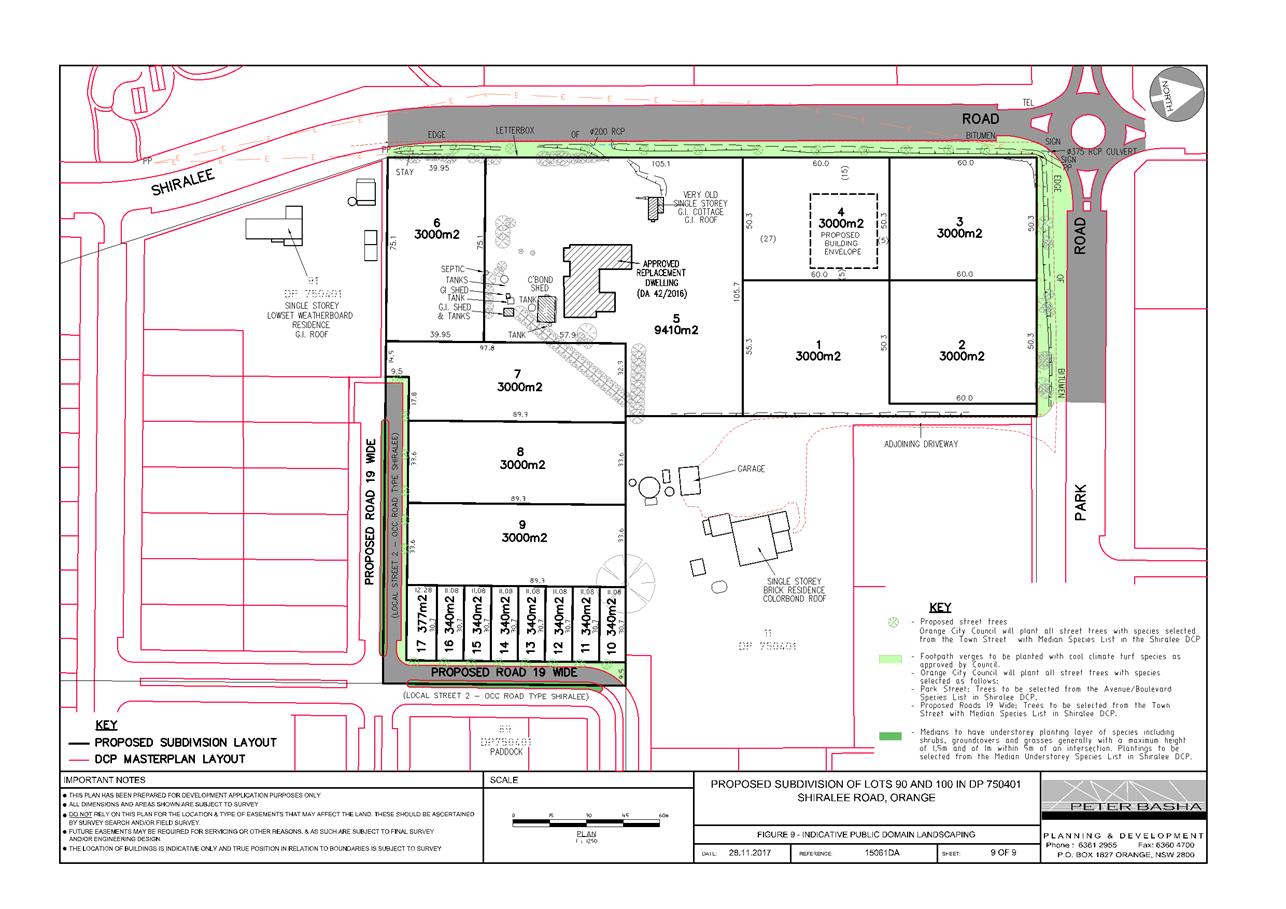
Figure 1 - Locality plan
RECENT LEGISLATIVE CHANGES
On 1 March 2018 the Environmental Planning and Assessment
Act 1979 was substantially amended. The most immediate change involves the
restructuring and renumbering of the Act, with other more substantive
changes to be phased in over time. However, for some applications (particularly
where an application was lodged prior to the changes coming into effect) the
supporting documentation may still reference the previous numbering regime. In
the drafting of this report the content and substance of the supporting
material has been considered irrespective of which legislative references were
used.
DECISION FRAMEWORK
Development in Orange is governed by two key documents
Orange Local Environment Plan 2011 and Orange Development Control Plan 2004. In
addition the Infill Guidelines are used to guide development, particularly in
the heritage conservation areas and around heritage items.
Orange Local Environment Plan 2011 – the LEP
should be considered by Council to be a definitive document. LEPs govern the
types of development that are permissible or prohibited in different parts of
the City and also provide some assessment criteria in specific circumstances.
Uses are either permissible or not - there are no grey areas in terms of
permissibility. The objectives of each zoning and indeed the aims of the LEP
itself are, however, open to interpretation and can be used to guide decision
making around appropriateness of development.
Orange Development Control Plan
2004 – the DCP guides development. In general it is a performance
based document rather than prescriptive in nature. The Shiralee DCP and
associated masterplans are considered part of the principal DCP (as only a
single DCP may apply within a given LGA). Its purpose is to guide development.
The Land and Environment Court tends to view it as such. In each area of
interest there are often guidelines used. These guidelines indicate ways of
achieving the planning outcomes. It is thus recognised that there may also be
other solutions of merit. All design solutions are considered on merit by
planning and building staff. Applications should clearly demonstrate how the
planning outcomes are being met where alternative design solutions are
proposed. So one can see that the DCP gives leeway for developers and
architects to use design to achieve the outcome in other ways if they can.
Stating that DCP guidelines are inflexible can be misleading.
DIRECTOR’S COMMENT
The subject property is located within the developing
Shiralee urban village. Development in the Shiralee urban village is generally
required to be developed in accordance with the Shiralee Development Control
Plan (Shiralee DCP), including the Shiralee Masterplan. The applicant
seeks a departure from Council’s adopted DCP as well as a variation to
the LEP minimum Lot size controls that relate to this site (discussed in detail
in the body of this report.)
While variations from the Shiralee DCP are generally not
supported, Council staff in the assessment recognise that the characteristics
of the subject property are unique, and the Consultant has put forward a
detailed justification as part of the application.
The planning assessment demonstrates that the proposed
variations are acceptable in this case. It is recommended that Council supports
the subject development application.
Link To Delivery/OPerational Plan
The recommendation in this report relates to the
Delivery/Operational Plan strategy “13.4 Our Environment – Monitor
and enforce regulations relating to City amenity”.
Financial Implications
Nil
Policy and Governance Implications
Nil
|
Recommendation
That Council consents to development application DA
305/2016(1) for Subdivision (17 lot residential) at Lots 90 and 100 DP
750401 - 168 Shiralee Road, Orange pursuant to the conditions of consent in
the attached Notice of Approval.
|
further considerations
Consideration has been given to the recommendation’s
impact on Council’s service delivery; image and reputation; political;
environmental; health and safety; employees; stakeholders and project
management; and no further implications or risks have been identified.
SUPPORTING INFORMATION
Council's consent is sought for Subdivision (17 lot
residential) at Lot 90 DP 750401, Lot 100 DP 750401 - 168 Shiralee Road,
Orange.
THE PROPOSAL
The proposal involves a subdivision of the subject land to
create 17 urban residential allotments and new public roads.
Proposed Lots 1 to 4 and 6 to 17 are vacant and each would
be created for urban residential purposes pursuant to the relevant clauses of
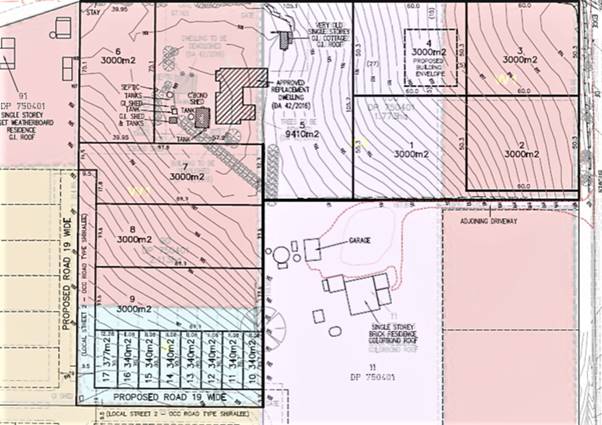
Orange Local Environmental Plan 2011. Proposed Lot 5 will excise the existing
dwelling (which is to be demolished and replaced by a new dwelling pursuant to
an approval granted under DA 42/2016).
The urban residential subdivision of the site would involve
the following:
· creation of vacant
lots ranging in area from 340m² to just over 3,000m². The existing
(and replacement) dwelling will be created on a lot of approximately
9,400m²
· construction of
new roads in accordance with Council requirements outlined in Shiralee
Engineering Requirements and additional information
· connection of each
lot to reticulated sewer
· connection of each
lot to the town water supply
· provision of an
inter-allotment stormwater drainage system.
The orientation and configuration of the proposed vacant
lots is such that a future dwelling can be designed without unreasonable
constraint to optimise solar penetration to internal and external living areas.
Land shaping and finished levels will be subject to final
civil engineering design.
The applicant has indicated that the subdivision will proceed
in stages subject to demand and provision of services. An indicative staging
plan is as follows:
· Stage 1 –
Proposed Lots 1 to 5
· Stage 2 –
Proposed Lots 10 to 17
· Stage 3 –
Proposed Lots 6 to 9
It should be noted that proposed Lots 7-17 will require the
provision of services and access through adjoining lands. These lots will not
be able to be released until such time that those services have been provided
to the land or alternative arrangements to those contemplated in this
application are sought.
MATTERS FOR CONSIDERATION
Section 1.7 - Application of
Part 7 of the Biodiversity Conservation Act 2016 and Part 7A of the
Fisheries Management Act 1994
Development Applications lodged prior to 25 February 2018
Section 1.7 of the EP&A Act 1979 identifies that Part 7
of the Biodiversity Conservation Act 2016 and Part 7A of the Fisheries
Management Act 1994 have effect in connection with terrestrial and aquatic
environments.
Notwithstanding, Section 28 of the Biodiversity
Conservation (Savings and Transitional) Regulation 2017 states that the
former planning provisions continue to apply to the determination of a pending
planning application, being an application for planning approval made before
the commencement of the new Act but not determined before that commencement.
The relevant provisions are set out at Part 5A of the historical version of the
EP&A Act 1979 dated 24 August 2017.
Having regard to the relevant provisions and based on an
inspection of the subject property, it is considered that the proposed
development is not likely to have a significant effect on any threatened
species, populations or ecological communities or their habitats.
Section 4.15
Section 4.15 of the Environmental Planning and Assessment
Act 1979 requires Council to consider various matters, of which those
pertaining to the application are listed below.
PROVISIONS OF ANY ENVIRONMENTAL
PLANNING INSTRUMENT s4.15(1)(a)(i)
Orange Local Environmental Plan 2011
Part 1 - Preliminary
Clause 1.2 - Aims of Plan
The aims of the Orange Local
Environmental Plan 2011 (‘OLEP 2011’) relevant to the application
include:
(a) to
encourage development which complements and enhances the unique character of
Orange as a major regional centre boasting a diverse economy and offering an
attractive regional lifestyle
(b) to
provide for a range of development opportunities that contribute to the social,
economic and environmental resources of Orange in a way that allows present and
future generations to meet their needs by implementing the principles for
ecologically sustainable development
(e) to
provide a range of housing choices in planned urban and rural locations to meet
population growth
(f) to
recognise and manage valued environmental heritage, landscape and scenic
features of Orange.
The proposed development is
considered to be consistent with the relevant aims of Orange LEP 2011. The
relevant matters are addressed in the body of this report.
Clause 1.6 - Consent Authority
This clause establishes that, subject to the Act, Council is
the consent authority for applications made under the LEP.
Clause 1.7 - Mapping
The subject site is identified
on the LEP maps in the following manner:
|
Land Zoning Map:
|
R2 Low Density Residential zone and
R1 General Residential
|
|
Lot Size Map:
|
Minimum Lot Size a combination of
200m2(Area B) 3000m2 (Area W1) and 9,000m2 (Area
X3)
|
|
Heritage Map:
|
Contains a heritage item under
Schedule 5 of the LEP
|
|
Height of Buildings Map:
|
No building height limit
|
|
Floor Space Ratio Map:
|
No floor space limit
|
|
Terrestrial Biodiversity Map:
|
No biodiversity sensitivity on the
site
|
|
Groundwater Vulnerability Map:
|
Ground water vulnerable
|
|
Drinking Water Catchment Map:
|
Not within the drinking water
catchment
|
|
Watercourse Map:
|
Not within or affecting a defined
watercourse
|
|
Urban Release Area Map:
|
Not within an urban release area
|
|
Obstacle Limitation Surface Map:
|
No restriction on building siting
or construction
|
|
Additional Permitted Uses Map:
|
No additional permitted use applies
|
Those matters that are of relevance are addressed in detail
in the body of this report.
Minimum Lot Sizes
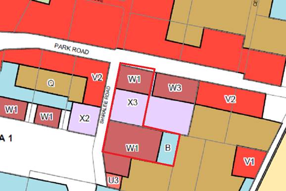
Figure 2 – Minimum Lot Size map
W1:
3000m2 min
X3:
9000m2 min
B:
200m2 min
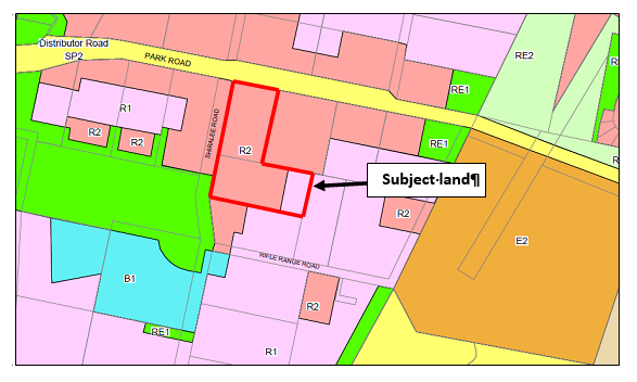
Figure 3 - Zoning
Part 2 - Permitted or Prohibited Development
Land Use Zones
The subject site is zoned in a combination of R1 General
Residential zone and R2 Low Density Residential zone as indicated in the
above map extracts.
Section 4B of the Environmental Planning and Assessment Act
1979 identifies that subdivision of land means:
“… the division of land into two or more
parts that, after the division, would be obviously adapted for separate
occupation, use or disposition.”
The objectives for land zoned R1 General Residential are:
· to provide for
the housing needs of the community
· to provide for
a variety of housing types and densities
· to enable other
land uses that provide facilities or services to meet the day to day needs of
residents
· to ensure
development is ordered in such a way as to maximise public transport patronage
and encourage walking and cycling in close proximity to settlement
· to ensure that
development along the Southern Link Road has an alternative access.
The objectives for land zoned R2 Low
Density Residential are:
· to provide for
the housing needs of the community within a low density residential environment
· to enable other
land uses that provide facilities or services to meet the day to day needs of
residents
· to ensure
development is ordered in such a way as to maximise public transport patronage
and encourage walking and cycling in close proximity to settlement
· to ensure that
development along the Southern Link Road has an alternative access.
The proposed residential subdivision is considered to be
consistent with the foregoing objectives. The relevant matters are addressed in
the body of this report.
Clause 1.9A - Suspension of
Covenants, Agreements and Instruments
This clause provides that covenants, agreements and other
instruments which seek to restrict the carrying out of development do not apply
with the following exceptions:
· covenants imposed
or required by Council
· prescribed
instruments under Section 183A of the Crown Lands Act 1989
· any conservation
agreement under the National Parks and Wildlife Act 1974
· any trust
agreement under the Nature Conservation Trust Act 2001
· any property
vegetation plan under the Native Vegetation Act 2003
· any biobanking
agreement under Part 7A of the Threatened Species Conservation Act 1995
· any planning
agreement under Division 6 of Part 4 of the Environmental Planning and
Assessment Act 1979.
This clause does not affect the rights or interests of any
public authority under any registered instrument.
A search of Council’s records identifies that the
subject property is not affected by any of the foregoing covenants,
instruments, agreements or plans.
Clause 2.6 - Subdivision -
Consent Requirements
Clause 2.6 Subdivision - Consent Requirements identifies
that land may be subdivided, but only with development consent.
Part 4 -
Principal Development Standards
Clause 4.1 - Minimum
Subdivision Lot Size
With reference to Figure 2 above
(minimum Lot size), the subject land is subject to three separate minimum
allotment sizes as follows:
· 3000m² in the
section of land identified as W1
· 9000m² in the
section of land identified as X3
· 200m² in the
section of land identified as B
The proposed
subdivision involves the creation of two lots (being Lots 1 and 4) that do not
satisfy the relevant MLS of 9,000m2 (see map below). Therefore a
variation of the MLS is sought pursuant to LEP Clause 4.6 Exceptions to
Development Standards (see below).
All other
lots comply with the minimum allotment size requirements. It should be noted
that proposed lot 9 will be partly within land denoted as “W1”
(3000m²) and partly within land denoted as “B” (200m²).
The majority of the subject lot is located on that part of the land requiring a
lot size of 3000m² with a smaller amount being located on that part of the
land requiring 200m² lots (see map below). There are no objections to this
arrangement as it will facilitate the proposed compact lots meeting the
required width to depth ratios as contemplated by the DCP masterplan.
Clause 4.6 –Exceptions to Development Standards
Clause 4.6 (Exceptions to
Development Standards) provides that development consent may, subject to this
clause, be granted for development even though the development would contravene
a development standard imposed by this or any other environmental planning
instrument (other than a development standard expressly excluded from the
operation of the clause).
Clause 4.1 sets out minimum
lot size requirements applicable in certain zones which relevantly states the
following controls, objectives and considerations for subdivision:
(a) to ensure that new subdivisions reflect
existing lot sizes and patterns in the surrounding locality,
(b) to ensure that lot sizes have a practical
and efficient layout to meet intended use,
(c) to ensure that lot sizes do not undermine
the land’s capability to support rural development
(d) to prevent the fragmentation of rural
lands
(e) to provide for a range of lot sizes
reflecting the ability of services available to the area
(f) to encourage subdivision designs
that promote a high level of pedestrian and cyclist connectivity and
accommodate public transport vehicles.
(2) This clause applies to a subdivision of
any land shown on the Lot Size Map that requires
development consent and that is carried out after the commencement of this
Plan.
(3) The size of any lot resulting from a
subdivision of land to which this clause applies is not to be less than the
minimum size shown on the Lot Size Map in
relation to that land.
(4) This clause does not apply in relation to
the subdivision of any land:
(a) by the registration of a strata plan or
strata plan of subdivision under the Strata Schemes Development Act
2015
(b) by any kind of subdivision under the Community Land Development Act
1989.
The lot size mapping for the
Shiralee precinct has a montage of differing lot sizes that in large measure
are intended to facilitate the lot yields, density and outcomes specified in
the Shiralee DCP. The LEP remains the skeletal strategic document, designed to
achieve residential living densities able to meet the aims and objectives of
that zone, and the LEP generally. It is noted that for this proposed
subdivision, the yields contained in the proposal, as well as the placement of
various lot classifications is more or less consistent with the outcomes of the
DCP.
Pursuant to Clause 4.1(3) of the
LEP, the size of any lot resulting from a subdivision of land to which this
clause applies is not to be less than the minimum size shown on the Lot Size
Map in relation to that land.
As indicated in the diagram
above (Figure 2), subdivision of the subject land is subject to three separate
minimum lot sizes as follows:
· 3,000m² in
the section of the land identified as W1.
· 9,000m² in
the section of the land identified as X3.
· 200m² in the
section of the land identified as B.
With reference to the submitted
plans the proposed subdivision involves the creation of proposed Lots 1 and 4
which do not satisfy the MLS of 9,000m2. It is proposed to create
these lots each with an area of 3,000m2.
The objectives of Clause 4.6 are
as follows:
(a) to provide an appropriate degree of
flexibility in applying certain development standards to particular development
(b) to achieve better outcomes for and from
development by allowing flexibility in particular circumstances.
Council must take
into account these objectives.
There is no issue with respect
to (a), but with respect to (b) it is important for Council to be able to show
in its thinking that a particular and special case or circumstance exists to
allow the variation. It is noted that the applicant’s Statement of Environmental
Effects puts forward a number of reasons to support the variation. However, at
the heart of the variation in this case is the desire to retain the heritage
item on the same lot as the approved dwelling under DA42/2016. This will
maximise the chances of this building being retained and re-purposed. In doing
so the applicant has successfully maintained the overall lot yield in this
case.
There are set procedures
outlined in guidelines published by the NSW Department of Planning encapsulated
in a circular published in 2008, and quite strongly supported and upheld in the
Land and Environment Court. For obvious reasons the Department advises all
Councils to allow variations only where exceptional circumstances exist and
where certain other criteria can be shown be achieved.
When applicant’s lodge
development applications and associated requests to vary a development
standard, they must give grounds of objection to the development standard.
Variation of a development standard may be justified where it is consistent
with the objectives that the relevant environmental planning instrument is
attempting to achieve.
The applicant has provided
written justification for the variation sought. The proposed subdivision is
considered to be consistent with the minimum lot size requirements with the
exception of proposed Lots 1 and 4. These lots are generally located in an area
identified as having a minimum lot size of 9000m2. The submitted
plans show that proposed Lots 1 and 4 each have an area of 3000m2. .
It is noted that proposed Lot 5 (on which dwelling approved under
DA 42/2016 would be located) incorporates a proposed site area exceeding
9000m2 and further the overall lot yield remains the same as is
prescribed in the relevant masterplan.
The application must address:
(i) whether strict compliance with the
standard, in the particular case, would be unreasonable or unnecessary and why
(ii) demonstrate that there are sufficient
environmental planning grounds to justify contravening the development
standard.
In order to address the
requirements of Clause 4.6(3) the following assessment is provided. The MLS Map
in the LEP is an established instrument in regard to the control of lot sizes.
The delineation of the various MLS zones has been largely informed by the Shiralee
DCP master planning. As such, it can be argued that there is an
inter-relationship between the DCP and the MLS provisions. The DCP refers to
the potential to vary lot sizes and types (Section 1.8 Exceptional
Circumstances). If a variation to lot size and type can be justified under
the DCP, it follows that a variation of the MLS may also be contemplated. In
this case the applicant submits that the resultant lot yield is entirely the
same as is called for under the masterplan, and the variation is simply taking
advantage of the existing consent granted for a new dwelling that was recently
approved under DA42/2016.
The site of proposed Lots 1 to 5 is
identified in the DCP Masterplan as a scenic hill which, in conjunction with
the existing heritage item, represents an important setting, particularly when
viewed from the north. To maintain these values the DCP encourages a lower
density of development on this part of the site; hence the MLS of 9,000m².
It is submitted that a MLS of 9,000m2 is not required to maintain
these scenic and heritage values.
Given that overall yields as specified in the masterplan are
adhered to and the integrity of the heritage item located on the site is
maximised by retaining it within the same lot as the approved replacement dwelling
it is considered reasonable and justified in this case to support the
variation. It is considered that the scenic vistas of the Shiralee hill are not
affected by the variation and suitable conditions of consent have been
recommended to protect the curtilage of the heritage item.
In assessing the appropriateness
of a proposal to vary a development standard Council should also satisfy itself
that the development is acceptable having reference to the matters set out in
the ‘five part test’ established by the NSW Land and
Environment Court. The NSW Department of Planning strongly advises Councils to
apply the Five Part Test in their assessments of Clause 4.6 matters.
The five part test embodies the
following:
1. the objectives of the standard
are achieved notwithstanding noncompliance with the standard
2. the underlying objective or
purpose of the standard is not relevant to the development and therefore
compliance is unnecessary
3. the underlying object or
purpose would be defeated or thwarted if compliance was required and therefore
compliance is unreasonable
4. the development standard has
been virtually abandoned or destroyed by the council’s own actions in
granting consents departing from the standard and hence compliance with the
standard is unnecessary and unreasonable
5. the compliance with development
standard is unreasonable or inappropriate due to existing use of land and
current environmental character of the particular parcel of land. That is, the
particular parcel of land should not have been included in the zone.
An assessment of the five part
test is provided below:
1. the objectives of the standard
are achieved notwithstanding non-compliance with the standard;
Applicant’s Response
Strict compliance with the
9,000m2 MLS would potentially result in a subdivision that does not provide
for a range of lot sizes reflecting the ability of services available to the
area as encouraged by objective (e) of Clause 4.1. In this sense, this
objective of the development standard may be thwarted if compliance with the
MLS was required.
The
proposal is considered to be consistent with the other objectives of the
development standard as explained (elsewhere in the statement).
Comment:
In this case the objectives of
the standard relate to achieving viable residential yields whilst at the same
time taking adequate steps to protect the heritage significance of the site,
the semi-rural character, whilst not interfering to the transition to
residential, and also to protecting the vista opportunities presented by the
hill leading off to the north. It is considered the proposed variation refines
and improves the broad planning outcomes enunciated in the LEP and DCP, and the
variation results in an improved outcome with respect to those underlying
intents.
2. the underlying objective or
purpose of the standard is not relevant to the development and therefore
compliance is unnecessary;
Applicant’s Response
The applicant has not directly
addressed this planning principle
Comment:
It is considered the underlying
purpose of the standard is to achieve compatible densities (compatible to the
preservation of neighbourhood and desired future character, as well as in terms
of servicing) whilst at the same time ensuring that constraints such as vistas,
heritage, water quality and the like are not placed under threat. In this case,
the lot yields as set out in the masterplan are met, and the overall
subdivision layout is respectful to existing character whilst also achieving
the strategic goals of the DCP.
3. the underlying object or
purpose would be defeated or thwarted if compliance was required and therefore
compliance is unreasonable;
Applicant’s Response
See applicant’s response
to (1) above.
Comment:
An insistence on full compliance
with the standard would result in a slightly less satisfactory subdivision
pattern, in that the masterplan would result in the heritage building being
located on a vacant lot and the dwelling approved under DA42/2016 would be
unlikely to be built without modification.
4. the development standard has
been virtually abandoned or destroyed by the Council’s own actions in
granting consents departing from the standard and hence compliance with the
standard is unnecessary and unreasonable;
Applicant’s Response
The
development standard cannot be said to be abandoned, particularly as
development of the Shiralee area is in its preliminary stages and the pattern
of development is yet to emerge.
Comment:
The applicant’s comment is
supported.
5. the compliance with development
standard is unreasonable or inappropriate due to existing use of land and
current environmental character of the particular parcel of land. That is, the
particular parcel of land should not have been included in the zone.
Applicant’s Response
Variation of the development
standard is justified in this case because it can be demonstrated that the
proposal satisfies the objectives of the R2 Low Density Residential zone and
the objectives of the MLS.
The proposal does not introduce
lot sizes that cannot be found elsewhere within the R2 Zone for the
Shiralee area. In this case, the appropriateness of lot size is more to do with
the physical characteristics of the site and its relationship to the surrounding
area, as expressed in the Shiralee DCP.
The overall lot yields as called
up in the masterplan are not exceeded by the proposal.
The inter-relationship between
the MLS and the Shiralee DCP cannot be dismissed. Despite the non-compliance
with the MLS, the subdivision is acceptable in terms of the more specific
provisions of the Shiralee DCP. In this regard, the creation of proposed Lots 1
and 4 can be demonstrated to uphold the aims and principles of the Shiralee DCP
pertaining to the protection of landscape and scenic values. The proposed
building envelope and height restriction pursuant to Section 88B of the
Conveyancing Act will assist in this regard.
Comment:
As indicated elsewhere in this
report, it is considered that full compliance is not warranted in this case.
The yields achieved in the application correlate to those specified in the
masterplan, the location of the heritage items and the approval already granted
for the replacement dwelling on the main lot suggest a need for justification
in this case.
General observations
The underlying purpose of the
standard for which variation is being sought is relevant to the development.
Minimum lot size requirements are a blunt assessment tool aimed at achieving
good design outcomes whilst at the same time making efficient use of the land
at densities likely to achieve a reasonable return for the development; and at
the same time ensuring neighbourhood character and amenity is not excessively
compromised. Variations based on a wholesale objection to a standard where
special circumstances do not exist should be avoided as they weaken the ability
to apply the standard at some point for other applications. In this case
special circumstances are considered to be evident and support for a variation
in this case would not establish an undesirable precedent.
The proposed development with
its non-compliance to Clause 4 is not contrary to any of the objectives for the
zone; it being noted the close similarities of the proposed subdivision to the
outcomes sought in the DCP. Overall, it is considered that the proposed
development has a neutral or slightly beneficial effect with respect to
achieving the objectives of the zone.
It is considered in an overall
and general sense that the proposal, including the variation sought, is
consistent with the above objectives.
Part 5 -
Miscellaneous Provisions
5.10 - Heritage Conservation
According to Orange LEP Schedule 5, the former
residence/packing shed within the subject land which lies to the north-west of
the main group of existing buildings is listed as a heritage item of local
significance.
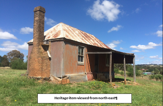
Figure 4 – Heritage Item north east view
The heritage item is listed in
Orange LEP 2011 as having Local significance. The building occupies an exposed
slope that is prominent in views from the north towards the subject land and
the Shiralee area.
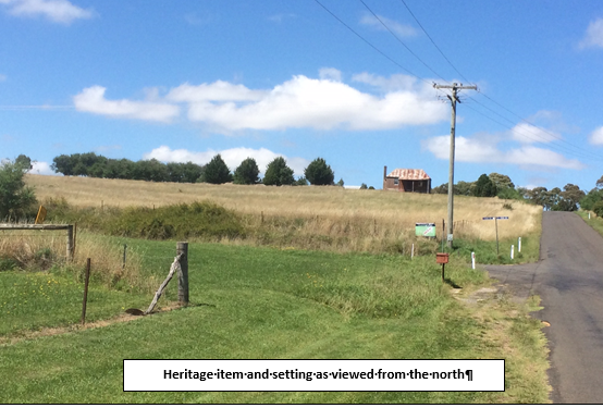
Figure 5 – Heritage Item north view
Relevant to the identified Heritage Item, the Shiralee DCP
Master Plan seeks to:
· conserve historic
items and their settings
· conserve,
maintain, and enhance existing views and vistas to buildings and places of
historic and aesthetic significance.
The applicant has provided the following consideration in
response to the NSW Heritage Office publication Statement of Heritage Impact
Guidelines (Table 7 – Relevant HIS Questions).
The proposal respects the heritage significance of the
item as follows:
· Consistent with
the approval granted via DA 42/2016, the heritage item and the replacement
dwelling will remain together on the same lot (i.e. proposed Lot 5). The
boundary of proposed Lot 5 maintains a generous curtilage for the item,
particularly noting that the northern boundary of this lot coincides with the
line of the boundary adjustment that was also approved in DA 42/2016.
· The inclusion
of both buildings on the one lot maintains the important relationship between
the replacement dwelling and the heritage item due to the following:
- the
replacement dwelling will be sufficiently set back from the item so as to not
encroach on its curtilage or setting. The separation between the proposed
dwelling and item is such that there would be minimal potential to undermine or
cause physical damage to the item
- the
replacement dwelling is set to the south of the item. The item remains forward
in the important views from the north looking south towards Shiralee and to the
item itself. As such, the proposed dwelling will not diminish any key views to
or from the heritage item, or public appreciation of the item
- the
proposed subdivision does not involve any works that have the potential to
damage the item. In this regard, there is ample opportunity to locate utility
service mains well away from the item, and thus not disturb it with excavations
or vibration. Further, the proposal does not involve the construction of new
roads in close proximity to the item
- compared
to the DCP Masterplan, it is acknowledged that proposed Lot 4 in the
subdivision creates the potential for one additional dwelling immediately to
the north of the heritage item. However, it is considered that the views from
the north towards the item can be respected. A building envelope is proposed
within Lot 4 to reduce the potential for a future dwelling to unreasonably
obstruct sightlines to the heritage item
- the
ground level in the proposed envelope ranges from approximately 897.5m AHD at
its northern end to 901m AHD at its southern end. The ground level in the
vicinity of the heritage item is in the order of 907m. As such, the ground
level at the heritage items is some 7 to 10m higher than the ground level
within the building envelope
- the
difference in ground levels should limit the potential for a future dwelling in
proposed Lot 4 to unreasonably obstruct views to or ruin the silhouette of the
heritage item. However, to further safeguard against such an impact, the
applicant proposes to apply a Section 88B Restriction that requires any future
dwelling in Lot 4 to be single storey. This can be imposed or reinforced as a
condition of approval in the notice of determination.
The
applicant has suitably demonstrated in the assessment above that the proposal
has minimal potential to adversely affect the heritage item. Building envelopes
and height restrictions for proposed Lots 3 and 4 are recommended in the
attached Notice of Approval to ensure that the view corridor from Shiralee Road
towards the item is not adversely compromised. Proposed Lot 5 has been designed
to accommodate the heritage item itself and new replacement dwelling under DA
42/2016. This allotment will comprise an area of in excess of 9000m² to
provide a suitable curtilage to the heritage item and its surrounds. In
this case the resultant lot yield is entirely the same as is called for under
the masterplan, and the variation is simply taking accommodating the existing
consent granted for a new dwelling that was recently approved under DA42/2016
which ultimately seeks to provide a greater level of protection for the listed
item of heritage contained within.
It is agreed that any dwelling within proposed Lots 3 and 4
would sit lower in the view corridor than the existing dwelling and shed that
are on the adjoining property to the east. The proposed subdivision would
create only 1 additional lot/dwelling opportunity in this section of the site
(compared to the layout in the DCP Masterplan) which is considered to be
acceptable subject to the recommended conditions. Impacts upon the heritage
item are considered to be acceptable.
Part 7 -
Additional Local Provisions
7.1 - Earthworks
This clause establishes a range
of matters that must be considered prior to granting development consent for
any application involving earthworks, such as:
(a) the likely disruption of, or any
detrimental effect on, existing drainage patterns and soil stability in the
locality of the development
(b) the effect of the development on the
likely future use or redevelopment of the land
(c) the quality of the fill or the soil to be
excavated, or both
(d) the effect of the development on the
existing and likely amenity of adjoining properties
(e) the source of any fill material and the
destination of any excavated material
(f) the likelihood of disturbing relics
(g) the proximity to and potential for adverse
impacts on any waterway, drinking water catchment or environmentally sensitive
area
(h) any measures proposed to minimise or
mitigate the impacts referred to in paragraph (g).
No significant earthworks or
details relating thereto have been submitted with the application. Clearly
there will be earthworks needed in the road construction and provision of
utilities, but there are no indications in the submitted material to undertake
bulk earthworks for preparation of the individual lots. In this case it is
considered that some benefit is derived from the existing amphitheatre effect
of the topography when viewed from the south.
Consequently, the following
condition is included in the consent:
· Earthworks for
all stages of the development shall be limited to those required for roads,
footpaths and the provision of utility services. No approval is granted for
bulk earthworks to be undertaken on the site with respect to levelling or
cut/filling otherwise, except with the further consent of Council, as the
details of such works are not shown in the development proposal submitted to
Council for approval.
7.3 -
Stormwater Management
This clause applies to all
industrial, commercial and residential zones and requires that Council be
satisfied that the proposal:
(a) is designed to maximise the use of water
permeable surfaces on the land having regard to the soil characteristics affecting
onsite infiltration of water
(b) includes, where practical, onsite
stormwater retention for use as an alternative supply to mains water,
groundwater or river water
(c) avoids any significant impacts of
stormwater runoff on adjoining downstream properties, native bushland and
receiving waters, or if that impact cannot be reasonably avoided, minimises and
mitigates the impact.
The applicant
will be required to contribute to the provision of an off-site stormwater
detention system for the development. Drainage for Lots 5-17 requires drainage
easements over adjoining land prior to the commencement of works. Council is in
receipt of submissions in relation to this issue. There is no obligation on an
adjoining property owner to provide easements over their land if they choose
not to develop at this time.
Conditions are included in the
consent to achieve these outcomes.
7.6 -
Groundwater Vulnerability
This clause seeks to protect
hydrological functions of groundwater systems and protect resources from both
depletion and contamination. Orange has a high water table and large areas of
the LGA, including the subject site, are identified with “Groundwater
Vulnerability” on the Groundwater Vulnerability Map. This requires that
Council consider:
(a) whether or not the development (including
any onsite storage or disposal of solid or liquid waste and chemicals) is
likely to cause any groundwater contamination or have any adverse effect on
groundwater dependent ecosystems, and
(b) the cumulative impact (including the
impact on nearby groundwater extraction for potable water supply or stock water
supply) of the development and any other existing development on groundwater.
Furthermore, consent may not be granted unless Council is satisfied that:
(a) the development is designed, sited and
will be managed to avoid any significant adverse environmental impact, or
(b) if that impact cannot be reasonably
avoided - the development is designed, sited and will be managed to minimise
that impact,
(c) if that impact cannot be minimised - the
development will be managed to mitigate that impact.
Given that the proposed
development is not anticipated to involve the discharge of toxic or noxious
substances it is considered unlikely to contaminate the groundwater or related
ecosystems. Similarly, the proposed development is not anticipated to involve
the extraction of groundwater and therefore would not contribute to groundwater
depletion.
Clause 7.11 - Essential
Services
Clause 7.11 - Essential Services
provides that development consent must not be granted to development unless the
consent authority is satisfied that any of the services which are essential for
the proposed development are available, or that adequate arrangements have been
made to make them available when required. Essential services include the
supply of water and electricity; the disposal and management of sewage;
stormwater drainage or onsite conservation and suitable road access.
The applicant has indicated that
all services have the capacity to be extended to the site. Council’s
Technical Services Division has recommended a condition of consent to ensure
arrangements can be made for all necessary essential services to be provided to
the subject property.
STATE ENVIRONMENTAL PLANNING
POLICIES
State Environmental Planning Policy 55 Remediation of
Land
State Environmental Planning Policy 55 - Remediation of Land
(SEPP 55) requires that a consent authority must not consent to the carrying
out of development of land unless it has considered whether the land is contaminated;
is satisfied that the land is suitable in its contaminated state for the
development that is proposed, and if the land requires remediation to be made
suitable for the proposed development it is satisfied that the land will be
remediated before the land is used for that purpose.
Furthermore, SEPP 55 requires that before determining an
application to carry out development that would involve a change of use of land
(specified in Subclause 4), the consent authority must consider a preliminary
investigation of the land concerned.
Given that the subject property has a history of use for the
purpose of horticulture, a Preliminary Contamination Investigation (PCI) was
submitted with the development application. Based on soil and laboratory
analysis, the PCI concluded that the soil sampling program did not detect
elevated levels of analysed metals and organochlorine pesticides, and that
levels of all substances evaluated were near background environmental levels
and below the EPA investigation threshold for residential land use.
Notwithstanding, Council’s Building Surveyor has
recommended a precautionary condition of consent requiring that chemical
testing of each lot is to be undertaken to demonstrate that the land is
suitable for residential use prior to the issue of a subdivision certificate.
PROVISIONS OF ANY DRAFT
ENVIRONMENTAL PLANNING INSTRUMENT THAT HAS BEEN PLACED ON EXHIBITION
4.15(1)(a)(ii)
There are no draft environmental planning instruments that
apply to the subject land or proposed development.
DESIGNATED DEVELOPMENT
The proposed development is not designated development.
INTEGRATED DEVELOPMENT
The proposed development is not integrated development.
PROVISIONS OF ANY DEVELOPMENT
CONTROL PLAN s4.15(1)(a)(iii)
Development Control Plan 2004
The Orange Development Control Plan 2004 (“the
DCP”) applies to the subject land. Chapters of the DCP relevant to the
proposed subdivision include:
· Chapter 0 -
Transitional Provisions.
· Chapter 2 -
Natural Resource Management.
· Chapter 3 -
General Considerations.
· Chapter 4 -
Special Environmental Considerations.
· Chapter 5 -
General Considerations for Zones and Development.
· Chapter 7 -
Development in Residential Areas
Chapter 0 - Transitional
Provisions
Section 0.2 - General
Translation of Zones
Section 0.2 provides that any
reference to a zone under Orange Local Environmental Plan 2000 is to be a
reference to the corresponding zones in the zone conversion table.
The table identifies that R1 General Residential Zone and R2
Low Density Residential Zone correspond with the 2a Urban Residential and 2d
Urban Transitional Zones.
Chapter 2 - Natural Resource
Management
Section 2.1 - Water Quality
Section 2.1 - Water Quality
identifies that development which concentrates, redirects flows, increases flow
rates or disturbs land in close proximity to creeks, has the potential to
affect waterways with associated erosion, sedimentation and release of
nutrients, which combine to affect downstream water quality. Section 2.1 also
identifies that development involving groundwater extraction and/or onsite
wastewater disposal is deemed to have the potential to affect groundwater
resources.
Stormwater and groundwater quality issues have previously
been addressed under “7.3 – Stormwater Management” and “7.6
- Groundwater Vulnerability”, respectively. In summary, it is considered
that the proposed development is unlikely to have a detrimental impact on storm
and ground water quality.
Section 2.3
- Vegetation and Section 2.4 - Flora, Fauna and Biodiversity
Section 2.3 - Vegetation and
Section 2.4 – Flora, Fauna and Biodiversity identify that the natural
environment of the Orange LGA has been heavily modified as a consequence of
land clearing for various uses, including agriculture, plantation forests,
mining and urban development; and that clearing of native vegetation has
significantly affected native habitats.
Based on inspection of the subject property, it is evident
that it has been highly modified by past agricultural practices and is unlikely
to contain significant habitat or biodiversity value.
Chapter 3 - General
Considerations
Section 3.1 - Cumulative
Impacts
Section 3.1 - Cumulative Impacts
identifies that Council will consider not only the direct impacts of a
particular development but also whether the development, when carried out in
conjunction with other development in the locality, has a more significant
environmental impact.
The proposed subdivision is generally consistent with the
intended future of the land for residential purpose. Any likely environmental
impact will be within community accepted levels.
Chapter 4 - Special Environmental
Considerations
Section 4.3 - Land Shaping
Section 4.3 - Land Shaping
identifies that substantial land shaping, including filling or excavating land,
has the potential to generate significant environmental impacts, and that land
shaping should not adversely affect land in the vicinity as a result of
drainage, erosion or sedimentation, or as a result of leachate entering surface
or groundwater.
Land shaping has previously been addressed under
“Section 7.1 - Earthworks”. In summary, it is considered that the
applicant has not proposed earthworks as part of the development application.
Notwithstanding, it is expected that some minor earthworks are likely to be
limited to the extent of cut and fill required to construct new internal roads
and provide utilities services to the newly created lots. It is accepted that
the required earthworks for these services are unlikely to disrupt or have a
detrimental effect on the existing drainage patterns and soil stability of the
area; detrimentally affect a future use or redevelopment of the land;
detrimentally affect the amenity of adjoining properties; or disturb any
relics.
Section 4.4
- Contaminated Land
Section 4.4 - Contaminated Land
identifies that contaminated land can pose a risk to human health and the
environment. Contaminants can be released into waterways and humans exposed
when contaminated land is disturbed as a consequence of development.
Land contamination has previously been addressed under
“State Environmental Planning Policy 55 - Remediation of
Land”.
Shiralee Development Control
Plan 2015
The Shiralee Development Control
Plan (Shiralee DCP) seeks to guide urban expansion south of the existing Orange
urban area; promote a high quality urban environment with a diversity of
housing and recreation opportunities; encourage alternative modes of transport
and healthy lifestyles and reduce traffic congestion providing for the day to
day needs of residents within the precinct.
These objectives are given
effect by a series of development controls which generally deal with issues
such as desired future character, local infrastructure, the village centre,
residential buildings, private and public domains, the environment, and
movement networks. There are masterplans that deal with individual parts of the
residential precinct, of which the subject site is a part. It is located within
Shiralee Masterplan Area E, shown below:
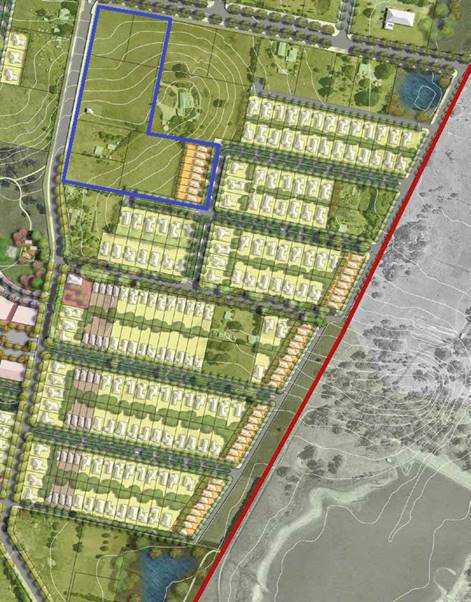
Figure 6 – Shiralee Area E master plan
The general intent of the development controls for the
future development of the Shiralee area is illustrated by the Shiralee
Masterplan (Figure 6).
While the development controls are often written in a
prescriptive manner, Section 1.8 of the Shiralee DCP provides that in
exceptional circumstances Council may consider some variation in lot sizes and
types. Any variation from the DCP is to be considered on a case by case basis
and subject to Council’s satisfaction that the proposal meets or exceeds
the aims and principles of the DCP. The relevant controls of the Shiralee DCP
are addressed below.
2.0 - Desired Future Character
2.4 - Subdivision
Section 2.4 Subdivision includes the following controls:
· Subdivision is
to be consistent generally in accordance with the Masterplan design and intent
per the DCP. Legislative requirements and DCP written controls take precedence
over the Masterplan.
The
control identifies that subdivision must be ‘consistent generally in
accordance with the Masterplan’. The proposal is considered to be
generally consistent with the adopted DCP. The applicant has sought a variation
to the minimum allotment sizes or certain lots within the proposal. In
this case the resultant lot yield is entirely the same as is called for under
the masterplan, and the variation is simply accommodating the existing consent
granted for a new dwelling that was recently approved under DA42/2016 which
ultimately seeks to provide a greater level of protection for the listed item
of heritage contained within.
· Lot sizes are
to be consistent with or greater than the adopted minimum lot size for the land
under the LEP zoning map.
Two of the lots are smaller than recommended in the master
planning document, whilst one is significantly larger. Overall, for this site,
the lot yields remain consistent, and the heritage constraints adequately
addressed and respected by the solution offered.
It is noted that this control requires lots’ sizes to
be consistent with or greater than the adopted minimum lot size for the land
under the LEP. The applicant has submitted a Clause 4.6 variation that
establishes that it is unreasonable and/or unnecessary to achieve full
compliance with the LEP requirements in this case (see assessment above for
detail). This has the effect that the lot layout complies with the intent of
the LEP (and hence the DCP) and is reasonable in terms of the outcomes the
subdivision is likely to generate.
· Where an
oversized lot is proposed (substantially greater than the adopted minimum lot
size), plans are to nominate a building envelope.
Lot 1 is proposed to be 9000m2, whereas the
masterplan only requires an area of 3000m2. However, a building
envelope is not considered necessary in this case as an existing approval for a
replacement dwelling is already in place for this site. The applicant has
suitably demonstrated that the lot size and shape of this lot has been designed
to accommodate the new dwelling and respect the listed heritage item.
· Building
envelopes on oversized lots are to be positioned in a manner that clearly
enables future subdivision of the lot to a pattern consistent with the
masterplan layout and adopted minimum lot size for the land.
Refer to assessment above.
· Except for
corner lots and where indicated otherwise on the Large Lot Classification
Table, all residential lots are to have a width to depth ratio of between 1:4
and 1:2.5 to allow more opportunity for the subsequent dwelling to address both
frontages.
Proposed Lots 3 and 17 are corner
lots for the purposes of this assessment criteria. Proposed Lot 17 has a width
to depth ratio of 1.2.5 and complies, whilst proposed Lot 3 has a proposed
width to depth ratio of 1.2:1 (on the assumption that the primary frontage of
this lot will be Shiralee Road). It is considered that notwithstanding the non-compliance
with the standard, it will still be possible to meet its intent in future
applications for development of the site.
2.5 - Lot Typologies
The explanatory notes of this section includes a requirement
for the imposition of a building envelope where a lot is proposed that exceeds
the lots sizes prescribed in the masterplan. This appears to be intended to
ensure development potential of the larger lot
more in accordance with the masterplan at some point in the future, so as to
maintain overall lot yields and thereby maintain viability of the masterplan.
In this case the lot yield for the subject land is achieved
in the subdivision and therefore a need for a restrictive building envelope
does not appear warranted.
The masterplan imposes restrictions on future development of
the lots in terms of maximum site coverages. As future developments are as
likely to be processed as exempt or complying development, in which the
application of the DCP is not well known, it is considered appropriate to apply
these restrictions as S-88B restrictions to user (so as to inform future
landowners).
The restriction will be:
“Site coverage ratio is the ratio between the overall
site area and the combined footprint of all buildings on the property. The
maximum site coverage ratio allowed for each type of lot is:
· 60% for compact
lots
· 45% for medium
lots
· 35% for standard
lots
· 25% for large Lots
Appropriate restrictions to user shall be applied to each of
the proposed lots to reflect these requirements of the Shiralee Masterplan”.
The Lot typology provisions of the DCP include the
following:
· all lots must
have a direct street frontage to ensure good access and property amenity. Lots
3,000m² and larger are excepted
· lots without a
street frontage are to have a minimum size of 3000m² providing that
boundary landscaping is provided.
The submitted layout complies with these requirements,
though Lots 7-17 will not be able to physically comply until such time as the
physical link to Rifle Range Road has been established. The submitted plan
conforms to that arrangement, though it needs to be acknowledged that the
adjoining landowners are not agreeable to the formation of that link at this
time. It is further noted that the road construction through adjoining land
does not form part of the proposed development. Nevertheless, a condition
deferring the release of Lots 7-17 is included in the consent.
The proposed lots comply with the
solar access guidelines of the DCP.
It is noted that the compact lots located at the eastern end
of existing Lot 90 don’t fully occupy the minimum lot size area contained
in the LEP, and configured generally so as to generally achieve the lot sizes
applicable to compact lots and width to depth ratio as set out in Appendix B of
the DCP. Whilst there is a general correlation between the LEP and the DCP, the
area set aside for compact lots under the LEP is too large compared to the DCP.
Were all the area for compact lots as shown in the LEP used for that purpose,
the resulting lots would no longer comply with the definition of a
“compact lot’ (ie the size of the lots would exceed 400m²which
is the upper limit specified in the DCP for this categorisation). If this were
to arise, the layout would not comply with the DCP and issues like width to
depth, site coverage and setbacks would be affected.
As a consequence, the submitted plans, with respect to the
compact lots, ensures that the compact lots are compliant to the DCP
requirements, but this in turn means that some of the high density land has
been folded over into the adjoining proposed Lot 9 of the development. There
are no objections to this arrangement.
3.1 -
Infrastructure Provisions
Controls:
· Clause 7.11 of
the Orange Local Environmental Plan 2011 establishes that development is
required to be provided with essential services including:
- the
supply of water
- the
supply of electricity
- the
supply of gas
- the
supply of telecommunications infrastructure
- the
disposal and management of sewage
- stormwater
drainage or on-site conservation, and
· Suitable road
access.
· Provision of
essential local infrastructure is at the developers cost and in line with the
Shiralee Contributions Development Plan.
· The design and
placement of local infrastructure is to be in accordance with the relevant authorities’
requirements.
· All power lines
are to be located underground.
It is possible for the proposed development to gain access
to these services, though it is acknowledged that in the case of the water,
drainage and sewer access easements with downstream properties will be
required, and for road access, agreement with adjoining land owners is still
needed. The proposed development does not actually include those services
within the physical confines of the site, and therefore such arrangements are
not directly relevant to the assessment of the application. The application is
consistent with the master planning for the locality and therefore no
impediment exists from the perspective of infrastructure provision under the
DCP.
3.2 - Ground
Levels and Excavation
All forms of development are to respond to the local
topography. Excessive cutting and filling of a site is an indication of poor
design and is likely to adversely impact streetscapes, alter site drainage,
hinder solar access and limit view sharing opportunities.
The application does not show any earthworks beyond those
necessary for the provision of roads and utilities. Conditions of consent have
been included to address this issue.
3.4 -
Staging
The DCP has a broad brush staging plan. The proposed
development is not contrary to the staging requirements of the DCP,
notwithstanding some of the obvious difficulties presented in achieving road
and services access for parts of the proposed development.
4.0 – Neighbourhood
Centre
Not directly relevant to this subdivision, however, there
are no aspects of the proposed development that would adversely impact on the
implementation of the neighbourhood centre provisions of the plan.
5.0 – Residential Buildings
No residential buildings are proposed in this application.
The proposed subdivision will create residential lots for the future, and there
are no elements of the subdivision likely to generate conflicts with the
desired future character of the locality.
6.0 – Private Domain
Landscape
Not relevant to this application.
7.0 – Public Domain
There are no public open spaces proposed or required for the
subject land under the DCP.
7.4 Street Tree Strategy
Controls:
· A minimum of
one tree per lot for compact lots, two street trees for standard lots and three
trees for larger lots, at even spacing along the street
· Street tree
plantings are to be consistent with the Street Tree Strategy Diagram, Species
List and Planting Detail and as approved by Council
· Residential
street verges are to be turfed with Council approved species except where
Council requires groundcover planting.
Conditions are included in the consent for those sections of
public road proposed on the subject land. The condition does not apply to the
connections outside the subject land to Rifle Range Road.
8.0 - Environmental Management
8.3 - Stormwater and Water Sensitive Urban Design (WSUD)
Section 8.3 Stormwater and Water Sensitive Urban Design
(WSUD) includes the following controls:
· a comprehensive
site-wide WSUD strategy is implemented for Shiralee
· streets and
public spaces incorporate best practice WSUD elements including swales rain
gardens and detention/retention basins
· WSUD elements
are to incorporate native planting.
Council’s Technical Services Division has commented
that Council will install Water Sensitive Urban Design techniques.
8.4 -
Environmental Hazards
Section 8.4
Environmental Hazards includes the following controls:
· Bushfire,
flooding and other environmental hazards are to be assessed for each
development site to ensure safety and compliance with all relevant codes,
regulations and laws.
The subject property is not identified as a bushfire risk
area and is not affected by the 100 ARI flood. Council staff are not aware
of any other significant environmental hazards which may affect the subject
property.
9.0 -
Movement Networks
9.2 -
Pedestrian and Bicycle Network and Associated Facilities
Section 9.2 Pedestrian and Bicycle Network and Associated
Facilities includes the following controls:
· A cycle network
is to be implemented in accordance with Figure 64. Cycle Network and be
designed in accordance with Austroads Standards and RMS Guidelines.
· Footpaths to be
provided on both sides of the street consistent with the street sections in
Appendix C.
· Safe road
crossings (e.g. marked crossings) are to be provided according to 9.4 Street
Network Access Controls. Also refer indicative intersection treatments, Figures
75 and 76.
· Universal
access to be provided throughout the precinct in accordance to AS.1428.1.
· On-road cycle
routes are to be clearly line marked and sign posted.
· Any development
that is assessed as requiring an on-site parking area or at least 5 spaces
shall also be required to provide bicycle parking.
· Bicycle parking
is to be provided at the ratio of 1 bicycle space per 15 car parking spaces (or
part thereof).
· All bicycle
spaces are to be provided with a fixed rack or other feature to facilitate
chain locking the bicycle.
· Bicycle spaces
are to be positioned so as to avoid conflict with car and service vehicle
circulation.
· Bicycle spaces
are to be clearly delineated from other parking areas by means of lane marking
and/or signage.
Technical
Services Comments:
“Internal
Roads
The proposed road layout is satisfactory and is generally in
accordance with the Shiralee DCP, however, proposed Lots 7-17 require adjoining
land to be developed and/or the construction of roads to serve the lots.
Park Road and Shiralee Road
Shiralee Road may need to be widened by 2.5m along the
western frontage of the development (as part of roundabout design). Shiralee
Road frontage is required to be constructed with an earth footpath to suit
future road design/levels (s94 contributions fund construction of roadway from
kerb to kerb).
The applicant will be required to construct Park Road (SFR)
with kerb and gutter, footpaths and bitumen sealed parking lane for the full
frontage of the development. (s94 contributions fund construction of travel
lanes).
Bike Path and Footpaths
The applicant will be required to build bike paths and
footpaths in accordance with the Shiralee DCP and Council requirements”.
9.3 -
Public Transport Network
Section 9.3 Public Transport Network and Associated
Facilities includes the following controls:
· Bus routes and
stops are to be positioned in accordance with Figure 67 - Bus Network.
· All bus stops
must have a shelter that includes: seating with arm rests and lighting.
· Bus shelters
are to be positioned on either side of the street at all stops indicated on
Figure 67 - Bus Network.
· Pedestrian
crossings must be provided within 30m of all stops.
· Continuous
accessible paving must be provided from the shelter to pedestrian crossing.21.
Council’s Technical Services Division has commented
that that the proposed road layout is satisfactory and that detailed design
will be addressed via a condition of consent requiring detailed engineering
plans prior to the issue of a Construction Certificate. Conditions of consent
are also recommended to require roads and paths to be built in accordance with
the Shiralee engineering requirements.
9.4 - Street
Network and Access
Section 9.4
Street Network and Access includes the following controls:
· Other than
where specified in the Masterplan there are to be no cul-de-sacs or no‑thru
roads.
· Where new roads
are aligned along existing property boundaries the first property to develop is
to include stage one of the shared road including any central median reserve.
· All streets
indicated on the Masterplan are to be designed and constructed in accordance
with the relevant street typology diagram.
· Intersections
are to be designed to maximise ease of movement for pedestrians and cyclists
and to slow vehicular traffic. Indicative intersection treatments for four way
and ‘T’ intersections are shown in Figure 75 and 76. Indicative
Intersection Treatments.
· Traffic calming
measures will be implemented in suitable locations to reduce vehicle speeds.
Traffic calming measures include passive measures such as intersection
narrowing, minimising width of road pavements, designation of slow speed
streets and use of rumble strips at pedestrian crossing points and
intersections.
· The principles
of water sensitive urban design are to be incorporated in the road network for
any new streets.
· Driveway
crossovers are to be a maximum of 3m wide and are not to be constructed within
6m of an intersection. Crossover pavement is to match the adjacent footpath
material.
· Garages and
carports on corner lots are to be accessed from the longer street frontage and
the crossover is to be aligned adjacent to the boundary furthest from the
intersection.
· Marked
Crossings, Refuge Islands and/or traffic signals are to be provided at street
intersections on:
-
collector Streets
- the
Southern Feeder Road, and
- intersections
of the ‘off road shared cycle and pedestrian path’.
Two
stage roads
· On development
of the first stage of a two stage road, the design shall include a buffer strip
alongside the neighbours existing boundary. This strip is to be created as a
Torrens lot and vested with Council to ensure Council can maintain control over
access arrangements.
Council’s Technical Services Division has commented
that that the proposed road layout is satisfactory and that detailed design
will be addressed via a condition of consent requiring detailed engineering
plans prior to the issue of a Construction Certificate. Conditions of consent
are also recommended to require roads and paths to be built in accordance with
the Shiralee engineering requirements.
9.5 - Traffic Management
Section 9.5 Traffic Management includes the following
controls:
· Key
intersections shown on the management plan are to be designed to
Council’s requirements.
· Intersections
along nominated bus routes are to be designed to accommodate the turning arc of
coach buses.
· Marked
crossings, refuge islands and/or traffic signals are to be provided at street
intersections on: Collector streets, the Southern Feeder Road and intersections
of the off road shared cycle and pedestrian path. This will improve pedestrian
and bicycle safety.
· All streets
except for Collectors and the Southern Feeder Road are to have a maximum 40km
per hour speed limit.
· All street
kerbs are to be upright not roll kerbs. Broken upright kerbs should be used
where required for WSUD function.
Council’s Technical Services Division has commented
that that the proposed road layout is satisfactory and that detailed design
will be addressed via a condition of consent requiring detailed engineering
plans prior to the issue of a Construction Certificate. Conditions of consent
are also recommended to require roads and paths to be built in accordance with
the Shiralee engineering requirements.
INFILL GUIDELINES
The proposed development is generally consistent with the
infill guidelines.
PROVISIONS PRESCRIBED BY THE
REGULATIONS s4.15(1)(a)(iv)
Demolition of a Building (clause 92)
The proposal does not involve the demolition of a building.
Fire Safety Considerations (clause 93)
The proposal does not involve a change of building use for
an existing building.
Buildings to be Upgraded (clause 94)
The proposal does not involve the rebuilding, alteration,
enlargement or extension of an existing building.
BASIX Commitments (clause 97A)
Not applicable
PART 7 – INFRASTRUCTURE CONTRIBUTIONS AND FINANCE
In accordance with Section 7.11
of the Act and Orange Development Contributions Plan 2017 (Shiralee Release
Area) a contribution towards the provision of the following public facilities
is required:
|
Open Space and
Recreation
|
@ 2,682.73 x 17
lots
|
45,606.41
|
|
Community and Cultural
|
@
777.99 x 17 lots
|
13,225.83
|
|
Roads and Traffic
Management
|
@ 3,541.11 x 17
lots
|
60,198.87
|
|
Local Area Facilities
|
@ 12,415.64 x 17 lots
|
211,065.88
|
|
Plan Preparation &
Administration
|
@
582.53 x 17 lots
|
9,903.01
|
|
Sub Total
|
(17 lots)
|
$340,000.00
|
|
Credit for existing
allotments
|
@ 20,000.00 x 2 lots
|
(-)40,000.00
|
|
Net Total
|
(subtotal less credits)
|
$300,000.00
|
The contribution will be indexed quarterly in accordance
with the Orange Development Contributions Plan 2017 (Shiralee Release Area).
Attached are conditions requiring the payment of the required contributions
prior to the issue of a Subdivision Certificate.
SECTION 64 (LOCAL GOVT ACT) -
WATER AND SEWER HEADWORKS CHARGES
Section 64 water and sewer headworks charges are also
applicable to the proposal. Such charges are calculated at the time of release
of a Subdivision Certificate for the development. Attached are conditions
requiring the payment of the required contributions prior to the issue of a
Subdivision Certificate.
THE LIKELY IMPACTS OF THE
DEVELOPMENT s4.15(1)(b)
The proposed subdivision has been assessed against the
relevant aims, objectives, planning outcomes and controls of the Orange LEP
2011, the Orange DCP 2004 and the Shiralee DCP 2015.
The assessment demonstrates that while the proposed
subdivision does not meet some of the specific development controls of the
Shiralee DCP 2015, it is generally in accordance with the intent of the
document. Generally, any variation from the Shiralee DCP 2015 is due to the
previous approval granted for a dwelling under DA 42/2016 and the desire to
protect the identified heritage item on a larger parcel of land.
The subdivision will have the effect of transforming former
farming land to a portion to a new residential estate (or part thereof). The
likely impacts associated with transformation are clearly extensive and will
range from obvious impacts such as visual impact on the existing landscape
through to less obvious impacts such as increased stormwater flows from
impermeable surfaces.
Notwithstanding, given the intent of the Shiralee DCP 2015,
it is considered that the likely impacts of the proposed development are
acceptable and can be adequately managed via the recommended conditions of
consent.
THE SUITABILITY OF THE SITE
s79C(1)(c)
The foregoing assessment demonstrates that the subject
property is suitable for the proposed development.
ANY SUBMISSIONS MADE IN ACCORDANCE
WITH THE ACT s79C(1)(d)
The proposed development is not defined as "advertised
development" under the provisions of the LEP or DCP, The application was
received in 2016 and although not advertised development at the time, attracted
three submissions from nearby and surrounding residents. These earlier submissions
were made by persons who have since made submissions to the current amended
proposal, raising very similar issues to those set out in the following
summary. The amended proposal is a subdivision that generally conforms to the
provisions of the masterplan, both in terms of layout and also in terms of lot
yield. Notwithstanding the fact that advertising was not required Council staff
determined as a result of the earlier submissions that the development
application would be advertised and notified. During the exhibition period
submissions have been received from the following persons:
Liz and Glen Saunders - 158 Shiralee Road
Access to Lots 7-17 of the proposed subdivision would
potentially require us (and our neighbour) to trigger development on our land
by agreeing to roadways, water lines and sewer lines being built within our
boundaries.
The masterplan does call for road and sewer connections that
will affect neighbours at some point in the future. However, there is no
compunction for the objectors, or any other third party to do anything with
their land in relation to the proposed development. If the objector does not
want road access to be constructed across their land, or water/sewer
connections to be provided, they are not compelled to do so by a consent for
this application.
Michael John MacMahon - 11
Park Road
1. Sewer
Main - the planning proposes that a sewer main be placed 1m inside the boundary
of my property along Park Road. The gardens on our Land have been established
over 40 years and we do not wish them to be destroyed by the installation of a
sewer main.
The subdivision plans show the intent is to provide road
extensions to Rifle Range Road. Water mains to be located within this future
road reserve, an access drive running along the western boundaries of Lots 7-9
and 17, and other services that at some point will require negotiation and
agreements to be reached with those nearby and adjoining affected landowners.
There is no compunction on the part of those affected neighbours to agree to
their land being used for these purposes. The layouts and service provisions
for the proposed subdivision is consistent with the masterplan layouts, but
until and unless agreements are reached with the neighbours affected, those
lots dependant on such arrangements cannot proceed. There are recommended
conditions in the consent presented to Council to ensure this outcome is
achieved and neighbours rights fully protected. Should at any point in the
future the applicant and adjoining residents wish to pursue an alternative
proposal. It would be necessary for a separate application be submitted for
Council consideration and for that application to be accompanied with
sufficient justification against the DCP controls.
2. Stormwater
Discharge - the proposed development will drastically increase the amount of
hard stand areas which will greatly increase stormwater discharges. Current
planning proposal states that the stormwater is to discharge to the natural low
point but that will force the increased stormwater runoffs onto my property
potentially causing considerable damage.
There are no substantial increases in hard stand areas
contained in this actual proposal, although some increase would arise from the
roadworks proposed. Clearly the likely future development of the lots for
residential purposes will increase the amount of surface runoff, and hence a
need for enhanced stormwater management will arise at some point. It is normal
practice for residential subdivisions in urban areas, at subdivision, to make allowance
in the engineering details for stormwater management, and this can often
require negotiation with downstream property owners for the establishment of
appropriate drainage reserves. There will not be any increase in terms of
ponded or unmanaged runoff onto neighbours land. Conditions are included for
the draft consent that require stormwater systems to be designed and installed
prior to the release of the subdivision stages.
Council’s Technical Services Division have provided
the following comments with regard to the proposed development its implications
for stormwater management: “The applicant will be required to
contribute to the provision of an off-site stormwater detention system for the
development (through s94 contributions). Drainage for Lots 5-17 requires
drainage easements over adjoining land prior to the commencement of
works”.
3. Roadways/Access
- the development relies on the creation of a number of roadways so that access
be granted to Sites 7–17. Until these roadways are put in I cannot see
how the development could possibly be approved as there will be no access to
these sites.
Until and unless the road connections can be provided, a
significant number of the lots cannot be registered. There are conditions
recommended in the consent to address this issue.
Gary Coulson - 23 Park Road
Raises no objection to the reduced block sizes and
configuration departures from the masterplan
This is noted, however such departures are supported on the
basis that unique circumstances are at play for the subject property.
Future variations would need to establish special circumstances in the same way
as the subject application.
Has concerns over the proposed sewerage main in Park
Road. With the mains traversing private property, what are the implications
for affected landowners with regard to liability and what easements will be
involved to service and maintain the main?
Landowners that reach agreement on the positioning of the
sewer main will generally not be permitted to build over the main or its zone
of influence. Typically this will be a two or three metre wide strip of
land extending over the location of the pipeline. Conversely, the costs
of installing such mains generally falls to the development that initially
generates the need for such services, which should be seen as a benefit for
nearby and surrounding landowners contemplating future subdivisions.
Those landowners able to gain access to the mains can generally tap into the
main after it has been installed.
What will be the compensation to the landowner as it will
detract from the land value. Who will cover the cost of for replacement
fencing, vegetation and ongoing rehabilitation of sites in which the main is
laid?
Compensation is a matter for negotiation between the
developer that installs the mains, and the landowner. With respect to
rehabilitation costs like replacement of fencing, this is normally either done
or covered by the developer. It is a matter of negotiation between the
developer and the landowner however.
Will the contributions for stormwater management be
sufficient in years to come. Why isn’t suitable Storm Water Drainage
being installed as the subdivision develops to alleviate the 1:100 year events,
instead of a contribution to Orange City Council, and why can’t
stormwater be discharged directly onto adjoining properties
The solution for stormwater management of the site requires
a mix of reticulation works to be undertaken on the site and in the surrounding
environs, and some investment in capital works for the overall build-up of
local capacities. This is to allow the collection and disposal of excess
runoff. There is a basic legal presumption that places an onus on
developers to ensure that pre and post development flows do not substantially
change and that such runoff is eventually discharged to a natural watercourse.
Detention works are required as a capital work (which is where the
contributions are applicable and will be expended) to facilitate capacity
building in the form of such measures as increased detention basin capacity and
other strategic capabilities.
SEPP-55 – want soil testing to be carried out
The Site contamination report indicates that some on-site
soil testing has been carried out, and the results of this testing are that
there is no significant threat from contamination on the site. As a
precautionary measure, Council’s EHBS has recommended a condition for
further testing to be undertaken by way of a condition of consent.
The objector points out that the site was used in the
1950’s and 60’s for orcharding purposes and that the chemicals used
in these processes were dangerous to human health and wellbeing. This is
acknowledged, and has been investigated as part of the site contamination
report.
Jenny and Chris Roberts (on
behalf of Peter Sharkey) - 55 Rifle Range Road
The impact on our amenity/views, serenity, sense of place
and historical sense of place as mentioned in Clause 5.10 Heritage
conservation- fabric, settings and views, will be greatly affected.
The submission is not specific as to how this development
will adversely affect the objector in the way described. It appears the
objections raised are more to do with the overall transition of the locality
from a rural environment to a residential village. It is considered the
proposed subdivision whilst possessing some differences to the DCP masterplan
layout, is substantially the same nevertheless, and at the same lot yield
overall. The proposed lot layout respects the listed heritage item on the
subject land.
Clause 2.10 - variation by 66.6%
on block size for Lot 1 and 4, would set a massive precedent for the Shiralee
DCP.
It is considered that special circumstances exist and are at
work on the subject site that render the proposed variation unique and non-transferrable
to other sites. The variation arises because of a desire to utilise an existing
development consent that includes retention of a listed heritage building.
Overall the lot yields remain the same, and in terms of general layout the
proposed development is consistent with the DCP masterplan as it relates to
this site. Matters in relation to heritage impacts of the development have been
separately addressed in the body of this report.
[The objectors] have no desire
to develop nor subdivide in the near future.
This is not relevant as a planning consideration to the
subject application. The subject application has no impact or in no way forces
the objector to subdivide their land. As discussed above there is no
compunction for the objectors, or any other third party to do anything with
their land in relation to the proposed development. If the objector does not
want road access to be constructed across their land, or water/sewer
connections to be provided, they are not compelled to do so by a consent for
this application.
Obviously, as the character of the locality changes,
residents may choose to voluntarily seek to have their land subdivided,
however, such future subdivisions, as applies to the subject land should be
consistent with the master planning set out in the new DCP.
Our views towards the west will
be impacted and detract from our sunset viewing and photo taking.
Whilst the subdivision itself will not have an adverse
impact upon views it is acknowledged that the construction of future buildings
within the new subdivision will have some effect on the objector’s views,
from the juxtaposition of simply being there. It is considered the
implementation of the Shiralee Masterplan will have some effect. However, it is
not considered that the proposed development will have an excessive effect on
view loss and that substantial proportions of existing views would be retained
after the development is carried out.
The following mapping extract shows the position of the
objector, the position of the proposed development and the primary view line in
the direction of Mount Canobolas and the Pinnacle.
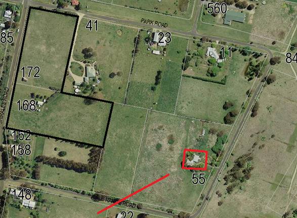
Figure X – view analysis for 55 Rifle Range Road
As can be seen from the attached basic view analysis, the
primary view lines for the objector, as identified in the DCP, are of Mt
Canobolas. The proposed development does not affect those primary views. The
views enjoyed by the objector in other directions cannot be considered the
primary views for that person. Moreover, with the larger lot to be located on
168 Shiralee Road, and the compact lots lower in elevation relative to the
crest at Shiralee Road, it is considered that views in the westerly
direction for the objector will not be significantly affected.
The Land and Environment Court have ‘planning principles”
with regard to view loss assessments. The value of views are linked to whether
the thing being viewed is iconic or essential to the inherent value of the
property benefitting from that view. Where views are of a more general or
panoramic value the Land and Environment Court “planning
principles” promote the idea of view sharing. In this case it is obvious
that the proposed development will not completely eradicate the objector of all
their views, and will not affect at all the primary viewing lines that may be
open to the objector.
Proposals to encroach on the
northern boundary of 55 Rifle Range Road for stormwater drainage, sewage and
future roads will clearly impact on mature white gums, a highly functioning and
vital underground bore for our potable water and agricultural land.
The positioning design of stormwater
drainage lines will require discussions and agreement with the relevant
landowner(s). Stormwater flows may not be simply discharged onto neighbours
land, and an approval for the subject application does not remove or impinge
upon the private property rights of other landowners to withhold their
agreement to the positioning of stormwater lines or other infrastructure across
or over their land. The issues of concern that have been raised would need to
be considered in detail if and only when a decision was made by those persons
to further develop their land for residential purposes. The status quo would
remain if a decision was made to not development that land at this time.
Groundwater vulnerability is
rated as high. We request further investigation in this area especially in
regards to the proximity of bores and adjoining downstream properties which are
vulnerable to contamination.
It is considered the proposed subdivision possesses little
risk to groundwater quality or the quality of water extracted from the aquifers
in the locality.
Groundwater vulnerability.
The subject property is mapped as having groundwater
vulnerability. This arises principally because of the relatively high water
table across much of Orange, including the subject site. It is considered that
the subject property is under no greater risk than other properties with
similar ground water vulnerability issues. It is further considered that, given
that surface runoff, and effluent disposal will both be managed principally by
removal via articulated networks linking back to Council infrastructure that
the risks to water quality are very low.
Clause 7.11 - Essential
services- e) Suitable road access
It is noted that this objector has similar concerns as
expressed by other residents with respect to access for Lots 7-17. These have
been previously commented upon.
C
Smith, PO Box 1272, Orange
Objects to the Compact Lots.
The compact lots are consistent with the masterplan
contained in the Shiralee DCP.
Roads and Access.
Mr Smith is concerned about safety arising from the
increased road usage. However, the roads layout on which the subdivision is
based is a direct facsimile of the DCP requirements.
Stormwater - stormwater system
be designed for the 1 in 10 year storm event.
Council’s stormwater standards that are applicable to
the proposed development are generally to a higher standard than the 1 in 10
year event. Notwithstanding, a detailed engineering drawing will be required to
be prepared for approval adhering to Council’s Subdivision and
Development Code prior to works commencing.
Location – slope and
elevation creates a highly visible development.
The subject property is particularly visible from the north,
with the views of the heritage item located on the site of particular interest.
To address this issue and minimise the impacts of both the existing development
and future development of the new lots, conditions are included in the attached
schedule to limit the extent of earthworks, height restrictions where
appropriate and setbacks for the compact lots that are proposed.
Landscaping – some
arrangement for revegetation should be included in the proposal.
Conditions are included in the consent for the provision of
landscaping as specified in the DCP.
Remediation of Land.
A site contamination report submitted with the application
indicates the site is not contaminated and is suitable for purpose as residential
land.
Laurie and Graeme Dwyer
– “Hillview” Park Road
Blocks 1, 4, 6, 7, 8 and 9 do not comply with the street
frontage requirements for a large lot classification.
There are some variations in relation to the DCP masterplan,
however this arises due to the existing approval granted for DA42/2016. In
terms of general layout the proposed subdivision is consistent with the DCP. In
terms of lot yield the proposed development is consistent with the DCP. Clause
1.8 does allow for certain variations to the DCP where the outcomes remains
remain generally acceptable and underlying objectives are being achieved.
Request that driveway access
for Lots 2, 3, 4 and 6 be identified.
It is standard for Council to determine the location of
driveways at dwelling application stage.
Objects to the location of the
sewer main and stormwater lines on their property. Same objection for proposed
road access.
As owners of that land, the objectors can refuse sewer mains
(and/or stormwater lines) being installed on their land. Those lots requiring
sewer and/or storm water access across the objectors land may not be developed
until such access is provided, but the objector is under no obligation to allow
such access. The same conclusions can be drawn with respect to roads access. It
is noted that the proposed development, with respect to water, sewer,
stormwater and roads is consistent with the LEP as well as the DCP masterplan.
The negotiations between landowners needed to put into effect those masterplan
are not relevant to the assessment of the layout.
Compact Lots will require
excessive cut and fill.
The compact lots are consistent with the masterplan layout
of the DCP in terms of size, shape and location. There are no bulk earthworks
proposed for the sites under this application.
The most appropriate time to assess whether future
development complies with the cut and fill requirements is if and when cut and
fill is actually part of the site works ie, when applications for buildings are
received. The overall cross fall is from north-west to south-east for the
compact lots is in the order of 10m, which equates to an average drop for each
of the proposed compact lots of 1.25m. Depending on the style of construction
used and whether or not split level buildings are adopted, the cut for future
dwellings can be expected to be under 1m. This is not considered excessive.
Fencing.
The objection points out that “larger lots require
open rural style fencing with high visual permeability. The objectors are
concerned that the large lots with open style permeable fencing will not
achieve adequate privacy for them. At the same time they point out that they
run cattle on their holding, suggesting that residential opaque fencing like
Colorbond or palings would not prevent their cattle pushing the fencing over.
The DCP is in fact concerned with trying to manage the
transition of the locality from a semi‑rural environment, to a
residential environment. The land has been rezoned generally to residential
purposes, and a masterplan to manage the transition. However, it is noted that
with a residential zoning, the use of the properties for any form of Extensive
Agriculture is no longer a permissible land use under the LEP. Existing use
rights would, however, apply in circumstances where the activity has been
continuous.
There are no details of any fencing to be provided on the
site which indicates that no new fencing is at this stage proposed. Future
applications for dwellings on the sites can be assessed as to their impacts on
privacy, versus the impacts of solid fencing on neighbourhood character. In
future, devices and techniques such as screen planting/landscaping, positioning
and orientation of buildings and the like are possible so as to minimise
privacy impact. These can be assessed on their merits.
For this application it is considered appropriate to impose
the following condition:
· For all stages
of the development and any future development on the new lots, where any
existing fencing at the perimeter of the site needs to be removed, or is of a
type which does not ensure the occupants of any adjoining residence adequate
privacy, new fencing that is compliant to the requirements the Section 6.2 of
the Shiralee DCP shall be provided, and where necessary shall include
arrangements for screening landscaping or privacy devices as necessary to suit
the style of development and its constraints at that time.
Tree Removal.
The objector raises concern about the loss of one gum tree
from the site. This tree is not proposed to be removed under this application.
It appears that approval to remove the significant vegetation from the site was
granted under DA42/2016. The vegetation existing on the site is not significant
from a biodiversity management perspective.
This DA should include soil
testing.
A site and soil analysis was submitted with the application
by Envirowest Consulting.
Future Development.
The objector’s land holding is affected by the
reservations for roads and services as set out in the DCP, to which the
proposed subdivision of the subject application is entirely consistent with.
Since the adoption of the DCP the objector’s land has been subject to
those land acquisitions for roads and services in the areas so shown in the
masterplan. As such, the parts of the objectors holding affected by road and
services acquisition has no real potential for any substantive alternative
development. The land owner has a choice to basically keep using the land as
they are, or to develop their holding as set out in the DCP. The proposed
development currently before Council does not interfere with that choice.
Compact Lots are not in keeping
with the Desired Future Character of the locality.
The compact lots as proposed in
this application reflect closely the layouts contained in the DCPs masterplans
for this locality, as shown in the following Figures 7 and 8.
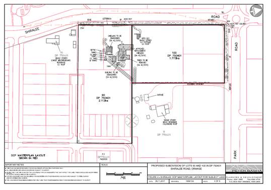
Figure 7 – DCP Masterplan (drawing by Applicant)
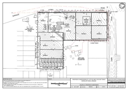
Figure 8 – Proposed subdivision layout
PUBLIC INTEREST
s4.15(1)(e)
The proposed development is considered to be of minor
interest to the wider public due to the relatively localised nature of
potential impacts. The proposal is not inconsistent with any relevant policy
statements, planning studies, guidelines etc that have not been considered in
this assessment.
SUMMARY
The proposed development is permissible with the consent of
Council. The proposed development complies with the relevant aims, objectives
and provisions of Orange LEP 2011 (as amended) and DCP 2004. The applicant
has sought a variation to the minimum allotment size controls pursuant to
Clause 4.6 of the LEP. A Section 4.15 assessment of the development
indicates that the development is acceptable in this instance. Attached is a
draft Notice of Approval outlining a range of conditions considered appropriate
to ensure that the development proceeds in an acceptable manner.
COMMENTS
The requirements of the Environmental Health and Building
Surveyor and the Engineering Development Section are included in the attached
Notice of Approval.
Attachments
1 Notice
of Approval, D18/33180⇩
2 Plans,
D18/33070⇩
3 Submissions,
D18/32971⇩
Planning and Development Committee
3 July 2018
2.4 Development
Application DA 305/2016(1) - 168 Shiralee Road
Attachment 1 Notice
of Approval
|

|
ORANGE CITY COUNCIL
Development
Application No DA
305/2016(1)
NA18/
Container
PR12742
|
NOTICE OF DETERMINATION
OF A DEVELOPMENT
APPLICATION
issued under the Environmental
Planning and Assessment Act 1979
Section 4.18
|
Development
Application
|
|
|
Applicant
Name:
|
Byng Administration
Services Pty Ltd
|
|
Applicant
Address:
|
C/- Peter Basha
Planning and Development
PO Box 1827
ORANGE
NSW 2800
|
|
Owner’s
Name:
|
Byng Administration
Services Pty Limited
|
|
Land
to Be Developed:
|
Lots 90 and 100 DP
750401 - 168 Shiralee Road, Orange
|
|
Proposed
Development:
|
Subdivision (17 lot
residential)
|
|
|
|
|
Building Code of
Australia
building
classification:
|
Not applicable
|
|
|
|
|
Determination made
under
Section 4.16
|
|
|
Made
On:
|
3 July 2018
|
|
Determination:
|
CONSENT GRANTED
SUBJECT TO CONDITIONS DESCRIBED BELOW:
|
|
|
|
|
Consent to Operate
From:
|
4 July 2018
|
|
Consent to Lapse On:
|
4 July 2023
|
Terms
of Approval
The reasons for the imposition of conditions
are:
(1) To ensure a quality
urban design for the development which complements the surrounding environment.
(2) To maintain
neighbourhood amenity and character.
(3) To ensure compliance
with relevant statutory requirements.
(4) To provide adequate
public health and safety measures.
(5) Because the development
will require the provision of, or increase the demand for, public amenities and
services.
(6) To ensure the utility
services are available to the site and adequate for the development.
(7) To prevent the proposed
development having a detrimental effect on adjoining land uses.
(8) To minimise the impact
of development on the environment.
Conditions
(1) The development must be
carried out in accordance with:
(a) Plans by Heath
Consulting numbered 16039-SERV01. Plan by Peter Basha numbered 15061 dated
28.11.2017. Figure 6 Subdivision Layout, (1 sheets)
(b) statements
of environmental effects or other similar associated documents that form part
of the approval
as amended in
accordance with any conditions of this consent.
|
PRIOR TO THE ISSUE OF A CONSTRUCTION
CERTIFICATE
|
(2) A
detailed landscaping plan covering all stages of the development of the
proposed subdivision is to be submitted to and approved by Council’s
Manager of Development Assessments prior to the issue of a Construction
Certificate. The amended landscape plan shall indicate the proposed landscaping
of all road reserves in accordance with the following:
· street verges are to be
fully turfed with cool climate species and trees to the satisfaction of the
Manager of City Presentations.
· road infrastructure
planting.
The landscape design shall have regard to the
landscaping principles contained within the Shiralee Urban Release Master Plan.
The landscape plan shall include details on
watering, weed control and temporary protective fencing as well as staking and
planting details for street trees incorporating any principals set out in the
Shiralee DCP.
(3) The street lighting
system shall comprise LED lighting and be designed having regard to the
relevant lighting controls contained within the Shiralee DCP. The applicant
shall submit details of the street lighting system for approval prior to the
issue of a Construction Certificate.
(4) Engineering plans,
showing details of all proposed work and adhering to any engineering conditions
of development consent, are to be submitted to, and approved by, Orange City
Council or an Accredited Certifier (Categories B1, C3, C4, C6) prior to the
issuing of a Construction Certificate.
(5) A water and soil
erosion control plan is to be submitted to Orange City Council or an Accredited
Certifier (Categories B1, C3, C4, C6) for approval prior to the issuing of a
Construction Certificate. The control plan is to be in accordance with the
Orange City Council Development and Subdivision Code and the Landcom, Managing
Urban Stormwater; Soils and Construction Handbook.
(6) Proposed Lots 1 to 17
are to be provided with interlot stormwater drainage, including those lots
abutting public land, where the surface of the entire lot cannot be drained to
the kerb and gutter at the lot frontage. A grated concrete stormwater pit is to
be constructed within each lot provided with interlot stormwater drainage.
Engineering plans for this drainage system are to be approved by Orange City
Council or an Accredited Certifier (Categories B1, C3, C4, C6) prior to the
issuing of a Construction Certificate.
(7) Stormwater from the
site is to be piped to a natural watercourse, where it is to be discharged
through a standard headwall with appropriate scour protection. Engineering
plans of this required drainage system are to be approved by Orange City
Council or by an Accredited Certifier (Categories B1, C3, C4, C6) and a licence
from the Department of Planning Infrastructure and Natural Resources for work
within 40 metres of the watercourse is to be submitted prior to the issuing of
a Construction Certificate.
Stormwater discharging from Lots 6 to 17 shall
be piped to the natural watercourse located adjacent to the intersection of
Park Road and Rifle Range Road.
(8) A 150mm-diameter sewer
main is to be constructed from Council’s existing main to serve the
proposed lots. Prior to a Construction Certificate being issued engineering
plans for this sewerage system are to be submitted to and approved by Orange
City Council.
(9) A water reticulation
analysis is to be carried out by Orange City Council on any proposed water
reticulation system for the development. Engineering plans are to be
submitted to and approved by Orange City Council prior to the issue of a
Construction Certificate.
The reticulation system is to be designed to
supply a peak instantaneous demand by gravity of 0.15 L/s/tenement at a
minimum residual head of 200kPa.
(10) The
existing residence is to be connected to the proposed reticulated sewer. The
existing septic tank is to be accurately located and indicated on the submitted
engineering plans.
(11) Prior to the issue of a
Construction Certificate evidence of the registration of any required easements
and rights of way over adjoining properties for the provision of services and
access shall be provided to the Principal Certifier.
|
PRIOR TO WORKS COMMENCING
|
(12) A
temporary onsite toilet is to be provided and must remain throughout the
project or until an alternative facility meeting Council’s requirements
is available onsite.
(13) Soil
erosion control measures shall be implemented on the site.
(14) A
Construction Certificate application is required to be submitted to, and issued
by Council/Accredited Certifier prior to any excavation or building works being
carried out onsite.
|
DURING CONSTRUCTION/SITEWORKS
|
(15) All
construction/demolition work on the site is to be carried out between the hours
of 7.00 am and 6.00 pm Monday to Friday inclusive, 7.00 am to
5.00 pm Saturdays and 8.00 am to 5.00 pm Sundays and Public
Holidays. Written approval must be obtained from the General Manager of Orange
City Council to vary these hours.
(16) If Aboriginal objects,
relics, or other historical items or the like are located during development
works, of any of the stages for the development works in the area of the
identified object, relic or item shall cease, and the NSW Office of Environment
and Heritage (OEH), and representatives from the Orange Local Aboriginal Land
Council shall be notified. Where required, further archaeological investigation
shall be undertaken. Development works in the area of the find(s) may
recommence if and when outlined by the management strategy, developed in
consultation with and approved by the OEH.
(17) Earthworks for all
stages of the development shall be limited to those required for roads,
footpaths and the provision of utility services. No approval is granted
for bulk earthworks to be undertaken on the site with respect to levelling or
cut/filling otherwise, except with the further consent of Council, as the
details of such works are not shown in the development proposal submitted to
Council for approval.
(18) Any adjustments to
existing utility services that are made necessary by this development
proceeding are to be at the full cost of the developer.
(19) The provisions and
requirements of the Orange City Council Development and Subdivision Code are to
be applied to this application and all work constructed within the development
is to be in accordance with that Code.
The developer is to be entirely responsible for
the provision of water, sewerage and drainage facilities capable of servicing
all the lots from Council’s existing infrastructure. The developer is to
be responsible for gaining access over adjoining land for services where
necessary and easements are to be created about all water, sewer and drainage
mains within and outside the lots they serve.
(20) The 19.0m wide road
fronting Lots 7 to 17 is to be constructed as half road width for the full
frontage of the proposed development. This work is to include road pavement and
pavement surfacing to the centreline, kerb and gutter construction and
earth-formed footpath on the development side of the road. Boxing out and
pavement construction of the roadway on the opposite side of the development is
to also be carried out.
Proposed Lots 7 to 17 shall be provided with
public road access to Rifle Range Road at no cost to Orange City Council. The
public road shall be a minimum of 19.0m wide for two way access and 9.5m wide
for one way access. The public road shall be constructed to full urban standard.
Park Road is to be constructed as part road
width for the full frontage of the proposed development. This work is to
include road pavement and pavement surfacing to the edge of the carriageway,
underground stormwater pipes, kerb and gutter construction and earth-formed
footpath on the development side of the road. Works are to be generally in
accordance with Council drawing R00442 (as amended).
Shiralee Road is to be constructed as part road
width for the full frontage of the proposed development. This work is to
include an earth-formed footpath on the development side of the road to suit
the future road levels. Works are to be generally in accordance with Council
drawing R00446 (as amended).
(21) A heavy-duty concrete
kerb and gutter layback and footpath crossing is to be constructed for proposed
Lot 1 and the existing dwelling on proposed Lot 5. The driveway is to be shown
on the plan submitted with the Construction Certificate application. The works
are to be carried out to the requirements of the Orange City Council
Development and Subdivision Code.
(22) Concrete pathways are
to be constructed to the widths and standards stated in the Orange City Council
Development and Subdivision Code and the Shiralee DCP.
(23) Water and sewerage
reticulation is to be provided to every lot in the proposed residential
subdivision in accordance with the Orange City Council Development and
Subdivision Code.
(24) Water and sewer
services, including mains construction, pumping station construction, easements
and all associated materials and works, are to be provided for the development
at the cost of the developer.
|
PRIOR TO THE ISSUE OF A SUBDIVISION
CERTIFICATE
|
(25) Soil sampling for
analysing chemical residue is to be carried out within the proposed Lots in a manner
and frequency as determined by an appropriately qualified and experienced
consultant giving consideration to previous specific uses and on-site
characteristics of the site. A NATA registered laboratory is to carry out
such testing. Reference is to be made to the Contaminated Land Management
Act 1997 and State Environmental Planning Policy No 55 -
“Remediation of Land”. The results of the testing are to be
provided to the Principal Certifying Authority and are to demonstrate that the
land is suitable for residential use, to enable a Subdivision Certificate to be
issued.
(26) The
maximum site coverage ratios allowed for each type of lot under the Shiralee
Masterplan are:
· 60% for compact lots
· 45% for medium lots
· 35% for standard lots
· 25% for large Lots
A
Restriction as to User under Section 88B of the NSW Conveyancing Act 1979 consistent
with the above shall be applied to each of the approved lots for all stages of
the development to reflect these requirements of the Shiralee Masterplan.
(27) A
Subdivision Certificate for Lots 7-17 shall not be released by Council until
road access that conforms to the requirements of the Shiralee Masterplan have
been provided (generally a road link to Rifle Range Road). The land
allocated to Lots 7-17 shall, as an interim arrangement, be retained as part of
Lot 1.
(28) Landscaping required to
be installed under this consent shall be completed in accordance with the
approved landscape plan and maintained in good condition delivered as such
prior to release of the subdivision certificate. Thereafter, landscaping is
required to be maintained in good order during the construction period for
buildings at all times by the future landowners and their builders.
(29) In
accordance with Section 7.11 of the Act and Orange Development Contributions
Plan 2017 (Shiralee Release Area) a contribution towards the provision of the
following public facilities is required:
|
Open Space and
Recreation
|
@ 2,682.73 x 17
lots
|
45,606.41
|
|
Community and
Cultural
|
@
777.99 x 17 lots
|
13,225.83
|
|
Roads and Traffic
Management
|
@ 3,541.11 x 17
lots
|
60,198.87
|
|
Local Area Facilities
|
@ 12,415.64 x 17 lots
|
211,065.88
|
|
Plan Preparation
& Administration
|
@
582.53 x 17 lots
|
9,903.01
|
|
Sub Total
|
(17 lots)
|
340,000.00
|
|
Credit for existing allotments
|
@ 20,000.00 x 2 lots
|
(-)40,000.00
|
|
Net Total
|
(subtotal less
credits)
|
$300,000.00
|
The contribution will be indexed quarterly in
accordance with the Orange Development Contributions Plan 2017 (Shiralee
Release Area). Attached are conditions requiring the payment of the required
contributions prior to the issue of a Subdivision Certificate.
(30) A
Restriction as to User under Section 88B of the NSW Conveyancing Act 1979 shall
applied to each of the approved lots for all stages of the development to
reflect the requirements of the Shiralee Masterplan as it relates to building
setbacks and garage presentation of future buildings. Building setbacks for
future development of the approved lots shall comply to the requirements of the
Shiralee DCP (Appendix B) for Lot typology that is applicable to that
lot. Garages may not occupy more than 50% of the building
frontages. The terms of this restriction are to be submitted to the Manager of
Development Assessments for approval prior to the issue of a Subdivision
Certificate.
(31) Application
shall be made for a Subdivision Certificate under Section 6.3(1)(d) of the Act.
(32) Payment
of contributions for water, sewer and drainage works is required to be made
at the contribution rate applicable at the time that the payment is made.
The contributions are based on 17 ETs for water supply headworks and 17 ETs for
sewerage headworks. A Certificate of Compliance, from Orange City Council
in accordance with the Water Management Act 2000, will be issued upon payment
of the contributions.
This Certificate of Compliance is to be
submitted to the Principal Certifying Authority prior to the issuing of a
Subdivision Certificate.
(33) Evidence from a
registered NATA laboratory is to be submitted prior to the issuing of a
Subdivision Certificate stating that the filling of all dams and low-lying
areas has been carried out in accordance with Australian Standard 3798-2007.
(34) Application is to be
made to Telstra/NBN for infrastructure to be made available to each individual
lot within the development. Either a Telecommunications Infrastructure
Provisioning Confirmation or Certificate of Practical Completion is to be
submitted to the Principal Certifying Authority confirming that the specified
lots have been declared ready for service prior to the issue of a Subdivision
Certificate.
(35) A Notice of Arrangement
from Essential Energy stating arrangements have been made for the provision of
electricity supply to the development, is to be submitted to the Principal
Certifying Authority prior to the issue of a Subdivision Certificate.
(36) An easement to drain
sewage and to provide Council access for maintenance of sewerage works a
minimum of 2.0 metres wide is to be created over the proposed sewerage works.
The Principal Certifying Authority is to certify that the easement is in
accordance with the Orange City Council Development and Subdivision Code prior
to the issuing of a Subdivision Certificate.
(37) All services are to be
contained within the allotment that they serve. A Statement of Compliance, from
a Registered Surveyor, is to be submitted to the Principal Certifying Authority
prior to the issuing of a Subdivision Certificate.
(38) A
Maintenance Security Deposit, in accordance with the provisions and requirements
of the Orange City Council Development and Subdivision Code, is to be provided
to Orange City Council prior to the issuing of a Subdivision Certificate.
A Certificate of Compliance, from Orange City
Council, certifying that the maintenance security deposit has been paid, is to
be submitted to the Principal Certifying Authority prior to the issuing of a
Subdivision Certificate.
(39) The
existing residence is to be connected to the proposed reticulated sewer.
The contents of the existing septic tank are to
be removed by a licensed contractor for disposal into Council’s sewer
system. The septic tank is to be excavated and disposed of at a licensed
landfill and the absorption trench is to be drained and the voids limed and
backfilled with clean compacted material.
Evidence of such work is to be provided to the
Principal Certifying Authority prior to the issuing of a Subdivision
Certificate.
(40) Where stormwater
crosses land outside the lot it favours, an easement to drain water is to be
created over the works. A Restriction-as-to-User under Section 88B of the NSW
Conveyancing Act 1979 is to be created on the title of the burdened lot
requiring that no structures are to be placed on the site, or landscaping or
site works carried out on the site, in a manner that affects the continued
operation of the interlot drainage system. The minimum width of the easement is
to be as required in the Orange City Council Development and Subdivision Code.
(41) Prior to the issuing of
a Subdivision Certificate, a Road Naming Application form is to be completed
and submitted with a plan of the whole development defining the stage being
released - including future road extensions.
(42) Certification from
Orange City Council is required to be submitted to the Principal Certifying
Authority prior to the issue of a Subdivision Certificate stating that all
works relating to connection of the development to Council assets, works on
public land, works on public roads, stormwater, sewer and water reticulation
mains and footpaths have been carried out in accordance with the Orange City
Council Development and Subdivision Code and the foregoing conditions, and that
Council will take ownership of the infrastructure assets.
(43) Proposed Lot 3 shall
dedicate 2.5m width along the full length of the western boundary and a 5m
splay at the intersection of Park Road and Shiralee Road, and Lot 17 shall
dedicate a 2m splay at the road intersection as public road at no cost to
Orange City Council.
(44) A
Restriction-as-to-User under section 88B of the NSW Conveyancing Act is
to be registered on the Deed of Title of Lot 2 where vehicular access is to be
located adjacent to the eastern boundary only and Lot 3 where vehicular access
is to be located adjacent to the southern boundary only.
(45) A Restriction as to
User under Section 88B of the NSW Conveyancing Act 1979 shall be created on the
title of proposed Lots 3 and 4 that limits the height of future buildings to
single storey. A building envelope to the satisfaction of the Manager of
Development Assessments shall also be applied to these lots. The building
envelope shall be designed having regard to the view corridor along Shiralee Drive
towards the listed heritage item within proposed Lot 5.
(46) All
of the foregoing conditions are to be at the full cost of the developer and to
the requirements and standards of the Orange City Council Development and
Subdivision Code, unless specifically stated otherwise. All work required by
the foregoing conditions is to be completed prior to the issuing of a
Subdivision Certificate, unless stated otherwise.
(47) For
all stages of the development and any future development on the new lots, where
any existing fencing at the perimeter of the site needs to be removed, or is of
a type which does not ensure the occupants of any adjoining residence adequate
privacy, new fencing that is compliant to the requirements the Section 6.2 of
the Shiralee DCP shall be provided, and where necessary shall include
arrangements for screening landscaping or privacy devices as necessary to suit
the style of development and its constraints at that time.
Other
Approvals
(1) Local
Government Act 1993 approvals granted under Section 68.
Nil
(2) General
terms of other approvals integrated as part of this consent.
Nil
Right
of Appeal
If you are dissatisfied with this decision,
Section 8.7 of the Environmental Planning and Assessment Act 1979 gives
you the right to appeal to the Land and Environment Court. Pursuant to Section
8.10, an applicant may only appeal within 6 months after the date the decision
is notified.
|
Disability
Discrimination Act 1992:
|
This application has been assessed in
accordance with the Environmental Planning and Assessment Act 1979. No
guarantee is given that the proposal complies with the Disability
Discrimination Act 1992.
The applicant/owner is responsible to ensure
compliance with this and other anti-discrimination legislation.
The Disability Discrimination Act
covers disabilities not catered for in the minimum standards called up in the
Building Code of Australia which references AS1428.1 - "Design for
Access and Mobility". AS1428 Parts 2, 3 and 4 provides the most
comprehensive technical guidance under the Disability Discrimination Act
currently available in Australia.
|
|
|
|
|
Disclaimer
- S88B of the Conveyancing Act 1919 - Restrictions on the Use of Land:
|
The applicant should note that there could be
covenants in favour of persons other than Council restricting what may be
built or done upon the subject land. The applicant is advised to check the
position before commencing any work.
|
|
|
|
|
Signed:
|
On behalf of the consent authority ORANGE
CITY COUNCIL
|
|
Signature:
|
|
|
Name:
|
PAUL JOHNSTON - MANAGER DEVELOPMENT
ASSESSMENTS
|
|
Date:
|
4 July 2018
|
Planning
and Development Committee
3 July 2018
2.4 Development
Application DA 305/2016(1) - 168 Shiralee Road
Attachment 2 Plans
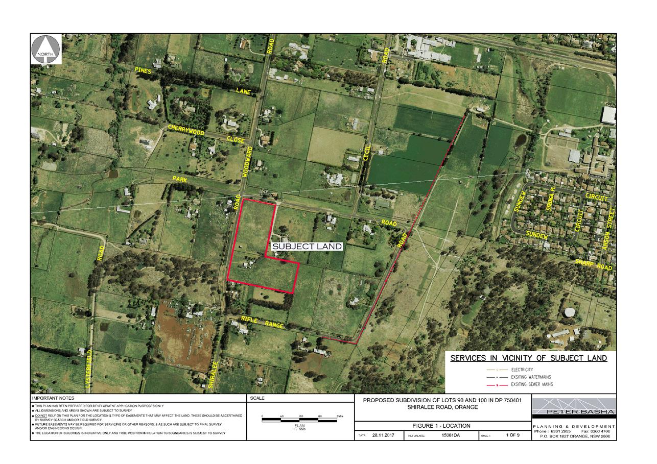
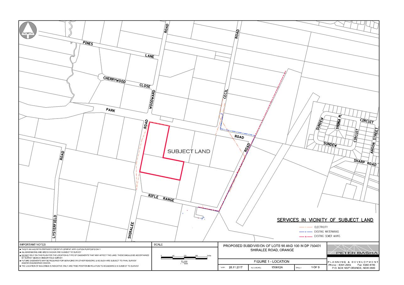
Planning and Development Committee
3 July 2018
2.4 Development
Application DA 305/2016(1) - 168 Shiralee Road
Attachment 2 Plans
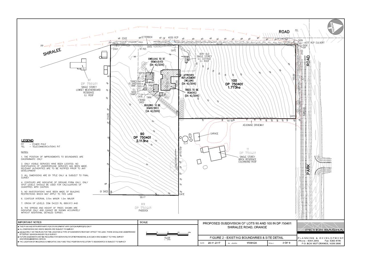
Planning and Development Committee
3 July 2018
2.4 Development
Application DA 305/2016(1) - 168 Shiralee Road
Attachment 2 Plans
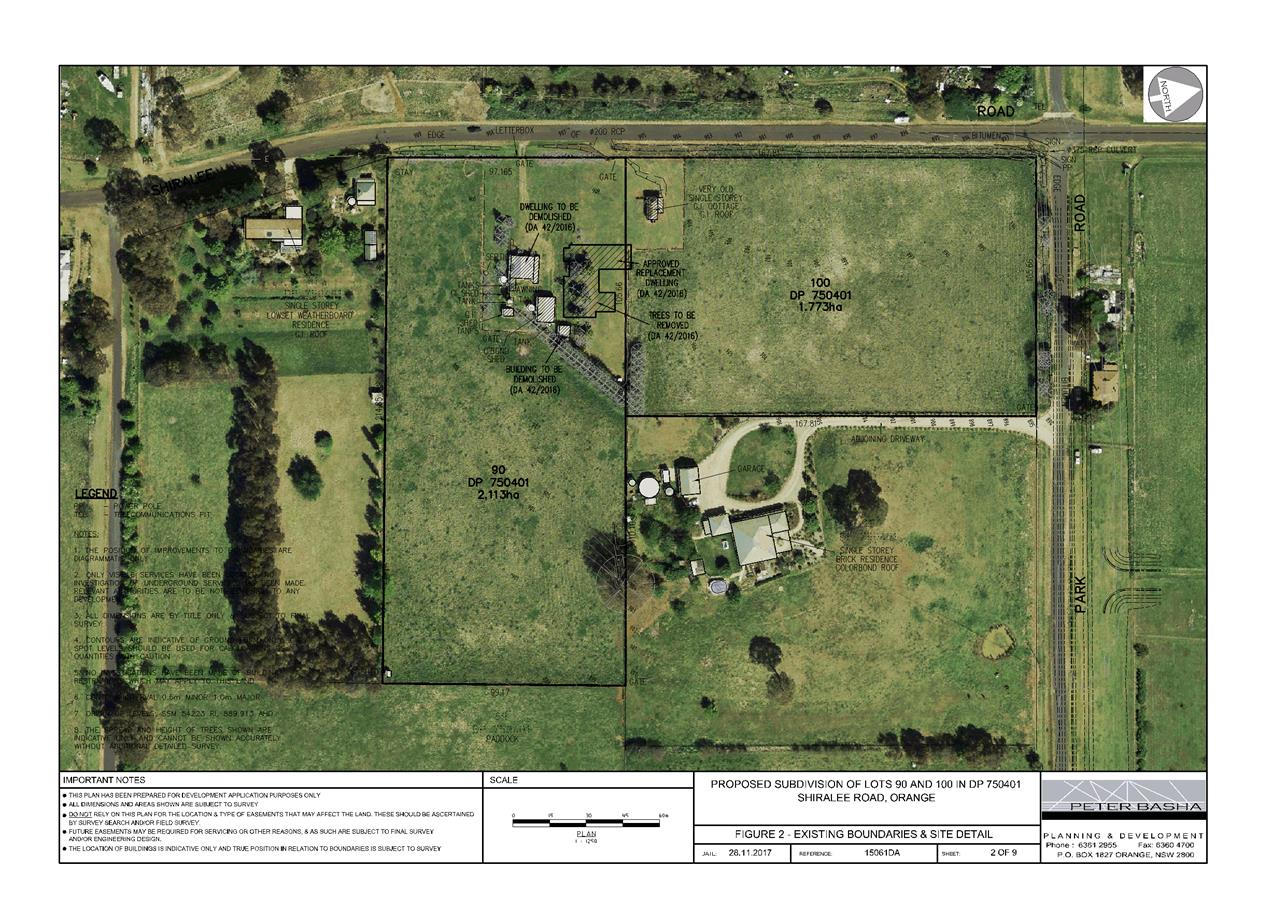
Planning and Development Committee
3 July 2018
2.4 Development
Application DA 305/2016(1) - 168 Shiralee Road
Attachment 2 Plans
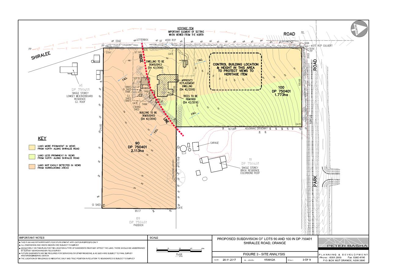
Planning and Development Committee
3 July 2018
2.4 Development
Application DA 305/2016(1) - 168 Shiralee Road
Attachment 2 Plans
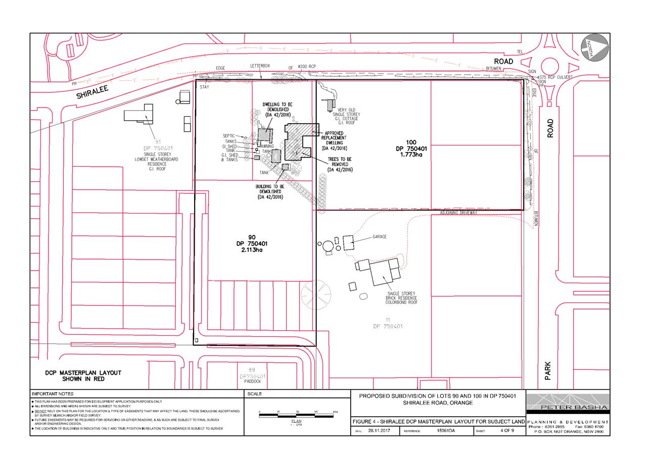
Planning and Development Committee
3 July 2018
2.4 Development
Application DA 305/2016(1) - 168 Shiralee Road
Attachment 2 Plans
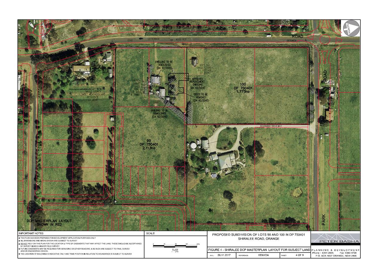
Planning and Development Committee
3 July 2018
2.4 Development
Application DA 305/2016(1) - 168 Shiralee Road
Attachment 2 Plans
Planning and Development Committee
3 July 2018
2.4 Development
Application DA 305/2016(1) - 168 Shiralee Road
Attachment 2 Plans
Planning and Development Committee
3 July 2018
2.4 Development
Application DA 305/2016(1) - 168 Shiralee Road
Attachment 2 Plans
Planning and Development Committee
3 July 2018
2.4 Development
Application DA 305/2016(1) - 168 Shiralee Road
Attachment 2 Plans
Planning and Development Committee
3 July 2018
2.4 Development
Application DA 305/2016(1) - 168 Shiralee Road
Attachment 2 Plans
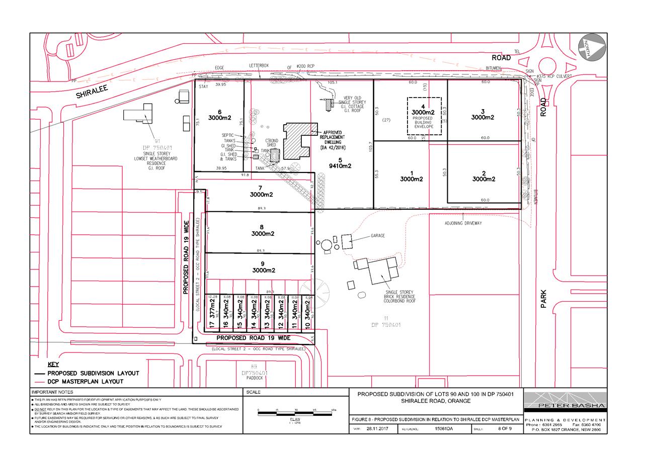
Planning and Development Committee
3 July 2018
2.4 Development
Application DA 305/2016(1) - 168 Shiralee Road
Attachment 3 Submissions
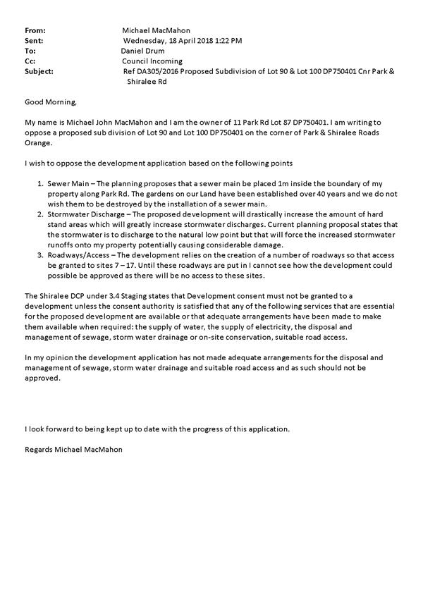
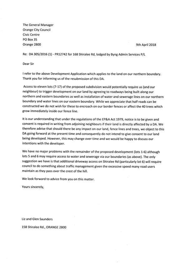
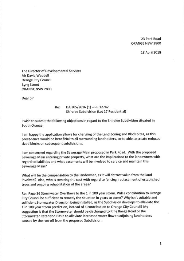

2.5 Development
Application DA 138/2018(1) - Lot 211 Lily Place
RECORD
NUMBER: 2018/1533
AUTHOR: Summer
Commins, Senior Planner
EXECUTIVE Summary
|
Application
lodged
|
20 April
2018
|
|
Applicant/s
|
Mr I
Zhang
|
|
Owner/s
|
Dinkum
Exporting and Importing Pty Limited
|
|
Land
description
|
Lot 211
DP 1229307 - Lily Place, Orange
|
|
Proposed
land use
|
Multi
Dwelling Housing (15 dwellings) and Subdivision (two Torrens lots, six
Community lots and nine Community lots)
|
|
Value of
proposed development
|
$1,800,000
|
Council's consent is sought for staged residential
development of land at Lot 211 Lily Place, Orange. The completed
development will involve 15 single-storey two bedroom dwelling houses, each on
a separate Torrens or Community lot.
The proposal comprises advertised development pursuant to
Development Control Plan (DCP) 2004-5.3. At the completion of the public notice
and exhibition period, three submissions had been received in relation to the
proposed development. The submissions generally relate to overdevelopment of
the site and the associated impacts on the neighbourhood (traffic, servicing
and character).
The proposal does not contravene
the planning regime that applies to the land. Impacts of the development are
considered to be within reasonable limit, consistent with applicable standards
and addressed by appropriate conditions of development consent. Approval of the
application is recommended.
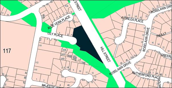
Figure 1 - Locality plan
RECENT LEGISLATIVE CHANGES
On 1 March 2018 the Environmental Planning and Assessment
Act 1979 was substantially amended. The most immediate change involves the
restructuring and renumbering of the Act, with other more substantive
changes to be phased in over time. However, for some applications (particularly
where an application was lodged prior to the changes coming into effect) the
supporting documentation may still reference the previous numbering regime. In
the drafting of this report the content and substance of the supporting
material has been considered irrespective of which legislative references were
used.
DECISION FRAMEWORK
Development in Orange is governed by two key documents
Orange Local Environment Plan 2011 and Orange Development Control Plan 2004. In
addition the Infill Guidelines are used to guide development, particularly in
the heritage conservation areas and around heritage items.
Orange Local Environment Plan 2011 – the LEP
should be considered by Council to be a definitive document. LEPs govern the
types of development that are permissible or prohibited in different parts of
the City and also provide some assessment criteria in specific circumstances.
Uses are either permissible or not - there are no grey areas in terms of
permissibility. The objectives of each zoning and indeed the aims of the LEP
itself are, however, open to interpretation and can be used to guide decision
making around appropriateness of development.
Orange Development Control Plan 2004 – the DCP
guides development. In general it is a performance based document rather than
prescriptive in nature - its purpose is to guide development. The Land and
Environment Court tends to view it as such. In each area of interest there are
often guidelines used. These guidelines indicate ways of achieving the planning
outcomes. It is thus recognised that there may also be other solutions of
merit. All design solutions are considered on merit by planning and building
staff. Applications should clearly demonstrate how the planning outcomes are
being met where alternative design solutions are proposed. So one can see that
the DCP gives leeway for developers and architects to use design to achieve the
outcome in other ways if they can. Stating that DCP guidelines are
inflexible can be misleading.
Director’s Comment - This
development, albeit dense in form, is in line with the residential and compact
nature of the area around it and serves one of the segments of the residential
market in Orange. The development complies in general with Orange’s
environmental planning instruments and is recommended for approval.
Link To Delivery/OPerational Plan
The recommendation in this report relates to the
Delivery/Operational Plan strategy “13.4 Our Environment – Monitor
and enforce regulations relating to City amenity”.
Financial Implications
Nil
Policy and Governance Implications
Nil
|
Recommendation
That Council consents to
development application DA 138/2018(1)
for Multi Dwelling Housing (15 dwellings) and Subdivision (2
Torrens lots, 6 Community lots and 9 Community lots) at Lot 211 DP 1229307 - Lily Place, Orange, pursuant to the conditions of consent in the attached
Notice of Approval.
|
further considerations
Consideration has been given to the recommendation’s
impact on Council’s service delivery; image and reputation; political;
environmental; health and safety; employees; stakeholders and project
management; and no further implications or risks have been identified.
SUPPORTING INFORMATION
The proposal involves residential development of land at Lot
211 Lily Place, Orange. The completed development will involve 15 dwelling
houses, each on a separate Torrens or Community lot.
The proposed dwellings will be
single-storey and detached, excepting Dwellings 2 and 3 which will be
semi-detached. Each dwelling will contain two bedrooms, two bathrooms,
open-plan kitchen/dining/living zone and attached single garage. Separate
private open space will be provided for each dwelling. External finishes for
the dwellings will comprise face brick walls with decorative rendered porch
piers; Colorbond roof sheeting and roller doors, and aluminium-framed glazing.
Dwellings 1 and 7 will present to Lily Place, as depicted below:
Figure 2 – Dwelling 1 front elevation
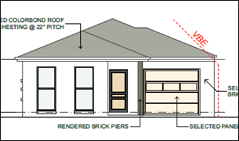
Figure 3 – Dwelling 7 front elevation
Separate access via Lily Place will be provided for
Dwellings 6 and 7 at the site frontage, with two shared accesses via Lily Place
provided for other dwellings within the development. Visitor car parking spaces
and waste storage facilities (bin bays) will be available onsite. Perimeter and
internal fencing will be erected and site landscaping installed.
The subject land will be subdivided to excise each dwelling
on a separate Torrens on Community lots. The residential lots will range in
area between 238.5m2 and 318.5m2.
The development will proceed in stages as follows:
Stage 1: Construction of
Dwellings 1-7
Stage 2: 4 Lot Torrens
subdivision:
Proposed
Lot 101 containing Dwelling 6
Proposed
Lot 102 containing Dwellings 1-5
Proposed
Lot 103 being a vacant development lot
Proposed
Lot 104 containing Dwelling 7
Stage 3: Six
lot Community subdivision to excise Dwellings 1-5 on separate lots with vehicle
areas to comprise Lot 1 Community Property
Stage 4: Construction
of Dwellings 8-15
Stage 5: Nine
lot Community subdivision to excise Dwellings 8-15 on separate lots with
vehicle areas to comprise Lot 1 Community Property.
The proposed site layout for the
completed development is depicted below.
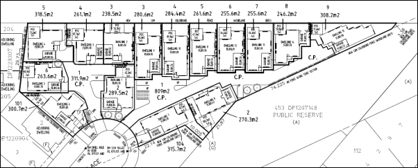
Figure 4 – Proposed site layout
MATTERS FOR CONSIDERATION
Section 1.7 - Application of
Part 7 of the Biodiversity Conservation Act 2016 and Part 7A of the
Fisheries Management Act 1994
Section 1.7 of the EP&A Act 1979 identifies that Part 7
of the Biodiversity Conservation Act 2016 and Part 7A of the Fisheries
Management Act 1994 have effect in connection with terrestrial and aquatic
environments.
Council staff inspected the site to ascertain the
biodiversity value of existing vegetation over the land. The inspection
revealed that the site has been graded in preparation for re‑development.
This is entirely consistent with its recent subdivision and zoning. There is some
regrowth on the site, consisting mostly of invasive and exotic ground
coverings. There are some isolated native species on the site, however these
species are common and offer little or no habitat value for other species. The
regrowth does not constitute native grasslands and show no signs that could be
reasonably construed as consistent with pioneer return of native vegetation.
Visually, the vegetation is of low value, adding little or nothing to the
neighbourhood character and amenity of the locality.
It is considered then, that the proposed development is not
likely to significantly affect a threatened species.
Section 4.15
Section 4.15 of the Environmental Planning and Assessment
Act 1979 requires Council to consider various matters, of which those pertaining
to the application are listed below.
PROVISIONS OF ANY ENVIRONMENTAL
PLANNING INSTRUMENT s4.15(1)(a)(i)
Orange Local Environmental Plan 2011
Part 1 - Preliminary
Clause 1.2 - Aims of Plan
The
particular aims of Orange LEP 2011 relevant to the proposal are:
(a) to
encourage development which complements and enhances the unique character of
Orange as a major regional centre boasting a diverse economy and offering an
attractive regional lifestyle,
(b) to
provide for a range of development opportunities that contribute to the social,
economic and environmental resources of Orange in a way that allows present and
future generations to meet their needs by implementing the principles for
ecologically sustainable development,
(e) to
provide a range of housing choices in planned urban and rural locations to meet
population growth,
(f) to
recognise and manage valued environmental heritage, landscape and scenic
features of Orange.
The application is considered to be
consistent with the above objectives as outlined below and in the following
sections in this report:
· there are no
aspects of the proposal that would adversely impact on the character of Orange
as a major regional centre. Indeed, ongoing development of residential lands
would contribute to the role of the City as a major centre (General Aim (a))
· there are no
aspects of the proposal that would compromise the principles of ecologically
sustainable development (General Aim (b))
· the proposal will
contribute to the City’s range and supply of housing choices (General Aim
(e))
· the proposal will
not adversely affect the value of heritage, landscape and scenic features of
the city (General Aim (f).
Clause 1.6 - Consent Authority
Clause 1.6 is applicable and
states:
The consent authority for the
purposes of this Plan is (subject to the Act) the Council.
Clause 1.7 - Mapping
The subject site is identified on the LEP maps in the
following manner:
|
Land
Zoning Map:
|
Land
zoned R1 General Residential
|
|
Lot
Size Map:
|
No
minimum lot size
|
|
Heritage
Map:
|
Not a
heritage item or conservation area
|
|
Height
of Buildings Map:
|
No
building height limit
|
|
Floor
Space Ratio Map:
|
No
floor space limit
|
|
Terrestrial
Biodiversity Map:
|
No
biodiversity sensitivity on the site
|
|
Groundwater
Vulnerability Map:
|
Groundwater
vulnerable
|
|
Drinking
Water Catchment Map:
|
Not
within the drinking water catchment
|
|
Watercourse
Map:
|
Not
within or affecting a defined watercourse
|
|
Urban
Release Area Map:
|
Not
within an urban release area
|
|
Obstacle
Limitation Surface Map:
|
No
restriction on building siting or construction
|
|
Additional
Permitted Uses Map:
|
No
additional permitted use applies
|
|
Flood
Planning Map:
|
Not
within a flood planning area
|
Those matters that are of relevance are addressed in detail
in the body of this report.
Clause 1.9A - Suspension of
Covenants, Agreements and Instruments
Clause 1.9A is applicable and states in part:
(1) For the purpose of enabling
development on land in any zone to be carried out in accordance with this Plan
or with a consent granted under the Act, any agreement, covenant or other
similar instrument that restricts the carrying out of that development does not
apply to the extent necessary to serve that purpose.
(2) This clause does not apply:
(a) to a covenant
imposed by the Council or that the Council requires to be imposed, or
(b) to
any prescribed instrument within the meaning of section 183A of the Crown Lands Act
1989, or
(c) to
any conservation agreement within the meaning of the National Parks
and Wildlife Act 1974, or
(d) to
any Trust agreement within the meaning of the Nature
Conservation Trust Act 2001, or
(e) to
any property vegetation plan within the meaning of the Native
Vegetation Act 2003, or
(f) to
any biobanking agreement within the meaning of Part 7A of the Threatened
Species Conservation Act 1995, or
(g) to
any planning agreement within the meaning of Division 6 of Part 4 of the Act.
In consideration of this clause, Council staff are not aware
of the title of the subject property being affected by any of the above.
The subject land adjoins a public reserve to the south,
which contains a TransGrid transmission line easement (refer below).
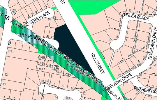
Figure 5 – TransGrid transmission line easement
TransGrid was provided with written
notice of the proposed development pursuant to State Environmental Planning
Policy (SEPP) (Infrastructure) 2007 (as considered later in this report).
TransGrid determined that the proposal was acceptable, subject to conditions
which are included on the attached Notice of Approval.
Part 2 - Permitted or Prohibited Development
Clause
2.1 - Land Use Zones
The subject site is located within the R1 General
Residential Zone. The proposed development is defined as ‘multi
dwelling housing’ and ‘subdivision.’
The proposed development is permitted in the R1 zone.
Clause 2.3 - Zone Objectives and Land Use Table
The
objectives of the R1 General Residential Zone are:
· to provide for
the housing needs of the community
· to provide for
a variety of housing types and densities
· to enable other
land uses that provide facilities or services to meet the day to day needs of
residents
· to ensure
development is ordered in such a way as to maximise public transport patronage
and encourage walking and cycling in close proximity to settlement
· to ensure that
development along the Southern Link Road has an alternative access.
The proposal is consistent with the objectives of the R1
zone as follows:
· the proposed
dwellings will provide additional housing stock to accommodate the housing
needs of the community
· the development
will contribute to the variety of housing types and densities in the North
Orange precinct, and complement the developing neighbouring residential density
· the proposal
involves residential land use only
· the North Orange
residential area is serviced by public transport
· the site does not
have frontage or access to the Southern Link Road.
Clause 2.6 - Subdivision -
Consent Requirements
Clause 2.6 is applicable and states:
(1) Land
to which this Plan applies may be subdivided but only with development consent.
Consent is sought for Torrens and Community subdivision to
excise each proposed dwelling on a separate lot in accordance with this Clause.
Part 3 - Exempt and Complying Development
The application is not exempt or complying development.
Part 4 - Principal Development Standards
4.1B
- Minimum Lot Sizes for Dual Occupancy, Multi Dwelling Housing and Residential
Flat Buildings
Clause
4.1B applies and states in part:
(2) Development
consent may be granted to development on a lot in a zone shown in Column 2 of
the Table to this clause for a purpose shown in Column 1 of the Table opposite
that zone, if the area of the lot is equal to or greater that the area
specified for that purpose and shown in Column 3 of the Table.
Column 1 Column
2 Column
3
Multi dwelling housing R1
General Residential 1250m2
In
consideration of this clause, the proposal is acceptable. The proposed
development is situated on land zoned R1 General Residential. The subject land
comprises a site area of 5,267m2, and exceeds the minimum area
of 1,250m2 required for a multi dwelling housing.
Part 5 - Miscellaneous Provisions
The Part 5 Miscellaneous Provisions do not relate to the
subject land or proposed development.
Part 6 - Urban Release Area
Not relevant to the application. The subject site is not
located in an Urban Release Area.
Part 7 - Additional Local Provisions
7.1
- Earthworks
Clause
7.1 applies. This clause states in part:
(3) Before granting development
consent for earthworks, the consent authority must consider the following
matters:
(a) the likely disruption of, or
any detrimental effect on, existing drainage patterns and soil stability in the
locality of the development,
(b) the effect of the development
on the likely future use or redevelopment of the land,
(c) the quality of the fill or the
soil to be excavated, or both,
(d) the effect of the development
on the existing and likely amenity of adjoining properties,
(e) the source of any fill material
and the destination of any excavated material,
(f) the likelihood of
disturbing relics,
(g) the proximity to and potential
for adverse impacts on any waterway, drinking water catchment or
environmentally sensitive area,
(h) any measures proposed to
minimise or mitigate the impacts referred to in paragraph (g).
In consideration of this clause, the proposal is considered
to be acceptable. Some earthworks will be required to create level
building pads for the proposed dwellings, open spaces and vehicle areas. The
earthworks will be supported onsite and the change in ground level is not
substantial. Disruption to drainage is considered to be minor and will not
detrimentally affect adjoining properties or receiving waterways.
The site is not known to be
contaminated, nor is the site known to contain any Aboriginal, European or
archaeological relics. The site is not in proximity to any waterway, drinking
water catchment or sensitive area. Conditions are imposed that require sediment
control measures to be implemented onsite prior to works commencing to ensure
that loose dirt and sediment does not escape the site boundaries.
7.3 - Stormwater Management
Clause 7.3 is applicable. This
clause states in part:
(3) Development
consent must not be granted to development on land to which this clause applies
unless the consent authority is satisfied that the development:
(a) is
designed to maximise the use of water permeable surfaces on the land having
regard to the soil characteristics affecting on-site infiltration of water, and
(b) includes,
where practical, on-site stormwater retention for use as an alternative supply
to mains water, groundwater or river water, and
(c) avoids
any significant impacts of stormwater runoff on adjoining downstream
properties, native bushland and receiving waters, or if that impact cannot be
reasonably avoided, minimises and mitigates the impact.
Council’s Development Engineer has recommended
conditions requiring stormwater detention within the development, designed to
limit peak stormwater outflows from the land to pre-existing natural outflows.
The conditional stormwater design will not result in adverse discharge impacts
for downstream parcels. The proposed development is consistent with the
requirements of Clause 7.3.
7.6 - Groundwater Vulnerability
The
subject land is identified as Groundwater Vulnerable on the Groundwater
Vulnerability Map. Clause 7.6 applies. This clause states in part:
(3) Before determining a
development application for development on land to which this clause applies,
the consent authority must consider:
(a) whether
or not the development (including any onsite storage or disposal of solid or
liquid waste and chemicals) is likely to cause any groundwater contamination or
have any adverse effect on groundwater dependent ecosystems, and
(b) the
cumulative impact (including the impact on nearby groundwater extraction for
potable water supply or stock water supply) of the development and any other
existing development on groundwater.
In consideration of Clause 7.6,
there are no aspects of the proposed residential development that will impact
on groundwater and related ecosystems.
Clause 7.11 - Essential Services
Clause 7.11 applies and states:
Development consent must not be
granted to development unless the consent authority is satisfied that any of
the following services that are essential for the proposed development are available
or that adequate arrangements have been made to make them available when
required:
(a) the
supply of water,
(b) the
supply of electricity,
(c) the
disposal and management of sewage,
(d) storm
water drainage or on-site conservation,
(e) suitable
road access.
In consideration of this clause, all utility services are
available to the land and adequate for the proposal.
Council’s trunk water main is located 1.8m from the
western boundary of the development site, within the public reserve. Council’s Water and Sewer Manager advises
that Dwellings 7, 8 and 15 will be affected by the zone of influence of
the main. The affected dwellings will be re-sited 1m from the boundary and be
piered to a depth of 2m. Conditions are included on the attached Notice of Approval
to this effect.
STATE ENVIRONMENTAL PLANNING
POLICIES
State Environmental Planning Policy 55 Remediation of
Land
SEPP 55 - Remediation of Land (SEPP 55) is applicable.
Pursuant to Clause 7 Contamination and remediation to be considered in
determining development application:
(1) A consent authority must not consent to
the carrying out of any development on land unless:
(a) it
has considered whether the land is contaminated, and
(b) if
the land is contaminated, it is satisfied that the land is suitable in its
contaminated state (or will be suitable, after remediation) for the purpose for
which the development is proposed to be carried out, and
(c) if
the land requires remediation to be made suitable for the purpose for which the
development is proposed to be carried out, it is satisfied that the land will
be remediated before the land is used for that purpose.
In
consideration of this clause, contamination investigation was undertaken in
conjunction with subdivision of the land. Since its creation as a residential
allotment, the subject land has remained vacant. Further investigation as a
precursor to site remediation is considered unnecessary in conjunction with the
current proposal.
State Environmental Planning Policy (Infrastructure) 2007
The
subject land adjoins a TransGrid electricity transmission line / easement and
SEPP Infrastructure 2007 (Division 5 Electricity transmission and distribution)
applies.
Clause 45 Determination of development applications –
other development states in part:
(1) This clause applies to a
development application (or an application for modification of a consent) for
development comprising or involving any of the following:
(b) development carried out:
(i) within or immediately
adjacent to an easement for electricity purposes (whether or not the
electricity infrastructure exists), or
(ii) immediately adjacent to an
electricity substation, or
(iii) within 5m of an exposed overhead
electricity power line,
(2) Before determining a
development application (or an application for modification of a consent) for
development to which this clause applies, the consent authority must:
(a) give written notice to the
electricity supply authority for the area in which the development is to be
carried out, inviting comments about potential safety risks, and
(b) take into consideration any
response to the notice that is received within 21 days after the notice is
given.
In
accordance with the clause, the proposal was referred to TransGrid for
consideration and comment. TransGrid raised no objection to the proposal,
subject to conditions which are included on the attached Notice of Approval.
PROVISIONS OF ANY DRAFT
ENVIRONMENTAL PLANNING INSTRUMENT THAT HAS BEEN PLACED ON EXHIBITION
4.15(1)(a)(ii)
Following the release of a discussion paper in 2015 “Options
for low rise medium density housing as complying development” the
State government exhibited a draft “Medium Density Guide and
Explanation of Intended Effect” document between 12 October and 23
December 2016. This consultation in turn informed preparation of a new “Low
Rise Medium Density Housing Code” that will be added to the State
Environmental Planning Policy (Exempt and Complying Development Codes) 2008
taking effect on 6 July 2018. The following additional consequential amendments
will also be made:
· Environmental
Planning and Assessment Regulation 2000
- Allowing Complying Development
Certificates (CDC’s) for Medium Density Housing (MDH) with concurrent subdivision
- Introducing the concept of a
“Design Verification Statement” (DVS) to be provided by the
architect/designer.
· Standard
instrument LEP
- Adding two new definitions
“Manor Houses” and “Multi Dwelling Houses (Terraces)”
- Amending the current MDH definition
- Enabling the new definitions in R1,
R2, R3 and RU5 zones where councils have allowed existing MDH
· A
new “Low Rise Medium Density Design Guide” will also take effect.
- Providing design requirements similar
to a DCP
- Establishing what a DVS needs to
address and respond to.
The current DA was lodged prior to
the above MDH reform package coming into effect. As such there is no
requirement for the proponent to have designed in response to the new design
guide or to provide a DVS. The existing provisions of the Orange LEP and DCP,
as considered within the body of this report, form the assessment framework by
which the proposal needs to be considered.
There are no other draft environmental planning instruments
that apply to the subject land or proposed development.
DESIGNATED DEVELOPMENT
The proposed development is not designated development.
INTEGRATED DEVELOPMENT
The proposed development is not integrated development.
PROVISIONS OF ANY DEVELOPMENT
CONTROL PLAN s4.15(1)(a)(iii)
Development Control Plan 2004
The planning outcomes applicable to the proposal are
considered below.
DCP 2004-7.2 Residential
Subdivision
The DCP sets the following (applicable) Planning Outcomes in
regard to urban residential subdivision:
· lots below 500m2
indicate a mandatory side setback to provide for solar access and privacy
· lots below 350m2
indicate existing or planned house layouts, which identify how privacy, solar
access, vehicular access and private open space needs are to be achieved
· lots are fully
serviced and have direct frontage and access to a public road
· design and
construction complies with the Orange Development and Subdivision Code.
The proposal will satisfy the above planning outcomes as
follows:
- The
subject land will be subdivided to excise each dwelling on a separate Torrens
or Community lot. The residential lots will range in area between 238.5m²
and 318.5m². As demonstrated in the following section of this report, the
proposed lots will be of sufficient area to provide a high standard of
residential amenity to the proposed dwellings, in compliance with the DCP
(Part 7.5 - Merit-Based Approach to Residential Development in Orange).
- The
proposed development will be connected to urban utility services. The proposed
lots will have direct street frontage and legal and practical access to
Lily Place. Separate access via Lily Place will be provided for Dwellings
6 and 7 at the site frontage, with two shared accesses via Lily Place provided
for other dwellings within the development.
- The
subdivision design and construction will comply with the Orange Development and
Subdivision Code. A condition is recommended in relation to this matter.
DCP 2004-7.7 Design Elements
for Residential Development
Neighbourhood Character
The DCP sets the following Planning Outcomes in regard to
Neighbourhood Character:
Site layout and building design enables the:
· creation of
attractive residential environments with clear character and identity
· use of site
features such as views, aspect, existing vegetation and landmarks
· buildings are
designed to complement the relevant features and built form that are identified
as part of the desired neighbourhood character
· the
streetscape is designed to encourage pedestrian access and use.
The North Orange/Botanic Way residential precinct is defined
by contemporary single‑storey, brick veneer dwellings and dual
occupancies. The proposed development involves a higher density residential
development than generally prevails in the neighbourhood, however, will
complement the medium density development in Majestic Way, on the southern
side of the public reserve. The applicant submits that the proposal will
suitably integrate within the surrounding residential neighbourhood due to the
following:
The spatial setting affords
the site an opportunity to create a distinct residential environment, with a
defined character and identity. Due to the position of the Hill Street
corridor to the east; the Botanic Way and Kearneys Drive road reserves to the
north and west; and the public reserve/transmission line easement to the south
west, the subject land is within a relatively compact and well defined
residential precinct. As such, it is able to accommodate a slightly higher
development density, without disrupting established built form in the broader
North Orange residential area.
Council officers concur that the subject land is well
located for a more intensive form of residential development. The surrounding
road formations and public reserve provide the development site with a physical
and spatial separation for adjoining residential lands.
The proposed dwellings will adopt a building form and finish
typical to the neighbourhood, with use of design elements consistent with the
prevailing development form including:
· detached
configuration (excepting Dwellings 2 and 3)
· hipped roof
profiles
· contemporary
finishes
· front elevation
garages and dwelling entrances
· landscaped front
setbacks.
The proposal will not adversely impact on pedestrian access
associated with the residential street. Excepting Dwellings 6 and 7, vehicles
associated with the development will enter and exit the site in a forward
direction. Sight lines within Lily Place are appropriate to avoid conflict with
pedestrians.
Multi dwelling housing is a permitted and complementary land
use in the zone. The development is sited and designed to reasonably integrate
in this setting, without adversely impacting on the neighbourhood character or
function.
Building Appearance
The DCP sets the following Planning Outcomes in regard to
Building Appearance:
· the building
design, detailing and finishes relate to the desired neighbourhood character,
complement the residential scale of the area, and add visual interest to the
street
· the frontages
of buildings and their entries face the street
· garages
and car parks are sited and designed so that they do not dominate the street
frontage.
The design and detailing for the proposed dwellings are
appropriate in this neighbourhood and will complement the streetscape built
form in respect of massing, footprint and external finishes.
Proposed Dwellings 1, 6 and 7 will be located at the site
frontage and address Lily Place. The front elevation for the dwellings will
comprise portico, front entry doors, windows and single garages (excepting
Dwelling 1).
Front façade openings to
Lily Place for Dwelling 6 comprise bedroom and ensuite windows as follows:
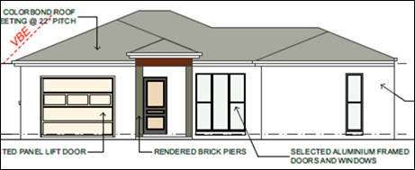
Figure 6 – Street elevation for Dwelling 6
It is considered that the building aesthetics at the street
frontage would be improved by inclusion of an additional vertical opening to
the main front building façade. A condition is recommended to this
effect.
Front elevation garages for Dwellings 6 and 7 will satisfy
the DCP guidelines in respect of design, siting and width. Garages for other
dwellings within the development will be located at the rear of the site and
will not present to Lily Place.
Heritage
The DCP sets the following Planning Outcomes in regard to
Heritage:
· heritage
buildings and structures are efficiently re-used
· new
development complements and enhances the significance of a heritage item or
place of heritage significance listed in the Orange Heritage Study
· significant
landscape features are retained including original period fences and period
gardens.
The subject land does not contain or adjoin a heritage item
and is not located within a heritage conservation area.
Setbacks
The DCP sets the following Planning Outcomes in regard to
Setbacks:
· street setbacks
contribute to the desired neighbourhood character, assist with the integration
of new development and make efficient use of the site
· street setbacks
create an appropriate scale for the street considering all other streetscape
components.
Proposed Dwellings 1, 6 and 7 will have frontage to the Lily
Place cul-de-sac. The dwellings will be sited 4.5m from the street frontage,
and complement the siting of the adjoining dwelling to the north-west at No. 7
Lily Place.
Single garages at the site frontage for Dwellings 6 and 7
will be sited 5.5m from the front boundary, and provide tandem car parking
wholly within the subject land.
It is proposed to locate the
shared waste storage facility for Dwellings 1-5 within the front setback for
Dwelling 6, adjacent to the shared driveway (refer below). While the bins will
be stored in the facility on collection days only, the bin bay is not
considered a suitable visual element within the streetscape. Furthermore, the
waste storage facility will utilise land that could provide additional site
landscaping and beautification. Conditions are recommended requiring relocation
of the storage facility behind the main front building line for
Dwellings 1 and 6, and additional landscaping, including an advanced tree
be provided in the Dwelling 6 front setback adjacent to the access driveway.

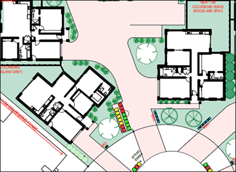
Figure 7 – Bin storage bay in front setback of
Dwelling 6
Front Fences and Walls
The DCP sets the following Planning Outcomes in regard to
Fences and Walls:
· Front fences
and walls:
- assist in
highlighting entrances and creating a sense of identity within the streetscape
- are
constructed of materials compatible with associated housing and with fences
visible from the site that positively contribute to the streetscape
- provide for
facilities in the street frontage area such as mail boxes.
The proposal does not involve the erection of front fencing
to Lily Place. Perimeter fencing to enclose the respective lots for proposed
Dwellings 1, 6 and 7 at the site frontage will not project forward of the main
front dwelling facades. The open front setbacks will complement those for
nearby dwellings in Lily Place.
Perimeter and internal fencing will be erected, and
generally comprise 1.8m high Colorbond panels, consistent with fencing on
adjoining residential parcels. TransGrid require a timber paling fence on the
common boundary with the public reserve. A condition is recommended to this
effect.
Visual Bulk
The DCP sets the following Planning Outcome in regard to
Visual Bulk:
· Built form
accords with the desired neighbourhood character of the area with:
- side and rear
setbacks progressively increased to reduce bulk and overshadowing
- site coverage
that retains the relatively low density landscaped character of residential
areas
- building form
and siting that relates to landform, with minimal land shaping (cut and fill)
- building
height at the street frontage that maintains a comparable scale with the
predominant adjacent development form
- building to
the boundary where appropriate.
The proposed dwellings will be single-storey, with
reasonable setbacks from side and rear boundaries. The dwellings will
complement the bulk and scale of dwellings nearby to the site in Aloe Vera
Place and Lily Place.
Dwellings adjacent to external site boundaries (Dwellings 4,
5, 6, 7, 8 and 15) will be contained within the DCP prescribed visual bulk
envelope plane.
The proposed dwellings will comprise a total building
footprint of 1961.69m2. Based on a site area of 5,271m2
the development will have site coverage of 37.2%, in compliance with the
maximum 50% prescribed for multi dwelling housing development.
The subject land falls towards Lily Place, with overall
cross fall in the order of 4m. Minor earthworks and land shaping will be
required for the establishment of the dwellings and private open spaces.
Retaining walls will be erected on the rear (east) and side (north) boundaries.
Finished levels will relate to natural ground level on this site and
neighbouring parcels, and be less than the DCP-prescribed 1.5m above
natural ground level. Visual bulk encroachment impacts are not anticipated for
adjoining dwellings.
Walls and Boundaries
The DCP sets the following Planning Outcome in regard to
Walls and Boundaries:
· Building to the
boundary is undertaken to provide for efficient use of the site taking into
account:
- the privacy of
neighbouring dwellings and private open space
- the access to
daylight reaching adjoining properties
- the impact of
boundary walls on neighbours.
The proposal does not involve the construction of buildings
on the boundary. As outlined in this report, the site layout and building
design will not impact on adjoining dwellings in respect of privacy, solar
access or visual bulk.
Daylight
and Sunlight
The DCP sets the following Planning Outcome in regard to
Daylight and Sunlight:
· Buildings are
sited and designed to ensure:
- daylight to
habitable rooms in adjacent dwellings is not significantly reduced
- overshadowing
of neighbouring secluded open spaces or main living area windows is not
significantly increased
- consideration
of Council’s Energy Efficiency Code.
Overshadowing of Private Open
Space
According to the DCP Guidelines, sunlight is to be available
to at least 40% of required open space for dwellings within the development and
those on adjoining lands for at least three hours between 9am and 3pm.
Shadow diagrams and a table of compliance (refer below) were
submitted in support of the proposal. Council officers concur that solar access
to private open space areas for Dwellings 1-15 will satisfy the DCP
requirements.
(over page)
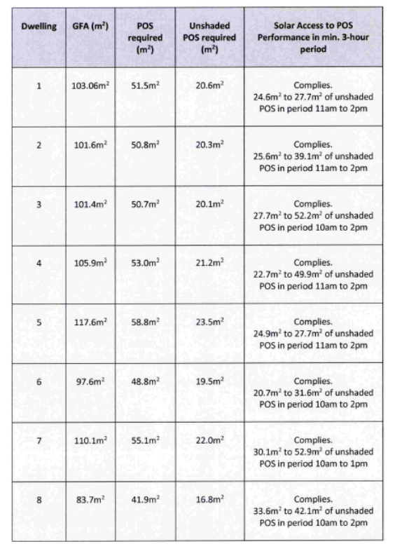
Figure 8 – On-ground solar access for Dwellings
1-8
(Source: Peter Basha Planning and Development)
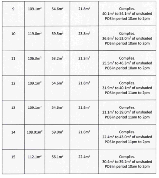
Figure 9 – On-ground solar access for Dwellings
9-15
(Source: Peter Basha Planning and Development)
The proposed dwellings will not overshadow private open space
areas for dwellings adjoining the site.
Overshadowing of Dwellings
According to the DCP Guidelines, sunlight to at
least 75% of north-facing living area windows within the development and
on adjoining land is to be provided for a minimum of 4 hours on 21 June; or not
further reduced than existing where already less.
Shadow diagrams and window shadow elevations were submitted
in support of the proposal. The drawings demonstrate that solar access to
northern windows for the proposed dwellings will satisfy the DCP requirements,
excepting Dwelling 7. Solar access to northern living room windows for Dwelling
7 exceed the required 75% at 10am, 11am, 12pm and 1pm. At 2pm, however,
sunlight to available to only 71.2% (refer below).
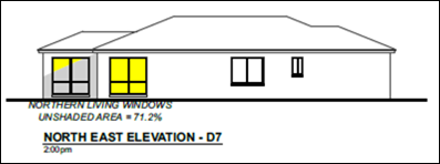
Figure 10 – 2pm window shadow elevation for
Dwelling 7
This is considered a minor variation on the DCP requirement,
and acceptable on the basis that solar access is otherwise generous throughout
the day.
The proposed dwellings will not affect north-facing living
room windows for any adjoining dwelling.
Views
The DCP sets the following Planning Outcomes in regard to
Views:
· building form
and design allow for residents from adjacent properties to share prominent
views where possible
· views including
vistas of heritage items or landmarks are not substantially affected by the
bulk and scale of the new development.
Based on proposed finished levels and building heights, the
proposed dwellings will not unreasonably diminish views to or from the Orange
Botanic Gardens. The proposed development will have acceptable visual impacts
within the view corridor formed by Hill Street, being compatible with the
neighbourhood built form in terms of design, massing and footprint.
Visual Privacy
The DCP sets the following Planning Outcome in regard to
Visual Privacy:
· Direct
overlooking of principal living areas and private open spaces of other
dwellings is minimised firstly by:
- building
siting and layout
- location of
windows and balconies
and
secondly by:
- design of
windows or use of screening devices and landscaping.
The proposed site layout and building design will provide
acceptable visual privacy for dwellings within the development and those on
adjoining parcels due to the following:
· living room
windows will overlook associated private open space areas
· there will be nil
– limited interface between living room windows and opposing open space
areas
· there will be nil
– modest interface between opposing private open space areas
· highlight windows
will be provided to living room windows adjoining internal vehicle areas or
entrances for opposing dwellings
· perimeter and
internal fencing will be installed
· front entrances
will be recessed
· finished floor
levels will relate to natural ground level
· site landscaping
will be installed
· the site layout
and building design will minimise the potential for overlooking from adjoining
dwellings. The orientation of living spaces, setbacks from boundaries, fencing
and landscaping will assist to maintain visual privacy.
Acoustic Privacy
The DCP sets the following Planning Outcome in regard to
Acoustic Privacy:
· Site layout and
building design:
- protect
habitable rooms from excessively high levels of external noise
- minimise the
entry of external noise to private open space for dwellings close to major
noise sources
- minimise
transmission of sound through a building to affect other dwellings.
The subject land has (rear) frontage to Hill Street. The
development is unlikely to be adversely affected by road noise, as the annual
average daily traffic volume along Hill Street does not exceed 40,000
vehicles (pursuant to SEPP Infrastructure 2007 and Development near Rail
Corridors and Busy Roads – Interim Guidelines (NSW Department of Planning
2008)). The subject land sits at a lower contour than the road formation and a
solid panel fence will be installed to the Hill Street frontage. This will
assist to reduce traffic noise. It is noted that noise attenuation measures
have not be installed to adjacent residential parcels with frontage to Hill Street.
The subject land is contained in a residential area, where
ambient noise levels are expected to be low. Excepting Dwellings 2 and 3, the
dwellings will be detached, thus limiting the potential for sound penetration
between them. Appropriate construction of Dwellings 2 and 3 will prevent noise
transfer between the dwellings.
Security
The DCP sets the following Planning Outcomes in regard to
Security:
· the site layout
enhances personal safety and minimises the potential for crime, vandalism and
fear
· the design of
dwellings enables residents to survey streets, communal areas and approaches to
dwelling entrances.
The proposal is considered acceptable
in in regard to safety and security as follows:
· the design of the
dwellings will offer reasonable opportunities for surveillance of Lily Place,
front yards and private open space areas
· the site has
reasonable access control due to internal garages and perimeter and internal
fencing
· the landscape
design will not restrict sight lines.
Circulation and Design
The DCP sets the following Planning Outcome in regard to
Circulation and Design:
· accessways and
parking areas are designed to manage stormwater
· accessways,
driveways and open parking areas are suitably landscaped to enhance amenity
while providing security and accessibility to residents and visitors
· the site layout
allows people with a disability to travel to and within the site between car
parks, buildings and communal open space.
Proposed Dwellings 6 and 7 will have direct frontage and
separate access to Lily Place. Reverse egress to the street will be
required for Dwellings 6 and 7, consistent with manoeuvring arrangements for
single dwellings throughout the City.
Access to proposed Dwellings 1-5
and Dwellings 8-15 will be via two shared private roadways from Lily Place. The
internal roadway will have a minimum formed width of 4.5m and accommodate
two-way passing of cars (B85 vehicles) within the site. Sufficient manoeuvring
area will be available within the internal roadway to permit a reverse
manoeuvre from garages, onsite turning and forward direction egress to
Lily Place. Furthermore, the proposed site layout will facilitate the
functional movement of a 6.4m service vehicle (Small Rigid Vehicle (SRV))
through the site (refer below).
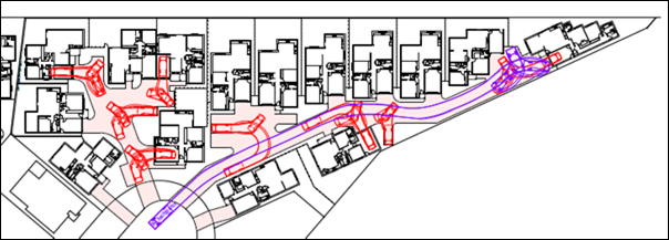
Figure 11 – Turn path analysis – B85 and
SRV
Landscaping of the common vehicle areas is proposed.
Additional plantings should be installed to provide softening of extensive
hardstand vehicle areas. A condition is recommended to this effect.
Car
Parking
The DCP sets the following Planning Outcomes in regard to
Car Parking:
· Parking
facilities are provided, designed and located to:
- enable the
efficient and convenient use of car spaces and access ways within the site
- reduce the
visual dominance of car parking areas and access ways.
· Car parking is
provided with regard to the:
- the number and
size of proposed dwellings
- requirements
of people with limited mobility or disabilities.
Pursuant to DCP 2004, onsite parking is required for two
bedroom dwellings at a rate of 1.2 spaces per dwelling; with visitor parking
required at a rate of 0.2 space per dwelling. Based on 15 dwellings, the
proposed development will require 21 car parking spaces.
Twenty-four (24) parking spaces will be provided for the
development, in compliance with the DCP as follows:
· Fifteen single
garages for each of Dwellings 1-15
· Four tandem spaces
adjacent to the single garages for Dwellings 4, 5, 6 and 7
· Five visitor
parking spaces.
Private Open Space
The DCP sets the following Planning Outcomes in regard to
Private Open Space:
Private open space is clearly defined for private use.
· Private open
space areas are of a size, shape and slope to suit the reasonable requirements
of residents including some outdoor recreational needs and service functions.
· Private open
space is:
- capable of
being an extension of the dwelling for outdoor living, entertainment and
recreation
- accessible
from a living area of the dwelling
- located to
take advantage of outlooks; and to reduce adverse impacts of overshadowing or
privacy from adjoining buildings
- orientated to
optimise year round use.
Private open space for the proposed multi dwelling housing
will comply with the DCP Guidelines in respect of minimum area, dimension,
orientation, solar access and connectivity:
· each of the
proposed dwellings are provided with open space that complies with the minimum
requirement in terms of area (ie. 50% of the gross floor area of the dwelling
· private open space
for each dwelling will have a minimum dimension of 3m
· the private yards
of Dwellings 1-15 can accommodate an area of 5m x 5m
· the nominated 5m x
5m open space areas will be of negligible slope and will achieve a high
standard of amenity and functionality
· open space for the
dwellings will be located behind the building line and be provided with a
northerly aspect
· as outlined
previously, the solar access to each area of private open space on the winter
solstice is considered satisfactory.
Open Space and Landscaping
The DCP sets the following Planning Outcomes in regard to
Open Space and Landscaping:
· the site layout
provides open space and landscaped areas which:
- contribute to
the character of the development by providing buildings in a landscaped setting
- provide for a
range of uses and activities including stormwater management
- allow cost
effective management.
· the landscape
design specifies landscape themes consistent with the desired neighbourhood
character; vegetation types and location, paving and lighting provided for
access and security.
· major existing
trees are retained and protected in a viable condition whenever practicable
through appropriate siting of buildings, access ways and parking areas.
· paving is
applied sparingly and integrated in the landscape design.
A landscape plan has been submitted in support of the
proposal. In order to provide improved integration of the dwellings in the
streetscape, softening of hardstand vehicle areas and internal privacy
screening, a condition is recommended requiring an amended landscape plan be
submitted and implemented.
Stormwater
The DCP sets the following Planning Outcomes in regard to
Stormwater:
· Onsite drainage
systems are designed to consider:
- downstream
capacity and need for on-site retention, detention and re-use
- scope for
onsite infiltration of water
- safety and
convenience of pedestrians and vehicles
- overland flow
paths.
· Provision is
made for onsite drainage which does not cause damage or nuisance flows to
adjoining properties.
Conditions are recommended in relation to stormwater
management (including stormwater detention) of the development.
Erosion
and Sedimentation
The DCP sets the following Planning Outcome in regard to
Erosion and Sedimentation:
· Measures
implemented during construction to ensure that the landform is stabilised and
erosion is controlled.
An erosion and sediment control plan will be required in
conjunction with the engineering design plans for the development. A condition
is recommended in relation to this matter.
DCP 2004-00 Transitional
Provisions – Orange Botanic Gardens
The subject land is partly shown hatched on the Scenic
Area Map 2 – Orange Botanic Gardens.

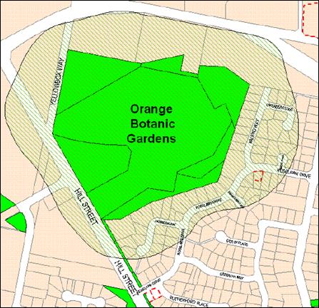
Figure 12 - DCP 2004 Scenic Area Map 2 – Orange
Botanic Gardens
The following planning outcomes are applicable to the
proposal:
· buildings are
located at a sufficient distance from the boundary of the Orange Botanic
Gardens to preserve public views of the Botanic Gardens
· building
heights do not unreasonably intrude on the landscape features and views from
the Orange Botanic Gardens.
· a view corridor
analysis that demonstrates the visual impacts of the proposal is provided for
any substantial building.
The proposal is not contrary to the
planning outcomes. The development site is removed from the Botanic Gardens by
some 40m, with the intervening area comprised of the Hill Street road
corridor and other residential development. The subject land is located at a
lower contour than the Gardens. Based on proposed finished levels and building
heights, the proposed dwellings will not intrude upon landscape features or
diminish views to or from the Botanic Gardens. The proposed dwellings are
compatible with the neighbourhood built form and appropriate in this setting.
DCP 2004-00 Transitional
Provisions – Transport Routes
Hill Street forms part of the City’s distributor road
network and is therefore considered a transport route. The following planning
outcomes apply:
· the development
provides a high standard of visual appeal to motorists, cyclists and
pedestrians as well as adjoining property owners
· the visual
appearance of the development… must not generate a distraction to
motorists
· any signage
must not be animated whether by movement or flashing lights
· where land has
more than one street frontage, the street with the lower volume of traffic is
to provide the principal access to the development, subject to safety
considerations
· where access is
provided onto an arterial road… the access point must point must have
appropriate safe sight distances for the prevailing speed limit and clear and
unimpeded entrance/exit signage must be displayed
· where onsite
customer parking is provided that is not immediately visible from a public
road, clear and unimpeded directional signage must be displayed
· where the
proposal is residential… appropriate noise mitigation measures to limit
the development from traffic noise must be demonstrated.
The proposal is not contrary to the planning outcomes. The
proposed dwellings are compatible with the neighbourhood built form in terms of
design and massing. The visual impacts of the development are consistent with
other residential development nearby to the site. There are no aspects of the
proposal that would generate a distraction to motorists. The proposal does not
involve advertising signage. Access to the land is not available via Hill
Street. Onsite visitor parking will be visible and accessible. As outlined
previously, the development is unlikely to be adversely affected by road noise,
based on road traffic volumes, site topography and solid fencing to Hill Street.
DEVELOPMENT CONTRIBUTIONS PLAN
2017
Development contributions are applicable to the proposed
staged development, pursuant to Orange Development Contributions Plan 2017
(North West Orange contributions area). Conditions are included on the attached
Notice of Approval requiring payment of contributions at the applicable stages.
Stage 1 - Construction of Dwellings 1-7
|
Open Space and Recreation
|
7 x 2 bedroom dwellings @ $2,230.68 less
1 x standard lot @ $3,907.24
|
11,707.52
|
|
Community and Cultural
|
7 x 2 bedroom dwellings @ $646.89 less
1 x standard lot @ $1,133.10
|
3,395.13
|
|
Roads and Traffic Management
|
7 x 2 bedroom dwellings @ $3,033.77 less
1 standard lot @ $5,157.43
|
16,078.96
|
|
Local Area Facilities
|
7 x 2 bedroom dwellings @ $3,623.66 less
1 standard lot @ $6,347.18
|
19,018.44
|
|
Plan Preparation & Administration
|
7 x 2 bedroom dwellings @ $283.37 less
1 standard lot @ $496.36
|
1,487.23
|
|
TOTAL:
|
7 x 2 bedroom dwellings @ $9,818.37 less
1 x standard lot @ $17,041.31
|
$51,687.28
|
Stage 2 - 4 lot Torrens Subdivision
|
Open Space and Recreation
|
1 x additional standard lot @ $3,907.24
|
3,907.24
|
|
Community and Cultural
|
1 x additional standard lot @ $1,133.10
|
1,133.10
|
|
Roads and Traffic Management
|
1 x additional standard lot @ $5,157.43
|
5,157.43
|
|
Local Area Facilities
|
1 x additional standard lot @ $6,347.18
|
6,347.18
|
|
Plan Preparation & Administration
|
1 x additional standard lot @ $496.36
|
496.36
|
|
TOTAL:
|
|
$17,041.34
|
Stage 3 – 6 lot Community
Subdivision to excise Dwellings 1-5 on separate lot
Development contributions are not
applicable to this stage. Contributions for Dwellings 1-5 were charged at Stage
1.
Stage 4 – Construction of Dwellings 8-15
|
Open Space and Recreation
|
8 x 2 bedroom dwellings @ $2,230.68 less
1 x standard lot @ $3,907.24
|
13,938.20
|
|
Community and Cultural
|
8 x 2 bedroom dwellings @ $646.89 less
1 x standard lot @ $1,133.10
|
4,042.02
|
|
Roads and Traffic Management
|
8 x 2 bedroom dwellings @ $3,033.77 less
1 standard lot @ $5,157.43
|
19,112.73
|
|
Local Area Facilities
|
8 x 2 bedroom dwellings @ $3,623.66 less
1 standard lot @ $6,347.18
|
22,642.10
|
|
Plan Preparation & Administration
|
8 x 2 bedroom dwellings @ $283.37 less
1 standard lot @ $496.36
|
1,770.60
|
|
TOTAL:
|
8 x 2 bedroom dwellings @ $9,818.37 less
1 x standard lot @ $17,041.31
|
$61,505.65
|
Stage 5 - 9 lot
Community subdivision to excise Dwellings 8-15 on separate lots
Development contributions are not
applicable to this stage. Contributions for Dwellings 8‑15 were charged
at Stage 4.
Section 64 Water and Sewer
Headworks Charges
Section 64 water and sewer headwork charges are applicable
to the proposed development. The contributions for water, sewer and drainage
works are collectively based on 15 additional ETs for water supply
headworks and 15 ETs for sewerage headworks, less two standard lots. Conditions
are recommended requiring payment of contributions prior to issue of a
Subdivision Certificate.
PROVISIONS PRESCRIBED BY THE
REGULATIONS s4.15(1)(a)(iv)
Demolition of a Building (clause 92)
The proposal does not involve the demolition of a building.
Fire Safety Considerations
(clause 93)
The proposal does not involve a change of building use for
an existing building.
Buildings to be Upgraded
(clause 94)
The proposal does not involve the rebuilding, alteration,
enlargement or extension of an existing building.
BASIX Commitments (clause 97A)
A BASIX assessment has been submitted in support of the
proposal. The proposed dwellings will satisfy the provisions of BASIX in
respect of water, thermal comfort and energy.
THE LIKELY IMPACTS OF THE DEVELOPMENT
s4.15(1)(b)
Neighbourhood Amenity
The proposal will provide and retain a reasonable standard
of residential amenity for the proposed dwellings and those on adjoining lands
in respect of solar access, privacy etc. The proposed development will provide
for a continuation of residential land use, albeit in a more compact form, and
will not alter the function of the neighbourhood. The development will not have
adverse impacts on neighbourhood amenity.
Visual Impacts
The visual impacts of the proposal are considered
acceptable, as outlined in the foregoing sections of this report. Conditions
are included on the attached Notice of Approval to improve the presentation of
the development to Lily Place, including additional landscaping, relocated bin
bay and additional openings to Dwelling 6 front façade.
Traffic Impacts
The proposal is considered to be satisfactory in terms of
traffic impacts. Traffic generation associated with the development will be in
the order of 60-75 daily vehicle trips, based on 4‑5 daily vehicle trips
for two bedroom dwellings (RTA Guide to Traffic Generating Development, Roads
and Traffic Authority 2002). Traffic associated with the development will have
peak morning and evening periods and be otherwise distributed throughout the
day. Council’s Development Engineer advises that the capacity of the
local road network is sufficient to accommodate traffic generated by the
development, and will not exceed environmental goals for peak volumes on local
streets.
As outlined previously, site
accesses and onsite manoeuvring areas are appropriate and will accommodate
standard and service vehicles associated with the development. Onsite car
parking will comply with the requirements of DCP 2004.
Cumulative Impacts
The proposal is considered to be satisfactory in terms of
cumulative impact. The proposed dwellings will complement the neighbourhood
built form in respect of bulk, form, design features and external finishes. The
proposed development will not reduce the open space, solar access or privacy
afforded to neighbouring properties. Similarly, the site layout and building
design will provide a reasonable standard of residential amenity for the
proposed dwellings in terms of open space, solar access and privacy. The
development will contribute to the diversity of housing forms in the precinct in a manner that is consistent with the neighbourhood
character.
Environmental Impacts
The subject land is contained within an established
residential precinct and comprises vacant, cleared land. Significant
vegetation, threatened species or ecological endangered communities or their
habitats are unlikely to be present. The site is not in proximity to any
waterway, drinking water catchment or sensitive area. Sediment control
measures, as required by conditions, will prevent loose dirt and sediment
escaping the site and polluting downstream waterways.
THE SUITABILITY OF THE SITE
s4.15(1)(c)
The subject land is suitable for the development due to the
following:
· the land is zoned
R1 General Residential. The proposal is permitted with consent
· the site is of
sufficient area and dimensions to accommodate multi dwelling housing and
provide a high standard of residential amenity
· the site has
direct frontage and access to Lily Place
· there is no known contamination
on the land
· all utility
services are available and adequate
· the site is not
subject to natural hazards
· the subject land
has no biodiversity or habitat value
· the site is not in
proximity to any waterway, drinking water catchment or sensitive area
· the site is not
known to contain any Aboriginal, European or archaeological relics.
ANY SUBMISSIONS MADE IN ACCORDANCE
WITH THE ACT s4.15(1)(d)
The proposed development is defined as "advertised
development" pursuant to DCP 2004-5.3. The application was advertised for
the prescribed period of 14 days and at the end of that period 3 submissions
were received. The issues raised in the submissions are outlined below and have
been considered in the foregoing sections of this report.
The proposal will generate additional localised traffic.
Comment: Council’s
Development Engineer advises that the local road network is of sufficient
capacity to accommodate additional traffic generated by the proposal.
The proposal comprises an
overdevelopment of the site.
Comment: The proposal satisfies
the applicable density provisions contained in DCP 2004.
The subject land contains
native vegetation regrowth.
Comment: The Biodiversity
Conservation Act 2016 does not contain provisions for the protection of native
regrowth. The native regrowth over the subject land is not considered to have
particular biodiversity value.
A lower density of development
would allow for additional site landscaping and thereby complement the scenic
values of the nearby Botanic Gardens
Comment: The proposal satisfies
the applicable density provisions contained in DCP 2004. Conditions are
recommended requiring additional site landscaping in order to provide site
beautification and integration of the development in the neighbourhood.
The proposal is contrary to the
aims of Orange LEP 2011.
Comment: The proposal is not
considered to be adverse to the aims of the LEP.
Stormwater discharge associated
with the development will adversely impact on adjoining properties.
Comment: The conditional stormwater
design for the development (incorporating stormwater detention) will not result
in adverse discharge impacts for downstream parcels.
On-street garbage collection
will be difficult in the cul-de-sac.
Comment: Bins will not be placed
on the kerb, with contractor collection from the onsite waste storage
facilities on a ‘run cost arrangement.’ Bins will be placed on the
bin storage facilities on collection days only, and otherwise stored with
dwellings in respective Torrens or Community lots.
Inadequate parking will be
provided for residents and visitors.
Comment: Car parking will be
provided for the development consistent with the provisions of DCP 2004.
The proposal is inconsistent with
the neighbourhood character in terms of density.
Comment: The subject
land is considered well-located for a more intensive form of residential
development. The surrounding road formations and public reserve provide the
development site with a physical and spatial separation for adjoining
residential lands. Multi- dwelling housing is a permitted and complementary
land use in the zone. The development is sited and designed to reasonably
integrate in this setting, without adversely impacting on the neighbourhood
character or function.
Traffic along Hill Street will
have adverse acoustic impacts for residents within the development.
Comment: The development is
unlikely to be adversely affected by road noise, as the annual average daily
traffic volume along Hill Street does not exceed the prescribed maximum of
40,000 vehicles.
The development should not be
extended into the public reserve.
Comment: The proposal does not
involve extension of the land into the public reserve. This triangular portion
is contained within the development site, and was purchased by the proponent in
2017.
The development site should be
fenced.
Comment: Conditions are
recommended requiring perimeter fencing of the subject land. Notably, TransGrid
have required timber paling fencing to the common boundary with the public
reserve/transmission line easement.
PUBLIC INTEREST
s4.15(1)(e)
The proposal is not inconsistent with any relevant policy
statements, planning studies, guidelines etc that have not been considered in
this assessment.
SUMMARY
The proposed development is permissible with the consent of
Council. The proposed development complies with the relevant aims, objectives
and provisions of Orange LEP 2011 (as amended) and DCP 2004. A
Section 4.15 assessment of the development indicates that the development
is acceptable in this instance. Attached is a draft Notice of Approval
outlining a range of conditions considered appropriate to ensure that the
development proceeds in an acceptable manner.
COMMENTS
The requirements of the Environmental Health and Building
Surveyor and the Engineering Development Section are included in the attached
Notice of Approval.
Attachments
1 Notice
of Approval, D18/33041⇩
2 Plans,
D18/32817⇩
3 Submissions,
D18/32946⇩
Planning and Development Committee
3 July 2018
2.5 Development
Application DA 138/2018(1) - Lot 211 Lily Place
Attachment 1 Notice
of Approval
|

|
ORANGE CITY COUNCIL
Development
Application No DA
138/2018(1)
NA18/
Container PR27649
|
NOTICE OF DETERMINATION
OF A DEVELOPMENT
APPLICATION
issued under the Environmental
Planning and Assessment Act 1979
Section 4.18
|
Development
Application
|
|
|
Applicant
Name:
|
Mr I Zhang
|
|
Applicant
Address:
|
C/- Peter Basha
Planning & Development
PO Box 1827
ORANGE
NSW 2800
|
|
Owner’s
Name:
|
Dinkum Exporting and
Importing Pty Limited
|
|
Land
to Be Developed:
|
Lot 211 DP 1229307 -
Lily Place, Orange
|
|
Proposed
Development:
|
Multi Dwelling
Housing (15 dwellings), Subdivision (2 Torrens lots, 6 Community Lots
and 9 Community lots)
|
|
|
|
|
Building Code of
Australia
building
classification:
|
As determined by
Certifier
|
|
|
|
|
Determination made
under
Section 4.16
|
|
|
Made
On:
|
3 July 2018
|
|
Determination:
|
CONSENT GRANTED
SUBJECT TO CONDITIONS DESCRIBED BELOW:
|
|
|
|
|
Consent to Operate
From:
|
4 July 2018
|
|
Consent to Lapse On:
|
4 July 2023
|
Terms
of Approval
The reasons for the imposition of conditions
are:
(1) To ensure a quality
urban design for the development which complements the surrounding environment.
(2) To maintain
neighbourhood amenity and character.
(3) To ensure compliance
with relevant statutory requirements.
(4) To provide adequate
public health and safety measures.
(5) Because the development
will require the provision of, or increase the demand for, public amenities and
services.
(6) To ensure the utility
services are available to the site and adequate for the development.
(7) To prevent the proposed
development having a detrimental effect on adjoining land uses.
(8) To minimise the impact
of development on the environment.
Conditions
(1) The development must be
carried out in accordance with:
(a) Plans by Peter Basha
Planning and Development Ref. 18003DA Sheets 3-8, dated 17.04.2018
(6 sheets). Plans by Designs@M, Job No. 17-154, Drawing Nos. 1-31
(31 sheets)
(b) statements
of environmental effects or other similar associated documents that form part
of the approval
as amended in
accordance with any conditions of this consent.
(2) All building work must
be carried out in accordance with the provisions of the Building Code of
Australia.
(3) A sign is to be erected
in a prominent position on any site on which building work, subdivision work or
demolition work is being carried out:
(a) showing
the name, address and telephone number of the principal certifying authority
for the work, and
(b) showing
the name of the principal contractor (if any) for any building work and a
telephone number on which that person may be contacted outside working hours,
and
(c) stating
that unauthorised entry to the site is prohibited.
Any such sign is to be maintained while the
building work, subdivision work or demolition work is being carried out.
(4) In
the case of residential building work for which the Home Building Act 1989
requires there to be a contract of insurance in force in accordance with Part 6
of the Act, evidence that such a contract of insurance is in force is to be
provided to the Principal Certifying Authority before any building work
authorised to be carried out by the consent commences.
(5) Residential
building work within the meaning of the Home Building Act 1989 must not
be carried out unless the principal certifying authority for the development to
which the work relates (not being the council) has given the council written
notice of the following information:
(a) in
the case of work for which a principal contractor is required to be appointed:
(i) the
name and the licence number of the principal contractor, and
(ii) the
name of the insurer by which the work is insured under Part 6 of that Act,
(b) in
the case of work to be done by an owner-builder:
(i) the
name of the owner-builder, and
(ii) if
the owner-builder is required to hold an owner-builder permit under that Act,
the number of the owner-builder permit.
If arrangements for doing the residential
building work are changed while the work is in progress so that the information
under this condition becomes out of date, further work must not be carried out
unless the principal certifying authority for the development to which the work
relates (not being the council) has given the council written notice of the
updated information.
(6) Where any excavation
work on the site extends below the level of the base of the footings of a
building on adjoining land, the person having the benefit of the development
consent must, at the person’s own expense:
(a) protect
and support the adjoining premises from possible damage from the excavation,
and
(b) where
necessary, underpin the adjoining premises to prevent any such damage.
Note: This
condition does not apply if the person having the benefit of the development
consent owns the adjoining land or the owner of the adjoining land has given
consent in writing to this condition not applying.
STAGE 1 - CONSTRUCTION OF DWELLINGS 1-7
|
PRIOR TO THE ISSUE OF A CONSTRUCTION
CERTIFICATE
|
(7) The payment of
$51,687.28 is to be made to Council in accordance with Section 7.11 of the Act
and the Orange Development Contributions Plan 2017 (North West Contributions
Area) towards the provision of the following public facilities:
|
Open Space and Recreation
|
7 x 2 bedroom dwellings @ $2,230.68 less
1 x standard lot @ $3,907.24
|
11,707.52
|
|
Community and Cultural
|
7 x 2 bedroom dwellings @ $646.89 less
1 x standard lot @ $1,133.10
|
3,395.13
|
|
Roads and Traffic Management
|
7 x 2 bedroom dwellings @ $3,033.77 less
1 standard lot @ $5,157.43
|
16,078.96
|
|
Local Area Facilities
|
7 x 2 bedroom dwellings @ $3,623.66 less
1 standard lot @ $6,347.18
|
19,018.44
|
|
Plan Preparation & Administration
|
7 x 2 bedroom dwellings @ $283.37 less
1 standard lot @ $496.36
|
1,487.23
|
|
TOTAL:
|
7 x 2 bedroom dwellings @ $9,818.37 less
1 x standard lot @ $17,041.31
|
$51,687.28
|
The contribution will be indexed quarterly in
accordance with the Orange Development Contributions Plan 2017 (North West
Contributions Area). This Plan can be inspected at the Orange Civic Centre,
Byng Street, Orange.
(8) Prior to issue of a
Construction Certificate, an amended landscape plan shall be submitted to
Council for approval. The plan shall incorporate:
· border plantings to
both shared access driveways, forward of the front facades for Dwellings 1, 6
and 7
· garden beds adjacent to
the main front dwellings facades for Dwellings 1, 6 and 7
· a small tree in the
front setback for Dwelling 6 in the location of the removed waste storage
facility
· tall hedges to internal
fences adjacent to visitor parking spaces
· garden beds at the
frontage of Dwellings 10, 11 and 12.
(9) The following revised
opening for Dwelling 6 shall be reflected in the Construction Certificate
plans:
· A full length vertical
window to the Bed 1 WIR on the south elevation, of consistent dimensions with
the full length window in the adjacent ensuite.
(10) The waste storage
facility (bin bay) for proposed Dwellings 1-5 shall be relocated behind the
main front building line for Dwellings 1 and 6. The relocated facility
shall be to the satisfaction of the Manager of Development Assessments
and shall be shown on the Construction Certificate plans.
(11) An
approval under Section 68 of the Local Government Act is to be sought
from Orange City Council, as the Water and Sewer Authority, for alterations to
water and sewer. No plumbing and drainage is to commence until approval is
granted.
(12) Engineering plans,
showing details of all proposed work and adhering to any engineering conditions
of development consent, are to be submitted to, and approved by, Orange City
Council or an Accredited Certifier (Categories B1, C3, C4, C6) prior to the
issuing of a Construction Certificate.
(13) A water and soil
erosion control plan is to be submitted to Orange City Council or an Accredited
Certifier (Categories B1, C3, C4, C6) for approval prior to the issuing of a
Construction Certificate. The control plan is to be in accordance with the
Orange City Council Development and Subdivision Code and the Landcom, Managing
Urban Stormwater; Soils and Construction Handbook.
(14) The development’s
stormwater design is to include stormwater detention within the development,
designed to limit peak outflows from the land to the pre-existing natural
outflows up to the 100 year ARI frequency, with sufficient allowance in
overflow spillway design capacity to safely pass flows of lower frequency (that
is, a rarer event) without damage to downstream developments. Where
appropriate, the spillway design capacity is to be determined in accordance
with the requirements of the Dam Safety Committee.
The design of the detention storage is to be
undertaken using the ILSAX/DRAINS rainfall-runoff hydrologic model or an
approved equivalent capable of assessing runoff volumes and their temporal
distribution as well as peak flow rates. The model is to be used to calculate
the flow rates for the existing and post-development conditions. The developed
flows are to be routed through the proposed storage within the model so that
the outflows obtained are no greater than the flows obtained for the
pre-existing natural flows. A report detailing the results of the analysis,
which includes:
· catchment plan showing
sub-catchments under existing and developed conditions
· schematic diagram of
the catchment model showing sub areas and linkages
· tabulation detailing
the elevation, storage volume and discharge relationships
· tabulation for the
range of frequencies analysed, the inflows, outflows and peak storage levels
for both existing and developed conditions
together with copies of the data files for the
model and engineering design plans of the required drainage system are to be
submitted to Orange City Council upon application for a Construction
Certificate.
(15) Engineering plans
providing complete details of the proposed driveway and car parking areas are
to be submitted to Orange City Council or an Accredited Certifier (Categories
B1, C3, C4, C6) upon application for a Construction Certificate. These plans
are to provide details of levels, cross falls of all pavements, proposed
sealing materials and proposed drainage works and are to be in accordance with
Orange City Council Development and Subdivision Code.
(16) Proposed Dwellings 1 to
7 are to be provided with interlot stormwater drainage, including those lots
abutting public land, where the surface of the entire lot cannot be drained to
the kerb and gutter at the lot frontage. A grated concrete stormwater pit is to
be constructed within each lot provided with interlot stormwater drainage.
Engineering plans for this drainage system are to be approved by Orange City
Council or an Accredited Certifier (Categories B1, C3, C4, C6) prior to the
issuing of a Construction Certificate.
(17) A 150mm-diameter sewer
main is to be constructed from Council’s existing main to serve the
proposed Lots 103 and 104. A sewer manhole and 150mm junction shall be
constructed to serve proposed Lot 103. Prior to a Construction Certificate
being issued engineering plans for this sewerage system are to be submitted to
and approved by Orange City Council.
Internal sewer lines servicing dwellings on
proposed Lots 102 and 103 shall be constructed as private sewer lines. Prior to
a Construction Certificate being issued plans for this sewerage system are to
be submitted to and approved by Orange City Council.
(18) Payment of
contributions for water, sewer and drainage works is required to be made
at the contribution rate applicable at the time that the payment is made.
The contributions are based on water supply headworks, sewerage headworks and
stormwater for 7 x two bedroom dwellings (the existing Lot 211 has a credit for
a single 3 bedroom dwelling which will be applied at the time of payment). A
Certificate of Compliance, from Orange City Council in accordance with the Water
Management Act 2000, will be issued upon payment of the contributions.
This Certificate of Compliance is to be
submitted to the Principal Certifying Authority prior to the issuing of a
Construction Certificate.
(19) Water services are to be
located in the common driveway area. Engineering plans of the water
reticulation layout and sizing are to be submitted to Orange City Council for
approval prior to the issuing of a Construction Certificate.
(20) Dwelling 7 is to be
located 1.0m clear of the boundary and the western wall is to be piered to a depth of 2.0m. The
piering is to be designed and certified by a structural engineer. Plans for
this work are
to be submitted to Orange City Council prior to the issuing of a Construction
Certificate.
|
PRIOR TO WORKS COMMENCING
|
(21) A
Construction Certificate application is required to be submitted to, and issued
by Council/Accredited Certifier prior to any excavation or building works being
carried out onsite.
(22) A
temporary onsite toilet is to be provided and must remain throughout the
project or until an alternative facility meeting Council’s requirements
is available onsite.
(23) The
location and depth of the sewer junction/connection to Council’s sewerage
system is to be determined to ensure that adequate fall to the sewer is
available.
(24) Soil
erosion control measures shall be implemented on the site.
|
DURING CONSTRUCTION/SITEWORKS
|
(25) All services (water,
sewer and stormwater) shall be laid outside the easement unless there is a
direct connection to the main within that easement.
(26) All
construction/demolition work on the site is to be carried out between the hours
of 7.00 am and 6.00 pm Monday to Friday inclusive, 7.00 am to
5.00 pm Saturdays and 8.00 am to 5.00 pm Sundays and Public
Holidays. Written approval must be obtained from the General Manager of Orange
City Council to vary these hours.
(27) All materials on site
or being delivered to the site are to be contained within the site. The
requirements of the Protection of the Environment Operations Act 1997
are to be complied with when placing/stockpiling loose material or when
disposing of waste products or during any other activities likely to pollute
drains or watercourses.
(28) No portion of the
building - including footings, eaves, overhang and service pipes - shall
encroach into any easement.
(29) Any adjustments to
existing utility services that are made necessary by this development proceeding
are to be at the full cost of the developer.
(30) The provisions and
requirements of the Orange City Council Development and Subdivision Code are to
be applied to this application and all work constructed within the development
is to be in accordance with that Code.
The developer is to be entirely responsible for
the provision of water, sewerage and drainage facilities capable of servicing
the development from Council’s existing infrastructure. The developer is
to be responsible for gaining access over adjoining land for services where
necessary and easements are to be created about all water, sewer and drainage
mains within and outside the lots they serve.
(31) All driveway and
parking areas are to be sealed with bitumen, hot mix or concrete and are to be
designed for all expected loading conditions (provided however that the minimum
pavement depth for gravel and flush seal roadways is 200mm) and be in
accordance with the Orange City Council Development and Subdivision Code.
(32) Dual water and sewerage
reticulation is to be provided to every dwelling in accordance with the Orange
City Council Development and Subdivision Code.
|
PRIOR TO THE ISSUE OF AN OCCUPATION
CERTIFICATE
|
(33) A 1.8m high fence shall
be provided around the perimeter of the development excluding the frontage. A
1.5m high fence shall be provided between each unit. The height of the fence
shall be measured from the highest finished ground level adjacent to each part
of that fence.
(34) Landscaping
adjacent Dwellings 1-7 shall be installed in accordance with the amended
approved landscaping plan and shall be permanently maintained to the
satisfaction of Council's Manager Development Assessments.
(35) No
person is to use or occupy the building or alteration that is the subject of
this approval without the prior issuing of an Occupation Certificate.
(36) Finished
ground levels are to be graded away from the buildings and adjoining properties
and must achieve natural drainage. The concentrated flows are to be dispersed
down slope or collected and discharged to the stormwater drainage system.
(37) Where
Orange City Council is not the Principal Certifying Authority, a final
inspection of water connection, sewer and stormwater drainage shall be
undertaken by Orange City Council and a Final Notice of Inspection issued,
prior to the issue of either an interim or a final Occupation Certificate.
(38) A Certificate of
Compliance, from a Qualified Engineer, stating that the stormwater detention
basin complies with the approved engineering plans is to be submitted to the
Principal Certifying Authority prior to the issuing of an Occupation
Certificate.
(39) Certification from
Orange City Council is required to be submitted to the Principal Certifying
Authority prior to the issue of an Occupation Certificate stating that all
works relating to connection of the development to Council assets, works on
public land, works on public roads, stormwater, sewer and water reticulation
mains and footpaths have been carried out in accordance with the Orange City
Council Development and Subdivision Code and the foregoing conditions, and that
Council will take ownership of the infrastructure assets.
(40) All
of the foregoing conditions are to be at the full cost of the developer and to
the requirements and standards of the Orange City Council Development and
Subdivision Code, unless specifically stated otherwise. All work required by
the foregoing conditions is to be completed prior to the issuing of an
Occupation or Subdivision Certificate, unless stated otherwise.
STAGE 2 - FOUR LOT SUBDIVISION
|
DURING CONSTRUCTION/SITEWORKS
|
(41) Any adjustments to
existing utility services that are made necessary by this development
proceeding are to be at the full cost of the developer.
|
PRIOR TO THE ISSUE OF A SUBDIVISION
CERTIFICATE
|
(42) The payment of
$17,041.34 is to be made to Council in accordance with Section 7.11 of the Act
and the Orange Development Contributions Plan 2017 (North West Contributions
Area) towards the provision of the following public facilities:
|
Open Space and Recreation
|
1 x additional standard lot @ $3,907.24
|
3,907.24
|
|
Community and Cultural
|
1 x additional standard lot @ $1,133.10
|
1,133.10
|
|
Roads and Traffic Management
|
1 x additional standard lot @ $5,157.43
|
5,157.43
|
|
Local Area Facilities
|
1 x additional standard lot @ $6,347.18
|
6,347.18
|
|
Plan Preparation & Administration
|
1 x additional standard lot @ $496.36
|
496.36
|
|
TOTAL:
|
|
$17,041.34
|
The contribution will be indexed quarterly in
accordance with the Orange Development Contributions Plan 2017 (North West
Contributions Area). This Plan can be inspected at the Orange Civic Centre,
Byng Street, Orange.
(43) Prior to the issuing of
the Subdivision Certificate, a Surveyor’s Certificate or written
statement is to be provided to the Principal Certifying Authority, stating that
the buildings within the boundaries of the proposed Lots comply in respect to
the distances of walls from boundaries.
(44) Application
shall be made for a Subdivision Certificate under Section 109(C)(1)(d) of the
Act.
(45) Payment
of contributions for water, sewer and drainage works is required to be made
at the contribution rate applicable at the time that the payment is made.
The contributions are based on 1.0 ETs for water supply headworks and 1.0 ETs
for sewerage headworks. A Certificate of Compliance, from Orange City
Council in accordance with the Water Management Act 2000, will be issued
upon payment of the contributions.
This Certificate of Compliance is to be
submitted to the Principal Certifying Authority prior to the issuing of a
Subdivision Certificate.
(46) Application is to be
made to Telstra/NBN for infrastructure to be made available to each individual
lot within the development. Either a Telecommunications Infrastructure
Provisioning Confirmation or Certificate of Practical Completion is to be
submitted to the Principal Certifying Authority confirming that the specified
lots have been declared ready for service prior to the issue of a Subdivision
Certificate.
(47) A Notice of Arrangement
from Essential Energy stating arrangements have been made for the provision of
electricity supply to the development, is to be submitted to the Principal
Certifying Authority prior to the issue of a Subdivision Certificate.
(48) A
Restriction-as-to-User under section 88B of the NSW Conveyancing Act is
to be registered on the Deed of Title on all lots where vehicular access is to
be denied to Hill Street.
(49) An easement to drain
sewage and to provide Council access for maintenance of sewerage works a
minimum of 2.0 metres wide is to be created over the proposed sewerage works.
The Principal Certifying Authority is to certify that the easement is in
accordance with the Orange City Council Development and Subdivision Code prior
to the issuing of a Subdivision Certificate.
(50) All services are to be
contained within the allotment that they serve. A Statement of Compliance, from
a Registered Surveyor, is to be submitted to the Principal Certifying Authority
prior to the issuing of a Subdivision Certificate.
(51) All engineering
conditions of development consent as required by the approved engineering plans
as it relates to the servicing of the development are to be completed prior to
the issuing of a Subdivision Certificate.
(52) Where stormwater
crosses land outside the lot it favours, an easement to drain water is to be
created over the works. A Restriction-as-to-User under section 88B of the NSW
Conveyancing Act 1979 is to be created on the title of the proposed Lot
requiring that no structures are to be placed on the site, or landscaping or
site works carried out on the site, in a manner that affects the continued
operation of the interlot drainage system. The minimum width of the easement is
to be as required in the Orange City Council Development and Subdivision Code.
(53) An easement for water
supply and to provide Council access for maintenance a minimum of 2.0 metres
wide is to be created over the existing trunk water main. The Principal
Certifying Authority is to certify that the easement is in accordance with the
Orange City Council Development and Subdivision Code prior to the issuing of a
Subdivision Certificate.
(54) Certification from
Orange City Council is required to be submitted to the Principal Certifying
Authority prior to the issue of a Subdivision Certificate stating that all
works relating to connection of the development to Council assets, works on
public land, works on public roads, stormwater, sewer and water reticulation
mains and footpaths have been carried out in accordance with the Orange City
Council Development and Subdivision Code and the foregoing conditions, and that
Council will take ownership of the infrastructure assets.
(55) All
of the foregoing conditions are to be at the full cost of the developer and to
the requirements and standards of the Orange City Council Development and
Subdivision Code, unless specifically stated otherwise. All work required by
the foregoing conditions is to be completed prior to the issuing of an
Occupation or Subdivision Certificate, unless stated otherwise.
STAGE 3 - COMMUNITY TITLE SUBDIVISION
|
DURING CONSTRUCTION/SITEWORKS
|
(56) Any adjustments to
existing utility services that are made necessary by this development
proceeding are to be at the full cost of the developer.
|
PRIOR TO THE ISSUE OF A SUBDIVISION
CERTIFICATE
|
(57) A Surveyor’s
Certificate or written statement is to be provided to the Principal Certifying
Authority, stating that the buildings within the boundaries of proposed Lots
comply in respect of the distances of walls from boundaries and the common wall
construction prior to the issuing of the Subdivision Certificate.
(58) Application
shall be made for a Subdivision Certificate shall be made in accordance with
the requirements of the Environmental Planning and Assessment Act and
associated Regulations.
(59) Application is to be
made to Telstra/NBN for infrastructure to be made available to each individual
lot within the development. Either a Telecommunications Infrastructure
Provisioning Confirmation or Certificate of Practical Completion is to be
submitted to the Principal Certifying Authority confirming that the specified
lots have been declared ready for service prior to the issue of a Subdivision
Certificate.
(60) A Notice of Arrangement
from Essential Energy stating arrangements have been made for the provision of
electricity supply to the development, is to be submitted to the Principal
Certifying Authority prior to the issue of a Subdivision Certificate.
(61) All services are to be
contained within the allotment that they serve. A Statement of Compliance, from
a Registered Surveyor, is to be submitted to the Principal Certifying Authority
prior to the issuing of a Subdivision Certificate.
(62) All engineering
conditions of development consent as required by the approved engineering plans
as it relates to the servicing of the lots are to be completed prior to the
issuing of a Subdivision Certificate.
(63) Certification from
Orange City Council is required to be submitted to the Principal Certifying
Authority prior to the issue of a Subdivision Certificate stating that all
works relating to connection of the development to Council assets, works on
public land, works on public roads, stormwater, sewer and water reticulation
mains and footpaths have been carried out in accordance with the Orange City
Council Development and Subdivision Code and the foregoing conditions, and that
Council will take ownership of the infrastructure assets.
(64) All
of the foregoing conditions are to be at the full cost of the developer and to
the requirements and standards of the Orange City Council Development and
Subdivision Code, unless specifically stated otherwise. All work required by
the foregoing conditions is to be completed prior to the issuing of an
Occupation or Subdivision Certificate, unless stated otherwise.
STAGE 4 - CONSTRUCTION OF DWELLINGS 8-15
|
PRIOR TO THE ISSUE OF A CONSTRUCTION
CERTIFICATE
|
(65) Dwellings 8 and 15 are
to be located 1.0m clear of the boundary and their western wall is to be piered
to a depth
of 2.0m. The piering is to be designed and certified by a structural engineer.
Plans for this work are
to be submitted to Orange City Council prior to the issuing of a Construction
Certificate.
(66) The payment of
$61,505.65 is to be made to Council in accordance with Section 7.11 of the Act
and the Orange Development Contributions Plan 2017 (North West Contributions
Area) towards the provision of the following public facilities:
|
Open Space and Recreation
|
8 x 2 bedroom dwellings @ $2,230.68 less
1 x standard lot @ $3,907.24
|
13,938.20
|
|
Community and Cultural
|
8 x 2 bedroom dwellings @ $646.89 less
1 x standard lot @ $1,133.10
|
4,042.02
|
|
Roads and Traffic Management
|
8 x 2 bedroom dwellings @ $3,033.77 less
1 standard lot @ $5,157.43
|
19,112.73
|
|
Local Area Facilities
|
8 x 2 bedroom dwellings @ $3,623.66 less
1 standard lot @ $6,347.18
|
22,642.10
|
|
Plan Preparation & Administration
|
8 x 2 bedroom dwellings @ $283.37 less
1 standard lot @ $496.36
|
1,770.60
|
|
TOTAL:
|
8 x 2 bedroom dwellings @ $9,818.37 less
1 x standard lot @ $17,041.31
|
$61,505.65
|
The contribution will be indexed quarterly in
accordance with the Orange Development Contributions Plan 2017 (North West
Contributions Area). This Plan can be inspected at the Orange Civic Centre,
Byng Street, Orange.
(67) An
approval under Section 68 of the Local Government Act is to be sought
from Orange City Council, 68as the Water and Sewer Authority, for water, sewer
and stormwater connection. No plumbing and drainage is to commence until
approval is granted.
(68) Prior to the issue of a
Construction Certificate evidence shall be provided to the Principal
Certifying Authority that
proposed Lot 103 has been registered with NSW Land and Property Information.
(69) Payment of
contributions for water, sewer and drainage works is required to be made
at the contribution rate applicable at the time that the payment is made.
The contributions are based on water supply headworks, sewerage headworks and
stormwater for 8 x two bedroom dwellings (proposed Lot 103, upon registration,
will have a credit for a single 3 bedroom dwelling which will be applied at the
time of payment). A Certificate of Compliance, from Orange City Council
in accordance with the Water Management Act 2000, will be issued upon
payment of the contributions.
This Certificate of Compliance is to be
submitted to the Principal Certifying Authority prior to the issuing of a
Construction Certificate.
(70) The development’s
stormwater design is to include stormwater detention within the development,
designed to limit peak outflows from the land to the pre-existing natural
outflows up to the 100 year ARI frequency, with sufficient allowance in
overflow spillway design capacity to safely pass flows of lower frequency (that
is, a rarer event) without damage to downstream developments. Where
appropriate, the spillway design capacity is to be determined in accordance
with the requirements of the Dam Safety Committee.
The design of the detention storage is to be
undertaken using the ILSAX/DRAINS rainfall-runoff hydrologic model or an
approved equivalent capable of assessing runoff volumes and their temporal
distribution as well as peak flow rates. The model is to be used to calculate
the flow rates for the existing and post-development conditions. The developed
flows are to be routed through the proposed storage within the model so that
the outflows obtained are no greater than the flows obtained for the
pre-existing natural flows. A report detailing the results of the analysis,
which includes:
· catchment plan showing
sub-catchments under existing and developed conditions;
· schematic diagram of
the catchment model showing sub areas and linkages;
· tabulation detailing
the elevation, storage volume and discharge relationships; and
· tabulation for the
range of frequencies analysed, the inflows, outflows and peak storage levels
for both existing and developed conditions;
together with copies of the data files for the
model and engineering design plans of the required drainage system are to be
submitted to Orange City Council upon application for a Construction
Certificate.
(71) A water and soil
erosion control plan is to be submitted to Orange City Council or an Accredited
Certifier (Categories B1, C3, C4, C6) for approval prior to the issuing of a Construction
Certificate. The control plan is to be in accordance with the Orange City
Council Development and Subdivision Code and the Landcom, Managing Urban
Stormwater; Soils and Construction Handbook.
(72) Engineering plans
providing complete details of the proposed driveway and car parking areas are
to be submitted to Orange City Council or an Accredited Certifier (Categories
B1, C3, C4, C6) upon application for a Construction Certificate. These plans
are to provide details of levels, cross falls of all pavements, proposed
sealing materials, structural engineer’s details of the driveway
indicating compliance with the NSW Fire Brigades Guidelines for Emergency
Vehicle Access, proposed drainage works, and are to be in accordance with
Orange City Council Development and Subdivision Code. The driveway within the
battle-axe handle shall be a minimum clear width of 4.5m and designed in
accordance with NSW Fire Brigades Guidelines for Emergency Vehicle Access.
(73) Proposed Dwellings 8 to
15 are to be provided with interlot stormwater drainage, including those lots
abutting public land, where the surface of the entire lot cannot be drained to
the kerb and gutter at the lot frontage. A grated concrete stormwater pit is to
be constructed within each lot provided with interlot stormwater drainage.
Engineering plans for this drainage system are to be approved by Orange City
Council or an Accredited Certifier (Categories B1, C3, C4, C6) prior to the
issuing of a Construction Certificate.
(74) Internal sewer lines servicing
dwellings on proposed Lot 103 shall be constructed as private sewer lines.
Prior to a Construction Certificate being issued plans for this sewerage system
are to be submitted to and approved by Orange City Council.
(75) Plans detailing
compliance with NSW Fire and Rescue – Fire Hydrants for Minor
Residential Development and NSW Fire and Rescue – Guidelines for
Emergency Vehicle Access is to be submitted to the Principal Certifying Authority
prior to the issuing of a Construction Certificate.
(76) Water services are to be
located in the common driveway area. Engineering plans of the water
reticulation layout and sizing are to be submitted to Orange City Council for
approval prior to the issuing of a Construction Certificate.
|
PRIOR TO WORKS COMMENCING
|
(77) A
Construction Certificate application is required to be submitted to, and issued
by Council/Accredited Certifier prior to any excavation or building works being
carried out onsite.
(78) A
temporary onsite toilet is to be provided and must remain throughout the
project or until an alternative facility meeting Council’s requirements
is available onsite.
(79) The
location and depth of the sewer junction/connection to Council’s sewerage
system is to be determined to ensure that adequate fall to the sewer is
available.
(80) Soil
erosion control measures shall be implemented on the site.
|
DURING CONSTRUCTION/SITEWORKS
|
(81) All
construction/demolition work on the site is to be carried out between the hours
of 7.00 am and 6.00 pm Monday to Friday inclusive, 7.00 am to
5.00 pm Saturdays and 8.00 am to 5.00 pm Sundays and Public
Holidays. Written approval must be obtained from the General Manager of Orange
City Council to vary these hours.
(82) All materials on site
or being delivered to the site are to be contained within the site. The
requirements of the Protection of the Environment Operations Act 1997
are to be complied with when placing/stockpiling loose material or when
disposing of waste products or during any other activities likely to pollute
drains or watercourses.
(83) No portion of the
building - including footings, eaves, overhang and service pipes - shall
encroach into any easement.
(84) All services (water,
sewer and stormwater) shall be laid outside the easement unless there is a
direct connection to the main within that easement.
(85) Any adjustments to
existing utility services that are made necessary by this development
proceeding are to be at the full cost of the developer.
(86) The provisions and
requirements of the Orange City Council Development and Subdivision Code are to
be applied to this application and all work constructed within the development
is to be in accordance with that Code.
The developer is to be entirely responsible for
the provision of water, sewerage and drainage facilities capable of servicing
all the lots from Council’s existing infrastructure. The developer is to
be responsible for gaining access over adjoining land for services where
necessary and easements are to be created about all water, sewer and drainage
mains within and outside the lots they serve.
(87) Dual water and sewerage
reticulation is to be provided to every dwelling in accordance with the Orange
City Council Development and Subdivision Code.
|
PRIOR TO THE ISSUE OF AN OCCUPATION CERTIFICATE
|
(88) A 1.8m high fence shall
be provided around the perimeter of the development excluding the frontage. A
1.5m high fence shall be provided between each unit. The height of the fence
shall be measured from the highest finished ground level adjacent to each part
of that fence.
(89) No
person is to use or occupy the building or alteration that is the subject of
this approval without the prior issuing of an Occupation Certificate.
(90) Finished
ground levels are to be graded away from the buildings and adjoining properties
and must achieve natural drainage. The concentrated flows are to be dispersed
down slope or collected and discharged to the stormwater drainage system.
(91) Where
Orange City Council is not the Principal Certifying Authority, a final
inspection of water connection, sewer and stormwater drainage shall be
undertaken by Orange City Council and a compliance certificate issued, prior to
the issue of either an interim or a final Occupation Certificate.
(92) The cut and fill is to
be retained and/or adequately battered and stabilised (within the allotment)
prior to the issue of an Occupation Certificate.
(93) A Certificate of
Compliance, from a Qualified Engineer, stating that the stormwater detention
basin complies with the approved engineering plans is to be submitted to the
Principal Certifying Authority prior to the issuing of an Occupation
Certificate.
(94) Certification from
Orange City Council is required to be submitted to the Principal Certifying
Authority prior to the issue of an Occupation Certificate stating that all
works relating to connection of the development to Council assets, works on
public land, works on public roads, stormwater, sewer and water reticulation
mains and footpaths have been carried out in accordance with the Orange City
Council Development and Subdivision Code and the foregoing conditions, and that
Council will take ownership of the infrastructure assets.
(95) Landscaping
adjacent Dwellings 8-15 shall be installed in accordance with the amended
approved landscaping plan and shall be permanently maintained to the
satisfaction of Council's Manager Development Assessments.
STAGE 5 – COMMUNITY TITLE
SUBDIVISION (9 lots)
DURING
CONSTRUCTION/SITEWORKS
(96) Any adjustments to
existing utility services that are made necessary by this development
proceeding are to be at the full cost of the developer.
|
PRIOR TO THE ISSUE OF A SUBDIVISION
CERTIFICATE
|
(97) A Surveyor’s
Certificate or written statement is to be provided to the Principal Certifying
Authority, stating that the buildings within the boundaries of proposed Lots
comply in respect of the distances of walls from boundaries and the common wall
construction prior to the issuing of the Subdivision Certificate.
(98) All
of the foregoing conditions are to be at the full cost of the developer and to
the requirements and standards of the Orange City Council Development and
Subdivision Code, unless specifically stated otherwise. All work required by
the foregoing conditions is to be completed prior to the issuing of an
Occupation or Subdivision Certificate, unless stated otherwise.
(99) Application shall be
made for a Subdivision Certificate under Section 6.3(1)(d) of the Act.
(100) Application is to be
made to Telstra/NBN for infrastructure to be made available to each individual
lot within the development. Either a Telecommunications Infrastructure
Provisioning Confirmation or Certificate of Practical Completion is to be
submitted to the Principal Certifying Authority confirming that the specified
lots have been declared ready for service prior to the issue of a Subdivision
Certificate.
(101) A Notice of Arrangement
from Essential Energy stating arrangements have been made for the provision of
electricity supply to the development, is to be submitted to the Principal
Certifying Authority prior to the issue of a Subdivision Certificate.
(102) All services are to be
contained within the allotment that they serve. A Statement of Compliance, from
a Registered Surveyor, is to be submitted to the Principal Certifying Authority
prior to the issuing of a Subdivision Certificate.
(103) All engineering
conditions of development consent as required by the approved engineering plans
as it relates to the servicing of the lots are to be completed prior to the
issuing of a Subdivision Certificate.
(104) Certification from
Orange City Council is required to be submitted to the Principal Certifying
Authority prior to the issue of a Subdivision Certificate stating that all
works relating to connection of the development to Council assets, works on
public land, works on public roads, stormwater, sewer and water reticulation
mains and footpaths have been carried out in accordance with the Orange City
Council Development and Subdivision Code and the foregoing conditions, and that
Council will take ownership of the infrastructure assets.
REQUIREMENTS OF
TRANSGRID
(1) TransGrid Conditions of
Approval:
1. TransGrid
notes the proposed Colourbond fence adjacent to TransGrid’s easement
corridor will now be constructed of timber materials only.
2. The only
underground service connections that will be required in the easement will be
inter-allotment stormwater for Dwellings 7 and 8. This will involve PVC pipes
and concrete pits. Buried services shall not come within 20m of the structure
and buried services on the easement should be non-metallic.
3. The section
of the site that is within the TransGrid easement is only the private open
space for Dwellings 7 and 8. Please note the area within TransGrid’s
Easement corridor will be subject to restrictions as per TransGrid’s
Easement Guidelines (attached).
4. Proposed
works must follow the Work Near Overhead Power Lines Code of Practice 2006 and
TransGrid’s Easement Guidelines for Third Party Development (V10)
(attached).
5. Any trees
and/or vegetation proposed to be planted within the easement are not to exceed
the 4M mature height limit and must not impede on access to the structure.
These should also not be planted within 30M of the structure.
6. Safe
Approach distance must be maintained when working near overhead power lines as
per Work Near Overhead Power Lines Code of Practice 2006.
7. Mobile
plant is required to be earthed when operated within the easement.
8. Please
ensure access to TransGrid’s infrastructure and easement corridor is
maintained at all times.
9. Please
advise TransGrid formally of any amendments or modifications to the proposed
work.
Other
Approvals
(1) Local
Government Act 1993 approvals granted under Section 68.
Nil
(2) General
terms of other approvals integrated as part of this consent.
Nil
Right
of Appeal
If you are dissatisfied with this decision,
Section 8.7 of the Environmental Planning and Assessment Act 1979
gives you the right to appeal to the Land and Environment Court. Pursuant to
Section 8.10, an applicant may only appeal within 6 months after the date the
decision is notified.
|
Disability
Discrimination Act 1992:
|
This application has been assessed in
accordance with the Environmental Planning and Assessment Act 1979. No
guarantee is given that the proposal complies with the Disability
Discrimination Act 1992.
The applicant/owner is responsible to ensure
compliance with this and other anti-discrimination legislation.
The Disability Discrimination Act
covers disabilities not catered for in the minimum standards called up in the
Building Code of Australia which references AS1428.1 - "Design for
Access and Mobility". AS1428 Parts 2, 3 and 4 provides the most
comprehensive technical guidance under the Disability Discrimination Act
currently available in Australia.
|
|
|
|
|
Disclaimer
- S88B of the Conveyancing Act 1919 - Restrictions on the Use of Land:
|
The applicant should note that there could be
covenants in favour of persons other than Council restricting what may be
built or done upon the subject land. The applicant is advised to check the
position before commencing any work.
|
|
|
|
|
Signed:
|
On behalf of the consent authority ORANGE
CITY COUNCIL
|
|
Signature:
|
|
|
Name:
|
PAUL JOHNSTON - MANAGER DEVELOPMENT
ASSESSMENTS
|
|
Date:
|
4 July 2018
|
Planning
and Development Committee
3 July 2018
2.5 Development
Application DA 138/2018(1) - Lot 211 Lily Place
Attachment 2 Plans
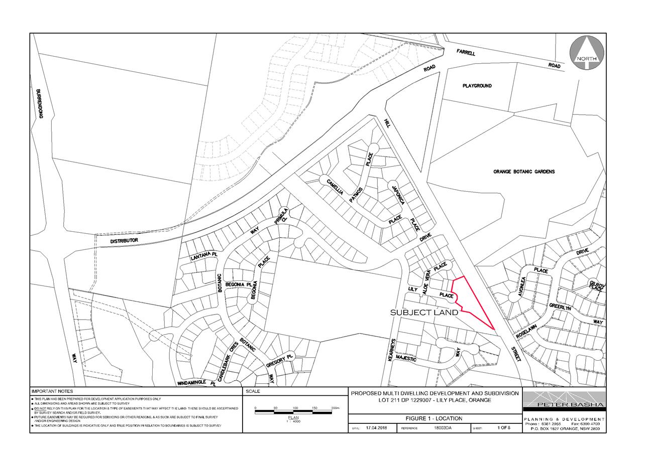
Planning and Development Committee
3 July 2018
2.5 Development
Application DA 138/2018(1) - Lot 211 Lily Place
Attachment 2 Plans
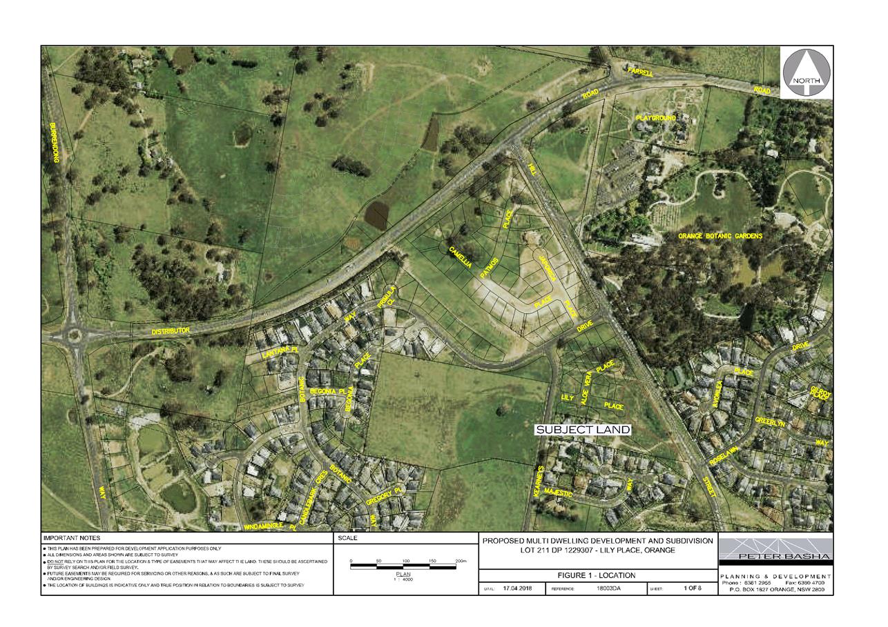
Planning and Development Committee
3 July 2018
2.5 Development
Application DA 138/2018(1) - Lot 211 Lily Place
Attachment 2 Plans
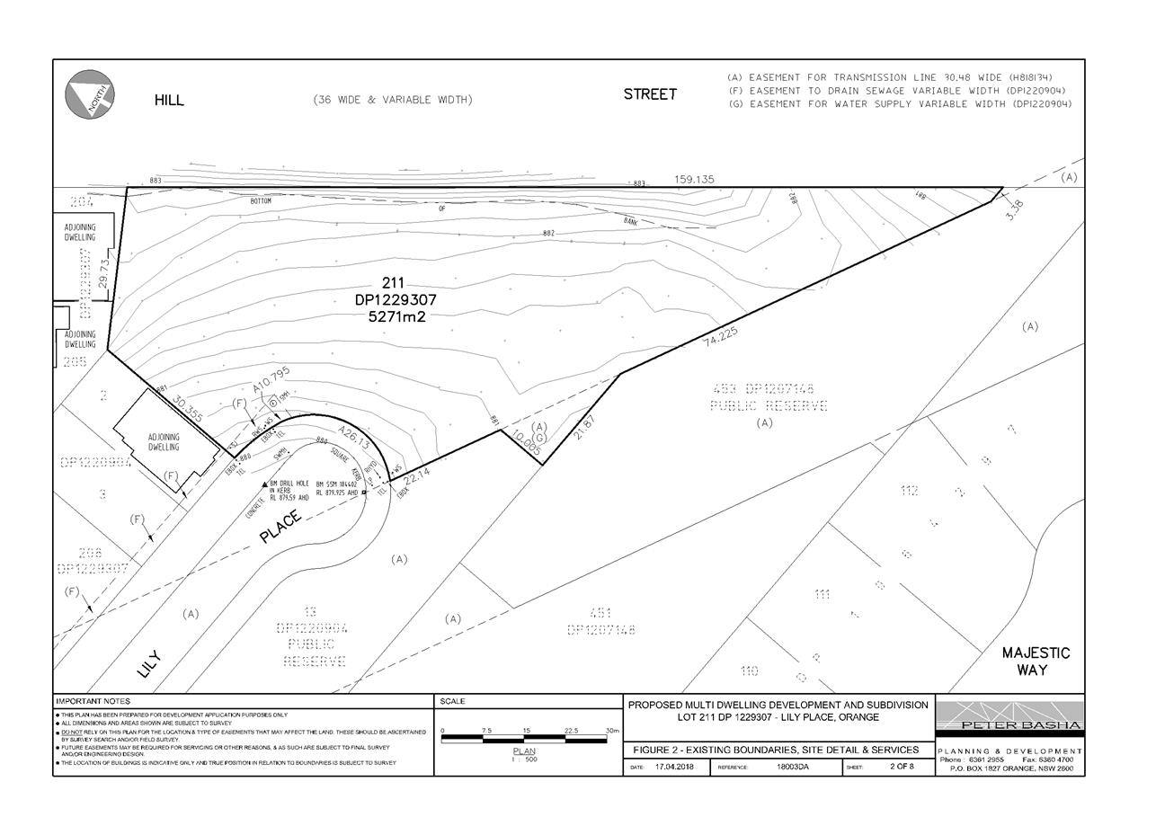
Planning and Development Committee
3 July 2018
2.5 Development
Application DA 138/2018(1) - Lot 211 Lily Place
Attachment 2 Plans
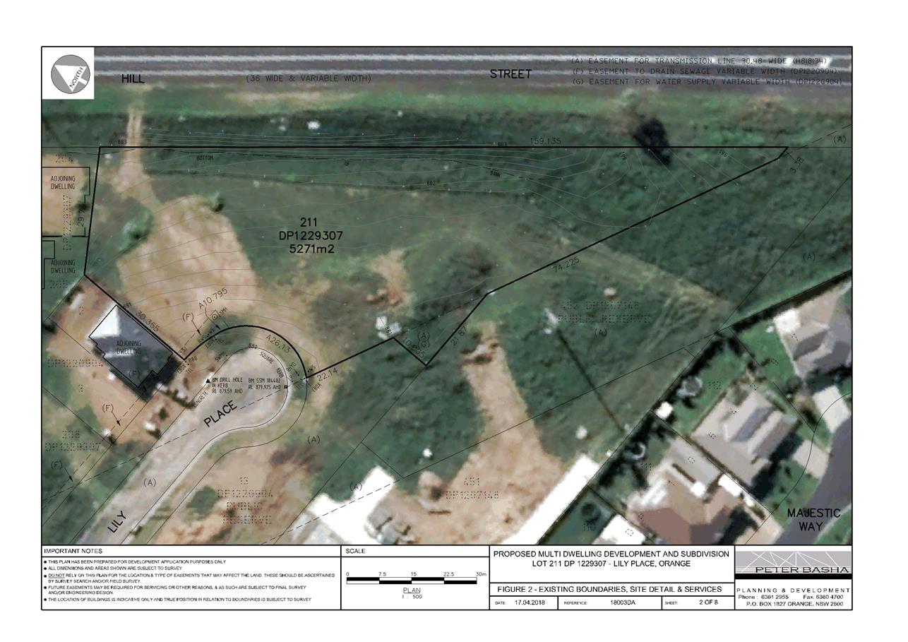
Planning and Development Committee
3 July 2018
2.5 Development
Application DA 138/2018(1) - Lot 211 Lily Place
Attachment 2 Plans
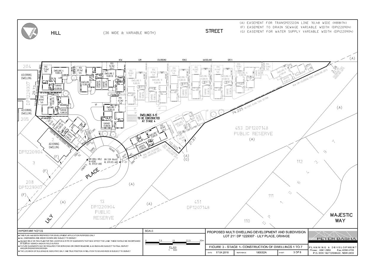
Planning and Development Committee
3 July 2018
2.5 Development
Application DA 138/2018(1) - Lot 211 Lily Place
Attachment 2 Plans
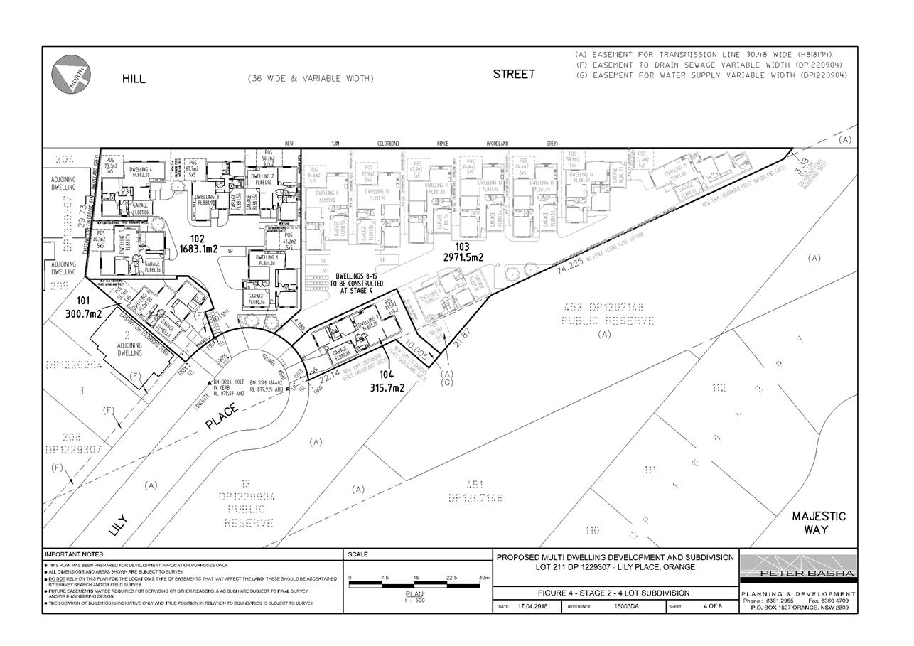
Planning and Development Committee
3 July 2018
2.5 Development
Application DA 138/2018(1) - Lot 211 Lily Place
Attachment 2 Plans
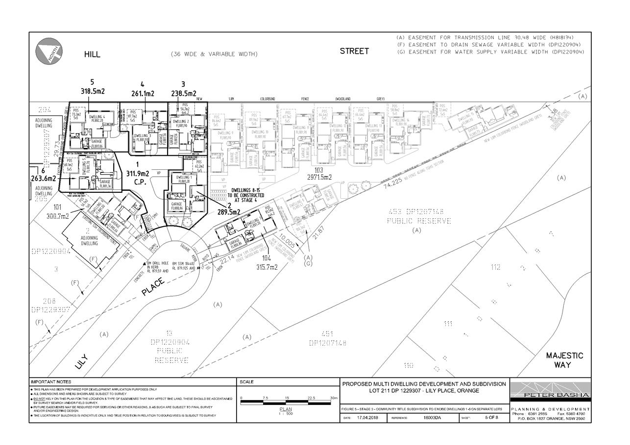
Planning and Development Committee
3 July 2018
2.5 Development
Application DA 138/2018(1) - Lot 211 Lily Place
Attachment 2 Plans
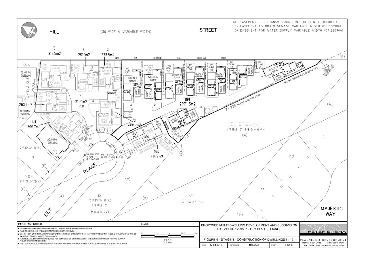
Planning and Development Committee
3 July 2018
2.5 Development
Application DA 138/2018(1) - Lot 211 Lily Place
Attachment 2 Plans
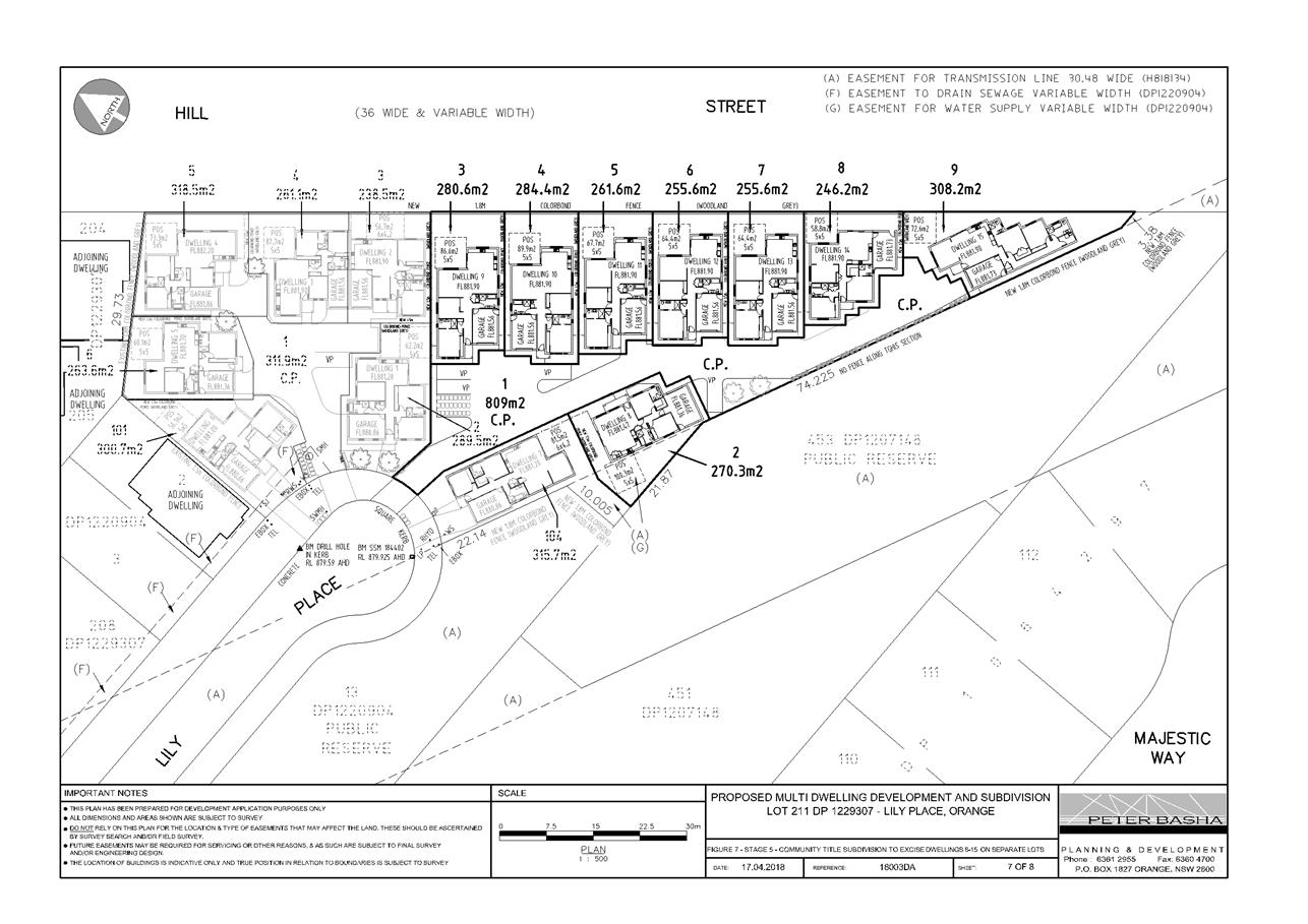
Planning and Development Committee
3 July 2018
2.5 Development
Application DA 138/2018(1) - Lot 211 Lily Place
Attachment 2 Plans
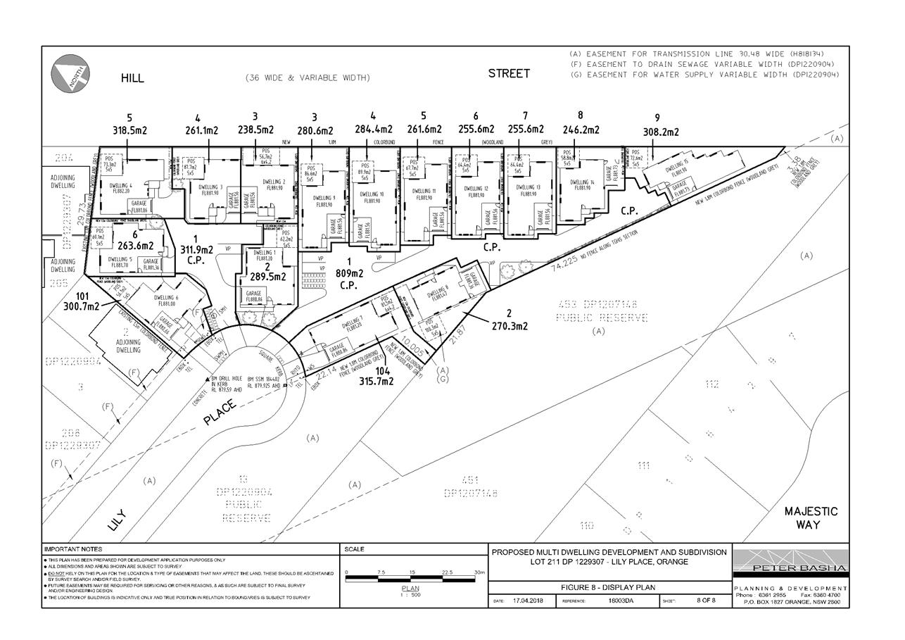
Planning and Development Committee
3 July 2018
2.5 Development
Application DA 138/2018(1) - Lot 211 Lily Place
Attachment 2 Plans
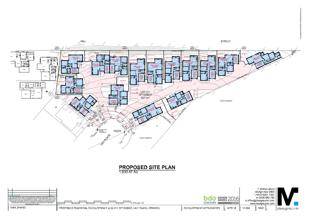
Planning and Development Committee
3 July 2018
2.5 Development
Application DA 138/2018(1) - Lot 211 Lily Place
Attachment 2 Plans
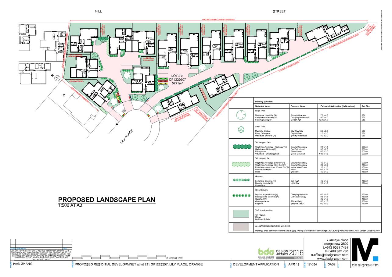
Planning and Development Committee
3 July 2018
2.5 Development
Application DA 138/2018(1) - Lot 211 Lily Place
Attachment 2 Plans
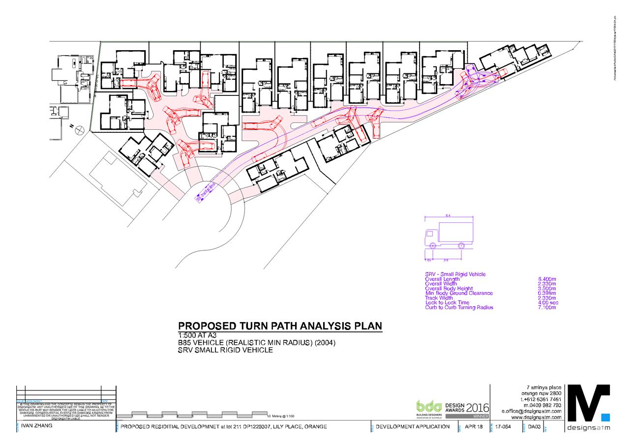
Planning and Development Committee
3 July 2018
2.5 Development
Application DA 138/2018(1) - Lot 211 Lily Place
Attachment 2 Plans
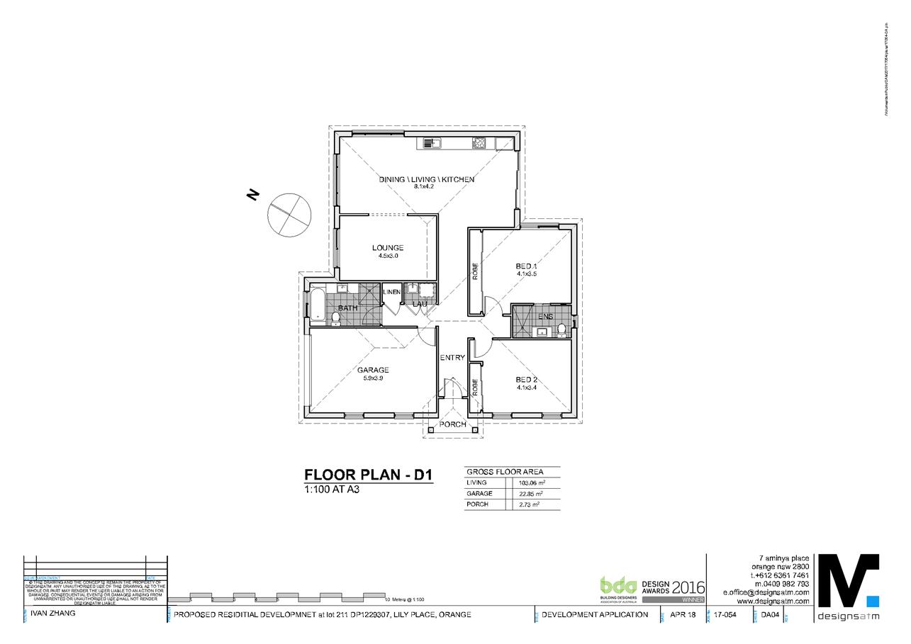
Planning and Development Committee
3 July 2018
2.5 Development
Application DA 138/2018(1) - Lot 211 Lily Place
Attachment 2 Plans
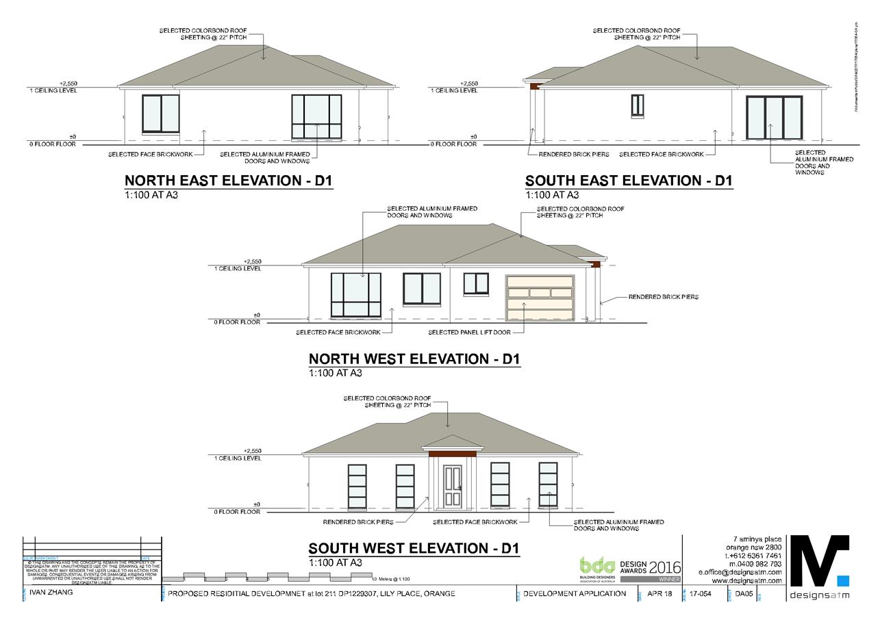
Planning and Development Committee
3 July 2018
2.5 Development
Application DA 138/2018(1) - Lot 211 Lily Place
Attachment 2 Plans
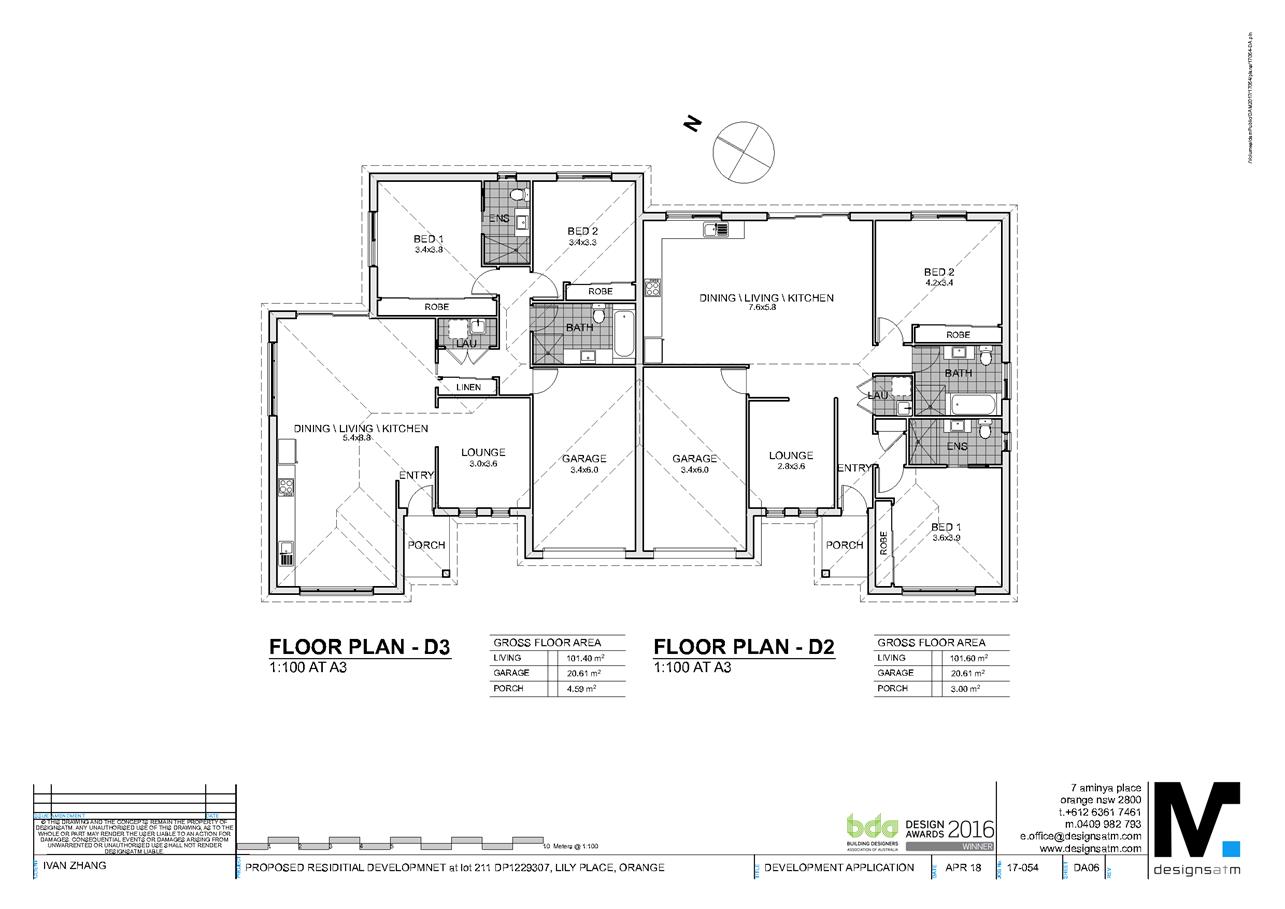
Planning and Development Committee
3 July 2018
2.5 Development
Application DA 138/2018(1) - Lot 211 Lily Place
Attachment 2 Plans
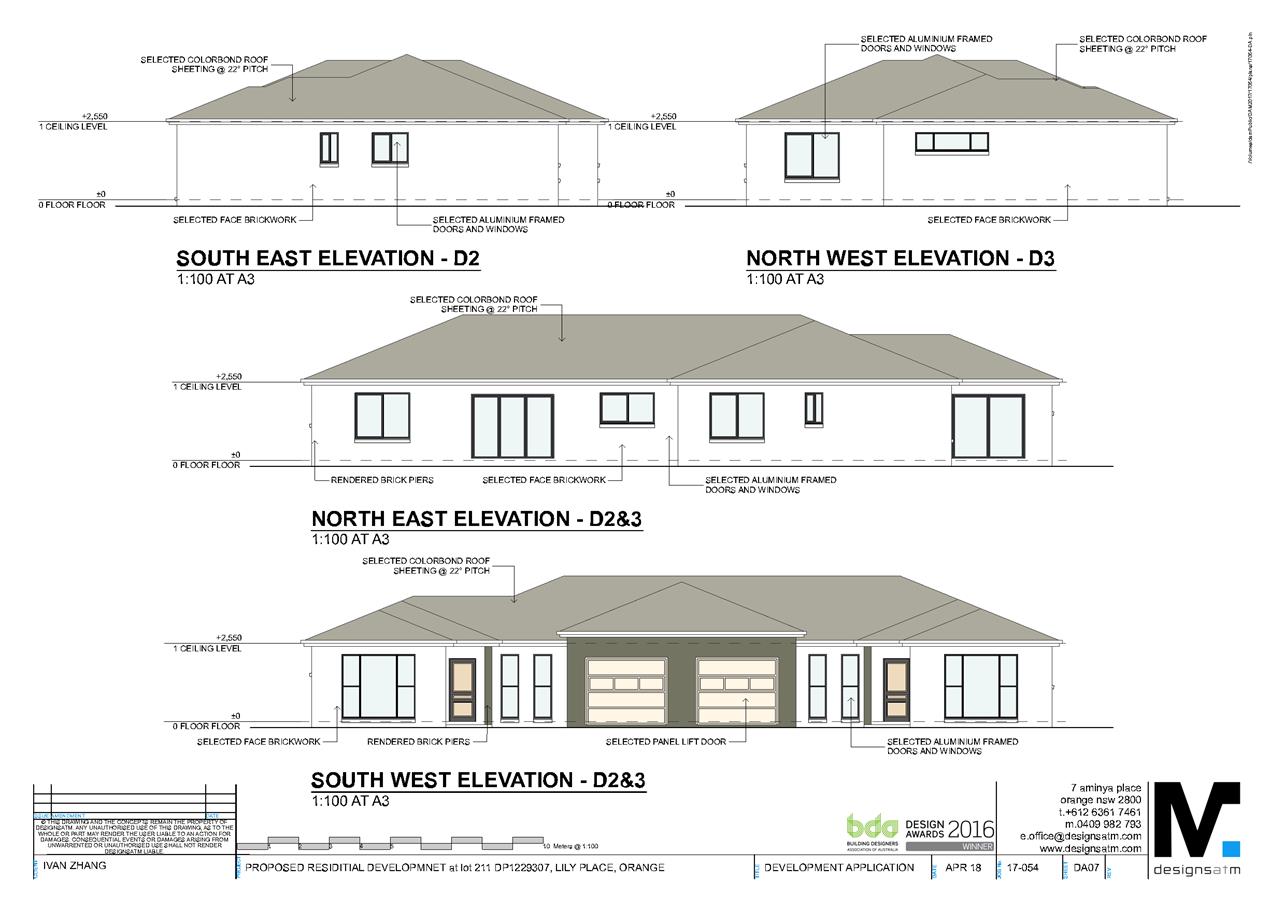
Planning and Development Committee
3 July 2018
2.5 Development
Application DA 138/2018(1) - Lot 211 Lily Place
Attachment 2 Plans
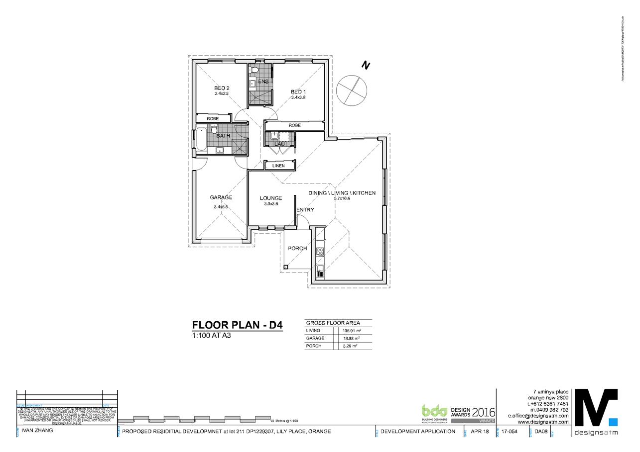
Planning and Development Committee
3 July 2018
2.5 Development
Application DA 138/2018(1) - Lot 211 Lily Place
Attachment 2 Plans
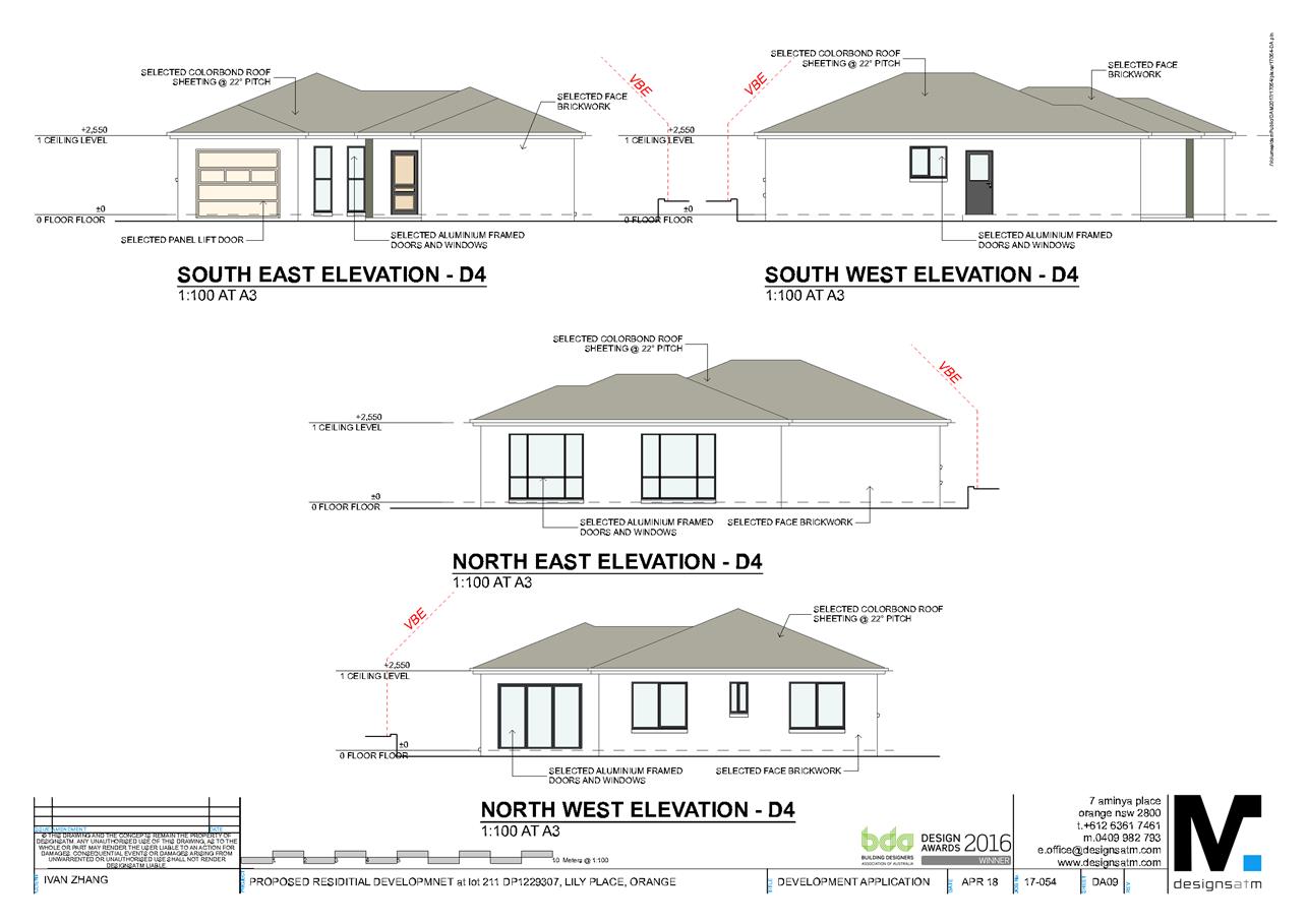
Planning and Development Committee
3 July 2018
2.5 Development
Application DA 138/2018(1) - Lot 211 Lily Place
Attachment 2 Plans
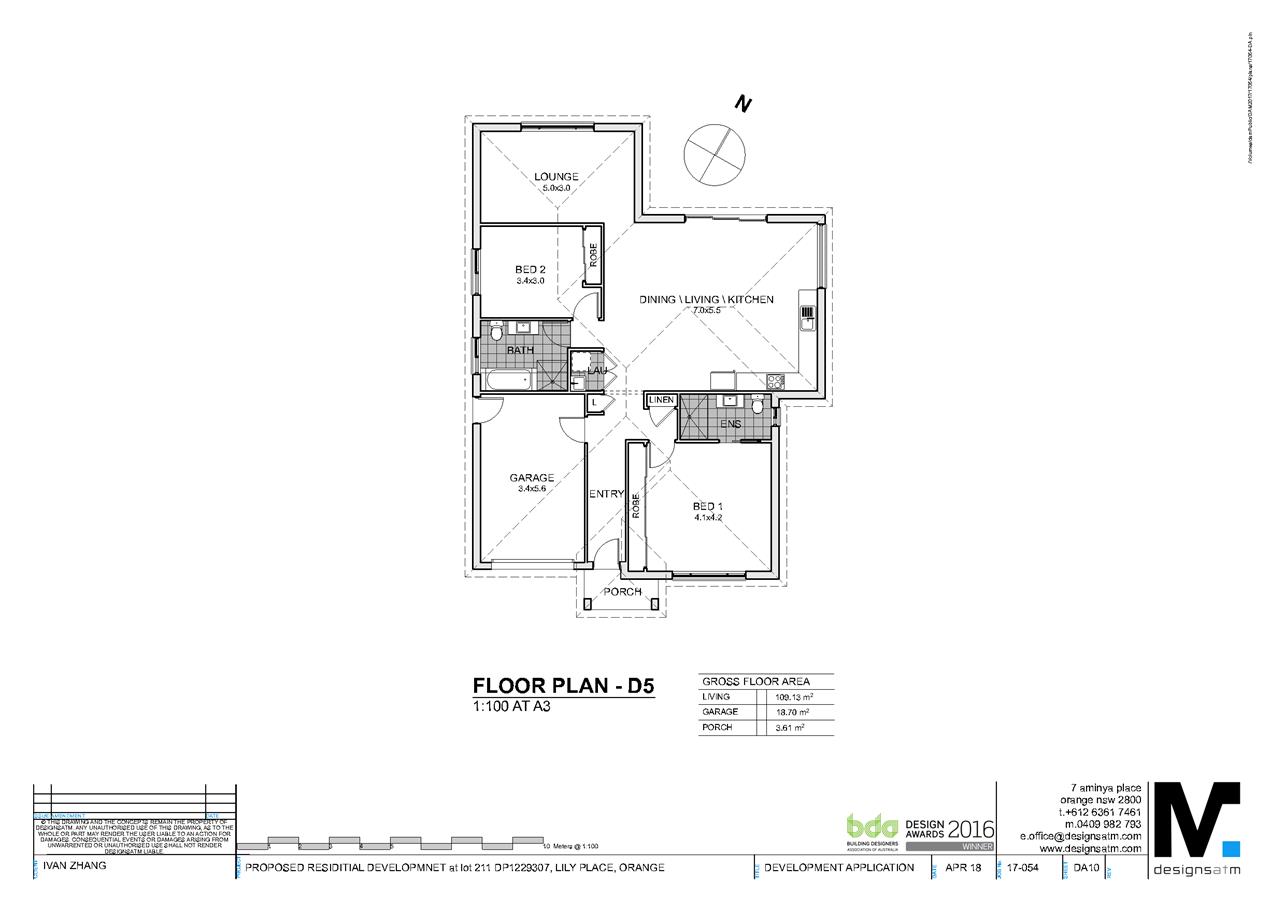
Planning and Development Committee
3 July 2018
2.5 Development
Application DA 138/2018(1) - Lot 211 Lily Place
Attachment 2 Plans
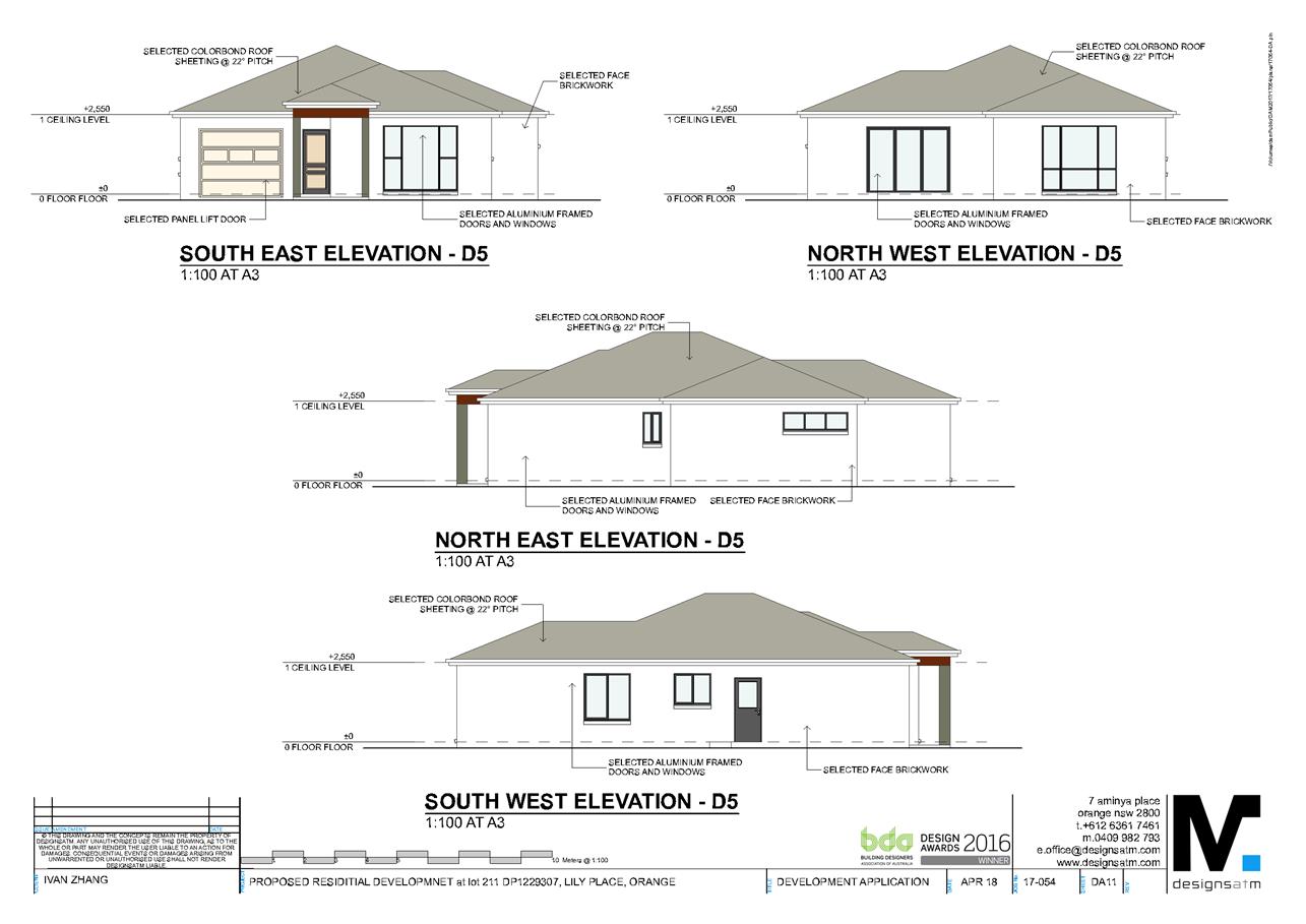
Planning and Development Committee
3 July 2018
2.5 Development
Application DA 138/2018(1) - Lot 211 Lily Place
Attachment 2 Plans
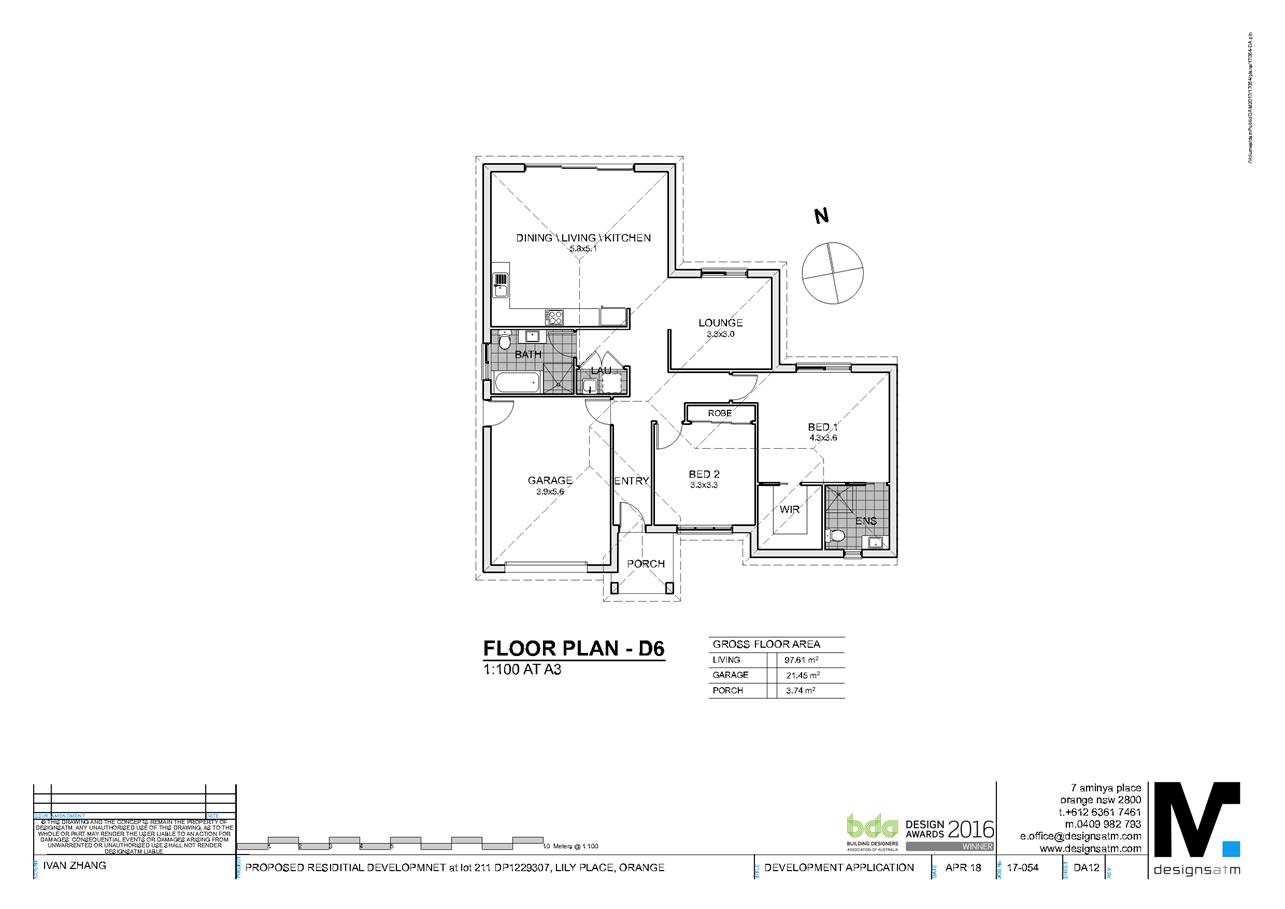
Planning and Development Committee
3 July 2018
2.5 Development
Application DA 138/2018(1) - Lot 211 Lily Place
Attachment 2 Plans
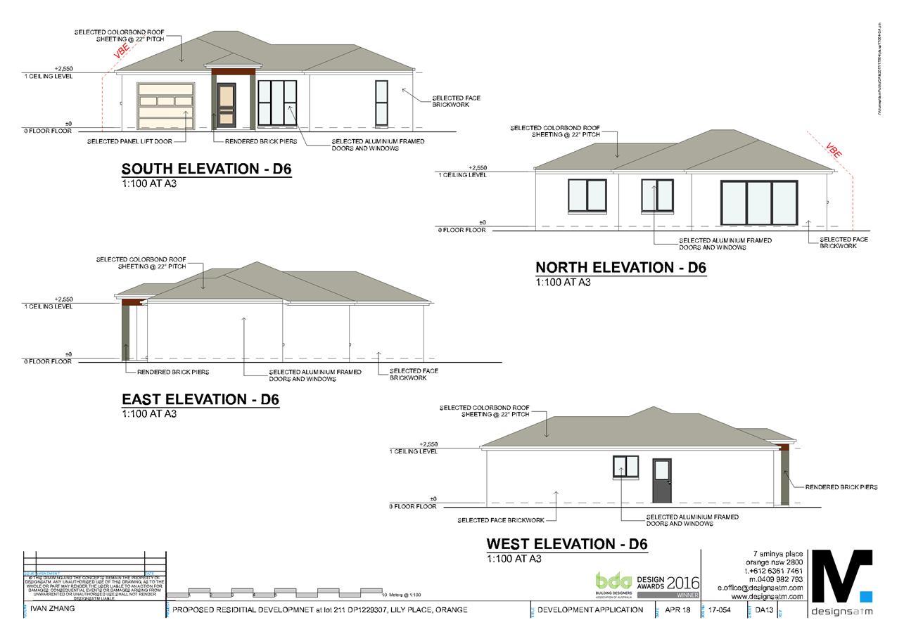
Planning and Development Committee
3 July 2018
2.5 Development
Application DA 138/2018(1) - Lot 211 Lily Place
Attachment 2 Plans
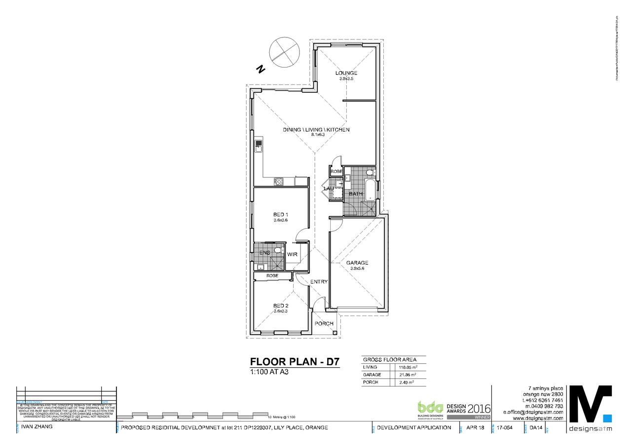
Planning and Development Committee
3 July 2018
2.5 Development
Application DA 138/2018(1) - Lot 211 Lily Place
Attachment 2 Plans
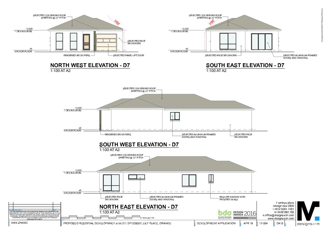
Planning and Development Committee
3 July 2018
2.5 Development
Application DA 138/2018(1) - Lot 211 Lily Place
Attachment 2 Plans
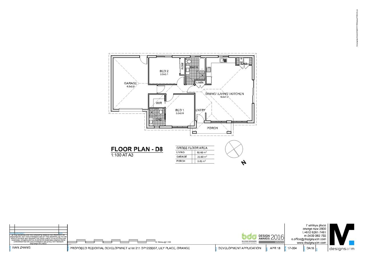
Planning and Development Committee
3 July 2018
2.5 Development
Application DA 138/2018(1) - Lot 211 Lily Place
Attachment 2 Plans
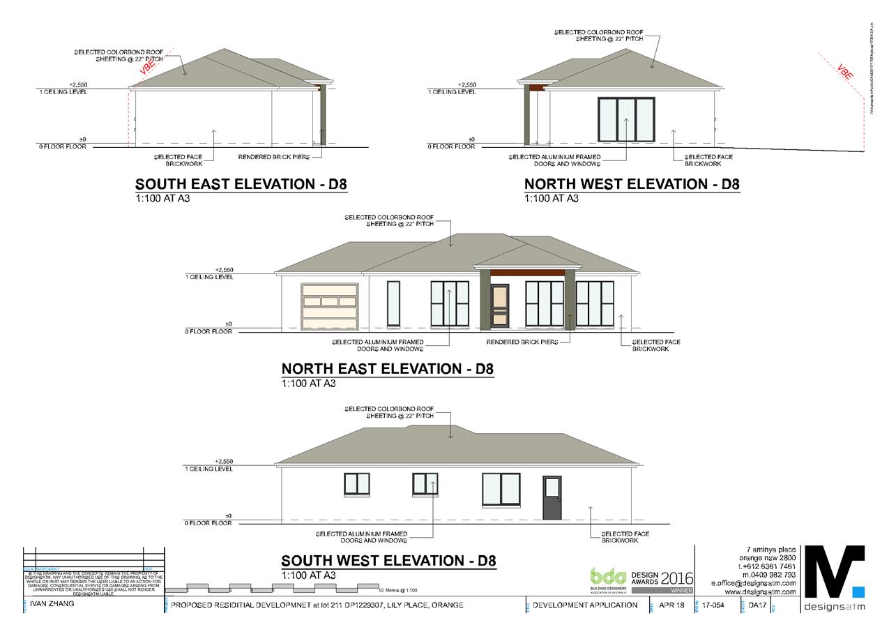
Planning and Development Committee
3 July 2018
2.5 Development
Application DA 138/2018(1) - Lot 211 Lily Place
Attachment 2 Plans
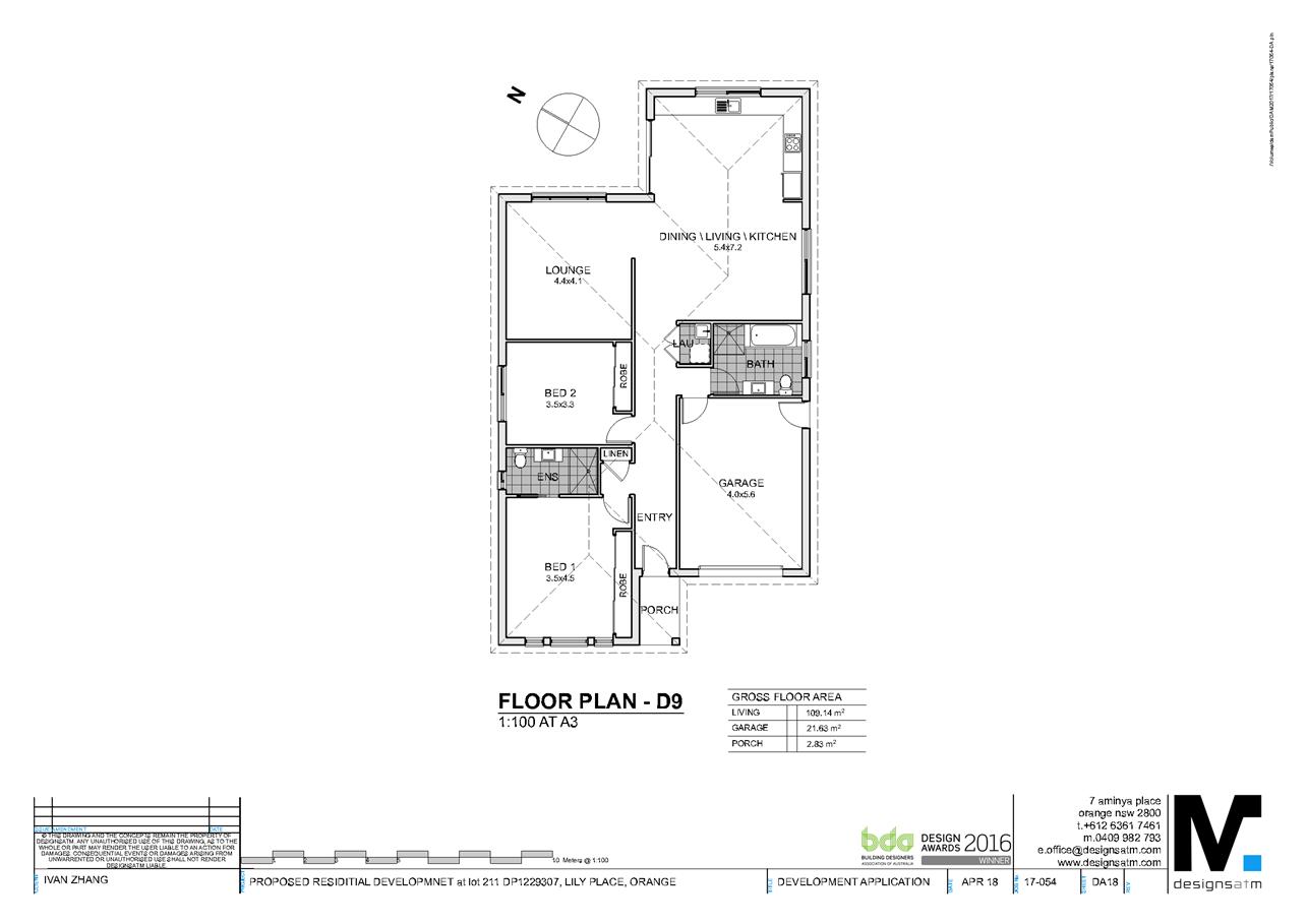
Planning and Development Committee
3 July 2018
2.5 Development
Application DA 138/2018(1) - Lot 211 Lily Place
Attachment 2 Plans
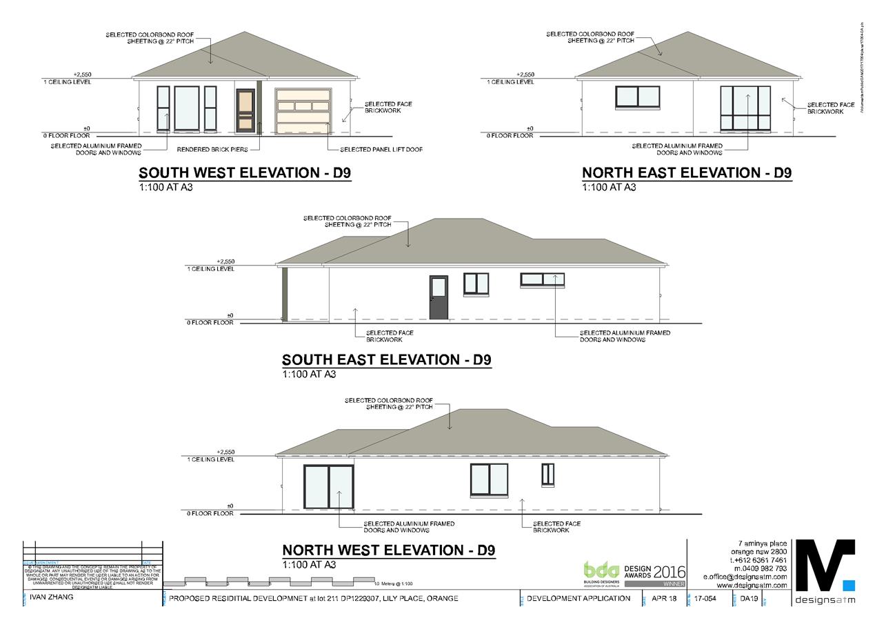
Planning and Development Committee
3 July 2018
2.5 Development
Application DA 138/2018(1) - Lot 211 Lily Place
Attachment 2 Plans
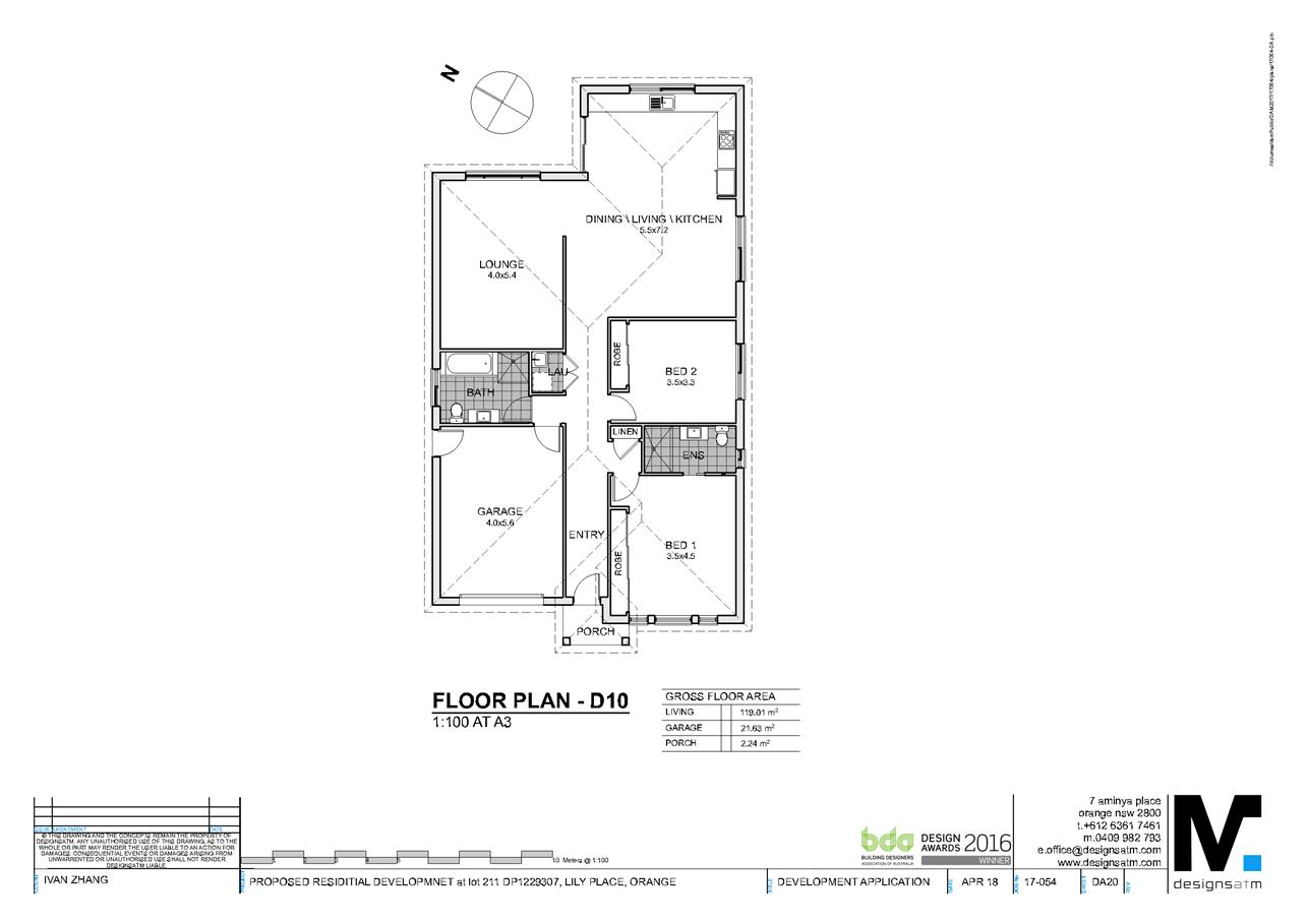
Planning and Development Committee
3 July 2018
2.5 Development
Application DA 138/2018(1) - Lot 211 Lily Place
Attachment 2 Plans
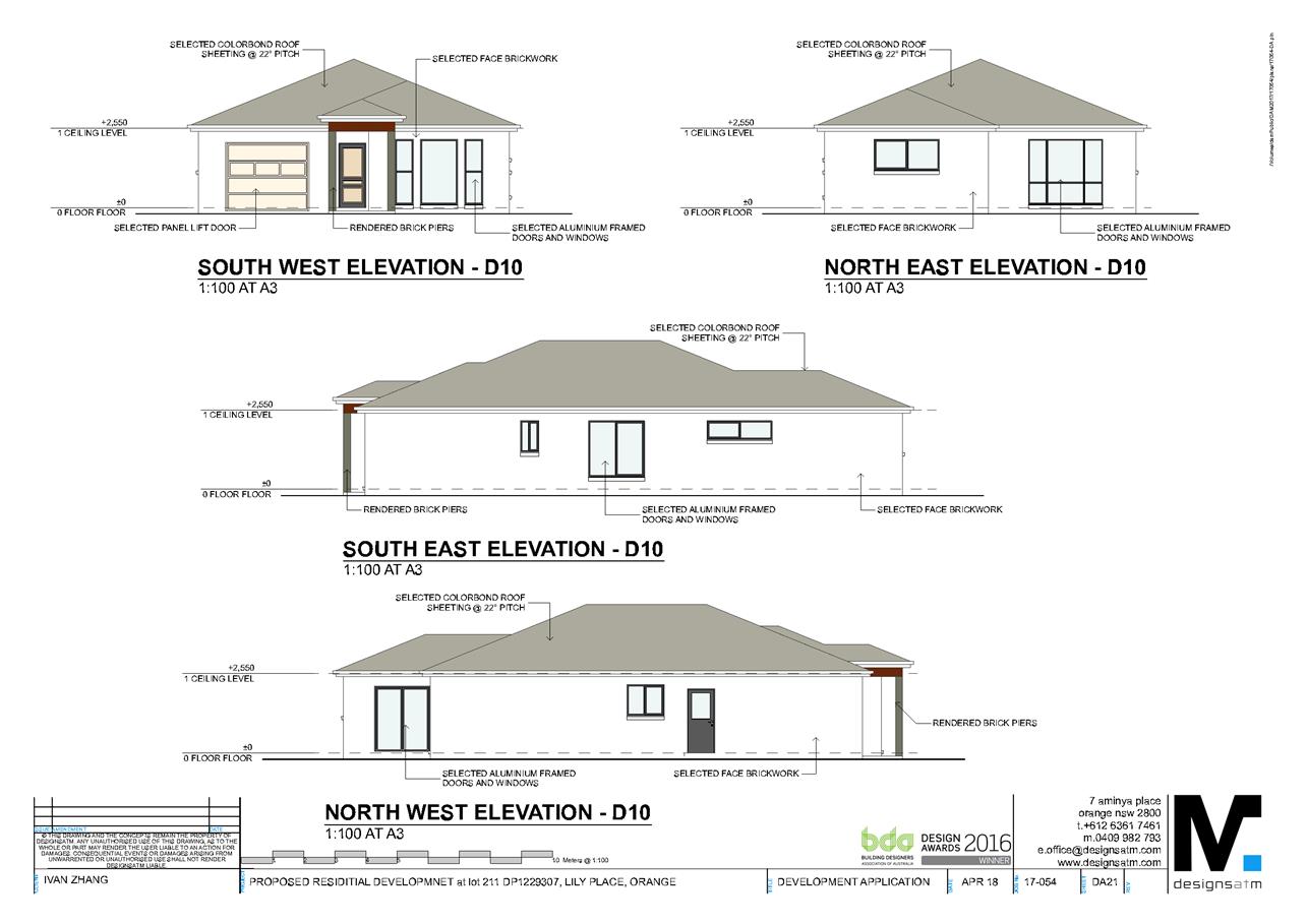
Planning and Development Committee
3 July 2018
2.5 Development
Application DA 138/2018(1) - Lot 211 Lily Place
Attachment 2 Plans
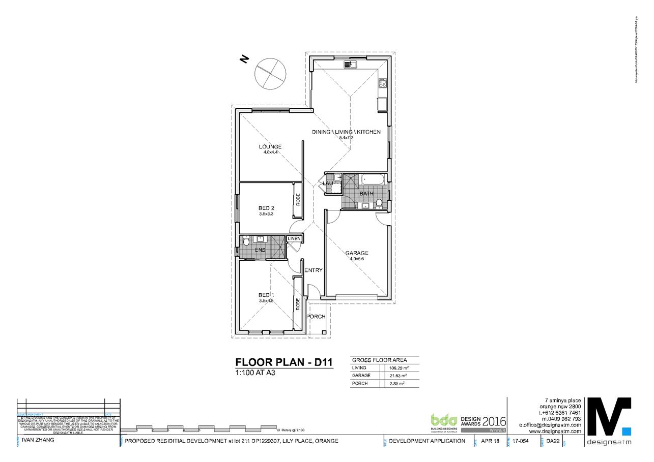
Planning and Development Committee
3 July 2018
2.5 Development
Application DA 138/2018(1) - Lot 211 Lily Place
Attachment 2 Plans
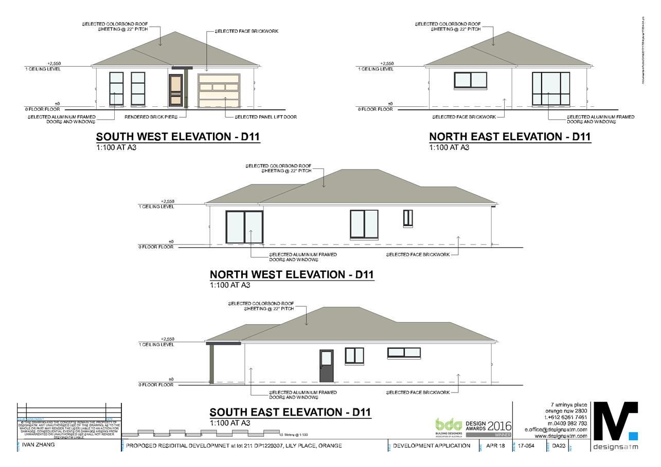
Planning and Development Committee
3 July 2018
2.5 Development
Application DA 138/2018(1) - Lot 211 Lily Place
Attachment 2 Plans
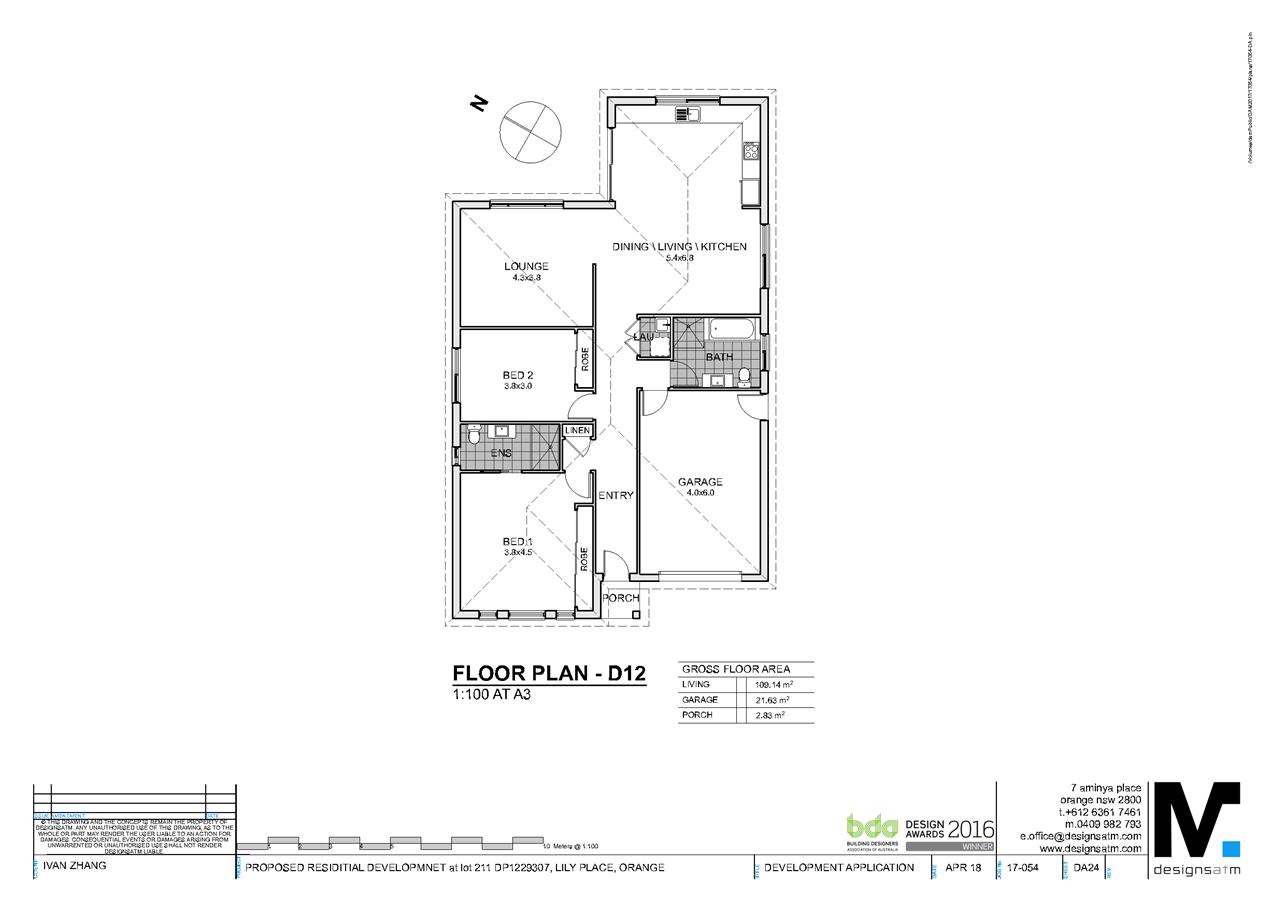
Planning and Development Committee
3 July 2018
2.5 Development
Application DA 138/2018(1) - Lot 211 Lily Place
Attachment 2 Plans
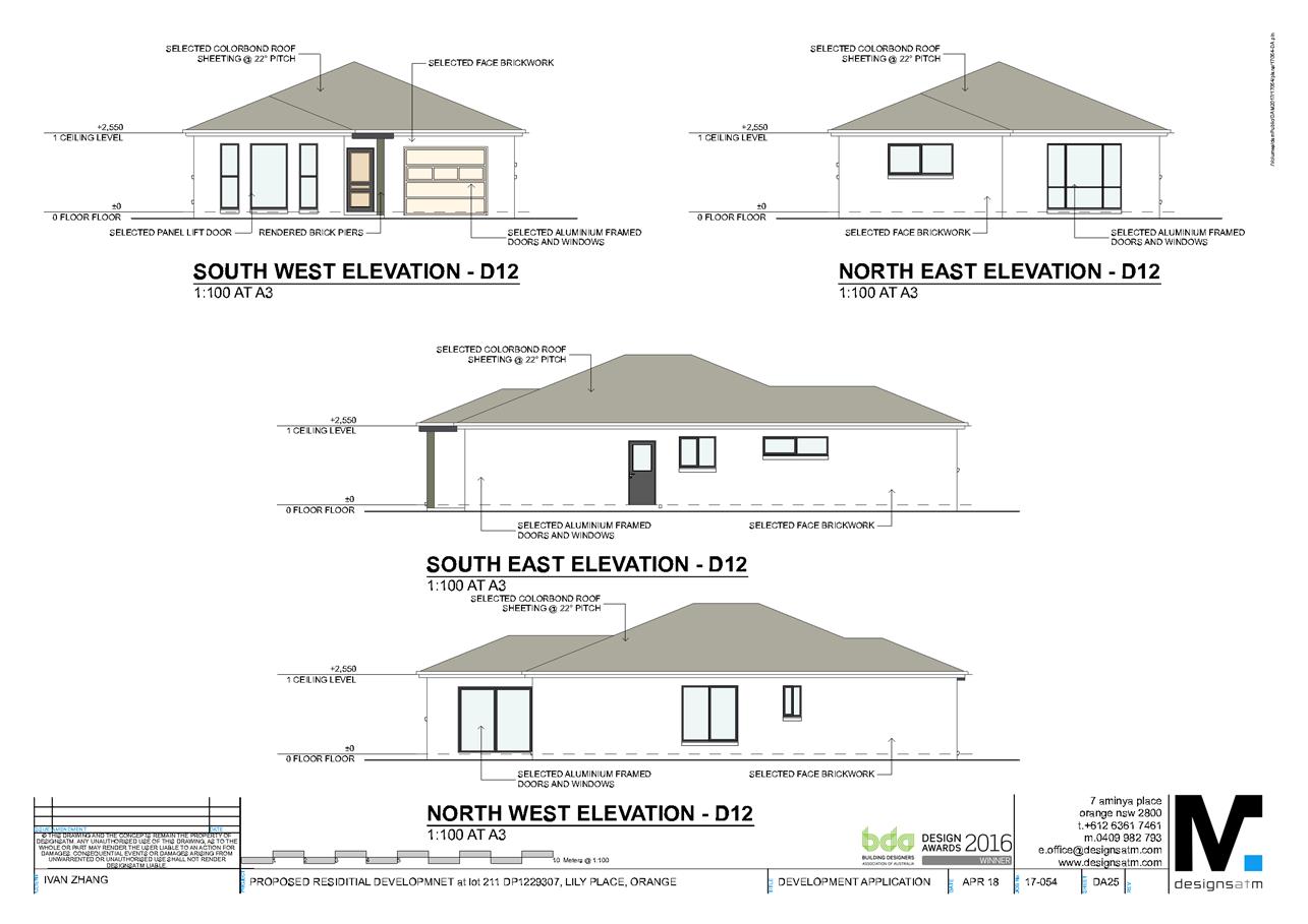
Planning and Development Committee
3 July 2018
2.5 Development
Application DA 138/2018(1) - Lot 211 Lily Place
Attachment 2 Plans
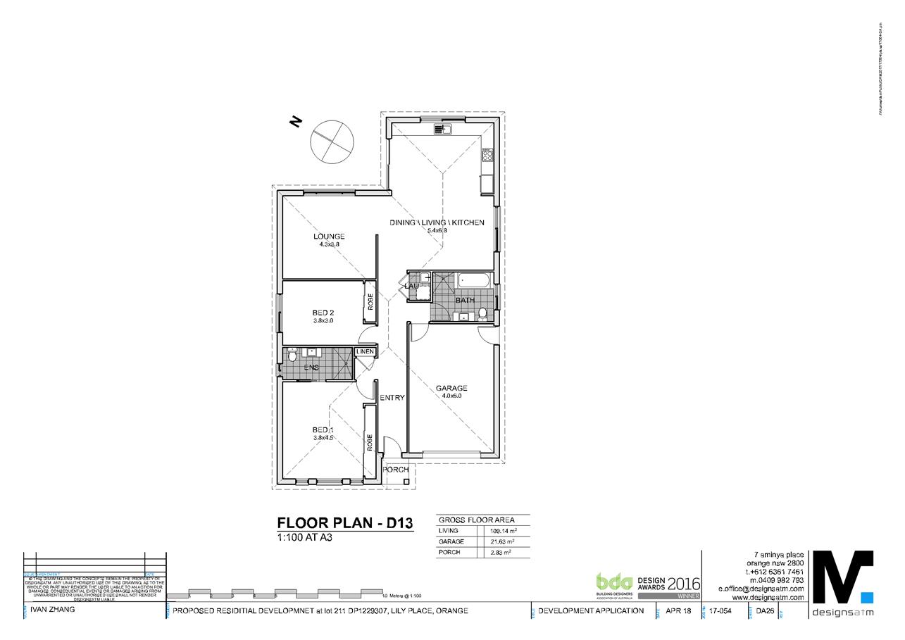
Planning and Development Committee
3 July 2018
2.5 Development
Application DA 138/2018(1) - Lot 211 Lily Place
Attachment 2 Plans
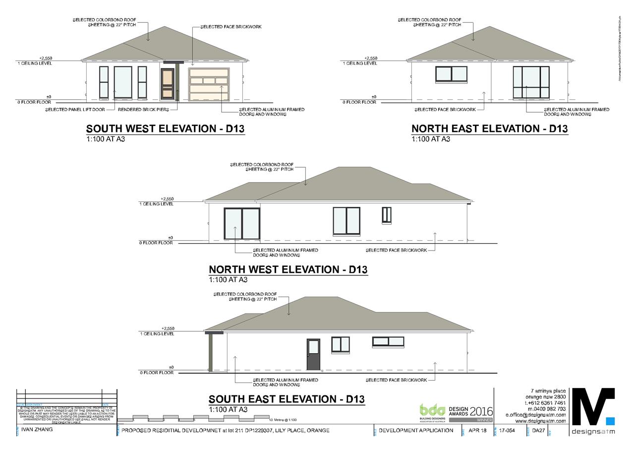
Planning and Development Committee
3 July 2018
2.5 Development
Application DA 138/2018(1) - Lot 211 Lily Place
Attachment 2 Plans
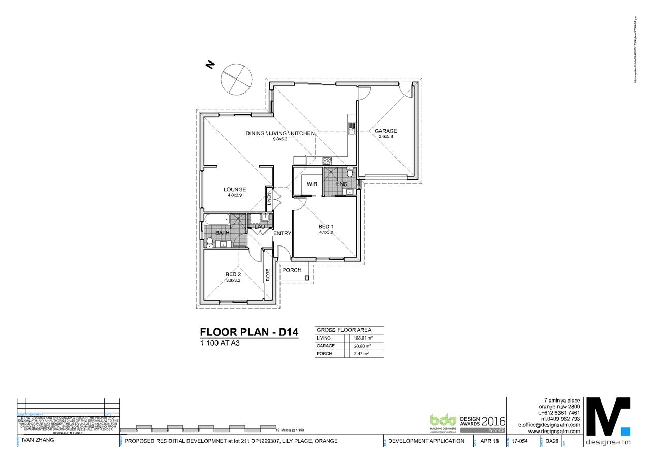
Planning and Development Committee
3 July 2018
2.5 Development
Application DA 138/2018(1) - Lot 211 Lily Place
Attachment 2 Plans
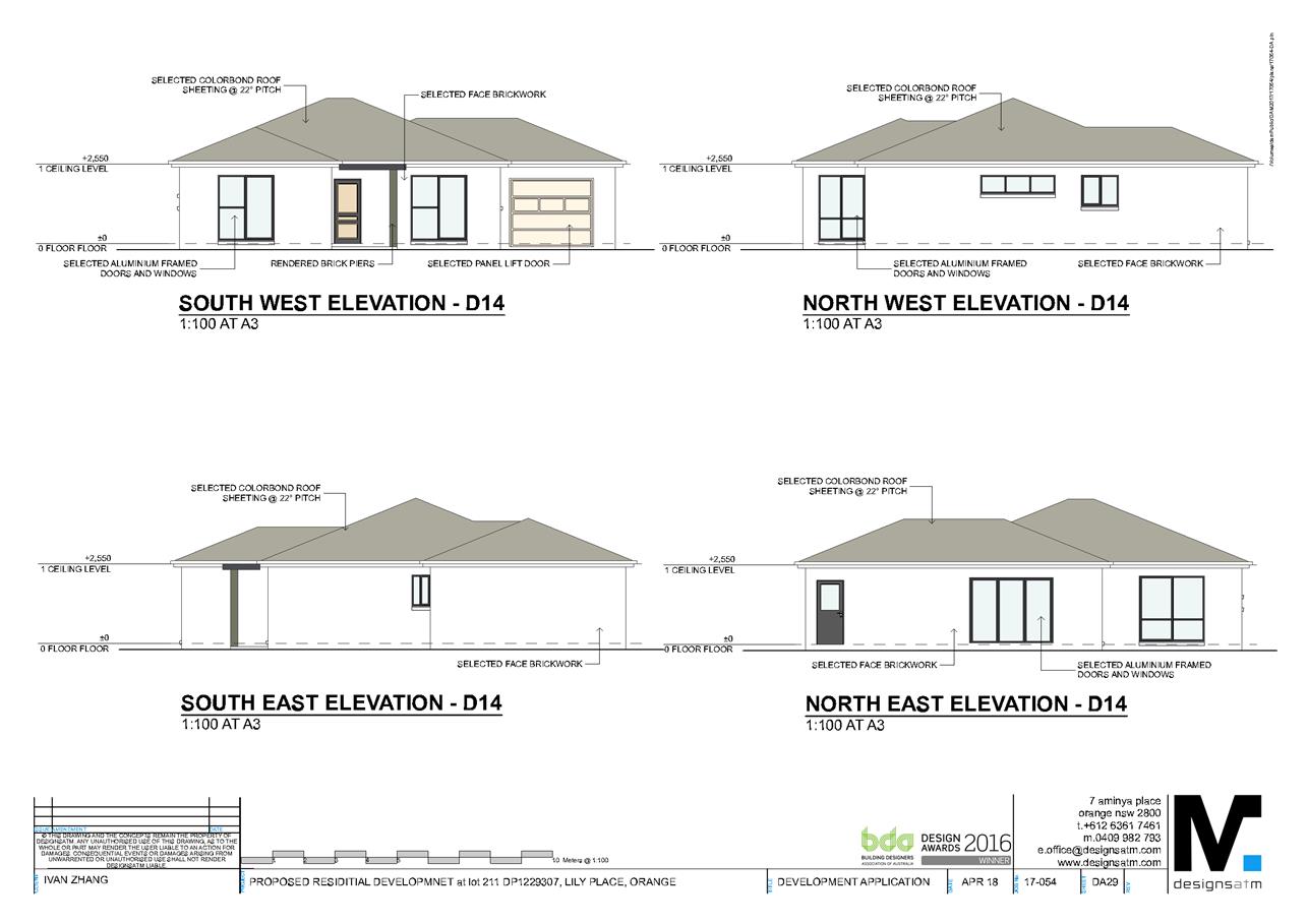
Planning and Development Committee
3 July 2018
2.5 Development
Application DA 138/2018(1) - Lot 211 Lily Place
Attachment 2 Plans
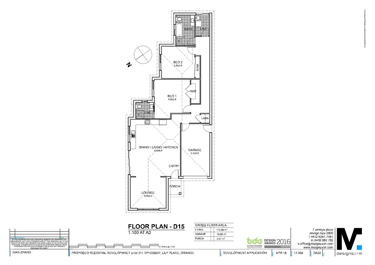
Planning and Development Committee
3 July 2018
2.5 Development
Application DA 138/2018(1) - Lot 211 Lily Place
Attachment 2 Plans
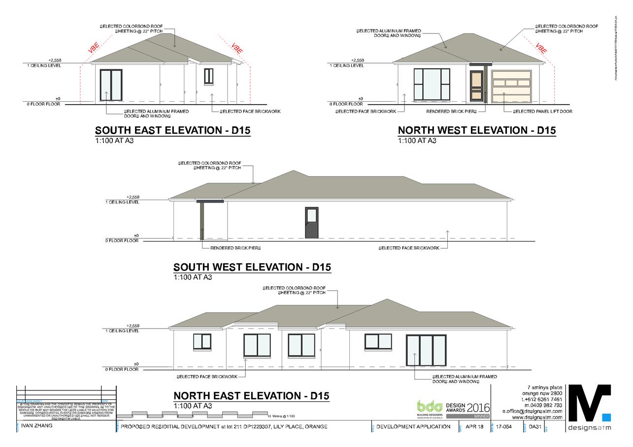
Planning and Development Committee
3 July 2018
2.5 Development
Application DA 138/2018(1) - Lot 211 Lily Place
Attachment 2 Plans
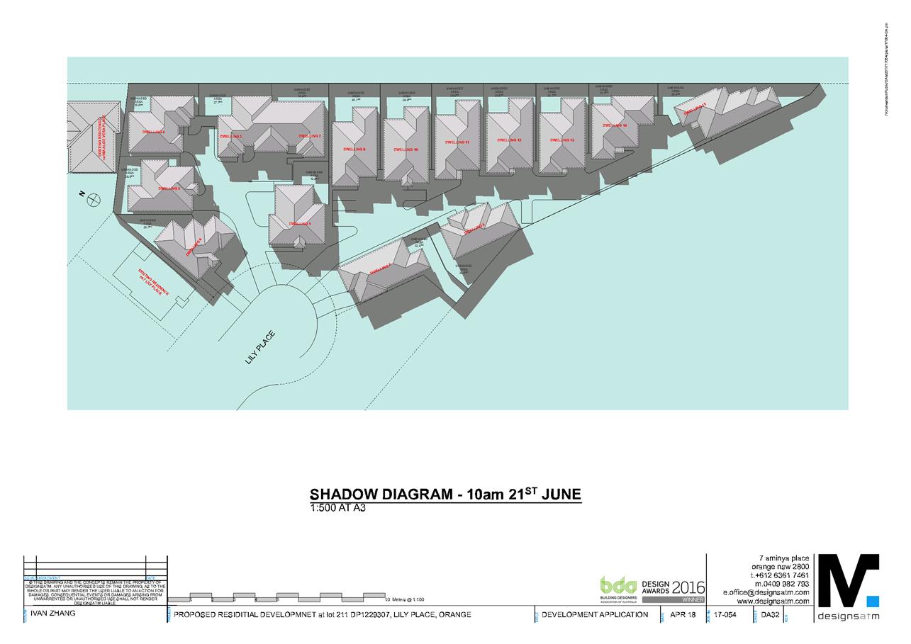
Planning and Development Committee
3 July 2018
2.5 Development
Application DA 138/2018(1) - Lot 211 Lily Place
Attachment 2 Plans
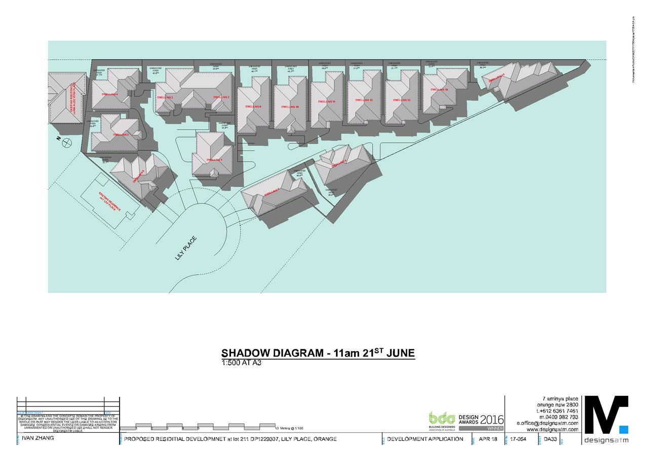
Planning and Development Committee
3 July 2018
2.5 Development
Application DA 138/2018(1) - Lot 211 Lily Place
Attachment 2 Plans
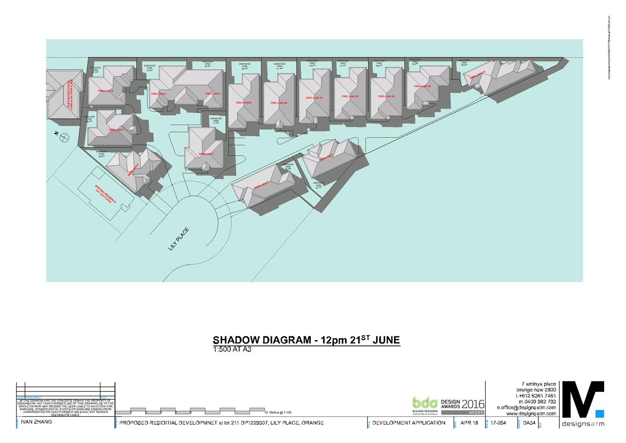
Planning and Development Committee
3 July 2018
2.5 Development
Application DA 138/2018(1) - Lot 211 Lily Place
Attachment 2 Plans
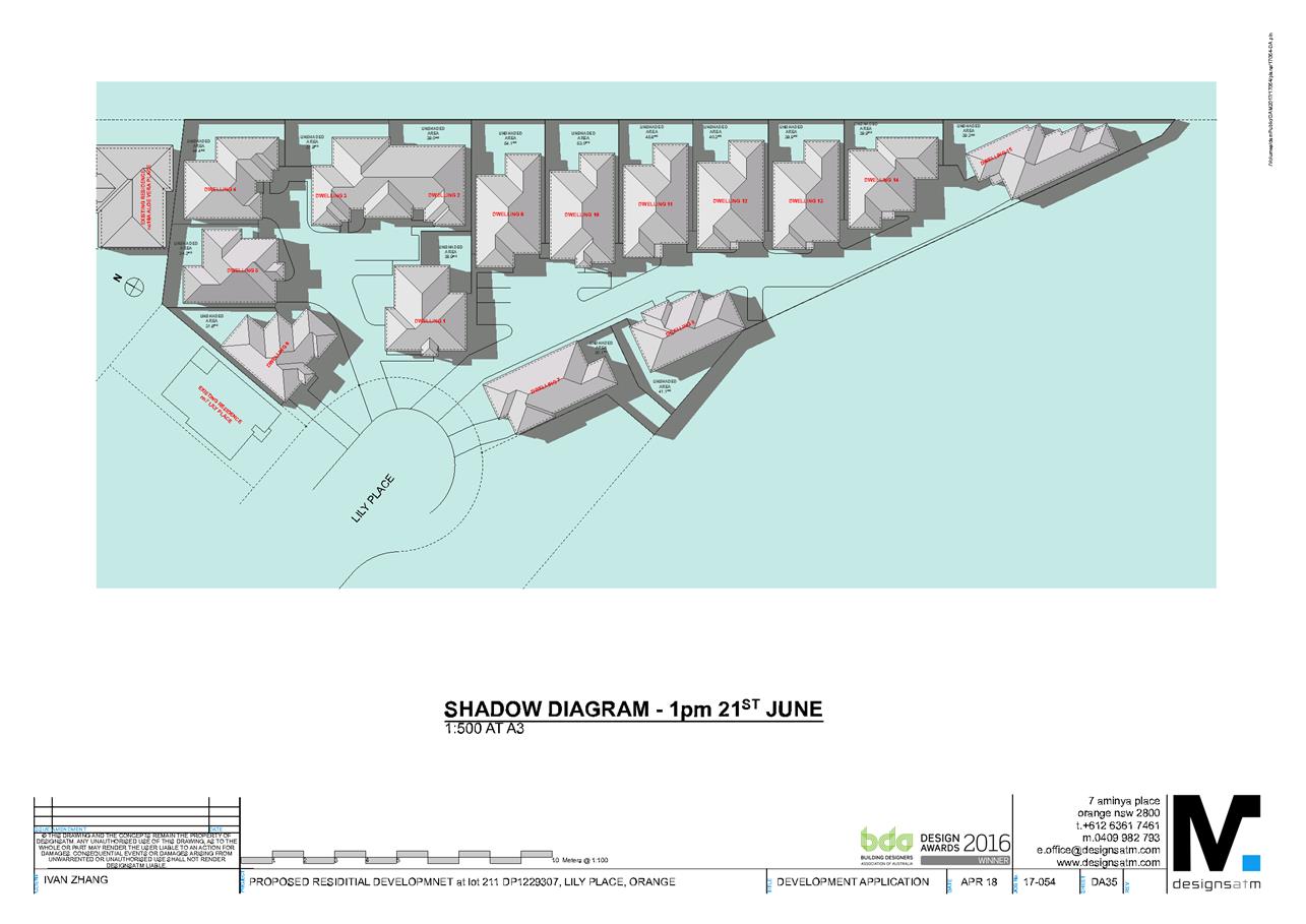
Planning and Development Committee
3 July 2018
2.5 Development
Application DA 138/2018(1) - Lot 211 Lily Place
Attachment 2 Plans
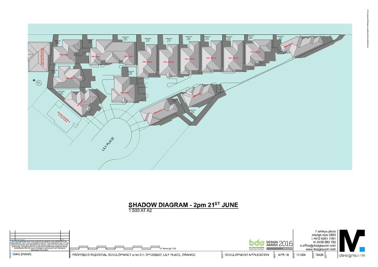
Planning and Development Committee
3 July 2018
2.5 Development
Application DA 138/2018(1) - Lot 211 Lily Place
Attachment 3 Submissions