ORANGE CITY COUNCIL
Planning and Development
Committee
Agenda
6 March 2018
Notice
is hereby given, in accordance with the provisions of the Local Government Act
1993 that a Planning and Development
Committee meeting
of ORANGE CITY COUNCIL will be held in the Council Chamber, Civic Centre, Byng Street, Orange on
Tuesday, 6 March 2018.
Garry
Styles
General Manager
For apologies please
contact Michelle Catlin on 6393 8246.
Planning and Development Committee 6
March 2018
1 Introduction
1.1 Declaration
of pecuniary interests, significant non-pecuniary interests and less than
significant non-pecuniary interests
The
provisions of Chapter 14 of the Local Government Act, 1993 (the Act)
regulate the way in which Councillors and designated staff of Council conduct
themselves to ensure that there is no conflict between their private interests
and their public role.
The
Act prescribes that where a member of Council (or a Committee of Council) has a
direct or indirect financial (pecuniary) interest in a matter to be considered
at a meeting of the Council (or Committee), that interest must be disclosed as
soon as practicable after the start of the meeting and the reasons given for
declaring such interest.
As
members are aware, the provisions of the Local Government Act restrict any
member who has declared a pecuniary interest in any matter from participating
in the discussion or voting on that matter, and requires that member to vacate
the Chamber.
Council’s Code of Conduct provides that if members
have a non-pecuniary conflict of interest, the nature of the conflict must be
disclosed. The Code of Conduct also provides for a number of ways in which a
member may manage non pecuniary conflicts of interest.
|
Recommendation
It is recommended that Committee Members now disclose any
conflicts of interest in matters under consideration by the Planning and
Development Committee at this meeting.
|
2 General
Reports
2.1 Items
Approved Under Delegated Authority of Council
RECORD
NUMBER: 2018/155
AUTHOR: Paul
Johnston, Manager Development Assessments
EXECUTIVE Summary
Following is a list of development
applications approved under the delegated authority of Council.
Link To Delivery/OPerational Plan
The recommendation in this report relates to the
Delivery/Operational Plan strategy “13.4 Our Environment
– Monitor and enforce regulations relating to City amenity”.
Financial Implications
Nil
Policy and Governance Implications
Nil
|
Recommendation
That the information provided in the
report by the Manager Development Assessments on Items Approved Under the
Delegated Authority of Council be acknowledged.
|
further considerations
Consideration has been given to the recommendation’s
impact on Council’s service delivery; image and reputation; political;
environmental; health and safety; employees; stakeholders and project
management; and no further implications or risks have been identified.
SUPPORTING INFORMATION
|
Reference:
|
DA 153/2011(2)
|
Determination
Date
|
2 February 2018
|
|
PR Number
|
PR24011
|
|
Applicant/s:
|
Mr TR Board
|
|
Owner/s:
|
Mr TR Board
|
|
Location:
|
Lot 16 DP 1147595
– 14 Scott Place, Orange
|
|
Proposal:
|
Modification of
development consent – depot and advertising signage. The modification
involves relocating two of the three roller doors from the east elevation, to
now have one proposed at the rear of the building and one proposed at the
front of the building.
|
|
Value:
|
$180,000 (being
the same value as the original development)
|
|
Reference:
|
DA 377/2013(3)
|
Determination
Date
|
5 February 2018
|
|
PR Number
|
PR20063
|
|
Applicant/s:
|
Mr MA Madden and
Mr LW Bevan
|
|
Owner/s:
|
Messrs LW Bevan
and MA Madden
|
|
Location:
|
Lot 5 DP 271075
– 4/8B Majestic Way, Orange
|
|
Proposal:
|
Modification of development consent
– subdivision – torrens title (three lot residential),
subdivision – community title (seven lot residential and one community
lot) and dwelling houses (seven). The modification proposal changes
the configuration of Unit 4, and increases the area of the unit from 141.2m2
to 157.48m2. No other changes are proposed.
|
|
Value:
|
$1,100,000 (being
the same value as the original development)
|
|
Reference:
|
DA 384/2017(1)
|
Determination
Date
|
29 January 2018
|
|
PR Number
|
PR27720
|
|
Applicant/s:
|
Mr I Zhang
|
|
Owner/s:
|
Dinkum Exporting
and Importing Pty Limited
|
|
Location:
|
Lot 300 DP 1232094
– Aloe Vera Place, Orange
|
|
Proposal:
|
Multi dwelling
housing (five dwellings) and subdivision (five lot residential)
|
|
Value:
|
$780,000
|
|
Reference:
|
DA 417/2017(1)
|
Determination
Date
|
29 January 2018
|
|
PR Number
|
PR27610
|
|
Applicant/s:
|
AMP Pastoral Pty
Limited
|
|
Owner/s:
|
AMP Pastoral Pty
Limited
|
|
Location:
|
Lot 100 DP 1226302
– Kite Street, Orange
|
|
Proposal:
|
Hotel or motel
accommodation (alterations and additions)
|
|
Value:
|
$200,000
|
|
Reference:
|
DA 449/2017(1)
|
Determination
Date
|
30 January 2018
|
|
PR Number
|
PR25970
|
|
Applicant/s:
|
Mr CH and Mrs MJ
Boardman
|
|
Owner/s:
|
Mr CH and Mrs MJ
Boardman
|
|
Location:
|
Lot 98 DP 1180866
– 26 Colliers Avenue, Orange
|
|
Proposal:
|
Vehicle repair
station, transport depot and vehicle sales or hire premises (industrial
building and site works)
|
|
Value:
|
$860,000
|
|
Reference:
|
DA 474/2017(1)
|
Determination
Date
|
19 February 2018
|
|
PR Number
|
PR20895
|
|
Applicant/s:
|
MJBP Property Pty
Ltd
|
|
Owner/s:
|
MJBP Property Pty
Ltd
|
|
Location:
|
Lot 23 DP 1090794
and Lot 2 DP 1181974 – 63-65 Hill Street, Orange
|
|
Proposal:
|
Office premises
(change of use, alterations and additions), business identification sign
(pylon sign) and demolition (shed)
|
|
Value:
|
$90,000
|
TOTAL
NET* VALUE OF ALL DEVELOPMENTS APPROVED IN THIS PERIOD: $1,930,000
*
Net value relates to the value of modifications. If modifications are
the same value as the original DA, then nil is added. If there is a plus/minus
difference, this difference is added or taken out.
2.2 Development
Application DA 212/2017(1) - 13, 15 and 17 Colliers Avenue
RECORD
NUMBER: 2018/245
AUTHOR: Daniel
Drum, Senior Planner
EXECUTIVE Summary
|
Application
lodged
|
13 June
2017
|
|
Applicant/s
|
Lovick
Engineering
|
|
Owner/s
|
Mrs VM
Lovick and Lovick SF Pty Ltd
|
|
Land
description
|
Lots 34,
35 and 36 DP 1035913 – 13,15 and 17 Colliers Avenue, Orange
|
|
Proposed
land use
|
General
Industry and Business Identification Signage
|
|
Value of
proposed development
|
$3.9
million
|
Council's consent is sought for the use and development
of a General Industry and Business Identification Signs at
13-17 Colliers Avenue, Orange, being Lots 34, 35 and 36 DP 1035913
(the ‘subject property’).
The subject property is located within the Narrambla
Industrial Estate, approximately 100m south of the intersection of Astill
Drive and Colliers Avenue, immediately adjacent to the Northern Distributor
Road.
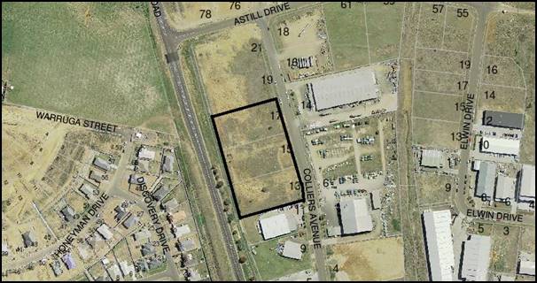
Figure 1: locality plan
The subject property comprises a total area of 13,641m2
(1.36ha) in regular shape. The property is currently vacant, save for an
electricity substation located in the north‑eastern corner.
The proposed development is intended to provide a new
facility for an existing engine reconditioning business which has outgrown its
existing premises in central Orange.
In particular, the proposed development will involve the construction of a 6,189.4m2 shed
purposively designed for the machining, rebuilding and reconditioning of
engines. The operation of the business would involve a minimum of 16 full time
employees performing mechanical and administrative duties. The proposed
operating hours are 7am‑10pm, Monday to Saturday.
Notably, the applicant has proposed that the development
occur in four separate stages. The staging of development is illustrated in the
attached design plans.
The key issues for consideration include the visual impact
of the proposed building, particularly when viewed by motorists from the
Northern Distributor Road, and potential off-site impacts on proximate
residential areas, particularly potential noise impacts.
Subject to meeting the recommended conditions of consent,
the proposed use and development are considered to be consistent with the
relevant aims, objectives and planning outcomes of Orange Development Control
Plan 2004 and Orange Local Environmental Plan 2011.
The following assessment identifies that the proposed use
and development should be supported.
DECISION FRAMEWORK
Development in Orange is governed
by two key documents - Orange Local Environment Plan 2011 and Orange
Development Control Plan 2004. In addition the Infill Guidelines are used to
guide development, particularly in the heritage conservation areas and around
heritage items.
Orange Local Environment Plan
2011 – the LEP should be considered by Council to be a definitive
document. LEPs govern the types of development that are permissible or
prohibited in different parts of the City and also provide some assessment
criteria in specific circumstances. Uses are either permissible or not - there
are no grey areas in terms of permissibility. The objectives of each zoning and
indeed the aims of the LEP itself are, however, open to interpretation and can
be used to guide decision making around appropriateness of development.
Orange Development Control
Plan 2004 – the DCP guides development. In general it is a
performance based document rather than prescriptive in nature - its purpose is
to guide development. The Land and Environment Court tends to view it as such.
In each area of interest there are often guidelines used. These guidelines
indicate ways of achieving the planning outcomes. It is thus recognised that
there may also be other solutions of merit. All design solutions are considered
on merit by planning and building staff. Applications should clearly
demonstrate how the planning outcomes are being met where alternative design
solutions are proposed. So one can see that the DCP gives leeway for developers
and architects to use design to achieve the outcome in other ways if they can.
Stating that DCP guidelines are inflexible can be misleading.
Director’s Comment
As discussed in the body of this report the applicant has
suitably demonstrated that the development is acceptable in this case with no
significant DCP departures.
Link To Delivery/OPerational Plan
The recommendation in this report relates to the
Delivery/Operational Plan strategy “13.4 Our Environment
– Monitor and enforce regulations relating to City amenity”.
Financial Implications
Nil
Policy and Governance Implications
Nil
|
Recommendation
That Council consents to
development application DA 212/2017(1)
for General Industry and Business Identification Signage at Lots
34, 35 and 36 DP 1035913 - 13, 15 and 17 Colliers
Avenue, Orange pursuant to the conditions of
consent in the attached Notice of Approval.
|
further considerations
Consideration has been given to the
recommendation’s impact on Council’s service delivery; image and
reputation; political; environmental; health and safety; employees;
stakeholders and project management; and no further implications or risks have
been identified.
SUPPORTING INFORMATION
THE APPLICATION/PROPOSAL
Council's consent is sought for the use and development of a
General Industry and Business Identification Signs at 13-17
Colliers Avenue, Orange being Lots 34, 35 and 36 DP 1035913.
Use
The proposed General Industry is intended to provide
for an existing engine reconditioning business which is seeking to relocate
from its existing premises in central Orange.
The supporting information submitted with the development
application indicates that core activities associated with the engine
reconditioning business include:
- rebuilding
and dyno testing of engines
- crankshaft
grinding and rebuilding
- cylinder
block machining
- cylinder
head servicing
- office
and administrative services.
It is understood that a number of other ancillary activities
are also undertaken as part of the day-to-day operation of an engine
reconditioning business.
The supporting information indicates that the existing
business employees 16 full time staff, and utilises six utilities and one
medium rigid truck for daily collection and delivery requirements. Other
vehicle movements typically include 6-8 semi-trailer movements per week, 20
medium/heavy rigid truck movements per week and daily customer and light
commercial vehicle movements.
It is understood that employee numbers and vehicle movements
would increase with the expansion of the business into the proposed facility.
The proposed operating hours of the General Industry are
7am-10pm, Monday to Saturday.
Development
The proposed development involves the construction of an
industrial scale building within the central portion of the subject property.
The proposed building would have a maximum length of 110m
(north-south), a maximum width of 55m (east-west) and a maximum height of 13.3m
(ridge height).
The building would generally be finished in a combination of
concrete tilt panel, Colorbond wall/roof sheeting and translucent wall and roof
sheeting, with a predominant colour scheme of Colorbond ‘Windspray’
and ‘Shale Grey’. The north-eastern corner of the building, which
contains the offices and amenities areas, would be distinguished from the
balance of the building through the use of alternative materials and colours,
and simple design features such as windows.
The proposed building would contain a workshop in the order
of 5,790m2 and office/amenities in the order of 230m2.
The workshop would consist of a combination open workspace, dyno rooms, a turbo
room, paint and blast rooms and wash bays. The office and amenities would
consist of an open plan office, individual offices, amenities, training and
conference rooms, and a reception area.
Other features of the proposed development include two
underground storage tanks, holding 60,000L and 120,000L respectively,
air compressors, oil separators, dust extractors, two cooling towers, 62 car
parking spaces and perimeter landscaping.
EXISTING CONDITIONS
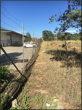
The existing conditions of the
subject property are illustrated in Figures 2-4 below:
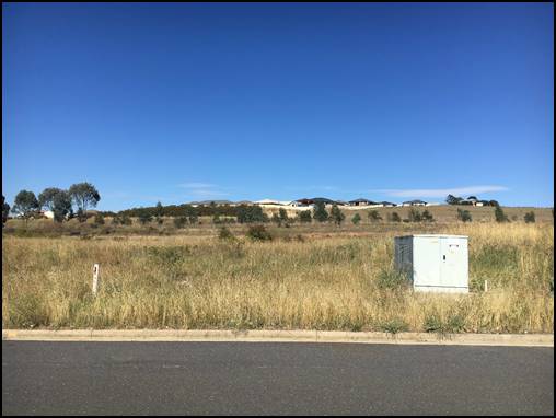
Figure 2: the subject property - existing conditions
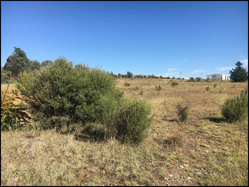
Figure 3: the subject property - existing conditions

Figure 4: the subject property - existing conditions
SURROUNDING USE AND DEVELOPMENT
The subject property adjoins 19 Colliers Avenue to the north
and 11 Colliers Avenue to the south. 11 Colliers Avenue has been developed for
the purpose of a Warehouse, including office and showrooms, while 19
Colliers Avenue is a vacant property.
Other properties proximate to the subject property have
typically been developed for an industrial purpose. The subject property is located
within 65m (approximately) of residential properties and land zoned for a
residential purpose in the Discovery Hill area, located to the immediate west
of the Northern Distributor Road.
The existing conditions of
proximate properties are demonstrated in Figures 5-10 below:
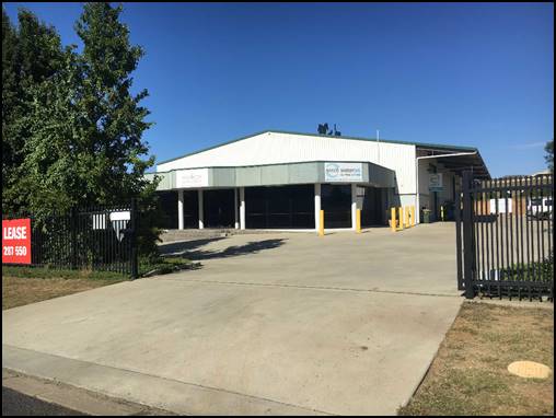
Figure 5: 11 Colliers Avenue
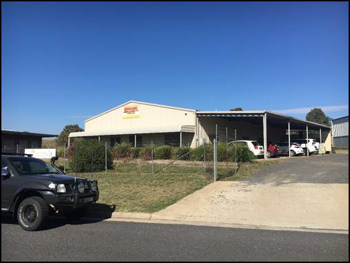
Figure 6: 9 Colliers Avenue
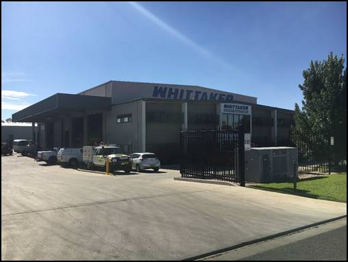
Figure 7: 4 Colliers Avenue
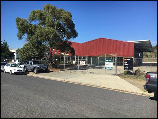
Figure 8: 5 Colliers Avenue
Figure 9: 6 Colliers Avenue
Figure 10: 14 Colliers Avenue
MATTERS FOR CONSIDERATION
Section 1.7 Application of
Part 7 of Biodiversity Conservation Act 2016 and Part 7A of Fisheries
Management Act 1994
From 25 August 2017, the
Biodiversity Conservation Act 2016 and Biodiversity Conservation
Regulation 2017 were gazetted. The implementation of this legislation
(and supporting guidelines) is subject to savings provisions that defer their
full effect for a period of six months from the date of gazettal for local
development.
In this instance, site inspection
reveals that the subject property has no biodiversity or habitat value.
Section 4.15 - Evaluation
Section 4.15 of the Environmental Planning and Assessment
Act 1979 sets out the matters that the consent authority is to take into
consideration in determining a development application. Those matters are
addressed in the body of this report.
PROVISIONS OF ANY ENVIRONMENTAL
PLANNING INSTRUMENT s4.15
Orange Local Environmental Plan 2011
Part 1 - Preliminary
Clause 1.2 - Aims of Plan
The
aims of the Orange Local Environmental Plan 2011 (‘OLEP
2011’) relevant to the application include:
(a) to encourage development which complements
and enhances the unique character of Orange as a major regional centre boasting
a diverse economy and offering an attractive regional lifestyle,
(b) to provide for a range of development
opportunities that contribute to the social, economic and environmental
resources of Orange in a way that allows present and future generations to meet
their needs by implementing the principles for ecologically sustainable
development,
(c) to conserve and enhance the water
resources on which Orange depends, particularly water supply catchments,
(f) to recognise and manage valued
environmental heritage, landscape and scenic features of Orange.
The application is considered to be consistent with the
relevant aims of OLEP 2011.
Clause 1.6 - Consent Authority
Clause establishes that Council is the consent authority for
the purpose of OLEP 2011.
Clause 1.9A - Suspension of
Covenants, Agreements and Instruments
Clause 1.9A provides that any agreement, covenant or other
similar instrument that restricts the carrying out of that development does not
apply to the extent necessary to serve that purpose, with the exception of:
· covenants imposed
by the Council or that the Council requires to be imposed;
· any prescribed
instrument with the meaning of section 183A of the Crown Lands Act 1989;
· any conservation
agreement within the meaning of the National Parks and Wildlife Act 1974;
· any Trust
agreement within the meaning of the Nature Conservation Trust Act 2001;
· any property
vegetation plan within the meaning of the Native Vegetation Act 2003;
· any biobanking
agreement within the meaning of Part 7A of the Threatened Species
Conservation Act 1995;
· any planning
agreement within the meaning of Division 6 of part 4 of the Act.
This clause does not affect the rights or interests of any
public authority under any registered instrument.
A search of Council’s records shows that the eastern
boundary of the subject property is affected by an easement of variable width
to drain sewage. The easement is to the benefit of Orange City Council. Lot 36
is also affected by an easement for the purpose of a substation to the benefit
of Country Energy.
In addition, the subject property is affected by two
restrictive covenants, being Covenant B100661 (denoted (C) on the
plan) and Covenant G217815 (denoted (B) on the plan). Covenants
B100661 and G2317815 preclude the affected portion of the subject property from
being used for the purpose of a slaughter yard, brickyard or graveyard or any
other ‘noxious noisome or offensive trade or business’.
The abovementioned easements and
covenants are shown in Figure 11 below:
Figure 11 - DP 1035913 (extract)
Clause 1.7 - Maps
The subject site is identified
on the LEP maps in the following manner:
|
Land Zoning Map:
|
Land zoned IN1 General Industrial
|
|
Lot Size Map:
|
Minimum Lot Size 2,000m2
|
|
Heritage Map:
|
Not a heritage item or conservation
area
|
|
Height of Buildings Map:
|
No building height limit
|
|
Floor Space Ratio Map:
|
No floor space limit
|
|
Terrestrial Biodiversity Map:
|
No biodiversity sensitivity on the
site
|
|
Groundwater Vulnerability Map:
|
Ground water vulnerable
|
|
Drinking Water Catchment Map:
|
Not within the drinking water
catchment
|
|
Watercourse Map:
|
Not within or affecting a defined
watercourse
|
|
Urban Release Area Map:
|
Not within an urban release area
|
|
Obstacle Limitation Surface Map:
|
No restriction on building siting
or construction
|
|
Additional Permitted Uses Map:
|
No additional permitted use applies
|
Those matters that are of relevance are addressed in detail
in the body of this report.
Part 2 - Permitted or
Prohibited Development
Land
Use Zones
The subject property is zoned IN1 General Industrial
(Figure 12).
Figure 12 - zone context plan - subject property
denoted by heavy black line
The objectives of the IN1 General Industrial zone are:
· To
provide a wide range of industrial and warehouse land uses.
· To
encourage employment opportunities.
· To
minimise any adverse effect of industry on other land uses.
· To
support and protect industrial land for industrial uses.
· To
ensure development along the Southern Link Road has an alternative access.
The proposed use and development
is defined as General Industry. Under OLEP 2011 General Industry
means:
“… a building or place (other than a heavy
industry or light industry) that is used to carry out an industrial
activity.”
Further,
under OLEP 2011 industrial activity means:
“… the manufacturing, production, assembling,
altering, formulating, repairing, renovating, ornamenting, finishing, cleaning,
washing, dismantling, transforming, processing, recycling, adapting or
servicing of, or the research and development of, any goods, substances, food,
products or articles for commercial purposes, and includes any storage or
transportation associated with any such activity.”
General Industry is
permissible within the IN1 General Industrial zone and is consistent with
the objectives of the zone.
Part 7 - Additional Local
Provisions
7.1
- Earthworks
Clause
7.1 seeks to ensure that earthworks for which development consent is required
will not have a detrimental impact on environmental functions and processes,
neighbouring uses, cultural or heritage items or features of the surrounding land;
and to allow earthworks of a minor nature without requiring separate
development consent.
Development
consent is required for earthworks unless the earthworks are exempt development
under this plan or another applicable environmental planning instrument, or the
earthworks are ancillary to other development for which development consent has
been given.
Before
granting development consent for earthworks, the consent authority must
consider the following matters:
(a) The likely disruption of, or any detrimental
effect on, existing drainage patterns and soil stability in the locality of the
development;
(b) The effect of the development on the likely
future use or redevelopment of the land;
(c) The quality of the fill or the soil to be
excavated, or both;
(d) The effect of the development on the existing
and likely amenity of adjoining properties;
(e) The source of any fill material and the
destination of any excavated material;
(f) The likelihood of disturbing relics;
(g) The proximity to and potential for adverse
impacts on any waterway, drinking water catchment or environmentally sensitive
area;
(h) Any measures proposed to minimise or mitigate
the impacts referred to in paragraph (g).
The
plans submitted with the development application identify that the extent of
earthworks associated with the development are in the order of 3m cut and
2m fill (approximately) from the existing Natural Ground level (NGL). The
proposed works are generally required to establish a consistent Finished Floor
Level within the building and an appropriate grade for the external car parking
and circulation/manoeuvring areas. The earthworks are considered ancillary to
the proposed development and do not require further assessment.
It is
considered unlikely that the proposed development would disrupt or have a
detrimental effect on the existing drainage patterns and soil stability of the
area, detrimentally affect a future use or development of the land,
detrimentally affect the amenity of adjoining properties, or disturb any relics.
As the
subject property is located within the vicinity of an area of naturally
occurring asbestos, Council’s Building Surveyor has recommended a
condition of consent requiring that an asbestos management plan for the site be
prepared in accordance with the provisions of the Work Health and Safety Act
2011 and Work Health and Safety Regulation 2011.
7.3 - Stormwater Management
Clause 7.3 - Stormwater
Management seeks to minimise the impacts of urban stormwater on the land to
which the development applies and on adjoining downstream properties, native
bushland and receiving waters.
Development consent must not be
granted to development on land to which this clause applies unless the consent
authority is satisfied that the development is designed to maximise the use of
water permeable surfaces on the land having regard to the soil characteristics
affecting onsite infiltration of water. This includes, where practical, onsite
stormwater retention for use as an alternative supply to mains water, groundwater
or river water; and avoids any significant impacts of stormwater runoff on
adjoining downstream properties, native bushland and receiving waters; or if
that impact cannot be reasonably avoided, minimises and mitigates the impact.
Council’s Development Engineer
have indicated that there is no requirement for stormwater retention. Attached
are relevant conditions requiring the development to be connected to
Council’s reticulated stormwater system for this precinct.
7.6 - Groundwater Vulnerability
Clause
7.6 - Groundwater Vulnerability seeks to maintain the hydrological functions of
key groundwater systems and to protect vulnerable groundwater resources from
depletion and contamination as a result of inappropriate development.
Before
determining a development application for development on land to which this
clause applies, the consent authority must consider whether or not the
development (including any onsite storage or disposal of solid or liquid waste
and chemicals) is likely to cause any groundwater contamination or any adverse
impact (including the impact on nearby groundwater extraction for potable water
supply or stock water supply) of the development and any other existing
development on groundwater.
Development
consent must not be granted to development on land to which this clause applies
unless the consent authority is satisfied that the development is designed,
sited and will be managed to avoid any significant adverse environmental
impact; or if that impact cannot be reasonably avoided - the development is
designed, sited and will be managed to minimise the impact; if that impact
cannot be minimised - the development will be managed to mitigate that impact.
The proposed development is not
anticipated to involve the discharge of toxic or noxious substances and is
therefore considered unlikely to contaminate the groundwater or related
ecosystems. Similarly, the proposed development will not involve the extraction
of groundwater and therefore will not contribute to groundwater depletion.
Notwithstanding, Council’s
Development Engineer has recommended a condition of consent requiring that,
where applicable, the applicant is to enter into a Liquid Trade Waste Service
Agreement with Orange City Council in accordance with the Orange City Council Liquid
Trade Waste Policy.
7.11 - Essential Services
Clause
7.11 - Essential Services provides that development consent must not be granted
to development unless the consent authority is satisfied that any of the
following services that are essential for the proposed development are
available or that adequate arrangements have been made to make them available
when required.
Essential
services include the supply of water; the supply of electricity; the disposal
and management of sewage; stormwater drainage or onsite conservation; and
suitable road access.
Councils Development Engineer
has advised that all essential services are available to the subject property.
Relevant conditions addressing matters pertaining to the provision of essential
services have been recommended.
STATE ENVIRONMENTAL PLANNING
POLICIES
State Environmental Planning Policy 55 - Remediation of
Land
State Environmental Planning Policy 55 - Remediation of
Land (SEPP 55) requires that a consent authority must not consent to the
carrying out of development of land unless it has considered whether the land
is contaminated, is satisfied that the land is suitable in its contaminated
state for the development that is proposed, and if the land requires
remediation, it can be made suitable for the proposed development.
Furthermore, SEPP 55 requires that before determining
an application to carry out development that would involve a change of use of
land (specified in subclause 4), the consent authority must consider a
preliminary investigation of the land concerned.
The subject property is currently vacant, having been
developed as part of the Narrambla Business Park in the early 1990s.
Prior to being developed for an industrial purpose, it is
understood that the Narrambla area was typically used for the purpose of
general agriculture, with the exception of a small slaughterhouse.
There is no evidence on the site of any form of
contamination associated with the former agricultural use of the area. Further,
based on the officer report to DA 102/2007(1), it is understood that the
slaughterhouse was located in excess of 150m north of the subject
property.
On
this basis, it is considered unlikely that the subject property would be
contaminated.
State Environmental Planning
Policy - Infrastructure
State Environmental Planning Policy (Infrastructure) 2007,
Section 45 Determination of development application – other development,
identifies that the Consent Authority must give written notice to the
electricity supply authority for development carried out immediately adjacent
to an electricity substation and take into consideration any response to the
notice that is received within 21 days after notice is given.
The development application was referred to Essential Energy
on the basis that the subject property contains an electricity substation.
Essential Energy provided Council with a written response indicating that,
strictly based on the submitted plans, Essential Energy has no comments to make
regarding potential safety risks arising from the proposed development.
Notwithstanding, Essential Energy has made a number of
general comments which have been included as an Advisory Note on the Notice of
Determination.
State Environmental Planning
Policy 64 - Advertising and Signage
The proposed development
involves the erection of four Business Identification Signs to be
located on the western, northern and eastern elevations of the proposed
building. Each sign includes the text: Lovick Diesel and Gas Specialists.
The proposed Business
identification signs are consistent with the intent of the assessment
criteria set out in Schedule 1 Assessment Criteria of SEPP 64, which deal with
the character of the area; special areas; views and vistas; streetscape,
setting or landscape; site and building; associated devices and logos;
illumination and safety.
In particular, it is considered
that:
Character of the Area:
The proposed signs are generally consistent with existing signage within the
Narrambla Industrial Estate (see Figures 7 and 10 above).
Special Areas: The
Narrambla Industrial Estate is not part of, and does not contain, any special
area which the proposed signs would detract from.
Views and Vistas: The
proposed signs are to be flat mounted against the proposed shed and would not
obscure or compromise any important view or dominate the skyline. The proposed
signs do not affect the viewing rights of any other advertiser.
Streetscape, Setting or
Landscape: The proposed signs are generally consistent with the character
of the typical streetscape within the Narrambla Industrial Estate.
Site and Building: The
proposed signs are consistent with the scale of the proposed building.
Associated Devices and Logos:
There are no other safety devices, platforms, lighting devices or logos
associated with the proposed signs.
Illumination: The
proposed business identification signs will not be illuminated.
Safety: The proposed
business identification signs are unlikely to reduce the safety of any public
road, or that of pedestrians or cyclists.
State Environmental Planning
Policy 33 - Hazardous and Offensive Development
State Environmental Planning Policy 33 - Hazardous and
Offensive Development (SEPP 33) identifies that in determining whether a
development is a hazardous storage establishment, hazardous industry or other
potentially hazardous industry; or an offensive storage establishment,
offensive industry or other potentially offensive industry, consideration must
be given to current circulars or guidelines published by the Department of
Planning relating to hazardous or offensive development. The applicable
guideline is the Hazardous and Offensive Development Application Guidelines
Applying SEPP 33 (SEPP 33 Guidelines).
Potentially Hazardous Industry
The SEPP 33 Guidelines set out a risk screening method for
potentially hazardous industry which principally requires consideration of all
hazardous materials on the site, classification of each material, mode of
storage, distance of the stored material from the site boundary, and the
average number of annual and weekly road movements of hazardous material to and
from the facility, including typical quantities of each load.
Supporting information submitted
with the development application indicates that a maximum of 220kg of Class 8
Packing Group II/III materials would be stored onsite, and that the average
number of deliveries per year would be in the order of eight, with a typical
load sized in the order of 10 to 12.5kg.
The volume of materials to be
stored onsite and number of deliveries required is well below the risk
screening threshold for potentially hazardous industry.
Potentially Offensive Industry
The SEPP 33 Guidelines identify that the key consideration
of a potentially offensive industry is that the consent authority is satisfied
there are adequate safeguards to ensure that emissions from a facility can be
controlled at levels which are not significant.
Based on the conditions of
consent recommended by Council’s Environmental Health and Building
Surveyor, it is considered that proposed development is not a potentially
offensive industry.
PROVISIONS OF ANY DRAFT
ENVIRONMENTAL PLANNING INSTRUMENT THAT HAS BEEN PLACED ON EXHIBITION s4.15
There are no draft environmental planning instruments that
apply to the subject land or proposed development.
DESIGNATED DEVELOPMENT
The proposed development is not designated development.
PROVISIONS OF ANY DEVELOPMENT
CONTROL PLAN s4.15
Development Control Plan 2004
Development Control Plan 2004 (the “DCP”)
applies to the subject property. Chapters of the DCP relevant to the
proposed use and development include:
· Chapter 0 - Transitional
Provisions;
· Chapter 2 - Natural
Resource Management;
· Chapter 3 - General
Considerations;
· Chapter 9 - Development
in the Industry and Employment Zone;
· Chapter 10 - Special
Uses and Road Zones; and
· Chapter 15 - Car
Parking.
The relevant sections, objectives and planning outcomes of
each chapter are addressed below.
CHAPTER 0 - TRANSITIONAL
PROVISIONS
Section 0.2 - General Translation of Zones
Clause 0.2 - General Translation of Zones provides
that any reference to a zone under Orange LEP 2000 is to be a reference to the
corresponding zones in a zone conversion table. The table identifies that the
IN1 General Industrial zone corresponds with the former zone 4 - Industry
and Employment.
Section 0.4 Former LEP Matters
0.4-10 Interim Planning Outcomes - Residential Proximity
Clause 0.4-10 - Interim Planning Outcomes - Residential
Proximity identifies that industrial development has the potential to
generate adverse impacts on surrounding land and therefore must be designed and
operated in a manner that minimises such impacts. This is particularly relevant
where industrial land adjoins or is in proximity to residential land.
This clause applies to development on land within 800m of
residential zones or established dwellings in any zone.
Specific objectives and planning outcomes include the
following:
Objectives
1 To
preserve reasonable levels of residential amenity for existing and future
residents.
2 To
protect the character of residential areas from intrusive or obnoxious
development.
Planning Outcomes
1 The
design of industrial and commercial development is consistent with nearby
residential areas in terms of design, siting and landscaping.
2 The
hours of operation, traffic and noise generation do not interfere with reasonable
expectations of residential amenity.
3 Noise-generating
activities are contained within the building where practicable.
4 Industrial
air conditioning compressors are shielded to direct noise away from residential
development.
5 Car
park and security lighting is positioned and shielded to prevent direct light
spill onto residential properties.
6 Measures
to prevent dust, odour and chemical spray from reaching or affecting
residential properties must be demonstrated.
7 The
design must demonstrate how residential privacy and solar access will be
maintained.
The subject property is located within 65m (approximately)
of residential properties and land zoned for a residential purpose in the
Discovery Hill area, located to the immediate west of the Northern Distributor
Road.
Supporting information submitted with the development
application indicates that the proposed development would not have an
unacceptable impact on proximate residential areas for the following reasons:
Noise
An operational noise impact assessment was submitted with
the development application. The operational noise impact assessment concludes
that the predicted operational noise levels associated with the development
comply with the established noise criterion during the daytime, and exceed the
evening criterion up to 1dB at the existing residential receivers. The
operational noise impact assessment states that a 1dB exceedance is considered
negligible, and should not warrant mitigation.
Further, the operational noise impact assessment concludes
that the predicted operational noise levels would comply with the criteria at
future residential receivers to the north of the existing receivers on the
basis that a 1.8 metre boundary fence is established.
Council’s Environmental Health and Building Surveyor
has commented that the noise assessment is very conservative and predicts a
higher level of noise impact than will most likely occur. He further states
that consultation between the applicant’s acoustician and Council’s
Manager of Building and Environment has confirmed the overly conservative
approach, with the impact of the proposed development unlikely to be
detrimental to current and future residents on the western side of the Northern
Distributor Road. Notwithstanding, a condition of consent has been recommended
requiring that a Commissioning Report is to be submitted to Council verifying
that the development, when operating, complies with the predicted noise levels
of the operational noise impact assessment within three months of the issue of
any Occupation Certificate for each stage of the development.
A condition of consent has also been recommended requiring
that emitted noise shall not exceed 5dB(A) above background sound level
measured at the nearest affected residence.
Air Quality (Dust, Odour and
Chemical Spray)
The supporting information submitted with the development
application identifies that the proposed development will include the following
measures to minimise impacts on air quality:
- All
painting is to occur within spray booths fitted with filters and extractors to
satisfy industry and environmental standards for internal and external air
quality;
- An
approved dust extraction system would be installed and fitted with filters and
extractors to satisfy industry and environmental standards for air quality; and
- Relevant
equipment would be fitted with dust extraction and collection units to maintain
external air quality.
Notwithstanding the foregoing commitments, Council’s
Environmental Health and Building Surveyor has commented that if the proposed
cooling tower is not managed properly, it could be a significant health hazard.
As such a condition of consent is recommended requiring the cooling tower to be
registered prior to occupation.
Further, Council’s Environmental Health and Building
Surveyor has recommended a condition of consent requiring that the proposed
spray painting booths be designed, installed and maintained in accordance with
the applicable Australian Standard.
Light Spill
The plans submitted with the development identify some
external lighting, which is unlikely to have a detrimental impact on proximate
residential properties. Notwithstanding, it is recommended that a condition of
consent be applied requiring that any external lighting is to be positioned and/or
shielded to prevent direct light spill onto any residential property.
Residential Privacy and Solar
Access
Given the location of the subject property and its
substantial separation from residential properties, it is considered that the
proposed development will not have a detrimental impact on residential privacy
and solar access.
Design
Given that the subject property is located within a
developing industrial estate and is physically separated from the Discovery
Hill residential area by the Northern Distributor Road, it is considered that
it is unnecessary that the design, siting and landscaping of the proposed
development be consistent with the residential area.
0.4-11 - Interim Planning
Outcomes - Transport Routes
Clause 0.4-11 Interim Planning Outcomes - Transport
Routes identifies that development alongside roads that convey a high
volume of traffic needs to be appropriately designed and managed to ensure that
the safe and efficient operation of the local road network is not compromised.
Additionally, the visual treatment of development alongside arterial and other
important roads plays a significant role in the impression that residents and
visitors have of the area.
This clause applies to all land adjoining an arterial road,
distributor road, major collector roads and Cadia Road.
Specific objectives and planning outcomes include the
following:
Objectives
1 To
ensure the continued safe and efficient operation of arterial and other
important road corridors.
2 To
alleviate traffic flows on high volume routes whenever feasible.
3 To
promote a high level of urban design on land exposed to significant volumes of
traffic, cyclists and pedestrians.
Planning Outcomes
1 The
development provides a high standard of visual appeal to motorists, cyclists and
pedestrians as well as adjoining properties.
2 The
visual appearance of the development, including any signage, lighting or other
ancillary element, must not generate a distraction to motorists.
3 Any
signage must not be animated whether by movement or flashing lights.
4 Where
land has more than one street frontage the street with the lower volume of
traffic is to provide the principal access to the development, subject to
safety considerations.
5 Where
access is provided onto an arterial road, distributor road or major collector
road, the access point must have appropriate safe sight distances for the
prevailing speed limit and clear and unimpeded entrance / exit signage must be
displayed.
6 Where
on-site customer parking is provided that is not immediately visible from a
public road clear and unimpeded directional signage must be displayed.
7 Where
the proposal is residential, or another noise sensitive form, appropriate noise
mitigation measures to limit the development from traffic noise must be demonstrated.
Given that the subject property was created as part of the
Narrambla Industrial Estate, with vehicle access designed to be provided from
Colliers Avenue via Astill Drive, it is considered that the safe and efficient
operation of the Northern Distributor Road has been adequately addressed and
requires no further assessment.
Accordingly, the key planning objective is considered to be
whether or not the proposed development achieves and appropriate level of urban
design for a property which is exposed to significant volumes of traffic.
Notably, other sections of Orange DCP 2004 also include
objectives and planning outcomes which seek to inform appropriate urban design
on land proximate to the Northern Distributor Road, including Section 9.3 -
Design and Siting of Industrial Development and Section 10.3 - Development
Along Major Transport Routes.
A key planning outcome of Section 9.3 includes:
· Buildings
are set back a minimum of 10 metres from front boundaries (5 metres to a
secondary boundary on a corner lot) for lots greater than 1,000m2 or 5 metres
for lots less than 1,000m2 or otherwise to a setback consistent with existing
setbacks in established areas. A 10m setback applies to lots that have frontage
to Clergate Road.
Key planning outcomes of Section 10.3 include:
· Development
on land fronting and visible from a major road or distributor road provides for
quality design on the highway and/or distributor road through landscaping,
building setbacks façade design, external colours and materials and siting.
· Commercial
buildings adjoining a distributor road are setback from the property boundary
by at least 10m.
While not explicit in the foregoing outcomes, the provisions
of the DCP have previously been interpreted as requiring that all industrial
buildings be set back a minimum of 10m from the Northern Distributor Road.
This interpretation is likely to stem from the background information contained
within Section 9.3 of Orange Development Control Plan 2004.
Supporting information submitted
with the development application contends that the proposed development would
achieve an appropriate level of urban design through a combination of
architectural design features, appropriate siting and a landscaped perimeter
treatment.
In general, it is accepted that
the proposed development will achieve an appropriate level of urban design in
its context. However, it is considered that further consideration should be
given to the southernmost section of the proposed building, which has a maximum
height of 13m (ridge height), being 3m higher than the balance of the building.
While not being as high as some
buildings within the Narrambla Industrial Estate, it is considered that the
southern elevation of the proposed building would be substantially more
prominent than other industrial development located immediately adjacent to the
Northern Distributor Road, and that it would form a dominant visual element to
motorists travelling north along the Northern Distributor Road.
In this regard, it is recommended
that a condition of consent be applied requiring that additional landscaping be
provided within the Northern Distributor Road reserve to partially screen and
soften the visual impact of the southern elevation of the building,
particularly to motorists travelling north.
In addition, it is noted that some
ancillary components of the proposed building, such as air compressors, oil
separators and dust extraction units, are located adjacent to the western
elevation of the proposed building and in the order of 9.4m from the common
boundary with the Northern Distributor Road. While Orange DCP 2004 requires a
setback of 10m from a property boundary adjoining the Northern Distributor
Road, it is accepted that the 10m setback should incorporate the 5m wide
Public Reserve which separates the subject property from the Northern
Distributor Road corridor. As such, a boundary setback of 9.4m is accepted
in this instance.
CHAPTER 2 - NATURAL RESOURCE
MANAGEMENT
Section 2.1 - Water Quality
Section 2.1 - Water Quality identifies that development that
concentrates, redirects flows, increases flow rates or disturbs land in close
proximity to creeks, has the potential to affect waterways with associated
erosion, sedimentation and release of nutrients, which combine to affect
downstream water quality. Section 2.1 also identifies that development
involving groundwater extraction and/or onsite wastewater disposal is deemed to
have the potential to affect groundwater resources.
Specific planning outcomes for stormwater and groundwater
quality include:
Planning Outcomes - Stormwater
1 Development
is carried out in a manner that does not contribute to downstream erosion or
sedimentation of waterways.
2 Development
complies with the Water and Soil Erosion Control requirements of the
Development and Subdivision Code.
3 Onsite
detention is carried out in accordance with the Development and Subdivision
Code for all developments comprising buildings with a site coverage greater
than 50m² or where site coverage exceeds the “percentage
impervious” level listed in the Code applicable to that development.
4 Where
onsite detention is not appropriate, contributions are made towards retarding
basins and/or GPTs and associated drainage under the Contributions Plan that
applies to the land.
5 Development
in the vicinity of a natural watercourse is positioned away from the waterway
and includes measures to minimise the impact of the development on the waterway
such as the establishment of Creekside buffer zones and planting of native
trees in a manner that enhances stream bank stability.
Planning Outcomes - Groundwater
1 Development
applications for development (excluding dwelling houses) that proposes to
extract groundwater or involve on-site wastewater disposal identify potential
risks to, and management of, groundwater resources.
2 Development
is carried out in a manner that does not adversely affect groundwater
resources.
3 Development
considered by Council to have the potential to significantly affect groundwater
quality incorporates a monitoring program and provides test results for NATA
– accredited laboratory to Council for review and for inclusion in the
City SoE Reports.
4 Development
that requires or proposes the use of groundwater demonstrates that the
groundwater extraction will meet the requirements of DLWC, where necessary.
Council’s Development
Engineer has not recommended that any specific conditions of consent be applied
with regard to groundwater. The applicant will be required to connect the
subject development to Council’s reticulated stormwater system.
Conditions to this effect have been recommended.
The proposed development is not
anticipated to involve the discharge of toxic or noxious substances and is
unlikely to cause groundwater contamination or have an adverse effect on
groundwater dependant ecosystems.
Section 2.2 - Soil Resources
Section 2.2 - Soil Resources identifies that soil
characteristics influence land use and development capability. Soil
characteristics determine the suitability for footings, onsite waste disposal,
road engineering and drainage. Shallow soils affect construction and onsite
wastewater disposal solutions.
Planning Outcomes
1 Development
complies with the Water and Soil Erosion Control requirements of the
Development and Subdivision Code.
2 Sites
affected by soil degradation are restored in accordance with management
strategies to be submitted with development proposals.
3 Agricultural
practices apply conservation farming techniques particularly within the water
supply catchments and in areas susceptible to significant erosion hazard.
4 A
geotechnical investigation is carried out by a NATA-accredited laboratory that
identifies and classifies all new residential lots for dwelling houses in
accordance with AS 2870-1996 Residential Slabs and Footings Construction.
5 A
geotechnical investigation is undertaken that determines the suitability of
land for on-site disposal of sewage effluent in accordance with Environmental
Health protection Guidelines: On-site Sewage management for Single Households
where appropriate.
6 Non-agricultural
activities in rural areas are carried out on less-productive soils.
Council’s Development
Engineer has recommended a condition of consent requiring that a water and soil
erosion control plan is to be submitted for approval prior to the issue of a
Construction Certificate, and that the development is to be in accordance with
the Orange City Council Development and Subdivision Code.
Section 2.3 Vegetation and
Section 2.4 - Flora and Fauna, Biodiversity
Section 2.3 - Vegetation and Section 2.4 - Flora and Fauna,
Biodiversity identify that the natural environment of the Orange LGA has been
heavily modified as a consequence of land clearing for various uses, including
agriculture, plantation forests, mining and urban development; and that clearing
of native vegetation has significantly affected native habitats.
Specific planning outcomes for vegetation and flora, fauna
and biodiversity include:
Planning Outcomes - Vegetation
1 Compliance
with the Native Vegetation Conservation Act 1997.
2 Development
is designed and constructed in a way that minimises the impact on existing
vegetation.
3 Particular
attention is given to the effect of rural or urban residential release
development on existing vegetation and scenic areas.
4 Development
applications indicate on plans the location of all significant trees affected
by or in the vicinity of development.
5 Applications
demonstrate to Council’s satisfaction that all practical measures have
been made to retain trees that contribute to and embellish the Orange
landscape.
Panning Outcomes - Flora, Fauna
and Biodiversity
1 Where
there is a likely impact of development on native habitats, that impact is
addressed in the development application.
2 A
Species Impact Statement is prepared for development that is likely to
significantly affect habitats of threatened species. The statement is submitted
with a development application and indicates how threatened species will be
managed with the development.
3 Development
affecting all or part of significant water bodies or remnant woodland areas
with the potential to comprise habitats of threatened species incorporates the
protection and conservation of these areas where deemed reasonable by Council.
4 Threatened
species, populations and ecological communities are managed in conjunction with
development in accordance with the Threatened Species Conservation Act.
The subject property is highly disturbed and does not
contain any significant biodiversity value.
CHAPTER 3 - GENERAL
CONSIDERATIONS
Section 3.1 - Cumulative Impacts
Section 3.1 - Cumulative Impacts identifies that Council
will consider not only the direct impacts of a particular development but also
whether the development, when carried out in conjunction with other development
in the locality, has a more significant environmental impact.
Specific planning outcomes regarding cumulative impact
include:
Planning Outcomes
1 Applications
for development demonstrate how the development relates to the character and
use of land in the vicinity.
2 The
introduction of new development into a locality maintains environmental impacts
within existing or community accepted levels.
3 Water
conservation measures are implemented.
The proposed development is
generally consistent with the intended use of land within the Narrambla
Industrial Estate insofar as it provides for uses which are permissible within
the IN1 General Industrial zone.
Further, with regard to the assessment set out under 0.4-10
Interim Planning Outcomes - Residential Proximity, it is considered
that the potential off-site environmental impacts associated with the proposed
development, including noise, can be maintained within community accepted
levels.
Recommended conditions of consent are contained within the
attached Notice of Approval.
CHAPTER 9 - DEVELOPMENT IN THE
INDUSTRY AND EMPLOYMENT ZONE
Section 9.3 - Design and Siting of Industrial Development
Section 9.3 - Design and Siting of Industrial Development
outlines planning outcomes for the development of industrial site, including
the following:
Planning Outcomes
1 Buildings
are set back a minimum of 10 metres from front boundaries (5 metres to a
secondary boundary on a corner lot) for lots greater than 1,000m2 or
5 metres for lots less than 1,000m2 or otherwise to a setback
consistent with existing setbacks in established areas. A 10m setback applies
to lots that have frontage to Clergate Road.
The proposed development complies
with this outcome as it provides for a minimum 10m (approximate) setback
from Colliers Avenue and a 9.4m setback from the Public Reserve which separates
the subject property from the Northern Distributor Road.
As previously assessed under 0.4-11
- Interim Planning Outcomes - Transport Routes, while Orange DCP 2004 calls
for a setback of 10m from a property boundary adjoining the Northern
Distributor Road, it is accepted that the 10m setback should incorporate the
5m wide Public Reserve which separates the subject property from the road.
As such, a boundary setback of 9.4m is accepted.
2 Buildings
cover up to 50% of the site area (excluding the area of access ways for battle-axe
lots).
The design plans submitted with
the development application indicate that the proposed development would have a
site coverage in the order of 45%.
3 Landscaping
is provided along boundaries fronting roads including trees with an expected
mature height at least comparable to the height of buildings on the site. All
sites contain an element of landscaping. Landscaping provided is of a bulk,
scale and height relative to buildings nearest the front property boundary so
as to provide beautification and visual relief to the built form proposed or
existing on the site. The depth of the landscape bed at the site frontage is
sufficient to accommodate the spread of plantings that meet the abovementioned
outcomes but, where practicable, a minimum depth of 3.5m is provided. Plantings
are designed to provide shade for parking areas, to break up large areas of
bitumen, to enhance building preservation and to screen against noise.
As discussed earlier in the report,
the southern elevation of the proposed building would be substantially more
prominent than other industrial development located immediately adjacent to the
Northern Distributor Road, and that it would form a dominant visual element to
motorists travelling north along the Northern Distributor Road.
In this regard, it is recommended
that a condition of consent be applied requiring that additional landscaping be
provided within the Northern Distributor Road reserve to partially screen and
soften the visual impact of the southern elevation of the building,
particularly to motorists travelling north.
The design plans submitted with
the development application provide for a 3.5m wide landscaping bed within the
Colliers Avenue frontage of the subject property. Council’s Manager City
Presentation has recommended that the landscaping bed include a combination of
large shrubs and small trees. Attached is a recommended condition of consent
requiring that an amended detailed landscape plan be provided to Council prior
to the issue of a Construction Certificate incorporating those species
recommended by Council’s Manager City Presentation. Details of
recommended species have been outlined in the Notice of approval.
4 Architectural
features are provided to the front building façade to provide relief
using such elements as verandahs, display windows, indented walls, etc.
The design merit of the proposed
development has previously been assessed under 0.4‑11 ‑ Interim
Planning Outcomes - Transport Routes.
In summary, it is considered that
the proposed development will achieve an appropriate level of urban design in
its context.
However, as previously discussed
it is recommended that a condition of consent be applied requiring that further
landscaping be provided within the Northern Distributor Road reserve to
partially screen and soften the visual impact of the southern elevation of the
building to motorists travelling north.
5 External
materials consist of non-reflective materials.
Supporting information submitted with the development
application identifies that all proposed external materials will be of
‘subdued tones and low reflective finishes’. These materials
primarily include concrete tilt panel in Colorbond ‘Windspray’, and
Colorbond wall and roof cladding in ‘Shale Grey’.
It should be noted that the original set of design plans
submitted to Council included a Zincalume roof. Council staff subsequently
requested that the applicant identify a suitable replacement material.
6 Adequate
parking and on-site manoeuvring is provided.
Section 9.3 of the DCP identifies that typical car parking
rates to be applied in industrial areas are:
Industry/warehouse/depot: 1
space per 100m2 gross floor area or 1 space per 2 employees,
whichever is greater
The proposed development includes 62 car parking spaces,
which satisfies the requirement of 1 car parking space per 100m2
of GFA. Further, on this basis, it is noted that while the existing business
includes 16 full times employees, the provision of 62 car parking spaces would
allow for up to 124 staff. The applicant has advised that the building will be
constructed in 4 stages. The provision of parking will be required to be
provided in a manner commensurate with the staging of the development.
Off-street car parking arrangements are acceptable.
7 Advertising
involves business-identification signs within the front façade and/or by
a pole sign comparable to the relative height to the main building on the site.
The proposed development includes four business
identification signs.
The foregoing assessment under SEPP 64 - Advertising and
Signage identifies that each of the proposed signs achieves an acceptable
design outcome.
8 Security
fencing is located or designed in a manner that does not dominate the visual
setting of the area.
Supporting information submitted with the development
application and a notation on the plans identify that perimeter fencing will
include 2.1m high black palisade fencing and entry gates along the Colliers
Avenue frontage of the subject property, with the balance of fencing to be a
2.1m high mesh fence.
It is considered that the use of black palisade fencing
along the Colliers Avenue frontage of the subject property will achieve a
positive visual outcome within the Narrambla Industrial Estate.
CHAPTER 10 - SPECIAL USES AND
ROAD ZONES
Section 10.3 - Development Along Major Transport Routes
Section 10.3 - Development Along Major Transport Routes
outlines planning outcomes for development near major roads with regard to
issues such as visual impact, access and noise impacts including the following:
Planning Outcomes
1 Development
on land fronting and visible from a major road or distributor road provides for
quality design on the highway and/or distributor road through landscaping,
building setbacks façade design, external colours and materials and
siting.
The design merit of the proposed development has previously
been assessed under 0.4‑11 ‑ Interim Planning Outcomes
- Transport Routes.
In summary, it is considered that the proposed development
will achieve an appropriate level of urban design in its context.
However, it is recommended that a condition of consent be
applied requiring that additional landscaping be
provided within the Northern Distributor Road reserve to partially screen and
soften the visual impact of the southern elevation of the building,
particularly to motorists travelling north.
2 Residential
buildings address potential noise impacts in design from adjacent main roads.
Not applicable.
3 Direct
access to major roads is limited and is constructed to the requirements of the
relevant roads authority.
Not applicable.
4 Residential
lots are set back from planned distributor roads to provide a reasonable
separation between future roads and residential land.
Not applicable.
5 Where
direct access to a main or arterial road is denied by the Roads Authority and
comprises residential subdivision, any rear or side fences are set back and
screened with dense landscaping.
Not applicable.
6 Commercial
buildings adjoining a distributor road are setback from the property boundary
by at least 10m.
Building setback requirements have previously been addressed
under 0.4-11 - Interim Planning Outcomes - Transport Routes.
It is noted that some ancillary components of the proposed
building, including air compressors, oil separators and dust extraction units,
are located adjacent to the western elevation of the proposed building and in
the order of 9.4m from the western property boundary adjacent to the Northern
Distributor Road.
While Orange DCP 2004 calls for a setback of 10m from a
property boundary adjoining the Northern Distributor Road, it is accepted that
the 10m setback should incorporate the 5m wide Public Reserve which
separates the subject property from the road. As such, a boundary setback of
9.4m is accepted.
7 Lighting
and signage visible from a distributor road is not animated and is designed so
as not to distract motorists beyond glance recognition.
The foregoing assessment under SEPP 64 –
Advertising and Signage identifies that the proposed signs along the
western elevation of the proposed development are unlikely to distract
motorists.
With regarding to lighting, it is recommended that a
condition of consent be applied requiring that all external lighting be
directed away and shielded, to prevent any distraction to passing motorists.
CHAPTER 15 - CAR PARKING
Section 15.4 - Parking Requirement
Section 15.4 - Parking Requirements identifies the
requirements for off-street car parking spaces.
The requirements of Section 15.4 have previously been
addressed under Section 9.3 - Design and Siting of Industrial Development.
Section 15.6 - Parking Area
Construction
Section 15.6 - Parking Area Construction outlines planning
outcomes for parking area construction.
Planning Outcomes
1 Adequate
off-street car parking is provided in accordance with the Table or,
alternatively, according to an assessment that demonstrates peak-parking demand
based on recognised research.
2 Car-parking
areas are designed according to Australian Standard.
3 Car-park
areas include adequate lighting and landscaping (preferably deciduous shade
trees), which provides for the personal security of users.
4 Bicycle-parking
facilities are provided according to the relevant Australian Standard.
5 Facilities
for loading and unloading of commercial vehicles are provided according to the
relevant Australian Standard.
Council’s Development Engineer has identified that the
proposed car parking spaces have been designed appropriately and that suitable
arrangements have been made for the onsite loading and unloading of vehicles.
Given the proposal to construct the development in stages it will be necessary
to ensure that access and parking arrangements are provided for each stage of
the development. All vehicles will be required to enter and leave the premises
in a forward direction. Attached are conditions addressing matters in relation
to the parking, forward ingress/egress requirements and the staged construction
of access.
PROVISIONS PRESCRIBED BY THE
REGULATIONS s4.15
Demolition of a Building (clause 92)
The proposal does not involve the demolition of a building.
Fire Safety Considerations
(clause 93)
The proposal does not involve a change of building use for
an existing building.
Buildings to be Upgraded
(clause 94)
The proposal does not involve the rebuilding, alteration,
enlargement or extension of an existing building.
BASIX Commitments (clause 97A)
Council’s Building Surveyor has identified that
Section J of the Building Code of Australia (BCA) would apply to the
proposed development.
THE LIKELY IMPACTS OF THE
DEVELOPMENT s4.15
Other than those discussed in the body of this report, it is
considered that there are no other likely impacts of the development.
THE SUITABILITY OF THE SITE
s4.15
It is considered that the physical attributes of the site and
availability of services are suitable for the proposed use and development,
subject to the recommended conditions of consent discussed in the body of this
report.
ANY SUBMISSIONS MADE IN
ACCORDANCE WITH THE ACT s4.15
The proposed development is not defined as advertised
development under the provisions of the LEP, and as such no formal exhibition
of the application was required. No submissions have been received in relation
to this application.
PUBLIC INTEREST s4.15
The proposed development is considered to be of minor
interest to the wider public due to the relatively localised nature of
potential impacts. The proposal is not inconsistent with any relevant policy
statements, planning studies, guidelines etc. that have not been considered in
this assessment.
SUMMARY
The proposed development is permissible with the consent of
Council. The proposed development complies with the relevant aims, objectives
and provisions of the LEP. A section 79C assessment of the
development indicates that the development is acceptable in this instance.
Attached is a draft Notice of Approval outlining a range of conditions
considered appropriate to ensure that the development proceeds in an acceptable
manner.
COMMENTS
The requirements of the Environmental Health and Building
Surveyor and the Engineering Development Section are included in the attached
Notice of Approval.
Attachments
1 Notice
of Approval, D18/9146⇩
2 Plans,
D18/7959⇩
Planning and Development Committee
6 March 2018
2.2 Development
Application DA 212/2017(1) - 13, 15 and 17 Colliers Avenue
Attachment 1 Notice
of Approval
|

|
ORANGE
CITY COUNCIL
Development
Application No DA
212/2017(1)
NA18/ Container
PR18288
|
NOTICE OF DETERMINATION
OF A DEVELOPMENT
APPLICATION
issued under the Environmental
Planning and Assessment Act 1979
Section 4.18
|
Development
Application
|
|
|
Applicant Name:
|
Lovick
Engineering
|
|
Applicant Address:
|
C/- Peter
Basha Planning and Development
ORANGE
NSW 2800
|
|
Owner’s Name:
|
Lovick SF
Pty Ltd
|
|
Land to Be Developed:
|
Lots 34,
35 and 36 DP 1035913 – 13, 15 and 17 Colliers Avenue, Orange
|
|
Proposed Development:
|
General
Industry and Business Identification Signage
|
|
|
|
|
Building
Code of Australia
building
classification:
|
To be
determined by the Principal Certifying Authority
|
|
|
|
|
Determination
made under Section 4.16
|
|
|
Made On:
|
6 March
2018
|
|
Determination:
|
CONSENT
GRANTED SUBJECT TO CONDITIONS DESCRIBED BELOW:
|
|
|
|
|
Consent to
Operate From:
|
7 March
2018
|
|
Consent to
Lapse On:
|
7 March
2023
|
Terms of Approval
The reasons for the imposition of
conditions are:
(1) To ensure a quality
urban design for the development which complements the surrounding environment.
(2) To maintain
neighbourhood amenity and character.
(3) To provide adequate
public health and safety measures.
(4) Because the development
will require the provision of, or increase the demand for, public amenities and
services.
(5) To ensure the utility
services are available to the site and adequate for the development.
(6) To prevent the proposed
development having a detrimental effect on adjoining land uses.
(7) To minimise the impact
of development on the environment.
Conditions
(1) The
development must be carried out in accordance with:
(a) Plans by
Peter Basha Planning & Development titled:
Figure 1 - Locality dated 8.11.2017 (two
sheets)
Figure 2 - Existing Boundaries, Site
Detail and Services dated 8.11.2017 (two sheets)
Plans by
Bassmann Drafting Services numbered:
DA-00 dated
August 2017
DA-01 Issue
E dated 13 December 2017
DA-02 Issue
C dated 23 November 2017
DA-03 dated December
2016
DA-04 Issue
E dated 23 November 2017
DA-05 Issue
D dated December 13 December 2017
DA-06 Issue
C dated 23 November 2017
DA-07 Issue
D dated 23 November 2017
DA-08 Issue
C dated 13 December 2017
DA-09 Issue
B dated 23 November 2017
DA-10 Issue
B dated 23 November 2017
DA-11 Issue
C dated 13 December 2017
DA-12 Issue
B dated 23 November 2017
DA-13 Issue
B dated 23 November 2017 (14 sheets)
(b) statements
of environmental effects or other similar associated documents that form part
of the approval
as amended
in accordance with any conditions of this consent.
(2) All building work must
be carried out in accordance with the provisions of the Building Code of
Australia.
(3) A sign is to be erected
in a prominent position on any site on which building work, subdivision work or
demolition work is being carried out:
(a) showing
the name, address and telephone number of the principal certifying authority
for the work, and
(b) showing
the name of the principal contractor (if any) for any building work and a
telephone number on which that person may be contacted outside working hours,
and
(c) stating
that unauthorised entry to the site is prohibited.
Any such sign is to be maintained while the
building work, subdivision work or demolition work is being carried out.
|
PRIOR TO THE ISSUE OF
A CONSTRUCTION CERTIFICATE
|
(4) Full details of colours
and finishes of all external materials for each stage of the development are to
be submitted and approved by Council’s Manager Development Assessments prior
to the issue of a Construction Certificate for Stage 1 of the development.
(5) An amended landscape
plan for each stage of the development shall be submitted to and approved by
Council’s Manager Development Assessments prior to the issue of a
Construction Certificate for Stage 1 of the development.
Colliers Avenue
frontage:
The amended landscape plan must incorporate a
combination of the following species along the frontage to Colliers Avenue:
Large shrubs suitable
for screening
· Callistemon citrinus, C
salignus, C sieberi
· Banksia margianta, B
ericifolia
· Michelia figo
· Pittosporum
· Hakea salicifolia
Small tree examples
· Pyrus sp (Ornamental
Pear)
· Pistacia chinensis
(Chinese Pistachio)
· Parrotia persica
· Lagerstroemia indica
Northern Distributor
Road Frontage:
The amended landscape plan must incorporate a
combination of the following species along the frontage to the Northern
Distributor Road:
Small shrubs
· Correa reflexa, C alba
· Grevillea lanigera
· Prostanthera sp
· Diosma sp
· Raphiolepis indica
Northern Distributor
Road Reserve:
The amended landscape plan must incorporate a
combination of the following species within the road reserve adjacent to the
Northern Distributor Road:
· Eucalyptus leucoxylon
– Yellow Gum
· Eucalyptus cinerea
– Argyle Apple
· Callistemon viminalis
– Weeping Bottle brush
· Callistemon salignus
– Willow Bottlebrush
· Acacia melanoxylon
– Black Wattle / Blackwood
For landscaping within the Northern Distributor
Road reserve, planting is to be at 4m centres and two staggered rows 4m apart,
with 15 of each species to be used.
These species are to be planted as tubestock
(rapid growth rates once established) with a mulch apron around each individual
tree of 1.5m diameter and 250mm thick.
(6) An
approval under Section 68 of the Local Government Act is to be sought
from Orange City Council, as the Water and Sewer Authority, for alterations to
water and sewer. No plumbing and drainage is to commence until approval is
granted.
(7) The
applicant is to submit a waste management plan that describes the nature of
wastes to be removed, the wastes to be recycled and the destination of all
wastes for each stage of the development prior to the issue of a Construction
Certificate for Stage 1 of the development. All wastes from the demolition and
construction phases of this project are to be deposited at a licensed or
approved waste disposal site.
(8) Prior to the issue of
any Construction Certificate for Stage 1 of the development, evidence shall be
submitted to Council/Principal Certifier of the lodgement of plans with NSW
Land and Property Information to consolidate Lots 35 and 36 DP
1035913 into one parcel.
(9) Prior to the issue of
any Construction Certificate for Stage 3 or 4 of the development, evidence
shall be submitted to Council/Principal Certifier of the lodgement of plans
with NSW Land and Property Information to consolidate Lots 34, 35
and 36 DP 1035913 into one parcel.
(10) Prior to the issue of
the Construction Certificate for each stage of the development, details showing how
compliance will be achieved with Australian Standard AS1940-2004 The storage
and handling of flammable and combustible liquids, including the provision
of bunding and fire protection to the proposed tanks, are to be submitted to
Council/Accredited Certifier for assessment.
(11) The
proposed spray painting booth shall be designed, installed and maintained in
accordance with AS/NZS 4114.1 and 2:2003.Prior to the issue of the
Construction Certificate for Stage 1 of the development, details are to be
provided to Council/Accredited Certifier showing how compliance will be achieved.
(12) Prior to the issue of a
Construction Certificate for Stage 1 of the Development, details are to be
provided to Council/Accredited Certifier of how the dust from the blasting area
will be managed.
(13) Engineering plans,
showing details of all proposed work and adhering to any engineering conditions
of development consent, are to be submitted to, and approved by, Orange City
Council or an Accredited Certifier (Categories B1, C3, C4, C6) prior to the
issuing of a Construction Certificate for Stage 1 of the development.
(14) A water and soil
erosion control plan for each stage of the development is to be submitted to
Orange City Council or an Accredited Certifier (Categories B1, C3, C4, C6) for
approval prior to the issuing of a Construction Certificate for Stage 1 of the
development. The control plan is to be in accordance with the Orange City
Council Development and Subdivision Code and the Landcom, Managing Urban
Stormwater; Soils and Construction Handbook.
(15) Engineering plans
providing complete details of the proposed driveway and car parking areas for
each stage of the development are to be submitted to Orange City Council or an
Accredited Certifier (Categories B1, C3, C4, C6) upon application for a
Construction Certificate for Stage 1 of the development. These plans are
to provide details of levels, cross falls of all pavements, proposed sealing
materials and proposed drainage works and are to be in accordance with Orange
City Council Development and Subdivision Code.
(16) A Liquid Trade
Waste Application is to be submitted to Orange City Council prior to the
issuing of a Construction Certificate for Stage 1 of the development. The
application is to be in accordance with Orange City Council’s Liquid
Trade Waste Policy. Engineering plans submitted as part of the application are
to show details of all proposed liquid trade waste pre-treatment systems and
their connection to sewer.
Where applicable, the applicant is to
enter into a Liquid Trade Waste Service Agreement with Orange City Council in
accordance with the Orange City Council Liquid Trade Waste Policy.
(17) Backflow Prevention
Devices are to be installed to AS3500 and in accordance with Orange City
Council Backflow Protection Guidelines. Details of the Backflow Prevention
Devices are to be submitted to Orange City Council prior to the issuing of a
Construction Certificate for Stage 1 of the development.
|
PRIOR TO WORKS
COMMENCING
|
(18) A
Construction Certificate application is required to be submitted to, and issued
by Council/Accredited Certifier prior to any excavation or building works being
carried out onsite for each stage of the development.
(19) A
temporary onsite toilet is to be provided and must remain throughout the
project or until an alternative facility meeting Council’s requirements
is available onsite.
(20) Satisfactory
arrangements must be made with Essential Energy for the provision of power to
the proposed development.
It is the applicant’s responsibility to make the appropriate application
with Essential Energy for the supply of electricity to the development, which
may include the payment of fees and contributions.
(21) The site is located
within an area identified as containing serpentinite rock formations, which can
contain chrysotile, a naturally occurring asbestos. Therefore the applicant or
person with management or control of the site shall ensure that a written plan
(an Asbestos Management Plan) for the site is prepared in
accordance with the provisions of the Work Health and Safety Act 2011 and
Work Health and Safety Regulation 2011 prior to Stage 1 of the
development.
To assist applicants with developing an Asbestos
Management Plan, applicants are encouraged to access the ‘Asbestos
Management Plan for Orange City Council 2014’, which is
available on Council’s website: www.orange.nsw.gov.au
(22) Soil erosion control
measures shall be implemented on the site.
|
DURING
CONSTRUCTION/SITEWORKS
|
(23) All
construction/demolition work on the site is to be carried out between the hours
of 7.00 am and 6.00 pm Monday to Friday inclusive, 7.00 am to
5.00 pm Saturdays and 8.00 am to 5.00 pm Sundays and Public
Holidays. Written approval must be obtained from the General Manager of Orange
City Council to vary these hours.
(24) All
construction works are to be strictly in accordance with the Reduced Levels
(RLs) as shown on the approved plans.
(25) All
materials onsite or being delivered to the site are to be contained within the
site. The requirements of the Protection of the Environment Operations Act
1997 are to be complied with when placing/stockpiling loose material or
when disposing of waste products or during any other activities likely to
pollute drains or watercourses.
(26) Any adjustments to
existing utility services that are made necessary by this development
proceeding are to be at the full cost of the developer.
(27) The
provisions and requirements of the Orange City Council Development and
Subdivision Code are to be applied to this application and all work constructed
within the development is to be in accordance with that Code.
The developer is to be entirely responsible for
the provision of water, sewerage and drainage facilities capable of servicing
the development from Council’s existing infrastructure. The developer is
to be responsible for gaining access over adjoining land for services where
necessary and easements are to be created about all water, sewer and drainage
mains within and outside the lots they serve.
(28) All driveway and
parking areas are to be sealed with bitumen, hot mix or concrete and are to be
designed for all expected loading conditions (provided however that the minimum
pavement depth for gravel and flush seal roadways is 200mm) and be in
accordance with the Orange City Council Development and Subdivision Code.
Sealed vehicle access suitable for a 19m
articulated vehicle shall be provided for the full perimeter of the building
for Stages 1 to 4 of the development. Access for heavy vehicles shall be
provided by at least two heavy duty concrete laybacks fronting Colliers Avenue.
(29) Heavy-duty concrete
kerb and gutter laybacks and footpath crossings are to be constructed for the
entrances to the proposed development. The location and construction of the
laybacks and footpath crossings are to be as required by the Orange City
Council Development and Subdivision Code.
(30) All storage/standing
areas are to have hard standing all-weather surfaces and be in accordance with
the Orange City Council Development and Subdivision Code.
|
PRIOR TO THE ISSUE OF
AN OCCUPATION CERTIFICATE
|
(31) No
person is to use or occupy the building or alteration that is the subject of
this approval without the prior issuing of an Occupation Certificate for each
stage of the development (ie an Occupation Certificate may be issued separately
for each individual stage of development).
(32) For
each stage of the development, the owner of the building/s must cause the
Council to be given a Final Fire Safety Certificate on completion of the
building in relation to essential fire or other safety measures included in the
schedule attached to this approval.
(33) Where
Orange City Council is not the Principal Certifying Authority, a final
inspection of water connection, sewer and stormwater drainage shall be
undertaken by Orange City Council and a Final Notice of Inspection issued,
prior to the issue of either an interim or a final Occupation Certificate for
each stage of the development.
(34) The cut and
fill is to be retained and/or adequately battered and stabilised (within the
allotment) prior to the issue of an Occupation Certificate for each
stage of the development.
(35) Prior to the issue of
any Occupation Certificate for Stage 1 of the development, evidence shall be
submitted to Council/Principal Certifier of the registration of plans with NSW
Land and Property Information to consolidate Lots 35 and 36 DP 1035913 into one
parcel.
(36) Prior to the issue of
any Occupation Certificate for Stage 3 or 4 of the development, evidence shall
be submitted to Council/Principal Certifier of the registration of plans with
NSW Land and Property Information to consolidate Lots 34, 35 and 36 DP 1035913
into one parcel.
(37) Prior to the issue of
any Occupation Certificate for Stage 1 of the development, evidence of the
registration of the cooling tower in accordance with the provisions of the Public
Health Act 2010 and Public Health Regulation 2012 is to be submitted
to Council/Principal Certifier.
(38) Certification from
Orange City Council is required to be submitted to the Principal Certifying
Authority prior to the issue of an Occupation Certificate for each stage of the
development stating that all works relating to connection of the development to
Council assets, works on public land, works on public roads, stormwater, sewer
and water reticulation mains and footpaths have been carried out in accordance
with the Orange City Council Development and Subdivision Code and the foregoing
conditions, and that Council will take ownership of the infrastructure assets.
(39) Certificates for
testable Backflow Prevention Devices are to be submitted to Orange City Council
by a plumber with backflow qualifications prior to the issue of an Occupation
Certificate
for each stage of the development.
(40) Prior
to the issue of an Occupation Certificate for each stage of the development,
off-street car parking is to be provided onsite in accordance with the approved
plans for each stage of the development and in accordance with the provisions
of Development Control Plan 2004. The parking spaces are to be constructed in
accordance with the requirements of Council’s Development and Subdivision
Code, prior to the issuing of an Occupation Certificate.
(41) Prior
to the issue of an Occupation Certificate for each stage of the development,
landscaping shall be installed in accordance with the approved landscaping plan
for each stage of the development and shall be permanently maintained to the
satisfaction of Council’s Manager Development Assessments.
(42) All
of the foregoing conditions are to be at the full cost of the developer and to
the requirements and standards of the Orange City Council Development and
Subdivision Code, unless specifically stated otherwise. All work required by
the foregoing conditions is to be completed prior to the issuing of an
Occupation Certificate, unless stated otherwise.
|
MATTERS FOR THE
ONGOING PERFORMANCE AND OPERATION OF THE DEVELOPMENT
|
(43) The developer shall be
responsible for ensuring the establishment of the Northern Distributor Road
buffer planting for a 12 month period from the date of practical completion of
the project. Any trees that fail within this establishment period shall be
replaced by the developer in a timely fashion and in consultation with
Council’s Manager City Presentation.
(44) Any fencing, planting,
landscaping or any proposed development around the padmount substation located
on Lot 36 DP 1039513 must not restrict access to the padmount substation and/or
its doors, nor be a fire hazard. Refer Essential Energy’s policy CEOM7098
Operational Manual – Underground Design Manual and ISSC 20
Guideline for the Management of Activities within Electricity Easements and
Close to Infrastructure.
(45) Outdoor
lighting must be in accordance with Australian Standard AS 4282-1997 - Control
of the obtrusive effects of outdoor lighting.
Any ancillary light fittings fitted to
the exterior of the building are to be shielded or mounted in a position to minimise
glare to adjoining properties and motorists.
(46) The
hours of operation of the premises shall not exceed 7am - 10pm Monday to
Saturday, inclusive, without the prior approval of Council.
(47) Emitted
noise shall not exceed 5dB(A) above background sound level measured at the
nearest affected residence.
(48) The
owner is required to provide to Council and to the NSW Fire Commissioner an
Annual Fire Safety Statement in respect of the fire-safety measures, as
required by Clause 177 of the Environmental Planning and Assessment
Regulation 2000.
(49) Within 3 months of the
issue of any Occupation Certificate for each stage of the development, an
Acoustic Commissioning Report is to be submitted to Council verifying that the
development, when operating, is complying with the predicted noise levels
contained in the Operational Noise Impact Assessment by Wilkinson Murray
(Report No. 16223 Version C) dated December 2017.
(50) All
vehicles must enter and leave the site in a forward direction.
(1) If the
proposed development changes, there may be potential safety risks and it is
recommended that Essential Energy is consulted for further comment.
(2) Any existing encumbrances in
favour of Essential Energy (or its predecessors) noted on the title of the
above property, should be complied with.
(3) Essential
Energy’s records indicate there is electricity infrastructure located
within the property and within close proximity of the property. Any activities
within these locations must be undertaken in accordance with the latest
industry guideline currently known as ISSC 20 Guideline for the Management
of Activities within Electricity Easements and Close to Infrastructure.
(4) Prior
to carrying out any works, a “Dial Before You Dig” enquiry should
be undertaken in accordance with the requirements of Part 5E (Protection of
Underground Electricity Power Lines) of the Electricity Supply Act 1995
(NSW).
(5) Given
there is electricity infrastructure in the area, it is the responsibility of
the person/s completing any works around powerlines to understand their safety
responsibilities. SafeWork NSW (www.safework.nsw.gov.au) has publications that
provide guidance when working close to electricity infrastructure. These
include the Code of Practice – Work near Underground Assets.
Other Approvals
(1) Local
Government Act 1993 approvals granted under Section 68.
Nil
(2) General
terms of other approvals integrated as part of this consent.
Nil
Right of Appeal
If
you are dissatisfied with this decision, Section 8.7 of Environmental
Planning and Assessment Act 1979 gives you the right to appeal to the Land
and Environment Court. Pursuant to Section 8.10 an applicant may only
appeal within 6 months after the date the decision is notified.
|
Disability Discrimination Act
1992:
|
This application has been assessed in
accordance with the Environmental Planning and Assessment Act 1979. No
guarantee is given that the proposal complies with the Disability
Discrimination Act 1992.
The applicant/owner is responsible to
ensure compliance with this and other anti-discrimination legislation.
The Disability Discrimination Act
covers disabilities not catered for in the minimum standards called up in the
Building Code of Australia which references AS1428.1 - "Design for
Access and Mobility". AS1428 Parts 2, 3 and 4 provides the most
comprehensive technical guidance under the Disability Discrimination Act
currently available in Australia.
|
|
|
|
|
Disclaimer - S88B of the Conveyancing Act 1919 -
Restrictions on the Use of Land:
|
The applicant should note that there
could be covenants in favour of persons other than Council restricting what
may be built or done upon the subject land. The applicant is advised to check
the position before commencing any work.
|
|
|
|
|
Signed:
|
On behalf of the consent authority ORANGE
CITY COUNCIL
|
|
Signature:
|
|
|
Name:
|
PAUL JOHNSTON - MANAGER DEVELOPMENT
ASSESSMENTS
|
|
Date:
|
7 March 2018
|
Planning
and Development Committee
6 March 2018
2.2 Development
Application DA 212/2017(1) - 13, 15 and 17 Colliers Avenue
Attachment 2 Plans
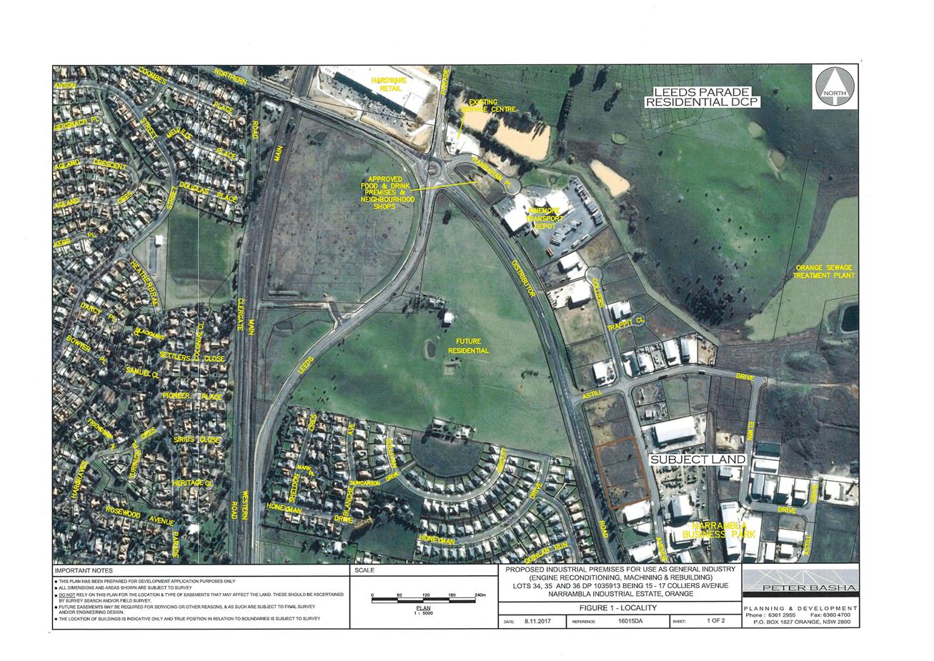
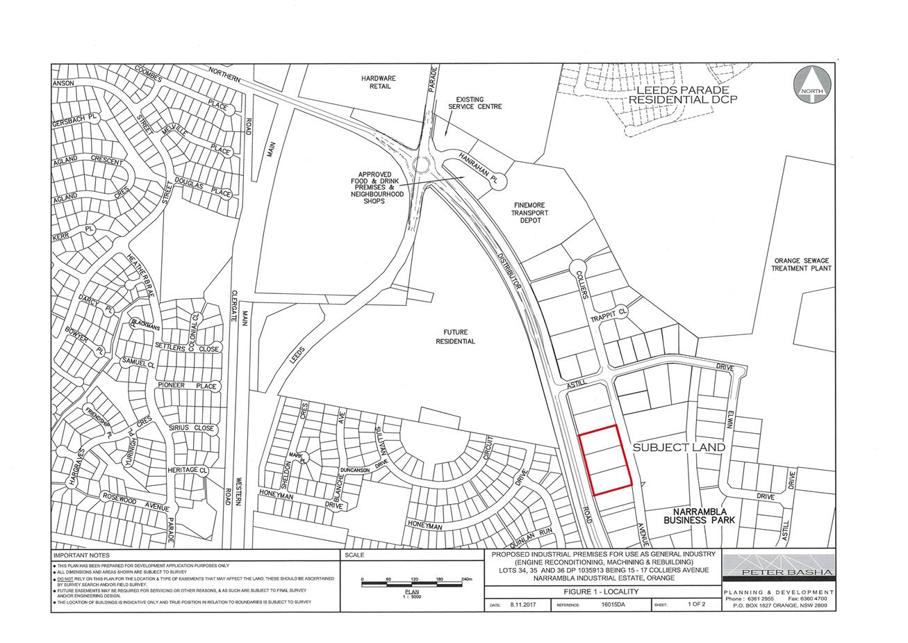
Planning and Development Committee
6 March 2018
2.2 Development
Application DA 212/2017(1) - 13, 15 and 17 Colliers Avenue
Attachment 2 Plans
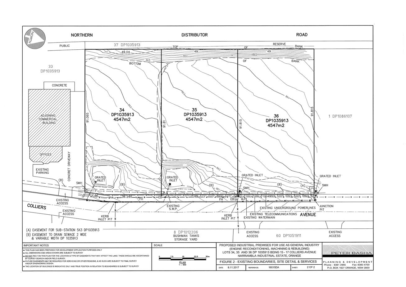
Planning and Development Committee
6 March 2018
2.2 Development
Application DA 212/2017(1) - 13, 15 and 17 Colliers Avenue
Attachment 2 Plans
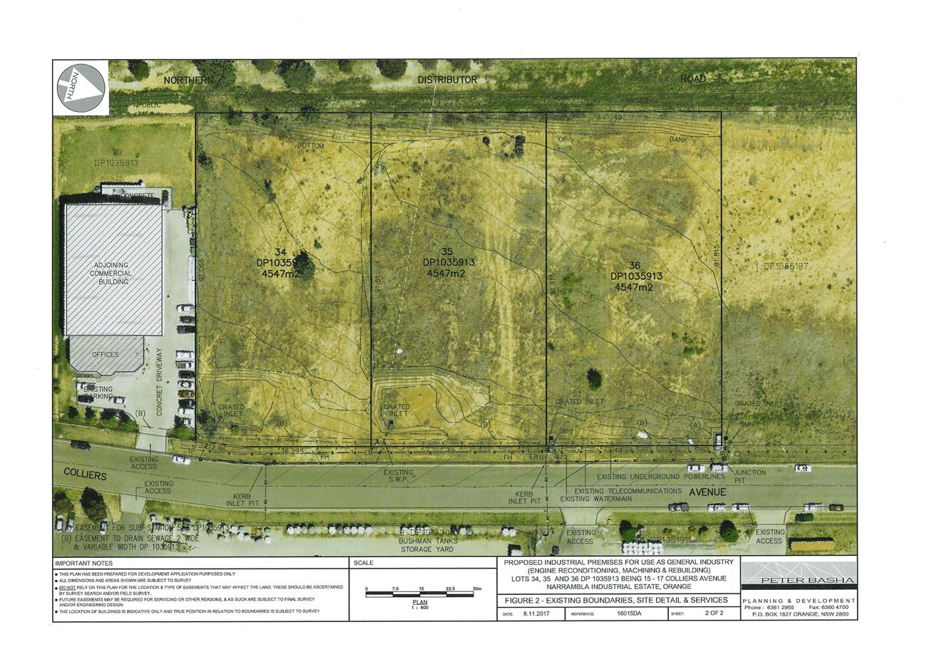
Planning and Development Committee
6 March 2018
2.2 Development
Application DA 212/2017(1) - 13, 15 and 17 Colliers Avenue
Attachment 2 Plans
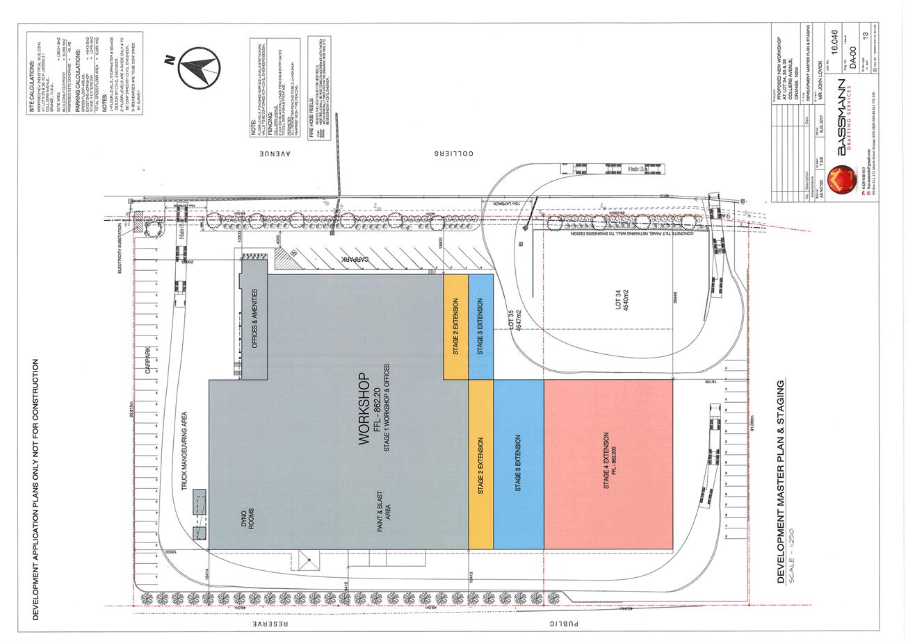
Planning and Development Committee
6 March 2018
2.2 Development
Application DA 212/2017(1) - 13, 15 and 17 Colliers Avenue
Attachment 2 Plans
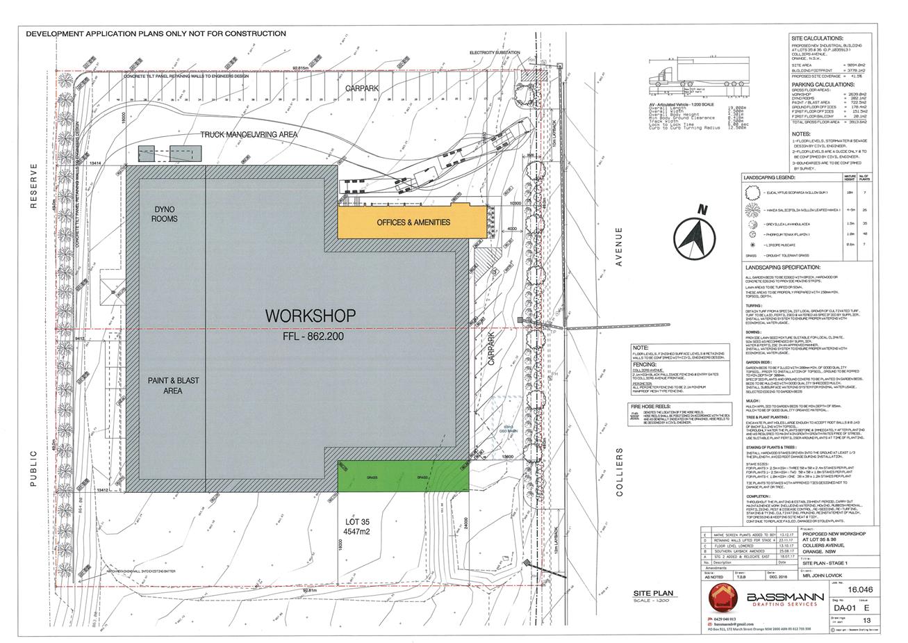
Planning and Development Committee
6 March 2018
2.2 Development
Application DA 212/2017(1) - 13, 15 and 17 Colliers Avenue
Attachment 2 Plans
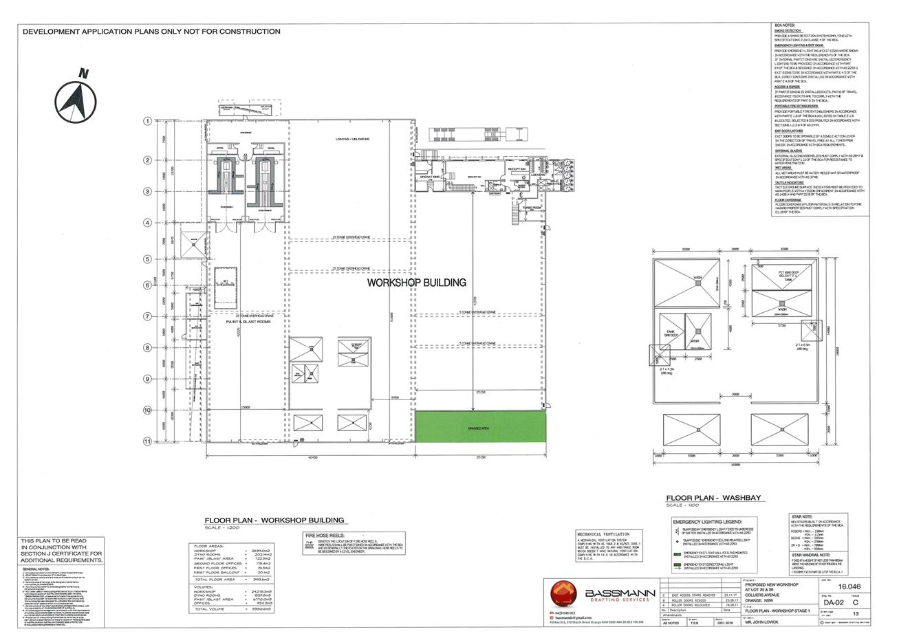
Planning and Development Committee
6 March 2018
2.2 Development
Application DA 212/2017(1) - 13, 15 and 17 Colliers Avenue
Attachment 2 Plans
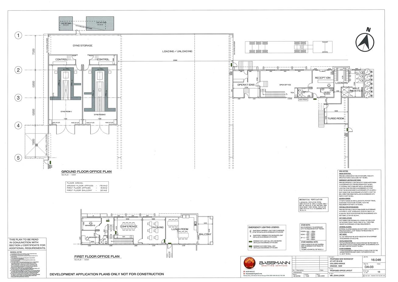
Planning and Development Committee
6 March 2018
2.2 Development
Application DA 212/2017(1) - 13, 15 and 17 Colliers Avenue
Attachment 2 Plans
Planning and Development Committee
6 March 2018
2.2 Development
Application DA 212/2017(1) - 13, 15 and 17 Colliers Avenue
Attachment 2 Plans
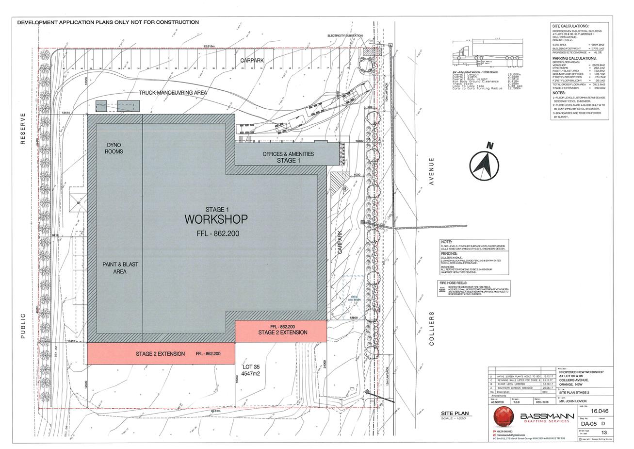
Planning and Development Committee
6 March 2018
2.2 Development
Application DA 212/2017(1) - 13, 15 and 17 Colliers Avenue
Attachment 2 Plans
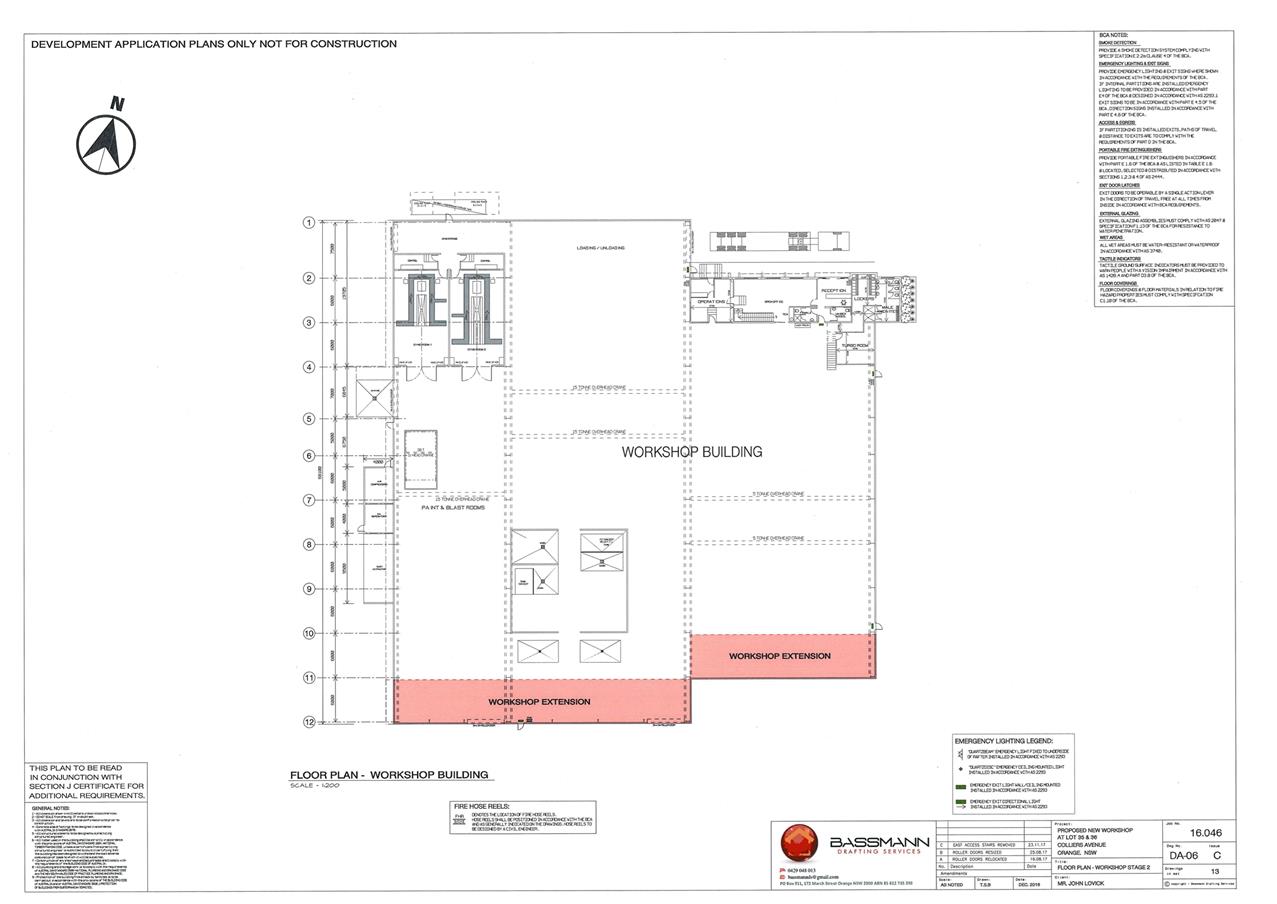
Planning and Development Committee
6 March 2018
2.2 Development
Application DA 212/2017(1) - 13, 15 and 17 Colliers Avenue
Attachment 2 Plans
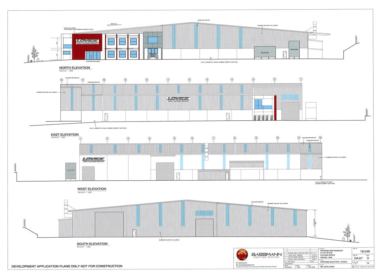
Planning and Development Committee
6 March 2018
2.2 Development
Application DA 212/2017(1) - 13, 15 and 17 Colliers Avenue
Attachment 2 Plans
Planning and Development Committee
6 March 2018
2.2 Development
Application DA 212/2017(1) - 13, 15 and 17 Colliers Avenue
Attachment 2 Plans
Planning and Development Committee
6 March 2018
2.2 Development
Application DA 212/2017(1) - 13, 15 and 17 Colliers Avenue
Attachment 2 Plans
Planning and Development Committee
6 March 2018
2.2 Development
Application DA 212/2017(1) - 13, 15 and 17 Colliers Avenue
Attachment 2 Plans
Planning and Development Committee
6 March 2018
2.2 Development
Application DA 212/2017(1) - 13, 15 and 17 Colliers Avenue
Attachment 2 Plans
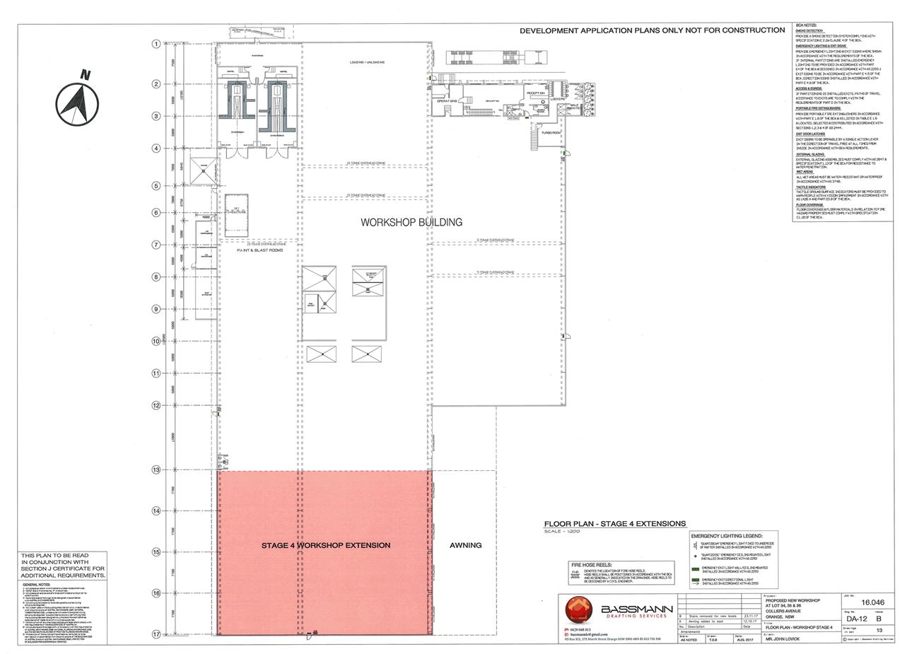
Planning and Development Committee
6 March 2018
2.2 Development
Application DA 212/2017(1) - 13, 15 and 17 Colliers Avenue
Attachment 2 Plans
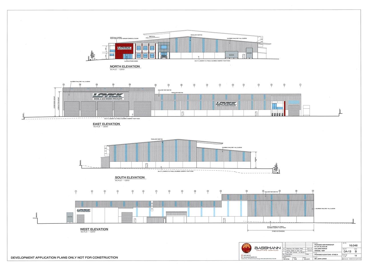
2.3 Development
Application DA 442/2017(1) - 122 McLachlan Street
RECORD
NUMBER: 2018/246
AUTHOR: Summer
Commins, Senior Planner
EXECUTIVE Summary
|
Application
lodged
|
23 November 2017
|
|
Applicant/s
|
Bassmann Drafting Services
|
|
Owner/s
|
Mustang Rocks Pty Ltd and 2Pursue
Mr Gini Pty Ltd
|
|
Land
description
|
Lot 172 DP 1238302 - 122 McLachlan
Street, Orange
|
|
Proposed
land use
|
Boarding House (four boarding
houses), Subdivision (four lot Strata) and Demolition (tree removal)
|
|
Value of
proposed development
|
$1,930,000
|
Council’s consent is sought for development of land at
122 McLachlan Street, Orange, for the purpose of boarding houses. The
development site was recently created by a subdivision (boundary adjustment)
pursuant to DA 157/2017 (amended), to excise the historic cottage at the site
frontage and create a vacant battleaxe development lot.
The proposal involves construction of four x two-storey
buildings, each containing five or six self-contained double rooms and a
communal living room. Shared outdoor open space areas will be provided for each
building, together with private courtyards for some of the rooms. Onsite
vehicle parking will be available. The boarding houses will provide residential
accommodation for lodgers for three months or more. A four lot Strata
subdivision is also proposed to excise each building/boarding house on a
separate Strata lot.
The proposal comprises ‘new generation boarding
houses’ pursuant to State Environmental Planning Policy (SEPP)
(Affordable Rental Housing) 2009. ‘New generation boarding houses’
provide a form of low cost, self-contained rental accommodation for a wide
range of tenants, including singles, retirees, students and young couples. The
SEPP contains clear standards for the design and construction of ‘new
generation boarding houses’ in order to increase the supply and diversity
of affordable rental housing throughout NSW.
The subject land is located in the East Orange Heritage
Conservation Area. Staff and Council’s Heritage Advisor do not support
the proposal on the grounds that the general building design has minimal
elements which relate to the Conservation Area. In particular, the roof type is
not supported. On this basis, it is considered that the proposal will adversely
impact on the significance of the Conservation Area pursuant to Clause 5.10(4)
of Orange Local Environmental Plan (LEP) 2011; and is incompatible with
the character of the local area pursuant to Clause 30A of the
SEPP (Affordable Rental Housing) 2009.
The proposed development will have impacts for the adjoining
dwellings in terms of privacy, visual bulk and overshadowing. The cumulative
effect of those impacts will alter the existing residential amenity afforded to
those dwellings. Notwithstanding, the development is generally consistent with
the relevant planning outcomes and guidelines contained in Development Control
Plan (DCP) 2004. The impacts for the adjoining dwellings are considered to be
within reasonable limit, subject to mitigation conditions should Council be of
the view to support the proposal.
The proposal comprises advertised development pursuant to
Orange Development Control Plan (DCP) 2004. At the completion of the exhibition
period four submissions had been received in relation to the development. The
submissions generally relate to the potential for adverse social, traffic and
amenity impacts on the neighbourhood associated with the proposed boarding
houses.
It is recommended that determination of the application be
deferred at this time and the applicant be requested to redesign the
development to comply with the requirements of Council’s Infill
Guidelines, the requirements of Clause 5.10(4) of Orange LEP 2011; and the
provisions of Clause 30A of the SEPP (Affordable Rental Housing) 2009 in
terms of its impact upon the character of the locality and the Heritage
Conservation Area in general.
DECISION FRAMEWORK
Development in Orange is governed by two key documents
Orange Local Environment Plan 2011 and Orange Development Control Plan
2004. In addition the Infill Guidelines are used to guide development,
particularly in the heritage conservation areas and around heritage items.
Orange Local Environment Plan 2011 – the LEP
should be considered by Council to be a definitive document. LEPs govern the
types of development that are permissible or prohibited in different parts of
the City and also provide some assessment criteria in specific circumstances.
Uses are either permissible or not - there are no grey areas in terms of
permissibility. The objectives of each zoning and indeed the aims of the LEP
itself are, however, open to interpretation and can be used to guide decision
making around appropriateness of development.
Orange Development Control Plan 2004 – the DCP
guides development. In general it is a performance based document rather than
prescriptive in nature - its purpose is to guide development. The Land and
Environment Court tends to view it as such. In each area of interest there are
often guidelines used. These guidelines indicate ways of achieving the planning
outcomes. It is thus recognised that there may also be other solutions of
merit. All design solutions are considered on merit by planning and building
staff. Applications should clearly demonstrate how the planning outcomes are
being met where alternative design solutions are proposed. So one can see that
the DCP gives leeway for developers and architects to use design to achieve the
outcome in other ways if they can. Stating that DCP guidelines are
inflexible can be misleading.
Director’s Comment
This development application involves infill development
comprising a boarding house which, although it is somewhat obscured by an
existing house, will impact on the streetscape and the heritage conservation
area in general. Being in a heritage zone, and reinforced by Council’s
recent position on heritage compatible design, it is very important to maintain
streetscapes and ensure that new development is compatible with the surrounding
character where possible. Council’s Heritage Advisor and staff do not
support the skillion style design of the proposed boarding house, preferring a
more traditional roof form comprising a pitch/hip roof design.
Should Council wish to support staff’s recommendation
of redesign, then an attempt will be made to further encourage the developer to
pursue a more appropriate design. If Council prefers to either refuse or
support the development application, then a Notice of Approval or Refusal will
be brought back to the next Council Meeting outlining the reasons for that
refusal or approval.
Link To Delivery/OPerational Plan
The recommendation in this report relates to the
Delivery/Operational Plan strategy “13.4 Our Environment
– Monitor and enforce regulations relating to City amenity”.
Financial Implications
Nil
Policy and Governance Implications
Nil
|
Recommendation
That Council defer determination of development
application DA 442/2017(1) for Boarding
House (four boarding houses), Subdivision (four lot Strata) and Demolition
(tree removal) at Lot 172 DP
1238302 – 122 McLachlan Street, Orange and the applicant be
requested to redesign the development to comply with the requirements of
Council’s Infill Guidelines, the provisions of Clause 5.10(4) of Orange
Local Environmental Plan 2011, and the provisions of Clause 30A of State
Environmental Planning Policy (Affordable Rental Housing) 2009 in terms of
its impact upon the character of the locality and the Heritage Conservation
Area in general.
|
further considerations
Consideration has been given to the
recommendation’s impact on Council’s service delivery; image and
reputation; political; environmental; health and safety; employees;
stakeholders and project management; and no further implications or risks have
been identified.
SUPPORTING INFORMATION
THE APPLICATION
The proposal involves development of land at 122 McLachlan
Street, Orange for the purpose of boarding houses, Strata subdivision and tree
removal. The development site was recently created by a subdivision (boundary
adjustment) pursuant to DA 157/2017 (amended), to excise the historic cottage
at the site frontage and create a vacant battle-axe development lot.
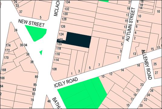
Figure 1 - locality
Four boarding houses will be erected on the land, each
containing five or six self‑contained double rooms, a communal living
room and communal balcony. A total of 22 boarding rooms will be provided,
with 20 rooms available for lodgers and two manager’s rooms. Each
boarding room will be furnished and self-contained, with kitchenette, ensuite
bathroom and laundry facilities.
Shared outdoor open space areas will be provided for each
building, together with private courtyards for four ground floor boarding
rooms, including the manager’s room. Each boarding house will incorporate
an accessible room, and a manager’s room will be provided in
Buildings A and B.
The boarding houses will have a generally rectangular
footprint, arranged parallel to central walkways and communal open space areas.
The buildings will be two-storey and of modern styling with skillion/clerestory
roof profiles; contemporary fenestration (window arrangement) and balustrades;
and mix of painted wall cladding.
Vehicular access to the site will be via an existing access
handle adjacent to the southern boundary. The access driveway will have a
formed minimum width of 6m. Shared onsite parking will be provided at the front
(west) of the boarding houses. The parking area will contain 14 car spaces, 8 motorcycle
spaces and 8 bicycle spaces. A bin enclosure for storage of waste and recycling
bins is proposed on the northern side of the access driveway, together with
mail boxes and utilities (gas meters and electrical boxes).
The proposal involves removal of vegetation along the
southern boundary of the site, comprising English Elm (Ulmus minor) (which has
suckered profusely) and Maple (Aver sp.). New site landscaping is
proposed, and perimeter and internal fencing will be installed.
The proposed site layout and
building design are depicted below.

Figure 2 - proposed site plan
Figure 3 - front (western) elevation and parking area
The development will provide short term accommodation for a
maximum of 40 lodgers (two lodgers x 20 rooms) and four managers (two
managers x 2 rooms). The minimum period of stay for lodgers will be three
months. The boarding rooms will not be serviced (meals, cleaning or laundry).
Maintenance of common areas (grounds and rooms) will be undertaken by the
manager or professional contractor.
Four lot Strata subdivision is proposed in order to excise
each boarding house on a separate Strata lot. Vehicle parking and open spaces
within the development will be allocated to corresponding Strata lots. The
remainder of the site, including driveways, pedestrian areas and landscaped
space, will comprise common property available for shared use by all boarding
house lodgers.
MATTERS FOR CONSIDERATION
Section 1.7 - Application of
Part 7 of the Biodiversity Conservation Act 2016 and Part 7A of the Fisheries
Management Act 1994
From 25 August 2017, the
Biodiversity Conservation Act 2016 and Biodiversity Conservation
Regulation 2017 were gazetted. The implementation of this legislation
(and supporting guidelines) is subject to savings provisions that defer their
full effect for a period of six months from the date of gazettal for local
development.
In this instance, site inspection
reveals that the subject property has no biodiversity or habitat value.
Section 4.15
Section 4.15 of the Environmental Planning and Assessment
Act 1979 requires Council to consider various matters, of which those
pertaining to the application are listed below.
PROVISIONS OF ANY ENVIRONMENTAL
PLANNING INSTRUMENT S4.15
Orange Local Environmental Plan 2011
Part 1 - Preliminary
Clause 1.2 - Aims of Plan
The
particular aims of Orange LEP 2011 relevant to the proposal include:
(a) to encourage development which complements
and enhances the unique character of Orange as a major regional centre boasting
a diverse economy and offering an attractive regional lifestyle,
(b) to provide for a range of development
opportunities that contribute to the social, economic and environmental
resources of Orange in a way that allows present and future generations to meet
their needs by implementing the principles for ecologically sustainable
development,
(e) to provide a range of housing choices in
planned urban and rural locations to meet population growth,
(f) to recognise and manage valued
environmental heritage, landscape and scenic features of Orange.
The application is considered to be consistent with aims (b)
and (e) above but inconsistent with (a) and (f). The following assessment
demonstrates that the built form of the proposed development is generally
inconsistent with the character of the surrounding area and the Heritage
Conservation Area in general. Matters pertaining to the development’s
compatibility with various planning controls relating to the built form and
heritage have been addressed in the body of this report.
Clause 1.6 - Consent Authority
Clause 1.6 is applicable and states:
The consent authority
for the purposes of this Plan is (subject to the Act) the Council.
Clause 1.7 Map
The subject site is identified
on the LEP maps in the following manner:
|
Land Zoning Map:
|
Land zoned R1 General Residential
|
|
Lot Size Map:
|
No minimum lot size
|
|
Heritage Map:
|
Not a heritage item; located within
East Orange Heritage Conservation Area
|
|
Height of Buildings Map:
|
No building height limit
|
|
Floor Space Ratio Map:
|
No FSR requirements
|
|
Terrestrial Biodiversity Map:
|
No biodiversity sensitivity on the
site
|
|
Groundwater Vulnerability Map:
|
Ground water vulnerable
|
|
Drinking Water Catchment Map:
|
Not within the drinking water
catchment
|
|
Watercourse Map:
|
Not within or affecting a defined
watercourse
|
|
Urban Release Area Map:
|
Not within an urban release area
|
|
Obstacle Limitation Surface Map:
|
No restriction on building siting
or construction
|
|
Additional Permitted Uses Map:
|
No additional permitted use applies
|
|
Flood Planning Map:
|
Flood planning area
|
Those matters that are of relevance are addressed in detail
in the body of this report.
Clause 1.9A Suspension of
Covenants, Agreements and Instruments
Clause 1.9A is applicable and states in part:
(1) For the purpose of
enabling development on land in any zone to be carried out in accordance with
this Plan or with a consent granted under the Act, any agreement, covenant or
other similar instrument that restricts the carrying out of that development
does not apply to the extent necessary to serve that purpose.
(2) This clause does not apply:
(a) to a covenant imposed by the Council or that the Council requires to be
imposed, or
(b) to any prescribed instrument within the
meaning of section 183A of the Crown Lands Act 1989, or
(c) to any conservation agreement within the
meaning of the National Parks and Wildlife Act
1974, or
(d) to any Trust agreement within the meaning
of the Nature Conservation Trust Act
2001, or
(e) to any property vegetation plan within the
meaning of the Native Vegetation Act 2003, or
(f) to any biobanking agreement within
the meaning of Part 7A of the Threatened Species Conservation
Act 1995, or
(g) to
any planning agreement within the meaning of Division 6 of Part 4 of the Act.
In consideration of this clause, Council staff are not aware
of the title of the subject property being affected by any of the above.
Part 2 - Permitted or Prohibited Development
Clause
2.1 - Land Use Zones
The subject site is located within the R1 General
Residential zone. The proposed development is defined as “boarding
houses,” “subdivision,” and “demolition.”
Pursuant to the LEP Dictionary:
Boarding
house means a building
that:
(a) is
wholly or partly let in lodgings, and
(b) provides
lodgers with a principal place of residence for 3 months or more, and
(c) may
have shared facilities, such as a communal living room, bathroom, kitchen or
laundry, and
(d) has
rooms, some or all of which may have private kitchen and bathroom facilities,
that accommodate one or more lodgers
Boarding houses are permitted with consent in the R1 zone.
Pursuant to the LEP Dictionary:
Demolish,
in relation to a heritage item or an Aboriginal object, or a building, work,
relic or tree within a heritage conservation area, means wholly or partly
destroy, dismantle or deface the heritage item, Aboriginal object or building,
work, relic or tree.
Demolition (tree removal) is permitted with consent pursuant
to Clause 2.7 (see below).
Pursuant to Section 4B of the Environmental Planning and
Assessment Act:
Subdivision of
land means the division of land into two or more parts that, after the
division, would be obviously adapted for separate occupation, use or
disposition.
Subdivision is permitted with consent pursuant to Clause 2.6
(see below).
Clause 2.3 - Zone Objectives
The
objectives for land zoned R1 General Residential are as follows:
· To provide for
the housing needs of the community.
· To provide for
a variety of housing types and densities.
· To enable other
land uses that provide facilities or services to meet the day to day needs of
residents.
· To ensure
development is ordered in such a way as to maximise public transport patronage
and encourage walking and cycling in close proximity to settlement.
· To ensure that
development along the Southern Link Road has an alternative access.
The proposal is consistent with
the relevant zone objectives as considered below:
- The
proposal will provide a rental housing option to supplement housing needs in
the community.
- The
proposed boarding houses will contribute to the variety of housing types and
densities in the neighbourhood.
- The
subject land is located in proximity to local and neighbourhood shops, and
accessible via public transport.
Clause 2.6 - Subdivision -
Consent Requirements
Clause 2.6 is applicable and states:
(1) Land
to which this Plan applies may be subdivided but only with development consent.
Consent is sought for a four lot Strata subdivision of the
development in accordance with this clause.
Clause 2.7 - Demolition
Requires Consent
Clause 2.7 is applicable and states:
The demolition of a building
or work may be carried out only with development consent.
Consent is sought for tree removal in accordance with this
clause.
Part 3 - Exempt and Complying
Development
The application is not exempt or complying development.
Part 4 - Principal Development Standards
The
Part 4 Principal Development Standards are not applicable to the proposal.
Part 5 - Miscellaneous Provisions
Clause 5.10 Heritage Conservation
Clause 5.10 is applicable and states in part:
(4) The
consent authority must, before granting consent under this clause in respect of
a heritage item or heritage conservation area, consider the effect of the
proposed development on the heritage significance of the item or area
concerned. This subclause applies regardless of whether a heritage management
document is prepared under subclause (5) or a heritage conservation management
plan is submitted under subclause (6).
The subject land is located in the East Orange Heritage
Conservation Area (HCA). The character of this particular precinct and
streetscape is defined by the following design elements:
· traditional,
detached single-storey dwellings;
· dwelling detailing
incorporating modelled roofs with hips and gables, chimneys and verandahs;
· established public
and private landscaping (front and rear gardens) including mature trees;
· a mix of external
finishes; and
· generous side
setbacks/dwelling curtilages with view corridors to the rear.
A departure from the established built character is a
two-storey residential flat building with skillion roof on the adjoining land
to the north (126 McLachlan Street).
In order to consider the effect of the proposed development
on the significance of the East Orange HCA, the proposed development was
referred to Council’s Heritage Advisor. He raised concerns in relation to
the suitability of the building design in the heritage setting and offered the
following guidance/recommendations:
1 The
spacing between buildings needs to include mitigation in the form of varied
wall colours … and mature trees in the car park
2 The
open space needs to allow for landscape tree planting consistent with that in
the area and a mature height of 6-8m is recommended to relate to the building
heights and to allow for visual screening of the bulk
3 The
external materials and colours need to relate to the context and to be
sufficiently dark to visually recede: Buildings A and B only are required to
use two varying darker colours.
4 The
roofs to Buildings A and B need to pitched and hipped in the traditional manner
5 The
roofs to be Colorbond Windspray
6 Buildings
A and B should be provided with propped window awnings to their north, west and
eastern windows and doors in those elevations
The applicant was requested to amend the building design to
address the recommendations of Council’s Heritage Advisor.
Amended plans were subsequently submitted to address the
Heritage Advisor’s recommendations in relation to colours, finishes and
landscaping (listed Items 1, 2, 3 and 5). The proponent was not
amendable to an alternative roof design (listed Item 4) and provided the
following (summarised) justification:
· ‘The
clerestory roof has been designed to provide maximum sunlight and ventilation
without impacting the privacy of residents or neighbours.
· The clerestory
roof form also results in a lower roof profile which will assist in mitigating
the two-storey form.
· The retention
of the existing cottage at 124 McLachlan Street [DA 157/2017
(amended)] and its excision from the site is a substantial measure that has
already been taken in recognition of the contribution that the cottages makes
to the character of the conservation area. The retention of the cottage between
the development site and street goes a long way towards ensuring that the
overall development will be compatible with the heritage character.
· A respective,
low design approach has been following by:
- Maximum
two-storey height
- Breaking
the development up into four buildings with forms and proportions that relate
to other modern era buildings in the conservation area
- Utilising
a simple, modern architectural style which clearly identifies this as a
contemporary development
- Avoiding
replication of period decoration and detailing.
· Specific
contextual details which support the [clerestory roof] design include:
- The
variety of building forms in East Orange Conservation Area, including several
non-traditional style infill developments such as the adjacent town houses
(126 McLachlan Street)
- The
proximity of the site to commercial development along Bathurst Road which
generally utilises flat or skillion roofing forms and unavoidably influences
the character of this location
- The
significant front setback of the buildings (over 38m) which, in combination
with the additional screen planting now proposed, will reduce their visibility
to the street.
· Having regard
to the above, it is submitted that the proposed clerestory roofs are consistent
with [DCP 2004] “respectful design principles” and that it is not
necessary to reproduce pitched and hipped roof forms in the context of this
development.’
Council’s Heritage Advisor provided the following
[paraphrased] comments in relation to the proponent’s amended and
justified submission:
· McLachlan Street
is dominated by pitched roof forms and traditional cottages; indeed, the
development site is informed by the historic cottage at the site frontage
(124 McLachlan Street).
· The residential
flat building adjoining the subject site to the north is not consistent with
the conservation character, and should not be used to justify further
degradation of the character.
· The proposed
buildings will be clearly visible from McLachlan Street based on the curtilage
afforded the historic cottage at 124 McLachlan Street.
· The general
design, materials selection and fenestration are contemporary and have minimal
elements which relate to the conservation area.
· A
medium density design with a serious climate response may be achieved using
traditional forms, with contemporary details and character (as depicted in the
examples provided by the Heritage Advisor below).
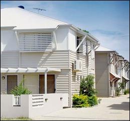
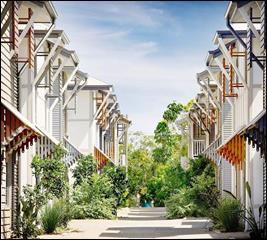
Figure 4 - traditional built form with contemporary
details
Based on the foregoing, it is considered that the proposed
building design will have an adverse effect on the significance of this setting
in the East Orange HCA, pursuant to Clause 10(4).
Given that the subject land is located in a conservation
area, development consent is required and sought for tree removal of the
English Elm (Ulmus minor) and Maple (Aver sp).
As outlined in the following sections of this report,
Council’s Manager City Presentation raised no objection to removal of the
English Elm which has suckered profusely, but he requires that the Maple be
retained. It is considered that the proposed vegetation removal will
significantly alter the landscape setting in the locality.
It is noted that Council’s Heritage Advisor recommended
that landscape tree planting be established to provide a visual screen to the
building bulk. While additional plantings are included in the latest plan set,
the submitted landscape plan is ‘uninspiring’ and ‘not
consistent with the landscape character in this area’
(Council’s Manager City Presentation).
Should the application be approved, conditions would be
imposed requiring preparation and implementation of a landscape plan prepared
by a suitability qualified landscape architect. New plantings would mitigate
vegetation removal along the southern boundary and provide visual screening of
the proposed built form. To this end, subject to conditions, the proposed tree
removal would not adversely impact on the significance of the site and setting
in the East Orange HCA pursuant to Clause 10(4).
Part 6 - Urban Release Area
Part 6 is not relevant to the proposal. The subject land is
not contained within an urban release area.
Part 7 - Additional Local Provisions
7.1
- Earthworks
Clause
7.1 applies. This clause states in part:
(3) Before granting
development consent for earthworks, the consent authority must consider the
following matters:
(a) The likely disruption
of, or any detrimental effect on, existing drainage patterns and soil stability
in the locality of the development
(b) The effect of the
development on the likely future use or redevelopment of the land
(c) The quality of the fill
or the soil to be excavated, or both
(d) The effect of the
development on the existing and likely amenity of adjoining properties
(e) The source of any fill
material and the destination of any excavated material
(f) The likelihood of
disturbing relics
(g) The proximity to and
potential for adverse impacts on any waterway, drinking water catchment or
environmentally sensitive area
(h) Any measures proposed
to minimise or mitigate the impacts referred to in paragraph (g).
In
consideration of this clause, the proposal is suitable. The development will
necessitate earthworks to create level pads for the vehicle areas, buildings
A and B and open space areas. The earthworks will be supported onsite and the
change in ground level is not substantial. Disruption to drainage is considered
to be minor and will not detrimentally affect adjoining properties or receiving
waterways. Should the application be approved, conditions would be imposed in
relation to sediment and erosion control during construction.
7.2 - Flood Planning
The
subject land is contained within a Flood Planning Area pursuant to the Flood
Planning Map. Clause 7.2 applies and states in part:
(3) Development consent
must not be granted to development on land to which this clause applies unless
the consent authority is satisfied that the development:
(a) is compatible with the
flood hazard of the land, and
(b) is not likely to
significantly adversely affect flood behaviour resulting in detrimental
increases in the potential flood affectation of other development or
properties, and
(c) incorporates
appropriate measures to manage risk to life from flood, and
(d) is not likely to
significantly adversely affect the environment or cause avoidable erosion,
siltation, destruction of riparian vegetation or a reduction in the stability
of river banks or watercourses, and
(e) is not likely to result
in unsustainable social and economic costs to the community as a consequence of
flooding.
In consideration of this clause, proposed Buildings C and D
are located within the medium flood risk precinct and adjoin the high
flood risk precinct, pursuant to the Blackmans Swamp Creek Floodplain Risk
Management Study.
Figure 5 - flood risk precincts
As a
consequence of the flood risk, the proposal involves elevation of rear
Buildings C and D on stilts. The overall height of the rear buildings
at the rear building facade will be 8.4m.
Council’s
Development Engineer advised that should the application be approved,
conditions would be imposed to ensure that the development is compatible with
the flood hazard of the land. Such conditions would relate to floor levels,
flood compatible construction, structural details and maintaining an open
waterway (no above-ground structures, unenclosed building subfloor and palisade
fencing).
7.3 - Stormwater Management
Clause 7.3 is applicable. This
clause states in part:
(3) Development
consent must not be granted to development on land to which this clause applies
unless the consent authority is satisfied that the development:
(a) is
designed to maximise the use of water permeable surfaces on the land having
regard to the soil characteristics affecting onsite infiltration of water
(b) includes,
where practical, onsite stormwater retention for use as an alternative supply
to mains water, groundwater or river water
(c) avoids
any significant impacts of stormwater runoff on adjoining downstream
properties, native bushland and receiving waters, or if that impact cannot be
reasonably avoided, minimises and mitigates the impact.
Subject to engineering design, stormwater from the
development will be directed to the drainage channel at the rear of the site.
Onsite stormwater detention will also be required to limit post-development
peak flows to pre-development levels. Should the application be approved,
conditions would be imposed in relation to stormwater management of the
development to satisfy the requirements of Clause 7.3.
Clause 7.11 - Essential Services
Clause
7.11 is applicable. This clause states:
Development
consent must not be granted to development unless the consent authority is
satisfied that any of the following services that are essential for the proposed
development are available or that adequate arrangements have been made to make
them available when required:
(a) the
supply of water
(b) the
supply of electricity
(c) the
disposal and management of sewage
(d) storm
water drainage or onsite conservation
(e) suitable
road access.
In
consideration of this clause, all utility services are available to the land
and adequate for the proposal:
· the subject land
is connected to reticulated water supply;
· electricity and
telecommunications are available to the land;
· the site is
connected to Council’s reticulated sewerage system;
· subject to
augmentation and administration, stormwater management for the subject land is
suitable; and
· the site has
direct frontage and access to McLachlan Street.
STATE ENVIRONMENTAL PLANNING
POLICIES
State Environmental Planning Policy (Affordable Rental
Housing) 2009
SEPP (Affordable Rental Housing) 2009 is applicable. An
assessment of the development against the requirements of the SEPP is outlined
below.
· The proposal is
consistent with the relevant Clause 3 Aims of policy in that affordable rental
housing will be provided in reasonable proximity to employment and businesses.
· The SEPP adopts
the standard instrument definition for “boarding house” pursuant to
Clause 4(2). The proposed development satisfies the definition.
· Boarding houses
are permitted with consent in the R1 General Residential zone, pursuant to
Clauses 26 and 28.
· The
proposal complies with the development standards listed in Clause 29
Standards that cannot be used to refuse consent:
|
Clause
|
Control
|
Proposal
|
Compliance
|
|
29(1)(a)
|
FSR:
maximum
FSR for any form of residential development permitted on the land
|
Not
applicable as there is no floor space limit for the subject land pursuant to OLEP 2011
Floor Space Ratio Map.
|
NA
|
|
29(2)(a)
|
Building
height:
maximum
building height permitted on the land
|
Not
applicable, as there is no building height limit for the subject land
pursuant to the OLEP 2011 Height of Buildings Map.
|
NA
|
|
29(2)(b)
|
Landscape
area:
landscape
treatment of the front setback is compatible with the streetscape
|
Not
applicable, as the subject land and proposed development does not have
frontage to McLachlan Street (excepting the access driveway).
|
NA
|
|
29(2)(c)
|
Solar
access:
communal
living room to receive three hours direct sunlight between 9am and 3pm
|
The
communal living rooms in all buildings/ boarding houses have glazing on the
northern building facade.
Solar
access to communal living rooms in Buildings B and C (on the northern side of
the land) will receive required sunlight.
|
Yes
|
|
|
|
Shadow
diagrams submitted with the application demonstrate that the internal space
between the buildings will be wholly overshadowed between 9am and 3pm.
Window
shadow elevations have not been submitted, but the diagrams suggest communal
living rooms in Buildings A and D will not receive three hours direct
sunlight.
Notwithstanding,
Clause 29(4) allows for variation of a development standard. It is considered
reasonable to vary this standard as a communal balcony is provided on the
first floor of each building. Reasonable solar access will be provided to the
first floor balconies.
|
|
|
29(2)(d)
|
Private
open space:
minimum
20m2 and with 3m dimension for each boarding house; and minimum 8m2
and 2.5m dimension for manager
|
Each
boarding house will be provided with an adjacent communal open space area
with minimum area of 21.3m² and minimum dimension of 3m. A communal
balcony to each boarding house will provide additional private open space for
lodgers.
The
four ground floor rooms in Buildings A and B (which include
manager’s rooms) will each have a private courtyard, with minimum area
of 15.4m² and minimum dimensions of 2.5m.
|
Yes
|
|
29(2)(e)
|
Parking:
0.4
parking spaces for each room and 1 space for manager
|
10
parking spaces are required, based on 8 parking spaces for 20 boarding rooms
and 2 parking spaces for 2 manager’s rooms. Fourteen (14) onsite car
parking spaces are provided.
|
Yes
|
|
29(2)(f)
|
Accommodation
size:
16m2
excluding kitchen and bathroom facilities
|
Each
boarding room exceeds 16m2, excluding kitchen and bathrooms
facilities
|
Yes
|
· The
proposal complies with the prescribed Clause 30 Standards for boarding
houses:
|
Clause
|
Control
|
Proposal
|
Compliance
|
|
30(1)(a)
|
A
communal living room is required for 5+ boarding rooms
|
Each
boarding house will comprise 5 or 6 boarding rooms and a shared communal
living room and communal balcony.
|
Yes
|
|
30(1)(b)
|
Boarding
rooms to have maximum GFA (excluding kitchen and bathroom) of 25m2
|
The
boarding rooms will comprise a maximum GFA of 22.23m2 (excluding
kitchen and bathroom)
|
Yes
|
|
30(1)(c)
|
Occupancy
is limited to 2 adult lodgers
|
Each
boarding room will accommodate a maximum of 2 adult lodgers
|
Yes
|
|
30(1)(d)
|
Bathroom
and kitchen facilities are available for lodgers
|
Each
boarding room will be self-contained with bathroom and kitchen facilities
|
Yes
|
|
30(1)(e)
|
Manager’s
room required for boarding house with 20+ lodgers
|
Each
boarding house will accommodate less than 20 lodgers (a maximum 8 lodgers in
Buildings A and B, and 12 lodgers in Buildings C and D). Notwithstanding, the
development will function as a single facility, and 2 manager’s rooms
will be provided in Buildings A and B.
|
Yes
|
|
30(1)(g)
|
In
commercial zones, residential purposes not permitted on ground floor
|
This
control is not applicable as the subject land is located in the
R1 General Residential zone.
|
NA
|
|
30(1)(h)
|
1
bicycle space and 1 motorcycle space required for every 5 boarding rooms
|
5
bicycle spaces and 5 motorcycle spaces are required based on 22 boarding
rooms. Eight (8) of each will be provided onsite.
|
Yes
|
· Clause 30A of the
SEPP provides that a consent authority must not consent to development
to which this Division applies unless it has taken into consideration whether
the design of the development is compatible with the character of the local
area. As outlined in the heritage assessment above, the building design for the
proposed boarding houses is considered to be incompatible with the character of
the local area. On this basis Council staff are of the view that the subject
development is inconsistent with the requirements of Clause 30A of the SEPP.
· Clause 52 provides
that ‘a consent authority must not grant consent to the strata
subdivision or community title subdivision of a boarding house.’ The
intent of this prohibition is to prevent separate titles being created for each
boarding room, as this would enable rooms to be owner-occupied and therefore no
longer ‘let in lodgings’ which is a defining characteristic of a
boarding house.
· Strata subdivision
is proposed in order to excise each boarding house on a separate Strata lot.
Vehicle parking and open spaces within the development will be allocated to
corresponding Strata lots. The remainder of the site, including driveways,
pedestrian areas and landscaped space, will comprise common property available
for shared use by all boarding house lodgers.
Council has sought legal advice,
which confirms that Strata subdivision of individual boarding houses is not
contrary to the requirements of Clause 52.
State Environmental Planning
Policy 55 - Remediation of Land
SEPP
55 - Remediation of Land is applicable. Pursuant to Clause 7(1):
(1) A consent authority
must not consent to the carrying out of any development on land unless:
(a) it has considered
whether the land is contaminated
(b) if the land is
contaminated, it is satisfied that the land is suitable in its contaminated
state (or will be suitable, after remediation) for the purpose for which the
development is proposed to be carried out
(c) if the land requires
remediation to be made suitable for the purpose for which the development is
proposed to be carried out, it is satisfied that the land will be remediated
before the land is used for that purpose.
In consideration of this clause, the potential for
contamination of the site is considered to be low. The subject land is well
established for residential use. The site is not known to have been used for a
Table 1 purpose to the contaminated land planning guidelines. Further
contamination investigation as a precursor to potential site remediation is
considered unnecessary for the proposed development.
PROVISIONS OF ANY DRAFT
ENVIRONMENTAL PLANNING INSTRUMENT THAT HAS BEEN PLACED ON EXHIBITION
S4.15
There are no draft environmental planning instruments that
apply to the subject land or proposed development.
DESIGNATED DEVELOPMENT
The proposed development is not designated development.
INTEGRATED DEVELOPMENT
The proposal is not integrated development.
PROVISIONS OF ANY DEVELOPMENT
CONTROL PLAN S4.15
Development Control Plan 2004
CHAPTER 0 - TRANSITIONAL PROVISIONS
The following Part 0 Planning Outcomes are applicable to
Tree Preservation:
· Trees
prescribed by this DCP must not be ringbarked, cut down, topped, lopped or
wilfully destroyed without the Council’s approval and landowners consent.
· This clause
applies to Eucalypts of any size belonging to the White Box, Yellow Box and Blakely’s
Red Gum Endangered Ecological Communities, including species indicated as
affected in the tree preservation table.
· This clause
also applies to any tree, native or exotic, with a trunk diameter equal to or
greater than 300mm at breast height (refer AS4970-2009 for measurement
guidelines).
· Notwithstanding
IPO-4(3) this clause does not apply to species indicated as exempt in the tree
preservation table.
· An application
for the Council’s approval must be accompanied by an appropriately
qualified specialist (i.e. Arborist) report.
With reference to the planning outcomes, the proposal
involves removal of two trees adjacent to the southern boundary comprising
English Elm (Ulmus minor) and Maple (Aver sp). The proposed tree removal
was referred to Council’s Manager City Presentation. He advised as
follows:
“With regard to existing
vegetation on the southern boundary, there is a significant amount of English
Elm (Ulmus minor). This tree suckers profusely and in recent years (past 2) elm
trees in Orange have become susceptible to Elm Leaf Beetle. This Beetle, in its
various stages of the life cycle, significantly affects the aesthetics of elm
trees, and over time if left untreated may cause or predispose the tree to
pathogens that compromise the health, vigour and structure. As such I would
support the removal of the Elm Trees along this southern boundary.
Of particular note is the presence
of a Maple (Acer sp. [possibly A. opalus]) growing immediately on the southern
side of the existing boundary fence separating 122 and 120 McLachlan Streets.
The stem of the subject tree is located upon 120 McLachlan Street, it
is a healthy specimen that appears… worthy of retention and protection
from the works associated with the proposed development.
With reference to the
Australian Standards - Protection of Trees on Development Sites (AS4970-2009) a
suitable tree protection zone shall be established… to ensure that the
health and stability of the subject tree are not compromised…
To effect a reasonable TPZ,
but not imposing on the proposed development, the removal of the bike parking
slot and car parks Nos 13 and 14 shall be deleted from the proposal and the
area maintained as ‘low maintenance ground cover’. Providing an
estimated TPZ on the subject development site of approximately 6m in radius
from the centre of the stem of the subject tree.”
Based on the foregoing, should the application be approved,
conditions would be imposed requiring retention of the Maple tree and
establishment of a suitable tree protection zone. The impact of the tree
protection zone on onsite vehicle parking for the development is considered
below.
CHAPTER 7 - DEVELOPMENT IN
RESIDENTIAL AREAS
The following Chapter 7 Planning Outcomes are considered as
a guide in the assessment of the proposal:
Neighbourhood Character
The DCP sets the following Planning Outcomes in regard to
Neighbourhood Character:
· site layout and
building design enables the:
- creation
of attractive residential environments with clear character and identity
- use
of site features such as views, aspect, existing vegetation and landmarks
· buildings are
designed to complement the relevant features and built form that are identified
as part of the desired neighbourhood character
· the
streetscape is designed to encourage pedestrian access and use.
As considered in the heritage assessment above, the building
design for the proposed boarding houses is considered to be incompatible with
the character of the local conservation area. It is recommended that the
applicant be requested to redesign the subject development so as to complement
the relevant features and built form that are identified as part of the desired
neighbourhood character for this locality.
In terms of neighbourhood function, the proposed development
will provide for a continuation of residential landuse and will not alter the
function of the neighbourhood. The proposal will provide a rental housing
option to supplement housing needs in the community, and contribute to the
variety of housing types and densities in the neighbourhood.
Building Appearance
The DCP sets the following Planning Outcomes in regard to
Building Appearance:
· the building
design, detailing and finishes relate to the desired neighbourhood character,
complement the residential scale of the area, and add visual interest to the
street
· the frontages
of buildings and their entries face the street
· garages
and car parks are sited and designed so that they do not dominate the street
frontage.
As considered in the heritage assessment above, the building
design for the proposed boarding houses is incompatible with the character of
the local area. The general design, materials selection and fenestration are
contemporary and have minimal elements which relate to the conservation area.
Being a battleaxe parcel, the site has limited visibility in
the McLachlan Street view corridor (ie when travelling along the public
road). Notwithstanding, expansive views of the site are available at the
frontage due to the spacing between buildings on adjoining parcels.
Vehicle parking areas will not have a street presence.
Heritage
The DCP sets the following Planning Outcomes in regard to
Heritage:
· heritage
buildings and structures are efficiently re-used
· new development
complements and enhances the significance of a heritage item or place of
heritage significance listed in the Orange Heritage Study
· significant
landscape features are retained including original period fences and period
gardens.
As considered in the heritage assessment above, it is
considered that the proposed development will not complement or enhance the
significance of this conservation setting. Recent adjacent buildings that are
inconsistent with the historic character should not be used as a precedent, or
to justify further degradation of the character.
Setbacks
The DCP sets the following Planning Outcomes in regard to
Setbacks:
· street setbacks
contribute to the desired neighbourhood character, assist with the integration
of new development and make efficient use of the site
· street setbacks
create an appropriate scale for the street considering all other streetscape
components.
Being a battleaxe parcel, the proposed development will have
nil impact on streetscape setbacks.
Front Fences and Walls
The DCP sets the following Planning Outcomes in regard to
Fences and Walls:
· Front fences
and walls:
- assist in highlighting entrances and
creating a sense of identity within the streetscape
- are constructed of materials
compatible with associated housing and with fences visible from the site that
positively contribute to the streetscape
- provide for facilities in the street
frontage area such as mail boxes.
The proposal does not involve front fencing to McLachlan
Street. Perimeter and internal fencing will be installed. Mail boxes will be
provided on the northern side of the access driveway at the site frontage.
Visual Bulk
The DCP sets the following Planning Outcome in regard to
Visual Bulk:
· Built form
accords with the desired neighbourhood character of the area with:
- side and rear setbacks progressively
increased to reduce bulk and overshadowing
- site coverage that retains the
relatively low density landscaped character of residential areas
- building form and siting that relates
to landform, with minimal land shaping (cut and fill)
- building height at the street frontage
that maintains a comparable scale with the predominant adjacent development
form
- building to the boundary where
appropriate.
The visual bulk impacts of the proposed development are
considered to be substantial for this particular site due to the following:
· Expansive views of
the site are available at the McLachlan Street frontage due to the spacing
between buildings on adjoining parcels and the curtilage afforded the front
cottage.
· Excepting the
adjoining residential units to the north, the predominant building height is
this neighbourhood is single-storey.
· While four
separate buildings are proposed, the boarding houses will present as a single
complex by virtue of consistent design, enclosed fencing and landscape theme.
The overall footprint for the development is markedly larger than improvements
on adjoining lands.
· The site falls to
the rear towards the drainage channel. A consistent building height is proposed
and required for flood levels, with Buildings C and D to be elevated on stilts.
The building height at the rear façade will be 8.4m, being some 3-4m
higher than adjoining single-storey dwellings to the west and south.
Notwithstanding, the visual impacts in terms of bulk are
generally consistent with the DCP planning outcomes and considered to be
within reasonable limit:
· Side and rear
setbacks will exceed typical residential setbacks, and generally relate to the
setbacks on adjoining lots to the north and south.
· Site coverage for
the development will comprise 24.3% and not exceed the maximum site coverage
for residential development (ie 50% for multi dwelling housing).
· Negligible
earthworks will be required.
· The proposed
boarding houses will be located at the rear of the site on a battleaxe parcel.
Buildings A and B will be set back some 38m from the McLachlan Street frontage
and at the rear of the existing cottage at 124 McLachlan Street.
· The proposed
two-storey form will complement the height of the residential units on the
adjoining parcel to the north at 126 McLachlan Street. Despite this, the unit
development is not considered a precedent to justify a variation to the
neighbourhood character in terms of height.
· The proposed
buildings will be contained within the DCP prescribed visual bulk envelope
plane, excepting minor eave encroachment.
· At the highest
point (8.4m for the rear facades of Buildings C and D), the buildings are
well-removed the McLachlan Street frontage and the adjoining dwellings to the
north and south. Whilst the buildings are large in dimension and will introduce
a new building element at the rear of the subject land, it is considered that
the development will not visually encroach upon adjoining dwellings.
Walls and Boundaries
The DCP sets the following Planning Outcome in regard to
Walls and Boundaries:
· Building to the
boundary is undertaken to provide for efficient use of the site taking into
account:
- the privacy of neighbouring dwellings
and private open space
- the access to daylight reaching
adjoining properties
- the impact of boundary walls on
neighbours.
The proposal does not involve the construction of buildings
on the boundary.
Daylight and Sunlight
The DCP sets the following Planning Outcome in regard to
Daylight and Sunlight:
· Buildings are
sited and designed to ensure:
- daylight to habitable rooms in
adjacent dwellings is not significantly reduced
- overshadowing of neighbouring secluded
open spaces or main living area windows is not significantly increased
- consideration of Council’s
Energy Efficiency Code.
Shadow diagrams have been submitted in support of the
proposal. As demonstrated, the proposed development will impact on solar access
for the adjoining dwelling to the south at 120 McLachlan Street.
As shown, the proposed development will not
overshadow northern windows or the rear (north and east facing) deck from
approximately 11am onwards. Similarly, a portion of the rear yard immediately
adjacent to the dwelling (between the dwelling and shed) will receive on-ground
solar access from approximately 11am onwards.
Shadow calculations have not been submitted, however, it is
extrapolated from the diagrams that solar access to 120 McLachlan Street will
be maintained consistent with the DCP guidelines (ie 40% of the required
open space area for three hours and 75% of north‑facing windows for
four hours), notwithstanding overshadowing caused by the proposed boarding
houses.
Views
The DCP sets the following Planning Outcomes in regard to
Views:
· building form
and design allow for residents from adjacent properties to share prominent
views where possible
· views including
vistas of heritage items or landmarks are not substantially affected by the
bulk and scale of the new development.
Notwithstanding the battleaxe configuration of the
development site, expansive views of the land are available at the McLachlan
Street frontage due to the spacing between buildings on adjoining parcels. The
development will be viewed from the street between the buildings at the site
frontage. As such, the building design and detailing should complement the
neighbourhood character. As considered in the heritage assessment above, the
building design for the proposed boarding houses is incompatible with the
character of the local area.
Visual Privacy
The DCP sets the following Planning Outcome in regard to
Visual Privacy:
· direct
overlooking of principal living areas and private open spaces of other
dwellings is minimised firstly by:
- building
siting and layout
- location
of windows and balconies
and secondly by:
- design
of windows or use of screening devices and landscaping.
The proposed site layout and building design will provide
reasonable visual privacy for the proposed development and adjoining dwellings.
The boarding houses will be sited a minimum 4m from the side
boundaries, being more than a typical residential setback. Perimeter fencing
1.8m in height will be installed/ maintained on the development site.
Buildings B and C will oppose the residential units on the
adjoining land to the north (126 McLachlan Street), including driveway and
unit entrances. Windows to boarding rooms on the first floor northern
façade will comprise hi-lite windows only, with sill height
of 1.5m. Communal room windows to the north will be at ground level only
and sited some 6m from the northern boundary. Perimeter fencing will
prevent direct views. The first floor and north-facing communal balcony will
have a solid balustrade to prevent overlooking when sitting.
Buildings A and D will oppose the dwelling on the adjoining
land to the south (at 120 McLachlan Street). The first floor southern
façade will comprise balconies/verandahs, entry doors and ensuite
windows to boarding rooms on the first floor. The spaces are non‑habitable
and will not result in unreasonable overlooking to the south. It is noted that
a distance of some 13m is available between nearest Building A and the rear
deck for 120 McLachlan Street. This distance exceeds the DCP-prescribed
9m, for which additional privacy measures are considered necessary. Retention
of the Maple tree and new screen planting to the southern boundary (as required
by conditions should the application be approved) will maintain visual privacy
for 120 McLachlan Street. Should Council be of the view that additional privacy
measures along the upstairs verandah were required in this case, it would also
be necessary to attach a condition of consent in the event that consent is
granted.
Buildings A and B will oppose the dwelling on the adjoining
land to the west (known as 124 McLachlan Street, at the site frontage).
The western façade comprises first-floor boarding room habitable
windows. The subject windows are located a distance of 17.8m from the
common boundary. This distance, exceeds the DCP-prescribed 9m, for which
additional privacy measures are required. Perimeter landscaping to the vehicle
parking area will be established to assist in obscuring views from the
development to the historic cottage and its rear yard.
Acoustic Privacy
The DCP sets the following Planning Outcome in regard to
Acoustic Privacy:
· site layout and
building design:
- protect
habitable rooms from excessively high levels of external noise
- minimise
the entry of external noise to private open space for dwellings close to major
noise sources
- minimise
transmission of sound through a building to affect other dwellings.
A Noise Impact Assessment (Wilkinson Murray November
2017) was submitted in support of the proposal. Noise impacts associated with
the development involve movement of vehicles in the car park and mechanical
plant. The assessment concludes that noise impacts on neighbouring residential
receivers associated with the development will comply with established criteria
(NSW Industrial Noise Policy) at all times.
Security
The DCP sets the following Planning Outcomes in regard to
Security:
· the site layout
enhances personal safety and minimises the potential for crime, vandalism and
fear
· the design of
dwellings enables residents to survey streets, communal areas and approaches to
dwelling entrances.
Should the application be approved,
conditions would be imposed in relation to surveillance, access control,
territorial enforcement and space management in order to reduce the crime risks
associated with the proposal.
Circulation and Design
The DCP sets the following Planning Outcome in regard to
Circulation and Design:
· accessways and
parking areas are designed to manage stormwater
· accessways,
driveways and open parking areas are suitably landscaped to enhance amenity
while providing security and accessibility to residents and visitors
· the site layout
allows people with a disability to travel to and within the site between car
parks, buildings and communal open space.
Subject to engineering design, stormwater from the
development (including the access driveway and parking areas) will be directed
to the drainage channel at the rear of the site. Onsite stormwater detention
will be required to limit post-development peak flows to pre‑development
levels. Should the application be approved, conditions would be imposed in
relation to stormwater management of the development.
The subject land has vehicular access via McLachlan Street
adjacent to the southern boundary. The existing vehicle crossing and proposed
formed driveway will have a minimum width of 6m to ensure safe and convenient
vehicle access to the site with forward entry and exit. The proposed car park
layout will comply with AS 2860.1-2004 - Off Street Parking. Landscaping will
be provided to the parking area perimeter and adjacent to the access driveway.
The site layout and building design will facilitate the
movement of people with a disability between parking area, accessible rooms and
communal areas.
Car Parking
The DCP sets the following Planning Outcomes in regard to
Car Parking:
· parking
facilities are provided, designed and located to:
- enable
the efficient and convenient use of car spaces and accessways within the site
- reduce
the visual dominance of car parking areas and accessways.
· car parking is
provided with regard to the:
- the
number and size of proposed dwellings
- requirements
of people with limited mobility or disabilities.
As outlined previously, car parking will be provided for the
development in compliance with the SEPP (Affordable Rental Housing) 2009
(Clause 29(2)(e)). Ten (10) car spaces are required and 14 provided.
Proposed tree removal along the southern boundary has
implications for onsite parking resources. Council’s Manager City
Presentation raised no objection to removal of the English Elm, which has
suckered profusely; however he requires retention of the Maple. In order to
retain the Maple a tree protection zone will be required, comprising an area of
approximately 6m in radius from the centre of the stem of the subject tree. The
tree protection zone will necessitate the removal of car spaces
numbered 13 and 14 and motorcycle space numbered 8. Despite
removal of these spaces (via conditions subject to approval), the proposal will
remain consistent with the provisions of the SEPP in relation to vehicle
parking for the development.
The proposal is inconsistent with the nearest-equivalent car
parking requirement of DCP 2004, which requires one space per bedroom, or
a total of 22 spaces. The development would have a parking shortfall of 10
spaces (based on removal of car spaces for the tree protection zone).
Notwithstanding, the provisions of the SEPP prevail in the event of any
inconsistency.
On-street parking is available at the frontage of the
development site, with additional spaces at the frontage of adjoining
residential parcels to the south along McLachlan Street. It is likely, despite
the development’s compliance with the requirements of the SEPP, that
on-street parking would be required to accommodate overflow parking needs.
Private Open Space
The DCP sets the following Planning Outcomes in regard to
Private Open Space:
· private open
space is clearly defined for private use
· private open
space areas are of a size, shape and slope to suit the reasonable requirements
of residents including some outdoor recreational needs and service functions
· private open
space is:
- capable
of being an extension of the dwelling for outdoor living, entertainment and recreation
- accessible
from a living area of the dwelling
- located
to take advantage of outlooks; and to reduce adverse impacts of overshadowing
or privacy from adjoining buildings
- Orientated
to optimise year round use.
As outlined previously, private open space will be provided
for the development in compliance with SEPP (Affordable Rental Housing) 2009
(Clause 29(2)(d)).
Open Space
and Landscaping
The DCP sets the following Planning Outcomes in regard to
Open Space and Landscaping:
· the site layout
provides open space and landscaped areas which:
- contribute
to the character of the development by providing buildings in a landscaped
setting
- provide
for a range of uses and activities including stormwater management
- allow
cost effective management.
· the landscape
design specifies landscape themes consistent with the desired neighbourhood
character; vegetation types and location, paving and lighting provided for
access and security
· major existing
trees are retained and protected in a viable condition whenever practicable
through appropriate siting of buildings, accessways and parking areas
· paving is
applied sparingly and integrated in the landscape design.
A landscape plan has been submitted in support of the
proposal. Council’s Manager City Presentation provided the following
advice in relation to the plan:
“The submitted landscape
plan is uninspiring and the selection of trees (Eucalypts) does not meet with
the Heritage Advisor’s stipulation of ‘consistent with that in the
area’ apart from the mature height (which is rather small). Deciduous
exotics are the dominant tree type in the vicinity as such I would recommended
examples such as:
- Crepe
Myrtle (Lagerstroemia indica) D
- Crab
Apple (Malus ioensis ‘Plena’) D
- Chinese
Elm (Ulmus parvifolia) Note Chinese Elm is not known to be susceptible to Elf
Leaf Beetle. D
- Ornamental
Pear (Pyrus sp)
- Trident
Maple (Acer
- Persian
Witchhazel (Parrotia persica)
A greater number of planted trees
[will be required], not just 5 specimens.”
Should the application be approved, conditions would be
imposed requiring preparation and implementation of a revised landscape plan by
a suitably qualified landscape architect, including but not limited to:
· exotic deciduous
species (consistent with the advice of Council’s Manager City
Presentation and Heritage Advisor);
· screen planting to
the southern (side) boundary adjacent to 120 McLachlan Street;
· screen planting to
the western (front) boundary adjacent to 124 McLachlan Street;
· additional
plantings to the eastern (rear) boundary appropriate to the flood risk
precinct;
· additional
plantings to the southern side of the access driveway to soften hardstand; and
· retention of the
Maple tree and establishment of a planted tree protection zone.
Stormwater
The DCP sets the following Planning Outcomes in regard to
Stormwater:
· onsite drainage
systems are designed to consider:
- downstream
capacity and need for onsite retention, detention and re-use
- scope
for onsite infiltration of water
- safety
and convenience of pedestrians and vehicles
- overland
flow paths.
· provision
is made for onsite drainage which does not cause damage or nuisance flows to
adjoining properties.
Subject to engineering design, stormwater from the
development will be directed to the drainage channel at the rear of the site.
Onsite stormwater detention will be required to limit post-development peak
flows to pre-development levels. Should the application be approved, conditions
would be imposed in relation to stormwater management of the development to
satisfy the requirements of Clause 7.3.
Erosion and Sedimentation
The DCP sets the following Planning Outcome in regard to
Erosion and Sedimentation:
· measures
implemented during construction to ensure that the landform is stabilised and
erosion is controlled.
Should the application be
approved, conditions would be imposed in relation to sediment and erosion
control during construction.
Subdivision
The DCP sets the following (applicable) Planning Outcomes in
regard to urban residential subdivision:
· lots are fully
serviced and have direct frontage and access to a public road
· design and
construction complies with the Orange Development and Subdivision Code.
The proposal involves Strata subdivision of the development
to excise each boarding house and associated parking spaces on separate Strata
lots. Vehicle parking and open spaces within the development will be allocated
to corresponding Strata lots. The remainder of the site, including driveways,
pedestrian areas and landscaped space will comprise common property available
for shared use by all boarding house lodgers. The proposed strata subdivision
is not contrary to the planning outcomes, nor the provisions of SEPP
(Affordable Rental Housing) 2009 (Clause 52).
INFILL GUIDELINES
As considered in the heritage assessment above, the proposed
development departs from the Assessment Criteria contained in the Infill
Guidelines:
Scale and Form: the proposal is inconsistent with the
prevailing residential form, profile and height. “The
residential flat building adjoining the subject site to the north is not
consistent with the conservation character, and should not be used to justify
further degradation of the character” (Heritage Advisor to Orange
City Council).
Siting: development on the battleaxe parcel will not
affect the established streetscape building line. Notwithstanding, views of the
site are available between buildings at the site frontage; as such the building
design and detailing should complement the neighbourhood character.
Materials and colour: external colours have been
recommended by Council’s Heritage Advisor to mitigate the contemporary
building design
Detailing: the general design, materials selection
and fenestration are contemporary and have minimal elements which relate to the
conservation area.
Based on an assessment of the development against
Council’s adopted Infill Guidelines, the requirements of Clause 5.10(4)of
the LEP relating to heritage matters and the requirements of Clause 30A of the
SEPP (Affordable Rental Housing) 2009 it is recommended that the applicant be
requested to consider redesign of the development to more appropriately relate
to the context of the surrounding locality.
DEVELOPMENT CONTRIBUTIONS
Orange Development Contributions Plan 2017
Orange Development Contributions
Plan provides for the levying of development contributions for residential
accommodation (including boarding houses). Based on 22 boarding rooms
less 1 credit for the existing residential parcel in the LGA contributions
area, development contributions are applicable as follows:
Should the application be
approved, a condition would be imposed requiring payment of contributions
(applicable to the LGA contributions area) prior to issue of a Construction
Certificate for the proposed development.
|
Open Space and Recreation
|
22 additional 1 bedroom boarding
rooms @ $1,641.58
less 1 standard lot @ $3,891.67
|
32,223.09
|
|
Community and Cultural
|
22 additional 1 bedroom boarding
rooms @ $476.06
less 1 standard lot @ $1,128.59
|
9,344.73
|
|
Roads and Traffic Management
|
22 additional 1 bedroom boarding
rooms @ $2,417.35
less 1 standard lot @ $5,136.89
|
48,044.81
|
|
Plan Preparation &
Administration
|
22 additional 1 bedroom boarding
rooms @ $128.54
less 1 standard lot @ $304.72
|
2,523.16
|
|
TOTAL:
|
|
$92,135.79
|
WATER AND SEWER HEADWORKS
CHARGES
Section 64 water and sewer headwork charges are applicable
to the proposed development. The contributions for water, sewer and drainage works
are based on 0.33 water ET and 0.5 sewer ET per boarding room, pursuant to
the NSW Water Directorate Guidelines. Should the application be approved,
conditions would be imposed requiring payment of contributions prior to issue
of a Construction Certificate.
PROVISIONS PRESCRIBED BY THE
REGULATIONS S4.15
Demolition of a Building (clause 92)
The proposal does not involve the demolition of a building.
Fire Safety Considerations
(clause 93)
Each boarding room will be considered a separate fire
compartment. Details to achieve compliance with the BCA in this respect will be
required with a Construction Certificate application. Should the application be
approved, conditions would be recommended in relation to this matter.
Buildings to be Upgraded
(clause 94)
The proposal does not involve the upgrading of an existing
building.
BASIX Commitments (clause 97A)
BASIX is not applicable to the proposed boarding house. A
Section J energy efficiency statement will be required with the Construction
Certificate application.
THE LIKELY IMPACTS OF THE
DEVELOPMENT S4.15
Impacts on Conservation Area
As considered in the heritage assessment above, the building
design for the proposed boarding houses is incompatible with the character of
the local area. It is considered that the proposed building design will have
adverse effect on the significance of this setting in the East Orange HCA.
Visual Impacts
As outlined in the foregoing assessment, the visual impacts
of the proposal are considered unsuitable as the general design does not relate
to the neighbourhood built form. Visual impacts associated with siting, massing
and landscaping are considered to be within reasonable limit, subject to
mitigation conditions should the application be approved.
Residential Amenity
A high standard of residential amenity will be provided to
lodgers of the proposed boarding house. In various design considerations, the
development exceeds the prescribed controls contained within the SEPP
(Affordable Rental Housing) 2009. Impacts of the development on the amenity of
adjoining dwellings (in terms of acoustic privacy, visual privacy, solar access
and visual bulk) are considered to be within reasonable limit, subject to
mitigation conditions should the application be approved.
Anti-Social Behaviour and Crime
Consideration has been given to the principles of Crime
Prevention through Environmental Design in the proposed site layout and
building design. Should the application be approved,
conditions would be imposed in relation to surveillance, access control,
territorial enforcement and space management in order to reduce the crime risks
associated with the proposal.
Traffic Matters
The proposal is considered to be satisfactory in terms of
traffic impacts due to the following:
· The capacity of
the local road network is sufficient to accommodate additional localised
traffic generated by the boarding houses.
· Onsite vehicle
parking resources are consistent with the requirements of the
SEPP (Affordable Rental Housing) 2009.
· On-street parking
may be required to meet a perceived shortfall of parking spaces (ie 12 car
parking spaces are available for a total of 22 boarding rooms). On-street
parking is available to the north along McLachlan Street. On-street parking
adjacent to the site is suitably removed from intersections and has reasonable
sightlines to the north. On‑street parking is unlikely to generate
traffic conflicts.
· The car park
layout and design will comply with AS 2890.1-2004 - Off-street car parking.
Environmental Impacts
The subject land is contained within an established
residential precinct and comprises cleared vacant land, excepting vegetation
proposed for removal along the southern boundary. Significant vegetation,
threatened species or ecological endangered communities or their habitats are
unlikely to be present. The site is not in proximity to any waterway, drinking
water catchment or sensitive area.
THE SUITABILITY OF THE SITE
S4.15
The subject land is suitable for the development due to the
following:
· boarding houses
are a permitted landuse in the R1 zone;
· the site is of
sufficient area and dimensions to accommodate the proposed development;
· the subject land
is flood liable; however Council’s Technical Services Division advises
that mitigation conditions may be imposed to manage flood hazards should the
application be approved;
· the site has
direct frontage and access to McLachlan Street;
· onsite vehicle
parking will be provided;
· the site
topography will not unreasonably constrain the development nor generate
unreasonable offsite impacts;
· there is no known
contamination on the land;
· the subject land
is located in proximity to the Central Business District, and is accessible via
public transport;
· all utility
services are available and adequate subject to augmentation;
· the subject land
has no biodiversity or habitat value;
· the site is not
known to contain any Aboriginal, European or archaeological relics.
ANY SUBMISSIONS MADE IN
ACCORDANCE WITH THE ACT S4.15
The proposed development is defined as "advertised
development" pursuant to DCP 2004‑5.3. The application was
advertised for the prescribed period, and at the end of that period four (4)
submissions had been received. The issues raised in the submissions are
considered below.
· Nominated
health professionals are unlikely to utilise or require low cost rental
accommodation; ongoing use of the boarding rooms by nominated health
professionals is unlikely.
Comment: The applicant intends
that the boarding houses will be occupied by medical professionals. The
intended lodgers is not a matter for Council in consideration of the proposal.
Council does not have the ability to impose conditions of consent (nor enforce
such conditions) placing limitations on lodgers. It is concurred that ongoing
occupation of the boarding houses may not be by medical professionals;
however, this is not a planning matter.
· The boarding
houses may be occupied by socially or economically disadvantaged persons, with
associated potential for adverse social impacts in the neighbourhood.
Comment: Traditional boarding houses, being those
with shared facilities, have historically provided low cost rental
accommodation for disadvantaged persons. The proposed development comprises
‘new generation boarding houses’ pursuant to
SEPP (Affordable Rental Housing) 2009. Pursuant to the SEPP,
‘new generation boarding houses’ provide a form of low cost,
self-contained rental accommodation for a wide range of tenants, including
singles, retirees, students and young couples. The SEPP contains clear
standards for the design and construction of ‘new generation boarding
houses,’ in order to increase the supply and diversity of affordable
rental housing throughout NSW. Adverse social impacts are not anticipated
as a consequence of the proposal, due to the following:
- The
proposal complies with or exceeds the development standards contained in
SEPP (Affordable Rental Housing) 2009.
- Operation
and management of the boarding houses will be governed by legislation (Boarding
Houses Act 2012 and the Boarding Houses Regulation 2013).
- Should
the application be approved, conditions would be imposed relating to the
prevention of crime and anti-social behaviour.
· Insufficient
onsite parking is available for the boarding houses; overflow on-street parking
will cause traffic congestion and conflict; parking restrictions in McLachlan
Street are required.
Comment: As outlined in this report, onsite vehicle
parking resources are consistent with the requirements of SEPP (Affordable
Rental Housing) 2009. Overflow on-street parking is available in the vicinity
of the site. It is not considered that parking restrictions in McLachlan Street
are required as a consequence of the development. Notwithstanding, this matter
can be monitored and assessed as required in conjunction with Council’s
Traffic Committee.
· The development
should be ‘gated’ in order to increase site security.
Comment: The proposal does not involve a gate across
the access driveway to restrict site access to managers and lodgers. There is
no requirement for a gate to be provided.
· The proposal
will result in overlooking of the historic cottage at 124 McLachlan Street from
first floor west-facing boarding room windows; landscaping will be required to
achieve privacy.
Comment: As outlined previously, the subject windows
are located a distance of 17.8m from the common boundary with 124 McLachlan
Street. DCP 2004 prescribes that ‘habitable room windows on upper-floor
levels within 9m from windows or living areas of adjacent dwellings ..…
are offset sufficient distance, or include measures to screen or obscure
views.’ As such, habitable room windows in the development are located a
greater distance to adjoining habitable spaces than prescribed in the DCP, and
preclude the need for screening. Perimeter landscaping to the vehicle parking
area will be established to assist in obscuring views from the development to the
historic cottage (as outlined above).
· The bin bay
should not be sited adjacent to existing dwellings.
Comment: A permanent bin enclosure is proposed on the
northern side of the access driveway, adjoining the cottage at 124 McLachlan
Street. Should the application be approved, a condition would be imposed
requiring placement of bins in the bin enclosure on collection days only, and
permanent storage of bins elsewhere on the site in a location more convenient
to lodgers. This arrangement is consistent with waste collection at other
multi-dwelling housing developments in the City whereby the proponent enters
into a private waste pick-up contract for the servicing of bins. A further bin
storage area for during the week (ie not collection days) would be required to
be shown on Construction Certificate drawings.
· Smoking control
in McLachlan Street will be required if the boarding house is a non‑smoking
facility.
Comment: Communal open space is available for lodgers
who choose to smoke.
· The letter
boxes should be relocated from the north side of the access driveway at the
site frontage.
Comment: There is no planning reason to require
relocation of the letter boxes. The facility will be screened from the
adjoining dwelling at 124 McLachlan Street by perimeter fencing and
landscaping. The proposed location is functional.
· Boarding houses
are unsuitable in the low-density residential neighbourhood.
Comment: Boarding houses are permitted in the R1
General Residential zone (being the zoning of the subject land) pursuant to
Orange LEP 2011 and SEPP (Affordable Rental Housing) 2009. The proposal is
consistent with the relevant R1 zone objectives insofar as the proposal will
provide a rental housing option to supplement housing needs in the community,
and contribute to the variety of housing types and densities in the
neighbourhood. It is considered that the proposed boarding houses will suitably
integrate in the neighbourhood in respect of landuse and function.
· The proposed
built form will have adverse visual impacts on the streetscape.
Comment: This matter has been variously addressed in
this report. It is considered that the proposed built form is unsuitable in
this setting.
· The proposed
tree removal on the southern boundary will alter the landscape setting.
Comment: As outlined in this report, Council’s
Manager City Presentation raised no objection to removal of the English Elm
which has suckered profusely, but he requires that the Maple be retained.
Should the application be approved conditions would be imposed requiring
preparation and implementation of a landscape plan prepared by a suitability
qualified landscape architect. New plantings would mitigate vegetation removal
along the southern boundary and provide visual screening of the proposed built
form.
· The proposal
will overlook the rear deck at 120 McLachlan Street (adjoining to the south).
Comment: As outlined in this report, the rear deck at
120 McLachlan Street will oppose the proposed vehicle parking area. Retention
of the adjacent Maple on the boundary as noted above will assist to maintain
privacy to the deck. Additional plantings on the southern boundary pursuant to
an amended landscape plan (as required by conditions should the application be
approved) will also assist.
· The proposal
will unreasonably overshadow 120 McLachlan Street (adjoining to the south).
Comment: As outlined previously, shadow diagrams have
been submitted in support of the proposal. As demonstrated, the proposed
development will impact on solar access for the adjoining dwelling to the south
at 120 McLachlan Street.
As shown, the proposed development will not overshadow
northern windows or the rear (north and east facing) deck from approximately
11am onwards. Similarly, a portion of the rear yard immediately adjacent to the
dwelling (between the dwelling and shed) will receive on-ground solar access
from approximately 11am onwards.
Shadow calculations have not been submitted; however, it is
extrapolated from the diagrams that solar access to 120 McLachlan Street will
be maintained consistent with the DCP guidelines (ie 40% of the required
open space area for three hours; and 75% of north-facing windows for four
hours), notwithstanding overshadowing caused by the proposed boarding houses.
· The
balcony/access areas on the south façade of the boarding houses will
overlook 120 McLachlan Street.
Comment: As previously considered, Buildings A and B
will oppose the cottage on the adjoining land to the south. The first floor
southern façade will comprise balconies/ verandahs, entry doors and
ensuite windows to boarding rooms. The spaces are non‑habitable and will
not result in unreasonable overlooking to the south. A distance of some
13m is available between nearest Building A and the rear deck at
120 McLachlan Street. This distance exceeds the DCP-prescribed 9m for
which additional privacy measures are required.
Should the application be approved, conditions would be
imposed requiring perimeter planting to the southern boundary of sufficient
height to minimise overlooking from Buildings A and D entrance
balconies/verandahs to the rear yard of 120 McLachlan Street. Whilst not
specifically recommended, should Council be of the view that additional privacy
measures along the upstairs verandah were required in this case, it would also
be necessary to attach a condition of consent in the event that consent is granted.
· Is strata
subdivision of the development permitted?
Comment: Council has sought legal advice which
confirms that Strata subdivision as proposed is not contrary to the
requirements of SEPP (Affordable Rental Housing) 2009. There are no
planning objections to the proposed Strata subdivision.
PUBLIC INTEREST S4.15
The proposal is not inconsistent with the planning regime
that applies to the particular landuse and subject land, excepting the heritage
and character provisions cited in this report. The proposed landuse is
considered to be in the public interest by increasing the supply and diversity
of rental housing. However, the proposed building design is considered
unsuitable in the particular conservation setting. Approval of the application
in the form submitted would not be in the public interest.
SUMMARY
Council’s consent is sought for development of land at
122 McLachlan Street, Orange, for the purpose of boarding houses.
The proposal comprises ‘new generation boarding
houses’ pursuant to State Environmental Planning Policy (SEPP)
(Affordable Rental Housing) 2009. ‘New generation boarding houses’
provide a form of low cost, self-contained rental accommodation for a wide
range of tenants, including singles, retirees, students and young couples.
The SEPP contains clear standards for the design and construction of
‘new generation boarding houses’ in order to increase the supply
and diversity of affordable rental housing throughout NSW.
The subject land is located in the East Orange Heritage
Conservation Area. Council’s Heritage Advisor does not support the
proposal on grounds that that the general building design has minimal elements
which relate to the Conservation Area. On this basis, it is considered that the
proposal will adversely impact on the significance of the Conservation Area
pursuant to Clause 5.10(4) of Orange LEP 2011, and is incompatible with the
character of the local area pursuant to Clause 30A of State Environmental
Planning Policy (Affordable Rental Housing) (ARHSEPP) 2009.
It is recommended that determination of the application be
deferred pending design revisions that that are appropriate to the conservation
setting and will satisfy Council’s Development Control Plan 2004 Infill
Guidelines.
Attachments
1 Plans,
D18/7787⇩
2 Submissions,
D18/7881⇩
Planning and Development Committee
6 March 2018
2.3 Development
Application DA 442/2017(1) - 122 McLachlan Street
Attachment 1 Plans
Planning and Development Committee
6 March 2018
2.3 Development
Application DA 442/2017(1) - 122 McLachlan Street
Attachment 1 Plans
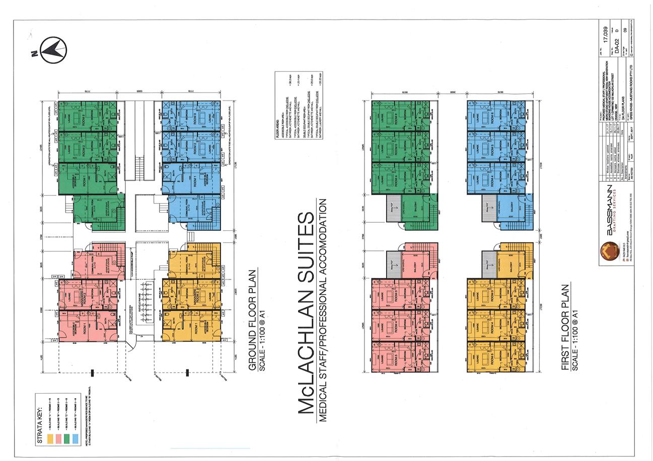
Planning and Development Committee
6 March 2018
2.3 Development
Application DA 442/2017(1) - 122 McLachlan Street
Attachment 1 Plans
Planning and Development Committee
6 March 2018
2.3 Development
Application DA 442/2017(1) - 122 McLachlan Street
Attachment 1 Plans
Planning and Development Committee
6 March 2018
2.3 Development
Application DA 442/2017(1) - 122 McLachlan Street
Attachment 1 Plans
Planning and Development Committee
6 March 2018
2.3 Development
Application DA 442/2017(1) - 122 McLachlan Street
Attachment 1 Plans
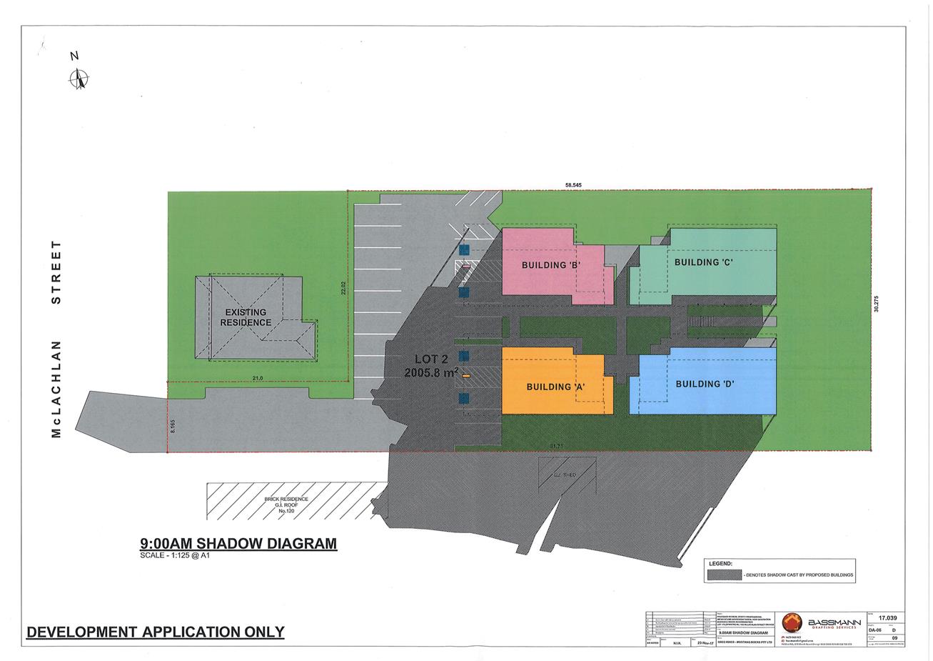
Planning and Development Committee
6 March 2018
2.3 Development
Application DA 442/2017(1) - 122 McLachlan Street
Attachment 1 Plans
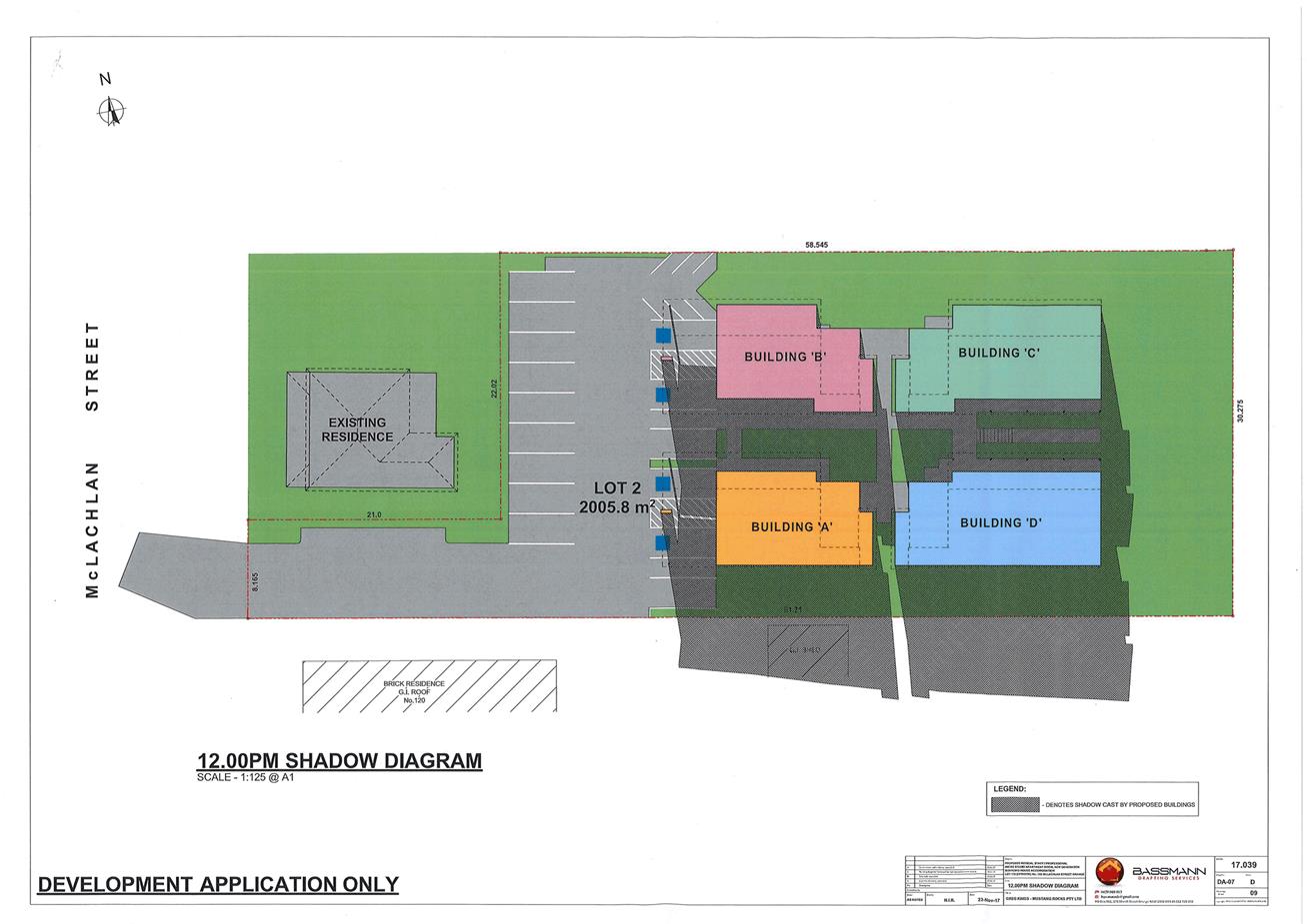
Planning and Development Committee
6 March 2018
2.3 Development
Application DA 442/2017(1) - 122 McLachlan Street
Attachment 1 Plans
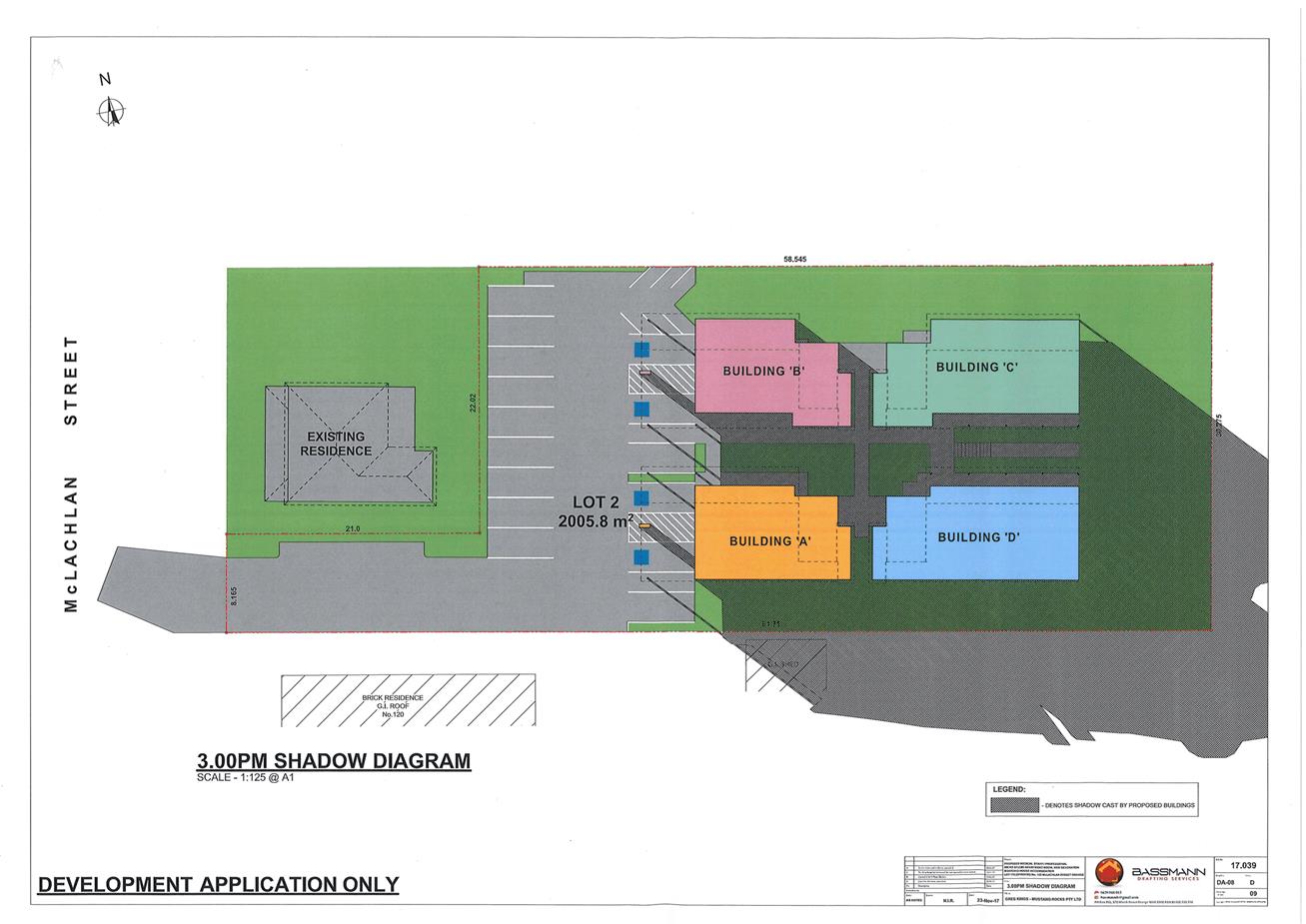
Planning and Development Committee
6 March 2018
2.3 Development
Application DA 442/2017(1) - 122 McLachlan Street
Attachment 1 Plans
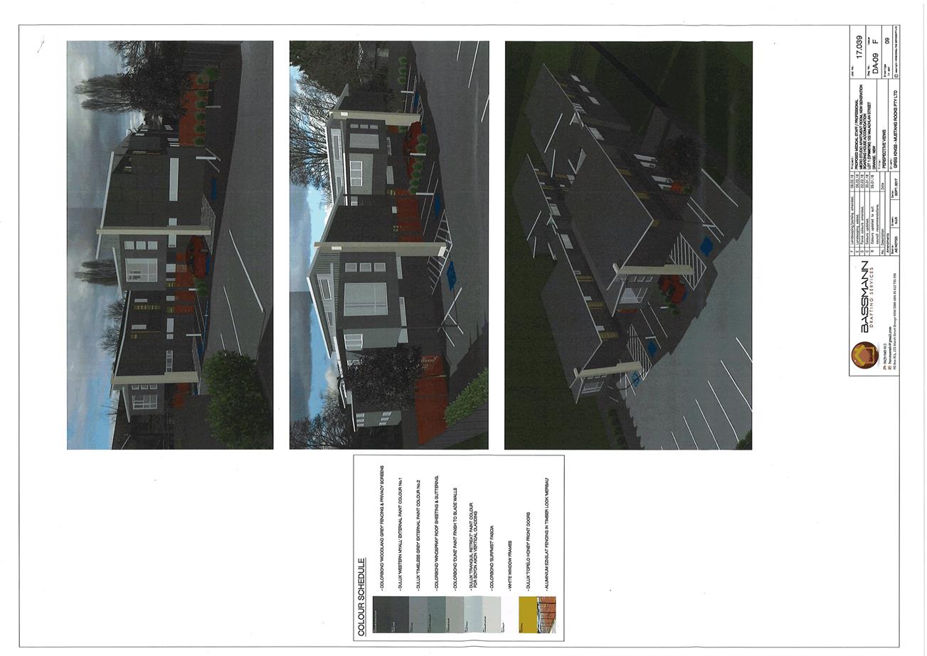
Planning and Development Committee
6 March 2018
2.3 Development
Application DA 442/2017(1) - 122 McLachlan Street
Attachment 2 Submissions
2.4 Development
Application DA 12/2018(1) - 3 Redmond Place
RECORD
NUMBER: 2018/266
AUTHOR: Daniel
Drum, Senior Planner
EXECUTIVE Summary
|
Application
lodged
|
16
January 2018
|
|
Applicant/s
|
Orange
City Council
|
|
Owner/s
|
Orange
City Council
|
|
Land
description
|
Lot 6 DP
1031236 - 3 Redmond Place, Orange
|
|
Proposed
land use
|
Warehouse
or Distribution Centre
|
|
Value of
proposed development
|
$0
|
Council's consent is sought for the use of a Warehouse or
Distribution Centre at 3 Redmond Place, Orange, being Lot 6 DP
1031236 (the ‘subject property’).
The subject property was formerly developed and used as a Helicopter
Landing Site by NSW Ambulance Medical Retrieval Service.
The proposed use of Warehouse or Distribution Centre will
involve the storage of ten vehicles within the former hangar building and truck
parking, with one truck to be parked inside the former hangar and one truck to
be parked on the former helipad.
Given that the Retrieval Service was moved to the Orange Airport
in 2017, the proposed Warehouse or Distribution Centre presents an
appropriate re-use of an existing building which may otherwise be vacant.
Subject to meeting the recommended conditions of consent,
the proposed use and development are considered to be consistent with the
relevant aims, objectives and planning outcomes of Orange Development Control
Plan 2004 and Orange Local Environmental Plan 2011. The following assessment
identifies that the proposed use and development should be supported.
DECISION FRAMEWORK
Development in Orange is governed by two key documents
Orange Local Environment Plan 2011 and Orange Development Control Plan 2004. In
addition the Infill Guidelines are used to guide development, particularly in
the heritage conservation areas and around heritage items.
Orange Local Environment Plan 2011 – the LEP
should be considered by Council to be a definitive document. LEPs govern the
types of development that are permissible or prohibited in different parts of
the City and also provide some assessment criteria in specific circumstances.
Uses are either permissible or not - there are no grey areas in terms of
permissibility. The objectives of each zoning and indeed the aims of the LEP
itself are, however, open to interpretation and can be used to guide decision
making around appropriateness of development.
Orange Development Control Plan 2004 – the DCP
guides development. In general it is a performance based document rather than
prescriptive in nature - its purpose is to guide development. The Land and
Environment Court tends to view it as such. In each area of interest there are
often guidelines used. These guidelines indicate ways of achieving the planning
outcomes. It is thus recognised that there may also be other solutions of
merit. All design solutions are considered on merit by planning and building
staff. Applications should clearly demonstrate how the planning outcomes are
being met where alternative design solutions are proposed. So one can see that
the DCP gives leeway for developers and architects to use design to achieve the
outcome in other ways if they can. Stating that DCP guidelines are
inflexible can be misleading.
Director’s Comment
The proposed development involves
the establishment of a Warehouse or Distribution Centre involving
the storage of ten vehicles within the former hangar building and truck
parking, with one truck to be parked inside the former hangar and one truck to
be parked on the former helipad. A section 4.15 evaluation of the
development application by staff indicates that the development is acceptable
in this instance. Attached is a draft Notice of Approval outlining a range of
conditions considered appropriate to ensure that the development proceeds in an
acceptable manner.
It is understood that the subject
business premises was established recently following the relocation of the
Air Ambulance to the Orange Airport in 2017. Whilst
the applicant was of the initial understanding that development consent was not
required given the former commercial use of the property prior to them
occupying the building, investigations by Planning Staff revealed that
development consent was, in fact, required. The applicant submitted this
development application to address the issue of illegal development. It is
understood that consent was not obtained as a result of a simple oversight by
the applicant, Orange City Council.
Link To Delivery/OPerational Plan
The recommendation in this report relates to the
Delivery/Operational Plan strategy “13.4 Our Environment
– Monitor and enforce regulations relating to City amenity”.
Financial Implications
Nil
Policy and Governance Implications
Nil
|
Recommendation
That Council consents to
development application DA 12/2018(1)
for Warehouse or Distribution Centre (change of use) at Lot 6 DP
1031236 - 3 Redmond Place, Orange pursuant
to the conditions of consent in the attached Notice of Approval.
|
further considerations
Consideration has been given to the
recommendation’s impact on Council’s service delivery; image and
reputation; political; environmental; health and safety; employees;
stakeholders and project management; and no further implications or risks have
been identified.
SUPPORTING INFORMATION
THE APPLICATION
Council's consent is sought for the use of a Warehouse or
Distribution Centre at 3 Redmond Place, Orange, being Lot 6 DP 1031236
(the ‘subject property’).
The proposed use of Warehouse or Distribution Centre will
involve the storage of vehicles within the former hangar building and truck
parking, with one truck to be parked inside the former hangar and one truck to
be parked on the former helipad.
The operation of the proposed Warehouse or Distribution
Centre is depicted in Figure 1, below:
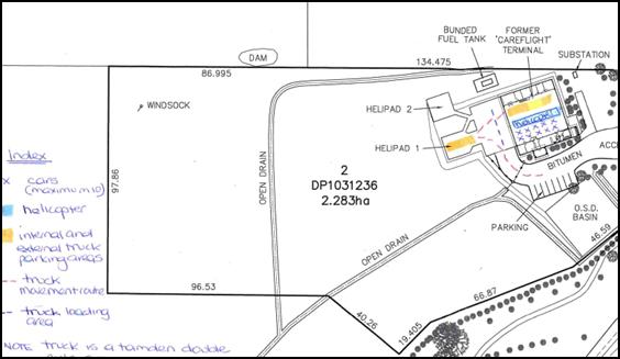
Figure 1: proposed operation
MATTERS FOR CONSIDERATION
Section 5 Assessment
Section 1.7 Application of
Part 7 of Biodiversity Conservation Act 2016 and Part 7A of Fisheries
Management Act 1994
From 25 August 2017, the
Biodiversity Conservation Act 2016 and Biodiversity Conservation
Regulation 2017 were gazetted. The implementation of this legislation
(and supporting guidelines) is subject to savings provisions that defer their
full effect for a period of six months from the date of gazettal for local
development.
In this instance, site inspection
reveals that the subject property has no biodiversity or habitat value.
Section 4.15 Evaluation
Section 4.15 of the Environmental Planning and Assessment
Act 1979 sets out the matters that the consent authority is to take into
consideration in determining a development application. Those matters are
addressed in the body of this report.
PROVISIONS OF ANY ENVIRONMENTAL
PLANNING INSTRUMENT s4.15(1)(a)(i)
Orange Local Environmental Plan 2011
Part 1 - Preliminary
Clause 1.2 - Aims of Plan
The
aims of the Orange Local Environmental Plan 2011 (‘OLEP
2011’) relevant to the application include:
(a) to
encourage development which complements and enhances the unique character of
Orange as a major regional centre boasting a diverse economy and offering an
attractive regional lifestyle,
(b) to
provide for a range of development opportunities that contribute to the social,
economic and environmental resources of Orange in a way that allows present and
future generations to meet their needs by implementing the principles for
ecologically sustainable development,
The application is considered to be consistent with the
relevant aims of OLEP 2011.
Clause 1.6 - Consent Authority
Clause establishes that Council is the consent authority for
the purpose of OLEP 2011.
Clause 1.9A - Suspension of
Covenants, Agreements and Instruments
Clause 1.9A provides that any agreement, covenant or other
similar instrument that restricts the carrying out of that development does not
apply to the extent necessary to serve that purpose, with the exception of:
· covenants imposed
by the Council or that the Council requires to be imposed;
· any prescribed
instrument with the meaning of section 183A of the Crown Lands Act 1989;
· any conservation
agreement within the meaning of the National Parks and Wildlife Act 1974;
· any Trust
agreement within the meaning of the Nature Conservation Trust Act 2001;
· any property
vegetation plan within the meaning of the Native Vegetation Act 2003;
· any biobanking
agreement within the meaning of Part 7A of the Threatened Species
Conservation Act 1995;
· any planning
agreement within the meaning of Division 6 of part 4 of the Act.
This clause does not affect the rights or interests of any
public authority under any registered instrument.
Council staff are not aware of any of the foregoing applying
to the subject property.
Council does not hold a Section 88B Instrument for the
subject property.
Clause 1.7 - Maps
The subject site is identified
on the LEP maps in the following manner:
|
Land Zoning Map:
|
Land zoned B5 Business Development
|
|
Lot Size Map:
|
No Minimum Lot Size
|
|
Heritage Map:
|
Not a heritage item or conservation
area
|
|
Height of Buildings Map:
|
No building height limit
|
|
Floor Space Ratio Map:
|
No floor space limit
|
|
Terrestrial Biodiversity Map:
|
No biodiversity sensitivity on the
site
|
|
Groundwater Vulnerability Map:
|
Ground water vulnerable
|
|
Drinking Water Catchment Map:
|
Within the drinking water catchment
|
|
Watercourse Map:
|
Not within or affecting a defined
watercourse
|
|
Urban Release Area Map:
|
Not within an urban release area
|
|
Obstacle Limitation Surface Map:
|
No restriction on building siting
or construction
|
|
Additional Permitted Uses Map:
|
No additional permitted use applies
|
Those matters that are of relevance are addressed in detail
in the body of this report.
Part 2 - Permitted or
Prohibited Development
Land Use Zones
The subject property is zoned B5
Business Development (Figure 2).
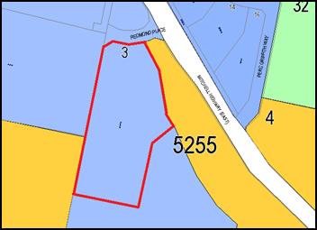
Figure 2 - zone context plan - subject property
denoted by heavy red line
The objective of the B5 Business Development zone is:
· To enable a mix of
business and warehouse uses, and bulky goods premises that require a large
floor area, in locations that are close to, and that support the viability of,
centres.
The proposed use and
development is defined as Warehouse or Distribution Centre. Under OLEP
2011 Warehouse or Distribution Centre means:
“… a building or
place used mainly or exclusively for storing or handling items (whether goods
or materials) pending their sale, but from which no retail sales are made.”
A Warehouse or
Distribution Centre is permissible with consent in the B5 Business Development zone.
Part 7 - Additional Local
Provisions
7.6 - Groundwater Vulnerability
Clause 7.6 - Groundwater Vulnerability
seeks to maintain the hydrological functions of key groundwater systems and to
protect vulnerable groundwater resources from depletion and contamination as a
result of inappropriate development.
Before determining a development
application for development on land to which this clause applies, the consent
authority must consider whether or not the development (including any onsite
storage or disposal of solid or liquid waste and chemicals) is likely to cause
any groundwater contamination or any adverse impact (including the impact on
nearby groundwater extraction for potable water supply or stock water supply)
of the development and any other existing development on groundwater.
Development consent must not be
granted to development on land to which this clause applies unless the consent
authority is satisfied that the development is designed, sited and will be
managed to avoid any significant adverse environmental impact; or if that
impact cannot be reasonably avoided - the development is designed, sited and
will be managed to minimise the impact; if that impact cannot be minimised -
the development will be managed to mitigate that impact.
The proposed
development is not anticipated to involve the discharge of toxic or noxious
substances and is therefore considered unlikely to contaminate the groundwater
or related ecosystems. Similarly, the proposed development will not involve the
extraction of groundwater and therefore will not contribute to groundwater
depletion.
7.7 - Drinking Water Catchments
Clause 7.7 seeks to protect drinking water catchments by minimising
the adverse impacts of development on the quality and quantity of water
entering drinking water storages.
Before determining an application for development on land to
which this clause applies, the consent authority must consider whether or not the
development is likely to have any adverse impact on the quality and quantity of
water entering the drinking water storage, having regard to the distance
between the development and any waterway that feeds into the drinking water
storage, the onsite use, storage and disposal of any chemicals on the land, and
the treatment, storage and disposal of waste water and solid waste generated or
used by the development.
Development consent must not be granted to development on
land to which this clause applies unless the consent authority is satisfied
that the development is designed, sited and will be managed to avoid any
significant adverse impact on water quality and flows; or if that impact cannot
be reasonably avoided - the development is designed, sited and will be managed
to minimise that impact; or if that impact cannot be minimised - the
development will be managed to mitigate that impact.
Given that the proposed Warehouse or Distribution Centre will
occupy the former Helicopter Landing Site premises, it is considered
unlikely that there will be any detrimental impact on the quality and quantity
of water entering drinking water storages.
STATE ENVIRONMENTAL PLANNING
POLICIES
State Environmental Planning Policy 55 - Remediation of Land
(SEPP 55) requires that a consent authority must not consent to the carrying
out of development of land unless it has considered whether the land is
contaminated, is satisfied that the land is suitable in its contaminated state
for the development that is proposed, and if the land requires remediation, it
can be made suitable for the proposed development.
Furthermore, SEPP 55 requires that before determining an
application to carry out development that would involve a change of use of land
(specified in subclause 4), the consent authority must consider a
preliminary investigation of the land concerned.
It is considered that while the subject property has
recently been used for a potentially contaminating land use (ie the Helicopter
Landing Site), given its recent construction and above ground storage of
fuel, it is unlikely that the subject property would be contaminated.
PROVISIONS OF ANY DRAFT
ENVIRONMENTAL PLANNING INSTRUMENT THAT HAS BEEN PLACED ON EXHIBITION s4.15(1)(a)(ii)
There are no draft environmental planning instruments that
apply to the subject land or proposed development.
DESIGNATED DEVELOPMENT
The proposed development is not designated development.
PROVISIONS OF ANY DEVELOPMENT
CONTROL PLAN s4.15(1)(a)(iii)
Development Control Plan 2004
Development Control Plan 2004 (the “DCP”)
applies to the subject property. Chapters of the DCP relevant to the
proposed use and development include:
· Chapter 0 - Transitional
Provisions;
· Chapter 3 - General
Considerations;
· Chapter 8 - Development
in Business Zones;
· Chapter 10 - Special
Uses and Road Zones;
· Chapter 15 - Car
Parking.
The relevant sections, objectives and planning outcomes of
each chapter are addressed below.
Chapter 0 - Transitional
Provisions
Section 0.2 - General Translation of Zones
Clause 0.2 - General Translation of Zones
provides that any reference to a zone under Orange LEP 2000 is to be a
reference to the corresponding zones in a zone conversion table. The table
identifies that the B5 Business Development zone corresponds with the former
3b Business Services zone.
0.4-11 - Interim Planning
Outcomes - Transport Routes
Clause 0.4-11 Interim Planning Outcomes - Transport
Routes identifies that development alongside roads that convey a high
volume of traffic needs to be appropriately designed and managed to ensure that
the safe and efficient operation of the local road network is not compromised.
Additionally, the visual treatment of development alongside arterial and other
important roads plays a significant role in the impression that residents and
visitors have of the area.
This clause applies to all land adjoining an arterial road,
distributor road, major collector roads and Cadia Road.
Specific objectives and planning outcomes include the
following:
Objectives
1 To
ensure the continued safe and efficient operation of arterial and other
important road corridors.
2 To
alleviate traffic flows on high volume routes whenever feasible.
3 To
promote a high level of urban design on land exposed to significant volumes of
traffic, cyclists and pedestrians.
Planning Outcomes
1 The
development provides a high standard of visual appeal to motorists, cyclists
and pedestrians as well as adjoining properties.
2 The
visual appearance of the development, including any signage, lighting or other
ancillary element, must not generate a distraction to motorists.
3 Any
signage must not be animated whether by movement or flashing lights.
4 Where
land has more than one street frontage the street with the lower volume of
traffic is to provide the principal access to the development, subject to
safety considerations.
5 Where
access is provided onto an arterial road, distributor road or major collector
road, the access point must have appropriate safe sight distances for the
prevailing speed limit and clear and unimpeded entrance / exit signage must be
displayed.
6 Where
on-site customer parking is provided that is not immediately visible from a
public road clear and unimpeded directional signage must be displayed.
7 Where
the proposal is residential, or another noise sensitive form, appropriate noise
mitigation measures to limit the development from traffic noise must be
demonstrated.
Given that the proposal involves a change of use only, it is
considered that that there will be no material impact on the existing
appearance of the subject property.
No further consideration of the foregoing objectives or
outcomes is required.
Chapter 3 - General
Considerations
Section 3.1 - Cumulative Impacts
Section 3.1 - Cumulative Impacts identifies that Council
will consider not only the direct impacts of a particular development but also
whether the development, when carried out in conjunction with other development
in the locality, has a more significant environmental impact.
Specific planning outcomes regarding cumulative impact
include:
1 Applications
for development demonstrate how the development relates to the character and
use of land in the vicinity.
2 The
introduction of new development into a locality maintains environmental impacts
within existing or community accepted levels.
3 Water
conservation measures are implemented.
The proposed development is
generally consistent with the intended use of land insofar as it provides for
uses which are permissible within the B5 Business Development zone.
CHAPTER 8 - DEVELOPMENT IN
BUSINESS ZONES
Section 8.2 - Shops in Zone 3(b)
Section 8.2 - Shops in Zone 3(b) identified under previous
plans that retailing was restricted in the business zones beyond the CBD in
order to reinforce the primary role of the existing retail precinct and
associated public provision of off-street parking infrastructure.
As such, Section 8.2 identifies that applications for shops
in Zone 3(b) must demonstrate that the development is appropriate and will not
detract from the main role of the CBD. To achieve this, Section 8.2 identifies
that shops should be small scale, having a maximum area of 400m2.
Given that the proposed development is for a change of use
of an existing building, the following requirements are generally not of direct
relevance.
· Applications
clearly demonstrate that the development will not detract from the role of the
CBD as a regional centre.
Given that Warehouse or Distribution Centres are not
suitable within the CBD, the proposed development will not detract from the
role of the Orange CBD as a regional centre.
· Provision of
adequate fire safety measures and facilities for disabled persons (according to
the BCA) is addressed at the application stage (relevant for all development
but particularly important where converting residential buildings for business
use).
Council’s Environmental Health and Building Surveyor
has commented that the fire risk associated with the proposed use is less than
the previous use as the aero medical base as there will no longer be people
sleeping within the building and that the storage of vehicles in the building
will not increase the requirements of the BCA in terms of fire safety.
· Heritage
streetscapes are conserved and enhanced through adaptive reuse of heritage
buildings, restrained advertising and landscaped gardens.
Not applicable.
· Areas on the
main roads into and out of Orange (such as Molong and Bathurst Road) provide a
high level of architectural design to enhance the visual character of the City
entrances.
The proposed change of use will not affect the existing
visual character of the subject property.
· All sites
contain an element of landscaping. Landscaping provided is of a bulk, scale and
height relative to buildings nearest the front property boundary so as to
provide beautification and visual relief to the built form proposed or existing
on the site… Plantings are designed to provide shade for parking areas,
to break of bitumen, to enhance building preservation and to screen against
noise.
The proposed change of use will not affect the existing
visual character of the subject property
Chapter 10 - Special Uses and
Road Zones
Section 10.3 - Development Along Major Transport Routes
Section 10.3 - Development Along Major Transport Routes
outlines planning outcomes for development near major roads with regard to
issues such as visual impact, access and noise impacts, including the
following:
1 Development
on land fronting and visible from a major road or distributor road provides for
quality design on the highway and/or distributor road through landscaping,
building setbacks façade design, external colours and materials and
siting.
The proposed change of use will not affect the existing
visual character of the subject property.
2 Residential
buildings address potential noise impacts in design from adjacent main roads.
Not applicable.
3 Direct
access to major roads is limited and is constructed to the requirements of the
relevant roads authority.
Not applicable.
4 Residential
lots are set back from planned distributor roads to provide a reasonable
separation between future roads and residential land.
Not applicable.
5 Where
direct access to a main or arterial road is denied by the Roads Authority and
comprises residential subdivision, any rear or side fences are set back and
screened with dense landscaping.
Not applicable.
6 Commercial
buildings adjoining a distributor road are setback from the property boundary
by at least 10m.
Not applicable.
7 Lighting
and signage visible from a distributor road is not animated and is designed so
as not to distract motorists beyond glance recognition.
The proposed change of use will not affect the existing
visual character of the subject property.
CHAPTER 15 - Car Parking
Section 15.4 - Parking Requirements
Section 15.4 - Parking Requirements identifies the number of
off-street car parking spaces required to be provided for specific land uses.
Section 15.4 identifies that a warehouse generates a
requirement for 1 space per 100m2 of GFA or
1 space for every 2 employees.
Given the nature of the proposed use and that it does not
involve customers attending the premises, it is considered that the six
existing car parking spaces provided onsite are adequate.
PROVISIONS PRESCRIBED BY THE
REGULATIONS s4.15(1)(a)(iv)
Demolition of a Building (clause 92)
The proposal does not involve the demolition of a building.
Fire Safety Considerations
(clause 93)
The proposal involves a change of building use for an
existing building.
Councils Environmental Health and Building Surveyor has
identified that the fire risk associated with the proposed use is less than the
previous use (the aero medical base) as there will be no longer people sleeping
within the building. The storage of vehicles in the building will not increase
the requirements of the BCA in terms of fire safety.
Buildings to be Upgraded
(clause 94)
Councils Environmental Health and
Building Surveyor has identified that the storage of vehicles in the building
will not create the need for the upgrading of the building unless the existing
fire safety measures have not been adequately maintained.
BASIX Commitments (clause 97A)
Not applicable.
THE LIKELY IMPACTS OF THE
DEVELOPMENT s4.15(1)(b)
It is considered unlikely that there would be any
significant impacts associated with the proposed use.
THE SUITABILITY OF THE SITE
s4.15(1)(c)
It is considered that the physical attributes of the site
and availability of services are suitable for the proposed use and development,
subject to the recommended conditions of consent discussed in the body of this
report.
ANY SUBMISSIONS MADE IN ACCORDANCE
WITH THE ACT s4.15(1)(d)
The proposed development is not defined as advertised
development under the provisions of the LEP, and as such no formal
exhibition of the application was required. No submissions have been received
in relation to this application.
PUBLIC INTEREST s4.15(1)(e)
The proposed development is considered to be of minor
interest to the wider public due to the relatively localised nature of
potential impacts. The proposal is not inconsistent with any relevant policy
statements, planning studies, guidelines etc that have not been considered in
this assessment.
SUMMARY
The proposed development is permissible with the consent of
Council. The proposed development complies with the relevant aims, objectives
and provisions of the LEP. A section 4.15 evaluation of the
development application indicates that the development is acceptable in this
instance. Attached is a draft Notice of Approval outlining a range of
conditions considered appropriate to ensure that the development proceeds in an
acceptable manner.
COMMENTS
The requirements of the Environmental Health and Building
Surveyor and the Engineering Development Section are included in the attached
Notice of Approval.
Attachments
1 Notice
of Approval, D18/8135⇩
2 Plans,
D18/7686⇩
Planning and Development Committee
6 March 2018
2.4 Development
Application DA 12/2018(1) - 3 Redmond Place
Attachment 1 Notice
of Approval
|

|
ORANGE
CITY COUNCIL
Development
Application No DA
12/2018(1)
NA18/ Container
PR18078
|
NOTICE OF DETERMINATION
OF A DEVELOPMENT
APPLICATION
issued under the Environmental
Planning and Assessment Act 1979
Section 4.18
|
Development
Application
|
|
|
Applicant Name:
|
Orange
City Council
|
|
Applicant Address:
|
PO Box 35
ORANGE
NSW 2800
|
|
Owner’s Name:
|
Orange
City Council
|
|
Land to Be Developed:
|
Lot 6 DP 1031236
- 3 Redmond Place, Orange
|
|
Proposed Development:
|
Warehouse
or Distribution Centre (change of use)
|
|
|
|
|
Building
Code of Australia
building
classification:
|
Class 7b
|
|
|
|
|
Determination
made under Section 4.16
|
|
|
Made On:
|
6 March
2018
|
|
Determination:
|
CONSENT
GRANTED SUBJECT TO CONDITIONS DESCRIBED BELOW:
|
|
|
|
|
Consent to
Operate From:
|
7 March
2018
|
|
Consent to
Lapse On:
|
7 March
2023
|
Terms of Approval
The reasons for the imposition of
conditions are:
(1) To
maintain neighbourhood amenity and character.
(2) To
ensure compliance with relevant statutory requirements.
(3) To
provide adequate public health and safety measures.
(4) To ensure the utility
services are available to the site and adequate for the development.
(5) To
prevent the proposed development having a detrimental effect on adjoining land
uses.
(6) To
minimise the impact of development on the environment.
Conditions
(1) The
development must be carried out in accordance with:
(a) Plan/s
numbered Plans by Saunders and Staniforth - Figure 1 Existing Boundaries and
Site Detail dated 2.01.18 (three sheets)
(b) statements
of environmental effects or other similar associated documents that form part
of the approval
as amended
in accordance with any conditions of this consent.
(2) All building work must
be carried out in accordance with the provisions of the Building Code of
Australia.
|
DURING
CONSTRUCTION/SITEWORKS
|
(3) Any adjustments to
existing utility services that are made necessary by this development
proceeding are to be at the full cost of the developer.
|
PRIOR TO THE ISSUE OF
AN OCCUPATION CERTIFICATE
|
(4) No
person is to use or occupy the building or alteration that is the subject of
this approval without the prior issuing of an Occupation Certificate.
(5) The
owner of the building/s must cause the Council to be given a Final Fire Safety
Certificate on completion of the building in relation to essential fire or
other safety measures included in the schedule attached to this approval.
(6) All
of the foregoing conditions are to be at the full cost of the developer and to
the requirements and standards of the Orange City Council Development and
Subdivision Code, unless specifically stated otherwise. All work required by
the foregoing conditions is to be completed prior to the issuing of an
Occupation Certificate, unless stated otherwise.
|
MATTERS FOR THE
ONGOING PERFORMANCE AND OPERATION OF THE DEVELOPMENT
|
(7) Off-street
car parking shall be provided on the land in accordance with the stamped
approved plans.
(8) The
owner is required to provide to Council and to the NSW Fire Commissioner an
Annual Fire Safety Statement in respect of the fire-safety measures, as
required by Clause 177 of the Environmental Planning and Assessment Regulation
2000.
(9) Emitted
noise shall not exceed 5dB(A) above background sound level measured at the
nearest affected residence
Other Approvals
(1) Local
Government Act 1993 approvals granted under section 68.
Nil
(2) General
terms of other approvals integrated as part of this consent.
Nil
Right of Appeal
If
you are dissatisfied with this decision, Section 8.7 of Environmental
Planning and Assessment Act 1979 gives you the right to appeal to the Land
and Environment Court. Pursuant to Section 8.10 an applicant may only
appeal within 6 months after the date the decision is notified.
|
Disability Discrimination Act
1992:
|
This application has been assessed in
accordance with the Environmental Planning and Assessment Act 1979. No
guarantee is given that the proposal complies with the Disability
Discrimination Act 1992.
The applicant/owner is responsible to
ensure compliance with this and other anti-discrimination legislation.
The Disability Discrimination Act
covers disabilities not catered for in the minimum standards called up in the
Building Code of Australia which references AS1428.1 - "Design for
Access and Mobility". AS1428 Parts 2, 3 and 4 provides the most
comprehensive technical guidance under the Disability Discrimination Act
currently available in Australia.
|
|
|
|
|
Disclaimer - S88B of the Conveyancing Act 1919 -
Restrictions on the Use of Land:
|
The applicant should note that there
could be covenants in favour of persons other than Council restricting what
may be built or done upon the subject land. The applicant is advised to check
the position before commencing any work.
|
|
|
|
|
Signed:
|
On behalf of the consent authority ORANGE
CITY COUNCIL
|
|
Signature:
|
|
|
Name:
|
PAUL JOHNSTON - MANAGER DEVELOPMENT
ASSESSMENTS
|
|
Date:
|
7 March 2018
|
Planning
and Development Committee
6 March 2018
2.4 Development
Application DA 12/2018(1) - 3 Redmond Place
Attachment 2 Plans
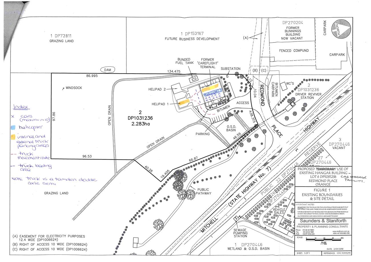
Planning and Development Committee
6 March 2018
2.4 Development
Application DA 12/2018(1) - 3 Redmond Place
Attachment 2 Plans

Planning and Development Committee
6 March 2018
2.4 Development
Application DA 12/2018(1) - 3 Redmond Place
Attachment 2 Plans
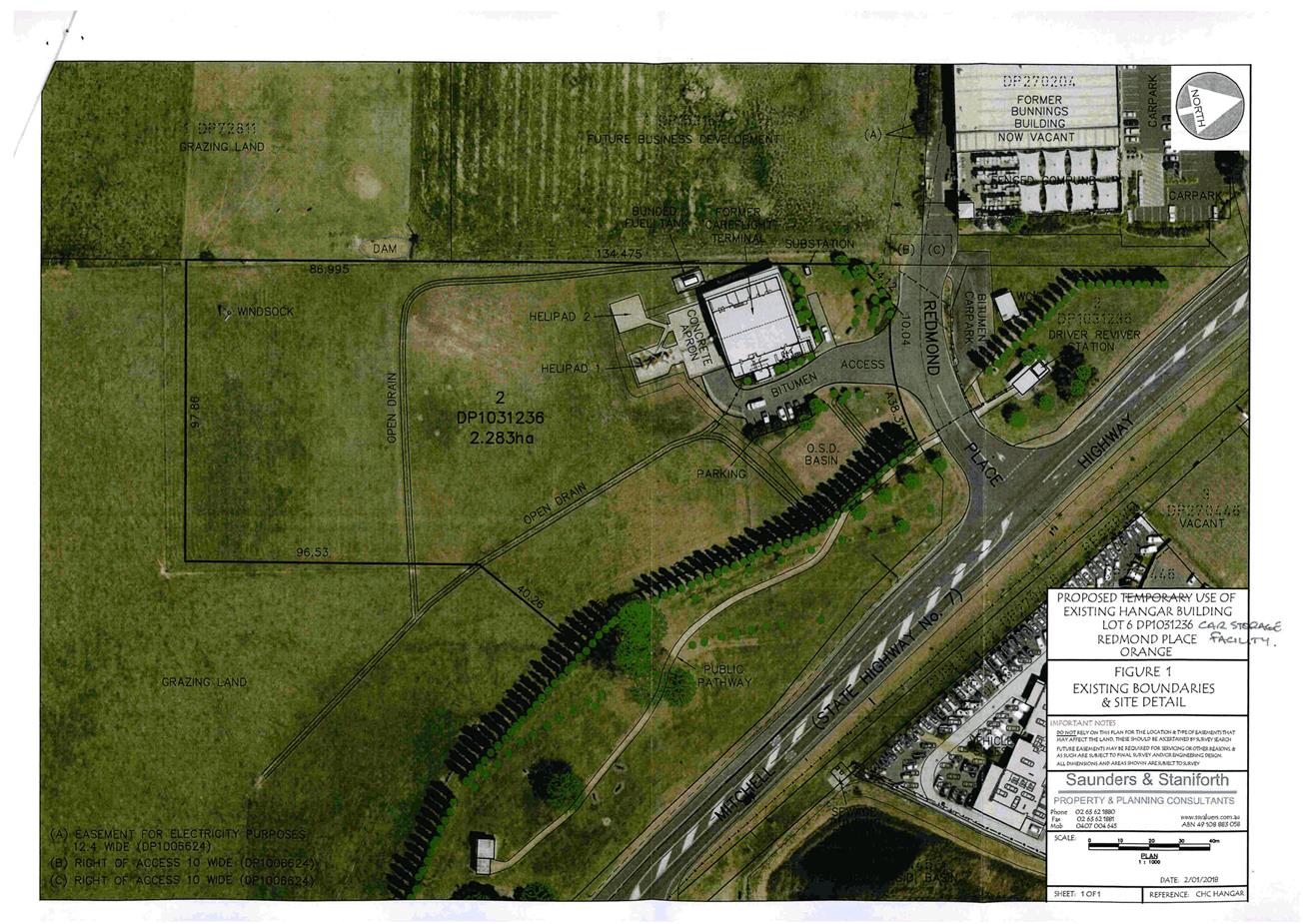
2.5 Development
Application DA 454/2017(1) - 58-64 Summer Street
RECORD
NUMBER: 2018/267
AUTHOR: Kelly
Walker, Senior Planner
EXECUTIVE Summary
|
Application
lodged
|
4
December 2017
|
|
Applicant/s
|
JC
Midway Pty Ltd
|
|
Owner/s
|
Longman
Super Pty Ltd
|
|
Land
description
|
Lots
A and B DP 153476, Lot 5 Sec 22 DP 758817, and Lot 1
DP 1128940 – 58-64 Summer Street, Orange
|
|
Proposed
land use
|
Hotel
or Motel Accommodation and Business Identification Sign
|
|
Value
of proposed development
|
Not
applicable
|
The proposal relates to land occupied by the
Central Caleula Motor Lodge (hereafter referred to as “the
Caleula”) and the former Heritage House (now known
as ‘Zona’) at Lots A and B DP 153476, Lot 5 Sec 22 DP
758817, and Lot 1 DP 1128940 – 58‑64 Summer Street,
Orange (Figure 1).
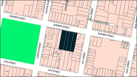
Figure 1 – location plan
The Caleula occupies 60-64 Summer
Street, and was established in stages starting in 1978. A restaurant and
bar was added to the motel in 1982, recently known as ‘Temptations
Restaurant’. Last year the original restaurant was decommissioned and
relocated into the adjacent Heritage House building, rebranded as
‘Zona’.
Zona was previously known as
‘Heritage House’, and occupies 58 Summer Street. Originally a
dwelling house, consent was granted in 1991 to change it to a
reception/function centre and use the flat to the rear as motel accommodation,
both of which were run in conjunction with the Caleula.
While the building continues its
function centre use, albeit under the name of ‘Zona’, it now also
operates as the Caleula’s motel restaurant. Development consent was required
for this change, however the applicant assumed it could be operated under the
existing motel and function centre consents. The previous consents and current
LEP separately delineate and define these uses, and as such separate
development consent is required. Replacement signs have been erected at the
frontage of the property which also required consent. This application seeks
consent for these recent changes carried out without consent.
The proposal involves a change of
use for the existing function centre to also be used as the Caleula’s
motel restaurant. As a motel restaurant, it provides breakfast and room service
for guests, as well as dinner for guests and the general public. This
restaurant continues the same operations as the previous restaurant on the
site, but in a changed location, with increased floor area and the introduction
of outdoor dining.
No changes are proposed to
staffing, car parking, access arrangements, hours of operation etc. Both
the Caleula and Zona are run by the same entity and manager, and servicing,
deliveries, administration and storage will continue to take place mainly at
the main Caleula building and entrance. The existing motel unit directly
adjacent to Zona and the motel’s swimming pool behind it will continue
these approved uses. Adequate car parking can be provided on the site for the
proposal.
The application also seeks
consent for the replacement signs at the site frontage for the rebranded
‘Zona’. The signs are larger than the previous Heritage House
signs, and are considered too large for the heritage setting - adversely
impacting on the listed heritage building on the subject site as well as the
streetscape. A condition of consent is recommended to reduce the size of these
signs so they are no higher than the top of the existing support poles.
The proposal does not contravene
the planning provisions that apply to the subject land or particular land use.
Approval of the application is recommended, subject to the attached conditions
of development consent.
DECISION FRAMEWORK
Development in Orange is governed
by two key documents - Orange Local Environment Plan 2011 and Orange
Development Control Plan 2004. In addition the Infill Guidelines are used to
guide development, particularly in the heritage conservation areas and around
heritage items.
Orange Local Environment Plan
2011 – the LEP should be considered by Council to be a definitive
document. LEPs govern the types of development that are permissible or
prohibited in different parts of the City and also provide some assessment
criteria in specific circumstances. Uses are either permissible or not - there
are no grey areas in terms of permissibility. The objectives of each zoning and
indeed the aims of the LEP itself are, however, open to interpretation and can
be used to guide decision making around appropriateness of development.
Orange Development Control
Plan 2004 – the DCP guides development. In general it is a
performance based document rather than prescriptive in nature - its purpose is
to guide development. The Land and Environment Court tends to view it as such.
In each area of interest there are often guidelines used. These guidelines
indicate ways of achieving the planning outcomes. It is thus recognised that
there may also be other solutions of merit. All design solutions are considered
on merit by planning and building staff. Applications should clearly
demonstrate how the planning outcomes are being met where alternative design
solutions are proposed. So one can see that the DCP gives leeway for developers
and architects to use design to achieve the outcome in other ways if they can.
Stating that DCP guidelines are inflexible can be misleading.
Director’s Comment
As discussed in the body of this report, the applicant has
assumed that the restaurant component of the development could be operated
under the existing motel and function centre consents. Following
discussions with Council staff, the applicant submitted this development
application to address the issue of illegal development. It is proposed to write
to the applicant following determination of this application and provide them
with a ‘final warning’ in accordance with current practice.
Link To Delivery/OPerational Plan
The recommendation in this report relates to the
Delivery/Operational Plan strategy “13.4 Our
Environment – Monitor and enforce regulations relating to City amenity”.
Financial Implications
Nil
Policy and Governance Implications
Nil
|
Recommendation
That
Council consent to development application DA 454/2017(1) for Hotel or Motel Accommodation and Business
Identification Signs at Lots A and B DP 153476, Lot
5 Sec 22 DP 758817, and Lot 1 DP 1128940 – 58-64 Summer
Street, Orange pursuant to the conditions of
consent in the attached Notice of Approval.
|
further considerations
Consideration has been given to the
recommendation’s impact on Council’s service delivery; image and
reputation; political; environmental; health and safety; employees;
stakeholders and project management; and no further implications or risks have been
identified.
SUPPORTING INFORMATION
BACKGROUND
The Caleula occupies Lot B DP
153476, Lot 5 Sec 22 DP 758817, and Lot 1 DP 1128940 – 60‑64
Summer Street, Orange. The land was rezoned in 1975 to allow for a motel
development, and the Caleula was established in stages starting in 1978. A
restaurant and bar was added to the motel in 1982, recently known as
‘Temptations Restaurant’. Last year the original restaurant
was decommissioned and relocated into the adjacent Heritage House building,
rebranded as ‘Zona’.
Zona was previously known as
‘Heritage House’, and occupies Lot A DP 153476 –
58 Summer Street. Originally a dwelling house, consent was granted in 1991
to change the use of the heritage listed building into a reception/function
centre and use the flat to the rear as motel accommodation, both of which were
run in conjunction with the Caleula. This involved the installation of a
commercial kitchen as well as amenities.
While the building continues its function centre use, albeit
under the name of ‘Zona’, it now also operates as the
Caleula’s motel restaurant. Development consent was required for this
change, however the applicant assumed it could be operated under the existing
motel and function centre consents. The previous consents and current LEP
separately delineate and define these uses, and as such separate development
consent is required. Replacement signs have been erected at the frontage of the
property, which also required consent.
THE APPLICATION/PROPOSAL
The subject application relates
to land described as Lots A and B DP 153476, Lot 5 Sec 22
DP 758817, and Lot 1 DP 1128940 – 58‑64 Summer Street, Orange
commonly known as ‘Heritage house’ and the ‘Central Caleula
Motor Lodge’.
Council's consent is sought to
include an additional use of the building at Lot A DP 153476 –
58 Summer Street, Orange for the purposes of ‘hotel or motel
accommodation’, while also continuing the existing function centre and
motel uses, to be run in conjunction with the Caleula motel.
The proposal involves a change of
use where the existing function centre (previously known as ‘Heritage
House’ and now rebranded to ‘Zona’) will also be used as the
Caleula’s motel restaurant. As a motel restaurant, it provides breakfast
and room service for guests, as well as dinner for guests and the general
public. This restaurant continues the same operations as the previous
restaurant on the site, but in a changed location, with increased floor area
and the introduction of outdoor dining. The existing function centre use will
continue, so when the building is occupied for private functions the kitchen
will provide room service for guests, but will not be open for dining-in.
No changes are proposed to
staffing, car parking, access arrangements, hours of operation etc. Both
the Caleula and Zona are run by the same entity and manager, and servicing,
deliveries, administration and storage will continue to take place mainly at
the main Caleula building and entrance. The existing motel unit directly adjacent
to Zona and the motel’s swimming pool behind it will continue these
approved uses.
The application also seeks consent for the replacement
signs at the site frontage for the rebranded ‘Zona’ (see Figure 2).
The signs are arranged in a v-shape, one facing northeast and the other facing
northwest, both towards Summer Street. The signs each measure 1.2m by 1.8m on
2.1m high poles. The signs have been erected on the existing support poles from
the previous ‘Heritage House’ signs, however are larger than the
previous signs.
Figure 2 – replacement ‘Zona’
signage at the Summer Street frontage
MATTERS FOR CONSIDERATION
Section 1.7 - Application of
Part 7 of the Biodiversity Conservation Act 2016 and Part 7A of the
Fisheries Management Act 1994
From 25 August 2017, the
Biodiversity Conservation Act 2016 and Biodiversity Conservation
Regulation 2017 were gazetted. The implementation of this legislation
(and supporting guidelines) is subject to savings provisions that defer their full
effect for a period of six months from the date of gazettal for local
development.
In this instance, site inspection
reveals that the subject property has no biodiversity or habitat value.
Section 4.15
Section 4.15 of the Environmental
Planning and Assessment Act 1979 requires Council to consider various
matters, of which those pertaining to the application are listed below.
PROVISIONS OF ANY ENVIRONMENTAL
PLANNING INSTRUMENTS - SECTION 4.15(1)(a)(i)
Orange Local Environmental
Plan 2011
Part 1 - Preliminary
Clause 1.2 - Aims of Plan
The broad aims of the LEP are set out under subclause 2.
Those relevant to the application are as follows:
(a) to encourage development which complements
and enhances the unique character of Orange as a major regional centre boasting
a diverse economy and offering an attractive regional lifestyle,
(b) to provide for a range of development
opportunities that contribute to the social, economic and environmental
resources of Orange in a way that allows present and future generations to meet
their needs by implementing the principles for ecologically sustainable
development,
(f) to recognise and manage valued
environmental heritage, landscape and scenic features of Orange.
The application is considered to
be consistent with the above objectives as outlined in this report.
Clause 1.6 - Consent Authority
This clause establishes that,
subject to the Act, the Council is the consent authority for applications made
under the LEP.
Clause 1.7 - Mapping
The subject site is identified on the LEP maps in the
following manner:
|
Land Zoning Map:
|
Land zoned R1 General Residential
|
|
Lot Size Map:
|
No Minimum Lot Size
|
|
Heritage Map:
|
Listed heritage item and located
within a heritage conservation area
|
|
Height of Buildings Map:
|
No building height limit
|
|
Floor Space Ratio Map:
|
No floor space limit
|
|
Terrestrial Biodiversity Map:
|
No biodiversity sensitivity on the
site
|
|
Groundwater Vulnerability Map:
|
Ground water vulnerable
|
|
Drinking Water Catchment Map:
|
Not within the drinking water
catchment
|
|
Watercourse Map:
|
Not within or affecting a defined
watercourse
|
|
Urban Release Area Map:
|
Not within an urban release area
|
|
Obstacle Limitation Surface Map:
|
No restriction on building siting
or construction
|
|
Additional Permitted Uses Map:
|
No additional permitted use
applies
|
|
Flood Planning Map:
|
Not within a flood planning area
|
Those matters that are of
relevance are addressed in detail in the body of this report.
Clause 1.9A - Suspension of
Covenants, Agreements and Instruments
Clause 1.9A is applicable and
states in part:
(1) For the purpose of
enabling development on land in any zone to be carried out in accordance with
this Plan or with a consent granted under the Act, any agreement, covenant or
other similar instrument that restricts the carrying out of that development
does not apply to the extent necessary to serve that purpose.
(2) This clause does not apply:
(a) to a covenant imposed by the Council or
that the Council requires to be imposed, or
(b) to any prescribed instrument within the
meaning of Section 183A of the Crown Lands Act 1989, or
(c) to any conservation agreement within the
meaning of the National Parks and Wildlife Act 1974, or
(d) to any Trust agreement within the meaning
of the Nature Conservation Trust Act 2001, or
(e) to any property vegetation plan within the
meaning of the Native Vegetation Act 2003, or
(f) to any biobanking agreement within
the meaning of Part 7A of the Threatened Species Conservation Act 1995, or
(g) to
any planning agreement within the meaning of Division 6 of Part 4 of the Act.
In consideration of this clause, Council
staff are not aware of the title of the subject property being affected by any
of the above.
Part 2 - Permitted or Prohibited
Development
Clause 2.1 Land Use Zones
The subject site is located
within the R1 General Residential zone. The proposed development is defined as
‘hotel or motel accommodation’ and ‘business identification signs’
under Orange LEP 2011. Pursuant to the Dictionary:
Hotel or motel accommodation means a building or place (whether or not licensed
premises under the Liquor Act 2007) that provides temporary or short-term accommodation on a
commercial basis and that:
(a) comprises
rooms or self-contained suites, and
(b) may
provide meals to guests or the general public and facilities for the parking of
guests’ vehicles,
but does not include backpackers’ accommodation, a
boarding house, bed and breakfast accommodation or farm stay accommodation.
‘Hotel or motel accommodation’, being a type of
‘tourist and visitor accommodation’, is permitted with
Council’s consent in the R1 zone. There has been some contention that the use should instead be
considered a ‘restaurant/café’ as it provides meals to the
general public. Restaurants are prohibited in the R1 zone. The applicant has
satisfied Council that the proposal meets the ‘motel or hotel
accommodation’ definition set out in the DCP for the following reasons:
· the
subject lot is intrinsically linked with the main Caleula lots, being a place
which provides temporary/short-term accommodation on a commercial basis;
· the
land contains motel rooms, including the subject lot, which contains one motel
room and the motel’s swimming pool, which are deemed to be ‘hotel
or motel accommodation’;
· meals
are provided to guests and to the general public (breakfast service for guests,
room service for guests, dinner for guests and the general public etc); and
· facilities
for the parking of guests vehicles are provided across all lots.
Notwithstanding
these comments, a condition of consent is recommended to ensure that the
Caleula Motel and Zona restaurant are operated together as one entity.
Business
identification sign means a sign:
(a) that indicates:
(i) the name of the person or business,
and
(ii) the nature of the business carried on by
the person at the premises or place at which the sign is displayed, and
(b) that may include the address of the
premises or place and a logo or other symbol that identifies the business,
but that does
not contain any advertising relating to a person who does not carry on business
at the premises or place.
‘Business identification
signs’ are permitted with
Council’s consent in the R1 zone.
Hotel or motel accommodation and business identification signs are
permissible with development consent. The existing use of the premises as a
function centre relies on the previous consent granted for that use, is subject
to the conditions of that consent and does not form part of this assessment.
It is noted that the use of the building for the motel’s
restaurant commenced without consent, and the signage was also
replaced without consent. This application seeks consent for these recent
changes.
Clause 2.3 Zone Objectives
The objectives for land zoned R1 General
Residential are as follows:
· To
provide for the housing needs of the community.
· To
provide for a variety of housing types and densities.
· To
enable other land uses that provide facilities or services to meet the day to
day needs of residents.
· To
ensure development is ordered in such a way as to maximise public transport
patronage and encourage walking and cycling in close proximity to settlement.
· To
ensure that development along the Southern Link Road has an alternative access.
The proposal
is consistent with the objectives of the R1 zone as follows:
· The
site has a long history of providing temporary visitor accommodation, and the
proposed development will continue the existing motel and function centre uses
the site.
· Both
land uses provide facilities that serve the needs of the local and wider
community.
· The
building is centrally located in the CBD and accessible via public transport,
walking and cycling.
· The
proposal will not impact on the Southern Link Road.
Part 3 - Exempt and Complying
Development
Part 3 is not applicable to the
proposal.
Part 4 - Principal Development
Standards
Part 4 is not applicable to the
proposal.
Part 5 - Miscellaneous Provisions
Clause 5.10 - Heritage
Conservation
The subject building is listed as
a Local heritage item under Orange LEP 2011 (Item I41-former house). The
Orange Heritage Inventory provides the following Statement of Significance for
the building, known in the database as ‘Gortnessy – Heritage
House’:
“An outstanding and
representative example of an Edwardian residence in a garden setting and
original piered and steel palisade fencing, the building retains all the
distinctive features from the original 1900 design and complements to the
streetscape and contributes to the Conservation Area as a heritage item”.
The site is also located within
the Central Orange Heritage Conservation Area. Furthermore, there are a number
of heritage items in the surrounding area nearby to the site which together
make up the heritage setting.
Clause 5.10 is applicable and
states in part:
(4) Effect
of Proposed Development on Heritage Significance
The
consent authority must, before granting consent under this clause in respect of
a heritage item or heritage conservation area, consider the effect of the
proposed development on the heritage significance of the item or area
concerned. This subclause applies regardless of whether a heritage management
document is prepared under subclause (5) or a heritage conservation management
plan is submitted under subclause (6).
In consideration of Clause 5.10(4),
the proposed development will not adversely impact on the significance of the
subject heritage item or heritage setting due to the following:
· The existing
listed building will be retained in its current form, and there are no physical
changes proposed to the interior or exterior of the building. As such the
streetscape presentation of the building and its contribution to the adjacent
built form and conservation area will be retained.
· The continued use
of the building allows for ongoing maintenance, improvements, and adaptive
reuse a landmark CBD building.
· The proposed
development will have not have any impacts on the appreciation or understanding
of the heritage conservation area or other heritage items in the vicinity.
Notwithstanding
the above assessment, the new Zona signs replace the previous Heritage
House signs, and are considered too large for the heritage setting. These signs
adversely impact on the listed heritage building on the subject site, as well
as the heritage streetscape. A condition of consent is recommended to reduce
the size of these signs so that they are no higher than the top of the existing
support poles. A full signage assessment is carried out later in this report
under ‘State Environmental Planning Policy 64 – Advertising and
Signage’.
Based on the foregoing and the condition of consent
reducing the size of the signs, it is considered that the proposed development
is consistent with the requirements of Clause 5.10.
Part 6 - Urban Release Area
Not relevant to the application.
Part 7 - Additional Local Provisions
Clause 7.3 - Stormwater Management
This clause states in
part:
(3) Development
consent must not be granted to development on land to which this clause applies
unless the consent authority is satisfied that the development:
(a) is
designed to maximise the use of water permeable surfaces on the land having
regard to the soil characteristics affecting on-site infiltration of water, and
(b) includes,
where practical, on-site stormwater retention for use as an alternative supply
to mains water, groundwater or river water, and
(c) avoids
any significant impacts of stormwater runoff on adjoining downstream
properties, native bushland and receiving waters, or if that impact cannot be
reasonably avoided, minimises and mitigates the impact.
In consideration of
Clause 7.3, the proposal will not alter existing arrangements for stormwater
management associated with the site.
Clause 7.6 - Groundwater Vulnerability
The subject land is identified as
Groundwater Vulnerable on the Groundwater Vulnerability Map. Clause 7.6
applies and states in part:
(3) Before
determining a development application for development on land to which this
clause applies, the consent authority must consider:
(a) whether or not the development (including
any onsite storage or disposal of solid or liquid waste and chemicals) is
likely to cause any groundwater contamination or have any adverse effect on
groundwater dependent ecosystems, and
(b) the cumulative impact (including the
impact on nearby groundwater extraction for potable water supply or stock water
supply) of the development and any other existing development on groundwater.
In consideration of
Clause 7.6, the proposed development will not involve processes or activities
that would impact on groundwater resources.
Clause 7.11 - Essential Services
Clause 7.11 applies and states:
Development consent must not be granted to
development unless the consent authority is satisfied that any of the following
services that are essential for the proposed development are available or that
adequate arrangements have been made to make them available when required:
(a) the supply of water,
(b) the supply of
electricity,
(c) the disposal and
management of sewage,
(d) stormwater drainage or on-site
conservation,
(e) suitable road access.
In consideration of this clause,
all utility services are available to the site and adequate for the
development.
STATE ENVIRONMENTAL PLANNING
POLICIES
State Environmental Planning
Policy (Infrastructure) 2007
Clause 104 - Traffic-generating development
Clause 104 of State Environmental
Planning Policy (Infrastructure) 2007 requires that development with
the potential to generate large volumes of traffic be referred to Roads and
Maritime Services (RMS). Schedule 3 of the SEPP Traffic Generating Development
to be Referred to the RTA sets out that if the capacity of development
involving a licensed premises has a size or capacity for 50 or more motor
vehicles with access to a classified road, referral is required.
Although the Caleula and Zona site has
97 off-street car parking spaces and generates a demand for over 50 vehicles,
most of the demand and traffic generation is existing. The schedule applies for
new premises, or the enlargement or extension of existing premises. In this
case the intensification of the use involves 79m2 of additional
floor area and 30 outdoor chairs, which generates a demand for 18
additional car parking spaces, well under the threshold. The RMS has confirmed
that no formal referral is required for this application, and therefore the
clause does not apply.
State Environmental Planning
Policy 55 - Remediation of Land
State Environmental Planning
Policy 55 - Remediation of Land is applicable. Pursuant to
Clause 7(1):
A consent authority must not consent to the
carrying out of any development on land unless:
(a) it has considered
whether the land is contaminated, and
(b) if the land is
contaminated, it is satisfied that the land is suitable in its contaminated
state (or will be suitable, after remediation) for the purpose for which the
development is proposed to be carried out, and
(c) if the land requires
remediation to be made suitable for the purpose for which the development is
proposed to be carried out, it is satisfied that the land will be remediated
before the land is used for that purpose.
In consideration of this clause,
the potential for contamination of the site is considered low. The subject land
is well-established as a commercial motel and function centre, and was
previously used as residential dwelling houses. The site is not known to have
been used for a Table 1 purpose to the contaminated land planning guidelines.
Further contamination investigation as a precursor to potential site
remediation is considered unnecessary for the proposed development.
State Environmental Planning
Policy 64 – Advertising and Signage
State Environmental Planning
Policy 64 - Advertising and Signage (SEPP
64) is applicable and states in part:
3 Aims,
Objectives etc
(1) This Policy aims:
(a) to
ensure that signage (including advertising):
(i) is compatible with the
desired amenity and visual character of an area, and
(ii) provides effective
communication in suitable locations, and
(iii) is of high quality design and
finish, and
(8) Granting of Consent to Signage
A consent
authority must not grant development consent to an application to display
signage unless the consent authority is satisfied:
(a) that the signage is consistent
with the objectives of this Policy as set out in clause 3 (1) (a),
and
(b) that the signage the subject of
the application satisfies the assessment criteria specified in Schedule 1.
The application seeks consent for
the replacement signs which have already been erected without consent at the
site frontage for the rebranded ‘Zona’ (see Figure 2). The signs
are arranged in a v-shape, one facing northeast and the other facing northwest,
both towards Summer Street. The signs each measure 1.2m by 1.8m on 2.1m high
poles. The signs have been erected on the existing support poles from the
previous ‘Heritage House’ signs.
The proposed signage was briefly
discussed in the LEP section earlier in this report. In consideration of the
relevant requirements of the SEPP, the following Schedule 1 assessment has
been undertaken.
1 - Character of the Area
· Is the proposal compatible with the existing or desired
future character of the area or locality in which it is proposed to be located?
· Is the proposal consistent with a particular theme for
outdoor advertising in the area or locality?
Signage on the edge of the CDB in
this area generally comprises flush wall and fence signs, and freestanding
signs. It is noted that some signage in the immediate area comprises unlawful
signs which do not meet the requirements of SEPP 64, the LEP or Development
Control Plan 2004, and therefore are not necessarily good examples of
signage within a conservation area and a residential area. As discussed
previously, it is considered that the new signs are too large for the site,
impacting adversely on the character of the area, which is predominately
residential in scale and appearance. A condition of consent is
recommended to reduce the size of these signs so that they are no higher than
the top of the existing support poles. The revised signage would complement the desired theme in the locality.
2 -
Special Areas
· Does the proposal detract from the amenity or visual
quality of any environmentally sensitive areas, heritage areas, natural or
other conservation areas, open space areas, waterways, rural landscapes or residential areas?
The subject land contains a listed
building, is situated within the Central Orange Heritage Conservation Area, is
nearby to other heritage listed buildings, and is adjacent to and opposite
residential dwelling houses. As outlined above, it is considered that the new
signage is too large for the setting and adversely impacts on the amenity
of the streetscape and the heritage significance of the area.
Revising the signage to be no
higher than the top of the existing support poles will ensure that the proposal will be restrained in scale and design, and will
not detract from the visual quality or heritage values of the site or setting.
A condition of consent is set out in the attached draft Notice of Approval.
3 -
Views and Vistas
· Does the proposal obscure or compromise important views?
· Does the proposal dominate the skyline and reduce the
quality of vistas?
· Does the proposal respect the viewing rights of other
advertisers?
The signage is wholly located
within the frontage site, however disrupts the streetscape view corridor which
is made up of the listed building on the subject site, the listed Cook Park to
the west, and surrounding contributory heritage buildings. The freestanding
signs within the frontage of the premises are larger than those which they
replaced, and it is recommended that their scale be revised so they will not
obscure views of the heritage setting.
4 -
Streetscape, Setting or Landscape
· Is the scale, proportion and form of the proposal
appropriate for the streetscape, setting or landscape?
· Does the proposal contribute to the visual interest of the
streetscape, setting or landscape?
· Does the proposal reduce clutter by rationalising and
simplifying existing advertising?
· Does the proposal screen unsightliness?
· Does the proposal protrude above buildings, structures or
tree canopies in the area or locality?
· Does the proposal require ongoing vegetation management?
As noted previously, the scale,
proportions and form of the signs are considered to be inappropriate within
this streetscape. The signs protrude over the support pole structure on which
they are placed, and screen important views of the listed heritage building on
the site. Revisions to the signs as discussed above are considered necessary.
The signage does not impact on vegetation management. The applicant intends to
remove the existing signage for the decommissioned restaurant from the Caleula
entrance, therefore reducing clutter on the site (subject to a separate application).
5 -
Site and Building
· Is the proposal compatible with the scale, proportion and
other characteristics of the site or building, or both, on which the proposed
signage is to be located?
· Does the proposal respect important features of the site or
building, or both?
· Does the proposal show innovation and imagination in its
relationship to the site or building, or both?
It is considered that the signage
is of a scale which is inappropriate for the subject site, and obscures views
towards the listed building set back on the site. A revision of the scale of
the free-standing signs as discussed above will ensure that they respect the
features of the existing building and landscaping.
6 -
Associated Devices and Logos With Advertisements and Advertising Structures
· Have any safety devices, platforms, lighting devices or
logos been designed as an integral part of the signage or structure on which it
is to be displayed?
No safety devices, platforms,
lighting devices or logos are proposed for the signs.
7 -
Illumination
· Would illumination result in unacceptable glare?
· Would illumination affect safety for pedestrians, vehicles
or aircraft?
· Would illumination detract from the amenity of any
residence or other form of accommodation?
· Can the intensity of the illumination be adjusted, if
necessary?
· Is the illumination subject to a curfew?
The proposed signs are not
illuminated.
8 -
Safety
· Would the proposal reduce the safety for any public road?
· Would the proposal reduce the safety for pedestrians or
bicyclists?
· Would the proposal reduce the safety for pedestrians,
particularly children, by obscuring sightlines from public areas?
The signs do not obscure access
sightlines from public areas, or reduce the safety of public roads, pedestrians
or cyclists.
PROVISIONS OF ANY DRAFT
ENVIRONMENTAL PLANNING INSTRUMENT THAT HAS BEEN PLACED ON EXHIBITION
– SECTION 4.15(1)(a)(ii)
There are no draft environmental
planning instruments that apply to the subject land or proposed development.
DESIGNATED DEVELOPMENT
The proposed development is not
designated development.
INTEGRATED DEVELOPMENT
The proposal is not integrated
development.
PROVISIONS OF ANY DEVELOPMENT
CONTROL PLAN - SECTION 4.15(1)(a)(iii)
Development Control Plan 2004
Development Control Plan 2004
(“the DCP”) applies to the subject land. An assessment of the
proposed development against the relevant Planning Outcomes will be undertaken
below.
Chapter 7 - Development in
Residential Areas
As the site is located within a residential zone, Chapter 7
applies. However, the planning outcomes relate to dwelling houses and are
therefore not relevant to this proposal. The proposal does not seek to alter
the physical building or layout of the site, and visual impacts of the signage
were discussed above. Impacts to neighbouring properties are discussed later in
the ‘Likely Impacts of the Development’ section of this report.
Chapter 13 - Heritage
· Development
relates to the significant features of heritage buildings on or near the site,
as reflected in inventory sheets.
· Development
conforms with recognised conservation principles.
· Conservation
Management Plans are prepared for development having a significant effect on
heritage site.
As outlined in the LEP heritage
assessment above, subject to a condition of consent revising the scale of the
signage on the site, the proposed development will not have an adverse impact
on the significance of the subject heritage building, the Central Orange Heritage
Conservation Area, or heritage items nearby to the site.
Chapter 15 - Car Parking
· Adequate
off-street car parking is provided in accordance with the Table, or
alternatively, according to an assessment that demonstrates peak parking demand
based on recognised research.
Council in determining the
parking requirements of a development is required to consider the net change in
parking demand generated by the proposed change of use. It is therefore
necessary to first determine the parking requirements that currently apply to
the existing motel and function centre before determining the parking
requirements of the proposed development.
Council’s records indicate that the existing motel
generated a car parking demand of 80 spaces, 18 of which were attributed
to the former restaurant. Another 18 spaces were required when Heritage House
was changed from a dwelling house into a function centre. This makes a total of
98 spaces across all of the lots. This is shown in the table below.
|
Existing Car Parking
|
Spaces Required
|
|
Motel units plus staff
|
62
|
|
Motel restaurant (former
Temptations)
|
18
|
|
Heritage House function centre
|
18
|
|
Total
|
98
|
This application does not involve
any changes to the number of rooms or staff for the Caleula motel. The
principal change relates to the use of the former Temptations restaurant area (which
is now proposed to be used as a conference room space) and the change in
operation of what is now known as ‘Zona’ (a restaurant and function
centre used in conjunction with the Caleula motel).
It is proposed to use the floor
area of the former Temptations restaurant for conferences, meetings and dining
areas for groups staying at the motel, such as travelling sports teams,
business groups and the like. As such, guest vehicles will already be parked on
the site and are accounted for in the motel car parking component. A condition
of consent is recommended which restricts the use of this space only for guests
staying at the motel. This results in a surplus of 18 car parking spaces on
this part of the site.
The relocated restaurant (now ‘Zona’) can
accommodate 70 seats inside, and 30 seats outside, totalling 100 seats.
The existing function centre use of this building will also continue. The DCP
sets out the following car parking rates for the relevant components of hotels
and motels:
|
DCP
Parking Rate
|
Demand
|
Spaces
required
|
|
1 space for every three seats in
the restaurant
|
100 seats
|
33.3
|
|
1 space per 10m² of
function/entertainment areas
|
180m2
|
18
|
Both the motel restaurant and
function centre use the same building, therefore they cannot operate at the
same time. As such, it is best to take the worst case scenario, being the
higher restaurant parking demand of 33.3 spaces. Although the kitchen will be
able to provide room service to guests while functions are on, the demand is
already generated and satisfied in the motel unit calculations as guests are
already parked onsite.
Based on the comments above, the
net change in parking demand for the development as a whole is as follows:
62
spaces for the Caleula motel units and conference space
+
33.3
spaces for the Zona motel restaurant/function centre
=
95.3
car parking spaces
As such, the proposal generates a
decreased demand of 2.7 spaces (the previous 98 spaces less the required
95.3 spaces). There are currently 97 spaces available on the subject land, which
means there is a surplus of car parking provided on the site. The proposal
meets the DCP car parking requirements, and existing arrangements are
considered sufficient. Notwithstanding this, a condition of
consent is recommended to ensure that the Caleula motel and Zona restaurant are
operated together as one entity as they rely on each other to satisfy the LEP
definition of hotel or motel accommodation and have shared car parking, access
and servicing arrangements.
It is also noted that there is
ample space in Summer Street for overflow car parking during the dinner meal
service or evening functions, which is the peak time for the use of the motel
and the restaurant/function centre. This coincides with off-peak time for
on-street car parking, when the demand for staff and customer parking for
surrounding businesses diminishes. While concerns have been raised in regards
to customers of Zona parking in Summer Street, there is ample parking provided
onsite and available on-street to accommodate the proposal. The applicant
states that they encourage customers to use the onsite parking, however Council
acknowledges that customers can still chose to lawfully park in the street.
INFILL GUIDELINES
Development in a heritage setting must be assessed against
Council’s Infill Guidelines. The application, subject to a condition to
revise signage, is considered to be consistent with these guidelines in terms
of character, human scale, form, siting, materials, and landscaping. Heritage
has been discussed in detail earlier in this report.
PROVISIONS PRESCRIBED BY THE
REGULATIONS - SECTION 4.15(1)(a)(iv)
Demolition of a Building
(clause 92)
The proposal does not involve the
demolition of a building.
Fire Safety Considerations
(clause 93) & Buildings to be Upgraded (clause 94)
Council’s Environmental
Health and Building Surveyor provided the following comments in relation to
Clauses 93 and 94:
(1) No
rebuilding or alterations are being carried out – change of use.
(2) Fire
Protection and structural capacity of the building – the fire safety of
the building has recently been finalised by the Private Certifier and a final
fire safety certificate has been received. The building is structurally suitable
for the intended use.
(3) Category
1 fire safety provisions – all fire services have been certified and
egress from the building restaurant area is considered as adequate. However the
residential motel flat (class3) attached to the side of the building has
openings that may be non-compliant and it is not known if it is fire separated.
This was not dealt with under the privately certified CC. A condition of
consent is recommended to provide details, or carry out works to ensure the
fire separation of the flat from the function/restaurant area. Egress from this
flat is considered as adequate with a choice of two exits.
THE LIKELY IMPACTS OF THE
DEVELOPMENT - SECTION 4.15(1)(b)
Visual Impacts/Heritage
Significance
No visual changes are proposed to the building or site other
than new signage in the site frontage. A condition of consent is recommended to
limit the size of the signs to be no higher than the top of the existing
support poles to ensure that they are of a more appropriate scale for the heritage
and residential setting. As outlined in the assessment sections of this report,
the development is not likely to have any adverse impacts on the heritage
significance of the listed building on the subject site, nearby listed
buildings, or on the surrounding conservation area.
Noise
The ambient noise levels of the
locality are typical of the CBD fringe. The proposal involves the relocation
within the overall site of the decommissioned motel restaurant, and an
intensification of that facility by way of additional floor area and outdoor
dining. No changes are proposed in terms of staffing, hours of operation,
servicing and deliveries etc.
When comparing the previous
restaurant to the relocated restaurant, the floor area increases by an
additional 79m2, and the outdoor dining area provides up to
30 seats, which may attract additional customers (guests or the public),
as well as generate additional demand for car parking and traffic movements to
and from the site.
The function centre use of the
site is likely to be the greatest noise generator, and this was assessed and
conditioned in a previous consent which needs to be complied with in addition
to this consent. This application does not seek to alter this current
arrangement.
The new outdoor dining area is also
a likely noise generator, however it is well separated from neighbouring
residential dwellings (in excess of 20m), and the existing building provides a
buffer between the area and the closest neighbour to the west. Furthermore, due
to the nature of the use of the site as a motel, it is anticipated that onsite
management will ensure that noise does not disturb guests early in the morning
or late in the evening, which will also benefit neighbours.
It is recommended that a
condition of consent be attached that restricts hours of operation of the motel
restaurant to 6am to 11pm Monday to Saturday, and from 6am to 10pm on
Sundays and public holidays. This is consistent with hours of other restaurants
in proximity to residential dwellings, as well as reasonably consistent with
liquor licensing hours.
A condition is also recommended
that the outdoor dining area is not used before 7am or after 9pm Monday to
Saturday; and not before 8am or after 9pm on Sundays and public holidays. A
further condition is recommended that noise levels are not to be more than
5dB(A) above background noise levels at the nearest affected residence,
consistent with relevant noise criteria.
The application was referred to
the Orange Police - Licensing Officer, as well as Council’s Environmental
Health and Building Surveyor. They have not raised any concerns in regards to
noise. Overall, it is considered that likely noise impacts can be adequately
mitigated through operational conditions of consent.
Traffic Impacts
The development will have a
neutral impact on local traffic levels and amenity. The subject site represents
a well-established component of the local traffic regime. Although there will
be a minor intensification of the use of the site because the relocated
restaurant has a larger floor area than the previous restaurant and includes
outdoor dining, car parking demand decreases on the site when taking into
account the changes to the former restaurant area and the existing parking
credits. Furthermore, any overflow parking can be accommodated on the street.
The capacity of the local road network is therefore sufficient to cater for
traffic associated with the development.
Existing parking arrangements are
considered suitable for the proposal. No changes are proposed to the existing
site accesses, being entry only adjacent to Zona, and entry/exit via the main
Caleula driveways. A condition of consent is recommended to
ensure that the Caleula motel and Zona restaurant are operated together as one
entity as they rely on each other for car parking, access, servicing etc.
Overall, it is considered that
traffic impacts are considered to be acceptable.
Social and Economic Impacts
The proposed development involves
a small intensification of the existing and longstanding uses of the site,
which are complementary in this precinct.
Environmental Impact
The subject property is unlikely to have any biodiversity or
habitat value due to the long‑standing use of the site for motel
accommodation and functions. No changes are proposed to existing landscaping
and vegetation on the site. The proposal is unlikely to impact on groundwater
or stormwater. As such, the proposal is unlikely to have adverse impacts on the
environment.
THE SUITABILITY OF THE SITE
- SECTION 4.15(1)(c)
The subject land is suitable for
the proposed development due to the following:
· the zoning of the
land permits development for the purpose of hotel and motel accommodation,
including the motel restaurant and ancillary outdoor dining area;
· the proposal
involves an intensification of the existing use of the land, however the
impacts can be adequately mitigated;
· the land has
frontage and access to Summer Street and continues the current access
arrangements, which are adequate;
· adequate car
parking is provided on the site and overflow car parking can be accommodated on
the street;
· utility services
are available and adequate for the proposal;
· the development
involves ongoing improvement and adaptive reuse of a landmark and heritage
listed building;
· the land has no
biodiversity or habitat value;
· there is no known
contamination on the land; and
· the site is not in
proximity to any waterway, drinking water catchment or sensitive area.
ANY SUBMISSIONS MADE IN
ACCORDANCE WITH THE ACT - SECTION 4.15(1)(d)
The proposed development is
defined as "advertised development" under the provisions of the DCP.
The application was advertised for the prescribed period of 14 days and at the
end of that period no written submissions were received.
PUBLIC INTEREST - SECTION
4.15(1)(e)
The proposed development is
considered to be of minor interest to the wider public due to the relatively
localised nature of potential impacts. The proposal is not inconsistent with
any relevant policy statements, planning studies, guidelines etc that have not
been considered in this assessment.
SUMMARY
The proposed development is
permissible with the consent of Council. The proposed development complies with
the relevant aims, objectives and provisions of the LEP. A Section 4.15
assessment of the development indicates that the development is acceptable in
this instance. Attached is a draft Notice of Approval outlining a range of
conditions considered appropriate to ensure that the development proceeds in an
acceptable manner.
COMMENTS
The requirements of the
Environmental Health and Building Surveyor are included in the attached Notice
of Approval.
Attachments
1 Notice
of Approval, D18/9153⇩
2 Plans,
D18/7661⇩
Planning and Development Committee
6 March 2018
2.5 Development
Application DA 454/2017(1) - 58-64 Summer Street
Attachment 1 Notice
of Approval
|
|
ORANGE
CITY COUNCIL
Development
Application No DA
454/2017(1)
NA18/ Container
PR11624
|
NOTICE OF DETERMINATION
OF A DEVELOPMENT
APPLICATION
issued under the Environmental
Planning and Assessment Act 1979
Section 4.18
|
Development
Application
|
|
|
Applicant Name:
|
JC Midway
Pty Ltd
|
|
Applicant Address:
|
C/- Peter
Basha Planning And Development
PO Box
1827
ORANGE
NSW 2800
|
|
Owner’s Name:
|
Longman
Super Pty Ltd
|
|
Land to Be Developed:
|
Lots A and
B DP153476, Lot 5 Sec 22 DP 758817, Lot 1 DP 1128940 – 58‑64
Summer Street, Orange
|
|
Proposed Development:
|
Hotel or
Motel Accommodation and Business Identification Sign
|
|
|
|
|
Building
Code of Australia
building
classification:
|
Class 9b
|
|
|
|
|
Determination
made under Section 4.16
|
|
|
Made On:
|
6 March
2018
|
|
Determination:
|
CONSENT
GRANTED SUBJECT TO CONDITIONS DESCRIBED BELOW:
|
|
|
|
|
Consent to
Operate From:
|
7 March
2018
|
|
Consent to
Lapse On:
|
7 March
2023
|
Terms of Approval
The reasons for the imposition of
conditions are:
(1) To ensure a quality
urban design for the development which complements the surrounding environment.
(2) To maintain
neighbourhood amenity and character.
(3) To ensure compliance
with relevant statutory requirements.
(4) To prevent the proposed
development having a detrimental effect on adjoining land uses.
Conditions
(1) The
development must be carried out in accordance with:
(a) Plan/s
numbered 16014DA,
drawing numbers 1, 3 and 4 dated 30.11.2017 (4 sheets), and drawing
number 2 dated 21.01.2018 (3 sheets), prepared by Peter Basha
Planning and Development
(b) statements
of environmental effects or other similar associated documents that form part
of the approval
as amended
in accordance with any conditions of this consent.
|
PRIOR TO THE ISSUE OF
AN OCCUPATION CERTIFICATE
|
(2) No
person is to use or occupy the building or alteration that is the subject of
this approval without the prior issuing of an Occupation Certificate.
(3) The
owner of the building/s must cause the Council to be given a Final Fire Safety
Certificate on completion of the building in relation to essential fire or
other safety measures included in the schedule attached to this approval.
(4) The
Class 3 residential flat is to be fire separated of from the restaurant/bar
(Class 9b). The protection of openings and the fire separation between classes
is to be in accordance with BCA 2016 PartC. This is to be certified prior to
the issue of an interim or final occupation certificate.
(5) Prior to the issuing of
any Occupation Certificate, the signage hereby approved must be amended to fit
within, and be no larger or higher than the existing support posts (max 2.1m
finished height from ground level).
(6) All
of the foregoing conditions are to be at the full cost of the developer and to
the requirements and standards of the Orange City Council Development and
Subdivision Code, unless specifically stated otherwise. All work required
by the foregoing conditions is to be completed prior to the issuing of an
Occupation Certificate, unless stated otherwise.
|
MATTERS FOR THE
ONGOING PERFORMANCE AND OPERATION OF THE DEVELOPMENT
|
(7) The
motel restaurant shall only operate in conjunction with the motel, including staffing,
servicing, deliveries, etc. Seating is limited to 70 indoor seats and 30
outdoor seats. Meals may be served to the general public, in accordance
with the definition for ‘hotel or motel accommodation’ as set out
in Orange Local Environmental Plan 2011.
(8) The
conference/meeting room is to be used by overnight-stay motel guests only. This
area is not permitted to be used by the general public.
(9) A
total of 97 car parking spaces shall be maintained upon the site in accordance
with approved plans and the provisions of the Orange Development Control
Plan 2004.
(10) The
hours of operation of the motel restaurant shall not exceed 6:00am to 11:00pm
Monday to Saturday, and 6am to 10pm Sundays and public holidays. The operation
of the outdoor dining area must not exceed 7am to 9pm Monday to Saturday, and
8am to 9pm Sundays and public holidays.
(11) Emitted
noise shall not exceed 5dB(A) above background sound level measured at the
nearest affected residence.
(12) The
owner is required to provide to Council and to the NSW Fire Commissioner an
Annual Fire Safety Statement in respect of the fire-safety measures, as
required by Clause 177 of the Environmental Planning and Assessment
Regulation 2000.
(1) This
development consent relates to the use of the premises as a motel restaurant,
and the continued function/reception centre use must be operated in accordance
with previous development consents DA 220/2016(1) and DA 30/91.
Other Approvals
(1) Local
Government Act 1993 approvals granted under Section 68.
Not
applicable
(2) General
terms of other approvals integrated as part of this consent.
Nil
Right of Appeal
If
you are dissatisfied with this decision, Section 8.7 of Environmental
Planning and Assessment Act 1979 gives you the right to appeal to the Land
and Environment Court. Pursuant to Section 8.10 an applicant may only
appeal within 6 months after the date the decision is notified.
|
Disability Discrimination Act
1992:
|
This application has been assessed in
accordance with the Environmental Planning and Assessment Act 1979. No
guarantee is given that the proposal complies with the Disability
Discrimination Act 1992.
The applicant/owner is responsible to
ensure compliance with this and other anti-discrimination legislation.
The Disability Discrimination Act
covers disabilities not catered for in the minimum standards called up in the
Building Code of Australia which references AS1428.1 - "Design for
Access and Mobility". AS1428 Parts 2, 3 and 4 provides the most
comprehensive technical guidance under the Disability Discrimination Act
currently available in Australia.
|
|
|
|
|
Disclaimer - S88B of the Conveyancing Act 1919 -
Restrictions on the Use of Land:
|
The applicant should note that there
could be covenants in favour of persons other than Council restricting what
may be built or done upon the subject land. The applicant is advised to check
the position before commencing any work.
|
|
|
|
|
Signed:
|
On behalf of the consent authority ORANGE
CITY COUNCIL
|
|
Signature:
|
|
|
Name:
|
PAUL JOHNSTON - MANAGER DEVELOPMENT
ASSESSMENTS
|
|
Date:
|
7 March 2018
|
Planning
and Development Committee
6 March 2018
2.5 Development
Application DA 454/2017(1) - 58-64 Summer Street
Attachment 2 Plans
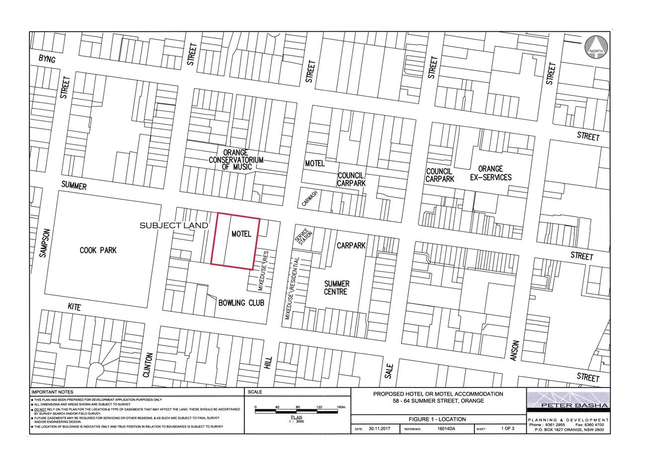
Planning and Development Committee
6 March 2018
2.5 Development
Application DA 454/2017(1) - 58-64 Summer Street
Attachment 2 Plans
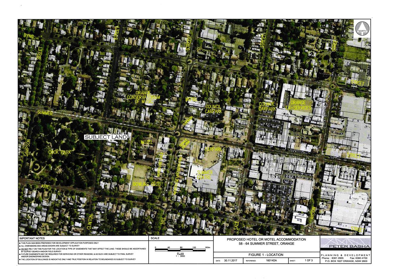
Planning and Development Committee
6 March 2018
2.5 Development
Application DA 454/2017(1) - 58-64 Summer Street
Attachment 2 Plans
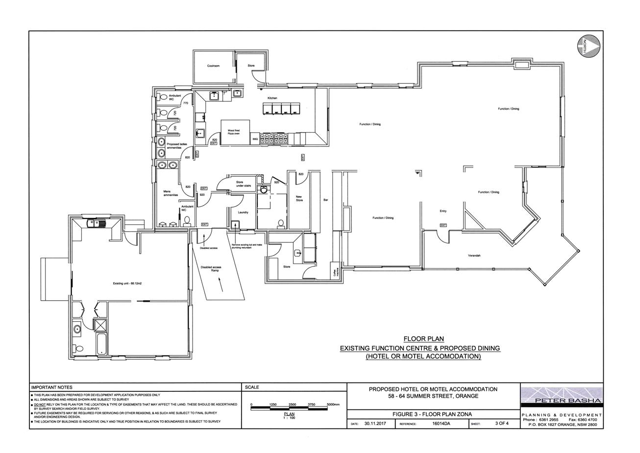
Planning and Development Committee
6 March 2018
2.5 Development
Application DA 454/2017(1) - 58-64 Summer Street
Attachment 2 Plans
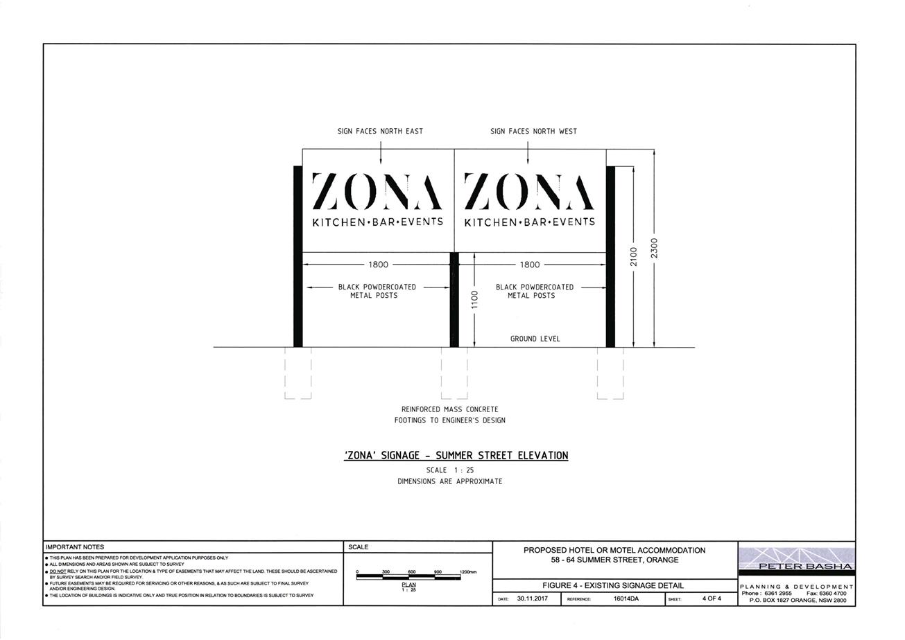
Planning and Development Committee
6 March 2018
2.5 Development
Application DA 454/2017(1) - 58-64 Summer Street
Attachment 2 Plans
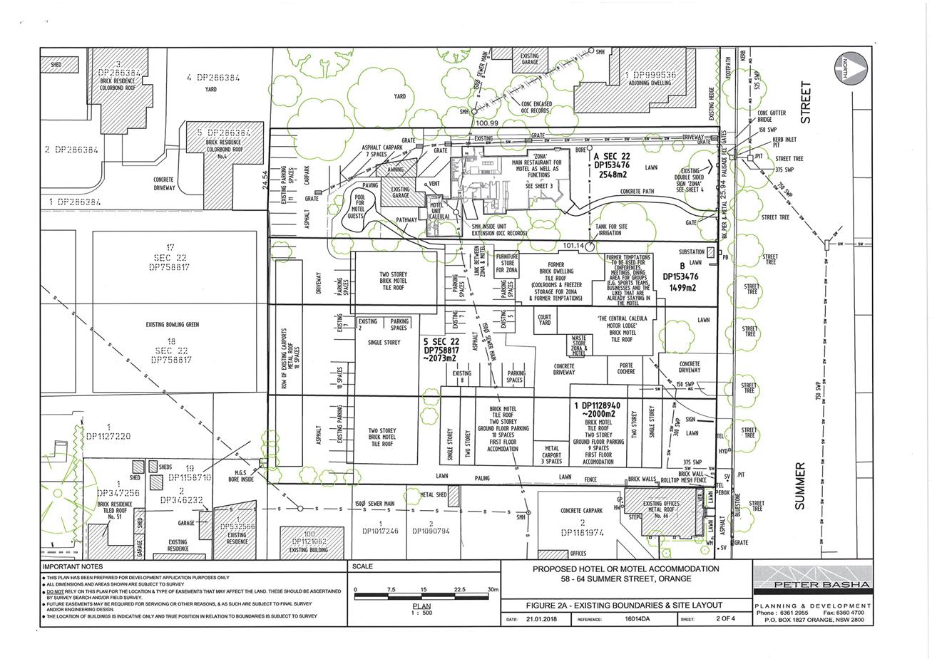
Planning and Development Committee
6 March 2018
2.5 Development
Application DA 454/2017(1) - 58-64 Summer Street
Attachment 2 Plans
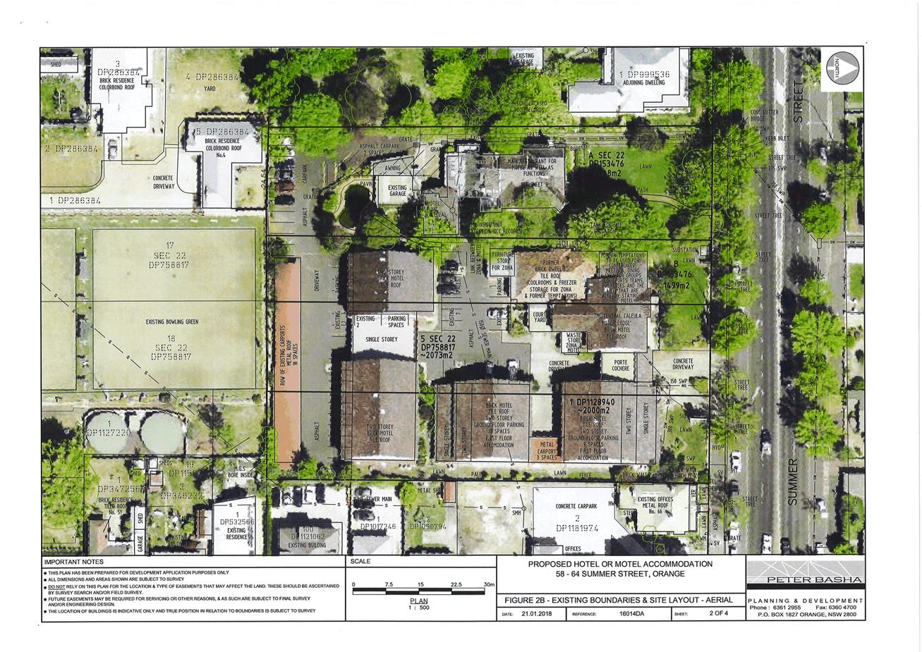
Planning and Development Committee
6 March 2018
2.5 Development
Application DA 454/2017(1) - 58-64 Summer Street
Attachment 2 Plans
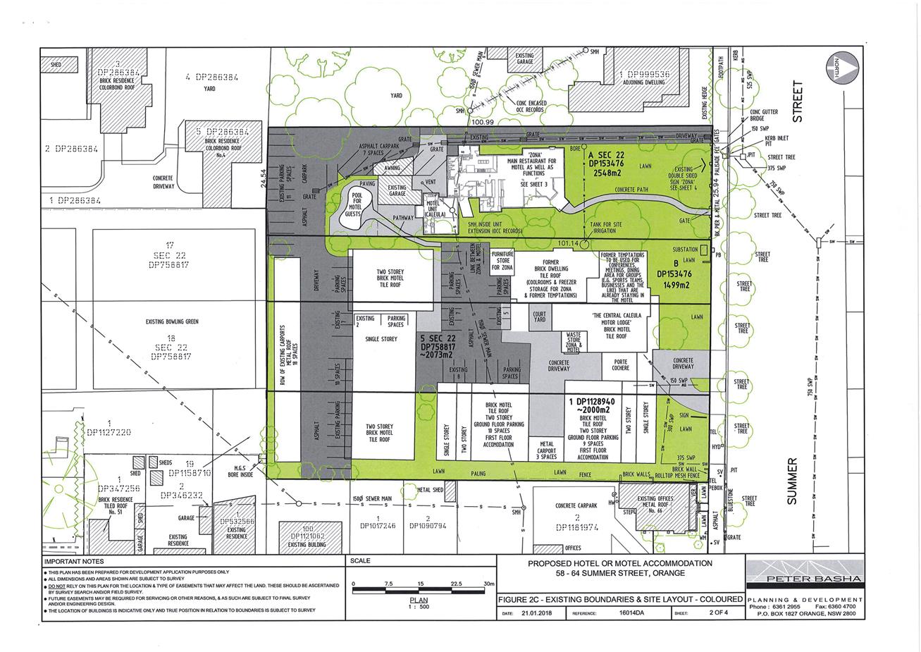
2.6 Development
Application DA 247/2017(1) - Tarawell Crescent and Margaret Road
RECORD
NUMBER: 2018/440
AUTHOR: Michael
Glenn, Senior Planner
EXECUTIVE Summary
|
Application
lodged
|
11 July
2017
|
|
Applicant/s
|
Westacre
Developments Pty Ltd
|
|
Owner/s
|
Westacre
Developments Pty Ltd
|
|
Land
description
|
Lots 30
and 31 DP 246174, and Lot 33 DP 1055815 - Tarawell Crescent and Margaret
Road, Orange
|
|
Proposed
land use
|
Subdivision
(29 lot residential)
|
|
Value of
proposed development
|
Not
applicable
|
Council's consent is sought for a 29 lot subdivision of
the land described as Lots 30 and 31 DP 246174, and Lot 33
DP 1055815. Whilst a total of 29 lots are shown on the plans, it should be
noted that one of the proposed lots is a drainage reserve. Council’s
Planning Protocols require subdivisions with a yield of more than ten lots, and
which are not covered by a subdivision masterplan, to be referred to the
Planning and Development Committee for determination. This matter was deferred
by the Planning and Development Committee at its meeting dated 6 February 2018
to permit a notification process to nearby and surrounding residents and
landholders. A major landholder in this locality is the Land and Housing
Corporation (L&HC), and this Corporation has lodged an objection. The issues
raised by L&HC have been considered in this amended report.
The basis of the L&HC objection to the development
relate to the following concerns:
· the impact of the
subdivision on the immediately adjoining social housing properties and wider
area and street network;
· avoidance of a
through road connection to Tarawell Crescent and Maramba Road; and
· no assessment of
Crime Prevention Through Environmental Design (CPTED) matters.
Discussions with the applicant during and immediately after
the notification period have resulted in amended plans being submitted for
Council’s consideration that now provide for a road linkage to connect
with Tarawell Crescent. In addition, the applicant has provided a staging plan
for the release of allotments within the subdivision.
The proposed layout will require the removal of several
large eucalyptus paddock trees from the site. These trees offer significant
landscape value and have some significant seed‑banking and nesting value,
but do not constitute an Endangered Ecological Community (EEC). Their
removal can be supported subject to the provision of replacements elsewhere.
The subject properties are in close proximity to the NDR,
with some of the lots within the noise shadow of the NDR. As a consequence, the
application required the submission of a full noise impact assessment. This
assessment has been reviewed as part of the overall merit assessment of the
application.
Council’s Technical Services Division has reviewed the
amended plans and raise no objections to that revised layout.
It is recommended that Council supports the subject
application.
Locality Plan
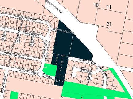
Figure 1 - locality plan
DECISION FRAMEWORK
Development in Orange is governed by key documents
summarised as follows:
State Environmental Planning
Policies (SEPPs) provide the NSW Government the ability to provide a
legislative framework to assess specific matters. They are made by the Minister
of Planning and generally have over-arching weight within the context of the
issue they address
In this case there are four principal state policies
applicable to the assessment of this application; SEPP Policy 33 (Hazardous and
Offensive Development), SEPP-55 (Remediation of Land), SEPP
(Infrastructure 2007), and SEPP 64 (Outdoor Advertising).
Orange Local Environment Plan
2011 – the LEP should be considered by Council to be a definitive
document (except when modified or added to by over-arching state policies).
LEPs govern the types of development that are permissible or prohibited in
different parts of the City and also provide some assessment criteria in
specific circumstances. Uses are either permissible or not - there are no grey
areas in terms of permissibility. The objectives of each zoning and indeed the
aims of the LEP itself are, however, open to interpretation and can be used to
guide decision making around appropriateness of development.
Orange Development Control Plan
2004 – the DCP guides development. In general it is a performance
based document rather than prescriptive in nature - its purpose is to guide
development. The Land and Environment Court tends to view it as such. In each
area of interest there are often guidelines used. These guidelines indicate
ways of achieving the planning outcomes. It is thus recognised that there may
also be other solutions of merit. All design solutions are considered on merit
by planning and building staff. Applications should clearly demonstrate how the
planning outcomes are being met where alternative design solutions are
proposed. So one can see that the DCP gives leeway for developers and
architects to use design to achieve the outcome in other ways if they can.
Stating that DCP guidelines are inflexible can be misleading.
Director’s Comment
The proposed development is permissible with the consent of
Council. The main issue in contention with this application in its original
form was lack of connections to Tarawell Crescent and the neighbourhood located
to the west. This issue has now been addressed in the revised plans.
Council’s DCP encourages the development of land based on the principle
of achieving a modified grid layout rather than a series of cul‑de‑sacs.
A Section 4.15 assessment of the development indicates that the
development is acceptable in this instance. Council’s Technical Services
Division has indicated support to the concept as proposed. Attached is a draft
Notice of Approval outlining a range of conditions considered appropriate to
ensure that the development proceeds in an acceptable manner.
Link To Delivery/OPerational Plan
The recommendation in this report relates to the
Delivery/Operational Plan strategy “13.4 Our Environment
– Monitor and enforce regulations relating to City amenity”.
Financial Implications
Nil
Policy and Governance Implications
Nil
|
Recommendation
That Council consents to development application DA
247/2017(1) for Subdivision (29 lot residential) at
Lots 30 and 31 DP 246174, and Lot 33 DP 1055815
– Tarawell Crescent and Margaret Road, Orange pursuant to the
conditions of consent in the attached Notice of Approval.
|
further considerations
Consideration has been given to the
recommendation’s impact on Council’s service delivery; image and
reputation; political; environmental; health and safety; employees; stakeholders
and project management; and no further implications or risks have been
identified.
SUPPORTING INFORMATION
THE APPLICATION
Council's consent is sought for subdivision (29 lot
residential) at Lots 30 and 31 DP 246174, and Lot 33 DP 1055815 - Tarawell
Crescent and Margaret Road, Orange.
THE PROPOSAL
Council's consent is sought for the residential subdivision
of the subject land into 29 allotments (comprising 28 residential
allotments and 1 public infrastructure lot). The design incorporates allotments
that contain extensive significant vegetation intended to be retained and
protected to an extent from removal by the imposition of restrictive building
envelopes. The subject design incorporates a road linkage to connect to
Tarawell Crescent.
Proposed lot sizes are generally under 1,000m², except
for Lot 17 which is substantially larger.
MATTERS FOR CONSIDERATION
Section 1.7 Application of Part 7 of the Biodiversity
Conservation Act 2016 and Part 7A of the Fisheries Management Act 1994
From 25 August 2017, the Biodiversity Conservation Act
2016 and Biodiversity Conservation Regulation 2017 were
gazetted. The implementation of this legislation (and supporting guidelines) is
subject to savings provisions that defer their full effect for a period of
six months from the date of gazettal for local development.
In this instance, site inspection reveals that the subject
property has some biodiversity value. Under the current provisions an
assessment of significance must be completed and Council must be satisfied that
an overall adverse significant effect on threatened species, populations or
ecological communities or their habitats does not result from the proposed
development.
This section includes a requirement to consider any adopted
assessment guidelines. The relevant guidelines applicable to the threatened
Endangered Ecological Community (EEC) evident on this site requires
Council as the consent authority to adopt the precautionary principle in its
assessment.
In this instance there is significant biodiversity or
habitat value over several parts of the site. The most significant single
element is the terrestrial vegetation on the site in the form of a
substantially intact box gum grassy woodland (BGGW) remnant. This remnant is
unique because it has retained a largely intact understorey, which is unusual
for urban bushland.
The applicant has proposed a large sized lot at the southern
end where some significant vegetation is located. The allotment contains two
small but valuable areas of remnant vegetation worthy of conservation. One is
at the extreme southern end, whilst the other is a more intact BGGW intended to
be protected in the longer term by a restrictive building exclusion envelope.
Both areas of significant vegetation will require protective fencing installed
around those areas in accordance with AS 4970‑2009 (Protection Of
Trees On Development Sites) during construction. These areas can be
protected under future legislation and conditions of development consent.
A condition is included for boundary fencing to be set back
from the principal vegetation a minimum of 3m.
Further, it is considered appropriate to impose a condition
requiring (prior to the issue of a fully endorsed Subdivision Certificate) a
Restriction-as-to-User to be imposed on the titles of Lots 17 and 18 in
favour of Orange City Council that does not allow the planting of invasive
exotic species on either of these lots, the removal of fallen timber without
permission from Council’s Manager City Presentation, or the removal of
understorey plants from the significant vegetated areas without the agreement
of Council’s Manager City Presentation.
With respect to the paddock trees, it is not considered
reasonable to require the retention of these trees. Whilst the trees themselves
are significant specimens and do provide seed banking opportunities, the
benefits derived from them do not warrant their retention. To offset the loss
of these important trees, a condition is included that requires a minimum
of 20 replacements (to be planted prior to the issue of a Subdivision
Certificate) in the public open space on the western side of Lot 29
(generally within Lot 48 DP 258905, known to Council as Plowman Park), or
such other location as nominated by Council’s Manager City Presentation.
The applicant is obligated to water and maintain these trees until such time as
the Subdivision Certificate has been released.
Aboriginal Heritage
The subject property is not identified in the Aboriginal
Heritage Information Management System (AHIMS) managed by the office of
Environment and Heritage (OEH). Notwithstanding, it is considered that a
standard condition should be imposed that requires the protection of any
Aboriginal artefacts discovered during the subdivisions works being carried
out.
Section 4.15
Section 79C of the Environmental Planning and Assessment Act
1979 requires Council to consider various matters, of which those pertaining to
the application are listed below.
PROVISIONS OF ANY ENVIRONMENTAL
PLANNING INSTRUMENT s4.15(1)(a)(i)
Orange Local Environmental Plan 2011
Part 1 - Preliminary
Clause 1.2 - Aims of Plan
The broad aims of the LEP are
set out under Subclause 2. Those relevant to the application are as follows:
(a) to
encourage development which complements and enhances the unique character of
Orange as a major regional centre boasting a diverse economy and offering an
attractive regional lifestyle,
(b) to
provide for a range of development opportunities that contribute to the social,
economic and environmental resources of Orange in a way that allows present and
future generations to meet their needs by implementing the principles for
ecologically sustainable development,
(c) to
conserve and enhance the water resources on which Orange depends, particularly
water supply catchments,
(e) to
provide a range of housing choices in planned urban and rural locations to meet
population growth,
(f) to
recognise and manage valued environmental heritage, landscape and scenic
features of Orange.
In relation to (a), the proposed
development will detract from or decrease the open character of the locality,
but will be consistent with and increase the residential character of the more
urban areas nearby. The subject property is zoned R2 Low Density Residential,
and it is appropriate to assume that the site would at some point be developed
for urban purposes.
The development site is surrounded by
similarly zoned low density residential land, with the exception of the open
space land known as Plowman Park.
With regard to (b), the proposed
development does increase the stock of housing lots that, in some perspective,
adds to the development opportunities of the City. Adding to the housing stock
increases the potential for population growth that, in turn, suggests that the
needs of the workforce will be met.
With regard to (c), the proposed
development would not have any significant effect on the resources of the
Orange City water supply.
With regard to (e), the proposed
development does not include housing, however, it does increase the supply of
residential allotments. This will produce the conditions needed to provide
additional housing opportunities.
With regard to (f), it is recognised that
the changes in zoning that occurred under LEP 2011 will result in some
adverse effects on the surrounding landscape. However, within the context of
the general provisions, the zoning, the other objectives of the LEP and the
recognised primary view corridors and the like, it is considered that this is
appropriate development for the site.
Clause 1.6 - Consent Authority
This clause establishes that, subject to the Act, Council is
the consent authority for applications made under the LEP.
Clause 1.9A - Suspension of
Covenants, Agreements and Instruments
This clause provides that covenants, agreements and other
instruments which seek to restrict the carrying out of development do not apply
with the following exceptions:
· covenants imposed
or required by Council
· prescribed
instruments under Section 183A of the Crown Lands Act 1989
· any conservation
agreement under the National Parks and Wildlife Act 1974
· any trust
agreement under the Nature Conservation Trust Act 2001
· any property
vegetation plan under the Native Vegetation Act 2003
· any biobanking
agreement under Part 7A of the Threatened Species Conservation Act 1995
· any planning
agreement under Division 6 of Part 4 of the Environmental Planning and
Assessment Act 1979.
Council staff are not aware of the title of the subject
property being affected by any of the above.
Clause 1.7 - Mapping
The subject site is identified
on the LEP maps in the following manner:
|
Land Zoning Map:
|
Land zoned R2 Low Density
Residential
|
|
Lot Size Map:
|
No Minimum Lot Size
|
|
Heritage Map:
|
Not a heritage item or conservation
area
|
|
Height of Buildings Map:
|
No building height limit
|
|
Floor Space Ratio Map:
|
No floor space limit
|
|
Terrestrial Biodiversity Map:
|
Biodiversity sensitivity on the
site
|
|
Groundwater Vulnerability Map:
|
Ground water vulnerable
|
|
Drinking Water Catchment Map:
|
Not within the drinking water
catchment
|
|
Watercourse Map:
|
Not within or affecting a defined
watercourse
|
|
Urban Release Area Map:
|
Not within an urban release area
|
|
Obstacle Limitation Surface Map:
|
No restriction on building siting
or construction
|
|
Additional Permitted Uses Map:
|
No additional permitted use applies
|
Those matters that are of relevance are addressed in detail
in the body of this report.
Part 2 -
Permitted or Prohibited Development
Land Use Zones
The subject property is zoned R2
Low Density Residential under the provisions of Orange Local Environmental Plan
2011. The proposed development is defined as a “subdivision “under
OLEP 2011. Subdivision of land under LEP 2011 has the same meaning as
defined in the Act. Pursuant to Clause 4B of the Environmental Planning and
Assessment Act, subdivision of land means:
the division of land into two
or more parts that, after the division, would be obviously adapted for separate
occupation, use or disposition.
Subdivision of land is permissible with consent in the R2
Low Density Residential zone. There are no minimum lot size provisions
applicable to the development site.
Clause 2.3 of
LEP 2011 references the Land Use Table and Objectives for each zone in
LEP 2011. These objectives for land zoned R2 Low Density Residential are
as follows:
· To provide for
the housing needs of the community within a low density residential
environment.
· To enable other
land uses that provide facilities or services to meet the day to day needs of
residents.
· To ensure
development is ordered in such a way as to maximise public transport patronage
and encourage walking and cycling in close proximity to settlement.
· To ensure that
development along the Southern Link Road has an alternative access.
In relation to the first
objective, the proposed development would provide additional lots of land on
which housing stock within the City can be provided. It will provide these
additional lots at a scale consistent with typical low density development. In
terms of lot yield and lot sizes, the proposed subdivision is consistent with
the relevant controls. In relation to the second objective, the proposed
subdivision would not impede the provision of other land to provide facilities
and services should such a need ever arise in the future. In relation to the
third objective, it is possible for public transport services to be provided to
the new lots proposed.
Clause 2.6 - Subdivision -
Consent Requirements
Application has been made for the subdivision of the subject
land. Clause 2.6 of OLEP 2011 permits the subdivision of the subject
land only with development consent.
Part 4 -
Principal Development Standards
Clause 4.1 - Minimum
Subdivision Lot Size
This clause requires the
subdivision of land to be equal to or greater than the size nominated for the
land under the Minimum Lot Size Map. Whilst the subject property is zoned R2
Low Density Residential which often has a minimum lot size applicable, in this
case there is no specified minimum lot size for the site.
Part 7 -
Additional Local Provisions
7.1 - Earthworks
This clause establishes a range
of matters that must be considered prior to granting development consent for any
application involving earthworks, such as:
(a) the likely disruption of, or any
detrimental effect on, existing drainage patterns and soil stability in the
locality of the development
(b) the effect of the development on the
likely future use or redevelopment of the land
(c) the quality of the fill or the soil to be
excavated, or both
(d) the effect of the development on the
existing and likely amenity of adjoining properties
(e) the source of any fill material and the
destination of any excavated material
(f) the likelihood of disturbing relics
(g) the proximity to and potential for adverse
impacts on any waterway, drinking water catchment or environmentally sensitive
area
(h) any measures proposed to minimise or
mitigate the impacts referred to in paragraph (g).
The earthworks proposed in the application are limited to
the extent of cutting and filling required for the construction of roads and
provision of services (such as drainage). The extent of disruption to the
drainage of the site is considered to be minor. There is some potential for the
bulk earthworks to adversely impact upon the health of significant vegetation
on the site, and for this reason conditions have been included in the consent
that require the installation of protective fencing that is installed to the
standards specified in AS 4970 so as to minimise the risks to that
vegetation.
7.3 -
Stormwater Management
This clause applies to all
industrial, commercial and residential zones and requires that Council be
satisfied that the proposal:
(a) is designed to maximise the use of water
permeable surfaces on the land having regard to the soil characteristics
affecting onsite infiltration of water
(b) includes, where practical, onsite
stormwater retention for use as an alternative supply to mains water,
groundwater or river water; and
(c) avoids any significant impacts of
stormwater runoff on adjoining downstream properties, native bushland and
receiving waters, or if that impact cannot be reasonably avoided, minimises and
mitigates the impact.
With regard to (a) and (b), the proposed development is for
subdivision of an existing three lot holding into residential lots. The future
development of the 28 residential lots will likely consist of standard
residential housing. Council has controls with respect to site coverage that
will ensure that extensive parts of each allotment will have permeable spaces.
The future surface runoff for each lot will be directed to
flow into Council’s stormwater reticulation system.
It is not anticipated that the proposed development will
lead to future development unsuited to the capabilities of either onsite
detention or the stormwater reticulation system.
With regard to (c), there will be some impacts arising with
stormwater runoff for water quantity and water quality. Quantities can be
expected to rise as hard surfaces like roads are installed but can be
adequately managed by engineering works, which are imposed as conditions in the
consent.
With regard to water quality, collection and increase in
particulate content and nutrients is likely for a residential subdivision,
although contamination from toxic or dangerous chemicals is considered minimal.
Nutrient and particulate control is recommended under Water Sensitive Urban
Design principals (WSUD) and for this site is managed under the water re-use
scheme.
7.4 -
Terrestrial Biodiversity
The site has biodiversity value
but is not mapped under Council’s Local Environmental Plan as warranting
an Environmentally Sensitive Area (ESA) layer. This does not suspend the
operation of Section 5A of the Act, but does mean that it is unnecessary to
assess the application against the provisions of Clause 7.4.
7.6 -
Groundwater Vulnerability
This clause seeks to protect
hydrological functions of groundwater systems and protect resources from both
depletion and contamination. Orange has a high water table and large areas of
the LGA, including the subject site, are identified with “Groundwater
Vulnerability” on the Groundwater Vulnerability Map. This requires that
Council consider:
(a) whether or not the development (including
any onsite storage or disposal of solid or liquid waste and chemicals) is
likely to cause any groundwater contamination or have any adverse effect on
groundwater dependent ecosystems, and
(b) the cumulative impact (including the
impact on nearby groundwater extraction for potable water supply or stock water
supply) of the development and any other existing development on groundwater.
Furthermore, consent may not be granted unless Council is satisfied that:
(a) the development is designed, sited and
will be managed to avoid any significant adverse environmental impact, or
(b) if that impact cannot be reasonably
avoided - the development is designed, sited and will be managed to minimise
that impact,
(c) if that impact cannot be minimised - the
development will be managed to mitigate that impact.
The proposal is not anticipated
to involve the discharge of toxic or noxious substances and is therefore
unlikely to contaminate the groundwater or related ecosystems. The proposal
does not involve extraction of groundwater and will therefore not contribute to
groundwater depletion. The design and siting of the proposal avoids impacts on
groundwater and is therefore considered acceptable.
STATE ENVIRONMENTAL PLANNING
POLICIES
The following State Environmental Planning Policies (SEPPs)
are applicable to the proposed development.
State Environmental Planning
Policy (Vegetation in Non-Rural Areas)
The operation of this SEPP is linked to Orange City
Council’s Tree Preservation Order (under Development Control Plan 2004).
Where the removal of vegetation forms part of an overall development
application, the assessment of that vegetation removal can be considered as
part of that DA.
The SEPP has its primary assessment provisions deferred
because of the savings provisions embedded into the SEPP, which permits
applications lodged but not determined before the relevant date (in this case
25 August 2017) to be determined under the old regime.
It is noted that the adoption of this SEPP was concurrent to
the government’s suspension of Clause 5.9. Unlike the SEPP, there
were no savings provisions applied to the removal of Clause 5.9.
The SEPP as a matter for consideration is acknowledged, but
has no significant impact on the assessment of this application.
State Environmental Planning
Policy 55 - Remediation of Land
The subject property has for many years been used for
extensive agriculture, which can act as a trigger for a contamination
assessment under Council’s draft remediation strategy. The structure of
Council's contamination strategy can be found in the quick reference guide
produced by Contamination Central at the time of the preparation of the draft policy.
There is a flowchart that sets
out the procedures when receiving new development applications. This flow chart
is reproduced below:
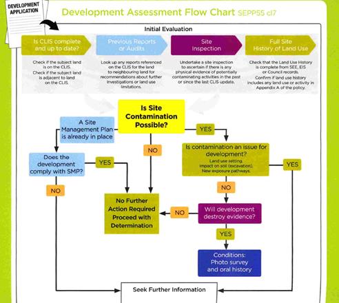
Figure 2 - development assessment flowchart
Initial Evaluation – Matters for Consideration
Figure 3 - determining if the property is on the
Contaminated Lands Information System (CLIS)
The subject land is not on
Council’s Local CLIS. It is not recorded on the EPA Register as
being contaminated.
Figure 4 - checking previous reports
There are no reports on the
CLIS relevant to this matter.
Figure 5 - site inspections
There is no physical evidence
to suggest a likely source of contamination. There are no sheds, sheep dips or
spray dumps; and perusal of the historical aerial photography does not reveal
the presence of such structures in previous times. The site has no prior
history as a site used for intensive plant agriculture. It has been used for
grazing on a very limited basis (hobby farming basically) for perhaps twenty
years. Before that it is believed to have also been used for more serious
general grazing.

Figure 6 - site history
The previous land uses of this site are reflected in the
absence of structures on the site and its use for extensive agriculture over an
extended period. There is no relevant history recorded in Council’s
records. Its prior land uses are based on site observation, and such deduced
history does not suggest that the site has any significant contamination
issues.
However, the existing land use for extensive agriculture is
included in Appendix A of the quick reference guide as a potential source
of contamination. This observation needs, however, to be further considered
against the provisions contained in the Contamination Central draft policy in
section 11.3, which states:
“land used for extensive
agriculture should be assessed for site contamination where development
applications relate to redevelopment in the vicinity of stock yards, stock
dip or farm sheds where fuel or chemicals have been stored or handled”.
As previously alluded to, the site was previously used for
extensive agriculture, but the site does not have any of the triggers contained
in the bolded part of the above-described clause. It appears to have been used
solely as grazing land.
It is considered unlikely given the above analysis that the
site is contaminated. However, notwithstanding the above assessment, it is
recommended that a condition be attached to the Notice of Determination
requiring soil sampling for analysing chemical residue to be undertaken for the
residential allotments in a manner and frequency as determined by an
appropriately qualified and experienced consultant, giving consideration to
specific uses and onsite characteristics of the land. The results of the
testing will be required to be provided to the Principal Certifying Authority
and are to demonstrate that the land is suitable for residential use to enable
the Subdivision Certificate to be released.
PROVISIONS OF ANY DRAFT
ENVIRONMENTAL PLANNING INSTRUMENT THAT HAS BEEN PLACED ON EXHIBITION
s4.15(1)(a)(ii)
There are no draft environmental planning instruments that
apply to the subject land or proposed development.
DESIGNATED DEVELOPMENT
The proposed development is not designated development.
PROVISIONS OF ANY DEVELOPMENT
CONTROL PLAN s4.15(1)(a)(iii)
Development Control Plan 2004
Development Control Plan 2004 (“the DCP”)
applies to the subject land (Part 7). An assessment of the
proposed development against the relevant Planning Outcomes will be undertaken
below.
Pursuant to Planning Outcome 0.2-1 Interim Planning Outcomes
- Conversion of Zones:
· Throughout this
Plan, any reference to a zone in Orange LEP 2000 is to be taken to be a
reference to the corresponding zone(s) in the zone conversion table.
The subject property was zoned Residential 2(a) under LEP
2000, and with the adoption of LEP 2011 the subject property was
classified as R2 Low Density Residential, which is an equivalent zoning to the
previous land classification. It is noted that the site is not subject to any
DCP masterplan.
It is appropriate to apply such parts of Chapter 7 of the
DCP as are applicable to the subdivision in the assessment. Additionally, the
general provisions of Chapters 2 (Natural Resource Management) and
3 (General Considerations) have relevance with respect to cumulative
impacts and scenic landscape issues.
Part 2 -
Natural Resource Management
The DCP states:
Development
that concentrates, redirects flows, increases flow rates or disturbs land in
close proximity to creeks has the potential to affect waterways with associated
erosion, sedimentation and release of nutrients, which combine to affect
downstream water quality. Erosion appears to be particularly prevalent within
the “North Orange” red earth soil types.
Urban stormwater has also been identified
as a significant source of water pollutants. Uncontrolled stormwater flow from
urban development has the potential to contribute to downstream impacts,
including periodic flooding, erosion, sedimentation and reduced in‑stream
water quality.
Orange City Council’s Drainage
Strategy was adopted by Council on 19 June 1997 to identify measures
required to control stormwater flow velocities and volumes.
Conditions are included that require the
design and provision of a stormwater management system that minimises erosion,
controls outflows and requires water quality to be at least as good as the best
water currently being discharged from the site as a vacant allotment.
Part 3 -
General Considerations
The applicant has responded to the site
constraints in a way generally satisfactory to environmental issues affecting
this site. The issues of slope, character, open space, linkages, proximity to
the NDR and Council’s plans for road re-design have been generally
responded to cooperatively by the applicant.
With regard to cumulative impacts, the DCP
requires that applicants demonstrate how the development relates to the
existing character of the locality. In this instance the character is generally
residential.
There are significant vegetation remnants
evident on the site. There is a major transport link in the form of the NDR
immediately to the south. Each of these constraints have differing, and
sometimes competing demands on land capability, but as a generalisation the
proposed subdivision responds well to the constraints.
It is accepted that the proposed
development is generally consistent with the lot sizes and subdivision patterns
of the residential subdivisions that are nearby. Within that context and in the
absence of any specific master planning in the DCP, it cannot be strongly
argued that the proposed development is vastly inconsistent with the expected
future character of the locality.
The applicant has now included in the
amended proposal connections for the site to the housing commission
neighborhood located to the west. This is consistent with the preferred roads
layout in the DCP, being a modified grid layout which recommends that
connectivity between neighborhoods be provided.
Part 7 -
Development in Residential Areas
General Principles
The DCP in its preliminary instructions includes the
following guidelines for design of urban residential subdivisions, based on
Department of Planning Urban Design guidelines:
“The Urban
Form publication identifies the following issues for future development of
the City:
· The square grid
of 200 m blocks and the open space system along the creek lines are the most
important features of Orange’s urban identity.
· Maintaining
this pattern in new development will allow uninterrupted view lines, and offer
variety as the streets traverse the topography. It will also result in the
efficient provision of services and permeable pedestrian routes.
· Expanding open
space along natural creek lines and in associated parks will increase amenity,
provide environmental buffer zones, allow for drainage control structures and
help people orient themselves by being able to read the landscape.
· Laneways that
have been introduced through the original blocks as a cul-de-sac can be
extended to give pedestrian or vehicular access across the blocks.
· As the town
grows, radial expansion will require cross connections to assist the movement
between outer suburbs.
The
distribution of facilities such as schools and places of worship in existing
development suggest similar distribution will be required near new residential
development, ie, within a five- to ten-minute walking distance from every
home”.
It is considered that the revised design responds positively
to these urban design principles. The proposed road system is functional from
the point of view of traffic management, and also provides a level of
connectivity to improve social and communal cohesion and integration that the
physical design parameters of the modified grid layout favour in the DCP.
Subdivision in LGA not forming
part of a Masterplan Area
Subdivision - Lot Sizes and Battleaxe
Lots
Residential lots in Orange are
predominantly between 600m² and 900m² in area. In recent years, the
average residential lot size has reduced from about 800m² to
about 750m².
This DCP
establishes guidelines for residential subdivision.
Standard Lot 500m2
or greater
Cottage Lot >350
and <500m2
Town House
Lot 250 to 350m2
The submitted plans show all the proposed
lots to be “Standard Lots”. There are no additional information
requirements for standard lots as the assumption is that there are no
particular difficulties in locating a standard detached dwelling on lots of
this size.
There are no battleaxe allotments proposed
under this application.
Corner Lots
· Corner lots should be designed to provide for a house facing one
street. Where dual occupancy development is proposed on a corner lot, each
dwelling should face a different street.
The proposed development is consistent with
this principle.
Dual Occupancy
and Unit Sites
Dual occupancies in the R2 zone are permissible
with consent. Under Clause 4.1B of the LEP, a minimum lot size of 800m2
is applicable. However, as there are no minimum lot sizes a future development
in which the subdivision precedes the dwelling houses is permissible on any
lot, subject to satisfactory merit assessment.
Subdivision
Layouts
The Department of Urban Affairs and
Planning’s Urban Design Advisory Service publication on Urban Form
describes the influences on, and effects of the urban pattern of Orange
as a Case Study.
Department of Urban Affairs and
Planning’s Urban Form concludes that:
... the city
is well contained within a multiple of the original square mile grid and no
significant subdivision has occurred along the roads into town. Some
subdivisions have occurred at the edges of the city, with curvilinear streets
and cul-de-sac. Nearer the city there are very small blocks, shallow with a
relatively wide frontage, which express the current fashion where a wide street
address is more important than a big backyard.
The Urban Form publication
identifies the following issues for future development of the City:
· The square grid
of 200m blocks and the open space system along the creek lines are the most
important features of Orange’s urban identity.
· Maintaining
this pattern in new development will allow uninterrupted view lines, and offer
variety as the streets traverse the topography. It will also result in the
efficient provision of services and permeable pedestrian routes.
· Expanding open
space along natural creek lines and in associated parks will increase amenity,
provide environmental buffer zones, allow for drainage control structures and
help people orient themselves by being able to read the landscape.
· Laneways that
have been introduced through the original blocks as cul-de-sac can be extended
to give pedestrian or vehicular access across the blocks.
· As the town
grows, radial expansion will require cross connections to assist the movement
between outer suburbs.
· The
distribution of facilities such as schools and places of worship in existing
development suggest similar distribution will be required near new residential
development, ie, within a five- to ten-minute walking distance from every home.
The return to a modified grid layout in
preference to the 1970’s urban-planning theories of curvilinear streets
and associated cul-de-sacs has become more recently promoted in the City, such
as in the layout for Ploughmans Valley. This principle will continue to be
emphasised for the planning for new release areas for the foreseeable future.
A modified grid layout not only provides
for more efficient servicing of residential land, views and improved
connections between residential areas, the grid pattern is also consistent with
energy efficiency principles. Orientation of boundaries along the north‑south
and east-west axes encourages solar design of houses. Lots facing east or west
need to be wider to promote northern sunlight.
In this case the layout is in its amended
form and is consistent with the modified grid layout principals favoured under
the DCP.
Orange
Subdivision Code
Council Technical Services Division is principally
responsible for the application of the Subdivision Code. That Division has not
raised objection to the submitted layout, and has imposed a suite of conditions
to ensure that the development is carried out in accordance with the
Subdivision Code requirements.
Planning Outcomes
|
PO 7.2-1 PLANNING OUTCOMES FOR URBAN RESIDENTIAL
SUBDIVISION
|
|
Item
|
Performance Standard
|
Compliance
|
|
1
|
Subdivision layouts in areas zoned Urban Residential prior to this
plan are generally in accordance with the applicable plan maps in
Appendix 1.
|
There are no layout masterplans for this site.
|
|
2
|
Lots are orientated to optimise energy-efficiency principles.
|
It will generally be possible to incorporate Energy efficient
principals into future development on the proposed lots.
|
|
3
|
New roads are planned according to modified grid layouts with
restrained use of cul-de-sac roads in new developments according to the UDAS Urban
Form principles for Orange.
|
The amended design now provides a road connection through to Tarawell
Crescent, effectively linking the adjoining residential area. The modified
design is now consistent with the DCP principle of achieving a modified
grid layout.
|
|
4
|
Local open space is provided along creek corridors to create open
space linkages for environmental conservation and social interaction. Release
areas removed from creeks provide for open-space links incorporating
substantial stands of native vegetation.
|
There are no creek systems traversing the site.
|
|
5
|
Release areas indicate trunk cycle and pedestrian ways that link the
area to major open space networks and activity centres (schools, shopping
centres and employment areas).
|
There are no masterplans applicable to this site. As such, pedestrian
links, open space networks and cycle paths are not required.
|
|
6
|
Lots below 500m2 indicate a mandatory side setback to
provide for solar access and privacy.
|
No lots below 500m2 are proposed.
|
|
7
|
Lots below 350m2 indicate existing or planned house
layouts, which identify how privacy, solar access, vehicular access and
private open-space needs are to be achieved.
|
No lots below 350m2 are proposed.
|
|
8
|
Up to 25% of new subdivisions comprise small lots in dispersed
locations
|
No small lots are proposed.
|
|
9
|
Lots are fully serviced and have direct frontage/access to a public
road.
|
Conditions are included in the consent to require these outcomes.
|
|
10
|
Design and construction complies with the Orange Development and
Subdivision Code
|
The proposed development will comply with the subdivision code.
|
|
11
|
Corner lots provide for a house to front one street
|
The proposed corner lots (Lots 3, 12, 13 and 23) have a
short and a long boundary, which conforms to this principal.
|
|
12
|
Battleaxe lots provide an adequate accessway width for the number of
dwellings proposed to be served in order to allow for vehicle and pedestrian
access and location of services
|
There are no battleaxe lots proposed for this development.
|
|
13
|
Lots proposed to be used specifically for dual occupancy or units in
new residential areas are identified on development application plans to
inform prospective purchasers of the mixed residential form of the area, and
measures are outlined on how prospective residents are to be informed of
these identified sites prior to purchasing land.
|
Four
lots have been identified within the subdivision as being directly suitable
for dual occupancy. Three of the lots identified are located on corner
allotments, which provides opportunity for access to be provided to both
streets. The subject lots are ideally located on the northern side of the
street to maximise access to northern sunlight into principle living spaces.
The forth lot is located on a large residential parcel. No objections. It should
be noted that the LEP specifies a minimum lot size of 800m² for dual
occupancy except where otherwise specified. Approximately 20 of the proposed
lots within the subdivision have areas exceeding 800m².
|
DEVELOPMENT CONTRIBUTIONS
Section 7.11 Contributions
The subject land comprises three existing lots. The proposed
subdivision plan shows 28 residential lots and 1 drainage reserve lot,
resulting in a 25 lot yield for future development.
Pursuant to Orange Development
Contributions Plan 2017, the following contributions have been levied for the
subject development and are attached as a condition of consent. The payment of
contributions as per the following shall be made to Council in accordance with
Section 7.11 of the Act and the Orange Development Contributions
Plan 2017 (development in LGA Remainder Area) towards the provision of the
following public facilities:
|
Open Space and Recreation
|
@ $3,891.67 x 25 additional lots
|
97,291.75
|
|
Community and Cultural
|
@ $1,128.59 x 25 additional lots
|
28,214.75
|
|
Roads and Traffic Management
|
@ $5,136.89 x 25 additional lots
|
128,422.25
|
|
Plan Preparation and Administration
|
@ $304.72 x 25 additional lots
|
7,618.00
|
|
TOTAL
|
|
$261,546.75
|
The contribution will be indexed quarterly in accordance
with the Orange Development Contributions Plan 2017 (development in LGA
Remainder Area). Attached is a condition of consent requiring the payment of
the Section 7.11 Contributions prior to the issue of a Subdivision Certificate.
Section 64 Water and Sewer
Headwork Charges
In contrast to Section 7.11 contributions which can apply a
credit for the three existing lots, no credits are applicable for Section 64
Water and Sewer Headworks charges, as the existing lots that are subject to the
proposed development have no access to water and sewer services.
Section 64 water and sewer headwork charges are also
applicable to the proposal. Such charges are calculated at the time of a
Construction Certificate for the proposed development. Attached are draft
conditions requiring the payment of the required contribution prior to the
issue of a Subdivision Certificate.
PROVISIONS PRESCRIBED BY THE
REGULATIONS s4.15(1)(a)(iv)
The development is not inconsistent with the provisions
prescribed by the regulations.
THE LIKELY IMPACTS OF THE
DEVELOPMENT s4.15(1)(b)
Major Site Constraints - Suitability for Residential
Subdivision
NDR Noise
A report submitted with the application by noise consultants
Wilkinson Murray measured noise levels in the most potentially affected
habitable spaces using a predictive tool based on the following assumptions:
· dwellings are
established as close as 1m to the boundary;
· dwellings are
single storey; and
· windows could be
left open.
No boundary fences were factored into the assumptions for
the prediction model.
The report concludes that based on the assumptions stated
above, the predicted internal noise levels in bedrooms and other habitable
spaces can be readily achieved through standard acoustic construction
techniques so that the internal noise levels do not exceed 40dBA. This is the
accepted industry standard for restful slumber for residential development.
The principal source of noise disturbance for the
residential subdivision will emanate from the NDR. The abovementioned
report by Wilkinson Murray was viewed by Council’s Manager Building and
Environment (who has the necessary experience to competently review noise
reports and noise issues) with the following brief comments provided:
I confirm that I have assessed
the noise assessment undertaken by Wilkinson Murray – Report 17366
Version A dated December 2017.
I am satisfied that the
proposed subdivision would comply with the noise requirements that arise from
the ISEPP.
I note that the study only
considered single storey residential development.
Therefore the consent should
have a condition that restricts residential development within the proposed
subdivision to single storey, unless an individual acoustic assessment is
undertaken for the specific dwelling. Noise levels within such a proposed
dwelling must not exceed 35 dB(A) in bedrooms between 10pm and 7am and 40 dB(A)
elsewhere in the building (other than a garage, kitchen, bathroom or hallway)
It may be best to have this
restriction on the 88b instrument – thus condition this.
It is considered that, subject to the imposition of
conditions, the proposed development will not suffer from excessive noise
intrusion.
Biodiversity
Council’s LEP mapping layers do not show the site to
contain Environmentally Sensitive Areas (ESAs). However, site inspection
confirms the existence of a small area of very high value bush, including a
rare intact understorey layer along the south-western boundary.
There is a less significant remnant along the southern
boundary of Lot 17.
Other remnants do exist on the site but suffer from
excessive weed infestation. The structure and spacing of the overstorey,
excessive weed infestation and dominance by other introduced species makes this
area an overall liability to the biodiversity of the site. The native tree
stands have been deformed by the excessive competition posed by the invasive
species that surround them, resulting in slender and weak trunk structure.
These other tree stands have virtually no intact understorey.
There are also several large single “paddock”
trees slightly to the north, which appear to be active as seed banking trees as
there are several small saplings evident around each of them. These individual
trees are also likely to provide transit points for juvenile avian species as
they transit to larger tree stands in the district. These trees are too large
to be practically accommodated on the lot sizes proposed. These individual tree
specimens are located on proposed Lots 13, 14, 19 and 20.
The subject property itself has limited-to-moderate
connectivity to more significant surrounding vegetation, but establishing the
importance of the remaining remnant as a link in the overall remaining
biodiversity network is problematic. On the basis of location and on site
observation, it is considered to have low importance as a transit point in the
remaining network.
The amended plan, subject to the imposition of certain
conditions (which the applicant has agreed to the imposition of), does not
incorporate key threatening processes within the subdivision. Some significant
isolated paddock trees will be lost as a result of the development. These trees
are not considered to form an EEC in their own right due to their relative
isolation, but they do provide seed banking opportunities and possibly act as
waypoints for juvenile avian species. To offset the loss of these significant
bits of vegetation, it is considered appropriate to impose a requirement for
replacements to be planted. It will take a long time for the replacement trees
to reach a level of maturity such that they could be considered replacements
for the trees to be removed, but it is nevertheless a reasonable compromise and
considered worthwhile to require replacements for the trees to be removed (or
likely to be removed) from the site.
The major biodiversity value of the site is the small
thickets located at the southern end of the site. The applicant has amended the
proposal so that the two EEC remnants are positioned on Lot 17. It is
considered appropriate to impose a condition requiring the establishment of
no-build restrictions within these areas, and also impose conditions relating
to not removing native vegetation from these areas (ie vegetation other than
the trees), as well placing restrictions on the selection of garden species
within Lot 17 and the adjoining Lot 18.
The conditions included in the attached notice of
determination were referred to Council’s Manager City Presentation, for
advice and comment. He has responded as follows:
“I concur with the
proposed consent conditions especially the erection of TPZ fencing prior to the
issue of a CC. The TPZ fencing condition in itself should, if enforced
correctly, ensure sound protection of the remnant woodland vegetation and
understory.
With regard to the condition
about replanting of trees in place of the loss of the two remnant Ribbon Gums (Eucalyptus
viminalis) located on proposed Lots 13/14 and 19/20. Your condition
should, apart from identify that 20 tubestock sized eucalypts (of the Box Gum
Woodland naturally occurring in Orange) are to be planted in Plowman Park,
specify that they are to be maintained for a 12 month period and any
losses during this time are to be replaced at the applicants expense and that adequate
tree protection guards shall be installed to the satisfaction of
Council’s Manager City Presentation.
I would also condition that
the developer is to undertake the judicious removal of Priority weeds from Lot
17 (outside of the proposed building envelopes) to improve the health of the
remnant woodland, ie removal of Priority Weeds including privet, blackberry,
cotoneaster, hawthorn etc using appropriate bush regeneration techniques such
as hand removal and cut and paint methods. Such a condition will assist with
improving the understory condition and maintaining species diversity, through
removal of woody weed competition”.
Traffic and Road Connectivity
The subject land consists of three separate Torrens lots
(Lots 30, 31 and 33). Each lot has its own access to a public
road as is required for Torrens lots. Lot 30 is accessed from Tarawell
Crescent, Lot 31 is accessed from Margaret Road/Sophie Drive, and Lot 33
is accessed from Maramba Road. The original housing commission subdivision of
adjoining land to the west which created the subject lots planned for the
continuation of the road network into each lot.
In the final amended plans it is proposed to provide a road
link between proposed Road Number 2 and the western Tarawell Crescent
carriageway stub. Maramba Road is proposed to be retained as a road stub. The
road layout is considered to be satisfactory both from the standpoint of
traffic safety/traffic management, and also from the standpoint of integration
of the neighbourhoods to assist in developing a sense of community and
accessibility. This is the major difference between the current proposal and
the form that the subdivision layout proposed in the previously submitted
iteration.
Conditions are considered necessary and are included in the
attached consent preventing access for the individual lots directly onto the
NDR.
Cumulative Impacts
The proliferation of low density residential development on
the fringe of the City is a reflection of the urban growth of Orange, which is
currently being achieved by an expansion of residential land into the
surrounding lower density rural and non-urban land.
A continuation of green field residential subdivisions satisfies
the market demand, but is likely to result in community isolation from
transport facilities and services due to the increase in distance from
employment areas and the Central Business District (CBD). Continued
reliance on green fields development on the urban fringes also tends to be high
in terms of biodiversity conservation. Because of the distances, a continuation
on motor vehicle reliance is likely to be reinforced by developments such as
the subject application.
On the other hand, the development of a new estate creates
opportunities for home ownership, improves housing stock quality from an
aesthetic point of view and promotes economic activity in the building
industry.
Safer by Design Considerations
The proper design of buildings and places using Crime
Prevention Through Environmental Design (CPTED) principles reduces crime and
fear by reducing criminal opportunity and fostering positive social interaction
among genuine users of space.
CPTED seeks to influence the design of buildings and places by:
· increasing the
perception of risk to criminals by increasing the possibility of detection,
challenge and capture
· increasing the
effort required to commit crime by increasing the time, energy or resources
which need to be expended
· reducing the potential
rewards of crime by minimising, removing or concealing ‘crime
benefits’
· removing
conditions that create confusion about required norms of behaviour.
Most CPTED planning is done at the building construction
stage, however there are some basic principles to also apply at subdivision
stage. Good lighting and visibility of the street layout, lots with boundaries
able to accommodate visible entrances and able to allow good surveillance are
generally sound principles to build into the design.
CPTED is based on four design concepts. They are:
· surveillance
· access
control
· territorial
reinforcement
· space
management/maintenance.
There are no inherent aspects of the proposed layout that
suggests that these principals would not be achieved as the lots are developed.
Surveillance: Surveillance is about creating
environments to keep intruders under observation. It aims to provide
opportunities for people engaged in their normal daily business to observe the
space around them. In the context of the proposed subdivision, surveillance is
related to the provision of adequate street lighting and fully visible road
networks. It is considered that the recommended Notice of Determination
contains conditions that satisfactorily address these issues.
Access Control: Access control is about decreasing
opportunities for crime by controlling access to a crime target and by creating
a perception of risk to an offender. Physical and symbolic barriers can be used
to attract, channel or restrict the movement of people. In the context of the
proposed subdivision, the most relevant consideration relates to the location
of footpaths and access points, avoiding isolated “dead ends” and
making pedestrian spaces visible for the casual observer. In this case the
amended concept does not produce access control issues that could be of
concern.
Territorial Reinforcement: Territorial reinforcement
is about clearly defining private space from semi-public and public space in
order to create a sense of ownership. The created ownership shows that the
owner has a vested interest in the location, which in turn challenges
intruders. For the proposed development, the subdivision layout is suggestive
of discreet allotments in which the boundary lines will be clearly identifiable
from public spaces.
Space Management/Maintenance: Space management
involves the formal supervision, control and care of urban space. Public
perceptions are affected by the appearance of a place. A well-maintained urban
environment is essential in sustaining confidence and helping to control
vandalism, crime or fear of crime. The proposed subdivision will result in
private ownership for most lots, which has inherent benefits as far as
‘space management” and ‘maintenance” is concerned.
Future land owners will maintain their lots as opposed to the current situation
where the land is largely unmanaged and opened to various forms of criminal or
antisocial behaviour. The passage of the land to a residential development will
also assist in the proper maintenance of the urban space. People are unlikely
to allow antisocial activities in the surrounding public spaces.
THE SUITABILITY OF THE SITE
s4.15(1)(c)
The subject property has significant natural features, being
the vegetation remnants. These are adequately allowed for in the subdivision
design.
The subject property will be significantly reliant on motor
vehicles for access to most facilities and amenities, and this should be seen
as a negative to the overall amenity and ambience the site will generate. To
achieve satisfactory levels of amenity it is considered highly desirable to
provide pedestrian linkages to the open space network, though at the present
time no plans are in place to do this.
Overall, the applicant has adequately demonstrated that the
site is suitable for the proposed development. Attached to the Notice of
Determination are a suite of conditions considered appropriate to ensure that
the development proceeds in an acceptable manner.
NATURALLY OCCURRING ASBESTOS
The subject land is contained within an area of naturally
occurring asbestos. Conditions are recommended requiring an asbestos management
plan be prepared and implemented for the development.
Council’s Environmental Health and Building Surveyor
has included the following standard condition in the development consent to
manage the likely presence of Naturally Occurring Asbestos in this locality:
The site is located within an
area identified as containing serpentinite rock formations, which can contain
chrysotile, a naturally occurring asbestos. Therefore the applicant or person
with management or control of the site shall ensure that a written plan
(an Asbestos Management Plan) for the site is prepared in
accordance with the provisions of the Work Health and Safety Act 2011 and
Work Health and Safety Regulation 2011
To assist applicants with
developing an Asbestos Management Plan, applicants are encouraged to access the
‘Asbestos Management Plan for Orange City Council 2014’, which
is available on Council’s website: www.orange.nsw.gov.au
ANY SUBMISSIONS MADE IN
ACCORDANCE WITH THE ACT s4.15(1)(d)
Following the Planning and Development Committee’s
deferral of this application at its meeting held on 6 February 2018, the
application was notified to nearby and adjoining landowners, including the Land
and Housing Corporation (L&HC). Council initially received one submission
from L&HC on the eve of the PDC meeting held on 6 February 2018 and a
further written submission from L&HC during the notification period
(submissions attached).
L&HC raise a number of issues in their submissions to
Council, but the root cause of their concerns was the matter pertaining to
connectivity between their estate to the west and the proposed subdivision.
L&HC are seeking road connections to be completed so as to remove some of
the physical constraints affecting the housing commission area and thereby
improve the level of connectivity between this area and the surrounding areas.
Council’s DCP promotes the use of the modified grid
layout in subdivisions, which is intended to provide or promote such
connectivity. During the notification period the applicant was again requested
to consider what opportunity there was for a connection to be provided through
to Tarawell Crescent. The applicant subsequently amended the plans to address
the concerns raised. The amended plans submitted by the applicant during the
notification period now provides for that connection, and thereby respond well
to the concerns raise by L&HC. The previous subdivision layout, whilst
functional at a certain level, was lacking in that it did not provide for such
connectivity.
L&HC also raise issues relating to the timing of the
proposed link within the last stage of the subdivision. The applicant has
provided a staging plan for the release of the subject lots, which is not
uncommon. The submitted plans show that eight lots are linked to this final
stage. Whilst it may be some time before the final connection is provided, it
is common practice for a subdivision of this type to be developed in stages.
The suggested timing for the release of these lots and the eventual connection
through to Tarawell Crescent is considered reasonable. It is considered, on
balance, that the amended plans largely address the concerns raised by
L&HC.
PUBLIC INTEREST
s4.15(1)(e)
The proposed development is considered to be of minor
interest to the wider public due to the relatively localised nature of
potential impacts. The proposal is not inconsistent with any relevant policy
statements, planning studies, guidelines etc that have not been considered in
this assessment.
SUMMARY
The proposed development is permissible with the consent of
Council. The proposed layout is functional in terms of its road layout and now
provides for a physical connection through to adjoining land, which is
supported. The amended proposal is now based on the principle of achieving a
modified grid layout rather than a series of cul‑de-sacs.
A Section 4.15 evaluation of the development by staff indicates that
the development is acceptable in this instance. Council’s Technical
Services Division has indicated support to the concept as proposed. Attached is
a draft Notice of Approval outlining a range of conditions considered
appropriate to ensure that the development proceeds in an acceptable manner.
COMMENTS
The requirements of the Environmental Health and Building
Surveyor and the Engineering Development Section are included in the attached
Notice of Approval.
Attachments
1 Notice
of Approval, D18/9141⇩
2 Plans,
D18/9051⇩
3 Submissions,
D18/9125⇩
Planning and Development Committee
6 March 2018
2.6 Development
Application DA 247/2017(1) - Tarawell Crescent and Margaret Road
Attachment 1 Notice
of Approval
|

|
ORANGE
CITY COUNCIL
Development
Application No DA
247/2017(1)
NA18/ Container
PR13530
|
NOTICE OF DETERMINATION
OF A DEVELOPMENT
APPLICATION
issued under the Environmental
Planning and Assessment Act 1979
Section 4.18
|
Development
Application
|
|
|
Applicant Name:
|
Westacre
Developments Pty Ltd
|
|
Applicant Address:
|
C/- Peter
Basha Planning and Development
ORANGE
NSW 2800
|
|
Owner’s Name:
|
Westacre
Group Developments Pty Limited
|
|
Land to Be Developed:
|
Lots 30 and 31 DP
246174, Lot 33 DP 1055815 - Tarawell Crescent and Margaret Road, Orange
|
|
Proposed Development:
|
Subdivision
(29 lot residential)
|
|
|
|
|
Building
Code of Australia
building
classification:
|
Not
applicable
|
|
|
|
|
Determination
made under Section 4.16
|
|
|
Made On:
|
6 March
2018
|
|
Determination:
|
CONSENT
GRANTED SUBJECT TO CONDITIONS DESCRIBED BELOW:
|
|
|
|
|
Consent to
Operate From:
|
7 March
2018
|
|
Consent to
Lapse On:
|
7 March
2023
|
Terms of Approval
The reasons for the imposition of
conditions are:
(1) To ensure a quality
urban design for the development which complements the surrounding environment.
(2) To maintain
neighbourhood amenity and character.
(3) To ensure compliance
with relevant statutory requirements.
(4) To provide adequate
public health and safety measures.
(5) Because the development
will require the provision of, or increase the demand for, public amenities and
services.
(6) To ensure the utility
services are available to the site and adequate for the development.
(7) To prevent the proposed
development having a detrimental effect on adjoining land uses.
(8) To minimise the impact
of development on the environment.
Conditions
(1) The
development must be carried out in accordance with:
(a) Plans
by Peter Basha Planning referenced 10036DA sheet 3A, 3B,
and 3C dated 20.02.2018 (3 sheets)
(b) statements
of environmental effects or other similar associated documents that form part
of the approval
as amended
in accordance with any conditions of this consent.
(2) A sign is to be erected
in a prominent position on any site on which building work, subdivision work or
demolition work is being carried out:
(a) showing
the name, address and telephone number of the principal certifying authority
for the work, and
(b) showing
the name of the principal contractor (if any) for any building work and a
telephone number on which that person may be contacted outside working hours,
and
(c) stating
that unauthorised entry to the site is prohibited.
Any such sign is to be maintained while the
building work, subdivision work or demolition work is being carried out.
(3) Where any excavation
work on the site extends below the level of the base of the footings of a
building on adjoining land, the person having the benefit of the development
consent must, at the person’s own expense:
(a) protect
and support the adjoining premises from possible damage from the excavation,
and
(b) where
necessary, underpin the adjoining premises to prevent any such damage.
Note: This
condition does not apply if the person having the benefit of the development
consent owns the adjoining land or the owner of the adjoining land has given
consent in writing to this condition not applying.
|
PRIOR TO THE ISSUE OF
A CONSTRUCTION CERTIFICATE
|
(4) Engineering plans,
showing details of all proposed work and adhering to any engineering conditions
of development consent, are to be submitted to, and approved by, Orange City
Council or an Accredited Certifier (Categories B1, C3, C4, C6) prior to the
issuing of a Construction Certificate.
(5) A water and soil
erosion control plan is to be submitted to Orange City Council or an Accredited
Certifier (Categories B1, C3, C4, C6) for approval prior to the issuing of a
Construction Certificate. The control plan is to be in accordance with the
Orange City Council Development and Subdivision Code and the Landcom, Managing
Urban Stormwater; Soils and Construction Handbook.
(6) The
development’s stormwater design is to include stormwater detention within
the development, designed to limit peak outflows from the land to the
pre-existing natural outflows up to the 100 year ARI frequency, with sufficient
allowance in overflow spillway design capacity to safely pass flows of lower
frequency (that is, a rarer event) without damage to downstream developments. Where
appropriate, the spillway design capacity is to be determined in accordance
with the requirements of the Dam Safety Committee.
The design of the detention storage is to be
undertaken using the ILSAX/DRAINS rainfall-runoff hydrologic model or an approved
equivalent capable of assessing runoff volumes and their temporal distribution
as well as peak flow rates. The model is to be used to calculate the flow rates
for the existing and post-development conditions.
The developed flows are to be routed through
the proposed storage within the model so that the outflows obtained are no
greater than the flows obtained for the pre-existing natural flows. A report
detailing the results of the analysis, which includes:
· catchment
plan showing sub-catchments under existing and developed conditions;
· schematic
diagram of the catchment model showing sub areas and linkages;
· tabulation
detailing the elevation, storage volume and discharge relationships; and
· tabulation
for the range of frequencies analysed, the inflows, outflows and peak storage
levels for both existing and developed conditions;
together with copies of the data files for the
model and engineering design plans of the required drainage system are to be
submitted to Orange City Council upon application for a Construction
Certificate.
(7) The proposed
lots are to be provided with interlot stormwater drainage, including those lots
abutting public land, where the surface of the entire lot cannot be drained to
the kerb and gutter at the lot frontage. A grated concrete stormwater pit is to
be constructed within each lot provided with interlot stormwater drainage.
Engineering plans for this drainage system are to be approved by Orange City
Council or an Accredited Certifier (Categories B1, C3, C4, C6) prior to the
issuing of a Construction Certificate.
(8) Stormwater from the
proposed on-site detention basin is to be piped to the existing 900mm diameter
stormwater pipe in the NDR road reserve. Engineering plans of this required
drainage system are to be approved by Orange City Council or by an Accredited
Certifier (Categories B1, C3, C4, C6 prior to the issuing of a Construction
Certificate.
(9) A 150mm-diameter sewer
main is to be constructed from Council’s existing main to serve the
proposed lots. Prior to a Construction Certificate being issued engineering
plans for this sewerage system are to be submitted to and approved by Orange
City Council.
(10) A water reticulation
analysis is to be carried out by Orange City Council on any proposed water
reticulation system for the development. Engineering plans are to be
submitted to and approved by Orange City Council prior to the issue of a
Construction Certificate.
The reticulation system is to be designed to
supply a peak instantaneous demand by gravity of 0.15 L/s/tenement at a
minimum residual head of 200kPa.
(11) Maramba Road shall be
terminated with an appropriate turn bay suitable for a 12.5m heavy vehicle. The
turn bay may be partly located within the existing road reserve. Stormwater
drainage from the turn bay is to be connected to the inter-allotment drainage
system for the proposed lots.
Construction
of the turn bay shall be completed prior to the release of lots 13 to 20.
Engineering
plans are to be submitted to Orange City Council and approved prior to the
issue of a Construction Certificate.
|
PRIOR TO WORKS
COMMENCING
|
(12) A
Construction Certificate application is required to be submitted to, and issued
by Council/Accredited Certifier prior to any excavation or building works being
carried out onsite.
(13) The
installation of protective fencing in accordance with AS 4970-2009 is required
around the protected vegetation areas, prior to works occurring onsite. Such
fencing is to be inspected and approved by Council’s Manager City
Presentation prior to works commencing.
|
DURING
CONSTRUCTION/SITEWORKS
|
(14) A minimum of 20 native
replacement species to be approved by Council’s Manager
City Presentation for the removal of the large paddock trees located in
the vicinity of proposed Lots 13, 14, 19 and 20 of the subdivision
shall be planted in the public open space on the western side of Lot 17
(generally within Lot 48 DP258905, known to Council as Plowman Park) or
such other location as is nominated by the Manager City Presentation.
(15) Replacement plantings
elsewhere required under this consent are required to be nurtured and protected
by the applicant during the construction period, up to the day of release of
the subdivision certificate. The applicant, or his agent is obligated to water
the plant, control weeds and replace any losses from these trees until such
time as the subdivision certificate has been released.
(16) The site is located
within an area identified as containing serpentinite rock formations, which can
contain chrysotile, a naturally occurring asbestos. Therefore the applicant or
person with management or control of the site shall ensure that a written plan
(an Asbestos Management Plan) for the site is prepared in
accordance with the provisions of the Work Health and Safety Act 2011 and
Work Health and Safety Regulation 2011.
To assist applicants with developing an
Asbestos Management Plan, applicants are encouraged to access the ‘Asbestos
Management Plan for Orange City Council 2014’, which is
available on Council’s website: www.orange.nsw.gov.au
(17) Any adjustments to
existing utility services that are made necessary by this development
proceeding are to be at the full cost of the developer.
(18) The
provisions and requirements of the Orange City Council Development and
Subdivision Code are to be applied to this application and all work constructed
within the development is to be in accordance with that Code.
The developer is to be entirely responsible for
the provision of water, sewerage and drainage facilities capable of servicing
all the lots from Council’s existing infrastructure. The developer is to
be responsible for gaining access over adjoining land for services where
necessary and easements are to be created about all water, sewer and drainage
mains within and outside the lots they serve.
(19) Sophie Drive and roads
1 and 2 shall be constructed full width for each stage of the proposed development.
This work is to include road pavement and pavement surfacing, kerb and gutter
construction and earth-formed footpath on both sides of the road.
(20) Concrete footpaths are
to be constructed to the widths and standards stated in the Orange City Council
Development and Subdivision Code including cul-de-sacs where an overland
stormwater drainage path is located at the cul-de-sac bowl.
(21) All proposed
residential lots adjacent to the detention basin and overland flow paths are to
have a minimum freeboard above the 1-in-100-year flood level in accordance with
the Orange City Council Development and Subdivision Code and the
Floodplain Risk Management Plan.
(22) Water and sewerage
reticulation is to be provided to every lot in the proposed residential subdivision
in accordance with the Orange City Council Development and Subdivision Code.
|
PRIOR TO THE ISSUE OF
A SUBDIVISION CERTIFICATE
|
(23) Prior to the issue of a
Subdivision Certificate, a Restriction as to User pursuant to Section 88B
of the Conveyancing Act shall be imposed on the title of Lot 17 in favour of Orange City Council, that does not
allow buildings, excavation or vegetation removal from within this area, except
with the written agreement of Council. The Restriction as to User shall also
prohibit the planting of invasive exotic species on Lots 17 and 18 and the
removal of fallen timber or the removal of understorey plants from the
significant vegetated areas without the agreement of Council’s Manager
City Presentation. Removal of weeds and introduced species is permitted
without approval.
(24) Soil
sampling for analysing chemical residue is to be carried out within the
proposed Lots in a manner and frequency as determined by an appropriately
qualified and experienced consultant giving consideration to previous specific
uses and on-site characteristics of the site. A NATA registered laboratory
is to carry out such testing. Reference is to be made to the Contaminated
Land Management Act 1997 and State Environmental Planning Policy No 55
- “Remediation of Land”. The results of the testing are to be
provided to the Principal Certifying Authority and are to demonstrate that the
land is suitable for residential use, to enable a Subdivision Certificate to be
issued.
(25) Application shall be
made for a Subdivision Certificate under Section 109(C)(1)(d) of the Act.
(26) Payment of
contributions for water, sewer and drainage works is required to be made
at the contribution rate applicable at the time that the payment is made.
The contributions are based on 28 ETs for water supply headworks and 28 ETs for
sewerage headworks. A Certificate of Compliance, from Orange City Council
in accordance with the Water Management Act 2000, will be issued upon
payment of the contributions.
This Certificate of Compliance is to be
submitted to the Principal Certifying Authority prior to the issuing of a
Subdivision Certificate.
(27) The payment of
contributions as per the following shall be made to Council in accordance with
Section 94 of the Act and the Orange Development Contributions Plan 2017
(Development in LGA Remainder Area) towards the provision of the following
public facilities:
|
Open Space and Recreation
|
@ 3,891.67 x 25 additional lots
|
97,291.75
|
|
Community and Cultural
|
@ 1,128.59 x 25 additional lots
|
28,214.75
|
|
Roads and Traffic Management
|
@ 5,136.89 x 25 additional lots
|
128,422.25
|
|
Plan Preparation and Administration
|
@ 304.72 x 25 additional lots
|
7,618.00
|
|
TOTAL
|
|
$261546.75
|
The contribution will be indexed quarterly in
accordance with the Orange Development Contributions Plan 2017 (development in
LGA Remainder Area).
(28) Evidence from a
registered NATA laboratory is to be submitted prior to the issuing of a
Subdivision Certificate stating that the filling of all dams and low-lying
areas has been carried out in accordance with Australian Standard 3798-2007.
(29) Application is to be
made to Telstra/NBN for infrastructure to be made available to each individual
lot within the development. Either a Telecommunications Infrastructure
Provisioning Confirmation or Certificate of Practical Completion is to be
submitted to the Principal Certifying Authority confirming that the specified
lots have been declared ready for service prior to the issue of a
Subdivision Certificate.
(30) A Notice of Arrangement
from Essential Energy stating arrangements have been made for the provision of
electricity supply to the development, is to be submitted to the Principal
Certifying Authority prior to the issue of a Subdivision Certificate.
(31) An easement to drain
sewage and to provide Council access for maintenance of sewerage works a
minimum of 2.0 metres wide is to be created over the proposed sewerage works.
The Principal Certifying Authority is to certify that the easement is in
accordance with the Orange City Council Development and Subdivision Code prior
to the issuing of a Subdivision Certificate.
(32) All services are to be
contained within the allotment that they serve. A Statement of Compliance, from
a Registered Surveyor, is to be submitted to the Principal Certifying Authority
prior to the issuing of a Subdivision Certificate.
(33) A Certificate of
Compliance, from a Qualified Engineer, stating that the stormwater retention
basin comply with the approved engineering plans is to be submitted to the
Principal Certifying Authority prior to the issuing of a Subdivision
Certificate.
(34) A
Maintenance Security Deposit, in accordance with the provisions and
requirements of the Orange City Council Development and Subdivision Code, is to
be provided to Orange City Council prior to the issuing of a Subdivision
Certificate.
A Certificate of Compliance, from Orange
City Council, certifying that the maintenance security deposit has been paid,
is to be submitted to the Principal Certifying Authority prior to the issuing
of a Subdivision Certificate.
(35) Where
stormwater crosses land outside the lot it favours, an easement to drain water
is to be created over the works. A Restriction-as-to-User under Section 88B of
the NSW Conveyancing Act 1979 is to be created on the title of all
affected lots requiring that no structures are to be placed on the site, or
landscaping or site works carried out on the site, in a manner that affects the
continued operation of the interlot drainage system. The minimum width of the
easement is to be as required in the Orange City Council Development and
Subdivision Code.
(36) Prior to the issuing of
a Subdivision Certificate, a Road Naming Application form is to be completed
and submitted with a plan of the whole development defining the stage being
released - including future road extensions.
(37) Prior to the issue of a
Subdivision Certificate easements shall be created over the existing water main
and sewer rising main on Proposed lot 17. The PCA is to certify that the
easement is in accordance with the Orange City Council Subdivision and
Development Code prior to the issue of a Subdivision Certificate.
(38) Construction
of the Maramba Road turn bay shall be completed prior to the release of Lots 13
to 20.
(39) Certification from
Orange City Council is required to be submitted to the Principal Certifying
Authority prior to the issue of a Subdivision Certificate stating that all
works relating to connection of the development to Council assets, works on
public land, works on public roads, stormwater, sewer and water reticulation
mains and footpaths have been carried out in accordance with the Orange City
Council Development and Subdivision Code and the foregoing conditions, and that
Council will take ownership of the infrastructure assets.
(40) A
Restriction as to User under the NSW Conveyancing Act shall be created on the
titles of each residential lot restricting future residential development within the
proposed subdivision to single storey development, unless an acoustic
assessment is undertaken for the specific dwelling on that lot. Noise levels
within such a proposed dwelling must not exceed 35 dB(A) in bedrooms between
10pm and 7am and 40 dB(A) elsewhere in the building (other than a garage,
kitchen, bathroom or hallway). The required restriction shall nominate Orange
City Council as the beneficiary of the Restriction as to User, with power to
vary or delete the restriction as required.
(41) All
of the foregoing conditions are to be at the full cost of the developer and to
the requirements and standards of the Orange City Council Development and
Subdivision Code, unless specifically stated otherwise. All work required by
the foregoing conditions is to be completed prior to the issuing of an
Occupation Certificate, unless stated otherwise.
|
MATTERS FOR THE
ONGOING PERFORMANCE AND OPERATION OF THE DEVELOPMENT
|
(42) Aboriginal artefacts or
other indigenous heritage that is discovered during the construction process is
required to be conserved, with all work in the vicinity of the discovered item
being suspended until the appropriate permits have been obtained from the
National Parks and Wildlife Service and the Local Aboriginal Land Council has
been appropriately consulted.
Other Approvals
(1) Local
Government Act 1993 approvals granted under Section 68.
Nil
(2) General
terms of other approvals integrated as part of this consent.
Nil
Right of Appeal
If
you are dissatisfied with this decision, Section 8.7 of Environmental
Planning and Assessment Act 1979 gives you the right to appeal to the Land
and Environment Court. Pursuant to Section 8.10 an applicant may only appeal
within 6 months after the date the decision is notified.
|
Disability Discrimination Act
1992:
|
This application has been assessed in
accordance with the Environmental Planning and Assessment Act 1979. No
guarantee is given that the proposal complies with the Disability
Discrimination Act 1992.
The applicant/owner is responsible to
ensure compliance with this and other anti-discrimination legislation.
The Disability Discrimination Act
covers disabilities not catered for in the minimum standards called up in the
Building Code of Australia which references AS1428.1 - "Design for
Access and Mobility". AS1428 Parts 2, 3 and 4 provides the most
comprehensive technical guidance under the Disability Discrimination Act
currently available in Australia.
|
|
|
|
|
Disclaimer - S88B under the NSW Conveyancing Act
1919 - Restrictions on the Use of Land:
|
The applicant should note that there
could be covenants in favour of persons other than Council restricting what
may be built or done upon the subject land. The applicant is advised to check
the position before commencing any work.
|
|
|
|
|
Signed:
|
On behalf of the consent authority ORANGE
CITY COUNCIL
|
|
Signature:
|
|
|
Name:
|
PAUL JOHNSTON - MANAGER DEVELOPMENT
ASSESSMENTS
|
|
Date:
|
7 March 2018
|
Planning
and Development Committee
6 March 2018
2.6 Development
Application DA 247/2017(1) - Tarawell Crescent and Margaret Road
Attachment 2 Plans
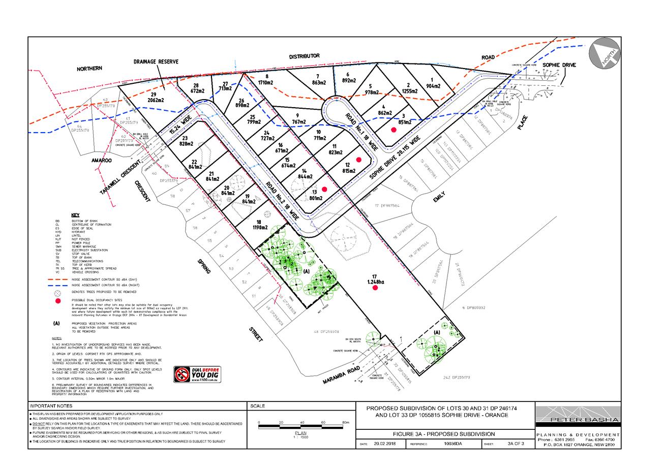
Planning and Development Committee
6 March 2018
2.6 Development
Application DA 247/2017(1) - Tarawell Crescent and Margaret Road
Attachment 2 Plans
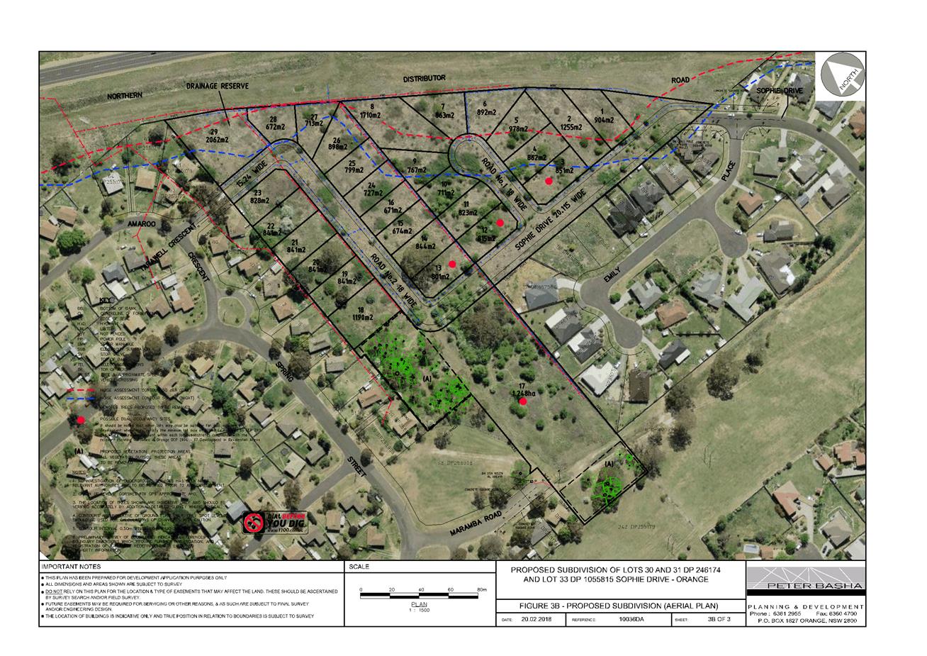
Planning and Development Committee
6 March 2018
2.6 Development
Application DA 247/2017(1) - Tarawell Crescent and Margaret Road
Attachment 2 Plans
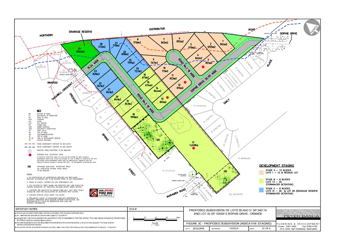
Planning and Development Committee
6 March 2018
2.6 Development
Application DA 247/2017(1) - Tarawell Crescent and Margaret Road
Attachment 3 Submissions
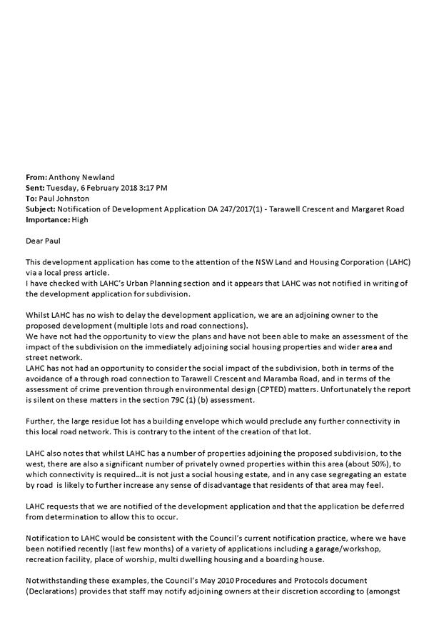
2.7 Recent
changes to the Environmental Planning & Assessment Act and other matters
RECORD
NUMBER: 2018/297
AUTHOR: David
Waddell, Director Development Services
EXECUTIVE Summary
The Environmental Planning & Assessment Act is to be
amended on 1 March 2018. This and some other relevant changes are presented in
this report.
Link To Delivery/OPerational Plan
The recommendation in this report relates to the
Delivery/Operational Plan strategy “1.1 Our City -
Provide easily obtainable information on the legal responsibilities of
Councillors, Council staff and the community”.
Financial Implications
Nil
Policy and Governance Implications
Numerous actions arise from these legislative changes for
both Staff and Council.
|
Recommendation
That the information provided in the
report by the Director Development Services on Recent Changes to the Environmental
Planning & Assessment Act and other matters be acknowledged.
|
further considerations
Consideration has been given to the recommendation’s
impact on Council’s service delivery; image and reputation; political;
environmental; health and safety; employees; stakeholders and project
management; and no further implications or risks have been identified.
SUPPORTING INFORMATION
UPDATING THE ENVIRONMENTAL PLANNING AND ASSESSMENT ACT
1979
The Environmental Planning and Assessment Amendment Bill
2017 has been passed by Parliament. The updates have four underlying
objectives:
· to enhance
community participation
· to promote
strategic planning
· to increase
probity and accountability in decision-making
· to promote
simpler, faster processes for all participants
The implications of the new Bill for Council are as follows:
1 New
Objects to Support the Built Environment
The new objects of the Act seek to reflect the
Government’s commitment to well designed communities with local character
and heritage. When performing functions under the Act authorities will now be
guided by additional objects promoting:
· good design and
amenity of the built environment; and
· the sustainable
management of built and cultural heritage (including Aboriginal cultural
heritage).
2 Enhanced
Community Participation
The Bill seeks to make it clearer and easier for the
community to understand how it can participate in planning decisions. The Bill
requires all planning authorities to prepare a community participation plan.
This will spell out when and how they will engage with their communities across
all the planning functions they perform.
The plans will have to meet the minimum requirements for
community participation that will be set out in Schedule 1 to the Act. Councils
can commit to go beyond the minimum requirements to suit the needs of their
communities.
In preparing their plans, councils will have to take into
consideration new community participation principles which set the bar for how
the community should be engaged. The principles state, among other things, that
the community has a right to be informed about planning matters that affect it
and it should be given opportunities to ·participate as early as
possible in strategic planning.
To improve accountability to all stakeholders, the Bill
requires decision-makers to give reasons for their decisions.
3 Strategic
Planning
For the first time, the Act will recognise the critical role
of councils in strategic planning.
Under the new provisions each council will prepare a local
strategic planning statement. This will set out the 20-year vision for land-use
in the local area, the special character and values that are to be preserved,
and how change will be managed into the future. The statements will need to
align with the regional and district plans, and the council's own priorities in
the community strategic plan it prepares under local government legislation.
The statements will shape how the development controls in
the Local Environmental Plan (LEP) evolve over time. This means the LEP
will be a tool to deliver the council and community's plan for the future.
4 Up-to-Date
Development Controls
The Bill seeks to ensure that LEPs and Development Control
Plans are kept up-to-date and as simple as possible by requiring councils to do
an 'LEP check' at least every five years. They will consider whether the LEP is
still fit for purpose given any changes in population, infrastructure, strategic
plans and other key indicators. This check may prompt some updates to the LEP,
or it may find that a comprehensive review of the LEP is needed.
The Bill will allow the Government to establish a standard,
online format for DCPs. The content will remain up to councils, but they will
be able to draw on model provisions prepared by the Department.
5 Confidence
in the Complying Development Process
To improve confidence in complying development, the Bill
enables:
· councils to
impose a levy on complying development certificates to fund monitoring and
enforcement of complying development standards in their area;
· councils to
stop work for up to seven days on a complying development site to investigate
whether the construction is in line with the certificate. From there, the
council can take more formal action -such as a development control order- if
warranted; and
· the courts
to declare a complying development certificate invalid if it does not meet the
approved standards.
Where developers have constructed works that go beyond an
approval, then retrospectively applied for a modification to authorise the
extra works, councils will be able to impose an additional fee to deter
retrospective modification applications. This fee will be set in the
EP&A Regulations.
Given the scope of the changes in this Bill, the Government
is taking a staged approach to the Bill's commencement. Most of the changes
will commence in the first quarter of 2018. Other changes will take longer to
switch on and will involve further consultation, so new features of the
planning system like community participation plans and local strategic planning
statements will be introduced over time. Changes will be supported by
appropriate guidance, templates and other resources.
ENVIRONMENTAL PLANNING AND
ASSESSMENT REGULATION
The Department of Planning and Environment has recently
commenced a review of the Environmental Planning and Assessment Regulation 2000
(the Regulation). The Regulation contains key operational provisions for the
NSW planning system, including those relating to:
· planning
instruments, including requirements and procedures for planning proposals and
procedures for making and amending development control plans;
· procedures
relating to development applications and complying development certificates;
· existing
uses and designated development;
· requirements
for environmental assessment under Part 5 of the EP&A Act and applications
for State significant infrastructure;
· environmental
impact statements;
· building
regulation and subdivision certification;
· (note: the
review of the Regulation does not examine these building and certification
provisions, as broader building regulation reforms are being fast tracked
through a separate process)
· fees and
charges , including fees for development applications, building certificates
and other planning services;
· development
contributions, including the preparation of contributions plans;
· planning
certificates, which provide information about land;
· other
miscellaneous matters, including amounts for penalty notices (or fines) that
may be issued for breaches of the EP&A Act and the Regulation, provisions
for planning bodies (the Planning Assessment Commission and Independent Hearing
and Assessment Panels), development by the Crown, and record keeping
requirements for councils.
BIODIVERSITY REFORMS AND
REGULATION OF CLEARING OF NATIVE VEGETATION
The legislative framework for native vegetation management,
private land conservation, threatened species and other protected native
animals and plants in New South Wales has been reformed.
The biodiversity conservation reforms include the creation
of the Biodiversity Conservation Act 2016, the Local Land Services
Amendment Act 2016, State Environmental Planning Policy (Vegetation in
Non-Rural Areas) and supporting Regulations and products. The reforms included
the repeal of several existing Acts, including the Native Vegetation Act 2003,
Threatened Species Conservation Act 1995 and the Nature Conservation Trust Act
2001. Also repealed are the animal and plant provisions (Parts 7-9) of the
National Parks and Wildlife Act 1974. The new legislative arrangements
commenced on 25 August 2017.
The Biodiversity Conservation Act and associated regulation
outline the framework for addressing impacts on biodiversity from development
and vegetation clearing. It establishes a hierarchical framework to avoid,
minimise and offset impacts on biodiversity from development through the
Biodiversity Offsets Scheme. The emphasis is on avoidance of impacts, with
substantial financial consequences where offsets are required.
Under the scheme developers and landholders who undertake
clearing which triggers the offsets scheme create a biodiversity credit
obligation which must be retired to offset their activity. The scheme also
establishes biodiversity stewardship agreements, which are voluntary
in-perpetuity agreements entered into by landholders to generate credits to
sell to developers and landholders who require these credits to offset the activities
at other sites.
Under the new arrangements there are three pathways for
approval for clearing native vegetation depending on the location and/or nature
of the clearing:
|
Type of Clearing
|
Relevant
|
Approvals Authority
|
Regulatory Tools/
Processes
|
|
Clearing in association with a local
development (DA)
|
Part 4 EP&A Act
|
Consent authority (generally
council)
|
Biodiversity Offsets
Scheme (Opt in for
Part 5) triggered by:
- Area thresholds (based on min lot
size)
- Biodiversity Values Map (BVM)
- Significant impact
on threatened species or community (where proposal is below
threshold or not on BVM)
Biodiversity Assessment Report to be prepared by accredited person using Biodiversity Assessment
Methodology.
Streamlined Assessment Process available for some developments.
Biodiversity Offset
requirements included as conditions of consent.
|
|
|
|
|
|
Clearing on agricultural land
|
LLS Act Part 14
|
Native Vegetation Panel
|
Allowable activities
Native Vegetation Regulatory Map Set-aside areas
OEH compliance role
|
|
Clearing in Urban
areas and E zones - not ancillary to a development
requiring consent.
|
Vegetation
SEPP
|
Exceeds area threshold -
Native Vegetation Panel
|
Biodiversity Offsets Scheme- including BAM assessment
|
|
Doesn't exceed
area threshold - council permit under DCP (unless exemption
applies)
|
Mechanism not yet established.
Model clauses for DCP
will be provided.
|
Offset Scheme Thresholds - Area
Criteria
|
Minimum lot size associated with
property
|
Threshold for clearing, above which
the BAM and offsets scheme apply
|
Proposed Area Limit for application of
Streamlined Biodiversity Assessment
|
|
Less than 1 ha
|
0.25 ha or more
|
s 1 ha
|
|
1 ha, and less than 40 ha
|
0.5 ha or more
|
s 2 ha
|
|
40 ha, and less than 1000 ha
|
1 ha or more
|
s 5 ha
|
|
1000 ha or greater
|
2 ha or more
|
s 10 ha
|
|
Note:
The area threshold applies to all proposed native
vegetation clearing associated with a proposal, regardless of whether this clearing is across multiple lots. In the case of a subdivision, the proposed clearing must include all future clearing likely to be required for the intended use of the land
after it is subdivided.
|
The Act requires a consent authority to reject a Part 4
development or clearing proposal (that is not State Significant Development
(SSD) or State Significant Infrastructure (SSI)) that they determine is likely
to have a serious and irreversible impact on biodiversity values.
Transitional arrangements in place mean that Part 4
development applications (except SSD) are assessed under previous arrangements
until 25 February 2018 (see OLG Circular No:17-38/24 November 2017).
PROPOSED PRIMARY PRODUCTION AND
RURAL DEVELOPMENT STATE ENVIRONMENTAL PLANNING POLICY (SEPP)
The Department of Planning and Environment is currently
seeking feedback on a package of reforms to update and improve the planning
framework for primary production and rural development.
Changes proposed include consolidating the following five
existing SEPPs:
· State
Environmental Planning Policy (Rural Lands) 2008 (Rural Lands SEPP)
· State Environmental
Planning Policy 30 - Intensive Agriculture (SEPP 30)
· State
Environmental Planning Policy 52 - Farm Dams and Other Works in Land and Water
Management Plan Areas (SEPP 52)
· State
Environmental Planning Policy 62 - Sustainable Aquaculture (SEPP 62)
· Sydney Regional
Environmental Plan 8 - Central Coast Plateau Areas (SREP 8)
The Explanation of Intended Effects (EIE) outlines
provisions to be included in a new SEPP. It also highlights proposals to
transfer existing plan making requirements to the Ministerial Planning
Directions under section 117 of the Environmental Planning and Assessment Act
1979, and to amend the Standard Instrument Local Environmental Plan (SILEP).
The proposed changes to clause 4.2 are akin to
re-establishing concessional allotment provisions. The changes are
controversial and will have significant effects on the protection of rural
lands throughout NSW.
DRAFT LARGE SCALE SOLAR ENERGY
GUIDELINES
Council has recently been advised that the Department of
Planning & Environment has released Draft Large Scale Solar Energy
Guidelines for public comment.
The Guidelines advise the community and proponents' on the
assessment and approval of large scale solar energy developments classed as
State Significant. It is not by itself statutory enforceable.
The draft Guidelines provide information on site selection.
It is noted that the Guideline identifies that the following
"constraints" should be identified:
Important agricultural lands, including Strategic
Agricultural Land (both critical industry clusters and biophysical strategic
agricultural land), and land with soil capability classes 1, 2
and 3. Consideration should also be given to any significant fragmentation
or displacement of existing agricultural industries.
The draft Guidelines are on exhibition until 18 February
2018.
SHORT TERM HOLIDAY LETTING
The NSW Department of Planning & Environment has been
undertaking a review of planning rules governing short term holiday letting
(STHL).
Short term holiday letting has been popular in coastal and
tourist destinations for many years.
Regulation of STHL varies significantly across the State
depending on the planning rules in place and the respective attitudes of
councils and communities to the use occurring.
In 2016, the NSW Legislative Assembly Committee on
Environment and Planning conducted an inquiry into the adequacy of the
regulation of STHL in New South Wales. The Committee's final report was
published on 19 October 2016 and made 12 recommendations.
The key recommendations were that the NSW Government:
· amend
planning laws to regulate short-term rental accommodation;
· allow home
sharing, and letting a principal place of residence, as exempt development;
· allow empty
houses to be let as exempt and complying development;
· strengthen
owners' corporations' powers to manage and respond to issues in Strata
properties; and
· commit to
further investigating impacts from STHL on traditional accommodation operators.
Subsequent to this, the Department of Planning issued an
"Options Paper" for regulating short term holiday letting for public
comment. The options to regulation range from unusual intervention to
substantial Government Regulation.
At this stage the Government's preferred option has not been
finalised.
REGIONAL URBAN DESIGN GUIDE
For the first time, the Environmental Planning and
Assessment Act now has an Object that relates to good design. In response, the
NSW Government Architect has developed the "Better Placed" policy to
achieve better urban design, and is now developing a Regional Urban Design
Guide and calling for input. The following information has been provided by the
Government Architect, but at this stage it remains unclear how a council can
require high quality urban design in its development control framework.
Background Information on the
Guide
Regional Plans now apply to
all of NSW beyond Greater Sydney. These Plans contain actions to prepare urban
design guidelines for planning, designing and developing a healthy built
environment. To deliver these actions, the NSW Government is preparing an urban
design guide for regional NSW.
Good urban design can add to
the community's cultural, economic and physical wellbeing by creating safe,
healthy and socially inclusive places that meet the needs of a broad range of
community members.
The Guide would form part of a
collection of guidance documents which sit beneath Better Placed- the
integrated design policy for NSW developed by GA NSW- and would apply to all of
NSW beyond Greater Sydney. Further information about Better Placed can be found
at the following website:
http://www.governmentarchitect.nsw.gov.au/thinking/integrateddesign-policy
It is intended that the Guide
would be a non-statutory document. This recognises that urban design is a
wide-ranging discipline, with related policy contained in a broad range of
policies prepared by the federal, state, and local governments.
Objectives of the Guide
· Produce a
guide which aligns with the over-arching objectives and values of Better
Placed- the integrated design policy for NSW developed by GA NSW.
· Identify
overarching design principles which respond to the challenges and opportunities
in regional cities, centres, towns and villages in regional NSW
· Provide
design guidance which addresses the unique characteristics, issues and
challenges for different regions.
· Demonstrate
how good built environment outcomes and design processes can be achieved
through case studies across regional NSW
· Produce a
guide which can be used by a range of different audiences, including state and
local government, urban design professionals, developers, builders, home owners
and the general community.
REFORM TO PLANNING RULES
GOVERNING ADVERTISING SIGNAGE
The Department of Planning and Environment has advised of a
review of State Environmental Planning Policy 64 -Advertising & Signage
State Environmental Planning Policy 64- Advertising &
Signage (SEPP 64) sets out planning controls for advertising and signage in
NSW. The SEPP requires signage to:
· be
compatible with the future character of an area;
· provide
effective communication in suitable locations; and
· be of high
quality design and finish.
Further, the SEPP regulates signage, provides time limited
consents, regulates the display of advertising in transport corridors, and ensures
that public benefits may be derived from advertising in and adjacent to
transport corridors.
Recent changes in SEPP 64 include:
· banning
advertisements on parked trailers on roads, road shoulders footpaths and nature
strips, excluding advertising associated with the primary use of the trailer,
eg tradie’s trailer and public authorities;
· requiring
consent for displaying signage on trailers parked on private land in view from
roads, road shoulders, footpaths and nature strips;
· allowing
advertising in transport corridors permissible with consent from the Planning
Minister or delegate across NSW; and
· minor
updates to clauses, terms and definitions.
The change to ban trailer advertising will come into effect
on 1 March 2018. All other changes came into effect on 29 November 2017.
The changes will introduce $1,500 fines for individuals and
$3,000 for businesses who advertise on trailers parked on roads, footpaths,
nature strips and road shoulders, or where trailer advertising is displayed on
private land without development consent. Local council will be the regulatory
authority.
PLANNING PORTAL
The NSW Department of Planning & Environment have been
progressively rolling out its Planning Portal.
The Planning Portal tool provides access to information to
assist members of the public with preparation, lodgement and tracking of
applications.
At this stage information on many of Council's planning
provisions, e.g. zoning etc., is available on the Portal.
The Department has foreshadowed a move towards online
lodgement of applications through the Portal. This would apply to the majority
of applications. Implementation of the online applications is, however,
progressing slowly and no clear timetable for regional NSW has been provided.
It is anticipated that the customer interaction at time of
lodgement will change significantly once introduced, with greater focus on
ensuring that documents are submitted and uploaded before official lodgement.
There will also be changes to the way councils’ fees are paid. This has
implications for the customers and the counter arrangements which will need to
be reviewed once full details are known.
The Director would like to acknowledge Janet Bingham of
Bathurst City Council for her assistance with this report.