
Planning and Development
Committee
Agenda
6 February 2018
Notice is hereby given, in
accordance with the provisions of the Local Government Act 1993 that a Planning and Development Committee meeting of ORANGE CITY COUNCIL
will be held in theCouncil Chamber,
Civic Centre, Byng Street, Orange on Tuesday, 6 February
2018.
Garry
Styles
General Manager
For apologies please
contact Administration on 6393 8218.
1 Introduction
1.1 Declaration
of pecuniary interests, significant non-pecuniary interests and less than
significant non-pecuniary interests
The
provisions of Chapter 14 of the Local Government Act, 1993 (the Act)
regulate the way in which Councillors and designated staff of Council conduct
themselves to ensure that there is no conflict between their private interests
and their public role.
The
Act prescribes that where a member of Council (or a Committee of Council) has a
direct or indirect financial (pecuniary) interest in a matter to be considered
at a meeting of the Council (or Committee), that interest must be disclosed as
soon as practicable after the start of the meeting and the reasons given for
declaring such interest.
As
members are aware, the provisions of the Local Government Act restrict any
member who has declared a pecuniary interest in any matter from participating
in the discussion or voting on that matter, and requires that member to vacate the
Chamber.
Council’s Code of Conduct provides that if members
have a non-pecuniary conflict of interest, the nature of the conflict must be
disclosed. The Code of Conduct also provides for a number of ways in which a
member may manage non pecuniary conflicts of interest.
|
Recommendation
It is recommended that Committee Members now disclose any
conflicts of interest in matters under consideration by the Planning and
Development Committee at this meeting.
|
2 General
Reports
2.1 Items
Approved Under the Delegated Authority of Council
TRIM
REFERENCE: 2017/2718
AUTHOR: Paul
Johnston, Manager Development Assessments
EXECUTIVE Summary
Following is a list of development
applications approved under the delegated authority of Council.
Link To Delivery/OPerational Plan
The recommendation in this report relates to the
Delivery/Operational Plan strategy “13.4 Our Environment
– Monitor and enforce regulations relating to City amenity”.
Financial Implications
Nil
Policy and Governance Implications
Nil
|
Recommendation
That the information provided in the
report by the Manager Development Assessments on Items Approved Under the
Delegated Authority of Council be acknowledged.
|
further considerations
Consideration has been given to the
recommendation’s impact on Council’s service delivery; image and
reputation; political; environmental; health and safety; employees;
stakeholders and project management; and no further implications or risks have
been identified.
SUPPORTING INFORMATION
|
Reference:
|
DA 255/2016(2)
|
Determination
Date
|
8 December 2017
|
|
PR Number
|
PR15538
|
|
Applicant/s:
|
Commplan Pty Ltd
|
|
Owner/s:
|
Orange City
Council
|
|
Location:
|
Lot 1 DP 418091
– 181 Icely Road, Orange
|
|
Proposal:
|
Modification of
development consent - telecommunications facility (30m
monopole, antennas, shelter and fenced compound). The modification proposes
to move elements of the infrastructure and the tower relative to the significant
vegetation.
|
|
Value:
|
$180,000 (being
the same value as the original development)
|
|
Reference:
|
DA 304/2016(2)
|
Determination
Date
|
4 January 2018
|
|
PR Number
|
PR27531
|
|
Applicant/s:
|
TPG Town Planning
& Urban Design
|
|
Owner/s:
|
Eastern
Developments Pty Ltd
|
|
Location:
|
Lot 200 DP 1225088
– 132 Kite Street, Orange
|
|
Proposal:
|
Modification of
development consent - demolition, hotel and motel accommodation, restaurant
or café, retail premises and subdivision (44 lot strata). The
modification involves deferring the requirement for sewer and water
headwork contributions and car parking contributions (Conditions (34)
and (21) respectively) from being paid prior to the issue of a
Construction Certificate and Occupation Certificate.
|
|
Value:
|
$10,500,000 (being
the same value as the original development)
|
|
Reference:
|
DA 229/2017(1)
|
Determination
Date
|
3 January 2018
|
|
PR Number
|
PR27170
|
|
Applicant/s:
|
Orange MS
Investments Pty Ltd
|
|
Owner/s:
|
Orange MS
Investments Pty Ltd
|
|
Location:
|
Lot 21 DP 1212446
– 104 Lysterfield Road, Orange
|
|
Proposal:
|
Subdivision (24
lot Torrens title)
|
|
Value:
|
$0
|
|
Reference:
|
DA 245/2017(2)
|
Determination
Date
|
8 January 2017
|
|
PR Number
|
PR1494
|
|
Applicant/s:
|
Housing Plus Ltd
|
|
Owner/s:
|
Housing Plus Ltd
|
|
Location:
|
Lot 10 DP 248178
– 71 Bletchington Street, Orange
|
|
Proposal:
|
Modification of
development consent - Seniors Housing (four self‑contained
dwellings). The modification involves the provision of an additional dwelling
within the building, comprising a total of five self‑contained
dwellings. The floor plan will be amended to remove common and staff areas
and accommodate the additional dwelling.
|
|
Value:
|
$1,400,000 (being
the same value as the original development)
|
|
Reference:
|
DA 300/2017(1)
|
Determination
Date
|
30 November 2017
|
|
PR Number
|
PR19019
|
|
Applicant/s:
|
Mrs J Miles
|
|
Owner/s:
|
Mr MJ and Mrs JM
Miles
|
|
Location:
|
Lot 49 DP 1063083
– 19 Elwin Drive, Orange
|
|
Proposal:
|
Resource recovery
facility (metal recycling) (industrial building and site works)
|
|
Value:
|
$76,000
|
|
Reference:
|
DA 304/2017(1)
|
Determination
Date
|
8 December 2017
|
|
PR Number
|
P8739R
|
|
Applicant/s:
|
Mr AC and Mrs RT
Roweth
|
|
Owner/s:
|
Mr AC and Mrs RT
Roweth
|
|
Location:
|
Lot 27 DP 11439
– 111 Moulder Street, Orange
|
|
Proposal:
|
Medical centre and
demolition (garage)
|
|
Value:
|
$10,000
|
|
Reference:
|
DA 335/2017(1)
|
Determination
Date
|
11 December 2017
|
|
PR Number
|
PR7567
|
|
Applicant/s:
|
Tent of Hope Ltd
|
|
Owner/s:
|
The State of NSW
|
|
Location:
|
Lot 7 DP 820905
– March Street, Orange
|
|
Proposal:
|
Temporary use of
land (community event for religious outreach and associated activities)
|
|
Value:
|
$0
|
|
Reference:
|
DA 345/2017(1)
|
Determination
Date
|
12 January 2018
|
|
PR Number
|
PR19022
|
|
Applicant/s:
|
Wakefield Planning
|
|
Owner/s:
|
Mr MP and Mrs CM
Bayada
|
|
Location:
|
Lot 52 DP 1063083
– 10 Elwin Drive, Orange
|
|
Proposal:
|
Industrial
activity with ancillary furniture showroom
|
|
Value:
|
$0
|
|
Reference:
|
DA 361/2017(2)
|
Determination
Date
|
17 January 2018
|
|
PR Number
|
PR10006
|
|
Applicant/s:
|
Lyndon Community
|
|
Owner/s:
|
Ms JZ Bond
|
|
Location:
|
Lot 177 DP 775277
– 6 Lysterfield Road, Orange
|
|
Proposal:
|
Modification of
development consent – group home (transitional) (change of use). The
modification sought to change the wording of Condition (4) of the original
consent, which required the upgrade of part of Lysterfield Road prior to
occupation of the group home, and that Council allows the upgrade to take
place after occupation.
|
|
Value:
|
$0 (being the same
value as the original development)
|
|
Reference:
|
DA 365/2017(1)
|
Determination
Date
|
24 November 2017
|
|
PR Number
|
PR15697
|
|
Applicant/s:
|
Western Freight
Management Pty Ltd
|
|
Owner/s:
|
Tura Holdings Pty
Limited
|
|
Location:
|
Lot 4 DP 844802
– 10 Astill Drive, Orange
|
|
Proposal:
|
Freight transport
facility (alterations to existing works bay)
|
|
Value:
|
$50,000
|
|
Reference:
|
DA 366/2017(1)
|
Determination
Date
|
11 January 2018
|
|
PR Number
|
PR1165
|
|
Applicant/s:
|
Homefront Crossfit
|
|
Owner/s:
|
Mr AO Baldwin
|
|
Location:
|
Lot 110 DP 614058
– 3 Barrett Court, Orange
|
|
Proposal:
|
Recreation
facility (indoor) (alterations and additions) and business identification
signs (wall and fascia signs)
|
|
Value:
|
$950,000
|
|
Reference:
|
DA 367/2017(1)
|
Determination
Date
|
12 January 2017
|
|
PR Number
|
PR25968
|
|
Applicant/s:
|
Cross Country
Trucks
|
|
Owner/s:
|
Mr PC and Mrs LG
Isaacs
|
|
Location:
|
Lot 96 DP 1180866
– 30 Colliers Avenue, Orange
|
|
Proposal:
|
Vehicle sales or
hire premises, business identification signage and solar energy system
|
|
Value:
|
$550,000
|
|
Reference:
|
DA 370/2017(1)
|
Determination
Date
|
19 December 2017
|
|
PR Number
|
PR18576
|
|
Applicant/s:
|
Mr GW and Mrs SA
Delaney
|
|
Owner/s:
|
Mr GW and Mrs SA
Delaney
|
|
Location:
|
Lot 200 DP 1042614
- 583 Huntley Road, Huntley
|
|
Proposal:
|
Home industry
(vehicle repair station)
|
|
Value:
|
$0
|
|
Reference:
|
DA 379/2017(1)
|
Determination
Date
|
8 December 2017
|
|
PR Number
|
PR6012
|
|
Applicant/s:
|
Mrs AB Burton
|
|
Owner/s:
|
Mrs AB Burton
|
|
Location:
|
Lot 20 DP 234780
– 32 Kenna Street, Orange
|
|
Proposal:
|
Serviced apartment
|
|
Value:
|
$0
|
|
Reference:
|
DA 381/2017(1)
|
Determination
Date
|
11 December 2017
|
|
PR Number
|
PR18066
|
|
Applicant/s:
|
Dr LE Butt
|
|
Owner/s:
|
Dr LE Butt
|
|
Location:
|
Lot 52 DP 1019314
– 7 Ophir Street, Orange
|
|
Proposal:
|
Demolition
(garage, carport and pergola) and secondary dwelling
|
|
Value:
|
$189,200
|
|
Reference:
|
DA 391/2017(1)
|
Determination
Date
|
7 December 2017
|
|
PR Number
|
PR14622
|
|
Applicant/s:
|
Mr S Marvasti
|
|
Owner/s:
|
Mr S Marvasti
|
|
Location:
|
Lot 2 DP 615667
– 4661 Mitchell Highway, Lucknow
|
|
Proposal:
|
Dual occupancy
(alterations and additions to existing), swimming pool (in ground) and
fencing (pool fencing)
|
|
Value:
|
$80,000
|
|
Reference:
|
DA 392/2017(1)
|
Determination
Date
|
18 December 2017
|
|
PR Number
|
PR17786
|
|
Applicant/s:
|
John Holland
Country Regional Network
|
|
Owner/s:
|
SRA (Aust Native
Landscapes)
|
|
Location:
|
Lot 52 DP 1026842
– 94 Peisley Street, Orange
|
|
Proposal:
|
Earthmoving
business, retail and sand supplies (alterations to existing building)
|
|
Value:
|
$50,000
|
|
Reference:
|
DA 394/2017(1)
|
Determination
Date
|
12 December 2017
|
|
PR Number
|
PR22619
|
|
Applicant/s:
|
Jones & Smith
Distillery
|
|
Owner/s:
|
Mr AJ and Mrs DM
Jones
|
|
Location:
|
Lot 100 DP 1117146
- 527 Beasley Road, Spring Hill
|
|
Proposal:
|
Rural industry
(artisan micro distillery)
|
|
Value:
|
$115,000
|
|
Reference:
|
DA 409/2017(1)
|
Determination
Date
|
8 December 2017
|
|
PR Number
|
PR19016
|
|
Applicant/s:
|
Mr HR and Mrs RH
Ovenden
|
|
Owner/s:
|
JH and HJ Ovenden
|
|
Location:
|
Lot 46 DP 1063083
– 13 Elwin Drive, Orange
|
|
Proposal:
|
Industry,
warehouse and distribution centre, business identification sign
|
|
Value:
|
$275,000
|
|
Reference:
|
DA 411/2017(1)
|
Determination
Date
|
14 December 2017
|
|
PR Number
|
PR8327
|
|
Applicant/s:
|
Peter Basha
Planning & Development
|
|
Owner/s:
|
Keronga Park Pty
Limited
|
|
Location:
|
Lot 1 DP 91037 -
72 McNamara Street, Orange
|
|
Proposal:
|
Office premises
(alterations and additions to existing building)
|
|
Value:
|
$30,000
|
|
Reference:
|
DA 419/2017(1)
|
Determination
Date
|
10 January 2018
|
|
PR Number
|
PR19012
|
|
Applicant/s:
|
McKinnon Design
and Drafting
|
|
Owner/s:
|
Mr JH and Mrs HJ
Ovenden
|
|
Location:
|
Lot 42 DP 1063083
– 17 Astill Drive, Orange
|
|
Proposal:
|
Industry
(alterations and additions to existing building) and signage
|
|
Value:
|
$480,000
|
|
Reference:
|
DA 425/2017(1)
|
Determination
Date
|
13 December 2017
|
|
PR Number
|
PR17497
|
|
Applicant/s:
|
The Top Wash
|
|
Owner/s:
|
Tinobah (Orange)
Pty Ltd
|
|
Location:
|
Lot 1 DP 1010341 -
65 Summer Street, Orange
|
|
Proposal:
|
Demolition (tree
removal)
|
|
Value:
|
$880
|
|
Reference:
|
DA 435/2017(1)
|
Determination
Date
|
18 December 2017
|
|
PR Number
|
PR10588
|
|
Applicant/s:
|
Veritas House
|
|
Owner/s:
|
Mr BD and Mrs SG
Furnell
|
|
Location:
|
Lot 1 DP 85339 -
29-31 Sale Street, Orange
|
|
Proposal:
|
Office premises
(change of use)
|
|
Value:
|
$100,000
|
TOTAL
NET* VALUE OF ALL DEVELOPMENTS APPROVED IN THIS PERIOD: $2,956,080
*
Net value relates to the value of modifications. If modifications are
the same value as the original DA, then nil is added. If there is a plus/minus
difference, this difference is added or taken out.
2.2 Development
Application DA 426/2016(1) - 160-178 Peisley Street
TRIM
REFERENCE: 2017/1605
AUTHOR: Michael
Glenn, Senior Planner
EXECUTIVE Summary
|
Application
lodged
|
7
December 2016
|
|
Applicant/s
|
RPS
Australia East Pty Ltd
|
|
Owner/s
|
Telfield
Pty Ltd & Wizby Pty Ltd
|
|
Land
description
|
Lots B,
C, D, E, F DP 37972 - 160-178 Peisley Street, Orange
|
|
Proposed
land use
|
Service
station and signage
|
|
Value of
proposed development
|
$2,000,000
|
Council's consent is sought for the construction of a
service station with small convenience store, and signs on the subject
property. The application has been referred to Council because the estimated
cost of the development exceeds the delegation prescribed for the General
Manager.
This application has been delayed for a number reasons.
Firstly, because the relatively shallow entry and exit angles for delivery vehicles
reduced the visibility of traffic in Peisley Street unacceptably in the
original design. The very shallow entry and exit angles for vehicles was
determined to be non-compliant and unsafe for vehicles in Peisley Street. This
caused the Roads and Maritime Service (RMS) and Council staff to withhold their
concurrence (Peisley Street/Forest Road as a state road requires concurrence of
RMS for developments of this nature), until such time as the layout had been
redesigned and the vehicle manoeuvring angles onto and off the site were made
more perpendicular to the front boundary. This would thereby improve the
ability to see traffic using the inside lane of Peisley Street (service
vehicles are permitted and can lawfully cross traffic lanes to access a sight,
but must do so in a manner that is safe). The amended plans achieve that
outcome, and RMS have now provided their concurrence.
Secondly, the site until November 2017 remained on the NSW
Environment Protection Authority’s (EPA’s) Contaminated Lands
Register. The contamination on the site was dealt with in 2006-2008 when the
original service station on the site was removed. The contamination took the
form principally as deep soil hydrocarbon contamination, with some lead
contamination that had potential to enter the water table and transmigrate via
natural flows. This contamination was dealt with by capping of the
contamination hot spots. The proposed development will require fresh
excavation, which has the potential to break open the cap and thereby uncover
remaining contamination on the site. Council has never received adequate
validation of the original remediation (until receipt of this DA) and could not
rely on the continued adequacy of that remediation as the principal containment
strategy (the capping), since the site was proposed to be excavated (thereby
raising the potential for exposure of the contaminated material remaining in
situ on the site. In its original form the applicant failed to produce an
adequate validation process that could serve to confirm that the site would be
suitable for purpose notwithstanding this re‑disturbance of the
site’s contamination hot spots.
The applicant made attempts to submit validation reports
over the past year, but none of these reports until the last addressed the key
matters set out in Clause 7 of State Environmental Planning Policy 55
(Remediation Of Land) by establishing that the site in its future state (ie
after the excavation) would remain safe enough and suitable enough for the
proposed development to proceed.
As indicated above, the applicant has now submitted a
relevant validation report that certifies the development is suitable for
purpose as the current proposed development is seeking consent for. Council is
now in a position to move forward in the assessment.
There are also issues regarding the provision of improved
landscaping, and a more restrained sign scheme than was originally proposed.
The building remains not ideal as an element of the streetscape, but is less
averse than the original design. Given that the subject property is not part of
a conservation area, and is already vacant after a demolition carried out in
2006, it is considered the proposed treatments are acceptable as an element of
the CBD.
DECISION FRAMEWORK
Development in Orange is governed by key documents
summarised as follows:
State Environmental Planning
Policies (SEPPs) provide the NSW Govt the ability to provide a legislative
framework to assess specific matters. They are made by the Minister of Planning
and generally have over-arching weight within the context of the issue they
address
In this case there are four principal state policies
applicable to the assessment of this application; SEPP Policy 33 (Hazardous and
Offensive Development), SEPP-55 (Remediation of Land), SEPP (Infrastructure
2007), and SEPP 64 (Outdoor Advertising).
Orange Local Environment Plan
2011 – the LEP should be considered by Council to be a definitive
document (except when modified or added to by over-arching state policies).
LEPs govern the types of development that are permissible or prohibited in
different parts of the City and also provide some assessment criteria in
specific circumstances. Uses are either permissible or not - there are no grey
areas in terms of permissibility. The objectives of each zoning and indeed the
aims of the LEP itself are, however, open to interpretation and can be used to
guide decision making around appropriateness of development.
Orange Development Control Plan
2004 – the DCP guides development. In general it is a performance
based document rather than prescriptive in nature - its purpose is to guide
development. The Land and Environment Court tends to view it as such. In each
area of interest there are often guidelines used. These guidelines indicate
ways of achieving the planning outcomes. It is thus recognised that there may
also be other solutions of merit. All design solutions are considered on merit
by planning and building staff. Applications should clearly demonstrate how the
planning outcomes are being met where alternative design solutions are
proposed. So one can see that the DCP gives leeway for developers and
architects to use design to achieve the outcome in other ways if they can.
Stating that DCP guidelines are inflexible can be misleading.
Director’s Comment – The proposed
development is permissible with the consent of Council. The subject land has
direct frontage to Peisley Street and therefore, pursuant to the requirements
of State Environmental Policy (Infrastructure), Council was required to obtain
the concurrence of Roads and Maritime Service (RMS) prior to determination of
the application. Whilst the RMS initially withheld their concurrence, the
applicant has since addressed the concerns raised by the RMS with the
submission of amended plans. The concurrence of the RMS has since been obtained
and it is open for Council to now grant development consent in this case. A Section
79C assessment of the development indicates that the development is acceptable
in this instance. Attached is a draft Notice of Approval outlining a range of
conditions considered appropriate to ensure that the development proceeds in an
acceptable manner.
Link To Delivery/OPerational Plan
The recommendation in this report relates to the
Delivery/Operational Plan strategy “13.4 Our
Environment – Monitor and enforce regulations relating to City amenity”.
Financial Implications
Nil
Policy and Governance Implications
Nil
|
Recommendation
That Council consents to
development application DA 426/2016(1)
for a service station and business identification signage at Lots
B, C, D, E, F DP 37972 - 160-178 Peisley Street Orange pursuant to the conditions of consent in the attached
Notice of Approval.
|
further considerations
Consideration has been given to the
recommendation’s impact on Council’s service delivery; image and
reputation; political; environmental; health and safety; employees;
stakeholders and project management; and no further implications or risks have
been identified.
SUPPORTING INFORMATION
Council's consent is sought for
Service Station and Signage at Lots B, C, D, E, F DP 37972 - 160-178
Peisley Street, Orange. The application itself describes the signs proposed as
“business identification signs”, however as a number of the signs
that are proposed do not conform to the definition of “business
identification signs”, the description of the proposed development has
been changed to the more general description of “Signage” which covers
both general advertising and business identification signs.
THE PROPOSAL
The proposal involves development of the
site as a service station and convenience store with associated parking and
manoeuvring areas. The proposed development will include the following:
· three fuel
dispenser stations with flat roofed canopy and a pre-cast concrete convenience
store with a Gross Floor Area (GFA) of 195m² and cashier. The proposed
building will also incorporate toilets, office and dry store
· three 55 KL
underground tanks
· ten
off-street car parking spaces
· loading bay
· bin storage
and collection area
· signage
· landscaping
· 24 hour
operating cycle, seven days per week, and usual staff of one onsite.
MATTERS FOR CONSIDERATION
Section 5A Assessment
In the administration of sections 78A, 79B, 79C, 111 and
112, the provisions of Section 5A must be taken into account for every
development application in deciding whether there is likely to be a significant
effect on threatened species, populations or ecological communities or their
habitats. This section includes a requirement to consider any adopted
assessment guidelines, which means assessment guidelines issued and in force
under Section 94A of the Threatened Species Conservation Act 1995.
Assessment guidelines are in force (see DECC-W “Threatened Species
Assessment Guidelines - The Assessment of Significance”) which requires
consent authority to adopt the precautionary principle in its assessment. In
this instance, site inspection reveals that the subject property has no
biodiversity or habitat value.
Section 79C
Section 79C of the Environmental Planning and Assessment Act
1979 requires Council to consider various matters, of which those pertaining to
the application are listed below.
PROVISIONS OF ANY ENVIRONMENTAL
PLANNING INSTRUMENT s79C(1)(a)(i)
Orange Local Environmental Plan 2011
Part 1 - Preliminary
Clause 1.2 - Aims of Plan
The
broad aims of the LEP are set out under Subclause 2. Those relevant to the
application are as follows:
(a) to encourage development
which complements and enhances the unique character of Orange as a major
regional centre boasting a diverse economy and offering an attractive regional
lifestyle,
(b) to provide for a
range of development opportunities that contribute to the social, economic and
environmental resources of Orange in a way that allows present and future
generations to meet their needs by implementing the principles for ecologically
sustainable development,
(f) to
recognise and manage valued environmental heritage, landscape and scenic
features of Orange.
The
application is considered to be generally consistent with these aims.
Clause 1.6 - Consent Authority
This clause establishes that, subject to the Act, Council is
the consent authority for applications made under the LEP.
Clause 1.9A - Suspension of
Covenants, Agreements and Instruments
This clause provides that covenants, agreements and other
instruments which seek to restrict the carrying out of development do not apply
with the following exceptions:
· covenants imposed
or required by Council
· prescribed
instruments under Section 183A of the Crown Lands Act 1989
· any conservation
agreement under the National Parks and Wildlife Act 1974
· any trust
agreement under the Nature Conservation Trust Act 2001
· any property
vegetation plan under the Native Vegetation Act 2003
· any biobanking
agreement under Part 7A of the Threatened Species Conservation Act 1995
· any planning
agreement under Division 6 of Part 4 of the Environmental Planning and
Assessment Act 1979.
Council does hold older surveys of the site that suggest the
existence of rights of way to favour Council over several of the properties.
However, the applicant has provided the most up to date registered surveys for
the site which show that the “proposed rights of way” shown in the
1945 survey (the relevant survey for the current lot descriptors), were in fact
never registered.
The applicant advises in an addendum to his SoEE “Attached
is a title search of the five properties involved (Lots B to F DP 37972)
– search done today. The attached shows that the “proposed
right of ways” are not recorded on the titles. Therefore in a legal
sense they do not exist”.
Mapping
The subject site is identified
on the LEP maps in the following manner:
|
Land Zoning Map:
|
Land zoned B3 Commercial Core
|
|
Lot Size Map:
|
No
Minimum Lot Size
|
|
Heritage Map:
|
Not a
heritage item or conservation area
|
|
Height of Buildings Map:
|
building
height limit 12m
|
|
Floor Space Ratio Map:
|
floor
space limit 1.5:1
|
|
Terrestrial Biodiversity Map:
|
No
biodiversity sensitivity on the site
|
|
Groundwater Vulnerability Map:
|
groundwater
vulnerable
|
|
Drinking Water Catchment Map:
|
Not
within the drinking water catchment
|
|
Watercourse Map:
|
Not
within or affecting a defined watercourse
|
|
Urban Release Area Map:
|
Not
within an urban release area
|
|
Obstacle Limitation Surface Map:
|
No
restriction on building siting or construction
|
|
Additional Permitted Uses Map:
|
No
additional permitted use applies
|
Those matters that are of relevance are addressed in detail
in the body of this report.
Part 2 - Permitted or Prohibited Development
Land
Use Zones
The subject site is located within the B3 Commercial Core
zone. The proposed development is defined as a service station and advertising
signs under OLEP 2011, and both elements of the proposed development are
permitted with consent for this zone. This application is seeking consent.
Pursuant to the LEP dictionary, a service station means:
a building or place used for
the sale by retail of fuels and lubricants for motor vehicles, whether or not
the building or place is also used for any one or more of the following:
(a) the
ancillary sale by retail of spare parts and accessories for motor vehicles,
(b) the
cleaning of motor vehicles,
(c) installation
of accessories,
(d) inspecting,
repairing and servicing of motor vehicles (other than body building, panel
beating, spray painting, or chassis restoration),
(e) the
ancillary retail selling or hiring of general merchandise or services or both.
Signage means:
any sign, notice, device,
representation or advertisement that advertises or promotes any goods, services
or events and any structure or vessel that is principally designed for, or that
is used for, the display of signage, and includes any of the following:
(a) an
advertising structure,
(b) a
building identification sign,
(c) a
business identification sign,
but does not include a traffic
sign or traffic control facilities.
Service stations and signage are permitted in the B3
Commercial Core zone with the consent of Council. It should be noted that the
proposed service station includes a small ancillary store, selling general
merchandise that may include goods not necessarily related to travelling
motorists. The scale of this aspect of the development is considered to be a
typical operation of a service station and therefore consistent with Part E of
the above‑described definition of a service station.
Clause
2.3 of LEP 2011 references the Land Use
Table and Objectives for each zone in LEP 2011. These objectives for land
zoned B3 Commercial Core are as follows:
1 - Objectives of the B3 Commercial Core Zone
· To
provide a wide range of retail, business, office, entertainment, community and
other suitable land uses that serve the needs of the local and wider community.
· To
encourage appropriate employment opportunities in accessible locations.
· To
maximise public transport patronage and encourage walking and cycling.
· To
promote development that contributes to the role of the Orange CBD as the
primary retail and business centre in the City and region.
The development is not
inconsistent with the objectives of the zone.
Part 3 - Exempt and Complying Development
The application is not exempt or complying development.
Part 4 - Principal Development Standards
Clause
4.3 - Height of Buildings
This
clause limits the height of buildings (HoB) on land identified on the Height of
Buildings Map. The subject land is identified on the Map as having a HoB limit
of 12m. The maximum height of the proposed development
is 6.1m and is therefore consistent with the established height limit
Clause
4.4 - Floor Space Ratio
This
clause limits the floor space ratio (FSR) permitted on land identified on the
Floor Space Ratio Map. Clause 4.5 is associated with this clause and
establishes the rules for calculating the site area and FSR of any proposal.
These rules exclude certain parts of a site and development such as:
· excluding
any part of the site upon which the development is prohibited (ie if the site
is split zoned only the zone in which the development is permissible may be
considered)
· excluding
community land and most public places
· lots
in a strata scheme wholly or partly above other lots in the scheme do not
increase the site area (ie the site area is the ground level of the scheme
only)
· adjoining
lots in the same ownership do not form part of the site area unless significant
parts of the development are proposed on that land
· the
floor area of existing buildings is to be included in the FSR calculation
· any
covenant restricting floor space on the lot, due to floor space having been
considered as part of the development of another lot, is to be taken into
account.
The subject land is identified
on the Map as having an FSR of 1.8:1. The site area has been calculated under
Clause 4.5 as 1664m2, meaning the site may have up to 2995.56m2
of floor space. The proposal, minus the exclusions detailed in Clause 4.5, has
been calculated as having a gross floor area of 191m2 and is
therefore consistent with the FSR requirements.
Part 7 - Additional Local Provisions
7.1
- Earthworks
This
clause establishes a range of matters that must be considered prior to granting
development consent for any application involving earthworks, such as:
(a) the likely disruption of, or any
detrimental effect on, existing drainage patterns and soil stability in the
locality of the development
(b) the effect of the development on the
likely future use or redevelopment of the land
(c) the quality of the fill or the soil to be
excavated, or both
(d) the effect of the development on the
existing and likely amenity of adjoining properties
(e) the source of any fill material and the
destination of any excavated material
(f) the likelihood of disturbing relics
(g) the proximity to and potential for adverse
impacts on any waterway, drinking water catchment or environmentally sensitive
area
(h) any measures proposed to minimise or
mitigate the impacts referred to in paragraph (g).
The earthworks proposed in the
application are limited to the extent of cutting and filling required for the
underground petrol storage tanks and associated drainage. The extent of the
proposed earthworks is considerable, however these works are not expected to
significantly affect drainage patterns in any way.
The earthworks will be
appropriately supported onsite and the change in ground level is not
substantial. Therefore, the effect on the amenity of adjoining properties is
considered to be minor. The extent of the earthworks will not materially affect
the potential future use or redevelopment of the site that may occur at the end
of the proposed development's lifespan. The site is not known to contain any
Aboriginal, European or archaeological relics. Previous known uses of the site
do not suggest that any relics are likely to be uncovered.
The site is not in proximity to
any waterway, drinking water catchment or sensitive area, however conditions
will be imposed to require a sediment control plan, including silt traps and
other protective measures, to ensure that loose dirt and sediment does not
escape the site boundaries.
7.3 - Stormwater Management
This clause applies to all
industrial, commercial and residential zones and requires that Council be
satisfied that the proposal:
(a) is designed to maximise the use of water
permeable surfaces on the land having regard to the soil characteristics
affecting onsite infiltration of water
(b) includes, where practical, onsite
stormwater retention for use as an alternative supply to mains water,
groundwater or river water; and
(c) avoids any significant impacts of
stormwater runoff on adjoining downstream properties, native bushland and
receiving waters, or if that impact cannot be reasonably avoided, minimises and
mitigates the impact.
The
proposal has been designed to include permeable surfaces through landscaping,
and includes onsite retention of stormwater. It is considered that the
post-development runoff levels will be similar to pre-development levels, and
the management of onsite stormwater is acceptable.
7.6 - Groundwater Vulnerability
This
clause seeks to protect hydrological functions of groundwater systems and
protect resources from both depletion and contamination. Orange has a high
water table and large areas of the LGA, including the subject site, are
identified with “Groundwater Vulnerability” on the Groundwater
Vulnerability Map. This requires that Council consider:
(a) whether or not the development (including
any onsite storage or disposal of solid or liquid waste and chemicals) is
likely to cause any groundwater contamination or have any adverse effect on
groundwater dependent ecosystems, and
(b) the cumulative impact (including the
impact on nearby groundwater extraction for potable water supply or stock water
supply) of the development and any other existing development on groundwater.
Furthermore, consent may not be granted unless Council is satisfied that:
(a) the development is designed, sited and
will be managed to avoid any significant adverse environmental impact, or
(b) if that impact cannot be reasonably
avoided - the development is designed, sited and will be managed to minimise
that impact,
(c) if that impact cannot be minimised - the
development will be managed to mitigate that impact.
The proposal does not involve
extraction of groundwater and will therefore not contribute to groundwater
depletion. The proposal has the potential to involve
the discharge of toxic or noxious substances through accidental spillages,
particularly through leaking of underground tanks and pipes, as well as above
ground spillages. Conditions designed to protect both groundwater quality (to
avoid groundwater contamination), as well as protecting surface water
standards, are included in the consent. The groundwater protection arrangements
centre around the use of an underground Spel Puracepter, as
well as a bio-retention basin for stormwater, and is therefore
considered acceptable.
Further, a condition is included
in the consent that requires the tanks to comply with AS1940-2004, which
is the relevant standard for underground tanks and includes requirements for
double bunding to minimise the risks from spills and leaks.
Furthermore, spills and leaks
will be monitored through wells, which is addressed in more detail below.
STATE ENVIRONMENTAL PLANNING
POLICIES
The following State Environmental Planning Policies apply to
the subject development:
State Environmental Planning
Policy Infrastructure 2007
Clauses 84-89 – Development in a Rail Corridor
Clauses 85 has provisions relating to non-metropolitan
land adjacent to rail corridors.
85 - Development
Immediately Adjacent to Rail Corridors
This clause applies to development on land
that is in or immediately adjacent to a rail corridor, if the development:
(a) is
likely to have an adverse effect on rail safety, or
(b) involves
the placing of a metal finish on a structure and the rail corridor concerned is
used by electric trains, or
(c) involves
the use of a crane in air space above any rail corridor.
Sub-clause (2) contains the following:
(2) Before
determining a development application for development to which this clause
applies, the consent authority must:
(a) within
7 days after the application is made, give written notice of the application to
the Chief Executive Officer of the rail authority for the rail corridor, and
(b) take
into consideration:
(i) any
response to the notice that is received within 21 days after the notice is
given, and
(ii) any
guidelines that are issued by the Secretary for the purposes of this clause and
published in the Gazette.
Clauses 98 - 104
Development in or Adjacent to Road corridors and Road reservations
Clauses 101 and 104 of this SEPP are applicable to this
development, and are discussed below. Concurrence with the RMS is required for
this proposal.
101 - Development with
Frontage to Classified Road
The primary objective of this clause is to ensure that new
development does not compromise the effective and ongoing operation and
function of classified roads. The consent authority must not grant consent to development
on land that has a frontage to a classified road unless it is satisfied that:
(a) where practicable, vehicular access to the
land is provided by a road other than the classified road, and
(b) the
safety, efficiency and ongoing operation of the classified road will not be
adversely affected by the development as a result of:
(i) the
design of the vehicular access to the land, or
(ii) the
emission of smoke or dust from the development, or
(iii) the
nature, volume or frequency of vehicles using the classified road to gain
access to the land, and
(c) the
development is of a type that is not sensitive to traffic noise or vehicle
emissions, or is appropriately located and designed, or includes measures, to
ameliorate potential traffic noise or vehicle emissions within the site
of the development arising from the adjacent classified road.
104 - Traffic-Generating
Development
This clause applies to a service station of any size where
it has direct vehicular or pedestrian access to a classified road, or to a road
that connects to a classified road where the access is within 90m of the
connection. It requires the consent authority to give written notice of the
application to the RMS and take their response into consideration, as well as
consider the accessibility of the site concerned, and any potential traffic
safety, road congestion or parking implications of the development.
The RMS was not prepared to support the
proposed development in its original form, due to the poor sightlines of the
heavy delivery vehicle nominated in the application to undertake fuel
deliveries. This position was largely supported by the City of Orange Traffic
Committee (COTC). To achieve an adequate design outcome, the applicant needed
to ensure the angle of entry and exits to and from the site was close to
perpendicular to the kerb as possible. Despite the applicant submitting a
report from a traffic consultant that argued the design in its original form
was satisfactory in this regard, the RMS, COTC and Council Technical Services
staff were unanimous that the delivery arrangements were not safe and required
amendment.
The applicant has amended his proposal now,
so as to incorporate and address the RMS issues. The RMS have indicated their
support for the agreement to the recommended conditions requiring the following
conditions be imposed:
· vehicular
access and egress between the site and Peisley Street shall be via the approved
vehicular access ways only
· the
exit driveway shall be no more than ten (10) m wide. The driveways shall be
constructed in concrete and shall match existing road and footpath levels
· prior
to occupation of the development, “No Entry “(R2-4) signs are to be
provided on the land at each side of the entry driveway. The signs are to face
the site to advise motorists not to exist the site onto Peisley Street via the
designated entry driveway
· all
vehicle movements to and from the site shall be in a forward direction
· adequate
turning circles and vertical clearance shall be provided within the site
to accommodate the largest type of vehicle (19m articulated vehicle) that
will visit the site during construction and operation
· all
activities, including loading and unloading of goods associated with the
development are to be carried out onsite in the dedicated areas.
With regard to the potential impacts on the
rail corridor located behind the site, the application was referred to the
Asset Manager for the rail network, with a response received by Council on1
February 2017, setting out the following requirements:
“It is
requested that Council considers fencing and stormwater as follows:
Fencing
· The
security of fencing along the rail corridor is essential to prevent
unauthorised entry. JHR requests that Council impose a condition on any consent
requiring a 1.8m chain wire fence or similar to prevent access.
Stormwater
· It is
requested that Council ensures that no additional stormwater flows toward the
rail corridor and all wastewater is appropriately treated and disposed
of.”
State Environmental Planning Policy
33 - Hazardous and Offensive Development
This policy seeks to ensure that the consent authority has
sufficient information to assess whether a development is potentially hazardous
or offensive, and to impose conditions to reduce or minimise any adverse
impacts. The policy sets out the definition of a ‘potentially hazardous
industry’ as follows:
a development for the purposes
of any industry which, if the development were to operate without employing any
measures (including, for example, isolation from existing or likely future
development on other land) to reduce or minimise its impact in the locality or
on the existing or likely future development on other land, would pose a
significant risk in relation to the locality:
(a) to
human health, life or property, or
(b) to
the biophysical environment,
and includes a hazardous
industry and a hazardous storage establishment.
A development application for a potentially hazardous
industry must be accompanied by a Preliminary Hazard Analysis (PHA), in
accordance with current circulars and guidelines from the Department of
Planning. Guidelines titled Applying SEPP-33 Development Application
Guidelines, and Multi Level Risk Assessment Guidelines are particularly
relevant to this application, among others. The applicant has prepared a
Multi-Level Risk Assessment and PHA in accordance with these guidelines.
The multi risk assessment was prepared by Myros and
concludes that the safety risks associated with the use of the site as a
service station are minimal. The multi risk assessment’s principal
recommendation is that all equipment to be installed on the site be carried out
strictly in accordance with the manufacturer’s specifications. The
following conditions are included in the consent as a result of that
recommendation:
· All
equipment must be installed to manufacturer’s recommendations and must
comply with all the relevant standards listed within.
· Specific
safety features of the site, as set out in the submitted Preliminary Hazard
Analysis (PHA) submitted with the Development Application shall be adhered to
strictly at all times. The applicant shall ensure that safety procedures are
well posted on the site and shall further ensure that all staff are adequately
inducted as to correct safety procedures and protocols as set out in the PHA.
Assessment Guidelines Appendix
6 - Ongoing Acceptability
The guidelines state:
"If, following the
assessment of a PHA and other considerations, Council considers that the
proposal can proceed, it should consider imposing relevant hazards-related
conditions as recommended by the Department. These conditions will help ensure
the ongoing safety of a potential development."
Not all of the recommended conditions are considered
relevant to this situation, however those that are relevant are included in the
attached consent.
Furthermore, a Trade Waste Agreement will need to be entered
into with the Council, and a Dangerous Goods Notification is required from
Safework NSW.
State Environmental Planning
Policy 55 - Remediation of Land
This policy requires contamination and remediation to be
considered when determining a planning application. Council may not grant
consent to further development of the site (pursuant to the provisions of
Clause 7 of the policy) unless it is satisfied that the site has been
remediated.
The Environmental Protection Authority maintains a register
of potentially contaminated sites. The register lists the subject property as
“under investigation” but does not specifically identify the site
as contaminated. The principal means for Council to monitor whether a site is
contaminated or not, is for a remediation plan to be implemented. There are
statutory procedures for achieving that outcome. A proponent must provide a
validation certificate incorporating a notice of completion of remediation
works to establish that such remediation has been completed and the site made
suitable for a particular category of development (generally within the
categories of Industrial, commercial or residential).
On 8 June 2005 development consent was granted under DA
014/682 to the demolition of the buildings, removal of underground tanks and
remediation of the site. The consent included the following condition in the
consent:
“the applicant shall
provide Council with a Notice of completion of Category 2 Remediation within
thirty days of completion of the works. The notice shall contain the
information as set out in SEPP-55 – Remediation of Land”.
Validation and/or notices of completion for the remediation
work undertaken in 2006‑2008 were not submitted to either Council or the
EPA. As a result of this, the EPA listed the site as “under investigation
until November 2017, at which time the ARCADIS report was finalised and
submitted to both Council and the EPA. Since the completion and submission of
that report, EPA have removed the site from being “under
investigation”.
It is noted that a validation report was completed in 2013
by the then owner (Mobil Australia), but this information was not communicated
to either the EPA or Council until June 2016. Even so, the remediation
processes that was employed (a cap over the contamination hotspots), could not
be guaranteed as effective if the cap was ever penetrated by subsequent
development (which is precisely what the current proposal does seek to do with
its excavation and re-installation of underground fuel storage tanks). Whether
or not the standard to which the site was remediated, and the methods of
remediation used remain effective has proven to be a major obstacle to
overcome.
Since June 2016, the applicant has made several attempts at
submitting a validation report to establish that the site was able to be used
for the proposed use. These earlier attempts failed to show that the site could
have the contamination capping broken and remain suitable for purpose. It has
taken until recently for an acceptable validation report to be submitted. A
report has now been submitted from ARCADIS (an environmental science
consultancy) that confirms the validation process and suggests the site is
suitable for the proposed development. A full copy of the ARCADIS report is
attached, but in summary the report concludes:
“the presence of
hydrocarbons in soil and groundwater at the site do not have the potential to
pose an unacceptable risk to human health or ecological receptors at the site.
As such, the site is suitable for the proposed use in accordance with the CLM
Act 1997. Any waste materials generated at the site related to excavation works
should be classified in accordance with the NSW EPA (2014) Waste
Classification Guidelines”
In substance, the submission meets the intent of Clause 7,
and Council may validly consider the issue of a development consent.
State Environmental Planning
Policy 64 – Advertising and Signage
State Environmental Planning Policy 64 - Advertising and
Signage applies to the subject land. The relevant provisions of the SEPP are
addressed below.
The Proposed Signs
The signs proposed include the following:
Sign 1 – General Advertisement 6m high illuminated pole sign with corporate
logo, wordmark “United Petroleum” and fluorescent pricing details.
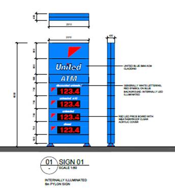
Figure 1 – proposed sign 1 (6m free standing
pole sign)
Initially the proposed pole sign
incorporated an overall height in excess of 8m above existing natural ground
levels and no setback from the street frontage. This was considered
unacceptable on grounds relating to streetscape. The amended proposal increases
the setback slightly and reduces the height of the structure to 6m, which in
the past has been generally accepted as within a reasonable human scale in
Orange. The proposal is not considered a Business Identification Sign since the
electronic number displays are not covered in the definition of business
identification sign. As a result this sign is considered to be general advertising.
Sign 2 - Building wrap fascia sign (illuminated) around pump canopy 900mm
wide.
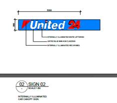
Figure 2 – building wrap fascia sign
(illuminated)
This is considered to be consistent with
the definition of business identification sign.
Sign 3 – Business Identification Sign - shop fascia sign
(illuminated)
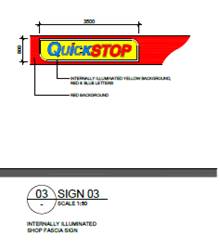
Figure 3 – illuminated shop fascia sign
Sign 4 – General advertisement – “Pie Face” sign
at entry
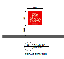
Figure 4 – “Pie face’ advertisement
entry sign
Sign 5 – General advertisement window sign (north facing)
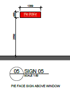
Figure 5 – “Pie Face” window
advertisement
Sign 6 – General advertisement painted wall sign (west facing,
Peisley Street)
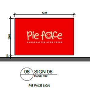
Figure 6 – general advertisement “Pie
Face” wall advertisement (not illuminated)
3 - Aims,
objectives etc.
(1) This
Policy aims:
(a) to
ensure that signage (including advertising):
(i) is
compatible with the desired amenity and visual character of an area, and
(ii) provides
effective communication in suitable locations, and
(iii) is
of high quality design and finish, and
(b) to
regulate signage (but not content) under Part 4 of the Act, and
(c) to
provide time-limited consents for the display of certain advertisements, and
(d) to
regulate the display of advertisements in transport corridors, and
(e) to
ensure that public benefits may be derived from advertising in and adjacent to
transport corridors.
(2) This
Policy does not regulate the content of signage and does not require consent
for a change in the content of signage.
The height of the pole sign, as originally proposed was
greater than the height of the proposed building to which it relates. This
proposed height for the pole sign has since been reduced to 6m, which is
considered acceptable.
4 - Definitions
The proposed signage can be defined as ‘business identification
signs’ and ‘advertisements’ pursuant to Clause 4 of the SEPP.
As a result, the overall classification of the proposed signs are
‘signage, which incorporates both categories of sign.
Business identification
signage means a sign:
(a) that
indicates:
(i) the
name of the person, and
(ii) the
business carried on by the person,
at the premises or place at
which the sign is displayed, and
(b) that
may include the address of the premises or place and a logo or other symbol
that identifies the business,
but that does not include any
advertising relating to a person who does not carry on business at the premises
or place.
Advertisement means
signage to which Part 3 applies and includes any advertising structure for the
advertisement.
Sign 2 of the proposed signage is considered to be
‘business identification signage’, with the other signs contained
in the application being more consistent with the definition of
“advertisement”. Both sign types are permissible at this locality,
but it is noted that the advertisements are subject to additional parts of the
policy compared to the business identification sign.
The advertising signs are subject to the additional
provisions of Part 3 of the policy, because it can be classified as
“advertising”, whilst the business identification sign, whilst a
sign, is not defined in the policy as advertising and not subject to Part 3 of
the policy.
All of the signs (ie both the general advertising and the
business identification signs) are, however subject to assessment against the
provisions of Schedule 1 of the Policy. Due to the numbers and types of signs
proposed, none of the signs may be erected or considered exempt development (ie
not requiring consent).
The proposed pylon sign will display fuel prices, which
places that sign outside the ambit of ‘business identification
signage’. Pricing of fuel by Service stations is a statutory requirement
by NSW Fair Trading which under its legislation requires the following:
All NSW petrol
station operators are required to display the price of regular unleaded petrol.
The sign must:
· be positioned and lit so that any price it displays can be readily seen
by motorists approaching the petrol station when the station is open; and
· display a price that must be a price per litre of petrol.
The size of the
sign should be determined by what is reasonable in the circumstances, given the
criteria outlined above.
Petrol station
operators will not have to display signs if the erection of a price sign is
inconsistent with local council planning restrictions (NSW Fair Trading).
This is addressed in detail in the Schedule 1 assessment
below.
6 - Signage to Which this Policy
Applies
(1) This Policy applies to all
signage:
(a) that,
under another environmental planning instrument that applies to the signage,
can be displayed with or without development consent, and
(b) is
visible from any public place or public reserve, except as provided by this
Policy.
(2) This
Policy does not apply to signage that, or the display of which, is exempt
development under an environmental planning instrument that applies to it, or
that is exempt development under this Policy.
The proposed signage can be displayed with development
consent and will be visible from a public place, and therefore SEPP 64 applies
to the application.
8 - Granting of Consent to
Signage
A consent authority must not grant development consent to an
application to display signage unless the consent authority is satisfied:
(a) that
the signage is consistent with the objectives of this Policy as set out in
Clause 3(1)(a), and
(b) that
the signage the subject of the application satisfies the assessment criteria
specified in Schedule 1.
The signage is consistent with the aims, objectives, etc. of
the plan and a Schedule 1 assessment is undertaken below.
Part 3 of the SEPP
As indicated above, the provisions of this part are only
applicable to the advertisements being proposed.
Clause 11 - Requirement
for Consent
Clause 11 states:
A person must not display an advertisement, except with
the consent of the consent authority or except as otherwise provided by this
Policy.
The applicant is seeking consent for the proposed signs.
Clause 13 - Matters for
Consideration
Clause 13 triggers the requirement for the development to be
consistent with this Policy, as well as the assessment criteria contained
within Schedule 1. An assessment of the criteria contained within Schedule 1 is
undertaken below.
Clause 14 - Duration of
Consents
(1) A
consent granted under this Part ceases to be in force:
(a) on
the expiration of 15 years after the date on which the consent becomes
effective and operates in accordance with Section 83 of the Act, or
(b) if
a lesser period is specified by the consent authority, on the expiration of the
lesser period.
A condition limiting the duration of the consent for the
pylon sign is included in the notice of determination.
23 - Freestanding
advertisements
(1) The consent authority may grant consent to
the display of a freestanding advertisement only if the advertising structure
on which the advertisement is displayed does not protrude above the dominant
skyline, including any buildings, structures or tree canopies, when viewed from
ground level within a visual catchment of 1 kilometre.
Schedule 1 Assessment
Criteria
Character of the Area
· Is the proposal compatible with the existing or desired future
character of the area or locality in which it is proposed to be located?
· Is the proposal consistent with a particular theme for outdoor
advertising in the area or locality?
The proposed pylon sign as is now proposed is 6 m high (in
its original form it was 8m high). It is noted the proposed development
incorporates a 6.1m awning or canopy, and the top plate of the proposed
building is 6.1m. Structures either side of the subject property are less than
this height.
A visual representation of the
proposed sign and how it might appear is shown in the following rendered
drawing.
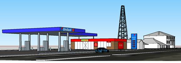
Figure 7 –streetscape after the development is
completed
It is considered the proposed pylon sign will not protrude
above the skyline and will not have a significant adverse effect on
neighbourhood character, though it is conceded the proposed development is far
from ideal in terms of its streetscape presentation.
The area is characterised as a mix of commercial,
industrial, rail and communications infrastructure with a heritage overtone in
the locality. Residential influences are less prevalent and less influential to
the neighbourhood character. The character of the land is further influenced by
the high profile location on the entrance to the business area of the city.
Existing signage in Peisley Street to the south of Summer Street for several
blocks is mixed. There are several other pylon signs (notably outside the
railway station and opposite at Aldi), both of which are at or below the 6m
height guide.
There is a greater density of signage as Summer Street is
approached, and less signage further away. Buildings are generally two storeys
on the western side of Peisley Street, and a mix of vacant, blocks, and one and
two storey forms on the eastern side of the street.
The proposed pylon sign is considered to be consistent with
the existing character of the area, taking into consideration the overall
scheme proposed with its mix of pylon, wall, fascia, and canopy signs on the
building and fuel canopy, which are both set back from the main road. The
proposed freestanding pylon sign will be erected on the corner of at the
frontage to Peisley Street, and will be a significant impact on character and
presentation. It is not ideal that this sign be included in the overall scheme,
but it is considered to within acceptable parameters in terms of impacts on
character and streetscape.
Special Areas
· Does the proposal detract from the amenity or visual quality of any
environmentally sensitive areas, heritage areas, natural or other conservation
areas, open space areas, waterways, rural landscapes or residential areas?
The subject land is not within an environmentally sensitive
area, but the area subject property is adjacent a listed heritage items and a
conservation area.
Views and Vistas
· Does the proposal obscure or compromise important views?
· Does the proposal dominate the skyline and reduce the quality of
vistas?
· Does the proposal respect the viewing rights of other advertisers?
The proposed signage, apart from the 6.0m pylon sign, is
shown to be limited to flush wall and canopy signage set back from the road,
and as such will not obscure views, dominate the skyline, or impact the viewing
rights of other signs in the area. The 6.0m pylon sign is sited in a manner
that will not impact upon views, and is a height commensurate with the heights
of the building on the land and adjacent properties, therefore will not
dominate the skyline, nor reduce the quality of view corridors.
Streetscape, Setting or
Landscape
· Is the scale, proportion and form of the proposal appropriate for the
streetscape, setting or landscape?
· Does the proposal contribute to the visual interest of the streetscape,
setting or landscape?
· Does the proposal screen unsightliness?
· Does the proposal protrude above the tree canopies in the locality?
· Does the proposal require ongoing vegetation management?
In relation to these matters, none of the signs contained in
the proposal can be considered in scale with the general building forms and
massing evident in the street. The proposal in terms of messaging and visual
impact is not inconsistent with the intent of the listed planning outcomes.
Site and Building
· Is the proposal compatible with the scale, proportion and other
characteristics of the site or building or both on which the proposed signage
is to be located?
· Does the proposal respect important features of the site or building,
or both?
· Does the proposal show innovation and imagination in its relationship
to the site or building or both?
The proposed development is compatible to the scale of the
buildings. The site is vacant at the present time, but there are no conflicts
expected to arise with respect to the future proposed building. The proposed
signage for the development is considered to be more or less standard design
responses for this style and scale of development.
Associated Devices and logos
with advertisements and advertising structures
· Have any safety devices, platforms, lighting devices or logos been
designed as an integral part of the signage or structure on it is to be
displayed?
No safety devices or logos that are likely to be
misidentified as a safety or traffic sign are incorporated into the proposed
advertisements.
PROVISIONS OF ANY DRAFT
ENVIRONMENTAL PLANNING INSTRUMENT THAT HAS BEEN PLACED ON EXHIBITION
s79C(1)(a)(ii)
There are no draft environmental planning instruments that
apply to the subject land or proposed development.
DESIGNATED DEVELOPMENT
The proposed development is not designated development.
PROVISIONS OF ANY DEVELOPMENT
CONTROL PLAN s79C(1)(a)(iii)
Development Control Plan 2004
Development Control Plan 2004 (“the DCP”)
applies to the subject land (Parts 8 – Development In Business zones and
Part 14 –Advertising) is the principal element of the DCP applicable to
the proposed development. An assessment of the proposed development against the
relevant Planning Outcomes will be undertaken below.
Pursuant to Planning Outcome 0.2-1 Interim Planning Outcomes
- Conversion of Zones:
· Throughout this Plan, any reference to a zone in Orange LEP 2000 is to
be taken to be a reference to the corresponding zone(s) in the zone conversion
table.
The corresponding zone to zone 3(a) – regional Centre
(Orange LEP 2000) is zone B3 Commercial Core (Orange LEP 2011). As such,
Orange DCP 2004 – Part 8 is relevant to this proposal. The provisions of Part
8 are considered below.
Design and Character
Part 8 of the DCP stems from the recommendations of the
Structure Plan developed by consultants Dickson Rothschild in 2002/2003. The CBD Plan identified the following main issues:
· appropriate land uses
· building type and form, setbacks
· building facades and awning treatments
· regard for heritage values
· lack of active street frontages and unused entrances
· landscape and public domain features
· signage
· dilapidated or unused buildings
The CBD Plan found that the dominance of
shopping centres and driveways to public and private parking areas can reduce
streetscape qualities of CBD streets, which reduce pedestrian amenity. Blank
walls and unused shop entrances reduce pedestrian amenity along important pedestrian-pathways
frontages.
There is a need to create unifying elements
along street facades and to integrate heritage features with new buildings.
Chapter 8 – Development
in Business Zones
Central Business District - Design Requirements
The subject property is located on the periphery of the
Central Business District (CBD). Part 8.1-1 of the DCP requires that
buildings within the CBD have a high level of urban design to contribute to the
regional status of the CBD as a regional hub, with attention given to
façade features, external materials, colour and advertising.
It is considered that architecturally the proposed
development is compatible to its surroundings. It is noted that there is a
diverse range of styles and finishes of the buildings in the locality. There
are significant heritage buildings on the opposite side of Peisley Street
(ie on the street’s its western side). There is a significant heritage
precinct to the south in the rail activity related buildings. The former
Roberts’ Bakery is located to the north and is also of heritage design
and significance.
However, there are also buildings and sites of contemporary
design with little or no heritage value. There are two motor vehicle showrooms
to the north, and on the opposite side of Peisley Street there is a
supermarket. These more contemporary elements of the streetscape have their
detracting qualities mitigated by several elements, involving increased
setbacks, low or small scale for the buildings, and/or elements of landscaping
in the frontage areas.
It is considered that for the proposed development, to
mitigate its effects on the character of the area, it will be necessary to
require all three of these elements (ie. setbacks, low scale and
landscaping). With regard to landscaping, the applicant has submitted a draft
plan which was referred to the Manager, City Presentation, and the following
comments have been provided:
“The submitted landscape plan falls well short of
being satisfactory as several of the identified species to be used would not
tolerate the severe frost conditions that are prevalent during an Orange
winter, eg the Gymea Lilly (Doryanthes excelsa) and Mock Orange (Murraya
paniculata) which will not tolerate the frosts.
The landscape bed in the south-western corner has the capacity
to host one to two small deciduous trees to enhance the streetscape, such as Malus
sp, Prunus sp or Pyrus sp - small trees growing to 6 to 10m in height.
Additional diversity of shrubs, such as the Indian Hawthorn
(Rhaphiolepis indica) ie shrubs growing 1 to 1.5m in height along the
western frontage are required, ie. replace the Doryanthes with more
suitable shrub species, eg. Westringea sp, Correa sp.
There is also potential to enhance the northern landscape
buffer through widening the landscape strip and planting a layered garden (ie
two tiers of shrub layer) Callistemon (as shown) in the rear and a shrub
growing to 1m in the foreground.
The Murraya shall be replaced on the north eastern
corner with a species known to tolerate the extreme frosts Orange is
susceptible to, eg. Pittosporum sp, Magnolia sp (Little Gem), Michelia
sp (Port Wine Magnolia).”
The applicant was informed of these concerns, along with
some issues relating to the parking spaces along the northern boundary. They
have indicated by email that no objection is raised to a condition requiring a
revised landscape plan (and another separate condition relating to parking
changes, assessed elsewhere in this report).
A condition incorporating the above recommendations is
included in the consent.
Chapter 14 - Advertising
Advertisements
· The location, size, colour and design of advertisement complement the
character of the locality.
· Advertisements on buildings fit within the envelope of the building.
As set out in the SEPP 64 assessment earlier in this report,
the revised proposed signage is considered to be acceptable for this site and
location, with the exception of advertisements and moving signs.
· Freestanding pole or pylon signs relate to the height of associated
buildings in business and industrial areas.
The applicant is proposing a pylon sign with a height of 6m.
This is considered an appropriate height, consistent with the scale of the
development and other signage within the vicinity.
High-Profile Areas
· Business identification signs complement the character of the locality.
As addressed above, the proposed signage is considered to be
acceptable in this locality. Subject to conditions of consent, the signs will
not impact on the nearby residential zone, are in keeping with other signage on
the highway, and provide suitable identification of the service station.
Chapter 15 - Car Parking
The DCP sets out the minimum car parking requirements for a
service station, which are three spaces for each work bay, and one space per
25m2 of gross floor area (GFA) of shop, convenience store or payment
area. The building, which contains a payment area, a shop and a toilet, has a
GFA of 200m2. No work bays are proposed as part of this service
station. As such, the development generates a requirement for eight car parking
spaces. A total of ten car parking spaces are proposed on the site, one being a
disabled parking space with a disabled shared zone. The excess parking is a
leftover of the earlier rendition in the proposal, wherein the GFA of the
convenience store was substantially larger than the current version of the
proposal.
Three of the spaces along the northern boundary are parallel
parks which is not ideal in this situation. Accessing these spaces is more
difficult and the placement along the boundary reduces the ability to optimise
the landscaping site. Landscaping along the northern boundary of a substantial
nature is necessary in this case in order to keep the less desirable
streetscape elements of this proposal. The car yard to the north separates
elements of the streetscape, and thereby limits their impact on the streetscape
if they were permitted to operate in a unified way. As a rough idea of how the
site layout is needed to be improved, the applicant has accepted the following
design concept and requested a condition to achieve the outcome be imposed.
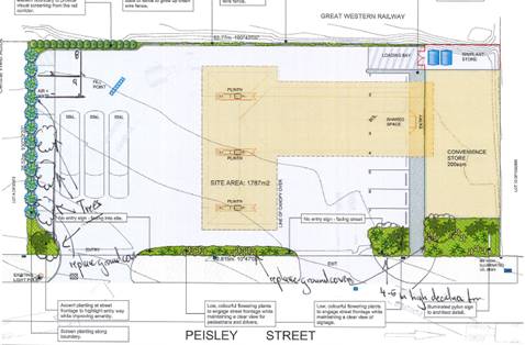
Figure 8 - recommended changes to landscaping and car
parking
Loading
Deliveries to the site will be by 19m semi-articulated
tanker vehicle. This aspect of the development was referred to the RMS for
advice, as well as Technical Services staff and the COTC.
It took the applicant several attempts of relocating the
fill points for the underground tanks, and the elimination of one of the pumps
from the proposed station to provide enough aisle widths for the delivery truck
to enter and leave in a forward direction. The main issue with the vehicle
deliveries was making sure the vehicle could enter and leave across the
driveway as perpendicular to the road alignment as possible. If the entry or
exit angles are too shallow there are potential conflicts with other traffic in
Peisley Street and inadequate vision for pedestrians and traffic (it should be
noted that the delivery vehicle must begin its entrance manoeuvre, and finish
its exit, on the right hand lane of Peisley Street and said manoeuvre must
cross the inner lane of Peisley Street. This is a legal traffic manoeuvre, but
it must be possible to carry this out safely.
The revised traffic manoeuvre diagram are as shown in Figure
9.

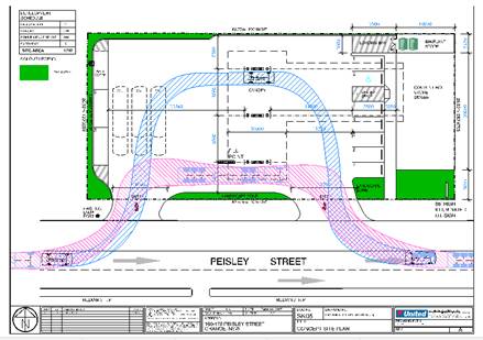
Figure 9 – manoeuvring diagram
As previously advised, RMS gave the following response to
the revised DA on 17 June 2017:
“I refer to an email
from Marc Kiho, Development Engineer at Orange City Council referring
amended plans for the DA426/2016 to Roads and Maritime Service (RMS) for
comment. I note DA426/2016 has been referred to the RMS in accordance with
Section 138(2) of the Roads Act 1993, Clause 18 of the State Environmental
Planning Policy No.64 (Advertising and Signage) and Section 104 of
State Environmental Planning Policy (Infrastructure 2007).
I note the amended plans
include relocation of the fuel storage tank inlet point to the rear of the
site.
The RMS does not object to the
proposal, and, pursuant to Section 138(2) of the Roads Act 1993 grants its
concurrence”.
The RMS has imposed a number of conditions which are
included in the consent. Council’s Technical Services staff have
reinforced this assessment, stating in the assessing report “Comments
from the RMS should be attached separately as a condition”.
The City of Orange Traffic Committee (OTDC) at its meeting
of 14 February 2017 considered the original proposal and raised concerns
about the solutions that have been applied for the internal circulation
patterns. The COTC shared the RMS’ concerns regarding the shallow
access and egress angles, and the safety issues this generates for pedestrians
and other traffic. They noted the loss of parking spaces in the street which
will result from the proposed development in its current form. The internal
traffic circulation patterns as submitted are considered unsatisfactory and
increase the chances of traffic conflicts in the current form.
The COTC have not considered the revised plans, but it is
noted that the revised plans do address the key points raised.
PROVISIONS PRESCRIBED BY THE
REGULATIONS s79C(1)(a)(iv)
Demolition of a Building (clause 92)
The proposal does not involve the demolition of a building.
Fire Safety Considerations
(clause 93)
The proposal does not involve a change of building use for
an existing building.
Buildings to be Upgraded
(clause 94)
The proposal does not involve the rebuilding, alteration,
enlargement or extension of an existing building.
THE LIKELY IMPACTS OF THE
DEVELOPMENT s79C(1)(b)
Context and Setting
The context and setting of a particular area is established
by taking into account the surrounding situation having regard for adjoining
land uses, scenic qualities, scale of surrounding development, previous land
use, etc. The locality immediately surrounding the site is characterised by
mixed land uses including hotels, motor vehicle sales premises, a restaurant,
rail precinct, supermarket and various specialty outlets. The subject property
is identified in the CBD Structure Plan (forming part of the DCP provisions) as
a commercial area of tertiary significance. The subject property is not itself
a heritage item, and is not within a conservation area, but is in proximity to
both, and fairly visible as an element of the streetscape and neighbourhood
character.
The proposed development is considered to be consistent with
the concept of a “tertiary commercial” site. The architecture
site design and land use are not conducive to the traditional building forms
that are part of the central CBD character, but it also needs to be
acknowledged that this particular locality has similar land uses (eg. the motor
vehicle sales yards) that are of a similar ilk to the land use being proposed
in this application, and set the tone of what a “tertiary commercial area”
is meant to look like and function.
The proposed land use is considered acceptable to its
context and setting on that basis, subject to the imposition of conditions
(such as limiting the sign heights, and increasing the landscaping).
Noise Impacts
Potential noise impacts of the proposed development have
been considered, but are not considered to be a key matter of consideration in
this instance. There are residential occupancies within the CBD, however the
existing noise levels in this locality are already at an elevated state, except
at night. It is considered that the primary sources of noise to the area are
road traffic and rail related noise. It is further considered that the proposed
development is unlikely to exacerbate those noise generators in any measurable
way.
Traffic Impacts, Access and
Site Design
The subject land is located adjacent to Peisley Street,
with one of the principal constraints being the entry and exist of large fuel
tankers to the site in such a way as safety for traffic and pedestrians is not
compromised. This was not evident in the original designs submitted for
consideration, but has been satisfactorily addressed in the amended plans.
The requirements of the RMS have been integrated into
the notice of approval as conditions of consent.
Given the high profile nature of the subject land and the
proximity to a classified road, the development was referred to the COTC for
comment. COTC supported the concerns of the RMS. As the amended plans have
received RMS issues, and the COTC in its comments did not add any other issues
for consideration, it was not considered necessary to refer the amended
proposal back to the COTC for further comment. COTC at the time assessed the
original proposal and did not request that the matter be returned to them for
further assessment.
It is considered that the proposed development, subject to
some minor adjustments to the basic site plan layout will ensure that access
points, car parking, loading and manoeuvring arrangements are sufficient for
the proposed service station, and will not adversely impact on the surrounding
road network, or on neighbouring properties.
Council agrees with the position of the RMS and COTC. It is
considered that the development would be appropriate in terms of traffic
impacts subject to the conditions of consent noted above.
Visual Impacts
The development is not likely to present any unreasonable
impacts in terms of visual amenity, where the building and canopy are set back
from the street, acceptable colours and materials are proposed, and the scale
and design are in keeping with other buildings in the surrounds. The heights of
the proposed pylon sign has been reduced to 6m, which is consistent to the
general standards of limiting sign heights to be not higher than the buildings
to which they relate The landscaping plan as submitted is not satisfactory,
being poor in its species nomination, and lacking in likely mature heights for
those species. The landscaped areas are considered inadequate. These
shortcomings can be addressed by conditions of consent, which the applicant has
agreed to.
Environmental Impacts
As set out in the SEPP 33 analysis of this report, there is
some risk to the environment through potential leaking of underground tanks and
pipes. The guidelines state that where the risk criteria has found to be
acceptable to people, then the environmental risk could also be tolerated.
However, the water table in this location is high, and conditions of consent
are recommended in relation to monitoring for leaks. Monitoring has been
recommended in the submitted PHA, and the EPA also recommends monitoring wells.
Management of stormwater on the site has been conditioned in
the consent.
Potential risks from ongoing contamination was a major
impediment to allowing the proposed development to proceed. The applicant has
now submitted a validation report that attests to the site being suitable for
purpose in its current state. This is a key question in legislation. By
answering that the site is suitable for the proposed use, and providing some
evidence to support that statement, the applicant has now allowed the
development to proceed, with Council able to conclude that the risks to life
and property from contamination on the site being minimal.
Safety, Security and Crime
Prevention
A Plan of Management is required which sets out
considerations to ensure the safety and security of staff, customers, workers
and the wider community. Measures include adequate staff training, holding an
Incident Register on the site (including complaints), installation of a
‘panic button’ for emergencies, 24 hour CCTV surveillance, money
handling procedures, theft procedures, external lighting, clear sightlines to
forecourt, and restricted staff areas. The proposed development is considered acceptable
in this regard, and a condition of consent is recommended to ensure that the
service station is operated in accordance with this Plan.
Socio-economic Impacts
The development has the potential to present positive
socio-economic impacts. The development will allow additional employment during
both the construction and operational phases of the development.
Cumulative Impacts
With appropriate conditions of consent the development is
not likely to present any unreasonable cumulative impacts within the locality.
The noise impact assessment concludes that the development is acceptable in
terms of noise. Traffic, parking and access are also considered to be
acceptable. Furthermore, the development is considered acceptable in terms of
hazard risk, and will not present any unreasonable environmental impacts within
the locality.
THE SUITABILITY OF THE SITE
s79C(1)(c)
There are no known physical constraints which would render
the site unsuitable for the proposed service station. Adequate services and
utilities are available to the site to facilitate the proposed development. The
submitted reports demonstrate that the site is suitable for this use. The
submitted Preliminary Hazard Analysis and Multi-Level Risk Assessment
demonstrate that the proposal is not a hazardous activity and is suitable for
this site.
ANY SUBMISSIONS MADE IN
ACCORDANCE WITH THE ACT s79C(1)(d)
The proposed development is defined as "advertised
development" under the provisions of the LEP. The application was
advertised for the prescribed period of 14 days and at the end of that period
no submissions from the public had been received.
PUBLIC INTEREST
s79C(1)(e)
The proposed development is considered to be of minor
interest to the wider public due to the relatively localised nature of
potential impacts. The proposal is not inconsistent with any relevant policy
statements, planning studies, guidelines, etc that have not been considered in
this assessment.
SUMMARY
The proposed development is permissible with the consent of
Council. The proposed development complies with the relevant aims, objectives
and provisions of the LEP. A Section 79C assessment of the
development indicates that the development is acceptable in this instance.
Attached is a draft Notice of Approval outlining a range of conditions considered
appropriate to ensure that the development proceeds in an acceptable manner.
COMMENTS
The requirements of the Environmental Health and Building
Surveyor and the Engineering Development Section are included in the
attached Notice of Approval.
Attachments
1 Notice
of Approval, D18/3017⇩
2 Plans,
D18/3389⇩
3 Validation
Report, D18/3391⇩
4 Agency
Submissions, D18/3397⇩
Planning
and Development Committee
6 February 2018
2.2 Development
Application DA 426/2016(1) - 160-178 Peisley Street
Attachment 1 Notice of Approval
|

|
ORANGE
CITY COUNCIL
Development
Application No DA
426/2016(1)
NA18/ Container
PR9811
|
NOTICE OF DETERMINATION
OF A DEVELOPMENT
APPLICATION
issued under the Environmental
Planning and Assessment Act 1979
Section 81(1)
|
Development
Application
|
|
|
Applicant Name:
|
RPS
Australia East Pty Ltd
|
|
Applicant Address:
|
PO Box 428
HAMILTON
NSW 2303
|
|
Owner’s Name:
|
Telfield
Pty Ltd & Wizby Pty Ltd
Lots B, C, D, E, F DP
37972 - 160-178 Peisley Street, Orange
|
|
Land to Be Developed:
|
|
|
Proposed Development:
|
Service
Station and Signage
|
|
|
|
|
Building
Code of Australia
building
classification:
|
To be
determined by the PCA
|
|
|
|
|
Determination
|
|
|
Made On:
|
6 February
2018
|
|
Determination:
|
CONSENT
GRANTED SUBJECT TO CONDITIONS DESCRIBED BELOW:
|
|
|
|
|
Consent to
Operate From:
|
7 February
2018
|
|
Consent to
Lapse On:
|
7 February
2023
|
Terms of Approval
The reasons for the imposition of
conditions are:
(1) To ensure compliance
with relevant statutory requirements.
(2) To provide adequate
public health and safety measures.
(3) To minimise the impact
of development on the environment.
(4) To ensure a quality
urban design for the development which complements the surrounding environment.
(5) To maintain
neighbourhood amenity and character.
(6) Because the development
will require the provision of, or increase the demand for, public amenities and
services.
(7) To ensure the utility
services are available to the site and adequate for the development.
(8) To prevent the proposed
development having a detrimental effect on adjoining land uses.
Conditions
(1) The
development must be carried out in accordance with:
(a) Plan/s
numbered - drawings TP03 REV D, TP04 REV C, TP05 REV B, LP-001 REVD, LP-002 REV
D, LP-003 REV D , SK06 Rev A (7 sheets)
(b) statements
of environmental effects or other similar associated documents that form part
of the approval
as amended
in accordance with any conditions of this consent.
(2) All building work must
be carried out in accordance with the provisions of the Building Code of
Australia.
(3) A sign is to be erected
in a prominent position on any site on which building work, subdivision work or
demolition work is being carried out:
(a) showing
the name, address and telephone number of the principal certifying authority
for the work, and
(b) showing
the name of the principal contractor (if any) for any building work and a
telephone number on which that person may be contacted outside working hours,
and
(c) stating
that unauthorised entry to the site is prohibited.
Any such sign is to be maintained while the
building work, subdivision work or demolition work is being carried out.
(4) Where any excavation
work on the site extends below the level of the base of the footings of a
building on adjoining land, the person having the benefit of the development
consent must, at the person’s own expense:
(a) protect
and support the adjoining premises from possible damage from the excavation,
and
(b) where
necessary, underpin the adjoining premises to prevent any such damage.
Note: This condition
does not apply if the person having the benefit of the development consent owns
the adjoining land or the owner of the adjoining land has given consent in
writing to this condition not applying.
|
PRIOR TO THE ISSUE OF
A CONSTRUCTION CERTIFICATE
|
(5) An amended landscaping
plan shall be submitted to and approved by Council’s Manager Development
Assessments prior to the issue of a Construction Certificate. The
plan shall have regard to the advice provided in the assessment of the
application by Council, relating to alternative species, more substantive
plantings along the western frontage and northern side boundaries, and
extension of the landscape beds along the northern boundary.
It is noted that this consent does not approve
the removal of any trees from the site, which may require separate consent or
permits, if not considered exempt development under the Orange Development
Control Plan 2004.
(6) Detailed
plans and specifications are to be provided specifying the proposed fitout of
the food preparation and storage areas in accordance with the requirements of
Australian Standard 4674-2004 "Design and construction and fitout of
food premises" and Standard 3.2.3 "Food Premises and
Equipment" of the Australian New Zealand Food Standards Code.
(7) The applicant shall
prepare and submit a Litter Patrol Management Plan for the approval of the
Manager of Building and Environment prior to the issue of a construction
certificate. The Litter Patrol Management plan shall detail the commitments
required to be undertaken by the operator of the premises to suitably manage
the pick-up of rubbish from the site and the surrounding street network and
open spaces.
(8) Prior to the issue of
the Construction Certificate, details showing how compliance will be achieved
with Australian Standard AS1940-2004 “The storage and handling of
flammable and combustible liquids”, are to be submitted to
Council/accredited certifier for assessment.
(9) Engineering plans
providing complete details of the proposed driveway and car parking areas are
to be submitted to Orange City Council or an Accredited Certifier (Categories
B1, C3, C4, C6) upon application for a Construction Certificate. These plans
are to provide details of levels, cross falls of all pavements, proposed
sealing materials and proposed drainage works and are to be in accordance with
Orange City Council Development and Subdivision Code.
(10) A Liquid
Trade Waste Application is to be submitted to Orange City Council prior to the
issuing of a Construction (or Occupation) Certificate. The application is
to be in accordance with Orange City Council’s Liquid Trade Waste
Policy. Engineering plans submitted as part of the application are to
show details of all proposed liquid trade waste pre-treatment systems and their
connection to sewer.
Where applicable, the applicant is to
enter into a Liquid Trade Waste Service Agreement with Orange City Council in
accordance with the Orange City Council Liquid Trade Waste Policy.
(11) All stormwater from the
site is to be collected and piped to the existing piped drainage system at the
intersection of Summer Street and Peisley Street. Engineering plans for this
stormwater system are to be submitted to and approved by Orange City Council
prior to a Construction Certificate being issued.
(12) Backflow Prevention
Devices are to be installed to AS3500 and in accordance with Orange City
Council Backflow Protection Guidelines. Details of the Backflow Prevention
Devices are to be submitted to Orange City Council prior to the issuing of a
Construction Certificate.
Certificates for testable Backflow Prevention
Devices are to be submitted to Orange City Council by a plumber with backflow
qualifications prior to the issue of an Occupation Certificate.
(13) All stormwater is to be
collected and piped to an onsite stormwater treatment system. The design and
construction of the stormwater treatment system for the subject land shall
ensure that the quality of stormwater leaving the developed site shall achieve
the following stormwater quality targets:
· 85% reduction in the
post development mean annual load of Total Suspended Solids (TSS)
· 65% reduction in the
post development mean annual load of Total Phosphorus (TP)
· 45% reduction in the
post development mean annual load of Total Nitrogen loads (TN)
· 90% reduction in the
post development average annual gross pollutant (>5 millimetres) load
· 90% reduction in the
post development mean annual load of Hydrocarbon
· No observable
Hydrocarbons present in stormwater discharge (<10ppm).
Orange City Council is
to approve engineering plans for this stormwater system prior to the issuing of
a Construction Certificate. The applicant shall undertake comprehensive water
quality modelling on for the site, using an accredited assessment tool
(recommended using Music™ or other approved assessment tool) and shall
include copies of the electronic data files.
|
PRIOR TO WORKS
COMMENCING
|
(14) A detailed site plan
shall be submitted to Council prior to works commencing. The site plan shall
accurately show the location of where the excavated material will be
stockpiled, identify all drainage channels (natural or constricted) within the
site and show the measures that will be implemented to prevent sediment from
entering the drainage channels
(15) Soil erosion control
measures shall be implemented on the site.
(16) A
Construction Certificate application is required to be submitted to, and issued
by Council/Accredited Certifier prior to any excavation or building works being
carried out onsite.
(17) A
temporary onsite toilet is to be provided and must remain throughout the
project or until an alternative facility meeting Council’s requirements
is available onsite.
|
DURING
CONSTRUCTION/SITEWORKS
|
(18) If Aboriginal objects,
relics, or other historical items or the like are located during development
works, all works in the area of the identified object, relic or item shall
cease, and the NSW Office of Environment and Heritage, and representatives from
the Orange LALC shall be notified. Where required, further archaeological
investigation shall be undertaken. Development works in the area of the find(s)
may recommence if and when outlined by the management strategy, developed in
consultation with and approved by the OEH.
(19) Any excavated material
removed from the site shall be tested for contamination and a record in
accordance with current procedures applicable in NSW made and submitted to both
the EPA and Council. The destination of the removed material is to be
accurately recorded and passed on to Council and the EPA. The receiver of waste
material must be licensed by the NSW Environment Protection Authority to
receive that waste. If a non-licensed premises is intended to receive waste
from the site then an approved notice within the meaning of Section 143(4) of
the Protection of the Environment Operations Act 1997 (Section 143 Notice) must
be supplied prior to removal of the material from the remediation site. Details
of material removed including volume, mass, classification, destination and any
Section 143 Notices are to be submitted to Council and the EPA.
(20) Soil disturbance
activities must not cause any environmental harm outside the site. The soil
disturbance area is to be fully bunded, fenced and dust suppression measures
implemented during the excavation and construction phases. Erosion and sediment
controls must be in place to prevent any soil leaving the remediation site.
Runoff from areas of potential contaminated soil, whether in situ, stockpiled
or in excavation pits, must not be permitted to leave the site without relevant
testing or treatment.
(21) Further validation is
required after completion of the excavation, but prior to the excavation being
filled, or new tanks installed, that certifies there is no risk from residual
contaminants to groundwater or the water table from the site. This
further validation shall be carried out in accordance with current reporting
standards. In the event that the excavated site reveals levels of contamination
that are either a risk to human health or at risk of entering the water table
or groundwater sources, further remediation (requiring separate development
consent) is required to be carried out prior to further work on the site under
this development consent proceeding.
(22) All
construction/demolition work on the site is to be carried out between the hours
of 7.00 am and 6.00 pm Monday to Friday inclusive, 7.00 am to
5.00 pm Saturdays and 8.00 am to 5.00 pm Sundays and Public
Holidays. Written approval must be obtained from the General Manager of Orange
City Council to vary these hours.
(23) A
Registered Surveyor’s certificate identifying the location of the
building on the site must be submitted to the Principal Certifying Authority.
(24) All
materials onsite or being delivered to the site are to be contained within the
site. The requirements of the Protection of the Environment Operations Act
1997 are to be complied with when placing/stockpiling loose material or
when disposing of waste products or during any other activities likely to
pollute drains or watercourses.
(25) Any adjustments to
existing utility services that are made necessary by this development
proceeding are to be at the full cost of the developer.
(26) The
provisions and requirements of the Orange City Council Development and
Subdivision Code are to be applied to this application and all work constructed
within the development is to be in accordance with that Code.
The developer is to be entirely responsible for
the provision of water, sewerage and drainage facilities capable of servicing
the development from Council’s existing infrastructure. The developer is
to be responsible for gaining access over adjoining land for services where
necessary and easements are to be created about all water, sewer and drainage
mains within and outside the lots they serve.
(27) All driveway and
parking areas are to be sealed with bitumen, hot mix or concrete and are to be
designed for all expected loading conditions (provided however that the minimum
pavement depth for gravel and flush seal roadways is 200mm) and be in
accordance with the Orange City Council Development and Subdivision Code.
(28) Heavy-duty concrete
kerb and gutter laybacks and footpath crossings are to be constructed in the
position shown on the plan submitted with the Construction Certificate
application. The works are to be carried out to the requirements of the Orange
City Council Development and Subdivision Code and NSW Roads and Maritime
Services.
(29) Any existing kerb and
gutter laybacks located on the frontage that are not part of the approved
entrance and exit to the development shall be replaced with standard concrete kerb
and gutter and the adjacent footpath area re‑graded to the shape and
level requirements of footpaths in the Orange City Council Development and
Subdivision Code.
|
PRIOR TO THE ISSUE OF
AN OCCUPATION CERTIFICATE
|
(30) State
Rail pursuant to the provisions of State environmental Planning policy
(Infrastructure 2007) require the following
Fencing
· Security
fencing along the rail corridor is essential to prevent unauthorised entry. A
1.8m (minimum height) chain wire fence or similar to prevent access onto the
rail corridor is imposed on the developer. During construction, temporary
fencing to prevent unauthorised access into the rail corridor shall be
provided.
Stormwater
· No
additional stormwater flows toward the rail corridor and all wastewater shall
be appropriately treated and disposed of, so as to not affect State Rail land
or infrastructure.
(31) Prior to the issuing of
an Occupational Certificate, the Applicant shall submit to Council
documentation demonstrating that the following plans and systems have been
developed and implemented:
(a) TRANSPORT
OF HAZARDOUS MATERIALS
Arrangements
covering the transport of hazardous materials including details of routes to be
used for the movement of vehicles carrying hazardous materials to or from the
development. The routes selected shall be consistent with the Department of
Planning’s Hazardous Industry Planning Advisory Paper No. 11, ‘Route
Selection’. Suitable routes identified in the study shall be used
except where departures are necessary for local deliveries or emergencies.
(b) EMERGENCY
PLAN
A
comprehensive Emergency Plan and detailed emergency procedures for the
development. The plan shall be consistent with the Department of
Planning’s Hazardous Industry Planning Advisory Paper No. 1, ‘Emergency
Planning’.
(c) SAFETY
MANAGEMENT SYSTEM
A
comprehensive Safety Management System, covering all on-site operations and
associated transport activities involving hazardous materials. The Safety
Management System shall be consistent with the Department of Planning’s
Hazardous Industry Planning Advisory Paper No. 9, ‘Safety
Management’.
(32) Landscaping
shall be installed in accordance with the approved plans and shall be
permanently maintained to the satisfaction of Council's Manager Development
Assessments.
(33) A total of nine (9)
off-street car parking spaces shall be provided upon the site, such that all
spaces are perpendicular to the kerbing provided onsite. An amended site
plan incorporating these changes is required to be submitted that incorporates
these requirements. The required spaces shall be provided in accordance with
these final approved plans, and constructed (line marked and sealed, with
appropriate dimensions) in accordance with the requirements of Council's
Development and Subdivision Code prior to the issue of an Occupation
Certificate.
(34) No
person is to use or occupy the building or alteration that is the subject of
this approval without the prior issuing of an Occupation Certificate.
(35) The
owner of the building/s must cause the Council to be given a Final Fire Safety
Certificate on completion of the building in relation to essential fire or
other safety measures included in the schedule attached to this approval.
(36) Where
Orange City Council is not the Principal Certifying Authority, a final
inspection of water connection, sewer and stormwater drainage shall be
undertaken by Orange City Council and a Final Notice of Inspection issued,
prior to the issue of either an interim or a final Occupation Certificate.
(37) Prior to the
issue of an Occupation Certificate, evidence of registration of the food
premises with the NSW Food Authority is to be submitted to Council/accredited
certifier.
(38) A Certificate of
Compliance, from a Qualified Engineer, stating that the stormwater treatment
system complies with the approved engineering plans and is commissioned and
ready for use shall be submitted to the Principal Certifying Authority prior to
the issuing of an Occupation Certificate.
(39) Certification from
Orange City Council is required to be submitted to the Principal Certifying
Authority prior to the issue of an Occupation Certificate stating that all
works relating to connection of the development to Council assets, works on
public land, works on public roads, stormwater, sewer and water reticulation
mains and footpaths have been carried out in accordance with the Orange City
Council Development and Subdivision Code and the foregoing conditions, and that
Council will take ownership of the infrastructure assets.
(40) All
of the foregoing conditions are to be at the full cost of the developer and to
the requirements and standards of the Orange City Council Development and
Subdivision Code, unless specifically stated otherwise. All work required by
the foregoing conditions is to be completed prior to the issuing of an
Occupation Certificate, unless stated otherwise.
|
MATTERS FOR THE
ONGOING PERFORMANCE AND OPERATION OF THE DEVELOPMENT
|
(41) Roads
and Maritime Services (RMS) impose the following operating restrictions on the
approved development:
· Vehicular
access and egress between the site and Peisley Street shall be via the approved
vehicular access ways only.
· The exit
driveway shall be no more than ten (10) metres wide. The driveways shall be
constructed in concrete and shall match existing road and footpath levels.
· Prior to
occupation of the development, “No Entry “(R2-4) signs are to be
provided on the land at each side of the entry driveway. The signs are to
face the site to advise motorists not to exit the site onto Peisley Street via
the designated entry driveway.
· All vehicle
movements to and from the site shall be in a forward direction.
· Adequate
turning circles and vertical clearance shall be provided within the site to
accommodate the largest type of vehicle 919m articulated vehicle) that will
visit the site during construction and operation.
· All
activities including loading and unloading of goods associated with the
development are to be carried out onsite in the dedicated areas.
(42) All equipment must be
installed to manufacturer’s recommendations and must comply with all the
relevant standards listed within.
Specific safety features of the site, as set
out in the submitted Preliminary Hazard Analysis (PHA) submitted with the
development application shall be adhered to strictly at all times. The
applicant shall ensure that safety procedures are well posted on the site and
shall further ensure that all staff are adequately inducted as to correct
safety procedures and protocols as set out in the PHA.
(43) Emitted
noise shall not exceed 5dB(A) above background sound level measured at the
nearest affected residence.
(44) Twelve (12) months
after the commencement of operations of the development, and every three (3)
years thereafter, the Applicant shall carry out a comprehensive Hazard Audit of
the proposed development consistent with the Department of Planning’s
Hazardous Industry Planning Advisory Paper No. 5, ‘Hazard Audit
Guidelines’. The audit shall be carried out by a qualified person or
team, independent of the development. Compliance documentation shall be
submitted to the Council within 28 days from the date of the audit.
(45) The signage approved by
this application is to be in accordance with the Department of Planning and
Environment’s Transport Corridor Outdoor Advertising and Signage
Guidelines 2007, and is not to flash, move or be objectionably glaring or
luminous. All signage is restricted to that contained in this approval or
exempt development, as defined in the Orange LEP 2011 (as amended) and State
Environmental Planning Policy 64 – Advertising and Signage, with the
exception of the fuel prices on the pylon sign as required by NSW Fair
Trading. As such, no sign is permitted to display any advertising
relating to a person or company that does not carry on business at the
premises.
(46) The consent insofar as
it relates to the advertising signs on the site, is time limited under
Clause 14 of SEPP-64 to 15 years after the date on which the consent
becomes effective and operates in accordance with Section 83 of the Act.
(47) The
owner is required to provide to Council and to the NSW Fire Commissioner an
Annual Fire Safety Statement in respect of the fire-safety measures, as
required by Clause 177 of the Environmental Planning and Assessment
Regulation 2000.
(48) Copies of
maintenance records for servicing of the stormwater treatment system and/or bio
retention basin shall be forwarded to Council on 1 December annually.
(49) Certificates for
testable Backflow Prevention Devices are to be submitted to Orange City Council
by a plumber with backflow qualifications prior to the issue of an Occupation
Certificate.
Other Approvals
(1) Local
Government Act 1993 approvals granted under Section 68.
Water,
sewer and stormwater
(2) General
terms of other approvals integrated as part of this consent.
(3) All plumbing
and drainage (water supply, sanitary plumbing and drainage, stormwater drainage
and hot water supply) is to comply with the Local Government (Water,
Sewerage and Drainage) Regulation 1998, the Plumbing Code of
Australia 2016 - Plumbing & Drainage and Australian
Standard AS3500 - National Plumbing and Drainage Code. Such work is to be
installed by a licensed plumber and is to be inspected and approved by Council
prior to concealment.
(4) Orange
City Council is the Water and Sewer Authority for the Orange City Council area.
Therefore all water and sewer works must be inspected by Council. These
inspections CANNOT be carried out by a private certifier.
(5) The
following inspections are required to be carried out by Council as the Water
and Sewer Authority:
· internal
sewer
· hot and cold
water installation
· external
sewer
· stormwater
drainage
· final on
water, sewer and stormwater drainage and Council services.
(6) Hot
water shall be stored at a minimum of 60OC and be delivered to all
sanitary fixtures used for personal hygiene (bathrooms/ensuites) at a
temperature not exceeding 50oC. Where tempering valves are
installed, a sign is to be permanently fixed on the hot water heater adjacent
to the tempering valve (clearly visible) indicating:
“A tempering valve has been
installed to prevent scalding. This valve is to be renewed at intervals as
recommended by the manufacturer.”
(7) The
location and depth of the sewer junction/connection to Council’s sewerage
system is to be determined to ensure adequate fall to the sewer is available.
(8) All
stormwater is to be disposed of in a manner suitable to the site.
Right of Appeal
If
you are dissatisfied with this decision, Section 97 of Environmental
Planning and Assessment Act 1979 gives you the right to appeal to the Land
and Environment Court within 6 months after the date on which you receive this
notice.
*
Section 97 of the Environmental Planning and Assessment Act 1979 does not apply
to the determination of a development application for State significant
development or local designated development that has been the subject of a
Commission of Inquiry.
|
Disability Discrimination Act
1992:
|
This application has been assessed in
accordance with the Environmental Planning and Assessment Act 1979. No
guarantee is given that the proposal complies with the Disability
Discrimination Act 1992.
The applicant/owner is responsible to
ensure compliance with this and other anti-discrimination legislation.
The Disability Discrimination Act
covers disabilities not catered for in the minimum standards called up in the
Building Code of Australia which references AS1428.1 - "Design for
Access and Mobility". AS1428 Parts 2, 3 and 4 provides the most
comprehensive technical guidance under the Disability Discrimination Act
currently available in Australia.
|
|
|
|
|
Disclaimer - S88B Restrictions on the Use of Land:
|
The applicant should note that there
could be covenants in favour of persons other than Council restricting what
may be built or done upon the subject land. The applicant is advised to check
the position before commencing any work.
|
|
|
|
|
Signed:
|
On behalf of the consent authority ORANGE
CITY COUNCIL
|
|
Signature:
|
|
|
Name:
|
PAUL JOHNSTON - MANAGER DEVELOPMENT
ASSESSMENTS
|
|
Date:
|
7 February 2018
|
Planning
and Development Committee
6 February 2018
2.2 Development
Application DA 426/2016(1) - 160-178 Peisley Street
Attachment 2 Plans
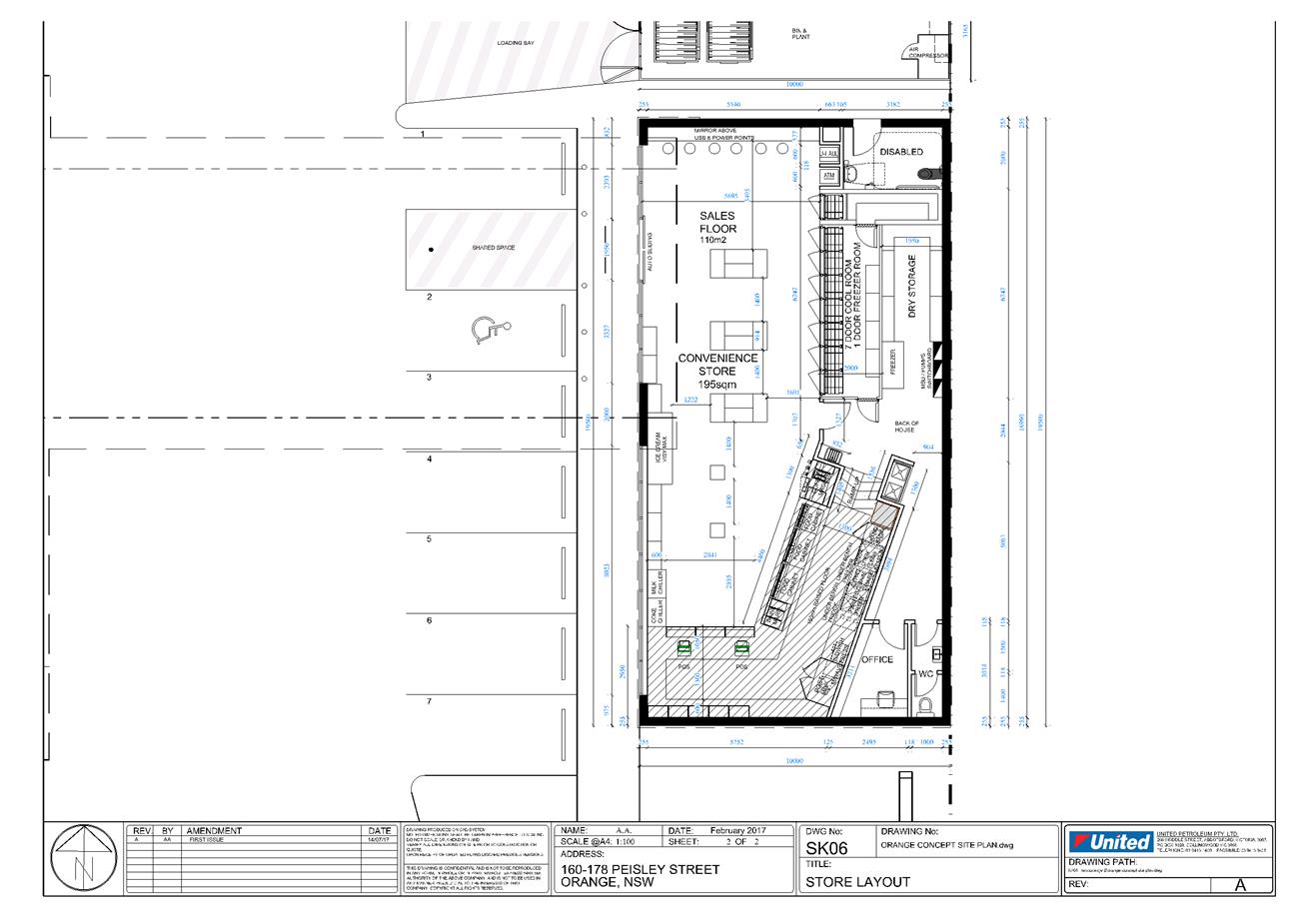
Planning and Development Committee
6 February 2018
2.2 Development
Application DA 426/2016(1) - 160-178 Peisley Street
Attachment 3 Validation
Report
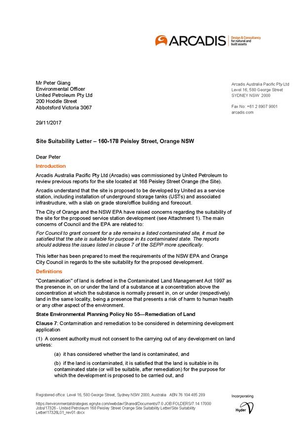

Planning and Development Committee
6 February 2018
2.2 Development
Application DA 426/2016(1) - 160-178 Peisley Street
Attachment 4 Agency
Submissions
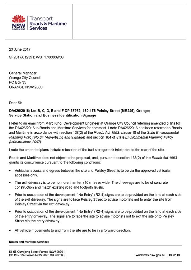
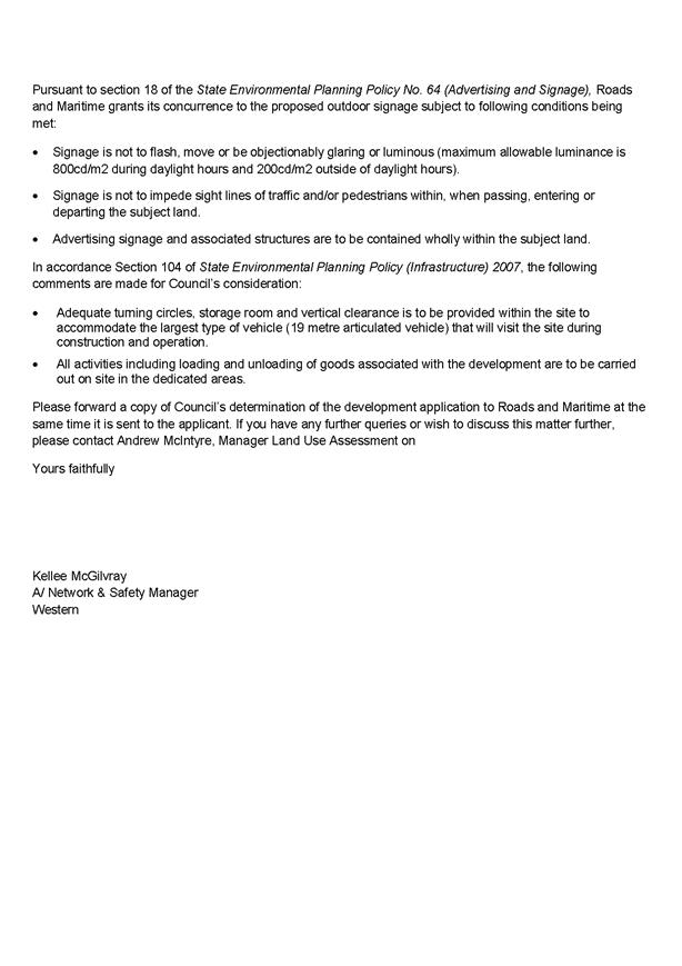
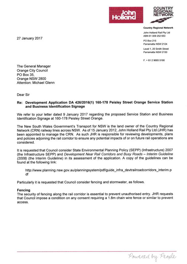
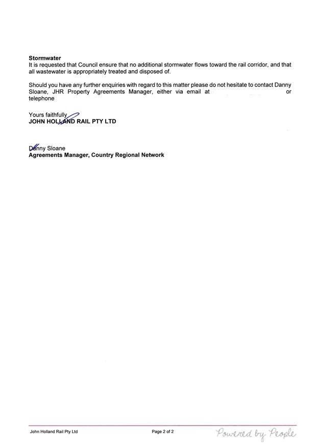
2.3 Development
Application DA 229/2017(1) - 104 Lysterfield Road
RECORD
NUMBER: 2018/51
AUTHOR: Daniel
Drum, Senior Planner
EXECUTIVE Summary
|
Application lodged
|
28 June 2017
|
|
Applicant/s
|
Orange MS Investments Pty Ltd
|
|
Owner/s
|
Orange MS Investments Pty Ltd
|
|
Land description
|
Lot 21 DP 1212446 CA 5137 - 104 Lysterfield Road,
Orange
|
|
Proposed land use
|
Subdivision
(24 lot Torrens title)
|
|
Value of proposed development
|
$0
|
Council's consent is sought for a 24 lot residential
subdivision of 104 Lysterfield Road, Orange, being Lot 21 DP 1212446 (the
‘subject property’).
The proposed subdivision would create 23 lots in the order
of 400 to 600m2 and a residual development lot of 1.53ha. The
proposed subdivision also includes provision for connecting north–south
and east–west roads.
The proposed subdivision is the second stage of subdivision
of the subject property, with the first stage being approved under DA293/2015
in May 2016 (modified in September 2016). The first stage of subdivision
is currently under construction.
The subject property is located within the developing
Shiralee urban village. Development in the Shiralee urban village is generally
required to be developed in accordance with the Shiralee Development Control
Plan (Shiralee DCP), including the Shiralee Masterplan. Despite this
requirement, the proposed subdivision includes a number of variations from the
Shiralee DCP, including lot shape, width to depth ratio and size.
While variations from the Shiralee DCP are generally not
supported, Council staff recognise that the characteristics of the subject
property and its ability to be developed in strict compliance with the Shiralee
DCP were affected by the subdivision layout originally approved under DA293/2015
in May 2016 (modified in September 2016).
The foregoing assessment demonstrates that the proposed
variations are acceptable.
Notwithstanding the foregoing issue, the proposed
subdivision is considered to be consistent with the relevant aims, objectives
and planning outcomes of the Orange Local Environmental Plan 2011 and Orange
Development Control Plan 2004.
DECISION FRAMEWORK
Development in Orange is governed by key documents
summarised as follows:
State Environmental Planning
Policies (SEPPs) provide the NSW Government the ability to provide a
legislative framework to assess specific matters. They are made by the Minister
of Planning and generally have over-arching weight within the context of the
issue they address.
In this case there are four principal state policies
applicable to the assessment of this application; SEPP Policy 33 (Hazardous and
Offensive Development), SEPP-55 (Remediation of Land), SEPP (Infrastructure
2007), and SEPP 64 (Outdoor Advertising).
Orange Local Environment Plan
2011 – the LEP should be considered by Council to be a definitive
document (except when modified or added to by over-arching state policies).
LEPs govern the types of development that are permissible or prohibited in
different parts of the City and also provide some assessment criteria in
specific circumstances. Uses are either permissible or not - there are no grey
areas in terms of permissibility. The objectives of each zoning and indeed the
aims of the LEP itself are, however, open to interpretation and can be used to
guide decision making around appropriateness of development.
Orange Development Control Plan
2004 – the DCP guides development. In general it is a performance
based document rather than prescriptive in nature - its purpose is to guide
development. The Land and Environment Court tends to view it as such. In each
area of interest there are often guidelines used. These guidelines indicate
ways of achieving the planning outcomes. It is thus recognised that there may
also be other solutions of merit. All design solutions are considered on merit
by planning and building staff. Applications should clearly demonstrate how the
planning outcomes are being met where alternative design solutions are
proposed. So one can see that the DCP gives leeway for developers and
architects to use design to achieve the outcome in other ways if they can.
Stating that DCP guidelines are inflexible can be misleading.
Director’s Comment - The subject property is
located within the developing Shiralee urban village. Development in the
Shiralee urban village is generally required to be developed in accordance with
the Shiralee Development Control Plan (Shiralee DCP), including the Shiralee
Masterplan. The applicant seeks a departure from Council’s adopted DCP
provisions that relate to this site (discussed in detail in the body of this
report.) The matters in contention relate namely to provisions dealing with lot
shape, width to depth ratio and size.
While variations from the Shiralee DCP are generally not
supported, Council staff in the assessment recognise that the characteristics
of the subject property are unique and its ability to be developed in strict
compliance with the Shiralee DCP is compromised and partly affected by the
subdivision layout originally approved under DA293/2015 in May 2016 (modified
in September 2016).
The planning assessment demonstrates that the proposed
variations are acceptable in this case. It is recommended that Council supports
the subject development application.
Link To Delivery/OPerational Plan
The recommendation in this report relates to the
Delivery/Operational Plan strategy “13.4 Our Environment
– Monitor and enforce regulations relating to City amenity”.
Financial Implications
Nil
Policy and Governance Implications
Nil
|
Recommendation
That Council consents to
development application DA 229/2017(1)
for Subdivision (24 lot Torrens title) at Lot 21 DP 1212446 CA 5137
- 104 Lysterfield Road, Orange pursuant to the
conditions of consent in the attached Notice of Approval.
|
further considerations
Consideration has been given to the
recommendation’s impact on Council’s service delivery; image and
reputation; political; environmental; health and safety; employees;
stakeholders and project management; and no further implications or risks have
been identified.
SUPPORTING INFORMATION
Council's consent is sought for a 24 lot residential subdivision
of the subject property.
The proposed subdivision would create 23 lots in the order
of 400 to 600m2, and a residual development lot of 1.53ha. The
proposed subdivision also includes provision for connecting north – south
and east – west roads.
The proposed subdivision is the second stage of subdivision
of the subject property, with the first stage being approved in May 2016 and
subsequently modified in September 2016. The first stage of subdivision is
currently under construction.
The arrangement of the proposed
subdivision is illustrated in Figure 1, below.
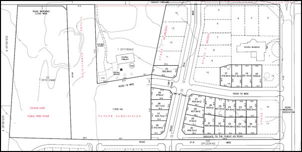
Figure 1 - proposed subdivision layout
EXISTING CONDITIONS/SURROUNDING
USE AND DEVELOPMENT
The existing conditions of the
subject property are illustrated in Figure 2, below.
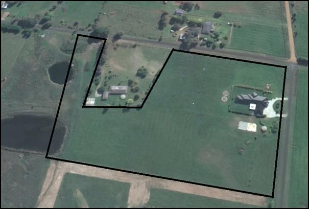
Figure 2 - the subject property – existing
conditions
MATTERS FOR CONSIDERATION
Section 5A Assessment
In the administration of sections 78A, 79B, 79C, 111 and
112, the provisions of Section 5A must be taken into account for every
development application in deciding whether there is likely to be a significant
effect on threatened species, populations or ecological communities or their
habitats. This section includes a requirement to consider any adopted
assessment guidelines, which means assessment guidelines issued and in force
under Section 94A of the Threatened Species Conservation Act 1995.
Assessment guidelines are in force (see DECC-W “Threatened Species
Assessment Guidelines - The Assessment of Significance”) which requires
consent authority to adopt the precautionary principle in its assessment.
From 25 August 2017, the Biodiversity Conservation Act 2017
and Biodiversity Conservation Regulation 2017 were gazetted. State
Environmental Planning Policy (Native Vegetation in Non-Rural Areas) 2017 was
also gazetted. The implementation of this legislation (and supporting
guidelines) is subject to savings provisions that defer their full effect for a
period of three months from the date of gazettal for local development.
In this instance, site inspection reveals that the subject
property is unlikely to have significant biodiversity or habitat value.
Section 79C – Evaluation
Section 79C of the Environmental Planning and Assessment Act
1979 sets out the matters that the consent authority is to take into
consideration in determining a development application.
These matters are addressed in the body of this report.
PROVISIONS OF ANY ENVIRONMENTAL
PLANNING INSTRUMENT s79C(1)(a)(i)
Orange Local Environmental Plan 2011
Part 1 - Preliminary
Clause 1.2 - Aims of Plan
The
aims of the Orange Local Environmental Plan 2011 (‘OLEP 2011’)
relevant to the application include:
(a) to
encourage development which complements and enhances the unique character of
Orange as a major regional centre boasting a diverse economy and offering an
attractive regional lifestyle,
(b) to
provide for a range of development opportunities that contribute to the social,
economic and environmental resources of Orange in a way that allows present and
future generations to meet their needs by implementing the principles for
ecologically sustainable development,
(e) to
provide a range of housing choices in planned urban and rural locations to meet
population growth,
(f) to
recognise and manage valued environmental heritage, landscape and scenic
features of Orange.
The proposed development is considered to be consistent with
the relevant aims of Orange LEP 2011. The relevant matters are addressed
in the body of this report.
Clause 1.6 - Consent Authority
Clause 1.6 establishes that Council is the consent authority
for the purposes of Orange LEP 2011.
Clause 1.9A - Suspension of
Covenants, Agreements and Instruments
This clause provides that covenants, agreements and other
instruments which seek to restrict the carrying out of development do not apply
with the following exceptions:
· covenants imposed
or required by Council
· prescribed
instruments under Section 183A of the Crown Lands Act 1989
· any conservation
agreement under the National Parks and Wildlife Act 1974
· any trust
agreement under the Nature Conservation Trust Act 2001
· any property
vegetation plan under the Native Vegetation Act 2003
· any biobanking
agreement under Part 7A of the Threatened Species Conservation Act 1995
· any planning
agreement under Division 6 of Part 4 of the Environmental Planning and
Assessment Act 1979.
This clause does not affect the rights or interests of any
public authority under any registered instrument.
A search of Council’s records identifies that the
subject property is not affected by any of the foregoing covenants,
instruments, agreements or plans.
Clause 1.7 - Mapping
The subject site is identified
on the LEP maps in the following manner:
|
Land Zoning Map:
|
Land zoned a combination of R1
General Residential zone, R2 Low Density Residential zone & RE1 Public Recreation
zone
|
|
Lot Size Map:
|
Minimum Lot Size a combination of
200m2, 400m2 and 2,000m2.
|
|
Heritage Map:
|
Not a heritage item or conservation
area
|
|
Height of Buildings Map:
|
No building height limit
|
|
Floor Space Ratio Map:
|
No floor space limit
|
|
Terrestrial Biodiversity Map:
|
No biodiversity sensitivity on the
site
|
|
Groundwater Vulnerability Map:
|
Ground water vulnerable
|
|
Drinking Water Catchment Map:
|
Not within the drinking water
catchment
|
|
Watercourse Map:
|
Not within or affecting a defined watercourse
|
|
Urban Release Area Map:
|
Not within an urban release area
|
|
Obstacle Limitation Surface Map:
|
No restriction on building siting
or construction
|
|
Additional Permitted Uses Map:
|
No additional permitted use applies
|
Those matters that are of relevance are addressed in detail
in the body of this report.
Part 2 - Permitted or
Prohibited Development
Land
Use Zones
The subject site is zoned in a
combination of R1 General Residential zone, R2 Low Density Residential zone and
RE1 Public Recreation zone (Figure 3, below).
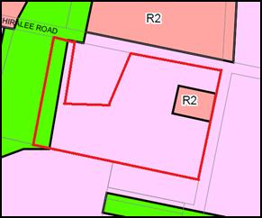
Figure 3 - Zoning Plan
Section 4B of the Environmental
Planning and Assessment Act 1979 identifies that subdivision of land
means:
“… the division of
land into two or more parts that, after the division, would be obviously adapted
for separate occupation, use or disposition.”
The
objectives for land zoned R1 General Residential are:
· To provide for the housing needs of the community.
· To provide for a variety of housing types and densities.
· To enable other land uses that provide facilities or
services to meet the day to day needs of residents.
· To ensure development is ordered in such a way as to
maximise public transport patronage and encourage walking and cycling in close
proximity to settlement.
· To ensure that development along the Southern Link Road has
an alternative access.
The
objectives for land zoned R2 Low Density Residential are:
· To provide for the housing needs of the community within a
low density residential environment.
· To enable other land uses that provide facilities or
services to meet the day to day needs of residents.
· To ensure development is ordered in such a way as to
maximise public transport patronage and encourage walking and cycling in close
proximity to settlement.
· To ensure that development along the Southern Link Road has
an alternative access.
The
objectives for land zoned RE1 Public Recreation are as follows:
· To enable land to be used for public open space or
recreational purposes.
· To provide a range of recreational settings and activities
and compatible land uses.
· To protect and enhance the natural environment for
recreational purposes.
· To ensure development is ordered in such a way as to
maximise public transport patronage and encourage walking and cycling in close
proximity to settlement.
· To ensure development along the Southern Link Road has
alternative access.
The
proposed residential subdivision only applies to the land zoned R1 General
Residential and R2 Low Density Residential. It is considered to be consistent
with the foregoing objectives.
The relevant matters are
addressed in the body of this report.
Clause 2.6 - Subdivision -
Consent Requirements
Clause 2.6 Subdivision - Consent Requirements identifies
that land may be subdivided, but only with development consent.
Part 4 - Principal Development Standards
Clause
4.1 - Minimum Subdivision Lot Size
Clause
4.1 Minimum Subdivision Lot Size requires the subdivision of land to be equal
to or greater than the size nominated for the land under the Minimum Lot Size
Map.
In
relation to this site, the map nominates three minimum lot sizes, which are
200m2 and 400m2 for the land zoned R1 General Residential
and RE1 Public Recreation, and 2,000m2 for the land zoned R2 Low
Density Residential.
The
proposed subdivision is consistent with the minimum lot size requirements with
the exception of proposed Lots 18, 19 and 20. These lots are generally located
in an area identified as having a minimum lot size of 400m2, however
the rear portion of each lot is within an area identified as having a minimum
lot size of 2,000m2. This appears to be a result of the previous
subdivision approved under DA 293/2015.
While
the applicant has not identified this issue or sought to deal with it any way,
Council staff accept that the orderly development of land requires that the
resultant area must be incorporated into the proposed subdivision and that
having regard to the Shiralee Masterplan, the most appropriate minimum lot size
is 400m2.
It is
noted that approval is required under Clause 4.6 to vary the requirements of
Clause 4.1. Clause 4.6 is addressed in further detail below.
Clause 4.6 – Exceptions to Development Standards
Clause
4.6 Exceptions to Development Standards provides that development consent may,
subject to this clause, be granted for development even though the development
would contravene a development standard imposed by this or any other
environmental planning instrument (other than a development standard expressly
excluded from the operation of the clause).
Development
consent must not be granted for development that contravenes a development
standard, unless the consent authority has considered a written request from
the applicant that seeks to justify the contravention of the development
standard by demonstrating that compliance with the development standard is
unreasonable or unnecessary in the circumstances of the case, and that there
are sufficient environmental planning grounds to justify contravening the
development standard.
Further,
development consent must not be granted for development that contravenes a
development standard, unless the consent authority is satisfied that the
applicant’s written request has adequately addressed the matters
required, and the proposed development will be in the public interest
because it is consistent with the objectives of the particular standard and the
objectives for development within the zone in which the development is proposed
to be carried out, and the concurrence of the Secretary has been obtained.
The
proposed subdivision is consistent with the minimum lot size requirements with
the exception of proposed Lots 18, 19 and 20. These lots are generally located
in an area identified as having a minimum lot size of 400m2, however
the rear portion of each lot is within an area identified as having a minimum
lot size of 2,000m2. This appears to be a remnant of the previous
subdivision approved under DA 293/2015.
As
previously noted, while the applicant has not identified this issue or sought
to deal with it any way, Council staff accept that the orderly development of
land requires that the resultant area must be incorporated into the proposed
subdivision and that having regard to the Shiralee Masterplan, the most
appropriate minimum lot size is 400m2.
For the sake of due process,
Council staff have requested that the applicant provides an application
pursuant to Clause 4.6 to confirm why compliance with the development standard
is unreasonable/unnecessary in the circumstances, and to outline the
environmental planning grounds to justify contravening the development
standard.
Council staff are satisfied that the application has
adequately addressed the relevant matters and that the proposed subdivision is
in the public interest as it is consistent with the objectives of Clause 4.1
Minimum Subdivision Lot Size and the objectives of the R2 Low Density
Residential Zone.
Council has the assumed concurrence of the
Secretary of the Department of Planning Environment for
the purpose of Clause 4.6.
Part 7 - Additional Local Provisions
7.1
- Earthworks
This
clause establishes a range of matters that must be considered prior to granting
development consent for any application involving earthworks, such as:
(a) the likely disruption of, or any
detrimental effect on, existing drainage patterns and soil stability in the
locality of the development
(b) the effect of the development on the
likely future use or redevelopment of the land
(c) the quality of the fill or the soil to be
excavated, or both
(d) the effect of the development on the
existing and likely amenity of adjoining properties
(e) the source of any fill material and the
destination of any excavated material
(f) the likelihood of disturbing relics
(g) the proximity to and potential for adverse
impacts on any waterway, drinking water catchment or environmentally sensitive
area
(h) any measures proposed to minimise or
mitigate the impacts referred to in paragraph (g).
The applicant has not proposed
earthworks as part of the development application.
Notwithstanding, it is expected
that some minor earthworks are likely to be limited to the extent of cut and
fill required to construct new internal roads and create developable lots.
It is accepted that the required
earthworks are unlikely to disrupt or have a detrimental effect on the existing
drainage patterns and soil stability of the area; detrimentally affect a future
use or redevelopment of the land; detrimentally affect the amenity of adjoining
properties; or disturb any relics.
7.3 - Stormwater Management
This clause applies to all
industrial, commercial and residential zones and requires that Council be
satisfied that the proposal:
(a) is designed to maximise the use of water
permeable surfaces on the land having regard to the soil characteristics
affecting onsite infiltration of water
(b) includes, where practical, onsite
stormwater retention for use as an alternative supply to mains water,
groundwater or river water; and
(c) avoids any significant impacts of
stormwater runoff on adjoining downstream properties, native bushland and
receiving waters, or if that impact cannot be reasonably avoided, minimises and
mitigates the impact.
Councils Technical Services
Department has advised that stormwater from the site is to be piped to the
adjacent watercourse, where it is to be discharged through a standard headwall
with appropriate scour protections.
Council’s Technical
Services Department has also identified that a licence from the Department of
Planning Infrastructure and Natural Resources for work within 40m of the
watercourse.
7.6 - Groundwater Vulnerability
This
clause seeks to protect hydrological functions of groundwater systems and
protect resources from both depletion and contamination. Orange has a high
water table and large areas of the LGA, including the subject site, are
identified with “Groundwater Vulnerability” on the Groundwater
Vulnerability Map. This requires that Council consider:
(a) whether or not the development (including
any onsite storage or disposal of solid or liquid waste and chemicals) is
likely to cause any groundwater contamination or have any adverse effect on
groundwater dependent ecosystems, and
(b) the cumulative impact (including the
impact on nearby groundwater extraction for potable water supply or stock water
supply) of the development and any other existing development on groundwater.
Furthermore, consent may not be granted unless Council is satisfied that:
(a) the development is designed, sited and
will be managed to avoid any significant adverse environmental impact, or
(b) if that impact cannot be reasonably avoided
- the development is designed, sited and will be managed to minimise that
impact,
(c) if that impact cannot be minimised - the
development will be managed to mitigate that impact.
Given
that the proposed development is not anticipated to involve the discharge of
toxic or noxious substances it is considered unlikely to contaminate the
groundwater or related ecosystems. Similarly, the proposed development is not
anticipated to involve the extraction of groundwater and therefore would not
contribute to groundwater depletion.
7.11 - Essential Services
Clause
7.11 - Essential Services provides that development consent must not be granted
to development unless the consent authority is satisfied that any of the
following services which are essential for the proposed development are
available, or that adequate arrangements have been made to make them available
when required.
Essential
services include the supply of water and electricity; the disposal and
management of sewage; stormwater drainage or onsite conservation and suitable
road access.
The applicant has indicated that
all services have the capacity to be extended to the site.
Council’s Technical
Services Department has recommended a condition of consent to ensure
arrangements can be made for all necessary essential services to be provided to
the subject property.
STATE ENVIRONMENTAL PLANNING
POLICIES
State Environmental Planning Policy 55 - Remediation of
Land
State Environmental Planning Policy 55 - Remediation of Land
(SEPP 55) requires that a consent authority must not consent to the carrying
out of development of land unless it has considered whether the land is
contaminated; is satisfied that the land is suitable in its contaminated state
for the development that is proposed, and if the land requires remediation to
be made suitable for the proposed development it is satisfied that the land
will be remediated before the land is used for that purpose.
Furthermore, SEPP 55 requires that before determining an
application to carry out development that would involve a change of use of land
(specified in subclause 4), the consent authority must consider a preliminary
investigation of the land concerned.
Given that the subject property has a history of use for the
purpose of horticulture, a Preliminary Contamination Investigation (PCI) was
submitted with the development application.
Based on soil and laboratory analysis, the PCI concluded
that the soil sampling program did not detect elevated levels of analysed
metals and organochlorine pesticides, and that levels of all substances
evaluated were near background environmental levels and below the EPA
investigation threshold for residential land use.
Notwithstanding, consistent with the approach adopted in the
assessment of DA293/2015 in May 2016, Council’s Building Surveyor
has recommended a precautionary condition of consent requiring that chemical
testing of each lot is to be undertaken to demonstrate that the land is
suitable for residential use prior to the issue of a subdivision certificate.
PROVISIONS OF ANY DRAFT
ENVIRONMENTAL PLANNING INSTRUMENT THAT HAS BEEN PLACED ON EXHIBITION
s79C(1)(a)(ii)
There are no draft environmental planning instruments that
apply to the subject land or proposed development.
DESIGNATED DEVELOPMENT
The proposed development is not designated development.
PROVISIONS OF ANY DEVELOPMENT
CONTROL PLAN s79C(1)(a)(iii)
Orange Development Control Plan 2004 & Shiralee
Development Control Plan 2015
Orange Development Control Plan 2004
The Orange Development Control Plan 2004 (“the
DCP”) applies to the subject land. Chapters of the DCP relevant to the
proposed subdivision include:
· Chapter 0 -
Transitional Provisions.
· Chapter 2 -
Natural Resource Management.
· Chapter 3 -
General Considerations.
· Chapter 4 -
Special Environmental Considerations.
Chapter 0 - Transitional
Provisions
Section
0.2 - General Translation of Zones
Section 0.2 provides that any
reference to a zone under Orange Local Environmental Plan 2000 is to be a
reference to the corresponding zones in the zone conversion table.
The table identifies that R1 General Residential Zone and R2
Low Density Residential Zone correspond with the 2a Urban Residential and 2d
Urban Transitional Zones, and the RE1 Public Recreation Zone corresponds
with the Open Space Zone.
Chapter 2 - Natural Resource
Management
Section
2.1 - Water Quality
Section 2.1 - Water Quality
identifies that development which concentrates, redirects flows, increases flow
rates or disturbs land in close proximity to creeks, has the potential to
affect waterways with associated erosion, sedimentation and release of
nutrients, which combine to affect downstream water quality. Section 2.1 also
identifies that development involving groundwater extraction and/or onsite
wastewater disposal is deemed to have the potential to affect groundwater
resources.
Stormwater and groundwater quality issues have previously
been addressed under “7.3 – Stormwater Management” and “7.6 - Groundwater Vulnerability”,
respectively. In summary, it is considered that the proposed development is
unlikely to have a detrimental impact on storm and ground water quality.
Section 2.3 - Vegetation and Section 2.4 - Flora, Fauna and
Biodiversity
Section 2.3 - Vegetation and
Section 2.4 – Flora, Fauna and Biodiversity identify that the natural
environment of the Orange LGA has been heavily modified as a consequence of
land clearing for various uses, including agriculture, plantation forests,
mining and urban development; and that clearing of native vegetation has
significantly affected native habitats.
Based on inspection of the subject property, it is evident
that it has been highly modified by past agricultural practices and is unlikely
to contain significant habitat or biodiversity value.
Chapter 3 - General
Considerations
Section
3.1 - Cumulative Impacts
Section 3.1 - Cumulative Impacts
identifies that Council will consider not only the direct impacts of a
particular development but also whether the development, when carried out in
conjunction with other development in the locality, has a more significant
environmental impact.
The proposed subdivision is generally consistent with the
intended future of the land for residential purpose. Any likely environmental
impact will be within community accepted levels.
Chapter 4 - Special Environmental
Considerations
Section
4.3 - Land Shaping
Section
4.3 - Land Shaping identifies that substantial land shaping, including filling
or excavating land, has the potential to generate significant environmental
impacts, and that land shaping should not adversely affect land in the vicinity
as a result of drainage, erosion or sedimentation, or as a result of leachate
entering surface or groundwater.
Land shaping has previously been addressed under
“Section 7.1 - Earthworks”. In summary, it is considered that the
applicant has not proposed earthworks as part of the development application.
Notwithstanding, it is expected that some minor earthworks
are likely to be limited to the extent of cut and fill required to construct
new internal roads and create developable lots.
It is accepted that the required earthworks are unlikely to
disrupt or have a detrimental effect on the existing drainage patterns and soil
stability of the area; detrimentally affect a future use or redevelopment of
the land; detrimentally affect the amenity of adjoining properties; or disturb
any relics.
Section 4.4 - Contaminated Land
Section 4.4 - Contaminated Land
identifies that contaminated land can pose a risk to human health and the
environment. Contaminants can be released into waterways and humans exposed
when contaminated land is disturbed as a consequence of development.
Land contamination has previously been addressed under
“State Environmental Planning Policy 55 - Remediation of
Land”.
SHIRALEE
DEVELOPMENT CONTROL PLAN 2015
The Shiralee Development Control
Plan (Shiralee DCP) seeks to guide urban expansion south of the existing Orange
urban area; promote a high quality urban environment with a diversity of
housing and recreation opportunities; encourage alternative modes of transport
and healthy lifestyles and reduce traffic congestion providing for the day to
day needs of residents within the precinct.
These objectives are given effect by a series of development
controls which generally deal with issues such as desired future character,
local infrastructure, the village centre, residential buildings, private and
public domains, the environment, and movement networks.
The general intent of the development controls for the
future development of the Shiralee area is illustrated by the Shiralee
Masterplan (Figure 5).
While the development controls are often written in a
prescriptive manner, Section 1.8 of the Shiralee DCP provides that in
exceptional circumstances Council may consider some variation in lot sizes and
types. Any variation from the DCP is to be considered on a case by case basis
and subject to Council’s satisfaction that the proposal meets or exceeds
the aims and principles of the DCP.
The relevant controls of the Shiralee DCP are addressed
below.
2.0 Desired Future Character
2.4 Subdivision
Section 2.4 Subdivision includes the following controls:
· Subdivision is
to be consistent generally in accordance with the Masterplan design and intent
per the DCP. Legislative requirements and DCP written controls take precedence over
the Masterplan.
An extract from the Shiralee Masterplan is provided below
(Figure 4). While the control identifies that subdivision must be ‘consistent
generally in accordance with the Masterplan’, it is noted that the
Masterplan lacks any meaningful detail against which the proposed subdivision
can be assessed.
The appropriate assessment
criteria is established in the following controls, set out below.
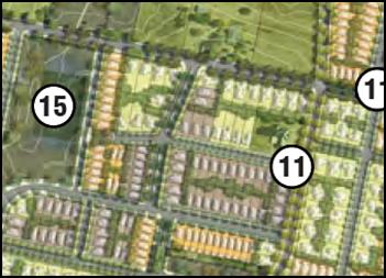
Figure 4 - Shiralee Masterplan (extract)
· Lot sizes are
to be consistent with or greater than the adopted minimum lot size for the land
under the LEP zoning map.
It is noted that this control requires lots’ sizes to
be consistent with or greater than the adopted minimum lot size for the land
under the LEP zoning map. It should be noted that minimum lot sizes are
established by the LEP lot size map and not the LEP zoning map.
This appears to be a simple drafting error which should not affect the obvious
and logical intent of the control.
Lot sizes have previously been addressed under “Clause
4.1 - Minimum Subdivision Lot Size”.
The map nominates three minimum lot sizes, which are 200m2
and 400m2 for the land zoned R1 General Residential and RE1
Public Recreation, and 2,000m2 for the land zoned R2 Low
Density Residential.
The
proposed subdivision is consistent with the minimum lot size requirements with
the exception of proposed Lots 18, 19 and 20. These lots are generally located
in an area identified as having a minimum lot size of 400m2, however
the rear portion of each lot is within an area identified as having a minimum
lot size of 2,000m2. This appears to be the result of the previous
subdivision approved under DA 293/2015.
While
the applicant has not identified this issue or sought to deal with it any way,
Council staff accept that the orderly development of land requires that the
remnant area must be incorporated into the proposed subdivision and that having
regard to the Shiralee Masterplan, the most appropriate minimum lot size
is 400m2.
It is
noted that approval is required under Clause 4.6 to vary the requirements of
Clause 4.1. Clause 4.6 has been addressed in detail above.
· Where an
oversized lot is proposed (substantially greater than the adopted minimum lot
size), plans are to nominate a building envelope.
The proposed subdivision would create two oversized lots
with one being 592.8m2 and the other being 1.535ha.
The 592.8m2 lot exceeds the medium lot range of
400–550m2 by 42.8m2. As such, it is considered that
the proposed lot could not be further subdivided and does not require a building
envelope.
The residual 1.535ha lot it is effectively a development lot
which will be the subject of a future subdivision proposal. It is considered
that it is not the intent of this control to require a building envelope to be
established on a development lot.
· Building
envelopes on oversized lots are to be positioned in a manner that clearly
enables future subdivision of the lot to a pattern consistent with the
masterplan layout and adopted minimum lot size for the land.
Refer to assessment above.
· Except for
corner lots and where indicated otherwise on the Large Lot Classification
Table, all residential lots are to have a width to depth ratio of between 1:4
and 1:2.5 to allow more opportunity for the subsequent dwelling to address both
frontages.
Residential corner lots are to have greater width with a
ratio of between 1:3.25 and 1:2.5 to allow more opportunity for the subsequent
dwelling to address both frontages.
The lot size ratio for all
lots, other than the residual development lot, are set out in Table 1
below.
|
Proposed
Lot
|
Width
|
Depth
|
Ratio
|
Compliance
with DCP
|
|
18
|
15
|
33.2
|
2.213333
|
No
|
|
19
|
15
|
33.2
|
2.213333
|
No
|
|
20
|
15
|
33.2
|
2.213333
|
No
|
|
21
|
17
|
29.6
|
1.741176
|
No
|
|
22
|
15.78
|
25.35
|
1.606464
|
No
|
|
23
|
15.78
|
25.35
|
1.606464
|
No
|
|
24
|
15.45
|
25.925
|
1.677994
|
No
|
|
25
|
15.25
|
26.5
|
1.737705
|
No
|
|
26
|
14.2
|
26.4
|
1.859155
|
No
|
|
28
|
15.1
|
26.5
|
1.754967
|
No
|
|
29
|
14
|
28.95
|
2.067857
|
No
|
|
30
|
18.7
|
39.8
|
2.128342
|
No
|
|
31
|
16
|
28.7
|
1.79375
|
No
|
|
32
|
15.1
|
26.2
|
1.735099
|
No
|
|
33
|
16.1
|
25.4
|
1.57764
|
No
|
|
34
|
15.8
|
25.4
|
1.607595
|
No
|
|
35
|
15.78
|
25.4
|
1.609632
|
No
|
|
36
|
13.1
|
20.8
|
1.587786
|
No
|
|
37
|
16.7
|
25.05
|
1.5
|
No
|
|
38
|
15.4
|
28.4
|
1.844156
|
No
|
|
39
|
14.7
|
37
|
2.517007
|
No
|
|
40
|
20.9
|
37.6
|
1.799043
|
No
|
Table 1 - Lot Width to Depth Ratio (other than corner
lots and residual development lots)
From the outset, it is noted that all lots exceed the width
to depth ratio established by the control.
The applicant has not identified this issue, nor sought to
deal with it any way after being requested by Council staff. Notwithstanding,
another contractor engaged by the applicant has provided a written statement to
Council indicating that the foregoing ratios demonstrate ‘reasonably
good compliance with the DCP’.
Council staff do not agree that a complete lack of
compliance with the Shiralee DCP can be assessed as being ‘reasonably
good compliance with the DCP’.
Notwithstanding, Council staff recognise that the
characteristics of the subject property and its ability to be developed in
strict compliance with the Shiralee DCP were affected by the subdivision layout
originally approved under DA293/2015 in May 2016 (modified in September 2016).
In particular, it is noted that the altered alignment of the
north–south and east‑west streets have had a substantial impact on
lot depth, orientation and shape. This is demonstrated in Figure 5 below, which
was provided by a contractor engaged by the applicant.
Based on the analysis presented
in Figure 5, it is accepted that it would be difficult to achieve both the
width to depth ratio required by the Shiralee DCP, as well as other controls
such as achieving minimum lot size requirements. On this basis, it is
considered that a departure from the DCP should be supported pursuant to the
‘exceptional circumstance’ provisions of Section 1.8.
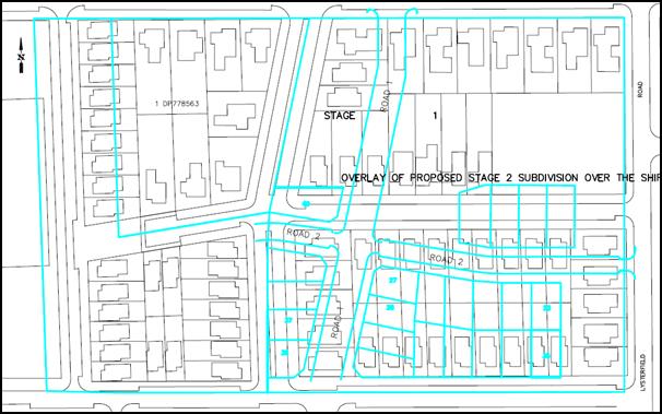
Figure 5- analysis of DA293/2015
· Roads
identified for Bus Routes:
- Intersections
where the bus route turns are to be designed to accommodate full size coaches.
- At
nominated bus stop locations the road reserve is to be increased by an addition
of 0.5m to allow for passenger congregation and future street furniture. The
front building setbacks of affected lots may be reduced by 0.25m to help
preserve the pattern and rhythm of development.
Council’s Technical Services Department has reviewed
the proposed subdivision and commented that the proposed road layout is
satisfactory and generally in accordance with the Shiralee Development Control
Plan.
2.5 Lot Typologies
Section 2.4 Lot typologies includes the following controls:
· Lot typologies
and minimum sizes are to be consistent with the Masterplan, DCP and LEP zoning
map.
An extract of the Shiralee
Structure Plan and Housing Densities map is provided below (Figure 6).
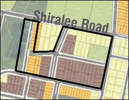
Figure 6 - Shiralee Structure Plan and Housing
Densities Map
While the proposed subdivision differs from the layout
originally envisaged by the Masterplan, it is considered that each of the
proposed lots, other than the residual development lot, should meet the lot
typology requirements for medium lots. Medium lots are identified as being
between 400m2–550m2.
All proposed lots are within the range of 400m2–550m2,
with the exception of proposed Lot 40 which is 592.8m2. While
the proposed Lot 40 exceeds the lot typology requirement for medium lots, it is
accepted that it is likely to be the only orderly outcome given the effect of
the subdivision layout approved under DA293/2015.
It is considered that a departure from the DCP should be
supported pursuant to the ‘exceptional circumstance’ provisions of
Section 1.8.
It is considered that this control is not intended to apply
to development lots such as the proposed residual 1.53ha lot.
· Any subdivision
which creates more than three lots must not have any oversized lots. Oversized
lots are lots that do not fit within the designated categories.
As discussed above, proposed Lot 40 exceeds the lot typology
requirement for medium lots (i.e. 400m2–550m2).
It is considered that a departure from to the DCP should be
supported pursuant to the ‘exceptional circumstance’ provisions of
Section 1.8.
The residual 1.535ha lot it is effectively a development lot
which will be the subject of a future subdivision proposal. It is considered
that it is not the intent of this control to prevent the creation of
development lots.
· Specific
requirements for large lots within the Precinct are to be consistent with
Large Lot Classification Diagram and Large Lot Classification Table.
Not applicable.
· Where
subdivision involves the creation of a lot greater than the maximum for the lot
typology, a building envelope is to be established on the title of the new lot.
The dimensions of the building envelope are to be no greater than:
- Compact
Lots: the width of the lot minus 1.2m (to provide for 0.6m side setbacks) by
the depth of the lot minus the front and rear setbacks.
- Medium
Lots: the width of the lot minus 2m (to provide for 1.1m side setbacks) by the
depth of the lot minus the front and rear setbacks.
- The
building envelope is to be positioned consistent the front and rear setbacks
otherwise specified for the lot typology in this DCP.
While Lot 40 exceeds the lot typology requirement for medium
lots, it only exceeds this requirement by 42.8m2 (i.e. the maximum
lot size is 550m2 and proposed Lot 40 is 592m2).
Given that proposed Lot 40 could not be further subdivided,
it is considered unnecessary to require a building envelope to be established.
The control would logically be used for an oversized lot
which included sufficient land to be further subdivided, but which is not a
residual development lot.
It is considered that a departure from the DCP should be
supported pursuant to the ‘exceptional circumstance’ provisions of
Section 1.8.
The residual 1.535ha lot is effectively a development lot
which will be the subject of a future subdivision proposal. It is considered
that it is not the intent of this control to require a building envelope to be
established on a development lot.
· The building
envelope is to be positioned consistent with the front and rear setbacks
otherwise specified for the lot typology in this DCP.
Note: This control applies to
compact and medium lots only.
Not applicable.
· Site coverage
ratio is the ratio is the ratio between the overall site area and the combined
footprint of all buildings on the property. The maximum site coverage ratio
allowed for:
- 60%
for compact lots
- 45%
for medium lots
- 35%
for standard lots
- 25%
for large lots
Not applicable.
· All lots musty
have direct street frontage to ensure good access and property amenity. Lots
3,000m2 and larger are excepted.
All proposed lots have direct street frontage.
· Lots without a
street frontage are to have a minimum size of 3,000m2 providing that
boundary landscaping is provided within any new development.
Not applicable.
· Corner lots are
to achieve high quality street frontages on the primary and secondary street.
Not applicable.
· All compact,
medium and standard lots need to achieve a solar orientation of where the long
axis of the lot is:
- For
north-south orientated lots between 20 degrees west of north or 30 degrees east
of north; or
- For
east-west orientated lots between 20 degrees north of east or 30 degrees south
of east.
All proposed lots are consistent with this control.
3.0 Local Infrastructure
3.1 Infrastructure Provisions
Section 3.1 Infrastructure Provisions references Clause 7.11
of the Orange LEP 2011 and states that development is required to be provided
with essential services including supply of water, electricity, gas and
telecommunications infrastructure, disposal and management of sewage,
stormwater drainage/onsite conservation and suitable road access.
In addition to the normal requirements of Clause 7.11,
Section 3.1 states that all power lines are to be located underground.
Council’s Technical
Services Department has recommended a condition of consent to ensure
arrangements can be made for all necessary essential services to be provided to
the subject property.
3.2 Ground Levels and
Excavation
Section 3.2 Ground Levels and Excavation includes the
following controls:
· Cut and fill is
to be minimised with cut materials used onsite as either fill for buildings or
used to even out landforms.
· Any cut is to
be supported by a retaining wall or battered at a gradient of less than 1:4,
provided that gradient is achievable entirely within the site boundaries.
· The design of
any retaining wall greater than 600mm must be accompanied by a statement from
an engineer attesting that the design is fit for purpose.
· Excavation for
the purposes of development must not exceed a maximum depth measured from
ground level (existing) of:
- If
located not more than 2m from any boundary:1m
- If
located more than 2m from any boundary: 2m
3.2 Ground Levels and
Excavation
· Notwithstanding
the above, excavation must not be more than 1m below ground level (existing) if
the land is within 40m of a waterbody (natural). Such excavation must not
interfere with or pose a risk of sedimentation to the water body –
excavation within 40m of a water body (natural) must be accompanied by a report
from a hydrologist demonstrating how the waterbody will be protected from harm.
· Filling, for
the purpose of erecting a dwelling must not exceed 1m above ground level
(existing).
· All excavation
and/or filling that exceeds 600mm in depth/height must be contained by either:
- A
retaining wall or other form of structural support that does not extend more
than 1.5m from:
o External walls of the dwelling
house,
o Decking connected to the dwelling
house, or
o Principal private open space of
the dwelling house,
o An unprotected sloping embankment
or batter that does not extend from the dwelling house, decking or principal
private open space by more than 3m, in which case the toe of the embankment or
batter must be more than 1m away from a side or rear boundary.
· To facilitate
assessment detailed engineering plans for retaining walls are to be supplied
where the wall is intended to retain more than 600mm or more of material.
Note: for this clause “Principal Private Open Space” means courtyard
space of up to 30m2 that is located behind the main building
alignment and is in close proximity to the living and entertaining spaces of
the dwelling house.
The applicant has not proposed
earthworks as part of the development application.
Notwithstanding, it is expected
that some minor earthworks are likely to be limited to the extent of cut and
fill required to construct new internal roads and create developable lots.
It is accepted that the required
earthworks are unlikely to disrupt or have a detrimental effect on the existing
drainage patterns and soil stability of the area; detrimentally affect a future
use or redevelopment of the land; detrimentally affect the amenity of adjoining
properties; or disturb any relics.
3.3 Public Domain
Section 3.3 Public Domain includes the following controls:
· Land identified
for the RE1 Public Recreation Zone is to be dedicated to Council as public open
space upon subdivision of the parent lot
Not applicable.
· Compensation
for the dedicated land is to be in accordance with the relevant Section 94
Development Contribution Plan
· Footpath dining
in the Village Centre is encouraged, although access on the footpath must be
maintained and consideration must be given to access for the vision impaired
and those in wheelchairs.
Not applicable.
· Outdoor dining
furniture and signage must be approved by Orange City Council and provide a
positive visual aesthetic to the streetscape.
Not applicable.
· Ensure
reasonable pedestrian/wheelchair/pram crossing ability is designed into the
road and median to ensure access into the heart of the village.
Council’s Technical Services Department has reviewed
the proposed subdivision and commented that the proposed road layout is
satisfactory.
It is recommended that landscaping within the public domain
be addressed by condition of consent, requiring a landscaping plan in
accordance with the Shiralee DCP to be submitted prior to the issue of a
Construction Certificate.
3.4 Staging
Section 3.4 Staging includes the following controls:
· The Rifle Range
exclusion zone, as shown in Figure 15. Land within the Rifle Range exclusion
zone, may not be subdivided or otherwise developed until the rifle range has
been decommissioned.
· The Hawke Dam
Lane exclusion zone may not be subdivided or otherwise developed until the dam
has been decommissioned or appropriate works are undertaken to safely convey
discharges from the dam into the downstream watercourse or drainage system, in
such a manner as to ensure no adverse flood risk is presented to downstream
properties. Stormwater drainage design needs to be undertaken in accordance
with Councils standard subdivision design code requirements. In particular
adequate provision must be made for all potential overland flows into the
subdivision from adjacent land as well as overland flows within the subdivision
and their safe discharge onto downstream properties. Overland flows can be
accommodated within road reserves or drainage reserves utilising a minor/major
drainage design approach.
The subject property is not located within either the Rifle
Range or Hawke Dam Lane exclusion zone.
7.0 Public Domain
7.1 Passive and Active Recreation Network
Section 7.1 Passive and Active Recreation Network includes
the following controls:
· Open spaces and
streets facing open spaces must be provided according to the Masterplan
· Where a
property adjoins a park or other public space that is not a street or road, any
residential development of that property:
- Must
provide at least two windows from habitable rooms to face the public space. The
windows are to be a minimum 2.5m² in size
- May
not place the side or rear walls of sheds and outbuildings any closer than 2.5m
from the boundary with the public space
· Properties
adjoining a public park or other public space are encouraged to include a
pedestrian gate along the boundary.
The applicant has not sought to address the passive and
active recreation network. It is recommended that a condition of consent be
applied requiring that a detailed landscaping plan be provided prior to the
issue of a Construction Certificate. The landscaping plan must be in accordance
with the applicable controls of the Shiralee Development Control Plan and must
be accompanied by a written statement which clearly demonstrates how the
applicable requirements have been met.
7.2 Landscape
Section 7.2 Landscape includes the following controls:
· Eco link
streets are to have an understory planting layer of native species including
shrubs, groundcovers and grasses of maximum mature height of 1.5m with planting
plans to be submitted for approval by Council.
· Streets
with medians are to have an understory planting layer of species responding to
the tree planting within the median, including shrubs, groundcovers and grasses
of generally maximum mature height of 1.5m and of 1m within 5m of an
intersection.
· Footpath
verges within residential areas are to be planted with cool climate turf
species, as approved by Council.
· Footpath
verges and tree planting zones within the village centre, may be planted with
robust groundcover and grass species in keeping with a high quality street
environment and as approved by Council.
· A
developer shall construct all footpaths, turf all verges and provide all road
infrastructure planting prior to sale of building blocks.
· Orange
City Council will plant all street trees.
· Maximum
verge cross-fall from property boundary to kerb is to be 2%.
· Longitudinal
gradient of verge is to match the gradient of the adjacent kerb. Retaining
walls are to be provided along property boundaries accordingly.
The applicant has not sought to address the passive and
active recreation network. It is recommended that a condition of consent be
applied requiring that a detailed landscaping plan be provided prior to the
issue of a Construction Certificate.
The landscaping plan must be in accordance with the
applicable controls of the Shiralee Development Control Plan and must be
accompanied by a written statement which clearly demonstrates how the
applicable requirements have been met.
8.0 Environmental Management
8.3 Stormwater and Water Sensitive Urban Design (WSUD)
Section
8.3 Stormwater and Water Sensitive Urban Design (WSUD) includes the following
controls:
· A comprehensive
site-wide WSUD strategy is implemented for Shiralee.
· Streets and
public spaces incorporate best practice WSUD elements including swales, rain
gardens and detention/retention basins.
· WSUD elements
are to incorporate native planting.
Council’s Technical Services Division has commented
that Council will install Water Sensitive Urban Design techniques.
8.4 Environmental Hazards
Section
8.4 Environmental Hazards includes the following controls:
· Bushfire,
flooding and other environmental hazards are to be assessed for each
development site to ensure safety and compliance with all relevant codes,
regulations and laws.
The subject property is not identified as a bushfire risk
area and is not affected by the 100 ARI flood. Council staff are not aware
of any other significant environmental hazards which may affect the subject
property.
9.0 Movement Networks
9.2 Pedestrian and Bicycle Network and Associated
Facilities
Section 9.2 Pedestrian and Bicycle Network and Associated
Facilities includes the following controls:
· A cycle network
is to be implemented in accordance with Figure 64. Cycle Network and be
designed in accordance with Austroads Standards and RMS Guidelines.
· Footpaths to be
provided on both sides of the street consistent with the street sections in
Appendix C.
· Safe road
crossings (e.g. marked crossings) are to be provided according to 9.4 Street
Network Access Controls. Also refer indicative intersection treatments, Figures
75 and 76.
· Universal
access to be provided throughout the precinct in accordance to AS.1428.1.
· On-road cycle
routes are to be clearly line marked and sign posted.
· Any development
that is assessed as requiring an on-site parking area or at least 5 spaces
shall also be required to provide bicycle parking.
· Bicycle parking
is to be provided at the ratio of 1 bicycle space per 15 car parking spaces (or
part thereof).
· All bicycle
spaces are to be provided with a fixed rack or other feature to facilitate
chain locking the bicycle.
· Bicycle spaces
are to be positioned so as to avoid conflict with car and service vehicle
circulation.
· Bicycle
spaces are to be clearly delineated from other parking areas by means of lane
marking and/or signage.
Council’s Technical Services Division has commented
that that the proposed road layout is satisfactory and that detailed design
will be addressed via a condition of consent requiring detailed engineering
plans prior to the issue of a Construction Certificate. Conditions of consent
are also recommended to require roads and paths to be built in accordance with
the Shiralee engineering requirements.
9.3 Public Transport Network
Section 9.3 Public Transport Network and Associated
Facilities includes the following controls:
· Bus routes and
stops are to be positioned in accordance with Figure 67 - Bus Network.
· All bus stops
must have a shelter that includes: seating with arm rests and lighting.
· Bus shelters
are to be positioned on either side of the street at all stops indicated on
Figure 67 - Bus Network.
· Pedestrian
crossings must be provided within 30m of all stops.
· Continuous
accessible paving must be provided from the shelter to pedestrian crossing.21.
Council’s Technical Services Division has commented
that that the proposed road layout is satisfactory and that detailed design
will be addressed via a condition of consent requiring detailed engineering
plans prior to the issue of a Construction Certificate. Conditions of consent
are also recommended to require roads and paths to be built in accordance with
the Shiralee engineering requirements.
9.4 Street Network and Access
Section 9.4 Street Network and Access includes the following
controls:
· Other than
where specified in the Masterplan there are to be no cul-de-sacs or no‑thru
roads.
· Where new roads
are aligned along existing property boundaries the first property to develop is
to include stage one of the shared road including any central median reserve.
· All streets
indicated on the Masterplan are to be designed and constructed in accordance
with the relevant street typology diagram.
· Intersections
are to be designed to maximise ease of movement for pedestrians and cyclists
and to slow vehicular traffic. Indicative intersection treatments for four way
and ‘T’ intersections are shown in Figure 75 and 76. Indicative
Intersection Treatments.
· Traffic calming
measures will be implemented in suitable locations to reduce vehicle speeds.
Traffic calming measures include passive measures such as intersection
narrowing, minimising width of road pavements, designation of slow speed
streets and use of rumble strips at pedestrian crossing points and
intersections.
· The principles
of water sensitive urban design are to be incorporated in the road network for
any new streets.
· Driveway
crossovers are to be a maximum of 3m wide and are not to be constructed within
6m of an intersection. Crossover pavement is to match the adjacent footpath
material.
· Garages and
carports on corner lots are to be accessed from the longer street frontage and
the crossover is to be aligned adjacent to the boundary furthest from the
intersection.
· Marked Crossings,
Refuge Islands and/or traffic signals are to be provided at street
intersections on:
-
Collector Streets
- the
Southern Feeder Road, and
- Intersections
of the ‘off road shared cycle and pedestrian path’.
Two stage roads
· On
development of the first stage of a two stage road, the design shall include a
buffer strip alongside the neighbours existing boundary. This strip is to be
created as a Torrens lot and vested with Council to ensure Council can maintain
control over access arrangements.
On development of the second stage
of a two stage road, Council will convert the
buffer strip from a lot to a road reserve to enable the construction of turning
bays as part of the development.
Council’s Technical Services Division has commented
that that the proposed road layout is satisfactory and that detailed design
will be addressed via a condition of consent requiring detailed engineering
plans prior to the issue of a Construction Certificate. Conditions of consent
are also recommended to require roads and paths to be built in accordance with
the Shiralee engineering requirements.
9.5 Traffic Management
Section 9.5 Traffic Management includes the following
controls:
· Key
intersections shown on the management plan are to be designed to
Council’s requirements.
· Intersections
along nominated bus routes are to be designed to accommodate the turning arc of
coach buses.
· Marked
crossings, refuge islands and/or traffic signals are to be provided at street
intersections on: Collector streets, the Southern Feeder Road and intersections
of the off road shared cycle and pedestrian path. This will improve pedestrian
and bicycle safety.
· All streets
except for Collectors and the Southern Feeder Road are to have a maximum 40km
per hour speed limit.
· All street
kerbs are to be upright not roll kerbs. Broken upright kerbs should be used
where required for WSUD function.
Council’s Technical Services Division has commented
that that the proposed road layout is satisfactory and that detailed design
will be addressed via a condition of consent requiring detailed engineering
plans prior to the issue of a Construction Certificate. Conditions of consent
are also recommended to require roads and paths to be built in accordance with
the Shiralee engineering requirements.
PROVISIONS PRESCRIBED BY THE
REGULATIONS s79C(1)(a)(iv)
Demolition of a Building (clause 92)
The proposal does not involve the demolition of a building.
Fire Safety Considerations
(clause 93)
The proposal does not involve a change of building use for
an existing building.
Buildings to be Upgraded
(clause 94)
The proposal does not involve the rebuilding, alteration,
enlargement or extension of an existing building.
BASIX Commitments (clause 97A)
Not applicable.
SECTION 94 DEVELOPMENT
CONTRIBUTIONS
In accordance with Section 94
of the Act and Orange Development Contributions Plan 2017 (Shiralee Release
Area) a contribution towards the provision of the following public facilities
is required:
|
Open
Space and Recreation
|
@
$741.78 x 23
|
17,060.94
|
|
Community
and Cultural
|
@ $215.33
x 23
|
4,952.59
|
|
Roads
and Traffic Management
|
@
$979.42 x 23
|
22,526.66
|
|
Local
Area Facilities
|
@
$17,903.20 x 23
|
411,773.60
|
|
Plan
Preparation & Administration
|
@
$160.27 x 23
|
3,686.21
|
|
Sub
Total
|
|
$460,000
|
The contribution will be indexed quarterly in accordance
with the Orange Development Contributions Plan 2017 (Shiralee Release Area).
Attached are conditions requiring the payment of the required contributions
prior to the issue of a Subdivision Certificate.
SECTION 64 - WATER AND SEWER
HEADWORKS CHARGES
Section 64 water and sewer headworks charges are also
applicable to the proposal. Such charges are calculated at the time of release
of a Subdivision Certificate for the development. Attached are conditions
requiring the payment of the required contributions prior to the issue of a
Subdivision Certificate.
THE LIKELY IMPACTS OF THE
DEVELOPMENT s79C(1)(b)
The proposed subdivision has been assessed against the
relevant aims, objectives, planning outcomes and controls of the Orange LEP
2011, the Orange DCP 2004 and the Shiralee DCP 2015.
The assessment demonstrates that while the proposed
subdivision does not meet some of the specific development controls of the
Shiralee DCP 2015, it is generally in accordance with the intent of the
document. Generally, any variation from the Shiralee DCP 2015 is due to the
previous subdivision approved under DA293/2015.
The subdivision will have the effect of transforming former
farming land to a portion to a new residential estate (or part thereof). The
likely impacts associated with transformation are clearly extensive and will
range from obvious impacts such as visual impact on the existing landscape
through to less obvious impacts such as increased stormwater flows from
impermeable surfaces.
Notwithstanding, given the intent of the Shiralee DCP 2015,
it is considered that the likely impacts of the proposed development are
acceptable and can be adequately managed via the recommended conditions of
consent.
THE SUITABILITY OF THE SITE
s79C(1)(c)
The foregoing assessment demonstrates that the subject
property is suitable for the proposed development.
ANY SUBMISSIONS MADE IN
ACCORDANCE WITH THE ACT s79C(1)(d)
The proposed development is not defined as "advertised
development" under the provisions of the LEP. Notwithstanding, the
development application was notified to the owners of 46 Shiralee Road, Orange,
which is effectively surrounded by the subject property with the exception of
the Shiralee Road frontage.
Three submissions were received at the end of the
notification period, two being from the owner of 46 Shiralee Road and one being
from a local interest group.
Environmental Interest Group
The submission from the local interest group focussed on the
environmental significance of the western portion of the subject property. The
submission identified that this land should not be developed for a residential
purpose given that an environmental report has not been prepared and that it
forms part of the stormwater harvesting catchment.
The submission concluded that the proposed development would
be supported subject to the removal of proposed Lots 53–62.
The applicant has subsequently amended the development
application to remove Lots 41‑62, being the western portion of the
subject property. It is understood that this land will be subject to a future
development application. The relevant issues will be considered as a part of an
assessment of any future subdivision proposal.
Owner of 46 Shiralee Road
– Submission 1
The first submission from the owners of 46 Shiralee Road
focussed on the western portion of the subject property, and raised issues such
as possible environmental impact, zoning and justification for development of
compact lots.
As noted above, the applicant has amended the development
application to remove Lots 41–62, being the western portion of the
subject property. It is understood that this land will be subject to a future
development application. The relevant issues will be considered as a part of an
assessment of any future subdivision proposal.
Owner of 46 Shiralee Road
– Submission 2
The second submission from the owners of 46 Shiralee Road
raised for key issues:
Overall Lot Density
The submitter contends that the high density of housing
proposed is inconsistent with the design principles of the DCP, because there
is little local amenity other than nearby open space and views (which will be
impeded following construction of houses).
Council staff note that the opening paragraph of Clause 2.2
Design Principles of the Shiralee DCP states:
“Shiralee will be
developed in accordance with the following Design Principles which underpin the
Master Plans:….”
On this basis, it is considered that the lot densities
required by the Shiralee DCP have been conceived with regard to the local
amenity. There is no further opportunity during the assessment of a proposed
subdivision to consider whether the lot density required by the Shiralee DCP is
appropriate with regard to local amenity.
As demonstrated in the body of this report, the proposed
subdivision is generally consistent with the Medium Lot typologies anticipated
for the subject property.
Soil Contamination
The submitter contends that while a Preliminary
Contamination Investigation (PCI) was submitted with the development
application, the PCI was undertaken in 2006 and that the horticultural use of
the land continued after this time. Further, the submitter identifies that that
soil sampling for the PCI only covered part of the subject property and may not
adequately reflect the conditions of the whole property.
The adequacy of the PCI was originally considered in the
assessment of Stage 1 under DA 293/2015(1) in May 2015. The
officer’s assessment of DA 293/2015(1) noted that while the horticultural
use of the property may have continued after the time of contamination
assessment, the use progressively declined and ceased. The report concluded
that it was probable that the level of any contaminant would have been highest
during the period of greatest use.
Notwithstanding, the report identified that on a
precautionary basis, a condition of consent should be applied requiring further
testing of each proposed lot to ensure suitability for residential use. For the
sake of consistency, it is recommended that the same approach be adopted for
the proposed subdivision.
Objection to proposed Lots
53-62
The submitter objects to the approval of Lots 53 – 62
for a number of reasons including: they are partially zoned RE1 Public
Recreation; impact on biodiversity; overland flow; lack of justification for
compact lots and road alignment.
While the issues raised are legitimate, the applicant has
amended the development application to remove Lots 41–62. The relevant
issues will be considered as a part of an assessment of any future subdivision
proposal.
The submitter has identified the construction of roads and
services for Stage 1 of the subdivision has had a detrimental impact on the
amenity of their property, particularly due to noise and vibration from rock
breaking and movement of machinery, and windblown dust from construction areas
and mounds of dirt located near the common property boundary.
The submitter contends that these impacts would be magnified
during construction of the proposed Stage 2 subdivision due to the larger
number of residential lots, which is closer proximity to the dwelling at 46
Shiralee Road.
The submitter states that if construction of the proposed
subdivision would render life intolerable, Council should apply a condition of
consent requiring the developer to offer to purchase 46 Shiralee Road for an
amount reflective of its value, Alternatively, the submitter states that all
possible steps should be taken to mitigate the impact of construction on the
subdivision on 46 Shiralee Road and should include locating equipment and
construction spoil as far away from the residence as practical at a minimum.
Council staff are aware of the noise and vibration impacts
associated with the construction of Stage 1 of the subdivision. In order to
minimise these impacts during the construction of Stage 2, Council staff
recommend that a condition of consent be applied requiring that a Noise and
Vibration Plan be prepared to ensure that noise and vibration measures are will
be compliant with the relevant Australian Standard. The plan is to be prepared
in consultation with any geotechnical report that itemises equipment to be used
for excavation works.
A further condition of consent is also recommended to
control the period for which activities generating noise levels greater than
75dB(A) (such as rock breaking, rock hammering, sheet and pile driving) be
restricted to.
With regard to windblown dust, it is recommended that a
condition of consent be applied requiring that a dust management plan be
submitted to Council or accredited certifier prior to the issue of a
Construction Certificate, identifying how dust and sources of dust can be
adequately managed during the construction process.
PUBLIC INTEREST
s79C(1)(e)
The proposed development is considered to be of minor
interest to the wider public due to the relatively localised nature of
potential impacts. The proposal is not inconsistent with any relevant policy
statements, planning studies, guidelines etc that have not been considered in
this assessment.
SUMMARY
The proposed development is permissible with the consent of
Council. The proposed development complies with the relevant aims, objectives
and provisions of the LEP. A Section 79C assessment of the
development indicates that the development is acceptable in this instance.
Attached is a draft Notice of Approval outlining a range of conditions
considered appropriate to ensure that the development proceeds in an acceptable
manner.
COMMENTS
The requirements of the Environmental Health and Building
Surveyor and the Engineering Development Section are included in the attached
Notice of Approval.
Attachments
1 Notice
of Approval, D18/3008⇩
2 Plan,
D18/3322⇩
3 Submissions,
D18/3350⇩
Planning
and Development Committee
6 February 2018
2.3 Development
Application DA 229/2017(1) - 104 Lysterfield Road
Attachment 1 Notice of Approval
|

|
ORANGE
CITY COUNCIL
Development
Application No DA
229/2017(1)
NA18/ Container
PR27170
|
NOTICE OF DETERMINATION
OF A DEVELOPMENT
APPLICATION
issued under the Environmental
Planning and Assessment Act 1979
Section 81(1)
|
Development
Application
|
|
|
Applicant Name:
|
Orange MS
Investments Pty Ltd
|
|
Applicant Address:
|
C/-
Anthony Daintith Town Planning
PO Box
1975
ORANGE
NSW 2800
|
|
Owner’s Name:
|
Orange MS
Investments Pty Ltd
|
|
Land to Be Developed:
|
Lot 21 DP
1212446 - 104 Lysterfield Road, Orange
|
|
Proposed Development:
|
Subdivision
(24 lot Torrens title)
|
|
|
|
|
Building
Code of Australia
building
classification:
|
Not
applicable
|
|
|
|
|
Determination
|
|
|
Made On:
|
6 February
2018
|
|
Determination:
|
CONSENT
GRANTED SUBJECT TO CONDITIONS DESCRIBED BELOW:
|
|
|
|
|
Consent to
Operate From:
|
7 February
2018
|
|
Consent to
Lapse On:
|
7 February
2023
|
Terms of Approval
The reasons for the imposition of
conditions are:
(1) To ensure compliance
with relevant statutory requirements.
(2) To provide adequate
public health and safety measures.
(3) To ensure a quality
urban design for the development which complements the surrounding environment.
(4) To maintain
neighbourhood amenity and character.
(5) Because the development
will require the provision of, or increase the demand for, public amenities and
services.
(6) To ensure the utility
services are available to the site and adequate for the development.
(7) To prevent the proposed
development having a detrimental effect on adjoining land uses.
(8) To minimise the impact
of development on the environment.
Conditions
(1) The
development must be carried out in accordance with:
(a) Proposed Subdivision of
Lot 21 DP1212446 Shiralee Road – Orange.
Proposed Subdivision of Stage 2 Drawing No.
10106 DA5 Rev B, dated 15.01.2015 by Carpenter, Collins, Craig (one plan)
(b) statements
of environmental effects or other similar associated documents that form part
of the approval
as amended
in accordance with any conditions of this consent.
(2) A sign is to be erected
in a prominent position on any site on which building work, subdivision work or
demolition work is being carried out:
(a) showing
the name, address and telephone number of the principal certifying authority
for the work, and
(b) showing
the name of the principal contractor (if any) for any building work and a
telephone number on which that person may be contacted outside working hours,
and
(c) stating
that unauthorised entry to the site is prohibited.
Any such sign is to be maintained while the
building work, subdivision work or demolition work is being carried out.
(3) Where any excavation
work on the site extends below the level of the base of the footings of a
building on adjoining land, the person having the benefit of the development
consent must, at the person’s own expense:
(a) protect
and support the adjoining premises from possible damage from the excavation,
and
(b) where
necessary, underpin the adjoining premises to prevent any such damage.
Note: This
condition does not apply if the person having the benefit of the development
consent owns the adjoining land or the owner of the adjoining land has given
consent in writing to this condition not applying.
|
PRIOR TO THE ISSUE OF
A CONSTRUCTION CERTIFICATE
|
(4) Prior
to the commencement of works or issue of a Construction Certificate (whichever
occurs first), a Noise and Vibration Management Plan is to be prepared by a
suitably qualified acoustic and vibration expert addressing the likely noise
and vibration from excavation and construction of the proposed development and
provided to Council for approval. The Plan is to identify amelioration measures
to ensure the noise and vibration levels will be compliant with the relevant
Australian Standards and Assessing Vibration: A technical guideline (available www.environment.nsw.gov.au). The
report shall be prepared in consultation with any geotechnical report that
itemises equipment to be used for excavation works. The Plan shall address, but
not be limited to, the following matters:
(a) Identification
of activities carried out and associated noise sources.
(b) Identification
of potentially affected sensitive receivers, including residences, churches,
commercial premises, schools and properties containing noise sensitive
equipment.
(c) Determination
of appropriate noise and vibration objectives for each identified sensitive
receiver.
(d) Noise
and vibration monitoring, reporting and response procedures.
(e) Assessment
of potential noise and vibration from the proposed excavation and construction
activities, including noise from construction vehicles.
(f) Description
of specific mitigation treatments, management methods and procedures to be
implemented to control noise and vibration during construction.
(g) Construction
timetabling to minimise noise impacts including time and duration restrictions,
respite periods and frequency (consistent with conditions of this consent).
(h) Procedures
for notifying residents of construction activities likely to affect their
amenity through noise and vibration.
(i) Contingency
plans to be implemented in the event of non- compliances and/or noise
complaints.
(5) A detailed landscaping
plan for the proposed subdivision is to be submitted to and approved by
Council’s Manager of Development Assessments prior to the issue of a
Construction Certificate. The amended landscape plan shall indicate the
proposed landscaping of all road reserves in accordance with the following:
1 Street
verges are to be fully turfed with cool climate species.
2 Median
strips are to be landscaped with trees and understory plantings (shrubs,
groundcovers and grasses) with a general maximum height of 1.5m, reduced to a
1m height for areas within 5m of an intersection.
3 Road
infrastructure planting.
The
landscape design shall have regard to the landscaping principles contained
within the Shiralee Urban Release Master Plan.
(6) Engineering plans,
showing details of all proposed work and adhering to any engineering conditions
of development consent, are to be submitted to, and approved by, Orange City
Council or an Accredited Certifier (Categories B1, C3, C4, C6) prior to the
issuing of a Construction Certificate.
(7) A water and soil
erosion control plan is to be submitted to Orange City Council or an Accredited
Certifier (Categories B1, C3, C4, C6) for approval prior to the issuing of a
Construction Certificate. The control plan is to be in accordance with the
Orange City Council Development and Subdivision Code and the Landcom, Managing
Urban Stormwater; Soils and Construction Handbook.
(8) Proposed
lots are to be provided with interlot stormwater drainage, including those lots
abutting public land, where the surface of the entire lot cannot be drained to
the kerb and gutter at the lot frontage. A grated concrete stormwater pit is to
be constructed within each lot provided with interlot stormwater drainage.
Engineering plans for this drainage system are to be approved by Orange City
Council or an Accredited Certifier (Categories B1, C3, C4, C6) prior to the
issuing of a Construction Certificate.
(9) Stormwater from the
site is to be piped to the adjacent watercourse, where it is to be discharged
through a standard headwall with appropriate scour protection. Engineering
plans of this required drainage system are to be approved by Orange City
Council or by an Accredited Certifier (Categories B1, C3, C4, C6) and a
licence from the Department of Planning Infrastructure and Natural Resources
for work within 40 metres of the watercourse is to be submitted prior to the
issuing of a Construction Certificate.
(10) A 150mm-diameter sewer
main is to be constructed from Council’s existing main to serve the
proposed lots. Prior to a Construction Certificate being issued engineering
plans for this sewerage system are to be submitted to and approved by Orange
City Council.
(11) A water reticulation
analysis is to be carried out by Orange City Council on any proposed water
reticulation system for the development. Engineering plans are to be
submitted to and approved by Orange City Council prior to the issue of a
Construction Certificate.
The reticulation system is to be designed to
supply a peak instantaneous demand by gravity of 0.15 L/s/tenement at a
minimum residual head of 200kPa.
(12) The street lighting
system shall be designed having regard to the relevant lighting controls
contained within the Shiralee DCP. The applicant shall submit details of the
street lighting system for approval prior to the issue of a Construction Certificate.
(13) A
dust management plan is to be submitted to Orange City Council or an accredited
Certifier upon application for a Construction Certificate. The approved dust
management plan must include measures to ensure that dust, and sources of dust,
do not a have a detrimental impact on the occupants of adjoining or proximate
residential properties.
The approved dust management plan is to be implemented prior
to construction work commencing and until completion of all work onsite.
|
PRIOR TO WORKS
COMMENCING
|
(14) A
temporary onsite toilet is to be provided and must remain throughout the
project or until an alternative facility meeting Council’s requirements
is available onsite.
(15) A
Construction Certificate application is required to be submitted to, and issued
by Council/Accredited Certifier prior to any excavation or building works being
carried out onsite.
(16) Soil erosion control
measures shall be implemented on the site.
|
DURING
CONSTRUCTION/SITEWORKS
|
(17) Excavation,
demolition, construction or subdivision work shall only be permitted during the
following hours:
(a) 7am
to 6pm, Monday to Friday, inclusive (with demolition works finishing at 5pm);
(b) 8am
to 1pm on Saturdays with no demolition works occurring during this time; and
(c) at
no time on Sundays or Public Holidays.
Works may be undertaken
outside these hours where they do not create any nuisance to neighbouring
properties in terms of dust, noise, vibration etc and do not entail the use of
power tools, hammers etc. This may include but is not limited to painting.
In the case that a
standing plant or special permit is obtained from Council for works in
association with this development, the works which are the subject of the
permit may be carried out outside these hours.
This condition does not
apply in the event of a direction from police or other relevant authority for
safety reasons, to prevent risk to life or environmental harm.
Activities generating
noise levels greater than 75dB(A) such as rock breaking, rock hammering, sheet
piling and pile driving shall be limited to:
(a) 8am
to 12pm, Monday to Saturday; and
(b) 2pm
to 5pm Monday to Friday.
The Proponent shall not
undertake such activities for more than three continuous hours and shall
provide a minimum of one 2 hour respite period between any two periods of such
works.
“Continuous”
means any period during which there is less than an uninterrupted 60 minute
respite period between temporarily halting and recommencing any of that
intrusively noisy work.
Noise arising from the
works must be controlled in accordance with the requirements of the Protection
of the Environment Operations Act 1997 and guidelines contained in the New
South Wales Environment Protection Authority Environmental Noise Control
Manual.
(18) All
construction/demolition work on the site is to be carried out between the hours
of 7am and 6pm Monday to Friday inclusive, 7am to 5pm Saturdays and 8am to
5pm Sundays and Public Holidays. Written approval must be obtained from the
General Manager of Orange City Council to vary these hours.
(19) Any adjustments to
existing utility services that are made necessary by this development
proceeding are to be at the full cost of the developer.
(20) The
provisions and requirements of the Orange City Council Development and
Subdivision Code are to be applied to this application and all work constructed
within the development is to be in accordance with that Code.
The developer is to be entirely responsible for
the provision of water, sewerage and drainage facilities capable of servicing
all the lots from Council’s existing infrastructure. The developer is to
be responsible for gaining access over adjoining land for services where
necessary and easements are to be created about all water, sewer and drainage
mains within and outside the lots they serve.
(21) The 21.6m wide road on
adjoining Lot 100 DP1204145 is to be constructed half road width for the full frontage
of the proposed development from the 15.5m wide road to Lysterfield Road. This
work is to include road pavement and pavement surfacing to the centreline, kerb
and gutter construction and earth-formed footpath on the development side of
the road.
Shiralee
Road is to be widened 2.245m in accordance with the Shiralee DCP.
(22) The proposed 19.0m,
21.6 and 25.6m wide roads shall be constructed in accordance with Orange City
Councils Shiralee Engineering Requirements and Additional Information
(D15/40462).
(23) Concrete pathways are
to be constructed to the widths and standards stated in the Shiralee
Development Control Plan and Orange City Councils Shiralee Engineering Requirements
and Additional Information (D15/40462).
Construction work is to
be to the requirements and standards of the Orange City Council Development and
Subdivision Code.
(24) Water and sewerage
reticulation is to be provided to every lot in the proposed residential
subdivision in accordance with the Orange City Council Development and Subdivision
Code.
|
PRIOR TO THE ISSUE OF
A SUBDIVISION CERTIFICATE
|
(25) In accordance with
Section 94 of the Act and Orange Development Contributions Plan 2017
(Shiralee Release Area) a contribution towards the provision of the following
public facilities will be required:
|
Open Space and
Recreation
|
@ $741.78 x 23
|
17,060.94
|
|
Community and
Cultural
|
@ $215.33 x 23
|
4,952.59
|
|
Roads and Traffic
Management
|
@ $979.42 x 23
|
22,526.66
|
|
Local Area Facilities
|
@ $17,903.20 x 23
|
411,773.60
|
|
Plan Preparation
& Administration
|
@ $160.27 x 23
|
3,686.21
|
|
Sub Total
|
|
$460,000
|
The
contribution will be indexed quarterly in accordance with the Orange
Development Contributions Plan 2017 (Shiralee Release Area).
(26) Prior to the issue of a
Subdivision Certificate all landscaping shall be carried out in accordance with
the approved landscaping plan.
(27) Soil
sampling for analysing chemical residue is to be carried out within the
proposed Lots in a manner and frequency as determined by an appropriately
qualified and experienced consultant giving consideration to previous specific
uses and on-site characteristics of the site. A NATA registered laboratory
is to carry out such testing. Reference is to be made to the Contaminated
Land Management Act 1997 and State Environmental Planning Policy No 55
- “Remediation of Land”. The results of the testing are to be
provided to the Principal Certifying Authority and are to demonstrate that the
land is suitable for residential use, to enable a Subdivision Certificate to be
issued.
(28) Application shall be
made for a Subdivision Certificate under Section 109(C)(1)(d) of the Act.
(29) Payment of
contributions for water, sewer and drainage works is required to be made
at the contribution rate applicable at the time that the payment is made.
The contributions are based on 23 ETs for water supply headworks and 23 ETs for
sewerage headworks. A Certificate of Compliance, from Orange City Council
in accordance with the Water Management Act 2000, will be issued upon
payment of the contributions.
This Certificate of Compliance is to be
submitted to the Principal Certifying Authority prior to the issuing of a
Subdivision Certificate.
(30) Evidence from a
registered NATA laboratory is to be submitted prior to the issuing of a
Subdivision Certificate stating that the filling of all dams and low-lying
areas has been carried out in accordance with Australian Standard 3798-2007.
(31) Application is to be
made to Telstra/NBN for infrastructure to be made available to each individual
lot within the development. Either a Telecommunications Infrastructure
Provisioning Confirmation or Certificate of Practical Completion is to be
submitted to the Principal Certifying Authority confirming that the specified
lots have been declared ready for service prior to the issue of a Subdivision
Certificate.
(32) A Notice of Arrangement
from Essential Energy stating arrangements have been made for the provision of
electricity supply to the development, is to be submitted to the Principal
Certifying Authority prior to the issue of a Subdivision Certificate.
(33) An easement to drain
sewage and to provide Council access for maintenance of sewerage works a
minimum of 2.0 metres wide is to be created over the proposed sewerage works.
The Principal Certifying Authority is to certify that the easement is in
accordance with the Orange City Council Development and Subdivision Code prior
to the issuing of a Subdivision Certificate.
(34) All services are to be
contained within the allotment that they serve. A Statement of Compliance, from
a Registered Surveyor, is to be submitted to the Principal Certifying Authority
prior to the issuing of a Subdivision Certificate.
(35) A
Maintenance Security Deposit, in accordance with the provisions and
requirements of the Orange City Council Development and Subdivision Code, is to
be provided to Orange City Council prior to the issuing of a Subdivision
Certificate.
A Certificate of Compliance, from Orange City
Council, certifying that the maintenance security deposit has been paid, is to
be submitted to the Principal Certifying Authority prior to the issuing of a
Subdivision Certificate.
(36) Where
stormwater crosses land outside the lot it favours, an easement to drain water
is to be created over the works. A Restriction-as-to-User under section 88B of
the NSW Conveyancing Act 1979 is to be created on the title of the
proposed lots requiring that no structures are to be placed on the site, or
landscaping or site works carried out on the site, in a manner that affects the
continued operation of the interlot drainage system. The minimum width of the
easement is to be as required in the Orange City Council Development and
Subdivision Code.
(37) Prior to the issuing of
a Subdivision Certificate, a Road Naming Application form is to be completed
and submitted with a plan of the whole development defining the stage being
released - including future road extensions.
(38) Prior to the release of
Lots 31 to 35 legal access shall be provided over adjoining Lot 100
DP1204145.
(39) All
of the foregoing conditions are to be at the full cost of the developer and to
the requirements and standards of the Orange City Council Development and
Subdivision Code, unless specifically stated otherwise. All work required by
the foregoing conditions is to be completed prior to the issuing of a
Subdivision Certificate, unless stated otherwise.
Other Approvals
(1) Local
Government Act 1993 approvals granted under Section 68.
Nil
(2) General
terms of other approvals integrated as part of this consent.
Nil
Right of Appeal
If
you are dissatisfied with this decision, section 97 of Environmental
Planning and Assessment Act 1979 gives you the right to appeal to the Land
and Environment Court within 6 months after the date on which you receive this
notice.
*
Section 97 of the Environmental Planning and Assessment Act 1979 does not apply
to the determination of a development application for State significant
development or local designated development that has been the subject of a
Commission of Inquiry.
|
Disability Discrimination Act
1992:
|
This application has been assessed in
accordance with the Environmental Planning and Assessment Act 1979. No
guarantee is given that the proposal complies with the Disability
Discrimination Act 1992.
The applicant/owner is responsible to
ensure compliance with this and other anti-discrimination legislation.
The Disability Discrimination Act
covers disabilities not catered for in the minimum standards called up in the
Building Code of Australia which references AS1428.1 - "Design for
Access and Mobility". AS1428 Parts 2, 3 and 4 provides the most
comprehensive technical guidance under the Disability Discrimination Act
currently available in Australia.
|
|
|
|
|
Disclaimer - S88B Restrictions on the Use of Land:
|
The applicant should note that there
could be covenants in favour of persons other than Council restricting what
may be built or done upon the subject land. The applicant is advised to check
the position before commencing any work.
|
|
|
|
|
Signed:
|
On behalf of the consent authority ORANGE
CITY COUNCIL
|
|
Signature:
|
|
|
Name:
|
PAUL JOHNSTON - MANAGER DEVELOPMENT
ASSESSMENTS
|
|
Date:
|
7 February 2018
|
Planning
and Development Committee
6 February 2018
2.3 Development
Application DA 229/2017(1) - 104 Lysterfield Road
Attachment 2 Plan
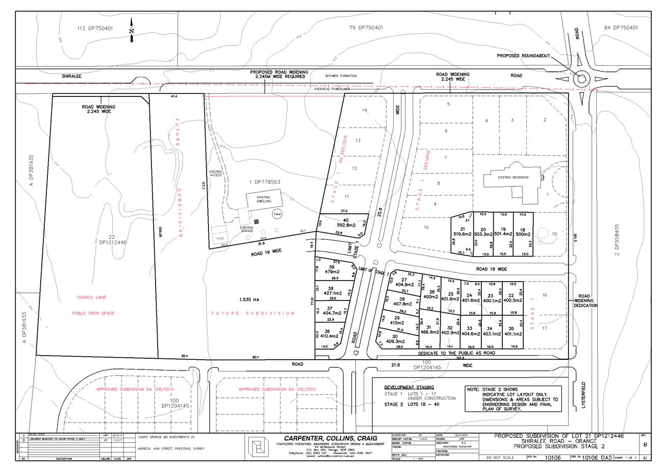
Planning and Development Committee
6 February 2018
2.3 Development
Application DA 229/2017(1) - 104 Lysterfield Road
Attachment 3 Submissions

2.5 Development
Application DA 247/2017(1) - Tarawell Crescent and Margaret Road
RECORD
NUMBER: 2018/73
AUTHOR: Michael
Glenn, Senior Planner
EXECUTIVE Summary
|
Application
lodged
|
11 July
2017
|
|
Applicant/s
|
Westacre
Developments Pty Ltd
|
|
Owner/s
|
Westacre
Developments Pty Ltd
|
|
Land
description
|
Lots 30
and 31 DP 246174, and Lot 33 DP 1055815 - Tarawell Crescent and Margaret
Road, Orange
|
|
Proposed
land use
|
Subdivision
(30 lot residential)
|
|
Value of
proposed development
|
Not
Applicable
|
The subject application is referred to the Planning and
Development Committee (PDC) for determination because Council’s Planning
Protocols require subdivisions with a yield of more than ten lots, and which
are not covered by a subdivision masterplan, to be referred to PDC for
determination.
Council's consent is sought for the subdivision of the land
described as Lots 30 and 31 DP 246174, and Lot 33
DP 1055815. Whilst a total of 30 lots are shown on the plans, it should be
noted that proposed Lot 30 is a drainage reserve. Taking into
consideration the existing lots that form the development site (which affects
Section 94 contributions), and the status of proposed lot 30 as an
infrastructure lot, the net yield of the proposed development is
26 residential lots and a public infrastructure lot.
Two of the proposed lots are constrained by significant
vegetation and have restricted building envelopes for them. Proposed Lot 29 is
unusual in that it is proposed as a lot with an area of 11,638m2. It
is understood this lot is configured in this way primarily to limit road
construction costs at this time. Given the R2 zoning applicable to the
site, this large lot should not be considered a future unit site
(since residential flats are not permitted in the zone). Proposed Lot 28
will need some further redesign (which the applicant has agreed to) as the
proposed boundary would otherwise cut through the middle of the site’s
significant vegetation, which is an identified Key Threatening Process under
the OEH guidelines.
The proposed layout will require the removal of several
large eucalyptus paddock trees from the site. These trees offer significant
landscape value, and have some significant seed-banking and nesting value, but
do not constitute an Endangered Ecological Community (EEC). Their removal
can be supported, subject to the provision of replacements elsewhere.
The subject properties are in close proximity to the
Northern Distributor Road (NDR) with some of the lots within the noise
shadow of the NDR. As a consequence, the application required the submission of
a full noise impact assessment. This assessment has been reviewed as part of
the overall merit assessment of the application.
The applicant proposes sole public road access from Sophie
Drive. Council’s Technical Services Division advises that Sophie Drive
has sufficient capacity (kerb to kerb width) for the additional traffic
generated by the proposed lots.
Council’s Technical Services Division advises that the
existing public roads terminating in an unfinished state behind serving Lots 22
and 29 will be required to be terminated at this time with a turn bay capable
of accommodating a 12.5m heavy rigid vehicle
(garbage truck/fire engine). This requirement will impact on the
dimensions, area and shape of proposed Lots 29 and 22. Whilst the impact
on proposed Lot 29 to accommodate the turn bay will be of limited impact (due
to the large size of that proposed lot), the impact on proposed Lot 22
will be proportionally greater (because of the small starting size of Lot 22)
effectively halving the available area of that lot. Its proposed area at the
present time is 880m2.
The proposed layout is functional in terms of its road
layout, however, from the juxtaposition of urban design and community
integration, the failure to provide road connections to the housing commission
area further to the west is not ideal. There remains the possibility for road
and footway connections to be provided across Lot 29 to the adjoining
connections in the future, if that lot is further developed.
Conditions relating to the construction of the turn bays
have been applied. The turn bays are required to be constructed prior to the
release of Lots 13 to 29 (inclusive).
Locality Plan
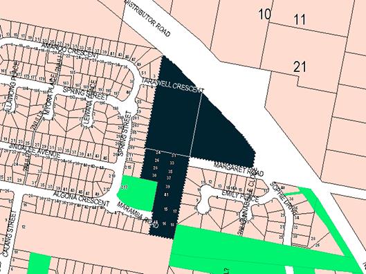
Figure 1 – Locality Plan
DECISION FRAMEWORK
Development in Orange is governed by key documents
summarised as follows:
State Environmental Planning
Policies (SEPPs) provide the NSW Government the ability to provide a
legislative framework to assess specific matters. They are made by the Minister
of Planning and generally have over-arching weight within the context of the
issue they address
In this case there are four principal state policies
applicable to the assessment of this application; SEPP Policy 33 (Hazardous and
Offensive Development), SEPP-55 (Remediation of Land), SEPP (Infrastructure
2007), and SEPP 64 (Outdoor Advertising).
Orange Local Environment Plan
2011 – the LEP should be considered by Council to be a definitive
document (except when modified or added to by over-arching state policies).
LEPs govern the types of development that are permissible or prohibited in
different parts of the City and also provide some assessment criteria in
specific circumstances. Uses are either permissible or not - there are no grey
areas in terms of permissibility. The objectives of each zoning and indeed the
aims of the LEP itself are, however, open to interpretation and can be used to
guide decision making around appropriateness of development.
Orange Development Control Plan
2004 – the DCP guides development. In general it is a performance
based document rather than prescriptive in nature - its purpose is to guide
development. The Land and Environment Court tends to view it as such. In each
area of interest there are often guidelines used. These guidelines indicate
ways of achieving the planning outcomes. It is thus recognised that there may
also be other solutions of merit. All design solutions are considered on merit
by planning and building staff. Applications should clearly demonstrate how the
planning outcomes are being met where alternative design solutions are proposed.
So one can see that the DCP gives leeway for developers and architects to use
design to achieve the outcome in other ways if they can. Stating that
DCP guidelines are inflexible can be misleading.
Director’s Comment
– The proposed development is permissible with the consent of Council.
The main issue in contention with this application is to determine whether or
not Council should insist upon the connection being provided through to the
adjoining residential land at this time. The proposed layout is functional in
terms of its road layout, however Council’s DCP encourages the
development of land based on the principle of achieving a modified grid layout
rather than a series of cul-de-sacs. The applicant has requested that Council
not insist upon a connection being provided through to the adjoining housing
commission area further to the west at this time. The design of the subdivision
is such that there remains the possibility if Council was of the view to
support the development as submitted to provide a road and footway connection
through to the adjoining land in the future if proposed Lot 29 (comprising an
area of 11,638m²) is further developed. A Section 79C assessment of
the development indicates that the development is acceptable in this instance.
Council’s Technical Services Division have indicated support to the
concept as proposed. Attached is a draft Notice of Approval outlining a range
of conditions considered appropriate to ensure that the development proceeds in
an acceptable manner.
Link To Delivery/OPerational Plan
The recommendation in this report relates to the
Delivery/Operational Plan strategy “13.4 Our Environment
– Monitor and enforce regulations relating to City amenity”.
Financial Implications
No compensation is payable for open space or other
dedications suggested in this proposal.
Policy and Governance Implications
Nil
|
Recommendation
That Council consents to
development application DA 247/2017(1)
for Subdivision (30 lot residential) at Lots 30 and 31 DP 246174,
and Lot 33 DP 1055815 – Tarawell Crescent
and Margaret Road, Orange pursuant to the
conditions of consent in the attached Notice of Approval.
|
further considerations
Consideration has been given to the
recommendation’s impact on Council’s service delivery; image and
reputation; political; environmental; health and safety; employees;
stakeholders and project management; and no further implications or risks have
been identified.
SUPPORTING INFORMATION
THE APPLICATION
Council's consent is sought for Subdivision (30 lot
residential) at Lots 30 and 31 DP 246174, and Lot 33 DP 1055815 - Tarawell
Crescent and Margaret Road, Orange.
THE PROPOSAL
Council's consent is sought for the residential subdivision
of the subject land into 30 allotments (comprising 29 residential
allotments and 1 public infrastructure lot). The design incorporates allotments
that contain extensive significant vegetation, intended to be retained and
protected to an extent from removal by the imposition of restrictive building
envelopes.
Proposed lot sizes are generally under 1000m², except
for Lots 28 and 29 which are substantially larger due to the presence of
significant vegetation adjacent to them.
MATTERS FOR CONSIDERATION
Section 5A Assessment
In the administration of Sections 78A, 79B, 79C, 111 and
112, the provisions of Section 5A must be taken into account for every
development application in deciding whether there is likely to be a significant
effect on threatened species, populations or ecological communities or their
habitats.
This section includes a requirement to consider any adopted
assessment guidelines, which means assessment guidelines issued and in force
under Section 94A of the Threatened Species Conservation Act 1995.
Assessment guidelines are in force (see DECC-W “Threatened Species
Assessment Guidelines - The Assessment of Significance”) which requires
consent authority to adopt the precautionary principle in its assessment.
From 25 August 2017, the Biodiversity Conservation Act 2017
and Biodiversity Conservation Regulation 2017 were gazetted. State
Environmental Planning Policy (Native Vegetation in Non-Rural Areas) 2017 was
also gazetted. The implementation of this legislation (and supporting guidelines)
is subject to savings provisions that defer their full effect for a period of
three months from the date of gazettal for local development.
In this instance there is significant biodiversity or
habitat value over several parts of the site. The most significant single
element is the terrestrial vegetation on the site in the form of a more or less
intact box gum grassy woodland remnant. This remnant is unique because it has
retained a largely intact understorey, which is unusual for urban
bushland.
The applicant has proposed larger sized lots (Lots 28 and
29) with restricted building envelopes which will lessen the impacts on
biodiversity significance of these areas.
There is a proposed boundary for Lot 28 at its southern end,
running in a roughly east-west direction and cutting through the middle of the
native vegetation area. This element of the subdivision layout is likely to
have a significant adverse effect on biodiversity value, since the boundary
will at some point need to be fenced, and the fencing will require some level
of clearing either side of the fence, and some level of site disturbance to
install such fencing. Fencing (and fragmentation of EEC remnants) is an
identified Key Threatening Process (KTP) under the OEH guidelines which are
applicable to the assessment.
A condition is included in the consent to address this
issue, requiring the inter-allotment boundary between Lots 28 and 29 to be
redesigned and repositioned so that the boundary does not pass through the
significant vegetation on either lot. The boundary fencing is required to be
set back from the principal vegetation a minimum of 3m.
It is further considered appropriate to impose a condition
requiring (prior to the issue of a fully endorsed Subdivision Certificate), a
Restriction to User to be imposed on the titles of Lots 28 and 29, in
favour of Orange City Council , that does not allow the planting of invasive
exotic species on either of these lots, the removal of fallen timber without
permission from Council’s Manager City Presentation, or the removal of
understorey plants from the significant vegetated areas without the agreement
of Council’s Manager City Presentation.
A condition requiring the installation of protective fencing
in accordance with AS 4970-2009 to be installed around the protected
areas, prior to the issue of a Construction Certificate for the
subdivision.
With respect to the paddock trees, it is not considered
reasonable to require the retention of these trees. Whilst the trees themselves
are significant specimens, and do provide seed banking opportunities, the
benefits derived from them do not warrant their retention. To offset the loss
of these important trees, a condition is included that requires a minimum of 20
replacements (to be planted prior to the issue of the Subdivision Certificate)
in the public open space on the western side of Lot 29 (generally within
Lot 48 DP258905, known to Council as Plowman Park), or such other location as
nominated by the Manager City Presentation. The applicant is obligated to
water and maintain these trees until such time as the Subdivision Certificate
has been released.
Aboriginal Heritage
The subject property is not identified in the Aboriginal
Heritage Information Management System (AHIMS) managed by the office of
Environment and Heritage (OEH). Notwithstanding, it is considered that a
standard condition should be imposed that requires protection of any Aboriginal
artefacts discovered during the subdivisions works being carried out.
Section 79C
Section 79C of the Environmental Planning and Assessment Act
1979 requires Council to consider various matters, of which those pertaining to
the application are listed below.
PROVISIONS OF ANY ENVIRONMENTAL
PLANNING INSTRUMENT s79C(1)(a)(i)
Orange Local Environmental Plan 2011
Part 1 - Preliminary
Clause 1.2 - Aims of Plan
The
broad aims of the LEP are set out under Subclause 2. Those relevant to the
application are as follows:
(a) to encourage development which complements
and enhances the unique character of Orange as a major regional centre boasting
a diverse economy and offering an attractive regional lifestyle,
(b) to provide for a range of development
opportunities that contribute to the social, economic and environmental
resources of Orange in a way that allows present and future generations to meet
their needs by implementing the principles for ecologically sustainable
development,
(c) to conserve and enhance the water
resources on which Orange depends, particularly water supply catchments,
(e) to provide a range of housing choices in
planned urban and rural locations to meet population growth,
(f) to recognise and manage valued
environmental heritage, landscape and scenic features of Orange.
In relation to (a), the proposed
development will detract from or decrease the open character of the locality,
but will be consistent with and increase the residential character of the more
urban areas nearby. The subject property is zoned R2 Low Density Residential,
and it is appropriate to assume that the site would at some point be developed for
urban purposes.
The development site is surrounded by
similarly zoned low density residential land, with the exception of the open
space land known as Ploughman Park.
With regard to (b), the proposed
development does increase the stock of housing lots that, in some perspective,
adds to the development opportunities of the city. Adding to the housing stock
increases the potential for population growth that, in turn, suggests that the
needs of the workforce will be met.
With regard to (c), the proposed development
would not have any significant effect on the resources of the Orange City water
supply.
With regard to (e), the proposed
development does not include housing; however, it does increase the supply of
residential allotments. This will produce the conditions needed to provide
additional housing opportunities.
With regard to (f), it is recognised that
the changes in zoning that occurred under LEP 2011 will result in some
adverse effects on the surrounding landscape. However, within the context of the
general provisions, the zoning, the other objectives of the LEP and the
recognised primary view corridors and the like, it is considered that this is
appropriate development for the site.
Clause 1.6 - Consent Authority
This clause establishes that, subject to the Act, Council is
the consent authority for applications made under the LEP.
Clause 1.9A - Suspension of
Covenants, Agreements and Instruments
This clause provides that covenants, agreements and other
instruments which seek to restrict the carrying out of development do not apply
with the following exceptions:
· covenants imposed
or required by Council
· prescribed
instruments under Section 183A of the Crown Lands Act 1989
· any conservation
agreement under the National Parks and Wildlife Act 1974
· any trust
agreement under the Nature Conservation Trust Act 2001
· any property
vegetation plan under the Native Vegetation Act 2003
· any biobanking
agreement under Part 7A of the Threatened Species Conservation Act 1995
· any planning
agreement under Division 6 of Part 4 of the Environmental Planning and
Assessment Act 1979.
Council staff are not aware of the
title of the subject property being affected by any of the above.
Mapping
The subject site is identified
on the LEP maps in the following manner:
|
Land Zoning Map:
|
Land zoned R2 Low Density
Residential
|
|
Lot Size Map:
|
No Minimum Lot Size
|
|
Heritage Map:
|
Not a heritage item or conservation
area
|
|
Height of Buildings Map:
|
No building height limit
|
|
Floor Space Ratio Map:
|
No floor space limit
|
|
Terrestrial Biodiversity Map:
|
Biodiversity sensitivity on the
site
|
|
Groundwater Vulnerability Map:
|
Ground water vulnerable
|
|
Drinking Water Catchment Map:
|
Not within the drinking water
catchment
|
|
Watercourse Map:
|
Not within or affecting a defined watercourse
|
|
Urban Release Area Map:
|
Not within an urban release area
|
|
Obstacle Limitation Surface Map:
|
No restriction on building siting
or construction
|
|
Additional Permitted Uses Map:
|
No additional permitted use applies
|
Those matters that are of relevance are addressed in detail
in the body of this report.
Part 2 - Permitted or Prohibited Development
Land
Use Zones
The subject property is zoned R2
Low Density Residential Zone under the provisions of the Orange Local
Environmental Plan 2011. The proposed development is defined as a subdivision
under OLEP 2011. Subdivision of land under LEP 2011 has the same
meaning as defined in the Act. Pursuant to Clause 4B of the Environmental
Planning and Assessment Act, subdivision of land means:
the division of land into two
or more parts that, after the division, would be obviously adapted for separate
occupation, use or disposition.
Subdivision of land is permissible with consent in the R2
Low Density Residential zone. There are no minimum lot size provisions
applicable to the development site.
Clause 2.3 of LEP 2011
references the Land Use Table and Objectives for each zone in LEP 2011.
These objectives for land zoned R2 Low Density Residential are as follows:
· To provide for
the housing needs of the community within a low density residential
environment.
· To enable other
land uses that provide facilities or services to meet the day to day needs of
residents.
· To ensure
development is ordered in such a way as to maximise public transport patronage
and encourage walking and cycling in close proximity to settlement.
· To ensure that
development along the Southern Link Road has an alternative access.
In
relation to the first objective, the proposed development would provide
additional lots of land on which housing stock within the city can be provided.
It will provide these additional lots at a scale consistent with typical low
density development. In terms of lot yield and lot sizes, the proposed
subdivision is consistent with the relevant controls. In relation to the second
objective, the proposed subdivision would not impede the provision of other
land to provide facilities and services should such a need ever arise in the
future. In relation to the third objective, it is possible for public transport
services to be provided to the new lots proposed.
Further,
the configuration of the proposed development with open space along the creek
lines is consistent with the zone objectives in that it would facilitate the
provision of walking and cycling opportunities to, through and from the site.
In relation to the last objective, the proposed development has no effect. The
proposed development is not inconsistent with the objectives of the zone.
Clause 2.6 - Subdivision -
Consent Requirements
Application has been made for the subdivision of the subject
land. Clause 2.6 of OLEP 2011 permits the subdivision of the subject
land only with development consent.
Part 4 - Principal Development Standards
Clause
4.1 - Minimum Subdivision Lot Size
This
clause requires the subdivision of land to be equal to or greater than the size
nominated for the land under the Minimum Lot Size Map. Whilst the subject
property is zoned R2 Low density Residential, which often has a minimum lot
size applicable, in this case there is no minimum specified lot size for the
site.
Part 7 - Additional Local Provisions
7.1
- Earthworks
This
clause establishes a range of matters that must be considered prior to granting
development consent for any application involving earthworks, such as:
(a) the likely disruption of, or any
detrimental effect on, existing drainage patterns and soil stability in the
locality of the development
(b) the effect of the development on the
likely future use or redevelopment of the land
(c) the quality of the fill or the soil to be
excavated, or both
(d) the effect of the development on the
existing and likely amenity of adjoining properties
(e) the source of any fill material and the
destination of any excavated material
(f) the likelihood of disturbing relics
(g) the proximity to and potential for adverse
impacts on any waterway, drinking water catchment or environmentally sensitive
area
(h) any measures proposed to minimise or
mitigate the impacts referred to in paragraph (g).
The earthworks proposed in the application are limited to
the extent of cutting and filling required for the construction of roads and
provision of services (such as drainage). The extent of disruption to the
drainage of the site is considered to be minor. There is some potential for the
bulk earthworks to adversely impact upon the health of significant vegetation
on the site, and for this reason conditions have been included in the consent
that require the installation of protective fencing that is installed to the
standards specified in AS 4970 so as to minimise the risks to that vegetation.
7.3 - Stormwater Management
This clause applies to all
industrial, commercial and residential zones and requires that Council be
satisfied that the proposal:
(a) is designed to maximise the use of water permeable
surfaces on the land having regard to the soil characteristics affecting onsite
infiltration of water
(b) includes, where practical, onsite
stormwater retention for use as an alternative supply to mains water,
groundwater or river water; and
(c) avoids any significant impacts of
stormwater runoff on adjoining downstream properties, native bushland and
receiving waters, or if that impact cannot be reasonably avoided, minimises and
mitigates the impact.
With regard to (a) and (b), the proposed development is for
subdivision of an existing three lot holding into residential lots. The future
development of the 29 residential lots will likely consist of standard
residential housing. Council has controls with respect to site coverage that
will ensure that extensive parts of each allotment will have permeable spaces.
The future surface runoff for each lot will be directed to
flow into Council’s stormwater reticulation system.
It is not anticipated that the proposed development will
lead to future development unsuited to the capabilities of either onsite
detention or the stormwater reticulation system.
With regard to (c), there will be some impacts arising with
stormwater runoff for water quantity and water quality. Quantities can be
expected to rise as hard surfaces like roads are installed but can be
adequately managed by engineering works, which are imposed as conditions in the
consent.
With regard to water quality, collection and increase in
particulate content and nutrients is likely for a residential subdivision,
although contamination from toxic or dangerous chemicals is considered minimal.
Nutrient and particulate control is recommended under Water Sensitive Urban
Design principals (WSUD) and for this site is managed under the water re-use
scheme.
7.4 - Terrestrial Biodiversity
The
site has biodiversity value but is not mapped under Council’s
Local Environment Plan (LEP) as warranting an Environmentally
Sensitive Area (ESA) layer. This does not suspend the operation of Section 5a
of the Act, but does mean that it is unnecessary to assess the application
against the provisions of Clause 7.4.
7.6 - Groundwater Vulnerability
This
clause seeks to protect hydrological functions of groundwater systems and
protect resources from both depletion and contamination. Orange has a high
water table and large areas of the LGA, including the subject site, are
identified with “Groundwater Vulnerability” on the Groundwater
Vulnerability Map. This requires that Council consider:
(a) whether or not the development (including
any onsite storage or disposal of solid or liquid waste and chemicals) is
likely to cause any groundwater contamination or have any adverse effect on
groundwater dependent ecosystems, and
(b) the cumulative impact (including the
impact on nearby groundwater extraction for potable water supply or stock water
supply) of the development and any other existing development on groundwater.
Furthermore, consent may not be granted unless Council is satisfied that:
(a) the development is designed, sited and will
be managed to avoid any significant adverse environmental impact, or
(b) if that impact cannot be reasonably
avoided - the development is designed, sited and will be managed to minimise
that impact,
(c) if that impact cannot be minimised - the
development will be managed to mitigate that impact.
The proposal is not anticipated
to involve the discharge of toxic or noxious substances and is therefore
unlikely to contaminate the groundwater or related ecosystems. The proposal
does not involve extraction of groundwater and will therefore not contribute to
groundwater depletion. The design and siting of the proposal avoids impacts on
groundwater and is therefore considered acceptable.
STATE ENVIRONMENTAL PLANNING
POLICIES
The following State Environmental Planning Policies (SEPPs)
are applicable to the proposed development.
State Environmental Planning
Policy (Vegetation in Non-Rural Areas)
The operation of this SEPP is linked to Orange City
Council’s Tree Preservation Order (under Development Control Plan 2004).
Where the removal of vegetation forms part of an overall development
application, the assessment of that vegetation removal can be considered as
part of that DA.
The SEPP has its primary assessment provisions deferred
because of the savings provisions embedded into the SEPP, which permits
applications lodged but not determined before the relevant date (in this case
25 August 2017) to be determined under the old regime.
It is noted that the adoption of this SEPP was concurrent to
the government’s suspension of Clause 5.9. Unlike the SEPP, there
were no savings provisions applied to the removal of Clause 5.9.
The SEPP as a matter for consideration is acknowledged but
has no significant impact on the assessment of this application.
State Environmental Planning
Policy 55 - Remediation of Land
The subject property has for many years been used for
extensive agriculture, which can act as a trigger for a contamination
assessment under Council’s draft remediation strategy. The structure of
Council's contamination strategy can be found in the quick reference guide
produced by Contamination Central at the time of the preparation of the draft
policy.
There is a flowchart that sets
out the procedures when receiving new development applications. This flow chart
is reproduced below:
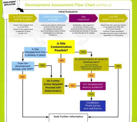
Figure 2 - development assessment flowchart
Initial Evaluation – Matters for Consideration
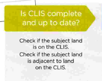
Figure 3 - determining if the property is on the
Contaminated Lands Information System (CLIS)
The subject land is not on
Council’s Local CLIS. It is not recorded on the EPA Register as being
contaminated.

Figure 4 - checking previous reports
There are no reports on the
CLIS relevant to this matter.
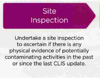
Figure 5 - site inspections
There is no physical evidence to
suggest a likely source of contamination. There are no sheds, sheep dips or
spray dumps, and perusal of the historical aerial photography does not reveal
the presence of such structures in previous times. The site has no prior
history as a site used for intensive plant agriculture. It has been used for
grazing on a very limited basis (hobby farming basically) for perhaps twenty
years. Before that it is believed to have been also used for more serious
general grazing.

Figure 6 - site history
The previous land uses of this site are reflected in the
absence of structures on the site and its use for extensive agriculture over an
extended period. There is no relevant history recorded in Council’s
records. Its prior land uses are based on site observation and such deduced
history does not suggest that the site has any significant contamination
issues.
However, the existing land use for extensive agriculture is
included in Appendix A of the quick reference guide as a potential source
of contamination. This observation needs, however, to be further considered
against the provisions contained in the Contamination Central draft policy in
section 11.3, which states:
“land used for extensive
agriculture should be assessed for site contamination where development
applications relate to redevelopment in the vicinity of stock yards, stock
dip or farm sheds where fuel or chemicals have been stored or handled”.
As previously alluded to the site was previously used for
extensive agriculture, but the site does not have any of the triggers contained
in the bolded part of the above-described clause. It appears to have been used
solely as grazing land.
It is considered unlikely given the above analysis that the
site is contaminated. However, notwithstanding the above assessment, it is
recommended that a condition be attached to the Notice of Determination
requiring soil sampling for analysing chemical residue be undertaken for the
residential allotments in a manner and frequency as determined by an
appropriately qualified and experienced consultant, giving consideration to
specific uses and onsite characteristics of the site. The results of the
testing will be required to be provided to the Principal Certifying Authority
and are to demonstrate that the land is suitable for residential use to enable
the Subdivision Certificate to be released.
PROVISIONS OF ANY DRAFT
ENVIRONMENTAL PLANNING INSTRUMENT THAT HAS BEEN PLACED ON EXHIBITION
s79C(1)(a)(ii)
There are no draft environmental planning instruments that
apply to the subject land or proposed development.
DESIGNATED DEVELOPMENT
The proposed development is not designated development.
PROVISIONS OF ANY DEVELOPMENT
CONTROL PLAN s79C(1)(a)(iii)
Development Control Plan 2004
Development Control Plan 2004 (“the DCP”)
applies to the subject land (Part 7). An assessment of the proposed
development against the relevant Planning Outcomes will be undertaken below.
Pursuant to Planning Outcome 0.2-1 Interim Planning Outcomes
- Conversion of Zones:
· Throughout this
Plan, any reference to a zone in Orange LEP 2000 is to be taken to be a
reference to the corresponding zone(s) in the zone conversion table.
The subject property was zoned Residential 2(a) under LEP
2000, and with the adoption of LEP 2011 the subject property was
classified as R2 Low Density Residential, which is an equivalent zoning to the
previous land classification. It is noted that the site is not subject to any
DCP masterplan.
It is appropriate to apply such parts of Chapter 7 of the
DCP as are applicable to the subdivision in the assessment. Additionally, the
general provisions of Chapters 2 (Natural Resource Management) and
3 (General Considerations) have relevance with respect to cumulative
impacts and scenic landscape issues.
Part 2 -
Natural Resource Management
The DCP states:
Development
that concentrates, redirects flows, increases flow rates or disturbs land in
close proximity to creeks has the potential to affect waterways with associated
erosion, sedimentation and release of nutrients, which combine to affect
downstream water quality. Erosion appears to be particularly prevalent within
the “North Orange” red earth soil types.
Urban stormwater has also been identified
as a significant source of water pollutants. Uncontrolled stormwater flows from
urban development has the potential to contribute to downstream impacts,
including periodic flooding, erosion, sedimentation and reduced in‑stream
water quality.
Orange City Council’s Drainage
Strategy was adopted by Council on 19 June 1997 to identify measures
required to control stormwater flow velocities and volumes.
Conditions are included that require the
design and provision of a stormwater management system that minimises erosion,
controls outflows and requires water quality to be at least as good as the best
water currently being discharged from the site as a vacant allotment.
Part 3 -
General Considerations
The applicant has responded to the site
constraints in a way generally satisfactory to environmental issues affecting
this site. The issues of slope, character, open space, linkages, proximity to
the NDR and Council’s plans for road re-design have been generally
responded to co-operatively by the applicant.
With regard to cumulative impacts, the DCP
requires that applicants demonstrate how the development relates to the
existing character of the locality. In this instance the character is generally
residential.
There are significant vegetation remnants
evident on the site. There is a major transport link in the form of the NDR
immediately to the south. Each of these constraints have differing, and
sometimes competing demands on land capability, but as a generalisation the
proposed subdivision responds well to the constraints.
It is accepted that the proposed
development is generally consistent with the lot sizes and subdivision patterns
of the residential subdivisions that are nearby. Within that context and in the
absence of any specific master planning in the DCP, it cannot be strongly
argued that the proposed development is vastly inconsistent with the expected
future character of the locality.
The proposed roads layout is considered
functional, but not ideal. The applicant has not included connections for the
site to the housing commission neighborhood located to the west. The preferred
roads layout in the DCP is to utilize a modified grid layout, which recommends
that connectivity between neighborhoods be provided. There will be a level of
disconnection between the two areas as a result. Further opportunity to provide
such connection will arise should the large Lot 29 be the subject of further
development in the future.
The site has been given a zone that
dictates what is appropriate to the site. The proposed development meets that
standard. The density and lot size are urban residential. There are no
significant land use conflicts likely to arise as a result of the proposed
development viz its nearby and surrounding land use patterns.
Part 7 -
Development in Residential Areas
General Principles
The DCP in its preliminary instructions includes the
following guidelines for design of urban residential subdivisions, based on
Department of Planning Urban Design guidelines:
“The Urban
Form publication identifies the following issues for future development of
the City:
· The square grid
of 200 m blocks and the open space system along the creek lines are the most
important features of Orange’s urban identity.
· Maintaining
this pattern in new development will allow uninterrupted view lines, and offer
variety as the streets traverse the topography. It will also result in the
efficient provision of services and permeable pedestrian routes.
· Expanding open
space along natural creek lines and in associated parks will increase amenity,
provide environmental buffer zones, allow for drainage control structures and
help people orient themselves by being able to read the landscape.
· Laneways that
have been introduced through the original blocks as a cul-de-sac can be
extended to give pedestrian or vehicular access across the blocks.
· As the town
grows, radial expansion will require cross connections to assist the movement
between outer suburbs.
The
distribution of facilities such as schools and places of worship in existing
development suggest similar distribution will be required near new residential
development, ie, within a five- to ten-minute walking distance from every
home”.
It is considered that the revised design responds positively
to the majority of these urban design principles. As previously noted, the
proposed street layout is not ideal, because there is a noticeable lack of
connectivity to the suburb located to the west. However the proposed road
system that is proposed is functional from the point of view of traffic
management, and potential does remain on the site for connections to be
provided to the west at some point in the future if Lot 29 is further
subdivided or developed beyond a single dwelling.
Subdivision in LGA not forming
part of a Masterplan Area
Subdivision – Lot Sizes and
Battleaxe Lots
Residential lots in Orange are
predominantly between 600 and 900m2 in area. In recent years, the
average residential lot size has reduced from about 800 square metres to
about 750m2.
This DCP
establishes guidelines for residential subdivision.
Standard Lot 500m2
or greater
Cottage Lot >350
and <500m2
Town House
Lot 250 to 350m2
The submitted plans show all the proposed
lots to be “Standard Lots”. There are no additional information
requirements for standard lots as the assumption is that there are no
particular difficulties in locating a standard detached dwelling on lots of
this size.
There are no battleaxe allotments proposed
under this application.
Corner Lots
Corner lots should be designed to
provide for a house facing one street. Where dual occupancy development is
proposed on a corner lot, each dwelling should face a different street.
The proposed development is consistent with
this principle.
Dual Occupancy
and Unit Sites
Dual occupancies in the R2 zone are
permissible with consent. Under Clause 4.1B of the OLEP, a minimum lot size of
800m2 is applicable. However, as there are no minimum lot sizes, a
future development in which the subdivision precedes the dwelling houses is
permissible on any lot, subject to satisfactory merit assessment.
Subdivision
Layouts
The Department of Urban Affairs and
Planning’s Urban Design Advisory Service publication on Urban Form
describes the influences on, and effects of, the urban pattern of Orange
as a Case Study.
Department of Urban Affairs and
Planning’s Urban Form concludes that:
... the city
is well contained within a multiple of the original square mile grid and no
significant subdivision has occurred along the roads into town. Some
subdivisions have occurred at the edges of the city, with curvilinear streets
and cul-de-sac. Nearer the city there are very small blocks, shallow with a
relatively wide frontage, which express the current fashion where a wide street
address is more important than a big backyard.
The Urban Form publication
identifies the following issues for future development of the City:
· The square grid
of 200m blocks and the open space system along the creek lines are the most
important features of Orange’s urban identity.
· Maintaining
this pattern in new development will allow uninterrupted view lines, and offer
variety as the streets traverse the topography. It will also result in the
efficient provision of services and permeable pedestrian routes.
· Expanding open
space along natural creek lines and in associated parks will increase amenity,
provide environmental buffer zones, allow for drainage control structures and
help people orient themselves by being able to read the landscape.
· Laneways that
have been introduced through the original blocks as cul-de-sac can be extended
to give pedestrian or vehicular access across the blocks.
· As the town
grows, radial expansion will require cross connections to assist the movement
between outer suburbs.
· The
distribution of facilities such as schools and places of worship in existing
development suggest similar distribution will be required near new residential
development, ie, within a five- to ten-minute walking distance from every home.
The return to a modified grid layout in
preference to the 1970’s urban-planning theories of curvilinear streets
and associated cul-de-sacs has become more recently promoted in the City, such
as in the layout for Ploughmans Valley. This principle will continue to be
emphasised for the planning for new release areas for the foreseeable future.
A modified grid layout not only provides
for more efficient servicing of residential land, views and improved connections
between residential areas, the grid pattern is also consistent with energy
efficiency principles. Orientation of boundaries along the north‑south
and east-west axes encourages solar design of houses. Lots facing east or west
need to be wider to promote northern sunlight.
In this case the layout is not ideal as the
applicant does not wish to provide neighbourhood connections as the adjoining
suburb to the south-west has not been proposed. This issue has been raised with
the applicant, but they do not wish to construct street connections to this
area. Adequate neighbourhood connections are available to the site from the
south‑east via Sophie Drive, though it is noted that the distance to the
road in the collector category is fairly long. Council’s Technical
Services have reviewed this layout and are satisfied that it can function
adequately.
Orange
Subdivision Code
Council Technical Services Division is principally
responsible for the application of the Subdivision Code. Technical Services
have not raised objection to the submitted layout, and have imposed a suite of
conditions to ensure that the development is carried out in accordance with the
Subdivision Code requirements.
Planning Outcomes
|
PO 7.2-1 PLANNING OUTCOMES FOR URBAN
RESIDENTIAL SUBDIVISION
|
|
Item
|
Performance Standard
|
Compliance
|
|
1
|
Subdivision layouts in areas zoned Urban
Residential prior to this plan are generally in accordance with the
applicable plan maps in Appendix 1.
|
There are no layout masterplans for this
site.
|
|
2
|
Lots are orientated to optimise
energy-efficiency principles.
|
It will generally be possible to
incorporate Energy efficient principals into future development on the
proposed lots.
|
|
3
|
New roads are planned according to
modified grid layouts with restrained use of cul-de-sac roads in new
developments according to the UDAS Urban Form principles for Orange.
|
The proposed roads layout does not
propose a modified grid layout because of the lack of connections to the
adjoining neighbourhood to the west. Potential exists for such
connections to be provided in the future.
|
|
4
|
Local open space is provided along creek
corridors to create open space linkages for environmental conservation and
social interaction. Release areas removed from creeks provide for open-space
links incorporating substantial stands of native vegetation.
|
There are no creek systems traversing the
site.
|
|
5
|
Release areas indicate trunk cycle and
pedestrian ways that link the area to major open space networks and activity
centres (schools, shopping centres and employment areas).
|
There is no masterplans applicable to
this site. As such, pedestrian links, open space networks and cycle paths are
not required.
|
|
6
|
Lots below 500m2 indicate a
mandatory side setback to provide for solar access and privacy.
|
No lots below 500m2 are proposed, however the
conditions for road treatments are likely to cause lot 22 to be reduced to
below this area. Whilst specific detail on the configuration of this lot is
not known at this stage, there are other examples elsewhere within the City
where small lots can be effectively developed with smart urban designs.
|
|
7
|
Lots below 350m2 indicate
existing or planned house layouts, which identify how privacy, solar access,
vehicular access and private open-space needs are to be achieved.
|
No lots below 350 m2 are proposed. It is considered
unlikely that lot 22 will be so significantly affected as to reduce its area
to this level.
|
|
8
|
Up to 25% of new subdivisions comprise
small lots in dispersed locations
|
No small lots proposed.
|
|
9
|
Lots are fully serviced and have direct
frontage/access to a public road.
|
Conditions are included in the consent to
require these outcomes.
|
|
10
|
Design and construction complies with the
Orange Development and Subdivision Code
|
The proposed development will comply with
the subdivision code.
|
|
11
|
Corner lots provide for a house to front
one street
|
The proposed corner lots (lots 3, 12 and
13) have a short and a long boundary, which conforms to this principal.
|
|
12
|
Battleaxe lots provide an adequate
accessway width for the number of dwellings proposed to be served in order to
allow for vehicle and pedestrian access and location of services
|
There are no battleaxe lots proposed for
this development.
|
|
13
|
Lots proposed to be used specifically for
dual occupancy or units in new residential areas are identified on
development application plans to inform prospective purchasers of the mixed
residential form of the area and measures are outlined on how prospective
residents are to be informed of these identified sites prior to purchasing
land.
|
Four lots have been identified within the subdivision
as being directly suitable for dual occupancy. Three of the lots
identified are located on corner allotments which provides opportunity for
access to be provided to both streets. The subject lots are ideally located
on the northern side of the street to maximise access to northern sunlight
into principle living spaces. The forth lot is located on a large residential
parcel. No objections. It should be noted that the LEP specifies a
minimum lot size of 800m2 for dual occupancy except where otherwise
specified. Approximately 20 of the proposed lots within the subdivision
have areas exceeding 800m2.”
|
DEVELOPMENT CONTRIBUTIONS
Section 94 Contributions
The subject land comprises three existing lots. The proposed
subdivision plan shows 29 residential lots and 1 drainage reserve lot,
resulting in a 26 lot yield for future development
Pursuant to Orange Development Contributions Plan 2017, the
following contributions have been levied for the subject development and are
attached as a condition of consent.
The payment of contributions as
per the following shall be made to Council in accordance with Section 94 of the
Act and the Orange Development Contributions Plan 2017 (development in LGA
Remainder Area) towards the provision of the following public facilities:
|
Open Space and Recreation
|
@ $3,868.46 x 26 additional lots
|
100,579.96
|
|
Community and Cultural
|
@ $1,121.86 x 26 additional lots
|
29,168.36
|
|
Roads and Traffic Management
|
@ $5,106.25 x 26 additional lots
|
132,762.50
|
|
Plan Preparation and Administration
|
@ $302.90x 26 additional lots
|
7,875.40
|
|
TOTAL
|
|
$270,386.22
|
The contribution will be indexed quarterly in accordance with
the Orange Development Contributions Plan 2017 (development in LGA Remainder
Area). Attached is a condition of consent requiring the payment of the Section
94 Contributions prior to the issue of a Subdivision Certificate.
Section 64 Water and Sewer Headwork
Charges
In contrast to Section 94 contributions which can apply a
credit for the three existing lots, no credits are applicable for Section 64
Water and Sewer Headworks charges, as the existing lots that are subject to the
proposed development have no access to water and sewer services.
Section 64 water and sewer headwork charges are also
applicable to the proposal. Such charges are calculated at the time of a
Construction Certificate for the proposed development. Attached are draft
conditions requiring the payment of the required contribution prior to the
issue of a Subdivision Certificate.
PROVISIONS PRESCRIBED BY THE
REGULATIONS s79C(1)(a)(iv)
The development is not inconsistent with the provisions
prescribed by the regulations.
THE LIKELY IMPACTS OF THE
DEVELOPMENT s79C(1)(b)
Major Site Constraints – Suitability for
Residential Subdivision
NDR Noise
A report submitted with the application by noise consultants
Wilkinson Murray measured noise levels in most potentially affected habitable
spaces using a predictive tool based on the following assumptions:
· dwellings are
established as close as 1m to the boundary
· dwellings are
single storey
· windows could be
left open.
No boundary fences were factored into the assumptions for
the prediction model.
The report concludes that based on the assumptions stated
above, the predicted internal noise levels in bedrooms and other habitable
spaces can be constructed so that the internal noise levels do not exceed
40dBA. This is the accepted industry standard for restful slumber for
residential development.
The principal source of noise disturbance for the
residential subdivision will emanate from the NDR. The abovementioned
report by Wilkinson Murray was viewed by Council’s Manager Building and
Environment (who has the necessary experience to competently review noise
reports and noise issues) with the following brief comments provided:
I confirm that I have assessed
the noise assessment undertaken by Wilkinson Murray – Report 17366
Version A dated December 2017.
I am satisfied that the
proposed subdivision would comply with the noise requirements that arise from
the ISEPP.
I note that the study only
considered single storey residential development.
Therefore the consent should
have a condition that restricts residential development within the proposed
subdivision to single storey, unless an individual acoustic assessment is
undertaken for the specific dwelling. Noise levels within such a proposed
dwelling must not exceed 35 dB(A) in bedrooms between 10pm and 7am and 40 dB(A)
elsewhere in the building (other than a garage, kitchen, bathroom or hallway)
It may be best to have this
restriction on the 88b instrument – thus condition this.
It is considered that, subject to the imposition of
conditions the proposed development will not suffer from excessive noise
intrusion.
Biodiversity
Council LEP mapping layers do not show the site to contain
Environmentally Sensitive Areas (ESAs). However, site inspection confirms
the existence of a small area of very high value bush, including a rare intact
understorey layer along the south-western boundary.
There is a less significant remnant along the southern
boundary of Lot 33.
Other remnants do exist on the site but suffer from
excessive weed infestation. The native tree stands have been deformed by the
excessive competition posed by the invasive species that surround them,
resulting in slender and weak trunk structure. These other tree stands have
virtually no intact understorey.
There are also several large single “paddock”
trees slightly to the north, which appear to be active as seed banking trees,
as there are several small saplings evident around each of these trees. These
individual trees are also likely to provide transit points for juvenile avian
species as they transit to larger tree stands in the district. These trees are
too large to be practically accommodated on the lot sizes proposed. These
individual tree specimens are located on proposed Lots 15, 26 and 27.
The subject property itself has limited to moderate connectivity
to more significant surrounding vegetation, but establishing the importance of
the remaining remnant as a link in the overall remaining biodiversity network
is problematic. On the basis of location and on site observation, it is
considered to have low importance as a transit point in the remaining network.
The amended plan, subject to the imposition of certain
conditions (which the applicant has agreed to the imposition of), does not
incorporate key threatening processes within the subdivision. Some significant
isolated paddock trees will be lost as a result of the development. These trees
are not considered to form an EEC in their own right due to their relative
isolation, but they do provide seed banking opportunities and possibly act as
waypoints for juvenile avian species. To offset the loss of these significant
bits of vegetation, it is considered appropriate to impose a requirement for
replacements to be planted. It will take a long time for the replacement trees
to reach a level of maturity, such that they could be considered replacements
for the trees to be removed, but it is nevertheless a reasonable compromise and
considered worthwhile to require replacements for the trees to be removed (or
likely to be removed) from the site.
The major biodiversity value of the site is the small
thickets located at the southern end of the site. The applicant has amended the
proposal so that the two southern blocks have restrictive building envelopes on
them and the blocks large enough to facilitate the conservation of those large
thickets on the site. Additional conditions are imposed preventing the planting
of introduced species on these lots in their gardens and limiting future
buildings to within the approved envelopes.
The conditions included in the attached notice of
determination were referred to Council’s Manager - City Presentation, for
advice and comment. He has responded as follows:
“I concur with the
proposed consent conditions especially the erection of TPZ fencing prior to the
issue of a CC and the boundary adjustment proposed for lots 28 and 29. The TPZ
fencing condition in itself should, if enforced correctly, ensure sound
protection of the remnant woodland vegetation and understory.
With regard to the condition
about replanting of trees in place of the loss of the two remnant Ribbon Gums (Eucalyptus
viminalis) located on proposed lots 13/14 and 25/26. Your condition
should, apart from identify that 20 tubestock sized eucalypts (of the Box Gum
Woodland naturally occurring in Orange) are to be planted in Plowman Park,
specify that they are to be maintained for a 12 month period and any losses
during this time are to be replaced at the applicants expense and that adequate
tree protection guards shall be installed to the satisfaction of Council’s
Manager City Presentation.
I would also condition that
the developer is to undertake the judicious removal of Priority weeds from lots
28 and 29 (outside of the proposed building envelopes) to improve the health of
the remnant woodland, ie removal of Priority Weeds including privet,
blackberry, cotoneaster, hawthorn etc using appropriate bush regeneration
techniques such as hand removal and cut and paint methods. Such a condition
will assist with improving the understory condition and maintaining species
diversity, through removal of woody weed competition”.
Traffic and Road Connectivity
The subject land consists of three separate Torrens lots
(Lots 30, 31 and 33). Each lot has its own access to a public
road as is required for Torrens lots. Lot 30 is accessed from Tarawell
Crescent, Lot 31 is accessed from Margaret Street/Sophie Drive, and Lot 33
is accessed from Maramba Rd. The original housing commission subdivision of
adjoining land to the west which created the subject lots planned for the
continuation of the road network into each lot.
The applicant proposes to consolidate the three lots and
provide sole public road access from Sophie Drive. The proposed
subdivision layout has been designed in such a way as to not provide access or
connection through to Tarawell Crescent or Maramba Road as originally
envisaged. These roads at the present time exist as road stubs left over when
the Department of Housing developed the residential subdivisions to the west,
and were intended to provide connections between the Department of Housing
subdivision and the subject land.
Council’s Technical Services Division advise that the
capacity of the road network (Sophie Drive) in the vicinity of the site is
sufficient to accommodate additional localised traffic generated by the
development, or the likely additional traffic that future developments on the
subdivided lots are likely to generate. Council’s Technical Services
Division have recommended given the design of the development that the existing
public roads serving (existing) Lots 30 and 33 be required to be terminated
with a turn bay capable of accommodating a 12.5m heavy rigid vehicle (garbage
truck/fire engine). Conditions relating to the construction of the turn bays
have been applied. The turn bays are required to be constructed prior to the
release of Lots 13 to 29.
As previously noted, the proposed street layout is not
ideal, because there is a noticeable lack of connectivity to the suburb located
to the west. However the proposed road system that is proposed is functional
from the point of view of traffic management, and potential does remain on the
site for connections to be provided to the west at some point in the future if
Lot 29 is further subdivided.
Conditions are considered necessary and are included in the
attached consent preventing access for the individual lots directly onto either
the NDR or William Maker Drive.
Cumulative Impacts
The proliferation of low density residential development on
the fringe of the City is a reflection of the urban growth of Orange, which is
currently being achieved by an expansion of residential land into the
surrounding lower density rural and non-urban land.
A continuation of green field residential subdivisions
satisfies the market demand, but is likely to result in community isolation
from transport facilities and services due to the increase in distance from
employment areas and the Central Business District (CBD). Continued reliance on
green field’s development on the urban fringes also tends to be high in
terms of biodiversity conservation. Because of the distances, a continuation on
motor vehicle reliance is likely to be reinforced by developments such as the
subject application.
On the other hand, the development of a new estate creates
opportunities for home ownership, improves housing stock quality from an
aesthetic point of view and promotes economic activity in the building
industry.
THE SUITABILITY OF THE SITE
s79C(1)(c)
The subject property has significant natural features, being
the vegetation remnants. These are adequately allowed for in the subdivision
design.
The subject property will be significantly reliant on motor
vehicles for access to most facilities and amenities, and this should be seen
as a negative to the overall amenity and ambience the site will generate. To
achieve satisfactory levels of amenity it is considered highly desirable to
provide pedestrian linkages to the open space network, though at the present
time no plans are in place to do this.
Overall, the applicant has adequately demonstrated that the
site is suitable for the proposed development. Attached to the Notice of
Determination are a suite of conditions considered appropriate to ensure that
the development proceeds in an acceptable manner.
Naturally Occurring Asbestos
The subject land is contained within an area of naturally
occurring asbestos. Conditions are recommended requiring an asbestos management
plan be prepared and implemented for the development.
Council’s Environmental Health and Building Surveyor
has included the following standard condition in the development consent to
manage the likely presence of Naturally Occurring Asbestos in this locality:
The site is located within an
area identified as containing serpentinite rock formations, which can contain
chrysotile, a naturally occurring asbestos. Therefore the applicant or person
with management or control of the site shall ensure that a written plan (an Asbestos
Management Plan) for the site is prepared in accordance with the provisions
of the Work Health and Safety Act 2011 and Work Health and Safety
Regulation 2011.
To assist applicants with
developing an Asbestos Management Plan, applicants are encouraged to access the
‘Asbestos Management Plan for Orange City Council 2014’, which is
available on Council’s website: www.orange.nsw.gov.au
ANY SUBMISSIONS MADE IN
ACCORDANCE WITH THE ACT s79C(1)(d)
The proposed development is not defined as advertised
development under the provisions of the LEP, and as such no formal exhibition
of the application was required. No submissions have been received in relation
to this application.
PUBLIC INTEREST
s79C(1)(e)
The proposed development is considered to be of minor
interest to the wider public due to the relatively localised nature of
potential impacts. The proposal is not inconsistent with any relevant policy
statements, planning studies, guidelines etc that have not been considered in
this assessment.
SUMMARY
The proposed development is permissible with the consent of
Council. The proposed layout is functional in terms of its road layout, however
Council’s DCP encourages the development of land based on the principle
of achieving a modified grid layout rather than a series of cul-de-sacs. The
applicant has requested that Council not insist upon a connection being
provided through to the adjoining housing commission area further to the west
at this time. The design of the subdivision is such that there remains the
possibility if Council was of the view to support the development as submitted
to provide a road and footway connection through to the adjoining land in the
future if proposed Lot 29 (comprising an area of 11,638m²) is further
developed. A Section 79C assessment of the development indicates that the
development is acceptable in this instance. Council’s Technical Services
Department have indicated support to the concept as proposed. Attached is a
draft Notice of Approval outlining a range of conditions considered appropriate
to ensure that the development proceeds in an acceptable manner.
COMMENTS
The requirements of the Environmental Health and Building
Surveyor and the Engineering Development Section are included in the attached
Notice of Approval.
Attachments
1 Notice
of Approval, D18/3470⇩
2 Plan,
D18/3487⇩
Planning
and Development Committee
6 February 2018
2.4 Development
Application DA 247/2017(1) - Tarawell Crescent and Margaret Road
Attachment 1 Notice of Approval
|
|
ORANGE
CITY COUNCIL
Development
Application No DA
247/2017(1)
NA18/ Container
PR13530
|
NOTICE OF DETERMINATION
OF A DEVELOPMENT
APPLICATION
issued under the Environmental
Planning and Assessment Act 1979
Section 81(1)
|
Development
Application
|
|
|
Applicant Name:
|
Westacre
Developments Pty Ltd
|
|
Applicant Address:
|
C/- Peter
Basha Planning and Development
ORANGE
NSW 2800
|
|
Owner’s Name:
|
Westacre
Group Developments Pty Limited
|
|
Land to Be Developed:
|
Lots 30 and 31 DP
246174, Lot 33 DP 1055815 - Tarawell Crescent and Margaret Road, Orange
|
|
Proposed Development:
|
Subdivision
(30 lot residential)
|
|
|
|
|
Building
Code of Australia
building
classification:
|
Not
applicable
|
|
|
|
|
Determination
|
|
|
Made On:
|
6 February
2018
|
|
Determination:
|
CONSENT
GRANTED SUBJECT TO CONDITIONS DESCRIBED BELOW:
|
|
|
|
|
Consent to
Operate From:
|
7 February
2018
|
|
Consent to
Lapse On:
|
7 February
2023
|
Terms of Approval
The reasons for the imposition of
conditions are:
(1) To ensure a quality
urban design for the development which complements the surrounding environment.
(2) To maintain
neighbourhood amenity and character.
(3) To ensure compliance
with relevant statutory requirements.
(4) To provide adequate
public health and safety measures.
(5) Because the development
will require the provision of, or increase the demand for, public amenities and
services.
(6) To ensure the utility
services are available to the site and adequate for the development.
(7) To prevent the proposed
development having a detrimental effect on adjoining land uses.
(8) To minimise the impact
of development on the environment.
Conditions
(1) The
development must be carried out in accordance with:
(a) Plans
by Peter Basha Planning referenced 10036DA sheet 3A dated 7 November 2017
(1 sheet)
(b) statements
of environmental effects or other similar associated documents that form part
of the approval
as amended
in accordance with any conditions of this consent.
(2) A sign is to be erected
in a prominent position on any site on which building work, subdivision work or
demolition work is being carried out:
(a) showing
the name, address and telephone number of the principal certifying authority
for the work, and
(b) showing
the name of the principal contractor (if any) for any building work and a
telephone number on which that person may be contacted outside working hours,
and
(c) stating
that unauthorised entry to the site is prohibited.
Any such sign is to be maintained while the
building work, subdivision work or demolition work is being carried out.
(3) Where any excavation
work on the site extends below the level of the base of the footings of a building
on adjoining land, the person having the benefit of the development consent
must, at the person’s own expense:
(a) protect
and support the adjoining premises from possible damage from the excavation,
and
(b) where
necessary, underpin the adjoining premises to prevent any such damage.
Note: This
condition does not apply if the person having the benefit of the development
consent owns the adjoining land or the owner of the adjoining land has given
consent in writing to this condition not applying.
|
PRIOR TO THE ISSUE OF
A CONSTRUCTION CERTIFICATE
|
(4) The installation of
protective fencing in accordance with AS 4970-2009 is required around the
protected vegetation areas, prior to the issue of a construction certificate
for the subdivision.
(5) A minimum of 20 native
species that are to be approved by Council’s Manager – City
Presentation prior to planting as replacement species for the large paddock
trees located in the vicinity of proposed lots 13, 14, 25, 26 and 27 of the
subdivision. The replacements shall be provided on a like for like basis to
those to be removed and shall be planted prior to the issue of the Construction
Certificate. The replacement species shall be planted in the public open
space on the western side of Lot 29 (generally within Lot 48 DP258905,
known to Council as Plowman Park) or such other location as is nominated by the
Manager City Presentation.
(6) Engineering plans,
showing details of all proposed work and adhering to any engineering conditions
of development consent, are to be submitted to, and approved by, Orange City
Council or an Accredited Certifier (Categories B1, C3, C4, C6) prior to the
issuing of a Construction Certificate.
(7) A water and soil
erosion control plan is to be submitted to Orange City Council or an Accredited
Certifier (Categories B1, C3, C4, C6) for approval prior to the issuing of a
Construction Certificate. The control plan is to be in accordance with the
Orange City Council Development and Subdivision Code and the Landcom, Managing
Urban Stormwater; Soils and Construction Handbook.
(8) The
development’s stormwater design is to include stormwater detention within
the development, designed to limit peak outflows from the land to the
pre-existing natural outflows up to the 100 year ARI frequency, with sufficient
allowance in overflow spillway design capacity to safely pass flows of lower
frequency (that is, a rarer event) without damage to downstream developments.
Where appropriate, the spillway design capacity is to be determined in
accordance with the requirements of the Dam Safety Committee.
The design of the detention storage is to be
undertaken using the ILSAX/DRAINS rainfall-runoff hydrologic model or an
approved equivalent capable of assessing runoff volumes and their temporal
distribution as well as peak flow rates. The model is to be used to calculate
the flow rates for the existing and post-development conditions.
The developed flows are to be routed through
the proposed storage within the model so that the outflows obtained are no greater
than the flows obtained for the pre-existing natural flows. A report detailing
the results of the analysis, which includes:
· catchment
plan showing sub-catchments under existing and developed conditions;
· schematic
diagram of the catchment model showing sub areas and linkages;
· tabulation
detailing the elevation, storage volume and discharge relationships; and
· tabulation
for the range of frequencies analysed, the inflows, outflows and peak storage
levels for both existing and developed conditions;
together with copies of the data files for the
model and engineering design plans of the required drainage system are to be
submitted to Orange City Council upon application for a Construction
Certificate.
(9) The proposed
lots are to be provided with interlot stormwater drainage, including those lots
abutting public land, where the surface of the entire lot cannot be drained to
the kerb and gutter at the lot frontage. A grated concrete stormwater pit is to
be constructed within each lot provided with interlot stormwater drainage.
Engineering plans for this drainage system are to be approved by Orange City
Council or an Accredited Certifier (Categories B1, C3, C4, C6) prior to the
issuing of a Construction Certificate.
(10) Stormwater from the
proposed on-site detention basin is to be piped to the existing 900mm diameter
stormwater pipe in the NDR road reserve. Engineering plans of this required
drainage system are to be approved by Orange City Council or by an Accredited
Certifier (Categories B1, C3, C4, C6 prior to the issuing of a Construction
Certificate.
(11) A 150mm-diameter sewer
main is to be constructed from Council’s existing main to serve the
proposed lots. Prior to a Construction Certificate being issued engineering
plans for this sewerage system are to be submitted to and approved by Orange
City Council.
(12) A water reticulation
analysis is to be carried out by Orange City Council on any proposed water
reticulation system for the development. Engineering plans are to be
submitted to and approved by Orange City Council prior to the issue of a
Construction Certificate.
The reticulation system is to be designed to
supply a peak instantaneous demand by gravity of 0.15 L/s/tenement at a
minimum residual head of 200kPa.
(13) Tarawell Crescent and Maramba
Roads shall be terminated with an appropriate turn bay suitable for a 12.5m
heavy vehicle. The turn bay may be partly located within the existing road
reserve. Stormwater drainage from the turn bay is to be connected to the
inter-allotment drainage system for the proposed lots.
Construction
of the turn bays shall be completed prior to the release of Lots 13 to 29.
Engineering
plans are to be submitted to Orange City Council and approved prior to the
issue of a Construction Certificate.
|
PRIOR TO WORKS
COMMENCING
|
(14) A
Construction Certificate application is required to be submitted to, and issued
by Council/Accredited Certifier prior to any excavation or building works being
carried out onsite.
|
DURING
CONSTRUCTION/SITEWORKS
|
(15) Replacement plantings
elsewhere required under this consent are required to be nurtured and protected
by the applicant during the construction period, up to the day of release of
the subdivision certificate. The applicant, or his agent is obligated to water
the plant, control weeds and replace any losses from these trees until such
time as the subdivision certificate has been released.
(16) The site is located
within an area identified as containing serpentinite rock formations, which can
contain chrysotile, a naturally occurring asbestos. Therefore the applicant or
person with management or control of the site shall ensure that a written plan
(an Asbestos Management Plan) for the site is prepared in
accordance with the provisions of the Work Health and Safety Act 2011 and
Work Health and Safety Regulation 2011.
To assist applicants with developing an
Asbestos Management Plan, applicants are encouraged to access the ‘Asbestos
Management Plan for Orange City Council 2014’, which is
available on Council’s website: www.orange.nsw.gov.au
(17) Any adjustments to
existing utility services that are made necessary by this development
proceeding are to be at the full cost of the developer.
(18) The
provisions and requirements of the Orange City Council Development and
Subdivision Code are to be applied to this application and all work constructed
within the development is to be in accordance with that Code.
The developer is to be entirely responsible for
the provision of water, sewerage and drainage facilities capable of servicing
all the lots from Council’s existing infrastructure. The developer is to
be responsible for gaining access over adjoining land for services where
necessary and easements are to be created about all water, sewer and drainage
mains within and outside the lots they serve.
(19) Sophie Drive and roads
1 and 2 shall be constructed full width for each stage of the proposed development.
This work is to include road pavement and pavement surfacing, kerb and gutter
construction and earth-formed footpath on both sides of the road.
(20) Concrete footpaths are
to be constructed to the widths and standards stated in the Orange City Council
Development and Subdivision Code including cul-de-sacs where an overland
stormwater drainage path is located at the cul-de-sac bowl.
(21) All proposed
residential lots adjacent to the detention basin and overland flow paths are to
have a minimum freeboard above the 1-in-100-year flood level in accordance with
the Orange City Council Development and Subdivision Code and the
Floodplain Risk Management Plan.
(22) Water and sewerage
reticulation is to be provided to every lot in the proposed residential subdivision
in accordance with the Orange City Council Development and Subdivision Code.
|
PRIOR TO THE ISSUE OF
A SUBDIVISION CERTIFICATE
|
(23) The inter allotment
boundary between Lot 28 and Lot 29 in the subdivision shall be relocated in the
final subdivision plans so that the boundary does not pass through the
significant vegetation on either lot. The plans of subdivision shall
incorporate this requirement. The boundary is required to be set back from the
principal vegetation a minimum of 3 metres.
(24) Prior to the issue of a
fully endorsed subdivision certificate, a Restriction-as-to-User pursuant to
Section 88B of the Conveyancing Act shall be imposed on the titles
of Lots 28 and 29, in favour of Orange City Council , that does not allow the
planting of invasive exotic species on either of these lots, the removal of
fallen timber without permission from Council’s Manager City Presentation,
or the removal of understorey plants from the significant vegetated areas
without the agreement of Council’s Manager City Presentation.
Removal of weeds and introduced species is permitted without approval.
A further restriction as to user is required
limiting the construction of buildings to those areas within the approved
building envelopes as shown on the approved plans.
(25) Soil
sampling for analysing chemical residue is to be carried out within the
proposed Lots in a manner and frequency as determined by an appropriately
qualified and experienced consultant giving consideration to previous specific
uses and on-site characteristics of the site. A NATA registered laboratory
is to carry out such testing. Reference is to be made to the Contaminated
Land Management Act 1997 and State Environmental Planning Policy No 55
- “Remediation of Land”. The results of the testing are to be
provided to the Principal Certifying Authority and are to demonstrate that the
land is suitable for residential use, to enable a Subdivision Certificate to be
issued.
(26) Application shall be
made for a Subdivision Certificate under Section 109(C)(1)(d) of the Act.
(27) Payment of
contributions for water, sewer and drainage works is required to be made
at the contribution rate applicable at the time that the payment is made.
The contributions are based on 29 ETs for water supply headworks and 29 ETs for
sewerage headworks. A Certificate of Compliance, from Orange City Council
in accordance with the Water Management Act 2000, will be issued upon
payment of the contributions.
This Certificate of Compliance is to be
submitted to the Principal Certifying Authority prior to the issuing of a
Subdivision Certificate.
(28) The payment of
contributions as per the following shall be made to Council in accordance with
Section 94 of the Act and the Orange Development Contributions Plan 2017
(Development in LGA Remainder Area) towards the provision of the following
public facilities:
|
Open Space and
Recreation
|
@ $3,868.46 x 26
additional lots
|
100,579.96
|
|
Community and
Cultural
|
@ $1,121.86 x 26
additional lots
|
29,168.36
|
|
Roads and Traffic
Management
|
@ $5,106.25 x 26
additional lots
|
132,762.50
|
|
Plan Preparation and
Administration
|
@ $302.90x 26
additional lots
|
7,875.40
|
|
TOTAL
|
|
$270,386.22
|
The contribution will be indexed quarterly in
accordance with the Orange Development Contributions Plan 2017 (development in
LGA Remainder Area).
(29) Evidence from a
registered NATA laboratory is to be submitted prior to the issuing of a
Subdivision Certificate stating that the filling of all dams and low-lying
areas has been carried out in accordance with Australian Standard 3798-2007.
(30) Application is to be
made to Telstra/NBN for infrastructure to be made available to each individual
lot within the development. Either a Telecommunications Infrastructure
Provisioning Confirmation or Certificate of Practical Completion is to be
submitted to the Principal Certifying Authority confirming that the specified
lots have been declared ready for service prior to the issue of a
Subdivision Certificate.
(31) A Notice of Arrangement
from Essential Energy stating arrangements have been made for the provision of
electricity supply to the development, is to be submitted to the Principal
Certifying Authority prior to the issue of a Subdivision Certificate.
(32) An easement to drain
sewage and to provide Council access for maintenance of sewerage works a
minimum of 2.0 metres wide is to be created over the proposed sewerage works.
The Principal Certifying Authority is to certify that the easement is in
accordance with the Orange City Council Development and Subdivision Code prior
to the issuing of a Subdivision Certificate.
(33) All services are to be
contained within the allotment that they serve. A Statement of Compliance, from
a Registered Surveyor, is to be submitted to the Principal Certifying Authority
prior to the issuing of a Subdivision Certificate.
(34) A Certificate of
Compliance, from a Qualified Engineer, stating that the stormwater retention
basin comply with the approved engineering plans is to be submitted to the
Principal Certifying Authority prior to the issuing of a Subdivision
Certificate.
(35) A
Maintenance Security Deposit, in accordance with the provisions and
requirements of the Orange City Council Development and Subdivision Code, is to
be provided to Orange City Council prior to the issuing of a Subdivision
Certificate.
A Certificate of Compliance, from Orange
City Council, certifying that the maintenance security deposit has been paid,
is to be submitted to the Principal Certifying Authority prior to the issuing
of a Subdivision Certificate.
(36) Where
stormwater crosses land outside the lot it favours, an easement to drain water
is to be created over the works. A Restriction-as-to-User under section 88B of
the NSW Conveyancing Act 1979 is to be created on the title of all
affected lots requiring that no structures are to be placed on the site, or
landscaping or site works carried out on the site, in a manner that affects the
continued operation of the interlot drainage system. The minimum width of the
easement is to be as required in the Orange City Council Development and
Subdivision Code.
(37) Prior to the issuing of
a Subdivision Certificate, a Road Naming Application form is to be completed
and submitted with a plan of the whole development defining the stage being
released - including future road extensions.
(38) Prior to the issue of a
Subdivision Certificate the building envelope on Lot 29 shall be amended to
provide a minimum 2m clearance to the water main and sewer rising main.
(39) Construction of the
Tarawell Crescent and Maramba Road turn bays shall be completed prior to the
release of Lots 13 to 29.
(40) Certification from
Orange City Council is required to be submitted to the Principal Certifying
Authority prior to the issue of a Subdivision Certificate stating that all
works relating to connection of the development to Council assets, works on
public land, works on public roads, stormwater, sewer and water reticulation
mains and footpaths have been carried out in accordance with the Orange City
Council Development and Subdivision Code and the foregoing conditions, and that
Council will take ownership of the infrastructure assets.
(41) A
Restriction as to User under the NSW Conveyancing Act shall be created on the
titles of each residential lot restricting future residential development within the
proposed subdivision to single storey development, unless an acoustic
assessment is undertaken for the specific dwelling on that lot. Noise levels
within such a proposed dwelling must not exceed 35 dB(A) in bedrooms between
10pm and 7am and 40 dB(A) elsewhere in the building (other than a garage,
kitchen, bathroom or hallway). The required restriction shall nominate
Orange City Council as the beneficiary of the restriction as to user, with
power to vary or delete the restriction as required.
(42) All
of the foregoing conditions are to be at the full cost of the developer and to
the requirements and standards of the Orange City Council Development and
Subdivision Code, unless specifically stated otherwise. All work required by
the foregoing conditions is to be completed prior to the issuing of an
Occupation Certificate, unless stated otherwise.
|
MATTERS FOR THE
ONGOING PERFORMANCE AND OPERATION OF THE DEVELOPMENT
|
(43) Aboriginal artefacts or
other indigenous heritage that is discovered during the construction process is
required to be conserved, with all work in the vicinity of the discovered item
being suspended until the appropriate permits have been obtained from the
National Parks and Wildlife Service and the Local Aboriginal Land Council has
been appropriately consulted.
Other Approvals
(1) Local
Government Act 1993 approvals granted under Section 68.
Nil
(2) General
terms of other approvals integrated as part of this consent.
Nil
Right of Appeal
If
you are dissatisfied with this decision, Section 97 of Environmental
Planning and Assessment Act 1979 gives you the right to appeal to the Land
and Environment Court within 6 months after the date on which you receive this
notice.
*
Section 97 of the Environmental Planning and Assessment Act 1979 does not apply
to the determination of a development application for State significant
development or local designated development that has been the subject of a
Commission of Inquiry.
|
Disability Discrimination Act
1992:
|
This application has been assessed in
accordance with the Environmental Planning and Assessment Act 1979. No
guarantee is given that the proposal complies with the Disability
Discrimination Act 1992.
The applicant/owner is responsible to
ensure compliance with this and other anti-discrimination legislation.
The Disability Discrimination Act
covers disabilities not catered for in the minimum standards called up in the
Building Code of Australia which references AS1428.1 - "Design for
Access and Mobility". AS1428 Parts 2, 3 and 4 provides the most
comprehensive technical guidance under the Disability Discrimination Act
currently available in Australia.
|
|
|
|
|
Disclaimer - S88B Restrictions on the Use of Land:
|
The applicant should note that there
could be covenants in favour of persons other than Council restricting what
may be built or done upon the subject land. The applicant is advised to check
the position before commencing any work.
|
|
|
|
|
Signed:
|
On behalf of the consent authority ORANGE
CITY COUNCIL
|
|
Signature:
|
|
|
Name:
|
PAUL JOHNSTON - MANAGER DEVELOPMENT
ASSESSMENTS
|
|
Date:
|
7 February 2018
|
Planning
and Development Committee
6 February 2018
2.4 Development
Application DA 247/2017(1) - Tarawell Crescent and Margaret Road
Attachment 2 Plan
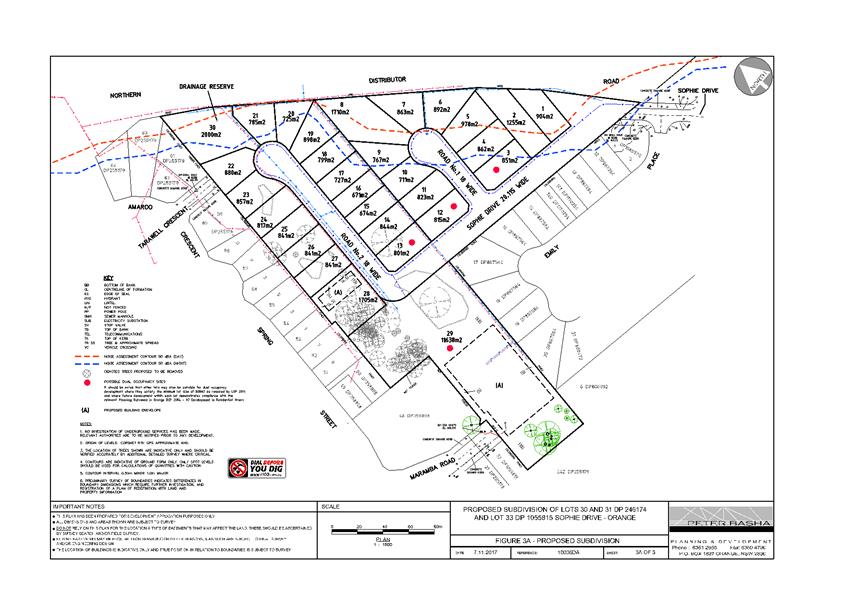
2.6 Complying
Development Certificate Procedures
RECORD
NUMBER: 2018/77
AUTHOR: Mark
Hodges, Manager Building and Environment
EXECUTIVE Summary
Over the past two months staff have been dealing with a home
owner in Casey Street whose property adjoins a site on which approval was
obtained under the delegated authority of Council to construct a two storey
addition to the rear of the existing dwelling. The approved development is
Complying Development under State Environmental Planning Policy (Exempt and
Complying Development Codes) 2008.
A review of the Complying Development Certificate has been
undertaken and it is concluded that the development was complying and therefore
the Certificate had to be issued.
This report has been prepared for Council following a
request from the neighbour to make a presentation to a Council Meeting on his
concerns regarding the State Complying Development process.
It is not proposed to take any further action regarding this
matter. This report informs Councillors of the issue for information.
Link To Delivery/OPerational Plan
The recommendation in this report relates to the
Delivery/Operational Plan strategy “1.1 Our City -
Provide easily obtainable information on the legal responsibilities of
Councillors, Council staff and the community”.
Financial Implications
Nil
Policy and Governance Implications
Nil
|
Recommendation
That the report by the Manager Building and Environment
in relation to Complying Development Certificate Procedures be acknowledged.
|
further considerations
Consideration has been given to the
recommendation’s impact on Council’s service delivery; image and
reputation; political; environmental; health and safety; employees;
stakeholders and project management; and no further implications or risks have
been identified.
SUPPORTING INFORMATION
Over the past two months, staff have been dealing with a
home owner in Casey Street whose property adjoins a site on which approval was
obtained under the delegated authority of Council to construct a two storey
addition to the rear of the existing dwelling.
The approved development is Complying Development under
State Environmental Planning Policy (Exempt and Complying Development Codes)
2008.
A review of the Complying Development Certificate (CDC),
which was issued by Council staff was undertaken. It was concluded that the
development complies with the provisions of the State legislation and it was
therefore appropriate for the CDC to be issued for the works. When a development
complies with this legislation, the Certifying Authority (whether they are a
council or private certifier) must issue the building approval.
A Complying Development Certificate includes standard
conditions of consent that the applicant must comply with whilst undertaking
the development or construction activity. One such requirement is for the owner
to notify all of their neighbours of the impending works. It is understood that
initially, in this particular case, this did not occur. When staff were made
aware that this did not happen, staff contacted the applicant and reminded them
of this requirement. The applicant then notified their neighbours as they were
required to do, albeit after the commencement of works. The neighbour advised
this was a simple oversight.
It should be noted that the neighbour notification process associated
with a CDC is simply a notice so that adjoining land owners are aware that
there are works that have been approved and will soon commence. It does not
provide the neighbours with any rights of objection or veto to the development.
In reviewing the approved development it was concluded that
whilst the house additions were certainly of a modern architectural design, the
additions had been designed with an increased setback to the side boundaries of
some 3-4m and 15m from the rear boundary. Complying Development proposals are
assessed only against the State Policy - Orange Development Control Plan (DCP)
does not apply to this form of development. However, it should be noted that
the works actually comply with the residential provisions within the DCP,
including matters of size, bulk, scale, setback, overshadowing, finishes and
privacy. Certainly the additions are of a modern design, however given their
location and setting of this site, it is more than likely that the proposal
would have been acceptable through the Development Application process.
In addition, a question has been raised by the neighbour as
to whether the Heritage Conservation Area of the City should be enlarged to
include Casey Street. This would effectively apply tighter development
controls to the area for all types of development, including restricting the
application of some forms of Complying Development.
The process is very detailed and takes a number of years to
undertake as it involves significant research, community involvement and
justification. Additionally a Heritage Conservation Area requires amendment of
the DCP and also amendment to the Orange Local Environmental Plan. Council last
commenced a heritage completed a Community Based Heritage Study in 2012 which
looked at all heritage items listed on the Heritage Inventory, including areas
to be included within the Heritage Conservation Area. It would not be common to
undertake such a review again so quickly after the relatively recent completion
of such a significant review. This is not to say that the area has not got a
pleasant character, it is more a reflection on the reality of process and
matters that must be taken into account in order to alter the classification of
lands so that future development is restricted, which as could be expected are
significant and extensive. It is considered that it may be more appropriate to
identify the area for inclusion in any future review of the document.
