
ORANGE CITY COUNCIL
Ordinary Council Meeting
Agenda
22 June 2017
Notice
is hereby given, in accordance with the provisions of the Local Government Act
1993 that a Ordinary meeting of ORANGE CITY COUNCIL
will be held in the Council Chamber,
Civic Centre, Byng Street, Orange on Thursday, 22 June 2017
commencing at 7.00pm.
Garry
Styles
General Manager
For apologies please
contact Michelle Catlin on 6393 8246.
1 Introduction
1.1 Apologies
and Leave of Absence
1.2 Opening
Prayer
1.3 Acknowledgement
of Country
I would like to acknowledge the Wiradjuri people who are the
Traditional Custodians of the Land. I would also like to pay respect to the
Elders both past and present of the Wiradjuri Nation and extend that respect to
other Aboriginal Australians who are present.
1.4 Declaration
of pecuniary interests, significant non-pecuniary interests and less than
significant non-pecuniary interests
The
provisions of Chapter 14 of the Local Government Act, 1993 (the Act)
regulate the way in which Councillors and designated staff of Council conduct
themselves to ensure that there is no conflict between their private interests
and their public role.
The
Act prescribes that where a member of Council (or a Committee of Council) has a
direct or indirect financial (pecuniary) interest in a matter to be considered
at a meeting of the Council (or Committee), that interest must be disclosed as
soon as practicable after the start of the meeting and the reasons given for
declaring such interest.
As
members are aware, the provisions of the Local Government Act restrict any
member who has declared a pecuniary interest in any matter from participating
in the discussion or voting on that matter, and requires that member to vacate
the Chamber.
Council’s Code of Conduct provides that if members
have a non-pecuniary conflict of interest, the nature of the conflict must be
disclosed. The Code of Conduct also provides for a number of ways in which a
member may manage non pecuniary conflicts of interest.
|
Recommendation
It is recommended that Councillors now disclose any
conflicts of interest in matters under consideration by the Council at this
meeting.
|
2 Mayoral
Minutes
Nil
3 Confirmation
of Minutes of Previous Meeting
|
RECOMMENDATION
That the Minutes of the Ordinary
Meeting of Orange City Council held on 6 June 2017 (copies of which were
circulated to all members) be and are hereby confirmed as a true and accurate
records of the proceedings of the Council meeting held on 6 June 2017.
|
|
RECOMMENDATION
That the Minutes of the
Extraordinary Meeting of Orange City Council held on 13 June 2017 (copies of
which were circulated to all members) be and are hereby confirmed as a true
and accurate records of the proceedings of the Council meeting held on 13
June 2017.
|
Attachments
1 Minutes
of the Ordinary Meeting of Orange City Council held on 6 June 2017
2 Minutes
of the Extraordinary Meeting of Orange City Council held on 13 June 2017
ORANGE CITY COUNCIL
MINUTES OF THE
Ordinary Council Meeting
HELD IN Council Chamber, Civic Centre, Byng Street, Orange
ON 6 June 2017
COMMENCING AT 7.00pm
1 Introduction
Cr J Davis OAM (Mayor), Cr J Hamling (Deputy Mayor), Cr A
Brown, Cr K Duffy, Cr R Gander, Cr C Gryllis, Cr R Kidd, Cr S
Munro, Cr G Taylor, Cr R Turner, Cr J Whitton
General Manager, Director
Corporate and Commercial Services, Director Development Services, Director
Community, Recreation and Cultural Services, Director Technical Services,
Manager Administration and Governance, Manager Corporate and Community
Relations, Water and Sewerage Strategic Manager, Manager Building and
Environment, Senior Planner (Drum)
|
RESOLVED
- 17/209 Cr
S Munro/Cr R Gander
That Council allow the
media to record the Council Meeting.
|
|
RESOLVED
- 17/210 Cr
J Hamling/Cr C Gryllis
That the apology be
accepted from Cr N Jones for the Council Meeting of
Orange City Council on 6 June 2017.
|
1.2 ACKNOWLEDGEMENT OF COUNTRY
1.3 Declaration of pecuniary interests, significant non-pecuniary interests and less
than significant non-pecuniary interests
Cr J Davis declared a pecuniary interest in item 2.4 of the
Planning and Development Committee (DA 113/2017(1) – 38-44 Bathurst Road)
as he is the business owner.
Cr J Hamling declared a less than significant non-pecuniary
interest in item 2.4 of the Planning and Development Committee (DA 113/2017(1)
– 38-44 Bathurst Road) as he ran on Cr Davis’s ticket in the 2012
Local Government Election.
Cr C Gryllis declared a pecuniary interest in item 2.6 of
the Planning and Development Committee (Planning Proposal Old Hospital Site) as
an agent acting in associated matter.
2 Mayoral
Minutes
Nil
THE
MAYOR DECLARED THE ORDINARY MEETING OF COUNCIL ADJOURNED FOR THE CONDUCT OF THE
OPEN FORUM AT 7.07PM
OPEN FORUM
Item 2.2 – Employment and Economic Development
Policy Committee – Update on Quarterly Unemployment Data (Grow Local
Program)
Mr Kevin McGuire (Wangarang)
Mr McGuire thanked Council for grants received under the
Grow Local campaign and outlined the significant development of Wangarang
Industries Council’s funding had provided.
Item 2.3 – Planning and Development Committee - DA
245/2016(1) - 6/175 and 7/175 Dalton Street
Mr Dhruv Patel
Mr Patel sought Council’s approval of the development
application.
Item 2.2 – Planning and Development Committee
– DA 63/2017(1) - 36-40 Turner Crescent, Orange
Ms Jodie Williams
Ms Williams outlined her objection to the development.
Ms Kylie Webster
Ms Webster outlined her objection to the development.
Mr Peter Calder
Mr Calder outlined his objection to the development.
Mr Graeme Scott
Mr Scott outlined his objection to the development.
THE OPEN FORUM CONCLUDED AT 8.00PM
3 Confirmation
of Minutes of Previous Meeting
|
RESOLVED
- 17/211 Cr
J Whitton/Cr S Munro
That the Minutes of the
Ordinary Meeting of Orange City Council held on 16 May 2017 (copies of which
were circulated to all members) be and are hereby confirmed as a true and
accurate record of the proceedings of the Council meeting held on 16 May
2017.
|
4 Notices
of Motion/Notices of Rescission
Nil
THE MAYOR DECLARED THE ORDINARY
MEETING OF COUNCIL ADJOURNED FOR THE CONDUCT OF THE POLICY COMMITTEE MEETINGS
AT 8.00PM
THE MAYOR DECLARED THE ORDINARY
MEETING OF COUNCIL RESUMED AT 9.48PM
5 General
Reports
5.1 Register
of Delegations
TRIM Reference: 2016/2974
|
|
RESOLVED - 17/248 Cr
C Gryllis/Cr S Munro
That the Register of Delegations, as amended in June 2017,
be adopted.
|
6 Closed
Meeting
In accordance with the Local Government Act 1993, and the
Local Government (General) Regulation 2005, in the opinion of the General
Manager, the following business is of a kind as referred to in Section 10A(2)
of the Act, and should be dealt with in a Confidential Session of the Council
meeting closed to the press and public.
In response to a question from the Mayor, the General
Manager advised that no written submissions had been received relating to any
item listed for consideration by the Closed Meeting of Council.
The Mayor extended an invitation to any member of the public
present at the meeting to make a presentation to the Council as to whether the
meeting should be closed for a particular item.
|
RESOLVED - 17/249 Cr
R Gander/Cr C Gryllis
That Council adjourn into a Closed Meeting and members of
the press and public be excluded from the Closed Meeting, and access to the
correspondence and reports relating to the items considered during the course
of the Closed Meeting be withheld unless declassified by separate resolution.
This action is taken in accordance with Section 10A(2) of the Local
Government Act, 1993 as the items listed come within the following
provisions:
6.1 NetWaste
Tender F2442 - Tender for the Collection and Recycling of Scrap Metal for
Councils in the NetWaste Region
This item is classified CONFIDENTIAL under the
provisions of Section 10A(2) of the Local Government Act 1993, which permits
the meeting to be closed to the public for business relating to (c)
information that would, if disclosed, confer a commercial advantage on a
person with whom the Council is conducting (or proposes to conduct) business.
6.2 Solar
Power Purchase Agreements Aquatic Centre and Civic Centre
This item is classified CONFIDENTIAL under the
provisions of Section 10A(2) of the Local Government Act 1993, which permits
the meeting to be closed to the public for business relating to (c)
information that would, if disclosed, confer a commercial advantage on a
person with whom the Council is conducting (or proposes to conduct) business.
6.3 EOI
- Loan Borrowings
This item is classified CONFIDENTIAL under the
provisions of Section 10A(2) of the Local Government Act 1993, which permits
the meeting to be closed to the public for business relating to (c) information
that would, if disclosed, confer a commercial advantage on a person with whom
the Council is conducting (or proposes to conduct) business.
6.4 General
Manager's Performance Appraisal (RESTRICTED)
This item is classified CONFIDENTIAL under the provisions
of Section 10A(2) of the Local Government Act 1993, which permits the meeting
to be closed to the public for business relating to (a) personnel matters
concerning particular individuals (other than councillors).
6.5 Complaints
under Orange City Council Code of Conduct (RESTRICTED)
This item is classified CONFIDENTIAL under the
provisions of Section 10A(2) of the Local Government Act 1993, which permits
the meeting to be closed to the public for business relating to (i) alleged
contraventions of any code of conduct requirements applicable under section
440.
|
The Mayor declared the Ordinary Meeting of Council adjourned
for the conduct of the Closed Meeting at 9.51pm.
The Mayor declared the
Ordinary Meeting of Council resumed at 10.37pm.
7 Resolutions from Closed
Meeting
The Mayor read out the following
resolutions made in the Closed Meeting of Council.
6.1 NetWaste
Tender F2442 - Tender for the Collection and Recycling of Scrap Metal for
Councils in the NetWaste Region
TRIM Reference: 2017/1010
|
|
RESOLVED - 17/250 Cr
C Gryllis/Cr R Gander
1 That
Council award contract F2442 for Collection and Recycling of Scrap Metal for
Councils in the NetWaste Region to Sims Metal Management.
2 That
Council confirm its involvement in the Contract to NetWaste and execute the
Contract documents as appropriate.
3 That
approval be granted for the use of the Council Seal on any relevant document
if required.
|
|
Division
of Voting
|
|
Voted For
|
Cr J Davis (Mayor), Cr
K Duffy, Cr R Gander, Cr C Gryllis, Cr J Hamling, Cr R Kidd, Cr S Munro, Cr G
Taylor, Cr R Turner, Cr J Whitton, Cr A Brown
|
|
Voted Against
|
Nil
|
|
Absent
|
Cr N Jones
|
6.2 Solar
Power Purchase Agreements Aquatic Centre and Civic Centre
TRIM Reference: 2017/913
|
|
RESOLVED - 17/251 Cr
S Munro/Cr J Hamling
1 That
Council award the tender for the Solar Panels and Power Purchase Agreement on
the Aquatic Centre roof to Kenjarhy Solar.
2 That
permission be granted for the use of the Council seal on any relevant
document if required.
|
|
Division
of Voting
|
|
Voted For
|
Cr J Davis (Mayor), Cr
K Duffy, Cr R Gander, Cr C Gryllis, Cr J Hamling, Cr R Kidd, Cr S Munro, Cr G
Taylor, Cr R Turner, Cr J Whitton, Cr A Brown
|
|
Voted Against
|
Nil
|
|
Absent
|
Cr N Jones
|
6.3 EOI
- Loan Borrowings
TRIM Reference: 2017/979
|
|
RESOLVED - 17/252 Cr
J Davis/Cr S Munro
That the loan be undertaken as an internal loan if a
response is received from the Office of Local Government by 19 June 2017,
otherwise:
1 That
the loan funds be drawn from the Commonwealth Bank of Australia repaid in
quarterly instalments fixed for five years at 3.12%.
2 That
the General Manager be authorised to execute relevant documents.
3 That
approval be granted for the use of the Council Seal on all relevant documents
if required.
4 That
the necessary advices be supplied to update the NSW Government on
Council’s borrowings.
|
|
Division
of Voting
|
|
Voted For
|
Cr J Davis (Mayor), Cr
K Duffy, Cr R Gander, Cr C Gryllis, Cr J Hamling, Cr R Kidd, Cr S Munro, Cr G
Taylor, Cr R Turner, Cr J Whitton, Cr A Brown
|
|
Voted Against
|
Nil
|
|
Absent
|
Cr N Jones
|
6.4 General
Manager's Performance Appraisal (RESTRICTED)
TRIM Reference: 2017/1016
|
|
RESOLVED - 17/253 Cr
G Taylor/Cr J Whitton
1 That
the completion of the General Manager’s performance appraisal be noted.
2 That
the Performance Agreement for 2017/18 and the action plan for 2017/18 be
noted.
3 That
the next appraisal of the General Manager be held prior to October 2018.
|
6.5 Complaints
under Orange City Council Code of Conduct
TRIM Reference: 2017/1087
|
|
RESOLVED - 17/254 Cr
J Whitton/Cr G Taylor
That the report on complaints under Orange City Council
Code of Conduct be deferred.
|
The Meeting Closed
at 10.39PM
This is
Page Number 6 and the Final Page of the Minutes of the Ordinary Meeting of
Orange City Council held on 6 June 2017.
ORANGE CITY COUNCIL
MINUTES OF THE
Extraordinary Council Meeting
HELD IN Council Chamber, Civic Centre, Byng Street, Orange
ON 13 June 2017
COMMENCING AT 7.00pm
1 Introduction
Cr J Davis OAM (Mayor), Cr J Hamling (Deputy Mayor), Cr K Duffy, Cr R
Gander, Cr C Gryllis, Cr R Kidd, Cr S Munro, and
Cr G Taylor.
General Manager, Director
Corporate and Commercial Services, Director Development Services, Director
Community, Recreation and Cultural Services, Director Technical Services,
Manager Administration and Governance, Manager Corporate and Community
Relations, Works Manager, Operations Manager.
|
RESOLVED
- 17/255 Cr
S Munro/Cr C Gryllis
That Council allow the
media to record the Council Meeting.
|
|
RESOLVED
- 17/256 Cr
C Gryllis/Cr S Munro
That the apologies be
accepted from Cr A Brown, Cr N Jones and Cr R Turner
for the Council Meeting of Orange City Council on 13 June 2017.
|
1.2 ACKNOWLEDGEMENT OF COUNTRY
1.3 Declaration of pecuniary interests, significant non-pecuniary interests and less
than significant non-pecuniary interests
Nil
THE
MAYOR DECLARED THE ORDINARY MEETING OF COUNCIL ADJOURNED FOR THE CONDUCT OF THE
OPEN FORUM AT 7.05 PM
Ms Linda Dawson
Ms Dawson made a pesentation to
support her submission regarding the fee for tutoring in the Library.
THE OPEN FORUM CONCLUDED AT 7. 08
PM
2 General
Reports
2.1 Adoption
of Integrated Planning and Reporting Documents - Community Strategic Plan,
Delivery/Operational Plan and Resourcing Strategy
TRIM Reference: 2017/1017
|
|
RESOLVED - 17/257 Cr
R Gander/Cr S Munro
1 That
in accordance with Sections 534, 535, 537 and 538 of the Local Government Act
1993, Council adopt the following structure for rating purposes for the
period 1 July 2017 to 30 June 2018, and make the ad valorem rate in the
dollar and base amount as detailed in the table below, noting that land value
to be used is based on the valuation date of 1 July 2016 and supplementary
information provided since that date, for the rateable land in the Orange
Local Government Area, as follows:
|
Ordinary
Rates
|
Value
of assessments
$M
|
Ad
Valorem
Amount
|
Base
Amount
|
Base
Amount %
of
Total
|
Estimated
Yield $
|
|
Residential
|
1,796
|
0.005747
|
662.56
|
48.79%
|
21,327,924
|
|
Residential
– Rural Residential
|
169
|
0.003229
|
662.56
|
36.12%
|
933,694
|
|
Residential
– Clifton Grove
|
59
|
0.004191
|
662.56
|
36.23%
|
418,843
|
|
Residential
– Ammerdown
|
14
|
0.004986
|
662.56
|
29.64%
|
96,110
|
|
Residential
– Village
|
18
|
0.003601
|
393.25
|
49.66%
|
149,656
|
|
Farmland
|
230
|
0.001617
|
662.56
|
36.72%
|
674,913
|
|
Business
|
517
|
0.012170
|
662.56
|
11.14%
|
7,570,805
|
|
Business
– Village
|
1
|
0.003601
|
393.25
|
49.94%
|
11,811
|
|
Special
Rates
|
|
|
|
|
|
|
Orange
Central Business Area
|
147
|
0.004259
|
N/A
|
N/A
|
655,769
|
|
|
|
|
|
TOTAL
|
$31,839,525
|
2 That
Council adopt the Schedule of Fees and Charges as listed in the exhibited
draft Delivery/Operational Plan for the period 1 July 2017 to 30 June 2018,
provided that such changes may be varied by any alteration to the Local
Government Act 1993 or Local Government (General) Regulation as directed by
the NSW Government and subject to Council having the right to vary fees
charged during the year subject to the required exhibition processes being
observed, with the following amendments to be re-advertised, noting these are
the ex GST amounts:
a The
interest rate payable on overdue rates and charges be set at 7.5%.
b Showground
Pavilion – events of greater than 1 week duration – fee
determined individually for each application
c Before
and After School Care – Before school session per child - $21.00
d Before
and After School Care – After school session per child - $27.00
e Vacation
Care – per child per day - $57.00
f Family
Day Care – Fee per hour of contracted care or part thereof - Before and
After School Care - $7.70 - $12.50
g Family
Day Care – Vacation Care – Daily rate - $55.00 - $60.00
h Spring
Street Childcare Centre - Bookings for extra day - $96.00
i Yarrawong
Childcare Centre – Bookings for extra day - $96.00
j Residential
Services – Residents contribution of their benefits – Residents
rent contribution – to be determined by the National Disability
Insurance Agency
k Residential
Services – Residents contribution of their benefits – Residents
board and lodgings – to be determined by the National Disability
Insurance Agency
l Companion
Animals – For a de-sexed animal - $53.00 with CPI to be applied from 1
July 2017
m Companion
Animals - For a de-sexed animal owned by an eligible pensioner - $22.00 with
CPI to be applied from 1 July 2017
n Companion
Animals - For an animal not de-sexed - $195.00 with CPI to be applied from 1
July 2017
o Companion
Animals – Animal not de-sexed but kept by a recognised breeder for
breeding purposes - $53.00 with CPI to be applied from 1 July 2017
p Private
Certification – Lodgement of privately certified Part 4A certification
with Council (Clause 263(2))- $36.00
q Property
Certificate – Certificate under s735A of the Local Government Act -
$195.00
r Environmental
Learning Facility – usage by not for profit community groups –
Free hire of venue
s Certificate
603 - $80.00
t Amend
references to the “Friends of the Gallery” free venue hire to
include “Friends of the Museum”.
u Amend
Carriage Cottage – Community Group entries to the following:
i. Community
Group – non-profit – up to 10 times in one year – free
ii. Community
Group – non-profit – per hour after 10 times per year - $9.55
3 That
the following expenditure, as detailed in the draft Delivery/Operational
Plan, for the period 1 July 2017 to 30 June 2018 be voted in accordance with
the requirements of Clause 211 (2) of the Local Government (General)
Regulation 2005:
|
2017/18
|
General Fund
|
Water Supply
|
Sewer Operations
|
All Funds
|
|
Operational Expenditure
|
$69,671,121
|
$21,208,680
|
$10,124,894
|
$101,004,695
|
|
Capital Expenditure
|
28,337,024
|
10,873,997
|
5,297,670
|
44,508,691
|
|
Loan Repayments
|
3,286,574
|
254,312
|
138,892
|
3,679,778
|
|
TOTAL
|
$101,294,719
|
$32,336,989
|
$15,561,456
|
$149,193,164
|
4 That
Council adopt the:
a 2017/18
– 2026/27 Community Strategic Plan
b 2017/18
– 2020/21 Delivery/Operational Plan
c Resourcing
Strategy incorporating the Long-Term Financial Plan, Workforce Management
Plan, Asset Management Policy and Strategy
5 That
Council approve requests for Financial Assistance of:
a General
Donations of $55,250.50
|
GENERAL DONATIONS
|
Donations information
|
Amount (ex GST)
|
|
Orange Pre-School Kindergarten Ltd
|
Rates reimbursement
|
$ 1,299.00
|
|
3rd Orange Scout Group
|
Rates reimbursement
|
$ 2,184.00
|
|
Orange District Girl Guides
|
Rates reimbursement
|
$
612.50
|
|
CareWest Ltd
|
Rates reimbursement
|
$ 2,792.00
|
|
City of Orange Brass Band
|
Rates reimbursement
|
$ 2,989.00
|
|
Orange War Widows Social Club
|
Bus trips and lunches for members
|
$
500.00
|
|
Orange Society of Model Engineers Cooperative
Ltd
|
Monthly miniature railway in Matthews Park
|
$
555.00
|
|
Mid Western Consumer Advisory Group Inc.
(MWCAG) The O'Brien Centre
|
Support for mental health service provision
|
$ 1,500.00
|
|
Orange Woodworkers Association Inc
|
Equipment
|
$ 1,375.00
|
|
Orange Bush Nippers Inc
|
Lifesaving equipment
|
$ 3,000.00
|
|
The Come Together Choir
|
Safety rails, ramp and microphone
|
$ 1,500.00
|
|
Foodcare Orange Inc
|
Engage dietician for series of recipe master
cards
|
$
500.00
|
|
Bowen Community Technology Centre
|
Supporting children in the Bowen area
|
$ 1,500.00
|
|
Western Region Academy of Sport (WRAS)
|
To assist athletes in Orange based training
sessions
|
$ 1,121.00
|
|
Central West Aboriginal Cancer Network
(Community Group)
|
Well Women's Day and Breastscreen
|
$ 3,000.00
|
|
Cantar Inc
|
Purchase music and facility hire for Women's
Community Choir
|
$
500.00
|
|
Glenroi Community Group
|
BBQ annual RSPCA vet check and inoculations
and Glenroi community activities
|
$ 1,500.00
|
|
Fusion Australia Ltd
|
Youth and community programs
|
$ 1,500.00
|
|
Orange and District Horticultural Society
|
Daffodil and Spring shows
|
$
100.00
|
|
City of Orange Eisteddfod Society Inc
|
Junior Pianoforte Scholarship
|
$
600.00
|
|
City of Orange Veterans Golf Inc
|
Orange Gold Classic for Veterans
|
$
750.00
|
|
Orange and District Early Education Program
(ODEEP)
|
Support for program to develop skills for
children to transition to school
|
$ 1,500.00
|
|
Salted Grace Interiors
|
Upgrades to rooms for vulnerable children
|
$
750.00
|
|
Orange Uniting Church
|
Upgrade community facilities with heating
and cooling infrastructure
|
$ 3,000.00
|
|
Orange Aero Club Inc
|
Orange Aero-Medical Exchange Facility -
facilities for medical patients
|
$ 3,000.00
|
|
The Shepherd Centre (for Deaf Children)
|
Ready-set-go - school readiness program for
Orange children with hearing difficulties
|
$ 3,000.00
|
|
Orange Eight Day Games
|
Support for event and prize giving
|
$ 1,500.00
|
|
Orange Baptist Church
|
Orange Community Christmas Lunch
|
$
650.00
|
|
Country Women's Association of NSW and
Central West Group
|
Schools public speaking competition - prizes
|
$
200.00
|
|
Canobolas Clontarf
|
Water confidence program for boys
|
$
500.00
|
|
Calare Public School
|
Senior presentation Day
|
$
500.00
|
|
Orange Legacy
|
Banners in main street
|
$
648.00
|
|
Orange Rainbow Swimming Club
|
Swimming lessons for children with a
disability
|
$
375.00
|
|
Orange Spinners and Handcrafts Group
|
Fibre muster event
|
$ 1,000.00
|
|
Orange Colour City Running Festival
|
Event administration
|
$
500.00
|
|
History Council of NSW Inc (HCNSW)
|
Workshop Orange Readers and Writers Festival
|
$ 1,000.00
|
|
All schools in Orange
|
Prize money for schools- available on
application
|
$ 2,000.00
|
|
Canobolas Highland Pipe Band
|
Uniforms and equipment
|
$
750.00
|
|
Apple Festival
|
Event sponsorship
|
$ 5,000.00
|
|
|
TOTAL
|
$ 55,250.50
|
b Major
Promotions and Sponsorships of $48,000
|
MAJOR PROMOTIONS AND SPONSORSHIP
|
Donations information
|
Amount
|
|
Canobolas Cottage Inc (trading as Ronald
McDonald House)
|
Gala Ball
|
$ 1,500.00
|
|
Cancer Council NSW
|
Orange relay for life
|
$ 1,500.00
|
|
Epilepsy Support Group Central West
|
Nurse
|
$ 3,000.00
|
|
Rotary Club of Orange
|
Banjo Paterson Poetry Festival - event
management
|
$ 10,000.00
|
|
Orange FOOD Week
|
Event management
|
$ 1,500.00
|
|
Orange Vignerons' Association
|
Wine Week - event management
|
$ 1,500.00
|
|
Dirt Lane Press
|
Local author - book publication
|
$ 3,000.00
|
|
Wangarang Industries
|
Charity Golf Challenge event
|
$ 1,500.00
|
|
McCormack Barber
|
New Year's Eve Fireworks
|
$ 20,000.00
|
|
Lions Club of Orange
|
Camel races event
|
$ 1,500.00
|
|
Australian National Field Days
|
Official program costs
|
$ 1,500.00
|
|
Orange City Bowling Club
|
Golden Eagle Pairs Classic - 50th Anniversary
|
$ 1,500.00
|
|
|
TOTAL
|
$ 48,000.00
|
c In region events
donations – from Tourism Services Promotions budget
|
Event
|
Tourism Services Promotions budget
|
|
Orange FOOD week
|
$8,500
|
|
Orange Vignerons' Association - Wine week
|
$8,500
|
|
Apple Festival/Ramble
|
$1,000
|
|
Rotary Club of Orange - Banjo Festival (will
be supplemented with in-kind up to $5,000 in value)
|
$5,000
|
|
TOTALS
|
$23,000.00
|
6 That
the Councillor allowance be set at $19,310 and the Mayoral Allowance be set
at $42,120 for 2017/18, being the maximum allowable for Regional Rural
councils as determined by the Local Government Remuneration Tribunal.
7 That
the Levels of Service table be amended with the following insertion:
Orange Regional Museum opened
in November 2016. A rotating series of installations will showcase the social
histories and heritage of the region through diverse themes such as
migration, food, mining, sporting and others. The Museum also presents a
diverse program of workshops, lectures and family friendly activities and has
a growing collection of historical items. The Museum is open 9am to 5pm daily
(except Christmas Day and Good Friday). Entry is free.
8 That
as the NSW Government has determined not to proceed with the Fire Emergency
Services Levy, all notations and any impacts of the levy be removed from the
Delivery/Operational Plan.
9 That
$20,000 (ex GST) be added for Lucknow capital projects from the masterplan as
a quarterly adjustment.
10 That
$20,000 (ex GST) be added for Spring Hill capital projects from the
masterplan as a quarterly adjustment.
|
QUESTIONS TAKEN ON NOTICE
|
Cr Kidd requested staff consider making the East Room or
West Room of the Gallery available for tutoring.
|
|
Cr Duffy requested a report on the impact if Council were
to remove the fee for tutoring in the Library. Cr Hamling requested this
report include the number of tutors operating in the Library and how many
students pay for tutoring in the Library.
|
|
Cr Kidd requested more information be sought from Food
Care in relation to the cost of providing their services and where their
funding comes from.
|
|
RESOLVED
- 17/258 Cr
R Kidd/Cr J Hamling
That the Council Meeting scheduled for 20 June 2017 be
held on Thursday 22 June 2017 at 7.00pm due to a number of Councillors attending
the National General Assembly of Local Government.
|
The Meeting
Closed at 7.55PM
This is Page Number 19 and the Final
Page of the Minutes of the Extraordinary Meeting of Orange City Council held on
13 June 2017.
5 General
Reports
5.1 Recommendations
and Resolutions from Policy Committees
TRIM
REFERENCE: 2017/1164
AUTHOR: Michelle
Catlin, Manager Administration and Governance
EXECUTIVE Summary
Council’s Policy Committees (Planning and Development
Committee, Employment and Economic Development Policy Committee, Infrastructure
Policy Committee, Sport and Recreation Policy Committee, Environmental
Sustainability Policy Committee, Finance Policy Committee and Services Policy
Committee) have delegation to determine matters before those Committees, with
the exception of items that impact on Council’s Delivery/Operational
Plan.
This report provides minutes of the Policy Committees held
since the last meeting. Resolutions made by the Committees are for noting, and
Recommendations are presented for adoption or amendment by Council.
Link To Delivery/OPerational Plan
The recommendation in this report relates to the
Delivery/Operational Plan strategy “1.2 Our City -
Information and advice provided for the decision-making process will be
succinct, reasoned, accurate, timely and balanced”.
Financial Implications
Nil
Policy and Governance Implications
Nil
|
Recommendation
1 That
the resolutions made by the Planning and Development Committee at its meeting
held on 6 June 2017 be noted.
2 That
the resolutions made by the Employment and Economic Development Policy
Committee at its meeting held on 6 June 2017 be noted.
3 That
the resolutions made by the Infrastructure Policy Committee at its meeting
held on 6 June 2017 be noted.
4 That
the resolutions made by the Sport and Recreation Policy Committee at its
meeting held on 6 June 2017 be noted.
5 That
the resolutions made by the Finance Policy Committee at its meeting held on
6 June 2017 be noted.
6 That
the resolutions made by the Services Policy Committee at its meeting held on
6 June 2017 be noted.
|
further considerations
Consideration has been given to the
recommendation’s impact on Council’s service delivery; image and
reputation; political; environmental; health and safety; employees;
stakeholders and project management; and no further implications or risks have
been identified.
SUPPORTING INFORMATION
Planning and Development
Committee
At the Planning and Development Committee meeting held on 6
June 2017 all resolutions were made under delegation, and the minutes are
presented for noting.
Employment
and Economic Development Policy Committee
At the Employment and Economic Development Policy Committee
meeting held on 6 June 2017 all resolutions were made under delegation, and the
minutes are presented for noting.
Infrastructure
Policy Committee
At the Infrastructure Policy Committee meeting held on 6
June 2017 all resolutions were made under delegation, and the minutes are
presented for noting.
Sport and Recreation Policy
Committee
At the Sport and Recreation Policy Committee meeting held on
6 June 2017, all resolutions were made under delegation, and the minutes are
presented for noting.
Environmental Sustainability
Policy Committee
At the Environmental Sustainability Policy Committee meeting
held on 6 June 2017, all resolutions were made under delegation, and the
minutes are presented for noting.
Finance Policy Committee
At the Finance Policy Committee meeting held on 6 June 2017,
all resolutions were made under delegation, and the minutes are presented for
noting.
Services Policy Committee
At the Services Policy Committee meeting held on 6 June 2017,
all resolutions were made under delegation, and the minutes are presented for
noting.
Attachments
1 PDC
6 June 2017 Minutes, 2017/1143⇩
2 EEDPC
6 June 2017 Minutes, 2017/1144⇩
3 IPC
6 June 2017 Minutes, 2017/1165⇩
4 SRPC
6 June 2017 Minutes, 2017/1168⇩
5 ESPC
6 June 2017 Minutes, 2017/1173⇩
6 FPC
6 June 2017 Minutes, 2017/1174⇩
7 SPC
6 June 2017 Minutes, 2017/1175⇩
Planning and Development Committee
22 June 2017
5.1 Recommendations
and Resolutions from Policy Committees
Attachment 1 PDC 6
June 2017 Minutes
ORANGE CITY COUNCIL
MINUTES OF THE
Planning and Development
Committee
HELD IN Council Chamber, Civic Centre, Byng Street, Orange
ON 6 June 2017
COMMENCING AT 8.00pm
1 Introduction
Cr R Turner (Chairperson), Cr J Davis OAM (Mayor), Cr C
Gryllis, Cr A Brown, Cr K Duffy, Cr R Gander, Cr J Hamling (Deputy Mayor), Cr R Kidd, Cr S Munro, Cr G Taylor, Cr J Whitton
General Manager, Director Corporate and Commercial Services,
Director Development Services, Director Community, Recreation and Cultural
Services, Director Technical Services, Manager Administration and
Governance, Manager Corporate and Community Relations, Water and Sewerage
Strategic Manager, Manager Development Assessments, Manager Building and
Environment, Senior Planner (Drum)
APOLOGIES AND LEAVE OF ABSENCE
|
RESOLVED
- 17/212 Cr
J Hamling/Cr C Gryllis
That the apology be
accepted from Cr N Jones for the Planning and Development Committee of
Orange City Council on 6 June 2017.
|
1.1 DECLARATION OF PECUNIARY
INTERESTS, SIGNIFICANT NON-PECUNIARY INTERESTS AND LESS THAN SIGNIFICANT
NON-PECUNIARY INTERESTS
Item 2.4 - DA 113/2017(1) – 38-44 Bathurst Road
Cr J Davis declared a pecuniary interest in item 2.4 as he
is the business owner.
Cr J Hamling declared a less than significant non-pecuniary
interest in item 2.4 as he ran on Cr Davis’s ticket in the 2012 Local
Government Election.
Item 2.6 – Planning Proposal Old Hospital Site
Cr C Gryllis declared a pecuniary interest in item 2.6 as an
agent acting in associated proposal.
2 General
Reports
2.1 Items
Approved Under the Delegated Authority of Council
TRIM Reference: 2017/917
|
|
RESOLVED - 17/213 Cr
C Gryllis/Cr K Duffy
That the information provided in the
report by the then Acting Manager Development Assessments on Items Approved
Under the Delegated Authority of Council be acknowledged.
|
2.2 Development
Application DA 63/2017(1) - 36-40 Turner Crescent
TRIM Reference: 2017/1000
|
|
RESOLVED - 17/214 Cr
R Turner/Cr S Munro
That Council defer consideration
of development application DA 63/2017(1) for
Child Care Centre at Lot 194 DP 1007290 - 36-40 Turner Crescent,
Orange subject to a site inspection and consideration of a possible access
off Molong Road.
|
|
Division
of Voting
|
|
Voted For
|
Cr J Davis, Cr K Duffy,
Cr R Gander, Cr C Gryllis, Cr J Hamling, Cr R Kidd, Cr S Munro, Cr G Taylor,
Cr R Turner, Cr J Whitton, Cr A Brown
|
|
Voted Against
|
Nil
|
|
Absent
|
Cr N Jones
|
MATTER ARISING
|
RESOLVED
- 17/215 Cr
C Gryllis/Cr J Hamling
That the inspection of
36-40 Turner Crescent be held on Tuesday 13 June 2017 at 8.00am.
|
2.3 Development
Application DA 245/2016(1) - 6/175 and 7/175 Dalton Street
TRIM Reference: 2017/999
|
|
MOTION Cr
J Davis/Cr G Taylor
That Council refuses DA
245/2016(1) for Neighbourhood Shop (internal
alterations) and Advertising Sign at Lots 6 and 7 SP 33395 – 6
and 7/175-181 Dalton Street, Orange.
|
|
THE MOTION ON BEING PUT TO THE MEETING WAS LOST
|
|
Division
of Voting
|
|
Voted For
|
Cr J Hamling, Cr G
Taylor
|
|
Voted Against
|
Cr J Davis, Cr K Duffy,
Cr R Gander, Cr C Gryllis, Cr R Kidd, Cr S Munro, Cr R Turner, Cr J Whitton,
Cr A Brown
|
|
Absent
|
Cr N Jones
|
MATTER ARISING
|
RESOLVED
- 17/216 Cr
R Turner/Cr R Kidd
That staff prepare a Notice of Approval for DA 245/2016(1)
– 6/175 and 7/175 Dalton Street – Neighbourhood Shop (internal
alterations) and advertising signs, for Council’s consideration.
|
|
Division
of Voting
|
|
Voted For
|
Cr J Davis, Cr K Duffy,
Cr R Gander, Cr C Gryllis, Cr R Kidd, Cr S Munro, Cr R Turner, Cr J Whitton,
Cr A Brown
|
|
Voted Against
|
Cr J Hamling, Cr G
Taylor
|
|
Absent
|
Cr N Jones
|
2.4 Development
Application DA 113/2017(1) - 38-44 Bathurst Road
TRIM Reference: 2017/1001
|
|
Cr J Davis declared a pecuniary interest in this item
as he is the business owner, left the Chamber and took no part in the debate
or voting on this item.
Cr J Hamling declared a less than significant
non-pecuniary interest in this item as he ran on Cr Davis’s ticket in
2012 Local Government Election, left the Chamber and took no part in the
debate or voting on this item.
|
|
RESOLVED - 17/217 Cr
S Munro/Cr G Taylor
That Council consents to
development application DA 113/2017(1) for
Vehicle Sales or Hire Premises (alterations and additions to existing
building) and Signage at Lot 1 DP 507837 - 38-44
Bathurst Road, Orange pursuant to the conditions of
consent in the attached Notice of Approval.
|
|
Division
of Voting
|
|
Voted For
|
Cr K Duffy, Cr R
Gander, Cr C Gryllis, Cr R Kidd, Cr S Munro, Cr G Taylor, Cr R Turner, Cr J
Whitton, Cr A Brown
|
|
Voted Against
|
Nil
|
|
Absent
|
Cr N Jones, Cr J Davis
(Mayor), Cr J Hamling (Deputy Mayor)
|
2.5 Development
Application DA 123/2017(1) - 136 Aerodrome Road
TRIM Reference: 2017/1003
|
|
RESOLVED - 17/218 Cr
R Kidd/Cr R Gander
That Council consents to
development application DA 123/2017(1) for
Air Transport Facility (bulk fuel tank and refuelling facility) at Lot 200 DP
1195298 - 136 Aerodrome Road, Huntley
pursuant to the conditions of consent in the attached Notice of Approval.
|
|
Division
of Voting
|
|
Voted For
|
Cr J Davis, Cr K Duffy,
Cr R Gander, Cr C Gryllis, Cr J Hamling, Cr R Kidd, Cr S Munro, Cr G Taylor,
Cr R Turner, Cr J Whitton, Cr A Brown
|
|
Voted Against
|
Nil
|
|
Absent
|
Cr N Jones
|
2.6 Planning
Proposal Old Hospital Site
TRIM Reference: 2017/1063
|
|
Cr C Gryllis declared a pecuniary interest in this item
as an agent acting in associated matter, left the Chamber and took no part in
the debate or voting on this item.
|
|
RESOLVED - 17/219 Cr
R Gander/Cr S Munro
1 That
staff prepare a planning proposal comprising draft height of building and
land use zone maps that would zone the eastern side of the site as B4 Mixed
Use.
2 That
the draft planning proposal retain the western side of the site as
R3 Medium Density Residential and RE1 Public Recreation zone.
3 That
Council forward the planning proposal to the Department of Planning and
Environment to seek a Gateway determination.
4 That
subject to any conditions of a Gateway determination, the matter be placed on
public exhibition for a period of 28 days.
|
|
Division
of Voting
|
|
Voted For
|
Cr J Davis, Cr K Duffy,
Cr R Gander, Cr J Hamling, Cr R Kidd, Cr S Munro, Cr G Taylor, Cr R Turner,
Cr J Whitton, Cr A Brown
|
|
Voted Against
|
Nil
|
|
Absent
|
Cr N Jones, Cr C
Gryllis
|
|
QUESTIONS
TAKEN ON NOTICE
Cr Kidd asked the
following questions:
· Are
there Council guidelines for unsolicited proposals?
· How
has Council entered into an option with a developer without going to the
market?
· Have
other developers had the opportunity to also submit offers to Council?
· How
much are they paying for the land? Is it a good deal for the ratepayers?
· Who
is the agent?
The General Manager confirmed that Council was able to
enter into commercial transactions and that the option had been resolved by
Council. A response relating to the agent will be provided to Councillors.
|
2.7 Planning
Proposal - Totally Local
TRIM Reference: 2017/1075
|
|
RESOLVED - 17/220 Cr
J Davis/Cr J Whitton
1 That
Council notes the attached planning proposal and resolves to support amending
the Orange Local Environmental Plan 2011 to enable the additional uses being
sought on the land.
2 That
Council forwards the planning proposal to the Department of Planning and
Environment to seek a Gateway determination.
3 That,
subject to any Gateway determination conditions, Council proceed to place the
planning proposal on public exhibition for a period of 28 days.
|
|
Division
of Voting
|
|
Voted For
|
Cr J Davis, Cr K Duffy,
Cr R Gander, Cr C Gryllis, Cr J Hamling, Cr R Kidd, Cr S Munro, Cr G Taylor,
Cr R Turner, Cr J Whitton, Cr A Brown
|
|
Voted Against
|
Nil
|
|
Absent
|
Cr N Jones
|
The Meeting
Closed at 8.34PM.
Employment
and Economic Development Policy Committee
22 June 2017
5.1 Recommendations
and Resolutions from Policy Committees
Attachment 2 EEDPC 6
June 2017 Minutes
ORANGE CITY COUNCIL
MINUTES OF THE
Employment and Economic
Development Policy Committee
HELD IN Council Chamber, Civic Centre, Byng Street, Orange
ON 6 June 2017
COMMENCING AT 8.34pm
1 Introduction
Cr J Whitton (Chairperson), Cr J Davis OAM (Mayor), Cr J Hamling (Deputy Mayor), Cr C Gryllis, Cr A Brown, Cr K Duffy, Cr R
Gander, Cr R Kidd, Cr S Munro, Cr G Taylor, Cr R
Turner
General Manager, Director Corporate and Commercial Services,
Director Development Services, Director Community, Recreation and Cultural
Services, Director Technical Services, Manager Administration and
Governance, Manager Corporate and Community Relations, Water and Sewerage
Strategic Manager, Manager Building and Environment, Senior Planner (Drum)
APOLOGIES AND LEAVE OF ABSENCE
|
RESOLVED
- 17/221 Cr
J Hamling/Cr C Gryllis
That the apology be
accepted from Cr N Jones for the Employment and Economic Development
Policy Committee of Orange City Council on 6 June 2017.
|
1.1 DECLARATION OF PECUNIARY
INTERESTS, SIGNIFICANT NON-PECUNIARY INTERESTS AND LESS THAN SIGNIFICANT
NON-PECUNIARY INTERESTS
Nil
2 General
Reports
2.1 Quarterly
Housing Data for Orange and the Region
TRIM Reference: 2017/237
|
|
RESOLVED - 17/222 Cr
R Kidd/Cr C Gryllis
That the report on housing data for Orange and the region
be acknowledged.
|
2.2 Update
on Quarterly Unemployment Data for Orange
TRIM Reference: 2017/815
|
|
RESOLVED - 17/223 Cr
J Davis/Cr C Gryllis
That the report by the Business Projects Officer on the
unemployment figures for Orange be acknowledged.
|
|
QUESTION
TAKEN ON NOTICE
Cr Munro requested information on youth unemployment
figures for Orange. Information to be circulated to Councillors.
|
The Meeting
Closed at 8.50pm.
Infrastructure
Policy Committee
22 June 2017
5.1 Recommendations
and Resolutions from Policy Committees
Attachment 3 IPC 6
June 2017 Minutes
ORANGE CITY COUNCIL
MINUTES OF THE
Infrastructure Policy
Committee
HELD IN Council Chamber, Civic Centre, Byng Street, Orange
ON 6 June 2017
COMMENCING AT 7.00pm
1 Introduction
Cr G Taylor (Chairperson), Cr J Davis OAM (Mayor), Cr J Hamling (Deputy Mayor), Cr C Gryllis, Cr A Brown, Cr K Duffy, Cr R
Gander, Cr R Kidd, Cr S Munro, Cr R Turner, Cr J
Whitton
General Manager, Director Corporate and Commercial Services,
Director Development Services, Director Community, Recreation and Cultural
Services, Director Technical Services, Manager Administration and
Governance, Manager Corporate and Community Relations, Water and Sewerage
Strategic Manager, Manager Building and Environment, Senior Planner (Drum)
APOLOGIES AND LEAVE OF ABSENCE
|
RESOLVED
- 17/224 Cr
J Hamling/Cr C Gryllis
That the apology be
accepted from Cr N Jones for the Infrastructure Policy Committee of
Orange City Council on 6 June 2017.
|
1.1 DECLARATION OF PECUNIARY
INTERESTS, SIGNIFICANT NON-PECUNIARY INTERESTS AND LESS THAN SIGNIFICANT
NON-PECUNIARY INTERESTS
2 Committee
Minutes
2.1 Minutes
of the Airport Community Committee - 10 May 2017
TRIM Reference: 2017/957
|
|
RESOLVED - 17/225 Cr
C Gryllis/Cr S Munro
That the recommendations made by the Airport
Community Committee at its meeting held on 10 May
2017 be adopted.
|
|
QUESTIONS
TAKEN ON NOTICE
Cr Gander requested
information on whether any tenants of the Orange Airport had moved to Cowra
following the approach from Cowra Council.
|
|
Cr Hamling requested
the opening date for the Toll hangar.
|
3 General
Reports
|
TRIM Reference: 2017/1042
|
|
RESOLVED - 17/226 Cr
J Hamling/Cr S Munro
That the information provided in the report on Current
Works be acknowledged.
|
|
QUESTIONS TAKEN ON
NOTICE
Cr Gryllis requested an educational campaign be undertaken
to inform the community of the benefits and purpose of the blisters being
installed at various intersections. It was agreed to list the issue of
intersection treatments for a future Councillor Briefing to discuss the
various compliance and design issues.
|
|
Cr Munro requested information on when Ploughmans Lane will
be resurfaced. A program of works is to be provided to Councillors.
|
|
Cr Gander requested information
on the possibility of opening the Franklin Road/Peisley Street intersection.
This will be added to the Councillor Briefing list for discussion.
|
|
Cr Taylor requested concept plans for the Hill
Street/William Maker Drive intersection be placed on Council’s website.
|
|
Cr Duffy requested information on the future subdivision
on the western side of William Maker Drive. The Development Control Plan for
this area is to be circulated to Councillors.
|
3.2 Further
clarification - Hydrants and Valves
TRIM Reference: 2017/807
|
|
RESOLVED - 17/227 Cr
J Whitton/Cr S Munro
That the report on Further Clarification – Hydrants
and Valves be acknowledged.
|
3.3 Security
Bonds on Developments for Damage to Council Assets and Road Opening Permits
TRIM Reference: 2017/1009
|
|
RESOLVED - 17/228 Cr
R Kidd/Cr S Munro
That the report on Security Bonds on Developments for
Damage to Council Assets and Road Opening Permits be acknowledged.
|
3.4 Recreational
use of Gosling Creek, Spring Creek and Suma Park Dams
TRIM Reference: 2017/783
|
|
RESOLVED - 17/229 Cr
J Davis/Cr J Hamling
1 That the July 1996 Gosling Creek Reservoir
Plan of Management be updated in accordance with the Local Government Act,
1993 and the Crown Lands Act 1989, with the aim of including additional
water-based activities such as swimming and non-motorised boating on Gosling
Creek Reservoir, as well as additional land-based activities to enable the
site to achieve its full recreational potential by September 2018.
2 That the recreational use of Spring Creek
Reservoir and Suma Park Dam be considered by Council after the implementation
of recreational use at Gosling Creek Dam.
3 That a report on the timeline and actions to
be finalised to allow recreational use of Spring Creek Reservoir and Suma
Park Dam be provided to Council within three months.
|
The Meeting Closed
at 9.30PM.
Sport
and Recreation Policy Committee
22 June 2017
5.1 Recommendations
and Resolutions from Policy Committees
Attachment 4 SRPC 6
June 2017 Minutes
ORANGE CITY COUNCIL
MINUTES OF THE
Sport and Recreation Policy
Committee
HELD IN Council Chamber, Civic Centre, Byng Street, Orange
ON 6 June 2017
COMMENCING AT 9.32pm
1 Introduction
Cr J Hamling (Chairperson) (Deputy
Mayor), Cr J Davis OAM (Mayor), Cr C Gryllis, Cr A Brown, Cr K
Duffy, Cr R Gander, Cr R Kidd, Cr S Munro, Cr G
Taylor, Cr R Turner, Cr J Whitton
General Manager, Director Corporate and Commercial Services,
Director Development Services, Director Community, Recreation and Cultural
Services, Director Technical Services, Manager Administration and
Governance, Manager Corporate and Community Relations, Water and Sewerage
Strategic Manager, Manager Building and Environment, Senior Planner (Drum)
APOLOGIES AND LEAVE OF ABSENCE
|
RESOLVED
- 17/230 Cr
J Hamling/Cr C Gryllis
That the apology be
accepted from Cr N Jones for the Sport and Recreation Policy Committee
of Orange City Council on 6 June 2017.
|
1.1 DECLARATION OF PECUNIARY INTERESTS,
SIGNIFICANT NON-PECUNIARY INTERESTS AND LESS THAN SIGNIFICANT NON-PECUNIARY
INTERESTS
Nil
2 Committee
Minutes
2.1 Minutes
of the Sport and Recreation Community Committee - 8 May 2017
TRIM Reference: 2017/954
|
|
RESOLVED - 17/231 Cr
S Munro/Cr C Gryllis
1 That
the recommendations made by the Sport and Recreation
Community Committee at its meeting held on 8 May 2017
be adopted.
2 That
the Sporting Facility Program funding be allocated as follows as per the
attached assessment:
a $11,656
to Cavaliers Cricket Club
b $8,742
to Orange Hockey Club
c $15,000
to Orange Indoor Tennis
d $6,333
to Orange Little Athletics
3 That
Council allocate $8,269 from the Sporting Facility Program to the Aquatic
Centre Scoreboard project.
4 That
Council allocate an amount up to $5,000 to the Aquatic Centre Scoreboard
project being $1,012 shortfall and $3,988 contingency for any additional
works and that the funding source be unused Sports Participation Grant
funding.
|
2.2 Minutes
of the Bicycling Community Committee - 1 May 2017
TRIM Reference: 2017/1055
|
|
RESOLVED - 17/232 Cr
J Whitton/Cr A Brown
That the recommendations made by the Bicycling
Community Committee at its meeting held on 1 May 2017
be adopted.
|
|
QUESTION
TAKEN ON NOTICE
Cr Kidd advised that
the changerooms at the Aquatic Centre require maintenance.
|
The
Meeting Closed at 9.34PM.
Environmental
Sustainability Policy Committee
22 June 2017
5.1 Recommendations
and Resolutions from Policy Committees
Attachment 5 ESPC 6
June 2017 Minutes
ORANGE CITY COUNCIL
MINUTES OF THE
Environmental Sustainability
Policy Committee
HELD IN Council Chamber, Civic Centre, Byng Street, Orange
ON 6 June 2017
COMMENCING AT 9.34pm
1 Introduction
Cr J Davis OAM (Mayor), Cr J Hamling
(Deputy Mayor), Cr C Gryllis, Cr A Brown, Cr K Duffy, Cr R Gander, Cr R Kidd, Cr S Munro, Cr G Taylor, Cr R Turner, Cr J Whitton
General Manager, Director Corporate and Commercial Services,
Director Development Services, Director Community, Recreation and Cultural
Services, Director Technical Services, Manager Administration and
Governance, Manager Corporate and Community Relations, Water and Sewerage
Strategic Manager, Manager Building and Environment, Manager Development
Assessments, Senior Planner (Drum)
** In
the absence of the Chairperson, Cr Hamling chaired the meeting. **
APOLOGIES AND LEAVE OF ABSENCE
|
RESOLVED
- 17/233 Cr
J Hamling/Cr C Gryllis
That the apology be
accepted from Cr N Jones (Chairperson) for the Environmental
Sustainability Policy Committee of Orange City Council on 6 June 2017.
|
1.1 DECLARATION OF PECUNIARY INTERESTS,
SIGNIFICANT NON-PECUNIARY INTERESTS AND LESS THAN SIGNIFICANT NON-PECUNIARY
INTERESTS
Nil
2 Committee
Minutes
2.1 Minutes
of the Companion Animal Community Committee held on 3 April 2017
TRIM Reference: 2017/863
|
|
RESOLVED - 17/234 Cr
R Kidd/Cr C Gryllis
That the recommendations made by the Companion
Animals Community Committee at its meeting held on 3
April 2017 be adopted.
|
The Meeting Closed at 9.35PM.
Finance
Policy Committee
22 June 2017
5.1 Recommendations
and Resolutions from Policy Committees
Attachment 6 FPC 6
June 2017 Minutes
ORANGE CITY COUNCIL
MINUTES OF THE
Finance Policy Committee
HELD IN Council Chamber, Civic Centre, Byng Street, Orange
ON 6 June 2017
COMMENCING AT 9.36pm
1 Introduction
Cr K Duffy (Chairperson), Cr J Davis OAM (Mayor), Cr J Hamling (Deputy Mayor), Cr C Gryllis, Cr A Brown, Cr R Gander, Cr R Kidd, Cr S Munro,
Cr G Taylor, Cr R Turner, Cr J Whitton
General Manager, Director Corporate and Commercial Services,
Director Development Services, Director Community, Recreation and Cultural
Services, Director Technical Services, Manager Administration and
Governance, Manager Corporate and Community Relations, Water and Sewerage
Strategic Manager, Manager Building and Environment, Manager Development
Assessments, Senior Planner (Drum)
APOLOGIES AND LEAVE OF ABSENCE
|
RESOLVED
- 17/235 Cr
J Hamling/Cr C Gryllis
That the apology be
accepted from Cr N Jones for the Finance Policy Committee of Orange
City Council on 6 June 2017.
|
1.1 DECLARATION OF PECUNIARY
INTERESTS, SIGNIFICANT NON-PECUNIARY INTERESTS AND LESS THAN SIGNIFICANT
NON-PECUNIARY INTERESTS
Nil
2 General
Reports
2.1 Statement
of Bank Balances as at 4 May 2017
TRIM Reference: 2017/949
|
|
RESOLVED - 17/236 Cr
R Gander/Cr S Munro
That the information provided in the report by the
Accounting Officer – Management on the Statement of Bank Balances as at
4 May 2017 be acknowledged.
|
2.2 Request
for Financial Assistance
TRIM Reference: 2017/1058
|
|
RESOLVED - 17/237 Cr
G Taylor/Cr R Turner
That Council approve the donation request to Lions Club of
Orange of $200.64 from Councillor Taylor’s allocation.
|
|
RESOLVED
- 17/238 Cr
J Whitton/Cr C Gryllis
That Council donate $500 to the Red Shield Appeal from
Councillor Whitton’s allocation.
|
|
RESOLVED
- 17/239 Cr
C Gryllis/Cr J Hamling
That the request from
Mr Eid for assistance with demolition of Kurim Shops be noted.
|
|
RESOLVED
- 17/240 Cr
S Munro/Cr J Davis
That Council donate to Duntryleague Golf Club the costs of
removal of a tree for a value of up to $2,700 (ex GST) to be paid $850 from
the Waste Budget for materials and contracts and the balance from the Urban
Street Tree Care Budget.
|
2.3 Audit
Office - Update on Process
TRIM Reference: 2017/1043
|
|
RESOLVED - 17/241 Cr
J Davis/Cr R Turner
That the Audit Office information be acknowledged.
|
The Meeting
Closed at 9.42PM.
Services
Policy Committee
22 June 2017
5.1 Recommendations
and Resolutions from Policy Committees
Attachment 7 SPC 6
June 2017 Minutes
ORANGE CITY COUNCIL
MINUTES OF THE
Services Policy Committee
HELD IN Council Chamber, Civic Centre, Byng Street, Orange
ON 6 June 2017
COMMENCING AT 9.42pm
1 Introduction
Cr R Gander (Chairperson), Cr J
Davis OAM (Mayor), Cr J Hamling (Deputy Mayor), Cr C
Gryllis, Cr A Brown, Cr K Duffy, Cr R Kidd, Cr S Munro, Cr G Taylor, Cr R Turner, Cr J Whitton
General Manager, Director
Corporate and Commercial Services, Director Development Services, Director
Community, Recreation and Cultural Services, Director Technical Services,
Manager Administration and Governance, Manager Corporate and Community
Relations, Water and Sewerage Strategic Manager, Manager Building and
Environment, Senior Planner (Drum)
APOLOGIES AND LEAVE OF ABSENCE
|
RESOLVED
- 17/242 Cr
J Hamling/Cr C Gryllis
That the apology be
accepted from Cr N Jones for the Services Policy Committee of Orange
City Council on 6 June 2017.
|
1.1 DECLARATION OF PECUNIARY
INTERESTS, SIGNIFICANT NON-PECUNIARY INTERESTS AND LESS THAN SIGNIFICANT
NON-PECUNIARY INTERESTS
Nil
2 Committee
Minutes
2.1 Minutes
of the Clifton Grove Community Committee - 27 April 2017
TRIM Reference: 2017/1084
|
|
RESOLVED - 17/243 Cr
C Gryllis/Cr S Munro
That the recommendations made by the Clifton
Grove Community Committee at its meeting held on 27
April 2017 be adopted.
|
2.2 Minutes
of the Ageing and Access Community Committee - 4 May 2017
TRIM Reference: 2017/981
|
|
RESOLVED - 17/244 Cr
R Kidd/Cr S Munro
That the recommendations made by the Ageing
and Access Community Committee at its meeting held on 4 May 2017 be adopted.
|
2.3 Minutes
of the NAIDOC Week Community Committee Meeting - 5 May 2017
TRIM Reference: 2017/1057
|
|
RESOLVED - 17/245 Cr
R Kidd/Cr K Duffy
1 That
the recommendations, with the exception of recommendation 3.1, made by the NAIDOC Week Community Committee at its meeting held on 5 May 2017 be adopted.
2 With
regard to Item 3.1 – that recommendations 1 and 3 be adopted with the
exception of recommendation 2 “That Orange City Council contribute $450
to the School’s Initiative”.
3 That
the NAIDOC Committee seek any financial support through Council’s
Grants and Donation processes.
|
2.4 Minutes
of the Community Safety and Crime Prevention Committee - 8 May 2017
TRIM Reference: 2017/964
|
|
RESOLVED - 17/246 Cr
J Hamling/Cr S Munro
That the recommendations made by the Community
Safety & Crime Prevention Committee at its meeting held on 8 May 2017 be adopted.
|
2.5 Minutes
of the World War I Centenary Community Committee - 16 May 2017
TRIM Reference: 2017/1062
|
|
RESOLVED - 17/247 Cr
R Kidd/Cr S Munro
That the recommendations made by the World
War I Centenary Community Committee at its meeting held on 16 May 2017
be adopted.
|
The Meeting
Closed at 9.48pm.
5.2 Outstanding
Questions Taken on Notice
TRIM
REFERENCE: 2017/1210
AUTHOR: Michelle
Catlin, Manager Administration and Governance
EXECUTIVE Summary
Councillors have the
opportunity to ask questions of the General Manager throughout Council and
Committee meetings. While many questions asked can be answered at the meeting,
or via a memo circulated to Councillors after the meeting, some questions require
further action.
To ensure these questions are recorded and monitored, the
attached table is updated, and is provided to Council for information.
Link To Delivery/OPerational Plan
The recommendation in this report relates to the
Delivery/Operational Plan strategy “1.2 Our City -
Information and advice provided for the decision-making process will be
succinct, reasoned, accurate, timely and balanced”.
Financial Implications
Nil
Policy and Governance Implications
Nil
|
Recommendation
That the information provided in the report by the
Manager Administration and Governance on Questions Taken on Notice be
acknowledged.
|
further considerations
Consideration has been given to the
recommendation’s impact on Council’s service delivery; image and
reputation; political; environmental; health and safety; employees;
stakeholders and project management; and no further implications or risks have
been identified.
SUPPORTING INFORMATION
Attached is a table of outstanding questions taken on notice
from the Council Meetings held from 15 November 2016 to present. Where action
has been taken on a particular question, this is noted in the
“action” column. A new section has been added to the report where a
matter arising has been progressed as a works request so Councillors are
provided with an update on those items that require works to be scheduled.
Attachments
1 Outstanding
Questions Taken on Notice, 2014/745⇩
Council Meeting
22 June 2017
5.2 Outstanding
Questions Taken on Notice
Attachment 1 Outstanding
Questions Taken on Notice
2014/745 OUTSTANDING
QUESTIONS TAKEN ON NOTICE
COUNCIL MEETINGS
|
Date of Meeting
|
Question
|
Responsible Staff Member
|
Action
|
Date for completion
|
|
|
Cr
Kidd advised that the changerooms at the Aquatic Centre require maintenance.
|
Commercial and Emergency Services Manager
|
Referred
to relevant staff for attention.
|
June
2017
|
|
Cr
Duffy requested information on the future subdivision on the western side of
William Maker Drive.
|
Director Technical Services
|
The
Development Control Plan for this area is to be circulated to Councillors.
|
June
2017
|
|
Cr
Taylor requested concept plans for the Hill Street/William Maker Drive
intersection be placed on Council’s website.
|
Director Technical Services
|
Concept
plans to be placed on website.
|
June
2017
|
|
Cr
Gander requested information on the possibility of opening the Franklin
Road/Peisley Street intersection.
|
Director Technical Services
|
Added
to the Councillor Briefing list for discussion.
|
July
2017
|
|
Cr
Munro requested information on when Ploughmans Lane will be resurfaced.
|
Works Manager
|
A
program of works is to be provided to Councillors.
|
June
2017
|
|
Cr
Gryllis requested an educational campaign be undertaken to inform the
community of the benefits and purpose of the blisters being installed at
various intersections.
|
Director Technical Services
|
It
was agreed to list the issue of intersection treatments for a future
Councillor Briefing to discuss the various compliance and design issues.
|
July
2017
|
|
Cr
Hamling requested the opening date for the Toll hangar.
|
Commercial and Emergency Services Manager
|
Council
staff have contacted a representative from Toll in regard to an opening day
and Toll are yet to advise.
|
June
2017
|
|
Cr
Gander requested information on whether any tenants of the Orange Airport had
moved to Cowra following the approach from Cowra Council.
|
Commercial and Emergency Services Manager
|
There
have been no leases cancelled at the Airport. Council also wrote to tenants
and other users at the airport in regard to interest in Council constructed
hangars. Only one person has contacted Council in this regard and they intend
to erect their own hangar.
|
June
2017
|
|
Cr
Munro requested information on youth unemployment figures for Orange.
|
Manager Business Development
|
Information
to be circulated to Councillors.
|
June
2017
|
|
Cr Duffy asked who the agent is for the Old Hospital
Site.
|
Director Corporate and Commercial Services
|
A
response will be provided to Councillors.
|
June
2017
|
|
2 May
2017
|
Cr
Kidd suggested staff consider promoting the Orange Function Centre carpark
for RV parking. Cr Kidd requested directional signage to the RV dump point be
reviewed.
|
Manager Business Development
|
Response
provided to Councillors through weekly email on Friday 12 May 2017
|
Completed
D17/29204
|
|
Cr
Hamling requested staff look into inviting currently serving members of the
armed forces to attend the Anzac Day ceremony.
|
Manager Business Development
|
Response
provided to Councillors through weekly email on Friday 12 May 2017.
|
Completed
D17/29143
|
|
Cr
Duffy requested the City of Orange Traffic Committee to review the operation
of the pedestrian crossing in Anson Street.
|
Commercial and Emergency Services Manager
|
Report
has been completed for the COTC meeting to be held in June.
|
June
2017
|
|
Cr
Duffy requested the City of Orange Traffic Committee to consider the
installation of a timer on traffic lights to indicate how long pedestrians
have to cross.
|
Commercial and Emergency Services Manager
|
Letter
written to the RMS regarding the timing at traffic lights.
|
June
2017
|
|
Cr
Gander asked what type of lighting will be used for Clergate Road.
|
Works Manager
|
Information
included in the weekly email to Councillors on 16 June 2017
|
June
2017
|
|
18 April
2017
|
Cr
Duffy requested the information on bats in Cook Park include reference to how
Singleton have managed this issue.
|
Manager City Presentation
|
Information
to be circulated to Councillors.
|
June
2017
|
|
Cr
Duffy asked a series of questions on valves and hydrants.
|
Water and Sewerage Strategic Manager
|
Report
provided to the Council Meeting held on 6 June 2017.
|
Completed
|
|
4 April
2017
|
Cr
Duffy asked about rats in William Street.
|
Manager Building and Environment
|
Matter
to be investigated and information supplied to councillors.
|
June
2017
|
|
21 March
2017
|
Cr
Duffy requested details of all costs for the Northern Distributor Road.
|
Director Technical Services
|
Information
to be provided to Councillors.
|
June
2017
|
|
Cr
Duffy requested a report on the issue of bats in Cook Park and what action
can be taken to remove the bats.
|
Manager City Presentation
|
Information
to be circulated to Councillors.
|
June
2017
|
|
Cr
Gryllis requested Council report on the possibility of making other water
reserves available for recreational purposes to be provided as soon as
possible.
|
Director Technical Services
|
Report
taken to the 6 June 2017 meeting on Gosling Creek. Follow up report on Suma
Park and Spring Creek to be provided
|
July
2017
|
|
15 Nov 2016
|
Cr Duffy requested comparative information on
infringements issued over 2015 under the manual system.
|
Director Development Services
|
Information
to be provided to Councillors.
|
June
2017
|
5.3 Statement
of Investments - May 2017
TRIM
REFERENCE: 2017/1137
AUTHOR: Brock
Gannon, Financial Accounting Officer
EXECUTIVE Summary
The purpose of this report is to provide a statement of
Council’s investments held as at 31 May 2017.
Link To Delivery/OPerational Plan
The recommendation in this report relates to the
Delivery/Operational Plan strategy “1.2 Our City -
Information and advice provided for the decision-making process will be
succinct, reasoned, accurate, timely and balanced”.
Financial Implications
Nil
Policy and Governance Implications
Nil
|
Recommendation
1 That Council receives
the Statement of Investments as at 31 May 2017.
2 That
Council receives and adopts the certification of the Responsible Accounting
Officer.
|
further considerations
Consideration has been given to the
recommendation’s impact on Council’s service delivery; image and
reputation; political; environmental; health and safety; employees;
stakeholders and project management; and no further implications or risks have
been identified.
SUPPORTING INFORMATION
Section 212(1) of the Local Government (General) Regulation
2005 requires that a written report be presented each month at an Ordinary
Meeting of the Council detailing all money that Council has invested under
Section 625 of the Local Government Act 1993.
As at 31 May 2017, the investments held by Council totalled
$120,653,799.04 and is attributed to the following funds.
|
|
31/05/2017
|
30/04/2017
|
|
General
Fund
|
44,627,883.20
|
44,729,299.05
|
|
Sewer
Local Fund
|
35,107,588.60
|
33,672,127.70
|
|
Water
Supply Local Fund
|
40,918,327.24
|
39,483,095.42
|
|
Orange
CBD Special Rate
|
|
|
|
120,653,799.04
|
117,884,522.17
|

A reconciliation of Council’s investment portfolio
provides a summary of the purposes for which Council’s investments are
being held.
|
Externally
Restricted
|
31/05/2017
|
30/04/2017
|
|
General
Fund
|
17,284,567.34
|
17,748,846.41
|
|
Water
Fund
|
40,918,327.24
|
39,483,095.42
|
|
Sewer
Fund
|
35,107,588.60
|
33,672,127.70
|
|
Auspiced
|
1,522,412.52
|
1,522,412.52
|
|
Internally
Restricted
|
10,416,175.71
|
9,950,332.74
|
|
Unrestricted
|
15,404,727.63
|
15,507,707.38
|
|
120,653,799.04
|
117,884,522.17
|
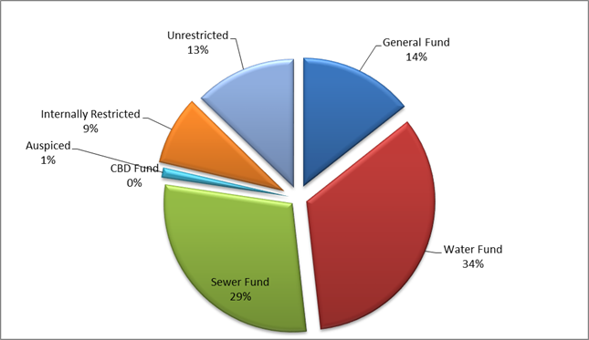
Portfolio Performance
Council’s current Long Term Financial Plan establishes
the benchmark for Council’s interest on investments at “75 basis
points above the current cash rate”. The cash rate as at 31 May 2017
remained at 1.50%. The annualised average interest rate of Council’s
investment portfolio at the same reporting date was 2.92% (weighted average
2.87%) which continues to exceed Council’s benchmark i.e. the cash rate
of 1.50% plus 0.75% (or 75 basis points).
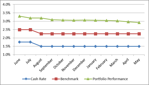
Council has also utilised the AusBond Bank Bill Index to
provide a further benchmark focused towards long term investments. As at 31 May
2017, the AusBond rate was 1.82%. The annualised average interest rate of
Council’s investment portfolio at the same reporting date was 2.97%.
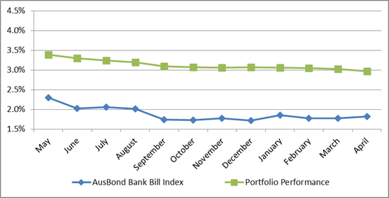
Council’s adopted Investment Policy establishes limits
in relation to the maturity terms of Council’s investments as well as the
credit ratings of the institutions with whom Council can invest.
The following tables provide a dissection of Council’s
investment portfolio as required by Council’s Investment Policy. The
Policy identifies the maximum amount that can be held in a variety of
investment products or with institutions based on their respective credit
ratings.
Table 1 and Table 2 show the percentage held by Council
(holdings) and the additional amount that Council could hold (capacity) for
each respective category in accordance with limits as established by Council’s
Policy.
Table 1:
Maturity – Term Limits
|
Term
to Maturity Allocation
|
Maximum
|
Holding
|
Capacity
|
|
0 - 3
Months
|
100.00%
|
10.07%
|
89.93%
|
|
3 - 12
Months
|
100.00%
|
60.51%
|
39.49%
|
|
1 - 2
Years
|
70.00%
|
6.88%
|
63.12%
|
|
2 - 5
Years
|
50.00%
|
22.55%
|
27.45%
|
|
5+ Years
|
25.00%
|
0.00%
|
25.00%
|
Table 2: Credit Rating Limits
|
|
Maximum
|
Holding
|
Capacity
|
|
AAA
|
100.00%
|
0.00%
|
100.00%
|
|
AA
|
100.00%
|
16.04%
|
83.96%
|
|
A
|
60.00%
|
42.87%
|
17.13%
|
|
BBB
& NR
|
40.00%
|
38.36%
|
1.64%
|
|
Below
BBB
|
0.00%
|
0.00%
|
0.00%
|
Certification by Responsible Accounting Officer
I, Kathy Woolley, hereby certify that all investments have
been made in accordance with Section 625 of the Local Government Act 1993,
Clause 212 of the Local Government (General) Regulation 2005 and
Council’s Investment Policy.
5.4 Orange
LEP Amendment 9 - Orange Airport Industrial Park - Submissions Report
TRIM
REFERENCE: 2017/333
AUTHOR: David
Waddell, Director Development Services
EXECUTIVE Summary
This report outlines the issues raised out of the exhibition
process associated with Amendment 9 to Orange Local Environmental Plan
2011 - Orange Airport Industrial Precinct. Additionally the remaining
procedural steps involved are outlined along with options explored by staff
with the NSW Department of Planning and Environment (DP&E).
133 submissions were received, including seven from Agencies
as follows:
· NSW Rural Fire
Service
· Roads and Maritime
Services (two submissions)
· Civil Aviation
Safety Authority
· Office of
Environment and Heritage
· Department of
Primary Industries – Agriculture
· Department of
Primary Industries – Water (two submissions)
· Sidings Springs
Observatory
In addition, both Blayney and Cabonne Councils made
submissions objecting to the proposal.
Should Council resolve to proceed with the Amendment, then
this report and all submissions will be forwarded to DP&E for
consideration.
Council is reminded that the Minister for Planning is the
ultimate consent authority for this Amendment, not Council.
Link To Delivery/OPerational Plan
The recommendation in this report relates to the
Delivery/Operational Plan strategy “11.1 Our Economy
– Encourage the growth of local business, support emerging industry
sectors and attract new investment to Orange”.
Financial Implications
Nil
Policy and Governance Implications
Nil
|
Recommendation
1 That,
having considered the report by the Director Development Services and the
submissions made following exhibition, Council resolves in accordance with
Section 59 of the Environmental Planning and Assessment Act 1979
to proceed with Amendment 9 to Orange Local Environmental Plan 2011
subject to:
· the proposed IN1
General Industrial zone being altered to IN2 Light Industrial zone and
including as additional permissible uses Rural Industries, Agricultural
Produce Industries and Freight Transport Facilities
· an Additional
Permitted Use listing being added to schedule 1 of the Local Environmental
Plan to enable Industrial Training Facilities in the proposed B7 area
2 That
in the event that the additional permissible uses for Rural Industries,
Agricultural Produce Industries and Freight Transport Facilities are not
included for land in the IN2 Light Industrial Zone, the IN1 General
Industrial zone in the original proposal be maintained.
3 That
as the changes are made to address community submissions and in consultation
with the Department of Planning and Environment, the proposal not be
re-exhibited.
4 That,
in consultation with the Department of Planning and Environment, the proposal
be forwarded to the Parliamentary Counsel Office for legal opinion and
subject to a satisfactory outcome the matter being submitted to Department of
Planning and Environment for final determination and publication.
|
further considerations
Consideration has been given to the recommendation’s
impact on Council’s service delivery; image and reputation; political;
environmental; health and safety; employees; stakeholders and project
management; and no further implications or risks have been identified.
SUPPORTING INFORMATION
Amendment 9 to Orange LEP 2011 - Orange Airport Industrial
Precinct was exhibited from 19 November 2016 to 31 January 2017. The
proposal was also sent to agencies and councils in line with the Gateway
requirement.
133 submissions were received, including seven from Agencies
as follows:
· NSW Rural Fire
Service
· Roads and Maritime
Services (two submissions)
· Civil Aviation
Safety Authority
· Office of
Environment and Heritage
· Department of
Primary Industries – Agriculture
· Department of
Primary Industries – Water (two submissions)
· Sidings Springs
Observatory
In addition both Blayney and Cabonne Councils made
submissions objecting to the proposal.
Agency responses were as follows:
· NSW Rural Fire
Service raised no objection to the proposal, noting that the site is not
currently mapped as bush fire prone but that they consider it likely that a
grassland hazard does exist at times on some adjoining lands. Consequently they
recommend that the aims and objectives of Planning for Bushfire Protection 2006
be considered during any subsequent development application.
· Roads and Maritime
Services initially requesting further traffic studies then not objecting to the
proposal.
· Civil Aviation
Safety Authority raised no objection to the proposal, advising that the National
Airports Safeguarding Framework (NASF) guidelines be used when proposing or
assessing development in the vicinity of airports as appropriate. NASF
guidelines were developed by the Commonwealth in conjunction with state
planning authorities and are intended to provide protection against
inappropriate development in and around airports, providing a nationally
consistent framework.
· Office of
Environment and Heritage note that there appears to be a drainage line that
meanders through the southern part of the site and an appropriate buffer should
be placed on either side of this drainage line. OEH support the retention of
remnant stands of vegetation including the Tablelands Snow Gum, Black Sallee,
Candlebark and Ribbon Gum Grassy Woodland Endangered Ecological Community
(EEC). OEH recommend maintaining records that demonstrate due diligence in
relation to protection of Aboriginal heritage and archaeology to ensure that
planning decisions do not inadvertently harm Aboriginal objects and demonstrate
consistency to the Due Diligence Code of Practice for the Protection of
Aboriginal Objects in NSW. OEH also note that the level of flora and fauna
assessment is as yet inadequate (Council will need to undertake further
assessment). In this regard Council can ensure that further more detailed work
is undertaken at the subdivision design stage.
· Department of
Primary Industries – (Agriculture) - stating that the area is inherently
valuable to agriculture as it includes Biophysical Strategic Agricultural Land
however past and current planning provisions have led to fragmentation and the
loss of such lands to residential uses hence the potential for productive and
efficient agriculture is significantly reduced in this area and further stating
that agricultural processing industries should be included to support job
creation.
· Department of
Primary Industries (Water) – providing general management suggestions
should the proposal proceed including monitoring of groundwater and supporting
reticulated water and sewerage.
· Australian
Astronomical Observatory (AAO) which has responsibility for the Siding Springs
Observatory made a submission having been approached by the Spring Hill &
Surrounding Districts Consultative Committee. AAO note that the Observatory is
234km distant from the subject site and as such the effect of the estate upon
the observatory “would be small”. AAO note that Orange lies outside
the NSW Dark Skies Region and there is no legal requirement for Council to
follow the Dark Sky Planning Guideline. Notwithstanding this they supplied a
copy of the guideline for reference noting that minimising upward sky-glow is
of benefit for everyone, not just astronomers.
Staff have collated the submissions made, extracted issues
of concern and attempted to provide responses to these issues. Full Submission
folders have been provided to Councillors under separate cover so that
Councillors can be fully aware of issues raised.
The following issues were raised in submissions and the
project team has attempted to provide responses for Council consideration
against each issue. In addition, the team has referred to some of the more
comprehensive submissions as reference points for detail within the issue
topic. Against each issue is the number of submissions raising the issue.
Issue 1 - Expresses support for
the proposal (1 submission)
No comment required.
Issue 2 - Expresses opposition
to the proposal (119 submissions)
No comment required.
Issue 3 - Supports proposition
that water issues can be readily managed (1 submission)
No comment. The author notes that the normal environmental
controls on development placed by Council should prevent pollution of the
catchment and also Council’s experience with stormwater harvesting adds
another layer of safety.
Issue 4 - The proposal will
result in negative amenity impacts for residents in Spring Hill, Huntley and
adjoining districts (16 submissions)
If amenity is the sum total of impacts such as light spill,
noise, traffic, visual impact and ‘the feel’ of the development in
the locality, then there is little doubt that the proposal will alter the
amenity of the area. Submissions raised amenity in a general sense combining
the causal factors to conclude that the proposal will diminish the quality of
life in the locality.
Traffic impacts are dealt with in responding to issues 16,
17 and 18. It is of note that the village of Spring Hill is already subject to
heavy vehicle movements from the various quarries in the area and from aircraft
noise. It is the intensification of these impacts, through increased frequency
of heavy vehicles and potential additional noise sources, which worries
residents.
Light spill is dealt with in response to other issues in
this report. It is noted that Australian Standards for light
infrastructure exist to prevent impacts, and this is what Orange City Council
will rely on to minimise impacts.
Noise from any development in NSW is controlled by the
Industrial Noise Policy and regulations. This will be the case with all
developments within the proposed OAITP boundaries. In addition, the EIS
for the airport extension dealt with aircraft noise impacts across the various
areas impacted and gained approval for eh extension project. State law on
these matters provides a baseline of safeguards and expectations. Orange City
Council has and always will seek to provide higher standards where possible.
The more general amenity impact arising from the mere
‘presence’ of industrial developments in the area is difficult to
quantify and mitigate against, other than to mitigate against the component
parts. The “do nothing” approach is clearly the only other option.
Issue 5 - The need for the
proposal is questioned because there are enough zoned sites in Blayney, Orange
and Cabonne to support industrial demand (45 submissions)
Several of these submissions phrase this issue in terms of
undeveloped ‘greenfield’ sites, while others point to built-out but
vacant ‘brownfield’ sites. Further, some submissions refer only to
supply within the Orange LGA, while others view supply across all three
councils in the sub-region.
In each context the issue relates to the question of
appropriate levels of supply of industrial land. Land use planning plays a
significant role in maintaining a strong and vibrant local and regional
economy. Both oversupply and undersupply of zoned land may cause market
distortions that hinder the economy. Undersupply of land may artificially
inflate prices to the detriment of new firms being able to establish or expand.
Oversupply of land may both deflate prices and increase holding costs to the
point of development becoming uneconomic.
Factors that may distort the demand level include broader
economic conditions at the state and national level and fluctuations in local
population growth rates; while supply levels may be distorted through
“land banking” by private landowners.
Due to these uncertainties supply levels should be
maintained within a range that is anticipated will not distort prices, defined
as a price point that recovers the costs of development without creating an
undue barrier to business establishment and/or expansion. An appropriate level
for most sectors (residential, commercial, industrial) is typically regarded as
between 15-20 years supply (relative to historic trends).
With regard to Electrolux, the former abattoir and various
smaller established premises, availability of established buildings should be
regarded in a similar manner to vacant houses and apartments in the residential
sector. There will always be a vacancy rate or percentage of one level or
another, but this does not mean that all premises are suitable for all
prospective occupants.
Just as some households seek to be build new homes tailored
to their own needs and preferences rather than adapt an existing house,
likewise some industries and businesses have specific operational requirements
that require purpose built facilities.
Additionally, the supply within the Orange LGA has minimal
ability to provide larger sized parcels, which in turn limits the ability for
Orange to attract major employment generators.
With regard to some of the undeveloped land, many of the
available sites have been found to be constrained in a variety of ways, as
outlined in the exhibition materials. This includes slope and topography,
drainage issues and available infrastructure.
Some of the submissions have also referenced land in north
Clergate which, although identified in the sub-regional strategy for industrial
development, is currently zoned RU1 Primary Production; and the owner has
indicated no intention to proceed with an industrial rezoning. To include such
land in supply estimates would therefore be misleading.
Of the remaining supply of industrial zoned land in the city
only 4 areas currently have vacant industrial land – Leewood Industrial
Estate (including Scott Place), Edward Street north of the Southern Feeder Road
(including the old saleyards site), Narrambla Industrial Estate and Clergate
Road. There is a total of 95.2ha of land available in these areas, however only
around 37ha of this supply is fully unconstrained.
Based on historical development of industrial land in Orange
over the past 25 years, it is estimated that around 5.5 years of supply of this
unconstrained industrial land exists, with only one parcel capable of
accommodating a large scale development in excess of 5ha.
In terms of the availability of industrial land in Blayney
and Cabonne shires, this is acknowledged. However, as stated in the proposal
documentation, the market does not view industrial land in the three LGAs as
interchangeable. Some firms seek to service a regional and interstate market,
others have a more local focus. Some firms value proximity to larger labour
pools than others. Some firms seek access to particular infrastructure and
transport options more so than others.
Accordingly, the proposal has sought to maintain the overall
industrial supply level that the sub-regional strategy nominated for the Orange
LGA, recognising the original removal of the Towac area and the difficulties
faced by the former abattoir and North Clergate areas.
If the supply represented by those locations is removed and
not replaced within the Orange LGA, the intent of the sub-regional
strategy would be distorted. This may cause the sub-region to lose the ability
to attract those firms whose operational, logistic or market requirements are
not well suited to rural shires.
Due to the time required to bring new land through the
planning process, there is a need to ensure that supply remains ahead of the
market. Waiting until supply exhausts would distort land values, causing some
firms to locate in other regions; and this in turn would suppress the local and
sub-regional economy. Creating new supply should therefore always occur against
a backdrop of apparent ample supply.
The proposed development has the potential to create in
excess of 1,100 new jobs once the site is fully occupied.
Issue 6 - There is inadequate
water supply to service the proposal (1 submission)
In designing the Orange to Carcoar Pipeline, both current
and future demands were allocated to each connection point along the route,
including the Orange Airport Industrial Park. The process included water
modelling by Orange City Council staff and peer review by consultants prior to
the awarding of the Design and Construct project. Laying of the pipeline is
underway, with commissioning of the project expected to be completed before the
end of the 2017/2018 financial year.
Issue 7- The proposal will be
in an area subject to flooding (2 submissions)
and
Issue 8 - Infrastructure is lacking in the area (2
submissions)
and
Issue 9 - The proposal lacks design detail (1 submission)
As described in the above response
to Issue 6, water supply will be adequate with the construction of a new
potable water connection between Orange and Carcoar that runs through the
proposed site.
A new sewer main will also be
constructed in conjunction with this water main to enable effluent from the
existing Spring Hill/Lucknow sewerage system, as well as future waste water
from the proposed development, to be pumped back to Orange for treatment at the
Orange Sewage Treatment Plant. This will limit the potential for any
groundwater contamination from the old Spring Hill Sewerage Treatment Plant by
removing all existing and future effluent from the Spring Hill area.
Existing roads to the site, i.e.
Huntley, Forest and Beasley Roads, are public roads and all have significant
spare capacity to cater for expected traffic generated by the development. In
addition, Forest Road is a Regional Road, which recognises its importance as a
major link road within the region as well as a recognised route for heavy
vehicles. Further information concerning roads and traffic is provided in the
combined response to Issues 16, 17 and 18 below.
The site is located on relatively flat ground approximately
948m-950m AHD. A small rise to the southwest of the site rises to
approximately 963m-964m AHD. With the exception of this area the proposal
site is elevated relative to surrounding land and essentially straddles the
watershed between catchments. The detailed design of
the estate will address any localised flooding issues. Being at the top of the
catchment there is little potential for major flooding.
The detailed design of the
development will be considered once the rezoning decision has been finalised.
However, the structure plan identifies potential development areas as well as
the general layout in sufficient detail to progress with the rezoning application.
Issue 10 - The proposal will
result in the loss of Prime Agricultural land (45 submissions)
The land is identified by the state as Biophysical Strategic
Agricultural Land (BSAL). The primary purpose of BSAL classification in
NSW is to reduce conflict between agriculture and the coal seam gas (CSG)
industry. CSG is a lucrative although finite resource, whereas agriculture
typically delivers lower but more sustained value as properly managed soils are
essentially an indefinitely renewable resource.
Notwithstanding this, the amount of land required to sustain
a commercially viable agricultural enterprise is substantial. In Orange the
minimum lot size for rural subdivisions has been set at 100ha (250 acres) and
is indicative of the amount of land that would typically be required for
commercial viability of most forms of primary production. The LEP does
enable consideration of smaller lots for more intensive forms of agriculture,
such as horticulture or viticulture, when supported by a farm plan that confirms
viability.
Orange has seen numerous small scale orchards and vineyards
taken out of production over the years, with the properties effectively
converting to rural-residential “lifestyle” properties, with little
to no agricultural output generated. Such fragmentation of land is the most
pronounced threat to continued agricultural use, both in terms of the lifestyle
lot itself and the potential for residential-agricultural land use conflicts
constraining the operational practices of neighbouring farms.
The subject land is situated on the southern side of the
Orange airport in an area that has already been significantly fragmented into
small lifestyle lots. Along Forest Road there are five residential lots between
1.2ha and 3.8ha in size; immediately west of Spring Hill in Cabonne Shire a 17
lot estate has been created ranging in size from 2ha-13ha. There are
additionally various concessional lots of approximately 2ha throughout the
area. Each residence constrains the ability of neighbouring farms to undertake
various routine agricultural activities such as spraying in order to avoid
complaints and protests.
Conversely the proposal seeks to establish a mixed light
industrial, business and technology park estate adjacent to the airport. The
proposal incorporates significant buffer lands that are to be zoned for public
open space and embellished with landscaping. As such the proposal will not
generate conflict with the operations of neighbouring farmlands. The impact
upon the agricultural land is therefore limited to the extent of land involved
in the proposal itself. At approximately 114ha of gross land involved, this
equates to approximately one commercially viable farm.
The NSW Farmers Association (Orange branch) submission
states in part:
“It is not clear that
the project represents an unacceptable and large impact on the state’s
BSAL asset base as a result of direct impact of the project, however, NSW
Farmers would prefer that productive agricultural land, including BSAL, be
protected.
…
In the analysis of the
proposed site it mainly consists of white volcanic soil that occupies most of
the lower ground, with some red volcanic soils on the higher parts of the
proposed development area. This has made most of the proposed site only
suitable for grazing enterprises and not suitable for horticultural crops such
as fruit trees and vegetable crops. While there would be a reduction in
agricultural output from sheep and cattle grazing, the proposed land area will
have only a minimal impact on agricultural production across the Orange
region.”
This is indicative of the broad brush approach that was
employed in mapping BSAL lands. In other words, a BSAL designation is an
indication that the agricultural value of land is “likely” to be
high, but that further more localised investigation, such as presented by
NSW Farmers, may give a better understanding of the actual value of any
given site. This advice was received as part of the public exhibition process
and was not solicited by Council.
In evaluating the proposal, the loss of an equivalent of one
commercially viable farm needs to be balanced against the potential benefits
that the creation of an employment precinct can generate. Admittedly, it would
be preferable to locate on non-BSAL lands, however the unique characteristics
of the site, such as proximity to air, road and rail infrastructure as well as
a gas line already in-situ, provide additional advantages to the site that are
not repeated elsewhere in the LGA. These advantages are outlined
throughout the planning proposal and would enhance the employment and economic
opportunities achievable. These reasons are considered to justify the
relatively minor loss of agricultural land in this instance.
The NSW Farmers submission suggests encouraging greenhouses
on part of the site, which if pursued could offset the potential loss of
agricultural production. In land use planning terms, this would be classed as a
rural industry and would be permissible in the proposed zones.
The
Department of Primary Industries (Agriculture) states in its submission:
…….this
proposal could provide significant opportunity for protected agriculture and
other (more intensive industrialised) agricultural industries. These industries
will generate employment and can take advantage of the infrastructure and
transport facilities this proposal will provide. This use is consistent with
the traditional “industrial and business” land uses that this
amendment seeks, and will also enhance primary industry production. Hence DPI
Agriculture recommends that agriculture and agricultural processing is included
as a potential land use in this proposal.
Since
this proposal’s instigation the NSW Government has released a Right to
Farm policy that supports landholders in undertaking lawful agricultural
practices without conflict or interference from neighbours or other land uses.
If agricultural land and practises are near the proposal, DPI Agriculture
encourages the council to take this policy into account and to also undertake a
land use conflict risk assessment.
The
area is inherently valuable to agriculture as it includes Biophysical Strategic
Agricultural Land and supports a range of agricultural activities including
grazing and intensive agriculture. However past and current planning provisions
have led to fragmentation and the loss of such lands to residential uses hence
the potential for productive and efficient agriculture is significantly reduced
in this area.
The submission then encourages Blayney Cabonne and Orange
Councils to continue to support the BCO Strategy as a means to prevent further
land fragmentation across the region.
Issue 11 - Orange City Council
should spend the funds on other projects including roads (2 submissions)
and
Issue 12 - The proposal will be cost prohibitive (3
submissions)
and
Issue 13 - No cost benefit analysis or Business plan has
been produced by Orange City Council and therefore there is a significant
financial risk (14 submissions)
and
Issue 14 - The financial sustainability of the Business
Park is in doubt if current industrial land take up rates are used (10
submissions)
Council has long been a developer
of industrial land in the city, with the Narrambla Estate the most recent
example of this. Provision of an adequate and diverse supply of industrial land
is a key part of Council's economic development role. This strategy is not just
focussed on the construction of industrial estates, but also on the flow-on
benefits which accrue to the broader local and regional economy through the
development of enterprises within the estate. Council also has the capacity to
take a long term approach to the delivery of the estate, with uptake of lots
potentially fluctuating depending on overall economic conditions. However, as
has been the case with Narrambla in particular, over the longer term this
estate has proven to be a key generator of jobs and economic activity in
Orange, and the proposed estate at the airport should also achieve the same
ultimate outcome. If the alternative is to do-nothing option, this projected
economic activity will not occur.
Issue 15 - The site selection
process is flawed including the criteria used (15 submissions)
The site selection criteria of the original Blayney Cabonne
Orange Rural and Industrial Lands sub-regional strategy resulted in the
peculiar recommendation of north Clergate being nominated for both industrial
and residential development, with an extensive direct interface. Additionally,
a site near the Towac Racecourse was initially nominated in a draft form of the
strategy that provoked considerable opposition and was ultimately removed from
the final strategy.
The rationale for the site selection criteria is detailed in
the addendum to the sub regional strategy that was exhibited alongside the
planning proposal. The addendum provides a summary of the strategic land units
identified in the original strategy, the original reasons they were included in
that strategy and a status update on how the land has been used/developed over
the intervening period.
The addendum reiterates a point made in the original
strategy that:
“it should be noted that
inclusion as a Strategy Area … does not automatically translate into
rezoning … detailed local environmental studies will be required for all
Strategy Areas to determine their suitability for rezoning”.
It should logically follow that if a strategy area
identified in the original strategy does not proceed, for whatever reason, an
adjustment would be required to ensure that appropriate levels of industrial
land are nonetheless maintained.
The addendum reviews the vision and principles of the
original strategy to ensure they remain applicable. This in turn leads into a
discussion of growth management and matters that should be considered to help
ensure that growth delivers the vision and principles of the strategy.
The site evaluation criteria are then reviewed and adapted
partly in recognition that the original criteria resulted in the north Clergate
interface conflict and the initial nomination of land near Towac Racecourse.
The revised criteria:
· increased emphasis
on potential land use conflict,
· increased emphasis
on site constraints to reduce disturbance of landforms,
· reduced emphasis
on urban proximity to reduce potential land use conflict.
This represents an evolution of evaluation criteria, which
is consistent with undertaking a meaningful review of the strategy. Further
detail of the criteria used and the rationale for each are detailed in Part D
of the addendum.
Issue 16 - The road network is
inadequate to service the proposal (3 submissions)
and
Issue 17 - The proposal will result in heavy vehicle
impacts on Spring Hill (6 submissions)
and
Issue 18 - The proposal will result in negative general
traffic impacts (14 submissions)
Council engaged Parking & Traffic Consultants Pty Ltd to
undertake a Traffic Impact Assessment Report for the proposed Orange Airport
Industrial Park. The report dated 17 March 2017 concludes the following:
· All roads and
junctions on the surrounding road network are operating within acceptable
levels of service for the existing scenarios;
· All the junctions
(based on a high density model) are shown to operate well within acceptable
levels of service; and
· There is no need
for any improvement of roads and junctions in relation to the low or high
density scenario and the forecast background growth within this period.
In response to the issue of heavy vehicles impacting Spring
Hill, we note the Parking & Traffic Consultants Pty Ltd Traffic Impact
Assessment Report dated 17 March 2017 models a total increase of between 9 (Low
density scenario) and 20 (high density scenario) commercial vehicle trips in
the peak hour, the expected commercial vehicle distribution (figure 12)
reduces the expected commercial vehicles travelling through Spring Hill by 60%.
Therefore the expected commercial vehicles travelling through Spring Hill in
the peak hour is 40% of the 9-20, resulting in 4- 8 additional commercial
vehicles only.
Upon receipt of the Parking & Traffic Consultants Pty
Ltd Traffic Impact Assessment Report, it was forwarded to Roads & Maritime
Services (RMS) NSW for review and comment.
RMS responded to Orange City Council via letter dated 28
April 2017, in which they advised, following review of the SIDRA analysis of
current traffic movements and projected future movements, they have no
objection to the proposal and will make no further submission.
The planning proposal envisages upgrading the road network
from the city to the airport to accommodate both the growth in traffic numbers
and heavy vehicle usage. Such upgrades will also enable improvements to cyclist
facilities along the route.
Issue 19 - There is a lack of
public transport for the workforce associated with the proposal (1 submission)
It is anticipated that most staff will commute with private
vehicles. The road network enhancements and a growing workforce could generate
sufficient demand for a peak period shuttle bus service, particularly if this
were to coincide with flight schedules.
Issue 20 - The proposal will
result in land use conflicts (8 submissions)
The proposal is situated alongside the airport and
incorporates buffer areas to the non-airport side. Each development within the
estate will be the subject of development assessments that can examine
potential land use conflicts, and Council will be able to impose appropriate
conditions and design requirements to protect neighbouring lands from adverse
consequences such as noise or other emissions.
Traffic generation is acknowledged and will be addressed
through road network upgrades as discussed in Issues 16 - 18.
Issue 21 - Heavy industry will
be involved in the proposal resulting in adverse impacts (1 submission)
Heavy industry is defined in the Orange LEP as:
heavy industry means a building or place used to carry out an industrial
activity that requires separation from other development because of the nature
of the processes involved, or the materials used, stored or produced, and
includes:
(a) hazardous
industry, or
(b) offensive
industry.
It could also involve the use of a hazardous storage
establishment or offensive storage establishment.
The assumption that any heavy industry proposal would
unavoidably result in adverse impacts is not supported. The majority of
industrial development in Orange does not conform to the heavy industry
definition. Orange typically attracts a range of light industries and trade
related enterprises, along with engineering and mining industry support
services.
As discussed later in this report a move to IN2 (light
Industry) and B7 (Business Park) amended zones has been offered to more
accurately reflect the type of industry that might be located at the airport.
Issue 22 - The proposal will
result in negative ecological impacts (11 submissions)
The site of the proposal is
situated on predominantly level, cleared land adjacent to the airport. The site
has been extensively disturbed from its natural state by decades of agriculture
and grazing. Direct impacts upon flora and fauna are therefore considered to be
negligible. Other potential ecological impacts have been inferred from
potential groundwater/aquifer impacts - this aspect has been addressed in
response to Issue 16.
The concept plan includes buffer
areas, particularly on the southern side of the estate that will be landscaped
as one means of addressing amenity concerns. Such landscaping has the potential
to improve ecological values. Street trees within the estate may further
contribute in this regard.
Issue 23 - The proposal will
result in negative impacts on the drinking water catchment
(91 submissions)
This water quality issue was
mentioned a number of times in the 2017 submission by the Spring Hill and
Surrounding Districts Consultative Committee (Spring Hill and Surrounding
Districts Consultative Committee) with comments predominantly drawn from the
Holliday Geoscience appendix. Whilst impact on water security is also regularly
mentioned in the report, it is in the context of risk to water quality on
existing raw water supply systems. In acknowledging that surface water is
interlinked with groundwater, the latter is specifically addressed in
Issue 25 below.
Concerns regarding heavy
industry, as raised a number of times in the Spring Hill and Surrounding
Districts Consultative Committee submission, are specifically addressed in
Issue 21.
Issue 24 - The proposal will
result in negative noise impacts (6 submissions)
The proposed location coincides with an existing noise
generating activity, namely the airport. As such, the local planning system has
discouraged placement of dwellings in the vicinity for many decades. The number
of sensitive receivers in proximity to the subject land is not surprisingly
low. The nearest homes are two dwellings in Adrian’s Lane which are
located on the edge of the final stage of the proposal, a further six dwellings
along Forest Road ranging from 200m-600m away from the southern edge of the
estate and one dwelling in Gander Road also approximately 600m from the western
edge of the estate. A small ridgeline on the south-western edge of the estate,
rising approximately 11m-12m above the surrounding land, provides some acoustic
and visual screening in this direction.
In addition to these distances, individual developments will
be subject to acoustic assessments during the development application process.
Firms that seek to operate 24 hours a day will need to demonstrate how
their proposals avoid and minimise noise impacts through suitable acoustic
design responses such as baffles, sound mounds, insulation of buildings, delivery
hours and shift changeovers, and other measures as may be relevant to their
particular operations. This can be reinforced through conditions of consent on
a case-by-case basis.
Issue 25 - The proposal will
result in negative impacts on groundwater (90 submissions)
and
Issue 26 - The proposal will result in negative impacts
on the Spring Hill bore capture zone (3 submissions)
and
Issue 27 - The Jewell groundwater report is deficient (4
submissions)
Issue 27 is a key process issue
raised in the submission by Spring Hill and Surrounding Districts Consultative
Committee (2017), with reference to Council’s environmental
assessment for the proposal that included a water quality risk assessment for
the Spring Hill drinking water bore supply (as conducted by Jewell &
Associates in 2015). Comments in the Spring Hill and Surrounding Districts
Consultative Committee submission were predominantly drawn from the Holliday
Geoscience appendix where it is stated that:
“The use of the Jewell Report for an
incorrect purpose is unprofessional, and potentially deceptive”.
The Department of Primary
Industries - Water (2017) has also provided comment on the need to consider
groundwater risk specific to the proposal site.
Subsequent to the environmental assessment (and the 2015
Jewell report), Council engaged Jewell & Associates to conduct a
Groundwater Assessment Orange Aerodrome (2016) which considered potential
groundwater impacts under both the existing scenario and that of the proposed
development. The assessment included a site reconnaissance and desktop review,
the latter of which involved review of information in the public domain and
previous studies conducted by Jewell & Associates. The output recommended a
number of measures considered appropriate to protect the aquifer, whereby it is
considered that risks can be reduced to an acceptable level.
Issue 25 is focussed on
impacts on groundwater quality, with the Department of Primary Industries -
Water (2017) commenting that the:
“… high quality groundwater
resource….is characterised by a high groundwater vulnerability rating
from surface pollution, hence adequate design and management measures need to
be applied to mitigate impacts” and requests that “further
studies are done to identify the groundwater flow direction and redefine the
capture zone for the town water supply bores”.
Groundwater vulnerability is a
key issue in the Spring Hill and Surrounding Districts Consultative Committee
submission (2017) and is raised in the context of: high water infiltration
rates, high connectivity between surface water and groundwater, little
knowledge of the likely pathways of the contaminant, water logging, the Spring
Hill bores, the sheer size of the proposal and the proposed heavy industry.
The Spring Hill and Surrounding Districts Consultative Committee
submission (2017) considers the groundwater pollution risk to be enhanced and
high for the similar reasons as listed in Issue 23, namely: sediment; fuel
spills and toxic chemicals; onsite use; storage and disposal of any chemicals
on the land; toxic runoff; spills and wash-downs; and the treatment, storage
and disposal of wastewater and solid waste arising from development and
operations of the proposed industrial site.
Two examples of industrial
groundwater contamination are provided in the Spring Hill and Surrounding
Districts Consultative Committee submission (2017), including reference
to the Williamstown RAAF by fire-fighting chemicals, and pollution across a
broad area in the Darling Downs, Qld by Linc Energy. The pollutant generated
from fire-fighting chemicals is considered in the Jewell and Associates
Groundwater Assessment Orange Aerodrome (2016). The Darling Downs example
concerns hydrogen contamination from a coal gasification plant run by Linc
Energy and is not considered relevant to the proposal.
The vulnerability of groundwater
to pollutants as raised in the Spring Hill and Surrounding Districts
Consultative Committee submission (2017) and by DPI-Water (2017) is
considered in the Jewell 2016 report. For example, the introduction describes
that:
“Within the Orange Basalt aquifer most
groundwater is hosted by secondary features such as fractures, which renders
the aquifer vulnerable to contamination derived from the surface. Storage in
the aquifer is replenished by infiltration derived directly from rainfall, as
well as by leakage from surface water bodies. Thus, the potential impact of
development on both the quality and quantity of groundwater in the aquifer, and
the measures required to protect the aquifer from any adverse impacts, are of
great importance to OCC and also to other users of the aquifer.”
The Jewell 2016 report includes
a description of the site, including existing groundwater use (including
Issue 26 - Spring Hill bores), the hydrogeological setting and aquifer
vulnerability. The Jewell 2016 report considers a range of potential hazards
under three scenarios, including hazards arising under current land use and
continuing under proposed re-zoning; hazards arising under the proposed
re-zoning or which may be exacerbated by the proposed re-zoning; and hazards
arising under the current zoning which may be reduced by the proposed rezoning.
Each hazard is considered in a risk assessment in the
‘uncontrolled’ state, and importantly with relevance to the
comments made by DPI-Water (2017), the ‘controlled’ state.
Whilst some of the risks in the
Jewell 2016 report are considered not significant, others will require
implementation of new or enhanced administrative procedures; and in some cases
additional investigative or engineering work to provide more or better
information, either because existing controls could be improved or to manage
changes that will occur due to the proposed development. These risks are:
- herbicide/pesticide
contamination originating from land application, including along the rail
corridor;
- contamination
originating from abandoned/disused bores;
- contamination
arising from road and rail accidents;
- contamination
arising from storage and handling of fluids and soluble solids in the proposed
industrial area;
- reduction of
aquifer recharge due to an increase in the proportion of paved surfaces; and
- the issue of use of
PFC’s for fire suppression, which requires confirmation that there are no
existing impacts, and appropriate controls to ensure that impacts cannot occur
in the future.
The Jewell 2016 report (p 43)
considers that:
“All of these risks can be effectively
managed and reduced to an acceptable level by the implementation of effective
control measures”.
Council is committed to incorporating
recommendations from the Jewell 2016 report into management processes. Council
considers that the Jewell 2016 report addresses the potential for groundwater
pollution as raised in public submissions, and Council is committed to engaging
Department of Primary Industries - Water to define the needs of further
groundwater studies, following their review of the report.
Issue 28 - The proposal will
result in negative visual impacts (5 submissions)
Assessment of development applications will have regard to
the visual presentation of each site and the estate overall. Development of the
estate will change the visual outlook, but the distance to neighbours, buffer
and landscaping areas as well as individual design assessments combine to
reduce the significance of the change.
Since Council is the proponent there is the opportunity to
impose conditions on the contract of sale and 88B restrictions on title, as
well as through Development Control Plan provisions, to ensure a high standard
of design is delivered. See discussion on Issue 29 for more detail on visual
impacts.
Issue 29 - The proposal will
result in negative impacts on the tourist arrival experience
(70 submissions)
Tourism is an important and valued sector of the Orange
economy and first impressions can affect the visitor experience. The overall
experience affects tourism on two levels. The first is the rate of
repeat/return visitation of the individual themselves, while the second is an
indirect effect via word-of-mouth (positive or negative).
A traditional view is that the reach of word-of-mouth
experiences was limited to the person’s direct relationships and
face-to-face encounters. However, with the rising influence of social media,
personal experiences are able to reach a much broader audience.
It is therefore important for local tourism to always seek
to provide a positive and welcoming experience. It is true that it only takes a
moment to form an impression. In this regard there are two moments where a
tourist’s impression could be influenced by the proposal. Airborne on
approach/departure and at ground level while driving to/from the airport.
Airborne visual impressions would be fleeting. Because the
industrial area is proposed to be located alongside the runway, rather than
under or adjacent to flight paths, lateral views from passenger planes on
approach would continue to consist of rural farmland. Only once landed and
taxiing would passenger views take in the industrial area, this only on one
side of the aircraft; and airside development such as hangars and the like
would largely screen the more general industry behind.
Ground level views, as may be experienced from taxi/bus and
private vehicle connections, would be screened by the inclusion of public open
space buffers and associated landscaping. While built forms would be
discernible beyond the landscaped buffer, the distance from Forest Road to
industrial developments would help to diminish the impression of bulk and
scale.
Furthermore, airports are not regarded to be tourist
destinations or attractors in their own right. Most visitors will spend a
minimal amount of time at the airport before and after flights, with most of
the dwell time spent inside the terminal building.
Tourist expectations for airports are more commonly
associated with how quickly and efficiently they can pass through the facility,
the standard of comfort and facilities available during their wait and the
availability of parking or connecting ground transport. As such, the standard
and presentation of the terminal building rather than surrounding development
is more significant.
That is not to suggest that the presentation and standard of
development in the industrial estate is not relevant. As the estate is a
Council driven concept there is the opportunity, through both conditions on
contracts for sale and through DCP provisions, to promote a high standard of
presentation.
Issue 30 - The proposal will
result in negative air safety impacts (2 submissions)
The Civil Aviation Safety Authority (CASA) is the national
air safety regulator. CASA was consulted on the proposal and made a submission,
recommending that the National Airports Safeguarding Framework (NASF)
guidelines be used when proposing or assessing developments in the vicinity of
airports as appropriate. NASF is a land use planning framework that aims to
improve community amenity by minimising noise-sensitive development near
airports and improve safety outcomes by ensuring aviation safety requirements
are recognised in land use planning decisions through guidelines being adopted
by jurisdictions on various safety related issues.
Issue 31 - The proposal will
result in negative light pollution impacts (6 submissions)
It is noted that Australian Standards exist for light
infrastructure to prevent impacts and this is what Orange City Council will
rely on to minimise impacts during the DA process for developments.
The Standard AS4282 Obtrusive Effects of Outdoor Lighting is
the relevant standard. From the website:
The Australian standard
providing guidance on outdoor lighting pollution, light trespass and excessive
glare………..
The aim of the standard is to provide application-based
guidelines for designers, installers, asset owners and managers, and to set
requirements ensuring outdoor lighting installations provide a safe, secure and
non-obtrusive lit environment.
Regulators and council officials use the standard to manage
lighting issues that range from light pollution to excessive glare and
neighbourhood nuisance. It currently addresses obtrusive outdoor lighting from car
parking lots, parks and reserves, sports lighting, floodlighting and yard
lighting that that can give rise to discomfort or pose a safety hazard.
Issue 32 - The proposal will
run the risk of an industrial accident/disaster (7 submissions)
The issue assumes that subsequent developments will involve
hazardous, poorly designed or poorly managed projects. Assessment of
development applications will have regard to this potential, and any proposal
with such potential will need to demonstrate appropriate responses in their
applications.
Issue 33 - The proposal will
result in negative impacts on cyclists (2 submissions)
The conceptual masterplan incorporates a buffer zone of open
space that can provide a separated pedestrian/cycleway. More generally, the
proposal will result in upgrading of the road network, improving the width and
condition of road shoulders and enabling greater separation between cyclists
and traffic.
Issue 34 - The proposal will
result in negative impacts on adjoining farms' accreditation (3 submissions)
Submissions raise concern that any contamination of water or
soils could threaten the accreditation of nearby agricultural activities, the
example cited being a beef and stud enterprise that is Cattlecare Accredited.
This presumes that subsequent developments will be of the heavy industry type
and not properly designed, operated or managed to prevent pollution.
As described in response to Issue 21, heavy industry is not
the typical form of business that establishes in Orange. However, part of the
rationale of the proposal is to provide for large format operations that are
not able to be accommodated in other industrial areas. Any such application
would be subject to the development assessment process and need to demonstrate
how the particular proposal will avoid and mitigate such risks. Failure to do
so would be adequate grounds for a refusal.
Issue 35 - The proposal will
result in reduced property values in the area (2 submissions)
The effect on property values from planning decisions is notoriously
difficult to quantify and is not regarded as being a material consideration in
land use planning. A wide range of factors contribute to the price that any
given property can achieve in the open market. These include (but are not
limited to):
· condition and
presentation of built improvements (house, sheds, fences etc)
· location
· proximity to
services (employment, shopping, education and health care)
· accessibility
(condition of road network, distance to city/town/village)
· mobile phone coverage
and internet access
· views and aspect
· climate and
rainfall patterns
· car parking and
traffic
· development
potential and land-use regulation
· change, and rate
of change, in population
· supply and demand
of development ready stock
· rental vacancy
rates
· urbanisation and
gentrification
· interest rate
environment
· taxation
environment (negative gearing, capital gains tax rules, ability to buy property
within self-managed superannuation funds).
In addition to this complexity, property values have both a
positive and negative effect in the local economy. Clearly a landowner benefits
from strong and rising prices, however the same effect is a barrier to entry
for those seeking to buy into an area. This dichotomy is a substantial reason
that land use planning typically seeks to be agnostic with respect to property
values.
Therefore, instead of trying to side with either established
landowners or aspiring land-seekers, the planning system fosters economic
growth overall. A growing local economy benefits both buyers and sellers.
Economic growth brings more prospective buyers, and such buyers have a greater
capacity to borrow/spend. Competition between buyers then drives up property
prices. Conversely, constraining development dampens economic growth, reducing
the number and purchasing power of buyers and leading to reduced competition
for available properties.
The planning system facilitates this dynamic by allocating
appropriate supply of land to its highest order use, while imposing appropriate
environmental safeguards and managing interface issues.
Appropriate supply in this regard is considered to be the
amount of land needed to provide buyers with a fair and reasonable diversity of
sites to choose from, while not creating a glut of supply such that the
competition among buyers would fail to reach a price point that covers the
costs of development.
Issue 36 - The proposal will
result in negative impacts on the region’s food bowl reputation (8
submissions)
Orange’s food and wine reputation has been fostered
over many decades through a variety of marketing, events and ongoing efforts of
both local producers and food establishments. Throughout this time the
industrial sector has played a significant if fluctuating role in the local
economy.
Industrial and light commercial activity has not previously
been cited as hindering or obstructing the food and wine or ‘food
bowl’ branding of either Orange or the central west more generally. It is
therefore reasonable to conclude that both sectors of the local economy are
able to co-exist without detriment. Additionally, some light industrial
activities (such as micro-breweries, wineries, cheesemakers and other
agricultural produce industries) may in fact contribute positively to such
branding endeavours.
Issue 37 - Appropriate rail
sidings already exist at Blayney and Orange (1 submission)
and
Issue 38 - The proposal duplicates the Parkes
Airport/Industrial Hub on the Inland Rail corridor (3 submissions)
and
Issue 39 - The proposed rail siding is on a stretch of
rail line that renders it unfeasible (1 submission)
The current proposal does not
include a rail siding.
The Parkes Inland Rail hub has a
very strong focus as a road/rail intermodal facility, which is likely to expand
significantly if the inland rail project proceeds. Future smaller scale
intermodals across the region could work in conjunction with a major national
facility at Parkes so could be regarded as complementary rather than in
competition if developed as part of an overall regional transport/freight strategy.
The proposal is not dependent upon a rail interchange or
siding. The potential for a rail/ road interchange was identified for further
investigation if and when expansion of the estate was warranted.
Issue 40 - There has been a
lack of consultation with Blayney and Cabonne Councils (2 submissions)
Both Blayney and Cabonne Shire Councils have been consulted
at staff level during varying stages of the project. Formal consultations have
been in accordance with the Gateway Determination, resulting in staff reports
to each respective Council.
Issue 41 - The local community
is being ignored (2 submissions)
The proposal was placed on public exhibition from 19 November
2016 to 31 January 2017, attracting 133 submissions of which 124 were from
members of the public and the Spring Hill and Surrounding Districts
Consultative Committee.
All issues raised in
submissions are required to be considered on their respective merits regardless
of the proximity of the person(s) making the submission to the proposal. That
is, the substance of the issue raised is the relevant concern rather than who
or how many raised it.
The formal exhibition period is
in addition to previous community engagement and public meetings in Spring Hill
that followed a preliminary concept presented to Council in 2015. The
assertion in one submission that “Consultation with the local
community has been cursory at best” and in another submission “What
is the point of community consultation if you don’t listen to that
community?” are both refuted. Consultation has been periodic over an
extended timeframe, with design and scope changes being made in response to
feedback.
Community consultation is an important feature of land use
planning that can serve to enhance understanding of the location and context of
a proposal. However Council is required to balance a wide range of often
competing interests and concerns, therefore consultation does not equate to a
resident veto.
Issue 42 - Orange City Council
is pursuing the Clergate rezoning back to residential in order to gain a
financial windfall from residential rates (1 submission)
The Clergate rezoning is being
pursued by an individual property owner who believes a rural residential estate
is more appropriate on their land than the currently zoned industrial estate. A
key reason for this rezoning application has been the failure over a period of
time to attract industrial development to this site.
Issue 43 - The proposal will
result in negative impacts on heritage assets (1 submission)
The relevant submission notes the wealth of history within
the agricultural area of Huntley and Spring Hill. Particular reference is then
made to several sites and buildings in the area, namely:
· ‘Little
Springs’ homestead comprised of mud brick construction,
· ‘Huntley Park’
butter factory,
· Jim Martin’s
cottage at Martin’s Corner,
· Huntley Park
Produce Company, and
· the former Cadia
Rail line and corridor adjacent to Forest Road.
The site area of the proposal does not include or impact
upon any of the above sites. These sites have been noted for further
consideration in the next heritage inventory review.
Issue 44 - The proposal will
result in negative health (air quality) impacts (5 submissions)
Dust generation during construction was cited in one
submission. This is a matter that is routinely addressed in the development
consent process and subsequently mitigated through standard dust suppression
conditions.
Increased traffic will result in an increase in vehicle
exhaust emissions along the route to and from the industrial estate. Parking
& Traffic Analysis have reviewed the proposal and supplied a traffic impact
assessment report (attached to this report). While the analysis does not extend
to air pollution, it does indicate that traffic volumes will remain within the
capacity of the network. This suggests that particulate levels will remain
consistent with rural areas generally.
Issue 45 - The information
presented is generally inaccurate (4 submissions)
The information and documents presented were reviewed by the
Department of Planning and Environment’s Gateway process. By virtue of
granting a Gateway Determination the Department affirmed that the materials
were sufficient to inform the public and relevant agencies of the intent of the
proposal. The information provided was prepared in good faith to portray both
the proposal and its context as accurately as was known at the time.
Issue 46 - The environmental
assessment is inadequate (2 submissions)
The environmental assessment presented was reviewed by the
Department of Planning and Environment’s Gateway process. By virtue of
granting a Gateway Determination the Department affirmed that the materials
were sufficient to inform the public and relevant agencies of the environmental
aspects of the proposal.
Issue 47 - The job numbers
presented are inflated (4 submissions)
The projected numbers have been
determined based on sound processes by an independent source.
Issue 48 – Biosecurity
concerns (1 submission)
This issue is acknowledged. The submission recommends
biosecurity risk assessments for any new industry and that high level
biosecurity measures are established to minimise the risk of incursions of
pests, diseases and plant material through the airport. These suggestions are
supported, and it is suggested that if the proposal proceeds then developments
will need to be subject to an overall biosecurity plan.
Issue 49 - The proposal will
result in negative impacts on the Huntley Berry farm (2 submissions)
One submission argues that driving through an industrial
zone would impact on the attractiveness of Huntley Berry farm as a tourist
destination, while the other notes it as a small scale commercial development
within a short distance to the airport.
The Huntley Berry farm is located on the northern side of
the airport, while the proposed industrial estate is located on the southern
side of the airport. This provides a separation distance of approximately 1600m
to the Huntley Berry Farm. The proposal does not place the estate directly on
any of the main routes such as Forest Road, Huntley Road etc.
Additionally, the concept includes buffer areas as public open space that would
be landscaped to enhance the presentation of the area and provide screening of
the estate.
Issue 50 - Objection to
internal loan being used to purchase property (1 submission)
Council considers when preparing
its 10 year Long Term Financial Plan the best use of funds and the best value
for money approaches for funding projects. Council is able to utilise
funds through internal borrowing processes. This is an attractive means of
funding projects as the lower borrowing costs mean the repayments are
less. Repayment of this loan are included in the budget.
Money held for sewerage infrastructure is being used in this case. These
funds are not required to be spent on infrastructure for a number of years.
Council manages expenditure on sewerage infrastructure having determined the
needs in its 30 year sewerage modelling systems. The use of moneys in this way
is a cheaper and better value for money option than external borrowings.
Council also has the capacity to externally source loans but it is at less
attractive interest rates.
PROCEDURE
Given the direct interest of
Council, as both land owner and proponent, the Department of Planning and
Environment (DP&E) retained the role of Relevant Planning
Authority (RPA) at the Gateway stage. This means that Council is not the
determining authority for the proposal.
Should Council proceed with the
proposal the materials will be forwarded to the NSW Parliamentary Counsels
Office (PCO) for a legal opinion that the plan has been drafted satisfactorily.
Once PCO opinion is received, the matter then moves to the DP&E for final
determination. In making the determination DP&E will have regard to:
· the merits of the proposal itself
· consistency and compliance with State and local policies
and strategies
· the issues and concerns raised during the public exhibition
process
· other government agency concerns or feedback.
In this regard DP&E would have
the option of approving the proposal as-is, approving the proposal with
modifications, or refusing the proposal.
It is assumed that if DP&E
were considering substantial changes (beyond the scope of any Council
resolution) that Council would be consulted prior to the final determination -
however this courtesy is not enshrined in legislation.
If DP&E decide to approve the
proposal, with or without changes, they would then undertake the final stages
of arranging to have the amendment published on the NSW legislation
website.
Any amendment would only have
legal effect upon publication on the legislation website.
OPTIONS
During review of the submissions,
staff have liaised with DP&E on a variety of matters, including the
consultation with Blayney and Cabonne Councils, the scope and status of the
sub-regional strategy addendum and the main themes of the submissions.
On 28 April 2017 Council staff met
onsite with DP&E Katrine O’Flaherty (Director, Western Region), Brett
Whitworth (Executive Director, Local Planning Liaison) and Nita Scott (Senior
Planner) and staff from Blayney and Cabonne Councils to help familiarise them
with the site and its surrounding context, and to discuss particularly issues
of concerns raised by the two Councils.
At that meeting it was suggested
that the use of IN1 General Industrial may have created an impression of being
predominantly ‘heavy industry’, with risks of contamination and
visual blight when this is not the case. The zone name ‘General
Industry’ is a result of the standardised LEP template adopted across NSW
over the last decade, whereby councils were not able to create entirely new
zones but may only select from a limited number of options. In this regard IN1
General Industry has simply been the default zone selected in Orange for
employment generating lands. This indeed may create a false impression as it is
Orange Council’s intent to create a special zone where higher level
industry can coexist with the advantages of gas, road and air freight to create
value adding employment. High tech manufacturing rather than heavy industrial.
Notwithstanding
this, the DP&E suggestion of an alternative, less contentious, zone that
still achieves the employment generating intent may assist in addressing many
of the concerns expressed by the community. Of the currently available zones
three alternatives have been examined, these include B6 Enterprise Corridor, B7
Business Park and IN2 Light Industrial. The following table illustrates the
different range of uses permitted in each. The primary distinction is that all three
limit industry to ‘Light Industries’ and prohibit ‘General
Industries’ that the IN1 zone otherwise allows.
|
Common to all four zones
|
Warehouse or distribution centres; Roads; Light
Industries; Neighbourhood shops; Garden centres; Hardware and building
supplies;
|
|
Unique to IN1
|
Freight transport facilities; General industries; Vehicle
sales or hire premises; Rural industries; Agricultural produce industries
|
|
Common to IN1 and IN2
|
Depots; Vehicle sales or hire premises; Timber yards;
Places of public worship; Kiosks; Industrial training facilities; Landscaping
material supplies; Rural supplies;
|
|
Unique to IN2
|
Funeral homes;
|
|
Common to IN1 and B6
|
Vehicle sales or hire premises; Timber yards; Kiosks;
Landscaping material supplies; Rural supplies;
|
|
Unique to B6
|
Hotel or motel accommodation; Multi dwelling housing;
Tourist and visitor accommodation; Business premises; Community facilities;
Plant nurseries; Restaurants or cafes; Self-storage units; Shop top housing;
|
|
Common to B6 and B7
|
Take away food and drink premises; Passenger transport
facilities;
|
|
Unique to B7
|
Respite day care centres; Child care centres; Office
premises;
|
The B6 and B7 zones have been used
in other parts of the LGA (principally along Bathurst Road and the northern
section of Leeds Parade) such that tailoring either of these zones to the
airport, through amending the land use table, may potentially have unintended
consequences in other parts of Orange.
The IN2 zone has only been used on
one other site in Orange at 185 Leeds Parade (south of the NDR alongside the
railway as shown below).
That site is yet to be developed
and has some constraints in terms of access. Consequently tailoring the IN2
zone to suit the airport would not affect any existing enterprises elsewhere in
the LGA.
Creating a zone specifically for
airport proposal will enable the zone to reflect the strategic importance of
the site and the intersection of its key values and assets, such as access to
the airport itself, the gas line and accessibility to the highway. This
approach also allows the concerns of Blayney and Cabonne Shires to be taken
into account as the range of uses and objectives of the zone can be more
closely tied to the high technology uses and related activities contemplated
for the site.
A local clause and Additional
Permitted Use (APU) listing in schedule 1 of the LEP would also assist in
refining the uses and objectives for the site and avoid compromising or
hindering the orderly development of 185 Leeds Parade.
Of the apparent options, retaining
the B7 Business Park zone combined with an Additional Permitted Use listing for
Industrial Training Facilities, and converting the IN1 General Industrial zone
to IN2 Light Industrial with similar Additional Permitted Uses to allow Rural
Industries, Agricultural Produce Industries and Freight Transport facilities is
considered to provide the most appropriate mix of uses while deterring the more
intensive forms envisaged in various submissions.
Changing the mix of zones selected
and tailoring the range of permissible uses as described would respond to
various matters raised in the submission process. Principally, the change would
ensure that some of the more intensive forms of industrial activity, that
appear to have been a significant cause for concern among the community, would
not be permissible in a revised mix of zones. As the changes are intended to
address community concerns, the Department of Planning and Environment advice
is that this would not result in a need to re‑exhibit the proposal.
It is therefore recommended that
the planning proposal be supported in principle by Council but that DP&E be
requested to alter the zone selection to B7 Business Park and IN2 Light
Industrial, with an accompanying APU listing for Industrial Training
Facilities, Rural Industries, Agricultural Produce Industries and Freight Transport
facilities.
In the event that this approach is
not supported by the Department of Planning and Environment then the proposal
stands as originally proposed with IN1 and B7 zones.
Attachments
1 Groundwater
Assessment Report, IC16/8122⇩
2 National
Airports Safeguarding Framework, D17/34466⇩
Council Meeting
22 June 2017
5.4 Orange
LEP Amendment 9 - Orange Airport Industrial Park - Submissions Report
Attachment 1 Groundwater
Assessment Report
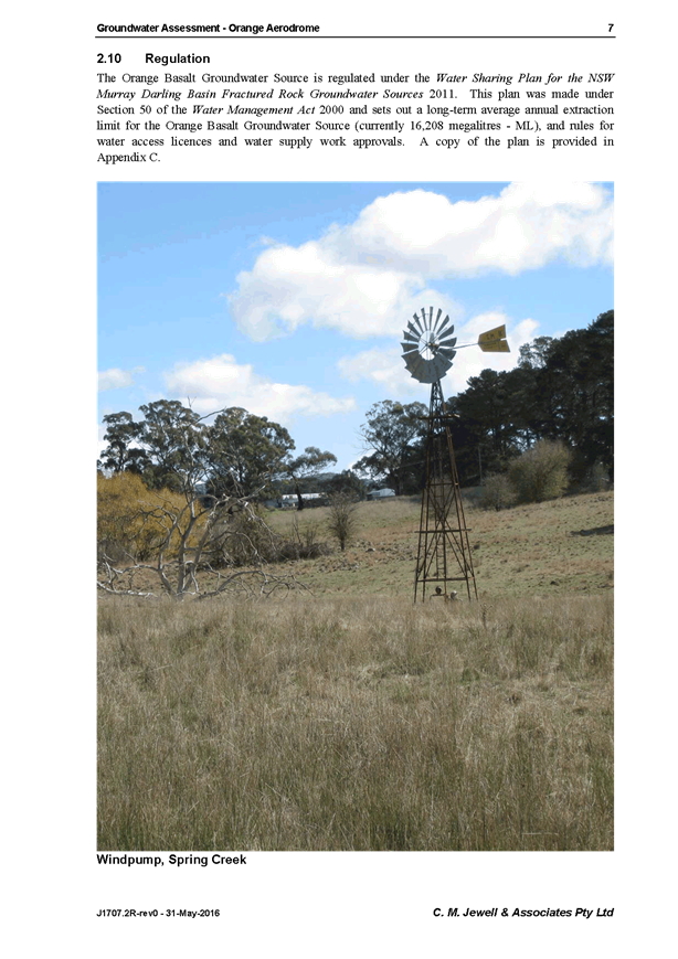

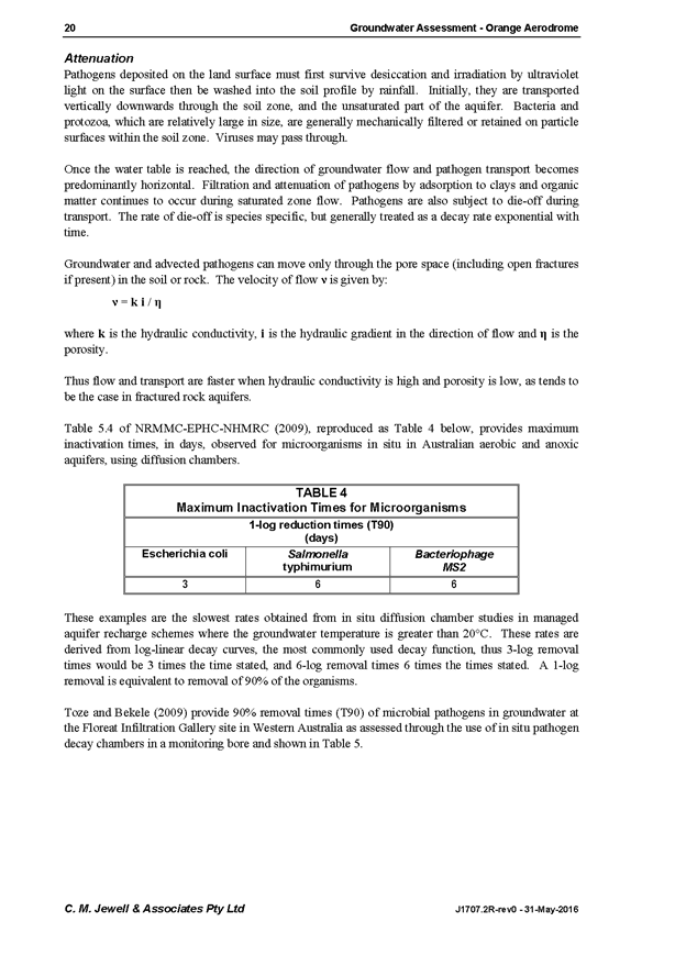
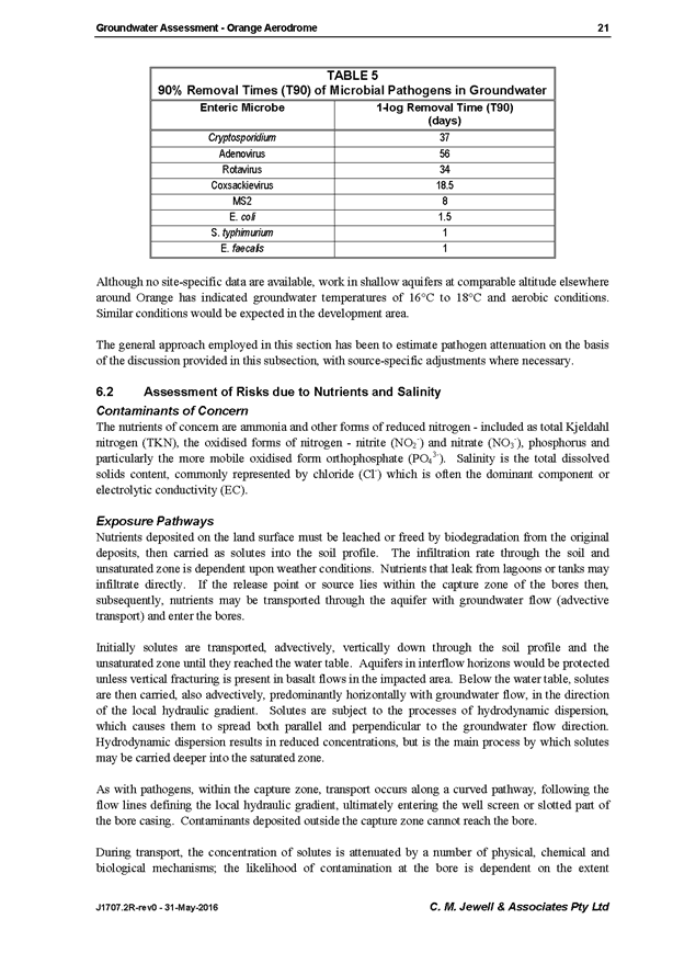
Council Meeting
22 June 2017
5.4 Orange
LEP Amendment 9 - Orange Airport Industrial Park - Submissions Report
Attachment 1 Groundwater
Assessment Report
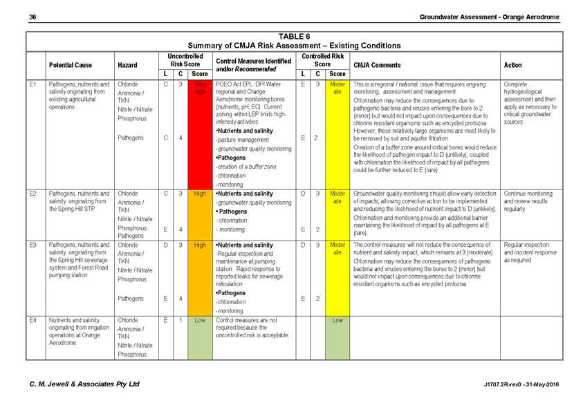
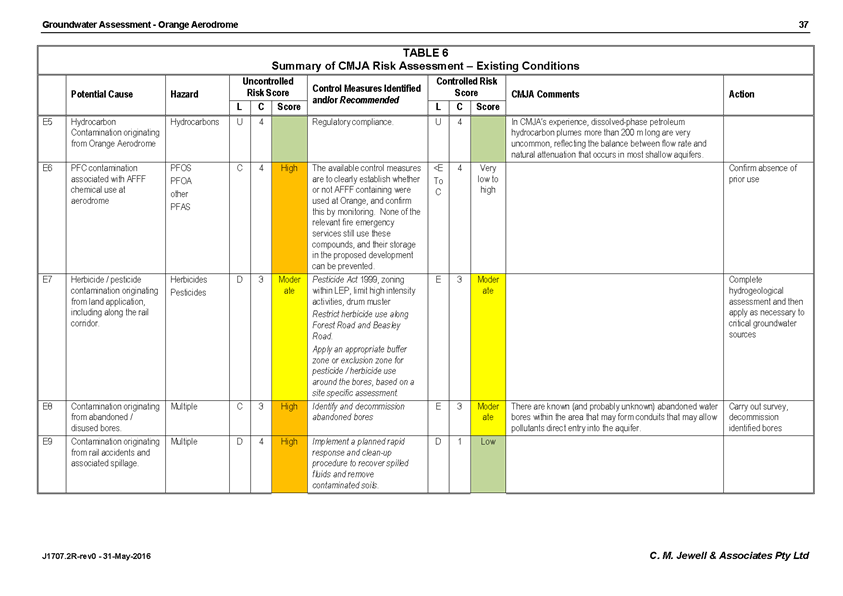
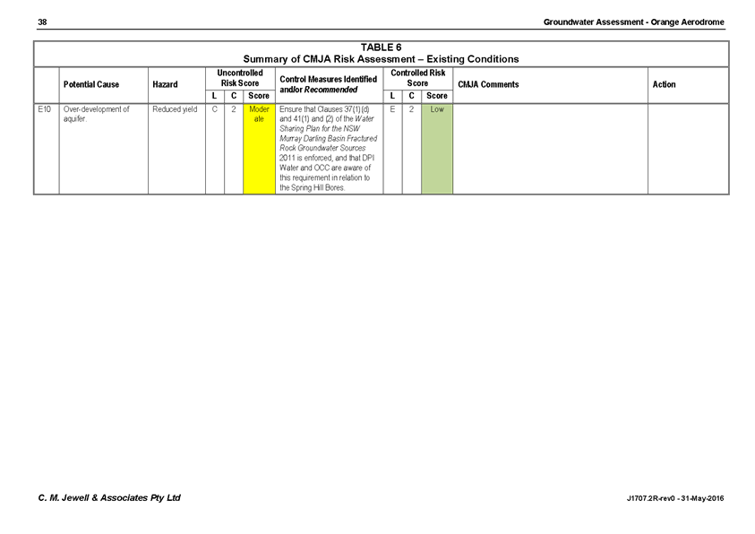
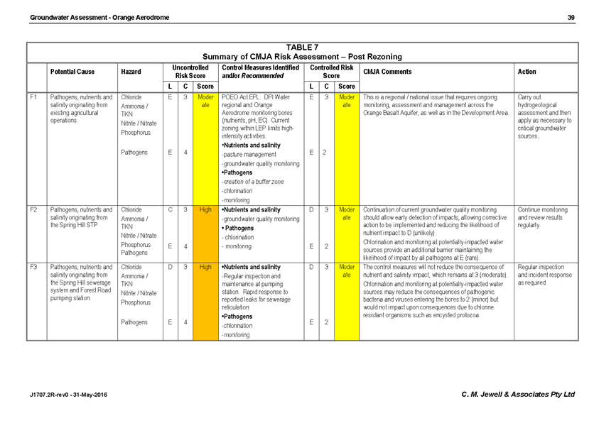
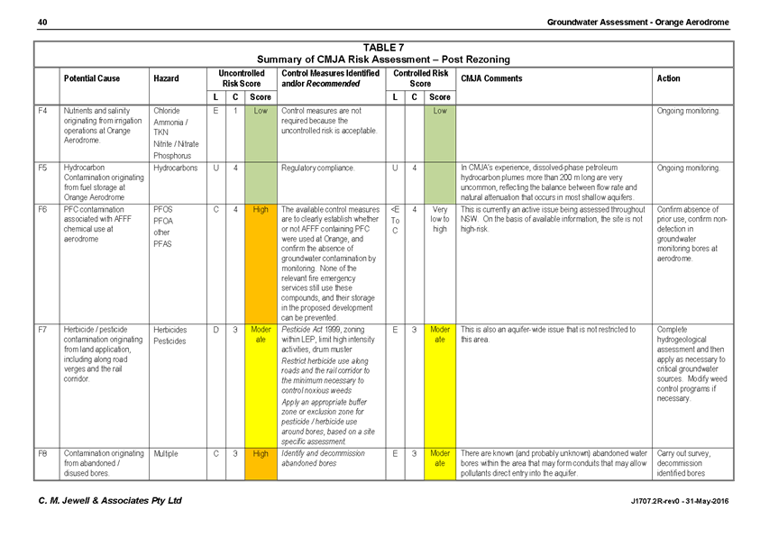
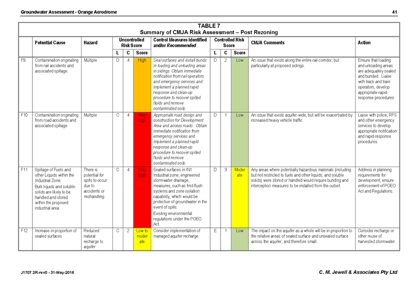
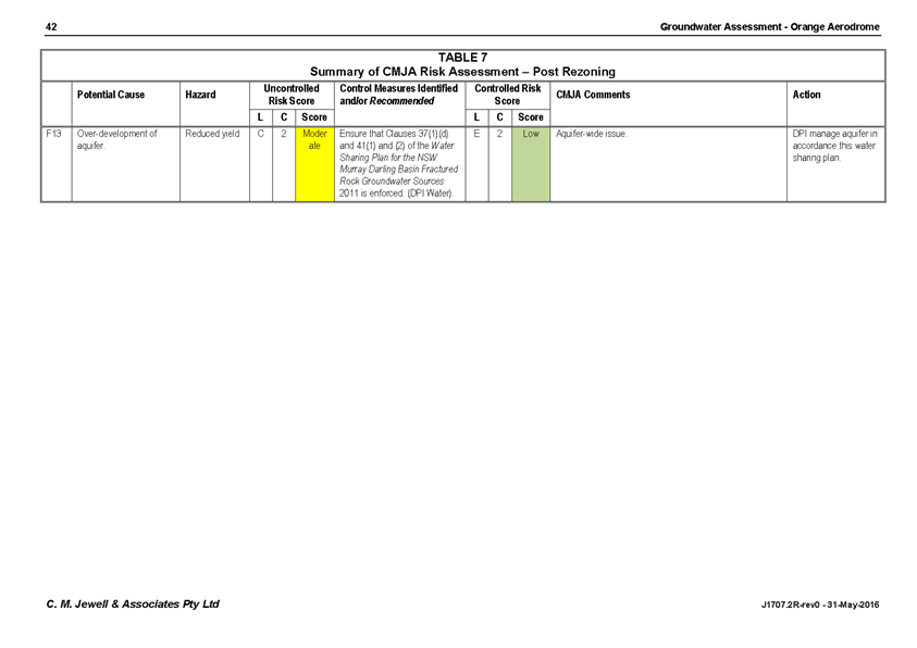
Council Meeting
22 June 2017
5.4 Orange
LEP Amendment 9 - Orange Airport Industrial Park - Submissions Report
Attachment 1 Groundwater
Assessment Report
Council Meeting
22 June 2017
5.4 Orange
LEP Amendment 9 - Orange Airport Industrial Park - Submissions Report
Attachment 1 Groundwater
Assessment Report
Council Meeting
22 June 2017
5.4 Orange
LEP Amendment 9 - Orange Airport Industrial Park - Submissions Report
Attachment 1 Groundwater
Assessment Report


Council Meeting
22 June 2017
5.4 Orange
LEP Amendment 9 - Orange Airport Industrial Park - Submissions Report
Attachment 1 Groundwater
Assessment Report

Council Meeting
22 June 2017
5.4 Orange
LEP Amendment 9 - Orange Airport Industrial Park - Submissions Report
Attachment 1 Groundwater
Assessment Report
Council Meeting
22 June 2017
5.4 Orange
LEP Amendment 9 - Orange Airport Industrial Park - Submissions Report
Attachment 1 Groundwater
Assessment Report
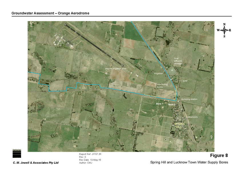
Council Meeting
22 June 2017
5.4 Orange
LEP Amendment 9 - Orange Airport Industrial Park - Submissions Report
Attachment 1 Groundwater
Assessment Report
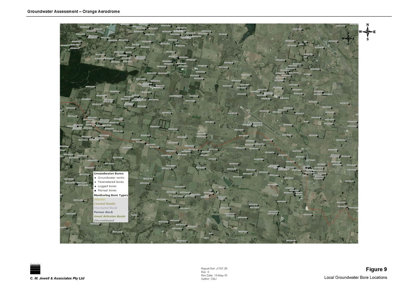
Council Meeting
22 June 2017
5.4 Orange
LEP Amendment 9 - Orange Airport Industrial Park - Submissions Report
Attachment 1 Groundwater
Assessment Report

Council Meeting
22 June 2017
5.4 Orange
LEP Amendment 9 - Orange Airport Industrial Park - Submissions Report
Attachment 1 Groundwater
Assessment Report
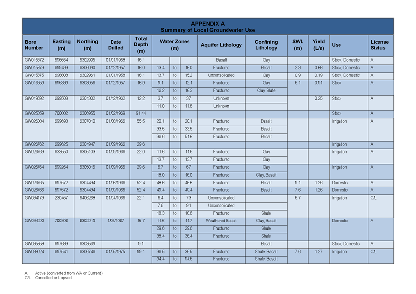
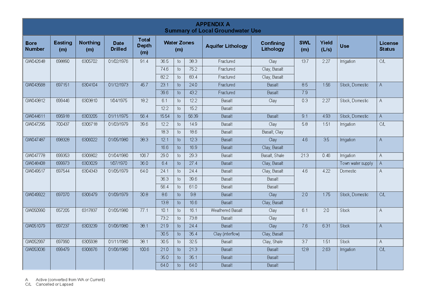
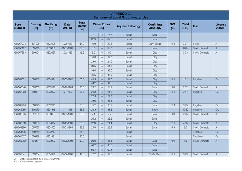
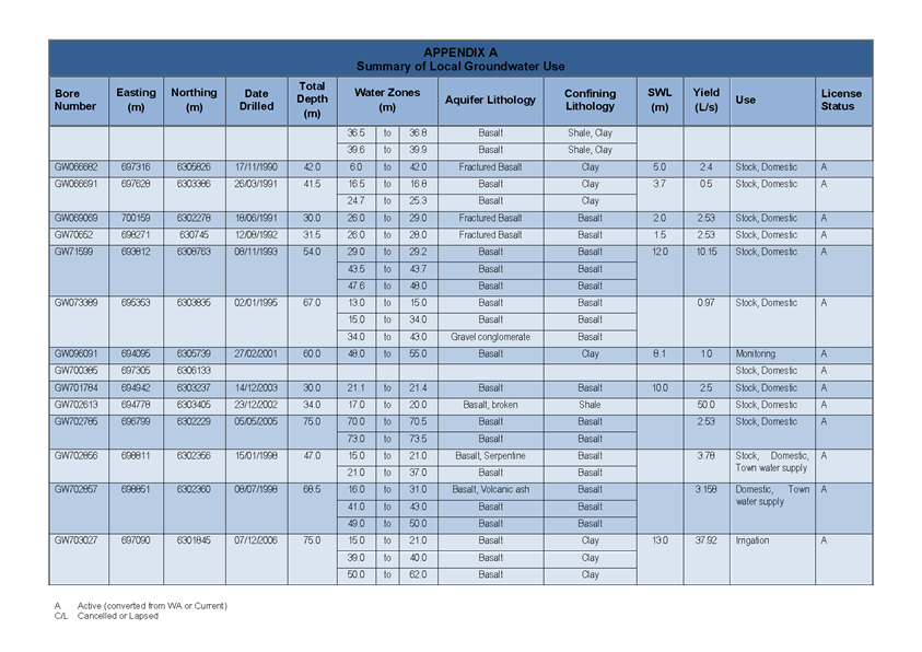
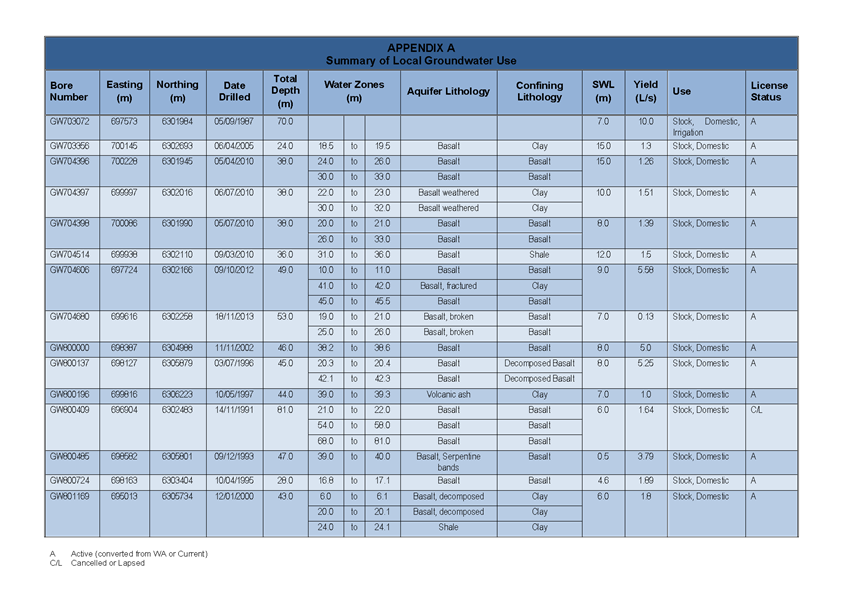
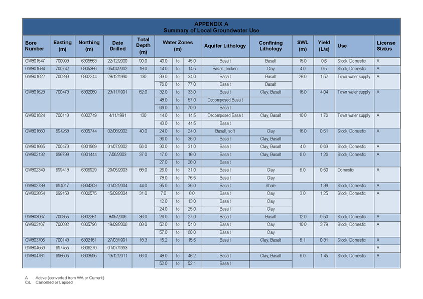
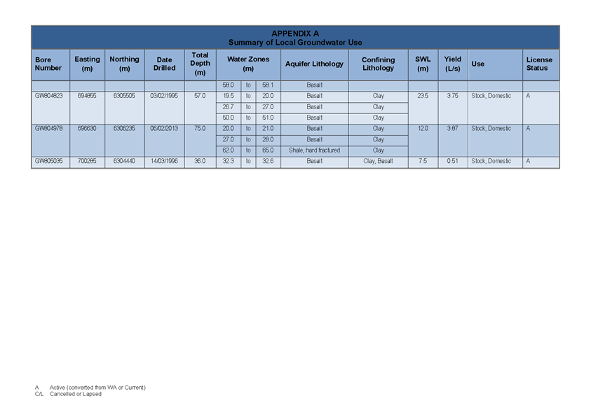
Council Meeting
22 June 2017
5.4 Orange
LEP Amendment 9 - Orange Airport Industrial Park - Submissions Report
Attachment 1 Groundwater
Assessment Report

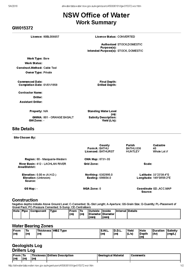

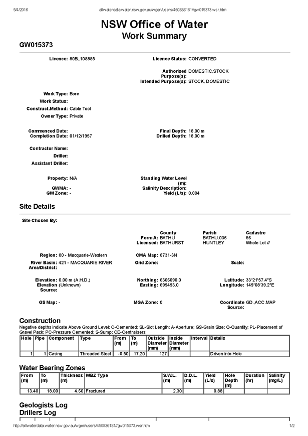

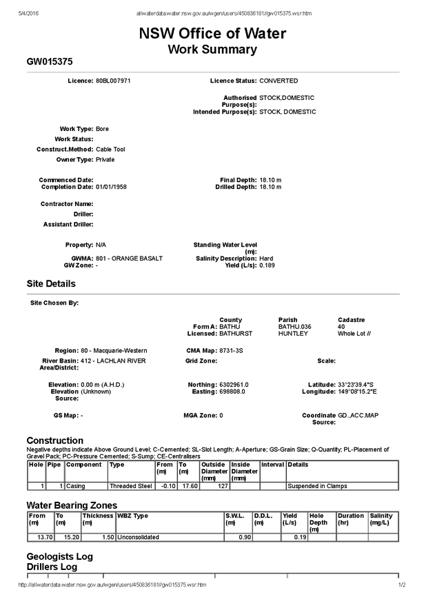

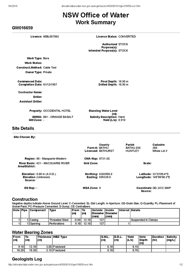

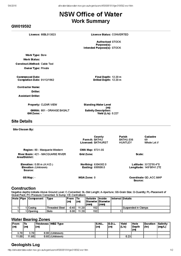
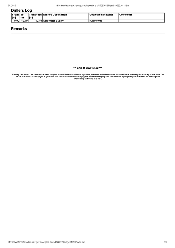
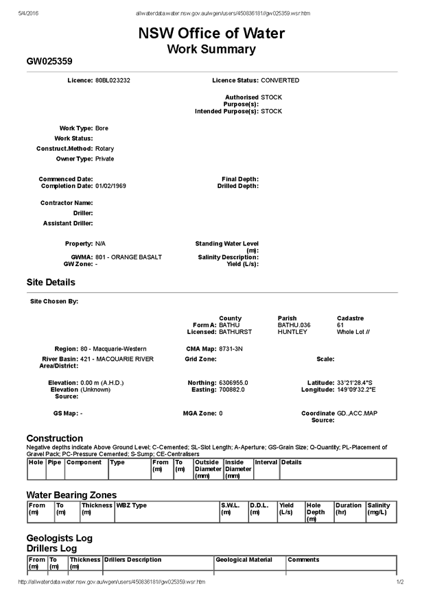

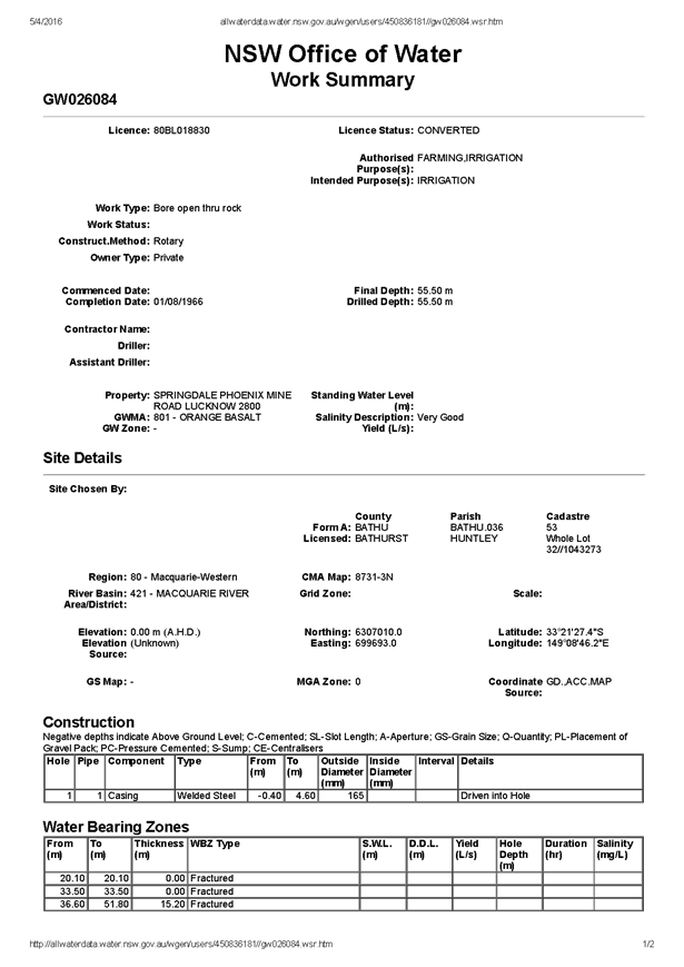

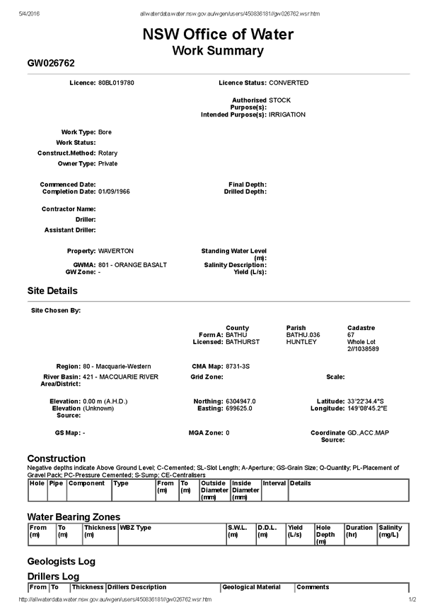

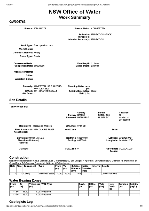


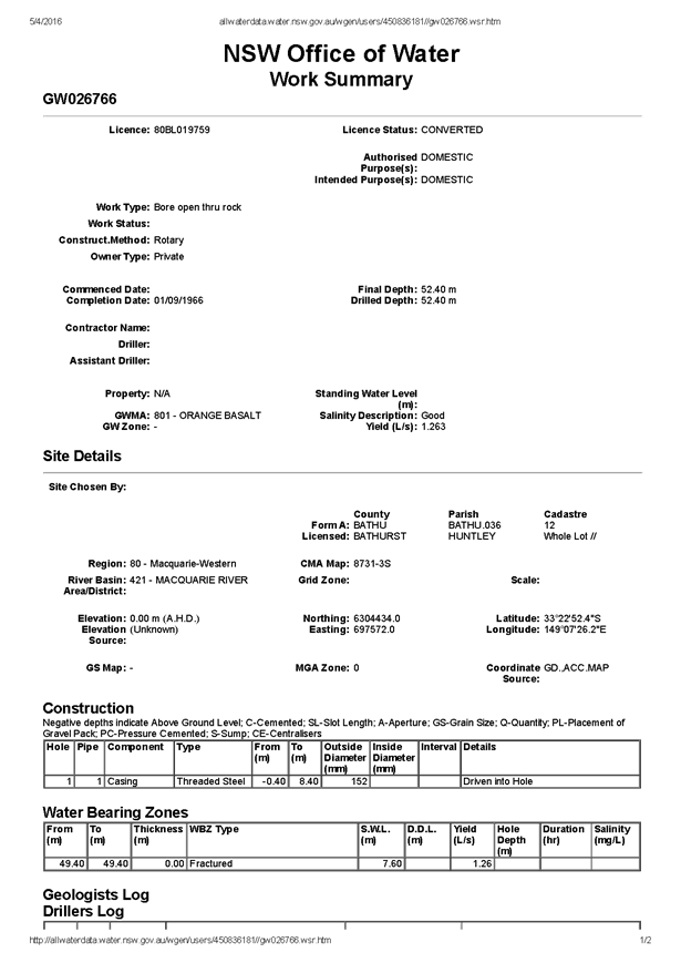

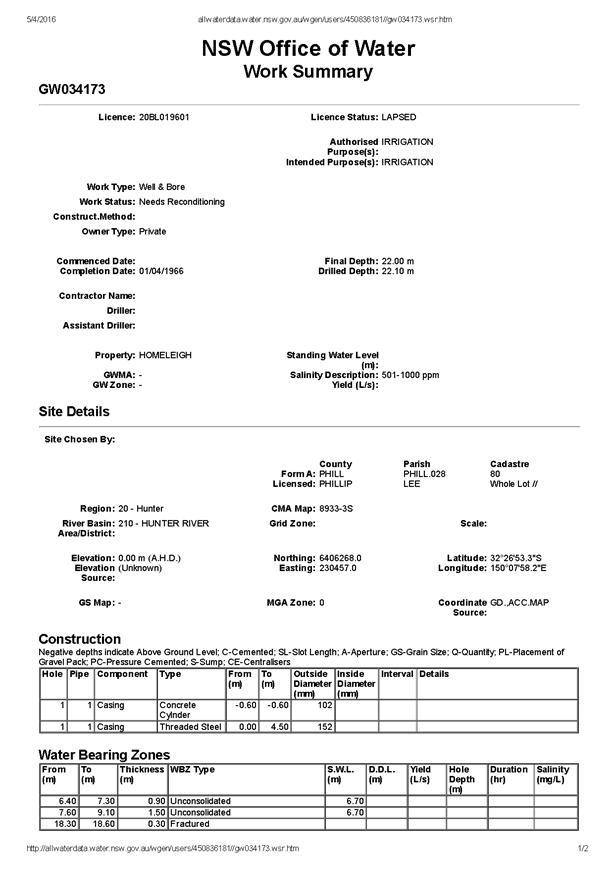

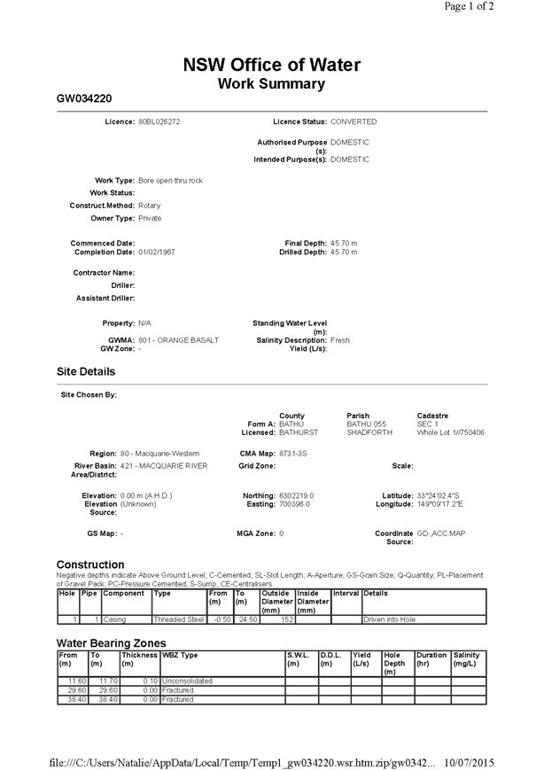

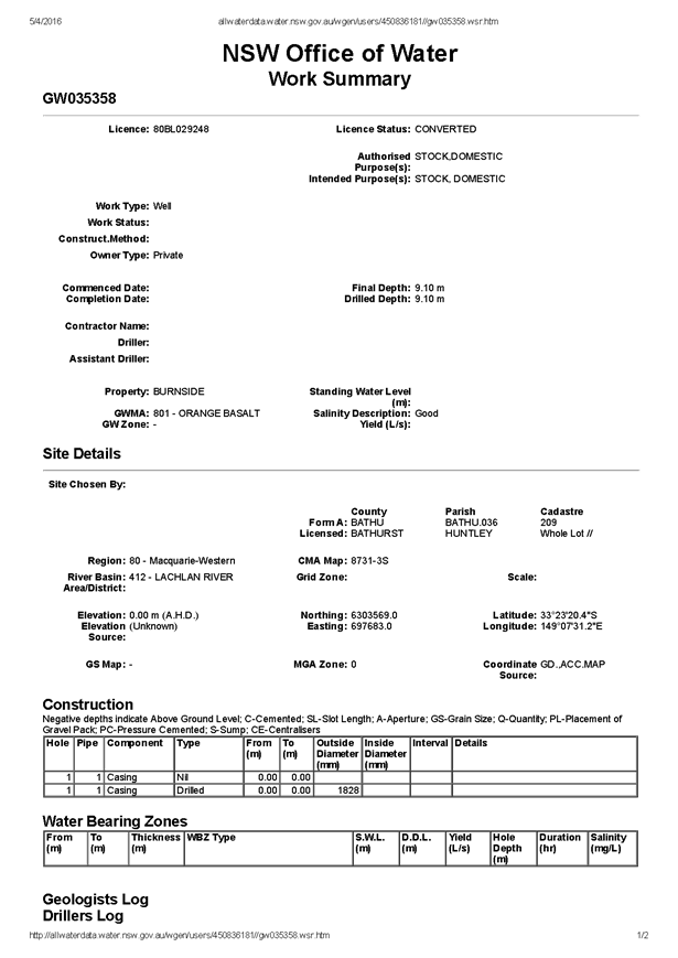

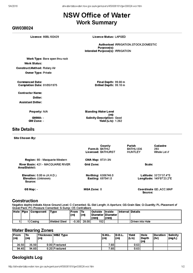

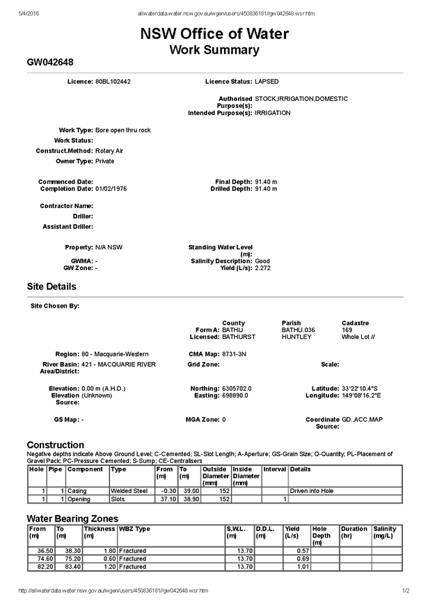

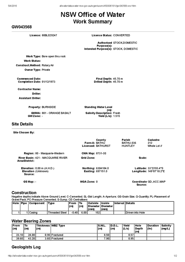

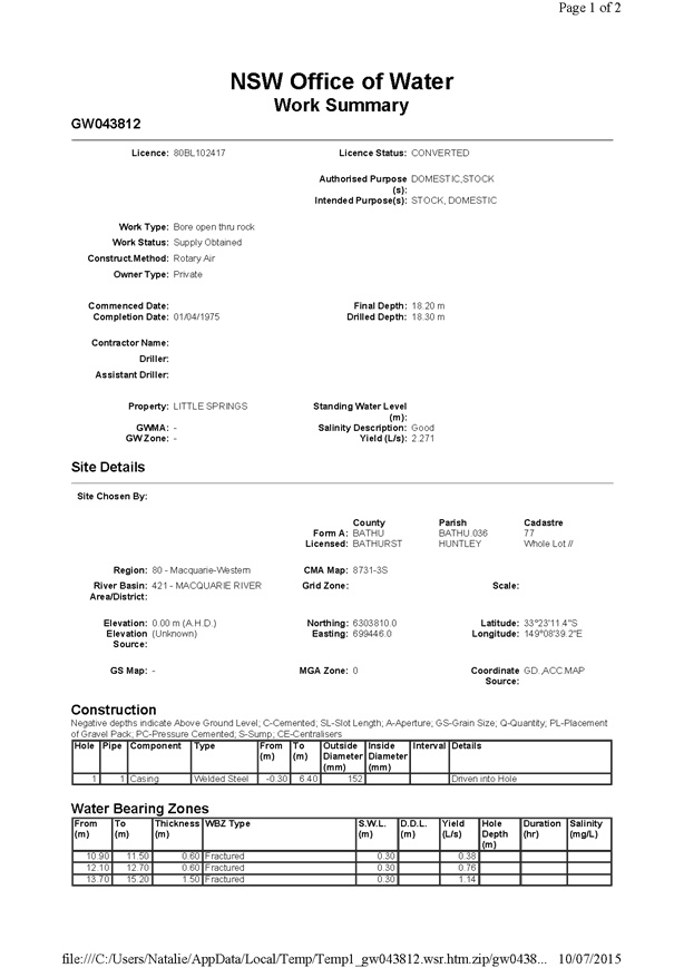
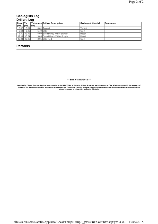
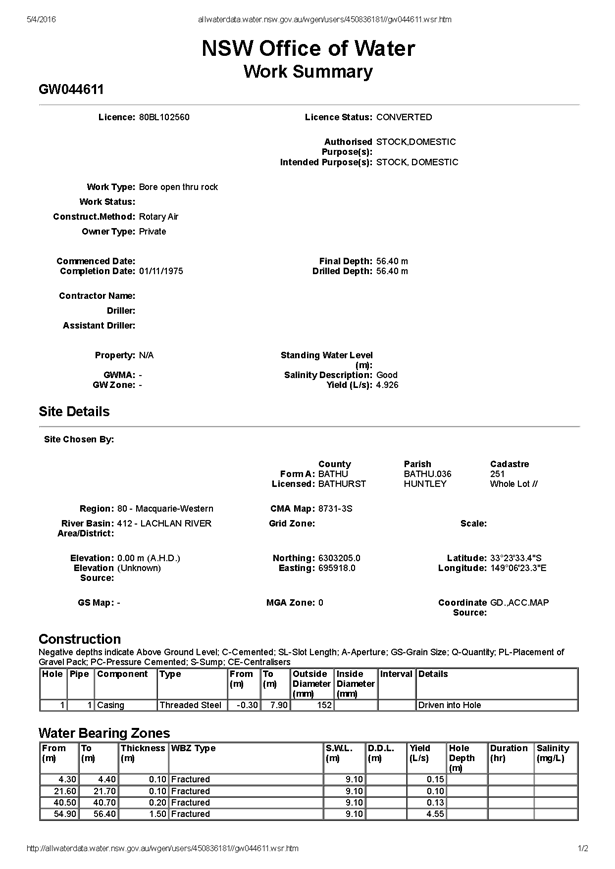

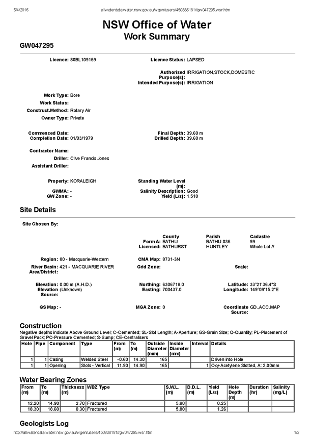

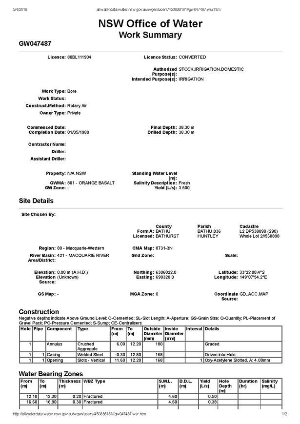

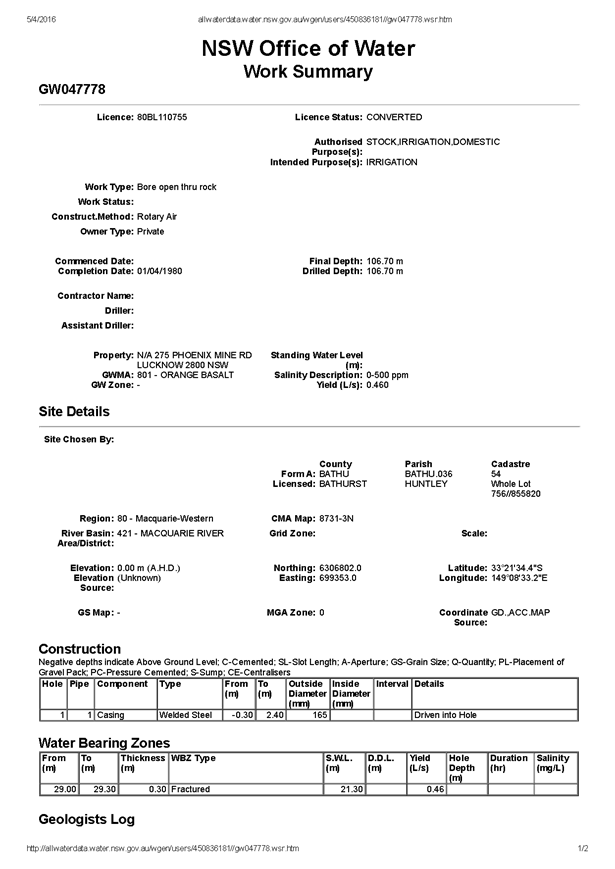

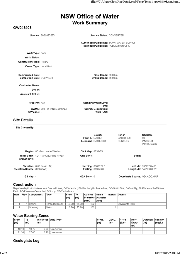

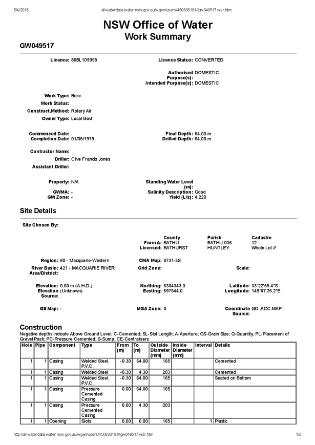
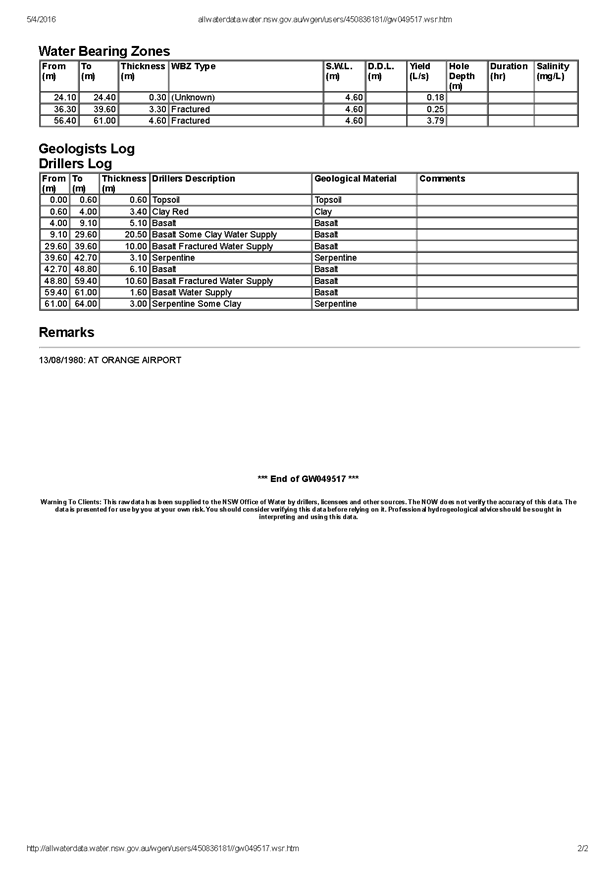
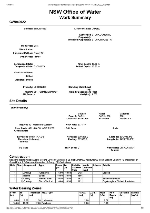

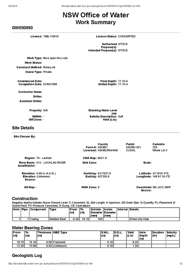

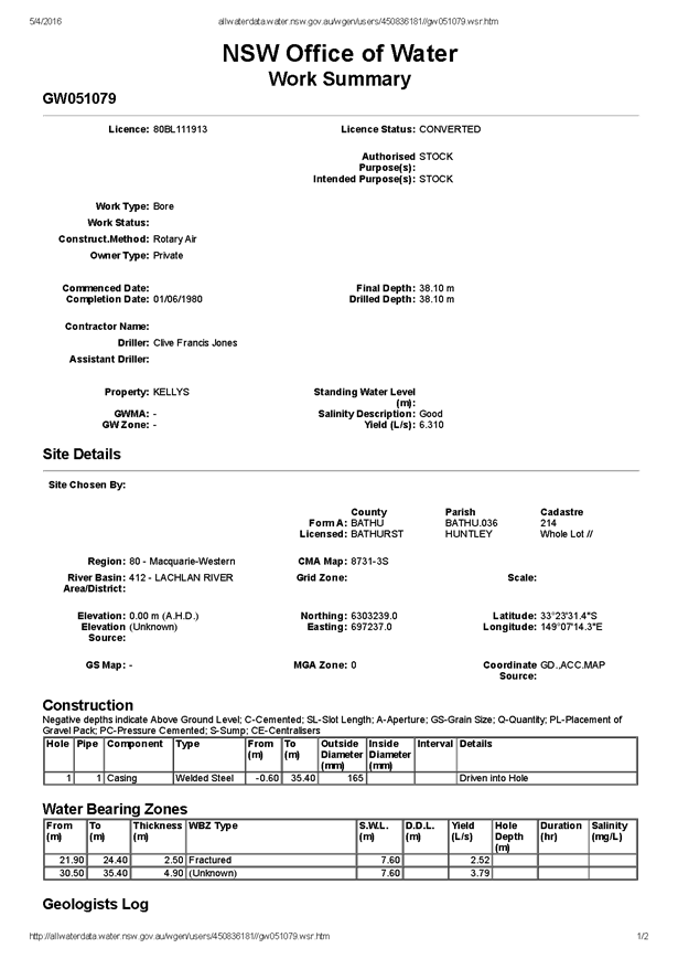

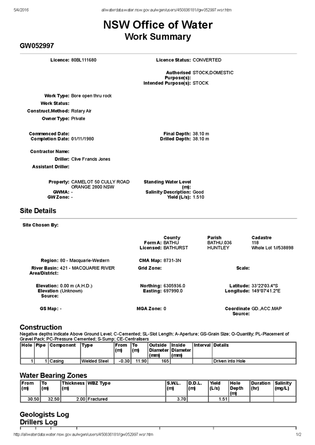

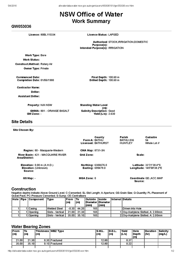

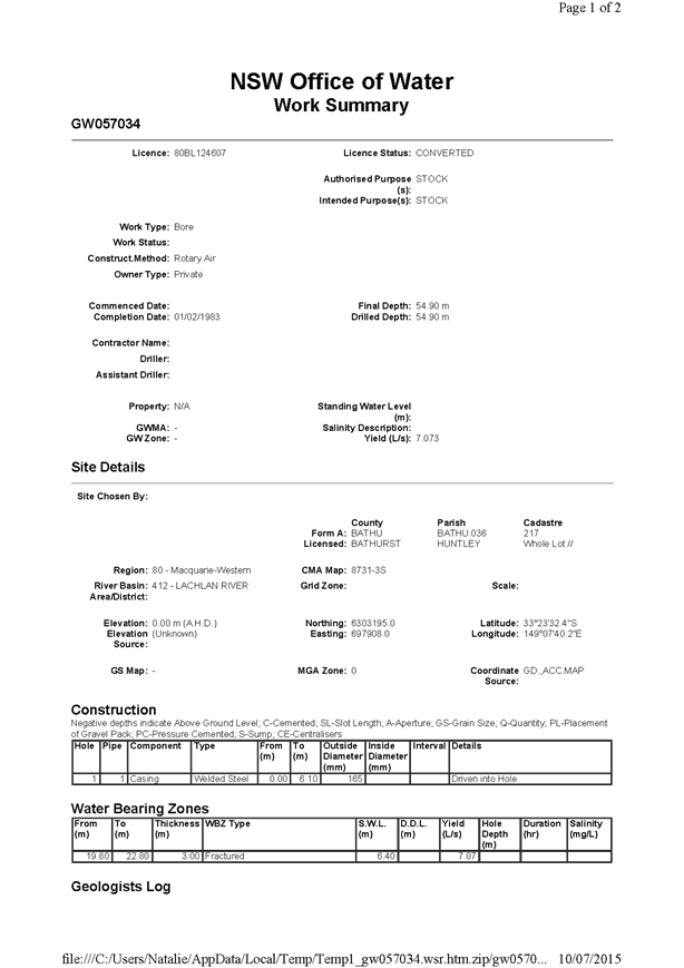
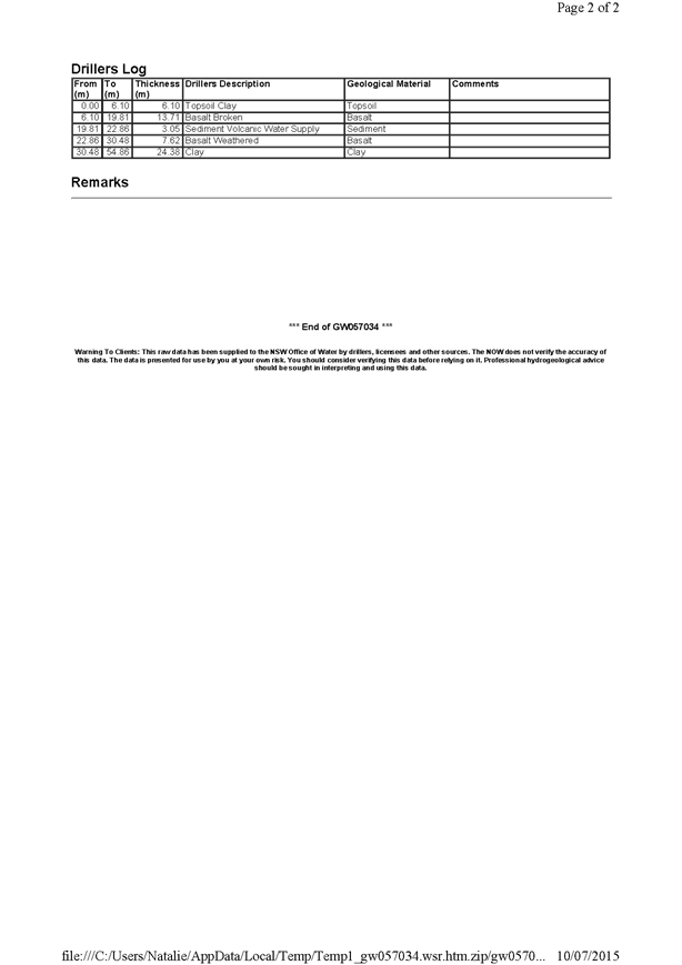
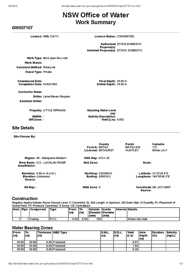

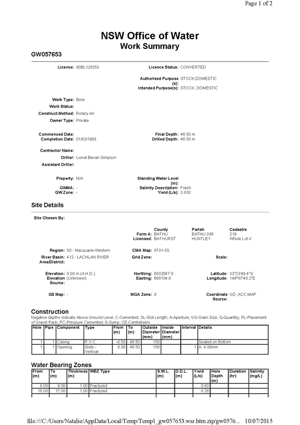

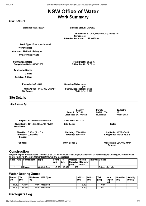

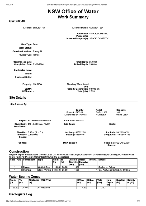

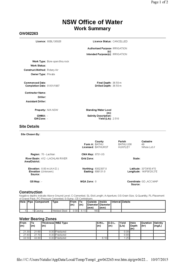

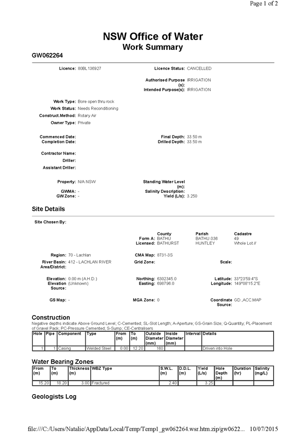
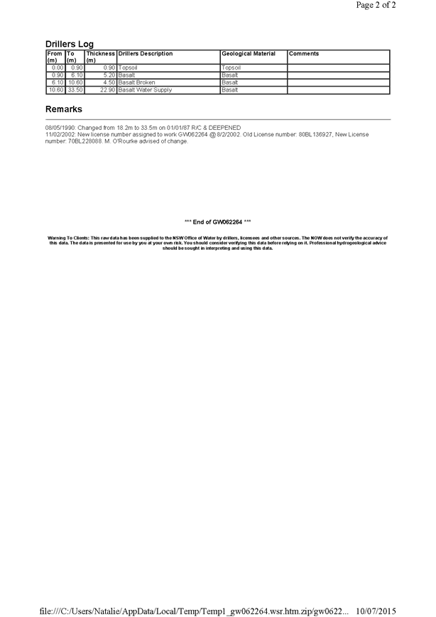
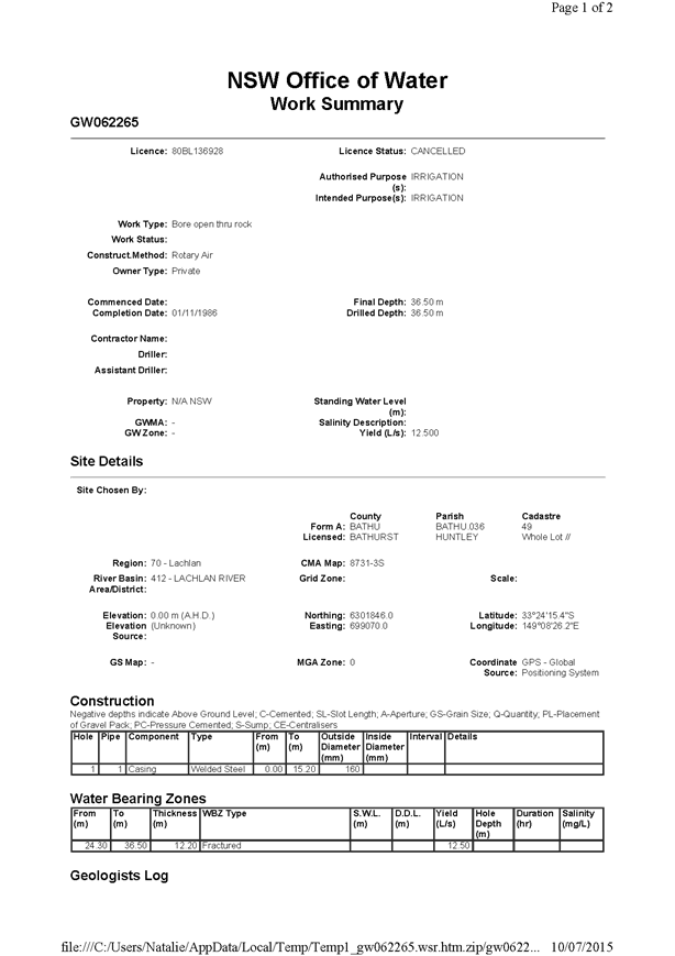
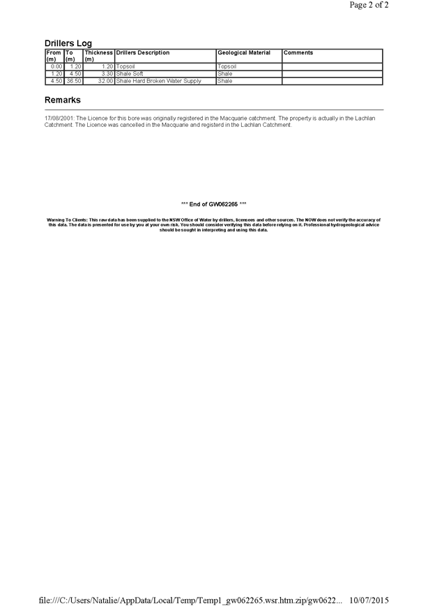
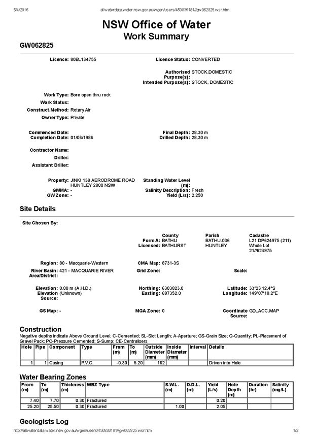


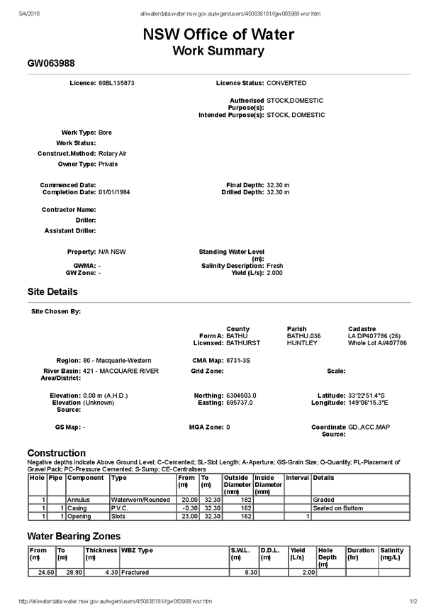

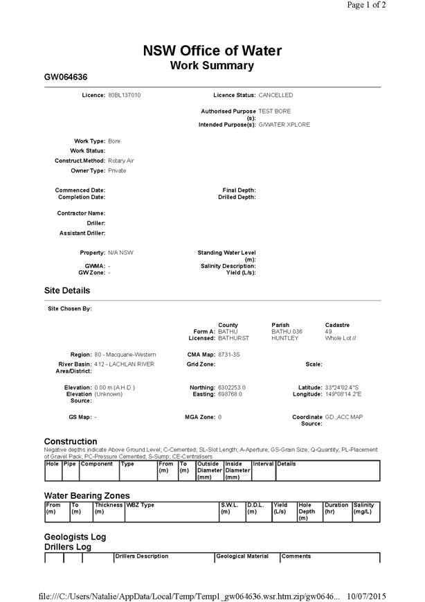


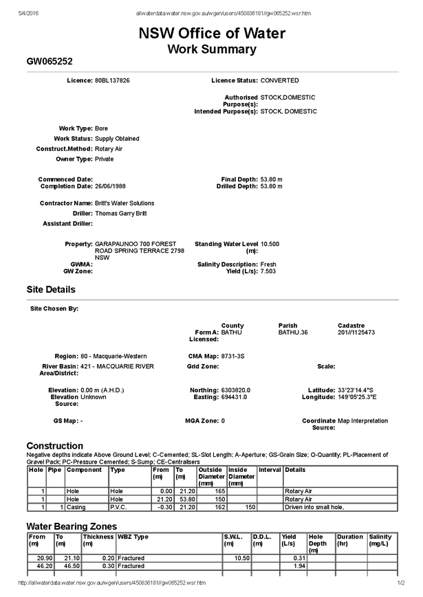

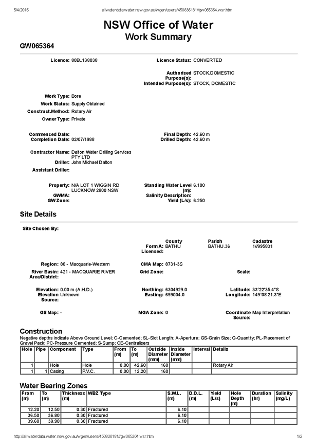

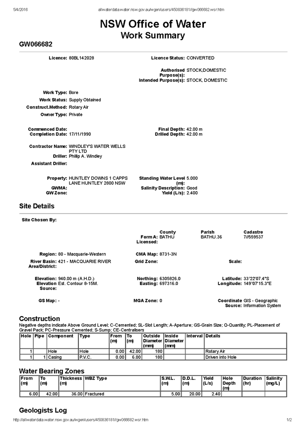

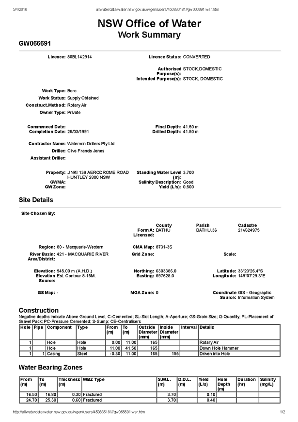

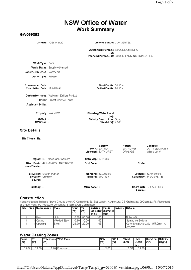
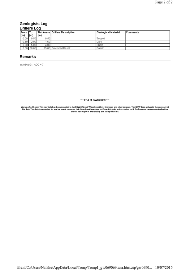
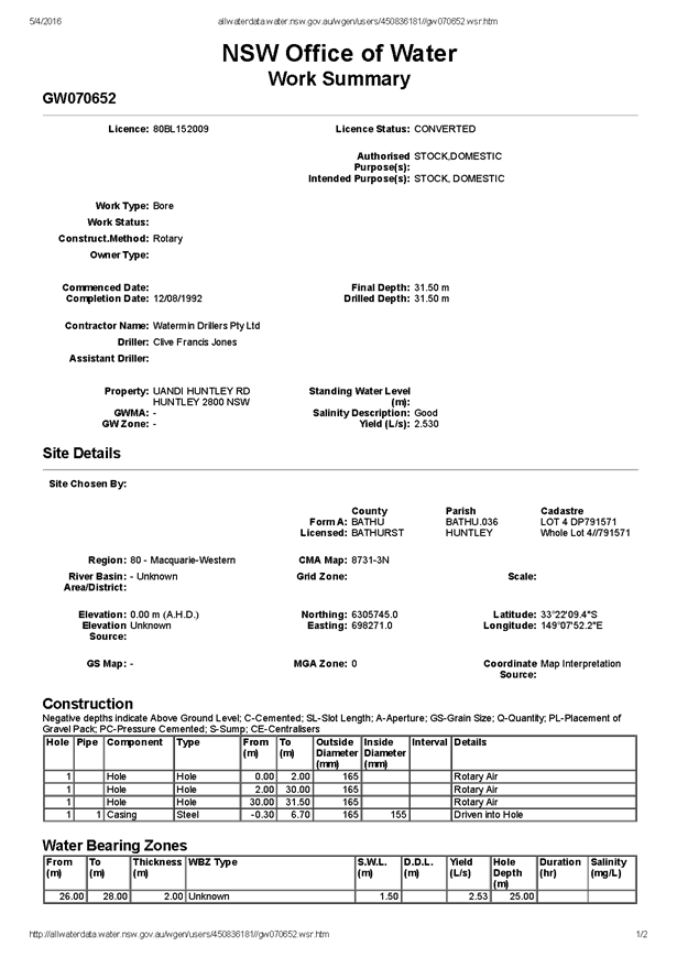


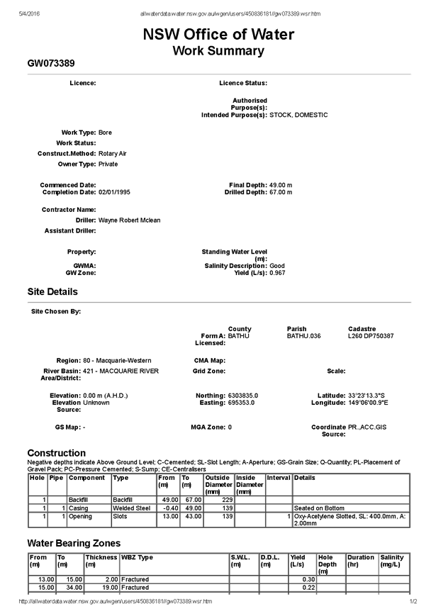
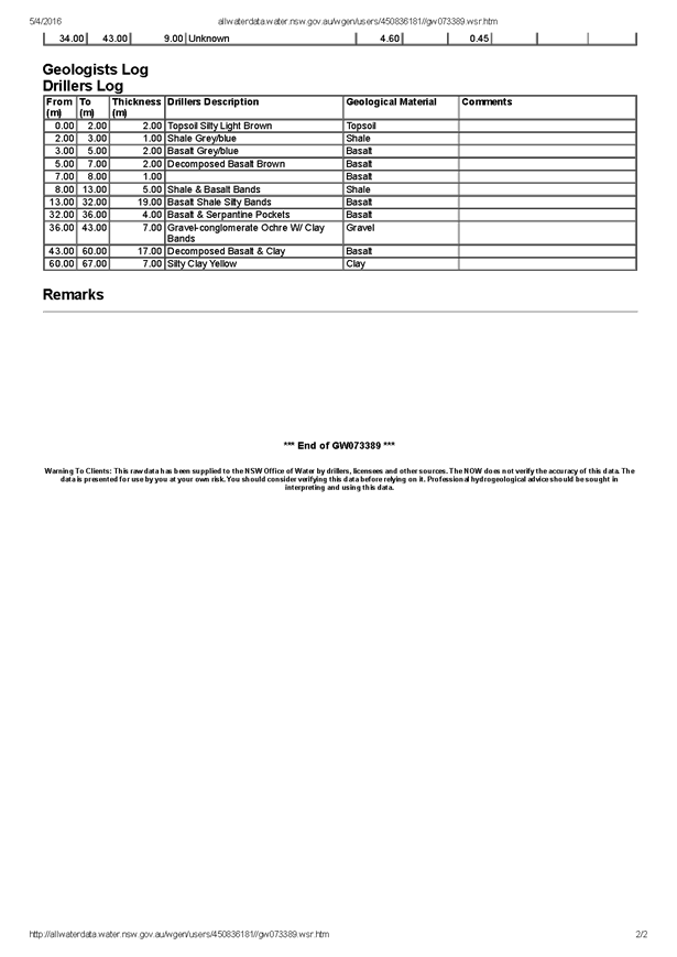
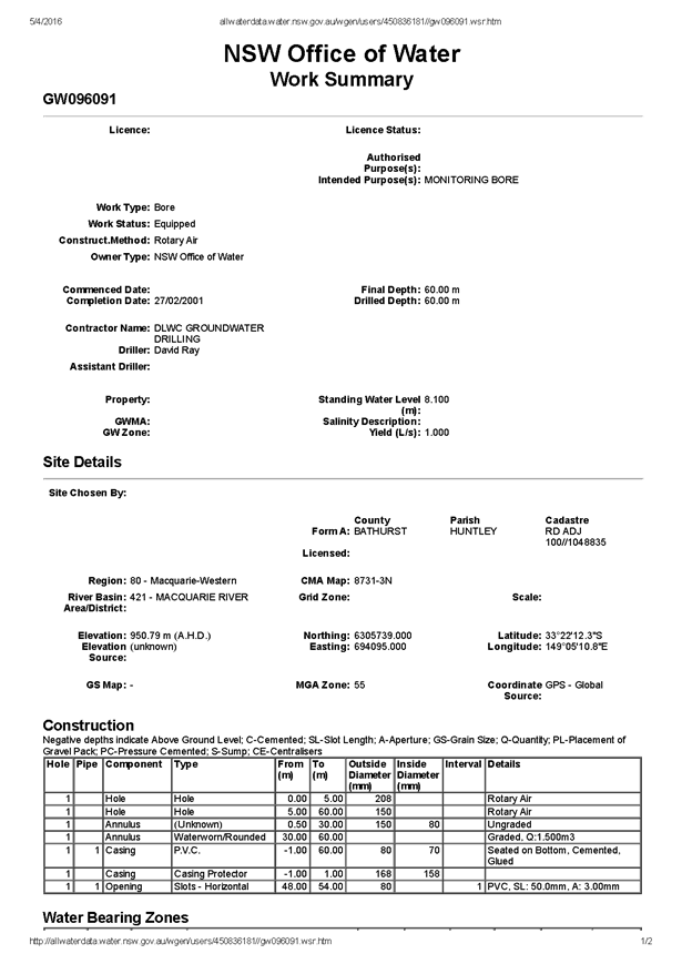
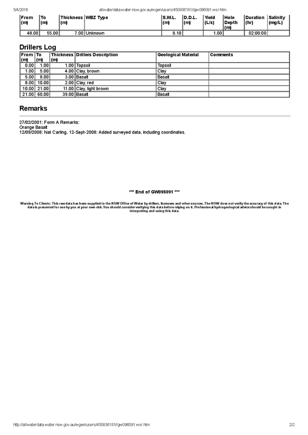


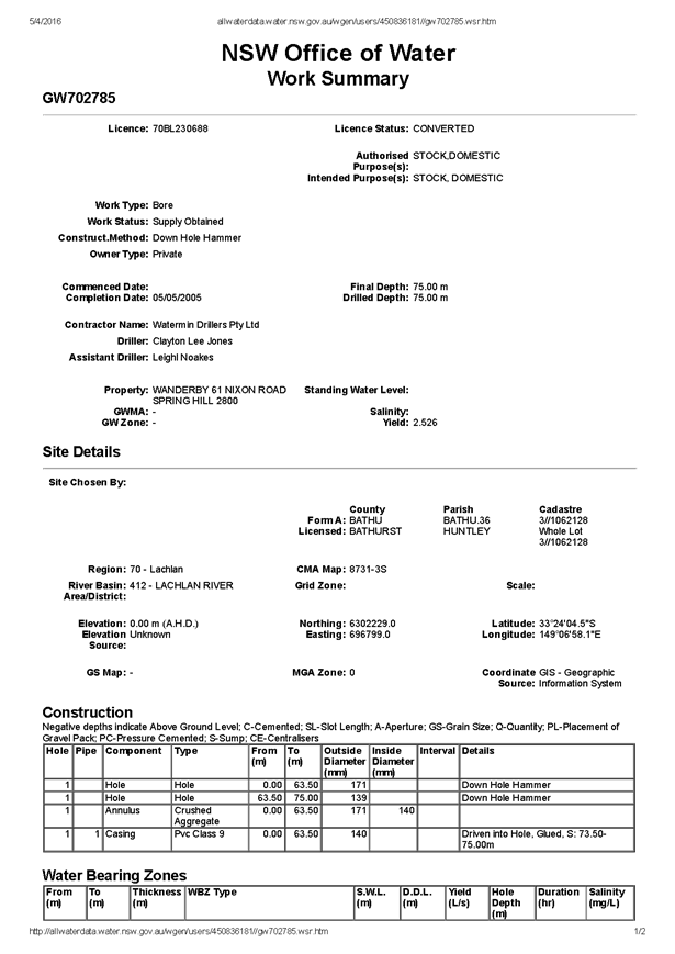
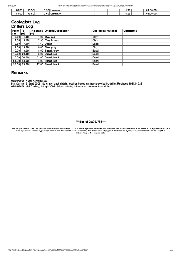
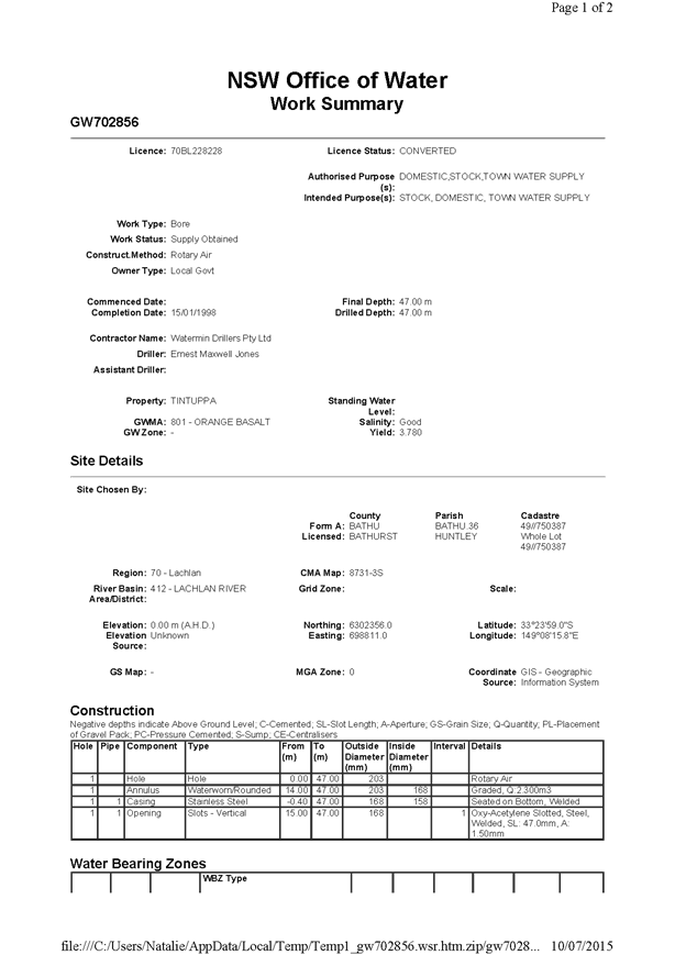
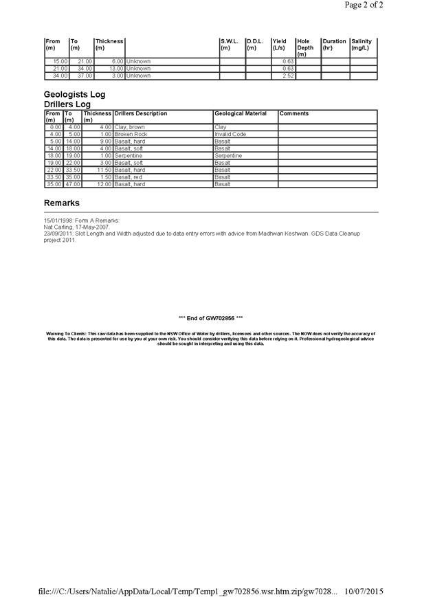
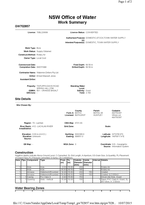
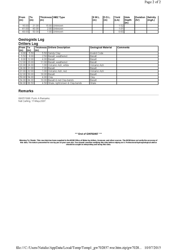
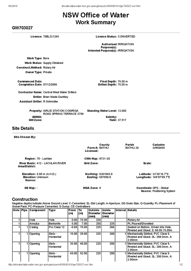
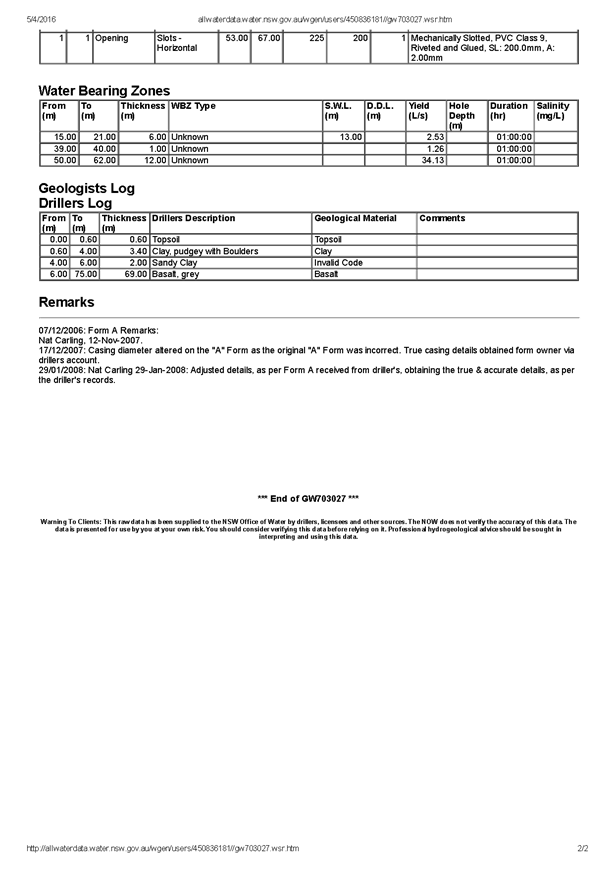
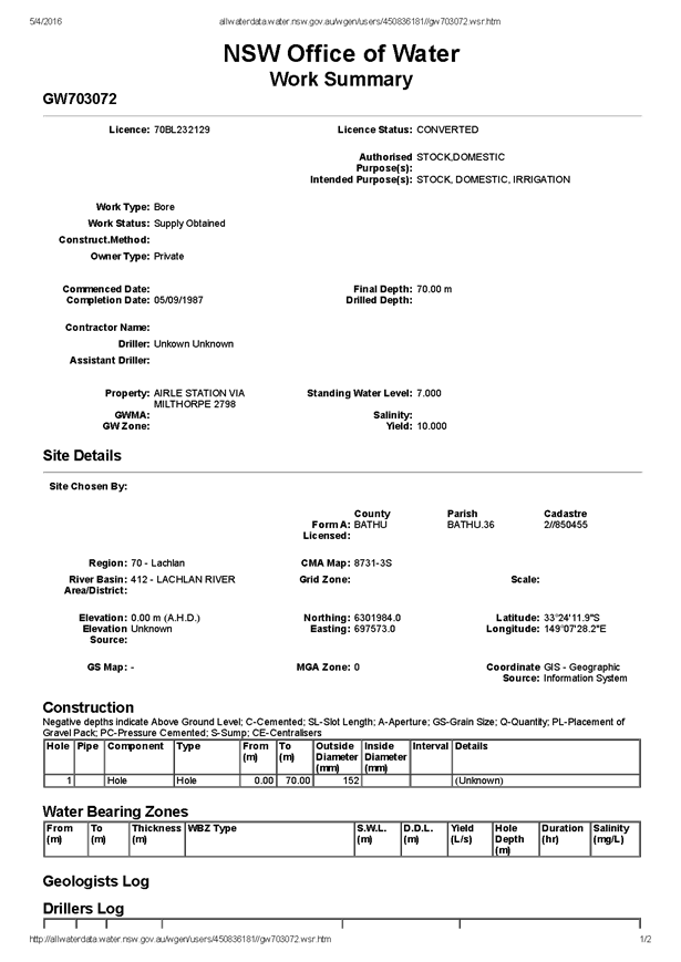

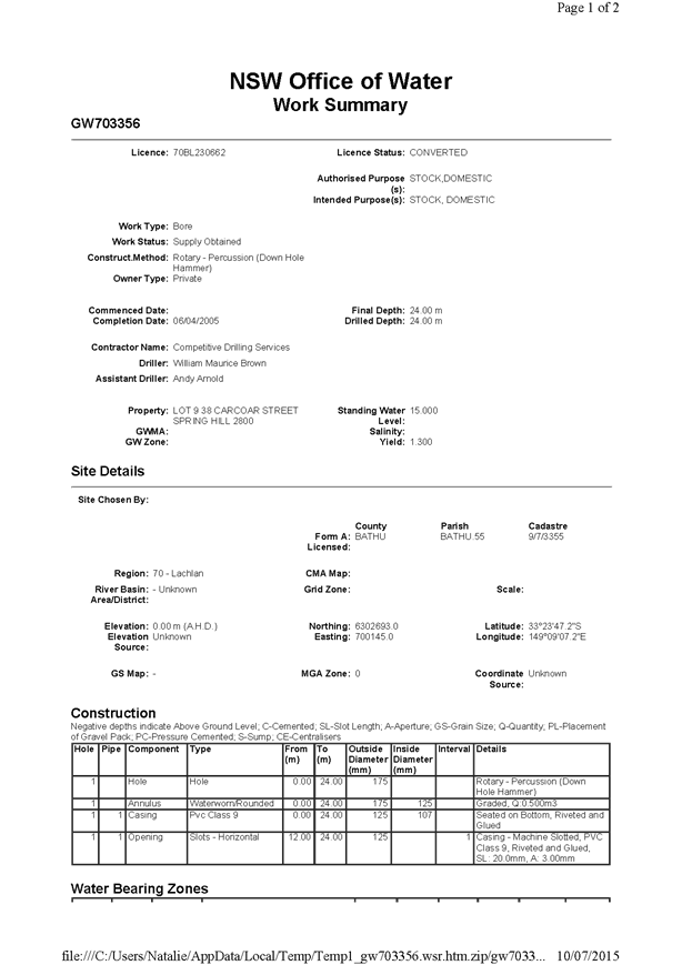

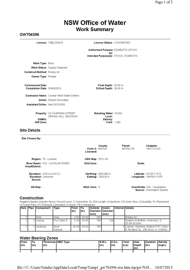

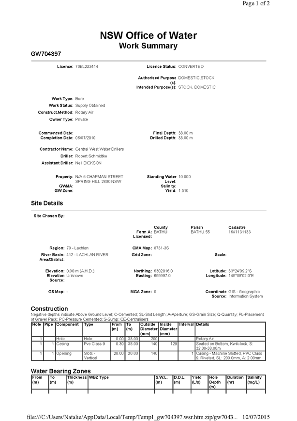

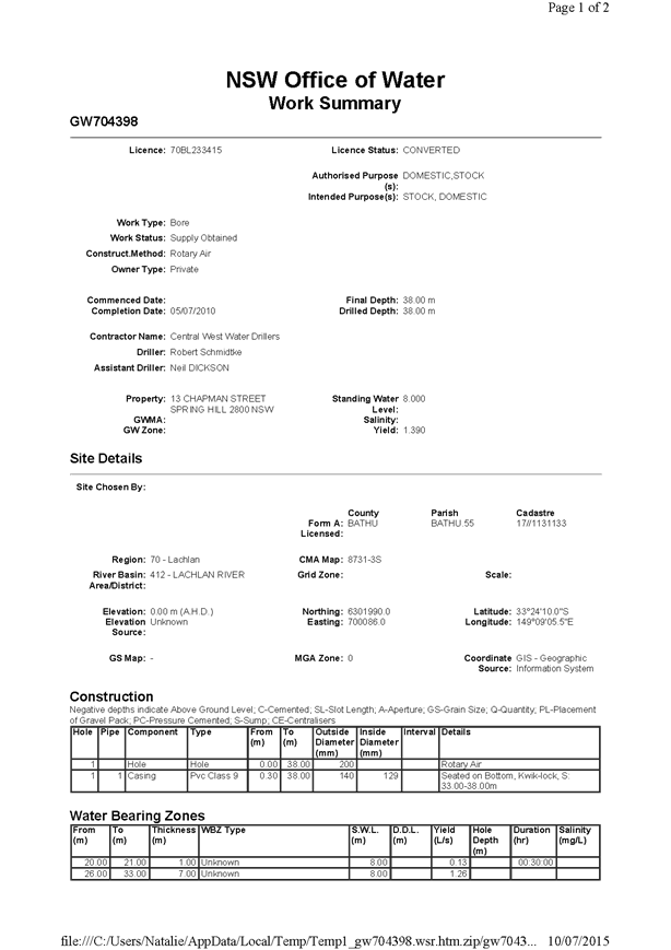


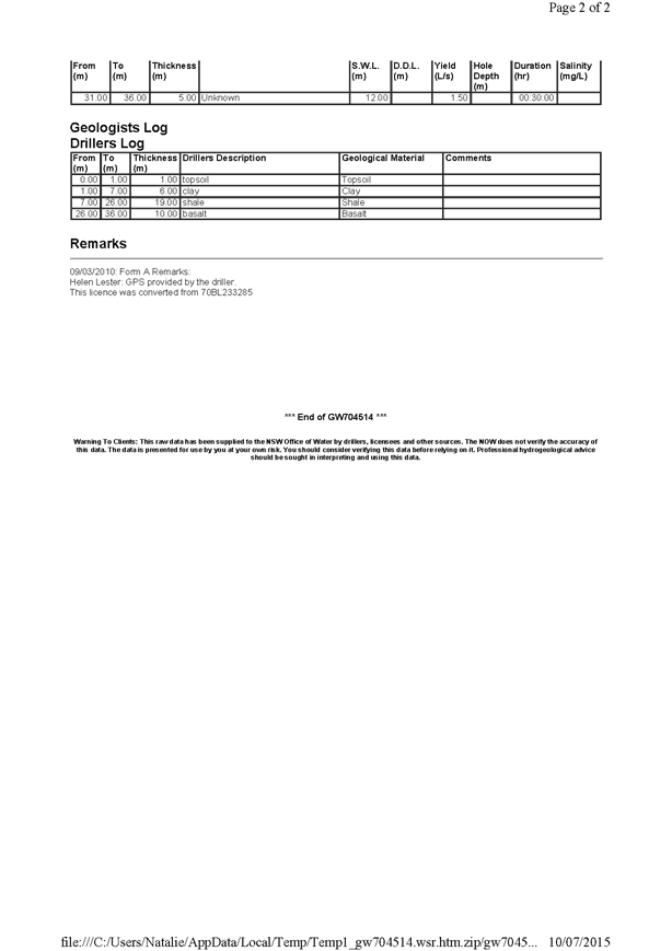
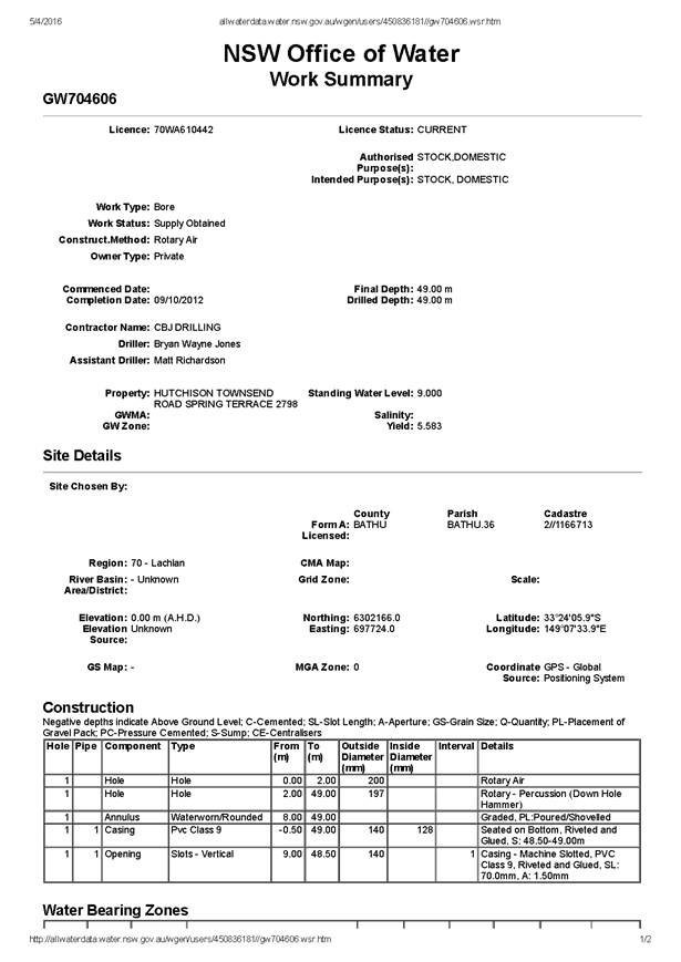
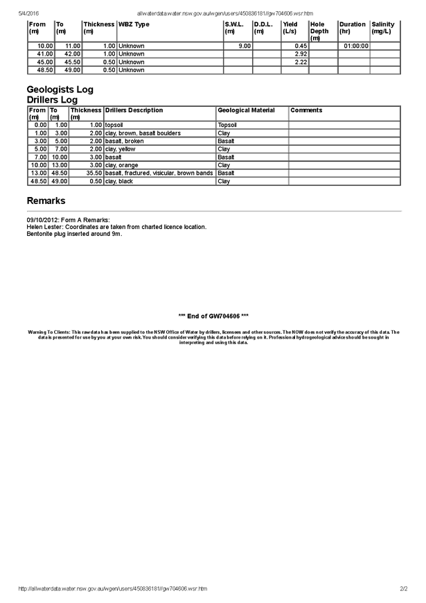
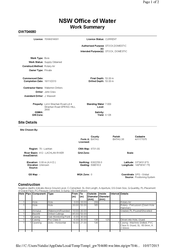
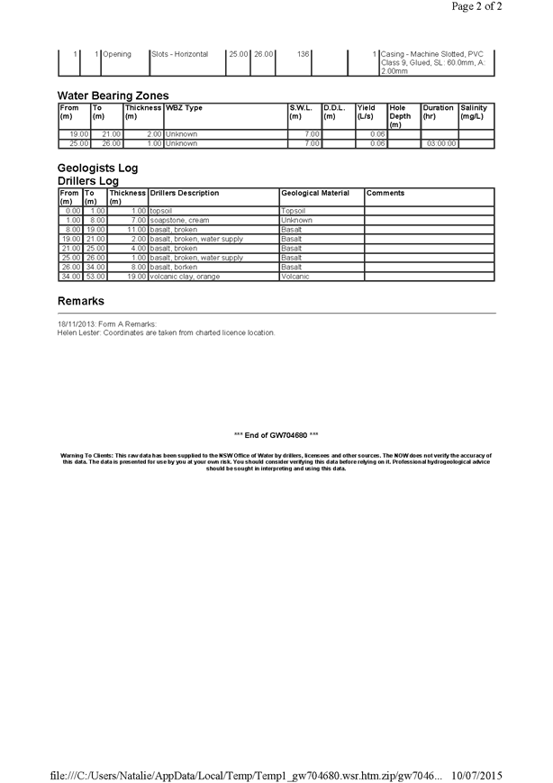
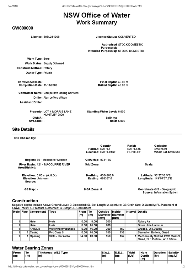
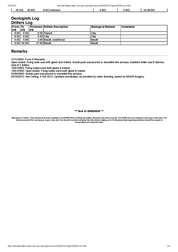
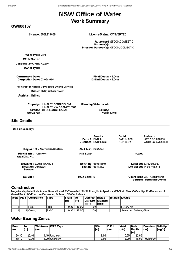

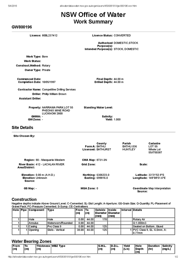

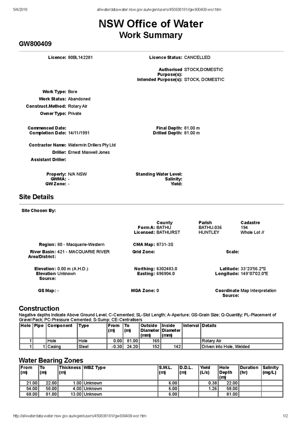

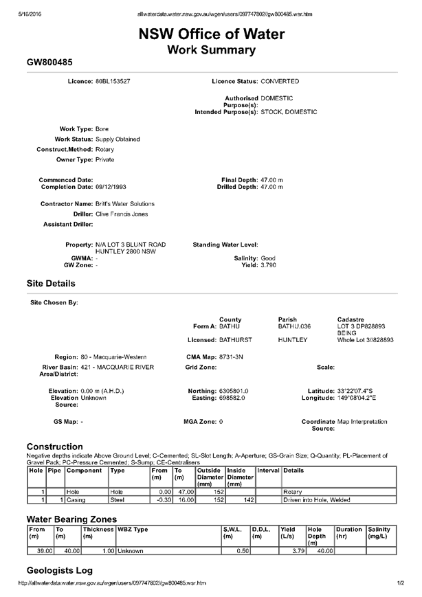

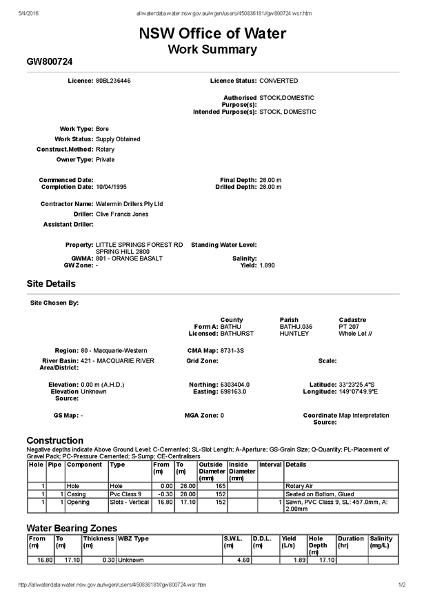


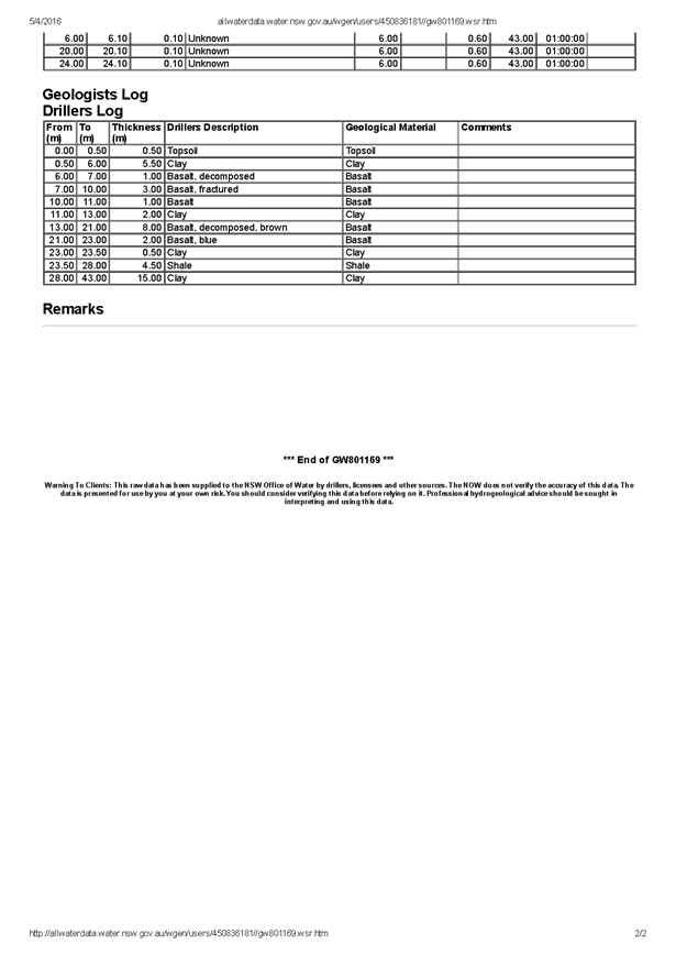
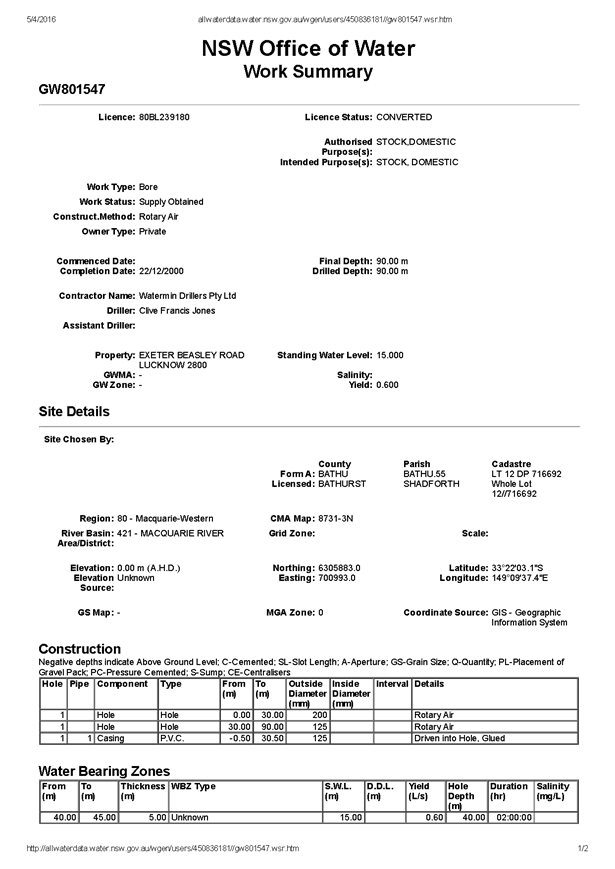

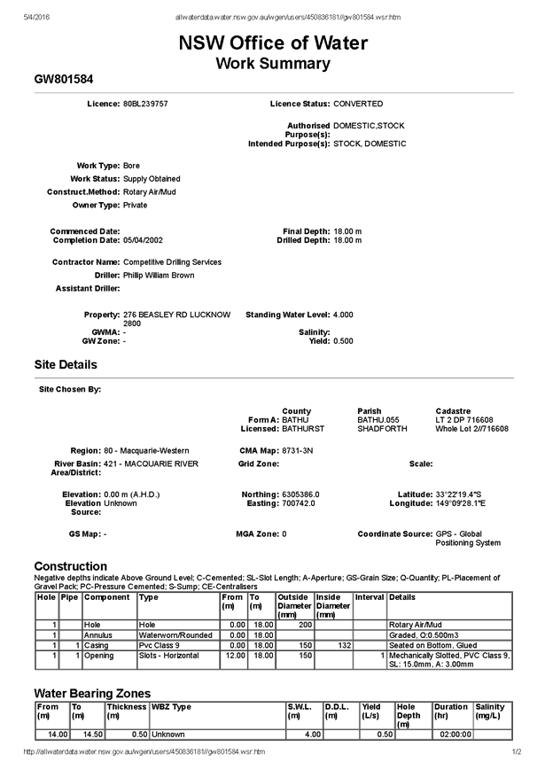

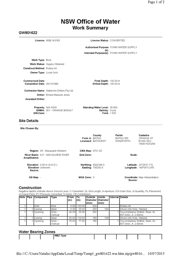
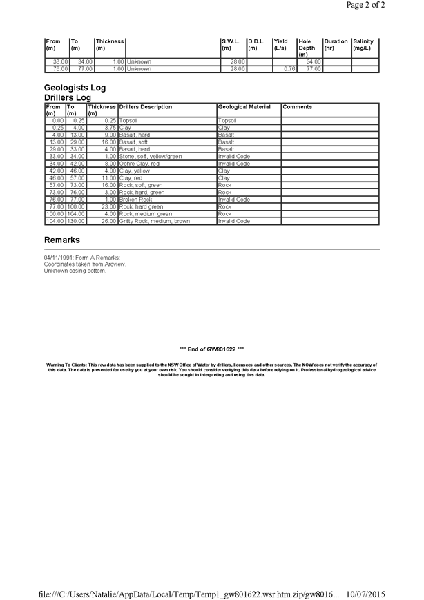
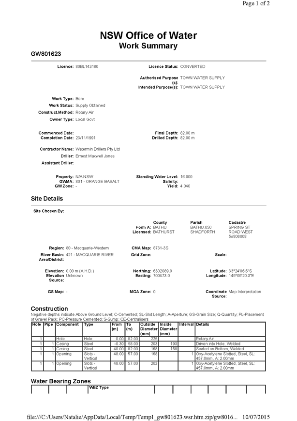
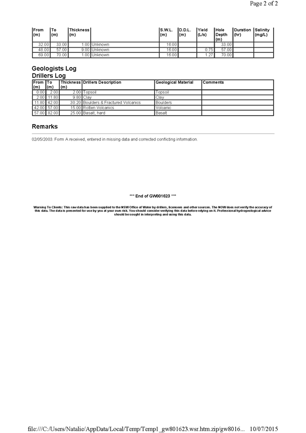
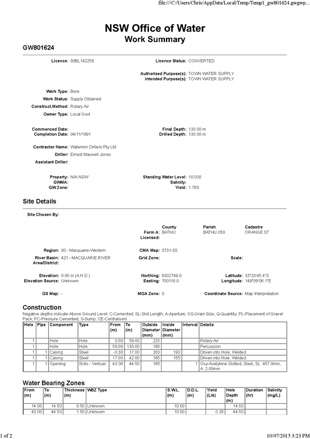

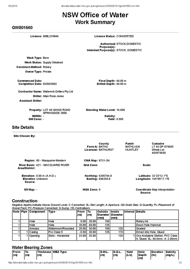
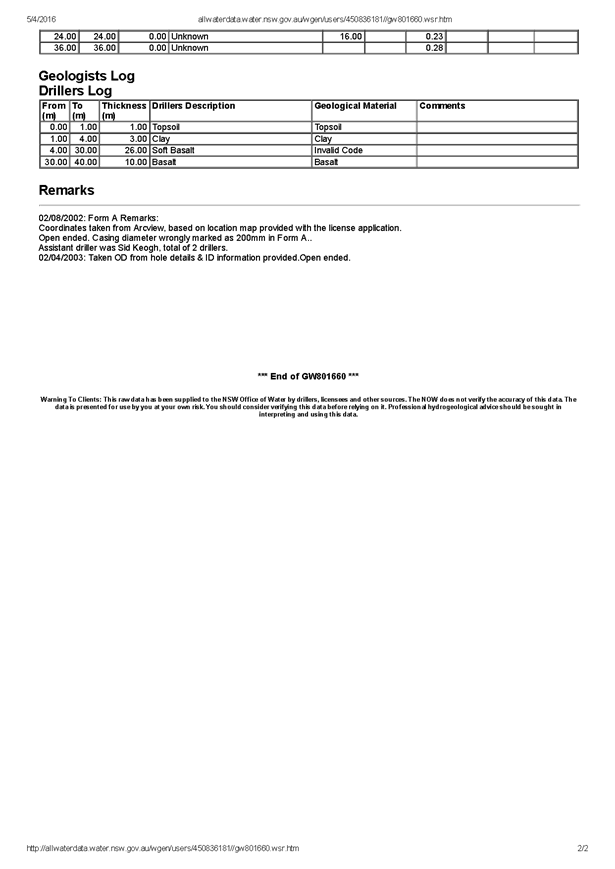
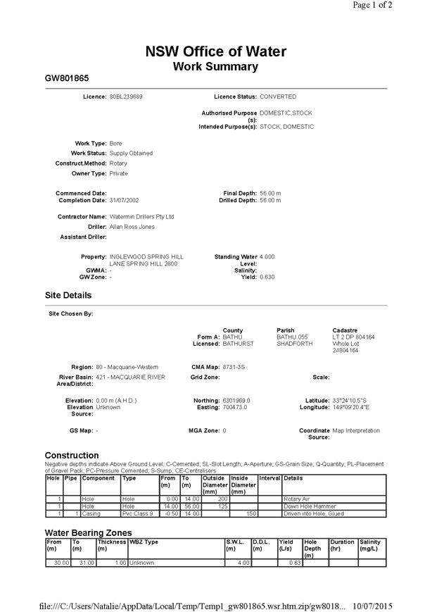
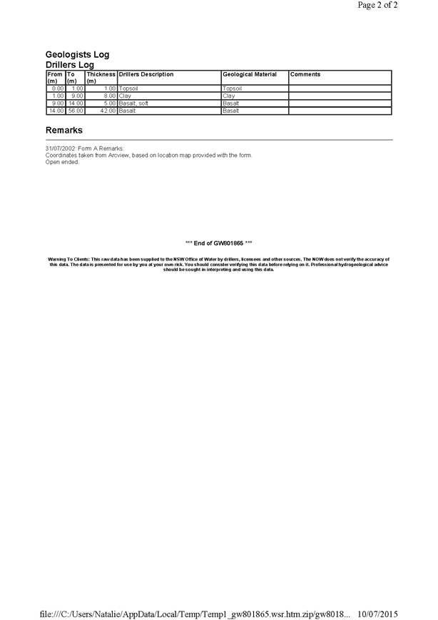
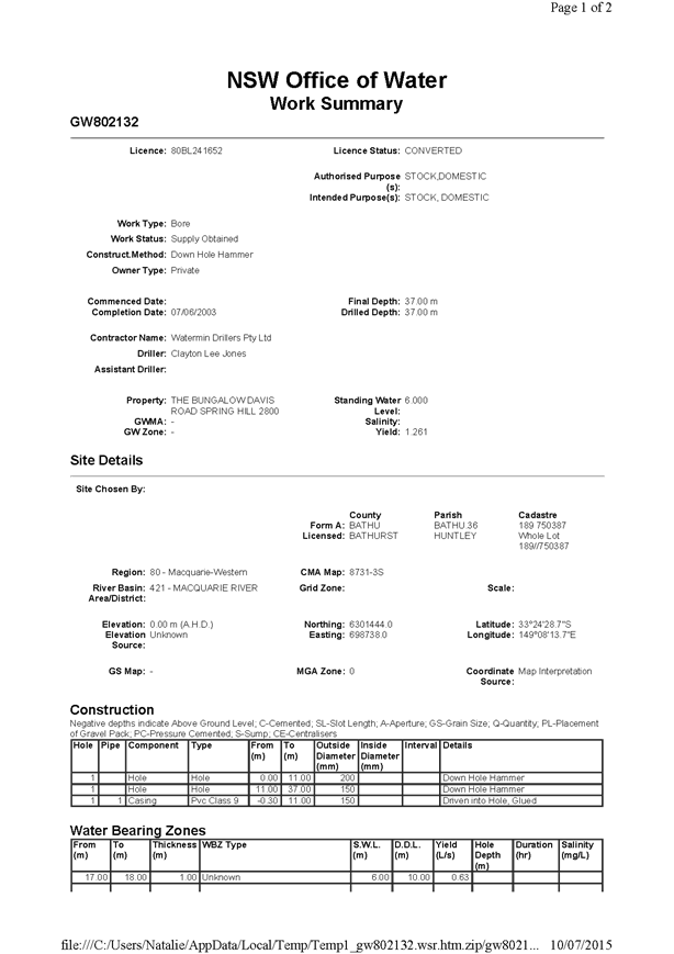
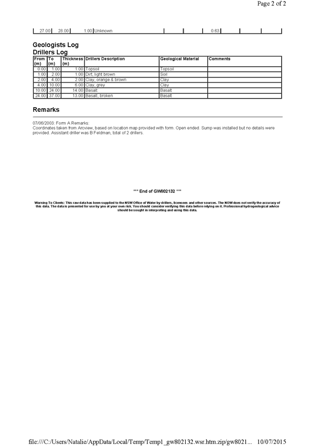
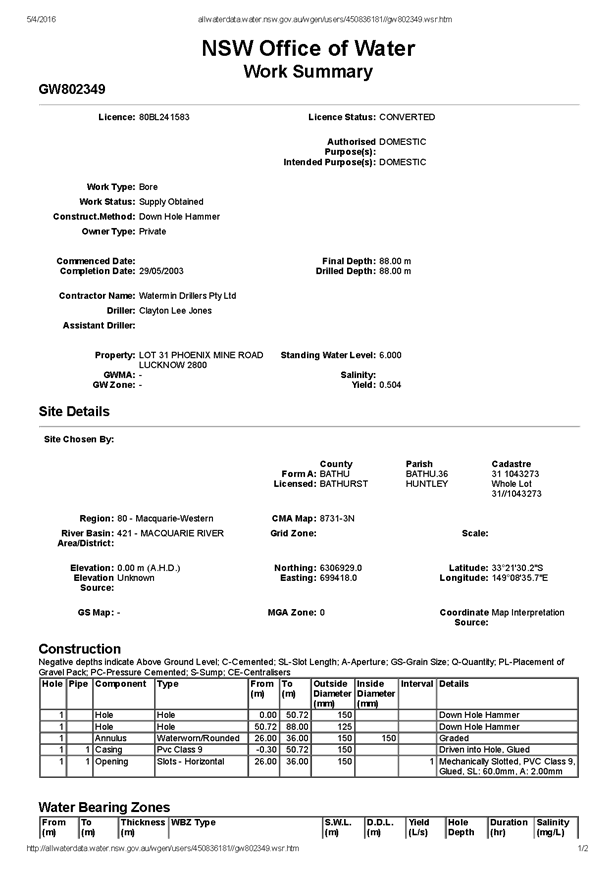
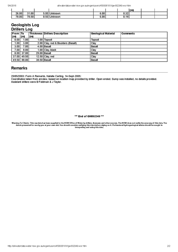
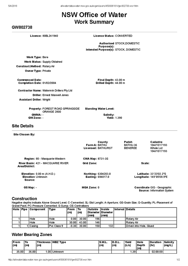

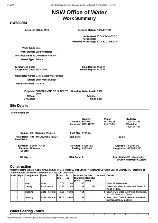
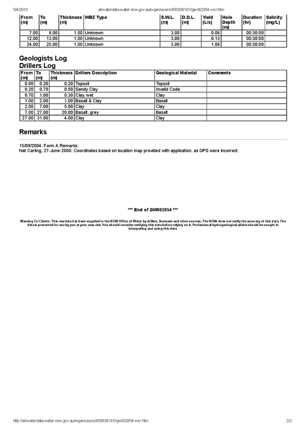


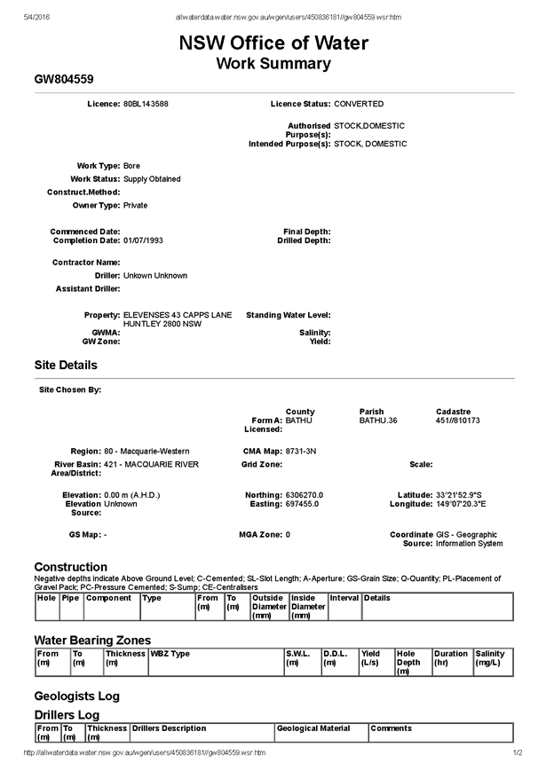

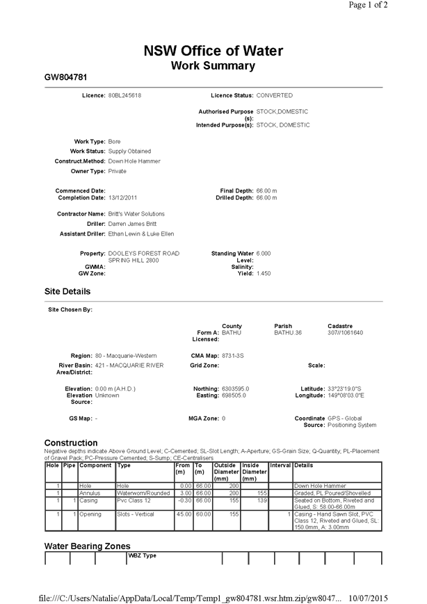
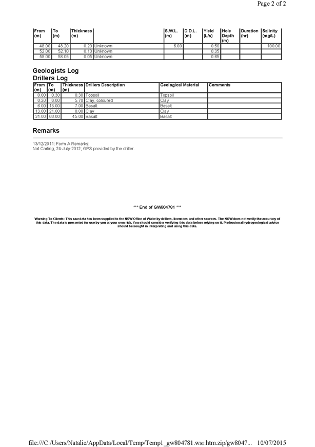
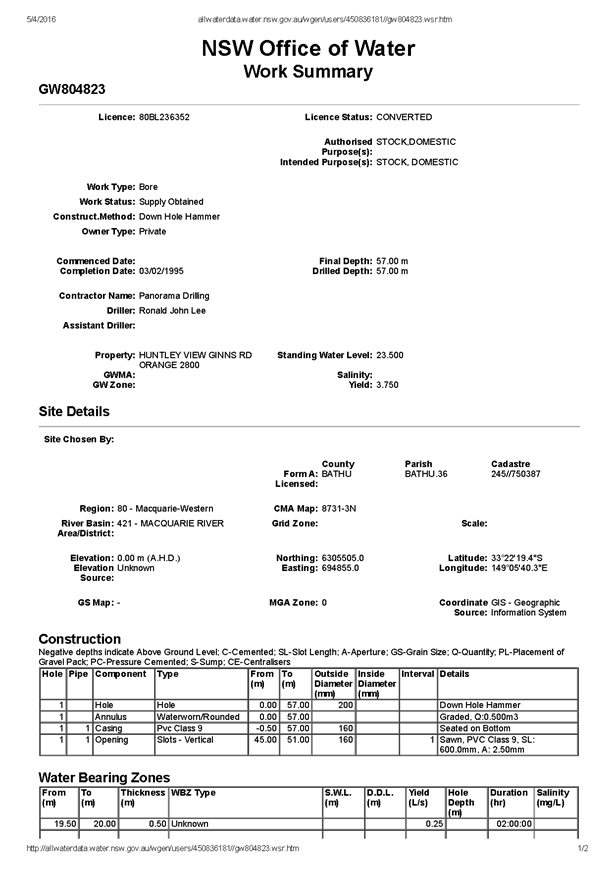

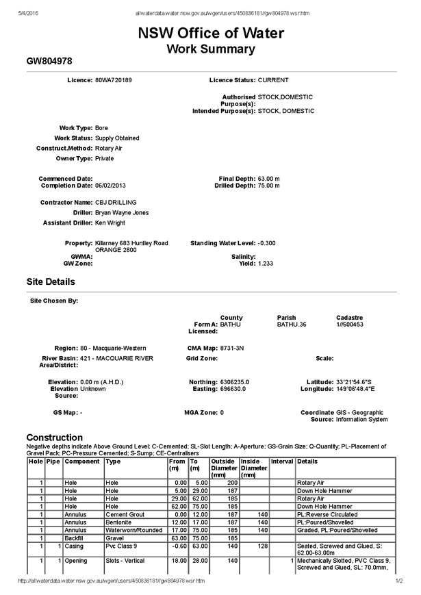
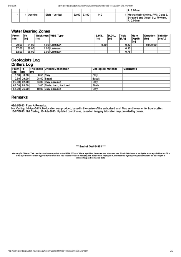
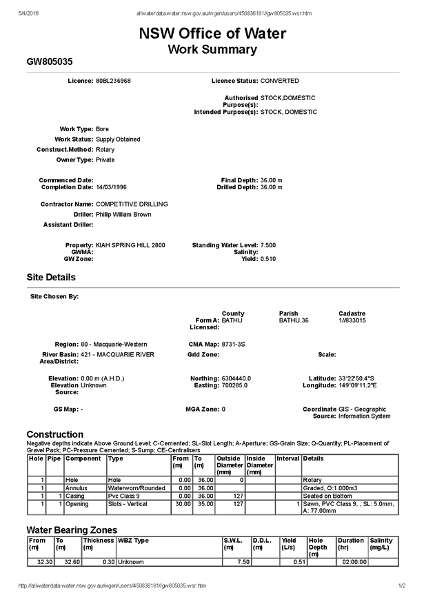


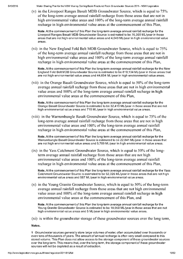
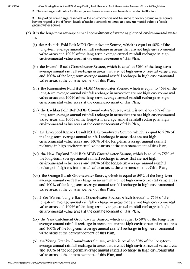
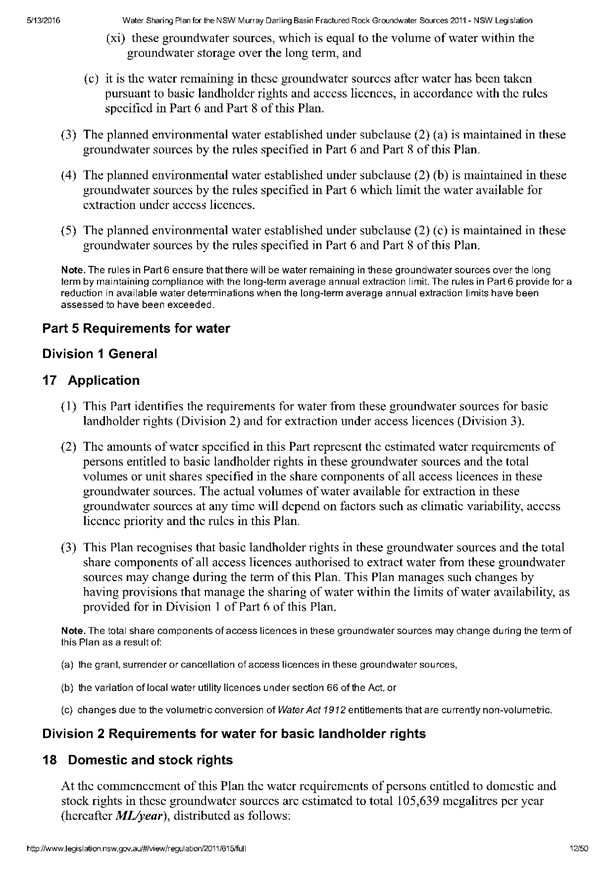
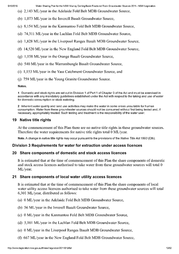


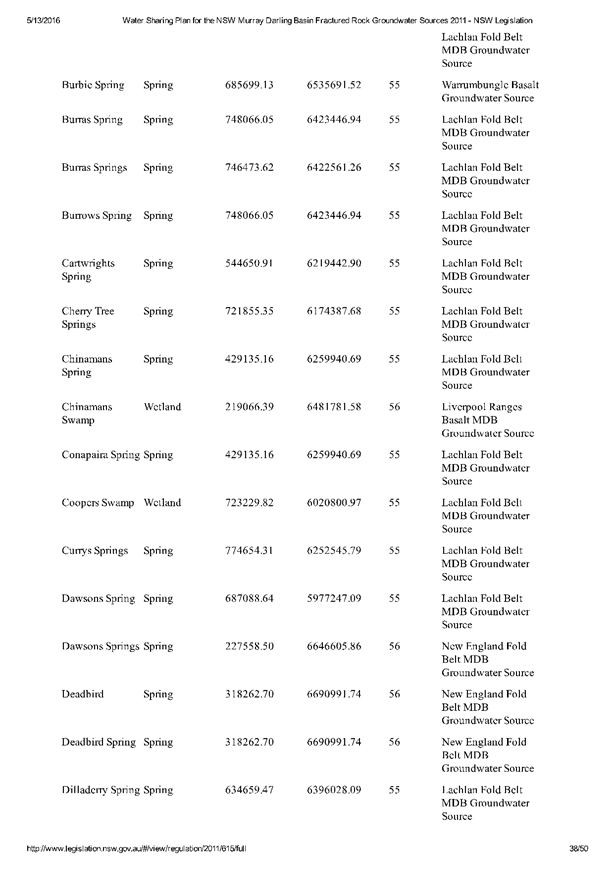
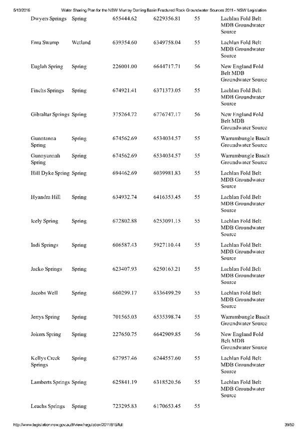
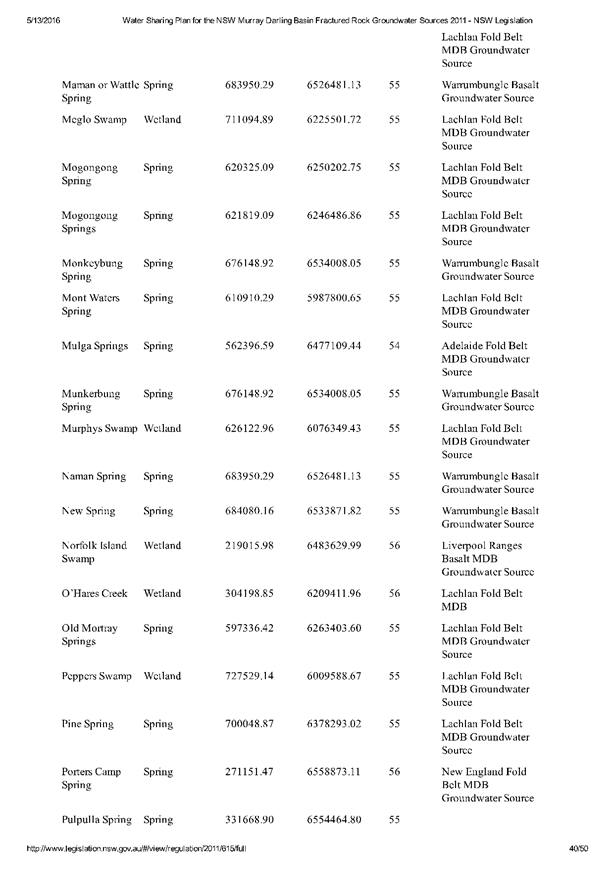
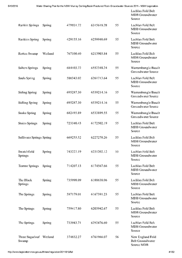
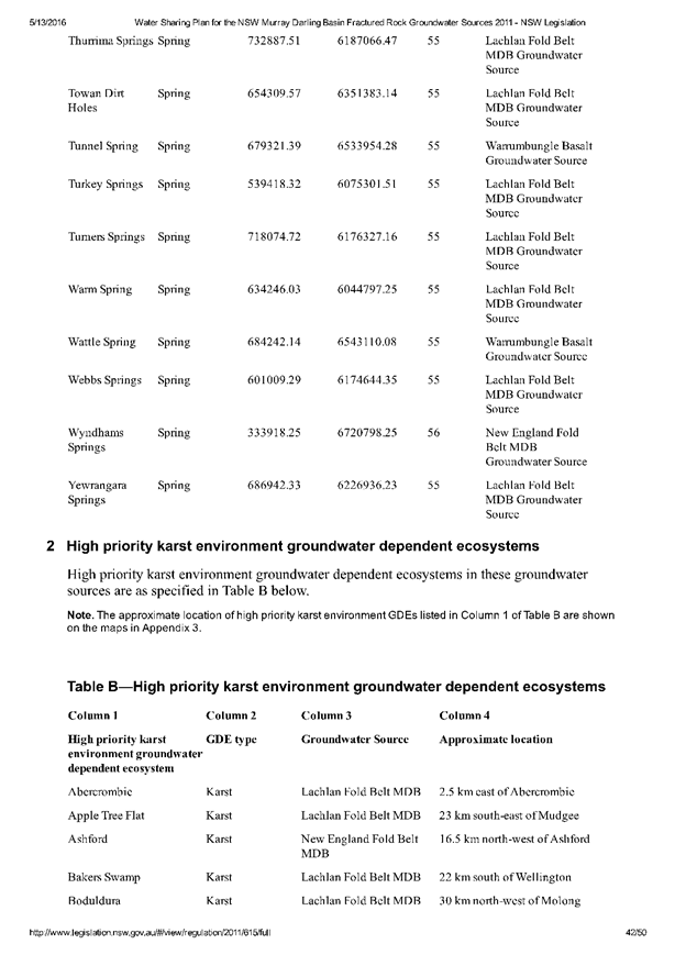
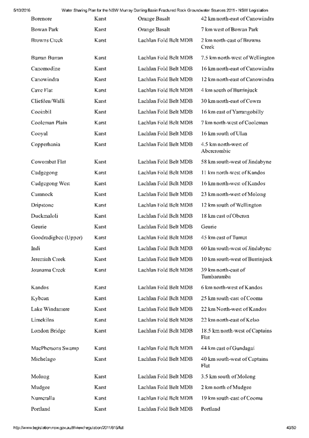
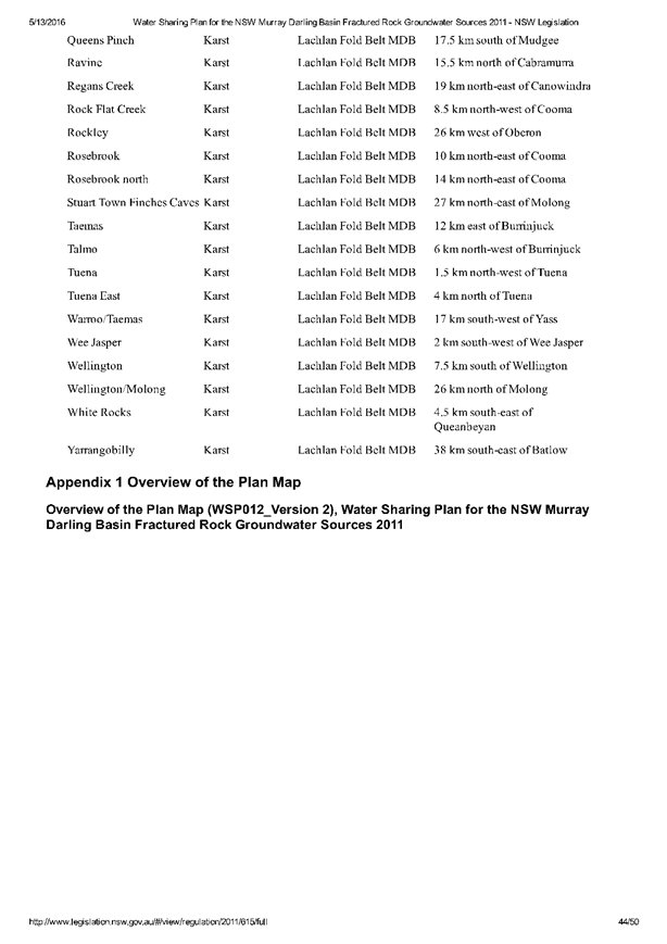
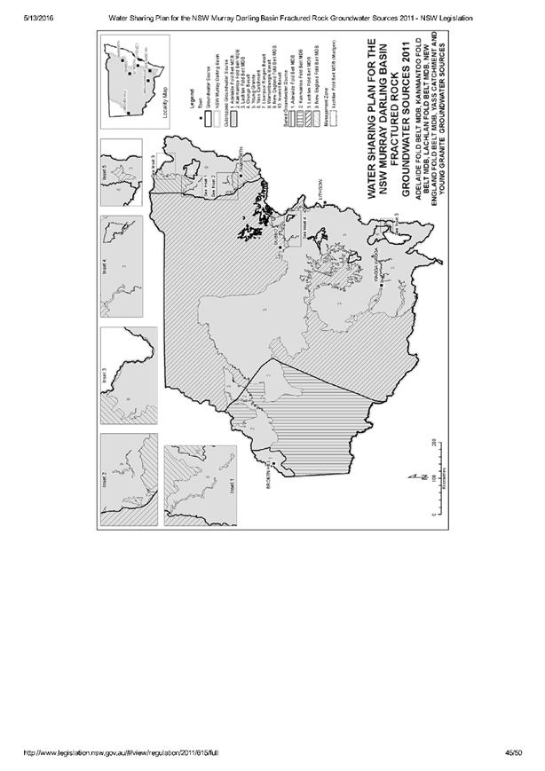
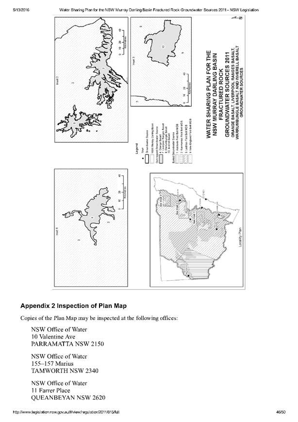

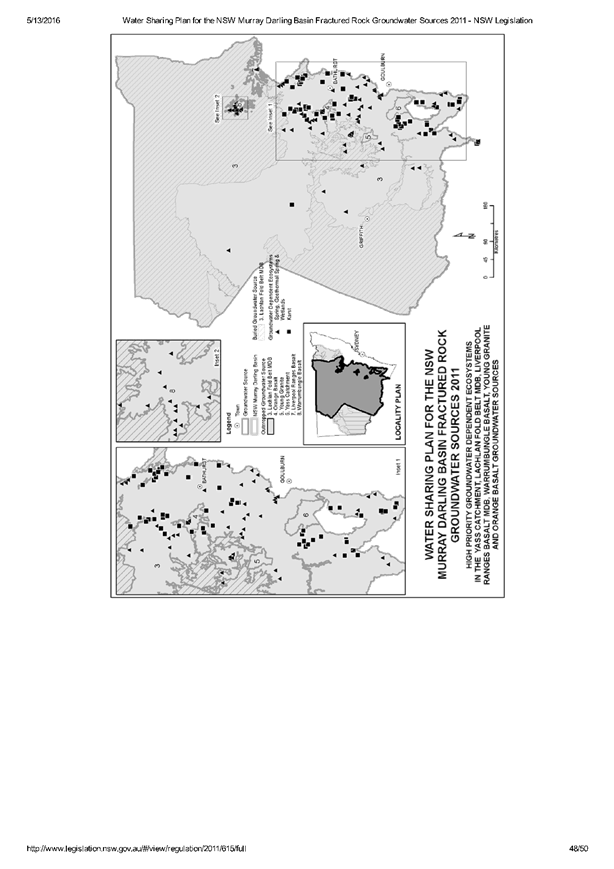
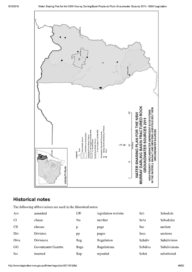
Council Meeting
22 June 2017
5.4 Orange
LEP Amendment 9 - Orange Airport Industrial Park - Submissions Report
Attachment 2 National
Airports Safeguarding Framework
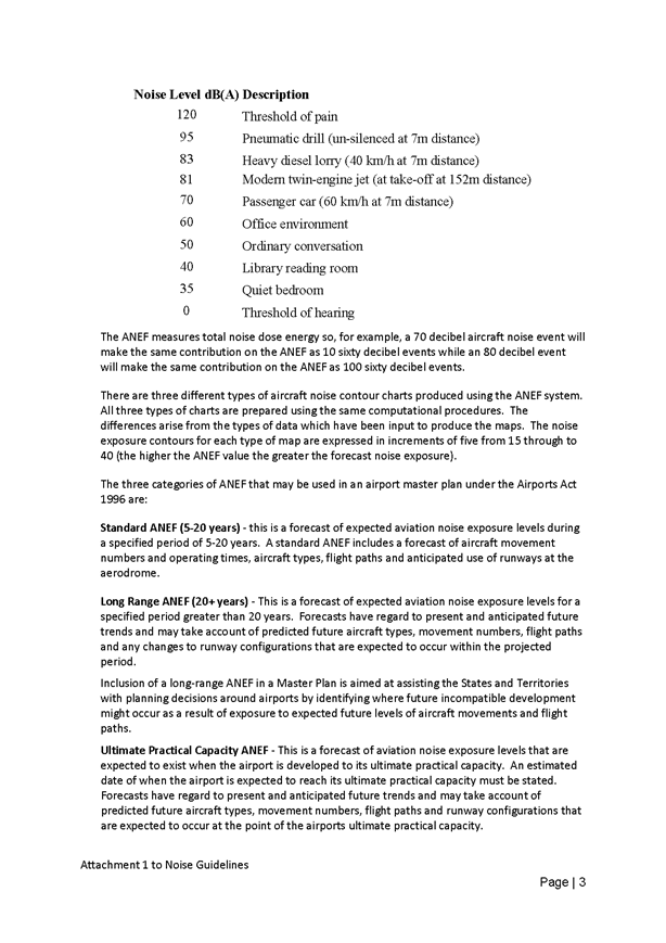
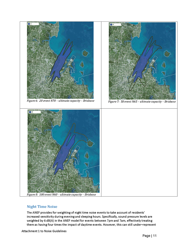
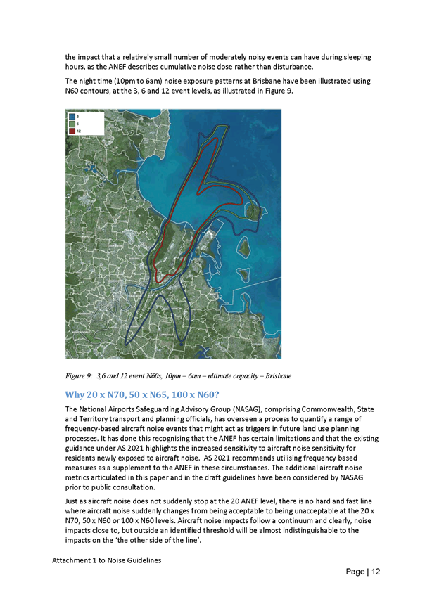
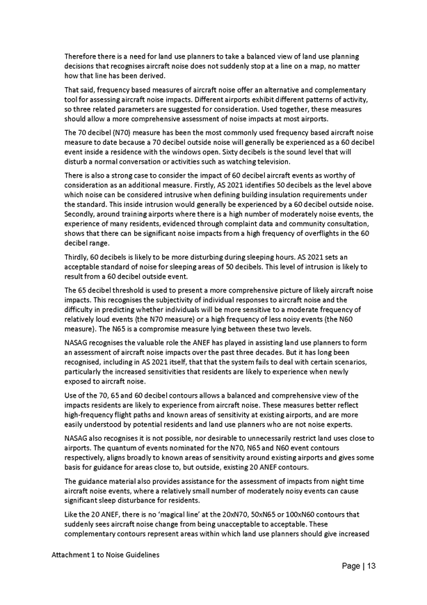

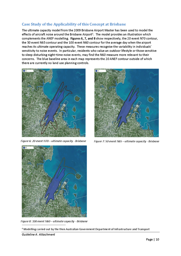
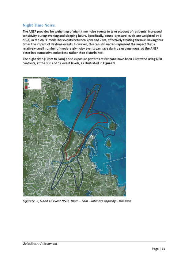
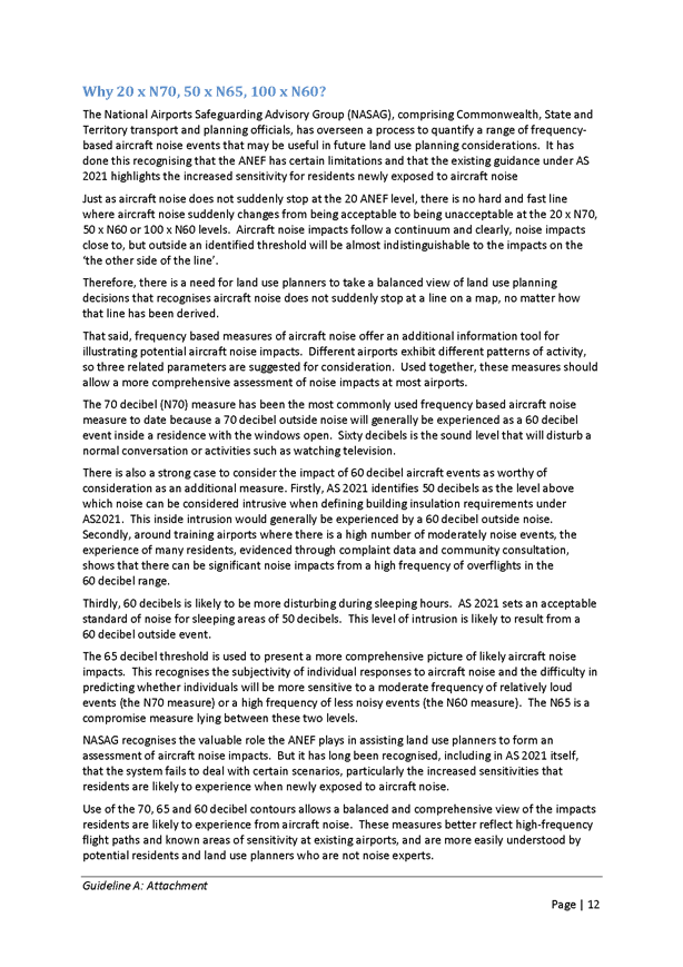

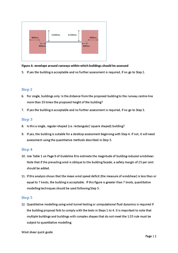

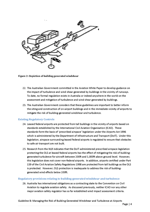
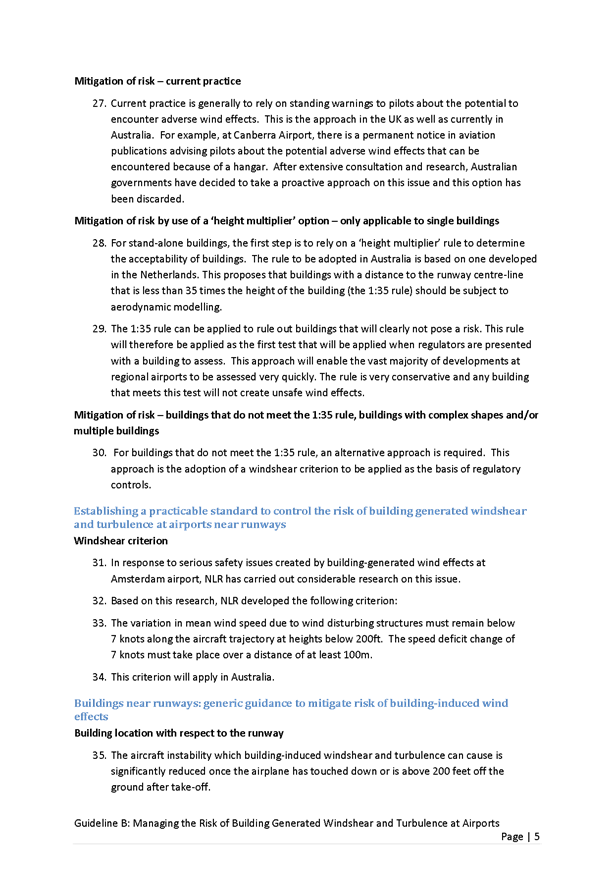
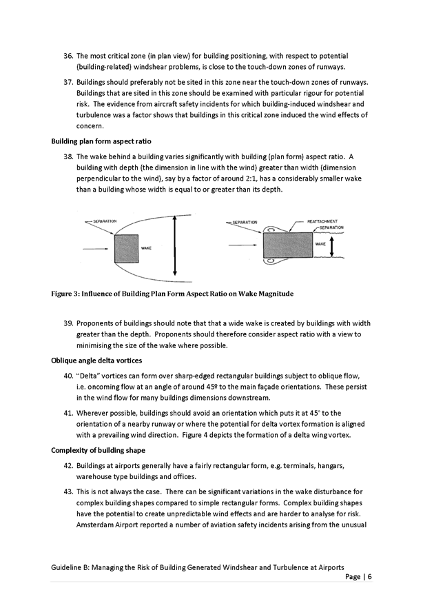
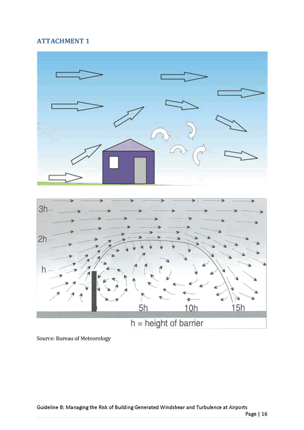
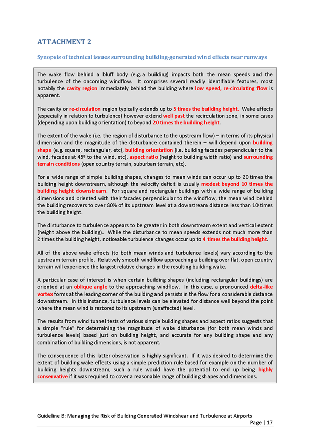
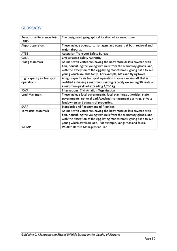
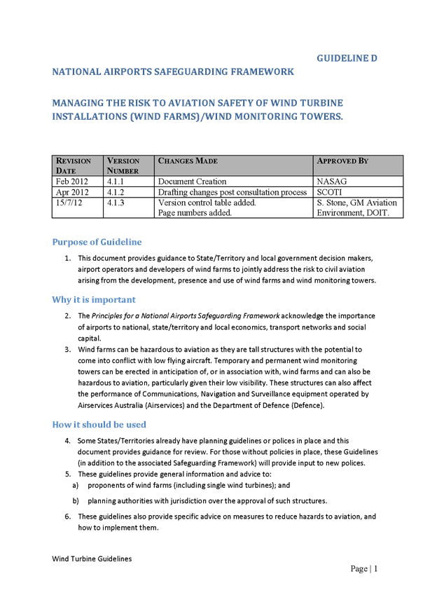


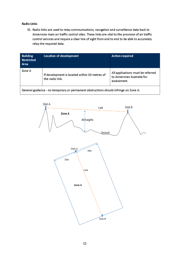
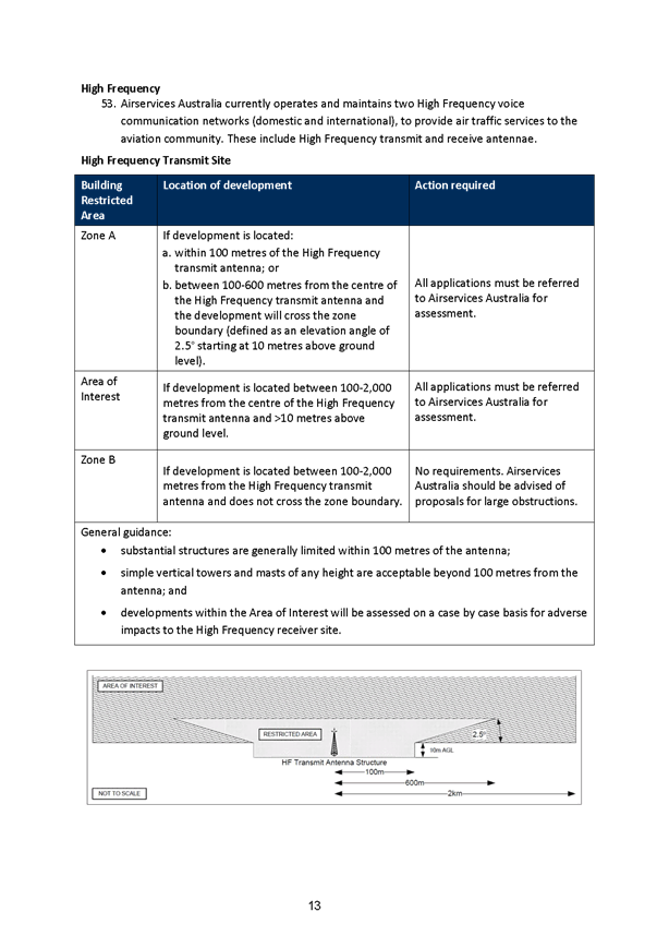
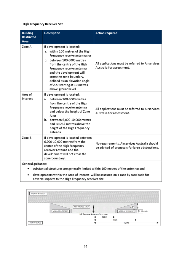
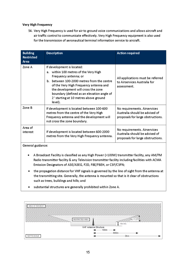
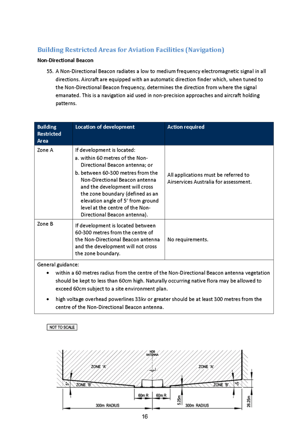
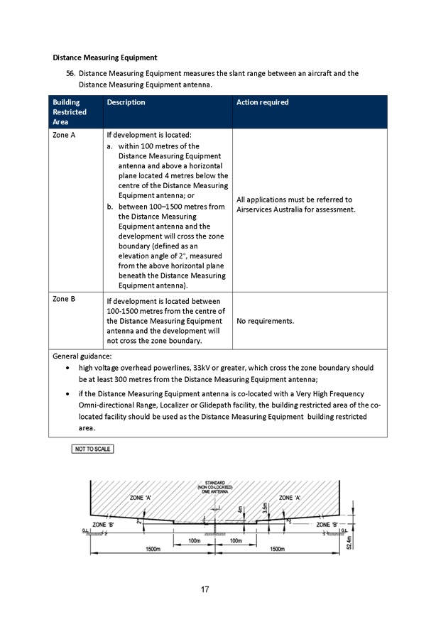
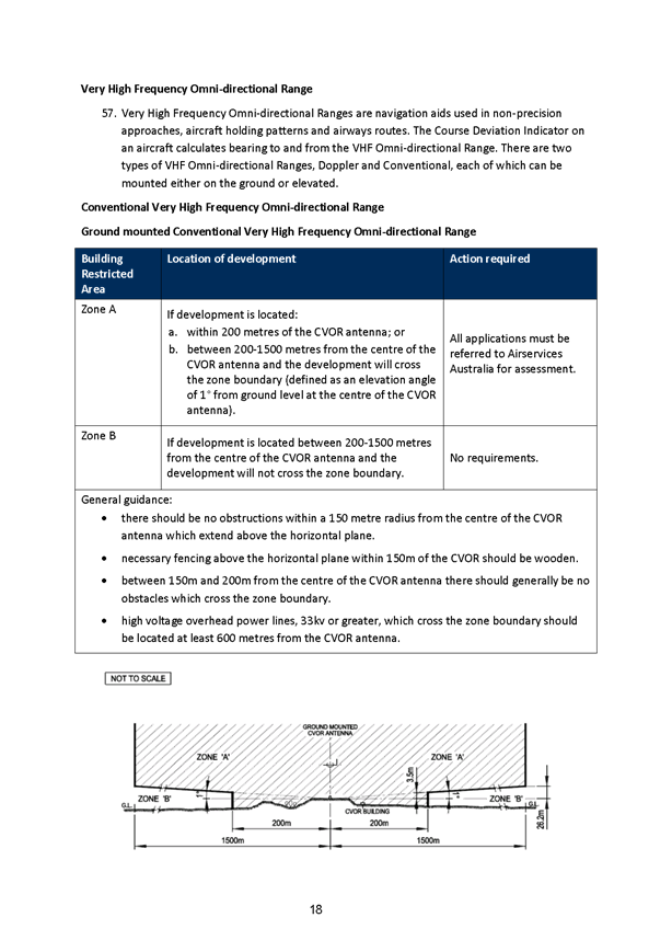
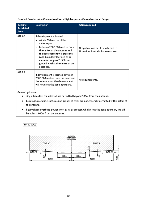
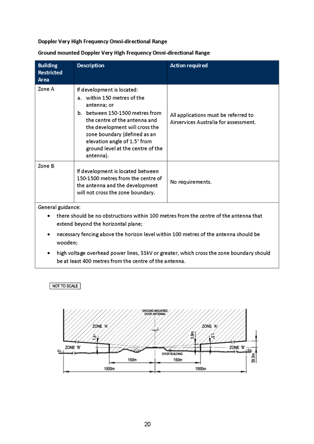
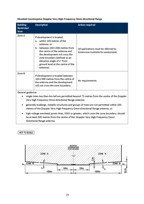
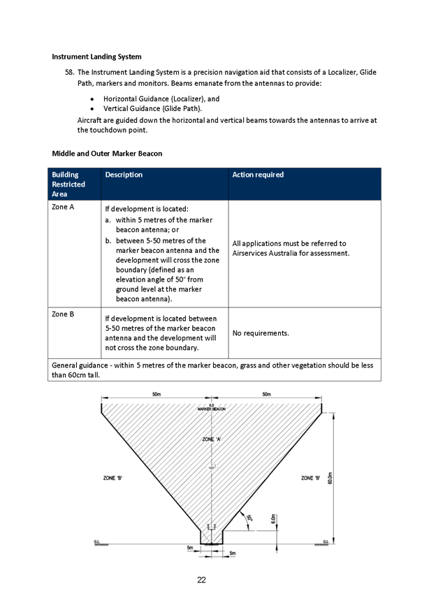
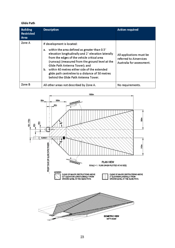
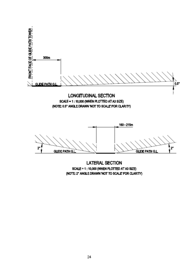
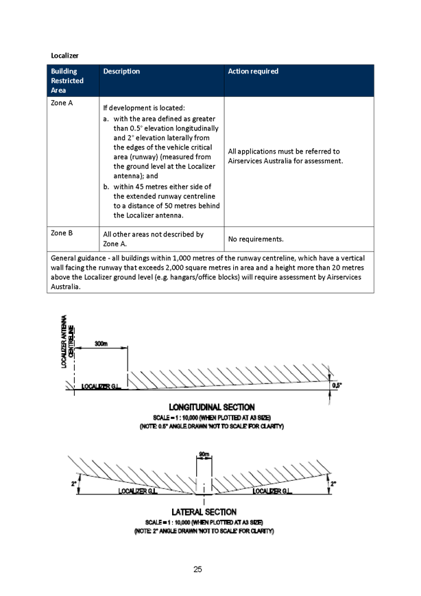
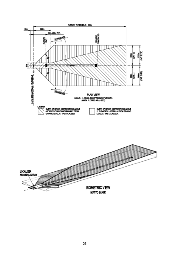
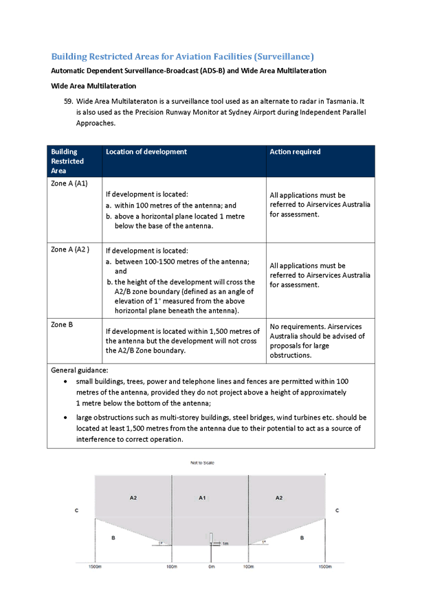
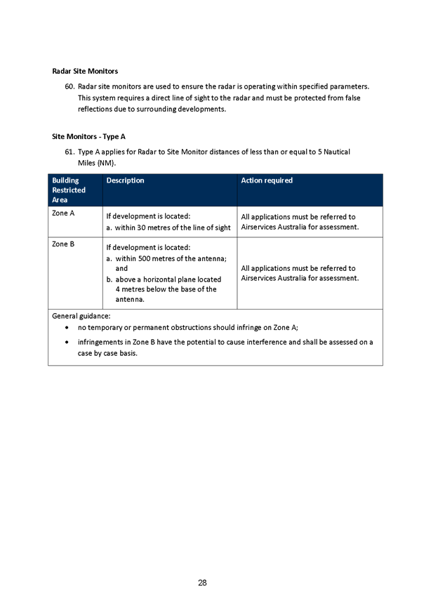
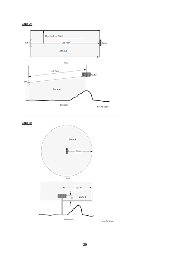
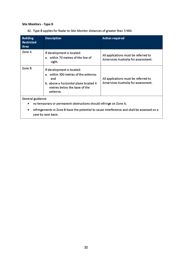
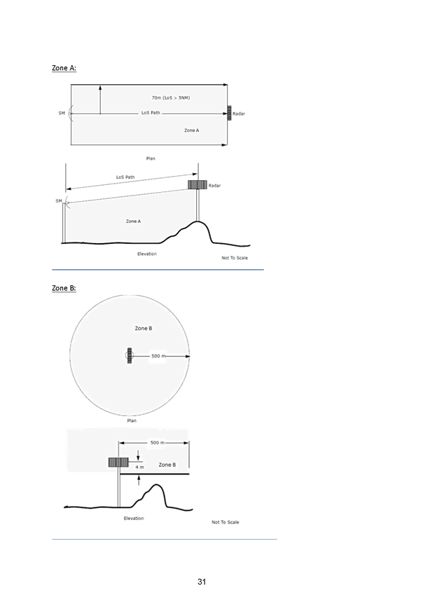
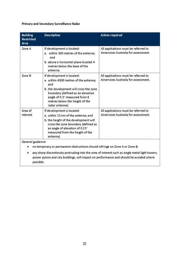

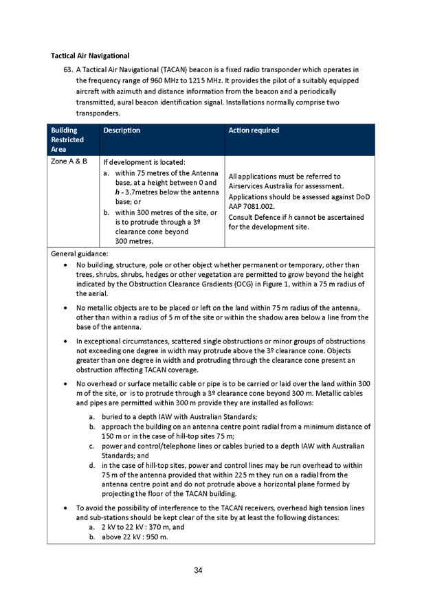
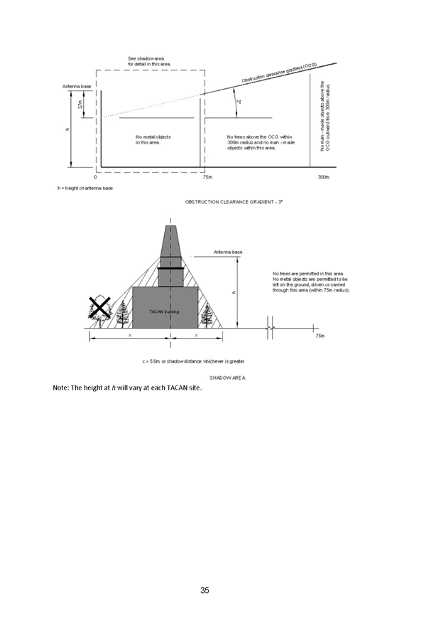

5.5 Part
5 Environmental Assessment East Fork Road Bridge
TRIM
REFERENCE: 2017/1200
AUTHOR: David
Waddell, Director Development Services
EXECUTIVE Summary
Orange
City Council is proposing to construct a new bridge at East Fork on Peisley
Street Orange, aimed at limiting the traffic impact in one of Orange’s
busiest streets when a new rail overpass bridge is built.
The
$2.5 million project, being managed by Orange City Council, has received a
total of $1.25 million in funding through the NSW Government’s Restart
NSW Fixing Country Roads program and $1.25 million in funding provided by the Australian
Government’s Bridges Renewal Program.
The key features of the proposal include:
· New two span, single lane bridge over the Broken Hill
rail line, adjacent to the existing bridge
· A bridge deck length of 30.9 metres with one seven metre
lane width between kerbs
· Minimum one metre shoulders
· A 2.5 metre shared path adjacent to the southbound lane
with service conduits underneath
· A 5.07 metre vertical clearance under the new bridge to
meet the single stacking height requirement and match adjacent existing bridge
· 1.5 metre horizontal clearance to existing bridge
· Bridge to be designed to cater for heavy vehicles up to
B-Doubles
· Appropriate retaining structures to suit local soil types
for bridge abutments and fill areas to reduce impact on rail corridor
· Temporary construction compounds to facilitate
construction activities.
· When
access across the bridges is closed, traffic would be diverted along Gardiner
Road, Anson Street and the southern feeder Road, adding 1.08 kilometres to a
journey.
· Unrestricted
two way traffic will be maintained for as long as practical. Full closure of
the road will be necessary but limited to high risk activities such as crane
lifts.
· Construction
work is expected to take about 12 months to complete with work in to begin
September.
· Construction
works should not result in the pollution of land or water so long as best
management practices for erosion and sediment control are undertaken during
construction, and appropriate remediation measures are implemented on a
progressive basis.
Council
commissioned GHD, to prepare a Review of Environmental Factors (REF) for
determination by Council as the proponent and the determining authority under
Part 5 of the Environmental Planning and Assessment Act 1979 (EP&A Act).
The
REF examines the Council’s plan to undertake the bridge construction
while maintaining traffic through the worksite. With the exception of heavy
vehicles, which would be required to detour around the work site, southbound
traffic will be maintained through the work site for as long as practically
possible and in consideration of Work Health and Safety.
The beneficial effects of the proposal would be
improvements to safety for all road users including the provision of access for
B-Doubles.
The REF has identified that the proposal has the
potential to result in a number of temporary adverse environmental effects
during construction, including:
· Potential noise and vibration impacts to sensitive
receivers
· Disruption to traffic, pedestrians and cyclists
· Potential decline in air quality
· Increased
risk of spills and contamination.
Whilst
Orange City Council is the determining authority for the project, at certain
locations other approvals/permits/licences will need to be secured from
Transport for NSW.
The
REF was exhibited and six submissions received. The issues raised have
been addressed by the Project team and are dealt with in this report.
The
REF concludes that:
The proposal would result
in both positive and negative impacts, however the safeguards summarised in
this REF would manage and mitigate the identified negative impacts. The
beneficial impacts are considered to outweigh the adverse impacts of the
proposal.
The assessment of the
proposal and associated environmental impacts has been undertaken in accordance
with clause 228 of the Environmental Planning and Assessment Regulation 2000,
Section 111 of the Environmental Planning and Assessment Act 1979, the
Threatened Species Conservation Act 1995, the Fisheries Management Act 1994,
and the Commonwealth Environment Protection and Biodiversity Conservation Act
1999.
This REF finds that the
proposal is unlikely to have a significant impact on the environment and
therefore an environmental impact statement under Part 5.1 of the Environmental
Planning and Assessment Act 1979 is not required. There would be no significant
impact on threatened species listed under the Threatened Species Conservation
Act 1995 and/or Fisheries Management Act 1994. Therefore, a species impact
statement is not required.
The
proposal would not significantly impact on a matter of national environmental
significance or Commonwealth land. As a result, it is considered that there is
no need to refer the proposal to the Australian Government Department of
Environment and Energy under the Environment Protection and Biodiversity
Conservation Act 1999.
Under
Section 111 of the EP&A Act, Council is responsible for assessing all
matters affecting or likely to affect the environment from this activity.
The
REF concludes that there will be no significant impacts arising. The REF also
recommends mitigation measures to minimise impacts and to protect the
environment. These, together with Council's standard conditions, form part of
the consent.
Staff concur with the findings
of the REF. It is concluded that Council has satisfied its obligations under
Part 5 of the EP&A Act 1979 and that the project can proceed.
Link To Delivery/OPerational Plan
The recommendation in this report relates to the
Delivery/Operational Plan strategy “15.1 Our Environment
– Maintain and renew traffic and transport infrastructure assets and
services as specified within the Asset Management Plan at agreed levels of
service”.
Financial Implications
Nil
Policy and Governance Implications
Nil
|
Recommendation
That Council approves the East Fork Road Project in
accordance with its obligations under Part 5 of the Environmental Planning
& Assessment Act 1979.
|
further considerations
Consideration has been given to the
recommendation’s impact on Council’s service delivery; image and
reputation; political; environmental; health and safety; employees;
stakeholders and project management; and no further implications or risks have
been identified.
SUPPORTING INFORMATION
The authority to determine developments under Part 5 of the
EP&A Act is encompassed by the General Manager's delegation GM004 adopted
by Council 18 December 2012.
Orange
City Council is proposing to construct a new bridge at East Fork on Peisley
Street Orange, aimed at limiting the traffic impact in one of Orange’s
busiest streets when a new rail overpass bridge is built.
The
$2.5 million project, being managed by Orange City Council, has received a
total of $1.25 million in funding through the NSW Government’s Restart
NSW Fixing Country Roads program and $1.25 million in funding provided by the
Australian Government’s Bridges Renewal Program.
The key features of the proposal include:
· New
two span, single lane bridge over the Broken Hill rail line, adjacent to the
existing bridge
· A
bridge deck length of 30.9 metres with one seven metre lane width between kerbs
· Minimum
one metre shoulders
· A
2.5 metre shared path adjacent to the southbound lane with service conduits
underneath
· A
5.07 metre vertical clearance under the new bridge to meet the single stacking
height requirement and match adjacent existing bridge
· 1.5
metre horizontal clearance to existing bridge
· Bridge
to be designed to cater for heavy vehicles up to B-Doubles
· Appropriate
retaining structures to suit local soil types for bridge abutments and fill
areas to reduce impact on rail corridor
· Temporary
construction compounds to facilitate construction activities.
Unrestricted
two way traffic will be maintained for as long as practical. Full closure of
the road will be necessary but limited to high risk activities such as crane
lifts.
Construction
work is expected to take about 12 months to complete with work in to begin
September.
The
REF examines the Council’s plan to undertake the bridge construction
while maintaining traffic through the worksite. With the exception of heavy
vehicles, which would be required to detour around the work site, southbound
traffic will be maintained through the work site for as long as practically
possible and in consideration of Work Health and Safety.
When access across the bridges
is closed, traffic would be diverted along Gardiner Road, Anson Street and the
southern feeder Road, adding 1.08 kilometres to a journey.
Council
commissioned GHD, to prepare a Review of Environmental Factors (REF) for
determination by Council as the proponent and the determining authority under
Part 5 of the Environmental Planning and Assessment Act 1979 (EP&A Act).
A full range of other issues
have been investigated within the REF and found to be satisfactory. In this
regard the REF has considered the relevant provisions of:
• Environmental Planning and Assessment Act 1979
• Environmental Planning and Assessment Regulation 2000
• Environmental Protection and Biodiversity Conservation
Act 1999
• Threatened Species Conservation Act 1995Fisheries
Management Act 1994
• National Parks and Wildlife Act 1974
• Wilderness Act 1987
• Heritage Act 1977
• Native Vegetation Act 2003
• Protection of the Environment Operations Act 1997
• Water Management Act 2000
• Water Act 1912
• Local Government Act 1993
• Dam Safety Act 1978
• Roads Act 1993
The
REF was exhibited and six submissions received.
Submissions
were received from
· James
Sheahan Catholic High School
· Max Jones
· Paul Matthews
· Ronald McDonald
House
· Tony Callaghan
· Lynette Redmond
James Sheehan Catholic High School
This
submission related mainly to the issue of traffic impacts.
Project
staff respond that a Community Engagement Plan has been developed and is
available on the Orange City Council website under “Your Say”. The
plan provides traffic advisory information to road users and the community.
Additional information will be provided via media, traffic message boards and
signage. Key stakeholders have been identified who will be appropriately
notified prior to and during the traffic diversions. Traffic diversions will be
monitored for effectiveness and amended as required.
An
independent traffic model has been developed that estimates diversions would
add between 1.5 to 3.0 minutes to travel times in the area.
A
construction Tender will be awarded later this year, which will require the
Contractor to develop and implement a traffic management plan in accordance
with the REF.
Max Jones
Mr Jones asked that a straight overhead bridge be
considered.
This option was investigated which would include the removal
of the existing bridge and pedestrian footbridge. Construction of a new
bridge would extend from Peisley Street to Forest Road in a straight line.
This option would reduce the length of road and provide a
direct route. The bridge would be in the order of 280m in length to enable
changes of grade to achieve rail clearances over the two tracks. It would also
require acquisition of private properties in both Peisley Street and Forest
Road, would impact on the existing rail buildings, have a significant impact on
existing underground services and have an unacceptable cost benefit ratio.
This option was not considered further in the REF due to the
necessary bridge width over the two rail lines being too wide and piles
required for support would impact on the heritage buildings located at East
Fork Junction. Additionally, the approaches to the bridge would result in major
impacts on existing properties such as land acquisition, potential for removal
of existing buildings and power lines.
Paul
Matthews
Mr
Matthews raised numerous concerns. These are listed and addressed by
Project staff below.
|
Response to Paul Matthews 35 Tynan
Street
|
|
Concerns
|
Replies
|
|
Currently the night time bridge traffic travelling south, causes the
headlight beams to just flick into our lounge room. The proposed new
southbound lane will cause the headlights to beam directly into our lounge
room, our lounge room is directly inline & at the same elevation as the
bridge.
Is a provision for screens available for protection from this
pollution?
|
A Headlight study has been conducted of 35 Tynan St.
The report concludes that the property is 110m from the new bridge
site and it would be very unlikely that the location of the proposed
duplicated bridge and new traffic alignment into Forest Road would create a
vehicle headlight problem for 35 Tynan Street beyond what would be considered
reasonable in a residential setting
|
|
As a new set of street lighting will be installed, are these fitted
with blinkers on the sides to concentrate the light downwards?
|
A lighting investigation has been completed by GHD and a preliminary
lighting design prepared by Gerard Lighting in accordance with AS/NZS 1158.
3.1 – 2005 Lighting Category P3.
Blinkers are not specified. Final lighting designs will be supplied
by the successful contractor
|
|
Large trucks travelling over the bridge day & night is going to
cause a large increase in road noise; eg. exhaust brakes.
Is a provision in place for the restricted use of exhaust brakes?
|
The REF determines that during operation it is expected that the
annual average daily traffic for B – Doubles would increase from 7 to
30 and the impacts associated with this increase in B – Double
movements is expected to be minor and there will not be a large increase in
road noise
There are many processes and procedures associated with the use of
exhaust brakes for drivers and some provisions require that there are no
restrictions within 300m of traffic to slow or stop such as rail crossings or
substandard curves
Drivers are trained in the minimal use of exhaust braking within
residential areas and modern exhaust systems emit minimal noise
|
|
Response to Paul Matthews 35 Tynan
Street
|
|
Concerns
|
Replies
|
|
The bridge is to be closed for periods. Working in Peisley St, I
walk to work & do not wish to walk all the way around.
Is a provision in place for pedestrians during this time?
|
The existing pedestrian footbridge would be removed prior to
construction of the new bridge.
During construction when southbound traffic only is facilitated,
pedestrians and cyclists would be permitted to cross the rail corridor via a
dedicated path on the existing rail bridge protected by concrete barriers.
It is intended to maintain two-way traffic for as long as possible
during construction. This is anticipated to occur for approximately 53
days during the project. Subsequent to the REF, additional investigation of
pedestrian access has been considered when two-way traffic is facilitated
over the existing bridge. To ensure pedestrian safety, it has been
determined that pedestrian access cannot be permitted while there is two-way
traffic. Detours via Anson Street would be in place along with public notices
advising of the detours during this time.
Pedestrians and cyclists would be permitted to cross the new bridge
when it is complete and works on the existing rail bridge have commenced.
The contractor’s Traffic Control Plan would also address the
closure of the road to allow safe work conditions for site personnel and
allow machinery access to the proposal site.
|
|
With the increase in B-Doubles down Peisley St/Forest Rd, this is a
heavily congested road already with very limited driveway access due to
parking.
Are the blind driveway issues going to be addressed in Peisley St?
This can be very difficult turning out of businesses on this street due to
the large amounts of parked cars there.
|
The REF determines that during operation it is expected that the
annual average daily traffic for B – Doubles would increase from 7 to
30 and the impacts associated with this increase in B – Double
movements is expected to be minor
The Bridge works REF does not specifically address existing access
issues along Peisley Street. Parking outside specific business’ that
may be causing issues would require submission to Council’s Traffic
Committee for consideration
The proposal will result in both positive and some negative impacts,
however the safeguards summarised in the REF will manage and mitigate the
identified negative impacts. The beneficial impacts are considered to
outweigh the adverse impacts of the proposal
|
|
Response to Paul Matthews 35 Tynan
Street
|
|
Concerns
|
Replies
|
|
There are currently NO crossing areas between the busiest sections
of Peisley St to Forest Rd to gain access to use the footbridge & the
footpath.
Is a provision in place to supply a pedestrian island & footpath
to prevent having to walk on the road if B-Doubles are allowed to use the
street?
|
The Bridge works REF does not specifically address existing
pedestrian access issues on Peisley Street. At this stage there is no
provision to provide a pedestrian island or footpath connections other than
to replicate what already exists. This could be a future consideration for
the traffic committee, subject to funding.
The REF determines that during
operation it is expected that the annual average daily traffic for B –
Doubles would increase from 7 to 30 and the impacts associated with this
increase in B – Double movements is expected to be minor
|
Ronald
McDonald House
Ronald McDonald House made
submission in regard to Ronald McDonald House visitor awareness of travel
routes to the Orange Health Service including Ronald McDonald House.
A Community Engagement Plan has
been developed provides traffic advisory information to road users and the
community via media, traffic message boards and signage. Key stakeholders have
been identified who will be appropriately notified prior to and during the
traffic diversions. Traffic diversions will be monitored for effectiveness and amended
as required.
An independent traffic model has
been developed that estimates diversions would add between 1.5 to 3.0 minutes
to travel times in the area.
A construction Tender will be
awarded later this year, which will require the Contractor to develop and
implement a traffic management plan in accordance with the REF.
Tony
Callaghan
Mr Callaghan asked that a
straight overhead bridge be considered.
This option was investigated
which would include the removal of the existing bridge and pedestrian footbridge.
Construction of a new bridge
would extend from Peisley St to Forest Rd in a straight line. This option would
reduce the length of road and provide a direct route, the bridge would be in
the order of 280m in length to enable changes of grade to achieve rail
clearances over the two tracks. It would also require acquisition of private
properties in both Peisley St and Forest Rd, would impact on the existing rail
buildings, have a significant impact on existing underground services and have
an unacceptable cost benefit ratio.
This option was not considered
further in the REF due to the necessary bridge width over the two rail lines
being too wide and pile required for support would impact on the heritage
buildings located at East Fork Junction. Additionally, the approaches to the
bridge would result in major impacts on existing properties such as land
acquisition, potential for removal of existing buildings and power lines.
Lynette
Redmond
Mrs
Redman understands the upgrade is necessary however believes that the
“Southern Ring Road” should be completed first. In addition
Mrs Redman raises concerns that “a major health facility was built
without main road access” and she considers the traffic in Anson Street
is already at a “dangerous level”.
Project
staff respond by identifying that for the majority of the project south bound
traffic will be facilitated along Peisley Street limiting impacts on the
morning peak traffic in Anson Street. It is also expected that some
self-regulation of traffic will occur with traffic avoiding Anson Street at
peak times. With the future development of the Southern Feeder Rd additional
north south accesses will be developed, such as at Edward St, Cecil Rd,
Woodward St/Shiralee Rd, Pinnacle Rd and ultimately Ploughman’s Lane, which
will reduce the reliance on Anson St in the future.
In
addition a Community Engagement Plan has been developed and is available on the
Orange City Council website under “Your Say”. The plan provides
traffic advisory information to road users and the community. Additional
information will be provided via media, traffic message boards and signage. Key
stakeholders have been identified who will be appropriately notified prior to
and during the traffic diversions. Traffic diversions will be monitored for effectiveness
and amended as required.
While
there is expected to be greater traffic numbers in Anson Street during
construction in the longer term the duplicate bridge will take traffic away
from Anson Street addressing some of Mrs Redmond’s concerns that “traffic
on Anson Street is already at a dangerous level”.
ENVIRONMENTAL
IMPACTS
As is
required under legislation, the REF has considered impacts as follows:
· Traffic,
transport and access
· Noise
and vibration
· Water
quality, groundwater and flooding
· Topography,
geology and soils
· Biodiversity
· Landscape
character and visual amenity
· Aboriginal
heritage
· Non-Aboriginal
heritage
· Waste
management
· Socio-economic
effects
· Energy
and greenhouse emissions
· Air
quality
Construction works should not
result in the pollution of land or water so long as best management practices
for erosion and sediment control are undertaken during construction, and
appropriate remediation measures are implemented on a progressive basis.
The beneficial effects of the proposal would
be improvements to safety for all road users including the provision of access
for B-Doubles.
The REF has identified that the proposal has
the potential to result in a number of temporary adverse environmental effects
during construction, including:
· Potential noise and vibration impacts to sensitive
receivers
· Disruption to traffic, pedestrians and cyclists
· Potential decline in air quality
· Increased
risk of spills and contamination.
Whilst
Orange City Council is the determining authority for the project, at certain
locations other approvals/permits/licences will need to be secured from
Transport for NSW.
Overall,
potential negative impacts associated with the proposal are not considered to
be significant and able to be adequately managed by implementing the mitigation
measures. The benefits of the proposal are considered to outweigh any potential
adverse impacts. The disruption to road users is clearly the issue which
will impact most but this is not atypical of road project impacts.
Under
Section 111 of the EP&A Act, OCC is responsible for assessing all matters
affecting or likely to affect the environment from this
activity. The potential impacts of the proposal have been
considered against the matters listed in clause 228 of the Environmental
Planning and Assessment Regulation 2000 (EP&A Regulation) and are not
considered to be significant.
The
REF concludes that:
The proposal would result
in both positive and negative impacts, however the safeguards summarised in
this REF would manage and mitigate the identified negative impacts. The
beneficial impacts are considered to outweigh the adverse impacts of the
proposal.
The assessment of the
proposal and associated environmental impacts has been undertaken in accordance
with clause 228 of the Environmental Planning and Assessment Regulation 2000,
Section 111 of the Environmental Planning and Assessment Act 1979, the Threatened
Species Conservation Act 1995, the Fisheries Management Act 1994, and the
Commonwealth Environment Protection and Biodiversity Conservation Act 1999.
This REF finds that the
proposal is unlikely to have a significant impact on the environment and therefore
an environmental impact statement under Part 5.1 of the Environmental Planning
and Assessment Act 1979 is not required. There would be no significant impact
on threatened species listed under the Threatened Species Conservation Act 1995
and/or Fisheries Management Act 1994. Therefore, a species impact statement is
not required.
The
proposal would not significantly impact on a matter of national environmental
significance or Commonwealth land. As a result, it is considered that there is
no need to refer the proposal to the Australian Government Department of
Environment and Energy under the Environment Protection and Biodiversity
Conservation Act 1999.
Under
Section 111 of the EP&A Act, Council is responsible for assessing all
matters affecting or likely to affect the environment from this activity.
The
REF concludes that there will be no significant impacts arising. The REF also
recommends mitigation measures to minimise impacts and to protect the
environment. These, together with Council's standard conditions, form part of
the consent.
Staff concur with the findings
of the REF. It is concluded that Council has satisfied its obligations under
Part 5 of the EP&A Act 1979 and that the project can proceed.
5.6 Future
of Department of Primary Industries Land in South Orange
TRIM
REFERENCE: 2016/2475
AUTHOR: David
Waddell, Director Development Services
EXECUTIVE Summary
In August 2011 the NSW
Department of Planning approved a Part 3A concept plan for the rezoning of
Department of Primary Industries (DPI) land on Forest Road, known as the
Bloomfield Concept Plan. This has rezoned the land to R2 Low Density
Residential, with a small area of B2 Local Centre commercial, enabling subdivision
under the concept plan for 550 residential lots with a typical size of 800m2
and a small shopping precinct. The context of the DPI site is shown in the
following map:
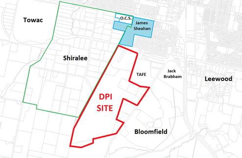
Council resisted the rezoning of the site at the time and
was critical of elements of the conceptual layout proposed.
The State Government has not proceeded with developing the
site. However, the rezoning was incorporated into Orange Local Environmental Plan
2011, and as such a development application for the project stages could be
lodged at any time. Therefore the site remains part of the urban land supply
for the City.
Subsequently, Council undertook a master planning exercise
on adjoining lands to the west known as the Shiralee project. Efforts were made
to ensure that the Shiralee concept could link with and potentially integrate
into the DPI site.
As the first Shiralee developments begin to emerge, Council
has a window of opportunity to revisit the DPI site to put forward an
alternative design that would improve upon the current concept. In addition
with the announcement of the modified Private Hospital it is also timely to
investigate the future of a South Orange Shopping precinct. This report
outlines the perceived issues with the current concept and explores possible
responses.
Link To Delivery/OPerational Plan
The recommendation in this report relates to the
Delivery/Operational Plan strategy “1.2 Our City -
Information and advice provided for the decision-making process will be
succinct, reasoned, accurate, timely and balanced”.
Financial Implications
Nil
Policy and Governance Implications
Nil
|
Recommendation
1 That
Council seek an undertaking from the NSW Government to allow Council to
prepare a revised concept master plan and Development Control Plan for the
Department of Primary Industries Bloomfield site.
2 That
Council note the indicative layout plan included in the report illustrating a
potential alternative approach to the Department of Primary Industries
Bloomfield site.
3 That
Council investigates the zoning and timing of a south orange shopping
precinct.
|
further considerations
Consideration has been given to the
recommendation’s impact on Council’s service delivery; image and
reputation; political; environmental; health and safety; employees;
stakeholders and project management; and no further implications or risks have
been identified.
SUPPORTING INFORMATION
The current Part 3A approved
concept plan is shown below:
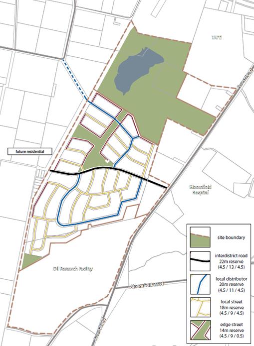
Design concerns arising from this concept include the
following:
· All traffic is funnelled
through a single connection point to Forest Road. This would be likely to
create a traffic bottleneck.
· The concept plan would
result in many lots throughout the design, but particularly north of the
“inter-district road”, being angled in a northeast-southwest or
northwest-southeast alignment. This would reduce and minimise the ability of
dwellings to respond to passive solar design principles, which are best
achieved when lots are oriented either directly north-south or east-west.
· The green corridor of
parkland does not align with the natural drainage corridor of the site. This
would result in additional earthworks or poor drainage outcomes.
· The layout essentially
ignores changes in topography, which will result in increased earthworks both
during subdivision and also as each house is constructed.
· The B2 Local Centre is
positioned on the fringe of the site and could be better positioned to
encourage more walking/cycling and reduce traffic generation.
· The concept plan
consists entirely of lots around 800m2 in area. Such uniformity
fails to respond to different market sectors, limiting housing options for the
broader community.
· The concept plan places
800m2 lots up to the south-western boundary of the site. While this
does adjoin a cycle path, immediately beyond that is farmland - potentially
creating agricultural-residential interface conflict.
· The main
“inter-district road” seeks to align with Hawke Lane in the west.
In doing so it conflicts with “the Springs” an important heritage
site for the local Aboriginal community.
· The concept fails to
identify potential community building elements, such as sports fields, school
sites and other embellishments, relying solely on a central triangular
parkland.
In exploring these issues staff have prepared a preliminary
alternative design that enhances the concept and resolves many of the concerns
above.
The location of the site, between the Shiralee suburb and
the new hospital and medical precinct on Forest Road, represents an opportunity
to expand the Shiralee concept in a coherent fashion.
This section of Forest Road has a distinct character
typified by large campus scale developments with generous landscaped setbacks.
There is an opportunity to consolidate this pattern by encouraging similar
large footprint developments along the Forest Road frontage. This has the added
benefit of separating residents from traffic noise.
Additionally, the current rifle range site to the immediate
north of the DPI site will ultimately close when the Southern Feeder Road is
constructed in this area. Much of the rifle range site comprises bushland with
significant ecological values. This is recognised in the E2 Environmental
Conservation zoning that applies to the site.
Nonetheless the north-western portion of the rifle range is
generally clear of vegetation, providing an opportunity to consider further
recreation or similar potential. Because this area has frontage to Rifle Range
Road and adjoins the future Southern Feeder Road, it will be highly accessible
not just to local residents but would naturally service the entire City.
A preliminary alternative
design, shown below, has been prepared to facilitate discussion:
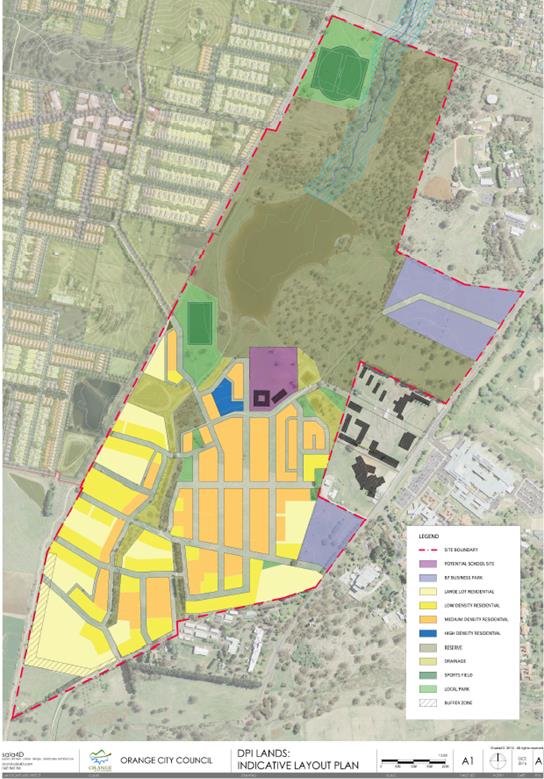
This design includes (or could allow for):
· Multiple potential
Forest Road connections, diffusing and dispersing traffic to avoid bottlenecks.
· A diversity of lot
sizes, ranging from large lots to medium density, and potentially a high
density site for apartment buildings, allowing the neighbourhood to provide for
a mix of housing opportunities and market segments.
· Identified sports field
opportunities, including a full size cricket field that can also be used as two
rectangular sports fields and a separate rectangular field. The large facility
in the north has ample space for parking and could accommodate grandstands,
changing rooms and other facilities.
· A potential school site
which is strategically positioned to enable easy access to the woodland
reserve, large dam site and sports field without the need for students to cross
any local roads. While not “school property” these features would
be readily available to enhance the educational experience available.
· Parkland corridor
aligned to actually match the existing drainage paths and also preserve the
established windbreaks and other stands of trees already on the site. This will
enable the estate to have an immediate level of landscaping that is all too
commonly lost in conventional subdivisions.
· Much improved solar
orientation throughout the design.
· Much improved response
to the topography of the site, with larger lots in steeper areas and roads
better aligned to contours
· Only large lots adjoin
the farmland in the southwest, enabling houses to be positioned further from
the interface and reducing the number of lots directly adjoining the farmland
substantially, all of which will be large enough to accommodate substantial
setbacks from the agricultural land.
· Road network no longer
seeks to disrupt the Springs heritage site.
· A variety of local parks
that will be suitable for a variety of functions.
Additionally, the various parts of the large
“reserve” area can be further investigated for a range of
additional embellishments such as:
· children’s
adventure playground
· netball/tennis
court sites
· community
gardens
· neighbourhood
hall/“men’s shed”
· outdoor
gym/fitness park
· skate park
As the first Shiralee developments begin to emerge, Council
has a window of opportunity to revisit the DPI site to put forward an
alternative design that would improve upon the current concept. In addition
with the announcement of the modified Private Hospital it is also timely to
investigate the future of a South Orange Shopping precinct. This report
outlines the perceived issues with the current concept and explores possible
responses.
These and other concepts can be further explored as part of
a formal proposal to the State government. As part of a proposal, a Development
Control Plan/Master plan document would be prepared with similarities to the
Shiralee Master Plan.
In particular, a DCP master plan would be able to consider
the various areas of the reserve lands and set out a vision for their future
development, each location tailored to its inherent advantages and
opportunities. It needs to be stated that the above ideas, or others, would be
subject to future funding availability and would only emerge over the course of
many years as and when budgets permit. The value of master planning for these
areas is to ensure that a clear vision is established so that the community can
know upfront how the reserve lands would evolve over time.
Additionally, a master plan would be able to refine the
layout in response to community reaction, establish street typologies, cycle
networks and other requirements to deliver a community that benefits from a
high standard of urban design.
To date, this initial work has shown that development of the
DPI site could be dramatically enhanced beyond what the Part 3A approval would
deliver. Instead of a dormitory estate of 550 lots, a park and some shops,
the site has the potential to deliver more housing (preliminary estimate of
over 600) across a mix of lot sizes and types, several local parks, a school
site that can integrate with the bushland, large dam and a sports field, while
also accommodating large campus style developments along Forest Road. Further
consideration of the reserve lands and drainage corridors can add yet more
community building features to the area benefitting both the resident
population and adjoining Shiralee suburb.
One useful metric that can illustrate the difference between
the two designs is the ratio of road length per residential lot. In any new
subdivision the cost of constructing new roads is a key element in the overall
viability of a proposal. Additionally once constructed roads are ordinarily
dedicated as public roads meaning that Council takes on the maintenance burden
in perpetuity. Increasing the number of lots per length of road has three
distinct benefits.
· Reduced cost and
therefore reduced risk to developers.
· Ability to sell lots at
more affordable prices.
· Maintenance costs to
Council are less on a per ratepayer basis.
In this regard it should be noted that the current Part 3A
approved design consists of approximately 10,765m of road length and would
create 550 residential lots (19.57m per lot). The alternative presented
consists of approximately 8,495m of road length and would create over 600
residential lots (14.15m per lot). This is a reduction of 21.1% of road length
and an increase of at least 8.3% of residential lots. This is a reduction of
5.42m of road length on a per lot basis (or 27.6% more efficient).
This improvement is before taking into account the
differences in road widths. The current Part 3A approved design uses a
generally consistent reserve width of approximately 21m, whereas it is
envisaged the alternative would have a mixture of widths including some at
26.5m, some 21, some 19 and some only 15m while access lanes would be only 8m
wide. Predominantly the difference would be toward narrower road reserves
further improving the efficiency gain.
Forest Road is important as the main southern entrance to
the City and this site will be the first impression of Orange that greets the
traveller from this direction. It is therefore considered that this opportunity
needs to be pursued now, before the State government either sells off or begins
to develop the site under the current Part 3A approved design, which
arguably does not achieve the best potential outcome for the site.
5.7 Development
Application DA 53/2017(1) - 30 Telopea Way
TRIM
REFERENCE: 2017/1249
AUTHOR: Summer
Commins, Senior Planner
EXECUTIVE Summary
|
Application
lodged
|
28
February 2017
|
|
Applicant/s
|
Orange
North Pty Ltd
|
|
Owner/s
|
Orange
North Pty Ltd
|
|
Land
description
|
Lot 16
DP 1210246 - 30 Telopea Way, Orange
|
|
Proposed
land use
|
Subdivision
(four lot Torrens title), Subdivision (eight lot Community Title), Dwelling
Houses (nine) and Medical Centre
|
|
Value of
proposed development
|
$2,600,000
|
Council's consent is sought for development of land at 30
Telopea Way, Orange, for the purposes of a medical centre and residential
development. The development will proceed in stages, as follows:
Stage 1: Torrens
subdivision of the land to create one (1) lot for the medical centre at the
Telopea Way frontage; two (2) standard lots for dwellings at the Telopea Way
frontage; and one (1) battleaxe development lot for dwellings at the rear of
the site.
Stage 2: Community
subdivision of the battleaxe development lot to create seven (7)
residential lots and one (1) community lot (for an internal road).
Stage 3: Construction
of the dwelling houses (single-storey and detached).
Stage 3: Construction
of the medical centre.
The proposal is consistent with the planning regime applying
to the land. Approval of the application is recommended.
DECISION FRAMEWORK
Development in Orange is governed by two key documents
Orange Local Environment Plan 2011 and Orange Development Control Plan 2004. In
addition the Infill Guidelines are used to guide development, particularly in
the heritage conservation areas and around heritage items.
Orange Local Environment Plan 2011 – the LEP
should be considered by Council to be a definitive document. LEPs govern the
types of development that are permissible or prohibited in different parts of
the City and also provide some assessment criteria in specific circumstances.
Uses are either permissible or not - there are no grey areas in terms of
permissibility. The objectives of each zoning and indeed the aims of the LEP
itself are, however, open to interpretation and can be used to guide decision
making around appropriateness of development.
Orange Development Control Plan 2004 – the DCP
guides development. In general it is a performance based document rather than
prescriptive in nature - its purpose is to guide development. The Land and
Environment Court tends to view it as such. In each area of interest there are
often guidelines used. These guidelines indicate ways of achieving the planning
outcomes. It is thus recognised that there may also be other solutions of
merit. All design solutions are considered on merit by planning and building
staff. Applications should clearly demonstrate how the planning outcomes are
being met where alternative design solutions are proposed. So one can see that
the DCP gives leeway for developers and architects to use design to achieve the
outcome in other ways if they can. Stating that DCP guidelines are
inflexible can be misleading.
This development is considered an appropriate use of land in
this precinct under the R1 zoning, although the Infrastructure SEPP has
been used to allow the medical centre use. It is still a use that might be
expected in a residential area servicing the needs of the local population. The
slight departure in bulk and scale around the medical centre building is
considered justified as the community road lessens its impact.
Link To Delivery/OPerational Plan
The recommendation in this report relates to the
Delivery/Operational Plan strategy “13.4 Our Environment
– Monitor and enforce regulations relating to City amenity”.
Financial Implications
Nil
Policy and Governance Implications
Nil
|
Recommendation
That Council consents to
development application DA 53/2017(1)
for Subdivision (four lot Torrens), Subdivision (eight lot Community
Title), Dwelling Houses (nine) and Medical Centre at Lot 16 DP 1210246 -
30 Telopea Way, Orange pursuant to the conditions
of consent in the attached Notice of Approval.
|
further considerations
Consideration has been given to the
recommendation’s impact on Council’s service delivery; image and
reputation; political; environmental; health and safety; employees;
stakeholders and project management; and no further implications or risks have
been identified.
SUPPORTING INFORMATION
THE PROPOSAL
The proposal involves staged development of the subject land
for the purposes of a medical centre and residential development, as follows:
Stage 1 - Torrens Subdivision
Stage 1 involves four lot
Torrens subdivision of the land to create the following parcels:
|
Proposed
Lot
|
Area
(m2)
|
Intended Use
|
|
201
|
1,478.4
|
Proposed medical centre
|
|
202
|
3,659.2
|
Development lot for Community title
subdivision and dwellings
|
|
203
|
398.7
|
Proposed Dwelling 1
|
|
204
|
398.7
|
Proposed Dwelling 2
|
Proposed four lot Torrens subdivision
Stage 2 - Community Subdivision
Stage 2 involves subdivision of
development Lot 202 (Stage 1) to create the following Community lots:
|
Proposed
Lot
|
Area
(m2)
|
Intended Use
|
|
1
|
991.7
|
Community property – vehicle
and landscaped areas
|
|
2
|
382
|
Dwelling 3
|
|
3
|
382
|
Dwelling 4
|
|
4
|
510.2
|
Dwelling 5
|
|
5
|
326.4
|
Dwelling 6
|
|
6
|
356.6
|
Dwelling 7
|
|
7
|
334.7
|
Dwelling 8
|
|
8
|
375.9
|
Dwelling 9
|
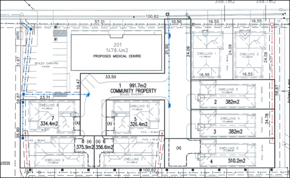
Proposed eight lot Community subdivision
Stage 3 - Dwellings
Stage 3 involves construction of Dwellings 1 and 2 on
proposed Torrens Lots 203 and 204 (Stage 1); and Dwellings 3-9
on Community Lots 2-8 (Stage 2).
The dwellings will be detached, single-storey, and of
contemporary design and detailing. Each dwelling will contain 3-4 bedrooms, two
bathrooms and attached double garage. External finishes will comprise face
brick walls with tiled/rendered and painted highlights, Colorbond roof sheeting
and roller doors, and aluminium framed openings. Private open space will be
provided for each dwelling. Perimeter and internal fencing will be erected and
landscaping installed.
Proposed Dwellings 1 and 2 will have frontage and access to
Telopea Way. Proposed Dwellings 3-9 will address and be accessed via the
shared internal roadway.
A typical elevation of the
proposed dwellings is depicted below:

Typical front elevation - Dwellings 1-9
Stage 4 - Medical Centre
Stage 4 involves construction of a medical centre on
proposed Torrens Lot 201 (Stage 1).
The medical centre will be single-storey with a footprint of
some 36m wide x 15m deep. The building will take a modern rectilinear design
with skillion roof profile, parapet to front and side elevations, defined entry
portal and symmetrical openings. External finishes will reinforce the contemporary
building design and comprise masonry walls, Scyon Matrix Panel cladding to
parapet, smooth sheet horizontal cladding to entry, Colorbond roof sheeting and
aluminium framed glazing.
The medical centre will comprise reception/waiting area, six
consulting rooms, three procedure rooms, nurse’s station, amenities and
utilities area. The building will have a floor area of
approximately 520.9m2.
The proposed medical centre will address Telopea Way. A car
park containing 18 car spaces will be provided to the south of the
building, with direct access via Telopea Way. Pedestrian pathways and
landscaping will be established.
The medical centre will provide health services to
out-patients via an appointment regime. The proposed hours of operation are 7am
to 7pm Monday to Friday; and 8am to 6pm weekends and public holidays.
The proposed medical centre is
depicted below:
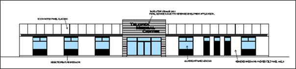
Front (western) façade to Telopea Way

Artist’s impression
MATTERS FOR CONSIDERATION
Section 5A Assessment
In the administration of sections 78A, 79B, 79C, 111 and
112, the provisions of Section 5A must be taken into account for every
development application in deciding whether there is likely to be a significant
effect on threatened species, populations or ecological communities or their
habitats. This section includes a requirement to consider any adopted
assessment guidelines, which means assessment guidelines issued and in force
under section 94A of the Threatened Species Conservation Act 1995.
Assessment guidelines are in force (see DECC-W “Threatened Species
Assessment Guidelines - The Assessment of Significance”) which requires
consent authority to adopt the precautionary principle in its assessment.
In this instance, site inspection reveals that the subject
property has no biodiversity or habitat value.
Section 79C
Section 79C of the Environmental Planning and Assessment
Act 1979 requires Council to consider various matters, of which those
pertaining to the application are listed below.
PROVISIONS OF ANY ENVIRONMENTAL
PLANNING INSTRUMENT s79C(1)(a)(i)
Orange Local Environmental Plan 2011
Part 1 - Preliminary
Clause 1.2 - Aims of Plan
The
broad aims of the LEP are set out under subclause 2. Those relevant to the
application are as follows:
(a) to encourage development which complements
and enhances the unique character of Orange as a major regional centre boasting
a diverse economy and offering an attractive regional lifestyle,
(b) to provide for a range of development
opportunities that contribute to the social, economic and environmental
resources of Orange in a way that allows present and future generations to meet
their needs by implementing the principles for ecologically sustainable
development,
(e) to provide a range of housing choices in
planned urban and rural locations to meet population growth,
(f) to recognise and manage valued
environmental heritage, landscape and scenic features of Orange.
The application is considered to be consistent with the
above objectives, as outlined in this report.
Clause 1.6 - Consent Authority
This clause establishes that, subject to the Act, Council is
the consent authority for applications made under the LEP.
Clause 1.9A - Suspension of
Covenants, Agreements and Instruments
This clause provides that covenants, agreements and other
instruments which seek to restrict the carrying out of development do not apply
with the following exceptions.
· covenants imposed
or required by Council
· prescribed
instruments under Section 183A of the Crown Lands Act 1989
· any conservation
agreement under the National Parks and Wildlife Act 1974
· any trust
agreement under the Nature Conservation Trust Act 2001
· any property
vegetation plan under the Native Vegetation Act 2003
· any biobanking
agreement under Part 7A of the Threatened Species Conservation Act 1995
· any planning
agreement under Division 6 of Part 4 of the Environmental Planning and
Assessment Act 1979.
Council staff are not aware of the title of the subject
property being affected by any of the above.
Mapping
The subject site is identified
on the LEP maps in the following manner:
|
Land Zoning Map:
|
Land zoned R1 General Residential
|
|
Lot Size Map:
|
No minimum Lot Size
|
|
Heritage Map:
|
Not a heritage item or conservation area
|
|
Height of Buildings Map:
|
No building height limit
|
|
Floor Space Ratio Map:
|
No floor space limit
|
|
Terrestrial Biodiversity Map:
|
No biodiversity sensitivity
on the site
|
|
Groundwater Vulnerability Map:
|
Ground water vulnerable
|
|
Drinking Water Catchment Map:
|
Not within the drinking water
catchment
|
|
Watercourse Map:
|
Not within or affecting a
defined watercourse
|
|
Urban Release Area Map:
|
Not within an urban release area
|
|
Obstacle Limitation Surface Map:
|
No restriction on building siting or construction
|
|
Additional Permitted Uses Map:
|
No additional permitted use applies
|
Those matters that are of relevance are addressed in detail
in the body of this report.
Part 2 - Permitted or Prohibited Development
Clause
2.1 - Land Use Zones
The subject site is located within the R1 General Residential
zone. The proposed development is defined as “subdivision,”
“dwelling houses” and “medical centre.”
Pursuant to Section 4B of the Environmental Planning and
Assessment Act:
Subdivision of land means:
the division of land into two or more parts that, after the division, would
be obviously adapted for separate occupation, use or disposition.
Pursuant to the OLEP 2011
Dictionary:
Dwelling house means: a building containing only one dwelling.
Dwelling means: a room or suite of rooms occupied or used
or so constructed or adapted as to be capable of being occupied or used as a
separate domicile.
Medical centre means:
premises that are used for the purpose of providing health services (including
preventative care, diagnosis, medical or surgical treatment, counselling or
alternative therapies) to out-patients only, where such services are
principally provided by health care professionals. It may include the ancillary
provision of other health services.
In terms of permissibility:
· Subdivision
is permitted with consent in the R1 zone pursuant to Orange LEP 2011.
· Dwelling houses
are permitted with consent in the R1 zone pursuant to Orange LEP 2011.
· Medical centres
are permitted with consent in the R1 zone pursuant to Clause 57 of State
Environmental Planning Policy (Infrastructure) 2007.
Clause 2.3 - Zone Objectives and Landuse Table
The
objectives for land zoned R1 General Residential are as follows:
· To provide for
the housing needs of the community.
· To provide for
a variety of housing types and densities.
· To enable other
land uses that provide facilities or services to meet the day to day needs of
residents.
· To ensure
development is ordered in such a way as to maximise public transport patronage
and encourage walking and cycling in close proximity to settlement.
· To ensure that
development along the Southern Link Road has an alternative access.
The proposal is consistent with the objectives of the R1
zone as follows:
· Proposed Dwellings
1-9 will provide additional housing stock to accommodate the housing needs of
the community.
· The development
will contribute to the variety of housing types and densities in the Waratah
precinct, and complement the developing neighbouring residential density.
· The proposed
medical centre is a complementary landuse that will provide health services
facilities for residents in the locality.
· The subject land
is serviced by public transport.
· The site does not
have frontage or access to the Southern Link Road.
Clause 2.6 - Subdivision -
Consent Requirements
Clause 2.6 is applicable and states:
(1) Land
to which this Plan applies may be subdivided but only with development consent.
Consent is sought for Torrens and Community subdivision of
the subject land in accordance with this clause.
Part 3 - Exempt and Complying Development
The application is not exempt or complying development.
Part 4 - Principal Development Standards
The
Part 4 Principal Development Standards do not relate to the subject land or
proposed development.
Part 5 - Miscellaneous Provisions
Part 5
Miscellaneous Provisions do not relate to the proposal.
Part 6 - Urban Release Area
Not relevant to the application. The subject site is not
located in an Urban Release Area.
Part 7 - Additional Local Provisions
7.1
- Earthworks
Clause
7.1 applies. This clause states in part:
(3) Before granting
development consent for earthworks, the consent authority must consider the
following matters:
(a) The likely disruption
of, or any detrimental effect on, existing drainage patterns and soil stability
in the locality of the development
(b) The effect of the
development on the likely future use or redevelopment of the land
(c) The quality of the fill
or the soil to be excavated, or both
(d) The effect of the
development on the existing and likely amenity of adjoining properties
(e) The source of any fill
material and the destination of any excavated material
(f) The likelihood of
disturbing relics
(g) The proximity to and
potential for adverse impacts on any waterway, drinking water catchment or
environmentally sensitive area
(h) Any measures proposed
to minimise or mitigate the impacts referred to in paragraph (g).
In
consideration of this clause, the proposal is considered to be acceptable.
Minor earthworks will be required to create level building pads, site
accesses and vehicle areas, service connections and landscaping. The earthworks
will be supported onsite with minor change to ground levels. Disruption to
drainage is considered to be minor and will not detrimentally affect adjoining
properties. Conditions are recommended in relation to sediment and erosion
control during construction.
7.3 - Stormwater Management
Clause 7.3 is applicable. This
clause states in part:
(3) Development
consent must not be granted to development on land to which this clause applies
unless the consent authority is satisfied that the development:
(a) is
designed to maximise the use of water permeable surfaces on the land having
regard to the soil characteristics affecting on-site infiltration of water
(b) includes,
where practical, on-site stormwater retention for use as an alternative supply
to mains water, groundwater or river water
(c) avoids
any significant impacts of stormwater runoff on adjoining downstream
properties, native bushland and receiving waters, or if that impact cannot be
reasonably avoided, minimises and mitigates the impact.
In consideration of this clause,
the proposal is acceptable. The development will be serviced by new interlot
stormwater drainage. Conditions are recommended in relation to drainage works
to satisfy the requirements of Clause 7.3.
7.6 - Groundwater Vulnerability
The
subject land is identified as Groundwater Vulnerable on the Groundwater
Vulnerability Map. Clause 7.6 applies. This clause states in part:
(3) Before
determining a development application for development on land to which this
clause applies, the consent authority must consider:
(a) whether or not the development (including
any onsite storage or disposal of solid or liquid waste and chemicals) is
likely to cause any groundwater contamination or have any adverse effect on
groundwater dependent ecosystems.
In consideration of Clause 7.6,
the proposal is acceptable. The proposed development does not involve processes
or activities that would impact on groundwater resources. The subject land is
connected to Council’s reticulated sewerage system.
Clause 7.11 - Essential Services
Clause
7.11 is applicable. This clause states:
Development
consent must not be granted to development unless the consent authority is
satisfied that any of the following services that are essential for the
proposed development are available or that adequate arrangements have been made
to make them available when required:
(a) the
supply of water
(b) the
supply of electricity
(c) the
disposal and management of sewage
(d) storm
water drainage or on-site conservation
(e) suitable
road access.
In
consideration of this clause, all utility services are available to the land
and adequate for the proposal:
· The subject land
is connected to reticulated water supply.
· Electricity and
telecommunications are available to the land.
· The site is
connected to Council’s reticulated sewerage system.
· Conditions are
recommended requiring stormwater management consistent with the Development and
Subdivision Code.
· The subject land
has direct frontage and access to Telopea Way.
STATE ENVIRONMENTAL PLANNING
POLICIES
State Environmental Planning Policy (Building
Sustainability Index: BASIX) 2004
SEPP (Building Sustainability Index BASIX) 2004 applies to
the subject development. BASIX Certificates have been submitted in support of
proposed Dwellings 1-9. Each dwelling will satisfy the provisions of BASIX in
respect of water, thermal comfort and energy. The proposal is consistent with
the SEPP. Conditions are recommended requiring the BASIX commitments be
undertaken during construction works.
State Environmental Planning
Policy No. 55 – Remediation of Land
SEPP
55 Remediation of Land is applicable. Pursuant to Clause 7(1):
(1) A consent authority
must not consent to the carrying out of any development on land unless:
(a) it has considered whether the
land is contaminated
(b) if the land is
contaminated, it is satisfied that the land is suitable in its contaminated
state (or will be suitable, after remediation) for the purpose for which the
development is proposed to be carried out
(c) if the land requires
remediation to be made suitable for the purpose for which the development is
proposed to be carried out, it is satisfied that the land will be remediated
before the land is used for that purpose.
Contamination
investigation was undertaken in conjunction with former subdivision of the
land. Further investigation as a precursor to site remediation is considered
unnecessary in conjunction with the proposal.
State Environmental
Planning Policy (Infrastructure) 2007
Health services facilities are permitted with consent in the
R1 General Residential zone, pursuant to Clause 57.
PROVISIONS OF ANY DRAFT
ENVIRONMENTAL PLANNING INSTRUMENT THAT HAS BEEN PLACED ON EXHIBITION
s79C(1)(a)(ii)
There are no draft environmental planning instruments that
apply to the subject land or proposed development.
DESIGNATED DEVELOPMENT
The proposed development is not designated development.
INTEGRATED DEVELOPMENT
The proposal is not integrated development.
PROVISIONS OF ANY DEVELOPMENT
CONTROL PLAN s79C(1)(a)(iii)
Development Control Plan 2004
DCP 2007-7 - Development in Residential Areas
Subdivision in North Orange - Waratah
The DCP sets the following (applicable) Planning Outcomes in
regard to residential subdivision in North Orange - Waratah:
· The subdivision
layout is generally in accordance with the Conceptual Subdivision Layout.
· Subdivision
design and construction complies with the Orange City Development and
Subdivision Code.
· Lots are
oriented to maximise energy efficiency principles.
· Residential
lots have direct frontage and access to a public road.
· All utility
services are provided to the proposed lots.
In consideration of the planning outcomes, the development
is acceptable, as follows:
· The Conceptual
Subdivision Layout has already been varied in the vicinity of the subject land.
The proposed Torrens and Community subdivision layouts will not impact upon the
approved or existing road network and landuse pattern, and are considered to be
acceptable.
· As demonstrated in
this report, the proposed residential lots will be of sufficient area to
provide a high standard of residential amenity to proposed Dwellings 1‑9,
in full compliance with the DCP (Part 7.5 - Merit-Based Approach to
Residential Development in Orange).
· The subdivision
design and construction will comply with the Orange Development and Subdivision
Code. Conditions are recommended in relation to this matter.
· The orientation of
the proposed lots will provide reasonable solar access to proposed Dwellings
1-9. The proposed dwellings will comply with the DCP guidelines for solar
access to indoor and outdoor habitable spaces, as outlined in this report.
· Proposed Torrens
Lots 203 and 204 will have direct frontage and access to Telopea Way. Proposed
Lot 1 in the Community subdivision will have direct access to Telopea Way. This
lot will be developed as a private roadway that will provide legal access to
Community Lots 2 to 8.
· Urban utility
services will be provided to the proposed lots. Relevant conditions are
recommended in relation to services construction and connection.
Neighbourhood Character
The DCP sets the following Planning Outcomes in regard to
Neighbourhood Character:
· Site layout and
building design enables the:
- creation
of attractive residential environments with clear character and identity
- use
of site features such as views, aspect, existing vegetation and landmarks.
· Buildings are
designed to complement the relevant features and built form that are identified
as part of the desired neighbourhood character.
· The
streetscape is designed to encourage pedestrian access and use.
Development adjoining the site is mixed in function and
character. A child care centre is approved on the adjoining northern parcel,
with two-storey medium density housing approved to the east. A low density
residential neighbourhood extends further to the east. Land to the immediate
south is vacant, with the next southern parcels comprising a further child care
centre and McDonalds Restaurant (across Farrell Road). The North Orange
Shopping Centre is located to the west, across Telopea Way. Waratah
Sportsground is situated to the north and northwest of the land, at the
culmination of Telopea Way.
The proposed development is considered satisfactory in terms
of neighbourhood character due to the following:
· The proposed
medical centre and medium density housing are considered appropriate landuses
in this spatial setting and will complement mixed use development in the vicinity.
· The proposed
medical centre will complement and reinforce the neighbourhood centre opposite
the site.
· The proposed
dwellings will complement the density of the approved medium density housing
development on the adjoining land to the east.
· The dwellings in
the community scheme will comprise a separate and integrated precinct, with a
defined character and identity.
· The design for
Dwellings 1-9 will complement the neighbourhood character in respect of
building design, external finishes, height and site layout.
The proposal will not alter or diminish the function of
Telopea Way for pedestrian access and use. In this regard:
· Vehicles
associated with the proposed medical centre and Dwellings 3-9 will enter and
exit the site in a forward direction.
· Reverse egress to
Telopea Way for Dwellings 1 and 2 will be consistent with vehicle movements for
single dwellings throughout the City. The driveways will be removed from the
car park exit associated with the North Orange Shopping Centre.
· The access for the
proposed medical centre will oppose the car park entrance and exit for the
shopping centre. The road formation of 13m is acceptable to prevent conflicts.
Furthermore, sight lines along Telopea Way to the north and south are
expansive.
Building Appearance
The DCP sets the following Planning Outcomes in regard to
Building Appearance:
· The building
design, detailing and finishes relate to the desired neighbourhood character,
complement the residential scale of the area, and add visual interest to the
street.
· The frontages
of buildings and their entries face the street.
· Garages
and car parks are sited and designed so that they do not dominate the street
frontage.
In consideration of the planning outcomes:
· The design and
detailing for the proposed dwellings are reflective of the predominant
residential building form in the Waratah precinct.
· Proposed Dwellings
1 and 2 will address Telopea Way, with Dwellings 3-9 to address the shared
private roadway. The front elevations will each comprise window/s, front entry
door, portico treatment and double garage.
· Garage
presentation will not dominate the street frontage. The attached garages will
not project forward of the main front dwelling façade. Each garage will
be contained beneath the main dwelling roof profile and thereby integrate with
the building design. The garage doors will comprise less than 50% of each
dwelling frontage.
· The building
design and detailing for the medical centre will complement the built from in
the North Orange shopping centre complex.
Heritage
The DCP sets the following Planning Outcomes in regard to
Heritage:
· Heritage
buildings and structures are efficiently re-used.
· New development
complements and enhances the significance of a heritage item or place of
heritage significance listed in the orange heritage study.
· Significant
landscape features are retained including original period fences and period
gardens.
The subject land does not contain or adjoin a heritage item
and is not located within a heritage conservation area.
Setbacks
The DCP sets the following Planning Outcomes in regard to
Setbacks:
· Street setbacks
contribute to the desired neighbourhood character, assist with the integration
of new development and make efficient use of the site.
· Street setbacks
create an appropriate scale for the street considering all other streetscape
components.
Street setbacks for the proposed dwellings will comply with
the DCP:
· Proposed Dwellings
1 and 2 will be sited a minimum 4.5m from the front boundary to Telopea Way.
· Garages for
Dwellings 1 and 2 will have a minimum setback of 5.5m from the public street,
thus providing tandem parking for each dwelling wholly within the subject land.
· Side and rear
setbacks for the proposed dwellings will comply with the BCA.
The street setback for the
proposed medical centre will be 6.2m for the main front façade
and 4.5m to the entry portal. Siting of the medical centre will relate to
the residential building line.
Front Fences and Walls
The DCP sets the following Planning Outcomes in regard to
Fences and Walls:
· Front fences
and walls:
- assist
in highlighting entrances and creating a sense of identity within the
streetscape
- are
constructed of materials compatible with associated housing and with fences
visible from the site that positively contribute to the streetscape
- provide
for facilities in the street frontage area such as mail boxes.
The proposal does not involve a front fence to Telopea Way
for proposed Dwellings 1 and 2 or the medical centre. Front fencing
does not feature in this streetscape.
Visual Bulk
The DCP sets the following Planning Outcome in regard to
Visual Bulk:
· Built form
accords with the desired neighbourhood character of the area with:
- side
and rear setbacks progressively increased to reduce bulk and overshadowing
- site
coverage that retains the relatively low density landscaped character of
residential areas
- building
form and siting that relates to landform, with minimal land shaping (cut and
fill)
- building
height at the street frontage that maintains a comparable scale with the
predominant adjacent development form
- building
to the boundary where appropriate.
In consideration of the DCP Guidelines, the proposal is
satisfactory as follows:
· Proposed Dwellings
1-9 will be contained within the DCP-prescribed visual bulk envelope (VBE)
plane when projected from the external and proposed internal lot boundaries.
· The medical centre
will encroach within the VBE plane when projected from the northern (side) and
eastern (rear) boundaries of proposed Lot 201. Visual encroachment impacts
for adjoining proposed Dwellings 1, 6 and 8 are not anticipated, due to
the separation provided by the private community roadway.
· Proposed
Dwellings 1-9 will not exceed the maximum 60% site coverage prescribed in
the DCP for single dwellings:
|
Proposed
Lot
|
Dwelling/Footprint
(m2)
|
Lot
Area (m2)
|
Site
Coverage (%)
|
|
203
|
Dwelling
1 – 189.5
|
398.7
|
47.5
|
|
204
|
Dwelling
2 – 191.4
|
398.7
|
47.5
|
|
2
|
Dwelling
3 – 187.8
|
382
|
49.2
|
|
3
|
Dwelling
4 – 187.8
|
382
|
49.2
|
|
4
|
Dwelling
5 – 187.8
|
510.2
|
36.8
|
|
5
|
Dwelling
6 – 174.4
|
326.4
|
53.4
|
|
6
|
Dwelling
7 – 174.4
|
356.6
|
49.0
|
|
7
|
Dwelling
8 – 175.4
|
334.4
|
52.2
|
|
8
|
Dwelling
9 – 174.7
|
375.9
|
46.5
|
· The proposed
medical centre will comprise a footprint of some 540m². Based on proposed
site area of Lot 201 of 1478.7m², the development will have site coverage
of some 36% in compliance with the maximum 50% prescribed in the DCP.
· The proposed
dwellings will be single-storey with reasonable setbacks from proposed side and
rear boundaries. The dwellings will complement the bulk, height and scale of
typical residential development in the Waratah subdivision.
· The bulk and
massing of the proposed medical centre will complement that of the North Orange
Shopping Centre precinct opposite the site.
· Negligible earthworks
and land shaping will be required in conjunction with the proposed development.
Finished levels will relate to natural surface levels.
Walls and Boundaries
The DCP sets the following Planning Outcome in regard to
Walls and Boundaries:
· Building to the
boundary is undertaken to provide for efficient use of the site taking into
account:
- the
privacy of neighbouring dwellings and private open space
- the
access to daylight reaching adjoining properties
- the
impact of boundary walls on neighbours.
The proposal does not involve the construction of buildings
on the boundary. As outlined in this report, the site layout and building
design will not impact on adjoining dwellings in respect of privacy, solar
access or visual bulk.
Daylight and Sunlight
The DCP sets the following Planning Outcome in regard to
Daylight and Sunlight:
· Buildings are
sited and designed to ensure:
- daylight
to habitable rooms in adjacent dwellings is not significantly reduced
- overshadowing
of neighbouring secluded open spaces or main living area windows is not
significantly increased
- consideration
of Council’s Energy Efficiency Code.
Shadow diagrams have been prepared in support of the
proposed development. In consideration of the DCP Guidelines, the proposal is
considered to be satisfactory as outlined below.
Solar Access to Private Open
Space
According to the DCP Guidelines and Council’s Energy
Smart Homes Code, sunlight is to be available to at least 40% of required open
space for dwellings within the development and on neighbouring properties for
at least three hours between 9am and 3pm.
The proposed development is considered satisfactory due to
the following:
· The shadow
diagrams demonstrated that sunlight will be available to the prescribed minimum
open space areas for the proposed dwellings for at least three hours between
9am and 3pm on the winter solstice:
|
Dwelling
|
GFA
(m2)
|
POS
Required (m2)
|
Unshaded
POS Required (m2)
|
Solar
access to POS- performance in min. 3 hour period
|
Compliance
|
|
1
|
124.9
|
62.5
|
25.0
|
25.3
10.30am
-1.30pm
|
Yes
|
|
2
|
124.9
|
62.5
|
25.0
|
25.2
10.30am
– 1.30pm
|
Yes
|
|
3
|
136.2
|
68.1
|
27.2
|
47.5
10.30am
– 1.30pm
|
Yes
|
|
4
|
136.2
|
68.1
|
27.2
|
47.5
10.30am
– 1.30pm
|
Yes
|
|
5
|
136.2
|
68.1
|
27.2
|
48.2
10.30am
– 1.30pm
|
Yes
|
|
6
|
122.2
|
61.1
|
24.4
|
32.7
10.30am
– 1.30pm
|
Yes
|
|
7
|
122.2
|
61.1
|
24.4
|
36.1
10.30am
– 1.30pm
|
Yes
|
|
8
|
122.2
|
61.1
|
24.4
|
25.9
10.00am
– 1.00pm
|
Yes
|
|
9
|
122.2
|
61.1
|
24.4
|
30.0
11.00am
– 2.00pm
|
Yes
|
· The proposed
development will not adversely shadow the private open space for the approved
dwellings on the adjoining eastern parcel (pursuant to DA 4/2005(1)).
Shadows cast by proposed Dwellings 5, 7 and 9 will not extend beyond the
perimeter fence shadow between 9am and 1pm. As such, more than three hours of
on-ground solar access will be maintained for the approved eastern dwellings,
consistent with the DCP guidelines.
· Shadows to the
adjoining vacant parcel to the south will mainly relate to perimeter fencing.
Overshadowing caused by the development is not expected to unreasonably impact
on the future use of the adjoining southern parcel.
· Shadows cast by
the proposed medical centre will be contained within vehicle areas in the
development (the medical centre car park to the south, and private roadway to
the east). The medical centre will have nil impact on solar access to private
open space areas within and adjoining the development site.
Solar Access to Northern
Windows
According to the DCP Guidelines and Council’s Energy
Efficiency Code, sunlight is to be provided to at least 75% of
north-facing living area windows within the development and on adjoining land
for a minimum of four hours on 21 June; or not further reduced than existing
where already less.
The proposed development is considered satisfactory due to
the following:
· Sunlight will be
provided to north-facing living area windows for proposed Dwellings 1, 2,
3, 4, 5 and 7 in excess of the DCP guidelines.
· It is noted that
north-facing dining room windows for Dwellings 3, 4 and 5 will be shaded
by the adjacent alfresco roof. This arrangement is considered acceptable,
however, as the open plan space also contains a generous and uncovered living
area window. The applicant submits that:
‘to remove the alfresco
simply to meet the numeric requirement of the DCP would diminish the
amenity of the dwelling in other respects. The alfresco provides an outdoor
living opportunity that will enhance the amenity of the dwelling by providing
shade in summer, shelter in winter and weather protection in general.’
No objection is raised to this
arrangement. While Council has required the installation of skylights to
habitable windows shaded by awnings or similar, skylights are not required for
Dwellings 3, 4 and 5 due to the adjacent uncovered living area window.
· In respect of
Dwelling 6, sunlight will be provided to >90% of north-facing glazing
between 9am and 12 noon; and >50% between 12 noon and 1pm. This is
considered a minor variation on the DCP requirement and will provide acceptable
solar access to the Dwelling 6 living room.
· Sunlight will be
provided to north-facing living area windows for proposed Dwellings 8
and 9, consistent with the DCP guidelines. The north-facing habitable
spaces for Dwellings 8 and 9 comprise a separate lounge room. The open plan
living/ dining/kitchen zone is located to the rear (south) of the dwelling and
will not have access to northern sunlight. However, additional sunlight will be
provided to open plan living areas in the morning for Dwelling 8 and afternoon
for Dwelling 9.
· The proposed
development will not reduce solar access to north-facing windows for the
approved dwellings to the east.
· As outlined above,
shadows to the adjoining vacant parcel to the south will mainly relate to
perimeter fencing. Overshadowing caused by the development is not expected to
unreasonably impact on the future use of the adjoining southern parcel.
Views
The DCP sets the following Planning Outcomes in regard to
Views:
· Building form
and design allow for residents from adjacent properties to share prominent
views where possible.
· Views including
vistas of heritage items or landmarks are not substantially affected by the
bulk and scale of the new development.
The valued view corridor to the southwest towards Mount
Canobolas and the Orange Botanic Gardens is already disrupted by the North
Orange Shopping Centre buildings. The proposed dwellings will not unreasonably
diminish views for adjoining residential properties in the vicinity of the
development site.
Visual Privacy
The DCP sets the following Planning Outcome in regard to
Visual Privacy:
· Direct
overlooking of principal living areas and private open spaces of other
dwellings is minimised firstly by:
- building
siting and layout
- location
of windows and balconies
and secondly by:
- design
of windows or use of screening devices and landscaping.
Acceptable visual privacy will be achieved within the
development and for dwellings on adjoining land, as follows:
· The proposed
medical centre will not have windows or public spaces along the northern (side)
and eastern (rear) elevations adjacent to the proposed dwellings. Further, the
internal private roadway will provide separation between the opposing landuses.
This interface will reduce the potential for adverse privacy impacts.
· The residential
site layout and building design will minimise the potential for overlooking
from adjoining dwellings. The orientation of living spaces, window placement
and configuration, setbacks from boundaries, fencing and landscaping will
assist to maintain visual privacy.
· Internal and
external living spaces for the proposed dwellings will be oriented to the rear
and will not be directly opposing.
· The interface
between private open spaces will be modest, and typical to a medium density
residential development.
· Perimeter and
internal fencing will be installed.
· The front door and
garage for each dwelling will be oriented to ensure privacy for residents when
arriving and departing the dwellings.
· Finished floor
levels for the dwellings will relate to natural ground level, and assist to
maintain visual privacy.
Acoustic Privacy
The DCP sets the following Planning Outcome in regard to
Acoustic Privacy:
· Site layout and
building design:
- protect
habitable rooms from excessively high levels of external noise
- minimise
the entry of external noise to private open space for dwellings close to major
noise sources
- minimise
transmission of sound through a building to affect other dwellings.
The layout and building design for the proposed dwellings
are typical of adjacent North Orange residential neighbourhoods. Adverse acoustic
impacts are not anticipated for the proposed dwellings within the development,
nor those on adjoining lands as a consequence of the proposal.
In respect of the siting of the medical centre adjacent to
proposed Dwelling 8, Council’s Environmental Health and Building
Surveyor advised as follows:
The proposed medical centre is
not likely to cause any acoustic issues for the proposed dwellings as it is
generally a quiet type of land use. The dwelling closest to the medical centre
carpark does not have any living areas adjacent and will be separated by a
fence which will provide a reasonable level of attenuation.
Hours of operation for the proposed medical centre are
consistent with day time operating hours pursuant to the NSW Industrial
Noise Policy. Operating hours are considered to be acceptable and will coincide
with those at the North Orange Shopping Centre.
Security
The DCP sets the following Planning Outcomes in regard to
Security:
· The site layout
enhances personal safety and minimises the potential for crime, vandalism and
fear.
· The design of
dwellings enables residents to survey streets, communal areas and approaches to
dwelling entrances.
The proposal development is considered satisfactory
in terms in surveillance, territorial enforcement and access control as
follows:
· Clear sightlines
will be available between building frontages to public areas and vehicle areas.
· The site and
buildings will be externally illuminated.
· The landscape
design will limit opportunities to conceal potential offenders.
· Perimeter and
internal fencing will be installed.
· The buildings will
have windows that address Telopea Way or private roadway.
· Internal access
will be provided from the garage into the dwellings.
· General
maintenance of the site and buildings.
Circulation and Design
The DCP sets the following Planning Outcome in regard to
Circulation and Design:
· Accessways and
parking areas are designed to manage stormwater
· Accessways,
driveways and open parking areas are suitably landscaped to enhance amenity
while providing security and accessibility to residents and visitors
· The site layout
allows people with a disability to travel to and within the site between car
parks, buildings and communal open space.
The proposed development is considered suitable in respect
of the planning outcomes:
· Conditions are
recommended in relation to stormwater management for the proposed development.
· Direct vehicular
access will be provided to Telopea Way for proposed Dwellings 1 and 2
via separate vehicle crossings and driveways. Reverse egress to the street will
be consistent with manoeuvring arrangements for single dwellings in residential
areas.
· Access to proposed
Dwellings 3-9 will be via a shared private roadway. Sufficient manoeuvring area
will be available within the private roadway to permit a reverse manoeuvre from
the garages, onsite turning and forward egress to the access arm and Telopea
Way.
· Separate access
will be provided to the medical centre via Telopea Way. The carpark access will
permit two-way passing at the street frontage. Sufficient manoeuvring area will
be available in the car park to accommodate a B99 vehicle.
· The site layout
will accommodate manoeuvring of a medium rigid vehicle 8.8m in length. A
service vehicle of this size is suitable for the residential component of the
development.
· Driveway areas
will be landscaped to provide softening of hardstand area.
Car Parking
The DCP sets the following Planning Outcomes in regard to
Car Parking:
· Parking
facilities are provided, designed and located to:
- enable
the efficient and convenient use of car spaces and accessways within the site
- reduce
the visual dominance of car parking areas and accessways.
· Car parking is
provided with regard to the:
- the
number and size of proposed dwellings
- requirements
of people with limited mobility or disabilities.
Pursuant to DCP 2004, onsite parking is to be provided for
3br+ dwellings at a rate of 1.5 spaces per dwelling and 0.2 visitor
spaces per dwelling. Two (2) garaged spaces per dwelling will be provided
for Dwellings 1-9; and two (2) visitor parking spaces will be provided in
Community Lot 1, consistent with the DCP requirements.
Consistent with Council’s practice, onsite parking is
to be provided for medical centres at a rate of 1 space per 40m2
gross floor area (GFA). Based on GFA of 520.9m2, 13 parking
spaces are required. Consistent with this requirement, 18 onsite parking spaces
will be provided in the medical centre carpark.
Private Open Space
The DCP sets the following Planning Outcomes in regard to
Private Open Space:
· Private open
space is clearly defined for private use.
· Private open
space areas are of a size, shape and slope to suit the reasonable requirements
of residents including some outdoor recreational needs and service functions.
· Private open
space is:
- capable
of being an extension of the dwelling for outdoor living, entertainment and
recreation
- accessible
from a living area of the dwelling
- located
to take advantage of outlooks; and to reduce adverse impacts of overshadowing
or privacy from adjoining buildings
- orientated
to optimise year round use.
Private open space for the proposed dwellings will comply
with the DCP Guidelines in respect of minimum area, dimension,
orientation, solar access and connectivity:
· The
following table demonstrates that each of the proposed dwellings is provided
with open space that complies with the minimum requirement in terms of area:
|
Dwelling
|
Living
Area (ex. Garage, porches, patios etc) (m2)
|
Private
Open Space Required by DCP (m2)
|
Private
Open Space Provided (m2)
|
Compliance
|
|
1
|
124.9
|
62.5
|
89.2
|
Yes
|
|
2
|
124.9
|
62.5
|
84.7
|
Yes
|
|
3
|
136.2
|
68.1
|
90
|
Yes
|
|
4
|
136.2
|
68.1
|
90
|
Yes
|
|
5
|
136.2
|
68.1
|
91.3
|
Yes
|
|
6
|
122.2
|
61.1
|
61.8
|
Yes
|
|
7
|
122.2
|
61.1
|
82.2
|
Yes
|
|
8
|
122.2
|
61.1
|
99.9
|
Yes
|
|
9
|
122.2
|
61.1
|
99.5
|
Yes
|
· Private open space
for each dwelling will have a minimum dimension of 3m.
· The private yards
can accommodate an area of 5m x 5m.
· The nominated 5m x
5m open space areas will be of negligible slope and will achieve a high
standard of amenity and functionality.
· Open space for the
dwellings will be located behind the building line and be provided with a
northerly aspect.
· As outlined
previously, the solar access to each area of private open space on the winter
solstice is considered satisfactory.
Open Space
and Landscaping
The DCP sets the following Planning Outcomes in regard to
Open Space and Landscaping:
· The site layout
provides open space and landscaped areas which:
- contribute
to the character of the development by providing buildings in a landscaped
setting
- provide
for a range of uses and activities including stormwater management
- allow
cost effective management.
· The landscape
design specifies landscape themes consistent with the desired neighbourhood
character; vegetation types and location, paving and lighting provided for
access and security.
· Major existing
trees are retained and protected in a viable condition whenever practicable
through appropriate siting of buildings, accessways and parking areas.
· Paving is
applied sparingly and integrated in the landscape design.
A landscape plan has been submitted in support of the
proposal. The proposed landscaping scheme will provide integration of the
dwellings and medical centre in the Telopea Way streetscape and softening of
hardstand driveways. The proposed plantings are appropriate to the Orange area
and incorporate trees and shrubs.
Stormwater
The DCP sets the following Planning Outcomes in regard to
Stormwater:
· Onsite drainage
systems are designed to consider:
- downstream
capacity and need for on-site retention, detention and re-use
- scope
for on-site infiltration of water
- safety
and convenience of pedestrians and vehicles
- overland
flowpaths.
· Provision is
made for onsite drainage which does not cause damage or nuisance flows to
adjoining properties.
Conditions are recommended in relation to stormwater
management of the site.
Erosion and Sedimentation
The DCP sets the following Planning Outcome in regard to
Erosion and Sedimentation:
· Measures
implemented during construction to ensure that the landform is stabilised and
erosion is controlled.
An erosion and sediment control plan will be required in
conjunction with the engineering design plans for the development. A condition
is recommended in relation to this matter.
DEVELOPMENT CONTRIBUTIONS PLAN
2015
Development contributions are applicable to the proposed
development pursuant to Orange Development Contributions Plan 2015.
The contributions applying to
Stage 1 (Torrens subdivision to create proposed Lots 201-204) in the
Waratah urban release area will be levied as follows:
|
Open Space and Recreation
|
3 additional lots @ $3,346.33
|
10,038.99
|
|
Community and Cultural
|
3 additional lots @ $673.97
|
2,021.91
|
|
Roads and Cycleways
|
3 additional lots @ $5,163.01
|
15,489.03
|
|
Stormwater Drainage
|
-
|
|
|
Local Area Facilities
|
3 additional lots @ $10,235.57
|
30,706.71
|
|
Plan Preparation & Administration
|
3 additional lots @ $581.12
|
1,743.36
|
|
TOTAL:
|
|
$60,000.00
|
The contributions applying to Stage 2 (Community
subdivision to create proposed Lots 1‑8) in the Waratah urban
release area will be levied as follows:
|
Open Space and Recreation
|
6 additional residential lots @ $3,346.33
|
20,077.98
|
|
Community and Cultural
|
6 additional residential lots @ $673.97
|
4,043.82
|
|
Roads and Cycleways
|
6 additional residential lots @ $5,163.01
|
30,978.06
|
|
Stormwater Drainage
|
-
|
|
|
Local Area Facilities
|
6 additional residential lots @ $10,235.57
|
61,413.42
|
|
Plan Preparation & Administration
|
6 additional residential lots @ $581.12
|
3,486.72
|
|
TOTAL:
|
|
$120,000.00
|
Conditions are recommended requiring payment of the
applicable development contributions.
SECTION 64 WATER AND SEWER
HEADWORKS CHARGES
Section 64 water and sewer headwork charges are applicable
to the proposed development.
The contributions for water, sewer and drainage works applying
to Stage 1 (Torrens subdivision to create proposed Lots 201-204) are based
on 3 ETs for water supply headworks and sewerage headworks.
The contributions for water, sewer and drainage works applying
to Stage 2 (Community subdivision to create proposed Lots 1-8) are based on
6 ETs for water supply headworks and sewerage headworks.
Conditions are recommended requiring payment of
contributions prior to issue of a Subdivision Certificate for the relevant
development stage.
PROVISIONS PRESCRIBED BY THE
REGULATIONS s79C(1)(a)(iv)
Demolition of a Building (clause 92)
The proposal does not involve the demolition of a building.
Fire Safety Considerations
(clause 93)
The proposal does not involve a change of building use for
an existing building.
Buildings to be Upgraded
(clause 94)
The proposal does not involve the rebuilding, alteration,
enlargement or extension of an existing building.
BASIX Commitments (clause 97A)
BASIX Certificates were submitted in support of proposed
Dwellings 1-9. The dwellings will comply with the provisions of BASIX in
respect of water, thermal comfort and energy.
THE LIKELY IMPACTS OF THE
DEVELOPMENT s79C(1)(b)
Visual Impacts
The visual impacts of proposed Dwellings 1-9 are considered
suitable in this setting, as outlined in this report.
Visual impacts associated with the proposed medical centre
are satisfactory, as follows:
· The building
design and detailing will complement the built from in the North Orange
Shopping Centre complex.
· The proposed
medical centre will make a positive contribution to the streetscape. The
building will take a modern rectilinear design with skillion roof profile,
parapet to front and side elevations, defined entry portal and symmetrical
openings.
· The building will
not conflict with or dominate adjoining residential elements:
- bulk, massing
and height will be of a residential scale
- the building
will be separated from adjoining dwellings by vehicle areas (car park to the
south and private roadway to the north)
- the front
setback to Telopea Way will be consistent with that of proposed
Dwellings 1 and 2
- the landscape
design to Telopea Way will complement plantings for adjoining Dwellings 1
and 2
Neighbourhood Amenity
The proposed development will not have adverse impacts on
neighbourhood amenity due to the following:
· The proposed
medical centre and dwellings are considered appropriate landuses in this
spatial setting and will complement mixed use development in the vicinity.
· The medical centre
will complement and reinforce the neighbourhood centre opposite the site and
adjacent service facilities (child care centres).
· The proposed
dwellings will complement the density of the approved medium density housing
development on the adjoining land to the east.
· As outlined in
this report, the development will not adversely impact on amenity for dwellings
within the development and adjoining the site in respect of noise, light,
privacy, visual bulk etc.
Traffic Impacts
The proposal is considered to be satisfactory in terms of
traffic impacts due to the following:
· The capacity of
the local road network is sufficient to accommodate additional localised
traffic generated by the development.
· The proposed
access and manoeuvring arrangements for the medical centre and community
Dwellings 3-9 will allow for forward direction ingress and egress to Telopea
Way for all private and service vehicles associated with the site.
· Adequate sight
lines will be maintained in Telopea Way to prevent vehicle conflicts when
entering or exiting the site.
· Access points for
the development will not conflict with accesses for the North Orange Shopping
Centre opposite the site.
· Parking resources
for the development will be consistent with DCP 2004 and will assist to
maintain traffic amenity along Telopea Way
Cumulative Impacts
The development will contribute to the
diversity of commercial/service landuses and housing forms in the precinct in a manner that is consistent with the neighbourhood
character.
Environmental Impacts
The subject land is contained within a developing
residential precinct and comprises vacant, cleared land. Significant
vegetation, threatened species or ecological endangered communities or their
habitats are unlikely to be present. The site is not in proximity to any
waterway, drinking water catchment or sensitive area. Sediment control
measures, as required by conditions, will prevent loose dirt and sediment
escaping the site and polluting downstream waterways. The
development does not involve processes or activities that would impact on air
or water quality.
In respect of waste management for
the medical centre, waste will be disposed of via Council’s kerbside
waste collection and recycling services; clinical waste will be stored within
the building in appropriate receptacles and collected by approved contractors.
Where applicable, the applicant shall enter into a Trade Waste Contract with
Council.
In regard to the residential
development, garbage and recycling bins for Dwellings 1 and 2 will be
placed kerbside for Council’s collection. A bin bay/waste storage
facility for Dwellings 3‑9 will be provided in the private roadway.
Garbage and recycling bins will be placed in the bin bay on collection days only
and stored in community lots at other times.
Adverse environmental impacts are
not anticipated as a result of the proposal.
Social and Economic Effects
The proposed development is unlikely to generate a negative
social or economic impact within the locality. The proposed medical centre will
enhance health care services within the City, generate employment opportunities
during and post construction, and complement and enhance the role of Orange as
a major regional business and service centre.
The proponent submits that the proposed residential
development will have beneficial social and economic impacts due to the
following:
· A variation in
housing forms and choices is encouraged in the general aims of Orange LEP 2011
and the objectives of the R1 Zone; and
· The proposed
development responds to the general planning principle which encourages the
location of medium density housing in close proximity to shopping, recreation,
community and medical facilities.
Council officers concur with this assessment.
THE SUITABILITY OF THE SITE
s79C(1)(c)
The subject land is suitable for the development due to the
following:
· Medical centre and
dwellings are permitted landuses in the R1 zone.
· The development
site is contained within a mixed use precinct.
· The site is of
sufficient area and dimensions to accommodate a medical centre and dwellings,
and provide a high standard of residential amenity for proposed and adjoining
dwellings.
· The site
topography is relatively level, with minor earthworks required.
· There is no known
contamination on the land.
· All utility
services are available and adequate.
· The site is not
subject to natural hazards.
· The subject land
has no biodiversity or habitat value.
· The site is not in
proximity to any waterway, drinking water catchment or sensitive area.
· The site is not
known to contain any Aboriginal, European or archaeological relics.
· The site has
direct frontage and access to a public road.
ANY SUBMISSIONS MADE IN
ACCORDANCE WITH THE ACT s79C(1)(d)
The proposed development comprises "advertised
development" pursuant to DCP 2004‑5.3. The application was
advertised for the prescribed period of 14 days. At the conclusion of the
exhibition period no submissions had been received.
PUBLIC INTEREST
s79C(1)(e)
The proposed development is considered to be of minor
interest to the wider public due to the relatively localised nature of
potential impacts. The proposal is not inconsistent with any relevant policy
statements, planning studies, guidelines etc that have not been considered in
this assessment.
SUMMARY
The proposed development is permissible with the consent of
Council. The proposed development complies with the relevant aims, objectives
and provisions of the LEP. A section 79C assessment of the
development indicates that the development is acceptable in this instance.
Attached is a draft Notice of Approval outlining a range of conditions
considered appropriate to ensure that the development proceeds in an acceptable
manner.
COMMENTS
The requirements of the Environmental Health and Building
Surveyor and the Engineering Development Section are included in the attached
Notice of Approval.
Attachments
1 Notice
of Approval, D17/34274⇩
Council Meeting
22 June 2017
5.7 Development
Application DA 53/2017(1) - 30 Telopea Way
Attachment 1 Notice
of Approval
|

|
ORANGE
CITY COUNCIL
Development
Application No DA
53/2017(1)
NA17/ Container
PR27086
|
NOTICE OF DETERMINATION
OF A DEVELOPMENT
APPLICATION
issued under the Environmental
Planning and Assessment Act 1979
Section 81(1)
|
Development
Application
|
|
|
Applicant Name:
|
Orange
North Pty Ltd
|
|
Applicant Address:
|
C/- Peter
Basha Planning & Development
PO Box
1827
ORANGE
NSW 2800
|
|
Owner’s Name:
|
Orange
North Pty Ltd
|
|
Land to Be Developed:
|
Lot 16 DP
1210246 - 30 Telopea Way, Orange
|
|
Proposed Development:
|
Subdivision
(four lot Torrens title), Subdivision (eight lot Community Title), Dwelling
Houses (nine) and Medical Centre
|
|
|
|
|
Building
Code of Australia
building
classification:
|
To be
determined by the PCA
|
|
|
|
|
Determination
|
|
|
Made On:
|
22 June
2017
|
|
Determination:
|
CONSENT
GRANTED SUBJECT TO CONDITIONS DESCRIBED BELOW:
|
|
|
|
|
Consent to
Operate From:
|
23 June
2017
|
|
Consent to
Lapse On:
|
23 June
2022
|
Terms of Approval
The reasons for the imposition of
conditions are:
(1) To ensure compliance
with relevant statutory requirements.
(2) To provide adequate
public health and safety measures.
(3) To maintain
neighbourhood amenity and character.
(4) Because the development
will require the provision of, or increase the demand for, public amenities and
services.
(5) To ensure the utility
services are available to the site and adequate for the development.
(6) To prevent the proposed
development having a detrimental effect on adjoining land uses.
(7) To minimise the impact
of development on the environment.
Conditions
(1) The
development must be carried out in accordance with:
(a) Plans by Peter Basha
Planning & Development Ref. 16038D1 - Figures 3-5 (3 sheets)
Plans
by Bassmann Drafting Services - Job No. 16-106 - Drawing Nos. DA01(C), DA02(B),
DA3, 04, 05, 06(A), 07(A), 08, 09(A), 10, 11(A), 12, 13(A), 14, 15(A), 16,
17(A), 18, 19(A), 20, 21 (21 sheets)
(b) statements
of environmental effects or other similar associated documents that form part
of the approval
as amended
in accordance with any conditions of this consent.
(2) All building work must
be carried out in accordance with the provisions of the Building Code of
Australia.
(3) A sign is to be erected
in a prominent position on any site on which building work, subdivision work or
demolition work is being carried out:
(a) showing
the name, address and telephone number of the principal certifying authority
for the work, and
(b) showing
the name of the principal contractor (if any) for any building work and a
telephone number on which that person may be contacted outside working hours,
and
(c) stating
that unauthorised entry to the site is prohibited.
Any such sign is to be maintained while the
building work, subdivision work or demolition work is being carried out.
(4) In the case
of residential building work for which the Home Building Act 1989
requires there to be a contract of insurance in force in accordance with Part 6
of the Act, evidence that such a contract of insurance is in force is to be
provided to the Principal Certifying Authority before any building work
authorised to be carried out by the consent commences.
(5) Residential
building work within the meaning of the Home Building Act 1989 must not
be carried out unless the principal certifying authority for the development to
which the work relates (not being the council) has given the council written
notice of the following information:
(a) in
the case of work for which a principal contractor is required to be appointed:
(i) the
name and the licence number of the principal contractor, and
(ii) the
name of the insurer by which the work is insured under Part 6 of that Act,
(b) in
the case of work to be done by an owner-builder:
(i) the
name of the owner-builder, and
(ii) if
the owner-builder is required to hold an owner-builder permit under that Act,
the number of the owner-builder permit.
If arrangements for doing the
residential building work are changed while the work is in progress so that the
information under this condition becomes out of date, further work must not be
carried out unless the principal certifying authority for the development to
which the work relates (not being the council) has given the council written
notice of the updated information.
(6) Where any excavation
work on the site extends below the level of the base of the footings of a
building on adjoining land, the person having the benefit of the development
consent must, at the person’s own expense:
(a) protect
and support the adjoining premises from possible damage from the excavation,
and
(b) where
necessary, underpin the adjoining premises to prevent any such damage.
Note: This
condition does not apply if the person having the benefit of the development
consent owns the adjoining land or the owner of the adjoining land has given
consent in writing to this condition not applying.
FOUR LOT TORRENS TITLE SUBDIVISION
|
PRIOR TO THE ISSUE OF
A CONSTRUCTION CERTIFICATE
|
(7) Engineering plans,
showing details of all proposed work and adhering to any engineering conditions
of development consent, are to be submitted to, and approved by, Orange City
Council or an Accredited Certifier (Categories B1, C3, C4, C6) prior to the
issuing of a Construction Certificate.
(8) A water and soil
erosion control plan is to be submitted to Orange City Council or an Accredited
Certifier (Categories B1, C3, C4, C6) for approval prior to the issuing of a
Construction Certificate. The control plan is to be in accordance with the
Orange City Council Development and Subdivision Code and the Landcom, Managing
Urban Stormwater; Soils and Construction Handbook.
(9) Proposed
lots 201 to 204 are to be provided with interlot stormwater drainage, including
those lots abutting public land, where the surface of the entire lot cannot be
drained to the kerb and gutter at the lot frontage. A grated concrete
stormwater pit is to be constructed within each lot provided with interlot
stormwater drainage. Engineering plans for this drainage system are to be
approved by Orange City Council or an Accredited Certifier (Categories B1, C3,
C4, C6) prior to the issuing of a Construction Certificate.
(10) A 150mm-diameter sewer
main is to be constructed from Council’s existing mains to serve each of
the proposed lots. Prior to a Construction Certificate being issued engineering
plans for this sewerage system are to be submitted to and approved by Orange
City Council.
|
PRIOR TO WORKS
COMMENCING
|
(11) A
Construction Certificate application is required to be submitted to, and issued
by Council/Accredited Certifier prior to any works being carried out onsite.
(12) Soil erosion control
measures shall be implemented on the site.
|
DURING
CONSTRUCTION/SITEWORKS
|
(13) Any adjustments to
existing utility services that are made necessary by this development
proceeding are to be at the full cost of the developer.
(14) The
provisions and requirements of the Orange City Council Development and
Subdivision Code are to be applied to this application and all work constructed
within the development is to be in accordance with that Code.
The developer is to be entirely responsible for
the provision of water, sewerage and drainage facilities capable of servicing
all the lots from Council’s existing infrastructure. The developer is to
be responsible for gaining access over adjoining land for services where
necessary and easements are to be created about all water, sewer and drainage
mains within and outside the lots they serve.
(15) Dual water and sewerage
reticulation is to be provided to every lot in the proposed subdivision in
accordance with the Orange City Council Development and Subdivision Code.
|
PRIOR TO THE ISSUE OF
A SUBDIVISION CERTIFICATE
|
(16) Application shall be
made for a Subdivision Certificate under Section 109(C)(1)(d) of the Act.
(17) Payment of
contributions for water, sewer and drainage works is required to be made
at the contribution rate applicable at the time that the payment is made.
The contributions are based on 3 ETs for water supply headworks and 3 ETs for
sewerage headworks. A Certificate of Compliance, from Orange City Council
in accordance with the Water Management Act 2000, will be issued upon
payment of the contributions.
This Certificate of Compliance is to be
submitted to the Principal Certifying Authority prior to the issuing of a
Subdivision Certificate.
(18) The payment of
$60,000.00 is to be made to Council in accordance with section 94 of the Act
and the Orange Development Contributions Plan 2015 (Waratah Urban Release Area)
towards the provision of the following public facilities:
|
Open Space and
Recreation
|
3 additional lots @
$3,346.33
|
10,038.99
|
|
Community and
Cultural
|
3 additional lots @
$673.97
|
2,021.91
|
|
Roads and Cycleways
|
3 additional lots @
$5,163.01
|
15,489.03
|
|
Stormwater Drainage
|
-
|
|
|
Local Area Facilities
|
3 additional lots @
$10,235.57
|
30,706.71
|
|
Plan Preparation
& Administration
|
3 additional lots @
$581.12
|
1,743.36
|
|
TOTAL:
|
|
$60,000.00
|
The contribution will be indexed quarterly in
accordance with the Orange Development Contributions Plan 2015 (Waratah Urban
Release Area). This Plan can be inspected at the Orange Civic Centre, Byng
Street, Orange.
(19) Application is to be
made to Telstra/NBN for infrastructure to be made available to each individual
lot within the development. Either a Telecommunications Infrastructure
Provisioning Confirmation or Certificate of Practical Completion is to be
submitted to the Principal Certifying Authority confirming that the specified
lots have been declared ready for service prior to the issue of a Subdivision
Certificate.
(20) A Notice of Arrangement
from Essential Energy stating arrangements have been made for the provision of
electricity supply to the development, is to be submitted to the Principal
Certifying Authority prior to the issue of a Subdivision Certificate.
(21) An easement to drain
sewage and to provide Council access for maintenance of sewerage works a
minimum of 2.0 metres wide is to be created over the proposed sewerage works.
The Principal Certifying Authority is to certify that the easement is in
accordance with the Orange City Council Development and Subdivision Code prior
to the issuing of a Subdivision Certificate.
(22) All services are to be
contained within the allotment that they serve. A Statement of Compliance, from
a Registered Surveyor, is to be submitted to the Principal Certifying Authority
prior to the issuing of a Subdivision Certificate.
(23) Where
stormwater crosses land outside the lot it favours, an easement to drain water
is to be created over the works. A Restriction-as-to-User under section 88B of
the NSW Conveyancing Act 1979 is to be created on the title of the
proposed Lot requiring that no structures are to be placed on the site, or
landscaping or site works carried out on the site, in a manner that affects the
continued operation of the interlot drainage system. The minimum width of the
easement is to be as required in the Orange City Council Development and
Subdivision Code.
(24) Certification from
Orange City Council is required to be submitted to the Principal Certifying
Authority prior to the issue of a Subdivision Certificate stating that all
works relating to connection of the development to Council assets, works on
public land, works on public roads, stormwater, sewer and water reticulation
mains and footpaths have been carried out in accordance with the Orange City
Council Development and Subdivision Code and the foregoing conditions, and that
Council will take ownership of the infrastructure assets.
(25) No
Stopping signs are to be installed along the eastern side of Telopea Way from
the northern boundary of the development to the existing No Stopping sign
located 10m from the Farrell Road intersection. The No Stopping signs are to be
placed appropriately to suit the proposed driveways and be no more than 20m
apart. The existing No Stopping sign at the intersection with Farrell Road is
to be changed to include a double-headed arrow.
(26) All
of the foregoing conditions are to be at the full cost of the developer and to
the requirements and standards of the Orange City Council Development and
Subdivision Code, unless specifically stated otherwise. All work required by
the foregoing conditions is to be completed prior to the issuing of an
Occupation or Subdivision Certificate, unless stated otherwise.
EIGHT LOT COMMUNITY TITLE
SUBDIVISION
|
PRIOR TO THE ISSUE OF
A CONSTRUCTION CERTIFICATE
|
(27) Engineering plans,
showing details of all proposed work and adhering to any engineering conditions
of development consent, are to be submitted to, and approved by, Orange City
Council or an Accredited Certifier (Categories B1, C3, C4, C6) prior to the
issuing of a Construction Certificate.
(28) A water and soil
erosion control plan is to be submitted to Orange City Council or an Accredited
Certifier (Categories B1, C3, C4, C6) for approval prior to the issuing of a
Construction Certificate. The control plan is to be in accordance with the
Orange City Council Development and Subdivision Code and the Landcom, Managing
Urban Stormwater; Soils and Construction Handbook.
(29) Proposed
lots are to be provided with interlot stormwater drainage, including those lots
abutting public land, where the surface of the entire lot cannot be drained to
the kerb and gutter at the lot frontage. A grated stormwater pit is to be
constructed within each lot provided with interlot stormwater drainage.
Engineering plans for this drainage system are to be approved by Orange City
Council or an Accredited Certifier (Categories B1, C3, C4, C6) prior to the
issuing of a Construction Certificate.
(30) A 150mm-diameter sewer
main is to be constructed from Council’s existing main to serve the
proposed lots. Prior to a Construction Certificate being issued engineering
plans for this sewerage system are to be submitted to and approved by Orange
City Council.
(31) A fire
hydrant and domestic water services are to be located in the common driveway
area. Engineering plans are to be submitted to Orange City Council for approval
prior to the issuing of a Construction Certificate.
(32) Engineering plans
providing complete details of the proposed driveway and car-parking areas is to
be submitted to Orange City Council or an Accredited Certifier (Categories B1,
C3, C4, C6) upon application for a Construction Certificate. These plans are to
provide details of levels, cross falls of all pavements, proposed sealing
materials and proposed drainage works and be in accordance with the Orange City
Council Development and Subdivision Code.
|
PRIOR TO WORKS
COMMENCING
|
(33) A
Construction Certificate application is required to be submitted to, and issued
by Council/Accredited Certifier prior to any works being carried out onsite.
(34) Soil erosion control
measures shall be implemented on the site.
|
DURING
CONSTRUCTION/SITEWORKS
|
(35) The
provisions and requirements of the Orange City Council Development and
Subdivision Code are to be applied to this application and all work constructed
within the development is to be in accordance with that Code.
The developer is to be entirely responsible for
the provision of water, sewerage and drainage facilities capable of servicing
all the lots from Council’s existing infrastructure. The developer is to
be responsible for gaining access over adjoining land for services where
necessary and easements are to be created about all water, sewer and drainage
mains within and outside the lots they serve.
(36) Any adjustments to
existing utility services that are made necessary by this development
proceeding are to be at the full cost of the developer.
(37) A 7.0m wide heavy-duty
concrete kerb and gutter layback and footpath crossing is to be constructed in
the position shown on the plan submitted with the Construction Certificate
application. The works are to be carried out to the requirements of the Orange
City Council Development and Subdivision Code.
(38) Dual water and sewerage
reticulation is to be provided to every lot in the proposed residential
subdivision in accordance with the Orange City Council Development and
Subdivision Code.
(39) All services
are to be contained within the allotment that they serve.
|
PRIOR TO THE ISSUE OF
A SUBDIVISION CERTIFICATE
|
(40) The payment of $120,000.00
is to be made to Council in accordance with section 94 of the Act and the
Orange Development Contributions Plan 2015 (Waratah Urban Release Area) towards
the provision of the following public facilities:
|
Open Space and
Recreation
|
6 additional residential
lots @ $3,346.33
|
20,077.98
|
|
Community and
Cultural
|
6 additional
residential lots @ $673.97
|
4,043.82
|
|
Roads and Cycleways
|
6 additional
residential lots @ $5,163.01
|
30,978.06
|
|
Stormwater Drainage
|
-
|
|
|
Local Area Facilities
|
6 additional
residential lots @ $10,235.57
|
61,413.42
|
|
Plan Preparation
& Administration
|
6 additional
residential lots @ $581.12
|
3,486.72
|
|
TOTAL:
|
|
$120,000.00
|
The contribution will be indexed quarterly in
accordance with the Orange Development Contributions Plan 2015 (Waratah Urban
Release Area). This Plan can be inspected at the Orange Civic Centre, Byng
Street, Orange.
(41) Application shall be
made for a Subdivision Certificate under Section 109(C)(1)(d) of the Act.
(42) Payment of
contributions for water, sewer and drainage works is required to be made
at the contribution rate applicable at the time that the payment is made.
The contributions are based on 6 ETs for water supply headworks and 6 ETs for
sewerage headworks. A Certificate of Compliance, from Orange City Council
in accordance with the Water Management Act 2000, will be issued upon
payment of the contributions.
This Certificate of Compliance is to be
submitted to the Principal Certifying Authority prior to the issuing of a
Subdivision Certificate.
(43) Application is to be
made to Telstra/NBN for infrastructure to be made available to each individual
lot within the development. Either a Telecommunications Infrastructure
Provisioning Confirmation or Certificate of Practical Completion is to be
submitted to the Principal Certifying Authority confirming that the specified
lots have been declared ready for service prior to the issue of a Subdivision
Certificate.
(44) A Notice of Arrangement
from Essential Energy stating arrangements have been made for the provision of
electricity supply to the development, is to be submitted to the Principal
Certifying Authority prior to the issue of a Subdivision Certificate.
(45) An easement to drain
sewage and to provide Council access for maintenance of sewerage works a
minimum of 2.0 metres wide is to be created over the proposed sewerage works.
The Principal Certifying Authority is to certify that the easement is in
accordance with the Orange City Council Development and Subdivision Code prior
to the issuing of a Subdivision Certificate.
(46) All services are to be
contained within the allotment that they serve. A Statement of Compliance, from
a Registered Surveyor, is to be submitted to the Principal Certifying Authority
prior to the issuing of a Subdivision Certificate.
(47) Where
stormwater crosses land outside the lot it favours, an easement to drain water
is to be created over the works. A Restriction-as-to-User under section 88B of
the NSW Conveyancing Act 1979 is to be created on the title of the
proposed Lots requiring that no structures are to be placed on the site, or
landscaping or site works carried out on the site, in a manner that affects the
continued operation of the interlot drainage system. The minimum width of the
easement is to be as required in the Orange City Council Development and
Subdivision Code.
(48) Certification from
Orange City Council is required to be submitted to the Principal Certifying
Authority prior to the issue of a Subdivision Certificate stating that all
works relating to connection of the development to Council assets, works on
public land, works on public roads, stormwater, sewer and water reticulation
mains and footpaths have been carried out in accordance with the Orange City
Council Development and Subdivision Code and the foregoing conditions, and that
Council will take ownership of the infrastructure assets.
(49) All
of the foregoing conditions are to be at the full cost of the developer and to
the requirements and standards of the Orange City Council Development and
Subdivision Code, unless specifically stated otherwise. All work required by
the foregoing conditions is to be completed prior to the issuing of an
Occupation or Subdivision Certificate, unless stated otherwise.
DWELLINGS
|
PRIOR TO THE ISSUE OF
A CONSTRUCTION CERTIFICATE
|
(50) An
approval under Section 68 of the Local Government Act is to be sought
from Orange City Council, as the Water and Sewer Authority, for water, sewer
and stormwater connection. No plumbing and drainage is to commence until
approval is granted.
(51) The
applicant is to submit a waste management plan that describes the nature of
wastes to be removed, the wastes to be recycled and the destination of all
wastes. All wastes from the demolition and construction phases of this project
are to be deposited at a licensed or approved waste disposal site.
(52) Prior to the issue of a
construction certificate evidence shall be provided that Lots 1 to 8 have been
registered with NSW Land and Property Information.
|
PRIOR TO WORKS
COMMENCING
|
(53) Where any existing
fencing at the perimeter of the site needs to be removed, or is of a type which
does not ensure the occupants of any adjoining residence adequate privacy, new
fencing of the type shown on the approved development application plans, or as
referred to elsewhere in this Notice, shall be erected prior to any building
or construction work being carried out upon this development.
(54) A
Construction Certificate application is required to be submitted to, and issued
by Council/Accredited Certifier prior to any excavation or building works being
carried out onsite.
(55) A
temporary onsite toilet is to be provided and must remain throughout the
project or until an alternative facility meeting Council’s requirements
is available onsite.
(56) Soil erosion control
measures shall be implemented on the site.
|
DURING CONSTRUCTION/SITEWORKS
|
(57) All
construction/demolition work on the site is to be carried out between the hours
of 7.00 am and 6.00 pm Monday to Friday inclusive, 7.00 am to
5.00 pm Saturdays and 8.00 am to 5.00 pm Sundays and Public
Holidays. Written approval must be obtained from the General Manager of Orange
City Council to vary these hours.
(58) A
Registered Surveyor’s certificate identifying the location of the
building on the site must be submitted to the Principal Certifying Authority
prior to the pouring of the slab or footings.
(59) All
construction works are to be strictly in accordance with the Reduced Levels
(RLs) as shown on the approved plans.
(60) All
materials onsite or being delivered to the site are to be contained within the
site. The requirements of the Protection of the Environment Operations Act
1997 are to be complied with when placing/stockpiling loose material or
when disposing of waste products or during any other activities likely to
pollute drains or watercourses.
(61) Any adjustments to
existing utility services that are made necessary by this development
proceeding are to be at the full cost of the developer.
|
PRIOR TO THE ISSUE OF
AN OCCUPATION CERTIFICATE
|
(62) A 1.8m high fence shall
be provided around the perimeter of the development excluding the frontage. A
1.5m high fence shall be provided between each unit. The height of the fence
shall be measured from the highest finished ground level adjacent to each part
of that fence.
(63) Landscaping
shall be installed in accordance with the approved plans and shall be
permanently maintained to the satisfaction of Council's Manager Development
Assessments.
(64) A total of 2 visitor
car parking spaces shall be provided upon the site in accordance with the
approved plans, the provisions of Development Control Plan 2004, and be
constructed in accordance with the requirements of Council's Development and
Subdivision Code prior to the issue of an Occupation Certificate.
(65) No
person is to use or occupy the building or alteration that is the subject of
this approval without the prior issuing of an Occupation Certificate.
(66) Finished
ground levels are to be graded away from the buildings and adjoining properties
and must achieve natural drainage. The concentrated flows are to be dispersed
down slope or collected and discharged to the stormwater drainage system.
(67) Where
Orange City Council is not the Principal Certifying Authority, a final
inspection of water connection, sewer and stormwater drainage shall be undertaken
by Orange City Council and a compliance certificate issued, prior to the issue
of either an interim or a final Occupation Certificate.
(68) All
of the foregoing conditions are to be at the full cost of the developer and to
the requirements and standards of the Orange City Council Development and
Subdivision Code, unless specifically stated otherwise. All work required by
the foregoing conditions is to be completed prior to the issuing of an
Occupation or Subdivision Certificate, unless stated otherwise.
MEDICAL CENTRE
|
PRIOR TO THE ISSUE OF
A CONSTRUCTION CERTIFICATE
|
(69) An
approval under Section 68 of the Local Government Act is to be sought
from Orange City Council, as the Water and Sewer Authority, for water, sewer
and stormwater connection. No plumbing and drainage is to commence until
approval is granted.
(70) The
applicant is to submit a waste management plan that describes the nature of
wastes to be removed, the wastes to be recycled and the destination of all
wastes. All wastes from the demolition and construction phases of this project
are to be deposited at a licensed or approved waste disposal site.
(71) Prior to the issue of a
construction certificate evidence shall be provided that Lot 201 has been
registered with NSW Land and Property Information.
(72) Engineering plans
providing complete details of the proposed driveway and car-parking areas is to
be submitted to Orange City Council or an Accredited Certifier (Categories B1,
C3, C4, C6) upon application for a Construction Certificate. These plans are to
provide details of levels, cross falls of all pavements, proposed sealing
materials and proposed drainage works and be in accordance with the Orange City
Council Development and Subdivision Code.
(73) A Liquid
Trade Waste Application is to be submitted to Orange City Council prior to the
issuing of a Construction Certificate. The application is to be in
accordance with Orange City Council’s Liquid Trade Waste Policy.
Engineering plans submitted as part of the application are to show details of
all proposed liquid trade waste pre-treatment systems and their connection to
sewer.
Where applicable, the applicant is to
enter into a Liquid Trade Waste Service Agreement with Orange City Council in
accordance with the Orange City Council Liquid Trade Waste Policy.
(74) Payment of
contributions for water, sewer and drainage works is required to be made
at the contribution rate applicable at the time that the payment is made.
The contributions are based on 0.2 ETs for water supply headworks and 0.89 ETs
for sewerage headworks. A Certificate of Compliance, from Orange City
Council in accordance with the Water Management Act 2000, will be issued
upon payment of the contributions.
This Certificate of Compliance is to be
submitted to the Principal Certifying Authority prior to the issuing of a
Construction Certificate.
(75) Backflow Prevention
Devices are to be installed to AS3500 and in accordance with Orange City
Council Backflow Protection Guidelines. Details of the Backflow Prevention
Devices are to be submitted to Orange City Council prior to the issuing of a
Construction Certificate.
|
PRIOR TO WORKS
COMMENCING
|
(76) A
Construction Certificate application is required to be submitted to, and issued
by Council/Accredited Certifier prior to any excavation or building works being
carried out onsite.
(77) A
temporary onsite toilet is to be provided and must remain throughout the
project or until an alternative facility meeting Council’s requirements
is available onsite.
(78) Soil erosion control
measures shall be implemented on the site.
|
DURING
CONSTRUCTION/SITEWORKS
|
(79) All
construction/demolition work on the site is to be carried out between the hours
of 7.00 am and 6.00 pm Monday to Friday inclusive, 7.00 am to
5.00 pm Saturdays and 8.00 am to 5.00 pm Sundays and Public
Holidays. Written approval must be obtained from the General Manager of Orange
City Council to vary these hours.
(80) A
Registered Surveyor’s certificate identifying the location of the
building on the site must be submitted to the Principal Certifying Authority
prior to the pouring of the slab or footings.
(81) All
construction works are to be strictly in accordance with the Reduced Levels
(RLs) as shown on the approved plans.
(82) All
materials onsite or being delivered to the site are to be contained within the
site. The requirements of the Protection of the Environment Operations Act
1997 are to be complied with when placing/stockpiling loose material or
when disposing of waste products or during any other activities likely to
pollute drains or watercourses.
(83) Any adjustments to
existing utility services that are made necessary by this development
proceeding are to be at the full cost of the developer.
|
PRIOR TO THE ISSUE OF
AN OCCUPATION CERTIFICATE
|
(84) Off-street car parking spaces
shall be provided upon the site in accordance with the approved plans, and be
constructed in accordance with the requirements of Council's Development and
Subdivision Code prior to the issue of an Occupation Certificate.
(85) Landscaping
shall be installed in accordance with the approved plans and shall be
permanently maintained to the satisfaction of Council's Manager Development
Assessments.
(86) No
person is to use or occupy the building or alteration that is the subject of
this approval without the prior issuing of an Occupation Certificate.
(87) Finished
ground levels are to be graded away from the buildings and adjoining properties
and must achieve natural drainage. The concentrated flows are to be dispersed
down slope or collected and discharged to the stormwater drainage system.
(88) The
owner of the building/s must cause the Council to be given a Final Fire Safety
Certificate on completion of the building in relation to essential fire or
other safety measures included in the schedule attached to this approval.
(89) Where
Orange City Council is not the Principal Certifying Authority, a final
inspection of water connection, sewer and stormwater drainage shall be
undertaken by Orange City Council and a compliance certificate issued, prior to
the issue of either an interim or a final Occupation Certificate.
(90) Certification from
Orange City Council is required to be submitted to the Principal Certifying
Authority prior to the issue of an Occupation Certificate stating that all
works relating to connection of the development to Council assets, works on
public land, works on public roads, stormwater, sewer and water reticulation
mains and footpaths have been carried out in accordance with the Orange City
Council Development and Subdivision Code and the foregoing conditions, and that
Council will take ownership of the infrastructure assets.
(91) Certificates for
testable Backflow Prevention Devices are to be submitted to Orange City Council
by a plumber with backflow qualifications prior to the issue of an Occupation
Certificate.
(92) All
of the foregoing conditions are to be at the full cost of the developer and to
the requirements and standards of the Orange City Council Development and
Subdivision Code, unless specifically stated otherwise. All work required by
the foregoing conditions is to be completed prior to the issuing of an
Occupation or Subdivision Certificate, unless stated otherwise.
|
MATTERS FOR THE
ONGOING PERFORMANCE AND OPERATION OF THE DEVELOPMENT
|
(93) A separate
development application shall be submitted to and approved by Council prior to
the erection of any advertising structures or signs of a type that do not meet
the exempt development provisions of State Environmental Planning Policy
(Exempt and Complying Development Codes) 2008.
(94) The hours of
operation of the medical centre shall not exceed 7.00am to 7.00pm Monday to
Friday; and 8.00am to 6.00pm weekends and public holidays without the prior
approval of Council.
(95) No sandwich
boards or the like are to be placed on Council's footpath.
(96) The
owner is required to provide to Council and to the NSW Fire Commissioner an
Annual Fire Safety Statement in respect of the fire-safety measures, as
required by Clause 177 of the Environmental Planning and Assessment
Regulation 2000.
Other Approvals
(1) Local
Government Act 1993 approvals granted under section 68.
Nil
(2) General
terms of other approvals integrated as part of this consent.
Nil
Right of Appeal
If
you are dissatisfied with this decision, section 97 of Environmental
Planning and Assessment Act 1979 gives you the right to appeal to the Land
and Environment Court within 6 months after the date on which you receive this
notice.
*
Section 97 of the Environmental Planning and Assessment Act 1979 does not apply
to the determination of a development application for State significant
development or local designated development that has been the subject of a
Commission of Inquiry.
|
Disability Discrimination Act
1992:
|
This application has been assessed in
accordance with the Environmental Planning and Assessment Act 1979. No
guarantee is given that the proposal complies with the Disability
Discrimination Act 1992.
The applicant/owner is responsible to ensure
compliance with this and other anti-discrimination legislation.
The Disability Discrimination Act
covers disabilities not catered for in the minimum standards called up in the
Building Code of Australia which references AS1428.1 - "Design for Access
and Mobility". AS1428 Parts 2, 3 and 4 provides the most comprehensive
technical guidance under the Disability Discrimination Act currently
available in Australia.
|
|
|
|
|
Disclaimer - S88B Restrictions on the Use of Land:
|
The applicant should note that there
could be covenants in favour of persons other than Council restricting what
may be built or done upon the subject land. The applicant is advised to check
the position before commencing any work.
|
|
|
|
|
Signed:
|
On behalf of the consent authority ORANGE
CITY COUNCIL
|
|
Signature:
|
|
|
Name:
|
PAUL JOHNSTON - MANAGER DEVELOPMENT
ASSESSMENTS
|
|
Date:
|
23 June 2017
|
5.8 Request
For Financial Assistance
TRIM
REFERENCE: 2017/1177
AUTHOR: Josie
Sanders, Management Accountant
EXECUTIVE Summary
Council is in receipt of requests for financial assistance
under section 356 of the Local Government Act 1993. The report provides details
of applications received.
Link To Delivery/OPerational Plan
The recommendation in this report relates to the
Delivery/Operational Plan strategy “3.3 Our City –
Recognise that members of the community will take different leadership
pathways, the Council will support this growth and development through
appropriate activities, initiatives and assistance”.
Financial Implications
None of the applications are recommended to be funded
because there are no uncommitted available funds for the applications attached
to the report given both the General Donations and Major Promotions budget have
been fully expended.
The Donations Policy is promoted widely as part of the
budget process and all applicants (successful or not) who have sought donations
in the past couple of years, are individually written to with an invitation for
them to make submissions for donations/sponsorships so their allocation is more
certain given it is included in the budget processes.
$2,000 for each Councillor has been reserved to enable
Councillors to allocate up to $2,000 each to requests as they arise throughout
the year. If any of the attached are supported by a Councillor, an allocation
can be made from their remaining allocation. A table is provided below and it
will be updated with each report to show how much each Councillor has
apportioned to their supported projects.
The overall donations/sponsorship budget for 2016/17 is as
follows:
|
Program
|
Adopted Budget
|
Actual/Committed
|
Remaining balance
|
|
General Donations
|
$84,378
|
$84,378*
|
Nil
|
|
Major Promotions
|
$72,127
|
$72,127
|
Nil
|
* The allocation of 19 x $100 reserved for school prize
giving is accounted for in the actual/committed column of the table. The
actual/committed column also includes the Councillor allocation of $24,000
($2,000 per Councillor) which is available to be allocated by Councillors
throughout the year.
Process for the application of the remaining budget
allocation
A Council resolution is required to allocate funds to any
external entity, including as a donation. Hence, the provision of donations can
only occur upon a Councillor’s request being specifically included in a
resolution.
Applications are considered against the criteria outlined in
the Donations Policy. There is an application form that should be submitted to
commence the process of making a donation to another entity. The form contains
details that inform Council that the donation aligns with the intentions the
Council has established in the Community Strategic Plan.
Where a Councillor has advised they wish to pledge money to
a particular cause, the pledge will be noted in the financial assistance
report. The steps to have donations considered are as follows:
1 Applicant
completes donations form – available on the Council website or can be
sent to the applicant.
2 Application
is assessed against the criteria in the Donations Policy and reported to
Council in the financial assistance report.
3 Council
considers applications at a Council Meeting with Councillors specifically
including in a resolution the amount and recipient of any donations supported.
4 In
accordance with s356 of the Local Government Act, some donations require
advertising and then a report back to Council of any submissions is required
(i.e. where the recipient acts for financial benefit for example).
Individual Councillor allocations
are as follows:
|
Councillor
|
Adopted
Budget
|
Actual/Committed
(as
resolved)
|
Remaining
balance
|
|
Councillor
Davis
|
$2,000
|
$2,000
– Forbes Flood Appeal
|
Nil
|
|
Councillor
Hamling
|
$2,000
|
$500
– Canobolas High School
$500
– Orange White Ribbon
$500
– Clontarf Foundation
$500
– Orange Bush Nippers
|
Nil
|
|
Councillor
Brown
|
$2,000
|
$2,000
- Leukaemia Foundation
|
Nil
|
|
Councillor
Duffy
|
$2,000
|
$500
– Come Together Choir
$500
– Foodcare Orange
$500
– Fusion
$500
– Carewest Preschool
|
Nil
|
|
Councillor
Gander
|
$2,000
|
$1,500
– Foodcare Orange
$500
- Fusion
|
Nil
|
|
Councillor
Gryllis
|
$2,000
|
$500
– Canobolas High School
$500
– Carewest Preschool
$1,000
– Forbes Flood Appeal
|
Nil
|
|
Councillor
Jones
|
$2,000
|
$2,000
- Riding for the Disabled
|
Nil
|
|
Councillor
Kidd
|
$2,000
|
$2,000
– Light it Red for Dyslexia
|
Nil
|
|
Councillor
Munro
|
$2,000
|
$2,000
– Anson St School
|
Nil
|
|
Councillor
Taylor
|
$2,000
|
$500
– Community Christmas Lunch
$500
– Blossoms Rescue
$500
– Historical Society
$201
– Lions Club of Orange
|
$299
|
|
Councillor
Turner
|
$2,000
|
$500
– Come Together Choir
$1,500
– At The Vineyard
|
Nil
|
|
Councillor
Whitton
|
$2,000
|
$350
– Riding for the Disabled
$500
– Community Christmas Lunch
$200
– Tiarah Jade Fisher
$500
– Red Shield Appeal
|
$450
|
Policy and Governance Implications
Nil
|
Recommendation
That Council determine if funding will be provided to
Bloomfield Junior Rugby League Football Club, as the remaining Councillor
unspent allocation of $749 will be forfeited come 30 June 2017.
|
further considerations
Consideration has been given to the recommendation’s
impact on Council’s service delivery; image and reputation; political;
environmental; health and safety; employees; stakeholders and project
management; and no further implications or risks have been identified.
SUPPORTING INFORMATION
Bloomfield Junior Rugby League Football Club –
Are holding an event for Girls League Tag 25 June 2017, approximately 300 girls
will be in attendance from Mudgee Cowra Lithgow and Bathurst. The request is to
fund the hire of additional toilets. If Council does wish to support this
application it can be funded from the remaining unallocated Councillor’s
budget of $749, from Cr Whitton $450 and Cr Taylor $299, as there will be no
further opportunity for this money to be allocated in this financial year.
The application would have been
supported if funds had been available for allocation.
Attachments
1 Donation
Table, D17/33396⇩
2 Bloomfield
Junior Rugby League Football Club, IC17/10285⇩
Council Meeting
22 June 2017
5.8 Request
For Financial Assistance
Attachment 1 Donation
Table
|
No
|
Applicant
|
Amount Sought
|
Policy Position
|
Purpose
|
Comment
|
Recom-mended
|
To be advertised
|
|
A.1
|
Bloomfield Junior Rugby League Football Club
|
$1,000
|
General Requests – Seed Funding – up to
a max of $1,000
|
Girls League Tag Carnival – Approx. 300 girls
in attendance from Mudgee, Cowra, Lithgow and Bathurst.
|
Policy Applied
|
Yes
|
No
|
Council
Meeting
22 June 2017
5.8 Request
For Financial Assistance
Attachment 2 Bloomfield
Junior Rugby League Football Club


5.9 Strategic
Policy Review
TRIM
REFERENCE: 2016/2415
AUTHOR: Michelle
Catlin, Manager Administration and Governance
EXECUTIVE Summary
This report continues the review of Council’s
Strategic Policy Register. A review has been undertaken of the Code of Conduct
and associated procedures, the Code of Meeting Practice and the Asbestos
Management Policy and Plan. These policies are recommended for exhibition by
Council.
Link To Delivery/OPerational Plan
The recommendation in this report relates to the
Delivery/Operational Plan strategy “1.2 Our City - Information
and advice provided for the decision-making process will be succinct, reasoned,
accurate, timely and balanced”.
Financial Implications
Nil
Policy and Governance Implications
Council’s Strategic Policies are being reviewed and
amended to ensure ongoing compliance with legislation and industry best
practice. Policies of Council are of two types – Strategic Policies are
determined by Council, and relate to Councillors and the broader community.
These policies require public exhibition (if new or include significant
changes) and adoption by Council. Operational Policies are determined and
implemented by the General Manager, and relate to staff and the operations of
the organisation.
|
Recommendation
That the following Strategic Policies be placed on public
exhibition:
- ST010 - Code of Conduct
- ST050 - Code of Meeting
Practice
- ST001 - Asbestos Management
|
further considerations
Consideration has been given to the
recommendation’s impact on Council’s service delivery; image and
reputation; political; environmental; health and safety; employees;
stakeholders and project management; and no further implications or risks have
been identified.
SUPPORTING INFORMATION
A number of amendments to Strategic
Policies are proposed. The Office of Local Government has confirmed that it is
appropriate to update these documents, notwithstanding the September 2017
election. Council has been advised that the proposed changes to the Local
Government Act 1993 are some months away, so a number of amendments are proposed
and any further changes to the Act will be the subject of a report to the new
Council.
Policies for exhibition
|
Reference
|
Amendment
|
|
Code of
Conduct
|
Part 2 – Purpose of the Code
of Conduct – Addition of:
Council officials should be
aware that the provisions of the Code of Conduct apply in full to situations
where a Councillor or staff member, who identify themselves as associated
with Orange City Council, make comment in traditional or social media.
|
|
Section 6.5
– addition of “including Closed Meetings” as follows:
You must act in accordance with
Council’s Code of Meeting Practice and the Local Government (General)
Regulation 2005 during Council and Committee meetings, including Closed
Meetings.
|
|
Section 8.12
– addition of “(including Closed Meetings)” as follows:
You must not make allegations of
suspected breaches of this Code at Council meetings (including Closed
Meetings) or in other public forums.
|
|
Definitions (in
Code of Conduct and Procedures) – Addition of:
Council Meeting – an
ordinary, extraordinary or closed meeting of Orange City Council
|
|
Code of
Meeting Practice
|
Policy –
Applicability amended to include “Closed Meetings”
|
|
Definitions – Addition of:
Council Meeting – an
ordinary, extraordinary or closed meeting of Orange City Council.
|
|
Addition of 2.5.6 - A notice under this section and the agenda for, and
the business papers relating to, this meeting may be given to a Councillor in
electronic form, but only if all Councillors have facilities to access the
notice, agenda and business papers in that form (Act – S 367(3)).
|
|
Delete previous 3.6.3 - only the
mover of a motion referred to in 3.6.2 (items in order of meeting being
changed) may speak on the motion before it is put.
|
|
Delete 3.7.5 - Despite Clause 3.18 only the mover of a motion referred
to in sub-clause 3.7.4(a) (Motion to deal with late items) may speak on the
motion before it is put.
|
|
Delete 3.8.3 - Despite Clause 3.18
only the mover of a motion referred to in sub-clause 3.8.2(a) (Motion to deal
with late items at extraordinary meetings) may speak on the motion before it
is put.
|
|
Added 3.25.9 - Where verbal
notice of a rescission motion is given at a Council or Policy Committee
Meeting, the Councillor(s) providing that notice must provide the signed,
written rescission motion to the General Manager within two days of the
meeting.
|
|
8.1.2 – Office of the Mayor
– removal of reference to “election by Councillors”
|
|
Asbestos
Management Policy and Plan
|
The Policy and Asbestos Management
Plan have been updated to reflect a number of changes including to SafeWork
NSW (formerly WorkCover) mapping showing naturally occurring asbestos in the
region.
The Plan has also been updated in
line with the amended Model Asbestos Policy for NSW Councils.
|
Attachments
1 Strategic
Policy - ST010 - Code of Conduct, D17/16606⇩
2 Strategic
Policy - ST010 - Code of Conduct attachment, D17/16610⇩
3 Strategic
Policy - ST010 - Procedures for Administration of the Code of Conduct,
D17/16609⇩
4 Strategic
Policy - ST050 - Code of Meeting Practice, D17/34213⇩
5 Strategic
Policy - ST050 - Code of Meeting Practice attachment, D17/34214⇩
6 Strategic
Policy - ST001 - Asbestos Management, D17/33915⇩
7 Strategic
Policy ST001 - Asbestos Management Plan , D17/34893⇩
Council Meeting
22 June 2017
5.9 Strategic
Policy Review
Attachment 1 Strategic
Policy - ST010 - Code of Conduct


CODE OF
CONDUCT
ST010 F22
ObjectiveS
To
provide a Code of Conduct for Orange City Council as required under the Local
Government Act 1993.
Applicability
The
Orange City Council Code of Conduct applies to Councillors, workers, volunteers,
committee and community members, contractors and other delegates of Orange City
Council.
General
The Code
of Conduct is based on the Model Code of Conduct and Model Procedures for the
Administration of the Code of Conduct issued by the Office of Local Government
and amended from time to time.
Procedure
All newly
elected members, community committee members and all new employees shall be
provided with a copy of Orange City Council’s Code of Conduct.
Training sessions will be
provided for Councillors, employees and other delegates as appropriate.
ADMINISTRATION OF THE CODE OF CONDUCT
Appendix
One of the Code of Conduct sets out the Procedures for the Administration of
the Code of Conduct.
Related Policies/Documents
Code of
Conduct
Procedures
for the Administration of the Code of Conduct
Local
Government Act 1993
Local
Government Amendment (Councillor Misconduct and Poor Performance) Act 2015
Model
Code of Conduct
Model
Procedures for the Administration of the Code of Conduct
Public
Interest Disclosures Act 1994
Guidelines
and Circulars issued by the Office of Local Government
Responsible Area – Corporate and
Commercial Services
|
REVISION
|
|
|
DATE
|
RESOLUTION
|
|
DATE
|
RESOLUTION
|
|
1
|
January 2006
|
06/685
|
7
|
November 2012
|
12/458
|
|
2
|
January 2007
|
07/207
|
8
|
16 April 2013
|
13/168
|
|
3
|
June 2007
|
07/258
|
9
|
1 July 2014
|
14/797
|
|
4
|
4 August 2008
|
08/841
|
10
|
21 July 2015
|
15/292
|
|
5
|
January 2009
|
09/453
|
11
|
5 April 2016
|
16/116
|
|
6
|
November 2011
|
11/517
|
12
|
|
|
|
All policies can be reviewed or revoked
by resolution of Council, at any time.
|
SUMMARY OF AMENDMENTS
|
Amendment Date
|
Section/Reference and Amendment
|
|
June 2017
|
Part 2 – Purpose of the Code of Conduct.
Addition of paragraph:
Council
officials should be aware that the provisions of the Code of Conduct apply in
full to situations where a Councillor or staff member, who identify
themselves as associated with Orange City Council, make comment in
traditional or social media.
Section 6.5 and Section 8.12 addition of reference
to closed meetings
Included
in definition - Council Meeting -
an ordinary, extraordinary or closed meeting of Orange City Council
Minor formatting updates.
|
|
February 2016
|
Amendments made by the Local Government
Amendment (Councillor Misconduct and Poor Performance) Act 2015.
Section 3.1 – General Conduct. New
Part f
Section 4.29 – Loss of quorum as a
result of compliance with this part. New Part b
|
|
June 2015
|
Minor formatting changes.
Clarification that provisions relating to
gifts and benefits to Council delegates also relate to gifts and benefits
offered to Council services.
|
|
July 2014
|
Changes to reflect change of name to
Office of Local Government.
Inclusion of Practice Direction 1 issued
by Office of Local Government in relation to ensuring any individual or
organisation appointed to Council’s Conduct Review Panel meet the
eligibility criteria set out in the Procedures (Section 6.3 – Procedures).
|
|
February 2013
|
Major review of Code of Conduct in line
with the new Model Code of Conduct and Model Procedures for Administration of
the Code of Conduct, issued by the Division of Local Government and effective
March 2013.
|
|
September 2012
|
Part 1 – Context. Addition of text
to indicate this part does not constitute separate enforceable standards of
conduct
6.11-6.15 – Dress Code. Amendment
to remove name of contractor providing uniform, and to exclude fixed
term/temporary staff and other staff as determined by the General Manager
6.17 – Health, wellbeing and
safety. Updated to reflect Work Health and Safety Act 2011
7.29 – Appointment to other
organisations. New clause to include requirements when Councillors or Council
staff are appointed to external bodies or organisations
8.11 – Lobbying. New clause setting
out how Councillors can ensure transparency when being lobbied
|
Council
Meeting
22 June 2017
5.9 Strategic
Policy Review
Attachment 2 Strategic
Policy - ST010 - Code of Conduct attachment

ORANGE CITY
COUNCIL
Code of Conduct
TABLE OF CONTENTS
PART 1 INTRODUCTION.. 3
PART 2 PURPOSE OF THE CODE OF CONDUCT. 4
PART 3 GENERAL CONDUCT OBLIGATIONS. 4
PART 4 CONFLICT OF INTERESTS. 6
PART 5 PERSONAL BENEFIT. 9
PART 6 RELATIONSHIP BETWEEN COUNCIL OFFICIALS. 11
PART 7 ACCESS TO INFORMATION AND COUNCIL RESOURCES. 13
PART 8 MAINTAINING THE INTEGRITY OF THIS CODE. 15
PART 9 DEFINITIONS. 17
ATTACHMENT
Code of
Conduct Acknowledgement of Receipt Form............................................................ 18
The
Procedures for the Administration of the Code of Conduct is a separate
document.
The Code
of Conduct sets out the standards of behaviour expected of all Council
officials.
PART 1 INTRODUCTION
Orange
City Council’s Code of Conduct is made for the purposes of section 440 of
the Local Government Act 1993 (“the Act”) and incorporates
the requirements of the Office of Local Government Model Code of Conduct for
Local Councils in NSW as amended in November 2015 and Procedures for the
Administration of the Model Code of Conduct for Local Councils in NSW –
November 2015. As a requirement of the Local Government Act 1993, all new
employees of Council shall be provided with a copy of this Code of Conduct and
the Acknowledgement of Receipt Form is required to be signed and returned to
the Human Resources Section.
Council
is an elected body responsible for administration of its area in accordance
with the applicable legislation. It must do that in the best interests of the
local community, as well as the public in general.
Councillors,
administrators, members of staff of Council, independent Conduct Reviewers,
members of Council Committees including the Conduct Review Committee and
delegates of the Council must comply with the applicable provisions of
Council’s Code of Conduct in carrying out their functions as Council
officials. It is the personal responsibility of Council officials to comply
with the standards in the Code and regularly review their personal
circumstances with this in mind.
Councillors
have two distinct roles under the Local Government Act 1993: as a member of the
governing body of the Council; and as an elected person. Councillors, as
members of the governing body, should work as part of a team to make decisions
and policies that guide the activities of the Council. The role as an elected
person requires Councillors to represent the interests of the community and
provide leadership.
The
Code of Conduct sets the standard of conduct that is expected when Council
officials exercise these roles.
Failure
by a Councillor to comply with the standards of conduct prescribed under this
Code constitutes misconduct for the purposes of the Act. The Act provides for a
range of penalties that may be imposed on Councillors for misconduct, including
suspension or disqualification from civic office.
Failure
by a member of staff to comply with Council’s Code of Conduct may give
rise to disciplinary action.
The
Code does not override or affect the legislation applicable to Local
Government.
Garry Styles
GENERAL MANAGER
PART 2 PURPOSE OF THE CODE OF
CONDUCT
The
Code of Conduct is based on the Code of Conduct for Local Councils in NSW, and
sets the minimum requirements of conduct for Council officials in carrying out
their functions. The Model Code is prescribed by regulation.
The
Code of Conduct has been developed to assist Council officials to:
§ Understand the standards of conduct that are expected
of them
§ Enable them to fulfil their statutory duty to act
honestly and exercise a reasonable degree of care and diligence (section 439)
§ Act in a way that enhances public confidence in the
integrity of Local Government.
Council
officials should be aware that the provisions of the Code of Conduct apply in
full to situations where a Councillor or staff member, who identify themselves
as associated with Orange City Council, make comment in traditional or social
media.
PART 3 GENERAL CONDUCT OBLIGATIONS
General
Conduct
3.1 You
must not conduct yourself in carrying out your functions in a manner that is
likely to bring Council or holders of Civic Office into disrepute.
Specifically, you must not act in a way that:
a) Contravenes the Act, associated regulations,
Council’s relevant administrative requirements and policies
b) is detrimental to the pursuit of the charter
of Council
c) is improper or unethical
d) is an abuse of power or otherwise amounts to
misconduct
e) causes, comprises or involves intimidation,
harassment or verbal abuse
f) causes, comprises or involves
discrimination, disadvantage or adverse treatment in relation to employment
(Schedule 6A)
g) causes, comprises or involves prejudice in
the provision of a service to the community (schedule 6A)
3.2 You
must act lawfully, honestly and exercise a reasonable degree of care and
diligence in carrying
out your functions under the Act or any other Act (section 439)
3.3 You
must treat others with respect at all times.
Fairness
and equity
3.4 You
must consider issues consistently, promptly and fairly. You must deal with
matters in accordance
with established procedures, in a non-discriminatory manner.
3.5 You
must take all relevant facts known to you or that you should be reasonably
aware of, into consideration
and have regard to the particular merits of each case. You must not take irrelevant
matters or circumstances into consideration when making decisions.
Harassment
and discrimination
3.6 You
must not harass, discriminate against, or support others who harass and
discriminate against colleagues or members of the public. This includes, but is
not limited to harassment and discrimination on the grounds of sex, pregnancy,
age, race, responsibilities as a carer, marital status, disability, homosexuality,
transgender grounds or if a person has an infectious disease.
Development
decisions
3.7 You
must ensure that development decisions are properly made and that parties
involved in the development process are dealt with fairly. You must avoid any
occasion for suspicion of improper conduct in the development assessment
process.
3.8 In
determining development applications, you must ensure that no action, statement
or communication between yourself and applicants or objectors conveys any
suggestion of willingness to provide improper concessions or preferential
treatment.
Binding
caucus votes
3.9 You
must not participate in binding caucus votes in relation to matters to be
considered at a Council or Committee meeting
3.10 For the
purpose of the clause 3.9, a binding caucus vote is a process whereby a group
of Councillors are compelled by a threat of disciplinary or other adverse
action to comply with a predetermined position on a matter before the Council
or Committee irrespective of the personal views of individual members of the
group on the merits of the matter before the Council or Committee.
3.11 Clause
3.9 does not prohibit Councillors from discussing a matter before the Council
or Committee prior to considering the matter in question at a Council or
Committee meeting or from voluntarily holding a shared view with other
Councillors on the merits of a matter.
3.12 Clause
3.9 does not apply to a decision to elect the Mayor or Deputy Mayor or to
nominate a person to be a member of a Council Committee.
Alcohol and other drugs
3.13 In
carrying out your functions or official duties you must never be intoxicated by
alcohol or be affected by drugs. To be so is an unsafe personal condition and
is proven to be a hindrance in carrying out official duties. A person, so
affected, cannot provide the high standard of service required. Such a person
could also expose others to an unacceptable level of risk.
Customer Service - Dress Code
3.14 A
corporate wear designed specifically for Orange City Council is available, and
a subsidy is available from Council of 50%, up to an annual maximum as set in
Council’s Delivery/Operational Plan.
All
staff employed after June 1995 are required to wear the corporate uniform
during working hours (excluding fixed term staff, and other staff as determined
by the General Manager).
3.15 Shoes
must be kept clean. Classic style is preferable and colour in keeping with
uniform tones.
3.16 Clothing
should be laundered or dry cleaned and neatly pressed regularly.
3.17 Staff
should present themselves in a neat and clean manner at all times.
3.18 Name
badges are to be worn during working hours.
Health, wellbeing and safety
3.19 Councillors
and Council staff should ensure that Council’s premises are adequate to
ensure the health, safety and wellbeing of other Council officials and members
of the public in accordance with their obligations under the Work Health and
Safety Act 2011.
PART 4 CONFLICT OF INTERESTS
4.1 A
conflict of interests exists where a reasonable and informed person would
perceive that you could be influenced by a
private interest when carrying out your public duty.
4.2 You
must avoid or appropriately manage any conflict of interests. The onus is on
you to identify a conflict of interests and take the appropriate action to
manage the conflict in favour of your public duty.
4.3 Any
conflict of interests must be managed to uphold the probity of Council
decision-making. When considering whether or not you have a conflict of
interests, it is always important to think about how others would view your
situation.
4.4 Private
interest can be of two types: pecuniary and non-pecuniary.
What
is a pecuniary interest?
4.5 A
pecuniary interest is an interest that a person has in a matter because of a
reasonable likelihood
or expectation of appreciable financial gain or loss to the person (section
442).
4.6 A
person will also be taken to have a pecuniary interest in a matter if that
person’s spouse or de facto partner or relative of the partner or a
partner or employer of the person, or a company or other body of which the
person, or a nominee, partner or employer of the person is a member, has a
pecuniary interest in the matter (section 443).
4.7 Pecuniary
interests are regulated by Chapter 14, Part 2 of the Act. The Act requires
that:
a) Councillors and designated persons lodge an
initial and an annual written disclosure of interests that could potentially be
in conflict with their public or professional duties (section 449)
b) Councillors and members of Council Committees
disclose an interest and the nature of that interest at a meeting, leave the
meeting and be out of sight of the meeting and not participate in discussions
or voting on the matter (section 451)
c) designated persons immediately declare,
in writing, and pecuniary interest (section 459)
4.8 Designated
persons are defined at section 441 of the Act, and include, but are not limited
to, the General Manager and other senior staff of Council.
4.9 Where
you are a member of staff of Council, other than a designated person (as
defined in section 441), you must disclose in writing to your supervisor or the
General Manager, the nature of any pecuniary interest you have in a matter you
are dealing with as soon as practicable.
What
are non-pecuniary interests?
4.10 Non-pecuniary
interests are private or personal interests the Council official has that do
not amount to a pecuniary interest as defined in the Act. These commonly arise
out of family, or personal relationships, or involvement in sporting, social or
other cultural groups and associations and may include an interest of a
financial nature.
4.11 The
political views of a Councillor do not constitute a private interest.
Managing
non-pecuniary conflict of interests
4.12 Where
you have a non-pecuniary interest that conflicts with your public duty, you
must disclose the interest fully and in writing, even if the conflict is not
significant, you must do this as soon as practicable.
4.13 If a disclosure
is made at a Council or Committee meeting, both the disclosure and the nature
of the interest must be recorded on the minutes. This disclosure constitutes
disclosure in writing for the purpose of Clause 4.2.
4.14 How you
manage a non-pecuniary conflict of interests will depend on whether or not it
is significant.
4.15 As a
general rule, a non-pecuniary conflict of interests will be significant where a
matter does not raise a pecuniary interest but it involves:
a) a relationship between a Council official and
another person that is particularly close, for example, parent, grandparent,
brother, sister, uncle, aunt, nephew, niece, lineal descendant or adopted child
of the person or of the person’s spouse, current or former spouse or
partner, de facto or other person living in the same household
b) other relationships that are particularly
close, such as friendships and business relationships. Closeness is defined by
the nature of the friendship or business relationship, the frequency of
contact and the duration of the friendship or relationship
c) an affiliation between the Council
official and an organisation, sporting body, club, corporation or association
that is particularly strong.
4.16 If you
are a Council official, other than a member of staff of Council, and you have
disclosed that a significant non-pecuniary conflict of interests exists, you
must manage it in one of two ways:
a) remove the source of the conflict, by
relinquishing or divesting the interest that creates the conflict, or reallocating
the conflicting duties to another Council official
b) have no involvement in the matter, by
absenting yourself from and not taking part in any debate or voting on the
issue as if the provisions in section 451(2) of the Act apply.
4.17 If you determine
that a non-pecuniary conflict of interests is less than significant and does
not require further action, you must provide an explanation of why you consider
that the conflict does not require further action in the circumstances.
4.18 If you
are a member of staff of Council, the decision on which option should be taken
to manage a non-pecuniary conflict of interests must be made in consultation
with your manager.
4.19 Despite
clause 4.16(b), a Councillor who has disclosed that a significant non-pecuniary
conflict of interests exists may participate in a decision to delegate
Council’s decision-making role to Council staff through the General
Manager, or appoint another person or body to make the decision in accordance
with the law. This applies whether or not Council would be deprived of a quorum
if one or more Councillors were to manage their conflict of interests by not
voting on a matter in accordance with clause 4.16(b) above.
Reportable
political donations
4.20 Councillors
should note that matters before Council involving political or campaign donors
may give rise to a non-pecuniary conflict of interests.
4.21 Where
a Councillor has received or knowingly benefitted from a reportable political donation:
a) made by a major political donor in the
previous four years, and
b) where the major political donor has a matter
before Council,
then the Councillor
must declare a non-pecuniary conflict of interests, disclose the nature of the
interest, and manage the conflict of interests in accordance with clause
4.16(b).
4.22 For
the purpose of this Part:
a) a “reportable political donation”
is a “reportable political donation” for the purposes of section 86
of the Election Funding, Expenditure and Disclosures Act 1981
b) a “major political donor” is a
“major political donor” for the purposes of section 84 of the Election
Funding, Expenditure and Disclosures Act 1981.
4.23 Councillors
should note that political donations below $1,000, or political donations to a
registered political party or group by which a Councillor is endorsed, may
still give rise to a non-pecuniary conflict of interests. Councillors should
determine whether or not such conflicts are significant and take the
appropriate action to manage them.
4.24 If a
Councillor has received or knowingly benefitted from a reportable political
donation of the kind referred to in clause 4.21, that Councillor is not
prevented from participating in a decision to delegate Council’s
decision-making role to Council staff through the General Manager or appointing
another person or body to make the decision in accordance with the law (see
Clause 4.19 above).
Loss
of quorum as a result of compliance with this part
4.25 Where a majority of Councillors
are precluded under this Part from consideration of a matter the Council or
Committee must resolve to delegate consideration of the matter in question to
another person.
4.26 Where a majority of Councillors
are precluded under this Part from consideration of a matter and the matter in
question concerns the exercise of a function that may not be delegated under
section 377 of the Act, the Councillors may apply in writing to the Chief
Executive to be exempted from complying with a requirement under this Part
relating to the management of a non-pecuniary conflict of interests.
4.27 The Chief Executive will only
exempt a Councillor from complying with a requirement under this Part where:
a) compliance by Councillors
with a requirement under the Part in relation to a matter will result in the
loss of a quorum, and
b) the matter relates to the
exercise of a function of the Council that may not be delegated under section
377 of the Act.
4.28 Where the Chief Executive
exempts a Councillor from complying with a requirement under this Part, the
Councillor must still disclose any interests they have in the matter the
exemption applies to in accordance with the requirements of this Part.
4.29 A Councillor, who would
otherwise be precluded from participating in the consideration of a matter
under this Part because they have a non-pecuniary conflict of interests in the
matter, is permitted to participate in consideration of the matter, if:
a) the matter is a proposal
relating to
i) the making of a principal
environmental planning instrument applying to the whole or a significant part
of the Council’s area, or
ii) the amendment, alteration or repeal of
an environmental planning instrument where the amendment, alteration or repeal
applies to the whole or a significant part of the Council’s area, and
b) the non-pecuniary conflict
of interest arises only because of an interest that a person has in that
person’s principle place of residence.
c) The Councillor
declares any interest they have in the matter that would otherwise have
precluded their participation in consideration of the matter under this Part.
Other
business or employment
4.30 If you are a member of staff of
Council considering outside employment or contract work that relates to the
business of the Council or that might conflict with your Council duties, you must
notify and seek the approval of the General Manager in writing (section 353).
4.31 As a member of staff, you must
ensure that any outside employment or business you engage in will not:
a) conflict with your official
duties
b) involve using confidential
information or Council resources obtained through your work with Council
c) require you to work
while on Council duty
d) discredit or disadvantage
the Council.
Personal
dealings with Council
4.32 You may have reason to deal
with your Council in your personal capacity (for example, as a ratepayer,
recipient of a Council service or applicant for a consent granted by Council).
You must not expect or request preferential treatment in relation to any matter
in which you have a private interest because of your position. You must avoid
any action that could lead members of the public to believe that you are
seeking preferential treatment.
4.33 Councillors and Council staff
may be appointed or nominated by Council as a member of another body or organisation.
If so, they will be bound by the rules of conduct of both organisations.
PART 5 PERSONAL BENEFIT
For
the purposes of this section, a reference to a gift or benefit does not include
a political donation or contribution to an election fund that is subject to the
provisions of the relevant election funding legislation.
The
following provisions apply equally to gifts and benefits offered to individual
Council delegates, and to Council Services.
Gifts and Benefits
5.1 You must avoid
situations giving rise to the appearance that a person or body, through the
provision of gifts, benefits or hospitality of any kind, is attempting to
secure favourable treatment from you or from the Council.
5.2 You must take
all reasonable steps to ensure that your immediate family members do not
receive gifts or benefits that give rise to the appearance of being an attempt
to secure favourable treatment. Immediate family members ordinarily include
parents, spouses, children and siblings.
Token
gifts and benefits
5.3 Generally
speaking, token gifts and benefits include:
a) free or
subsidised meals, beverages or refreshments provided in conjunction with:
i) the discussion of official
business
ii) Council work related events such
as training, education sessions, workshops
iii) conferences
iv) Council functions or events
v) social functions organised by
groups, such as Council Committees and community organisations
b) invitations to
and attendance at local social, cultural or sporting events
c) gifts of single
bottles of reasonably priced alcohol to individual Council officials at end of
year functions, public occasions or in recognition of work done (such as
providing a lecture/training session/address)
d) ties, scarves,
coasters, tie pins, diaries, chocolates or flowers
e) prizes of token
value.
Gifts
and benefits of value
5.4 Notwithstanding
clause 5.3, gifts and benefits that have more than a token value include, but
are not limited to, tickets to major sporting events (such as state or international
cricket matches or matches in other national sporting codes (including the NRL,
AFL, FFA, NBL)), corporate hospitality at a corporate facility at major
sporting events, discounted products for personal use, the frequent use of
facilities such as gyms, use of holiday homes, free or discounted travel.
How
are offers of gifts and benefits to be dealt with?
5.5 You
must not:
a) seek or accept a bribe or other improper
inducement
b) seek gifts or benefits of any kind
c) accept any gift or benefit that may
create a sense of obligation on your part or may be perceived to be intended or
likely to influence you in carrying out your public duty
d) accept any gift or benefit of more than token
value
e) accept an offer of cash or a cash-like gift, regardless
of the amount.
f) accept any gift or benefit if you are a
member of staff delegated to authorise purchase requisitions
5.6 For the
purposes of clause 5.5(e), a “cash-like gift” includes but is not
limited to gift vouchers, credit cards, debit cards with credit on them,
prepayments such as phone or internal credit, memberships or entitlements to
discounts.
5.7 Where you
receive a gift or benefit of more than token value that cannot reasonably be
refused or returned, this must be disclosed promptly to your supervisor, the
Mayor or the General Manager. The recipient, supervisor, Mayor or General
Manager must ensure that any gifts or benefits of more than token value that
are received are recorded in a Gifts Register. The gift or benefit must be surrendered
to Council, unless the nature of the gift or benefit makes this impractical.
Improper
and undue influence
5.8 You must not
use your position to influence other Council officials in the performance of
their public or professional duties to obtain a private benefit for yourself or
for somebody else. A Councillor will not be in breach of this clause where they
seek to influence other Council officials through the appropriate exercise of
their representative functions.
5.9 You must not
take advantage (or seek to take advantage) of your status or position with or
of functions you perform for Council in order to obtain a private benefit for
yourself or for any other person or body.
Lobbying
5.10 Councillors and Council staff
may be lobbied by a wide range of people, including individuals, organisations,
companies and developers. As a general rule it is an essential element of the
democratic system that any individual should be able to lobby the Council or a
Councillor. However, particular considerations apply when Councillors and
Council staff are dealing with statutory powers such as planning.
5.11 Councillors and Council staff
must consider evidence and arguments put by a wide range of organisations and
individuals in order to perform their duties effectively. However, Councillors
should encourage lobbyists and applicants to put their views in writing to the
General Manager for evaluation by Council staff and reporting to Council of all
the consequences of granting the request.
5.12 Councillors can ensure
transparency when being lobbied by:
· keeping records of meetings
· holding meetings in locations such as Council offices
· ensuring other people are present
· making sure that any information obtained when being
lobbied is available to Council staff and other Councillors.
PART 6 RELATIONSHIP BETWEEN COUNCIL
OFFICIALS
Obligations
of Councillors and administrators
6.1 Each Council
is a body politic. The Councillors or administrator/s are the governing body of
the Council. The governing body has the responsibility of directing and
controlling the affairs of the Council in accordance with the Act and is
responsible for policy determinations, for example, those relating to workforce
policy.
6.2 Councillors
or administrators must not:
a) direct Council staff other than by giving
appropriate direction to the General Manager in the performance of
Council’s functions by way of Council or Committee resolution, or by the
Mayor or administrator exercising their power under section 226 of the Act (section
352)
b) in any public or private forum, direct or
influence or attempt to direct or influence, any other member of the staff of
the Council or a delegate of the Council in the exercise of the functions of
the member or delegate (Schedule 6A of the Act)
c) contact a member of the staff of the
Council on Council-related business unless in accordance with the policy and
procedures governing the interaction of Councillors and Council staff that have
been authorised by the Council and the General Manager
d) contact or issue instructions to any of
Council’s contractors or tenderers, including Council’s legal
advisers, unless by the Mayor or administrator exercising their power under
section 226 of the Act. This does not apply to Council’s external auditors
or the Chairperson of Council’s Audit and Risk Management Committee who
may be provided with any information by individual Councillors reasonably
necessary for the external auditor or Audit and Risk Management Committee to
effectively perform their functions.
Obligations
of staff
6.3 The General
Manager is responsible for the efficient and effective operation of the
Council’s organisation and for ensuring the implementation of the
decisions of the Council without delay.
6.4 Members
of staff of Council must:
a) give their attention to the business of
Council while on duty
b) ensure that their work is carried out
efficiently, economically and effectively
c) carry out lawful directions given by
any person having authority to give such directions
d) give effect to the lawful decisions,
policies, and procedures of the Council, whether or not the staff member agrees
with or approves of them
e) ensure that any participation in political
activities outside the service of the Council does not conflict with the performance
of their official duties.
Obligations
during meetings
6.5 You must act
in accordance with Council’s Code of Meeting Practice and the Local
Government (General) Regulation 2005 during Council and Committee meetings,
including Closed Meetings.
6.6 You must show
respect to the Chairperson, other Council officials and any members of the
public present during Council and Committee meetings or other formal
proceedings of Council.
Inappropriate interactions
6.7 You
must not engage in any of the following inappropriate interactions:
a) Councillors and administrators
approaching staff and staff organisations to discuss individual or operational
staff matters other than broader workforce policy issues.
b) Council staff approaching
Councillors and administrators to discuss individual or operational staff
matters other than broader workforce policy issues.
c) Council staff refusing to give
information that is available to other Councillors to a particular Councillor.
d) Councillors and administrators who
have lodged a development application with Council, discussing the matter with
Council staff in staff-only areas of Council.
e) Councillors and administrators
being overbearing or threatening to Council staff.
f) Councillors and
administrators making personal attacks on Council staff in a public forum.
g) Councillors and administrators
directing or pressuring Council staff in the performance of their work, or
recommendations they should make.
h) Council staff providing ad hoc
advice to Councillors and administrators without recording or documenting the
interaction as they would if the advice was provided to a member of the
community.
i) Council staff meeting with
applicants or objectors alone AND outside office hours to discuss applications
or proposals.
j) Councillors attending
on-site inspection meetings with lawyers and/or consultants engaged by Council
associated with current or proposed legal proceedings unless permitted to do so
by Council’s General Manager or, in the case of the Mayor or administrator,
exercising their power under section 226 of the Act.
PART 7 ACCESS TO INFORMATION AND
COUNCIL RESOURCES
Councillor
and administrator access to information
7.1 The General
Manager and Public Officer are responsible for ensuring that members of the public,
Councillors and administrators can gain access to the documents available under
the Government Information (Public Access) Act 2009.
7.2 The General
Manager must provide Councillors and administrators with information sufficient
to enable them to carry out their civic office functions.
7.3 Members of
staff of Council must provide full and timely information to Councillors and
administrators sufficient to enable them to carry out their civic office
functions and in accordance with Council procedures.
7.4 Members
of staff of Council who provide any information to a particular Councillor in
the performance of their
civic duties must also make it available to any other Councillor who requests
it and in accordance with Council procedures.
7.5 Councillors
and administrators who have a private (as distinct from civic) interest in a
document of Council have the same rights of access as any member of the public.
Councillors
and administrators to properly examine and consider information
7.6 Councillors
and administrators must properly examine and consider all the information
provided to them relating to matters that they are dealing with to enable them
to make a decision on the matter in accordance with Council’s charter.
Refusal
of access to documents
7.7 Where the
General Manager and Public Officer determine to refuse access to a document
sought by a Councillor or administrator they must act reasonably. In reaching
this decision they must take into account whether or not the document sought is
required for the Councillor or administrator to perform their civic duty (see
clause 7.2). The General Manager or Public Officer must state the reasons for
the decision if access is refused.
Use
of certain Council information
7.8 In
regard to information obtained in your capacity as a Council official, you
must:
a) only access Council information needed for
Council business
b) not use that Council information for private
purposes
c) not seek or obtain, either directly or
indirectly, any financial benefit or other improper advantage for yourself, or
any other person or body, from any information to which you have by virtue of
your office or position with Council
d) only release Council information in
accordance with established Council policies and procedures and in compliance
with relevant legislation.
Use
and security of confidential information
7.9 You must
maintain the integrity and security of confidential documents or information in
your possession, or for which you are responsible.
7.10 In
addition to your general obligations relating to the use of Council
information, you must:
a) protect confidential information
b) only release confidential information if you
have authority to do so
c) only use confidential information for
the purpose it is intended to be used
d) not use confidential information gained
through your official position for the purpose of securing a private benefit
for yourself or for any other person
e) not use confidential information with the
intention to cause harm or detriment to your Council or any other person or
body
f) not disclose any information discussed
during a confidential session of a Council meeting.
Personal
information
7.11 When
dealing with personal information you must comply with:
a) the Privacy and Personal Information
Protection Act 1998
b) the Health Records and Information Privacy
Act 2002
c) the Information Protection Principles
and Health Privacy Principles
d) Council’s Privacy Management Plan
e) the
Privacy Code of Practice for Local Government
Use
of Council resources
7.12 You must use Council resources
ethically, effectively, efficiently and carefully in the course of your
official duties, and must not use them for private purposes (except when
supplied as part of a contract of employment) unless this use is lawfully
authorised and proper payment is made where appropriate.
7.13 Union delegates and
Consultative Committee Members may have reasonable access to Council resources
for the purposes of carrying out their industrial responsibilities, including
but not limited to:
a) the representation of members with respect to
disciplinary matters
b) the representation of employees with respect
to grievances and disputes
c) functions associated with the role of
the local consultative Committee.
7.14 You must be scrupulous in your
use of Council property, including intellectual property, official services and
facilities, and must not permit their misuse by any other person or body.
7.15 You must avoid any action or
situation that could create the appearance that Council property, official
services or public facilities are being improperly used for your benefit or the
benefit of any other person or body.
7.16 You must not use Council
resources, property or facilities for the purpose of assisting your election
campaign or the election campaign of others unless the resources, property or
facilities are otherwise available for use or hire by the public and any
publicly advertised fee is paid for use of the resources, property or facility.
7.17 You must not use Council
letterhead, Council crests or logos, and other information that could give the
appearance it is official Council material for:
a) the purpose of assisting your election
campaign or the election campaign of others, or
b) for other non-official purposes.
7.18 You
must not convert any property of the Council to your own use unless properly
authorised.
7.19 You must not use
Council’s computer resources to search for, access, download or
communicate any material of an offensive, obscene, pornographic, threatening,
abusive or defamatory nature.
Councillor
access to Council buildings
7.20 Councillors and administrators
are entitled to have access to the Council Chamber, Committee room,
Mayor’s Office (subject to availability), Councillors’ rooms, and
public areas of Council’s buildings during normal business hours and for
meetings. Councillors and administrators needing access to these facilities at
other times must obtain authority from the General Manager.
7.21 Councillors and administrators
must not enter staff-only areas of Council buildings without the approval of
the General Manager (or delegate) or as provided in the procedures governing
the interaction of Councillors and Council staff.
7.22 Councillors and administrators
must ensure that when they are within a staff area they avoid giving rise to
the appearance that they may improperly influence Council staff decisions.
PART 8 MAINTAINING THE INTEGRITY OF
THIS CODE
8.1 You must not
conduct yourself in a manner that is likely to undermine confidence in the
integrity of this Code or its administration.
Complaints
made for an improper purpose
8.2 You must not
make a complaint or cause a complaint to be made under this Code for an
improper purpose.
8.3 For the
purposes of clause 8.2, a complaint is made for an improper purpose where it is
trivial, frivolous, vexatious or not made in good faith, or where it otherwise
lacks merit and has been made substantially for one or more of the following
purposes:
a) to intimidate or harass another Council
official
b) to damage another Council official’s
reputation
c) to obtain a political advantage
d) to influence a Council official in the
exercise of their official functions or to prevent or disrupt the exercise of
those functions
e) to influence the Council in the exercise of
its functions or to prevent or disrupt the exercise of those functions
f) to avoid disciplinary action under this
Code
g) to take reprisal action against a person for
making a complaint under this Code except as may be otherwise specifically
permitted under this Code
h) to take reprisal action against a person for
exercising a function prescribed under the procedures for the administration of
this Code except as may be otherwise specifically permitted under this Code
i) to prevent or disrupt the
effective administration of this Code.
Detrimental
action
8.4 You must not
take detrimental action or cause detrimental action to be taken against a
person substantially in reprisal for a complaint they have made under this Code
except as may be otherwise specifically permitted under this Code.
8.5 You must not
take detrimental action or cause detrimental action to be taken against a
person substantially in reprisal for any function they have exercised under
this Code except as may be otherwise specifically permitted under this Code.
8.6 For the
purposes of clauses 8.4 and 8.5 detrimental action is an action causing,
comprising or involving any of the following:
a) injury, damage or loss
b) intimidation or harassment
c) discrimination, disadvantage or adverse
treatment in relation to employment
d) dismissal from, or prejudice in, employment
e) disciplinary proceedings.
Compliance
with requirements under this Code
8.7 You must not
engage in conduct that is calculated to impede or disrupt the consideration of
a matter under this Code.
8.8 You must
comply with a reasonable and lawful request made by a person exercising a
function under this Code.
8.9 You
must comply with a practice ruling made by the Office of Local Government.
8.10 Where you are a Councillor or
the General Manager, you must comply with any Council resolution requiring you
to take action as a result of a breach of this Code.
Disclosure
of information about the consideration of a matter under this Code
8.11 You must report breaches of
this Code in accordance with the reporting requirements under this Code.
8.12 You must not make allegations
of suspected breaches of this Code at Council meetings (including Closed
Meetings) or in other public forums.
8.13 You must not disclose
information about the consideration of a matter under this Code except for the
purposes of seeking legal advice unless the disclosure is otherwise permitted
under this Code.
Complaints
alleging a breach of this part
8.14 Complaints alleging a breach of
this Part (Part 8) by a Councillor, the General Manager or an administrator are
to be made to the Office of Local Government.
8.15 Complaints alleging a breach of
this Part by other Council officials are to be made to the General Manager.
PART 9 DEFINITIONS
In the
Code of Conduct the following definitions apply:
the Act the
Local Government Act 1993
act of disorder see
the definition in clause 256 of the Local Government (General) Regulation 2005
administrator an
administrator of Council appointed under the Act other than an administrator
appointed under section 66
Chief Executive Chief
Executive of the Office of Local Government
Committee a
Council Committee
conflict of interests a
conflict of interests exists where a reasonable and informed person would
perceive that you could be influenced by a private interest when carrying out
your public duty
Council Committee a
Committee established by resolution of Council
“Council Committee
member” a
person other than a Councillor or member of staff of a Council who is a member
of a Council Committee
Council Meeting an
ordinary, extraordinary or closed meeting of Orange City Council
Council official includes
Councillors, members of staff of Council, administrators, Council Committee
members, Conduct Reviewers and delegates of Council
Councillor a
person elected or appointed to civic office and includes a Mayor
delegate of Council a
person (other than a Councillor or member of staff of a Council) or body, and
the individual members of that body, to whom a function of the Council is
delegated
designated person see
the definition in section 441 of the Act
election campaign includes
Council, State and Federal election campaigns
personal information information
or an opinion about a person whose identity is apparent, or can be ascertained
from the information or opinion
the Regulation the
Local Government (General) Regulation 2005
The term “you” used in the Code of Conduct
refers to Council officials.
The
phrase “this Code” used in the Code of Conduct refers also to the
Procedures for the Administration of the Code of Conduct prescribed under the
Local Government (General) Regulation 2005.
(Attachment 1)

Code of Conduct
acknowledgement of receipt form
|
Name
|
|
|
Position
|
|
|
Address
|
|
|
I hereby certify that I have
read, understood and agree to comply with the provisions of the Orange City
Council Code of Conduct.
|
|
Signature
|
|
|
Date
|
|
Please return to
Human Resources at the Civic Centre or via council@orange.nsw.gov.au
Council
Meeting
22 June 2017
5.9 Strategic
Policy Review
Attachment 3 Strategic
Policy - ST010 - Procedures for Administration of the Code of Conduct

PROCEDURES FOR ADMINISTRATION OF THE ORANGE CITY COUNCIL CODE OF CONDUCT
TABLE OF CONTENTS
PART 1 INTRODUCTION.. 3
PART 2 DEFINITIONS. 3
PART 3 ADMINISTRATIVE
FRAMEWORK. 5
PART 4 HOW
MAY CODE OF CONDUCT COMPLAINTS BE MADE?. 7
PART 5 HOW
ARE CODE OF CONDUCT COMPLAINTS TO BE MANAGED?. 9
PART 6 PRELIMINARY
ASSESSMENT. 15
PART 7 OPERATIONS
OF CONDUCT REVIEW COMMITTEES. 19
PART 8 INVESTIGATIONS. 21
PART 9 RIGHTS
OF REVIEW... 28
PART 10 PROCEDURAL
IRREGULARITIES. 30
PART 11 PRACTICE
DIRECTIONS. 30
PART 12 REPORTING
ON COMPLAINTS STATISTICS. 30
PART 13 CONFIDENTIALITY. 31
PART
1 INTRODUCTION
These
procedures (“the Code of Conduct Procedures”) are prescribed for
the purposes of the administration of the Code of Conduct for Local Councils in
NSW (“the Code”). The Code and Code Procedures are made under
sections 440 and 440AA respectively of the Local Government Act 1993 (“the
Act”) and the Local Government (General) Regulation 2005
(“the Regulation”).
Sections
440 and 440AA of the Act require every Council to adopt a Code of Conduct and
procedures for the administration of the Code of Conduct that incorporate the
provisions of the Code and Code Procedures respectively.
In
adopting procedures for the administration of their adopted Codes of Conduct,
Councils may supplement the Code Procedures. However provisions of a
Council’s adopted procedures that are not consistent with those
prescribed under the Code Procedures will have no effect.
PART
2 DEFINITIONS
For
the purposes of the procedures, the following definitions apply:
“the
Act” the
Local Government Act 1993
“administrator” an
administrator of Council appointed under the Act other than an administrator
appointed under section 66
“Code of Conduct” a
Code of Conduct adopted under section 440 of the Act
“Code of Conduct complaint” a
complaint that alleges conduct on the part of a Council official acting in
their official capacity that on its face, if proven, would constitute a breach
of the standards of conduct prescribed under the Council’s Code of
Conduct
“complainant” a
person who makes a Code of Conduct complaint
“complainant Councillor” a
Councillor who makes a Code of Conduct complaint
“complaints coordinator” a
person appointed by the General Manager under these procedures as a Complaints
Coordinator
“Conduct Reviewer” a
person appointed under these procedures to review allegations of breaches of
the Code of Conduct by Councillors or the General Manager
“Council Committee” a
Committee established by resolution of Council
“Council Committee member” a
person other than a Councillor or member of staff of a Council who is a member
of a Council Committee
Council Meeting an
ordinary, extraordinary or closed meeting of Orange City Council
“Councillor” a
person elected or appointed to civic office and includes a Mayor
“Council official” includes
Councillors, members of staff of Council, administrators, Council Committee
members, Conduct Reviewers and delegates of Council
“delegate of Council” a
person (other than a Councillor or member of staff of a Council) or body and
the individual members of that body to whom a function of the Council is
delegated
“the Office” the
Office of Local Government, Department of Premier and Cabinet
“investigator” a
Conduct Reviewer or Conduct Review Committee
“the Regulation” the
Local Government (General) Regulation 2005
“subject person” a
person whose Conduct is the subject of investigation by a Conduct Reviewer or
Conduct Review Committee under these procedures
PART
3 ADMINISTRATIVE FRAMEWORK
The establishment of a panel of
conduct Reviewers
3.1 The Council
must by resolution establish a panel of Conduct Reviewers.
3.2 The Council
may by resolution enter into an arrangement with one or more other Councils to
share a panel of Conduct Reviewers.
3.3 The panel of
Conduct Reviewers is to be established following a public expression of
interest process.
3.4 An expression
of interest for members of the Council’s panel of Conduct Reviewers must,
at a minimum, be advertised locally and in the Sydney metropolitan area.
3.5 To be eligible
to be a member of a panel of Conduct Reviewers, a person must, at a minimum,
meet the following requirements:
a) an understanding of Local
Government, and
b) knowledge of investigative
processes including but not limited to procedural fairness requirements and the
requirements of the Public Interest Disclosures Act 1994, and
c) knowledge and experience of one
or more of the following:
i) investigations, or
ii) law, or
iii) public administration, or
iv) public sector ethics, or
v) alternative dispute resolution,
and
d) meet the eligibility requirements
for membership of a panel of Conduct Reviewers under clause 3.6.
3.6 A person is
not be eligible to be a member of the panel of Conduct Reviewers if they are
a) a Councillor, or
b) a nominee for election as a
Councillor, or
c) an administrator, or
d) an employee of a Council, or
e) a member of the Commonwealth
Parliament or any State Parliament or Territory Assembly, or
f) a nominee for election as a
member of the Commonwealth Parliament or any State Parliament or Territory
Assembly, or
g) a person who has a conviction for
an indictable offence that is not an expired conviction.
3.7 A person is
not precluded from being a member of the Council’s panel of Conduct
Reviewers if they are a member of another Council’s panel of Conduct
Reviewers.
3.8 A panel of
Conduct Reviewers established under this Part is to have a term of up to four
years.
3.9 The Council
may terminate the panel of Conduct Reviewers at any time by resolution.
3.10 When the term of the Conduct
Reviewers concludes or is terminated, the Council must establish a new panel of
Conduct Reviewers in accordance with the requirements of this Part.
3.11 A person who was a member of a
previous panel of Conduct Reviewers established by Council may be a member of
subsequent panels of Conduct Reviewers established by Council.
The appointment of Complaints
Coordinators
3.12 The General Manager must
appoint a member of staff of the Council to act as a Complaints Coordinator.
Where practicable, the Complaints Coordinator should be a senior and suitably
qualified member of staff.
3.13 The General Manager may appoint
other members of staff to act as alternates to the Complaints Coordinator.
3.14 The General Manager must not
undertake the role of Complaints Coordinator.
3.15 The person appointed as
Complaints Coordinator or alternate Complaints Coordinator must also be a
Nominated Disclosures Coordinator appointed for the purpose of receiving and
managing reports of wrongdoing under the Public Interest Disclosures Act
1994.
3.16 The role of the Complaints
Coordinator is to:
a) coordinate the management
of complaints made under the Council’s Code of Conduct,
b) liaise with and provide
administrative support to a Conduct Reviewer or Conduct Review Committee,
c) liaise with the
Office of Local Government, and
d) arrange the annual
reporting of Code of Conduct complaints statistics.
PART
4 HOW MAY CODE OF CONDUCT COMPLAINTS BE MADE?
What is a “Code of Conduct
complaint”?
4.1 For the
purpose of these procedures, a Code of Conduct complaint is a complaint that
alleges conduct on the part of a Council official acting in their official
capacity that on its face, if proven, would constitute a breach of the
standards of conduct prescribed under the Council’s Code of Conduct.
4.2 Only Code of
Conduct complaints are to be dealt with under these procedures. Complaints that
do not satisfy the definition of a “Code of Conduct complaint” are
to be dealt with under Council’s routine complaints management processes.
When must a Code of Conduct complaint be
made?
4.3 A Code of
Conduct complaint must be made within three months of the alleged conduct
occurring or within three months of the complainant becoming aware of the
alleged conduct.
4.4 A
complaint made after three months may only be accepted if the General Manager,
or, in the case of a complaint about the General Manager, the Mayor, is
satisfied that there are compelling grounds for the matter to be dealt with
under the Code of Conduct.
How may a Code of Conduct complaint about a Council
official other than the General Manager be made?
4.5 All Code of
Conduct complaints other than those relating to the General Manager are to be
made to the General Manager in writing.
4.6 Where a Code
of Conduct complaint about a Council official other than the General Manager
cannot be made in writing, the complaint must be confirmed with the complainant
in writing as soon as possible after the receipt of the complaint.
4.7 In making a
Code of Conduct complaint about a Council official other than the General Manager,
the complainant may nominate whether they want the complaint to be resolved by
mediation or by other alternative means.
4.8 The General
Manager or, where the complaint is referred to a Conduct Reviewer, the Conduct
Reviewer, must consider the complainant’s preferences in deciding how to
deal with the complaint.
4.9 Notwithstanding
clauses 4.5 and 4.6, where the General Manager becomes aware of a possible
breach of the Council’s Code of Conduct, he or she may initiate the
process for the consideration of the matter under these procedures without a
written complaint.
How may a Code of Conduct complaint
about the General Manager be made?
4.10 Code of Conduct complaints
about the General Manager are to be made to the Mayor in writing.
4.11 Where a Code of Conduct
complaint about the General Manager cannot be made in writing, the complaint
must be confirmed with the complainant in writing as soon as possible after the
receipt of the complaint.
4.12 In making a Code of Conduct
complaint about the General Manager, the complainant may nominate whether they
want the complaint to be resolved by mediation or by other alternative means.
4.13 The Mayor or, where the
complaint is referred to a Conduct Reviewer, the Conduct Reviewer must consider
the complainant’s preferences in deciding how to deal with the complaint.
4.14 Notwithstanding clauses 4.10
and 4.11, where the Mayor becomes aware of a possible breach of the
Council’s Code of Conduct by the General Manager, he or she may initiate
the process for the consideration of the matter under these procedures without
a written complaint.
PART
5 HOW ARE CODE OF CONDUCT COMPLAINTS TO BE MANAGED?
How are Code of Conduct complaints about staff (other
than the General Manager) to be dealt with?
5.1 The General
Manager is responsible for making enquiries or causing enquiries to be made
into Code of Conduct complaints about members of staff of Council and for
determining the outcome of such complaints.
5.2 Where the
General Manager decides not to make enquiries into a Code of Conduct complaint
about a member of staff, the General Manager must give the complainant reasons
in writing for their decision.
5.3 Without
limiting clause 5.2, the General Manager may decide not to enquire into the
matter on grounds that the complaint is trivial, frivolous, vexatious or not
made in good faith.
5.4 Enquiries made
into staff conduct that might give rise to disciplinary action must occur in
accordance with the relevant industrial instrument or employment contract and make
provision for procedural fairness including the right of an employee to be
represented by their union.
5.5 Sanctions for
staff depend on the severity, scale and importance of the breach and must be
determined in accordance with any relevant industrial instruments or contracts.
How are Code of Conduct complaints about delegates of
Council and Council Committee members to be dealt with?
5.6 The General
Manager is responsible for making enquiries or causing enquiries to be made
into Code of Conduct complaints about delegates of Council and Council
Committee members and for determining the outcome of such complaints.
5.7 Where the
General Manager decides not to make enquiries into a Code of Conduct complaint
about a delegate of Council or a Council Committee member, the General Manager
must give the complainant reasons in writing for their decision.
5.8 Without
limiting clause 5.7, the General Manager may decide not to enquire into the
matter on grounds that the complaint is trivial, frivolous, vexatious or not
made in good faith.
5.9 Sanctions for
delegates of Council and/or members of Council Committees depend on the
severity, scale and importance of the breach and may include one or more of the
following:
a) censure,
b) requiring the person to apologise
to any person or organisation adversely affected by the breach,
c) prosecution for any breach of the
law,
d) removing or restricting the
person’s delegation, or
e) removing the person from
membership of the relevant Council Committee.
5.10 Prior to imposing a sanction
against a delegate of Council or a Council Committee member under clause 5.9,
the General Manager or any person making enquiries on behalf of the General
Manager must comply with the requirements of procedural fairness. In particular:
a) the substance of the allegation
(including the relevant provision/s of Council’s Code of Conduct that the
alleged conduct is in breach of) must be put to the person the subject of the
allegation, and
b) the person must be given an
opportunity to respond to the allegation, and
c) the General Manager must consider
the person’s response in deciding whether to impose a sanction under
clause 5.9.
How are Code of Conduct complaints about Conduct
Reviewers to be dealt with?
5.11 The General Manager must refer
all Code of Conduct complaints about Conduct Reviewers to the Office of Local
Government for its consideration.
5.12 The General Manager must notify
the complainant of the referral of their complaint in writing.
5.13 The General Manager must implement
any recommendation made by the Office of Local Government as a result of its
consideration of a Code of Conduct complaint about a Conduct Reviewer.
How are Code of Conduct complaints about
administrators to be dealt with?
5.14 The General Manager must refer
all Code of Conduct complaints about administrators to the Office for its
consideration.
5.15 The General Manager must notify
the complainant of the referral of their complaint in writing.
How are Code of Conduct complaints about Councillors to
be dealt with?
5.16 The General Manager must refer
the following Code of Conduct complaints about Councillors to the Office of
Local Government:
a) complaints alleging a breach of
the pecuniary interest provisions of the Act,
b) complaints alleging a failure to
comply with a requirement under the Code of Conduct to disclose and
appropriately manage conflicts of interests arising from reportable political
donations (see section 328B),
c) complaints alleging a breach of
Part 8 of the Code of Conduct relating to the maintenance of the integrity of
the Code, and
d) complaints the subject of a
special complaints management arrangement with the Office of Local Government
under clause 5.40.
5.17 Where the General Manager
refers a complaint to the Office under clause 5.16, the General Manager must
notify the complainant of the referral in writing.
5.18 Where the General Manager
considers it to be practicable and appropriate to do so, the General Manager
may seek to resolve Code of Conduct complaints about Councillors, other than
those requiring referral to the Office under clause 5.16, by alternative means
such as, but not limited to, explanation, counselling, training, mediation,
informal discussion, negotiation or apology instead of referring them to the Complaints
Coordinator under clause 5.20.
5.19 Where the General Manager
resolves a Code of Conduct complaint under clause 5.18 to the General
Manager’s satisfaction, the General Manager must notify the complainant
in writing of the steps taken to resolve the complaint and this shall finalise
the consideration of the matter under these procedures.
5.20 The General Manager must refer
all Code of Conduct complaints about Councillors other than those referred to
the Office under clause 5.16 or resolved under clause 5.18 to the Complaints
Coordinator.
How are Code of Conduct complaints about the General
Manager to be dealt with?
5.21 The Mayor must refer the
following Code of Conduct complaints about the General Manager to the Office of
Local Government:
a) complaints alleging a breach of
the pecuniary interest provisions of the Act,
b) complaints alleging a breach of
Part 8 of the Code of Conduct relating to the maintenance of the integrity of
the Code, and
c) complaints the subject of a
special complaints management arrangement with the Office of Local Government
under clause 5.40.
5.22 Where the Mayor refers a
complaint to the Office under clause 5.21, the Mayor must notify the
complainant of the referral in writing.
5.23 Where the Mayor considers it to
be practicable and appropriate to do so, he or she may seek to resolve Code of
Conduct complaints about the General Manager, other than those requiring
referral to the Office under clause 5.21, by alternative means such as, but not
limited to, explanation, counselling, training, mediation, informal discussion,
negotiation or apology instead of referring them to the Complaints Coordinator
under clause 5.25.
5.24 Where the Mayor resolves a Code
of Conduct complaint under clause 5.23 to the Mayor’s satisfaction, the
Mayor must notify the complainant in writing of the steps taken to resolve the
complaint and this shall finalise the consideration of the matter under these
procedures.
5.25 The Mayor must refer all Code
of Conduct complaints about the General Manager other than those referred to
the Office under clause 5.21 or resolved under clause 5.23 to the Complaints
Coordinator.
Referral of Code of Conduct complaints
to external agencies
5.26 The General Manager, Mayor or a
Conduct Reviewer or Conduct Review Committee may, at any time, refer a Code of
Conduct complaint to an external agency or body such as, but not limited to,
the Office, the Independent Commission Against Corruption, the NSW Ombudsman or
the Police for its consideration, where they consider such a referral is
warranted.
5.27 Where the General Manager,
Mayor, Conduct Reviewer or Conduct Review Committee refers a complaint to an
external agency or body under clause 5.26, they must notify the complainant of
the referral in writing where it is appropriate for them to do so.
5.28 Referral of a matter to an
external agency or body shall finalise consideration of the matter under the
Code of Conduct unless the Council is subsequently advised otherwise by the
referral agency or body.
Disclosure of the identity of
complainants
5.29 In dealing with matters under
these procedures, information that identifies or tends to identify complainants
is not to be disclosed unless:
a) the complainant consents in
writing to the disclosure, or
b) it is generally known that the
complainant has made the complaint as a result of the complainant having
voluntarily identified themselves as the person who made the complaint, or
c) it is essential, having regard to
procedural fairness requirements, that the identifying information be
disclosed, or
d) a Conduct Reviewer or Conduct
Review Committee is of the opinion that disclosure of the information is
necessary to investigate the matter effectively, or
e) it is otherwise in the public
interest to do so.
5.30 Clause 5.29 does not apply to
Code of Conduct complaints made by Councillors about other Councillors or the
General Manager.
5.31 Where a Councillor makes a Code
of Conduct complaint about another Councillor or the General Manager and the
complainant Councillor considers that compelling grounds exist that would
warrant information that identifies or tends to identify them as the
complainant not to be disclosed, they may request in writing that such
information not be disclosed.
5.32 A request made by a complainant
Councillor under clause 5.31 must be made at the time they make a Code of
Conduct complaint and must state the grounds upon which the request is made.
5.33 The General Manager or Mayor
or, where the matter is referred, a Conduct Reviewer or Conduct Review
Committee must consider a request made under clause 5.31 before disclosing
information that identifies or tends to identify the complainant Councillor but
are not obliged to comply with the request.
5.34 Where a complainant Councillor
makes a request under clause 5.31, the General Manager or Mayor or, where the
matter is referred, a Conduct Reviewer or Conduct review Committee shall notify
the Councillor in writing of their intention to disclose information that
identifies or tends to identify them prior to disclosing the information.
Code of Conduct complaints made as
Public Interest Disclosures
5.35 Code of Conduct complaints that
are made as Public Interest Disclosures under the Public Interest
Disclosures Act 1994 are to be managed in accordance with the requirements
of that Act, the Council’s Internal Reporting Policy and any guidelines
issued by the NSW Ombudsman that relate to the management of Public Interest
Disclosures.
5.36 For a Code of Conduct complaint
to be dealt with as a Public Interest Disclosure, the complainant must state at
the outset and in writing at the time of making the complaint that it is made
as a Public Interest Disclosure.
5.37 Where a Councillor makes a Code
of Conduct complaint about another Councillor or the General Manager as a
Public Interest Disclosure, before the matter may be dealt with under these
procedures, the complainant Councillor must consent in writing to the
disclosure of their identity as the complainant.
5.38 Where a complainant Councillor
declines to consent to the disclosure of their identity as the complainant
under clause 5.37, the General Manager or the Mayor must refer the complaint to
the Office for consideration. Such a referral must be made under section 26 of
the Public Interest Disclosures Act 1994.
Special complaints management
arrangements
5.39 The General Manager may request
in writing that the Office of Local Government enter into a special complaints
management arrangement with the Council in relation to Code of Conduct complaints
made by or about a person or persons.
5.40 Where the Office receives a
request under clause 5.39, it may agree to enter into a special complaints
management arrangement where it is satisfied that the number or nature of Code
of Conduct complaints made by or about a person or persons has:
a) imposed an undue and
disproportionate cost burden on the Council’s administration of its Code
of Conduct, or
b) impeded or disrupted the
effective administration by the Council of its Code of Conduct, or
c) impeded or disrupted the
effective functioning of the Council.
5.41 A special complaints management
arrangement must be in writing and must specify the following:
a) the Code of Conduct complaints
the arrangement relates to, and
b) the period that the arrangement
will be in force.
5.42 The Office may by notice in
writing, amend or terminate a special complaints management arrangement at any
time.
5.43 While a special complaints
management arrangement is in force, an officer of the Office (the assessing
Divisional officer) must undertake the preliminary assessment of the Code of
Conduct complaints specified in the arrangement in accordance with the
requirements of these procedures except as provided by clause 5.44 below.
5.44 Where, following a preliminary
assessment, the assessing Divisional officer determines that a Code of Conduct
complaint warrants investigation by a Conduct Reviewer or a Conduct Review
Committee, the assessing Divisional officer shall notify the Complaints
Coordinator in writing of their determination and the reasons for their
determination. The complaints coordinator must comply with the recommendation
of the assessing Divisional officer.
5.45 Prior to the expiry of a
special complaints management arrangement, the Office of Local Government
shall, in consultation with the General Manager, review the arrangement to
determine whether it should be renewed or amended.
5.46 A special complaints management
arrangement shall expire on the date specified in the arrangement unless renewed
under clause 5.45.
PART
6 PRELIMINARY ASSESSMENT
Referral of Code of Conduct complaints
to Conduct Reviewers
6.1 The Complaints
Coordinator must refer all Code of Conduct complaints about Councillors or the
General Manager submitted to the Complaints Coordinator within 21 days of
receipt of a complaint by the General Manager or the Mayor.
6.2 For the
purposes of clause 6.1, the Complaints Coordinator will refer a complaint to a
Conduct Reviewer selected from:
a) a panel of Conduct Reviewers established by
the Council, or
b) a panel of Conduct Reviewers established by
an organisation approved by the Chief Executive of the Office.
6.3 In selecting a
suitable Conduct Reviewer, the Complaints Coordinator may have regard to the
qualifications and experience of members of the panel of Conduct Reviewers.
6.4 A Conduct
Reviewer must not accept the referral of a Code of Conduct complaint where:
a) they have a conflict of
interests in relation to the matter referred to them, or
b) a reasonable apprehension
of bias arises in relation to their consideration of the matter, or
c) they or their
employer has entered into one or more contracts with Council in the two years
preceding the referral and they or their employer have received or expect to
receive payments under the contract or contracts of a cumulative value that
exceeds $100,000, or
d) at the time of the
referral, they or their employer are the Council’s legal service
providers or are a member of a panel of legal service providers appointed by
Council.
6.5 For the
purposes of clause 6.4(a), a Conduct Reviewer will have a conflict of interests
in a matter where a reasonable and informed person would perceive that they
could be influenced by a private interest when carrying out their public duty
(see clause 4.1 of the Code of Conduct).
6.6 For the
purposes of clause 6.4(b), a reasonable apprehension of bias arises where a
fair-minded observer might reasonably apprehend that the Conduct Reviewer might
not bring an impartial and unprejudiced mind to the matter referred to the
Conduct Reviewer.
6.7 Where the
Complaints Coordinator refers a matter to a Conduct Reviewer, they will provide
the Conduct Reviewer with a copy of the Code of Conduct complaint and any other
information relevant to the matter held by the Council.
6.8 The Complaints
Coordinator must notify the complainant in writing that the matter has been
referred to a Conduct Reviewer and advise which Conduct Reviewer the matter has
been referred to.
Preliminary assessment by a Conduct Reviewer
6.9 The Conduct
Reviewer is to undertake a preliminary assessment of a complaint referred to
them by the Complaints Coordinator for the purposes of determining how the
complaint is to be managed.
6.10 The Conduct Reviewer may
determine to do one or more of the following in relation to a complaint
referred to them by the Complaints Coordinator:
a) to take no action, or
b) to resolve the complaint by alternative and
appropriate strategies such as, but not limited to, explanation, counselling,
training, mediation, informal discussion, negotiation or apology, or
c) to refer the matter back to the General
Manager or, in the case of a complaint about the General Manager, the Mayor,
for resolution by alternative and appropriate strategies such as, but not
limited to, explanation, counselling, training, mediation, informal discussion,
negotiation, or apology, or
d) to refer the matter to another agency or body
such as, but not limited to, the ICAC, the NSW Ombudsman, the Office or the
Police, or
e) to investigate the matter, or
f) to recommend that the Complaints
Coordinator convene a Conduct review Committee to investigate the matter.
6.11 In determining how to deal with
a matter under clause 6.10, the Conduct Reviewer must have regard to the
complaint assessment criteria prescribed under clause 6.27.
6.12 The Conduct Reviewer may make
such enquiries the Conduct Reviewer considers to be reasonably necessary to
determine what option to exercise under clause 6.10.
6.13 The Conduct Reviewer may
request the complaints coordinator to provide such additional information the
Conduct Reviewer considers to be reasonably necessary to determine what option
to exercise in relation to the matter under clause 6.10. The Complaints
Coordinator will, as far as is reasonably practicable, supply any information
requested by the Conduct Reviewer.
6.14 The Conduct Reviewer must refer
to the Office any complaints referred to him or her that should have been
referred to the Office under clauses 5.16 and 5.21.
6.15 The Conduct
Reviewer must determine to take no action on a complaint that is not a Code of
Conduct complaint for the purposes of these procedures.
6.16 Where the Conduct Reviewer
completes their preliminary assessment of a complaint by determining to
exercise an option under clause 6.10, paragraphs (a), (b) or (c), they must
provide the complainant with written notice of their determination and provide
reasons for it and this will finalise consideration of the matter under these
procedures.
6.17 Where the Conduct
Reviewer refers a complaint to another agency or body, they must notify the
complainant of the referral in writing where it is appropriate for them to do
so.
6.18 The Conduct Reviewer may only
determine to investigate a matter or to recommend that a Conduct review
Committee be convened to investigate a matter where they are satisfied as to
the following:
a) that the complaint is a
“Code of Conduct complaint” for the purposes of these procedures,
and
b) that the alleged Conduct,
on its face, is sufficiently serious to warrant investigation, and
c) that the matter is
one that could not or should not be resolved by alternative means.
6.19 The Conduct Reviewer may only
determine to recommend that a Conduct Review Committee be convened to
investigate a matter after consulting with the complaints coordinator and where
they are satisfied that it would not be practicable or appropriate for the
matter to be investigated by a sole Conduct Reviewer.
6.20 The Conduct Reviewer must
complete their preliminary assessment of the complaint within 28 days of
referral of the matter to them by the Complaints Coordinator.
6.21 The Conduct Reviewer is not
obliged to give prior notice to or to consult with any person before making a
determination in relation to their preliminary assessment of a complaint except
as may be specifically required under these procedures.
Referral back to the General Manager
or Mayor for resolution
6.22 Where the Conduct Reviewer
determines to refer a matter back to the General Manager or to the Mayor to be
resolved by alternative and appropriate means, they must write to the General
Manager or, in the case of a complaint about the General Manager, to the Mayor,
recommending the means by which the complaint may be resolved.
6.23 The Conduct Reviewer must
consult with the General Manager or Mayor prior to referring a matter back to
them under clause 6.22.
6.24 The General Manager or Mayor
may decline to accept the Conduct Reviewer’s recommendation. Where the
General Manager or Mayor declines to do so, the Conduct Reviewer may determine
to deal with the complaint by other means under clause 6.10.
6.25 Where the Conduct Reviewer
refers a matter back to the General Manager or Mayor under clause 6.22, the
General Manager or, in the case of a complaint about the General Manager, the
Mayor, is responsible for implementing or overseeing the implementation of the
Conduct Reviewer’s recommendation.
6.26 Where the Conduct Reviewer
refers a matter back to the General Manager or Mayor under clause 6.22, the
General Manager, or, in the case of a complaint about the General Manager, the
Mayor, must advise the complainant in writing of the steps taken to implement
the Conduct Reviewer’s recommendation once these steps have been
completed.
Complaints assessment criteria
6.27 In undertaking the preliminary
assessment of a complaint, the Conduct Reviewer may have regard to the
following considerations:
a) whether the complaint is a “Code of
Conduct complaint”,
b) whether the complaint is trivial, frivolous,
vexatious or not made in good faith,
c) whether the complaint discloses prima
facie evidence of a breach of the Code,
d) whether the complaint raises issues that
would be more appropriately dealt with by another agency or body,
e) whether there is or was an alternative and
satisfactory means of redress available to the complainant in relation to the
conduct complained of,
f) whether the complaint is one that can
be resolved by alternative and appropriate strategies such as, but not limited
to, explanation, counselling, training, informal discussion, negotiation or
apology,
g) whether the issue/s giving rise to the
complaint have previously been addressed or resolved,
h) whether the conduct complained of forms part
of a pattern of conduct,
i) whether there were mitigating
circumstances giving rise to the conduct complained of,
j) the seriousness of the alleged conduct,
k) the significance of the conduct or the impact
of the conduct for the Council,
l) how much time has passed since
the alleged conduct occurred, or
m) such other considerations that the Conduct Reviewer
considers may be relevant to the assessment of the complaint.
PART
7 OPERATIONS OF CONDUCT REVIEW COMMITTEES
7.1 Where a
Conduct Reviewer recommends that the Complaints Coordinator convene a Conduct
Review Committee to investigate a matter, the Conduct Reviewer must notify the
Complaints Coordinator of their recommendation and the reasons for their
recommendation in writing.
7.2 The Complaints
Coordinator must convene a Conduct Review Committee comprising three Conduct
Reviewers selected from:
a) a panel of Conduct
Reviewers established by the Council, or
b) a panel of Conduct
Reviewers established by an organisation approved by the Chief Executive of the
Office.
7.3 In selecting
suitable Conduct Reviewers for membership of a Conduct Review Committee
convened under clause 7.2, the Complaints Coordinator may have regard to the
following:
a) the qualifications and
experience of members of the panel of Conduct Reviewers, and
b) any recommendation made by
the Conduct Reviewer about the membership of the Committee.
7.4 The Conduct
Reviewer who made the preliminary assessment of the complaint must not be a
member of a Conduct Review Committee convened under clause 7.2.
7.5 A member of a
panel of Conduct Reviewers may not be appointed to a Conduct Review Committee
where they would otherwise be precluded from accepting a referral of the matter
to be considered by the Committee under clause 6.4.
7.6 Where the
Complaints Coordinator convenes a Conduct Review Committee, they will advise
the complainant in writing that the Committee has been convened and the
membership of the Committee.
7.7 Where, after a
Conduct Review Committee has been convened, a member of the Committee becomes unavailable
to participate in further consideration of the matter, the Complaints
Coordinator may appoint another person from a panel of Conduct Reviewers to
replace them.
7.8 Meetings of a
Conduct Review Committee may be conducted in person or by teleconference.
7.9 The members of
the Conduct Review Committee must elect a chairperson of the Committee.
7.10 A quorum for a meeting of the
Conduct Review Committee is two members.
7.11 Business is not to be conducted
at any meeting of the Conduct Review Committee unless a quorum is present.
7.12 If a quorum is not present at a
meeting of the Conduct Review Committee, it must be adjourned to a time and
date that is specified.
7.13 Each member of the Conduct
Review Committee is entitled to one vote in relation to a matter. In the event
of an equality of votes being cast, the Chairperson will have a casting vote.
7.14 If the vote on a matter is not
unanimous, then this should be noted in the report of the Conduct Review
Committee in which it makes its determination in relation to the matter.
7.15 The Chairperson may make a
ruling on questions of procedure and the Chairperson’s ruling is to be
final.
7.16 The Conduct Review Committee
may only conduct business in the absence of the public.
7.17 The Conduct Review Committee
must maintain proper records of its proceedings.
7.18 The Complaints Coordinator
shall undertake the following functions in support of a Conduct Review
Committee:
a) provide procedural advice where
required,
b) ensure adequate resources are
provided including secretarial support,
c) attend meetings of the Conduct
Review Committee in an advisory capacity, and
d) provide advice about
Council’s processes where requested.
7.19 The Complaints Coordinator must
not be present at, or in sight of a meeting of, the Conduct Review Committee
where it makes its final determination in relation to the matter.
7.20 The Conduct Review Committee
may adopt procedures governing the conduct of its meetings that supplement
these procedures. However any procedures adopted by the Committee must not be
inconsistent with these procedures.
PART
8 INVESTIGATIONS
What matters may a Conduct Reviewer or Conduct Review
Committee investigate?
8.1 A Conduct
Reviewer or Conduct Review Committee (hereafter referred to as an
“investigator”) may investigate a Code of Conduct complaint that
has been referred to them by the Complaints Coordinator and any matters related
to or arising from that complaint.
8.2 Where an
investigator identifies further separate possible breaches of the Code of
Conduct that are not related to or arise from the Code of Conduct complaint
that has been referred to them, they are to report the matters separately in
writing to the General Manager, or, in the case of alleged Conduct on the part
of the General Manager, to the Mayor.
8.3 The General
Manager or the Mayor is to deal with a matter reported to them by an
investigator under clause 8.2 as if it were a new Code of Conduct complaint in
accordance with these procedures.
How are investigations to be
commenced?
8.4 The
investigator must at the outset of their investigation provide a written notice
of investigation to the subject person. The notice of investigation must:
a) disclose the substance of the allegations
against the subject person, and
b) advise of the relevant provisions of the Code
of Conduct that apply to the alleged Conduct, and
c) advise of the process to be followed in
investigating the matter, and
d) invite the subject person to make a written
submission in relation to the matter within 28 days or such other reasonable
period specified by the investigator in the notice, and
e) provide the subject person the opportunity to
address the investigator on the matter within such reasonable time specified in
the notice.
8.5 The subject
person may within 14 days of receipt of the notice of investigation, request in
writing that the investigator provide them with such further information they
consider necessary to assist them to identify the substance of the allegation
against them. An investigator will only be obliged to provide such information
that the investigator considers reasonably necessary for the subject person to
identify the substance of the allegation against them.
8.6 An
investigator may at any time prior to issuing a draft report, issue an amended
notice of investigation to the subject person in relation to the matter
referred to them.
8.7 Where an
investigator issues an amended notice of investigation, they will provide the
subject person with a further opportunity to make a written submission in
response to the amended notice of investigation within 28 days or such other
reasonable period specified by the investigator in the amended notice.
8.8 The
investigator must also, at the outset of their investigation, provide written
notice of the investigation to the complainant, the Complaints Coordinator and
the General Manager, or in the case of a complaint about the General Manager,
to the Mayor. The notice must:
a) advise them of the matter the investigator is
investigating, and
b) in the case of the notice to the complainant,
invite them to make a written submission in relation to the matter within 28
days or such other reasonable period specified by the investigator in the
notice.
Written and oral submissions
8.9 Where the
subject person or the complainant fails to make a written submission in
relation to the matter within the period specified by the investigator in their
notice of investigation or amended notice of investigation, the investigator
may proceed to prepare their draft report without receiving such submissions.
8.10 The investigator may accept
written submissions received outside the period specified in the notice of
investigation or amended notice of investigation.
8.11 Prior to preparing a draft
report, the investigator must give the subject person an opportunity to address
the investigator on the matter being investigated. The subject person may do so
in person or by telephone.
8.12 Where the subject person fails
to accept the opportunity to address the investigator within the period
specified by the investigator in the notice of investigation, the investigator
may proceed to prepare a draft report without hearing from the subject person.
8.13 Where the subject person
accepts the opportunity to address the investigator in person, they may have a
support person or legal advisor in attendance. The support person or legal
advisor will act in an advisory or support role to the subject person only.
They must not speak on behalf of the subject person or otherwise interfere with
or disrupt proceedings.
8.14 The investigator must consider
all written and oral submissions made to them in relation to the matter.
How are investigations to be
conducted?
8.15 Investigations are
to be undertaken without undue delay.
8.16 Investigations are
to be undertaken in the absence of the public and in confidence.
8.17 Investigators must
make any such enquiries that may be reasonably necessary to establish the facts
of the matter.
8.18 Investigators may
seek such advice or expert guidance that may be reasonably necessary to assist
them with their investigation or the conduct of their investigation.
8.19 An investigator
may request that the Complaints Coordinator provide such further information
that the investigator considers may be reasonably necessary for them to
establish the facts of the matter. The Complaints Coordinator will, as far as
is reasonably practicable, provide the information requested by the
investigator.
Referral or resolution of a matter
after the commencement of an investigation
8.20 At any time after an
investigator has issued a notice of investigation and before they have issued a
draft report, an investigator may determine to:
a) resolve the matter by alternative
and appropriate strategies such as, but not limited to, explanation,
counselling, training, mediation, informal discussion, negotiation or apology,
or
b) refer the matter to the General
Manager, or, in the case of a complaint about the General Manager, to the Mayor,
for resolution by alternative and appropriate strategies such as, but not
limited to, explanation, counselling, training, mediation, informal discussion,
negotiation or apology, or
c) refer the matter to another
agency or body such as, but not limited to, the ICAC, the NSW Ombudsman, the
Office or the Police.
8.21 Where an investigator
determines to exercise any of the options under clause 8.20 after the
commencement of an investigation, they must do so in accordance with the
requirements of Part 6 of these procedures relating to the exercise of these
options at the preliminary assessment stage.
8.22 Where an investigator
determines to exercise any of the options under clause 8.20 after the
commencement of an investigation, they may by written notice to the subject
person, the complainant, the Complaints Coordinator and the General Manager, or
in the case of a complaint about the General Manager, the Mayor, discontinue
their investigation of the matter.
8.23 Where the investigator
discontinues their investigation of a matter under clause 8.22, this shall
finalise the consideration of the matter under these procedures.
8.24 An investigator is not obliged
to give prior notice to or to consult with any person before making a
determination to exercise any of the options under clause 8.20 or to
discontinue their investigation except as may be specifically required under
these procedures.
Draft investigation reports
8.25 When an
investigator has completed their enquiries and considered any written or oral submissions
made to them in relation to a matter, they must prepare a draft of their
proposed report.
8.26 The investigator
must provide their draft report to the subject person and invite them to make a
written submission in relation to it within 28 days or such other reasonable
period specified by the investigator.
8.27 Where the
investigator proposes to make adverse comment about any other person (an
affected person) in their report, they must also provide the affected person
with relevant extracts of their draft report containing such comment and invite
the affected person to make a written submission in relation to it within 28
days or such other reasonable period specified by the investigator.
8.28 The investigator
must consider written submissions received in relation to the draft report
prior to finalising their report in relation to the matter.
8.29 The investigator
may, after consideration of all written submissions received in relation to
their draft report, make further enquiries into the matter. Where as a result
of making further enquiries, the investigator makes any material change to
their proposed report that makes new adverse comment about the subject person
or an affected person, they must provide the subject person or affected person
as the case may be with a further opportunity to make a written submission in
relation to the new adverse comment.
8.30 Where the subject person or an
affected person fails to make a written submission in relation to the draft
report within the period specified by the investigator, the investigator may
proceed to prepare and issue their final report without receiving such
submissions.
8.31 The investigator may accept
written submissions in relation to the draft report received outside the period
specified by the investigator at any time prior to issuing their final report.
Final investigation reports
8.32 Where an investigator issues a
notice of investigation they must prepare a final report in relation to the
matter unless the investigation is discontinued under clause 8.22.
8.33 An investigator must not
prepare a final report in relation to the matter at any time before they have
finalised their consideration of the matter in accordance with the requirements
of these procedures.
8.34 The investigator’s final
report must:
a) make findings of fact in relation to the
matter investigated, and,
b) make a determination that the conduct
investigated either,
i. constitutes a breach of the Code
of Conduct, or
ii. does not constitute a breach of the
Code of Conduct, and
c) provide reasons for the determination.
8.35 Where the investigator
determines that the Conduct investigated constitutes a breach of the Code of
Conduct, the investigator may make one or more of the following
recommendations:
a) that the Council revise any
of its policies or procedures,
b) that the subject person
undertake any training or other education relevant to the conduct giving rise
to the breach,
c) that the subject
person be counselled for their conduct,
d) that the subject person
apologise to any person or organisation affected by the breach in such a time
and form specified by the recommendation,
e) that findings of
inappropriate conduct be made public,
f) in the case of a
breach by the General Manager, that action be taken under the General
Manager’s contract for the breach,
g) in the case of a breach by
a Councillor, that the Councillor be formally censured for the breach under
section 440G of the Act,
h) in the case of a breach by
a Councillor, that the Council resolves as follows:
i. that the Councillor be formally
censured for the breach under section 440G of the Act, and
ii. that the matter be referred to the
Office of Local Government for further action under the misconduct provisions
of the Act.
8.36 Where the investigator
determines that the conduct investigated does not constitute a breach of the
Code of Conduct, the investigator may make one or more of the following
recommendations:
a) that the Council revise any
of its policies or procedures,
b) that a person or persons
undertake any training or other education.
8.37 In making a recommendation
under clause 8.35, the investigator may have regard to the following:
a) the seriousness of the
breach,
b) whether the breach can be
easily remedied or rectified,
c) whether the subject
person has remedied or rectified their conduct,
d) whether the subject person
has expressed contrition,
e) whether there were any
mitigating circumstances,
f) the age, physical or
mental health or special infirmity of the subject person,
g) whether the breach is
technical or trivial only,
h) any previous breaches,
i) whether the
breach forms part of a pattern of conduct,
j) the degree of
reckless intention or negligence of the subject person,
k) the extent to which the
breach has affected other parties or the Council as a whole,
l) the harm or
potential harm to the reputation of the Council or local government arising
from the conduct,
m) whether the findings and
recommendations can be justified in terms of the public interest and would
withstand public scrutiny,
n) whether an educative
approach would be more appropriate than a punitive one,
o) the relative costs and
benefits of taking formal enforcement action as opposed to taking no action or
taking informal action,
p) what action or remedy would
be in the public interest.
8.38 At a minimum, the
investigator’s final report must contain the following information:
a) a description of the
allegations against the subject person,
b) the relevant provisions of
the Code of Conduct that apply to the alleged conduct investigated,
c) a statement of
reasons as to why the Conduct Reviewer considered that the matter warranted
investigation,
d) a statement of reasons as
to why the Conduct Reviewer considered that the matter was one that could not
or should not be resolved by alternative means,
e) where the matter is
investigated by a Conduct Review Committee, a statement as to why the matter
was one that warranted investigation by a Conduct Review Committee instead of a
sole Conduct Reviewer,
f) a description of any
attempts made to resolve the matter by use of alternative means,
g) the steps taken to
investigate the matter,
h) the facts of the matter,
i) the
investigator’s findings in relation to the facts of the matter and the
reasons for those findings,
j) the
investigator’s determination and the reasons for that determination,
k) any recommendations.
8.39 The investigator must provide a
copy of their report to the Complaints Coordinator, the subject person and the
complainant.
8.40 Where the investigator has
determined that there has not been a breach of the Code of Conduct, the
Complaints Coordinator must provide a copy of the investigator’s report
to the General Manager or, where the report relates to the General
Manager’s conduct, to the Mayor and this will finalise consideration of
the matter under these procedures.
8.41 Where the investigator has
determined that there has been a breach of the Code of Conduct and makes a
recommendation or recommendations under clause 8.35, paragraph (a), the Complaints
Coordinator must provide a copy of the investigator’s report to the
General Manager. Where the General Manager agrees with the recommendation/s,
the General Manager is responsible for implementing the recommendation/s.
8.42 Where the investigator has
determined that there has been a breach of the Code of Conduct and makes a
recommendation or recommendations under clause 8.35, paragraphs (b) or (c), the
Complaints Coordinator must provide a copy of the investigator’s report
to the General Manager or, where the report relates to the General
Manager’s conduct, to the Mayor. The General Manager is responsible for
arranging the implementation of the recommendation/s where the report relates
to a Councillor’s conduct. The Mayor is responsible for arranging the
implementation of the recommendation/s where the report relates to the General
Manager’s conduct.
8.43 Where the investigator has
determined that there has been a breach of the Code of Conduct and makes a
recommendation or recommendations under clause 8.35, paragraphs (d) to (h), the
Complaints Coordinator must, where practicable, arrange for the
investigator’s report to be reported to the next ordinary Council meeting
for the Council’s consideration unless the meeting is to be held within
the four weeks prior to an ordinary local government election, in which case
the report must be reported to the first ordinary Council meeting following the
election.
Consideration of the final
investigation report by Council
8.44 The role of the Council in
relation to a final investigation report is to impose a sanction where an
investigator determines that there has been a breach of the Code of Conduct and
makes a recommendation in their final report under clause 8.35, paragraphs (d)
to (h).
8.45 The Council is to close its
meeting to the public to consider the final investigation report where it is
permitted to do so under section 10A of the Act.
8.46 Where the complainant is a
Councillor, they must absent themselves from the meeting and take no part in
any discussion or voting on the matter. The complainant Councillor may absent
themselves without making any disclosure of interests in relation to the matter
unless otherwise required to do so under the Act or the Code.
8.47 Prior to imposing a sanction,
the Council must provide the subject person with an opportunity to make an oral
submission to the Council. The subject person is to confine their submission to
addressing the investigator’s recommendation/s.
8.48 Once the subject person has
completed their oral submission they must absent themselves from the meeting
and, where they are a Councillor, take no part in any discussion or voting on
the matter.
8.49 The Council must not invite
oral submissions from other persons for the purpose of seeking to rehear evidence
previously considered by the investigator.
8.50 Prior to imposing a sanction,
the Council may by resolution:
a) request that the
investigator make additional enquiries and/or provide additional information to
it in a supplementary report, or
b) seek an opinion by the
Office in relation to the report.
8.51 The Council may, by resolution,
defer further consideration of the matter pending the receipt of a
supplementary report from the investigator or an opinion from the Office.
8.52 The investigator may make
additional enquiries for the purpose of preparing a supplementary report.
8.53 Where the investigator prepares
a supplementary report, they must provide copies to the Complaints Coordinator
who shall provide a copy each to the Council, the subject person and the
complainant.
8.54 The investigator is not obliged
to notify or consult with any person prior to submitting the supplementary
report to the Complaints Coordinator.
8.55 The Council is only required to
provide the subject person a further opportunity to address it on a
supplementary report where the supplementary report contains new information
that is adverse to them.
8.56 A Council may by resolution
impose one or more of the following sanctions on a subject person:
a) that the subject person apologise to any
person or organisation affected by the breach in such a time and form specified
by the resolution,
b) that findings of inappropriate conduct be
made public,
c) in the case of a breach by the General
Manager, that action be taken under the General Manager’s contract for
the breach,
d) in the case of a breach by a Councillor, that
the Councillor be formally censured for the breach under section 440G of the
Act,
e) in the case of a breach by a Councillor:
i. that the Councillor be formally
censured for the breach under section 440G of the Act, and
ii. that the matter be referred to the
Office for further action under the misconduct provisions of the Act.
8.57 The Council is not obliged to
adopt the investigator’s recommendation/s. Where the Council does not
adopt the investigator’s recommendation/s, the Council must resolve not
to adopt the recommendation and state in its resolution the reasons for its
decision.
8.58 The Council may, by resolution,
impose a sanction on the subject person under clause 8.56 different to the
sanction recommended by the investigator in their final report.
8.59 Where the Council resolves not
to adopt the investigator’s recommendation/s, the Complaints Coordinator
must notify the Office of the Council’s decision and the reasons for it.
PART
9 RIGHTS OF REVIEW
Failure to comply with a requirement
under these procedures
9.1 Where any
person believes that a person has failed to comply with a requirement
prescribed under these procedures, they may, at any time prior to the
Council’s consideration of an investigator’s final report, raise
their concerns in writing with the Office.
Practice rulings
9.2 Where a
subject person and an investigator are in dispute over a requirement under
these procedures, either person may make a request in writing to the Office to
make a ruling on a question of procedure (a practice ruling).
9.3 Where the
Office receives a request in writing for a practice ruling, the Office may
provide notice in writing of its ruling and the reasons for it to the person
who requested it and to the investigator, where that person is different.
9.4 Where the
Office makes a practice ruling, all parties are to comply with it.
9.5 The Office may
decline to make a practice ruling. Where the Office declines to make a practice
ruling, it will provide notice in writing of its decision and the reasons for
it to the person who requested it and to the investigator, where that person is
different.
Requests for review
9.6 A person the
subject of a sanction imposed under Part 8 of these procedures other than one
imposed under clause 8.56, paragraph (e), may, within 28 days of the sanction
being imposed, seek a review of the investigator’s determination and
recommendation by the Office.
9.7 A review under
clause 9.6 may be sought on the following grounds:
a) that the investigator has failed
to comply with a requirement under these procedures, or
b) that the investigator has
misinterpreted or misapplied the Standards of Conduct prescribed under the Code
of Conduct, or
c) that the Council has failed to
comply with a requirement under these procedures in imposing a sanction.
9.8 A request for
a review made under clause 9.6 must be made in writing and must specify the
grounds upon which the person believes the investigator or the Council has
erred.
9.9 The Office may
decline to conduct a review, where the grounds upon which the review is sought
are not sufficiently specified.
9.10 The Office may undertake a
review of a matter without receiving a request under clause 9.6.
9.11 The Office will undertake a
review of the matter on the papers. However, the Office may request that the
Complaints Coordinator provide such further information that the Office
considers reasonably necessary for it to review the matter. The Complaints
Coordinator must, as far as is reasonably practicable, provide the information
requested by the Office.
9.12 Where a person requests a
review under clause 9.6, the Office may direct the Council to defer any action
to implement a sanction. The Council must comply with a direction to defer
action by the Office.
9.13 The Office must notify the
person who requested the review and the Complaints Coordinator of the outcome
of the Office’s review in writing and the reasons for its decision. In doing
so, the Office may comment on any other matters the Office considers to be
relevant.
9.14 Where the Office considers that
the investigator or the Council has erred, the Office may recommend that a
decision to impose a sanction under these procedures be reviewed.
9.15 In the case of a sanction
implemented by the General Manager or Mayor under clause 8.42, where the Office
recommends that the decision to impose a sanction be reviewed:
a) the Complaints Coordinator must provide a
copy of the Office’s determination in relation to the matter to the
General Manager or the Mayor, and
b) the General Manager or Mayor must review any
action taken by them to implement the sanction, and
c) the General Manager or Mayor must
consider the Office’s recommendation in doing so.
9.16 In the case of a sanction
imposed by the Council by resolution under clause 8.56, where the Office
recommends that the decision to impose a sanction be reviewed:
a) the Complaints Coordinator must, where
practicable, arrange for the Office’s determination to be tabled at the
next ordinary Council meeting unless the meeting is to be held within the 4
weeks prior to an ordinary local government election, in which case it must be
tabled at the first ordinary Council meeting following the election, and
b) the Council must:
i. review its decision to impose the
sanction, and
ii. consider the Office’s
recommendation in doing so, and
iii. resolve to either rescind or reaffirm its
previous resolution in relation to the matter.
9.17 Where having reviewed its
previous decision in relation to a matter under clause 9.16 the Council
resolves to reaffirm its previous decision, the Council must state in its
resolution its reasons for doing so.
PART
10 PROCEDURAL IRREGULARITIES
10.1 A failure to comply with these
procedures does not, on its own, constitute a breach of the Code of Conduct
except as may be otherwise specifically provided under the Code of Conduct.
10.2 A failure to comply with these
procedures will not render a decision made in relation to a matter invalid
where:
a) the non-compliance is
isolated and/or minor in nature, or
b) reasonable steps are taken
to correct the non-compliance, or
c) reasonable steps are
taken to address the consequences of the non-compliance.
PART
11 PRACTICE DIRECTIONS
11.1 The Office may at any time
issue a practice direction in relation to the application of these procedures.
11.2 The Office will issue practice
directions in writing, by circular to all Councils.
11.3 All persons performing a
function prescribed under these procedures must consider the Office’s
practice directions when performing the function.
PART
12 REPORTING ON COMPLAINTS STATISTICS
12.1 The Complaints Coordinator must
arrange for the following statistics to be reported to the Council within three
months of the end of September of each year:
a) the total number of Code of
Conduct complaints made about Councillors and the General Manager under the
Code of Conduct in the year to September,
b) the number of Code of Conduct
complaints referred to a Conduct Reviewer,
c) the number of Code of Conduct
complaints finalised by a Conduct Reviewer at the preliminary assessment stage
and the outcome of those complaints,
d) the number of Code of Conduct
complaints investigated by a Conduct Reviewer,
e) the number of Code of Conduct
complaints investigated by a Conduct Review Committee,
f) without identifying
particular matters, the outcome of Code of Conduct complaints investigated by a
Conduct Reviewer or Conduct Review Committee under these procedures,
g) the number of matter reviewed by
the Office and, without identifying particular matters, the outcome of the
reviews, and
h) The total cost of dealing with
Code of Conduct complaints made about Councillors and the General Manager in
the year to September, including staff costs.
12.2 The Council is to provide the
Office with a report containing the statistics referred to in clause 12.1
within three months of the end of September of each year.
PART
13 CONFIDENTIALITY
13.1 Information about
Code of Conduct complaints and the management and investigation of Code of
Conduct complaints is to be treated as confidential and is not to be publicly
disclosed except as may be otherwise specifically required or permitted under
these procedures.
Code Procedure Flowchart


Council
Meeting
22 June 2017
5.9 Strategic
Policy Review
Attachment 4 Strategic
Policy - ST050 - Code of Meeting Practice


CODE OF MEETING PRACTICE
ST050 F22
ObjectiveS
To
provide a Code of Meeting Practice for Orange City Council to ensure the
effective conduct of all Council and Committee Meetings.
Applicability
This policy
applies to all formal meetings of Council, including Council Committee meetings
and Closed Meetings.
General
The Local
Government (General) Regulation 2005 (Part 10 – Meetings) governs the
operation of Council and Committee meetings.
Open
Forum
Ordinary
Council Meetings allow for an “open forum” section at the start of
the meeting. This section allows for matters listed on the agenda to be raised
for information or discussion, but not for decision.
No
decisions are to be made during the Open Forum.
Procedure
The
attached Orange City Council Code of Meeting Practice incorporates the
requirements of the Local Government Act 1993 (as amended) and the Local
Government (General) Regulation 2005 with respect to meetings.
BREACHES
Breaches
under this policy are dealt with as described in the Local Government (General)
Regulation 2005 (Part 10 – Meetings).
Related Policies/Documents
Code of
Meeting Practice
Code of
Conduct
Model
Code of Conduct
Procedures
for the Administration of the Code of Conduct
Local
Government Act 1993
Local
Government (General) Regulation 2005
Meetings
Practice Note (Office of Local Government)
Responsible Area – Corporate and
Commercial Services
REVISION
|
|
|
DATE
|
RESOLUTION
|
|
DATE
|
RESOLUTION
|
|
1
|
20 January 2001
|
01/476
|
9
|
January 2009
|
09/453
|
|
2
|
January 2002
|
|
10
|
7 June 2010
|
10/283
|
|
3
|
January 2003
|
|
11
|
20 November 2012
|
12/458
|
|
4
|
January 2004
|
|
12
|
16 April 2013
|
13/168
|
|
5
|
January 2006
|
06/685
|
13
|
20 May 2014
|
14/190
|
|
6
|
October 2006
|
|
14
|
3 Nov 2015
|
15/521
|
|
7
|
January 2007
|
07/207
|
15
|
|
|
|
8
|
January 2008
|
08/992
|
|
|
|
SUMMARY OF AMENDMENTS
June 2017
|
Section/Reference
|
Amendment
|
|
Policy
|
Applicability amended to include
“Closed meetings”. Related documents amended to include Meetings
Practice Note issued by the Office of Local Government.
|
|
1.1 – Definitions
|
Included definition of a “Council
Meeting”
|
|
2.5 –
Notice of Meetings
|
Added 2.5.6 - A notice under this section
and the agenda for, and the business papers relating to, this meeting may be
given to a Councillor in electronic form, but only if all Councillors have
facilities to access the notice, agenda and business papers in that form (Act
– S 367(3)).
|
|
3.6 –
Order of business
|
Delete previous 3.6.3 - only the mover of a motion
referred to in 3.6.2 (items in order of meeting being changed) may speak on
the motion before it is put.
|
|
3.7 –
Giving notice of business
|
Delete 3.7.5 - Despite
Clause 3.18 only the mover of a motion referred to in sub-clause 3.7.4(a) (Motion to deal with late items) may speak on the motion before it is
put.
|
|
3.8 –
Agenda for extraordinary meeting
|
Delete 3.8.3 - Despite
Clause 3.18 only the mover of a motion referred to in sub-clause 3.8.2(a) (Motion to deal with late items at extraordinary
meetings) may speak on the motion
before it is put.
|
|
3.25 –
Altering or rescinding decisions
|
Addition of 3.25.9 - Where
verbal notice of a rescission motion is given at a Council or Policy
Committee Meeting, the Councillor(s) providing that notice must provide the
signed, written rescission motion to the General Manager within two days of
the meeting.
|
|
8.1.2 –
Office of the Mayor
|
Removal of reference to Mayor elected by
Councillors.
|
September
2015
|
Section/Reference
|
Amendment
|
|
Definitions
|
Included definition of a “planning
decision”
|
|
3.6.5 and
5.2.2 – Reason for confidentiality
|
Added section i) alleged contravention of any code
of conduct requirements applicable under Section 440 (the Act)
|
|
3.6.7 –
Public representations on closed items
|
Added that Council may allow members of the public
to make representations to or at a meeting, before any part of the meeting is
closed to the public, as to whether that part of the meeting should be
closed.
|
|
3.26.2
– Petitions
|
Clarification of what needs to be
provided if a petition is lodged with Council
|
|
3.26.3
– Petitions
|
Petitions relating to operational matters will be
referred to the General Manager
|
|
5.2.5 –
Closed meetings
|
Removed reference to closed meetings held during
Policy Committees
|
|
6.6.2-
Procedure in Committees
|
Removed reference to casting vote of Chairperson of
Sustainable Development Committee. No Policy or Community Committee
Chairperson has a casting vote.
|
|
6.6.4 –
Division
|
Added that a division of voting is required on
tender resolutions
|
|
8.2.3 –
Confidential information
|
Clarification of requirements for security of
confidential information also applied to Community Committees.
|
|
Various
|
Replace “Division” of Local Government
with “Office” of Local Government
|
April 2014
|
Section/Reference
|
Amendment
|
|
2.13 –
Open Forum
|
Changes to reflect open forum held as
part of Ordinary Council Meeting. Presentations to Council must relate
specifically to item on agenda for that meeting. Speakers to present orally
only, no electronic presentation can be made.
|
|
2.15.1
|
New provision – Notice of business
(ie reports, Notices of Motion) must be in writing and lodged with General
Manager by no later than 10 days before scheduled meeting.
|
|
3.2.2
|
Staff should be addressed by position
title rather than name during Council and Committee meetings.
|
|
3.6 –
Order of Business
|
Amendments to table to reflect open
forum held as part of Council Meeting. Inclusion of Declarations of Interest
and Adoption of recommendations from Closed Meeting. Addition of Order of
Business for Community Committees
|
|
6.4.2
|
General business cannot be raised at a Committee
Meeting if due notice has not been provided
|
|
6.7.2
|
Provision for the Chairperson of Council’s
Community Committees to confirm minutes are a true and accurate record for
the purposes of submission to Council for consideration
|
|
8.2
|
Addition of provisions relating to the misuse of
confidential information
|
February
2013
|
Section/Reference
|
Amendment
|
|
3.6 –
Order of Business
|
Changes to reflect open forum held as
part of Policy Committee, change in order of Mayoral Minutes, and
confirmation of Policy Committees and adoption/amendment of recommendations
from Policy Committees.
|
|
3.21.3
|
Change to representatives by members of
the public – closure of part of meetings – to allow Mayor or
Chairperson to invite submissions on matters for closed meeting.
|
|
6.2.2
|
Acknowledging Working Parties as well as
Community and Advisory Committees can make recommendations to Council.
|
|
6.2.3
|
New provision to allow Policy Committees
to make resolutions on matters in accordance with the delegation of the
Committee as resolved by Council with the exception of any action that will
alter the budgetary position of Council. Those items will be recommendations
made to Council for consideration at a Council Meeting.
|
|
6.5.2
|
The Chairperson of the
Sustainable Development Committee will have a casting vote as delegated by
Council. No other Policy Committee nor
any Working Party, Community or Advisory Committee Chairperson will have a
casting vote and any deadlocked decisions will be referred to the relevant
Policy Committee or to Council if the matter arises at a Policy Committee
Meeting other than the Sustainable Development Committee
|
September
2012
|
Section/Reference
|
Amendment
|
|
3.1 –
Chairperson
|
New provisions relating to the process
for electing a Chairperson for a meeting, in the absence of the Mayor and
Deputy Mayor
|
|
4.2 –
Acts of Disorder
|
Removal of a clause that if a Councillor
leaves a meeting without the permission of the Chairperson before all
business has been concluded, this is determined to be an act of disorder.
|
|
6.2 –
Functions of Committees
|
Confirmation that Committees make
recommendations to Council but do not have power to make decisions or direct
Council staff.
|
\
Council
Meeting
22 June 2017
5.9 Strategic
Policy Review
Attachment 5 Strategic
Policy - ST050 - Code of Meeting Practice attachment

Code of
MEETING PRACTICE
ORANGE CITY COUNCIL –
CODE OF MEETING PRACTICE
Message
from the General Manager
As
part of Council’s Charter, Council is to involve Councillors, Council
staff, members of the public and others in the development, improvement and
coordination of Local Government. How meetings are managed is an important part
of achieving this goal.
The
Code of Meeting Practice sets out the manner in which meetings of Council and
Committees of Council, including Closed Meetings, are to be convened and
conducted.
The
Code incorporates the requirements of the Local Government Act, 1993 (as
amended) and the Local Government (General) Regulation, 2005 with respect to
meetings and the Meeting Practice Note issued by the Division of Local
Government in August 2009. Changes, which are made to the Act or Regulation,
will be incorporated into this Code.
This
Code has been structured to assist the reader to easily understand what is
required in the conduct of meetings and can, if required, be used as a
reference document for Committees and forums associated with Council.
This
Code will come into effect after consideration by Council, of comments from the
public exhibition process in response to the exhibited draft. The date of
adoption of the Code by the Council, will be the effective date from which the
Code will come into effect.
The
Code of Meeting Practice will be reviewed annually, however, Council may review
and adopt an amended Code at any time to reflect changing circumstances.
Garry Styles
GENERAL MANAGER
TABLE OF CONTENTS
PART
1 - PRELIMINARY. 5
1.1 Definitions. 5
1.2 Act and Regulation. 5
1.3 Principles. 6
PART
2 - CONVENING OF, AND ATTENDANCE AT, COUNCIL MEETINGS. 7
2.1 Frequency of meetings of Council 7
2.2 Authority to cancel a scheduled Council or Committee
Meeting. 7
2.3 Absence without prior leave. 7
2.4 Extraordinary Meetings. 8
2.5 Notice of Meetings. 8
2.6 Quorum.. 8
2.7 What happens when a quorum is not present 9
2.8 Anticipated lack of quorum.. 9
2.9 Adjourning Meetings. 9
2.10 Presence at Council meetings. 10
2.11 Leave of absence. 10
2.12 Entitlement to attend Council or Committee Meetings
(Act-S10). 10
2.13 Open
Forum................................................................................................................ 11
2.14 Public
Notice of meetings............................................................................................. 12
2.15 Submission of reports/information to Council/Policy
Committees. 13
PART
3 - PROCEDURE FOR THE CONDUCT OF COUNCIL MEETINGS. 12
3.1 Chairperson of Council meetings. 12
3.2 Addressing Councillors and staff 13
3.3 Chairperson to have precedence. 13
3.4 Chairperson’s duty with respect to motions. 13
3.5 Confirmation of Minutes. 13
3.6 Order of Business. 14
3.7 Giving Notice of Business. 15
3.8 Agenda for Extraordinary Meeting. 16
3.9 Mayoral Minutes. 16
3.10 Matters to be included in Minutes of Council Meeting. 17
3.11 Report of a Departmental Representative to be tabled
at Council Meeting. 17
3.12 Notices of Motion. 17
3.13 Notice of Motion – Absence of Mover 18
3.14 Motions to be seconded. 18
3.15 How subsequent amendments may be moved. 18
3.16 Motions of dissent 18
3.17 Questions may be put to Councillors and Council
employees. 19
3.18 Limitation as to number of speeches. 19
3.19 Motions put without debate. 20
3.20 Voting at Council Meetings. 20
3.21 Representations by members of the public –
closure of part of meeting. 21
3.22 Decisions of the Council 22
3.23 Council decision making during election periods. 22
3.24 Resolutions passed at closed Meetings to be made
public. 22
3.25 Rescinding or altering resolutions. 23
3.26 Petitions. 23
PART
4 - KEEPING ORDER AT MEETINGS. 24
4.1 Questions of order 24
4.2 Acts of disorder 24
4.3 How disorder at a meeting may be dealt with. 25
4.4 Power to remove persons from meeting after expulsion
resolution. 25
PART
5 – CLOSED COUNCIL. 26
5.1 Closed Council 26
5.2 Exclusion of the public from Closed Meetings of
Council 26
PART
6 - COUNCIL COMMITTEES. 28
6.1 Council may establish Committees. 28
6.2 Functions of Committees. 28
6.3 Notice of Committee Meetings to be given. 28
6.4 Submission
of reports or information to Council Committees........................................ 30
6.5 Non-members entitled to attend Committee Meetings. 29
6.6 Procedure in Committees. 29
6.7 Committee to keep Minutes. 29
6.8 Chairperson and Deputy Chairperson of Committees. 30
6.9 Absence from Committee Meetings. 30
6.10 Reports of Committees. 30
6.11 Disorder in Committee Meetings. 31
6.12 Committee may expel certain persons from its Meetings. 31
6.13 Committees shall not have power to incur expenditure. 31
6.14 Inspection Committees. 31
PART
7 - PECUNIARY INTERESTS. 32
7.1 Pecuniary Interest 32
7.2 Persons who have a Pecuniary Interest 32
7.3 What Interests do not have to be disclosed. 32
7.4 Disclosure and participation in Meetings –
Councillors or members of Committees. 34
7.5 Non-Pecuniary Conflicts of Interest 35
7.6 Disclosures by Advisors. 35
7.7 Disclosures to be recorded. 35
PART
8 - MISCELLANEOUS. 36
8.1 Office of Councillor and Mayor 36
8.2 Information relating to Proceedings at Closed Meetings
not to be Disclosed. 36
8.3 Inspection of the Minutes of Council 37
8.4 Tape recording of Council or Community Committee
Meetings prohibited without permission 37
8.5 Council presentations. 38
8.6 Smoking on Council’s premises. 38
8.7 Attendance of General Manager at Meetings. 38
8.8 Common Seal 38
8.9 Mobile phones and digital audio players and portable
multimedia players. 39
8.10 Amendment of Code. 39
Forms
Councillor
Leave of Absence....................................................................................................... 40
Speaker Registration – Open Forum.................................................................... 41
Council Meeting
22 June 2017
5.9 Strategic
Policy Review
Attachment 5 Strategic
Policy - ST050 - Code of Meeting Practice attachment
PART 1 - PRELIMINARY
1.1 Definitions
In this
Code:
amendment in relation to an original motion, means a motion
moving an amendment to that motion. An amendment is a change to the motion
before Council, and takes place while that motion is being debated.
Chairperson
a) in
relation to a meeting of the Council - means the person presiding at the
meeting as provided by Clause 3.1 of this Code
b) in
relation to a meeting of a Committee - means the person presiding at the
meeting as provided by Clause 6.8 of this Code
Community
Committee means a Committee
established under Clause 6.1 of this Code and includes community or external
representatives
Council
Meeting includes an ordinary,
extraordinary or closed meeting of Orange City Council.
motion
means a proposal put forward
by a Councillor or Committee member calling for a specific Action to be taken
or a decision to be made on a particular matter before the meeting
Planning Decision means a decision made in the
exercise of a function of Council under the Environmental Planning and
Assessment Act 1979, including a decision relating to a development
application, an environmental planning instrument, a development control plan
or a development contributions plan
Policy
Committee means a Committee established
under Clause 6.1 of this Code or the Council when it has resolved itself into
closed meetings
record means
a document (including any written or printed material) or object (including a
sound recording, coded storage device, magnetic tape or disc, microfilm,
photograph, film, map, plan or model or a painting or other pictorial or
graphic work) that is or has been made or received in the course of official
duties by a Councillor or an employee of the Council and, in particular,
includes the minutes of meetings of the Council or of a Committee of the
Council
resolution
is a motion that has been passed by a majority of Councillors at a meeting. It
means the Council decision
the Act means
the Local Government Act 1993
the Code means
the Orange City Council Code of Meeting Practice
the Regulation means the Local Government (General) Regulation 2005 (part 10
– Meetings)
1.2 Act
and Regulation
1.2.1 This Code is
made as required by Section 360(2) of the Act. It incorporates relevant
provisions of the Regulation and the Act.
1.2.2 Where there
is any inconsistency between the Code and the Act or the Regulation, the
provisions of the Act or the Regulation prevail.
1.3 Principles
1.3.1 In adopting a
Code of Meeting Practice, Orange City Council commits itself to the following
principles:
a) Council
meetings should be orderly, efficient and earn the respect of Orange’s
residents.
b) Councillors
have an obligation to conduct themselves at meetings to high standards of
behaviour and make a positive contribution to all decisions and debates.
c) Meetings
should be part of Council’s commitment to open government and maximise
the access and participation available to the City’s residents
d) Council
meetings should comply with the principles underlying the Act relating to the
roles and responsibilities of the Councillors and the General Manager. Within
the delegations of authority adopted by Council, matters considered at meetings
should be restricted to matters of policy, direction, resource allocation and statutory
decisions which are required to be made by Council.
e) The
following key principles are committed to:
Integrity
You
must not place yourself under any financial or other obligation to any
individual or organisation that might reasonably be thought to influence you in
the performance of your duties.
Leadership
You
have a duty to promote and support the key principles by leadership and
example, and to maintain and strengthen the public’s trust and confidence
in the integrity of Council. This means promoting your public duty to others in
the Council and outside, by your own ethical behaviour.
Selflessness
You
have a duty to make decisions solely in the public interest. You must not act
in order to gain financial or other benefits for yourself, your family, friends
or business interests. This means making decisions because they benefit the
public, not because they benefit the decision maker.
Impartiality
You
must make decisions solely on merit and in accordance with your statutory
obligations when carrying out public business. This includes the making of
appointments, awarding of contracts or recommending individuals for rewards or
benefits. This means fairness to all; impartial assessment; merit selection in
recruitment and in purchase and sale of Council’s resources; considering
only relevant matters.
Accountability
You
are accountable to the public for your decisions and actions and must consider
issues on their merits, taking into account the views of others. This means
recording reasons for decisions; submitting to scrutiny; keeping proper
records; establishing audit trails.
Openness
You
have a duty to be as open as possible about your decisions and actions, giving
reasons for decisions and restricting information only when the wider public
interest clearly demands. This means recording; giving and revealing reasons
for decisions; revealing other avenues available to the client of business;
when authorized, offering all information, communicating clearly.
Honesty
You
have a duty to act honestly. You must declare any private interests relating to
your public duties and take steps to resolve any conflicts arising in such as
way that protects the public interest. This means obeying the law; following
the letter and spirit of policies and procedures; observing the Code of
Conduct; fully disclosing actual or potential conflicts of interest and
exercising any conferred power strictly for the purpose for which the power was
conferred.
Respect
You
must treat others with respect at all times. This means not using derogatory
terms towards others, observing the rights of other people, treating people
with courtesy and recognising the different roles others play in local
government decision making.
PART
2 - CONVENING OF, AND ATTENDANCE AT, COUNCIL MEETINGS
2.1 Frequency
of meetings of Council
2.1.1 Council
is required to meet at least 10 times each year, each time in a different month
(Act - S 365)
2.1.2 The
General Manager shall report to Council in September of each year, recommending
the frequency and times for meeting times for the ensuing twelve months of
ordinary Policy Committee Meetings and ordinary Council Meetings.
2.1.3 The
Council may by resolution, vary the times and dates of ordinary Policy
Committee Meetings and ordinary Council Meetings from the adopted times.
Note:
Ordinary meetings of Council are generally not held in the month of January.
2.2 Authority
to cancel a scheduled Council or Committee Meeting
2.2.1 The
Mayor and General Manager may cancel a scheduled meeting of Council or a
Committee if there are no significant items for consideration. Public notice
will be given of any cancelled Council or Policy Committee Meeting.
2.3 Absence
without prior leave
2.3.1 Any
Councillor who is absent without prior leave being granted by Council from
three consecutive ordinary meetings of Council, shall be disqualified from
holding civic office (Act - S 234).
2.4 Extraordinary
Meetings
2.4.1 If
the Mayor receives a request in writing signed by at least two Councillors, the
Mayor must call an Extraordinary Meeting of Council to be held as soon as
practicable but in any event within 14 days after the receipt of the request
(Act - S 366).
2.4.2 If
the Mayor fails, within three working days of receipt of a request pursuant to
subsection 2.4.1, to give a direction to the General Manager for the sending of
notices to Councillors for an extraordinary meeting to be held within the
period specified in subsection 2.4.1, the General Manager must send a notice to
each Councillor specifying that the meeting be held within 14 days following
the date of receipt of the request.
2.4.3 Any
request submitted in accordance with this clause must clearly state the
business proposed to be transacted at the meeting.
2.4.4 Extraordinary
meetings are not only held in ‘extraordinary’ circumstances. These
meetings are usually held to deal with special business or where there is so
much business to be dealt with an additional meeting is required (Reg Cl242)
2.5 Notice
of Meetings
2.5.1 The General Manager must send to each Councillor, at
least three calendar days before each meeting of the Council, a notice
specifying the time and place at which and the date on which the meeting is to
be held and the business on the agenda of meeting (Act - S 367(1))
2.5.2 Notice
of less than three days may be given of an extraordinary meeting called in an
emergency (Act - S 367(2))
2.5.3 A
notice of a meeting of Council or a Policy Committee must be published in a
newspaper circulating in the area before the meeting takes place (Reg - Cl
232(2))
2.5.4 The
notice must specify the time and place of the meeting (Reg - Cl 232(3))
2.5.5 Notice
of more than one meeting may be given in the same notice (Reg - Cl 232(4))
2.5.6 A
notice under this section and the agenda for, and the business papers relating
to, this meeting may be given to a Councillor in electronic form, but only if
all Councillors have facilities to access the notice, agenda and business
papers in that form (Act – S 367(3)).
2.5.7 This
clause does not apply to an extraordinary meeting of Council or a Policy
Committee (Reg Cl 232(5))
2.6 Quorum
2.6.1 The
quorum for a meeting of Council is a majority of the Councillors who are not
suspended from office (Act - S 368)
2.7 What
happens when a quorum is not present
2.7.1 A
meeting of the Council must be adjourned if a quorum is not present:
a) within
half an hour after the time designated for the holding of the meeting; or
b) at
any time during the meeting (Reg - Cl 233(1))
2.7.2 In
either case, the meeting must be adjourned to a time, date and place fixed:
a) by
the Chairperson; or
b) in
his or her absence - by the majority of the Councillors present; or
c) failing
that, by the General Manager (Reg - Cl 233(2))
2.7.3 The
General Manager must record in the Council’s minutes the circumstances
relating to the absence of a quorum (including the reasons for the absence of a
quorum) at or arising during a meeting of the Council, together with the names
of the Councillors present (Reg - Cl 233(3)).
2.7.4 A
Councillor who is not capable of voting on a matter before the Council (by
reason of having disclosed a pecuniary interest is the matter) is regarded as
being absent from the meeting for the purpose of determining whether or not a
quorum is present.
2.7.5 If
so many Councillors declare a pecuniary interest in a matter that the Council
is unable to form a quorum to deal with business before it, the Councillors
concerned may apply to the Minister for Local Government to allow them to
participate in the discussion and vote on that matter (Act S 458).
2.8 Anticipated
lack of quorum
2.8.1 There
is no provision in the Act or Regulation for a Council meeting to be abandoned
or cancelled if a lack of a quorum is anticipated.
2.8.2 If
notice of a meeting has been given, it must be held or at least opened.
2.8.3 While
a meeting without a quorum can be opened, it cannot make any decisions (Act
– S371).
2.9 Adjourning
Meetings
2.9.1 If
a meeting is adjourned because it cannot be held, for example because of a lack
of a quorum, it is postponed to a later time or date and, possibly, to a
different place.
2.9.2 If,
part way through a meeting, the meeting is adjourned (for example because a
quorum ceases to be present or because of time constraints) the meeting will
recommence at the time and place that is adjourned to.
2.9.3 An
adjourned meeting is a continuation of the earlier part of the same meeting,
not a new meeting.
2.9.4 If
a meeting is adjourned to a different date, time or place, each Councillor and
the public should be notified of the new date, time or place.
2.9.5 As
an adjourned meeting is a continuation of the same meeting (not a new meeting),
Council will not issue a new agenda and business paper for the adjourned meeting.
2.10 Presence
at Council meetings
2.10.1 A
Councillor cannot participate in a meeting of Council unless personally present
at the meeting (Reg Cl 235)
2.11 Leave of
absence
2.11.1 Councillors
should seek leave of absence from a meeting(s) in writing, using the Councillor
Leave of Absence Request Form (Appendix 1).
2.11.2 A
Councillor’s application for leave of absence from Council meetings
should, if practicable, identify (by date) the meeting(s) from which the
Councillor intends to be absent (Reg 235A(1)).
2.11.3 If
a Councillor who intends to attend a Council meeting despite having been
granted leave of absence should, if practicable, give the General Manager at
least two days’ notice of his or her intention to attend (Reg Cl -
235A(2))
2.11.4 Council
will only grant leave of absence in circumstances where a Councillor submits a
written leave application that is accepted by resolution of Council.
2.12 Entitlement
to attend Council or Policy and Community Committee Meetings (Act-S10)
2.12.1 Except
as provided elsewhere in this Policy:
a) everyone
is entitled to attend a meeting of Council and its Policy Committees of which
the members are Councillors.
b) Council
must ensure that all meetings of Council and Policy and Community Committees
are open to the public. With the exception of those members of the public
addressing Council in accordance with Clause
2.13 members of the public are attending as observers only and are not
permitted to interrupt meeting procedures or engage in disorderly conduct.
2.12.2 A
person (whether a Councillor or another person) is not entitled to be present
at a meeting of Council or of a Committee if expelled from the meeting:
a) by
resolution of the meeting
b) by
the person presiding at the meeting if Council has, by resolution, authorised
the person presiding to exercise the power of expulsion.
2.12.3 A
person may be expelled from a meeting only on the grounds specified in, or in
the circumstances prescribed in Clause 4.2.3
hereof.
2.13 Open
Forum
2.13.1 Council
will conduct an Open Forum as part of the Ordinary Council Meeting held on the
first Tuesday of each month.
2.13.2 Council sets aside a maximum of 30 minutes for the
conduct of the Open Forum. Each speaker will have a maximum of 5 minutes to
address the meeting.
2.13.3 Speaker’s presentations to Council must relate
specifically to an item on the Council Meeting agenda for that meeting.
2.13.4 Speakers
are able to present to Council orally only, no electronic presentation can be
made. If handouts are to be provided, these are to be supplied to the General
Manager by 4pm on the day of the meeting.
2.13.5 Conduct
a) Essentially
the key principles in Council’s Code of Conduct should be expected of
each speaker who addresses the Open Forum.
b) Those
principles incorporate integrity, objectivity, accountability, openness,
honesty and respect.
c) The
Open Forum does not provide private parliamentary privilege to speakers,
Councillors or staff.
2.13.6 Speakers
are expected:
a) to
behave in a manner that does not cause any reasonable person unwarranted
offence or embarrassment.
b) to
Act lawfully, honestly and to exercise a degree of care and diligence in the
comments made.
c) to
observe the highest standards of honesty and integrity and to avoid conduct
(verbal/actions) that might suggest any departure from the key principles of
conduct.
d) to
be frank, honest and open when presenting to Council.
e) to
avoid any behaviour that could be deemed to be an Act of disorder or
misbehaviour such as insults or personal reflections on or imputes employee
motives when discussing others.
f) to
not behave in a manner that might be considered to be threatening to or
harassment of Councillors or Council staff.
2.13.7 Unacceptable
behaviour at the Open Forum
a) Persons
who conduct themselves in a manner considered by any reasonable person, to be disorderly,
will be expelled from the forum in a similar manner as that provided under Reg
Cl - 257(2).
b) Should
the behaviour of a speaker and/or audience be such that the Mayor/Chairperson
of the forum deems necessary to discontinue a particular section of the forum,
then the following will apply:
i) the
speaker and/or persons will be asked to discontinue the offensive
behaviour.
ii) the
speaker and/or persons may be asked to leave the building where the meeting is
being held.
iii) a
Police Officer or any person authorised for the purpose by Council, or the
person presiding may, by using only such force as is necessary, remove the
person/persons from the building and if necessary restrain that person from
re-entering the building.
iv) the
person may be advised to correspond in future with Council via mail or email
and/or Council’s appointed legal representative.
2.14 Public notice of Meetings
2.14.1 Council
must give notice to the public of the times, dates and places of its meetings
and meetings of those of its Policy Committees of which all the members are
Councillors (Act - S 9 (1)).
2.14.2 Council
and each such Policy Committee must have available for the public at its
offices and at each meeting, copies (for inspection or taking away by any
person) of the agenda and the associated business papers (such as
correspondence and reports) for the meeting (Act - S 9 (2))
2.14.3 The
copies are to be available free of charge (Act - S 9 (4))
2.14.4 The
advertisements referred to in this part shall be placed in the local print
media, on a monthly basis, notifying the public as to the place, dates and
times the ordinary meetings of Council, and its Policy Committees, are
scheduled to meet (Reg Cl - 232).
Note:
The requirement to advertise the holding of a meeting of the Council or a Policy Committee
meeting does not apply to Extraordinary meetings – (Reg Cl –
232(5)). Community Committee meetings will not generally be advertised.
2.15 Submission
of Reports/Information to Council/Policy Committee
2.15.1 Notice
of business (ie reports, Notices of Motion) for a Council Meeting or a Policy
Committee Meeting must be in writing and lodged with the General Manager by no
later than 10 days before the scheduled meeting (Reg Cl-241).
PART
3 - PROCEDURE FOR THE CONDUCT OF COUNCIL MEETINGS
3.1 Chairperson
of Council meetings
3.1.1 The
Mayor or, at the request of or in the absence of the Mayor, the Deputy Mayor
presides at meetings of the Council (Act - S369(1)).
3.1.2 If
the Mayor and the Deputy Mayor are absent, a Councillor elected to chair the
meeting by the Councillors present presides at a meeting of Council (Act - S
369(2))
3.1.3 If
no Chairperson is present at a meeting of Council at the time designated for
the holding of the meeting, the first business of the meeting must be the
election of a Chairperson to preside at the meeting (Reg - Cl 236(1)).
3.1.4 The
election must be conducted:
a) by
the General Manager or, in his or her absence, an employee of the Council
designated by the General Manager to conduct the election (a Director or
Manager Administration and Governance), or
b) if
neither of them is present at the meeting or there is no General Manager of
designated employee – by the person who called the meeting or a person
Acting on his or her behalf.
3.1.5 If,
at an election of a chairperson, 2 or more candidates receive the same number
of votes and no other candidate receives a greater number of votes, the
chairperson is to be the candidate whose name is chosen by lot.
3.1.6 For
the purposes of sub-clause 3.1.5, the person conducting the election must:
a) arrange
for the names of the candidates who have equal numbers of votes to be written
on similar slips, and
b) then
fold the slips so as to prevent the names from being seen, mix the slips and
draw one of the slips at random.
3.1.7 The
candidate whose name is on the drawn slips is the candidate who is to be the
chairperson.
3.2 Addressing
Councillors and Staff
3.2.1 Councillors
are to be addressed as “Councillor (Surname)” by other Councillors
and staff during Council meetings. This applies whether or not the Councillor
has a title (eg Honorable or Reverend) or qualifications (eg Doctor).
3.2.2 Staff
should be addressed by their position title rather name during Council or
Committee Meetings.
3.3 Chairperson
to have precedence
3.3.1 When
the Chairperson rises or speaks during a meeting of Council:
a) any
Councillor then speaking or seeking to speak must immediately, if standing, resume
his or her seat.
b) every
Councillor present must be silent to enable the Chairperson to be heard without
interruption (Reg - Cl 237)
3.4 Chairperson’s
duty with respect to motions
3.4.1 It
is the duty of the Chairperson at a meeting of Council to receive and put to
the meeting any lawful motion that is brought before the meeting.
3.4.2 The
Chairperson must rule out of order any motion that is unlawful or the
implementation of which would be unlawful.
3.4.3 Any
motion, amendment or other matter that the Chairperson has ruled out of order
is taken to have been rejected (Reg - Cl 238)
3.5 Confirmation
of Minutes
3.5.1 Council must ensure that full
and accurate minutes are kept of proceedings of Council (Act - S 375 (1))
3.5.2 The
correctness of the minutes of every preceding meeting, including an
extraordinary meeting, not previously confirmed must be dealt with at every
ordinary meeting of the Council, in order that such minutes may be confirmed.
3.5.3 A
motion or discussion with respect to such minutes shall not be in order except
with regard to their accuracy as a true record of the proceedings.
3.5.4 Minutes
may be confirmed at an extraordinary meeting of Council.
3.5.5 The
minutes must, when they have been confirmed at a subsequent meeting of the
Council, be signed by the person presiding at that subsequent meeting. (Act - S
375(2))
3.6 Order
of Business
3.6.1
|
Agenda items
|
Ordinary and Extraordinary meetings of Council
|
Policy Committees including those called as
Extraordinary Committee meetings
|
Community
Committees
|
|
a) Emergency
procedures
|
ü
|
ü
|
ü
|
|
b) Apologies for
absence
|
ü
|
ü
|
ü
|
|
c) Prayer
|
ü
|
n/a
|
n/a
|
|
d) Acknowledgement
of Country
|
ü
|
ü
|
ü
|
|
e) Declarations of
Interest
|
ü
|
ü
|
ü
|
|
f) Open Forum
|
ü
|
n/a
|
n/a
|
|
g) Condolences
– The Mayor or Chairperson may give condolences and observe a
minute’s silence
|
ü
|
n/a
|
ü
|
|
h) Mayoral Minutes
|
ü
|
n/a
|
n/a
|
|
i) Confirmation
of minutes of previous meetings
|
Ordinary and Extraordinary Council Meetings
|
n/a
|
ü
|
|
j) Acceptance
of late items
|
ü
|
ü
|
ü
|
|
k) Confirmation of
items listed for closed section of the meeting
|
ü
|
n/a
|
n/a
|
|
l) Confirmation
of the Resolutions and adoption/amendment of the Recommendations of Policy
Committees
|
ü
|
n/a
|
n/a
|
|
m) Notices of Motion and
Rescission Motions
|
ü
|
n/a
|
n/a
|
|
n) Reports
|
ü
|
ü
|
ü
|
|
o) Closed section
of meeting
|
ü
|
n/a
|
n/a
|
|
p) Adoption of
recommendations from Closed Meeting
|
ü
|
n/a
|
n/a
|
3.6.2 The
order of business fixed in 3.6.1 above may be altered if a motion to that
effect is passed. Such a motion can be moved without notice.
3.6.3 If
a Closed Meeting agenda is prepared the business thereof must be referred to in
the ordinary agenda prepared for the same meeting.
3.6.4 Items
on a Closed Meeting agenda are to include subject matter and the reason for
confidentially which must be stated as being one of the following (Act -
S10(A)):
a) personnel
matters concerning particular individuals.
b) the
personal hardship of any resident or ratepayer.
c) information
that would, if disclosed, confer a commercial advantage on a person with whom
Council is conducting (or proposes to conduct) business.
d) commercial
information of a confidential nature that would if disclosed:
· prejudice the commercial position of the person who
supplied it
· confer a commercial advantage on a competitor of the
Council
· reveal a trade secret.
e) information
that would, if disclosed, prejudice the maintenance of law.
f) matters
affecting the security of Council, Councillors, Council staff or Council property.
g) advice
concerning litigation, or advice that would otherwise be privileged from
production in legal proceedings on the ground of legal professional privilege.
h) information
concerning the nature and location of a place or an item of Aboriginal significance
on community land.
i) alleged
contravention of any code of conduct requirements applicable under Section 440
(the Act)
3.6.5 Confidential
items on Business papers are to be listed on the agenda after all other
non-confidential items.
3.6.6 Council
may allow members of the public to make representations to or at a meeting,
before any part of the meeting is closed to the public, as to whether that part
of the meeting should be closed.
3.7 Giving
Notice of Business
3.7.1 Council
must not transact business at a meeting of Council:
a) unless
a Councillor has given at least three calendar days prior notice of the
business in writing to the General Manager (Reg – Cl 241(1)(a)).
b) unless
notice of the business has been sent out to each Councillor at least three
calendar days before each meeting of the Council specifying the time and place
at which and the date on which the meeting is to be held and the business
proposed to be transacted at the meeting (Reg – Cl 241(1)(b)).
3.7.2 Notice
of less than three days may be given to an Extraordinary Meeting called in an
emergency (Act – S367)
3.7.3 Sub-clause
3.7.1 does not apply to the consideration of business at a meeting if the
business:
a) is
already before, or directly relates to a matter that is already before Council,
or (Reg – Cl 241(2)(a)).
b) is
the election of a Chairperson to preside at the meeting as provided by Clause
3.1.2, or (Reg – Cl 241(2)(b)).
c) is
a matter or topic put to the meeting by the Chairperson in accordance with
Clause 3.8.2, or (Reg – Cl241(2)(c)).
d) is
a motion for the adoption of recommendations of a Policy Committee.
3.7.4 Despite
Clause 3.7.3, business may be transacted at a meeting of a Council even
though due notice of the business has not been given to the Councillors. This
can only happen if:
a) A
motion is passed to have business transacted at the meeting (Reg – Cl
241(3)(a)).
b) The
business proposed to be forward is ruled by the Chairperson to be of great
urgency (Reg – Cl 241(3)(b)).
Such a motion shall be moved without notice.
3.8 Agenda
for Extraordinary Meeting
3.8.1 The General Manager must ensure that the agenda for an
Extraordinary Meeting of Council deals only with the matters stated in the
notice of the meeting (Reg – Cl 242(1)).
3.8.2 Despite
Clause 3.8.1 business may be transacted at an extraordinary meeting of Council
even though due notice of the business has not been given to Councillors.
However, this can only happen if:
a) a
motion is passed to have the business transacted at the meeting (Reg – Cl
242(2)(a)).
b) the
business proposed to be brought forward is ruled by the Chairperson to be of
great urgency (Reg – Cl 242(2)(b)).
Such a motion can be moved without notice, but only after
the business notified in the agenda for the meeting has been dealt with (Reg -
Cl 242(2))
3.9 Mayoral
Minutes
3.9.1 If the Mayor (or the Deputy Mayor, if acting for the
Mayor) is the Chairperson at a meeting of Council, the Chairperson is, by
Mayoral Minute signed by the Chairperson, entitled to put to the meeting
without notice any matter or topic that is within the jurisdiction of Council
of which Council has official knowledge. (Reg – Cl 243(1))
3.9.2 Such
a Mayoral Minute, when put to the meeting, takes precedence over all business
on Council’s agenda for the meeting. The Chairperson (but only if the
Chairperson is the Mayor, or the Deputy Mayor, if acting for the Mayor) may
move the adoption of the Mayoral minute without the motion being seconded. (Reg
– Cl 243(2))
3.9.3 A
recommendation made in a Mayoral Minute of the Chairperson (being the Mayor, or
Deputy Mayor, if acting for the Mayor) or in a report made by a Council
employee is, so far as adopted by Council, a resolution of Council. (Reg - Cl
243(3))
3.10 Matters
to be included in Minutes of Council Meeting
3.10.1 The General
Manager must ensure that the following matters are recorded in Council’s
minutes:
a) Details
of each motion moved at a Council meeting and of any amendments (Act Cl
254(b)).
b) The
name of the mover and seconder of each motion and amendment (Cl 254(b)).
c) Whether
each motion and amendment is passed or lost (Cl 254(c)).
d) The
circumstances and reasons relating to the absence of a quorum together with
names of the Councillors present (Cl 233(3))
e) The
dissenting vote of a Councillor if requested (Cl 251(2)).
f) The
names of the Councillors who voted for a motion in a division and those
who
voted against it (Cl 251(4)). Note that a division is always required when a
motion
for planning decision is put at a meeting of the Council (Act Sec 375A)
g) The
grounds for closing a part of a meeting to the public (Act Sec 10D).
h) The
report of a Council Committee leading to a rescission or alteration motion (Act
Se 372(6)).
i) Any
question asked to staff taken on notice.
j) The
disclosure to a meeting by a Councillor of a pecuniary interest (Act Sec 453).
k) When
Council makes a decision against the recommendation of staff or
Council–engaged experts, the reason(s) for this should be minuted,
particularly when determining Development Applications against the
recommendation of Council staff.
3.11 Report
of a Departmental Representative to be tabled at Council Meeting
3.11.1 When a
report of a NSW Office of Local Government representative has been presented to
a meeting of Council in accordance with Section 433 of the Act, Council must
ensure that the report:
a) is
laid on the table at that meeting; and
b) is
subsequently available for the information of Councillors and members of the
public at all reasonable times (Reg - Cl 244)
3.12 Notices of
Motion
3.12.1 Notices of motion should start with the word
“that” and should be clear, brief and accurate.
3.12.2 A
Councillor could submit more than one notice of motion on the same topic.
3.12.3 Notices
of motion should be written in a positive sense so that a ‘yes’
vote indicates support.
3.12.4 The
General Manager will provide appropriate comments from a staff perspective
where appropriate however these comments will not refer to the merit of any
notice of motion.
3.12.5 Notices
of Motion are to be lodged with the General Manager by 9am at least 10 days
before the scheduled meeting.
3.13 Notice
of Motion – Absence of Mover
3.13.1 In the
absence of a Councillor who has placed a notice of motion on the agenda for a
meeting of the Council:
a) any
other Councillor may move the motion at the meeting, or
b) the
Chairperson may defer the motion until the next meeting of the Council at which
the motion can be considered (Reg - Cl 245)
3.14 Motions
to be seconded
3.14.1 A motion or
an amendment cannot be debated unless or until it has been seconded. This
Clause is subject to Clause 3.18 (Reg - Cl 246).
3.14.2 The
seconder of a motion or of an amendment may reserve the right to speak later in
the debate, subject to Clause
3.18.
3.14.3 It
is permissible to debate the motion and an amendment concurrently.
3.15 How
subsequent amendments may be moved
3.15.1 If
an amendment has been accepted or rejected, a further amendment can be moved to
the motion in its original or amended form (as the case may be), subject to the
further amendment being foreshadowed and so on, but no more than one motion and
one proposed amendment can be before Council at any one time. (Reg - Cl 247)
3.15.2 During the debate on an
amendment, if a further amendment is foreshadowed, the subject and the detail
of the foreshadowed amendment shall not be indicated, and any such foreshadowed
amendment shall not be moved and debated until the amendment being debated is
dealt with.
3.15.3 An
amendment must relate solely to the subject matter of the motion and not to
something else. The Chairperson shall reject an amendment if the proposed
amendment:
a) Is
a direct negative, or contradiction, of the motion or has that effect.
b) Does
not relate to the motion.
3.16 Motions
of dissent
3.16.1 A
Councillor can, without notice, move to dissent from the ruling of the Chairperson
on a point of order. If that happens, the Chairperson must suspend the business
before the meeting until a decision is made on the motion of dissent. (Reg
– Cl 248(1))
Note:
A point of order occurs where a person formally draws the attention of the
Chairperson of a meeting to an alleged irregularity in the proceedings of the
meeting.
3.16.2 If
a motion of dissent is passed, the Chairperson must proceed with the suspended
business as though the ruling dissented from had not been given. If, as a
result of the ruling, any motion or business has been discharged as out of
order, the Chairperson must restore the motion or business to the agenda and
proceed with it in due course. (Reg – Cl 248(2))
3.16.3 Only
the mover of a motion of dissent and the Chairperson can speak to the motion
before it is put. The mover of the motion does not have a right of general
reply. (Reg – Cl 248(3))
3.17 Questions
may be put to Councillors and Council employees
3.17.1 A Councillor:
a) may,
through the Chairperson, put a question to another Councillor.
b) may,
through the Chairperson and the General Manager, put a question to a Council
employee. (Reg - Cl 249(1))
3.17.2 However,
a Councillor or Council employee to whom a question is put is entitled to be
given reasonable notice of the question and, in particular, sufficient notice
to enable reference to be made to other persons or to documents. (Reg - Cl
249(2))
3.17.3 Any
such question must be put directly, succinctly, and without argument. (Reg - Cl
249(3))
3.17.4 The
Chairperson must not permit discussion on any reply or refusal to reply to a
question put to a Councillor or Council employee under this Clause. (Reg - Cl
249(4))
3.17.5 If
a question is asked of a member of staff that requires time to respond, the
question will be taken on notice and recorded in the minutes.
3.18 Limitation
as to number of speeches
3.18.1 A
Councillor who, during a debate at a meeting of Council, moves an original
motion has the right of general reply to all observations that are made by
Councillors during the debate in relation to the motion and to any amendment to
it, as well as the right to speak on any such amendment. (Reg - Cl 250(1))
3.18.2 A
Councillor, other than the mover of an original motion, has the right to speak
once on the motion and once on each amendment to it. (Reg - Cl 250(2))
3.18.3 A
Councillor must not, without the consent of Council, speak more than once on a
motion or an amendment, or for longer than five minutes at any one time.
However, the Chairperson may permit a Councillor who claims to have been
misrepresented or misunderstood to speak more than once on a motion or an
amendment, and for longer than five minutes on that motion or amendment to
enable the Councillor to make a statement limited to explaining the
misrepresentation or misunderstanding. (Reg - Cl 250(3))
3.18.4 Despite
sub-clause 3.18.3, a Councillor may move that a motion or an amendment be
now put:
a) if
the mover of the motion or amendment has spoken in favour of it and no
Councillor expresses an intention to speak against it.
b) if
at least two Councillors have spoken in favour of the motion or amendment and
at least two Councillors have spoken against it. (Reg - Cl 250(4))
3.18.5 The
Chairperson must immediately put to the vote, without debate, a motion moved
under sub-clause 3.18.4. A seconder is not required
for such a motion. (Reg - Cl 250(5))
3.18.6 If
a motion that the original motion or an amendment be now put is passed, the
Chairperson
must, without further debate, put the original motion or amendment to
the
vote immediately after the mover of the original motion has exercised his or
her
right
of reply under sub-clause 3.18.1. (Reg – Cl 250 (6))
3.18.7 If
a motion that the original motion or an amendment be now put is rejected, the
Chairperson must allow the debate on the original motion or the amendment to be
resumed. (Reg - Cl 250(7))
3.19 Motions
put without debate
3.19.1 Provided
there is no objection from any Councillor present, any motion or recommendation
before Council may be put to the vote without discussion or debate.
3.20 Voting
at Council Meetings
3.20.1 Each
Councillor is entitled to one vote. (Act - S 370(1))
3.20.2 However,
the Chairperson has, in the event of an equality of votes, a second or casting
vote. (Act - S 370(2))
3.20.3 A
Councillor who is present at a meeting of Council but who fails to vote on a
motion put to the meeting is taken to have voted against the motion. (Reg - Cl
251(1)).
3.20.4 The
Chairperson in using a casting vote does not need to vote the same way on their
first and second vote.
3.20.5 Should
the Chairperson fail to exercise a casting vote, the motion being voted on
would be lost.
3.20.6 If
a Councillor who has voted against a motion put at a Council meeting so
requests, the General Manager must ensure that the Councillor’s
dissenting vote is recorded in Council minutes. (Reg - Cl 251(2)).
3.20.7 The
decision of the Chairperson as to the result of a vote is final, unless: (Reg -
Cl 251(3))
a) in
the case where a vote has been declared on the voices, a Councillor immediately
requests a show of hands; or
b) the
decision is immediately challenged and not fewer than two Councillors rise and
demand a division. (Reg - Cl 251(3)).
3.20.8 A
division is a means by which the support or objection to a motion is easily
seen and recorded.
3.20.9 When
a division on a motion is demanded by two Councillors, the Chairperson must
ensure that the division takes place immediately. The General Manager must
ensure that the names of those who vote for the motion and those who vote
against it are respectively recorded in Council minutes. (Reg - Cl 251(4))
3.20.10 Voting
at a Council meeting, including voting in an election at such a meeting, is to
be by open means (such as on the voices or by show of hands). However, Council
may resolve that the voting in an election by Councillors for Mayor and Deputy
Mayor is to be by secret ballot. (Reg – Cl 251(5))
Note:
The Local Government (General) Regulation 2005 provides that a Council is to
resolve whether an election by the Councillors for Mayor or Deputy Mayor is to
be by preferential ballot, ordinary ballot or open voting (Clause 394 and
Clause 3 of schedule 7). Clause 3 of schedule 7 of the Regulation also makes it
clear that “ballot” has its normal meaning of secret ballot.
3.20.11 Voting
on any planning decision is to be via a division and a record of voting
included in the minutes.
3.20.12 “Planning
decision” means a decision made in the exercise of a function of Council
under the Environmental Planning and Assessment Act 1979:
a) Including
a decision relating to a development application, an environmental planning
instrument, a development control plan or a development contribution plan under
that Act, but
b) Not
including the making of an order under Division 2A of Part 6 of that Act.
3.20.13 The
General Manager is required to keep a register containing, for each planning
decision made at a meeting of Council or a Council Policy Committee, the names
of the Councillors who supported the decision and the names of any Councillors
who opposed (or are taken to have opposed) the decision.
3.20.14 For
the purpose of maintaining the register, a division is required to be called
whenever a motion for a planning decision is put at a meeting of Council or
Policy Council Committee.
3.20.15 Each
decision recorded in the register is to be described in the register or
identified in a manner that enables the description to be obtained from another
publicly available document, and is to include the information required by the
Regulations.
3.20.16 This
section extends to a meeting that is closed to the public.
3.20.17 Voting
on any tender decision is to be via a division and record of voting included in
the minutes.
3.21 Representations
by members of the public – closure of part of meeting
3.21.1 A
representation at a Council meeting by a member of the public as to whether a
part of the meeting should be closed to the public, can only be made for a
period of one minute, (ie - each member of the public will be limited to
speaking for no more than one minute each) immediately after the motion to
close the part of the meeting is moved and seconded. (Reg - Cl 252)
3.21.2 The
Mayor, or the Chairperson of the Council meeting, may allow only such number of
members of the public to make representations on the proposed closure as is
sufficient, in the opinion of the Mayor or Chairperson, to enable Council to
gauge the views of the members of the public present.
3.21.3 The
process that will be followed for public representations will be:
Step 1 Mayor
or Chairperson announces those items listed for consideration by a closed
meeting.
Step 2 Mayor
or Chairperson asks of General Manager if any written representations have been
received, or if any member present in the public gallery wishes to make a
verbal representation. Each verbal representation will be limited to one minute
per person.
Step 3 After
the verbal representations (if any) the Mayor or Chairperson puts the Motion to
consider items in a Closed Meeting.
Step 4 When
that matter has been decided, the persons who made the verbal representations
should be informed as to whether the matter will be discussed in open, or
Closed Council.
Step 5 When
the subject matter is decided at Step 3, there will be two ways that the matter
can be dealt with - either Council decided to deal with the matter in a Closed
Meeting (despite the representations), or Council decided to deal with the
matter in Open Council. Depending on the decision of Council, these matters
will then be dealt with as follows:
a) If
decided to be dealt with in Closed Meeting - continue with the business in the
ordinary course
b) If
decided to be dealt with in open Council – the matter which has been the
subject of representations is dealt with as the last item in the Meeting.
3.22 Decisions
of the Council
3.22.1 A
decision supported by a majority of the votes at a meeting of Council at which
a quorum is present is a decision of Council. (Act - S 371)
3.22.2 Council
is a body politic of the State with perpetual succession and the legal capacity
and powers of an individual (Act-S220). This means that Council is legally
separate from the Councillors on it, and that Council decisions are not
affected by changes in the Councillors.
3.23 Council
decision making during election periods
3.23.1 Council is expected to assume a
‘care-taker’ role during election periods to ensure that major
decisions are not made which limit the actions of an incoming Council.
3.24 Resolutions
passed at closed Meetings to be made public
3.24.1 If Council
passes a resolution during a meeting, or a part of a meeting, that is closed to
the public, the Chairperson must make the resolution public as soon as
practicable after the meeting or part of the meeting has ended. (Reg – Cl
253)
3.25 Rescinding
or altering resolutions
3.25.1 A
resolution passed by Council may not be altered or rescinded except by a motion
to that effect of which notice has been duly given in accordance with this Code
(Act - S 372(1))
3.25.2 If
it is proposed to move a further motion in the event that a rescission motion
is carried, the required notice may also be given of the proposed further
motion.
3.25.3 If
a notice of motion to rescind or alter a resolution is given:
a) at
the meeting at which the resolution is carried, the resolution must not be carried
into effect until the motion of rescission or alteration has been dealt with;
or (Act - 372 (2))
b) at
any time after the meeting at which the resolution was passed such Notice of
motion to rescind does not prevent the carrying into effect of the resolution
pending the determination of the notice of motion for rescission, unless such
motion for rescission is received by 12 noon on the working day immediately
after the meeting.
3.25.4 If
a motion has been negatived by Council, a motion having the same effect must
not be considered unless notice of it has duly been given in accordance with
Clause 18. (Act - S 372 (3))
3.25.5 A
notice of motion to alter or rescind a resolution, and a notice of motion which
has the same effect as a motion which has been negatived by Council, must be
signed by at least three Councillors if less than three months has elapsed
since the resolution was passed, or the motion was negatived, as the case may
be. (Act - S 372 (4))
3.25.6 If
a motion to alter or rescind a resolution has been negatived, or if a motion
which has the same effect as a previously negatived motion, is negatived, no
similar motion may be brought forward within three months. This sub-clause may
not be evaded by substituting a motion differently worded, but in principle the
same. (Act - S 372(5))
3.25.7 A
motion to which this Clause applies may be moved on the report of a Policy
Committee of Council and any such report must be recorded in the minutes. (Act
- S 372(6))
3.25.8 The
provisions of this Clause concerning negatived motions do not apply to motions
of adjournment. (Act - S 372(7))
3.25.9 Where
verbal notice of a rescission motion is given at a Council or Policy Committee
Meeting, the Councillor(s) providing that notice must provide the signed,
written rescission motion to the General Manager within two days of the
meeting.
3.26 Petitions
3.26.1 Petitions
may be submitted to Council in writing (other than pencil) or in electronic
form. The specific issue addressed in the petition and the number of
signatories may be included in the Council business paper, but details of
signatories will not.
3.26.2 Petitions
submitted to Council must include:
a A
clear and concise statement covering the subject matter of the petition. The
statement should state what action petitioners want Council to take
b The
name, address and signature or email address in the case of electronic
petitions, of any person supporting the petition
c The
name, address and contact details of the main petition contact.
3.26.3 Petitions
that relate to operational matters will be referred to the General Manager.
PART
4 - KEEPING ORDER AT MEETINGS
4.1 Questions
of order
4.1.1 Councillors
must act honestly and reasonably in carrying out of functions (Act S 439).
Guidance on acceptable conduct can be found in Council’s Code of Conduct.
4.1.2 The
Chairperson, without the intervention of any other Councillor, may call any
Councillor to order whenever, in the opinion of the Chairperson, it is
necessary to do so. (Reg - Cl 255(1))
4.1.3 A
Councillor who claims that another Councillor has committed an act of disorder,
or is out of order, may call the attention of the Chairperson to the matter.
(Reg - Cl 255(2))
4.1.4 The
Chairperson must rule on a question of order immediately after it is raised
but, before doing so, may invite the opinion of Council. (Reg - Cl 255(3))
4.1.5 The
Chairperson’s ruling must be obeyed unless a motion dissenting from the
ruling is passed. (Reg - Cl 255(4))
4.1.6 The
Chairperson may reject any motion, amendment, or other matter which is, in the
opinion of the Chairperson, out of order, before it is moved or seconded.
4.2 Acts
of disorder
4.2.1 A
Councillor commits an act of disorder if the Councillor, at a meeting of
Council or a Policy or Community Committee of Council:
a) contravenes
the Act, any regulation in force under the Act.
b) assaults
or threatens to assault another Councillor or person present at the meeting.
c) moves
or attempts to move a motion or an amendment that has an unlawful purpose or
that deals with a matter that is outside the jurisdiction of Council or Policy
or Community Committee, or addresses or attempts to address Council or Policy
or Committee Community on such a motion, amendment or matter.
d) insults
or make personal reflections on or imputes improper motives to any other
Councillor or staff member
e) says
or does anything that is inconsistent with maintaining order at the meeting or
is likely to bring Council or Policy or Community Committee into contempt (Reg
- Cl 256(1))
4.2.2 The
Chairperson may require a Councillor:
a) to
apologise without reservation for an act of disorder referred to in sub-clause
4.2.1(a) or 4.2.1(b).
b) to
withdraw a motion or an amendment referred to in sub-clause 4.2.1(c) and, where
appropriate, to apologise without reservation.
c) to
retract and apologise without reservation for an act of disorder referred to in
sub-clause 4.2.1(d). (Reg - Cl 256(2))
4.2.3 A
Councillor may, as provided by section 10(2)(a) or (b) of the Act, be expelled
from a meeting of Council or from a Policy or Community Committee by the
Chairperson presiding at the meeting, for having failed to comply with a
requirement under sub-clause 4.2.2. The expulsion of a Councillor under this
sub-clause does not prevent any other Action from being taken against the
Councillor for the act of disorder concerned. (Reg - Cl 256(3) & Act - S10
(2))
4.3 How
disorder at a meeting may be dealt with
4.3.1 If
disorder occurs at a meeting of Council or Policy or Community Committee, the
Chairperson may adjourn the meeting for a period of not more than 15 minutes
and leave the Chair. Council, on reassembling, must, on a question put from the
Chairperson, decide without debate whether the business is to be proceeded with
or not. This sub-clause applies to disorder arising from the conduct of members
of the public as well a disorder arising from the conduct of Councillors. (Reg
- Cl 257(1))
4.3.2 A
member of the public may be expelled from a meeting of Council or from a Policy
or Community Committee by the Chairperson presiding at the meeting, for
engaging in or having engaged in disorderly conduct at the meeting. (Reg - Cl
257(2) & Act - S 10 (2))
4.4 Power
to remove persons from meeting after expulsion resolution
4.4.1 If
a Councillor or a member of the public fails to leave the place where a meeting
of a Council is being held:
a) immediately
after Council has passed a resolution expelling the Councillor or member from
the meeting.
b) where
Council has authorised the person presiding at the meeting to exercise the
power of expulsion - immediately after being directed by the person presiding
to leave the meeting.
A
police officer, or any person authorised for the purpose by Council or person
presiding, may, by using only such force as is necessary, remove the Councillor
or member from that place and, if necessary, restrain the Councillor or member
from re-entering that place. (Reg Cl 258)
PART
5 – CLOSED COUNCIL
5.1 Closed
Council
5.1.1 Council
may resolve itself into a Closed Meeting to consider any matter before Council.
(Act - S 373)
5.1.2 All
the provisions of this Code relating to meetings of Council, so far as they are
applicable, extend to and govern the proceedings of a Closed Meeting.
5.1.3 The
General Manager or, in the absence of the General Manager, an employee of the
Council designated by the General Manager, is responsible for reporting to the
Council proceedings in a Closed Meeting. It is not necessary to report the
proceedings in full but any recommendations of the Closed Meeting must be
reported. (Reg - Cl 259(2))
5.1.4 Council
must ensure that a report of the proceedings (including any recommendations of
the Closed Meeting) is recorded in Council’s minutes. However, Council is
not taken to have adopted the report until a motion for adoption has been made
and passed. (Reg - Cl 259(3))
5.2 Exclusion
of the public from Closed Meetings of Council
5.2.1 Council,
or a Committee of Council of which all members are Councillors, may close to
the public so much of its meeting as comprises:
a) the
discussion of any of the matters listed in Clause 5.2.2.
b) the
receipt or discussion of any of the information so listed.
5.2.2 The
matters considered by a Closed meeting are restricted to:
a) personnel
matters concerning particular individuals.
b) the
personal hardship of any resident or ratepayer.
c) information
that would, if disclosed, confer a commercial advantage on a person
with whom the Council is conducting (or proposes to conduct) business.
d) commercial
information of a confidential nature that would, if disclosed:
i) prejudice
the commercial position of the person who supplied it.
ii) confer
a commercial advantage on a competitor of Council.
e) reveal
a trade secret.
f) information
that would, if disclosed, prejudice the maintenance of law
matters affecting the security
of Council, Councillors, Council staff or Council property.
g) advice
concerning litigation, or advice that would otherwise be privileged from
production in legal proceedings on the ground on legal professional privilege.
h) information
concerning the nature and location of a place or an item of Aboriginal
significance on community land. (Act – S 10A(1))
i) alleged
contravention of any code of conduct requirements applicable under Section 440
(the Act)
5.2.3 For
the purpose of determining whether the discussion of a matter in an open
meeting would be contrary to the public interest, it is irrelevant that (Act
– S 10B(4)):
a) a
person may misinterpret or misunderstand the discussion, or
b) the
discussion of the matter may:
i) cause
embarrassment to the Council or to Councillors or to employees of the Council.
ii) cause
a loss of confidence in the Council.
5.2.4 In
deciding whether part of a meeting is to be closed to the public, the Council
must have regard to any relevant guidelines issued by the Chief Executive of
the Office of Local Government. (Act – S 10B(5)).
5.2.5 Part
of a meeting of Council may be closed to the public while the Council considers
a matter that has not been identified in the agenda for the meeting as a matter
that is likely to be considered when the meeting is closed, but only if: (Act
– S 10C)
a) it
becomes apparent during the discussion of a particular matter that the matter
is a matter referred to in sub-clause 5.2.2 and
b) the
Council after considering any representations made under sub-clause 3.21
resolves that further discussion on the matter:
i) Should
not be deferred (because of the urgency of the matter), and
ii) Should
take place in a part of the meeting that is closed to the public.
5.2.6 The
grounds on which part of a meeting is closed must be stated in the decision to
close that part of the meeting and must be recorded in the minutes of the
meeting. (Act – S 10D(1)).
5.2.7 The
grounds must specify the following (Act –S 10D (2)):
a) the
relevant provision of Section 10A(2) of the Act.
b) the
matter that is to be discussed during the closed part of the meeting.
c) the
reasons why the part of the meeting is being closed, including (if the matter
concerned is a matter other than personnel matter concerning particular
individuals, the personal hardship of a resident or ratepayer or a trade
secret) an explanation of the way in which discussion of the matter in an open
meeting would be, on balance, contrary to the public interest.
5.2.8 If
Council passes a resolution during a meeting, or part of a meeting, that is
closed to the public, the Chairperson must make the resolution public as soon
as practicable after the meeting or part of the meeting has ended. (Reg
–Cl253)
5.2.9 Once
Council has finished business in a Closed meeting, it must formally resolve to
move back into open Council.
PART
6 - COUNCIL COMMITTEES
6.1 Council
may establish Committees
6.1.1 The
Council may, by resolution, establish such Committees, as it considers
necessary. (Reg - Cl 260(1))
6.1.2 A
Policy Committee is to consist of the Mayor and such other Councillors as are
elected by the Councillors or appointed by the Council. (Reg - Cl 260(2))
6.13 A
Community Committee is to consist of the Councillors as nominated by Council,
and other members as appointed by Council.
6.1.4 The
quorum for a meeting of a Policy or Community Committee is to be:
a) such
number of members as the Council decides; or
b) if
the Council has not decided a number - a majority of the members of the
Committee. (Reg - Cl 260(3))
6.2 Functions
of Committees
6.2.1 Council
must specify the functions of each of its Policy and Community Committees when
the Committee is established, but may from time to time amend those functions.
(Reg - Cl 261)
6.2.2 Working
Parties, Community or Advisory Committees can make recommendations to Council
but do not have power to make decisions or direct staff.
6.2.3 Policy
Committees can make resolutions on matters in accordance with the delegation of
the Committee as resolved by Council with the exception of any action that will
alter the budgetary position of Council. Those items will be recommendations
made to Council for consideration at a Council Meeting.
6.3 Notice
of Committee Meetings to be given
6.3.1 The
General Manager must send to each member Councillor, at least three clear
days before each meeting of the Policy or Community Committee, a notice
specifying:
a) the
time and place at which and the date on which the meeting is to be held.
b) the
business proposed to be transacted at the meeting. (Reg - Cl 262(1))
6.3.2 However,
notice of less than three days may be given of a Policy or Community Committee
meeting called in an emergency. (Reg - Cl 262(2))
6.4 Submission
of reports or information to Council Committees
6.4.1 Notice
of business (ie reports or information) for a Policy or Community Committee
meeting must be in writing and lodged with the General Manager at least 10 days
before the scheduled date of the meeting.
6.4.2 General
business cannot be raised for consideration at a Policy or Community Committee
Meeting if due notice has not been provided, or the Chairperson has ruled the
matter as urgent.
6.5 Non-members
entitled to attend Committee Meetings
6.5.1 A
Councillor who is not a member of a Community Committee of the Council is
entitled to attend, and to speak at, a meeting of the Community Committee. (Reg
- Cl 263(1))
6.5.2 However, the Councillor is not
entitled:
a) to
give notice of business for inclusion in the agenda for the meeting.
b) to
move or second a motion at the meeting.
c) to
vote at the meeting. (Reg - Cl 263(2))
6.6 Procedure
in Committees
6.6.1 Subject
to sub-clause 3.6.1, each Policy or Community Committee of the Council may
regulate its own order of business. (Reg - Cl 265(1))
6.6.2 No
Policy Committee nor any Working Party, Community or Advisory Committee
Chairperson will have a casting vote and any deadlocked decisions will be
referred to the relevant Policy Committee or to Council if the matter arises at
a Policy Committee Meeting.
6.6.3 Voting
at a Policy or Community Committee meeting is to be by open means (such as on
the voices or by show of hands). (Reg - Cl 265(3))
6.6.4 Voting
at the Planning and Development Committee or Council Meeting in relation to any
planning decision or tender is to be done by way of a division and voting
recorded in the minutes.
6.7 Committee
to keep Minutes
6.7.1 Each
Policy and Community Committee of Council must ensure that full and accurate
minutes of the proceedings of its meeting are kept. In particular, a Committee must
ensure that the following matters are recorded in the Committee’s
minutes:
a) details
of each motion moved at a meeting and of any amendments moved to it.
b) the
names of the mover and seconder of the motion or amendment.
c) whether
the motion or amendment is passed or lost. (Reg - Cl 266(1))
d) if
a motion is passed or lost on the casting vote of the Chairman, a statement to
that effect.
6.7.2 Following
the conduct of a Community Committee Meeting, the Chairperson will be requested
by the Committee Clerk to confirm the minutes of the meeting are a true and
accurate record of the meeting. The minutes can then be presented to Council
for consideration.
6.7.3 As
soon as the minutes of an earlier meeting of a Community Committee of the
Council have been confirmed at a later meeting of the Committee, the person
presiding at the later meeting must sign the minutes of the earlier meeting.
(Reg – Cl 266(2))
6.8 Chairperson
and Deputy Chairperson of Committees
6.8.1 The
Chairperson of each Policy and Community Committee of Council, must be:
a) the
Mayor.
b) if
the Mayor does not wish to be the Chairperson of a Policy or Community
Committee - a member of the Committee elected by Council. (Reg – Cl
267(1))
c) if
the Council does not elect such a member - a member of the Committee elected by
the Committee. (Reg - Cl 267(1))
6.8.2 Council
may elect a member of a Policy or Community Committee of Council as Deputy
Chairperson of the Committee. If Council does not elect a Deputy Chairperson of
such a Committee, the Committee may elect a Deputy Chairperson. (Reg - Cl
267(2))
6.8.3 If
neither the Chairperson nor the Deputy Chairperson of a Policy or Community
Committee of Council is able or willing to preside at a meeting of the
Committee, the Committee must, prior to the consideration of any business,
elect a member of the Committee to be Acting Chairperson of the Committee. (Reg
- Cl 267(3))
6.8.4 The
Chairperson is to preside at a meeting of a Policy or Community Committee of
Council. If the Chairperson is unable or unwilling to preside, the Deputy
Chairperson is to preside at the meeting, but if neither the Chairperson nor
the Deputy Chairperson is able or willing to preside, the Acting Chairperson is
to preside at the meeting. (Reg - Cl 267(4))
6.9 Absence
from Committee Meetings
6.9.1 A
member (other than the Mayor) ceases to be a member of a Community Committee if
the member:
a) has
been absent from three consecutive meetings of the Community Committee without
having given reasons acceptable to the Community Committee for the
member’s absences.
b) has
been absent from at least half of the meetings of the Community Committee held
during the immediately preceding year without having given to the Community
Committee acceptable reasons for the member’s absences. (Reg - Cl 268(1))
6.9.2 Sub-clause 6.8.1 does not apply
in respect of a Policy Committee that consists of all of the members of
Council. (Reg - Cl 268(2))
Note:
The expression “year” means the period beginning 1 July and ending
the following 30 June.
6.10 Reports
of Policy and Community Committees
6.10.1 If
in a report of a Policy or Community Committee distinct recommendations are
made, the decision of Council may be made separately on each recommendation.
(Reg - Cl 269(1))
6.10.2 The
recommendations of a Policy or Community Committee are, so are as adopted by
the Council, resolutions of Council. (Reg - Cl 269(2))
6.11 Disorder
in Committee Meetings
6.11.1 The
provisions of the Act, the Regulation and this Code relating to the maintenance
of order in Council meetings apply to meetings of Policy and Community
Committees of Council in the same way as they apply to meetings of Council.
(Reg - Cl 270)
6.12 Committee
may expel certain persons from its Meetings
6.12.1 If
a meeting or a part of a meeting of a Policy Committee is closed to the public
in accordance with section 10A of the Act, any person who is not a Councillor
may be expelled from the meeting as provided by Section 10 (2) (a) or (b) of
the Act. (Reg – Cl 271(1))
6.12.2 If
any such person, after being directed, or notified of a direction expelling him
or her from the meeting, fails to leave the place where the meeting is being
held, a police officer, or any person authorised for the purpose by the person presiding,
may, by using only such force as is necessary, remove the member of the public
from that place and, if necessary, restrain the member of the public from
re-entering that place. (Reg Cl 271(2))
6.13 Committees
shall not have power to incur expenditure
6.13.1 A Policy or
Community Committee (with the exception of the Sustainable Development
Committee) shall not have power to incur expenditure or to bind the Council.
Recommendations or reports of Policy or Community Committees shall not have
effect unless and until adopted by the Council. Provided that Council may
delegate to Policy or Community Committees functions of inspection and
supervision, and any orders which a Policy or Community Committee may find it
necessary to give in pursuance of any such delegation shall be given to or
through the General Manager.
6.14 Inspection
Committees
6.14.1 Inspection
Committees shall not have the power to make decisions.
6.14.2 Council may
undertake inspections of sites, projects or proposals to allow Councillors to
collect information to support their decision-making.
6.14.3 Any such
inspection is for information purposes only no formal decisions can be made.
PART
7 - PECUNIARY INTERESTS
7.1 Pecuniary
Interest
7.1.1 For
the purposes of this Part, a pecuniary interest is an interest that a person
has in a matter because of a reasonable likelihood or expectation of
appreciable financial gain or loss to the person or another person with whom
the person is associated as provided in Clause 7.2.1. (Act – S 442 (1))
7.1.2 A
person does not have a pecuniary interest in a matter if the interest is so
remote or insignificant that it could not reasonably be regarded as likely to
influence any decision the person might make in relation to a matter or if the
interest is of a kind specified in Clause 7.2.2. (Act – S 442
(2))
7.2 Persons
who have a Pecuniary Interest
7.2.1 For
the purposes of this Part, a person has a pecuniary interest in a matter if the
pecuniary interest is the interest of:
a) the
person.
b) the
person’s spouse or de facto partner or a relative of the person, or a
partner or employer of the person.
c) a
company or other body of which the person, or a nominee, partner or employer of
the person, is a member (Act – S 443(1))
7.2.2 However,
a person is not taken to have a pecuniary interest in a matter as referred to
in sub-section 7.2.1(b) or (c):
a) if
the person is unaware of the relevant pecuniary interest of the spouse, de
facto partner, relative, partner, employer or company or other body.
b) Just
because the person is a member of, or employed by, a Council or a statutory
body or employed by the crown.
c) Just
because the person is a member of, or delegate of a Council to, a company or
other body that has a pecuniary interest in the matter, so long as the person
has not beneficial interest in any shares of the company or body. (Act –
S 443(3))
7.3 What
Interests do not have to be disclosed
7.3.1 The
following interests do not have to be disclosed for the purposes of this Part:
a) an
interest as an elector.
b) an
interest as a ratepayer or a person liable to pay a charge.
c) an
interest in any matter relating to the terms on which the provision of a
service or the supply of goods or commodities is offered to the public
generally, or to a section of the public that includes persons who are not
subject to this Part.
d) an
interest in any matter relating to the terms on which the provision of a
service or the supply of goods or commodities is offered to a relative of the
person by the Council in the same manner and subject to the same conditions as
apply to persons who are not subject to this Part.
e) an
interest as a member of a club or other organisation or association, unless the
interest is as the holder of an office in the club or organisation (whether
remunerated or not).
f) an
interest of a member of a Council Community Committee as a person chosen to
represent the community or as a member of a non-profit organisation or other
community or special interest group if the Community Committee member has been
appointed to represent the organisation or group on the Community Committee.
g) an
interest in a proposal relating to the making, amending, altering or repeal of
an environmental planning instrument, other than an instrument that effects a
change of permissible uses of:
i) land
in which the person or another person with whom the person is associated as
provided in 7.2.1 or 7.2.2 has a proprietary interest (which, for the purposes
of this paragraph, includes any entitlement to the land at law or in equity and
any other interest or potential interest in the land arising out of any
mortgage, lease, trust, option or contract, or otherwise); or
ii) land
adjoining, or adjacent to, or in proximity to land referred to in sub-clause 7.2.2.
if
the person or the other person, company or body referred to in 7.2.1 or 7.2.2
would by reason of the proprietary interest have a pecuniary interest in the
proposal.
h) an
interest relating to a contract, proposed contract or other matter if the
interest arises only because of a beneficial interest in shares in a company
that does not exceed 10 per cent of the voting rights in the company.
i) an
interest of a person arising from the proposed making by Council of an
agreement between Council and a corporation, association or partnership, being
a corporation, association or partnership that has more than 25 members, if the
interest arises because a relative of the person is a shareholder (but not a
director) of the corporation or is a member (but not a member of the Community
Committee) of the association or is a partner of the partnership.
j) an
interest of a person arising from the making by Council of a contract or
agreement with a relative of the person for or in relation to any of the
following, but only if the proposed contract or agreement is similar in terms
and conditions to such contracts and agreements as have been made, or as are
proposed to be made, by Council in respect of similar matters with other
residents of the area:
i) the
performance by Council at the expense of the relative of any work or service in
connection with roads or sanitation.
ii) security
for damage to footpaths or roads.
iii) any
other service to be rendered, or Act to be done, by Council by or under any Act
conferring functions on Council or by or under any contract.
k) an
interest relating to the payment of fees to Councillors (including the Mayor
and Deputy Mayor).
l) an
interest relating to the payment of expenses and the provision of facilities to
Councillors (including the Mayor and Deputy Mayor) in accordance with a policy
under Section 252 of the Act.
m) an
interest relating to an election to the office of Mayor arising from the fact
that a fee for the following 12 months has been determined for the Office of
Mayor.
n) an
interest of a person arising from the passing for payment of a regular account
for wages or salary of an employee who is a relative of the person.
o) an
interest arising from being covered by, or a proposal to be covered by,
indemnity insurance as a Councillor or member of a Council Community Committee.
p) an
interest arising from appointment of a Councillor to a body as representative
or delegate of Council, whether or not a fee or other recompense is payable to
the representative of delegate.
7.4 Disclosure
and participation in Meetings – Councillors or members of Policy or
Community Committees
7.4.1 A
Councillor, or a member of a Council Community Committee, who has a pecuniary
interest in any matter with which Council is concerned and who is present at a
meeting of the Council or Committee at which the matter is being considered
must disclose the nature of the interest to the meeting as soon as practicable.
(Act - S 451(1))
7.4.2 A
general notice given to the General Manager in writing by a Councillor or a
member of a Council Community Committee to the effect that the Councillor or
member, or the Councillor’s or member’s spouse, de facto partner or
relative, is:
a) member,
or in the employment, of a specified company or other body.
b) a
partner, or in the employment, of a specified person.
unless and until the notice is withdrawn,
sufficient disclosure of the Councillor’s or member’s interest in a
matter relating to the specified company, body or person that may be the
subject of consideration by the Council or Council Committee after the date of
the notice. (Act – S 454)
7.4.3 The
Councillor or member must not be present at, or in sight of, the meeting of the
Council or Community Committee:
a) at
any time during which the matter is being considered or discussed by Council or
Community Committee.
b) at
any time during which Council or Committee is voting on any question in
relation to the matter. (Act - S 451 (2))
7.4.4 Councillors
or members banned from taking part in a discussion because of a Pecuniary
Interest cannot escape this by addressing the meeting as a resident or
ratepayer.
7.4.5 A
Councillor or member of a Council Community Committee does not breach this
Clause if the Councillor or member of a Council Community Committee did not
know and could not reasonably be expected to have known that the matter under
consideration at the meeting was a matter in which he or she had a pecuniary
interest. (Act - S 457)
7.5 Non-Pecuniary
Conflicts of Interest
7.5.1 A
non-pecuniary conflict of interest is any private or personal interest, which
does not amount to a pecuniary interest. Examples are friendship, membership of
an association or involvement or interest in an activity.
7.5.2 Dealing
with non-pecuniary interests.
If
a Councillor has declared a non-pecuniary conflict of interests he/she has a
broad range of options for managing the conflict. The option he/she chooses
will depend on an assessment of the circumstances of the matter, the nature of
his/her interest and the significance of the issue being dealt with. He/she
must deal with a non-pecuniary conflict of interests in at least one of these
ways:
a) It may be appropriate that no action is taken where
the potential for conflict is minimal. However, Councillors should consider
providing an explanation of why they consider a conflict does not exist.
b) Limit
involvement if practical (for example, participate in discussion but not in
decision making or vice versa). Care needs to be taken when exercising this
option.
c) Remove
the source of the conflict (for example, relinquishing or divesting the personal
interest that creates the conflict).
d) Have
no involvement by absenting himself/herself from and not taking part in any
debate or voting on the issue as if the provisions in Section 451(2) of the Act
apply (particularly is he/she has a significant non-pecuniary conflict of
interest.)
e) A
Councillor who has a non-pecuniary interest in a matter before Council of the
type that could reasonably be perceived to influence the Councillors actions
shall disclose the interest and the nature of the interest to the meeting as
soon as practicable.
7.5.3 If
it is the intention of the Councillor to participate in the consideration of
the matter and/or vote on the matter, that intention is to be made known at the
time the declaration is made.
7.5.4 If
the relationship is sufficiently strong, the Councillor may consider vacating
the Chamber whilst the matter is under consideration.
7.6 Disclosures
by Advisors
7.6.1 A
person giving advice to Council at a Council or Committee meeting must disclose
the nature of any pecuniary interest the person has in the matter to the
meeting at the time the advice is given.
7.7 Disclosures
to be recorded
7.7.1 A disclosure made at a meeting of the Council or
Policy or Community Committee must be recorded in the minutes of the meeting.
(Act - S 453)
PART
8 - MISCELLANEOUS
8.1 Office
of Councillor and Mayor
8.1.1 All
Councillors start holding office on the day the person is declared to be
elected (Act S.233(2)). All Councillors, other than the Mayor, stop holding
office of the day of the Ordinary election (s.233(2)).
8.1.2 The
Mayor holds office until his or her successor is declared elected (s.230(3)).
8.2 Information
relating to Proceedings at Closed Meetings not to be Disclosed
8.2.1 If
a meeting or part of a meeting of the Council is closed to the public in
accordance with Part 5 a person must not, without the authority of Council
disclose, otherwise than to Council or to a Councillor, information with
respect to the discussion at, or the business of, the meeting. (Act - S 664
(1A))
8.2.2 Sub-clause
8.2.1 does not apply to the recommendation of a Policy Committee after it has
been presented to the Council (Act - S 664 (1B)(a))
8.2.3 The
requirements for use and security of confidential information (provided to
Councillors and members of Council Community Committees) are, in accordance
with the adopted Code of Conduct:
8.2.3a Councillors
and Committee members must maintain the integrity and security of confidential
documents or information in their possession, or for which they are responsible
8.2.3b In
addition to Councillors and Committee members’ general obligations
relating to the use of Council information, Councillors and Committee members
must:
a protect
confidential information
b only
release confidential information if they have authority to do so
c only
use confidential information for the purpose it is intended to be used
d not
use confidential information gained through their official position for the
purpose of securing a private benefit for themselves or any other person
e not
use confidential information with the intention to cause harm or detriment to
the Council or any other person or body
f not
disclose any information discussed during a confidential session of a Council
Meeting.
8.2.4 Where
the conduct is also a breach of the Act, fines may apply (Act – S664)
8.2a Misuse
of confidential information and influence
8.2A.1 Councillors and
Committee members must not disclose any information obtained from any Council
or Policy Committee Meeting, Councillor briefing or information session marked
as confidential, in connection with the administration or execution of the Act
unless that disclosure is made:
(a) with the consent of the person from
whom the information was obtained, or
(b) in connection with the administration
or execution of the Act, or
(c) for the purposes of any legal
proceedings arising out of the Act or of any report of
any
such proceedings, or
(d) in accordance with a requirement
imposed under the Ombudsman Act 1974 or
the Government Information (Public
Access) Act 2009, or
(e) with other lawful excuse (Act S664(1a)
8.2A.2 Councillors and Committee members must
not use, either directly or indirectly, information acquired in that capacity,
being information that is not generally known or is marked confidential, for
the purpose of gaining either directly or indirectly a financial advantage for
themselves, their spouse or de facto partner or a relative (Act S664(2))
8.2A.3 Councillors and Committee members
where in a position to do so, must not, for the purpose of gaining either
directly or indirectly an advantage for themselves, their spouse or de facto
partner or a relative, influence:
(a) the determination of an application for
an approval, or
(b) the giving of an order (Act S664(3))
8.2A.4 Where
the conduct is also a breach of the Act, fines may apply (Act S 664)
8.3 Inspection
of the Minutes of Council
8.3.1 An
inspection of the minutes of Council or Policy or Community Committee is to be
carried out under the supervision of the General Manager or an employee of
Council designated by the General Manager to supervise inspections of those
minutes. (Reg - Cl 272 (1)) A copy of the minutes of the Ordinary meetings of
Council shall be made available for display in the Orange City Library.
8.3.2 A
copy of the minutes of the Ordinary meetings of Council shall be made available
on Council’s website.
8.3.3 The
General Manager must ensure that the minutes of Council and any minutes of a
Committee are kept secure and in safe custody and that no unauthorised person
is allowed to interfere with them. (Reg - Cl 272(2))
8.4 Tape
recording of Council or Policy or Community Committee Meetings prohibited
without permission
8.4.1 A
person may use a tape recorder to record the proceedings of a meeting of
Council or a Policy or Community Committee only with the authority of Council
or the Committee. (Reg - Cl 273 (1))
8.4.2 A
person may be expelled from a Council meeting by the Mayor or from a Council
Policy or Community Committee meeting by the Chairperson of a Council Policy or
Community Committee, for having used a tape recorder in contravention of this
Clause. (Reg - Cl 273 (2))
8.4.3 Television
cameras or audiotapes are permitted to be operated by recognised media, upon
resolution of Council.
8.4.4 If
any such person, after being notified of a direction expelling him or her from
the meeting, fails to leave the place where the meeting is being held, a police
officer, or any person authorised for the purpose by the person presiding, may,
by using only such force as is necessary, remove the first - mentioned person
from that place and, if necessary, restrain that person from re-entering that
place. (Reg - Cl 273 (3))
8.4.5 In
this Clause, tape recorder includes a video camera and any electronic device
capable of recording speech, whether a magnetic tape is used to record or not.
(Reg - Cl 273(4))
8.5 Council
presentations
8.5.1 The
General Manager may determine whether a presentation will be made to a Council
or Policy or Community Committee meeting by a Council officer, a consultant
commissioned by Council, or any other presenter so invited by Council to address
the Policy or Community Committee.
8.6 Smoking
on Council’s premises
8.6.1 Smoking
will not be permitted at any Council meeting or any Policy or Community
Committee meeting held on Council premises or attended by Council staff. This
is in accordance with Council’s Smoke Free Workplace policy, and will
remain in force despite any change which may occur in that policy in the
future.
8.7 Attendance
of General Manager at Meetings
8.7.1 The
General Manager is entitled to attend, but not to vote at, a meeting of Council
or a meeting of a Policy Committee of which all the members are Councillors.
8.7.2 The
General Manager is entitled to attend a meeting of any other Community
Committee of Council and may, if a member of the Committee, exercise a vote.
8.7.3 The
General Manager may be excluded from a meeting of Council while the Council
deals with a matter relating to the standard performance of the General Manager
or the terms of the employment of the General Manager (Act - S 376)
8.7.4 The
General Manager (or nominee) will attend each Council and Policy and Community
Committee meeting.
8.8 Common
Seal
8.8.1 The
Council Seal must be kept by the Mayor or the General Manager, as the Council
determines (Reg – Cl 400(1)).
8.8.2 The
Council Seal may be affixed to a document only in the presence of:
a) the
Mayor and General Manager, or
b) at
least one Councillor (other than the Mayor) and the General Manager, or
c) the
Mayor and at least one other Councillor, or
d) At
least two Councillors other than the Mayor. (Reg – Cl 400(2))
8.8.3 The
affixing of the Council Seal to a document has no effect unless the persons who
were
present when the Seal was affixed (being persons referred to in sub-clause 8.8.2)
attest
by their signatures that the Seal was affixed in their presence. (Reg –
Cl 400 (3))
8.8.4 The
Seal of Council must not be affixed to a document unless the document relates
to the business of Council, and Council has resolved (by resolution specifically
referring to the document) that the Seal be so affixed. (Reg - Cl 400(4))
8.8.5 For
the purposes of sub-clause 8.8.4, a document in the nature of a reference or
certificate of services for an employee of Council does not relate to the
business of Council. (Reg - Cl 400(5))
8.9 Mobile
phones and digital audio players and portable multimedia players
8.9.1 Councillors,
staff and members of the public are not permitted to use a mobile phone,
digital audio player and portable multimedia players during the course of a
Council meeting.
8.10 Amendment
of Code
8.10.1 The Code
may be amended only in accordance with the provisions of Division 1, Part 2, of
the Act, which requires the preparation, public notice and public exhibition of
the draft code prior to adoption by Council.
APPENDIX ONE
Orange City council
councillor leave of absence
cOUNCILLOR NAME__________________________________________________________
Wish to apply for leave of absence
for the Council meeting(s) scheduled for
__________________________________________ Date
of Meeting
__________________________________________ Date
of Meeting
__________________________________________ Date
of Meeting
__________________________________________ Date
of Meeting
As well as any committee meetings
that may be held over the period of
__________________________________ to______________________________________
DATE DATE
Signed Cr ____________________________________________________________________
Dated ______________________________________________________________________
Received by staff member _______________________________________________________
Signed ________________________________________ Date
_______________________
 SPEAKER REGISTRATION - ORANGE CITY COUNCIL
OPEN FORUM
As a
member of the public, you are invited to address Council on a matter listed for
consideration by Council in the meeting, as part of the Open Forum.
The
maximum speaking time is five minutes per speaker. The Open Forum will run for
30 minutes.
Oral
presentations can be made, however no electronic presentations are permitted.
Please
complete the section below, and provide to a Council Staff Member, at least
five minutes before the start of the Forum.
Please
be advised that speakers need to be aware that they have no protection from
action in response to any comments they may make.
Name ...........................................................................................................................................
Address .......................................................................................................................................
......................................................................................................................................................
Phone ..........................................................................................................................................
Organisation ...............................................................................................................................
......................................................................................................................................................
Date of Meeting ..........................................................................................................................
Topic for discussion.....................................................................................................................
......................................................................................................................................................
Relates to Item in Meeting Agenda...........................................................................................
......................................................................................................................................................
I HAVE READ AND UNDERSTAND THE
CONDITIONS OF THE CONDUCT AND UNACCEPTABLE BEHAVIOUR AT THE OPEN FORUM AS SET
OUT OVERLEAF.
Signature
.......................................................................... Date
...............................................
THE INFORMATION SUPPLIED BY YOU IS PRIVATE
INFORMATION FOR THE PURPOSES OF THE PRIVACY AND PERSONAL INFORMATION PROTECTION
ACT. YOUR INFORMATION IS BEING COLLECTED BY COUNCIL AND MAY BE USED IN THE
FUTURE TO PROVIDE FEEDBACK ON ANY ISSUE RAISED. THE INFORMATION WILL NOT BE
USED FOR ANY OTHER PURPOSE, AND YOU CAN ELECT NOT TO PROVIDE PARTICULAR
DETAILS, HOWEVER YOUR NAME AND THE TOPIC FOR DISCUSSION MUST BE SUPPLIED.
2
SPEAKER REGISTRATION –
ORANGE CITY COUNCIL – OPEN FORUM
Conduct
Essentially the principles of
Council’s Code of Conduct should be expected of each speaker who
addresses the Council, Committee or Forum.
Those principles incorporate
integrity, objectivity, accountability, openness, honesty and respect.
The Open Forum does not provide
private parliamentary privilege to either speakers, Councillors or staff.
Speakers are expected
· To behave in a manner that does not cause any reasonable
person unwarranted offence or embarrassment.
· To act lawfully, honestly and to exercise a degree of
care and diligence in the comments made.
· To observe the highest standards of honesty and integrity
and to avoid conduct (verbal/actions) that might suggest any departure from the
key principles of conduct.
· To be frank, honest and open when presenting to Council.
· To avoid any behaviour that could be deemed to be an act
of disorder or misbehaviour such as insults or personal reflections on or
imputes improper motives when discussing others.
· To not behave in a manner that might be considered to be
threatening to or harassment of Councillors or Council staff.
Unacceptable behaviour at the Open
Forum
Persons who conduct themselves in a
manner considered by any reasonable person, to be disorderly, will be expelled
from the forum in a similar manner as that provided under the Meetings
Regulations for Council and Committee meetings (Section 258) Local Government
(General) Regulation 2005.
Should the behaviour of a speaker
and/or audience be such that the Mayor/Chairperson of the forum deems if
necessary to discontinue a particular section of the forum, then the following
will apply:
· the speaker and/or persons will be asked to discontinue
the offensive behaviour;
· the speaker and/or persons may be asked to leave the
building where the meeting is being held;
· a Police Officer or any person authorised for the purpose
by Council, or the person presiding may, by using only such force as is
necessary, remove the person/persons from the building and if necessary
restrain that person from re-entering the building;
· the person may be advised to correspond in future with
Council via mail or email and/or Council’s appointed legal
representative.
Council
Meeting
22 June 2017
5.9 Strategic
Policy Review
Attachment 6 Strategic
Policy - ST001 - Asbestos Management
ASBESTOS
MANAGEMENT
ST001 F22
Objective
The Asbestos Management Policy will
identify how Council will manage asbestos and provide information to the
community.
Applicability
Workers at
all Council workplaces and users/visitors to Council buildings.
General
Council is required to adopt an
Asbestos Management Policy in accordance with Guidelines issued by the Office
of Local Government.
Asbestos fibres when airborne have
the potential to cause serious health impacts, including asbestosis, lung
cancer and mesothelioma. Asbestos in the Orange Local Government Area may occur
in one of the following forms:
· Naturally
Occurring Asbestos
Some rocks and associated soils
in the Orange Local Government Area naturally contain an asbestos mineral
called Chrysotile. These rocks and soils are commonly associated with a series
of elongated “serpentinite belts” in the eastern section of the
Local Government Area.
· Asbestos products
in buildings and other infrastructure
Asbestos was commonly used in the
manufacture of building products until the mid-1980s, after which it was
gradually phased out. Many buildings constructed prior to a total ban on the
use of asbestos in 2003 are likely to have asbestos containing materials.
· Asbestos contamination resulting from disturbance of
either of the above
Contamination
may be the result of illegal dumping of asbestos containing materials, from
incidents such as building fires or prior uncontrolled placement of asbestos
containing materials.
Various
legislation and regulations impose responsibility and obligations for managing
asbestos on organisations and individuals. The Asbestos Management Plan
provides guidance in relation to measures that will assist compliance with
those requirements.
Related Policies/Documents
Asbestos
Management Plan
Model
Asbestos Policy for NSW Councils (Office of Local Government)
Work
Health and Safety Act 2011
Work
Health and Safety Regulation 2011
Contaminated
Land Management Act 1997
Local Government
Act 1993
Responsible Area – Development Services
|
REVISION
|
|
|
DATE
|
RESOLUTION
|
|
DATE
|
RESOLUTION
|
|
1
|
3 March 2015
|
15/084
|
6
|
|
|
|
2
|
June 2017
|
|
7
|
|
|
|
3
|
|
|
8
|
|
|
|
4
|
|
|
9
|
|
|
|
5
|
|
|
|
|
|
|
All policies can be reviewed or
revoked by resolution of Council, at any time.
|
SUMMARY OF AMENDMENTS
|
Amendment Date
|
Section/Reference and Amendment
|
|
June 2017
|
Updating of document. Comprehensive review of Asbestos
Management Plan following internal audit of implementation of the Plan.
|
Council
Meeting
22 June 2017
5.9 Strategic
Policy Review
Attachment 7 Strategic
Policy ST001 - Asbestos Management Plan

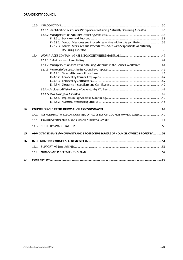
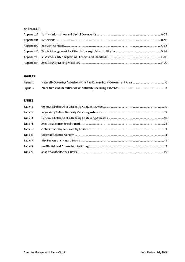
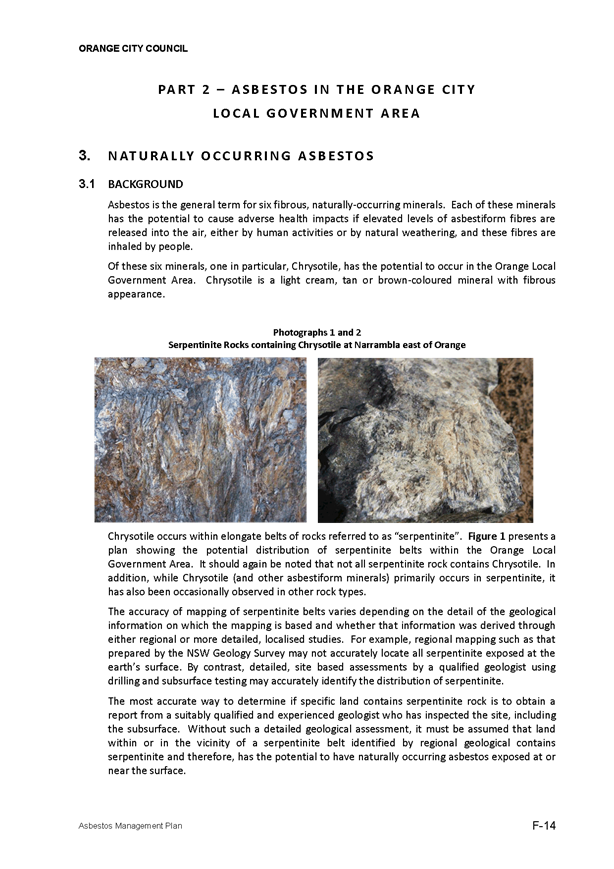
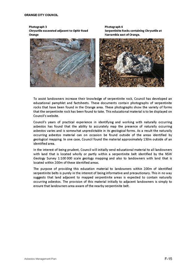

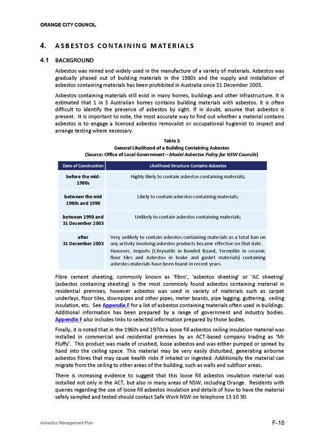
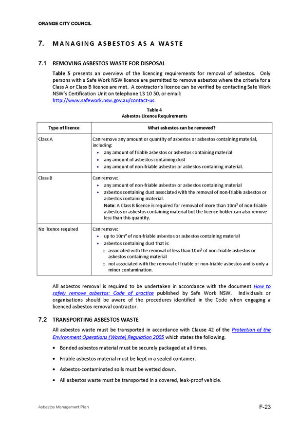

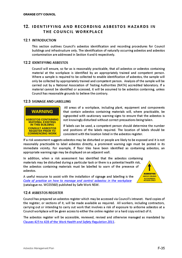
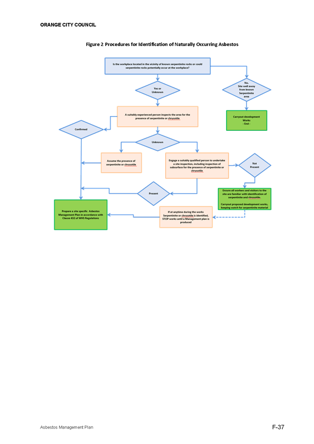
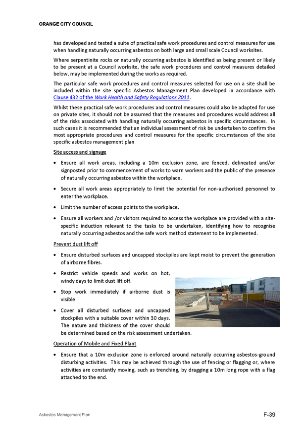
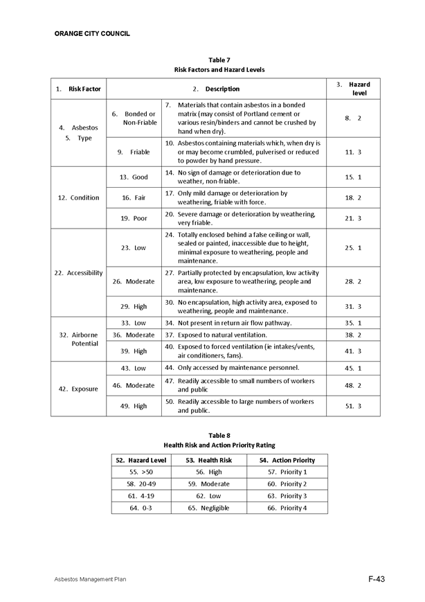
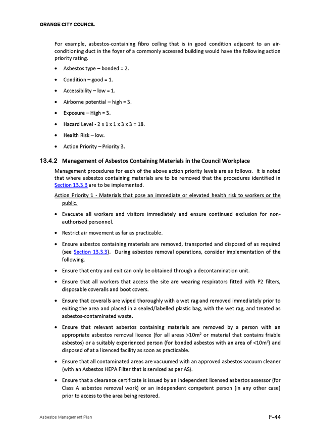
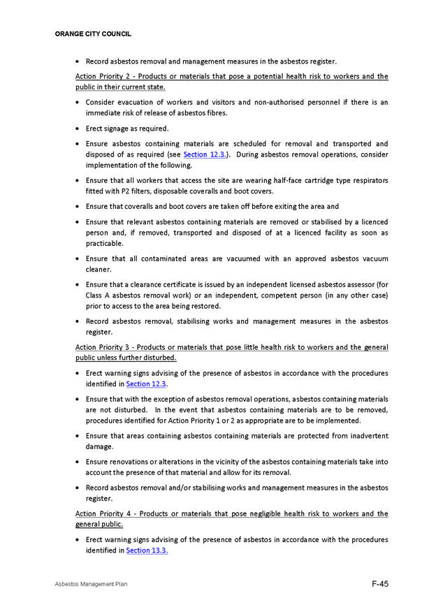
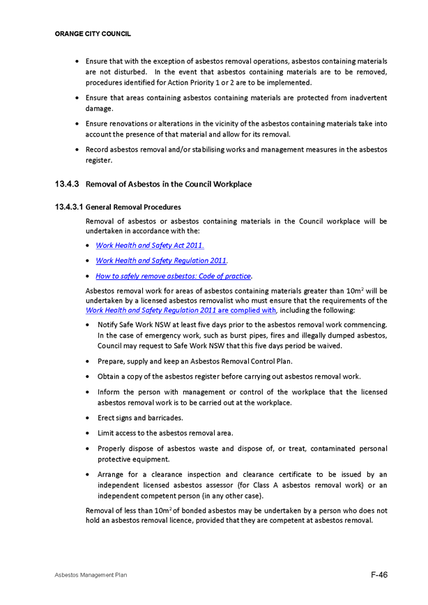
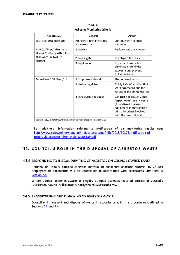

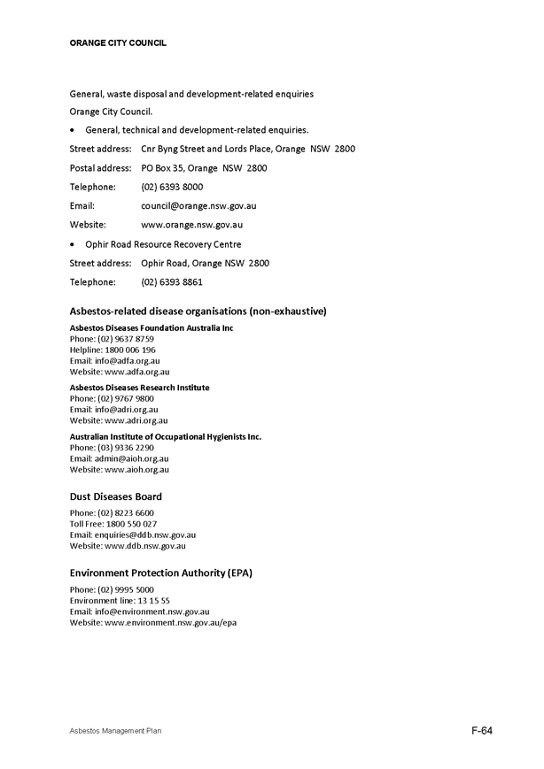
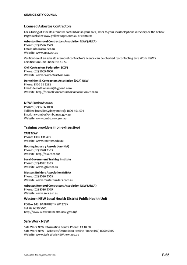
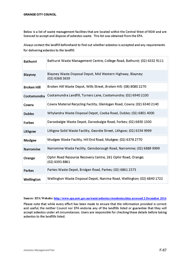
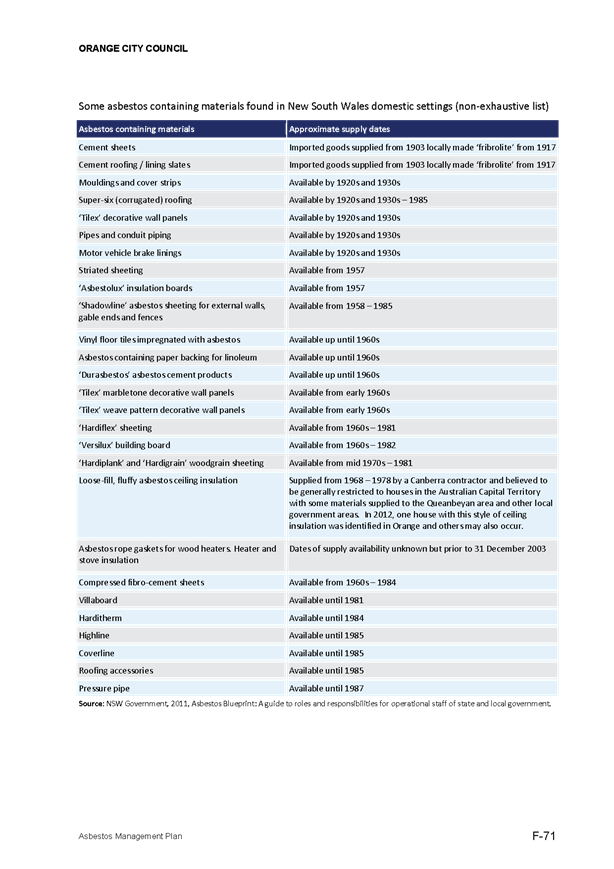

5.10 Independent
Members - Audit and Risk Management Committee
TRIM
REFERENCE: 2017/1184
AUTHOR: Kathy
Woolley, Director Corporate and Commercial Services
EXECUTIVE Summary
The Charter for Council’s Audit and Risk Management
Committee has two independent members in the current charter. Given the
formation of a new Council post September, and the status of the terms of the
current members, this report recommends running an expression of interest
process to enable the presentation of candidates to the new Council post
election in order that the Audit and Risk Management Committee can be formed.
Link To Delivery/OPerational Plan
The recommendation in this report relates to the Delivery/Operational
Plan strategy “1.3 Our City - Ensure a robust framework
that supports the community’s and Council’s current and evolving
activities, services and functions”.
Financial Implications
Nil
Policy and Governance Implications
The Charter for the Audit and Risk Management Committee
provides for the maximum term of an independent member to be re-appointed for a
total of eight years.
|
Recommendation
1 That
expressions of interest be called for independent members of Council’s
Audit and Risk Management Committee.
2 That
Council reappoint Mr Phil Burgett as an independent member and Chair of the
Audit and Risk Management Committee until September 2017.
|
further considerations
Consideration has been given to the
recommendation’s impact on Council’s service delivery; image and
reputation; political; environmental; health and safety; employees;
stakeholders and project management; and no further implications or risks have
been identified.
SUPPORTING INFORMATION
The Audit and Risk Management Committee Charter is approved
by Council. Since 2014 the maximum term approved by Council for independent
members is eight years.
The Committee appointments are made by a resolution of
Council.
Mr Andrew Fletcher was appointed an independent member in
2009, and therefore Mr Fletcher’s term will conclude prior to the
September election this year, given the 8 year limitation.
The current Chairperson and other independent member, Mr
Phillip Burgett, was appointed in 2014 for a two year period. With Orange being
subject to a merger proposal, the Council resolved to defer the review of the
Charter and membership being the outcome of that process. The re-appointment of
Mr Burgett until September is recommended as it will enable his Chairmanship to
continue for the short period until the new Council appoints the independent
and Councillor members.
It is also recommended that expressions of interest for
suitably qualified independent members of the Committee be sought, with a view
to these positions being presented to the new Council for it to resolve
membership of the Audit and Risk Management Committee via the appointment of
independent members and nominated Councillors.
5.11 Council's
Insurance Portfolio
TRIM
REFERENCE: 2017/1259
AUTHOR: Michelle
Catlin, Manager Administration and Governance
EXECUTIVE Summary
This report advises Council of actions taken by staff in
order to go to tender for Council’s insurance portfolio (excluding
workers’ compensation insurance) from 2018/19.
Link To Delivery/OPerational Plan
The recommendation in this report relates to the
Delivery/Operational Plan strategy “1.3 Our City -
Ensure a robust framework that supports the community’s and
Council’s current and evolving activities, services and functions”.
Financial Implications
Experience of other councils in NSW that have gone to tender
for their insurances suggest significant savings, have been achieved.
Policy and Governance Implications
The Local Government Act 1993, requires Council to make
arrangements for adequate insurance against public liability and professional
indemnity insurance.
|
Recommendation
That Council seek quotations for its insurance coverage
for the 2018/19 year and beyond via a tender process.
|
further considerations
The recommendation of this report has been assessed
against Council’s other key risk categories and the following comments
are provided:
|
Political
|
Since 1994 Council has obtained
insurances (excluding workers’ compensation insurance) through
Statewide Mutual. Going to tender will allow Statewide still to compete for
Council’s business, but will also offer commercial agents the
opportunity to bid.
|
SUPPORTING INFORMATION
Statewide Mutual is a Mutual Discretionary Trust that was
set up in 1994 to provide insurance for NSW Councils. Similar schemes exist in
other states.
Orange City Council joined the Mutual in 1994, and currently
holds some 13 policies through the Mutual, at a premium cost of over $1.5m.
Council engaged an independent consultant to undertake a
“health check” of its insurance portfolio in 2016. This review
identified several opportunities for Council to pursue potential savings in
premium costs and to request a risk-based approach to premium calculation for
Orange City Council. Council has been advised that the pricing of premiums by
the Mutual is based on the Mutual as a whole, and does not reflect the risk
management practices, or claims history, of Orange City Council. It is
considered therefore that Council should seek quotations on its insurance
portfolio to test the market.
Given Council’s membership of the Statewide Mutual,
insurances have not been put to tender. Recent advice from other councils has
proven that going to tender has resulted in significant savings on the costs of
insurance.
Last year a group of 10 councils went to tender for their
insurance portfolio through Local Government Procurement. Some of these
councils opted to remain with Statewide based on Statewide’s tender, but
achieved savings in premiums as a result of their market testing. Other
councils have opted to go with a commercial insurer, also with substantial
savings.
Under the Deed Council has with Statewide, notice of one year
is required prior to leaving the Scheme. It has been determined that in order
to commit to the intent of tendering the services, Council needs to give notice
even though Statewide may continue as Council’s insurer as it has in
other similar situations. Council has provided notice to Statewide of its
intent to go to the market and thus to potentially exit the Scheme in July
2018.
Local Government Procurement have indicated they will again
run an insurance tender for NSW Councils, and Orange City Council has
registered an interest in participating in this process. Council may opt to
tender via a smaller group or manage the process itself but will engage
specialists in the sector to ensure the coverage and premiums are both
comprehensive enough to protect Council’s interest and are price
competitive.
5.12 Beach
Boys Concert update
TRIM
REFERENCE: 2017/1172
AUTHOR: Kathy
Woolley, Director Corporate and Commercial Services
EXECUTIVE Summary
Council asked for an update report on the Beach Boys Concert
recently held in the City. This report provides that update.
Link To Delivery/OPerational Plan
The recommendation in this report relates to the
Delivery/Operational Plan strategy “10.1 Our Economy
– Capitalise on the character and lifestyle of Orange to enhance tourism”.
Financial Implications
Council was a sponsor for the event contributing $20,000.
Policy and Governance Implications
Nil
|
Recommendation
That Council note the report and the policy reforms to
be implemented.
|
further considerations
The recommendation of this report has been
assessed against Council’s other key risk categories and the following
comments are provided:
|
Image
and Reputation
|
Council supported the event in
order to have the concert come to the City. It is understood that other
cities are having similar issues. There is a potential risk to
Council’s reputation and hence a policy review is proposed to consider
how sponsorship of events may be undertaken in future.
|
SUPPORTING INFORMATION
At a recent Council meeting, a question was taken on notice
regarding the outstanding payments from the Show Promoter, Southern Stars for
the Surf and Soul 2017 Concert.
An investigation by Council staff has found that local
businesses in Orange have accounts unpaid from this event. Up to seven
businesses are affected. Some have received part payment while others have not.
The most affected are the accommodation providers, with an estimated $12,000
unpaid across three providers. An estimation of total unpaid accounts is
$18,862.78.
Regular communication has been taking place between Southern
Stars Touring, Sports Marketing Australia, local businesses and Council.
Council has been advised that on Friday 2 June, Southern
Stars was put into voluntary administration.
Surf and Soul 2017 concert was held at Wade Park on Sunday
12 February. It featured The Temptations and Beach Boys and was attended by
2,500 people. It was a regional tour and involved shows at Sydney, Hobart,
Wollongong, Wagga Wagga and Tamworth.
Council uses event promoters to highlight events and has
successfully achieved many events following these leads being pursued. These
events promoting services are an extremely effective way to be in a highly
competitive market. Many nights of visitation and local spend are achieved from
the events that Council sponsors via these services.
Council considered the proposal presented to it and
considered with such a line up and the large scale of the tour, the support
provided through the sponsorship was warranted.
Given the event was brought to Council by an events
promoter, and had acts of international renown, the sponsorship provided was
within the range for such an event. It is however recommended to Council that
the event sponsorship policy position be reviewed with a view to partial
payment until it is confirmed that all local businesses are fully paid be
prepared.
5.13 Industry
Led Tourism Entity Proposal
TRIM
REFERENCE: 2017/1018
AUTHOR: Kathy
Woolley, Director Corporate and Commercial Services
EXECUTIVE Summary
Council has received a proposal seeking funding for services
to be delivered by an industry led regional tourism entity, tentatively
referred to as Orange Region Tourism Limited.
The assessment of the proposal is presented to Council with
recommendations to offer a performance based funding agreement pending advice
on the need for ministerial approval on the formation of the Entity.
Link To Delivery/OPerational Plan
The recommendation in this report relates to the
Delivery/Operational Plan strategy “10.1 Our Economy
– Capitalise on the character and lifestyle of Orange to enhance tourism”.
Financial Implications
The proposal seeks a contribution from the three councils,
Orange, Blayney and Cabonne as shown below:
|
Council
|
2017/18
|
2018/19
|
2019/20
|
|
Orange City Council
|
$377,000
|
$386,425
|
$396,086
|
|
Blayney Shire Council
|
$50,000
|
$51,250
|
$52,531
|
|
Cabonne Council
|
$64,000
|
$65,600
|
$67,240
|
The proposal is modelled on a 2.5% increase p.a. in the
councils’ contributions. Council is modelling CPI increases
of 1.8% p.a. due to the limited rate increase and low CPI currently
applicable.
Council has included in the exhibited draft Delivery/Operational
Plan an allocation for outsourced regional tourism services. Council has had
services contracted out since 2010. The proposal seeks slightly higher
than available funds based on what has been budgeted. These amounts are
minor however and even with the higher CPI figure used in the
proposal, equate to just over $2,600 in 2018/19 and just over
$5,300 in 2019/20 above the budgeted figure so the differences are
immaterial.
In the previous outsourced tourism services contract with
Brand Orange, Council included them supporting the 4 major in region events
– namely F.O.O.D Week, Wine week, Banjo Paterson Festival and
Apple Festival/Ramble. As outlined in the draft Delivery/Operational
Plan, this funding allocation ($23,000 in 2017/18) has been reviewed and the
intention is to deliver funding directly to these committees rather than via a
third party. The committees are given greater control of the funds in
this way. This has been discussed with the committees for the events and
the executive officer of the Transition Board who prepared the proposal.
The proposal seeks quarterly payments in advance. Council
has advised the executive officer that Council’s funds are to be used for
promotions, marketing, advertising and events and not for operational purposes.
This is built on the basis that the new entity has to be financial
sustainable. However, in year 1 only, the proposal seeks to use $100,000
for setup and that this be paid in advance with the first quarterly payment.
In a white paper supplied by Council that offered guidance
for the proposal, it was countenanced that the proposal consider its set up
issues. As a start up entity, it is acknowledged that the entity may need
initial assistance for establishment. The request is that $100,000 of the
$377,000 sought in 2017/18 (p4 of the strategic plan) in year 1 be allocated
for start up operational costs. It is recommended that this be agreed
although the allocation is suggested to be for a specific range of items as
outlined in the attached draft funding agreement. These items have been
specifically chosen as they underpin the activities that Council will fund in
the areas of marketing and promotions, rather than operational funding.
Policy and Governance Implications
Nil
|
Recommendation
1 That
Council seek advice from the Office of Local Government on the issues
identified about the formation of corporations as outlined in the report,
seeking Ministerial approval if required.
2 That
Council resolves that there are extenuating circumstances not to tender the
regional tourism services given the ability of the industry led tourism
entity to deliver the involvement of tourism operators in the region in order
to achieve the regional tourism marketing tasks in Council’s Tourism
Strategy which would be unable to be delivered by another entity.
3 That
upon the completion of item 1, a 3 year performance based funding
agreement with the industry led tourism entity be entered into, for
$377,000 in year 1, $386,425 in year 2 and $396,086 in year 3 (all ex
GST).
4 That
a performance based funding agreement with specified KPIs to monitor
performance based on the draft agreement provided be entered into so that
Council can monitor the delivery of the activities.
5 That
a Service Level Agreement illustrating the services from the Visitor
Information Centre be entered into based on the draft service level agreement
provided.
6 That
an interim funding agreement for a 3 month period with a 3 month option be
entered into on a prorata rate with TDO Ltd to ensure the delivery of tourism
services is maintained if there is a delay in getting advice on the need for
a Ministerial approval.
7 That
the Council seal be applied to any documents as required.
|
further considerations
The
recommendation of this report has been assessed against Council’s other
key risk categories and the following comments are provided:
|
Service
Delivery
|
Council has maintained an extensive
range of regional tourism services for many years. Some services for
marketing, particularly relating to events, have been outsourced via a
contract which Brand Orange secured in 2010.
The proposal from the tourism sector for an industry led
entity to take on regional tourism promotions would achieve the ambition in
the Council’s Tourism Strategy which seeks a higher level of
participation of operators across all segments of the tourism sector.
|
|
Image
and Reputation
|
Council’s reputation and
image could be compromised if the services delivered are not at a high level
as the community often doesn’t differentiate between Council’s
role in tourism promotion and the industry’s own role. The risk could
be managed by a performance based funding agreement to ensure the services
procured from the new industry led entity are value for money and of a high
standard such that the region’s reputation and image is not
compromised.
|
|
Stakeholders
|
Council’s stakeholders in
this are the Federal and State governments, local tourism industry, Brand
Orange, Blayney Shire Council and Cabonne Council.
|
SUPPORTING INFORMATION
Council has received a proposal seeking funding for regional
tourism promotion from a yet to be formed tourism industry led entity,
provisionally called Orange Region Tourism Inc. (Entity). This report
considers the proposal and raises some issues for Council to consider in
determining the next steps.
Council has managed the outsourcing of some regional tourism
marketing via a tendered contract with Brand Orange since 2010. The contract
concluded in June 2016. Funding of events and promotions has continued while
Council reviewed what the future was for regional tourism marketing.
In August 2016, Council facilitated a series of workshops
with local tourism operators and stakeholders. Over 200 participants provided
ideas and a preferred direction for the management of marketing of regional
tourism activities. In October 2016, Council adopted a new Tourism
Strategy which picked up on ideas raised in the workshops. The most
significant idea was that the industry wanted, and was ready, to take on a
greater role in regional tourism promotion. The concept of a new whole of
industry entity, formed and led by the sector, was identified.
Ministerial approval
Council has considered the implications of its role in this
matter. Under cl 358 of the Local Government Act, if Council is a participant
in the formation of a corporation, it needs to seek ministerial approval. Legal
opinion has been sought on this issue. As such, it is recommended that this be
explored and an application made to the Office of Local Government on this
issue. Formation of the Entity will need to be deferred until a response
is received.
Interim arrangements
A contract with Brand Orange delivering tourism services
concludes on 30 June 2017. In order to ensure there is no disruption to
the regional marketing initiatives, while Council awaits a response from the
Office of Local Government, it is recommended that a short term contract with
TDO Ltd be entered into to support the events and marketing initiatives
currently in train. The agreement could be based on the attached draft funding
agreement covering the elements to be undertaken in the next 3 months. As a
surety, an option to extend by a further 3 months could be included in the
agreement. The payment would be determined based on a pro rata rate of the
annual allocation as outlined in the attached draft funding agreement.
The proposal
Council is presented with a proposal to form an industry led
entity that will deliver regional tourism marketing for the Orange region.
The key issues the proposal needed to address were
identified in a white paper published in January 2017. The key issues are
extracted below. An assessment of how the proposal addresses each issue
is supplied. The key issues were:
The
first consideration will be a consideration of what the Entity proposes to
deliver and tests of how well the package of services offered aligns to the
Council’s Tourism Strategy. These elements include:
· The Strategy has been prepared on the basis that the
Entity will be formed. The specific tasks for both the Transition Board
and the Entity are itemised in the section that follows. The tasks Council will
continue to deliver are also shown. Assessment against the listed tasks,
or others that the Transition Board seeks to add to the deliverables from the
Entity, will be assessed in Council’s consideration of the request for
funding.
· The processes used to develop the proposal’s
elements and the specifics of the consultation with the tourism sector, in
particular illustrating the interactions across all of the Region of Orange,
Blayney and Cabonne local government areas should be noted.
· How the Entity will engage and inform the tourism
sector of its activities and illustrate transparency and inclusiveness.
The
second area of consideration is how well the proposal outlines how the Entity
will be managed and governed, with particular emphasis on:
o The proposed strategic direction and objectives of the
Entity via the provision of a draft strategic plan for a 3 year period
o How the entity will be managed and operationally
delivered illustrated in a draft 3 year operational plan including
organisational structure and how positions are to be filled, the specific tasks
that will be proposed for the 3 years, proposed on a timelined draft
operational plan for the consideration of the Entity. This should include a 3
year budget with forecasts and cash flow management clearly illustrated.
o The financial information in the operational plan
should show how expenditure and funding will be managed in a cash flowed 3 year
budget which illustrates forecasts of financial performance
o The financial information in the operational plan
should also include the level of investment from funding sources other than
Orange City Council – with particular consideration of the Tourism
Strategy objectives of the % of other source funding to match Council’s
contribution over the 3 years to be picked up from alternate funding sources.
The strategies will be undertaken to achieve these targets should be considered
and commented upon.
o The approach the Entity will take to attain financial
sustainability over time should be outlined.
o A draft risk profile and assessment of risk issues the
new Entity will need to manage with processes for how these risks will be
managed. This work should provide the Entity with the information to enable it
to set its risk appetite and use this information to finalise the strategic and
operational plans.
o What the governance structure of the new Entity is
proposed to be, on what basis will directors be chosen, how will the performance
of the Directors be monitored and assessed, and how well the proposed
governance framework illustrates best practice approaches to board governance.
o How the Transition Board sees the performance of the
Entity could be best measured to show value for money, including draft key
performance indicators and the metrics the Entity could use to attain the key
Tourism Strategy task of increased visitation.
Assessment
of the proposal
A draft strategic plan and financial
masterplan have been presented. It has been analyses against the
guidelines provided in the white paper (italicised text above) plus the
specific tasks identified in the Council’s tourism strategy. The
table below shows the results of this assessment.
Criteria
assessment
1 White
paper guidelines - Alignment with the Council’s Tourism Strategy:
|
Issue
|
Proposal assessment
|
|
Tasks
alignment – those allocated to the industry led entity or transition
board
|
The
proposal contains an Strategic plan which has a section on operational
activities that lists basic tasks as outlined in the Orange Council’s
Tourism Strategy. Detailed analysis of the completeness of the response
against the tourism strategy is provided below. There are additional
items the Entity is proposing to deliver beyond the scope of the Tourism
Strategy. Elements have been added, particularly around set up
operational tasks and events have been listed throughout the Strategic Plan.
|
|
Processes
and consultation used to develop the proposal that illustrate a regional
approach has been taken.
|
The
Strategic Plan identifies that several meetings were held with councils and
with Brand Orange members. The Plan identifies that the representative
Board provides an avenue for consulting with the groups that are represented.
|
|
How the entity will
engage and inform the tourism sector of its activities and how these
processes will illustrate inclusiveness and transparency
|
The Entity plans an
online stake holder magazine, social events, industry seminars and forums to
broaden its consultative processes.
|
2 White paper guidelines - How
will the entity be managed and governed
|
Issue
|
Proposal assessment
|
|
Strategic
directions and objectives established in a draft 3 year strategic plan
|
The
documentation is identified as a strategic plan and operational plan in one
document. It covers a three year period. Strategic directions are
established by the Vision and Mission provided (p3).
The purpose of the
documents are outlined on p10.
However,
the new entity’s purpose needs to be defined and would be a critical
first step process required to set the organisation’s direction upon
formation.
|
|
How
the entity will be managed and operationally delivered in a three year draft
operational plan. A three year budget with forecasts and cash flow
management needs to be clearly identified.
|
The
content is brief but there is a broadly based operational plan provided.
Annualised cash flow
statements and budgets have been provided. The white paper suggested
that given the lumpiness of the income stream and the high up front costs for
events, the Board would be likely to need a quarterly cash flow analysis framework.
Such detail would not be required by Council but rather the identification of
the Board’s acceptance of the financial stability of the organisation
would be illustrated in their sign off of the annual statements.
|
|
Issue
|
Proposal assessment
|
|
The
financial information in the operational plan should show how expenditure and
funding will be managed in a cash flowed three year budget which
illustrates forecasts of financial performance
|
The
financial plan is high level and there is an annual cash flow position
presented.
As public moneys are
requested, should the funding be approved for the industry led entity, a
recommended key performance indicator will seek that audited statements are
provided within a specified period of the end of the financial year. This is
a typical KPI in council’s agreements.
The proposal seeks
payment quarterly in advance. Council policy is not to retrospectively fund
activities and allocating funding on a quarterly basis is supported.
Additionally, the
proposal seeks a one off payment of $100,000 in year 1 to assist with set up
costs. While the white paper advises moneys should be spent for
marketing/advertising only and not operational costs, as it is at set
up stage, there is some merit in Council considering this request. If
it is supported, it is recommended that it be identified as a one off and all
future moneys be used exclusively for marketing and advertising initiatives
or events management. The attached draft funding agreement shows the
distribution of the one off operational payment for specific tasks that would
underpin the marketing and promotion of the region which are the elements
Council seeks to fund.
|
|
The financial
information in the operational plan should also include the level of
investment from funding sources other than Orange City Council – with
particular consideration of the Tourism Strategy objectives of the % of other
source funding to match Council’s contribution over the three years to
be picked up from alternate funding sources. The strategies will be
undertaken to achieve these targets should be considered and commented upon.
|
The level of income
generated to satisfy Council’s desire to see its marketing program
specifically matched on dollar for dollar basis matches the element in the
Tourism Strategy with the new Entity offering matching $ for $ on an
incremental scale to achieve 100% matching in year 3.
The expenditure must be
on actual marketing/advertising expenditure – not inkind contributions.
This will see the new Entity design and put into the market a $40K
advertising campaign in year 1, a $45K campaign in year 2 and a $60K campaign
in year 3.
At the time the Tourism
Strategy was written, the direct advertising campaign moneys was estimated at
$30K contribution from Council. Council has added additional money to the
advertising/marketing elements and should encourage the Entity to seek
matching funding in the same ratios as it will add exponentially to the
outcomes and visitation to the region from a number of campaigns to promote
the area.
|
|
Issue
|
Proposal assessment
|
|
The approach the Entity
will take to attain financial sustainability over time should be outlined
|
The proposal provides a
modest profit.
|
|
A draft risk profile
and assessment of risk issues the new Entity will need to manage with
processes for how these risks will be managed. This work should provide the
Entity with the information to enable it to set its risk appetite and use
this information to finalise the strategic and operational plans.
|
The risk analysis is
limited. Council is advised that the Board has high level skills in
assessing and managing risk. As part of the finalisation of the
strategic plan the articulation of the governance processes the board will
use to revise and consider its risks would enhance this section of the
strategic plan. At present there is no articulation of the risk appetite or
tolerance levels and the mitigation strategies are lacking in likely impact
and detail.
The white paper listed
14 critical risk issues as prompts for the risk assessment which could be
used to expand on the risk assessment processes.
|
|
What the governance structure of the new Entity is proposed to be, on
what basis will Directors be chosen, how will the performance of the
Directors be monitored and assessed, and how well the proposed governance
framework illustrates best practice approaches to board governance.
|
The proposal provides a
short explanation of why it is recommending a not for profit entity limited
by guarantee.
The proposal outlines
that the Board will move toward skills based overtime, elected by
members.
|
|
How the Transition Board sees the performance of the Entity could be
best measured to show value for money, including draft key performance
indicators and the metrics
|
As this is lightly
treated in the proposal, the value for money issue has been picked up as a
proposed KPI basing the analysis on a return on investment comparison of
expenditure against direct visitation measured via member surveys that the
new Entity will be delivering.
|
Council’s Tourism Strategy
On October 2016, Council adopted a
Tourism Strategy. The Strategy assumes the industry would form a new Entity to
offer the operators a means for enhanced involvement in advertising campaigns
and events. There are a range of tasks in the Strategy that Council was seeking
the industry provide/participate in. These tasks are the basis for assessing
how the proposal will deliver the Council’s strategic intention in
tourism services.
Detailed
requirements in Council’s Tourism Strategy
Following is an assessment of how well the proposal delivers
the specific tasks to be considered that were identified in the Tourism
Strategy Council adopted in October 2016. At the end of each section a comment
is provided on the proposal’s response to the items identified for either
the Transition Board or the proposed new entity to deliver:
|
Undertake
assessment and design of an industry led tourism entity to undertake regional
tourism marketing activities
|
|
|
1A
|
Increased industry
engagement in setting and delivering regional tourism growth
|
|
|
Action
|
Increase industry
participation in regional tourism marketing activities
|
|
|
|
Current budget
allocation
|
Allocation to assess
value of current events and to undertake full analysis of the impacts and
deliverables of an industry led tourism entity is from within existing
2016/17 budget item Tourism services contract – allocated by
Council to fund the creation of an industry led tourism board (Resolution
16/407)
|
$50,000 in 2016/17
|
|
|
|
Issue
|
Actions
|
Key Performance Indicators
|
Timeframe
|
Cost
|
|
1.A.i
|
Undertake assessment and
design of an industry led tourism entity to undertake regional tourism
marketing activities
|
Prepare a submission to
Council for an industry led tourism entity. Proposal to include:
· Draft strategic plan
· Draft operational plan and budget with cash flow and
3 year projections
· Corporate Risk register
· Governance framework for how the entity will be
formed and managed
|
Proposal presented to
Council.
|
Feb 2017
|
$10,000
|
|
1.A.ii
|
Create an industry led
regional tourism entity.
|
Subject to securing
funding, develop a 3 year performance based funding agreement for an
industry led tourism entity to deliver regional tourism marketing initiatives
|
Agreement finalised
|
May 2017
|
$5,000
|
|
1.A.iii
|
Industry led entity has a
membership base that covers all sectors of the tourism industry and grows
annually.
|
Marketing and engagement
strategy to attract members
|
Membership growth of 15%
annually in 2016/17, 2017/18 and 2018/19
|
June 2019
|
$0 – part of funding
agreement
|
|
|
|
|
|
|
|
Comments on proposal response:
· The proposal
was received in June 2017 so the timeframes from the Tourism Strategy have
slipped.
· Timeframes
in the proposal also need to be revised.
· The membership
growth target of 15% per annum is not delivered but the proposal presents an
ambitious growth projection.
o The proposal builds revenue from
members by 11.8% in year 2 and 9.7% in year 3.
o Membership jumps from 200 paying
members (p7 of the strategic plan) of Brand Orange’s membership to 323
(Financial masterplan – assumptions identifies 42 free individual members
deducted from total projected for year 1 of 365 members).
o The proposal thus suggests the
addition of 123 members in year 1 – a 61.5% increase which is a large
impost.
o A clearly defined membership drive
process will be required.
o Membership grows by a further 10.7%
in year 2 and a further 10.1% in year 3.
· The proposal
identifies a membership strategy will be developed in January 2018 with a
target growth of 10% per annum (page 56). The key performance indicators need
to be both number of members and membership revenue based. The growth
factor is below the Tourism Strategy target of 15% p.a.
|
1C
|
Enhance the
visitOrange branding
|
|
|
Action
|
Maximise the brand usage
and impact of visitOrange
|
|
|
|
Current budget allocation
|
Promotions budget
Sports marketing budget
|
$60,000 (subject to budget
allocation annually) + museum advertising allocation when determined
$80,000 (2016/17)
|
|
|
|
Issue
|
Actions
|
Key Performance Indicators
|
Timeframe
|
Cost
|
|
1.C.ii
|
Grow industry involvement
direct in tourism advertising campaign by seeking matching $ for $ cash
contributions for Council’s contribution to the industry led body for
campaigns using the using visitOrange as call to action
|
Achieve equity in cash
contributions for regional tourism advertising campaigns by 2018/19
|
Direct
visitation achieved from each element funded.
Matching
Council cash contribution for tourism advertising as follows:
· 50% in 2016/17
· 75% in 2017/18
· 100% in 2018/19
|
Report to Council in
December annually
|
$30,000
|
|
1.C.vii
|
Develop packages to
highlight the indigenous features of the Region
|
Promotional activities
developed and implemented.
|
Programs activated and
visitation measured directly from the promotion
|
Annual
|
$0
|
1.C.ix
|
Develop packages promote
the natural beauty and seasonality of the Region
|
Packages that promote
natural beauty and seasonality created
|
Programs activated and
visitation measured directly from the promotion
|
Annual
|
$0
|
|
|
|
|
|
|
|
|
Comments on proposal response:
· The proposal
does not deliver the matching $ for $ targets in 1.C.ii with only $10,000
identified in year 1, $20,000 in year 2 and $30,000 in year 3 (“other
income” sheet in financial masterplan).
· There are
references to packages for:
o Accommodation
o Villages
o Harvest
o Golf
o Wellness
o Sports
o Nature
o Cultural tourism
|
2A
|
Tourism market knowledge
enhanced
|
|
|
Visitor profiling
enhancements to build knowledge of :
· Who are the Region’s visitors? Are they still
who we think they are? How do their characteristics compare to previous
research.
· What are the decision points that influence their
destination choices
· How effective are the advertising and events that
are being held to drive visitation to come to the Region?
· What awareness do our visitors have of our in region
and out of region events?
· How often have visitors come to the Region?
|
|
|
Current budget allocation
|
From within existing budget
for tourism services contract
|
$15,000
|
|
|
Issue
|
Actions
|
Key Performance Indicators
|
Timeframe
|
Cost
|
|
2A.iii
|
One out of region survey
implemented
|
One out of region survey at
all events
|
Report on results annually
in December
|
December annually
|
$0
|
Comments on proposal response:
· It is
assumed that this item will be delivered in the Local Visitor Data research
Program (p 44 of the strategic plan)
· It is
recommended that the delivery of surveys of both attendees at out of region
events and also of the Entity’s members to measure direct visitation from
marketing initiatives and out of region events be included in the funding
agreement. This will ensure Council continues to receive information to assist
in the assessment of value for money in how the funding is being applied.
2B
|
Knowledge building of
local residents of the tourism facilities and events
|
|
|
Provide information to the
residents in the Region on events and facilities
|
|
|
Current budget allocation
|
|
$0
|
|
|
Issue
|
Actions
|
Key Performance Indicators
|
Timeframe
|
Cost
|
|
|
2B.iv
|
Have local tourism
businesses recognised in NSW awards programs
|
Assist local
businesses to enter the NSW Government annual tourism awards programs
|
5 applicants per annum to
NSW Awards
|
Annually
|
$0
|
|
2B.vi
|
Develop a
“harvest” program of events for pick your own
|
Packages implemented that
promote the pick your own opportunities
|
Program developed and
implemented
|
Annually
|
$0
|
|
|
2B.viii
|
Promote the villages
experiences and create packages to boost visitation
|
Packages created and
prompted
|
Overnight stays enhanced from
current level of average nights stayed from 2.9 nights to 3.5 nights by June
2019.
|
Annually
|
$revenue neutral solutions
established.
|
|
|
|
|
|
|
|
|
|
|
Comments on proposal response:
· Assistance to local
sector applicants for the NSW Government awards and a regional tourism awards
event is identified (p45).
· Harvest packages are
included (p45).
· Village experiences are
included (p44).
· The funding agreement
specifies the KPIs for visitation impacts as identified in the Tourism
Strategy.
|
2C
|
Updated key target market
demographics
|
|
|
Develop an updated set of
key market segments and tailor marketing to these markets
|
|
|
Current budget allocation
|
To be delivered as part of
the tourism services contract $400,000
|
$20,000
|
|
|
Issue
|
Actions
|
Key Performance Indicators
|
Timeframe
|
Cost
|
|
2C.ii
|
Continue to monitor visitor
profile
|
Review profile against
survey data on quarterly basis to determine any shifts
|
Annual report
|
October annually
|
$0
|
|
2C.iii
|
Build knowledge of growth
opportunities in key market segments
|
Identify key location
markets and survey in those areas to build knowledge of how to market more
effectively to drive visitation
|
Survey complete
|
December 2017
|
$20,000
|
|
2C.iv
|
Convert visitors who
transit through the Region to overnight stays
|
Review visitor transit
information and develop and market programs and packages that will
drive increased overnight stays
|
Overnight stays enhanced
from current level of average nights stayed from 2.9 nights to 3.5 nights by
June 2019.
|
Report to Council October
annually
|
$0 – contribution to
marketing campaigns from participating businesses
|
|
2C.v
|
Convert visitors who shop/
use services in the Region to overnight stays
|
Create and promote packages
to the market areas in surrounding towns that use Orange as a service centre
to encourage an overnight stay
|
Overnight stays enhanced
from current level of average nights stayed from 2.9 nights to 3.5 nights by
June 2019.
|
Report to Council October
annually
|
$0 – contribution to
marketing campaigns from participating businesses
|
Comments on proposal response:
· The proposal
outlines the provision of visitor profiling elements in the Visitor Data
Collection research and Survey Program (p44).
· There is no
explicit identification of strategies/elements which are aimed at converting
visitors who transit or shop in the region to overnight stays. It is assumed
this will be delivered in the marketing campaigns deliverables.
|
2E
|
Build stakeholder engagement
processes
|
|
|
Tiers of government
relationship enhancement
|
|
|
Current budget allocation
|
From Regional Promotions
budget- total of $60K in 2016/17
|
$24,000
|
|
|
Issue
|
Actions
|
Key Performance Indicators
|
Timeframe
|
Cost
|
|
2E.iii
|
Encourage community participation
in tourism planning and activities
|
Engagement with industry
and community to promote tourism opportunities by disseminating information
|
Quarterly email
exchanges/updates to tourism networks
4 familiarisation tours of
VIC staff to local operators p.a.
|
June 2017
|
$0
|
Comments on proposal response:
· VIC
familiarisation tours are identified.
· Quarterly
emails are identified.
Memorandum
of Understanding with the Transition Board and consideration of Council’s
role in formation of the Entity
The passage of time have eroded a need to sign a MoU which,
by its nature is non-binding, and thus has limited purpose. The new Entity
could be established relatively quickly.
Visitor
Information Centre services
Council is not seeking a change in
the delivery of information services from the Visitors Information Centres. A
draft Service Level Agreement is proposed to make certain the level of services
to be delivered for the duration of the proposed funding agreement is attached.
Risk issues
The proposal contains a high level
risk assessment from the perspective of the new Entity. Obviously, Council has
different risks to those of an agency which may be engaged to deliver services.
This is particularly influenced as the entity will be new and is unproven.
The proposal does not provide a high level of detail on
risk. It does identify that the directors will consider and assess risks
and presumably establish a risk profile and appetite.
Attachments
1 Final
draft strategic plan , D17/34215⇩
2 Draft
Service Level Agreement Visitor Information Centre , D17/34216⇩
3 Draft
Funding Agreement , D17/34217⇩
4 Draft
Financial masterplan , D17/34256⇩
Council Meeting
22 June 2017
5.13 Industry
Led Tourism Entity Proposal
Attachment 1 Final
draft strategic plan

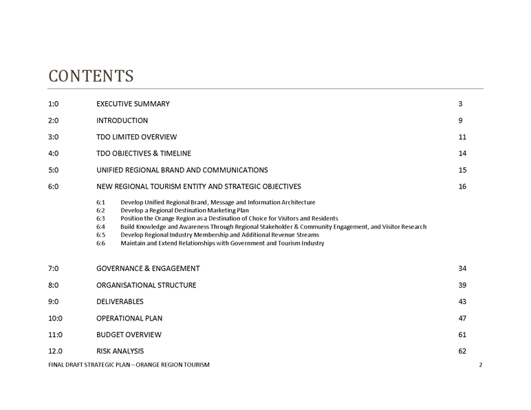
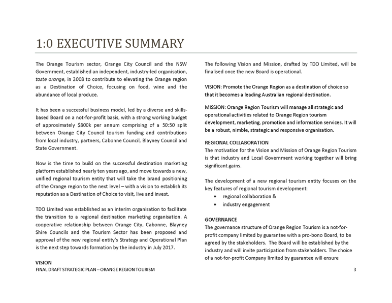
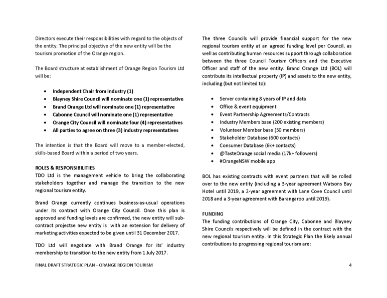
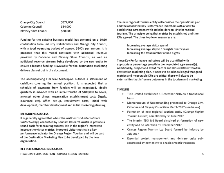
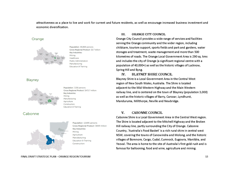
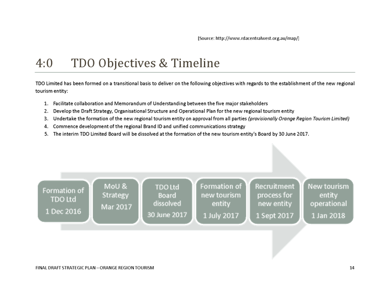
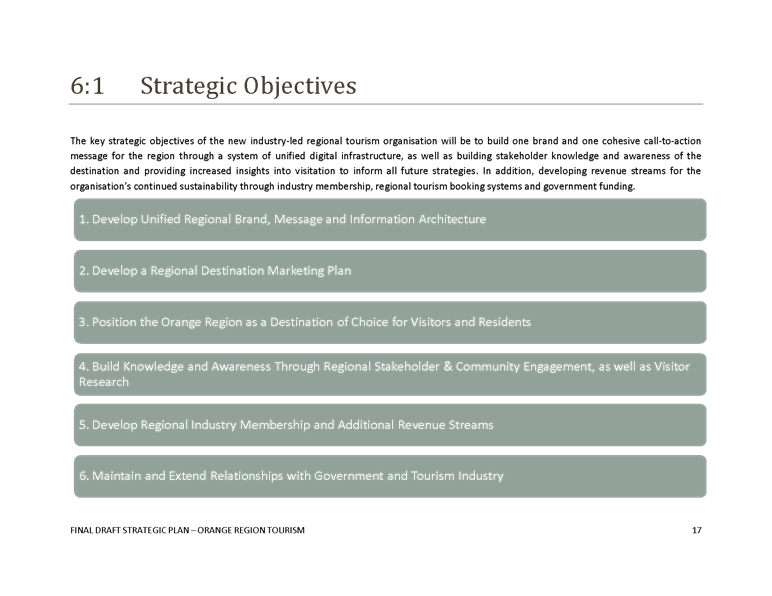


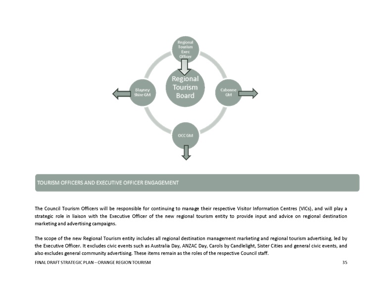
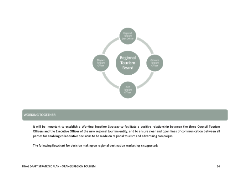
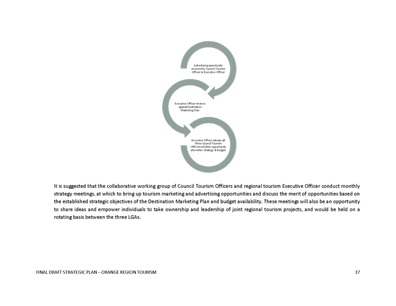
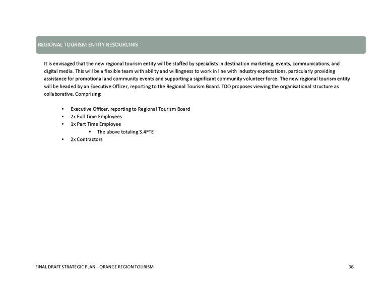
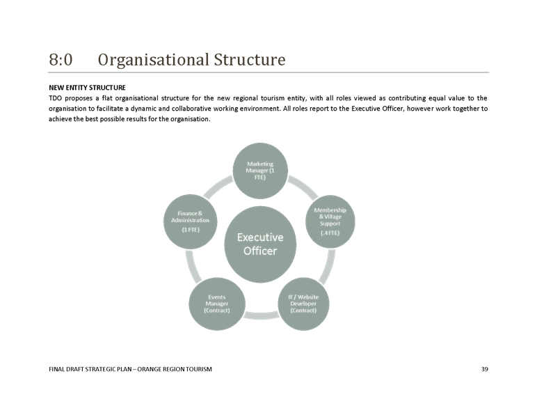
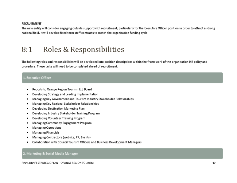
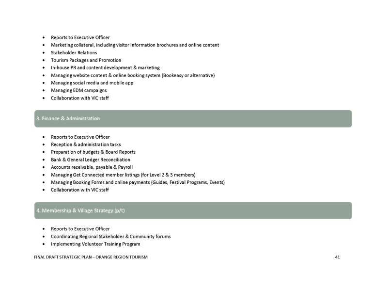
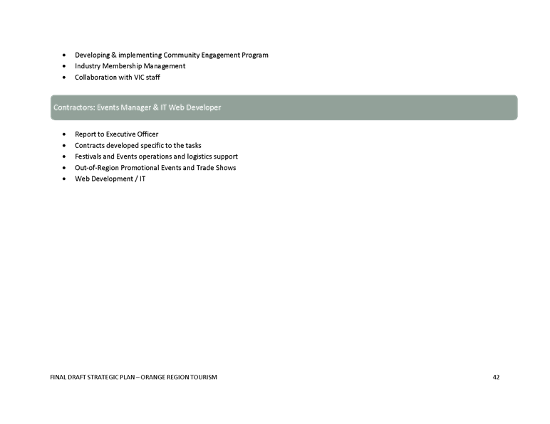
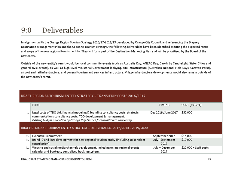
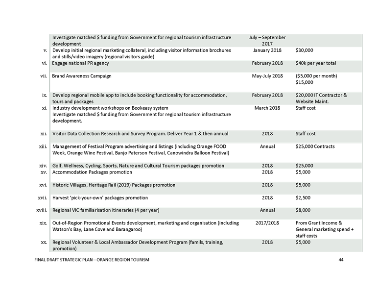
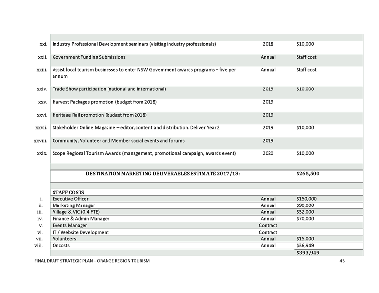
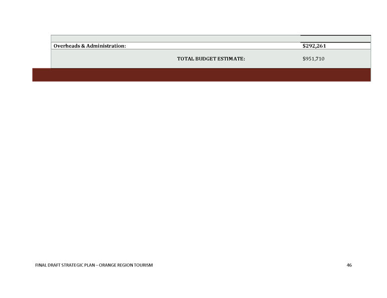
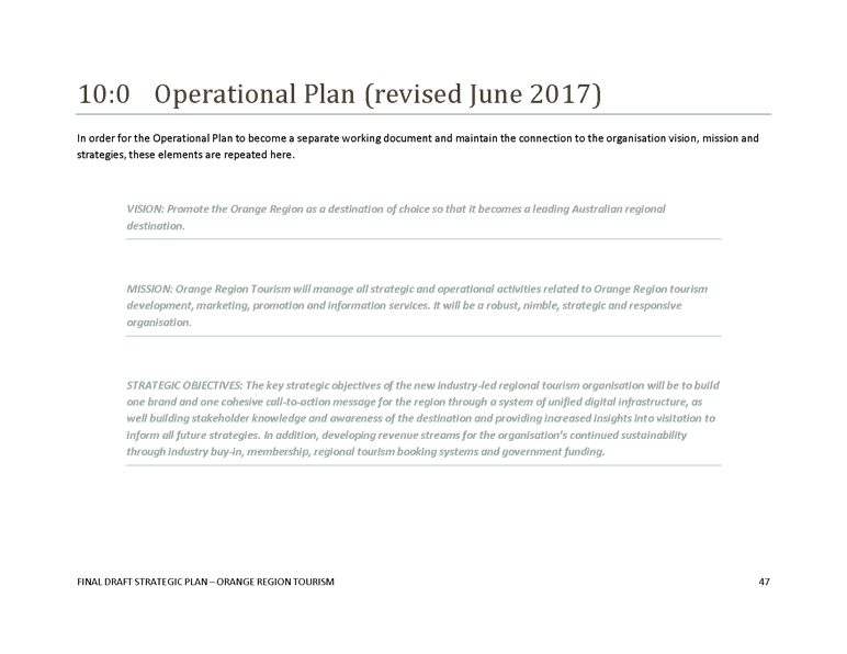


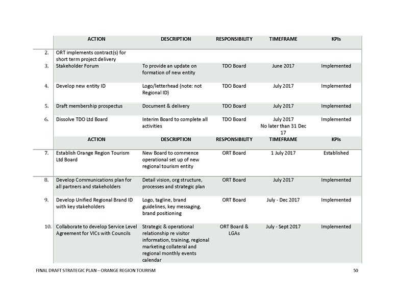
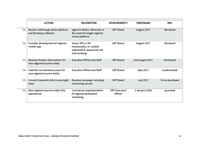
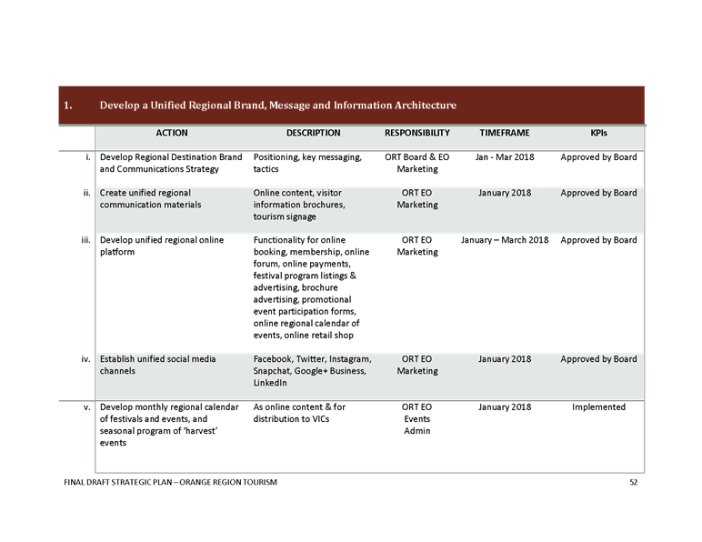
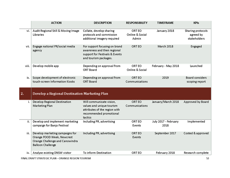
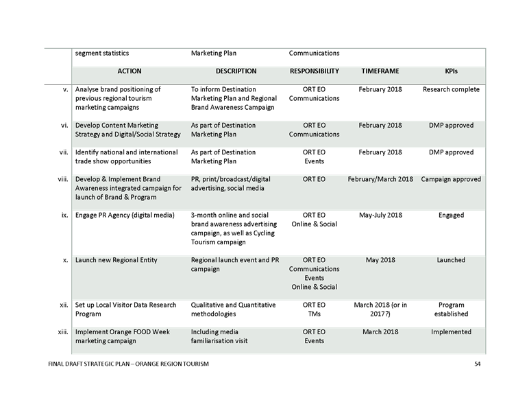
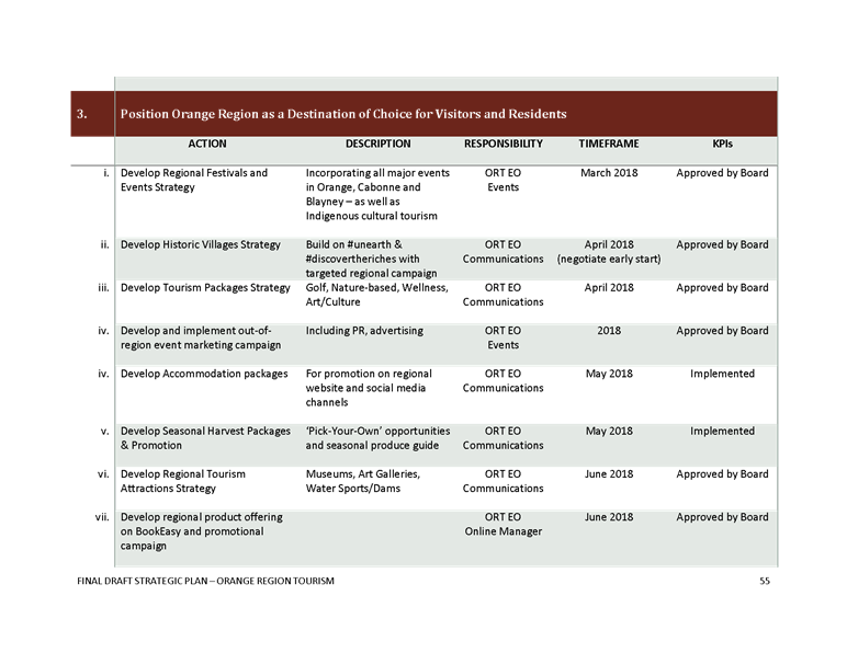
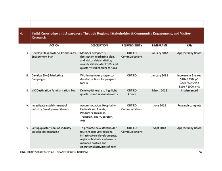
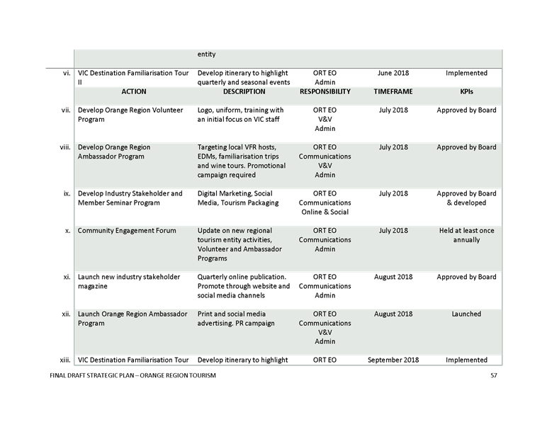
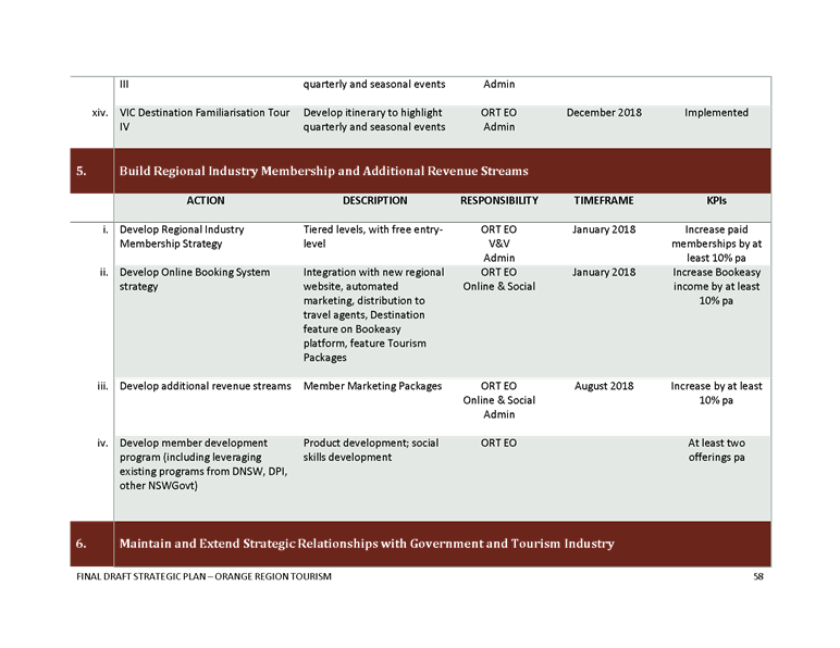
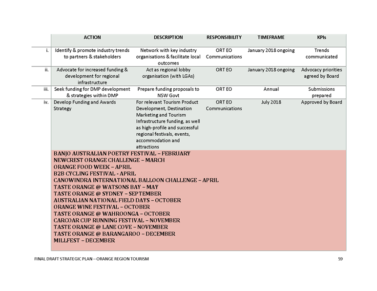

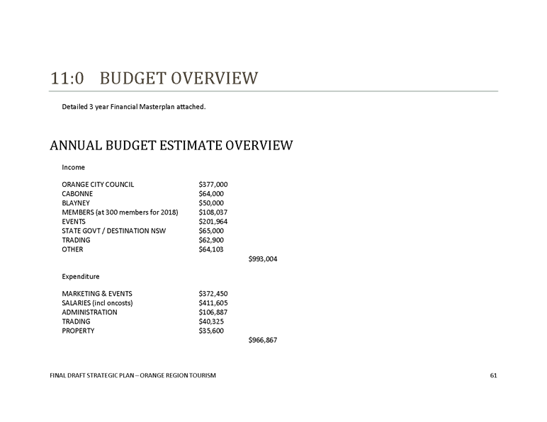
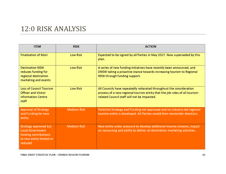

Council
Meeting
22 June 2017
5.13 Industry
Led Tourism Entity Proposal
Attachment 2 Draft
Service Level Agreement Visitor Information Centre

1. Objective
Orange
City Council will provide services from the Visitor Information Centre as
outlined in this Agreement.
2. Period
of this Agreement
This document will cover the period specified on the
associated funding agreement between Orange City Council and TBC (Document
reference D17/XXXX).
3. Description
of Services
This Agreement covers the provision of visitor information
services from the Visitor Information Centre in the Civic Centre precinct of
Orange City Council.
3.1 The
Visitor information Centre Services:
Orange City Council commits to the following services
from the Visitor Information Centre:
A. The
continuance of Level 1 Visitor Information Centre national accreditation,
including:
· Visitor information services offered 363 days per year
· A minimum of 56 hours of visitor information provision
per week
· A minimum of 1 full time permanent visitor information
officer positions
· Training and development of visitor information
officer(s) through staff induction, customer service and product
familiarisation processes
B. Council
will maintain accreditation in order to use of the blue/yellow “i”on
signage and compliance with signage requirements for accreditation
C. Council
will maintain the Visitor information Centre network engagement with other
Visitor Information Centres to remain informed on industry best practice and
collaboration opportunities.
D. Council
will operate the Visitor Information Centre in accordance with Orange
City Council VIC Business/Operational Plan that is framed around the
model operations manual required for accreditation
E. Council
will ensure the words “Visitor” and “Centre” are
included in the name of the facility
F. The
Visitor Information Centre will display a map of the area within 2 hours
driving radius.
G. The Tourism
Manager will be the contact point from Orange City Council for
Destination NSW offices, other state and federal government tourism
departments regarding the Visitor Information Centre operations.
H. Adequate
parking in the vicinity of the Visitor Information Centre will be provided to
satisfy the accreditation criteria.
I. The
Visitor Information Centre will operate an after hours answering system.
4. TBC obligations
A. TBC
will plan and deliver a minimum of 4 familiarisation tours of member facilities
to be organised per annum, scheduled in conjunction with the Tourism
Manager. Transport will be included in the arrangements.
B. TBC
will obtain agreement for the display of member materials and all
promotional materials in the Visitor Information Centre from the Tourism
Manager prior to the installation or delivery of items.
C. TBC
will maintain the Tourism Data Warehouse system lists with accurate and current
information as prescribed in the Level 1 Visitor Information Centre accreditation
requirements.
D. TBC
will maintain an accommodation register that is current and provide weekly
updates to the Visitor Information Centre on all accommodation, including non
members of TB, and the availability of accommodation in
order to satisfy the criteria for the retention of Level 1 accreditation.
5. Reporting and Feedback.
A. Council
reports on visitor attendance at the Visitor Information Centre on a quarterly
basis in reports to Council.
B. Council
will provide an annual report on the levels of service as outlined in this
agreement to TBC by the end of September for each of the years in the
associated funding agreement.
C. TBC
will provide quarterly by the 10th day of the month following a
quarter end updates confirming the currency of the Tourism Data Warehouse
information.
D. TBC will provide weekly updates
by 3pm on Fridays confirming the currency of the accommodation register and
availability at individual premises.
6. Points of contact for this Agreement
Council point of contact: Tourism Manager
TBC: Executive Officer
7. Dispute resolution
Refer to the processes outlined in the funding
agreement between Orange City Council and TBC.
Council
Meeting
22 June 2017
5.13 Industry
Led Tourism Entity Proposal
Attachment 3 Draft
Funding Agreement

DRAFT Funding Agreement
Between
Orange
City Council
ABN
85 985 402 386
(“Council”)
And
TBC
ACN TBC
(“TBC”)
Orange
Civic Centre
135 Byng
Street
ORANGE
NSW 2800
PO Box
35
ORANGE
NSW 2800
Tel: 02
6393 8000
www.orange.nsw.gov.au
D17/XXXX
Council Meeting
22 June 2017
5.13 Industry
Led Tourism Entity Proposal
Attachment 3 Draft
Funding Agreement
a)
Table of Contents
BACKGROUND.. 3
terms and conditions. 3
1 Definitions
and Interpretation. 3
2 Purpose. 4
3 Funding
Amount 4
4 Conditions
of Funding. 4
5 Payment
of Funding. 5
6 Approved
Use of Funding. 5
7 Insurance
and Indemnity. 5
8 Financial
Reporting. 6
9 Costs. 6
10 Assignment 6
11 Amendment 6
12 Entire
Agreement 7
13 No
waiver. 7
14 Notices. 7
15 Disputes. 8
16 Failure
to comply with this Agreement/Termination. 8
17 Confidentiality. 8
18 Goods
and Services Tax. 9
19 Independent
Advice. 9
20 Governing
law.. 9
FUNDING AGREEMENT dated _____________________ 2017
PARTIES: ORANGE CITY COUNCIL ABN 85 985 402 386 of 135 Byng Street, Orange NSW 2800 (Council)
TBC
LTD ACN TBC of PO Box TBC, Orange NSW 2800 (TBC)
BACKGROUND
A Council
resolved on 22 June 2017 to enter into a
3 year funding agreement with TBC for a fee as outlined in Schedule A.
B Council
agrees to provide Funding on the terms and conditions of this Agreement.
C TBC
accepts the Funding on the terms and conditions of this Agreement.
terms and conditions
1 Definitions
and Interpretation
1.1 Definitions
Business
Day means any day except a Saturday or Sunday or other public holiday in
NSW.
Corporations
Act means the Corporations Act 2001 (Cth).
Funding means the amount in
Schedule A provided by Council to TBC subject to the terms of this Agreement.
Funding term means 1 July
2017 to 30 June 2020.
1.2 Interpretation
In
this Agreement, unless the context otherwise requires:
(a) Singular
includes plural and plural includes singular;
(b) Words of one gender
includes any gender;
(c) Reference
to legislation includes any amendment to it, any legislation substituted for
it, and any subordinate legislation made under it;
(d) Reference to a
person includes a corporation, firm and any other entity;
(e) Reference
to a party includes that party’s personal representatives, successors and
permitted assigns;
(f) If
a thing is to be done on a day which is not a Business Day, it must be done on
the Business Day after that day.
2 Purpose
2.1 The proceeds, including
any interest, of the Funding shall only be used by TBC for the purposes
outlined in the Schedules.
2.2 TBC will submit as
timelined in Schedule A an annually updated Operational Plan and
Financial Masterplan that includes the items listed in this Agreement.
2.3 Council seeks from the
TBC the delivery of regional marketing promotions via marketing/advertising
campaigns and events management both in and out of the region.
3 Funding
Amount
3.1 Council
will provide TBC with Funding as outlined in Schedule A.
4 Conditions
of Funding
4.1 Funding
is subject to TBC delivering all reporting, events and activities in Schedule
A, B and C.
4.2 TBC
is to acknowledge Council’s sponsorship of events and funding of TBC
activities using the supplied artwork and wording in all printed and electronic
materials, and content promoting, featuring or mentioning the events and
activities mentioned in this agreement, including newsletters, forms, all
correspondence, member updates, electronic and printed newsletters and advice
to the media, members and industry media releases and advertising.
4.3
Council will supply the logo and words for the sponsorship acknowledgement.
4.4 All
promotional materials using Council’s logo must be preapproved by Council
before publication.
4.5 Council
and TBC will nominate contact officers for the management of the funding
agreement.
5 Payment
of Funding
5.1 Payment
will be made in accordance with the timetable in Schedule A.
5.2 TBC
will keep accurate current financial and operational records on all aspects of
the Funding.
6 Approved
Use of Funding
6.1 TBC
must use the Funding for the Purpose as set out in Clause 2, unless prior
written approval is provided by Council.
6.2 If
TBC decides to suspend or cease any of the activities in relation to the
Purpose set out in Clause 2, TBC must immediately notify Council.
6.3 If Council believes
that TBC has not used the Funding for the Purpose, Council may request
repayment of all or part of the Funding. If Council requests TBC to repay
the Funding, then such Funding must be returned to Council within thirty (30)
days.
6.4 Funding can not be
used to purchase capital equipment nor any assets.
6.5 TBC will discuss with
Council any applications for grant funding prior to applications being made to
ensure no duplication of requests occur.
7 Insurance
and Indemnity
7.1 TBC
must take out and keep in force appropriate insurance policies for:
7.1.1 Public
Liability Insurance for a minimum amount of $10,000,000.
7.1.2 Workers
Compensation insurance;
7.1.3 Personal
accident and sickness insurance.
7.2 TBC
must provide to Council copies of Certificates of Currency of Insurance and
policy documents if and when requested.
7.3 TBC
indemnifies Council, its officers, employees and agents against any:
7.3.1 Loss,
damage or other liability incurred by Council;
7.3.2 Loss
or expense incurred by Council in dealing with any claim against it (including
legal costs);
that is caused
by or arises from:
7.3.3 An act or omission by
TBC, or any of TBC’s employees, agents, volunteers or
subcontractors in connection with this Agreement, where there was a fault on
the part of the person whose conduct gave rise to that liability, loss, damage
or expense; and or
7.3.4 Failure by TBC to comply
with its obligations under this Agreement.
8 Financial
Reporting
8.1 TBC
must produce in accordance with the Schedules, or within one week if TBC ceases operation during the Funding
Term, an itemised income and expenditure statement on each
event, Key Performance Indicator (KPIs) and activities listed in Schedules
which specifically identifies the allocation of Council funding and the
dollar amounts contributed by any other funder.
8.2
The statement prepared in accordance with 8.1 must include itemised expenditure
to individually identify the amounts received by local businesses who gained a
benefit of the funding from Council for all activities and events in Schedules.
8.2
The statement prepared in accordance with 8.1 will be signed
off by an independent Certified Practicing Accountant or Auditor as a confirmed
record of income and expenditure.
9 Costs
9.1 Each
party must pay its own costs in respect of the costs of the negotiating,
preparation and examination of this Agreement and any document required by this
Agreement.
10 Assignment
10.1 Council
will not agree to the assignment of TBC’s rights or obligations under
this Agreement.
11 Amendment
11.1 This
Agreement may only be amended in writing signed by the parties.
12 Entire
Agreement
12.1 This
Agreement constitutes the entire Agreement between the parties and there are no
further items or provisions, either oral or otherwise.
13 No
waiver
13.1 A
party may only waive a breach of this Agreement in writing signed by that party
or its authorised representative.
13.2 A
waiver is limited to the instance referred to in the writing (or if no instance
is referred to in the writing, to past breaches).
14 Notices
14.1 Any
notice, consent or Agreement given in connection with this Agreement must be in
writing and in English, and may be given by an authorised representative of the
sender.
14.2 Notice
is deemed to be received by a party:
14.2.1 When
left at that party’s address;
14.2.2 If
sent by pre‑paid mail, three Business Days after posting or five Business
Days in the case of a notice sent to or from a place outside Australia; and
14.2.3 If
sent by facsimile at the time and on the day shown in the sender's transmission
report;
14.2.4 If
sent by email at the time and on the day shown in the sender's transmission
report.
14.3 At
the date of this Agreement, the last notified address is the address stated at
the beginning of this Agreement.
14.4 A
party may change its address or facsimile number for service by giving at least
1 Business Days’ notice to the other party.
15 Disputes
15.1 In
the event of a disagreement, the Council and TBC will negotiate in good faith.
Costs for mediation will be jointly shared. If an agreed position cannot
be reached, Council’s decision will prevail.
16 Failure
to comply with this Agreement/Termination
16.1 If
TBC:
16.1.1 Do
not apply the Funding for the Purpose; and/or
16.1.2 Fails
to comply with any other requirement of this Agreement;
TBC will be in breach of this
Agreement.
16.2 If
it is found that TBC is in breach of this Agreement, Council may give Notice in
writing asking TBC to rectify the breach and specifying a period in which the
breach must be rectified.
16.3 If
the breach is not rectified within the time specified by Council in the notice
sent to TBC, Council may terminate this Agreement immediately by written Notice
to TBC.
16.4 If
this Agreement is terminated, TBC agrees to repay to Council any of the Funding
not spent or put towards the Purpose.
17 Confidentiality
17.1 In this clause,
confidential information is:
17.1.1 Any
term of this Agreement.
17.1.2 Any
information acquired by a party for the purpose of, or under the terms of, this
Agreement.
17.1.3 Any other
information belonging to a party which is of a confidential nature.
17.2 A
party may only disclose confidential information:
17.2.1 To
that party’s professional advisers;
17.2.2 If
required by law;
17.2.3 If
necessary to perform that party’s obligations under this Agreement;
17.2.4 If
the other party consents to the disclosure.
18 Goods
and Services Tax
18.1 “GST”
and “GST law” and other terms used in this Agreement, or in this
definition have the meanings used in the A New Tax System (Goods and
Services Tax) Act 1999 (Commonwealth of Australia) as amended, or any
replacement or other relevant legislation and regulations, except “GST
law” also includes any applicable rulings.
18.2 Any
amount payable or consideration (as defined for GST purposes) to be provided
under, in connection with or as part of this Agreement for a supply is
exclusive of GST unless otherwise specifically stated.
18.3 To
the extent GST is payable on a supply made under or in connection with this
Agreement, the party providing the consideration (Council) for that supply must
pay an additional consideration an amount equal to the amount of GST payable on
that supply (the GST Amount).
18.4 Council
may withhold from the Funding if an Australian Business Number (ABN) is not
quoted, unless a declaration is provided to Council by TBC that states a reason
for not quoting an ABN.
19 Independent
Advice
19.1 TBC
acknowledges that, prior to the execution of this Agreement it has been
provided with the opportunity of obtaining independent legal advice.
20 Governing
law
20.1 This
Agreement is governed by the law of the State of New South Wales. The
parties irrevocably and unconditionally submit to the non-exclusive
jurisdiction of the courts of the State of New South Wales and courts of appeal
from them.
EXECUTION
EXECUTED AS AN AGREEMENT ON 23 December 20162
|
Executed
as an Agreement
(Res
No. 2017/XXXXX of XX June 2017
Executed
for and on behalf of Orange City Council by its authorised delegate
pursuant to Section 377 of the Local Government Act 1993 in the presence of:
……………………………………………………………
Signature
of Witness
…………………………………………………………….
Name
of Witness
|
……………………………………………………….
Signature
of Authorised Delegate
………………………………………………………..
Name
of Authorised Delegate
|
|
|
|
|
Executed
by TBC Ltd ACN TBC in
accordance with Section 127 of the Corporations Act 2001
……………………………………………………………
Signature
of Director
…………………………………………………………….
Name
of Director
|
……………………………………………………………
Signature
of Director
…………………………………………………………….
Name
of Director
|
SCHEDULE
A
Funding
levels – amounts are listed Ex GST
|
Payments
|
One off set up payment
|
Payment
|
Payment
|
Payment
|
Payment
|
|
|
1-Jul-17
|
1 July annually
|
1 October annually
|
1 January annually
|
1 April annually
|
|
Year 1: 2017/18
|
$ 100,000.00
|
$
69,250.00
|
$ 69,250.00
|
$ 69,250.00
|
$ 69,250.00
|
|
Year 2: 2018/19
|
$
-
|
$
96,606.25
|
$ 96,606.25
|
$ 96,606.25
|
$ 96,606.25
|
|
Year 3: 2019/20
|
$
-
|
$
99,021.41
|
$ 99,021.41
|
$ 99,021.41
|
$ 99,021.41
|
NOTE:
In 2017/18 only, up to $100,000 of the funds will be allocated to operational
costs as identified above. These funds must be specifically
reported on in the first annual report in an itemised list which must be
confirmed by the external auditor and specifically commented upon to confirm
where the funds were spent. All other moneys in this agreement must be
specifically spent on marketing/advertising or events management as shown in
the section marketing and promotions allocation.
|
Reporting framework
|
Provision of final Operational Plan
to get approval of what tasks/events will be delivered
|
End of contract operational report
|
Annual report on achievements against
Schedule B KPIs and audited statements
|
|
|
|
|
|
|
Year 1: 2017/18
|
01-July-2017
|
na
|
29-September-2018
|
|
Year 2: 2018/19
|
01-June-2018
|
na
|
27-September-2019
|
|
Year 3: 2019/20
|
01-June-2019
|
30-April-2020
|
25-September-2020
|
|
Allocation of Orange City Council funds
|
|
|
|
|
|
|
|
Allocation
(ex GST)
|
2017/18
|
2018/19
|
2019/20
|
|
OPERATING TASK ALLOCATION (YEAR 1
ONLY)
|
|
|
|
Rent and office establishment fees, new
stationery
|
$
35,000.00
|
$
-
|
$
-
|
|
Website development
|
$
20,000.00
|
$
-
|
$
-
|
|
Regional Volunteer Network set up
|
$
5,000.00
|
$
-
|
$
-
|
|
Regional Brand review
|
$
10,000.00
|
$
-
|
$
-
|
|
Recruitment EO
|
$
15,000.00
|
$
-
|
$
-
|
|
Accounting and Audit fees - setup and
first audit
|
$
15,000.00
|
$
-
|
$
-
|
|
TOTAL Operational tasks
|
$
100,000.00
|
$
-
|
$
-
|
|
|
|
|
|
MARKETING AND PROMOTIONS ALLOCATION
|
2017/18
|
2018/19
|
2019/20
|
|
Tourism packages/marketing campaigns
|
$
37,500.00
|
$
38,438.00
|
$
39,398.00
|
|
Media and journalist famils
|
$
5,000.00
|
$
5,125.00
|
$
5,253.00
|
|
General marketing
|
$
30,000.00
|
$
30,750.00
|
$
31,519.00
|
|
Member development and forums
|
$
10,000.00
|
$
10,250.00
|
$
10,506.00
|
|
Regional Marketing
|
|
$
40,250.00
|
$
41,256.00
|
|
VIC famils
|
$
8,200.00
|
$
8,405.00
|
$
8,615.00
|
|
TOTAL MARKETING AND PROMOTIONS ALLOCATION
|
$
90,700.00
|
$
133,218.00
|
$
136,547.00
|
|
|
|
|
|
Marketing support services
allocation
|
2017/18
|
2018/19
|
2019/20
|
|
Maintain accommodation register and on
line booking system as required to preserve Level 1 VIC accreditation
|
$
5,000.00
|
$
20,000.00
|
$
20,000.00
|
|
Maintain the Data Warehouse system
information as required to preserve Level 1 VIC accreditation
|
$
5,000.00
|
$
20,000.00
|
$
20,000.00
|
|
Survey data collation and annual visitor
profile review and update
|
$
6,300.00
|
$
15,000.00
|
$
15,000.00
|
|
Allocation for Out of region events run
by TBC for events sponsorship (acknowledging Council and using art an words
as supplied)
|
$
60,000.00
|
$
80,000.00
|
$
80,000.00
|
|
Allocation for staff time for in region
events support
|
$
20,000.00
|
$
20,000.00
|
$
20,000.00
|
|
Allocation of staff time on marketing and
promotions
|
$
90,000.00
|
$
98,207.00
|
$
104,538.63
|
|
TOTAL ADDITIONAL SERVICES
|
$
186,300.00
|
$
253,207.00
|
$
259,538.63
|
|
|
|
|
|
TOTAL ALLOCATION
|
$
377,000.00
|
$ 386,425.00
|
$
396,085.63
|
|
|
|
|
|
SCHEDULE
B
PERFORMANCE
BASED FUNDING AGREEMENT PARAMETERS
General reporting against TBC
Operational Plan – tasks to be reported against will be those items
approved from the annual operational plan as accepted by Orange City Council
|
Deliverable
|
Comment/Key performance indicator
|
|
Annual report of delivery of the tasks outlined in the
TBC Operational Plan (as accepted by Orange City Council) delivered with all
elements by due date with specific assessment against the KPIs listed in
Schedule B
|
· KPI – Report supplied in
accordance with the timetable in Schedule A
· KPI –Report to include comment on
the specific elements and their respective due dates as identified in the TBC Operational Plan and/or as listed in Schedule A
|
|
Externally audited financial statements provided to
Orange City Council within 3 months of the end of the financial year.
|
· KPI – Audited statements supplied
in accordance with the timetable in Schedule A.
· KPI – year 1 only – External
auditor to confirm the expenditure of the allocation of operating task
allocation.
|
|
Annual analysis of membership growth provided in the
Annual report
|
· KPI – Report on the growth in
membership against the Orange City Council Tourism Strategy target of 15%
p.a. increases in both:
o Number of members in each category
o Income from membership
|
|
Annual growth in own source funding identified in the
Annual report
|
· KPI – Report on the outcome of
seeking $10,000 in year 1, $20,000 in year 2 and $30,000 in year 3 as
matching $ for $ funding of actual advertising/marketing costs (no in
kind component) for general marketing.
· KPI – Report in the annual report
of any additional matching $ for $ funding secured to further extend the
value of the marketing expenditure (no in kind component)
|
|
Visitation impacts directly attributable to the events
run by TBC to be specified in the Annual Report
|
· KPI – Report data in the annual
report on the attendance at 4 out of region events and 4 in region events as
specified in the agreement enumerating visitation attributable directly to
the events from promotion of both against the targets increasing overnight
stays from 2.9 to 3.5 by June 2019. . Data will be used by Council to assess
the return on investment of each event.
|
|
Visitation impacts directly attributable to the
activities of TBC to be specified in the Annual Report
|
· KPI – Report data in the annual
report on the increase on visitation directly attributable to approved
marketing/advertising campaigns measured from results of surveys collected and
analysed by TBC from accommodation providers against the targets increasing
overnight stays from 2.9 to 3.5 by June 2019. Data will be used by Council to
assess the return on investment of each campaign
|
Events
|
Deliverable
|
Comment/Key performance indicator
|
|
Deliver a minimum of 4 out of region events
promoting the Orange Region in each financial year in which Orange City
Council is acknowledged as a sponsor
|
· KPI - Application of "Proudly
sponsored by Orange City Council" and use of branding/logo as per
supplied artwork on all materials promoting the event, including
correspondence to members and event participants and on all printed and
electronic correspondence and marketing/advertising materials.
· KPI - Approval on all materials using
Council’s artwork
· KPI- Survey of attendees at all events
as per survey components in Schedule C and collate and report results in the
Annual report on an event by event basis with analysis of the visitor profile
being updated each year.
· KPI – Survey of members/operators
to ascertain direct visitation arising from each event at least quarterly and
report annually in annual report
|
|
Survey attendees at the 4 in region events:
FOOD Week
Wine Week
Banjo Paterson festival
Apple Festival/Ramble
|
· KPI- Survey of attendees at all events
as per survey components in Schedule C and collate and report results in the
Annual report on an event by event basis with analysis of the visitor profile
being updated each year.
· KPI – Survey of members/operators
to ascertain direct visitation arising from each event at least quarterly and
report annually in annual report
|
SCHEDULE
C Event survey components
1. A survey will be conducted at every event identified in the Agreement
during the period covered by the Agreement.
2. A report analysing the results of the survey will be individually
prepared for each event and will be incorporated into each Annual report.
3. A minimum of 200 or 5% of attendees (whichever is the lesser) will be
surveyed.
4. A standard format survey will be used
5. Council and TBC will jointly agree on the survey content.
6. All alterations to the survey will require mutual consent.
7. TBC will collate and analyse the event surveys and compare them to the
survey results of the previous events covered by previous contracts with
Council.
8. Council will provide the previous survey data.
9. Surveys will include as a minimum, in a format that can be
longitudinally analysed against previous years' data. Minimum data is to include:
a) Demographics including age, postcode of residence, gender
b) Previous attendance at the same event - number of times
c) Attendance at another event promoting Orange Region - to be specified
by name and number of times attended, test awareness by asking them to name the
events
d) How the visitor became aware of the event/s
e) For in region events - survey to also include:
i. Length of stay in the Orange region by number of
nights
ii. Where the visitor stayed
iii. How many in the visitor's party
iv. Estimated
expenditure of the party while in the Orange Region
v. Where the expenditure was made - i.e. restaurants, retail etc.
vi. What
attracted them to the Orange Region
f) For out of region events - survey to also include:
i. Attendance
at the same event - how many times
ii. How learnt about the event
iii. Awareness of any other events promoting the Orange
Region - test awareness by asking them to name the other events
iv. Attendance at other out of region events - number of
times
v. How many times have they visited the Orange Region in
the past 5 years
vi. Key issues that prompt their destination choices -
e.g. price, uniqueness, food excellence, nature, family activities etc.
Council Meeting
22 June 2017
5.13 Industry
Led Tourism Entity Proposal
Attachment 4 Draft Financial
masterplan

Council Meeting
22 June 2017
5.13 Industry
Led Tourism Entity Proposal
Attachment 4 Draft
Financial masterplan
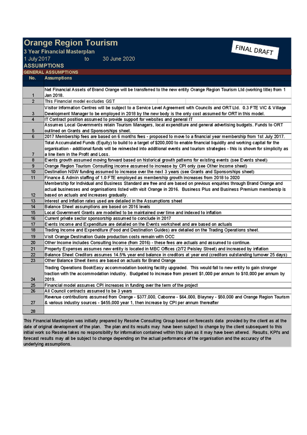
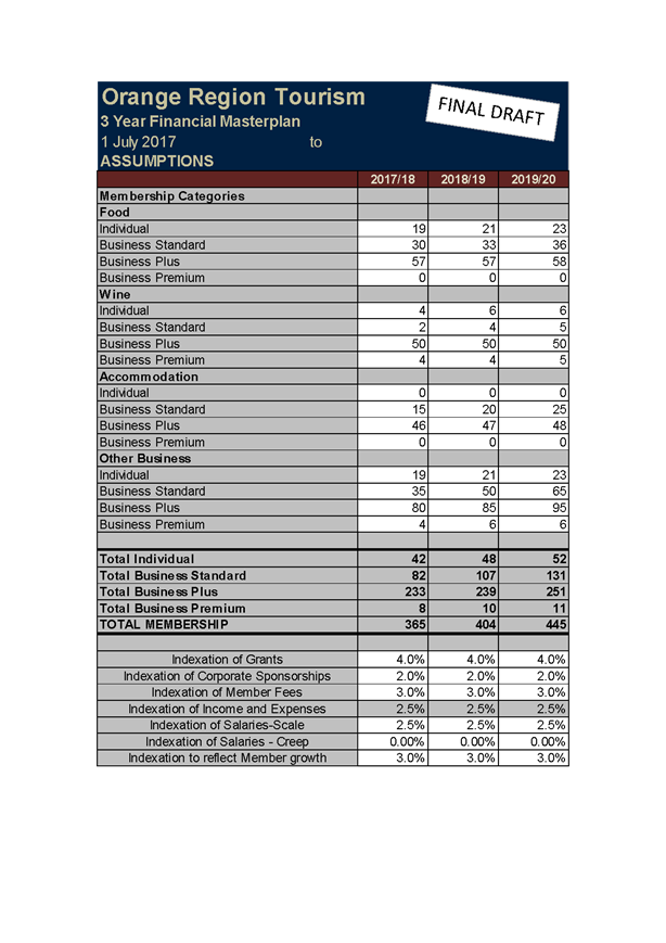
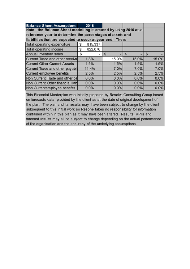
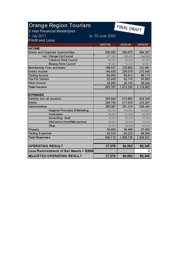
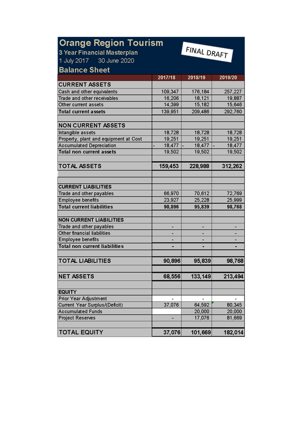
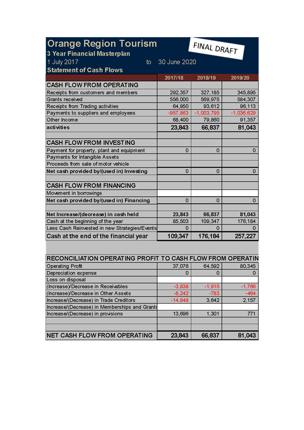
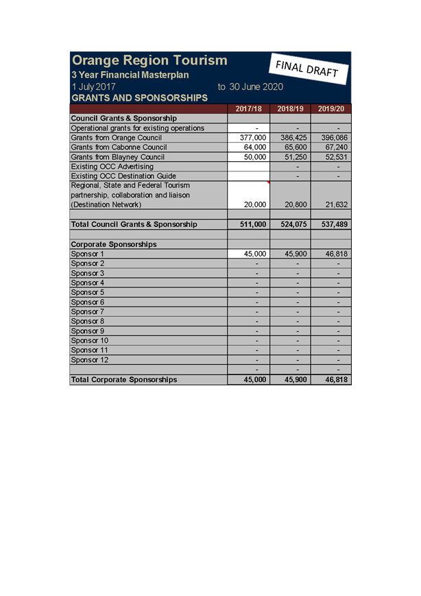
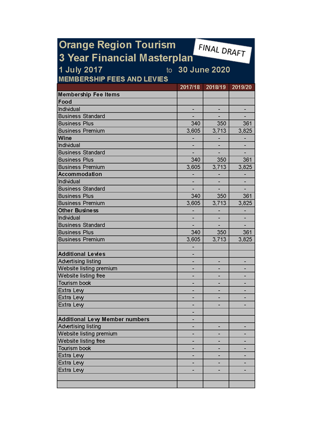
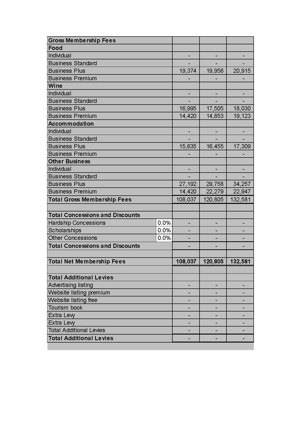
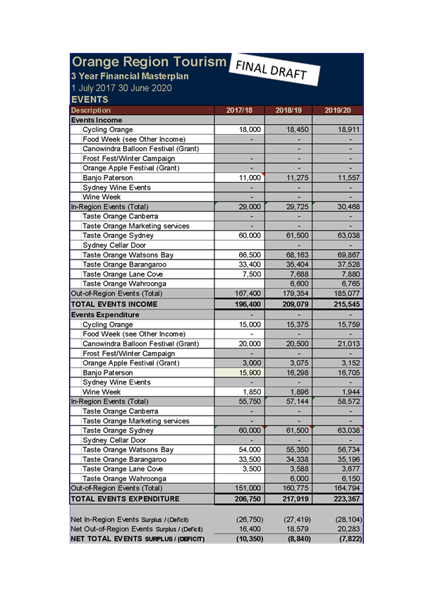
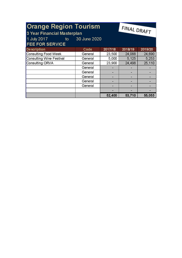
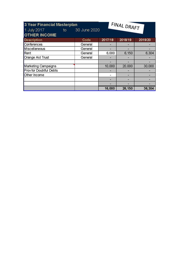
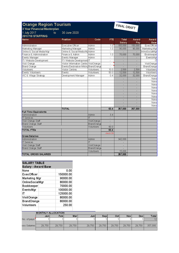
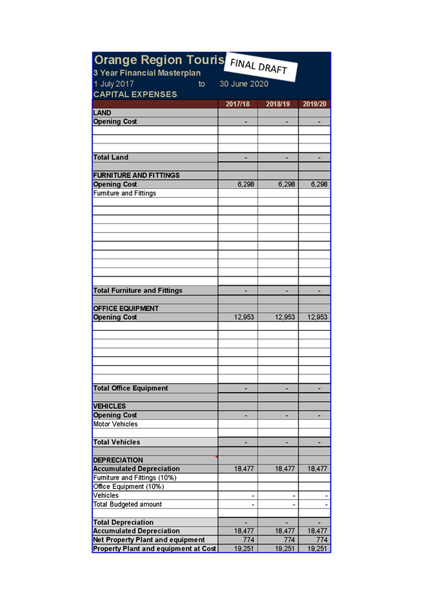
5.14 Disability
Inclusion Action Plan
TRIM
REFERENCE: 2017/1104
AUTHOR: Maureen
Horth, Community Services Manager
EXECUTIVE Summary
Orange City Council has developed a Disability Inclusion
Action Plan as required under the Disability Inclusion Act 2014. Blayney,
Cabonne and Orange Councils resolved to take a collaborative approach to the
development of a joint plan with individual strategies and actions.
The Disability Inclusion Action Plan will underpin
Council’s commitment to providing quality facilities and services that
enable people with disability to fully participate in our communities.
Link To Delivery/OPerational Plan
The recommendation in this report relates to the
Delivery/Operational Plan strategy “5.1 Our Community
– Identify changing community aspirations and undertake community
engagement and planning for the creation of open spaces, recreational
facilities and services, recognising the special needs of older people and
those with disabilities”.
Financial Implications
Nil
Policy and Governance Implications
The development of a Disability Inclusion Action Plan is
required under the Disability Inclusion Act 2014. Reporting on actions will
occur through the quarterly updates to the Delivery/Operational Plan.
|
Recommendation
That Council endorse the Blayney Cabonne Orange
Disability Inclusion Action Plan 2017-2021 with the removal of the first
action under point 3 of Systems and Processes as this action is outside the
adopted Charter of the Ageing and Access Community Committee.
|
further considerations
Consideration has been given to the
recommendation’s impact on Council’s service delivery; image and
reputation; political; environmental; health and safety; employees;
stakeholders and project management; and no further implications or risks have
been identified.
SUPPORTING INFORMATION
The Blayney Cabonne Orange Disability Inclusion Action Plan
has been on public exhibition for 28 days.
The only proposed change is to delete part of point 3 of the
systems and processes action plan (page 28 of the attachment) which refers to
the Ageing and Access Community Committee providing comment on development
applications. This action is outside the purpose of the Committee as outlined
in its Charter and would require Council to amend the Charter to be enacted.
Attachments
1 Disability
Inclusion Action Plan - Final Draft, D17/26039⇩
Council Meeting
22 June 2017
5.14 Disability
Inclusion Action Plan
Attachment 1 Disability
Inclusion Action Plan - Final Draft


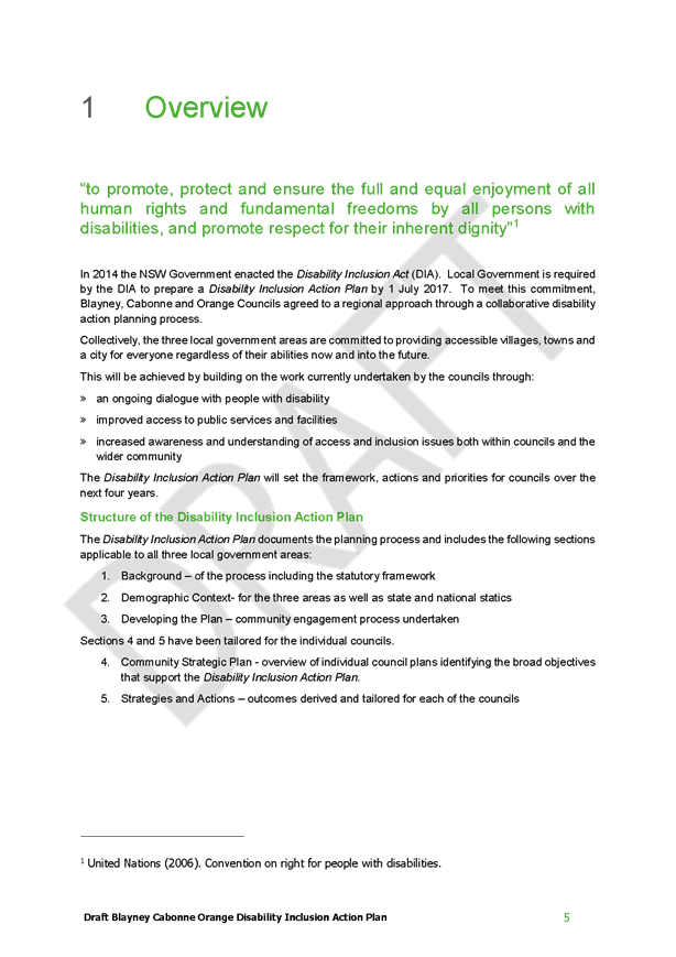

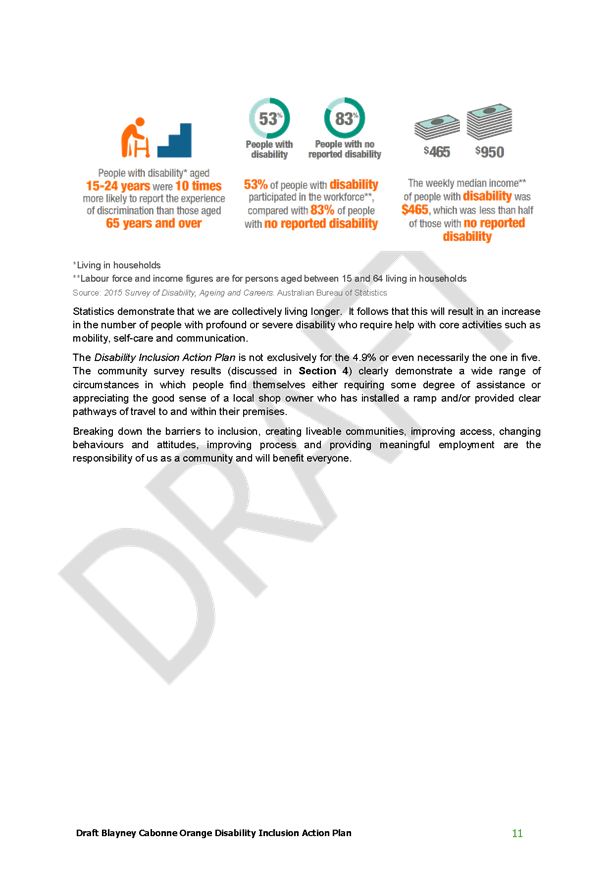
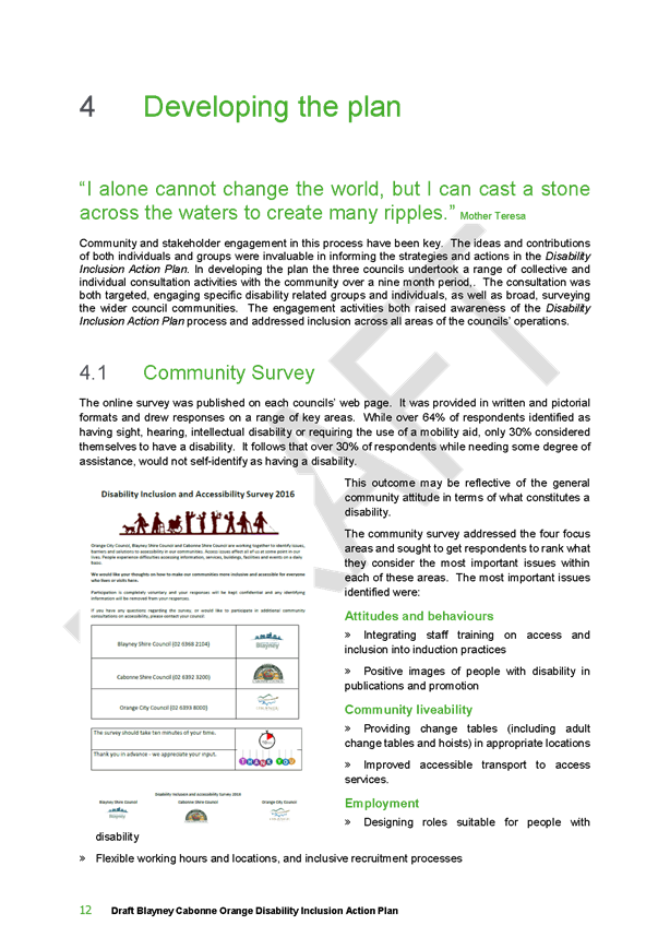

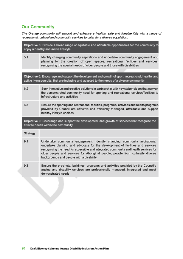
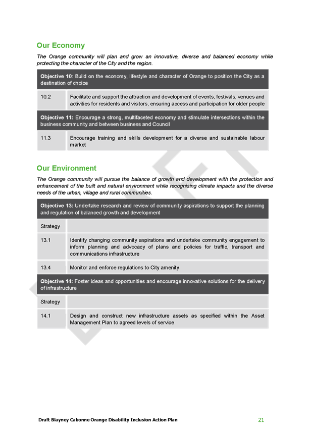
Council Meeting
22 June 2017
5.14 Disability
Inclusion Action Plan
Attachment 1 Disability
Inclusion Action Plan - Final Draft
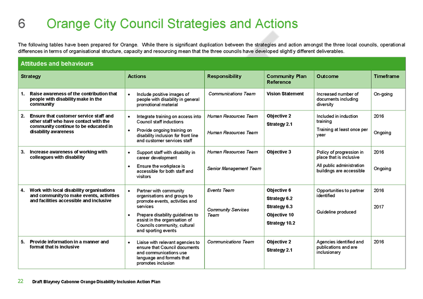
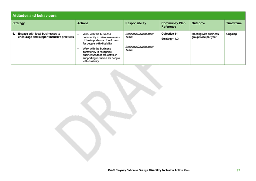
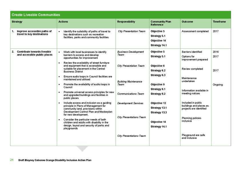
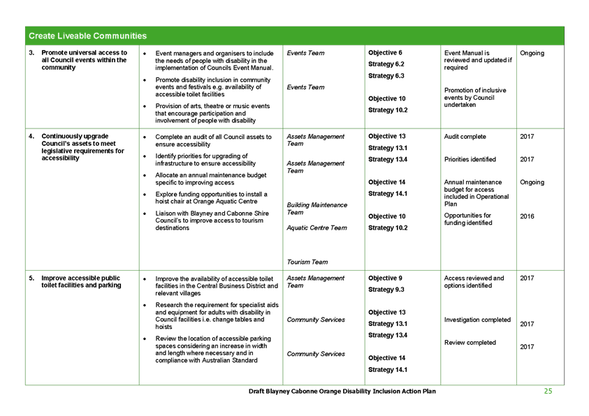
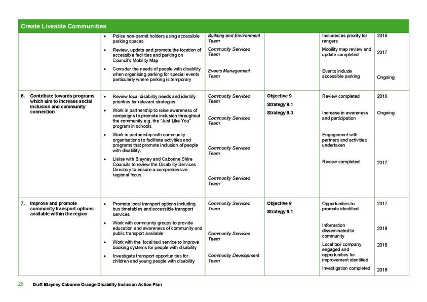
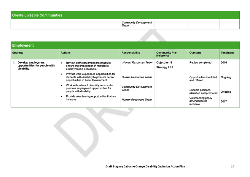
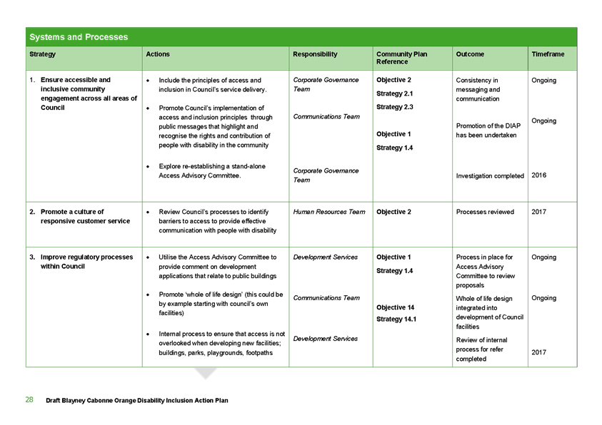
Council Meeting
22 June 2017
5.14 Disability
Inclusion Action Plan
Attachment 1 Disability
Inclusion Action Plan - Final Draft
5.15 Animal
Shelter Project
TRIM
REFERENCE: 2017/982
AUTHOR: Mark
Hodges, Manager Building and Environment
EXECUTIVE Summary
Council was recently informed by the RSPCA that they will be
ceasing the housing of stray animals in the near future. Accordingly Council
will need to provide or secure those services and a new shelter. This report
outlines the situation, financial implications involved and possible courses of
action over the next 12 months. The RSCPA Animal Shelter in William Street has
been in operation for many years and will continue to be an active shelter used
by the RSPCA for animal transfer and welfare.
Link To Delivery/OPerational Plan
The recommendation in this report relates to the
Delivery/Operational Plan strategy “1.3 Our City -
Ensure a robust framework that supports the community’s and
Council’s current and evolving activities, services and functions”.
Financial Implications
The annual fees paid to the RSPCA are what is currently
budgeted for this project. A quarterly review item would be required for any
additional expenditure.
Policy and Governance Implications
Nil
|
Recommendation
That the report on the Animal Shelter Project be
acknowledged.
|
further considerations
Consideration has been given to the
recommendation’s impact on Council’s service delivery; image and
reputation; political; environmental; health and safety; employees;
stakeholders and project management; and no further implications or risks have
been identified.
SUPPORTING INFORMATION
The CEO of the RSPCA and the RSPCA Animal Shelter Services
Officer were present in Orange in April 2017 to announce that the RSPCA is not
going to renew the Council contract with the Orange Shelter so Council will
need to find an alternative location for the impoundment of stray animals. The
RSPCA stated that the decision had not been taken lightly and that the RSPCA
had been looking at the facilities and the number of strays being handled in
Orange over a long time period. They will support the Council with the
management of stray animals until an alternative shelter site and service is
secured.
The RSCPA Animal Shelter in William Street has been in
operation for many years and will continue to be an active shelter used by the
RSPCA for animal transfer and welfare.
Council has contracted the RSPCA to provide and operate
impound services for the City over the past 25 years. Costs for the current
year for these services have a budget in the vicinity of $278,000 p.a.. Income
received from impounding/sustenance fees is generally in the order of $25,000
and fines of between $20,000 and $25,000.
It should also be noted that in more recent years, Council
has a no charge position on impounding fees for registered dogs that are
collected by their owners within the first day of being held in the pound.
Whilst this had the desired effect of decreasing the number of dogs held at the
pound over a longer period of time and increased the number of animals
reclaimed, it did decrease the income associated with operating the pound.
After reviewing costs of other councils’ that operate
similar facilities, it is anticipated that costs are likely to be more than
Council has incurred in the past. At this stage, it is not possible to confirm
costings until service options are narrowed down. Budget in the 2017/18
financial year has been committed that reflects the current level of
service.
Option A – service delivery model
Overall preliminary non-capital options exist as follows:
1 Privately supplied
Animal Shelter run by Council
2 Privately supplied
Animal Shelter run by private operator
3 Regional
partnership with a neighbouring council(s) to build and operate a regional
shelter somewhere in the region utilising smaller scale ‘holding
kennels’ in Orange, prior to transfer of unclaimed animals to the
regional centre.
Initially, expressions of interest for option A are being
sought to judge interest and costs.
The outcomes of Option A Expression
of Interest will be reported to council.
Option B - New Animal Shelter
An alternate approach is for Council to build a
new/refurbish a facility and deliver the services directly.
The functions identified within the Local Government Act
1993 require Local Government to control stray animals, including companion
animals under the Companion Animals Act and stray stock and items under the
Impounding Act. Council must therefore provide or source an impounding
facility.
The RSPCA has over the past few years effected a change in
shifting its focus away from the management of stray animals at a number of its
locations within the State, including Dubbo in 2014 and following this, Broken
Hill and other local government areas.
Staff have visited several animal shelters to determine the
specification for a new animal shelter. The design of a shelter is required to
comply with NSW Guidelines.
Design will need to facilities to safely delivery the
operational services offered to animals and offering staff a safe work
environment. Other issues to be considered ensuring the facility is
easily cleaned and maintained as well as providing reasonable comfort for the
animals, allowing particularly for the weather in Orange (thus indoor and
outdoor options will be considered).
Essentially it is estimated that an animal shelter suitable
for holding 30-40 dogs and 10-15 cats is required in Orange.
Location of an animal shelter service
The EOI period may identify existing local boarding kennel
operations that may be interested in expanding their services.
Options will also be considered for service delivery outside
the main built up area of the City. The benefit of such sites is that they
would provide a buffer to neighbours so as to minimise the noise impacts of
barking dogs. The disadvantage of out of town sites is whether or not the site
could be serviced, particularly by the sewerage system.
Consideration will also be given to sites within the City,
particularly those with within the commercial/industrial areas. Options on such
sites may be full construction, or refurbishment of an existing building.
The following photographs show
examples of indoor shelter concepts.

Staff have engaged a consultant to assist in the project
planning stage of this project.
Staff will report back to Council on the outcomes of the EOI
process.
6 Closed Meeting
- See Closed Agenda
The General Manager will advise the Council if any written
submissions have been received relating to any item advertised for
consideration by a closed meeting of Orange City Council.
The Mayor will extend an invitation to any member of the
public present at the meeting to make a representation to Council as to whether
the meeting should be closed for a particular item.
In accordance with the Local Government Act 1993, and
the Local Government (General) Regulation 2005, in the opinion of the General
Manager, the following business is of a kind as referred to in Section 10A(2)
of the Act, and should be dealt with in a Confidential Session of the Council meeting
closed to the press and public.
|
Recommendation
That Council adjourn into a Closed Meeting and members of
the press and public be excluded from the Closed Meeting, and access to the
correspondence and reports relating to the items considered during the course
of the Closed Meeting be withheld unless declassified by separate resolution.
This action is taken in accordance with Section 10A(2) of the Local
Government Act, 1993 as the items listed come within the following
provisions:
6.1 Tender
for Supply of Roadbase Materials
This item is classified CONFIDENTIAL under the
provisions of Section 10A(2) of the Local Government Act 1993, which permits
the meeting to be closed to the public for business relating to (c)
information that would, if disclosed, confer a commercial advantage on a
person with whom the Council is conducting (or proposes to conduct) business.
6.2 Tender
for Supply of Ready Mixed Concrete 2017-2019
This item is classified CONFIDENTIAL under the
provisions of Section 10A(2) of the Local Government Act 1993, which permits
the meeting to be closed to the public for business relating to (c)
information that would, if disclosed, confer a commercial advantage on a
person with whom the Council is conducting (or proposes to conduct) business.
6.3 Land
sale - 30 Colliers Avenue
This item is classified CONFIDENTIAL under the
provisions of Section 10A(2) of the Local Government Act 1993, which permits
the meeting to be closed to the public for business relating to (c)
information that would, if disclosed, confer a commercial advantage on a
person with whom the Council is conducting (or proposes to conduct) business.
6.4 Complaints
under Orange City Council Code of Conduct (RESTRICTED)
This item is classified CONFIDENTIAL under the
provisions of Section 10A(2) of the Local Government Act 1993, which permits
the meeting to be closed to the public for business relating to (i) alleged
contraventions of any code of conduct requirements applicable under section
440.
|
6.1 Tender
for Supply of Roadbase Materials
TRIM
REFERENCE: 2017/1101
AUTHOR: Mark
Frecklington, Assistant Works Manager
Reason
for Confidentiality
This item is
classified CONFIDENTIAL under the provisions of Section 10A(2) of the Local
Government Act 1993, which permits the meeting to be closed to the public for
business relating to (c) information that would, if disclosed, confer a
commercial advantage on a person with whom the Council is conducting (or
proposes to conduct) business.
6.2 Tender
for Supply of Ready Mixed Concrete 2017-2019
TRIM
REFERENCE: 2017/1102
AUTHOR: Mark
Frecklington, Assistant Works Manager
Reason
for Confidentiality
This item is
classified CONFIDENTIAL under the provisions of Section 10A(2) of the Local
Government Act 1993, which permits the meeting to be closed to the public for
business relating to (c) information that would, if disclosed, confer a
commercial advantage on a person with whom the Council is conducting (or
proposes to conduct) business.
6.3 Land
sale - 30 Colliers Avenue
TRIM
REFERENCE: 2017/1166
AUTHOR: Kathy
Woolley, Director Corporate and Commercial Services
Reason
for Confidentiality
This item is
classified CONFIDENTIAL under the provisions of Section 10A(2) of the Local
Government Act 1993, which permits the meeting to be closed to the public for
business relating to (c) information that would, if disclosed, confer a
commercial advantage on a person with whom the Council is conducting (or
proposes to conduct) business.
6.4 Complaints
under Orange City Council Code of Conduct (RESTRICTED)
TRIM
REFERENCE: 2017/1203
AUTHOR: Kathy
Woolley, Director Corporate and Commercial Services
Reason
for Confidentiality
This item is
classified CONFIDENTIAL under the provisions of Section 10A(2) of the Local
Government Act 1993, which permits the meeting to be closed to the public for
business relating to (i) alleged contraventions of any code of conduct requirements
applicable under section 440.