ORANGE CITY COUNCIL
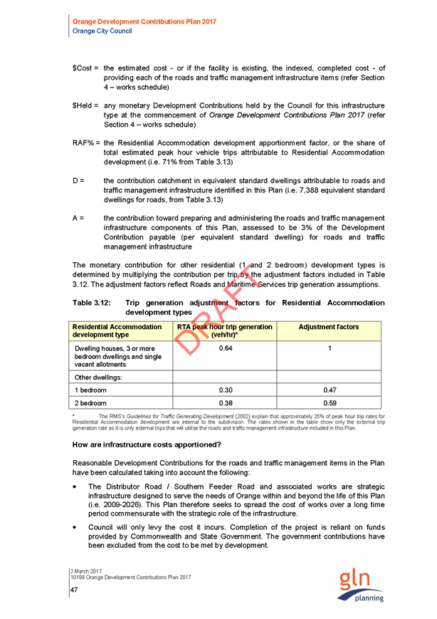
Planning and Development
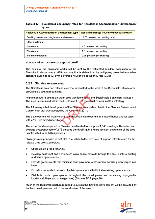
Committee
Agenda
4 April 2017
Notice
is hereby given, in accordance with the provisions of the Local Government Act
1993 that a Planning and Development
Committee meeting
of ORANGE CITY COUNCIL will be held in the Council Chamber, Civic Centre, Byng Street, Orange on Tuesday,
4 April 2017.
Garry
Styles
General Manager
For apologies please
contact David Waddell on 6393 8261.
Planning and Development Committee 4
April 2017
1 Introduction
1.1 Declaration
of pecuniary interests, significant non-pecuniary interests and less than
significant non-pecuniary interests
The
provisions of Chapter 14 of the Local Government Act, 1993 (the Act)
regulate the way in which Councillors and designated staff of Council conduct
themselves to ensure that there is no conflict between their private interests
and their public role.
The
Act prescribes that where a member of Council (or a Committee of Council) has a
direct or indirect financial (pecuniary) interest in a matter to be considered
at a meeting of the Council (or Committee), that interest must be disclosed as
soon as practicable after the start of the meeting and the reasons given for
declaring such interest.
As
members are aware, the provisions of the Local Government Act restrict any
member who has declared a pecuniary interest in any matter from participating
in the discussion or voting on that matter, and requires that member to vacate the
Chamber.
Council’s Code of Conduct provides that if members
have a non-pecuniary conflict of interest, the nature of the conflict must be
disclosed. The Code of Conduct also provides for a number of ways in which a
member may manage non pecuniary conflicts of interest.
|
Recommendation
It is recommended that Committee Members now disclose any
conflicts of interest in matters under consideration by the Planning and
Development Committee at this meeting.
|
2 General
Reports
2.1 Items
Approved Under the Delegated Authority of Council
TRIM
REFERENCE: 2017/325
AUTHOR: Paul
Johnston, Planning Team Leader
EXECUTIVE Summary
Following is a list of development
applications approved under the delegated authority of Council.
Link To Delivery/OPerational Plan
The recommendation in this report relates to the
Delivery/Operational Plan strategy “13.4 Our Environment
– Monitor and enforce regulations relating to City amenity”.
Financial Implications
Nil
Policy and Governance Implications
Nil
|
Recommendation
That the information provided in the
report by the Acting Manager Development Assessments on Items Approved Under
the Delegated Authority of Council be acknowledged.
|
further considerations
Consideration has been given to the
recommendation’s impact on Council’s service delivery; image and
reputation; political; environmental; health and safety; employees;
stakeholders and project management; and no further implications or risks have
been identified.
SUPPORTING INFORMATION
|
Reference:
|
DA 335/2012(2)
|
Determination
Date
|
3 March 2017
|
|
PR Number
|
PR17660
|
|
Applicant/s:
|
Health
Infrastructure on behalf of Health Administration Corporation
|
|
Owner/s:
|
Health Administration
Corporation
|
|
Location:
|
Lots 10B, 10C,
10D, 10E and 10F DP 4099, Lot 10A DP 187494 - 127 and 129-133 Sale Street,
Orange
|
|
Proposal:
|
Modification
of development consent – the modification involve deleting
Condition (19) which related to fire safety provisions under the
Building Code of Australia.
|
|
Value:
|
$0.00
|
|
Reference:
|
DA 426/2015(3)
|
Determination
Date
|
21 February 2017
|
|
PR Number
|
PR4274
|
|
Applicant/s:
|
Bassman Drafting
Services
|
|
Owner/s:
|
Mr JS Pegum and Ms
R Gradon
|
|
Location:
|
Lots 3 and 4 DP
6662 - 106 and 106A Franklin Road, Orange
|
|
Proposal:
|
Modification
of development consent - demolition (part dwelling and sheds), dwelling
alterations and additions, swimming pool with associated deck and fencing,
and secondary dwelling. The modification involves altering the approved
design and detailing for the existing east addition to the principal
dwelling; and staging the construction works relating to the principal
dwelling.
|
|
Value:
|
$550,000 (being
the same value as the original development)
|
|
Reference:
|
DA 331/2016(1)
|
Determination
Date
|
6 March 2017
|
|
PR Number
|
PR3863
|
|
Applicant/s:
|
Orange Land
Development Pty Ltd
|
|
Owner/s:
|
Mr GG and Mrs TM
Tilston
|
|
Location:
|
Lot 23 Sec 6 DP
8196 - 8 Endsleigh Avenue, Orange
|
|
Proposal:
|
Subdivision
(two lot residential - Torrens Title), Subdivision (five lot residential -
Community Title), Dwellings (four), Carport, Demolition (ancillary
structures) and Tree Removal
|
|
Value:
|
$880,000
|
|
Reference:
|
DA 340/2016(2)
|
Determination
Date
|
23 February 2017
|
|
PR Number
|
PR6950
|
|
Applicant/s:
|
Mr RA Cummins
|
|
Owner/s:
|
Mr RA and Ms JA
Cummins
|
|
Location:
|
Lot 1 DP 195511 -
259 Lords Place, Orange
|
|
Proposal:
|
Modification
of development consent - proposed serviced apartments and office premises -
the modification involves minor reconfiguration of internal spaces in order
to provide a more functional layout and simplify fire safety upgrading.
|
|
Value:
|
$200,000 (being
the same value as the original development)
|
|
Reference:
|
DA 416/2016(1)
|
Determination
Date
|
11 February 2017
|
|
PR Number
|
PR22910
|
|
Applicant/s:
|
Mr MM Oosterveen
|
|
Owner/s:
|
Mr MM Oosterveen
|
|
Location:
|
Lot 100 DP 1124705
- 7-9 Dora Street, Orange
|
|
Proposal:
|
Office premises (alterations and additions to
pathology laboratory and office), and replacement shed (new construction)
|
|
Value:
|
$198,000
|
|
Reference:
|
DA 422/2016(1)
|
Determination
Date
|
23 February 2017
|
|
PR Number
|
PR17293
|
|
Applicant/s:
|
Orange Society of
Model Engineers
|
|
Owner/s:
|
NSW Government
|
|
Location:
|
Lots 701 and 702
DP 1002275 - Matthews Park - Moulder Street, Orange
|
|
Proposal:
|
Recreation
area (additions to signal box)
|
|
Value:
|
$40,000
|
|
Reference:
|
DA 434/2016(1)
|
Determination
Date
|
22 February 2017
|
|
PR Number
|
PR7468
|
|
Applicant/s:
|
Mr AM Low and Ms
AK Bailey
|
|
Owner/s:
|
Mr AM Low and Ms
AK Bailey
|
|
Location:
|
Lot 1 DP 731620 -
123 March Street, Orange
|
|
Proposal:
|
Demolition
(tree removal)
|
|
Value:
|
$1,800
|
|
Reference:
|
DA 447/2016(1)
|
Determination
Date
|
13 March 2017
|
|
PR Number
|
PR21294
|
|
Applicant/s:
|
Whyalla Circuit
Pty Limited
|
|
Owner/s:
|
Country Rail
Infrastructure Authority
|
|
Location:
|
Lot 16 DP 1134650
and Lot 101 DP 1037022, 150 and 154 Peisley Street, Orange
|
|
Proposal:
|
Subdivision
(boundary adjustment)
|
|
Value:
|
$0.00
|
|
Reference:
|
DA 10/2017(1)
|
Determination
Date
|
6 March 2017
|
|
PR Number
|
PR17233
|
|
Applicant/s:
|
Mrs J Campbell
|
|
Owner/s:
|
Mr DA and Mrs JL
Player
|
|
Location:
|
Lot 101 DP 884400
-184-190 Peisley Street, Orange
|
|
Proposal:
|
Restaurant
(change of use) and business identification signs
|
|
Value:
|
$500,000
|
|
Reference:
|
DA 14/2017(1)
|
Determination
Date
|
20 February 2017
|
|
PR Number
|
PR6952
|
|
Applicant/s:
|
Messenger
Superannuation Pty Ltd
|
|
Owner/s:
|
Messenger
Superannuation Pty Ltd
|
|
Location:
|
Lot 1 DP 745659 -
263 Lords Place, Orange
|
|
Proposal:
|
Demolition
(tree removal)
|
|
Value:
|
$4,400
|
|
Reference:
|
DA 16/2017(1)
|
Determination
Date
|
8 March 2017
|
|
PR Number
|
PR27165
|
|
Applicant/s:
|
Havenhand and
Mather Architects
|
|
Owner/s:
|
United Protestant
Association of NSW Limited
|
|
Location:
|
Lot 100 DP 1209880
- March Street, Orange (AKA 70 Nile Street)
|
|
Proposal:
|
Demolition
(dwelling house, garage and trees)
|
|
Value:
|
$28,000
|
|
Reference:
|
DA 21/2017(1)
|
Determination
Date
|
16 March 2017
|
|
PR Number
|
PR809
|
|
Applicant/s:
|
Mrs JL Pottie
|
|
Owner/s:
|
Mrs JL Pottie
|
|
Location:
|
Lot 8 SP 17153 -
8/182 Anson Street, Orange
|
|
Proposal:
|
Serviced
apartment (change of use from commercial premises)
|
|
Value:
|
$0.00
|
|
Reference:
|
DA 24/2017(1)
|
Determination
Date
|
14 March 2017
|
|
PR Number
|
PR25385
|
|
Applicant/s:
|
Hotel Canobolas
Pty Limited
|
|
Owner/s:
|
Hotel Canobolas
Pty Limited
|
|
Location:
|
Lot 18 SP 82891 -
18/266 Summer Street, Orange
|
|
Proposal:
|
Pub
(alterations - new kitchen)
|
|
Value:
|
$20,000
|
|
Reference:
|
DA 31/2017(1)
|
Determination
Date
|
28 February 2017
|
|
PR Number
|
PR20399
|
|
Applicant/s:
|
Orange Aboriginal
Medical Service Inc.
|
|
Owner/s:
|
Orange Aboriginal
Medical Service Inc.
|
|
Location:
|
Lot 14 DP 270446 -
16 Cameron Place, Orange
|
|
Proposal:
|
Medical
centre
|
|
Value:
|
$850,000
|
TOTAL
NET* VALUE OF ALL DEVELOPMENTS APPROVED IN THIS PERIOD: $2,522,200
*
Net value relates to the value of modifications. If modifications are
the same value as the original DA, then nil is added. If there is a plus/minus
difference, this difference is added or taken out.
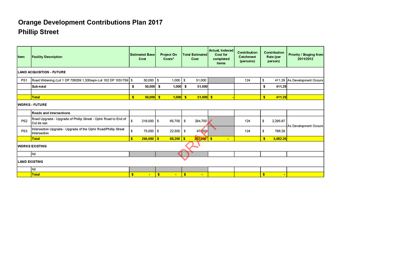
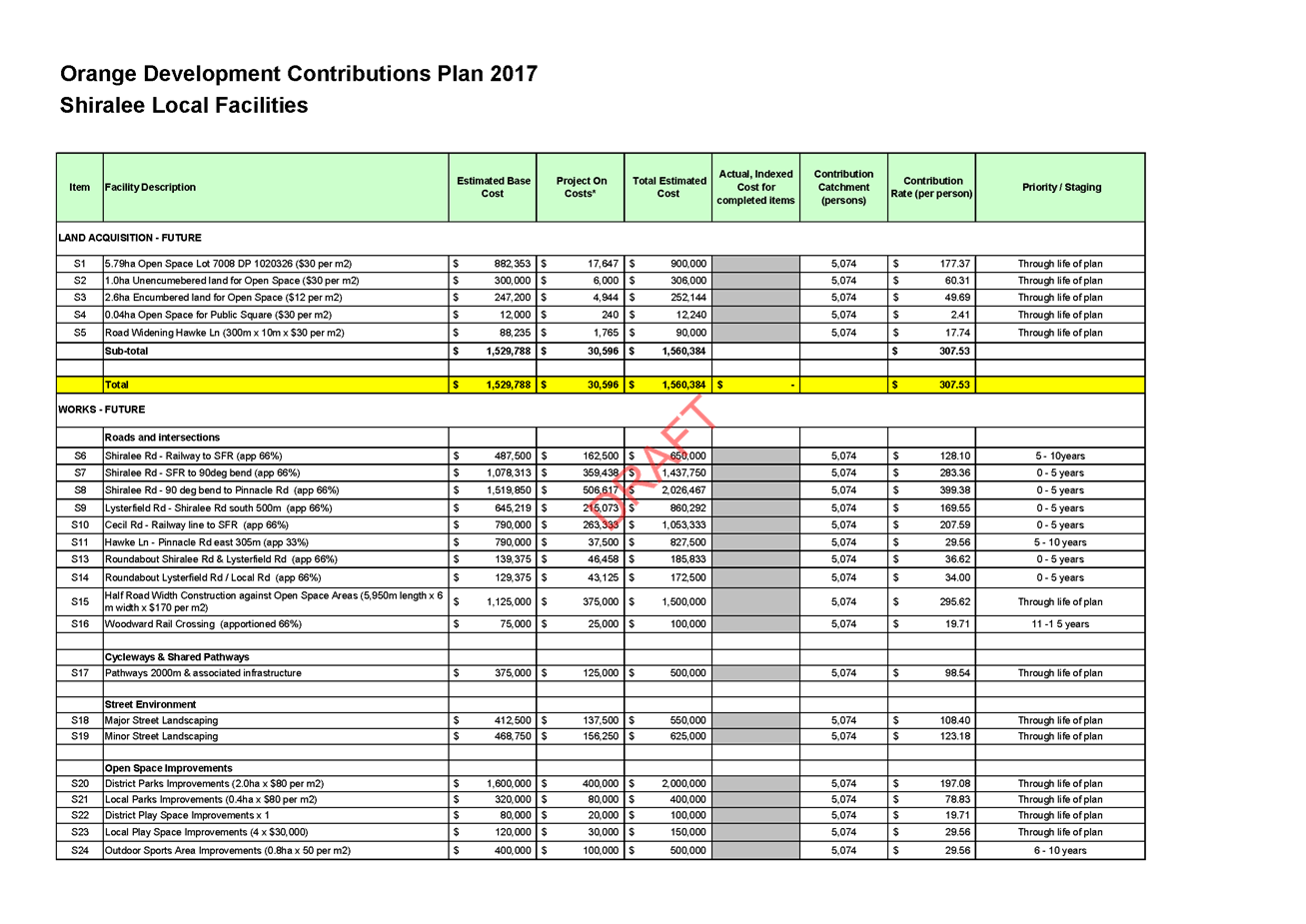
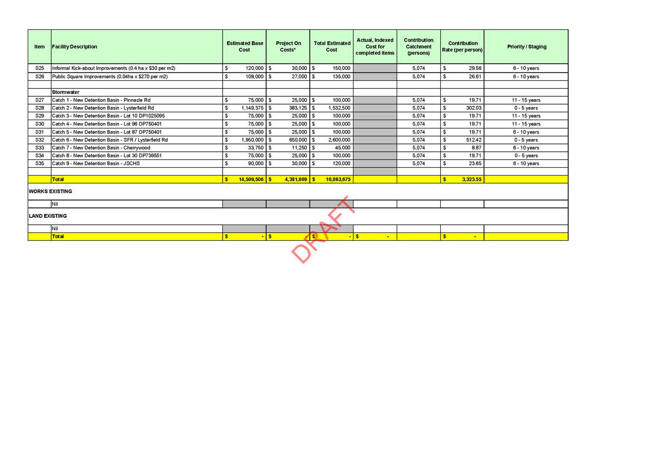
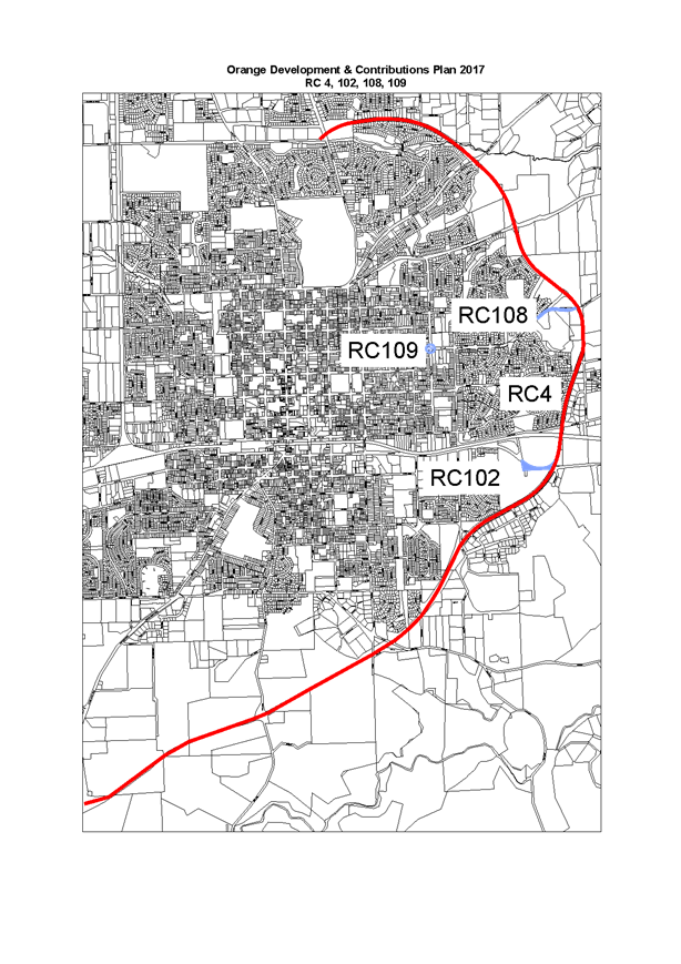
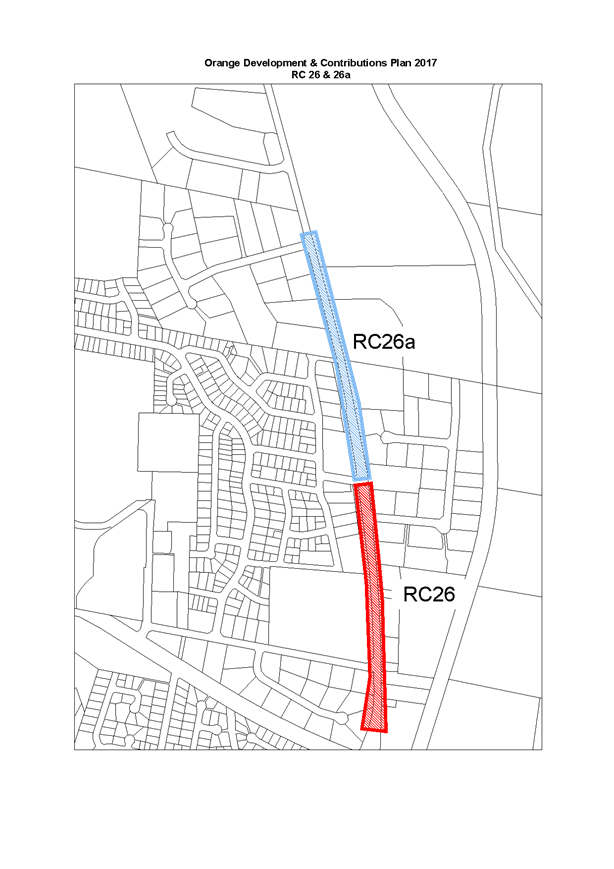
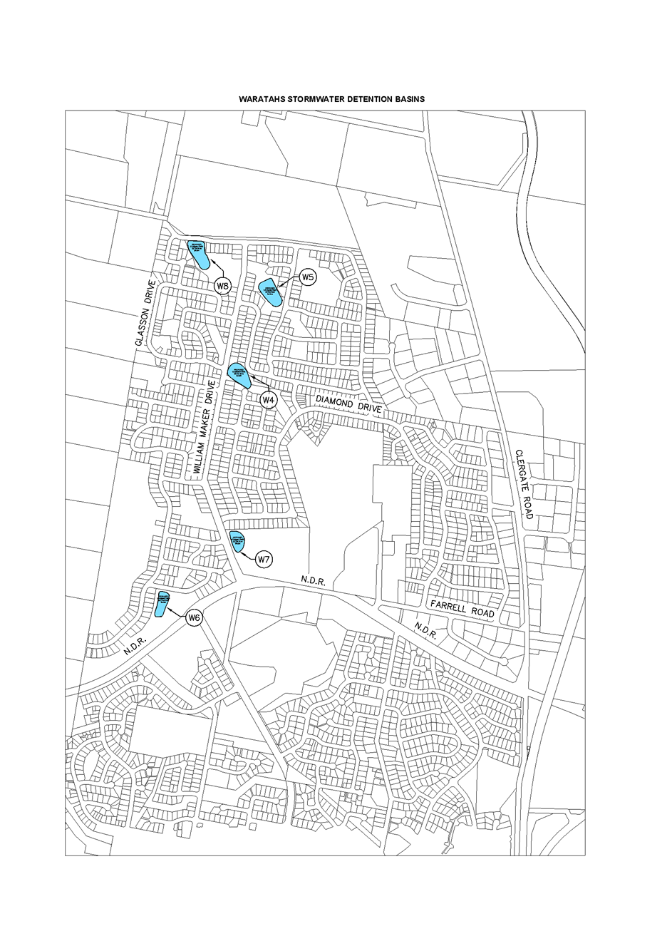
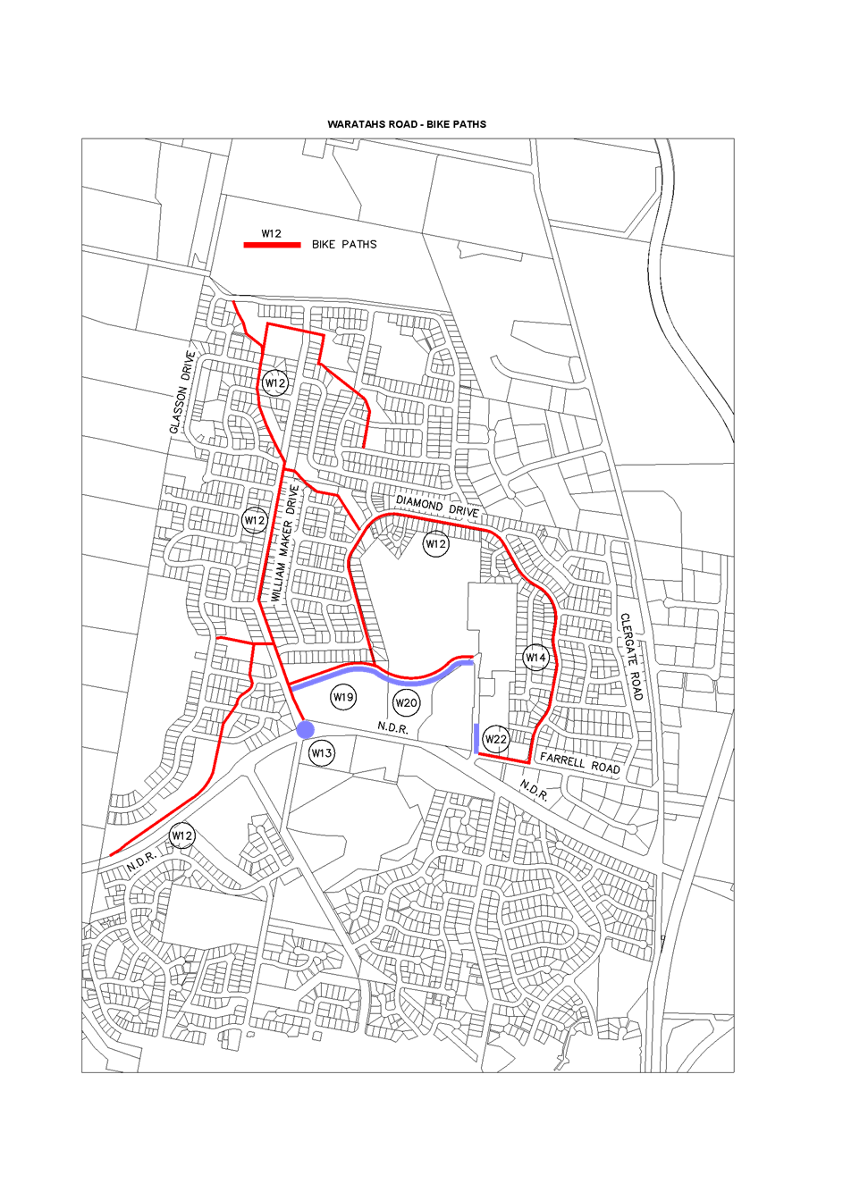
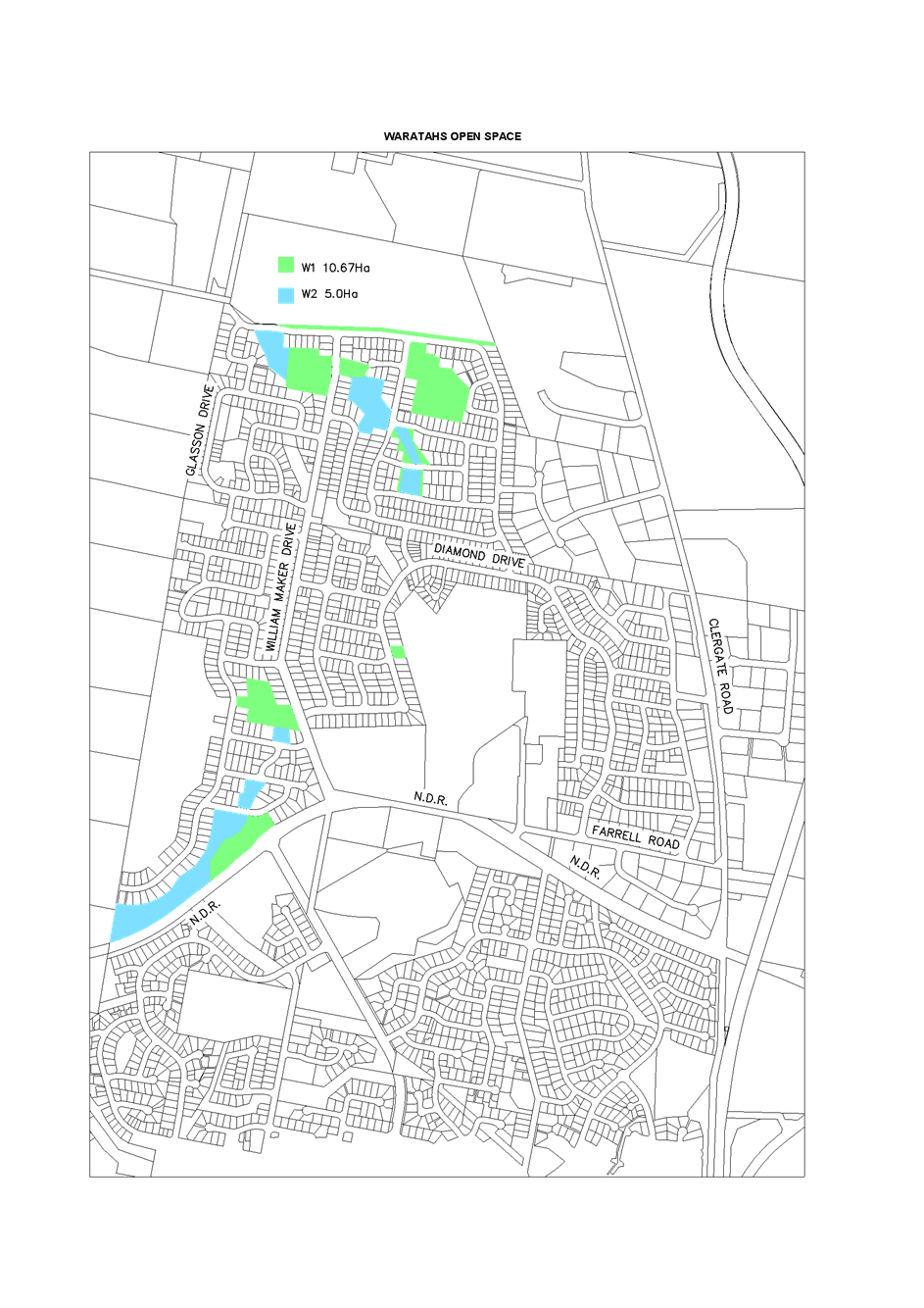
2.2 Section
94 Orange Development Contributions Plan 2017
TRIM
REFERENCE: 2017/425
AUTHOR: Michael
McFadden, Projects and Research Manager
EXECUTIVE Summary
Council, at its meeting held on 3 November 2015, resolved to
adopt the Orange Development Contributions Plan 2015 and to review the
submission from Heath Consulting Engineers regarding potential changes to the
Section 94 Orange Development Contributions Plan 2015, with a subsequent report
to Council to be prepared if required.
The review of the Heath Consulting Engineers submission has
been completed and a number of changes are required to be made to the Orange
Development Contributions Plan 2015. Additional works and costing have also
been identified and the Orange Development Contributions Plan 2017 plan has
been generated to account for all issues.
The Draft Development Contributions Plan 2017 is provided
and recommended to Council for exhibition.
Link To Delivery/OPerational Plan
The recommendation in this report relates to the
Delivery/Operational Plan strategy “1.3 Our City -
Ensure a robust framework that supports the community’s and
Council’s current and evolving activities, services and functions”.
Financial Implications
Nil
Policy and Governance Implications
The contribution plans have been developed in accordance
with section 94 of the Environmental Planning and Assessment (EP&A) Act
1979.
|
Recommendation
1. That
the Orange Development Contributions Plan 2017 be placed on exhibition for 28
days.
2. That
relevant consultants and developers who undertake development work in Orange
be advised that the Draft Orange Development Contributions Plans 2017 will be
on exhibition and invite comments on the draft Plan.
|
further considerations
Consideration has been given to the
recommendation’s impact on Council’s service delivery; image and
reputation; political; environmental; health and safety; employees;
stakeholders and project management; and no further implications or risks have
been identified.
SUPPORTING INFORMATION
Orange Development
Contributions Plan 2017
Council has been working with Greg New from GLN Planning on
the development of the Draft Orange Contributions Plan 2017, which includes
revisions from the review of Heath Consulting Engineers’ submission. The
draft plan has been prepared to address anticipated demand for local
infrastructure generated by new development up to 2026. The draft plan applies
to all land within the Orange Local Government Area.
Section 2.20 of the 2015 Plan required it to be regularly
updated to ensure:
- Council’s
infrastructure program remains on a sound financial footing;
- development
infrastructure is delivered in a reasonable time; and
- contribution
rates remain reasonable over time.
The draft plan updates the 2015 Plan by updating local
facilities areas, lot yields, assumptions, works items and costs.
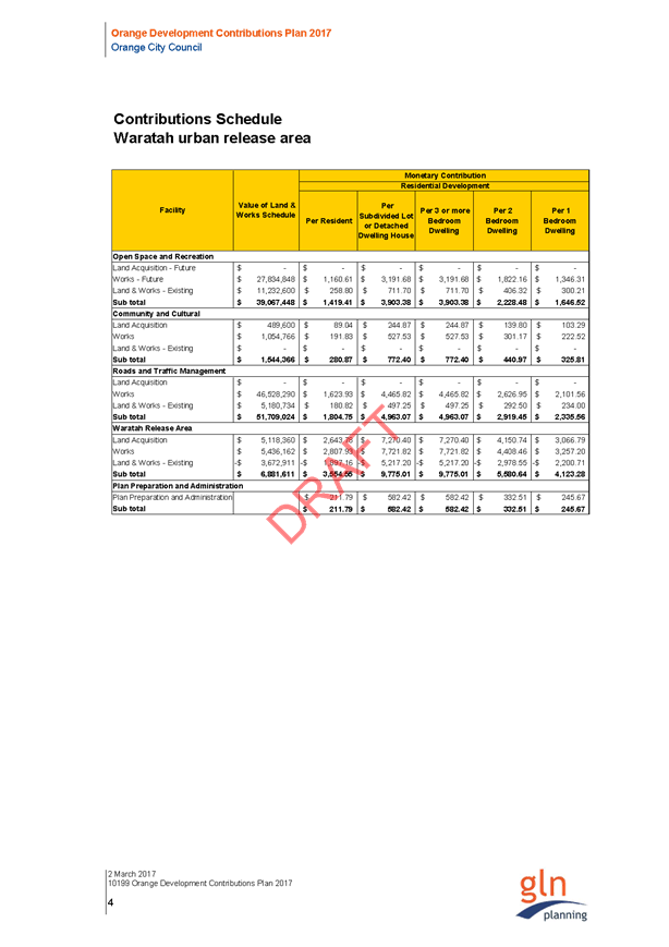
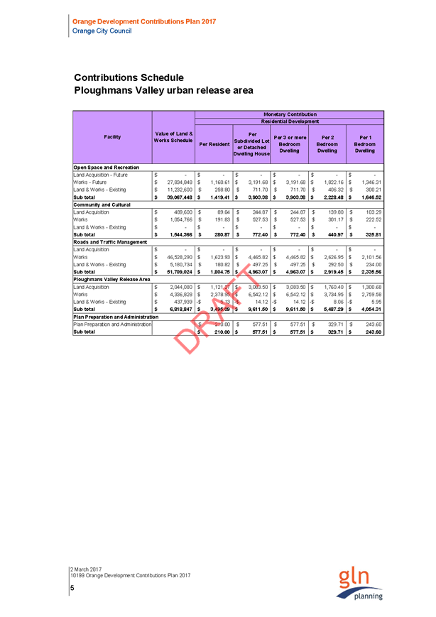
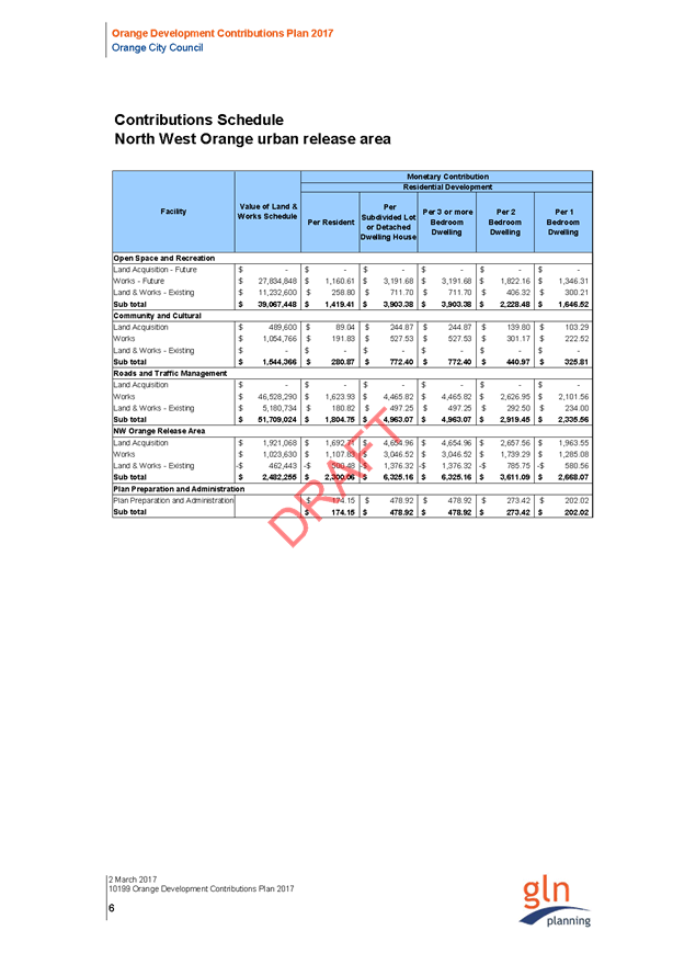
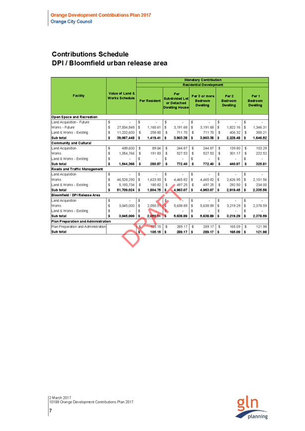
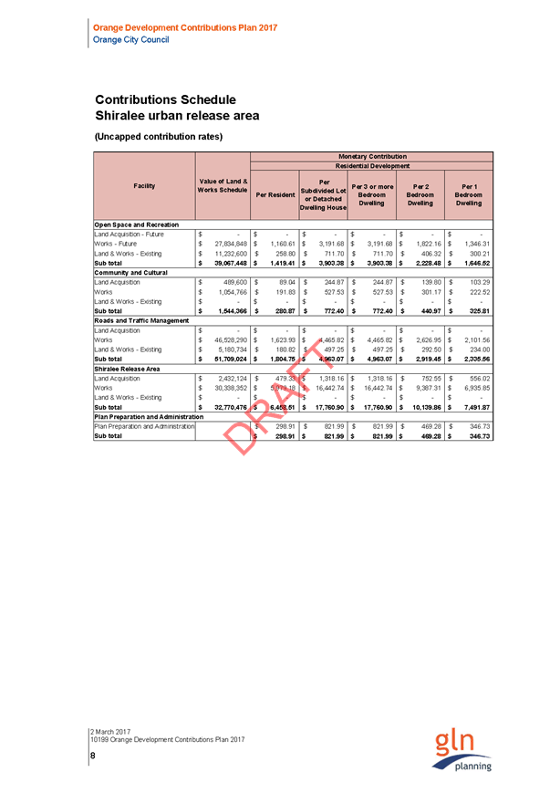
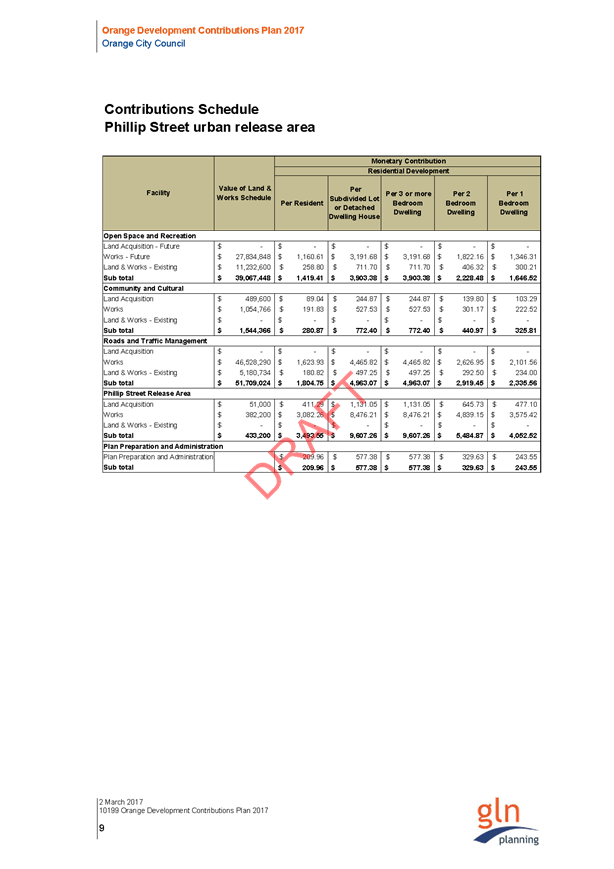
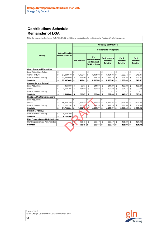
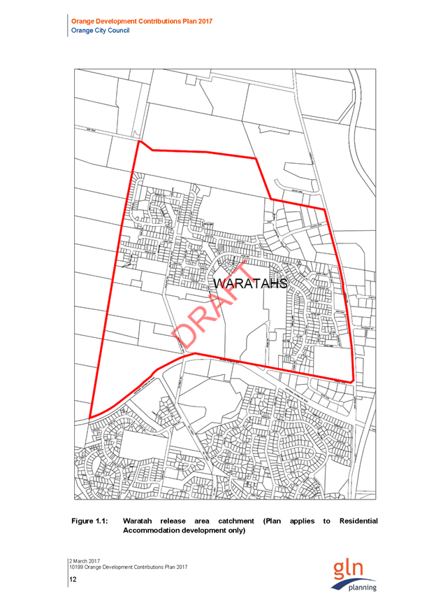
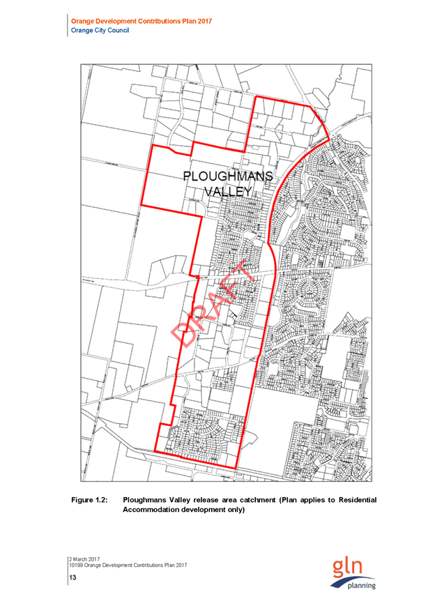
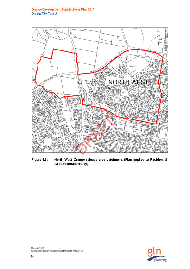
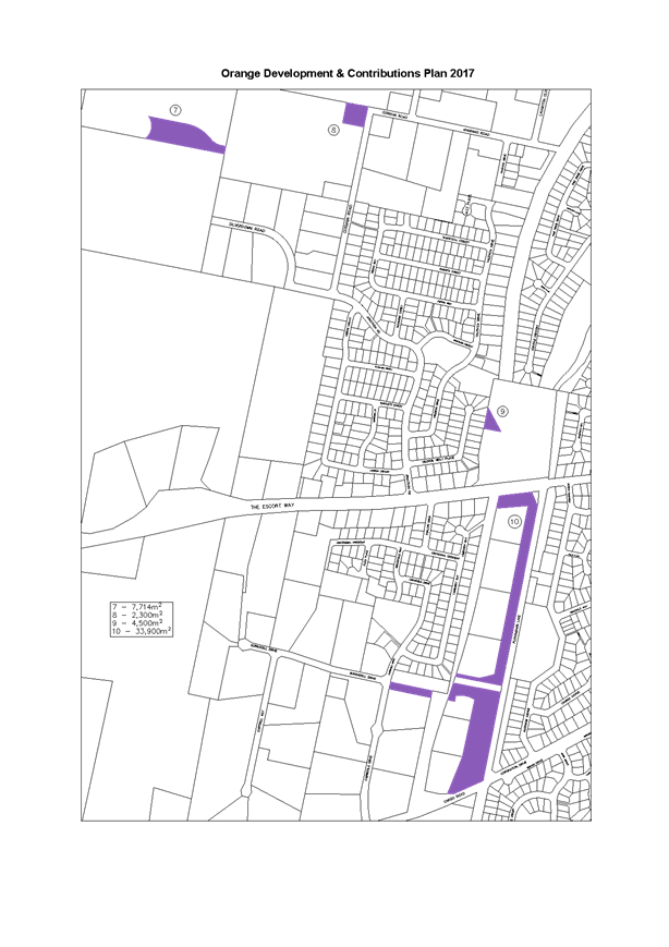
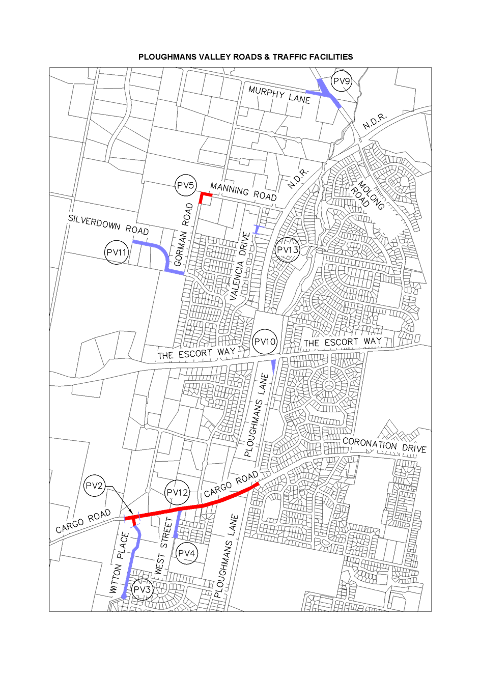
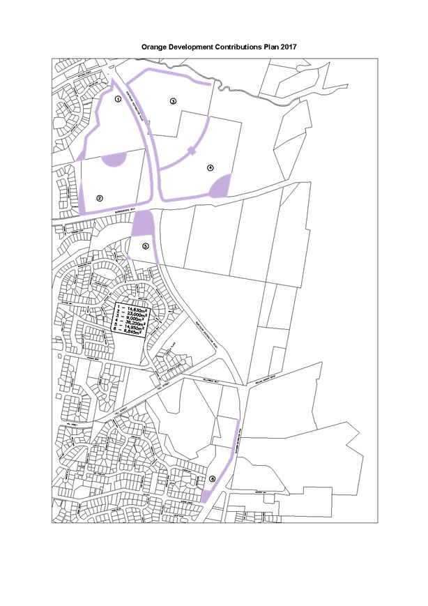
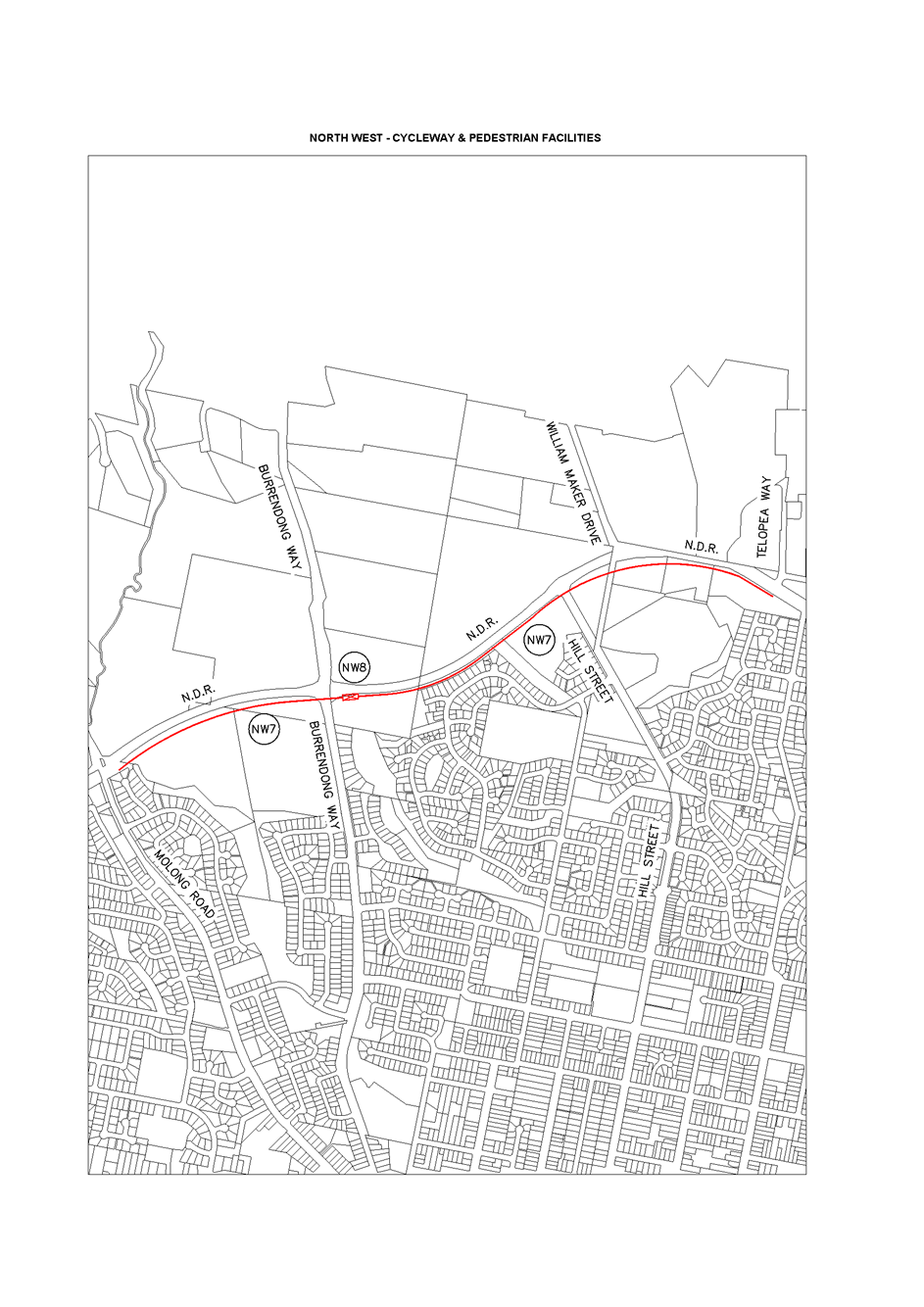
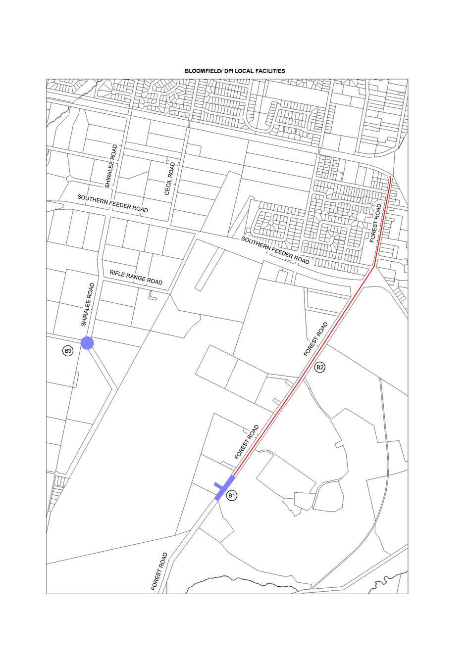
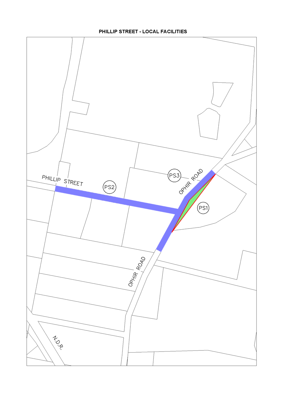
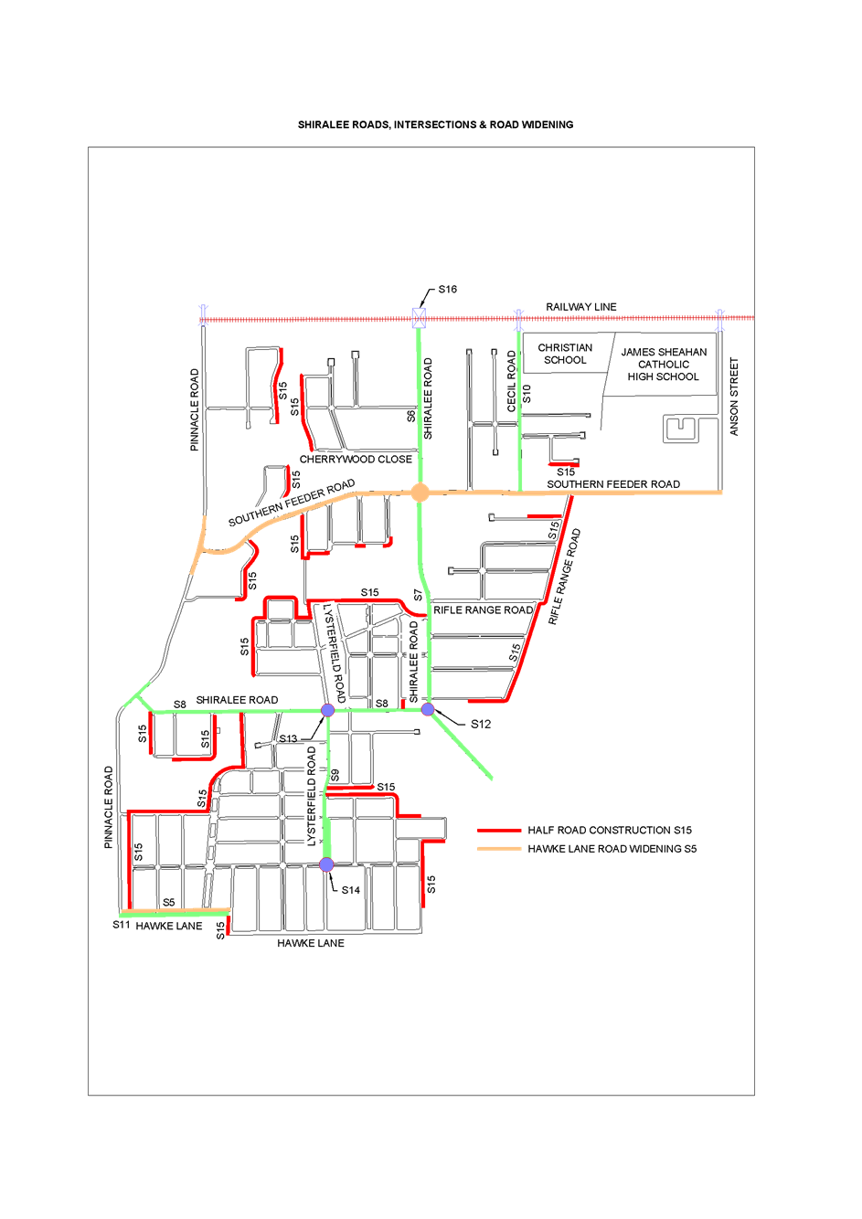
There are seven sub-areas identified within the Local
Government area (LGA) in the 2017 plan and these are:
1 Development
in Waratah urban release area
2 Development
in Ploughman’s Valley urban release area
3 Development
in North West urban release area
4 Development
in DPI/Bloomfield urban release area
5 Development
in remainder of LGA
6 Development
in Phillip Street urban release area
7 Development
in the Shiralee urban release area
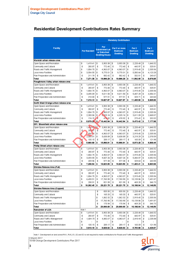
The proposed and existing
contributions rates (per lot as at 1 March 2017) within the proposed sub-areas
are:
|
AREA
|
2015 PLAN RATE
|
2017 PLAN RATE
|
|
Waratah urban release area
|
$20,000
|
$19,996.29
|
|
Ploughmans Valley urban release area
|
$19,774
|
$19,827.87
|
|
North West urban release area
|
$15,774
|
$16,442.94
|
|
DPI/Bloomfield urban release area
|
$15,270
|
$15,566.91
|
|
Remainder of LGA
|
$9,868
|
$9,928.02
|
|
Phillip Street urban release area
|
$20,000 (capped)
|
$19,823.50
|
|
The Shiralee urban release area
|
$20,000 (capped)
|
$20,000 (capped)
|
As indicated in the above table, the rates will remain
similar or lower in the 2017 Plan, which is within the $20,000 cap per lot as
required under section 94E of the EP&A Act.
AMENDMENTS TO PLAN
Stormwater
Stormwater contributions were
contained within the Section 94 Contributions Plan 2015 but further
clarification on nexus requirements restricts the contribution to only minor
areas within the City. To fully utilise the $20,000 cap on contributions, this
section of the 2015 Plan will be deleted in the 2017 Plan. Funds currently
collected will be utilised in the construction of the drainage projects
identified in the 2015 Plan.
Heath Consulting Engineers
Submission
The submission identified a number of issues with the 2015
Plan but a thorough investigation only identifies minor changes to the
substance of the document. These include:
1 Clarification
on equivalent standard dwelling;
2 Reduction
of Northern Distributor Road (NDR) and North Orange Bypass (NOB) contributions
to account for residential accommodation apportionment;
3 Stormwater
contribution deleted;
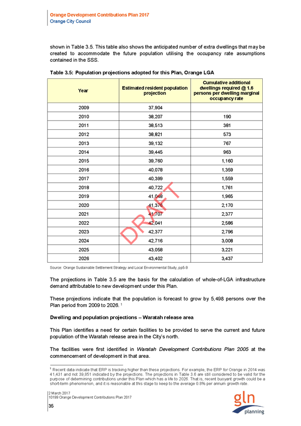
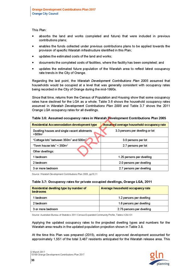
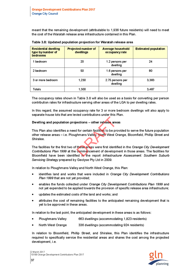
4 Update
growth figures to 5,498 people;
5 Clergate
Road deleted from Waratah Local area and transferred to Roads and Traffic
Management schedule;
6 Correct
formula irregularities within various schedules;
7 Update
m2 rate for open space improvements within various schedules;
8 Correct
incorrect costs of Valencia Drive and Gorman Road construction;
9 Work
map incorrect.
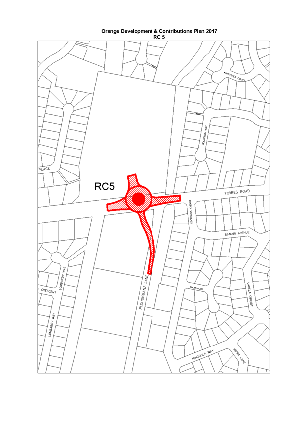
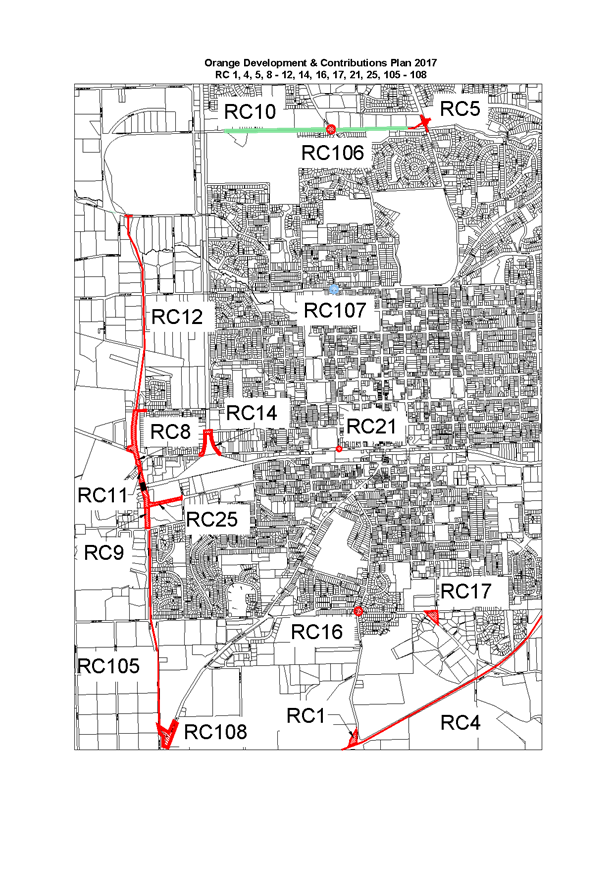
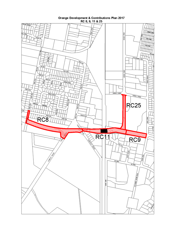
New Works
Since the adoption of the 2015 Plan, Council has identified
new projects within the City and some of these have been included in the 2017
Plan. These include:
1 Sporting
Precinct off the North Orange Bypass;
2 Conservatorium
of Music preliminary works;
3 Blowes/Dairy
Ck Road upgrade;
4 Intersection
Dairy Ck Road and the Mitchell Highway;
5 Roundabout
at the intersection Matthews Avenue and Hill Street;
6 Roundabout
and road deviation Hill Street/NDR/William Maker Drive.
COST OF WORKS
The cost of all projects within the Plan have been updated
in line with current estimates.
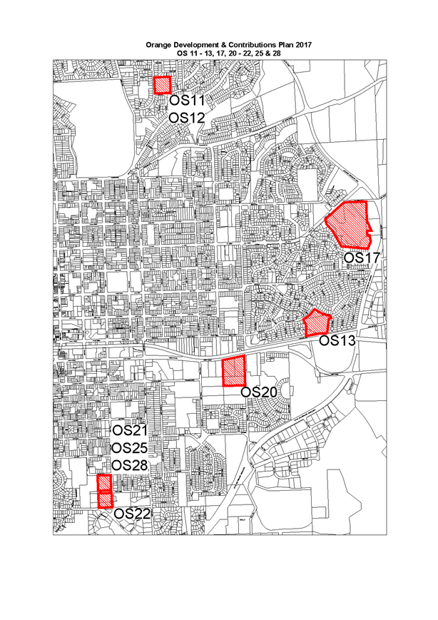
WORK MAPS
All work maps have been updated the above works and to
correct incorrect information identified by the Heath Consulting Engineers
submission.
DEFERRED
OR PERIODIC PAYMENT OF CONTRIBUTIONS
In November 2013, Council
resolved to enter a voluntary planning agreement to trial an alternative
mechanism in deferring developer contributions.
The trial followed a developer meeting held that year where
the key issue related to contribution payments being required at the time of
the release of a subdivision certificate. Developers described this payment
time as upfront payment of developer contributions (Section 64 and 94) and
raised this as an impediment to the timely release of vacant residential lots.
In short, the financing of the contribution by developers
had been cited as a limitation for developers to move onto new projects and, in
turn, make more housing available.
The various Orange Development Contributions Plans already
have an option to defer Sec 94 contributions (Sec 2.16 page 26-27), which
includes the requirement for bank guarantees.
Developers had advised that the guarantee does not assist
with the financing of projects in the early stages of development and has
limited the availability of land for residential development. While there were
strong views on this, the level of available land for development does not
support this view.
It is noted that, at the time, some developers cited
policies working in other LGAs, particularly Shoalhaven, where deferments were
operational and did not require a bank guarantee. However, upon checking,
Council only found that deferments are linked to guarantees.
The intention of the Voluntary Planning Agreement in the
trial was to provide flexibility to Council to negotiate new terms to assist
with the release of residential lots while maintaining legally enforceable
catchpoints for the collection of contributions. In short, it was a
caveat-arrangement to replace bank guarantees.
While the trial did proceed, the developer in this case has
not sought further deferrals under the pilot arrangements. Nor has there been
strong developer industry interest in joining the pilot.
Attachments
1 DRAFT
Orange Development Contributions Plan 2017 - with schedules, D17/17320⇩
2 DRAFT
Orange Development Contribution Plans 2017 - Works Maps, D17/19040⇩
Planning and Development Committee
4 April 2017
2.2 Section
94 Orange Development Contributions Plan 2017
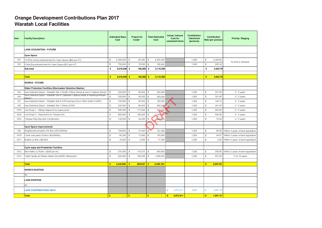
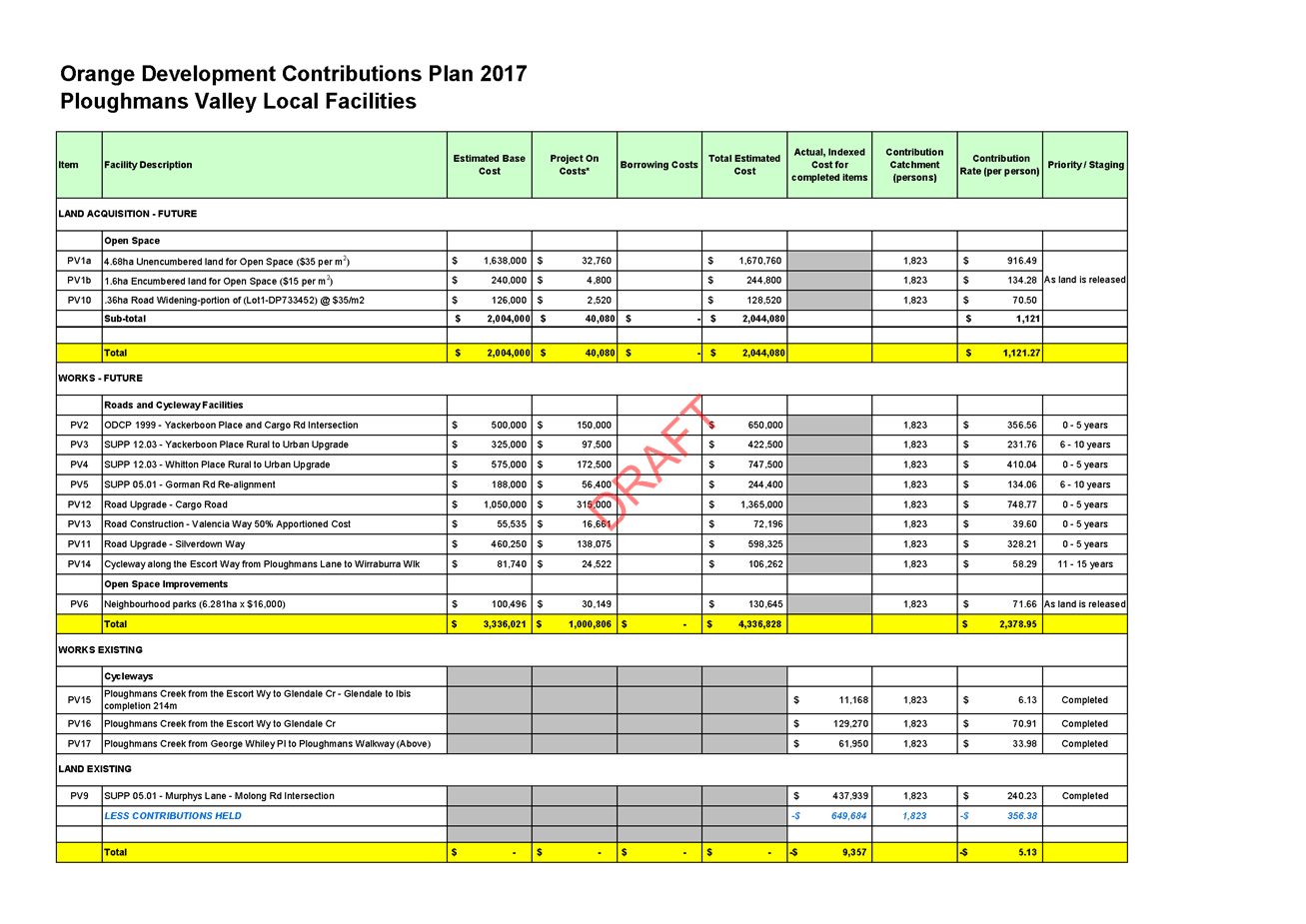
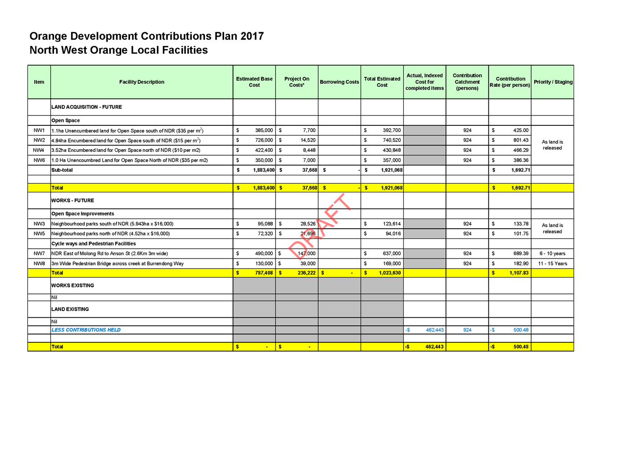
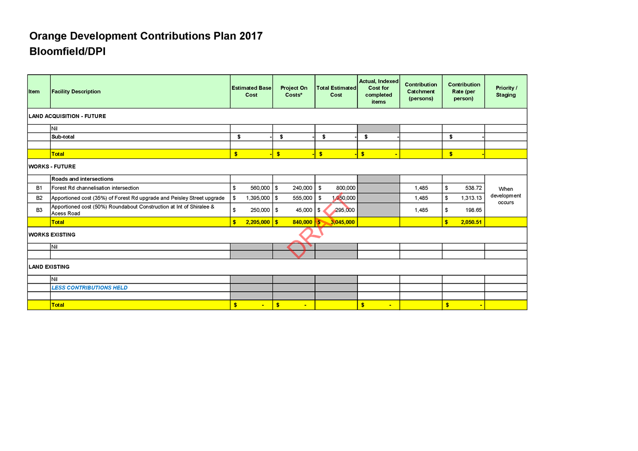
Attachment 1 DRAFT
Orange Development Contributions Plan 2017 - with schedules


Planning and Development Committee
4 April 2017
2.2 Section
94 Orange Development Contributions Plan 2017
Attachment 1 DRAFT
Orange Development Contributions Plan 2017 - with schedules
Planning and Development Committee
4 April 2017
2.2 Section
94 Orange Development Contributions Plan 2017
Attachment 1 DRAFT
Orange Development Contributions Plan 2017 - with schedules
Planning and Development Committee
4 April 2017
2.2 Section
94 Orange Development Contributions Plan 2017
Attachment 1 DRAFT
Orange Development Contributions Plan 2017 - with schedules
Planning and Development Committee
4 April 2017
2.2 Section
94 Orange Development Contributions Plan 2017
Attachment 1 DRAFT
Orange Development Contributions Plan 2017 - with schedules
Planning and Development Committee
4 April 2017
2.2 Section
94 Orange Development Contributions Plan 2017
Attachment 1 DRAFT
Orange Development Contributions Plan 2017 - with schedules
Planning and Development Committee
4 April 2017
2.2 Section
94 Orange Development Contributions Plan 2017
Attachment 1 DRAFT
Orange Development Contributions Plan 2017 - with schedules
Planning and Development Committee
4 April 2017
2.2 Section
94 Orange Development Contributions Plan 2017
Attachment 1 DRAFT
Orange Development Contributions Plan 2017 - with schedules
Planning and Development Committee
4 April 2017
2.2 Section
94 Orange Development Contributions Plan 2017
Attachment 1 DRAFT
Orange Development Contributions Plan 2017 - with schedules
Planning and Development Committee
4 April 2017
2.2 Section
94 Orange Development Contributions Plan 2017
Attachment 1 DRAFT
Orange Development Contributions Plan 2017 - with schedules
Planning and Development Committee
4 April 2017
2.2 Section
94 Orange Development Contributions Plan 2017
Attachment 1 DRAFT
Orange Development Contributions Plan 2017 - with schedules
Planning and Development Committee
4 April 2017
2.2 Section
94 Orange Development Contributions Plan 2017
Attachment 1 DRAFT
Orange Development Contributions Plan 2017 - with schedules
Planning and Development Committee
4 April 2017
2.2 Section
94 Orange Development Contributions Plan 2017
Attachment 2 DRAFT
Orange Development Contribution Plans 2017 - Works Maps
Planning and Development Committee
4 April 2017
2.2 Section
94 Orange Development Contributions Plan 2017
Attachment 2 DRAFT
Orange Development Contribution Plans 2017 - Works Maps
Planning and Development Committee
4 April 2017
2.2 Section
94 Orange Development Contributions Plan 2017
Attachment 2 DRAFT
Orange Development Contribution Plans 2017 - Works Maps
Planning and Development Committee
4 April 2017
2.2 Section
94 Orange Development Contributions Plan 2017
Attachment 2 DRAFT
Orange Development Contribution Plans 2017 - Works Maps
Planning and Development Committee
4 April 2017
2.2 Section
94 Orange Development Contributions Plan 2017
Attachment 2 DRAFT
Orange Development Contribution Plans 2017 - Works Maps
Planning and Development Committee
4 April 2017
2.2 Section
94 Orange Development Contributions Plan 2017
Attachment 2 DRAFT
Orange Development Contribution Plans 2017 - Works Maps
2.3 Development
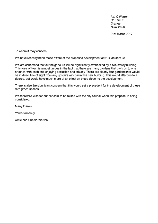
Application DA 4/2016(1) - 61B Moulder Street
TRIM
REFERENCE: 2017/503
AUTHOR: Kelly
Walker, Town Planner
EXECUTIVE Summary
Council's consent is sought for additions and alterations to
an existing dwelling at Lot 13 DP 1037756
- 61B Moulder Street, Orange.
The application was originally considered at the Planning
and Development Committee meeting on 7 March 2017, and was deferred by members
so that a site inspection could be undertaken. The site inspection was carried
out on 21 March 2017. Three additional submissions were received following the
last Committee meeting, and another following the site inspection. One of the submissions
is supplementary to an original submission, and the other three are from
additional neighbours. These submissions do not raise any issues that had not
already been covered in the original report.
Since the previous Committee meeting, Council has adopted a
policy document in relation to infill development in Conservation Areas; Development
Control Plan 2004 Infill Guidelines, which has been taken into
consideration in the Development Control Plan (DCP) section of this report. It
is concluded that the proposed development complies with the objectives of the
policy.
The proposal involves internal
alterations and the addition of an upper floor. The upper floor will consist of
two bedrooms, a study and a bathroom, with a new internal stairway which
provides access. The ground floor will consist of a master bedroom with ensuite
and walk in robe, an open plan kitchen, dining and sitting room, and a laundry.
The double garage remains unchanged. It is proposed to replace the
existing roof tiles with Colorbond material in ‘Monument’ colour.
‘Volcanic Ash’ is proposed for the walls of the existing dwelling
and the additions.
Amenity concerns have been raised by neighbouring properties
in regards to overlooking, privacy, daylighting, noise, and impacts to
heritage. The proposed development departs from the bulk and scale guidelines
set out in the Orange Development Control Plan 2004 (DCP), however it is
considered that the resulting impacts can be mitigated by way of conditions of
consent, and the proposal complies with the overriding planning outcomes of the
DCP, as well as the tests applied by the Land and Environment Court when
considering departures from numerical requirements of planning controls. Whilst
the proposed first floor addition would be visible from neighbouring sites, the
sensitive architectural design and recessive colour scheme of the proposal
ensures that the development would not have significant or adverse impacts on
the surrounding neighbourhood.
It is important to recognise that neither the new Infill
Guidelines, or the DCP and Orange Local Environmental Plan 2011 (LEP) require
land to be viewed in isolation within the heritage Conservation Area. The
guidelines states that development does not have to replicate the existing
built form, but should be compatible. Furthermore, just because a development
is visible from nearby properties does not result in the proposal being
inappropriate.
It is considered that the architectural design (such as the
addition being recessed into the existing roof, low ceiling height,
articulation, recessive colour scheme, and window positioning and design), and
number of amendments during the assessment phase of this application, and those
that will be required by conditions of consent, adequately ameliorate impacts
from the proposed development so that it will not adversely impact on the
surrounding environment.
The application is recommended for approval.
Link To Delivery/OPerational Plan
The recommendation in this report relates to the
Delivery/Operational Plan strategy “13.4 Our Environment – Monitor
and enforce regulations relating to City amenity”.
Financial Implications
Nil
Policy and Governance Implications
Nil
|
Recommendation
That Council consents to
development application DA 4/2016(1)
for Dwelling Alterations and Additions at Lot 13 DP 1037756 -
61B Moulder Street, Orange pursuant to the conditions
of consent in the attached Notice of Approval.
|
further considerations
Consideration has been given to the recommendation’s
impact on Council’s service delivery; image and reputation; political;
environmental; health and safety; employees; stakeholders and project
management; and no further implications or risks have been identified.
SUPPORTING INFORMATION
THE APPLICATION/PROPOSAL
Council's consent is sought for additions and alterations to
an existing dwelling at Lot 13 DP 1037756
- 61B Moulder Street, Orange.
The proposal involves internal
alterations and the addition of an upper floor. The upper floor will consist of
two bedrooms, a study and a bathroom, with a new internal stairway which
provides access. The ground floor will consist of a master bedroom with ensuite
and walk in robe, an open plan kitchen, dining and sitting room, a laundry and
a toilet. The double garage remains unchanged. It is proposed to replace
the existing roof tiles with Colorbond material in ‘Monument’
colour. ‘Volcanic Ash’ is proposed for the walls of the existing
dwelling and the additions.
Amended drawings were submitted following the initial
lodgement of the application, which removes the ground floor toilet and inserts
a new sliding door on the eastern elevation.
MATTERS FOR CONSIDERATION
Section 5A Assessment
In the administration of Sections 78A, 79B, 79C, 111 and
112, the provisions of Section 5A must be taken into account for every
development application in deciding whether there is likely to be a significant
effect on threatened species, populations or ecological communities or their
habitats. This section includes a requirement to consider any adopted
assessment guidelines, which means assessment guidelines issued and in force
under Section 94A of the Threatened Species Conservation Act 1995.
Assessment guidelines are in force (see DECC-W “Threatened Species
Assessment Guidelines - The Assessment of Significance”) which requires
consent authority to adopt the precautionary principle in its assessment.
In this instance, site inspection reveals that the subject
property has no biodiversity or habitat value.
Section 79C
Section 79C of the Environmental Planning and Assessment
Act 1979 requires Council to consider various matters, of which those
pertaining to the application are listed below.
PROVISIONS OF ANY ENVIRONMENTAL
PLANNING INSTRUMENT s79C(1)(a)(i)
Orange Local Environmental Plan 2011
Part 1 - Preliminary
Clause 1.2 - Aims of Plan
The
broad aims of the LEP are set out under subclause 2. Those relevant to the
application are as follows:
(a) to encourage development which complements
and enhances the unique character of Orange as a major regional centre boasting
a diverse economy and offering an attractive regional lifestyle,
(b) to provide for a range of development
opportunities that contribute to the social, economic and environmental
resources of Orange in a way that allows present and future generations to meet
their needs by implementing the principles for ecologically sustainable
development,
(e) to provide a range of housing choices in
planned urban and rural locations to meet population growth,
(f) to recognise and manage valued
environmental heritage, landscape and scenic features of Orange.
The application is considered to be generally consistent
with these aims, where the proposed development increases the range of housing
choice in the City in a way that does not impact on the heritage values of the
area.
Clause 1.6 - Consent Authority
This clause establishes that, subject to the Act, Council is
the consent authority for applications made under the LEP.
Clause 1.9A - Suspension of
Covenants, Agreements and Instruments
This clause provides that covenants, agreements and other
instruments which seek to restrict the carrying out of development do not apply
with the following exceptions:
· covenants imposed or
required by Council
· prescribed instruments
under Section 183A of the Crown Lands Act 1989
· any conservation
agreement under the National Parks and Wildlife Act 1974
· any trust agreement
under the Nature Conservation Trust Act 2001
· any property vegetation
plan under the Native Vegetation Act 2003
· any biobanking agreement
under Part 7A of the Threatened Species Conservation Act 1995
· any planning agreement
under Division 6 of Part 4 of the Environmental Planning and Assessment Act
1979.
The land is subject to a number of easements relating to
access, services and drainage, however, these will not be affected by the
proposed development. Council staff are not aware of the title of the subject
property being affected by any of the other above instruments.
Mapping
The subject site is identified
on the LEP maps in the following manner:
|
Land Zoning Map:
|
Land zoned R1 General Residential
|
|
Lot Size Map:
|
No Minimum Lot Size
|
|
Heritage Map:
|
Not a heritage item, but is located
within a Conservation Area
|
|
Height of Buildings Map:
|
No building height limit
|
|
Floor Space Ratio Map:
|
No floor space limit
|
|
Terrestrial Biodiversity Map:
|
No biodiversity sensitivity on the
site
|
|
Groundwater Vulnerability Map:
|
Ground water vulnerable
|
|
Drinking Water Catchment Map:
|
Not within the drinking water
catchment
|
|
Watercourse Map:
|
Not within or affecting a defined
watercourse
|
|
Urban Release Area Map:
|
Not within an urban release area
|
|
Obstacle Limitation Surface Map:
|
No restriction on building siting
or construction
|
|
Additional Permitted Uses Map:
|
No additional permitted use applies
|
Those matters that are of relevance are addressed in detail
in the body of this report.
Part 2 - Permitted or Prohibited Development
Land
Use Zones
The subject site is located within the R1 General
Residential zone. The proposed development is described as a ‘dwelling
house’ under the LEP 2011, which is defined as follows:
dwelling
house means a building containing
only one dwelling.
A dwelling house is permitted with consent for this zone.
This application is seeking consent to undertake additions and alterations to
an existing dwelling house.
Clause
2.3 of LEP 2011 references the Land Use
Table and Objectives for each zone in LEP 2011. These objectives
for land zoned R1 General Residential are as follows:
· to provide for
the housing needs of the community
· to provide for
a variety of housing types and densities
· to enable other
land uses that provide facilities or services to meet the day to day needs of
residents
· to ensure
development is ordered in such a way as to maximise public transport patronage
and encourage walking and cycling in close proximity to settlement
· to ensure that
development along the Southern Link Road has an alternative access.
The proposed addition to the
dwelling provides additional living space to an existing dwelling, providing
for the needs of the community, and adding to the variety of housing types and
densities. The subject site is within easy walking distance to the city centre,
with good access to public transport and cycling routes. The proposal has no
impact on the Southern Link Road.
Part 3 - Exempt and Complying Development
The application is not exempt or complying development.
Part 4 - Principal Development Standards
The
LEP Principal Development Standards do not apply to this application.
Part 5 - Miscellaneous Provisions
5.10 - Heritage Conservation
(1) Objectives
The
objectives of this clause are as follows:
(a) to
conserve the environmental heritage of Orange
(b) to
conserve the heritage significance of heritage items and heritage conservation
areas, including associated fabric, settings and views
(c) to
conserve archaeological sites
(d) to
conserve Aboriginal objects and Aboriginal places of heritage significance.
(4) Effect
of Proposed Development on Heritage Significance
The
consent authority must, before granting consent under this clause in respect of
a heritage item or heritage Conservation Area, consider the effect of the
proposed development on the heritage significance of the item or area
concerned. This subclause applies regardless of whether a heritage management
document is prepared under subclause (5), or a heritage conservation management
plan is submitted under subclause (6).
The
subject site is located within the Central Orange Heritage Conservation Area
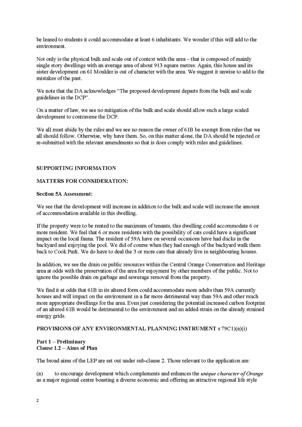
and nearby to listed heritage items, as seen in Figure 1 below (delineated by
brown hashing).
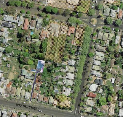
Figure 1 – Heritage listed
properties within vicinity of subject site
The closest listed properties include ‘Mena
Mansion’ at 50 Kite Street and a dwelling at 52 Kite Street, both to
the north-east of the site, as well as a dwelling at 27 Hill Street
to the south-east of the site. Council’s Heritage Database sets out the
following details about these properties.
‘Mena Mansion’ at 50 Kite Street
“This
symmetrical masonry residence with curved return verandah was built for
Thomas Dalton by his father James, and is a significant example of the
Irish legacy and a manifestation of their confident outlook while complementing
the streetscape and contributing to the Conservation Area within the city as a
heritage item.
Mena,
which may have been designed by architect, Benjamin Backhouse, was built in
1875… James Dalton was a very prominent Orange merchant and pastoralist
and townsman; he was at one time mayor of Orange and the Dalton family was one
of the most influential Catholic families in New South Wales.
Some
of the early tree plantings in the back garden are common Poplars reaching more
than 30 metres. A tortured Willow at the rear of the Stables is well over 100
years old and Robinia flank the boundaries on all sides.
The
current owners have reshaped the front garden and many parts in the rear,
adding more varieties and species overall, making the garden a finely manicured
formal garden with many leafy trees acting as canopy over the property”.
Dwelling at 52 Kite Street
“An
attractive Victorian-style residence which has retained the original character
and distinctive details, including mouldings, verandah and barge boards, the
property was the home of Sir Charles and Lady Cutler. Sir Charles was leader of
the Country party, Minister for Education, and Deputy Premier of NSW”.
Dwelling at 27 Hill Street
“A fine late Victorian residence with double
fronted plan, surround verandah and elaborate triple posted porch and venetian
fenestration, the building and garden complement the streetscape and contribute
to the Conservation Area as a heritage item”.
The
Orange City Council Community Based Heritage Study, dated March 2012 states
that Central Orange Heritage Conservation Area consists of a “range of
buildings dating from the nineteenth century and the early part of the
twentieth, and has historical importance for reflecting the development and
prosperity of Orange during this period. The conservation area exhibits several
fine examples of different architectural styles. The building materials used
the mature street trees and the fine parklands all help to bring the area
together as an aesthetically pleasing whole and as a townscape of
importance”.
The
Study states that the Conservation Areas are
to be considered as whole heritage items in their own right, where the
character comes from many components, such as buildings, landscape elements,
fences, roads, etc., and the relationships formed between these components.
Most
of the dwellings surrounding the subject site are not individually listed, but
are considered to be ‘contributory items’. These dwellings represent
an integral component of the Conservation Area, tend to date from the key
periods of development, and generally have a high level of intactness. However,
the subject dwelling, as well as the dwellings nearest to it, are neither
listed heritage items nor contributory items, but are considered to be
‘neutral’ buildings located within the Conservation Area. The study
applies the following controls to alterations and additions to
‘neutral’ buildings:
· individual buildings
as ‘neutral’ are to be retained and enhanced unless it can be
demonstrated that their removal will not compromise the significance of the
area;
· where retention is
proposed the original form of the building is to be respected. Alterations and
additions are not to dominate the original building form, but enhance it;
· where demolition is
proposed, justification for the removal of the building is to be demonstrated
in accordance with standard submission requirements for Demolition.
The
proposed development seeks to both retain and enhance the existing dwelling.
The proposed first floor addition matches the form and detailing of the
existing building, and has been designed to be smaller in scale than the ground
floor, being set back from the existing building lines. It is also set back
from neighbouring dwellings. Having regards to these controls, it is considered
that the proposed additions and alterations enhance the existing dwelling and
complement the original built form.
The
proposed change in roof material is considered acceptable, where it is
consistent with other modern neutral dwellings in the area. The dark colour
‘Monument’ for the roof, and ‘Volcanic Ash’ for the
walls are considered appropriate recessive colours in the Conservation Area. It
is also considered that the new colours are more appropriate than the existing
colour scheme of the dwelling.
The
Study observes that most items within a
Conservation Area will be able to grow and change to accommodate contemporary
needs, provided those changes are designed to also maintain the contribution of
the property to the heritage significance of the Conservation Area. The subject
dwelling as a ‘neutral’ building does not specifically contribute
to the Conservation Area, and it is considered that the proposed additions and
alterations will not impact on the buildings that do contribute, specifically
the nearby listed buildings. The subject dwelling and its proposed additions
will not be easily seen within the context of the neighbouring listed buildings
due to siting and separation distances. Furthermore, the proposal will not be
readily visible from the street, and will not impact on the built form of the
streetscape that contributes to the Conservation Area.
Overall,
it is considered that the proposal will have negligible impacts on the heritage
values of the Conservation Area and nearby listed buildings.
Part 6 - Urban Release Area
Not relevant to the application. The subject site is not
located in an Urban Release Area.
Part 7 - Additional Local Provisions
7.3
- Stormwater Management
This clause applies to all
industrial, commercial and residential zones and requires that Council be
satisfied that the proposal:
(a) is designed to maximise the use of water
permeable surfaces on the land having regard to the soil characteristics
affecting onsite infiltration of water
(b) includes, where practical, onsite
stormwater retention for use as an alternative supply to mains water,
groundwater or river water, and
(c) avoids any significant impacts of
stormwater runoff on adjoining downstream properties, native bushland and
receiving waters, or if that impact cannot be reasonably avoided, minimises and
mitigates the impact.
The
proposal does not seek to alter the existing permeable and non-permeable areas
on the site. There will be a slight increase in the massing of the roof,
however it is considered that the post development runoff levels will be
similar to pre-development
levels. Overall, the proposal is considered acceptable in regards to stormwater
management.
7.6 - Groundwater Vulnerability
This
clause seeks to protect hydrological functions of groundwater systems and
protect resources from both depletion and contamination. Orange has a high
water table and large areas of the LGA, including the subject site, are
identified with “Groundwater Vulnerability” on the Groundwater
Vulnerability Map.
This
requires that Council consider:
(a) whether or not the development (including
any onsite storage or disposal of solid or liquid waste and chemicals) is
likely to cause any groundwater contamination or have any adverse effect on
groundwater dependent ecosystems, and
(b) the cumulative impact (including the
impact on nearby groundwater extraction for potable water supply or stock water
supply) of the development and any other existing development on groundwater.
Furthermore, consent may not be granted unless Council is satisfied that:
(a) the development is designed, sited and
will be managed to avoid any significant adverse environmental impact, or
(b) if that impact cannot be reasonably
avoided - the development is designed, sited and will be managed to minimise
that impact
(c) if that impact cannot be minimised - the
development will be managed to mitigate that impact.
The proposal is not anticipated
to involve the discharge of toxic or noxious substances and is therefore
unlikely to contaminate the groundwater or related ecosystems. The proposal
does not involve extraction of groundwater and will therefore not contribute to groundwater depletion. The design and siting of the
proposal avoids impacts on groundwater and is therefore considered acceptable.
STATE ENVIRONMENTAL PLANNING
POLICIES
State Environmental Planning
Policy 55 - Remediation of Land
Under Clause 7 of State Environmental Planning Policy 55
- Remediation of Land (SEPP 55), Council must consider whether the
land is contaminated and whether the land requires any form of remediation to
render it suitable for the purpose to which it is proposed to be used. The
previous land uses must be considered, along with any visible or tangible
evidence on the site. Clause 7 of SEPP 55 provides as follows:
A consent authority must not consent to the carrying out of any
development on land unless:
(a) it has considered whether the land is
contaminated, and
(b) if the land is contaminated, it is
satisfied that the land is suitable in its contaminated state (or will be
suitable, after remediation) for the purpose for which the development is
proposed to be carried out, and
(c) if the land requires remediation to be
made suitable for the purpose for which the development is proposed to be
carried out, it is satisfied that the land will be remediated before the land
is used for that purpose.
In
consideration of this clause, the subject land has longstanding residential
use, is not listed on Council’s Contaminated Land Register, nor known to
be used for a purpose referred to in Table 1 to the Contaminated Land
Planning Guidelines. As such, the land is unlikely to be contaminated. Furthermore,
the proposal involves alterations internal to, and an addition above, the
existing dwelling, with very little earth disturbance required.
On the basis of the available evidence, it is considered
that the site is suitable for the proposed use and no further preliminary
investigation is required to satisfy the requirements of SEPP 55.
State Environmental Planning
Policy (Building Sustainability Index: BASIX) 2004
SEPP (Building Sustainability Index: BASIX) 2004 applies to
the subject development. Clause 3 states in part:
(a) an application for a
development consent, complying development certificate or construction
certificate in relation to certain kinds of residential development must be
accompanied by a list of commitments by the applicant as to the manner in which
the development will be carried out, and
(b) the carrying out of residential
development pursuant to the resulting development consent, complying
development certificate or construction certificate will be subject to a
condition requiring such commitments to be fulfilled.
In consideration of this clause, a BASIX certificate has
been submitted in support of the development. The proposed dwelling will
satisfy the provisions of BASIX in respect of water, thermal comfort and
energy.
PROVISIONS OF ANY DRAFT
ENVIRONMENTAL PLANNING INSTRUMENT THAT HAS BEEN PLACED ON EXHIBITION
s79C(1)(a)(ii)
There are no draft environmental planning instruments that
apply to the subject land or proposed development.
DESIGNATED DEVELOPMENT
The proposed development is not designated development.
INTEGRATED DEVELOPMENT
The proposal is not integrated development.
PROVISIONS OF ANY DEVELOPMENT
CONTROL PLAN s79C(1)(a)(iii)
Development Control Plan 2004
Development Control Plan 2004 (“the DCP”)
applies to the subject land. An assessment of the proposed development against
the relevant Planning Outcomes will be undertaken below.
Chapter 7 - Development in
Residential Areas
Neighbourhood Character
The DCP sets the following Planning Outcomes in regard to
Neighbourhood Character:
· Site layout and
building design enables the:
- creation of attractive
residential environments with clear character and identity
- use of site features such as
views, aspect, existing vegetation and landmarks
· Buildings are
designed to complement the relevant features and built form that are identified
as part of the desired neighbourhood character.
· The streetscape
is designed to encourage pedestrian access and use.
The surrounding residential precinct is predominately
characterised by large single dwelling houses at the frontage of Hill
Street, and smaller single dwellings located at the frontage of Moulder Street.
Most of these houses have heritage value, being within the Heritage
Conservation Area, with a few listed buildings in the surrounds. Typically,
lots on Hill Street and Kite Street are large and long, whereas the lots on
Moulder Street have been subdivided up over the past few decades, with a few
unit developments behind the original front dwellings (See Figure 1). The subject
site is an example of this type of development.
The proposed additions and alterations to the existing
dwelling do not significantly alter the existing pattern of infill dwelling on
the site or within the surrounding area. The first floor addition will
complement the built form of the existing house and the site in respect of
massing, footprint, and external finishes. The proposed colour scheme uses
recessive colours that will not dominate the heritage values and residential
amenity of the surrounding area. The proposal is unlikely to create a precedent
for further first floor additions in the area, as this form of development is
only feasible for a few houses within the street, and as such would not become
a dominant pattern. Overall, it is considered that the proposed development
complements the neighbourhood character.
Building Appearance
The DCP sets the following Planning Outcomes in regard to
Building Appearance:
· the building
design, detailing and finishes relate to the desired neighbourhood character,
complement the residential scale of the area, and add visual interest to the
street
· the frontages
of buildings and their entries face the street
· garages and car
parks are sited and designed so that they do not dominate the street frontage.
The design, detailing, and colours for the proposed
additions and alterations match the existing dwelling, are appropriate in this
neighbourhood, and will complement the streetscape. The dwelling does not
address the street, being the third unit back from Moulder Street, and is not
easily visible from the streetscape, with the exception of a view viewpoints
such as directly at the end of the driveway. No changes are proposed to the
existing double garage.
Heritage
The DCP sets the following Planning Outcomes in regard to
Heritage:
· heritage
buildings and structures are efficiently re-used
· new development
complements and enhances the significance of a heritage item or place of
heritage significance listed in the Orange Heritage Study
· significant
landscape features are retained including original period fences and
period gardens.
Heritage has been discussed in detail in the LEP assessment
earlier in this report. The discussion concludes that the proposed development
will not impact on the heritage values of the area.
Setbacks
The DCP sets the following Planning Outcomes in regard to
Setbacks:
· street setbacks
contribute to the desired neighbourhood character, assist with the integration
of new development and make efficient use of the site
· street setbacks
create an appropriate scale for the street considering all other
streetscape components.
No changes are proposed to the existing ground floor
building footprint, and therefore the existing setbacks from the street and
boundaries will be retained.
Visual Bulk
The DCP sets the following Planning Outcome in regard to
Visual Bulk:
· Built form
accords with the desired neighbourhood character of the area with:
- side and rear setbacks
progressively increased to reduce bulk and overshadowing
- site coverage that retains
the relatively low density landscaped character of residential areas
- building form and siting
that relates to landform, with minimal land shaping (cut and fill)
- building height at the
street frontage that maintains a comparable scale with the predominant adjacent
development form
- building to the boundary
where appropriate.
The NSW Land and Environment Court decision of Veloshin v
Randwick Council [2007] NSWLEC 428 sets out planning principles for height
and bulk which can be applied to this development. In that decision, Senior
Commissioner Dr John Roseth states “the appropriateness of a
proposal’s height and bulk is most usefully assessed against planning
controls related to these attributes, such as maximum height, floor space ratio,
site coverage and setbacks. The questions to be asked [where planning
controls apply] are:
- are the impacts consistent
with impacts that may be reasonably expected under the controls?
- how does the
proposal’s height and bulk relate to the height and bulk desired under
the relevant controls?
- does the area have a
predominant existing character and are the planning controls likely to maintain
it?
- does the proposal fit into
the existing character of the area?”
The proposed dwelling will not be contained within the DCP
prescribed visual bulk envelope plane, with encroachments on the eastern and
western elevations. These encroachments appear fairly substantial, with the
western elevation encroaching between 1.4-1.6m for a length of 11.5m, and
the eastern elevation encroaching 0.6m for a length of 2.35m.
In this case, the encroachments are considered acceptable
because the immediate neighbouring dwellings are offset from the subject
dwelling. The design utilises the form of the existing roof to partially recess
the first floor, thus providing visual relief to the bulk of the addition. In
particular, the elevations have been recessed back from the front building
line, and steps back from some of the side building lines to separate the main
bulk of the building from neighbouring dwellings. Additionally, the application
proposes a dark recessive roof colour, and a neutral recessive wall colour,
which assist in reducing visual prominence.
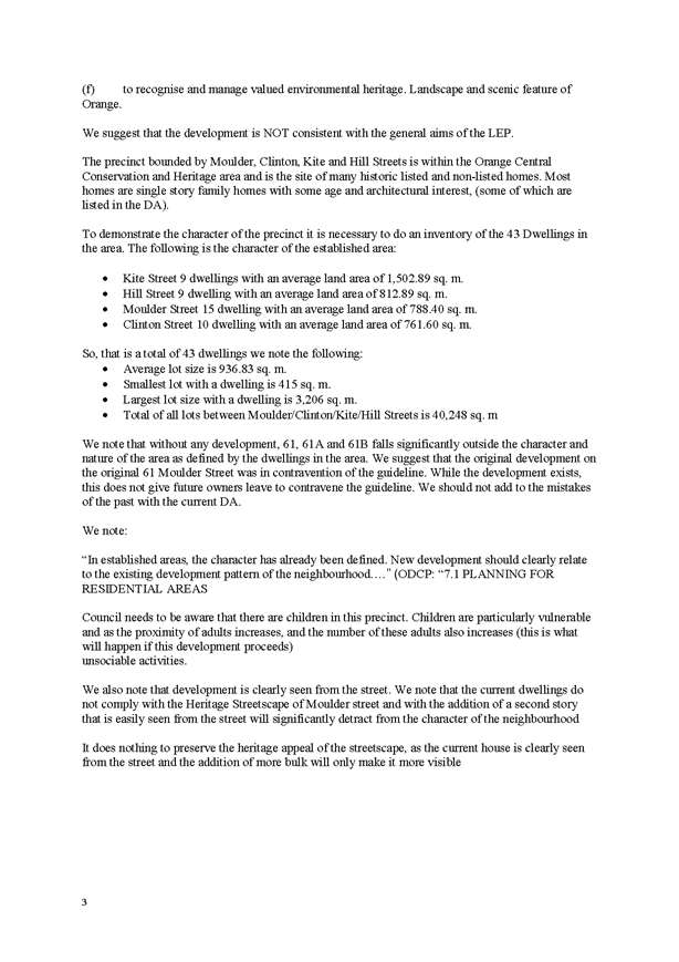
The neighbouring dwellings are well separated from the first
floor addition, with the closest eastern dwelling (35 Hill Street) being over
50m away, and the closest western dwelling (59A Moulder Street) being
approximately 24m away (see Figure 2). This design results in the massing being
distributed to reduce impacts, which is consistent with the planning principles
set out in the case law. Furthermore, the dwelling will maintain its existing
setbacks from the boundaries, where there are no alterations to the existing
ground floor footprint of the dwelling. As such, the existing site coverage and
areas of open space and vegetation will remain unchanged, which was assessed in
the original application to create the dual occupancy to be acceptable.
No maximum height or floor space ratios apply to this site
based on the current LEP and DCP standards, however it was considered in the
original application that the height and floor space ratio was well below the
standards required in the previous DCP which it was assessed against at the
time. The proposed development will meet the previous DCP standards, as well as
the current DCP planning objectives, and it is considered that the overall
height, roof pitch, and additional floor area are reasonable for this
neighbourhood.
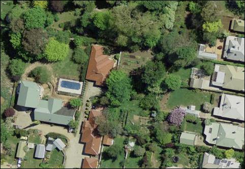
Figure 2 – Aerial photograph showing
subject dwelling in relation to neighbouring dwellings
It is considered that the current DCP planning controls are
an appropriate means to maintain the existing character of the area. The
planning principle question of existing character has been addressed earlier in
the DCP assessment, where it was considered that the proposal complements the
character of the neighbourhood.
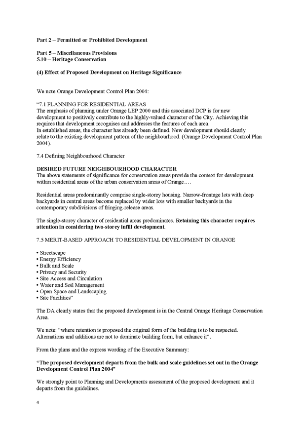
It is noted that there are a few other examples of
two storey dwellings in the surrounding area, including:
· 59A Moulder Street
immediately adjacent (west) of the subject site;
· 48 Kite Street to
the immediate north (see Figure 3);
· 45 Moulder Street
to the west;
· 84 Moulder Street
to the east (see Figure 3); and
· 36 and 48 Hill
Street to the northeast (see Figure 4).
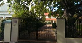

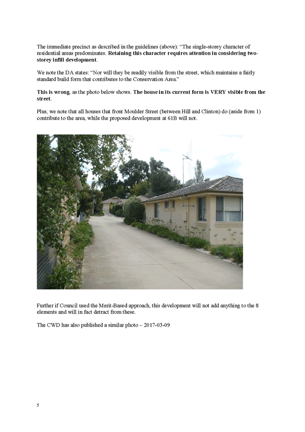
Figure 3 – Photographs of two storey
dwellings at 48 Kite (left) and 84 Moulder (right) Streets


Figure 4 – Photographs of two storey
dwellings at 36 (left) and 48 (right) Hill Street
These two storey dwellings are considered generally suitable
for the Conservation Area and the neighbourhood. With the exception of number
84 Moulder Street, the upper levels are set back from the front boundary, and
are not readily noticeable when viewed within the streetscape (see Figures 3
and 4). These examples are comparable to the subject proposal, which is also
set back from the street, but also set behind other dwellings. There are also
numerous large heritage houses in the neighbourhood which have high ridgelines.
As such, the proposal is considered to respect the bulk and scale of adjacent
dwellings.
It is acknowledged that the immediate neighbouring
properties will have an altered outlook, where the subject dwelling will be
increased in bulk and scale, and the addition will be visible from some of the
neighbouring sites. However, it is considered that the visual impacts resulting
from the proposed additions and alterations are acceptable and reasonable given
the architectural design and features of the addition, including the recessive
colour scheme. Overall it is considered that the proposal meets the planning
objectives for bulk and scale. Other potential impacts such as overshadowing
and privacy are addressed in greater detail in the following outcomes below.
Walls and Boundaries
The DCP sets the following Planning Outcome in regard to
Walls and Boundaries:
· Building to the
boundary is undertaken to provide for efficient use of the site taking into
account:
- the privacy of neighbouring
dwellings and private open space
- the access to daylight
reaching adjoining properties
- the impact of boundary walls
on neighbours.
As mentioned above, the proposal maintains existing setbacks
from the boundaries. The first floor addition has the potential to impact on
adjoining properties in respect of privacy and solar access, which is discussed
in detail below.
Daylight and Sunlight
The DCP sets the following Planning Outcome in regard to
Daylight and Sunlight:
· Buildings are
sited and designed to ensure:
- daylight to habitable rooms
in adjacent dwellings is not significantly reduced
- overshadowing of
neighbouring secluded open spaces or main living area windows is not
significantly increased
- consideration of
Council’s Energy Efficiency Code.
In consideration of the DCP Guidelines, the proposal is not
considered to have any adverse daylighting impacts due to the north-south
orientation of the subject site and dwelling, and the design of the proposed
addition being set back from the existing building lines and boundaries. This
is demonstrated in the submitted shadow diagrams, which show the extent of the
additional shadow caused by the first floor addition, and this will create some
minor overshadowing to the western neighbour’s back yard and swimming
pool between 9‑10am on the winter solstice. There is also some minor
shadowing to the eastern neighbour’s vegetable garden at 3pm on the
winter solstice. However, these gardens are extensive in size and as such the
shadowing is minor and acceptable.
Due to the orientation, design and setbacks of the existing
dwelling and proposed addition, there will be no overshadowing impacts to the
area of private open space of the neighbour to the south, and daylighting to
the subject site’s area of private open space will be maintained. As
mentioned in the visual bulk assessment above, the proposed works are well
separated from neighbouring dwellings and as such will not impact on
daylighting to their windows.
Views
The DCP sets the following Planning Outcomes in regard to
Views:
· building form
and design allow for residents from adjacent properties to share prominent
views where possible
· views including
vistas of heritage items or landmarks are not substantially affected by the
bulk and scale of the new development.
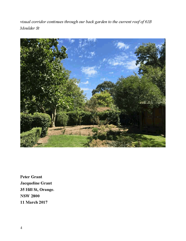
The subject site is not within an important view corridor,
and the iconic landforms of Orange are not visible from the site. As such the
view sharing planning principles are not applicable to this application.
Notwithstanding this, it is acknowledged that residents in the area enjoy
vistas of extensive mature vegetation, and the increased bulk and scale of the
subject dwelling will result in a changed outlook to this vista. A number of
neighbouring properties would only have filtered views of the proposal through
the existing vegetation, even when taking into account season variation in foliage.
For those properties who will be able to see the proposed addition, impacts to
the vistas of vegetation will be negligible due to the design, form, and
recessive colours of the proposed addition; as well as the separation distances
between the subject site and the neighbouring dwellings and their areas of
private open space, which has been discussed previously in the DCP assessment.
It is also notes that the proposal does not involve the removal or alteration
of any of the existing vegetation.
Visual Privacy
The DCP sets the following Planning Outcome in regard to
Visual Privacy:
· Direct
overlooking of principal living areas and private open spaces of other
dwellings is minimised firstly by:
- building siting and layout
- location of windows and
balconies
and
secondly by:
- design of windows or use of
screening devices and landscaping.
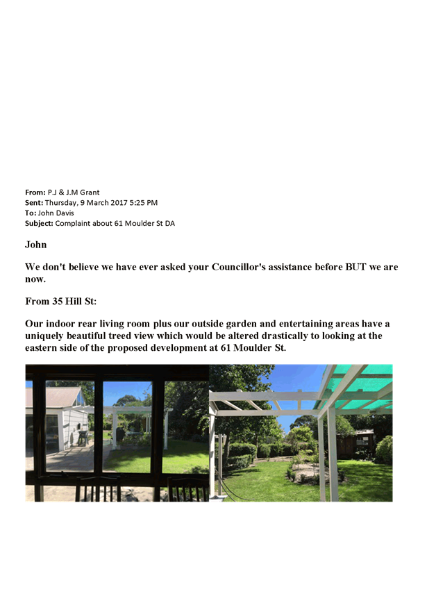
Concerns have been raided in regards to potential
overlooking impacts from the first floor addition into the western
neighbour’s area of private open space and swimming pool. Although not
set out in the DCP, a higher regard is given to visual privacy of existing
neighbouring swimming pools.
The proposal involves new windows on the ground floor
elevation, however there will be a net decrease in the number of windows, and
the existing boundary fence and vegetation will sufficiently maintain privacy.
The first floor addition involves three new western windows, one of which is a
bathroom and the other two belong to a bedroom.
It can be reasonably expected that the bathroom window will
be constructed using obscured glazing or similar, and therefore overlooking
impacts will only arise from the bedroom windows towards the western
neighbour’s back yard and swimming pool. However, these impacts can be
mitigated by way of privacy screens being installed and permanently maintained
over all of the western windows. A condition of consent is recommended to this
effect.
It is considered that the study windows on the eastern
elevation overlooking the neighbour’s vegetable garden are acceptable due
to separation distance to the boundary.
Acoustic Privacy
The DCP sets the following Planning Outcome in regard to
Acoustic Privacy:
· Site layout and
building design:
- protect habitable rooms from
excessively high levels of external noise
- minimise the entry of
external noise to private open space for dwellings close to major noise sources
- minimise transmission of
sound through a building to affect other dwellings.
The site is located in an area where ambient noise levels
are low due to the predominant residential land use pattern. It is not expected
that the proposed development will change these existing noise levels, as there
is only an increase in living floor area, not in bedrooms or expected
occupancy.
Security
The DCP sets the following Planning Outcomes in regard to
Security:
· the site layout
enhances personal safety and minimises the potential for crime, vandalism and
fear
· the design of
dwellings enables residents to survey streets, communal areas and approaches to
dwelling entrances.
The proposal does not alter the existing arrangements in
this regard.
Circulation and Design and Car
Parking
The proposal does not alter the existing circulation,
garages and car parking arrangements on the site. The existing arrangements are
considered acceptable for the proposed development.
Private Open Space
The DCP sets the following Planning Outcomes in regard to
Private Open Space:
· Private open
space is clearly defined for private use.
· Private open
space areas are of a size, shape and slope to suit the reasonable requirements
of residents including some outdoor recreational needs and service functions.
· Private open
space is:
– capable
of being an extension of the dwelling for outdoor living, entertainment and
recreation
– accessible
from a living area of the dwelling
– located
to take advantage of outlooks; and to reduce adverse impacts of overshadowing
or privacy from adjoining buildings
– orientated
to optimise year round use.
Private open space for the
proposed increase in floor will not comply with the DCP Guidelines in
respect of minimum area as set out in the table below:
|
Dwelling
|
Living
Area (ex. Garage, porches, patios etc)
|
Private Open
Space Required by DCP
|
Private Open
Space Provided
|
|
Existing
|
145.86m²
|
72.93m²
|
86m²
|
|
Proposed
|
216.36m²
|
108.18m²
|
86m²
|
No changes are proposed to the existing area of private open
space, and there is no capacity to provide additional open space given the
constraints of the site. The existing arrangements are considered acceptable in
this case due to the following:
· The rear yard will
continue to accommodate an area of 5m x 5m;
· The open space
area will continue to be of negligible slope, to achieve amenity and
functionality;
· The open space
will continue to be located behind the building line, have direct access from
the living areas, and have access to northern sunlight;
· As outlined
previously, appropriate solar access can be maintained to the area of private
open space on the winter solstice; and
· It is not
anticipated that the proposal will increase the occupancy of the existing
dwelling.
Open Space and Landscaping
The DCP sets the following Planning Outcomes in regard to
Open Space and Landscaping:
· The site layout
provides open space and landscaped areas which:
– contribute
to the character of the development by providing buildings in a landscaped
setting
– provide
for a range of uses and activities including stormwater management
– allow
cost effective management.
· The landscape
design specifies landscape themes consistent with the desired neighbourhood
character; vegetation types and location, paving and lighting provided for
access and security.
· Major existing
trees are retained and protected in a viable condition whenever practicable
through appropriate siting of buildings, accessways and parking areas.
· Paving is
applied sparingly and integrated in the landscape design.
No changes are proposed to the existing areas of private
open space and landscaping on the site, which is considered to be acceptable.
Stormwater, Erosion and
Sedimentation
Conditions are recommended in relation to stormwater
management of the site. Earthworks are not expected as part of this
development.
Development Control Plan 2004 Infill Guidelines
The Orange Development
Control Plan 2004 Infill Guidelines apply to this application. Council
recently adopted this policy to guide designs of infill development in heritage
areas, to ensure new development ‘harmonises’ with the character of
the neighbourhood. Residential infill development is important, as it
contributes to the physical and social renewal of the older neighbourhoods,
making better use of existing infrastructure, public facilities and services.
The policy specifically relates to ‘infill’ development, and the
NSW Heritage Office and the Royal Australian Institute of Architects NSW 2005
publication Design in Context defines infill as:
“A new building in an
established and valued historic context. Good infill is building that is
sympathetic to the surrounding buildings and historic context and creates new
structures that enhance and complement the existing urban, suburban or rural
character”.
While the proposed development
does not relate to a new building, it involves a building addition a
Conservation Area and adjacent to a listed heritage item, and therefore the
policy can be used as a guidance tool.
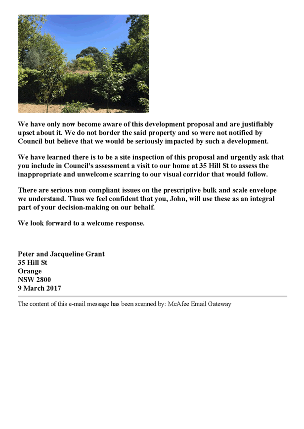
The policy states that an important
aspect of good design is designing in context and having regard to the site and
its surroundings. Consideration should be given to the nature of adjoining and
surrounding heritage items and places, significant vegetation on the site and
adjoining the site, and the overall significance and character of the heritage
area where it is located.
New development within a
Conservation Area should not have to replicate the existing built form, but
should be compatible and enhance the existing streetscape. Contemporary designs
may be acceptable provided the design is appropriate in character, scale and
form, siting, materials and colour, and detailing. Historic character is shaped
by landform, distinctive vegetation, building style and scale, street and subdivision
pattern, fabric, curtilage, setbacks, materials, views, vistas, and pattern and
proportions of buildings.
The setting is varied in terms
of scale, ranging from modest to very grand sized dwellings, both one and two
storey dwellings with varying ridgeline heights, and lots varying greatly in
size and shape. Extensive mature vegetation is fairly consistent in the area.
The proposed additions and alterations do not alter the existing landform;
vegetation; street, building and lot patterns; the fabric of neighbouring
listed buildings and their curtilage; the subject curtilage; or setbacks from
the boundaries or the street. The materials and proportions of the addition
have been designed to match the existing dwelling, neighbouring dwellings, and
the landscape, as discussed in detail in the LEP and DCP assessments of this
report.
The guideline also allows
alternative design solutions that may not meet the prescriptive numerical
standards of the LEP and DCP, but would otherwise satisfy the fundamental objectives.
The objectives of the policy are as follows:
· Retention of
appropriate visual setting (Article 8 Burra Charter).
· To ensure new
buildings respond to and enhance the character and appearance of the
streetscapes of the Heritage Conservation Areas.
· To ensure
contributory heritage items retain their prominence and are not dominated by
new development within a Heritage Conservation Area and do not compromise the
heritage values of the existing area.
· To ensure new
buildings do not adversely affect the significance, character or appearance of
the Heritage Conservation Area or heritage items.
· To allow for
reasonable change within a Heritage Conservation Area while ensuring all other
heritage objectives are met.
· To ensure new
development facilitates the retention of significant vegetation that
contributes to the tree canopy, especially within the Central Orange Heritage
Conservation Area.
It is considered that the applicant has given adequate
consideration to the context of the subject site, the neighbouring properties,
and the surrounding pattern of development, as shown in the submitted plans and
supporting information, and discussed in the LEP and DCP assessments. In
particular:
- The visual
setting will be largely retained, with no more than minor alterations to the
outlook from neighbouring dwellings, and negligible impact on the streetscape;
- The heritage
values of the nearby listed buildings and the Conservation Area will not be
compromised;
- The proposal
allows for a reasonable change to the existing site without impacting on the
heritage objectives of the LEP and DCP; and
- No vegetation
will be lost as a result of the proposal, therefore the existing tree canopy
and significant vegetation will be retained.
Overall it is considered that the proposal is generally
consistent with the standards set out in the DCP, and any impacts are minor and
can be appropriately mitigated.
PROVISIONS PRESCRIBED BY THE
REGULATIONS s79C(1)(a)(iv)
Demolition of a Building (clause 92)
The proposal does not involve some demolition of the
existing building, particularly the removal of roof tiles and windows.
Conditions are recommended requiring demolition works to comply with relevant
standards, guidelines and codes.
Fire Safety Considerations
(clause 93)
The proposal does not involve a change of building use for
an existing building.
Buildings to be Upgraded
(clause 94)
The proposal involves the rebuilding, alteration,
enlargement or extension of an existing building, however no upgrading works
are required in this case.
BASIX Commitments (clause 97A)
A BASIX Certificate was submitted in support of the
proposal. The new dwelling will comply with the provisions of BASIX in respect
of water, thermal comfort and energy.
THE LIKELY IMPACTS OF THE
DEVELOPMENT s79C(1)(b)
Neighbourhood Amenity
The proposed development will provide an improved standard
of residential amenity for the existing dwelling, and maintain a reasonable
standard of amenity to neighbouring properties in respect of visual amenity,
bulk, daylighting etc. Privacy impacts can be mitigated by way of
conditions of consent requiring obscured glazing and/or privacy screens. The
proposed development will provide for a continuation of residential landuse,
albeit in a more dense form, and will not alter the function of the
neighbourhood or the heritage values of the Conservation Area and nearby listed
buildings. Overall, it is considered that the proposed development is unlikely
to have adverse impacts on neighbourhood amenity.
Traffic Impacts
The proposal is considered to be satisfactory in terms of
traffic impacts, where the proposal is unlikely to increase the demand for car
parking or increase traffic movements in the locality. In any case, the
capacity of the local road network is sufficient to accommodate additional
localised traffic. As outlined previously, no changes are proposed to the
existing car parking, garage, and manoeuvring arrangements on site.
Cumulative Impacts
The proposal is considered to be satisfactory in terms of
cumulative impact. The proposal will maintain the pattern of detached dwellings
and unit developments that characterise this streetscape. The proposed addition
will complement the neighbourhood built form in respect of bulk and form,
design features and external finishes. Subject to conditions of consent, the
proposed development will not reduce the open space, solar access or privacy
afforded to neighbouring properties.
Similarly, the site layout and building design will provide
an increased standard of residential amenity for the existing dwelling. The
development will contribute to the diversity of housing forms in the precinct in a manner that is consistent with the neighbourhood
character.
Environmental Impacts
The subject land is contained within an established
residential precinct. Significant vegetation, threatened species or ecological
endangered communities or their habitats are unlikely to be present. Conditions
are recommended in regards to stormwater management.
THE SUITABILITY OF THE SITE
s79C(1)(c)
The subject land is suitable for the proposed development
due to the following:
· dwellings are
permitted land uses in the R1 zone, and the proposal involves additions and
alterations to an existing dwelling
· urban utilities
are available and adequate
· the site is not
subject to known technological or natural hazards
· there
are no physical attributes of the land that would constrain the development
· the land is not
known to be contaminated, and
· the proposed works
will not impact on the streetscape, Conservation Area, or nearby listed
buildings, and impacts to neighbouring properties can be mitigated and are
considered acceptable.
ANY SUBMISSIONS MADE IN
ACCORDANCE WITH THE ACT s79C(1)(d)
The proposed development is not defined as advertised
development under the provisions of the LEP, and as such no formal exhibition
of the application was required. Notwithstanding this, neighbouring properties
were notified of the development and two submissions were received.
Daniel Fock – 59A Moulder
Street
The submission raised concerns regarding visual privacy and
overlooking into their outdoor spaces including the backyard, deck and swimming
pool. The submission requests that the western windows either be removed from
the proposal or have privacy screens. This issue has been dealt with in the DCP
assessment of the report where conditions of consent require obscured glazing
and/or privacy screens to be installed on upper level western windows, and be
permanently maintained thereafter. Subject to this condition of consent,
privacy and overlooking impacts are considered to be acceptable.
It is noted that Mr Fock
submitted an additional representation following the previous Committee
meeting. He reiterates his concerns in regards to overlooking and privacy from
the proposed western windows, stating that there is no privacy screening or
glazing to mitigate to these impacts. While the proposal does not include such
measures, conditions of consent require them to be installed, and Council
officers have discussed this in detail with Mr Fock. Additional concerns and
comments are detailed in the table below.
|
Concerns
|
Comments
|
|
Increased
density:
- dwelling floor area and bedrooms will result in
additional occupants and no additional garden space;
- change in the type of occupants, with the possibility
of cats which could affect the local fauna;
- additional ‘drain’ on public resources
including garbage, energy (electricity), and sewerage;
- likely to increase anti-social behaviour in the area;
and
- likely increase in noise levels.
|
The previous report stated that the proposal increased the dwelling
from a 2-bed to a 3-bed house, however this was incorrect. As Mr Fock points
out, the existing dwelling is a 3-bed house. The proposal is for a 3-bed
house with a greater living room floor area, as such there is no increase in
bedrooms or the expected occupancy. While a study can be considered an
additional bedroom in some cases, this particular layout shows the study to
be in an open communal space, that could not easily be converted into a
bedroom. It is therefore not anticipated that the proposal will increase the
occupancy rate of the dwelling, increase noise levels, or increase the
overall demand for services in the area. It is also not anticipated that the
development will give rise to an increased number of domestic cats or
anti-social behaviour in the area.
|
Inconsistent with the aims of the LEP:
- unique
character of Orange; and
- heritage
values.
|
As set out in the LEP assessment of this report, the proposal is
considered to be generally consistent with the aims of the LEP, where the
proposed development increases the range of housing choice in the City in a
way that does not impact on the heritage values of the area.
|
|
Neighbourhood character:
- departs
from the DCP Guidelines;
- the
development can clearly be seen from the street;
- is
inconsistent with heritage streetscape of Moulder Street
- single-storey
character of residential areas predominates and should be retained.
|
While Mr Fock’s supplied photograph shows that the subject
dwelling is visible, this has been taken from a viewpoint in the subject
driveway and not from the street. The rear dwelling at 61B Moulder Street and
its proposed addition will only be seen from very limited positions in the
street, including at the end of the subject driveway, and adjacent to the
vacant lot at 74 Moulder Street (see Figure 5). Heritage and neighbourhood
character was considered in the DCP section of this report, where it was
concluded that the proposal will not adversely affect the surrounding
neighbourhood or heritage values.
|
|
Bulk and scale is out of context with the area and encroachments with
visual bulk envelopes are fairly substantial – questions whether
substantial enough to not be considered a modification. Objects to allowing
the applicant to be ‘exempt’ from the rules, requesting that the
design should be amended.
|
As noted in the DCP assessment, the proposal does not fit within the
visual bulk envelope, however achieves compliance with the DCP planning
objectives for bulk and scale. The impacts resulting from the encroachments
are minor due to the design of the proposed addition, as well as separation
distances to neighbouring dwellings. Furthermore the proposal meets the tests
for bulk and scale set out in relevant case law. This application is not a
modification to the original application, but is a new and separate
application to extend and alter the original development.
|
|
Impacts to solar access
to his backyard, adjoining vegetable garden, and his solar panels.
|
As set out in the DCP
section of the report, the extent of the additional shadow caused by the
proposal is limited to minor shadowing to the western neighbour’s back
yard and swimming pool between 9‑10am on the winter solstice, and minor
shadowing to the eastern neighbour’s vegetable garden at 3pm on the
winter solstice. These gardens are extensive in size and as such the
shadowing impacts are not considered to be adverse, and meet the standards
for daylighting set out in the DCP. There will not be any overshadowing of
the neighbour’s solar panels.
|
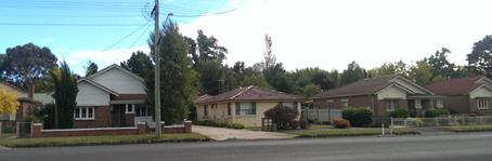
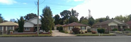
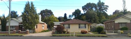

Figure 5 – Photographs of site from
Moulder Street which shows that the subject dwelling is visible from limited
viewpoints in the street
Ian Carter – 29 Hill
Street
This submission raises the following concerns:
- privacy and overlooking into
backyard;
- upstairs noise;
- afternoon overshadowing of
backyard; and
- inconsistent with neighbourhood
character and Heritage Conservation Area.
Privacy, overlooking, and daylighting was considered in the
DCP assessment of the report, where it was concluded that the amenity of this
neighbour was unlikely to be adversely impacted by the development due to
separation distances between the proposed works and the neighbouring dwelling,
as well as the set back of the proposed addition from the existing eastern
building line and boundary.
As discussed in the S79C assessment, it is not anticipated
that there will be any increase in noise generated from the dwelling, as the
additional living floor area is are unlikely to generate additional noise over
and above what would be expected for a dwelling house.
It is considered that although different in scale and form
to other development in the neighbourhood, the proposed addition respects the
existing and adjacent dwelling, and is not out of character with the
surrounding area, meeting the tests for bulk and scale set out in relevant case
law. Furthermore, the proposal does not have any adverse impacts on the
heritage values of the Conservation Area or nearby listed buildings and
cumulative impacts are unlikely.
Scott Gilbank – 50 Kite
Street ‘Mena’
This submission was received after the previous Committee
meeting, and raises the following concerns:
- proposal alters the pattern of
development on the site and in the surrounding area;
- there are no 2 storey dwellings in
the townhouse cluster;
- the proposal does not complement
the neighbourhood character;
- the outlook for the neighbouring
properties will alter, where the subject dwelling will be increased in scale
and bulk;
- proposal is not contained within
the visual bulk envelope prescribed by the DCP with substantial encroachments
on the eastern and western elevations; and
- the current vegetation is not
indicative of the mass throughout the year.
These issues were considered in the original
report to Committee. The DCP assessment concludes that although the proposed
development is different in scale and form to other development in the
neighbourhood, the proposed addition respects the existing and adjacent
dwellings, and is not out of character with the surrounding area.
Although there is extensive vegetation screening
the proposed additions from this neighbouring listed dwelling at present (being
that it is early autumn), it is acknowledged that foliage will vary throughout
the seasons. While the proposal will result in a changed outlook for the
neighbour in the seasons where foliage is sparse, it is not considered that
there will be any adverse loss of amenity due to a generous separation distance
between the proposed works and the listed dwelling of around 68m. Furthermore,
the immediate neighbour to the west of Mena (at number 48 Kite Street) contains
a two-storey dwelling in close proximity to the listed dwelling, which does not
affect its heritage setting and values, or impact adversely on the Conservation
Area.
Peter and Jacqueline Grant
– 35 Hill Street
This submission was received after the previous Committee
meeting, and raises the following concerns:
- late summer foliage will not be
retained for over six months of each year, and trees may fall or be felled
resulting in visual intrusion of the development into gardens;
- want to preserve the unique dense
vegetated areas of the City, including its ecological values;
- impacts to the heritage values of
the area and neighbourhood character;
- visual bulk is not reasonable, and
neighbours will have an altered outlook, loss of privacy and loss of views to
flora;
- potential cumulative impacts.
These issues were considered in the original report to
Committee. The DCP assessment concludes that while the development will be
visible from neighbouring sites and will alter their outlook, the visual
setting will remain largely unchanged, and the impacts are not adverse. The
proposal does not result in the loss of any existing vegetation or areas of
outdoor space, and it is considered that the reduction in the vegetation vista
of for the neighbour at 35 Hill Street will be negligible. It is also noted
that number 35 Hill Street is not an immediately adjacent neighbour, where the
vegetable garden at number 48 Kite Street separates it from the subject site,
with a separation distance of around 29m to the back garden of 35 Hill Street
and at least 50m to the dwelling. As noted in the DCP assessment, the physical
separation results in the visual bulk encroachment from the eastern stairwell
to have a negligible impact on eastern neighbouring dwellings. The proposed
addition is considered respectful of the existing and adjacent dwellings,
respectful to nearby listed buildings and the Conservation Area, and is not out
of character with the heritage setting of the surrounding area.
Amie and Charlie Warren –
52 Kite Street
Following the site inspection held on 21 March 2017, another
submission was received which raises the following concerns:
- overlooking from upper level
windows;
- impacts on seclusion and amenity of
the vegetated area; and
- would set a precedent for
development of green spaces.
These issues have been considered in the assessment sections
of this report, where it was concluded that impacts are minor and can be
adequately mitigated.
PUBLIC INTEREST
s79C(1)(e)
The proposed development is considered to be of minor
interest to the wider public due to the relatively localised nature of
potential impacts. The proposal is not inconsistent with any relevant policy
statements, planning studies, guidelines, etc. that have not been considered in
this assessment.
A site inspection was carried out on 21 March 2017 to view
the subject site and hear the concerns of neighbours.
SUMMARY
The proposed development is permissible with the consent of
Council. The proposed development complies with the relevant aims, objectives
and provisions of the LEP. A Section 79C assessment of the
development indicates that the development is acceptable in this instance.
Attached is a draft Notice of Approval outlining a range of conditions
considered appropriate to ensure that the development proceeds in an acceptable
manner.
COMMENTS
The requirements of the Environmental Health and Building
Surveyor and the Engineering Development Section are included in the attached
Notice of Approval.
Attachments
1 Notice
of Approval, D17/21142⇩
2 Plans,
D17/20651⇩
3 Submissions,
D17/20961⇩
Planning and Development Committee
4 April 2017
2.3 Development
Application DA 4/2016(1) - 61B Moulder Street
Attachment 1 Notice
of Approval
|

|
ORANGE
CITY COUNCIL
Development
Application No DA
4/2016(1)
NA17/ Container
PR18419
|
NOTICE OF DETERMINATION
OF A DEVELOPMENT
APPLICATION
issued under the Environmental
Planning and Assessment Act 1979
Section 81(1)
|
Development
Application
|
|
|
Applicant Name:
|
Mr DG and
Mrs CG Isles
|
|
Applicant Address:
|
C/- Source
Architects
PO Box 144
ORANGE
NSW 2800
|
|
Owner’s Name:
|
Mr DG and
Mrs CG Isles
|
|
Land to Be Developed:
|
Lot 13 DP
1037756 - 61B Moulder Street, Orange
|
|
Proposed Development:
|
Dwelling
Alterations and Additions
|
|
|
|
|
Building
Code of Australia
building
classification:
|
As determined
by the certifier
|
|
|
|
|
Determination
|
|
|
Made On:
|
4 April
2017
|
|
Determination:
|
CONSENT
GRANTED SUBJECT TO CONDITIONS DESCRIBED BELOW:
|
|
|
|
|
Consent to
Operate From:
|
5 April
2017
|
|
Consent to
Lapse On:
|
5 April
2022
|
Terms of Approval
The reasons for the imposition of
conditions are:
(1) To ensure a quality
urban design for the development which complements the surrounding environment.
(2) To maintain
neighbourhood amenity and character.
(3) To ensure compliance
with relevant statutory requirements.
(4) To ensure the utility
services are available to the site and adequate for the development.
(5) To prevent the proposed
development having a detrimental effect on adjoining land uses.
Conditions
(1) The
development must be carried out in accordance with:
(a) Plan/s
numbered 15120 DA00 Rev 6, DA01 Rev 4, DA02-3 Rev 7, DA04 Rev 6, DA06 Rev 6 (6
sheets)
(b) statements
of environmental effects or other similar associated documents that form part
of the approval
as amended
in accordance with any conditions of this consent.
(2) All building work must
be carried out in accordance with the provisions of the Building Code of
Australia.
(3) A sign is to be erected
in a prominent position on any site on which building work, subdivision work or
demolition work is being carried out:
(a) showing
the name, address and telephone number of the principal certifying authority
for the work, and
(b) showing
the name of the principal contractor (if any) for any building work and a
telephone number on which that person may be contacted outside working hours,
and
(c) stating
that unauthorised entry to the site is prohibited.
Any such sign is to be maintained while the
building work, subdivision work or demolition work is being carried out.
(4) In the case
of residential building work for which the Home Building Act 1989
requires there to be a contract of insurance in force in accordance with Part 6
of the Act, evidence that such a contract of insurance is in force is to be
provided to the Principal Certifying Authority before any building work
authorised to be carried out by the consent commences.
(5) Residential
building work within the meaning of the Home Building Act 1989 must not
be carried out unless the principal certifying authority for the development to
which the work relates (not being the council) has given the council written
notice of the following information:
(a) in
the case of work for which a principal contractor is required to be appointed:
(i) the
name and the licence number of the principal contractor, and
(ii) the
name of the insurer by which the work is insured under Part 6 of that Act,
(b) in
the case of work to be done by an owner-builder:
(i) the
name of the owner-builder, and
(ii) if
the owner-builder is required to hold an owner-builder permit under that Act,
the number of the owner-builder permit.
If arrangements for doing the
residential building work are changed while the work is in progress so that the
information under this condition becomes out of date, further work must not be
carried out unless the principal certifying authority for the development to
which the work relates (not being the council) has given the council written
notice of the updated information.
(6) Where any excavation
work on the site extends below the level of the base of the footings of a
building on adjoining land, the person having the benefit of the development
consent must, at the person’s own expense:
(a) protect
and support the adjoining premises from possible damage from the excavation,
and
(b) where
necessary, underpin the adjoining premises to prevent any such damage.
Note: This
condition does not apply if the person having the benefit of the development
consent owns the adjoining land or the owner of the adjoining land has given
consent in writing to that condition not applying.
|
PRIOR TO THE ISSUE OF
A CONSTRUCTION CERTIFICATE
|
(7) An
approval under Section 68 of the Local Government Act is to be sought
from Orange City Council, as the Water and Sewer Authority, for water, sewer
and stormwater connection. No plumbing and drainage is to commence until
approval is granted.
(8) Plans
shall be amended to include colours of the dwelling. The roof shall be
finished in Colorbond ‘Monument’, and the walls shall be finished
in ‘Volcanic Ash’ or a similar colour. Final colours may be
darker than these colours, but not lighter.
|
PRIOR TO WORKS
COMMENCING
|
(9) A
Construction Certificate application is required to be submitted to, and issued
by Council/Accredited Certifier prior to any excavation or building works being
carried out onsite.
(10) The
location and depth of the sewer junction/connection to Council’s sewerage
system is to be determined to ensure that adequate fall to the sewer is
available.
|
DURING
CONSTRUCTION/SITEWORKS
|
(11) All
construction/demolition work on the site is to be carried out between the hours
of 7am and 6pm Monday to Friday inclusive, 7am to 5pm Saturdays and 8am to
5pm Sundays and Public Holidays. Written approval must be obtained from the
General Manager of Orange City Council to vary these hours.
(12) All
materials on site or being delivered to the site are to be contained within the
site. The requirements of the Protection of the Environment Operations Act
1997 are to be complied with when placing/stockpiling loose material or
when disposing of waste products or during any other activities likely to
pollute drains or watercourses.
(13) Building
demolition is to be carried out in accordance with Australian
Standard 2601:2001 - The Demolition of Structures and the requirements
of the NSW WorkCover Authority.
(14) All materials and
finishes of the proposed additions are to be constructed from non-reflective materials
and in accordance with the approved colour scheme.
|
PRIOR TO THE ISSUE OF
AN OCCUPATION CERTIFICATE
|
(15) Privacy screens and/or
obscured glazing is to be installed on all upper floor western windows prior to
the issue of any Occupation Certificate.
(16) No
person is to use or occupy the building or alteration that is the subject of
this approval without the prior issuing of an Occupation Certificate.
(17) Where
Orange City Council is not the Principal Certifying Authority, a final
inspection of water connection, sewer and stormwater drainage shall be
undertaken by Orange City Council and a Final Notice of Inspection issued,
prior to the issue of either an interim or a final Occupation Certificate.
(18) All
of the foregoing conditions are to be at the full cost of the developer and to
the requirements and standards of the Orange City Council Development and
Subdivision Code, unless specifically stated otherwise. All work required by
the foregoing conditions is to be completed prior to the issuing of an
Occupation Certificate, unless stated otherwise.
|
MATTERS FOR THE
ONGOING PERFORMANCE AND OPERATION OF THE DEVELOPMENT
|
(19) Privacy
screens and/or obscured glazing shall be permanently maintained on the upper
floor western windows.
Other Approvals
(1) Local
Government Act 1993 approvals granted under Section 68.
Nil
(2) General
terms of other approvals integrated as part of this consent.
Nil
Right of Appeal
If
you are dissatisfied with this decision, Section 97 of Environmental
Planning and Assessment Act 1979 gives you the right to appeal to the Land
and Environment Court within 6 months after the date on which you receive this
notice.
*
Section 97 of the Environmental Planning and Assessment Act 1979 does not apply
to the determination of a development application for State significant
development or local designated development that has been the subject of a
Commission of Inquiry.
|
Disability Discrimination Act
1992:
|
This application has been assessed in
accordance with the Environmental Planning and Assessment Act 1979. No
guarantee is given that the proposal complies with the Disability
Discrimination Act 1992.
The applicant/owner is responsible to
ensure compliance with this and other anti-discrimination legislation.
The Disability Discrimination Act
covers disabilities not catered for in the minimum standards called up in the
Building Code of Australia which references AS1428.1 - "Design for
Access and Mobility". AS1428 Parts 2, 3 and 4 provides the most
comprehensive technical guidance under the Disability Discrimination Act
currently available in Australia.
|
|
|
|
|
Disclaimer - S88B Restrictions on the Use of Land:
|
The applicant should note that there
could be covenants in favour of persons other than Council restricting what
may be built or done upon the subject land. The applicant is advised to check
the position before commencing any work.
|
|
|
|
|
Signed:
|
On behalf of the consent authority ORANGE
CITY COUNCIL
|
|
Signature:
|
|
|
Name:
|
DAVID WADDELL - DIRECTOR DEVELOPMENT
SERVICES
|
|
Date:
|
5 April 2017
|
Planning
and Development Committee
4 April 2017
2.3 Development
Application DA 4/2016(1) - 61B Moulder Street
Attachment 2 Plans
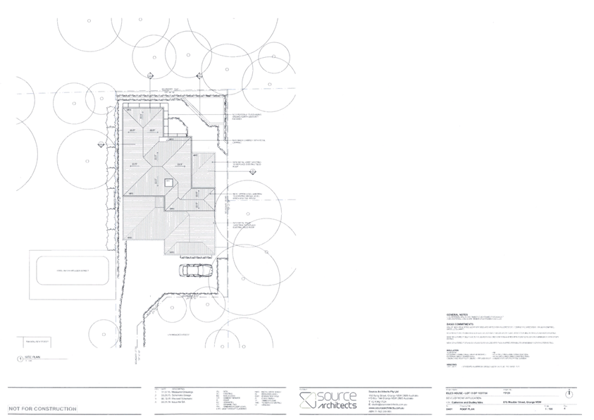
Planning and Development Committee
4 April 2017
2.3 Development
Application DA 4/2016(1) - 61B Moulder Street
Attachment 2 Plans
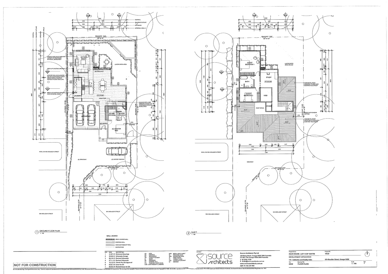
Planning and Development Committee
4 April 2017
2.3 Development
Application DA 4/2016(1) - 61B Moulder Street
Attachment 2 Plans
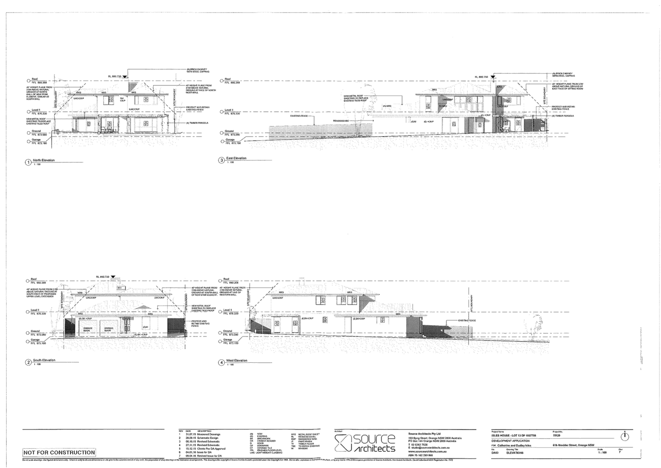
Planning and Development Committee
4 April 2017
2.3 Development
Application DA 4/2016(1) - 61B Moulder Street
Attachment 2 Plans
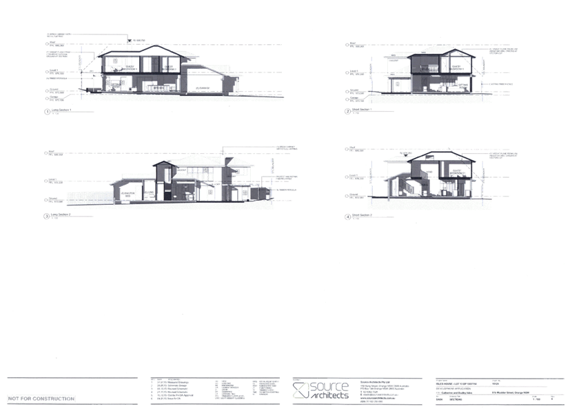
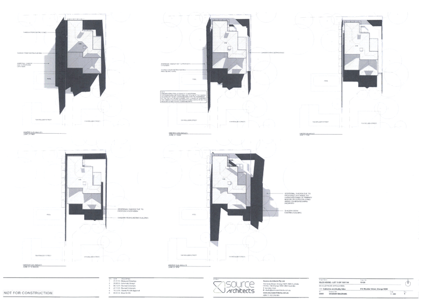
2.4 Development
Application DA 304/2016(1) - 132-142 Kite Street and 26 McNamara Street
TRIM
REFERENCE: 2017/536
AUTHOR: Daniel
Drum, Town Planner
EXECUTIVE Summary
|
Application
lodged
|
8
September 2016
|
|
Applicant/s
|
TPG Town
Planning & Urban Design
|
|
Owner/s
|
Eastern
Developments Pty Ltd
|
|
Land
description
|
Lot 1 DP
197828, Lots 2-6 DP 131416 and Lots 1‑3 DP 779111 - 132-142
Kite Street and 26 McNamara Street, Orange
|
|
Proposed
land use
|
Demolition,
Hotel or Motel Accommodation, Restaurant or Cafe, Retail Premises and
Subdivision (44 lot Strata)
|
|
Value of
proposed development
|
$10,500,000
|
Council's consent is sought to establish a mixed use
development on land at 132-142 Kite Street and 26 McNamara Street, Orange,
being Lot 1 DP197828, Lots 2-6 DP 131416 and Lots 1-3 DP 779111 (the
‘subject property’). The mixed use development comprises hotel or
motel accommodation, restaurant or café and retail premises. The subject
property comprises a total area in the order of 2,899m2 (approximately)
in an irregular shape and is occupied by the former Central Western Daily
building, which is currently vacant.
Specifically, Council’s consent is sought for:
· demolition of the
existing building;
· use and
development of hotel or motel accommodation, restaurant or
café and retail premises; and
· subdivision (44
lot Strata).
While the development application also foreshadows
consolidation of the subject lots, this has previously been approved as exempt
development and is pending registration.
The proposed hotel comprises 44 apartments in a combination
of one bedroom (one), two bedroom (40), and three bedroom (three) apartments.
However, 33 of the two bedroom apartments have been designed in a manner which
allows for each room to be accessed separately as a one bedroom apartment,
allowing for a maximum capacity of 77 apartments.
Aside from accommodation, other facilities within the hotel
would include:
· reception and
waiting area;
· manager’s
office;
· luggage store;
· business lounge;
· conference room
and associated kitchen and amenities;
· gym;
· BBQ area;
· laundry; and
· service and
utility facilities.
In addition to the hotel, the mixed use development includes
a café and one leasable retail area. While the café would be
available to the general public, the supporting material submitted with the
development application indicates that it is largely intended to service hotel
guests. The proposed cafe has a seating capacity of 65 people (approximately)
and would operate from 6am-11pm daily.
Eighty car parking spaces have been proposed as part of the
mixed use development. The provision of off-street car parking spaces is a key
issue for consideration in the assessment of this application and is addressed
in detail in the body of this report.
Landscaping associated with the proposed development is
principally the extension of existing street trees in Kite Street and
commencement of street trees in McNamara Street. Other minor landscaping is
also proposed adjacent to the main Kite Street entrance to the hotel reception
area and along the common boundary of 24 McNamara Street and 137‑139
Peisley Street.
The key issues for consideration include:
· car parking and
traffic;
· urban design;
· heritage; and
· impact on
adjoining properties.
Six submissions were received during the exhibition period.
Copies of all submissions are attached to this report and the issues raised by
submitters are addressed in the body of this report.
The following assessment identifies that the proposed development
can be supported.
Link To Delivery/OPerational Plan
The recommendation in this report relates to the
Delivery/Operational Plan strategy “13.4 Our Environment
– Monitor and enforce regulations relating to City amenity”.
Financial Implications
Nil
Policy and Governance Implications
Nil
|
Recommendation
That Council consents to development application DA
304/2016(1) for Demolition, Hotel or Motel Accommodation, Restaurant or
Cafe, Retail Premises and Subdivision (44 lot Strata) at Lot 1 DP
197828, Lots 2-6 DP 131416 and Lots 1‑3 DP 779111 - 132-142
Kite Street and 26 McNamara Street, Orange pursuant to the conditions
of consent in the attached Notice of Approval.
|
further considerations
Consideration has been given to the
recommendation’s impact on Council’s service delivery; image and
reputation; political; environmental; health and safety; employees;
stakeholders and project management; and no further implications or risks have
been identified.
SUPPORTING INFORMATION
THE APPLICATION/PROPOSAL AND ADJOINING PROPERTIES
Council's consent is sought for demolition, use and
development of hotel or motel accommodation, restaurant or
café, retail premises; and 44 lot Strata subdivision.
Use
The proposed hotel comprises 44 apartments in a combination
of one bedroom (one), two bedroom (40) and three bedroom (three) apartments.
However, 33 of the two bedroom apartments have been designed to allow for each
room to be accessed separately as a one bedroom apartment, creating the
potential for up to 33 additional apartments and an overall total of 77
apartments.
Supporting material submitted with the development
application, based on data from the Australian Bureau of Statistics for the
period between July 2012 and June 2013, indicates that occupancy rates for hotels
in Orange varied between 49.7% in December 2012 and 76.9% in
October 2012. This would equate to an average maximum occupancy of
59 apartments.
Apart from accommodation, other facilities and services
within the hotel would include a reception and waiting area, manager’s
office, luggage store, business lounge, conference room and associated kitchen
and amenities, gym, BBQ area, laundry, and service and utility facilities.
The services and facilities offered by the hotel, including
the business lounge, conference room and gym, will only be available to guests
of the hotel.
The hotel would employ four permanent staff and a resident
manager.
In addition to the hotel, the mixed use development includes
a café and one leasable retail area. While the café would be
available to the general public, the supporting material submitted with the
development application indicates that it is largely intended to service hotel
guests. The proposed cafe has a seating capacity of 65 people (approximately)
and would operate from 6am-11pm daily.
The 66m2 leasable area adjacent to Kite Street is
intended to be used as a form of retail premises, which includes uses
such as shops and food and drink premises. However, as a tenant for the lease
area has not been secured and no specific details of the proposed use have been
provided, a condition of consent must be applied requiring a fresh development
application for its first use. Notwithstanding, the area is treated as a retail
premises for the purpose of this assessment.
Development
Development works include the complete demolition of the
former Central Western Daily building, which is currently vacant, and
construction of a new four storey building.
The proposed building has been designed in a contemporary
style which is distinguished from the proximate historic buildings, including
the Great Western Hotel at 145-147 Kite Street and the Kite Street Specialist
Centre at 126 Kite Street (formerly the Canobolas Shire Council Chamber).
The proposed building would generally be built to the Kite
Street and McNamara Street boundaries, presenting as a four storey form to both
street frontages with the exception of a three storey interface to the existing
single storey building at 24 McNamara Street.
The ground floor of the building has been designed to
activate both the Kite Street and McNamara Street frontages. This is
predominately achieved via the café and outdoor terrace which
‘wrap’ around the corner of Kite and McNamara Street. The level of
activation achieved by the café and outdoor terrace will be further
complemented by the retail lease area adjacent to Kite Street. The use of
various external materials, including glazing and stone cladding, and
architectural features such as the awning to Kite Street, will also ensure an
appropriate level of visual interest within the streetscape.
Above ground level, building articulation is predominately
achieved via a combination of staggered building setbacks, varied external
materials including pre-finished cladding and textured paint finish, and
architectural features including metal screens and glass balustrades.
While presenting predominately as a four storey building,
the overall height of the building has been minimised via an inverted roof
design.
The design of the proposed building is illustrated in the
attached architectural plans.
The existing conditions of the
subject property are illustrated in Figures 1-4 below.
Figure 1: existing building as viewed from McNamara
Street
Figure 2: existing building as viewed from corner of
Kite Street and McNamara Street
Figure 3: existing building and unsealed car park as
viewed from south-eastern corner
of the subject property
Figure 4: existing building and unsealed car park as
viewed from south-western corner
of the subject property
Adjoining Properties
Properties immediately adjoining the subject property
include the Great Western Hotel at 145-147 Peisley Street, Ace Accounting
at 26 McNamara Street, a hair and beauty salon at 141-143 Peisley Street
and second hand/antique store at 137-139 Peisley Street. While 26 McNamara
Street appears to be used for the purpose of an accounting business,
Council’s records indicate that the current approved use of the property
is a residential dwelling. This matter is discussed in detail in the body of
this report.
The existing conditions of the
properties adjoining the subject property are illustrated in Figures 5-9,
below.
Figure 5: 24 McNamara Street as viewed from McNamara
Street
Figure 6: 24 McNamara Street as viewed from the
subject property
Figure 7: 145-147 Peisley Street as viewed from the
subject property
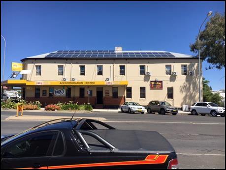
Figure 8: 145-147 Peisley Street as viewed from Kite
Street
Figure 9: 137-139 McNamara Street as viewed from the
subject property
MATTERS FOR CONSIDERATION
Section 5A Assessment
In the administration of sections 78A, 79B, 79C, 111 and
112, the provisions of Section 5A must be taken into account for every
development application in deciding whether there is likely to be a significant
effect on threatened species, populations or ecological communities or their
habitats. This section includes a requirement to consider any adopted
assessment guidelines, which means assessment guidelines issued and in force
under section 94A of the Threatened Species Conservation Act 1995.
Assessment guidelines are in force (see DECC-W “Threatened Species
Assessment Guidelines - The Assessment of Significance”) which requires
consent authority to adopt the precautionary principle in its assessment.
In this instance, site inspection reveals that the subject
property has no biodiversity or habitat value.
Section 79C - Evaluation
Section 79C of the Environmental Planning and Assessment
Act 1979 requires Council to consider various matters, of which those
pertaining to the application are listed below.
PROVISIONS OF ANY ENVIRONMENTAL
PLANNING INSTRUMENT s79C(1)(a)(i)
Orange Local Environmental Plan 2011
Part 1 - Preliminary
Clause 1.2 - Aims of Plan
The
aims of the Orange Local Environmental Plan 2011 relevant to the application
include:
(a) to encourage development which complements
and enhances the unique character of Orange as a major regional centre boasting
a diverse economy and offering an attractive regional lifestyle,
(b) to provide for a range of development
opportunities that contribute to the social, economic and environmental
resources of Orange in a way that allows present and future generations to meet
their needs by implementing the principles for ecologically sustainable
development,
(f) to recognise and manage valued
environmental heritage, landscape and scenic features of Orange.
The proposed development is considered to be consistent with
the relevant aims of Orange LEP 2011. In particular, the proposed
development will assist in reinforcing Orange as a major regional centre; will
contribute to the social, economic and environmental resources of Orange; and
recognise the environmental heritage features of Orange.
The relevant matters are discussed throughout the body of
this report.
Clause 1.6 - Consent Authority
Clause 1.6 establishes that Council is the consent authority
for the purposes of Orange LEP 2011.
Clause 1.9A - Suspension of
Covenants, Agreements and Instruments
Clause 1.9A provides that any agreement, covenant or other
similar instrument that restricts the carrying out of development does not
apply to the extent necessary to serve that purpose, with the exception of:
· A covenant
imposed by Council or that Council requires to be imposed;
· Any prescribed
instrument within the meaning of Section 138A of the Crown Lands Act 1989; or
· Any
conservation agreement under the National Parks and Wildlife Act 1974;
· Any Trust
agreement within the meaning of the Nature Conservation Trust Act 2001;
· Any property
vegetation plan within the meaning of the Native Vegetation Act 2003;
· Any biobanking
agreement under Part 7A of the Threatened Species Conservation Act 1995; or
· Any planning
agreement under Division 6 of part 4 of the Environmental Planning and
Assessment Act 1979.
This clause does not affect the rights or interests of any
public authority under any registered instrument.
A search of Council’s records identifies that the
subject property is not affected by any of the foregoing covenants,
instruments, agreements or plans. However, it is noted that Council does not
hold a Section 88B Instrument for the subject property.
It is noted that Lot 5 DP 131416 is affected by a right-of-way (ROW). The applicant has advised that
the ROW is effectively redundant as it only applies to those lots which form
part of the subject property and is not to the benefit of any adjoining
property. As such, there is no impact of building over the ROW.
Lots 1, 2 and 3 DP 779111 are affected by an easement for
the underground drainage of water. Council’s Development Engineer has
identified that a condition of consent should be applied requiring that the
existing stormwater line be included as part of the drainage works for the
proposed development.
Two sewer mains traverse Lots 4, 5 and 6 DP 132416. While
the applicant has proposed to realign the affected sewer main, Council’s
Technical Services Division has recommended conditions of consent requiring
that the sewer line be relocated clear of the proposed building.
Clause 1.7 Mapping
The subject site is identified
on the LEP maps in the following manner:
|
Land Zoning Map:
|
Land zoned B3 Commercial Core
|
|
Lot Size Map:
|
No Minimum Lot Size
|
|
Heritage Map:
|
Not a heritage item or conservation
area
|
|
Height of Buildings Map:
|
Building height limit 16m
|
|
Floor Space Ratio Map:
|
Floor space limit 2:1
|
|
Terrestrial Biodiversity Map:
|
No biodiversity sensitivity on the
site
|
|
Groundwater Vulnerability Map:
|
Ground water vulnerable
|
|
Drinking Water Catchment Map:
|
Not within the drinking water
catchment
|
|
Watercourse Map:
|
Not within or affecting a defined watercourse
|
|
Urban Release Area Map:
|
Not within an urban release area
|
|
Obstacle Limitation Surface Map:
|
No restriction on building siting
or construction
|
|
Additional Permitted Uses Map:
|
No additional permitted use applies
|
The relevant matters are addressed in detail in the body of
this report.
Part 2 - Permitted or Prohibited Development
Clause
2.1 - Land Use Zones and Clause 2.3 - Zone Objectives and Land Use Table
The
subject property is zoned B3 Commercial Core zone (Figure 10).
Figure 10: zone context plan
(subject property identified by heavy red line)
The
proposed use and development is defined as hotel or motel accommodation,
restaurant or café and retail premises under the Orange
Local Environmental Plan, which mean:
Hotel or motel accommodation:
… a building or place (whether or not licensed
premises under the Liquor Act 2007) that provides temporary or short-term
accommodation on a commercial basis and that:
(a) comprises rooms or
self-contained suites, and
(b) may provide meals to guests or
the general public and facilities for the parking of guests’ vehicles,
but does not include backpackers’ accommodation, a
boarding house, bed and breakfast accommodation or farm stay accommodation.
Note.
Hotel or motel accommodation is a type of tourist and
visitor accommodation - see the definition of that term in this Dictionary.
Restaurant or café:
… a building or place the principal purpose of which
is the preparation and serving, on a retail basis, of food and drink to people
for consumption on the premises, whether or not liquor, take away meals and
drinks or entertainment are also provided.
Note.
Restaurants or cafes are a type of food and drink premises
- see the definition of that term in this Dictionary.
Retail premises:
…retail
premises means a building or
place used for the purpose of selling items by retail, or hiring or displaying
items for the purpose of selling them or hiring them out, whether the items are
goods or materials (or whether also sold by wholesale), and includes any of the
following:
(a) bulky goods premises,
(b) cellar door premises,
(c) food and drink premises,
(d) garden centres,
(e) hardware and building supplies,
(f) kiosks,
(g) landscaping material supplies,
(h) markets,
(i) plant nurseries,
(j) roadside stalls,
(k) rural supplies,
(l) shops,
(m) timber yards,
(n) vehicle sales or hire premises,
but does not include highway service centres, service
stations, industrial retail outlets or restricted premises.
Note.
Retail premises are a type of commercial premises -
see the definition of that term in this Dictionary.
Hotel
or motel accommodation, restaurant or
café and retail premises are permissible within the B3
Commercial Core zone with the consent of Council.
The
objectives of the B3 Commercial Core are:
· To
provide a wide range of retail, business, office, entertainment, community and
other suitable land uses that serve the needs of the local and wider community.
· To
encourage appropriate employment opportunities in accessible locations.
· To
maximise public transport patronage and encourage walking and cycling.
· To
promote development that contributes to the role of the Orange CBD as the
primary retail and business centre in the City and region.
It is considered that the
proposed development is consistent with the objectives of the
B3 Commercial Core zone. In particular, the proposed development is
considered to be a suitable land use which would serve the needs of the local
and wider community; encourage appropriate employment opportunities in an
accessible location; and promote development that contributes to the role of
the Orange CBD as the primary retail and business centre of the City and
region.
Clause 2.6 - Subdivision -
Consent Requirements
Clause 2.6 triggers the need for development consent for the
subdivision of land. Additionally, the clause prohibits subdivision of land on
which a secondary dwelling is situated if the subdivision would result in the
principal and secondary dwellings being located on separate lots if either of
those lots are below the minimum lot size applying to the land.
The proposed development involves a 44 lot Strata
subdivision which corresponds with the floor layout of the 44 apartments.
The proposal does not involve a secondary dwelling.
Clause 2.7 - Demolition
Requires Development Consent
Clause
2.7 identifies that demolition of a building or work may be carried out only
with development consent, unless it is identified as exempt development.
The
proposed development involves the demolition of the former Central Western
Daily building, which is now vacant.
Part 4 - Principal Development Standards
Clause
4.3 - Height of Buildings
This
clause limits the height of buildings (HoB) on land identified on the Height of
Buildings Map. The subject land is identified on the map as having a HoB limit
of 16m.
The
maximum height of the proposed development is generally associated with the
utilities and services located on the roof of the proposed development. A
review of these utilities and services identified that the height of each was
below 16m when compared with the corresponding contour line below, with the
exception of the air conditioning condenser with the RL 878.85 which had a
maximum height of 16.1m. The applicant subsequently submitted amended plans to
address this issue.
Clause 4.4 - Floor Space Ratio
This
clause limits the floor space ratio (FSR) permitted on land identified on the
Floor Space Ratio Map. Clause 4.5 is associated with this clause and
establishes the rules for calculating the site area and FSR of any proposal.
These rules exclude certain parts of a site and development such as:
· excluding
any part of the site upon which the development is prohibited (I if the
site is split zoned only the zone in which the development is permissible may
be considered)
· excluding
community land and most public places
· lots
in a strata scheme wholly or partly above other lots in the scheme do not
increase the site area (ie the site area is the ground level of the scheme
only)
· adjoining
lots in the same ownership do not form part of the site area unless significant
parts of the development are proposed on that land
· the
floor area of existing buildings is to be included in the FSR calculation
· any
covenant restricting floor space on the lot, due to floor space having been
considered as part of the development of another lot, is to be taken into
account.
The
subject land is identified as having an FSR of 2:1. The site area has
been calculated under Clause 4.5 as 2,898m2 using a plan of consolidation
prepared for the subject property, meaning the site may have up to 5,796m2
of floor space.
The proposal, minus the
exclusions detailed in Clause 4.5, has been calculated as having a gross floor
area in the order of 4,676m2 and is therefore consistent with the FSR requirements.
Notably, the applicant has
indicated that the proposed development would have a gross floor area of 4,771m2,
being approximately 100m2 greater than the area calculated by
Council staff. Regardless, the gross floor area as calculated by the applicant
is also consistent with the FSR requirement.
Part 5 - Miscellaneous Provisions
5.10 - Heritage Conservation
Clause 5.10 seeks to conserve the environmental heritage of
Orange, the heritage significance of heritage items and heritage conservation
areas (including associated fabric, settings and views), to conserve
archaeological sites, and to conserve Aboriginal objects and Aboriginal places
of heritage significance.
While the subject property is
not identified as a heritage item and is not located within a heritage
conservation area, it is located adjacent to the former Canobolas Shire Council
Chambers (now the Kite Street Specialist Centre) (Heritage Item I149) at
126-130 Kite Street and the Great Western Hotel (Heritage Item I230) at
145-147 Peisley Street, Orange. The subject property is also located adjacent
to the southern periphery of the Central Orange Heritage Conservation Area
(Figure 11).
Figure 11: heritage context plan (subject property
identified by heavy red line and star)
As the subject property is not a heritage item and is not
located within a heritage conservation area, consent is not required pursuant
to Clause 5.10(2) Requirement for consent. However, pursuant to Clause
5.10(5) heritage assessment Council may require the submission of a
heritage conservation management plan before granting consent to any
development on land that is in the vicinity of a heritage item or heritage
conservation area.
Given that the subject property adjoins two heritage items and
is adjacent to the Central Orange Heritage Conservation Area, Council staff
considered it appropriate to refer the development application to
Council’s appointed Heritage/Urban Design Advisor for his assessment and
recommendations. A copy of the Heritage/Urban Design Advisor’s comments
are attached to this report.
It is noted that during the assessment of the proposed
development Council adopted the Orange Development Control Plan 2004 Infill
Guidelines (the ‘guidelines’), which apply to land within
heritage conservation areas or which adjoins heritage items. Given that the
subject property is located between two heritage items, the guidelines would
apply to the proposed development.
Notably, the development application was accompanied by an
assessment against the Office of Environment and Heritage’s Design in
Context - Guidelines for Infill Development in the Historic Environment
design criteria, addressing issues such as character, scale, form, siting, materials
and colours. The design criteria of the Design in Context document form the
basis of Council’s recently adopted guidelines. Council’s
Heritage/Urban Design Advisor has advised that the assessment provided is the
appropriate form of heritage management document in this circumstance.
Council’s Heritage/Urban Design Advisor has considered
the proposed development with regard to the applicable planning controls as
well as the OEH and Council infill guidelines. With specific regard to the
Council guidelines, the Heritage/Urban Design Advisor has indicated that the
proposed development is suitable in its context for the following reasons:
1. Character
a. The proposal is an infill in
the streetscape between the Hotel and the former Council building. The
provision of a defined base, mid-section and top provides a traditional
reference to the buildings in the vicinity
b. The screens reference verandahs
and provide depth and shading to the street elevations
c. The setbacks are appropriate
for the commercial uses and location where boundary development is common.
2. Scale and form
a. While the building is higher
than the neighbours the scaling references and screens mitigate this impact
b. The form addresses the street
corner where the height and corner details are appropriate.
3. Siting
a. The setbacks are appropriate
for both street frontages. The ends of the two wings address the proximity of
the adjoining sites and proximity of the listed buildings.
4. Materials and colour
a. Subject to revised architectural
drawings and the samples requested, the materials and colour scheme relates to
the main colours and tones used in the streetscape. The use of darker and
deeper tones will allow the traditional buildings and heritage items to remain
dominant.
b. The screen materials will
mitigate the bulk and character by providing depth and shade across the
facades. They will interpret traditional verandahs in a suitable contemporary
manner while mitigating the use of glass.
c. The use of a suitable stone
will interpret the traditional local use of basalt at the ground floor level.
5. Detailing
a. The screen details will
mitigate the bulk and character by providing depth to the two facades –
one which is opposite the Conservation Area. They will interpret traditional
verandahs in a suitable contemporary manner.
In summary, the Heritage/Urban Design Advisor has provided
the following advice and recommendations:
Summary
The
consultants have generally adopted directions and the advice offered in
relation to design issues associated with meeting the issues required within
the LEP, DCP , the DCP Infill guidelines and the Design in Context guide.
Generally
the proposals presented in the Drawings will complement the heritage
significance of the existing listed heritage item and the streetscape within
the conservation area subject to the amendments to the drawings and the
materials requested being provided and approved.
Recommendations
· Steel
perforated or louvred metal screens around the North, West and East sides of
the roof mounted units and similar to their height in Windspray colour are
recommended to provide a suitable roof form, character and appearance;
· The
finishes and materials noted are to be submitted and approved with the DA;
· Steel
and metal screens are to be provided to the two sets of elevations to unify the
Kite Street and McNamara Street elevations and the balcony/balustrade details
so as to present a consistent character to the streetscapes which are in the
vicinity of the conservation area and listed heritage items.
Given that Council’s Heritage/Urban Design Advisor
recommended that detailed finishes and materials were to be submitted and
approved with the proposed development, Council staff requested that the
applicant provide a complete materials board including examples of actual
external materials and complete colour schedule.
Council’s Heritage/Urban Design Adviser has inspected
the materials board and indicated that the samples of the paint colours for the
sheet materials, the balustrade glass and stainless steel framing, and
aluminium louvres are acceptable. However, the samples presented for the two
stone areas on the external walls to both streets and the aluminium window
framing are not consistent with earlier advice nor with the DCP guide for
Heritage: complementing the heritage significance of the Conservation Area.
In particular, the Heritage/Urban Design Adviser stated the following:
“The stone samples are
not acceptable as they provide a product which are by their nature a thin tile
and will appear as a tile. The original design intent and the appearance shown
on the November drawings of the two Street Elevations was of a stone and not a
tile. It is a design principle in heritage practice that replica products are
not supported. This principle has been used to guide the advice for both the
stone and aluminium. It is consistent with heritage advice provided by Council
for similar projects where there is an impact on Heritage values and
significance.
There are alternatives which
are genuine stone in a suitable colour, texture and laying style which will
complement this substantial building in a prominent location. There are two
aluminium finishes which are similar in colour with lifespan expectations
beyond the wood grain finishes.”
Council’s Heritage/Urban Design Advisor subsequently
recommended that performance based conditions be applied in order to ensure
that appropriate external finishes will be used on the development, including:
· The
stone shown as D on the Elevations is to be used to clad the external walls on
the ground floor of the two street elevations and is to be a genuine stone
product, similar to Basalt in colour with a traditional Rough finish, laid in a
traditional Random ashlar pattern and tight 10-15mm joints to be provided with
recessed pointing darker than the stone;
· The
stone shown as E is used to clad the base plinth on both street elevations and
is to be similar to Basalt in colour but fully dressed on the exposed faces,
laid in a traditional Random coursed ashlar pattern with a Honed finish and
tight 10-15mm joints with recessed pointing darker than the stone;
· The
aluminium framing to the doors and windows is to have an anodised Light Bronze
colour by AWS or equal or a powdercoated finish similar to Dulux Wheatmeal
A copy of
the Heritage/Urban Design Advisor’s supplementary comments are also
attached to this report.
Based on this advice, including the Heritage/Urban Design
Advisor’s full report, it is recommended that conditions of consent be
applied requiring that:
· amended
architectural plans must be submitted to and approved by Council’s
Manager Development Assessments prior to the issue of a Construction
Certificate showing steel perforated or louvered metal screens around the
north, west and east sides of the roof mounted units and equivalent to their
height in Windspray;
· amended
architectural plans must be submitted to and approved by Council’s
Manager Development Assessments prior to the issue of a Construction
Certificate showing steel and metal screens to all balconies and balustrades;
and
· amended
architectural plans must be submitted to and approved by Council’s
Manager Development Assessments prior to the issue of a Construction
Certificate which include a notation on the plan requiring horizontal ruled
nominal 5mm joints at floor, window sill and window headlines.
Following a further discussion with Council’s Heritage/Urban
Design Advisor, it is also recommended that a further condition of consent be
applied requiring that the proposed 1.8m high Colorbond fence around the
perimeter of the subject property be replaced with a 1.8m high lapped and
capped hardwood timber fence.
Part 7 - Additional Local Provisions
7.1
- Earthworks
This
clause establishes a range of matters that must be considered prior to granting
development consent for any application involving earthworks, such as:
(a) the likely disruption of, or any
detrimental effect on, existing drainage patterns and soil stability in the
locality of the development
(b) the effect of the development on the
likely future use or redevelopment of the land
(c) the quality of the fill or the soil to be
excavated, or both
(d) the effect of the development on the
existing and likely amenity of adjoining properties
(e) the source of any fill material and the
destination of any excavated material
(f) the likelihood of disturbing relics
(g) the proximity to and potential for adverse
impacts on any waterway, drinking water catchment or environmentally sensitive
area
(h) any measures proposed to minimise or
mitigate the impacts referred to in paragraph (g).
The architectural plans
submitted with the development application indicate that the extent of
earthworks associated with the proposed development are in the order of
+/- 1m of cut and fill from the existing ground level (EGL).
The earthworks are considered
minor and ancillary to the proposed development and are unlikely to have a
detrimental impact with regard to the foregoing matters.
7.3 - Stormwater Management
This clause applies to all
industrial, commercial and residential zones and requires that Council be
satisfied that the proposal:
(a) is designed to maximise the use of water
permeable surfaces on the land having regard to the soil characteristics
affecting onsite infiltration of water
(b) includes, where practical, onsite
stormwater retention for use as an alternative supply to mains water,
groundwater or river water; and
(c) avoids any significant impacts of
stormwater runoff on adjoining downstream properties, native bushland and
receiving waters, or if that impact cannot be reasonably avoided, minimises and
mitigates the impact.
The proposed development has
been designed to minimise the impacts of stormwater on the subject property and
adjoining properties. In particular, this is to be achieved by utilising
existing stormwater infrastructure which services the subject property.
Council’s Development Engineer has confirmed that the proposed method of
stormwater management is appropriate.
7.6 - Groundwater Vulnerability
This
clause seeks to protect hydrological functions of groundwater systems and
protect resources from both depletion and contamination. Orange has a high
water table and large areas of the LGA, including the subject site, are identified
with “Groundwater Vulnerability” on the Groundwater Vulnerability
Map. This requires that Council consider:
(a) whether or not the development (including
any onsite storage or disposal of solid or liquid waste and chemicals) is
likely to cause any groundwater contamination or have any adverse effect on
groundwater dependent ecosystems, and
(b) the cumulative impact (including the
impact on nearby groundwater extraction for potable water supply or stock water
supply) of the development and any other existing development on groundwater.
Furthermore consent may not be
granted unless Council is satisfied that:
(a) the development is designed, sited and
will be managed to avoid any significant adverse environmental impact, or
(b) if that impact cannot be reasonably
avoided - the development is designed, sited and will be managed to minimise
that impact,
(c) if that impact cannot be minimised - the
development will be managed to mitigate that impact.
The proposed development is not
anticipated to involve the discharge of toxic or noxious substances and is
unlikely to cause groundwater contamination or have an adverse effect on
groundwater dependant ecosystems. The proposed development is considered
unlikely to have a detrimental impact on groundwater.
7.11 Essential Services
Clause 7.11 requires that development consent must not be
granted for development unless the consent authority is satisfied that any of
the following services that are essential for the proposed development are
available or that adequate arrangements have been made to make them available
when required.
Council’s Technical Services Division has advised that
all necessary services are available to the subject property and that any
requirements for services to be upgraded can be achieved, but will be at the
cost of the applicant.
STATE ENVIRONMENTAL PLANNING
POLICIES
State Environmental Planning Policy 55 - Remediation of
Land (SEPP 55
State Environmental Planning Policy 55 - Remediation of
Land (SEPP 55) requires that a consent authority must not consent to the
carrying out of development of land unless it has considered whether the land
is contaminated, is satisfied that the land is suitable in its contaminated
state for which the development is proposed, and if the land requires
remediation to be made suitable for the purpose for which the development is
proposed to be carried out, it is satisfied that the land will be remediated
before the land is used for that purpose.
Furthermore, SEPP 55 requires that before determining an
application to carry out development that would involve a change of use of land
(specified in subclause 4), the consent authority must consider a preliminary
investigation of the land concerned.
While the subject property was historically used for
residential purpose, as verified by Council’s historic photos and other
research (Edwards 2011, A gentleman of the inky Way – Orange through
Joe Glassons Looking Glass) it has contained the Central Western Daily
office and printery since the mid 1960s.
While an office and printery are not uses listed in Table 1
of the SEPP 55 Planning Guidelines, paper and printing works which include
commercial printeries with significant stores of ink and solvents are
considered to be a potentially contaminating land use.
Accordingly, Council staff undertook a review of the site
history and internal inspection of the existing building to determine the
likelihood of the subject property being contaminated. The review of the
site’s history identified that the existing building is the original
building purpose built to house the Central Western Daily offices and printery.
However, it is noted that there have been a number of modifications and
extensions since its original construction.
The internal inspection of the
subject property identified that those areas housing the printing equipment
were in good condition and unlikely to have allowed any significant penetration
of contaminating substances into the soil profile below the building. The
existing condition of the floor in areas likely to have housed printing
equipment is demonstrated in Figures 12-14 below.
Figure 12: condition of floor surface


Figure
13: condition of floor surface Figure
14: condition of floor surface
Further, during the assessment of the proposed development,
Council staff identified a Phase 1 and 2 Environmental Site Assessment and
Underground Storage Tank In Situ Validation Report for the subject
property within Council’s records. The report had been provided to
Council in November 2014.
Notably, the report identified that the primary risks of
site contamination were associated with the historical printing operations as
discussed above, and a former underground storage tank and bowser. The report
notes that the underground storage tank located adjacent to the southern wall
of the building was decommissioned by extracting residual oily water from the
tank and filling the tank with concrete slurry.
Based on the findings of the Phase 2 Environmental Site
Assessment and in situ decommissioning and validation of the underground
storage tank, the consultant indicated that the potential risk of site
contamination is low and that the site is suitable for ongoing
“commercial/industrial” land use.
The Contamination Central Contaminated Land Quick
Reference Guide defines a commercial/industrial scenario as:
“Typical commercial or
light industrial properties, consisting of single or multistorey buildings
where work areas on the ground floor (constructed on a ground level slab) or
above surface structures (such as a basement car parks or storage areas).
Adult employees, who are
largely involved in office-based or light indoor industrial activities. The
employees who are most susceptible to health risks associated with volatile
soil contaminants are the employees who work in offices on the ground floor, as
the greatest potential for vapour intrusion occurs with workspaces immediately
overlying contaminated soil.
The outdoor areas of the
commercial/industrial facilities are largely covered by hardstand, with some
limited areas of landscaping or lawns and facilities. Employees may make use of
outdoor areas of the commercial/industrial premises for activities such as meal
breaks. Opportunities for direct access to soil by employees using these
facilities are likely to be minimal, but there may be potential for employees
to inhale, ingest or come into direct skin contact with dust particulates
derived from the soil on the site.”
Given that the ground floor of the proposed development
would comprise a café, retail tenancy and other uses associated with the
hotel, and that all apartments would be located on the upper levels, it is
considered that commercial/industrial is the most appropriate characterisation
of the proposed use.
While it is clear that the subject property is not likely to
be contaminated, it is considered prudent to apply a precautionary condition of
consent requiring that if any previously unidentified contamination is
identified during works, the works must cease and an appropriate resolution
must be achieved in consultation with Council. Any necessary remediation works
may require additional development consent.
State Environmental Planning
Policy (Infrastructure) 2007
Traffic-generating Development
State Environmental Planning Policy (infrastructure) 2007
Section 104 Traffic-generating development requires that written notice of
an application for traffic-generating development must be provided to Roads and
Maritime Services. The application was subsequently referred to the RMS.
The RMS has provided Council with a written response
indicating that it does not object to the proposed development and makes no
submission.
Other matters required to be considered under Section 104
Traffic-generating development, such as the efficiency of movement of
people and freight to and from the site, the extent of multi-purpose trips,
potential traffic safety, road congestion and parking implications, are
addressed in the body of this report.
Other Development
State Environmental Planning Policy (infrastructure) 2007
Section 45 Determination of development applications – other development
requires that written notice of development that may penetrate ground within 2m
of an underground electricity power line must be given to the electricity
supply authority for the area. The application was subsequently referred to
Essential Energy.
Essential Energy provided Council with a written response
indicating that it has no objection to the development subject to conditions of
consent. These conditions have been incorporated into the attached draft notice
of consent.
PROVISIONS OF ANY DRAFT
ENVIRONMENTAL PLANNING INSTRUMENT THAT HAS BEEN PLACED ON EXHIBITION
s79C(1)(a)(ii)
There are no draft environmental planning instruments that
apply to the subject land or proposed development.
DESIGNATED DEVELOPMENT
The proposed development is not designated development.
PROVISIONS OF ANY DEVELOPMENT
CONTROL PLAN s79C(1)(a)(iii)
Development Control Plan 2004
Development Control Plan 2004 (“the DCP”)
applies to the subject land. Chapters of the DCP relevant to the proposed use
and development include:
· Chapter 0 - Transitional
Provisions;
· Chapter 2 -
Natural Resource Management;
· Chapter 3 -
General Considerations;
· Chapter 4 -
Special Environmental Considerations;
· Chapter 5 -
General Considerations for Zones and Development;
· Chapter 8 -
Development in Business Zones;
· Chapter 13 -
Heritage; and
· Chapter 15 - Car
Parking.
CHAPTER 0 - TRANSITIONAL
PROVISIONS
Section 0.2 - General Translation of Zones
Section 0.2 - General Translation of Zones provides that any
reference to a zone under Orange Local Environmental Plan 2000 is to be a
reference to the corresponding zones in the zone conversion table.
The table identifies that the B3 Commercial Core zone
corresponds with the 3A Regional Centre zone for the purposes of the DCP.
Chapter 2 - Natural Resource
Management
Section2.1 - Water Quality
Section 2.1 - Water Quality identifies that development that
concentrates, redirects flows, increases flow rates or disturbs land in close
proximity to creeks has the potential to affect waterways with associated erosion,
sedimentation and release of nutrients, which combine to affect downstream
water quality. Section 2.1 also identifies development involving groundwater
extraction and/or onsite wastewater disposal is deemed to affect groundwater
resources.
The relevant matters have previously been addressed in
detail under the headings “7.3 _ Stormwater” and
“7.6 - Groundwater Vulnerability”.
It is considered that the requirements of the DCP have been
adequately addressed.
Section 2.2 - Soil Resources
Section 2.2 - Soil Resources identifies that soil
characteristics influence land use and development capability, including the
suitability for building footings, onsite waste disposal, road engineering and
drainage.
Council’s Technical Services Division has recommended
a condition of consent requiring that the development is to be constructed in
accordance with Council’s Development and Subdivision Code.
It is considered that the requirements of the DCP have been
adequately addressed.
CHAPTER 3 - GENERAL
CONSIDERATIONS
Section 3.1 - Cumulative Impacts
Section 3.1 - Cumulative Impacts identifies that Council
will consider not only the direct impacts of a particular development, but also
whether the development, when carried out in conjunction with other development
in the locality, has a more significant environmental impact.
Cumulative impacts of the proposed development are addressed
under the heading “Likely Impacts of the Development”.
Section 3.2 - Scenic, Landscape
and Urban Areas
Section 3.2 -Scenic, Landscape and Urban Areas identifies
that in urban areas consideration should be given to the character of the
locality, whether that locality is recognised as having heritage character with
formal plantings of exotic trees or whether the locality comprises areas developed
as suburban release areas where informal native planting is common.
Landscaping has predominately been proposed in the form of
street trees along the Kite Street and McNamara Street frontages.
Council’s Manager City Presentation has indicated
support for the proposed street trees and has provided recommended conditions
of consent in relation to the location of the proposed street trees and tree
species (Fraxinus ‘Raywood’ - Claret Ash).
Council’s Manager City Presentation has also
recommended a condition of consent requiring a Tree Protection Zone to be
implemented to protect the mature Eucalypt located in the north-western corner
of the adjoining property at 145-147 Peisley Street (the Great Western Hotel)
during construction works, particularly the realignment of the sewer line.
Council’s Heritage/Urban Design Advisor has indicated
that the proposed development will complement the heritage significance of the
existing listed heritage item and the streetscape subject to the
recommendations previously discussed.
Section 3.4 - Waste Generation
Section 3.4 - Waste Generation requires that applications
involving demolition indicate measures that will be implemented for reuse and
recycling of waste, and that development involving demolition is carried out in
a manner that optimises reuse and recycling of waste materials consistent with
waste-minimisation principles.
While a Waste Management Plan has not been submitted with
the development application, the applicant has indicated that a waste
management plan would be submitted prior to the issue of a Construction
Certificate.
Council’s Building Surveyor has indicated that this is
an appropriate outcome and has recommended conditions of consent requiring a
waste management plan to be prepared prior to the issue of a Construction
Certificate.
CHAPTER 4 - SPECIAL
ENVIRONMENTAL CONSIDERATIONS
Section 4.1 - Sewage Disposal
Section 4.1 - Sewage Disposal
identifies that urban development must be connected to a sewerage system
approved by Council prior to occupation. For the purposes of this clause, urban
development includes all development within residential, business and
industrial zones (and associated open space and special use zones).
Council’s Development
Engineer has advised that appropriate sewerage services can be connected to the
proposed development. An assessment of sewer and headwork charges
applicable to the proposed development is provided in the body of this report.
Section 4.3 - Land Shaping
Section 4.3 - Land Shaping
identifies that substantial land shaping, including filling or excavating land,
has the potential to generate significant environmental impacts, and that land
shaping should not adversely affect land in the vicinity as a result of
drainage, erosion or sedimentation or as a result of leachate entering surface
or groundwater.
The relevant matters have previously been addressed under
the heading “7.1 – Earthworks”.
It is considered that the requirements of the DCP have been
adequately addressed.
Section 4.4 - Contaminated Land
Section 4.4 - Contaminated Land identifies that contaminated
land can pose a risk to human health and the environment. Contaminants can be
released into waterways and humans exposed when contaminated land is disturbed
as a consequence of development.
The relevant matters have previously been addressed under
the heading State “Environmental Planning Policy 55 - Remediation of
Land”.
It is considered that the requirements of the DCP have been
adequately addressed.
CHAPTER 5 - GENERAL
CONSIDERATION FOR ZONES AND DEVELOPMENT
Section 5.3 - Advertised Development
Section 5.3 - Advertised Development identifies that Council
will give written and published notice of applications for advertised
development as required by the Environmental Planning and Assessment
Regulations.
While the proposed development is not categorised as
advertised development, Council’s Development Services Division
determined to advertise the development application in the public interest
given the scale of the proposed development and location of the subject
property adjacent to a number of heritage items and the Central Orange Heritage
Conservation Area.
Accordingly, the development application was advertised on
Saturday, 21 January 2017 and exhibited between Monday, 23 January and
Monday, 6 February 2017.
At the end of that period six written submissions were
received. A detailed assessment of the issues raised
by the submitters is provided under the heading “Any Submissions Made in
Accordance with the Act”.
CHAPTER 8 - DEVELOPMENT IN
BUSINESS ZONES
Section 8.1 - Orange CBD
Section 8.1 - Orange CBD outlines planning outcomes for the
Orange Central Business District, with an emphasis on design, character,
parking and loading. The relevant planning outcomes are addressed below.
· Buildings
have a high level of urban design to contribute to the regional status of the
City’s Central Business District with attention given to façade
features, external materials, colour and advertising.
Given the scale of the proposed development, the prominent
location of the subject property within the Orange CBD and the relationship to
nearby heritage items and heritage conservation area, Council staff considered
it appropriate to refer the development application to Councils Heritage/Urban
Design Advisor for his assessment and recommendations.
A copy of the Heritage/Urban Design Advisor’s comments
are attached to this report with the summary and recommendations reproduced
under the heading “5.10 - Heritage Conservation”.
In particular, it is noted that Council’s appointed
Heritage/Urban Design Advisor has assessed the proposed development against
Council’s recently adopted Orange Development Control Plan 2004 Infill
Guidelines. In summary, the Heritage/Urban Design Advisor considers that
the proposed development has provided a suitable response to each of the
applicable design criteria, including character, scale and form, siting,
materials and colours, and detailing.
Based on the advice and recommendations provided by
Council’s Heritage/Urban Design Advisor, it is considered that the
proposed development has been appropriately designed with regard to the
site’s context within the Orange CBD, subject to meeting the recommended
conditions of consent.
· Urban
design demonstrates a clear reference to the CBD Strategic Action Plan.
The Orange Central Business District Strategic Action
Plan 2003 (the ‘Strategic Action Plan’) seeks to provide
a long term strategy to address a broad range of issues affecting the CBD.
In general, the Strategic Action
Plan identifies the subject property as forming a tertiary street retail area
at the southern periphery of the CBD (Figure 15). Key themes of the Strategic
Action Plan relevant to the subject property include access and movement, built
form and heritage, and landscape and public domain.
Figure 15: Orange Central Business District Strategic
Action Plan - Structure Plan (Land Use)
Access and Movement
In terms of access and movement, the proposed development is
considered to be consistent with the Strategic Action Plan as the ground level
will incorporate a continuous awning over the Kite Street footpath, protecting
against sun and rain; and the activated frontage to Kite Street and McNamara
Street and street trees will make a positive contribution to the streetscape.
Built Form and Heritage
With regard to built form, the proposed development is
considered to be consistent with the Strategic Action Plan insofar as the
ground level will provide an active frontage to Kite and McNamara Streets, with
the combination of materials and architectural features achieving a suitably
articulated façade.
Landscape and Public Domain
The proposed development is consistent with the landscape
and public domain objectives of the Strategic Action Plan as it would provide
for the extension of existing street trees within Kite Street.
· Provision
of adequate fire-safety measures and facilities for disabled persons (according
to the BCA) are addressed at the application stage (relevant for all
development but particularly important where converting residential buildings
for business use).
Council’s Building Surveyor has commented that further
detail would be required at the Construction Certificate stage to determine
compliance with the BCA.
· Land
use complements the role of the CBD as a regional centre for commerce and
services.
The proposed development is considered to be complementary
to the role of the CBD as a regional centre is it will make a substantial
contribution to the existing supply of tourist and visitor accommodation within
Orange.
· The
reinstatement of verandahs on posts over footpaths is encouraged.
Given that the proposal involves the construction of a new
building, the foregoing outcome is not considered applicable.
· Car
parking is provided to meet demand either as onsite parking areas or through
contributions towards public parking in and adjacent to the CBD.
Section 15.4 - Parking Requirements sets out the minimum
parking requirements for specific land uses. A detailed assessment against the
requirements of Section 15.4 is undertaken below.
· Advertising
comprises business identification signs in accordance with SEPP 64.
No advertising signs have been
proposed. It is anticipated that a separate application for advertising will be
lodged once the applicant has entered into an agreement with a primary tenant
for the hotel.
· Loading
areas are provided for developments requiring access by large trucks in a
manner that doesn’t reduce active frontages for important pedestrian
pathways.
The applicant has proposed an
internal loading/service area which will effectively be a shared space with the
car park. Council’s Development Engineer has indicated that this is an
acceptable outcome as the loading area would typically only be accessed by
small rigid vehicles and that any cars using the affected spaces could be moved
by hotel staff if necessary.
Notwithstanding the internal
loading/service area, waste collection will need to be undertaken directly from
McNamara Street. A condition of consent will be applied regarding the storage
of garbage bins and a private service agreement with Council’s waste
provider.
· Where
possible, new buildings or external alterations in the CBD include an element
of landscaping.
Landscaping associated with the proposed development is
principally the extension of existing street trees in Kite Street and
commencement of street trees in McNamara Street. Council’s Heritage/Urban
Design advisor has commented that while other peripheral landscaping, such as
planter boxes, are not necessarily required, they are acceptable in this
circumstance.
It is considered that the requirements of the DCP have been
adequately addressed.
CHAPTER 13 - HERITAGE
Sections 13.1-13.06 of Chapter 13 - Heritage of the DCP
address heritage matters in detail, including heritage objectives, heritage items
and heritage conservation areas, heritage consideration for development,
development in the vicinity of heritage items, heritage proposals as advertised
development, and incentives for heritage conservation.
These matters have previously been addressed in detail under
the heading “Clause 5.10 - Heritage Conservation”.
It is considered that the requirements of the DCP have been
adequately addressed.
CHAPTER 15 - CAR PARKING
Section 15.1 - Background, Section 15.2 - Objectives and
Section 15.3 - Relationship Between On-Street and Off-Street Car Parking
Sections 15.1-15.3 of Chapter 15 - Car Parking set out the
background, objectives and relationship between on-street and off-street car
parking in Orange. In particular, these sections highlight the importance of
making provision for car parking in order that the demand for parking in the
City is met and ensuring that the design and layout of car parking facilitates
the safe and effective use of off-street parking.
The appropriate assessment of car parking requirements is
addressed under the following sections.
Section 15.4 - Parking
Requirements
Section 15.4 - Parking Requirements sets out the minimum
parking requirements for specific land uses.
Background
The provision of off-street car
parking spaces is a key issue for consideration in the assessment of this
application. Notably, during the assessment process the applicant has submitted
three separate car parking plans to address concerns raised by Council staff,
including an original plan for 52 off-street car parking spaces, a revised plan
for 77 off-street car parking spaces and the final plan which forms part of the
proposed development being considered for 80 off-street car parking spaces. The
provision of an additional 28 car parking spaces from the original plan
for 52 car parking marks a significant effort by the applicant to address the
concerns of Council staff.
While the applicant has been able to make amendments to the
proposed development to substantially increase the number of off-street car
parking spaces to be provided, the current design relies on the use of
‘tandem’ and ‘valet’ style car parking spaces, which
would effectively require hotel staff to undertake all parking operations once
the hotel reaches a certain occupancy. If the ‘tandem’ and
‘valet’ style car parking spaces were to be removed from the
current car parking plan, the number of spaces provided would be reduced
to 55.
In February 2017, the City of Orange Traffic Development
Committee considered the proposed development and commented that it does not
accept the concept of ‘tandem’ and ‘valet’ style car
parking spaces. In this regard, it is noted that Council’s Development
Services Division is unaware of any other existing car park within the
Orange CBD which is of a similar scale and relies upon
‘tandem’ and ‘valet’ style car parking spaces. However,
similar arrangements are not uncommon in a metropolitan environment where land
constraints demand a higher car parking yield. Further, Council’s
Development Engineer has indicated that the proposed car parking arrangement,
including the use of ‘tandem’ and ‘valet’ style car
parking spaces, is acceptable.
The detailed operation of the tandem’ and
‘valet’ style car parking spaces is outlined under Section 15.5
- Parking Area Design and Layout.
It is open to Council to determine whether or not
tandem’ and ‘valet’ style car parking spaces should be supported
with these considerations in mind.
Car Parking Demand
Section 15.4 - Parking Requirements sets out the minimum
parking requirements for hotel or motel accommodation, restaurants, and shops
within the Orange Central Business District.
Council staff have calculated the likely demand for
off-street car parking based on the following:
· The proposed hotel
comprises 44 apartments in a combination of one bedroom (one), two bedroom
(40), and three bedroom (three) apartments. However, 33 of the two bedroom
apartments have been designed in a manner which allows for each room to be
accessed separately as a one bedroom apartment, allowing for a maximum capacity
of 77 apartments.
· The applicant has
indicated that the facilities ancillary to the hotel, including the conference
room, business lounge and gym are intended for hotel guests only and would not
generate any additional demand for car parking spaces. This approach is
accepted subject to the use of these areas being restricted to hotel guests
only as a condition of consent.
· In addition to the
hotel, the mixed use development includes a café of 225m2
and one leasable retail area of 66m2. While the café would be
available to the general public, the supporting material submitted with the
development application indicates that it is largely intended to service hotel
guests.
Section 15.4 - Parking Requirements sets out the following
minimum car parking requirements:
Hotel or Motel Accommodation
· 1
space per unit/bedroom/tent or caravan site
· 1
space for every 3 beds (hostel accommodation)
· +
1 space for each resident manager
· +
1 space for every 2 employees
· +
1 space for every 3 seats in the restaurant
· +
1 space per 10m2 of entertainment or function room areas.
Restaurants in the CBD
· 1
space per 40m2 of GFA
Shops and Shopping Centres
· Within
the CBD - 4.1 spaces/100m² GLFA
Notably, the foregoing provisions
identify that there is a separate car parking requirement for a restaurant
associated with hotel or motel accommodation as opposed to a restaurant in the
CBD which is not associated with another use. Depending on the size of the
restaurant and the number of seats available, this may result in a
substantially different requirement for off-street car parking spaces.
Given that all other recently approved restaurants in the
Orange CBD have been subject to the requirement for 1 space per 40m2
of GFA, it seems logical that the same rate should be applied in this case as
there seems to be no obvious or logical reason to apply the requirement based
on seating numbers. Notwithstanding, the requirement for off-street car parking
spaces generated under both requirements is presented below:
Hotel or Motel Accommodation
· 77
units = 77 car parking spaces
· 1
resident manager = 1 car parking space
· 4
full time employees = 2 car parking spaces
· 65
restaurant seats = 21.6 (22) car parking spaces*
Restaurants in the CBD
· 225.08m2
of GFA = 5.6 (6) car parking spaces*
Shops and Shopping Centres
· 66²
GLFA = 2.7(3) car parking spaces
*Indicates
interchangeable car parking requirements
Based on the foregoing, it is
considered that the proposed development would generate a requirement for a
total of 105 off-street car parking spaces if calculating the car parking
requirement for the café based on seating numbers, or 89 off-street car
parking spaces if calculating the car parking requirement for the café
based on GFA.
As previously discussed, given that all other recently
approved restaurants in the Orange CBD have been subject to the
requirement for 1 space per 40m2 of GFA, it is recommended that this
rate be applied and that the proposed development be assessed as generating a
requirement for 89 car parking spaces. The proposed development would therefore
have a shortfall of 9 car parking spaces.
However, if Council were not of a view to support the
proposed ‘tandem’ and ‘valet’ style car parking
arrangement, the proposed development would have a shortfall in the order
of 34 car parking spaces.
In addition to the foregoing assessment, it is noted that
the introduction of additional street trees to Kite Street and McNamara Street
and the realignment of the existing ingress and egress would likely result in
the net loss of 1 on-street car parking space.
While the current proposed plan
provides for 80 car parking spaces, the most recent traffic and parking
assessment relates to the car park layout which provided for 77 off-street car
parking spaces and has sought to allocate off-street car parking spaces on the
following basis:
|
Use Type
|
Units/GFA/Staff
|
DCP Rate
|
Min Spaces
|
Spaces
Provided
|
|
Hotel
|
77 units
|
1 per unit
|
77
|
71
|
|
|
1 manager
|
1 per unit
|
1
|
1
|
|
|
4 staff
|
1 per 2 staff
|
2
|
2
|
|
Retail
|
66m2
|
4.1 per 100m2
|
2.7(3)
|
3
|
|
|
|
|
83
|
77
|
The current proposed plan which
provides for 80 car parking spaces allocates 3 car parking spaces to hotel
staff, with the remaining 77 assumed to be allocated to hotel guests.
Notably, the applicant has not sought to allocate any
off-street car parking spaces to account for the proposed café which
will be open to the public, on the basis that customers are likely to be in the
vicinity for reasons other than visiting the café and that this type of
multi trip destination does not generate additional car parking requirements.
If Council is willing to support the proposed
‘tandem’ and ‘valet’ style car parking arrangement, it
is considered that the shortfall of 9 off-street car parking spaces could
adequately be addressed via conditions of consent requiring a contribution in
lieu of the physical provision of car parking spaces. In accordance with the Orange
Car Parking Development Contributions Plan 2015, a contribution of
$14,064.35 would be applied to account for each off-street car parking spaces
not provided onsite (ie a total of $126,579.15 to account for 9 car parking
spaces).
However, if Council is not willing to accept the proposed
tandem’ and ‘valet’ style car parking arrangement, the
shortfall of 34 car parking spaces could not simply be rectified by via a
condition of consent requiring a contribution in lieu of the physical provision
of car parking spaces.
In particular, it is noted that the Orange Car Parking
Development Contributions Plan 2015 precludes car parking
contributions being offered by the developer or required by Council for car
parking associated with tourist or visitor accommodation because Council
considers that it is inappropriate that those using these development should
have to park in public areas physically removed from the development.
As such, a condition of consent could not be applied
requiring that a contribution be required to account for each off-street car
parking space required for the accommodation aspect of the proposed hotel which
is not provided onsite. This would amount to a significant departure from
Orange DCP 2004 and likely result in an unacceptable environmental impact.
As previously stated, it is open to Council to determine
whether or not tandem’ and ‘valet’ style car parking spaces
should be supported in this instance.
If Council is willing to accept the proposed tandem’
and ‘valet’ style car parking arrangement, it is considered that
the foregoing approach is appropriate on the basis that Council research
indicates that proximate public car parks, such as the Ophir Car Park, are
underutilised. Other public car parks are also proximate to the subject
property.
In particular, it is noted that Council’s Orange
CBD Car Parking Study Final Report, dated 10 April 2015, identified
that the Ophir Car Park (217 car parking spaces) has been surveyed as having
maximum weekday occupancy of 56% and a maximum weekend occupancy of 21%,
representing low usage of a Council car park. While it is noted that these
figures may have changed since the report was prepared, surveys by Council
staff during the assessment process identified a maximum occupancy in the order
of 40%, consistent with the findings of the report. Given that the Ophir Car
Park is located within 200m of the subject property, it is considered to be
highly accessible to the subject property and the local street network.
It is noted that the introduction of additional street trees
to Kite Street and McNamara Street and the realignment of the existing ingress
and egress would likely result in the net loss of one on-street car parking
space. It is considered that the net loss of one existing
on‑street car parking space can also be accounted for within
Council’s underutilised car parks.
It is considered that the requirements of the DCP have been
adequately addressed.
Section 15.5 - Parking Area
Design and Layout
Section 15.5 - Parking Design and Layout identifies that the
design and layout of parking areas are to comply with the applicable Australian
Standard.
It is noted that the operation of the proposed car parking
layout would rely on the use of a ‘tandem’ and ‘valet’
style parking system depending on the occupancy of the hotel.
In February 2017, the City of Orange Traffic Development
Committee considered the proposed development and commented that it does not
accept the concept of ‘tandem’ and ‘valet’ style car
parking spaces.
While Council’s Development Engineer has indicated
that the proposed ‘tandem’ and ‘valet’ style car
parking would not meet the applicable Australian Standard, he has confirmed
that such an arrangement is a common method of maximising the capacity of a
private car park and that the design is acceptable. The implications of the
‘tandem’ and ‘valet’ style car parking spaces and
Council’s options have been set out in the foregoing ”Section 15.4
- Parking Requirements”.
While the proposed development being considered provides for
80 off-street car parking spaces, the most recent traffic and parking
assessment outlines a car park management plan which relates to the car parking
plan which provided for 77 car parking spaces:
Mode A
In Mode A, up to 44 units are
occupied and the car and the car park will operate in a standard car park
procedure, with hotel residents allocated (1) space per room.
The spaces used in this mode are
1, 3, 5,7 to 18, 20, 22, 24, 26, 28, 30, 31 to 48 and 55 to 66.
Mode B
In Mode B, between 45 and 58
units are occupied and the nine (9) tandem spaces will be utilised for units
operating as dual key. These are often occupied by ‘related’
residents. There are an additional 5 single spaces allocated to dual key units
occupied by ‘non related’ residents.
The tandem spaces allocated to the
‘related’ dual key occupants are 1 to 6 and 18 to 29.
Mode C
In Mode C, 59 to 77 units are
occupied and the 11 ‘valet’ style spaces (spaces 67 to 77)
will be utilised. Subsequently, a valet system will be implemented to manage
the parking provision.
Once allocated a room(and
parking space), hotel residents allocated parking spaces 14 to 77
will proceed to space 67, where they will park and give their car keys to the
valet. The valet will then park the car in the allocated space and securely store
the key.
When exiting the hotel, the
valet will bring the residents car to the exit driveway (adjacent to space 30)
and return the car to the residents for them to exit the parking facility.
In mode C, should Quest staff
require access or egress to their parking spaces (spaces 52 to 54),
they will also utilise the valet system.
Retail staff spaces (49 to 51)
are accessible at all times (as reverse in only spaces), regardless of the
mode of operation.
As discussed previously, should
all 77 rooms be occupied, 6 vehicles will be required to utilise on-street
parking in the vicinity of the site.
On the basis that the applicant has provided a car park
management plan and that Council’s Development Engineer has indicated
that the car park layout it is satisfactory, it is considered that the proposed
‘tandem’ and ‘valet’ style car parking spaces could be
supported.
Notwithstanding, it is noted that in February 2017, the City
of Orange Traffic Development Committee considered the proposed development and
commented that it does not accept the concept of ‘tandem’ and
‘valet’ style car parking spaces.
It is open to Council to determine whether or not
‘tandem’ and ‘valet’ style car parking spaces should be
supported in this instance.
In this case it is recommended that Council support the
proposed ‘tandem’ and ‘valet’ style car parking spaces
subject to the following recommended conditions of consent:
· A
revised car parking management plan be provided prior to the issue of an
Occupation Certificate accounting for the 80 car parking spaces provided;
· The
revised car parking management plan allocate 77 car parking spaces to the
accommodation component of the proposed hotel, with one car parking space to be
allocated to each of the 77 units; and
· The
revised car parking management plan provide an appropriate methodology for each
car park to be accessed regardless of the occupancy of the hotel or
relationship between the users of dual keyed rooms (ie all ‘tandem’
and ‘valet’ car parking spaces must be accessible to hotel
occupants at all times via the valet parking system).
Section 15.6 - Parking Area
Construction
Section 15.6 - Off-Street Car Parking sets out the following
planning outcomes:
· Adequate
off-street car parking is provided in accordance with the Table or, alternatively,
according to an assessment that demonstrates peak-parking demand based on
recognised research.
The requirements for off-street
car parking have previously been addressed under “Section 15.4 -
Car Parking Requirements”.
· Car
parking areas are designed according to Australian Standard.
While Council’s
Development Engineer has indicated that the proposed ‘tandem’ and
‘valet’ style car parking would not meet the applicable Australian
Standard, he has confirmed that such an arrangement is a common method of
maximising the capacity of a private car park and that the design is
acceptable.
The implications of the ‘tandem’ and
‘valet’ style car parking spaces and Council’s options have
been set out in the foregoing “Section 15.4 - Parking
Requirements”.
· Car
park areas include adequate lighting and landscaping (preferably deciduous
shade trees), which provides for the personal security of users.
All off-street car parking will
be provided internally on the ground level of the proposed development. While
it is likely that a prospective developer would ensure that adequate lighting
is provided, a condition of consent is recommended requiring that lighting be
provided for the personal security of users.
· Bicycle
parking facilities are provided according to the relevant Australian Standard.
The architectural plans provide
bicycle parking facilities for three bikes. Based on the number of hotel units
and likely employee numbers, it is considered that the proposed development is
likely to generate a demand for facilities for 4 bicycles
(ie 4.15 approximately.)
Given that the applicant has
made substantial changes to the proposed car park in order to accommodate an
additional 28 car parking spaces to the original proposal, it is considered
that, on balance, the reduction of bicycle parking facilities for one bicycle
is acceptable.
· Facilities
for loading and unloading of commercial vehicles are provided according to the
relevant Australian Standard.
Council’s Development
Engineer has indicated while the proposed internal loading area has been
designed to utilise two ‘valet’ style car parking spaces. This
arrangement would be satisfactory until such time as the affected car parking
spaces were required.
Notwithstanding, Council’s
Development Engineer has commented that a dedicated loading facility would not
actually be required as delivery activities would only occur for short periods,
having a negligible impact on the operation of the car park.
Council’s Development
Engineer has confirmed that the proposed ‘tandem’ and
‘valet’ style car parking system would not limit access through the
car park by a service vehicle.
SECTION 64 WATER AND SEWER
HEADWORKS CHARGES
Section 64 water and sewer headwork charges are applicable
to the proposal. Such charges are calculated at the time of release of a
Construction Certificate for the proposed development.
Council’s Development Engineer has advised that water
and sewer headworks charges are based on Water Directorate rates for the hotel
rooms, café and function room, and that contributions are based on 26.75
ETs for water supply headworks and 42.25 ETs for sewerage headworks.
PROVISIONS PRESCRIBED BY THE
REGULATIONS s79C(1)(a)(iv)
Demolition of a Building (clause 92)
A condition is attached requiring the demolition to be
carried out in accordance with Australian Standard AS2601 - 2001: The
Demolition of Structures.
Fire Safety Considerations
(clause 93)
The proposal does not involve a change of building use for
an existing building.
Buildings to be Upgraded
(clause 94)
The proposal does not involve the rebuilding, alteration,
enlargement or extension of an existing building.
BASIX Commitments (clause 97A)
Council’s Building Surveyor has identified that BASIX
does not apply to the proposed development, however Section J of the Building
Code of Australia will apply and more detail will be required at the
Construction Certificate stage.
THE LIKELY IMPACTS OF THE
DEVELOPMENT s79C(1)(b)
Context and Settings
The subject property is located within the commercial core
of the Orange CBD. The area is generally characterised by a mix of commercial
businesses, shops, offices restaurants and cafes.
Notably, the planning controls which apply to the subject
property (including the zoning (ie B3 Commercial Core), maximum height
limit (ie 16 metres), floor space ratio (ie 2:1) and Orange Development
Control Plan 2004 planning outcomes for business areas) anticipate that
properties such as the subject property will be redeveloped for a more
intensive commercial purpose. The proposed development demonstrates compliance
with these controls.
While the subject property is not identified as a heritage
item and is not located within the Central Orange Heritage Conservation Area,
it is noted that the subject property is located adjacent to two heritage items
and the southern periphery of the Central Orange Heritage Conservation Area.
Given the scale of the proposed development and the prominent location of the
subject property with the Orange CBD, staff considered it appropriate to refer
the development application to Council’s Heritage/Urban Design Advisor
for his assessment and recommendations.
The Heritage/Urban Design Advisor has assessed the proposed
development against Council’s recently adopted Orange Development
Control Plan 2004 Infill Guidelines and has indicated that the proposed
development is suitable in its context subject to meeting recommended
conditions of consent. In particular, it is noted that while the Heritage/
Urban Design Advisor has commented that the proposed building would be higher
than the neighbouring buildings, the scaling references and screens mitigate
the impact and the form addresses the street corner where height and corner
details are appropriate. The Heritage/Urban Design Advisor also considers the
proposed development to be appropriate with regard to character, siting,
materials, colours and details subject to meeting recommended conditions of
consent.
While there is potential for residential accommodation
within the upper levels of a number of proximate buildings, there appear to be
no freestanding dwellings within the immediate vicinity of the subject
property. However, it is noted that the owner of the adjoining property at 24
McNamara Street has indicated that while that premises is operated for a
business, it should be treated as a dwelling for the purpose of this
assessment.
The impact of the proposed development on the property at 24
McNamara Street is discussed in further detail in the body of this report under
the heading Any Submissions Made in Accordance with the Act s79c(1)(d).
In summary it is considered that the proposed development will have an
acceptable impact on the property at 24 McNamara Street.
Access, Transport and Traffic
All written submissions received raised concerns regarding
the potential impacts associated with the perceived increased demand for
on-street car parking spaces. One submission raised concern regarding the
impacts associated with increased vehicle movements.
Car Parking
Car parking has been addressed in detail in the body of this
report. In particular, the assessment of the development application identifies
that the proposed development would generate a requirement for 89 off-street
car parking spaces. While the proposed development would provide for only 80
off-street car parking spaces, it is considered that the shortfall of 9
off-street car parking spaces can be adequately addressed via a condition of
consent requiring monetary contributions in lieu of the physical provision of
car parking spaces.
If Council is willing to support the proposed
‘tandem’ and ‘valet’ style car parking arrangement, it
is considered that this approach is appropriate on the basis that Council
research indicates that proximate public car parks, such as the Ophir Car Park,
are underutilised.
Traffic
A number of submissions identified that increased traffic
flows associated with the proposed development would have a detrimental impact
on the operation of the local street network, particularly within McNamara
Street.
Analysis submitted by the applicant indicates that the
proposed development would typically generate a total of 33 trips during the AM
and PM peaks. By comparison, the applicant submits that the former use of the
subject property by the Central Western Daily would have generated 26 trips
during the AM and PM peaks. Given this analysis, it is considered that an
increase of seven vehicle movements during the AM and PMs peak would not have a
significantly detrimental impact on the operation of the local street network.
Council’s Development Engineer has indicated that the
proposed development will have an acceptable impact in the locality.
Public Domain
The proposed development is likely to a have a positive
impact on the public domain of Kite Street and McNamara Street. In particular,
this would be achieved by the activation of the Kite Street and McNamara Street
frontages.
Utilities
Council’s Development Engineer has advised that all
necessary utilities are available to the subject property and that any required
upgrade would be at the applicant’s cost.
Heritage
Heritage has been addressed in detail in the body of this
report.
It is considered that an appropriate heritage management
document has been prepared and that the design of the proposed development
achieves an appropriate response with regard to the significance of the
adjoining heritage items and proximate heritage conservation area subject to
meeting recommended conditions of consent.
Other Land Resources
The proposed use and development will not affect other land
resources such as agricultural land, mineral and extractive resources, or the
water supply catchment.
Water
Water quality is addressed in detail in the body of this
report. It is not considered that the proposed development will have a
detrimental impact on water quality.
Soils
The proposed use and development will not have a detrimental
impact on soil conservation.
Air and Microclimate
The proposed use and development are unlikely to have a
detrimental impact on air quality or microclimate.
Flora and Fauna
A site inspection reveals that the subject property has no
biodiversity or habitat value.
Waste
It is recommended that a condition of consent be applied
requiring that the applicant enter into a private service agreement with
Council’s waste contractor.
Energy
Council’s Environmental Health and Building staff
advise that matters in relation to the energy efficiency of the building would
be considered by the Principle Certifying Authority at the Construction
Certificate stage. In particular a Section J Report would be required.
Noise and Vibration
The architectural plans submitted with the development
application indicate that the likely main sources of noise associated with the
proposed use and development include traffic, security gate operations,
mechanical plant, resident noise, noise generated by patrons leaving the site
and service staff.
Council’s Manager Building and Environment (MBE) has
advised that a noise assessment has been undertaken with regard to the
proximate sensitive receivers, including the residential portion of the Great
Western Hotel which adjoins the subject property to the east, and the property
to the immediate south at 24 McNamara Street.
It is noted that while 24 McNamara Street is currently used
for the purpose of an accountancy business, it is approved for use as a
residential dwelling. The circumstances surrounding 24 McNamara Street have
previously been noted in this report.
Council’s MBE has advised that the proposed
development is required to comply with two State Policies, including the
EPA’s Interim Construction Noise Guideline 2009, which
relates to noise during the construction of buildings, and the EPA’s NSW
Industrial Noise Policy. With regard to these policies, the MBE has made
the following comments:
· A
major potential source of noise with this development would be the roof top air
conditioning units. It is normal at development application stage not to have
the size and type of air conditioning unit specifically identified as this is a
construction detail. Therefore, at this stage it cannot be determined exactly
what noise levels would be emitted from the air conditioning units. Again,
however, from experience with similar developments, it is considered that
acoustic panelling adjacent to each condenser unit on the roof of the proposed
building would provide adequate noise shielding to ensure that compliance with
the INP is achieved.
· Other
operational noise impacts of the proposed development can adequately be
addressed with the inclusion of conditions that require the proponent to
develop and comply with an Operational Management Plan. The requirement to
develop and comply with such a Plan is standard for such developments, and
would ensure the appropriate management of matters such as noise from plant;
patrons/pedestrians entering/leaving the site; noise from private areas such as
balconies and the BBQ area; waste collection times; delivery times;
general access and security gate operations); along with measures to mitigate
odours and fumes that could be emitted from the kitchen or waste storage area.
Accordingly, Council’s MBE concludes that the
environmental health impacts, including noise arising from the construction and
operation of the proposed development, can be adequately mitigated at both the
detailed construction design phase and during ongoing operation. Further, it is
advised that this conclusion can be made whether or not the building to the
south (the accountancy business) is used as a private residence or as a
commercial building. As such, there is no objection to the proposed development
subject to the recommended conditions of consent being implemented to mitigate
noise impacts.
Natural Hazards
There are no known natural hazards associated with the
proposed use and development.
Technological Hazards
There are no known technical hazards associated with the
proposed use and development.
Safety, Security and Crime
Prevention
The proposed development has generally been designed in
accordance with the key principles of Crime Prevention through Environmental
Design (CPTED). In particular:
· Surveillance:
The proposed development would benefit from extensive natural surveillance,
particularly from the café, outdoor terrace and apartment balconies.
· Access
control: While the development would be open to the public, physical
and symbolic barriers would generally channel private and public guests to
appropriate locations, such as private hotel guests to the reception area and
public guests to the café and café terrace.
Further, the ground level car park has been designed as a
secure car park with security gates to be recessed within the McNamara Street
ingress and Kite Street egress. A condition of consent is also recommended
requiring lighting to be provided within the car park to ensure the safety of
all users.
· Territoriality:
The private and public spaces of the proposed hotel would be clearly delineated
(ie hotel apartments will be located on the first level and above, while the
café and terrace would be located on the ground floor adjacent to the
street) . Further, the likely regular use of the café terrace would
reduce opportunities for crime.
· Space
management: Public open space would generally be restricted to the
café and café terrace. These areas are likely to be regularly
used and well maintained.
In this regard, it is considered that the proposed
development is unlikely to detract from personal safety or increase the
potential for crime, vandalism or fear.
Social Impacts
It is considered that there will be no detrimental social impacts
associated with the proposed development.
Economic Impacts
It is considered that the proposed development will have a
positive economic impact on the local area through investment development,
further opportunities for employment within the Orange region and further
attraction of tourists.
Site Design and Internal Design
The detailed design of the proposed development has been
addressed throughout the body of this report. It is considered that the
proposed development has been suitably designed to respond to the key
opportunities and constraints of the subject property and achieves a suitable
internal layout and external appearance.
Cumulative Impacts
The DCP outlines that in determining a development
application Council will consider not only the direct impacts of a particular
development, but also whether the development, when carried out in conjunction
with other development in the locality, has a more significant environmental
impact.
As an example, in urban areas the DCP identifies that the
amenity of a residential area may be affected by a concentration of
non-residential units, and that developments such as residential units and dual
occupancy should be located and designed in a way that fits in with the
predominant low-density character of the City’s residential areas.
With regard to the proposed development, it is considered
that it has the potential to have a cumulative impact on:
· the significance
of adjoining and proximate heritage items and the Central Orange Heritage
Conservation Area; and
· the local street
network in terms of traffic flow and availability of on-street parking.
Notwithstanding the potential cumulative impacts, it is
considered that each issue has been appropriately assessed in this report, that
the proposed use and development is suitable in its context, and that it will
not have a significant cumulative impact which exceeds reasonable community
expectations.
There may be cumulative impacts associated with other future
use and development of properties within the vicinity of the subject property.
Those impacts will be assessed at the development application stage.
THE SUITABILITY OF THE SITE
s79C(1)(c)
The subject property is considered suitable for the proposed
use and development given that it is located within the Orange CBD within an
area characterised by a mix of uses which are unlikely to experience
unreasonable off-site impacts. There are no physical constraints to the site
which would render it unsuitable and all appropriate utilities are available.
ANY SUBMISSIONS MADE IN
ACCORDANCE WITH THE ACT s79C(1)(d)
While the proposed development is not categorised as
advertised development, Council’s Development Services Division
determined to advertise the development application in the public interest
given the scale of the proposed development and location of the subject
property adjacent to a number of heritage items and the Central Orange Heritage
Conservation Area.
Accordingly, the development application was advertised on
Saturday, 21 January 2017 and exhibited between Monday, 23 January and
Monday, 6 February 2017.
At the end of that period six submissions were received,
with three submissions being received from one submitter.
The key issues raised by submitters included the impact on
the availability of on-street car parking spaces in Kite Street and McNamara
Street; increased traffic flow in the local street network, particularly
McNamara Street; and potential impacts on the property at 24 McNamara
Street, including overshadowing, overlooking and noise.
Availability of On-Street Car
Parking Spaces
As previously discussed in this report, the proposed
development has been assessed as generating a demand for 89 off-street car
parking spaces. Given that the proposed development provides for 80 off-street
car parking spaces, it is considered that the shortfall can be accounted for by
requiring that a monetary contribution be charged in lieu of the physical
provision of nine car parking spaces.
While it is acknowledged that all submissions have
identified potential increasing demand for on-street car parking spaces as a
key issue, it is considered that the foregoing approach is appropriate on the
basis that Council research indicates that proximate public car parks, such as
the Ophir Car Park, are underutilised.
In particular, it is noted that Council’s Orange
CBD Car Parking Study Final Report, dated 10 April 2015, identified
that the Ophir Car Park (217 car parking spaces) has been surveyed as having
maximum weekday occupancy of 56% and a maximum weekend occupancy of 21%,
representing low usage of a Council car park. While it is noted that these
figures may have changed since the report was prepared, spot surveys by Council
staff during the assessment process identified a maximum occupancy in the order
of 40%, consistent with the findings of the report. Given that the Ophir Car
Park is located within 200m of the subject property, it is considered to be
highly accessible to the subject property and the local street network.
It is noted that the introduction of additional street trees
to Kite Street and McNamara Street and the realignment of the existing ingress
and egress would likely result in the net loss of one on-street car parking
space. Notwithstanding, it is considered that the net loss of one on-street car
parking space can also be accounted for within Council’s underutilised
car parks.
Operation of the Local Street
Network
A number of submissions identified that increased traffic
flows associated with the proposed development would have a detrimental impact
on the operation of the local street network, particularly within McNamara
Street.
Analysis submitted by the applicant indicates that the
proposed development would typically generate a total of 33 trips during the AM
and PM peaks. By comparison, the applicant submits that the former use of the
subject property by the Central Western Daily would have generated 26 trips
during the AM and PM peaks. Given this analysis, it is considered that an
increase of seven vehicle movements during the AM and PM peaks would not have a
significantly detrimental impact on the operation of the local street network.
Operation of McNamara Street
One submission identified that the section of McNamara
Street between Kite Street and Moulder Street contains a number of trade and
wholesale businesses which require loading and unloading on a regular basis.
The submitter identified that it would be beneficial for Council to alter
current on-street parking to include one or several loading zones to create a
safer traffic environment.
While it is acknowledged that a number of business regularly
utilise McNamara Street for the purpose of truck loading and unloading, it is
beyond the scope of this report to consider this suggestion in any further
detail.
Operation of the Right-of-Way
between 16 and 18 McNamara Street
One submission identified that the operation of the right-of-way between
16 and 18 McNamara Street is unsatisfactory, with multiple
vehicles using it inappropriately.
This submission is beyond the scope of this report and is
not discussed in any further detail.
Impacts on 24 McNamara Street
The owner of the property at 24 McNamara Street, located to
the immediate south of the subject property, has provided written submissions
to Council outlining that while the property is used for the purpose of a
business (ie an accountancy firm), the property should be treated as a dwelling
for the purpose of this assessment. The submitter has also identified other
concerns with the proposed development, including impacts on existing solar
panels, impacts associated with noise caused by the proposed development
(ie the loading bay), impacts associated with noise during construction
and the accuracy of the subject property boundary.
Specifically, the owner has identified that while he was
aware that the property had a history of residential use prior to its purchase,
he had relied on Council advice indicating that it could be used for a business
if it involved himself and two other employees only.
This advice is generally consistent with the definition of a
home business which may be undertaken as exempt development subject to State
Environmental Planning Policy (Exempt and Complying Development Codes 2008) (the
Exempt and Complying Development Code).
However, in order to fully satisfy the requirements of the
Exempt and Complying Development Code, it also necessary that the home business
not involve the use of more than 10% of the floor area of the building and/or
the use of 30m2, not involve the employment of more than two people
other than the residents, and must be carried on by a permanent resident of the
dwelling. Other requirements, which are not necessarily applicable in the
current context, also apply regarding impacts on the amenity of the
neighbourhood, exposure of unsightly matter, exhibition of signage and the
exposure and sale of items.
In this regard, it is noted that the submitter has indicated
to Council that he has had up to five staff operating from the premises (with
staff numbers fluctuating subject to workload) and that he only stays at the
premises from time-to-time and not on a permanent basis. As such, it is
considered that the current use would not meet the requirements of an exempt
home business and that a form of business premises has been established without
the requisite development consent from Council. Notwithstanding the business
use of the property, it must also be acknowledged that the current approved use
of the property is a dwelling.
In terms of assessing the impact of the proposed development
on 24 McNamara Street it is noted that the applicable chapter of Orange
Development Control Plan 2004, Chapter 8 - Development in Business Zones, does
not set out any applicable planning outcome or guideline regarding issues such
as privacy, overshadowing, noise etc.
Further, while it may seem convenient to apply the
provisions of Orange Development Control Plan 2004 Chapter 7 -
Development in Residential Areas, which are intended to be applied in a
typical residential setting, it is not considered appropriate to apply such
provisions in the commercial core of Orange where appropriate land use and
development is distinctly different from those expected in a residential area.
In this circumstance, it is considered appropriate to have
regard to any applicable planning principle of the Land Environment Court for
the purpose of assessing the impact of the proposed development. The planning
principles are intended to assist where there is a void in policy, where
policies expressed in qualitative terms allow for more than one interpretation
and where policies lack clarity.
A review of the planning principles identifies that those
which may be relevant to this proposal would include general impact (Davies v
Penrith City Council at [116] to [121]); height, bulk and scale (Veloshin v
Randwick Council [2007] NSWLEC 428 at 32-33); privacy (Meriton v Sydney
City Council [2004] NSWLEC 313 at 45-46); sunlight (The Benevolent Society
v Waverley Council [2010] NSWLEC 1082 at 133-144) and surrounding
development (Project Venture Developments Pty Ltd v Pittwater Council [2005]
NSWLEC 191 at 22-31).
Notably, the majority of applicable planning principles
identify that it is not only necessary to consider the impact on existing
development, but also likely future development. In particular, planning
principles relating to the following subject matter are noted as requiring
consideration of likely future development:
Veloshin
v Randwick Council [2007] NSWLEC 428 - height, bulk and scale
Where the planning controls
are aimed at creating a new character, the existing character is of less
relevance. The controls then indicate the nature of the new character desired.
The question to be asked is: Is the proposal consistent with the bulk and
character intended by the planning controls?
Meriton
v Sydney City Council [2004] NSWLEC 313 - privacy
In areas undergoing change,
the impact on what is likely to be built on adjoining sites, as well as the
existing development, should be considered.
The
Benevolent Society v Waverley Council [2010] NSWLEC 1082 - sunlight
In areas undergoing change,
the impact on what is likely to be built on adjoining sites should be
considered as well as the existing development.
Project
Venture Developments v Pittwater Council [2005] NSWLEC 191 - surrounding
development
It should be noted that
compatibility between proposed and existing is not always desirable. There are
situations where extreme differences in scale and appearance produce great
urban design involving landmark buildings. There are situations where the
planning controls envisage a change of character, in which case compatibility
with the future character is more appropriate than with the existing. Finally,
there are urban environments that are so unattractive that it is best not to
reproduce them.
Based on these planning principles it is evident that it is
appropriate to consider the impact on likely future development as well as
existing development. This is considered to be of particular relevance in this
circumstance whereby there are no dwellings on McNamara Street between Kite
Street to the north and Moulder Street to the south. The approved dwelling at
24 McNamara Street, if used in accordance with the approved use, would be the
last remaining dwelling. While historically a residential and mixed use area,
it is clear that current zoning (ie B3 Commercial Core), maximum height limit
(ie 16 metres), floor space ratio (ie 2:1) and Orange Development Control Plan
2004 planning outcomes for business areas anticipate that the area is to be
developed for a more intense commercial purpose, rather than a single dwelling
on a lot.
In this regard it is considered appropriate to assess the
impact of the proposed development on 24 McNamara Street based on the following
three scenarios:
1 current approved
use as a dwelling;
2 current actual
use as an accounting business; and
3 likely highest
and best future use as a multi-level commercial purpose.
The impacts on 24 McNamara Street are addressed below in
this context.
Overshadowing
Planning Principle:
Where guidelines dealing with
the hours of sunlight on a window or open space leave open the question what
proportion of the window or open space should be in sunlight, and whether the
sunlight should be measured at floor, table or a standing person’s eye level,
assessment of the adequacy of solar access should be undertaken with the
following principles in mind, where relevant:
· The ease with
which sunlight access can be protected is inversely proportional to the density
of development. At low densities, there is a reasonable expectation that a
dwelling and some of its open space will retain its existing sunlight.
(However, even at low densities there are sites and buildings that are highly
vulnerable to being overshadowed.) At higher densities sunlight is harder to
protect and the claim to retain it is not as strong.
· The amount of
sunlight lost should be taken into account, as well as the amount of sunlight
retained.
· Overshadowing
arising out of poor design is not acceptable, even if it satisfies numerical
guidelines. The poor quality of a proposal’s design may be demonstrated
by a more sensitive design that achieves the same amenity without substantial
additional cost, while reducing the impact on neighbours.
· For
a window, door or glass wall to be assessed as being in sunlight, regard should
be had not only to the proportion of the glazed area in sunlight but also to
the size of the glazed area itself. Strict mathematical formulae are not always
an appropriate measure of solar amenity. For larger glazed areas, adequate
solar amenity in the built space behind may be achieved by the sun falling on
comparatively modest portions of the glazed area.
· For private
open space to be assessed as receiving adequate sunlight, regard should be had
of the size of the open space and the amount of it receiving sunlight.
Self-evidently, the smaller the open space, the greater the proportion of it
requiring sunlight for it to have adequate solar amenity. A useable strip
adjoining the living area in sunlight usually provides better solar amenity,
depending on the size of the space. The amount of sunlight on private open
space should ordinarily be measured at ground level but regard should be had to
the size of the space as, in a smaller private open space, sunlight falling on
seated residents may be adequate.
· Overshadowing
by fences, roof overhangs and changes in level should be taken into
consideration. Overshadowing by vegetation should be ignored, except that
vegetation may be taken into account in a qualitative way, in particular dense
hedges that appear like a solid fence.
· In areas
undergoing change, the impact on what is likely to be built on adjoining sites
should be considered as well as the existing development.
Assessment
The extent of overshadowing caused
by the proposed development is demonstrated in Figures 16-19 below:
Figure 16: overshadowing 9am June 21
Figure 17: overshadowing 12pm June 21
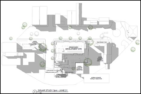
Figure 18: overshadowing 3pm June 21
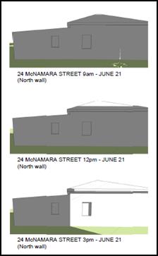
Figure 19: Overshadowing of north facing windows
– 9am, 12pm and 3pm June 21
Current approved use as a
dwelling
Based on the foregoing planning principle regarding
overshadowing, it is considered that the proposed development would have an
unacceptable impact on 24 McNamara Street if it is considered as a dwelling.
In particular, it is evident from the diagrams above that
the proposed development would substantially overshadow both of the north
facing windows between 9am and 2pm, with the shadow progressively receding
during the late afternoon. Following an assessment of the plans and further
analysis submitted by the applicant, it is estimated that the north facing
windows of the dwelling would receive less than one hour of sunlight between
9am and 3pm, with one window receiving between 15 and 30 minutes of sunlight
and the other window receiving no sunlight.
Further, it is noted that the area of private open space
that would be located to the rear of the dwelling would be substantially
overshadowed throughout the day, with only the rear portion of the site receiving
meaningful sunlight in the middle of the day.
Given that the north facing windows and area of private open
space located to the immediate rear of the dwelling would be the most sensitive
elements of the dwelling to the impact of overshadowing, it is considered that
the proposed development would have an unacceptable impact when considered
against the planning principle. In order to reduce the impact, it would be
necessary to require a redesign of the proposed development.
It should be noted that the extent over overshadowing is
assessed on 21 June 21 (ie the Winter Solstice) because the sun is
low in the sky and shadows are longest. In this regard, it is noted that the
impact of overshadowing on the north facing windows and private open space of
24 McNamara Street will be less before and after June 21, with optimum solar
access occurring on the Summer Solstice during December.
With regard to the solar panels located on the roof of 24
McNamara Street, the plans indicate that while both the east and west facing
solar panels will be in shadow at 9am, the shadow would progressively recede
through the morning, with both sets of panels being in full sun by 12pm and
remaining in full sun until late into the afternoon. Unlike northern windows,
solar panels could, in effect, operate beyond the hours of 9am to 3pm.
Therefore at least three hours of direct sunlight to the panels through the
middle of the day is considered reasonable.
Current actual use as an
accounting business
While the current actual use of 24 McNamara Street for the
purpose of an accounting business would experience the same level of impact as
described above, it is not considered that a business use is as sensitive to
overshadowing as a dwelling.
In particular, it is considered that the use of a room for
an office or meeting area is not as sensitive as a habitable room of a
dwelling, such as a living room or kitchen. Similarly, it is not considered
that the area of open space located at the rear of the building would be as
sensitive as a private open space immediately adjoining a dwelling.
Therefore, while the current business use may benefit from
good solar access, it is not considered to be as important, or necessary, as
good solar access to a dwelling. As such it is considered that the impact on
the current business use is acceptable and could be supported when considered
against the planning principle.
The impact of overshadowing on the solar panels would not
change from the foregoing assessment and is considered reasonable.
Likely highest and best future
use as a multi-level commercial purpose
Given the applicable planning controls, including the B3
Commercial Core zone, Maximum Building Height of 16m, Floor Space Ratio of 2:1
and Orange Development Control Plan 2004 planning outcomes for business
areas, it is considered that the highest and best use of 24 McNamara Street is
likely to be a more intense form of commercial development. However, it is
noted that in order for 24 McNamara Street to accommodate a building
of 16m with a Floor Space Ratio of 2:1, it is likely that it would need to
be consolidated with one or more adjoining lots.
In this regard, it is considered that the impact of
overshadowing cast by the proposed development would be limited to the ground
floor of any new development and that a suitable design outcome could be
achieved to mitigate such impact (ie no north facing windows on the ground
floor area or north facing rooms used for non-sensitive uses such as storage or
services).
Furthermore, it is noted that any upper level is unlikely to
be affected by overshadowing cast by the proposed development.
Similarly, it is considered that any likely future
development would have a greater potential to effectively utilise roof mounted
solar panels.
As such it is considered that the potential impact on the
likely future use and development of 24 McNamara Street would be acceptable and
could be supported when considered against the planning principle.
Conclusion
Having regard to the likely overshadowing impact under each
scenario and the overshadowing planning principle, it is considered that the
proposed development is likely to have an acceptable impact.
In particular, it is noted that while the current approved
use of 24 McNamara Street is a dwelling, it is in fact being used for an
accounting business, which is an indication of how the locality in general and
the property specifically are progressively transitioning to a higher and
better commercial use as anticipated by the applicable planning controls.
As such, while it is accepted that overshadowing of the
north facing windows and private open space of a dwelling is inappropriate; in
the current context it is considered that the likely overshadowing impact is
acceptable.
Overlooking
Planning Principle:
When visual privacy is referred
to in the context of residential design, it means the freedom of one dwelling
and its private open space from being overlooked by another dwelling and its
private open space. Most planning instruments and development control plans
acknowledge the need for privacy, but leave it to be assessed qualitatively.
Numerical guidelines for the separation of dwellings exist in the
Australia-wide guideline, AMCORD; as well is in the NSW-specific Residential
Flat Design Code attached to SEPP 65. AMCORD recommends a separation of 9m
between habitable rooms. The Residential Flat Design Code recommends increasing
separation between buildings as they get taller. For buildings up to three
storeys, it suggests 12m between habitable rooms and balconies, 9m between a
habitable and non-habitable room, and 6m between non-habitable rooms. For tall
buildings (such as the proposal) it suggests 24m between habitable rooms, 18m
between habitable rooms and non-habitable rooms, and 12m between non-habitable
rooms.
· Generalised numerical
guidelines such as above, need to be applied with a great deal of judgment,
taking into consideration density, separation, use and design. The following
principles may assist.
· The ease with
which privacy can be protected is inversely proportional to the density of
development. At low-densities there is a reasonable expectation that a dwelling
and some of its private open space will remain private. At high-densities it is
more difficult to protect privacy.
· Privacy can be
achieved by separation. The required distance depends upon density and whether
windows are at the same level and directly facing each other. Privacy is
hardest to achieve in developments that face each other at the same level. Even
in high-density development it is unacceptable to have windows at the same
level close to each other. Conversely, in a low-density area, the objective
should be to achieve separation between windows that exceed the numerical
standards above. (Objectives are, of curse, not always achievable.)
· The use of a
space determines the importance of its privacy. Within a dwelling, the privacy
of living areas, including kitchens, is more important than that of bedrooms.
Conversely, overlooking from a living area is more objectionable than
overlooking from a bedroom where people tend to spend less waking time.
· Overlooking of
neighbours that arises out of poor design is not acceptable. A poor design is
demonstrated where an alternative design, that provides the same amenity to the
applicant at no additional cost, has a reduced impact on privacy.
· Where the whole
or most of a private open space cannot be protected from overlooking, the part
adjoining the living area of a dwelling should be given the highest level of
protection.
· Apart from
adequate separation, the most effective way to protect privacy is by the skewed
arrangement of windows and the use of devices such as fixed louvres, high
and/or deep sills and planter boxes. The use of obscure glass and privacy
screens, while sometimes being the only solution, is less desirable.
· Landscaping
should not be relied on as the sole protection against overlooking. While
existing dense vegetation within a development is valuable, planting proposed
in a landscaping plan should be given little weight.
· In areas
undergoing change, the impact on what is likely to be built on adjoining sites,
as well as the existing development, should be considered.
Current approved use as a
dwelling
Given that the accommodation component of the proposed
development includes south and east facing balconies and windows, it presents a
significant opportunity for overlooking of the rear yard and north facing
windows of 24 McNamara Street. The upper level barbeque area also presents an
opportunity for overlooking of the north facing windows and rear private open
space.
In this regard, it is noted that the majority of south
facing windows and balconies are located in excess of 23m from the common
boundary with 24 McNamara Street. Despite the high number of south facing
windows and balconies, it is considered that a separation distance of 23m would
achieve an acceptable level of privacy in a commercial setting.
However, the east facing windows and balconies and the upper
level barbeque area are located within 5m and 8m of 24 McNamara Street respectively,
and would allow for some overlooking of the north facing windows and rear
private open space. A separation distance of 5m to 8m is not considered to be
adequate and could not be supported.
Notwithstanding, while this would present an unacceptable outcome,
it is considered that the impact could be mitigated to an acceptable level
through the application of external screening devices along the southern
elevation of each east facing balcony and the barbeque area. As such, it is
considered that a condition of consent should be applied to this affect.
Current actual use as an
accounting business
Based on the foregoing assessment, it is considered that the
proposed development would not have an adverse impact on the existing use of 24
McNamara Street as an accounting business.
Likely highest and best future
use as a multi-level commercial purpose
Based on the foregoing assessment, it is considered that the
proposed development would not have an adverse impact on the existing use of 24
McNamara Street for a higher and better commercial use.
Height, Bulk and Scale
Planning Principle:
The appropriateness of a
proposal’s height and bulk is most usefully assessed against planning
controls related to these attributes, such as maximum height, floor space
ratio, site coverage and setbacks. The questions to be asked are:
Are the impacts consistent
with impacts that may be reasonably expected under the controls? (For complying
proposals this question relates to whether the massing has been distributed so
as to reduce impacts, rather than to increase them. For non-complying proposals
the question cannot be answered unless the difference between the impacts of a
complying and a non-complying development is quantified.) How does the
proposal’s height and bulk relate to the height and bulk desired under
the relevant controls?
Where the planning controls
are aimed at preserving the existing character of an area, additional questions
to be asked are: Does the area have a predominant existing character and
are the planning controls likely to maintain it? Does the proposal fit into the
existing character of the area?
Where the planning controls
are aimed at creating a new character, the existing character is of less
relevance. The controls then indicate the nature of the new character desired.
The question to be asked is: Is the proposal consistent with the bulk and
character intended by the planning controls?
Where there is an absence of
planning controls related to bulk and character, the assessment of a proposal
should be based on whether the planning intent for the area appears to be the
preservation of the existing character or the creation of a new one. In cases
where even this question cannot be answered, reliance on subjective opinion
cannot be avoided. The question then is: Does the proposal look
appropriate in its context?
Assessment
The height, bulk and scale of
the proposed development relative to 24 McNamara Street is demonstrated below
by Figure 20.
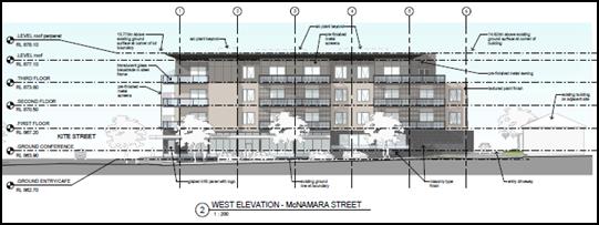
Figure 20: comparison of height, bulk and scale -
proposed development and 24 McNamara Street
Current approved use as a
dwelling
The Orange LEP provides specific controls to address height,
bulk and scale within the Orange CBD. In particular, this includes Clause
4.3 Height of buildings (ie maximum building height of 16m) and Clause 4.4
Floor space ratio (ie Floor space ration of 2:1). These provisions have been
addressed in detail in the body of this report.
While it is evident that there would be a contrast between
the height, bulk and scale of the proposed development and 24 McNamara Street,
it is noted that the proposed development has been designed to achieve the
outcomes anticipated by the LEP provisions.
As such, the foregoing planning principle indicates that the
appropriate test is to consider “…whether the massing has
been distributed so as to reduce impacts, rather than to increase them”. In
this regard, it is noted that the proposed development has been intentionally
designed to step down to three levels adjacent to 24 McNamara Street, with a
driveway also separating each property. Further, it is noted that the proposed
development has been massed most heavily along the Kite Street and McNamara
Street boundaries, with the building form stepping down to the ground level car
park to the southeast adjacent to the rear yard of 24 McNamara Street. This
outcome would ensure some relief to the private open space of 24 McNamara
Street.
In this regard it is considered that the proposed
development has been massed in a manner which would reduce the impact on 24
McNamara Street and that the impacts of the height, bulk and scale of the
proposed development are consistent with the impacts which would be reasonably
expected under the LEP controls.
Furthermore, it is noted that the planning principle
highlights that where planning controls are aimed at creating a new character,
the existing character is of less relevance, with the controls indicating the
nature of the new character desired. This point further serves to demonstrate
that while there is a contrast in height, bulk and scale between the proposed
development and 24 McNamara Street, it appropriate where the planning controls
are seeking to facilitate a more substantial form of development.
Current actual use as an
accounting business
Based on the foregoing assessment, it is considered that the
proposed development would not have an adverse impact on the existing use of 24
McNamara Street as an accounting business.
Likely highest and best future
use as a multi-level commercial purpose.
Based on the foregoing assessment, it is considered that the
proposed development would not have an adverse impact on the likely development
of 24 McNamara Street for a higher and better commercial use.
Further, in is noted that the proposed development reflects
the character envisaged by the planning controls which apply to the immediate
area. This has been confirmed by the assessment of Councils Heritage/Urban
Design Advisor with regard to Council’s recently adopted Orange
Development Control Plan 2004 Infill Guidelines.
In particular, the Heritage/Urban Design Advisor commented
that while the building is higher than the neighbouring buildings, the scaling
references and mitigates the impact; and the form of the building addresses the
street corner where the height and corner details are appropriate.
Noise
The owner of 24 McNamara has raised concerns regarding the
impact of noise associated with the construction period and operation of the
development (eg loading zones).
Noise has been previously addressed in detail under the
heading “The Likely Impacts of the Development s79c(1)(b)”.
In summary, it is considered that the environmental health
impacts, including noise arising from the construction and operation of the
proposed development, can be adequately mitigated at the detailed design phase
and during ongoing operations.
OTHER IMPACTS
Accuracy of Property Boundary
The owner of 24 McNamara Street has indicated that the plans
submitted by the applicant do not accurately reflect the boundary of the
subject property.
In this regard, it is noted that during the assessment
process Council staff requested that the applicant provide further details
regarding the alignment of the subject property’s southern boundary
adjacent to 26 McNamara Street, due to a discrepancy between the architectural
plans and Council’s mapping system.
The applicant’s surveyor has subsequently advised
Council that it has undertaken a full boundary redefinition accounting for the
discrepancy between the actual property boundary and Council’s mapping
system. The surveyor has provided written advice indicating that the
discrepancy arose as a result of an error in a deed description used to create
and dimension the effected lot.
PUBLIC INTEREST
s79C(1)(e)
The proposed development is considered to be of minor
interest to the wider public due to the relatively localised nature of
potential impacts. The proposal is not inconsistent with any relevant policy
statements, planning studies, guidelines, etc that have not been considered in
this assessment.
SUMMARY
The proposed development is permissible with the consent of
Council. The proposed development complies with the relevant aims, objectives
and provisions of the LEP. A section 79C assessment of the development
indicates that the development is acceptable in this instance. Attached is a
draft Notice of Approval outlining a range of conditions considered appropriate
to ensure that the development proceeds in an acceptable manner.
COMMENTS
The requirements of the Environmental Health and Building
Surveyor and the Engineering Development Section are included in the attached
Notice of Approval.
Attachments
1 Notice
of Approval, D17/21205⇩
2 Plans,
D17/22246⇩
3 External
Finishes, IC17/5716⇩
4 Submissions
(community), D17/20397⇩
5 Submissions
(external authorities), D17/20399⇩
6 Heritage
Advice, D17/20400⇩
7 Supplementary
Heritage Advice, D17/20859⇩
Planning and Development Committee
4 April 2017
2.4 Development
Application DA 304/2016(1) - 132-142 Kite Street and 26 McNamara Street
Attachment 1 Notice
of Approval
|

|
ORANGE
CITY COUNCIL
Development
Application No DA
304/2016(1)
NA17/ Container
PR14263
|
NOTICE OF DETERMINATION
OF A DEVELOPMENT
APPLICATION
issued under the Environmental
Planning and Assessment Act 1979
Section 81(1)
|
Development
Application
|
|
|
Applicant Name:
|
TPG Town
Planning & Urban Design
|
|
Applicant Address:
|
Attention:
Ashleigh Coombes
PO Box 820
EDGECLIFF
NSW 2027
|
|
Owner’s Name:
|
Eastern
Developments Pty Ltd
|
|
Land to Be Developed:
|
Lot 1 DP 197828, Lots
2-6 DP 131416 and Lots 1‑3 DP 779111 -
132-142 Kite Street and 26 McNamara Street, Orange
|
|
Proposed Development:
|
Demolition,
Hotel or Motel Accommodation, Restaurant or Cafe, Retail Premises and
Subdivision (44 lot Strata)
|
|
|
|
|
Building
Code of Australia
building
classification:
|
To be
determined by the PCA
|
|
|
|
|
Determination
|
|
|
Made On:
|
4 April
2017
|
|
Determination:
|
CONSENT
GRANTED SUBJECT TO CONDITIONS DESCRIBED BELOW:
|
|
|
|
|
Consent to
Operate From:
|
5 April
2017
|
|
Consent to
Lapse On:
|
5 April
2022
|
Terms of Approval
The reasons for the imposition of
conditions are:
(1) To ensure a quality
urban design for the development which complements the surrounding environment.
(2) To maintain
neighbourhood amenity and character.
(3) To ensure compliance
with relevant statutory requirements.
(4) To provide adequate
public health and safety measures.
(5) Because the development
will require the provision of, or increase the demand for, public amenities and
services.
(6) To ensure the utility
services are available to the site and adequate for the development.
(7) To prevent the proposed
development having a detrimental effect on adjoining land uses.
(8) To minimise the impact
of development on the environment.
Conditions
(1) The development
must be carried out in accordance with:
(a) Plans
numbered DA.01
(10.11.16), DA02(30.08.16), DA03(08.02.17), DA.04 (10.02.17), DA.05 (08.02.17),
DA.06 (21.12.16), DA.07(10.11.16), DA.08 (30.08.16), DA.09(30.08.16), DA.10
(30.08.16), DA.11 (21.03.17), Exterior Finishes (03.11.16 and March 2017) (13
sheets)
(b) statements
of environmental effects or other similar associated documents that form part
of the approval
as amended
in accordance with any conditions of this consent.
(2) All building work must
be carried out in accordance with the provisions of the Building Code of
Australia.
(3) A sign is to be erected
in a prominent position on any site on which building work, subdivision work or
demolition work is being carried out:
(a) showing
the name, address and telephone number of the principal certifying authority
for the work, and
(b) showing
the name of the principal contractor (if any) for any building work and a
telephone number on which that person may be contacted outside working hours,
and
(c) stating
that unauthorised entry to the site is prohibited.
Any such sign is to be maintained while the
building work, subdivision work or demolition work is being carried out.
(4) Where any excavation
work on the site extends below the level of the base of the footings of a
building on adjoining land, the person having the benefit of the development
consent must, at the person’s own expense:
(a) protect
and support the adjoining premises from possible damage from the excavation,
and
(b) where
necessary, underpin the adjoining premises to prevent any such damage.
Note: This
condition does not apply if the person having the benefit of the development
consent owns the adjoining land or the owner of the adjoining land has given
consent in writing to this condition not applying.
DEMOLITION
|
PRIOR TO WORKS
COMMENCING
|
(5) Due
to the extensive nature of the demolition works and their proximity to the
public footpath, the applicant is to provide public liability and public risk
insurance cover for a minimum of $10,000,000, endorsed to cover Council
for its respective rights and interests. Evidence of valid insurance cover must
be submitted to Council.
(6) Prior
to demolition works commencing, the applicant is to obtain an approval under
Section 68 of the Local Government Act for the temporary closure of
any footpath or roadway. A pedestrian/vehicle management plan is to
accompany the application. Details are to be provided of the protective
hoardings, fences and lighting that are to be used during demolition,
excavation and building works in accordance with the requirements of the Occupational
Health & Safety Act 2000, Australian Standard AS3798-1996
(Guidelines on Earthworks for Commercial and Residential Developments) and the
WorkCover Authority.
Note: On corner
properties, particular attention is to be given to the provision of adequate
sight distances.
(7) The
applicant is to submit a waste management plan that describes the nature of
wastes to be removed, the wastes to be recycled and the destination of all
wastes. All wastes from the demolition phase of this project are to be
deposited at a licensed or approved waste disposal site.
(8) A
survey to determine the existence of any hazardous materials on the site is to
be provided. Suitable arrangements are to be made to dispose of, or remediate,
any identified hazardous materials - including the notification of authorities
and/or the obtaining of any required permits. Particular care and attention is
to be paid to the disposal of any waste containing asbestos material.
|
DURING
DEMOLITION/SITEWORKS
|
(9) All
construction/demolition work on the site is to be carried out in accordance
with the EPA’s Interim Construction Noise Guideline 2009.
(10) All
construction/demolition work on the site is to be carried out between the hours
of 7.00 am and 6.00 pm Monday to Friday inclusive, 7.00 am to
5.00 pm Saturdays and 8.00 am to 5.00 pm Sundays and Public
Holidays. Written approval must be obtained from the General Manager of Orange
City Council to vary these hours.
(11) Building
demolition is to be carried out in accordance with Australian
Standard 2601:2001 - The Demolition of Structures and the requirements
of the NSW WorkCover Authority.
(12) Any asbestos
material must be removed and disposed of in accordance with the provisions of
the Work Health & Safety Act 2011 and any guidelines or Codes of
Practice published by WorkCover.
(13) Any adjustments to
existing utility services that are made necessary by this development
proceeding are to be at the full cost of the developer.
(14) The existing sewer
connection to the building proposed to be removed is to be sealed off at the
sewer main.
(15) The existing water
service connection to the building proposed to be removed is to be sealed off
at the Council water main.
(16) Certification from
Orange City Council is required shall be obtained on completion of the
demolition works stating that all works relating to disconnection of the
development from Council assets, works on Public Land, stormwater, sewer and
water reticulation mains and footpaths have been carried out in accordance with
the Orange City Council Development and Subdivision Code and the foregoing
conditions.
(17) A Tree Protection Zone
(TPZ) as detailed in AS 4970 – 2009 shall be established on the
development site 132 – 142 Kite Street for the Eucalyptus sp tree sited
upon 145-147 Peisley Street.
(18) No
excavation shall occur within 4 metres of the centre of the stem of the Eucalyptus
sp tree sited upon 145-147 Peisley Street in accordance with the Tree
Protection Zone required by Condition (17).
(19) All
of the foregoing conditions are to be at the full cost of the developer and to
the requirements and standards of the Orange City Council Development and
Subdivision Code, unless specifically stated otherwise. All work required by
the foregoing conditions is to be completed prior to the issuing of an
Occupation or Subdivision Certificate, unless stated otherwise.
CONSTRUCTION OF MOTEL, CAFE
AND RETAIL PREMISES
|
PRIOR TO THE ISSUE OF
A CONSTRUCTION CERTIFICATE
|
(20) Architectural plans
must be amended prior to the issue of a Construction Certificate to include the
following:
·
A 1.8m high screening device on the southern elevation of each east facing
balcony and the upper level barbeque area. The height of the screening device
must be measured from the finished floor level of each balcony and the barbeque
area respectively. The screening device must be a pre-finished metal screen
with horizontal blades consistent with the pre-finished metal screens shown on
the northern and western elevations of the building. The blades of the screen
must be orientated to prevent overlooking of the adjoining property at 24
McNamara Street.
· A perforated or
louvered metal screen around the north, west and east sides of each roof
mounted unit. The height of each screen must be equal to the height of each
unit. The screens must be finished with Dulux colour Windspray.
· Pre-finished metal
screens attached to each bay of balconies along the Kite Street and McNamara
Street frontages, consistent with those metal screens shown on the Plan DA.06
dated 21 December 2016.
· Ruled 5mm (nominal)
joints at floor, window sill and window headlines.
· Material D on the
Exterior Finishes plan dated 3 November 2016 and Exterior Finishes Board dated
March 2017 must be a genuine stone product, similar to Basalt in colour with a
traditional Rough finish, laid in a traditional Random ashlar pattern and tight
10-15mm joints to be provided with recessed pointing darker than the stone. The
stone is to be used to clad the external walls on the ground floor of the two
street elevations.
· Material E on the
Exterior Finishes plan dated 3 November 2016 and Exterior Finishes Board dated
March 2017 shall be similar to Basalt in colour but fully dressed on the
exposed faces, laid in a traditional Random coursed ashlar pattern with a Honed
finish and tight 10-15mm joints with recessed pointing darker than the stone.
· Aluminium framing to
the doors and windows shall have an anodised Light Bronze colour by
Architectural Window Systems or equal, or a powder coated finish similar to
Dulux Wheatmeal.
· The colour bond fence
as shown on DA.04 dated 10 February 2017shall be replaced with a 1.8m high
lapped and capped hardwood timber fence. The height of the fence must be
measured from the finished ground level of each adjoining property.
Note It is
suggested strongly that the applicant obtain advice from Council and its
Heritage Adviser to ensure that stone material complies with heritage
requirements.
(21) The payment of $126,579.15
shall be made to
Council in accordance with Section 94 of the Act and Orange Car Parking
Development Contributions Plan 2015 in lieu of the
physical provision of adequate on-site car parking spaces.
PAYMENT MUST BE MADE PRIOR TO THE
ISSUE OF ANY CERTIFICATE under part 4A of
the Act.
The contribution shall be indexed
quarterly in accordance with the Orange Car Parking Development Contributions
Plan 2015, which may be inspected at the Orange Civic Centre, Byng Street,
Orange.
(22) An
approval under Section 68 of the Local Government Act is to be sought
from Orange City Council, as the Water and Sewer Authority, for water, sewer
and stormwater connection. No plumbing and drainage is to commence until
approval is granted.
(23) Prior
to the issue of a Construction Certificate, the applicant is to obtain an
approval under Section 68 of the Local Government Act for the
temporary closure of any footpath or roadway. A pedestrian/vehicle
management plan is to accompany the application. Details are to be provided of
the protective hoardings, fences and lighting that are to be used during
demolition, excavation and building works in accordance with the requirements
of the Occupational Health & Safety Act 2000, Australian
Standard AS3798-1996 (Guidelines on Earthworks for Commercial and Residential
Developments) and the WorkCover Authority.
Note: On corner
properties particular attention is to be given to the provision of adequate
sight distances.
(24) Detailed
plans and specifications are to be provided specifying the proposed fitout of
the food preparation and storage areas in accordance with the requirements of
Australian Standard 4674-2004 "Design and construction and fitout of
food premises" and Standard 3.2.3 "Food Premises and
Equipment" of the Australian New Zealand Food Standards Code.
(25) The
applicant is to submit a waste management plan that describes the nature of
wastes to be removed, the wastes to be recycled and the destination of all
wastes. All wastes from the construction phase of this project are to be
deposited at a licensed or approved waste disposal site.
(26) Prior
to the issue of a Construction Certificate, evidence shall be submitted to
Council of the lodgement of plans with Land & Property Information to
consolidate Lot 1 DP 197826, Lots 2-6 DP 131416 and Lots 1-3
DP 779111 into one parcel.
(27) The applicant shall
provide the Principal Certifying Authority and Council with a report from a
qualified Acoustic Consultant that identifies all mechanical equipment and
attenuation solutions (such as acoustic shielding) to be installed within the
development. The Report shall confirm that the operation of such plant will
comply with the NSW State Industrial Noise Policy. Plans must be amended to
include any recommendations and design requirements of the Acoustic Consultant
prior to the issue of a Construction Certificate.
(28) Engineering plans,
showing details of all proposed work and adhering to any engineering conditions
of development consent, are to be submitted to, and approved by, Orange City
Council or an Accredited Certifier (Categories B1, C3, C4, C6) prior to the
issuing of a Construction Certificate.
(29) A water and soil
erosion control plan is to be submitted to Orange City Council or an Accredited
Certifier (Categories B1, C3, C4, C6) for approval prior to the issuing of a
Construction Certificate. The control plan is to be in accordance with the
Orange City Council Development and Subdivision Code and the Landcom, Managing
Urban Stormwater; Soils and Construction Handbook.
(30) Engineering plans
providing complete details of the proposed driveways and car parking areas are
to be submitted to Orange City Council or an Accredited Certifier (Categories
B1, C3, C4, C6) upon application for a Construction Certificate. These plans are
to provide details of levels, cross falls of all pavements, proposed sealing
materials and proposed drainage works and are to be in accordance with Orange
City Council Development and Subdivision Code.
(31) All stormwater from the
site is to be collected and piped to the existing stormwater pits located on
the corner of Kite Street and McNamara Lane. Orange City Council or an
Accredited Certifier (Categories B1, C3, C4, C6), prior to issuing a
Construction Certificate, is to approve engineering plans for this drainage
system. The drainage works are to be in accordance with Orange City Council
Development and Subdivision Code.
The
existing stormwater line serving Lot 1 DP 779074 is to be included as part of
the drainage works.
(32) The existing 150mm diameter
sewer main is to be relocated clear of the proposed building. Prior to a
Construction Certificate being issued engineering plans for this sewerage
system are to be submitted to and approved by Orange City Council.
(33) A Liquid
Trade Waste Application is to be submitted to Orange City Council prior to the
issuing of a Construction Certificate. The application is to be in accordance
with Orange City Council’s Liquid Trade Waste Policy. Engineering plans
submitted as part of the application are to show details of all proposed liquid
trade waste pre-treatment systems and their connection to sewer.
Where applicable, the applicant is to
enter into a Liquid Trade Waste Service Agreement with Orange City Council in
accordance with the Orange City Council Liquid Trade Waste Policy.
(34) Payment of
contributions for water, sewer and drainage works is required to be made
at the contribution rate applicable at the time that the payment is made. The
contributions are based on 26.75 ETs for water supply headworks and 42.25 ETs
for sewerage headworks. A Certificate of Compliance, from Orange City Council
in accordance with the Water Management Act 2000, will be issued upon
payment of the contributions.
This Certificate of Compliance is to be
submitted to the Principal Certifying Authority prior to the issuing of a
Construction Certificate.
(35) Backflow Prevention
Devices are to be installed to AS3500 and in accordance with Orange City
Council Backflow Protection Guidelines. Details of the Backflow Prevention Devices
are to be submitted to Orange City Council prior to the issuing of a
Construction Certificate.
(36) The 150mm diameter
sewer main that crosses the site is to be accurately located in relation to the
proposed building. Where the main is positioned adjacent to any part of the
building, measures to support building footings and slabs are to be taken in
accordance with Orange City Council Policy - Building over and/or adjacent to
sewers ST009.
|
PRIOR TO WORKS
COMMENCING
|
(37) A Tree Protection Zone
(TPZ) as detailed in AS 4970 – 2009 shall be established on the
development site 132 – 142 Kite Street for the Eucalyptus sp tree sited
upon 145-147 Peisley Street.
(38) A
Construction Certificate application is required to be submitted to, and issued
by Council/Accredited Certifier prior to any excavation or building works being
carried out onsite.
(39) A
temporary onsite toilet is to be provided and must remain throughout the
project or until an alternative facility meeting Council’s requirements
is available onsite.
(40) Soil erosion control
measures shall be implemented on the site.
|
DURING
CONSTRUCTION/SITEWORKS
|
(41) No excavation shall
occur within 4 metres of the centre of the stem of the Eucalyptus sp tree sited
upon 145-147 Peisley Street in accordance with the Tree Protection Zone
required by Condition (37).
Prior
to removal of the TPZ to construct the vehicle crossover and driveway
Council’s Manager City Presentation shall be contacted and approval
gained to establish formwork within the TPZ for the construction of any hard
surfacing.
(42) In the event of an
unexpected find during works such as (but not limited to) the presence of
undocumented waste, odorous or stained soil, asbestos, structures such as
underground storage tanks, slabs, or any contaminated or suspect material, all
work on site must cease immediately. The beneficiary of the consent must
discuss with Council the appropriate process that should be followed therein.
Works on site must not resume unless the express permission of the Director
Development Services is obtained in writing
(43) All
construction/demolition work on the site is to be carried out in accordance
with the EPA’s Interim Construction Noise Guideline 2009.
(44) A
Registered Surveyor’s certificate identifying the location of the
building on the site must be submitted to the Principal Certifying Authority
prior to the pouring of the slab or footings.
(45) All
construction works are to be strictly in accordance with the Reduced Levels (RLs)
as shown on the approved plans.
(46) All
materials onsite or being delivered to the site are to be contained within the
site. The requirements of the Protection of the Environment Operations Act
1997 are to be complied with when placing/stockpiling loose material or
when disposing of waste products or during any other activities likely to
pollute drains or watercourses.
(47) Any adjustments to
existing utility services that are made necessary by this development
proceeding are to be at the full cost of the developer.
(48) The
provisions and requirements of the Orange City Council Development and
Subdivision Code are to be applied to this application and all work constructed
within the development is to be in accordance with that Code.
The developer is to be entirely responsible for
the provision of water, sewerage and drainage facilities capable of servicing
the development from Council’s existing infrastructure. The developer is
to be responsible for gaining access over adjoining land for services where
necessary and easements are to be created about all water, sewer and drainage
mains within and outside the lots they serve.
(49) All driveway and
parking areas are to be sealed with bitumen, hot mix or concrete and are to be
designed for all expected loading conditions (provided however that the minimum
pavement depth for gravel and flush seal roadways is 200mm) and be in
accordance with the Orange City Council Development and Subdivision Code.
(50) Heavy-duty concrete
kerb and gutter laybacks and footpath crossings are to be constructed for the
entrances to the proposed development. The location and construction of the
laybacks and footpath crossings are to be as required by the Orange City
Council Development and Subdivision Code.
(51) The existing basalt
(bluestone) kerb and gutters in Kite Street and McNamara Lane are to be
retained. Where bluestone exists in the location of the proposed new driveways,
the bluestone gutter is to be retained and incorporated into the new vehicular
layback. Any kerb stones removed as a result of the works are to be firstly
used as kerb stones in the areas of reinstated kerb and any leftover stones
returned to Council.
The
existing driveways in Kite Street and McNamara Street that are not proposed to
be used are to be replaced with concrete and/or bluestone kerb, and the
footpath reinstated to the requirements of the Orange City Council Development
and Subdivision Code.
|
PRIOR TO THE ISSUE OF
AN OCCUPATION CERTIFICATE
|
(52) Garbage collection is
to be fully contained within the site. Bins must not to be located on the
footpath or roadway on collection days. Prior to a Construction Certificate
being issued plans and/or details of the operation of the garbage collection
are to be submitted to and approved by Orange City Council, including details
of a private service agreement with Council’s waste contractor. The
private service agreement must be to the satisfaction of Council's Waste
Services Manager.
(53) An amended Car Parking
Management plan must be submitted to and be approved by Council’s Manager
Development Assessments accounting for the 80 on-site car parking spaces
provided. The revised Car Parking Management plan must:
· Allocate 77 car parking
spaces to the accommodation component of the proposed hotel, with one car
parking space to be allocated to each of the 77 units; and
· Provide an appropriate
methodology for each car park to be accessed at all times (i.e. all
‘tandem’ and ‘valet’ car parking spaces must be
accessible to hotel occupants at all times via the valet parking system).
(54) External lighting is to
be provided to ensure adequate lighting of the proposed car park to ensure the
safety of employees and visitors outside of daylight hours. The lighting must
be installed on the external façade of the existing / proposed building
and be orientated in such a manner that it does not cause light spill from the
subject property. Outdoor lighting must be in accordance with Australian
Standard Control of the obtrusive effects of outdoor lighting – AS 4282-1997.
(55) No
person is to use or occupy the building or alteration that is the subject of
this approval without the prior issuing of an Occupation Certificate.
(56) Where
Orange City Council is not the Principal Certifying Authority, a final inspection
of water connection, sewer and stormwater drainage shall be undertaken by
Orange City Council and a compliance certificate issued, prior to the issue of
either an interim or a final Occupation Certificate.
(57) The
owner of the building/s must cause the Council to be given a Final Fire Safety
Certificate on completion of the building in relation to essential fire or
other safety measures included in the schedule attached to this approval.
(58) Prior to the issue of
an Occupation Certificate, evidence shall be submitted to Council of the
registration of plans with the Department of Lands and Property Information to
consolidate Lot 1 DP 197826, Lots 2-6 DP 131416 and Lots 1-3 DP 779111
into one parcel.
(59) The applicant shall
provide Council with an Operational Management Plan. The Plan shall include
measures to appropriately mitigate operational noise from the development
(including noise from plant; patrons/pedestrians entering/leaving the site;
noise from private areas such as balconies and the BBQ area; waste collection
times; delivery times, general access and security gate operations) along with
measures to mitigate odours and fumes that could be emitted from the kitchen or
waste storage area.
(60) Certification from
Orange City Council is required to be submitted to the Principal Certifying
Authority prior to the issue of an Occupation Certificate stating that all
works relating to connection of the development to Council assets, works on
public land, works on public roads, stormwater, sewer and water reticulation
mains and footpaths have been carried out in accordance with the Orange City
Council Development and Subdivision Code and the foregoing conditions, and that
Council will take ownership of the infrastructure assets.
(61) Certificates for
testable Backflow Prevention Devices are to be submitted to Orange City Council
by a plumber with backflow qualifications prior to the issue of an Occupation
Certificate.
(62) Prior to the issue of
an Occupation Certificate the existing 2.0m wide interlot drainage
easement benefiting Lot 1 DP 779074 shall be amended as required. A
Restriction-as-to-User under section 88B of the NSW Conveyancing Act 1979
is to be created on the title of the proposed development Lot requiring that no
structures are to be placed on the site, or landscaping or site works carried
out on the site, in a manner that affects the continued operation of the
interlot drainage system. The minimum width of the easement is to be as
required in the Orange City Council Development and Subdivision Code.
(63) All
of the foregoing conditions are to be at the full cost of the developer and to
the requirements and standards of the Orange City Council Development and
Subdivision Code, unless specifically stated otherwise. All work required by
the foregoing conditions is to be completed prior to the issuing of an
Occupation or Subdivision Certificate, unless stated otherwise.
|
MATTERS FOR THE
ONGOING PERFORMANCE AND OPERATION OF THE DEVELOPMENT
|
(64) The applicant shall
within 3 months from the issue of any Occupation Certificate arrange for
street trees are to be supplied and installed in Kite Street and McNamara
Street to Council’s specification, including removal of the existing
Scotch Elm and refurbishment of the tree surround within the Kite Street
frontage.
Each
new tree site (three) in Kite Street is to be planted with a Fraxinus
‘Raywood’ – Claret Ash grown in a minimum 100 litre
container size. Tree planting and surrounds are to be to the satisfaction of
Council’s Manager City Presentation.
Each
new tree site (three) and trees species in McNamara Street is to be determined
in consultation with Council’s Manager City Presentation and Traffic
Management Officer. Each street tree shall be of a minimum 100 litre container
size and shall be installed in the parking lane on the McNamara Street frontage
of the subject site. The tree sites shall be constructed using a tree pit in
combination with structural soils methodology (for example City Greens
Stratvault).
(65) Operating hours of the
restaurant or café are restricted to between 6am - 11pm Monday to
Sunday, inclusive.
(66) Access to all services
and facilities within the hotel, other than the restaurant or café,
shall be limited to overnight stay guests only
(67) The development must be
operated in accordance with the approved car parking management plan required
under Condition (53).
(68) The operation of the
hotel, other than the associated restaurant or café shall be limited to
a maximum of four employees and one resident manager at any one time.
(69) All garbage bins must
be stored within the garbage bay at all times, other than on garbage collection
days.
On
garbage collection days, garbage bins must be stored in the garbage bay or
within the property boundary between the conference room terrace and McNamara
Street ingress.
(70) The
owner is required to provide to Council and to the NSW Fire Commissioner an
Annual Fire Safety Statement in respect of the fire-safety measures, as
required by Clause 177 of the Environmental Planning and Assessment
Regulation 2000.
(71) An assessment of noise
emissions from the premises is to be provided to Council within 3 months
from the issue of any Occupation Certificate. This commissioning report is
to indicate noise levels through the monitoring of noise emanating from the
normal peak use of the premises and determine if any, necessary noise
mitigation measures. Any identified mitigation works shall be carried out
within 1 month of the commissioning report, and the operation of the premises shall be
carried out in accordance with any recommendations set out in the report.
(72) Emitted
noise shall not exceed 5dB(A) above background sound level measured at the
nearest affected residence.
(73) The development shall
be operated in accordance with the approved Operational Management Plan.
(74) Waste collection bins
shall be contained within the site and not located on public footpaths or
roadways.
(75) The
use and fitout of the area shown on the plans as Lease Area 2a has not been
approved under this consent. The applicant shall obtain development consent for
the first use of this space.
STRATA SUBDIVISION
|
DURING
CONSTRUCTION/SITEWORKS
|
(76) Any adjustments to
existing utility services that are made necessary by this development
proceeding are to be at the full cost of the developer.
|
PRIOR TO THE ISSUE OF
A SUBDIVISION CERTIFICATE
|
(77) An easement
is created for any existing electrical infrastructure. The easement is to be
created using Essential Energy’s standard easement terms current at the
time of registration of the plan of subdivision.
(78) Notification
of Arrangement (confirming satisfactory arrangements have been made for the
provision of power) must be issued by Essential Energy with respect to all
proposed lots which will form part of the subdivision, prior to Council
releasing the Subdivision Certificate. It is the applicant’s
responsibility to make the appropriate application with Essential Energy for
the supply of electricity to the subdivision, which may include the payment of
fees and contributions.
(79) Prior
to the issue of a Subdivision Certificate, the applicant is to provide a
written statement that the building complies with the Building Code of
Australia with regard to fire separation and early warning systems.
(80) Application shall be
made for a Subdivision Certificate under Section 109(C)(1)(d) of the Act.
(81) Certification from
Essential Energy, stating that electricity and street lighting systems comply
with Essential Energy’s Networks Division Customer Connection Policy
NP11.1, is to be submitted to the Principal Certifying Authority prior to the
issuing of a Subdivision Certificate.
(82) An easement to drain
sewage and to provide Council access for maintenance of sewerage works a
minimum of 2.0 metres wide is to be created over the 150mm diameter sewer line.
The Principal Certifying Authority is to certify that the easement is in
accordance with the Orange City Council Development and Subdivision Code prior
to the issuing of a Subdivision Certificate.
(83) All services are to be
contained within the allotment that they serve. A Statement of Compliance, from
a Registered Surveyor, is to be submitted to the Principal Certifying Authority
prior to the issuing of a Subdivision Certificate.
(84) Prior to the issuing of
a Subdivision Certificate, Certification from Orange City Council is required
stating that all works relating to connection of the development to Council
assets, works on Public Land, stormwater, sewer and water reticulation mains
and footpaths have been carried out in accordance with the Orange City Council
Development and Subdivision Code and the foregoing conditions.
(85) All
of the foregoing conditions are to be at the full cost of the developer and to
the requirements and standards of the Orange City Council Development and
Subdivision Code, unless specifically stated otherwise. All work required by
the foregoing conditions is to be completed prior to the issuing of an
Occupation or Subdivision Certificate, unless stated otherwise.
(1) Any
existing encumbrances in favour of Essential Energy (or its predecessors) noted
on the title of the above property are complied with.
Essential
Energy’s records indicate there is electricity infrastructure located
within close proximity to the property. Any activities within this location
must be undertaken in accordance with the latest industry guideline currently
known as ISSC 20 Guideline for the Management of Activities within
Electricity Easements and Close to Infrastructure.
Prior
to carrying out any works, a “Dial Before You Dig” enquiry must be
undertaken in accordance with the requirements of Part 5E (Protection of
Underground Electricity Power Lines) of the Electricity Supply Act 1995
(NSW).
Given
there is electricity infrastructure in the area, it is the responsibility of
the person/s completing any works around powerlines to understand their safety
responsibilities. SafeWork NSW (www.safework.nsw.gov.au) has publications that
provide guidance when working close to electricity infrastructure. These
include the Code of Practice – Work near Overhead Power Lines and
Underground Assets.
Other Approvals
(1) Local
Government Act 1993 approvals granted under section 68.
Nil
(2) General
terms of other approvals integrated as part of this consent.
Nil
Right of Appeal
If
you are dissatisfied with this decision, section 97 of Environmental
Planning and Assessment Act 1979 gives you the right to appeal to the Land
and Environment Court within 6 months after the date on which you receive this
notice.
*
Section 97 of the Environmental Planning and Assessment Act 1979 does not apply
to the determination of a development application for State significant
development or local designated development that has been the subject of a
Commission of Inquiry.
|
Disability Discrimination Act
1992:
|
This application has been assessed in
accordance with the Environmental Planning and Assessment Act 1979. No
guarantee is given that the proposal complies with the Disability
Discrimination Act 1992.
The applicant/owner is responsible to
ensure compliance with this and other anti-discrimination legislation.
The Disability Discrimination Act
covers disabilities not catered for in the minimum standards called up in the
Building Code of Australia which references AS1428.1 - "Design for
Access and Mobility". AS1428 Parts 2, 3 and 4 provides the most
comprehensive technical guidance under the Disability Discrimination Act
currently available in Australia.
|
|
|
|
|
Disclaimer - S88B Restrictions on the Use of Land:
|
The applicant should note that there
could be covenants in favour of persons other than Council restricting what
may be built or done upon the subject land. The applicant is advised to check
the position before commencing any work.
|
|
|
|
|
Signed:
|
On behalf of the consent authority ORANGE
CITY COUNCIL
|
|
Signature:
|
|
|
Name:
|
DAVID WADDELL - DIRECTOR DEVELOPMENT
SERVICES
|
|
Date:
|
5 April 2017
|
Planning
and Development Committee
4 April 2017
2.4 Development
Application DA 304/2016(1) - 132-142 Kite Street and 26 McNamara Street
Attachment 2 Plans
Planning and Development Committee
4 April 2017
2.4 Development
Application DA 304/2016(1) - 132-142 Kite Street and 26 McNamara Street
Attachment 2 Plans
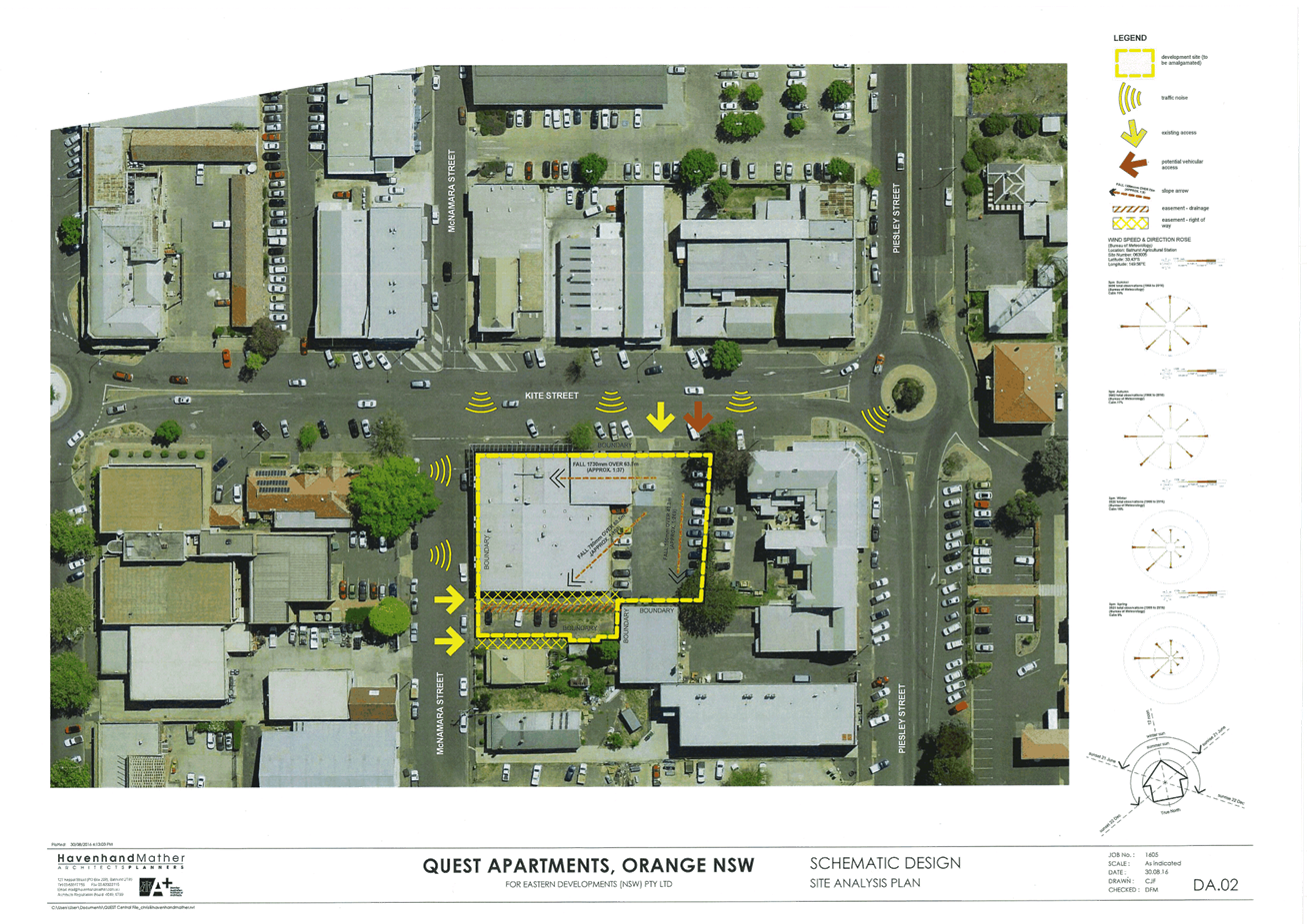
Planning and Development Committee
4 April 2017
2.4 Development
Application DA 304/2016(1) - 132-142 Kite Street and 26 McNamara Street
Attachment 2 Plans
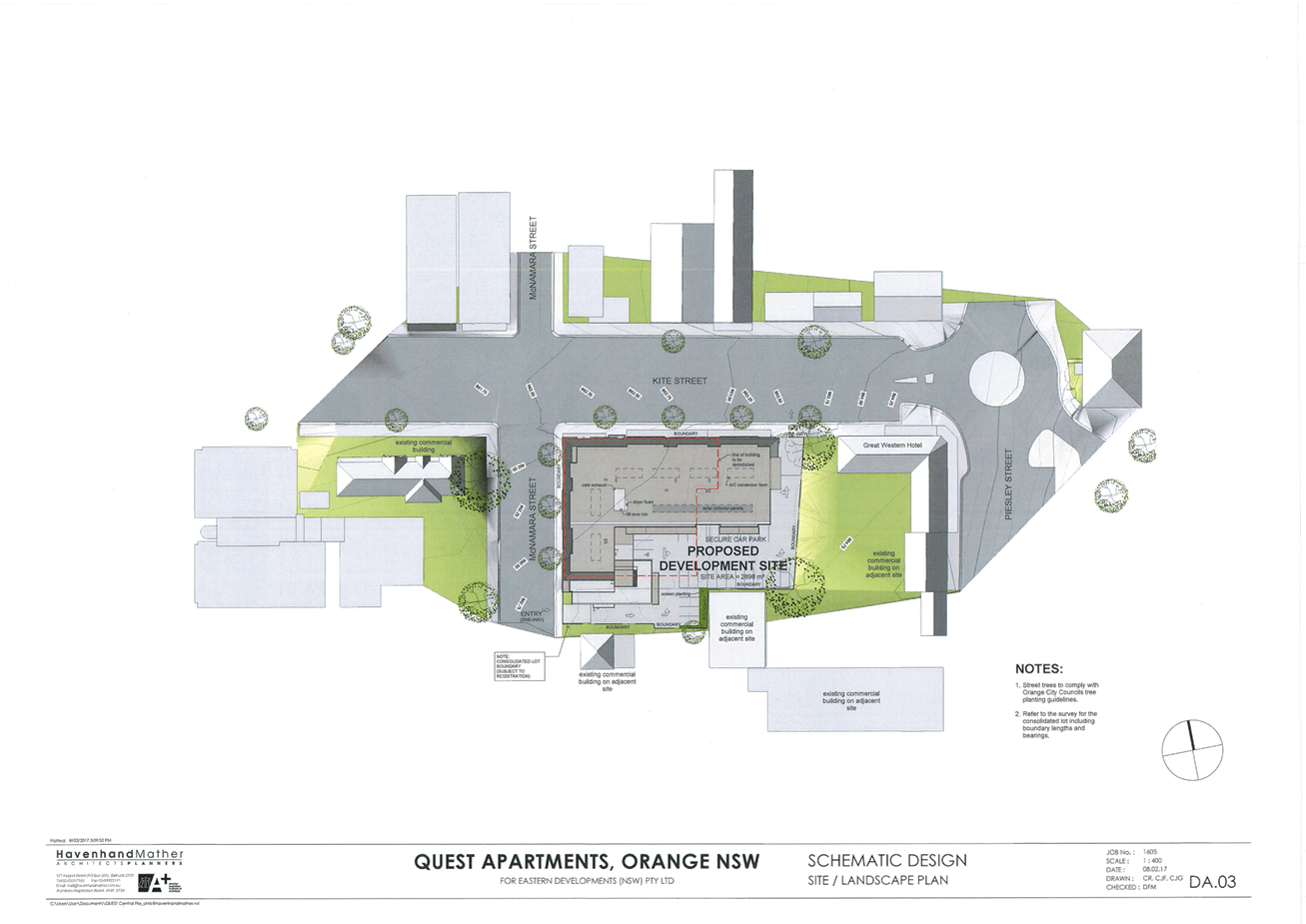
Planning and Development Committee
4 April 2017
2.4 Development
Application DA 304/2016(1) - 132-142 Kite Street and 26 McNamara Street
Attachment 2 Plans
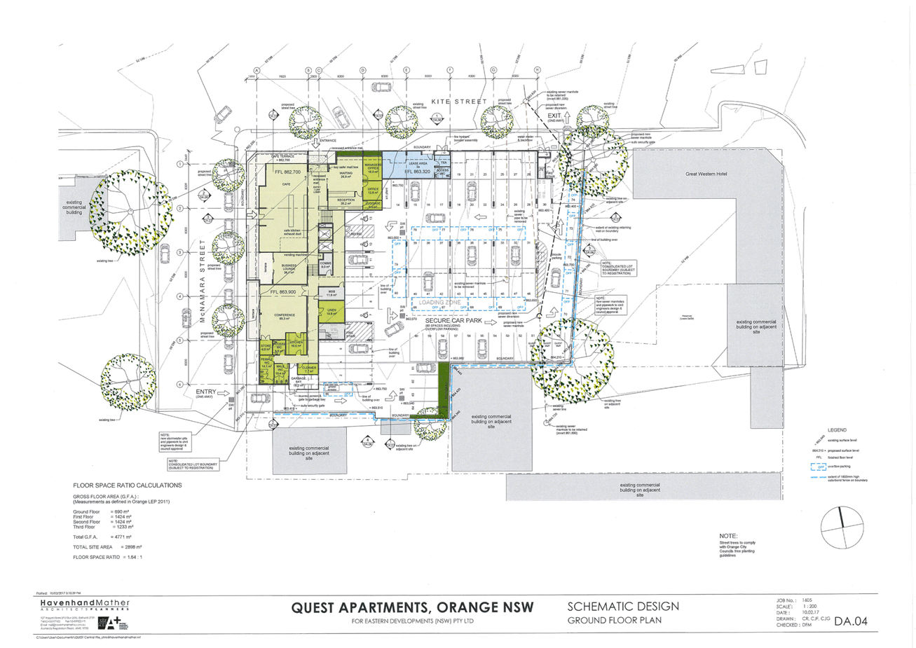
Planning and Development Committee
4 April 2017
2.4 Development
Application DA 304/2016(1) - 132-142 Kite Street and 26 McNamara Street
Attachment 2 Plans
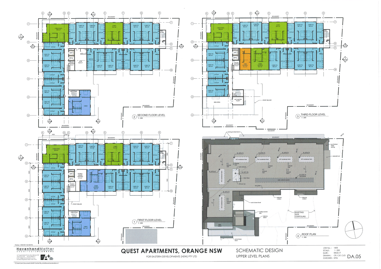
Planning and Development Committee
4 April 2017
2.4 Development
Application DA 304/2016(1) - 132-142 Kite Street and 26 McNamara Street
Attachment 2 Plans
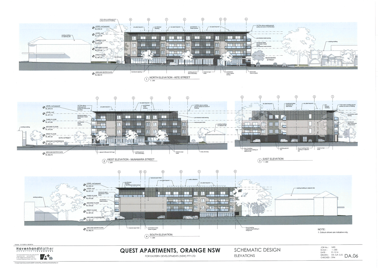
Planning and Development Committee
4 April 2017
2.4 Development
Application DA 304/2016(1) - 132-142 Kite Street and 26 McNamara Street
Attachment 2 Plans
Planning and Development Committee
4 April 2017
2.4 Development
Application DA 304/2016(1) - 132-142 Kite Street and 26 McNamara Street
Attachment 2 Plans
Planning and Development Committee
4 April 2017
2.4 Development
Application DA 304/2016(1) - 132-142 Kite Street and 26 McNamara Street
Attachment 2 Plans
Planning and Development Committee
4 April 2017
2.4 Development
Application DA 304/2016(1) - 132-142 Kite Street and 26 McNamara Street
Attachment 2 Plans
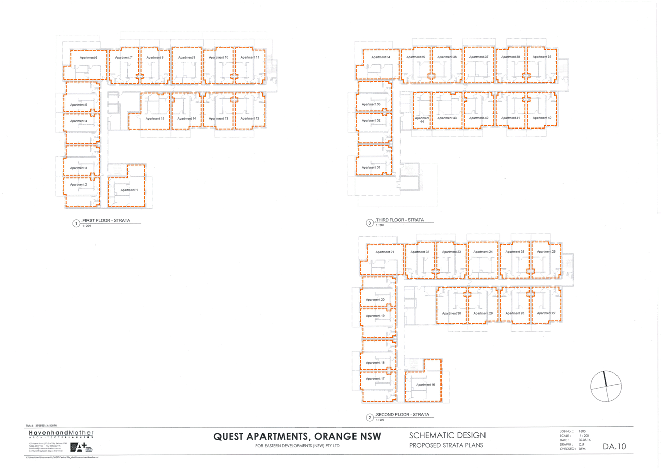
Planning and Development Committee
4 April 2017
2.4 Development
Application DA 304/2016(1) - 132-142 Kite Street and 26 McNamara Street
Attachment 2 Plans
Planning and Development Committee
4 April 2017
2.4 Development
Application DA 304/2016(1) - 132-142 Kite Street and 26 McNamara Street
Attachment 3 External
Finishes
Planning
and Development Committee
4 April 2017
2.4 Development
Application DA 304/2016(1) - 132-142 Kite Street and 26 McNamara Street
Attachment 4 Submissions
(community)

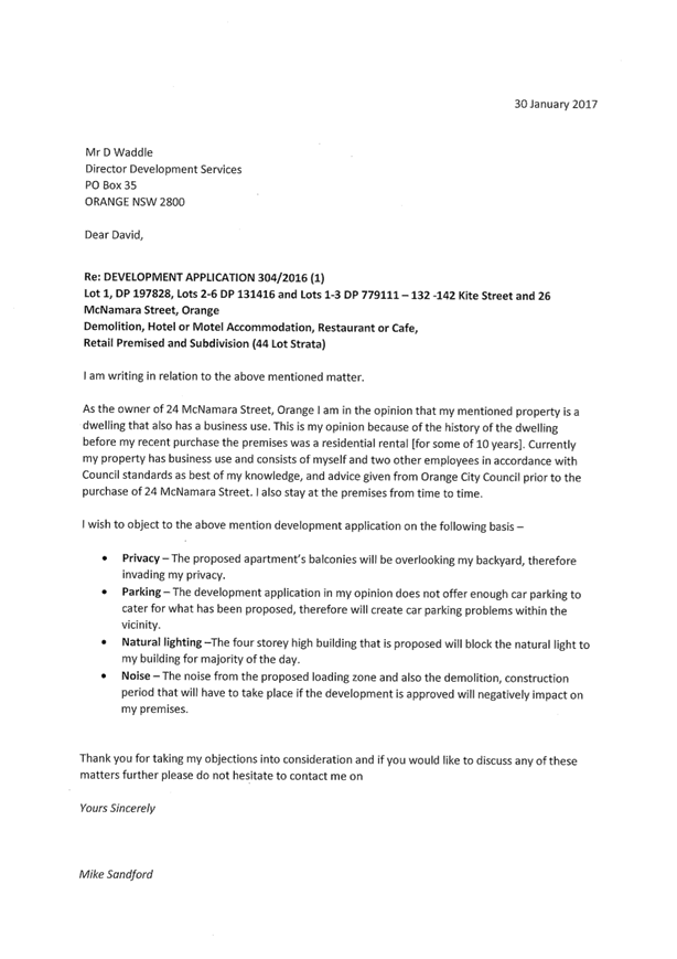
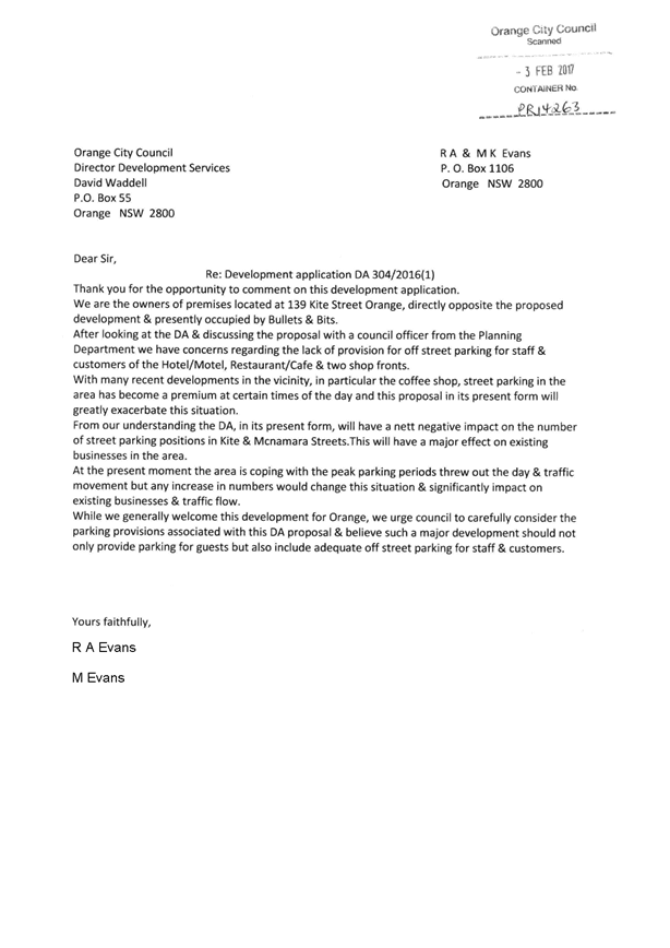
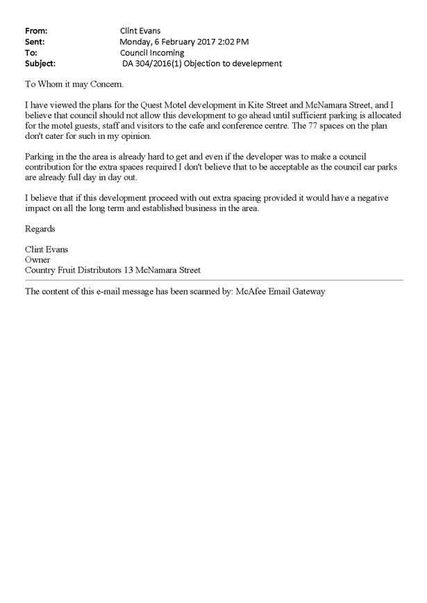
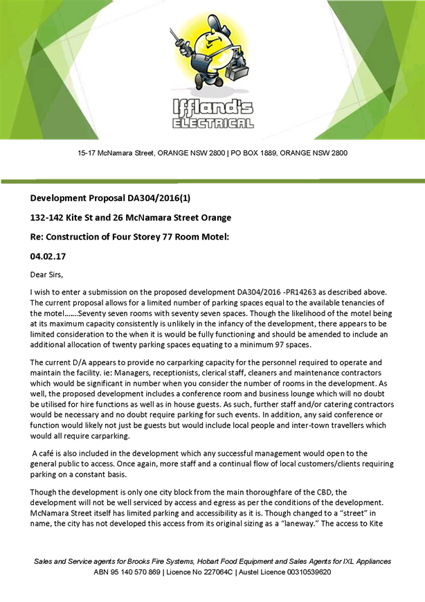

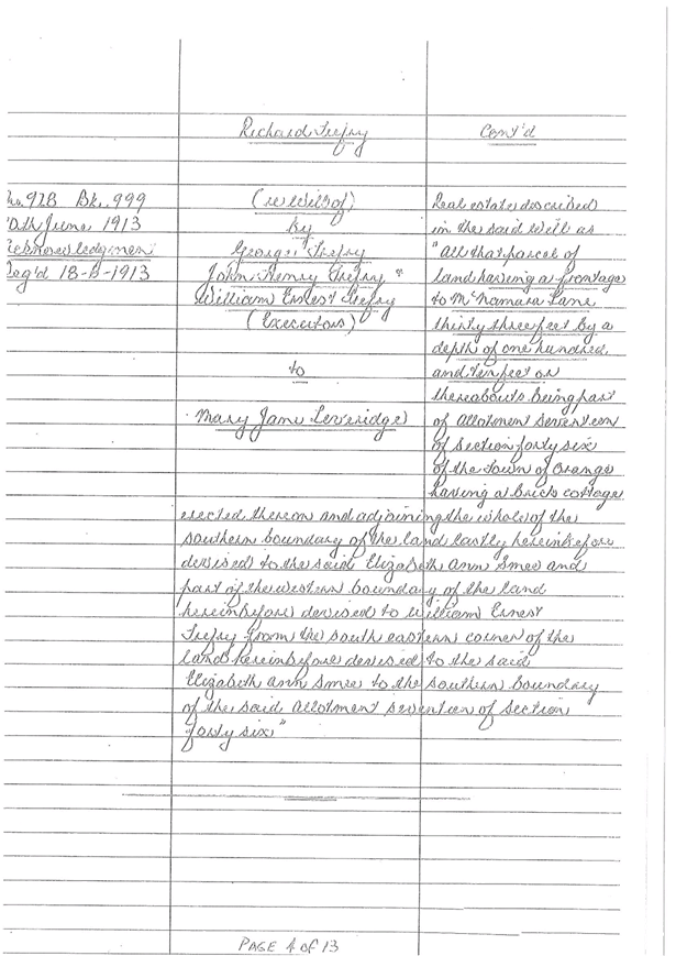
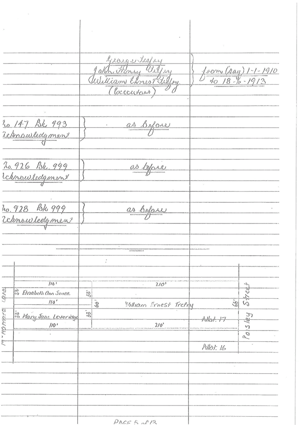
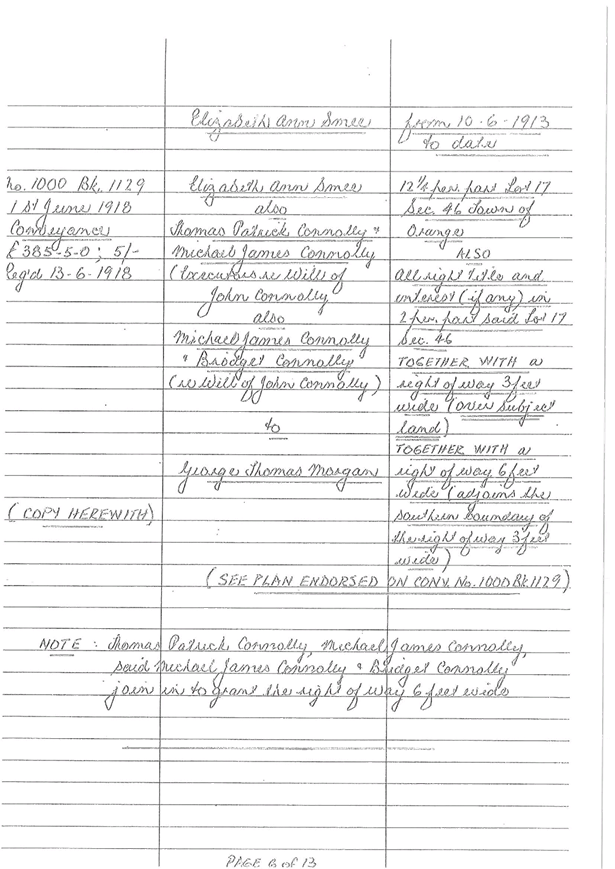
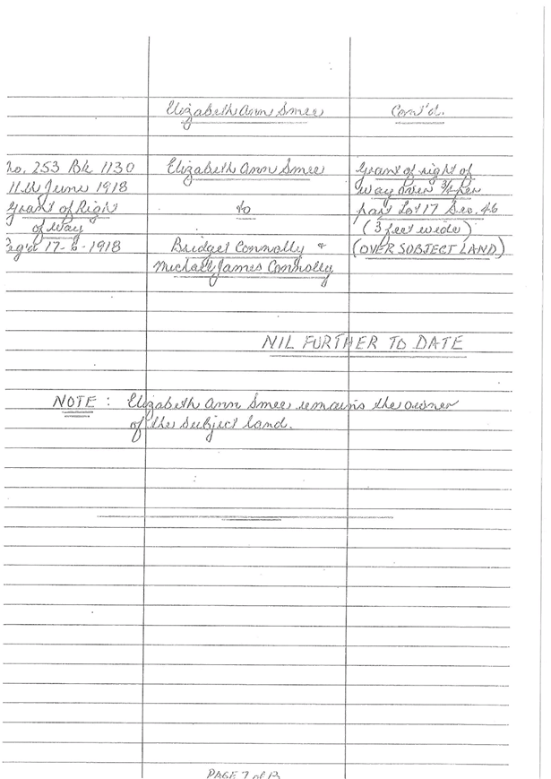
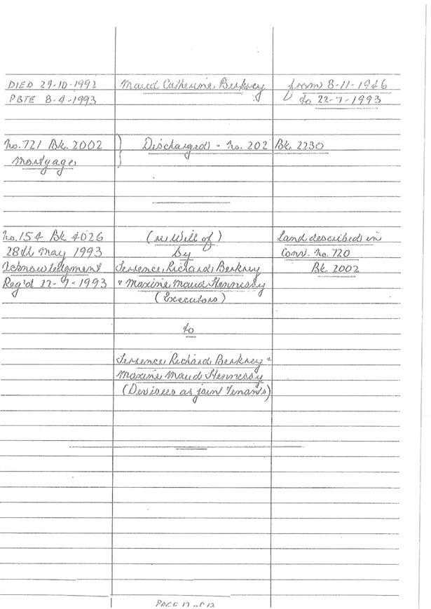
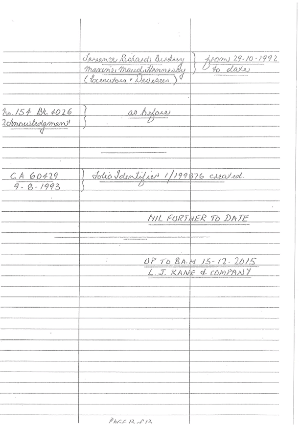
Planning
and Development Committee
4 April 2017
2.4 Development
Application DA 304/2016(1) - 132-142 Kite Street and 26 McNamara Street
Attachment 5 Submissions
(external authorities)

Planning
and Development Committee
4 April 2017
2.4 Development
Application DA 304/2016(1) - 132-142 Kite Street and 26 McNamara Street
Attachment 6 Heritage
Advice
Planning
and Development Committee
4 April 2017
2.4 Development
Application DA 304/2016(1) - 132-142 Kite Street and 26 McNamara Street
Attachment 7 Supplementary
Heritage Advice
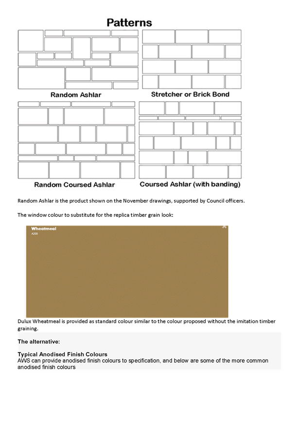
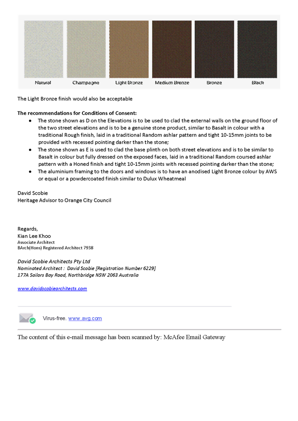
2.5 Development
Application DA 445/2016(1) - 108 Hill Street
TRIM
REFERENCE: 2017/537
AUTHOR: Andrew
Crump, Senior Planner
EXECUTIVE Summary
|
Application
lodged
|
19/12/2016
|
|
Applicant/s
|
Mr AJ
and Mrs AM Ralston
|
|
Owner/s
|
Mr AJ
and Mrs AM Ralston
|
|
Land
description
|
Lot 5 DP
22199 - 108 Hill Street, Orange
|
|
Proposed
land use
|
Dwelling
and Attached Garage
|
|
Value of
proposed development
|
$334,743
|
Council's consent is sought for the construction of a
dwelling house at Lot 5 DP 22199 -108 Hill Street, Orange. The
dwelling comprises a gross floor area of 198.61m2 and will provide
four bedrooms, open plan kitchen/living/meals, separate living and attached
double garage. The application also involves the construction of a new 1.8m
high front fence comprising rendered brick piers and base and palisade infill
panels.
The land, up until recently,
contained a c1970s modest red brick dwelling which was demolished under
development consent DA 253/2016(1).
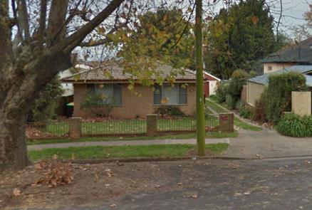
Figure 1 – previous dwelling – demolished
under Development Consent DA 253/2016(1)
The subject land is located in the Central Heritage
Conservation Area, and accordingly Council’s Infill Guidelines apply to the
assessment of the dwelling.
This development involves the replacement of an older style
house, albeit not of very high quality, with a more modern design that will
stand out in the streetscape through its contemporary nature. A critical part
of the rationale behind the staff approval recommendation is the premise that
the peripheral parts of the Heritage Conservation Areas are more tolerant to a
lesser quality building design. In addition, the heritage value of this
particular precinct needs to be acknowledged as being of a lower level of
significance, as detailed below.
The development is consistent with Council’s relevant
planning provisions and is recommended for approval.
Link To Delivery/OPerational Plan
The recommendation in this report relates to the
Delivery/Operational Plan strategy “13.4 Our Environment
– Monitor and enforce regulations relating to City amenity”.
Financial Implications
Nil
Policy and Governance Implications
Nil
|
Recommendation
That Council consents to
development application DA 445/2016(1)
for Dwelling and Attached Garage at Lot 5 DP 22199 - 108 Hill
Street, Orange pursuant to the conditions of
consent in the attached Notice of Approval.
|
further considerations
Consideration has been given to the
recommendation’s impact on Council’s service delivery; image and
reputation; political; environmental; health and safety; employees;
stakeholders and project management; and no further implications or risks have
been identified.
SUPPORTING INFORMATION
THE APPLICATION/PROPOSAL
Council's consent is sought for the construction of a
dwelling house at Lot 5 DP 22199 - 108 Hill Street, Orange. The
dwelling comprises a gross floor area of 198.61m2 and will provide
four bedrooms, open plan kitchen/living/meals, separate living and attached
double garage. The application also involves the construction of a new 1.8m
high front fence comprising rendered brick piers and base, and palisade infill
panels.
MATTERS FOR CONSIDERATION
Section 5A Assessment
In the administration of sections 78A, 79B, 79C, 111 and
112, the provisions of Section 5A must be taken into account for every
development application in deciding whether there is likely to be a significant
effect on threatened species, populations or ecological communities or their
habitats. This section includes a requirement to consider any adopted
assessment guidelines, which means assessment guidelines issued and in force
under Section 94A of the Threatened Species Conservation Act 1995.
Assessment guidelines are in force (see DECC-W “Threatened Species
Assessment Guidelines - The Assessment of Significance”) which requires
consent authority to adopt the precautionary principle in its assessment.
A site inspection reveals that the subject property has no
biodiversity or habitat value.
Section 79C
Section 79C of the Environmental Planning and Assessment
Act 1979 requires Council to consider various matters, of which those
pertaining to the application are listed below.
BACKGROUND
When the application was first made, the design of the
development comprised a contemporary façade presenting to the street
consisting of opposing skillion roofs over the front living room and portico
and hip roof over the garage.
Council’s Heritage Advisor provided recommendations to
amend the presentation of the dwelling within the heritage conservation area
such that the design was more sympathetic to the context and setting. The
applicant was not fully agreeable to the proposed recommendations and a
subsequent site meeting occurred between Council’s Heritage Advisor,
Council Staff and the applicant; and at that time a more suitable façade
presentation was agreed upon. After the meeting, the plans were amended and
submitted to Council for assessment, thereby superseding the original plans. As
discussed below, Council’s Heritage Advisor has fully endorsed the
revised plans (including the front fence).
The comparison of the original plans compared to the amended
design is shown below:
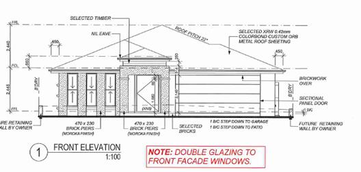
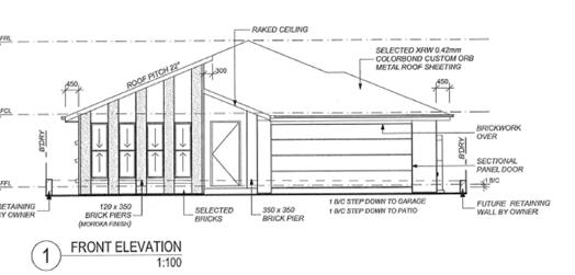
Figures 2 and 3 - amended design (top) –
original design (bottom)
PROVISIONS OF ANY ENVIRONMENTAL
PLANNING INSTRUMENT s79C(1)(a)(i)
Orange Local Environmental Plan 2011
Part 1 - Preliminary
Clause 1.2 - Aims of Plan
The
broad aims of the LEP are set out under subclause 2. Those relevant to the
application are as follows:
(a) to encourage development which complements
and enhances the unique character of Orange as a major regional centre boasting
a diverse economy and offering an attractive regional lifestyle,
(b) to provide for a range of development
opportunities that contribute to the social, economic and environmental
resources of Orange in a way that allows present and future generations to meet
their needs by implementing the principles for ecologically sustainable
development,
(e) to provide a range of housing choices in
planned urban and rural locations to meet population growth,
(f) to recognise and manage valued
environmental heritage, landscape and scenic features of Orange.
The application is not contrary to the general aims the plan
and is consistent specifically with aims (a), (b), (e) and (f).
Clause 1.6 - Consent Authority
This clause establishes that, subject to the Act, Council is
the consent authority for applications made under the LEP.
Clause 1.9A - Suspension of
Covenants, Agreements and Instruments
This clause provides that covenants, agreements and other
instruments which seek to restrict the carrying out of development do not apply
with the following exceptions:
· covenants imposed
or required by Council
· prescribed
instruments under Section 183A of the Crown Lands Act 1989
· any conservation
agreement under the National Parks and Wildlife Act 1974
· any trust
agreement under the Nature Conservation Trust Act 2001
· any property
vegetation plan under the Native Vegetation Act 2003
· any biobanking
agreement under Part 7A of the Threatened Species Conservation Act 1995
· any planning
agreement under Division 6 of Part 4 of the Environmental Planning and
Assessment Act 1979.
Council staff are not aware of the title of the subject
property being affected by any of the above. There is a Council sewer line
traversing the rear of the site which the development will not affect (as shown
on the plans). Relevant conditions are attached in relation to the sewer line.
Mapping
The subject site is identified on the LEP maps in the
following manner:
|
Land Zoning Map:
|
Land zoned R1 General Residential
|
|
Lot Size Map:
|
No Minimum Lot Size
|
|
Heritage Map:
|
Located in the Central Heritage
Conservation Area
|
|
Height of Buildings Map:
|
No building height limit
|
|
Floor Space Ratio Map:
|
No floor space limit
|
|
Terrestrial Biodiversity Map:
|
No biodiversity sensitivity on the
site
|
|
Groundwater Vulnerability Map:
|
Ground water vulnerable
|
|
Drinking Water Catchment Map:
|
Not within the drinking water
catchment
|
|
Watercourse Map:
|
Not within or affecting a defined
watercourse
|
|
Urban Release Area Map:
|
Not within an urban release area
|
|
Obstacle Limitation Surface Map:
|
No restriction on building siting
or construction
|
|
Additional Permitted Uses Map:
|
No additional permitted use applies
|
Those matters that are of relevance are addressed in detail
in the body of this report.
Part 2 - Permitted or Prohibited Development
Land
Use Zones
The subject site is located within the R1 General
Residential zone. The proposed development is defined as a dwelling house under
OLEP 2011 which means:
a building containing only one
dwelling.
A dwelling is further defined as:
a room or suite of rooms
occupied or used or so constructed or adapted as to be capable of being
occupied or used as a separate domicile.
Dwelling
houses are permissible in the R1 General Residential zone with the consent of
Council.
Clause 2.3 of LEP
2011 references the Objectives for each zone in LEP 2011. These objectives
for land zoned R1 General Residential are as follows:
1 - Objectives of the R1 General Residential Zone
· to provide for
the housing needs of the community
· to provide for
a variety of housing types and densities
· to enable other
land uses that provide facilities or services to meet the day to day needs of
residents
· to ensure
development is ordered in such a way as to maximise public transport patronage
and encourage walking and cycling in close proximity to settlement
· to ensure that
development along the Southern Link Road has an alternative access.
The
proposal is not inconsistent with the objectives of the zone. The development
will provide a new dwelling to the existing broader housing stock within the
City, which is commensurate with the long-standing use of the land. The site is
conveniently located in close proximity to the periphery of the CBD; accessible
to services and encouraging walking and cycling.
Part 3 - Exempt and Complying Development
The application is not exempt or complying development.
Part 5 - Miscellaneous Provisions
5.10 - Heritage Conservation
The subject land is situated within the Central Heritage
Conservation Area. Spatially, the land lies at the northern periphery of the
conservation area. The surrounding area concerned comprises a mix of housing
styles from an array of periods, consisting of 1930’s inter-war
bungalows, post-war weatherboard and fibro cottages, C.1960s red brick cottages
(similar to that which was recently demolished on the subject land), and contemporary
infill development from the late 20th century (see below examples).
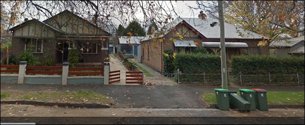
Figure 4 - c1930s inter-war Californian bungalow
– opposite the site
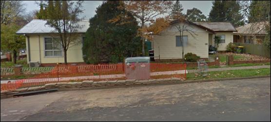
Figure 5 - post war weatherboard and fibro cottages -
adjoining subject land
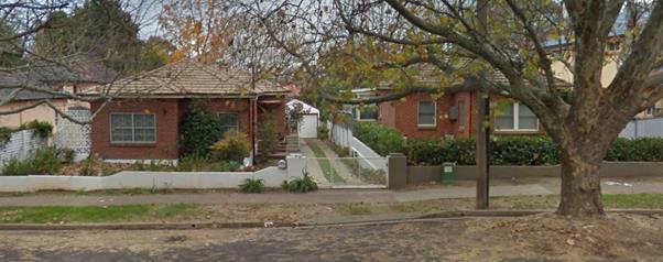
Figure 6 – c1960s red brick cottages – one
and two properties removed to the south in Hill Street
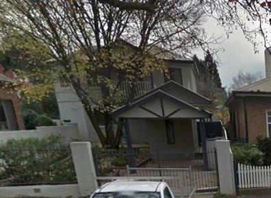
Figure 7 – late
20th century infill development – opposite the site
(1) Objectives
The
objectives of this clause are as follows:
(a) to
conserve the environmental heritage of Orange,
(b) to
conserve the heritage significance of heritage items and heritage conservation
areas, including associated fabric, settings and views,
(c) to
conserve archaeological sites,
(d) to
conserve Aboriginal objects and Aboriginal places of heritage significance.
The application is not antipathetic to the objects of this
clause. The development has been deemed satisfactory by Council’s
heritage Advisor and is consistent with Council’s Infill Guideline as
demonstrated below.
(2) Requirement
for Consent
Development
consent is required for any of the following:
(e) erecting
a building on land:
(i) on
which a heritage item is located or that is within a heritage conservation
area, or
The above clause (and subclause (e)(i)) has the effect of
requiring consent for the application, which the applicant has sought.
(4) Effect
of Proposed Development on Heritage Significance
The
consent authority must, before granting consent under this clause in respect of
a heritage item or heritage conservation area, consider the effect of the
proposed development on the heritage significance of the item or area
concerned. This subclause applies regardless of whether a heritage management
document is prepared under subclause (5) or a heritage conservation management
plan is submitted under subclause (6).
This development involves the replacement of an older style
house, albeit not of very high quality, with a more modern design that will
stand out in the streetscape through its contemporary nature. A critical part
of the rationale behind the staff approval recommendation is the premise that
the peripheral parts of the Heritage Conservation Areas are more tolerant to a
lesser quality building design. In addition, the heritage value of this
particular precinct needs to be acknowledged as being of a lower level of
significance, as detailed below.
The development will not result in an unacceptable impact
upon the heritage significance of the Central Heritage Conservation Area. A
detailed assessment of the application’s appropriateness and
compatibility within the heritage conservation area in terms of character,
scale and form, siting, materials and colour, and detailing is undertaken below
under the heading DCP 2004 - Infill Guidelines.
(5) Heritage
assessment
The
consent authority may, before granting consent to any development:
(a) on
land on which a heritage item is located, or
(b) on
land that is within a heritage conservation area, or
(c) on
land that is within the vicinity of land referred to in paragraph (a) or (b),
require
a heritage management document to be prepared that assesses the extent to which
the carrying out of the proposed development would affect the heritage
significance of the heritage item or heritage conservation area concerned.
A heritage management document is not required for this
application, the applicant has worked with Council’s heritage Advisor as
part of the assessment process which has been beneficial in arriving at the
final outcome.
(6) Heritage
Conservation Management Plans
The
consent authority may require, after considering the heritage significance of a
heritage item and the extent of change proposed to it, the submission of a
heritage conservation management plan before granting consent under this
clause.
A Conservation Management Plan is not required for this
application. The site is vacant land and there are no items of heritage value
within the land that warrant the preparation of a Conservation Management Plan.
(7) Archaeological
Sites
The
consent authority must, before granting consent under this clause to the
carrying out of development on an archaeological site (other than land listed
on the State Heritage Register or to which an interim heritage order under the Heritage Act 1977 applies):
(a) notify
the Heritage Council of its intention to grant consent, and
(b) take
into consideration any response received from the Heritage Council within 28
days after the notice is sent.
The site is not known to be an archaeological site;
notwithstanding this, Council’s standard unexpected finds condition is
attached to the notice.
(8) Aboriginal
Places of Heritage Significance
The
consent authority must, before granting consent under this clause to the
carrying out of development in an Aboriginal place of heritage significance:
(a) consider
the effect of the proposed development on the heritage significance of the
place and any Aboriginal object known or reasonably likely to be located at the
place by means of an adequate investigation and assessment (which may involve
consideration of a heritage impact statement), and
(b) notify
the local Aboriginal communities, in writing or in such other manner as may be
appropriate, about the application and take into consideration any response
received within 28 days after the notice is sent.
An AHIMS search of the site indicates that the land is not a
known Aboriginal Place of Heritage Significance. Notwithstanding this,
Council’s standard unexpected finds condition is attached in the likely
event that an aboriginal object is discovered.
Part 6 - Urban Release Area
Not relevant to the application. The subject site is not
located in an Urban Release Area.
Part 7 - Additional Local Provisions
7.1
- Earthworks
This
clause establishes a range of matters that must be considered prior to granting
development consent for any application involving earthworks, such as:
(a) the likely disruption of, or any
detrimental effect on, existing drainage patterns and soil stability in the
locality of the development
(b) the effect of the development on the
likely future use or redevelopment of the land
(c) the quality of the fill or the soil to be
excavated, or both
(d) the effect of the development on the
existing and likely amenity of adjoining properties
(e) the source of any fill material and the
destination of any excavated material
(f) the likelihood of disturbing relics
(g) the proximity to and potential for adverse
impacts on any waterway, drinking water catchment or environmentally sensitive
area
(h) any measures proposed to minimise or
mitigate the impacts referred to in paragraph (g).
The proposed earthworks are
minor and ancillary to the construction of the dwelling (for which development
consent has been sought). As such, consent is not required for the cut and
filling of the site associated with the construction of the dwelling. In any
event, the cut and fill associated with the construction of the dwelling is
modest and thus will not impact on adjoining properties.
7.3 - Stormwater Management
This clause applies to all
industrial, commercial and residential zones and requires that Council be
satisfied that the proposal:
(a) is designed to maximise the use of water
permeable surfaces on the land having regard to the soil characteristics
affecting onsite infiltration of water
(b) includes, where practical, onsite
stormwater retention for use as an alternative supply to mains water,
groundwater or river water; and
(c) avoids any significant impacts of
stormwater runoff on adjoining downstream properties, native bushland and
receiving waters, or if that impact cannot be reasonably avoided, minimises and
mitigates the impact.
The proposal has been designed
to include permeable surfaces and includes onsite retention of stormwater
through the use of a rainwater tank (as required by BASIX). It is therefore
considered that the post development runoff levels will not exceed the
predevelopment levels; or more relevantly, those levels previously experienced
when a dwelling was on the land.
7.6 - Groundwater Vulnerability
This
clause seeks to protect hydrological functions of groundwater systems and
protect resources from both depletion and contamination. Orange has a high
water table and large areas of the LGA, including the subject site, are
identified with “Groundwater Vulnerability” on the Groundwater
Vulnerability Map. This requires that Council consider:
(a) whether or not the development (including
any onsite storage or disposal of solid or liquid waste and chemicals) is
likely to cause any groundwater contamination or have any adverse effect on
groundwater dependent ecosystems, and
(b) the cumulative impact (including the
impact on nearby groundwater extraction for potable water supply or stock water
supply) of the development and any other existing development on groundwater.
Furthermore, consent may not be granted unless Council is satisfied that:
(a) the development is designed, sited and
will be managed to avoid any significant adverse environmental impact, or
(b) if that impact cannot be reasonably
avoided - the development is designed, sited and will be managed to minimise
that impact,
(c) if that impact cannot be minimised - the
development will be managed to mitigate that impact.
The proposal is not anticipated
to involve the discharge of toxic or noxious substances and is therefore
unlikely to contaminate the groundwater or related ecosystems. The proposal
does not involve extraction of groundwater and will therefore not contribute to
groundwater depletion. The development is considered acceptable in this regard.
STATE ENVIRONMENTAL PLANNING
POLICIES
State Environmental Planning Policy 55 –
Remediation of Land
State Environmental Planning Policy 55 - Remediation of Land
(SEPP 55) requires that a consent authority must not consent to the carrying
out of development of land unless it has considered whether the land is
contaminated, is satisfied (if contaminated) that the land is suitable in its
contaminated state for the development that is proposed, and if the land
requires remediation to be made suitable for the proposed development, it is
satisfied that the land will be remediated before the land is used for that
purpose.
Furthermore, SEPP 55 requires that before determining an
application for consent to carry out development that would involve a change of
use on any of the land specified in subclause (4), the consent authority
must consider a report specifying findings of a preliminary investigation of
the land concerned. However, the application does not relate to a change of
use. The land has always been residential land, and will continue to be
residential land.
Given that the land, up until the recent demolition, has been
used for residential purposes and will continue to do so; it is considered that
the subject land is suitable for the proposed development and no further
investigation of contamination is required. Moreover, there was nothing
identified during the recent assessment relating to the demolition of the
previous dwelling on the land to suggest that the land was previously used for
a purpose that could lead to contamination within the site or on adjoining
land.
State Environmental Planning
Policy (Infrastructure)
State Environmental Planning Policy (Infrastructure) applies
to the land, specifically clause 45 which requires Council to seek comment from
the applicable electricity service provider (in this case Essential Energy)
where the development will be within 5m of overhead powerlines or penetration
of ground within 2m of underground powerlines.
A power pole exists in the frontage of the subject land and
provides domestic power supplies to the two adjoining dwellings. The land in
question is serviced by an underground line from the pillar box in the
footpath.
Accordingly, the application was referred to Essential
Energy for comment. Essential Energy responded with no objections provided the
following conditions are met:
1. If
the proposal changes, Essential Energy would need to be informed for further
comment;
2. Any
existing encumbrances in favour of Essential Energy (or its predecessors) noted
on the title of the above property are complied with; and
3. A
clearance of 1.25 is provided from the top of the front security fence to both
overhead powerlines that cross this property.
In
addition, Essential Energy’s records indicate there is electricity
infrastructure located within close proximity of the property. Any activities
within this location must be undertaken in accordance with the latest industry
guideline currently known as ISSC 20 Guideline for the Management of Activities
within Electricity Easements and Close to Infrastructure.
Prior
to carrying out any works, a “Dial Before You Dig” enquiry must be
undertaken in accordance with the requirements of Part 5E (Protection of
Underground Electricity Power Lines) of the Electricity Supply Act 1995 (NSW).
Given
there is electricity infrastructure in the area, it is the responsibility of
the person/s completing any works around powerlines to understand their safety
responsibilities. SafeWork NSW (www.safework.nsw.gov.au) has publications that
provide guidance when working close to electricity infrastructure. These include
the Code of Practice – Work near Overhead Power Lines/Underground Assets.
The above comments from Essential Energy have been
incorporated into the consent where appropriate, either as conditions or as
advisory notes.
State Environmental Planning
Policy (Building Sustainability Index BASIX)
State Environmental Planning Policy (Building Sustainability
Index BASIX) applies to the subject development. The applicant has submitted a
BASIX certificate in support of the development which demonstrates compliance
with the State Government Water and Thermal efficiency targets. The application
is consistent with the SEPP.
PROVISIONS OF ANY DRAFT
ENVIRONMENTAL PLANNING INSTRUMENT THAT HAS BEEN PLACED ON EXHIBITION
s79C(1)(a)(ii)
There are no draft environmental planning instruments that
apply to the subject land or proposed development.
DESIGNATED DEVELOPMENT
The proposed development is not designated development.
PROVISIONS OF ANY DEVELOPMENT
CONTROL PLAN s79C(1)(a)(iii)
Development Control Plan 2004
Development Control Plan 2004 (“the DCP”)
applies to the subject land (Chapters 2, 3, 7 and 13). An assessment of
the proposed development against the relevant Planning Outcomes will be
undertaken below.
Pursuant to Planning Outcome 0.2-1 Interim Planning Outcomes
- Conversion of Zones:
· Throughout this
Plan, any reference to a zone in Orange LEP 2000 is to be taken to be a
reference to the corresponding zone(s) in the zone conversion table.
The corresponding zone to zone 2a urban residential (Orange
LEP 2000) is zone R1 General Residential (Orange LEP 2011). As such, Orange
DCP 2004 chapter 7 – development in residential areas is of primary
relevance to this proposal (other relevant chapters have also been considered).
The provisions of chapter 7 are considered below.
Chapter 2 – Natural
Resource Management
Chapter 2 – Natural Resource Management provides
planning outcomes for stormwater quality, groundwater quality, soil resource
management, vegetation management and flora fauna management; all of which have
been considered above under the heading Orange LEP 2011 (stormwater,
groundwater) or Section 5A of the Act.
Chapter 3 – General
Considerations
Chapter 3 provides planning outcomes of a general nature.
Those of relevance to this assessment relate to cumulative impacts, scenic
landscape, urban areas and energy efficiency. These are all addressed elsewhere
within this report. Cumulative impacts are addressed below under the heading
“Likely Impacts”. Scenic, landscape and urban areas are addressed
under the infill guidelines below, and energy efficiency is addressed under
State Environmental Planning Policy (BASIX).
Chapter 7 - Design Elements
for Residential Development
Chapter 7 provides a suite of planning outcomes applicable
to residential development within residential zones. Those that are of
relevance are addressed below.
Streetscape Objectives
· to
ensure that the development fits into its setting and environmental features of
the locality
· to
ensure that the appearance of housing is of a high visual quality, enhances the
streetscape and complements good quality surrounding development
· to
ensure that new development complements places with heritage significance and
their settings in a contemporary way
· to
develop a sense of place with attractive street frontages
· to
encourage visually appealing cohesive streetscapes
· to
create a safe and secure environment
· to provide
consistent design elements that protect private investment.
The development’s compliance with the above objectives
will be considered in the assessment of the following planning outcomes.
Neighbourhood Character
The DCP sets the following Planning Outcomes in regard to
Neighbourhood Character:
· site
layout and building design enables the:
- creation of attractive
residential environments with clear character and identity
- use of site features
such as views, aspect, existing vegetation and landmarks
· buildings
are designed to complement the relevant features and built form that are
identified as part of the desired neighbourhood character
· the
streetscape is designed to encourage pedestrian access and use
The character and identity of a particular area is
influenced by the intricate interrelationship of the public and private realms,
taking into account the qualitative interplay of built form, vegetation and
topographic characteristics; all of which contribute to creating a unique
neighbourhood character.
The neighbourhood in which the subject land is located is
characterised as a mix of dwellings from a range of periods set amongst a wide
street, lined with mature deciduous trees. There are several non-residential
uses further to the south including a restaurant, school, church and pub. The
general topography consists of a gentle rise to the south in Hill Street.
Most dwellings comprise consistent setbacks with established front gardens. The
proposed development is not inconsistent with the residential character of the
locality in terms of use, scale, setbacks and building appearance.
Building Appearance
The DCP sets the following Planning Outcomes in regard to
Building Appearance:
· the building
design, detailing and finishes relate to the desired neighbourhood character,
complement the residential scale of the area, and add visual interest to the
street
· the frontages
of buildings and their entries face the street
· garages and car
parks are sited and designed so that they do not dominate the street frontage.
The dwelling will present satisfactorily within the street.
The architectural detailing and presentation of the attached garage addressing
Hill Street will be atypical of the majority of built form (garages) within the
neighbourhood, most of which are in the traditional location, being in the rear
yard or toward the rear of the dwelling. Aside from the atypical design of the
attached garage, the remaining design elements of the dwelling will be
congruous with the design, detailing and finishes that are identified as
contributing to the established neighbourhood character as established below
under the infill guidelines assessment.
The dwelling will be commensurate with the existing built
form in the locality, albeit with an attached garage that will appear more
contemporary to the majority of the development pattern within this part of the
conservation area.
Notwithstanding this, the design is considered acceptable
for the following reasons:
· the width of the
block constrains the usable space of the development – achieving rear
garaging – and this has been recognised by Council Heritage Advisor
· the subject land
is located on the periphery of the central heritage conservation area
· the portion of
streetscape concerned is not as consistent (later examples of dwellings with
lower or no heritage value) and as intact as other examples within the central
heritage conservation area – in other examples in the heritage
conservation area, such a design would be unlikely to be accepted
· the proposed
fencing will assist in screening the visual dominance of the attached garage,
and
· the colours and
finishes of external materials is acceptable.
For the reasons outlined above and further discussed under
the infill guideline, the building presentation is acceptable in the context
and setting.
Heritage
The land is located within a heritage conservation area and
as such Council’s heritage provisions apply. These have been addressed
under the heading LEP 2011 and the below assessment against the infill
Guidelines.
Setbacks
The DCP sets the following Planning Outcomes in regard to
Setbacks:
· street setbacks
contribute to the desired neighbourhood character, assist with the integration
of new development and make efficient use of the site
· street setbacks
create an appropriate scale for the street considering all other streetscape
components
The front setback of the dwelling will be satisfactory and
will relate appropriately to the adjoining development pattern. The dwelling to
the south comprises a setback of approximately 3.5m to the front building line
of the projecting carport and 4.8m to the remaining portion of the dwelling.
The dwelling to the north comprises a setback of approximately 4.5m.
The proposed dwelling comprises a front setback of 4.5m to
the front portico and 6.64m to the garage – consistent with the relevant
planning outcome.
Side and rear setbacks comply with the Building Code of
Australia.
Fences and Walls
The DCP sets the following
Planning Outcomes in regard to fences and walls:
· fences and
walls assist in highlighting entrances and creating a sense of identity within
the streetscape
· fences and
walls are constructed of materials compatible with associated housing and with
fences visible from the site that positively contribute to the streetscape
· fences
and walls provide for facilities in the street frontage area such as mail
boxes.
A front fence is proposed as part of the application which
is considered acceptable as outlined below under the assessment against the
infill guideline.
The
dwelling requires several modest retaining walls along the boundary as a result
of creating a building pad. The retaining walls will be modest in height
between (approximately) 400mm (cut) and 340mm (fill). The required retaining
walls will not result in any adverse impacts upon adjoining land.
Bulk and Scale Objectives
· to
allow flexibility in siting buildings and to ensure that the bulk and scale of
new development reasonably protects the amenity of neighbouring properties and
maintains appropriate neighbourhood character
· to
allow adequate daylight, sunlight and ventilation to living areas and private
open spaces of new and neighbouring developments
· to
encourage the sharing of views, while considering the reasonable development of
the site.
The development’s compliance with the above objectives
will be considered in the assessment of the following planning outcomes.
Visual Bulk
The DCP sets the following Planning Outcome in regard to
Visual Bulk:
· Built form
accords with the desired neighbourhood character of the area with:
- side
and rear setbacks progressively increased to reduce bulk and overshadowing
- site
coverage that retains the relatively low density landscaped character of
residential areas
- building
form and siting that relates to landform, with minimal land shaping (cut and
fill)
- building
height at the street frontage that maintains a comparable scale with the
predominant adjacent development form
- building
to the boundary where appropriate.
In consideration of the DCP Guidelines, the proposal is
considered to be satisfactory. The proposed dwelling will be single storey,
consistent with the established development form of residential development in
the locality, save for the occasional two storey dwelling within the street
(one example opposite and one adjacent).
The numerical standards under the DCP require dwellings to be contained within the prescribed envelopes generated
by planes projected at 45o over the site commencing 2.5m above
existing ground level from each side and rear boundary. The development
complies with this numerical standard.
The single storey scale of the dwelling and the positioning
of it within the subject land results in a development that will be
satisfactory in terms of Council’s visual bulk requirements. The
development (including the existing garage) will be below the 60% site coverage
requirement for single dwellings.
Walls and Boundaries
The DCP sets the following Planning Outcome in regard to
Walls and Boundaries:
· Building to the
boundary is undertaken to provide for efficient use of the site taking into
account:
- the privacy of neighbouring
dwellings and private open space
- the access to daylight
reaching adjoining properties
- the impact of boundary walls
on neighbours.
The dwelling is appropriately sited within the property such
that it will result in limited impacts to adjoining properties, and will have
satisfactory outcomes within the site in terms of privacy and solar access.
Daylight and Sunlight
The DCP sets the following Planning Outcome in regard to
Daylight and Sunlight:
· Buildings are
sited and designed to ensure:
- daylight to habitable rooms
in adjacent dwellings is not significantly reduced
- overshadowing of
neighbouring secluded open spaces or main living area windows is not
significantly increased
- consideration of
Council’s Energy Efficiency Code.
The extent of shadow created by the development has been
analysed by Council staff. In consideration of the DCP Guidelines, the proposal
is considered to be satisfactory as outlined below.
Overshadowing of Dwellings
According to the DCP Guidelines and Council’s Energy
Efficiency Code, sunlight to at least 75% of north facing living area
windows within the development and on adjoining land is to be provided for a
minimum of four hours on 21 June; or not further reduced than existing where
already less.
The subject dwelling is appropriately designed such that it
will receive satisfactory levels of solar access into living areas via two
vertically proportioned windows relating to the meals/kitchen area. An
assessment of the level sunlight to these windows concluded that approximately
90% of the two windows will receive sunlight at 10am and 2pm, with levels
increasing during the times between this period (i.e. 11am, 12 noon and 1pm).
In terms of adjoining properties, a shadow analysis from the
submitted plans demonstrates that the subject dwelling will have an acceptable
impact on the north facing windows of the adjoining land to the south. This is
primarily due to the elevated nature of the floor level of the adjoining dwelling,
the reasonable separation of the adjoining dwelling from its northern boundary
and the covered improvements (carport) at the boundary on the adjoining land.
Overshadowing of Private Open
Space
According to the DCP Guidelines and Council’s Energy Smart
Homes Code, sunlight is to be available to at least 40% of required open space
for dwellings within the development and on neighbouring properties for at
least three hours between 9am and 3pm.
The development is appropriately sited on the land with a usable
area of private open space orientated to receive reasonable levels solar
access.
Additionally, the development will not unreasonably impact
on adjoining properties solar access to private open space.
Views
The DCP sets the following Planning Outcomes in regard to
Views:
· building form
and design allow for residents from adjacent properties to share prominent
views where possible
· views including
vistas of heritage items or landmarks are not substantially affected by the
bulk and scale of the new development.
The subject site is not within an important view corridor.
The proposed dwellings will not unreasonably diminish views for other
properties in the vicinity.
Visual Privacy
The DCP sets the following Planning Outcome in regard to
Visual Privacy:
· Direct
overlooking of principal living areas and private open spaces of other
dwellings is minimised firstly by:
- building siting and layout
- location of windows and
balconies
and
secondly by:
- design of windows or use of
screening devices and landscaping.
The subject land is relatively flat with 1.5m of cross-fall
falling from the front to the rear of the site, resulting in finished floor
levels that reasonably relate to existing ground levels and no elevated floor
levels. This, coupled with boundary fencing, will result in satisfactory
outcomes in terms of visual privacy impacts from the development on adjoining
properties.
The adjoining dwelling to the south comprises elevated floor
levels, including an elevated balcony which could result in overlooking of the
subject land. However, the design appears to be cognisant of this fact and the
principle living areas (including private open space) are orientated such that
they will not be overlooked. The design is considered acceptable.
Acoustic Privacy
The DCP sets the following Planning Outcome in regard to
Acoustic Privacy:
· Site layout and
building design:
- protect habitable rooms from
excessively high levels of external noise
- minimise the entry of external
noise to private open space for dwellings close to major noise sources
- minimise transmission of
sound through a building to affect other dwellings.
In consideration of the DCP Guidelines the proposal is
considered to be satisfactory. The site is located in an area where ambient
noise levels are expected to be low due to the predominant residential land use
pattern. Hill Street does carry a reasonable amount of traffic north/south
across the city, so it is positive to note that there are no bedrooms
immediately adjoining the street frontage and that windows within the street
frontage are double glazed thus improving the acoustic amenity of the dwelling.
Security
The DCP sets the following Planning Outcomes in regard to
Security:
· the site layout
enhances personal safety and minimises the potential for crime, vandalism and
fear
· the design of
dwellings enables residents to survey streets, communal areas and approaches to
dwelling entrances.
The siting and design of the dwelling is
appropriate to be able to maintain safety and minimise the potential for crime,
vandalism and fear for residents. Habitable room windows will address public
roads, thereby providing opportunities for natural surveillance. The proposed
front fencing (being open style) will not restrict sightlines to public areas,
nor will it create hiding spaces for uninvited persons within the frontage, and
will provide territorial reinforcement and delineate public and private spaces.
Internal access to the dwellings will be available through the garage.
Site Access
and Circulation Objectives
· to
provide convenient and safe access and parking that meets the needs of all
residents and visitors
· to
encourage the integrated design of access and parking facilities to minimise
visual and environmental impacts.
The development’s compliance with the above objectives
will be considered in the assessment of the following planning outcomes.
Circulation and Design
The DCP sets the following Planning Outcome in regard to
Circulation and Design:
· accessways and
parking areas are designed to manage stormwater
· accessways,
driveways and open parking areas are suitably landscaped to enhance amenity
while providing security and accessibility to residents and visitors
· the site layout
allows people with a disability to travel to and within the site between car
parks, buildings and communal open space.
Reverse egress will be required from the attached garage
consistent with the majority of residential situations across the city and is
considered satisfactory. The driveway utilises the existing layback and
footpath crossing and widens at the front of the garage to provide access. The
design of the driveway is cognisant of the existence of the power pole within
the footpath and the existing arrangement being utilised is acceptable.
Council’s technical services raise no objections to the proposed vehicle
egress/ingress.
Car Parking
The DCP sets the following Planning Outcomes in regard to
Car Parking:
· Parking
facilities are provided, designed and located to:
- enable the efficient and
convenient use of car spaces and accessways within the site
- reduce the visual dominance
of car parking areas and accessways.
· Car parking is
provided with regard to the:
- number and size of proposed
dwellings
- requirements of people with
limited mobility or disabilities.
The development will result in at least two onsite car
parking spaces through the provision of the attached double garage. Opportunity
for stacked parking would also exist in front of the garage. The parking
arrangements are acceptable.
Private Open Space
The DCP sets the following Planning Outcomes in regard to
Private Open Space:
· private open
space is clearly defined for private use
· private open
space areas are of a size, shape and slope to suit the reasonable requirements
of residents including some outdoor recreational needs and service functions.
· Private open
space is:
– capable
of being an extension of the dwelling for outdoor living, entertainment and
recreation
– accessible
from a living area of the dwelling
– located
to take advantage of outlooks; and to reduce adverse impacts of overshadowing
or privacy from adjoining buildings
– Orientated
to optimise year round use.
The submitted plans show an area of 159m2
of private open space, well in excess of the numerical requirements of
the DCP. The area of private open space will be level, connected to the living
spaces of the dwelling, and private and well orientated to receive sunlight
from the north.
The development is acceptable in terms of
private open space.
Open Space
and Landscaping
The DCP sets the following Planning Outcomes in regard to
Open Space and Landscaping:
· the site layout
provides open space and landscaped areas which:
– contribute
to the character of the development by providing buildings in a landscaped
setting
– provide
for a range of uses and activities including stormwater management
– allow
cost effective management.
· the landscape
design specifies landscape themes consistent with the desired neighbourhood
character; vegetation types and location, paving and lighting provided for
access and security
· major existing
trees are retained and protected in a viable condition whenever practicable
through appropriate siting of buildings, accessways and parking areas
· paving is
applied sparingly and integrated in the landscape design.
A landscape plan was not submitted in support of the
dwelling, which is not typically required for single dwellings. However, given
the heritage setting, a condition is attached that requires a detailed
landscape plan to be submitted prior to the issue of a construction
certificate. The landscape plan shall relate to the front setback area and show
hard and soft landscaped areas, as well as show at least two suitable trees;
along with the type, number and location of shrubs and ground covers.
Water and Soil Management
Objectives
· to control and
minimise the impact of stormwater run-off and soil erosion on adjoining land
and downstream
· to encourage
reduced water wastage by reusing, recycling and harvesting stormwater.
The development’s compliance with the above objectives
will be considered in the assessment of the following planning outcomes.
Stormwater
The DCP sets the following Planning Outcomes in regard to
Stormwater:
· On-site
drainage systems are designed to consider:
– downstream
capacity and need for on-site retention, detention and re-use
– scope
for on-site infiltration of water
– safety
and convenience of pedestrians and vehicles
– overland
flow paths.
· Provision is
made for on-site drainage which does not cause damage or nuisance flows to
adjoining properties.
Relevant conditions of consent are attached to the Notice of
Approval in relation to stormwater management of the site.
Erosion and Sedimentation
The DCP sets the following Planning Outcome in regard to
Erosion and Sedimentation:
· Measures
implemented during construction to ensure that the landform is stabilised and
erosion is controlled.
Erosion and sediment control measures will be required to be
implemented during construction. Attached is a condition of consent addressing
this issue.
Chapter 13 – Heritage
The land is located within a heritage conservation area and
as such Council’s heritage provisions apply. These have been addressed
under the heading OLEP 2011 and the infill Guidelines below.
INFILL GUIDELINES
The development is described as new dwelling located in the
central heritage conservation area, and as such is identified as infill
development. Accordingly, the infill guidelines recently adopted by Council are
applicable to the application.
The Setting
The Burra Charter includes in Article 8 in
its section on "Setting":
"Conservation requires the retention of an appropriate visual
setting and other relationships that contribute to the cultural significance of
the place. New construction, demolition, intrusions or other changes which
would adversely affect the setting or relationships are not appropriate"
It is important to firstly establish the context and setting
of the location concerned as the first step in establishing the level of
heritage significance relating to the subject land. Obviously, certain
characteristics and idiosyncrasies of a particular place are unique to that
setting; some areas within a heritage setting will intuitively have a higher
level of significance than other areas by virtue of its spatial setting,
surrounding built form, consistency of streetscape and the characteristics and
elements within the public realm.
As shown below, the context and setting of the land in
question is defined by the mix of dwelling styles from varying periods, the
consistency of the streetscape and the location on the periphery of the
heritage conservation area. These characteristics combined, result in a setting
that has a lower significance than other areas within the heritage conservation
area, which allows for a more contemporary design within the streetscape.
Objectives
of Infill Design
· Retention
of appropriate visual setting (Article 8 Burra Charter).
· To
ensure new buildings respond to and enhance the character and appearance of the
streetscapes of the Heritage Conservation Areas.
· To
ensure contributory heritage items retain their prominence and are not
dominated by new development within a Heritage Conservation Area and do not
compromise the heritage values of the existing area.
· To
ensure new buildings do not adversely affect the significance, character or
appearance of the Heritage Conservation Area or heritage items.
· To
allow for reasonable change within a Heritage Conservation Area while ensuring
all other heritage objectives are met.
· To
ensure new development facilitates the retention of significant vegetation that
contributes to the tree canopy, especially within the Central Orange Heritage
Conservation Area.
The development is not antipathetic to the objects of the
guideline. The development is appropriate for its context and setting, and will
not adversely affect the significance, character or appearance of the heritage
conservation area. Additionally, the development will not affect the existing
tree canopy within the locality.
Assessment Criteria
Character
As established above, the area concerned is characterised as
a mix of dwellings from a range of periods set amongst a wide street, lined
with mature deciduous trees. There are several non-residential uses further to
the south including a restaurant, school, church and pub. The general
topography consists of a gentle rise to the south in Hill Street. Most
dwellings comprise consistent setbacks with established front gardens. The
proposed development is not inconsistent with the residential character of the
locality in terms of use, scale, setbacks and building appearance.
In terms of the proposed fence, Council’s Heritage
Advisor provides the following comments:
The Infill design guide which
forms part of the DCP indicates that fences should be similar to the adjoining
fences.
There is a range of fences in
this area of Hill Street.
The majority have walls in
face brick but there are several in painted render.
The majority are lower than
the proposed 1800mm high however there are several which are a similar height.
These tend to be on the contemporary properties.
The proposal is therefore
acceptable on the basis that it will suit the proposed new house and will not
detract from the streetscape, subject to the proposed palisade decorative
aluminium infill be the same as drawn. It is to consist of simple vertical rods
without elaborative elements which would be out of keeping with the
contemporary house and coloured Woodland Grey. The painted render colour is
acceptable.
Scale and Form
The scale and form is consistent with the prevailing scale
and form of development within the locality. The development adopts a single
storey design in keeping with the prevailing development pattern within the
majority of the conservation area, which is evident in the immediate surrounds,
save for the adjoining property to the south and the recent infill development
opposite the site.
The form of the building (as amended) adopts a contemporary
design with the attached garage, rendered elements and timber features.
However, the contemporary design of the dwelling through its form interoperates
the tradition roof-scape (hip roof), the portico element – representing
verandahs typical of a Californian bungalow, and vertically proportioned
openings for the windows presenting to the street.
The form of the dwelling will be legible as a new element
within the street and does not seek to mimic, replicate or copy a period
dwelling.
It is important to reiterate that the attached garage is
acceptable in this context as established above. There will be circumstances
where the context, setting and characteristics of a particular site are more
significant and intact, or spatially significant (more centrally located within
the HCA), and in those circumstances an attached garage would not be acceptable.
Siting
The proposed sitting is appropriate and consistent with the
open style frontages and generous landscaped setting of other dwellings in the
locality and typical of residential properties in the central heritage
conservation area. The front setbacks of the subject dwelling are generally
consistent with the immediately adjoining developments.
Side setbacks are consistent with the adjoining development
to the south and are considered acceptable in the context and setting.
Materials and Colour
The applicant submits the following materials and colours
will be utilised within the development:
Roof
Woodland grey
Facia, Gutters,
etc Woodland
grey
Window
frames Woodland
grey
Garage
door
Woodland grey
Driveway
Charcoal
grey
Bricks
Austral – Old Colonial – Amber Glow
Moroka
Finish
Taubmans
- Paperbark.
Council’s Heritage Advisor has agreed to the above
colours and finishes. The dark grey elements (including the driveway) will be
recessive and understated, which is important for a new element with an
established precinct to sit sympathetically. The selected brick is sympathetic
to the traditional buff brick used throughout the conservation area and will be
appropriate in this context.
Detailing
The proposed detailing whilst contemporary, will be
appropriate for the context and setting and when balanced against the above
considerations, the detailing will be acceptable.
PROVISIONS PRESCRIBED BY THE
REGULATIONS s79C(1)(a)(iv)
The development is not inconsistent with the provisions
prescribed by the regulations.
THE LIKELY IMPACTS OF THE
DEVELOPMENT s79C(1)(b)
Context and Setting
The context and setting has been established throughout the
report, ie. the mix of dwellings styles, the consistency of the streetscape and
the location on the periphery of the heritage conservation area. The
non-residential uses within the street have been considered in the assessment
of the appropriateness of the development, which is determined, on balance to
be acceptable and will not unreasonably detract from its context and setting.
Neighbourhood Amenity
As established above, the development is acceptable in terms
of the level of impact upon adjoining residential properties. The development
will not impact adjoining properties by way of overshadowing, visual bulk or
visual privacy.
Visual Impact
The visual impacts of the development have been addressed
above and are found to be acceptable in the context.
Traffic Impact
The development will not result in any unreasonable traffic
impacts in the locality, over and above those previously experienced prior to
the former dwelling being demolished.
Environmental Impact
The subject land is a highly modified residential parcel of
land with no significant vegetation on the property. The development will not
result in any adverse impact on endangered ecological communities, threated
species or habitats.
Heritage Impact
The impacts upon the heritage significance of the central
heritage conservation area has been addressed in detail in the body of this
report and have been found to be acceptable.
THE SUITABILITY OF THE SITE
s79C(1)(c)
The site is considered suitable for the proposed single
dwelling. Council staff are not aware of the subject property being affected by
any physical, natural or technological hazards that would unreasonably
constrain the development from occurring in a satisfactory manner.
ANY SUBMISSIONS MADE IN
ACCORDANCE WITH THE ACT s79C(1)(d)
The proposed development is not defined as advertised
development under the provisions of the LEP and, as such, no formal exhibition
of the application was required. However, the original design submitted (since
amended) was notified to adjoining property owners. No submissions were
received.
PUBLIC INTEREST
s79C(1)(e)
The proposed development is considered to be of minor
interest to the wider public due to the relatively localised nature of
potential impacts. The proposal is not inconsistent with any relevant policy
statements, planning studies, guidelines, etc that have not been considered in
this assessment.
SUMMARY
The proposed development is permissible with the consent of
Council. The proposed development complies with the relevant aims, objectives
and provisions of the LEP. A Section 79C assessment of the development
indicates that the development is acceptable in the context and setting.
Attached is a draft Notice of Approval outlining a range of conditions
considered appropriate to ensure that the development proceeds in an acceptable
manner.
COMMENTS
The requirements of the Environmental Health and Building
Surveyor and the Engineering Development Section are included in the attached
Notice of Approval.
Attachments
1 Notice
of Approval, D17/21132⇩
2 Plans,
D17/20943⇩
Planning and Development Committee
4 April 2017
2.5 Development
Application DA 445/2016(1) - 108 Hill Street
Attachment 1 Notice
of Approval
|

|
ORANGE
CITY COUNCIL
Development
Application No DA
445/2016(1)
NA17/ Container
PR5210
|
NOTICE OF DETERMINATION
OF A DEVELOPMENT
APPLICATION
issued under the Environmental
Planning and Assessment Act 1979
Section 81(1)
|
Development
Application
|
|
|
Applicant Name:
|
Mr AJ and
Mrs AM Ralston
|
|
Applicant Address:
|
C/-
Beechwood Homes
PO Box 519
NOWRA
NSW 2541
|
|
Owner’s Name:
|
Mr AJ and
Mrs AM Ralston
|
|
Land to Be Developed:
|
Lot 5 DP
22199 - 108 Hill Street, Orange
|
|
Proposed Development:
|
Dwelling
and Attached Garage
|
|
|
|
|
Building
Code of Australia
building
classification:
|
Class 1a
(dwelling) and Class 10a (attached garage)
|
|
|
|
|
Determination
|
|
|
Made On:
|
4 April
2017
|
|
Determination:
|
CONSENT
GRANTED SUBJECT TO CONDITIONS DESCRIBED BELOW:
|
|
|
|
|
Consent to
Operate From:
|
5 April
2017
|
|
Consent to
Lapse On:
|
5 April
2022
|
Terms of Approval
The reasons for the imposition of
conditions are:
(1) To ensure a quality
urban design for the development which complements the surrounding environment.
(2) To maintain
neighbourhood amenity and character.
(3) To ensure compliance
with relevant statutory requirements.
(4) To provide adequate
public health and safety measures.
(5) To ensure the utility
services are available to the site and adequate for the development.
(6) To prevent the proposed
development having a detrimental effect on adjoining land uses.
(7) To minimise the impact
of development on the environment.
Conditions
(1) The
development must be carried out in accordance with:
(a) Plans
by Beechwood - Job No OR204028 – VARI 4 amended 02.03.17 AD Pages 1-6 (6
sheets)
Plan
by designs@m - Job No 16-017 Sheet CC01 dated February 2017 (1 sheet)
(b) statements
of environmental effects or other similar associated documents that form part
of the approval
as amended
in accordance with any conditions of this consent.
(2) All building work must
be carried out in accordance with the provisions of the Building Code of
Australia.
(3) A sign is to be erected
in a prominent position on any site on which building work, subdivision work or
demolition work is being carried out:
(a) showing
the name, address and telephone number of the principal certifying authority
for the work, and
(b) showing
the name of the principal contractor (if any) for any building work and a
telephone number on which that person may be contacted outside working hours,
and
(c) stating
that unauthorised entry to the site is prohibited.
Any such sign is to be maintained while the
building work, subdivision work or demolition work is being carried out.
(4) In the case
of residential building work for which the Home Building Act 1989
requires there to be a contract of insurance in force in accordance with Part 6
of the Act, evidence that such a contract of insurance is in force is to be
provided to the Principal Certifying Authority before any building work
authorised to be carried out by the consent commences.
(5) Residential
building work within the meaning of the Home Building Act 1989 must not
be carried out unless the principal certifying authority for the development to
which the work relates (not being the council) has given the council written
notice of the following information:
(a) in
the case of work for which a principal contractor is required to be appointed:
(i) the
name and the licence number of the principal contractor, and
(ii) the
name of the insurer by which the work is insured under Part 6 of that Act,
(b) in
the case of work to be done by an owner-builder:
(i) the
name of the owner-builder, and
(ii) if
the owner-builder is required to hold an owner-builder permit under that Act,
the number of the owner-builder permit.
If arrangements for doing the
residential building work are changed while the work is in progress so that the
information under this condition becomes out of date, further work must not be
carried out unless the principal certifying authority for the development to
which the work relates (not being the council) has given the council written
notice of the updated information.
(6) Where any excavation
work on the site extends below the level of the base of the footings of a
building on adjoining land, the person having the benefit of the development
consent must, at the person’s own expense:
(a) protect
and support the adjoining premises from possible damage from the excavation,
and
(b) where
necessary, underpin the adjoining premises to prevent any such damage.
Note: This
condition does not apply if the person having the benefit of the development
consent owns the adjoining land or the owner of the adjoining land has given
consent in writing to this condition not applying.
|
PRIOR TO THE ISSUE OF
A CONSTRUCTION CERTIFICATE
|
(7) A detailed landscape
plan shall be submitted to and approved by Council’s Director Development
Services prior to the issue of a construction certificate. The plan must show
the proposed hard and soft landscaping within the front setback area of the
dwelling. The plan shall also show at least two trees of an appropriate height;
along with the type, number and location of shrubs and ground covers within the
subject area. Landscaping shall also be provided along the southern side of the
driveway.
(8) The external colours
and finishes of the external materials shall comprise the following:
Roof
Woodland grey
Facia,
Gutters, etc Woodland
grey
Window
frames Woodland
grey
Garage
door
Woodland grey
Driveway
Charcoal grey
Bricks
Austral – Old Colonial – Amber Glow
Moroka
Finish
Taubmans -
Paperbark.
The above details shall be noted on the
detailed plans submitted with the application for a construction certificate.
|
PRIOR TO WORKS
COMMENCING
|
(9) A
temporary onsite toilet is to be provided and must remain throughout the
project or until an alternative facility meeting Council’s requirements
is available onsite.
(10) Soil erosion control
measures shall be implemented on the site.
|
DURING
CONSTRUCTION/SITEWORKS
|
(11) A
clearance of 1.25m is provided from the top of the front security fence to both
overhead powerlines that cross this property.
In
complying with this condition from Essential Energy the height of the fence may
need to be reduced.
(12) If Aboriginal objects,
relics, or other historical items or the like are located during development
works, all works in the area of the identified object, relic or item shall
cease, and the NSW Office of Environment and Heritage (OEH), and
representatives from the Orange Local Aboriginal Land Council shall be
notified. Where required, further archaeological investigation shall be
undertaken. Development works in the area of the find(s) may recommence if and
when outlined by the management strategy, developed in consultation with and
approved by the OEH.
(13) All
construction/demolition work on the site is to be carried out between the hours
of 7.00 am and 6.00 pm Monday to Friday inclusive, 7.00 am to
5.00 pm Saturdays and 8.00 am to 5.00 pm Sundays and Public
Holidays. Written approval must be obtained from the General Manager of Orange
City Council to vary these hours.
(14) Where Orange
City Council is appointed as the Principal Certifying Authority, the following
inspections will be required to be carried out by Council:
- at
commencement of building work
- footing
reinforcement, prior to the pouring of concrete
- slab
reinforcement, prior to the pouring of concrete
- frame
inspection
- wet
area waterproofing
- final
inspection.
Should any of the above mandatory inspections
not be carried out by Council, an Occupation Certificate will not be issued on
the complete structure.
(15) A
Registered Surveyor’s certificate identifying the location of the
building on the site must be submitted to the Principal Certifying Authority.
(16) All
construction works are to be strictly in accordance with the Reduced Levels
(RLs) as shown on the approved plans.
(17) All
materials on site or being delivered to the site are to be contained within the
site. The requirements of the Protection of the Environment Operations Act
1997 are to be complied with when placing/stockpiling loose material or
when disposing of waste products or during any other activities likely to
pollute drains or watercourses.
(18) The applicant is to
provide a layback in accordance with Council policy to suit the driveway
indicated on the approved plan. The finished level at the property boundary
shall be 180mm above the top of kerb level. The driveway width shall be limited
to 6.0m wide between the property boundary and the kerb and gutter. Where
Council considers the access to be unsatisfactory, Council will order its
removal.
(19) Any adjustments to
existing utility services that are made necessary by this development
proceeding are to be at the full cost of the developer.
(20) The
provisions and requirements of the Orange City Council Development and
Subdivision Code are to be applied to this application and all work constructed
within the development is to be in accordance with that Code.
The developer is to be entirely responsible for
the provision of water, sewerage and drainage facilities capable of servicing
all the lots from Council’s existing infrastructure. The developer is to
be responsible for gaining access over adjoining land for services where
necessary and easements are to be created about all water, sewer and drainage
mains within and outside the lots they serve.
(21) The existing 150mm
diameter sewer main that crosses the site is to be accurately located. Where
the main is positioned under any proposed building work, measures are to be
taken in accordance with Orange City Council Policy - Building over and/or
adjacent to sewers ST009.
(22) All sewage from the
site is to be piped to the existing standard sewerage junction within the lot
and over Council's existing 150mm diameter sewer main.
|
PRIOR TO THE ISSUE OF
AN OCCUPATION CERTIFICATE
|
(23) Landscaping
shall be installed in accordance with the approved plan prior to this issue of
a final occupation certificate.
(24) No
person is to use or occupy the building or alteration that is the subject of
this approval without the prior issuing of an Occupation Certificate.
(25) Finished
ground levels are to be graded away from the buildings and adjoining properties
and must achieve natural drainage. The concentrated flows are to be dispersed
down slope or collected and discharged to the stormwater drainage system.
(26) The
following certifications are required prior to the issue of an Occupation
Certificate:
- wet
area flashing
- smoke
detector
- glazing
compliance (shower screens and window requirements under BASIX)
- star
rating of taps, toilets and shower heads
- type
and R value of insulation
- set
out survey
- termite
protection (including notification in the meter box)
- energy
rating of the heating and cooling system.
(27) The cut and
fill is to be retained and/or adequately battered and stabilised (within the
allotment) prior to the issue of an Occupation Certificate.
(28) All
of the foregoing conditions are to be at the full cost of the developer and to
the requirements and standards of the Orange City Council Development and
Subdivision Code, unless specifically stated otherwise. All work required by
the foregoing conditions is to be completed prior to the issuing of an
Occupation Certificate, unless stated otherwise.
|
MATTERS FOR THE
ONGOING PERFORMANCE AND OPERATION OF THE DEVELOPMENT
|
(29) Demolition of the existing
brick garage is not to commence without separate development consent.
(1) Essential
Energy’s records indicate there is electricity infrastructure located
within close proximity of the property. Any activities within this location
must be undertaken in accordance with the latest industry guideline currently
known as ISSC 20 Guideline for the Management of Activities within Electricity
Easements and Close to Infrastructure.
(2) Prior
to carrying out any works, a “Dial Before You Dig” enquiry must be
undertaken in accordance with the requirements of Part 5E (Protection of
Underground Electricity Power Lines) of the Electricity Supply Act 1995 (NSW).
(3) Given
there is electricity infrastructure in the area, it is the responsibility of
the person/s completing any works around powerlines to understand their safety
responsibilities. SafeWork NSW (www.safework.nsw.gov.au) has publications that provide guidance
when working close to electricity infrastructure. These include the Code of
Practice – work near Overhead Power Lines/Underground Assets.
Other Approvals
(1) Local
Government Act 1993 approvals granted under Section 68.
Water,
sewer, stormwater
(2) General
terms of other approvals integrated as part of this consent.
(1) All
plumbing and drainage (water supply, sanitary plumbing and drainage, stormwater
drainage and hot water supply) is to comply with the Local Government (Water,
Sewerage and Drainage) Regulation 1998, the Plumbing Code of
Australia 2016 - Plumbing & Drainage and Australian
Standard AS3500 - National Plumbing and Drainage Code. Such work is to be
installed by a licensed plumber and is to be inspected and approved by Council
prior to concealment.
(2) The
following inspections are required to be carried out by Council as the Water
and Sewer Authority:
- internal
sewer
- hot
and cold water installation
- external
sewer
- stormwater
drainage
- final
on water, sewer and stormwater drainage and Council services.
(3) Hot
water shall be stored at a minimum of 60OC and be delivered to all
sanitary fixtures used for personal hygiene (bathrooms/ensuites) at a
temperature not exceeding 50oC. Where tempering valves are
installed, a sign is to be permanently fixed on the hot water heater adjacent
to the tempering valve (clearly visible) indicating:
“A tempering valve has been
installed to prevent scalding. This valve is to be renewed at intervals as
recommended by the manufacturer.”
(4) The
location and depth of the sewer junction/connection to Council’s sewerage
system is to be determined to ensure adequate fall to the sewer is available.
(5) Details
of the backflow prevention device shall be provided to Council prior to the
issue of a compliance certificate.
(6) All
stormwater is to be disposed of in a manner suitable to the site.
Right of Appeal
If
you are dissatisfied with this decision, section 97 of Environmental
Planning and Assessment Act 1979 gives you the right to appeal to the Land
and Environment Court within 6 months after the date on which you receive this
notice.
*
Section 97 of the Environmental Planning and Assessment Act 1979 does not apply
to the determination of a development application for State significant
development or local designated development that has been the subject of a
Commission of Inquiry.
|
Disability Discrimination Act
1992:
|
This application has been assessed in
accordance with the Environmental Planning and Assessment Act 1979. No
guarantee is given that the proposal complies with the Disability
Discrimination Act 1992.
The applicant/owner is responsible to
ensure compliance with this and other anti-discrimination legislation.
The Disability Discrimination Act
covers disabilities not catered for in the minimum standards called up in the
Building Code of Australia which references AS1428.1 - "Design for
Access and Mobility". AS1428 Parts 2, 3 and 4 provides the most
comprehensive technical guidance under the Disability Discrimination Act
currently available in Australia.
|
|
|
|
|
Disclaimer - S88B Restrictions on the Use of Land:
|
The applicant should note that there
could be covenants in favour of persons other than Council restricting what
may be built or done upon the subject land. The applicant is advised to check
the position before commencing any work.
|
|
|
|
|
Signed:
|
On behalf of the consent authority ORANGE
CITY COUNCIL
|
|
Signature:
|
|
|
Name:
|
DAVID WADDELL - DIRECTOR DEVELOPMENT
SERVICES
|
|
Date:
|
5 April 2017
|
Planning
and Development Committee
4 April 2017
2.5 Development
Application DA 445/2016(1) - 108 Hill Street
Attachment 2 Plans
Planning and Development Committee
4 April 2017
2.5 Development
Application DA 445/2016(1) - 108 Hill Street
Attachment 2 Plans
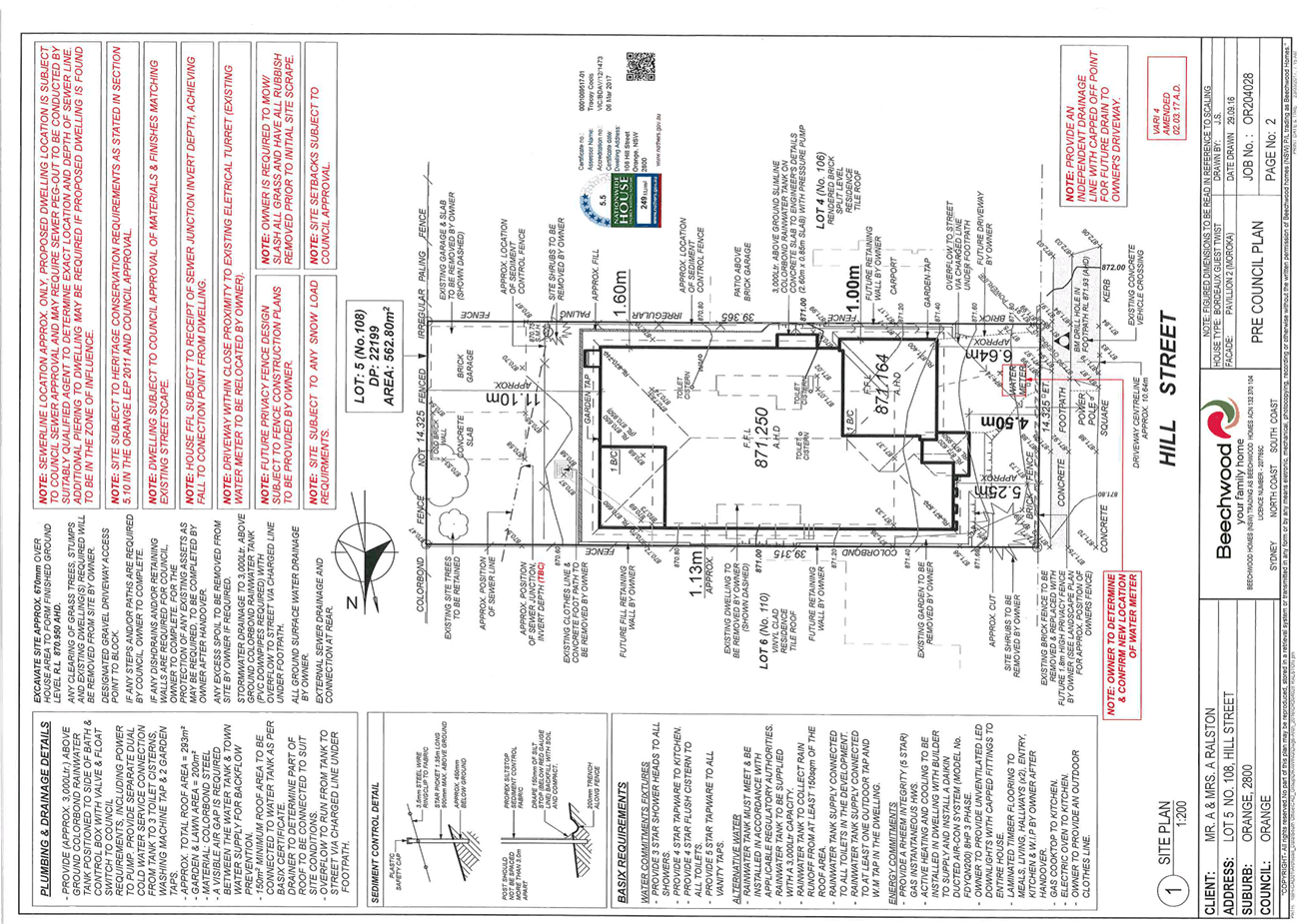
Planning and Development Committee
4 April 2017
2.5 Development
Application DA 445/2016(1) - 108 Hill Street
Attachment 2 Plans
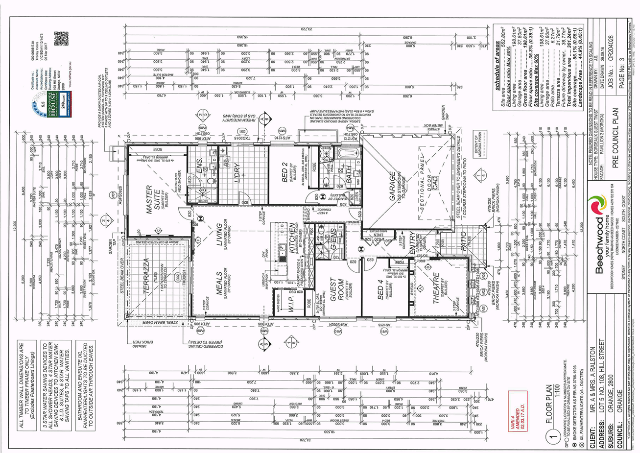
Planning and Development Committee
4 April 2017
2.5 Development
Application DA 445/2016(1) - 108 Hill Street
Attachment 2 Plans
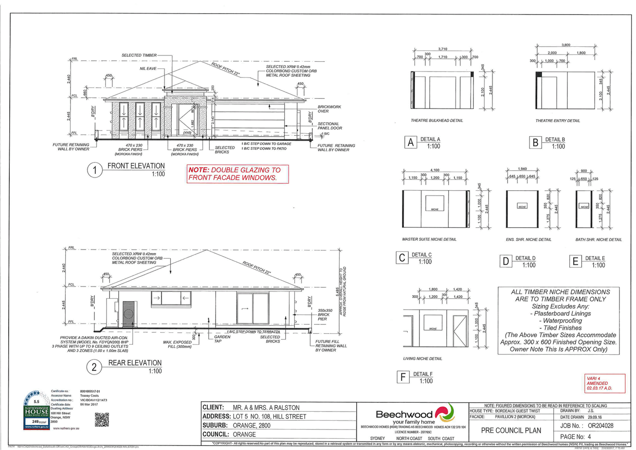
Planning and Development Committee
4 April 2017
2.5 Development
Application DA 445/2016(1) - 108 Hill Street
Attachment 2 Plans
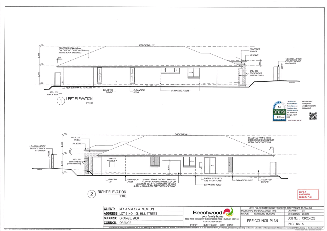
Planning and Development Committee
4 April 2017
2.5 Development
Application DA 445/2016(1) - 108 Hill Street
Attachment 2 Plans
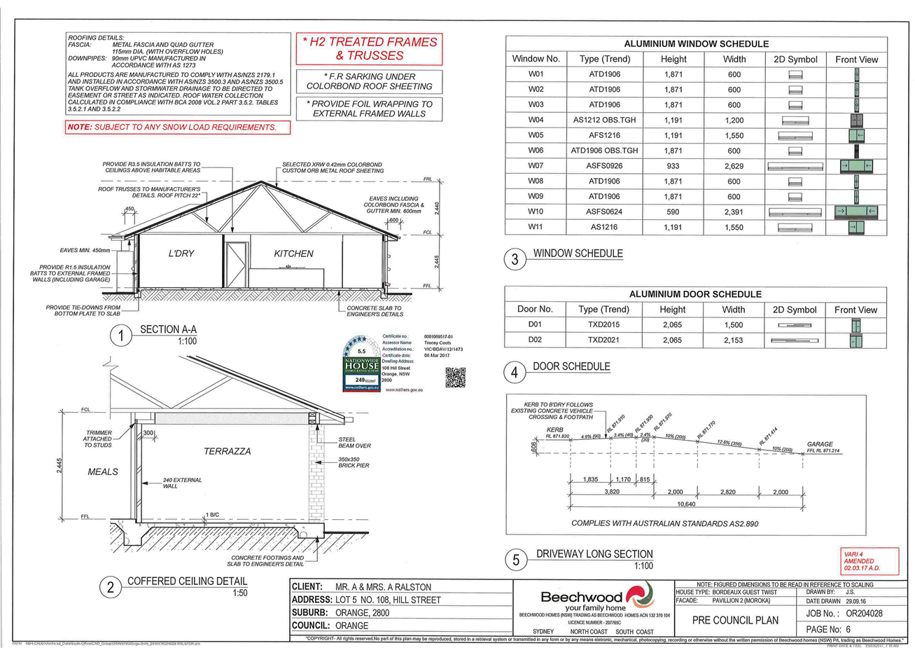
Planning and Development Committee
4 April 2017
2.5 Development
Application DA 445/2016(1) - 108 Hill Street
Attachment 2 Plans