
ORANGE CITY COUNCIL
Planning and Development
Committee
Agenda
6 September 2016
Notice
is hereby given, in accordance with the provisions of the Local Government Act
1993 that a Planning and Development
Committee meeting
of ORANGE CITY COUNCIL will be held in the Council Chamber, Civic Centre, Byng Street, Orange on Tuesday,
6 September 2016.
Garry
Styles
General Manager
For apologies please
contact David Waddell on 6393 8261.
1 Introduction
1.1 Declaration
of pecuniary interests, significant non-pecuniary interests and less than
significant non-pecuniary interests
The
provisions of Chapter 14 of the Local Government Act, 1993 (the Act)
regulate the way in which Councillors and designated staff of Council conduct
themselves to ensure that there is no conflict between their private interests
and their public role.
The
Act prescribes that where a member of Council (or a Committee of Council) has a
direct or indirect financial (pecuniary) interest in a matter to be considered
at a meeting of the Council (or Committee), that interest must be disclosed as
soon as practicable after the start of the meeting and the reasons given for
declaring such interest.
As
members are aware, the provisions of the Local Government Act restrict any
member who has declared a pecuniary interest in any matter from participating
in the discussion or voting on that matter, and requires that member to vacate
the Chamber.
Council’s Code of Conduct provides that if members
have a non-pecuniary conflict of interest, the nature of the conflict must be
disclosed. The Code of Conduct also provides for a number of ways in which a
member may manage non pecuniary conflicts of interest.
|
Recommendation
It is recommended that Committee Members now disclose any
conflicts of interest in matters under consideration by the Planning and
Development Committee at this meeting.
|
2 General
Reports
2.1 Items
Approved Under the Delegated Authority of Council
TRIM
REFERENCE: 2016/1711
AUTHOR: Paul
Johnston, Planning Team Leader
EXECUTIVE Summary
This report provides a list of development
applications approved under the delegated authority of Council.
Link To Delivery/OPerational Plan
The recommendation in this report relates to the Delivery/Operational
Plan strategy “13.4 Our Environment – Monitor and
enforce regulations relating to City amenity”.
Financial Implications
Council has been advised that as a council included in the
NSW Government’s merger proposals under consideration by the Office of
Local Government since referral on 6 January 2016, Council must comply with the
merger proposal period guidelines issued under S23A of the Local Government Act
1993. The guidelines instruct Council it should expend money in accordance with
the detailed budget adopted for the purposes of implementing the
Delivery/Operational Plan for the 2015/16 year.
Any expenditure outside the adopted budget requires the
identification of clear and compelling grounds and must be approved by Council
at a meeting that is open to the public. The guidelines indicate the resolution
of Council for increased expenditure must specify the reasons why the
expenditure is required and warranted.
If increased expenditure is greater than $250,000 or 1% of
the Council’s revenue from rates in
the preceding year, whichever is the greater, Council
is required to exhibit the increase to the budget and consider comments
received.
Council must also avoid entering into contracts or
undertakings were expenditure or revenue is greater than $250,000 or 1% of the Council’s revenue from rates in the
preceding year, whichever is the greater, unless the contract or undertaking is
as a result of a decision or procurement process commenced prior to the merger
proposal period or where entering into a contract or undertaking is reasonably
necessary for the purposes of meeting the ongoing service delivery commitments
of the Council or was previously approved in the Council’s
Delivery/Operational Plan.
Policy and Governance Implications
Nil
|
Recommendation
That the information provided in the
report by the Acting Manager Development Assessments on Items Approved Under
the Delegated Authority of Council be acknowledged.
|
further considerations
Consideration has been given to the
recommendation’s impact on Council’s service delivery; image and
reputation; political; environmental; health and safety; employees;
stakeholders and project management; and no further implications or risks have
been identified.
SUPPORTING INFORMATION
|
Reference:
|
DA 814/1998(2)
|
Determination
Date
|
3 August 2016
|
|
PR Number
|
PR17942
|
|
Applicant/s:
|
Ms NL Gannon
|
|
Owner/s:
|
Ms NL Gannon
|
|
Location:
|
Lot 1 DP 1022900
– 11 Witton Place, Orange (previously
part of Lots 1 and 6 DP 229896, Lot 5 in DP 112242 and
Pt Lot 64 DP 756899 - Cargo Road, Orange)
|
|
Proposal:
|
Modification
of development consent – six lot rural residential subdivision (Stage
1). The modification involves removing the building envelope from Lot 1
DP 1022900 – 11 Witton Place
|
|
Value:
|
$0
|
|
Reference:
|
DA 194/2014(5)
|
Determination
Date
|
29 July 2016
|
|
PR Number
|
PR25415
|
|
Applicant/s:
|
Orange Service
Centre Pty Ltd
|
|
Owner/s:
|
Orange Service
Centre Pty Ltd
|
|
Location:
|
Lot 86 DP 1167633
– 1 Hanrahan Place, Orange
|
|
Proposal:
|
Modification
of development consent – highway service centre and signage. The
modification involves increasing the number of signs on the building (four
wall panel signs on the southern elevation) and canopy (one additional sign
on the fascia); and installing one banner sign on the southern boundary.
|
|
Value:
|
$1,200,000 (being
the same value as the original development)
|
|
Reference:
|
DA 75/2016(2)
|
Determination
Date
|
16 August 2016
|
|
PR Number
|
PR22435
|
|
Applicant/s:
|
NSW Rural Fire
Service
|
|
Owner/s:
|
The State of New
South Wales
|
|
Location:
|
Lot 1 DP 1117200
– 1395 Forest Road, Orange
|
|
Proposal:
|
Modification
of development consent – emergency services facility (shed). The
modification involves relocation of the approved shed 3m to the east and
minor reorientation of the shed to face due north and parallel to the existing
internal access road.
|
|
Value:
|
$300,000 (being
the same value as the original development)
|
|
Reference:
|
DA 139/2016(1)
|
Determination
Date
|
15 August 2016
|
|
PR Number
|
PR20778
|
|
Applicant/s:
|
Bell River Homes
Pty Ltd
|
|
Owner/s:
|
Bell River Homes
Pty Ltd
|
|
Location:
|
Lot 580 DP 1093492
– 21-23 Elsham Avenue, Orange
|
|
Proposal:
|
Subdivision
(two lot industrial)
|
|
Value:
|
$0
|
|
Reference:
|
DA 165/2016(1)
|
Determination
Date
|
15 August 2016
|
|
PR Number
|
PR21084
|
|
Applicant/s:
|
D’Aquino
Bros Pty Ltd
|
|
Owner/s:
|
Rotom Holdings Pty
Limited
|
|
Location:
|
Lot 16 DP 1097086
– 2 Strathgrove Way, Orange
|
|
Proposal:
|
Warehouse
or distributions centre (washbay and alterations and additions to existing
premises)
|
|
Value:
|
$100,000
|
|
Reference:
|
DA 192/2016(1)
|
Determination
Date
|
22 August 2016
|
|
PR Number
|
PR7083
|
|
Applicant/s:
|
Hotel Canobolas
Pty Limited
|
|
Owner/s:
|
Hotel Canobolas
Pty Limited
|
|
Location:
|
Lots 2, 3, 4 and 5
DP 239074 – 170-174 Lords Place and 119 Kite Street, Orange
|
|
Proposal:
|
Office
premises, food and drink premises, hotel or motel accommodation and signage
|
|
Value:
|
$200,000
|
|
Reference:
|
DA 201/2016(1)
|
Determination
Date
|
1 August 2016
|
|
PR Number
|
PR26173
|
|
Applicant/s:
|
Mr I Zhang
|
|
Owner/s:
|
Mr R Lin and Mrs M
Hong
|
|
Location:
|
Lot 104 DP 1188122
– 5 Glasson Drive, Orange
|
|
Proposal:
|
Dual
occupancy and subdivision (two lot residential)
|
|
Value:
|
$320,000
|
|
Reference:
|
DA 201/2016(2)
|
Determination
Date
|
16 August 2016
|
|
PR Number
|
PR26173
|
|
Applicant/s:
|
Mr I Zhang
|
|
Owner/s:
|
Mr R Lin and Mrs M
Hong
|
|
Location:
|
Lot 104 DP 1188122
– 5 Glasson Drive, Orange
|
|
Proposal:
|
Modification
of development consent - dual occupancy and subdivision (two lot
residential). The modification involves the recalculation of development
contributions applicable to the development.
|
|
Value:
|
$320,000 (being
the same value as the original development)
|
|
Reference:
|
DA 202/2016(1)
|
Determination
Date
|
1 August 2016
|
|
PR Number
|
PR26172
|
|
Applicant/s:
|
Mr I Zhang
|
|
Owner/s:
|
Mr R Lin and Mrs M
Hong
|
|
Location:
|
Lot 103 DP 1188122
– 3 Glasson Drive, Orange
|
|
Proposal:
|
Dual occupancy
and subdivision (two lot residential)
|
|
Value:
|
$320,000
|
|
Reference:
|
DA 202/2016(2)
|
Determination
Date
|
16 August 2016
|
|
PR Number
|
PR26172
|
|
Applicant/s:
|
Mr I Zhang
|
|
Owner/s:
|
Mr R Lin and Mrs M
Hong
|
|
Location:
|
Lot 103 DP 1188122
– 3 Glasson Drive, Orange
|
|
Proposal:
|
Modification
of development consent - dual occupancy and subdivision (two lot
residential). The modification involves the recalculation of development
contributions applicable to the development.
|
|
Value:
|
$320,000 (being
the same value as the original development)
|
|
Reference:
|
DA 218/2016(1)
|
Determination
Date
|
15 August 2016
|
|
PR Number
|
PR1178
|
|
Applicant/s:
|
Canobolas Caravan
& Marine Centre
|
|
Owner/s:
|
Canobolas Caravan
Park Pty Limited
|
|
Location:
|
Lot 1 DP 218415
– 166-172 Bathurst Road, Orange
|
|
Proposal:
|
Vehicles
sales or hire premises and vehicle repair station (alterations and additions,
including washbay)
|
|
Value:
|
$100,000
|
|
Reference:
|
DA 224/2016(1)
|
Determination
Date
|
1 August 2016
|
|
PR Number
|
PR6248
|
|
Applicant/s:
|
Ms J Malone
|
|
Owner/s:
|
Ms J Malone
|
|
Location:
|
Lot 11 DP 825795
– 68 Kite Street, Orange
|
|
Proposal:
|
Demolition
(tree removal)
|
|
Value:
|
$3,000
|
|
Reference:
|
DA 231/2016(1)
|
Determination
Date
|
11 August 2016
|
|
PR Number
|
PR9813
|
|
Applicant/s:
|
LM Interiors and
Steel Stone & Wood
|
|
Owner/s:
|
Bailey Funds
Management Pty Ltd
|
|
Location:
|
Lot 11 DP 800314
– 86-88 Peisley Street, Orange
|
|
Proposal:
|
Bulky goods
premises and office premises (alterations to existing premises)
|
|
Value:
|
$50,000
|
|
Reference:
|
DA 232/2016(1)
|
Determination
Date
|
18 August 2016
|
|
PR Number
|
PR26102
|
|
Applicant/s:
|
DB and R Jones
|
|
Owner/s:
|
Orange Investments
(NSW) Pty Ltd, and Mr RG Dawes
|
|
Location:
|
Lots 6 and 7 DP
1183249 – 229 and 231 McLachlan Street, Orange
|
|
Proposal:
|
Recreation
facility (indoor)
|
|
Value:
|
$750,000
|
|
Reference:
|
DA 234/2016(1)
|
Determination
Date
|
26 July 2016
|
|
PR Number
|
PR27302
|
|
Applicant/s:
|
McNamara Street
Investments Pty Ltd
|
|
Owner/s:
|
McNamara Street
Investments Pty Ltd
|
|
Location:
|
Lot 11 DP 1218499
– 8 McNamara Street, Orange
|
|
Proposal:
|
Office
premises
|
|
Value:
|
$650,000
|
|
Reference:
|
DA 242/2016(1)
|
Determination
Date
|
22 July 2016
|
|
PR Number
|
PR11580
|
|
Applicant/s:
|
Checkpoint
Building Surveyors
|
|
Owner/s:
|
Alceon Group Pty
Limited
|
|
Location:
|
Lot 564 DP 776383
– 212-220 Summer Street, Orange
|
|
Proposal:
|
Shop
(shop fitout – tenancies 2-3 and 4)
|
|
Value:
|
$248,524
|
|
Reference:
|
DA 252/2016(1)
|
Determination
Date
|
15 August 2016
|
|
PR Number
|
PR6608
|
|
Applicant/s:
|
Orange Precision
Metalcraft
|
|
Owner/s:
|
Jenkins (DIT) Pty
Limited
|
|
Location:
|
Lot 2 DP 255071
– 3 Leewood Drive, Orange
|
|
Proposal:
|
General
industry (portable structure (meal room))
|
|
Value:
|
$10,000
|
|
Reference:
|
DA 253/2016(1)
|
Determination
Date
|
17 August 2016
|
|
PR Number
|
PR5210
|
|
Applicant/s:
|
Mr AJ and Mrs AM
Ralston
|
|
Owner/s:
|
Mr AJ and Mrs AM
Ralston
|
|
Location:
|
Lot 5 DP 22199 –
108 Hill Street, Orange
|
|
Proposal:
|
Demolition
(existing dwelling)
|
|
Value:
|
$18,000
|
|
Reference:
|
DA 270/2016(1)
|
Determination
Date
|
19 August 2016
|
|
PR Number
|
PR11580
|
|
Applicant/s:
|
CPRAM Investments
Pty Ltd
|
|
Owner/s:
|
Alceon Group Pty
Limited
|
|
Location:
|
Lot 564 DP 776383
– 212-220 Summer Street, Orange
|
|
Proposal:
|
Take
away food and drink premises (alterations)
|
|
Value:
|
$50,000
|
|
Reference:
|
DA 271/2016(1)
|
Determination
Date
|
15 August 2016
|
|
PR Number
|
PR6234
|
|
Applicant/s:
|
Daryl Jackson
Robin Dyke Pty Ltd
|
|
Owner/s:
|
Petrinovic Family
Pty Limited
|
|
Location:
|
Lot 1 Sec 46 DP
758817
|
|
Proposal:
|
Business
identification signage
|
|
Value:
|
$3,060
|
TOTAL
NET* VALUE OF ALL DEVELOPMENTS APPROVED IN THIS PERIOD: $2,822,584
*
Net value relates to the value of modifications. If modifications are
the same value as the original DA, then nil is added. If there is a plus/minus
difference, this difference is added or taken out.
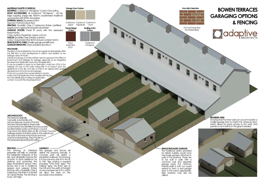
2.2 Bowen
Terraces Heritage Strategy - Outbuildings and Fencing - Post Exhibition
TRIM
REFERENCE: 2016/1963
AUTHOR: Andrew
Crump, Senior Planner
EXECUTIVE Summary
Council recently placed on exhibition the Bowen Terraces
Heritage Strategy – Out buildings and Fencing. No formal submissions
were received. Correspondence was received through Council’s Heritage
Advisor from a former employee of Council who made Council staff aware of the
existence of wells in the rear yards of the terraces, possibly one well per two
terraces. In response to this information Council staff have carried out a
search of historic records of services on the land, however nothing was
conclusively determined.
In order to progress the project to the final phase of
adoption it was recommended by Council’s Heritage Advisor that a note be
placed on the Strategy making people aware of the possible existence of wells,
and require that they be accurately located on the detailed drawings when
development applications are lodged.
No other amendments to the Strategy were required
post-exhibition.
Link To Delivery/OPerational Plan
The recommendation in this report relates to the
Delivery/Operational Plan strategy “13.4 Our Environment
– Monitor and enforce regulations relating to City amenity”.
Financial Implications
Council has been advised that as a council included in the
NSW Government’s merger proposals under consideration by the Office of
Local Government since referral on 6 January 2016, Council must comply with the
merger proposal period guidelines issued under S23A of the Local Government Act
1993.
The guidelines instruct Council it should expend money in
accordance with the detailed budget adopted for the purposes of implementing
the Delivery/Operational Plan for the 2015/16 year.
Any expenditure outside the adopted budget requires the
identification of clear and compelling grounds and must be approved by Council
at a meeting that is open to the public. The guidelines indicate the resolution
of Council for increased expenditure must specify the reasons why the
expenditure is required and warranted.
If increased expenditure is greater than $250,000 or 1% of
the Council’s revenue from rates in
the preceding year, whichever is the greater, Council
is required to exhibit the increase to the budget and consider comments
received.
Council must also avoid entering into contracts or
undertakings where expenditure or revenue is greater than $250,000 or 1% of the
Council’s revenue from rates in the
preceding year, whichever is the greater, unless the contract or undertaking is
as a result of a decision or procurement process commenced prior to the merger
proposal period or where entering into a contract or undertaking is reasonably
necessary for the purposes of meeting the ongoing service delivery commitments
of the Council or was previously approved in the Council’s
Delivery/Operational Plan.
Policy and Governance Implications
Nil
|
Recommendation
That Council adopts the Bowen Terraces Heritage
Strategy - Out buildings and Fencing noting the amendment regarding wells in
the vicinity.
|
further considerations
Consideration has been given to the
recommendation’s impact on Council’s service delivery; image and
reputation; political; environmental; health and safety; employees;
stakeholders and project management; and no further implications or risks have
been identified.
SUPPORTING INFORMATION
A number of owners within the Bowen Terraces at 3-25
Bathurst Road, Orange have expressed to Council staff an intention to construct
outbuildings (ie garages) and regularise the fencing at the rear of the
Terraces.
So as to achieve a consistent, coherent and sympathetic
approach to rear development at the Terraces; Council staff have prepared a
guiding document: Bowen Terraces Heritage Strategy – Outbuildings and Fencing
which provides the necessary detail to inform future development applications;
and will hopefully assist the assessment required to be undertaken through the
NSW Office of Environment and Heritage under the Heritage Act (as the
Bowen Terraces are an item of environmental heritage listed on the State
Heritage Register).
The strategy was placed on public exhibition for a period of
28 days and comments were invited from the general public. At the conclusion of
the exhibition period no formal submissions were received.
Council’s Heritage Advisor was made aware of the
possibility of wells located in the rear yards. Council staff attempted to
located historic evidence of the exact locations of the possible wells, however
were not able to find the required information.
In order to progress the project to the final phase of
adoption, it was recommended by Council’s Heritage Advisor that a note be
placed on the Strategy making people aware of the possible existence of wells,
and require that they be accurately located on the detailed drawings when
development applications are lodged.
The required amendment has been made
to the Strategy and it is recommended that the policy now be adopted by
Council.
Attachments
1 Bowen
Terraces Heritage Strategy, D16/38882⇩
Planning and Development Committee
6 September 2016
2.2 Bowen
Terraces Heritage Strategy - Outbuildings and Fencing - Post Exhibition
Attachment 1 Bowen
Terraces Heritage Strategy
2.3 Development
Application DA 233/2015(1) - 98 Gorman Road
TRIM
REFERENCE: 2016/1741
AUTHOR: Michael
Glenn, Senior Planner
EXECUTIVE Summary
|
Application
lodged
|
15 July
2015
|
|
Applicant/s
|
Mrs CY
Pearson, Mrs FK Blunt and Mrs JE Youngman
|
|
Owner/s
|
Mrs CY
Pearson, Mrs FK Blunt and Mrs JE Youngman
|
|
Land
description
|
Lot 1 DP
581736 - 98 Gorman Road, Orange
|
|
Proposed
land use
|
Subdivision
(37 lot residential plus public open space and drainage reserves)
|
|
Value of
proposed development
|
$0
|
Council's consent is sought for a subdivision of the subject
land into 37 lots ranging in size from 2,009m² to 3,917m².
The subject property is constrained by its slope, its
prominence as a visual element of the landscape, and the potential impacts on
iconic views to both the north to the Mullion Ranges and southwest to Mt
Canobolas. The slope of the subject land is, in places, in excess of 25%,
and is thus likely to lead to significant levels of cut and fill both in the
road construction and also for likely future development of the lots.
SITE INSPECTION
This matter was submitted to the Planning and Development
Committee (PDC) at its meeting of 5 April 2016, at which time it was resolved
to undertake a site inspection.
The site inspection was convened on 5 May 2016, attended by
Councillors and staff as well as some objectors and observed by the proponent.
Several other Councillors are understood to have conducted their own
inspections subsequent to the formal site inspection.
Several comments arose from Councillors as a result of the
inspection and the principal objector did address the meeting and staff and the
proponent did answer several questions posed. The principal objector
subsequently submitted an alternative concept sketch, in which no direct access
to Gorman Road was proposed, rather relying on the access through the recently
completed "Sunset Ridge" estate located to the north.
Council's Technical Services Division has reviewed this
alternative concept and offered the following advice:
"The road layout for this
subdivision has a road (Road no. 1) connecting the extension of Connemara Drive
….. with Gorman Rd.
The reason for this connection
to Gorman Road is to provide an additional exit point from Blunt’s
subdivision to the surrounding road network.
Without this connection, all
the lots in Blunt’s subdivision (38 in total) plus the 36 lots in (the
Sunset Ridge subdivision) all access the surrounding road network at Gorman
Road at one point. In effect there is a 74 lot cul-de-sac created. Our
subdivision code limits cul-de-sacs to 30 lots so this is a significant
departure from the code. Apart from amenity for residents, (which would (be)
adversely impact (upon)) the residents which have to put up with traffic from
all these lots travelling past their property each day) and travel efficiency,
as motorists are forced to travel significant distances from the subdivision to
access the surrounding road network, a key reason for this requirement relates
to access for emergency vehicles and potential escape paths for residents in
the event of a fire or similar situation".
A redesigned subdivision layout with no access from Gorman
Road is thus not supportable because of these amenity and safety
considerations.
The principal objector at the site inspection also raised
issues or made comment with respect to several other issues, which can be
summarised generally as follows:
· view loss
· building heights
· setbacks
· building envelopes
· materials and
finishes for buildings.
A number of these issues have previously been assessed and
commented upon in the main report; others appear to have been misinterpreted as
far as staff recommendations are concerned. One is a new issue requiring
further comment.
With regard to view loss, this issue was fully assessed and
the staff position made clear in the main report.
With regard to building height, the principal objector is
seeking a blanket single storey restriction across the whole subdivision. This
is not supported, but single storey restrictions are recommended in the consent
for certain lots along the main ridge.
With regard to setbacks, the staff position and
recommendation of a 15m setback from the southern boundary for future buildings
and substantial setbacks from Gorman Road with side setbacks also specified
remain. It is the objector's submission that these controls be further
increased at least for the shared southern boundary.
With regard to building envelopes, restrictions are
contained in the attached consent that require minimum setbacks and limit site
coverage to either 35% for the more sensitive blocks, or 50% for the less
sensitive blocks. The objector wants to further restrict development by
specifying actual building envelopes, but this is not supported in this case
due to the slope of many of the affected lots.
With regard to materials and finishes, whilst future
buildings and development on the subdivided lots are valid as matters for
consideration, it is a fine line of separation to determine what is a linked
secondary impact arising from the subdivision, and issues that should more
appropriately be considered at the building application stage.
Issues relating to general form, height, site coverage,
setbacks and the like have a clear link to the subdivision, but issues relating
to building finishes do not have a link to the subdivision aspect of the land's
development. Further, it is noted that the general provisions of
Council's DCP 2004 will require the reflectivity and compatibility of
materials to be considered at the building stage of development.
The original report is again submitted to Council for
consideration.
REVISED PROPOSAL AND NOMINATION
AS INTGRATED DEVELOPMENT
On 6 June 2016 the applicant informed Council staff that
they now wished the matter to be processed as Integrated Development, and
submitted amended plans that are claimed to respond to some issues raised
during the public consultations on this application. The revised plans have
been exhibited as per the requirements for Integrated Development, and the
general Terms of Approval obtained from the co-approval agency. Objections were
lodged in relation to the revised proposal, and as required by the legislation,
copies of the objections passed to the co-approval agency.
The NSW Office of Water has responded after having considered
the revised proposal and all submissions received within the statutory period.
The General Terms of Approval of the NSW Office of Water have been
included in the attached draft Notice of Determination.
Link To Delivery/OPerational Plan
The recommendation in this report relates to the
Delivery/Operational Plan strategy “13.4 Our Environment
– Monitor and enforce regulations relating to City amenity”.
Financial Implications
Council has been advised that as a council included in the
NSW Government’s merger proposals under consideration by the Office of
Local Government since referral on 6 January 2016, Council must comply with the
merger proposal period guidelines issued under S23A of the Local Government Act
1993.
The guidelines instruct Council it should expend money in
accordance with the detailed budget adopted for the purposes of implementing
the Delivery/Operational Plan for the 2015/16 year.
Any expenditure outside the adopted budget requires the
identification of clear and compelling grounds and must be approved by Council
at a meeting that is open to the public. The guidelines indicate the resolution
of Council for increased expenditure must specify the reasons why the
expenditure is required and warranted.
If increased expenditure is greater than $250,000 or 1% of
the Council’s revenue from rates in
the preceding year, whichever is the greater, Council
is required to exhibit the increase to the budget and consider comments
received.
Council must also avoid entering into contracts or
undertakings where expenditure or revenue is greater than $250,000 or 1% of the
Council’s revenue from rates in the
preceding year, whichever is the greater, unless the contract or undertaking is
as a result of a decision or procurement process commenced prior to the merger
proposal period or where entering into a contract or undertaking is reasonably
necessary for the purposes of meeting the ongoing service delivery commitments
of the Council or was previously approved in the Council’s
Delivery/Operational Plan.
Policy and Governance Implications
Nil
|
Recommendation
That Council consents to development application DA
233/2015(1) for Subdivision (37 lot residential plus public open
space and drainage reserves) at Lot 1 DP 581736 - 98 Gorman Road, Orange
pursuant to the conditions of consent in the attached Notice of Approval.
|
further considerations
Consideration has been given to the
recommendation’s impact on Council’s service delivery; image and
reputation; political; environmental; health and safety; employees;
stakeholders and project management; and no further implications or risks have
been identified.
SUPPORTING INFORMATION
THE APPLICATION
Council's consent is sought for subdivision (37 lot
residential plus public open space and drainage reserves) at Lot 1 DP 581736 -
98 Gorman Road, Orange.
THE PROPOSAL
The proposal involves a subdivision, associated earthworks,
drainage, installation of services and road construction.
As indicated in the executive summary, the site is
constrained by its slope, high levels of visibility and conflicts between the
zone restrictions and the existing and competing local character. These
constraints are acknowledged in the applicant's submission and some allowances
made in the layout of the subdivision. Principally, the layout incorporates
larger lots on the more sloping areas of the site. This will provide space in
which to move future dwellings around and provide privacy buffers and the like.
However, the applicants’ response in itself is not sufficient to conclude
that no significant adverse effect will be likely to arise from the proposed
subdivision.
The proposed subdivision complies with the requirements of
LEP 2011. Further, there is no detailed masterplan applicable (in the same way
as a masterplan has been done for the Shiralee Urban Release Area). The
proposed development does not generate any significant direct breaches of the
general residential planning outcomes of DCP 2004.
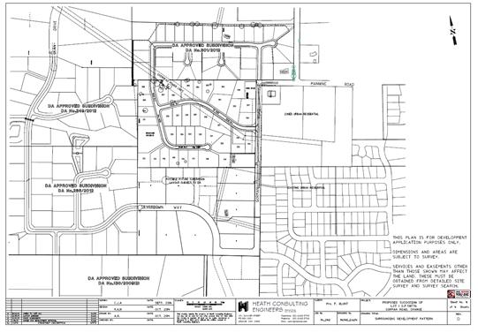
Figure 1 - site plan showing surrounding development
densities
However, notwithstanding the general compliance with the
major planning controls, the proposed development does have some significant
adverse effects which can be identified in the Section 79C assessment. The
Sustainable Settlement Strategy completed in 2004 as a precursor to
further changes to the zoning of the locality indicated significant constraints
in terms of view corridors along the ridgetop, and highly constrained land
along the area where slope is greatest in view of the likely amount of cut and
fill that will be required in these areas. The inherent conflict that arises
due to the differing subdivision densities between the essentially rural
residential and rural land to the north and west of the site (which has been the
subject of some intense debate for other similar proposals on the surrounding
lots) and the more densely used residential land to the east and south is
acknowledged, and remains as much an issue for this application as any of the
other recently approved green fields residential subdivisions for this
locality.
To an extent it is not possible to fully address all of
these constraints such that their impact could be said to be fully expunged
from the development, however it is considered possible to minimise such
impacts with conditions and render the proposed development acceptable in terms
of its external effects.
MATTERS FOR CONSIDERATION
Site Constraints - the Sustainable Settlement Strategy
The significant constraints are thoroughly outlined in
Chapter 9 of the Sustainable Settlement Strategy (SSS).
The SSS identified parts of this land as being unsuitable
for urban/residential development. It is, however, zoned R5 Large Lot
Residential under Orange Local Environment Plan 2011 (OLEP 2011),
with no special controls applicable under a DCP masterplan.
The SSS was intended to serve as the basis for any
future zonings and any detail design criteria that might otherwise be devised
to apply to the subject land. Of itself, the SSS has no statutory weight, but
it does offer significant usefulness in undertaking a merits based assessment
as is required under Section 79C of the Act.
The major environmental constraints affecting the subject
land are depicted in a series of maps from the SSS:
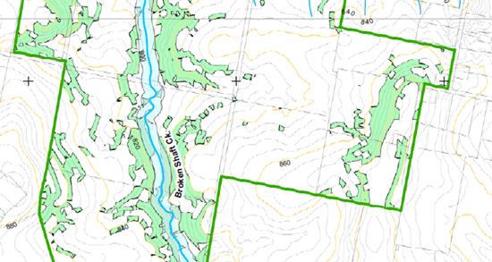
Figure 2 - geotechnical constraints
The sloping parts of the site can be expected to contain
significant tonnages of submerged rock.
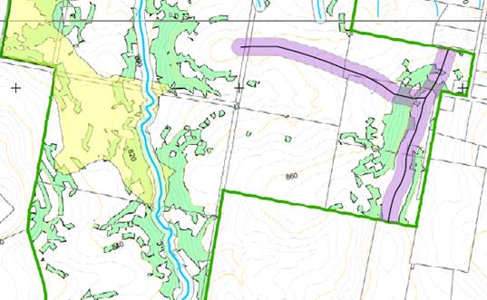
Figure 3 - visual and landscape constraints
The areas of visual and landscape sensitivity within the
study area are creek lines (focused on Broken Shaft Creek), existing
significant vegetation, ridgelines and sensitive rural views. These constraints
are shown in Figure 2. Specifically, the SSS recommends or identifies the
following slope and ridge related constraints:
(a) any
future development needs to protect watercourses, establish appropriate buffers
and protect and augment existing riparian vegetation;
(b) sensitive
rural views include attractive views from both within and outside the study
area;
(c) protection
and enhancement of the remnant native vegetation is identified as a high
priority in the SSS;
(d) the
SSS suggests that the sensitive drainage lines within the study area be vested
in public ownership - it identifies one such line traversing the subject
property.
Response to the Identified
Constraints
The layout of the proposed subdivision does not incorporate
any linkages to connect the walking and open space areas purchased (but as yet
undeveloped) to the west when that land was recently subdivided. Whilst a
specific link is not proposed the subdivision layout does, however, include
dedications of land for a drainage reserve at the western lower end of the
block, and a smaller area of open space around the Trig station in the
north-eastern corner. The open space around the Trig station is included in the
2015 Section 94 Contributions Plan, and as such compensation for this land
will be offered to the applicant. Council is not in a position to expend funds
from its general revenue sources to acquire land that does not form part of the
intended open space network.
Whilst the drainage lines have some importance, the
overwhelmingly significant constraining factors of this site are the elevated
ridge lines and the rocky soil on the slope of the land, which will make future
construction expensive and difficult, and the likely levels of site disturbance
at dwelling construction a difficult and challenging prospect. The sheer slope
of the site leading to the ridge is a significant issue and likely to affect
view lines and neighbourhood character to an inordinate degree as these sloping
areas are developed.
The basic permissibility of the proposed subdivision is
established in the zoning restrictions (and in particular the minimum lot size
provisions) which this proposal meets the requirements of. Moreover, the
proposed development is generally consistent with the objectives of the
principal environmental planning instrument (EPI) and also the zone objectives.
However, the SSS clearly identifies some major constraints
affecting the site. The applicant’s submission addresses these
constraints, however it is considered appropriate to impose conditions so as to
achieve outcomes more consistent with the LEP and DCP objectives.
Amended plans were submitted on 6 June 2016 that took into
account earlier amendments, whilst also attempting to address some of the
issues that arose during the assessment and public consultation process. The
amended plans accommodate Essential Energy’s requirements and also try to
respond to some of the landscape quality issues by retaining more of the trees
on the site. The applicant erroneously believes that Essential Energy requires
the removal of vegetation from the easements, including the very significant
landscape trees on Lots 306 and 307, but this is not the case. Essential Energy
has no issue with the retention of these trees within their easement areas.
A constraint identified in the SSS is the ridgeline which is
identified as making a significant contribution to the visual amenity of the
locality. It is considered that the development that will occur on the
ridgeline both as a result of the subject development and under further
development that will occur following subdivision will significantly impact on
the skyline from large areas of the existing area of the City to the east and
south, and from the more rural and rural residential land to the north and
west; and also have inordinate potential to affect the view corridor and scenic
quality over a wide area.
The following is a summary of the major changes incorporated
into the final amended plans. To provide clarity and certainty in the consent
outcomes, it is considered appropriate to impose a number of restrictions as to
user to address these issues. These restrictions will relate to some of the
following features of the amended (and some that are carried over, unaddressed
in the applicant submission):
(1) The
final amended plans increase the minimum depth for Lot 333 to 38m as was
recommended in discussions with the applicant. However the final revised layout
proposes to retain Lot 332 which is heavily affected by the Essential Energy
electricity easement.
(2) The
addition of a second drainage reserve, adjacent the southern boundary with the
adjoining Lot 106. This additional reserve would isolated Lots 313 and 314, and
limit the shared boundary with Lot 106 DP1075776.
(3) Reconfigures
the orientation of Lots 306 and 307 making it possible for the significant
vegetation on those lots to be retained.
(4) Building
restriction envelopes in which maximum site coverage does not exceed 35%
of the block size for Lots 331 to 337, and Lots 313 to 318 (being those lots on
the ridge and those lots along the southern boundary). A minimum setback of 15m
from the southern boundary for Lots 312 to 318 is also recommended.
(5) Minimum
setbacks from Gorman Road of 12m.
(6) The
imposition of a Section 88B Restriction-as-to-User that requires the submission
of a landscape plan that is to the satisfaction of Council with any dwelling
(or outbuilding) application for Lots 331 to 337 inclusive. Such landscaping is
to incorporate species selection with a mature height greater than the height
of the structures proposed and able to screen a minimum of 50% of the width of
the proposed dwelling or building frontage. Full implementation of the approved
landscaping is required prior to the issue of an Occupation Certificate and
retention and maintenance of such landscaping required thereafter.
(5) A
Section 88B Restriction-as-to-User is required for Lots 331 to 337 limiting
future development on these lots to single storey construction.
(6) All
fencing throughout the entire subdivision is to be restricted to rural type
fencing less the barbed wire component as per the requirements of
Council’s DCP 2004 or its successor.
(7) Retention
and protection of trees on Lots 306 and 307 as well as any other native species
with a height greater than 10m generally on Lots 315, 310, 303 (the
smaller tree on this lot may be removed), 304 and 305, including those trees
currently proposed for removal on the amended plan (principally those trees
within the easement), by the imposition of building envelopes and fenced tree
protection zones on these sites. Section 88B restrictions are also required for
the protection of the designated trees
(8) For
those lots not elsewhere identified in the consent (Lots 301 to 307,
Lots 308 to 312 and Lots 319 to 330), building restriction envelopes
not exceeding 50% of the block size are required.
(9) All
building envelopes required under this consent, in addition to all other
restrictions, shall incorporate front and side setbacks not less than of 10m
and 2m respectively.
Section 5A Assessment
In the administration of sections 78A, 79B, 79C, 111 and
112, the provisions of Section 5A must be taken into account for every
development application in deciding whether there is likely to be a significant
effect on threatened species, populations or ecological communities or their
habitats. This section includes a requirement to consider any adopted
assessment guidelines, which means assessment guidelines issued and in force
under section 94A of the Threatened Species Conservation Act 1995.
Assessment guidelines are in force (see DECC-W
“Threatened Species Assessment Guidelines - The Assessment of
Significance”) which requires consent authority to adopt the
precautionary principle in its assessment.
The subject property is not mapped as containing high value
biodiversity, however the SSS nevertheless identifies the site as having
some biodiversity potential. There are isolated trees on the site, as well as a
number of partially exposed rocky outcrops and considerable amounts of embedded
surface rock. These rocky components are discussed in OEH guidelines as
landscape elements likely to provide some habitat value, particularly for invertebrates
and small reptiles. Invariably the proposed development, along with future
development of the site as a housing estate, poses some threat to those habitat
niches on the site.
As an offset to that threat, it is considered appropriate to
require as a condition of approval either the storage and above ground use of
excavated rock material on the site, or the storage of the material on a
Council designated stockpile for future use. A condition to that effect is
included in the attached notice, and specifically does not allow such material
to be reburied.
Site Photographs
Photograph 1 - subject property from its western
boundary looking east upslope
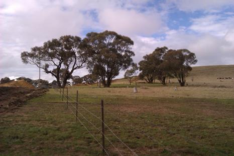
Photograph 2 - native vegetation on the site is fairly
limited,
but offers significance as a link to the more rural
land nearby
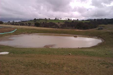
Photograph 3 - recently completed stormwater drainage
for the
western subdivision in Dean Drive.
The proposed development will direct its surface flows into
the drainage system that passes through this detention basin. It is important
that water quality and sedimentation be managed to maintain this system in
adequate working order and to ensure the continuing water quality of the
downstream properties, which rely on this water course as a water supply,
albeit some 33 kilometres downstream. The dual drainage reserves that are now
proposed will not inhibit the quality of surface runoff from the site.

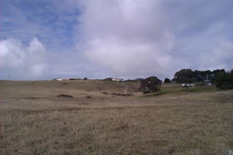
Photograph 4 - subject property looking north
This photograph was taken from Silverdown Way. Note the
slope of the site and the iconic views of the Mullion Ranges in the distance.
Aboriginal
Heritage
Council commissioned a report by Parsons
Brinkerhoff in 2004 for the Sustainable Settlement Strategy. The Parsons
Brinkerhoff report includes a predictive tool as to the likelihood of
Aboriginal heritage existing on a given site within its study area. In this
case, the predictive tool (which includes a map) suggests a moderate
possibility of Aboriginal heritage occurring on adjoining sites closer to Broken
Shaft Creek, but no significant potential for the subject property. This is
consistent with known Aboriginal settlement and encampment patterns that, as a
generalization, favoured more sheltered sites closer to known watercourses.
Occasionally,
if there is a significant feature such as an escarpment or large floater stones
on the surface, Aboriginals might identify the locality as being culturally or
religiously significant, but in this case there are no such natural features or
landmarks with sufficient prominence as to be likely to attract attention.
Additionally, occasionally wooded areas might be used for the collection of
bark, and some species of trees could be used as "scar trees". Again
no observable evidence exists on the site of this sort of activity.
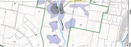
Figure 4 - extract from Parson Brinkerhoff report on Aboriginal Heritage
Council in 2010 also commissioned an
Aboriginal Heritage Study. This study identified some potential for part of
Broken Shaft Creek to possess some Aboriginal artefacts, but not much potential
for the site itself. The OEH register of known artefacts and sites lists two
finds approximately 600m west of the site in the riparian area of Broken Shaft
Creek.
The NPW Act requires a developer to apply
“due diligence”, which means a legal standard of care, to determine
whether a proposed activity could harm (ie damage, destroy, deface or move)
Aboriginal objects or declared Aboriginal Places. In the context of protecting
Aboriginal cultural heritage, due diligence involves taking reasonable and
practicable measures to determine whether a developer’s actions will
harm an Aboriginal object, and if so, what measures can be taken to avoid that
harm.
The process for applying due diligence is
described in the OEH publication Due Diligence Code of Practice for the
Protection of Aboriginal Objects in New South Wales (2010). If a
proposed development could harm Aboriginal objects or declared Aboriginal
Places, then investigations of the development area are required to determine:
1 what Aboriginal cultural
heritage is located there;
2 why (or if) the
Aboriginal cultural heritage located within the area is important;
3 the likely impacts of
the proposed development on Aboriginal cultural heritage are;
4 how the impacts on
Aboriginal cultural heritage can be avoided or minimised. In cases where
Aboriginal cultural heritage will be damaged or destroyed, an Aboriginal
Heritage Impact Permit (AHIP) is required.
In this case, the applicant has not
undertaken a survey or study to determine if such heritage exists. However, the
site characteristics do not suggest a great possibility of Aboriginal heritage
of any kind on the site. The available area based general studies suggest no
significant possibility for this site.
Integrated Development
The applicants have sought approval under the Integrated
Development provisions of the Act, which is the applicants’ choice.
The NSW Office of Water (NoW) has issued its general Terms of Approval which
are incorporated into the draft development consent.
There is a drainage line Category 1 stream (using the
Strahler classification system on the site) which eventually drains into Broken
Shaft creek. The NoW advises that it is probable that a controlled activity
permit would be required given the extent of disturbance to be undertaken on
this drainage line. It is considered appropriate to impose a condition that
requires the applicant to liaise directly with NoW with respect to requirements
under the Water Management Act (WMA).
Section 79C
Section 79C of the Environmental Planning and Assessment
Act 1979 requires Council to consider various matters, of which those
pertaining to the application are listed below.
PROVISIONS OF ANY ENVIRONMENTAL
PLANNING INSTRUMENT s79C(1)(a)(i)
Orange Local Environmental Plan 2011
Part 1 - Preliminary
Clause 1.2 - Aims of Plan
The broad aims
of the LEP are set out under sub-clause 2. Those relevant to the application
are discussed below:
(a) to encourage development
which complements and enhances the unique character of Orange as a major
regional centre boasting a diverse economy and offering an attractive regional
lifestyle.
The proposed
development will detract from the rural character of the locality, but will be
consistent with the residential character of the more urban areas nearby. Given
that the land is essentially a transitional zone between urban and non-urban
development, this would appear to be appropriate development for the site.
In
acknowledgement of the competing demands of rural residential and residential
character affecting the subject site, it is considered appropriate to impose a
range of conditions aimed at achieving a better relationship with these
competing characters. In summary, the conditions will:
1 Require all
subdivision fencing as rural style fencing (post and wire, no barbed wire).
2 Impose a
Section 88B Restriction-as-to-User under the Conveyancing Act 1979
requiring such rural fencing to be retained and maintained, and prohibiting the
replacement of such fencing except with like materials, and the approval of
Council and the adjoining owner (as per the general principals of the Dividing
Fences Act).
3 Imposition
of Section 88B building restriction envelopes for certain lots to ensure
retention of certain significant trees on the site and thereby maintain to a
better extent the contribution to character and amenity made by this property
to the locality.
4 Establishment
by condition and Section 88B Restriction-as-to-User under the Conveyancing
Act 1979 of a no build buffer 10m wide for the northern, western and
eastern boundaries. For the northern and western boundaries, vegetation buffers
are also required to be planted and maintained until release of the Subdivision
Certificate.
5 To improve
the streetscape and spacing between dwellings, it is considered appropriate to
impose a condition that requires minimum front and side setbacks on the new
lots, except where similar alternative arrangements (such as the building
envelopes for certain lots) are already imposed as conditions of consent.
6 Imposition
of a condition preventing the removal of any trees except within the designated
road reserves of the development. Future applications will need to consider the
tree removals from the site outside the specified exclusion zones on a case‑by‑case
basis.
(b) to provide for a range of
development opportunities that contribute to the social, economic and
environmental resources of Orange in a way that allows present and future
generations to meet their needs by implementing the principles for ecologically
sustainable development.
With regard to
this aim, the proposed development does increase the stock of housing lots that
in some perspective adds to the development opportunities of the City. Adding
to the housing stock increases the potential for population growth that in turn
suggests that the needs of the workforce will be met.
(c) to conserve and enhance
the water resources on which Orange depends, particularly water supply
catchments.
The proposed
development would not have any significant effect on the resources of the
Orange City water supply.
(e) to provide a range of
housing choices in planned urban and rural locations to meet population growth.
The proposed
development does not propose housing; however it does increase the supply of
residential allotments. This will produce the conditions needed to provide
additional housing opportunities.
(f) to recognise and
manage valued environmental heritage, landscape and scenic features of Orange.
It is
recognised that the changes in zoning that occurred under LEP 2011 will result
in some adverse effects on the surrounding landscape. However, within the
context of the general provisions, the zoning, the other objectives of the LEP
and the recognised primary view corridors and the like, it is considered that
this is appropriate development for the site.
To minimise the
impacts on character and visual amenity, the consent includes conditions to
retain the significant vegetation on the site, enhance vegetation buffers
around the perimeter, retain or provide rural fencing around the site
boundaries, and require setbacks that are in excess of current DCP standards
for residential development.
Clause 1.6 - Consent Authority
This clause establishes that, subject to the Act, Council is
the consent authority for applications made under the LEP.
Clause 1.9A - Suspension of
Covenants, Agreements and Instruments
This clause provides that covenants, agreements and other
instruments which seek to restrict the carrying out of development do not apply
with the following exceptions.
· covenants imposed
or required by Council
· prescribed
instruments under Section 183A of the Crown Lands Act 1989
· any conservation
agreement under the National Parks and Wildlife Act 1974
· any trust
agreement under the Nature Conservation Trust Act 2001
· any property
vegetation plan under the Native Vegetation Act 2003
· any biobanking
agreement under Part 7A of the Threatened Species Conservation Act 1995
· any planning
agreement under Division 6 of Part 4 of the Environmental Planning and
Assessment Act 1979.
Council staff are not aware of the title of the subject
property being affected by any of the above.
Mapping
The subject
site is identified on the LEP maps in the following manner:
|
Land Zoning Map:
|
Land zoned R5
Large Lot Residential
|
|
Lot Size Map:
|
Minimum Lot Size
2000m2
|
|
Heritage Map:
|
Not a heritage
item or conservation area
|
|
Height of
Buildings Map:
|
No building height
limit
|
|
Floor Space Ratio
Map:
|
No floor space
limit
|
|
Terrestrial
Biodiversity Map:
|
Low biodiversity
sensitivity on the site
|
|
Groundwater
Vulnerability Map:
|
Ground water
vulnerable
|
|
Drinking Water
Catchment Map:
|
Not within the
drinking water catchment
|
|
Watercourse Map:
|
Not within but
affecting a defined watercourse
|
|
Urban Release Area
Map:
|
Not within an
urban release area
|
|
Obstacle
Limitation Surface Map:
|
No restriction on
building siting or construction
|
|
Additional
Permitted Uses Map:
|
No additional
permitted use applies
|
These matters (and all clauses of the LEP)
have been considered in the assessment. Those relevant to the proposed
development are listed and commented upon where appropriate in the body of this
report.
Part 2 -
Permitted or Prohibited Development
Land Use Zones
The subject
site is zoned R5 Large Lot Residential. The proposed development is defined as
subdivision under LEP 2011. Subdivision of land under LEP 2011 has the
same meaning as defined in the Act. Pursuant to clause 4B of the Environmental
Planning and Assessment Act subdivision of land means:
the division of land into two or more parts that, after the
division, would be obviously adapted for separate occupation, use or
disposition.
Subdivision of
land is permissible in the R5 Large Lot Residential zone with the consent of
Council pursuant to clause 2.6.
Clause 2.3 of LEP 2011
references the Land Use Table and Objectives for each zone in LEP 2011.
These objectives for land zoned R5 Large Lot Residential are as follows:
· To ensure that large residential lots do not hinder the proper and
orderly development of urban areas in the future.
· To ensure that development in the area does not unreasonably
increase the demand for public services or public facilities.
· To ensure development is ordered in such a way as to maximise public
transport patronage, and encourage walking and cycling, in close proximity to
settlement.
· To provide residential housing in a rural setting while preserving,
and minimising impacts on, environmentally sensitive locations and scenic
quality.
· To minimise conflict between land uses within this zone and land
uses within adjoining zones.
· To provide for student housing in close proximity to the Charles
Sturt University.
· To ensure development along the Southern Link Road has an
alternative access.
In relation to
the first objective, the proposed development would not act to hinder the
proper and orderly development of urban areas. The development is consistent in
terms of yields and layout with the zoning of the site.
In relation to
the second objective, the proposed development will incorporate essential
utility services, including roads, stormwater sewer and water supply. These
will be the responsibility of, and at the expense of the developer to provide.
In relation to
the third objective, there will be access to a public road, making access to
public transport possible. There are no public walkways or open areas provided
on the site. There is, however, a drainage reserve that generally will tend to
have a secondary usage as open space.
In relation to
the fourth objective, the proposed development will provide opportunities for
housing that can minimise environmental impacts, impacts on scenic quality and
maintain rural character.
In relation to the fifth
objective, conditions have been included to minimise the likely nuisances that
may arise for future development on the new lots. These include buffering,
lighting and fencing requirements.
In relation to
the sixth objective, the subject application does not propose any housing and
the subject land is not located in close proximity to Charles Sturt University
In relation to the seventh
objective, this objective is not relevant to the subject property or the
proposed development
Clause 2.6 - Subdivision - Consent Requirements
The above
clause establishes that development consent is required for subdivision. The
applicant is seeking consent via this development application.
Part 4 -
Principal Development Standards
Clause 4.1 - Minimum
Subdivision Lot Size
This clause requires the
subdivision of land to be equal to or greater than the size nominated for the
land under the Minimum Lot Size Map. In relation to this site, the map
nominates a minimum lot size of 2,000m2. The smallest lot proposed
by the application is 2,000m2.
Part 5 -
Miscellaneous Provisions
5.9 - Preservation of Trees or Vegetation
The application as submitted
shows some significant individual native trees on the site. The plans suggest
that significant natives exist on the following lots: Lots 303-308,
Lot 310, Lots 315-316 and Lot 319. There are three or four trees
located within the proposed road reserves.
The plans submitted with the
application indicate the removal of all the trees within the road reserves and
no special protection for any of the trees on the private lots to be created.
It is considered that these arrangements are not satisfactory. The trees form
an important element of the landscape.
The most significant vegetated
areas of the site are located on Lots 307-308 and Lot 310. Lot 307 is
also heavily affected by a proposed electricity easement. As original
submitted, it was not possible to create Lot 307 and realistically retain the
significant trees on that lot with the current configuration of the lot.
However ,amendment of the lot layout so as to reconfigure the division between
Lot 306 and 307 from the current east-west division line to a north-south
division line, and the imposition of building envelopes ensures the retention
of the significant vegetation on these lots whilst not affecting lot yields for
the proponent.
With regard to the other trees
on the site, the trees located on certain lots should be retained and protected
for reasons relating to visual amenity. The applicant has submitted an amended
plan in this regard, but has erroneously claimed he needs to remove trees from
within the electricity easement (including the significant trees on
Lots 306 and 307) "to meet Essential Energy
requirements".
In fact, no such requirement
exists, and conversations with Essential Energy staff indicate they have no
expectation to remove existing vegetation from the site. Conditions are
therefore imposed requiring the retention and protection of those trees.
Conditions are also included in the consent requiring the protection of the
trees to be retained by the establishment of fenced TPZs in accordance
with AS2970, and specifically no site disturbance, fill or excavation
within these areas.
Part 7 -
Additional Local Provisions
7.1 - Earthworks
This clause establishes a range
of matters that must be considered prior to granting development consent for
any application involving earthworks, such as:
(a) the likely disruption of, or any
detrimental effect on, existing drainage patterns and soil stability in the
locality of the development
(b) the effect of the development on the
likely future use or redevelopment of the land
(c) the quality of the fill or the soil to be
excavated, or both
(d) the effect of the development on the
existing and likely amenity of adjoining properties
(e) the source of any fill material and the
destination of any excavated material
(f) the likelihood of disturbing relics
(g) the proximity to and potential for adverse
impacts on any waterway, drinking water catchment or environmentally sensitive
area
(h) any measures proposed to minimise or
mitigate the impacts referred to in paragraph (g).
There are extensive earthworks
proposed in this application that will substantially alter the site as an
element of the landscape, and in some respects are likely to adversely affect
the site as part of an identified view corridor. In response to the itemised
matters of this clause, the following comments are submitted:
In relation to (a), the details
of the stormwater drainage system have not been submitted. However, it is
apparent from the material that has been submitted that the general intention
is to collect surface runoff to a detention basin that will, in turn, drain
into a drainage reserve and stormwater management system already in place on
this lower subdivision. There is nothing wrong with this general approach,
however the slope and soil characteristics are likely to present significant
erosion and water quality challenges.
In relation to (b), earthworks
relating to the proposed subdivision are unlikely to adversely affect the
likely future use of the site for residential purposes. Clearly, the slope
issue will require extensive earthworks for this subdivision, and further there
is every likelihood of extensive earthworks as specific house applications are
received. It is unlikely that house applications on the sloping lots will, or
can be processed as complying developments, so Council will have the
opportunity to revisit the excavation effects of individual house applications
and apply merit based solutions as required as those applications are received.
In relation to (c), fill quality
can be monitored at construction stage by the certifier. There is no
information to suggest that the site at the present time suffers from any
significant levels of sub-surface contamination.
In relation to (d), there will
be amenity impacts arising from the expected levels of earthworks on the site;
however within the parameters of the zoning restrictions, such works cannot be
considered as excessive. Even extensive earthworks do not necessarily lead to
excessive impacts on amenity, and in this case it is expected that the works
for the subdivision will be managed and carried out in a way that keeps
nuisance and amenity issues to an acceptable minimum.
In relation to (e), the source
of imported material has not been stated, but can be conditioned in the
consent. In terms of disposal, it is not expected that large quantities of
material will need to be removed from the site, but conditions can be included
that require removal of material from the site, where necessary, to be to an
approved landfill. Special arrangements should be imposed with respect to
excavated rock.
With regard to (f), the
likelihood of disturbing relics as a result of earthworks for this development
is considered low.
With regard to (g), there is a
drainage line that appears as a blue line on the NSW Office Of Water map.
Conditions are included that follow the general terms of approval issued by NSW
office of water as integrated development assessment. It is conceded that
significant changes are likely in the drainage patterns on the site, but no
changes to the pre- and post-development flows and no significant adverse
effects are likely.
With regard to (g), a stormwater
design is required to be submitted at the construction stage of the
development; although conceptually the subdivision plan includes provision for
a large retention basin on the site. It is considered that the engineered
solutions sketched out in the concept plans submitted with this application are
sufficient to conclude no significant external effects arising from stormwater
runoff from the development.
7.3 -
Stormwater Management
This clause applies to all
industrial, commercial and residential zones and requires that Council be
satisfied that the proposal:
(a) is designed to maximise the use of water
permeable surfaces on the land having regard to the soil characteristics
affecting onsite infiltration of water
(b) includes, where practical, onsite
stormwater retention for use as an alternative supply to mains water,
groundwater or river water; and
(c) avoids any significant impacts of
stormwater runoff on adjoining downstream properties, native bushland and
receiving waters, or if that impact cannot be reasonably avoided, minimises and
mitigates the impact.
The sloping nature of the site and the extensive earthworks
that will be necessary for this development, along with the increases in hard
paving, will require the development of a comprehensive stormwater management
plan and erosions and sediment control plan for the site. The
submitted plans show the provision of a large drainage reserve in the
south-western sector of the subject land. This drainage reserve will be
developed as a detention basin and will form an integral component for the
stormwater management of the site.
Councils Development Engineer is of the opinion that a
solution can be designed for this site with no significant problems arising. Conditions are included to ensure that the development is designed
in accordance with Orange Development and Subdivision Code.
It is considered that the post-
development runoff levels will not exceed the pre-development levels.
7.4 -
Terrestrial Biodiversity
The subject property is not
identified in the LEP as possessing any significant terrestrial biodiversity.
7.5 -
Riparian Land and Watercourses
The subject property is not
identified as containing riparian land or a significant watercourse under the
LEP. NoW mapping identified the site as containing a very low order
Category 1 stream, based on the Strahler method of assessment.
7.6 -
Groundwater Vulnerability
This clause seeks to protect
hydrological functions of groundwater systems and protect resources from both
depletion and contamination. Orange has a high water table and large areas of
the LGA, including the subject site, are identified with “Groundwater
Vulnerability” on the Groundwater Vulnerability Map. This requires that
Council consider:
(a) whether or not the development (including
any onsite storage or disposal of solid or liquid waste and chemicals) is
likely to cause any groundwater contamination or have any adverse effect on
groundwater dependent ecosystems, and
(b) the cumulative impact (including the
impact on nearby groundwater extraction for potable water supply or stock water
supply) of the development and any other existing development on groundwater.
Furthermore consent may not be
granted unless Council is satisfied that:
(a) the development is designed, sited and
will be managed to avoid any significant adverse environmental impact, or
(b) if that impact cannot be reasonably
avoided - the development is designed, sited and will be managed to minimise
that impact,
(c) if that impact cannot be minimised - the
development will be managed to mitigate that impact.
The proposal is not anticipated
to involve the discharge of toxic or noxious substances and is therefore
unlikely to contaminate the groundwater or related ecosystems. The proposal
does not involve extraction of groundwater and will therefore not contribute to
groundwater depletion. The design and siting of the proposal avoids impacts on
groundwater and is therefore considered acceptable.
7.8 -
Salinity
There is no evidence of salinity
affecting the site. Whilst imposed as a matter for consideration under the
standard instrument, salinity is not a problem that arises in the
Orange LGA. Salinity is most often affected with wholesale, large scale
vegetation removal or where there is a large amount of intensive irrigation to
occur. In this case neither activity is proposed.
STATE ENVIRONMENTAL PLANNING
POLICIES
State Environmental Planning Policy -55
(Remediation Of Land) 2008
State Environmental Planning Policy 55 -
Remediation of Land applies to the subject development. The previous use of the
land is agriculture, with the most recent use being a small hobby farm type
activity. In consideration of the relevant consideration of the SEPP,
contamination of the subject land is possible, but unlikely. A condition is
included on the attached Notice of Approval requiring soil sampling and geotechnical
testing to be undertaken prior to the issue of a Subdivision Certificate.
State
Environmental Planning Policy (Infrastructure) 2008
The subject land is affected by an
Essential Energy transmission line, which under the provisions of the
Infrastructure SEPP triggers a need for Essential Energy to be consulted and
their views taken into account in the assessment. Relevantly the SEPP provides
as follows with respect to development proposed to be subdivided and/or
developed for residential purposes. Clause 45 of the Infrastructure SEPP makes
the following provisions that are relevant to this application:
(1) This clause applies to a development
application (or an application for modification of a consent) for development
comprising or involving any of the following:
(a) the penetration of ground within 2m of
an underground electricity power line or an electricity distribution pole or
within 10m of any part of an electricity tower,
(b) development carried out:
(i) within or immediately adjacent to
an easement for electricity purposes (whether or not the electricity
infrastructure exists), or
(ii) immediately adjacent to an electricity
substation, or
(iii) within 5m of an exposed overhead electricity
power line,
(c) installation of a swimming pool any part
of which is:
(i) within 30m of a structure
supporting an overhead electricity transmission line, measured horizontally
from the top of the pool to the bottom of the structure at ground level, or
(ii) within 5m of an overhead electricity
power line, measured vertically upwards from the top of the pool,
(d) development involving or requiring the
placement of power lines underground, unless an agreement with respect to the
placement underground of power lines is in force between the electricity supply
authority and the council for the land concerned.
(2) Before determining a development
application (or an application for modification of a consent) for development
to which this clause applies, the consent authority must:
(a) give written notice to the electricity
supply authority for the area in which the development is to be carried out,
inviting comments about potential safety risks, and
(b) take into consideration any response to
the notice that is received within 21 days after the notice is given.
A copy of the application was forwarded to
Essential Energy, which has provided requirements in relation to the proposed
development. In summary Essential Energy has stated the following:
Development Application
0233/2015(1)
Property: 98 Gorman Road
Orange more particularly described as Lot 1 in DP 581736
We refer to the above matter
and Council’s correspondence requesting comment on the proposed
subdivision at the above address.
Strictly based on the
documents provided Essential Energy consents to the above subdivision subject
to:
· statutory ground
clearances being maintained in accordance with Essential Energy’s Operational
Manual: Overhead Design Manual (CEOM7097). Any remediation work required
would need to be completed by an Accredited Service Provider not at the expense
of Essential Energy;
· no vegetation being
planted within the proposed easement without approval from Essential Energy;
and
· an easement being
created with respect to the existing 66,000 volt powerline within the proposed
subdivision, as outlined in Essential Energy’s Network Planning:
Easement Requirements policy (CEOP8046) in particular:
(a) an
easement 30 metres wide is required; and
(b) Essential
Energy’s standard easement terms parts A/B or C of Memorandum AG189384.
It
should be noted that there is high voltage overhead electricity infrastructure
in the area. It is the responsibility of the persons/s completing any works
around powerlines to understand their safety responsibilities. WorkCover NSW
(www.workcover.nsw.gov.au) has publications that provide guidance when working
close to electricity infrastructure these include the Code of Practice
– Work near Overhead Power Lines.
These requirements are included as conditions of consent in
the attached notice of determination.
PROVISIONS OF ANY DRAFT
ENVIRONMENTAL PLANNING INSTRUMENT THAT HAS BEEN PLACED ON EXHIBITION
s79C(1)(a)(ii)
There are no draft environmental planning instruments that
apply to the subject land or proposed development.
DESIGNATED DEVELOPMENT
The proposed development is not designated development.
PROVISIONS OF ANY DEVELOPMENT
CONTROL PLAN s79C(1)(a)(iii)
Development Control Plan 2004
Part 0.2 (General Translation of Zones) establishes the interim provisions that link DCP 2004 to LEP
2011, and further establishes the equivalent zones of the new LEP to the
previous LEP 2000 zones for which the DCP was prepared.
Part 0.4-5 (Interim Planning Outcomes -
Murphy Lane and Gorman Road) establishes some basic
site specific controls for the subject property.
Part 2 (Natural Resource Management) of the DCP has relevance to the assessment of the water quality
issue affecting the site.
Part 3 (General Considerations) has relevance with respect to cumulative impacts and scenic
landscape issues.
Part 4 (Special Environmental
Considerations) has some relevance with regard to
possible site contamination.
Part 7 (Development In Residential
Areas) is relevant as it establishes the urban
design principles on which to assess the layout of the proposed subdivision.
The relevant Planning Outcomes for the
proposed development are commented upon below.
Part 0.2 -
General Translation of Zones
This part establishes the equivalent zones
in LEP 2011 that are equivalent for the previous LEP for which DCP 2004
was written. In this case the R5 zone is equivalent to the LEP 2000 1(c)
Rural Residential and 2(d) Urban Transition zones.
Part 0.4-5 -
Interim Planning Outcomes - Murphy Lane and Gorman Road
· Development of land within the area comprises rural style fencing
and does not comprise coloured metal fencing.
This is an issue most appropriately
addressed by a section 88B instrument.
· Development of land within the area is accompanied by a landscape
plan that demonstrates how the buildings will be blended into the landscape,
and,
· Development of land within the area is landscaped to effectively
prevent skylining of buildings.
In the context of the individual allotments
off Gorman Road, landscaping will occur as dwellings on those allotments are
constructed. In the context of street tree planting, Councils Section 94
funds will cover the cost of street tree planting. In the context of
landscaping to protect the ridgeline effects, a condition is included (and will
also be required as a Section 88B Restriction-as-to-User) requiring a
landscaping plan and subsequent plantings to be established to mask at least
50% of the frontage of future dwellings, and be capable of achieving mature
heights and densities so as to be effective in achieving its purpose of
screening for scenic protection.
In other respects there are also conditions
recommended that protect the existing significant vegetation (for character).
Other conditions are included to limit site coverage and impose setback or
building envelope restrictions on the lots to be created.
· Ancillary buildings and outbuildings are located behind the front
building line of the main dwelling and provided with screen landscaping when
viewed from the public road.
This is a matter that is not relevant to
the subdivision assessment, however it is relevant to the planning of future
development of each site.
· Where permitted by the minimum lot size map of the LEP all
subdivisions creating lots below 2ha must provide reticulated sewer to lots
below 2ha.
Water and sewer in accordance with this
requirement is proposed for the proposed subdivision. Attached to the draft
Notice of Determination are conditions addressing these matters.
Part 2 -
Natural Resource Management
The DCP states:
Development
that concentrates, redirects flows, increases flow rates or disturbs land in
close proximity to creeks has the potential to affect waterways with associated
erosion, sedimentation and release of nutrients, which combine to affect downstream
water quality. Erosion appears to be particularly prevalent within the
“North Orange” red earth soil types.
Urban stormwater has also been identified
as a significant source of water pollutants. Uncontrolled stormwater flows from
urban development has the potential to contribute to downstream impacts,
including periodic flooding, erosion, sedimentation and reduced in‑stream
water quality.
Orange City Council’s Drainage
Strategy was adopted by Council on 19 June 1997 to identify measures required to
control stormwater-flow velocities and volumes.
Conditions are included that require the
design and provision of a stormwater management system that minimises erosion,
controls outflows and requires water quality to be at least as good as the best
water currently being discharged from the site as a vacant allotment.
Part 3 -
General Considerations
It is acknowledged that for this particular
development the applicant has not responded in a way that is fully satisfactory
to the views expressed by the community in their submissions. The issues of
slope, character, open space, linkages and the like have not been well
addressed in the design of the subdivision.
These shortcomings are not sufficient to
warrant refusal of the application in itself. In order to refuse the
application it would need to be established that significant adverse effect was
likely or unavoidable. In this case, the design is not optimal, however the
external impacts, measured against the applicable assessment standards, are not
significant.
With regard to cumulative impacts, the DCP
requires that applicants demonstrate how the development relates to the
existing character of the locality. In this instance there is a mixed character
for the locality. To the west there is further R5 land with a minimum lot size
of 4000m2, beyond which is rural land. Land to the north is R5
with a minimum lot size of 2000m2, and beyond that is further
R5 land with a 2ha minimum lot size. To the east the character of the land is
more fully urban, generally zoned R2 Low Density Residential with a minimum lot
size of around 850m2. To the south the land is R5 Large Lot
Residential, again with a minimum lot size of 2ha.
Whilst there is a consistency in zoning
restrictions, the minimum lot sizes are variable for this locality and this
reflects in the density and form of final development. The 2 hectare
R5 land generally has large spacing between dwellings and larger, more grand
dwellings erected thereon. Most of the 4000m2 and 2000m2
land to the west and north is still under development. The more urbanised
residential land to the east relative to the R5 land is fairly densely
developed, though in comparison to other parts of Orange it remains low density
residential.
It is accepted that the proposed
development does result in lot sizes significantly smaller than the large lot
residential subdivisions that are nearby. It does not follow, however, that
this is necessarily a conflict in the character. Moreover, the DCP is somewhat
inconsistent with the new zoning and density provisions applicable to the site,
in that the zoning restrictions are clearly aimed at achieving or accepting
changes in the development patterns that are intended to reflect a new density
that is intermediate between the lower density 2 hectare development to
the north and the higher density full urban to the east. Within that context,
and in the absence of any specific master planning in the DCP, it cannot
be strongly argued that the proposed development is vastly inconsistent with
the expected future character of the locality.
The site has been given a zone and a lot
size control that dictates what is appropriate to the site. The proposed
development meets that standard. This density and lot size are somewhere
between full urban residential and the lower density large lot residential that
also exists in the locality. Some mitigation of the apparent conflict in
competing demands can be achieved by means of appropriate fencing, roads
construction, landscape buffering, retention of significant vegetation,
building envelopes and street lighting. It is conceded, however, that the
future development of this site in terms of expected yields, spacing and
intensity of development, will be greater than has hitherto been the case in
this locality.
Relevant Planning Outcomes also require
that new development maintains environmental impacts within existing or
community accepted levels, and lastly, that water conservation measures are
implemented. It is considered that appropriate conditions can be imposed that
will satisfactorily address these matters.
Part 4 - Special Environmental
Considerations
This part has some relevance
with regard to possible site contamination to the extent that as a greenfields
development site there is some risk of soil contamination arising from past
uses for agricultural purposes. Such risk in this case is considered to be very
low, however conditions are included that address soil testing as a precaution
to health and safety of future residents of the site.
Part 7 -
Development in Residential Areas
The subject land is residential in terms of
zoning, and therefore the proposal requires assessment against commonly
accepted standards and practices applicable to low density residential
development. As currently written, there are no specific provisions of the
Ploughmans Valley Master Plan applicable or relevant to the proposed
development. Council does have general principles applicable to all
subdivisions that are listed in PO7.2‑1 and commented upon as
follows:
· Subdivision layouts in areas zoned Urban Residential prior to this
plan are generally in accordance with the applicable plan maps in Appendix 1.
Does not apply to the proposed subdivision.
There are no DCP master plan sheets applicable to this site.
· Lots are orientated to optimise energy-efficiency principles.
The proposed subdivision is for lots around
2,000m2 in area, which will allow for space to configure and
orientate standard sized dwellings for optimal energy efficiency and solar
access.
· New roads are planned according to modified grid layouts with
restrained use of cul-de-sac roads in new developments according to the UDAS
Urban Form principles for Orange.
The urban design guidelines are an
interpretative set of standards. The provisions of these guidelines and the
assessment relating to each matter for consideration are set out below:
UDAS Urban
Form Principles Summary
· Street hierarchy developed in accordance with required size and
function; topography and natural features determine lot and street layouts.
The proposed development has no real street
hierarchy, however such hierarchy is not really necessary for a subdivision of
this size.
· Plan services and infrastructure to accommodate future growth
strategies and ensure development is located for cost effective service
provision.
The proposed subdivision will rely on a
pump station that has been installed to provide service to the other recent
subdivisions that have occurred in the Gorman Road/Dean Drive/Silverdown Way
locality. Attached are relevant conditions of consent addressing matters in
relation to the provision of essential infrastructure.
· Establish a development scale and density which is supportive of
public transport, cyclist and pedestrian use; provide pedestrian and cycle
routes that connect key community facilities, parks and open spaces.
To achieve a better outcome in respect of
this guideline (ie supportive of public transport), it would be necessary
to increase densities to standard residential levels, which could have further
detrimental effect on amenity.
The proposed development is large lot
residential in character, which traditionally is difficult to achieve good
outcomes in terms of access to public transport. Within the constraints of the
zoning and minimum lot size restrictions of the site, the proposed development
is satisfactory.
With regard to pedestrian and cycleway
links, the proposed development makes minimal provision in the current design.
However, the development site will be within reasonable proximity to future
open space and pedestrian/cycleway links likely to be constructed as the area
generally is developed.
· In new subdivisions, continue the established city grid and maintain
direct physical and visual connections, avoid car-dependent, cul-de-sac
development.
The proposed development is a new
subdivision, which links into the existing road network. There will be a degree
of car dependence in the subdivision given the distance and isolation from the
CBD and the very nature of the subdivision as fringe large lot residential
development. However, within the constraints of the subdivision type, the
response offered by the applicant is a neutral impact.
· Ensure that street patterns provide maximum physical and visual
connectivity, offer a choice of routes and allow for double sided blocks such
that development is oriented towards the street frontage.
It is considered that the proposed layout
is consistent with this guideline.
· In multi-dwelling development, provide a street entry for each
dwelling, avoid battleaxe, villa-style development and design appropriately to
topography, climate and aspect.
As R5 land, the ability for multi housing
development such as dual occupancy will be restricted. The proposed development
is for subdivision, so the relevance of this guideline to the assessment is
marginal as it relates to specific building types and forms.
· Reinforce original subdivision patterns and streetscapes that
characterise the settlement, maintain consistent setbacks from front and rear
of lots in low density areas and continuous street and awning edges along core
streets/perimeters of major blocks.
The subject land has been recently rezoned
to facilitate large lot residential development. Whilst the area largely
remains underdeveloped at this stage future large lot residential development
will alter the general character of this locality in time. The proposed
development is considered to be largely consistent with the emerging
development form envisaged for this locality.
· Encourage deep soil zones to centre of blocks to allow the
cultivation of large trees with large canopies and to permit infiltration of
rainwater to the water table.
It is unlikely that there is a significant
variation in soil depths and zones for this site.
· Maintain axes with views and vistas towards watercourses and
surrounding natural landscape, enhance and maintain river, coastal and
landscape edge treatments, whilst minimising risk of flooding.
The allotments on this site will
essentially have principal vistas to the north which offer panoramic scenic
views of semi-rural development. In all, the proposed lots will have generally
very good views and vistas.
· Maintain and protect any local heritage, natural or manmade, of
physical, social or cultural significance in the community to establish an
understanding of the collective past.
These issues have been considered in this
assessment and appropriate allowances made in the recommendations.
· Define public open spaces and parks with consistent carriageway
treatment and landscaping along the urban/natural edge.
The proposed development incorporates a
small pocket park around the Trig station atop the ridge in the north-eastern
corner of the site. The proposed open space around the Trig station has been
identified in the Section 94 Plan for this locality, and hence compensation for
the dedication of this open space will be provided. The location of the open
space will provide for views across the urban areas of Orange, the large lot
urban development to the west, and through to Mt Canobolas and surrounding
rural lands. Matters in relation to compensation of the open space will be
addressed below under the heading “2015 Contributions Plan”.
· Release areas indicate trunk cycle and pedestrian ways that link the
area to major open space networks and activity centres (schools, shopping
centres and employment areas).
The proposed development is not identified
under the DCP or LEP as a release area; however it is green fields development
on the urban fringe of the City. Ideally, the development should provide for
good open space and pedestrian links (preferably with cycle ways as well).
These are not included in this proposal.
· Lots are fully serviced and have direct frontage/access to a public
road.
Conditions are attached to address the
servicing issue. All the proposed lots will have road access provided.
· Design and construction complies with the Orange Development and
Subdivision Code.
The submitted plans show the provision of a
large drainage reserve in the south-western sector of the subject land. This
drainage reserve will be developed as a detention basin to assist with
stormwater management of the site.
Conditions are included to ensure that the
development is designed in accordance with Orange Development and Subdivision
Code.
· Corner lots provide for a house to front one street
The design makes appropriate allowance for
this to occur as development proceeds in the new subdivision.
· Battleaxe lots provide an adequate accessway width for the number of
dwellings proposed to be served in order to allow for vehicle and pedestrian
access and location of services.
The proposed layout complies with this
requirement.
· Lots proposed to be used specifically for dual occupancy or units in
new residential areas are identified on development application plans to inform
prospective purchasers of the mixed residential form of the area and measures
are outlined on how prospective residents are to be informed of these
identified sites prior to purchasing land
This standard is not relevant as dual
occupancy is not permitted in the R5 zone.
LOCAL INFRASTRUCTURE
CONTRIBUTIONS - SECTION 94 OF THE ENVIRONMENTAL PLANNING & ASSESSMENT
ACT
2015 Contributions Plan
Net increase in lot numbers (should the recommendations of
this report be adopted) would be 36 lots (one lot credit for the existing
site). Should the lot yield change during the course of the decision making
processes it would under those circumstances be necessary to recalculate the
contributions rates and adjust the consent accordingly.
The proposed development incorporates a
small pocket park around the Trig station atop the ridge in the north-eastern
corner of the site. The proposed open space around the Trig station has been
identified in the Section 94 Plan for this locality, and hence compensation for
the dedication of this open space will be provided. The submitted plans show
that the proposed open space will comprise an area of 2,297m². The area in
question has been identified as unencumbered open space, and the rate
applicable for encumbered open space under the contribution plan has been
calculated to be $35 per m².
Based on the above, the amount of
compensation has been calculated as follows:
2,297m² x $35
per m² = $80,395
Based on the compensation for
open space described above, the payment of $620,210.36 is to be made to Council
in accordance with Section 94 of the Act and Orange Development Contributions
Plan 2015 (development in Ploughmans Valley urban release area) towards the
provision of the following public facilities:
|
Open Space and Recreation
|
@ $3,314.19 x 36 additional lots
|
119,310.84
|
|
Community and Cultural
|
@ $667.50 x 36 additional lots
|
24,030.00
|
|
Roads and Cycleways
|
@ $5,137.60 x 36 additional lots
|
184,953.60
|
|
Stormwater Drainage
|
@ $310.15 x 36 additional lots
|
11,165.40
|
|
Local Area Facilities
|
@ $9,465.09 x 36 additional lots
|
340,743.24
|
|
Plan Preparation &
Administration
|
@ $566.73 x 36 additional lots
|
20,402.28
|
|
Sub Total
|
|
700,605.36
|
|
Less compensation for Open Space
|
(2297m² x $35 per m² =
$80,395)
|
(80,395.00)
|
|
Total
|
|
$620,210.36
|
The contribution will be indexed quarterly in accordance
with Orange Development Contributions Plan 2015 (development in Ploughmans
Valley urban release area).
Section 64 Water and Sewer
Headwork Charges
Section 64 water and sewer headwork charges are also
applicable to the proposal. Such charges are calculated at the time of the
issue of a Subdivision Certificate for the proposed development. Attached are
draft conditions requiring the payment of the required contributions prior to
the issue of a Subdivision Certificate.
PROVISIONS PRESCRIBED BY THE
REGULATIONS s79C(1)(a)(iv)
The proposed roads design is consistent
with the provisions prescribed by the regulations.
THE LIKELY IMPACTS OF THE
DEVELOPMENT s79C(1)(b)
Traffic Impacts
The proposed subdivision provides
appropriate connections to the existing street network and will also allow
appropriate connections for future development. There is no connection to the
large lot subdivision to the west, but there is a road connection to the
approved subdivision to the north.
Given the extent of cut and fill proposed
in the subdivision careful engineering consideration of road geometry issues
onto Gorman Road will be required. The submitted plans show that the road intersection
proposed with Gorman Road will be at the top of a hill, with cuts of up to 3m
either side of the junction. Whilst such arrangements are of obvious concern,
there is no breach of any road safety standards, and the roads design is
actively supported by Council's design engineer in pre-lodgment discussions
with the applicant. This has been re-affirmed for the amended plan. It is
necessary to provide a separate intersection onto Gorman Road, as the
alternative (rely on the access point for the sunset Ridge Estate) would
overload the capacity of that intersection above current design limits of the
subdivision code.
Conditions of consent are attached to the
notice of determination addressing matters in relation to road construction.
Cumulative Impacts
It is appropriate to consider the potential
for resultant cumulative impacts of the development. There is an obvious
cumulative impact arising from the ongoing urbanisation of the locality as the
remaining stocks of residential land are subdivided and developed for
residential purposes occurs. For this site there are also issues relating to
slope and view lines that have been elsewhere assessed. The critical question
is not only whether cumulative impacts would arise (quite obviously they do),
but also whether such effects are significant or unexpected.
As suggested above, the proposed
development has a cumulative impact because it is an example of gradual
urbanisation of an area not previously used for such residential development.
This impacts in a cumulative way on the character and amenity enjoyed by the
low density development located to the north and south of the site. Whilst the
cumulative effects are acknowledged, such effects are not unusual or
exceptional. They are expected and allowed for in the zoning and density
provisions that apply to the site. There is nothing unusual or unexpected in
the nature or this proposed development, and from that standpoint the proposed
development does not have a significant impact, either individually or when viewed
as part of the overall cumulative effects of residential encroachment into the
rural and rural residential portions of the City.
The proposed development as originally
submitted proposed minimal alleviation to its cumulative impacts. This has been
partially addressed in the amended proposal with the provision of some buffers
and tree retention. Such measures are to be augmented and perpetuated by the
recommended conditions included in the attached Notice of Determination. It is
also considered appropriate to include conditions relating to appropriate rural
fencing around the perimeter of the site.
It is acknowledged that the changes to
density allowed for in LEP 2011 do, by definition, detract from the large lot
residential character of the locality envisaged by some nearby landowners.
However, this development is consistent with the provisions of LEP 2011.
Environmental
Impacts
The proposed subdivision is not anticipated
to present any significant environmental impacts, subject to the design and
construction of an appropriate stormwater management system and the provision
of appropriate native species in the landscaping buffers. The proposed
subdivision represents an extension of the residential development pattern of
the area.
THE SUITABILITY OF THE SITE
s79C(1)(c)
The site is considered suitable for the
proposed development, however the site does have a number of significant
constraints that require extensive conditions to address. The principal
constraints detracting from the site suitability are slope, view lines,
drainage lines, landscape quality and surrounding residential densities.
The subject site has a few significant
trees and vegetation types that have previously been considered in this report.
In the amended design some provision has been made to protect these areas. The
constraints of the site will not significantly inhibit future development. The
land is not subject to known natural or technological hazards. All utility
services are or will be available to the site and adequate for the proposal.
The proposed lots are of sufficient area and dimension to provide a reasonable
standard of residential amenity.
As elsewhere described, the site has an
identified constraint in that the ridge is prominent in terms of its visual
effect and a known visual corridor to iconic views to the north. There are Land
and Environment Court Planning Principals that may be applied to the view
issue, and with regard to the ridgeline development, conditions are included
that whilst not completely overcoming all of the impacts of future development,
will reduce such impacts to the point of not having a significant adverse
effect.
ANY SUBMISSIONS MADE IN
ACCORDANCE WITH THE ACT s79C(1)(d)
The proposed development in its original form was not
defined as advertised development, however upon its nomination as Integrated
Development by the applicant, this in turn triggered advertised development
Provisions of the Environmental Planning & Assessment
Regulation 2000. This triggered a need to exhibit the proposed
development for 30 days and to advise the co-approval body of any
submissions arising from that exhibition process.
For the original application, a notification process was
undertaken for the adjoining residents, and a notice advising of the receipt of
the application was also placed in the local newspaper. A number of submissions
were received as a result of that earlier notification process.
The plans received on 6 June, and which are the subject of
the exhibition (and this assessment) differ in a number of aspects to those
that were considered from June 2015. Submissions received in relation to
those earlier renditions of the plans cannot be validly considered or carried
forward to the revised scheme.
In relation to the 6 June 2016 version of the proposed
development, three submissions have been received, which are summarised and
commented upon as follows:
John Brunner - 126 Gorman Road
(1) Sustainable
Settlement Strategy (section 2.4.2) requires that ‘ample configuration
can provide reasonable areas of useable open space and achieve
detachment/privacy from neighbours.’ Mr Brunner states that in his
opinion Lot 318 will not be able to achieve adequate privacy and/or detachment.
(2) The
development of proposed Lot 318 will be contrary to a key R5 Large Lot
Residential Zone objective, which requires [that future development]
‘provide residential housing in a rural setting while preserving and
minimising impacts on environmentally sensitive locations and scenic
quality’. Mr Brunner claims that future development on Lot 318 will
certainly not achieve these stated outcomes, and further advocates a specific
building envelope to add certainty to the outcomes on Lot 318 (which will be a
significant issue for his property).
(3) Planning
outcomes of the DCP - ancillary buildings are located behind the front building
line. Mr Brunner claims that the location of ancillary buildings has the
potential to affect his amenity and is therefore a significant potential impact
of the application, is not being addressed in the application
(4) Likely
Impacts of the Development- Visual Amenity. The objector is concerned that the
lack of detail, and the lack of a building envelope at subdivision stage
renders an assessment of view loss impossible.
Comment
With regard to point (1), the SSS was a strategic document
prepared in 2004 (approximately) with a mind to identifying constraints
and opportunities for future zonings and DCP policy positions for the
Ploughmans Valley estate. It was never fully implemented and does not form part
of any planning control or policy for the subject property, although it is
readily acknowledged that as a study into land capability it is probably the
best available to Council. Despite this, it is not a document that could
reasonably be used as a lot specific assessment tool in the manner suggested by
the objector.
With regard to point (2), the R5 zoning should essentially
be viewed as a transition zone between full blown rural land and residentially
zoned land. As such, it cannot be expected to develop with the same densities
as full rural land. Moreover, R5 has differing densities. The pattern of
development on the objector’s land is at a lower density to that likely
to occur within the subject site. However, the lot sizes proposed (including
Lot 318) are consistent with the minimum specified for this locality (2000m2).
It is difficult to justify a rejection of a proposed development, or even a
particular lot within a subdivision, when the proposed development complies
with the relevant standard and it is possible for future development to
mitigate possible adverse effects.
With regard to point (3), controls are proposed that limit
the footprint of future buildings and impose certain restrictions with regard
to setbacks. Additionally, any future applications would be required to
consider neighbourhood amenity, visual building bulk restrictions and view
sharing provisions detailed within in the DCP.
With regard to point (4), the key issue being mooted within
this objection appears to be that no specific building envelope is proposed or
required. Controls are proposed that will limit the site coverage and also
apply minimum setbacks from the boundaries. A building envelope, as such, in
this case is not favoured as this will tend to limit the solutions and options
available to future landowners as specific subsoil characteristics are
discovered for each site.
Pauline Heffernan - 120 Gorman
Road
(1) Unclear
if single storey restrictions specified for the original submission would be
applied to the ridge top lots.
(2) Lots
318, 319 and 330 should also have a single storey restriction applied to them.
(3) Lot
318 should have a building envelope applied.
With regard to points (1) and (2), the single storey
restriction is recommended for Lots 331 to 337. The restriction is intended
to limit the effects of vertical bulk on the visual landscape significance of
the ridge, particularly when viewed from the more densely populated residential
areas of the City to the east and southeast. It is impossible to completely
avoid or solve the visual impacts of future development along the ridge, and a
limitation to single storey for Lots 318, 319 and 330 is impractical because of
the slope that exists on these lots. Lot 330, for example, has a cross fall in
excess of 9m. Moreover, none of these three additional lots (Lots 318, 319 and
330) are visible from the populated areas to the east of the site.
With regard to point (3), staff do not support the
imposition of a building envelope on Lot 318. A site coverage restriction
and a setback control are proposed, but a limit on the physical space a
building might occupy is considered an overly rigid and constraining limit on
the future development of the site. Being able to move a building around on
these sites during the design phase will give a degree of flexibility to the
design process.
Sarah and Patrick Rourke - 40
Silverdown Way
(1) Impact
of the proposed road that cuts across the contours over the top of the
ridgeline. This will have a significant adverse effect on the visual amenity
and detrimentally affect the ridge as an element of the view corridor.
(2) Access
should be limited to solely via the new Sunset Ridge estate or other less
visually intrusive solution.
With respect to points (1) and (2), the proposed road is a
necessity for the proposed development for which there is no practical
alternative. Council’s Director Technical Services has previously
provided comments with respect to this issue. There are no obvious alternatives
other than the one proposed; and in any event, Council has a primary obligation
to consider the application as submitted rather than attempt to design
on-the-run the layout of the subdivision.
The applicant has also wanted to point out that the batters
that will be either side of the road construction will be relatively gentle and
fully landscaped as part of the subdivision works.
View loss (and scenic quality) remain issues of concern to
this objector principally for reasons relating to the link road construction
over the ridge to Gorman Road.
Assessment of views (and scenic quality)
are addressed in DCP 2004 under the planning outcomes for buildings -
PO7.7-9. There are also some relevant Land & Environment Court Planning
Principles on which to base the assessment of these issues.
DCP 2004 has the following planning
outcomes with respect to view loss assessment:
· Building Form and Design allow for residents from adjacent
properties to share prominent views where possible.
· Views including vistas of heritage items or landmarks are not
substantially affected by the bulk and scale of new development.
The Mullion Ranges to the north and
northeast not visible from the objectors’ property (refer to
Photograph 4 of this report, which was taken from the front boundary of
the objectors’ property), although it enjoys more general panoramic views
to the north. These should be classified as significant and panoramic to the
north. The SSS further identifies the ridge of the subject property as
itself forming and contributing an element of the views enjoyed in this locality.
The objectors’ property and dwelling
have been set up to take advantage of these views, as is evidenced from the
following aerial view (see Figure 5).
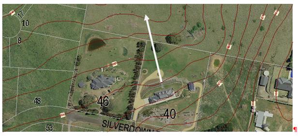
Figure
5 – objectors’ primary view line
There is a significant height difference
between the position of the objectors’ dwelling and land over which they
enjoy their primary views. Other views further to the east are constrained by
the topography and will be adversely affected, but it is considered that
substantially the primary views for the objectors’ would be retained. The
contours shown in Figure 5 are at 2m intervals, and thus the
objectors’ dwelling is approximately 6-8m higher than the land over which
they enjoy their most significant views.
There is no dispute that certain elements
of these views may be impacted for the objector after the subject property is
developed. However, it is not considered that such losses are excessive. The
views currently enjoyed would be substantially retained for the objector, and
conditions with respect to setbacks, site coverage and building envelopes,
along with secondary controls relating to tree retention and future fencing
(required to be rural fencing, less the barbed wire), will all serve to reduce
view loss impacts.
The DCP includes some guidelines with regard
to view analysis, and identifies certain features as providing "highly
valued" views. The DCP identifies Mt Canobolas as the primary view in
Orange, but also identifies Suma Park, Mt Bulgas to the east, the framing hills
around Clifton Grove and further to the north the Mullion Ranges.
None of these primary or "highly
valued" views are impeded by the proposed development. The likely future
development on the lots in question will be the subject of further assessment
when applications for individual development proposals are received. However,
it is appropriate and possible to impose building restrictions (previously
detailed) that will control the amount of view loss to a "view
sharing" situation.
The Land & Environment Court has
established some planning principles with regard to view loss assessment. The
salient principle can be found in Tenacity Consulting v Warringah Council
[2004] NSWLEC 140 at 25-29, as set out below:
25 The notion of view sharing is
invoked when a property enjoys existing views and a proposed development would
share that view by taking some of it away for its own enjoyment. (Taking it all
away cannot be called view sharing, although it may, in some circumstances, be
quite reasonable.) To decide whether or not view sharing is reasonable, I have
adopted a four-step assessment.
26 The first step is the assessment of
views to be affected. Water views are valued more highly than land views.
Iconic views (eg of the Opera House, the Harbour Bridge or North Head) are
valued more highly than views without icons. Whole views are valued more highly
than partial views, eg a water view in which the interface between land and
water is visible is more valuable than one in which it is obscured.
27 The second step is to consider from
what part of the property the views are obtained. For example the protection of
views across side boundaries is more difficult than the protection of views
from front and rear boundaries. In addition, whether the view is enjoyed from a
standing or sitting position may also be relevant. Sitting views are more
difficult to protect than standing views. The expectation to retain side views
and sitting views is often unrealistic.
28 The third step is to assess the
extent of the impact. This should be done for the whole of the property, not
just for the view that is affected. The impact on views from living areas is
more significant than from bedrooms or service areas (though views from
kitchens are highly valued because people spend so much time in them). The
impact may be assessed quantitatively, but in many cases this can be
meaningless. For example, it is unhelpful to say that the view loss is 20% if
it includes one of the sails of the Opera House. It is usually more useful to
assess the view loss qualitatively as negligible, minor, moderate, severe or
devastating.
29 The fourth step is to assess the
reasonableness of the proposal that is causing the impact. A development that
complies with all planning controls would be considered more reasonable than
one that breaches them. Where an impact on views arises as a result of
non-compliance with one or more planning controls, even a moderate impact may
be considered unreasonable. With a complying proposal, the question should be
asked whether a more skillful design could provide the applicant with the same
development potential and amenity and reduce the impact on the views of
neighbours. If the answer to that question is no, then the view impact of a
complying development would probably be considered acceptable and the view sharing
reasonable.
In relation to paragraph 25, it is
acknowledged that likely future development of the site will reduce views
enjoyed by the objector to the north. However, due to the size of the
allotments and the controls elsewhere included in the Notice of Determination,
view sharing for this development is considered possible.
In relation to paragraphs 26 and 27, the views
to the north are significant, but are not identified as iconic under the DCP.
They are, however, considered in the SSS and suggested as significant in that
study. The views for the objectors’ property are panoramic and general,
viewed primarily across the rear, north-northwest facing boundary of the
objector. These views cover a wide proportion of the panorama. A proportion of
this outlook view may be lost as a result of future residential development,
however some of this outlook view would be retained. The DCP building envelope
provisions will ensure that total obstruction of the view corridor does not
occur.
Further, in relation to paragraph 28, it is
considered that this principal links back to the preceding comments. For the
whole of the objectors’ property the potential view loss arising from
future development is considered unlikely to be a total loss of view. Some
degree of view sharing will be possible from the objectors’ property. It
is considered unreasonable for the objector to assume that the vacant land to
the north of their property would remain vacant indefinitely.
In relation to paragraph 29, the proposed
subdivision is consistent with other planning controls, and in the context of
applying those controls must be considered as in conformity to the applicable
standards. There is an obvious problem in taking this logic too far. Although
conforming to the LEP provisions and the general controls of the DCP, there is
no detailed masterplan in the DCP. Such guiding principles as are considered
likely to have been applied to such a masterplan have, in fact, been applied to
this planning assessment, and conditions and changes imposed as to achieve
those altered outcomes. It is considered that even with the application of
ersatz controls, the proposed development should be considered as consistent
with those desired planning outcomes, and hence a reasonable outcome in terms
of view sharing.
This report includes an assessment of the
suitability of the subdivision design, including an analysis of slope and its
impact on sizes and shapes of the proposed lots. The submission urges Council
to consider the placement of certain restrictions on the titles of the proposed
lots aimed at assisting with the protection of views and amenity of surrounding
properties.
The matters raised in the submission
suggest the establishment of buffer zones along the ridge, a redesign of the
width-to-depth ratio of certain lots to limit future view impacts, the
establishment of building envelopes, a limit on the amount of cut and fill
permitted on the land and the establishment of building height controls to
minimize impacts on rural views.
Recommendations included in this report
attempt to address some, but not all of the suggestions made by the objector.
In particular it should be noted that the recommendations outlined in the body
of the report have been incorporated into conditions of consent where deemed appropriate
and reasonable. It should also be noted that the draft conditions of consent
includes conditions requiring the establishment of a restriction on the title
of certain lots prior to the issue of a Subdivision Certificate. The
recommended conditions address the following matters
· establishment of building envelopes and setbacks for future
development
· establishment of site coverage controls
· a requirement for the protection and retention of certain
established vegetation within the development site
· a requirement for the establishment of landscape zones within
certain lots
· a requirement for landscape buffers to be established in certain
locations
· a requirement for single storey development for Lots 332/333 to 338
· the amalgamation of Lots 332 and 333 into a single allotment.
The implementation of the above
recommendations is considered necessary to limit the impacts of this
development on surrounding lands, and will ensure that the development proceeds
in an acceptable manner.
Conditions of consent have been included on
the attached notice which relate to soil and erosion control and the hours of
operation for construction. Furthermore, the future developers will need to
comply with the noise requirements and regulations set out in the Protection
of the Environmental Operations Act 1997.
PUBLIC INTEREST
s79C(1)(e)
The proposed development is of considerable
interest to a small section of the public due to the perception of the adverse
impacts the proposal would generate on rural residential character. However,
whist the change in zoning may be perceived as a land use conflict, the actual
development is consistent with its zoning and the overall objectives and
provisions of the LEP; and the proposed development, of itself, will not
cause any significant adverse effect beyond what is allowed for under the
zoning of the site. The proposal is not inconsistent with any relevant policy
statements, planning studies, guidelines etc that have been considered in this
assessment.
SUMMARY
The proposed development can be conditioned
so as to minimise the adverse effects of the subdivision. Principally,
conditions have been added to retain existing rural fencing, retain and enhance
the natural vegetation of the site, and achieve higher than normal spacing and
setbacks for future dwellings on the new lots by various measures. These
measures are unlikely to meet with the approval of all the local residents, who
remain opposed to the proposed development, however this opposition is more to
do with the change in zoning than the details of the actual proposed
subdivision design (there are exceptions to this generalization and these are
addressed in the report with some changes incorporated into the consent).
The proposed subdivision is consistent with
the zoning that applies to the site. It is also consistent with the objectives
of the LEP, or at minimum, not contrary to them. The proposed development is
not contrary to any specific provision of the DCP. Conditions are imposed that
would achieve the same outcomes as if the subject property were the subject of
a fully worked-up masterplan.
It is considered that within the parameter
discussed within the report, there is no significant view loss or privacy
issues allied to the proposed development. It has been necessary to recommend
significant conditions to address certain amenity issues, but as a
generalisation, the proposed development is consistent with the standards and
aims of the planning controls that can be applied to it.
The proposed development complies with the
relevant aims, objectives and provisions of the LEP. A Section 79C
assessment of the development indicates that the development is acceptable in
this instance. Attached is a draft Notice of Approval outlining a range of
conditions considered appropriate to ensure that the development proceeds in an
acceptable manner.
COMMENTS
The requirements of the Environmental Health and Building
Surveyor and the Engineering Development Section are included in the attached
Notice of Approval.
Attachments
1 Notice
of Approval, D16/34999⇩
2 Plans,
D16/33385⇩
3 Submissions,
D16/33386⇩
Planning and Development Committee
6 September 2016
2.3 Development
Application DA 233/2015(1) - 98 Gorman Road
Attachment 1 Notice
of Approval
|

|
ORANGE
CITY COUNCIL
Development
Application No DA
233/2015(1)
NA16/ Container
PR4763
|
NOTICE OF DETERMINATION
OF A DEVELOPMENT
APPLICATION
issued under the Environmental
Planning and Assessment Act 1979
Section 81(1)
|
Development
Application
|
|
|
Applicant Name:
|
Mrs JE Youngman,
Mrs FK Blunt and Mrs CY Pearson
|
|
Applicant Address:
|
C/- Peter
Basha Planning & Development
PO Box
1827
ORANGE
NSW 2800
|
|
Owner’s Name:
|
Mrs CY
Pearson, Mrs JE Youngman and Mrs FK Blunt
|
|
Land to Be Developed:
|
Lot 1 DP
581736 - 98 Gorman Road, Orange
|
|
Proposed Development:
|
Subdivision
(37 lot residential plus public open space and drainage reserves)
|
|
|
|
|
Building
Code of Australia
building classification:
|
Not
applicable
|
|
|
|
|
Determination
|
|
|
Made On:
|
6
September 2016
|
|
Determination:
|
CONSENT GRANTED
SUBJECT TO CONDITIONS DESCRIBED BELOW:
|
|
|
|
|
Consent to
Operate From:
|
7
September 2016
|
|
Consent to
Lapse On:
|
7
September 2021
|
Terms of Approval
The reasons for the imposition of
conditions are:
(1) To ensure a quality
urban design for the development which complements the surrounding environment.
(2) To maintain
neighbourhood amenity and character.
(3) To ensure compliance
with relevant statutory requirements.
(4) To provide adequate
public health and safety measures.
(5) Because the development
will require the provision of, or increase the demand for, public amenities and
services.
(6) To ensure the utility
services are available to the site and adequate for the development.
(7) To prevent the proposed
development having a detrimental effect on adjoining land uses.
(8) To minimise the impact
of development on the environment.
Conditions
(1) The
development must be carried out in accordance with:
(a) Plan/s
by Heath Consulting Engineers numbered:
14048_DA03 REV F (Sheet
3); 14048_DE02 REV B (sheet 2); 14048_DE03 REV B (sheet 3);
14048_DE04 REV B (sheet
4); 14048_DE05 REV B (sheet 5); 14048_DE06 REV B (sheet 6);
14048_DE07 REV B (sheet
7); 14048_DE08 REV B (sheet 8); 14048_DE09 REV B (sheet 9);
14048_DE10 REV B (sheet
10); 14048_DE10 REV B (sheet 11); 14048_DE12 REV B (sheet 12);
14048_DE13 REV B (sheet
13); 14048_DE14 REV B (sheet 14); 14048_DE15 REV B (sheet 15);
14048_DA04 REV D (sheet
4); (16 sheets in total)
(b) statements
of environmental effects or other similar associated documents that form part
of the approval
as amended
in accordance with any conditions of this consent.
(2) A sign is to be erected
in a prominent position on any site on which building work, subdivision work or
demolition work is being carried out:
a. showing
the name, address and telephone number of the principal certifying authority
for the work, and
b. showing
the name of the principal contractor (if any) for any building work and a
telephone number on which that person may be contacted outside working hours,
and
c. stating
that unauthorised entry to the site is prohibited.
Any such sign is to be maintained while the
building work, subdivision work or demolition work is being carried out.
|
PRIOR TO THE ISSUE OF
A CONSTRUCTION CERTIFICATE
|
(3) A
Construction Certificate application is required to be submitted to, and issued
by, Council prior to any works being carried out onsite.
(4) Engineering plans,
showing details of all proposed work and adhering to any engineering conditions
of development consent, are to be submitted to, and approved by, Orange City
Council or an Accredited Certifier (Categories B1, C3, C4, C6) prior to the
issuing of a Construction Certificate.
All
roads are to be constructed to a sealed urban road standard in accordance with
the Orange City Council Development and Subdivision Code.
(5) The applicant shall
provide Council with written documentation from NSW Office of Water (NOW)
indicating that a controlled activity permit under the Water Management Act
(WMA) is not required for the proposed development. If the NSW Office of Water
determine that a controlled activity permit under the Water Management Act is
required for the proposed development the applicant shall furnish Council with
a copy of the permit prior to the issue of a Construction Certificate.
(6) A water and soil
erosion control plan is to be submitted to Orange City Council or an Accredited
Certifier (Categories B1, C3, C4, C6) for approval prior to the issuing of a
Construction Certificate. The control plan is to be in accordance with the
Orange City Council Development and Subdivision Code and the Landcom, Managing
Urban Stormwater; Soils and Construction Handbook.
(7) The
development’s stormwater design is to include stormwater retention within
the development, designed to limit peak outflows from the land to the
pre-existing natural outflows up to the 100 year ARI frequency, with sufficient
allowance in overflow spillway design capacity to safely pass flows of lower
frequency (that is, a rarer event) without damage to downstream developments.
Where appropriate, the spillway design capacity is to be determined in
accordance with the requirements of the Dam Safety Committee.
The design of the detention storage is to be
undertaken using the ILSAX rainfall-runoff hydrologic model or an approved
equivalent capable of assessing runoff volumes and their temporal distribution
as well as peak flow rates. The model is to be used to calculate the flow rates
for the existing and post-development conditions. The developed flows are to be
routed through the proposed storage within the model so that the outflows
obtained are no greater than the flows obtained for the pre-existing natural
flows. A report detailing the results of the analysis, which includes:
· catchment
plan showing sub-catchments under existing and developed conditions;
· schematic
diagram of the catchment model showing sub areas and linkages;
· tabulation
detailing the elevation, storage volume and discharge relationships; and
· tabulation
for the range of frequencies analysed, the inflows, outflows and peak storage
levels for both existing and developed conditions;
together with copies of the data files for the
model and engineering design plans of the required drainage system are to be
submitted and approved by Orange City Council or an Accredited Certifier
(Categories B1, C3, C4, C6) prior to the issue a Construction Certificate.
(8) Proposed
lots are to be provided with interlot stormwater drainage, including those lots
abutting public land, where the surface of the entire lot cannot be drained to
the kerb and gutter at the lot frontage. A grated stormwater pit is to be
constructed within each lot provided with interlot stormwater drainage.
Engineering plans for this drainage system are to be approved by Orange City
Council or an Accredited Certifier (Categories B1, C3, C4, C6) prior to the
issuing a Construction Certificate.
(9) Stormwater from the
site is to be piped to the adjacent watercourse, where it is to be discharged
through a standard headwall with appropriate scour protection. Engineering
plans of this required drainage system are to be approved by Orange City
Council or by an Accredited Certifier (Categories B1, C3, C4, C6) prior to the
issuing of a Construction Certificate.
(10) A 150mm-diameter sewer
main is to be constructed from Council’s existing mains to serve the
proposed lots. Orange City Council, prior to issuing a Construction
Certificate, is to approve engineering plans for this sewerage system.
(11) A water
reticulation analysis is to be carried out by Orange City Council on any
proposed water-reticulation system for the development. Engineering plans are
to be submitted to Orange City Council for approval prior to the issuing of a
Construction Certificate.
The reticulation system is to be designed to
supply a peak instantaneous demand by gravity of 0.15 L/s/tenement at a minimum
residual head of 200kPa.
(12) Fencing
of the Tree Protection Zones (TPZs) around remnant trees Lots 303, 304, 305,
306, 307, 310 and 315 shall be installed, with signage to be supplied by
Orange City Council. TPZs shall be identified in consultation with
Council’s Manager City Presentation, and fencing is required to be
installed to the Director – Environmental Services’ satisfaction
and retained throughout the construction process.
|
PRIOR TO WORKS
COMMENCING
|
(13) Soil erosion control
measures shall be implemented on the site.
(14) A
temporary onsite toilet is to be provided and must remain throughout the
project or until an alternative facility meeting Council’s requirements
is available onsite.
|
DURING
CONSTRUCTION/SITEWORKS
|
(15) Excavated rock derived
from the site works shall either be the stored and used in above ground uses
within the subdivision area, or, stored on a Council designated stockpile for
future use. It shall not be re-buried.
If
Aboriginal objects, relics, or other historical items or the like are located
during development works, all works in the area of the identified object, relic
or item shall cease, and the NSW OEH and representatives from the Orange LALC
shall be notified. Further archaeological investigation shall be undertaken
where required,. Development works in the area of the find(s) may recommence
only when cleared to do so by OEH, which may require a permit to destroy the
artefact under section 90 of the National Parks and Wildlife Act 1974.
(16) The source of imported
material must be advised prior to the placement of that fill and shall be from
a site or source certified as not contaminated
(17) All
construction/demolition work on the site is to be carried out between the hours
of 7.00 am and 6.00 pm Monday to Friday inclusive and
7.00 am to 5.00 pm Saturdays. Written approval must be obtained from
the General Manager of Orange City Council to vary these hours.
(18) Any adjustments to
existing utility services that are made necessary by this development
proceeding are to be at the full cost of the developer.
(19) The
provisions and requirements of the Orange City Council Development and
Subdivision Code are to be applied to this application and all work constructed
within the development is to be in accordance with that Code.
The developer is to be entirely responsible for
the provision of water, sewerage and drainage facilities capable of servicing
all the lots from Council’s existing infrastructure. The developer is to
be responsible for gaining access over adjoining land for services where
necessary and easements are to be created about all water, sewer and drainage
mains within and outside the lots they serve.
(20) Gorman Road is to be constructed as
half road width
for the full frontage of the proposed development. This work is to include road
pavement and pavement surfacing to the centreline, kerb and gutter construction
and earth-formed footpath on the development side of the road.
(21) For all single access
battle axe blocks, a concrete driveway, kerb layback and footpath crossing is
to be constructed to a minimum width of 3.0 metres and to the requirements and
standards of the Orange City Council Development and Subdivision Code.
(22) Water and sewerage
reticulation is to be provided to every lot in the proposed residential
subdivision in accordance with the Orange City Council Development and
Subdivision Code.
(23) Concrete bicycle
pathways, a minimum of 2.5 metres wide, are to be constructed on one side of
all 20.0m wide streets including Gorman Road.
Construction work is to be to the requirements
and standards of the Orange City Council Development and Subdivision Code.
(24) All street lighting is
to be completed using Essential Energy approved LED lighting. The required
lighting level along all roads is P4 as per the Australian Standard.
|
PRIOR TO THE ISSUE OF
A SUBDIVISION CERTIFICATE
|
(25) Application shall be
made for a Subdivision Certificate under Section 109(C)(1)(d) of the Act.
(26) The subdivision plan
shall also be altered to show a minimum depth for Lot 334 of 38m
(proposed at 35m).
(27) A
Restriction-as-to-User under Section 88B of the NSW Conveyancing Act 1979 shall
be created on the titles of Lots 332 to 338 and 312 to 319 (being those lots on
the ridge and those lots along the southern boundary) specifying a maximum site
coverage that does not exceed 35% of the respective lot size. The Restriction
shall also provide for a minimum setback of 15m from the southern boundary for
Lots 312 to 319 and a minimum setback of 12m from Gorman Road.
For
those lots not elsewhere identified in the consent (Lots 301 to 307, Lots 308
to 311 and Lots 320 to 331) building restriction envelopes not
exceeding 50% of the allotment size are required.
All
building envelopes required under this consent, except where elsewhere
otherwise specified, shall incorporate front and side setbacks not less than of
10m and 2m respectively.
(28) A
Restriction-as-to-User under Section 88B of the NSW Conveyancing Act 1979 shall
be created on the title for Lots 332 to Lot 338 (inclusive) that requires the
submission of a landscape plan that is to the satisfaction of Council with any
dwelling (or outbuilding) application. Such landscaping is to incorporate
species selection with a mature height greater than the height of the
structures proposed and able to screen a minimum of 50% of the width of the
proposed dwelling or building frontage. Full implementation of the approved
landscaping is required prior to the issue of an Occupation Certificate, and
retention and maintenance of such landscaping required thereafter.
(29) A
Restriction-as-to-User under Section 88B of the NSW Conveyancing Act 1979 shall
be placed on the titles of proposed Lots 332 to 338 limiting future development
on these lots to single storey construction. The Restriction-as-to-User shall
also limit all fencing throughout the subdivision to rural type fencing less
the barbed wire component as per the requirements of Councils Development
Control Plan 2004.
(30) A
Restriction-as-to-User under Section 88B of the NSW Conveyancing Act 1979 is
required for the retention and protection of trees on Lots 303, 304, 305, 306,
307, 310 and 315 (the smaller tree on this lot may be removed), including those
trees currently proposed for removal on the amended plan (principally those
trees within the easement), by the imposition of building envelopes and tree
protection zones on these sites. The restriction shall provide for the
protection of the designated trees.
(31) The payment of
$620,210.36 is to be made to Council in accordance with Section 94 of the Act
and the Orange Development Contributions Plan 2015 (development in Ploughmans
Valley urban release area) towards the provision of the following public
facilities:
|
Open Space and Recreation
|
@ $3,314.19 x 36 additional lots
|
119,310.84
|
|
Community and Cultural
|
@ $667.50 x 36 additional lots
|
24,030.00
|
|
Roads and Cycleways
|
@ $5,137.60 x 36 additional lots
|
184,953.60
|
|
Stormwater Drainage
|
@ $310.15 x 36 additional lots
|
11,165.40
|
|
Local Area Facilities
|
@ $9,465.09 x 36 additional lots
|
340,743.24
|
|
Plan Preparation & Administration
|
@ $566.73 x 36 additional lots
|
20,402.28
|
|
Sub Total
|
|
$700,605.36
|
|
Less compensation for Open Space
|
(2297m² x $35 per m² = $80,395)
|
-$80395.00
|
|
Total
|
|
$620,210.36
|
The
contribution will be indexed quarterly in accordance with the Orange
Development Contributions Plan 2015 (development in Ploughmans Valley urban
release area).
(32) Soil
sampling for analysing chemical residue is to be carried out within the
proposed Lots in a manner and frequency as determined by an appropriately
qualified and experienced consultant giving consideration to previous specific
uses and on-site characteristics of the site. A NATA registered laboratory
is to carry out such testing. Reference is to be made to the Contaminated
Land Management Act 1997 and State Environmental Planning Policy No 55
- “Remediation of Land”. The results of the testing are to be
provided to the Principal Certifying Authority and are to demonstrate that the
land is suitable for residential use, to enable a Subdivision Certificate to be
issued.
(33) Payment of
contributions for water, sewer and drainage works is required to be made
at the contribution rate applicable at the time that the payment is made. The
contributions are based on 36 ETs for water supply headworks and 37 ETs for
sewerage headworks. A Certificate of Compliance, from Orange City Council in
accordance with the Water Management Act 2000, will be issued upon
payment of the contributions.
This Certificate of Compliance is to be
submitted to the Principal Certifying Authority prior to the issuing of a
Subdivision Certificate.
(34) Evidence from a
registered NATA laboratory is to be submitted prior to the issuing of a
Subdivision Certificate stating that the filling of all dams and low-lying
areas has been carried out in accordance with Australian Standard 3798-2007.
(35) Certification from
Telstra, stating that telecommunication systems comply with Australian
Standards, is to be submitted to the Principal Certifying Authority prior to
the issuing of a Subdivision Certificate.
(36) Certification from
Essential Energy, stating that electricity and street lighting systems comply
with Essential Energy’s Networks Division Customer Connection Policy
NP11.1, is to be submitted to the Principal Certifying Authority prior to the
issuing of a Subdivision Certificate.
All street lighting is to be completed using
Essential Energy prestige style 4 columns and luminaries. The required lighting
level along all roads is P4 as per the Australian Standard.
(37) An easement to drain
sewage and to provide Council access for maintenance of sewerage works a
minimum of 2.0 metres wide is to be created over the proposed sewerage works.
The Principal Certifying Authority is to certify that the easement is in
accordance with the Orange City Council Development and Subdivision Code prior
to the issuing of a Subdivision Certificate.
(38) All services are to be
contained within the allotment that they serve. A Statement of Compliance, from
a Registered Surveyor, is to be submitted to the Principal Certifying Authority
prior to the issuing of a Subdivision Certificate.
(39) A Certificate of
Compliance, from a Qualified Engineer, stating that the stormwater retention
basin comply with the approved engineering plans is to be submitted to the
Principal Certifying Authority prior to the issuing of a Subdivision
Certificate.
(40) A
Maintenance Security Deposit, in accordance with the provisions and
requirements of the Orange City Council Development and Subdivision Code, is to
be provided to Orange City Council prior to the issuing of a Subdivision
Certificate.
A Certificate of Compliance, from Orange
City Council, certifying that the maintenance security deposit has been paid,
is to be submitted to the Principal Certifying Authority prior to the issuing
of a Subdivision Certificate.
(41) Where
stormwater crosses land outside the lot it favours, an easement to drain water
is to be created over the works. A Restriction-as-to-User under section 88B of
the NSW Conveyancing Act 1979 is to be created on the title of the
proposed lots requiring that no structures are to be placed on the site, or
landscaping or site works carried out on the site, in a manner that affects the
continued operation of the interlot drainage system. The minimum width of the
easement is to be as required in the Orange City Council Development and
Subdivision Code.
(42) All
of the foregoing conditions are to be at the full cost of the developer and to
the requirements and standards of the Orange City Council Development and
Subdivision Code, unless specifically stated otherwise. All work required by
the foregoing conditions is to be completed prior to the issuing of a
Subdivision Certificate, unless stated otherwise.
|
REQUIREMENTS FROM
ESSENTIAL ENERGY
|
· Statutory
ground clearances being maintained in accordance with Essential Energy’s Operational
Manual: Overhead Design Manual (CEOM7097). Any remediation work required
would need to be completed by an Accredited Service Provider not at the expense
of Essential Energy;
· No
vegetation being planted within the proposed easement without approval from
Essential Energy; and
· An easement
being created with respect to the existing 66,000 volt powerline within the
proposed subdivision, as outlined in Essential Energy’s Network
Planning: Easement Requirements policy (CEOP8046) in particular:
(a) An
easement 30 metres wide is required; and
(b) Essential
Energy’s standard easement terms parts A/B or C of Memorandum AG189384.
|
GENERAL TERMS OF
APPROVAL FROM THE NSW OFFICE OF WATER
|
|
Number
|
Condition
|
File No:
ERM2016/0474
|
|
Site Address:
|
98 Gorman Road, Orange
|
|
DA Number:
|
233/2015/1
|
|
LGA:
|
Orange City Council
|
|
Plans, standards and guidelines
|
|
1
|
These General Terms of Approval (GTA) only
apply to the controlled activities described in the plans and associated
documentation relating to 233/2015/1 and provided by Council:
(i) Site
plan
Any
amendments or modifications to the proposed controlled activities may render
these GTA invalid. If the proposed controlled activities are amended or
modified DPI Water (formerly the NSW Office of Water) must be notified to
determine if any variations to these GTA will be required.
|
|
2
|
Prior to the commencement of any controlled
activity (works) on waterfront land, the consent holder must obtain a
Controlled Activity Approval (CAA) under the Water Management Act from DPI
Water. Waterfront land for the purposes of this DA is land and material in or
within 40 metres of the top of the bank or shore of the river identified.
|
|
3
|
The consent holder must prepare or commission
the preparation of:
(i) Rehabilitation
and Vegetation Management Plan
(ii) Works
Schedule
(iii) Erosion
and Sediment Control Plan
(iv) Soil
and Water Management Plan
(v) Design and
specifications including discharge design plan
|
|
4
|
All plans must be prepared by a suitably
qualified person and submitted to the DPI Water for approval prior to any
controlled activity commencing. The following plans must be prepared in
accordance with DPI Water's guidelines located at www.water.nsw.gov.au/
Water-Licensing/Approvals.
(i) Vegetation
Management Plans
(ii) Laying
pipes and cables in watercourses
(iii) Riparian
Corridors
(iv) In-stream works
(v) Outlet
structures
|
|
5
|
The
consent holder must (i) carry out any controlled activity in accordance with
approved plans and (ii) construct and/or implement any controlled activity by
or under the direct supervision of a suitably qualified professional and
(iii) when required, provide a certificate of completion to DPI Water.
|
|
6
|
The
consent holder must carry out a maintenance period of two (2) years after
practical completion of all controlled activities, rehabilitation and
vegetation management in accordance with a plan approved by the DPI Water.
|
|
7 - 11
|
N/A
|
|
12-14
|
N/A
|
|
|
|
|
|
15
|
The
consent holder is to ensure that all drainage works (i) capture and convey
runoffs, discharges and flood flows to low flow water level in accordance
with a plan approved by DPI Water; and (ii) do not obstruct the flow of water
other than in accordance with a plan approved by DPI Water.
|
|
16
|
The
consent holder must stabilise drain discharge points to prevent erosion in
accordance with a plan approved by DPI Water.
|
|
17
|
The
consent holder must establish all erosion and sediment control works and
water diversion structures in accordance with a plan approved by DPI
Water. These works and structures must be inspected and maintained
throughout the working period and must not be removed until the site has been
fully stabilised.
|
|
18
|
The
consent holder must ensure that no excavation is undertaken on waterfront
land other than in accordance with a plan approved by DPI Water.
|
|
19
|
The
consent holder must ensure that any excavation does not result in (i)
diversion of any river (ii) bed or bank instability or (iii) damage to native
vegetation within the area where a controlled activity has been authorised,
other than in accordance with a plan approved by DPI Water.
|
|
20
|
The
consent holder must ensure that (i) river diversion, realignment or alteration
does not result from any controlled activity work and (ii) bank control or
protection works maintain the existing river hydraulic and geomorphic
functions, and (iii) bed control structures do not result in river
degradation other than in accordance with a plan approved by DPI Water.
|
|
21 - 28
|
N/A
|
|
END OF CONDITIONS
|
Other Approvals
(1) Local
Government Act 1993 approvals granted under section 68.
Nil
(2) General
terms of other approvals integrated as part of this consent.
Nil
Right of Appeal
If
you are dissatisfied with this decision, section 97 of Environmental
Planning and Assessment Act 1979 gives you the right to appeal to the Land
and Environment Court within 6 months after the date on which you receive this
notice.
*
Section 97 of the Environmental Planning and Assessment Act 1979 does not apply
to the determination of a development application for State significant
development or local designated development that has been the subject of a
Commission of Inquiry.
|
Disability Discrimination Act
1992:
|
This application has been assessed in
accordance with the Environmental Planning and Assessment Act 1979. No
guarantee is given that the proposal complies with the Disability
Discrimination Act 1992.
The applicant/owner is responsible to
ensure compliance with this and other anti-discrimination legislation.
The Disability Discrimination Act
covers disabilities not catered for in the minimum standards called up in the
Building Code of Australia which references AS1428.1 - "Design for
Access and Mobility". AS1428 Parts 2, 3 and 4 provides the most
comprehensive technical guidance under the Disability Discrimination Act
currently available in Australia.
|
|
|
|
|
Disclaimer - S88B Restrictions on the Use of Land:
|
The applicant should note that there
could be covenants in favour of persons other than Council restricting what
may be built or done upon the subject land. The applicant is advised to check
the position before commencing any work.
|
|
|
|
|
Signed:
|
On behalf of the consent authority ORANGE
CITY COUNCIL
|
|
Signature:
|
|
|
Name:
|
DAVID WADDELL - DIRECTOR DEVELOPMENT
SERVICES
|
|
Date:
|
7 September 2016
|
Planning
and Development Committee
6 September 2016
2.3 Development
Application DA 233/2015(1) - 98 Gorman Road
Attachment 2 Plans
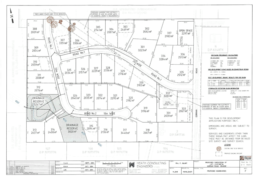
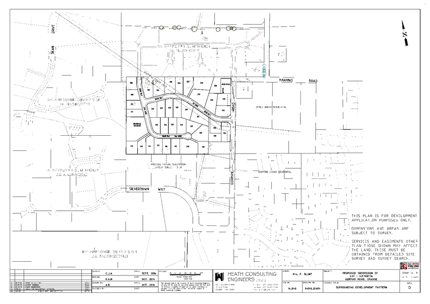
Planning
and Development Committee
6 September 2016
2.3 Development
Application DA 233/2015(1) - 98 Gorman Road
Attachment 3 Submissions
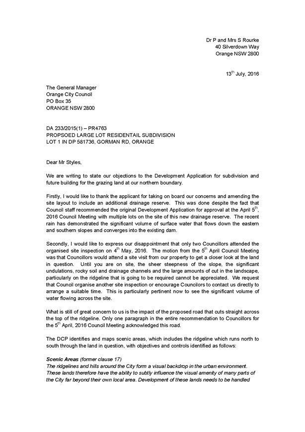
2.4 Development
Application DA 172/2016(1) - 50 Moonstone Drive
TRIM
REFERENCE: 2016/1959
AUTHOR: Summer
Commins, Town Planner
EXECUTIVE Summary
|
Application
lodged
|
27 May
2016
Additional
information received 16 August 2016
|
|
Applicant/s
|
Ms DH
Omer
|
|
Owner/s
|
Ms DH
Omer
|
|
Land
description
|
Lot 123
DP 1190845 - 50 Moonstone Drive, Orange
|
|
Proposed
land use
|
Child
Care Centre
|
|
Value of
proposed development
|
$1,030,000
|
Council's consent is sought for a proposed child care centre
at 50 Moonstone Drive, Orange, on land described as Lot 123 DP 1190845. The
proposal involves construction of a single-storey building for the purpose of a
long day care child care centre. Onsite car parking will be provided. The
centre will provide 75 child care places for children aged between 0‑5 years,
and operate between the hours of 6.30am and 6.00pm Monday to Friday.
Link To Delivery/OPerational Plan
The recommendation in this report relates to the
Delivery/Operational Plan strategy “13.4 Our Environment
– Monitor and enforce regulations relating to City amenity”.
Financial Implications
Council has been advised that as a council included in the
NSW Government’s merger proposals under consideration by the Office of
Local Government since referral on 6 January 2016, Council must comply with the
merger proposal period guidelines issued under S23A of the Local Government Act
1993.
The guidelines instruct Council it should expend money in
accordance with the detailed budget adopted for the purposes of implementing
the Delivery/Operational Plan for the 2015/16 year.
Any expenditure outside the adopted budget requires the
identification of clear and compelling grounds and must be approved by Council
at a meeting that is open to the public. The guidelines indicate the resolution
of Council for increased expenditure must specify the reasons why the
expenditure is required and warranted.
If increased expenditure is greater than $250,000 or 1% of
the Council’s revenue from rates in
the preceding year, whichever is the greater, Council
is required to exhibit the increase to the budget and consider comments
received.
Council must also avoid entering into contracts or
undertakings where expenditure or revenue is greater than $250,000 or 1% of the
Council’s revenue from rates in the
preceding year, whichever is the greater, unless the contract or undertaking is
as a result of a decision or procurement process commenced prior to the merger
proposal period or where entering into a contract or undertaking is reasonably
necessary for the purposes of meeting the ongoing service delivery commitments
of the Council or was previously approved in the Council’s
Delivery/Operational Plan.
Policy and Governance Implications
Nil
|
Recommendation
That Council consents to
development application DA 172/2016(1)
for Child Care Centre at Lot 123 DP 1190845 - 50 Moonstone
Drive, Orange pursuant to the conditions of consent
in the attached Notice of Approval.
|
further considerations
Consideration has been given to the
recommendation’s impact on Council’s service delivery; image and
reputation; political; environmental; health and safety; employees;
stakeholders and project management; and no further implications or risks have
been identified.
SUPPORTING INFORMATION
THE PROPOSAL
The proposal involves the construction of a new building for
use as a long day child care centre.
The purpose-built premises will be of contemporary design
and detailing, and residential in form and scale. The building will be single-storey,
with a floor area of 739.1m2, footprint of some 29m x 29m and height
(ridge) of some 5.8m. External finishes will include face brick walls,
Colorbond roof sheeting and aluminium framed openings.
The proposed building will contain:
· entry foyer with
adjacent reception, offices and conference room
· five (5) playrooms
according to age bracket and adjacent bathrooms and nap rooms
· kitchen, staff
amenities, laundry and store rooms.
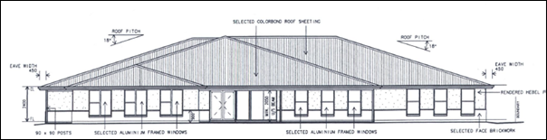
Front (west) elevation to Moonstone Drive
As depicted below, the site
layout will provide vehicle, pedestrian and landscaped areas at the site
frontage and outdoor play spaces at the rear of the building.
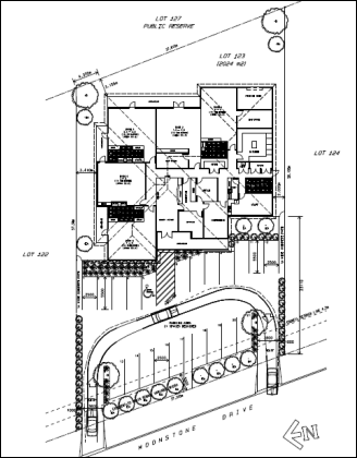
Site plan
Onsite car parking will be provided for 21 vehicles. Dual
access via Moonstone Drive will provide for one-way vehicle circulation through
the site.
The centre will provide 75 child care places for
children aged between 0-5 years, and operate between the hours of 6.30am and
6.00pm Monday to Friday.
MATTERS FOR CONSIDERATION
Section 5A Assessment
In the administration of sections 78A, 79B, 79C, 111 and
112, the provisions of Section 5A must be taken into account for every
development application in deciding whether there is likely to be a significant
effect on threatened species, populations or ecological communities or their
habitats. This section includes a requirement to consider any adopted
assessment guidelines, which means assessment guidelines issued and in force
under section 94A of the Threatened Species Conservation Act 1995.
Assessment guidelines are in force (see DECC-W “Threatened Species
Assessment Guidelines - The Assessment of Significance”) which requires
consent authority to adopt the precautionary principle in its assessment.
In this instance, site inspection reveals that the subject
property has no biodiversity or habitat value.
Section 79C
Section 79C of the Environmental Planning and Assessment
Act 1979 requires Council to consider various matters, of which those
pertaining to the application are listed below.
PROVISIONS OF ANY ENVIRONMENTAL
PLANNING INSTRUMENT s79C(1)(a)(i)
Orange Local Environmental Plan 2011
Part 1 - Preliminary
Clause 1.2 - Aims of Plan
The
broad aims of the LEP are set out under subclause 2. Those relevant to the
application are as follows:
(a) to encourage development which complements
and enhances the unique character of Orange as a major regional centre boasting
a diverse economy and offering an attractive regional lifestyle,
(b) to provide for a range of development
opportunities that contribute to the social, economic and environmental
resources of Orange in a way that allows present and future generations to meet
their needs by implementing the principles for ecologically sustainable
development,
The application is considered to be consistent with
objectives (a) and (b) as outlined in this report.
Clause 1.6 - Consent Authority
This clause establishes that, subject to the Act, Council is
the consent authority for applications made under the LEP.
Clause 1.9A - Suspension of
Covenants, Agreements and Instruments
This clause provides that covenants, agreements and other
instruments which seek to restrict the carrying out of development do not apply
with the following exceptions.
· covenants imposed
or required by Council
· prescribed
instruments under Section 183A of the Crown Lands Act 1989
· any conservation
agreement under the National Parks and Wildlife Act 1974
· any trust
agreement under the Nature Conservation Trust Act 2001
· any property
vegetation plan under the Native Vegetation Act 2003
· any biobanking
agreement under Part 7A of the Threatened Species Conservation Act 1995
· any planning
agreement under Division 6 of Part 4 of the Environmental Planning and
Assessment Act 1979.
Council staff are not aware of the title of the subject property
being affected by any of the above.
Mapping
The subject site is identified
on the LEP maps in the following manner:
|
Land Zoning Map:
|
Land zoned R1 General Residential
|
|
Lot Size Map:
|
No minimum Lot Size
|
|
Heritage Map:
|
Not a heritage item or conservation
area
|
|
Height of Buildings Map:
|
No building
height limit
|
|
Floor Space Ratio Map:
|
No floor space limit
|
|
Terrestrial Biodiversity Map:
|
No biodiversity sensitivity on the
site
|
|
Groundwater Vulnerability Map:
|
Ground water vulnerable
|
|
Drinking Water Catchment Map:
|
Not within
the drinking water catchment
|
|
Watercourse Map:
|
Not within
or affecting a defined watercourse
|
|
Urban Release Area Map:
|
Not within an urban release area
|
|
Obstacle Limitation Surface Map:
|
No restriction
on building siting or construction
|
|
Additional Permitted Uses Map:
|
No additional
permitted use applies
|
Those matters that are of relevance are addressed in detail
in the body of this report.
Part 2 - Permitted or Prohibited Development
Land
Use Zones
The subject site is located within the R1 General
Residential zone. The proposed development is defined as child care centre.
Pursuant to the OLEP 2011 Dictionary:
Child care centre means a building or place used for the supervision and
care of children that:
(a) provides long day care,
pre-school care, occasional child care or out-of-school-hours care, and
(b) does not provide
overnight accommodation for children other than those related to the owner or
operator of the centre,
but does not include:
(c) a building or place
used for home-based child care, or
(d) an out-of-home care
service provided by an agency or organisation accredited by the
Children’s Guardian, or
(e) a baby-sitting,
playgroup or child-minding service that is organised informally by the parents
of the children concerned, or
(f) a service
provided for fewer than 5 children (disregarding any children who are related
to the person providing the service) at the premises at which at least one of
the children resides, being a service that is not advertised, or
(g) a regular child-minding
service that is provided in connection with a recreational or commercial
facility (such as a gymnasium), by or on behalf of the person conducting the
facility, to care for children while the children’s parents are using the
facility, or
(h) a service that is
concerned primarily with the provision of:
(i) lessons or
coaching in, or providing for participation in, a cultural, recreational,
religious or sporting activity, or
(ii) private tutoring, or
(i) a school, or
(j) a service provided at exempt premises (within the meaning of Chapter 12
of the Children and Young Persons (Care and Protection) Act 1998), such as
hospitals, but only if the service is established, registered or licensed as
part of the institution operating on those premises.
Child care centres are permitted with consent in the R1 General Residential zone.
Objectives
These
objectives for land zoned R1 General Residential
are as follows:
1 -
Objectives of the R1 General Residential Zone
· To
provide for the housing needs of the community.
· To
provide for a variety of housing types and densities.
· To
enable other land uses that provide facilities or services to meet the day to
day needs of residents.
· To
ensure development is ordered in such a way as to maximise public transport
patronage and encourage walking and cycling in close proximity to settlement.
· To
ensure that development along the Southern Link Road has an alternative access.
The proposed development is
consistent with the relevant objectives of the R1 zone. The proposal does not
involve residential landuse. The proposed child care centre will provide a
long-day child care service that will be utilised by local and wider residents.
The subject Waratah residential precinct is serviced by public transport. The
land does not have frontage or access to the Southern Link Road.
Part 3 - Exempt and Complying Development
The application is not exempt or complying development.
Part 4 - Principal Development Standards
The
Part 4 Principal Development Standards do not relate to the subject land or
proposed development.
Part 5 - Miscellaneous Provisions
The
Part 5 Miscellaneous Provisions are not applicable to the proposal.
Part 6 - Urban Release Area
The subject site is not located in an Urban Release Area and
Part 6 does not apply.
Part 7 - Additional Local Provisions
7.1 - Earthworks
Clause 7.1 is applicable. This clause states in part:
(2) Development consent is
required for earthworks unless:
(b) the
earthworks are ancillary to other development for which development consent has
been given.
Minor earthworks are required for the proposed child care
centre. The earthworks are ancillary to the development and separate consent is
not required pursuant to clause 7.1(2)(b).
7.3 - Stormwater Management
Clause 7.3 is applicable. This
clause states in part:
(3) Development consent must not
be granted to development on land to which this clause applies unless the
consent authority is satisfied that the development:
(a) is
designed to maximise the use of water permeable surfaces on the land having
regard to the soil characteristics affecting on-site infiltration of water, and
(b) includes,
where practical, on-site stormwater retention for use as an alternative supply
to mains water, groundwater or river water, and
(c) avoids
any significant impacts of stormwater runoff on adjoining downstream
properties, native bushland and receiving waters, or if that impact cannot be
reasonably avoided, minimises and mitigates the impact.
In consideration of Clause 7.3,
conditions are recommended in relation to stormwater infrastructure associated
with the proposed child care centre. Stormwater from the site will be connected
to Council’s urban stormwater drainage system. Compliance with conditions
will ensure that stormwater runoff will not adversely impact on adjoining
properties.
7.6 - Groundwater Vulnerability
The
subject land is identified as Groundwater Vulnerable on the Groundwater
Vulnerability Map. Clause 7.6 applies. This clause states in part:
(3) Before
determining a development application for development on land to which this
clause applies, the consent authority must consider:
(a) whether or not the development (including
any onsite storage or disposal of solid or liquid waste and chemicals) is
likely to cause any groundwater contamination or have any adverse effect on
groundwater dependent ecosystems, and
(b) the cumulative impact (including the
impact on nearby groundwater extraction for potable water supply or stock water
supply) of the development and any other existing development on groundwater.
In consideration of Clause 7.6,
the proposal is considered to be acceptable. The proposed child care centre
does not involve processes or activities that would impact on groundwater
resources.
Clause 7.11 - Essential
Services
Clause 7.11 applies. This clause states:
Development
consent must not be granted to development unless the consent authority is
satisfied that any of the following services that are essential for the
proposed development are available or that adequate arrangements have been made
to make them available when required:
(a) the
supply of water,
(b) the
supply of electricity,
(c) the
disposal and management of sewage,
(d) stormwater
drainage or on-site conservation,
(e) suitable
road access.
In consideration of this clause, all utility services are
available to the site and adequate for the proposed child care centre.
STATE ENVIRONMENTAL PLANNING
POLICIES
State Environmental Planning Policy 55 - Remediation of Land
(SEPP 55) requires that a consent authority must not consent to the carrying
out of development of land unless it has considered whether the land is
contaminated, is satisfied that the land is suitable in its contaminated state
for the development that is proposed, and if the land requires remediation to
be made suitable for the proposed development it is satisfied that the land
will be remediated before the land is used for that purpose.
Furthermore, SEPP 55 requires that before determining an
application for consent to carry out development that would involve a change of
use on any of the land specified in subclause (4), the consent authority
must consider a report specifying findings of a preliminary investigation of
the land concerned. Notably, subclause (4) refers to ‘child care
purposes’.
Given that the land has been recently subdivided and deemed
suitable for residential use, it is considered that the subject land is
suitable for the proposed development and no further investigation of
contamination is required.
PROVISIONS OF ANY DRAFT
ENVIRONMENTAL PLANNING INSTRUMENT THAT HAS BEEN PLACED ON EXHIBITION
s79C(1)(a)(ii)
There are no draft environmental planning instruments that
apply to the subject land or proposed development.
DESIGNATED DEVELOPMENT
The proposed development is not designated development.
PROVISIONS OF ANY DEVELOPMENT
CONTROL PLAN s79C(1)(a)(iii)
Development Control Plan 2004 - Part 7 Development in
Residential Zones
Part 7.5 Merit Based Approach to Residential Development
in Orange
The following Planning Outcomes are used as a guide in
assessment of the proposed child care centre.
Neighbourhood Character
The DCP sets the following Planning Outcomes in regard to
Neighbourhood Character:
· Site
layout and building design enables the:
- creation of attractive
residential environments with clear character and identity
- use of site features
such as views, aspect, existing vegetation and landmarks
· Buildings
are designed to complement the relevant features and built form that are
identified as part of the desired neighbourhood character.
· The
streetscape is designed to encourage pedestrian access and use.
The Moonstone Drive residential precinct is defined by
substantial and contemporary double fronted, brick veneer, single dwellings. In
addition, a church has recently been constructed on land two parcels removed
from the subject land to the south at 46 Moonstone Drive.
The design and detailing of the proposed childcare centre
are considered suitable within the subject residential setting and will
complement the neighbourhood character due to the following:
· The building is
provided with a generous setback of some 19m from the front boundary so as to
not appear imposing in the Moonstone Drive streetscape. The setback will
complement the siting of adjoining improvements to the south.
· The building will
be single storey and of consistent height with adjoining dwellings.
· The hipped roof,
wall height and window fenestration are reflective of domestic architectural
forms in this streetscape and the Waratah subdivision generally.
· The proposed
external finishes are compatible with adjoining dwellings.
Building Appearance
The DCP sets the following Planning Outcomes in regard to
Building Appearance:
· The building
design, detailing and finishes relate to the desired neighbourhood character,
complement the residential scale of the area, and add visual interest to the
street.
· The frontages
of buildings and their entries face the street.
· Garages and car
parks are sited and designed so that they do not dominate the street frontage.
As considered above, the design, detailing and finishes for
the proposed child care centre are appropriate in this neighbourhood and will
complement the streetscape built form. The external materials and scale of the
proposed building are generally residential in form and commensurate with the
existing and emerging built form.
The proposed building will address Moonstone Drive. The
front elevation will comprise main entrance double doors, verandah treatment
and numerous symmetrical vertical openings.
The proposed car park will be located at the site frontage,
forward of the child care centre building. The proposed site layout is
consistent with other child care centres on residential parcels in the city (eg
the Waratah Early Learning Centre at 52-54 Farrell Road). Extensive landscaping
of the front boundary and site boundaries forward of the building line will
provide screening and visual relief of vehicle areas.
Heritage
The DCP sets the following Planning Outcomes in regard to
Heritage:
· Heritage
buildings and structures are efficiently re-used.
· New
development complements and enhances the significance of a heritage item or
place of heritage significance listed in the Orange Heritage Study.
· Significant
landscape features are retained including original period fences and period
gardens.
The subject land does not contain or adjoin a heritage item
and is not located within a heritage conservation area.
Setbacks
The DCP sets the following Planning Outcomes in regard to
Setbacks:
· Street setbacks
contribute to the desired neighbourhood character, assist with the integration
of new development and make efficient use of the site.
· Street setbacks
create an appropriate scale for the street considering all other streetscape
components.
The proposed building will be sited a minimum 20m from the
front boundary to Moonstone Drive. The front setback will relate to the siting
of the adjoining dwelling to the south at 48 Moonstone Drive; and the
church on the next southern parcel at 46 Moonstone Drive. The proposed
front setback is considered to be acceptable. Side and rear setbacks for the
proposed building will comply with the Building Code of Australia.
Front Fences and Walls
The DCP sets the following Planning Outcomes in regard to
Fences and Walls:
· Front fences
and walls:
– assist
in highlighting entrances and creating a sense of identity within the
streetscape.
– are
constructed of materials compatible with associated housing and with fences
visible from the site that positively contribute to the streetscape
– provide
for facilities in the street frontage area such as mail boxes.
The proposal does not involve the erection of a front fence
to Moonstone Drive.
An acoustic assessment has been
submitted in support of the proposal (Wilkinson Murray August 2016). In
order to ameliorate noise impacts associated with the proposed child care
centre, fencing will be erected on the side boundaries (consistent with the
recommendations of the acoustic assessment). Side boundary fencing will have a
height of 1.8m on the northern boundary, and height range of 1.8m - 2.4m
on the southern boundary. Side boundary fencing will generally extend to the
front building line of dwellings on the adjoining parcels, consistent with
fence siting in this streetscape.
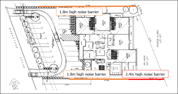
Recommended Noise Barriers (Wilkinson Murray August 2016)
That part of the fence on the southern boundary with a
height of 2.4m will not have unreasonable visual bulk impacts for the adjoining
dwelling at 48 Moonstone Drive. The existing dwelling is set back some 10m from
the fence, and main internal and external living spaces of the dwelling will
not directly oppose the fence. Plantings (trees) on the child care centre site
adjacent to the fence will have a mature height of 10m, and provide some visual
relief to the fence. The taller portion of the fence will not be visible at the
Moonstone Drive site frontage.
A condition is recommended that fencing be erected
consistent with the recommendations contained in the acoustic assessment.
Visual Bulk
The DCP sets the following Planning Outcome in regard to
Visual Bulk:
· Built form
accords with the desired neighbourhood character of the area with:
- side and rear setbacks
progressively increased to reduce bulk and overshadowing
- site coverage that retains
the relatively low density landscaped character of residential areas
- building form and siting
that relates to landform, with minimal land shaping (cut and fill)
- building height at the
street frontage that maintains a comparable scale with the predominant adjacent
development form
- building to the boundary
where appropriate.
The proposed building will be single-storey with reasonable
setbacks from side and rear boundaries. The building will generally complement
the bulk and scale of adjacent dwellings and church in Moonstone Drive.
The proposed building will be contained within the DCP
prescribed visual bulk envelope plane. The building will comprise a total
building footprint of 739.1m2. Based on a site area of 2,024m2,
the development will have site coverage of 36.5%, in compliance with the
maximum 50% prescribed in the DCP.
Minor earthworks will be required for the establishment of
the building and car park. Finished levels will relate to natural ground levels
on this site and neighbouring parcels. Visual bulk encroachment impacts are not
anticipated for adjoining dwellings.
Walls and Boundaries
The DCP sets the following Planning Outcome in regard to
Walls and Boundaries:
· Building to the
boundary is undertaken to provide for efficient use of the site taking into
account:
- the privacy of neighbouring
dwellings and private open space
- the access to daylight
reaching adjoining properties
- the impact of boundary walls
on neighbours.
The proposal does not involve the construction of buildings
on the boundary. As outlined in this report, the site layout and building
design will not impact on adjoining dwellings in respect of privacy, solar
access or visual bulk.
Daylight and Sunlight
The DCP sets the following Planning Outcome in regard to
Daylight and Sunlight:
· Buildings are
sited and designed to ensure:
- daylight to habitable rooms
in adjacent dwellings is not significantly reduced
- overshadowing of
neighbouring secluded open spaces or main living area windows is not
significantly increased
- consideration of
Council’s Energy Efficiency Code.
Shadow diagrams were not prepared in support of the proposed
development. Notwithstanding, assessment of shadow impacts demonstrates that
the proposal will not unreasonably overshadow the (most effected) adjoining
dwelling to the south at 48 Moonstone Drive. Based on the height and
siting of the proposed building and the siting of the adjoining southern
dwelling, internal and external solar access will be maintained for
48 Moonstone Drive, consistent with the DCP guidelines.
Consistent with the recommendations of the submitted
acoustic assessment (Wilkinson Murray August 2016), fencing on the
southern boundary will have a height of 1.8m‑2.4m. That part of the
fence 2.4m in height will not oppose main internal or external living spaces
for the adjoining southern dwelling at 48 Moonstone Drive. Accordingly, the
fence height will not result in unreasonable overshadowing of primary living
spaces.
The proposed site layout and building design will provide
solar access to internal play rooms and outdoor play spaces associated with the
proposed child care centre.
Views
The DCP sets the following Planning Outcomes in regard to
Views:
· Building form
and design allow for residents from adjacent properties to share prominent
views where possible.
· Views including
vistas of heritage items or landmarks are not substantially affected by the
bulk and scale of the new development.
The subject site is not within an important view corridor.
The proposed building will not unreasonably diminish views for other properties
in the vicinity.
Visual Privacy
The DCP sets the following Planning Outcome in regard to
Visual Privacy:
· Direct
overlooking of principal living areas and private open spaces of other
dwellings is minimised firstly by:
- building siting and layout
- location of windows and
balconies
and secondly by:
- design of windows or use of
screening devices and landscaping.
The proposed site layout and building design will provide
acceptable visual privacy for adjoining dwellings. Perimeter fencing of varying
heights will be erected on the side boundaries and will prevent overlooking
from internal and external play spaces associated with the proposed child care
centre. Landscaping to the site boundaries will further assist.
Acoustic Privacy
The DCP sets the following Planning Outcome in regard to
Acoustic Privacy:
· Site layout and
building design:
- protect habitable rooms from
excessively high levels of external noise
- minimise the entry of
external noise to private open space for dwellings close to major noise sources
- minimise transmission of
sound through a building to affect other dwellings.
An acoustic assessment has been submitted in support of the
proposal (Wilkinson Murray August 2016). Noise associated with the child
care centre will be generated by indoor activities, mechanical plant, onsite
traffic and outdoor play. In order to mitigate noise impacts associated with
the proposed child care centre, the assessment makes the following
recommendations:
· Construct noise
barriers/fences on the northern and southern boundaries… Barriers should
be continuous with no gaps.
· Limit the
number of children permitted to partake in outdoor free play to 50 at any one
time.
· Condition
mechanical plant noise to comply with the criteria derived therein (ie. 40dBA,
39dBA and 35dBA for the day, evening and early morning periods respectively) at
the neighbouring residences.
· The centre
should erect signage and also brief parents on the importance of limiting noise
emissions from the car park area.
· The proponent
should assess mechanical plant noise once details of the design are available.
The acoustic assessment concludes:
‘With [implementation
of] the mitigation measures, noise emissions from the proposed centre are
predicted to generally be within the relevant criteria.’
Conditions are recommended to address the requirements of
the acoustic assessment.
Security
The DCP sets the following Planning Outcomes in regard to
Security:
· The site layout
enhances personal safety and minimises the potential for crime, vandalism and fear.
· The design of
dwellings enables residents to survey streets, communal areas and approaches to
dwelling entrances.
The proposal is considered acceptable in
regard to safety and security as follows:
· The front facade to Moonstone Drive has numerous windows which
address the onsite car park and street. The building design will provide
reasonable opportunities for natural surveillance.
· The site has acceptable access control due to perimeter fencing and
fully enclosed outdoor play spaces.
· The proposed landscape design will not restrict sight lines.
Circulation and Design
The DCP sets the following Planning Outcome in regard to
Circulation and Design:
· Accessways and
parking areas are designed to manage stormwater.
· Accessways,
driveways and open parking areas are suitably landscaped to enhance amenity
while providing security and accessibility to residents and visitors.
· The site layout
allows people with a disability to travel to and within the site between car
parks, buildings and communal open space.
The subject land has direct frontage to Moonstone Drive.
Dual footpath crossings will provide for one-way vehicle circulation through
the site: vehicles will enter via the northern access and exit via the southern
access. All vehicles will enter and exit the site in a forward direction.
The onsite car park will accommodate the turn path of a B85
vehicle (4.9m in length); ie a standard car. Sufficient manoeuvring area
will be available in the car park to permit reverse manoeuvring from car spaces
and forward direction egress to Moonstone Drive.
Conditions are recommended requiring stormwater drainage
within the proposed car park. Landscaping of the car park is proposed. The site
layout will allow for the functional movement of people with a disability
through the site.
Car Parking
The DCP sets the following Planning Outcomes in regard to
Car Parking:
· Parking
facilities are provided, designed and located to:
- enable the efficient and
convenient use of car spaces and accessways within the site
- reduce the visual dominance
of car parking areas and accessways.
· Car parking is
provided with regard to the:
- the number and size of
proposed dwellings
- requirements of people with
limited mobility or disabilities.
Pursuant to DCP 2004, onsite parking is required for child
care centres at a rate of 1 space for every 4 children in attendance. The
proposed child care centre will provide 75 child care places, with 18.75 (ie
19) parking spaces required. Twenty-one (21) onsite car parking spaces will be
provided, including 1 space for disabled drivers, in compliance with the DCP.
Onsite car parking for the development is also consistent
with parking requirements pursuant to the Guide to Traffic Generating
Developments (Roads and Traffic Authority 2002) (the RTA Guide). The
RTA Guide requires 1 space for every 4.5 children in attendance, which amounts
to 16.6 (17) parking spaces for the proposed child care centre.
Private Open Space
The DCP sets the following Planning Outcomes in regard to
Private Open Space:
· Private open
space is clearly defined for private use.
· Private open
space areas are of a size, shape and slope to suit the reasonable requirements
of residents including some outdoor recreational needs and service functions.
· Private open
space is:
– capable
of being an extension of the dwelling for outdoor living, entertainment and
recreation
– accessible
from a living area of the dwelling
– located
to take advantage of outlooks; and to reduce adverse impacts of overshadowing
or privacy from adjoining buildings
– Orientated
to optimise year round use.
The Planning Outcomes are not applicable to the proposed
child care centre.
Open Space
and Landscaping
The DCP sets the following Planning Outcomes in regard to
Open Space and Landscaping:
· The site layout
provides open space and landscaped areas which:
– contribute
to the character of the development by providing buildings in a landscaped
setting
– provide
for a range of uses and activities including stormwater management
– allow
cost effective management.
· The landscape
design specifies landscape themes consistent with the desired neighbourhood
character; vegetation types and location, paving and lighting provided for
access and security.
· Major existing
trees are retained and protected in a viable condition whenever practicable
through appropriate siting of buildings, accessways and parking areas.
· Paving is
applied sparingly and integrated in the landscape design.
A landscape plan has been submitted in support of the
proposal. Extensive plantings at the site frontage will provide screening of
the car park in the Moonstone Drive streetscape. Landscaping on the side
boundaries forward of the building line will partly ameliorate noise and visual
impacts associated with the site accesses and car park for adjoining dwellings
to the north and south. The proposed plantings are appropriate to the Orange
area and incorporate trees, shrubs and groundcover. Conditions are recommended
requiring the establishment and maintenance of landscaping.
Stormwater
The DCP sets the following Planning Outcomes in regard to
Stormwater:
· On-site
drainage systems are designed to consider:
– downstream
capacity and need for on-site retention, detention and re-use
– scope
for on-site infiltration of water
– safety
and convenience of pedestrians and vehicles
– overland
flow paths.
· Provision is
made for on-site drainage which does not cause damage or nuisance flows to
adjoining properties.
In order to achieve compliance with the Planning Outcomes,
conditions are recommended in relation to stormwater management of the site.
Erosion and Sedimentation
The DCP sets the following Planning Outcome in regard to
Erosion and Sedimentation:
· Measures
implemented during construction to ensure that the landform is stabilised and erosion
is controlled.
In order to achieve compliance with the Planning Outcomes,
conditions are recommended in relation to erosion and sediment control.
Part 7.9 - Shops and Business
in the Urban Residential Zone
The DCP prescribes the following Planning Outcomes for Shops
and Business in the Urban Residential Zone:
· Development
complements the scale of residential development in the area and the
predominant heights and form of residential development in the vicinity
· Business
premises are located in neighbourhood business areas existing prior to Orange
LEP 2000
· Development
applications satisfactorily demonstrate that the development will not adversely
affect the amenity of the residential locality as a consequence of the nature
of the business, loading or unloading requirements, on-street parking, hours of
operation, etc
· Neighbourhood
business premises are small scale to serve the needs of the residents of the
locality…
· Onsite parking
is provided according to Section 15.4 of this plan
· Advertising signage
is limited to exempt development for home businesses or businesses in converted
dwelling houses
· Advertising
signage in neighbourhood centres is not intrusive to the character of the
residential locality…
In consideration of the Planning Outcomes, the proposed
child care centre is satisfactory, as outlined below:
· As considered
earlier in this report, the design, detailing and finishes for the proposed
child care centre are appropriate in this neighbourhood and will complement the
streetscape built form. The external materials and scale of the proposed
building are generally residential in form and scale, and commensurate with the
adjoining dwellings and emerging built form in this setting.
· The proposal does
not comprise a business premises or neighbourhood business premises.
· As outlined in
this report, the proposed child care centre will not unreasonably impact on
amenity for adjoining dwellings in respect of visual bulk, solar access,
privacy, noise or traffic congestion. Relevant conditions are recommended to
maintain amenity for adjoining dwellings.
· As considered
earlier in this report, the proposed child care centre will generate demand for
19 onsite parking spaces. Twenty-one (21) onsite car parking spaces will be
provided, including 1 space for disabled drivers, in compliance with the DCP.
· The proposal does
not involve advertising. A condition is recommended requiring further consent
be obtained for advertising that is not exempt development.
Development Control Plan 2004 -
Part 15 Car Parking
The DCP prescribes the following Planning Outcomes for
Off-Street Car Parking:
· Adequate
off-street car parking is provided in accordance with the table, or
alternatively, according to an assessment that demonstrates peak parking demand
based on recognised research
· Car parking
areas are designed according to Australian Standard.
· Car parking
areas include adequate lighting and landscaping which provides for the personal
security of users
· Bicycle parking
facilities are provided according to the relevant Australian Standard.
· Facilities for
loading and unloading of commercial vehicles are provided according to the
relevant Australian Standard
In consideration of the Planning Outcomes, the proposed
child care centre is satisfactory, as outlined below:
· As outlined
earlier in this report, onsite car parking will be provided for the proposed
child care centre consistent with the DCP requirements.
· Conditions are
recommended requiring the submission of engineering plans for the proposed car
park, demonstrating compliance with AS 2890.1-2004 Off Street Car Parking.
· Landscaping will
be provided to the perimeter of the proposed car park. The landscaping will
provide site beautification and visual and acoustic relief to vehicle areas.
· The nature of the
landuse is unlikely to necessitate bicycle parking facilities.
· Service vehicles
associated with the development will comprise small vans and light commercial
vehicles. These may be accommodated onsite within the proposed car park.
DEVELOPMENT CONTRIBUTIONS PLAN
2015
Development contributions for water, sewer and drainage
works are applicable to the proposed development. The contributions are based
on 3.5 ETs for water supply headworks and 6.5 ETs for sewerage headworks. A
condition is recommended requiring payment of the applicable contributions.
PROVISIONS PRESCRIBED BY THE
REGULATIONS s79C(1)(a)(iv)
Demolition of a Building (clause 92)
The proposal does not involve the demolition of a building.
Fire Safety Considerations
(clause 93)
Fire protection measures will be required appropriate to the
building class. Fire safety considerations will be addressed at Construction
Certificate stage.
Buildings to be Upgraded
(clause 94)
This matter is not relevant as the subject land is vacant.
BASIX Commitments (clause 97A)
BASIX is not applicable to the proposal. A Section J Energy
Efficiency statement will be required at Construction Certificate stage.
THE LIKELY IMPACTS OF THE
DEVELOPMENT s79C(1)(b)
Visual Impacts
The design, detailing and finishes for the proposed child
care centre are appropriate in this neighbourhood and will complement the streetscape
built form. The external materials and scale of the proposed building are
generally residential in form and scale and commensurate with the adjoining
dwellings and church. Extensive landscaping to the car park perimeter will
provide integration of the proposed building in the streetscape and softening
of hardstand areas.
Traffic Impacts
Traffic Generation
The RTA Guide prescribes the
following traffic generation rates for long day child care centres:
|
Centre Type and Number
of Children
|
Peak Vehicle
Trips/Child
|
|
75 place
long day care
|
7.00am –
9.00am
|
2.30-4.00pm
|
4.00-6.00pm
|
|
|
0.8
|
0.3
|
0.7
|
|
Total Vehicle Trips
|
60
|
22.5
|
52.5
|
Traffic generation associated with the development is in the
order of 60 vehicle trips in the morning peak (7.00am-9.00am) and 52.5 vehicle
trips in the evening peak (4.00pm‑6.00pm). The RTA Guide defines a
vehicle trip as a one-way vehicular movement from one point to another,
excluding the return journey. Accordingly, the estimated vehicle trips will
comprise 30 in the morning peak and some 27 in the evening peak.
It is acknowledged that traffic generation associated with
the child care centre will be substantially greater than that pertaining to
residential landuse. Notwithstanding this, the centre has the potential to
generate less than one (1) vehicle trip per minute either approaching or
departing the site (not both) in the peak morning and evening period.
It is considered that the traffic generated by the proposed
child care centre will not adversely impact on local traffic amenity. The
existing road network in the vicinity of the site operates at a reasonable
level of service, with more than sufficient capacity to cater for additional
traffic volumes.
The increase in traffic flows is unlikely to have a
detrimental effect upon the operation of Moonstone Drive, or the intersections
with Jasper Street to the north and Turquoise Way to the south. In this regard:
· The access
driveways proposed to serve the development are suitably located and will
provide good sight distances along Moonstone Drive.
· The design of the
carpark will comply with AS 2890.1-2004 Off Street Car Parking.
· Onsite car parking
for the development will comply with the requirements of DCP 2004 and the
RTA Guide.
The applicant submits that traffic generation associated
with the proposed child care centre is unlikely to conflict with traffic
associated with the recently approved place of worship at 46 Moonstone
Drive. Peak vehicle trips for the church are weekends and weekday evenings;
ie outside of operating hours for the child care centre. On this basis,
there is considered to be minimal overlapping traffic generation for
non-residential uses in the locality. This assessment is acknowledged and
concurred with.
Access
and Manoeuvring
The subject land has direct frontage to Moonstone Drive.
Dual footpath crossings will provide for one-way vehicle circulation through
the site: vehicles will enter via the northern access and exit via the southern
access. All vehicles will enter and exit the site in a forward direction. The
access driveways will be reasonably removed from the intersections with Jasper
Street to the north and Turquoise Way to the south.
The onsite car park will accommodate the turn path of a B85
vehicle (4.9m in length); ie a standard car. Sufficient manoeuvring area
will be available in the carpark to permit reverse manoeuvring from car spaces
and forward direction egress to Moonstone Drive.
Car
Parking
The proposed development
incorporates a total of 21 off-street car parking spaces, consistent with the
requirements of DCP 2004 and the RTA Guide. Compliance
with the requirements for onsite car parking will lessen reliance for on-street
parking and associated traffic congestion in Moonstone Drive.
Neighbourhood Amenity
Noise
Noise associated with operation of the proposed child care
centre will exceed that pertaining to normal residential landuse. Noise will be
generated by indoor activities, mechanical plant, onsite traffic and outdoor
play. As outlined earlier in this report, an acoustic assessment was submitted
in support of the proposal (Wilkinson Murray August 2016). The acoustic
assessment confirms that subject to implementation of mitigation measures,
noise emissions from the proposed child care centre will generally comply with
the relevant criteria. Conditions are recommended to address the requirements
of the acoustic assessment. On this basis, noise impacts are considered to be
within reasonable limit.
Light
In order that any external
lighting associated with the proposed child care centre will not cause nuisance
glare for adjoining dwellings, a condition is recommended requiring exterior
lighting be sited and designed to comply with AS 4282-1997 Control of the
obtrusive effects of outdoor lighting.
Privacy
Perimeter fencing of varying heights will be erected on the
side boundaries and will prevent overlooking of adjoining dwellings from
internal and external play spaces and car park. Landscaping will further
assist. The proposal will not adversely impact on privacy for adjoining
dwellings.
Environmental Impacts
The proposed child care centre
will not involve processes or activities that would impact on air or water
quality in the locality. Where applicable, the applicant shall enter into a
Trade Waste Contract with Council. Other wastes will be disposed of via
Council's waste collection or recycling services. Adverse environmental impacts
are not anticipated as a result of the proposal.
Social and Economic Impacts
The proposed development is unlikely to generate a negative
social or economic impact within the locality. The proposal will provide
valuable child care places within the community, enabling greater participation
by parents in the workforce. The development will also provide additional
employment opportunities.
THE SUITABILITY OF THE SITE
s79C(1)(c)
Landuse
Child care centres are permitted in the R1 zone and
considered to be a complementary landuse.
Servicing
All utility services are available to the site and adequate
for the proposal. The proposed development will be connected to Council’s
sewer, town water and stormwater reticulations in accordance with normal
requirements. Power, telephone and natural gas services will be connected to
the dwellings in accordance with the requirements of the relevant supply
authority. Conditions are recommended in relation to services connection to the
proposed development.
Physical Attributes and Hazards
The subject site is considered to be suitable for the
proposed development. There are no physical attributes within the site that
would unreasonably constrain the development. The site is not subject to known
technological or natural hazards.
ANY SUBMISSIONS MADE IN
ACCORDANCE WITH THE ACT s79C(1)(d)
The proposed development is defined as "advertised
development" under the provisions of the LEP. The application was
advertised for the prescribed period of 14 days. At the conclusion of the
exhibition period two submissions had been received, including a petition
containing ten signatures. The issues raised in the submissions are outlined
below:
The proposal will generate
additional traffic
As outlined earlier in this report, it is considered that
the traffic generated by the proposed child care centre will not adversely
impact on local traffic amenity. The existing road network in the vicinity of
the site operates at a reasonable level of service, with more than sufficient capacity
to cater for additional traffic volumes. Onsite traffic arrangements will
assist to minimise congestion associated with increased traffic volumes.
The proposal will cause
on-street parking congestion; insufficient onsite parking will be provided
As outlined earlier in this report, 21
onsite car parking spaces will be provided for the proposed child care centre,
consistent with the requirements of DCP 2004 and the RTA Guide. Compliance with the requirements for onsite car parking
will lessen reliance for on-street parking and associated traffic congestion in
Moonstone Drive.
The proposal will contribute to
an overdevelopment of non-residential uses in a residential area
The proposed child care centre is a permitted use in the R1
General Residential zone and consistent with the zone objective to ‘enable
other land uses that provide facilities or services to meet the day to day
needs of residents.’
The place of worship at 46 Moonstone Drive represents the
only other non-residential use in the western portion of the Waratah
subdivision, and indeed in the Moonstone Drive precinct. (Industrial uses to
the east across Clergate Road and north on Ralston Drive are located outside of
the Waratah subdivision). Two (2) non-residential and permitted uses are not considered
an overdevelopment in the locality.
Cumulative impacts are considered to be within reasonable
limits. As demonstrated in this report, the building design will complement the
neighbourhood built form; traffic generation will not adversely impact on local
traffic amenity; and the proposal will not unreasonably impact on residential
amenity in terms of visual bulk, solar access, privacy or noise.
The proposed building utilises
the maximum permissible density for the site
The proposed building will not exceed the DCP-prescribed
building envelope or site coverage. As considered earlier in this report, the
design, detailing and finishes for the proposed child care centre are
appropriate in this neighbourhood and will complement the streetscape built
form. The external materials and scale of the proposed building are generally
residential in form, and commensurate with the existing and emerging built
form.
The proposal will decrease the
value of surrounding dwellings
The perceived impact of a proposed development on property
values is not a valid consideration in the assessment of a development
application, pursuant to Section 79C of the Environmental Planning and
Assessment Act 1979.
PUBLIC INTEREST s79C(1)(e)
The proposed development is considered to be of minor
interest to the wider public due to the relatively localised nature of
potential impacts. The proposal is not inconsistent with any relevant policy
statements, planning studies, guidelines etc that have not been considered in
this assessment.
SUMMARY
The proposed development is permissible with the consent of
Council. The proposed development complies with the relevant aims, objectives
and provisions of Orange LEP 2011. The proposal is consistent with the
applicable planning outcomes and guidelines contained in Orange DCP 2004. A
section 79C assessment of the development indicates that the development is
acceptable in this instance. Attached is a draft Notice of Approval outlining a
range of conditions considered appropriate to ensure that the development
proceeds in an acceptable manner.
COMMENTS
The requirements of the Environmental Health and Building
Surveyor and the Engineering Development Section are included in the attached
Notice of Approval.
Attachments
1 Notice
of Approval, D16/38546⇩
2 Plans,
D16/38253⇩
3 Submissions,
D16/38261⇩
Planning
and Development Committee
6 September 2016
2.4 Development
Application DA 172/2016(1) - 50 Moonstone Drive
Attachment 1 Notice
of Approval
|

|
ORANGE
CITY COUNCIL
Development
Application No DA
172/2016(1)
NA16/ Container
PR26365
|
NOTICE OF DETERMINATION
OF A DEVELOPMENT
APPLICATION
issued under the Environmental
Planning and Assessment Act 1979
Section 81(1)
|
Development
Application
|
|
|
Applicant Name:
|
Ms DH Omer
|
|
Applicant Address:
|
17
Westringia Avenue
MOUNT
ANNAN NSW 2567
|
|
Owner’s Name:
|
Ms DH Omer
|
|
Land to Be Developed:
|
Lot 123 DP
1190845 - 50 Moonstone Drive, Orange
|
|
Proposed Development:
|
Child Care
Centre
|
|
|
|
|
Building
Code of Australia
building classification:
|
To be
determined by the PCA
|
|
|
|
|
Determination
|
|
|
Made On:
|
6
September 2016
|
|
Determination:
|
CONSENT
GRANTED SUBJECT TO CONDITIONS DESCRIBED BELOW:
|
|
|
|
|
Consent to
Operate From:
|
7
September 2016
|
|
Consent to
Lapse On:
|
7
September 2021
|
Terms of Approval
The reasons for the imposition of
conditions are:
(1) To ensure compliance
with relevant statutory requirements.
(2) To provide adequate
public health and safety measures.
(3) To ensure a quality
urban design for the development which complements the surrounding environment.
(4) To maintain
neighbourhood amenity and character.
(5) Because the development
will require the provision of, or increase the demand for, public amenities and
services.
(6) To ensure the utility
services are available to the site and adequate for the development.
(7) To prevent the proposed
development having a detrimental effect on adjoining land uses.
(8) To minimise the impact
of development on the environment.
Conditions
(1) The
development must be carried out in accordance with:
(a)
Plan/s
numbered Plans by McKinnon Design - Job No. 15010 - Drawings DA1-DA3
Issue B (3 sheets)
(b) statements
of environmental effects or other similar associated documents that form part
of the approval
as amended
in accordance with any conditions of this consent.
(2) All building work must
be carried out in accordance with the provisions of the Building Code of
Australia.
(3) A sign is to be erected
in a prominent position on any site on which building work, subdivision work or
demolition work is being carried out:
(a) showing
the name, address and telephone number of the principal certifying authority
for the work, and
(b) showing
the name of the principal contractor (if any) for any building work and a
telephone number on which that person may be contacted outside working hours,
and
(c) stating
that unauthorised entry to the site is prohibited.
Any such sign is to be maintained while the
building work, subdivision work or demolition work is being carried out.
(4) Where any excavation
work on the site extends below the level of the base of the footings of a
building on adjoining land, the person having the benefit of the development
consent must, at the person’s own expense:
(a) protect
and support the adjoining premises from possible damage from the excavation,
and
(b) where
necessary, underpin the adjoining premises to prevent any such damage.
Note: This
condition does not apply if the person having the benefit of the development
consent owns the adjoining land or the owner of the adjoining land has given
consent in writing to that condition not applying.
|
PRIOR TO THE ISSUE OF
A CONSTRUCTION CERTIFICATE
|
(5) An
approval under Section 68 of the Local Government Act is to be sought
from Orange City Council, as the Water and Sewer Authority, for water, sewer
and stormwater connection. Details concerning the proposed backflow prevention
between the nominated water tank supply and the potable system are to be
provided. No plumbing and drainage is to commence until approval is granted.
(6) Detailed
plans and specification are to be provided specifying the proposed fitout of
the food preparation and storage areas in accordance with the requirements of
Australian Standard 4674-2004 "Design and construction and fit-out of
food premises" and Standard 3.2.3 "Food Premises and
Equipment" of the Australian New Zealand Food Standards Code.
(7) The
applicant is to submit a waste management plan that describes the nature of
wastes to be removed, the wastes to be recycled and the destination of all
wastes. All wastes from the demolition and construction phases of this project
are to be deposited at a licensed or approved waste disposal site.
(8) Prior to the issue of a
Construction Certificate, details of the mechanical plant to be installed are
to be provided to the PCA. Such details are to be accompanied by a revised
acoustical assessment demonstrating compliance with the noise goals set out in
the report by Wilkinson Murray (Report No. 16132 Version B) dated August 2016.
(9) Engineering plans
providing complete details of the proposed driveway and car-parking areas is to
be submitted to Orange City Council or an Accredited Certifier (Categories B1,
C3, C4, C6) upon application for a Construction Certificate. These plans are to
provide details of levels, cross falls of all pavements, proposed sealing
materials and proposed drainage works and be in accordance with the Orange City
Council Development and Subdivision Code.
(10) A water and soil
erosion control plan is to be submitted to Orange City Council or an Accredited
Certifier (Categories B1, C3, C4, C6) for approval prior to the issuing of a
Construction Certificate. The control plan is to be in accordance with the
Orange City Council Development and Subdivision Code and the Landcom, Managing
Urban Stormwater; Soils and Construction Handbook.
(11) The
development’s stormwater design is to include stormwater detention within
the development, designed to limit peak outflows from the land to the
pre-existing natural outflows up to the 100 year ARI frequency, with sufficient
allowance in overflow spillway design capacity to safely pass flows of lower
frequency (that is, a rarer event) without damage to downstream developments.
Where appropriate, the spillway design capacity is to be determined in
accordance with the requirements of the Dam Safety Committee.
The design of the detention storage is to be
undertaken using the ILSAX rainfall-runoff hydrologic model or an approved
equivalent capable of assessing runoff volumes and their temporal distribution
as well as peak flow rates. The model is to be used to calculate the flow rates
for the existing and post-development conditions. The developed flows are to be
routed through the proposed storage within the model so that the outflows
obtained are no greater than the flows obtained for the pre-existing natural
flows. A report detailing the results of the analysis, which includes:
· catchment
plan showing sub-catchments under existing and developed conditions;
· schematic
diagram of the catchment model showing sub areas and linkages;
· tabulation
detailing the elevation, storage volume and discharge relationships; and
· tabulation
for the range of frequencies analysed, the inflows, outflows and peak storage
levels for both existing and developed conditions;
together with copies of the data files for the
model and engineering design plans of the required drainage system are to be
submitted and approved by Orange City Council prior to the issue a Construction
Certificate.
Alternatively a payment
of $1,798.80 shall be paid to Council, prior to the issuing of a Construction
Certificate, for the construction of an off-site stormwater retention basin.
Payments are indexed in accordance with Councils Management Plan current at the
time of issue of a Construction Certificate.
(12) A Liquid Trade
Waste Application is to be submitted to Orange City Council prior to the
issuing of a Construction Certificate. The application is to be in accordance
with Orange City Council’s Liquid Trade Waste Policy. Engineering plans
submitted as part of the application are to show details of all proposed liquid
trade waste pre-treatment systems and their connection to sewer.
Where applicable, the applicant is to
enter into a Liquid Trade Waste Service Agreement with Orange City Council in
accordance with the Orange City Council Liquid Trade Waste Policy.
(13) Payment of
contributions for water, sewer and drainage works is required to be made
at the contribution rate applicable at the time that the payment is made. The
contributions are based on 3.5 ETs for water supply headworks and 6.5 ETs for
sewerage headworks. A Certificate of Compliance, from Orange City Council in
accordance with the Water Management Act 2000, will be issued upon
payment of the contributions.
This Certificate of Compliance is to be
submitted to the Principal Certifying Authority prior to the issuing of a
Construction Certificate.
|
PRIOR TO WORKS COMMENCING
|
(14) A
Construction Certificate application is required to be submitted to, and issued
by Council/Accredited Certifier prior to any excavation or building works being
carried out onsite.
(15) A
temporary onsite toilet is to be provided and must remain throughout the
project or until an alternative facility meeting Council’s requirements
is available onsite.
(16) Soil erosion control
measures shall be implemented on the site.
|
DURING
CONSTRUCTION/SITEWORKS
|
(17) All
construction/demolition work on the site is to be carried out between the hours
of 7.00 am and 6.00 pm Monday to Friday inclusive, 7.00 am to
5.00 pm Saturdays and 8.00 am to 5.00 pm Sundays and Public
Holidays. Written approval must be obtained from the General Manager of Orange
City Council to vary these hours.
(18) A
Registered Surveyor’s certificate identifying the location of the
building on the site must be submitted to the Principal Certifying Authority.
(19) All
materials onsite or being delivered to the site are to be contained within the
site. The requirements of the Protection of the Environment Operations Act
1997 are to be complied with when placing/stockpiling loose material or
when disposing of waste products or during any other activities likely to
pollute drains or watercourses.
(20) Noise barriers/fences
are to be constructed in accordance with the recommendations of the acoustic
assessment by Wilkinson Murray (Report No. 16132 Version B dated August 2016).
(21) Any adjustments to
existing utility services that are made necessary by this development
proceeding are to be at the full cost of the developer.
(22) The
provisions and requirements of the Orange City Council Development and
Subdivision Code are to be applied to this application and all work constructed
within the development is to be in accordance with that Code.
The developer is to be entirely responsible for
the provision of water, sewerage and drainage facilities capable of servicing
the development from Council’s existing infrastructure. The developer is
to be responsible for gaining access over adjoining land for services where
necessary and easements are to be created about all water, sewer and drainage
mains within and outside the lots they serve.
(23) All driveway and
parking areas are to be sealed with bitumen, hot mix or concrete and are to be
designed for all expected loading conditions (provided however that the minimum
pavement depth for gravel and flush seal roadways is 200mm) and be in
accordance with the Orange City Council Development and Subdivision Code.
(24) Heavy-duty concrete
kerb and gutter laybacks and footpath crossings are to be constructed for the
entrances to the proposed development. The location and construction of the
laybacks and footpath crossings are to be as required by the Orange City
Council Development and Subdivision Code.
|
PRIOR TO THE ISSUE OF
AN OCCUPATION CERTIFICATE
|
(25) A total of 21
off-street car parking spaces shall be provided upon the site in accordance
with the approved plans, the provisions of Development Control Plan 2004, and
be constructed in accordance with the requirements of Council's Development and
Subdivision Code prior to the issue of an Occupation Certificate.
(26) Landscaping
shall be installed in accordance with the approved plans and shall be
permanently maintained to the satisfaction of Council's Manager Development Assessments.
(27) No
person is to use or occupy the building or alteration that is the subject of
this approval without the prior issuing of an Occupation Certificate.
(28) The
owner of the building/s must cause the Council to be given a Final Fire Safety
Certificate on completion of the building in relation to essential fire or
other safety measures included in the schedule attached to this approval.
(29) Where
Orange City Council is not the Principal Certifying Authority, a final
inspection of water connection, sewer and stormwater drainage shall be
undertaken by Orange City Council and a Final Notice of Inspection issued,
prior to the issue of either an interim or a final Occupation Certificate.
(30) Prior to the issue of
an Occupation Certificate, signage is to be erected in the carpark in
accordance with the recommendations of Acoustic Assessment by Wilkinson Murray
(Report No. 16132 Version B) dated August 2016, advising that noise is to be
limited in the carpark.
(31) A Certificate of
Compliance, from a Qualified Engineer, stating that the stormwater detention
basin complies with the approved engineering plans is to be submitted to the
Principal Certifying Authority prior to the issuing of an Occupation
Certificate.
(32) Certification from
Orange City Council is required to be submitted to the Principal Certifying
Authority prior to the issue of an Occupation Certificate stating that all
works relating to connection of the development to Council assets, works on
Public Land, stormwater, sewer and water reticulation mains and footpaths have
been carried out in accordance with the Orange City Council Development and
Subdivision Code and the foregoing conditions.
(33) All
of the foregoing conditions are to be at the full cost of the developer and to
the requirements and standards of the Orange City Council Development and
Subdivision Code, unless specifically stated otherwise. All work required by
the foregoing conditions is to be completed prior to the issuing of an
Occupation Certificate, unless stated otherwise.
|
MATTERS FOR THE
ONGOING PERFORMANCE AND OPERATION OF THE DEVELOPMENT
|
(34) A separate development
application shall be submitted to and approved by Council prior to the erection
of any advertising structures or signs of a type that do not meet the exempt
development provisions of State Environmental Planning Policy (Exempt and
Complying Development Codes) 2008.
(35) Outdoor lighting must
be in accordance with the Australian Standard AS 4282-1997 Control of the
obtrusive effects of outdoor lighting.
(36) The noise mitigation
measures as outlined in the recommendations of the acoustic assessment by
Wilkinson Murry (Report No. 16132 Version B dated August 2016) shall be
maintained for the duration of the development.
(37) The
owner is required to provide to Council and to the NSW Fire Commissioner an
Annual Fire Safety Statement in respect of the fire-safety measures, as
required by Clause 177 of the Environmental Planning and Assessment
Regulation 2000.
(38) The maximum number of
children permitted to partake in outdoor free play is 50 at any one time.
(39) All
vehicles associated with the pickup and drop-off of children must use the car
park facilities provided on the land.
Other Approvals
(1) Local
Government Act 1993 approvals granted under section 68.
Nil
(2) General
terms of other approvals integrated as part of this consent.
Nil
Right of Appeal
If
you are dissatisfied with this decision, section 97 of Environmental
Planning and Assessment Act 1979 gives you the right to appeal to the Land
and Environment Court within 6 months after the date on which you receive this
notice.
*
Section 97 of the Environmental Planning and Assessment Act 1979 does not apply
to the determination of a development application for State significant
development or local designated development that has been the subject of a
Commission of Inquiry.
|
Disability Discrimination Act
1992:
|
This application has been assessed in
accordance with the Environmental Planning and Assessment Act 1979. No
guarantee is given that the proposal complies with the Disability
Discrimination Act 1992.
The applicant/owner is responsible to
ensure compliance with this and other anti-discrimination legislation.
The Disability Discrimination Act
covers disabilities not catered for in the minimum standards called up in the
Building Code of Australia which references AS1428.1 - "Design for
Access and Mobility". AS1428 Parts 2, 3 and 4 provides the most
comprehensive technical guidance under the Disability Discrimination Act
currently available in Australia.
|
|
|
|
|
Disclaimer - S88B Restrictions on the Use of Land:
|
The applicant should note that there
could be covenants in favour of persons other than Council restricting what
may be built or done upon the subject land. The applicant is advised to check
the position before commencing any work.
|
|
|
|
|
Signed:
|
On behalf of the consent authority ORANGE
CITY COUNCIL
|
|
Signature:
|
|
|
Name:
|
DAVID WADDELL - DIRECTOR DEVELOPMENT
SERVICES
|
|
Date:
|
7 September 2016
|
Planning
and Development Committee
6 September 2016
2.4 Development
Application DA 172/2016(1) - 50 Moonstone Drive
Attachment 2 Plans
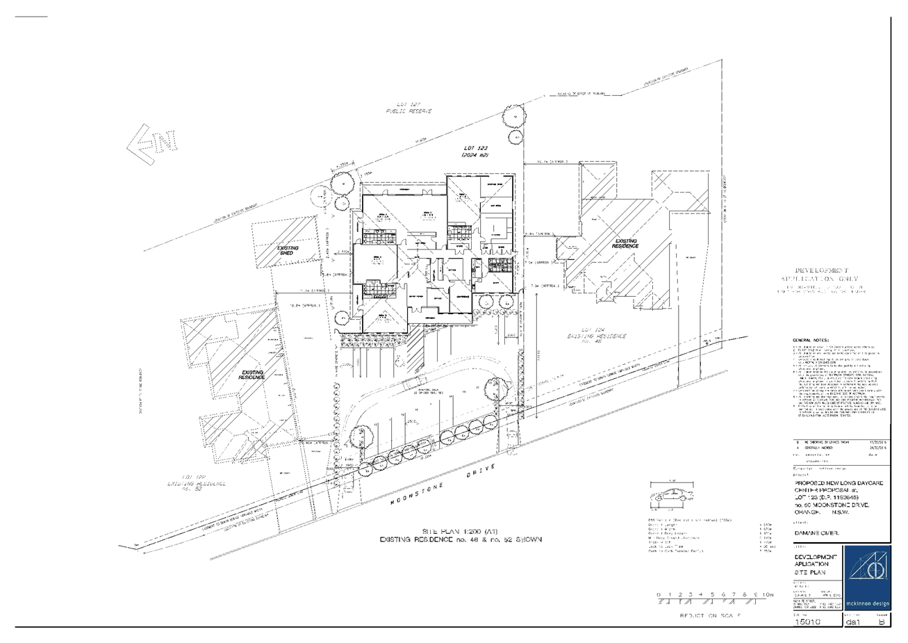
Planning and Development Committee
6 September 2016
2.4 Development
Application DA 172/2016(1) - 50 Moonstone Drive
Attachment 2 Plans
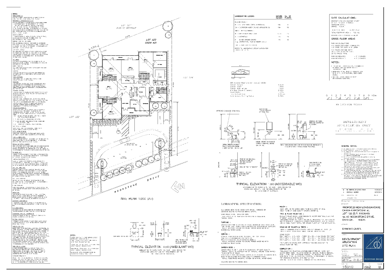
Planning and Development Committee
6 September 2016
2.4 Development
Application DA 172/2016(1) - 50 Moonstone Drive
Attachment 2 Plans
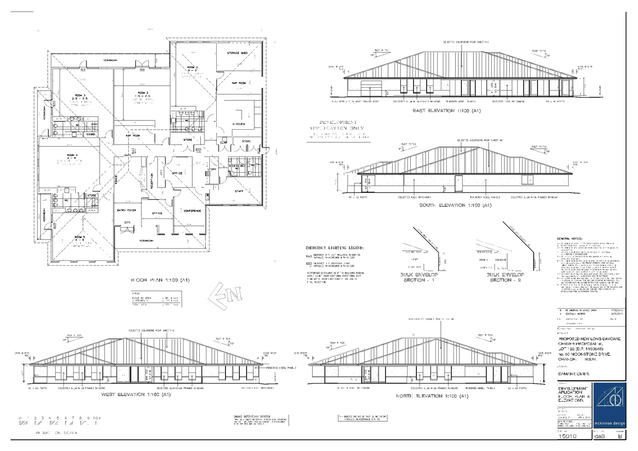
Planning and Development Committee
6 September 2016
2.4 Development
Application DA 172/2016(1) - 50 Moonstone Drive
Attachment 3 Submissions
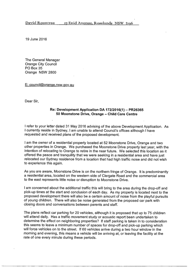
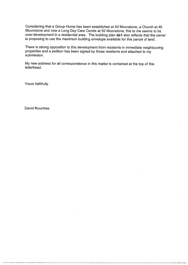


2.5 Development
Application DA 3/2013(1) - 806 Huntley Road
TRIM
REFERENCE: 2016/1979
AUTHOR: Andrew
Crump, Senior Planner
EXECUTIVE Summary
|
Application
lodged
|
21
December 2012
|
|
Applicant/s
|
Mr GG
Howarth
|
|
Owner/s
|
Mr GG
Howarth
|
|
Land
description
|
Lot 19
DP 750387 - 806 Huntley Road, Huntley
|
|
Proposed
land use
|
Dwelling
(building entitlement)
|
|
Value of
proposed development
|
$100,000
|
Council's consent is sought for a dwelling house on land
described as Lot 19 DP 750387, known as 806 Huntley Road, Huntley.
A search of Council’s records indicates that the land
comprises only part of an existing holding as defined under Orange Local
Environmental Plan 2011. Records further indicate that the existing holding
comprised land described as Lots 18, 19, 29 and 30 DP 750387.
An existing holding is defined under OLEP 2011 as:
land that:
(a) was a holding on 24 January 1964, and
(b) is a holding at the time the application
for development consent referred to in subclause (3) is lodged,
whether or not
there has been a change in the ownership of the holding since 24 January
1964, and includes any other land adjoining that land acquired by the owner
since 24 January 1964.
Given that the application has been lodged only on Lot 19 DP
750387, being only part of an “existing holding”, it is
beyond Council’s power to consent to the application in its current
configuration, even in the event the application was complete and competent on
this single title.
The above nonconformity with the applicable provision could
be addressed if the applicant were to amend the application pursuant to clause
55 of the Environmental Planning and Assessment Regulations (provided
that Council was agreeable to the amendments) to include the three other
parcels for which the applicant owns that make up the whole of the
existing holding.
Pursuant to clause 4.2A(4) of Orange Local Environmental
Plan 2011 (OLEP 2011) land ceases to be an existing holding for
the purposes of subclause (3)(d) if an application for development consent
referred to in that subclause is not made in relation to that land before
31 December 2012.
Whilst it is unclear from the information submitted with the
application as to which provision of the LEP the applicant is relying upon for
consent to be granted for a dwelling on the land, Council staff can confirm
that a development application (of limited information) for a dwelling was
lodged on 21 December 2012.
The application, when submitted, comprised only the
application form and a basic Statement of Environmental Effects of limited
detail. No plans or environmental reports (ie contamination, suitability
for onsite effluent or impact from aircraft noise, etc.) accompanied the
application.
As such, Council staff are not able to complete the
assessment of the application; and relevantly, the application is recommended
for refusal for the following reasons:
1 Insufficient
information has been submitted with the application to allow a detailed and
rigorous assessment pursuant to Section 79C of the Environmental Planning and
Assessment Act 1979.
2 The
applicant did not include documents that are required to accompany a
development application as detailed in schedule 1 of the Environmental Planning
and Assessment Regulation 2000.
3 The
land to which this application relates does not constitute the whole of an
existing holding as defined by clause 4.2A(6) of Orange Local Environmental
Plan 2011.
Council staff have provided the applicant with a number of
opportunities via both formal correspondence and phone conversations to provide
the necessary information, but to no avail.
Link To Delivery/OPerational Plan
The recommendation in this report relates to the
Delivery/Operational Plan strategy “13.4 Our Environment
– Monitor and enforce regulations relating to City amenity”.
Financial Implications
Council has been advised that as a council included in the
NSW Government’s merger proposals under consideration by the Office of
Local Government since referral on 6 January 2016, Council must comply with the
merger proposal period guidelines issued under S23A of the Local Government Act
1993.
The guidelines instruct Council it should expend money in
accordance with the detailed budget adopted for the purposes of implementing
the Delivery/Operational Plan for the 2015/16 year.
Any expenditure outside the adopted budget requires the
identification of clear and compelling grounds and must be approved by Council
at a meeting that is open to the public. The guidelines indicate the resolution
of Council for increased expenditure must specify the reasons why the
expenditure is required and warranted.
If increased expenditure is greater than $250,000 or 1% of
the Council’s revenue from rates in
the preceding year, whichever is the greater, Council
is required to exhibit the increase to the budget and consider comments
received.
Council must also avoid entering into contracts or
undertakings where expenditure or revenue is greater than $250,000 or 1% of the
Council’s revenue from rates in the
preceding year, whichever is the greater, unless the contract or undertaking is
as a result of a decision or procurement process commenced prior to the merger
proposal period or where entering into a contract or undertaking is reasonably
necessary for the purposes of meeting the ongoing service delivery commitments
of the Council or was previously approved in the Council’s
Delivery/Operational Plan.
Policy and Governance Implications
Nil
|
Recommendation
That Council refuses development application
DA 3/2013(1) for Dwelling House at Lot 19 DP 750387 -
806 Huntley Road, Huntley pursuant to the reasons provided in the attached
Notice of Refusal.
|
further considerations
Consideration has been given to the
recommendation’s impact on Council’s service delivery; image and
reputation; political; environmental; health and safety; employees;
stakeholders and project management; and no further implications or risks have
been identified.
SUPPORTING INFORMATION
THE APPLICATION
Council's consent is sought for the erection of a dwelling
house on land described as Lot 19 DP 750387, known as 806 Huntley
Road, Huntley.
THE PROPOSAL
It is not clears as to exactly what is proposed as part of
the application, other than to state that the application form describes a
‘four bedroom residence with detached double garage’. The location,
size, appearance, etc of the dwelling are not known from the information
provided.
CHRONOLOGY OF THE APPLICATION
The application was lodged on 21 December 2012. Council
wrote to the applicant on 14 January 2013 requesting additional
information necessary to complete assessment. The applicant responded to this
request seeking an extension to the 28 day timeframe stipulated in that letter
on 10 February 2013. A further letter was received from the applicant on
15 February 2013 requesting that the dwelling entitlement be retained.
Council again wrote to the applicant on 13 May 2013
requesting additional information and again on 13 August 2014. The applicant
again requested an extension of time to provide the additional information.
This letter provided a commitment to provision of the plans by 1 August
2015. An extension of time was agreed to by Council staff in a letter dated
10 September 2014
Council staff wrote a final letter on 9 August 2016
providing the applicant with 14 days to respond to the request for
information, and advising the applicant that if the necessary information had
not been received by the date provided in the letter, the application would be
finalised with a recommendation for refusal. No response has been received to
date.
MATTERS FOR CONSIDERATION
Section 5A Assessment
In the administration of sections 78A, 79B, 79C, 111 and
112, the provisions of Section 5A must be taken into account for every
development application in deciding whether there is likely to be a significant
effect on threatened species, populations or ecological communities or their
habitats. This section includes a requirement to consider any adopted
assessment guidelines, which means assessment guidelines issued and in force
under section 94A of the Threatened Species Conservation Act 1995.
Assessment guidelines are in force (see DECC-W “Threatened Species
Assessment Guidelines - The Assessment of Significance”) which requires
consent authority to adopt the precautionary principle in its assessment.
In this instance there is significant biodiversity or habitat
value identified in the north-eastern quadrant of the parcel. It is not
possible to complete a Part 5A assessment as it is not known from the
information provided where the proposed house is located, and as such what
impact that may have on the identified biodiversity and habitat value.
Section 79C
Section 79C of the Environmental Planning and Assessment
Act 1979 requires Council to consider various matters, of which those
pertaining to the application are listed below.
PROVISIONS OF ANY ENVIRONMENTAL
PLANNING INSTRUMENT s79C(1)(a)(i)
Orange Local Environmental Plan 2011
Part 1 - Preliminary
Clause 1.2 - Aims of Plan
The broad aims of the LEP are
set out under subclause 2. Those relevant to the application are as follows:
(a) to encourage development which complements
and enhances the unique character of Orange as a major regional centre boasting
a diverse economy and offering an attractive regional lifestyle,
(b) to provide for a range of development
opportunities that contribute to the social, economic and environmental
resources of Orange in a way that allows present and future generations to meet
their needs by implementing the principles for ecologically sustainable
development,
(c) to conserve and enhance the water
resources on which Orange depends, particularly water supply catchments,
(d) to manage rural land as an environmental
resource that provides economic and social benefits for Orange,
(e) to provide a range of housing choices in
planned urban and rural locations to meet population growth,
(f) to recognise and manage valued
environmental heritage, landscape and scenic features of Orange.
It is not possible to conclusively ascertain from the
information provided whether or not the application is consistent with the above
listed aims of the plan.
Clause 1.6 - Consent Authority
This clause establishes that, subject to the Act, Council is
the consent authority for applications made under the LEP.
Clause 1.9A - Suspension of
Covenants, Agreements and Instruments
This clause provides that covenants, agreements and other
instruments which seek to restrict the carrying out of development do not apply
with the following exceptions.
· covenants imposed
or required by Council
· prescribed
instruments under Section 183A of the Crown Lands Act 1989
· any conservation
agreement under the National Parks and Wildlife Act 1974
· any trust
agreement under the Nature Conservation Trust Act 2001
· any property
vegetation plan under the Native Vegetation Act 2003
· any biobanking
agreement under Part 7A of the Threatened Species Conservation Act 1995
· any planning
agreement under Division 6 of Part 4 of the Environmental Planning and
Assessment Act 1979.
Council staff are not aware of the title of the subject
property being affected by any of the above.
Mapping
The subject site is identified
on the LEP maps in the following manner:
|
Land Zoning Map:
|
Land zoned E3 Environmental
Management
|
|
Lot Size Map:
|
Minimum Lot Size 100ha
|
|
Heritage Map:
|
Not a heritage item or conservation
area (located opposite a heritage item)
|
|
Height of Buildings Map:
|
No building height limit
|
|
Floor Space Ratio Map:
|
No floor space limit
|
|
Terrestrial Biodiversity Map:
|
High biodiversity sensitivity on
the site
|
|
Groundwater Vulnerability Map:
|
Ground water vulnerable
|
|
Drinking Water Catchment Map:
|
Within the drinking water catchment
|
|
Watercourse Map:
|
Not within or affecting a defined
watercourse
|
|
Urban Release Area Map:
|
Not within an urban release area
|
|
Obstacle Limitation Surface Map:
|
No restriction on building siting
or construction
|
|
Additional Permitted Uses Map:
|
No additional permitted use applies
|
Those matters that are of relevance are addressed in detail
in the body of this report.
Part 2 - Permitted or
Prohibited Development
Land Use Zones
The subject site is located within the E3 Environmental
Management zone. The proposed development is defined as a dwelling house under
OLEP 2011 which means:
a building
containing only one dwelling.
To extend this definition further:
dwelling means a room or suite of rooms occupied or used or so constructed or
adapted as to be capable of being occupied or used as a separate domicile.
Dwelling houses are permissible in the E3 Environmental Management
zone with the consent of Council.
Clause 2.3 of LEP 2011
references the Objectives for each zone in LEP 2011. These objectives for
land zoned E3 Environmental Management are as follows:
1 - Objectives of the E3 Environmental Management
· To protect, manage and restore areas with special ecological, scientific,
cultural or aesthetic values.
· To provide for a limited range of development that does not have an
adverse effect on those values.
· To manage development within water supply catchment lands to conserve
and enhance the city and district’s water resources.
· To maintain the rural function and primary production values of the
area.
· To ensure development along the Southern Link Road has alternative
access.
It is not possible to complete
an assessment of the appropriateness of the development against the above
listed objectives of the zone given the deficiencies with the application.
Part 3 - Exempt and
Complying Development
The application is not exempt or complying development.
Part 4 - Principal
Development Standards
Clause 4.2A -
Erection of Dwelling Houses on Land in Certain Rural and Environmental
Protection Zones
This clause prevents
the erection of dwelling Houses on land zoned RU1, E2, E3 or E4 unless the
following provisions can be met:
(1) The
objectives of this clause are as follows:
(a) to
minimise unplanned rural residential development,
(b) to
enable the replacement of lawfully erected dwelling houses in rural and
environmental protection zones.
It is not possible to conclusively
determine if the proposed dwelling is consistent with the above objectives
given the identified deficiencies with the application.
(3) Development
consent must not be granted for the erection of a dwelling house on land in a
zone to which this clause applies, and on which no dwelling house has been
erected, unless the land is:
(a) a
lot that is at least the minimum lot size specified for that land by the Lot
Size Map, or
(b) a
lot created before this Plan commenced and on which the erection of a dwelling
house was permissible immediately before that commencement, or
(c) a
lot resulting from a subdivision for which development consent (or equivalent)
was granted before this Plan commenced and on which the erection of a dwelling
house would have been permissible if the plan of subdivision had been
registered before that commencement, or
(d) an
existing holding.
Note. A
dwelling cannot be erected on a lot created under clause 9 of State
Environmental Planning Policy (Rural Lands) 2008 or clause 4.2.
(4) Land ceases to be an existing holding for
the purposes of subclause (3) (d) if an application for development consent referred
to in that subclause is not made in relation to that land before 31 December
2012.
A search of Council’s records indicates that the land
comprises only part of an existing holding as defined under Orange Local
Environmental Plan 2011. Records further indicate that the existing holding
comprised land described as Lots 18, 19, 29 and 30 DP 750387. (This
application relates only to Lot 19 DP 750387.)
OLEP 2011 defines an existing holding as
land that:
(a) was a holding on 24 January 1964, and
(b) is a holding at the time the application
for development consent referred to in subclause (3) is lodged,
whether or not
there has been a change in the ownership of the holding since 24 January 1964,
and includes any other land adjoining that land acquired by the owner since 24
January 1964.
Given that the application has been lodged only on Lot 19 DP
750387, being only part of an “existing holding”, it is
beyond Council’s power to consent to the application as proposed even in
the event the application was complete and competent on this single allotment.
The above nonconformity with the applicable provision could
be addressed if the applicant were to amend the application pursuant to clause
55 of the Environmental Planning and Assessment Regulations (provided
that Council was agreeable to the amendments) to include the three other
parcels for which the applicant owns that make up the whole of the
existing holding.
Pursuant to clause 4.2A(4) of Orange Local Environmental
Plan 2011 land ceases to be an existing holding for the purposes
of subclause (3)(d) if an application for development consent referred to in
that subclause is not made in relation to that land before 31 December
2012.
Whilst it is unclear from the information submitted with the
application as to which provision of the LEP the applicant is relying upon,
Council staff can confirm that a development application (of limited
information) for a dwelling was lodged on 21 December 2012.
Part 5 -
Miscellaneous Provisions
5.10 - Heritage Conservation
The subject land is not identified as a heritage item, nor
is it located in a conservation area. It is, however, opposite a heritage item,
and therefore the below provisions apply by virtue of subclause 5(c).
(1) Objectives
The
objectives of this clause are as follows:
(a) to
conserve the environmental heritage of Orange,
(b) to
conserve the heritage significance of heritage items and heritage conservation
areas, including associated fabric, settings and views,
(c) to
conserve archaeological sites,
(d) to
conserve Aboriginal objects and Aboriginal places of heritage significance.
(2) Requirement
for Consent
Development
consent is required for any of the following:
(a) demolishing
or moving any of the following or altering the exterior of any of the following
(including, in the case of a building, making changes to its detail, fabric,
finish or appearance):
(i) a
heritage item,
(ii) an
Aboriginal object,
(iii) a
building, work, relic or tree within a heritage conservation area,
(b) altering
a heritage item that is a building by making structural changes to its interior
or by making changes to anything inside the item that is specified in Schedule
5 in relation to the item,
(c) disturbing
or excavating an archaeological site while knowing, or having reasonable cause
to suspect, that the disturbance or excavation will or is likely to result in a
relic being discovered, exposed, moved, damaged or destroyed,
(d) disturbing
or excavating an Aboriginal place of heritage significance,
(e) erecting
a building on land:
(i) on
which a heritage item is located or that is within a heritage conservation
area, or
(ii) on
which an Aboriginal object is located or that is within an Aboriginal place of
heritage significance,
(f) subdividing
land:
(i) on
which a heritage item is located or that is within a heritage conservation
area, or
(ii) on
which an Aboriginal object is located or that is within an Aboriginal place of
heritage significance.
(4) Effect
of Proposed Development on Heritage Significance
The
consent authority must, before granting consent under this clause in respect of
a heritage item or heritage conservation area, consider the effect of the
proposed development on the heritage significance of the item or area
concerned. This subclause applies regardless of whether a heritage management
document is prepared under subclause (5) or a heritage conservation management plan
is submitted under subclause (6).
(5) Heritage
assessment
The
consent authority may, before granting consent to any development:
(a) on
land on which a heritage item is located, or
(b) on
land that is within a heritage conservation area, or
(c) on
land that is within the vicinity of land referred to in paragraph (a) or (b),
require
a heritage management document to be prepared that assesses the extent to which
the carrying out of the proposed development would affect the heritage
significance of the heritage item or heritage conservation area concerned.
It is not possible to adequately complete a heritage
assessment of the heritage item in the vicinity of the subject land due to the
limited information provided.
Part 6 - Urban
Release Area
Not relevant to the application. The subject site is not
located in an Urban Release Area.
Part 7 - Additional
Local Provisions
7.1 - Earthworks
This clause
establishes a range of matters that must be considered prior to granting
development consent for any application involving earthworks, such as:
(a) the likely disruption of, or any detrimental
effect on, existing drainage patterns and soil stability in the locality of the
development
(b) the effect of the development on the
likely future use or redevelopment of the land
(c) the quality of the fill or the soil to be
excavated, or both
(d) the effect of the development on the
existing and likely amenity of adjoining properties
(e) the source of any fill material and the
destination of any excavated material
(f) the likelihood of disturbing relics
(g) the proximity to and potential for adverse
impacts on any waterway, drinking water catchment or environmentally sensitive
area
(h) any measures proposed to minimise or
mitigate the impacts referred to in paragraph (g).
It is not clear from
the information provided if earthworks are required; and therefore it is not
possible to assess the development against the above provisions.
7.3 - Stormwater
Management
This clause applies
to all industrial, commercial and residential zones and requires that Council
be satisfied that the proposal:
(a) is designed to maximise the use of water
permeable surfaces on the land having regard to the soil characteristics
affecting onsite infiltration of water
(b) includes, where practical, onsite
stormwater retention for use as an alternative supply to mains water,
groundwater or river water; and
(c) avoids any significant impacts of
stormwater runoff on adjoining downstream properties, native bushland and
receiving waters, or if that impact cannot be reasonably avoided, minimises and
mitigates the impact.
It is not clear from
the information provided how stormwater will be managed; and therefore it is
not possible to assess the development against the above provisions.
Notwithstanding this, given the size of the land it is likely that post-development
run off levels will not exceed pre-development levels.
7.4 - Terrestrial
Biodiversity
This clause seeks to
maintain terrestrial biodiversity and requires that consent must not be issued
unless the application demonstrates whether or not the proposal:
(a) is likely to have any adverse impact on
the condition, ecological value and significance of the fauna and flora on the
land
(b) is likely to have any adverse impact on
the importance of the vegetation on the land to the habitat and survival of
native fauna
(c) has any potential to fragment, disturb or
diminish the biodiversity structure, function and composition of the land, and
(d) is likely to have any adverse impact on
the habitat elements providing connectivity on the land.
Additionally this clause
prevents consent being granted unless Council is satisfied that:
(a) the development is designed, sited and
will be managed to avoid any significant adverse environmental impact, or
(b) if that impact cannot be reasonably
avoided - the development is designed, sited and will be managed to minimise
that impact, or
(c) if that impact cannot be minimised - the
development will be managed to mitigate that impact.
The subject
land comprises an area identified as high biodiversity as shown below:
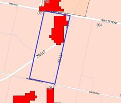
Image
1 - high biodiversity on the subject land
As it is not known
where the dwelling is proposed, Council staff are not able to complete an
assessment against the above provisions and conclusively determine the level of
impact likely upon the area of high biodiversity.
7.6 - Groundwater
Vulnerability
This clause seeks to
protect hydrological functions of groundwater systems and protect resources
from both depletion and contamination. Orange has a high water table and large
areas of the LGA, including the subject site, are identified with
“Groundwater Vulnerability” on the Groundwater Vulnerability Map.
This requires that Council consider:
(a) whether or not the development (including
any onsite storage or disposal of solid or liquid waste and chemicals) is
likely to cause any groundwater contamination or have any adverse effect on
groundwater dependent ecosystems, and
(b) the cumulative impact (including the
impact on nearby groundwater extraction for potable water supply or stock water
supply) of the development and any other existing development on groundwater.
Furthermore consent may not be granted unless Council is satisfied that:
(a) the development is designed, sited and
will be managed to avoid any significant adverse environmental impact, or
(b) if that impact cannot be reasonably
avoided - the development is designed, sited and will be managed to minimise
that impact,
(c) if that impact cannot be minimised - the
development will be managed to mitigate that impact.
The proposal is not
anticipated to involve the discharge of toxic or noxious substances and is
therefore unlikely to contaminate the groundwater or related ecosystems. The proposal
does not appear to involve extraction of groundwater and will therefore not
contribute to groundwater depletion.
However, given the
deficiencies in the application it is not possible to determine if the design
and siting (including the provision of an onsite effluent management system),
would avoid impact on groundwater; and therefore, it is not possible to
conclude if the development is acceptable or not in relation to groundwater.
7.7 - Drinking Water
Catchments
This clause seeks to protect the quality of Council’s
drink water catchment and requires the following provisions to be met.
(1) The
objective of this clause is to protect drinking water catchments by minimising
the adverse impacts of development on the quality and quantity of water
entering drinking water storages.
(2) This
clause applies to land identified as “Drinking water” on the Drinking
Water Catchment Map.
(3) Before
determining a development application for development on land to which this
clause applies, the consent authority must consider whether or not the
development is likely to have any adverse impact on the quality and quantity of
water entering the drinking water storage, having regard to:
(a) the
distance between the development and any waterway that feeds into the drinking
water storage, and
(b) the
onsite use, storage and disposal of any chemicals on the land, and
(c) the
treatment, storage and disposal of waste water and solid waste generated or
used by the development.
(4) Development
consent must not be granted to development on land to which this clause applies
unless the consent authority is satisfied that:
(a) the
development is designed, sited and will be managed to avoid any significant
adverse impact on water quality and flows, or
(b) if
that impact cannot be reasonably avoided - the development is designed, sited
and will be managed to minimise that impact, or
(c) if
that impact cannot be minimised - the development will be managed to mitigate
that impact.
No information has been provided to adequately address the
above provisions; and in particular, matters in relation to the treatment
of on-site effluent. Therefore, Council staff cannot conclusively determine
that the development will not impact on the drinking water catchment.
7.9 - Airspace Operations
This clause seeks to protect the continued safe operation of
the Orange Regional Airport and obligates Council to consider development
within the area mapped obstacle limitation and have regard to the following
provisions.
(1) The
objectives of this clause are as follows:
(a) to
provide for the effective and ongoing operation of the Orange Airport by
ensuring that such operation is not compromised by proposed development that
penetrates the Limitation or Operations Surface for that airport,
(b) to
protect the community from undue risk from that operation.
(2) If
a development application is received and the consent authority is satisfied
that the proposed development will penetrate the Limitation or Operations
Surface, the consent authority must not grant development consent unless it has
consulted with the relevant Commonwealth body about the application.
(3) The
consent authority may grant development consent for the development if the
relevant Commonwealth body advises that:
(a) the
development will penetrate the Limitation or Operations Surface but it has no
objection to its construction, or
(b) the
development will not penetrate the Limitation or Operations Surface.
(4) The
consent authority must not grant development consent for the development if the
relevant Commonwealth body advises that the development will penetrate the
Limitation or Operations Surface and should not be constructed.
The subject land lies just outside the area mapped obstacle
limitation on the obstacle limitations map, and as such the above provisions do
not apply to the assessment of the development application.
7.10 - Development in
Areas Subject to Aircraft Noise
This clause requires
Council to have regard to developments that will result in additional dwellings
or people within the vicinity of the airport and ensure that new development
will not unreasonably conflict with the continued operations of the airport.
(1) This
clause applies to development that:
(a) is
on land that:
(i) is
near an airport, and
(ii) is
in an ANEF contour of 20 or greater, and
(b) the
consent authority considers is likely to be adversely affected by aircraft
noise.
(2) Before
determining a development application for development to which this clause
applies, the consent authority:
(a) must
consider whether the development will result in an increase in the number of
dwellings or people affected by aircraft noise, and
(b) must
consider the location of the development in relation to the criteria set out in
Table 2.1 (Building Site Acceptability Based on ANEF Zones) in AS
2021—2000, Acoustics—Aircraft noise intrusion—Building siting
and construction, and
(c) must
be satisfied that the development will meet AS 2021—2000,
Acoustics—Aircraft noise intrusion—Building siting and construction
with respect to interior noise levels for the purposes of:
(i) if
the development will be in an ANEF contour of 20 or greater—child care
centres, educational establishments, entertainment facilities, hospitals,
places of public worship, public administration buildings or residential
accommodation, and
(ii) if
the development will be in an ANEF contour of 25 or greater—business
premises, hostels, hotel or motel accommodation, office premises or retail
premises.
The applicant has not
provided any information in relation to compliance with the above clause. As
such, it would be ultra vires for Council to consent to the application.
7.11 - Essential services
The following clause requires Council to give
regard to the essential services necessary to accommodate a particular
development on the land, and whether those services are able to be made
available for the development.
Development consent must not be granted to
development unless the consent authority is satisfied that any of the following
services that are essential for the proposed development are available or that
adequate arrangements have been made to make them available when required:
(a) the
supply of water,
(b) the
supply of electricity,
(c) the
disposal and management of sewage,
(d) stormwater
drainage or on-site conservation,
(e) suitable
road access.
It is not possible to adequately assess the availability of
services given the lack of information - no information has been provided on
such things as management of sewage, access, etc.
STATE ENVIRONMENTAL PLANNING
POLICIES
State Environmental Planning Policy (Building Sustainability
Index BASIX) applies to the subject development. However, the applicant has not
submitted an a BASIX certificate with the application.
State Environmental Planning Policy 55 - Remediation of Land
applies to the subject land, specifically clause 7 which states:
7 Contamination
and remediation to be considered in determining development application
(1) A
consent authority must not consent to the carrying out of any development on
land unless:
(a) it
has considered whether the land is contaminated, and
(b) if
the land is contaminated, it is satisfied that the land is suitable in its
contaminated state (or will be suitable, after remediation) for the purpose for
which the development is proposed to be carried out, and
(c) if
the land requires remediation to be made suitable for the purpose for which the
development is proposed to be carried out, it is satisfied that the land will
be remediated before the land is used for that purpose.
The land has been previously used for agricultural purposes,
and as such there is the likelihood of some form of contamination being present
on the land. The applicant has not submitted sufficient information to
demonstrate to Council staff that the land is suitable for the purposes of a
residential land-use. As such it would not be within Council’s power to
approve the application in its current form.
PROVISIONS OF ANY DRAFT
ENVIRONMENTAL PLANNING INSTRUMENT THAT HAS BEEN PLACED ON EXHIBITION
s79C(1)(a)(ii)
There are no draft environmental planning instruments that
apply to the subject land or proposed development.
DESIGNATED DEVELOPMENT
The proposed development is not designated development.
PROVISIONS OF ANY DEVELOPMENT
CONTROL PLAN s79C(1)(a)(iii)
Development Control Plan 2004
Development Control Plan 2004 (“the DCP”)
applies to the subject land. An assessment of the proposed development against
the relevant Planning Outcomes will be undertaken below.
Pursuant to Planning Outcome 0.2-1 Interim Planning Outcomes
- Conversion of Zones:
· Throughout this
Plan, any reference to a zone in Orange LEP 2000 is to be taken to be a
reference to the corresponding zone(s) in the zone conversion table.
The corresponding zone to zone 7 Water Supply Catchment
(Orange LEP 2000) is zone E3 Environmental management (Orange LEP 2011).
As such, Orange DCP 2004 – Chapter 6 is of primary relevance
to the assessment of this proposal. The relevant provisions are considered
below.
PO 2.3-1 PLANNING OUTCOMES -
VEGETATION MANAGEMENT
· Compliance
with the Native Vegetation Conservation Act 1997.
· Development
is designed and constructed in a way that minimises the impact on existing
vegetation.
· Particular
attention is given to the effect of rural or urban residential release
development on existing vegetation and scenic areas.
· Development
applications indicate on plans the location of all significant trees affected
by or in the vicinity of development.
· Applications
demonstrate to Council’s satisfaction that all practical measures have
been made to retain trees that contribute to and embellish the Orange
landscape.
It is not possible to complete an assessment of the above
planning outcomes due to the deficiencies in information with the application.
PLANNING
OUTCOMES FOR DWELLINGS IN PROXIMITY TO AGRICULTURE AND OTHER RURAL ACTIVITIES
· Dwelling
houses should be located to minimise conflicts with the operation of activities
associated with primary production.
· Where
a dwelling is proposed to be located within 150 metres of land where spraying
of chemicals is likely to occur, an adequate biological buffer is to be
established between the dwelling and that agricultural land.
It is not possible to complete
an assessment of the above planning outcomes due to the deficiencies in information
with the application.
PLANNING OUTCOMES FOR RURAL DWELLING HOUSES
· The
dwelling house complies with Council’s Energy Smart Homes Code.
· The
dwelling house is sited on land identified as being suitable for construction
and free from contamination, flooding and bushfire risk.
· Privacy
and views of neighbouring houses are retained.
· A suitable
area is available for perpetual on-site disposal of wastes.
· Substantial
remnant vegetation is protected from disturbance.
· An
adequate water supply is provided.
· All-weather
access to a public road is provided.
· Entry
gateways are set back sufficiently from the front boundary to allow vehicles to
pull up off the public road carriageway.
· A buffer
area is established in the vicinity of agricultural operations.
· Outbuildings
are located in proximity of and to the rear of the main dwelling house when
viewed from the nearest road.
It is not possible to complete an assessment of the above
planning outcomes due to the deficiencies in information with the application.
PLANNING OUTCOMES –
DEVELOPMENT IN THE VICINITY OF THE AIRPORT
· Noise-sensitive
development is located outside the airport-noise zone.
· Where
there is no alternative location, development occurs within the hatched area
around the Orange airport in full compliance with Australian Standard AS 2021-
1994 Acoustics- Aircraft Noise Intrusion - Building Siting and Construction.
· Development
in the vicinity of the airport complies with the Obstacle Limitation Surfaces
Plan for Orange.
It is not possible to complete an assessment of the above
planning outcomes due to the deficiencies in information with the application.
PROVISIONS PRESCRIBED BY THE
REGULATIONS s79C(1)(a)(iv)
The applicant has not suitably demonstrated that the
development is consistent with the provisions prescribed by the regulations.
THE LIKELY IMPACTS OF THE
DEVELOPMENT s79C(1)(b)
The application is deficient in so far as the information
provided is not adequate to enable a complete and rigorous assessment of the
likely impacts as required by s79C(1)(b).
THE SUITABILITY OF THE SITE
s79C(1)(c)
The application is deficient in so far as the information
provided is not adequate to enable a complete and rigorous assessment of the
suitability of the site required by s79C(1)(c).
ANY SUBMISSIONS MADE IN
ACCORDANCE WITH THE ACT s79C(1)(d)
The proposed development is not defined as advertised
development under the provisions of the LEP and, as such, no formal exhibition
of the application was required. No submissions have been received in relation
to this application.
PUBLIC INTEREST
s79C(1)(e)
Whilst the proposed development is likely to be of minor
interest to the wider public due to the relatively localised nature of
potential impacts, given the deficiencies with the application it not
considered to be in the public interest to consent to the application.
SUMMARY
The application is deficient in so far as the information
provided is not adequate to enable a complete and rigorous assessment pursuant
to Council’s obligations under the Environmental Planning and
Assessment Act. Council staff have provided the applicant with a number of
opportunities via both formal correspondence and phone conversations to provide
the necessary information, but to no avail. As such, the development application
is recommended for refusal.
COMMENTS
The requirements of the Environmental Health and Building
Surveyor and the Engineering Development Section have not been sought due to
the absence of information.
Attachments
1 Notice
of Refusal, D16/38654⇩
Planning and Development Committee
6 September 2016
2.5 Development
Application DA 3/2013(1) - 806 Huntley Road
Attachment 1 Notice
of Refusal
|
|
ORANGE
CITY COUNCIL
Development
Application No DA
3/2013(1)
NA16/ Container
PR14200
|
NOTICE OF DETERMINATION
OF A DEVELOPMENT
APPLICATION
issued under the Environmental
Planning and Assessment Act 1979
Section 81(1)
|
Development Application
|
|
|
Applicant Name:
|
Mr GG Howarth
|
|
Applicant Address:
|
806
Huntley Road
HUNTLEY
NSW 2800
|
|
Land to Be Developed:
|
Lot 19 DP 750387 - 806 Huntley Road,
Huntley
|
|
Proposed Development:
|
Dwelling House
|
|
|
|
|
Building Code of Australia
Building Classification:
|
Not applicable
|
|
|
|
|
Determination
|
|
|
Made On:
|
6 September 2016
|
|
Determination:
|
APPLICATION REFUSED
|
|
|
|
|
Reason(s) for Refusal:
|
1 Insufficient
information has been submitted with the application to allow a detailed and
rigorous assessment pursuant to Section 79C of the Environmental Planning
and Assessment Act 1979.
2 The
applicant did not include documents that are required to accompany a
development application as detailed in schedule 1 of the Environmental
Planning and Assessment Regulation 2000.
3 The
land to which this application relates does not constitute the whole of an
existing holding as defined by clause 4.2A(6) of Orange Local Environmental
Plan 2011.
|
|
|
|
|
Right of Appeal:
|
Applicant:
If
you are dissatisfied with this decision, Section 97 of Environmental
Planning and Assessment Act 1979 gives you the right to appeal to the
Land and Environment Court within 6 months after the date on which you
receive this notice.
*
Section 97 of the Environmental Planning and Assessment Act, 1979 does not
apply to the determination of a development application for State significant
development or local designated development that has been the subject of a
Commission of Inquiry.
Objector:
The
Environmental
Planning and Assessment Act 1979 does not give a right of appeal against this
determination to an objector.
|
|
|
|
|
Signed:
|
On behalf of the consent authority:
|
|
Signature:
|
|
|
Name:
|
DAVID WADDELL - DIRECTOR DEVELOPMENT
SERVICES
|
|
Date:
|
7 September 2016
|