ORANGE CITY COUNCIL
Planning and Development
Committee
Agenda
5 April 2016
Notice
is hereby given, in accordance with the provisions of the Local Government Act
1993 that a Planning and Development
Committee meeting
of ORANGE CITY COUNCIL will be held in the Council Chamber, Civic Centre, Byng Street, Orange on Tuesday,
5 April 2016.
Garry
Styles
General Manager
For apologies please
contact David Waddell on 6393 8261.
1 Introduction
1.1 Declaration
of pecuniary interests, significant non-pecuniary interests and less than
significant non-pecuniary interests
The
provisions of Chapter 14 of the Local Government Act, 1993 (the Act)
regulate the way in which Councillors and designated staff of Council conduct
themselves to ensure that there is no conflict between their private interests
and their public role.
The
Act prescribes that where a member of Council (or a Committee of Council) has a
direct or indirect financial (pecuniary) interest in a matter to be considered
at a meeting of the Council (or Committee), that interest must be disclosed as
soon as practicable after the start of the meeting and the reasons given for
declaring such interest.
As
members are aware, the provisions of the Local Government Act restrict any
member who has declared a pecuniary interest in any matter from participating
in the discussion or voting on that matter, and requires that member to vacate
the Chamber.
Council’s Code of Conduct provides that if members
have a non-pecuniary conflict of interest, the nature of the conflict must be
disclosed. The Code of Conduct also provides for a number of ways in which a
member may manage non pecuniary conflicts of interest.
|
Recommendation
It is recommended that Committee Members now disclose any
conflicts of interest in matters under consideration by the Planning and
Development Committee at this meeting.
|
2 General
Reports
2.1 Items
Approved Under the Delegated Authority of Council
TRIM
REFERENCE: 2016/420
AUTHOR: Paul
Johnston, Planning Team Leader
EXECUTIVE Summary
Following is a list of development
applications approved under the delegated authority of Council.
Link To Delivery/OPerational Plan
The recommendation in this report relates to the Delivery/Operational
Plan strategy “13.4 Our Environment – Monitor and
enforce regulations relating to City amenity”.
Financial Implications
Council has been advised that as a council included in the
NSW Government’s merger proposals under consideration by the Office of
Local Government since referral on 6 January 2016, Council must comply with the
merger proposal period guidelines issued under S23A of the Local Government Act
1993.
The guidelines instruct Council it should expend money in
accordance with the detailed budget adopted for the purposes of implementing
the Delivery/Operational Plan for the 2015/16 year.
Any expenditure outside the adopted budget requires the
identification of clear and compelling grounds and must be approved by Council
at a meeting that is open to the public. The guidelines indicate the resolution
of Council for increased expenditure must specify the reasons why the
expenditure is required and warranted.
If increased expenditure is greater than $250,000 or 1% of
the Council’s revenue from rates in
the preceding year, whichever is the greater, Council
is required to exhibit the increase to the budget and consider comments
received.
Council must also avoid entering into contracts or
undertakings where expenditure or revenue is greater than $250,000 or 1% of the
Council’s revenue from rates in the
preceding year, whichever is the greater, unless the contract or undertaking is
as a result of a decision or procurement process commenced prior to the merger
proposal period or where entering into a contract or undertaking is reasonably
necessary for the purposes of meeting the ongoing service delivery commitments
of the Council or was previously approved in the Council’s
Delivery/Operational Plan.
Policy and Governance Implications
Nil
|
Recommendation
That the information provided in the
report by the Planning Team Leader on Items Approved Under the Delegated
Authority of Council be acknowledged.
|
further considerations
Consideration has been given to the
recommendation’s impact on Council’s service delivery; image and
reputation; political; environmental; health and safety; employees;
stakeholders and project management; and no further implications or risks have
been identified.
SUPPORTING INFORMATION
|
Reference:
|
DA 390/1999(2)
|
Determination
Date
|
26 February 2016
|
|
PR Number
|
PR17174
|
|
Applicant/s:
|
Richmorn Pty Ltd
|
|
Owner/s:
|
Richmorn Pty Ltd
|
|
Location:
|
Lot 42 DP 882960
– 12A-12B Hamer Street, Orange
|
|
Proposal:
|
Modification
of development consent – dual occupancy development and detached
garage. The modification involves:
· amending the condition of consent relating to the boundary wall
along the southern boundary (which was built at a lower height than the
condition specified) and
· amending/deleting the conditions relating to the garage doors
(which were built at a different width than specified by conditions of
consent)
|
|
Value:
|
$150,000 (being
the same value as the original development)
|
|
Reference:
|
DA 189/2014(2)
|
Determination
Date
|
21 March 2016
|
|
PR Number
|
PR796
|
|
Applicant/s:
|
Mr MR Pasquali
|
|
Owner/s:
|
Pasquali Pty Ltd
|
|
Location:
|
Lot 1 DP 152150
– 198 Anson Street, Orange
|
|
Proposal:
|
Modification
of development consent – retail premises (change of use from office and
alteration of shopfront). The modification involves altering the entrance
details and changing the wall treatments below the awning at the front of the
site.
|
|
Value:
|
$8,000 (being the
same value as the original development)
|
|
Reference:
|
DA 38/2015(2)
|
Determination
Date
|
14 March 2016
|
|
PR Number
|
PR1199
|
|
Applicant/s:
|
Isaac Property
Developments Orange Pty Limited
|
|
Owner/s:
|
Southill Pty Ltd
|
|
Location:
|
Lot 1 Sec A DP
13435 and Lot 20 DP 1020706 – 90-92 Bathurst Road, Orange
|
|
Proposal:
|
Modification
of development consent – demolition (existing structures), service
station and signage. The modification involves deleting Condition (14),
which required various safety and hazard studies to be undertaken prior to
the issue of a Construction Certificate. (It was the applicant’s
submission that appropriate analysis was undertaken for the original
development and pre-construction reporting requirements are unnecessary.)
|
|
Value:
|
$1,544,555 (being
the same value as the original development)
|
|
Reference:
|
DA 133/2015(2)
|
Determination
Date
|
2 March 2016
|
|
PR Number
|
PR25724
|
|
Applicant/s:
|
Don’t Tell
Jo Pty Ltd
|
|
Owner/s:
|
Don’t Tell
Jo Pty Ltd
|
|
Location:
|
Lot 101 DP 1175489
– 74 Phillip Street, Orange
|
|
Proposal:
|
Modification
of development consent – dual occupancy and subdivision (two lot
residential). The modification involves amending the layout of approved
Dwelling 1 to achieve sufficient vehicular access to the site and improved
privacy to the neighbouring property to the east; and modifying the approved
lot sizes.
|
|
Value:
|
$500,000 (being
the same value as the original development)
|
|
Reference:
|
DA 299/2015(1)
|
Determination
Date
|
7 March 2016
|
|
PR Number
|
PR19448
|
|
Applicant/s:
|
Mr MN Nagy
|
|
Owner/s:
|
Mr ND and Mrs A
Nagy
|
|
Location:
|
Approved Lot 41 in
the subdivision of Lot 4 DP 1067471 – 2-6 Whitney Place, Orange
|
|
Proposal:
|
Dual
occupancy and subdivision (two lot residential)
|
|
Value:
|
$400,000
|
|
Reference:
|
DA 421/2015(1)
|
Determination
Date
|
16 March 2016
|
|
PR Number
|
PR2317
|
|
Applicant/s:
|
Mr GP Madafiglio
|
|
Owner/s:
|
Carwoola Family
Pty Limited
|
|
Location:
|
Lot 5 DP 715252
– 6 Carwoola Drive, Orange
|
|
Proposal:
|
Subdivision
(12 lot residential)
|
|
Value:
|
$0
|
|
Reference:
|
DA 429/2015(1)
|
Determination
Date
|
18 March 2016
|
|
PR Number
|
PR11558
|
|
Applicant/s:
|
Mr Sushi King Pty
Ltd
|
|
Owner/s:
|
Fawcett Ridge Pty
Ltd
|
|
Location:
|
Lot 24 DP 587326
– 282-284 Summer Street, Orange
|
|
Proposal:
|
Restaurant
(change of use and building alterations)
|
|
Value:
|
$200,000
|
|
Reference:
|
DA 433/2015(1)
|
Determination
Date
|
16 March 2016
|
|
PR Number
|
PR27179
|
|
Applicant/s:
|
Laurellen Pty Ltd
|
|
Owner/s:
|
Mr LW Bevan and
Laurellen Pty Ltd, and Orange City Council
|
|
Location:
|
Lot 391 DP 1212526 and Lot 24 DP
1035913 – 18 Astill Drive and Phillip Street Orange
|
|
Proposal:
|
Earthworks
(bulk earthworks and tree removal)
|
|
Value:
|
$40,000
|
|
Reference:
|
DA 437/2015(1)
|
Determination
Date
|
2 March 2016
|
|
PR Number
|
PR26103
|
|
Applicant/s:
|
Australia Wide
Coaches
|
|
Owner/s:
|
Mr RG Dawes
|
|
Location:
|
Lot 7 DP 1183249
– 229 McLachlan Street, Orange
|
|
Proposal:
|
Transport
depot (passenger coaches)
|
|
Value:
|
$230,000
|
|
Reference:
|
DA 445/2015(1)
|
Determination
Date
|
18 March 2016
|
|
PR Number
|
PR18907
|
|
Applicant/s:
|
Mr G Norton
|
|
Owner/s:
|
Mr PM and Mrs ME
Hiney
|
|
Location:
|
Lot 121 DP 1057438
– 14 Claremont Way, Orange
|
|
Proposal:
|
Subdivision
(two lot residential)
|
|
Value:
|
$5,000
|
|
Reference:
|
DA 451/2015(1)
|
Determination
Date
|
24 February 2016
|
|
PR Number
|
PR10589
|
|
Applicant/s:
|
Mr NW Luelf and Ms
PM Brett
|
|
Owner/s:
|
Mr NW Luelf and Ms
PM Brett
|
|
Location:
|
Lot 1 DP 1029465
– 33-35 Sale Street, Orange
|
|
Proposal:
|
Shop and
restaurant or café (alterations to existing premises), and business
identification signage
|
|
Value:
|
$120,000
|
|
Reference:
|
DA 9/2016(1)
|
Determination
Date
|
25 February 2016
|
|
PR Number
|
PR26728
|
|
Applicant/s:
|
McKinnon Design
and Drafting
|
|
Owner/s:
|
Graham Barrett
Leewood Dr Pty Ltd
|
|
Location:
|
Lot 101 DP 1203113
– 43 Leewood Drive, Orange
|
|
Proposal:
|
General
industry (alterations and additions)
|
|
Value:
|
$75,000
|
|
Reference:
|
DA 14/2016(1)
|
Determination
Date
|
10 March 2016
|
|
PR Number
|
PR21273
|
|
Applicant/s:
|
Blanchard Design
Drafting
|
|
Owner/s:
|
Mr JA and Mrs SN
Nunn
|
|
Location:
|
Lot 23 DP 270446
– 1 Gateway Crescent, Orange
|
|
Proposal:
|
Warehouse
or distribution centre
|
|
Value:
|
$310,000
|
|
Reference:
|
DA 22/2016(1)
|
Determination
Date
|
23 February 2016
|
|
PR Number
|
PR9681
|
|
Applicant/s:
|
Ms CE Cusack
|
|
Owner/s:
|
Mr E Eid
|
|
Location:
|
Lot 1 DP 162437
– 159 Peisley Street, Orange
|
|
Proposal:
|
Business
premises and business identification signage
|
|
Value:
|
$7,000
|
|
Reference:
|
DA 25/2016(1)
|
Determination
Date
|
25 February 2016
|
|
PR Number
|
PR6935
|
|
Applicant/s:
|
One Agency
|
|
Owner/s:
|
Mr G, Mrs R, Mr A
and Mrs R Sciuto
|
|
Location:
|
Lot 1 DP 565108
– 189-191 Lords Place, Orange
|
|
Proposal:
|
Business
identification signage
|
|
Value:
|
$2,000
|
|
Reference:
|
DA 26/2016(1)
|
Determination
Date
|
23 February 2016
|
|
PR Number
|
PR19017
|
|
Applicant/s:
|
Spicer
Constructions Pty Ltd
|
|
Owner/s:
|
Mr AM and Mr GW
Spicer
|
|
Location:
|
Lot 47 DP 1063083
– 15 Elwin Drive, Orange
|
|
Proposal:
|
Truck
depot
|
|
Value:
|
$50,000
|
|
Reference:
|
DA 37/2016(1)
|
Determination
Date
|
4 March 2016
|
|
PR Number
|
PR26816
|
|
Applicant/s:
|
Mr L Bevan
|
|
Owner/s:
|
Tansix Pty Ltd
|
|
Location:
|
Part Lot 231 DP
1206376 – 16 Astill Drive, Orange
|
|
Proposal:
|
Depot
and vehicle sales or hire premises (change of use and building addition
– wash bay)
|
|
Value:
|
$30,000
|
|
Reference:
|
DA 44/2016(1)
|
Determination
Date
|
24 February 2016
|
|
PR Number
|
PR11580
|
|
Applicant/s:
|
Suzanne Grae
Corporation
|
|
Owner/s:
|
Alceon Group Pty
Limited
|
|
Location:
|
Lot 564 DP 776383
– 212-220 Summer Street, Orange
|
|
Proposal:
|
Shop
(internal tenancy fitout for Shop 13)
|
|
Value:
|
$150,000
|
|
|
|
TOTAL
NET* VALUE OF ALL DEVELOPMENTS APPROVED IN THIS PERIOD: $1,619,000
*
Net value relates to the value of modifications. If modifications are
the same value as the original DA, then nil is added. If there is a plus/minus
difference, this difference is added or taken out.
2.2 Development
Application DA 329/2015(1) - 62 Byng Street and 77 Hill Street
TRIM
REFERENCE: 2016/647
AUTHOR: Daniel
Drum, Town Planner
EXECUTIVE Summary
|
Application
lodged
|
22
September 2015
|
|
Applicant/s
|
Mayoh
Architects Pty Ltd - PD Mayoh Pty Ltd
|
|
Owner/s
|
Denoc
Holdings Pty Ltd
|
|
Land
description
|
Lot 3 DP
758817, Lot 4 DP 1085463 and Lot 1 DP 956418 - 62 Byng Street and 77
Hill Street, Orange
|
|
Proposed
land use
|
Hotel or
Motel Accommodation
|
|
Value of
proposed development
|
$5,200,000
|
Council’s consent is sought to establish a hotel on
the land at 62 Byng Street and 77 Hill Street, Orange, being Lot 3 DP
758817, Lot 4 DP 1085463 and Lot 1 DP 956418 (the ‘subject
property’). The subject property comprises a
total area of 3,900m2 (approximately) and is currently occupied by the Yallungah
Mansion at 62 Byng Street and a single storey dwelling at 77 Hill Street.
The Yallungah Mansion is a listed local heritage item.
Specifically, Council’s
consent is sought for:
· the use and development of hotel or motel accommodation
· partial demolition of the Yallungah Mansion and the single
storey dwelling
· structural changes to the interior of the mansion
· demolition of outbuildings
· removal of trees
The proposed hotel is intended to offer a 5 star boutique
service to overnight stay guests, with a maximum capacity of 56 persons. Aside
from accommodation, other facilities and services offered by the hotel will
include:
· a conference room
for up to 20 persons
· an a la carte
breakfast meal service
· high tea service
The facilities and services offered by the hotel will only
be available to overnight stay guests.
The proposed hotel would comprise:
· 28 double or twin
bedroom suites with a typical internal floor area of 32m2
· breakfast room
· conference room
· lounges and
sitting areas
· undercover and
outdoor seating
· kitchen facilities
· office
· service and
utility facilities
· manager’s
residence
· 28 car parking
spaces
The existing dwelling located at 77 Hill Street will be
used as the Manager’s residence.
Works associated with the proposed hotel include:
· partial demolition
of the rear portions of the Yallungah Mansion and single storey dwelling
· internal and
external alterations to the mansion
· demolition of
outbuildings
· removal of trees
· construction of a
two storey extension and lower ground floor undercroft at the rear of the
mansion to accommodate bedroom suites
· service and
utility facilities
· internal
accessways and car parking
· perimeter
landscaping
The key issues for consideration include:
· impact on the
significance of local heritage items and the Central Orange Heritage
Conservation Area
· the visual bulk
associated with the height, length, setbacks and architectural design of the
proposed development
· impacts on
residential amenity
· noise associated
with the use of the proposed hotel
· car parking
· traffic impacts
Preservation and restoration of the key elements that
distinguish the Yallungah Mansion as a heritage item are considered to be
positive and desirable outcomes given its recent dilapidated condition and
potential for complete loss of a prominent heritage item.
Notably, some works have already
been undertaken onsite. Accordingly, the applicant is seeking consent to
regularise those works. In accordance with Council’s standard procedure,
matters in relation to carrying out works on the subject property without
development consent are addressed under separate cover to avoid any confusion
between the assessment of the development application and potential enforcement
procedures.
25 submissions were received during the exhibition period. A
further 26 submissions were received after that period ended, including
five supporting submissions. It is noted that a number of people made multiple
submissions. A copy of all submissions are attached to this report and the
issues raised by submitters are addressed in the body of this report.
Council is the owner of 73A Hill Street, Orange which is the
site of the Orange Regional Conservatorium. As the owner of a site which
adjoins the subject development site, Council acknowledges that there may be
perceived to be a conflict of interest. As the owner of the adjoining land and
as the determining authority under the Environmental Planning and Assessment
Act, Council cannot divest itself of the circumstances which give rise to the
conflict of interest, and therefore the conflict requires to be managed.
The procedure which Council has put in place to manage the
conflict of interest is to have the Development Assessment independently reviewed
(peer review) by a Consultant Town Planner from outside the region, being
Lindsay Fletcher, Consultant Town Planner. A copy of the peer review is
attached for Council’s information and should be considered in
conjunction with this report.
Council staff have taken on board the views of the peer
reviewer, incorporating those changes into this report and the draft consent.
The changes arising from the peer review have not altered
the general direction of the staff assessment, but have refined and added value
to the assessment and conditions of the draft consent.
Notwithstanding the foregoing issues, the following
assessment identifies that the proposed development can be supported within the
framework of Councils’ planning regime and the NSW Environmental Planning
& Assessment Act.
Link To Delivery/OPerational Plan
The recommendation in this report relates to the
Delivery/Operational Plan strategy “13.4 Our Environment
– Monitor and enforce regulations relating to City amenity”.
Financial Implications
Council has been advised that as a council included in the
NSW Government’s merger proposals under consideration by the Office of
Local Government since referral on 6 January 2016, Council must comply with the
merger proposal period guidelines issued under S23A of the Local Government Act
1993.
The guidelines instruct Council it should expend money in
accordance with the detailed budget adopted for the purposes of implementing
the Delivery/Operational Plan for the 2015/16 year.
Any expenditure outside the adopted budget requires the
identification of clear and compelling grounds and must be approved by Council
at a meeting that is open to the public. The guidelines indicate the resolution
of Council for increased expenditure must specify the reasons why the expenditure
is required and warranted.
If increased expenditure is greater than $250,000 or 1% of
the Council’s revenue from rates in
the preceding year, whichever is the greater, Council
is required to exhibit the increase to the budget and consider comments received.
Council must also avoid entering into contracts or
undertakings were expenditure or revenue is greater than $250,000 or 1% of the Council’s revenue from rates in the
preceding year, whichever is the greater, unless the contract or undertaking is
as a result of a decision or procurement process commenced prior to the merger
proposal period or where entering into a contract or undertaking is reasonably
necessary for the purposes of meeting the ongoing service delivery commitments
of the Council or was previously approved in the Council’s
Delivery/Operational Plan.
Policy and Governance Implications
Nil
|
Recommendation
That Council consents to development application DA
329/2015(1) for Hotel or Motel Accommodation at Lot 3 DP 758817, Lot 4
DP 1085463 and Lot 1 DP 956418 – 62 Byng Street and 77 Hill
Street, Orange pursuant to the conditions of consent in the attached Notice
of Determination.
|
further considerations
Consideration has been given to the
recommendation’s impact on Council’s service delivery; image and
reputation; political; environmental; health and safety; employees;
stakeholders and project management; and no further implications or risks have
been identified.
SUPPORTING INFORMATION
THE APPLICATION/PROPOSAL
Council’s consent is sought
for the use and development of hotel or motel accommodation; partial
demolition of the Yallungah Mansion and the single storey dwelling, structural
changes to the interior of the mansion, demolition of outbuildings and removal
of trees.
Use
The hotel is intended to offer a 5 star boutique service to
overnight stay guests with a maximum capacity of 56 persons. Aside from
accommodation, other facilities and services offered by the hotel will include
a conference room for up to 20 persons, an a la carte breakfast service and
high tea service. The applicant has indicated that additional meal services may
be offered by special arrangement only.
The facilities and services offered by the hotel will be
limited to overnight stay guests only and will not be available to the general
public.
The hotel would employ four
permanent staff and up to eight casual staff. The applicant has indicated that
a chef and casual staff would commence work at 6am and finish at 11am
typically, while housekeeping staff will commence at 9:30am and finish at 3pm. A receptionist
would work between 7:30am and 10am and 4pm to 7pm, daily.
The applicant has forecast an
average weekly occupancy rate of 70% (40 persons), with occupancy rates
expected to peak on Fridays and Saturdays. The applicant also anticipates that
the average nightly stay will be two nights over the weekend (ie Friday and
Saturday) and one night on all other days.
Check-in and check-out times will
be 3pm and 10am respectively however the applicant has indicated that the hotel will seek to meet the requirements
of guests regarding check-in and check-out times.
Development
The proposed hotel would utilise the existing Yallungah
Mansion, being a two storey dwelling with slate roof and return verandahs, and
a modern two storey extension and lower ground floor undercroft adjoining the
rear of the mansion.
The hotel would comprise 28 double bedroom suites with a
typical internal floor area of 32m2, a breakfast room,
conference room, lounges and sitting areas, undercover and outdoor seating,
kitchen facilities, office, service and utility facilities, manager’s
residence and 28 car parking spaces.
Works associated with the hotel include partial demolition
of the rear portions of the mansion and single dwelling, internal and external
alterations to the mansion, construction of a two storey extension and lower
ground floor undercroft at the rear of the mansion building to accommodate
bedroom suites, service and utility facilities, internal accessways and car
parking, and perimeter landscaping.
The proposed extension has been designed in a contemporary
style which is distinguished from the proximate period dwellings and other
buildings within the immediate vicinity of the subject property. The proposed
extension comprises a predominately glazed transitional element at the rear of
the existing mansion, creating a link to a more substantial and visually
prominent two to three storey form that extends towards the rear of the subject
property.
The proposed extension has been designed with the intent of
presenting as three separate sections to the west and east through a
combination of variable setbacks and separation of built form elements,
articulation and disaggregation of building materials.
Key materials of the proposed extension include glazing,
metal cladding with a charcoal finish, exposed steel with a charcoal finish,
exposed timber, perforated metal screen with a dark bronze finish, fibre cement
with a painted light grey finish, fibre cement cladding with a warm light grey
finish, stone cladding and aluminium louvers.
The stepped and pitched roof elements will generally appear
flat from the east and west, having a grade of 1-3o.
Given the sloping nature of the property (ie a fall of 1.3m
over a distance of 70m from north to south from the rear of the mansion), the
proposed extension will vary in height, with a maximum height in the order of
9m towards the rear of the site and a minimum height of 6m towards the
front of the site. The proposed extension has a length in the order of 69m
when measured from the rear of the mansion.
The design of the proposed extension is illustrated in the
attached architectural plans.
The existing conditions
of the subject property and surrounding properties are illustrated in
Figures 1-10 below.
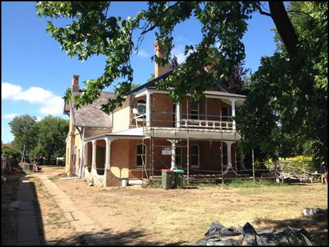
Figure 1: 62 Byng Street - Yallungah Mansion (as viewed from Byng Street)
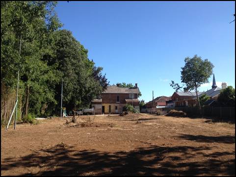
Figure 2: 62 Byng Street – Yallungah Mansion
(as viewed from the southern property boundary -
height poles are visible along
the western property boundary)
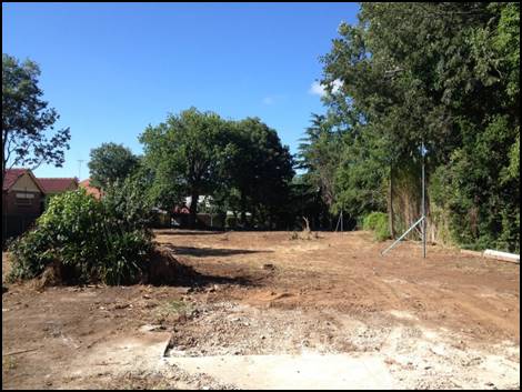
Figure 3: 62 Byng Street - Yallungah Mansion
(as viewed from rear of mansion - height poles are
visible along
the western property boundary)
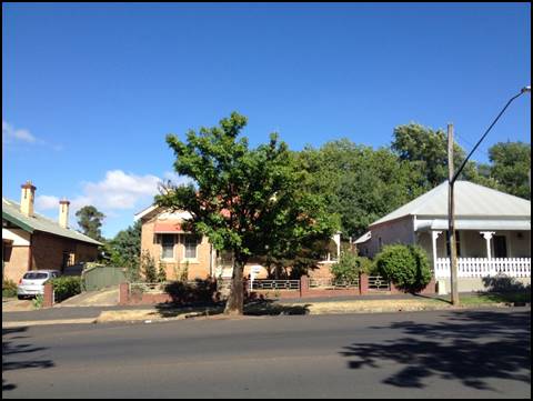
Figure 4: 77 Hill Street (as viewed from Hill Street)
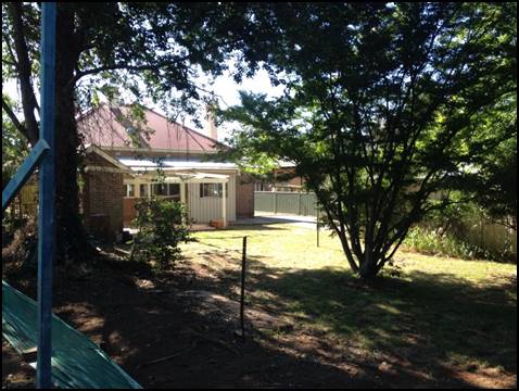
Figure 5: 77 Hill Street (as viewed from the common boundary with 62 Byng
Street)
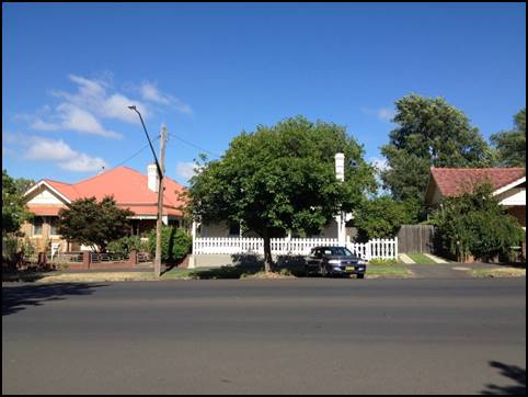
Figure 6: 79 Hill Street (as viewed from Hill Street)
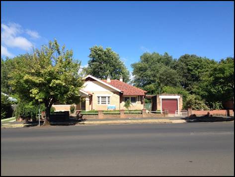
Figure 7: 81 Hill Street (as viewed from Hill Street)
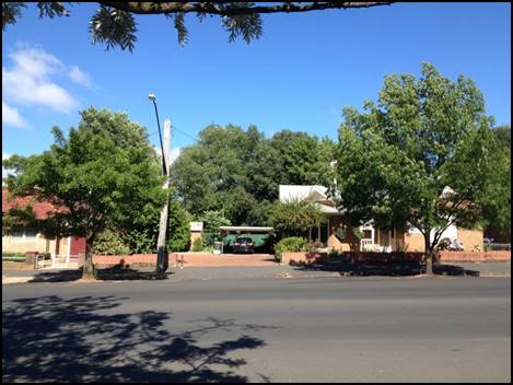
Figure 8: 85 Hill Street (as viewed from Hill Street)
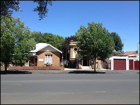
Figure 9: 87 Hill Street - Hibernian Australasian
Catholic Benefit Society Hall
(as viewed from Hill Street)
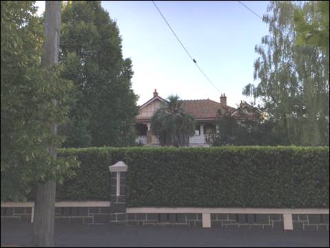
Figure 10: 60 Byng Street - Gallbally Mansion (as viewed from Byng Street)
MATTERS FOR CONSIDERATION
Section 5A Assessment – Significant Effect on
Threatened Species, Populations or Ecological Communities, or their Habitats
In the administration of sections 78A, 79B, 79C, 111 and
112, the provisions of Section 5A must be taken into account for every
development application in deciding whether there is likely to be a significant
effect on threatened species, populations or ecological communities or their
habitats. This section includes a requirement to consider any adopted
assessment guidelines, which means assessment guidelines issued and in force
under section 94A of the Threatened Species Conservation Act 1995.
Assessment guidelines are in force (see DECC-W “Threatened Species
Assessment Guidelines - The Assessment of Significance”) which requires
consent authority to adopt the precautionary principle in its assessment.
The development application has proposed the removal of a
number of trees from the subject property, including a Box Elder, Nettle, Deodar
and a number of smaller trees with a diameter at breast height of or (DBH) less
than 300mm. No trees proposed to be removed are threatened species.
Based on an inspection of the subject property and taking
into consideration its urban context, it is considered that removal of the
trees:
· is unlikely to have an adverse effect on the life cycle of
a threatened species or endangered population such that a viable local
population of the species is likely to be placed at risk of extinction
· is unlikely to have an adverse effect on the extent, or
substantially and adversely modify the composition of an endangered or
critically ecological community such that its local occurrence is likely to be
placed at risk of extinction
· is unlikely to effect the extent, fragment or isolate the
habitat of a threatened species, population or ecological community
· is unlikely to have an adverse effect on critical habitat
Council officers are not aware of
any applicable recovery plan or threat abatement plan. The removal of the trees
would not constitute a key threatening process.
Section 79C - Evaluation
Section 79C of the Environmental Planning and Assessment Act
1979 sets out the matters that the consent authority is to take into
consideration in determining a development application.
These matters are addressed in the body of this report.
PROVISIONS OF ANY ENVIRONMENTAL
PLANNING INSTRUMENT s79C(1)(a)(i)
Orange Local Environmental Plan 2011
Part 1 - Preliminary
Clause 1.2 - Aims of Plan
The
aims of Orange Local Environmental Plan 2011 relevant to the application
include:
(a) To encourage development which complements
and enhances the unique character of Orange as a major regional centre boasting
a diverse economy and offering an attractive regional lifestyle.
(b) To provide for a range of development
opportunities that contribute to the social, economic and environmental
resources of Orange in a way that allows present and future generations to meet
their needs by implementing the principles for ecologically sustainable
development.
(f) To recognise and manage valued
environmental heritage, landscape and scenic features of Orange.
The proposed development is
considered to be consistent with the relevant aims of the Orange LEP 2011.
The relevant matters are discussed
throughout the body of this report.
Clause 1.6 - Consent Authority
Clause 1.6 establishes that Council is the consent authority
for the purposes of Orange LEP 2011.
Clause 1.9A - Suspension of
Covenants, Agreements and Instruments
Clause 1.9A provides that any agreement, covenant or other
similar instrument that restricts the carrying out of development does not
apply to the extent necessary to serve that purpose, with the exception of:
· A covenant
imposed by Council or that Council requires to be imposed;
· Any prescribed
instrument within the meaning of Section 138A of the Crown Lands Act 1989; or
· Any
conservation agreement under the National Parks and Wildlife Act 1974;
· Any Trust
agreement within the meaning of the Nature Conservation Trust Act 2001;
· Any property
vegetation plan within the meaning of the Native Vegetation Act 2003;
· Any biobanking
agreement under Part 7A of the Threatened Species Conservation Act 1995; or
· Any planning
agreement under Division 6 of part 4 of the Environmental Planning and
Assessment Act 1979.
This clause does not affect the rights or interests of any
public authority under any registered instrument.
A search of Council’s records identifies that the
subject property is not affected by any of the foregoing covenants,
instruments, agreements or plans.
A sewer main does, however, traverse the southern portion of
the subject property. Accordingly, Council’s Engineering Department has
recommended a condition of consent requiring that that the sewer main be
relocated clear of the proposed building.
Clause 1.7 Mapping
The subject property is
identified on the LEP maps in the following manner:
|
Land Zoning Map:
|
Land zoned R1 General Residential
|
|
Lot Size Map:
|
No Minimum Lot Size
|
|
Heritage Map:
|
Heritage item (62 Byng Street,
adjacent to 60 Byng Street and 87 Hill Street) and within the Central Orange
Heritage Conservation Area
|
|
Height of Buildings Map:
|
No building height limit
|
|
Floor Space Ratio Map:
|
No floor space limit
|
|
Terrestrial Biodiversity Map:
|
No biodiversity sensitivity on the
site
|
|
Groundwater Vulnerability Map:
|
Ground water vulnerable
|
|
Drinking Water Catchment Map:
|
Not within the drinking water
catchment
|
|
Watercourse Map:
|
Not within or affecting a defined
watercourse
|
|
Urban Release Area Map:
|
Not within an urban release area
|
|
Obstacle Limitation Surface Map:
|
No restriction on building siting
or construction
|
|
Additional Permitted Uses Map:
|
No additional permitted use applies
|
The relevant matters are addressed in detail in the body of
this report.
Part 2 - Permitted or Prohibited Development
Clause
2.1 - Land Use Zones and Clause 2.3 – Zone Objectives and Land Use Table
The subject property is zoned R1 General Residential zone
(Figure 11).
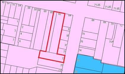
Figure 11: Zone Context Plan - R1 General Residential
Zone
(subject property
identified by heavy red line)
The
proposed use and development is defined as hotel or motel accommodation under
the Orange Local Environmental Plan, which means:
… a building or place (whether or not licensed
premises under the Liquor Act 2007) that provides temporary or short-term
accommodation on a commercial basis and that:
(a) comprises rooms or
self-contained suites, and
(b) may provide meals to guests
or the general public and facilities for the parking of guests’ vehicles,
But does not include backpackers’ accommodation, a
boarding house, bed and breakfast accommodation, a boarding house, bed and
breakfast accommodation or farm stay accommodation.
Note. Hotel or
motel accommodation is a type of tourist and visitor accommodation.
Tourist
and visitor accommodation is permissible
within the R1 General Residential Zone with the consent of Council.
The
objectives of the R1 General Residential zone are:
· To provide for
the housing needs of the community.
· To provide for
a variety of housing types and densities.
· To enable other
land uses that provide facilities or services to meet the day to day needs of
residents.
· To ensure
development is ordered in such a way as to maximise public transport patronage
and encourage walking and cycling in close proximity to settlement.
· To ensure that
development along the Southern Link Road has an alternative access.
The
objectives of the R1 General Residential zone focus on providing for the
housing needs of the community, and services and facilities to meet the
day-to-day needs of residents.
It is considered that the
proposed hotel is consistent with the objectives of the R1 General
Residential zone as it would provide a form of short term residential
accommodation. Short term residential accommodation would meet the housing
needs of some segments of the community, particularly those travelling to and
seeking short term accommodation within the Orange region.
Furthermore, it is noted that
the subject property is located at the periphery of the Orange Central
Business District, with Hill Street and the northern boundary of 72 Hill Street
forming the extent of the B3 Commercial Core zone.
Properties within the immediate
vicinity of the subject property that are zoned R1 General Residential and that
comprise non-residential uses, include the Orange Conservatorium of Music at
73A Hill Street, Chiropractic Centre at 85 Hill Street, Osteopath at 81 Hill
Street, the Gladstone Hotel at 69 Byng Street and St Joseph’s Church at
71-85 Byng Street.
Clause 2.7 - Demolition requires development consent
Clause
2.7 identifies that demolition of a building or work may be carried out only
with development consent, unless it is identified as exempt development.
Orange
LEP 2011 identifies that demolition means:
… in relation to a heritage item or an Aboriginal
object, or a building, work, relic or tree within a heritage conservation area,
means wholly or partly destroy, dismantle or deface the heritage item,
Aboriginal object or building, work, relic or tree.
The
proposed development involves the demolition of the rear portions of the
Yallungah Mansion and single storey dwelling, demolition of outbuildings and
removal of trees.
As some of these works have
already been undertaken, the applicant is seeking consent to regularise these
works.
In accordance with
Council’s standard procedure, matters in relation to carrying out works
on the subject property without development consent are addressed under
separate cover to avoid any confusion between the assessment of the development
application and potential enforcement procedures.
Part 5 -
Miscellaneous Provisions
Clause
5.9 - Preservation of Trees or Vegetation
Clause
5.9 seeks to preserve the amenity of the area, including biodiversity values,
through the preservation of trees and other vegetation.
A
person must not ringbark, cut down, top, lop, remove, injure or wilfully
destroy any tree or other vegetation to which a development control plan
applies without the authority conferred by a development consent or a permit
granted by Council.
Despite
the foregoing, a permit cannot be issued under Clause 5.9 in relation to a tree
that is or forms part of a heritage item or that is within a heritage
conservation area unless the Council is satisfied that the proposed activity is
of a minor nature or is for the maintenance of the heritage item or heritage
conservation area, and would not adversely affect the heritage significance of
the heritage item or heritage conservation area.
Accordingly,
the removal of trees is addressed under Section 5.10, below.
Clause 5.10 - Heritage
Conservation
Clause 5.10 seeks to conserve the environmental heritage of
Orange, the heritage significance of heritage items and heritage conservation
areas, including associated fabric, settings and views, to conserve
archaeological sites, and to conserve Aboriginal objects and Aboriginal places
of heritage significance.
The subject property comprises a heritage item, being the
Yallungah Mansion (heritage item 36), and adjoins the Galbally Mansion
heritage item at 60 Byng Street (heritage item I35) and the Hibernian
Australasian Catholic Benefit Society (H.A.C.B.S) Hall heritage item at 87 Hill
Street (heritage item I27). The subject property is also located adjacent to
the Gladstone Hotel heritage item (I33) at 69 Byng Street. These properties are
located within the Central Orange Heritage Conservation Area (Figure 12).
Heritage Item I198 is also shown
adjacent to the subject property on Figure 12.
However, based on Schedule 5 of Orange
LEP 2011, I198 relates to brass footpath inlays in the pavement of Summer
Street. Accordingly, this is considered to be an error in the mapping.
Figure 12: Heritage Context Plan (subject property identified
by heavy red line)
Pursuant to Clause 5.10(2)
development consent is required to:
· demolish the rear
portions of the mansion, single storey dwelling and two outbuildings
· alter the exterior
of the mansion
· alter the existing
mansion by making structural changes to its interior
· erect a building
on land in which a heritage item is located
· demolish trees
within the garden area
Before granting consent, the consent authority must consider
the effect of the proposed development on the heritage significance of the item
or area concerned.
Council has been made aware of works that may have been
undertaken onsite without development consent. The applicant has previously
indicated to Council that these works include:
· demolition of a
ground floor fibro addition on the southern side of the mansion
· removal of the
first floor verandah, with rotten timber joists removed and replaced
· partial removal of
ground floor verandah to expose rotten bearers
· removal of
north-eastern verandah post and brick work to enable verandah post to be
restraightened
· removal of the
north-western verandah post and rebuilt to replace rotten timber
· removal of iron
roof above ground floor verandah to enable scaffolding to be erected to repair
roof
· new ceiling in
bedrooms
· removal of upper
level fire places
An inspection of the subject property also identifies that:
· some original
brick brickwork has been removed from the ground level Byng Street
façade to provide for a new doorway from the verandah
· an outbuilding has
been demolished
· some trees may
have been removed from within the garden area
Accordingly, if development consent is granted it will
regularise these works.
However, Council officers consider some works to have been
undertaken for the maintenance of the heritage item and for which development consent
was not required.
Matters in relation to carrying
out works on the subject property without development consent will be addressed
under a separate report at a later date, as is Council’s usual practice.
A background to adaptive reuse of heritage items, a summary
of the significance of each of the relevant heritage items and the conservation
area, the comments of Council’s appointed Heritage Advisor and an
assessment of the effect of the proposed development are set out below.
Adaptive Reuse
The proposed use and development is accurately characterised
as an “adaptive reuse” in accordance with the Office of Environment
and Heritage (OEH) publication “New uses for heritage places:
Guidelines for the adaption of historic buildings and sites”.
The OEH defines adaptive reuse as:
“The modification of a
heritage place to a new use that conserves its heritage values. Adaption may
involve the introduction of new services, or a new use, or changes to safeguard
a heritage item. A good adaption is one that is sympathetic to the existing
building and its historic context, and inserts new work, or makes changes that
enhance and complement the heritage values of the heritage item”.
The OEH identifies that the best way to conserve a heritage
building, structure or site is to use it. Adaption or adaptive reuse offers new
uses for old places. The new use needs to be compatible with the building,
retain is historic character and conserve significant fabric, but it can still
introduce new services, as well as modifications and additions.
The OEH goes on to indicate that as with all infill
development, adaption can accommodate a rich variety of interpretation and
expressions. Some designers may adopt a more traditional or vernacular
approach, others may wish to explore a highly contemporary solution. Both are
valid. It is the quality of the response that is the key and the relationship
between the old and the new – a respect for the old and the inspiration
it provides for the new work.
The OEH identifies that in order to achieve successful
adaption; new work must be appropriate and accord with the following seven
principles:
1 Understand
the significance of the place
2 Find
a use which is appropriate to the heritage significance of the place
3 Determine
a level of change which is appropriate to the significance of the place
4 Provide
for the change to be reversed and for the place’s future conservation
5 Conserve
the relationship between the setting and preserve significant views to and from
the heritage place
6 Provide
for the long-term management and viability of the heritage place
7 Reveal
and interpret the heritage significance of the place as an integral and
meaningful part of the adaption project
Summary of Significance of
Heritage Items and Heritage Conservation Area
Yallungah Mansion (I36)
The Orange City Council Heritage Inventory (Orange City
Council Heritage Study 2012, David Scobie Architects Pty Ltd) describes the
Yallungah Mansion as:
“A substantial home of
two storeys with unusual verandah treatment, incorporation curved render work
to ground level, plain timber to first floor and a large lattice balustrade.
The walls are constructed of local brick, with contrasting colour to pointed
window heads. The roof is slate. The building is enhanced by the substantial garden.”
The Statement of Significance for the Yallungah Mansion sets
out the following:
“The two storey face
brick residence with slate roof and distinctive return verandahs is rare within
Orange as one of the collection of mansion type houses and it complements the
streetscape while contributing to the Conservation Area as a heritage
item”
Galbally Mansion (I36)
The Orange City Council Heritage Inventory describes the
Galbally Mansion as:
“An imposing wide
fronted two storey house with ground and first floor verandahs, returning on
east. Verandah probably constructed approximately six months after construction
of house was completed.”
The Statement of Significance for the Galbally Mansion sets
out the following:
“One of seven houses of
significance built in or around Orange by the Dalton family, this being the
last and one which retains the traditional character, complements the
streetscape and contributes to the Conservation Area as a heritage item.”
Hibernian Australasian Catholic
Benefit Society (H.A.C.B.S) Hall (I27)
The Orange City Council Heritage Inventory describes the
H.A.C.B.S Hall as:
“An imposing Federation
building displaying simple contrasts of form and decoration and fine
workmanship. Contrast of smooth render, running cornices and roughcast finish.
Fabulous fringing. Bullseye windows and projecting piers add to the strong
symmetrical design, emphasising the brick arched doorway. Leadlight glass to
bullseye windows with elaborate plaster labelling below. Entrance hood on
double shaped brackets. The front façade has a slightly projecting
doorway with round headed 2 leaved doors, with arched brick lintel, sheltered
by narrow bracketed timber awning. Above are 2 block bollard features, a
corner and a parapet with the inscription HABCS 1917. String courses extend the
sides of the building. Internally, the ceilings are pressed metal. On the
property boundary, originally there was a decorative timber fence, with wrought
iron panels and gates, which existed in 1987.”
The Statement of Significance for the H.A.C.B.S Hall sets
out the following:
“A prominent and
unusually designed Hall, of social and historic significance in relation to the
Hibernian Society and now to St. Vincent de Paul, the building complements the
streetscape and contributes to the Conservation Area as a heritage item.”
Gladstone Hotel
The Orange City Council Heritage Inventory describes the
Gladstone Hotel as:
“A single storey
mid-Victorian hotel with splayed corner entry and steep pitched hipped roof on
street alignment. Six pane double hung sash windows and solid panel doors,
evenly spaced along frontage. Brickwork ion English bond.”
The Statement of Significance for the Gladstone Hotel sets
out the following:
“The Hotel has remained
in use for over 100 years, has retained the key distinctive elements of the
original character, complements the streetscape in a prominent corner location
and contributes to the Conservation Area as a heritage item.”
Central Orange Heritage
Conservation Area
The Statement of Significance for the Central Orange
Heritage Conservation Area identifies that it consists of a range of buildings
dating from the latter part of the nineteenth century and early part of the
twentieth century, and that some have historical importance for reflecting the
development and prosperity of Orange during that period.
The statement also identifies that the conservation area
exhibits several fine examples of different architectural styles and that the
building materials, mature street trees and fine parklands help to bring the
area together as an aesthetically pleasing whole and as a townscape of
importance.
Key characteristics of the residential areas within the
Central Orange Heritage Conservation Area include:
· An important
spread of Victorian buildings, especially public and ecclesiastical buildings,
and many buildings from the turn of the century with late Victorian and
Edwardian features which are of particular significance because of their
concentration and general good condition
· Some significant
Federation houses and bungalows of the twenties and thirties which make up a
major element of the housing stock
· Significant common
features, including the use of the vernacular ‘buff brown’ brick,
corrugated iron roofs and consistent front verandah elements
Heritage Advisor Comments
The Development Application has been reviewed by
Council’s appointed Heritage Advisor. A final report has been prepared by
the Heritage Advisor to provide a consolidated summary of the heritage
significance of the affected heritage items and Central Orange Heritage
Conservation Area; details of the proposed use and development; the Heritage
Advisor’s involvement in the assessment process; and the conclusions of
the Heritage Advisor with regard to the requirements of Clause 5.10. The
contents of the final report are reproduced below:
“The project has been
the subject of a site visit, reviews of documents and advice on a number of
occasions in relation to heritage matters. The following summary covers the
principles and strategies presented to the Applicant and the Architect. These
were discussed and presented to all the parties including Council, in order
that the heritage significance of the site and setting within the Conservation
Are were clearly understood and appreciated. The Heritage Advisor is an
experienced Heritage Advisor and Architect and the following report covers both
the assessment process and the engagement with the Applicant and the Architect
in achieving an acceptable outcome related to the heritage matters.
Significance
· The site has heritage
significance in relation to the Conservation Area location and as a Heritage
item on the LEP. In relation to the assessment of heritage impacts, the key
matters of consideration were the loss of original fabric within the building,
the changes to the landscape, views to and from the heritage building and views
within the vicinity of the Conservation Area of the building and the extension.
Proposal
· The proposal includes
the provision of hotel accommodation within the adapted existing building and a
new two storey building to the rear. Car parking is provided and a vehicle
entry located on Byng Street at the existing entry and an exit to Hill Street.
· The works include
landscape treatments with the planting of trees and shrubs and a range of
appropriate pavements.
· The proposal was
illustrated in appropriate black and white and coloured drawings and
perspectives and height poles were erected in several locations to further
clarify the visual impacts of the rear wing when viewed from the east.
Comments
· The project has been
the subject of heritage advice which is available in the form of the original
reports. The sequence included an initial site visit to establish the heritage
listing and significance of materials and details, a pre-DA submission, a
meeting, a formal DA submission and final revised drawings and written
submission;
· At each of the stages
of engagements with the Applicant and their Architect there was an exchange of
information in the form of drawings and written documentation. This was
assessed by the Heritage Advisor and comments and recommendations provided in
response;
· The documentation
submitted with the Development Application included a Statement of
Environmental Effects and the heritage impact issues were addressed within the
statement;
· At each stage of the
process, the impact of the proposal was reviewed by the Heritage Advisor in
relation to the heritage item and the conservation area. The general view was
the scheme had the capacity for providing a scheme which would result in
acceptable heritage impacts on the building, the setting and the Conservation
Area provided a series of modifications; were made to the proposal;
· A Heritage Impact
Statement (HIS) was provided by a local Heritage Architect in consultation with
members of the community. The issues raised were based on a range of objections
to the proposal. The statement covered the more general impacts of the proposal
on the heritage building and the Conservation Area. The Heritage Advisor noted
the commentary and issues raised within the HIS Report. Changes to the east and
west elevations of the new rear wing were discussed with Council and a set of
recommendations provided as a result of these considerations. Council adopted
the recommendation for a screen consistent with a traditional verandah to the
west elevation and supported the use of a privacy film on the east elevation.
Summary
· The Heritage Advisor
elected not to request a Heritage Impact Statement or a Conservation Management
Plan from the applicant and their Architect as the issues were dealt with
according to the principles within the LEP and the DCP and consistent with the
guidelines provided by the NSW Heritage Office for Statements of Heritage
Impact and ‘Design in Context Guidelines for infill development in the
historic environment. In addition the Applicant and the Architect adopted a
flexible approach during the assessment period and a range of changes were
offered in relation to the issues raised.
· In preparing the
final assessment of the heritage impact however, there were outstanding matters
relating to the heritage impact which were not addressed in the drawings. The
advisor therefore prepared recommendations and these were put to Council
planning staff to be provided by Council as Conditions of Consent, should
Council choose to approve the project.
The
primary issues were the retention and reinstatement of fireplaces within the
listed building, the provision of an external steel structure interpreting a
verandah on the west elevation to provide sunshading and privacy and an
appropriate traditional character within the setting and the retention of
elements from the original timber staircase.
Conclusions
1 It
is the view of the Heritage Advisor that the proposal will have impacts on the
heritage significance of the item and the conservation area which are
acceptable. There are both positive and negative impacts for consideration. The
positive impacts are related to the retention of the house and its conservation
and adaptive re-use and interpretation while the negative impacts are the
losses of fabric including the original timber staircase and the original rear
lean to service portion. The rear extension is substantial in length and height
however it is treated in a contemporary style so to distinguish it from the
highly detailed original building, has a recessed junction at the meeting point
and the roof line remains well below the pitched roof of the original. The
general approach taken with the east and west elevations, which are minimal and
glazed to reflect the surrounds and trees, is a preferred option against
adopting a style modelled on the existing heritage building.
2 The
Heritage Advisor has taken the view that the current documentation in
conjunction with the proposed conditions and additional submissions for colours
and materials and appropriate certification during construction will provide
the essential controls for ensuring that the heritage significance of the item
and Conservation Area will be protected. Therefore an additional Conservation
Management Plan document would not be required as the objectives for conserving
and protecting heritage significance would be achieved with the current regime.
3 The
Heritage Advisor is of the view that a Heritage Conservation Management Plan
would not achieve further protection or enhancement of the heritage
significance of the item or the Conservation Area beyond what is envisaged with
the current recommendations.
Provided the Proposal is
carried out in accordance with the documentation and the relevant Conditions in
relation to heritage matters, and is constructed and certified accordingly, the
Heritage Advisor is satisfied that the development will prove to be acceptable
in regard to Orange LEP 2011 Clauses 5.10 (4) – Heritage significance,
(5) Heritage assessment, and (6) heritage conservation management plan
David Scobie
Heritage Advisor to Orange
City Council
Thursday, 10 March 2016”
The Heritage Advisor has provided
Council with recommendations to ensure that the proposed works enhance and
complement the heritage significance of the listed site and significance of the
remaining building, landscape and streetscape, and the wider setting and
context of the conservation area.
The Heritage Advisor has identified that there are losses of
original material and original landscape which require mitigation. The loss is
appreciated in terms of achieving the accommodation, which is otherwise
considered to meet the general planning requirements.
Based on the amended plans provided by the applicant, the
Heritage Advisor has provided the following comments. The comments have been
integrated where the Heritage Advisor has provided advice on separate occasions.
A Council officer response is provided below each comment.
1 Confirm
the nature of the fence as it is subsumed in the hedge. A suitable timber round
top picket/paling timber fence and similar gates is appropriate in either terms
of restoration or reinstatement where the materials are not capable of re-use.
Front fence and gates subject to additional detail at CC stage - this detail
will need to be supplied to the assessing officer at the time for approval
prior to construction.
Officer
response: Supported.
The applicant has indicated a willingness to restore or
rebuild the front fence and gates to match the existing.
It is
considered that this can be addressed by a condition of consent.
2 Timber
lapped and capped side fences at 1800mm high are suitable to side boundaries in
conjunction with the planting.
Officer
response: Supported.
The submitted plans show a 2m high lapped and capped timber
fence. It is noted that in previous advice, the Heritage Advisor had required a
2.4m fence. On this basis it is considered that a 2m fence will be acceptable.
It is considered that this can be addressed by a condition of consent.
3 The
median grass in the driveway is not traditional in these building types, adds
complexity to the landscape and is not supported.
The
median grass strip in the drive is not supported given the traditional
character of the house and setting where gravel was standard.
Officer response: Supported.
It is considered that this can be addressed by a condition
of consent.
4 A
traditional gravel seal road surface in the parking and road areas is
recommended. Check the specifications for the Statewide Bitumen Company and
their heritage surfaces using a selected local gravel finish.
Officer response: Supported.
The amended architectural plans indicate a bitumen surface
with resin-bonded sealed gravel overlay.
It is noted that Council’s Engineering Department
requires all driveway and parking areas to be sealed with bitumen, hotmix or
concrete and be designed for all expected loading conditions. The attached
Notice of Determination includes a condition addressing this matter.
5 Retaining
stair markings on walls is generally acknowledged by the architects but
requires large scale design documentation.
The
significant original timber staircase has been removed. It is standard practice
to interpret removed significant fabric to mitigate that loss. This is highly
recommended within the new space within the heritage building where the stair
has been removed. There are no practical restrictions in providing these
details within the space.
Officer response: Supported.
The applicant has indicated that while the markings of the
stair could be incorporated into the design, it does not believe it to be
consistent with the quality of interiors of newly renovated space.
Council officers are aware of similar proposals for adaptive
reuse of heritage items where the markings of original features, such as
stairs, have been retained and successfully integrated with an otherwise modern
finish. It is considered that retention of these markings provides an important
reference to the historic use, appearance and layout of the heritage item.
It is considered that this can be addressed by a condition
of consent.
6 The
re-use of original timber from the stairs on walls is required as mitigation
for the loss of the original fabric to be demolished and requires further
design documentation.
Timber
elements of the original stair are to be re-used within the space as mitigation
for the loss of this highly significant item. It is not arguable that an
original stair could not be fundamental to understanding a two storey
residence. Detailed drawings are required at the CC stage for approval relating
to the incorporation of original timber in the walls of the subject area.
Officer response: Supported
The applicant has indicated that the stair is not considered
to be significant and that its removal has facilitated the inclusion of new
wider lobbies on both the ground and first floors, which increases the vistas
of the restored interiors.
Further, the applicant also considers that there is not any
scope to reuse the timber of the existing stair as the proposed location of the
timber will be inappropriate in the new extension and is not considered to be
consistent with the quality of interiors of the renovated space within the
mansion.
Given that the stair has not previously been removed from
the mansion and that the timber appears to be in relatively good condition, it
is considered appropriate that it be used in an interpretive form within the
renovated mansion.
It is considered that this can be addressed by a condition
of consent.
7 Fireplaces
are significant despite their demolition and are to be reinstated in their
original locations to a suitable design and materials. All
fireplaces and surrounds are equally significant and are to be conserved and
reinstated to all fireplace locations and chimneys. Where these have been
removed, this is unfortunate and requires a suitable redress given the
significance.
There is no practical implication
on the accommodation for this occur and they will enhance the heritage
credentials of the project. Detailed drawings are to be provided at the
CC stage.
Officer response: Supported.
The applicant has indicated that the layout of rooms suitable
for a boutique hotel should override the requirement to reinstate the already
demolished fireplaces, given that the original fireplaces have been retained on
the ground floor in the public areas, and that the main heritage features of
the house have been reinstated and restored.
Notwithstanding the applicant’s submission, it remains
desirable that the original elements of the Yallungah Mansion be retained and
restored to maintain its heritage significance. The former fire places are
considered to be a significant aspect of the layout and design of the first
floor of the building and no undue constraint on the operation will be produced
by their reinstatement. Attached is a recommended condition to this effect.
8 Interpretation
may consist of text and photographs from historic sources to professional
graphic standards and authorship of external and internal walls and areas.
Officer response: Supported.
The applicant has previously agreed to prepare an
interpretation study, including provision of history plaques within the
grounds; historical photos, drawings and news articles within public areas and
website.
It is considered that this can be addressed by a condition
of consent.
9 While
louvres provided on the revised west elevation may deal with the over-looking
issue, it does not deal with the intent from former advice which sought to
interpret the traditional screening verandah to modify the visual impact of the
large rear extension on the setting and oblique views from the adjoining
property and streetscapes.
The treatment of the west
elevation – drawing 02 on A.150. A change to the proposal is essential on
a range of aspects. The current contemporary treatment is consistent with
louvres on demountable school classrooms but not with the character of a boutique
hotel adjoining a significant property and conservation area location. A two
storey steel frame which supports steel screens or louvres on the alignment of
the lower balustrade is recommended. This should provide details which respect
the heritage character of the adjoining property. It reduces overlooking, it
prevents heat gain and glare in summer, it complements the character of the new
building and it supplements the amenity of the associated accommodation.
Officer response: Supported.
In relation to this matter, the Heritage Advisor had
previously made the following recommendation:
“An external independent
dark grey steel framed horizontal louvered screen is to be provided to the west
elevation of the guest lounge area to modify the scale and character of the
glass expanse and to benefit the amenity and sunshading while retaining the
benefit of the all glass design.”
The applicant has identified that the primary purpose of the
louvres on the western facade is to prevent overlooking until the landscaping
along the boundary has been established. The privacy screen will not be seen
together with the original house given the oblique angles of the site, and this
issue is therefore not considered relevant in heritage terms.
It is recommended that a condition of consent be applied
requiring that amended plans be submitted to and approved by Council’s
Manager Development Assessments showing a redesigned louvre system that is
consistent with the recommendations of the Heritage Advisor.
10 The
use of the tree to modify the impact of the fully glazed two storey glass wall
in reception is accepted in heritage terms without further screening.
Officer response: Supported.
11 The
use of a stone panel in place of the ceramic at the entry in conjunction with a
cor‑ten or similar steel tree symbol could be acceptable subject to
detail design documentation.
Officer response: Supported.
It is considered that this can be addressed by a condition
of consent.
12 A
combination of the maximum possible tree planting for screening without the
loss of car spaces and the gravel finish will be acceptable in heritage terms.
Officer response: Supported.
Council’s Manager City Presentation has advised that
the landscape plan submitted with the development application is satisfactory.
While not specifically required by Council’s appointed
Heritage Advisor or Manager City Presentation, given the prominent location of
the subject property and characteristics of the adjoining properties it is
considered appropriate that all proposed trees be planted semi-mature.
It is considered that this can be addressed by a condition
of consent.
13 Prepare
a modification to the east elevation which would include a louvre system to the
upper portion of each glazed bay on the ground floor below the expressed beam
and similarly on the first floor, consistent with Council requirements to limit
overlooking and to provide solar control and set within an expressed steel
framework related to each bay.
Officer response: Not supported.
The intent of recommendation No. 13 has been further
clarified with Council’s appointed Heritage Advisor. Specifically, the
Heritage Advisor has indicated that the primary purpose of recommending a
louvre system on the eastern façade was to prevent overlooking and
provide solar control through an architectural treatment suitable to the
heritage significance of the subject property and surrounding area.
In this regard, it is noted that the louvre system is not
necessarily required on the eastern façade for heritage reasons.
The applicant has also identified that this recommendation
relates to planning matters and not heritage matters.
Notwithstanding, the applicant has provided further analysis
of the potential for overlooking of the Hill Street properties. In particular,
the applicant has stated that:
The juxtaposition of the two
commercially operated buildings at 81 and 85 Hill Street, so close to the rear
boundary, reduces any overlooking from the first floor to virtually nil.
(sections 2 & 3).
The space between these
buildings (Section 3) is predominately used for car parking on hard surface.
Proposed landscaping on the boundary would satisfactorily screen any future
usage of these properties.
The proposal already as the
architectural treatment of a perforated metal screen to the central section of
the eastern façade.
The commercially operated
guest house at 79 Hill Street is shown on Section 1. It is acknowledged that
initially the rear lawn would be overlooked but in time the landscape would
screen the views from the upper levels of the corridor adjacent to the four
most southern rooms.
A solution, which we would
propose, would be to screen the upper level corridor glass with an obscure film
to the glass up to 1700mm, to the southernmost section of the addition.
We would then request removal
of this film, when the landscape had provided suitable screening, to the
councils discretion. We consider that this could be suitably conditioned.
Sections 1, 2, 3 and 4 referred to above are shown in
Figures 13, 14 and 15 below.
Figure 13: Sections 1 and 2 - views to Hill
Street neighbours
Figure 14: Sections 2 and 3 - views to Hill Street
neighbours
Figure 15: Key Plan to Sections
This suggestion is supported and it is considered that it
can be addressed via a condition of consent. However, as landscaping is not
typically taken to be an appropriate form of screening, there is no
in-principle agreement that Council may support removal of the obscure film in
the future. Council’s appointed Heritage Advisor has not raised any
fundamental concerns regarding the use of obscure film rather than a louvre
system.
Further, given the possibility that both 81 and 85 Hill
Street may be re-used as dwellings in the future, it is considered that the
obscure film should be incorporated along the entire upper level of the eastern
elevation of the proposed extension.
It is considered that this can be addressed by a condition
of consent.
Notably, a number of adjoining and proximate neighbours
commissioned a local architect to prepare a Heritage Impact Statement (HIS) in
relation to the proposed use and development of the hotel. The HIS was received
in late January 2016, well outside the public exhibition period which concluded
in October 2015.
A copy of the HIS is attached to this report with all other
submissions. The key issues raised by the HIS include:
· The proposal does
not take any cues from the context. The additions connect to the heritage item
and involve demolition of two single storey wings
· There is no
breakdown of scale and volume to match the residential character and no respect
for the context of a very important heritage intersection within the town. The
proposed additions are completely foreign to the heritage item, the surrounding
precinct and the central Conservation Area of the town
· The proposal
involves significant demolition of important fabric elements within the
heritage item
· The statements
accompanying the application base their defence on the building not being seen
from the street, which only considers the Conservation Area. The need to
protect the heritage item from incompatible development is not addressed
· The change of use
of the building strips it of its main heritage value, that is of no connection
with the architect and original owner, William Lamrock. The new function
changes the relationships of the spaces, making it impossible to read how it
was used as a residence. The building must remain as a single residence to
protect this association and permit the building to demonstrate this
association
· The main stair
within the building is a rare example of a wreathed handrail in a late
Victorian building
· Changes to the
first floor will remove any legibility in understanding Lamrock’s design
of the upper floor
· Removal of the
skillion wings and connection of a new wing directly to the historic building
does not respect the curtilage of the historic building and will greatly impact
its appreciation
· The demolition of
many original fabric elements will cheapen the interior, especially since the
building has survived with a high level of intactness to the present day
· The precinct
around Yallungah is one of the most densely packed with heritage items in
Orange. It is of particular value in contributing to the sense of place that
residents and visitors have of Orange. The proposal has a large incompatible
form that will be visible from the street and will degrade the value of the
precinct
· The density of the
development is excessive given the context of the heritage item and surrounding
area
· The proposal makes
no attempt to relate to the scale, footprint, volumes, or the landscaped
setting of the context. Instead it breaks with the overwhelming character of
its surrounds with a large building that competes for attention and results in
a wholly incompatible structure
Council’s appointed Heritage Advisor has reviewed the
HIS and revised his previous recommendations regarding the eastern and western
elevations accordingly.
The applicant has been provided with a copy of the HIS, however
no formal response has been received by Council.
Effect of the Proposed
Development
Yallungah Mansion
The Statement of Significance for the Yallungah Mansion
emphasises its two storey form, face brick construction, slate roof and
distinctive return verandah as the key elements that define it as an example of
the rare collection of mansion type houses within Orange. The statement also
acknowledges the contribution of the mansion to the streetscape and wider
Central Orange Heritage Conservation Area.
While the development would present a substantial departure
from the former and existing character of the heritage item, those elements
that have been identified as being significant would be preserved in their
original or a restored form. In particular:
· Face brick:
has been preserved and/or restored where required.
It is noted that some original
brickwork has been removed from the ground level, Byng Street façade to
provide for a new doorway from the verandah. The detailing of the new doorway
is consistent with the original character of the mansion and will not detract
from its significance.
· Slate roof:
has been restored and/or replaced where required.
The applicant has noted that the
original slate roof was required to be replaced to prevent further structure
damage to the interior of the mansion. The new slate roof is considered to be
consistent with the original character of the mansion and will not detract from
its significance.
· Return
verandah: will be restored to maintain the existing timber structure.
While a new glass balustrade
will be installed within the upper level balcony, it will have a negligible
impact on the appearance of Yallungah Mansion from Byng Street and will not
detract from its significance.
Preservation and restoration of the key elements that
distinguish the Yallungah Mansion as a heritage item are considered to be a
positive and desirable outcome given its recent dilapidated condition and
potential for complete loss of a prominent heritage item.
The most recognisable effect of the development will occur
at the rear of Yallungah Mansion where the original garden, a fibro addition
and timber/fibro/metal garden shed have previously been demolished and two
brick additions to the rear of the mansion are proposed to be demolished to
provide for the extension.
The applicant contends that the additions and garden shed
were not original elements of the Yallungah Mansion, however Councils appointed
Heritage Advisor indicates that the two brick skillion elements were probably
likely to have contained a laundry and kitchen. It is noted that the brick
additions are evident on an historic drainage plan held in Council’s
records.
Removal of the substantial garden from the rear of the
subject property has detracted from the original setting of the Yallungah
Mansion. However, it is acknowledged that the garden was not identified as a
key element of the Yallungah Mansion as a heritage item and that removal of the
garden does not require development consent, with the exception of trees.
An arborist’s statement provided with the development
application identifies that development consent is required for the removal of
three trees from the rear of the subject property, being a Box Elder, Nettle
and Deodar, each having a diameter at breast height (DBH) greater than
300mm. It is noted, however, that under Clause 5.10, development consent
is required to demolish any tree which forms part of a heritage item or is
located within a heritage conservation area. This is in contrast with the
provisions of Clause 5.9 which, with reference to the Tree Preservation
Order at Clause 0.4-2 Interim Planning Outcomes - Tree Preservation of DCP
2004, identifies that development consent is typically only required to
demolish trees with a DBH greater than 300mm. Accordingly, development consent
is required to demolish all trees identified to be removed from the subject
property. In addition to those discussed above, these are identified as
including Nettle, Pistachio and Birch species.
The arborist statement has sought to justify the removal of
the larger trees on the basis of safety (Box Elder), not being an original
planting of the garden (Nettle) and the compensatory effect of proposed
landscaping (Deodar).
Further to the arborist statement, Council’s Manager
City Presentation has undertaken an inspection of the subject property. The
Manager City Presentation noted the Deodar as the only tree of significance
proposed to be removed and provided the following commentary:
“Located within the rear
yard of 77 Hill Street is mature Deodar cedar. This tree, although the trunk is
leaning to the east before straightening vertically, appears to be in sound
health and vigour. The Deodar is located centrally within the rear yard of the
property and its retention would impact significantly on the proposal’s
development of this area for car parking. It is regretful that such a tree
should be removed as its life expectancy is considerable; however to retain and
ensure it remains a viable and healthy tree a 4.35 metre radius (from trunk
centre, ie 8.7 metre diameter) TPZ would be required. The proposal identifies
that soil level changes (up to 500mm of fill) will be required to link the two
properties for car parking; this importation of fill itself is sufficient to
damage the tree’s root system and ensure the slow decline in health of
the tree. As such it is regretfully agreed that this specimen should be
permitted to be removed.”
Further to the arborist statement and commentary provided by
Council’s Manager City Presentation, it is noted that all trees to be
removed are located at the rear of 62 Byng Street and 77 Hill Street and
do not contribute to the appearance of the Yallungah Mansion when viewed from
Byng Street. Accordingly, it is considered acceptable that the trees be removed
in this instance to facilitate the construction of the car park at the rear of
the property.
Council has previously issued a permit for the removal of a
Golden Elm from within the Byng Street frontage of the subject property on the
basis that it was considered to be structurally compromised and posed a risk.
A Council officer has also previously undertaken an
inspection of a Liquid Amber on the subject property, describing it as majorly
disfigured, having no lateral branch structure and marginally alive. However,
there are no Council records of a permit being issued for the removal of the
tree. It is unclear whether any other trees have been removed without Council
consent.
The extension will be sited entirely at the rear of the
Yallungah Mansion within the space formerly occupied by the rear extensions,
garden sheds and garden, and currently partially occupied by the two brick
additions to the rear of the mansion. The extension has been designed to
preserve the commanding presence of the mansion within the Byng Street
streetscape. In particular, the design has incorporated a maximum roof height
that will sit below the ridgeline of the central, western and eastern gables
and has ensured that all new built form elements which protrude beyond existing
side setbacks of the mansion will be set back in the order of 9m from the rear
of the altered mansion building and 40m from the street frontage.
As such, the extension will be a recessive form when viewed
in the context of the Yallungah Mansion and will only be visible from acute
angles when viewed from within Byng Street.
Alterations to the front façade of the mansion,
including installation of a new doorway to the ground level verandah and the
proposed installation of two new doorways to the upper level verandah, will be
consistent with the existing character of the building.
It is also considered that the contemporary architectural
design of the proposed extension, including its scale, form, siting, colours
and materials, are suitably sympathetic to the Yallungah Mansion, subject to
meeting the recommendations of Council’s appointed Heritage Advisor.
Less recognisable from the public realm but of equal
significance are the internal alterations to the Yallungah Mansion, including
the previous removal of original fire places from upper level rooms, proposed
removal of the original stair case and altered layout of internal walls.
The applicant has generally
asserted that these works are required to successfully facilitate the adaptive
reuse of the Yallungah Mansion. While this is accepted, it is considered that
further works should be undertaken to retain and interpret some of these
original internal features. This has been discussed in detail under the heading
“Heritage Advisor Comments”.
It is considered that these works are appropriate and will
not detract from the heritage significance of Yallungah Mansion, subject to
meeting the recommendations of Council’s appointed Heritage Advisor.
Galbally Mansion
The Statement of Significance for Galbally Mansion
identifies that it is significant for being the last of seven houses of
significance built in and around Orange by the Dalton family that retains its
traditional character.
While the statement does not highlight any key elements that
define Galbally Mansion as a heritage item, the physical description of the
property identifies it as a wide fronted, two storey house with ground floor
and first floor verandahs.
As outlined in the foregoing assessment, the proposed
extension will be sited at the rear of the Yallungah Mansion and has been
designed to maintain the existing appearance of the Byng Street streetscape,
including the appearance of Gallbally Mansion.
The proposed extension will, however, present a new 69m
long, predominantly two storey form adjacent to the common boundary of 60 Byng
Street. While this scale and form is not characteristic of either property, it
is noted that its visual effect will generally be limited to the substantial
rear garden of Galbally Mansion.
The scale and form of the proposed extension will be offset
and softened by a variable setback of 2 to 5m from the common boundary at the
ground level, 4 to 5.8m setback from the common boundary at the upper level,
screening provided by existing trees and proposed perimeter landscaping. A 2m
high timber fence is also proposed along the common boundary.
While it is considered that the architectural design and
materials of the proposed extension generally achieve a suitable response to
Gallbally Mansion, Council’s appointed Heritage Advisor does not consider
that the louvres as currently proposed provide an adequate interpretation of
the traditional screening verandah to modify the visual impact of the large
rear extension on the setting and oblique views from the adjoining property and
streetscape.
While the applicant has submitted amended plans to increase
the level of screening of the adjoining property, it is recommended that a
condition of consent be applied requiring that amended plans be submitted to
and approved by Council’s Manager Development Assessments showing a
redesigned louvre system that is consistent with the recommendations of the
Heritage Advisor.
Accordingly, it is considered that the proposed extension
will not detract from the significance of Galbally Mansion, particularly as it
is experienced from within Byng Street, subject to meeting the relevant
conditions of consent.
Hibernian Australasian Catholic
Benefit Society (H.A.C.B.S) Hall
The Statement of Significance for the H.A.C.B.S Hall
emphasises its prominence and unusual design as the key elements that define it
as a heritage item, aside from its social significance.
While the proposed extension to the Yallungah Mansion would
be clearly visible in the backdrop of the H.A.C.B.S Hall, the extension will
generally appear as a recessive form and will not detract from the appearance
of the hall to Hill Street. In particular, the main new building element
located behind the H.A.C.B.S Hall will be the predominantly glazed transition
linking the Yallungah Mansion to the balance of the proposed extension. The
glazed transition will not be visible above the roof line of the hall when
viewed from Byng Street.
Accordingly, it is considered that the proposed extension
will not significantly detract from the H.A.C.B.S Hall, particularly as it is
experienced from within Hill Street.
Gladstone Hotel
Given the limited changes to the Byng Street frontage of the
subject property, it is considered that the proposed use and development would
not affect the significance of the Gladstone Hotel.
Central Orange Heritage
Conservation Area
The Statement of Significance for the Central Orange
Heritage Conservation Area identifies the spread, concentration, general good
condition and significant common features of Victorian, Federation, twenties
and thirties bungalows and dwellings as the key characteristic of residential
areas within the conservation area.
As previously addressed, the proposed development has been
designed to maintain the existing appearance of the Yallungah Mansion and the
Byng Street streetscape. Accordingly, the effect of the proposed extension on
the Central Orange Heritage Conservation area will be limited to its visibility
between the buildings on Hill Street.
The western side of Hill Street, between Summer Street and
Byng Street, comprises a mix of period dwellings and
the H.A.C.B.S Hall, of which the hall and dwellings located at 79, 81,
85 and 87 Hill Street and 64 Byng Street are immediately adjacent to the
subject property. Currently, the visible backdrop to these properties is the
substantial trees located along the common boundary of the subject property and
60 Byng Street.
The predominately two storey form of the proposed extension
will be visually prominent behind and between those buildings immediately
adjacent to and proximate to the subject property, with the height of the
proposed extension above existing ground level increasing from north to south.
The scale of the proposed extension in relation to these
buildings is demonstrated in the 3D Fly over, 2D Elevation and 3D
perspective recently provided by the applicant.
In relation to this matter, Council’s appointed
Heritage Advisor has advised that:
The two storey elevation of
the proposed wing remains modulated and will be improved through adoption of
following modifications. It remains subservient / substantially lower than that
on the significant heritage building. In relation to the Hill Street properties
external to the subject site, should a second storey addition be proposed in
the future to these properties, then similar guidance would be applied given
their location within the Conservation Area.
In relation to the
contemporary character proposed for the additional wing, it is noted that the
scale, modulated bays, recessed junction to the heritage building, landscape
planting and materials are sufficient to complement the heritage significance
of the existing building and will not detract from the character of conservation
area in this location.
Accordingly, it is considered that the proposed development
would have an acceptable impact on the Hill Street streetscape and the
significance of the Central Orange Heritage Conservation Area.’
Notably, the modification referred to in the first paragraph
of the above quote is identified as Recommendation No 13 under the heading
“Heritage Advisor Comments”. That recommendation has not been
supported on the basis that it does not specifically relate to heritage matters
and that the applicant has advanced a suitable alternative.
Part 7 -
Additional Local Provisions
7.1
- Earthworks
Clause
7.1 seeks to ensure that earthworks for which development consent is required
will not have a detrimental impact on environmental functions and processes,
neighbouring uses, cultural or heritage items or features of the surrounding
land; and to allow earthworks of a minor nature without requiring development
consent.
Development
consent is required for earthworks, unless:
(a) The earthworks
are exempt development under this Plan or another applicable environmental
planning instrument; or
(b) The earthworks
are ancillary to other development for which development consent has been
given.
Before
granting development consent for earthworks, the consent authority must
consider the following matters:
(a) The likely disruption of, or any
detrimental effect on, existing drainage patterns and soil stability in the
locality of the development;
(b) The effect of the development on the
likely future use or redevelopment of the land;
(c) The quality of the fill or the soil to be
excavated, or both;
(d) The effect of the development on the
existing and likely amenity of adjoining properties;
(e) The source of any fill material and the
destination of any excavated material;
(f) The likelihood of disturbing relics;
(g) The proximity to and potential for adverse
impacts on any waterway, drinking water catchment or environmentally sensitive
area;
(h) Any measures proposed to minimise or
mitigate the impacts referred to in paragraph (g).
Architectural plans submitted
with the development application indicate that the extent of earthworks
associated with the proposed development are in the order of 1m of cut
and 0.5m of fill from the Existing Ground Level (EGL). These works are
required in order to level some areas and accommodate an undercroft towards the
rear of the proposed building extension.
The earthworks are considered
minor and ancillary to the proposed development and do not require further
assessment.
Council’s Engineering
Department has, however, identified that in order for stormwater to discharge
to the Hill Street kerb as proposed, it will be necessary to increase the level
of the car park at the rear of 77 Hill Street in the order of 0.5m to achieve
an appropriate grade.
Amended plans submitted by the
applicant in relation to this matter indicate that between 250 and 665mm
of fill will be required along the southern boundary of the subject property.
Given that the architectural plans provide for a 2m boundary fence, it is
considered more appropriate that the fence along the southern boundary, common
to 75 Hill Street be reduced to 1.8m above the Finished Ground Level in order
to minimise the height of the fence as experienced from the private open space
of 75 Hill Street. Based on the levels indicated by the applicant, the fence
would have a maximum height of 2.465 above the Existing Ground Level of
the common boundary with 75 Hill Street.
Further, it is noted that the
requirement for a 1.8m fence along the side of the
car park and driveway adjacent to 75 Hill Street is consistent with the
recommendations of the Noise Impact Assessment (NIA) prepared in support of the
development application. This is discussed in further detail in the body of
this report.
While it is noted that the
proposed fill will increase the extent of overshadowing of the rear private
open space of 75 Hill Street than what is shown on the shadow diagrams provided
by the applicant, it is not considered that this increase would be significant.
It is unlikely that there are
other detrimental impacts associated with the proposed earthworks.
7.3 - Stormwater Management
Clause 7.3 seeks to minimise the
impacts of urban stormwater on the land to which the development applies and on
adjoining downstream properties, native bushland and receiving waters.
Development consent must not be
granted to development on land to which Clause 7.3 applies unless the consent authority
is satisfied that the development:
(a) Is designed to maximise the use of water
permeable surfaces on the land having regard to the soil characteristics
affecting onsite infiltration of water
(b) Includes, where practical, onsite
stormwater retention for use as an alternative supply to mains water,
groundwater or river water; and
(c) Avoids any significant impacts of
stormwater runoff on adjoining downstream properties, native bushland and
receiving waters, or if that impact cannot be reasonably avoided, minimises and
mitigates the impact.
The proposed development has
been designed to minimise the impacts of stormwater on the subject property and
adjoining properties.
The proposed development
incorporates a system to collect stormwater from impermeable surfaces via
surface inlet pits which discharge to the kerb and gutter of Hill Street.
Furthermore, surface levels are to be set to ensure overland flows from hard
surfaces discharge to Hill Street.
The proposed development also
incorporates three 10,000 litre rainwater tanks within the lower ground floor
level to capture rainwater off the roof. The stored rainwater will be used for
garden irrigation and flushing of toilets. Excess rainwater will be discharged
to the stormwater system.
The proposed methods of
minimising the impacts of stormwater are considered suitable by Council’s
Engineering Department. The attached Notice of Determination includes a
condition that addresses stormwater management of the development.
7.6 - Groundwater Vulnerability
Clause
7.6 seeks to protect hydrological functions of groundwater systems and protect
resources from both depletion and contamination. Orange has a high water table
and large areas of the LGA, including the subject site, are identified with
“Groundwater Vulnerability” on the Groundwater Vulnerability Map.
This requires that Council consider:
(a) Whether or not the development (including
any onsite storage or disposal of solid or liquid waste and chemicals) is
likely to cause any groundwater contamination or have any adverse effect on
groundwater dependent ecosystems; and
(b) The cumulative impact (including the
impact on nearby groundwater extraction for potable water supply or stock water
supply) of the development and any other existing development on groundwater.
Furthermore consent may not be granted unless Council is satisfied that:
(a) The development is designed, sited and
will be managed to avoid any significant adverse environmental impact; or
(b) If that impact cannot be reasonably
avoided - the development is designed, sited and will be managed to minimise
that impact;
(c) If that impact cannot be minimised - the
development will be managed to mitigate that impact.
The proposed development is not
anticipated to involve the discharge of toxic or noxious substances and is
unlikely to cause groundwater contamination or have an adverse effect on
groundwater dependant ecosystems. The proposed development is considered
unlikely to have a detrimental impact on groundwater.
7.11 Essential Services
Clause 7.11 requires that development consent must not be
granted for development unless the consent authority is satisfied that any of
the following services that are essential for the proposed development are
available or that adequate arrangements have been made to make them available
when required.
Essential services are available to the subject site
including electricity, sewerage, stormwater drainage and road access.
Council’s Engineering Department has advised that all
necessary services are available to the property and that any requirements for
services to be upgraded can be achieved, but will be at the cost of the
applicant.
STATE ENVIRONMENTAL PLANNING
POLICIES
State Environmental Planning Policy - Remediation of Land
(SEPP 55)
State Environmental Planning Policy 55 - Remediation of Land
(SEPP 55) requires that a consent authority must not consent to the carrying
out of development of land unless it has considered whether the land is
contaminated, is satisfied that the land is suitable in its contaminated state
for which the development is proposed, and if the land requires remediation to
be made suitable for the proposed development.
Furthermore, SEPP 55 requires that before determining an
application to carry out development that would involve a change of use of land
(specified in subclause 4), the consent authority must consider a preliminary
investigation of the land concerned.
As the subject property has a long history of residential
use, it is not considered likely that it would be contaminated or unsuitable
for the proposed development.
It is acknowledged that asbestos materials associated with
recent additions to the Yallungah Mansion may be present on the subject
property. Council’s Building Surveyor has recommended a condition of
consent requiring that demolition is to be carried out in accordance with the
applicable Australian Standard and the requirements of SafeWork NSW.
PROVISIONS OF ANY DRAFT
ENVIRONMENTAL PLANNING INSTRUMENT THAT HAS BEEN PLACED ON EXHIBITION
s79C(1)(a)(ii)
There are no draft environmental planning instruments that
apply to the subject land or proposed development.
DESIGNATED DEVELOPMENT
The proposed development is not designated development.
PROVISIONS OF ANY DEVELOPMENT
CONTROL PLAN s79C(1)(a)(iii)
Development Control Plan 2004
Development Control Plan 2004 (“the DCP”)
applies to the subject land. Chapters of the DCP relevant to the proposed use
and development include:
· Chapter 0 -
Transitional Provisions;
· Chapter 2 -
Natural Resource Management;
· Chapter 3 - General
Considerations;
· Chapter 4 -
Special Environmental Considerations;
· Chapter 5 -
General Considerations for Zones and Development;
· Chapter 7 -
Development in Residential Areas;
· Chapter 13 -
Heritage
· Chapter 15 - Car
Parking
CHAPTER 0 - TRANSITIONAL
PROVISIONS
Section 0.2 - General Translation of Zones
Section 0.2 - General Translation of Zones provides that any
reference to a zone under Orange Local Environmental Plan 2000 is to be a
reference to the corresponding zones in the zone conversion table.
The table identifies that the R1 General residential zone
corresponds with the 2a Urban Residential and 2d Urban Transition zones for the
purposes of the DCP.
Section 0.4-2 - Interim
Planning Outcomes - Tree Preservation
Section 0.4-2 Interim Planning Outcomes - Tree Preservation
seeks to prescribe the kinds of trees and other vegetation that are subject to
Clause 5.9 of Orange Local Environmental Plan 2011 and to establish the
activities that must not occur.
Tree preservation has previously been addressed in detail
under the headings “Clause 5.9 Preservation of Trees or Vegetation”
and “5.10 Heritage Conservation”.
It is considered that the requirements of the DCP have been
adequately addressed.
Chapter 2 - Natural Resource
Management
Section2.1 - Water Quality
Section 2.1 - Water Quality identifies that development that
concentrates, redirects flows, increases flow rates or disturbs land in close
proximity to creeks has the potential to affect waterways with associated
erosion, sedimentation and release of nutrients, which combine to affect
downstream water quality. Section 2.1 also identifies development involving
groundwater extraction and/or onsite wastewater disposal is deemed to affect
groundwater resources.
The relevant matters have previously been addressed in
detail under the headings “7.3 ‑ Stormwater” and
“7.6 - Groundwater Vulnerability”.
It is considered that the requirements of the DCP have been
adequately addressed.
Section 2.3 - Vegetation and
Section 2.4 - Flora and Fauna, Biodiversity
Section 2.3 - Vegetation and Section 2.4 - Flora and Fauna,
Biodiversity identify that the natural environment of the Orange LGA has been
heavily modified as a consequence of land clearing for various uses, including
agriculture, plantation forests, mining and urban development; and that
clearing of native vegetation has significantly affected native habits.
These matters have generally been addressed under the
heading “Section 5A Assessment- Significant Effect on Threatened Species,
Populations or Ecological Communities, or their Habitats” and throughout
the body of this report.
Furthermore, Council’s Manager City Presentation has
undertaken an inspection of the subject property to ascertain the likely impact
of the proposed development on vegetation identified for retention and
development of conditions of consent to ensure the retention of safe and viable
trees in the long term. The Manager of City Presentation provided the following
commentary:
“On the western boundary
of 62 Byng Street and the adjoining neighbour are 3 trees of particular note:
· A Beech (fagus sp)
located on the subject property
· A Box Elder (Acer
negundo) located on the boundary, predominately on the property of 60 Byng
Street, but the trunk is deflecting the common boundary wire fence.
· An Elm tree (Ulmus
sp.) located on the boundary, predominately on the property of 60 Byng Street,
but the trunk is deflecting the common boundary timber paling fence.
The trees are mature
specimens, with their health varying from sound to moderate, and trunk
diameters in the order of 600mm to 800+mm in diameter (approximated). With
reference to the Australia Standard 4970-2009 each tree should have a Tree
protection Zone (TPZ) erected prior to and maintained throughout construction
works. The AS calls for a TPZ in the order of 7.2 to 9.6 metres in radius with
the shape or weighting of the TPZ relevant to the canopy of the subject tree,
level of tree maturity and aboricultural needs. As the proposed development has
minor encroachments to the TPZ and proposed construction works are outside of
the Structural Root Zone (SRZ) the TPZ area can be compensated for elsewhere,
that being within 60 Byng Street.
The Beech tree has been
impacted by past building infrastructure which at the time of this inspection
has been removed. This built infrastructure would have precluded important root
growth and therefore modifications to the TPZ is considered appropriate. Given
the location of the trees, a significant amount of TPZ for each tree is
available on the adjoining property and will not be impacted by the proposed
works.
For each tree identified as
being retained on the subject property, including those along the western
boundary that are situated either on or immediately beyond the existing
boundary fence, TPZs shall be established in line with the following clause:
· Each tree on the
western side of the subject property (62 Byng Street) and those located
immediately adjacent to the common boundary of 62 and 60 Byng Street shall have
a Tree Protection Zone established to isolate the tree from the impact of
construction disturbance including the stockpiling or storage of materials, so
that the tree remains viable.
o For tree along the western
boundary – the TPZ shall be erected at a minimum 4.5metres in radius from
the centre of each tree and connect to the western boundary fence.
o Liquidambar – TPZ shall be
7.2 metres in diameter
Trees included:
Liquidambar – north
eastern corner of 62 Byng Street
Elm – north western
corner of 62 Byng Street
Beech – western boundary
Box Elder – western
boundary on or immediately beyond
Elm (2) western boundary on or
immediately beyond
It is noted that pruning will
be required to remove branches encroaching within the building envelope. The
following clause shall apply:
· All pruning work
shall be undertaken to AS4373-2007 Pruning of amenity trees by a qualified
arborist under the supervision of Council’s Manager City
Presentation.”
It is considered that the requirements of the DCP have been
adequately addressed.
CHAPTER 3 - GENERAL
CONSIDERATIONS
Section 3.1 - Cumulative Impacts
Section 3.1 - Cumulative Impacts identifies that Council
will consider not only the direct impacts of a particular development but also
whether the development, when carried out in conjunction with other development
in the locality, has a more significant environmental impact.
Cumulative impacts of the proposed development are addressed
under the heading “Likely Impacts of the Development”.
Section 3.2 – Scenic, Landscape and Urban Areas
Section 3.2 -Scenic, Landscape and Urban Areas identifies
that in urban areas consideration should be given to the character of the
locality, whether that locality is recognised as having heritage character with
formal plantings of exotic trees or whether the locality comprises areas
developed as suburban release areas where informal native planting is common.
While the original garden has been removed from the rear of
the Yallungah Mansion, detracting from its setting, the existing garden located
within the Byng Street frontage will generally be retained and enhanced by the
proposed development.
Further, it is noted that the Heritage Advisor has indicated
the following:
“In relation to the
contemporary character proposed for the additional wing, it is noted that the scale,
modulated bays, recessed junction to the heritage building, landscape planting
and materials are sufficient to complement the heritage significance of the
existing building and will not detract from the character of the conservation
area in this location.”
Council’s Manager City Presentation has advised that
the landscape plan submitted with the development application is satisfactory,
and that the tree species selected to be planted along the eastern boundary
should not impact upon neighbouring properties.
However, it is has been recommended that the proposed Silver
Birch (Betula pendula) is replaced with specimens that require less watering
and which maintain good foliage density when in leaf, such as Columnare (Acer
platanoides), Capital (Pyrus calleryana) or Pringreen (Quercus palustris).
It is considered that this can be addressed by a condition
of consent.
It is considered that the requirements of the DCP have been
adequately addressed.
Section 3.4 - Waste Generation
Section 3.4 - Waste Generation requires that applications
involving demolition indicate measures that will be implemented for reuse and
recycling of waste, and that development involving demolition is carried out in
a manner that optimises reuse and recycling of waste materials consistent with
waste-minimisation principles.
A Waste Management Plan was submitted with the development
application. The plan indicates that waste will typically be transported to the
Orange City Resource Recovery Centre.
It is considered that the requirements of the DCP have been
adequately addressed.
CHAPTER 4 - SPECIAL
ENVIRONMENTAL CONSIDERATIONS
Section 4.3 - Land Shaping
Section 4.3 - Land Shaping
identifies that substantial land shaping, including filling or excavating land,
has the potential to generate significant environmental impacts, and that land
shaping should not adversely affect land in the vicinity as a result of
drainage, erosion or sedimentation or as a result of leachate entering surface
or groundwater.
The relevant matters have previously been addressed under
the heading “7.1 – Earthworks”.
It is considered that the requirements of the DCP have been
adequately addressed.
Section 4.4 - Contaminated Land
Section 4.4 - Contaminated Land identifies that contaminated
land can pose a risk to human health and the environment. Contaminants can be
released into waterways and humans exposed when contaminated land is disturbed
as a consequence of development.
The relevant matters have previously been addressed under
the heading State “Environmental Planning Policy No. 55 - Remediation of
Land”.
It is considered that the requirements of the DCP have been
adequately addressed.
CHAPTER 5 - GENERAL
CONSIDERATION FOR ZONES AND DEVELOPMENT
Section 5.3 - Advertised Development
Section 5.3 - Advertised Development identifies that Council
will give written and published notice of applications for advertised
development as required by the Environmental Planning and Assessment
Regulations.
Hotel or motel accommodation in a residential zone is
identified as advertised development. Accordingly, the development application
was advertised on Wednesday, 7 October 2015 and exhibited between
Wednesday, 7 October and Tuesday, 20 October 2015.
At the end of that period 25 submissions were received. A
further 26 submissions were received after that period ended, including five
supporting submissions. It is noted that some submitters made multiple
submissions. Any submissions made after this report is completed will be
provided under separate cover.
A detailed assessment of the
issues raised by the submitters is provided under the heading “Any
Submissions Made in Accordance with the Act”.
Council’s Declaration of
Planning and Development Assessment Procedures and Protocols identifies that
upon receipt of at least five submissions objecting to a development
application and where those issues are considered by Council to be reasonably
capable of negotiation, a meeting will be offered to all parties in an attempt
to resolve issues and find compromise prior to the matter being determined by
the relevant authority.
Given the volume of submitters and
range of issues identified, this requirement was addressed via an onsite
meeting between the applicant, Councillors and interested parties. Interested
parties were considered to be those people who were an owner of a property
adjoining the subject property or had previously made a submission to Council
in relation to the development application.
During the onsite meeting the applicant was invited to make
a presentation regarding the proposed development while three members of the
public were invited to present the concerns of the interested parties.
No substantial amendments to the proposed development were
made following the onsite meeting.
CHAPTER 7 - DEVELOPMENT IN
RESIDENTIAL AREAS
Section 7.7 Design Elements for Residential Development
Section 7.7 - Design Elements for Residential Development
sets out the objectives and planning outcomes for residential development.
While the proposed development is defined as hotel or motel
accommodation, the objectives and planning outcomes outlined in Section 7.7 are
relevant considerations given that the subject property and immediate area is
zoned R1 General Residential and that a number of adjoining and proximate
properties contain dwellings.
Streetscape Objectives
The DCP sets out overarching objectives with regard to
streetscape, including:
· To ensure that the
development fits into its setting and environmental features of the locality.
· To ensure that the
appearance of housing is of a high visual quality, enhances the streetscape and
complements good quality surrounding development.
· To ensure that new
development complements places with heritage significance and their settings in
a contemporary way.
· To develop a sense
of place with attractive street frontages.
· To encourage
visually appealing cohesive streetscapes.
· To create a safe
and secure environment.
· To provide
consistent design elements that protect private investment.
The streetscape objectives are addressed by the following
planning outcomes regarding neighbourhood character, building appearance,
heritage, setbacks, and front fences and walls.
Neighbourhood Character
The DCP sets out the following planning outcomes in regard to
neighbourhood character:
· Site layout and
building design enables the:
- creation of attractive
residential environments with clear character and identity
- use of site features such as
views, aspect, existing vegetation and landmarks
· Buildings are designed
to complement the relevant features and built form that are identified as part
of the desired neighbourhood character.
· The streetscape
is designed to encourage pedestrian access and use.
The proposed development has been designed in accordance with
the outcomes for neighbourhood character. In particular, the proposed
development has been designed to maintain the existing appearance of the
Yallungah Mansion and the Byng Street streetscape, with the main impact on
neighbourhood character being limited to Hill Street. In this regard, it is
noted that Council’s appointed Heritage Advisor has advised that the
scale, modulated bays, recessed junction, landscape planting and materials will
not detract from the character of the conservation area.
While original garden has been removed from the rear of the
Yallungah Mansion and a number of trees are proposed to be removed, the
existing garden located within the Byng Street frontage will generally be
retained and enhanced by the proposed development. Further, it is noted that
Council’s Manager City Presentation has advised that the landscape plan
submitted with the development application is satisfactory, subject to the
proposed Silver Birch trees being replaced with a more appropriate species.
It is not considered that the impact of the proposed
development on the streetscape would have any impact on current pedestrian
access and use.
Building Appearance
The DCP sets the following planning outcomes in regard to
building appearance:
· The
building design, detailing and finishes relate to the desired neighbourhood
character, complement the residential scale of the area, and add visual
interest to the street.
· The
frontages of buildings and their entries face the street.
· Garages
and car parks are sited and designed so that they do not dominate the street
frontage.
As noted above, the proposed development has been designed
to maintain the existing appearance of the Yallungah Mansion and the Byng
Street streetscape, with the main impact on neighbourhood character being
limited to Hill Street.
Council’s appointed Heritage Advisor has advised that
the scale, modulated bays, recessed junction, landscape planting and materials
will not detract from the character of the conservation area.
The car park proposed to be located at the rear of the
subject property will be entirely located behind
the existing dwelling at 77 Hill Street and will have a negligible impact on
the Hill Street streetscape.
Heritage
The DCP sets the following planning outcomes in regard to
heritage:
· Heritage
buildings and structures are efficiently re-used.
· New
development complements and enhances the significance of a heritage item or
place of heritage significance listed in the Orange Heritage Study.
· Significant
landscape features are retained including original period fences and period
gardens.
Heritage has previously been addressed in detail under the
heading “5.10 - Heritage Conservation”. The proposed development
has been designed in accordance with the outcomes for heritage.
In particular, the proposal provides for the adaptive re-use
of an existing heritage item, subject to various alterations, which is
considered to be a positive and desirable outcome given its recent dilapidated
condition and potential for complete loss.
With regard to the significance of Yallungah Mansion, other
adjoining heritage items and the Central Orange Heritage Conservation Area,
Council’s appointed Heritage Advisor has stated the following, subject to
meeting recommendations:
“In relation to the
contemporary character proposed for the additional wing, it is noted that the
scale, modulated bays, recessed junction to the heritage building, landscape
planting and materials are sufficient to complement the heritage significance
of the existing building and will not detract from the character of the
conservation area in this location.”
While original garden has been removed from the rear of the
Yallungah Mansion and a number of trees are proposed to be removed, the
existing garden located within the Byng Street frontage and the existing fence
will generally be retained and enhanced by the proposed development.
Setbacks
The DCP sets out the following planning outcomes with regard
to setbacks:
· Street
setbacks contribute to the desired neighbourhood character, assist with the
integration of new development and make efficient use of the site.
· Street
setbacks create an appropriate scale for the street considering all other
streetscape components.
The proposed development will retain the existing setback of
the Yallungah Mansion from Byng Street.
Front Fences and Walls
The DCP sets out the following planning outcomes with regard
to fences and walls:
· Front
fences and walls:
- assist in highlighting
entrances and creating a sense of identity within the streetscape.
- are constructed of materials
compatible with associated housing and with fences visible from the site that
positively contribute to the streetscape
- provide for facilities in
the street frontage area such as mail boxes.
Council’s appointed Heritage Advisor has recommended
that the applicant confirm the nature of the Byng Street fence as it is
currently subsumed in the hedge, and has indicated that a suitable timber round
top picket/paling timber fence and similar gates is appropriate in terms of
either restoration or reinstatement where materials are not capable of re-use.
The applicant has indicated a commitment to either restore
or rebuild the existing front fence and gates to match the existing.
It is considered that these requirements of the DCP have
been adequately addressed and that this matter can be addressed by a condition
of consent.
Bulk and Scale Objectives
The DCP sets out overarching objectives with regard to bulk
and scale, including:
· To
allow flexibility in siting buildings and to ensure that the bulk and scale of
new development reasonably protects the amenity of neighbouring properties and
maintains appropriate neighbourhood character.
· To
allow adequate daylight, sunlight and ventilation to living areas and private
open spaces of new and neighbouring developments.
· To
encourage the sharing of views, while considering the reasonable development of
the site.
The bulk and scale objectives are addressed by the following
planning outcomes regarding visual bulk, walls and boundaries, daylight and
sunlight, and views.
Visual Bulk
The DCP sets out the following planning outcome with regard
to visual bulk:
· Built
form accords with the desired neighbourhood character of the area with:
- side and rear setbacks progressively
increased to reduce bulk and overshadowing
- site coverage that retains
the relatively low density landscaped character of residential areas
- building form and siting
that relates to landform, with minimal land shaping (cut and fill)
- building height at the
street frontage that maintains a comparable scale with the predominant adjacent
development form
- building to the boundary
where appropriate.
The DCP identifies that appropriate visual bulk is achieved
by containing buildings within an envelope generated by planes projected over
the site at 45o, commencing at 2.5m above existing ground level from
each side and rear boundary and by having a site coverage not greater than 50%.
The proposed extension would generally meet these requirements,
except for the middle section which would encroach up to 1m (approximately)
outside of the western plane of the required building envelope. However, given
that the encroachment would only be experienced from the substantial rear
garden of Galbally Mansion at 60 Byng Street and that the encroachment would
not detrimentally affect the amenity of that property, it is considered
acceptable in this instance. The submitted plans show that the proposed
development, including existing buildings, would have site coverage in the
order of 35%.
While not directly addressed by the DCP, it is acknowledged
that the 69m length of the proposed extension will further contribute to its
sense of visual bulk as experienced from 60 Byng Street, the adjoining
properties located in Hill Street and from within the Hill Street public realm.
In particular, it is noted that the Hill Street properties that adjoin the
subject property typically have very shallow rear gardens that would provide
little visual relief.
A number of written submissions received have expressed
concern regarding the overall visual bulk and height of the proposed extension
and the potential impact upon the Central Orange Heritage Conservation Area. As
discussed above, Council’s appointed Heritage Advisor has evaluated the
submitted plans and has advised that the scale, modulated bays, recessed
junction, landscape plantings and materials will not detract from the character
of the conservation area, subject to meeting the Heritage Advisor’s
recommendations.
There will be no change to the height of the Yallungah
Mansion as it presents to the Byng Street frontage of the subject property.
The proposed development generally relates to the landform
of the subject property by utilising the lower portion of 62 Byng Street for
the purpose of an undercroft level and requiring negligible cut and fill.
However, it is noted that the height of the proposed extension will increase
towards the rear of the subject property as it slopes from north to south.
It is considered that the overall design and presentation of
the development is acceptable given its relative compliance with the DCP, with
the exception of the western elevation.
Walls and Boundaries
The DCP sets out the following planning outcome with regard
to walls and boundaries:
· Building
to the boundary is undertaken to provide for efficient use of the site taking
into account:
- the privacy of neighbouring
dwellings and private open space
- the access to daylight
reaching adjoining properties
- the impact of boundary walls
on neighbours.
All side and rear setbacks are consistent with the
requirements of the DCP. No walls will be built to boundary of the subject
property.
Daylight and Sunlight
The DCP sets out the following planning outcome in regard to
daylight and sunlight:
· Buildings
are sited and designed to ensure:
- daylight to habitable rooms
in adjacent dwellings is not significantly reduced
- overshadowing of
neighbouring secluded open spaces or main living area windows is not
significantly increased
- consideration of
Council’s Energy Efficiency Code.
The DCP guidelines and Council’s Energy Smart Home
Code require sunlight to be available to at least 40% of required open space
for dwellings on neighbouring properties for at least three hours between 9am
and 3pm and is not further reduced where existing overshadowing exceeds this
requirement, and that sunlight to at least 75% of north facing living- area
windows within development and on adjoining land is provided for a minimum of
four hours on 21 June and is not further reduced where already less.
Shadow diagrams have been prepared in support of the
proposed development. These diagrams demonstrate that due to the north-south
orientation of the subject property the proposed development will generally
have a minimal impact on the majority of adjoining properties. Notably, the
applicant has recently advised Council that shadow diagrams have been modelled
on a 1.8m fence rather than a 2m fence as proposed. While the shadow diagrams
are inaccurate in this regard, it not considered that the increase in
overshadowing would be significant.
While the proposed development will cause some additional
overshadowing of the property at 60 Byng Street on 21 June, the extent of
additional overshadowing is considered negligible given the substantial size of
the private open space located to the rear of that dwelling.
The proposed development will have an increased shadow
impact on the properties located at 79, 81 and 85 Hill Street. These
properties are currently used for the purpose of short stay accommodation, an
Osteopath and Chiropractic Centre, respectively. However, the owners of these
properties have all expressed an intention to use these properties as their
principal dwelling in the future.
Based on the shadow diagrams provided by the applicant, it
is evident that each of these properties, including private open space, are
partially overshadowed throughout the day due to the siting and height of
adjacent buildings and fence lines.
While the shadow diagrams indicate that the proposed
development would cause some additional overshadowing of each of these
properties, this would be limited to between 2pm and 3pm.
The greatest impact of the proposed development would be on
the rear private open space of the dwelling at 79 Hill Street, which is
currently used for the purpose of short stay accommodation. Notwithstanding the
impact, it is considered that approximately 40% of the private open space
of this property would continue to receive sunlight between 11am and 2pm,
in accordance with the DCP.
In addition, it is noted that
the proposed fill required for the car park to drain to Hill Street will
increase the extent of overshadowing of the rear private open space of 75 Hill
Street by increasing the height of the boundary fence. This has not been shown
on the shadow diagrams provided by the applicant. However, a detailed
assessment allowing for this has been undertaken by staff and it is considered
that this increase would not be significant.
Accordingly, it is considered that the proposed development
would not significantly reduce the availability of daylight to habitable rooms
or significantly increase overshadowing of main living-area windows or the
private open space of the adjoining properties.
It is considered that these requirements of the DCP have
been adequately addressed.
Views
The DCP sets the following planning outcomes with regard to
views:
· Building
form and design allow for residents from adjacent properties to share prominent
views where possible.
· Views
including vistas of heritage items or landmarks are not substantially affected
by the bulk and scale of the new development.
The proposed development will not affect views to any
significant landmarks such as Mount Canobolas, Suma Park, Mount Bulga, the
framing views north of Clifton Grove or the Mullion Ranges.
The proposed development will, however, affect the view of
the Yallungah Mansion from the rear of the Hill Street properties. Notably,
while the mansion is currently clearly visible from these properties, the
historical experience of Yallungah from these properties would have been that
of a garden setting.
In this regard it is considered that the proposed perimeter
landscaping will partially reinstate the original garden setting and screen the
Yallungah Mansion from view. However, despite the perimeter landscaping the
proposed extension to the mansion will be a clearly visible and prominent form
when viewed from the rear of the Hill Street properties.
The existing views of Yallungah Mansion from the public
domain, particularly within Byng Street and proximate to the intersection of
Byng Street and Hill Street, will be maintained.
Privacy and Security
Objective
The DCP sets the following planning outcome in regard to
privacy and security:
· To
ensure that the siting and design of buildings provide privacy for residents
and neighbours in their dwellings and principal private open space.
The privacy and security objective is addressed by the
following planning outcomes regarding visual privacy, acoustic privacy and
security.
Visual Privacy
The DCP sets the following planning outcome in regard to
visual privacy:
· Direct
overlooking of principal living areas and private open spaces of other
dwellings is minimised firstly by:
- building
siting and layout
- location
of windows and balconies
and
secondly by:
- design
of windows or use of screening devices and landscaping.
The proposed development has generally been designed to
avoid any direct or close views into the windows or private open space of
adjoining dwellings.
In particular, the eastern facade of the proposed
development has been set back in excess of 9m from the properties located
at 75, 79, 81 and 85 Hill Street, mitigating any potential overlooking impacts.
While the proposed development is located within 6m of the property at
87 Hill Street, this property contains the H.A.C.B.S Hall which is used
for the purpose of a food and drink premises and is not sensitive to
overlooking.
In addition, it is noted that the floor layout of the
proposed development generally only provides for corridors and some
lounge/sitting areas on the eastern side of the building, with the main lounge/sitting
area to be screened by a perforated metal screen.
Despite the foregoing, the applicant has recently suggested
to Council that the upper level corridor within the southernmost section of the
proposed extension could be screened with an obscure film to a height of 1700mm
above the Finished Floor Level, preventing any opportunity for overlooking of
the rear private open space of the property at 79 Hill Street, which is
currently used for short term accommodation. The applicant has also indicated that
a modification of the development may be sought in the future to remove the
film once perimeter landscaping is established.
This suggestion is supported and it is considered that it
can be addressed via a condition of consent. However, as landscaping is not
typically taken to be an appropriate form of screening, there is no
in-principle agreement that Council may support removal of the obscure film in
the future.
Further, given the possibility that both 81 and 85 Hill
Street may be re-used as dwellings in the future, it is considered that the
obscure film should be incorporated along the entire upper level of the eastern
elevation of the proposed extension.
While a number of written submissions received raised
concerns regarding privacy impacts, particularly on the Hill Street properties
to the east, it is considered that with the recommended privacy measures there
are no unreasonable opportunities for direct and close views from the proposed
development to the residential properties to the east.
A greater potential for overlooking exists on the western
side of the proposed development, with all bedroom suites orientated to the
west and setback between 2 and 5.8 metres from the common boundary
with the residential property at 60 Byng Street. A new lounge area for Suite 26
within the existing mansion also has an outlook to the west. A conference room
and public lounge area are also located on the ground floor on the western side
of the building.
On the upper level, the architectural plans indicate that
views from bedroom suites would be obscured by fixed aluminium louvres. While
not specified on the plans, it is considered that the louvres must prevent
direct and close views of 60 Byng Street (i.e. louvres must restrict view
planes to horizontal or above). No form of screening has been shown for the new
lounge area associated with Suite 26. However, it is considered that as
these windows are set back in the order of 8.5m from the common boundary
and would be screened by the existing Beech Tree, potential overlooking would
be limited.
The applicant contends that the ground level of the proposed
development would not result in a loss of visual privacy to the adjoining
property given the relative level, setback, and existing and proposed landscape
screen between the properties.
Based on the survey and architectural plans submitted with
the development application, it is evident that the Finished Floor Level (FFL)
of the ground floor level units at 880.220 is higher than the Existing
Ground Level (EGL) along the common boundary of the two properties.
Specifically the NGL reduces from 879.35 (approximately) adjacent to the
northern most ground floor unit to 878.08 (approximately) adjacent to the
southernmost ground floor unit.
Accordingly, it is considered that in order to adequately
prevent overlooking from the ground flood units to the secluded private open
space of 60 Byng Street, it is necessary to require either a perimeter fence
that has a height of 1.8m when measured from the FFL of the ground floor units,
or a louvre system similar to that shown for the upper level.
Given that the requirement for a 1.8m fence when measured
from the FFL of the ground floor units would require construction of a fence
varying in height between 2.67m (approximately) to 3.94m (approximately)
above Existing Ground Level, it is considered that a louvre system would
achieve a more appropriate design outcome.
As previously discussed, Council’s appointed Heritage
Advisor has identified that the proposed louvre system does not interpret the
traditional screening verandah to modify the visual impact of the large rear
extension on the setting and oblique views from the adjoining property and
streetscapes.
Accordingly, it is recommended that a condition of consent
be applied requiring that amended plans be submitted to and approved by
Council’s Manager Development Assessments showing a redesigned louvre
system that is consistent with the recommendations of the Heritage Advisor and
which prevents overlooking.
Further, given that the public lounge is located on the
ground floor level, is set back 9m from the common boundary of 60 Byng
Street and will be screened by a substantial mature tree and perimeter fencing,
it is not considered that it would provide for overlooking of the adjoining property.
Acoustic Privacy
The DCP sets the following planning outcome in regard to
acoustic privacy:
· Site
layout and building design:
- protect habitable rooms from
excessively high levels of external noise
- minimise the entry of
external noise to private open space for dwellings close to major noise sources
- minimise transmission of
sound through a building to affect other dwellings.
Several written submissions were received raising concerns
regarding potential noise impacts associated with the proposed hotel. In order
to address this issue, Council requested that the applicant provide a Noise
Impact Assessment (NIA).
NIA prepared by Acoustic Logic has now been received in
support of the development application. The NIA identifies that the
primary noise sources associated with the proposed use and development include
use of the car park located at the rear of the site and associated driveway and
the operation of mechanical equipment, including supply/exhaust fans, minor
plant and condenser equipment.
In response to the assessment, the NIA recommends the
installation of an acoustic treatment screen constructed of solid material,
such as a lapped and capped timber fence, to a minimum height of 1.8m along the
side of the car park and driveway adjacent to 75 Hill Street.
The NIA concludes that the noise emissions associated with
the proposed use and development will achieve compliance with the relevant
criteria subject to the recommendations being implemented.
Council’s Manager Building and Environment has reviewed
the NIA and concluded that the proposal would not adversely impact on the
adjoining residential receivers of the area, subject to meeting the conditions
contained with the attached Notice of Determination.
Council’s Manager Building and Environment has also
indicated that noise from the servicing of garbage bins on the site and from
patrons walking into and out of the site at night can also be managed through
the development and implementation of an Operational Management Plan for the
site and also the Protection of the Environment Operations Act.
Noise from outdoor activities in the front yard of the site
can be adequately managed with a condition that would restrict these activities
to between the hours of 7.00am and 10pm.
It is considered that the requirements of the DCP have been
adequately addressed.
Security
The DCP sets the following planning outcomes in regard to
security:
· The
site layout enhances personal safety and minimises the potential for crime,
vandalism and fear.
· The
design of dwellings enables residents to survey streets, communal areas and
approaches to dwelling entrances.
The proposed hotel has generally been designed in accordance
with the key principles of Crime Prevention through Environmental Design
(CPTED). In particular:
· Territoriality:
The private space of the proposed hotel would be clearly delineated from the
public spaces of the surrounding street network through the use of boundary
fencing and security gates;
· Surveillance:
The hotel grounds would be monitored by security cameras and will benefit from
natural surveillance of guests and employees;
· Access
Control: Access to the hotel would be restricted by gates and boundary fencing;
· Target
hardening: While not specifically addressed by the applicant, it is reasonable
to assume that internal access to the hotel would be restricted and appropriate
security measures in place.
In this regard, it is not considered that the proposed use
or development would detract from personal safety or increase the potential for
crime, vandalism or fear.
Site Access and Circulation
Objectives
The DCP sets out the following objectives in regard to site
access and circulation:
· To
provide convenient and safe access and parking that meets the needs of all
residents and visitors.
· To
encourage the integrated design of access and parking facilities to minimise
visual and environmental impacts.
The site access and circulation objectives are addressed by
the following planning outcomes regarding public transport, circulation and
design and car parking.
Public Transport
· Residential
unit development is accessible to public transport.
While the outcome regarding public
transport is not applicable to the proposed development, it is noted that the
subject property is centrally located to the Orange CBD and accessible to
many services and facilities.
Circulation and Design
The DCP sets the following planning outcome in regard to
circulation and design:
· Accessways
and parking areas are designed to manage stormwater.
· Accessways,
driveways and open parking areas are suitably landscaped to enhance amenity
while providing security and accessibility to residents and visitors.
· The
site layout allows people with a disability to travel to and within the site
between car parks, buildings and communal open space.
A traffic assessment prepared by Terraffic Pty Ltd was
submitted with the development application.
The traffic assessment identifies that the proposed
off-street car park has been designed to satisfy Australian Standard
AS/NZS2890.1:2004. However, the assessment identifies that the width of the
access roadway that links the car park with Hill Street is deficient
by 230mm. Terraffic Pty Ltd has sought to justify the variation from the
standard on the basis that:
· The
access driveway is existing and cannot be widened;
· A
generous turning area has been provided prior to entering the roadway in order
for vehicles to be virtually parallel with the fence line before entering the
corridor; and
· The
largest delivery vehicle to access the site will be the 6.4m long Small Rigid
Vehicle that has an overall width of 2.33m. This vehicle will have a clearance
of approximately 500mm either side when travelling toward Hill Street.
A swept path analysis has also been provided with the
traffic assessment in accordance with AS2890.2:2002. The swept path analysis
and assessment seeks to demonstrate the ability of a 6.4m long Small Rigid
Vehicle (SRV) and B99 vehicle to manoeuvre within the site and exit via the
3.37m wide corridor to Hill Street, with a 300mm clearance achieved to wall and
fence.
Notably, the assessment identifies that the SRV would
overhang the carpark access aisle by approximately 1m when parked within the
service bay, however it is asserted that no car parking spaces would be
obstructed by the parked SRV.
Council’s Engineer has reviewed the assessment and
considers that car park layout, including the ingress and egress are
satisfactory.
As previously addressed, the proposed development, including
the car park and accessway, have been designed to manage stormwater via surface
inlet pits which discharge to the kerb and gutter of Hill Street and surface
levels set to ensure that overland flows from hard surfaces discharge to Hill
Street.
Council’s Manager City Presentation has advised that
the landscape plan submitted with the development application is satisfactory.
Disabled access is addressed at the Construction Certificate
stage.
It is considered that the requirements of the DCP have been
adequately addressed.
Car Parking
The DCP sets out the following planning outcomes in regard
to car parking:
· Parking
facilities are provided, designed and located to:
- enable the efficient and
convenient use of car spaces and accessways within the site
- reduce the visual dominance
of car parking areas and accessways.
· Car
parking is provided with regard to the:
- the number and size of
proposed dwellings
- requirements of people with
limited mobility or disabilities.
Car parking is addressed in detail below under the heading
“Section 15.4 - Parking Requirements”.
Open Space and Landscaping
Objectives
The DCP sets the following objectives in regard to open
space and landscaping:
· To
provide convenient and safe access and parking that meets the needs of all
residents and visitors.
· To
encourage the integrated design of access and parking facilities to minimise
visual and environmental impacts.
The open space and landscaping objectives are addressed by
the following planning outcomes regarding private open space and open space and
landscaping. It is noted that the open space and landscaping objectives of the
DCP relate to access and car parking facilities rather than open space or
landscaping.
Private Open Space
The DCP sets out the following planning outcomes in regard
to private open space:
· Private
open space is clearly defined for private use.
· Private
open space areas are of a size, shape and slope to suit the reasonable
requirements of residents including some outdoor recreational needs and service
functions.
· Private
open space is:
- capable
of being an extension of the dwelling for outdoor living, entertainment and
recreation
- accessible
from a living area of the dwelling
- located
to take advantage of outlooks; and to reduce adverse impacts of overshadowing
or privacy from adjoining buildings
- orientated
to optimise year round use.
The foregoing objectives are specific to residential
dwellings and are not applicable to the proposed hotel development.
Open Space
and Landscaping
The DCP sets the following planning outcomes in regard to
open space and landscaping:
· The
site layout provides open space and landscaped areas which:
- contribute to the character
of the development by providing buildings in a landscaped setting
- provide for a range of uses
and activities including stormwater management
- allow cost effective
management.
· The
landscape design specifies landscape themes consistent with the desired
neighbourhood character; vegetation types and location, paving and lighting
provided for access and security.
· Major
existing trees are retained and protected in a viable condition whenever
practicable through appropriate siting of buildings, accessways and parking
areas.
· Paving
is applied sparingly and integrated in the landscape design.
A detailed landscape plan has been submitted in support of
the proposed development. Council’s Manager City Presentation has
evaluated that plan and advised that the plan is satisfactory. In particular,
it has been noted that the tree species selected to be planted along the
eastern boundary should not impact upon neighbouring properties, aside from
leaf debris. However, it is has been recommended that the proposed Silver Birch
(Betula pendula) is replaced with specimens that require less watering and
which maintain good foliage density when in leaf, such as Columnare (Acer
platanoides), Capital (Pyrus calleryana) or Pringreen (Quercus palustris). It
is considered that this can be addressed by condition of consent.
While the landscape plans provide for the retention of a
number of large, mature trees, a number of trees are proposed to be removed
from the rear of the subject property. Removal of these trees has been
supported by an arborist’s statement. Further to the arborist statement,
Council’s Manager City Presentation has undertaken an inspection of the
subject property. The Manager City Presentation noted the Deodar as the only
tree of significance proposed to be removed and provided the following
commentary:
“Located within the rear
yard of 77 Hill Street is mature Deodar cedar. This tree, although the trunk is
leaning to the east before straightening vertically, appears to be in sound
health and vigour. The Deodar is located centrally within the rear yard of the
property and its retention would impact significantly on the proposal’s
development of this area for car parking.
It is regretful that such a
tree should be removed as its life expectancy is considerable; however to
retain and ensure it remains a viable and healthy tree a 4.35 metre radius
(from trunk centre, ie 8.7 metre diameter) TPZ would be required. The proposal
identifies that soil level changes (up to 500mm of fill) will be required to
link the two properties for car parking; this importation of fill itself is
sufficient to damage the tree’s root system and ensure the slow decline
in health of the tree. As such it is regretfully agreed that this specimen
should be permitted to be removed.”
Further to the arborist statement and commentary provided by
Council’s Manager, it is noted that all trees to be removed are located
at the rear of 62 Byng Street and 77 Hill Street and do not contribute to
the appearance of the Yallungah Mansion when viewed from Byng Street.
Accordingly, it is considered acceptable that the trees be removed in this
instance to facilitate the construction of the car park at the rear of the
property.
Paving, including a cobblestone and bitumen (resin-bonded
sealed gravel overlay) has been proposed as the main accessway and car park
surface treatments. These treatments are considered appropriate from both a
landscaping and heritage perspective.
Notably, Council’s appointed Heritage Advisor has
identified that the median grass in the driveway is not traditional and adds
complexity to the landscape which is not supported. Accordingly a condition of
consent has been recommended requiring removal of the grass strip.
It is considered that the requirements of the DCP have been
adequately addressed.
Water and
Soil Management Objectives
The DCP sets the following objectives in regard to water and
soil management:
· To
control and minimise the impact of stormwater run-off and soil erosion on
adjoining land and downstream.
· To
encourage reduced water wastage by reusing, recycling and harvesting
stormwater.
The water and soil management objectives are addressed by
the following planning outcomes regarding stormwater, and erosion and sediment
control.
Stormwater
The DCP sets the following planning outcomes in regard to
stormwater:
· Onsite
drainage systems are designed to consider:
- downstream capacity and the need for onsite
stormwater retention, detention and re-use;
- scope for onsite infiltration of water;
- safety and convenience of pedestrians and
vehicles;
- overland flowpaths.
· Provision
is made for onsite drainage which does not cause damage or nuisance flows to
adjoining properties.
Stormwater has previously been addressed in detail under the
heading “7.3 - Stormwater Management” and is considered
satisfactory.
It is considered that the requirements of the DCP have been
adequately addressed.
Erosion and
Sediment Control
The DCP sets out the following planning outcomes in regard
to erosion and sediment control:
· A
Stormwater and Soil Management Plan as required by the Development and
Subdivision Code demonstrate how sedimentation and erosion of disturbed areas
will be managed on the site.
· All
disturbed areas are re-stabilised and revegetated as soon as practicable during
development.
Council’s Building Surveyor has recommended a
condition of consent requiring soil erosion measures to be implemented onsite
prior to works commencing.
It is considered that the requirements of the DCP have been
adequately addressed.
CHAPTER 13 - HERITAGE
Sections 13.1-13.06 of Chapter 13 - Heritage of the DCP
address heritage matters in detail, including heritage objectives, heritage
items and heritage conservation areas, heritage consideration for development,
development in the vicinity of heritage items, heritage proposals as advertised
development, and incentives for heritage conservation.
These matters have previously been addressed in detail under
the heading “Clause 5.10 - Heritage Conservation”.
It is considered that the requirements of the DCP have been
adequately addressed.
CHAPTER 15 - CAR PARKING
Section 15.4 - Parking Requirements
Section15.4 - Parking Requirements sets out the minimum
parking requirements for specific land uses.
The DCP identifies that a motel generates a minimum car
parking requirement of:
· one
space per unit
· one
space for each resident manager
· one
space for every two employees
· one
space for every three seats in a restaurant
· one
space per 10m² of entertainment or function room areas
The applicant has identified that the facilities and
services offered by the hotel would not be available to the general public. On
this basis it is considered that the restaurant and conference room do not need
to be taken into consideration in the calculation of minimum car parking
requirements.
Furthermore, the applicant has forecast an average weekly
occupancy rate of 70% and indicates that casual staff will be onsite at
different times throughout the day. In this regard it is open to Council to
determine whether or not a dispensation from the minimum car parking
requirements should be granted. However, it is not considered to be appropriate
in this instance.
It is considered that the proposed hotel generates the
following car parking requirement:
· 28
units = 28 car parking spaces
· One
resident manager = 1 car parking space
· Four
Full time employees = 2 car parking spaces
· Eight
casual employees = 4 car parking spaces
As such, the proposed hotel generates a requirement for a
total of 35 car parking spaces.
As the proposed development provides for 28 onsite car
parking spaces, there is a shortfall of seven spaces. In accordance with the
Orange Car Parking Development Contribution Plan 2015, Council may impose
conditions on a development consent requiring the payment of a monetary
contribution for the shortfall of parking to ensure that the equilibrium in car
parking demand and supply is maintained.
It acknowledged that both 62 Byng Street and 77 Hill Street
have historically been used for the purpose of a dwelling house. As each
property included sufficient space for two car parking spaces it is not
considered that a credit for car parking spaces should be applied.
A contribution of $13,841.73 is applied per deficient car
parking space for all developments that involve the creation of a net
additional gross floor area on the development site. The relevant condition is
calculated as follows:
7 car parking
spaces x $13,841.73 = $96,892.11
It is recommended in this case that a condition of consent
be applied requiring that the applicant make a cash contribution towards the
provision of car parking in lieu of its actual provision on the site.
Given the proximity of the subject property to the Orange
CBD and the public car park located 200m (approximately) to the east (accessed
from Hill Street via Little Summer Street) it is considered that the shortfall
of onsite parking can be accommodated within a reasonable distance of the
proposed hotel.
In addition, it is noted that four of the proposed car
parking spaces are identified as being small car parking spaces.
Council’s Engineering Department has commented that the relevant
Australian Standard is silent on the maximum number of small car parking spaces
to be provided within a carpark, with the final number being at the discretion
of the consent authority. In this regard, Council’s Engineering
Department consider that number of small car parking spaces provided is
reasonable.
It is considered that the requirements of the DCP have been
adequately addressed.
PROVISIONS PRESCRIBED BY THE
REGULATIONS s79C(1)(a)(iv)
Demolition of a Building (clause 92)
The proposal involves the demolition of the rear portion of
the existing mansion. A condition is attached requiring the demolition to be
carried out in accordance with Australian Standard AS2601 - 2001: The
Demolition of Structures.
Fire Safety Considerations
(clause 93)
Council’s Building Surveyor has identified that fire
safety considerations are to be addressed at the Construction Certificate
stage. Such considerations would include emergency service vehicle access. It
is acknowledged that the site has some physical restrictions for emergency
service vehicles and these may result in the need for an alternative fire
engineered solution that would need to be approved by NSW Fire and Rescue and
the appointed Principle Certifying Authority.
Buildings to be Upgraded
(clause 94)
Council’s Building Surveyor has identified that the
existing dwelling is to be upgraded to suite the new classification. This is
addressed by a prescribed condition of consent.
BASIX Commitments (clause 97A)
Council’s Environmental Health and Building staff
advise that matters in relation to the energy efficiency of the building would
be considered by the Principle Certifying Authority at the Construction
Certificate stage of the development.
THE LIKELY IMPACTS OF THE
DEVELOPMENT s79C(1)(b)
Context and Settings
The
subject property is located within a predominately residential area at the
periphery of the Orange CBD. The area is generally characterised by single
and double storey period dwellings to the west, with a greater prevalence of
commercial buildings and uses to the east.
Non-residential uses located
proximate to the subject property include the Orange Conservatorium of Music at
73A Hill Street, the De Russi Suites at 72 Hill Street, Chiropractic Centre at
85 Hill Street, Osteopath at 81 Hill Street, a car wash at 65 Summer Street,
the Gladstone Hotel at 69 Byng Street and St Joseph’s Church at 71-85
Byng Street.
The history of the area and integrity of the historic
streetscapes is acknowledged by the widespread application of the Central
Orange Heritage Conservation Area and individual property listings.
The potential impacts of the proposed use and development on
its context and settings have been addressed in the body of this report. In
summary, it is considered that:
· The
subject property is strategically located at the periphery of the Orange CBD
and the proposed use is compatible with the surrounding land use mix
· The
use and development will not adversely significantly impact on the amenity of
adjoining and proximate residential properties. It is, however, acknowledged
that the height and length of the proposed extension emphasise the sense of
visual bulk experienced from the Hill Street properties and the Hill Street
public domain
· The
use and development will not detract from have an acceptable impact the
heritage significance of the Yallungah Mansion, Gallbally Mansion or H.A.C.B.S
Hall
· The
extension will not detract from have an acceptable impact on the
character of the conservation area.
Access, Transport and Traffic
A number of written submissions received raised concerns
regarding potential impacts associated with increased vehicle movements within
Hill Street and Byng Street, and increased demand for off-street car parking
spaces.
Car
parking and access have been addressed in detail in the body of this
report. Council’s Engineer considers that car park layout, including
ingress and egress are satisfactory.
In addition, the assessment prepared by Terraffic Pty Ltd
provides an assessment of the likely potential number of evening peak hour
trips generated by the proposed hotel based on the Roads and Maritime Service
(RMS) “Guide to Traffic Generating Development”.
Specifically, the assessment identifies that the proposed
hotel would generate a maximum of 11.2 vehicle traffic movements during
the evening peak. Taking into consideration the original residential use of the
subject property, the additional traffic generated by the proposed hotel is
reduced to nine vehicle traffic movements per hour.
The assessment goes on to state that the additional traffic
generated by the proposed hotel is relatively minor and will not have any
noticeable or unacceptable effect on the road network serving the site in terms
of road network capacity or traffic related environmental effect, and that the
proposed development does not have unacceptable traffic implications.
While not addressed by the assessment prepared by Terraffic Pty Ltd, the RMS guide indicates that the
proposed development would generate 84 daily vehicle trips.
Council’s Engineer considers that there will be
negligible impact on the local traffic network as a result of the increase in
traffic movements. However, in order to avoid potential conflict between
traffic exiting the driveway of 77 Hill Street and pedestrians, it has been
recommended that the southern boundary fence forward of the building line be
limited to a maximum of 1.2m in height.
In addition, it is considered that the security gate should
be set back from the street frontage and behind the front building line of the
existing dwelling at 77 Hill Street.
It is considered that this can be addressed by a condition
of consent.
Public Domain
The proposed development will not impact on the proximate
public domain.
Utilities
Council’s Engineer has identified that all necessary
utilities are available to the subject property and that any required upgrade
would be at the cost of the applicant
Heritage
Heritage has been addressed in detail in the body of this
report.
It is considered that the proposed development has been
suitably designed to maintain the significance of the Yallungah Mansion,
Galbally Mansion and the H.A.C.B.S Hall heritage items, and the integrity of
the Byng Street streetscape.
The development application has been evaluated by
Council’s appointed Heritage Advisor. The Heritage Advisor has made
recommendations to ensure that the proposed works enhance and complement the
heritage significance of the listed site and significance of the remaining
building, landscape and streetscape and the wider setting and context of the
Conservation area.
Accordingly, the proposed use and development is considered
to be an appropriate infill development in the context of the wider Central
Orange Heritage Conservation Area.
Other Land Resources
The proposed use and development will not affect other land
resources such as agricultural land, mineral and extractive resources, or the
water supply catchment.
Water
Water quality is addressed in detail in the body of this
report. It is not considered that the proposed development will have a
detrimental impact on water quality.
Soils
The proposed use and development will not have a detrimental
impact on soil conservation.
Air and Microclimate
The proposed use and development is unlikely to have a
detrimental impact on air quality or microclimate.
Asbestos materials associated with the Yallungah Mansion may
be present on the site. Council’s Building Surveyor has recommended a
condition of consent requiring that all building demolition is to be carried
out in accordance with the relevant Australian Standard and the requirements of
the NSW Work Cover Authority.
Flora and Fauna
Flora and fauna have been considered in detail in the body
of this report.
The development application
proposes the removal of three trees from the subject property, being a
Box Elder, Nettle and Deodar, each having a diameter at breast
height (DBH) greater than 300mm. It is noted, however, that development
consent is required to demolish any tree which forms part of a heritage item or
is located within a heritage conservation area. Accordingly, development
consent is required to demolish all trees identified to be removed from the
subject property. In addition to those discussed above, these are identified as
including Nettle, Pistachio and Birch species.
The arborist statement has sought to justify the removal of
these trees on the basis of safety (Box Elder), not being an original planting
of the garden (Nettle) and the compensatory effect of proposed landscaping
(Deodar).
Further to the arborist statement, Council’s Manager
City Presentation has undertaken an inspection of the subject property. The
Manager City Presentation noted the Deodar as the only tree of significance
proposed to be removed and provided the following commentary:
“Located within the rear
yard of 77 Hill Street is mature Deodar cedar. This tree, although the trunk is
leaning to the east before straightening vertically, appears to be in sound
health and vigour. The Deodar is located centrally within the rear yard of the
property and its retention would impact significantly on the proposal’s
development of this area for car parking. It is regretful that such a tree
should be removed as its life expectancy is considerable; however to retain and
ensure it remains a viable and healthy tree a 4.35 metre radius (from trunk
centre, ie 8.7 metre diameter) TPZ would be required. The proposal identifies
that soil level changes (up to 500mm of fill) will be required to link the two
properties for car parking; this importation of fill itself is sufficient to
damage the tree’s root system and ensure the slow decline in health of
the tree. As such it is regretfully agreed that this specimen should be
permitted to be removed.”
Based on an inspection of the
subject property and taking into consideration its urban context, it is
considered that removal of trees:
· Is
unlikely to have an adverse effect on the life cycle of a threatened species or
endangered population such that a viable local population of the species is
likely to be placed at risk of extinction;
· Is
unlikely to have an adverse effect on the extent or substantially and adversely
modify the composition of an endangered or critically ecological community such
that its local occurrence is likely to be placed at risk of extinction;
· Is
unlikely to effect the extent, fragment or isolate the habitat of a threatened
species, population or ecological community; and
· Is
unlikely to have an adverse effect on critical habitat.
Council officers are not aware of
any applicable recovery plan or threat abatement plan. The removal of the trees
would not constitute a key threatening process.
Waste
The applicant has advised Council that they have achieved an
in principle agreement with an external waste removal contractor to service the
proposed hotel with two skip bins located within an enclosure at the lower
ground floor undercroft. The skip bins are to be removed by a small truck with
a tare weight of 4.1 tonnes. It is considered that a waste management agreement
should be required by condition of consent.
Energy
Council’s Environmental Health and Building staff
advise that matters in relation to the energy efficiency of the building would
be considered by the Principle Certifying Authority at the Construction
Certificate stage of the development.
Noise and Vibration
A Noise Impact Assessment (NIA) was provided with the
development application.
The NIA concludes that the noise emissions associated with
the proposed use and development will achieve compliance with the relevant
criteria subject to the recommendations being implemented.
Council’s Manager Building and Environment has
reviewed NIA and concluded that the proposal would not adversely impact on the
adjoining residential receivers of the area, subject to meeting the conditions
contained with the attached Notice of Determination.
Council’s Manager Building and Environment has also
indicated that noise from the servicing of garbage bins on the site and from
patrons walking into and out of the site at night can also be managed through
the development and implementation of an Operational Management Plan for the
site and also the Protection of the Environment Operations Act.
Natural Hazards
There are no known natural hazards associated with the
proposed used and development.
Technological Hazards
There are no known technical hazards associated with the
proposed used and development.
Safety, Security and Crime
Prevention
The proposed hotel has generally been designed in accordance
with the key principles of Crime Prevention through Environmental Design
(CPTED). In particular:
· Territoriality:
The private space of the proposed hotel would be clearly delineated from the
public spaces of the surrounding street network through the use of boundary
fencing and security gates;
· Surveillance:
The hotel grounds would be monitored by security cameras and will benefit from
natural surveillance of guests and employees;
· Access
Control: Access to the hotel would be restricted by gates and boundary fencing;
· Target
hardening: While not specifically addressed by the applicant, it is reasonable
to assume that internal access to the hotel would be restricted and appropriate
security measures in place.
In this regard, it is not considered that the proposed use
or development would detract from personal safety or increase the potential for
crime, vandalism or fear.
Social Impacts
It is not considered that there will be any detrimental
social impacts associated with the proposed hotel. In particular, it is noted
that the proposed hotel and its associated facilities and services are not
available to the general public and that the hotel
does not include a facility licensed to serve alcohol.
Economic Impacts
It is considered that the proposed development will have a
positive economic impact on the local area through investment in the
development of the hotel, further opportunities for employment within the
Orange Region and further attraction of tourists.
Site Design and Internal Design
The detailed design of the proposed development has been
addressed throughout the body of this report. It is considered that the
proposed development has been suitably designed to responded to the key
opportunities and constraints of the subject property and achieves a suitable
internal layout and external appearance.
Cumulative Impacts
The DCP outlines that in determining a development
application, Council will consider not only the direct impacts of a particular
development but also whether the development, when carried out in conjunction
with other development in the locality, has a more significant environmental
impact.
As an example, in urban areas the DCP identifies that the
amenity of a residential area may be affected by a concentration of
non-residential units, and that developments such as residential units and dual
occupancy should be located and designed in a way that fits in with the
predominant low-density character of the City’s residential areas.
With regard to the proposed development, it is considered
that it has the potential to have a cumulative impact on:
· The
significance of the Yallungah Mansion, other adjoining and proximate heritage
items; and the Central Orange Conservation Area;
· The
local street network in terms of traffic flow and availability of on-street
parking; and
· Residential
amenity in terms of the noise and light associated with the use of the proposed
hotel and the visual bulk of the proposed two storey extension and lower ground
floor under croft.
However, notwithstanding the potential cumulative impacts,
it is considered that each issue has been appropriately assessed in this
report, that the proposed use and development is suitable in its context, and
that it will not have a significant cumulative impact which exceeds reasonable
community expectations.
There may be cumulative impacts associated with other future
use and development of properties within the vicinity of the subject property.
Those impacts will be assessed at the Development Application stage.
THE SUITABILITY OF THE SITE
s79C(1)(c)
The subject property is considered suitable for the proposed
use and development given that it is located at the periphery of the Orange CBD
within an area characterised by a mix of uses and that will not have any
unreasonable off-site impacts. There are no physical constraints of the site
which render it unsuitable and all appropriate utilities are available.
ANY SUBMISSIONS MADE IN
ACCORDANCE WITH THE ACT s79C(1)(d)
The proposed development is defined as "advertised
development" under the provisions of Council’s DCP 2004 and the
relevant provisions of the Environmental Planning and Assessment Regulations.
Notice of the development application was given in accordance with
Section 88 of the Environmental Planning and Assessment Regulations. No
public authorities were identified as having an interest in the determination
of the application.
The application was advertised for the prescribed period of
14 days and at the end of that period 25 submissions were received. It is noted
that some submitters made multiple submissions. A further 26 submissions were
received after that period ended, including five supporting submissions. All of
these submissions have been taken into consideration in this assessment.
In summary, the submissions raised issues regarding:
· impacts
on adjoining properties (overlooking, overshadowing, noise, light spill, visual
bulk, air pollution, damage to trees, impacts of proposed trees, risk of
structural damage, property devaluation)
· increased
traffic congestion within Hill Street and Byng Street, including risk to
pedestrian safety
· lack
of/inadequate parking
· impacts
on significance of heritage items and the Central Orange Heritage Conservation
Area
· waste
management
· signage
· emergency
access
· lack
of community consultation
· developer
contributions
· Council
process
· disabled
access
Each of these concerns is commented upon as follows:
Impacts on Adjoining Properties
The residents/occupants of the adjoining properties at 60
Byng Street; 64 Hill Street, 85 Hill Street, 81 Hill Street, 79 Hill
Street and 75 Hill Street have raised concerns regarding the following matters:
Privacy (overlooking)
Overlooking has been addressed in detail in the body of this
report.
To the west it is considered that potential overlooking of
the private open space of 60 Byng Street can adequately be controlled by
fencing and a fixed, external louvre system with limited transparency.
Conditions to this effect are recommended.
To the east it is considered that the visual privacy of the
Hill Street properties will be adequately protected by a 9m setback from each
residential property boundary, the metal screening of lounge/sitting areas and
a condition of consent requiring that the upper level corridor on the eastern
elevation of the proposed extension be screened with an obscure film to a
height of 1700mm above floor level.
Overshadowing
Overshadowing has been addressed in detail in the body of
this report.
Shadow diagrams have been prepared in support of the
proposed development. These diagrams demonstrate that due to the north-south
orientation of the subject property the proposed development will generally
have a minimal impact on the majority of adjoining properties. Notably, the
applicant has recently advised Council that shadow diagrams have been modelled
on a 1.8m fence rather than a 2m fence as proposed.
While the shadow diagrams are inaccurate in this regard, it
not considered that the increase in overshadowing would be significant.
While the proposed development will cause some additional
overshadowing of the property at 60 Byng Street on 21 June, having regard to
Council’s planning controls and standards, the extent of additional
overshadowing is considered negligible given the substantial size of the
private open space located to the rear of the dwelling.
The proposed development will have an impact on the
properties located at 79, 81 and 85 Hill Street. These properties are
currently used for the purpose of serviced short stay accommodation, an
Osteopath and Chiropractic Centre, respectively. However, the owners of these
properties have all expressed an intention to use these properties as their
principal dwelling in the future.
Based on the shadow diagrams provided by the applicant, it
is evident that each of these properties, including their private open space,
are partially overshadowed throughout the day due to the siting and height of
adjacent buildings and fence lines. While the shadow diagrams indicate that the
proposed development would cause some additional overshadowing of each of these
properties, this would be limited to between 2 and 3pm.
The greatest shadow impact of the proposed development would
be on the rear private open space of the dwelling at 79 Hill Street, which is
currently used for the purpose of short stay accommodation. Notwithstanding the
impact, it is considered that approximately 40% of the private open space of
this property would continue to receive sunlight between 11am and 2pm.
In addition, it is noted that
the proposed fill required for the car park to drain to Hill Street will
increase the extent of overshadowing of the rear private open space of 75 Hill
Street. This has not been shown on the shadow diagrams provided by the
applicant. However, it is not considered that this increase would be
significant. A detailed assessment of such was undertaken by staff that
indicated that the fence height would not adversely affect shadow impacts on
this property having regard to Council’s planning controls and standards.
Accordingly, it is not considered that the proposed
development would significantly reduce the availability of daylight to
habitable rooms or significantly increase overshadowing of main living-area
windows or the private open space of the adjoining properties.
Residential Amenity (noise)
Acoustic privacy has been addressed in detail in the body of
this report.
A Noise Impact Assessment (NIA) was submitted with the
development application. That assessment identifies that the noise emissions
associated with the proposed use will achieve compliance with the relevant
criteria, subject to recommendations being implemented.
Council’s Manager Building and Environment has
reviewed the NIA and concluded that the proposal would not adversely impact on
the adjoining residential receivers of the area, subject to meeting the
conditions contained with the attached Notice of Determination.
Residential Amenity (light
spill)
While a lighting plan has not been provided with the
development application, the applicant has indicated that lighting will be
bollard lighting below fence height with a downward spill.
Council’s Building Surveyor has recommended a
condition of consent that requires glare from internal lighting not to be
permitted to extend beyond the limits of the building authorised by the
approval, and that ancillary light fittings fitted to the exterior of the
building are to be shielded or mounted in a position to minimise glare to
adjoining properties.
In addition, a condition of
consent is recommended requiring that a lighting plan be submitted prior to the
issue of a Construction Certificate demonstrating compliance with Australian
Standard AS 4282-1997 - Control of the Obtrusive Effects of Outdoor Lighting.
Furthermore, given the extent of glazing proposed on the
eastern facade of the proposed extension, it is recommended that glazing may
include a body tint without any external reflective coating to minimise potential impacts on the Hill Street
properties. Further, it is considered that the applicant should be required to
demonstrate how the proposed glazing will not create an unreasonable level of
glare prior to the issue of a Construction Certificate.
Residential Amenity (loss of
amenity and privacy from original garden)
While the original garden setting of 62 Byng Street would
have complemented the amenity of the adjoining residential properties, that
amenity is considered to be “borrowed” and cannot be relied upon by
an adjoining property owner.
Visual Bulk
Visual bulk has been addressed in detail in the body of this
report.
The proposed development would exceed Council’s
guidelines for appropriate visual bulk on part of the western side of the
proposed development. The sense of visual bulk experienced would be further
emphasised by the 69m length of the proposed development.
The encroachment is considered acceptable as it provides
modulation that helps to improve the appearance of the proposed addition and
would only be experienced through existing and proposed screening vegetation
from within the substantial rear garden of Galbally Mansion at 60 Byng Street,
and because it would not have an excessively detrimental effect on the amenity
of that property.
While the proposed development would meet the DCP guidelines
for appropriate visual bulk on the eastern side of the development, the 69m
length of the proposed development would emphasise the sense of visual bulk
experienced from the Hill Street properties. In particular, it is noted that
the Hill Street properties that adjoin the subject property typically have very
shallow rear gardens that would provide little visual relief.
Council’s appointed Heritage Advisor has evaluated the
submitted plans and has advised that the scale, modulated bays, recessed junction,
landscape planting and materials will not detract from the character of the
conservation area. Further discussion in relation to overall design of the
building and its impact upon the heritage conservation area has been provided
in the body of this report.
Air Pollution (kitchen fumes)
Council’s Building Surveyor has recommended a
condition of consent requiring an Operational Management Plan relating to the
hotel operations. The Plan shall include measures to appropriately mitigate
operational noise (including noise from plant, patrons/pedestrians
entering/leaving the site, waste collection and deliveries) along with measures
to mitigate odours and fumes that could be emitted from the kitchen or waste
storage area.
Clarification of Use - what
time of the day will ‘high teas’ and ‘similar
functions’ occur? Will they be available to the public?
The applicant has advised that all services and facilities
offered by the proposed hotel would be restricted to overnight stay guests.
While the applicant has not provided specific details
regarding the times that these services would be offered, given the residential
nature of adjoining properties it is considered appropriate that all organised
outdoor activities and services on the Formal Lawn Area of the site be limited
to the hours of 7am - 10pm to protect their amenity. It is considered that this
can be addressed by a condition of consent.
Trees - construction may damage
the root system of old trees located on common boundary
Council identified that that the development would be
constructed within the drip zone/ root zone of a mature tree located on the
adjoining property to the west. An additional submission from the
applicant’s arborist identified that as the building involves piers,
potential disturbance would be limited to two 300mm holes. While the arborist
acknowledged that the two holes would be located in the drip zone of the tree
and that some severance would occur, it is his opinion that there would be
negligible impact on the health, stability and longevity of the tree.
Furthermore, Council’s Manager City Presentation has
undertaken an inspection of the subject property to ascertain the likely impact
of the proposed development on vegetation identified for retention and
development of conditions of consent to ensure the retention of safe, and
viable trees in the long term.
The Manager of City Presentation provided the following
commentary:
“On the western boundary
of 62 Byng Street and the adjoining neighbour are 3 trees of particular note:
· A Beech (fagus sp)
located on the subject property
· A Box Elder (Acer
negundo) located on the boundary, predominately on the property of 60 Byng
Street, but the trunk is deflecting the common boundary wire fence.
· An Elm tree (Ulmus
sp.) located on the boundary, predominately on the property of 60 Byng Street,
but the trunk is deflecting the common boundary timber paling fence.
The trees are mature
specimens, with their health varying from sound to moderate, and trunk
diameters in the order of 600mm to 800+mm in diameter (approximated). With
reference to the Australia Standard 4970-2009 each tree should have a Tree
protection Zone (TPZ) erected prior to and maintained throughout construction
works. The AS calls for a TPZ in the order of 7.2 to 9.6 metres in radius with
the shape or weighting of the TPZ relevant to the canopy of the subject tree,
level of tree maturity and aboricultural needs. As the proposed development has
minor encroachments to the TPZ and proposed construction works are outside of
the Structural Root Zone (SRZ) the TPZ area can be compensated for elsewhere,
that being within 60 Byng Street.
The Beech tree has been
impacted by past building infrastructure which at the time of this inspection
has been removed. This built infrastructure would have precluded important root
growth and therefore modifications to the TPZ is considered appropriate. Given
the location of the trees, a significant amount of TPZ for each tree is
available on the adjoining property and will not be impacted by the proposed works.
For each tree identified as
being retained on the subject property, including those along the western
boundary that are situated either on or immediately beyond the existing
boundary fence, TPZs shall be established in line with the following clause:
· Each tree on the
western side of the subject property (62 Byng Street) and those located
immediately adjacent to the common boundary of 62 and 60 Byng Street shall have
a Tree Protection Zone established to isolate the tree from the impact of
construction disturbance including the stockpiling or storage of materials, so
that the tree remains viable.
o For tree along the western
boundary – the TPZ shall be erected at a minimum 4.5metres in radius from
the centre of each tree and connect to the western boundary fence.
o Liquidambar – TPZ shall be
7.2 metres in diameter
Trees included:
Liquidambar – north
eastern corner of 62 Byng Street
Elm – north western
corner of 62 Byng Street
Beech – western boundary
Box Elder – western
boundary on or immediately beyond
Elm (2) western boundary on or
immediately beyond
It is noted that pruning will
be required to remove branches encroaching within the building envelope. The
following clause shall apply:
· All pruning work
shall be undertaken to AS4373-2007 Pruning of amenity trees by a qualified
arborist under the supervision of Council’s Manager City
Presentation.”
Trees - impact on adjoining
properties
Council’s Manager City Presentation has identified
that the trees selected to be planted along the eastern boundary of the
development being Horn beam (Carpinus betulus ‘Fastigiata’)
is an upright narrow (to 6m wide) small sized tree (10m high) which
is useful where lateral space is limited. The species is not known for issues,
leaf debris aside, as the species is deciduous; and where the environment is
urban windblown, detached vegetative material would present minor
inconvenience. The species is often used in avenue planting and should not
impact on neighbouring properties.
Leaf debris is not considered to be a relevant planning
consideration.
Council Process - Council did
not advise of the previous demolition of structures, garden and trees from the
rear of the site
Council has been made aware of some works previously
undertaken without development consent. Those works have been addressed as part
of the current development application. Matters in relation to carrying out
works on the subject property without development consent will be addressed
under separate cover, consistent with Council’s usual practice.
Where works are undertaken without Council’s
knowledge, Council has no scope to advertise to adjoining and proximate
landowners.
Clarification of Surrounding
Uses - the development application incorrectly identifies that the properties
along Hill Street are used for commercial purpose. The properties at 79, 73,
75, 81 and 83 Hill Street are residential properties.
The Hill Street properties, with the exception the H.A.B.C.S
Hall, have been treated as residential properties for the purpose of this
assessment. However, it is noted that 79, 81 and 85 Hill Street are currently
used for short stay accommodation, an Osteopath and Chiropractic Clinic
respectively.
Engineering - risk of
structural damage to adjoining properties
Risk of structural damage is generally not considered to be
a relevant planning consideration. However, considering the historic nature of
proximate buildings to the subject property, it is recommended that a condition
of consent be applied requiring that the applicant shall supply Council with a
dilapidation report for the adjoining properties at 75 and 79 Hill Street
as well as 60 and 64 Byng Street which documents and photographs the condition
of buildings and improvements on those properties. A copy of the report must be
provided to Council and the owners of the nominated properties and Council
shall be provided with a list of owners to whom a copy of the report has been
provided.
Engineering - well/s and active
water table have been identified on the subject property
This matter would need to be addressed by the developer
prior to, or during construction as required.
Commercial Levels of Vehicle
and Foot Traffic Along Driveway Impacting on 75 Hill Street
While the proposed hotel will increase the volume of traffic
adjacent to the northern boundary of 75 Hill Street, the NIA provided with the
development application indicates that the noise emissions associated with the
proposed use and development will achieve compliance with the relevant criteria
subject to the installation of an acoustic treatment screen along the side of
the car park adjacent to 75 Hill Street.
Furthermore, the assessment prepared by Terraffic Pty Ltd
indicates that the additional traffic generated by the proposed hotel is
relatively minor and will not have any noticeable or unacceptable effect on the
road network serving the site in terms of road network capacity or traffic
related environmental effect, and that the proposed development would not have
unacceptable traffic implications.
Developer Contributions - is
the developer willing to contribute to cost of works required to offset the
impact of the proposed use, including double-glazed windows, 1.8m double
brick fence and leaf gutter stoppers?
The attached Notice of Determination includes conditions
that require the applicant to make changes to the proposed development and to
provide perimeter treatments that are considered necessary to protect the
amenity of adjoining residential properties. Any additional works sought by
adjoining property owners may be negotiated with the applicant.
Property Devaluation
Property value is not considered to be a relevant planning
consideration.
Clarification of Use - has a
liquor licence been sought? Unacceptable for residential property to adjoin two
licenced premises in a residential area. 85 Hill Street is already affected on
Friday and Saturday nights.
The development application does not indicate an intention
to obtain a liquor licence, however this would not preclude the applicant from
seeking a licence in the future. Liquor licences are issued at the discretion
of the NSW Police, not Local Government. However, it is acknowledged that a hotel
is a use for which a liquor licence may be granted.
OTHER ISSUES
Traffic - increased traffic flow and congestion within
Hill Street and Byng Street, pedestrian safety
Traffic has been addressed in detail in the body of this
report.
A traffic assessment was submitted with the development
application. That assessment identifies that the proposed hotel would generate
a maximum of 11.2 vehicle traffic movements during the evening peak. Taking
into consideration the original residential use of the subject property, the
additional traffic generated by the proposed hotel is reduced to 9 vehicle
traffic movements per hour.
The assessment goes on to state that the additional traffic
generated by the proposed hotel is relatively minor and will not have any
noticeable or unacceptable effect on the road network serving the site in terms
of road network capacity or traffic related environmental effect, and that the
proposed development does not have unacceptable traffic implications.
While not addressed by the
assessment prepared by Terraffic Pty Ltd,
the RMS guide indicates that the proposed development would generate 84
daily vehicle trips. Council’s Engineer considers that there will be
negligible impact on the local traffic network as a result of the increase in
traffic movements. However, in order to avoid potential conflict between
traffic exiting the driveway of 77 Hill Street and pedestrians, it has been
recommended that the southern boundary fence and any front fence forward of the
building line be limited to a maximum of 1.2m in height.
It is considered that this can be addressed by a condition
of consent.
Parking (increase in on-street
parking demand)
Parking has been addressed in detail in the body of this
report.
As the proposed development provides for 28 onsite car
parking spaces, there is a shortfall of seven spaces. Subject to the Orange Car
Parking Development Contribution Plan 2015, Council may impose conditions
on a development consent requiring that the equilibrium in car parking demand
and supply be maintained.
It is recommended in this case that a condition of consent
be applied requiring that the applicant make a cash contribution towards the
provision of car parking in lieu of its actual provision on the site.
Given the proximity of the subject property to the Orange
CBD and the public car park located 200m (approximately) to the east (accessed
from Hill Street via Little Summer Street), it is considered the shortfall of
onsite parking can be accommodated within a reasonable distance of the proposed
hotel.
In addition, it is noted that four of the proposed car
parking spaces are identified as being small car parking spaces.
Council’s Engineering Department has commented that it is not aware of
any limit on the number of small car parking spaces to be provided in a car
park.
Works Undertaken Without
Approval
Council has been made aware of works that have been
undertaken onsite without development consent. These works include the
demolition of a rear fibro addition to the mansion and two asbestos outbuildings,
alteration of the existing mansion by making structural changes to its interior
and exterior, and demolition of trees within the garden area.
This matter is to be addressed under separate cover at a
future Council meeting.
Heritage Character/Neighbourhood
Character
Heritage has been addressed in detail in the body of this
report.
It is considered that the proposed development has been
suitably designed to maintain the significance of the Yallungah Mansion,
Galbally Mansion and the H.A.C.B.S Hall heritage items, and the integrity of
the Byng Street streetscape.
The development application has been evaluated by
Council’s appointed Heritage Advisor. The Heritage Advisor has made
recommendations to ensure that the proposed works enhance and complement the
heritage significance of the listed site and significance of the remaining
building, landscape and streetscape, and the wider setting and context of the
Conservation area.
Accordingly, the proposed use and development is considered
to be an appropriate infill development in the context of the wider Central
Orange Heritage Conservation Area.
Disabled Access – does
the proposed development meet the relevant Australian Standard for disabled
access?
Council’s Building Surveyor has advised that disabled
access is to be addressed at the Construction Certificate stage.
The Development Application is
not on Display at Council
The development application was advertised on Wednesday 7,
October 2015 and exhibited between Wednesday, 7 October and Tuesday, 20 October
2015. During this period the development application was available to be viewed
at the main reception desk, with all other development applications advertised
during the same period.
Waste Management
The applicant has advised Council that they have achieved an
in principle agreement with an external waste removal contractor to service the
proposed hotel with two skip bins located within an enclosure at the lower
ground floor undercroft. The skip bins are to be removed by a small truck with
a tare weight of 4.1 tonnes.
It is considered that a Waste Management Plan (WMP) should
be required by condition of consent.
Lack of Community Consultation
The development application has been advertised in
accordance with Council protocols. In addition, it noted that Council has
accepted and considered issues raised in submissions lodged after the public
exhibition period and that interested members of the public (being adjoining
land owners and submitters) were invited to an onsite meeting.
Signage
The development application does not seek consent for
signage. Unless signage can be erected as exempt or complying development, a
separate development application would be required for signage. All development
applications are assessed on merit.
Councillor Conflict of Interest
Issues regarding conflict of interest are not a relevant
planning consideration. Issues of conflicts of interest for individual
Councillors are matters for consideration by the individual Councillor and are
subject to Council’s adopted Code of Conduct.
Council is the owner of 73A Hill Street, Orange which is the
site of the Orange Regional Conservatorium. As the owner of a site which
adjoins the subject development site, Council acknowledges that there may be
perceived to be a conflict of interest.
As the owner of the adjoining land and as the determining
authority under the Environmental Planning and Assessment Act, Council cannot
divest itself of the circumstances which give rise to the conflict of interest,
and therefore the conflict requires to be managed.
The procedure which Council has put in place to manage the
conflict of interest is to have the Development Assessment independently
reviewed (peer review) by a Consultant Town Planner from outside the region,
being Lindsay Fletcher, Consultant Town Planner. A copy of the peer review is
attached for Council’s information and should be considered in
conjunction with this report.
Infill Development Policy
Council’s Development Control Plan 2004 is currently
under review and in draft form awaiting the outcomes of Council amalgamations.
The Department of Planning has advised that no planning documents would be
adopted until such time as this process has played out. The Infill Policy will
form a chapter of the new DCP.
Accuracy of Height Poles at
Onsite Meeting and Tape Between Poles
The applicant has provided a survey of the height poles
erected for the purpose of the onsite meeting. The applicant has advised
Council that the height pole survey found that in comparison to the RLs shown
on the roof plan, there were five height poles that accurately represent the
proposed RLs. There are four height poles that are higher than the
proposed RL (between 30mm and 180mm). There is one height pole that is
60mm lower than the proposed RL.
Notwithstanding the variation between the height poles and
the proposed RLs, the applicant has asserted that height poles erected
onsite provide an accurate representation of the proposed building layout.
Further, the applicant has indicated that the height poles as viewed from Hill
Street verify the accurate perspective view of the proposed development, rather
than the 2D elevation which is unrealistic.
Council does not have a policy in relation to height poles
and no specific guidance was given to the applicant in relation to the use of
tape between height poles.
Essential Service Access
Council’s Engineer has
advised that the access to the proposed development has been appropriately
designed to allow access for all essential services.
The exhibition period should be
extended to provide for closer scrutiny and Councillor consultation
The development application has been advertised in
accordance with Council’s protocol.
Architectural plans should have
been available at the onsite meeting to demonstrate how the proposed
development will present from Hill Street
Architectural plans were on exhibition at Council from
Wednesday, 7 October 2015 to Tuesday, 20 October 2015. Council did not require
the applicant to provide plans at the site meeting.
SUPPORTING SUBMISSIONS
The Orange City Council 10 Year Tourism strategy
identified a shortage of higher quality accommodation
Noted.
Lack of quality accommodation
available in Orange
Noted.
The proposed development will
have a positive impact on business and small wine makers
Noted.
Hill Street/Byng Street is a
mixed use area
Noted.
Traffic - increased traffic
will have negligible impact
Noted.
Parking - parking in Hill
Street is rarely an issue
Noted.
PUBLIC INTEREST
s79C(1)(e)
The proposed development is considered to be of interest to
the wider public. However, the proposal is not inconsistent with any relevant
policy statements, planning studies, guidelines, etc that have been considered
in this assessment.
SUMMARY
The proposed development is permissible with the consent of
Council. The proposed development complies with the relevant aims, objectives
and provisions of the LEP. A section 79C assessment of the
development indicates that the development is acceptable in this instance. Attached
is a draft Notice of Determination outlining a range of conditions considered
appropriate to ensure that the development proceeds in an acceptable manner.
COMMENTS
The requirements of the Environmental Health and Building
Surveyor and the Engineering Development Section are included in the attached
Notice of Determination.
Attachments
1 Notice
of Approval, D16/12111⇩
2 Plans
(1), D16/6627⇩
3 Plans
(2), D16/6629⇩
4 Plans
(3), D16/6631⇩
5 Plans
(4), D16/6632⇩
6 Plans
(5), D16/6634⇩
7 Plans
(6), D16/6635⇩
8 Plans
(7), D16/6638⇩
9 Plans
(8), D16/6639⇩
10 Submissions
(1), D16/6398⇩
11 Submissions
(2), D16/6400⇩
12 Submissions
(3), D16/6401⇩
13 Submissions
(4), D16/6402⇩
14 Submissions
(5), D16/6403⇩
15 Submissions
(6), D16/6404⇩
16 Submissions
(7), D16/6405⇩
17 Submissions
(8), D16/6406⇩
18 Submissions
(9), D16/6408⇩
19 Submissions
(10), D16/6409⇩
20 Heritage
Advice, D16/11997⇩
21 Peer
Review, IC16/4511⇩
Planning and Development Committee
5 April 2016
2.2 Development
Application DA 329/2015(1) - 62 Byng Street and 77 Hill Street
Attachment 1 Notice
of Approval
|

|
ORANGE
CITY COUNCIL
Development
Application No DA
329/2015(1)
NA16/ Container
PR2111
|
NOTICE OF DETERMINATION
OF A DEVELOPMENT
APPLICATION
issued under the Environmental
Planning and Assessment Act 1979
Section 81(1)
|
Development
Application
|
|
|
Applicant Name:
|
Mayoh
Architects Pty Ltd - PD Mayoh Pty Ltd
|
|
Applicant Address:
|
(Attention
Melodie Kaplan)
60
Strathallen Avenue
NORTHBRIDGE
NSW 2063
|
|
Owner’s Name:
|
Denoc
Holdings Pty Ltd
|
|
Land to Be Developed:
|
Lot 3 Sec
21 DP 758817, Lot 4 DP 1085463 and Lot 1 DP 956418 -
62 Byng Street and 77 Hill Street, Orange
|
|
Proposed Development:
|
Hotel or
Motel Accommodation
|
|
|
|
|
Building
Code of Australia
building classification:
|
To be
determined by Certifier
|
|
|
|
|
Determination
|
|
|
Made On:
|
5 April
2016
|
|
Determination:
|
CONSENT
GRANTED SUBJECT TO CONDITIONS DESCRIBED BELOW:
|
|
|
|
|
Consent to
Operate From:
|
5 April
2016
|
|
Consent to
Lapse On:
|
5 April
2021
|
Terms of Approval
The reasons for the imposition of
conditions are:
(1) To ensure a quality
urban design for the development which complements the surrounding environment.
(2) To maintain
neighbourhood amenity and character.
(3) To ensure compliance
with relevant statutory requirements.
(4) To provide adequate
public health and safety measures.
(5) Because the development
will require the provision of, or increase the demand for, public amenities and
services.
(6) To ensure the utility
services are available to the site and adequate for the development.
(7) To prevent the proposed
development having a detrimental effect on adjoining land uses.
(8) To minimise the impact
of development on the environment.
Conditions
(1) The
development must be carried out in accordance with:
(a) Plan/s numbered Plans by PD Mayoh Pty
Ltd A.001 Issue B, A.002 Issue A, A.003 Issue A, A.080 Issue A, A.090 Issue A,
A.100 Issue P, A.101 Issue Q, A 102 Issue N, A.103 Issue F, A.150 Issue D,
A.151 Issue A, A.160 Issue F, A.161 Issue C, A.165 Issue A, A 700 Issue C,
A.701 Issue C, A.702 Issue A and A.800 Issue A.
Plans
by Christopher Nicholas Garden Design Issue 1, dated 18 September 2015 (two
plans)
(b) statements
of environmental effects or other similar associated documents that form part
of the approval
as amended
in accordance with any conditions of this consent.
(2) All building work must
be carried out in accordance with the provisions of the Building Code of
Australia.
(3) A sign is to be erected
in a prominent position on any site on which building work, subdivision work or
demolition work is being carried out:
a. showing
the name, address and telephone number of the principal certifying authority
for the work, and
b. showing
the name of the principal contractor (if any) for any building work and a telephone
number on which that person may be contacted outside working hours, and
c. stating
that unauthorised entry to the site is prohibited.
Any such sign is to be maintained while the
building work, subdivision work or demolition work is being carried out.
(4) Where any excavation
work on the site extends below the level of the base of the footings of a
building on adjoining land, the person having the benefit of the development
consent must, at the person’s own expense:
a protect
and support the adjoining premises from possible damage from the excavation,
and
b where
necessary, underpin the adjoining premises to prevent any such damage.
Note: This
condition does not apply if the person having the benefit of the development
consent owns the adjoining land or the owner of the adjoining land has given
consent in writing to that condition not applying.
|
PRIOR TO THE ISSUE OF
A CONSTRUCTION CERTIFICATE
|
(5) Full details of the
restoration or rebuilding of the front fence and gate to 62 Byng Street must be
submitted to, and approved by, Council’s Manager Development Assessments
prior to the issuing of a Construction Certificate.
Evidence
of the condition of the existing fence and gate must be provided to
Council’s Manager Development Assessments. Where it can be demonstrated
to the satisfaction of Council’s Manager of Developments Assessments that
the existing materials are incapable of restoration, the existing fence must be
replaced by a timber round top picket/ paling fence consistent with the heritage
character of the subject property and Central Orange Heritage Conservation
Area.
(6) Amended plans must be
submitted to, and approved by, Council’s Manager Development Assessments
showing the median grass shown in the driveway replaced by cobblestone,
consistent with the surrounding driveway surface treatment prior to the issuing
of a Construction Certificate.
(7) Detailed internal
elevations of walls which form part of the staircase, or other relevant walls,
illustrating proposed finishes that incorporate markings and original elements
from the staircase relevant to interpreting the staircase and its location must
be submitted
to, and approved by, Council’s Manager Development Assessments prior to
the issuing of a Construction Certificate.
(8) An interpretation plan
must be submitted to, and approved by, Council’s Manager Development
Assessments prior to the issuing of a Construction Certificate. The
interpretation plan must be consistent with the guidelines produced by the NSW
Heritage Office and must be prepared for the property by an experienced
heritage consultant. The interpretation plan must recommend interpretive
devices both internal and external to the building and within the significant
portions of the building sufficient to interpret the relevant aspects of its
cultural heritage significance.
Where
required, a separate development application must be lodged for any works
associated with the installation of interpretation devices.
(9) The
timber from the original staircase must be reutilised in an interpretive form
within the vicinity of the original staircase location. Details of such shall
be submitted to and be approved by Council’s Manager Development
Assessments prior to the issue of a Construction Certificate.
(10) Amended plans must be
submitted to, and be approved by, Council’s Manager Development
Assessments showing an amended western elevation showing a two storey steel
frame standing proud and which supports steel screens or louvres and which
would interpret a two level verandah prior to the issuing of a Construction
Certificate.
The
steel frame and associated steel screens or louvres must restrict transparency
to prevent overlooking from the apartments within the ground and upper levels
and the conference room of the new extension.
(11) A
detailed plan must be submitted to the Principle Certifying Authority
confirming that all proposed outdoor lighting for the development will comply with Australian Standard AS
4282-1997 - Control of the Obtrusive Effects of Outdoor Lighting.
(12) The
applicant shall submit amended drawings and accompanying details prior to the
issue of a Construction Certificate illustrating reinstatement of the two fire
places in rooms 26 and 28. Details of such shall be submitted to and be
approved by Council’s Manager Development Assessments prior to the issue
of a Construction Certificate.
(13) Amended plans must be
submitted to, and approved by, Council’s Manager Development Assessments
showing an amended eastern elevation which includes the use of stone panels
with expressed joints in place of the ceramic panels and graphic similar to the
proposed symbol in cor-ten or similar steel mounted proud of the stone panels
prior to the issuing of a Construction Certificate.
(14) An amended landscape plan
must be submitted to, and approved by Council’s Manager Development
Assessments prior to the issue of a Construction Certificate. The amended
landscape plan must show the Silver Birches (Betula pendula) replaced with
either Columnare (Acer Platanoisdes), Capital (Pyrus calleryana) or Pringreen
(Quercus palustris) and accurately reflect the approved site layout, including
car parking.
(15) Amended plans must be
submitted to,
and approved by, Council’s Manager Development Assessments showing the
security gate at the Hill Street exit setback 2m behind the front building line
of the building at 77 Hill Street prior to the issuing of a Construction
Certificate.
(16) Specifications for the
glazing of the east and west elevations of the new extension must be submitted
to, and approved by, Council’s Manager Development Assessments. Glazing
must rely on body tint or similar without any external reflective coating.
The
applicant must demonstrate how glazing will not create an unreasonable level of
glare.
(17) Full
details of glazing on the east elevation must be submitted to, and be approved
by, Council’s Manager Development Assessments to illustrate that glazing
is set inwards of the framing as far as is reasonably possible so as to
modulate the bulk and minimise the apparent extent of glazing on that
elevation.
(18) Full details of
external colours and finishes of external materials are to be submitted and
approved by Councils Manager Development Assessments prior to the issue of a
Construction Certificate.
(19) A
Construction Certificate application is required to be submitted to, and issued
by, Council/Accredited Certifier prior to any excavation or building works
being carried out on site.
(20) An
approval under Section 68 of the Local Government Act is to be sought from
Orange City Council, as the Water and Sewer Authority, for water, sewer and
stormwater connection. No plumbing and drainage is to commence until approval
is granted.
(21) Detailed
plans and specification are to be provided specifying the proposed fit-out of
the food preparation and storage areas in accordance with the requirements of
Australian Standard 4674-2004 "Design and construction and fit-out of food
premises" and Standard 3.2.3 "Food Premises and Equipment" of the
Australian New Zealand Food Standards Code.
(22) A
detailed plan and report indicating all fire safety measures for the existing
site and/or building is required to be provided. This is to be designed by a
suitably qualified person. The specification is to include all hydraulic
calculations for any required hydrants, hose reels, fire water mains.
(23) The applicant shall
provide the Principal Certifying Authority and Council with a report from a
qualified Acoustic Consultant that confirms all mechanical equipment to be installed
within the development will comply with the noise goals identified in the noise
Impact Report by Acoustic Logic, Revision 1 dated 12/11/15.
(24) Engineering plans,
showing details of all proposed work and adhering to any engineering conditions
of development consent, are to be submitted to, and approved by, Orange City
Council or an Accredited Certifier (Categories B1, C3, C4, C6) prior to the
issuing of a Construction Certificate.
(25) A water and soil
erosion control plan is to be submitted to Orange City Council or an Accredited
Certifier (Categories B1, C3, C4, C6) for approval prior to the issuing of a
Construction Certificate. The control plan is to be in accordance with the
Orange City Council Development and Subdivision Code and the Landcom, Managing
Urban Stormwater; Soils and Construction Handbook.
(26) The
development’s stormwater design is to include stormwater detention within
the development, designed to limit peak outflows from the land to the
pre-existing natural outflows up to the 100 year ARI frequency, with sufficient
allowance in overflow spillway design capacity to safely pass flows of lower
frequency (that is, a rarer event) without damage to downstream developments.
Where appropriate, the spillway design capacity is to be determined in
accordance with the requirements of the Dam Safety Committee.
The design of the detention storage is to be
undertaken using the DRAINS rainfall-runoff hydrologic model or an approved
equivalent capable of assessing runoff volumes and their temporal distribution
as well as peak flow rates. The model is to be used to calculate the flow rates
for the existing and post-development conditions. The developed flows are to be
routed through the proposed storage within the model so that the outflows
obtained are no greater than the flows obtained for the pre-existing natural
flows. A report detailing the results of the analysis, which includes:
· catchment
plan showing sub-catchments under existing and developed conditions;
· schematic
diagram of the catchment model showing sub areas and linkages;
· tabulation
detailing the elevation, storage volume and discharge relationships; and
· tabulation
for the range of frequencies analysed, the inflows, outflows and peak storage
levels for both existing and developed conditions;
together with copies of the data files for the
model and engineering design plans of the required drainage system are to be
submitted and approved by Orange City Council prior to the issue a Construction
Certificate.
(27) All stormwater from the
site is to be collected and piped to the Hill Street and Byng Street kerb and
gutter. Orange City Council, prior to issuing a Construction Certificate, is to
approve engineering plans for this drainage system.
(28) The existing
150mm-diameter sewer main is to be relocated clear of the proposed building.
Engineering plans, showing details of the proposed relocation work, are to be
submitted to, and approved by, Orange City Council prior to the issuing of a
Construction Certificate.
(29) A Liquid
Trade Waste Application is to be submitted to Orange City Council prior to the
issuing of a Construction Certificate. The application is to be in accordance
with Orange City Council’s Liquid Trade Waste Policy. Engineering plans
submitted as part of the application are to show details of all proposed liquid
trade waste pre-treatment systems and their connection to sewer.
Where applicable, the applicant is to
enter into a Liquid Trade Waste Service Agreement with Orange City Council in
accordance with the Orange City Council Liquid Trade Waste Policy.
(30) The
payment of $96,892.11 shall be made to Council in accordance with Section 94 of
the Act and Orange Car Parking Development Contributions Plan 2015 in lieu of
the physical provision of adequate on-site car parking spaces.
PAYMENT
MUST BE MADE PRIOR TO THE ISSUE OF ANY CERTIFICATE under Part 4A of the Act.
The
contribution shall be indexed quarterly in accordance with the Orange Car
Parking Development Contributions Plan 2015, which may be inspected at the
Orange civic Centre, Byng Street, Orange.
(31) Payment of
contributions for water, sewer and drainage works is required to be made
at the contribution rate applicable at the time that the payment is made. The
contributions are based on 7.9 ETs for water supply headworks and 12.1 ETs for
sewerage headworks. A Certificate of Compliance, from Orange City Council in
accordance with the Water Management Act 2000, will be issued upon
payment of the contributions.
This Certificate of Compliance is to be
submitted to the Principal Certifying Authority prior to the issuing of a
Construction Certificate.
(32) Backflow Prevention Devices
are to be installed to AS3500 and in accordance with Orange City Council
Backflow Protection Guidelines. Details of the Backflow Prevention Devices are
to be submitted to Orange City Council prior to the issuing of a Construction
Certificate.
|
PRIOR TO WORKS
COMMENCING
|
(33) A
temporary onsite toilet is to be provided and must remain throughout the
project or until an alternative facility meeting Council’s requirements
is available onsite.
(34) Soil erosion control
measures shall be implemented on the site.
(35) The
applicant shall supply Council with a dilapidation report for the adjoining
properties at 75 and 79 Hill Street as well as 60 and 64 Byng Street, Orange
which documents and photographs the conditions of buildings and improvements on
those properties prior to commencement of works. A copy of the report must be
provided to Council and the owners of the nominated properties. Council shall
be provided with a list of owners to whom a copy of the report has been
provided.
This
condition shall not apply in the event that access is refused by those property
owners.
|
DURING
CONSTRUCTION/SITEWORKS
|
(36) All
construction/demolition work on the site is to be carried out between the hours
of 7.00 am and 6.00 pm Monday to Friday inclusive and
7.00 am to 5.00 pm Saturdays. Written approval must be obtained from
the General Manager of Orange City Council to vary these hours.
(37) All
materials onsite or being delivered to the site are to be contained within the
site. The requirements of the Protection of the Environment Operations Act
1997 are to be complied with when placing/stockpiling loose material or
when disposing of waste products or during any other activities likely to
pollute drains or watercourses.
(38) Building
demolition is to be carried out in accordance with Australian
Standard 2601:2001 - The Demolition of Structures and the requirements
of the NSW WorkCover Authority.
(39) Where
asbestos material is removed or disturbed as a result of any proposed
demolition, alterations or additions, all work must be carried out by a person
licensed under Chapter 10 of the Occupational Health & Safety Regulation
2001 and undertaken in accordance with the requirements of clause 29 of the
Protection of the Environment Operations (Waste) Regulation 2005. All asbestos
to be removed must be disposed of at a tip recommended by the NSW Environment
Protection Authority and under no circumstances shall it be reused or sold.
(40) The
fit-out of the food preparation and storage areas are to be installed in
accordance with the requirements of Food Safety Standard 3.2.3 "Food
Premises and Equipment" of the Australian New Zealand Food Standards Code
and Australian Standard 4674-2004 "Design and construction and fit-out of
food premises".
(41) Any adjustments to
existing utility services that are made necessary by this development
proceeding are to be at the full cost of the developer.
(42) The
provisions and requirements of the Orange City Council Development and
Subdivision Code are to be applied to this application and all work constructed
within the development is to be in accordance with that Code.
The developer is to be entirely responsible for
the provision of water, sewerage and drainage facilities capable of servicing
the development from Council’s existing infrastructure. The developer is
to be responsible for gaining access over adjoining land for services where
necessary and easements are to be created about all water, sewer and drainage
mains within and outside the lots they serve.
(43) All driveway and parking
areas are to be sealed with bitumen, hot mix or concrete and are to be designed
for all expected loading conditions (provided however that the minimum pavement
depth for gravel and flush seal roadways is 200mm) and be in accordance with
the Orange City Council Development and Subdivision Code.
(44) Each
tree to be retained on the western side of the subject property (62 Byng
Street) and those located immediately adjacent to the common boundary of 62 and
60 Byng Street shall have a Tree Protection Zone established to isolate the
tree from the impact of construction disturbance including the stockpiling or
storage of materials, so that the tree remains viable.
· For trees along the
western boundary – the TPZ shall be erected at a minimum 4.5 metres in
radius from the centre of each tree and connect to the western boundary fence.
· Liquidambar – TPZ
shall be 7.2 metres in diameter.
Trees include Liquidambar in the north east
corner of 62 Byng Street, Elm in the north west corner of 62 Byng Street, Beech
on western boundary, Box Elder on or immediately beyond western boundary and
Elm (2) on or immediately beyond western boundary.
(45) All
pruning works shall be undertaken to AS4373-2007 Pruning of amenity trees by a
qualified arborist under the supervision of Council’s Manger City
Presentation.
|
PRIOR TO THE ISSUE OF
AN OCCUPATION CERTIFICATE
|
(46) A 2m high lapped and
capped hard wood timber fence must be provided around the perimeter of the
development, excluding the frontages to 62 Byng Street and 77 Hill Street, and
the common boundary to 75 Hill Street and the common boundary between 77 Hill
Street and 79 Hill Street prior to the issue of an Occupation Certificate.
Along the eastern boundary of 62 Byng Street, the fence must taper to a maximum
height of 1.8m forward of the front building line of the building at 64 Byng
Street. Along the western boundary of 62 Byng Street, the fence must taper to a
maximum height of 1.8m forward of the front building line of the building at 62
Byng Street. The height of the fence must be taken from the highest Finished
Surface Level adjacent to each part of that fence.
(47) A 1.8m high lapped hard
wood timber fence must be provided along the common boundary of 75 Hill Street
prior to the issue of an Occupation Certificate. The fence must taper to
maximum height of 1.2m where it is forward of the front building line of the
building at 75 Hill Street. The height of the fence must be taken from the
highest finished ground level adjacent to each part of that fence.
(48) The
existing fence on the common boundary between 77 and 79 Hill Street is to be
retained.
(49) Landscaping must be
planted prior to the issue of an Occupation Certificate, consistent with the
approved amended plan
All
trees to be planted must be semi mature and planted prior to the issue of an
Occupation Certificate.
(50) Works associated with
the installation of interpretative devices recommended by the interpretation
plan must be installed prior to the issue of an Occupation Certificate.
(51) An obscure film must be
installed on the glass to 1700mm above the Finished Floor Level along the
length of the upper level corridor of the new extension.
(52) A total of 28
off-street car parking spaces and one service bay are to be provided upon the
site in accordance with approved plans and the provisions of Development
Control Plan 2004. The parking spaces are to be constructed in accordance with
the requirements of Council’s Development and Subdivision Code, prior to
the issue of an Occupation Certificate.
(53) A written agreement
with an approved waste management contractor to service the proposed hotel with
two skip bins located within an enclosure at the lower ground floor undercroft
must be entered into to the satisfaction of Council's Waste Services Manager
prior to the issue of an Occupation Certificate. The agreement shall be written
so as to obligate the waste contractor to service the development with a small
truck with a tare weight of not more than 4.1 tonnes. The waste delivery
vehicle shall enter and leave the premises in a forward direction. Hours of
garbage collection shall be between the hours of 7am and 6pm Monday to
Saturday. Any agreement in relation to the waste management arrangements shall
only be varied with the prior approval of the Director of Development Services.
Kerbside collection of waste is not permitted.
(54) No
person is to use or occupy the building or alteration that is the subject of
this approval without the prior issuing of an Occupation Certificate.
(55) Finished
ground levels are to be graded away from the buildings and adjoining properties
and must achieve natural drainage. The concentrated flows are to be dispersed
down slope or collected and discharged to the stormwater drainage system.
(56) Where
Orange City Council is not the Principal Certifying Authority, a final
inspection of water connection, sewer and stormwater drainage shall be
undertaken by Orange City Council and a Final Notice of Inspection issued,
prior to the issue of either an interim or a final Occupation Certificate.
(57) The
owner of the building/s must cause the Council to be given a Final Fire Safety
Certificate on completion of the building in relation to essential fire or
other safety measures included in the schedule attached to this approval.
(58) The applicant shall
provide Council with an Operational Management Plan relating to the hotel
operations. The Plan shall include measures to appropriately mitigate
operational noise (including noise from plant; patrons/pedestrians entering/leaving
the site; waste collection, deliveries, general access and security gate
operations) along with measures to mitigate odours and fumes that could be
emitted from the kitchen or waste storage area.
(59) An easement, to drain
sewage and to provide Council access for maintenance of sewerage works, a
minimum of 2.0 metres wide is to be created over the 150mm diameter sewer main.
Evidence that the easement has been registered is to be submitted to the
Principal Certifying Authority prior to issuing of an Occupation Certificate.
(60) A Certificate of
Compliance, from a Qualified Engineer, stating that the stormwater detention
basin complies with the approved engineering plans is to be submitted to the
Principal Certifying Authority prior to the issuing of an Occupation
Certificate.
(61) Certification from
Orange City Council is required to be submitted to the Principal Certifying
Authority prior to the issue of an Occupation Certificate stating that all
works relating to connection of the development to Council assets, works on
Public Land, stormwater, sewer and water reticulation mains and footpaths have
been carried out in accordance with the Orange City Council Development and
Subdivision Code and the foregoing conditions.
(62) Prior to the issuing of
an Occupation Certificate Lot 3 Sec 21 DP 758817, Lot 4 DP 1085463 and Lot 1 DP 956418 shall be consolidated
into one lot.
(63) Where
stormwater crosses land outside the lot it favours, an easement to drain water
is to be created over the works. A Restriction-as-to-User under section 88B of
the NSW Conveyancing Act 1979 is to be created on the title of the
burdened lots requiring that no structures are to be placed on the site, or
landscaping or site works carried out on the site, in a manner that affects the
continued operation of the interlot drainage system. The minimum width of the
easement is to be as required in the Orange City Council Development and
Subdivision Code.
(64) All
of the foregoing conditions are to be at the full cost of the developer and to
the requirements and standards of the Orange City Council Development and
Subdivision Code, unless specifically stated otherwise. All work required by
the foregoing conditions is to be completed prior to the issuing of an
Occupation Certificate, unless stated otherwise.
|
MATTERS FOR THE
ONGOING PERFORMANCE AND OPERATION OF THE DEVELOPMENT
|
(65) Access
to all services and facilities within the hotel shall be limited to overnight
stay guests only.
(66) The
development shall be operated in accordance with the approved Operational
Management Plan.
(67) Waste
collection from the development shall be carried out to the satisfaction of Council's Waste
Services Manager and in accordance with the agreement entered into with the waste management contractor
engaged to service the development.
(68) Outdoor lighting must
be in accordance with Australian
Standard Control of the obtrusive effects of outdoor lighting – AS
4282-1997.
(69) Glare
from internal lighting is not permitted to extend beyond the limits of the
building authorised by this approval.
(70) Any
ancillary light fittings fitted to the exterior of the building are to be
shielded or mounted in a position to minimise glare to adjoining properties.
(71) The
owner is required to provide to Council and to the NSW Fire Commissioner an
Annual Fire Safety Statement in respect of the fire-safety measures, as
required by Clause 177 of the Environmental Planning and Assessment
Regulation 2000.
(72) The applicant shall
ensure that the development is operated in accordance with the Operational
Management Plan developed for the site.
(73) The Formal Lawn Area of
the site shall not be used for ‘high tea’ events and functions
between the hours of 10.00pm and 7.00am.
Other Approvals
(1) Local
Government Act 1993 approvals granted under section 68.
Nil
(2) General
terms of other approvals integrated as part of this consent.
Nil
Right of Appeal
If
you are dissatisfied with this decision, section 97 of Environmental
Planning and Assessment Act 1979 gives you the right to appeal to the Land
and Environment Court within 6 months after the date on which you receive this
notice.
*
Section 97 of the Environmental Planning and Assessment Act 1979 does not apply
to the determination of a development application for State significant
development or local designated development that has been the subject of a
Commission of Inquiry.
|
Disability Discrimination Act
1992:
|
This application has been assessed in
accordance with the Environmental Planning and Assessment Act 1979. No
guarantee is given that the proposal complies with the Disability
Discrimination Act 1992.
The applicant/owner is responsible to
ensure compliance with this and other anti-discrimination legislation.
The Disability Discrimination Act
covers disabilities not catered for in the minimum standards called up in the
Building Code of Australia which references AS1428.1 - "Design for
Access and Mobility". AS1428 Parts 2, 3 and 4 provides the most
comprehensive technical guidance under the Disability Discrimination Act
currently available in Australia.
|
|
|
|
|
Disclaimer - S88B Restrictions on the Use of Land:
|
The applicant should note that there
could be covenants in favour of persons other than Council restricting what
may be built or done upon the subject land. The applicant is advised to check
the position before commencing any work.
|
|
|
|
|
Signed:
|
On behalf of the consent authority ORANGE
CITY COUNCIL
|
|
Signature:
|
|
|
Name:
|
DAVID WADDELL - DIRECTOR DEVELOPMENT
SERVICES
|
|
Date:
|
5 April 2016
|
Planning
and Development Committee
5 April 2016
2.2 Development
Application DA 329/2015(1) - 62 Byng Street and 77 Hill Street
Attachment 2 Plans
(1)
Planning
and Development Committee
5 April 2016
2.2 Development
Application DA 329/2015(1) - 62 Byng Street and 77 Hill Street
Attachment 3 Plans
(2)
Planning
and Development Committee
5 April 2016
2.2 Development
Application DA 329/2015(1) - 62 Byng Street and 77 Hill Street
Attachment 4 Plans
(3)
Planning
and Development Committee
5 April 2016
2.2 Development
Application DA 329/2015(1) - 62 Byng Street and 77 Hill Street
Attachment 5 Plans
(4)
Planning and Development Committee
5 April 2016
2.2 Development
Application DA 329/2015(1) - 62 Byng Street and 77 Hill Street
Attachment 5 Plans
(4)
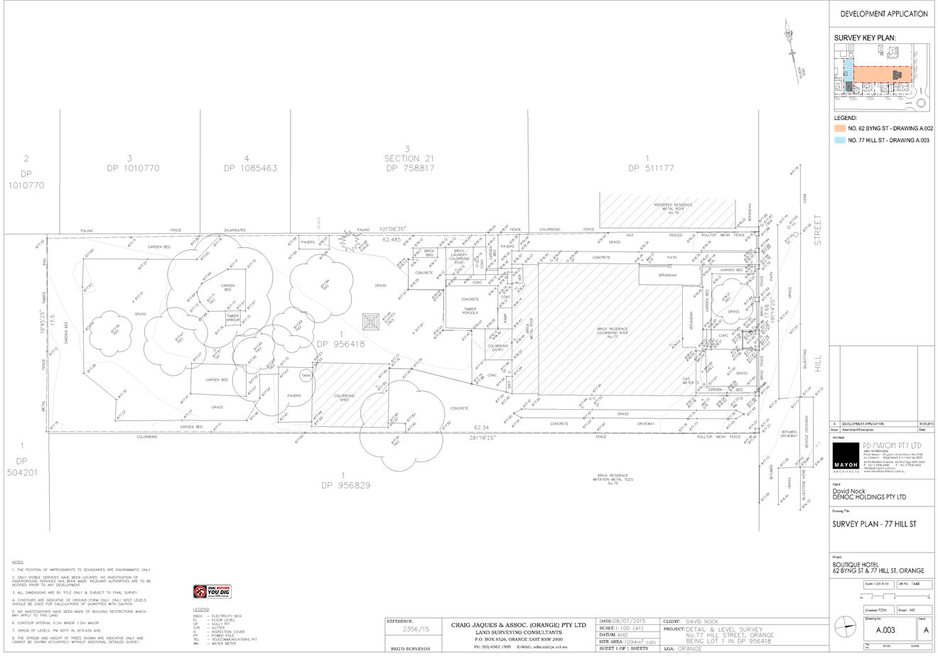
Planning and Development Committee
5 April 2016
2.2 Development
Application DA 329/2015(1) - 62 Byng Street and 77 Hill Street
Attachment 5 Plans
(4)
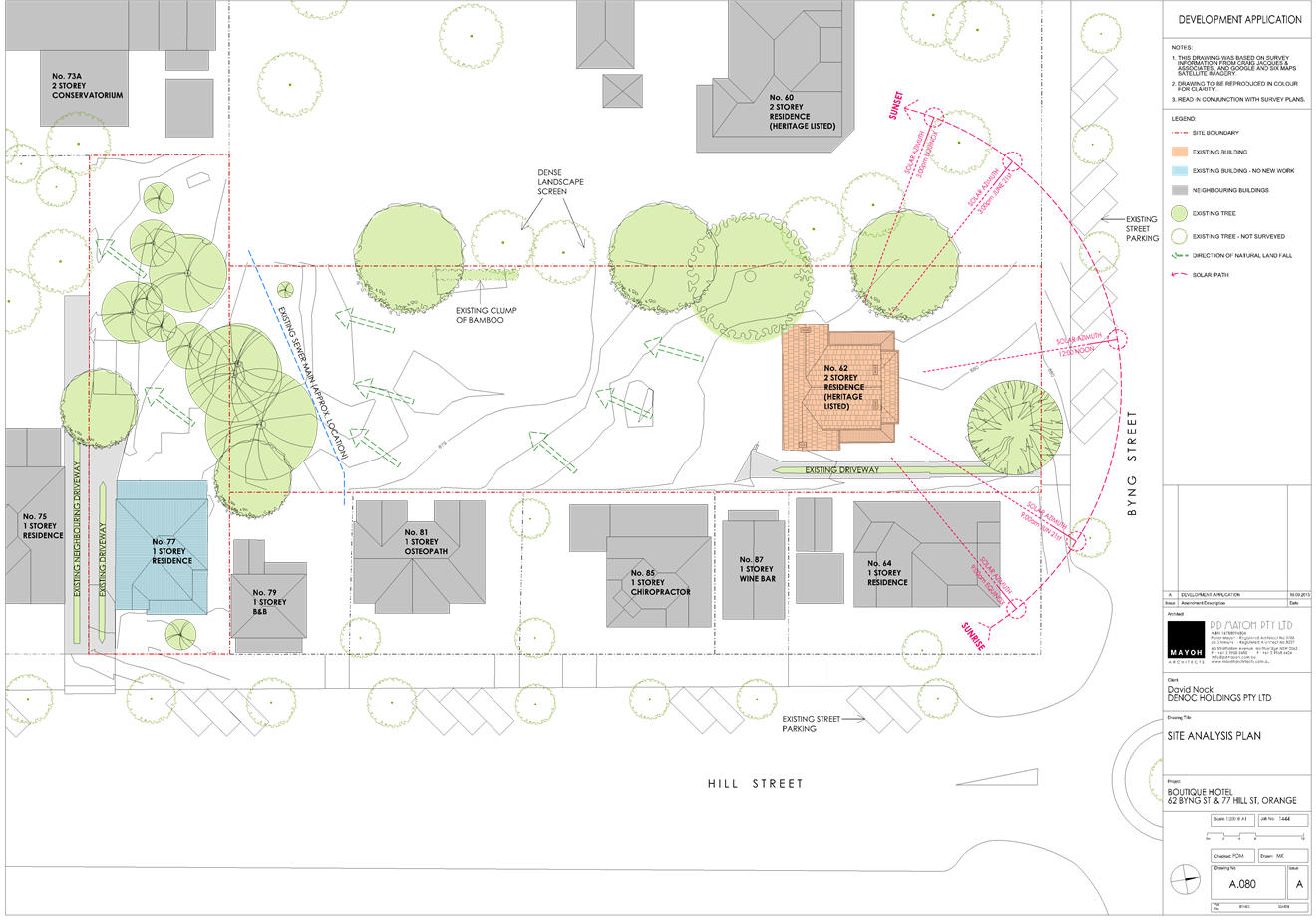
Planning and Development Committee
5 April 2016
2.2 Development
Application DA 329/2015(1) - 62 Byng Street and 77 Hill Street
Attachment 5 Plans
(4)

Planning and Development Committee
5 April 2016
2.2 Development
Application DA 329/2015(1) - 62 Byng Street and 77 Hill Street
Attachment 5 Plans
(4)
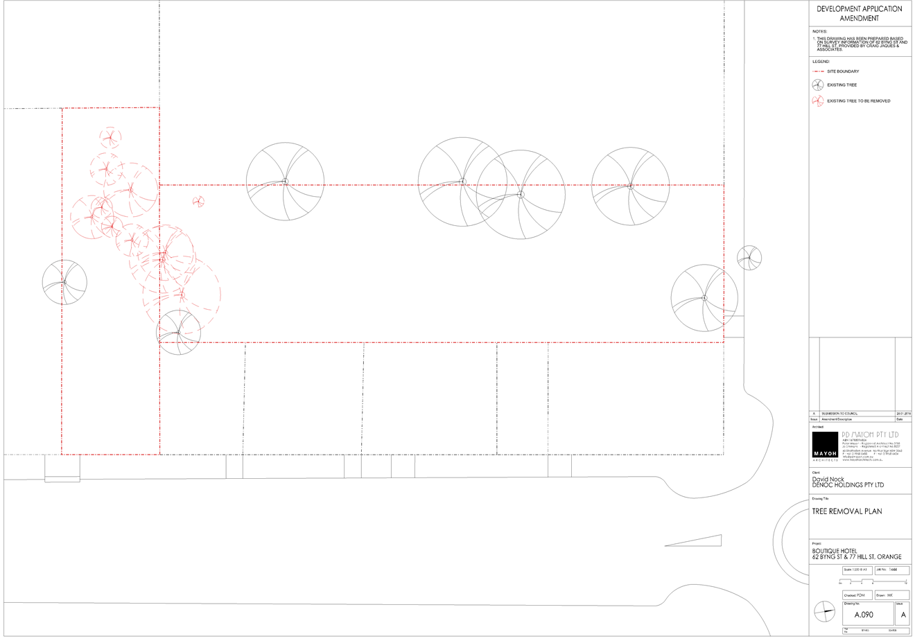
Planning and Development Committee
5 April 2016
2.2 Development
Application DA 329/2015(1) - 62 Byng Street and 77 Hill Street
Attachment 5 Plans
(4)
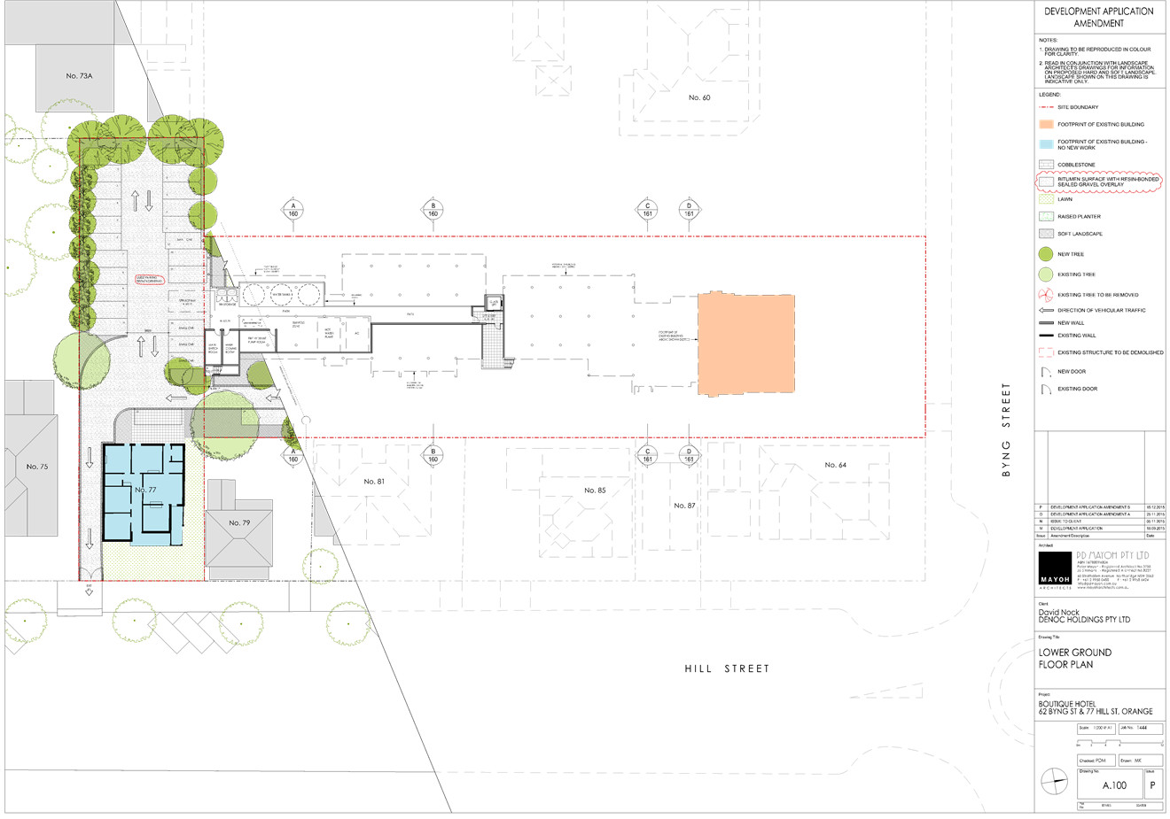
Planning and Development Committee
5 April 2016
2.2 Development
Application DA 329/2015(1) - 62 Byng Street and 77 Hill Street
Attachment 5 Plans
(4)
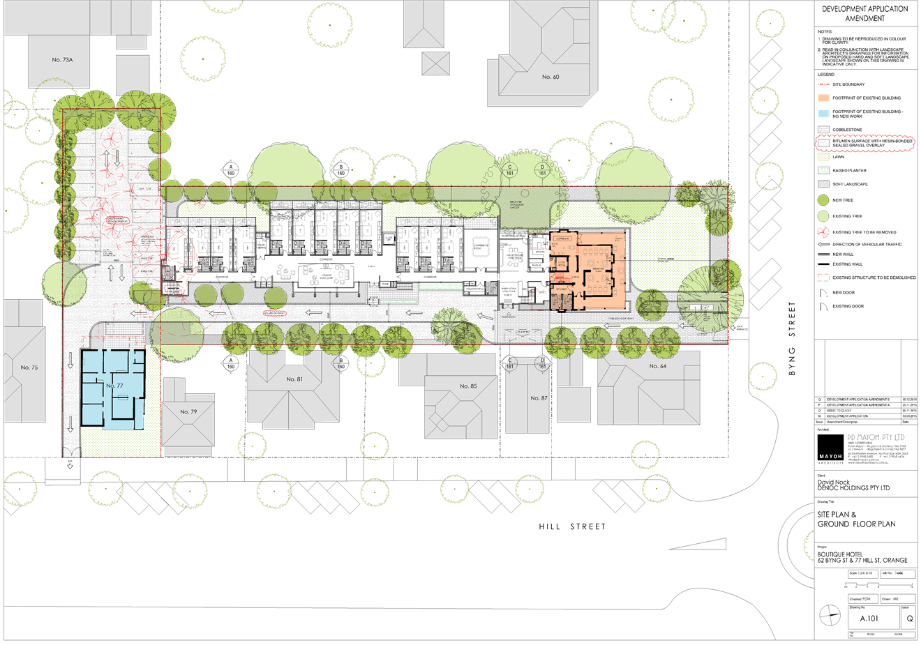
Planning and Development Committee
5 April 2016
2.2 Development
Application DA 329/2015(1) - 62 Byng Street and 77 Hill Street
Attachment 5 Plans
(4)
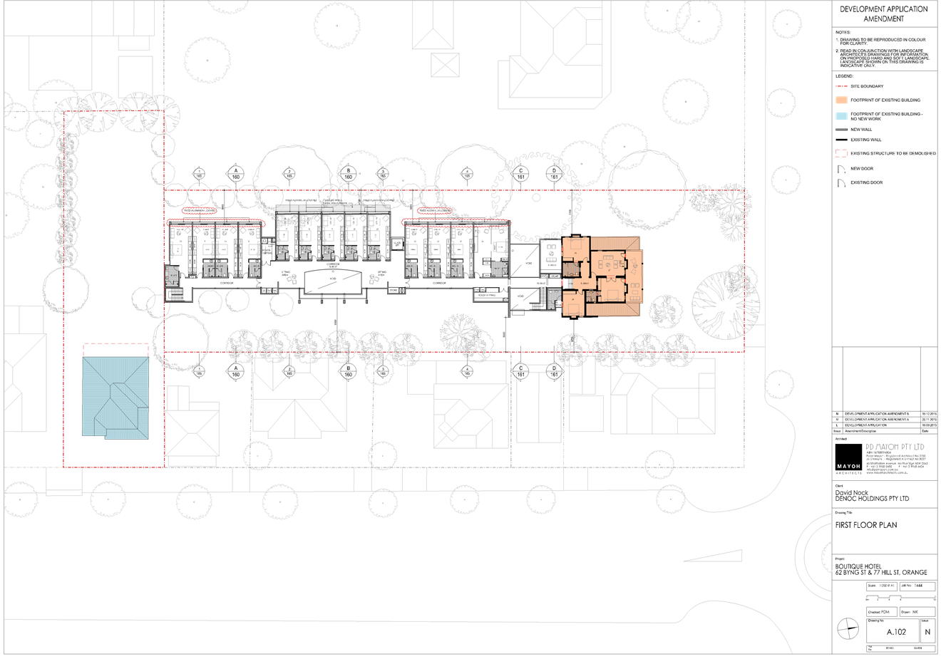
Planning and Development Committee
5 April 2016
2.2 Development
Application DA 329/2015(1) - 62 Byng Street and 77 Hill Street
Attachment 5 Plans
(4)

Planning and Development Committee
5 April 2016
2.2 Development
Application DA 329/2015(1) - 62 Byng Street and 77 Hill Street
Attachment 5 Plans
(4)
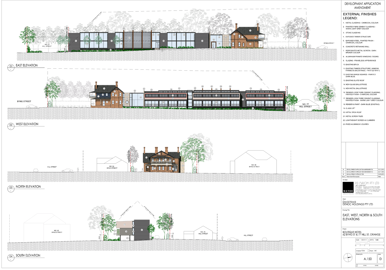
Planning and Development Committee
5 April 2016
2.2 Development
Application DA 329/2015(1) - 62 Byng Street and 77 Hill Street
Attachment 6 Plans
(5)
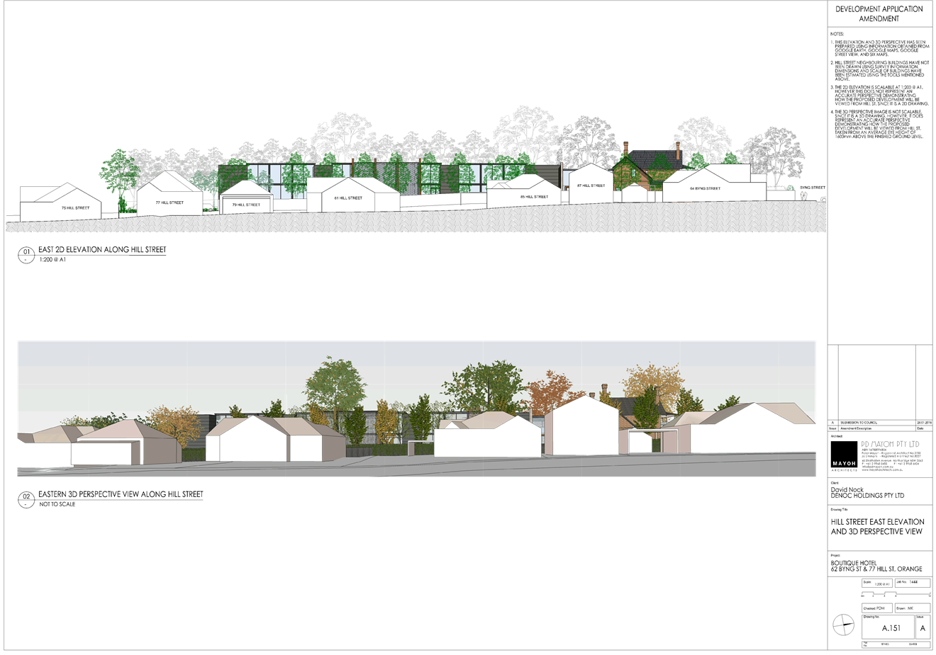
Planning and Development Committee
5 April 2016
2.2 Development
Application DA 329/2015(1) - 62 Byng Street and 77 Hill Street
Attachment 6 Plans
(5)
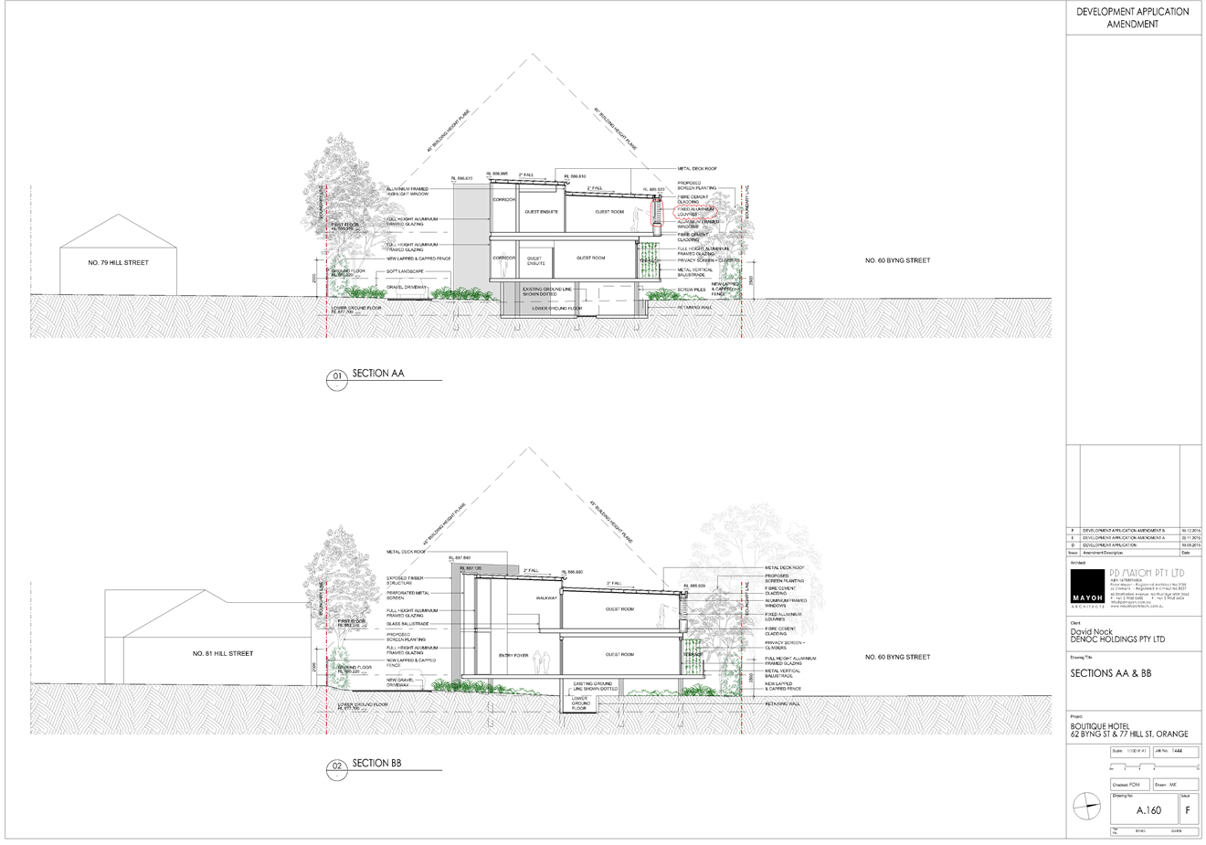
Planning and Development Committee
5 April 2016
2.2 Development
Application DA 329/2015(1) - 62 Byng Street and 77 Hill Street
Attachment 6 Plans
(5)
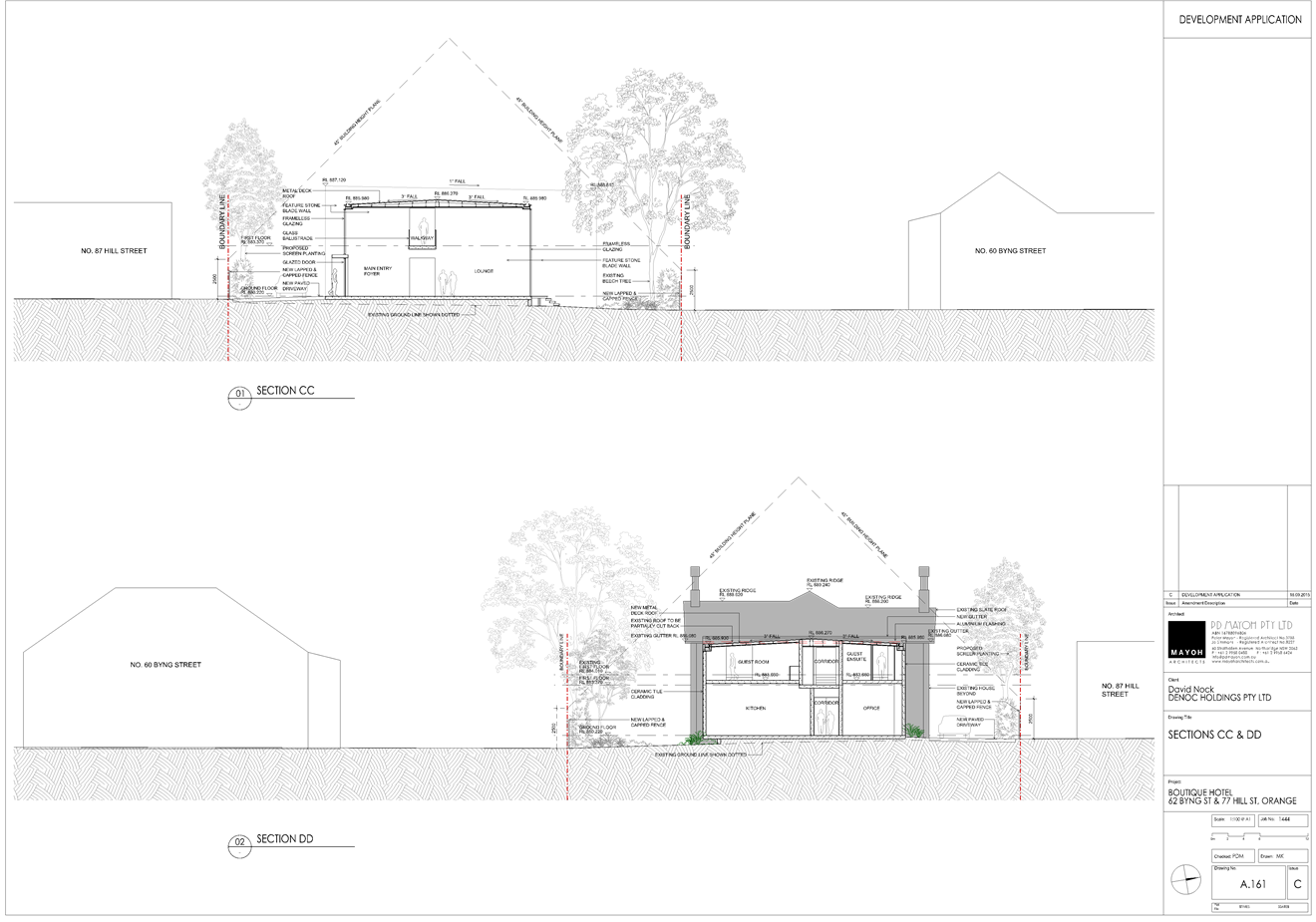
Planning and Development Committee
5 April 2016
2.2 Development
Application DA 329/2015(1) - 62 Byng Street and 77 Hill Street
Attachment 6 Plans
(5)
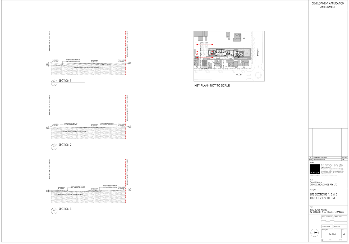
Planning and Development Committee
5 April 2016
2.2 Development
Application DA 329/2015(1) - 62 Byng Street and 77 Hill Street
Attachment 7 Plans
(6)
Planning
and Development Committee
5 April 2016
2.2 Development
Application DA 329/2015(1) - 62 Byng Street and 77 Hill Street
Attachment 8 Plans
(7)
Planning and Development Committee
5 April 2016
2.2 Development
Application DA 329/2015(1) - 62 Byng Street and 77 Hill Street
Attachment 8 Plans
(7)
Planning and Development Committee
5 April 2016
2.2 Development
Application DA 329/2015(1) - 62 Byng Street and 77 Hill Street
Attachment 9 Plans
(8)
Planning
and Development Committee
5 April 2016
2.2 Development
Application DA 329/2015(1) - 62 Byng Street and 77 Hill Street
Attachment 10 Submissions (1)

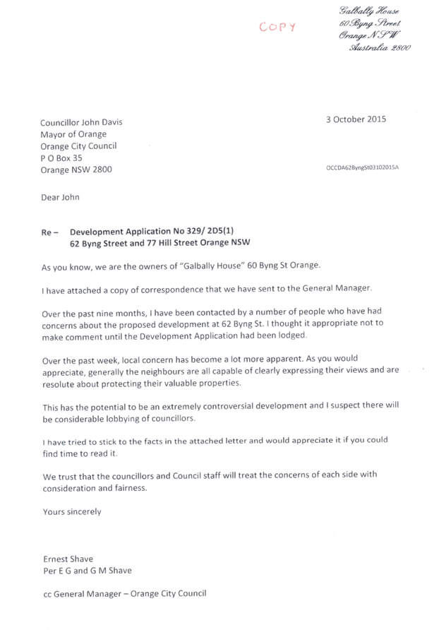
Planning and Development Committee
5 April 2016
2.2 Development
Application DA 329/2015(1) - 62 Byng Street and 77 Hill Street
Attachment 10 Submissions (1)
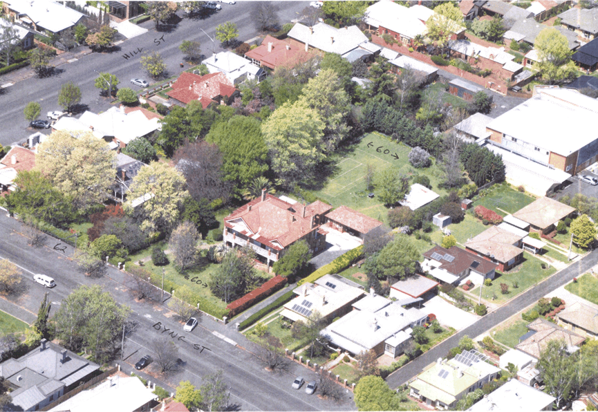

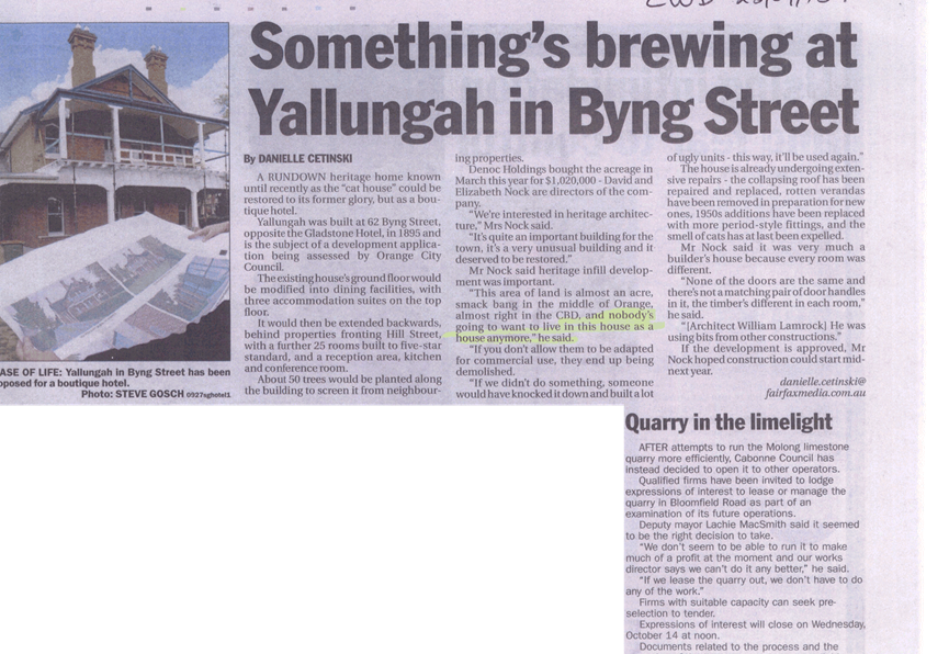
Planning and Development Committee
5 April 2016
2.2 Development
Application DA 329/2015(1) - 62 Byng Street and 77 Hill Street
Attachment 10 Submissions (1)
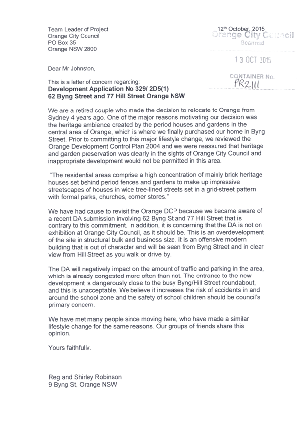
Planning and Development Committee
5 April 2016
2.2 Development
Application DA 329/2015(1) - 62 Byng Street and 77 Hill Street
Attachment 11 Submissions (2)

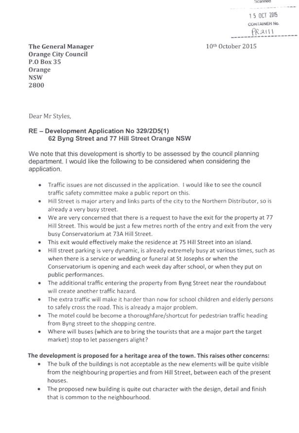
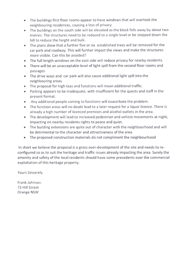
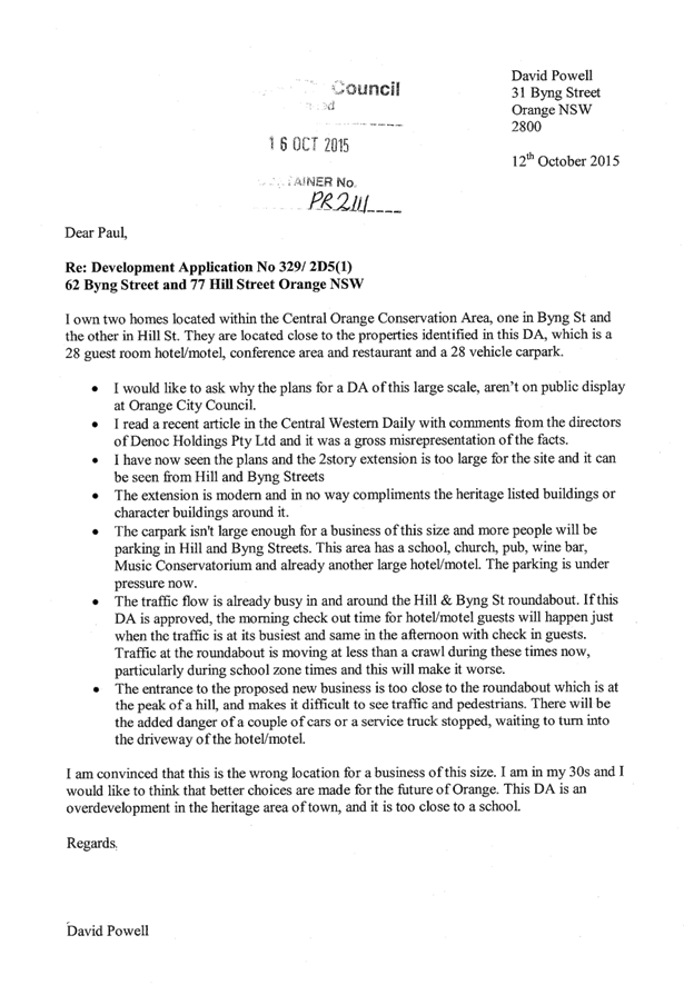
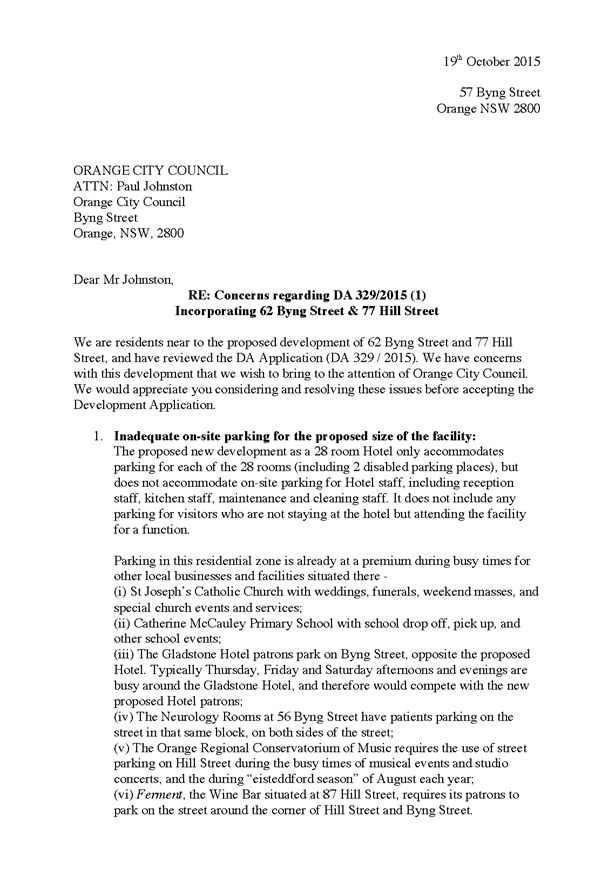
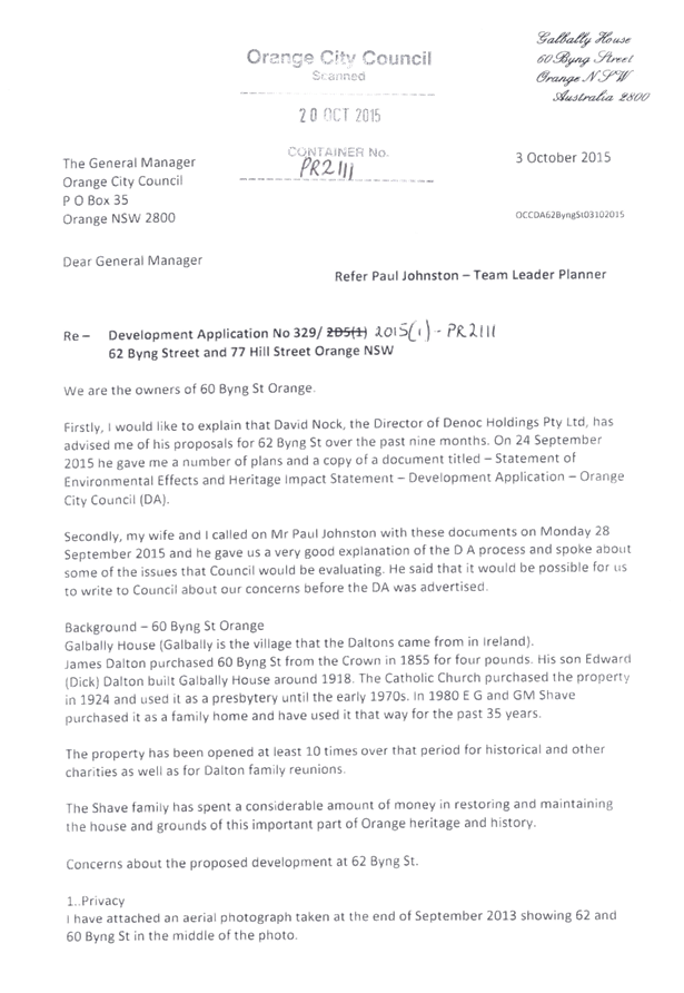
Planning
and Development Committee
5 April 2016
2.2 Development
Application DA 329/2015(1) - 62 Byng Street and 77 Hill Street
Attachment 12 Submissions (3)


Planning and Development Committee
5 April 2016
2.2 Development
Application DA 329/2015(1) - 62 Byng Street and 77 Hill Street
Attachment 12 Submissions (3)


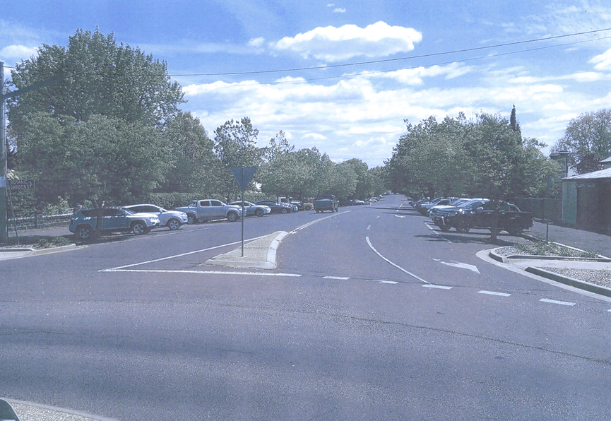

Planning and Development Committee
5 April 2016
2.2 Development
Application DA 329/2015(1) - 62 Byng Street and 77 Hill Street
Attachment 13 Submissions (4)


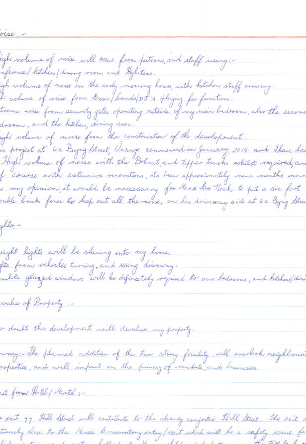
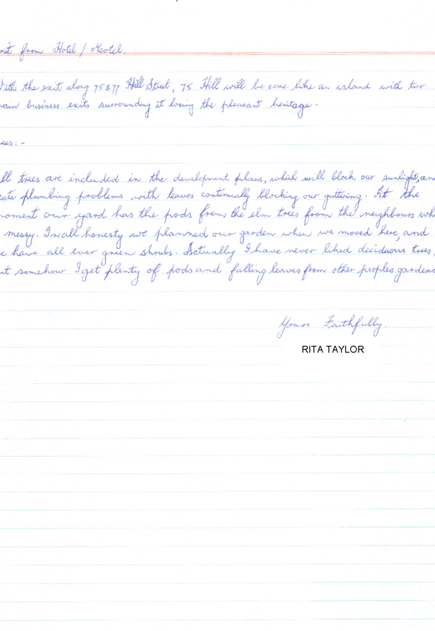
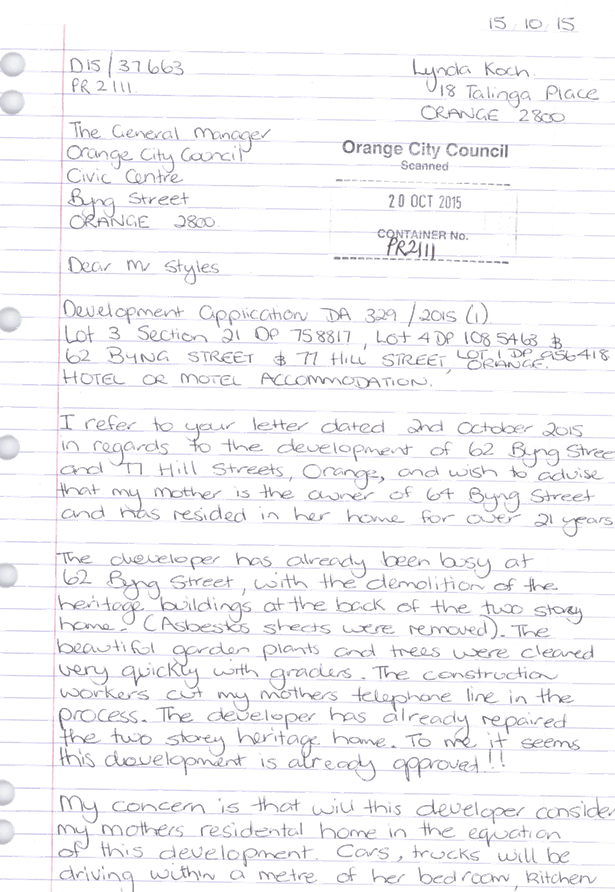
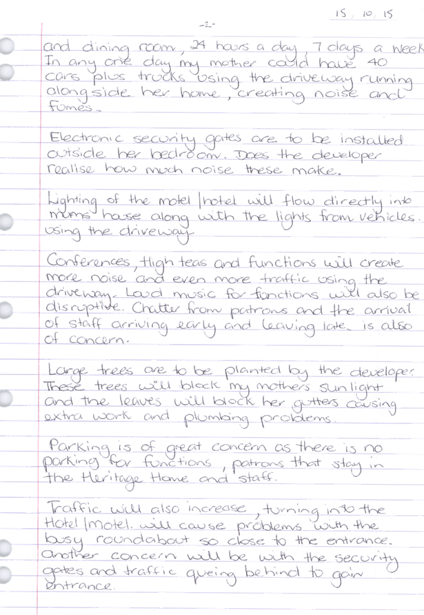

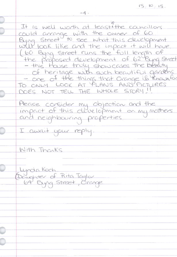
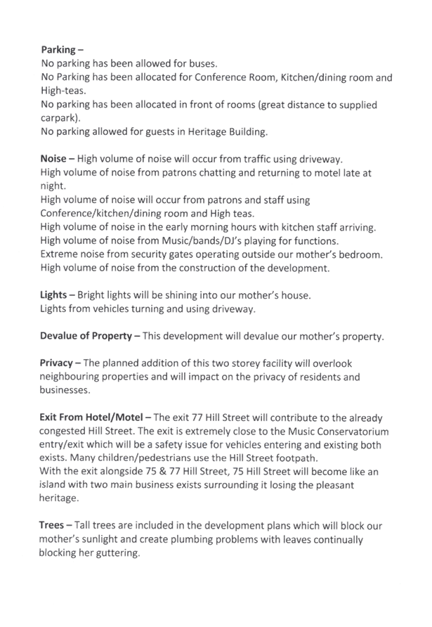
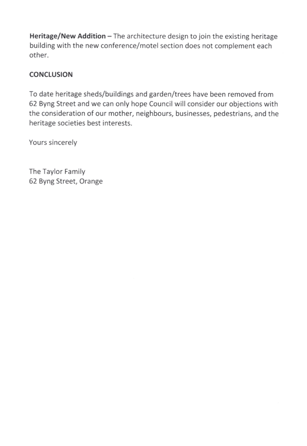
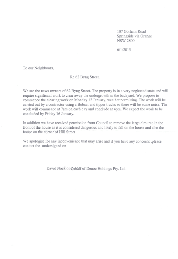
Planning
and Development Committee
5 April 2016
2.2 Development
Application DA 329/2015(1) - 62 Byng Street and 77 Hill Street
Attachment 14 Submissions (5)


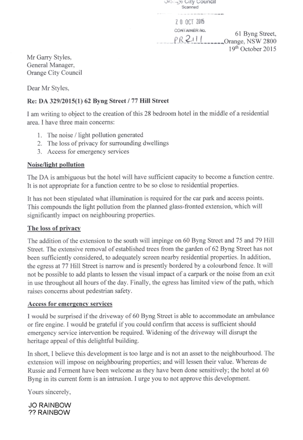
Planning
and Development Committee
5 April 2016
2.2 Development
Application DA 329/2015(1) - 62 Byng Street and 77 Hill Street
Attachment 15 Submissions (6)
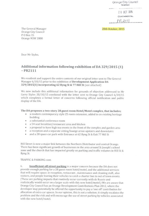
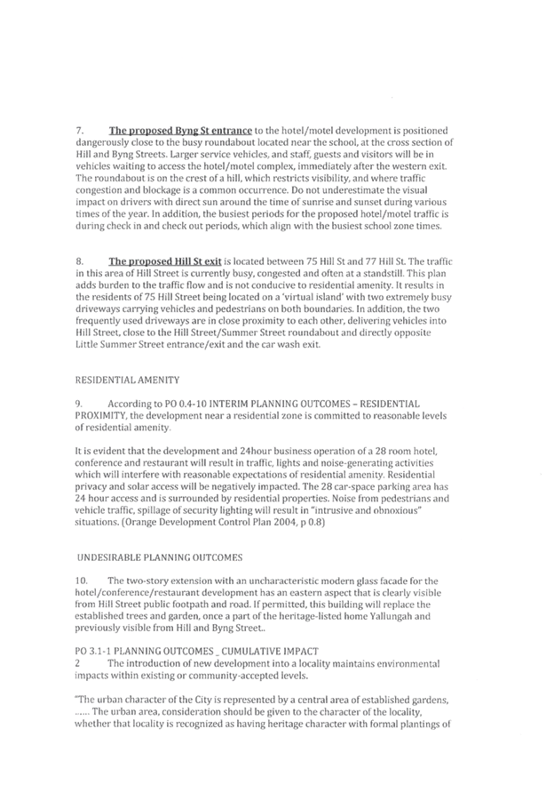
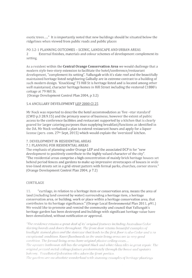
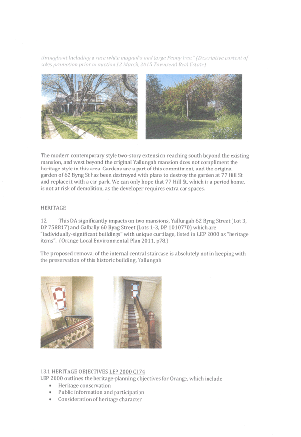
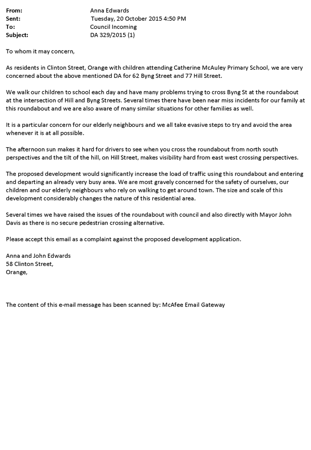
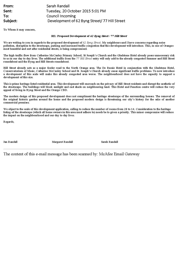
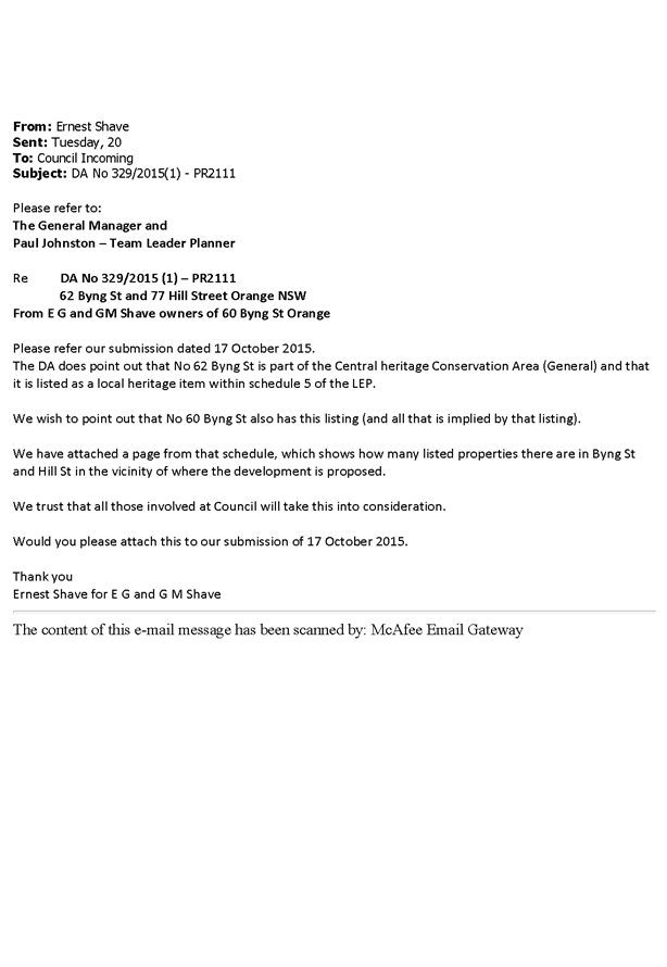
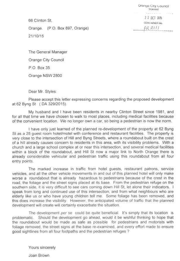
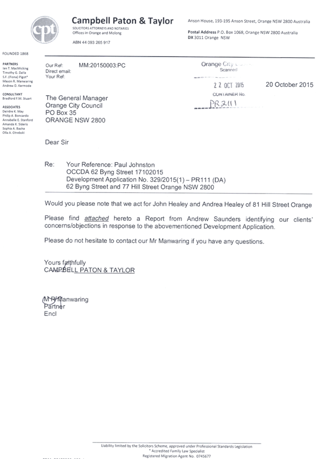

Planning
and Development Committee
5 April 2016
2.2 Development
Application DA 329/2015(1) - 62 Byng Street and 77 Hill Street
Attachment 16 Submissions (7)


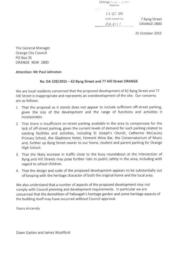
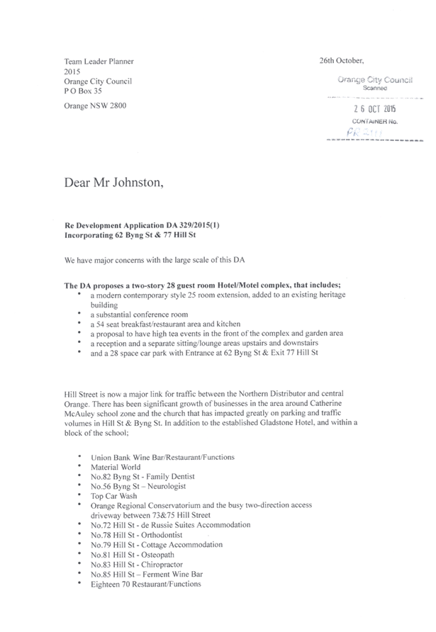
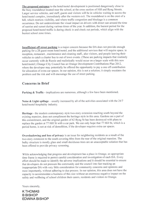
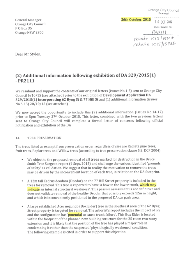
Planning
and Development Committee
5 April 2016
2.2 Development
Application DA 329/2015(1) - 62 Byng Street and 77 Hill Street
Attachment 17 Submissions (8)
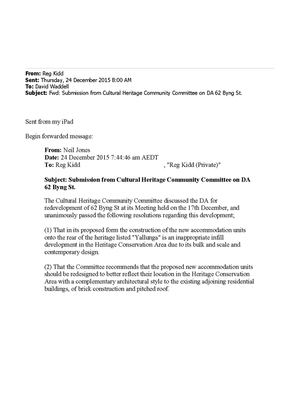
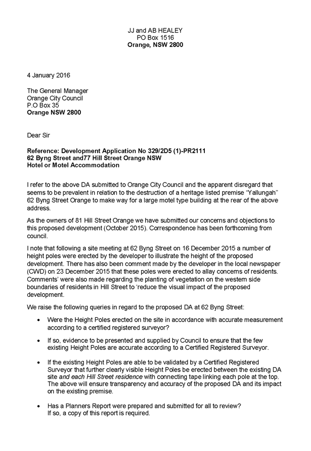
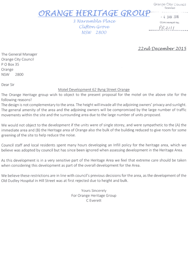
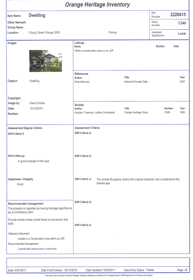

Planning
and Development Committee
5 April 2016
2.2 Development
Application DA 329/2015(1) - 62 Byng Street and 77 Hill Street
Attachment 18 Submissions (9)
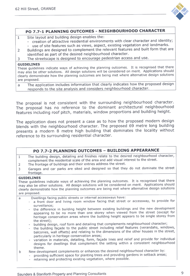


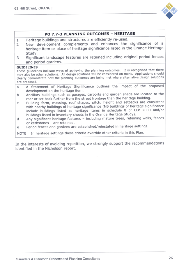

Planning
and Development Committee
5 April 2016
2.2 Development
Application DA 329/2015(1) - 62 Byng Street and 77 Hill Street
Attachment 19 Submissions (10)
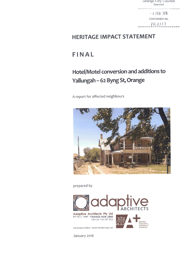

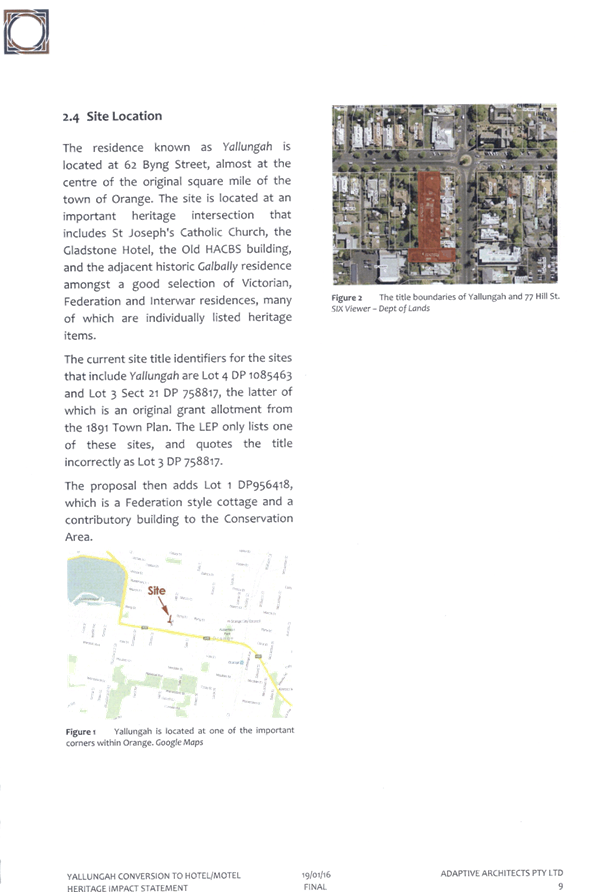
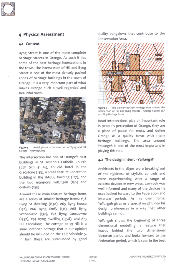
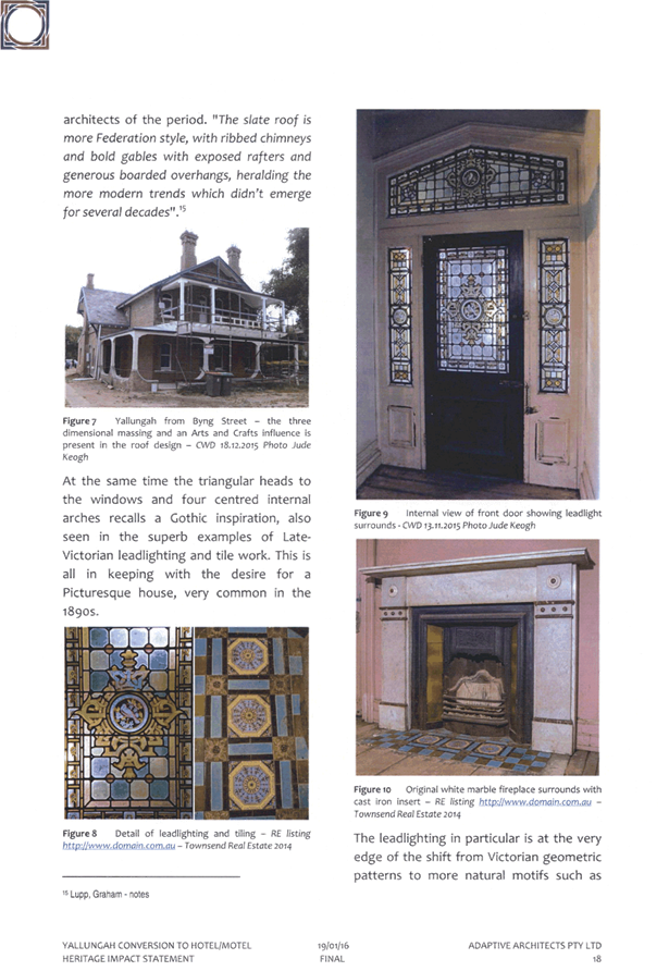
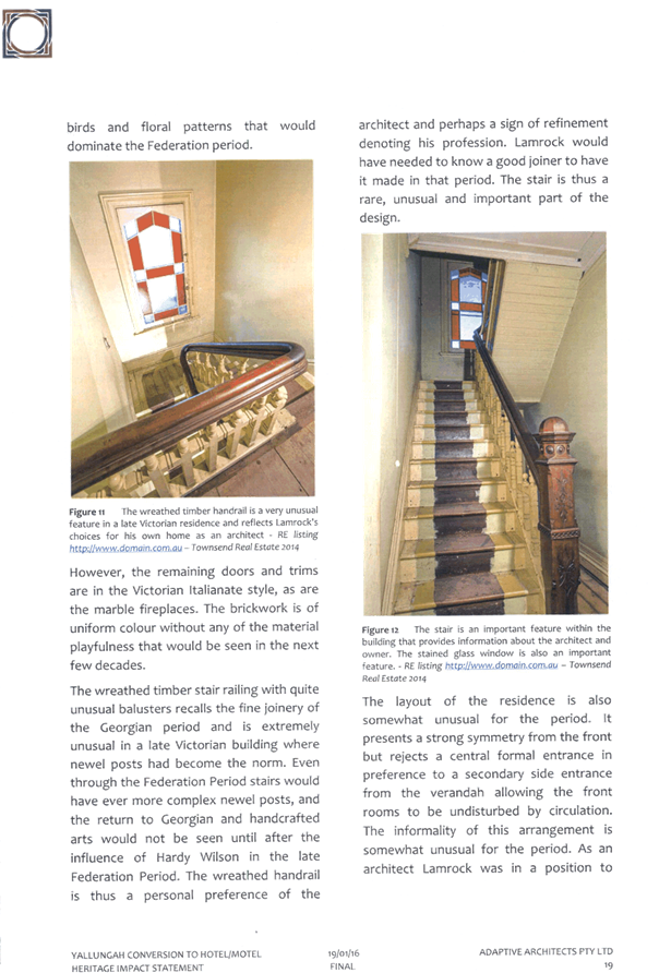
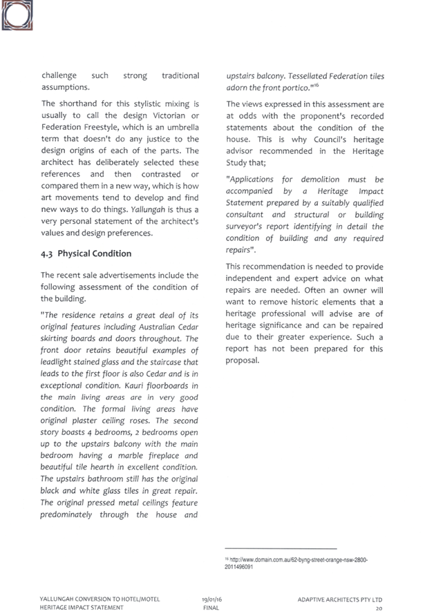
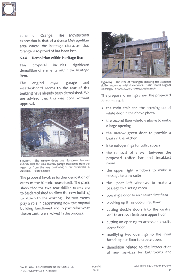
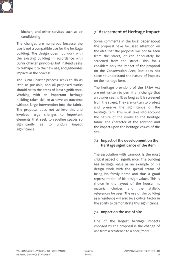
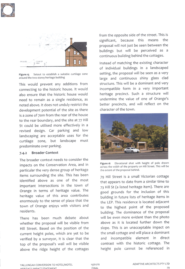
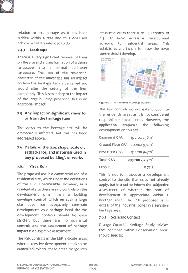
Planning
and Development Committee
5 April 2016
2.2 Development
Application DA 329/2015(1) - 62 Byng Street and 77 Hill Street
Attachment 20 Heritage Advice
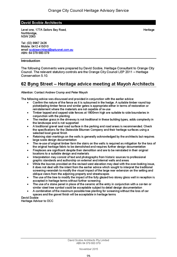

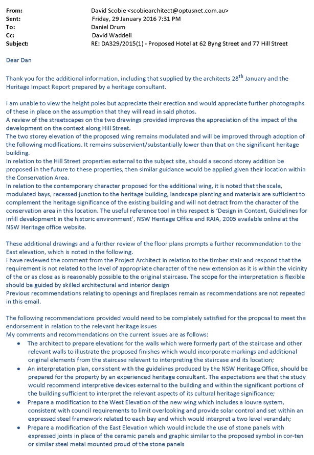

Planning
and Development Committee
5 April 2016
2.2 Development
Application DA 329/2015(1) - 62 Byng Street and 77 Hill Street
Attachment 21 Peer Review
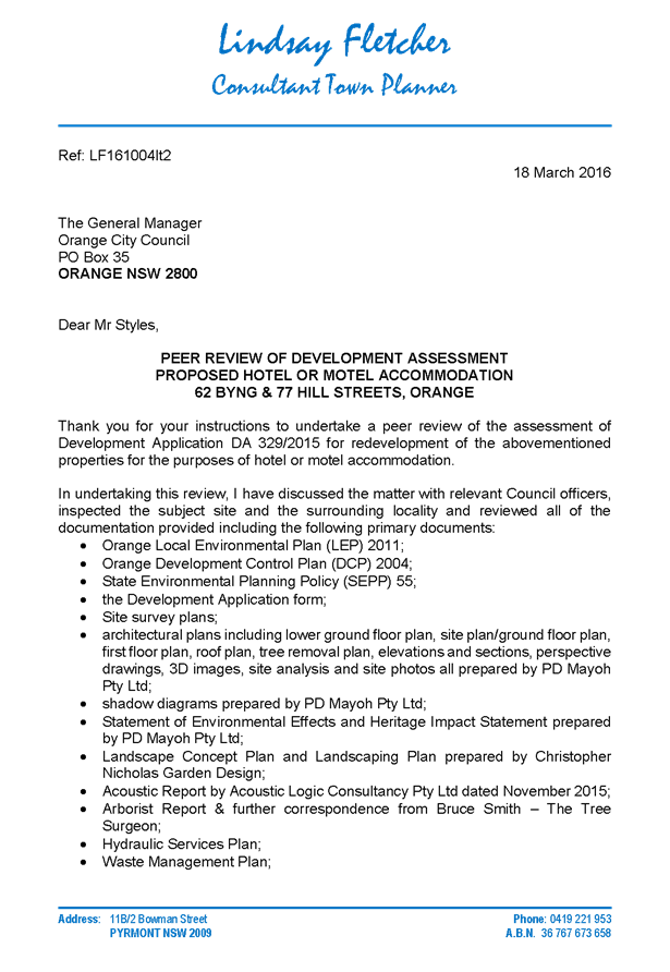
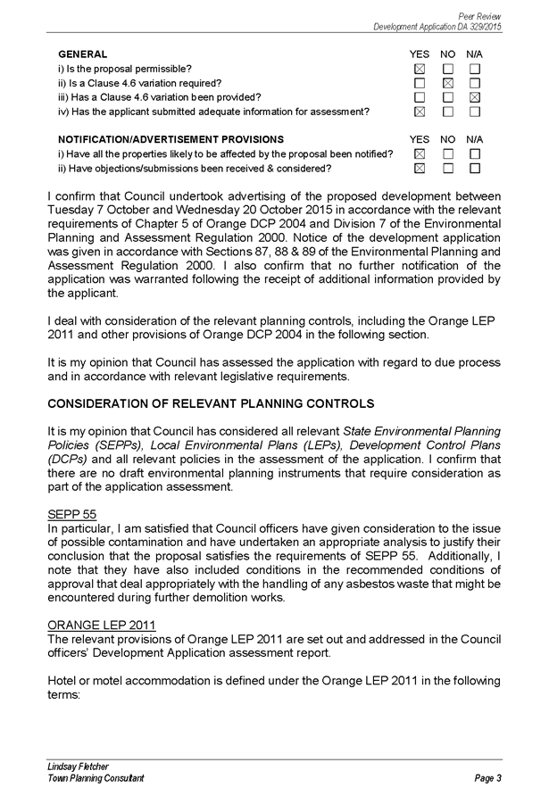

2.3 Development
Application DA 233/2015(1) - 98 Gorman Road
TRIM
REFERENCE: 2016/577
AUTHOR: Michael
Glenn, Senior Planner
EXECUTIVE Summary
|
Application
lodged
|
15 July
2015
|
|
Applicant/s
|
Mrs CY
Pearson, Mrs FK Blunt and Mrs JE Youngman
|
|
Owner/s
|
Mrs CY
Pearson, Mrs FK Blunt and Mrs JE Youngman
|
|
Land
description
|
Lot 1 DP
581736 - 98 Gorman Road, Orange
|
|
Proposed
land use
|
Subdivision
(38 lot residential plus public open space and drainage reserves)
|
|
Value of
proposed development
|
$0
|
Council's consent is sought for a subdivision of the subject
land into 38 lots ranging in size from 2,009m2 to 3917m2.
The subject property is constrained by its slope, its
prominence as a visual element of the landscape, and the potential impacts on
iconic views to both the north to the Mullion Ranges and southwest to Mt
Canobolas. The slope of the subject land is, in places, in excess of 25%,
and is thus likely to lead to significant levels of cut and fill both in the
road construction and also for likely future development of the lots.
Link To Delivery/OPerational Plan
The recommendation in this report relates to the
Delivery/Operational Plan strategy “13.4 Our Environment
– Monitor and enforce regulations relating to City amenity”.
Financial Implications
Council has been advised that as a council included in the
NSW Government’s merger proposals under consideration by the Office of
Local Government since referral on 6 January 2016, Council must comply with the
merger proposal period guidelines issued under S23A of the Local Government Act
1993.
The guidelines instruct Council it should expend money in
accordance with the detailed budget adopted for the purposes of implementing
the Delivery/Operational Plan for the 2015/16 year.
Any expenditure outside the adopted budget requires the
identification of clear and compelling grounds and must be approved by Council
at a meeting that is open to the public. The guidelines indicate the resolution
of Council for increased expenditure must specify the reasons why the
expenditure is required and warranted.
If increased expenditure is greater than $250,000 or 1% of
the Council’s revenue from rates in
the preceding year, whichever is the greater, Council
is required to exhibit the increase to the budget and consider comments
received.
Council must also avoid entering into contracts or
undertakings were expenditure or revenue is greater than $250,000 or 1% of the Council’s revenue from rates in the
preceding year, whichever is the greater, unless the contract or undertaking is
as a result of a decision or procurement process commenced prior to the merger
proposal period or where entering into a contract or undertaking is reasonably
necessary for the purposes of meeting the ongoing service delivery commitments
of the Council or was previously approved in the Council’s
Delivery/Operational Plan.
Policy and Governance Implications
Nil
|
Recommendation
That Council consents to development application DA
233/2015(1) for Subdivision (38 lot residential plus public open
space and drainage reserves) at Lot 1 DP 581736 - 98 Gorman Road, Orange
pursuant to the conditions of consent in the attached Notice of Approval.
|
further considerations
Consideration has been given to the
recommendation’s impact on Council’s service delivery; image and
reputation; political; environmental; health and safety; employees;
stakeholders and project management; and no further implications or risks have
been identified.
SUPPORTING INFORMATION
THE APPLICATION
Council's consent is sought for subdivision (38 lot
residential plus public open space and drainage reserves) at Lot 1 DP 581736 -
98 Gorman Road, Orange.
THE PROPOSAL
The proposal involves a subdivision, associated earthworks,
drainage, installation of services and road construction.
As indicated in the executive summary, the site is
constrained by its slope, high levels of visibility and conflicts between the
zone restrictions and the existing and competing local character. These
constraints are acknowledged in the applicant's submission and some allowances
made in the layout of the subdivision. Principally, the layout incorporates
larger lots on the more sloping areas of the site. This will provide space in
which to move future dwellings around and provide privacy buffers and the like.
However, the applicants’ response in itself is not sufficient to conclude
that no significant adverse effect will be likely to arise from the proposed
subdivision.
The proposed subdivision complies with the requirements of
LEP 2011. Further, there is no detailed masterplan applicable (in the same way
as a masterplan has been done for the Shiralee Urban Release Area). The
proposed development does not generate any significant direct breaches of the
general residential planning outcomes of DCP 2004.
Figure 1 - site plan showing surrounding development
densities
However, notwithstanding the general compliance to the major
planning controls, the proposed development does have some significant adverse
effects which can be identified in the Section 79C assessment. The Sustainable
Settlement Strategy completed in 2004 as a precursor to further changes to the
zoning of the locality indicated significant constraints in terms of view
corridors along the ridgetop, and highly constrained land along the area where
slope is greatest in view of the likely amount of cut and fill that will be
required in these areas. The inherent conflict that arises due to the differing
subdivision densities between the essentially rural residential and rural land
to the north and west of the site (and which has been the subject of some
intense debate for other similar proposals on the surrounding lots, and the
more densely used residential land to the east and south is acknowledged, and
remains as much an issue for this application as any of the other recently
approved green fields residential subdivisions for this locality.
To an extent it is not possible to fully address all of
these constraints such that their impact could be said to be fully expunged
from the development; however it is considered possible to minimise such impacts
with conditions and render the proposed development acceptable in terms of its
external effects.
MATTERS FOR CONSIDERATION
Site Constraints - the Sustainable Settlement Strategy
The significant constraints are thoroughly outlined in
Chapter 9 of the Sustainable Settlement Strategy (SSS).
The SSS identified parts of this land as being unsuitable
for urban/residential development. It is, however, zoned R5 Large Lot
Residential under Orange Local Environment Plan 2011 (OLEP 2011),
with no special controls applicable under a DCP masterplan. The SSS was
intended to serve as the basis for any future zonings and any detail design
criteria that might otherwise be devised to apply to the subject land. Of
itself, the SSS has no statutory weight, but it does offer significant
usefulness in undertaking a merits based assessment as is required under
Section 79C of the Act.
The major environmental
constraints affecting the subject land are depicted in a series of maps from
the SSS:
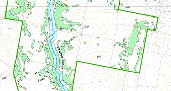
Figure 2 - geotechnical constraints
The sloping parts of the site can be expected to
contain significant tonnages of submerged rock.
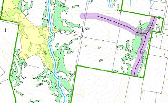
Figure 3 - visual and landscape constraints
The areas of visual and landscape sensitivity within the
study area are creek lines (focused on Broken Shaft Creek), existing
significant vegetation, ridgelines and sensitive rural views. These constraints
are shown in Figure 2. Specifically, the SSS recommends or identifies the
following slope and ridge related constraints:
(a) any
future development needs to protect watercourses, establish appropriate buffers
and protect and augment existing riparian vegetation;
(b) sensitive
rural views include attractive views from both within and outside the study
area;
(c) protection
and enhancement of the remnant native vegetation is identified as a high
priority in the SSS;
(d) the
SSS suggests that the sensitive drainage lines within the study area be vested
in public ownership - it identifies one such line traversing the subject
property.
Response to the Identified
Constraints
The layout of the proposed subdivision does not incorporate
any linkages to connect the walking and open space areas purchased (but as yet
undeveloped) to the west when that land was recently subdivided. Whilst a
specific link is not proposed the subdivision layout does, however, include
dedications of land for a drainage reserve at the western lower end of the
block, and a smaller area of open space around the Trig station in the
north-eastern corner. The open space around the Trig station is included in the
2015 Section 94 Contributions Plan, and as such compensation for this land
will be offered to the applicant. Council is not in a position to expend funds
from its general revenue sources to acquire land that does not form part of the
intended open space network.
Whilst the drainage lines have some importance, the
overwhelmingly significant constraining factors of this site are the elevated
ridge lines and the rocky soil on the slope of the land, which will make future
construction expensive and difficult, and the likely levels of site disturbance
at dwelling construction a difficult and challenging prospect. The sheer slope
of the site leading to the ridge is a significant issue and likely to affect
view lines and neighbourhood character to an inordinate degree as these sloping
areas are developed.
The basic permissibility of the proposed subdivision is
established in the zoning restrictions (and in particular the minimum lot size
provisions) which this proposal meets the requirements of. Moreover, the
proposed development is generally consistent with the objectives of the
principal environmental planning instrument (EPI) and also the zone objectives.
However, the SSS clearly identifies some major constraints
affecting the site. The applicant’s submission addresses these
constraints, however it is considered appropriate to impose conditions so as to
achieve outcomes more consistent with the LEP and DCP objectives.
Amended plans were submitted on 22 February 2016 that
attempt to address some of the issues that arose during the assessment process.
The amended plans accommodate Essential Energy’s requirements and also
try to respond to some of the landscape quality issues by retaining more of the
trees on the site. The applicant erroneously believes that Essential Energy
requires the removal of vegetation from the easements, including the very
significant landscape trees on Lots 306 and 307, but this is not the case.
Essential Energy has no issue with the retention of these trees within their
easement areas.
A constraint identified in the SSS is the ridgeline which is
identified as making a significant contribution to the visual amenity of the
locality. It is considered that the development that will occur on the
ridgeline both as a result of the subject development and under further
development that will occur following subdivision will significantly impact on
the skyline from large areas of the existing area of the City to the east and
south, and from the more rural and rural residential land to the north and
west; and also have inordinate potential to affect the view corridor and scenic
quality over a wide area.
A number of restrictions are considered appropriate to
address these concerns and are included as conditions of consent to be written
as Restrictions-as-to-User on the land titles for these affected lots. These
restrictions relate to:
(1) Amended
plans are required that require the amalgamation of proposed Lots 332
and 333 (hereafter referred to as Lot 332/333) into the one allotment, and
increase the minimum depth for Lot 334 to 38m (currently proposed at 35m).
(2) Building
restriction envelopes in which maximum site coverage does not exceed 35%
of the block size for Lots 332/333 to 338, and Lots 312 to 319 (being those
lots on the ridge and those lots along the southern boundary). A minimum
setback of 15m from the southern boundary for Lots 312 to 319 is required.
(3) Minimum
setbacks from Gorman Road of 12m.
(4) The
imposition of a Section 88B Restriction-as-to-User that requires the submission
of a landscape plan that is to the satisfaction of Council with any dwelling
(or outbuilding) application for Lots 332/333 to 338 inclusive. Such
landscaping is to incorporate species selection with a mature height greater
than the height of the structures proposed and able to screen a minimum of 50%
of the width of the proposed dwelling or building frontage. Full implementation
of the approved landscaping is required prior to the issue of an Occupation
Certificate and retention and maintenance of such landscaping required
thereafter.
(5) A
Section 88B Restriction-as-to-User is required for Lots 332/333 to 338 limiting
future development on these lots to single storey construction.
(6) All
fencing throughout the entire subdivision is to be restricted to rural type
fencing less the barbed wire component as per the requirements of
Council’s DCP 2004 or its successor.
(7) Retention
and protection of trees on Lots 306 and 307 as well as trees on Lots 315,
310, 303 (the smaller tree on this lot may be removed), 304 and 305, including
those trees currently proposed for removal on the amended plan (principally
those trees within the easement), by the imposition of building envelopes and
tree protection zones on these sites. Section 88B restrictions are also
required for the protection of the designated trees
(8) For
those lots not elsewhere identified in the consent (Lots 301 to 307,
Lots 308 to 311 and Lots 320 to 331), building restriction envelopes
not exceeding 50% of the block size are required.
(9) All
building envelopes required under this consent, in addition to all other
restrictions, shall incorporate front and side setbacks not less than of 10m
and 2m respectively.
Section 5A Assessment
In the administration of sections 78A, 79B, 79C, 111 and
112, the provisions of Section 5A must be taken into account for every
development application in deciding whether there is likely to be a significant
effect on threatened species, populations or ecological communities or their
habitats. This section includes a requirement to consider any adopted
assessment guidelines, which means assessment guidelines issued and in force
under section 94A of the Threatened Species Conservation Act 1995.
Assessment guidelines are in force (see DECC-W
“Threatened Species Assessment Guidelines - The Assessment of
Significance”) which requires consent authority to adopt the
precautionary principle in its assessment.
The subject property is not mapped as containing high value
biodiversity, however the SSS nevertheless identifies the site as having
some biodiversity potential. There are isolated trees on the site, as well as a
number of partially exposed rocky outcrops and considerable amounts of embedded
surface rock. These rocky components are discussed in OEH guidelines as landscape
elements likely to provide some habitat value, particularly for invertebrates
and small reptiles. Invariably the proposed development, along with future
development of the site as a housing estate, poses some threat to those habitat
niches on the site.
As an offset to that threat, it is considered appropriate to
require as a condition of approval either the storage and above ground use of
excavated rock material on the site, or the storage of the material on a
Council designated stockpile for future use. A condition to that effect is
included in the attached notice, and specifically does not allow such material
to be reburied.
Site Photographs
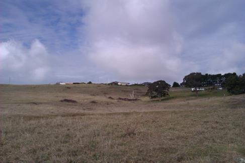
Photograph 1 - subject property from its western
boundary looking east upslope
Photograph 2 - native vegetation on the site is fairly
limited,
but offers significance as a link to the more rural
land nearby
Photograph 3 - recently completed stormwater drainage
for the western subdivision
in Dean Drive.
The proposed development will
direct its surface flows into the drainage system that passes through this
detention basin. It is important that water quality and sedimentation be
managed to maintain this system in adequate working order and to ensure the
continuing water quality of the downstream properties, which rely on this water
course as a water supply, albeit some 33 kilometres downstream.
Photograph 4 - subject property looking north
This photograph was taken from Silverdown Way. Note the
slope of the site and the iconic views of the Mullion Ranges in the distance.
Aboriginal
Heritage
Council commissioned a report by Parsons
Brinkerhoff in 2004 for the Sustainable Settlement Strategy. The Parsons
Brinkerhoff report includes a predictive tool as to the likelihood of
Aboriginal heritage existing on a given site within its study area. In this
case, the predictive tool (which includes a map) suggests a moderate
possibility of Aboriginal heritage occurring on adjoining sites closer to
Broken Shaft Creek, but no significant potential for the subject property. This
is consistent with known Aboriginal settlement and encampment patterns that, as
a generalization, favoured more sheltered sites closer to known watercourses.
Occasionally,
if there is a significant feature such as an escarpment or large floater stones
on the surface, Aboriginals might identify the locality as being culturally or
religiously significant, but in this case there are no such natural features or
landmarks. Additionally, occasionally wooded areas might be used for the
collection of bark, and some species of trees could be used as "scar
trees". Again no observable evidence exists on the site of this sort of
activity.
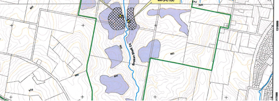
Figure 4 - extract from Parson Brinkerhoff report on Aboriginal Heritage
Council in 2010 also commissioned an
Aboriginal Heritage Study. This study identified some potential for part of
Broken Shaft Creek to possess some Aboriginal artefacts, but not much potential
for the site itself. The OEH register of known artefacts and sites lists two
finds approximately 600m west of the site in the riparian area of Broken Shaft
Creek.
The NPW Act requires a developer to apply
“due diligence”, which means a legal standard of care, to determine
whether a proposed activity could harm (ie damage, destroy, deface or move)
Aboriginal objects or declared Aboriginal Places. In the context of protecting
Aboriginal cultural heritage, due diligence involves taking reasonable and
practicable measures to determine whether a developer’s actions will
harm an Aboriginal object, and if so, what measures can be taken to avoid that
harm.
The process for applying due diligence is
described in the OEH publication Due Diligence Code of Practice for the
Protection of Aboriginal Objects in New South Wales (2010). If a
proposed development could harm Aboriginal objects or declared Aboriginal Places,
then investigations of the development area are required to determine:
1 what Aboriginal cultural
heritage is located there;
2 why (or if) the
Aboriginal cultural heritage located within the area is important;
3 the likely impacts of
the proposed development on Aboriginal cultural heritage are;
4 how the impacts on
Aboriginal cultural heritage can be avoided or minimised. In cases where
Aboriginal cultural heritage will be damaged or destroyed, an Aboriginal
Heritage Impact Permit (AHIP) is required.
In this case, the applicant has not
undertaken a survey or study to determine if such heritage exists. However, the
site characteristics do not suggest a great possibility of Aboriginal heritage
of any kind on the site. The available area based general studies suggest no
significant possibility for this site.
Integrated Development
The applicant has not sought approval under the integrated
development provisions of the Act, which is the applicant’s choice.
There is a drainage line Category 1 stream (using the Strahler
classification system on the site) which eventually drains into Broken Shaft
creek. The NSW Office of Water (NoW) advises that it is probable that a
controlled activity permit would be required given the extent of disturbance to
be undertaken on this drainage line. It is considered appropriate to impose a
condition that requires the applicant to liaise directly with NoW with respect
to requirements under the Water Management Act (WMA).
Section 79C
Section 79C of the Environmental Planning and Assessment
Act 1979 requires Council to consider various matters, of which those
pertaining to the application are listed below.
PROVISIONS OF ANY ENVIRONMENTAL
PLANNING INSTRUMENT s79C(1)(a)(i)
Orange Local Environmental Plan 2011
Part 1 - Preliminary
Clause 1.2 - Aims of Plan
The broad aims
of the LEP are set out under sub-clause 2. Those relevant to the application
are discussed below:
(a) to encourage development
which complements and enhances the unique character of Orange as a major
regional centre boasting a diverse economy and offering an attractive regional
lifestyle.
The proposed
development will detract from the rural character of the locality, but will be
consistent with the residential character of the more urban areas nearby. Given
that the land is essentially a transitional zone between urban and non-urban
development, this would appear to be appropriate development for the site.
In
acknowledgement of the competing demands of rural residential and residential
character affecting the subject site, it is considered appropriate to impose a
range of conditions aimed at achieving a better relationship with these
competing characters. In summary, the conditions will:
1 Require all
subdivision fencing as rural style fencing (post and wire, no barbed wire).
2 Impose a
Section 88B Restriction-as-to-User under the Conveyancing Act 1979
requiring such rural fencing to be retained and maintained, and prohibiting the
replacement of such fencing except with like materials, and the approval of
Council and the adjoining owner (as per the general principals of the Dividing
Fences Act).
3 Imposition
of Section 88B building restriction envelopes for certain lots to ensure
retention of certain significant trees on the site and thereby maintain to a
better extent the contribution to character and amenity made by this property
to the locality.
4 Establishment
by condition and Section 88B Restriction-as-to-User under the Conveyancing
Act 1979 of a no build buffer 10m wide for the northern, western and
eastern boundaries. For the northern and western boundaries, vegetation buffers
are also required to be planted and maintained until release of the Subdivision
Certificate.
5 To improve
the streetscape and spacing between dwellings, it is considered appropriate to
impose a condition that requires minimum front and side setbacks on the new
lots, except where similar alternative arrangements (such as the building
envelopes for certain lots) are already imposed as conditions of consent.
6 Imposition
of a condition preventing the removal of any trees except within the designated
road reserves of the development. Future applications will need to consider the
tree removals from the site outside the specified exclusion zones on a case‑by‑case
basis.
(b) to provide for a range of
development opportunities that contribute to the social, economic and
environmental resources of Orange in a way that allows present and future
generations to meet their needs by implementing the principles for ecologically
sustainable development.
With regard to
this aim, the proposed development does increase the stock of housing lots that
in some perspective adds to the development opportunities of the City. Adding
to the housing stock increases the potential for population growth that in turn
suggests that the needs of the workforce will be met.
(c) to conserve and enhance
the water resources on which Orange depends, particularly water supply
catchments.
The proposed
development would not have any significant effect on the resources of the
Orange City water supply.
(e) to provide a range of
housing choices in planned urban and rural locations to meet population growth.
The proposed
development does not propose housing; however it does increase the supply of
residential allotments. This will produce the conditions needed to provide
additional housing opportunities.
(f) to recognise and
manage valued environmental heritage, landscape and scenic features of Orange.
It is
recognised that the changes in zoning that occurred under LEP 2011 will result
in some adverse effects on the surrounding landscape. However, within the
context of the general provisions, the zoning, the other objectives of the LEP
and the recognised primary view corridors and the like, it is considered that
this is appropriate development for the site.
To minimise the
impacts on character and visual amenity, the consent includes conditions to
retain the significant vegetation on the site, enhance vegetation buffers
around the perimeter, retain or provide rural fencing around the site boundaries,
and require setbacks that are in excess of current DCP standards for
residential development.
Clause 1.6 - Consent Authority
This clause establishes that, subject to the Act, Council is
the consent authority for applications made under the LEP.
Clause 1.9A - Suspension of
Covenants, Agreements and Instruments
This clause provides that covenants, agreements and other
instruments which seek to restrict the carrying out of development do not apply
with the following exceptions.
· covenants imposed
or required by Council
· prescribed
instruments under Section 183A of the Crown Lands Act 1989
· any conservation
agreement under the National Parks and Wildlife Act 1974
· any trust
agreement under the Nature Conservation Trust Act 2001
· any property
vegetation plan under the Native Vegetation Act 2003
· any biobanking
agreement under Part 7A of the Threatened Species Conservation Act 1995
· any planning
agreement under Division 6 of Part 4 of the Environmental Planning and
Assessment Act 1979.
Council staff are not aware of the title of the subject
property being affected by any of the above.
Mapping
The subject
site is identified on the LEP maps in the following manner:
|
Land Zoning Map:
|
Land zoned R5
Large Lot Residential
|
|
Lot Size Map:
|
Minimum Lot Size
2000m2
|
|
Heritage Map:
|
Not a heritage
item or conservation area
|
|
Height of
Buildings Map:
|
No building height
limit
|
|
Floor Space Ratio
Map:
|
No floor space
limit
|
|
Terrestrial
Biodiversity Map:
|
Low biodiversity
sensitivity on the site
|
|
Groundwater
Vulnerability Map:
|
Ground water
vulnerable
|
|
Drinking Water
Catchment Map:
|
Not within the
drinking water catchment
|
|
Watercourse Map:
|
Not within but
affecting a defined watercourse
|
|
Urban Release Area
Map:
|
Not within an
urban release area
|
|
Obstacle
Limitation Surface Map:
|
No restriction on
building siting or construction
|
|
Additional
Permitted Uses Map:
|
No additional
permitted use applies
|
These matters (and all clauses of the LEP)
have been considered in the assessment. Those relevant to the proposed
development are listed and commented upon where appropriate in the body of this
report.
Part 2 -
Permitted or Prohibited Development
Land Use Zones
The subject
site is zoned R5 Large Lot Residential. The proposed development is defined as
subdivision under LEP 2011. Subdivision of land under LEP 2011 has the
same meaning as defined in the Act. Pursuant to clause 4B of the Environmental
Planning and Assessment Act subdivision of land means:
the division of land into two or more parts that, after the
division, would be obviously adapted for separate occupation, use or
disposition.
Subdivision of
land is permissible in the R5 Large Lot Residential zone with the consent of
Council pursuant to clause 2.6.
Clause 2.3 of LEP 2011
references the Land Use Table and Objectives for each zone in LEP 2011.
These objectives for land zoned R5 Large Lot Residential are as follows:
· To ensure that large residential lots do not hinder the proper and
orderly development of urban areas in the future.
· To ensure that development in the area does not unreasonably
increase the demand for public services or public facilities.
· To ensure development is ordered in such a way as to maximise public
transport patronage, and encourage walking and cycling, in close proximity to
settlement.
· To provide residential housing in a rural setting while preserving,
and minimising impacts on, environmentally sensitive locations and scenic
quality.
· To minimise conflict between land uses within this zone and land
uses within adjoining zones.
· To provide for student housing in close proximity to the Charles
Sturt University.
· To ensure development along the Southern Link Road has an
alternative access.
In relation to
the first objective, the proposed development would not act to hinder the
proper and orderly development of urban areas. The development is consistent in
terms of yields and layout with the zoning of the site.
In relation to
the second objective, the proposed development will incorporate essential
utility services, including roads, stormwater sewer and water supply. These
will be the responsibility of, and at the expense of the developer to provide.
In relation to
the third objective, there will be access to a public road, making access to
public transport possible. There are no public walkways or open areas provided
on the site. There is, however, a drainage reserve that generally will tend to
have a secondary usage as open space.
In relation to
the fourth objective, the proposed development will provide opportunities for
housing that can minimise environmental impacts, impacts on scenic quality and
maintain rural character.
In relation to the fifth
objective, conditions have been included to minimise the likely nuisances that
may arise for future development on the new lots. These include buffering,
lighting and fencing requirements.
In relation to
the sixth objective, the subject application does not propose any housing and
the subject land is not located in close proximity to Charles Sturt University
In relation to the seventh
objective, this objective is not relevant to the subject property or the
proposed development
Clause 2.6 - Subdivision - Consent Requirements
The above
clause establishes that development consent is required for subdivision. The
applicant is seeking consent via this development application.
Part 4 -
Principal Development Standards
Clause 4.1 - Minimum
Subdivision Lot Size
This clause requires the
subdivision of land to be equal to or greater than the size nominated for the
land under the Minimum Lot Size Map. In relation to this site, the map
nominates a minimum lot size of 2,000m2. The smallest lot proposed
by the application is 2,000m2.
Part 5 -
Miscellaneous Provisions
5.9 - Preservation of Trees or Vegetation
The application as submitted
shows some significant individual native trees on the site. The plans suggest
that significant natives exist on the following lots: Lots 303-308,
Lot 310, Lots 315-316 and Lot 319. There are three or four trees
located within the proposed road reserves.
The plans submitted with the
application indicate the removal of all the trees within the road reserves and
no special protection for any of the trees on the private lots to be created.
It is considered that these arrangements are not satisfactory. The trees form
an important element of the landscape.
The most significant vegetated
areas of the site are located on Lots 307-308 and Lot 310. Lot 307 is
also heavily affected by a proposed electricity easement. As original
submitted, it was not possible to create Lot 307 and realistically retain the
significant trees on that lot with the current configuration of the lot.
However ,amendment of the lot layout so as to reconfigure the division between
Lot 306 and 307 from the current east-west division line to a north-south
division line, and the imposition of building envelopes ensures the retention
of the significant vegetation on these lots whilst not affecting lot yields for
the proponent.
With regard to the other trees
on the site, the trees located on certain lots should be retained and protected
for reasons relating to visual amenity. The applicant has submitted an amended
plan in this regard, but has erroneously claimed he needs to remove trees from
within the electricity easement (including the significant trees on
Lots 306 and 307) "to meet Essential Energy
requirements". In fact, no such requirement exists, and conversations
with Essential Energy staff indicate they have no expectation to remove
existing vegetation from the site. Conditions are therefore imposed requiring
the retention and protection of those trees. Conditions are also included in
the consent requiring the protection of the trees to be retained by the
establishment of TPZs in accordance with AS2970, and specifically no site
disturbance, fill or excavation within these areas.
Part 7 -
Additional Local Provisions
7.1 - Earthworks
This clause establishes a range
of matters that must be considered prior to granting development consent for
any application involving earthworks, such as:
(a) the likely disruption of, or any
detrimental effect on, existing drainage patterns and soil stability in the
locality of the development
(b) the effect of the development on the
likely future use or redevelopment of the land
(c) the quality of the fill or the soil to be
excavated, or both
(d) the effect of the development on the
existing and likely amenity of adjoining properties
(e) the source of any fill material and the
destination of any excavated material
(f) the likelihood of disturbing relics
(g) the proximity to and potential for adverse
impacts on any waterway, drinking water catchment or environmentally sensitive
area
(h) any measures proposed to minimise or
mitigate the impacts referred to in paragraph (g).
There are extensive earthworks
proposed in this application that will substantially alter the site as an
element of the landscape, and in some respects are likely to adversely affect
the site as part of an identified view corridor. In response to the itemised
matters of this clause, the following comments are submitted:
In relation to (a), the details
of the stormwater drainage system have not been submitted. However, it is
apparent from the material that has been submitted that the general intention
is to collect surface runoff to a detention basin that will, in turn, drain
into a drainage reserve and stormwater management system already in place on
this lower subdivision. There is nothing wrong with this general approach,
however the slope and soil characteristics are likely to present significant
erosion and water quality challenges.
In relation to (b), earthworks
relating to the proposed subdivision are unlikely to adversely affect the
likely future use of the site for residential purposes. Clearly, the slope
issue will require extensive earthworks for this subdivision, and further there
is every likelihood of extensive earthworks as specific house applications are
received. It is unlikely that house applications on the sloping lots will, or
can be processed as complying developments, so Council will have the
opportunity to revisit the excavation effects of individual house applications
and apply merit based solutions as required as those applications are received.
In relation to (c), fill quality
can be monitored at construction stage by the certifier. There is no
information to suggest that the site at the present time suffers from any
significant levels of sub-surface contamination.
In relation to (d), there will
be amenity impacts arising from the expected levels of earthworks on the site;
however within the parameters of the zoning restrictions, such works cannot be
considered as excessive. Even extensive earthworks do not necessarily lead to
excessive impacts on amenity, and in this case it is expected that the works
for the subdivision will be managed and carried out in a way that keeps
nuisance and amenity issues to an acceptable minimum.
In relation to (e), the source
of imported material has not been stated, but can be conditioned in the
consent. In terms of disposal, it is not expected that large quantities of
material will need to be removed from the site, but conditions can be included
that require removal of material from the site, where necessary, to be to an
approved landfill. Special arrangements should be imposed with respect to
excavated rock.
With regard to (f), the
likelihood of disturbing relics as a result of earthworks for this development
is considered low.
With regard to (g), there is a
drainage line that appears as a blue line on the NSW Office Of Water map.
Conditions are included that require the applicant to liaise with NoW and
obtain all necessary controlled activity permits under the Water Management
Act as necessary. For the purposes of LEP assessment, it is conceded that
significant changes are likely in the drainage patterns on the site, but no
changes to the pre- and post-development flows and no significant adverse
effects are likely.
With regard to (g), a stormwater
design is required to be submitted at the construction stage of the development;
although conceptually the subdivision plan includes provision for a large
retention basin on the site. It is considered that the engineered solutions
sketched out in the concept plans submitted with this application are
sufficient to conclude no significant external effects arising from stormwater
runoff from the development.
7.3 -
Stormwater Management
This clause applies to all
industrial, commercial and residential zones and requires that Council be
satisfied that the proposal:
(a) is designed to maximise the use of water
permeable surfaces on the land having regard to the soil characteristics
affecting onsite infiltration of water
(b) includes, where practical, onsite
stormwater retention for use as an alternative supply to mains water, groundwater
or river water; and
(c) avoids any significant impacts of
stormwater runoff on adjoining downstream properties, native bushland and
receiving waters, or if that impact cannot be reasonably avoided, minimises and
mitigates the impact.
The sloping nature of the site and the extensive earthworks
that will be necessary for this development, along with the increases in hard
paving, will require the development of a comprehensive stormwater management
plan and erosions and sediment control plan for the site. The
submitted plans show the provision of a large drainage reserve in the
south-western sector of the subject land. This drainage reserve will be
developed as a detention basin and will form an integral component for the
stormwater management of the site.
Councils Development Engineer is of the opinion that a
solution can be designed for this site with no significant problems arising. Conditions are included to ensure that the development is designed
in accordance with Orange Development and Subdivision Code.
It is considered that the post-
development runoff levels will not exceed the pre-development levels.
7.4 -
Terrestrial Biodiversity
The subject property is not
identified in the LEP as possessing any significant terrestrial biodiversity.
7.5 -
Riparian Land and Watercourses
The subject property is not
identified as containing riparian land or a significant watercourse under the
LEP. NoW mapping identified the site as containing a very low order
Category 1 stream, based on the Strahler method of assessment.
7.6 -
Groundwater Vulnerability
This clause seeks to protect
hydrological functions of groundwater systems and protect resources from both
depletion and contamination. Orange has a high water table and large areas of
the LGA, including the subject site, are identified with “Groundwater
Vulnerability” on the Groundwater Vulnerability Map. This requires that
Council consider:
(a) whether or not the development (including
any onsite storage or disposal of solid or liquid waste and chemicals) is
likely to cause any groundwater contamination or have any adverse effect on
groundwater dependent ecosystems, and
(b) the cumulative impact (including the
impact on nearby groundwater extraction for potable water supply or stock water
supply) of the development and any other existing development on groundwater.
Furthermore consent may not be
granted unless Council is satisfied that:
(a) the development is designed, sited and
will be managed to avoid any significant adverse environmental impact, or
(b) if that impact cannot be reasonably
avoided - the development is designed, sited and will be managed to minimise
that impact,
(c) if that impact cannot be minimised - the
development will be managed to mitigate that impact.
The proposal is not anticipated
to involve the discharge of toxic or noxious substances and is therefore
unlikely to contaminate the groundwater or related ecosystems. The proposal
does not involve extraction of groundwater and will therefore not contribute to
groundwater depletion. The design and siting of the proposal avoids impacts on
groundwater and is therefore considered acceptable.
7.8 -
Salinity
There is no evidence of salinity
affecting the site. Whilst imposed as a matter for consideration under the
standard instrument, salinity is not a problem that arises in the
Orange LGA. Salinity is most often affected with wholesale, large scale
vegetation removal or where there is a large amount of intensive irrigation to
occur. In this case neither activity is proposed.
STATE ENVIRONMENTAL PLANNING
POLICIES
State Environmental Planning Policy -55
(Remediation Of Land) 2008
State Environmental Planning Policy 55 -
Remediation of Land applies to the subject development. The previous use of the
land is agriculture, with the most recent use being a small hobby farm type
activity. In consideration of the relevant consideration of the SEPP,
contamination of the subject land is possible, but unlikely. A condition is
included on the attached Notice of Approval requiring soil sampling and geotechnical
testing to be undertaken prior to the issue of a Subdivision Certificate.
State
Environmental Planning Policy (Infrastructure) 2008
The subject land is affected by an
Essential Energy transmission line, which under the provisions of the Infrastructure
SEPP triggers a need for Essential Energy to be consulted and their views taken
into account in the assessment. Relevantly the SEPP provides as follows with
respect to development proposed to be subdivided and/or developed for
residential purposes. Clause 45 of the Infrastructure SEPP makes the following
provisions that are relevant to this application:
(1) This clause applies to a development
application (or an application for modification of a consent) for development
comprising or involving any of the following:
(a) the penetration of ground within 2m of
an underground electricity power line or an electricity distribution pole or
within 10m of any part of an electricity tower,
(b) development carried out:
(i) within or immediately adjacent to
an easement for electricity purposes (whether or not the electricity
infrastructure exists), or
(ii) immediately adjacent to an electricity
substation, or
(iii) within 5m of an exposed overhead electricity
power line,
(c) installation of a swimming pool any part
of which is:
(i) within 30m of a structure
supporting an overhead electricity transmission line, measured horizontally
from the top of the pool to the bottom of the structure at ground level, or
(ii) within 5m of an overhead electricity
power line, measured vertically upwards from the top of the pool,
(d) development involving or requiring the
placement of power lines underground, unless an agreement with respect to the
placement underground of power lines is in force between the electricity supply
authority and the council for the land concerned.
(2) Before determining a development
application (or an application for modification of a consent) for development
to which this clause applies, the consent authority must:
(a) give written notice to the electricity
supply authority for the area in which the development is to be carried out,
inviting comments about potential safety risks, and
(b) take into consideration any response to
the notice that is received within 21 days after the notice is given.
A copy of the application was forwarded to
Essential Energy, which has provided requirements in relation to the proposed
development. In summary Essential Energy has stated the following:
Development Application
0233/2015(1)
Property: 98 Gorman Road
Orange more particularly described as Lot 1 in DP 581736
We refer to the above matter
and Council’s correspondence requesting comment on the proposed
subdivision at the above address.
Strictly based on the
documents provided Essential Energy consents to the above subdivision subject
to:
· statutory ground
clearances being maintained in accordance with Essential Energy’s Operational
Manual: Overhead Design Manual (CEOM7097). Any remediation work required
would need to be completed by an Accredited Service Provider not at the expense
of Essential Energy;
· no vegetation being
planted within the proposed easement without approval from Essential Energy;
and
· an easement being
created with respect to the existing 66,000 volt powerline within the proposed
subdivision, as outlined in Essential Energy’s Network Planning:
Easement Requirements policy (CEOP8046) in particular:
(a) an easement 30 metres wide
is required; and
(b) Essential Energy’s
standard easement terms parts A/B or C of Memorandum AG189384.
It should be noted that there
is high voltage overhead electricity infrastructure in the area. It is the
responsibility of the persons/s completing any works around powerlines to
understand their safety responsibilities. WorkCover NSW
(www.workcover.nsw.gov.au) has publications that provide guidance when working
close to electricity infrastructure these include the Code of Practice
– Work near Overhead Power Lines.
These requirements are included as conditions of consent in
the attached notice of determination.
PROVISIONS OF ANY DRAFT
ENVIRONMENTAL PLANNING INSTRUMENT THAT HAS BEEN PLACED ON EXHIBITION
s79C(1)(a)(ii)
There are no draft environmental planning instruments that
apply to the subject land or proposed development.
DESIGNATED DEVELOPMENT
The proposed development is not designated development.
PROVISIONS OF ANY DEVELOPMENT
CONTROL PLAN s79C(1)(a)(iii)
Development Control Plan 2004
Part 0.2 (General Translation of Zones) establishes the interim provisions that link DCP 2004 to LEP
2011, and further establishes the equivalent zones of the new LEP to the
previous LEP 2000 zones for which the DCP was prepared.
Part 0.4-5
(Interim Planning Outcomes - Murphy Lane and Gorman Road) establishes some basic site specific controls for the subject
property.
Part 2
(Natural Resource Management) of the DCP has
relevance to the assessment of the water quality issue affecting the site.
Part 3 (General Considerations) has relevance with respect to cumulative impacts and scenic
landscape issues.
Part 4
(Special Environmental Considerations) has some
relevance with regard to possible site contamination.
Part 7 (Development In Residential
Areas) is relevant as it establishes the urban
design principles on which to assess the layout of the proposed subdivision.
The relevant Planning Outcomes for the
proposed development are commented upon below.
Part 0.2 -
General Translation of Zones
This part establishes the equivalent zones in
LEP 2011 that are equivalent for the previous LEP for which DCP 2004 was
written. In this case the R5 zone is equivalent to the LEP 2000 1(c) Rural
Residential and 2(d) Urban Transition zones.
Part 0.4-5 -
Interim Planning Outcomes - Murphy Lane and Gorman Road
· Development of land within the area comprises rural style fencing
and does not comprise coloured metal fencing.
This is an issue most appropriately
addressed by a section 88B instrument.
· Development of land within the area is accompanied by a landscape
plan that demonstrates how the buildings will be blended into the landscape,
and,
· Development of land within the area is landscaped to effectively
prevent skylining of buildings.
In the context of the individual
allotments, landscaping will occur as dwellings on those allotments are
constructed. In the context of street tree planting, Councils Section 94
funds will cover the cost of street tree planting. In the context of
landscaping to protect the ridgeline effects, a condition is included (and will
also be required as a Section 88B Restriction-as-to-User) requiring a
landscaping plan and subsequent plantings to be established to mask at least
50% of the frontage of future dwellings, and be capable of achieving mature
heights and densities so as to be effective in achieving its purpose of
screening for scenic protection.
In other respects there are also conditions
recommended that protect the existing significant vegetation (for character).
Other conditions are included to limit site coverage and impose setback or
building envelope restrictions on the lots to be created.
· Ancillary buildings and outbuildings are located behind the front
building line of the main dwelling and provided with screen landscaping when
viewed from the public road.
This is a matter that is not relevant to
the subdivision assessment, however it is relevant to the planning of future
development of each site.
· Where permitted by the minimum lot size map of the LEP all
subdivisions creating lots below 2ha must provide reticulated sewer to lots
below 2ha.
Water and sewer in accordance with this
requirement is proposed for the proposed subdivision. Attached to the draft
Notice of Determination are conditions addressing these matters.
Part 2 -
Natural Resource Management
The DCP states:
Development
that concentrates, redirects flows, increases flow rates or disturbs land in
close proximity to creeks has the potential to affect waterways with associated
erosion, sedimentation and release of nutrients, which combine to affect
downstream water quality. Erosion appears to be particularly prevalent within
the “North Orange” red earth soil types.
Urban stormwater has also been identified
as a significant source of water pollutants. Uncontrolled stormwater flows from
urban development has the potential to contribute to downstream impacts,
including periodic flooding, erosion, sedimentation and reduced in‑stream
water quality.
Orange City Council’s Drainage
Strategy was adopted by Council on 19 June 1997 to identify measures required
to control stormwater-flow velocities and volumes.
Conditions are included that require the
design and provision of a stormwater management system that minimises erosion,
controls outflows and requires water quality to be at least as good as the best
water currently being discharged from the site as a vacant allotment.
Part 3 -
General Considerations
It is acknowledged that for this particular
development the applicant has not responded in a way that is satisfactory to
the views expressed by the community in their submissions. The issues of slope,
character, open space, linkages and the like have not been well addressed in
the design of the subdivision.
These shortcomings are not sufficient to
warrant refusal of the application in itself. In order to refuse the
application it would need to be established that significant adverse effect was
likely or unavoidable. In this case, the design is not optimal, however the
external impacts, measured against the applicable assessment standards, are not
significant.
With regard to cumulative impacts, the DCP
requires that applicants demonstrate how the development relates to the
existing character of the locality. In this instance there is a mixed character
for the locality. To the west there is further R5 land with a minimum lot size
of 4000m2, beyond which is rural land. Land to the north is R5
with a minimum lot size of 2000m2, and beyond that is further
R5 land with a 2ha minimum lot size. To the east the character of the land is
more fully urban, generally zoned R2 Low Density Residential with a minimum lot
size of around 850m2. To the south the land is R5 Large Lot
Residential, again with a minimum lot size of 2ha.
Whilst there is a consistency in zoning
restrictions, the minimum lot sizes are variable for this locality and this
reflects in the density and form of final development. The 2 hectare
R5 land generally has large spacing between dwellings and larger, more
grand dwellings erected thereon. Most of the 4000m2 and 2000m2
land to the west and north is still under development. The more urbanised
residential land to the east relative to the R5 land is fairly densely
developed, though in comparison to other parts of Orange it remains low density
residential.
It is accepted that the proposed
development does result in lot sizes significantly smaller than the large lot
residential subdivisions that are nearby. It does not follow, however, that
this is necessarily a conflict in the character. Moreover, the DCP is somewhat
inconsistent with the new zoning and density provisions applicable to the site,
in that the zoning restrictions are clearly aimed at achieving or accepting
changes in the development patterns that are intended to reflect a new density
that is intermediate between the lower density 2 hectare development to
the north and the higher density full urban to the east. Within that context,
and in the absence of any specific master planning in the DCP, it cannot
be strongly argued that the proposed development is vastly inconsistent with
the expected future character of the locality.
The site has been given a zone and a lot
size control that dictates what is appropriate to the site. The proposed
development meets that standard. This density and lot size are somewhere
between full urban residential and the lower density large lot residential that
also exists in the locality. Some mitigation of the apparent conflict in
competing demands can be achieved by means of appropriate fencing, roads
construction, landscape buffering, retention of significant vegetation,
building envelopes and street lighting. It is conceded, however, that the
future development of this site in terms of expected yields, spacing and intensity
of development, will be greater than has hitherto been the case in this
locality.
Relevant Planning Outcomes also require
that new development maintains environmental impacts within existing or
community accepted levels, and lastly, that water conservation measures are
implemented. It is considered that appropriate conditions can be imposed that
will satisfactorily address these matters.
Part 4 - Special Environmental
Considerations
This part has some relevance
with regard to possible site contamination to the extent that as a greenfields
development site there is some risk of soil contamination arising from past
uses for agricultural purposes. Such risk in this case is considered to be very
low, however conditions are included that address soil testing as a precaution
to health and safety of future residents of the site.
Part 7 -
Development in Residential Areas
The subject land is residential in terms of
zoning, and therefore the proposal requires assessment against commonly
accepted standards and practices applicable to low density residential
development. As currently written, there are no specific provisions of the
Ploughmans Valley Master Plan applicable or relevant to the proposed
development. Council does have general principles applicable to all
subdivisions that are listed in PO7.2‑1 and commented upon as
follows:
· Subdivision layouts in areas zoned Urban Residential prior to this
plan are generally in accordance with the applicable plan maps in Appendix 1.
Does not apply to the proposed subdivision.
There are no DCP master plan sheets applicable to this site.
· Lots are orientated to optimise energy-efficiency principles.
The proposed subdivision is for lots around
2,000m2 in area, which will allow for space to configure and
orientate standard sized dwellings for optimal energy efficiency and solar
access.
· New roads are planned according to modified grid layouts with
restrained use of cul-de-sac roads in new developments according to the UDAS
Urban Form principles for Orange.
The urban design guidelines are an
interpretative set of standards. The provisions of these guidelines and the
assessment relating to each matter for consideration are set out below:
UDAS Urban
Form Principles Summary
· Street hierarchy developed in accordance with required size and
function; topography and natural features determine lot and street layouts.
The proposed development has no real street
hierarchy, however such hierarchy is not really necessary for a subdivision of
this size.
· Plan services and infrastructure to accommodate future growth
strategies and ensure development is located for cost effective service
provision.
The proposed subdivision will rely on a
pump station that has been installed to provide service to the other recent
subdivisions that have occurred in the Gorman Road/Dean Drive/Silverdown Way
locality. Attached are relevant conditions of consent addressing matters in
relation to the provision of essential infrastructure.
· Establish a development scale and density which is supportive of
public transport, cyclist and pedestrian use; provide pedestrian and cycle
routes that connect key community facilities, parks and open spaces.
To achieve a better outcome in respect of
this guideline (ie supportive of public transport), it would be necessary
to increase densities to standard residential levels, which could have further
detrimental effect on amenity.
The proposed development is large lot
residential in character, which traditionally is difficult to achieve good
outcomes in terms of access to public transport. Within the constraints of the
zoning and minimum lot size restrictions of the site, the proposed development
is satisfactory.
With regard to pedestrian and cycleway links,
the proposed development makes minimal provision in the current design.
However, the development site will be within reasonable proximity to future
open space and pedestrian/cycleway links likely to be constructed as the area
generally is developed.
· In new subdivisions, continue the established city grid and maintain
direct physical and visual connections, avoid car-dependent, cul-de-sac
development.
The proposed development is a new
subdivision, which links into the existing road network. There will be a degree
of car dependence in the subdivision given the distance and isolation from the
CBD and the very nature of the subdivision as fringe large lot residential
development. However, within the constraints of the subdivision type, the
response offered by the applicant is a neutral impact.
· Ensure that street patterns provide maximum physical and visual
connectivity, offer a choice of routes and allow for double sided blocks such
that development is oriented towards the street frontage.
It is considered that the proposed layout
is consistent with this guideline.
· In multi-dwelling development, provide a street entry for each
dwelling, avoid battleaxe, villa-style development and design appropriately to
topography, climate and aspect.
As R5 land, the ability for multi housing
development such as dual occupancy will be restricted. The proposed development
is for subdivision, so the relevance of this guideline to the assessment is
marginal as it relates to specific building types and forms.
· Reinforce original subdivision patterns and streetscapes that
characterise the settlement, maintain consistent setbacks from front and rear
of lots in low density areas and continuous street and awning edges along core
streets/perimeters of major blocks.
The subject land has been recently rezoned
to facilitate large lot residential development. Whilst the area largely
remains underdeveloped at this stage future large lot residential development
will alter the general character of this locality in time. The proposed
development is considered to be largely consistent with the emerging
development form envisaged for this locality.
· Encourage deep soil zones to centre of blocks to allow the
cultivation of large trees with large canopies and to permit infiltration of rainwater
to the water table.
It is unlikely that there is a significant
variation in soil depths and zones for this site.
· Maintain axes with views and vistas towards watercourses and
surrounding natural landscape, enhance and maintain river, coastal and
landscape edge treatments, whilst minimising risk of flooding.
The allotments on this site will
essentially have principal vistas to the north which offer panoramic scenic
views of semi-rural development. In all, the proposed lots will have generally
very good views and vistas.
· Maintain and protect any local heritage, natural or manmade, of
physical, social or cultural significance in the community to establish an
understanding of the collective past.
These issues have been considered in this
assessment and appropriate allowances made in the recommendations.
· Define public open spaces and parks with consistent carriageway
treatment and landscaping along the urban/natural edge.
The proposed development incorporates a
small pocket park around the Trig station atop the ridge in the north-eastern
corner of the site. The proposed open space around the Trig station has been
identified in the Section 94 Plan for this locality, and hence compensation for
the dedication of this open space will be provided. The location of the open
space will provide for views across the urban areas of Orange, the large lot
urban development to the west, and through to Mt Canobolas and surrounding
rural lands. Matters in relation to compensation of the open space will be
addressed below under the heading “2015 Contributions Plan”.
· Release areas indicate trunk cycle and pedestrian ways that link the
area to major open space networks and activity centres (schools, shopping
centres and employment areas).
The proposed development is not identified
under the DCP or LEP as a release area; however it is green fields development
on the urban fringe of the City. Ideally, the development should provide for
good open space and pedestrian links (preferably with cycle ways as well).
These are not included in this proposal.
· Lots are fully serviced and have direct frontage/access to a public
road.
Conditions are attached to address the
servicing issue. All the proposed lots will have road access provided.
· Design and construction complies with the Orange Development and
Subdivision Code.
The submitted plans show the provision of a
large drainage reserve in the south-western sector of the subject land. This
drainage reserve will be developed as a detention basin to assist with
stormwater management of the site.
Conditions are included to ensure that the
development is designed in accordance with Orange Development and Subdivision
Code.
· Corner lots provide for a house to front one street
The design makes appropriate allowance for
this to occur as development proceeds in the new subdivision.
· Battleaxe lots provide an adequate accessway width for the number of
dwellings proposed to be served in order to allow for vehicle and pedestrian
access and location of services.
The proposed layout complies with this
requirement.
· Lots proposed to be used specifically for dual occupancy or units in
new residential areas are identified on development application plans to inform
prospective purchasers of the mixed residential form of the area and measures
are outlined on how prospective residents are to be informed of these
identified sites prior to purchasing land
This standard is not relevant as dual
occupancy is not permitted in the R5 zone.
LOCAL INFRASTRUCTURE
CONTRIBUTIONS - SECTION 94 OF THE ENVIRONMENTAL PLANNING & ASSESSMENT
ACT
2015 Contributions Plan
The recommendation of this report is that one lot, Lot 332,
be amalgamated with Lot 333 behind it, effectively reducing the lot yield
of the site by one lot. Net increase in lot numbers (should the recommendations
of this report be adopted) would be 36 lots (one lot credit for the existing
site). Should Council elect to allow this lot to remain in the approved
subdivision, the lot yield will increase and it would under those circumstances
be necessary to recalculate the contributions rates and adjust the consent
accordingly.
The proposed development incorporates a
small pocket park around the Trig station atop the ridge in the north-eastern
corner of the site. The proposed open space around the Trig station has been
identified in the Section 94 Plan for this locality, and hence compensation for
the dedication of this open space will be provided. The submitted plans show
that the proposed open space will comprise an area of 2,297m². The area in
question has been identified as unencumbered open space, and the rate
applicable for encumbered open space under the contribution plan has been
calculated to be $35 per m². Based on the above, the amount of
compensation has been calculated as follows:
2,297m² x 35m²
= $80,395
Based on the compensation for
open space described above and the recommendation to amalgamate Lot 332 and 333
into a single allotment, the payment of $620,210.36 is to be made to Council in
accordance with Section 94 of the Act and Orange Development Contributions Plan
2015 (development in Ploughmans Valley urban release area) towards the
provision of the following public facilities:
|
Open Space and Recreation
|
@ $3,314.19 x 36 additional lots
|
119,310.84
|
|
Community and Cultural
|
@ $667.50 x 36 additional lots
|
24,030.00
|
|
Roads and Cycleways
|
@ $5,137.60 x 36 additional lots
|
184,953.60
|
|
Stormwater Drainage
|
@ $310.15 x 36 additional lots
|
11,165.40
|
|
Local Area Facilities
|
@ $9,465.09 x 36 additional lots
|
340,743.24
|
|
Plan Preparation & Administration
|
@ $566.73 x 36 additional lots
|
20,402.28
|
|
Sub Total
|
|
700,605.36
|
|
Less compensation for Open Space
|
(2297m² x 35m² = $80,395)
|
(80,395.00)
|
|
Total
|
|
$620,210.36
|
The contribution will be indexed quarterly in accordance
with Orange Development Contributions Plan 2015 (development in Ploughmans
Valley urban release area).
Section 64 Water and Sewer
Headwork Charges
Section 64 water and sewer headwork charges are also
applicable to the proposal. Such charges are calculated at the time of the
issue of a Subdivision Certificate for the proposed development. Attached are
draft conditions requiring the payment of the required contributions prior to
the issue of a Subdivision Certificate.
PROVISIONS PRESCRIBED BY THE
REGULATIONS s79C(1)(a)(iv)
The proposed roads design is consistent
with the provisions prescribed by the regulations.
THE LIKELY IMPACTS OF THE
DEVELOPMENT s79C(1)(b)
Traffic Impacts
The proposed subdivision provides
appropriate connections to the existing street network and will also allow appropriate
connections for future development. There is no connection to the large lot
subdivision to the west, but there is a road connection to the approved
subdivision to the north.
Given the extent of cut and fill proposed
in the subdivision careful engineering consideration of road geometry issues
onto Gorman Road will be required. The submitted plans show that the road
intersection proposed with Gorman Road will be at the top of a hill, with cuts
of up to 3m either side of the junction. Whilst such arrangements are of
obvious concern, there is no breach of any road safety standards, and is the
roads design actively supported by Council's design engineer in pre-lodgment
discussions with the applicant. Attached are conditions of consent addressing
matters in relation to road construction.
Cumulative
Impacts
Council is required to consider the
potential for resultant cumulative impacts of the development. There is an
obvious cumulative impact arising from the ongoing urbanisation of the locality
as the remaining stocks of residential land are subdivided and developed for
residential purposes occurs. For this site there are also issues relating to
slope and view lines that have been elsewhere assessed. The critical question
is not only whether cumulative impacts would arise (quite obviously they do),
but also whether such effects are significant or unexpected.
As suggested above, the proposed
development has a cumulative impact because it is an example of gradual
urbanisation of an area not previously used for such residential development.
This impacts in a cumulative way on the character and amenity enjoyed by the
low density development located to the north and south of the site. Whilst the
cumulative effects are acknowledged, such effects are not unusual or
exceptional. They are expected and allowed for in the zoning and density
provisions that apply to the site. There is nothing unusual or unexpected in
the nature or this proposed development, and from that standpoint the proposed
development does not have a significant impact, either individually or when
viewed as part of the overall cumulative effects of residential encroachment
into the rural and rural residential portions of the City.
The proposed development as originally
submitted proposed minimal alleviation to its cumulative impacts. This has been
partially addressed in the amended proposal with the provision of some buffers
and tree retention. Such measures are to be augmented and perpetuated by the
recommended conditions included in the attached Notice of Determination. It is
also considered appropriate to include conditions relating to appropriate rural
fencing around the perimeter of the site.
It is acknowledged that the changes to
density allowed for in LEP 2011 do, by definition, detract from the large lot
residential character of the locality envisaged by some nearby landowners.
However, this development is consistent with the provisions of LEP 2011.
Environmental
Impacts
The proposed subdivision is not anticipated
to present any significant environmental impacts, subject to the design and
construction of an appropriate stormwater management system and the provision
of appropriate native species in the landscaping buffers. The proposed
subdivision represents an extension of the residential development pattern of
the area.
THE SUITABILITY OF THE SITE
s79C(1)(c)
The site is considered suitable for the
proposed development, however the site does have a number of significant
constraints that require extensive conditions to address. The principal
constraints detracting from the site suitability are slope, view lines,
drainage lines, landscape quality and surrounding residential densities.
The subject site has a few significant
trees and vegetation types that have previously been considered in this report.
In the amended design some provision has been made to protect these areas. The
constraints of the site will not significantly inhibit future development. The
land is not subject to known natural or technological hazards. All utility
services are or will be available to the site and adequate for the proposal.
The proposed lots are of sufficient area and dimension to provide a reasonable
standard of residential amenity.
A further constraint affecting the land is
the presence of a power line traversing the site, and to an extent this power
line easement renders one of the proposed lots impractical for future
development. For that reason a condition is included that requires the
amalgamation of proposed Lots 332 and 333 on the site.
As elsewhere described, the site has an
identified constraint in that the ridge is prominent in terms of its visual
effect and a known visual corridor to iconic views to the north. There are Land
and Environment Court Planning Principals that may be applied to the view
issue, and with regard to the ridgeline development, conditions are included
that whilst not completely overcoming all of the impacts of future development,
will reduce such impacts to the point of not having a significant adverse
effect.
ANY SUBMISSIONS MADE IN
ACCORDANCE WITH THE ACT s79C(1)(d)
The proposed development is not defined as advertised
development under the provisions of the LEP. However, a notification process
was undertaken for the adjoining residents, and a notice advising of the
receipt of the application was also placed in the local newspaper. A summary of
the submissions received follows, along with staff responses to the issues
raised.
Martin Atkins - 80 Gorman Road
(1) The
supporting information for the application does not adequately address the
major constraints and environmental issues.
(2) Slope
of the site is excessive, as well as the slope of the access to the proposed
reserve and Trig point. Suggests that solar access can be improved by changing
the orientation of sites.
(3) The
ridge line as a visual element is vital with extensive discussion already
available such as the discussion contained in the Sustainable Settlements
Strategy (SSS).
(4) The
proposed development would bring about substantial (and in many respects,
unsatisfactory) changes to the landform and negate or detract from the
essentially rural character and aspect of this locality.
(5) Suggests
ways that the ridgeline could be protected; specified building footprints for
each lot (reflecting the suggestions of the SSS for no build areas); mandatory
tree planting and landscaped buffers along the ridgelines; and controls over
building heights along the ridgelines.
Comment
With regard to point (1), there is sufficient information
submitted to allow Council to make assessment of the proposed development
against the relevant criteria set up in the LEP and other related
legislation. The outcomes likely to arise in the development of this site are
not considered ideal; however within the context of the local controls that
apply, it is considered that satisfactory development will be achievable within
the revised subdivision layout.
With regard to point (2), it is agreed the slope of the site
is considered to be the most challenging constraint affecting the site, and
will certainly require careful assessment of future applications. The slope
issue renders it unlikely that future dwellings can be erected except with
development consent from Council. As a generalisation, it will not be possible
to erect dwellings on the sloping lots as complying development. A requirement
for further development consent will give Council the opportunity to assess the
particular idiosyncrasies of each proposal.
The proposed lots are of sufficient size and orientation to
achieve adequate solar access. It is considered that with careful planning and
specific site constraints as elsewhere discussed in this report, it will be
possible to achieve satisfactory final outcomes for these sites.
With regard to (3), it is agreed that the ridgeline
represents a critical constraint and that future development along the ridgeline
is unlikely to allow the ridge to emerge unsullied as an element of the visual
character of the area. The ridge is both part of the view of the locality and
provides a frame of reference for the views to the north, and such function
will be eroded as future development occurs. Conditions have been included to
at least mitigate the worst effects that this will have, including mandatory
landscaping for future development applications, limits on the building area,
greater than normal setbacks and the elimination of one lot. These measures
will help to mitigate the worst excesses of future ridgeline development.
With regard to (4), the proposed development will lead to
extensive earthworks and, ergo, changes to landform. Moreover, future
development (for higher than surrounding residential density) will lead to
significant changes to the character of the locality, as is also occurring in
surrounding subdivisions in this locality. There will be some adverse effects
arising from those changes from the juxtaposition of the low density rural
residential character that currently dominates the locality, but is not
considered excessive in terms of the
residential character the current zoning and minimum lot size provisions that
apply to the site. Such conflicts are to be expected, and not considered
uncommon. Council must satisfy itself that the conflicts that do arise are not
out of the ordinary, or unexpected, and that such impacts as are likely to
arise are not excessive. It is considered that in general the detracting
qualities of the proposed development are not significant, or excessive in
their effect.
With regard to (5), the recommended conditions of consent
reflect the basic thrust of the suggestions contained in this point of
objection. Conditions are included for retention of trees, other conditions for
the ridgeline lots require appropriate landscaping as both a condition of
consent and as a Section 88B Restriction-as-to-User (so as to apply to future
development applications). It is not recommended that special building height
restrictions be applied in this case, as the dominant effect arises from the
topography of the site, rather than the future dwellings.
Pauline Heffernan - 120 Gorman
Road
(1) Has
expressed repeatedly since 2012 strong opposition to small lot subdivisions in
this locality. Small lots are not in keeping with the desirable character of
this locality.
(2) The
proposal is located on a block with challenging topography which generate major
additional concerns relating to runoff and erosion and sediment control. Also
the need for major earthworks that will be visible from long distances on the
major entry points into Orange from Forbes and Molong.
Comment
With regard to point (1), it is confirmed that this person,
and others, have expressed repeated concerns about the ability to undertake
small lot subdivisions in an area that prior to LEP 2011 only allowed 2
hectare lots. As such, this point of concern is less an objection to this
particular proposal and more an objection to the minimum lot size provisions
contained in the LEP.
There is no specific objection raised in this point
pertinent to the details of this proposed layout. It is a matter for Council to
decide appropriate density controls, but within the confines of the current
planning controls, the proposed development is fully compliant.
With regard to point (2), it is agreed that the major
constraint affecting the future development of this site is its slope, and that
two of the issues arising from that constraint are stormwater management and
erosion and sediment control. Whilst presenting a challenge, it is far from
insurmountable. Council has previously been confronted with large subdivisions
on slope constrained land and has required developers to find solutions to the challenges
those sites present. In this case the applicant has a concept plan for
stormwater management that can work adequately. There will not be a serious
issue with stormwater management, and erosion or sediment control arising from
this development, which will be managed by way of conditions of consent.
Dr P and Mrs S Rourke - 40
Silverdown Way (two submissions)
(1) The
application as submitted does not adequately address the constraints specific
to this parcel of land, in particular the effects on the scenic ridge, slope,
existing streams and maintaining the scenic quality of the locality.
(2) (The
residence of this objector) enjoys a significant northerly aspect with iconic
views to the north that will be degraded by the proposed development.
(3) Urges
Council to adopt the following:
(i) Building
buffers (of 40m) off the ridge line as suggested in the SSS
(ii) Larger
street frontages are required for proposed lots 314, 315, 316, 317, 322, 323,
324, 325, 326, 327, 328, 329, which run as long narrow lots from north to
south. Such configuration affects the distant views and will decrease glimpses
of the distant iconic views by the lot configuration
(iii) Building
envelopes for each of the lots to provide spacing between the dwellings
(iv) The
permitted amount of cut and fill per lot. To minimise the amount of scarring on
the hillside, earthworks need to be controlled from the outset
(v) Maximum
building height controls should be applied to minimise the effect on rural
views.
(4) Construction
impacts, including dust and noise, which will continue for many years. The
submitter requests that appropriate dust controls are put in place, and that
Council enforces noise restrictions.
Comment
With regard to point (1), the submission by the applicant in
terms of required information and form meets the statutory obligations imposed
on Local Development as specified in Schedule 1 of the EP&A Regulations
2000 and does allow an adequate assessment to be made under Section 79C of the
Act. It is considered that topography, slope and view loss are major
constraints affecting the locality, as is the likely impact on existing
character. It is considered that changes to the proposal are required to more
adequately address these constraints, but such changes are within the ambit of
conditions to achieve those outcomes.
These conditions as included in the draft notice of
determination are consistent with the restrictions set out in Section 80A
of the Act.
With regard to view loss as set out in point (2), assessment of views is addressed in DCP 2004 under the planning
outcomes for buildings - PO7.7-9. There are also some relevant Land &
Environment Court Planning Principles for the assessment of views.
DCP 2004 has the following planning
outcomes with respect to view loss assessment:
· Building Form and Design allow for residents from adjacent
properties to share prominent views where possible.
· Views including vistas of heritage items or landmarks are not
substantially affected by the bulk and scale of new development.
The Mullion Ranges to the north are not
visible from the objectors’ property (refer to Photograph 4 of this
report, which was taken from the front boundary of the objectors’
property), although it enjoys more general panoramic views to the north. These
should be classified as significant and panoramic to the north. The SSS
further identifies the ridge of the subject property as itself forming and
contributing an element of the views enjoyed in this locality.
The
objectors’ property and dwelling have been set up to take advantage of
these views, as is evidenced from the following aerial view (see Figure 5).
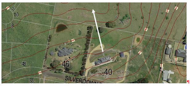
Figure 5 – objectors primary view line
There is a significant height difference
between the position of the objector's dwelling and land over which they enjoy
their primary views. Other views further to the east are constrained by the
topography and will be adversely affected, but it is considered that
substantially the primary views for the objector’ would be retained. The
contours shown in Figure 5 are at 2m intervals, and thus the
objectors’ dwelling is approximately 6-8m higher than the land over which
they enjoy their most significant views.
There is no dispute that certain elements
of these views may be impacted after the subject property is developed for the objector.
However it is not considered that such losses are excessive. The views
currently enjoyed would be substantially retained for the objector, and
conditions with respect to setbacks, site coverage and building envelopes,
along with secondary controls relating to tree retention and future fencing
(required to be rural fencing, less the barbed wire) will all serve to reduce
view loss impacts.
The DCP includes some guidelines with
regard to view analysis, and identifies certain features as providing "highly
valued" views. The DCP identifies Mt Canobolas as the primary view in
Orange, but also identifies Suma Park, Mt Bulgas to the east, the framing hills
around Clifton Grove and further to the north the Mullion Ranges
None of these primary or "highly valued"
views are impeded by the proposed development. The likely future development on
the lots in question will be the subject of further assessment at the stage
applications for individual development proposals are received. However, it is
appropriate and possible to impose building restrictions (previously detailed)
that will control the amount of view loss to a "view sharing"
situation.
The Land & Environment Court has
established some planning principles with regard to view loss assessment. The
salient principle can be found in Tenacity Consulting v Warringah Council
[2004] NSWLEC 140 at 25-29, as set out below:
25 The notion of view sharing is
invoked when a property enjoys existing views and a proposed development would
share that view by taking some of it away for its own enjoyment. (Taking it all
away cannot be called view sharing, although it may, in some circumstances, be
quite reasonable.) To decide whether or not view sharing is reasonable, I have
adopted a four-step assessment.
26 The first step is the assessment of
views to be affected. Water views are valued more highly than land views.
Iconic views (eg of the Opera House, the Harbour Bridge or North Head) are
valued more highly than views without icons. Whole views are valued more highly
than partial views, eg a water view in which the interface between land and
water is visible is more valuable than one in which it is obscured.
27 The second step is to consider from
what part of the property the views are obtained. For example the protection of
views across side boundaries is more difficult than the protection of views
from front and rear boundaries. In addition, whether the view is enjoyed from a
standing or sitting position may also be relevant. Sitting views are more
difficult to protect than standing views. The expectation to retain side views
and sitting views is often unrealistic.
28 The third step is to assess the
extent of the impact. This should be done for the whole of the property, not
just for the view that is affected. The impact on views from living areas is
more significant than from bedrooms or service areas (though views from
kitchens are highly valued because people spend so much time in them). The
impact may be assessed quantitatively, but in many cases this can be meaningless.
For example, it is unhelpful to say that the view loss is 20% if it includes
one of the sails of the Opera House. It is usually more useful to assess the
view loss qualitatively as negligible, minor, moderate, severe or devastating.
29 The fourth step is to assess the
reasonableness of the proposal that is causing the impact. A development that
complies with all planning controls would be considered more reasonable than
one that breaches them. Where an impact on views arises as a result of
non-compliance with one or more planning controls, even a moderate impact may
be considered unreasonable. With a complying proposal, the question should be
asked whether a more skillful design could provide the applicant with the same
development potential and amenity and reduce the impact on the views of
neighbours. If the answer to that question is no, then the view impact of a
complying development would probably be considered acceptable and the view
sharing reasonable.
In relation to paragraph 25, it is
acknowledged that likely future development of the site will reduce views
enjoyed by the objector to the north. However, due to the size of the
allotments and the controls elsewhere included in the Notice of Determination,
view sharing for this development is considered possible.
In relation to paragraphs 26 and 27, the views
to the north are significant, but are not identified as iconic under the DCP.
They are, however, considered in the SSS and suggested as significant in that
study. The views for the objectors’ property are panoramic and general,
viewed primarily across the rear, north-north west facing boundary of the
objector. These views cover a wide proportion of the panorama. A proportion of
this outlook view may be lost as a result of future residential development,
however it would retain some of this outlook view. The DCP building envelope
provisions will ensure that total obstruction of the view corridor does not
occur.
Further, in relation to paragraph 28, it is
considered that this principal links back to the preceding comments. For the
whole of the objectors’ property the potential view loss arising from
future development is considered unlikely to be a total loss of view. Some
degree of view sharing will be possible from the objectors’ property. It
is considered unreasonable for the objector to assume that the vacant land to
the north of their property would remain vacant indefinitely.
In relation to paragraph 29, the proposed
subdivision is consistent with other planning controls, and in the context of
applying those controls must be considered as in conformity to the applicable
standards. There is an obvious problem in taking this logic too far. Although
conforming to the LEP provisions and the general controls of the DCP, there is
no detailed masterplan in the DCP. Such guiding principles as are considered
likely to have been applied to such a masterplan have, in fact, been applied to
this planning assessment and conditions and changes imposed as to achieve those
altered outcomes. It is considered that even with the application of ersatz
controls the proposed development should be considered as consistent with those
desired planning outcomes, and hence a reasonable outcome in terms of view
sharing.
In regards to point (3), the body of this
report includes an assessment of the suitability of the subdivision design,
including an analysis of slope and its impact on size and shape of the proposed
lots. The submission urges Council to consider the placement of certain
restrictions on the titles of the proposed lots aimed at assisting with the
protection of views and amenity of surrounding properties.
The matters raised in the submission
suggest the establishment of buffer zones along the ridge, a redesign of the
width-to-depth ratio of certain lots to limit future view impacts, the
establishment of building envelopes, a limit on the amount of cut and fill
permitted on the land and the establishment of building height controls to
minimize impacts on rural views.
Recommendations included in this report
attempt to address some, but not all of the suggestions made by the objector.
In particular it should be noted that the recommendations outlined in the body
of the report have been incorporated into conditions of consent where deemed
appropriate and reasonable. In particular, it should be noted that the draft
conditions of consent include conditions requiring the establishment a
restriction on the title of certain lots prior to the issue of a Subdivision
Certificate. The recommended conditions address the following matters
· establishment of building envelopes and setbacks for future
development
· establishment of site coverage controls
· a requirement for the protection and retention of certain
established vegetation within the development site
· a requirement for the establishment of landscape zones within
certain lots
· a requirement for landscape buffers to be established in certain
locations
· a requirement for single storey development for Lots 332/333 to 338
· The amalgamation of Lots 332 and 333 into a single allotment.
The implementation of the above
recommendations are considered necessary to limit the impacts of this
development on surrounding lands and will ensure that the development proceeds
in an acceptable manner.
In regards to point (4), conditions of
consent have been included on the attached draft notice, which relate to soil
and erosion control, and the hours of operation for construction. Furthermore,
the future developers will need to comply with the noise requirements and regulations
set out in the Protection of the Environmental Operations Act 1997.
Professional planning
submission by Planning Partnerships (Ben Rourke), on behalf of Sarah and
Patrick Rourke
(1) The
waterway on the block is a prescribed stream, requiring an Integrated
Development Consent with co-approval from NSW Office of Water. Alternatively a
40 setback from the Riparian zone is required.
(2) Visual
impacts. The likely future development along the ridgelines will have a
significant adverse impact on the existing scenic outlook enjoyed by the
objector.
(3) Requests
amended plans that include a 30m wide buffer from the shared boundary , or a
building envelope on which a dwelling may be built. Further the establishment
of a landscape buffer along the shared boundary is requested.
Comment
In relation to (1), Council is advised that there is a
drainage line Category 1 stream (using the Strahler classification system
on the site) which eventually drains into Broken Shaft creek. The NSW
Office of Water (NoW) advises that it is probable that a controlled activity
permit would be required given the extent of disturbance to be undertaken on
this drainage line. It is incorrect, however, to assert that Integrated
Development assessment is mandatory for a proposed development not nominated as
integrated by the proponent when lodged with Council. The applicant has a
choice and has elected in this case that this proposal not be treated as
Integrated Development. As discussed in the body of this report, it is
considered appropriate under these circumstances to impose a condition that
requires the applicant to liaise directly with NoW with respect to requirements
under the Water Management Act (WMA).
In relation to (2), it is agreed that the development likely
to follow the subdivision of the subject land will change the character of the
objectors’ land, however it does not follow that such impacts are likely
to have a significant adverse effect. This is a significant test to
apply in the assessment, and is obviously subjective. However, the proposed
development is consistent with the relevant zoning and density controls of the
LEP, generally conforms to the assessment criteria of the DCP as they currently
exist, and further can be conditioned so as to meet further standards as would
be likely to apply had the site been subject to formal master planning. The
proposed development is generally consistent with relevant Land and Environment
Court Planning Principals in terms of view loss and view sharing. On the basis
of these relevant surrogate measures and standards, the proposed development is
considered reasonable development, unlikely to have significant impact on the
visual quality of the locality.
In relation to (3), there are no detailed master planning
provisions on which to assess the outcomes of this proposed development. It is
not possible or practical to seek buffers or corridors of 30m; however building
envelopes for proposed Lots 312 to 319 (inclusive), in which setbacks of not
less than 15m are included as conditions in the notice.
PUBLIC INTEREST
s79C(1)(e)
The proposed development is of considerable
interest to a small section of the public due to the perception of the adverse
impacts the proposal would generate on rural residential character. However,
whist the change in zoning may be perceived as a land use conflict, the actual
development is consistent with its zoning and the overall objectives and
provisions of the LEP; and the proposed development, of itself, will not
cause any significant adverse effect beyond what is allowed for under the
zoning of the site. The proposal is not inconsistent with any relevant policy
statements, planning studies, guidelines etc that have been considered in this
assessment.
SUMMARY
The proposed development can be conditioned
so as to minimise the adverse effects of the subdivision. Principally,
conditions have been added to retain existing rural fencing, retain and enhance
the natural vegetation of the site, and achieve higher than normal spacing and
setbacks for future dwellings on the new lots by various measures. One lot is
proposed to be eliminated. This is unlikely to meet with the approval of the
local residents, who are strongly opposed to the proposed development, however
it is likely to minimise the adverse effects arising from the proposed
development.
The proposed subdivision is consistent with
the zoning that applies to the site. It is also consistent with the objectives
of the LEP, or at minimum, not contrary to them. The proposed development is
not contrary to any specific provision of the DCP. Conditions are imposed that
would achieve the same outcomes as if the subject property were the subject of
a fully worked-up masterplan.
It is considered that within the parameter
discussed within the report, there is no significant view loss or privacy
issues allied to the proposed development. It has been necessary to recommend
significant conditions to address certain amenity issues, but as a
generalisation, the proposed development is consistent with the standards and
aims of the planning controls that can be applied to it.
The proposed development complies with the
relevant aims, objectives and provisions of the LEP. A Section 79C
assessment of the development indicates that the development is acceptable in
this instance. Attached is a draft Notice of Approval outlining a range of
conditions considered appropriate to ensure that the development proceeds in an
acceptable manner.
COMMENTS
The requirements of the Environmental Health and Building
Surveyor and the Engineering Development Section are included in the attached
Notice of Approval.
Attachments
1 Notice
of Approval, D16/12646⇩
2 Plans,
D16/12096⇩
3 Submissions
(1), D16/11916⇩
4 Submissions
(2), D16/11917⇩
Planning and Development Committee
5 April 2016
2.3 Development
Application DA 233/2015(1) - 98 Gorman Road
Attachment 1 Notice
of Approval
|

|
ORANGE
CITY COUNCIL
Development
Application No DA
233/2015(1)
NA16/ Container
PR4763
|
NOTICE OF DETERMINATION
OF A DEVELOPMENT APPLICATION
issued under the Environmental
Planning and Assessment Act 1979
Section 81(1)
|
Development
Application
|
|
|
Applicant Name:
|
Mrs CY
Pearson, Mrs FK Blunt and Mrs JE Youngman
|
|
Applicant Address:
|
C/- Peter
Basha Planning & Development
PO Box
1827
ORANGE
NSW 2800
|
|
Owner’s Name:
|
Mrs CY
Pearson, Mrs JE Youngman and Mrs FK Blunt
|
|
Land to Be Developed:
|
Lot 1 DP
581736 - 98 Gorman Road, Orange
|
|
Proposed Development:
|
Subdivision
(38 lot residential plus public open space and drainage reserves)
|
|
|
|
|
Building
Code of Australia
building classification:
|
Not
applicable
|
|
|
|
|
Determination
|
|
|
Made On:
|
5 April
2016
|
|
Determination:
|
CONSENT
GRANTED SUBJECT TO CONDITIONS DESCRIBED BELOW:
|
|
|
|
|
Consent to
Operate From:
|
6 April
2016
|
|
Consent to
Lapse On:
|
6 April
2021
|
Terms of Approval
The reasons for the imposition of
conditions are:
(1) To ensure a quality
urban design for the development which complements the surrounding environment.
(2) To maintain
neighbourhood amenity and character.
(3) To ensure compliance
with relevant statutory requirements.
(4) To provide adequate
public health and safety measures.
(5) Because the development
will require the provision of, or increase the demand for, public amenities and
services.
(6) To ensure the utility
services are available to the site and adequate for the development.
(7) To prevent the proposed
development having a detrimental effect on adjoining land uses.
(8) To minimise the impact
of development on the environment.
Conditions
(1) The
development must be carried out in accordance with:
(a) Plans By Heath
Consulting Engineers: 14048_DE01 REV B (sheet 1); 14048_DE02 REV B (sheet 2);
14048_DE03 REV B (sheet 3); 14048_DE04 REV B (sheet 4); 14048_DE05 REV B (sheet
5); 14048_DE06 REV B (sheet 6); 14048_DE07 REV B (sheet 7); 14048_DE08 REV B
(sheet 8); 14048_DE09 REV B (sheet 9); 14048_DE10 REV B (sheet 10);14048_DE10
REV B (sheet 11); 14048_DE12 REV B (sheet 12); 14048_DE13 REV B (sheet 13);
14048_DE14 REV B (sheet 14); 14048_DE15 REV B (sheet 15); 14048_DA03 REV D
(sheet 3 of 4); 14048_DA04 REV D (sheet 4 of 4); (17 sheets in total)
(b) statements
of environmental effects or other similar associated documents that form part
of the approval
as amended
in accordance with any conditions of this consent.
(2) A sign is to be erected
in a prominent position on any site on which building work, subdivision work or
demolition work is being carried out:
a. showing
the name, address and telephone number of the principal certifying authority
for the work, and
b. showing
the name of the principal contractor (if any) for any building work and a
telephone number on which that person may be contacted outside working hours,
and
c. stating
that unauthorised entry to the site is prohibited.
Any such sign is to be maintained while the
building work, subdivision work or demolition work is being carried out.
|
PRIOR TO THE ISSUE OF
A CONSTRUCTION CERTIFICATE
|
(3) A
Construction Certificate application is required to be submitted to, and issued
by, Council prior to any works being carried out onsite.
(4) Engineering plans,
showing details of all proposed work and adhering to any engineering conditions
of development consent, are to be submitted to, and approved by, Orange City
Council or an Accredited Certifier (Categories B1, C3, C4, C6) prior to the
issuing of a Construction Certificate.
All
roads are to be constructed to a sealed urban road standard in accordance with
the Orange City Council Development and Subdivision Code.
(5) Amended plans shall be
submitted to Council that show the amalgamation of proposed Lots 332
and 333 (hereafter referred to as Lot332/333), into the one allotment, and
increase the minimum depth for Lot 334 to 38m (currently proposed at
35m.
(6) The applicant shall
provide Council with written documentation from NSW Office of Water (NOW)
indicating that a controlled activity permit under the Water Management Act
(WMA) is not required for the proposed development. If the NSW Office of Water
determine that a controlled activity permit under the Water Management Act is
required for the proposed development the applicant shall furnish Council with
a copy of the permit prior to the issue of a Construction Certificate.
(7) A water and soil
erosion control plan is to be submitted to Orange City Council or an Accredited
Certifier (Categories B1, C3, C4, C6) for approval prior to the issuing of a
Construction Certificate. The control plan is to be in accordance with the
Orange City Council Development and Subdivision Code and the Landcom, Managing
Urban Stormwater; Soils and Construction Handbook.
(8) The
development’s stormwater design is to include stormwater retention within
the development, designed to limit peak outflows from the land to the
pre-existing natural outflows up to the 100 year ARI frequency, with sufficient
allowance in overflow spillway design capacity to safely pass flows of lower
frequency (that is, a rarer event) without damage to downstream developments.
Where appropriate, the spillway design capacity is to be determined in
accordance with the requirements of the Dam Safety Committee.
The design of the detention storage is to be
undertaken using the ILSAX rainfall-runoff hydrologic model or an approved
equivalent capable of assessing runoff volumes and their temporal distribution
as well as peak flow rates. The model is to be used to calculate the flow rates
for the existing and post-development conditions. The developed flows are to be
routed through the proposed storage within the model so that the outflows
obtained are no greater than the flows obtained for the pre-existing natural
flows. A report detailing the results of the analysis, which includes:
· catchment
plan showing sub-catchments under existing and developed conditions;
· schematic
diagram of the catchment model showing sub areas and linkages;
· tabulation
detailing the elevation, storage volume and discharge relationships; and
· tabulation
for the range of frequencies analysed, the inflows, outflows and peak storage
levels for both existing and developed conditions;
together with copies of the data files for the
model and engineering design plans of the required drainage system are to be
submitted and approved by Orange City Council or an Accredited Certifier
(Categories B1, C3, C4, C6) prior to the issue a Construction Certificate.
(9) Proposed
lots are to be provided with interlot stormwater drainage, including those lots
abutting public land, where the surface of the entire lot cannot be drained to
the kerb and gutter at the lot frontage. A grated stormwater pit is to be
constructed within each lot provided with interlot stormwater drainage.
Engineering plans for this drainage system are to be approved by Orange City
Council or an Accredited Certifier (Categories B1, C3, C4, C6) prior to the
issuing a Construction Certificate.
(10) Stormwater from the
site is to be piped to the adjacent watercourse, where it is to be discharged
through a standard headwall with appropriate scour protection. Engineering
plans of this required drainage system are to be approved by Orange City
Council or by an Accredited Certifier (Categories B1, C3, C4, C6) prior to the
issuing of a Construction Certificate.
(11) A 150mm-diameter sewer
main is to be constructed from Council’s existing mains to serve the
proposed lots. Orange City Council, prior to issuing a Construction
Certificate, is to approve engineering plans for this sewerage system.
(12) A water
reticulation analysis is to be carried out by Orange City Council on any
proposed water-reticulation system for the development. Engineering plans are
to be submitted to Orange City Council for approval prior to the issuing of a
Construction Certificate.
The reticulation system is to be designed to
supply a peak instantaneous demand by gravity of 0.15 L/s/tenement at a minimum
residual head of 200kPa.
|
PRIOR TO WORKS
COMMENCING
|
(13) Soil erosion control
measures shall be implemented on the site.
(14) A
temporary onsite toilet is to be provided and must remain throughout the
project or until an alternative facility meeting Council’s requirements
is available onsite.
|
DURING
CONSTRUCTION/SITEWORKS
|
(15) Excavated rock derived
from the site works shall either be the stored and used in above ground uses
within the subdivision area, or, stored on a Council designated stockpile for
future use. It shall not be re-buried.
If
Aboriginal objects, relics, or other historical items or the like are located
during development works, all works in the area of the identified object, relic
or item shall cease, and the NSW OEH and representatives from the Orange LALC
shall be notified. Further archaeological investigation shall be undertaken
where required,. Development works in the area of the find(s) may recommence
only when cleared to do so by OEH, which may require a permit to destroy the
artefact under section 90 of the National Parks and Wildlife Act 1974.
(16) The source of imported
material must be advised prior to the placement of that fill and shall be rom a
site or source certified as not contaminated
(17) All
construction/demolition work on the site is to be carried out between the hours
of 7.00 am and 6.00 pm Monday to Friday inclusive, 7.00 am to
5.00 pm Saturdays and 8.00 am to 5.00 pm on Sundays and Public
Holidays. Written approval must be obtained from the General Manager of Orange
City Council to vary these hours.
(18) Any adjustments to
existing utility services that are made necessary by this development
proceeding are to be at the full cost of the developer.
(19) The
provisions and requirements of the Orange City Council Development and
Subdivision Code are to be applied to this application and all work constructed
within the development is to be in accordance with that Code.
The developer is to be entirely responsible for
the provision of water, sewerage and drainage facilities capable of servicing
all the lots from Council’s existing infrastructure. The developer is to
be responsible for gaining access over adjoining land for services where
necessary and easements are to be created about all water, sewer and drainage
mains within and outside the lots they serve.
(20) Gorman Road is to be constructed as
half road width
for the full frontage of the proposed development. This work is to include road
pavement and pavement surfacing to the centreline, kerb and gutter construction
and earth-formed footpath on the development side of the road.
(21) For all single access
battleaxe blocks, a concrete driveway, kerb layback and footpath crossing is to
be constructed to a minimum width of 3.0 metres and to the requirements and
standards of the Orange City Council Development and Subdivision Code.
(22) Water and sewerage
reticulation is to be provided to every lot in the proposed residential
subdivision in accordance with the Orange City Council Development and
Subdivision Code.
(23) Concrete bicycle
pathways, a minimum of 2.5 metres wide, are to be constructed on one side of
all 20.0m wide streets including Gorman Road.
Construction work is to be to the requirements
and standards of the Orange City Council Development and Subdivision Code.
(24) All street lighting is
to be completed using Essential Energy prestige style 4 columns and luminaries.
The required lighting level along all roads is P4 as per the Australian
Standard.
|
PRIOR TO THE ISSUE OF
A SUBDIVISION CERTIFICATE
|
(25) Application shall be
made for a Subdivision Certificate under Section 109(C)(1)(d) of the Act.
(26) The
final subdivision plan shall show the amalgamation of proposed Lots 332
and 333, into the one allotment. The subdivision plan shall also be
altered to show a minimum depth for Lot 334 of 38m (proposed at 35m).
(27) A
Restriction-as-to-User under Section 88B of the NSW Conveyancing Act 1979 shall
be created on the titles of Lots 332/333 to 338 and 312 to 319 (being
those lots on the ridge and those lots along the southern boundary) specifying
a maximum site coverage that does not exceed 35% of the respective lot size.
The Restriction shall also provide for a minimum setback of 15m from the
southern boundary for Lots 312 to 319 and a minimum setback of 12m from Gorman
Road.
For
those lots not elsewhere identified in the consent (Lots 301 to 307, Lots 308
to 311 and Lots 320 to 331) building restriction envelopes not
exceeding 50% of the allotment size are required.
All
building envelopes required under this consent, except where elsewhere
otherwise specified, shall incorporate front and side setbacks not less than of
10m and 2m respectively.
(28) A
Restriction-as-to-User under Section 88B of the NSW Conveyancing Act 1979 shall
be created on the title for Lots 332/333 to Lot 338 (inclusive) that requires
the submission of a landscape plan that is to the satisfaction of Council with
any dwelling (or outbuilding) application. Such landscaping is to incorporate
species selection with a mature height greater than the height of the
structures proposed and able to screen a minimum of 50% of the width of the
proposed dwelling or building frontage. Full implementation of the approved
landscaping is required prior to the issue of an Occupation Certificate, and
retention and maintenance of such landscaping required thereafter.
(29) A
Restriction-as-to-User under Section 88B of the NSW Conveyancing Act 1979 shall
be placed on the titles of proposed Lots 332/333 to 338 limiting future
development on these lots to single storey construction. The
Restriction-as-to-User shall also limit all fencing throughout the subdivision
to rural type fencing less the barbed wire component as per the requirements of
Councils Development Control Plan 2004.
(30) A
Restriction-as-to-User under Section 88B of the NSW Conveyancing Act 1979 is
required for the retention and protection of trees on Lots 304, 305, 306
and 307, 315, 310, 303 (the smaller tree on this lot may be removed),
including those trees currently proposed for removal on the amended plan
(principally those trees within the easement), by the imposition of building
envelopes and tree protection zones on these sites. The restriction shall
provide for the protection of the designated trees.
(31) The payment of
$620,210.36 is to be made to Council in accordance with Section 94 of the Act
and the Orange Development Contributions Plan 2015 (development in Ploughmans
Valley urban release area) towards the provision of the following public
facilities:
|
Open Space and Recreation
|
@ $3,314.19 x 36 additional lots
|
119,310.84
|
|
Community and Cultural
|
@ $667.50 x 36 additional lots
|
24,030.00
|
|
Roads and Cycleways
|
@ $5,137.60 x 36 additional lots
|
184,953.60
|
|
Stormwater Drainage
|
@ $310.15 x 36 additional lots
|
11,165.40
|
|
Local Area Facilities
|
@ $9,465.09 x 36 additional lots
|
340,743.24
|
|
Plan Preparation & Administration
|
@ $566.73 x 36 additional lots
|
20,402.28
|
|
Sub Total
|
|
$700,605.36
|
|
Less compensation for Open Space
|
(2297m² x 35m² = $80,395)
|
-$80395.00
|
|
Total
|
|
$620,210.36
|
The
contribution will be indexed quarterly in accordance with the Orange
Development Contributions Plan 2015 (development in Ploughmans Valley urban
release area).
(32) Soil
sampling for analysing chemical residue is to be carried out within the
proposed Lots in a manner and frequency as determined by an appropriately
qualified and experienced consultant giving consideration to previous specific
uses and on-site characteristics of the site. A NATA registered laboratory
is to carry out such testing. Reference is to be made to the Contaminated
Land Management Act 1997 and State Environmental Planning Policy No 55
- “Remediation of Land”. The results of the testing are to be provided
to the Principal Certifying Authority and are to demonstrate that the land is
suitable for residential use, to enable a Subdivision Certificate to be issued.
(33) Payment of
contributions for water, sewer and drainage works is required to be made
at the contribution rate applicable at the time that the payment is made. The
contributions are based on 36 ETs for water supply headworks and 37 ETs for
sewerage headworks. A Certificate of Compliance, from Orange City Council in
accordance with the Water Management Act 2000, will be issued upon
payment of the contributions.
This Certificate of Compliance is to be
submitted to the Principal Certifying Authority prior to the issuing of a
Subdivision Certificate.
(34) Evidence from a
registered NATA laboratory is to be submitted prior to the issuing of a
Subdivision Certificate stating that the filling of all dams and low-lying
areas has been carried out in accordance with Australian Standard 3798-2007.
(35) Certification from
Telstra, stating that telecommunication systems comply with Australian
Standards, is to be submitted to the Principal Certifying Authority prior to
the issuing of a Subdivision Certificate.
(36) Certification from
Essential Energy, stating that electricity and street lighting systems comply
with Essential Energy’s Networks Division Customer Connection Policy
NP11.1, is to be submitted to the Principal Certifying Authority prior to the
issuing of a Subdivision Certificate.
All street lighting is to be completed using
Essential Energy prestige style 4 columns and luminaries. The required lighting
level along all roads is P4 as per the Australian Standard.
(37) An easement to drain
sewage and to provide Council access for maintenance of sewerage works a
minimum of 2.0 metres wide is to be created over the proposed sewerage works.
The Principal Certifying Authority is to certify that the easement is in
accordance with the Orange City Council Development and Subdivision Code prior
to the issuing of a Subdivision Certificate.
(38) All services are to be
contained within the allotment that they serve. A Statement of Compliance, from
a Registered Surveyor, is to be submitted to the Principal Certifying Authority
prior to the issuing of a Subdivision Certificate.
(39) A Certificate of
Compliance, from a Qualified Engineer, stating that the stormwater retention
basin comply with the approved engineering plans is to be submitted to the
Principal Certifying Authority prior to the issuing of a Subdivision
Certificate.
(40) A
Maintenance Security Deposit, in accordance with the provisions and
requirements of the Orange City Council Development and Subdivision Code, is to
be provided to Orange City Council prior to the issuing of a Subdivision
Certificate.
A Certificate of Compliance, from Orange
City Council, certifying that the maintenance security deposit has been paid,
is to be submitted to the Principal Certifying Authority prior to the issuing
of a Subdivision Certificate.
(41) Where
stormwater crosses land outside the lot it favours, an easement to drain water
is to be created over the works. A Restriction-as-to-User under section 88B of
the NSW Conveyancing Act 1979 is to be created on the title of the
proposed lots requiring that no structures are to be placed on the site, or
landscaping or site works carried out on the site, in a manner that affects the
continued operation of the interlot drainage system. The minimum width of the
easement is to be as required in the Orange City Council Development and
Subdivision Code.
(42) All
of the foregoing conditions are to be at the full cost of the developer and to
the requirements and standards of the Orange City Council Development and
Subdivision Code, unless specifically stated otherwise. All work required by
the foregoing conditions is to be completed prior to the issuing of a
Subdivision Certificate, unless stated otherwise.
|
REQUIREMENTS FROM
ESSENTIAL ENERGY
|
· Statutory
ground clearances being maintained in accordance with Essential Energy’s Operational
Manual: Overhead Design Manual (CEOM7097). Any remediation work required
would need to be completed by an Accredited Service Provider not at the expense
of Essential Energy;
· No
vegetation being planted within the proposed easement without approval from
Essential Energy; and
· An easement
being created with respect to the existing 66,000 volt powerline within the
proposed subdivision, as outlined in Essential Energy’s Network
Planning: Easement Requirements policy (CEOP8046) in particular:
(a) An
easement 30 metres wide is required; and
(b) Essential
Energy’s standard easement terms parts A/B or C of Memorandum AG189384.
Other Approvals
(1) Local
Government Act 1993 approvals granted under section 68.
Nil
(2) General
terms of other approvals integrated as part of this consent.
Nil
Right of Appeal
If
you are dissatisfied with this decision, section 97 of Environmental
Planning and Assessment Act 1979 gives you the right to appeal to the Land
and Environment Court within 6 months after the date on which you receive this
notice.
*
Section 97 of the Environmental Planning and Assessment Act 1979 does not apply
to the determination of a development application for State significant
development or local designated development that has been the subject of a
Commission of Inquiry.
|
Disability Discrimination Act
1992:
|
This application has been assessed in
accordance with the Environmental Planning and Assessment Act 1979. No
guarantee is given that the proposal complies with the Disability
Discrimination Act 1992.
The applicant/owner is responsible to
ensure compliance with this and other anti-discrimination legislation.
The Disability Discrimination Act
covers disabilities not catered for in the minimum standards called up in the
Building Code of Australia which references AS1428.1 - "Design for
Access and Mobility". AS1428 Parts 2, 3 and 4 provides the most
comprehensive technical guidance under the Disability Discrimination Act
currently available in Australia.
|
|
|
|
|
Disclaimer - S88B Restrictions on the Use of Land:
|
The applicant should note that there
could be covenants in favour of persons other than Council restricting what
may be built or done upon the subject land. The applicant is advised to check
the position before commencing any work.
|
|
|
|
|
Signed:
|
On behalf of the consent authority ORANGE
CITY COUNCIL
|
|
Signature:
|
|
|
Name:
|
DAVID WADDELL - DIRECTOR DEVELOPMENT
SERVICES
|
|
Date:
|
6 April 2016
|
Planning
and Development Committee
5 April 2016
2.3 Development
Application DA 233/2015(1) - 98 Gorman Road
Attachment 2 Plans
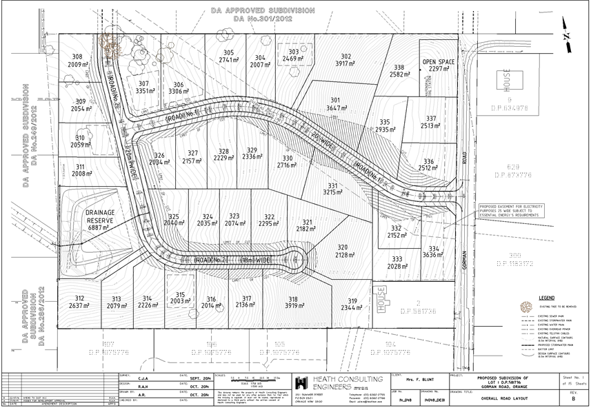
Planning and Development Committee
5 April 2016
2.3 Development
Application DA 233/2015(1) - 98 Gorman Road
Attachment 2 Plans
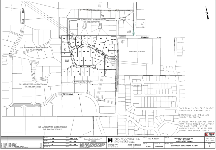
Planning and Development Committee
5 April 2016
2.3 Development
Application DA 233/2015(1) - 98 Gorman Road
Attachment 2 Plans
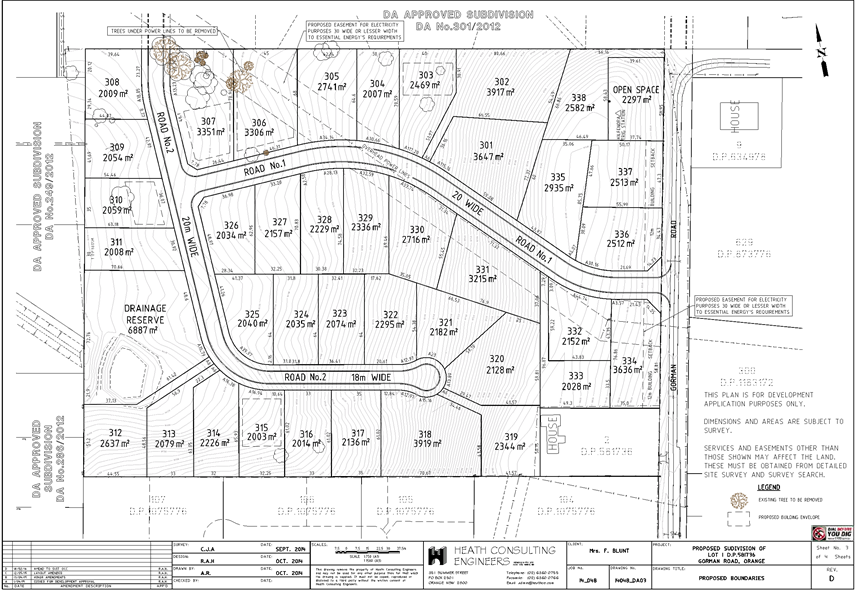
Planning and Development Committee
5 April 2016
2.3 Development
Application DA 233/2015(1) - 98 Gorman Road
Attachment 3 Submissions
(1)
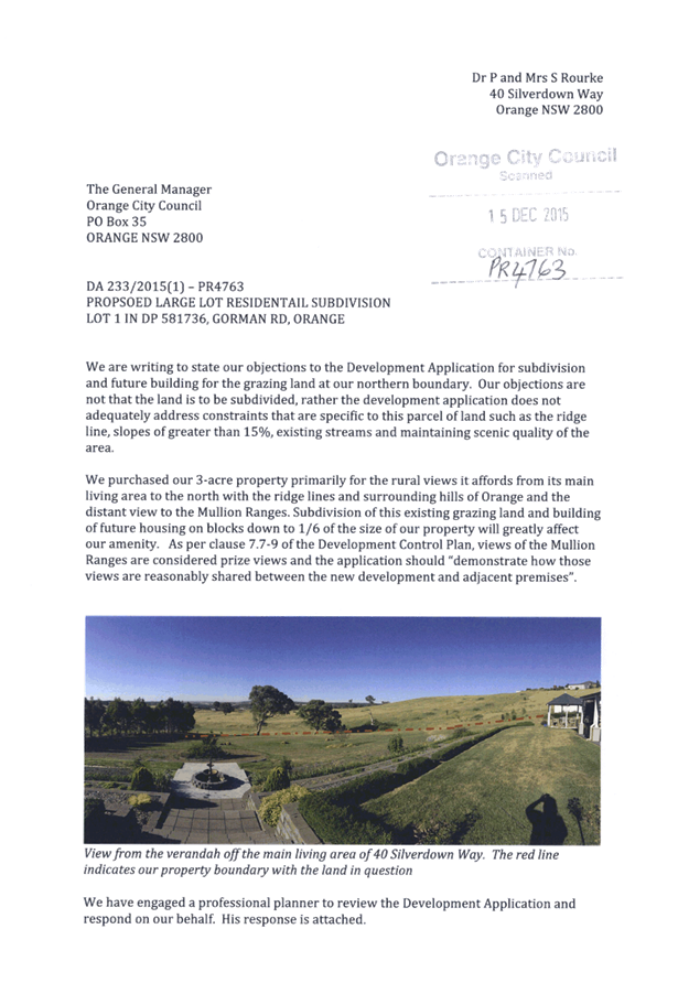
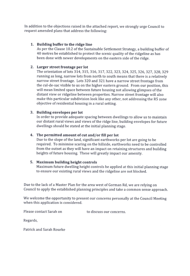
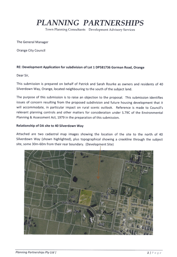
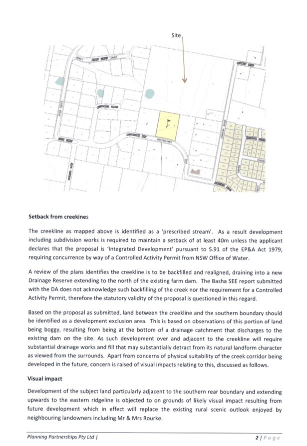
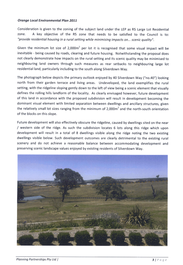
Planning
and Development Committee
5 April 2016
2.3 Development
Application DA 233/2015(1) - 98 Gorman Road
Attachment 4 Submissions
(2)

2.4 Development
Application DA 31/2016(1) - CWA Hall - Robertson Park - Byng Street
TRIM
REFERENCE: 2016/642
AUTHOR: Kelly
Walker, Town Planner
EXECUTIVE Summary
|
Application lodged
|
8 February 2016
|
|
Applicant
|
Orange City Council
|
|
Owner
|
Orange City Council
|
|
Land description
|
Lot 703 DP 1020799 - CWA Hall - Robertson Park - Byng Street,
Orange
|
|
Proposed land use
|
Community Facility (alterations and additions to CWA Hall),
Business Identification Signage and Demolition (tree removal)
|
|
Value of proposed development
|
$228,000
|
Council's consent is sought for alterations
to the CWA (Country Women’s Association) Hall in Robertson Park, Byng
Street, Orange. The proposal involves part demolition of the CWA Hall and
rebuilding a slightly larger extension, including the installation of public
toilets, an outdoor courtyard, and a new ramp from the park. The proposal also
involves the removal of a tree within the park to facilitate the larger
extension. A new sign is proposed on the northern (Byng Street) elevation
stating: “CWA Orange Branch”.
Robertson Park is a listed heritage item,
which includes the landscaping, trees, bandstand, war memorial, fountain and
CWA Hall. The site is also within the Heritage Conservation Area. Consent is
required for the demolition of a listed heritage item, including the removal of
the tree, as well as the construction of the new extension.
The applicant has been liaising with
Council’s Heritage Advisor, who has made recommendations to achieve an
acceptable outcome. While the applicant has taken some of these comments into
consideration two design elements relating to the provision of a glass block
panel in the eastern elevation of the building and the final details of the
proposed sliding gate remain outstanding. The applicant states that a final
design of the gate has not yet been worked up.
The applicant has requested that the
requirement for a glass block panel in the eastern elevation of the building
not be required in this case, arguing that a requirement to do so will affect
the design of the wall and is outside the current brief provided by
the CWA. Council’s Heritage Advisor is of the view that the eastern
elevation of the building will have a heavy visual impact. In order to address
concerns in regards to the visual appearance of the eastern elevation and the
impact it will have on the heritage and landscape values of the park, it is
recommended that the provision of a glass block panel in the proposed toilet
area, similar to the panel proposed in the accessible toilet on the southern
elevation of the building, be required as a condition of consent. It is
considered that the provision of a glass block panel within the eastern
elevation will significantly improve the overall visual presentation of this
particular elevation.
Conditions of consent addressing such
matters have been recommended for Council’s consideration and are
attached to the Notice of Approval. A condition of consent is also required to
photographically record and survey the listed building prior to its (part)
demolition.
Council’s Manager City Presentation
supports the removal of the tree, and does not require a replacement.
Council’s Environmental Health and
Building Surveyor recommends conditions of consent to ensure that works are
carried out in compliance with relevant regulations, including the demolition
and removal of asbestos materials, fencing off the site during construction
(given it is public land) and accessibility requirements of the public toilets.
Link To Delivery/OPerational Plan
The recommendation in this report relates to the
Delivery/Operational Plan strategy “13.4 Our Environment
– Monitor and enforce regulations relating to City amenity”.
Financial Implications
Council has been advised that as a council included in the
NSW Government’s merger proposals under consideration by the Office of
Local Government since referral on 6 January 2016, Council must comply with the
merger proposal period guidelines issued under S23A of the Local Government Act
1993.
The guidelines instruct Council it should expend money in
accordance with the detailed budget adopted for the purposes of implementing
the Delivery/Operational Plan for the 2015/16 year.
Any expenditure outside the adopted budget requires the
identification of clear and compelling grounds and must be approved by Council
at a meeting that is open to the public. The guidelines indicate the resolution
of Council for increased expenditure must specify the reasons why the
expenditure is required and warranted.
If increased expenditure is greater than $250,000 or 1% of
the Council’s revenue from rates in
the preceding year, whichever is the greater, Council
is required to exhibit the increase to the budget and consider comments
received.
Council must also avoid entering into contracts or
undertakings where expenditure or revenue is greater than $250,000 or 1% of the
Council’s revenue from rates in the
preceding year, whichever is the greater, unless the contract or undertaking is
as a result of a decision or procurement process commenced prior to the merger
proposal period or where entering into a contract or undertaking is reasonably
necessary for the purposes of meeting the ongoing service delivery commitments
of the Council or was previously approved in the Council’s
Delivery/Operational Plan.
Policy and Governance Implications
Nil
|
Recommendation
That Council
consents to development application DA
31/2016(1) for Community Facility (alterations
and additions to CWA Hall), Business Identification Signage and Demolition
(tree removal) at Lot 703 DP 1020799 - CWA Hall - Robertson Park -
Byng Street, Orange pursuant to the conditions of
consent in the attached Notice of Approval.
|
further considerations
Consideration has been given to the
recommendation’s impact on Council’s service delivery; image and
reputation; political; environmental; health and safety; employees;
stakeholders and project management; and no further implications or risks have
been identified.
SUPPORTING INFORMATION
THE
APPLICATION/PROPOSAL
Council's consent is sought for alterations
to the CWA (Country Women’s Association) Hall in Robertson Park, Byng
Street, Orange.
The proposal involves part demolition of the
CWA Hall, being the southern section of the hall, currently containing the
mothers’/meeting room, kitchen and hall toilets; and the removal of the
Box Elder tree adjacent to the hall to the south. The proposal also involves
building an extension in its place, with a larger footprint of around 129m2.
The new extension will contain a meeting room with doors out to a new enclosed
courtyard (facing the park), kitchen, hall toilets, and a storage cupboard and
entry (facing Byng Street). The extension will also provide new public toilet
facilities with three toilet cubicles, one being an accessible toilet. Entry to
the public toilets will be provided from both the park (eastern side sliding
gate) and from the courtyard (hinged gate). The courtyard will have gates
opening to a ramp to the park.
Materials include painted timber chamfer
boards, painted concrete base, glass bricks on the northern and southern
elevations, and brickwork (Macarthur mix) on the eastern elevation and for
fence and wall detailing. A sliding gate is proposed on the eastern elevation,
however final details have not yet been provided.
A new sign is proposed on the northern
(Byng Street) elevation stating: “CWA Orange Branch”.
No external changes are proposed the
existing main hall building.
MATTERS FOR
CONSIDERATION
Section 5A Assessment
In the administration of sections 78A, 79B,
79C, 111 and 112, the provisions of Section 5A must be taken into account
for every development application in deciding whether there is likely to be a
significant effect on threatened species, populations or ecological communities
or their habitats.
This section includes a requirement to
consider any adopted assessment guidelines, which means assessment guidelines
issued and in force under section 94A of the Threatened Species
Conservation Act 1995. Assessment guidelines are in force (see DECC-W
“Threatened Species Assessment Guidelines - The Assessment of
Significance”) which requires consent authority to adopt the
precautionary principle in its assessment.
In this instance, site inspection reveals
that the subject property has no biodiversity or habitat value.
Section 79C
Section 79C of the Environmental
Planning and Assessment Act 1979 requires Council to consider various
matters, of which those pertaining to the application are listed below.
PROVISIONS OF
ANY ENVIRONMENTAL PLANNING INSTRUMENT s79C(1)(a)(i)
Orange Local Environmental Plan 2011
Part 1 - Preliminary
Clause 1.2 - Aims of Plan
The broad aims of the LEP are set out under subclause 2.
Those relevant to the application are as follows:
(a) to encourage development
which complements and enhances the unique character of Orange as a major
regional centre boasting a diverse economy and offering an attractive regional
lifestyle,
(f) to recognise and
manage valued environmental heritage, landscape and scenic features of Orange.
The application is considered to be
consistent with these aims, where the proposal enhances a public space and has
been designed to be respectful of the heritage and landscape values of
Robertson Park and the CWA Hall.
Clause 1.6 -
Consent Authority
This clause establishes that, subject to
the Act, Council is the consent authority for applications made under the LEP.
Clause 1.9A -
Suspension of Covenants, Agreements and Instruments
This clause provides that covenants,
agreements and other instruments which seek to restrict the carrying out of
development do not apply with the following exceptions.
· covenants imposed or required by Council
· prescribed instruments under Section 183A of the Crown Lands Act
1989
· any conservation agreement under the National Parks and Wildlife
Act 1974
· any trust agreement under the Nature Conservation Trust Act 2001
· any property vegetation plan under the Native Vegetation Act 2003
· any biobanking agreement under Part 7A of the Threatened Species
Conservation Act 1995
· any planning agreement under Division 6 of Part 4 of the Environmental
Planning and Assessment Act 1979.
Council staff are not aware of the title of
the subject property being affected by any of the above.
Mapping
The subject site
is identified on the LEP maps in the following manner:
|
Land Zoning Map:
|
Land zoned RE1
Public Recreation
|
|
Lot Size Map:
|
Minimum Lot Size
|
|
Heritage Map:
|
A listed heritage
item and within a heritage conservation area
|
|
Height of
Buildings Map:
|
Building height
limit 6m
|
|
Floor Space Ratio
Map:
|
Floor space limit
0.2:1
|
|
Terrestrial
Biodiversity Map:
|
No biodiversity
sensitivity on the site
|
|
Groundwater
Vulnerability Map:
|
Ground water
vulnerable
|
|
Drinking Water
Catchment Map:
|
Not within the drinking
water catchment
|
|
Watercourse Map:
|
Within a sensitive
waterway and Orange Key Fish Habitat
|
|
Urban Release Area
Map:
|
Not within an
urban release area
|
|
Obstacle
Limitation Surface Map:
|
No restriction on
building siting or construction
|
|
Additional
Permitted Uses Map:
|
No additional
permitted use applies
|
Those matters that are of relevance are
addressed in detail in the body of this report.
Part 2 - Permitted or Prohibited Development
Land
Use Zones
The subject site is located within the RE1
Public Recreation zone. The proposed development is defined as a
‘Community Facility’ and ‘Business Identification
Signage’ under the Orange LEP 2011, which are defined as follows:
community facility means a building or
place:
(a) owned or controlled by a
public authority or non-profit community organisation, and
(b) used for the physical,
social, cultural or intellectual development or welfare of the community,
but does not include an
educational establishment, hospital, retail premises, place of public worship
or residential accommodation.
business identification sign means a
sign:
(a) that indicates:
(i) the name of the person
or business, and
(ii) the nature of the business
carried on by the person at the premises or place at which the sign is
displayed, and
(b) that may include the address
of the premises or place and a logo or other symbol that identifies the
business,
but that does not contain any
advertising relating to a person who does not carry on business at the premises
or place.
Both are permitted with consent for this
zone, and this application is seeking consent.
Clause
2.3 of LEP 2011 references the Land Use
Table and Objectives for each zone in LEP 2011. These objectives
for land zoned RE1 Public Recreation are as follows:
· To
enable land to be used for public open space or recreational purposes.
· To
provide a range of recreational settings and activities and compatible land
uses.
· To
protect and enhance the natural environment for recreational purposes.
· To
ensure development is ordered in such a way as to maximise public transport
patronage and encourage walking and cycling in close proximity to settlement.
· To
ensure development along the Southern Link Road has alternative access
The proposal is
generally consistent with the objectives for the zone in that it provides a
public facility which enhances the use of the land for community and
recreational use, and does not impact on the natural environment.
Clause 2.7 -
Demolition Requires Development Consent
This clause triggers the need for
development consent in relation to a building or work. This requirement does
not apply to any demolition that is defined as exempt development.
The proposal involves demolition and the
applicant is seeking the consent of Council. The demolition works proposed will
have no significant impact on adjoining lands, streetscape or public realm.
Conditions will be imposed in respect of hours of operation, dust suppression
and the need to investigate for, and appropriately manage the presence of any
materials containing asbestos. The proposal involves the demolition of a listed
heritage item, as well as the removal of a tree in a heritage conversation
area, and this is discussed in greater detail later in this report.
Part 3 - Exempt and Complying Development
The application is not exempt or complying
development.
Part 4 - Principal Development Standards
Clause
4.3 - Height of Buildings
This
clause limits the height of buildings (HoB) on land identified on the Height of
Buildings Map. The subject land is identified on the Map as having a HoB
limit of 6m. The maximum height of the proposed extension is 4.1m2
and is therefore consistent with the established height limit.
Clause 4.4 - Floor Space Ratio
This
clause limits the floor space ratio (FSR) permitted on land identified on the
Floor Space Ratio Map. Clause 4.5 is associated with this clause and
establishes the rules for calculating the site area and FSR of any proposal.
These rules exclude certain parts of a site and development such as:
· excluding
any part of the site upon which the development is prohibited (ie if the
site is split zoned only the zone in which the development is permissible may
be considered)
· excluding
community land and most public places
· lots
in a strata scheme wholly or partly above other lots in the scheme do not
increase the site area (ie the site area is the ground level of the scheme
only)
· adjoining
lots in the same ownership do not form part of the site area unless significant
parts of the development are proposed on that land
· the
floor area of existing buildings is to be included in the FSR calculation
· any
covenant restricting floor space on the lot, due to floor space having been
considered as part of the development of another lot, is to be taken into
account.
The subject land is identified
on the Map as having an FSR of 0.2:1. Robertson Park is considered to be
community land, and its site area has been calculated under clause 4.5
as 17,941.2m2, meaning the site may have up to 3,588.2m2
of floor space. The proposal has been calculated as having a gross floor area
of 308.7m2 (existing hall to be retained, plus new extension) and is
therefore consistent with the FSR requirements.
Part 5 - Miscellaneous Provisions
5.10 - Heritage
Conservation
(1) Objectives
The
objectives of this clause are as follows:
(a) to conserve the environmental heritage
of Orange,
(b) to conserve the heritage significance of
heritage items and heritage conservation areas, including associated fabric,
settings and views,
(c) to conserve archaeological sites,
(d) to conserve Aboriginal objects and
Aboriginal places of heritage significance.
(2) Requirement for Consent
Development
consent is required for any of the following:
(a) demolishing or moving any of the
following or altering the exterior of any of the following (including, in the
case of a building, making changes to its detail, fabric, finish or
appearance):
(i) a heritage item,
(ii) an Aboriginal object,
(iii) a building, work, relic or tree within a
heritage conservation area,
(b) altering a heritage item that is a
building by making structural changes to its interior or by making changes to
anything inside the item that is specified in Schedule 5 in relation to the
item,
(c) disturbing or excavating an
archaeological site while knowing, or having reasonable cause to suspect, that
the disturbance or excavation will or is likely to result in a relic being
discovered, exposed, moved, damaged or destroyed,
(d) disturbing or excavating an Aboriginal
place of heritage significance,
(e) erecting a building on land:
(i) on which a heritage item is
located or that is within a heritage conservation area, or
(ii) on which an Aboriginal object is
located or that is within an Aboriginal place of heritage significance,
(f) subdividing land:
(i) on which a heritage item is
located or that is within a heritage conservation area, or
(ii) on which an Aboriginal object is
located or that is within an Aboriginal place of heritage significance.
(4) Effect of Proposed Development on
Heritage Significance
The consent
authority must, before granting consent under this clause in respect of a
heritage item or heritage conservation area, consider the effect of the
proposed development on the heritage significance of the item or area
concerned. This subclause applies regardless of whether a heritage management
document is prepared under subclause (5) or a heritage conservation management
plan is submitted under subclause (6).
Robertson Park is a listed heritage item,
which includes the landscaping, trees, bandstand, war memorial, fountain, and
CWA Hall. The site is also within the Heritage Conservation Area. The Orange Heritage database states the following:
“The
park occupies 2 hectares, has an important central location in the city, and
has considerable cultural significance in the town's history. Elements of
significance which have retained their character include the diagonal layout,
trees, bandstand, war memorial, fountain, Boer war memorial lamp post, and CWA
Hall. This park is notable for its mature exotic trees - plains and elms on the
west and ash and pin oaks on the east. A formal arrangement of paths, made of
decomposed granite gravel with concrete edges, runs throughout, with focal points,
which include the marble fountain. There is a timber and bluestone bandstand of
1915, with slate roof, an entrance arbour and a monument to the war dead. The
grass is predominantly kikuyu. A country Women's Building occupies the
north-west corner of the park”.
The park and listed items are considered to
be in good condition, and have high level streetscape value. The site is highly
valued by the community.
The CWA Hall is in two distinct parts, the
original part which is to be demolished (See Figures 1 and 2), which was
erected as a Bowling Club:
“formed
in 1900 had its greens at the N end of the park, with a clubhouse which
remained as a ladies rest room when the Club moved to Anson Street. It was
taken over by the Country Women’s association before becoming the first
baby health centre in Orange”.
The art deco
style hall part of the building (See Figure 2) is a later addition, erected in
1954.
Figure 1 - corner view indicating the brick extension
and timber extension
(to be demolished and replaced)
Figure 2 - view from the Park showing the CWA Hall to
the left (to be retained)
and the attached structures to the right (to be
demolished and replaced)
The heritage photograph from 1931 (See
Figure 3) appears to show the building to be demolished standing independently without the Hall, with weatherboard wall cladding and
traditional terracotta roof tiles. A sign suspended from the front eave
indicates that the premises accommodated a Baby Health Centre and CWA Rest
Room. It appears that the roof was re-clad and the building clad in face brick,
possibly at the time the main hall was built. Based on the 1931 photograph, it
can be assumed that the rear timber clad elevation, clearly evident in Figure
1, is the remaining portion of the original building, and that it was not
re-clad in brick when the Hall was erected.
Figure 3: Heritage photograph of bowling green and
baby health centre (from 1931)
Consent is
required for the demolition of a listed heritage building and the removal of
the tree, as well as the construction of the new extension. The applicant has
been liaising with Council’s Heritage Advisor, who has made
recommendations to achieve an acceptable outcome. The following comments have
been made:
Distinctive
hall features:
· The hall building includes a horizontal band of slightly darker
brickwork on the upper wall
· The hall has a rendered expressed base some 450mm high above ground
level
· The front of the hall only has distinctive horizontal (canopy) and
vertical details in brick and render
· The building has some rendered details and some traditional gloss
ceramic tiles
· The building includes the traditional CWA logo
· The windows are generally large with refined fine framing
· The hall has a traditional terra cotta tiled hipped roof with expressed
eave and gutter
Issues
raised in pre-application stages:
· The loss of the accessible front line which is replaced by the
fenced enclosed space has a physical and visual impact upon the heritage
significance of the Park. If there is no alternative option but for the larger
building footprint then some form of mitigation will be required.
· The general materials appear to be suitable with the exception of
the matching face brick. The use of bricks that are darker and not lighter than
the existing will ensure that the new work remains visually recessive and does
not distract from the existing. A good example is the darker brown bricks
evident on the hall.
· An expressed base in a form of interpretation would be a sympathetic
treatment to the ground level.
· In view of the origins of the building to be demolished being the
earliest remaining portion of the CWA Rest Room on the site, it is recommended
that the rear elevation is clad below the proposed windows in weatherbaords as
an interpretation of the original building.
· A special effect on the side wall in the brickwork would be
acceptable subject to that panel of brick being expressed say 50mm forward as a
framing device from the ends of the wall.
· A bold CWA traditional graphic would be appropriate on the rear
elevation.
· Safety mesh where required should be crimsafe, securimesh or similar
and not expanded metal.
While the applicant has taken most of these points into
account in the design submitted in this application, there are still concerns
over the visual appearance of the elevations fronting the park. The following
recommendations have been made.
Recommendations:
· An archival record of the building should be prepared prior to any
demolition in accordance with the standard NSW Heritage Division guide, in
order that the nature of the building be retained within the Local Studies
Collection of the Library.
· Interpretive material should be provided in text and photographs,
based on consultations with the CWA and the appropriate records and mounted
within the premises to illustrate the site history and significance for the CWA
and the former Bowling Club.
• The courtyard takes over
a substantial portion of the existing green lawn and has a substantial visual
impact - recommended mitigation to re-orient the ramp to be parallel with the
proposed fence, delete the brick walls and piers so that only the transparent
steel fence provides a barrier with minimal visual impact, modify the steel
barrier by deleting the exposed spear points to reduce any hazard as well as
enhance the design, and steel fence to be Dulux Lead Colour or similar.
• The side elevation has a heavy visual impact with the brick
wall and steel sliding gate – recommended mitigation to provide a glass
block panel in the toilet area similar to the panel in the accessible toilet,
and modify the steel sliding gate with a more decorative design.
While the applicant has taken some of these
comments into consideration two design elements relating to the provision of a
glass block panel in the eastern elevation and the final details of the
proposed sliding gate remain outstanding. The applicant states that a final
design of the gate has not yet been worked up.
The applicant has requested that the
requirement for a glass block panel in the eastern elevation of the building
not be required in this case, arguing that a requirement to do so will affect
the design of the wall and is outside the current brief provided by
the CWA. Council’s Heritage Advisor is of the view that the eastern
elevation of the building will have a heavy visual impact. In order to address
concerns in regards to the visual appearance of the eastern elevation and the
impact it will have on the heritage and landscape values of the park, it is
recommended that the provision of a glass block panel as recommended by
Council’s Heritage Advisor in the toilet area, similar to the panel
proposed in the accessible toilet on the southern elevation of the building, be
required as a condition of consent. It is considered that the provision of a
glass block panel within the eastern elevation will significantly improve the
overall visual presentation of this particular elevation. Conditions of consent
addressing matters in relation to the provision of a glass block panel within
the eastern elevation and a requirement for final details of a sliding gate to
the public toilets to be submitted for approval have been recommended for
Council’s consideration and are attached to the Notice of Approval. A
condition of consent is also required to photographically record and survey the
listed building prior to its (part) demolition.
Although the park’s trees are
included in the heritage listing, where the exotic (English) trees were planted
in the 1880s, the particular specimen to be removed is in poor condition and
will continue to deteriorate. As such, Council’s Manager City
Presentation supports the removal of the tree, and does not require a
replacement.
It is considered that a heritage management
document and heritage management plan are not required in this case.
Part 6 - Urban Release Area
Not relevant to the application. The
subject site is not located in an Urban Release Area.
Part 7 - Additional Local Provisions
7.1
- Earthworks
This
clause establishes a range of matters that must be considered prior to granting
development consent for any application involving earthworks, such as:
(a) the likely disruption of,
or any detrimental effect on, existing drainage patterns and soil stability in
the locality of the development
(b) the effect of the
development on the likely future use or redevelopment of the land
(c) the quality of the fill
or the soil to be excavated, or both
(d) the effect of the
development on the existing and likely amenity of adjoining properties
(e) the source of any fill
material and the destination of any excavated material
(f) the likelihood of
disturbing relics
(g) the proximity to and
potential for adverse impacts on any waterway, drinking water catchment or
environmentally sensitive area
(h) any measures proposed to
minimise or mitigate the impacts referred to in paragraph (g).
The earthworks proposed in the
application are limited to the extent of cutting and filling required for the
proposed extension. The extent of disruption to the drainage of the site is
considered to be minor and will not detrimentally affect adjoining properties
or nearby sensitive waterways. Conditions of consent are recommended to require
a sediment control plan, including silt traps and other protective measures, to
ensure that loose dirt and sediment does not escape the site boundaries.
The extent of the earthworks
will not materially affect the potential future use or redevelopment of the
site that may occur at the end of the proposed development's lifespan.
The site is not known to be
contaminated. The site is not known to contain any Aboriginal, European or
archaeological relics. Previous known uses of the site do not suggest that any
relics are likely to be uncovered. However, conditions are recommended to
ensure that should site works uncover a potential relic or artefact, works will
be halted to enable proper investigation by relevant authorities and the
proponent required to seek relevant permits to either destroy or relocate the
findings.
7.2 - Flood Planning
This
clause applies to land identified on the Flood Planning Map as a Flood Planning
Area and requires that, before any consent is issued, Council must be satisfied
that the proposal:
(a) is compatible with the
flood hazard of the land, and
(b) is not likely to significantly
adversely affect flood behaviour resulting in detrimental increases in the
potential flood affectation of other development or properties, and
(c) incorporates appropriate
measures to manage risk to life from flood, and
(d) is not likely to significantly
adversely affect the environment or cause avoidable erosion, siltation,
destruction of riparian vegetation or a reduction in the stability of river
banks or watercourses, and
(e) is not likely to result
in unsustainable social and economic costs to the community as a consequence of
flooding.
In this regard the proposed
development is unlikely to change flooding regimes on or off the site and would
be unlikely to cause or contribute to erosion, siltation or reduce riparian
vegetation, and is therefore unlikely to create a cost burden on the community
or neighbours.
7.5 - Riparian Land and Watercourses
This
clause seeks to preserve both water quality and riparian ecological health. The
clause applies to land identified as a “Sensitive Waterway” on the
Watercourse Map.
The
subject land contains such a waterway and therefore Council must consider
whether or not the proposal:
(a) is likely to have any
adverse impact on the following:
(i) the water quality
and flows within a watercourse
(ii) aquatic and riparian
species, habitats and ecosystems of the watercourse
(iii) the stability of the bed and
banks of the watercourse
(iv) the free passage of fish and
other aquatic organisms within or along the watercourse
(v) any future rehabilitation
of the watercourse and its riparian areas, and
(b) is likely to increase water extraction
from the watercourse.
Additionally,
consent may not be granted until Council is satisfied that:
(a) the development is
designed, sited and will be managed to avoid any significant adverse
environmental impact, or
(b) if that impact cannot be
reasonably avoided - the development is designed, sited and will be managed to
minimise that impact, or
(c) if that impact cannot be
minimised - the development will be managed to mitigate that impact.
While the
subject site contains a sensitive waterway and key fish habitat, the waterway
runs underground. The proposed development seeks to demolish part of the
existing building and rebuilt it slightly larger, which will result in
negligible difference in stormwater runoff for the overall site. Additionally,
stormwater will be connected to the existing system.
Overall, while
there will always remain a risk to the waterway under extreme circumstances
such as record storms and the like, it is considered that the risk of adverse
impact can be appropriately managed to an acceptable level of risk.
7.6 - Groundwater Vulnerability
This
clause seeks to protect hydrological functions of groundwater systems and
protect resources from both depletion and contamination. Orange has a high
water table and large areas of the LGA, including the subject site, are
identified with “Groundwater Vulnerability” on the Groundwater
Vulnerability Map. This requires that Council consider:
(a) whether or not the
development (including any onsite storage or disposal of solid or liquid waste
and chemicals) is likely to cause any groundwater contamination or have any
adverse effect on groundwater dependent ecosystems, and
(b) the cumulative impact
(including the impact on nearby groundwater extraction for potable water supply
or stock water supply) of the development and any other existing development on
groundwater.
Furthermore consent may not be granted unless Council is
satisfied that:
(a) the development is
designed, sited and will be managed to avoid any significant adverse
environmental impact, or
(b) if that impact cannot be
reasonably avoided - the development is designed, sited and will be managed to
minimise that impact,
(c) if that impact cannot be
minimised - the development will be managed to mitigate that impact.
The proposal
is not anticipated to involve the discharge of toxic or noxious substances and
is therefore unlikely to contaminate the groundwater or related ecosystems. The
proposal does not involve extraction of groundwater and will therefore not
contribute to groundwater depletion. The design and siting of the proposal
avoids impacts on groundwater and is therefore considered acceptable.
STATE
ENVIRONMENTAL PLANNING POLICIES
There are no State Environmental Planning
Policies that apply to the subject development.
PROVISIONS OF
ANY DRAFT ENVIRONMENTAL PLANNING INSTRUMENT THAT HAS BEEN PLACED ON EXHIBITION s79C(1)(a)(ii)
There are no draft environmental planning
instruments that apply to the subject land or proposed development.
DESIGNATED
DEVELOPMENT
The proposed development is not designated
development.
PROVISIONS OF
ANY DEVELOPMENT CONTROL PLAN s79C(1)(a)(iii)
Development Control Plan 2004
Development Control Plan 2004 (“the
DCP”) applies to the subject land. An assessment of the proposed
development against the relevant Planning Outcomes will be undertaken below.
Pursuant to Planning Outcome 0.2-1 Interim
Planning Outcomes - Conversion of Zones:
· Throughout this Plan, any reference to a zone in Orange LEP 2000 is
to be taken to be a reference to the corresponding zone(s) in the zone
conversion table.
The corresponding zone to zone 6 Open Space
(Orange LEP 2000) is the RE1 Public Recreation zone (Orange LEP 2011). As
such, Orange DCP 2004 - Chapter 11 is relevant to this proposal. The
relevant provisions are considered below.
Chapter 11 -
Land Used for Open Space and Recreation
The planning outcome for this chapter of
the DCP states that development should be carried out in accordance with the
relevant adopted plan of management. While Robertson Park and the CWA Hall are
considered to be public and community land, they are not covered by any adopted
plan of management.
The following criteria needs to be
considered for development of public land in the zone:
· The need for the proposed development on that land.
· The impact of the proposed development on the existing or likely
future use of the land.
· How any proposed building complements the use of the land as open
space.
· Whether public use of, and access to, the site will be affected and
to what extent.
It is considered that the provision of
public toilets are a necessity in the park, and the CWA Hall has been
identified as the best location for these. This location and the design of the
extension was chosen following years of consultation between interested
parties. The proposed development is considered to have a positive impact on
the park, and will complement the use of the land for recreation and public
open space, where public toilets are highly desirable in parks.
The proposed extension will improve the
access arrangements and existing facilities of the CWA Hall, which is used
for community purposes. The proposal will not impact on the future use of the
land, which is likely to remain a public park, and will improve the public use
of the park without impacting on public access to the park.
Chapter 15 -
Car Parking
The DCP does not set out car parking rates
for community buildings and areas of public open space. The proposed
development only involves a net increase in floor area of 40m2,
and only seeks to improve the existing facilities within the CWA Hall and
provide public toilets within Robertson Park. As such, it is not expected that
the proposed development will increase the demand for car parking. There is
ample on-street car parking surrounding the park for users of the park,
toilets, and hall, most of which is time restricted during peak hours, allowing
for a greater availability and high turnover of car parking. As such, the
application is considered acceptable in this regard.
PROVISIONS
PRESCRIBED BY THE REGULATIONS s79C(1)(a)(iv)
Demolition of a Building (clause 92)
The proposal involves demolition with
potential removal of asbestos material, and conditions are attached requiring
the demolition to be carried out in accordance with Australian Standard
AS2601 - 1991: The Demolition of Structures, and in accordance with the
requirements of WorkCover.
Fire Safety
Considerations (clause 93)
The proposal involves changes to a
community building, and fire safety considerations can be assessed at
Construction Certificate stage. Relevant conditions are attached.
Buildings to
be Upgraded (clause 94)
Upgrading of the building will be required
to ensure that the building is brought into partial or total conformity with
the Building Code of Australia, in particular sanitary and access facilities
for people with disabilities. Conditions are attached in relation to the
required upgrading works.
THE LIKELY
IMPACTS OF THE DEVELOPMENT s79C(1)(b)
Visual and Heritage Impacts
As set out in the heritage assessment
earlier in this report, the proposal has been amended to address some of the concerns
highlighted by Council’s Heritage Advisor. Although the concerns relating
to the appearance of the eastern elevation, particularly the design of the
sliding gate, and an identified need to provide some further relief within the
eastern elevation have not been addressed in the application, this can be
mitigated by way of conditions of consent. The visual appearance of the
proposed development is considered to be acceptable, subject to various
conditions of consent being adopted. Based on support for the recommended
conditions of consent the visual impacts to the streetscape, heritage and
landscape values of the heritage listed park and its features, and heritage
conservation area are considered to be acceptable.
Conditions of consent are also required in
order to record the history of the site before demolition and tree removal take
place. The design and siting of the replacement extension to the CWA Hall
renders the proposed part demolition of the listed building acceptable.
The loss of the tree adjacent to the
existing building is considered acceptable in this case. Council’s
Manager City Presentation states that the semi-mature Box Elder (Acer
negundo) is exhibiting dieback to the canopy extremity, and that the
thinning of the canopy has resulted in over-exposure of the branch structure to
the sun, which will continue to deteriorate. A replacement planting is not
required in this case as the park already has a great number of trees, and Byng
Street has mature street trees which will assist in integrating the new
extension into the vicinity.
Environmental
Impacts
As set out in the assessment earlier in
this report, impacts in terms of flooding, sensitive waterways, key fish
habitat, soil erosion, and groundwater are unlikely.
THE
SUITABILITY OF THE SITE s79C(1)(c)
There are no known physical constraints on
the site which would render the proposed development unsuitable. The proposed
use is in keeping with the existing recreational and community use of the hall
and the park, and will not impact on public access to the park.
ANY
SUBMISSIONS MADE IN ACCORDANCE WITH THE ACT
s79C(1)(d)
The proposed development is defined as
"advertised development" under the provisions of the LEP. The
application was advertised for the prescribed period of 14 days and at the end
of that period no submissions were received.
PUBLIC
INTEREST s79C(1)(e)
The proposed development is considered to
be of minor interest to the wider public due to the relatively localised nature
of potential impacts. The proposal is not inconsistent with any relevant policy
statements, planning studies, guidelines, etc that have not been considered in
this assessment.
SUMMARY
The proposed development is permissible
with the consent of Council. The proposed development complies with the
relevant aims, objectives and provisions of the LEP. A section 79C
assessment of the development indicates that the development is acceptable in
this instance subject to the adoption of recommended conditions of consent.
Attached is a draft Notice of Approval outlining a range of conditions
considered appropriate to ensure that the development proceeds in an acceptable
manner.
COMMENTS
The requirements of the Environmental
Health and Building Surveyor, the Engineering Development Section, and the
Heritage Advisor are included in the attached Notice of Approval.
Attachments
1 Notice
of Approval, D16/12307⇩
2 Plans,
D16/12157⇩
Planning and Development Committee
5 April 2016
2.4 Development
Application DA 31/2016(1) - CWA Hall - Robertson Park - Byng Street
Attachment 1 Notice
of Approval
|

|
ORANGE
CITY COUNCIL
Development
Application No DA
31/2016(1)
NA16/ Container
PR15510
|
NOTICE OF DETERMINATION
OF A DEVELOPMENT
APPLICATION
issued under the Environmental
Planning and Assessment Act 1979
Section 81(1)
|
Development
Application
|
|
|
Applicant Name:
|
Orange
City Council
|
|
Applicant Address:
|
PO Box 35
ORANGE NSW
2800
|
|
Owner’s Name:
|
Orange
City Council
|
|
Land to Be Developed:
|
Lot 703 DP 1020799 -
CWA Hall - Robertson Park - Byng Street, Orange
|
|
Proposed Development:
|
Community
Facility (alterations and additions to CWA Hall), Business Identification
Signage and Demolition (tree removal)
|
|
|
|
|
Building
Code of Australia
building classification:
|
As
determined by Certifier
|
|
|
|
|
Determination
|
|
|
Made On:
|
5 April
2016
|
|
Determination:
|
CONSENT
GRANTED SUBJECT TO CONDITIONS DESCRIBED BELOW:
|
|
|
|
|
Consent to
Operate From:
|
6 April
2016
|
|
Consent to
Lapse On:
|
6 April
2021
|
Terms of Approval
The reasons for the imposition of
conditions are:
(1) To ensure a quality
urban design for the development which complements the surrounding environment.
(2) To maintain
neighbourhood amenity and character.
(3) To ensure compliance
with relevant statutory requirements.
(4) To provide adequate
public health and safety measures.
(5) To ensure the utility
services are available to the site and adequate for the development.
(6) To minimise the impact
of development on the environment.
Conditions
(1) The
development must be carried out in accordance with:
(a) Plan/s
numbered DA02 Rev A-2 and dated 18/3/16; DA01, DA04, DA06 and DA 07 Rev A-1 and
dated 16/3/16; and DA03, DA05 and DA08 Rev A and dated 15/12/15, prepared by
Architecture Raw (8 sheets)
(b) statements
of environmental effects or other similar associated documents that form part
of the approval
as amended
in accordance with any conditions of this consent.
(2) All building work must
be carried out in accordance with the provisions of the Building Code of
Australia.
(3) A sign is to be erected
in a prominent position on any site on which building work, subdivision work or
demolition work is being carried out:
a. showing
the name, address and telephone number of the principal certifying authority
for the work, and
b. showing
the name of the principal contractor (if any) for any building work and a
telephone number on which that person may be contacted outside working hours,
and
c. stating
that unauthorised entry to the site is prohibited.
Any such sign is to be maintained while the
building work, subdivision work or demolition work is being carried out.
|
PRIOR TO THE ISSUE OF
A CONSTRUCTION CERTIFICATE
|
(4) Full details, including
colours, materials and finishes, of the sliding gate to the public toilets are
to be submitted to and be approved by Councils Manager Development Assessments prior
to the issue of a Construction Certificate. The sliding gate shall be
decorative in design, to fit in with the heritage conservation values of the
park, CWA Hall, and surrounding conservation area.
(5) Detailed
plans showing the incorporation of a glass block panel in the toilet area along
the eastern elevation of the proposed building, similar to the panel proposed
in the accessible toilet on the southern elevation of the building, shall be
submitted to and be approved by Council’s Director Development Services
prior to the issue of a Construction Certificate.
(6) A
Construction Certificate application is required to be submitted to, and issued
by, Council/Accredited Certifier prior to any excavation or building works
being carried out on site.
(7) Detailed
plans indicating the layout of all sanitary and access facilities for people
with disabilities is to be submitted. These designs must be in accordance with
Part D3 of the Building Code of Australia, Australian Standard 1428.1:2009 -
Design for Access and Mobility: General Requirements for Access - New Building
Work.
(8) A Liquid
Trade Waste Application is to be submitted to Orange City Council prior to the
issuing of a Construction (or Occupation) Certificate. The application is to be
in accordance with Orange City Council’s Liquid Trade Waste Policy.
Engineering plans submitted as part of the application are to show details of
all proposed liquid trade waste pre-treatment systems and their connection to
sewer.
Where applicable, the applicant is to
enter into a Liquid Trade Waste Service Agreement with Orange City Council in
accordance with the Orange City Council Liquid Trade Waste Policy.
|
PRIOR TO WORKS
COMMENCING
|
(9) An archival record of
the building, including a photographical record and survey, is to be undertaken
prior to demolition, in accordance with the relevant NSW Heritage
Publications for archival recording and photographing. A copy shall be provided
to Council for its records prior to works commencing.
(10) A
temporary onsite toilet is to be provided and must remain throughout the
project or until an alternative facility meeting Council’s requirements
is available onsite.
(11) The
location and depth of the sewer junction/connection to Council’s sewerage
system is to be determined to ensure adequate fall to the sewer is available.
|
DURING CONSTRUCTION/SITEWORKS
|
(12) All
construction/demolition work on the site is to be carried out between the hours
of 7.00 am and 6.00 pm Monday to Friday inclusive, 7.00 am to
5.00 pm Saturdays and 8.00 am to 5.00 pm on Sundays and Public
Holidays. Written approval must be obtained from the General Manager of Orange
City Council to vary these hours.
(13) Where Orange
City Council is appointed as the Principal Certifying Authority, the following
inspections will be required to be carried out by Council:
- at
commencement of building work
- footing
reinforcement, prior to the pouring of concrete
- slab
reinforcement, prior to the pouring of concrete
- frame
inspection
- wet
area waterproofing
- stormwater
drainage
- internal
sewer/sanitary drainage
- external/sanitary
drainage
- hot
and cold water plumbing
- final
inspection
Should any of the above mandatory
inspections not be carried out by Council, an Occupation Certificate will not
be issued on the complete structure.
(14) All
materials onsite or being delivered to the site are to be contained within the
site. The requirements of the Protection of the Environment Operations Act
1997 are to be complied with when placing/stockpiling loose material or
when disposing of waste products or during any other activities likely to
pollute drains or watercourses.
(15) Excavation
adjacent to the road boundary is to be adequately shored to support the roadway
and all improvements and services within the road reserve. Protective fencing is
to be provided to ensure the safety of the public.
(16) Building
demolition is to be carried out in accordance with Australian
Standard 2601:2001 - The Demolition of Structures and the requirements
of the NSW WorkCover Authority.
(17) All asbestos
material must be removed in accordance with the requirements of the WorkCover
Authority.
(18) The
provisions and requirements of the Orange City Council Development and
Subdivision Code are to be applied to this application and all work constructed
within the development is to be in accordance with that Code.
The developer is to be entirely responsible for
the provision of water, sewerage and drainage facilities capable of servicing
all the lots from Council’s existing infrastructure. The developer is to
be responsible for gaining access over adjoining land for services where
necessary and easements are to be created about all water, sewer and drainage
mains within and outside the lots they serve.
(19) Any adjustments to
existing utility services that are made necessary by this development
proceeding are to be at the full cost of the developer.
|
PRIOR TO THE ISSUE OF
AN OCCUPATION CERTIFICATE
|
(20) No
person is to use or occupy the building or alteration that is the subject of
this approval without the prior issuing of an Occupation Certificate.
(21) Finished
ground levels are to be graded away from the buildings and adjoining properties
and must achieve natural drainage. The concentrated flows are to be dispersed
down slope or collected and discharged to the stormwater drainage system.
(22) The
owner of the building/s must cause the Council to be given a Final Fire Safety
Certificate on completion of the building in relation to essential fire or
other safety measures included in the schedule attached to this approval.
(23) Where
Orange City Council is not the Principal Certifying Authority, a final
inspection of water connection, sewer and stormwater drainage shall be
undertaken by Orange City Council and a Final Notice of Inspection issued,
prior to the issue of either an interim or a final Occupation Certificate.
(24) Certification from
Orange City Council is required to be submitted to the Principal Certifying
Authority prior to the issue of an Occupation Certificate stating that all
works relating to connection of the development to Council assets, works on
Public Land, stormwater, sewer and water reticulation mains and footpaths have
been carried out in accordance with the Orange City Council Development and
Subdivision Code and the foregoing conditions.
(25) All
of the foregoing conditions are to be at the full cost of the developer and to
the requirements and standards of the Orange City Council Development and
Subdivision Code, unless specifically stated otherwise. All work required by
the foregoing conditions is to be completed prior to the issuing of an
Occupation Certificate, unless stated otherwise.
|
MATTERS FOR THE
ONGOING PERFORMANCE AND OPERATION OF THE DEVELOPMENT
|
(26) Display material shall
be provided in text and photographs, in consultation with the CWA, and mounted
within the premises to illustrate the site history and significance for the CWA
and the former Bowling Club.
(27) The
owner is required to provide to Council and to the NSW Fire Commissioner an
Annual Fire Safety Statement in respect of the fire-safety measures, as
required by Clause 177 of the Environmental Planning and Assessment
Regulation 2000.
Other Approvals
(1) Local
Government Act 1993 approvals granted under section 68.
Alterations
to water, sewer and stormwater.
(2) General
terms of other approvals integrated as part of this consent.
(1) All
plumbing and drainage (water supply, sanitary plumbing and drainage, stormwater
drainage and hot water supply) is to comply with the Local Government
(Water, Sewerage and Drainage) Regulation 1998, the Plumbing Code of
Australia 2012 - Plumbing & Drainage and Australian
Standard AS3500 - National Plumbing and Drainage Code. Such work is to be
installed by a licensed plumber and is to be inspected and approved by Council
prior to concealment.
(2) Orange
City Council is the Water and Sewer Authority for the Orange City Council area.
Therefore all water and sewer works must be inspected by Council. These
inspections CANNOT be carried out by a private certifier.
(3) Hot
water shall be stored at a minimum of 60OC and be delivered to all
sanitary fixtures used for personal hygiene (bathrooms/ensuites) at a
temperature not exceeding 50oC. Where tempering valves are
installed, a sign is to be permanently fixed on the hot water heater adjacent
to the tempering valve (clearly visible) indicating:
“A tempering valve has been
installed to prevent scalding. This valve is to be renewed at intervals as
recommended by the manufacturer.”
(4) Convey
roof water to the existing system. Existing drains are to be checked for
adequacy.
Right of Appeal
If
you are dissatisfied with this decision, section 97 of Environmental
Planning and Assessment Act 1979 gives you the right to appeal to the Land
and Environment Court within 6 months after the date on which you receive this
notice.
*
Section 97 of the Environmental Planning and Assessment Act 1979 does not apply
to the determination of a development application for State significant
development or local designated development that has been the subject of a
Commission of Inquiry.
|
Disability Discrimination Act
1992:
|
This application has been assessed in
accordance with the Environmental Planning and Assessment Act 1979. No
guarantee is given that the proposal complies with the Disability
Discrimination Act 1992.
The applicant/owner is responsible to
ensure compliance with this and other anti-discrimination legislation.
The Disability Discrimination Act
covers disabilities not catered for in the minimum standards called up in the
Building Code of Australia which references AS1428.1 - "Design for
Access and Mobility". AS1428 Parts 2, 3 and 4 provides the most
comprehensive technical guidance under the Disability Discrimination Act
currently available in Australia.
|
|
|
|
|
Disclaimer - S88B Restrictions on the Use of Land:
|
The applicant should note that there
could be covenants in favour of persons other than Council restricting what
may be built or done upon the subject land. The applicant is advised to check
the position before commencing any work.
|
|
|
|
|
Signed:
|
On behalf of the consent authority ORANGE
CITY COUNCIL
|
|
Signature:
|
|
|
Name:
|
DAVID WADDELL - DIRECTOR DEVELOPMENT
SERVICES
|
|
Date:
|
6 April 2016
|
Planning
and Development Committee
5 April 2016
2.4 Development
Application DA 31/2016(1) - CWA Hall - Robertson Park - Byng Street
Attachment 2 Plans
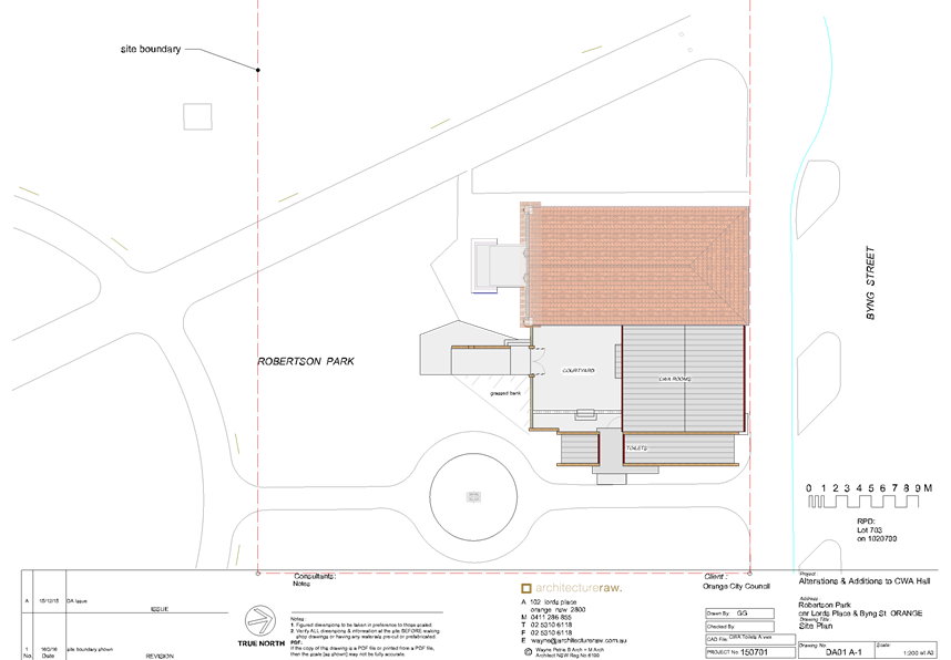
Planning and Development Committee
5 April 2016
2.4 Development
Application DA 31/2016(1) - CWA Hall - Robertson Park - Byng Street
Attachment 2 Plans
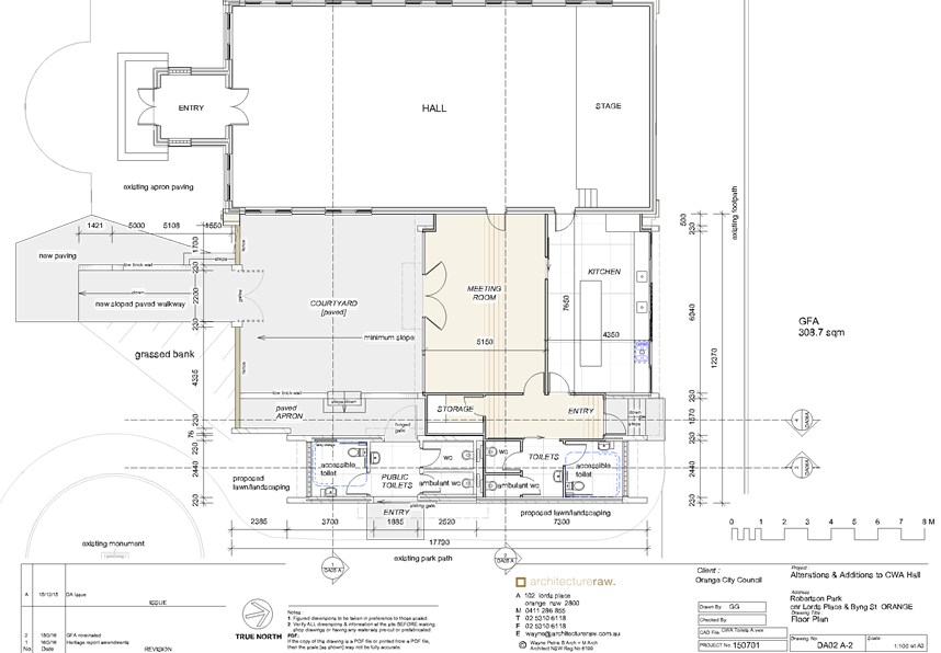
Planning and Development Committee
5 April 2016
2.4 Development
Application DA 31/2016(1) - CWA Hall - Robertson Park - Byng Street
Attachment 2 Plans
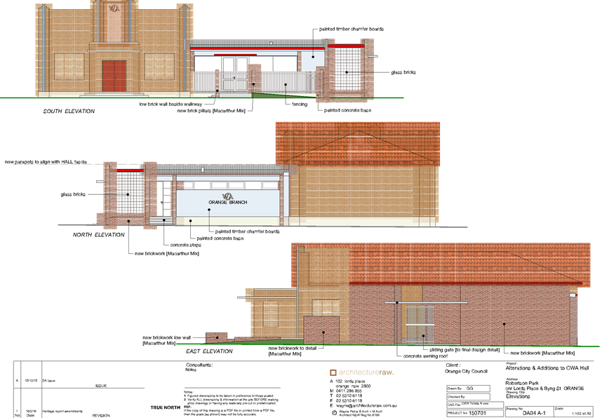
Planning and Development Committee
5 April 2016
2.4 Development
Application DA 31/2016(1) - CWA Hall - Robertson Park - Byng Street
Attachment 2 Plans
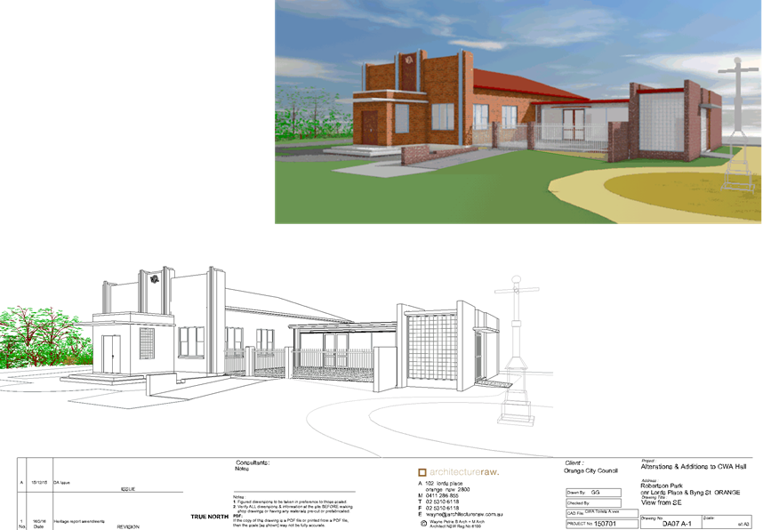
Planning and Development Committee
5 April 2016
2.4 Development
Application DA 31/2016(1) - CWA Hall - Robertson Park - Byng Street
Attachment 2 Plans