ORANGE CITY COUNCIL
Planning and Development
Committee
Agenda
1 December 2015
Notice
is hereby given, in accordance with the provisions of the Local Government Act
1993 that a Planning and Development
Committee meeting
of ORANGE CITY COUNCIL will be held in the Council Chamber, Civic Centre, Byng Street, Orange on Tuesday,
1 December 2015.
Garry
Styles
General Manager
For apologies please
contact David Waddell on 6393 8261.
1 Introduction
1.1 Declaration
of pecuniary interests, significant non-pecuniary interests and less than
significant non-pecuniary interests
The
provisions of Chapter 14 of the Local Government Act, 1993 (the Act)
regulate the way in which Councillors and designated staff of Council conduct
themselves to ensure that there is no conflict between their private interests
and their public role.
The
Act prescribes that where a member of Council (or a Committee of Council) has a
direct or indirect financial (pecuniary) interest in a matter to be considered
at a meeting of the Council (or Committee), that interest must be disclosed as
soon as practicable after the start of the meeting and the reasons given for
declaring such interest.
As
members are aware, the provisions of the Local Government Act restrict any
member who has declared a pecuniary interest in any matter from participating
in the discussion or voting on that matter, and requires that member to vacate
the Chamber.
Council’s Code of Conduct provides that if members
have a non-pecuniary conflict of interest, the nature of the conflict must be
disclosed. The Code of Conduct also provides for a number of ways in which a
member may manage non pecuniary conflicts of interest.
|
Recommendation
It is recommended that Committee Members now disclose any
conflicts of interest in matters under consideration by the Planning and
Development Committee at this meeting.
|
2 General
Reports
2.1 Items
Approved Under the Delegated Authority of Council
TRIM
REFERENCE: 2015/2827
AUTHOR: David
Waddell, Director Development Services
EXECUTIVE Summary
Following is a list of development
applications approved by the General Manager under the delegated authority of
Council.
Link To Delivery/OPerational Plan
The recommendation in this report relates to the
Delivery/Operational Plan strategy “13.4 Our Environment
– Monitor and enforce regulations relating to City amenity”.
Financial Implications
Nil
Policy and Governance Implications
Nil
|
Recommendation
That the information provided in the
report by the Director Development Services on Items Approved Under the
Delegated Authority of Council be acknowledged.
|
further considerations
Consideration has been given to the
recommendation’s impact on Council’s service delivery; image and
reputation; political; environmental; health and safety; employees;
stakeholders and project management; and no further implications or risks have
been identified.
SUPPORTING INFORMATION
|
Reference:
|
DA 404/2008(4)
|
Determination
Date
|
10 November 2015
|
|
PR Number
|
PR19361
|
|
Applicant/s:
|
Fenlor Group Pty
Ltd
|
|
Owner/s:
|
Fenlor Group Pty
Ltd
|
|
Location:
|
Lot 158 DP 1207987 - Tilston Way, Orange (residue lot of historic
Lots 7 and 8 DP 1065578 - 384 and 386 Molong Road)
|
|
Proposal:
|
Modification
of development consent – subdivision (78 lot residential, one residue
lot) (Community and Torrens Title). The modification involves deleting
condition (25) which required a geotechnical investigation to be carried out
within each proposed building envelope; and correcting an error in the
description of the proposal (should have been “78 lot
residential”, not “80 lot residential).
|
|
Value:
|
$0
|
|
Reference:
|
DA 278/2010(2)
|
Determination
Date
|
30 October 2015
|
|
PR Number
|
PR19629
|
|
Applicant/s:
|
Mr DE and Mrs TN
Davies
|
|
Owner/s:
|
Mr DE and Mrs TN
Davies
|
|
Location:
|
Lot 103 DP 1069672
and Lot 22 DP 1011975 – 163 and 205 Berrilee Road, Springside
|
|
Proposal:
|
Modification
of development consent – subdivision (two lot rural boundary
adjustment). The modification involves altering the location of the new lot
so that it fronts Berrilee Road and relocating to the access driveway to run
along the eastern boundary. The proposed building envelope will be closer to
Berrilee Road.
|
|
Value:
|
$0
|
|
Reference:
|
DA 283/2014(1)
|
Determination
Date
|
13 November 2015
|
|
PR Number
|
PR27170
|
|
Applicant/s:
|
Mr SP and Mrs KA
Romano
|
|
Owner/s:
|
Mr SP and Mrs KA
Romano
|
|
Location:
|
Lot 21 DP 1212446
– 104 Lysterfield Road, Orange
|
|
Proposal:
|
Subdivision
(two lots)
|
|
Value:
|
$0
|
|
Reference:
|
DA 336/2014(1)
|
Determination
Date
|
9 November 2015
|
|
PR Number
|
PR958
|
|
Applicant/s:
|
Twice Around
|
|
Owner/s:
|
Mr GJ and Mr AJ
Vangestel
|
|
Location:
|
Lot 121 DP 549276
– 390 Clergate Road, Orange
|
|
Proposal:
|
Resource
recovery facility
|
|
Value:
|
$50,000
|
|
Reference:
|
DA 116/2015(2)
|
Determination
Date
|
22 October 2015
|
|
PR Number
|
PR26819
|
|
Applicant/s:
|
NSW Rural Fire
Service
|
|
Owner/s:
|
Verga Pty Ltd
|
|
Location:
|
Lot 11 DP 1206162
– Orchard Road, Springside
|
|
Proposal:
|
Modification
of development consent – emergency services facility and rainwater tank
(110,000 litre). The modification involves moving the approved rural fire
station building 5m to the north, and also moving the adjacent water tank to
the north to remain next to the building.
|
|
Value:
|
$265,000
|
|
Reference:
|
DA 280/2015(1)
|
Determination
Date
|
28 October 2015
|
|
PR Number
|
PR22539
|
|
Applicant/s:
|
Hibbard Homes
|
|
Owner/s:
|
Hibbards Pty Ltd
|
|
Location:
|
Lot 26 DP 1122907
– 3 Begonia Place, Orange
|
|
Proposal:
|
Dual
occupancy and subdivision (two lot residential)
|
|
Value:
|
$440,000
|
|
Reference:
|
DA 292/2015(1)
|
Determination
Date
|
19 October 2015
|
|
PR Number
|
PR13472
|
|
Applicant/s:
|
McKinnon Design
|
|
Owner/s:
|
Ms RE Payne
|
|
Location:
|
Lot 26 DP 826452
– 131 March Street, Orange
|
|
Proposal:
|
Dual
occupancy
|
|
Value:
|
$310,000
|
|
Reference:
|
DA 298/2015(1)
|
Determination
Date
|
4 November 2015
|
|
PR Number
|
PR27109
|
|
Applicant/s:
|
Mr M Mustac
|
|
Owner/s:
|
Mr M Mustac
|
|
Location:
|
Lot 421 DP 1210576
– 67 Glasson Drive, Orange
|
|
Proposal:
|
Dual
occupancy and subdivision (two lot residential)
|
|
Value:
|
$400,000
|
|
Reference:
|
DA 326/2015(1)
|
Determination
Date
|
17 November 2015
|
|
PR Number
|
PR27026
|
|
Applicant/s:
|
GJ Gardner Homes
Orange
|
|
Owner/s:
|
Develop Orange Pty
Ltd
|
|
Location:
|
Lot 144 DP 1207987
– 16 Tilston Way, Orange
|
|
Proposal:
|
Exhibition
home and business identification signage
|
|
Value:
|
$320,000
|
|
Reference:
|
DA 334/2015(1)
|
Determination
Date
|
17 November 2015
|
|
PR Number
|
PR15703
|
|
Applicant/s:
|
Ms D Maguire
|
|
Owner/s:
|
Birrang Enterprise
Development Company Limited
|
|
Location:
|
Lot 11 DP 844802
and Lot 32 DP 1035913 – 7 and 9 Colliers Avenue, Orange
|
|
Proposal:
|
Depot
(alterations and additions to existing approved workshop and training
establishment)
|
|
Value:
|
$11,400
|
|
Reference:
|
DA 345/2015(1)
|
Determination
Date
|
17 November 2015
|
|
PR Number
|
PR26735
|
|
Applicant/s:
|
BT Homes
|
|
Owner/s:
|
B & J Flowers
Pty Ltd
|
|
Location:
|
Lot 303 DP 1201019
– 90 William Maker Drive, Orange
|
|
Proposal:
|
Exhibition
home and business identification signage
|
|
Value:
|
$320,000
|
|
Reference:
|
DA 349/2015(1)
|
Determination
Date
|
29 October 2015
|
|
PR Number
|
PR620
|
|
Applicant/s:
|
Mr T Cheney
|
|
Owner/s:
|
Mrs JA Shillington
and Mrs CM Cheney
|
|
Location:
|
Lot 11 DP 701366
– 263 Anson Street, Orange
|
|
Proposal:
|
Community
facility (change of use from dwelling)
|
|
Value:
|
$0
|
|
Reference:
|
DA 359/2015(1)
|
Determination
Date
|
21 October 2015
|
|
PR Number
|
PR592
|
|
Applicant/s:
|
Mr TJ Zinga and Ms
AP Watson
|
|
Owner/s:
|
Orange City
Council
|
|
Location:
|
Lot 1 DP 341650
– former netball courts – Moulder Park, Anson Street, Orange
|
|
Proposal:
|
Kiosk
and business identification signage
|
|
Value:
|
$2,500
|
|
Reference:
|
DA 370/2015(1)
|
Determination
Date
|
17 November 2015
|
|
PR Number
|
PR11977
|
|
Applicant/s:
|
Mr RJ and Mrs PS
Mages
|
|
Owner/s:
|
Mr RJ and Mrs PS
Mages
|
|
Location:
|
Lot 1 DP 630700
– 82 Thompson Road, Orange
|
|
Proposal:
|
Dwelling
and attached carport
|
|
Value:
|
$490,000
|
TOTAL
NET* VALUE OF ALL DEVELOPMENTS APPROVED IN THIS PERIOD: $2,608.900
*
Net value relates to the value of modifications. If modifications are
the same value as the original DA, then nil is added. If there is a plus/minus
difference, this difference is added or taken out.
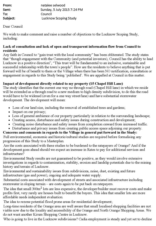
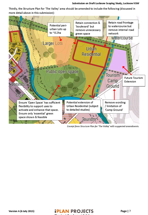
2.2 Lucknow
Scoping Study Outcomes
TRIM
REFERENCE: 2015/3062
AUTHOR: David
Waddell, Director Development Services
EXECUTIVE Summary
A Scoping Study was prepared in 2015 by the Consultant
Oculus on behalf of Orange City Council that sought to assess the potential of
the Village for growth and uplift given it is the entrance or
‘Gateway’ to Orange.
Lucknow is a Village steeped in history and heritage
significance with the capacity to continue as is or to become a vibrant village
with a population critical mass that can sustain growth and provide the lift
the Village needs.
The scoping study was based on a consideration of
opportunities and constraints across the Village including:
· previous
mining activities and legacy impacts
· slope
and surface water flows
· highway
issues
· potential
future residential zonings
· key
views
· existing
character
· significant
vegetation
· connectivity
· an
understanding of elements required to create a greater ‘sense of
place’ and support a village.
The Scoping Study was subsequently placed on exhibition for
public comment. This report presents the main issues raised, responses to those
issues and outlines the next steps in the process.
On 2 June 2015, Council resolved:
|
RESOLVED -15/211 Cr
J Hamling/Cr J Davis
That Council exhibits the Lucknow Scoping Study for a
period of 28 days.
|
Exhibition was held from 9 June to 6 July
2015. Submissions were received from 14 authors and the issues raised in
those submissions have been reviewed internally. As a result amendments to the Scoping
Study are now recommended in order to address some of the concerns raised while
maintaining the overall vision for the Village as an enhanced gateway to
Orange.
Council is asked to formally adopt the Scoping Study and to
resolve that a Masterplan and accompanying Planning Proposal for any rezoning
be drafted and brought back to a future Council meeting for consideration and
public exhibition.
Link To Delivery/OPerational Plan
The recommendation in this report relates to the
Delivery/Operational Plan strategy “13.4 Our Environment
– Monitor and enforce regulations relating to City amenity”.
Financial Implications
Nil
Policy and Governance Implications
Nil
|
Recommendation
1 That
Council notes the report by the Director Development Services on the Lucknow
Scoping Study exhibition process and adopts the Scoping Study with amendment ‘principles’
as detailed.
2 That
Council resolves that a Masterplan, Infrastructure Plan and accompanying
Planning Proposal for any rezonings be drafted and brought back to a future
Council meeting for consideration and public exhibition.
|
further considerations
Consideration has been given to the
recommendation’s impact on Council’s service delivery; image and
reputation; political; environmental; health and safety; employees;
stakeholders and project management; and no further implications or risks have
been identified.
SUPPORTING INFORMATION
14 submissions were received following public exhibition via
various means. In addition the Scoping Study attracted significant interest and
staff met with several interested residents over the period.
The issues raised will be used to now develop a Masterplan
and accompanying Planning Proposal. It should be noted that the Scoping Study
document itself will not be changed rather an addendum will be attached to it
which outlines the amendment principles that will be adopted in pursuing the
Masterplan.
Issues RAISED AND PRELIMINARY responseS
Consultation
Several submissions expressed
disappointment at the level of consultation during the Scoping Study. The
scoping study is based on a consideration of opportunities and constraints
across the Village including previous mining activities and legacy impacts,
slope and surface water flows, Mitchell Highway issues, potential future
residential zonings, key views, existing character, significant vegetation,
connectivity and an understanding of elements required to create a greater
‘sense of place’ and support a Village. It is not a study
typically where fine grain detail is dealt with and thus a decision was made to
allow the consultant to look at the Village without preconceived bias. It
is acknowledged that minimal consultation has occurred with landowners or
commercial operators to date– this was done by way of exhibition and the
next steps will see a more concentrated effort.
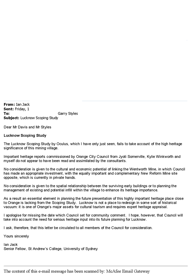
Heritage
Some submissions expressed disappointment that the Scoping
Study fails to take into account the high heritage significance of the Village,
particularly its mining past.
The Scoping Study was based on a consideration of
opportunities and constraints across the Village rather than by a single issue
alone such as heritage, including:
· previous
mining activities and legacy impacts
· slope
and surface water flows
· highway
issues
· potential
future residential zonings
· key
views
· existing
character
· significant
vegetation
· connectivity
· an
understanding of elements required to create a greater ‘sense of
place’ and support a Village.
Historical overlays were presented in the Study document. It
needs to be understood that the heritage value of Lucknow has been severely
degraded over the last decades and this will continue unless action is taken to
arrest the decline. This cannot be done without funding sources. Lucknow,
a ‘gateway’ to Orange, is a Village steeped in history and
heritage significance with the capacity to either remain as is or to become a
vibrant village with a population critical mass that can sustain growth and
provide the lift the village needs. A purist heritage view that only looks at
that aspect alone may not be enough to succeed given the paucity of funding
available. The privately owned new reform mine site is an example. In order to
incorporate this in the overall Masterplan, Council will need to negotiate to
either purchase or financially assist the owner in any uplift. It would be
naive to think that a private owner would contribute extensively. Nonetheless
the point is taken and the preparation of the Masterplan and rezoning phase
will now take the project to the fine grain detail that will address many of
the concerns raised.
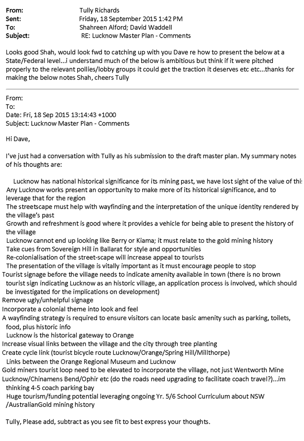
One enthusiastic resident has taken the time to canvass
support for a heritage focus and summarises the general view as follows:
· Lucknow
has national historical significance for its mining past, we have lost sight of
the value of this
· Any
Lucknow works present an opportunity to make more of its historical
significance, and to leverage that for the region
· The
streetscape must help with wayfinding and the interpretation of the unique
identity rendered by the Village’s past
· Growth
and refreshment is good where it provides a vehicle for being able to present
the history of the Village
· Lucknow
cannot end up looking like Berry or Kiama; it must relate to the gold mining
history
· Take
cues from Sovereign Hill in Ballarat for style and opportunities
· Re-colonialization
of the street-scape will increase appeal to tourists
· The
presentation of the village is vitally important as it must encourage people to
stop
· Tourist
signage before the village needs to indicate amenity available in town (there
is no brown tourist sign indicating Lucknow as an historic village, an
application process is involved, which should be investigated for the
implications on development)
· Remove
ugly/unhelpful signage
· Incorporate
a colonial theme into look and feel
· A
wayfinding strategy is required to ensure visitors can locate basic amenity
such as parking, toilets, food, plus historic information
· Lucknow
is the historical gateway to Orange
· Increase
visual links between the village and the city through tree planting
· Create
cycle link (tourist bicycle route Lucknow/Orange/Spring Hill/Millthorpe)
· Links
between the Orange Regional Museum and Lucknow
· Gold
miners tourist loop need to be elevated to incorporate the village, not just
Wentworth Mine
· Tourism/funding
potential leveraging ongoing Yr. 5/6 School Curriculum about Gold mining
history
The suggestions raised fall under two areas of
Council’s operation; that of heritage and that of planning. Many of these
suggested heritage initiatives can be addressed through the various Heritage
Office grant programs available and can be pursued separately to the Masterplan
and will be investigated by staff as the fine grain detail work is undertaken.
In addition the Masterplan will need to come up with detailed guidance on
issues such as uniform fencing, signage and materiality to address these
issues.
Location
of residential growth
Submissions were mixed in terms of the additional
residential areas shown in the Scoping Study and these views will be taken into
account at the master planning stage.
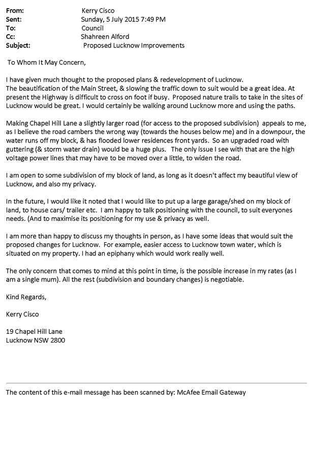
The proposed infill around Chapel Hill Lane was supported by
some residents and opposed by others and will need to be re-assessed in detail.
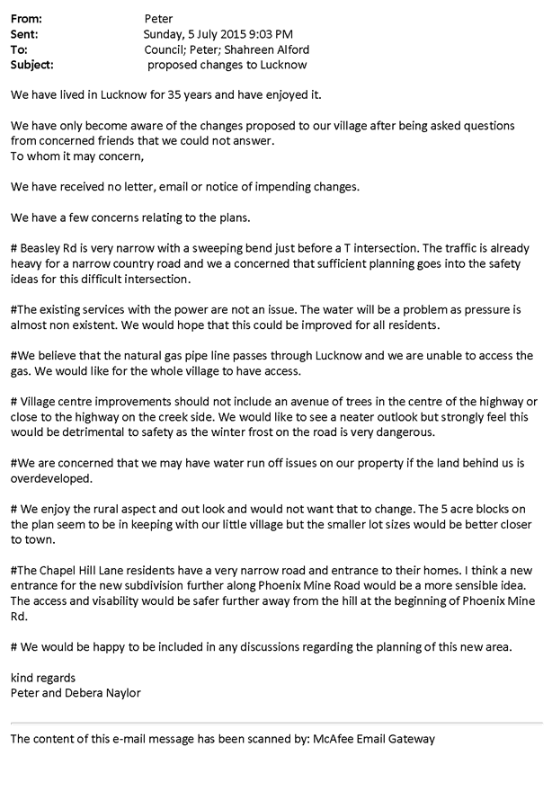
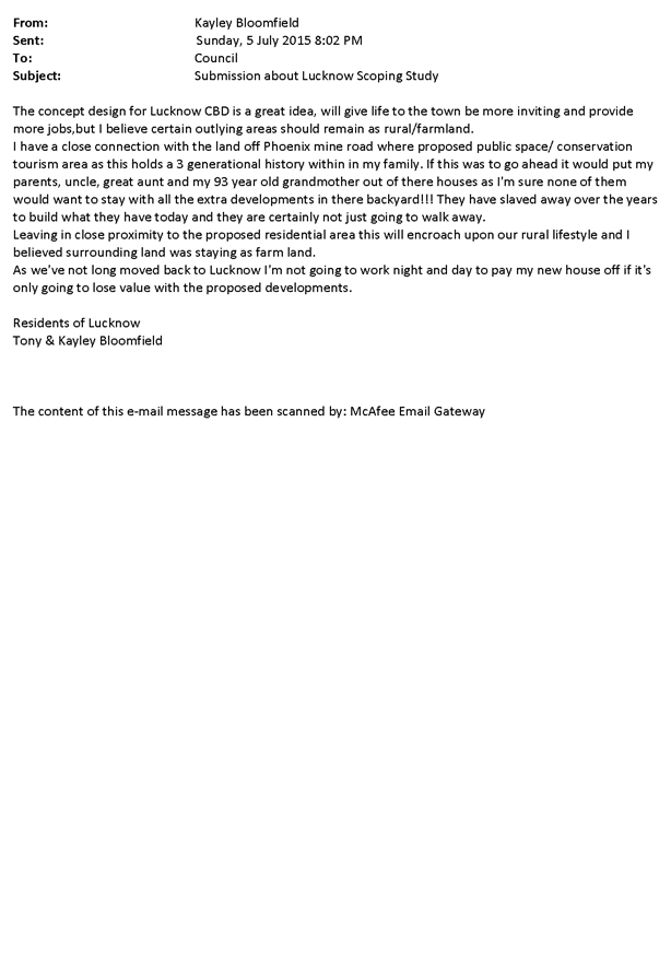
Residents on Phoenix Mine Road generally did not see
additional subdivision as something they would like to see and raised traffic issues
at the same time given the sight lines and topography in that locale. Given the
sentiment the Masterplan will need to concentrate on other areas in the short
to medium term. Staging of residential growth will be a key part of the
Masterplan to address both sentiment and infrastructure staging.
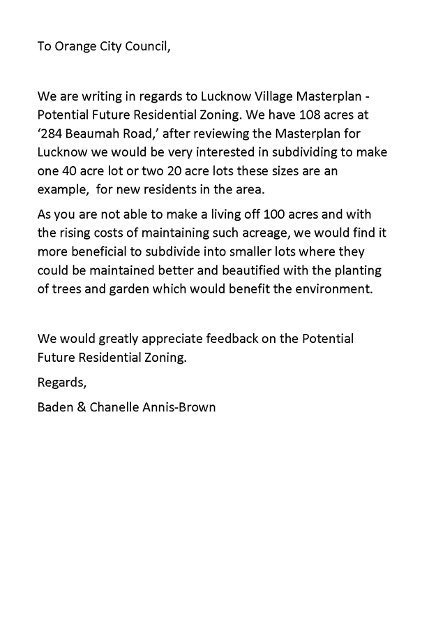
A landowner on Beaumah Road expressed a desire to allow
subdivision from 108 acres to 40 or 20 acres which will need to be further
assessed along with other surrounding areas of minimal agricultural potential.
One landowner to the north of the Highway where substantial
additional housing was shown in the Scoping Study states “the aim of this
submission is to support Council’s work in promoting growth in and around
Lucknow and a vision for its character and land uses.” The landowner is
supportive of the potential residential growth area and suggests further
changes to the layouts and density which will be the subject of further
discussion during the master planning stages. Combined with some reticence to see
further infill on the southern side, this area may provide the best opportunity
for growth in the Village as it also would link to the Village centre via the
open space network.
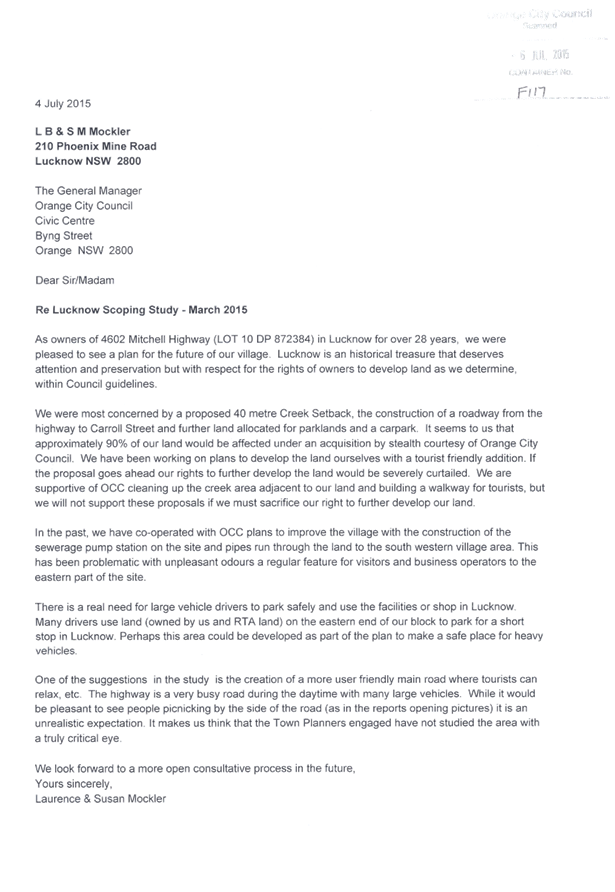
Beautification of the Village
commercial centre
There was very little opposition to the concept of Village
beautification. Comments such as “as a long term resident of Lucknow, I
agree that the village itself on the highway does need beautification and maybe
in and around the village, owners of the property will be allowed to subdivide
to residential blocks” were typical.
A key landowner in the Village commercial zone stated that
he was ‘pleased to see a plan for the future of our village. Lucknow is
an historical treasure that deserves attention and preservation but with
respect for the rights of owners to develop land as we determine, within
Council guidelines’. Indeed the Scoping Study is the first part of
establishing those guidelines. This submitter goes into some detail on how the
Village Centre expansion would affect their land adversely and there will need
to be close consultation to find a compromise during the master planning stage.
Any plans to clean up the creek and open space areas were welcomed.
The issue of truck and vehicle parking and associated
Highway safety is a critical one and raised by several submitters and will need
to be addressed in consultation with the Roads and Maritime Services (RMS) in
future work. Truck parking was another common issue raised.
The master planning stage will need to carefully look lot by
lot at the ownership issue involved and negotiate with individual owners in
order to arrive at a common goal of beautification. Council does not own a
great deal of property in the Village so the overall success of the
beautification will be a function of the level of cooperation that can be
achieved.
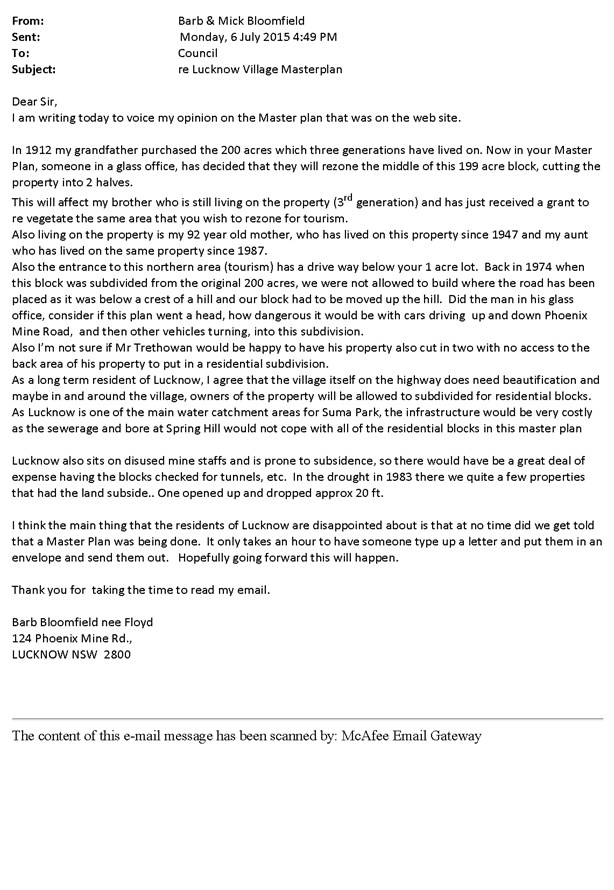
Privacy
One submitter expressed serious concern over privacy issues
associated with proposed connection pathways and this will be considered in the
master planning stages. Other submitters expressed a desire for Lucknow to be
left as is with its inherent privacy and Village feel.
Infrastructure
Some submissions raised the cost of infrastructure costs.
Typically infrastructure in the form of road upgrades, footpaths, water and
sewer is paid for by a combination of grant funding and developer
contributions. The scoping of residential growth in Lucknow, whilst unpopular
with some submitters is critical to raising funds to pay for beautification and
infrastructure works. This is the problem faced – without growth there
may not be the opportunity to fund the projects required to achieve the plan.
Nonetheless the Scoping Study provides an indication on the
level of infrastructure upgrades required.
Subsidence and Contamination
Submitters pointed out the issue of subsidence, historical
mining activity and its potential to restrict development. Council is aware of
much of the subsidence and is currently preparing a report on historical mine
activity and contamination to feed into the Masterplan. It is correct to say
that it is a critical issue that will guide development into the future.
amendment principles
The amendment principles that will be adopted in pursuing
the Masterplan are presented below and will be used to guide staff in the next
stages.
|
Aspect
|
Amendment Principle
|
|
Heritage
|
Address in fine detail the heritage of Lucknow with
particular reference to the Jack, Winkworth and Somerville reports and
Heritage NSW guidelines.
Work with the goldmining theme
|
|
Location of residential
growth
|
Concentrate further residential growth firstly in areas
where residents are generally supportive. Look at staging. Further look at
larger lot subdivision.
|
|
Beautification of the
Village commercial centre
|
Work with individual landowners to arrive at the common goal
which is a revitalised Village Centre.
|
|
Privacy
|
Look closer at connection and pathway impacts on
residents. Seek to preserve the intimacy of Lucknow.
|
|
Infrastructure
|
Look closely at highway safety and cost effective
infrastructure staging
|
|
Subsistence and
contamination
|
The next stages should address contamination and subsidence
in more detail
|
Attachments
1 Lucknow
Scoping Study Post Exhibition Report - Submissions, D15/46178⇩
Planning and Development Committee
1 December 2015
2.2 Lucknow
Scoping Study Outcomes
Attachment 1 Lucknow
Scoping Study Post Exhibition Report - Submissions


2.3 Development
Application DA 308/2015(1) - 98 Dalton Street
TRIM
REFERENCE: 2015/3076
AUTHOR: Michael
Glenn, Senior Planner
EXECUTIVE Summary
|
Application lodged
|
11 September 2015
|
|
Applicant/s
|
BT Homes
|
|
Owner/s
|
Mrs JM Granger
|
|
Land description
|
Lot 6 DP 1932 - 98 Dalton Street,
Orange
|
|
Proposed land use
|
Secondary Dwelling
|
|
Value of proposed development
|
$119,164
|
Council's consent is sought for the creation of a secondary
dwelling in the rear yard of the site. The application has attracted four
individual submissions from nearby and adjoining property owners raising
various issues. Most of the issues relate to the prior poor management of the
premises as a rental property which, whilst understood, has only limited
relevance to the assessment of this application.
Some of the issues raised by neighbours do have some
relevance resulting in the imposition of conditions that increase the setback
from the rear southern boundary, require new boundary fencing, the
establishment of better landscaped treatments and the establishment of separate
private open space areas for each dwelling.
Link To Delivery/OPerational Plan
The recommendation in this report relates to the
Delivery/Operational Plan strategy “13.4 Our Environment
– Monitor and enforce regulations relating to City amenity”.
Financial Implications
Nil
Policy and Governance Implications
Nil
|
Recommendation
That Council grants consent to development application
DA 308/2015(1) for Secondary Dwelling at Lot 6 DP 1932 - 98 Dalton
Street, Orange pursuant to the conditions of consent in the attached Notice
of Approval.
|
further considerations
Consideration has been given to the
recommendation’s impact on Council’s service delivery; image and
reputation; political; environmental; health and safety; employees;
stakeholders and project management; and no further implications or risks have
been identified.
SUPPORTING INFORMATION
THE APPLICATION/PROPOSAL
Council's consent is sought for
a secondary dwelling at Lot 6 DP 1932 - 98 Dalton Street Orange. The proposal
can be summarised in the following table:
|
Dwelling
|
Land
Area
|
Total
Floor Area (excluding garage, alfresco and porch)
|
%
of Principal
|
Site
Coverage
|
Description
|
|
Principal
|
-
|
120.02m2
|
n/a
|
n/a
|
Existing dwelling
|
|
(Garaging etc)
|
|
30.2m2
|
n/a
|
n/a
|
Garages verandahs and entrance
|
|
Secondary
|
-
|
59.99m2
|
50%
|
n/a
|
One
bedroom dwelling with store, living, separate bath and kitchenette
|
|
Total
|
676m²
|
210.21m²
|
n/a
|
31.09%
|
-
|
MATTERS FOR CONSIDERATION
Section 5A Assessment
In the administration of sections 78A, 79B, 79C, 111 and
112, the provisions of Section 5A must be taken into account for every
development application, in deciding whether there is likely to be a
significant effect on threatened species, populations or ecological communities
or their habitats. This section includes a requirement to consider any adopted
assessment guidelines, which means assessment guidelines issued and in force
under section 94A of the Threatened Species Conservation Act 1995.
Assessment guidelines are in force (see DECC-W “Threatened Species
Assessment Guidelines - The Assessment of Significance”) which requires
consent authority to adopt the precautionary principle in its assessment.
In this instance, site inspection reveals the subject property
has no biodiversity or habitat value.
Section 79C
Section 79C of the Environmental Planning and Assessment
Act 1979 requires Council to consider various matters, of which those
pertaining to the application are listed below.
PROVISIONS OF ANY ENVIRONMENTAL
PLANNING INSTRUMENT s79C(1)(a)(i)
Orange Local Environmental Plan 2011
Part 1 - Preliminary
Clause 1.2 - Aims of Plan
(a) to encourage development which complements
and enhances the unique character of Orange as a major regional centre boasting
a diverse economy and offering an attractive regional lifestyle,
(b) to provide for a range of development
opportunities that contribute to the social, economic and environmental
resources of Orange in a way that allows present and future generations to meet
their needs by implementing the principles for ecologically sustainable
development,
(c) to conserve and enhance the water
resources on which Orange depends, particularly water supply catchments,
(e) to provide a range of housing choices in
planned urban and rural locations to meet population growth,
(f) to recognise and manage valued
environmental heritage, landscape and scenic features of Orange.
With regard to (a), it is noted
that the streetscape provides significant value in terms of heritage character.
It is important to ensure that the integrity and context of the nearby heritage
items is not compromised or placed too far out of context by unsympathetic
materials or design for the new building. With regard to (b), the proposed
development seeks to provide low scale accommodation, as well as some
relatively minor alterations and additions to the existing dwelling. There are
no significant issues arising from the changed land use patterns or densities
arising. With regard to (c), the proposed development will have a slight
increase in demand for water services, but otherwise have no impact. In
relation to (e), the basic proposal is to provide a secondary dwelling that
inherently is of different characteristics to the more traditional housing
forms evident in the street. There are general demographic trends that suggest smaller
household sizes, family members staying longer in the family home, or older
members of a family being provided with separate onsite accommodation. In
relation to (f), the subject application proposes minimal changes to the
visible parts of the site. This represents tangible and positive management of
the site in terms of the heritage, landscape and scenic contribution of the
site to the City.
Clause 1.6 - Consent Authority
This clause establishes that, subject to the Act, Council is
the consent authority for applications made under the LEP.
Clause 1.9A - Suspension of
Covenants, Agreements and Instruments
This clause provides that covenants, agreements and other
instruments which seek to restrict the carrying out of development do not apply
with the following exceptions.
· covenants imposed
or required by Council
· prescribed
instruments under Section 183A of the Crown Lands Act 1989
· any conservation
agreement under the National Parks and Wildlife Act 1974
· any trust
agreement under the Nature Conservation Trust Act 2001
· any property
vegetation plan under the Native Vegetation Act 2003
· any biobanking
agreement under Part 7A of the Threatened Species Conservation Act 1995
· any planning
agreement under Division 6 of Part 4 of the Environmental Planning and
Assessment Act 1979
Council staff are not aware of the title of the subject
property being affected by any of the above.
Mapping
The subject site is identified
on the LEP maps in the following manner:
|
Land Zoning Map:
|
Land zoned R1 General Residential
|
|
Lot Size Map:
|
No Minimum Lot Size
|
|
Heritage Map:
|
Located in a heritage conservation
area
|
|
Height of Buildings Map:
|
No building height limit
|
|
Floor Space Ratio Map:
|
No floor space limit
|
|
Terrestrial Biodiversity Map:
|
No biodiversity sensitivity on the
site
|
|
Groundwater Vulnerability Map:
|
ground water vulnerable
|
|
Drinking Water Catchment Map:
|
Not within the drinking water
catchment
|
|
Watercourse Map:
|
Not within or affecting a defined
watercourse
|
|
Urban Release Area Map:
|
Not within an urban release area
|
|
Obstacle Limitation Surface Map:
|
No restriction on building siting
or construction
|
|
Additional Permitted Uses Map:
|
No additional permitted use applies
|
Those matters that are of relevance are addressed in detail
in the body of this report.
Part 2 - Permitted or
Prohibited Development
Land Use Zones
The subject site is located within the R1 General
Residential zone. The proposed development is defined as residential
accommodation comprising a secondary dwelling and alterations and additions to
a dwelling house under OLEP 2011.
All elements of the proposed development are permissible in
the zone. Residential accommodation is a group term of the LEP, covering a
range of development types. Secondary dwelling is defined in the LEP as self-contained
dwelling that:
(a) is
established in conjunction with another dwelling (the principal dwelling), and
(b) is
on the same lot of land as the principal dwelling, and
(c) is
located within, or is attached to, or is separate from, the principal dwelling
Proposals for secondary dwellings must also comply or meet
the development standards contained in clause 5.4 of the LEP. The proposed
development is fully compliant with the relevant standards and further is
consistent with the definition parameters set out above.
Dwelling house is defined under the LEP as:
a building containing only one
dwelling. Dwelling in turn means a room or suite of rooms occupied or used or
so constructed or adapted as to be capable of being occupied or used as a
separate domicile.
A dwelling house is a form of development permissible in the
R1 zone.
State Environmental Planning Policy (Affordable Rental
Housing) (the SEPP) has provisions that act to override or replace the
development standards of the LEP where inconsistencies arise between the SEPP
and the LEP. In this case, however, there are no inconsistencies between the
LEP and the SEPP. The proposed development is permissible in its own right to the
definitions and standards of the LEP.
Clause 2.3 of LEP 2011
references the Land Use Table and Objectives for each zone in LEP 2011.
These objectives for land zoned R1 General Residential are as follows:
1 - Objectives of the R1 General Residential Zone
· To
provide for the housing needs of the community.
· To
provide for a variety of housing types and densities.
· To
enable other land uses that provides facilities or services to meet the day to
day needs of residents.
· To
ensure development is ordered in such a way as to maximise public transport
patronage and encourage walking and cycling in close proximity to settlement.
· To
ensure that development along the Southern Link Road has an alternative access.
In relation to the first and
second dot points, the proposed secondary dwelling is consistent with this
objective. In relation to the third dot point, the proposed development is for
the continuation and intensification of the residential use of the site.
Consideration of alternative land uses is, in this instance, not relevant to
the assessment.
In relation to the fourth dot
point, the proposed development seeks approval for a modest intensification of
the residential use of the site. This has the potential to increase the demand
for public transport, particularly given the style of housing proposed and its
location on a main road, close to bus stops and in close proximity to the CBD.
In relation to the last dot point, the proposed development has no relevance to
the objective.
Part 5 -
Miscellaneous Provisions
Clause 5.4 - Controls
Relating to Miscellaneous Permissible Uses
This clause contains
specific provisions for a secondary dwelling that by reason of the structure of
the LEP go to the definition of the proposed development. Because of that, the provisions
of Clause 5.4 have been considered elsewhere in this report.
5.10 - Heritage
Conservation
The subject property is located within a conservation area,
but is not identified in the adopted heritage inventory.
(1) Objectives
The
objectives of this clause are as follows:
(a) to
conserve the environmental heritage of Orange,
(b) to
conserve the heritage significance of heritage items and heritage conservation
areas, including associated fabric, settings and views,
(c) to
conserve archaeological sites,
(d) to
conserve Aboriginal objects and Aboriginal places of heritage significance.
In relation to (a), the proposed development does not alter
the fabric or form of the existing dwelling, and seeks permission to add a
relatively low scale structure to the rear of the site. The impacts on the
environmental heritage of this site and its surroundings are considered to be
minor. In relation to (b), it is noted that there are three listed items
adjoining along the eastern side boundary of the premises. The impacts of the
proposed development on the heritage significance of these buildings is
considered limited, subject to the setback of the development from the side
access lane being increased to bring it into better alignment with the shed
located at the rear of northernmost side neighbour, and also subject to certain
restrictions on materials selection aimed at limiting the visual impacts. In
relation to (c), there is no obvious indication that the site is a potential
archaeological site. In relation to (d), there is no obvious evidence of
Aboriginal heritage on the site.
Requirement for Consent
The applicant is seeking consent in accordance with the
requirements of the LEP.
Effect of Proposed
Development on Heritage Significance
The consent authority
must, before granting consent under this clause in respect of a heritage item
or heritage conservation area, consider the effect of the proposed development
on the heritage significance of the item or area concerned. This subclause
applies regardless of whether a heritage management document is prepared under
subclause (5) or a heritage conservation management plan is submitted
under subclause (6).
The proposed
development is considered unlikely to have a significant impact on the
significance of the conservation area, or on any of the nearby and adjoining
heritage items in the locality.
Heritage Assessment
This clause enables
Council, where deemed appropriate, to require the submission of an overarching
management statement to permit a more complete assessment of the extent to
which the carrying out of the proposed development would affect the heritage
significance of the heritage item or heritage conservation area concerned. In
this case a heritage management statement is not considered warranted. Advice
was, however, sought from Council's Heritage Adviser, who has provided the
following advice with respect to this proposal:
Significance:
· The site is within
the Conservation area
Issues:
· The granny flat is
located to the rear garden.
· The selected
materials should be sympathetic to the garden setting.
Recommendations:
· The roof to be
Colorbond Woodland Grey
· All flashings to be
traditional rolled type
· Gutters to be
traditional smooth unperforated Woodland Grey
· Downpipes to be
circular and painted to match the wall colour
· Walls to be
weathertex board cladding painted in Dulux Stone
· Watertank to be
acquaplate steel in an acceptable colorbond colour such as Windspray or
Woodland Grey
· A landscape planting
plan to be provided to illustrate two trees with a mature height of 6m –
one to each side at a suitable distance from the building".
Clauses 5.10(6), (7),
(8), (9) and (10) have been considered, but are not relevant to this
assessment.
Part 7 - Additional Local
Provisions
7.3 - Stormwater
Management
This clause applies
to all industrial, commercial and residential zones and requires that Council
be satisfied that the proposal:
(a) is designed to maximise the use of water
permeable surfaces on the land having regard to the soil characteristics
affecting onsite infiltration of water
(b) includes, where practical, onsite
stormwater retention for use as an alternative supply to mains water,
groundwater or river water; and
(c) avoids any significant impacts of
stormwater runoff on adjoining downstream properties, native bushland and
receiving waters, or if that impact cannot be reasonably avoided, minimises and
mitigates the impact.
The proposal can be
provided with adequate infrastructure for the collection and disposal of
surface runoff. Appropriate conditions to that effect are included in the
attached consent. It is considered that the post-development runoff levels will
not exceed the pre-development levels.
7.6 - Groundwater
Vulnerability
This clause seeks to
protect hydrological functions of groundwater systems and protect resources
from both depletion and contamination. Orange has a high water table and large
areas of the LGA, including the subject site, are identified with
“Groundwater Vulnerability” on the Groundwater Vulnerability Map.
This requires that Council consider:
(a) whether or not the development (including
any onsite storage or disposal of solid or liquid waste and chemicals) is
likely to cause any groundwater contamination or have any adverse effect on
groundwater dependent ecosystems, and
(b) the cumulative impact (including the
impact on nearby groundwater extraction for potable water supply or stock water
supply) of the development and any other existing development on groundwater.
Furthermore consent may not be granted unless Council is satisfied that:
(a) the development is designed, sited and
will be managed to avoid any significant adverse environmental impact, or
(b) if that impact cannot be reasonably
avoided - the development is designed, sited and will be managed to minimise
that impact,
(c) if that impact cannot be minimised - the
development will be managed to mitigate that impact.
The proposal is not
anticipated to involve the discharge of toxic or noxious substances and is
therefore unlikely to contaminate the groundwater or related ecosystems. The
proposal does not involve extraction of groundwater and will therefore not
contribute to groundwater depletion. The design and siting of the proposal
avoids impacts on groundwater and is therefore considered acceptable.
STATE ENVIRONMENTAL PLANNING
POLICIES
Affordable Rental housing SEPP (ARH)
The ARH is applicable to this site and development type. The
aims of this Policy are as follows:
(a) to
provide a consistent planning regime for the provision of affordable rental
housing,
(b) to
facilitate the effective delivery of new affordable rental housing by providing
incentives by way of expanded zoning permissibility, floor space ratio bonuses
and non-discretionary development standards,
(c) to
facilitate the retention and mitigate the loss of existing affordable rental
housing,
(d) to
employ a balanced approach between obligations for retaining and mitigating the
loss of existing affordable rental housing, and incentives for the development
of new affordable rental housing,
(e) to
facilitate an expanded role for not-for-profit-providers of affordable rental
housing,
(f) to
support local business centres by providing affordable rental housing for
workers close to places of work,
(g) to
facilitate the development of housing for the homeless and other disadvantaged
people who may require support services, including group homes and supportive
accommodation.
The proposed development is consistent with the objectives
of the ARH.
Division 2 9, Clauses 19-24 set out the provisions relating
to secondary dwellings.
Clause 19 of the SEPP sets out the definition criteria for
secondary dwellings. It defines a secondary dwelling as
"development for the
purposes of a secondary dwelling includes the following:
(a) the
erection of, or alterations or additions to, a secondary dwelling,
(b) alterations
or additions to a principal dwelling for the purposes of a secondary dwelling.
Note The
standard instrument defines secondary dwelling as follows:
secondary dwelling
means a self-contained dwelling that:
(a) is
established in conjunction with another dwelling (the principal dwelling), and
(b) is
on the same lot of land (not being an individual lot in a strata plan or
community title scheme) as the principal dwelling, and
(c) is
located within, or is attached to, or is separate from, the principal
dwelling"
Clause 20 establishes the zones of LEP 2011 in which the ARH
SEPP is applicable. It includes the R1 General Residential zone, in which the
subject property is located.
Clause 21 establishes the types of development to which
the policy applies. The subject application, being consistent with the
definition of secondary dwelling, can have the ARH applied to it.
Clause 22 serves to clarify and define those instances where
development consent is required and applies certain development standards, or
instances where council may not grant consent under the ARH.
Subclause (1) establishes that development to which the
division is applicable may be carried out with consent.
Subclause (2) does not permit the application of the
secondary dwelling clauses where there is more than the principal dwelling and
secondary dwelling on the subject property.
Subclause (3) applies certain standards that prevent Council
from granting consent if exceeded. Part (a) limits the total floor area of the
principal dwelling to the maximum permissible for a dwelling house on the land
under another environmental planning instrument (EPI). There are no such
standards under another EPI, however there is a site coverage limit contained
in Council’s DCP 2004 (a DCP by definition is not an EPI). The proposed
development does not exceed the standards set out in DCP 2004 with respect to
site coverage. Part (b) of subclause (3) restricts the total floor area of the
secondary dwelling is no more than 60m2 or, if a greater floor area
is permitted in respect of a secondary dwelling on the land under another EPI,
that greater floor area. In this case LEP 2011 has an additional provision
that allows the secondary dwelling to be no more than 50% of the principal
dwelling’s floor area. In this case the proposed dwelling is both under
60m2 and also less than 50% of the area of the principal dwelling.
Subclause (4) has an important function in that it sets up
the parameters in which Council may not refuse an application for a secondary
dwelling. Part (a) of this subclause sets standards with respect to site area.
For a secondary dwelling that is attached or located within the principal
dwelling, approval may not be refused on the basis of site area if the site area
is 450m² or greater. In this instance, the proposed secondary dwelling is
detached from the main dwelling; however the site area is considerably greater
than 450m2.
Part (b) prevents Council from refusing an application if no
additional parking is to be provided on the site. This clause does not obviate
other requirements for a parking assessment, such as is called up by DCP 2004
and required as a matter for consideration under Section 79C(1)(A)(iii) of
the Act. Where alternatives exist for parking to be provided, whilst Council
cannot refuse such an application on the basis of parking, it can require by
amended plan, or condition parking to achieve better outcomes in terms of the
Section 79 assessment.
Clause 23 sets up the parameters for complying development,
and calls into effect the provisions of the SEPP (Exempt and Complying
Development Codes). Under Clause 1.19, an application for a secondary
dwelling may not be assessed as complying development if the subject land is
within a conservation area.
Clause 24 prevents any subdivision of a lot on which a
secondary dwelling is proposed or has been approved.
SEPP (Building Sustainability
Index BASIX)
State Environmental Planning Policy (Building Sustainability
Index - BASIX) applies to the subject development. The applicant has submitted
a BASIX certificate in support of the development which demonstrates compliance
with the State Government Water and Thermal efficiency targets. The application
is consistent with the SEPP.
PROVISIONS OF ANY DRAFT
ENVIRONMENTAL PLANNING INSTRUMENT THAT HAS BEEN PLACED ON EXHIBITION
s79C(1)(a)(ii)
There are no draft amendments to LEP 2011 applicable to the
proposed development.
DESIGNATED DEVELOPMENT
The proposed development is not designated development.
PROVISIONS OF ANY DEVELOPMENT
CONTROL PLAN s79C(1)(a)(iii)
Development Control Plan 2004
Development Control Plan 2004 (“the DCP”)
applies to the subject land (Part 0 - LEP 2011 and Part - 7 Development in
Residential Areas). An assessment of the proposed development against the relevant
Planning Outcomes will be undertaken below.
Pursuant to Planning Outcome 0.2-1 Interim Planning Outcomes
- Conversion of Zones:
· Throughout this
Plan, any reference to a zone in Orange LEP 2000 is to be taken to be a
reference to the corresponding zone(s) in the zone conversion table.
The corresponding zone to zone 2(a) Urban Residential
(Orange LEP 2000) is zone R1 General Residential (Orange LEP 2011). As
such, Orange DCP 2004 (Part 7 - Development in Residential Areas) is relevant
to this proposal. The provisions of Part 7 are considered below
Part 7 - Design Elements for
Residential Development
The DCP sets the following Planning Outcomes in regard to
urban residential development.
Neighbourhood Character
The DCP sets the following Planning Outcomes in regard to
Neighbourhood Character:
· Site layout and
building design enables the:
- creation of attractive
residential environments with clear character and identity
- use of site features such as
views, aspect, existing vegetation and landmarks
· Buildings are
designed to complement the relevant features and built form that are identified
as part of the desired neighbourhood character.
· The streetscape
is designed to encourage pedestrian access and use.
The character and identity of the development are influenced
by building design that maintains a common theme and consistent use of
materials. It is considered that the proposal will complement the pattern of
development that characterises the Central Conservation Area. The heritage
study identifies the key elements of this area as consisting of a range of
buildings dating from the latter part of the 19th century, with historical
importance for the development and prosperity of Orange during this period.
There are several examples of architectural styles that include the elements of
the Edwardian style exhibited in the main dwelling of the proposed development.
The proposed structures behind the main dwelling, being the secondary dwelling,
are less sympathetic, and their current location forward of the adjacent
laneway setback will expose that structure unnecessarily and detrimentally to
view. The issue is addressed by a condition that requires the building to be
set back to a line closer to match that of adjoining development that faces the
rear lane.
Building Appearance
The DCP sets the following Planning Outcomes in regard to
Building Appearance:
· The building
design, detailing and finishes relate to the desired neighbourhood character,
complement the residential scale of the area, and add visual interest to the
street.
· The frontages
of buildings and their entries face the street.
· Garages and car
parks are sited and designed so that they do not dominate the street frontage.
Council’s Heritage Adviser has recommended conditions
relating to finishes which are incorporated into the Notice of Approval.
Setbacks
The DCP sets the following Planning Outcomes in regard to
Setbacks:
· Street setbacks
contribute to the desired neighbourhood character, assist with the integration
of new development and make efficient use of the site.
· Street setbacks
create an appropriate scale for the street considering all other streetscape
components.
In this case the appropriate setback to apply is against the
rear lane on the southern side of the site. An increased rear setback is
considered justified to provide better integration with existing adjacent
development, and better define and delineate the areas of open space on
the site for each dwelling.
Visual Bulk
The DCP sets the following Planning Outcome in regard to
Visual Bulk:
· Built form
accords with the desired neighbourhood character of the area with:
- side and rear setbacks
progressively increased to reduce bulk and overshadowing
- site coverage that retains
the relatively low density landscaped character of residential areas
- building form and siting
that relates to landform, with minimal land shaping (cut and fill)
- building height at the
street frontage that maintains a comparable scale with the predominant adjacent
development form
- building to the boundary
where appropriate.
In consideration of the DCP Guidelines, the proposal is
considered to be satisfactory. The proposed building is single storey,
consistent with the established development form of residential development in
the locality.
The DCP requires dwellings to be contained
within the prescribed envelopes generated by planes projected at 45o
over the site commencing 2.5m above existing ground level from each side and
rear boundary. The development will be contained within these planes and
is considered acceptable.
Site Coverage
Site coverage (including both the existing principal
dwelling and its component parts) and the proposed secondary dwelling is
31.09%, which is well within the specified limits of the DCP.
Walls and Boundaries
The DCP sets the following Planning Outcome in regard to
Walls and Boundaries:
· Building to the
boundary is undertaken to provide for efficient use of the site taking into
account:
- the privacy of neighbouring
dwellings and private open space
- the access to daylight
reaching adjoining properties
- the impact of boundary walls
on neighbours.
The proposed development does not propose building any
structures other than fences along any boundaries.
Daylight and Sunlight
The DCP sets the following Planning Outcome in regard to
Daylight and Sunlight:
· Buildings are
sited and designed to ensure:
- daylight to habitable rooms
in adjacent dwellings is not significantly reduced
- overshadowing of
neighbouring secluded open spaces or main living area windows is not
significantly increased
- consideration of
Council’s Energy Efficiency Code.
Shadow diagrams have not been prepared in support of the
proposed development. The applicant advises in the Statement of Environmental
Effects that diagrams are not required in this case to establish whether the
proposed development is satisfactory. This position is generally agreed with.
Both the existing principal dwelling and the proposed
secondary dwelling will have adequate solar access and little or no effect on
the solar access of adjoining residential development.
Views
The DCP sets the following Planning Outcomes in regard to
Views:
· Building form
and design allow for residents from adjacent properties to share prominent
views where possible.
· Views including
vistas of heritage items or landmarks are not substantially affected by the
bulk and scale of the new development.
The subject site is not within an important view corridor.
It will, however, be visible from a verandah of the western neighbour and will,
to a degree, have a level of visibility from Lords Place. As a form of
residential architecture, it is noted that the proposed development is low
scale, of small size and simple design. These are design elements consistent
with Burra Charter principals. However, notwithstanding, it is considered that
the inadequate rear setback does increase the level of exposure and visibility
of the proposed development. The problem can be addressed in a relatively
simple fashion simply by requiring an increased rear setback of not less than
8m. This will pull the new dwelling into a setback alignment consistent with
the approved shed located to the west.
Visual Privacy
The DCP sets the following Planning Outcome in regard to
Visual Privacy:
· Direct
overlooking of principal living areas and private open spaces of other
dwellings is minimised firstly by:
- building siting and layout
- location of windows and
balconies
and
secondly by:
- design of windows or use of
screening devices and landscaping.
In this case the proposed development is for a shared open
space area between the principal and secondary dwellings. For secondary
dwellings, where the secondary dwelling is to be occupied by an unrelated
person, shared open space areas are considered unsatisfactory. It is considered
appropriate where the occupants are unrelated (such as is the case for this application)
for each dwelling to have a separately fenced off area and clearly designated
private open space area for each dwelling.
Acoustic Privacy
The DCP sets the following Planning Outcome in regard to
Acoustic Privacy:
· Site layout and
building design:
- protect habitable rooms from
excessively high levels of external noise
- minimise the entry of
external noise to private open space for dwellings close to major noise sources
- minimise transmission of
sound through a building to affect other dwellings.
It is considered that the proposed development will not have
an excessive or unreasonable effect on acoustic privacy, and will not itself
suffer excessively from existing intrusive noise levels.
This is the basis of the applicant's submission on this
issue. The Statement of Environmental Effects makes the following observations:
· The proposed
secondary dwelling is set back as far as possible from Summer Street and thus
would not be as affected by traffic noise.
· Residential
occupation is not typically a noise generating use. As such the proposed
secondary dwelling is unlikely to cause noise impacts upon surrounding
residential properties.
In terms of the Planning Outcomes, it is considered that the
new dwelling is proposed to be located in the most suitable location. In terms
of entry and exit to the new dwelling, there are no onsite vehicle arrangements
made within the application for the secondary dwelling. It is considered that
such arrangements are unnecessary given the modest size of the secondary
dwelling; and as a result noise intrusions from entry and egress will also not
be significantly intrusive. In relation to the last planning outcome, it is
considered that this provision is relevant to dwellings that are attached to
another dwelling in some way. In this case there is no attachment, and
consequently the opportunity for internal sound transmission between dwellings
is considered to be very minor.
Security
The DCP sets the following Planning Outcomes in regard to
Security:
· The site layout
enhances personal safety and minimises the potential for crime, vandalism and
fear.
· The design of
dwellings enables residents to survey streets, communal areas and approaches to
dwelling entrances.
A condition is included requiring the provision
of a 1.5m high internal dividing fence between the two dwellings for the
purpose of achieving privacy between those dwellings, given the two dwelling
will be occupied by unrelated persons.
Circulation and Design
The DCP sets the following Planning Outcome in regard to
Circulation and Design:
· Accessways and
parking areas are designed to manage stormwater.
· Accessways,
driveways and open parking areas are suitably landscaped to enhance amenity
while providing security and accessibility to residents and visitors.
· The site layout
allows people with a disability to travel to and within the site between car
parks, buildings and communal open space.
No changes are proposed for the existing access and no
changes are proposed to landscaping on the site. However, it is likely that
some tree removal is likely as a result of the development. To improve the
presentation and amenity of the site, it is considered appropriate to impose
conditions requiring the submission of a landscaping condition, and further, to
require full implementation and retention of those landscaped areas.
Car Parking
The DCP sets the following Planning Outcomes in regard to
Car Parking:
· Parking
facilities are provided, designed and located to:
- enable the efficient and
convenient use of car spaces and access ways within the site
- reduce the visual dominance
of car parking areas and access ways.
· Car parking is
provided with regard to the:
- the number and size of
proposed dwellings
- requirements of people with
limited mobility or disabilities.
No changes are proposed for the existing dwelling, which has
some provision for off-street parking accessed by a driveway off Dalton Street.
Given that no real changes are proposed for this dwelling, it would seem
reasonable to not require additional parking for this dwelling under the
current proposed development.
With respect to the proposed dwelling, the applicant is
proposing no parking to be provided. Whilst the ARH SEPP provisions do not
allow Council to refuse an application lodged under the provisions of that
instrument on the basis of parking, in this case the applicant has not
specified that the application is lodged under the provisions of the LEP
or the SEPP. Moreover, whilst outright refusal is problematic, Council
does have the ability to require parking where such parking is considered
reasonable and achievable.
The imposition of a setback as is elsewhere required for
this development will make it possible to park in the rear yard of the site, though
no requirement is considered warranted as a condition of consent for a
formalised parking area.
Private Open Space
The DCP sets the following Planning Outcomes in regard to
Private Open Space:
· Private open
space is clearly defined for private use.
· Private open
space areas are of a size, shape and slope to suit the reasonable requirements
of residents including some outdoor recreational needs and service functions.
· Private open
space is:
– capable
of being an extension of the dwelling for outdoor living, entertainment and
recreation
– accessible
from a living area of the dwelling
– located
to take advantage of outlooks; and to reduce adverse impacts of overshadowing
or privacy from adjoining buildings
– Orientated
to optimise year round use.
The applicant has not delineated the private open space area
for each dwelling, but it is clear that each dwelling can be provided with the
requisite 5m x 5m main area, and for each dwelling 50% of the dwelling size as
open space. A condition is included requiring the delineation and provision of
private open space according to the above requirements to be shown a plan that
is part of the Construction Certificate.
Open Space
and Landscaping
The DCP sets the following Planning Outcomes in regard to
Open Space and Landscaping:
· The site layout
provides open space and landscaped areas which:
– contribute
to the character of the development by providing buildings in a landscaped
setting
– provide
for a range of uses and activities including stormwater management
– allow
cost effective management.
· The landscape
design specifies landscape themes consistent with the desired neighbourhood
character; vegetation types and location, paving and lighting provided for
access and security.
· Major existing
trees are retained and protected in a viable condition whenever practicable
through appropriate siting of buildings, access ways and parking areas.
· Paving is
applied sparingly and integrated in the landscape design.
It is apparent from site inspection and perusal of the plans
that open space and landscaping is already, or can be provided for each
dwelling. The existing dwelling already has landscaping and open space that
clearly meets the DCP requirements. The proposed dwelling (after application of
the setback elsewhere discussed in this report is applied) can also comply, but
this needs to be clearly shown in the Construction Certificate. It is
considered appropriate to require a landscaping plan for the new dwelling and
implementation of that plan as part of the site works.
Stormwater
The DCP sets the following Planning Outcomes in regard to
Stormwater:
· Onsite drainage
systems are designed to consider:
– downstream
capacity and need for on-site retention, detention and re-use
– scope
for on-site infiltration of water
– safety
and convenience of pedestrians and vehicles
– overland
flowpaths.
· Provision is
made for onsite drainage which does not cause damage or nuisance flows to
adjoining properties.
Relevant conditions of consent are attached to the Notice of
Approval in relation to stormwater management of the site.
Erosion and Sedimentation
The DCP sets the following Planning Outcome in regard to
Erosion and Sedimentation:
· Measures
implemented during construction to ensure that the landform is stabilised and
erosion is controlled.
Erosion and sediment control measures will be required to be
implemented during construction. Attached is a condition of consent addressing
this issue.
DEVELOPMENT CONTRIBUTIONS PLAN
2015
Orange Development Contributions Plan 2015 is relevant to
the proposal. The following table provides the relevant charges under the
contributions plan
The payment of $5,660.92 is to
be made to Council in accordance with section 94 of the Act and the Orange
Development Contributions Plan 2015 (Development in LGA Remainder) towards
the provision of the following public facilities:
|
Open Space and Recreation
|
@ $1,920.59 x 1 additional 2 bedroom dwelling
|
1,920.59
|
|
Community and Cultural
|
@ $386.82 x 1 additional 2 bedroom dwelling
|
386.82
|
|
Roads and Cycleways
|
@ $3,010.07 x 1 additional 2 bedroom dwelling
|
3,010.07
|
|
Stormwater Drainage
|
@ $179.52 x 1 additional 2 bedroom dwelling
|
179.52
|
|
Local Area Facilities
|
-
|
-
|
|
Plan Preparation & Admin
|
@ $163.92 x 1 additional 2 bedroom dwelling
|
163.92
|
|
TOTAL:
|
|
$5,660.92
|
The contribution will be indexed
quarterly in accordance with Orange Development Contributions Plan 2012
(Development in LGA Remainder).
Section 64 Water and Sewer
Headworks Charges
Section 64 water and sewer headwork charges are also
applicable to the proposal. Such charges are calculated at the time of release
of a Construction Certificate for the proposed secondary dwelling. Attached are
draft conditions requiring the payment of the required contributions prior to
the issue of a Construction Certificate.
PROVISIONS PRESCRIBED BY THE
REGULATIONS s79C(1)(a)(iv)
The development is not inconsistent with the provisions
prescribed by the regulations.
THE LIKELY IMPACTS OF THE
DEVELOPMENT s79C(1)(b)
Traffic Impacts
The capacity of the road network in the vicinity of the site
is sufficient to accommodate additional localised traffic generated by the
development. The proposed driveways will be appropriately sited so as to
prevent vehicle conflicts. As previously considered (see
“DCP 2004”), proposed parking and manoeuvring arrangements
comply with the provisions of the DCP.
Neighbourhood Amenity
The proposed development will provide and retain a
reasonable standard of residential amenity for the dwellings on the site and
development on adjoining lands in respect of solar access, privacy etc.
The proposed development will provide for a continuation of residential land
use and will not alter the function of the neighbourhood. The development will
not have adverse impacts on neighbourhood amenity.
Cumulative Impacts
The proposal is considered to be satisfactory in terms of
cumulative impact. Whilst there are few examples of secondary dwellings visible
or prominent in the street, there are older style flats and the like that are
very similar in their impact to a secondary dwelling. The proposal has
compatible impacts on the streetscape and will maintain the pattern of detached
dwelling houses of one and two storey forms. The siting of the secondary dwelling
will have minor visual impacts, largely because it is not easily visible from
the street. Generally, those elements of the proposed development that are
visible from the street are respectful of the unique and important character of
the street and the heritage setting into which it is placed.
The proposed development will not reduce the open space,
solar access or privacy afforded to neighbouring properties. Similarly, the
site layout and building design will provide a reasonable standard of residential
amenity for both the principal dwelling and proposed secondary dwelling in
terms of open space, solar access and privacy.
Environmental Impacts
The subject land is located within an established
residential area. As a result, significant vegetation, threatened species or
ecological endangered communities or their habitats are unlikely to occur on
the subject land. The proposed development will not impact upon the locality in
terms of environmental impacts.
THE SUITABILITY OF THE SITE
s79C(1)(c)
Servicing
Council’s Technical Services Division advises that all
utility services are available to the site and adequate for the proposal. The
proposed development will be connected to Council’s sewer, town water and
stormwater reticulations in accordance with normal requirements. Power,
telephone and natural gas services will be connected to the dwellings in
accordance with the requirements of the relevant supply authority. Attached is
a condition of consent addressing this issue.
Physical Attributes
The land does not present any significant constraints to
render the proposed development as unsuitable.
ANY SUBMISSIONS MADE IN
ACCORDANCE WITH THE ACT s79C(1)(d)
The proposed development is defined as "advertised
development" under the provisions of the LEP. The application was
advertised for the prescribed period of 14 days and at the end of that period
four submissions had been received, summarised and commented upon as follows:
Lee and David Bell - 332 Lords
Place
· The
"secondary dwelling" is more accurately described as "affordable
rental accommodation".
The residents are concerned that various issues associated
with the use of the existing residence as a "rental" will be
magnified and exacerbated if a second rental style dwelling is constructed on
the site. There are no records of serious amenity issues for this site recorded
in Council's property information system. Moreover, issues relating to bad
tenancies are not a matter for Council to deal with; rather they are matters
for the property manager and the owner to address on receipt of complaints; or
in extreme cases, in the situation of litigation about an issue. In this case,
it is not a relevant matter for consideration in the assessment of the proposed
secondary dwelling. The legislation does not draw in the concern that the
occupants may not necessarily be an owner of the premises.
· Building
appearance - the setback from the lane is insufficient to hide the secondary
dwelling from view.
The recommendation contained in this report is for the
proposed dwelling to be provided with an increased setback so that more of the
secondary dwelling will not be visible. It is agreed that the proposed
structure is unremarkable in its appearance. This is to be addressed in the conditions
relating to finishes for the proposed dwelling and the overall simplicity of
the design. Whilst it is conceded the proposed development is very simple and
of indifferent appearance, it is also considered that this is preferable to
presenting a design that is excessively ornate and attention seeking.
"Mock Federation" or "Mock Edwardian" would be of greater
harm to the streetscape than a low scale, simple design, such as is being
proposed in this instance.
· Heritage - the
proposed secondary will adversely affect the importance and value of the
heritage conservation area.
The submission raises objection to the overall poor quality
of materials, design and construction of the proposed development. There is
little doubt that the proposed development is for a low cost structure, however
this is juxtaposed against its low scale and relative levels of obscurity. The
proposed dwelling will not have a significant presence in terms of its
visibility. It is largely masked by existing development, except in regard to
glimpses that will be possible from the rear lane and from the
neighbours’ verandah located to the west. This degree of visibility will
be further reduced by the required increased setback.
· Setbacks - the
rear setback needs to be a minimum of 8 metres.
This concern is considered justified, however it can be
addressed by condition. The consent as currently recommended requires an
increase in setback along the lines suggested by these residents.
· Fences and
walls - are currently inadequate.
Site inspection shows the existing condition of fencing to
be inadequate, or even non-existent. It is generally standard requirement to
require new development, where a need for replacement fencing to be provided is
required, to impose a condition to require that replacement or new fencing by
the proponent. In this case a new fence is considered a justifiable requirement
for consent.
· Landscaping
-needs replacement for vegetation that will be necessary to remove as a result
of the development.
The consent includes a condition for a landscaping plan to
be developed and for that landscaping to be implemented prior to occupation. It
is a further requirement that such required landscaping be maintained to a
reasonable standard.
· Colour
Council's Heritage Adviser has provided advice on finishes
and colours for the proposed building.
· Fire rating -
setbacks from the shared boundary are inadequate.
The proposed development will comply with the Building Code
of Australia and does not present any issues with respect to setbacks from the
boundary.
Lisa Marie Smith - 131 Prince
Street
· Was not
notified of proposed development.
Council's records show that a letter was sent to the
objector’s address on 2 October 2015.
· Is concerned
about the permissibility of secondary dwellings in a Heritage Conservation
Area.
Both Council's LEP and the State Government legislation list
secondary dwellings as permissible development with consent in this zone.
Secondary dwellings represent one response to the urban consolidation challenges
facing city development, whereby densities are to be increased in existing
areas, with minimal disturbance to existing built forms, housing stock and
streetscapes, which are often valued for reasons such as heritage. If it is
accepted, as it inevitably must, that on the one hand higher densities are
needed in established areas whilst trying to conserve the best parts of the
existing fabric, the secondary dwelling provisions provide a low impact and
least invasive solution. Secondary dwellings are predicated on the retention of
existing housing as opposed to wholesale urban renewal, which would be very
invasive to the value of conservation areas.
It is also noted that within the immediate area there are
multiple examples of multi dwelling housing, including near equivalents to
secondary dwellings.
· Has the
construction of the proposed dwelling (building appearance/heritage style) and
materials been taken into consideration?
The proposed development has been referred to Council's
Heritage Adviser. Subject to certain specific conditions relating to
landscaping, materials selection and colours, no significant objection is
raised to the proposed development.
· Will the
premises be owner occupied?
The proposed development is unlikely to be owner occupied,
particularly given that the development would result in two dwellings on the
one lot.
The objector is concerned that construction as rental
accommodation would result in social behaviour problems. There are apparently
prior issues relating to bad behaviour by previous tenants of the main
dwelling. As previously reported, there is not a history recorded in Council's
files to support or refute that problems existed previously for this site.
However, on the basis that some behavioural problems were manifested
previously, that is not reason to affect the assessment of the application.
Misbehaviour by tenants should be a matter taken up by the site manager and/or
the landowner. Legal recourse is available to a neighbour suffering nuisance as
a result of poor site management. Within the parameters of the development type
(ie secondary dwelling) there is nothing to suggest about this application that
it would lead to social or environmental issues. As an exercise in built form
there are some concerns relating to setback, finishes, landscaping and fencing,
all of which can be addressed by conditions of consent. The subject application
after its establishment as a permissible land use in the zone is principally an
exercise in urban design. Good urban design does have a role in discouraging
good or poor social behaviour, but in itself cannot act as a substitute for
proper rental management.
· Proposed
development compromises privacy and rear lane access.
The conditions of consent incorporate increased setbacks,
landscaping and fencing for both internal and external boundaries. It is
further noted that the proposed development seeks consent for a single storey
dwelling only, in which fencing can have a significant ameliorating effect on
intrusions to visual privacy. It is considered that the conditions imposed in
the attached notice will maintain privacy for surrounding development. With
regard to rear lane access, the proposed development does not propose rear lane
access, and Council's consent does not require it. The rear lane is not
constructed to a satisfactory standard. However, the rear lane is a public
lane, and has been so since at least 1914. It would be beyond Council's
authority to deny access for the subject land to this lane.
Barbara Woodley - 334 Lords Place
· Boundary
fencing inadequate.
A condition requiring standard boundary fencing is included.
In other respects, the objector raises similar issues to those already
summarised and commented upon.
CA Carroll and FM Towns - 100
Dalton Street
· There is an
agreement between the previous owners of 98 and 100 Dalton Street which
resulted in a driveway being constructed for shared use. The driveway has been
fenced off preventing access for 100 Dalton Street, and the existing garage
built so as to straddle the boundary.
The proposed development relates to a secondary dwelling
with no additional parking proposed. The issue raised by this objector is not
relevant to the proposed development. The survey data available to Council does
not suggest any encroachment of buildings fences or driveways with the eastern
neighbour. Issues of encroachment would only have relevance if subdivision or
development along the shared boundary were proposed.
This is a matter more appropriately resolved between the
parties.
PUBLIC INTEREST
s79C(1)(e)
The proposed development is considered to have some interest
to neighbours as outlined in this report. However it is considered that the
planning related concerns raised by the neighbours can be addressed as
conditions of consent.
SUMMARY
The proposed development is permissible with the consent of
Council. The proposed development complies with the relevant aims, objectives
and provisions of the LEP. A section 79C assessment of the
development indicates that the development is acceptable in this instance. The
concerns of adjoining landowners are acknowledged and have resulted in
conditions being included in the notice of determination. Attached is a draft
Notice of Approval outlining a range of conditions considered appropriate to
ensure that the development proceeds in an acceptable manner.
COMMENTS
The requirements of the Environmental Health and Building
Surveyor and Manager Engineering Development are included in the attached
Notice of Approval.
Attachments
1 Notice
of Approval, D15/45330⇩
2 Plans,
D15/44684⇩
3 Submissions,
D15/44688⇩
Planning and Development Committee
1 December 2015
2.3 Development
Application DA 308/2015(1) - 98 Dalton Street
Attachment 1 Notice
of Approval
|

|
ORANGE
CITY COUNCIL
Development
Application No DA
308/2015(1)
NA15/ Container
PR3298
|
NOTICE OF DETERMINATION
OF A DEVELOPMENT
APPLICATION
issued under the Environmental
Planning and Assessment Act 1979
Section 81(1)
|
Development
Application
|
|
|
Applicant Name:
|
BT Homes
|
|
Applicant Address:
|
PO Box
2155
ORANGE
NSW 2800
|
|
Owner’s Name:
|
Mrs J M
Granger
|
|
Land to Be Developed:
|
Lot 6 DP
1932 - 98 Dalton Street, Orange
|
|
Proposed Development:
|
Secondary
Dwelling
|
|
|
|
|
Building
Code of Australia
building classification:
|
As
determined by Certifier
|
|
|
|
|
Determination
|
|
|
Made On:
|
1 December
2015
|
|
Determination:
|
CONSENT
GRANTED SUBJECT TO CONDITIONS DESCRIBED BELOW:
|
|
|
|
|
Consent to
Operate From:
|
2 December
2015
|
|
Consent to
Lapse On:
|
2 December
2020
|
Terms of Approval
The reasons for the imposition of
conditions are:
(1) To ensure a quality
urban design for the development which complements the surrounding environment.
(2) To maintain
neighbourhood amenity and character.
(3) To ensure compliance
with relevant statutory requirements.
(4) To provide adequate
public health and safety measures.
(5) Because the development
will require the provision of, or increase the demand for, public amenities and
services.
(6) To ensure the utility
services are available to the site and adequate for the development.
(7) To prevent the proposed
development having a detrimental effect on adjoining land uses.
(8) To minimise the impact
of development on the environment.
Conditions
(1) The
development must be carried out in accordance with:
(a) Plan/s
numbered Plans By BT Homes dated 10 September 2015 numbered 2/3 and 3/3
(2 sheets)
(b) statements
of environmental effects or other similar associated documents that form part
of the approval
as amended
in accordance with any conditions of this consent.
(2) All building work must
be carried out in accordance with the provisions of the Building Code of
Australia.
(3) A sign is to be erected
in a prominent position on any site on which building work, subdivision work or
demolition work is being carried out:
a. showing
the name, address and telephone number of the principal certifying authority
for the work, and
b. showing
the name of the principal contractor (if any) for any building work and a
telephone number on which that person may be contacted outside working hours,
and
c. stating
that unauthorised entry to the site is prohibited.
Any such sign is to be maintained while the
building work, subdivision work or demolition work is being carried out.
(4) In the case
of residential building work for which the Home Building Act 1989
requires there to be a contract of insurance in force in accordance with Part 6
of the Act, evidence that such a contract of insurance is in force is to be
provided to the Principal Certifying Authority before any building work
authorised to be carried out by the consent commences.
(5) Residential building
work within the meaning of the Home Building Act 1989 must
not be carried out unless the principal certifying authority for the
development to which the work relates (not being the council) has given the
council written notice of the following information:
a in the
case of work for which a principal contractor is required to be appointed:
1 the name
of the licence number of the principal contractor, and
2 the name
of the insurer by which the work is insured under Part 6 of that Act,
b in the
case of work to be done by an owner-builder:
1 the name
of the owner-builder, and
2 if the
owner-builder is required to hold an owner-builder permit under that Act, the
number of the owner-builder permit.
(condition
(5) continued over the page
(5) (cont)
If arrangements for doing the residential
building work are changed while the work is in progress so that the information
under this condition becomes out of date, further work must not be carried out
unless the principal certifying authority for the development to which the work
relates (not being the council) has given the council written notice of the
updated information.
(6) Where any excavation
work on the site extends below the level of the base of the footings of a
building on adjoining land, the person having the benefit of the development
consent must, at the person’s own expense:
a protect
and support the adjoining premises from possible damage from the excavation,
and
b where
necessary, underpin the adjoining premises to prevent any such damage.
Note: This
condition does not apply if the person having the benefit of the development
consent owns the adjoining land or the owner of the adjoining land has given
consent in writing to that condition not applying.
|
PRIOR TO THE ISSUE OF
A CONSTRUCTION CERTIFICATE
|
(7) Full details of
external colours and finishes of external materials are to be submitted and
approved by Councils Director Environmental Services prior to the issue of a Construction
Certificate. The materials and finishes
are required to specify the following:
· the roof to be
Colorbond Woodland Grey
· all flashings to be
traditional rolled type
· gutters to be
traditional smooth unperforated Woodland Grey
· downpipes to be
circular and painted to match the wall colour
· walls to be weathertex
board cladding painted in Dulux Stone
· water tank to be
acquaplate steel in an acceptable Colorbond colour such as Windspray or
Woodland Grey
(8) A detailed plan showing
landscaping shall be submitted to and approved by Councils Manager Development
Assessments prior to the issue of a Construction Certificate. The revised landscaping
plan shall incorporate at least two trees with a mature height of 6m –
one to each side of the secondary dwelling at a suitable distance from the
building.
(9) An amended plan is
required that is to the satisfaction of the Director Development Services that
increases the setback from the rear, southern boundary to not less than 8m.
(10) The payment of $5,660.92
is to be made to Council in accordance with section 94 of the Act and the
Orange Development Contributions Plan 2015 (Development in LGA Remainder)
towards the provision of the following public facilities:
|
Open Space and
Recreation
|
@ $1,920.59 x 1
additional 2 bedroom dwelling
|
1,920.59
|
|
Community and
Cultural
|
@ $386.82 x 1
additional 2 bedroom dwelling
|
386.82
|
|
Roads and Cycleways
|
@ $3,010.07 x 1
additional 2 bedroom dwelling
|
3,010.07
|
|
Stormwater Drainage
|
@ $179.52 x 1
additional 2 bedroom dwelling
|
179.52
|
|
Local Area Facilities
|
-
|
-
|
|
Plan Preparation
& Admin
|
@ $163.92 x 1
additional 2 bedroom dwelling
|
163.92
|
|
TOTAL:
|
|
$5,660.92
|
The contribution will be indexed quarterly in
accordance with Orange Development Contributions Plan 2015 (Development in LGA
Remainder).
(11) A
Construction Certificate application is required to be submitted to, and issued
by, Council/Accredited Certifier prior to any excavation or building works
being carried out on site.
(12) An
approval under Section 68 of the Local Government Act is to be sought from
Orange City Council, as the Water and Sewer Authority, for water, sewer and
stormwater connection. No plumbing and drainage is to commence until approval
is granted.
(13) The development’s
stormwater design is to include stormwater retention within the development,
designed to limit peak outflows from the land to the pre-existing natural
outflows up to the 100 year ARI frequency, with sufficient allowance in
overflow spillway design capacity to safely pass flows of lower frequency (that
is, a rarer event) without damage to downstream developments. Where
appropriate, the spillway design capacity is to be determined in accordance
with the requirements of the Dam Safety Committee.
The design of the detention storage is to be
undertaken using the ILSAX rainfall-runoff hydrologic model or an approved
equivalent capable of assessing runoff volumes and their temporal distribution
as well as peak flow rates. The model is to be used to calculate the flow rates
for the existing and post-development conditions. The developed flows are to be
routed through the proposed storage within the model so that the outflows
obtained are no greater than the flows obtained for the pre-existing natural flows.
A report detailing the results of the analysis,
which includes:
· catchment
plan showing sub-catchments under existing and developed conditions;
· schematic
diagram of the catchment model showing sub areas and linkages;
· tabulation
detailing the elevation, storage volume and discharge relationships; and
· tabulation
for the range of frequencies analysed, the inflows, outflows and peak storage
levels for both existing and developed conditions;
together with copies of the data files for the
model and engineering design plans of the required drainage system are to be
submitted and approved by Orange City Council or an Accredited Certifier
(Categories B1, C3, C4, C6) prior to the issue a Construction Certificate.
Alternatively a payment of $448.20 shall be
paid to Council, prior to the issuing of a Construction Certificate, for the
construction of an off-site stormwater retention basin. Payments are indexed in
accordance with Councils Management Plan current at the time of issue of a Construction
Certificate.
(14) Payment of
contributions for water, sewer and drainage works is required to be made at the
contribution rate applicable at the time that the payment is made. The
contributions are based on 0.66 ETs for water supply headworks and
0.66 ETs for sewerage headworks. A Certificate of Compliance, from Orange
City Council in accordance with the Water Management Act 2000, will be
issued upon payment of the contributions.
This Certificate of Compliance is to be
submitted to the Principal Certifying Authority prior to the issuing of a
Construction Certificate.
|
PRIOR TO WORKS
COMMENCING
|
(15) A
temporary onsite toilet is to be provided and must remain throughout the
project or until an alternative facility meeting Council’s requirements
is available onsite.
(16) The
location and depth of the sewer junction/connection to Council’s sewerage
system is to be determined to ensure adequate fall to the sewer is available.
|
DURING
CONSTRUCTION/SITEWORKS
|
(17) No existing street
trees (of any height) or site trees (higher than 8m) shall be removed without
Council approval. Where such approval is granted, the trees shall be replaced
at full cost by the applicant with super advanced trees of a species nominated
by Council's relevant officer.
(18) All
construction/demolition work on the site is to be carried out between the hours
of 7.00 am and 6.00 pm Monday to Friday inclusive, 7.00 am to
5.00 pm Saturdays and 8.00 am to 5.00 pm on Sundays and Public
Holidays. Written approval must be obtained from the General Manager of Orange
City Council to vary these hours.
(19) All
materials onsite or being delivered to the site are to be contained within the
site. The requirements of the Protection of the Environment Operations Act
1997 are to be complied with when placing/stockpiling loose material or
when disposing of waste products or during any other activities likely to
pollute drains or watercourses.
(20) Any adjustments to
existing utility services that are made necessary by this development proceeding
are to be at the full cost of the developer.
(21) The
provisions and requirements of the Orange City Council Development and
Subdivision Code are to be applied to this application and all work constructed
within the development is to be in accordance with that Code.
The developer is to be entirely responsible for
the provision of water, sewerage and drainage facilities capable of servicing
all the lots from Council’s existing infrastructure. The developer is to
be responsible for gaining access over adjoining land for services where
necessary and easements are to be created about all water, sewer and drainage
mains within and outside the lots they serve.
(22) All driveway and
parking areas are to be sealed with bitumen, hot mix or concrete and are to be
designed for all expected loading conditions (provided however that the minimum
pavement depth for gravel and flush seal roadways is 200mm) and be in
accordance with the Orange City Council Development and Subdivision Code.
(23) All stormwater from the
roof of the dwelling and/or rainwater tank overflow is to be collected and
piped to the Dalton Street kerb and gutter.
|
PRIOR TO THE ISSUE OF
AN OCCUPATION CERTIFICATE
|
(24) Landscaping
shall be installed in accordance with the approved plans to the satisfaction of
Council's Director Environmental Services.
(25) No
person is to use or occupy the building or alteration that is the subject of
this approval without the prior issuing of an Occupation Certificate.
(26) Finished
ground levels are to be graded away from the buildings and adjoining properties
and must achieve natural drainage. The concentrated flows are to be dispersed
down slope or collected and discharged to the stormwater drainage system.
(27) Where
Orange City Council is not the Principal Certifying Authority, a final
inspection of water connection, sewer and stormwater drainage shall be
undertaken by Orange City Council and a Final Notice of Inspection issued,
prior to the issue of either an interim or a final Occupation Certificate.
(28) Certification from
Orange City Council is required to be submitted to the Principal Certifying
Authority prior to the issue of an Occupation Certificate stating that all
works relating to connection of the development to Council assets, works on
Public Land, stormwater, sewer and water reticulation mains and footpaths have
been carried out in accordance with the Orange City Council Development and
Subdivision Code and the foregoing conditions.
(29) A 1.8m high
solid fence is to be provided from the rear of the existing dwelling facing 98
Dalton Street to the rear boundary, along the western side of the property.
This fence shall be constructed to replace the existing timber fence and shall
also provide a fence along the western side of the property where currently
there is no fence. A 1.5m high solid fence shall also be provided between each
dwelling.
(30) All of the foregoing
conditions are to be at the full cost of the developer and to the requirements
and standards of the Orange City Council Development and Subdivision Code,
unless specifically stated otherwise. All work required by the foregoing
conditions is to be completed prior to the issuing of an Occupation
Certificate, unless stated otherwise.
|
MATTERS FOR THE
ONGOING PERFORMANCE AND OPERATION OF THE DEVELOPMENT
|
(31) Landscaping
shall be permanently maintained to the satisfaction of Council's Director
Environmental Services.
Other Approvals
(1) Local
Government Act 1993 approvals granted under section 68.
Nil
(2) General
terms of other approvals integrated as part of this consent.
Nil
Right of Appeal
If
you are dissatisfied with this decision, section 97 of Environmental
Planning and Assessment Act 1979 gives you the right to appeal to the Land
and Environment Court within 6 months after the date on which you receive this
notice.
*
Section 97 of the Environmental Planning and Assessment Act 1979 does not apply
to the determination of a development application for State significant
development or local designated development that has been the subject of a
Commission of Inquiry.
|
Disability Discrimination Act
1992:
|
This application has been assessed in
accordance with the Environmental Planning and Assessment Act 1979. No
guarantee is given that the proposal complies with the Disability
Discrimination Act 1992.
The applicant/owner is responsible to
ensure compliance with this and other anti-discrimination legislation.
The Disability Discrimination Act
covers disabilities not catered for in the minimum standards called up in the
Building Code of Australia which references AS1428.1 - "Design for
Access and Mobility". AS1428 Parts 2, 3 and 4 provides the most
comprehensive technical guidance under the Disability Discrimination Act
currently available in Australia.
|
|
|
|
|
Disclaimer - S88B Restrictions on the Use of Land:
|
The applicant should note that there
could be covenants in favour of persons other than Council restricting what
may be built or done upon the subject land. The applicant is advised to check
the position before commencing any work.
|
|
|
|
|
Signed:
|
On behalf of the consent authority ORANGE
CITY COUNCIL
|
|
Signature:
|
|
|
Name:
|
ALLAN RENIKE - MANAGER DEVELOPMENT
ASSESSMENTS
|
|
Date:
|
2 December 2015
|
Planning
and Development Committee
1 December 2015
2.3 Development
Application DA 308/2015(1) - 98 Dalton Street
Attachment 2 Plans
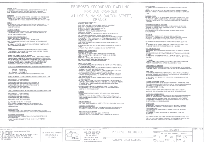
Planning and Development Committee
1 December 2015
2.3 Development
Application DA 308/2015(1) - 98 Dalton Street
Attachment 3 Submissions


2.4 Development
Application DA 342/2015(1) - Lot 16 Woodward Street
TRIM
REFERENCE: 2015/3145
AUTHOR: Andrew
Crump, Senior Planner
EXECUTIVE Summary
|
Application lodged
|
29 September 2015
|
|
Applicant/s
|
Metasite
|
|
Owner/s
|
Orange Golf Club Limited
|
|
Land description
|
Lot 16 DP 1120534 - Duntryleague -
Woodward Street, Orange
|
|
Proposed land use
|
Telecommunications facility (30m
monopole, antennas and shelter)
|
|
Value of proposed development
|
$180,000
|
Council's consent is sought for the installation of a
telecommunications facility on land described as Lot 16 DP 1120534, known as
Duntryleague Golf Club. The facility involves the installation of a 30m
monopole, antenna on top of the monopole, shelter and fenced compound.
The major consideration with this application is the visual
impact and the cumulative effect of a second facility in the locality.
The development is consistent with Council’s relevant
planning provisions is recommended for approval.
Link To Delivery/OPerational Plan
The recommendation in this report relates to the
Delivery/Operational Plan strategy “13.4 Our Environment
– Monitor and enforce regulations relating to City amenity”.
Financial Implications
Nil
Policy and Governance Implications
Nil
|
Recommendation
That Council consents to
development application DA 342/2015(1)
for Telecommunications Facility (30m monopole, antennas and shelter)
at Lot 16 DP 1120534 - Woodward Street, Orange pursuant to the conditions of consent in the attached
Notice of Approval.
|
further considerations
Consideration has been given to the
recommendation’s impact on Council’s service delivery; image and
reputation; political; environmental; health and safety; employees;
stakeholders and project management; and no further implications or risks have
been identified.
SUPPORTING INFORMATION
THE APPLICATION/PROPOSAL
Council's consent is sought for the installation of a
telecommunications facility on land described as Lot 16 DP 1120534, known as Duntryleague
Golf Club. The development involves the installation of a 30m monopole,
associated antennas and shelter and fenced compound. The facility is proposed
approximately 50m east of the existing Telstra facility.
MATTERS FOR CONSIDERATION
Telstra is a licenced telecommunications carrier and is
required to operate under the provisions of the Telecommunications Act 1997
and the Telecommunications Code of Practice 1997.
The 1997 Act and Telecommunications (Low-impact
Facilities) Determination 1997 (as amended) establish the criteria for
‘low impact’ telecommunications facilities. The proposed
development is not defined as a ‘’low-impact facility” under
the Telecommunications Act and is therefore subject to the
provisions of the NSW Environmental Planning and Assessment Act 1979
and, accordingly, the provisions of Orange Local Environmental Plan 2011.
The Telecommunications Code of Practice 1997 sets out
the design, planning and installation requirements for carriers to ensure that
the installation of facilities is in accordance with industry “best
practice”. The applicant advises that the design and siting of the
proposed communications facility has been undertaken in accordance with
Section 3 (Planning and Siting) of the Australian Standard, Siting of Radio
Communications Facilities (AS3516.2). Relevant conditions are attached in this
regard.
Section 5A Assessment
In the administration of sections 78A, 79B, 79C, 111 and
112, the provisions of Section 5A must be taken into account for every
development application in deciding whether there is likely to be a significant
effect on threatened species, populations or ecological communities or their
habitats. This section includes a requirement to consider any adopted
assessment guidelines, which means assessment guidelines issued and in force
under section 94A of the Threatened Species Conservation Act 1995.
Assessment guidelines are in force (see DECC-W “Threatened Species
Assessment Guidelines - The Assessment of Significance”) which requires
consent authority to adopt the precautionary principle in its assessment.
In this instance, site inspection reveals that the subject
property has no biodiversity or habitat value.
Section 79C
Section 79C of the Environmental Planning and Assessment
Act 1979 requires Council to consider various matters, of which those
pertaining to the application are listed below.
Heritage Act - Section 57(2)
The subject land is identified as a State registered
heritage item. The applicant has obtained a section 57(2) exemption
pursuant to the Heritage Act. As such, there are no other requirements
or functions that Council is obligated to carry out under the Heritage Act.
PROVISIONS OF ANY ENVIRONMENTAL
PLANNING INSTRUMENT s79C(1)(a)(i)
Orange Local Environmental Plan 2011
Part 1 - Preliminary
Clause 1.2 - Aims of Plan
The
broad aims of the LEP are set out under subclause 2. Those relevant to the
application are as follows:
(a) to encourage development which complements
and enhances the unique character of Orange as a major regional centre boasting
a diverse economy and offering an attractive regional lifestyle,
(b) to provide for a range of development
opportunities that contribute to the social, economic and environmental
resources of Orange in a way that allows present and future generations to meet
their needs by implementing the principles for ecologically sustainable
development,
(f) to recognise and manage valued
environmental heritage, landscape and scenic features of Orange.
The application is considered to be consistent with aims
(a), (b) and (f) as listed above.
Clause 1.6 - Consent Authority
This clause establishes that, subject to the Act, Council is
the consent authority for applications made under the LEP.
Clause 1.9A - Suspension of
Covenants, Agreements and Instruments
This clause provides that covenants, agreements and other
instruments which seek to restrict the carrying out of development do not apply
with the following exceptions.
· covenants imposed
or required by Council
· prescribed
instruments under Section 183A of the Crown Lands Act 1989
· any conservation
agreement under the National Parks and Wildlife Act 1974
· any trust
agreement under the Nature Conservation Trust Act 2001
· any property
vegetation plan under the Native Vegetation Act 2003
· any biobanking
agreement under Part 7A of the Threatened Species Conservation Act 1995
· any planning
agreement under Division 6 of Part 4 of the Environmental Planning and
Assessment Act 1979.
Council staff are not aware of the title of the subject
property being affected by any of the above.
Mapping
The subject site is identified
on the LEP maps in the following manner:
|
Land Zoning Map:
|
Land zoned RE2 Private Recreation
|
|
Lot Size Map:
|
No Minimum Lot Size
|
|
Heritage Map:
|
State listed heritage item
|
|
Height of Buildings Map:
|
No building height limit
|
|
Floor Space Ratio Map:
|
No floor space limit
|
|
Terrestrial Biodiversity Map:
|
No biodiversity sensitivity on the
site
|
|
Groundwater Vulnerability Map:
|
Ground water vulnerable
|
|
Drinking Water Catchment Map:
|
Not within the drinking water
catchment
|
|
Watercourse Map:
|
Not within or affecting a defined
watercourse
|
|
Urban Release Area Map:
|
Not within an urban release area
|
|
Obstacle Limitation Surface Map:
|
No restriction on building siting
or construction
|
|
Additional Permitted Uses Map:
|
No additional permitted use applies
|
Those matters that are of relevance are addressed in detail
in the body of this report.
Part 2 - Permitted or
Prohibited Development
Land
Use Zones
The subject land is zoned RE2 Private Recreation. The
proposed development is defined as a telecommunications facility under OLEP
2011. Pursuant to OLEP 2011 a telecommunications facility means:
(a) any
part of the infrastructure of a telecommunications network, or
(b) any
line, cable, optical fibre, fibre access node, interconnect point equipment,
apparatus, tower, mast, antenna, dish, tunnel, duct, hole, pit, pole or other
structure in connection with a telecommunications network, or
(c) any
other thing used in or in connection with a telecommunications network.
Telecommunications Facilities are not specifically
listed as permissible in the RE2 Private Recreation zone under OLEP 2011
and are thus prohibited. However, State Environmental Planning Policy
(Infrastructure) applies to the State, and under Clause 115 development for the
purposes of telecommunications facilities may be carried out by any person with
consent on any land. The SEPP overrides the provisions of Orange LEP 2011 and
therefore has the effect of rendering the proposed development permissible on
any land with the consent of Council.
In accordance with Clause 115(3) of SEPP (Infrastructure),
Council in determining this matter must take into consideration any guidelines
concerning site selection, design, construction or operating principles for
telecommunications facilities that are issued by the Director-General for the
purposes of this clause and published in the Gazette.
This provision has the effect of imposing any assessment
guidelines imposed by the Director General (Department Of Planning). The
Department has a design guideline, entitled "NSW Telecommunications
Facilities Guideline Including Broadband" which applies in this case.
A detailed assessment of how the development responds to
these guidelines has been provided below under the heading of "State
Environmental Planning Policies".
Clause
2.3 of LEP 2011 references the Land Use
Table and Objectives for each zone in LEP 2011. These objectives
for land zoned RE2 Private Recreation are as follows:
1 - Objectives of the RE2 Private Recreation
Zone
· To enable
land to be used for private open space or recreational purposes.
· To
provide a range of recreational settings and activities and compatible land
uses.
· To
protect and enhance the natural environment for recreational purposes.
· To ensure
development is ordered in such a way as to maximise public transport patronage
and encourage walking and cycling in close proximity to settlement.
· To ensure
development along the Southern Link Road has alternative access.
The
development is not inconsistent with the objectives of the zone.
Part 3 - Exempt and Complying Development
The application is not exempt or complying development.
Part 5 - Miscellaneous Provisions
5.10 - Heritage Conservation
The subject land is identified as a Local heritage item and
as an item on the State Heritage Register. The relevant heritage inventory
sheets provide the following statement of significance for Duntryleague:
This two storey house, with
tower like chapel above, is significant for the display of wealth and
confidence following, and partly the result of, the gold rush to the
surrounding fields.
The property now known as
Duntryleague was part of one of the first land grants in the Orange area in
1834, located adjacent to the later gazetted township of Orange and comprising
a full square mile. The property was grazed for many years by various owners
and tenants, but William Sampson, the first grantee who was himself an absent
land owner with interests in the Mudgee area, also established his early
property called Campdale on the land. The property also included other early
buildings important in the history of Orange such as John Peisley's the Coach
and Horses which is regarded as the first inn in the Blackman's Swamp (Orange)
area.
James Dalton, the prominent
Orange merchant, purchased sections of the land from 187205 to establish a
substantial family estate of 311 acres that he named Duntryleague after his
birthplace in Ireland. In 1876 he commissioned the design and construction of a
mansion located on a prominent ridge of the property from Sydney architect
Benjamin Backhouse.
The house is a splendid
example of mid Victorian splendour designed in the Victorian Filigree style
with a richness of detail befitting the man of wealth and influence that James
had become by that time. The estate included two gatehouses, an ornate entrance
and gates, a stables, a dairy, 2-3 workers' cottages, a fern house, orchards,
vegetable gardens for the household and extensive pastures for grazing.
James initially assisted his
father in their first shop in Orange after arriving from Ireland at the age of
15. In 1853 he set up his own store at the corner of Post Office Lane which he
later managed with his brother Thomas who arrived in Australia in 1858. His
father went on to manage the well known Daniel O'Connell Inn in Orange. The
Dalton Bros. business grew to become the largest wholesale merchant business
west of the Blue Mountains with interests throughout the Central West,
eastwards to Sydney and northwards to the Queensland border at the height of
their success in the late 1800s. The store building that James built in Summer
Street was significantly added to over the years and was to become one of the
landmark buildings in town. The Sydney side of the business was managed by
Thomas who lived at Wheatleigh in North Sydney and the company was notable in
the city for Dalton House in Pitt Street and the Dalton Wharf at Millers Point.
Over the years up to 1925 in
Orange the family have been associated with a large number of significant homes
and also owned and managed a number of extensive pastoral properties. Many of
these buildings remain today as testimony to the importance of the family in
the region.
The Dalton family was among
New South Wales' most influential and wealthy Catholic families. The
Irish-Catholic community in Orange was relatively large and particularly
wealthy enough to play a dominant role in politics and the social and spiritual
development of the town. The Daltons were instrumental in the financing of St.
Joseph's Catholic Church in Orange and James Dalton had built Australia Hall in
Lord's Place to provide the controversial venue for a group of visiting Irish
Nationalists in 1883. James may also have provided funds and leadership for the
Irish Nationalist Movement in NSW. Some of the Dalton children later studied in
Ireland and returned to Australia to work.
The Dalton family were
involved in the early civic development of Orange. Some stood on local Council
(James Dalton Mayor 1869, Michael Francis Dalton Councillor from 1906 for many
years). In 1877 James was awarded the rare honour of being made a Papal Knight
by Pope Gregory for his services to the Catholic Church and the large stained
glass window in the hall of Duntryleague commemorates his investiture.
After James' death the house
and grounds were retained briefly in family ownership and also used as a large
convalescent hospital run by the Red Cross. The property was then purchased by
the Orange Golf Club in 1935 as a home for the Club, which had originally been
established in Orange in 1909, but had outgrown earlier Club premises. James
Dalton had in fact opened the Club in 1901.
The Club has made some
alterations to the house and grounds over the years but both still retain
significant aspects of their history that are still able to demonstrate the
original design and use of the once splendid property. The Club has established
itself at Duntryleague over the past 70 years as an important golf club in NSW
with an exceptional setting for its courses and attracting local, state and
international players and visitors (Christo Aitken & Associates, 2003,
66-67).
Duntryleague property has
strong historic associations with prominent merchant, pastoralist and townsman,
James Dalton, and architect Benjamin Backhouse, its designer, R Scott & JJ
McMurtrie, stone masons. Duntryleague has aesthetic significance with its
prominent hilltop location, extensive grounds now a golf course, fine
collection of magnificent mature trees, original estate elements including an
axial entry driveway with gate keeper's lodge, notable house, terraced former
gardens and tennis courts.
Duntryleague contains a house
of mid Victorian splendour, a good example of Victorian Filigree style by
virtue of its ornate cast iron work to the portico and verandahs. It displays
high standards of construction and high quality craftsmanship in its joinery an
ironwork.
Gate Keeper's Lodge
This simple building is
relieved by its decorative traceried bargeboards. It is of additional interest
for its association with the wealthy and influential Dalton family, former
owners of the Duntryleague property.
(Register of the National
Estate, modified Read, S., 8/2005)
Estate
Duntryleague's grounds while
modified into a notable golf course have considerable historic, aesthetic and
social significance. They have historic associations with the Dalton family,
the Orange Golf Club and a series of gardeners, golf course and landscape
designers notable within NSW, including Andrew Alfred Patterson, John Irving,
Richard Apperly & Ilmar Berzins. The grounds have a considerable collection
of mature exotic trees.
The main entrance drive off
Woodward Street in particular is richly planted from the gate house up to the
mansion, as is the area around the mansion, with a mixture of conifers,
evergreen and deciduous trees (Stuart Read, pers.comm., Aitken, 2002, 465,
Christo Aitken, 2003).
(1) Objectives
The
objectives of this clause are as follows:
(a) to
conserve the environmental heritage of Orange,
(b) to
conserve the heritage significance of heritage items and heritage conservation
areas, including associated fabric, settings and views,
(c) to
conserve archaeological sites,
(d) to
conserve Aboriginal objects and Aboriginal places of heritage significance.
The area of the subject land to which the application
relates is well separated from the elements identified in the above statement
of significance, and as such the development is not likely to impact upon the
identified significance. This position is agreed to by NSW Heritage given
that a standard exemption has been provided by NSW Heritage.
Part 6 - Urban Release Area
Not relevant to the application. The subject site is not
located in an Urban Release Area.
Part 7 - Additional Local
Provisions
7.6
- Groundwater Vulnerability
This
clause seeks to protect hydrological functions of groundwater systems and
protect resources from both depletion and contamination. Orange has a high
water table and large areas of the LGA, including the subject site, are
identified with “Groundwater Vulnerability” on the Groundwater
Vulnerability Map. This requires that Council consider:
(a) whether or not the development (including
any onsite storage or disposal of solid or liquid waste and chemicals) is
likely to cause any groundwater contamination or have any adverse effect on
groundwater dependent ecosystems, and
(b) the cumulative impact (including the
impact on nearby groundwater extraction for potable water supply or stock water
supply) of the development and any other existing development on groundwater.
Furthermore consent may not be granted unless Council is satisfied that:
(a) the development is designed, sited and
will be managed to avoid any significant adverse environmental impact, or
(b) if that impact cannot be reasonably
avoided - the development is designed, sited and will be managed to minimise
that impact,
(c) if that impact cannot be minimised - the
development will be managed to mitigate that impact.
The proposal is not anticipated
to involve the discharge of toxic or noxious substances and is therefore
unlikely to contaminate the groundwater or related ecosystems. The proposal
does not involve extraction of groundwater and will therefore not contribute to
groundwater depletion.
STATE ENVIRONMENTAL PLANNING
POLICIES
State Environmental Planning Policy (Infrastructure) 2007
("the SEPP") applies to the subject development.
Clause 2 - Aim of Policy
The aim of this policy is to facilitate the effective
delivery of infrastructure across the state by:
(a) improving
regulatory certainty and efficiency through a consistent planning regime for
infrastructure and the provision of services, and
(b) providing
greater flexibility in the location of infrastructure and service facilities,
and
(c) allowing
for efficient development, redevelopment or disposal of surplus government
owned land, and
(d) identifying
the environmental assessment category into which different types of
infrastructure and services development fall (including identifying certain
development of minimal environmental impact as exempt development), and
(e) identifying
matters to be considered in the assessment of development adjacent to particular
types of infrastructure development, and
(f) providing
for consultation with relevant public authorities about certain development
during the assessment process or prior to development commencing.
The development is not inconsistent with the aims of the
SEPP.
Clause 115 - Development
Permitted with Consent
(1) Development
for the purposes of telecommunications facilities, other than development in
clause 114 or development that is exempt development under clause 20 or
116, may be carried out by any person with consent on any land.
The SEPP has the effect of rendering the proposed
development permissible on any land with the consent of Council.
(3) Before
determining a development application for development to which this clause
applies, the consent authority must take into consideration any guidelines
concerning site selection, design, construction or operating principles for
telecommunications facilities that are issued by the Director-General for the
purposes of this clause and published in the Gazette.
This provision has the effect of imposing any assessment
guidelines imposed by the Director General (Department of Planning). The
relevant guideline applicable in NSW for the consideration of development of
this type is entitled "NSW Telecommunications Facilities Guideline
Including Broadband". The guideline has the effect under clause 1.6 of
applying as a design tool in all zones of an LEP.
Section 2.2 of the policy sets up the design principles that
should be followed. The guidelines are organised under the heading of
"Principles". Detailed consideration of how the development fits into
the landscape will, however, remain an important element for consideration
under the guidelines. The site is an important visual landscape on the entrance
into the City from the west.
Those principles that are called up in the policy and which
are relevant to the assessment of visual impact are set out below:
Principle
1 - A telecommunications facility is to be designed and sited to minimise
visual impact
(a) As far as practical, a telecommunications
facility that is to be mounted on an existing building or structure should be
integrated with the design and appearance of the building or structure.
The development relates to a new
structure. As such the above is not applicable. The applicant’s
justification against co-location is provided below.
(b) The visual impact of telecommunications
facilities should be minimised, visual clutter is to be reduced particularly
on tops of buildings, and their physical dimensions (including support mounts)
should be sympathetic to the scale and height of the building to which it is to
be attached, and sympathetic to adjacent buildings.
As a new structure designed to meet technical
specifications, there appear to be few opportunities to modify or reduce the
intrusive nature of the monopole and the array antenna to be placed on top of
the pole.
(c) Where
telecommunications facilities protrude from a building or structure and are
predominantly backgrounded against the sky, the facility and their support
mounts should be either the same as the prevailing colour of the host building
or structure, or a neutral colour such as grey should be used.
The proposed telecommunications facility is a stand-alone
structure. The proposed structure will protrude above the exiting stand of
mature trees in close proximity to the facility when viewed from a large area
of the western section of the City, particularly from The Escort Way, Dalton
Street, Sieben Drive and Prince Street. A detailed assessment of the visual
impacts of the development has been provided below under the heading
“Likely Impacts of the Development”. It is considered appropriate
in this case to impose a condition requiring the structure to be “shale
grey” in colour as suggested. A condition to that effect is included.
(d) Ancillary
facilities associated with the telecommunications facility should be screened
or housed, using the same colour as the prevailing background to reduce its
visibility, including the use of existing vegetation where available, or new
landscaping where possible and practical.
In this case, the ground based structures will be located
immediately around the base of the structure. Existing vegetation will serve to
screen the ancillary structures. No additional landscaping is considered
warranted.
(e) A
telecommunications facility should be located and designed to respond
appropriately to its rural landscape setting.
Not applicable - the proposed development is located within
a highly urbanised area and not a rural setting.
(f) A
telecommunications facility located on, or adjacent to, a State or local
heritage item or within a heritage conservation area, should be sited and
designed with external colours, finishes and scale sympathetic to those of the
heritage item or conservation area.
The subject land is identified as a State registered
heritage item. The applicant has obtained a section 57(2) heritage
exemption from NSW Heritage. As such no further heritage assessment is
required.
(g) A
telecommunication facility should be located and designed so as to respond
appropriately to its landscape setting.
The proposed facility is to be located within a large area
of private open space in amongst an area of mature stands. A detailed
assessment of the visual impact of the development and its impact on the
landscape setting has been provided below under the heading “Likely
Impacts of the Development’.
(h) The
relevant local government authority must be consulted where the pruning,
lopping, or removal of any tree or other vegetation would contravene a Tree
Preservation Order applying to the land or where a permit or development
consent is required.
A condition is attached in relation to where pruning,
lopping or removing a tree is concerned.
(i) A
telecommunications facility that is no longer required is to be removed and the
site restored, to a condition that is similar to its condition before the
facility was constructed.
A relevant condition is attached in this regard.
(j) The
siting and design of telecommunications facilities should be in accordance with
any relevant Industry Design Guides.
A relevant condition is attached in this regard.
Principle
2 - Co-location
Council staff expressed to the applicant prior to lodgement
that co-location should be explored in detail as an option given that there
exists a facility within 50m of the proposed facility. The applicant submits
that co-location is not feasible for the following reasons:
Due to reservations for future
upgrades by Telstra below its existing equipment, it doesn’t offer Optus
the sufficient height to co-locate their equipment on the pole to meet the
coverage objectives. Furthermore the trees would interfere with the signal as
the equipment would need to be above the tree canopy. Therefore it was
discounted from a radio frequency and design perspective.
Whilst it would be ideal if the proposed facility was
co-located upon the existing Telstra facility so as to reduce the amount visual
clutter within the landscape, there is no mechanism for Council to force
Telstra to allow Optus to use their facility; and whilst this would be the
ideal situation, as established throughout this report the visual impacts
associated with the development are considered to be within acceptable
parameters.
Principle
3 - Health Standards
The applicant has submitted technical specifications and
discussion in their Statement of Environmental Effects attesting that the
proposed structure when in operation will comply with relevant health
standards, particularly relating to electromagnetic emissions standards.
Whilst there are currently wide-ranging and contentious
views on the health impacts associated with electromagnetic energy (EME), with
large volumes of discourse related to the study, there is currently no
definitive evidence or conclusive findings one way or another of the effects of
EME on humans. Council is therefore largely reliant on the studies of
recognised health organisations and the submitted report on the summary of
Estimated RF (radiofrequency) EME (electromagnetic energy) in determining
the likely health impacts associated with the development.
The Australian Government’s Australian Radiation
Protection and Nuclear Safety Agency cite the World Health Organisation’s
advice stating:
None of the
recent reviews have concluded that exposure to RF fields from mobile phones and
their base stations cause any adverse health consequences” (ARPANSA).
Furthermore, the ARPANSA suggests:
the balance of evidence does
not indicate a risk to the health of people, including children, living in the
vicinity of base stations where exposure levels are only small fractions of the
ARPANSA standard.
A report titled ‘Environmental EME Report Woodward
Street, Orange NSW 2800’ indicates:
The maximum EME level
calculated for the proposed system at this site is 2.94V/m; equivalent to
22.94mW/m2 or 0.34% of the public exposure limit.
As mentioned above, Council is
largely reliant on the reports submitted in the application and studies of
recognised health agencies in determining the likely health impacts associated
with the development.
In light of the above, it is considered that the development
is not likely to result in adverse health impacts as a result of human
exposure.
The submitted EME report only accounts for the proposed
structure and does not take into account the cumulative effects of EME levels
considering the existing structure in close proximity. Council staff wrote to
the applicant and raised this issue. The applicant responded with the
following:
The sites have different
entries on the Radio Frequency National Site Archive (RFNSA) website (see
screenshot below) as they are different base stations and different carriers. I
have attached the EME report for both the Telstra site and the Optus site. Both
sites comply with Australian Radiation Protection and Nuclear Safety Agency
(ARPANSA) standards and both are less than 1% where 100% is acceptable. The
sites are within 50m of each other. The maximum EME levels being radiated from
the Optus site between 0 – 50m are 0.061% and 0.062% for the Telstra site
as demonstrated on page two of each report attached.
As these are two different
sites and different carriers (Optus & Telstra) it is not possible to
calculate a cumulative EME level, however, from the information above (and
attached) even if it was on the same site, the level(s) would still be
extremely low and well within the ARPANSA standards.
It should be noted that the same EME levels would be
experienced if co-location was a viable option, which can happen as low impact
exempt development.
Council staff are satisfied from the information provided
that the cumulative effects of the two nearby facilities will be within
acceptable levels.
Principle
4 - Minimise Disturbance
This principle is mainly concerned with the impact that the
development may have on other telecommunication facilities in the locality,
particularly those relating to airport operations. It is considered unlikely
that the proposed structure will have any significant impact in this regard.
PROVISIONS OF ANY DRAFT
ENVIRONMENTAL PLANNING INSTRUMENT THAT HAS BEEN PLACED ON EXHIBITION
s79C(1)(a)(ii)
There are no draft environmental planning instruments that
apply to the subject land or proposed development.
DESIGNATED DEVELOPMENT
The proposed development is not designated development.
PROVISIONS OF ANY DEVELOPMENT
CONTROL PLAN s79C(1)(a)(iii)
Development Control Plan 2004
Development Control Plan 2004 (“the DCP”)
applies to the subject land (Chapter 0 - OLEP 2011, Chapter 11 - Land
Used for Open Space and Recreation and Chapter 13 - Heritage). An
assessment of the proposed development against the relevant Planning Outcomes
will be undertaken below.
Pursuant to Planning Outcome 0.2-1 Interim Planning Outcomes
- Conversion of Zones:
· Throughout this
Plan, any reference to a zone in Orange LEP 2000 is to be taken to be a
reference to the corresponding zone(s) in the zone conversion table.
The corresponding zone to zone 6 Open Space and Recreation
(Orange LEP 2000) is zone RE2 Private Recreation (Orange LEP 2011). As
such, Orange DCP 2004 – Chapter 11 - Land Used for Open Space is
of primary relevance to this proposal. The provisions of Chapter 11 and
other applicable chapters are considered below.
Part 11 - Land Used for Open
Space and Recreation
Part 11 of the DCP states in part:
For the purposes of the plan private recreation land
refers to the following:
· Orange Golf
Club.
It is considered that the development is consistent with the
provisions of Part 11 of the DPC.
Part 13 - Heritage
As outlined above, the development is not likely to impact
on the significance of the heritage item “Duntryleague” and is
therefore not considered to be inconsistent with the planning requirements of
Part 13 of the DCP.
PROVISIONS PRESCRIBED BY THE
REGULATIONS s79C(1)(a)(iv)
The development is not inconsistent with the provisions
prescribed by the regulations.
THE LIKELY IMPACTS OF THE
DEVELOPMENT s79C(1)(b)
Context and Setting
Duntryleague golf course represents a very high quality and
large landscape item within an established urban setting which is flanked on
two sides by major roads. The location of the facility is on a shallow
ridgeline. It is considered that the facility will project above the horizon
when viewed from a substantial proportion of the surrounding residential areas,
particularly from the east and west. From much of these areas there is no
backdrop behind the facility; and even considering the slimline nature of the
facility, with the absence of any backdrop the facility will be quite
prominent. This is further exacerbated by the clean lines of the upper
structure against the irregular canopy of the surrounding landscape. This is
observed with the existing facility 50m from this proposed facility. However,
as established below the existing vegetation serves to screen the development
when observed from close to the facility and the effects of visual perspective
mean that the development is less obtrusive and less visible from afar where
vegetation stops to serve as screening.
Visual Impacts
The development will be a visible element within the
landscape from various vantage points on the western side of the City and will
add an additional structure within the landscape to the existing Telstra
facility 50m from the proposed facility.
Notwithstanding the above, the situation with this
particular site is such that the closer the observer gets to the structure the
less visible the structure is by virtue of the existing vegetation; and the
further away the observer gets to the structure the more of the structure the
observer will be able to see. However, given that the observer is a
considerable distance away, with the effects of visual perspective the object
appears quiet small and far less objectionable then if it were visible from a
considerably closer distance. This is what has been experienced with the
existing Telstra facility. The above principle applies in the most part except
for the example shown in plate 4 below.
It should be noted that the
selected site will result in the structure being more visible than the Telstra
facility on the land (refer plate 4 below), however not to the point where the
development would be unacceptable. The following photomontages demonstrate how
the proposed facility will sit within the landscape.
Plate 1 - looking generally south towards facility in
Burrendong Way
Plate 2 - looking generally south towards the
development from Molong Road
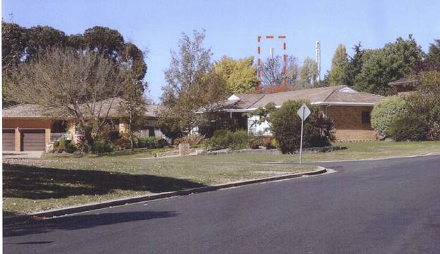
Plate 3 - looking southeast towards development in
Sieben Drive
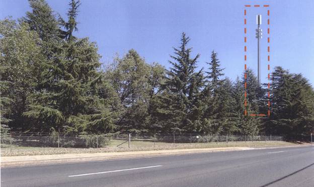
Plate 4 -looking generally west towards the facility
within Forbes Road
Plate 4 demonstrates where the
development will be the most visible. Notwithdstanding the above photomontage,
the development will be acceptable given the existing mature vegetation which
will assist to shield the development, the open landscape characteristics of
the location, the requirement on the light grey resessive colour and the
existing built form in the proximity such as the large advertising sign at West
Orange Motors all resulting in the development being acceptable in the
location.
In addition to the above, it is noted that these types of
structures are becoming more and more common place within the urban
landscape and Council needs to give weight not only to the level of
visual impact likely as a result from the development but also couter balance
that with the public benefit derived from these types of facilities. On balance
the development is considered acceptable.
During pre-lodgement meetings onsite, Council staff
suggested that an alternate location be explored further within the site on the
other side of the adjacent fairway. However, this option was discounted by the
owner of the land and not listed as a viable option for the applicant. Little
would be gained from moving the structure slightly in either direction and for
the reasons outlined above the development is considered acceptable in terms of
visual impacts.
Cumulative Impacts
The likely cumulative impacts associated with the
development relate to the cumulative visual impacts and the cumulative EME. In
relation to the former, the visual impacts have been addressed above and are
considered to be acceptable. In relation to the latter, the combined EME levels
of the existing facility on the land and the proposed facility are considered
to be well below the required threshold levels, and as such are acceptable.
The cumulative impacts associated with the development are
not unacceptable.
Construction Management
The submitted plans show a craning location within the
highway. Relevant traffic management plans and permits from the road authority
will be required for the temporary road closure. An alternate crane point could
be sought internally within the site to avoid such requirements. The applicant
also submits that the existing gates will be removed to allow site access and
then reinstated at the completion of the development. Relevant conditions are
attached to ensure that this occurs in an acceptable manner. A Section 68
hoarding application may also be required if the applicant requires the closing
of the footpath.
Noise Impacts
The construction stage would generate a certain level of
noise attributed to the construction work. Conditions are attached in regards
to hours during which construction may be carried out onsite.
Traffic Impacts
Given the location of the development within the confines of
the Orange Golf Club it is not likely to present any adverse traffic impacts.
The Orange Golf club is well serviced by public roads. Submitted plans indicate
access to the site from Forbes Road. However, the Statement of Environmental
Effects does not make mention of the proposed access indicated on the plan.
THE SUITABILITY OF THE SITE
s79C(1)(c)
The site comprises a large area of private recreation land
with extensive vegetation to act as screening within the property, and is
considered suitable for the proposed development. Moreover, Council staff are
not aware of any natural, technological or physical hazard that may constrain
the development from occurring in an acceptable manner.
ANY SUBMISSIONS MADE IN
ACCORDANCE WITH THE ACT s79C(1)(d)
The proposed development is not defined as advertised
development under the provisions of the LEP, and as such no formal exhibition
of the application was required. However, consistent with Council’s
approach with these types of developments across the City, the development was
notified. No submissions have been received in relation to this application.
PUBLIC INTEREST
s79C(1)(e)
The proposed development is considered to be of minor to
moderate interest to the wider public due to the potential for visual impacts.
Notwithstanding this, the proposal is not inconsistent with any relevant policy
statements, planning studies, guidelines etc that have not been considered in
this assessment.
SUMMARY
The proposed development complies with the relevant aims,
objectives and provisions of both the Orange LEP and SEPP
(Infrastructure). A section 79C assessment of the development indicates that
the development will have a visual impact, but nonetheless will be within
acceptable levels.
It should be noted that infrastructure of this type is fast
becoming a common element within urban environments. Council will therefore
need to determine the application having regard to the overall visual impact
that the structure will have on surrounding land against the overall public benefit
that may result from facilitating improved mobile phone coverage in this
locality.
Attached is a draft Notice of Approval outlining a range of
conditions considered appropriate to ensure that the development proceeds in an
acceptable manner.
It is recommended that Council supports the development.
COMMENTS
The requirements of the Environmental Health and Building
Surveyor and the Engineering Development Section are included in the attached
Notice of Approval.
Attachments
1 Notice
of Approval, D15/45745⇩
2 Plans,
D15/45751⇩
Planning and Development Committee
1 December 2015
2.4 Development
Application DA 342/2015(1) - Lot 16 Woodward Street
Attachment 1 Notice
of Approval
|

|
ORANGE
CITY COUNCIL
Development
Application No DA
342/2015(1)
NA15/ Container
PR22661
|
NOTICE OF DETERMINATION
OF A DEVELOPMENT
APPLICATION
issued under the Environmental
Planning and Assessment Act 1979
Section 81(1)
|
Development
Application
|
|
|
Applicant Name:
|
Metasite
|
|
Applicant Address:
|
Attention:
Timothy Brosnan
PO Box 31
CROWS
NEST NSW 1585
|
|
Owner’s Name:
|
Orange
Golf Club Limited
|
|
Land to Be Developed:
|
Lot 16 DP
1120534 - Woodward Street, Orange
|
|
Proposed Development:
|
Telecommunications
Facility (30m monopole, antennas and shelter)
|
|
|
|
|
Building
Code of Australia
building classification:
|
To be
determined by the PCA
|
|
|
|
|
Determination
|
|
|
Made On:
|
23
November 2015
|
|
Determination:
|
CONSENT
GRANTED SUBJECT TO CONDITIONS DESCRIBED BELOW:
|
|
|
|
|
Consent to
Operate From:
|
23
November 2015
|
|
Consent to
Lapse On:
|
23
November 2020
|
Terms of Approval
The reasons for the imposition of
conditions are:
(1) To ensure compliance
with relevant statutory requirements.
(2) To provide adequate
public health and safety measures.
(3) To ensure a quality
urban design for the development which complements the surrounding environment.
(4) To maintain
neighbourhood amenity and character.
(5) To ensure the utility
services are available to the site and adequate for the development.
(6) To prevent the proposed
development having a detrimental effect on adjoining land uses.
(7) To minimise the impact
of development on the environment.
Conditions
(1) The
development must be carried out in accordance with:
(a) Plan/s
numbered Drawing Nos. S2308B-P1 Rev 04; S2308B-P2 Rev 04 Plans by Sureline
Geomatics Drawing no. SG15131 Sheets 1 and 2 (4 sheets)
(b) statements
of environmental effects or other similar associated documents that form part
of the approval
as amended
in accordance with any conditions of this consent.
(2) All building work must
be carried out in accordance with the provisions of the Building Code of
Australia.
(3) A sign is to be erected
in a prominent position on any site on which building work, subdivision work or
demolition work is being carried out:
a. showing
the name, address and telephone number of the principal certifying authority
for the work, and
b. showing
the name of the principal contractor (if any) for any building work and a
telephone number on which that person may be contacted outside working hours,
and
c. stating
that unauthorised entry to the site is prohibited.
Any such sign is to be maintained while the
building work, subdivision work or demolition work is being carried out.
|
PRIOR TO THE ISSUE OF
A CONSTRUCTION CERTIFICATE
|
(4) The monopole shall be
shale grey in colour. This detail shall be shown on the detailed construction
drawings prior to the issue of a construction certificate.
(5) The design and siting
of the facility shall be carried out in accordance with any relevant industry
design guidelines.
(6) A
Construction Certificate application is required to be submitted to, and issued
by, Council/Accredited Certifier prior to any excavation or building works
being carried out on site.
|
PRIOR TO WORKS
COMMENCING
|
(7) Any pruning or lopping
of any trees needing to be undertaken to facilitate the development shall be
identified prior to works commencing and shall only be undertaken in consultation
with a suitably qualified arborist. This consent does not provide approval to
remove any trees.
(8) Soil erosion control
measures shall be implemented on the site.
|
DURING
CONSTRUCTION/SITEWORKS
|
(9) All
construction/demolition work on the site is to be carried out between the hours
of 7.00 am and 6.00 pm Monday to Friday inclusive, 7.00 am to
5.00 pm Saturdays and 8.00 am to 5.00 pm on Sundays and Public
Holidays. Written approval must be obtained from the General Manager of Orange
City Council to vary these hours.
(10) All
materials onsite or being delivered to the site are to be contained within the
site. The requirements of the Protection of the Environment Operations Act
1997 are to be complied with when placing/stockpiling loose material or
when disposing of waste products or during any other activities likely to
pollute drains or watercourses.
(11) Storage
of materials including stockpiles is not permitted on the public footpath area
or roadway unless a hoarding is provided and approval granted.
(12) Any adjustments to
existing utility services that are made necessary by this development
proceeding are to be at the full cost of the developer.
(13) If Aboriginal objects,
relics, or other historical items or the like are located during development
works, all works in the area of the identified object, relic or item shall
cease, and the NSW Office of Environment and Heritage, and representatives from
the Orange LALC shall be notified. Where required, further archaeological
investigation shall be undertaken. Development works in the area of the find(s)
may recommence if and when outlined by the management strategy, developed in
consultation with and approved by the OEH.
|
PRIOR TO THE ISSUE OF
AN OCCUPATION CERTIFICATE
|
(13) The cost of
repairing any damage caused to Council or other Public Authority’s assets
adjoining the subject site as a result of construction works associated with
the approved development, shall be met in full by the applicant prior to the
issue of an Occupation Certificate.
(14) The fence and access
gates on the common boundary shall be reinstated to the same condition
prevailing prior to them being removed; this shall occur prior to the issue of
an occupation certificate.
(15) No
person is to use or occupy the building or alteration that is the subject of
this approval without the prior issuing of an Occupation Certificate.
(16) All
of the foregoing conditions are to be at the full cost of the developer and to
the requirements and standards of the Orange City Council Development and
Subdivision Code, unless specifically stated otherwise. All work required by
the foregoing conditions is to be completed prior to the issuing of an
Occupation Certificate, unless stated otherwise.
|
MATTERS FOR THE
ONGOING PERFORMANCE AND OPERATION OF THE DEVELOPMENT
|
(17) In the event that the
facility is no longer required or used, all structures shall be removed from
the site and the site shall be returned to the same state immediately
prevailing prior to the installation of the facility.
(1) Where any public land
is obstructed during the construction phase of the development, a section 68
Hoarding Application shall be made to Council. Where any road closure is
required, whether partial or otherwise, the relevant authority shall be
obtained to do so.
Other Approvals
(1) Local
Government Act 1993 approvals granted under section 68.
Nil
(2) General
terms of other approvals integrated as part of this consent.
Nil
Right of Appeal
If
you are dissatisfied with this decision, section 97 of Environmental
Planning and Assessment Act 1979 gives you the right to appeal to the Land
and Environment Court within 6 months after the date on which you receive this
notice.
*
Section 97 of the Environmental Planning and Assessment Act 1979 does not apply
to the determination of a development application for State significant
development or local designated development that has been the subject of a
Commission of Inquiry.
|
Disability Discrimination Act
1992:
|
This application has been assessed in
accordance with the Environmental Planning and Assessment Act 1979. No
guarantee is given that the proposal complies with the Disability
Discrimination Act 1992.
The applicant/owner is responsible to ensure
compliance with this and other anti-discrimination legislation.
The Disability Discrimination Act
covers disabilities not catered for in the minimum standards called up in the
Building Code of Australia which references AS1428.1 - "Design for Access
and Mobility". AS1428 Parts 2, 3 and 4 provides the most comprehensive
technical guidance under the Disability Discrimination Act currently
available in Australia.
|
|
|
|
|
Disclaimer - S88B Restrictions on the Use of Land:
|
The applicant should note that there
could be covenants in favour of persons other than Council restricting what
may be built or done upon the subject land. The applicant is advised to check
the position before commencing any work.
|
|
|
|
|
Signed:
|
On behalf of the consent authority ORANGE
CITY COUNCIL
|
|
Signature:
|
|
|
Name:
|
DAVID WADDELL - DIRECTOR DEVELOPMENT
SERVICES
|
|
Date:
|
23 November 2015
|
Planning
and Development Committee
1 December 2015
2.4 Development
Application DA 342/2015(1) - Lot 16 Woodward Street
Attachment 2 Plans