ORANGE CITY COUNCIL
Ordinary Council Meeting
Agenda
15 December 2015
Notice
is hereby given, in accordance with the provisions of the Local Government Act
1993 that a Ordinary meeting of ORANGE CITY COUNCIL
will be held in the Council Chamber,
Civic Centre, Byng Street, Orange on Tuesday, 15 December 2015
commencing at 7.00pm.
Garry
Styles
General Manager
For apologies please
contact Michelle Catlin on 6393 8246.
1.1 Apologies
and Leave of Absence
1.2 Opening
Prayer
1.3 Acknowledgement
of Country
I would like to acknowledge the Wiradjuri people who are the
Traditional Custodians of the Land. I would also like to pay respect to the
Elders both past and present of the Wiradjuri Nation and extend that respect to
other Aboriginal Australians who are present.
1.4 Declaration
of pecuniary interests, significant non-pecuniary interests and less than
significant non-pecuniary interests
The
provisions of Chapter 14 of the Local Government Act, 1993 (the Act)
regulate the way in which Councillors and designated staff of Council conduct
themselves to ensure that there is no conflict between their private interests
and their public role.
The
Act prescribes that where a member of Council (or a Committee of Council) has a
direct or indirect financial (pecuniary) interest in a matter to be considered
at a meeting of the Council (or Committee), that interest must be disclosed as
soon as practicable after the start of the meeting and the reasons given for
declaring such interest.
As
members are aware, the provisions of the Local Government Act restrict any
member who has declared a pecuniary interest in any matter from participating
in the discussion or voting on that matter, and requires that member to vacate
the Chamber.
Council’s Code of Conduct provides that if members
have a non-pecuniary conflict of interest, the nature of the conflict must be
disclosed. The Code of Conduct also provides for a number of ways in which a
member may manage non pecuniary conflicts of interest.
|
Recommendation
It is recommended that Councillors now disclose any
conflicts of interest in matters under consideration by the Council at this
meeting.
|
2 Mayoral
Minutes
Nil
3 Confirmation
of Minutes of Previous Meeting
|
RECOMMENDATION
That the Minutes of the Ordinary
Meeting of Orange City Council held on 1 December 2015 (copies of which were
circulated to all members) be and are hereby confirmed as a true and accurate
record of the proceedings of the Council meeting held on 1 December 2015.
|
Attachments
1 Minutes
of the Ordinary Meeting of Orange City Council held on 1 December 2015
ORANGE CITY COUNCIL
MINUTES OF THE
Ordinary Council Meeting
HELD IN Council Chamber, Civic Centre, Byng Street, Orange
ON 1 December 2015
COMMENCING AT 7.00pm
1 Introduction
Cr J Davis OAM (Mayor), Cr C Gryllis (Deputy Mayor), Cr A
Brown, Cr K Duffy, Cr R Gander, Cr J Hamling, Cr N Jones, Cr R Kidd, Cr S Munro, Cr G Taylor (7.35pm), Cr R Turner, Cr J Whitton
Acting General Manager (Devitt),
Director Development Services, Director Community, Recreation and Cultural
Services, Acting Director Technical Services (Gailey), Manager Administration
and Governance, Manager Corporate and Community Relations, Manager Financial
Services, Acting Manager Development Assessments (Johnston)
|
RESOLVED
- 15/550 Cr
J Hamling/Cr S Munro
That the apology for
lateness be accepted from Cr Taylor for the Council
Meeting of Orange City Council on 1 December 2015.
|
1.2 ACKNOWLEDGEMENT OF COUNTRY
1.3 Declaration of pecuniary interests, significant non-pecuniary interests and less
than significant non-pecuniary interests
Planning and Development
Committee Item 2.1 Items Approved Under the Delegated Authority of Council (DA
283/2014(1) – 104 Lysterfield Road, Orange)
Cr R Kidd declared a less than significant non-pecuniary
interest in Item 2.1 (DA 283/2014(1)) . Cr Kidd did not specify the reason.
Planning and Development
Committee Item 2.2 Lucknow Scoping Study Outcomes
Cr C Gryllis declared a pecuniary interest in Item 2.2 as a
real estate agent managing properties in Lucknow.
Planning and Development Committee
Item 2.4 Development Application DA 342/2015(1) - Lot 16 Woodward Street
Cr R Kidd declared a less than significant non-pecuniary
interest in Item 2.4 as a member of Duntryleague Golf Club.
Cr J Whitton declared a pecuniary interest in Item 2.4 as he
has business partnerships with Telstra.
Council Item 6.1 Land Sale at
Narrambla Estate
Cr C Gryllis declared pecuniary interest in Item 6.1 as the
real estate agent acting in this matter.
Council Item 6.3 Shiralee Water
and Sewer Infrastructure Contract
Cr A Brown declared a pecuniary interest in Item 6.3 as a
real estate agent acting in the area.
THE MAYOR DECLARED THE ORDINARY
MEETING OF COUNCIL ADJOURNED FOR THE CONDUCT OF THE OPEN FORUM AT 7.03PM
Planning and Development
Committee Item 2.2 Lucknow Scoping Study Outcomes
Andrew Napier
Mr Napier spoke on behalf of Craig Jones, a land owner in
Lucknow. Mr Napier supported the vision for the village, and advised Mr Jones
would be prepared to consider a range of options for development.
Natalie Selwood
Ms Selwood outlined her support for the study, but
identified that development should not be to the detriment of existing land
owners.
Daniel Taurins
Mr Taurins outlined his support for the study, but requested
consideration be given to existing land owners and that issues of traffic and
noise be addressed.
THE OPEN FORUM CONCLUDED AT 7.14PM
2 Mayoral
Minutes
2.1 Support
for Averkin Family
TRIM Reference: 2015/3133
|
|
RESOLVED - 15/551 Cr
J Hamling/Cr S Munro
That Council provide $5,000 to the Averkin family funeral
fund.
|
MATTER ARISING
|
MOTION Cr
K Duffy/Cr R Gander
That a report be prepared on the support provided to
families struggling to meet funeral expenses.
|
|
THE MOTION ON BEING PUT TO THE MEETING WAS LOST
|
3 Confirmation
of Minutes of Previous Meeting
|
RESOLVED
- 15/552 Cr
S Munro/Cr C Gryllis
That the Minutes of the Ordinary Meeting of Orange City
Council held on 17 November 2015 (copies of which were circulated to all
members) be and are hereby confirmed as a true and accurate record of the
proceedings of the Council meeting held on 17 November 2015, noting that Crs
Jones, Taylor and Whitton voted against decision 2.1 Fit for the Future.
|
THE MAYOR DECLARED THE ORDINARY
MEETING OF COUNCIL ADJOURNED FOR THE CONDUCT OF THE POLICY COMMITTEE MEETINGS
AT 7.25PM
THE MAYOR DECLARED THE ORDINARY
MEETING OF COUNCIL RESUMED AT 8.08PM
4 Notices
of Motion/Notices of Rescission
Nil
5 General
Reports
5.1 Lease
of Hangar M at Orange Airport
TRIM Reference: 2015/2993
|
|
RESOLVED - 15/580 Cr
J Whitton/Cr C Gryllis
1 That
Council enter into a ten year lease (with a further ten year option) to
Rovest Holdings Pty Limited for Hangar M at the Orange Airport.
2 That
permission be granted to use the Council Seal on all necessary documentation.
|
5.2 Leeds
Parade Road Construction in Conjunction with Bunnings
TRIM Reference: 2015/3194
|
|
RESOLVED - 15/581 Cr
R Turner/Cr S Munro
1 That
in accordance with Section 55(3)(i) of the Local Government Act 1993, due to
extenuating circumstances being:
a the
potential for Council to create a significant commercial impact on another
entity and
b delivery
of value for money for the community may be compromised
Council
not call tenders to undertake road upgrade works on Leeds Parade north of the
Northern Distributor Road and utilise the contractor previously engaged by
Bunnings to undertake these works, Hamcon Civil, at the same rates as
previously negotiated between these two parties.
2 That
permission be granted for the use of the Council Seal on all relevant
documents.
|
|
5.3 COUNCIL FOLDER
|
|
TRIM Reference: 2015/3236
|
|
Letter from The Hon John Cobb
MP congratulating Orange on recently receiving the Overall Regional
Sustainability Award at the Keep NSW Beautiful Blue Star Sustainability
(Regional) Award ceremony in Gloucester.
|
|
RESOLVED
- 15/582 Cr
C Gryllis/Cr J Davis
That the contents of the Council Folder be noted.
|
MATTER ARISING
|
RESOLVED
- 15/583 Cr
C Gryllis/Cr S Munro
That Council promote
the NSW Blue Star Award win on suitable stationery, signage and other
materials.
|
6 Closed
Meeting
In accordance with the Local Government Act 1993, and the
Local Government (General) Regulation 2005, in the opinion of the Acting
General Manager, the following business is of a kind as referred to in Section
10A(2) of the Act, and should be dealt with in a Confidential Session of the
Council meeting closed to the press and public.
In response to a question from the Mayor, the Acting General
Manager advised that no written submissions had been received relating to any
item listed for consideration by the Closed Meeting of Council.
The Mayor extended an invitation
to any member of the public present at the meeting to make a presentation to
the Council as to whether the meeting should be closed for a particular item.
|
RESOLVED - 15/584 Cr
S Munro/Cr R Gander
That Council adjourn into a Closed Meeting and members of
the press and public be excluded from the Closed Meeting, and access to the
correspondence and reports relating to the items considered during the course
of the Closed Meeting be withheld unless declassified by separate resolution.
This action is taken in accordance with Section 10A(2) of the Local
Government Act, 1993 as the items listed come within the following
provisions:
6.1 Land
Sale at Narrambla Estate
This item is classified CONFIDENTIAL under the
provisions of Section 10A(2) of the Local Government Act 1993, which permits
the meeting to be closed to the public for business relating to (c)
information that would, if disclosed, confer a commercial advantage on a person
with whom the Council is conducting (or proposes to conduct) business.
6.2 NetWaste
Tender for Collection and Recycling of Waste Tyres
This item is classified CONFIDENTIAL under the
provisions of Section 10A(2) of the Local Government Act 1993, which permits
the meeting to be closed to the public for business relating to (c)
information that would, if disclosed, confer a commercial advantage on a
person with whom the Council is conducting (or proposes to conduct) business.
6.3 Shiralee
Water and Sewer Infrastructure Contract
This item is classified CONFIDENTIAL under the
provisions of Section 10A(2) of the Local Government Act 1993, which permits
the meeting to be closed to the public for business relating to (c)
information that would, if disclosed, confer a commercial advantage on a
person with whom the Council is conducting (or proposes to conduct) business.
|
THE MAYOR DECLARED THE ORDINARY MEETING OF COUNCIL
ADJOURNED FOR THE CONDUCT OF THE CLOSED MEETING AT 8.16PM
THE MAYOR DECLARED THE ORDINARY MEETING OF COUNCIL
RESUMED AT 8.28PM
7 Resolutions from Closed
Meeting
The
Manager Administration and Governance read out the following resolutions made
in the Closed Meeting of Council.
6.1 Land
Sale at Narrambla Estate
TRIM Reference: 2015/2440
|
|
Cr C
Gryllis declared pecuniary interest in Item 6.1 as the real estate agent
acting in this matter, left the Chamber, and did not participate in the
voting or debate on this item.
|
|
RESOLVED - 15/585 Cr
J Whitton/Cr S Munro
That Council proceed with the sale of Part Lot 101 DP
1198640 Astill Drive, and the proceeds applied to the Land Development
Reserve.
|
|
QUESTION
TAKEN ON NOTICE
Cr Turner requested an
update report on the old saleyards site.
|
6.2 NetWaste
Tender for Collection and Recycling of Waste Tyres
TRIM Reference: 2015/3006
|
|
RESOLVED - 15/586 Cr
C Gryllis/Cr S Munro
1 That
Orange City Council accepts the tender submitted by JLW Services Pty Ltd
dated 6 October 2015 for the initial two year term and authorise the General
Manager to sign the required contract documentation
2 That
the resolution regarding this tender remains confidential to the Council
until the last meeting of the participating NetWaste Councils is held.
|
|
Division
of Voting
|
|
Voted For
|
Cr J Davis (Mayor), Cr K Duffy, Cr R Gander, Cr C Gryllis,
Cr J Hamling, Cr N Jones, Cr R Kidd, Cr S Munro, Cr G Taylor, Cr R Turner, Cr
J Whitton, Cr A Brown
|
|
Voted Against
|
Nil
|
|
Absent
|
Nil
|
6.3 Shiralee
Water and Sewer Infrastructure Contract
TRIM Reference: 2015/3075
|
|
Cr A Brown
declared pecuniary interest in Item 6.3 as a real estate agent acting in the
area , left the Chamber, and did not participate in the voting or debate on
this item.
|
|
RESOLVED - 15/587 Cr
S Munro/Cr J Whitton
That Council notes the termination of the contract with
Josa Constructions for the reasons outlined in this report.
|
The Meeting
Closed at 8.28PM
This is
Page Number 7 and the Final Page of the Minutes of the Ordinary Meeting of
Orange City Council held on 1 December 2015.
4 Notices
of Motion/Notices of Rescission
4.1 White
Ribbon Day Oath by Cr Kidd
TRIM REFERENCE: 2015/3222
I, CR
Reg Kidd wish to move the following Notice of Motion at the Council Meeting
of 15 December 2015:
|
Motion
That Orange City Council “Swear the Oath”
that is part of White Ribbon Day, showing that we will all play a part in
exposing domestic violence in its many forms.
|
Background
White Ribbon Day is in its 11th year and focuses on
men’s violence against women and family. We need to speak up about family
domestic violence in support of women and children who do not have a voice of
their own. We can all play a part in exposing the documented high rate of
domestic violence in Orange, and particularly the role alcohol plays. There is
a website and a free phone number where we can pledge our support.
I was approached by some women who feel quite intimidated to
speak out, but would find it helpful to see Council totally supportive, thus
the motion.
Signed
Cr Reg Kidd
White Ribbon Day Oath
“I swear never to commit, excuse or remain
silent about violence against women. This is my oath.”
4.2 Proposed
Playground at Stirling Avenue Reserve by Cr Hamling
TRIM REFERENCE: 2015/3313
I, CR
Jason Hamling wish to move the following Notice of Motion at the Council Meeting
of 15 December 2015:
|
Motion
That Council install play equipment in the Stirling Avenue
Reserve.
|
Signed
Cr Jason Hamling
STAFF COMMENT
As part of the draft Play Plan and mapping of available play
areas, a play space for Stirling Avenue Park has been identified for
consideration in the 2016/17 Delivery/Operational Plan.
This Plan proposes a junior/older child space (ages 3-12)
with a swing theme.
FINANCIAL IMPLICATIONS
The play space is estimated at $50,000 including
installation.
As there is no allocation in the 2015/16 Delivery/Operation
Plan it is recommended that this request be referred for consideration
in the 2016/17 Delivery/Operational Plan.
5 General
Reports
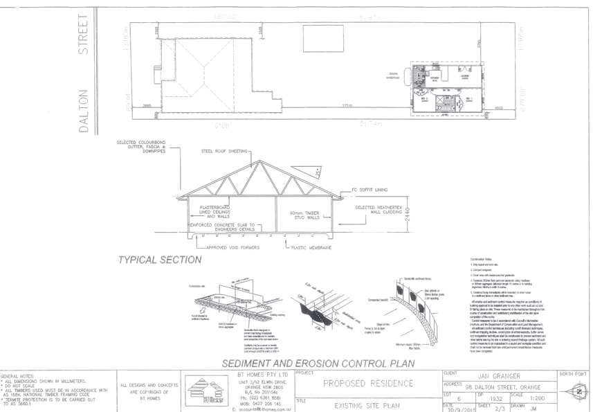
5.1 Development
Application DA 308/2015(1) - 98 Dalton Street
TRIM
REFERENCE: 2015/3076
AUTHOR: Michael
Glenn, Senior Planner
EXECUTIVE Summary
|
Application lodged
|
11 September 2015
|
|
Applicant/s
|
BT Homes
|
|
Owner/s
|
Mrs JM Granger
|
|
Land description
|
Lot 6 DP 1932 - 98 Dalton Street,
Orange
|
|
Proposed land use
|
Secondary Dwelling
|
|
Value of proposed development
|
$119,164
|
Council's consent is sought for the creation of a secondary dwelling
in the rear yard of the site. The application has attracted four individual
submissions from nearby and adjoining property owners raising various issues.
Most of the issues relate to the prior poor management of the premises as a
rental property which, whilst understood, has only limited relevance to the
assessment of this application.
Some of the issues raised by neighbours do have some
relevance resulting in the imposition of conditions that increase the setback
from the rear southern boundary, require new boundary fencing, the
establishment of better landscaped treatments and the establishment of separate
private open space areas for each dwelling.
Link To Delivery/OPerational Plan
The recommendation in this report relates to the
Delivery/Operational Plan strategy “13.4 Our Environment
– Monitor and enforce regulations relating to City amenity”.
Financial Implications
Nil
Policy and Governance Implications
Nil
|
Recommendation
That Council grants consent to development application
DA 308/2015(1) for Secondary Dwelling at Lot 6 DP 1932 - 98 Dalton
Street, Orange pursuant to the conditions of consent in the attached Notice
of Approval.
|
further considerations
Consideration has been given to the
recommendation’s impact on Council’s service delivery; image and
reputation; political; environmental; health and safety; employees;
stakeholders and project management; and no further implications or risks have
been identified.
SUPPORTING INFORMATION
THE APPLICATION/PROPOSAL
Council's consent is sought for
a secondary dwelling at Lot 6 DP 1932 - 98 Dalton Street Orange. The proposal
can be summarised in the following table:
|
Dwelling
|
Land
Area
|
Total
Floor Area (excluding garage, alfresco and porch )
|
%
of Principal
|
Site
Coverage
|
Description
|
|
Principal
|
-
|
120.02m2
|
n/a
|
n/a
|
Existing dwelling
|
|
(Garaging etc)
|
|
30.2m2
|
n/a
|
n/a
|
Garages verandahs and entrance
|
|
Secondary
|
-
|
59.99m2
|
50%
|
n/a
|
One
bedroom dwelling with store, living, separate bath and kitchenette
|
|
Total
|
676m²
|
210.21m²
|
n/a
|
31.09%
|
-
|
MATTERS FOR CONSIDERATION
Section 5A Assessment
In the administration of sections 78A, 79B, 79C, 111 and
112, the provisions of Section 5A must be taken into account for every
development application, in deciding whether there is likely to be a
significant effect on threatened species, populations or ecological communities
or their habitats. This section includes a requirement to consider any adopted
assessment guidelines, which means assessment guidelines issued and in force
under section 94A of the Threatened Species Conservation Act 1995.
Assessment guidelines are in force (see DECC-W “Threatened Species
Assessment Guidelines - The Assessment of Significance”) which requires
consent authority to adopt the precautionary principle in its assessment.
In this instance, site inspection reveals the subject
property has no biodiversity or habitat value.
Section 79C
Section 79C of the Environmental Planning and Assessment
Act 1979 requires Council to consider various matters, of which those
pertaining to the application are listed below.
PROVISIONS OF ANY ENVIRONMENTAL
PLANNING INSTRUMENT s79C(1)(a)(i)
Orange Local Environmental Plan 2011
Part 1 - Preliminary
Clause 1.2 - Aims of Plan
(a) to encourage development which complements
and enhances the unique character of Orange as a major regional centre boasting
a diverse economy and offering an attractive regional lifestyle,
(b) to provide for a range of development
opportunities that contribute to the social, economic and environmental
resources of Orange in a way that allows present and future generations to meet
their needs by implementing the principles for ecologically sustainable
development,
(c) to conserve and enhance the water resources
on which Orange depends, particularly water supply catchments,
(e) to provide a range of housing choices in
planned urban and rural locations to meet population growth,
(f) to recognise and manage valued
environmental heritage, landscape and scenic features of Orange.
With regard to (a), it is noted
that the streetscape provides significant value in terms of heritage character.
It is important to ensure that the integrity and context of the nearby heritage
items is not compromised or placed too far out of context by unsympathetic
materials or design for the new building. With regard to (b), the proposed
development seeks to provide low scale accommodation, as well as some
relatively minor alterations and additions to the existing dwelling. There are
no significant issues arising from the changed land use patterns or densities
arising. With regard to (c), the proposed development will have a slight
increase in demand for water services, but otherwise have no impact. In
relation to (e), the basic proposal is to provide a secondary dwelling that
inherently is of different characteristics to the more traditional housing
forms evident in the street. There are general demographic trends that suggest
smaller household sizes, family members staying longer in the family home, or
older members of a family being provided with separate onsite accommodation. In
relation to (f), the subject application proposes minimal changes to the
visible parts of the site. This represents tangible and positive management of
the site in terms of the heritage, landscape and scenic contribution of the
site to the City.
Clause 1.6 - Consent Authority
This clause establishes that, subject to the Act, Council is
the consent authority for applications made under the LEP.
Clause 1.9A - Suspension of
Covenants, Agreements and Instruments
This clause provides that covenants, agreements and other
instruments which seek to restrict the carrying out of development do not apply
with the following exceptions.
· covenants imposed
or required by Council
· prescribed
instruments under Section 183A of the Crown Lands Act 1989
· any conservation
agreement under the National Parks and Wildlife Act 1974
· any trust
agreement under the Nature Conservation Trust Act 2001
· any property
vegetation plan under the Native Vegetation Act 2003
· any biobanking
agreement under Part 7A of the Threatened Species Conservation Act 1995
· any planning
agreement under Division 6 of Part 4 of the Environmental Planning and
Assessment Act 1979
Council staff are not aware of the title of the subject
property being affected by any of the above.
Mapping
The subject site is identified
on the LEP maps in the following manner:
|
Land Zoning Map:
|
Land zoned R1 General Residential
|
|
Lot Size Map:
|
No Minimum Lot Size
|
|
Heritage Map:
|
Located in a heritage conservation
area
|
|
Height of Buildings Map:
|
No building height limit
|
|
Floor Space Ratio Map:
|
No floor space limit
|
|
Terrestrial Biodiversity Map:
|
No biodiversity sensitivity on the
site
|
|
Groundwater Vulnerability Map:
|
ground water vulnerable
|
|
Drinking Water Catchment Map:
|
Not within the drinking water
catchment
|
|
Watercourse Map:
|
Not within or affecting a defined
watercourse
|
|
Urban Release Area Map:
|
Not within an urban release area
|
|
Obstacle Limitation Surface Map:
|
No restriction on building siting
or construction
|
|
Additional Permitted Uses Map:
|
No additional permitted use applies
|
Those matters that are of relevance are addressed in detail
in the body of this report.
Part 2 -
Permitted or Prohibited Development
Land Use Zones
The subject site is located within the R1 General
Residential zone. The proposed development is defined as Secondary Dwelling
comprising an existing principal dwelling, to which a detached, smaller
Secondary Dwelling is proposed to be added..
All elements of the proposed development are permissible in
the zone. Residential accommodation is a group term of the LEP, covering a
range of development types. Secondary dwelling is defined in the LEP as
self-contained dwelling that:
(a) is established in conjunction with another
dwelling (the principal dwelling), and
(b) is on the same lot of land as the
principal dwelling, and
(c) is
located within, or is attached to, or is separate from, the principal dwelling
Proposals for secondary dwellings must also comply or meet
the development standards contained in clause 5.4 of the LEP. The proposed
development is fully compliant with the relevant standards and further is
consistent with the definition parameters set out above.
State Environmental Planning Policy (Affordable Rental
Housing) (the SEPP) has provisions that act to override or replace the
development standards of the LEP where inconsistencies arise between the SEPP
and the LEP. In this case, however, there are no inconsistencies between the
LEP and the SEPP. The proposed development is permissible in its own right to
the definitions and standards of the LEP.
Clause 2.3 of LEP 2011
references the Land Use Table and Objectives for each zone in LEP 2011.
These objectives for land zoned R1 General Residential are as follows:
1 - Objectives of the R1 General Residential Zone
· To
provide for the housing needs of the community.
· To
provide for a variety of housing types and densities.
· To
enable other land uses that provides facilities or services to meet the day to
day needs of residents.
· To
ensure development is ordered in such a way as to maximise public transport
patronage and encourage walking and cycling in close proximity to settlement.
· To
ensure that development along the Southern Link Road has an alternative access.
In relation to the first and
second dot points, the proposed secondary dwelling is consistent with this
objective. In relation to the third dot point, the proposed development is for
the continuation and intensification of the residential use of the site.
Consideration of alternative land uses is, in this instance, not relevant to
the assessment.
In relation to the fourth dot
point, the proposed development seeks approval for a modest intensification of
the residential use of the site. This has the potential to increase the demand
for public transport, particularly given the style of housing proposed and its
location on a main road, close to bus stops and in close proximity to the CBD.
In relation to the last dot point, the proposed development has no relevance to
the objective.
Part 5 -
Miscellaneous Provisions
Clause 5.4 - Controls
Relating to Miscellaneous Permissible Uses
This clause contains specific
provisions for a secondary dwelling that by reason of the structure of the LEP
go to the definition of the proposed development. Because of that, the
provisions of Clause 5.4 have been considered elsewhere in this report.
5.10 - Heritage
Conservation
The subject property is not located within a conservation
area, but is adjacent to a row of identified heritage listed buildings to the
west.
(1) Objectives
The
objectives of this clause are as follows:
(a) to
conserve the environmental heritage of Orange,
(b) to
conserve the heritage significance of heritage items and heritage conservation
areas, including associated fabric, settings and views,
(c) to
conserve archaeological sites,
(d) to
conserve Aboriginal objects and Aboriginal places of heritage significance.
In relation to (a), the proposed development does not alter
the fabric or form of the existing dwelling, and seeks permission to add a
relatively low scale structure to the rear of the site. The impacts on the
environmental heritage of this site and its surroundings are considered to be
minor. In relation to (b), it is noted that there are three listed items of
environmental heritage adjoining along the western side boundary of the
premises. The impacts of the proposed development on the heritage significance
of these buildings is considered limited, subject to the setback of the
development from the side access lane being increased to bring it into better
alignment with the setback of the shed located at the rear of 332 Lords Place,
and also subject to certain restrictions on materials selection aimed at
limiting the visual impacts. In relation to (c), there is no obvious indication
that the site is a potential archaeological site. In relation to (d), there is
no obvious evidence of Aboriginal heritage on the site.
Requirement for Consent
The
applicant is seeking consent in accordance with the requirements of the LEP.
Effect of
Proposed Development on Heritage Significance
The consent authority must,
before granting consent under this clause in respect of a heritage item or
heritage conservation area, consider the effect of the proposed development on
the heritage significance of the item or area concerned. This subclause applies
regardless of whether a heritage management document is prepared under
subclause (5) or a heritage conservation management plan is submitted
under subclause (6).
The proposed development is
considered unlikely to have a significant impact on any of the nearby and
adjoining heritage items in the locality.
Heritage
Assessment
This Council, may, before
granting consent to any development on land that is within the vicinity of land
containing a heritage item or adjacent a conservation area, require a heritage
management document to be prepared that assesses the extent to which the
carrying out of the proposed works would have on the heritage significance of
the heritage item or heritage conservation area> In this case the
scale of the work, the contrasts of design, the relative lack of visibility
suggest that it is unnecessary to require a heritage management statement in
this case. Advice was, however, sought from Council's Heritage Adviser, who has
provided the following advice with respect to this proposal:
Significance:
· The site
is within the Conservation area (Planners Note; this is incorrect)
Issues:
· The
granny flat is located to the rear garden.
· The
selected materials should be sympathetic to the garden setting.
Recommendations:
· The roof
to be Colorbond Woodland Grey
· All
flashings to be traditional rolled type
· Gutters
to be traditional smooth unperforated Woodland Grey
· Downpipes
to be circular and painted to match the wall colour
· Walls to
be weathertex board cladding painted in Dulux Stone
· Watertank
to be acquaplate steel in an acceptable colorbond colour such as Windspray or
Woodland Grey
· A
landscape planting plan to be provided to illustrate two trees with a mature
height of 6m – one to each side at a suitable distance from the building".
Clauses 5.10(6), (7), (8), (9)
and (10) have been considered, but are not relevant to this assessment.
Part 7 - Additional Local
Provisions
7.3 - Stormwater Management
This clause applies to all
industrial, commercial and residential zones and requires that Council be
satisfied that the proposal:
(a) is designed to maximise the use of water
permeable surfaces on the land having regard to the soil characteristics
affecting onsite infiltration of water
(b) includes, where practical, onsite stormwater
retention for use as an alternative supply to mains water, groundwater or river
water; and
(c) avoids any significant impacts of
stormwater runoff on adjoining downstream properties, native bushland and
receiving waters, or if that impact cannot be reasonably avoided, minimises and
mitigates the impact.
The proposal can be provided
with adequate infrastructure for the collection and disposal of surface runoff.
Appropriate conditions to that effect are included in the attached consent. It
is considered that the post-development runoff levels will not exceed the
pre-development levels.
7.6 -
Groundwater Vulnerability
This clause seeks to protect
hydrological functions of groundwater systems and protect resources from both
depletion and contamination. Orange has a high water table and large areas of
the LGA, including the subject site, are identified with “Groundwater
Vulnerability” on the Groundwater Vulnerability Map. This requires that
Council consider:
(a) whether or not the development (including
any onsite storage or disposal of solid or liquid waste and chemicals) is
likely to cause any groundwater contamination or have any adverse effect on
groundwater dependent ecosystems, and
(b) the cumulative impact (including the
impact on nearby groundwater extraction for potable water supply or stock water
supply) of the development and any other existing development on groundwater.
Furthermore consent may not be granted unless Council is satisfied that:
(a) the development is designed, sited and
will be managed to avoid any significant adverse environmental impact, or
(b) if that impact cannot be reasonably
avoided - the development is designed, sited and will be managed to minimise
that impact,
(c) if that impact cannot be minimised - the
development will be managed to mitigate that impact.
The proposal is not anticipated
to involve the discharge of toxic or noxious substances and is therefore
unlikely to contaminate the groundwater or related ecosystems. The proposal
does not involve extraction of groundwater and will therefore not contribute to
groundwater depletion. The design and siting of the proposal avoids impacts on
groundwater and is therefore considered acceptable.
STATE ENVIRONMENTAL PLANNING
POLICIES
Affordable Rental housing SEPP (ARH)
The ARH is applicable to this site and development type. The
aims of this Policy are as follows:
(a) to
provide a consistent planning regime for the provision of affordable rental
housing,
(b) to
facilitate the effective delivery of new affordable rental housing by providing
incentives by way of expanded zoning permissibility, floor space ratio bonuses
and non-discretionary development standards,
(c) to
facilitate the retention and mitigate the loss of existing affordable rental
housing,
(d) to
employ a balanced approach between obligations for retaining and mitigating the
loss of existing affordable rental housing, and incentives for the development
of new affordable rental housing,
(e) to
facilitate an expanded role for not-for-profit-providers of affordable rental
housing,
(f) to
support local business centres by providing affordable rental housing for
workers close to places of work,
(g) to
facilitate the development of housing for the homeless and other disadvantaged
people who may require support services, including group homes and supportive
accommodation.
The proposed development is consistent with the objectives
of the ARH.
Division 2 9, Clauses 19-24 set out the provisions relating
to secondary dwellings.
Clause 19 of the SEPP sets out the definition criteria for
secondary dwellings. It defines a secondary dwelling as
"development for the
purposes of a secondary dwelling includes the following:
(a) the
erection of, or alterations or additions to, a secondary dwelling,
(b) alterations
or additions to a principal dwelling for the purposes of a secondary dwelling.
Note The
standard instrument defines secondary dwelling as follows:
secondary dwelling
means a self-contained dwelling that:
(a) is
established in conjunction with another dwelling (the principal dwelling), and
(b) is
on the same lot of land (not being an individual lot in a strata plan or
community title scheme) as the principal dwelling, and
(c) is
located within, or is attached to, or is separate from, the principal
dwelling"
Clause 20 establishes the zones of LEP 2011 in which the ARH
SEPP is applicable. It includes the R1 General Residential zone, in which the
subject property is located.
Clause 21 establishes the types of development to which
the policy applies. The subject application, being consistent with the
definition of secondary dwelling, can have the ARH applied to it.
Clause 22 serves to clarify and define those instances where
development consent is required and applies certain development standards, or
instances where council may not grant consent under the ARH.
Subclause (1) establishes that development to which the
division is applicable may be carried out with consent.
Subclause (2) does not permit the application of the
secondary dwelling clauses where there is more than the principal dwelling and
secondary dwelling on the subject property.
Subclause (3) applies certain standards that prevent Council
from granting consent if exceeded. Part (a) limits the total floor area of the
principal dwelling to the maximum permissible for a dwelling house on the land
under another environmental planning instrument (EPI). There are no such
standards under another EPI, however there is a site coverage limit contained
in Council’s DCP 2004 (a DCP by definition is not an EPI). The proposed development
does not exceed the standards set out in DCP 2004 with respect to site
coverage. Part (b) of subclause (3) restricts the total floor area of the
secondary dwelling is no more than 60m2 or, if a greater floor area
is permitted in respect of a secondary dwelling on the land under another EPI,
that greater floor area. In this case LEP 2011 has an additional provision
that allows the secondary dwelling to be no more than 50% of the principal
dwelling’s floor area. In this case the proposed dwelling is both under
60m2 and also less than 50% of the area of the principal dwelling.
Subclause (4) has an important function in that it sets up
the parameters in which Council may not refuse an application for a secondary
dwelling. Part (a) of this subclause sets standards with respect to site area.
For a secondary dwelling that is attached or located within the principal
dwelling, approval may not be refused on the basis of site area if the site
area is 450m² or greater. In this instance, the proposed secondary
dwelling is detached from the main dwelling; however the site area is
considerably greater than 450m2.
Part (b) prevents Council from refusing an application if no
additional parking is to be provided on the site. This clause does not obviate
other requirements for a parking assessment, such as is called up by DCP 2004
and required as a matter for consideration under Section 79C(1)(A)(iii) of
the Act. Where alternatives exist for parking to be provided, whilst Council
cannot refuse such an application on the basis of parking, it can require by
amended plan, or condition, parking to achieve better outcomes in terms of the
Section 79 assessment.
Clause 23 sets up the parameters for complying development,
and calls into effect the provisions of the SEPP (Exempt and Complying
Development Codes). Under Clause 1.19, an application for a secondary
dwelling may not be assessed as complying development if the subject land is
within a conservation area.
Clause 24 prevents any subdivision of a lot on which a secondary
dwelling is proposed or has been approved.
SEPP (Building Sustainability
Index BASIX)
State Environmental Planning Policy (Building Sustainability
Index - BASIX) applies to the subject development. The applicant has submitted
a BASIX certificate in support of the development which demonstrates compliance
with the State Government Water and Thermal efficiency targets. The application
is consistent with the SEPP.
PROVISIONS OF ANY DRAFT
ENVIRONMENTAL PLANNING INSTRUMENT THAT HAS BEEN PLACED ON EXHIBITION
s79C(1)(a)(ii)
There are no draft amendments to LEP 2011 applicable to the
proposed development.
DESIGNATED DEVELOPMENT
The proposed development is not designated development.
PROVISIONS OF ANY DEVELOPMENT
CONTROL PLAN s79C(1)(a)(iii)
Development Control Plan 2004
Development Control Plan 2004 (“the DCP”)
applies to the subject land (Part 0 - LEP 2011 and Part - 7 Development in
Residential Areas). An assessment of the proposed development against the
relevant Planning Outcomes will be undertaken below.
Pursuant to Planning Outcome 0.2-1 Interim Planning Outcomes
- Conversion of Zones:
· Throughout this
Plan, any reference to a zone in Orange LEP 2000 is to be taken to be a
reference to the corresponding zone(s) in the zone conversion table.
The corresponding zone to zone 2(a) Urban Residential
(Orange LEP 2000) is zone R1 General Residential (Orange LEP 2011). As
such, Orange DCP 2004 (Part 7 - Development in Residential Areas) is relevant
to this proposal. The provisions of Part 7 are considered below
Part 7 - Design Elements for
Residential Development
The DCP sets the following Planning Outcomes in regard to
urban residential development.
Neighbourhood Character
The DCP sets the following Planning Outcomes in regard to
Neighbourhood Character:
· Site layout and
building design enables the:
- creation of attractive
residential environments with clear character and identity
- use of site features such as
views, aspect, existing vegetation and landmarks
· Buildings are
designed to complement the relevant features and built form that are identified
as part of the desired neighbourhood character.
· The streetscape
is designed to encourage pedestrian access and use.
The character and identity of the development are influenced
by building design that maintains a common theme and consistent use of
materials. Whilst it needs to be clearly understood that the subject property
is not part of a Conservation Area it is located adjacent a number of listed
heritage items of the LEP to the west. Council's heritage study identifies the
key elements of this area as consisting of a range of buildings dating from the
latter part of the 19th century, with historical importance for the development
and prosperity of Orange during this period. There are several examples of
architectural styles that include the elements of the Edwardian style exhibited
in the main dwelling of the proposed development. The proposed structures
behind the main dwelling, being the secondary dwelling, are simple and low
scaled, with generally low visual impact. However, their current location
forward of the adjacent laneway setback will expose that structure
unnecessarily and detrimentally to the character issue of this locality. The
issue is addressed by a condition that requires the building to be set back to
a line closer to match that of adjoining development that faces the rear lane.
Building Appearance
The DCP sets the following Planning Outcomes in regard to
Building Appearance:
· The building
design, detailing and finishes relate to the desired neighbourhood character,
complement the residential scale of the area, and add visual interest to the
street.
· The frontages
of buildings and their entries face the street.
· Garages and car
parks are sited and designed so that they do not dominate the street frontage.
Council’s Heritage Adviser has recommended conditions
relating to finishes which are incorporated into the Notice of Approval.
Setbacks
The DCP sets the following Planning Outcomes in regard to
Setbacks:
· Street setbacks
contribute to the desired neighbourhood character, assist with the integration
of new development and make efficient use of the site.
· Street setbacks
create an appropriate scale for the street considering all other streetscape
components.
In this case the appropriate setback to apply is against the
rear lane on the southern side of the site. An increased rear setback is
considered justified to provide better integration with existing adjacent
development, and better define and delineate the areas of open space on the
site for each dwelling.
Visual Bulk
The DCP sets the following Planning Outcome in regard to
Visual Bulk:
· Built form
accords with the desired neighbourhood character of the area with:
- side and rear setbacks
progressively increased to reduce bulk and overshadowing
- site coverage that retains
the relatively low density landscaped character of residential areas
- building form and siting
that relates to landform, with minimal land shaping (cut and fill)
- building height at the
street frontage that maintains a comparable scale with the predominant adjacent
development form
- building to the boundary
where appropriate.
In consideration of the DCP Guidelines, the proposal is
considered to be satisfactory. The proposed building is single storey,
consistent with the established development form of residential development in
the locality.
The DCP requires dwellings to be contained
within the prescribed envelopes generated by planes projected at 45o
over the site commencing 2.5m above existing ground level from each side and
rear boundary. The development will be contained within these planes and
is considered acceptable.
Site Coverage
Site coverage (including both the existing principal
dwelling and its component parts) and the proposed secondary dwelling is
31.09%, which is well within the specified limits of the DCP.
Walls and Boundaries
The DCP sets the following Planning Outcome in regard to
Walls and Boundaries:
· Building to the
boundary is undertaken to provide for efficient use of the site taking into
account:
- the privacy of neighbouring
dwellings and private open space
- the access to daylight
reaching adjoining properties
- the impact of boundary walls
on neighbours.
The proposed development does not propose building any
structures other than fences along any boundaries.
Daylight and Sunlight
The DCP sets the following Planning Outcome in regard to
Daylight and Sunlight:
· Buildings are
sited and designed to ensure:
- daylight to habitable rooms
in adjacent dwellings is not significantly reduced
- overshadowing of
neighbouring secluded open spaces or main living area windows is not
significantly increased
- consideration of
Council’s Energy Efficiency Code.
Shadow diagrams have not been prepared in support of the
proposed development. The applicant advises in the Statement of Environmental
Effects that diagrams are not required in this case to establish whether the
proposed development is satisfactory. This position is generally agreed with.
Both the existing principal dwelling and the proposed
secondary dwelling will have adequate solar access and little or no effect on
the solar access of adjoining residential development.
Views
The DCP sets the following Planning Outcomes in regard to
Views:
· Building form
and design allow for residents from adjacent properties to share prominent
views where possible.
· Views including
vistas of heritage items or landmarks are not substantially affected by the
bulk and scale of the new development.
The subject site is not within an important view corridor.
It will, however, be visible from a verandah of the western neighbour and will,
to a degree, have a level of visibility from Lords Place. As a form of
residential architecture, it is noted that the proposed development is low
scale, of small size and simple design. These are design elements consistent
with Burra Charter principals. However, notwithstanding, it is considered that
the inadequate rear setback does increase the level of exposure and visibility
of the proposed development. The problem can be addressed in a relatively
simple fashion simply by requiring an increased rear setback of not less than
8m. This will pull the new dwelling into a setback alignment consistent with
the approved shed located to the west.
Visual Privacy
The DCP sets the following Planning Outcome in regard to
Visual Privacy:
· Direct
overlooking of principal living areas and private open spaces of other
dwellings is minimised firstly by:
- building siting and layout
- location of windows and
balconies
and
secondly by:
- design of windows or use of
screening devices and landscaping.
In this case the proposed development is for a shared open
space area between the principal and secondary dwellings. For secondary
dwellings, where the secondary dwelling is to be occupied by an unrelated
person, shared open space areas are considered unsatisfactory. It is considered
appropriate where the occupants are unrelated (such as is the case for this
application) for each dwelling to have a separately fenced off area and clearly
designated private open space area for each dwelling. A condition requiring
separation of the open spaces is included in the consent.
Acoustic Privacy
The DCP sets the following Planning Outcome in regard to
Acoustic Privacy:
· Site layout and
building design:
- protect habitable rooms from
excessively high levels of external noise
- minimise the entry of
external noise to private open space for dwellings close to major noise sources
- minimise transmission of
sound through a building to affect other dwellings.
It is considered that the proposed development will not have
an excessive or unreasonable effect on acoustic privacy, and will not itself
suffer excessively from existing intrusive noise levels.
This is the basis of the applicant's submission on this
issue. The Statement of Environmental Effects makes the following observations:
· The proposed
secondary dwelling is set back as far as possible from Summer Street and thus
would not be as affected by traffic noise.
· Residential
occupation is not typically a noise generating use. As such the proposed
secondary dwelling is unlikely to cause noise impacts upon surrounding
residential properties.
In terms of the Planning Outcomes, it is considered that the
new dwelling is proposed to be located in the most suitable location. In terms
of entry and exit to the new dwelling, there are no onsite vehicle arrangements
made within the application for the secondary dwelling. It is considered that
such arrangements are unnecessary given the modest size of the secondary
dwelling; and as a result noise intrusions from entry and egress will also not
be significantly intrusive. In relation to the last planning outcome, it is
considered that this provision is relevant to dwellings that are attached to
another dwelling in some way. In this case there is no attachment, and
consequently the opportunities for internal sound transmission between
dwellings is considered to be very minor.
Security
The DCP sets the following Planning Outcomes in regard to
Security:
· The site layout
enhances personal safety and minimises the potential for crime, vandalism and
fear.
· The design of
dwellings enables residents to survey streets, communal areas and approaches to
dwelling entrances.
A condition is included requiring the
provision of a 1.5m high internal dividing fence between the two dwellings for the
purpose of achieving privacy between those dwellings, given the two dwelling
will be occupied by unrelated persons.
Circulation and Design
The DCP sets the following Planning Outcome in regard to
Circulation and Design:
· Accessways and
parking areas are designed to manage stormwater.
· Accessways,
driveways and open parking areas are suitably landscaped to enhance amenity
while providing security and accessibility to residents and visitors.
· The site layout
allows people with a disability to travel to and within the site between car
parks, buildings and communal open space.
No changes are proposed for the existing access and no
changes are proposed to landscaping on the site. However, it is likely that
some tree removal is likely as a result of the development. To improve the
presentation and amenity of the site, it is considered appropriate to impose
conditions requiring the submission of a landscaping condition, and further, to
require full implementation and retention of those landscaped areas.
Car Parking
The DCP sets the following Planning Outcomes in regard to
Car Parking:
· Parking
facilities are provided, designed and located to:
- enable the efficient and
convenient use of car spaces and access ways within the site
- reduce the visual dominance of
car parking areas and access ways.
· Car parking is
provided with regard to the:
- the number and size of
proposed dwellings
- requirements of people with
limited mobility or disabilities.
No changes are proposed for the existing dwelling, which has
some provision for off-street parking accessed by a driveway off Dalton Street.
Given that no real changes are proposed for this dwelling, it would seem
reasonable to not require additional parking for this dwelling under the
current proposed development.
With respect to the proposed dwelling, the applicant is
proposing no parking to be provided. Whilst the ARH SEPP provisions do not
allow Council to refuse an application lodged under the provisions of that
instrument on the basis of parking, in this case the applicant has not
specified that the application is lodged under the provisions of the LEP
or the SEPP. Moreover, whilst outright refusal is problematic, Council
does have the ability to require parking where such parking is considered
reasonable and achievable.
The imposition of a setback as is elsewhere required for
this development will make it possible to park in the rear yard of the site,
though no requirement is considered warranted as a condition of consent for a
formalised parking area.
Private Open Space
The DCP sets the following Planning Outcomes in regard to
Private Open Space:
· Private open
space is clearly defined for private use.
· Private open
space areas are of a size, shape and slope to suit the reasonable requirements
of residents including some outdoor recreational needs and service functions.
· Private open
space is:
– capable
of being an extension of the dwelling for outdoor living, entertainment and
recreation
– accessible
from a living area of the dwelling
– located
to take advantage of outlooks; and to reduce adverse impacts of overshadowing
or privacy from adjoining buildings
– Orientated
to optimise year round use.
The applicant has not delineated the private open space area
for each dwelling, but it is clear that each dwelling can be provided with the
requisite 5m x 5m main area, and for each dwelling 50% of the dwelling size as
open space. A condition is included requiring the delineation and provision of
private open space according to the above requirements to be shown a plan that
is part of the Construction Certificate.
Open Space
and Landscaping
The DCP sets the following Planning Outcomes in regard to
Open Space and Landscaping:
· The site layout
provides open space and landscaped areas which:
– contribute
to the character of the development by providing buildings in a landscaped
setting
– provide
for a range of uses and activities including stormwater management
– allow
cost effective management.
· The landscape
design specifies landscape themes consistent with the desired neighbourhood
character; vegetation types and location, paving and lighting provided for
access and security.
· Major existing
trees are retained and protected in a viable condition whenever practicable
through appropriate siting of buildings, access ways and parking areas.
· Paving is
applied sparingly and integrated in the landscape design.
It is apparent from site inspection and perusal of the plans
that open space and landscaping is already, or can be provided for each
dwelling. The existing dwelling already has landscaping and open space that
clearly meets the DCP requirements. The proposed dwelling (after application of
the setback elsewhere discussed in this report is applied) can also comply, but
this needs to be clearly shown in the Construction Certificate. It is
considered appropriate to require a landscaping plan for the new dwelling and
implementation of that plan as part of the site works.
Stormwater
The DCP sets the following Planning Outcomes in regard to
Stormwater:
· Onsite drainage
systems are designed to consider:
– downstream
capacity and need for on-site retention, detention and re-use
– scope
for on-site infiltration of water
– safety
and convenience of pedestrians and vehicles
– overland
flowpaths.
· Provision is
made for onsite drainage which does not cause damage or nuisance flows to
adjoining properties.
Relevant conditions of consent are attached to the Notice of
Approval in relation to stormwater management of the site.
Erosion and Sedimentation
The DCP sets the following Planning Outcome in regard to
Erosion and Sedimentation:
· Measures
implemented during construction to ensure that the landform is stabilised and
erosion is controlled.
Erosion and sediment control measures will be required to be
implemented during construction. Attached is a condition of consent addressing
this issue.
DEVELOPMENT CONTRIBUTIONS PLAN
2015
Orange Development Contributions Plan 2015 is relevant to
the proposal. The following table provides the relevant charges under the
contributions plan
The payment of $5,660.92 is to
be made to Council in accordance with section 94 of the Act and the Orange
Development Contributions Plan 2015 (Development in LGA Remainder) towards
the provision of the following public facilities:
|
Open
Space and Recreation
|
@
$1,920.59 x 1 additional 2 bedroom dwelling
|
1,920.59
|
|
Community
and Cultural
|
@
$386.82 x 1 additional 2 bedroom dwelling
|
386.82
|
|
Roads
and Cycleways
|
@
$3,010.07 x 1 additional 2 bedroom dwelling
|
3,010.07
|
|
Stormwater
Drainage
|
@
$179.52 x 1 additional 2 bedroom dwelling
|
179.52
|
|
Local
Area Facilities
|
-
|
-
|
|
Plan
Preparation & Admin
|
@
$163.92 x 1 additional 2 bedroom dwelling
|
163.92
|
|
TOTAL:
|
|
$5,660.92
|
The contribution will be indexed quarterly in accordance
with Orange Development Contributions Plan 2012 (Development in LGA Remainder).
Section 64 Water and Sewer
Headworks Charges
Section 64 water and sewer headwork charges are also
applicable to the proposal. Such charges are calculated at the time of release
of a Construction Certificate for the proposed secondary dwelling. Attached are
draft conditions requiring the payment of the required contributions prior to
the issue of a Construction Certificate.
PROVISIONS PRESCRIBED BY THE
REGULATIONS s79C(1)(a)(iv)
The development is not inconsistent with the provisions
prescribed by the regulations.
THE LIKELY IMPACTS OF THE
DEVELOPMENT s79C(1)(b)
Traffic Impacts
The capacity of the road network in the vicinity of the site
is sufficient to accommodate additional localised traffic generated by the
development. The proposed driveways will be appropriately sited so as to
prevent vehicle conflicts. As previously considered (see
“DCP 2004”), proposed parking and manoeuvring arrangements
comply with the provisions of the DCP.
Neighbourhood Amenity
The proposed development will provide and retain a
reasonable standard of residential amenity for the dwellings on the site and
development on adjoining lands in respect of solar access, privacy etc.
The proposed development will provide for a continuation of residential land
use and will not alter the function of the neighbourhood. The development will
not have adverse impacts on neighbourhood amenity.
Cumulative Impacts
The proposal is considered to be satisfactory in terms of
cumulative impact. Whilst there are few examples of secondary dwellings visible
or prominent in the street, there are older style flats and the like that are
very similar in their impact to a secondary dwelling. The proposal has
compatible impacts on the streetscape and will maintain the pattern of detached
dwelling houses of one and two storey forms. The siting of the secondary dwelling
will have minor visual impacts, largely because it is not easily visible from
the street. Generally, those elements of the proposed development that are
visible from the street are respectful of the unique and important character of
the street and the heritage setting into which it is placed.
The proposed development will not reduce the open space,
solar access or privacy afforded to neighbouring properties. Similarly, the
site layout and building design will provide a reasonable standard of residential
amenity for both the principal dwelling and proposed secondary dwelling in
terms of open space, solar access and privacy.
Environmental Impacts
The subject land is located within an established
residential area. As a result, significant vegetation, threatened species or
ecological endangered communities or their habitats are unlikely to occur on
the subject land. The proposed development will not impact upon the locality in
terms of environmental impacts.
THE SUITABILITY OF THE SITE
s79C(1)(c)
Servicing
Council’s Technical Services Division advises that all
utility services are available to the site and adequate for the proposal. The
proposed development will be connected to Council’s sewer, town water and
stormwater reticulations in accordance with normal requirements. Power,
telephone and natural gas services will be connected to the dwellings in
accordance with the requirements of the relevant supply authority. Attached is
a condition of consent addressing this issue.
Physical Attributes
The land does not present any significant constraints to
render the proposed development as unsuitable.
ANY SUBMISSIONS MADE IN
ACCORDANCE WITH THE ACT s79C(1)(d)
The proposed development is defined as "advertised
development" under the provisions of the LEP. The application was
advertised for the prescribed period of 14 days and at the end of that period
four submissions had been received, summarised and commented upon as follows:
Lee and David Bell - 332 Lords
Place
· The
"secondary dwelling" is more accurately described as "affordable
rental accommodation".
The residents are concerned that various issues associated
with the use of the existing residence as a "rental" will be
magnified and exacerbated if a second rental style dwelling is constructed on
the site. There are no records of serious amenity issues for this site recorded
in Council's property information system. Moreover, issues relating to bad
tenancies are not a matter for Council to deal with; rather they are matters
for the property manager and the owner to address on receipt of complaints; or
in extreme cases, in the situation of litigation about an issue. In this case,
it is not a relevant matter for consideration in the assessment of the proposed
secondary dwelling. The legislation does not draw in the concern that the
occupants may not necessarily be an owner of the premises.
· Building
appearance - the setback from the lane is insufficient to hide the secondary
dwelling from view.
The recommendation contained in this report is for the
proposed dwelling to be provided with an increased setback so that more of the
secondary dwelling will not be visible. It is agreed that the proposed
structure is unremarkable in its appearance. This is to be addressed in the
conditions relating to finishes for the proposed dwelling and the overall
simplicity of the design, for which Council Heritage Consultant made several
recommendations (and for which conditions are made in the notice of approval).
Whilst it is conceded the proposed development is very simple and of
indifferent appearance, it is also considered that this is preferable to
presenting a design that is excessively ornate and attention seeking.
"Mock Federation" or "Mock Edwardian" would be of greater
harm to the streetscape than a low scale, simple design, such as is being
proposed in this instance.
· Heritage - the
proposed secondary will adversely affect the importance and value of the
heritage conservation area.
The submission raises objection to the overall poor quality
of materials, design and construction of the proposed development. There is
little doubt that the proposed development is for a low cost structure, however
this is juxtaposed against its low scale and relative levels of obscurity. The
proposed dwelling will not have a significant presence in terms of its
visibility. It is largely masked by existing development, except in regard to
glimpses that will be possible from the rear lane and from the
neighbours’ verandah located to the west. This degree of visibility will
be further reduced by the required increased setback. Council's Heritage
Consultant has made recommendations to improve the external appearance of the
building , which are included in the conditions of consent.
· Setbacks - the
rear setback needs to be a minimum of 8 metres.
This concern is considered justified, however it can be
addressed by condition. The consent as currently recommended requires an
increase in setback along the lines suggested by these residents.
· Fences and
walls - are currently inadequate.
Site inspection shows the existing condition of fencing to
be inadequate, or even non-existent. It is generally standard requirement to
require new development, where a need for replacement fencing to be provided is
required, to impose a condition to require that replacement or new fencing by
the proponent. In this case a new fence is considered a justifiable requirement
for consent.
· Landscaping
-needs replacement for vegetation that will be necessary to remove as a result
of the development.
The consent includes a condition for a landscaping plan to
be developed and for that landscaping to be implemented prior to occupation. It
is a further requirement that such required landscaping be maintained to a
reasonable standard.
· Colour
Council's Heritage Adviser has provided advice on finishes
and colours for the proposed building, and this advice is included as
conditions in the attached notice of approval. .
· Fire rating -
setbacks from the shared boundary are inadequate.
The proposed development will comply with the Building Code
of Australia and does not present any issues with respect to setbacks from the
boundary.
Lisa Marie Smith - 131 Prince
Street
· Was not
notified of proposed development.
Council's records show that a letter was sent to the
objector’s address on 2 October 2015.
· Is concerned
about the permissibility of secondary dwellings in a Heritage Conservation
Area.
Both Council's LEP and the State Government legislation list
secondary dwellings as permissible development with consent in this zone. Secondary
dwellings represent one response to the urban consolidation challenges facing
city development, whereby densities are to be increased in existing areas, with
minimal disturbance to existing built forms, housing stock and streetscapes,
which are often valued for reasons such as heritage. If it is accepted, as it
inevitably must, that on the one hand higher densities are needed in
established areas whilst trying to conserve the best parts of the existing
fabric, the secondary dwelling provisions provide a low impact and least
invasive solution. Secondary dwellings are predicated on the retention of
existing housing as opposed to wholesale urban renewal, which would be very
invasive to the value of conservation areas.
It is also noted that within the immediate area there are
multiple examples of multi dwelling housing, including near equivalents to
secondary dwellings.
· Has the
construction of the proposed dwelling (building appearance/heritage style) and
materials been taken into consideration?
The proposed development has been referred to Council's
Heritage Adviser. Subject to certain specific conditions relating to
landscaping, materials selection and colours, no significant objection is
raised to the proposed development.
· Will the
premises be owner occupied?
The proposed development is unlikely to be owner occupied,
particularly given that the development would result in two dwellings on the
one lot.
The objector is concerned that construction as rental
accommodation would result in social behaviour problems. There are apparently
prior issues relating to bad behaviour by previous tenants of the main
dwelling. As previously reported, there is not a history recorded in Council's
files to support or refute that problems existed previously for this site.
However, on the basis that some behavioural problems were manifested
previously, that is not reason to affect the assessment of the application.
Misbehaviour by tenants should be a matter taken up by the site manager and/or
the landowner. Legal recourse is available to a neighbour suffering nuisance as
a result of poor site management. Within the parameters of the development type
(ie secondary dwelling) there is nothing to suggest about this application that
it would lead to social or environmental issues. As an exercise in built form
there are some concerns relating to setback, finishes, landscaping and fencing,
all of which can be addressed by conditions of consent. The subject application
after its establishment as a permissible land use in the zone is principally an
exercise in urban design. Good urban design does have a role in discouraging
good or poor social behaviour, but in itself cannot act as a substitute for
proper rental management.
· Proposed
development compromises privacy and rear lane access.
The conditions of consent incorporate increased setbacks,
landscaping and fencing for both internal and external boundaries. It is
further noted that the proposed development seeks consent for a single storey
dwelling only, in which fencing can have a significant ameliorating effect on
intrusions to visual privacy. It is considered that the conditions imposed in
the attached notice will maintain privacy for surrounding development. With
regard to rear lane access, the proposed development does not propose rear lane
access, and Council's consent does not require it. The rear lane is not
constructed to a satisfactory standard. However, the rear lane is a public
lane, and has been so since at least 1914. It would be beyond Council's
authority to deny access for the subject land to this lane.
Barbara Woodley - 334 Lords
Place
· Boundary
fencing inadequate.
A condition requiring standard boundary fencing is included.
In other respects, the objector raises similar issues to those already
summarised and commented upon.
CA Carroll and FM Towns - 100
Dalton Street
· There is an
agreement between the previous owners of 98 and 100 Dalton Street which
resulted in a driveway being constructed for shared use. The driveway has been
fenced off preventing access for 100 Dalton Street, and the existing garage
built so as to straddle the boundary.
The proposed development relates to a secondary dwelling
with no additional parking proposed. The issue raised by this objector is not
relevant to the proposed development. The survey data available to Council does
not suggest any encroachment of buildings fences or driveways with the eastern
neighbour. Issues of encroachment would only have relevance if subdivision or
development along the shared boundary were proposed.
This is a matter more appropriately resolved between the
parties.
PUBLIC INTEREST
s79C(1)(e)
The proposed development is considered to have some interest
to neighbours as outlined in this report. However it is considered that the
planning related concerns raised by the neighbours can be addressed as
conditions of consent.
SUMMARY
The proposed development is permissible with the consent of
Council. The proposed development complies with the relevant aims, objectives
and provisions of the LEP. A section 79C assessment of the
development indicates that the development is acceptable in this instance. The
concerns of adjoining landowners are acknowledged and have resulted in
conditions being included in the notice of determination. Attached is a draft
Notice of Approval outlining a range of conditions considered appropriate to
ensure that the development proceeds in an acceptable manner.
COMMENTS
The requirements of the Environmental Health and Building
Surveyor and the Engineering Development Manager are included in the attached
Notice of Approval.
Attachments
1 Notice
of Approval, D15/45330⇩
2 Plans,
D15/44684⇩
3 Submissions,
D15/44688⇩
Council Meeting
15 December 2015
5.1 Development
Application DA 308/2015(1) - 98 Dalton Street
Attachment 1 Notice
of Approval
|

|
ORANGE
CITY COUNCIL
Development
Application No DA
308/2015(1)
NA15/ Container
PR3298
|
NOTICE OF DETERMINATION
OF A DEVELOPMENT
APPLICATION
issued under the Environmental
Planning and Assessment Act 1979
Section 81(1)
|
Development
Application
|
|
|
Applicant Name:
|
BT Homes
|
|
Applicant Address:
|
PO Box
2155
ORANGE
NSW 2800
|
|
Owner’s Name:
|
Mrs J M
Granger
|
|
Land to Be Developed:
|
Lot 6 DP
1932 - 98 Dalton Street, Orange
|
|
Proposed Development:
|
Secondary
Dwelling
|
|
|
|
|
Building
Code of Australia
building classification:
|
As
determined by Certifier
|
|
|
|
|
Determination
|
|
|
Made On:
|
15
December 2015
|
|
Determination:
|
CONSENT
GRANTED SUBJECT TO CONDITIONS DESCRIBED BELOW:
|
|
|
|
|
Consent to
Operate From:
|
16
December 2015
|
|
Consent to
Lapse On:
|
16
December 2020
|
Terms of Approval
The reasons for the imposition of conditions
are:
(1) To ensure a quality
urban design for the development which complements the surrounding environment.
(2) To maintain
neighbourhood amenity and character.
(3) To ensure compliance
with relevant statutory requirements.
(4) To provide adequate
public health and safety measures.
(5) Because the development
will require the provision of, or increase the demand for, public amenities and
services.
(6) To ensure the utility
services are available to the site and adequate for the development.
(7) To prevent the proposed
development having a detrimental effect on adjoining land uses.
(8) To minimise the impact
of development on the environment.
Conditions
(1) The
development must be carried out in accordance with:
(a) Plan/s
numbered Plans By BT Homes dated 10 September 2015 numbered 2/3 and 3/3
(2 sheets)
(b) statements
of environmental effects or other similar associated documents that form part
of the approval
as amended
in accordance with any conditions of this consent.
(2) All building work must
be carried out in accordance with the provisions of the Building Code of
Australia.
(3) A sign is to be erected
in a prominent position on any site on which building work, subdivision work or
demolition work is being carried out:
a. showing
the name, address and telephone number of the principal certifying authority
for the work, and
b. showing
the name of the principal contractor (if any) for any building work and a
telephone number on which that person may be contacted outside working hours,
and
c. stating
that unauthorised entry to the site is prohibited.
Any such sign is to be maintained while the
building work, subdivision work or demolition work is being carried out.
(4) In the case
of residential building work for which the Home Building Act 1989
requires there to be a contract of insurance in force in accordance with Part 6
of the Act, evidence that such a contract of insurance is in force is to be
provided to the Principal Certifying Authority before any building work
authorised to be carried out by the consent commences.
(5) Residential building
work within the meaning of the Home Building Act 1989 must
not be carried out unless the principal certifying authority for the
development to which the work relates (not being the council) has given the
council written notice of the following information:
a in the
case of work for which a principal contractor is required to be appointed:
1 the name
of the licence number of the principal contractor, and
2 the name
of the insurer by which the work is insured under Part 6 of that Act,
b in the
case of work to be done by an owner-builder:
1 the name
of the owner-builder, and
2 if the
owner-builder is required to hold an owner-builder permit under that Act, the
number of the owner-builder permit.
(condition
(5) continued over the page
(5) (cont)
If arrangements for doing the residential
building work are changed while the work is in progress so that the information
under this condition becomes out of date, further work must not be carried out
unless the principal certifying authority for the development to which the work
relates (not being the council) has given the council written notice of the
updated information.
(6) Where any excavation
work on the site extends below the level of the base of the footings of a
building on adjoining land, the person having the benefit of the development
consent must, at the person’s own expense:
a protect
and support the adjoining premises from possible damage from the excavation,
and
b where
necessary, underpin the adjoining premises to prevent any such damage.
Note: This
condition does not apply if the person having the benefit of the development
consent owns the adjoining land or the owner of the adjoining land has given
consent in writing to that condition not applying.
|
PRIOR TO THE ISSUE OF
A CONSTRUCTION CERTIFICATE
|
(7) Full details of
external colours and finishes of external materials are to be submitted and
approved by Councils Director Environmental Services prior to the issue of a
Construction Certificate. The materials
and finishes are required to specify the following:
· the roof to be
Colorbond Woodland Grey
· all flashings to be
traditional rolled type
· gutters to be
traditional smooth unperforated Woodland Grey
· downpipes to be
circular and painted to match the wall colour
· walls to be weathertex
board cladding painted in Dulux Stone
· water tank to be
acquaplate steel in an acceptable Colorbond colour such as Windspray or
Woodland Grey
(8) A detailed plan showing
landscaping shall be submitted to and approved by Councils Manager Development
Assessments prior to the issue of a Construction Certificate. The revised landscaping
plan shall incorporate at least two trees with a mature height of 6m –
one to each side of the secondary dwelling at a suitable distance from the
building.
(9) An amended plan is
required that is to the satisfaction of the Director Development Services that
increases the setback from the rear, southern boundary to not less than 8m.
(10) The payment of $5,660.92
is to be made to Council in accordance with section 94 of the Act and the
Orange Development Contributions Plan 2015 (Development in LGA Remainder)
towards the provision of the following public facilities:
|
Open Space and
Recreation
|
@ $1,920.59 x 1 additional
2 bedroom dwelling
|
1,920.59
|
|
Community and
Cultural
|
@ $386.82 x 1
additional 2 bedroom dwelling
|
386.82
|
|
Roads and Cycleways
|
@ $3,010.07 x 1
additional 2 bedroom dwelling
|
3,010.07
|
|
Stormwater Drainage
|
@ $179.52 x 1
additional 2 bedroom dwelling
|
179.52
|
|
Local Area Facilities
|
-
|
-
|
|
Plan Preparation
& Admin
|
@ $163.92 x 1
additional 2 bedroom dwelling
|
163.92
|
|
TOTAL:
|
|
$5,660.92
|
The contribution will be indexed quarterly in
accordance with Orange Development Contributions Plan 2015 (Development in LGA
Remainder).
(11) A
Construction Certificate application is required to be submitted to, and issued
by, Council/Accredited Certifier prior to any excavation or building works
being carried out on site.
(12) An
approval under Section 68 of the Local Government Act is to be sought from
Orange City Council, as the Water and Sewer Authority, for water, sewer and
stormwater connection. No plumbing and drainage is to commence until approval
is granted.
(13) The
development’s stormwater design is to include stormwater retention within
the development, designed to limit peak outflows from the land to the
pre-existing natural outflows up to the 100 year ARI frequency, with sufficient
allowance in overflow spillway design capacity to safely pass flows of lower frequency
(that is, a rarer event) without damage to downstream developments. Where
appropriate, the spillway design capacity is to be determined in accordance
with the requirements of the Dam Safety Committee.
The design of the detention storage is to be undertaken
using the ILSAX rainfall-runoff hydrologic model or an approved equivalent
capable of assessing runoff volumes and their temporal distribution as well as
peak flow rates. The model is to be used to calculate the flow rates for the
existing and post-development conditions. The developed flows are to be routed
through the proposed storage within the model so that the outflows obtained are
no greater than the flows obtained for the pre-existing natural flows.
A report detailing the results of the analysis,
which includes:
· catchment
plan showing sub-catchments under existing and developed conditions;
· schematic
diagram of the catchment model showing sub areas and linkages;
· tabulation
detailing the elevation, storage volume and discharge relationships; and
· tabulation
for the range of frequencies analysed, the inflows, outflows and peak storage
levels for both existing and developed conditions;
together with copies of the data files for the
model and engineering design plans of the required drainage system are to be
submitted and approved by Orange City Council or an Accredited Certifier
(Categories B1, C3, C4, C6) prior to the issue a Construction Certificate.
Alternatively a payment of $448.20 shall be
paid to Council, prior to the issuing of a Construction Certificate, for the
construction of an off-site stormwater retention basin. Payments are indexed in
accordance with Councils Management Plan current at the time of issue of a Construction
Certificate.
(14) Payment of
contributions for water, sewer and drainage works is required to be made at the
contribution rate applicable at the time that the payment is made. The
contributions are based on 0.66 ETs for water supply headworks and
0.66 ETs for sewerage headworks. A Certificate of Compliance, from Orange
City Council in accordance with the Water Management Act 2000, will be
issued upon payment of the contributions.
This Certificate of Compliance is to be
submitted to the Principal Certifying Authority prior to the issuing of a
Construction Certificate.
|
PRIOR TO WORKS
COMMENCING
|
(15) A
temporary onsite toilet is to be provided and must remain throughout the
project or until an alternative facility meeting Council’s requirements
is available onsite.
(16) The
location and depth of the sewer junction/connection to Council’s sewerage
system is to be determined to ensure adequate fall to the sewer is available.
|
DURING
CONSTRUCTION/SITEWORKS
|
(17) No existing street
trees (of any height) or site trees (higher than 8m) shall be removed without
Council approval. Where such approval is granted, the trees shall be replaced
at full cost by the applicant with super advanced trees of a species nominated
by Council's relevant officer.
(18) All
construction/demolition work on the site is to be carried out between the hours
of 7.00 am and 6.00 pm Monday to Friday inclusive, 7.00 am to
5.00 pm Saturdays and 8.00 am to 5.00 pm on Sundays and Public
Holidays. Written approval must be obtained from the General Manager of Orange
City Council to vary these hours.
(19) All
materials onsite or being delivered to the site are to be contained within the
site. The requirements of the Protection of the Environment Operations Act
1997 are to be complied with when placing/stockpiling loose material or
when disposing of waste products or during any other activities likely to
pollute drains or watercourses.
(20) Any adjustments to
existing utility services that are made necessary by this development proceeding
are to be at the full cost of the developer.
(21) The
provisions and requirements of the Orange City Council Development and
Subdivision Code are to be applied to this application and all work constructed
within the development is to be in accordance with that Code.
The developer is to be entirely responsible for
the provision of water, sewerage and drainage facilities capable of servicing
all the lots from Council’s existing infrastructure. The developer is to
be responsible for gaining access over adjoining land for services where
necessary and easements are to be created about all water, sewer and drainage
mains within and outside the lots they serve.
(22) All driveway and
parking areas are to be sealed with bitumen, hot mix or concrete and are to be
designed for all expected loading conditions (provided however that the minimum
pavement depth for gravel and flush seal roadways is 200mm) and be in
accordance with the Orange City Council Development and Subdivision Code.
(23) All stormwater from the
roof of the dwelling and/or rainwater tank overflow is to be collected and
piped to the Dalton Street kerb and gutter.
|
PRIOR TO THE ISSUE OF
AN OCCUPATION CERTIFICATE
|
(24) Landscaping
shall be installed in accordance with the approved plans to the satisfaction of
Council's Director Environmental Services.
(25) No
person is to use or occupy the building or alteration that is the subject of
this approval without the prior issuing of an Occupation Certificate.
(26) Finished
ground levels are to be graded away from the buildings and adjoining properties
and must achieve natural drainage. The concentrated flows are to be dispersed
down slope or collected and discharged to the stormwater drainage system.
(27) Where
Orange City Council is not the Principal Certifying Authority, a final
inspection of water connection, sewer and stormwater drainage shall be
undertaken by Orange City Council and a Final Notice of Inspection issued,
prior to the issue of either an interim or a final Occupation Certificate.
(28) Certification from
Orange City Council is required to be submitted to the Principal Certifying
Authority prior to the issue of an Occupation Certificate stating that all
works relating to connection of the development to Council assets, works on
Public Land, stormwater, sewer and water reticulation mains and footpaths have
been carried out in accordance with the Orange City Council Development and
Subdivision Code and the foregoing conditions.
(29) A 1.8m high
solid fence is to be provided from the rear of the existing dwelling facing 98
Dalton Street to the rear boundary, along the western side of the property.
This fence shall be constructed to replace the existing timber fence and shall
also provide a fence along the western side of the property where currently
there is no fence. A 1.5m high solid fence shall also be provided between each
dwelling.
(30) All of the foregoing
conditions are to be at the full cost of the developer and to the requirements
and standards of the Orange City Council Development and Subdivision Code,
unless specifically stated otherwise. All work required by the foregoing
conditions is to be completed prior to the issuing of an Occupation
Certificate, unless stated otherwise.
|
MATTERS FOR THE
ONGOING PERFORMANCE AND OPERATION OF THE DEVELOPMENT
|
(31) Landscaping
shall be permanently maintained to the satisfaction of Council's Director
Environmental Services.
Other Approvals
(1) Local
Government Act 1993 approvals granted under section 68.
Nil
(2) General
terms of other approvals integrated as part of this consent.
Nil
Right of Appeal
If
you are dissatisfied with this decision, section 97 of Environmental
Planning and Assessment Act 1979 gives you the right to appeal to the Land
and Environment Court within 6 months after the date on which you receive this
notice.
*
Section 97 of the Environmental Planning and Assessment Act 1979 does not apply
to the determination of a development application for State significant
development or local designated development that has been the subject of a
Commission of Inquiry.
|
Disability Discrimination Act
1992:
|
This application has been assessed in
accordance with the Environmental Planning and Assessment Act 1979. No
guarantee is given that the proposal complies with the Disability
Discrimination Act 1992.
The applicant/owner is responsible to
ensure compliance with this and other anti-discrimination legislation.
The Disability Discrimination Act
covers disabilities not catered for in the minimum standards called up in the
Building Code of Australia which references AS1428.1 - "Design for
Access and Mobility". AS1428 Parts 2, 3 and 4 provides the most
comprehensive technical guidance under the Disability Discrimination Act
currently available in Australia.
|
|
|
|
|
Disclaimer - S88B Restrictions on the Use of Land:
|
The applicant should note that there
could be covenants in favour of persons other than Council restricting what
may be built or done upon the subject land. The applicant is advised to check
the position before commencing any work.
|
|
|
|
|
Signed:
|
On behalf of the consent authority ORANGE
CITY COUNCIL
|
|
Signature:
|
|
|
Name:
|
ALLAN RENIKE - MANAGER DEVELOPMENT
ASSESSMENTS
|
|
Date:
|
16 December 2015
|
Council
Meeting
15 December 2015
5.1 Development
Application DA 308/2015(1) - 98 Dalton Street
Attachment 2 Plans
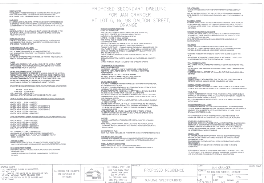
Council Meeting
15 December 2015
5.1 Development
Application DA 308/2015(1) - 98 Dalton Street
Attachment 3 Submissions
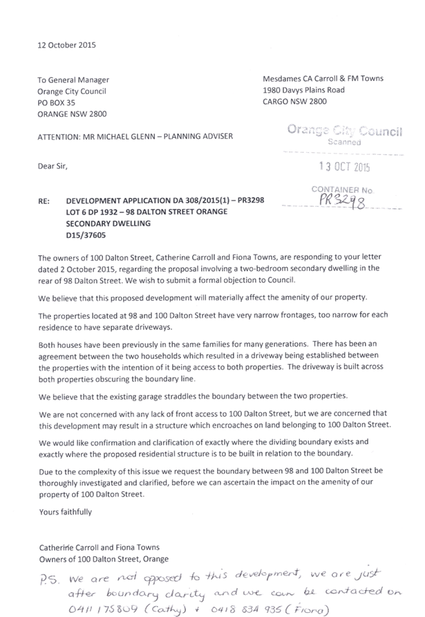


5.2 Development
Application DA 217/2014(1) - Northern Distributor Road and 386 Molong Road
TRIM
REFERENCE: 2015/1973
AUTHOR: Michael
Glenn, Senior Planner
EXECUTIVE Summary
|
Application
lodged
|
21 July
2014
|
|
Applicant/s
|
Fenlor
Group Pty Limited
|
|
Owner/s
|
Mr GJ
Thornberry
|
|
Land
description
|
Lot 6 DP
1065578 and Lot 81 DP 1202584 - Northern Distributor Road and 386 Molong
Road, Orange
|
|
Proposed
land use
|
Subdivision
(61 residential lots, one residue lot and three open space lots)
|
|
Value of
proposed development
|
$0
|
Council's consent is sought for a subdivision of the subject
land into 61 lots ranging in size from 1,000m2 to 1,632m2.
A further development lot, proposed Lot 62, is also proposed, with no direct
access off the Northern Distributor Road (NDR) or Molong Road.
The principal environmental issues
for consideration in this application are:
1 The
noise and odour impacts between the proposed subdivision and the sewer pump
station located at the northern extremity of the site, and the security in the
tenure of this structure and the infrastructure, as well as the arrangements
for access to that piece of infrastructure
2 The
noise impacts arising from the NDR and Molong Road
3 The
protection of the riparian corridor that will require the setting aside of land
and its ongoing conservation and management as per NSW Office of Water
requirements.
One particular element of this application necessitates a
comment from the broader strategic perspective of Council as a planning
authority, as a manager of public land and provider of public open space.
This relates to the proposed large amount of open space
associated with the two watercourses which traverse the land in question and
proposals put forward by the developer and supported in a late submission by
Environmentally Concerned Citizens of Orange (ECCO) that all the suggested land
be acquired by Council. The amount of land is well above Council’s
requirements for public purposes and is able to be held in private ownership
for conservation purposes as it has been for many years. The following plan
shows the land offered by the Applicant in the original submission (IC14/9646
Sheet 3).
The developer wishes that Council acquire the land at
typical open space rates under Council’s Development Contributions Plan.
This would exceed the ability of Council’s Development Contributions Plan
to meet the open space costs by in excess of $200,000. Council made a conscious
strategic planning decision not to lift developer contributions above the
$20,000 threshold when it resolved the Development Contributions Plan in 2015,
for good reason, that is concerns about the cost of housing for residents
trying to build houses in Orange and the competitiveness of opportunities in
Orange.
Equally, from a Council purse perspective, Council has
assigned its priorities in its multi-year budget, with this priority not
otherwise raised. Council went through an extensive priority setting process
leaving out many worthy projects. Consideration of the surplus land matter
arising from this application ought not be a way to step around the proper
priority setting processes of Council.
The amount of open space for public and Council purposes is
properly identified in the Development Contributions Plan. The additional open
space proposed in this application is not required for public and Council purposes
and can be held for conservation purposes privately as is vast amounts of land
in NSW and in Orange. It is simply that the developer wishes to release
themselves of land that is not of a financial purpose to them, having had the
benefit of subdividing the profitable land, that the land is being offered for
sale at contributions plan rates to Council. This circumstance could well arise
in other future subdivisions.
Given the surplus nature of the land to the developer and
the surplus nature of the land for public and Council purposes, it is held that
were it offered, it ought to be offered at heavily discounted rates and be
offered like any other parcel of land not required by Council for a specific
planning purpose under the Environmental Planning and Assessment Act that a
landowner wishes to divest, that is through a separate negotiation process.
Through such a process, Council can ensure thorough and
diligent consideration of its priorities, understand the operating costs of the
potential asset and the opportunity cost of the asset. As such the offer of
acquisition of the surplus land ought not be dealt with under the development
application and the recommended condition relating to the conservation of the
extra watercourse land is appropriate. Going forward the developer has the
opportunity to enter into discussions, should they wish with Council, under a
proper process for the consideration of the surplus land.
It is recommended that Council supports the subject proposal
subject to the conditions attached.
Link To Delivery/OPerational Plan
The recommendation in this report relates to the
Delivery/Operational Plan strategy “13.4 Our Environment
– Monitor and enforce regulations relating to City amenity”.
Financial Implications
Nil
Policy and Governance Implications
Nil
|
Recommendation
That Council consents to development application DA
217/2014(1) for Subdivision (61 residential lots, one residue lot and
three open space lots) at Lot 6 DP 1065578 and Lot 81 DP 1202584 -
Northern Distributor Road and 386 Molong Road, Orange pursuant to the
conditions of consent in the attached Notice of Approval.
|
further considerations
Consideration has been given to the
recommendation’s impact on Council’s service delivery; image and
reputation; political; environmental; health and safety; employees;
stakeholders and project management; and no further implications or risks have
been identified.
SUPPORTING INFORMATION
THE APPLICATION
Council's consent is sought for subdivision (61 residential
lots, one residue lot and three open space lots) at Lot 81 DP 1202584 and Lot 6
DP 1065578 - 386 Molong Road and land adjacent to the Northern Distributor
Road, Orange.
THE PROPOSAL
The proposal involves a 61 lot subdivision and also the
creation of an additional development lot. It is further proposed that riparian
corridors on the site be dedicated as open space, as well as open space lots
adjacent to the NDR. It is also proposed to establish easements on which the
sewer pump station is to be located. Easements across the creek are proposed to
facilitate access to the development lot (Lot 61). No direct access from a
road to Lot 61 is proposed. The proposed subdivision is to be provided with a
single access vehicular point off the NDR.
MATTERS FOR CONSIDERATION
The Relevant Objectives
The proposed development as configured is an appropriate
response to the demands of the various zone objectives of the LEP. The riparian
corridors with their (mostly) E2 (Environmental Conservation) zoning have
objectives that seek to:
protect, manage and restore
areas of high ecological, scientific, cultural or aesthetic values, and prevent
development that could destroy, damage or otherwise have an adverse effect on
those values.
With regards to the R2 (Low Density Residential) zone
the stated objectives of the zone are:
To provide for the housing needs of the community
within a low density residential environment, enable other land uses that
provide facilities or services to meet the day to day needs of residents, and
ensure development is ordered in such a way as to maximise public transport
patronage and encourage walking and cycling in close proximity to settlement.
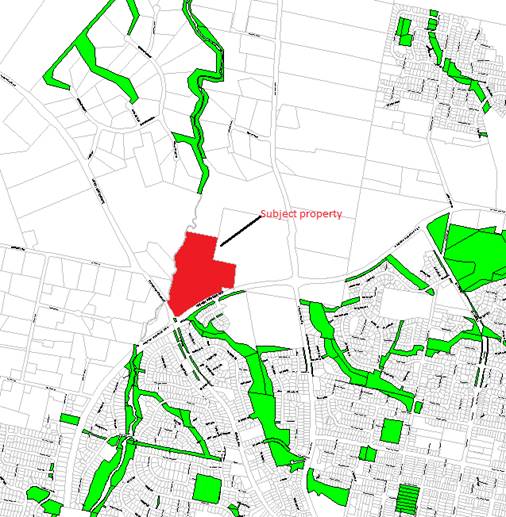
Figure 1 - the subject property and the developing
open space corridor network
to the north and south of the site
The principal environmental issues for consideration in this
application are:
1 The
noise and odour impacts between the proposed subdivision and the sewer pump
station located at the northern extremity of the site, and the security in the
tenure of this structure and the infrastructure, as well as the arrangements
for access to that piece of infrastructure
2 The
noise impacts arising from the NDR and Molong Road
3 The
protection of the riparian corridor that will require the setting aside of land
and its ongoing conservation and management as per NSW Office of Water
requirements.
Council needs to consider in its determination whether the
condition of the riparian corridor as it currently exists is capable of
absorbing the key threatening processes presented by the subdivision in the
condition that it exists at the present, or whether some level of
rehabilitation will be required to avoid further deterioration of the
environment.
Section 5A Assessment
In the administration of sections 78A, 79B, 79C, 111 and
112, the provisions of Section 5A must be taken into account for every
development application in deciding whether there is likely to be a significant
effect on threatened species, populations or ecological communities or their
habitats. This section includes a requirement to consider any adopted
assessment guidelines, which means assessment guidelines issued and in force
under section 94A of the Threatened Species Conservation Act 1995.
Similar provisions are contained in the Fisheries Management Act for
land located within a riparian corridor and affected by potential fish
habitats. Assessment guidelines are in force (see DECC-W “Threatened
Species Assessment Guidelines - The Assessment of Significance”), which
requires consent authority to adopt the precautionary principle in its
assessment.
In this case, threatened fish habitats are also relevant as
this section of Ploughmans Creek is listed by NSW Fisheries (now a part of
the NSW Department of Primary Industries) as significant fish habitat. This
listing basically places the waterway and its riparian zone within the same
level of environmental land management terrestrial components of the riparian
vegetation.
In this case, the terrestrial elements of the site have some
isolated tree stands associated with the Box Gum Grassy Woodland; however, the
vegetation does not constitute a viable vegetation community and is not serving
a purpose as a waypoint or linkage to more significant stands elsewhere (it
lacks connectivity). These tree stands offer some habitat value as seed banks
but do not fill the criteria or even have potential to fill the criteria of
being a viable woodland area or vegetated corridor to other more substantial
vegetation communities nearby.
With regard to the areas adjacent to the creek, co-approval
is required for the proposed development within these areas of riparian
significance as controlled activities will be required within the riparian zone
of the creek areas, and rehabilitation of the riparian areas is a reasonable
outcome to require as a consequence of this development.
These areas constitute highly degraded riparian systems at
present, however there is potential for these areas to be worked into the
developing riparian network further upstream. Creek systems for native species
are very important; they provide water supply, better opportunities for
connectivity and safe havens for many species, as well as the obvious benefits
to the open space system. Preservation and rehabilitation of the creek lines
and their riparian vegetation areas is critical to retaining some level of
viability for the urban bushland areas of the City and its surrounds.
The applicant has included in the proposal some corridor
land adjacent to the two creek systems that traverse the site. Whilst this land
has little or no value for subdivision purposes, it is of significance from the
standpoint of developing the riparian open space network, which has a further
spinoff value of making allowance for riparian biodiversity. The amenity of the
West Orange suburban areas has benefitted from this approach in recent years,
as has the retention of some habitat viability along these pathways.
Waterbodies and Riparian Zones
The subject sites boundaries are shown in the relevant
survey as follows:
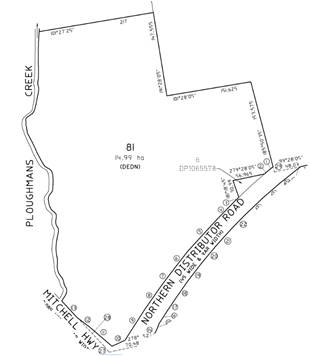
Figure 2 - extract of cadastral survey Lot 81 DP
1202584, Lot 6 DP 1065578 dated 2011
The abovementioned survey shows that the principal lot (Lot
81) does not include the watercourse itself - it is Crown land, with the western
boundary of Lot 81 being the edge of the creek itself. This is an imprecise
boundary definition.
The site is traversed by two separate waterbodies (one being
Ploughmans Creek) that merge into a single higher order stream after this merge
of the two streams.
Stream ordering is important because it affects the width of
the riparian corridor adjacent and also impacts on the significance of streams
as potential fisheries. The order ranking of a stream determines whether that
stream is subject to the controlled activity provisions of the Water
Management Act 2000. A stream above a certain classification will generally
require a controlled activity permit and this, in turn, requires co-approval
from the NSW Office of Water (NoW) pursuant to the Integrated Development
provisions of the Act.
On 1 July 2012, NoW introduced new rules regarding
controlled activities within riparian corridors. The new rules amend the
riparian corridor widths that apply to watercourses, providing more flexibility
in how riparian corridors can be used and making it easier for applicants to
determine the Office of Water controlled activity approval requirements. Key
aspects of the changes include:
· provision of
greater flexibility in the allowable uses and works permitted within riparian
corridors
· the
core riparian zone and vegetated buffer have been combined into a single
vegetated riparian zone (VRZ)
· the width of the
VRZ within the riparian corridor has been pre-determined and standardised for
first, second, third and fourth order and greater watercourses
· where suitable,
applicants may undertake non-riparian corridor works or development within the
outer 50 per cent of a VRZ, as long as they offset this activity by connecting
an equivalent area to the riparian corridor within the development site
· a new riparian
corridors matrix enables applicants to determine what activities can be
considered in riparian corridors.
Riparian Corridor Widths
The Office of Water recommends a VRZ width based on
watercourse order as classified under the Strahler System of ordering
watercourses and using current 1:25 000 topographic maps (see Figure 4 and
Table 1). The width of the VRZ should be measured from the top of the highest
bank on both sides of the watercourse.
Figure 3 - the Strahler System for stream ordering
|
Watercourse
type
|
VRZ
width
(each side of watercourse)
|
Total
RC width
|
|
1st order
|
10
m
|
20m + channel width
|
|
2nd order
|
20m
|
40m + channel width
|
|
3rd Order
|
30m
|
60m + channel width
|
|
4th Order or greater
|
40m
|
80m + channel width
|
Table 1 - recommended
riparian corridor (RC) widths
The riparian corridor consists
of the channel which comprises the bed and banks of the watercourse (to the
highest bank) and the vegetated riparian zone (VRZ) adjoining the channel.
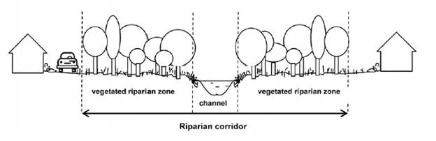
Figure 4 - the riparian corridor
The subject property has, on the basis of Strahler, a
category 2 stream (being the more eastern water body that runs into Ploughmans
Creek. Ploughmans Creek is a category 3 stream below the junction.
The new regulations make the primary determinant of stream
order the responsibility of NoW. In this regard, the advice of NoW was
sought. NoW has provided the following advice:
I refer to your enquiry
regarding the Office of Water's determination of what order stream Ploughmans
creek is on the subject development site. I have had a brief look and attached
a map which identifies the stream order in accordance with the Strahler Stream
Ordering System that the Office of Water uses.
You will note that Ploughmans
Creek on the southern boundary is a 2nd order, once the unnamed 2nd order creek
drops into Ploughmans Creek opposite Lot 208//1018862, it becomes a 3rd order.
A 20 m buffer from the high
bank of the creek is required for the 2nd order and a 30 m buffer from the high
bank of the creek for the 3rd order in accordance with the attached Office of
Water guidelines for riparian corridors. There is some flexibility to vary the
setbacks in some cases however this will of course have to also be in line with
council's requirements.
These comments relate to establishing an appropriate
riparian corridor based on the Department’s guidelines that were issued
in July 2012. Any activities within the riparian zone of a prescribed stream
(of which Ploughmans Creek is one) triggers a need for a "controlled
activity" assessment, and hence for this application an Integrated
Development assessment.
As a result of those comments, the applicant was contacted
with a view to amending the proposal to widen or change the riparian corridors
so as to meet statutory requirements. Amended plans were received and were
referred to NoW seeking its General Terms of Approval. NoW provided a reply
dated 26 June 2015 providing their General Terms of Approval, which are
included in the attached development consent.
As discussed in this report however this riparian zone will
be in the ownership of both Council and the Applicant.
Key Threatening Processes
(KTPs) for Riparian Land
A riparian corridor forms a transition zone between the
land, also known as the terrestrial environment, and the river or watercourse
or aquatic environment. Riparian corridors perform a range of important
environmental functions such as:
· providing bed and
bank stability and reducing bank and channel erosion
· protecting water
quality by trapping sediment, nutrients and other contaminants
· providing
diversity of habitat for terrestrial, riparian and aquatic plants (flora) and
animals (fauna)
· providing
connectivity between wildlife habitats
· conveying flood
flows and controlling the direction of flood flows
· providing an
interface or buffer between developments and waterways
· providing passive
recreational uses.
The protection, restoration or rehabilitation of vegetated
riparian corridors is important for maintaining or improving the water quality,
stability (or geomorphic form) and ecological functions of a watercourse. It
also has implications under the Fisheries Management Act and the
protection of waterways as fish or aquatic habitats. It is further noted that
the controlled activity aspects of the proposed development trigger a need for
a co-approval from NoW, and the co-approval conditions they have provided already
address many of the potential harmful impacts that could arise from the
subdivision.
Subdivision is identified of itself to incorporate Key
Threatening Processes (KTPs), and the existing riparian corridors are unlikely
to be sufficient to address those increased threats. The KTPs that can be
attributed to the subdivision include the following:
· weed infestation
· fragmentation and
lack of connectivity
· feral predation
and feral infestation (such as Willow and European Carp
· changes to stream
hydraulics (either inundation or water deprivation
· nutrient control
and biological oxygen demand (BOD)
· water quality,
particularly turbidity, but also toxic pollution from sprays, insecticides and
the like
· erosion arising
from concentration of flows
The subject creek is known as a potential platypus habitat,
and according to advice provided by officers of the Local Land Service (LLS),
this riparian system could be expected to provide habitat for the following if
its environmental health was restored to acceptable levels:
· Trout Cod
· Macquarie Perch
· Silver Perch
· Eel Tailed Catfish
· Purple Spotted
Gudgeon
LLS advise that in their opinion "the proposal would be
likely to involve increased pressure/threats on the waterway (increased area of
imperviousness etc). LLS suggests that the water balance and flow regime
be maintained at pre-development levels through keeping water in the landscape.
This will also avoid erosion and sediment issues. This will require development
that uses “water sensitive urban design principles". These
suggestions are incorporated already in the NoW co-approval General Terms Of
Approval and certain conditions imposed by Council's Technical Services
assessment.
Appropriate responses to the potential KTPs posed by the
proposed subdivision are considered to be adequately addressed in the
co-approval conditions provided by the NoW.
Aboriginal Heritage
There is no obvious evidence of Aboriginal archaeology on
the site. Notwithstanding, as a green fields site it is considered appropriate
to impose a precautionary condition placing a responsibility on the client to
stop work and seek the necessary Section 90 (National Parks and
Wildlife Act) Permits if such evidence is uncovered during the site
preparation phases. This provision already applies under that legislation;
however, such provision can appropriately be applied as a condition of consent
for clarity.
If Aboriginal objects, relics or other historical items or
the like are located during development works, all works in the area of the
identified object, relic or item shall cease and the NSW Office of
Environmental Heritage (OEH), and representatives from the Orange Local
Aboriginal Land Council shall be notified. Where required, further
archaeological investigation shall be undertaken. Development works in the area
of the find(s) may recommence if and when outlined by the management strategy,
developed in consultation with and approved by the OEH.
Riparian Corridors
The subject property is intersected by
Ploughmans Creek and Somerset Creek, which flow from the urban areas to the
south. These creek-based corridors exist up to the NDR which forms the southern
boundary of the subject land, and have been developed by Council over time for
open space, environmental protection and recreational purposes. The development
in the form submitted proposes that these riparian areas of the site be
incorporated into the existing networks that are a key facet of the residential
subdivisions that have occurred for approximately the last 30 years in north
and west Orange.
This network will terminate within this
subdivision as the creek system downstream (north) of the development becomes
very steep, making further extension of these open space corridors impossible.
Council's consent is sought for a subdivision of the subject
land into 61 lots ranging in size from 1,000m2 to 1,632m2.
A further development lot, proposed Lot 62, is also proposed, with no direct
access off the Northern Distributor Road (NDR) or Molong Road.
This application raises issues in relation to riparian
corridors and the provision of open space. A detailed analysis of these issues
is provided in this report.
Planning history
of the site
The subject land was zoned 1(c) Rural
Residential at the gazettal date of Orange Local Environmental Plan 2000 (LEP
2000), however over the lifetime of the previous LEP the land underwent
various zoning changes aimed at increasing the urbanised development potential
of the site. In 2009 when a development application for an 18 lot subdivision
was approved the land was zoned part 2(a) Urban Residential, part 2(d) Urban
Transition, part 5(b) Distributor Road and part 6 Open Space and
Recreation under LEP 2000 (as amended). The open space affectation was
along the creek. When the new LEP 2011 was being adopted, the most appropriate
equivalent zone for the riparian corridor was considered to be E2
Environmental Conservation since this zone was considered to best capture both
the open space and conservation constraints of the land in question. The residential
component of the site was rationalised to R2 Low Density Residential. The
minimum allotment size for the site was established as 1000 m2
from the gazettal of LEP 2011.
Amendment 1 of LEP 2011 incorporated the subject property
along with an adjoining lot newly rezoned (to R2) into an Urban Release Area as
of March 2014. This Urban Release Area classification has no impact on the
subject property as the minimum lot sizes are not reduced under the amendment
for this site, but it does affect the north-eastern neighbour. The Urban
Release Area status is reflective of one of the main constraints affecting the
subject land, being its relative isolation. As an Urban Release Area the
expectation is that a fully worked-up master plan would be prepared prior to
any further subdivision (similar to the recent "Shiralee" master
planning).
This is fully the case for the north-eastern neighbour,
however for the site that is the subject of this application, a master plan is
not required on a technical basis, since a master plan is only required if the
lot size minimums are reduced (under the LEP). In this case, no such reduction
in lot sizes has occurred (for the subject site, the minimum lot size was 1000m2
both before and after the LEP changes). Nevertheless, the implication of
placing this site within a release area is clear; it is considered a master
plan to overcome the pedestrian linkages, access and open space needs for this
site (and the north-eastern neighbour) is of great importance in achieving
satisfactory land use outcomes.
At the time the 4000m2 standard was applicable
Council approved an 18 lot subdivision which included provisions for the
acquisition of riparian corridors for open space and pedestrian link ways
consistent with the preceding discussion, albeit under a previous Development
Contributions Plan.
Constraints
As suggested above, the site is constrained by its relative
isolation. It is bounded on two sides by the NDR and Molong Road, making access
to the site more difficult except by car. Pedestrian links are in the process
of being developed to the south with the subdivision of "Ribbon Gums
Estate" - the pedestrian links developed along the waterways of that
subdivision are clearly designed to be extended under the NDR to this site, and
an underpass has been provided under the NDR, making the completion of a
pedestrian linkage along the creek lines for this site a logical progression
and in some respects a critical element of the subdivision planning for this
site.
The Section 94 contribution rates for services can be
applied using the "North West" locality contribution rates. The 2015 Contributions
Plan provides conceptual acquisition plans for this site indicating noise and
visual buffers for the Northern Distributor Road and corridors for open space
adjacent or within the defined riparian corridors. A maximum allocation of
9000m2 is applicable under the 2015 plan. It is not lawful to draw
from the Section 94 contributions funds to pay for land dedications not
identified in the plan as part of the Open Space network under that plan. The
applicable rate for open space included in the contribution plans acquisition
plan is $10 per square metre.
The applicant has configured and stated in his application
that he is offering some of the land as open space. This offer exceeds the plan
allocations in terms of area the limits imposed under the S-94 plan.
The riparian and NDR corridors are not suitable for
dwelling houses, neither is it practicable to expect this land to be used for
extensive agriculture. As either public or privately managed E2 land it
will still be critical from an environmental perspective to maintain the
corridors (albeit as private space). To achieve this outcome, it will be
necessary as private land to vest the relevant parts of the site to a specific
lot, so that a specific land owner has responsibility of care, control and
management of that land.
As a result of the financial constraints discussed above,
Council is confined to the purchase of up to 9000m2 in total under the S94 plan
which will in any case allow the purchase of a contiguous strip of riparian
land but not all of the riparian zone.
Section 79C
Section 79C of the Environmental Planning and Assessment
Act 1979 requires Council to consider various matters, of which those
pertaining to the application are listed below.
PROVISIONS OF ANY ENVIRONMENTAL
PLANNING INSTRUMENT s79C(1)(a)(i)
Orange Local Environmental Plan 2011
Part 1 - Preliminary
Clause 1.2 - Aims of Plan
The broad aims of the LEP are
set out under subclause 2. Those relevant to the application are as follows:
(a) to encourage development which complements
and enhances the unique character of Orange as a major regional centre boasting
a diverse economy and offering an attractive regional lifestyle,
(b) to provide for a range of development
opportunities that contribute to the social, economic and environmental
resources of Orange in a way that allows present and future generations to meet
their needs by implementing the principles for ecologically sustainable
development,
(c) to conserve and enhance the water
resources on which Orange depends, particularly water supply catchments,
(d) to manage rural land as an environmental
resource that provides economic and social benefits for Orange,
(e) to provide a range of housing choices in
planned urban and rural locations to meet population growth,
(f) to recognise and manage valued
environmental heritage, landscape and scenic features of Orange.
In relation to (a), the proposed
development will detract from or decrease the rural character of the locality,
but will be consistent with and increase the residential character of the more
urban areas nearby. The subject property is zoned R2 Low Density Residential
and E2 Environmental Conservation along the riparian corridor adjacent to
Ploughmans Creek. Adjoining land to the north is substantially zoned rural,
whilst land to the east, south and west is zoned residential. On the basis of
its zoning, the lot sizes and layout appear to be appropriate development for
the site.
In acknowledgement of the competing demands
of rural residential and residential character affecting the subject site, it
is considered appropriate to impose a range of conditions aimed at achieving a
better relationship with these competing characters. In summary, the conditions
will:
1 Require all subdivision
fencing adjoining rural land (to the north) to be rural style fencing (post and
wire, no barbed wire).
2 Impose a Section 88B
Restrictions-as-to-User under the Conveyancing Act 1979 requiring
such rural fencing to be retained and maintained, and prohibiting the
replacement of such fencing except with like materials and the approval of
Council and the adjoining owner (as per the general principals of the Dividing
Fences Act).
With regard to (b), the proposed
development does increase the stock of housing lots that, in some perspective,
adds to the development opportunities of the City. Adding to the housing stock
increases the potential for population growth that, in turn, suggests that the
needs of the workforce will be met.
With regard to (c), the proposed
development would not have any significant effect on the resources of the
Orange City water supply.
With regard to (d), it is acknowledged that
the current use of the site is mostly for grazing. Such activities have a
limited contribution to the local economy, whilst the proximity of farming land
close to the suburban areas of the City provides a degree of ambience and
amenity for those properties. Conversion of the land to residential lots will
subtract that land from the agricultural stock of land and make some areas
closer to the City less connected to the rural surroundings of the City. Such
effects are accepted as part of the normal expansion and increase in
residential land stocks for the City.
With regard to (e), the proposed
development does not include housing; however, it does increase the supply of
residential allotments. This will produce the conditions needed to provide
additional housing opportunities.
With regard to (f), it is recognised that
the changes in zoning that occurred under LEP 2011 will result in some
adverse effects on the surrounding landscape. However, within the context of
the general provisions, the zoning, the other objectives of the LEP and the recognised
primary view corridors and the like, it is considered that this is appropriate
development for the site.
Clause 1.6 - Consent Authority
This clause establishes that, subject to the Act, Council is
the consent authority for applications made under the LEP.
Clause 1.9A - Suspension of
Covenants, Agreements and Instruments
This clause provides that covenants, agreements and other
instruments which seek to restrict the carrying out of development do not apply
with the following exceptions.
· covenants imposed
or required by Council
· prescribed
instruments under Section 183A of the Crown Lands Act 1989
· any conservation
agreement under the National Parks and Wildlife Act 1974
· any trust
agreement under the Nature Conservation Trust Act 2001
· any property
vegetation plan under the Native Vegetation Act 2003
· any biobanking
agreement under Part 7A of the Threatened Species Conservation Act 1995
· any planning
agreement under Division 6 of Part 4 of the Environmental Planning and
Assessment Act 1979.
Council staff are not aware of the title of the subject
property being affected by any of the above easements. There is, however, sewer
related infrastructure (sewer mains and sewer pump station) constructed on the
site. The application includes proposed easements for the existing sewer mains
and sewer pump station on the site.
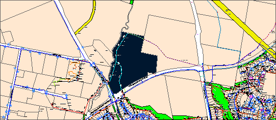
Figure 5 - utilities mapping
Mapping
The subject site is identified on the LEP maps in the
following manner:
|
Land Zoning Map:
|
Land
zoned R2 Low Density Residential and E2 Environmental Conservation
|
|
Lot Size Map:
|
Minimum
Lot Size 1000 m2 (applicable to both zones)
|
|
Heritage Map:
|
Not a
heritage item or conservation area
|
|
Height of Buildings Map:
|
No
building height limit
|
|
Floor Space Ratio Map:
|
No floor
space limit
|
|
Terrestrial Biodiversity Map:
|
Some
high biodiversity sensitivity on the site
|
|
Groundwater Vulnerability Map:
|
ground
water vulnerable
|
|
Drinking Water Catchment Map:
|
Not
within the drinking water catchment
|
|
Watercourse Map:
|
within
or affecting a defined watercourse
|
|
Urban Release Area Map:
|
Not
within an Urban Release Area
|
|
Obstacle Limitation Surface Map:
|
No
restriction on building siting or construction
|
|
Additional Permitted Uses Map:
|
No
additional permitted use applies
|
Those matters that are of relevance are addressed in detail
in the body of this report.
Part 2 - Permitted or
Prohibited Development
Land Use Zones
The following is an extract from
the LEP, showing the applicable zones.
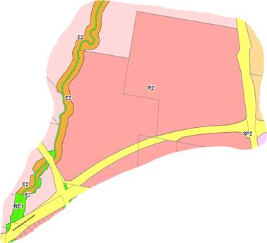
Figure 6 - extract of zoning Map 1
The subject site is principally located within the R2 Low
Density Residential zone. Parts of the riparian zone adjacent to the creek are
zoned E2 Environmental Management. The creek bed itself (to the top of the
bank) is zoned RE1 Open Space, but in general this land is not part of the
subject property . However, it is noted that, unlike property boundaries based
on creek lines (which can move), zone boundaries do not move. It is entirely
possible that parts of the property now contain RE1 zoned land because of the
shifts in creek position that have occurred over time. The creek itself does
not form part of the subject property but its riparian zones do. In the
south-western corner (near the intersection of the NDR and Molong Road),
part of the site is zoned SP2 Infrastructure, but as a result of a re-survey of
the site undertaken in 2014, this land is no longer part of the subject
property. It equates to land required for road widening purposes.
The proposed development is defined as a subdivision under
OLEP 2011. Subdivision of land under LEP 2011 has the same meaning as
defined in the Act. Pursuant to clause 4B of the Environmental Planning and
Assessment Act, subdivision of land means:
the division of land into two
or more parts that, after the division, would be obviously adapted for separate
occupation, use or disposition.
Subdivision of land is permissible in the R2 Low Density
Residential zone with the consent of Council pursuant to Clause 2.6.
With regard to the E2 component of the subject property
which equates to its Riparian corridors, subdivision is only proposed to the
extent of excising that land from the R2 zoned land also on the subject
property.
Subdivision of land is permissible the E2 Environmental
Management zone with the consent of Council pursuant to Clause 2.6.
Clause 2.3 of LEP 2011
references the Land Use Table and Objectives for each zone in LEP 2011.
These objectives for land zoned R2 Low Density Residential and E2 Environmental
Management are as follows:
1 - Objectives of the R2 Low Density Residential Zone
· To provide for
the housing needs of the community within a low density residential
environment.
· To enable other
land uses that provide facilities or services to meet the day to day needs of
residents.
· To ensure
development is ordered in such a way as to maximise public transport patronage
and encourage walking and cycling in close proximity to settlement.
· To ensure that
development along the Southern Link Road has an alternative access.
In relation to the first objective, the proposed development
would provide additional lots on land on which housing stock within the City
can be provided. It will provide these additional lots at a scale consistent
with typical low density development. In terms of lot yield and lot sizes, the
proposed subdivision is consistent with the relevant controls. In relation to
the second objective, the proposed subdivision would not impede the provision
of other land to provide facilities and services should such a need ever arise
in the future. In relation to the third objective, the subject site is within
close proximity to routes used by public transport.
Further, the configuration of the proposed development with
open space along the creek lines is consistent with the zone objectives in that
it would facilitate the provision of walking and cycling opportunities to,
through and from the site. In relation to the last objective, the proposed
development has no effect. The proposed development is not inconsistent with
the objectives of the zone.
2 -
Objectives of the E2 Environmental Conservation Zone
· To
protect, manage and restore areas of high ecological, scientific, cultural or
aesthetic values.
· To
prevent development that could destroy, damage or otherwise have an adverse
effect on those values.
The E2 Environmental
Conservation zone has a limited range of permissible land uses, which reflects
the physical constraints that often affect such land. In urban situations the
range of uses that are permissible are effectively restricting such land to
public open space activities in most cases.
Achievement of the objectives
contained in the first dot point is the responsibility of the landowner.
With regard to the second dot
point of the objectives, it is considered that as private land the range of
permissible uses is limited in an urban context. It cannot, for example, be
used as a component of residential development. As land in private ownership,
but with no viable or realistic purpose, it is considered highly likely that
the land might not be managed or maintained responsibly. This part of the
riparian corridor land not purchased under the S94 plan shall be incorporated
into the residual lot 62 and developed in accordance with a plan of management
that is to the satisfaction of the Director of Planning and consistent with
the E2 zoning.
Clause 2.6
- Subdivision - Consent Requirements
Application has been made for the subdivision of the subject
land. Clause 2.6 of OLEP 2011 permits the subdivision of the subject
land only with development consent.
Part 4 - Principal Development
Standards
Clause 4.1 - Minimum
Subdivision Lot Size
This clause requires the subdivision of land to be equal to
or greater than the size nominated for the land under the Minimum Lot Size Map.
In relation to this site, the map nominates a minimum lot
size of 1,000m². The smallest lot proposed by the application is
1,000m². The subject lots satisfy the minimum area requirements.
Part 5 - Miscellaneous
Provisions
5.9 - Preservation of Trees or Vegetation
The provision of the LEP is linked to certain provisions of
DCP 2004, which define the sizes and types of tree that require development
consent for their removal. Trees that do not fit the criteria set out in the
DCP do not require consent for their removal.
"Google Maps" street view (see images below)
provides the best impressions of the vegetation that exists on the site.

Figure 7 - site at its eastern end as viewed from the
NDR Road
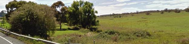
Figure 8 - site at the western end (east of the creek)
adjacent to Molong Road
and Ploughmans Creek
With regard to the terrestrial
vegetation shown above in Figure 8, it is proposed to remove this vegetation.
It is acknowledged this vegetation is highly visible from the NDR but it is not
a good example of remnant vegetation, and whilst important as a visual element,
is not considered to be of vital importance to the character of Orange in the
way some other stands of native vegetation can be viewed.
It is considered appropriate to
require offset vegetation along the creek lines. The creek lines, as shown in
Figure 9, are a highly degraded feature of the landscape, but their
rehabilitation is critical from an ecological management point of view at the
very least. It is possible to retain, conserve and enhance this riparian area
with little cost to the site yields of the development. As indicated in this
report, it is considered that the ideal outcome would be for the riparian land
of both stream systems that converge on the site to be developed as an open
space link in the overall network.
Part 6 - Urban Release Areas
Clause 6.1 - State Public
Infrastructure
The subject land is located in a
designated Urban Release Area of the LEP. The objective of this clause is to
require satisfactory arrangements to be made for the provision of designated
State public infrastructure before the subdivision of land in an Urban Release
Area to satisfy needs that arise from development on the land, but only if the
land is developed intensively for urban purposes.
Development consent cannot be
granted for the subdivision of land in an Urban Release Area if the subdivision
would create a lot smaller than the minimum lot size permitted on the land
immediately before the land became, or became part of, an Urban Release Area,
unless the Director-General has certified in writing to the consent authority
that satisfactory arrangements have been made to contribute to the provision of
designated State public infrastructure in relation to that lot. In this case
for the subject lot, the minimum lot sizes applicable were the same before and
after the imposition of the Urban Release Area on the subject land.
Clause 6.2
- Public Utility Infrastructure
Council
is prevented from granting consent on the subject land because of its Urban
Release Area affectation unless public utility infrastructure (essentially
defined as water, sewer and electricity) is available, or adequate arrangements
have been made to make that infrastructure available when it is required. This
clause does not apply to development for the purpose of providing, extending,
augmenting, maintaining or repairing any public utility infrastructure.
Council's
Technical Services Division advises that such utilities are available to the
site.
Clause 6.3
- Development Control Plan
This clause sets out the
requirements for any detailed master planning to be contained in a DCP.
Subclause (2) works to prevent Council from granting consent to a subdivision
except where such a master plan is prepared in accordance with the requirements
of subclause (3). Subclause (4) sets out the instances where such
detailed master planning is not required, with part (b) specifying a
subdivision if any of the lots to be created are to be dedicated for public
roads, public open space, public place or environmental protection purposes. In
this case, land is proposed to be dedicated as a public road; and it is also
proposed to dedicate three of the lots as open space. It is considered that the
roads dedication element of this proposal does not meet the exemption
requirements of this clause; however the public open space dedications proposed
do enable an exemption of the DCP to be applied.
Part 7 - Additional Local
Provisions
7.1 - Earthworks
This clause establishes a range
of matters that must be considered prior to granting development consent for
any application involving earthworks, such as:
(a) the likely disruption of, or any
detrimental effect on, existing drainage patterns and soil stability in the
locality of the development
(b) the effect of the development on the
likely future use or redevelopment of the land
(c) the quality of the fill or the soil to be
excavated, or both
(d) the effect of the development on the existing
and likely amenity of adjoining properties
(e) the source of any fill material and the
destination of any excavated material
(f) the likelihood of disturbing relics
(g) the proximity to and potential for adverse
impacts on any waterway, drinking water catchment or environmentally sensitive
area
(h) any measures proposed to minimise or
mitigate the impacts referred to in paragraph (g).
As well as bulk earthworks that would normally be associated
with preparation of green fields land for urban residential subdivision, the
earthworks proposed in the application during Stage 2 of the proposed
development are limited to the extent of cutting and filling required for the
construction of Road Nos 1, 2 and 3. The extent of disruption to the drainage
of the site is considered to have a potential significant effect on the creek
system due to adverse effect on the quality of runoff. Conditions are included
to address the issue of erosion and sediment control and the quality of the
runoff from the site. As a referral to the NoW as Integrated Development under
the Water Management Act, Council has sought advice from an external
government agency entrusted to set the standards for protection of the
State’s waterways. NoW has indicated in their reply to Council that they
do not have any objections to the proposed development.
The likely extent of the earthworks will not materially
affect the potential future use or redevelopment of the site that may occur at
the end of the proposed development’s lifespan. The site is not known to
be contaminated. The site is not known to contain any Aboriginal, European or
archaeological relics. Previous known uses of the site do not suggest that any
relics are likely to be uncovered.
As indicated above, the site is within proximity to a
prescribed waterway, also noted as potential fish habitat by the NSW Department
of Primary Industries.
7.2 - Flood
Planning
This clause applies to land
identified on the Flood Planning Map as a Flood Planning Area and requires
that, before any consent is issued, Council must be satisfied that the
proposal:
(a) is compatible with the flood hazard of the
land, and
(b) is not likely to significantly adversely
affect flood behaviour resulting in detrimental increases in the potential
flood affectation of other development or properties, and
(c) incorporates appropriate measures to
manage risk to life from flood, and
(d) is not likely to significantly adversely
affect the environment or cause avoidable erosion, siltation, destruction of
riparian vegetation or a reduction in the stability of river banks or
watercourses, and
(e) is not likely to result in unsustainable
social and economic costs to the community as a consequence of flooding.
The site is not identified as
being affected by flood hazard on the Flood Hazard Mapping layer of the LEP;
however, the site is nevertheless known to contain some level of hazard from
flood near the creek areas of the site. This is on the basis of flood analysis
undertaken by the applicant. This study is further reflected in the subdivision
planning as shown on the submitted plans, which set aside those areas of the
site likely to be inundated by flood.
7.3 -
Stormwater Management
This clause applies to all
industrial, commercial and residential zones and requires that Council be
satisfied that the proposal:
(a) is
designed to maximise the use of water permeable surfaces on the land having
regard to the soil characteristics affecting onsite infiltration of water
(b) includes,
where practical, onsite stormwater retention for use as an alternative supply
to mains water, groundwater or river water; and
(c) avoids
any significant impacts of stormwater runoff on adjoining downstream
properties, native bushland and receiving waters, or if that impact cannot be
reasonably avoided, minimises and mitigates the impact.
With regard to (a) and (b), the proposed development is for
subdivision of an existing two lot holding into moderate and large-sized
residential lots. The future development of the 61 lots will likely
consist of standard residential housing, with some multi dwelling houses also
fed into the mix. Council has controls with respect to site coverage that will
ensure that extensive parts of each allotment will have permeable spaces
suitable for onsite detention. The future surface runoff for each lot could be
directed to flow into Council’s stormwater reticulation system as an
alternative method to installing water tanks for onsite detention. It is not
anticipated that the proposed development will lead to future development
unsuited to the capabilities of either onsite detention or the stormwater
reticulation system.
With regard to (c), there will be some impacts arising with
stormwater runoff for water quantity and water quality. Quantities can be
expected to rise as hard surfaces like roads are installed. Flow rates into the
creek system will need to be controlled to within certain specified limits to
avoid events such as flash flooding during peak events. With regard to water quality,
collection and increase in particulate content and nutrients is likely for a
residential subdivision, although contamination from toxic or dangerous
chemicals is considered minimal. Nutrient and particulate control is
recommended under Water Sensitive Urban Design principals (WSUD) and can be
worked into the detailed stormwater plans that are required in the conditions
of this consent. It is noted that this particular runoff area is not part of
the Council stormwater harvesting catchment, and therefore receives no benefit
from the water quality improvement systems included in that scheme. All such
water quality controls will need to be incorporated into the onsite systems.
7.4 -
Terrestrial Biodiversity
Subclause (3) of this clause
requires that prior to determining a development
application for development on land to which this clause applies, the consent
authority must consider whether or not the development:
(a) is likely to have any adverse
impact on the condition, ecological value and significance of the fauna and
flora on the land, and
(b) is likely to have any adverse
impact on the importance of the vegetation on the land to the habitat and
survival of native fauna, and
(c) has any potential to fragment,
disturb or diminish the biodiversity structure, function and composition of the
land, and
(d) is likely to have any adverse
impact on the habitat elements providing connectivity on the land.
Isolated patches of high value
biodiversity are shown on the relevant LEP mapping layer adjacent to Ploughmans
Creek; however, it is considered that the conditions on the ground suggest a
highly degraded ecosystem. Riparian systems are vital in conservation issues as
they act as nodal points for species propagation. Managed responsibly, they can
work to allow the propagation of beneficial species supportive and reinforcing
of the natural environment. If the river systems of a locality are poorly
managed, the health of the ecosystem - both locally and in a wider sense - will
be degraded.
The NSW Planning Institute (PIA)
has a written position statement concerning riparian corridors. PIA is the peak
non-government professional body for planners in Australia. They state that:
Riparian
corridors in urban areas are important components of a city’s open space
system. Riparian corridors provide hydrological, ecological, landscape and
recreational functions. The corridors can contribute towards flood mitigation,
water table lowering, geomorphic stabilisation of watercourses, maintenance of
terrestrial and aquatic biodiversity.
Provision of biodiversity
corridors offer a buffer to nutrient and polluted runoff and act as an
interface between urban development and watercourses. The courses can
contribute towards pedestrian and cycle movement corridors and an urban
environment’s aesthetic amenity. Conservation and rehabilitation of
riparian corridors offer a magnifying effect on conservation initiatives as
species propagation and habitat opportunities (both floral and faunal) are
magnified many times by the good management of those corridors. Stream systems
identified as potential fish habitats (and Ploughmans Creek below the Molong
Road Bridge has been identified by NSW Fisheries as an important potential fish
nursery) are heavily dependent upon the health of the surrounding corridor
vegetation to achieve productive outcomes in terms of water quality and
propagation of native fish species.
The proposal, as submitted, sets
up appropriate riparian corridors as part of the layout. As discussed elsewhere
in this report, it is considered highly desirable to meet the objectives of the
E2 zone around the Ploughman’s Creek.
7.5 -
Riparian Land and Watercourses
This clause seeks to preserve
both water quality and riparian ecological health. The clause applies to land
identified as a “Sensitive Waterway” on the Watercourse Map. The
subject land contains such a waterway and therefore Council must consider
whether or not the proposal:
(a) is likely to have any adverse impact on
the following:
(i) the water quality and flows within a
watercourse
(ii) aquatic and riparian species, habitats and
ecosystems of the watercourse
(iii) the stability of the bed and banks of the
watercourse
(iv) the free passage of fish and other aquatic organisms
within or along the watercourse
(v) any future rehabilitation of the watercourse and
its riparian areas, and
(b) is likely to increase water extraction
from the watercourse.
Additionally, consent may not be granted until Council is satisfied that:
(a) the development is designed, sited and
will be managed to avoid any significant adverse environmental impact, or
(b) if that impact cannot be reasonably
avoided - the development is designed, sited and will be managed to minimise
that impact, or
(c) if that impact cannot be minimised - the
development will be managed to mitigate that impact.
The proposal has been designed
to incorporate appropriate riparian corridors to allow mitigation of the
impacts as outlined above. It will be necessary to confer the open space lots
into a parent lot of some description. The most logical lot for this
amalgamation is considered to be Lot 62, the proposed development lot.
Overall, while there will always remain a risk to the waterway
under extreme circumstances such as record storms and the like, it is
considered that the risk of adverse impact can be appropriately managed to an
acceptable level. In the event that the applicant does not wish to dedicate riparian
areas free of cost to council, this part of the riparian corridor land shall be
incorporated into the residual lot 62 and developed in accordance with a plan
of management that is to the satisfaction of the Director of Development
Services and consistent with the E2 zoning.
7.6 -
Groundwater Vulnerability
This clause seeks to protect
hydrological functions of groundwater systems and protect resources from both
depletion and contamination. Orange has a high water table and large areas of
the LGA, including the subject site, are identified with “Groundwater
Vulnerability” on the Groundwater Vulnerability Map. This requires that
Council consider:
(a) whether or not the development (including
any onsite storage or disposal of solid or liquid waste and chemicals) is
likely to cause any groundwater contamination or have any adverse effect on
groundwater dependent ecosystems, and
(b) the cumulative impact (including the
impact on nearby groundwater extraction for potable water supply or stock water
supply) of the development and any other existing development on groundwater.
Furthermore consent may not be
granted unless Council is satisfied that:
(a) the development is designed, sited and
will be managed to avoid any significant adverse environmental impact, or
(b) if that impact cannot be reasonably
avoided - the development is designed, sited and will be managed to minimise
that impact,
(c) if that impact cannot be minimised - the
development will be managed to mitigate that impact.
The proposal is not anticipated to
involve the discharge of toxic or noxious substances and is therefore unlikely
to contaminate the groundwater or related ecosystems. The proposal does not
involve extraction of groundwater and will therefore not contribute to
groundwater depletion. The design and siting of the proposal avoids impacts on
groundwater and is therefore considered acceptable.
STATE ENVIRONMENTAL PLANNING
POLICIES
There are no State Environmental Planning Policies that
apply to the subject development.
PROVISIONS OF ANY DRAFT ENVIRONMENTAL
PLANNING INSTRUMENT THAT HAS BEEN PLACED ON EXHIBITION s79C(1)(a)(ii)
There are no draft environmental planning instruments that
apply to the subject land or proposed development.
DESIGNATED DEVELOPMENT
The proposed development is not designated development.
PROVISIONS OF ANY DEVELOPMENT
CONTROL PLAN s79C(1)(a)(iii)
Development Control Plan 2004
Development Control Plan 2004 (“the DCP”)
applies to the subject land (Part 7). An assessment of the proposed
development against the relevant Planning Outcomes will be undertaken below.
Pursuant to Planning Outcome 0.2-1 Interim Planning Outcomes
- Conversion of Zones:
· Throughout this
Plan, any reference to a zone in Orange LEP 2000 is to be taken to be a
reference to the corresponding zone(s) in the zone conversion table.
The subject property was zoned 1(C) Rural Residential under
LEP 2000 but, with the adoption of LEP 2011, the subject property was rezoned
to R2 Low Density Residential. The equivalent zones under LEP 2000 are the
residential zones. It is therefore appropriate to apply such parts of Chapter 7
of the DCP as are applicable to the subdivision in the assessment. Additionally,
the general provisions of Chapters 3 (General Considerations) has relevance
with respect to cumulative impacts and scenic landscape issues, whilst
Chapter 4 (Special Environmental Considerations) has some relevance with
regard to possible site contamination.
Whilst the subject property has been rezoned, it has not
undergone any master planning under the DCP. As a result, only the general
subdivision provisions as provided under Chapters 3 and 4 and Planning
Outcome 7.2-1 can be applied. There are no specific provisions for open space
or subdivision layouts contained in the DCP that can be applied to this land.
Chapter 3 - General
Considerations
PO 3.1.1 - Cumulative Impact
· Applications
for Development demonstrate how the development relates to the character and
use of land in the vicinity.
There is a mixed character for
the locality. General residential development exists to the south and land of a
similar zoning to the subject land exists to the east and west of the site.
Land to the north is rural in character. The creek lines at the western end of
the site are a significant element of the landscape.
The minimum lot size applicable
to this land is 1,000m2. The proposed development is compliant with
that standard. It follows that future development on these sites is likely to
be consistent with the objectives of the zone and compatible with the densities
and built form already evident to the south of the site.
In relation to the lower density
development located to the north of the site (2ha minimum lot sizes), the
zoning of the site makes it inherent that future development will be of a
different density to the rural land that adjoins the site. There will always be
a certain level of disconnectedness between these two zones. It is considered
that the proposed subdivision layout is likely to lead to development typical
of the R2 zone and that such development will, to a degree, be mismatched to
the rural or large lot land that adjoins it. However, such conflict is not
likely to be more than, or unusual for such a zone interface.
· The
introduction of new development into a locality maintains environmental impacts
within existing or community accepted levels.
The proposed subdivision is
intended to lead to further residential development, similar in scale and
density to the existing development that exists to the south of the site. This
suggests no change to the development patterns already occurring in the
locality.
From the juxtaposition of the
rural land to the north, the likely further development of the subject land as
low density residential development will lead to erosion of rural landscapes
and character. Given that the subdivision is consistent with zoning standards
that are applicable; this is considered an acceptable change. In terms of
environmental impacts, the direct impacts on issues such as water quality,
biodiversity and scenic quality are all considered to be acceptable and
unlikely to generate significant adverse impacts.
· Water
Conservation measures are implemented.
The opportunities for water
conservation within this subdivision are limited, however the size and shape of
the lots do not preclude or inhibit future initiatives by householders as new
dwellings are constructed.
In addition, Orange City Council
favours a centralised water re-use scheme for surface runoff. Under the scheme,
water is collected and given limited cleaning treatment before being returned
to the householders for use on gardens and non-potable purposes. The proposed
subdivision will be connected to that scheme (although not for water
collection), with some of the works needed in that scheme being completed as
part of this subdivision.
PO 3.2.1 -
Scenic Landscape and Urban Areas
· Development
incorporates landscaping that enhances the landscaped setting of the locality.
There is no provision for
landscaping on the lots at this stage. It is impractical to require landscaping
on the lots prior to the development for those lots being known.
With regard to street tree
planting, Council's Section 94 contributions plans will levy funds needed for
on-street landscaping. It would be unreasonable in this case to levy such funds
and also require landscaping to be undertaken by the proponent within the
riparian zone.
Chapter 4 - Special
Environmental Considerations
PO 4.3-1 - Planning Outcomes - Land Shaping
· Applications
include details on existing and proposed landform, watercourses and vegetation.
The proposed development as submitted does not include
details on the extent of cut and fill to be undertaken. The site has an
undulating land form with low to moderate slope. In terms of land form and
slope it is considered to have similarities to the southern neighbour, now
known as "Ribbon Gums" estate.
It can be expected that the works needed to carry out the
subdivision will be considerable. Roads, sewer and water infrastructure will
need to be constructed, and parts of the site will need to be levelled and
filled. The consent will require implementation of erosion and sediment control
measures and the design of a stormwater management system. These elements of
the subdivision can all be expected to significantly alter the landform of the
site.
In regards to land shaping, nearly all forms of residential
subdivision require extensive land shaping to render the land suitable for
standard residential development. Further, such changes will affect drainage
patterns and the scenic appearance of a locality in fairly dramatic ways.
It does not follow, however, that such changes are
prohibitively adverse in their overall effect, and such effects need to be
weighed against the benefits of releasing further land for residential growth.
In this regard, it is considered that the subject application is a satisfactory
solution. The anticipated earthworks are expected to be significant, with
scenic appearance and character expected to change substantially. However, such
changes will not generate a significant or exceptional change to amenity or
have a significant adverse effect on visual character.
· Applications
are accompanied by a soil erosion control plan prior to and upon commencement
of the work.
The application as submitted does not include an erosion and
sediment control (ESC) plan. However, in common with other recent similar
subdivision applications, conditions are included in the consent to address
this issue.
· Landfilling
comprises inert material only and does not include putrescible waste vegetation
or other material that may decompose.
There are no details with regard to this planning outcome.
It appears that the planning outcome seeks to avoid the placing of decomposing
organic matter as part of any landfill on new subdivisions.
· Landfill is
compacted to the required standard and evidence of compaction rates are
provided upon completion of the work, or otherwise as directed by Council.
This issue is normally attended to during the construction
phase of the subdivision.
Chapter 7 - Development in
Residential Areas
Dual Occupancy and Unit Sites
The DCP identifies early identification of dual occupancy
sites as a matter for consideration under the DCP, given the long known
opposition to the siting and proliferation of dual occupancies in some areas of
the City, to enable better informed decisions by future lot owners.
In this case it is noted that the site is zoned R2 Low
Density Residential and that the lot sizes proposed are not sufficiently large
as to allow further subdivision. Medium density housing is restricted on R2
land, and as a result the adverse effects of uncontrolled dual occupancy
developments is considered a low probability for this site. However, the
applicant has not identified future possible dual occupancy sites within the
development.
PO7.2-1 - Planning Outcomes for
Urban Residential Subdivision
· Subdivision
layouts in areas zoned Urban Residential prior to this plan are generally in
accordance with the applicable plan maps in Appendix 1.
There is no applicable master plan that can be
applied to this site.
· Lots are
orientated to optimise energy-efficiency principles.
The energy efficiency principles of the DCP relate to
orientation of boundaries along north-south and east-west axes so as to
encourage solar design of houses. Lots with frontages that face east or west
are recommended to be wider in the DCP guidelines.
The proposed layout is relatively neutral with regard to the
energy efficiency guidelines. Lots have a variety of sizes and orientations,
but those with frontages facing east and west are somewhat wider, which assists
in achieving better solar access for future development. All of the lots are
quite large, which will also assist in achieving good levels of solar access.
· New roads are
planned according to modified grid layouts with restrained use of cul-de-sac
roads in new developments according to the UDAS Urban Form principles for
Orange.
The proposed layout is consistent with this planning outcome
· Local open
space is provided along creek corridors to create open space linkages for
environmental conservation and social interaction. Release areas removed from
creeks provide for open-space links incorporating substantial stands of native
vegetation.
The proposed development as submitted to Council is
consistent with this planning outcome in that adequate areas are set aside in
the proposal to protect riparian areas, and these reservations are offered to
Council under the application as open space.
As discussed above however Council is only offering
compensation on the Somerset Creek component so management of the
Ploughman’s Creek area will be as Private Open Space and thus the
responsibility of the current and future land owner(s) under various
legislative mechanisms consistent with the E2 zoning.
· Up to 25% of
new subdivisions comprise small lots in dispersed locations.
It is not possible to provide small lots for this land as a
minimum lot size of 1000m2 is applicable.
· Lots are fully
serviced and have direct frontage/access to a public road.
The lots proposed in this subdivision will be fully serviced
with water, sewer and electricity before release of the Subdivision
Certificate. Similarly, release of the Subdivision Certificate will be deferred
pending the completion of roads, and where appropriate, kerb and gutter and
footpaths within the subdivision. Access to piped gas is also feasible, but not
an impediment to the release of the Subdivision Certificate.
· Design and
construction complies with the Orange Development and Subdivision Code.
The proposed development is consistent with the code.
· Corner lots
provide for a house to front one street.
The corner lots of the proposed subdivision can be developed
in the manner specified under this outcome.
· Battleaxe lots
provide an adequate accessway width for the number of dwellings proposed to be
served in order to allow for vehicle and pedestrian access and location of
services.
There are no battleaxe allotments proposed in this
application.
· Lots proposed
to be used specifically for dual occupancy or units in new residential areas
are identified on development application plans to inform prospective
purchasers of the mixed residential form of the area and measures are outlined
on how prospective residents are to be informed of these identified sites prior
to purchasing land.
None of the lots shown in the plans have been identified for
dual occupancy. As land zoned R2 Low Density Residential, dual occupancy
is permissible with consent; however, subdivision would not be possible given
the minimum lot sizes applicable to the land. This is different to the
situation in North Orange with dual occupancy where the subdivision was
permissible via no minimum lot size.
It is considered that the instance of dual occupancy
occurring on this land, where potential for subdivision does not exist, will
result in dual occupancy being a relatively infrequent form of development.
Subdivision Layout
The DCP includes the above matter as a head of consideration
and has some discussion contained therein, however the specific planning
outcomes have been addressed above. Additional discussion are included in the
preamble of the DCP that are worthy of note in this particular assessment and
retain relevance as a general discussion matter under the DCP.
The Department of Planning's Urban Design Advisory Service
Publication on Urban Form uses Orange as a case study and concludes that:
…the city is well
contained within a multiple of the original square mile grid and no significant
subdivision has occurred along the roads into the city.
Major subdivisions have occurred around the periphery of the
City, including developments abutting major arterial roads entering the City.
The subject proposal is an example of residential development on the fringe of
the City limits. There are issues such as isolation from amenities and services
(including open space). For the fringe outer areas of the City containing these
new subdivisions, the design approach has, up to this point, been to provide
pedestrian linkages to improve amenity and connectivity to these outer
localities.
The Urban Design Guidelines identify the following issues
for future development (of which, the subject application is an example):
· The open space
system along the creek lines are the most important features of the city's
identity.
This issue is previously discussed in the Planning Outcomes
for PO7.2-1.
The bridge under the NDR has been designed and constructed
so that a pathway and/or cycleway can be provided under the road, thereby
providing a continuation of the pathway and open space already provided.
A separate underpass is constructed under the NDR to allow
pedestrian access to the Somerset Park Creek system, which then runs through
the subject land. Completion of this link will enable connection between the
existing pathway system of the Somerset Park Creek system. The pathway/cycleway
construction in the underpass would enable connection to the Somerset Park
Creek system that is proposed under this application.
SECTION 94 DEVELOPMENT
CONTRIBUTIONS
Riparian Land and NDR Corridor Land
The 2015 contributions plan
includes a conceptual acquisitions plan for the subject property. The
proposed development as submitted incorporates dedications along the entire
length of both creek systems of the site, which are not envisaged in the
contributions plan, as well as provision of a buffer adjacent to the NDR. As
currently configured, the conceptual acquisition plan allows for acquisition of
land adjacent to Somerset Creek, and that part of Ploughmans creek north of the
junction of Ploughmans and Somerset creeks. This represents the optimum outcome
in terms of achieving the LEP objectives and environmental outcomes of allied
legislation, but results in a compensation package that exceeds the maximum
allowed for under the Contributions Plan.
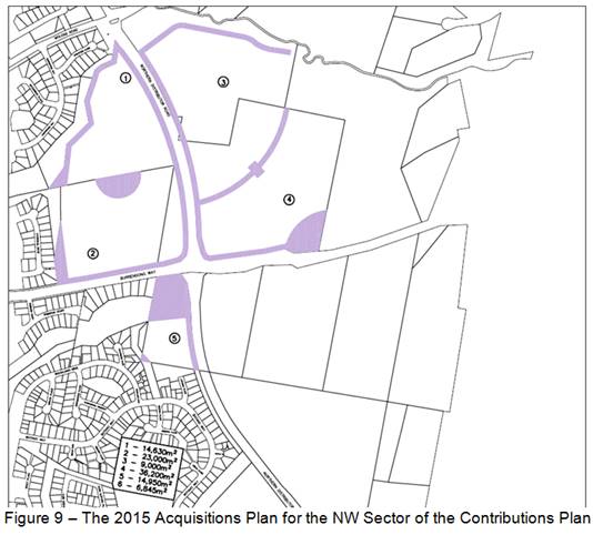
The applicable compensation rates
for open space involving the NDR is $10 per square metre.
The land to which the proposed subdivision relates has two
starting allotments and the resulting yield from the proposed subdivision is 62
lots on which dwellings can be constructed. However, one of the starting
allotments is not of sufficient size to support an Equivalent Tenement (ET).
Consequently, the existing development of the site has a credit of 1ET,
and the net yield of the proposed development is 61 lots.
Pursuant to Orange Development Contributions Plan 2015, the
following contributions have been levied for the subject development and are
attached as a condition of consent.
The payment of contributions as
per the following shall be made to Council in accordance with Section 94 of the
Act and the Orange Development Contributions Plan 2015 (development in North
West Urban Release Area) towards the provision of the following public
facilities:
|
Open Space and Recreation
|
@ $3,300.99 x 61 additional lots
|
201,360.39
|
|
Community and Cultural
|
@ $664.84 x 61 additional lots
|
40,555.24
|
|
Roads and Cycleways
|
@ $5,117.13 x 61 additional lots
|
312,144.93
|
|
Stormwater Drainage
|
@ $308.55 x 61 additional lots
|
18,821.55
|
|
Local Area Facilities
|
@ $5,615.43 additional lots
|
342541.23
|
|
Plan Preparation &
Administration
|
@ $449.99 x 61 additional lots
|
27,449.39
|
|
Subtotals
|
|
942,872.73
|
|
Compensation for Internal Open
Space
|
@$10 per m2 x 9,000m2
|
(-)90,000.00
|
|
TOTAL (subtotal less compensation):
|
|
$852,872.73
|
The contribution will be indexed
quarterly in accordance with the Orange Development Contributions Plan 2015
(development in North West Urban Release Area).
With regard to open space
contributions, the contributions levied for this application will provide
funding for an extensive and ambitious program of projects. There are no funds
available for acquisitions that don’t form part of the acquisition plan.
Section 64 Water and Sewer
Headwork Charges
Section 64 water and sewer headwork charges are also
applicable to the proposal. Such charges are calculated at the time of a
Construction Certificate for the proposed development. Attached are draft
conditions requiring the payment of the required contribution prior to the
issue of a Subdivision Certificate.
PROVISIONS PRESCRIBED BY THE
REGULATIONS s79C(1)(a)(iv)
The development is not inconsistent with the provisions
prescribed by the regulations
THE LIKELY IMPACTS OF THE
DEVELOPMENT s79C(1)(b)
Traffic
The capacity of the road network in the vicinity of the site
is sufficient to accommodate additional localised traffic generated by the
development, or the likely additional traffic that future developments on the
subdivided lots are likely to generate. Council’s Technical Services
Division advises that the proposed road layout is satisfactory, allows
adjoining land to be developed and is generally in accordance with the DCP.
Conditions are considered necessary and are included in the
attached consent preventing access for the individual lots directly onto either
the NDR or Molong Road.
Noise
There are two possible areas of noise conflict for the use
of the site as a residential estate. Noise arises from the adjacent NDR Road
and a further noise source arises from the operation of the sewer pump station
located on the northern part of the site.
The applicant has undertaken a noise assessment as part of
the submission to Council. This assessment has been referred to Council's
Manager Building and Environment.
Noise Considerations from NDR
The Interim Guidelines by the NSW government are relevant to
the assessment of this application. They are titled Development Near
Rail Corridors And Busy Roads and have been prepared by the NSW Department
of Planning. The Infrastructure SEPP (I-SEPP) refers to guidelines which must
be taken into account where development is proposed in, or adjacent to
Classified Roads under clauses 98-104 of the I-SEPP. The Northern Distributor
is not listed as a "Classified Road" under the RMS classification
system. Molong Road, whilst listed as a Classified Road, has no
additional lots proposed along the shared frontage.
Notwithstanding this, it is appropriate to apply the noise
performance criteria called up by clause 102 of the State Environmental
Planning Policy - Infrastructure (I-SEPP). This clause requires that
prior to determining a development application for development to which this
clause applies, the consent authority must take into consideration any
guidelines that are issued by the Director-General for the purposes of this
clause and published in the Gazette. The abovementioned guidelines fall within
that category.
Therefore, as the proposed development is a residential
subdivision, Council must not grant consent to the development unless it is
satisfied that appropriate measures will be taken to ensure that the following
noise levels are not exceeded:
(a) in
any bedroom in the building - 35 dB(A) at any time between 10 pm and 7 am,
(b) anywhere
else in the building (other than a garage, kitchen, bathroom or hallway) - 40
dB(A) at any time.
The development application included an Acoustic Report by
Blackett Acoustics dated September 2013. Unlike other subdivisions that adjoin
the NDR, the report does not rely on the developer providing either an
increased setback of houses from the road or physical barriers (sound walls and
fencing) to mitigate road noise emissions. Instead, the Acoustic report
recommends passing this responsibility onto any future residents.
The Acoustic Report recommends that each individual house be
required to undertake their own noise assessment and to include any identified
attenuation measures within the houses themselves. The Report suggests
that by using specific acoustic building materials and management practices
(closing of windows in the houses fronting the NDR between 10pm and
7am), noise levels within the dwellings can comply with the current
requirements provided in State Environmental Planning Policy (Infrastructure
SEPP) and the Department of Planning’s “Development near Rail
Corridors and Busy Roads - Interim Guideline”.
Whilst from a purely science point of view, by restricting
the activities of residents within the houses (ie requiring windows to be
closed at night) and also requiring the houses to be constructed using certain
materials, compliance with the State Policies would technically be achieved.
These restrictions have the potential to impact on the amenity of future residents
of the houses. The treatment of noise at the individual house is therefore the
least favoured of the options available. Further to this, as the
subdivision is a ‘green fields’ site, it is difficult to justify
that matters such as constraints of the site (eg. topography, or the lack of
available land) result in the need to pass the responsibility to manage noise
fully onto future residents. This view reflects previous legal advice that
Council has obtained, which suggested that in non-metropolitan areas, it is
considered unreasonable to reduce the amenity of future residents when other
measures to attenuate noise at a subdivision scale are available.
The draft consent document attached to this report includes
the following conditions:
1 The
applicant shall submit for Council approval a revised acoustic report from a
qualified acoustic engineer detailing measures required to be implemented as
part of the construction of this subdivision, including heights, materials,
design and placement of barriers so as to ensure that future residential
development for lots affected by noise from the Northern Distributor and Molong
Road have noise intrusion minimised.
2 Noise
attenuation measures shall be provided adjacent to the Northern Distributor
Road and Molong Road, such as earth mounding acoustic barriers or the like
during the construction of the subdivision so that the noise criteria specified
in Table 3.1 of the 'Development Near Rail Corridors and Busy Roads –
Interim Guidelines" are achieved at the nearest residential building
likely to be constructed at each point along those roads. Details of the
proposed attenuation measures shall be provided to Council prior to the issue
of a Construction Certificate.
Note: Physical
noise attenuation measures may be provided in future dwellings to supplement
subdivision scale measures where it is not physically practicable to meet the
standards referred to above, such as at road openings and the like.
Further conditions have been included to require that where
the relevant noise criteria cannot be practicably met by the works carried out
in association with the construction or the like, shall be required under a
restriction as to user under Section 88B of the Conveyancing Act.
Sewer Pump Station
There is a Sewer Pump Station located in the northern corner
of the site. Allowance has been made for this asset by the inclusion of a
right-of-carriageway to allow access to the asset. It does not address the
issue of tenure for this structure beyond that point. The right of that
structure to be on the site does not appear to be protected by any formal
agreement reached between the landowner and Council, although there is some
form of understanding as to its continued location on the site.
Councils Technical Services Division advises that it is
intended to eventually relocate the pump station, however for the moment it
would be preferred if the pump station were retained on the site.
It is considered that the following issues arise from the
operation of the pump station
Noise
Council's Manager Building and Environment has provided the
following comment:
A noise report dated 6 July
2012 was submitted with the Development Application for this subdivision. The
noise report can be only used as a guide and may not represent actual noise
levels from the sewer pump station. The reason for this is the type of
emergency generator proposed to be used was unknown during the assessment and
therefore the report highlighted the need for further acoustic reporting by the
pump station operator once this is known (Council is the operator of the pump
station). This therefore represents a slight risk to the operator of the pump
station that assumptions only have been made and they will be required to
ensure they achieve compliance with those assumptions once a specific generator
is selected.
Assessment of general
operation of the pump station noise was also considered with the consultants
noise report. The report assumed a background noise of 32dB(A), which is
considered reasonable for this area. Therefore a noise goal of 37dB(A) applies
to the pump station. The SLR Report identifies the 37dB(A) contour extends
80-100m from the station if no noise mitigation works are carried out on the
pump station. Following the installation of mitigation measures, the SLR Report
predicts that the 37 dB(A) contour would be reduced to a minor part of the
three closest residential allotments (Lots 35‑37). Provided
dwellings are not located within the 37dB(A) contour without mitigation, I have
no objection to the proposed subdivision.
Odour Assessment of Sewer Pump
Station
Review of the SLR Odour Impact Assessment dated 12 July 2012
has been undertaken. The report predicts that the maximum odour criterion would
not be exceeded provided mitigation works are undertaken to the pump station.
It is of interest to note that the whole of the proposed residential
subdivision will be the subject of some odour from the pump station. There is a
risk to the pump station operator (Council) that, should any variance to the
predicted odour levels occur (exceedance), odour complaints would arise.
It is recommended that a condition of consent be applied to
the development that requires the remediation works identified in the SLR
report to be undertaken prior to the commencement of the construction of any
residential development on Lots 28-43 and Lot 57. Specifically these works
are to include:
· sealing of the wet
well cover;
· sealing of the
concrete channel housing electrical cables to the pump house; and
· installation of
buffers (vegetated) between residences and the pump station.
This work will necessarily need to be undertaken by Council.
An alternative does exist for the pump station to be removed or relocated away
from the site. Two conditions are considered necessary to address the issue.
The first prevents the issue of Subdivision Certificates for the 17 affected
lots until the recommended works have been completed. The second condition
withholds the release of the subdivision for Lots 36 and 37 until the pump station
has been relocated.
Cumulative Impacts
The proliferation of low density residential development on
the fringe of the City is a reflection of the urban growth of Orange, which is
currently being achieved by an expansion of the residential land into the
surrounding lower density rural and non-urban land. A continuation of green
field residential subdivisions satisfies the market demand but is likely to
result in community isolation from transport facilities and services due to the
increase in distance from employment areas and the CBD. Because of the
distances, a continuation on motor vehicle reliance is likely to be reinforced
by developments such as the subject application.
On the other hand, the development of a new estate creates
opportunities for home ownership, improves housing stock quality from an
aesthetic point of view and promotes economic activity in the building
industry.
THE SUITABILITY OF THE SITE
s79C(1)(c)
The subject property has one significant natural feature,
being the waterways that cross the site. These are adequately allowed for in
the subdivision design.
The subject property will be significantly reliant on motor
vehicles for access to most facilities and amenities, and this should be seen
as a negative to the overall amenity and ambience the site will generate. To
achieve satisfactory levels of amenity it is considered highly desirable to
provide pedestrian linkages to the open space network.
ANY SUBMISSIONS MADE IN
ACCORDANCE WITH THE ACT s79C(1)(d)
The proposed development is defined as "advertised
development" by reason of the Integrated Development provisions of the
Act. The application was advertised for the prescribed period of 30 days and,
at the end of that period one submission had been received. A further late submission
has also been made by the Environmentally Concerned Citizens of Orange (ECCO).
The first submission is from the owner of the
"Robar" site at 426 Mitchell Highway (the buildings of which are
located 220m from the proposed subdivision). The basis of the submission to
Council is that a line of sight exists between the subject site and the Robar
commercial site. The concern is that the future development of the property at
386 Molong Road for residential development could impede the development
of the Robar site for commercial purposes at some point in the future.
The objection is not well founded and not supported as a
basis for imposing conditions, refusing or modifying the proposed development.
Should Robar be the subject of a future development proposal, it is incumbent
on the applicant for that future application to seek solutions appropriate to
protecting the amenity of all its neighbours. It would be a misuse of the
planning system to impose burdens on the current application to address issues
that are not related to its future development.
The submission from ECCO raises no objection to the proposed
subdivision layout, but stresses that the open space corridors within the
riparian corridors are important to be acquired as open space on the following
grounds:
· Both Creeks are
in the Murray Darling catchment. Every effort needs to be made to ensure water
quality.
· Creation of
green corridors is consistent with the aims and objectives of the LEP and
the DCP.
· OCC has an
obligation to protect and enhance all waterways.
· The
recreational and lifestyle benefits in the provision of a continuous
walking/cycling track would be increased through the linkage of the land to the
already excellent tracks developed by council along both creek lines thus
linking Ploughmans Valley and Somerset tracks to the Ammerdown riparian public
open space.
· A plan for
revegetation for this area will provide an opportunity for community
involvement through planting programs, to be carried out by community and
volunteer groups leading to a sense of local ownership and appreciation of the
value of the natural environment.
With regard to the dot points
listed above, the following comments are provided:
With respect to the first dot
point, Council officers concur with the position taken by ECCO. However, it
needs to be pointed out that the environmental responses built into the notice
of approval and canvassed in the report, represent a reasonable response to
those challenges.
With regard to the second dot
point, the outcomes prescribed by the attached consent are consistent with LEP
and DCP objectives and requirements, as well as relevant state legislation.
Financial constraints limit the amount of land that can be acquired under
compensation, but where land is not to be acquired, conditions are included for
the appropriate management of that land that is remain in private ownership.
With regard to the third dot
point, Council has responsibility to ensure development is carried out without
significant adverse environmental effect. There are obligations on Council to
undertake its assessments in accordance with certain procedures and standards
that are set out in legislation. These have been done for this application.
However, such responsibilities do not require that all land that is
environmentally constrained be vested in Councils direct care control and
management. Such a position is financially beyond the means available to
Council. Where direct acquisition is not to occur, the environmental
constraints have otherwise been satisfactorily addressed. There is not
likely to be significant adverse environmental effect arising from an approval
for this development.
With regard to the fourth dot
point, the consent as now envisaged and conditioned can provide linkages and
connectivity in the open space network.
With regard to the fifth dot point
there will be opportunities for volunteer groups such as Landcare or
Conservation Volunteers to undertake rehabilitation work within the riparian
corridor and open space, as Council will acquire a minimum of 9000m2
of open space including land along the creek systems, and will leave the option
of free dedication to Council at the applicants discretion of other land as
considered appropriate, or alternatively place that land under the controls of
a plan of management. It is entirely possible that the conservation
volunteers could be invited to undertake rehabilitation work within that
privately managed area at some point.
The ECCO submission goes on to state:
the best way to ensure that
the appropriate environmental outcomes are achieved is for the land in question
to be placed under the control of Council.
This has been discussed
extensively in this report.
The submission by ECCO is relevant to the riparian issue
raised by this application. The benefits supporting acquisition are fairly well
summarised in this submission and deserving of some consideration by Council.
The ‘complete Council purchase’ option advocated by ECCO is however
unlawful if funded from the S94 plan as discussed in this report.
PUBLIC INTEREST
s79C(1)(e)
The proposed development is considered to be of minor
interest to the wider public due to the relatively localised nature of
potential impacts. The proposal is not inconsistent with any relevant policy
statements, planning studies, guidelines, etc that have not been considered in
this assessment.
SUMMARY
The proposed development is permissible with the consent of
Council. The proposed development complies with the relevant aims, objectives
and provisions of the LEP. A section 79C assessment of the
development indicates that the development is acceptable in this instance.
Attached is a draft Notice of Approval outlining a range of conditions
considered appropriate to ensure that the development proceeds in an acceptable
manner.
COMMENTS
The requirements of the Environmental Health and Building
Surveyor and the Engineering Development Section are included in the attached
Notice of Approval.
Attachments
1 Notice
of Approval, D15/45486⇩
2 Plans,
D15/45260⇩
3 Submissions,
D15/41058⇩
Council Meeting
15 December 2015
5.2 Development
Application DA 217/2014(1) - Northern Distributor Road and 386 Molong Road
Attachment 1 Notice
of Approval
|

|
ORANGE
CITY COUNCIL
Development
Application No DA
217/2014(1)
NA15/ Container
PR19362
|
NOTICE OF DETERMINATION
OF A DEVELOPMENT
APPLICATION
issued under the Environmental
Planning and Assessment Act 1979
Section 81(1)
|
Development
Application
|
|
|
Applicant Name:
|
Fenlor
Group Pty Limited
|
|
Applicant Address:
|
1
Borrodell Drive
ORANGE
NSW 2800
|
|
Owner’s Name:
|
Mr GJ
Thornberry
|
|
Land to Be Developed:
|
Lot 81 DP 1202584 and
Lot 6 DP 1065578 - Northern Distributor Road and 386 Molong Road, Orange
|
|
Proposed Development:
|
Subdivision
(61 residential lots, one residue lot and three open space lots)
|
|
|
|
|
Building
Code of Australia
building classification:
|
Not
applicable
|
|
|
|
|
Determination
|
|
|
Made On:
|
15 December
2015
|
|
Determination:
|
CONSENT
GRANTED SUBJECT TO CONDITIONS DESCRIBED BELOW:
|
|
|
|
|
Consent to
Operate From:
|
16
December 2015
|
|
Consent to
Lapse On:
|
16
December 2020
|
Terms of Approval
The reasons for the imposition of
conditions are:
(1) To ensure a quality
urban design for the development which complements the surrounding environment.
(2) To maintain
neighbourhood amenity and character.
(3) To ensure compliance
with relevant statutory requirements.
(4) To provide adequate
public health and safety measures.
(5) Because the development
will require the provision of, or increase the demand for, public amenities and
services.
(6) To ensure the utility
services are available to the site and adequate for the development.
(7) To prevent the proposed
development having a detrimental effect on adjoining land uses.
(8) To minimise the impact
of development on the environment.
Conditions
(1) The
development must be carried out in accordance with:
(a) Plans by Heath
Consulting numbered 07_066 sheets 1 and 2 dated April 2015 titled "Area
Breakdown" and "Proposed Subdivision" (both Rev A), as amended
by the further plan submitted by the applicant, drawn by Heath Consulting
Engineers titled Proposed Subdivision" (Rev N) (3 sheets)
(b) statements
of environmental effects or other similar associated documents that form part
of the approval
as amended
in accordance with any conditions of this consent.
|
PRIOR TO THE ISSUE OF
A CONSTRUCTION CERTIFICATE
|
(2) A comprehensive
landscaping plan to screen the area around the pump station, as recommended in
the odour Assessment report submitted with the application is required to be
prepared by the applicant and approved by Councils Director –
Development Services to provide effective screening around this facility.
(3) The submission of a
landscaping plan incorporating appropriate levels of earth mounding, native
species selection, weed matting or suppression, plant density is to be
submitted to Council for the noise buffer areas adjacent to Northern Distributor
Road (shown on the approved plans as Lots 63 and 64). The plan shall be to
the satisfaction of the Councils Director – Development Services. The
developer is responsible for regular maintenance and establishment of this
landscape, including regular watering and weeding of these areas, until
handover has been accepted. All landscaping shall be well established
prior to handover to Council.
(4) Engineering plans,
showing details of all proposed work and adhering to any engineering conditions
of development consent, are to be submitted to, and approved by, Orange City
Council or an Accredited Certifier (Categories B1, C3, C4, C6) prior to the
issuing of a Construction Certificate.
(5) A water and soil
erosion control plan is to be submitted to Orange City Council or an Accredited
Certifier (Categories B1, C3, C4, C6) for approval prior to the issuing of a
Construction Certificate. The control plan is to be in accordance with the
Orange City Council Development and Subdivision Code and the Landcom, Managing
Urban Stormwater; Soils and Construction Handbook.
(6) Engineering plans,
showing details of the proposed road works, access and traffic management works
on the Northern Distributor Road (NDR), are to be submitted to Orange City
Council for approval prior to the issuing of a Construction Certificate.
(7) The
development’s stormwater design is to include stormwater retention within
the development, designed to limit peak outflows from the land to the
pre-existing natural outflows up to the 100 year ARI frequency, with
sufficient allowance in overflow spillway design capacity to safely pass flows
of lower frequency (that is, a rarer event) without damage to downstream
developments. Where appropriate, the spillway design capacity is to be determined
in accordance with the requirements of the Dam Safety Committee.
The design of the detention storage is to be
undertaken using the ILSAX rainfall-runoff hydrologic model or an approved
equivalent capable of assessing runoff volumes and their temporal distribution
as well as peak flow rates. The model is to be used to calculate the flow rates
for the existing and post-development conditions. The developed flows are to be
routed through the proposed storage within the model so that the outflows
obtained are no greater than the flows obtained for the pre-existing natural
flows.
condition
(7) continued over the page
(7) (cont)
A report detailing the results of the analysis,
which includes:
· catchment
plan showing sub-catchments under existing and developed conditions;
· schematic
diagram of the catchment model showing sub areas and linkages;
· tabulation
detailing the elevation, storage volume and discharge relationships; and
· tabulation
for the range of frequencies analysed, the inflows, outflows and peak storage
levels for both existing and developed conditions;
together with copies of the data files for the
model and engineering design plans of the required drainage system are to be
submitted and approved by Orange City Council or an Accredited Certifier
(Categories B1, C3, C4, C6) prior to the issue a Construction Certificate.
(8) Proposed
lots are to be provided with interlot stormwater drainage, including those lots
abutting public land, where the surface of the entire lot cannot be drained to
the kerb and gutter at the lot frontage. A grated stormwater pit is to be
constructed within each lot provided with interlot stormwater drainage.
Engineering plans for this drainage system are to be approved by Orange City
Council or an Accredited Certifier (Categories B1, C3, C4, C6) prior to the
issuing a Construction Certificate.
(9) Stormwater from the
site is to be piped to the adjacent watercourse, where it is to be discharged
through a standard headwall with appropriate scour protection. Engineering plans
of this required drainage system are to be approved by Orange City Council or
by an Accredited Certifier (Categories B1, C3, C4, C6) and a licence from the
Department of Planning Infrastructure and Natural Resources for work within 20
metres of the watercourse is to be submitted prior to the issuing of a
Construction Certificate.
(10) A 150mm-diameter sewer
main is to be constructed from Council’s existing main to serve the
proposed lots. Orange City Council, prior to issuing a Construction Certificate,
is to approve engineering plans for this sewerage system.
(11) A water
reticulation analysis is to be carried out by Orange City Council on any
proposed water-reticulation system for the development. Engineering plans are
to be submitted to Orange City Council for approval prior to the issuing of a
Construction Certificate.
The reticulation system is to be designed to
supply a peak instantaneous demand by gravity of 0.15 L/s/tenement at a
minimum residual head of 200kPa.
(12) The
applicant shall submit for Council approval a revised acoustic report from a
qualified acoustic engineer detailing measures required to be implemented as
part of the construction of this subdivision, including heights, materials,
design and placement of barriers so as to ensure that future residential
development for lots affected by noise from the Northern Distributor and Molong
Road have noise intrusion minimised.
(13) Noise
attenuation measures shall be provided adjacent to the Northern Distributor
Road and Molong Road, such as earth mounding acoustic barriers or the like
during the construction of the subdivision so that the noise criteria specified
in Table 3.1 of the 'Development Near Rail Corridors and Busy Roads –
Interim Guidelines" are achieved at the nearest residential building
likely to be constructed at each point along those roads. Details of the
proposed attenuation measures shall be provided to Council prior to the issue
of a Construction Certificate.
(Note
Physical Noise attenuation measures may be provided in future dwellings to
supplement subdivision scale measures where it is not physically practicable to
meet the standards referred to above, such as at road openings and the like.
(14) A plan of management
for the riparian corridors adjacent to Ploughmans Creek and consistent with
the E2 zoning shall be prepared to the satisfaction of the Director
Development Services, establishing this area as an area of private open space.
|
PRIOR TO WORKS
COMMENCING
|
(15) Soil erosion control
measures shall be implemented on the site.
|
DURING
CONSTRUCTION/SITEWORKS
|
(16) Any adjustments to
existing utility services that are made necessary by this development
proceeding are to be at the full cost of the developer.
(17) The
provisions and requirements of the Orange City Council Development and
Subdivision Code are to be applied to this application and all work constructed
within the development is to be in accordance with that Code.
The developer is to be entirely responsible for
the provision of water, sewerage and drainage facilities capable of servicing
all the lots from Council’s existing infrastructure. The developer is to
be responsible for gaining access over adjoining land for services where
necessary and easements are to be created about all water, sewer and drainage
mains within and outside the lots they serve.
(18) Concrete pathways are
to be constructed to the widths and standards stated in the Orange City Council
Development and Subdivision Code.
(19) Land
contained within the boundaries of the proposed lot 65 shall be restored to its
predevelopment state, with banks to be grassed and stabilised, armoured with
rock where required to minimise or prevent erosion and/or scouring from
increased stormwater flow rates and all sediment within this lot arising from
the development works being removed from the riparian zone and the waterbody.
Work required or carried out in the riparian corridor shall also be fully in
accordance with the required management plan and any other requirements
specified under this consent.
(20) All proposed
residential lots adjacent to the waterways, are to have a minimum freeboard
above the 1‑in-100-year flood level in accordance with the Orange City
Council Development and Subdivision Code and the Floodplain Risk Management
Plan.
(21) Dual water and sewerage
reticulation is to be provided to every lot in the proposed residential
subdivision in accordance with the Orange City Council Development and
Subdivision Code.
(22) Water and sewer
services, including mains construction, pumping station construction, easements
and all associated materials and works, are to be provided for the development
at the cost of the developer.
(23) A right-of-way is to be
created over the riparian corridors as shown in the approved plans, to provide
access to Lot 62 from the internal roads system. A sealed access road is to be
constructed in accordance with the Orange City Council Development and
Subdivision Code, as well as any requirements listed or required by the controlled
activity approval. This right of way shall also incorporate rights of access
contained within the S-88B instrument that permits access for pedestrians and
cyclists using the adjacent open space corridors, without impediment.
|
PRIOR TO THE ISSUE OF
A SUBDIVISION CERTIFICATE
|
(24) Application shall be
made for a Subdivision Certificate under Section 109(C)(1)(d) of the Act.
(25) This
approval requires the dedication of a minimum of 9000 m2 of the land
for open space as
set out in the 2015 Contributions Plan. Such allocation of land to Council
shall incorporate the buffers adjacent to the Northern Distributor Road, and a
riparian corridor adjacent to Somerset Creek that is contiguous to the
pedestrian underpass under the Northern Distributor Road. Compensation for this
land dedication shall be in accordance with the Contributions Plan and shall be
to a maximum value of $90,000, and a minimum dedication of 9000m2.
An amended plan that is to the satisfaction of the Director Development
Services is required to reflect these requirements prior to issue of a
Subdivision Certificate. In the event that the applicant does not wish to
dedicate the remainder of the riparian corridor to Council without charge, this
part of the riparian corridor land shall be incorporated into the residual lot
62 and developed in accordance with a plan of management, that is also to the
satisfaction of the Director, and also required to be submitted to Council
prior to issue of the Subdivision Certificate. The Management Plan shall be
consistent with the provisions and objectives of clause 7.5 of Orange
Local Environmental Plan 2011. Additionally, the Riparian Corridor contained
within the E2 Environmental Conservation Zone (adjacent Ploughmans Creek)
shall be written and implemented in a manner consistent with the objectives for
that zone.
(26) The payment of
contributions as per the following shall be made to Council in accordance with
Section 94 of the Act and the Orange Development Contributions Plan 2015
(development in North West Urban Release Area) towards the provision of the
following public facilities:
|
Open Space and
Recreation
|
@ $3,300.99 x 61
additional lots
|
201,360.39
|
|
Community and
Cultural
|
@ $664.84 x 61
additional lots
|
40,555.24
|
|
Roads and Cycleways
|
@ $5,117.13 x 61
additional lots
|
312,144.93
|
|
Stormwater Drainage
|
@ $308.55 x 61
additional lots
|
18,821.55
|
|
Local Area Facilities
|
@ $5,615.43
additional lots
|
342541.23
|
|
Plan Preparation
& Administration
|
@ $449.99 x 61
additional lots
|
27,449.39
|
|
Subtotals
|
|
942,872.73
|
|
Compensation for
Internal Open Space
|
@$10 per m2
x 9,000m2
|
(-)90,000.00
|
|
TOTAL (subtotal less
compensation):
|
|
$852,872.73
|
The contribution will be indexed quarterly in
accordance with the Orange Development Contributions Plan 2015 (development in
North West Urban Release Area).
(27) The landscaping plans
required for the areas shown as Lots 63 and 64 (adjacent to the Northern
Distributor) shall be fully completed to the satisfaction of the Director -
Development Services. Council will only accept the landscaping as satisfactory
if it is well established and maintained at the time of subdivision release.
(28) Landscaping around the
pump station shall be completed in accordance with the approved plan, to the
satisfaction of the Director Development Services prior to the issue of a
subdivision certificate. .
(29) Lots 28-33, 34-37,
38-43, 56 and 57, as depicted on the Drawing Number 07_006NOISEODOUR prepared
by Heath Consulting
dated March 2012 and submitted with the application shall not be released until
and unless all mitigation recommendations as set out in the report titled
"Appendix B -N01 Odour Assessment by SLR (referenced Report Number
610.11488, dated July 2012) as outlined in Section 8.2.1 of the report have
been fully implemented to the satisfaction of Council's Manager Development
Assessments who shall also be advised accordingly.
(30) The
provision of the following with respect to boundary fencing:
i) Fencing
adjoining rural land (to the north) is required as rural style fencing (post
and wire, no barbed wire), as per the requirements of DCP-2004. .
ii) A
Section 88B Restrictions-as-to-User under the Conveyancing Act 1979
shall require such rural fencing (or any replacement) to be maintained in the
same style.
(31) Where the noise
criteria referred
to in Table 3.1 of the 'Development Near Rail Corridors and Busy Roads –
Interim Guidelines" cannot be achieved to any lot solely by the construction of the
noise attenuation measures of the subdivision in the revised acoustic report,
as required by condition (12) of this consent, such lots shall be identified in
that report and shall have a restriction as to user pursuant to S-88B of
the Conveyancing Act imposed on the title requiring future dwelling
construction in accordance with the specifications detailed in the revised
acoustic report by Blackett and Associates.
(32) Completion
of all noise attenuation works required by this consent or any acoustic report
recommendations required by this consent shall be fully completed.
(33) Noise Considerations
from Sewer Pump Station
A noise goal of 37dB(A) applies to lots
affected by noise from the pump station. To be suitable for dwelling
construction, mitigation of background noise levels to below 37dBa is required.
Release of those allotments within the 37DBa contour is not permitted under
this consent until all measures to mitigate noise from the pump station have
been implemented and a further noise report by a qualified Acoustics engineer
has been provided corroborating the target noise levels has been achieved to
satisfaction of council has been submitted.
(34) Payment of
contributions for water, sewer and drainage works is required to be made
at the contribution rate applicable at the time that the payment is made.
The contributions are based on 62 ETs for water supply headworks and 62
ETs for sewerage headworks. A Certificate of Compliance, from Orange City
Council in accordance with the Water Management Act 2000, will be issued
upon payment of the contributions.
This Certificate of Compliance is to be
submitted to the Principal Certifying Authority prior to the issuing of a
Subdivision Certificate.
(35) Evidence from a
registered NATA laboratory is to be submitted prior to the issuing of a
Subdivision Certificate stating that the filling of all dams and low-lying
areas has been carried out in accordance with Australian Standard 3798-2007.
(36) Certification from Telstra,
stating that telecommunication systems comply with Australian Standards, is to
be submitted to the Principal Certifying Authority prior to the issuing of a
Subdivision Certificate.
(37) Certification from
Essential Energy, stating that electricity and street lighting systems comply
with Essential Energy’s Networks Division Customer Connection Policy
NP11.1, is to be submitted to the Principal Certifying Authority prior to the
issuing of a Subdivision Certificate.
(38) All services are to be
contained within the allotment that they serve. A Statement of Compliance, from
a Registered Surveyor, is to be submitted to the Principal Certifying Authority
prior to the issuing of a Subdivision Certificate.
(39) An easement to drain
sewage and to provide Council access for maintenance of sewerage works a
minimum of 2.0 metres wide is to be created over the proposed sewerage works
and all existing sewer mains. The Principal Certifying Authority is to certify
that the easement is in accordance with the Orange City Council Development and
Subdivision Code prior to the issuing of a Subdivision Certificate.
(40) A Certificate of
Compliance, from a Qualified Engineer, stating that the stormwater retention
basin comply with the approved engineering plans is to be submitted to the
Principal Certifying Authority prior to the issuing of a Subdivision
Certificate.
(41) A
Maintenance Security Deposit, in accordance with the provisions and
requirements of the Orange City Council Development and Subdivision Code, is to
be provided to Orange City Council prior to the issuing of a Subdivision
Certificate.
A Certificate of Compliance, from Orange
City Council, certifying that the maintenance security deposit has been paid,
is to be submitted to the Principal Certifying Authority prior to the issuing
of a Subdivision Certificate.
(42) Where
stormwater crosses land outside the lot it favours, an easement to drain water
is to be created over the works. A Restriction-as-to-User under section 88B of
the NSW Conveyancing Act 1979 is to be created on the title of the
proposed lots requiring that no structures are to be placed on the site, or
landscaping or site works carried out on the site, in a manner that affects the
continued operation of the interlot drainage system. The minimum width of the
easement is to be as required in the Orange City Council Development and
Subdivision Code.
(43) A
Subdivision Certificate
creating Lots 36 and 37 shall not be issued until the sewer pump station
is removed.
(44) A
Restriction-as-to-User under section 88B of the NSW Conveyancing Act 1979 is to
be created on the title of lots containing riparian corridor land, and lots
adjacent to riparian corridor land prohibiting the planting nurturing or
propagation of invasive weed species on these lots.
(45) All
of the foregoing conditions are to be at the full cost of the developer and to
the requirements and standards of the Orange City Council Development and
Subdivision Code, unless specifically stated otherwise. All work required by
the foregoing conditions is to be completed prior to the issuing of a
Subdivision Certificate, unless stated otherwise.
|
MATTERS FOR THE
ONGOING PERFORMANCE AND OPERATION OF THE DEVELOPMENT
|
(46) The
area of private open space adjacent to Ploughmans Creek will be maintained in
accordance with the Plan of Management to the satisfaction of the Director
Development Services.
(47) If Aboriginal objects,
relics, or other historical items or the like are located during development
works, all works in the area of the identified object, relic or item shall
cease, and the NSW Office of Environment and Heritage, and representatives from
the Orange LALC shall be notified. Where required, further archaeological
investigation shall be undertaken. Development works in the area of the find(s)
may recommence if and when outlined by the management strategy, developed in
consultation with and approved by the OEH.
|
GENERAL TERMS OF
APPROVAL - NSW OFFICE OF WATER
|
|
Plans, standards and
guidelines
|
|
1
|
These General Terms of Approval (GTA) only
apply to the controlled activities described in the plans and associated
documentation relating to 2014/217 (1) and provided by Council.
Any
amendments or modifications to the proposed controlled activities may render
these GTA invalid. If the proposed controlled activities are amended or
modified the NSW Office of Water must be notified to determine if any
variations to these GTA will be required.
|
|
2
|
Prior to the commencement of any controlled
activity (works) on waterfront land, the consent holder must obtain a
Controlled Activity Approval (CAA) under the Water Management Act from the
NSW Office of Water. Waterfront land for the purposes of this DA is land and
material in or within 40 metres of the top of the bank or shore of the river
identified.
|
|
3
|
The consent holder must prepare or commission
the preparation of:
(i) Vegetation
Management Plan
(ii) Works
Schedule
(iii) Erosion
and Sediment Control Plan
(iv) Soil
and Water Management Plan
(v) Design
Plans
|
|
4
|
All plans must be prepared by a suitably
qualified person and submitted to the NSW Office of Water for approval prior
to any controlled activity commencing. The following plans must be prepared
in accordance with the NSW Office of Water's guidelines located at http://www.water.nsw.gov.au/water-licensing/approvals/controlled-activity
(i) Vegetation
Management Plans
(ii) Laying
pipes and cables in watercourses
(iii) Riparian
Corridors
(iv) In-stream
works
(v) Outlet
structures
|
|
5
|
The consent holder must (i) carry out any
controlled activity in accordance with approved plans and (ii) construct
and/or implement any controlled activity by or under the direct supervision
of a suitably qualified professional and (iii) when required, provide a
certificate of completion to the NSW Office of Water.
|
|
Rehabilitation and maintenance
|
|
6
|
The consent holder must carry out a
maintenance period of two (2) years after practical completion of all
controlled activities, rehabilitation and vegetation management in accordance
with a plan approved by the NSW Office of Water.
|
|
7
|
The consent holder must reinstate waterfront
land affected by the carrying out of any controlled activity in accordance
with a plan or design approved by the NSW Office of Water.
|
|
Reporting requirements
|
|
8
|
The consent holder must use a suitably
qualified person to monitor the progress, completion, performance of works,
rehabilitation and maintenance and report to the NSW Office of Water as
required.
|
|
9-11
|
N/A
|
|
Disposal
|
|
14
|
The consent holder must ensure that no
materials or cleared vegetation that may (i) obstruct flow, (ii) wash into
the water body, or (iii) cause damage to river banks; are left on waterfront
land other than in accordance with a plan approved by the NSW Office of
Water.
|
|
Drainage and stormwater
|
|
15
|
The consent holder is to ensure that all
drainage works (i) capture and convey runoffs, discharges and flood flows to
low flow water level in accordance with a plan approved by the NSW Office of
Water; and (ii) do not obstruct the flow of water other than in accordance
with a plan approved by the NSW Office of Water.
|
|
16
|
The consent holder must stabilise drain
discharge points to prevent erosion in accordance with a plan approved by the
NSW Office of Water.
|
|
Erosion control
|
|
17
|
The consent holder must establish all erosion
and sediment control works and water diversion structures in accordance with
a plan approved by the NSW Office of Water. These works and structures
must be inspected and maintained throughout the working period and must not
be removed until the site has been fully stabilised.
|
|
Excavation
|
|
18
|
N/A
|
|
19
|
The consent holder must ensure that any
excavation does not result in (i) diversion of any river (ii) bed or
bank instability or (iii) damage to native vegetation within the area where a
controlled activity has been authorised, other than in accordance with a plan
approved by the NSW Office of Water.
|
|
Maintaining river
|
|
20
|
The consent holder must ensure that (i) river
diversion, realignment or alteration does not result from any controlled
activity work and (ii) bank control or protection works maintain the existing
river hydraulic and geomorphic functions, and (iii) bed control structures do
not result in river degradation other than in accordance with a plan approved
by the NSW Office of Water.
|
|
21
|
N/A
|
|
22
|
The consent holder must protect and maintain
a riparian corridor on the unnamed watercourse and Ploughmans Creek in
accordance with the NSW Office of Water Guidelines for Riparian Corridors.
The riparian corridor must be measured horizontally landward from the
highbank of each watercourse for the length of the site directly affected by
the controlled activity.
|
|
23
|
The consent holder must establish a riparian
corridor along the unnamed Creek and Ploughmans Creek in accordance with a
plan approved by the NSW Office of Water.
|
|
24-28
|
N/A
|
|
END OF CONDITIONS
|
Other Approvals
(1) Local
Government Act 1993 approvals granted under section 68.
Nil
(2) General
terms of other approvals integrated as part of this consent.
Nil
Right of Appeal
If
you are dissatisfied with this decision, section 97 of Environmental
Planning and Assessment Act 1979 gives you the right to appeal to the Land
and Environment Court within 6 months after the date on which you receive this
notice.
*
Section 97 of the Environmental Planning and Assessment Act 1979 does not apply
to the determination of a development application for State significant
development or local designated development that has been the subject of a
Commission of Inquiry.
|
Disability Discrimination Act
1992:
|
This application has been assessed in
accordance with the Environmental Planning and Assessment Act 1979. No
guarantee is given that the proposal complies with the Disability
Discrimination Act 1992.
The applicant/owner is responsible to
ensure compliance with this and other anti-discrimination legislation.
The Disability Discrimination Act
covers disabilities not catered for in the minimum standards called up in the
Building Code of Australia which references AS1428.1 - "Design for
Access and Mobility". AS1428 Parts 2, 3 and 4 provides the most
comprehensive technical guidance under the Disability Discrimination Act
currently available in Australia.
|
|
|
|
|
Disclaimer - SECTION 88B Restrictions on the
Use of Land:
|
The applicant should note that there
could be covenants in favour of persons other than Council restricting what
may be built or done upon the subject land. The applicant is advised to check
the position before commencing any work.
|
|
|
|
|
Signed:
|
On behalf of the consent authority ORANGE
CITY COUNCIL
|
|
Signature:
|
|
|
Name:
|
ALLAN RENIKE - MANAGER DEVELOPMENT
ASSESSMENTS
|
|
Date:
|
16 December 2015
|
Council
Meeting
15 December 2015
5.2 Development
Application DA 217/2014(1) - Northern Distributor Road and 386 Molong Road
Attachment 2 Plans
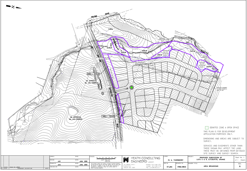
Council Meeting
15 December 2015
5.2 Development
Application DA 217/2014(1) - Northern Distributor Road and 386 Molong Road
Attachment 3 Submissions
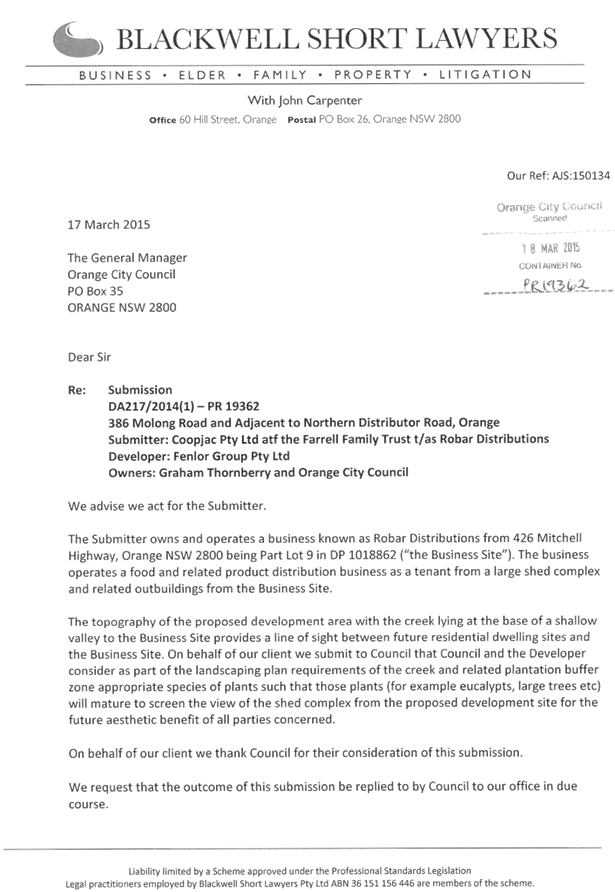


5.3 Statement
of Investments - November 2015
TRIM
REFERENCE: 2015/3239
AUTHOR: Brock
Gannon, Financial Accounting Officer
EXECUTIVE Summary
The purpose of this report is to provide a statement of
Council’s investments held as at 30 November 2015.
Link To Delivery/OPerational Plan
The recommendation in this report relates to the
Delivery/Operational Plan strategy “1.2 Our City -
Information and advice provided for the decision-making process will be
succinct, reasoned, accurate, timely and balanced”.
Financial Implications
Nil
Policy and Governance Implications
Nil
|
Recommendation
1 That Council receives the
Statement of Investments as at 30 November 2015.
2 That
Council receives and adopts the certification of the Responsible Accounting
Officer.
|
further considerations
Consideration has been given to the
recommendation’s impact on Council’s service delivery; image and
reputation; political; environmental; health and safety; employees;
stakeholders and project management; and no further implications or risks have
been identified.
SUPPORTING INFORMATION
Regulation 212(1) of the Local Government (General) Regulation
2005 requires that a written report be presented each month at an Ordinary
Meeting of the Council detailing all money that Council has invested under
Section 625 of the Local Government Act 1993.
As at 30 November 2015, the investments held by Council
totalled $117,095,694.57 and is attributed to the following funds.
|
|
30/11/2015
|
31/10/2015
|
|
General
Fund
|
49,677,408.92
|
50,987,614.15
|
|
Sewer
Local Fund
|
34,267,279.59
|
31,711,087.69
|
|
Water
Supply Local Fund
|
30,953,098.84
|
32,177,151.30
|
|
Orange
CBD Special Rate
|
2,197,907.22
|
2,134,294.84
|
|
117,095,694.57
|
117,010,147.98
|
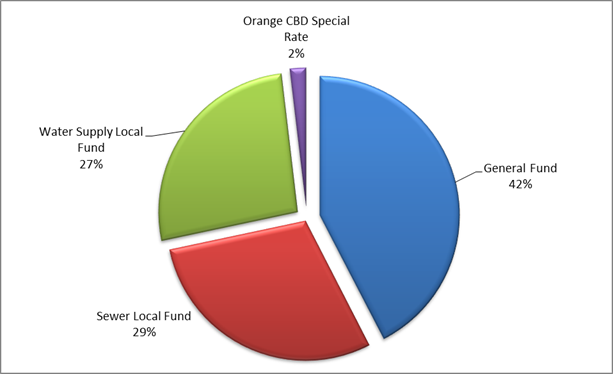
A reconciliation of Council’s investment portfolio
provides a summary of the purposes for which Council’s investments are
being held.
|
Externally
Restricted
|
30/11/2015
|
31/10/2015
|
|
General
Fund
|
19,723,825.32
|
23,502,297.27
|
|
Water
Fund
|
30,953,098.84
|
32,177,151.30
|
|
Sewer
Fund
|
34,267,279.59
|
31,711,087.69
|
|
CBD Fund
|
2,197,907.22
|
2,134,294.84
|
|
Auspiced
|
1,403,672.92
|
1,403,672.92
|
|
Internally
Restricted
|
16,854,622.53
|
15,778,487.77
|
|
Unrestricted
|
11,695,288.15
|
10,303,156.19
|
|
117,095,694.57
|
117,010,147.98
|
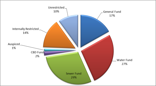
Portfolio Performance
Council’s current Long Term Financial Plan establishes
the benchmark for Council’s interest on investments at “75 basis
points above the current cash rate”. The cash rate as at 30 November 2015
remained at 2.00%. The annualised average interest rate of Council’s
investment portfolio at the same reporting date was 3.53% (weighted average
3.40%) which continues to exceed Council’s benchmark i.e. the cash rate
of 2.00% plus 0.75% (or 75 basis points).
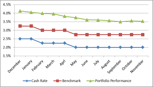
Council has also utilised the AusBond Bank Bill Index to
provide a further benchmark focused towards long term investments. As at 30
November 2015, the AusBond rate was 2.05%. The annualised average interest rate
of Council’s investment portfolio at the same reporting date was 3.55%.
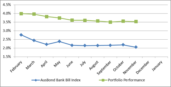
Council’s adopted Investment Policy establishes limits
in relation to the maturity terms of Council’s investments as well as the
credit ratings of the institutions with whom Council can invest.
The following tables provide a dissection of Council’s
investment portfolio as required by Council’s Investment Policy. The
Policy identifies the maximum amount that can be held in a variety of
investment products or with institutions based on their respective credit
ratings.
Table 1 and Table 2 shows the percentage held by Council
(holdings) and the additional amount that Council could hold (capacity) for
each respective category in accordance with limits as established by
Council’s Policy.
Table 1: Maturity – Term Limits
|
Term
to Maturity Allocation
|
Maximum
|
Holdings
|
Capacity
|
|
0 - 3
Months
|
100.00%
|
11.22%
|
88.78%
|
|
3 - 12
Months
|
100.00%
|
54.65%
|
45.35%
|
|
1 - 2
Years
|
70.00%
|
7.48%
|
62.52%
|
|
2 - 5
Years
|
50.00%
|
26.65%
|
23.35%
|
|
5+ Years
|
25.00%
|
0.00%
|
25.00%
|
Table 2: Credit Rating Limits
|
|
Maximum
|
Holding
|
Capacity
|
|
AAA
|
100.00%
|
0.00%
|
100.00%
|
|
AA
|
100.00%
|
28.78%
|
71.22%
|
|
A
|
60.00%
|
43.71%
|
16.29%
|
|
BBB
& NR
|
40.00%
|
27.50%
|
12.50%
|
|
Below
BBB
|
0.00%
|
0.00%
|
0.00%
|
Certification by Responsible Accounting Officer
I, Aaron Jones, hereby certify that all investments have
been made in accordance with Section 625 of the Local Government Act 1993,
Clause 212 of the Local Government (General) Regulation 2005 and
Council’s Investment Policy.

5.4 Recommendations
and Resolutions from Policy Committees
TRIM
REFERENCE: 2015/3263
AUTHOR: Michelle
Catlin, Manager Administration and Governance
EXECUTIVE Summary
Council’s Policy Committees (Planning and Development
Committee, Employment and Economic Development Policy Committee, Infrastructure
Policy Committee, Sport and Recreation Policy Committee, Environmental
Sustainability Policy Committee, Finance Policy Committee and Services Policy
Committee) have delegation to determine matters before those Committees, with
the exception of items that impact on Council’s Delivery/Operational
Plan.
This report provides minutes of the Policy Committees held
since the last meeting. Resolutions made by the Committees are for noting, and
Recommendations are presented for adoption or amendment by Council.
Link To Delivery/OPerational Plan
The recommendation in this report relates to the
Delivery/Operational Plan strategy “1.2 Our City -
Information and advice provided for the decision-making process will be
succinct, reasoned, accurate, timely and balanced”.
Financial Implications
Nil
Policy and Governance Implications
Nil
|
Recommendation
1 That
the resolutions made by the Planning and Development Committee at its meeting
held on 1 December 2015 be noted.
2 That
the resolutions made by the Employment and Economic Development Policy
Committee at its meeting held 1 December 2015 be noted.
3 That
the resolutions made by the Infrastructure Policy Committee at its meeting
held on 1 December 2015 be noted.
4 That
the resolutions made by the Sport and Recreation Policy Committee at its
meeting held on 1 December 2015 be noted.
5 That
the resolutions made by the Finance Policy Committee at its meeting held on
1 December 2015 be noted.
6 That
the resolutions made by the Services Policy Committee at its meeting held on
1 December 2015 be noted.
|
further considerations
Consideration has been given to the
recommendation’s impact on Council’s service delivery; image and
reputation; political; environmental; health and safety; employees;
stakeholders and project management; and no further implications or risks have
been identified.
SUPPORTING INFORMATION
Planning and Development
Committee
At the Planning and Development Committee meeting held on 1
December 2015, all resolutions were made under delegation, and the minutes are
presented for noting.
Employment and Economic
Development Policy Committee
At the Employment and Economic Development Policy Committee
meeting held on 1 December 2015, all resolutions were made under delegation,
and the minutes are presented for noting.
Infrastructure Policy Committee
At the Infrastructure Policy Committee meeting held on 1
December 2015 all resolutions were made under delegation, and the minutes are
presented for noting.
Sport and Recreation Policy
Committee
At the Sport and Recreation Policy Committee meeting held on
1 December 2015, all resolutions were made under delegation, and the minutes
are presented for noting.
Finance Policy Committee
At the Finance Policy Committee meeting held on 1 December
2015, all resolutions were made under delegation, and the minutes are presented
for noting.
Services Policy Committee
At the Services Policy Committee meeting held on 1 December
2015 all resolutions were made under delegation, and the minutes are presented
for noting.
Attachments
1 PDC
1 December 2015 Minutes, 2015/3274⇩
2 EEDPC
1 December 2015 Minutes, 2015/3275⇩
3 IPC
1 December 2015 Minutes, 2015/3276⇩
4 SRPC
1 December 2015 Minutes, 2015/3277⇩
5 FPC
1 December 2015 Minutes, 2015/3278⇩
6 SPC
1 December 2015 Minutes, 2015/3279⇩
Council Meeting
15 December 2015
5.4 Recommendations
and Resolutions from Policy Committees
Attachment 1 PDC 1
December 2015 Minutes
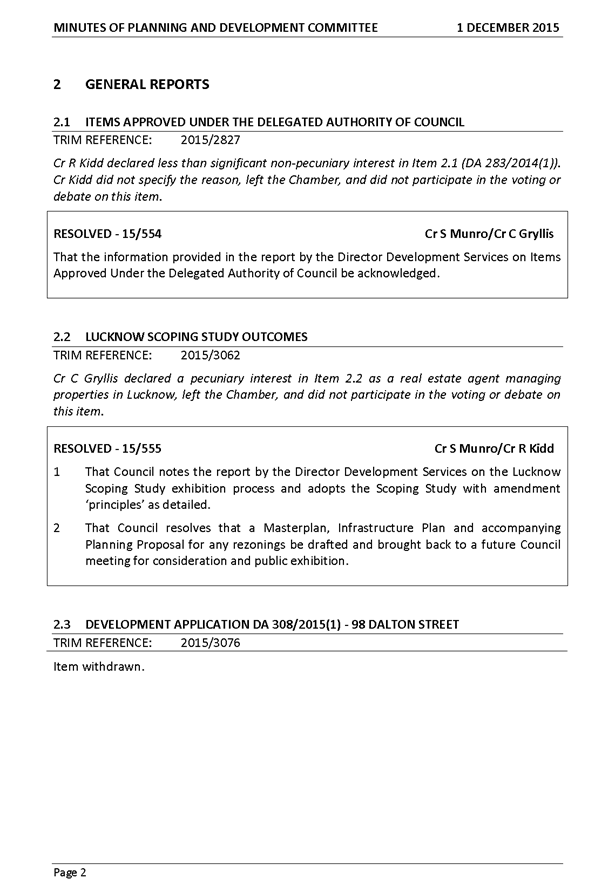
Council
Meeting
15 December 2015
5.4 Recommendations
and Resolutions from Policy Committees
Attachment 2 EEDPC 1
December 2015 Minutes
Council
Meeting
15 December 2015
5.4 Recommendations
and Resolutions from Policy Committees
Attachment 3 IPC 1
December 2015 Minutes
Council
Meeting
15 December 2015
5.4 Recommendations
and Resolutions from Policy Committees
Attachment 4 SRPC 1
December 2015 Minutes
Council
Meeting
15 December 2015
5.4 Recommendations
and Resolutions from Policy Committees
Attachment 5 FPC 1
December 2015 Minutes
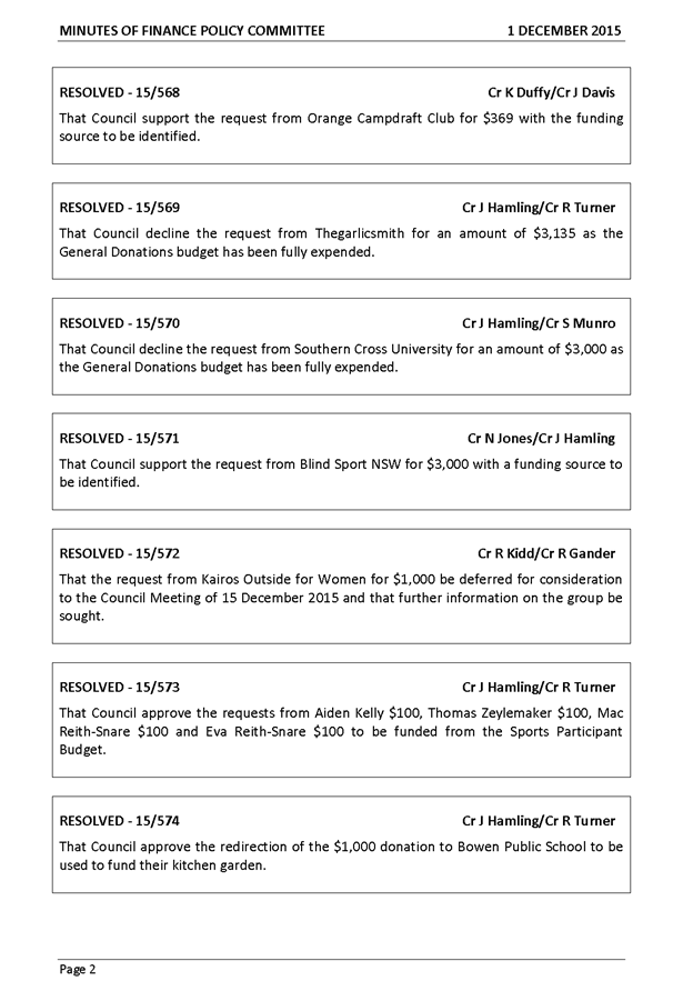

Council
Meeting
15 December 2015
5.4 Recommendations
and Resolutions from Policy Committees
Attachment 6 SPC 1
December 2015 Minutes
5.5 Outstanding
Questions Taken on Notice
TRIM
REFERENCE: 2015/3266
AUTHOR: Michelle
Catlin, Manager Administration and Governance
EXECUTIVE Summary
Councillors have the opportunity to ask questions of the
General Manager throughout Council and Committee meetings. While many questions
asked can be answered at the meeting, or via a memo circulated to Councillors
after the meeting, some questions require further action.
To ensure these questions are recorded and monitored, the
attached table is updated, and is provided to Council for information.
Link To Delivery/OPerational Plan
The recommendation in this report relates to the
Delivery/Operational Plan strategy “1.2 Our City -
Information and advice provided for the decision-making process will be
succinct, reasoned, accurate, timely and balanced”.
Financial Implications
Nil
Policy and Governance Implications
Nil
|
Recommendation
That the information provided in the report by the
Manager Administration and Governance on Questions Taken on Notice be
acknowledged.
|
further considerations
Consideration has been given to the
recommendation’s impact on Council’s service delivery; image and
reputation; political; environmental; health and safety; employees;
stakeholders and project management; and no further implications or risks have
been identified.
SUPPORTING INFORMATION
Attached is a table of outstanding questions taken on notice
from the Council Meetings held from 15 April 2014 to present. Where action has
been taken on a particular question, this is noted in the “action”
column. A new section has been added to the report where a matter arising has
been progressed as a works request so Councillors are provided with an update
on those items that require works to be scheduled.
Attachments
1 Outstanding
Questions Taken on Notice, 2014/745⇩
Council Meeting
15 December 2015
5.5 Outstanding
Questions Taken on Notice
Attachment 1 Outstanding
Questions Taken on Notice
2014/745
OUTSTANDING
QUESTIONS TAKEN ON NOTICE
COUNCIL MEETINGS
|
Date of Meeting
|
Question
|
Responsible Staff Member
|
Action
|
|
1 Dec
2015
|
Cr
Turner requested an update report on the old saleyards site.
|
Director Corporate and Commercial Services
|
Report
to be provided.
|
|
Cr
Gryllis requested an inspection for the Museum be arranged for interested
Councillors.
|
Director Community, Recreation and
Cultural Services
|
Inspection
proposed for 11 December.
|
|
17 Nov
2015
|
Cr
Gander requested a Councillor briefing on the RSPCA.
|
Manager Building and Environment
|
Briefing
to be scheduled.
|
|
Cr
Jones requested an update on the status of Kurim shops.
|
Manager Building and Environment
|
Council's
Manager of Building and Environment carried out an inspection of the site on
Tuesday 17/11/15 contacted the owner of the Kurim Shops site. The owner
agreed to again secure the site (it was found that vandals had removed part
of an iron clad wall at the rear of the building in order to gain access).
The owner has agreed to have the grass cut.
|
|
Cr
Turner requested a Councillor briefing on the status of the old hospital site
and adjacent nurses quarters.
|
Director Development Services
|
Briefing
to be scheduled.
|
|
The
Mayor requested a report identifying Council’s resolved position on the
requirement for footpaths to be installed in new/existing areas.
|
Manager Administration and Governance
|
Report
to be provided.
|
|
20 Oct 2015
|
Cr
Taylor requested a check of the play equipment in Newman Park and
investigation into the possibility of installing additional equipment.
|
Manager City Presentation
|
The
equipment provided at Newman Park is considered to be in reasonable
condition. Council could give consideration to the addition of a swing set to
increase the variety of play experiences. A swing set will cost in the order
of $4,500 to $6,000 if installed at a time when other play equipment is being
installed within Orange.
Council
could consider allocating $6,000 in the 2016/2017 Delivery Plan.
|
|
Cr
Hamling requested a report investigating the possibility of installing play
equipment into Wentworth Reserve.
|
Manager City Presentation
|
A
notice of motion from Cr Hamling is listed for Council’s meeting of 15
December 2015.
|
|
15 Sept 2015
|
Cr Gander requested the ‘no stopping’
signage be reviewed in front of Bletchington School adjacent to the previous
location of the pedestrian crossing.
|
Commercial and Emergency Services
Manager
|
The
“No Stopping” sign has repositioned.
|
|
16 June 2015
|
Cr Kidd requested an update on plans for landscaping
the triangle section of land between the Northern Distributor Road and the
Mitchell Highway
|
Director Technical Services
|
Information
to be circulated to Councillors.
|
|
17 Mar 2015
|
Cr Taylor requested a review of Council’s
process for determining requests to waive hire fees for the Orange Function
Centre, and include a review of costs for making the Centre available.
|
Director Community, Recreation and
Cultural Services
|
Information
provided to Councillors by memo.
|
|
2 Sept 2014
|
Cr Hamling requested a briefing to consider options
for private cars for sale being parked on Council land, particularly on the
Northern Distributor Road and the Escort Way, and Jack Brabham Park.
|
Director Development Services
|
This item has been included on the Councillor Briefing
Schedule.
|
|
15 April 2014
|
Cr
Taylor requested consideration be given to further noise abatement issues at
the residential properties in Anson Street adjacent to the Northern
Distributor Road.
|
Director Technical Services
|
The design of a suitable sound mound has been
completed. This project, including landscaping options and ongoing
maintenance costs will be included for consideration for funding in the
2016/17 Delivery Plan.
|
5.6 Request
For Financial Assistance
TRIM REFERENCE: 2015/3218
AUTHOR: Josie
Sanders, Management Accountant
EXECUTIVE Summary
Council is in receipt of requests for financial assistance
under section 356 of the Local Government Act 1993.
Link To Delivery/OPerational Plan
The recommendation in this report relates to the
Delivery/Operational Plan strategy “3.3 Our City –
Recognise that members of the community will take different leadership
pathways, the Council will support this growth and development through
appropriate activities, initiatives and assistance”.
Financial Implications
If Council resolves as per
recommendations of this report, the following balances remain in 2015/16
budget.
|
Program
|
Adopted Budget
|
Actual/Committed
|
Remaining balance
|
|
General Donations
|
111,674
|
116,674*
|
Nil
|
|
Major Promotions
|
30,900
|
29,519
|
1,381
|
|
Sports Participant
|
10,900
|
5,850
|
5,050
|
|
Sports Facility
|
50,000
|
50,000
|
Nil
|
*NB: Includes 20 x $100 reserved for school prize giving
Policy and Governance Implications
Nil
|
Recommendation
1 That
Council defer consideration of the request from Orange Rifle Club for $15,000
to allow further discussion with the Club in relation to the relocation to
Eugowra.
2 That
Council decline the request from Kairos Outside for Women $1,000 as the
General Donations budget has been fully expended.
3 That
Council fund:
a The
Orange Campdraft Club request of $369 from the Showground hire income.
b The
Blind Sport NSW request of $3,000 from the Sports Participant program.
|
further considerations
Consideration has been given to the recommendation’s
impact on Council’s service delivery; image and reputation; political;
environmental; health and safety; employees; stakeholders and project
management; and no further implications or risks have been identified.
SUPPORTING INFORMATION
Council has received an application from the Orange Rifle
Club for $15,000 for the purchase of two electronic targets that will be
located at the Eugowra Range.
The total costs for this purchase is $25,000, which as per
the application, the Club would be contributing $10,000. Council’s policy
is that a dollar for dollar matching of funds is required under the Sports
Facility program. Council’s policy also suggests that it must demonstrate
a broad community benefit, and it is noted that the targets will be located in
Eugowra.
The Club have provided a letter of support for their
application which is attached for Council’s reference.
A representative of the Club originally discussed Council
providing funds to assist in the removal of targets/equipment from the Rifle
Range. It is considered that there is a need to have further discussions with
the Club about the relocation to Eugowra, and on that basis, it is recommended
that the request for funding be deferred to allow Council staff to seek further
discussions with the executive of the Orange Rifle Club.
Kairos Outside for Women
At its meeting of 1 December 2015, Council deferred
consideration of this request as more information was sought on the ongoing
nature of this request.
The financial assistance sought from Council is to assist
the applicant with meeting the costs of providing the event in Carcoar only.
The applicant has further disclosed that post this event, the applicant will be
offering ongoing support to participants.
Should Council be inclined to support this event, funds
could be reallocated from Council’s Community Safety program to cover the
$1,000 requested.
Orange Campdraft Club
At its meeting of 1 December 2015, Council approved the
request of $369, however as the General Donations allocation has been fully
expended, a further resolution of Council is required to reallocate the funds
required for this request.
As this request relates to the fees associated with the hire
of the Showground, the funds required for this donation can be sourced for the
Showground hire income.
Blind Sport NSW
At its meeting of 1 December 2015, Council approved the
request of $3,000, however as the General Donations allocation has been fully
expended, a further resolution of Council is required to reallocate the funds
required for this request.
Funds for this request can be reassigned from the Sports
Participant program.
Attachments
1 Donations
Table - 15 December 2015, D15/47320⇩
2 Orange
Rifle Club Inc., IC15/18053⇩
3 Orange
Rifle Club Letter, IC15/18250⇩
4 Kairos
Outside for Women, IC15/16107⇩
Council Meeting
15 December 2015
5.6 Request
For Financial Assistance
Attachment 1 Donations
Table - 15 December 2015
Sports Facility
|
No
|
Applicant
|
Amount Sought
|
Policy Position
|
Purpose
|
Comment
|
Recommendation
|
To be advertised
|
|
A.1
|
Orange Rifle Club Inc.
|
$15,000
|
Maximum funding up to $15,000 per organisation.
Applicant must demonstrate a dollar for dollar matching of funds, and
demonstrate a broad community benefit.
|
To purchase new 2 electronic targets to accompany
the 2 existing targets being relocated to the Eugowra Range.
|
Budget fully expended
|
Nil
|
No
|
Council
Meeting
15 December 2015
5.6 Request
For Financial Assistance
Attachment 2 Orange
Rifle Club Inc.


Council
Meeting
15 December 2015
5.6 Request
For Financial Assistance
Attachment 3 Orange
Rifle Club Letter

Council
Meeting
15 December 2015
5.6 Request
For Financial Assistance
Attachment 4 Kairos
Outside for Women


5.7 Request
For Financial Assistance To Host Small Halls Festival 2016
TRIM
REFERENCE: 2015/3271
AUTHOR: Sharon
D'Elboux, Manager Business Development
EXECUTIVE Summary
Council is in receipt of request for financial assistance
under section 356 of the Local Government Act 1993.
Link To Delivery/OPerational Plan
The recommendation in this report relates to the
Delivery/Operational Plan strategy “10.2 Our Economy
– Facilitate and support the attraction and development of events,
festivals, venues and activities for residents and visitors, ensuring access
and participation for older people”.
Financial Implications
It is proposed that this request be funded from within
Council’s existing events budget.
Policy and Governance Implications
Nil
|
Recommendation
That Council support the request for funding from JAM
Orange Committee for the Small Halls Festival 2016 to $5,000, to be met from
within Council’s existing events budget.
|
further considerations
Consideration has been given to the
recommendation’s impact on Council’s service delivery; image and
reputation; political; environmental; health and safety; employees;
stakeholders and project management; and no further implications or risks have
been identified.
SUPPORTING INFORMATION
Council has received an application from the JAM Orange Committee
for funding of $5,000 to host the Small Halls Festival 2016. The Festival of
Small Halls is a series of tours that takes the best folk and contemporary
acoustic artists performing at two of Australia’s largest festivals, and
sends them on the road to tiny halls in communities all over Australia.
Orange City Council hosted the event in 2015 and it was well
attended and embraced. As a result, Orange has been offered to be a part of the
tour locations for 2016.
Following the successful hosting in 2015 a
community group was formed to support local live music – JAM Orange. This
group aims to support local musicians, students and venues through providing
performance opportunities, workshops and promotions. They have offered to
assist Council in hosting Small Halls 2016 with a view to taking on the event
management in future years and expanding it to include workshops, markets and
other performances. Any funds raised from this event will go towards future
activities of the JAM Orange group in support of local, live music.
It is proposed that the Small Halls Festival for Orange be
held on Saturday 2 April at the Bloomfield Hall. The target audience for this
event is those interested in music from Orange and various Central West
communities.
In addition to the concert, other proposed activities of the
festival include:
· music
workshops – targeting the general public
· mentoring
workshops – targeting young people interested in music
· open
mic sessions enabling local musicians to perform
· art
and craft stalls
· food
and beverage stalls
JAM Orange Committee formed in July 2015. Their objectives
are:
· Support
music in the Orange region
· Support
and develop local musicians
· Support
and develop music events
· Develop
a local music festival
The Committee consists of volunteers with experience in
music promotion, local business management, musicians, administration, event
management, public relations, teachers/mentors, project management and
crowdsource funding specialist.
Attachments
1 Request
donation - JAM Orange - Festival of Small Halls - 2 April 2016, IC15/18563⇩
Council Meeting
15 December 2015
5.7 Request
For Financial Assistance To Host Small Halls Festival 2016
Attachment 1 Request
donation - JAM Orange - Festival of Small Halls - 2 April 2016


5.8 Complaints
Under Council's Code of Conduct
TRIM
REFERENCE: 2015/3262
AUTHOR: Michelle
Catlin, Manager Administration and Governance
EXECUTIVE Summary
The General Manager is required to report annually on
complaints made under Council’s Code of Conduct.
This report summarises the complaints processed up to 30
September 2015. The statistics provided in this report have been supplied to
the Office of Local Government, as required by the Procedures for the
Administration of the Code of Conduct.
Link To Delivery/OPerational Plan
The recommendation in this report relates to the
Delivery/Operational Plan strategy “1.1 Our City -
Provide easily obtainable information on the legal responsibilities of
Councillors, Council staff and the community”.
Financial Implications
The total cost to 30 September 2015 for investing complaints
under the Code of Conduct against Councillors, including staff time, is in the
order of $86,450. This does not include any time spent by the General Manager
in relation to these complaints.
Policy and Governance Implications
Complaints made under the Code of Conduct and managed in
accordance with the Procedures for the Administration of the Code. Part 12 of
these Procedures requires a report be provided on an annual basis, summarising
the complaints made over the year.
|
Recommendation
That the report on complaints under Council’s
Code of Conduct for the 2015 year be acknowledged.
|
further considerations
Consideration has been given to the
recommendation’s impact on Council’s service delivery; image and
reputation; political; environmental; health and safety; employees;
stakeholders and project management; and no further implications or risks have
been identified.
SUPPORTING INFORMATION
The Procedures for the Administration of the Code of Conduct
require a range of statistics to be reported to Council within three months of
the end of September each year, and also to be provided to the Office of Local
Government.
The following table provides
information in relation to Code of Conduct matters dealt with over 2015.
|
Required information
|
Comment
|
|
Total number of Code of Conduct complaints made about
Councillors and the General Manager under the Code of Conduct in the year to
September
|
2 complaints made and finalised in the year
|
|
Number of Code of Conduct complaints referred to a
Conduct Reviewer
|
2
|
|
Number of Code of Conduct complaints finalised by a
Conduct Reviewer at the Preliminary Assessment stage and the outcome of those
complaints
|
1 complaint. This complaint contained 24 allegations
and was referred to a Conduct Reviewer. The Reviewer determined to take no
action on all but one matter, which has been resolved by the General Manager
and which had been acted upon prior to complaint.
|
|
Number of Code of Conduct complaints investigated by a
Conduct Reviewer
|
0
|
|
Number of Code of Conduct complaints investigated by a
Conduct Review Committee
|
1
|
|
Without identifying particular matters, the outcome of
Code of Conduct complaints investigated by a Conduct Reviewer or Conduct
Review Committee under the Procedures
|
Panel found breaches. Reported to Council in February
2015 and finalised in April 2015. The matter was resolved by public
apologies.
|
|
Number of matters reviewed by the Office, and without
identifying particular matters, the outcome of the reviews
|
0
|
|
The total cost of dealing with Code of Conduct
complaints made about Councillors and the General Manager in the year to
September, including staff costs.
|
$86,450
|
5.9 Lease
- Orange Society of Model Engineers - Matthews Park
TRIM
REFERENCE: 2015/3195
AUTHOR: Michelle
Catlin, Manager Administration and Governance
EXECUTIVE Summary
The Orange Society of Model Engineers has been leasing its
current site at Matthews Park for over 30 years. This report seeks
Council’s approval to enter into a new lease for the continued use of the
site by the group.
Link To Delivery/OPerational Plan
The recommendation in this report relates to the
Delivery/Operational Plan strategy “6.3 Our Community
– Ensure the sporting and recreational facilities, programs, activities
and health programs provided by Council are effectively and efficiently
managed, affordable and support healthy lifestyle choices”.
Financial Implications
Nil
Policy and Governance Implications
Nil
|
Recommendation
1 That
Council enter into a lease with the Orange Society of Model Engineers for
part of Matthews Park for a term of 10 years with a 10 year option at rental
of $1 per annum.
2 That
permission be granted for the use of the Council Seal on all necessary
documentation.
|
further considerations
Consideration has been given to the
recommendation’s impact on Council’s service delivery; image and
reputation; political; environmental; health and safety; employees;
stakeholders and project management; and no further implications or risks have
been identified.
SUPPORTING INFORMATION
The Orange Society of Model Engineers is a miniature live
steam club running steam, electric and petrol locomotives. It was founded in
May 1982 and has been utilising Matthews Park since 1984. The Club holds
monthly public running days, offering affordable miniature train rides.
Popularity of this facility continues to increase, with the monthly days
providing up to 800 rides.
Matthews Park is Crown Land with Council the Trustee, so
Ministerial Consent will be required for this lease.
5.10 Streetlighting
Upgrade Orange CBD
TRIM
REFERENCE: 2015/3329
AUTHOR: Chris
Devitt, Director Technical Services
EXECUTIVE Summary
Council’s Delivery/Operational Plan
identifies funding to replace the existing Council owned under-awning lighting
system in the Central Business District (CBD) over the next three years.
Following investigations into this issue Council has now been provided with a
lighting design which can be installed in the CBD to provide a uniform and
consistent spread of lighting throughout the CBD. The proposed solution
involves pole-mounted lights located at uniform spaces behind the kerb on both
sides of the street, which can be operated independently of the existing
under-awning system, which will be removed once the new scheme is operational.
Link To Delivery/OPerational Plan
The recommendation in this report relates to the
Delivery/Operational Plan strategy “14.1 Our Environment
– Design and construct new infrastructure assets as specified with the
Asset Management Plan to agreed levels of service”.
Financial Implications
Funding for this work has been identified in the current
four year Delivery/Operational Plan
Policy and Governance Implications
Nil
|
Recommendation
That Council endorse the installation of the proposed
pole-mounted CBD pedestrian lighting scheme to replace the existing Council
owned under-awning lighting scheme, as outlined in the report to the 15
December 2015 Council Meeting.
|
further considerations
Consideration has been given to the
recommendation’s impact on Council’s service delivery; image and
reputation; political; environmental; health and safety; employees;
stakeholders and project management; and no further implications or risks have
been identified.
SUPPORTING INFORMATION
Council has identified, in the four year
Delivery/Operational Plan, the need to improve the existing Council owned
under-awning lighting in the CBD, extending from William Street to Sale Street.
At the present time the majority of these lights, which are required to light
the CBD and contribute towards a safe and functional CBD at night, are attached
to building awnings. The original lighting scheme was installed in the 1960’s
by Ophir County Council and operated by subsequent electricity providers, with
ownership and responsibility transferred to Council from Advanced Energy in the
early 1990’s.
An inspection of the Council owned under-awning network has
revealed that there is a need to substantially upgrade this system due to the
overall functionality of the system, the numerous points of electrical supply
which also overlap with other customers and the varied level of lighting within
the CBD. This upgrade would also enable Council to manage the system more
effectively in the future. In response to the need to undertake this work
funding of $170,000 per annum has been provided in the current financial year
as well as the 2016/17 and 2017/18 financial years.
Council has recently engaged consultants to provide advice
on the most appropriate type of lighting layout for the CBD. Their recommended
solution, as shown in attachment 1, involves installation of a network of new
lights behind the kerbs along both sides of the street which are completely
independent of the building awnings. This solution enables a consistent and
uniform spread of lighting to be achieved throughout the whole CBD, regardless
of whether there is a building awning over the footpath or not. The level of
lighting achieved will be appropriate for the operation of the existing CCTV
network throughout the CBD. The lights are designed to be very simple and
unobtrusive as an element in the CBD, not to act as a streetscape feature
themselves, but to serve a functional purpose in lighting the footpaths and
adjacent features in the CBD such as buildings, landscaping and other elements.
This approach should also ensure that these lights will also blend in easily
with any future upgrading of the overall CBD. From a streetscape perspective,
Orange has an enviable variety of attractive buildings and streetscape features
that obviates the need to use ornate light poles and lamps in the streetscape.
The proposed lighting solution will utilise LED lights and
involve installation of conduits in a trench located behind the kerb and
gutter, with concrete footings for the new poles constructed at 15m spacing
along each side of the street. While this work will create some disruption in
the CBD during construction it should be completed in a relatively short time
period and provide a significant long term benefit to the look and function of
the CBD. There will still be opportunities for individual businesses to provide
additional lighting to their premises as well as, where appropriate, enable
targeted feature lighting to be installed to highlight particular features
within the CBD. The layout of the new lights will be undertaken to minimise the
number of additional poles in the CBD, with options to be examined in the
detailed design phase including possibly mounting new lights on existing
overhanging streetlight poles as well as making use of lighting poles to also
accommodate regulatory/parking signs currently located in the CBD. The upgrade
is designed to provide lighting to the footpath and parking lanes only and to
function in an integrated way with the taller light poles that provide light
for the roadway traffic lanes to meet the relevant requirements of public light
standards.
Council has been working closely with Essential Energy in
the development of this solution and will continue this collaboration as the
project moves into the detailed design and delivery phase. As well, the
opportunity exists to potentially include this work in the delivery of the NBN
through then sharing of trenches to minimise overall disruption in the CBD in
the provision of this key infrastructure.
Attachments
1 Indicative
Section - CBD Streetlighting, 2015/3331⇩
Council Meeting
15 December 2015
5.10 Streetlighting
Upgrade Orange CBD
Attachment 1 Indicative
Section - CBD Streetlighting

5.11 Robertson
Park Toilets - Co-location with CWA Hall
TRIM
REFERENCE: 2015/3282
AUTHOR: Scott
Maunder, Director Community, Recreation and Cultural Services
EXECUTIVE Summary
This report provides Council with the proposed design for
the intended co-location of a new amenities block with the Country
Women’s Association (CWA) Hall in Robertson Park. Council’s
agreement is sought for the final design, and if obtained proceed with the
Development Application for the new amenities.
Link To Delivery/OPerational Plan
The recommendation in this report relates to the
Delivery/Operational Plan strategy “5.1 Our Community
– Identify changing community aspirations and undertake community
engagement and planning for the creation of open spaces, recreational
facilities and services, recognising the special needs of older people and
those with disabilities”.
Financial Implications
The cost estimate to proceed to
appropriate design to development application stage is:
|
Architectural fee for DA/CC
drawings
|
$15,000
|
|
Structural fee for construction
drawings
|
$920
|
|
|
$15,920
|
It is estimated that the total construction cost would be in
the vicinity of $228,000 which includes new building works based on square
metre rates and external works. It should be noted that this estimation is
based on a square metre rate which is higher because of the amount of wet area
to be constructed and a contingency of 20%. If approved funds will be
identified at the next quarterly budget review and brought to Council for their
consideration.
Policy and Governance Implications
Nil
|
Recommendation
That Council accepts the design for the co-location of
Robertson Park amenities with the Country Women’s Association Hall and
proceed with the lodgement of a Development Application.
|
further considerations
The
recommendation of this report has been assessed against Council’s other
key risk categories and the following comments are provided:
|
Service Delivery
|
No public amenity is available in
Robertson Park.
|
|
Image
and Reputation
|
Council has received criticism in
relation to the lack of public amenities in Robertson Park, particularly at
times of major events held in the Park.
|
SUPPORTING INFORMATION
The discussion relating to the
construction of an amenities block in Robertson Park has been an ongoing
process. In December 2014 Council resolved:
|
RESOLVED – 14/1053 Cr
N Jones/Cr R Turner
That Council defer development application DA
295/2014(1) for Recreation Area (amenities facility) at Lot 702 DP 1002273 -
Robertson Park - 269-279 Summer Street, Orange pending further investigation
of alternate locations (including the CWA Hall).
|
Discussions were held with the Country Women’s
Association (CWA), requesting the Association reconsider the co-location of new
amenities facility with the CWA Hall to which they agreed to this request.
Council called for quotations from an experienced designer
to develop a concept design for the demolition and rebuild of existing
amenities block at the CWA Hall including three external public use toilets,
three to four internal only use toilets and the option for access from the CWA
rooms to the external toilets if required.
After appropriate consultation with the CWA representative
and the architect, two design options were presented to the Council at its
meeting of 6 October 2015 at which Council resolved:
|
RESOLVED - 15/467 Cr
S Munro/Cr C Gryllis
1 That
Council co-locate the new amenities block in Robertson Park with the Country
Women’s Association Hall.
2 That
Council proceed with option 1 as set out in this report to progress to the
detailed design stage.
|
Further discussions were held with the Architect and the CWA
to develop a design which would deliver a facility including two general
cubicles and one cubicle for people with a disability which can be accessed
from within the building, and public toilets which would include two general
cubicles and one cubicle for people with disability.
The design would also see the addition of a new mothers
room, kitchen and secure courtyard which would complement the façade of
the building.
It was also noted that the final
plan should deliver the following outcomes:
· Resolve
the issue of the need for disability access to building. In its current form
there is no disabled access to the building and/or toilet facilities.
· Allows
the mothers/meeting room to open out onto the fenced courtyard which provides
an enclosed safe and secure area within the park.
· Includes
the upgrade of the kitchen and mothers room which will assist hirers of the
Hall by providing modern and up to date facilities benefiting numerous community
groups especially during significant events such as Food Week and Anzac Day.
· Will
result in increased hiring of the building and will be seen as an added
community benefit.
· Sees
the addition of a private courtyard with a surrounding fence reducing the
opportunity of vandalism which historically occurs in concealed spaces.
· An
enclosed courtyard will also allow the responsible service of alcohol to take
place, which again will increase the use of the building and will also enforce
greater controls around this area especially during the times of festivals and
functions.
This allowed the CWA building and amenities block to be seen
as a holistic building whilst consolidating social infrastructure, avoiding a
fragmented design and providing a clean integration with the CWA Building.
The design was received from the Architect, reflecting the
design brief as outlined above.
Further consultation has taken place with CWA
representatives and it was requested the Association consider the final design,
provide feedback and/or in principal approval.
Council has been advised that at its meeting of 3 December
2015 the CWA has provided in-principal approval, with the inclusion of extended
security for windows and final agreement on disabled access to the Hall.
Council’s approval is now sought for the final design
and to proceed with the lodgement of a development application.
Upon approval of the development application, tenders will
be called for the completion of works, and a further report will be bought back
to Council to proceed with the next stage of the project.
Attachments
1 CWA
Toilets View 1, D15/48094⇩
2 CWA
Toilets View 2, D15/48100⇩
3 CWA
Toilets Floor Plan, D15/48096⇩
4 CWA
Toilets Site Plan, D15/48098⇩
5 CWA
Toilets Elevations, D15/48091⇩
6 CWA
Toilets Sections, D15/48092⇩
7 CWA
Toilets Roof Plan, D15/48099⇩
8 CWA
in principal support for the proposed Robertson Park amenities plan, D15/48487⇩
Council Meeting
15 December 2015
5.11 Robertson
Park Toilets - Co-location with CWA Hall
Attachment 1 CWA
Toilets View 1

Council
Meeting
15 December 2015
5.11 Robertson
Park Toilets - Co-location with CWA Hall
Attachment 2 CWA
Toilets View 2

Council
Meeting
15 December 2015
5.11 Robertson
Park Toilets - Co-location with CWA Hall
Attachment 3 CWA
Toilets Floor Plan

Council
Meeting
15 December 2015
5.11 Robertson
Park Toilets - Co-location with CWA Hall
Attachment 4 CWA
Toilets Site Plan

Council
Meeting
15 December 2015
5.11 Robertson
Park Toilets - Co-location with CWA Hall
Attachment 5 CWA
Toilets Elevations

Council
Meeting
15 December 2015
5.11 Robertson
Park Toilets - Co-location with CWA Hall
Attachment 6 CWA
Toilets Sections

Council
Meeting
15 December 2015
5.11 Robertson
Park Toilets - Co-location with CWA Hall
Attachment 7 CWA
Toilets Roof Plan

Council
Meeting
15 December 2015
5.11 Robertson
Park Toilets - Co-location with CWA Hall
Attachment 8 CWA in
principal support for the proposed Robertson Park amenities plan
Country Women’s
Association of NSW
Orange branch PO Box 621 Orange NSW 2800
7 December 2015
Mr Scott Maunder
Director
Community, Recreation and Cultural Services
Orange
City Council
PO Box
35
Orange
NSW 2800
Dear
Mr Maunder
Reference D15/47319
Thank you for providing the
plans for the proposed co-location of the CWA and Orange City Council amenities
facilities in Robertson Park. Members support the development in principle and
have reviewed the plans in the light of the Branch’s overall aims for the
proposed development. We offer the following feedback on the achievement of our
desired aims.
1. To
allow a satisfactory solution to the co-location of public toilets with the CWA
hall and rooms. Members feel this has been achieved in the proposed plan.
2. To
facilitate the construction of new toilets, kitchen and meeting room attached
to the existing CWA hall that meet the required standards for disability
access. Ideally we would like to be able to offer access for disabled
members through all entrances to the hall. However, we understand the
limitations of the site and believe that with some modifications, (designated
disability parking spaces, appropriate access from road to pavement, paved
access to the new entrance, safe emergency egress) the proposed access could
meet the required standard and be dignified, equitable and cost-effective.
3. To
design a kitchen that is suitable for future medium size catering events for
approximately 80-100 people. Members feel that the proposed plans and size
of the kitchen will allow this to be achieved.
4. To be able
to use the meeting room and hall for concurrent but separate events. At present
access to the toilets from the hall is through the meeting room or the kitchen
neither of which is entirely satisfactory. Separate access from the hall to the
toilets would be ideal but may not be possible with the present design. If this
were the
case we would accept a limitation on concurrent but separate use of the hall
and meeting room.
5. To
minimise maintenance costs and optimise security. As a community
organisation with limited funds we need to minimise maintenance costs and
optimise security by careful use of building materials, screen doors, hardened
glass and good design. We believe that this is possible and has largely been
achieved by the proposed plan. However we have asked for some clarification on
the durability and/or replacement cost of the attractive glass brick feature
and the possible substitution of some glass with other tougher and better insulated
materials.
We are excited and grateful
for the opportunity that this proposed plan represents for the CWA, for Council
and for the community and within reason we are prepared to “cut our suit
to fit our cloth”. Please contact me if you need clarification of our
position or further discussion. My contact number is 0408 254 360.
Yours sincerely
Deborah Marr
Secretary
CWA Orange Branch
5.12 Fence
Between 1 and 3 Summer Street
TRIM
REFERENCE: 2015/3324
AUTHOR: Michelle
Catlin, Manager Administration and Governance
EXECUTIVE Summary
At its meeting held on 3 November 2015, Council approved
development application DA3619/2015(1) for the demolition of 1 Summer Street.
As a matter arising, Council further resolved:
|
RESOLVED - 15/505 Cr
J Hamling/Cr K Duffy
That the General Manager negotiate with the owners of 3
Summer Street, the construction of a suitable 2.1 metre high fence adjoining
1 Summer Street with the outcome to be reported to Council.
|
This report provides the outcome of
this negotiation.
Link To Delivery/OPerational Plan
The recommendation in this report relates to the
Delivery/Operational Plan strategy “13.4 Our Environment
– Monitor and enforce regulations relating to City amenity”.
Financial Implications
The cost of the proposed fence is in the order of $6,000 and
is proposed to be fully funded by Council as part of the demolition of 1 Summer
Street.
Policy and Governance Implications
Nil
|
Recommendation
That the report by the Manager Administration and
Governance on the fence between 1 and 3 Summer Street be acknowledged.
|
further considerations
Consideration has been given to the
recommendation’s impact on Council’s service delivery; image and
reputation; political; environmental; health and safety; employees;
stakeholders and project management; and no further implications or risks have
been identified.
SUPPORTING INFORMATION
The owners of 3 Summer Street, in their submission on the
development application to demolish 1 Summer Street, requested Council meet the
full cost of replacing the existing fence, with a two metre high double brick
wall. This was estimated at a cost of $20,000-$30,000.
A condition of the development consent included Council
extending the existing fence with a 0.3m high matching Colorbond
‘lattice’ style extension.
Following Council’s resolution to negotiate with the
owners, staff have met with the owners on site, and discussed their concerns in
relation to the fence.
The owners of 3 Summer Street have changed their request
from a 2m high double brick fence, to a 1.8m high wood paling fence. This has
been costed, and is in the order of $6000.
The General Manager has agreed to meet 100% of the costs of
this replacement fence. Given that Council’s plans for 1 Summer Street
are not yet known, and the owners have agreed to a more reasonable solution, it
is considered a reasonable compromise. The owners of 3 Summer Street have
thanked Council for the resolution of this matter.
This fence will be completed as soon as possible.
5.13 Shiralee
DCP Amendment - Post Exhibition
TRIM
REFERENCE: 2015/3264
AUTHOR: Craig
Mortell, Senior Planner
EXECUTIVE Summary
Council placed amendments to the Shiralee Development
Control Plan (DCP) Master Plan and Orange Development Control Plan 2004 on
public exhibition between 10 October 2015 and 9 November 2015. The amendments
relate to street lighting and solar access requirements in the Shiralee suburb
as well as a revised introduction and table in chapter 7 of DCP 2004 intended
to clarify which controls apply to different areas of the City.
There was a single submission during the exhibition period.
The submission was from a local property developer advising on a range of
potential issues from the overall Shiralee DCP Master Plan. The issues raised
are largely unrelated to the focus of the draft amendment but are being taken
under advisement as development of the suburb proceeds. Should the concerns be
borne out a further amendment can be drafted for consideration at a later date.
Link To Delivery/OPerational Plan
The recommendation in this report relates to the
Delivery/Operational Plan strategy “1.2 Our City -
Information and advice provided for the decision-making process will be
succinct, reasoned, accurate, timely and balanced”.
Financial Implications
Nil
Policy and Governance Implications
Nil
|
Recommendation
That Council adopt the draft amendments to the Shiralee
Development Control Plan Master Plan and chapter 7 of Orange Development
Control Plan 2004.
|
further considerations
Consideration has been given to the recommendation’s
impact on Council’s service delivery; image and reputation; political;
environmental; health and safety; employees; stakeholders and project
management; and no further implications or risks have been identified.
SUPPORTING INFORMATION
During pre-lodgement discussions and preliminary assessments
of the first Shiralee subdivisions some concerns were raised regarding whether
future dwellings on some of the lots, particularly east-west oriented compact
lots, would be able to achieve the solar access requirements.
Council’s normal solar access requirements are
outlined in chapter 7 of DCP 2004 which are intended to apply to most
situations across the City where more conventional lot sizes and dimensions are
the norm. The Shiralee Master Plan introduces a higher level of density which
in some cases could struggle to achieve full compliance.
Past experience has shown that technical compliance is
sometimes achieved in an undesirable manner ie where a north facing window does
not receive sufficient sunlight some designs simply remove the window
altogether resulting in cavern-like interiors that deny residents any natural
light.
Staff investigated this matter in some detail resulting in
the Shiralee DCP Master Plan amendment which refines the solar access
requirements establishing appropriate and achievable levels of solar access
requirements that respond to the subdivision design.
Similarly the amendment also seeks to ensure that
subdivision street lighting will be of an appropriate standard, energy
efficient and relatively consistent across the emerging suburb.
Given the inter-relationship between the Shiralee Master
Plan and chapter 7 of DCP 2004, as well as the existing area specific provisions
of chapter 7, it was considered appropriate to create a new introduction to
chapter 7 that clarifies which provisions apply to different areas of the City.
This change is purely intended to assist interpretation of the document
particularly for the casual user, and does not materially change any design
standard or requirement.
Submissions
A submission was received from a local developer whose
comments are related to issues that are beyond the scope of the proposed
amendments. In particularly the submission discusses:
Section 5.1 Building Form and Layout. Specifically in
relation to the prohibition on roof mounted water tanks.
Section 5.6 Universal Design. Objecting to the controls on
door widths arguing that non-standard doors may add to costs. Also concerned
that window sill heights may make homes harder to furnish.
Section 6.1 Landscaping. Does not support size requirements
for trees in front and rear yards.
Section 6.2 Fences. Expressing concern that requirements on
secondary street frontage fencing may not provide sufficient privacy for
residents.
Section 7.2 Landscape. Concerned that street landscaping
prior to the construction of the homes will be damaged and lead to additional
costs.
Section 8.0 Environmental management. Concerned that needing
to vary architectural elements and provide articulated designs may increase
build costs.
As stated these matters are not
relevant to the current amendment. Nonetheless staff will review the above
concerns as development applications are received. Where the concerns are born
out a further review and amendment of the Master Plan may be considered.
Conclusion
The draft amendments to the Shiralee DCP Master Plan and
chapter 7 of Orange DCP 2004 have been publicly exhibited and the only
submission received did not relate to the substance of the amendment. The
amendments will improve the Master Plan and enable appropriate designs to
achieve reasonable levels of solar access. The amendments will also assist in
delivering a quality streetscape outcome by providing guidance on appropriate
street-lighting designs.
Accordingly the draft amendments to Shiralee DCP Master Plan
and chapter 7 of the Orange DCP 2004 are recommended for adoption.
5.14 Spring
Hill Master Plan
TRIM
REFERENCE: 2015/3268
AUTHOR: Scott
Maunder, Director Community, Recreation and Cultural Services
EXECUTIVE Summary
The draft Spring Hill Master Plan been completed and this
report seeks Council’s approval to place the draft Plan on public
exhibition.
Link To Delivery/OPerational Plan
The recommendation in this report relates to the
Delivery/Operational Plan strategy “13.4 Our Environment
– Monitor and enforce regulations relating to City amenity”.
Financial Implications
Nil
Policy and Governance Implications
Nil
|
Recommendation
That Council place the draft Spring Hill Master Plan on
public exhibition.
|
further considerations
The recommendation of this report has been
assessed against Council’s other key risk categories and the following
comments are provided:
|
|
|
|
Image
and Reputation
|
Opportunity for the creation of
goodwill with the broad engagement of the community.
|
|
Stakeholders
|
Council has been working with the
Spring Hill community for many years and it is through the Community
Committee that Council has primarily developed the Master Plan to reflect the
desires of the community and to provide a plan for future long term growth.
|
SUPPORTING INFORMATION
Council has been working with the Spring Hill Community
Committee for the past several years to retain and enhance Spring Hill which
has included a Spring Hill Strategic Plan developed in 2011 and the Public
Space Master Plan developed in 2013.
Recognising the need for the development of a comprehensive
Master Plan for villages in Orange, Council commenced a planning process for
both Lucknow and Spring Hill.
To progress the Master Plan for Spring Hill a survey was
developed to obtain feedback from the community as to what they valued and
wanted to see for the future for Spring Hill. This information together with
the two previous plans was provided to Oculus Landscape Architects and Urban
Design to develop a conceptual master plan.
The conceptual master plan was developed and presented to
the Spring Hill community on 22 September 2015. Feedback was gathered at the
meeting, by email and through the “Your Say” web page.
A summary of the issues communicated were then incorporated
into the objectives and deliverable elements for the Spring Hill Master Plan,
these were:
1 Identification
and conservation of existing character of Spring Hill, including heritage core
2 Retention
of existing residential lot sizes
3 Provision
for smaller lots to promote business development in the village core
4 Improve
arrival experience including road access
5 Strengthen
commercial hub
6 Improve
facilities and access – park toilet and recreation ground
7 Improve
walking/access between key elements of village
8 Improve
drainage but not necessarily kerb and guttering across whole village
9 Manage
traffic speed – probably via plantings, road narrowing and crossings at
key points
10 Improve
connectivity between village heart and recreation ground
11 Provide
small growth option to east utilising development typology of existing village
12 Provide
broader scale development comment on impact of 2ha lots to south and west on
the village and possible rezoning options for those lots
The deliverables for the project
were:
A an
illustrative masterplan (to show long-term intent) for exhibition
B a
zoning and a lot size plan (for updating the Local Environmental Plan)
C identification
of key heritage buildings and spaces
D some
Development Control Plan (DCP) principles and controls (for inserting into the
Orange DCP)
These elements were incorporated into the draft Master Plan
which was presented to the community on 30 November 2015.
The plan was presented in two parts, Part A being the
current stage with the focus being in retaining the village elements of Spring
Hill whilst improving the public open space, arrival into town (trees lining
entrance streets to north and south), retaining heritage, improving footpaths
and guttering along the main street, improving access between the main elements
of town and importantly leaving the existing zoning for residential minimum lot
sizes in place (minimal infill). These elements reflected the key components
from the community.
The second part of the master plan was developed to provide
a planning framework for the growth of the village in the future. Council is
not certain when the demand for growth will occur, however with the low level
of housing or vacant lots available there is increasing demand for increased
housing.
DEVELOPMENT APPROACH
An extract from the Master Plan from Oculus follows outlines
the development approach:
The development of Spring Hill will enable the village to
enjoy a greater amount of activity, amenity and services that come with
additional density. To make sure that the village doesn’t lose its highly
valued character, new development will need to be carefully considered and also
sensitive to heritage. This will ensure that Spring Hill evolves as an active,
attractive, safe and people-friendly village.
Within the existing village, development will be focused
predominantly on infill residential, with additional opportunities for smaller
commercial and retail ventures arising through the population increase. The
focus is on “keeping it local” and not overdeveloping the village.
Additional development to the east needs to be sensitive
to the existing village’s views and character whilst offering a range of
different lot sizes to cater for a variety of potential future residents.
· Build
upon the village character of Spring Hill with well-considered infill
development and improvements
· Avoid
urban sprawl by providing discreet new developments, nestled in green, on the
least constrained lands
· Provide
opportunity for some subdivision of large rural lots but without compromising
the rural character of the area. Ensure each lot has adequate level area for a
building pad and good privacy.
· Retain
views to hills and rural landscape.
· Provide
a range of lot sizes within new development areas
· Locate
small lots with frontage to rural views and views over parks.
· Edge
urban development with streets, narrow one-way streets if necessary to keep
development costs down. Do not back lots onto open spaces.
· Improve
the architectural quality of existing and new buildings
The areas identified that have the most potential for
development were to the east and west of the existing village. The key elements
being:
TO THE EAST
· The
land is predominantly flat
· There
is a single owner for the land north of the oval
· Large
opportunity for development in this area, with consideration needed for water
management and visual buffers (to existing village houses and rural neighbours)
TO THE SOUTH AND WEST
· Cabonne
Council local government area
· Opportunity
for smaller ‘transition’ lots to the west given the amenity of the
school and proximity to the village heart.
Lot typologies were developed for these spaces that
included:
· Residential
lots vary in size from 300m2 - 2Ha+, providing diversity of housing
options and lifestyles.
· Smaller
lot sizes in the eastern expansion area (300-500m2) will meet demand
for more affordable housing and reflect changing demographics (smaller family
sizes, ageing population).
· Lots
ranging from 750 - 2000m2 will meet traditional demand for generous
sized residential lots with space for a family dwelling, double garage and
front and rear gardens.
· Lots
larger than 2000m2 in the eastern expansion area will:
- provide
a visual and physical transition to rural land.
- respond
to environmental issues (noise and vibration) in proximity to the railway
corridor.
· Lots larger than
2000m2 in the western area will:
- provide
a visual and physical transition between the village and 2Ha properties further
west.
Lot Controls suggested are:
· Site
coverage ratio is the ratio between the overall site area and the combined
footprint of all buildings on the property. The maximum site coverage ratio
allowed for each type of lot is:
- 55%
for lots sizes ranged from 300m2 - 500m2
- 40%
or maximum 350m2 for lots sizes ranged from 500m2 - 2000m2
- 20%
or maximum 500m2 for lots sizes 2000m2 and larger
· All
lots must have a direct street frontage to ensure good access and residential
amenity. Lots 5000m2 and larger are expected but must have boundary
landscaping to screen new development.
· Corner
lot dwellings are to have frontages to primary and secondary streets.
· Except
where shown otherwise on Master Plan options, all lots ranging from 300m2
- 2000m2 need to achieve a solar orientation where the long axis of
the lot is:
- For
north-south oriented lots between 20 degrees west of north or 30 degrees east
of north, or
- For
east-west oriented lots between 20 degrees north east or 30 degrees south east.
· In
order to retain and reinforce the existing rural lot pattern and character new
development is to incorporate existing hedgerows and mature trees.
Feedback at the meeting centred
on:
· acknowledging
that the main elements desired to retain and enhance the village of Spring Hill
had been incorporated into the plan
· Concern
that the development proposal may be too broad
· Concern
that landholders and other local government areas had not been consulted
· Concern
on possible impact of the Airport development
· Desire
for a road from the Airport across to Bathurst Road to reduce the potential for
heavy vehicle traffic increasing through the village.
At the meeting those in attendance
were also advised that the Master Plan is a planning process which looked at
the objectives of the community and the best outcome for future expansion. As
with the previous meetings it was stressed that:
· Any
expansion or subdivision could only occur if it was the desire of the
landholder and were subject to the full development application process
· Any
development or rezoning to the west of the village was a matter for Cabonne but
it was impossible to ignore from a planning context
· This
was a long term plan for the next 25, 50 years.
Community members were advised
that the draft Master Plan would be presented to Council for their
consideration to place on public exhibition at its meeting of 15 December 2015
and further advised that members of the public could address Council at that
meeting.
Attachments
1 Draft
Spring Hill Master Plan - December 2015, D15/47934⇩
Council Meeting
15 December 2015
5.14 Spring
Hill Master Plan
Attachment 1 Draft
Spring Hill Master Plan - December 2015


5.15 Community Land Plan of
Management
TRIM
REFERENCE: 2015/3261
AUTHOR: Shahreen
Alford, Recreation Planner
EXECUTIVE Summary
This report provides Council with an outline of the approach
to be utilised for plans of management for community land.
Link To Delivery/OPerational Plan
The recommendation in this report relates to the
Delivery/Operational Plan strategy “12.1 Our Environment
– Ensure the Plans of Management for the City’s natural resource
assets are current and reviewed”.
Financial Implications
Nil
Policy and Governance Implications
Nil
|
Recommendation
That the approach for the preparation of the Community
Land Plan of Management be adopted.
|
further considerations
Consideration has been given to the
recommendation’s impact on Council’s service delivery; image and
reputation; political; environmental; health and safety; employees;
stakeholders and project management; and no further implications or risks have
been identified.
SUPPORTING INFORMATION
In the Promoting Better Practice report presented to Council
on 1 December 2015 Council staff committed to the following: A report is to
be presented to Council in December 2015 to establish the approach to be
utilised in plans of management. It is expected that following adoption of this
approach, plans will be developed and presented to Council for adoption in
February/March 2016.
A complete assessment of Council’s community land
assets has been conducted, with specific attention to management practice and
procedures and the function of the existing Community Land Plans of Management.
A review of Plans of Management used by other local government areas (including
City of Sydney and Parramatta) demonstrated that the most effective method is
to develop a single integrated plan that covers all community land that
provides a greater degree of clarity for the Council, the community and asset
managers.
This approach ensures complete coverage of land parcels and
makes new parcels of community land easy to add, rather than having to produce
new plans for each parcel or classification type.
The approach recommended is to produce a revised document
that will detail permitted activities and management of all community land in
the Orange area required by the Local Government Act 1993 (the Act). The
current Plans of Management that will be superseded by the new Plan of
Management are:
· Lake
Canobolas, Wildlife Sanctuary and Scout Camp (2006)
· Rural
Parks (2004)
· Ploughmans
Valley (November 2006)
· Buildings
(2005)
· Major
Sports grounds (2005)
· Local
and Neighbourhood Parks (2005)
· Spring
Creek Reservoir (2007)
Significant omissions from the list of Community Land assets
covered by a Plan of Management are:
· Suma
Park Dam
· Gosling
Creek Reservoir
· Orange
Botanic Gardens
· Cook
Park
Although some of these areas have Master Plans that have
been adopted by Council, a Plan of Management is still required under the Act.
A Plan of Management is the principal guiding document that directs the future
planning and management of a park, while a Master Plan is a design document
that illustrates a broad physical concept for how the park might appear in the
long term; the implementation of which is described in the Plan of Management.
The Community Land Plan of Management has been prepared to
draft stage and is undergoing an internal review prior to presentation to
Council for its consideration. The suggested contents of the report will
include:
INTRODUCTION
1.1 Background
1.2 What
is a Plan of Management?
1.3 Need
for this Plan of Management
1.4 Community
Consultation
1.5 Future
Review
LAND DESCRIPTION
2.1 Land
Covered by this PoM
2.2 Crown
Land
2.3 Land
Not Covered by this PoM
2.4 Other
Plans of Management
2.5 Land
Owned &/or Managed by Other Entities
LEGISLATION & POLICY
3.1 Commonwealth
3.2 State
3.3 Local
BASIS FOR MANAGEMENT
4.1 Community
Land Categorisation
4.2 Community
Values
4.3 Issues
LAND USES
5.1 Core
Objectives
5.2 Environmental
Planning Instruments
5.3 Development
& Use of Community Land
5.4 Activity
Approvals
5.5 Advertising
& Signage
LEASES, LICENCES & OTHER
ESTATES
6.1 What
are Leases, Licences & Other Estates?
6.2 Authorisation
of Leases, Licences & Other Estates
6.3 Leases
or Licenses in Land Categorised as Natural Area
6.4 Short-Term
& Temporary Uses
6.5 Telecommunications
Infrastructure & Facilities
ACTION PLAN
7.1 Access
7.2 Recreation & Facilities
7.3 Cultural Heritage
7.4 Community Education & Participation
7.5 Biodiversity
7.6 Domestic & Feral Animals
7.7 Maintenance
7.8 Erosion & Stormwater
7.9 Fire Management
7.10 Litter & Dumping
7.11 Contaminated Land & Naturally
Occuring Asbestos
7.12 Water Quality
7.13 Risk Management & Public Safety
7.14 Unauthorised Use, Encroachments &
Adjoining Land
REFERENCES
APPENDICES
Appendix A: Community Land
Schedule
The Action Plan section details performance targets, means
to achieve targets and performance assessment measures that will be
incorporated into the Delivery/Operational Plan to ensure a complete management
loop from objective, to process through to assessment.
Next Steps
The Plan of Management is expected to be revised, reviewed
and provided to Council for consideration in February/March 2016 for placement
on public exhibition.
Any submissions would be presented to Council following
exhibition for consideration as part of adopting the Plan of Management.
5.16 Ride2School
Program - Schools Active Travel Study
TRIM
REFERENCE: 2015/3265
AUTHOR: Shahreen
Alford, Recreation Planner
EXECUTIVE Summary
This report informs Council of the results of the
Ride2School study (part of Cycle Towns) and how the project will progress.
Link To Delivery/OPerational Plan
The recommendation in this report relates to the
Delivery/Operational Plan strategy “6.3 Our Community
– Ensure the sporting and recreational facilities, programs, activities
and health programs provided by Council are effectively and efficiently
managed, affordable and support healthy lifestyle choices”.
Financial Implications
Nil
Policy and Governance Implications
Nil
|
Recommendation
That the information provided in the report on
Ride2School Program - Schools Active Travel Study be acknowledged.
|
further considerations
Consideration has been given to the
recommendation’s impact on Council’s service delivery; image and
reputation; political; environmental; health and safety; employees;
stakeholders and project management; and no further implications or risks have
been identified.
SUPPORTING INFORMATION
The Cycle Towns Program, funded by the Roads and Maritime
Services (RMS), includes a range of initiatives to achieve a mode-shift in how
the community of Orange travels to work and to school. One of the actions
included as an education initiative is to engage the Bicycle Network to conduct
their Ride2School program in Orange.
The program works with schools to understand how students
travel and what can be done to get more students ‘actively’
travelling to school. This study report details the findings of the survey and
recommends actions to progress.
Key findings of the study include:
1 The
preference of mode of travel to school (from most preferred to least preferred)
is
o Walk
o Public transport
o Ride
o Motor vehicle
o Scoot or skate
2 Primary
initiatives to improve active travel selected by schools are
o Constructing footpaths and
shared paths where those paths are missing
o Installation/improvement
of nearby bike lanes
o Better signed bike
routes
o Widening or improving
existing bike lanes
The project includes funding to continue the program to work
with five schools in implementing recommendations. The five schools selected by
Bicycle Network, based on the results of the study, are:
· Calare
Public School
· Orange
Public School
· Bowen
Public School
· Catherine
McAuley Primary School
· St
Mary’s Primary School
Each School has been advised of their selection to the next
stage of the project and have enthusiastically responded to further involvement
in the program.
The recommendations for the next phase are:
· Investigating
paths to schools
· New
infrastructure
· Signage
and mapping activities
· Involving
the parent community
· Recognise
and reward
Next Steps
Bicycle Network will start working with schools in the new
school year and anticipate completion of their work by May. If other schools
wish to be involved in the program in future years funding would need to be
found to cover costs.
Success of the program will be judged on the proportion of
children travelling to school by walking or riding a bike. Additional benefits
are expected to include:
· Reduced
rates of overweight and obesity
· Improved
behavioural issues
· Greater
spatial awareness
· Reduced
traffic congestion around schools
This
program ties with the overall objectives and implementation of the Cycle Towns
Program to achieve a healthier community with less reliance on private vehicles
for transport and streets that support a range of transport modes.
Attachments
1 Report
- Ride2School - City of Orange School Study, D15/48029⇩
Council Meeting
15 December 2015
5.16 Ride2School
Program - Schools Active Travel Study
Attachment 1 Report
- Ride2School - City of Orange School Study


5.17 15th
National Local Roads and Transport Congress 17-19 November, Ballarat, Victoria
TRIM
REFERENCE: 2015/3216
AUTHOR: Cr
Reg Kidd
EXECUTIVE Summary
This report provides a summary of the 15th
National Local Roads and Transport Congress held recently in Ballarat.
Link To Delivery/OPerational Plan
The recommendation in this report relates to the
Delivery/Operational Plan strategy “1.3 Our City -
Ensure a robust framework that supports the community’s and
Council’s current and evolving activities, services and functions”.
Financial Implications
Nil
Policy and Governance Implications
Nil
|
Recommendation
That the report by Cr Reg Kidd on the 15th
National Local Roads and Transport Congress 2015 be acknowledged.
|
further considerations
Consideration has been given to the
recommendation’s impact on Council’s service delivery; image and
reputation; political; environmental; health and safety; employees;
stakeholders and project management; and no further implications or risks have
been identified.
SUPPORTING INFORMATION
It was a great pleasure to attend again a most informative
and constructive Congress.
Much has happened since the inaugural Congress in Moree
fifteen years ago which I attended with the former General Manager Michael
Ryan. That congress hosted by Mayor Mike Montgomery of Moree saw a working
group (of which we were part) to progress with Federal and State Governments
the importance of road and transport linkages (particularly in rural
Australia).
It eventuated in the Federal Roads to Recovery Funding
Grants (R2R) which every regional council in Australia has benefitted from for
the last fifteen years. It has also highlighted the needs for adequate
resourcing in regional Australia for infrastructure to get our production
outputs to market and to export parts and to decrease the cost of getting
necessary production inputs out to the regions.
Later conferences recognised the need to have more
substantial facts around roads and transport linkages and the costs involved in
maintenance and construction. This saw the beginnings of asset planning for
roads and transport linkages (including bridges).
Again Orange City Council was very pro-active and John Boyd
did a presentation at a previous conference.
At Congress this year the National State of the Assets Plan
was launched (a roads and community Infrastructure report). This Strategic
Asset Management Plan (SAMP), which is evidence based, can provide policy data
for all infrastructure.
Some interesting statistics and conclusions from the report
include:
· 230
councils that took part across Australia manage $180 billion in six
infrastructure asset groups
· $73.7
billion is in roads managed by those 230
· 230
councils provided condition, function and capacity data for all community
infrastructure
· 396
Councils provided condition functions and capacity for roads and bridges
o NB: Cabonne Council was
not one of the contributing Councils (a list of all participants is in the
report)
It was not so many years ago that many sceptics were saying
that such an extensive asset management plan could not be done! Whilst the critics
have been proven wrong, there remains the need for ongoing data collection and
maintenance. It highlights the need for better community engagement in what is
happening and using asset management plans to guide our investment.
The NSW Roads and Benchmarking study emphasised the need to:
· Maintain
and renew assets guided by asset management plans within available resources to
align with regional strategies
· Capacity
to use grant funds quickly and efficiently
Therefore, Asset Plans can give a map of investment
opportunity for economic, environmental, social and cultural objectives which
should enhance Councils (either individually or collectively) attracting grant
funding.
Speakers included:
Honourable Warren Truss MP
Acting Prime Minister, Deputy Prime
Minister and Minister for Infrastructure and Regional Development
The Honourable Warren Truss MP
Shadow Minister for Infrastructure
and Transport, Tourism and Cities
Honourable Paul Fletcher MP
Minister for Major Projects,
Territories and Local Government
Philip Davies
Chief Executive Officer,
Infrastructure Australia
Sal Petrocitto –
Chief Executive Officer, National
Heavy Vehicle Regulator
Jeff Roorda
Jeff Roorda and Associates,
responsible for the Asset Management Plan development
Prof John Woodrooffe
University of Michigan Transport
Research Institute
Key Messages from the Federal
Government:
· R2R
funding is now legislated, hopefully negating putting up a renewal proposal
every three or four years
· R2R
funding for the next two years is $2.05 billion
· Government
want it used promptly to stimulate employment (particularly recognising the
decrease in mining activity)
· New
stronger Communities Program
· Blackspot
funding increased over the next two years
· Expanded
Heavy Vehicles Infrastructure Funding ($200 million increase)
· Stronger
Regions Funding
· The
first round of funding has been announced, the objective was to stimulate
economic growth by addressing disadvantaged
· It
was noted that 50 of the 51 successful recipients of grant funding in Round 1
had consulted with their Regional Development Board
· Round
2 funding is underway. Also emphasised was the need to consult/communicate with
your Federal Member
Infrastructure Australia’s
new reform directives will be released in 2016 and they are basically
· Productivity
· Population
· Connectivity
· Regional
partnerships
· Funding
partnerships
· Competitive
markets
· Sustainability
and resilience
· Remote
and Indigenous communities
· Best
Practice
· Governance
I was fortunate enough to be asked by National WIN to do an
interview on the ongoing success of the National Roads Congress, and our
Council was recognised for its ongoing contribution over the 15 years (by Mayor
Troy Pickard ALGA President).
I also had the opportunity to speak
with the Honourable Warren Truss MP.
We also had the opportunity to experience first-had the
incredible success of:
Sovereign Hill Gold Discovery
Centre
· Started
over 45 years ago by an Apex Club
· Now
has over 600,000 visitors a year
· Employs
over 300 people – full time
· Runs
an extensive range of educational programs for schools and universities
We had to emphasise to them that the first payable gold was
found at Ophir near Orange, and then Lucknow in 1851, but felt quite
overshadowed by what they have done to promote their gold history.
Parks and Gardens
We took an early morning drive around the numerous parks and
gardens including the racetrack and stables of Melbourne Cup winning trainer.
CBD Infrastructure and
Landscaping
Ballarat would definitely rank as one of the best examples
of heritage restoration and street scaping within a CBD in Australia. We took
many photos which we will pass onto Council.
Heritage
The history and heritage conservation of Ballarat is
outstanding. The trip from Ballarat to Bendigo reinforced what history and
heritage conservation and preservation can do for tourism.
Many thanks to Cr Duffy and the Works Manager for their
company, and to Cr Duffy for sharing the driving down and back.
5.18 Scrap
Metal Recycling and Downturn in Commodity Prices
TRIM
REFERENCE: 2015/3151
AUTHOR: Wayne
Davis, Manager Waste Services and Technical Support
EXECUTIVE Summary
NetWaste and participating councils have been advised by
Sims Metal Management (Council’s contracted service provider for the
collection and processing of scrap steel from the Resource Recovery Centre)
that due to the state of the current scrap steel market both locally and
overseas, that Councils can no longer receive an income for their scrap steel
as of 16 November 2015. This situation may worsen to the point where the
contractor has to charge Councils for future scrap steel collections.
Link To Delivery/OPerational Plan
The recommendation in this report relates to the
Delivery/Operational Plan strategy “13.3 Our Environment
– Identify changing community aspirations and undertake community
engagement to inform planning and advocacy of plans and policies for waste
management and resource recovery”.
Financial Implications
Council forecasts an income of excess of $41,000 within the
Delivery/Operational Plan, however, due to the current market conditions, this
income threshold is not likely to be reached within the 2015/2016 year and
future years may incur a cost against the program.
Policy and Governance Implications
Council currently advertises within its Delivery/Operational
Plan that receipt of scrap steel is free at the Ophir Road Resource Recovery
Centre however Council will need to review this position to reflect a charge to
at least cover the cost of transfer of this material to a recycling facility to
ensure this bulky waste is excluded from landfill and continues to be recycled.
If this position is adopted by Council, the appropriate fee will be advertised
within the draft 2016/20 Delivery/Operational Plan.
|
Recommendations
That Council consider in the draft 2016/20
Delivery/Operational Plan the inclusion of an appropriate charge to achieve a
cost-neutral outcome to Council for the continued cost of providing a
contracted recycling service of bulky scrap steel products from the Ophir
Road Resource Recovery Centre.
|
further considerations
Consideration has been given to the
recommendation’s impact on Council’s service delivery; image and
reputation; political; environmental; health and safety; employees;
stakeholders and project management; and no further implications or risks have
been identified.
SUPPORTING INFORMATION
Sims Metal has advised NetWaste and the participating
councils within the regional scrap steel collection and processing contract
that they can no long pay for steel collected from our landfill sites due to
the downturn in the market both locally and overseas.
While there are a number of reasons for this issue, it is
apparent that a major factor is the huge increase in cheaper Chinese steel
exports which have dramatically affected the viability of steel mills right
across Asia, North America and Europe, as they find steel product prices
dropping alarmingly.
As from the 16 November 2015, Sims Metal
Management will continue to remove scrap steel from our landfill however at no
value for the product collected. If the market continues to free fall then Sims
Metal Management may need to charge councils for the removal of scrap steel and
they will advise of further movements in the market place.
Recent media on the scrap steel industry’s plight has
been graphic in describing mill closures and slowdowns with Australia’s
two steel makers - Arrium and BlueScope having been caught up in this process
as well.
Ferrous scrap metal is a basic steel making commodity. As a
result, the value of scrap metal has plummeted through 2015 along with steel
prices. Unfortunately, the state of the overall industry and the value of
ferrous scrap metal have reached a point where its sale value is outweighed by
the cost of collecting, freight and processing in some cases.
Council has allowed for free disposal of this material ever
since taking over the Resource Recovery Centre in 1994 and to not accept this
waste would be deleterious to the levels of service that the customers have
become acquainted with and possibly to the environment if access was denied to
a local disposal point. Council’s Waste Services financial model can
sustain no income or no imposition of a collection charge for the remainder of
this financial year however, this would not be sustainable for future financial
year budgeting cycles. Stockpiling of material is not sustainable from a space constraint
perspective or would be entertained from the Environmental Protection
Authority’s perspective and therefore, ongoing servicing is really the
most logical solution.
As identified within the recommendations of this report, the
most appropriate course of action for Council to follow is to allow for
potential charging for receipt of this waste stream subject to market
influences and be reflective of the actual cost of collection and/or processing
of this waste stream as advised by Council’s contracted service provider
with provision made within the draft 2016/20 Delivery/Operational Plan.
6 Closed Meeting
- See Closed Agenda
The General Manager will advise the Council if any written
submissions have been received relating to any item advertised for
consideration by a closed meeting of Orange City Council.
The Mayor will extend an invitation to any member of the
public present at the meeting to make a representation to Council as to whether
the meeting should be closed for a particular item.
In accordance with the Local Government Act 1993, and
the Local Government (General) Regulation 2005, in the opinion of the General
Manager, the following business is of a kind as referred to in Section 10A(2)
of the Act, and should be dealt with in a Confidential Session of the Council meeting
closed to the press and public.
|
Recommendation
That Council adjourn into a Closed Meeting and members of
the press and public be excluded from the Closed Meeting, and access to the
correspondence and reports relating to the items considered during the course
of the Closed Meeting be withheld unless declassified by separate resolution.
This action is taken in accordance with Section 10A(2) of the Local
Government Act, 1993 as the items listed come within the following
provisions:
6.1 Tender
for Supply Staff Uniforms and Personal Protective Equipment
This item is classified CONFIDENTIAL under the
provisions of Section 10A(2) of the Local Government Act 1993, which permits
the meeting to be closed to the public for business relating to (c)
information that would, if disclosed, confer a commercial advantage on a
person with whom the Council is conducting (or proposes to conduct) business.
6.2 Tender
for Supply of Roadbase Materials
This item is classified CONFIDENTIAL under the
provisions of Section 10A(2) of the Local Government Act 1993, which permits
the meeting to be closed to the public for business relating to (c)
information that would, if disclosed, confer a commercial advantage on a
person with whom the Council is conducting (or proposes to conduct) business.
6.3 Tender
for Reconstruction of Burrendong Way Stage 3
This item is classified CONFIDENTIAL under the
provisions of Section 10A(2) of the Local Government Act 1993, which permits
the meeting to be closed to the public for business relating to (c)
information that would, if disclosed, confer a commercial advantage on a
person with whom the Council is conducting (or proposes to conduct) business.
6.4 Provision
of Electrical Services
This item is classified CONFIDENTIAL under the
provisions of Section 10A(2) of the Local Government Act 1993, which permits
the meeting to be closed to the public for business relating to (c) information
that would, if disclosed, confer a commercial advantage on a person with whom
the Council is conducting (or proposes to conduct) business.
6.5 Lease
- Orange Regional Museum Cafe
This item is classified CONFIDENTIAL under the
provisions of Section 10A(2) of the Local Government Act 1993, which permits
the meeting to be closed to the public for business relating to (d)i
commercial information of a confidential nature that would, if disclosed
prejudice the commercial position of the person who supplied it.
6.6 Update
- 6-8 Callawa Street, Orange
This item is classified CONFIDENTIAL under the
provisions of Section 10A(2) of the Local Government Act 1993, which permits
the meeting to be closed to the public for business relating to (g) advice
concerning litigation, or advice that would otherwise be privileged from
production in legal proceedings on the ground of legal professional
privilege.
6.7 Proposed
Demolition 250 to 262 Peisley Street
This item is classified CONFIDENTIAL under the
provisions of Section 10A(2) of the Local Government Act 1993, which permits
the meeting to be closed to the public for business relating to (c)
information that would, if disclosed, confer a commercial advantage on a
person with whom the Council is conducting (or proposes to conduct) business.
6.8 Purchase
of Land within Airport Precinct
This item is classified CONFIDENTIAL under the
provisions of Section 10A(2) of the Local Government Act 1993, which permits
the meeting to be closed to the public for business relating to (c)
information that would, if disclosed, confer a commercial advantage on a
person with whom the Council is conducting (or proposes to conduct) business.
6.9 Sale
of Land at Colliers Avenue
This item is classified CONFIDENTIAL under the
provisions of Section 10A(2) of the Local Government Act 1993, which permits
the meeting to be closed to the public for business relating to (c)
information that would, if disclosed, confer a commercial advantage on a
person with whom the Council is conducting (or proposes to conduct) business.
6.10 Orange
Showground Pavilion
This item is classified CONFIDENTIAL under the
provisions of Section 10A(2) of the Local Government Act 1993, which permits
the meeting to be closed to the public for business relating to (c) information
that would, if disclosed, confer a commercial advantage on a person with whom
the Council is conducting (or proposes to conduct) business.
|
6.1 Tender
for Supply Staff Uniforms and Personal Protective Equipment
TRIM
REFERENCE: 2015/2796
AUTHOR: Roxanne
Betts, Major Projects Administration Coordinator
Reason
for Confidentiality
This item is
classified CONFIDENTIAL under the provisions of Section 10A(2) of the Local
Government Act 1993, which permits the meeting to be closed to the public for
business relating to (c) information that would, if disclosed, confer a
commercial advantage on a person with whom the Council is conducting (or
proposes to conduct) business.
6.2 Tender
for Supply of Roadbase Materials
TRIM
REFERENCE: 2015/3059
AUTHOR: Mark
Frecklington, Assistant Works Manager
Reason
for Confidentiality
This item is
classified CONFIDENTIAL under the provisions of Section 10A(2) of the Local
Government Act 1993, which permits the meeting to be closed to the public for
business relating to (c) information that would, if disclosed, confer a commercial
advantage on a person with whom the Council is conducting (or proposes to
conduct) business.
6.3 Tender
for Reconstruction of Burrendong Way Stage 3
TRIM
REFERENCE: 2015/3106
AUTHOR: Mark
Frecklington, Assistant Works Manager
Reason
for Confidentiality
This item is
classified CONFIDENTIAL under the provisions of Section 10A(2) of the Local
Government Act 1993, which permits the meeting to be closed to the public for
business relating to (c) information that would, if disclosed, confer a commercial
advantage on a person with whom the Council is conducting (or proposes to
conduct) business.
6.4 Provision
of Electrical Services
TRIM
REFERENCE: 2015/3198
AUTHOR: Timothy
Mooney, Manager Plant and Depot
Reason
for Confidentiality
This item is classified
CONFIDENTIAL under the provisions of Section 10A(2) of the Local Government Act
1993, which permits the meeting to be closed to the public for business
relating to (c) information that would, if disclosed, confer a commercial
advantage on a person with whom the Council is conducting (or proposes to
conduct) business.
6.5 Lease
- Orange Regional Museum Cafe
TRIM
REFERENCE: 2015/3126
AUTHOR: Scott
Maunder, Director Community, Recreation and Cultural Services
Reason
for Confidentiality
This item is
classified CONFIDENTIAL under the provisions of Section 10A(2) of the Local
Government Act 1993, which permits the meeting to be closed to the public for
business relating to (d)i commercial information of a confidential nature that
would, if disclosed prejudice the commercial position of the person who
supplied it.
6.6 Update
- 6-8 Callawa Street, Orange
TRIM
REFERENCE: 2015/3327
AUTHOR: Paul
Johnston, Planning Team Leader
INPUT: Garry
Styles, General Manager
Reason
for Confidentiality
This item is classified
CONFIDENTIAL under the provisions of Section 10A(2) of the Local Government Act
1993, which permits the meeting to be closed to the public for business
relating to (g) advice concerning litigation, or advice that would otherwise be
privileged from production in legal proceedings on the ground of legal
professional privilege.
6.7 Proposed
Demolition 250 to 262 Peisley Street
TRIM
REFERENCE: 2015/3169
AUTHOR: Nick
Redmond, Manager Corporate and Community Relations
Reason for Confidentiality
This item is
classified CONFIDENTIAL under the provisions of Section 10A(2) of the Local
Government Act 1993, which permits the meeting to be closed to the public for
business relating to (c) information that would, if disclosed, confer a
commercial advantage on a person with whom the Council is conducting (or
proposes to conduct) business.
6.8 Purchase
of Land within Airport Precinct
TRIM
REFERENCE: 2015/3187
AUTHOR: Chris
Devitt, Director Technical Services
Reason
for Confidentiality
This item is
classified CONFIDENTIAL under the provisions of Section 10A(2) of the Local
Government Act 1993, which permits the meeting to be closed to the public for
business relating to (c) information that would, if disclosed, confer a
commercial advantage on a person with whom the Council is conducting (or
proposes to conduct) business.
6.9 Sale
of Land at Colliers Avenue
TRIM
REFERENCE: 2015/3273
AUTHOR: Nick
Redmond, Manager Corporate and Community Relations
Reason
for Confidentiality
This item is
classified CONFIDENTIAL under the provisions of Section 10A(2) of the Local
Government Act 1993, which permits the meeting to be closed to the public for
business relating to (c) information that would, if disclosed, confer a
commercial advantage on a person with whom the Council is conducting (or
proposes to conduct) business.
6.10 Orange
Showground Pavilion
TRIM
REFERENCE: 2015/3272
AUTHOR: Scott
Maunder, Director Community, Recreation and Cultural Services
Reason
for Confidentiality
This item is
classified CONFIDENTIAL under the provisions of Section 10A(2) of the Local
Government Act 1993, which permits the meeting to be closed to the public for
business relating to (c) information that would, if disclosed, confer a
commercial advantage on a person with whom the Council is conducting (or
proposes to conduct) business.