ORANGE CITY COUNCIL
Planning and Development
Committee
Agenda
3 November 2015
Notice
is hereby given, in accordance with the provisions of the Local Government Act
1993 that a Planning and Development
Committee meeting
of ORANGE CITY COUNCIL will be held in the Council Chamber, Civic Centre, Byng Street, Orange on Tuesday,
3 November 2015.
Garry
Styles
General Manager
For apologies please
contact David Waddell on 6393 8261.
1 Introduction
1.1 Declaration
of pecuniary interests, significant non-pecuniary interests and less than
significant non-pecuniary interests
The
provisions of Chapter 14 of the Local Government Act, 1993 (the Act)
regulate the way in which Councillors and designated staff of Council conduct
themselves to ensure that there is no conflict between their private interests
and their public role.
The
Act prescribes that where a member of Council (or a Committee of Council) has a
direct or indirect financial (pecuniary) interest in a matter to be considered
at a meeting of the Council (or Committee), that interest must be disclosed as
soon as practicable after the start of the meeting and the reasons given for
declaring such interest.
As
members are aware, the provisions of the Local Government Act restrict any
member who has declared a pecuniary interest in any matter from participating
in the discussion or voting on that matter, and requires that member to vacate
the Chamber.
Council’s Code of Conduct provides that if members
have a non-pecuniary conflict of interest, the nature of the conflict must be
disclosed. The Code of Conduct also provides for a number of ways in which a
member may manage non pecuniary conflicts of interest.
|
Recommendation
It is recommended that Committee Members now disclose any
conflicts of interest in matters under consideration by the Planning and
Development Committee at this meeting.
|
2 General
Reports
2.1 Items
Approved Under the Delegated Authority of Council
TRIM
REFERENCE: 2015/2535
AUTHOR: Paul
Johnston, Planning Team Leader
EXECUTIVE Summary
Following is a list of development
applications approved by the General Manager under the delegated authority of
Council.
Link To Delivery/OPerational Plan
The recommendation in this report relates to the
Delivery/Operational Plan strategy “13.4 Our Environment
– Monitor and enforce regulations relating to City amenity”.
Financial Implications
Nil
Policy and Governance Implications
Nil
|
Recommendation
That the information provided in the
report by the Planning Team Leader on Items approved under the Delegated
Authority of Council be acknowledged.
|
further considerations
Consideration has been given to the
recommendation’s impact on Council’s service delivery; image and
reputation; political; environmental; health and safety; employees;
stakeholders and project management; and no further implications or risks have
been identified.
SUPPORTING INFORMATION
|
Reference:
|
DA 275/2009(2)
|
Determination
Date
|
9 October 2015
|
|
PR Number
|
PR18572
|
|
Applicant/s:
|
Mr BC Whiley
|
|
Owner/s:
|
Orange City
Council
|
|
Location:
|
Lot 200 DP 1195298
– 136 Aerodrome Road, Orange
|
|
Proposal:
|
Modification
of development consent – aircraft transport facility (hanger and
maintenance facility). The modification involves increasing the floor area of
the hangar to 1238.55m² and detail changes to the internal layout
|
|
Value:
|
$150,000 (being
the same value as the original development)
|
|
Reference:
|
DA 401/2010(2)
|
Determination
Date
|
24 September 2015
|
|
PR Number
|
PR958
|
|
Applicant/s:
|
Mr GJ and Mr AJ
Vangestel
|
|
Owner/s:
|
Mr GJ and Mr AJ
Vangestel
|
|
Location:
|
Lot 121 DP 549276
– 390 Clergate Road, Orange
|
|
Proposal:
|
Modification
of development consent – industry (additions and alterations). The
modification involves amending a condition that prevented further development
from occurring on the land until such time as the land was remediated.
|
|
Value:
|
$800,000 (being
the same value as the original development)
|
|
Reference:
|
DA 194/2014(3)
|
Determination
Date
|
24 September 2015
|
|
PR Number
|
PR25415
|
|
Applicant/s:
|
Orange Service
Centre Pty Ltd
|
|
Owner/s:
|
Orange Service
Centre Pty Ltd
|
|
Location:
|
Lot 86 DP 1167633
– 1 Hanrahan Place, Orange
|
|
Proposal:
|
Modification
of development consent – highway service centre and signage. The
modification involves amendment to Condition (16) relating to a requirement
to pay Section 64 water and sewer headwork charges (a reduction in the
charges due to one row of fuel bowsers being removed).
|
|
Value:
|
$1,200,000 (being
the same value as the original development)
|
|
Reference:
|
DA 191/2015(1)
|
Determination
Date
|
7 October 2015
|
|
PR Number
|
PR26739
|
|
Applicant/s:
|
Willowdene
Constructions Pty Ltd
|
|
Owner/s:
|
Mulgoa
Corporations Pty Ltd
|
|
Location:
|
Lot 307 DP 1201019
– 29 Dimboola Way, Orange
|
|
Proposal:
|
Subdivision
(two lot residential) and dwelling houses (two)
|
|
Value:
|
$460,000
|
|
Reference:
|
DA 192/2015(1)
|
Determination
Date
|
9 October 2015
|
|
PR Number
|
PR8762
|
|
Applicant/s:
|
Dr DE and Mrs TN
Davies
|
|
Owner/s:
|
Mr DE and Mrs TN
Davies
|
|
Location:
|
Lot 2 DP 217914 –
152 Moulder Street, Orange
|
|
Proposal:
|
Subdivision
(two lot residential) and carport
|
|
Value:
|
$0
|
|
Reference:
|
DA 202/2015(2)
|
Determination
Date
|
7 October 2015
|
|
PR Number
|
PR23038
|
|
Applicant/s:
|
Lynweir Pty Ltd
|
|
Owner/s:
|
Lynweir Pty Ltd
|
|
Location:
|
Lot 100 DP 1134401
– 190-192 Lords Place, Orange
|
|
Proposal:
|
Modification
of development consent – demolition (existing building) and shop (new).
The modification involves reducing the size of the building to facilitate the
provision of six off-street car parking spaces at the rear of the building.
|
|
Value:
|
$700,000 (being
the same value as the original development)
|
|
Reference:
|
DA 216/2015(1)
|
Determination
Date
|
7 October 2015
|
|
PR Number
|
PR26697
|
|
Applicant/s:
|
Mr I Zhang
|
|
Owner/s:
|
Dinkum Exporting
and Importing Pty Ltd
|
|
Location:
|
Lot 187 DP 1201168
– 2 Japonica Place, Orange
|
|
Proposal:
|
Dual
occupancy and subdivision (two lot residential)
|
|
Value:
|
$280,000
|
|
Reference:
|
DA 234/2015(1)
|
Determination
Date
|
1 October 2015
|
|
PR Number
|
PR26991
|
|
Applicant/s:
|
Mr R and Mrs K
Campbell
|
|
Owner/s:
|
Mr RB and Mrs KJ
Campbell
|
|
Location:
|
Lot 3 DP 1209535 -
8 Spencer Lane, Orange
|
|
Proposal:
|
Interim dwelling house;
construction of dwelling house and bed and breakfast accommodation; and
conversion of the interim dwelling house for the purpose of garage and
recreational outbuilding
|
|
Value:
|
$500,000
|
|
Reference:
|
DA 259/2015(1)
|
Determination
Date
|
7 October 2015
|
|
PR Number
|
PR27090
|
|
Applicant/s:
|
Mr M Mustac
|
|
Owner/s:
|
Eastern
Developments (NSW) Pty Ltd
|
|
Location:
|
Lot 402 DP 1210576
– 98 William Maker Drive, Orange
|
|
Proposal:
|
Subdivision
(two lot residential)
|
|
Value:
|
$0
|
|
Reference:
|
DA 264/2015(1)
|
Determination
Date
|
7 October 2015
|
|
PR Number
|
PR27043
|
|
Applicant/s:
|
Mr D Clark
|
|
Owner/s:
|
Tork Investments
Pty Ltd
|
|
Location:
|
Lot 407 DP 1210194
– 23 Hughes Street, Orange
|
|
Proposal:
|
Multi dwelling housing (six dwellings) and
subdivision (Community Title – six residential lots and one Community
lot)
|
|
Value:
|
$840,000
|
|
Reference:
|
DA 268/2015(1)
|
Determination
Date
|
14 October 2015
|
|
PR Number
|
PR22035
|
|
Applicant/s:
|
DWP Homes Pty Ltd
|
|
Owner/s:
|
DWP Homes Pty Ltd
|
|
Location:
|
Lot 215 DP 1105371
– 27 Diamond Drive, Orange
|
|
Proposal:
|
Subdivision
(two lot residential)
|
|
Value:
|
$0
|
|
Reference:
|
DA 281/2015(1)
|
Determination
Date
|
6 October 2015
|
|
PR Number
|
PR18085
|
|
Applicant/s:
|
Super Retail Group
|
|
Owner/s:
|
Sentinel Orange
Homemaker Pty Ltd
|
|
Location:
|
Lot 6 DP 270204
– Mitchell Highway, Orange
|
|
Proposal:
|
Signage
|
|
Value:
|
$60,000
|
|
Reference:
|
DA 300/2015(1)
|
Determination
Date
|
7 October 2015
|
|
PR Number
|
PR26816
|
|
Applicant/s:
|
designs@m
|
|
Owner/s:
|
Tansix Pty Ltd
|
|
Location:
|
Lot 231 DP 1206376
– 16 Astill Drive, Orange
|
|
Proposal:
|
Business
identification signage
|
|
Value:
|
$0
|
|
Reference:
|
DA 340/2015(1)
|
Determination
Date
|
12 October 2015
|
|
PR Number
|
PR14812
|
|
Applicant/s:
|
Blanchard Design
Drafting
|
|
Owner/s:
|
Baptist Churches
of New South Wales Property Trust
|
|
Location:
|
Lot 8 DP 52660 and Lot 2 DP 1135933 – 59 and 61 Sale
Street, Orange
|
|
Proposal:
|
Office
premises (cover walkway, and alterations and additions) and place of public worship
(alterations and additions)
|
|
Value:
|
$40,000
|
TOTAL
NET* VALUE OF ALL DEVELOPMENTS APPROVED IN THIS PERIOD: $2,180,000
*
Net value relates to the value of modifications. If modifications are
the same value as the original DA, then nil is added. If there is a plus/minus
difference, this difference is added or taken out.
2.2 Development
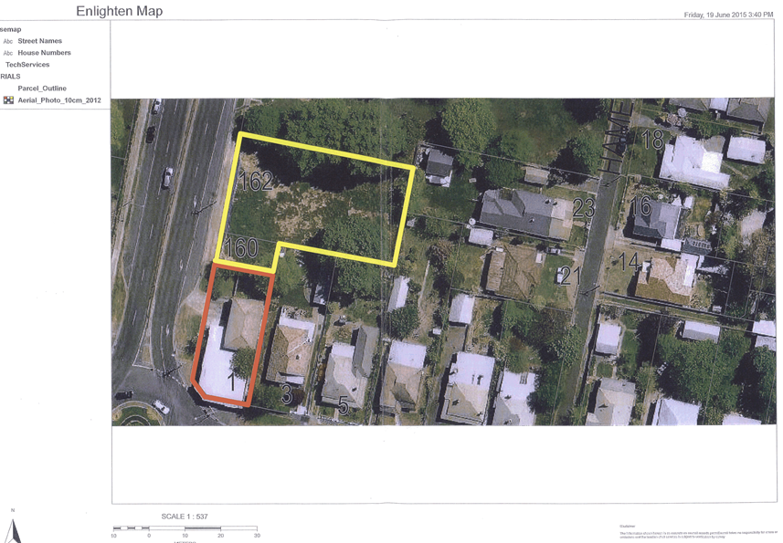
Application DA 38/2015(1) - 90-92 Bathurst Road
TRIM
REFERENCE: 2015/2806
AUTHOR: Kelly
Walker, Town Planner
EXECUTIVE Summary
|
Application lodged
|
16
February 2015
|
|
Applicant/s
|
Isaac
Property Developments
|
|
Owner/s
|
Erolwren
Pty Limited
|
|
Land description
|
Lot 1 DP
13435 and Lot 20 DP 1020706 –
90-92
Bathurst Road, Orange
|
|
Proposed land use
|
Demolition
(existing structures), Service Station and Signage
|
|
Value of proposed development
|
$1,544,555
|
Council's consent is sought for the
demolition of the existing buildings on the site, which was previously used as
a used car sales yard. It is proposed to redevelop the site as a 24 hour
‘7 Eleven’ service station. A new single storey convenience store
building will be constructed, as well as a fuel canopy over the petrol filling
area. A loading and service area and eight car parking spaces will be provided,
as well as landscaping. Signage includes a 6m high illuminated pylon sign
on the corner of Bathurst Road and Glenroi Avenue, as well as canopy signage,
directional signage, entry facia signage, wall signs and window signs.
It is proposed to reinstate the existing
vehicle crossovers providing access from Glenroi Avenue, and provide one new
access from Glenroi Avenue and one new access from Bathurst Road. The Bathurst
Road entry will be left turns in and out only, restricted by a new central
median island on Bathurst Road.
Concurrence is required from the Roads and
Maritime Service (RMS) as a service station on a Classified Road is considered
to be a traffic generating activity. The RMS has recommended an additional
central median island on Glenroi Avenue, which will also restrict entry to left
turns only. Additional traffic information and amended drawings have been
submitted by the applicant to address concerns raised. The requirements
of the RMS have been integrated as conditions of consent within the
attached notice.
The development was referred to the City of Orange Traffic
Development Committee for comment, who agree with comments made by the RMS; and
their requirements are also included as conditions within the attached notice.
Council’s Development Engineer has concerns about the
proposed pylon sign on the corner of the site impeding sightlines for traffic
turning out of Glenroi Avenue. The applicant has revised the location of this
sign to be setback from the intersection.
The applicant has prepared a Preliminary Hazard Analysis and
Multi-Level Risk Assessment, as required by State Environmental Planning Policy
33, indicating that the level of risk is negligible, and therefore the activity
is not considered hazardous. The PHA recommends risk management practices,
which are included as conditions of consent in the attached notice.
A noise impact assessment has been submitted which concludes
that the development will achieve the relevant noise criteria subject to
certain operational measures. It sets out recommendations as to appropriate
plant equipment, and restricted servicing and delivery hours, which are
included as conditions of consent. Overall there will be no adverse noise
impacts on neighbouring properties.
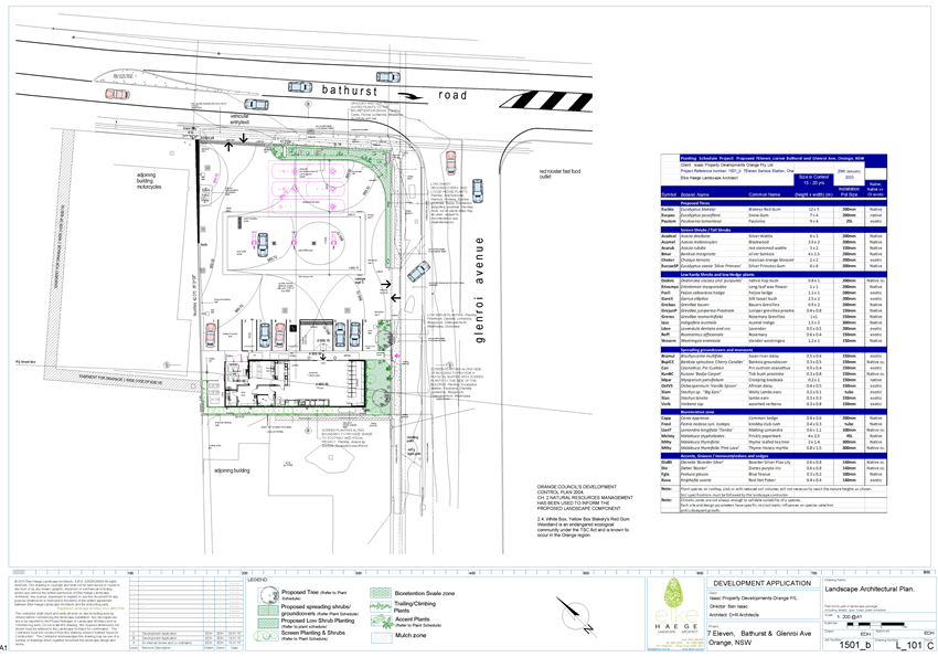
The submitted landscaping plan is considered to be generally
acceptable subject to a condition of consent requiring the plant species along
the rear (south-western) boundary to be amended to a shrub growing 2m in height
and tolerant of indirect sunlight.
Four submissions have been received from neighbouring
residential and commercial properties, with concerns relating to traffic,
access, safety, noise, and proximity to other service stations. These concerns
have been addressed in the report.
Overall the development is considered acceptable and is
recommended for approval, subject to conditions of consent.
Link To Delivery/OPerational Plan
The recommendation in this report relates to the
Delivery/Operational Plan strategy “13.4 Our Environment
– Monitor and enforce regulations relating to City amenity”.
Financial Implications
Nil
Policy and Governance Implications
Nil
|
Recommendation
That Council consents to
development application DA 38/2015(1)
for Demolition (existing structures), Service Station and Signage at Lot
1 DP 13435 and Lot 20 DP 1020706 – 90‑92 Bathurst Road,
Orange pursuant to the conditions of consent in the
attached Notice of Approval.
|
further considerations
Consideration has been given to the
recommendation’s impact on Council’s service delivery; image and
reputation; political; environmental; health and safety; employees;
stakeholders and project management; and no further implications or risks have
been identified.
SUPPORTING INFORMATION
THE APPLICATION
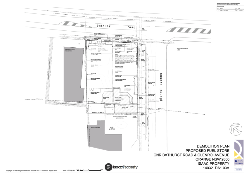
Council's consent is
sought for the demolition of existing buildings and
structures, and the construction of a new service station and signage at Lot
1 DP 13435 and Lot 20 DP 1020706, known as 90-92 Bathurst Road, Orange.
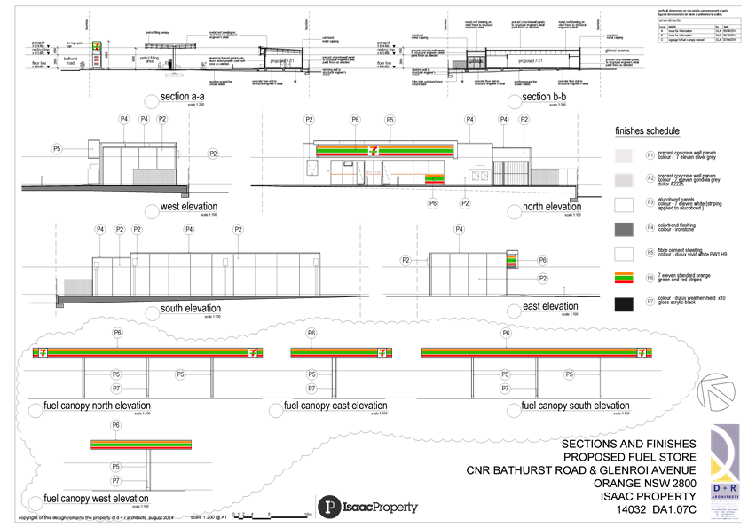
THE PROPOSAL
The application involves the demolition of
the existing buildings and structures, and the redevelopment of the site as a 7
Eleven service station. A new single storey building will be constructed
towards the rear of the site, which will contain a convenience store with
coolroom, will take payments for petrol, and provide customer toilets and staff
facilities including an office, a store room, and a food preparation area
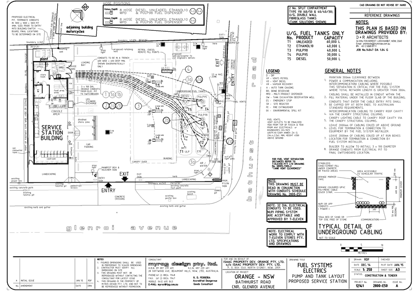
(gross floor area (GFA) of 174m2). A fuel canopy will be
erected over the petrol filling area, which will contain three fuel bowsers and
two underground fuel tanks. An underground Spel Puracepter is also proposed, as
well as a bio-retention basin for stormwater.
The site currently has two vehicle
crossovers providing access from Glenroi Avenue, and it is proposed to
reinstate these and provide one new access from Glenroi Avenue and another new
access from Bathurst Road. The latter will be left turns in and out only,
restricted by a new central meridian island on Bathurst Road. A loading bay and
eight car parking spaces are proposed on the site, as well as landscaping on
the western, southern, and eastern boundaries.
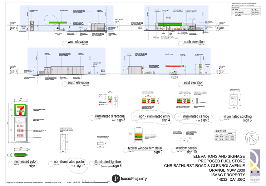
Proposed
signage includes the following:
Sign
|
Location
|
Illuminated
|
Size
|
|
Pylon sign - logo and fuel prices
|
Corner of Glenroi Ave and Bathurst Road
|
Yes
|
6.0m high x 2.0m wide
|
|
Directional signage (x4)
|
2 at each entry and exit
|
Yes
|
1.5m high x 0.55m wide
|
|
Entry facia signage
|
On shopfront awning
|
No
|
0.8m high x 0.8m wide
|
|
Canopy signage (x4)
|
On each side of the fuel canopy
|
Yes
|
0.8m high x 0.8m wide
|
|
Scrolling promo wall sign
|
On shopfront
|
Yes
|
1.73 high x 1.2m wide
|
|
Poster signs (x2)
|
On shopfront (internal)
|
No
|
2.4m high x 0.81m wide
|
|
Light box sign
|
On shopfront (internal)
|
Yes
|
0.48m high x 0.93 wide
|
|
Window vinyl film
|
On shopfront (internal)
|
No
|
|
|
Window decals (numerous)
|
On shopfront doors and glazing (internal)
|
No
|
0.085m high x 1.12m wide
|
The proposed pylon sign will display fuel prices which is
not considered ‘business identification signage’, however is
required by NSW Fair Trading.
It is proposed to operate 24 hours a day, seven days a week.
Approximately two staff members will be present on the site at any one time.
Deliveries include 1-2 fuel deliveries each week, 1-2 dry grocery deliveries
each week and daily fresh food deliveries. Deliveries will typically occur
during the day and evening, however consent is sought to allow flexibility to
make deliveries anytime within a 24 hour period when necessary.
MATTERS FOR CONSIDERATION
Section 5A Assessment
In the administration of sections 78A, 79B, 79C, 111 and
112, the provisions of Section 5A must be taken into account for every
development application in deciding whether there is likely to be a significant
effect on threatened species, populations or ecological communities or their
habitats. This section includes a requirement to consider any adopted
assessment guidelines, which means assessment guidelines issued and in force
under section 94A of the Threatened Species Conservation Act 1995.
Assessment guidelines are in force (see DECC-W “Threatened Species
Assessment Guidelines - The Assessment of Significance”) which requires
consent authority to adopt the precautionary principle in its assessment.
In this instance, site inspection reveals the subject
property has no biodiversity or habitat value.
Section 79C
Section 79C of the Environmental Planning and Assessment
Act 1979 requires Council to consider various matters, of which those
pertaining to the application are listed below.
PROVISIONS OF ANY ENVIRONMENTAL
PLANNING INSTRUMENT s79C(1)(a)(i)
Orange Local Environmental Plan 2011
Part 1 - Preliminary
Clause 1.2 - Aims of Plan
The
broad aims of the LEP are set out under subclause 2. Those relevant to the
application are as follows:
(a) to encourage development which complements
and enhances the unique character of Orange as a major regional centre boasting
a diverse economy and offering an attractive regional lifestyle,
(b) to provide for a range of development
opportunities that contribute to the social, economic and environmental
resources of Orange in a way that allows present and future generations to meet
their needs by implementing the principles for ecologically sustainable
development,
(f) to
recognise and manage valued environmental heritage, landscape and scenic
features of Orange.
The application is considered to be generally consistent
with these aims.
Clause 1.6 - Consent Authority
This clause establishes that, subject to the Act, Council is
the consent authority for applications made under the LEP.
Clause 1.9A - Suspension of
Covenants, Agreements and Instruments
This clause provides that covenants, agreements and other
instruments which seek to restrict the carrying out of development do not apply
with the following exceptions.
· covenants imposed
or required by Council
· prescribed
instruments under Section 183A of the Crown Lands Act 1989
· any conservation
agreement under the National Parks and Wildlife Act 1974
· any trust
agreement under the Nature Conservation Trust Act 2001
· any property
vegetation plan under the Native Vegetation Act 2003
· any biobanking
agreement under Part 7A of the Threatened Species Conservation Act 1995
· any planning
agreement under Division 6 of Part 4 of the Environmental Planning and
Assessment Act 1979.
Council staff are not aware of the title of the subject
property being affected by any of the above.
Mapping
The subject site is identified on
the LEP maps in the following manner:
|
Land Zoning Map:
|
Land zoned B6 Enterprise Corridor
|
|
Lot Size Map:
|
No Minimum Lot Size
|
|
Heritage Map:
|
Not a heritage item or conservation
area, however Kinross Wolaroi School is nearby, which is a listed item
|
|
Height of Buildings Map:
|
No building height limit
|
|
Floor Space Ratio Map:
|
No floor space limit
|
|
Terrestrial Biodiversity Map:
|
No biodiversity sensitivity on the
site
|
|
Groundwater Vulnerability Map:
|
Ground water vulnerable
|
|
Drinking Water Catchment Map:
|
Not within the drinking water
catchment
|
|
Watercourse Map:
|
Not within or affecting a defined
watercourse
|
|
Urban Release Area Map:
|
Not within an urban release area
|
|
Obstacle Limitation Surface Map:
|
No restriction on building siting
or construction
|
|
Additional Permitted Uses Map:
|
No additional permitted use applies
|
Those matters that are of relevance are addressed in detail
in the body of this report.
Part 2 - Permitted or Prohibited Development
Land
Use Zones
The subject site is located within the B6 Enterprise
Corridor zone. The proposed development is defined as a service station and
business identification signage under OLEP 2011.
Pursuant to the LEP dictionary, a service station means:
a building or place used for
the sale by retail of fuels and lubricants for motor vehicles, whether or not
the building or place is also used for any one or more of the following:
(a) the
ancillary sale by retail of spare parts and accessories for motor vehicles,
(b) the
cleaning of motor vehicles,
(c) installation
of accessories,
(d) inspecting,
repairing and servicing of motor vehicles (other than body building, panel
beating, spray painting, or chassis restoration),
(e) the
ancillary retail selling or hiring of general merchandise or services or both.
Signage means:
any sign,
notice, device, representation or advertisement that advertises or promotes any
goods, services or events and any structure or vessel that is principally
designed for, or that is used for, the display of signage, and includes any of
the following:
(a) an
advertising structure,
(b) a
building identification sign,
(c) a
business identification sign,
but does not include a traffic
sign or traffic control facilities.
Service Stations and signage are permitted in the B6
Enterprise Corridor zone with the consent of Council. It should be noted that
the proposed service station includes a small ancillary store, selling general
merchandise that may include goods not necessarily related to travelling
motorists. The scale of this aspect of the development is considered to be a
typical operation of a service station and therefore consistent with Part E of
the above described definition of a service station.
Clause
2.3 of LEP 2011 references the Land Use
Table and Objectives for each zone in LEP 2011. These objectives for land
zoned B6 Enterprise Corridor are as follows:
· To promote businesses
along main roads and to encourage a mix of compatible uses.
· To provide a range of
employment uses (including business, office, retail and light industrial uses).
· To maintain the
economic strength of centres by limiting retailing activity.
· To provide for
residential uses, but only as part of a mixed use development.
The development is not inconsistent
with the objectives of the zone.
Clause 2.7 - Demolition
Requires Development Consent
This clause triggers the need for development consent in
relation to a building or work. This requirement does not apply to any demolition
that is defined as exempt development.
The proposal involves demolition and the applicant is
seeking the consent of council. A Waste Management Plan has been submitted
as part of the application. The demolition works proposed will have no significant
impact on adjoining lands, streetscape or public realm. Conditions may be
imposed in respect of hours of operation, dust suppression and the need to
investigate for, and appropriately manage the presence of, any materials
containing asbestos.
Part 5 - Miscellaneous Provisions
5.10 - Heritage Conservation
(1) Objectives
The
objectives of this clause are as follows:
(a) to
conserve the environmental heritage of Orange,
(b) to
conserve the heritage significance of heritage items and heritage conservation
areas, including associated fabric, settings and views,
(c) to
conserve archaeological sites,
(d) to
conserve Aboriginal objects and Aboriginal places of heritage significance.
The
site is not located within a heritage conservation area, but is within
proximity to Kinross Wolaroi School, which is a listed heritage item. The
original mansion and it’s landscaped surrounds have State significance in
relation to architecture and education. The school is separated from the
highway by a row of large lots which contain large dwelling houses and mature
vegetation, and as such the school, and in particular the mansion, cannot be
seen from the site. The proposed development will not have any impact on the
listed heritage item.
Part 7 - Additional Local Provisions
7.1
- Earthworks
This
clause establishes a range of matters that must be considered prior to granting
development consent for any application involving earthworks, such as:
(a) the likely disruption of, or any
detrimental effect on, existing drainage patterns and soil stability in the
locality of the development
(b) the effect of the development on the
likely future use or redevelopment of the land
(c) the quality of the fill or the soil to be
excavated, or both
(d) the effect of the development on the
existing and likely amenity of adjoining properties
(e) the source of any fill material and the
destination of any excavated material
(f) the likelihood of disturbing relics
(g) the proximity to and potential for adverse
impacts on any waterway, drinking water catchment or environmentally sensitive
area
(h) any measures proposed to minimise or
mitigate the impacts referred to in paragraph (g).
The earthworks proposed in the
application are limited to the extent of cutting and filling required for the
underground petrol storage tanks; an underground puracepter; bio-retention
aggregate layers, surcharge and discharge pits; and associated drainage. The
extent of disruption to the drainage of the site is considered to be minor and
will not detrimentally affect adjoining properties or receiving waterways.
The earthworks will be
appropriately supported onsite and the change in ground level is not substantial.
Therefore the effect on the amenity of adjoining properties is considered to be
minor. The extent of the earthworks will not materially affect the potential
future use or redevelopment of the site that may occur at the end of the
proposed development's lifespan. The site is not known to contain any
Aboriginal, European or archaeological relics. Previous known uses of the site
do not suggest that any relics are likely to be uncovered.
A Baseline Environmental Site
Assessment has been undertaken by Parsons Brinckerhoff, dated September 2014,
and submitted as part of the application. It concludes that the site is
suitable for the use as a petrol station as negligible soil and groundwater
contamination impacts have been identified beneath the site. Conditions of
consent are required to ensure that surplus materials from demolition and
earthworks will disposed of to an appropriate destination.
The site is not in proximity to
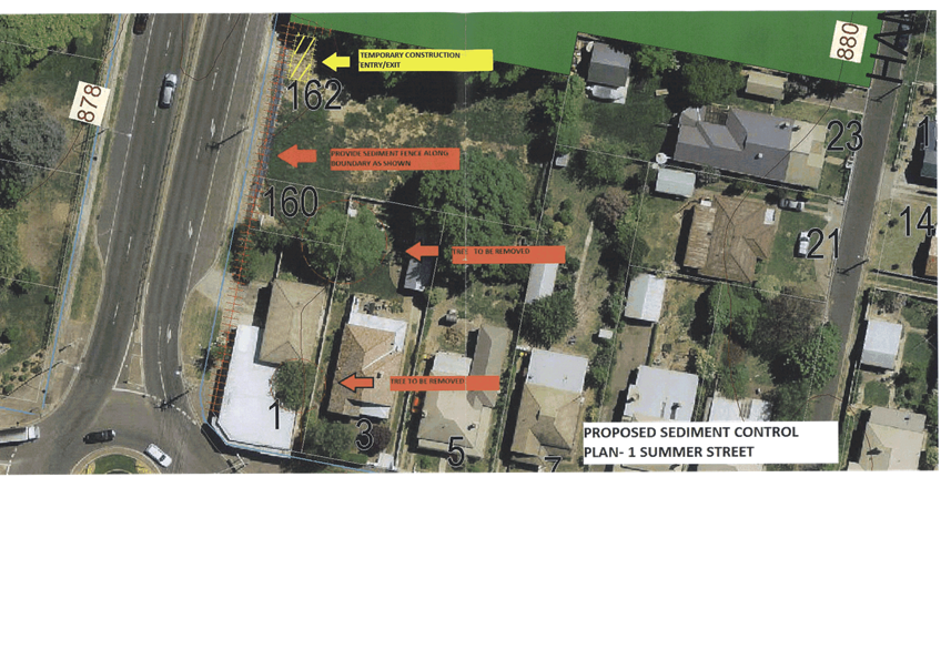
any waterway, drinking water catchment or sensitive area, however conditions
will be imposed to require a sediment control plan, including silt traps and
other protective measures, to ensure that loose dirt and sediment does not
escape the site boundaries.
7.3 - Stormwater Management
This clause applies to all
industrial, commercial and residential zones and requires that Council be
satisfied that the proposal:
(a) is designed to maximise the use of water
permeable surfaces on the land having regard to the soil characteristics
affecting onsite infiltration of water
(b) includes, where practical, onsite
stormwater retention for use as an alternative supply to mains water,
groundwater or river water; and
(c) avoids any significant impacts of
stormwater runoff on adjoining downstream properties, native bushland and
receiving waters, or if that impact cannot be reasonably avoided, minimises and
mitigates the impact.
The
proposal has been designed to include permeable surfaces through landscaping,
and includes onsite retention of stormwater through the use of a
bio-retention basin. A Spel Puraceptor is also proposed. Although the roof
catchment area will be greatly increased, the total impermeable area will be
reduced by removing some of the hardstand area and providing a larger area of
landscaping. It is therefore considered that the post-development runoff levels
will be similar to pre-development levels, and the management of onsite
stormwater is acceptable.
7.6 - Groundwater Vulnerability
This
clause seeks to protect hydrological functions of groundwater systems and
protect resources from both depletion and contamination. Orange has a high
water table and large areas of the LGA, including the subject site, are
identified with “Groundwater Vulnerability” on the Groundwater
Vulnerability Map.
This
requires that Council consider:
(a) whether or not the development (including
any onsite storage or disposal of solid or liquid waste and chemicals) is
likely to cause any groundwater contamination or have any adverse effect on
groundwater dependent ecosystems, and
(b) the cumulative impact (including the
impact on nearby groundwater extraction for potable water supply or stock water
supply) of the development and any other existing development on groundwater.
Furthermore consent may not be granted unless Council is satisfied that:
(a) the development is designed, sited and
will be managed to avoid any significant adverse environmental impact, or
(b) if that impact cannot be reasonably
avoided - the development is designed, sited and will be managed to minimise
that impact,
(c) if that impact cannot be minimised - the
development will be managed to mitigate that impact.
The proposal does not involve
extraction of groundwater and will therefore not contribute to groundwater
depletion. The proposal has the potential to involve
the discharge of toxic or noxious substances through accidental spillages,
particularly through leaking of underground tanks and pipes, and therefore
may contaminate the groundwater or related ecosystems.
The design and siting of the proposal avoids impacts on groundwater through the
use of an underground Spel Puracepter, as well as a
bio-retention basin for stormwater, and is therefore considered
acceptable. Furthermore, spills and leaks will be monitored through wells,
which is addressed in more detail below.
STATE ENVIRONMENTAL PLANNING
POLICIES
The following State Environmental Planning Policies apply to
the subject development:
State Environmental Planning
Policy Infrastructure 2007
Clauses 101 and 104 of this SEPP are applicable to this
development, and are discussed below. Concurrence with the RMS is required for
this proposal.
101 - Development with Frontage to Classified
Road
The primary objective of this clause is to ensure that new
development does not compromise the effective and ongoing operation and
function of classified roads. The consent authority must not grant consent to
development on land that has a frontage to a classified road unless it is
satisfied that:
(a) where
practicable, vehicular access to the land is provided by a road other than the
classified road, and
(b) the
safety, efficiency and ongoing operation of the classified road will not be
adversely affected by the development as a result of:
(i) the
design of the vehicular access to the land, or
(ii) the
emission of smoke or dust from the development, or
(iii) the
nature, volume or frequency of vehicles using the classified road to gain
access to the land, and
(c) the
development is of a type that is not sensitive to traffic noise or vehicle
emissions, or is appropriately located and designed, or includes measures, to
ameliorate potential traffic noise or vehicle emissions within the site of the
development arising from the adjacent classified road.
104 - Traffic-Generating Development
This clause applies to a service station of any size where
it has direct vehicular or pedestrian access to a classified road or to a road
that connects to a classified road where the access is within 90m of the
connection. It requires the consent authority to give written notice of the
application to the RMS and take their response into consideration, as well as
consider the accessibility of the site concerned, and any potential traffic
safety, road congestion or parking implications of the development.
The RMS has requested further information
from the applicant several times. In particular, concerns related to traffic
counts and modelling, points of conflict, queuing impacts on Bathurst Road and
neighbouring businesses, loading arrangements, sightlines, the design of the
median island on Bathurst Road, and the manoeuvring of tankers. Revised
drawings have been submitted, and the traffic report has been amended and added
to, to address these concerns.
The RMS recommended that an additional central median island
be constructed on Glenroi Avenue to prevent right hand turns into the Glenroi
Avenue access as there were still concerns about queuing traffic impacting on
Bathurst Road and other surrounding businesses. Initially there were concerns
as to whether this island would impact on customers of Red Rooster being able
to turn in and out of the driveway opposite the site, however the median can be
achieved with a slightly less than standard length. The applicant has submitted
a revised drawing to this effect.
The RMS has provided concurrence for
the development, and their requirements have been integrated as conditions of
consent within the attached notice. They also note that Council should consider
restricting fuel deliveries to be outside of normal trading hours; that signage
is not to flash, move or be objectionably bright; and to improve sightlines and
access to the site, that Council should create a ‘No Stopping’ zone
on the road shoulder adjacent to the site between the intersection of Bathurst
Road and Glenroi Avenue and the proposed Bathurst Road access driveway. These
concerns are addressed within the following report.
State Environmental Planning
Policy 33 - Hazardous and Offensive Development
This policy seeks to ensure that the consent authority has
sufficient information to assess whether a development is potentially hazardous
or offensive, and to impose conditions to reduce or minimise any adverse
impacts. The policy sets out the definition of a ‘potentially hazardous
industry’ as follows:
a development for the purposes
of any industry which, if the development were to operate without employing any
measures (including, for example, isolation from existing or likely future
development on other land) to reduce or minimise its impact in the locality or
on the existing or likely future development on other land, would pose a
significant risk in relation to the locality:
(a) to
human health, life or property, or
(b) to
the biophysical environment,
and includes a hazardous
industry and a hazardous storage establishment.
A development application for a potentially hazardous
industry must be accompanied by a preliminary hazard analysis (PHA), in
accordance with current circulars and guidelines from the Department of
Planning. Guidelines titled Applying SEPP-33 Development Application
Guidelines, and Multi Level Risk Assessment Guidelines are
particularly relevant to this application, among others. Myros Design, on
behalf of the applicant, has prepared a Multi-Level Risk Assessment and PHA in
accordance with these guidelines.
In this case, the relevant screening criteria are the
quantities of hazardous materials proposed (onsite and to be transported) and
the buffer distances to nearby boundaries. The assessment found that for a
screening quantity of 44kL, the minimum separation distance from the remote
filling and dispenser points to the site boundary is 7.9m. As the northern
site boundary is less than this distance away at only 7.19m, the proposed
storage and dispensing of fuel does not pass initial screening. As such, further
analysis was undertaken, and it was concluded that the societal risk of the
proposal is ‘negligible’, and that all possible measures shall be
undertaken to ensure that the level of risk is kept to a minimum.
Assessment Guidelines Chapter 4
- Assessing Hazard and Determining Risk
Chapter 4 of the Applying SEPP-33 Development Application
Guidelines states that a PHA should enable the consent authority to
make a judgement about the level of risk involved in a proposal and its
acceptability. It should allow the consent authority to decide if the level of
risk exceeds criteria for acceptability (thus indicating that the proposal is a
hazardous industry) or whether the level of risk can be managed (so that the
proposal is acceptable on hazard grounds). The PHA may be done qualitatively
and/or quantitatively, depending on the circumstances of the
proposal and its location.
A Level 1 Qualitative Risk Analysis was carried out and
forms part of the submitted PHA. It includes specific safety measures that
need to be undertaken on the site, both during construction and during
operation, and all inspections and monitoring procedures. Furthermore, all
equipment must be installed to manufacturer’s recommendations, and must
comply with all the relevant standards.
The PHA sets out potential incidents, hazard prevention
equipment and hazard response procedures however this mostly deals with onsite
risks and risks to human life. The risk to the biophysical environment has not
specifically been addressed. However, in accordance with the SEPP guidelines,
the procedure for identifying a potentially hazardous development does not
explicitly include an assessment of biophysical risk. As there is no known
presence of rare or threatened species, or any watercourses in the immediate vicinity,
a specific biophysical risk assessment is not necessary in this case.
Furthermore, the guidelines state that higher importance is attached to public
risk; and where the risk criteria is found to be acceptable to people, then the
environmental risk could also be tolerated. Notwithstanding this, there is
potential risk to the wider environment and ecosystems through underground
tanks and pipes leaking into the groundwater, where the water table is high in
this location. The monitoring of this risk has been recommended in
the PHA, and as mentioned earlier, the EPA has also recommended that
groundwater monitoring wells be installed.
The consent authority, in addition to the above, must also
consider:
(i) any
feasible alternatives to the carrying out of the development and the reasons
for choosing the development the subject of the application (including any
feasible alternatives for the location of the development and the reasons for
choosing the location the subject of the application), and
(ii) any
likely future use of the land surrounding the development.
No alternatives or reasons have been provided by the
applicant, therefore it is considered that the alternative to the proposed
service station is to retain the previous use of the site as a car sales yard.
Future likely uses of the land surrounding the development are similar to the
current surrounding uses, being residential and commercial uses. As such, the
risk assessment has looked at the worst case scenario, where residential use is
the most sensitive land use likely to surround the development site.
Overall it is considered that the Multi-Level Risk
Assessment and PHA that have been submitted are consistent with the relevant
guidelines, and indicate that the level of risk is below the thresholds
specified.
Assessment Guidelines Appendix
6 - Ongoing Acceptability
The guidelines state:
"If, following the
assessment of a PHA and other considerations, council considers that the
proposal can proceed, it should consider imposing relevant hazards-related
conditions as recommended by the department. These conditions will help ensure
the ongoing safety of a potentially development."
Not all of the recommended conditions are considered
relevant to this situation, however those that are relevant are included in the
attached consent.
Furthermore, a Trade Waste Agreement will need to be entered
into with the Council, and a Dangerous Goods Notification is required from
WorkCover NSW.
State Environmental Planning
Policy 55 - Remediation of Land
This policy requires
contamination and remediation to be considered when determining a planning
application. While there are no previous known uses of the site that could
cause contamination as set out in the SEPP guidelines, a full history of the
site is not known. As such a Baseline Environmental Site Assessment has been
undertaken and submitted as part of the application.
Parsons Brinckerhoff carried out
soil and groundwater sampling from boreholes on the site in
September 2014, and found negligible soil and groundwater contamination
impacts beneath the site. Heavy metal concentrations detected in the soil
samples are considered to represent background levels, and Hydrocarbon
detections in the groundwater samples are below the adopted site criteria for
commercial land. They concluded that the site is suitable for use as a service
station.
It is considered that the land
is suitable in its current state for the purposes of the service station, and
no further investigation or remediation is required for this use. It is noted
that although the site is suitable for use as a petrol service station,
conditions of consent are required to ensure that surplus materials from
demolition and excavation will disposed of to an appropriate destination.
State Environmental Planning
Policy 64 - Advertising and Signage
State Environmental Planning Policy 64 - Advertising and
Signage applies to the subject land. The relevant provisions of the SEPP are
addressed below.
3 -
Aims, objectives etc.
(1) This Policy aims:
(a) to
ensure that signage (including advertising):
(i) is
compatible with the desired amenity and visual character of an area, and
(ii) provides
effective communication in suitable locations, and
(iii) is
of high quality design and finish, and
(b) to
regulate signage (but not content) under Part 4 of the Act, and
(c) to
provide time-limited consents for the display of certain advertisements, and
(d) to
regulate the display of advertisements in transport corridors, and
(e) to
ensure that public benefits may be derived from advertising in and adjacent to
transport corridors.
(2) This
Policy does not regulate the content of signage and does not require consent
for a change in the content of signage.
The development is consistent with the aims, objectives etc.
of the plan.
4 - Definitions
The proposed signage can be defined as ‘business
identification signs’ and ‘advertisements’ pursuant to clause
4 of the SEPP.
Business identification
signage means a sign:
(a) that
indicates:
(i) the
name of the person, and
(ii) the
business carried on by the person,
at
the premises or place at which the sign is displayed, and
(b) that
may include the address of the premises or place and a logo or other symbol
that identifies the business,
but that does not include any
advertising relating to a person who does not carry on business at the premises
or place.
Advertisement
means signage to which Part 3 applies and includes any advertising structure
for the advertisement.
Most of the proposed signage is considered to be
‘business identification signage’, with the possible exception of
the proposed scrolling promotional sign and two poster signs on the shopfront
wall, which are likely to display advertisements. This is addressed in detail
in Part 3 of the SEPP below.
Furthermore, the proposed pylon sign will display fuel
prices, which although not technically considered ‘business
identification signage’, is required by NSW Fair Trading pursuant to the
following:
All NSW petrol station operators are required to display the price of
regular unleaded petrol. The sign must:
· be positioned and lit so that any price it displays can be readily seen
by motorists approaching the petrol station when the station is open; and
· display a price that must be a price per litre of petrol.
The size of the sign should be determined by what is reasonable in the
circumstances, given the criteria outlined above.
Petrol station operators will not have to display signs if the erection
of a price sign is inconsistent with local council planning restrictions (NSW
Fair Trading).
This is
addressed in detail in the Schedule 1 assessment below.
6 - Signage to Which this
Policy Applies
(1) This
Policy applies to all signage:
(a) that,
under another environmental planning instrument that applies to the signage,
can be displayed with or without development consent, and
(b) is
visible from any public place or public reserve, except as provided by this
Policy.
(2) This
Policy does not apply to signage that, or the display of which, is exempt
development under an environmental planning instrument that applies to it, or
that is exempt development under this Policy.
The proposed signage can be displayed with development
consent and will be visible from a public place, and therefore SEPP 64 applies
to the application.
8 - Granting of Consent to
Signage
A consent authority must not grant development consent to an
application to display signage unless the consent authority is satisfied:
(a) that
the signage is consistent with the objectives of this Policy as set out in
clause 3(1)(a), and
(b) that
the signage the subject of the application satisfies the assessment criteria
specified in Schedule 1.
The signage is consistent with the aims, objectives, etc. of
the plan and a Schedule 1 assessment is undertaken below.
Part
3 of the SEPP
Clause 11 - Requirement for Consent
Clause 11 states:
A person must not display an
advertisement, except with the consent of the consent authority or except as otherwise
provided by this Policy.
The shopfront wall signs are likely to display
advertisements, and the applicant is applying for consent through this
application.
Clause 13 - Matters for
Consideration
Clause 13 triggers the requirement for the development to be
consistent with this Policy, as well as the assessment criteria contained
within Schedule 1. An assessment of the criteria contained within Schedule 1 is
undertaken below.
Clause 14 - Duration of
Consents
(1) A
consent granted under this Part ceases to be in force:
(a) on
the expiration of 15 years after the date on which the consent becomes
effective and operates in accordance with section 83 of the Act, or
(b) if
a lesser period is specified by the consent authority, on the expiration of the
lesser period.
A condition
will need to be attached in this regard.
Clause 22 - Wall Advertisements
(1) Only
one wall advertisement may be displayed per building elevation.
(2) The
consent authority may grant consent to a wall advertisement only if:
(a) the
consent authority is satisfied that the advertisement is integrated with the
design of the building on which it is to be displayed, and
(b) for
a building having:
(i) an
above ground elevation of 200 square metres or more—the advertisement
does not exceed 10% of the above ground elevation, and
(ii) an
above ground elevation of more than 100 square metres but less than 200 square
metres—the advertisement does not exceed 20 square metres, and
(iii) an
above ground elevation of 100 square metres or less—the advertisement
does not exceed 20% of the above ground elevation, and
(c) the
advertisement does not protrude more than 300 millimetres from the wall, unless
occupational health and safety standards require a greater protrusion, and
(d) the
advertisement does not protrude above the parapet or eaves, and
(e) the
advertisement does not extend over a window or other opening, and
(f) the
advertisement does not obscure significant architectural elements of the
building, and
(g) a
building identification sign or business identification sign is not displayed
on the building elevation.
Clause 22 only allows one wall advertisement on each
elevation. Furthermore, this clause states that Council may only grant consent
to wall advertisements if no building or business identification sign is
displayed on the elevation. The proposal involves three advertisements and two
business identification signs on the shopfront elevation. As such, consent
cannot be granted to the advertisements, as they do not meet the provisions of
the SEPP.
As there is no limit on the number of business
identification signs that may be erected on a building, a condition of consent
is recommended that the proposed poster signs and scrolling promotional sign
are restricted to ‘business identification signage’ only, and that
no advertisements are approved for this development. The following
Schedule 1 assessment has been carried out on this basis.
Schedule 1 Assessment
Character of the Area
· Is the proposal
compatible with the existing or desired future character of the area or
locality in which it is proposed to be located?
· Is the proposal
consistent with a particular theme for outdoor advertising in the area or
locality?
The area is characterised as a
mix of commercial and established residential properties, with signage
primarily associated with the commercial uses on the southern side of Bathurst
Road and in Glenroi Avenue. The character of the land is further influenced by
the high profile location on the entrance to the business area of the City.
Existing signage is made up of freestanding pylon signs along Bathurst Road,
and wall signs on buildings set back from the street.
The proposed signage is
considered to be consistent with the existing character of the area as it
involves the installation of wall, fascia, and canopy signs on the building and
fuel canopy, which are both set back from the main road. One low profile
freestanding pylon sign will be erected on the corner of Bathurst Road and
Glenroi Avenue, which is consistent with other pylon signs in the area. It is
noted that the Red Rooster and McDonalds pylon signs on the other side of
Glenroi Avenue are much higher than the proposed sign. However, 6.0m is
considered to be the maximum allowed height in this location to ensure that the
highway does not become dominated by signage, as well as maintaining the
residential amenity of the properties on the northern side of Bathurst Road.
Special
Areas
· Does
the proposal detract from the amenity or visual quality of any environmentally
sensitive areas, heritage areas, natural or other conservation areas, open
space areas, waterways, rural landscapes or residential areas?
Whilst the subject land is not
within a residential zoning, nor is it in a heritage conservation area or a
listed item, the site is directly opposite to residential zoning and is nearby
to a listed heritage item at Kinross Wolaroi School. As detailed above, the
signage is consistent with the character of the area, and as such it will not
detract from the amenity of the residential properties on the northern side of
Bathurst Road. As noted earlier in this report, the features of Kinross Wolaroi
School cannot be seen from the road as it is visually separated by a row of
dwelling houses, therefore the listed item and school grounds will not be
impacted by the proposed signage.
Views and
Vistas
· Does the
proposal obscure or compromise important views?
· Does the
proposal dominate the skyline and reduce the quality of vistas?
· Does the
proposal respect the viewing rights of other advertisers?
The proposed signage, apart from
the 6.0m pylon sign, is shown to be limited to flush wall and canopy signage
set back from the road, and as such will not obscure views, dominate the
skyline, or impact the viewing rights of other signs in the area. The 6.0m
pylon sign is sited in a manner that will not impact upon views, and is a
height commensurate with the heights of the building on the land and adjacent
properties, therefore will not dominate the skyline, nor reduce the quality of
view corridors.
Streetscape,
Setting or Landscape
· Is the scale,
proportion and form of the proposal appropriate for the streetscape, setting or
landscape?
· Does the
proposal contribute to the visual interest of the streetscape, setting or
landscape?
· Does the
proposal reduce clutter by rationalising and simplifying existing advertising?
· Does the
proposal screen unsightliness?
· Does the
proposal protrude above buildings, structures or tree canopies in the area or
locality?
· Does the
proposal require ongoing vegetation management?
The scale, proportions and forms
of the proposed signage are appropriate within the context of the setting.
Whilst the signage may not contribute to the visual interest of the residential
area, it has been designed in such a way so as to be compatible with the
locality by way of scale, proportions and location of the signage; and it is
important in identifying the business on the site. As established above, the
proposed wall, fascia, and canopy signage is flush and will not protrude above
the buildings or structures. Landscaping on the site has been designed as part
of the overall proposal, and low maintenance vegetation and grasses will be
planted around the pylon and directional signage.
Site and
Building
· Is the proposal
compatible with the scale, proportion and other characteristics of the site or
building, or both, on which the proposed signage is to be located?
· Does the
proposal respect important features of the site or building, or both?
· Does the
proposal show innovation and imagination in its relationship to the site or
building, or both?
The proposed signage is
considered to be compatible with the scale, proportion and other
characteristics of the site and proposed buildings on the land. The proposed
level of signage is not unreasonable for a land use of this type. On this
basis, as well as for the reasons in the above sections of the Schedule 1
assessment, the display of fuel prices on the proposed pylon sign is considered
to be acceptable.
Associated
Devices and Logos with Advertisements and Advertising Structures
· Have
any safety devices, platforms, lighting devices or logos been designed as an
integral part of the signage or structure on which it is to be displayed?
The proposed signage does not
include any safety devices, platforms or lighting devices.
Illumination
· Would
illumination result in unacceptable glare?
· Would
illumination affect safety for pedestrians, vehicles or aircraft?
· Would
illumination detract from the amenity of any residence or other form of
accommodation?
· Can the
intensity of the illumination be adjusted, if necessary?
· Is the
illumination subject to a curfew?
Most of the signage proposed is
to be illuminated internally. Specific lighting details have not been submitted
with the application, and as such a condition of consent is recommended to
ensure that it will not impact on the safety of vehicles, result in
unacceptable glare, or impact on residential amenity. It is noted that the
building and the outdoor areas of the site will also be illuminated, such as
the car park, and forecourt, which will create background light levels on the
site. As such, impacts from the illuminated signage lighting are likely to be
negligible.
Safety
· Would the
proposal reduce the safety for any public road?
· Would the
proposal reduce the safety for pedestrians or bicyclists?
· Would the
proposal reduce the safety for pedestrians, particularly children, by obscuring
sightlines from public areas?
Council’s Development Engineers have raised concerns
in relation to the proposed pylon sign on the corner of the site as it will
impede sightlines for vehicles turning out of Glenroi Avenue onto Bathurst
Road. The applicant has revised the location of this sign to address this
concern, by setting it further to the northwest away from the intersection.
The RMS recommends that none of the signage is to flash or
move; and as such a condition of consent restricts the proposed scrolling sign
to not only be a ‘business identification sign’, but also to be
unmoving.
All other proposed signage is appropriately sited, with most
of the signs being set well back from the street. Therefore they will not
obstruct movement, obscure sightlines, or reduce the safety for any public
road, pedestrians or cyclists.
Protection of the Environment
Operations (Underground Petroleum Storage Systems) Regulation 2014
This regulation seeks to ensure that new underground
petroleum storage systems are properly designed, installed, equipped, and
tested. The application was referred to the Environment Protection Authority
(EPA), who responded that groundwater in the vicinity of the site is quite
shallow (between 0.1-0.5m below ground level) and recommends groundwater monitoring
wells. They also recommend conditions to ensure that the development complies
with the Regulation; that an Environmental Protection Plan is in place before
operation commences; as well as requiring documentation demonstrating
compliance.
PROVISIONS OF ANY DRAFT
ENVIRONMENTAL PLANNING INSTRUMENT THAT HAS BEEN PLACED ON EXHIBITION
s79C(1)(a)(ii)
There are no draft environmental planning instruments that
apply to the subject land or proposed development.
PROVISIONS OF ANY DEVELOPMENT
CONTROL PLAN s79C(1)(a)(iii)
Development Control Plan 2004
Development Control Plan 2004 (“the DCP”)
applies to the subject land:
· Chapter 0 - Orange
LEP 2011;
· Chapter 3 -
General Considerations;
· Chapter 4 -
Special Environmental Considerations;
· Chapter 8 - Development
in Business Zones;
· Chapter 13 -
Heritage
· Chapter 14 -
Advertising; and
· Chapter 15 - Car
Parking
An assessment of the proposed development against the
relevant Planning Outcomes will be undertaken below.
Chapter 0 - Local Environmental
Plan
Translation of Zones
Chapter 0.2 of Orange DCP 2004 provides a conversion table
of old zones and the applicable new zones. The table indicates that the former
3b Business Services zone is the equivalent to the B6 Enterprise Corridor zone.
As such, the relevant provisions pertaining to Part 8 of the DCP
apply to the assessment of this development, as well as other relevant parts.
Transport Routes
· The development
provides a high standard of visual appeal to motorists, cyclists and
pedestrians as well as adjoining property owners.
The development will be appropriate in this regard. The
proposed style of the building, canopy and signage is considered appropriate
for the site, and is consistent with the design of other petrol stations, both
in the immediate area, and the wider region.
· The visual
appearance of the development, including any signage, lighting or other
ancillary element, must not generate a distraction to motorists.
Relevant conditions are attached that require lighting
associated with the development to be appropriately sited or shielded so as to
not cause unreasonable glare or distraction to motorists. As noted previously,
the applicant has revised the location of the corner pylon sign to address
concerns in relation to sightlines.
· Any signage
must not be animated whether by movement or flashing lights.
The proposal involves one illuminated scrolling sign on the
front wall of the shop, and as noted above, a condition of consent is
recommended to ensure that this sign is stationary.
· Where land has
more than one street frontage the street with the lower volume of traffic is to
provide the principal access to the development, subject to safety
considerations.
The development has been designed to limit the extent of
traffic related impacts upon the highway, with a restricted left only into and
out of the Bathurst Road access point through the use of a central median
island on Bathurst Road. The RMS also requires a central median island on
Glenroi Avenue to restrict to left hand turns only. Although the Bathurst Road
access will be the principal access, the RMS, City of Orange Traffic
Development Committee (COTDC) and Council’s Development Engineers
considered the arrangement acceptable in this case.
· Where access is
provided onto an arterial road, distributor road or major collector road, the
access point must have appropriate safe sight distances for the prevailing
speed limit and clear and unimpeded entrance/exit signage must be displayed.
The left only access to and from Bathurst Road and Glenroi
Avenue are considered to be satisfactory. The requirements of the RMS stipulate
that landscaping, fencing and signage must not impede sightlines of traffic
and/or pedestrians within the development, or when entering or leaving the
development.
· Where onsite
customer parking is provided that is not immediately visible from a public road
clear and unimpeded directional signage must be displayed.
The location of onsite parking will be easily identifiable
from both the highway for traffic approaching the development and for traffic
entering the site from the entry point on Glenroi Avenue.
· Where the
proposal is residential, or another noise sensitive form, appropriate noise
mitigation measures to limit the development from traffic noise must be demonstrated.
An acoustic assessment has been submitted in support of the
development which concludes that the development is appropriate in terms of
noise impacts upon nearby sensitive receptors. Subject to the installation of
appropriate plant equipment, the development will remain within acceptable
limits and not present an unreasonable environmental impact in relation to
noise. It is noted that there are some discrepancies between the proposed hours
of deliveries in the Statement of Environmental Effects and the Noise Report,
which is addressed in more detail in Car Parking and Noise Impacts
later in this report. Noise levels will only comply with the more conservative
hours recommended in the noise report, and these will need to form a condition
of consent.
Chapter 3 - General
Considerations
Waste Generation
· Applications
involving demolition indicate measures that will be implemented for reuse and
recycling of waste materials.
· Development
involving demolition is carried out in a manner that optimises reuse and
recycling of waste materials consistent with waste-minimisation principles.
The applicant has submitted a Waste Management Plan prepared
by KDC Pty Ltd, dated February 2015, which sets out the type of waste generated
during the demolition, construction and operation stages, and the means of
disposal, reuse and recycling. It is noted that special measures are indicated
for hazardous spills and waste. The plan is considered acceptable and meets the
objectives of the DCP.
Chapter 4 - Special Environmental
Considerations
Contaminated Land
· Land subject to
development is clear from contamination
· Applications
for development consent on land used or likely to have previously been used for
uses in the table include contamination assessment and where necessary a
proposed mediation strategy to make the site suitable for the proposed use.
A Baseline Environmental Site
Assessment has been undertaken and submitted as part of the application, which
concludes that the site is suitable for the use as a petrol station. No
remediation is necessary, however conditions of consent are required to ensure
that surplus materials from demolition and earthworks will disposed of to an
appropriate destination.
Chapter 8 - Development in
Business Zones
Business Services Areas
· Applications
clearly demonstrate that the development will not detract from the role of the
CBD as a regional centre.
The development is not likely to impact upon the primary
role of the CBD. This type of development is considered appropriate within the
zone and will appeal to the travelling public. Although the service station
comprises a retail component, most of the customers will be those who are
already stopping to purchase petrol, that is, incidental customers, which will
not impact on the primary retail shops in the CBD.
· Provision of
adequate fire-safety measures and facilities for disabled persons (according to
the BCA) is addressed at the application stage (relevant for all development
but particularly important where converting residential buildings for business
use).
Relevant conditions are attached in relation to fire-safety
and disabled access. These are considerations relevant to the Construction
Certificate stage of the development.
· Heritage
streetscapes are conserved and enhanced through adaptive reuse of heritage
buildings, restrained advertising and landscaped gardens.
Whilst the development is nearby to Kinross Wolaroi School,
which has a listed item within the school grounds, the development is not
considered to form part of a heritage streetscape.
· Areas on the
main roads into and out of Orange (such as Molong Road and Bathurst Road)
provide a high level of architectural design to enhance the visual character of
the City entrances.
The site is a prominent and high profile site on the eastern
entrance to the City, and as such the architectural design of the development
is of high importance. The proposal uses a simple modern design for the
building and canopy, which is similar to other service stations so that it is easily
identifiable from passing traffic. The scale, design, colours and materials are
considered acceptable in the context of the locality.
· All sites
contain an element of landscaping. Landscaping provided is of a bulk, scale and
height relative to buildings nearest the front property boundary so as to
provide beautification and visual relief to the built form proposed or existing
on the site. The depth of the landscape bed at the site frontage is sufficient
to accommodate the spread of plantings that meet the abovementioned outcomes
but, where practicable, a minimum depth of 3m is provided. Plantings are
designed to provide shade for parking areas, to break up large areas of
bitumen, to enhance building preservation and to screen against noise.
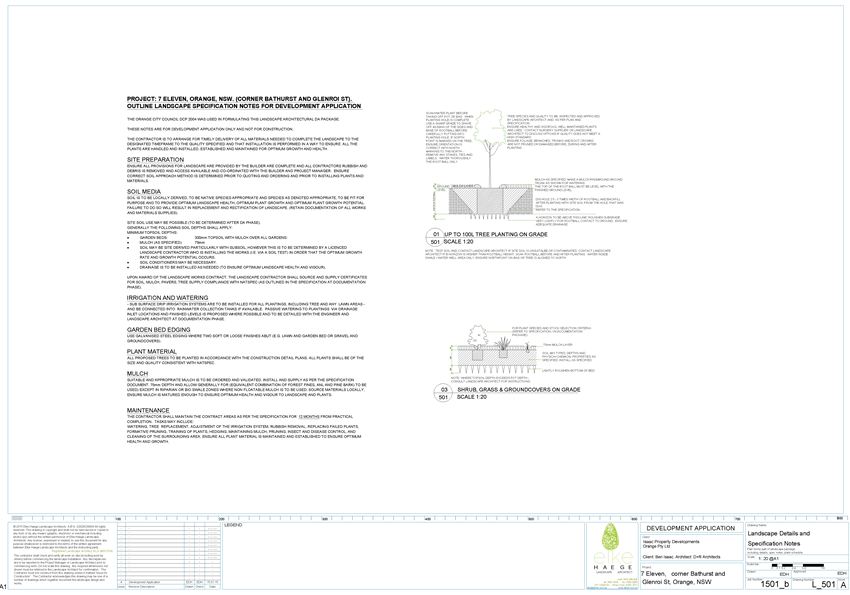
A landscaping plan has been submitted in support of the
development. Landscaping at the frontage of the site is limited to between
1.0-2.5m in bed depth, which is adjacent to the access points and the filling
forecourt. This is considered acceptable, as maintaining vehicle sightlines and
being able to carry out maintenance of the signage is important. The
landscaping depth increases to 4.5m between the secondary frontage and the side
of the building as required in the DCP, and wraps around the back of the
building to provide screening for the neighbouring property and the street.
The landscaping plan has been reviewed by Council’s
Manager City Presentation, who comments that it is satisfactory with the
exception of the plantings to the rear of the building, along the south-western
boundary. Concerns relate to the proposed species being in such close proximity
to the building, as when each individual plant matures into a tree, they will
overhang the building, which may result in issues. There are also potential
issues with these trees being able to obtain sufficient sunlight due to the
site orientation. It is recommended that a different species is chosen for this
part of the site, one that will reduce visual impact through screening, such as
shrubs that grow to around 2m in height that are also tolerant of limited
direct sunlight.
Subject to a condition of consent to alter the landscaping
plan as recommended above, the development is considered appropriate in this
regard.
Chapter 13 - Heritage
· Development
conforms with recognised conservation principles.
Heritage considerations are addressed above.
Chapter 14 - Advertising
Advertisements
· The location,
size, colour and design of advertisement complement the character of the
locality.
· Advertisements
on buildings fit within the envelope of the building.
As set out in the SEPP 64 assessment earlier in this report,
the revised proposed signage is considered to be acceptable for this site and
location, with the exception of advertisements and moving signs.
· Freestanding pole
or pylon signs relate to the height of associated buildings in business and
industrial areas.
The applicant is proposing a pylon sign with a height of 6m.
This is considered an appropriate height, consistent with the scale of the
development and other signage within the vicinity.
High-Profile Areas
· Business
identification signs complement the character of the locality.
As addressed above, the proposed signage is considered to be
acceptable in this locality. Subject to conditions of consent, the signs will
not impact on the nearby residential zone, are in keeping with other signage on
the highway and provide suitable identification of the service station.
Chapter 15 - Car Parking
The DCP sets out the minimum car parking requirements for a
service station, which are 3 spaces for each workbay, and 1 space per 25m2
of gross floor area (GFA) of shop, convenience store or payment area. The
building, which contains a payment area, a shop, and a toilet, has a GFA of
174m2. No workbays are proposed as part of this service station. As
such, the development generates a requirement for 6.9 car parking spaces. A
total of 8 car parking spaces are proposed on the site, one being a
disabled parking space with a disabled shared zone. The car parking provision
set out in the DCP can be met and the proposal is considered acceptable in this
regard.
A loading and service area is
also proposed on the site adjacent to the car parking area, the refuse area and
back door of the shop. This arrangement is considered acceptable. Deliveries
are proposed as follows:
|
Type
of delivery
|
Frequency
|
Hours
proposed
|
Hours
limited by noise report
|
Delivery
vehicle
|
|
Fuel
|
1-2
times per week
|
Usually
7am-6pm,
some
6pm-10pm, occasional 10pm-7am
|
One
delivery at any one time in a single 24 hour period
|
17m
articulated vehicle
RMS
comments that 19m more likely
|
|
Dry
goods
|
1-2
times per week
|
24 hours
a day – but usually early morning prior to 7am, and late evening
8pm-midnight
|
Daytime
and evening only 7am-10pm
|
10-14t
pallet trucks
|
|
Fresh
food
|
Daily
|
24 hours
a day – but usually early morning prior to 7am, and late evening
8pm-midnight
|
Daytime
and evening only 7am-10pm
|
6-8t
pallet trucks and/or a small delivery van
|
|
Waste
collection
|
As
required
|
Daytime
hours
|
Daytime
and evening only
7am-10pm
|
Private contractor,
details not yet known
|
Although deliveries are proposed 24 hours a day, the
submitted noise report places restrictions on their frequencies in order for
the development to comply with noise levels. This includes only one fuel
delivery in any 24 hour period, and all other truck deliveries, including waste
collection, to only take place during daytime and evening hours, being 7am‑10pm.
A condition of consent is required to this effect. The RMS also recommends that
fuel deliveries are outside of normal trading hours. As the petrol
station will be open 24 hours a day, a condition of consent is recommended that
fuel deliveries are outside of normal peak periods.
The development was referred to the RMS and the City of
Orange Traffic Development Committee (COTDC) for comment. Following
the submission of amended drawings and revised traffic information, concerns
related to traffic counts and modelling, points of conflict, queuing impacts on
Bathurst Road and neighbouring businesses, loading arrangements, sightlines,
the design of the median island on Bathurst Road, providing a median island on
Glenroi Avenue, and the manoeuvring of tankers, have been satisfied.
The RMS, COTDC, and Council’s Development Engineers
have recommended conditions of consent for any further requirements not
included on amended drawings, including the installation of painted lines and
left turn only signage. These are included on the attached notice.
PROVISIONS PRESCRIBED BY THE
REGULATIONS s79C(1)(a)(iv)
Demolition of a Building (clause 92)
The proposal involves the demolition of the existing
building on the site. A Waste Management Plan was submitted as part of the
application. A condition is attached requiring the demolition to be carried out
in accordance with Australian Standard AS2601 - 1991: The Demolition of
Structures, and the requirements of the NSW WorkCover
Authority.
Fire Safety Considerations
(clause 93)
Fire safety will be considered at the Construction
Certificate stage of the development.
Buildings to be Upgraded (clause
94)
The proposal does not involve the rebuilding, alteration,
enlargement or extension of an existing building.
THE LIKELY IMPACTS OF THE
DEVELOPMENT s79C(1)(b)
Context and Setting
The context and setting of a particular area is established
by taking into account the surrounding situation having regard for adjoining
land uses, scenic qualities, scale of surrounding development, previous land
use, etc. The locality immediately surrounding the site is characterised by
mixed land uses including commercial land, eg fast food outlets, a tavern,
local retail shops, car sales, and bulk retail sales; residential land uses and
Kinross Wolaroi School. The wider area also includes other service stations,
public parks/open space, accommodation, and a medical centre.
Taking into account the context and setting of the subject
land, the proposed development is considered appropriate. The subject land will
continue to be used for commercial purposes, albeit as a different use. The
scale of the development will be similar to the existing, where a single storey
building will replace the existing two storey building on the site, and a
canopy will be erected over the previous car sales display area. Overall, it
will still be commensurate with the scale of buildings on adjoining properties.
In terms of the compatibility with adjoining residential
land uses, the development is considered acceptable. Although the intensity of
customers will be much greater than the previous use as a used car sales yard,
there are similarities in terms of vehicles coming and going from the site.
However, it is proposed to operate 24 hours a day, which creates different
impacts to the previous use. This is still in keeping with other uses, where
McDonalds is open 24 hours, as is the nearby Shell service station. This is
discussed in more detail in Noise Impacts and Residential Amenity
below.
Noise Impacts
A noise impact assessment has been prepared by SLR
Consulting, dated 16 December 2014, which concludes that the development will
achieve the relevant noise criteria subject to certain operational measures.
Although the applicant proposes deliveries to take place 24 hours a day,
the noise report limits hours and frequencies for deliveries to no more than
one fuel tanker delivery every 24 hours, and other deliveries during daytime
and evenings only (7am to 10pm) to ensure that residential neighbours will not
be impacted during the night.
Council’s Manager Building and Environment concurs
with these conclusions, but also recommends that a commissioning report be
carried out three months after operation commences to assess actual noise
emissions from the development. Any recommended additional noise attenuation
works must be carried out to ensure that compliance will be achieved.
It is also noted that noise management is included in the
site’s Plan of Management, where staff are encouraged to minimise noise
on the site, report negative behaviour, report noise complaints, encourage
customers to not disturb neighbours at night time, and to erect signage to
request customers to respect local residents.
Overall there is unlikely to be any adverse noise impacts on
surrounding residential neighbours, subject to the service station operating under
their conditions of consent.
Traffic Impacts, Access and
Site Design
The subject land is located adjacent to Bathurst Road which
is a classified road, and as such the RMS has the function of controlling the
travels lanes of the subject road. Accordingly, the development was referred to
the RMS for concurrence. The requirements of the RMS have been integrated
into the notice of approval as conditions of consent, and are as follows:
· All access to
the land from Bathurst Road and Glenroi Avenue is to be left in/left out only.
All vehicle movements to and from the land are to be in a forward direction.
· A concrete
median designed and constructed in accordance with Parts 3 and 4A of
‘Austroads Guide to Road Design’ and generally in accordance with
the submitted plans, is to be provided in Bathurst Road. The median is to
extend past the proposed Bathurst Road driveway up to the intersection of
Glenroi Avenue and Bathurst Road with painting to delineate the median from the
adjoining turning and through lanes. The concrete median is to be a minimum 300
millimetres wide. The right turn lane and the east and west bound highway
through lanes are to maintain a minimum width of three metres.
· The concrete
median in Bathurst Road is to be lit in accordance with ‘Australian
Standard 1158’.
· A concrete
median is to be provided in Glenroi Avenue in accordance with the submitted
plans. To prevent in and out right turns. The median is to extend in Glenroi
Avenue from the subject land’s front property boundary line to past the
proposed Glenroi Avenue driveway. A double barrier line is to be painted on
Glenroi Avenue from its intersection with Bathurst Road to south of the
McDonalds Restaurant driveway.
· A formal
agreement in the form of a Works Authorisation Deed (WAD) will be required
between the developer and Roads and Maritime for the developer to undertake
“private financing and construction” of any works on Bathurst Road.
This agreement is necessary for works in which Roads and Maritime has a statutory
interest. The WAD is to be executed prior to issuance of a Construction
Certificate.
· Prior to the
commencement of construction works, the proponent is to contact Roads and
Maritime’s Traffic Operations Manager to determine if a Road Occupancy
Licence (ROL) is required. In the event that an ROL is required, the proponent
will obtain the ROL prior to works commencing within three (3) metres of the
travel lanes in Bathurst Road.
· The entry and
exit driveways are to be constructed in accordance with the submitted plans and
finished with concrete. Driveways are to be designed to provide good sight
lines between pedestrians and motorists, match road levels and not interfere
with road drainage.
· Size
“B” “Left Only” (r2-14) signs are to be erected to the
left of the exit side of the Bathurst Road and Glenroi Avenue driveways. The
signs are to face the site to advise motorists that all egress from the site is
left turn only.
· The painted
pavement arrows proposed on the site to direct motorists to exit the site onto
Bathurst Road and Glenroi Avenue are to curve to the left to reinforce to
motorists that exit from the site is by left turn only.
· All entry/exit
points onto/from the public road network, internal vehicular manoeuvring,
parking and loading areas are to be constructed in accordance with the
submitted plans prior to the issuance of an Occupation Certificate for the
development.
· Prior to
occupation of the development, signage on the site facing the highway and
Glenroi Avenue is to be installed displaying “NO FUELING OF VEHICLES OVER
12.5 METRES LONG”.
· Prior to the
issuance of an Occupation Certificate, redundant kerb layback crossing accesses
in Bathurst Road and Glenroi Avenue servicing the land, are to be removed and
replaced with kerb and gutter to match existing kerb and gutter.
· Adequate
turning circles, storage room and vertical clearance is to be provided in the
site for the largest type of vehicle (19 metre articulated vehicle) that will
visit the site during construction and operation. Fuel delivery vehicles are to
be restricted to vehicles 19 metres or less in length.
· All activities
including loading and unloading of goods associated with the development are to
be carried out on site in the dedicated areas.
· Landscaping,
signage and fencing is not to impede sight lines of traffic within or when
passing, entering or departing from the site. Safe Intersection Sight Distance
(SISD) is to be provided and maintained in both directions at the intersection
of the driveways with Bathurst Road and Glenroi Avenue. For a 50km/h speed
zone, SISD is 100 metres.
Given the high profile nature of the subject land and the
proximity to a classified road, the development was referred to the COTDC for
comment. Following numerous discussions between relevant parties and amendments
to the proposal, the development is considered to be acceptable in terms of
traffic impacts. The central median islands proposed on Bathurst Road and Glenroi
Avenue to restrict movements to left turns only will ensure that impacts to the
flow of traffic on Bathurst Road, and access to and from neighbouring
commercial and residential driveways, will be minimised.
It is considered that the site has been appropriately
designed to ensure that access points, car parking, loading and manoeuvring
arrangements are sufficient for the proposed service station, and will not
adversely impact on the surrounding road network, or on neighbouring
properties.
Council agrees with the position of the RMS and COTDC,
however it is noted that Council’s Development Engineers also had
concerns about the proposed pylon sign impeding sightlines to traffic turning
out of Glenroi Avenue. The applicant has provided amended drawings to address
this concern, where the sign has been relocated further along the site frontage
to ensure adequate sightlines, which is considered acceptable.
It is considered that the development would be appropriate
in terms of traffic impacts subject to the conditions of consent noted above.
Residential Amenity
The proposed development is directly opposite residential
land uses on the northern side of Bathurst Road, and as such consideration must
be given to residential amenity. The dwelling houses on these properties are
set well back from Bathurst Road, with separation distances of between 45-60m
from the site boundary. Existing landscaping in the frontages assists with
screening the development from view from those properties. Landscaping at the
frontage of the site will assist in integrating the development into the
streetscape. One neighbour on Bathurst Road has objected to the proposal, which
is discussed in more detail in the Submissions Made section of this
report.
The residential area to the south in Glenroi has a
separation distance from the site boundary of at least 95m, which is more than
sufficient to minimise impacts to their residential amenity. Landscaping has
been included on the southern boundary of the site, which will improve the
visual amenity when travelling towards the site along Glenroi Avenue.
It is acknowledged that there will be some traffic impacts
to the neighbouring residential properties, which has been discussed above.
External lighting on the site has the potential to impact on residential
neighbours, where the building, canopy, and signage will be lit 24 hours a
day. The recommended condition of consent to ensure that lighting levels and
positioning is safe for traffic will also act to ensure that impacts to
residential properties are minimised.
Noise has been assessed as set out above, and it is
considered that noise levels associated with the proposed service station will
be within the relevant noise criteria, subject to conditions with regards to
plant equipment and frequency, and hours of deliveries.
It is noted that the service station is considered to be a
potentially hazardous activity due to the underground storage and deliveries of
fuel. The submitted PHA demonstrates that the societal risk is negligible based
on the low frequency of accidents. Specific measures will need to be carried
out to ensure that the site is constructed and operated in a safe manner.
The development is considered acceptable in terms of the
residential amenity of the nearby dwellings.
Visual Impacts
The development is not likely to present any unreasonable
impacts in terms of visual amenity, where the building and canopy are set back
from the street, acceptable colours and materials are proposed, and the scale
and design are in keeping with other buildings in the surrounds. Adequate
landscaping will assist with integrating the development within the
streetscape. While Kinross Wolaroi has a listed item within the school grounds,
it is not visible from the street, and as such will not be impacted by the proposed
development.
Environmental Impacts
The subject land does not contain any vegetation, therefore
the development is not likely to contain any threatened species, their habitats
or any endangered ecological communities. A landscape plan has been submitted in
support of the development which provides for landscape strips along three
boundaries, which is considered suitable for the proposed development.
Post-development landscaping area also exceeds existing landscaped areas,
resulting in more permeable surfaces. Some species alterations are required to
the landscaping plan as set out earlier in this report.
As set out in the SEPP 33 analysis of this report, there is
some risk to the environment through potential leaking of underground tanks and
pipes. The guidelines state that where the risk criteria has found to be
acceptable to people, then the environmental risk could also be tolerated.
However, the water table in this location is high, and conditions of consent
are recommended in relation to monitoring for leaks. Monitoring has been
recommended in the submitted PHA, and the EPA also recommends monitoring wells.
The proposed bio-retention basin will collect and filter
stormwater on the site, and a Spel Puraceptor is also proposed. The management
of onsite stormwater is considered to be acceptable. It is noted that the
revised location of the pylon sign is within the basin, however the applicant
has provided confirmation from their engineer that modified footings will not
impact on efficiency of the bio-retention system.
Subject to conditions of consent, environmental impacts are
unlikely, and therefore the proposed development is acceptable.
Safety, Security and Crime
Prevention
A Plan of Management, dated February 2015, has been
submitted as part of the application, which sets out considerations to ensure
the safety and security of staff, customers, workers, residents and the wider
community. Measures include adequate staff training, holding an incident
register on the site (including complaints), installation of a ‘panic
button’ for emergencies, 24 hour CCTV surveillance, money handling
procedures, theft procedures, external lighting, clear sightlines to forecourt,
and restricted staff areas. The proposed development is considered acceptable
in this regard, and a condition of consent is recommended to ensure that the
service station is operated in accordance with this Plan.
Socio-economic Impacts
The development has the potential to present positive
socio-economic impacts. The development will allow additional employment during
both the construction and operational phases of the development.
Cumulative Impacts
With appropriate conditions of consent the development is
not likely to present any unreasonable cumulative impacts within the locality.
The noise impact assessment concludes that the development is acceptable in
terms of noise. Traffic, parking, and access are also considered to be
acceptable. Furthermore, the development is considered acceptable in terms of
hazard risk, and will not present any unreasonable environmental impacts within
the locality.
THE SUITABILITY OF THE SITE
s79C(1)(c)
There are no known physical constraints which would render
the site unsuitable for the proposed service station. Adequate services and
utilities are available to the site to facilitate the proposed development. The
submitted reports demonstrate that the site is suitable for this use. The
submitted Preliminary Hazard Analysis and Multi-Level Risk Assessment
demonstrate that the proposal is not a hazardous activity and is suitable for
this site.
ANY SUBMISSIONS MADE IN
ACCORDANCE WITH THE ACT s79C(1)(d)
The proposed development is defined as advertised
development, and as such the application was advertised, and neighbours were notified
for a period of 14 days. At the end of that period three submissions were
received, as well as one late submission, as outlined below.
Submission 1 - residential
neighbour
The following concerns were raised by a Bathurst Road
residential neighbour:
· three high traffic
businesses already exiting onto that section of Glenroi Avenue;
· Glenroi Avenue and
Bathurst Road intersection is already very busy;
· already have two
service stations nearby;
· noise impacts to
residential properties; and
· additional traffic
will make access to residential driveways more difficult.
Submission 2 - commercial owner
The following concerns were raised by a Glenroi commercial
owner:
· that the submitted
traffic assessment does not properly analyse traffic flows or demonstrate that
the network has sufficient capacity for this development;
· existing traffic
congestion at the intersection of Glenroi and Bathurst Road will be increased,
where there are high existing volumes of traffic from the nearby uses
(McDonalds, Red Rooster and Ophir Tavern), causing problems with turning and
queuing;
· that parking on
Glenroi Avenue limits visibility and availability for queuing at the
intersection to turn out onto Bathurst Road; and
· visibility for
turning traffic is poor.
Submission 3 - other
The following concerns were raised by a third objector:
· existing traffic
congestion at the intersection of Glenroi and Bathurst Road will be increased,
where there are difficulties and safety concerns for turning traffic, with no
vehicle management at the intersection in place; and
· there are suitable
alternative sites for this type of use.
Submission 4 - residential
neighbour
A late submission was also received, and the following
concerns were raised:
· Glenroi/Bathurst
road intersection is already too busy with McDonalds and Red Rooster traffic,
and adding another service station when there are already two nearby is adding
to that busy traffic;
· adding another
reason for cars to pull in and out of exits at this busy corner is a safety
issue; and
· noise levels will
increase, and night time squealing tyre noises are common, which will have an
adverse impact on home value.
All objectors raise similar
traffic concerns. Both the initial and subsequent Traffic Assessments submitted
by the applicant were not considered sufficient, and further information was
requested by the RMS to address concerns raised by themselves, and those raised
by the objectors. As addressed throughout this report, all traffic concerns
have been addressed through amendments to the proposal and conditions of
consent.
In terms of impacts to residential amenity, the submitted
Noise Impact Assessment concludes that tanker and truck deliveries, and
forecourt noise emissions will meet the intrusive noise criteria both during
daytime and night hours. The mechanical plant equipment will need to be
selected and installed to ensure compliance with criteria set out for
acceptable noise levels for residential properties. Frequencies and hours of
deliveries are limited by way of conditions of consent to ensure residential
amenity is not adversely impacted at night time. Council’s Manager
Building and Environment concurs with these conclusions, and recommends a
commissioning report to ensure compliance. As such, there will be no adverse
noise impacts on surrounding residential neighbours.
PUBLIC INTEREST
s79C(1)(e)
The proposed development is considered to be of minor
interest to the wider public due to the relatively localised nature of
potential impacts. The proposal is not inconsistent with any relevant policy
statements, planning studies, guidelines etc that have not been considered in
this assessment.
SUMMARY
The proposed development is permissible with the consent of
Council. The proposed development complies with the relevant aims, objectives
and provisions of the LEP. A section 79C assessment of the
development indicates that the development is acceptable in this instance.
Attached is a draft Notice of Approval outlining a range of conditions
considered appropriate to ensure that the development proceeds in an acceptable
manner.
COMMENTS
The requirements of Roads and Maritime Services, the
Environmental Protection Authority, and Council’s City of Orange Traffic
Development Committee, Manager Building and Environment, Manager City
Presentation, Environmental Health and Building Surveyor, and the Engineering
Development Section are included in the attached Notice of Approval.
Attachments
1 Notice
of Approval, D15/40652⇩
2 Plans,
D15/40866⇩
3 Submissions,
D15/40592⇩
Planning and Development Committee
3 November 2015
2.2 Development
Application DA 38/2015(1) - 90-92 Bathurst Road
Attachment 1 Notice
of Approval
|

|
ORANGE
CITY COUNCIL
Development
Application No DA
38/2015(1)
NA15/ Container
PR1199
|
NOTICE OF DETERMINATION
OF A DEVELOPMENT
APPLICATION
issued under the Environmental
Planning and Assessment Act 1979
Section 81(1)
|
Development
Application
|
|
|
Applicant Name:
|
Isaac Property
Developments
|
|
Applicant Address:
|
C/- KOC
Pty Ltd
PO Box 70
THE
JUNCTION NSW 2291
|
|
Owner’s Name:
|
Isaac
Property Developments Orange Pty Limited
|
|
Land to Be Developed:
|
Lot 1 Sec
A DP 13435 and Lot 20 DP 1020706 – 90-92 Bathurst Road, Orange
|
|
Proposed Development:
|
Demolition
(existing structures), Service Station and Signage
|
|
|
|
|
Building
Code of Australia
building classification:
|
As
determined by Certifier
|
|
|
|
|
Determination
|
|
|
Made On:
|
3 November
2015
|
|
Determination:
|
CONSENT
GRANTED SUBJECT TO CONDITIONS DESCRIBED BELOW:
|
|
|
|
|
Consent to
Operate From:
|
4 November
2015
|
|
Consent to
Lapse On:
|
4 November
2020
|
Terms of Approval
The reasons for the imposition of
conditions are:
(1) To ensure a quality
urban design for the development which complements the surrounding environment.
(2) To maintain
neighbourhood amenity and character.
(3) To ensure compliance
with relevant statutory requirements.
(4) To provide adequate
public health and safety measures.
(5) To ensure the utility
services are available to the site and adequate for the development.
(6) To prevent the proposed
development having a detrimental effect on adjoining land uses.
(7) To minimise the impact
of development on the environment.
Conditions
(1) The
development must be carried out in accordance with:
(a) Drawings prepared by D
+ R Architects, referenced DA1.01A, 02A, 03A, 04N, 05B, 06C, and 07C (7
sheets);
Drawings
prepared by Henry & Hymas Structural and Civil Engineers, referenced
14864_DA_C00-C05 and 14864_DA_SE01-02, and dated July 2014 (8 sheets);
Drawings
prepared by Myros Design, referenced 2800-E50, E51 and F02, and dated December
2014 (3 sheets); and
Landscape
drawings prepared by Elke Haege, referenced L_101 and L_501, and dated August
2014 (2 sheets).
(b) statements
of environmental effects or other similar associated documents that form part
of the approval
as amended
in accordance with any conditions of this consent.
(2) All building work must
be carried out in accordance with the provisions of the Building Code of
Australia.
(3) A sign is to be erected
in a prominent position on any site on which building work, subdivision work or
demolition work is being carried out:
a. showing
the name, address and telephone number of the principal certifying authority
for the work, and
b. showing
the name of the principal contractor (if any) for any building work and a
telephone number on which that person may be contacted outside working hours,
and
c. stating
that unauthorised entry to the site is prohibited.
Any such sign is to be maintained while the
building work, subdivision work or demolition work is being carried out.
DEMOLITION
|
PRIOR TO WORKS COMMENCING
|
(4) A
temporary onsite toilet is to be provided and must remain throughout the
project or until an alternative facility meeting Council’s requirements
is available onsite.
|
DURING
CONSTRUCTION/SITEWORKS
|
(5) All
construction/demolition work on the site is to be carried out between the hours
of 7.00 am and 6.00 pm Monday to Friday inclusive, 7.00 am to
5.00 pm Saturdays and 8.00 am to 5.00 pm on Sundays and Public
Holidays. Written approval must be obtained from the General Manager of Orange
City Council to vary these hours.
(6) Building
demolition is to be carried out in accordance with Australian
Standard 2601:2001 - The Demolition of Structures and the requirements
of the NSW WorkCover Authority.
(7) Excavation
adjacent to the road boundary is to be adequately shored to support the roadway
and all improvements and services within the road reserve. Protective fencing
is to be provided to ensure the safety of the public.
(8) No
obstruction is to be caused to pedestrian use of Council's footpath or to
vehicular use of any public roadway during construction. These areas are to be
maintained in a safe condition at all times.
(9) Asbestos
cement sheeting must be removed in accordance with the requirements of the
WorkCover Authority.
(10) Any adjustments to
existing utility services that are made necessary by this development
proceeding are to be at the full cost of the developer.
(11) The water and sewerage
services to the existing building, where they are not proposed to be used as
part of this development, are to be sealed off at their respective Council
mains.
(12) All
of the foregoing conditions are to be at the full cost of the developer and to
the requirements and standards of the Orange City Council Development and
Subdivision Code, unless specifically stated otherwise. All work required by
the foregoing conditions is to be completed prior to the issuing of an
Occupation or Subdivision Certificate, unless stated otherwise.
SERVICE STATION
|
PRIOR TO THE ISSUE OF
A CONSTRUCTION CERTIFICATE
|
(13) Full details of
groundwater monitoring wells shall be submitted to, and approved, by
Council’s Manager Development Assessments prior to the issuing of a
Construction Certificate. Required details include results of hydraulic
testing carried out on site, where and how the wells are to be installed, as
well as their operational details. The approved monitoring wells must be
installed and operated in accordance with approved details, to the satisfaction
of Council’s Manager Development.
(14) Prior to the issue of a
Construction Certificate, the Applicant shall prepare and submit to Council
documentation to demonstrate compliance that the following studies have been
undertaken:
(a) FIRE
SAFETY STUDY
A
Fire Safety Study for the development. This study shall cover the relevant
aspects of the Department of Planning’s Hazardous Industry Planning
Advisory Paper No. 2, ‘Fire Safety Study Guidelines’ and the
New South Wales Government’s ‘Best Practice Guidelines for
Contaminated Water Retention and Treatment Systems’. The study shall
meet the requirements of Fire and Rescue NSW.
(b) HAZARD
AND OPERABILITY STUDY
A
Hazard and Operability Study for the development, chaired by an independent
qualified person. The study shall be consistent with the Department of
Planning’s Hazardous Industry Planning Advisory Paper No. 8, ‘HAZOP
Guidelines’.
(c) FINAL
HAZARD ANALYSIS
A
Final Hazard Analysis of the development, consistent with the Department of
Planning’s Hazardous Industry Planning Advisory Paper No. 6, ‘Hazard
Analysis’.
(d) CONSTRUCTION
SAFETY STUDY
A
Construction Safety Study, consistent with the Department of Planning’s
Hazardous Industry Planning Advisory Paper No. 7, ‘Construction
Safety’.
(15) A
Construction Certificate application is required to be submitted to, and issued
by, Council/Accredited Certifier prior to any excavation or building works
being carried out on site.
(16) An
approval under Section 68 of the Local Government Act is to be sought from
Orange City Council, as the Water and Sewer Authority, for water, sewer and
stormwater connection. No plumbing and drainage is to commence until approval
is granted.
(17) Engineering plans
providing complete details of the proposed driveway and car-parking areas is to
be submitted to Orange City Council or an Accredited Certifier (Categories B1,
C3, C4, C6) upon application for a Construction Certificate. These plans are to
provide details of levels, cross falls of all pavements, proposed sealing
materials and proposed drainage works and be in accordance with the Orange City
Council Development and Subdivision Code.
(18) A water and soil
erosion control plan is to be submitted to Orange City Council or an Accredited
Certifier (Categories B1, C3, C4, C6) for approval prior to the issuing of a
Construction Certificate. The control plan is to be in accordance with the
Orange City Council Development and Subdivision Code and the Landcom, Managing
Urban Stormwater; Soils and Construction Handbook.
(19) A Liquid
Trade Waste Application is to be submitted to Orange City Council prior to the
issuing of a Construction Certificate. The application is to be in
accordance with Orange City Council’s Liquid Trade Waste Policy.
Engineering plans submitted as part of the application are to show details of all
proposed liquid trade waste pre-treatment systems and their connection to
sewer.
Where applicable, the applicant is to
enter into a Liquid Trade Waste Service Agreement with Orange City Council in
accordance with the Orange City Council Liquid Trade Waste Policy.
(20) The existing
150mm-diameter sewer main is to be relined from boundary to boundary and a new
sewer junction constructed clear of the proposed building. Orange City Council
is to approve engineering plans for this work and payment is to be made to
Council for the works prior to issuing a Construction Certificate.
(21) Payment of
contributions for water, sewer and drainage works is required to be made
at the contribution rate applicable at the time that the payment is made.
The contributions are based on 0.7 ETs for sewerage headworks. A
Certificate of Compliance, from Orange City Council in accordance with the Water
Management Act 2000, will be issued upon payment of the contributions.
This Certificate of Compliance is to be
submitted to the Principal Certifying Authority prior to the issuing of a
Construction Certificate.
(22) All stormwater from the
site is to be collected and treated prior to discharge to the stormwater
drainage system in Bathurst Road. The design and construction of the stormwater
treatment system for the subject land shall ensure that the quality of
stormwater leaving the developed site achieves the following stormwater quality
targets:
· 85% reduction in the
post development mean annual load of Total Suspended Solids (TSS);
· 65% reduction in the
post development mean annual load of Total Phosphorus (TP);
· 45% reduction in the
post development mean annual load of Total Nitrogen loads (TN);
· 90% reduction in the
post development average annual gross pollutant (>5 millimetres) load.
Orange City Council is to approve engineering
plans for this stormwater system prior to the issuing of a Construction
Certificate. The applicant shall undertake comprehensive water quality
modelling on for the site, using an accredited assessment tool (recommended
using Music™ or other approved assessment tool) and shall include copies
of the electronic data files.
(23) A copy of a Works
Authorisation Deed from the Roads and Traffic Authority for the proposed work
on Main Road 61 (The Escort Way) is to be submitted to Orange City Council or
an Accredited Certifier (Categories B1, C3, C4, C6) upon application for a
Construction Certificate.
(24) Backflow Prevention
Devices are to be installed to AS3500 and in accordance with Orange City
Council Backflow Protection Guidelines. Details of the Backflow Prevention
Devices are to be submitted to Orange City Council prior to the issuing of a
Construction Certificate.
|
PRIOR TO WORKS
COMMENCING
|
(25) A
temporary onsite toilet is to be provided and must remain throughout the
project or until an alternative facility meeting Council’s requirements
is available onsite.
(26) The
location and depth of the sewer junction/connection to Council’s sewerage
system is to be determined to ensure adequate fall to the sewer is available.
(27) Soil erosion control
measures shall be implemented on the site.
|
DURING
CONSTRUCTION/SITEWORKS
|
(28) All
construction/demolition work on the site is to be carried out between the hours
of 7.00 am and 6.00 pm Monday to Friday inclusive, 7.00 am to
5.00 pm Saturdays and 8.00 am to 5.00 pm on Sundays and Public
Holidays. Written approval must be obtained from the General Manager of Orange
City Council to vary these hours.
(29) The
fit-out of the food preparation and storage areas are to be installed in
accordance with the requirements of Food Safety Standard 3.2.3 "Food
Premises and Equipment" of the Australian New Zealand Food Standards Code
and Australian Standard 4674-2004 "Design and construction and fit-out of
food premises".
(30) Any adjustments to
existing utility services that are made necessary by this development
proceeding are to be at the full cost of the developer.
(31) The
provisions and requirements of the Orange City Council Development and
Subdivision Code are to be applied to this application and all work constructed
within the development is to be in accordance with that Code.
The developer is to be entirely responsible for
the provision of water, sewerage and drainage facilities capable of servicing
the development from Council’s existing infrastructure. The developer is
to be responsible for gaining access over adjoining land for services where
necessary and easements are to be created about all water, sewer and drainage mains
within and outside the lots they serve.
(32) All driveway and
parking areas are to be sealed with bitumen, hot mix or concrete and are to be
designed for all expected loading conditions (provided however that the minimum
pavement depth for gravel and flush seal roadways is 200mm) and be in
accordance with the Orange City Council Development and Subdivision Code.
(33) The existing kerb and
gutter laybacks that are not proposed to be used are to be replaced with
standard concrete kerb and gutter and the adjacent concrete and bitumen
footpaths reinstated to the requirements in the Orange City Council Development
and Subdivision Code.
(34) Heavy-duty concrete
kerb and gutter laybacks and footpath crossings are to be constructed for the
entrances to the proposed development. The location and construction of the
laybacks and footpath crossings are to be as required by the Orange City
Council Development and Subdivision Code.
(35) The existing 150mm
diameter sewer main that crosses the site is to be accurately located. Where
the main is positioned under any proposed building work, measures are to be
taken in accordance with Orange City Council Policy - Building over and/or
adjacent to sewers ST009.
|
PRIOR TO THE ISSUE OF
AN OCCUPATION CERTIFICATE
|
(36) Landscaping
shall be installed in accordance with the approved plans, with the exception of
the screen planting between the building and rear south-western boundary, which
shall be amended to species which grow to approximately 2m in height and are
tolerant of limited direct sunlight. The landscaping shall be permanently
maintained to the satisfaction of Council's Manager Development Assessments.
(37) Prior to the issuing of
an Occupational Certificate, the Applicant shall submit to Council
documentation demonstrating that the following plans and systems have been
developed and implemented:
(a) TRANSPORT
OF HAZARDOUS MATERIALS
Arrangements
covering the transport of hazardous materials including details of routes to be
used for the movement of vehicles carrying hazardous materials to or from the
development. The routes selected shall be consistent with the Department of
Planning’s Hazardous Industry Planning Advisory Paper No. 11, ‘Route
Selection’. Suitable routes identified in the study shall be used except
where departures are necessary for local deliveries or emergencies.
(b) EMERGENCY
PLAN
A
comprehensive Emergency Plan and detailed emergency procedures for the
development. The plan shall be consistent with the Department of
Planning’s Hazardous Industry Planning Advisory Paper No. 1, ‘Emergency
Planning’.
(c) SAFETY
MANAGEMENT SYSTEM
A
comprehensive Safety Management System, covering all on-site operations and
associated transport activities involving hazardous materials. The Safety
Management System shall be consistent with the Department of Planning’s
Hazardous Industry Planning Advisory Paper No. 9, ‘Safety
Management’.
(38) No
person is to use or occupy the building or alteration that is the subject of
this approval without the prior issuing of an Occupation Certificate.
(39) The
owner of the building/s must cause the Council to be given a Final Fire Safety
Certificate on completion of the building in relation to essential fire or
other safety measures included in the schedule attached to this approval.
(40) Where
Orange City Council is not the Principal Certifying Authority, a final
inspection of water connection, sewer and stormwater drainage shall be
undertaken by Orange City Council and a compliance certificate issued, prior to
the issue of either an interim or a final Occupation Certificate.
(41) An easement, to drain
sewage and to provide Council access for maintenance of sewerage works, a
minimum of 2.0 metres wide is to be created over the proposed sewerage works.
Evidence that the easement has been registered is to be submitted to the
Principal Certifying Authority prior to issuing of an Occupation Certificate.
(42) A Certificate of
Compliance, from a Qualified Engineer, stating that the stormwater treatment
system complies with the approved engineering plans is to be submitted to the
Principal Certifying Authority prior to the issuing of an Occupation
Certificate.
(43) Certification from
Orange City Council is required to be submitted to the Principal Certifying
Authority prior to the issue of an Occupation Certificate stating that all
works relating to connection of the development to Council assets, works on
Public Land, stormwater, sewer and water reticulation mains and footpaths have
been carried out in accordance with the Orange City Council Development and
Subdivision Code and the foregoing conditions.
(44) Certificates for
testable Backflow Prevention Devices are to be submitted to Orange City Council
by a plumber with backflow qualifications prior to the issue of an Occupation
Certificate.
(45) Prior
to the issuing of an Occupation Certificate, a “No Stopping” zone
shall be created on the road shoulder adjoining the westbound Bathurst Road
travel lane between the intersection of Bathurst Road and Glenroi Avenue and
the proposed Bathurst Road access driveway. Works shall be carried out by
the developer, or by the Council at the cost of the developer.
(46) All
of the foregoing conditions are to be at the full cost of the developer and to
the requirements and standards of the Orange City Council Development and
Subdivision Code, unless specifically stated otherwise. All work required by
the foregoing conditions is to be completed prior to the issuing of an
Occupation or Subdivision Certificate, unless stated otherwise.
|
MATTERS FOR THE
ONGOING PERFORMANCE AND OPERATION OF THE DEVELOPMENT
|
(47) The development shall
be carried out in accordance with the Plan of Management dated February 2015.
(48) Recommendations of the
SLR DA Noise Impact Assessment Report, dated 16 December 2014, shall be
implemented both at the design phase of the development (in terms of selection
of plant and equipment) and during the operation of the development.
(49) In accordance with the
SLR DA Noise Impact Assessment Report, dated 16 December 2014, deliveries shall
be limited as follows:
· Truck deliveries and
servicing (waste collection, fresh food, dry goods, etc.) are limited to occur
during daytime and evening periods only, that is 7.00am to 10.00pm; and
· Fuel tankers delivery
is to be scheduled to one (1) delivery at any time during a single 24 hour
period, and outside of normal peak customer periods.
(50) The development shall
be carried out, both in design and construction phase, and during operation, in
accordance with the Multi-Level Risk Assessment and Preliminary Hazards
Analysis, prepared by Myros Design, and dated 12 December 2014; as well as in
accordance with any subsequent study and analysis prepared in relation to these
(including, but not limited to, Fire Safety Study, Hazard and Operability
Study, Final Hazard Analysis, Construction Safety Study, Transport of Hazardous
Materials, Emergency Plan, and Safety Management System).
(51) Emitted
noise shall not exceed 5dB(A) above background sound level measured at the
nearest affected residence.
(52) The applicant shall
obtain a Commissioning Report which assesses actual noise emissions from
all operations of the development within 3 months of the issue of an
Occupation Certificate. Where the report requires additional noise
attenuation works to be carried out, these works shall be undertaken within 28
days from the date of the Commissioning Report.
(53) The applicant shall
provide Council with a copy of the Commissioning Report and certification that
the development complies with the NSW State Industrial Noise Policy within
four (4) months from the issue of an Occupation Certificate.
(54) Twelve (12) months
after the commencement of operations of the development, and every three (3)
years thereafter, the Applicant shall carry out a comprehensive Hazard Audit of
the proposed development consistent with the Department of Planning’s
Hazardous Industry Planning Advisory Paper No. 5, ‘Hazard Audit
Guidelines’. The audit shall be carried out by a qualified person or
team, independent of the development. Compliance documentation shall be
submitted to the Council within 28 days from the date of the audit.
(55) The signage approved by
this application is to be in accordance with the Department of Planning and
Environment’s Transport Corridor Outdoor Advertising and Signage
Guidelines 2007, and is not to flash, move or be objectionably glaring or
luminous. This also applies to the scrolling sign, which must be
stationary. All signage is restricted to ‘business identification
signage’ only, as defined in the Orange LEP 2011 (as amended) and State
Environmental Planning Policy 64 – Advertising and Signage, with the
exception of the fuel prices on the pylon sign as required by NSW Fair
Trading. As such, no sign is permitted to display any advertising
relating to a person or company that does not carry on business at the
premises.
(56) Any
ancillary light fittings fitted to the exterior of the building, the canopy,
and signage are to be shielded or mounted in a position to minimise glare to
adjoining properties.
(57) The
owner is required to provide to Council and to the NSW Fire Commissioner an
Annual Fire Safety Statement in respect of the fire-safety measures, as
required by Clause 177 of the Environmental Planning and Assessment
Regulation 2000.
(58) Copies of
maintenance records for servicing of the stormwater treatment system
(spel-puracepter) and bio retention basin shall be forwarded to Council on 1
December annually.
CONDITIONS
OF CONCURRENCE FROM ROADS AND MARITIME SERVICES
(59) All
access to the land from Bathurst Road and Glenroi Avenue is to be left in/left
out only. All vehicle movements to and from the land are to be in a forward
direction.
(60) A
concrete median designed and constructed in accordance with Parts 3 and 4A of Austroads
Guide to Road Design and generally in accordance with the submitted plan
(Drawing number 14864_DA_C05), is to be provided in Bathurst Road prior to
the issuance of an Occupation Certificate. The concrete median is to be a
minimum 300 millimetres wide. The right turn lane and the east and west bound
highway through lanes are to maintain a minimum width of three (3) metres.
(61) The
concrete median in Bathurst Road is to be lit in accordance with Australian
Standard 1158.
(62) A
concrete median is to be provided in Glenroi Avenue in accordance with the
submitted plans, to prevent in and out right turns, prior to the issuance of
an Occupation Certificate. The median is to extend in Glenroi Avenue from
the subject land’s front property boundary line to past the proposed
Glenroi Avenue driveway. A double barrier line is to be painted on Glenroi
Avenue from its intersection with Bathurst Road to south of the McDonalds
Restaurant driveway.
(63) A
formal agreement in the form of a Works Authorisation Deed (WAD) will be
required between the developer and Roads and Maritime for the developer to
undertake “private financing and construction” of any works on
Bathurst Road. This agreement is necessary for works in which Roads and
Maritime has a statutory interest. The WAD is to be executed prior to issuance
of a Construction Certificate.
(64) Prior
to the commencement of construction works, the proponent is to contact
Roads and Maritime’s Traffic Operations Manager to determine if a Road
Occupancy Licence (ROL) is required. In the event that an ROL is required, the
proponent will obtain the ROL prior to works commencing within three (3) metres
of the travel lanes in Bathurst Road.
(65) The
entry and exit driveways are to be constructed in accordance with the submitted
plans and finished with concrete. Driveways are to be designed to provide good
sight lines between pedestrians and motorists, match road levels and not
interfere with road drainage.
(66) Size
“B” “Left Only” (r2-14) signs are to be erected to the
left of the exit side of the Bathurst Road and Glenroi Avenue driveways prior to the issuance of an Occupation Certificate. The signs are to face
the site to advise motorists that all egress from the site is left turn only.
(67) The
painted pavement arrows proposed on the site to direct motorists to exit the
site onto Bathurst Road and Glenroi Avenue are to curve to the left to
reinforce to motorists that exit from the site is by left turn only.
(68) All
entry/exit points onto/from the public road network, internal vehicular
manoeuvring, parking and loading areas are to be constructed in accordance with
the submitted plans prior to the issuance of an Occupation Certificate for
the development.
(69) Prior
to the issuance of an Occupation Certificate for the development, signage
on the site facing the highway and Glenroi Avenue is to be installed displaying
“NO FUELING OF VEHICLES OVER 12.5 METRES LONG”.
(70) Prior
to the issuance of an Occupation Certificate, redundant kerb layback
crossing accesses in Bathurst Road and Glenroi Avenue servicing the land, are
to be removed and replaced with kerb and gutter to match existing kerb and
gutter.
(71) Adequate
turning circles, storage room and vertical clearance is to be provided in the
site for the largest type of vehicle (19 metre articulated vehicle) that will
visit the site during construction and operation. Fuel delivery vehicles are
restricted to vehicles 19 metres or less in length.
(72) All
activities including loading and unloading of goods associated with the
development are to be carried out on site in the dedicated areas.
(73) Landscaping,
signage and fencing is not to impede sight lines of traffic within or when
passing, entering or departing from the site. Safe Intersection Sight Distance
(SISD) is to be provided and maintained in both directions at the intersection
of the driveways with Bathurst Road and Glenroi Avenue. For a 50km/h speed
zone, SISD is 100 metres.
GENERAL
TERMS OF APPROVAL FROM NSW ENVIRONMENTAL PROTECTION AUTHORITY
|
Number
|
Condition
|
|
1
|
The development must
comply with Part 2, Division 1, Clauses 5-8 of the Protection of the
Environment Operations (Underground Petroleum Storage Systems) Regulation
2014, which sets out the design, installation, equipping and testing
requirements prior to the commissioning of the underground petroleum storage
system (UPSS). Appropriate documentation demonstrating compliance with this
part of the Regulation shall be submitted to Council prior to the
commissioning of the UPSS.
|
|
2
|
The development must
comply with Part 3, Clauses 16-18 of the Protection of the Environment
Operations (Underground Petroleum Storage Systems) Regulation 2014, which
sets out secondary leak detection requirements for any UPSS.
Appropriate documentation demonstrating compliance with this part of the
Regulation shall be submitted to Council prior to the commissioning of the
UPSS.
|
|
3
|
The development must
have an Environmental Protection Plan in place which complies with Part 4,
Clause 19 of the Protection of the Environment Operations (Underground
Petroleum Storage Systems) Regulation 2014, which sets out secondary leak
detection requirements for any UPSS. Appropriate documentation
demonstrating compliance with this part of the Regulation shall be submitted
to Council prior to the commissioning of the UPSS.
|
Other Approvals
(1) Local
Government Act 1993 approvals granted under section 68.
Nil
(2) General
terms of other approvals integrated as part of this consent.
Nil
Right of Appeal
If
you are dissatisfied with this decision, section 97 of Environmental
Planning and Assessment Act 1979 gives you the right to appeal to the Land
and Environment Court within 6 months after the date on which you receive this
notice.
*
Section 97 of the Environmental Planning and Assessment Act 1979 does not apply
to the determination of a development application for State significant
development or local designated development that has been the subject of a
Commission of Inquiry.
|
Disability
Discrimination Act 1992:
|
This application has been assessed in
accordance with the Environmental Planning and Assessment Act 1979. No
guarantee is given that the proposal complies with the Disability
Discrimination Act 1992.
The applicant/owner is responsible to
ensure compliance with this and other anti-discrimination legislation.
The Disability Discrimination Act
covers disabilities not catered for in the minimum standards called up in the
Building Code of Australia which references AS1428.1 - "Design for
Access and Mobility". AS1428 Parts 2, 3 and 4 provides the most
comprehensive technical guidance under the Disability Discrimination Act
currently available in Australia.
|
|
|
|
|
Disclaimer
- S88B Restrictions on the Use of Land:
|
The applicant should note that there
could be covenants in favour of persons other than Council restricting what
may be built or done upon the subject land. The applicant is advised to check
the position before commencing any work.
|
|
|
|
|
Signed:
|
On behalf of the consent authority ORANGE
CITY COUNCIL
|
|
Signature:
|
|
|
Name:
|
ALLAN RENIKE - MANAGER DEVELOPMENT
ASSESSMENTS
|
|
Date:
|
4 November 2015
|
Planning
and Development Committee
3 November 2015
2.2 Development
Application DA 38/2015(1) - 90-92 Bathurst Road
Attachment 2 Plans
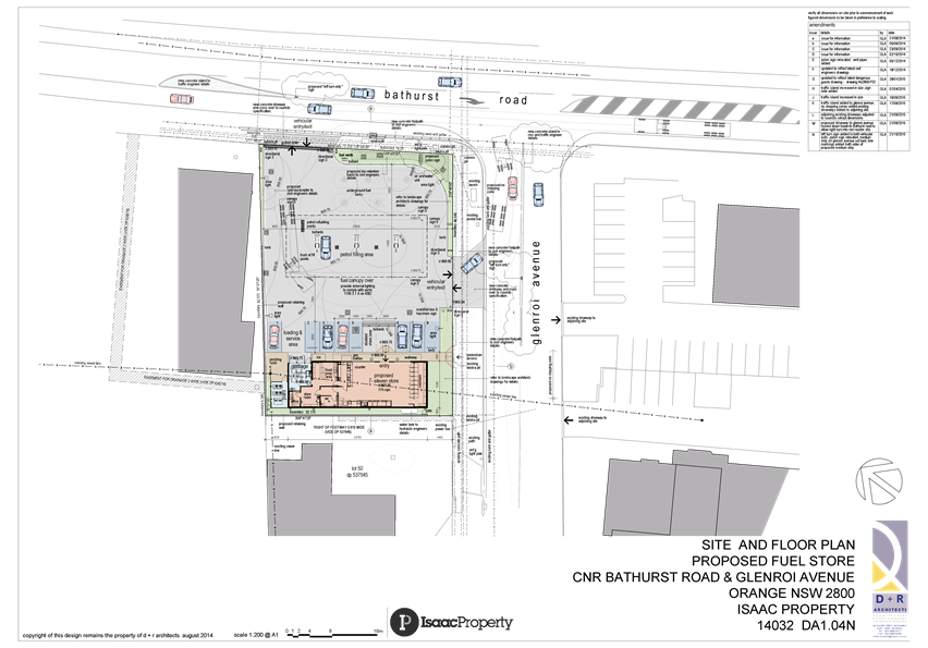
Planning and Development Committee
3 November 2015
2.2 Development
Application DA 38/2015(1) - 90-92 Bathurst Road
Attachment 3 Submissions


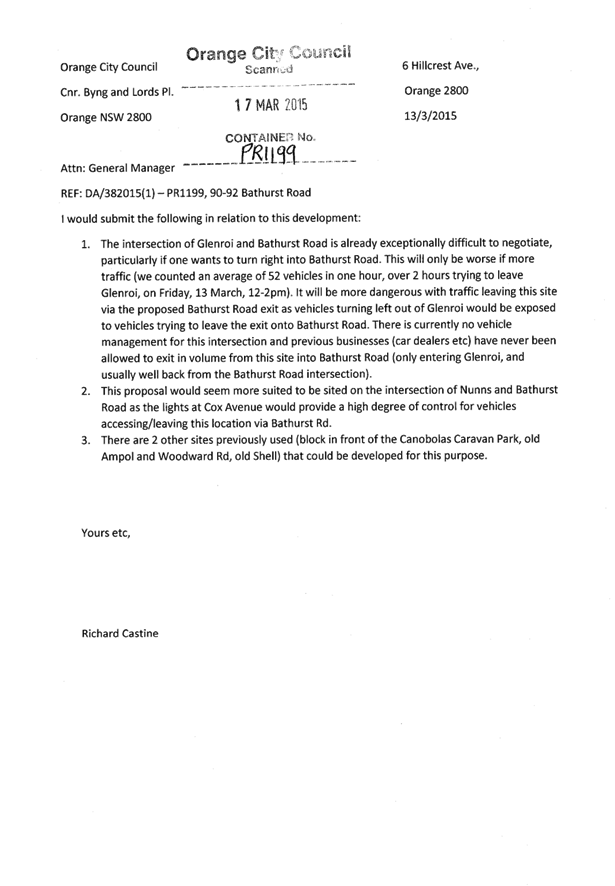

2.3 Development
Application DA 255/2015(1) - 12 Leewood Drive
TRIM
REFERENCE: 2015/2839
AUTHOR: Michael
Glenn, Senior Planner
EXECUTIVE Summary
|
Application
lodged
|
10
August 2015
|
|
Applicant/s
|
Inland
Truck Centres
|
|
Owner/s
|
Rakara
Holdings Pty Limited
|
|
Land
description
|
Lot 52
DP 255071 - 12 Leewood Drive, Orange
|
|
Proposed
land use
|
Vehicle
Sales or Hire Premises and Signage
|
|
Value of
proposed development
|
$300,000
|
Council's consent is sought to convert the existing premises
to a vehicle sales and hire premises. Associated signage is also proposed as
part of the proposed development.
There is no dispute that the proposed development has benefits
and should be approved. However, the application as submitted unnecessarily
contradicts certain provisions of Council’s Development Control Plan
(DCP) 2004. The amount of car parking greatly exceeds that required under the
DCP, and the landscape setbacks do not comply with the minimum requirements of
the DCP. There is no obvious planning related reason for this non-compliance,
and it will lead to the loss of significant landscaping from the site. There
are some areas of non-compliance with regard to the proposed signs under State
Environmental Planning Policy 64 (the SEPP), that have the effect of
prohibiting the development if left unaltered, however these non-compliance
aspects can be addressed by conditions.
The need for exposure of vehicles to promote the premises as
a sales point is, however, acknowledged; and for this reason it is considered
appropriate to allow the front landscape setback to adopt a give-and-take
approach. The conifers on the eastern side of the driveway are considered the least
significant visual elements of the site, and their removal is not opposed.
However, on the western side of the frontage it is considered appropriate to
require the existing landscape strip of approximately 5m around the existing
mature vegetation, but allow incursions where no significant vegetation is
affected.
The application is recommended for approval, subject to
conditions that reflect the above parameters.
Link To Delivery/OPerational Plan
The recommendation in this report relates to the Delivery/Operational
Plan strategy “13.4 Our Environment – Monitor and
enforce regulations relating to City amenity”.
Financial Implications
Nil
Policy and Governance Implications
Nil
|
Recommendation
That Council consents to development application DA
255/2015(1) for Vehicle Sales or Hire Premises and Signage at Lot 52
DP 255071 - 12 Leewood Drive, Orange pursuant to the conditions of consent in
the attached Notice of Approval.
|
further considerations
Consideration has been given to the
recommendation’s impact on Council’s service delivery; image and
reputation; political; environmental; health and safety; employees;
stakeholders and project management; and no further implications or risks have
been identified.
SUPPORTING INFORMATION
THE APPLICATION
Council's consent is sought for a vehicle sales or hire
premises and signage at Lot 52 DP 255071 - 12 Leewood Drive, Orange.
THE PROPOSAL
The proposal involves the following works:
· Internal building
alterations and additions to provide a small showroom and office and
administration areas.
· Minor external
building alterations including new shopfront glazing and an awning to identify
the main entrance to the building.
· Site works
including new hardstand vehicle display areas, parking areas, extensive tree
removals and minimal landscaping replacement. The replacement landscaping does
not comply with DCP requirements and new fencing. The parking requirements
exceed DCP requirements by a considerable margin.
· Establishment of
signage for the business, being a mix of wall advertisements (both business
identification signage and general advertising), and a free standing pylon
sign.
· Removal of
significant vegetation from the site
The proposed development represents permissible development
in the IN1 General Industrial zone.
MATTERS FOR CONSIDERATION
Section 5A Assessment
In the administration of sections 78A, 79B, 79C, 111 and
112, the provisions of Section 5A must be taken into account for every
development application in deciding whether there is likely to be a significant
effect on threatened species, populations or ecological communities or their
habitats.
This section includes a requirement to consider any adopted
assessment guidelines, which means assessment guidelines issued and in force
under section 94A of the Threatened Species Conservation Act 1995.
Assessment guidelines are in force (see DECC-W “Threatened Species
Assessment Guidelines - The Assessment of Significance”) which requires
consent authority to adopt the precautionary principle in its assessment.
In this instance, site inspection reveals the subject
property has low biodiversity or habitat value.
Section 79C
Section 79C of the Environmental Planning and Assessment
Act 1979 requires Council to consider various matters, of which those
pertaining to the application are listed below.
PROVISIONS OF ANY ENVIRONMENTAL
PLANNING INSTRUMENT s79C(1)(a)(i)
Orange Local Environmental Plan 2011
Part 1 - Preliminary
Clause 1.2 - Aims of Plan
The broad aims of the LEP are
set out under subclause 2. Those relevant to the application are as follows:
(a) to encourage development which complements
and enhances the unique character of Orange as a major regional centre boasting
a diverse economy and offering an attractive regional lifestyle,
(b) to provide for a range of development
opportunities that contribute to the social, economic and environmental
resources of Orange in a way that allows present and future generations to meet
their needs by implementing the principles for ecologically sustainable
development,
(c) to conserve and enhance the water
resources on which Orange depends, particularly water supply catchments,
In relation to (a), the configuration of the proposed
development is not considered entirely consistent with this objective in that
the impacts on the visual quality and amenity of the area would be
significantly detrimental due to the complete loss of mature vegetation from
the site. This plan objective is general, but is aimed at maintaining diversity
and amenity, with an emphasis on visual amenity and character. In the form
submitted, the proposed development is likely to significantly affect visual
character and amenity of the locality.
In relation to (b), the proposed development is considered
to be relatively neutral. It will provide certain employment and commercial
opportunities on the one hand, however the site activities are essentially a
re-use of existing buildings within an established industrial area of the City.
In relation to (c), the proposed development is not expected
to have significant effect.
Clause 1.6 - Consent Authority
This clause establishes that, subject to the Act, Council is
the consent authority for applications made under the LEP.
Clause 1.9A - Suspension of
Covenants, Agreements and Instruments
This clause provides that covenants, agreements and other
instruments which seek to restrict the carrying out of development do not apply
with the following exceptions.
· covenants imposed
or required by Council
· prescribed
instruments under Section 183A of the Crown Lands Act 1989
· any conservation
agreement under the National Parks and Wildlife Act 1974
· any trust
agreement under the Nature Conservation Trust Act 2001
· any property
vegetation plan under the Native Vegetation Act 2003
· any biobanking
agreement under Part 7A of the Threatened Species Conservation Act 1995
· any planning
agreement under Division 6 of Part 4 of the Environmental Planning and
Assessment Act 1979.
Council staff are not aware of the title of the subject
property being affected by any of the above.
Mapping
The subject site is identified
on the LEP maps in the following manner:
|
Land Zoning Map:
|
Land zoned IN1 General Industrial
|
|
Lot Size Map:
|
Minimum Lot Size 3000m2
|
|
Heritage Map:
|
Not a heritage item or conservation
area
|
|
Height of Buildings Map:
|
No building height limit
|
|
Floor Space Ratio Map:
|
No floor space limit
|
|
Terrestrial Biodiversity Map:
|
No biodiversity sensitivity on the
site
|
|
Groundwater Vulnerability Map:
|
Not ground water vulnerable
|
|
Drinking Water Catchment Map:
|
Not within the drinking water
catchment
|
|
Watercourse Map:
|
Not within or affecting a defined
watercourse
|
|
Urban Release Area Map:
|
Not within an urban release area
|
|
Obstacle Limitation Surface Map:
|
No restriction on building siting
or construction
|
|
Additional Permitted Uses Map:
|
No additional permitted use applies
|
Those matters that are of relevance are addressed in detail
in the body of this report.
Part 2 - Permitted or
Prohibited Development
Land Use Zones
The subject site is located within the IN1 General
Industrial zone. The proposed development is best defined as "vehicle
sales or hire premises" and "signage" under the relevant
planning controls.
Vehicle sales or hire premises is defined under the LEP as:
a building or place used for
the display, sale or hire of motor vehicles, caravans, boats, trailers,
agricultural machinery and the like, whether or not accessories are sold or
displayed there.
Vehicle sales and hire premises and signage are permissible
with consent from Council in the IN1 General Industrial zone
Clause 2.3 of LEP 2011
references the Land Use Table and Objectives for each zone in LEP 2011.
These objectives for land zoned IN1 General Industrial are as follows:
1 -
Objectives of the IN1 General Industrial Zone
· To provide a wide
range of industrial and warehouse land uses.
· To encourage
employment opportunities.
· To minimise any
adverse effect of industry on other land uses.
· To support and
protect industrial land for industrial uses.
· To ensure development
along the Southern Link Road has an alternative access.
In relation to the first dot point the proponent is seeking
approval for a use that is consistent with the zoning of the land. In relation
to the second dot point, the proposed development is likely to lead to some
employment opportunities associated with the new use. In relation to the third
dot point, there are no adverse effects arising for other land uses.
Surrounding development is predominantly industrial style development. There
are significant impacts on visual character and amenity, however these are not
considered to be land uses in the traditional sense. In relation to the fourth
dot point, the proposed development is compatible with the surrounding
industrial land use patterns. In relation to the fifth dot point, the proposed
development will not have any direct impact.
Part 7 - Additional Local
Provisions
7.3 - Stormwater Management
This clause applies to all
industrial, commercial and residential zones and requires that Council be
satisfied that the proposal:
(a) is designed to maximise the use of water
permeable surfaces on the land having regard to the soil characteristics
affecting onsite infiltration of water
(b) includes, where practical, onsite
stormwater retention for use as an alternative supply to mains water,
groundwater or river water; and
(c) avoids any significant impacts of
stormwater runoff on adjoining downstream properties, native bushland and
receiving waters, or if that impact cannot be reasonably avoided, minimises and
mitigates the impact.
The proposal has been designed
to include permeable surfaces and includes onsite retention of stormwater.
7.6 -
Groundwater Vulnerability
This clause seeks to protect
hydrological functions of groundwater systems and protect resources from both
depletion and contamination. Orange has a high water table and large areas of
the LGA, including the subject site, are identified with “Groundwater
Vulnerability” on the Groundwater Vulnerability Map. This requires that
Council consider:
(a) whether or not the development (including
any onsite storage or disposal of solid or liquid waste and chemicals) is
likely to cause any groundwater contamination or have any adverse effect on
groundwater dependent ecosystems, and
(b) the cumulative impact (including the
impact on nearby groundwater extraction for potable water supply or stock water
supply) of the development and any other existing development on groundwater.
Furthermore consent may not be granted unless Council is satisfied that:
(a) the development is designed, sited and
will be managed to avoid any significant adverse environmental impact, or
(b) if that impact cannot be reasonably
avoided - the development is designed, sited and will be managed to minimise
that impact,
(c) if that impact cannot be minimised - the
development will be managed to mitigate that impact.
The proposal is not anticipated
to involve the discharge of toxic or noxious substances and is therefore
unlikely to contaminate the groundwater or related ecosystems. The proposal
does not involve extraction of groundwater and will therefore not contribute to
groundwater depletion. The design and siting of the proposal avoids impacts on
groundwater and is therefore considered acceptable.
STATE ENVIRONMENTAL PLANNING
POLICIES
State Environmental Planning Policy 64 - Advertising and
Signage
State Environmental Planning Policy 64 -
Advertising and Signage applies to the subject development (the SEPP). The SEPP
aims to ensure that outdoor advertising is compatible with the desired amenity
and visual character of an area, provides effective communication in suitable
locations and is of high quality design and finish.
It is proposed to construct the following
signs on the subject property:
1 Three
illuminated flush wall signs erected to the front of the building as depicted
in the following drawing:
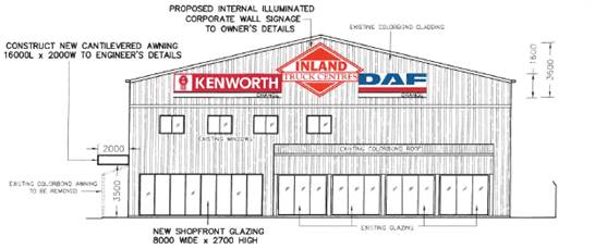
Figure 1 – flush mounted signs on the northern
wall of the main building
For the purposes of definition, these
constitute a business identification sign (the 'Inland Truck Centre"
wordmark), and two advertisements (being the "Kenworth" and
"DAF" wordmarks).
2 Freestanding 6m high
pylon sign in the north-eastern corner of the site:
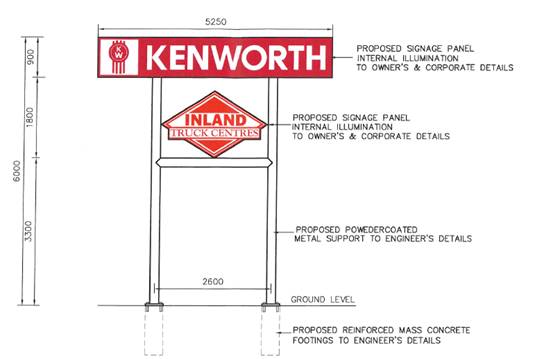
Figure 2 - freestanding pylon sign
The positioning
of this sign is shown below:
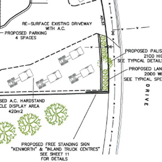
Figure 3 - location of proposed pylon sign
It is noted that in Leewood Drive generally
there are only two known examples of pylon signs higher than 4m in height that
appear to have Council approval. The proposed pylon sign would represent a new
precedent in terms of sign height and bulk as compared to the existing
character of the street.
The proposed pylon sign within the
landscaped area adjacent to Leewood Drive is inconsistent with the theme of
signage within the locality. As indicated above, there are few examples of
approved pylon signs along this length of Leewood Drive, and it is considered
that the height of the proposed pylon sign is excessive. To address this issue
it is considered appropriate to impose a condition that limits the height of
the pylon sign to a maximum of 4.5m. Limiting the signage to this height will
bring the proposed sign into a more compatible scale with other existing signs
in the street. A condition is included that limits the height of this sign
accordingly.
3 - Aims, Objectives etc
(1) This Policy aims:
(a) to
ensure that signage (including advertising):
(i) is
compatible with the desired amenity and visual character of an area, and
(ii) provides
effective communication in suitable locations, and
(iii) is
of high quality design and finish, and
(b) to
regulate signage (but not content) under Part 4 of the Act, and
(c) to
provide time-limited consents for the display of certain advertisements, and
(d) to
regulate the display of advertisements in transport corridors, and
(e) to
ensure that public benefits may be derived from advertising in and adjacent to
transport corridors.
(2) This
Policy does not regulate the content of signage and does not require consent
for a change in the content of signage.
Subject to the condition specified, the proposed development
is not inconsistent with the aims and objectives of the policy.
6 - Signage to Which
this Policy Applies
(1) This Policy applies to all
signage:
(a) that,
under another environmental planning instrument that applies to the signage,
can be displayed with or without development consent, and
(b) is
visible from any public place or public reserve,
except
as provided by this Policy
(2) This
Policy does not apply to signage that, or the display of which, is exempt
development under an environmental planning instrument that applies to it, or
that is exempt development under this Policy.
The proposed development includes signage that is of a type
that requires development consent.
8 - Granting of Consent
to Signage
A consent authority must not grant development consent to
an application to display signage unless the consent authority is satisfied:
(a) that
the signage is consistent with the objectives of this Policy as set out in
clause 3 (1)(a), and
(b) that
the signage the subject of the application satisfies the assessment criteria
specified in Schedule 1.
The proposal satisfies the assessment criteria outlined
within Schedule 1. The proposed signs are a mix of general
advertising and business identification signs. As such, the proposed
development triggers a need for a more general assessment under the policy.
11- Requirement for Consent
This clause establishes a need for consent for general
advertising of the kind proposed in this application
13 - Matters for Consideration
(1) A
consent authority (other than in a case to which subclause (2) applies) must
not grant consent to an application to display an advertisement to which this
Policy applies unless the advertisement or the advertising structure, as the
case requires:
(a) is
consistent with the objectives of this Policy as set out in clause 3 (1) (a),
and
(b) has
been assessed by the consent authority in accordance with the assessment
criteria in Schedule 1 and the consent authority is satisfied that the proposal
is acceptable in terms of its impacts, and
(c) satisfies
any other relevant requirements of this Policy.
In relation to 13(1)(a), it is considered that as submitted
the proposed pylon sign does not satisfy the criteria set down in Schedule 1.
The issue is the adverse effects the sign is likely to generate in terms of
visual character and amenity. It is considered that the shortcomings of this
sign can be addressed by the simple expedient of lowering it.
14 - Duration of Consents
(1) A
consent granted under this Part ceases to be in force:
(a) on
the expiration of 15 years after the date on which the consent becomes
effective and operates in accordance with section 83 of the Act
A condition is included limiting the consent to the
specified 15 years under the SEPP. Provisions remain in the SEPP that
allow under certain circumstances a shorter duration for consents, however such
pre-requisites are not applicable in this case.
22 - Wall Advertisements
(1) Only
one wall advertisement may be displayed per building elevation.
A condition is included that specifies no consent for the
wall advertisements for "Kenworth" and "DAF" as neither of
these sign elements are permissible under the SEPP.
(2) The
consent authority may grant consent to a wall advertisement only if:
(a) the
consent authority is satisfied that the advertisement is integrated with the
design of the building on which it is to be displayed, and
The proposed wall mounted signs are integrated with the
architecture of the building to the extent that they do not result in any
unsightly protrusions from the building and generally follow the form and
outline of the building.
(b) for
a building having:
(i) an
above ground elevation of 200 square metres or more - the advertisement does
not exceed 10% of the above ground elevation,
The front elevation of the building has an area of
approximately 260m2, and the proposed advertisement has an area of
almost exactly 26m2. This suggests that the size of the proposed
wall sign is compliant with this development standard.
(c) the
advertisement does not protrude more than 300 millimetres from the wall, unless
occupational health and safety standards require a greater protrusion, and
The proposed wall signs comply with this requirement.
(d) the
advertisement does not protrude above the parapet or eaves, and
The proposed wall advertisements do not protrude above any
of the parapet or eave lines of the building.
(e) the
advertisement does not extend over a window or other opening, and
(f) the
advertisement does not obscure significant architectural elements of the
building,
The proposed wall advertisement does not obstruct any
windows or openings of the building, or any significant architectural features.
(g) a
building identification sign or business identification sign is not displayed
on the building elevation.
The application insofar as it relates to the proposed wall
advertisements is contrary to both clause 22(1) (maximum of one wall advertisement
per elevation), and clause 22(2)(g) (building identification signs are not
permissible on walls where general advertising is displayed). To address this
area of non-compliance, the attached consent includes a condition that excludes
the general advertising for the front wall (the "Kenworth" and
"DAF" wordmark components). Such a condition will achieve
permissibility for the proposed development.
23 - Freestanding
Advertisements
The proposed pylon sign is consistent with the definition of
a 'free standing sign" and is subject to assessment under this clause.
(1) The
consent authority may grant consent to the display of a freestanding
advertisement only if the advertising structure on which the advertisement is
displayed does not protrude above the dominant skyline, including any
buildings, structures or tree canopies, when viewed from ground level within a
visual catchment of 1 kilometre.
The proposed sign is lower than the adjacent buildings, but
in terms of the vegetation, which is considered the dominant element of the
streetscape, the removal of nearly all trees from the frontage as currently
proposed would render the signage the dominant influence in the site
presentation, and significantly detract from the ambience and amenity of the locality.
To a degree, advertising exposure is accepted as a necessary element of
commercialisation of the area. However, where possible, such impacts as are
likely to arise should be undertaken in balance with the preservation of a
reasonable streetscape.
It is considered that in this case a reasonable balance can
be achieved by allowing the removal of the conifers from the eastern side of
the frontage. This will yield some visual exposure for both the trucks on
display, and allow the signage to be displayed with some reasonable level of
commercial exposure. However, the retention of the mature trees on the western
side of the site, whilst allowing reasonable commercial exposure of the site
and its advertising structures, will maintain a semblance of amenity and garden
setting, for which the Leewood industrial estate was designed.
Schedule 1 Assessment
criteria
1 - Character of the Area
· Is the proposal
compatible with the existing or desired future character of the area or
locality in which it is proposed to be located?
As previously mentioned in this report, the Leewood
industrial estate was developed more than 30 years ago as a garden industrial
estate. Further, notwithstanding its industrial land uses, it does not suffer a
wide proliferation of signs of the height and intrusiveness that would occur
with this proposal. It is considered that the most significant intrusive
element of the signage scheme is the height of the proposed pylon sign. Given
its proximity to the front boundary and the absence of similar 6m high pylon
signs of similar scale elsewhere in the street, it considered appropriate to
limit the height of this structure to a maximum of 4.5m. Limiting the
height of the sign structure will limit the intrusive effects of the sign,
whilst still permitting a reasonable level of commercial exposure.
· Is the proposal
consistent with a particular theme for outdoor advertising in the area or
locality?
Leewood Estate does not exhibit a particular design theme in
terms of its signage other than the instances of freestanding signs are less
frequent and the height of those signs more restrained that might be assumed.
2 - Special Areas
· Does the
proposal detract from the amenity or visual quality of any environmentally
sensitive areas, heritage areas, natural or other conservation areas, open
space areas, waterways, rural landscapes or residential areas?
When considered in conjunction with the other environmental
element of the proposed development, namely the removal of all the trees from
across the site frontage, it is considered that the impacts on amenity and
character would be significantly adverse.
This report contains two amending elements designed to
reduce those impacts to satisfactory level: some of the tree cover across the
frontage to be retained and a modest reduction in height for the proposed pylon
sign. It is considered that these amendments can be achieved as conditions of consent,
and if implemented will render a satisfactory impact on amenity and character.
3 - Views and Vistas
· Does the
proposal obscure or compromise important views?
There are no significant views affected by the proposed
development. A significant view in a planning assessment is generally vision of
a landmark or feature of something exceptional. Under DCP 2004, significant
views are considered to be limited to Mt Canobolas and certain mountain areas
to the north and northeast. There is no obstruction arising from the proposed
development on any of those features.
· Does the
proposal dominate the skyline and reduce the quality of vistas?
The vista of this part of Leewood drive is characterised by
mature and attractive landscape elements, restrained signage schemes and
generous setbacks. These characteristics establish a dominance and calming
effect on the street that is in other respects chaotic at times. Certain elements
of the overall proposal, namely the height of the pylon sign coupled with the
proposed removal of all frontage landscaping, would work to detract from those
calming elements of the streetscape, but can be addressed with conditions to
control the height of the pylon sign and retain some elements of the
landscaping.
· Does the
proposal respect the viewing rights of other advertisers?
There are no advertisers affected by the proposed
development.
4 - Streetscape, Setting or
Landscape
The following is an image of the
proposed pylon sign superimposed on an existing street view:
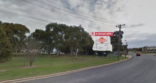
Figure 4 - pylon sign montage
The detail of this sign is as
follows:
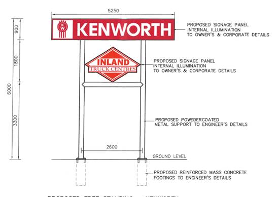
Figure 5 - pylon sign detail
The SEPP sets the following assessment criteria that are
relevant to the assessment of this element of the proposed development, as set
out in Clause 4 of the schedule:
· Is the scale,
proportion and form of the proposal appropriate for the streetscape, setting or
landscape?
In the form submitted and taking into account the other
elements of the proposed development (ie the proposed comprehensive tree
removal), it cannot be concluded that the proposed signage in its current form
has an appropriate scale, proportion, and form. Moreover, such adverse effects
on streetscape are considered to be potentially significant. The optimal
response in terms of streetscape impact would be to eliminate the pylon sign
and retain most or all of the trees at the frontage. However, this approach
would not take into account the other matters of commercial exposure that the
applicant states is important (and for which consideration should be given as
an objective of the LEP). It is considered a reasonable compromise to restrict
the height of the sign to 4.5m (a 25% reduction in scale for this sign),
and to require the retention of the trees on the western side of the frontage
of the site, as elsewhere stated in this report.
· Does the
proposal contribute to the visual interest of the streetscape, setting or
landscape?
It is considered that in the form submitted the proposed
development detracts from the visual amenity of the street. As a
generalisation, landscaping is considered a beneficial element to the ambience
and appeal of a given streetscape. Signs are generally accepted as having a
detrimental impact on the value and appeal of a given streetscape, but do form
part of the commercial and industrial landscape.
What is an appropriate scale and impact for a given sign is
generally taken from the scale, density and heights of other signs that exist
in a given locality. Signs that out of scale and have a dominant effect on the
streetscape are generally not a positive influence on the quality of the
streetscape.
· Does the
proposal reduce clutter by rationalising and simplifying existing advertising?
The proposed development is generally neutral from the
standpoint of this head of consideration. It cannot be considered a
rationalisation of the site signage, rather a change and intensification of the
signage impact.
· Does the
proposal screen unsightliness?
The proposed has no effect in this respect.
· Does the
proposal protrude above buildings, structures or tree canopies in the area or
locality?
The configuration of the proposed development as submitted
is such that the proposed pylon sign would protrude above the tree canopy
because it is also proposed to remove the tree canopy from the frontage of the
site.
· Does the
proposal require ongoing vegetation management?
The proposed development as modified by the conditions of
consent would require the retention of a degree of the existing landscaping at
the frontage of the site, however the resources needed for such management are
not considered excessive or unreasonable.
It the applicant’s request was fully implemented,
vegetation management of a similar scale and nature would still be required for
this site.
5 - Site and Building
· Is the proposal
compatible with the scale, proportion and other characteristics of the site or
building, or both, on which the proposed signage is to be located?
The wall mounted signage is considered compatible, but the
pylon sign is considered to be excessive in its impact due to its height and
the proposed vegetation removal.
· Does the
proposal respect important features of the site or building, or both?
The proposed wall advertisements are considered to be
consistent with this matter for consideration, but the pylon sign in the form
submitted is inconsistent with this planning outcome.
· Does the
proposal show innovation and imagination in its relationship to the site or
building, or both?
The proposed development is unremarkable with regard to its
design innovation and imagination.
6 - Associated Devices and
Logos with Advertisements and Advertising Structures
· Have any safety
devices, platforms, lighting devices or logos been designed as an integral part
of the signage or structure on which it is to be displayed?
There is no use of commonly identified devices or logos of
this form incorporated into the proposed sign messaging.
7 - Illumination
The proposed signage is proposed to be illuminated and
therefore this clause has relevance to the assessment.
· Would
illumination result in unacceptable glare?
There are no standards attached to this matter for
consideration, however it is noted that there are no dwellings in proximity to
the subject property. Whilst it is expected the glare will be considerable, it
is also considered that significant adverse impact is unlikely to arise as a
result of that effect.
· Would
illumination affect safety for pedestrians, vehicles or aircraft?
This is considered an unlikely impact from the proposed
development.
· Would
illumination detract from the amenity of any residence or other form of
accommodation?
Residences are not in proximity to the subject property. It
is considered unlikely that there would be adverse effects arising from the
signs being illuminated in this regard.
· Can the
intensity of the illumination be adjusted, if necessary?
This provision of the SEPP is suggestive of the fitting of
time clocks to the illumination apparatus on the signs. Such devices can be
used in situations where illuminated signage is proposed within or in close
proximity to residential precincts. In this case the signs are not in close
proximity to a residential precinct.
· Is the
illumination subject to a curfew?
There are no curfews in place, and none are proposed or
considered necessary.
8 - Safety
· Would the
proposal reduce the safety for any public road?
· Would the
proposal reduce the safety for pedestrians or bicyclists?
· Would the
proposal reduce the safety for pedestrians, particularly children, by obscuring
sightlines from public areas?
The proposed signs do not pose any significant, unusual or
unacceptable safety risks.
PROVISIONS OF ANY DRAFT
ENVIRONMENTAL PLANNING INSTRUMENT THAT HAS BEEN PLACED ON EXHIBITION
s79C(1)(a)(ii)
There are no draft environmental planning instruments that
apply to the subject land or proposed development.
DESIGNATED DEVELOPMENT
The proposed development is not designated development.
PROVISIONS OF ANY DEVELOPMENT
CONTROL PLAN s79C(1)(a)(iii)
Development Control Plan 2004
Development Control Plan 2004 (“the DCP”)
applies to the subject land (Part 9). An assessment of the proposed
development against the relevant Planning Outcomes will be undertaken below.
Pursuant to Planning Outcome 0.2-1 Interim Planning Outcomes
- Conversion of Zones:
· Throughout this
Plan, any reference to a zone in Orange LEP 2000 is to be taken to be a
reference to the corresponding zone(s) in the zone conversion table.
The corresponding zone to zone 4 (Light Industry) (Orange
LEP 2000) is zone IN1 General Industry (Orange LEP 2011). As such, Orange
DCP 2004 - Chapter 9 is relevant to this proposal. The provisions of Part 9
are considered below.
Industrial Site Development
· Buildings are
set back a minimum of 10 metres from front boundaries (5 metres to a secondary
boundary on a corner lot) for lots greater than 1,000m2 or 5 metres for lots
less than 1,000m2 or otherwise to a setback consistent with existing setbacks
in established areas. A 10m setback applies to lots that have frontage to
Clergate Road.
The proposed development is a re-use and refurbishment of an
existing building. Existing building setbacks would be unaffected by the
proposed development.
· Buildings cover
up to 50% of the site area (excluding the area of accessways for battleaxe
lots).
There are no changes proposed for building setbacks under
this application.
· Landscaping is
provided along boundaries fronting roads including trees with an expected mature
height at least comparable to the height of buildings on the site. All sites
contain an element of landscaping. Landscaping provided is of a bulk, scale and
height relative to buildings nearest the front property boundary so as to
provide beautification and visual relief to the built form proposed or existing
on the site. The depth of the landscape bed at the site frontage is sufficient
to accommodate the spread of plantings that meet the abovementioned outcomes
but, where practicable, a minimum depth of 3.5m is provided. Plantings are
designed to provide shade for parking areas, to break up large areas of
bitumen, to enhance building preservation and to screen against noise.
The application as submitted is proposing to remove the
existing significant landscaping and reduce the landscape buffer at the front
of the site to 2m or less. In effect, no landscaping is proposed for the
frontage of the site. The justification for the variation and vegetation
removal is provided in the applicants Statement of Environmental Effects as:
The proposal will require a
reduction in the width of the landscaping that is presently established along
the frontage of the site. As indicated in the submitted site plan, the existing
trees and landscaping along the frontage would require removal and the new
landscape bed would be reduced to a width of 2 metres. This is required to
provide sufficient area at the front of the site for the external display of
trucks for sale.
Council’s DCP encourages
landscape beds to have a width of 3.5 metres “where practicable”.
It is submitted that a 3.5 metre wide bed is not practical in the circumstances
and it is requested that Council accept the proposal as submitted.
The effective exposure and
display of vehicles for sale is central to the needs of a vehicle sales
premises. The existing landscaping (and indeed a 3.5 metre wide landscape bed)
would be contrary to this need.
The applicant’s submission is not fully supported in
this instance. The retention of the existing landscaping, at least on the
western side of the frontage as being "not practicable" is based on
the provision of parking not needed to meet Council parking requirements (as is
outlined elsewhere in this report). Parking provided as per Council standards
would enable the truck display area on the western side of the site to be set
back and allow the retention of the two mature trees planted in that area.
Planter beds of between 4-6m are required to retain these trees.
On the eastern side of the driveway into the site there are
ten conifers which will be required to be removed, and such removal is not
opposed. A variation to the landscape widths is not opposed on this part of the
site.
It is considered a reasonable balance between the commercial
considerations of the applicant and the preservation of visual amenity for the
locality to allow the removal of the conifers located on the eastern side of
the internal driveway, and to require retention of the landscaping that exists
on the western side of the driveway. Conditions to that effect are included in
the consent.
· Architectural
features are provided to the front building façade to provide relief
using such elements as verandahs, display windows, indented walls, etc.
There are no significant changes proposed to the front
façade of the building.
· External
materials consist of non-reflective materials.
Not relevant to this proposal.
· Adequate
parking and onsite manoeuvring is provided.
The building as approved under DA 159/1987 permitted the
construction of a warehouse building with a gross floor area of 1220m2.
Fifteen (15) off-street car parking spaces were required under this consent.
In 2007 Council received a further development application
for the subject property in which approval was granted to carry out alterations
and additions to the subject property, described in the development consent as alterations
and additions to an industrial building. The planning report noted at the
time that "existing parking arrangements were appropriate to the needs of
the new tenant, Pinnacle Drilling”. Of the 36 spaces shown on the
approved plan, not more than 26 were ever actually provided.
The current application seeks consent for a vehicle sales or
hire premises. The applicable rate of parking under the DCP is 1 space per 100m2
of site area, plus three spaces for every work bay for vehicle servicing, with
such spaces exclusive of cars displayed for sale.
There are six work bays proposed under this application
(plus a seventh service entry), generating a requirement for 18 spaces. The
vehicle display area is 535m2 (it is considered unnecessary to
include those parts of the site not actually used for motor vehicle display in
the parking demand calculations), generating a demand for parking of 5.35
spaces. The overall calculated demand for parking under Council's DCP is 23.35
spaces, rounded out to 24 spaces.
The proposed development provides for 21 existing spaces and
a further seven new spaces in front of the building. Given the large and
expensive nature of the vehicles proposed, it is considered that a car parking
rate of 21 spaces (ie rounding the fraction down) is sufficient to meet the
demands of the site. The new spaces in front of the building are not considered
necessary to meet the actual demands generated by the proposed use and have
definite adverse effects in that their provision pushes the display area for
trucks on the western side of the site further forward, such that significant
landscape elements and landscape buffer requirements of the DCP are not met. It
is considered that the seven spaces (numbered 7 through to 15 inclusive)
are not required, and in non-related areas generate excessive adverse effects
on the site because their inclusion forces or makes necessary the removal of
significant landscaping from the site.
In regards to manoeuvring, there is sufficient room to allow
car turning on the site, but not sufficient room to allow truck turnaround on
the site in a single manoeuvre. However, it is noted that this is a
continuation of the existing situation for the site. Arrangements exist, and
will continue to be so, for prime mover vehicles and rigid trucks to turn
around at the rear of the site, in either a single turning manoeuvre or a
three-point turn. For a semi-articulated vehicle with trailer attached it would
be difficult to turn the vehicle around on the site, although not impossible.
Such limitations on the manoeuvring on the site are a
continuation of the existing site constraints. It is not an ideal situation,
but given the traffic conditions in the locality, a continuation of existing
arrangements is considered satisfactory.
· Advertising
involves business-identification signs within the front façade and/or by
a pole sign comparable to the relative height to the main building on the site.
This issue has been assessed elsewhere in the report.
· Security
fencing is located or designed in a manner that does not dominate the visual
setting of the area.
A 2100mm metal palisade fence is proposed incorporating a
600mm high brick dwarf wall. This will replace the existing chain wire mesh
fence of similar height currently erected on the property.
PROVISIONS PRESCRIBED BY THE
REGULATIONS s79C(1)(a)(iv)
Demolition of a Building (clause 92)
The proposal does not involve the demolition of a building.
Fire Safety Considerations
(clause 93)
The proposal involves a change of building use for an
existing building. Council is satisfied that the fire protection and structural
capacity of the building are appropriate for the proposed new building use.
Relevant conditions are attached.
Buildings to be Upgraded (clause
94)
Upgrading of the building will be required to ensure that
the existing building is brought into partial or total conformity with the
Building Code of Australia. Conditions are attached in relation to the required
upgrading works.
THE LIKELY IMPACTS OF THE
DEVELOPMENT s79C(1)(b)
Visual Impacts
As submitted, the proposed development would have a
significant adverse effect on the visual amenity and character of the locality
and would provide parking on the site. The excess parking is not an issue of
itself, however it does generate a need to clear parts of the site of its
attractive and significant landscaping. Such parking is not necessary and
generates adverse effects on the visual quality.
There are also adverse effects on the visual amenity and
character of the area as a result of the proposed signage, or more specifically
the height of the proposed pylon sign.
Both these elements of the proposed development are
relatively easy to address by minor changes to the basic proposal. Specifically,
conditions are included requiring the lowering of the pylon sign by 1.5m,
reducing the parking provision to that required under the DCP and the
retention of the existing landscaping along the frontage on the western side of
the entrance gates. The applicant is not agreeable to these conditions, however
they are relatively simple and minor changes that will address the principal
concerns about this application.
Noise
The subject property is located in the centre of an existing
industrial estate and predicted noise intensity from this development type is
within guidance criteria identified in Council's previous noise assessment of
the Leewood industrial estate. Therefore, it is considered that the proposed
development would comply with the NSW Industrial Noise Policy.
A precautionary condition is attached to the consent
requiring the emitted noise from the development to not exceed 5dB(A) above
background noise measured from any affected nearby residence.
THE SUITABILITY OF THE SITE
s79C(1)(c)
The site is considered to be generally suitable for the
proposed development.
ANY SUBMISSIONS MADE IN
ACCORDANCE WITH THE ACT s79C(1)(d)
The proposed development is not defined as advertised
development under the provisions of the LEP, and as such no formal exhibition
of the application was required. No submissions have been received in relation
to this application.
PUBLIC INTEREST
s79C(1)(e)
The proposed development is considered to be of minor
interest to the wider public due to the relatively localised nature of
potential impacts. The proposal is not inconsistent with any relevant policy
statements, planning studies, guidelines etc that have not been considered in
this assessment.
SUMMARY
The proposed development in the form submitted is not
permissible, in that the proposed signs are not fully compliant to
SEPP-64. This problem can be addressed by conditions, in which the signs
that are not permissible are not included in the consent.
In addition to the permissibility issue, there are aspects
of the proposed development that on merit are considered unsatisfactory.
The proposed 6m high pylon sign is considered an excessive adverse effect on
the visual amenity and character of the locality, as is the proposed removal
and subsequent non-compliance with the landscape requirements of the DCP. These
are considered serious effects, and avoidable, given the excess of parking the
applicant is proposing. Conditions are included that rationalise the amount of
parking, and as a follow on consequence of that rationalisation, require the
retention of some of the landscaping on the western side of the frontage. Other
landscaping of the site is approved for removal as per the applicant’s
proposal. Subject to conditions, the proposed development complies with the relevant
aims, objectives and provisions of the LEP. A section 79C assessment
of the development indicates that the development is acceptable in this
instance. Attached is a draft Notice of Approval outlining a range of
conditions considered appropriate to ensure that the development proceeds in an
acceptable manner.
COMMENTS
The requirements of the Environmental Health and Building
Surveyor and the Engineering Development Section are included in the attached
Notice of Approval.
Attachments
1 Notice
of Approval, D15/40895⇩
2 Plans,
D15/41030⇩
Planning and Development Committee
3 November 2015
2.3 Development
Application DA 255/2015(1) - 12 Leewood Drive
Attachment 1 Notice
of Approval
|

|
ORANGE
CITY COUNCIL
Development
Application No DA
255/2015(1)
NA/ Container
PR6661
|
NOTICE OF DETERMINATION
OF A DEVELOPMENT
APPLICATION
issued under the Environmental
Planning and Assessment Act 1979
Section 81(1)
|
Development
Application
|
|
|
Applicant Name:
|
Inland
Truck Centres
|
|
Applicant Address:
|
C/- Peter
Basha Planning & Development
PO Box 1827
ORANGE
NSW 2800
|
|
Owner’s Name:
|
Rakara
Holdings Pty Limited
|
|
Land to Be Developed:
|
Lot 52 DP
255071 - 12 Leewood Drive, Orange
|
|
Proposed Development:
|
Vehicle
Sales or Hire Premises and Signage
|
|
|
|
|
Building
Code of Australia
building classification:
|
As
determined by Certifier
|
|
|
|
|
Determination
|
|
|
Made On:
|
3 November
2015
|
|
Determination:
|
CONSENT
GRANTED SUBJECT TO CONDITIONS DESCRIBED BELOW:
|
|
|
|
|
Consent to
Operate From:
|
4 November
2015
|
|
Consent to
Lapse On:
|
4 November
2020
|
Terms of Approval
The reasons for the imposition of
conditions are:
(1) To ensure a quality
urban design for the development which complements the surrounding environment.
(2) To maintain
neighbourhood amenity and character.
(3) To prevent the proposed
development having a detrimental effect on adjoining land uses.
(4) To minimise the impact
of development on the environment.
Conditions
(1) The
development must be carried out in accordance with:
(a) Plan/s
numbered Plans by Peter Basha Planning referenced 15040DA sheets 5, 6, 7, 8, 9,
10, and 11, dated 21.09.2015 (7 sheets)
(b) statements
of environmental effects or other similar associated documents that form part
of the approval
as amended
in accordance with any conditions of this consent.
(2) All building work must
be carried out in accordance with the provisions of the Building Code of
Australia.
(3) A sign is to be erected
in a prominent position on any site on which building work, subdivision work or
demolition work is being carried out:
a. showing
the name, address and telephone number of the principal certifying authority
for the work, and
b. showing
the name of the principal contractor (if any) for any building work and a
telephone number on which that person may be contacted outside working hours,
and
c. stating
that unauthorised entry to the site is prohibited.
Any such sign is to be maintained while the
building work, subdivision work or demolition work is being carried out.
|
PRIOR TO THE ISSUE OF
A CONSTRUCTION CERTIFICATE
|
(4) An amended landscaping
plan is required to be submitted and approved by Councils Manager Development
Assessments prior to the issue of a Construction Certificate. This amended plan
shall retain the existing landscaped areas along the frontage west of the
existing entrance drive, as well as the landscaped areas along the western side
boundary forward of the building line. The vegetation contained within these
landscaped areas above 3m in height shall be retained. Elsewhere on the
site, the landscaping plan may allow for the removal of the conifers on the
eastern side of the entrance driveway and the provision of a 2m wide landscape
strip as shown in the existing plans for this area of the site.
(5) An amended plan for the
pylon sign shall be submitted and approved by Councils Manager Development
Assessments, prior to the issue of a Construction Certificate, that limits the
maximum height of the pylon sign to no more than 4.5m. This sign shall
not exceed that approved height of 4.5m.
(6) A
Construction Certificate application is required to be submitted to, and issued
by, Council/Accredited Certifier prior to any excavation or building works
being carried out on site.
(7) An
approval under Section 68 of the Local Government Act is to be sought from
Orange City Council, as the Water and Sewer Authority, for water, sewer and
stormwater connection. No plumbing and drainage is to commence until approval
is granted.
|
DURING
CONSTRUCTION/SITEWORKS
|
(8) All
construction/demolition work on the site is to be carried out between the hours
of 7.00 am and 6.00 pm Monday to Friday inclusive, 7.00 am to
5.00 pm Saturdays and 8.00 am to 5.00 pm on Sundays and Public
Holidays. Written approval must be obtained from the General Manager of Orange
City Council to vary these hours.
(9) Building
demolition is to be carried out in accordance with Australian
Standard 2601:2001 - The Demolition of Structures and the requirements
of the NSW WorkCover Authority.
(10) Any adjustments to
existing utility services that are made necessary by this development
proceeding are to be at the full cost of the developer.
(11) All driveway and
parking areas are to be sealed with bitumen, hot mix or concrete and are to be
designed for all expected loading conditions (provided however that the minimum
pavement depth for gravel and flush seal roadways is 200mm) and be in
accordance with the Orange City Council Development and Subdivision Code.
|
PRIOR TO THE ISSUE OF
AN OCCUPATION CERTIFICATE
|
(12) A total of 21
off-street car parking spaces shall be provided upon the site in accordance
with the approved plans, the provisions of Development Control Plan 2004, and
be constructed in accordance with the requirements of Council's Development and
Subdivision Code prior to the issue of an Occupation Certificate. The parking
spaces numbered 9 through to 15 on the approved plan are not required. The
parking spaces 7 through to 15 shown on the plans may be used for the display
of vehicles on sale. No vehicles may be displayed, stored or parked within the
landscaped areas on the western side of the access drive.
(13) Landscaping
shall be installed in accordance with the amended plans required by condition 4
of the Consent.
(14) No
person is to use or occupy the building or alteration that is the subject of
this approval without the prior issuing of an Occupation Certificate.
(15) The
owner of the building/s must cause the Council to be given a Final Fire Safety
Certificate on completion of the building in relation to essential fire or
other safety measures included in the schedule attached to this approval.
(16) Where
Orange City Council is not the Principal Certifying Authority, a final
inspection of water connection, sewer and stormwater drainage shall be undertaken
by Orange City Council and a Final Notice of Inspection issued, prior to the
issue of either an interim or a final Occupation Certificate.
(17) All
of the foregoing conditions are to be at the full cost of the developer and to
the requirements and standards of the Orange City Council Development and
Subdivision Code, unless specifically stated otherwise. All work required by
the foregoing conditions is to be completed prior to the issuing of an
Occupation Certificate, unless stated otherwise.
|
MATTERS FOR THE
ONGOING PERFORMANCE AND OPERATION OF THE DEVELOPMENT
|
(18) Landscaping
required under this consent, and existing landscaping required to be retained
under this consent shall be permanently maintained to the satisfaction of
Council's Manager Development Assessments.
(19) The
owner is required to provide to Council and to the NSW Fire Commissioner an
Annual Fire Safety Statement in respect of the fire-safety measures, as
required by Clause 177 of the Environmental Planning and Assessment Regulation
2000.
(20) This
consent
does not permit the wall advertisements on the building containing the
wordmarks "Kenworth" and "DAF". The Business Identification
Sign with wordmark "Inland Truck Centre" is approved. It is
noted that the application as submitted, with respect to the wall
advertisements is contrary to clause 22 (1) (maximum of 1 sign per elevation)
and 22 (2) (g) (general advertising may not be displayed on the same wall as a
wall displaying business identification signage).
(21) Emitted
noise shall not exceed 5dB(A) above background sound level measured at the
nearest affected residence.
Other Approvals
(1) Local
Government Act 1993 approvals granted under section 68.
Nil
(2) General
terms of other approvals integrated as part of this consent.
Nil
Right of Appeal
If
you are dissatisfied with this decision, section 97 of Environmental
Planning and Assessment Act 1979 gives you the right to appeal to the Land
and Environment Court within 6 months after the date on which you receive this
notice.
*
Section 97 of the Environmental Planning and Assessment Act 1979 does not apply
to the determination of a development application for State significant
development or local designated development that has been the subject of a
Commission of Inquiry.
|
Disability Discrimination Act
1992:
|
This application has been assessed in
accordance with the Environmental Planning and Assessment Act 1979. No
guarantee is given that the proposal complies with the Disability
Discrimination Act 1992.
The applicant/owner is responsible to
ensure compliance with this and other anti-discrimination legislation.
The Disability Discrimination Act
covers disabilities not catered for in the minimum standards called up in the
Building Code of Australia which references AS1428.1 - "Design for
Access and Mobility". AS1428 Parts 2, 3 and 4 provides the most
comprehensive technical guidance under the Disability Discrimination Act
currently available in Australia.
|
|
|
|
|
Disclaimer - S88B Restrictions on the Use of Land:
|
The applicant should note that there
could be covenants in favour of persons other than Council restricting what
may be built or done upon the subject land. The applicant is advised to check
the position before commencing any work.
|
|
|
|
|
Signed:
|
On behalf of the consent authority ORANGE
CITY COUNCIL
|
|
Signature:
|
|
|
Name:
|
ALLAN RENIKE - MANAGER DEVELOPMENT
ASSESSMENTS
|
|
Date:
|
4 November 2015
|
Planning
and Development Committee
3 November 2015
2.3 Development
Application DA 255/2015(1) - 12 Leewood Drive
Attachment 2 Plans
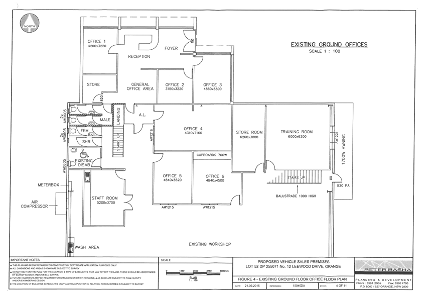
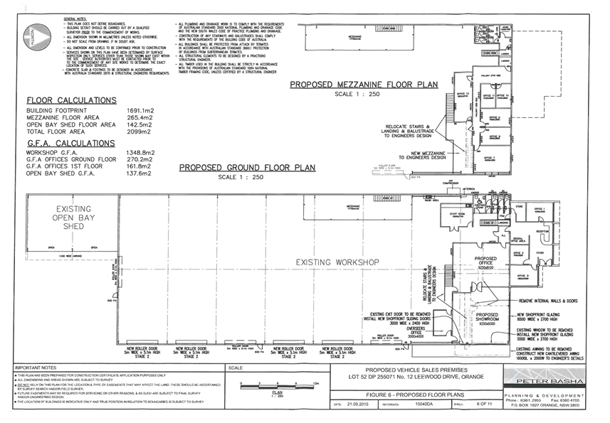
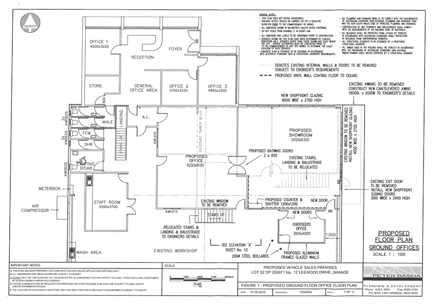
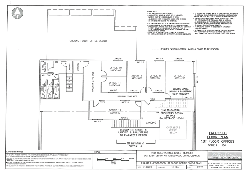
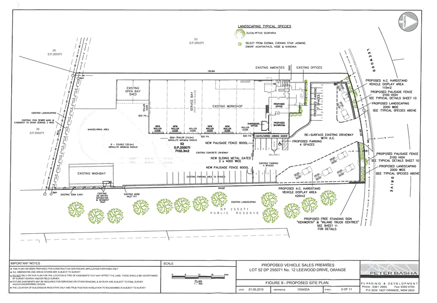
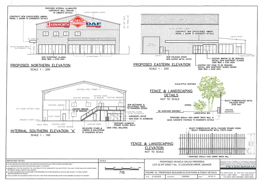
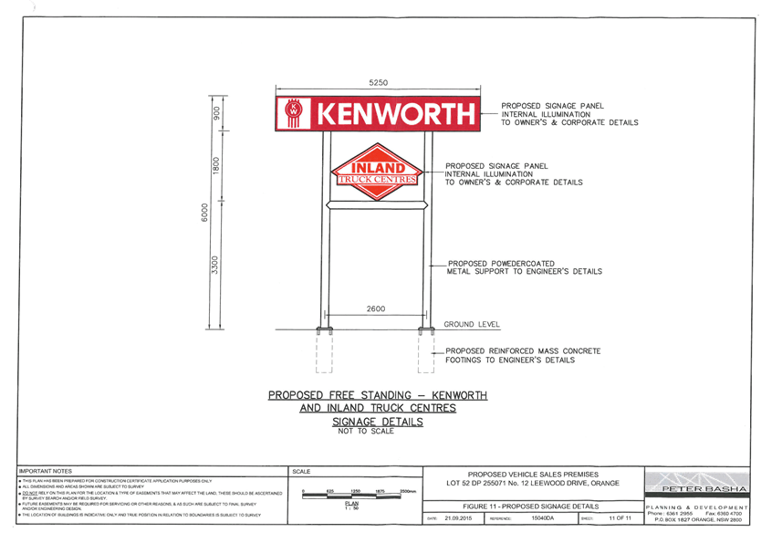
2.4 Development
Application DA 319/2015(1) - 1 Summer Street
TRIM
REFERENCE: 2015/2769
AUTHOR: Daniel
Drum, Town Planner
EXECUTIVE Summary
|
Application
lodged
|
15
September 2015
|
|
Applicant/s
|
Orange
City Council
|
|
Owner/s
|
Orange
City Council
|
|
Land
description
|
Lot 1 DP
1065949 - 1 Summer Street, Orange
|
|
Proposed
land use
|
Demolition
(existing shop and dwelling)
|
|
Value of
proposed development
|
$60,000
|
Council's consent is sought for the demolition of the existing
dwelling and shop at 1 Summer Street, Orange being Lot 1 DP 1065949 (the
‘subject property’).
While the subject property is located within the Central
Orange Heritage Conservation Area and proximate to the Coronation Memorial
Plaque heritage item, it is considered that the demolition of the existing
dwelling and shop will not affect the heritage significance of either.
One submission was received from the adjoining land owners at
3 Summer Street. The submitters identified that they are concerned by the loss
of security and increased traffic noise that they will experience due to the
existing dwelling and shop being demolished.
The applicant had previously offered to meet 50% of the
costs of a heritage style fence, estimated at a cost of $6,000-$8,000. This
offer has been rejected by the adjoining land owners. The applicant has advised
that the estimated cost of the requested brick wall is between $20K - $30K
which is unacceptable to the applicant.
The applicant has subsequently
advised that it would be willing to install at its own cost a matching
‘lattice style’ Colorbond fence extension on top of the existing
1.8m high Colorbond fence which divides the properties, bringing the total
height of the fence to 2.1m. This is considered to be a suitable outcome.
The proposed demolition is considered to be consistent with
the relevant aims, objectives and planning outcomes of Orange Local
Environmental Plan 2011 and Orange Development Control plan 2004.
The following assessment identifies that the proposed subdivision
should be supported.
Link To Delivery/OPerational Plan
The recommendation in this report relates to the
Delivery/Operational Plan strategy “13.4 Our Environment
– Monitor and enforce regulations relating to City amenity”.
Financial Implications
The cost of the construction of the dividing fence will be
entirely at Council’s expense and will require a budget variation.
Policy and Governance Implications
Nil
|
Recommendation
That Council consents to
development application DA 319/2015(1)
for Demolition (existing shop and dwelling) at Lot 1 DP 1065949 -
1 Summer Street, Orange pursuant to the conditions
of consent in the attached Notice of Approval.
|
further considerations
Consideration has been given to the
recommendation’s impact on Council’s service delivery; image and
reputation; political; environmental; health and safety; employees;
stakeholders and project management; and no further implications or risks have
been identified.
SUPPORTING INFORMATION
THE APPLICATION/PROPOSAL
Council's consent is sought for the demolition of the
existing dwelling and shop at 1 Summer Street, Orange being Lot 1 DP
1065949.
The applicant has advised that the shop and dwelling were
constructed during the 1960s and mid-1970s, respectively. Neither the shop nor
dwelling are currently in use. Neither building is identified as a heritage
item.
The proposal also indicates that two trees would be removed
from the subject property during the demolition, being a walnut and lemon.
Internal advice from Council’s Manager City Presentation confirms that
consent is not required for the removal of either tree.
The existing conditions of the
subject site are illustrated in Figures 1-4 below.
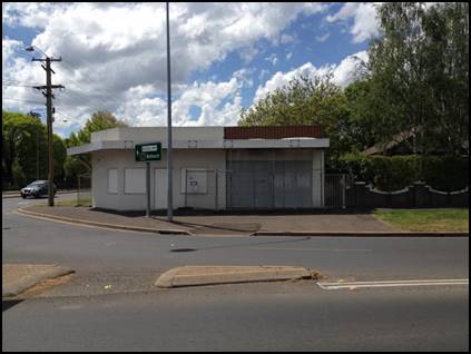
Figure 1: the subject
site - shop (viewed from the south)
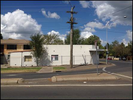
Figure 2: the subject
site - shop (viewed from the west)
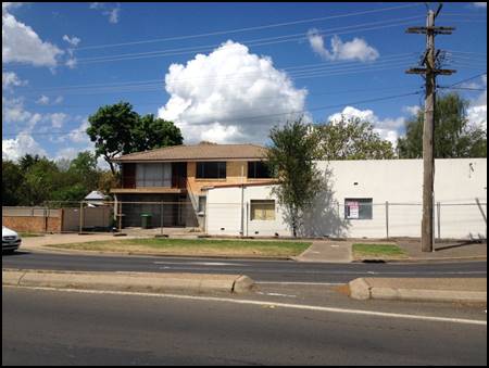
Figure 3: the subject
site - dwelling and shop (viewed from the west)
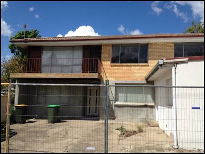
Figure 4: the subject site - dwelling (viewed from the
west)
MATTERS FOR CONSIDERATION
Section 5A Assessment – Significant Effect on
Threatened Species, Populations or Ecological Communities or Their Habitats
In the administration of sections 78A, 79B, 79C, 111 and
112, the provisions of Section 5A must be taken into account for every
development application in deciding whether there is likely to be a significant
effect on threatened species, populations or ecological communities or their
habitats. This section includes a requirement to consider any adopted
assessment guidelines, which means assessment guidelines issued and in force
under section 94A of the Threatened Species Conservation Act 1995.
Assessment guidelines are in force (see DECC-W “Threatened Species
Assessment Guidelines - The Assessment of Significance”) which requires
consent authority to adopt the precautionary principle in its assessment.
In this instance, site inspection reveals the subject
property has no biodiversity or habitat value.
Section 79C
Section 79C of the Environmental Planning and Assessment
Act 1979 sets out the matters that the consent authority is to take into
consideration in determining a development application. Those matters are
addressed in the body of this report.
PROVISIONS OF ANY ENVIRONMENTAL
PLANNING INSTRUMENT s79C(1)(a)(i)
Orange Local Environmental Plan 2011
Part 1 - Preliminary
Clause 1.2 - Aims of Plan
The
aims of the LEP relevant to the application include:
(a) To encourage development which complements
and enhances the unique character of Orange as a major regional centre boasting
a diverse economy and offering an attractive regional lifestyle.
(b) To provide for a range of development
opportunities that contribute to the social, economic and environmental
resources of Orange in a way that allows present and future generations to meet
their needs by implementing the principles for ecologically sustainable
development.
(f) To recognise and manage valued environmental
heritage, landscape and scenic features of Orange.
The application is considered to be consistent with the
relevant aims of the LEP. Relevant matters are addressed throughout the body of
this report.
Clause 1.6 - Consent Authority
Clause 1.6 establishes that Council is the consent authority
for the purpose of Orange Local Environmental Plan 2011.
Clause 1.9A - Suspension of
Covenants, Agreements and Instruments
Clause 1.9A provides that any agreement, covenant or other
similar instrument that restricts the carrying out of that development does not
apply to the extent necessary to serve that purpose, with the exception of:
· Covenants
imposed or required by Council; prescribed instruments within the meaning of
Section 183A of the Crown Lands Act 1989
· Any
conservation agreement within the meaning of the National Parks and Wildlife
Act 1974;
· Any trust
agreement within the meaning of the Nature Conservation Trust Act 2001;
· Any property
vegetation plan under the Native Vegetation Act 2003;
· Any biobanking
agreement within the meaning of Part 7A of the Threatened Species Conservation
Act 1995;
· Any planning
agreement under Division 6 of Part 4 of the Environmental Planning and
Assessment Act 1979.
This clause does not affect the rights or interests of any
public authority under any registered instrument.
A search of Council’s records indicates that a Section
88B Instrument does not apply to the subject property and that it is not
affected by any of the above covenants, agreements or plans.
Clause 1.7 Maps
The subject site is identified
on the LEP maps in the following manner:
|
Land Zoning Map:
|
Land zoned R1 General Residential
|
|
Lot Size Map:
|
No Minimum Lot Size
|
|
Heritage Map:
|
Heritage conservation area
|
|
Height of Buildings Map:
|
No building height limit
|
|
Floor Space Ratio Map:
|
No floor space limit
|
|
Terrestrial Biodiversity Map:
|
No biodiversity sensitivity on the
site
|
|
Groundwater Vulnerability Map:
|
Ground water vulnerable
|
|
Drinking Water Catchment Map:
|
Not within the drinking water catchment
|
|
Watercourse Map:
|
Not within or affecting a defined
watercourse
|
|
Urban Release Area Map:
|
Not within an urban release area
|
|
Obstacle Limitation Surface Map:
|
No restriction on building siting
or construction
|
|
Additional Permitted Uses Map:
|
No additional permitted use applies
|
Those matters that are of relevance are addressed in detail
in the body of this report.
Part 2 - Permitted or
Prohibited Development
Clause
2.1 - Land Use Zones and Clause 2.3 - Zone Objectives and Land Use Table
The subject site is zoned R1
General Residential Zone (Figure 5).
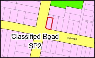
Figure 5 - zone plan (subject property denoted by red
line)
The objectives of the R1 General Residential zone are:
· To
provide for the housing needs of the community.
· To
provide for a variety of housing types and densities.
· To
enable other land uses that provide facilities or services to meet the day to
day needs of residents.
· To
ensure development is ordered in such a way as to maximise public transport
patronage and encourage walking and cycling in close proximity to settlement.
· To
ensure that development along the Southern Link Road has an alternative access.
The proposed demolition is considered to be consistent with
the objectives of the R1 General Residential zone.
Clause 2.7 – Demolition Requires Development Consent
Clause
2.7 identifies that demolition of a building may be carried out only with
development consent.
Part 3 - Exempt and Complying Development
The application is not exempt or complying development.
Part 5 - Miscellaneous Provisions
5.9 - Preservation of Trees
or Vegetation
Clause
5.9 seeks to preserve the amenity of the area, including biodiversity value,
through the preservation of trees and other vegetation. Subject to Clause
5.9(3)(a) and (b) development consent, a permit granted by Council is
required to ringbark, cut down, top, lop, remove, injure or wilfully destroy
any tree or other vegetation to which any such development control plan
applies.
The applicant has indicated that two trees would be removed
from the subject property during the demolition, being a walnut and lemon tree.
Internal advice from Council’s Manager City Presentations confirms that
consent is not required for either tree.
5.10 - Heritage
Conservation
Clause
5.10 seeks to conserve the environmental heritage of Orange; conserve the
heritage significance of heritage items and heritage conservation areas,
including associated fabric, settings and views; conserve archaeological sites
and conserve Aboriginal objects and Aboriginal places of heritage significance.
Subject
to Clause 5.10(2)(f), development consent is required to demolish a building
within a heritage conservation area. Before granting consent, the consent
authority must consider the effect of the proposed development on the
significance of the heritage area concerned.
The subject site is located at
the western periphery of the Central Orange Heritage Conservation Area (Figure
6).
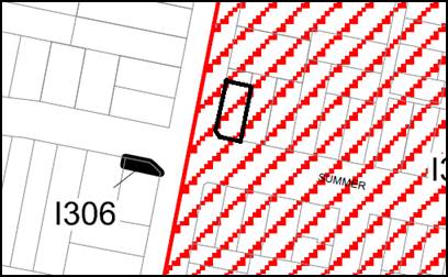
Figure 6 - Orange Central Heritage Conservation Area
(extract) and the Coronation Memorial
Plaque heritage item (I306) (subject property denoted
by dark black line)
The Statement of Significance for the Central Orange
Heritage Conservation Area (Orange City Council Heritage Study 2012, David
Scobie Architects Pty Ltd) identifies that it consists of a range of buildings
dating from the latter part of the nineteenth century and early part of the
twentieth century, and that some have historical importance for reflecting the
development and prosperity of Orange during that period.
The Statement of Significance identifies that the
conservation area exhibits several fine examples of different architectural
styles and that the building materials, mature street trees and fine parklands
help to bring the area together as an aesthetically pleasing whole and as a
townscape of importance.
Key characteristics of the residential areas include:
· an important
spread of Victorian buildings (especially public and ecclesiastical buildings),
and many buildings from the turn of the century with late Victorian and
Edwardian features which are of particular significance because of their
concentration and general good condition;
· some significant
Federation houses and bungalows of the twenties and thirties which make up a
major element of the housing stock; and
· significant common
features, including the use of the vernacular ‘buff brown’ brick,
corrugated iron roofs and consistent front verandah elements.
The subject site is also
adjacent to the Coronation Memorial Plaque heritage item (I306) located
within the road reserve at corner of Coronation Drive and Woodward Street
(Figure 7).
Figure 7 - the Coronation Memorial Plaque
The plaque is described as being:
“A concrete base with
tapering pedestal to 700mm high supporting an inclined concrete slab with
square edges as a lectern upon which is pinned an engraved black stone slab. A
lamp post is mounted behind the supporting a domestic scale lantern and street
sign.”
The Statement of Significance for the plaque identifies
that:
“The memorial plaque is
a marker and reminder of the Commonwealth relationship as expressed in the form
of civic improvements and acknowledgement.”
Although the subject property is located within the Central
Orange Heritage Conservation Area and is adjacent to the Coronation Memorial
Plaque, it is not considered that the proposed demolition will have a
detrimental impact on the heritage significance of either.
In particular, based on the era and design of the existing
shop and dwelling it is not considered that they are consistent with the key
characteristics of residential areas within the Central Orange Heritage
Conservation Area, or that they make a contribution to the heritage character
of the area that is worthy of retention.
Further, given the type of significance attributed to the
Coronation Memorial Plaque (i.e. not being of architectural significance)
and its separation from the subject site, it is not considered that the
proposed demolition would affect its heritage significance.
While the applicant has not identified any future proposed
development of the subject property, any future proposal will be subject to the
relevant provisions of the LEP and DCP which seek to conserve the
significance of heritage items and heritage conservation areas within Orange.
As such, the proposed demolition will afford the opportunity
for a new, infill development of the subject property which will be required to
conserve the heritage significance of the local area.
Part 7 - Additional Local Provisions
7.3
- Stormwater Management
Clause 7.3 - Stormwater
Management seeks to minimise the impacts of urban stormwater on the land to
which the development applies and on adjoining downstream properties, native
bushland and receiving waters.
Development consent must not be
granted to development on land to which this clause applies unless the consent
authority is satisfied that the development is designed to maximise the use of
water permeable surfaces on the land having regard to the soil characteristics
affecting onsite infiltration of water. This includes, where practical, onsite
stormwater retention for use as an alternative supply to mains water,
groundwater or river water; and avoids any significant impacts of stormwater
runoff on adjoining downstream properties, native bushland and receiving
waters, or if that impact cannot be reasonably avoided, minimises and mitigates
the impact.
The
development application indicates that a soil and erosion control plan will be
implemented during the demolition, including a sediment fence located along the
western boundary of the subject property and the vacant properties at 160 and
162 Woodward Street. 160 and 162 Woodward Street are both Council owned
properties.
In addition, the Environmental
Health and Building Department have recommended a condition of consent
requiring that soil erosion controls be implemented on the subject property
prior to works commencing.
7.6 - Groundwater Vulnerability
Clause
7.6 - Groundwater Vulnerability seeks to maintain the hydrological functions of
key groundwater systems and to protect vulnerable groundwater resources from
depletion and contamination as a result of inappropriate development.
Before
determining a development application for development on land to which this
clause applies, the consent authority must consider whether or not the
development (including any onsite storage or disposal of solid or liquid waste
and chemicals) is likely to cause any groundwater contamination or any adverse
impact (including the impact on nearby groundwater extraction for potable water
supply or stock water supply) of the development and any other existing
development on groundwater.
Development
consent must not be granted to development on land to which this clause applies
unless the consent authority is satisfied that the development is designed,
sited and will be managed to avoid any significant adverse environmental
impact; or if that impact cannot be reasonably avoided - the development is
designed, sited and will be managed to minimise the impact; if that impact
cannot be minimised - the development will be managed to mitigate that impact.
The proposed demolition will not
involve the discharge of toxic or noxious substances and is therefore unlikely
to contaminate the groundwater or related ecosystems. Similarly,
the proposed demolition will not involve
extraction of groundwater and will therefore not contribute to
groundwater depletion.
A detailed assessment of
groundwater vulnerability would be undertaken as part of an assessment of any
future proposal to develop the subject property.
STATE ENVIRONMENTAL PLANNING
POLICIES
State Environmental Planning Policy (Infrastructure) 2007
applies to the proposed demolition.
Specifically, Subdivision 2 - Development in or adjacent to
road corridors and road reservations, Section 101 - Development with frontage
to classified road provides that the consent authority must not grant consent
to development on land that has a frontage to a classified road unless it is
satisfied that where practicable, vehicular access to the land is provided by a
road other than the classified road; the safety, efficiency and ongoing
operation of the classified road will not be adversely affected by the
development; and the development is of a type that is not sensitive to traffic
noise or vehicle emissions, or is appropriately located and designed, or
includes measures, to ameliorate potential traffic noise or vehicle emissions
within the site of the development arising from the adjacent classified road.
Access to the subject property
is currently provided from Woodward Street, being a classified road. The
development application also indicates that the subject property may be
accessed from the adjoining vacant property at 162 Woodward Street during the
course of the demolition. Access to this property is also currently provided
from Woodward Street.
Accordingly, it is considered
that the existing access arrangement to the subject property is suitable.
PROVISIONS OF ANY DRAFT
ENVIRONMENTAL PLANNING INSTRUMENT THAT HAS BEEN PLACED ON EXHIBITION
s79C(1)(a)(ii)
There are no draft environmental planning instruments that
apply to the subject land or proposed development.
DESIGNATED DEVELOPMENT
The proposed development is not designated development.
PROVISIONS OF ANY DEVELOPMENT
CONTROL PLAN s79C(1)(a)(iii)
Development Control Plan 2004
Development Control Plan 2004 (“the DCP”)
applies to the subject land. Chapters of the DCP relevant to the proposed
subdivision include:
· Chapter 0 -
Transitional Provisions;
· Chapter 2 -
Natural Resource Management;
· Chapter 3 - General
Considerations;
· Chapter 4 -
Special Environmental Considerations
· Chapter 5 -
General Considerations for Zones and Development; and
· Chapter 13 -
Heritage.
The relevant sections, objectives and planning outcomes of
each chapter are addressed below.
Chapter 0 - Transitional
Provisions
Section 0.2 - General Translation of Zones
Section 0.2 - General Translation of Zones provides that any
reference to a zone under Orange LEP 2000 is to be a reference to the
corresponding zones in a zone conversion table.
The table identifies that the R1 General Residential zone
corresponds with the former 2a Urban Residential and 2d Urban Transition
Zones.
Section 0.4 - Former LEP
Matters
Section 0.4-2 – Tree Preservation prescribes the kinds
of trees and other vegetation that are subject to Clause 5.9 - Preservation of
Trees or Vegetation of Orange Local Environmental Plan 2011, and establishes
the activities that must not occur in relation to trees and vegetation.
Tree
preservation has previously been addressed in detail under the heading “5.9
- Preservation of Trees or Vegetation”.
Chapter 3 - General
Considerations
Section 3.1 - Cumulative Impacts
Section 3.1 - Cumulative Impacts identifies that Council
will consider not only the direct impacts of a particular development but also
whether the development, when carried out in conjunction with other development
in the locality, has a more significant environmental impact.
Given that the proposed development is for the demolition of
the existing dwelling and shop only, it is considered that any significant or
cumulative environmental impact would be limited to impacts on the Central
Orange Heritage Conservation Area and the Coronation Memorial Plaque heritage
item.
Based on the previous discussion under “5.10 - Heritage
Conservation”, it is not considered that the proposed demolition will
have a detrimental impact on the heritage significance of either.
Section 3.4 - Waste Generation
Section 3.4 - Waste Generation requires that applications
involving demolition indicate measures that will be implemented for reuse and
recycling of waste materials, and that demolition is carried out in a manner
that optimises reuse and recycling of waste materials consistent with
waste-minimisation principles.
A Waste Management Plan has been submitted with the
development application. The Environmental Health and Building Department has
advised that the Waste Management Plan is appropriate.
Chapter 4 - Special
Environmental Considerations
Section 4.4 - Contaminated Land
Section 4.4 –- Contaminated Land identifies that
contaminated land can pose a risk to human health and the environment.
Council records indicate that the adjoining and proximate
Council owned properties located at 160-164 Woodward Street were used for the
purpose of a motor garage and service station between 1937 and 2000.
A report prepared by Envirowest Consulting Pty Ltd in 2014
(the ‘Envirowest report’) identifies that remediation of 160-164
Woodward Street commenced in 2000, including the removal of underground fuel tanks.
The Envirowest report recommends that those properties are now suitable for a
number of uses.
The extent to which the subject property may be affected by
contamination from the former motor garage and service station will need to be
addressed as part of any future development application.
Chapter 5 - General
Consideration for Zones and Development
Section 5.3 - Advertised Development
Section 5.3 - Advertised Development identifies that Council
will give written and published notice of applications for advertised
development as required by the Environmental Planning and Assessment
Regulations.
The proposed demolition was advertised in the Central West
Daily on Saturday, 19 September 2015 and exhibited between Monday 21
September and Tuesday 6 October, 2015.
Chapter 13 - Heritage
Heritage matters are addressed in detail at Sections
13.1-13.06 of Chapter 13 - Heritage of the DCP, including heritage objectives;
heritage items and heritage conservation areas; heritage consideration for
development; development in the vicinity of heritage items; heritage proposals
as advertised development; and incentives heritage conservation.
Heritage
matters have previously been addressed in detail under the heading “Clause 5.10
- Heritage Conservation”.
PROVISIONS PRESCRIBED BY THE
REGULATIONS s79C(1)(a)(iv)
Demolition of a Building (clause 92)
The proposal involves the demolition of an existing dwelling
and shop. A condition is attached requiring the demolition to be carried out in
accordance with Australian Standard AS2601:2001: The Demolition of
Structures and the requirements of the NSW WorkCover Authority.
Fire Safety Considerations
(clause 93)
The proposal does not involve a change of building use for
an existing building.
Buildings to be Upgraded
(clause 94)
The proposal does not involve the rebuilding, alteration,
enlargement or extension of an existing building.
BASIX Commitments (clause 97A)
Not applicable.
THE LIKELY IMPACTS OF THE
DEVELOPMENT s79C(1)(b)
Noise
Surrounding and proximate properties are likely to
experience an increase in noise levels during the demolition of the existing
dwelling and shop. However, the applicant has advised that the demolition is
likely to only take seven days approximately, and will be carried out during
the hours of 7am and 5pm Monday to Friday. Furthermore, the applicant has
advised that risk of noise impacts on neighbouring properties will be
considered and all possible steps will be taken to silence construction plant
and equipment.
Accordingly, it is considered that temporary increase in
noise levels is acceptable.
Air Quality
The applicant has advised that air monitoring will be
carried out by an independent licensed asbestos assessor during the demolition
works to assist in assessing exposure to asbestos and the effectiveness of the
control measures.
THE SUITABILITY OF THE SITE
s79C(1)(c)
The subject site is considered suitable for the proposed
demolition.
ANY SUBMISSIONS MADE IN
ACCORDANCE WITH THE ACT s79C(1)(d)
The proposed development is defined as "advertised
development" under the provisions of the LEP. The application was
advertised for the prescribed period of 14 days and at the end of that period
one submission was received.
The submission was received from the owners of the adjoining
property at 3 Summer Street. The submitters identified that they are
concerned by the loss of security and increased traffic noise that they will
experience due to the existing dwelling being demolished. As such, the
submitters have requested that Council construct a minimum 2m high double
brick wall along the common boundary with the subject property.
Following a discussion regarding the issues identified by
the submitter, the applicant has subsequently advised
that it would be willing to install at its own cost a matching ‘lattice
style’ Colorbond fence extension on top of the existing 1.8m high
Colorbond fence which divides the properties, bringing the total height of the
fence to 2.1m. This is considered to be a suitable outcome and it is
recommended that the extension of the fence be required as a condition of
consent.
In a residential area, a 1.8m high Colorbond fence is
considered to be a suitable boundary treatment to ensure the reasonable amenity
and privacy of residents. Accordingly, while it is acknowledged that the owners
of 3 Summer Street may experience an increase in traffic noise from Woodward
Street following the demolition of the existing dwelling and shop, it is not
considered that this would be unreasonable.
Furthermore, it is likely that the applicant will seek to
redevelop the subject property once the existing shop and dwelling are
demolished. The adequacy of the boundary treatment between the properties would
be reviewed as part of the assessment of a development application. Depending
on the proposed development, it may be necessary to alter the height and/or
type of fencing to achieve a suitable outcome.
The submitters also identified that they are concerned that
Council would spend $650,000 to purchase the property and then demolish
the dwelling without outlining how the vacant land might eventually be used.
This is not a planning matter and no further discussion is
required for the purpose of this report.
PUBLIC INTEREST
s79C(1)(e)
The proposed development is considered to be of minor
interest to the wider public due to the relatively localised nature of
potential impacts. The proposal is not inconsistent with any relevant policy
statements, planning studies, guidelines etc. that have been considered in this
assessment.
SUMMARY
The proposed development is permissible with the consent of
Council. The proposed development complies with the relevant aims, objectives
and provisions of the LEP. A section 79C assessment of the
development indicates that the development is acceptable in this instance. Attached
is a draft Notice of Approval outlining a range of conditions considered
appropriate to ensure that the development proceeds in an acceptable manner.
COMMENTS
The requirements of the Environmental Health and Building
Surveyor and the Engineering Development Section are included in the attached
Notice of Approval.
Attachments
1 Notice
of Approval, D15/40364⇩
2 Plans,
D15/40173⇩
3 Submission,
D15/40175⇩
Planning and Development Committee
3 November 2015
2.4 Development
Application DA 319/2015(1) - 1 Summer Street
Attachment 1 Notice
of Approval
|

|
ORANGE
CITY COUNCIL
Development
Application No DA
319/2015(1)
NA15/ Container
PR19311
|
NOTICE OF DETERMINATION
OF A DEVELOPMENT
APPLICATION
issued under the Environmental
Planning and Assessment Act 1979
Section 81(1)
|
Development
Application
|
|
|
Applicant Name:
|
Orange
City Council
|
|
Applicant Address:
|
(Attention
Simon Isbester)
PO Box 35
ORANGE
NSW 2800
|
|
Owner’s Name:
|
Orange
City Council
|
|
Land to Be Developed:
|
Lot 1 DP
1065949 - 1 Summer Street, Orange
|
|
Proposed Development:
|
Demolition
(existing shop and dwelling)
|
|
|
|
|
Building
Code of Australia
building classification:
|
Not
applicable
|
|
|
|
|
Determination
|
|
|
Made On:
|
3 November
2015
|
|
Determination:
|
CONSENT
GRANTED SUBJECT TO CONDITIONS DESCRIBED BELOW:
|
|
|
|
|
Consent to
Operate From:
|
4 November
2015
|
|
Consent to
Lapse On:
|
4 November
2020
|
Terms of Approval
The reasons for the imposition of
conditions are:
(1) To ensure compliance
with relevant statutory requirements.
(2) To provide adequate
public health and safety measures.
(3) To maintain
neighbourhood amenity and character.
(4) To prevent the proposed
development having a detrimental effect on adjoining land uses.
(5) To minimise the impact
of development on the environment.
Conditions
(1) The
development must be carried out in accordance with:
(a) Plan
by Midwest Traffic Management No. 2473016589 (1 sheet)
Plan
by Dermot B Murphy, unnumbered, undated (1 sheet)
Plans,
unnumbered, undated (3 sheets)
(b) statements
of environmental effects or other similar associated documents that form part
of the approval
as amended
in accordance with any conditions of this consent.
(2) A sign is to be erected
in a prominent position on any site on which building work, subdivision work or
demolition work is being carried out:
a. showing
the name, address and telephone number of the principal certifying authority
for the work, and
b. showing
the name of the principal contractor (if any) for any building work and a
telephone number on which that person may be contacted outside working hours,
and
c. stating
that unauthorised entry to the site is prohibited.
Any such sign is to be maintained while the
building work, subdivision work or demolition work is being carried out.
|
PRIOR TO WORKS
COMMENCING
|
(3) A
temporary onsite toilet is to be provided and must remain throughout the
project or until an alternative facility meeting Council’s requirements
is available on-site.
(4) Due
to the extensive nature of the demolition works and their proximity to the
public footpath, the applicant is to provide public liability and public risk
insurance cover for a minimum of $10,000,000, endorsed to cover Council for its
respective rights and interests. Evidence of valid insurance cover must be
submitted to Council.
(5) A
registered demolition contractor must carry out demolition. Documentary
evidence of registration must be submitted to Council.
(6) Soil erosion control
measures shall be implemented on the site.
(7) A
dilapidation report prepared by a suitably qualified engineer is to be
submitted to Council, addressing the current condition of the buildings that
are adjoining the development site.
(8) Prior to works
commencing, an approval under Section 68 of the Local Government Act is to be
sought from Orange City Council, for a Construction Zone/Hoarding. Details
concerning the size and position of the area are to be provided. A
traffic/pedestrian management plan is to accompany the application.
|
DURING CONSTRUCTION/SITEWORKS
|
(9) A 0.3m-high matching
Colorbond ‘lattice’ style fence extension is to be installed on top
of the existing 1.8m-high perimeter fence between 1 Summer Street and 3 Summer
Street.
The
full cost of the extension is to be borne by the Orange City Council, or any
subsequent owner of the land.
(10) All
construction/demolition work on the site is to be carried out between the hours
of 7.00 am and 6.00 pm Monday to Friday inclusive, 7.00 am to
5.00 pm Saturdays and 8.00 am to 5.00 pm on Sundays and Public
Holidays. Written approval must be obtained from the General Manager of Orange
City Council to vary these hours.
(11) Storage
of materials including stockpiles is not permitted on the public footpath area
or roadway unless a hoarding is provided and approval granted.
(12) Building
demolition is to be carried out in accordance with Australian
Standard 2601:2001 - The Demolition of Structures and the requirements
of the NSW WorkCover Authority.
(13) Adequate
care is to be taken during demolition to ensure that no damage is caused to any
adjoining properties.
(14) All
demolition works must be carried out within the allotment boundaries and must
not extend onto the public footpath area or the public roadway.
(15) Asbestos
cement sheeting must be removed in accordance with the requirements of the
WorkCover Authority.
(16) Any adjustments to
existing utility services that are made necessary by this development
proceeding are to be at the full cost of the developer.
(17) The water and sewerage
services to the existing building, where they are not proposed to be used as
part of this development, are to be sealed off at their respective Council
mains.
(18) All
of the foregoing conditions are to be at the full cost of the developer and to
the requirements and standards of the Orange City Council Development and
Subdivision Code, unless specifically stated otherwise. All work required by
the foregoing conditions is to be completed prior to the issuing of an
Occupation Certificate, unless stated otherwise.
(19) Upon completion of the
demolition, the land must be levelled.
|
MATTERS FOR THE
ONGOING PERFORMANCE AND OPERATION OF THE DEVELOPMENT
|
(20) The land must be
maintained in a condition that is safe and which does not detract from
neighbourhood amenity.
Other Approvals
(1) Local
Government Act 1993 approvals granted under section 68.
Nil
(2) General
terms of other approvals integrated as part of this consent.
Nil
Right of Appeal
If
you are dissatisfied with this decision, section 97 of Environmental
Planning and Assessment Act 1979 gives you the right to appeal to the Land
and Environment Court within 6 months after the date on which you receive this
notice.
*
Section 97 of the Environmental Planning and Assessment Act 1979 does not apply
to the determination of a development application for State significant
development or local designated development that has been the subject of a
Commission of Inquiry.
|
Disability Discrimination Act
1992:
|
This application has been assessed in
accordance with the Environmental Planning and Assessment Act 1979. No
guarantee is given that the proposal complies with the Disability
Discrimination Act 1992.
The applicant/owner is responsible to
ensure compliance with this and other anti-discrimination legislation.
The Disability Discrimination Act
covers disabilities not catered for in the minimum standards called up in the
Building Code of Australia which references AS1428.1 - "Design for
Access and Mobility". AS1428 Parts 2, 3 and 4 provides the most
comprehensive technical guidance under the Disability Discrimination Act
currently available in Australia.
|
|
|
|
|
Disclaimer - S88B Restrictions on the Use of Land:
|
The applicant should note that there
could be covenants in favour of persons other than Council restricting what
may be built or done upon the subject land. The applicant is advised to check
the position before commencing any work.
|
|
|
|
|
Signed:
|
On behalf of the consent authority ORANGE
CITY COUNCIL
|
|
Signature:
|
|
|
Name:
|
ALLAN RENIKE - MANAGER DEVELOPMENT
ASSESSMENTS
|
|
Date:
|
4 November 2015
|
Planning
and Development Committee
3 November 2015
2.4 Development
Application DA 319/2015(1) - 1 Summer Street
Attachment 2 Plans
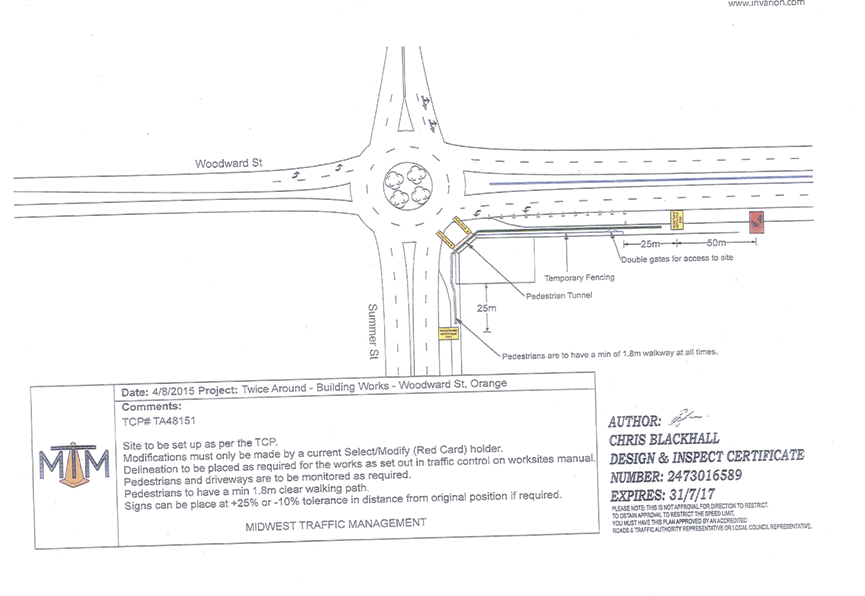
Planning and Development Committee
3 November 2015
2.4 Development
Application DA 319/2015(1) - 1 Summer Street
Attachment 3 Submission