ORANGE CITY COUNCIL
Sustainable Development
Committee
Agenda
3 March 2015
Notice
is hereby given, in accordance with the provisions of the Local Government Act
1993 that a Sustainable Development
Committee meeting
of ORANGE CITY COUNCIL will be held in the Council Chamber, Civic Centre, Byng Street, Orange on Tuesday,
3 March 2015.
Garry
Styles
General Manager
For apologies please
contact David Waddell on 6393 8261.
Sustainable Development Committee 3
March 2015
1 Introduction
1.1 Apologies
and Leave of Absence
1.2 Declarations
of Interest
The
provisions of Chapter 14 of the Local Government Act, 1993 (the Act)
regulate the way in which Councillors and designated staff of Council conduct
themselves to ensure that there is no conflict between their private interests
and their public role.
The
Act prescribes that where a member of Council (or a Committee of Council) has a
direct or indirect financial (pecuniary) interest in a matter to be considered
at a meeting of the Council (or Committee), that interest must be disclosed as
soon as practicable after the start of the meeting and the reasons given for
declaring such interest.
As
members are aware, the provisions of the Local Government Act restrict any
member who has declared a pecuniary interest in any matter from participating
in the discussion or voting on that matter, and requires that member to vacate
the Chamber.
Council’s Code of Conduct provides that if members
have a non-pecuniary conflict of interest, the nature of the conflict must be
disclosed. The Code of Conduct also provides for a number of ways in which a
member may manage non pecuniary conflicts of interest.
|
Recommendation
It is recommended that Committee Members now disclose any
conflicts of interest in matters under consideration by the Sustainable
Development Committee at this meeting.
|
2 General
Reports
2.1 Items
Approved Under the Delegated Authority of Council
TRIM
REFERENCE: 2015/261
AUTHOR: Allan
Renike, Manager Development Assessments
EXECUTIVE Summary
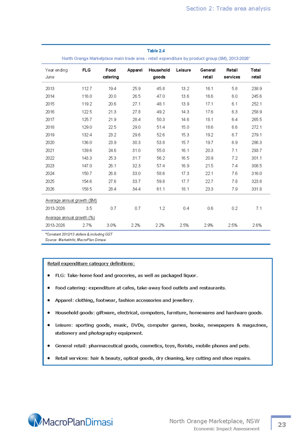
Following is a list of development
applications approved by the General Manager under the delegated authority of
Council.
Link To Delivery/OPerational Plan
The recommendation in this report relates to the
Delivery/Operational Plan strategy “13.4 Our Environment
– Monitor and enforce regulations relating to City amenity”.
Financial Implications
Nil
Policy and Governance Implications
Nil
|
Recommendation
That the information provided in the
report by the Manager Development Assessments on Items Approved Under the
Delegated Authority of Council be acknowledged.
|
further considerations
Consideration has been given to the
recommendation’s impact on Council’s service delivery; image and
reputation; political; environmental; health and safety; employees;
stakeholders and project management; and no further implications or risks have
been identified.
SUPPORTING INFORMATION
|
Reference:
|
DA 473/2011(3)
|
Determination
Date
|
11 February 2015
|
|
PR Number
|
PR6622
|
|
Applicant/s:
|
PJL Group Pty Ltd
|
|
Owner/s:
|
Prevision Holdings Pty Ltd
|
|
Location:
|
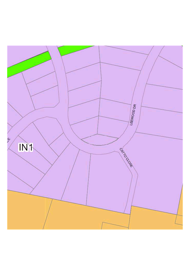
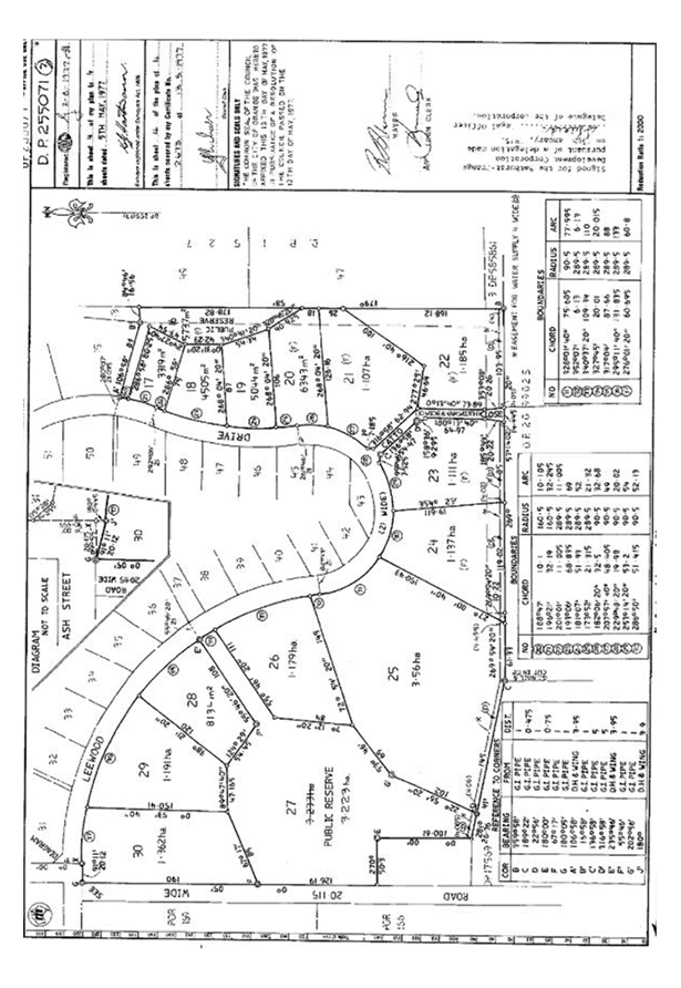
Lot 201 DP 807735 – 27 Leewood Drive, Orange
|
|
Proposal:
|
Modification
of development consent DA 473/2011(1) - industry (plant and blast bay, and
heavy vehicle wash bay) and warehouse (nine units). The modification involves
a slight adjustment to the location of Building B within the subject
site so as to facilitate a revised location for the approved wash bay; and
carry out alterations to the size of the wash bay and introduce a small
enclosure for the associated wash bay development.
|
|
Value:
|
$2,000,000 (which is the same value as the original development)
|
|
Reference:
|
DA 241/2013(2)
|
Determination
Date
|
4 February 2015
|
|
PR Number
|
PR19305
|
|
Applicant/s:
|
Carewest
|
|
Owner/s:
|
Carewest
Foundation Ltd
|
|
Location:
|
Lot 300 DP 1057870 and Lot 100 DP 1195304 – 88 Dalton Street
and 107 Prince Street, Orange
|
|
Proposal:
|
Modification
of development consent DA 241/2013(1) - transitional group home, community
facility, medical centre and strata subdivision. The modification involves
swapping the approved uses of the two existing demountable buildings,
altering the approved floor plan for Anson Cottage, altering the approved
location of the bin storage area and clarifying the wording of condition (7)
relating to fire safety matters.
|
|
Value:
|
$3,000,000 (which is the same value as the original development)
|
|
Reference:
|
DA 246/2014(2)
|
Determination
Date
|
11 February 2015
|
|
PR Number
|
PR6622
|
|
Applicant/s:
|
PJL Group Pty Ltd
|
|
Owner/s:
|
Prevision Holdings Pty Ltd
|
|
Location:
|
Lot 201 DP 807735 – 27 Leewood Drive, Orange
|
|
Proposal:
|
Modification
of development consent DA 246/2014(1) – general industry, alterations
and additions (existing building) and solar energy system (photovoltaic
electricity generating system. The modification involves deleting the
approved wash bay in Building C and amending the approved floor plan of that
building; and amending the site plan generally to reflect the proposed
modification of DA 473/2011.
|
|
Value:
|
$600,000 (which is the same value as the original development)
|
|
Reference:
|
DA 263/2014(2)
|
Determination
Date
|
11 February 2015
|
|
PR Number
|
PR26100
|
|
Applicant/s:
|
Rosser Property Pty Ltd ATF Rosser Property Unit Trust
|
|
Owner/s:
|
Rosser Property Pty Ltd
|
|
Location:
|
Lots 3 and 4 DP 1183249 – 170 and 172 Dalton Street, Orange
|
|
Proposal:
|
Modification
of development consent DA 263/2014(1) – hardware and building supplies
(two tenancies). The modification involves altering condition (4) of the
consent, which required the disabled car parking spaces to be realigned and
additional landscaping to be provided
|
|
Value:
|
$1,800,000 (which is the same value as the original development)
|
|
Reference:
|
DA 311/2014(1)
|
Determination
Date
|
20 January 2015
|
|
PR Number
|
PR16838
|
|
Applicant/s:
|
Eastern
Developments (NSW) Pty Ltd
|
|
Owner/s:
|
Mr AJ
and Mrs DM Thurtell, and Mr MJ Thurtell
|
|
Location:
|
Lots 626 and 627 DP 873776 - 4 and 18 Manning Road, Orange
|
|
Proposal:
|
Subdivision (34 lot residential)
|
|
Value:
|
$0
|
|
Reference:
|
DA 339/2014(1)
|
Determination
Date
|
3 February 2015
|
|
PR Number
|
PR26183
|
|
Applicant/s:
|
Mr R Mastronardi
|
|
Owner/s:
|
Mr WT and Mrs JM Edwards
|
|
Location:
|
Lot 114 DP 1188122 – 29 Hughes Street, Orange
|
|
Proposal:
|
Subdivision (two lot residential)
|
|
Value:
|
$0
|
|
Reference:
|
DA 392/2014(1)
|
Determination
Date
|
11 February 2015
|
|
PR Number
|
PR18604
|
|
Applicant/s:
|
Rick James Designs
|
|
Owner/s:
|
Dr KM Murali
|
|
Location:
|
Lot 14 DP 1042428 – 10 Illamatta Way, Orange
|
|
Proposal:
|
Community facility
|
|
Value:
|
$30,000
|
|
Reference:
|
DA 400/2014(1)
|
Determination
Date
|
11 February 2015
|
|
PR Number
|
PR26080
|
|
Applicant/s:
|
West Orange Holdings Pty Ltd
|
|
Owner/s:
|
West Orange Holdings Pty Ltd
|
|
Location:
|
Lot 102 DP 1187463 – 22-34 Forbes Road, Orange
|
|
Proposal:
|
Vehicle sales or hire premises (building addition to
showroom) and signage
|
|
Value:
|
$700,000
|
|
Reference:
|
DA 24/2015(1)
|
Determination
Date
|
12 February 2015
|
|
PR Number
|
PR1205
|
|
Applicant/s:
|
BP Australia Pty Ltd
|
|
Owner/s:
|
Centrel Pty Ltd
|
|
Location:
|
Lot 1 DP 507625 – 56-60 Bathurst Road, Orange
|
|
Proposal:
|
Service station (alterations and additions)
|
|
Value:
|
$80,000
|
|
Reference:
|
DA 26/2015(1)
|
Determination
Date
|
17 February 2015
|
|
PR Number
|
PR16273
|
|
Applicant/s:
|
Hort Enterprises
|
|
Owner/s:
|
Ennabay Pty Ltd
|
|
Location:
|
Lot 9 DP 855651 – 10-12 Edward Street, Orange
|
|
Proposal:
|
Vehicle repair station
|
|
Value:
|
$0
|
TOTAL
NET* VALUE OF ALL DEVELOPMENTS APPROVED IN THIS PERIOD: $810,000
*
Net value relates to the value of modifications. If modifications are
the same value as the original DA, then nil is added. If there is a plus/minus
difference, this difference is added or taken out.
2.2 Development
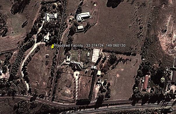
Application DA 181/2014(1) - 454 The Escort Way
TRIM
REFERENCE: 2015/289
AUTHOR: Paul
Johnston, Planning Team Leader
EXECUTIVE Summary
Council’s consent is sought to construct a
telecommunications facility, described by the applicant as a new mobile phone
base station, at 454 The Escort Way, Orange. The proposed structure is located
on the western ridgeline of Ploughmans Valley within the scenic protection area
as defined by Council’s Development Control Plan.
A section 79C assessment of the proposed development has
been undertaken by Council staff. It is considered that the proposed
development will have a significant visual impact upon the immediate
surrounding residential locality. The proposal is, however, considered
acceptable in this case subject to the implementation of several recommended
conditions of consent. Having said this, given the significance of the western
ridgeline of the City, it would be open for Council to form an alternative view
should the visual impact of the development in this location be considered
unacceptable.
Council, at the SDC meeting held on 3 February 2015,
resolved to defer consideration of the subject application so as to allow for
an onsite inspection of the premises to be carried out by Councillors. In
accordance with the resolution, an onsite inspection of the premises was
carried out on 12 February 2015. The applicant’s consultant also
attended the meeting, as did several neighbours.
Link To Delivery/OPerational Plan
The recommendation in this report relates to the
Delivery/Operational Plan strategy “13.4 Our Environment
– Monitor and enforce regulations relating to City amenity”.
Financial Implications
Nil
Policy and Governance Implications
Nil
|
Recommendation
That Council
approves development application DA 181/2014(1) for Telecommunications Facility (mobile phone
base station with 40m high monopole and equipment shelter) at
Lot 100 DP 1035863 - 454 The Escort Way, Orange
pursuant to the conditions of consent in the attached Notice of Approval.
|
further considerations
Consideration has been given to the
recommendation’s impact on Council’s service delivery; image and reputation;
political; environmental; health and safety; employees; stakeholders and
project management; and no further implications or risks have been identified.
SUPPORTING INFORMATION
THE APPLICATION
Council’s consent is sought to construct a telecommunications
facility (mobile phone base station) at 454 The Escort Way, Orange, being Lot
100 in DP 1035863.
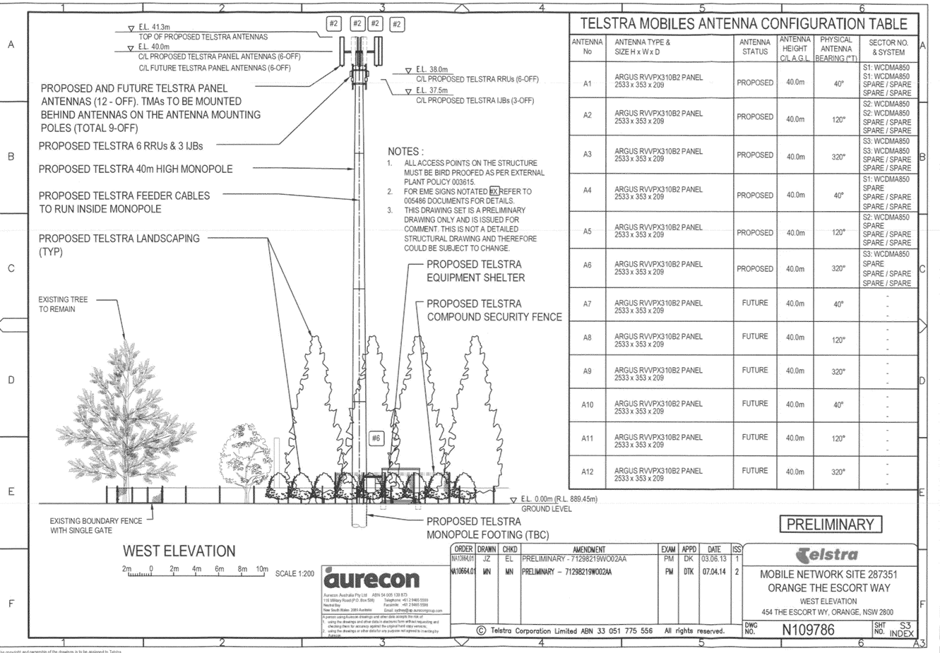
THE PROPOSAL
Telstra propose to install a new mobile phone base station
at 454 The Escort Way, Orange. The applicant has summarised the proposal as follows:
· installation of a
new 40m high monopole with a triangular head frame mounted at a centreline
elevation of 40m
· six panel antennas
(2.6m long) mounted on the headframe at the centreline elevation of 40m, giving
a total elevation of 41.3m
· six future panel
antennas (2.6m long) mounted on the headframe at a centreline elevation 40m,
giving a total elevation of 41.3m
· installation of
six remote radio units and nine tower mounted amplifiers in proximity to the
antennas
· one equipment
shelter 2.28 (width) x 3.28m (length) x 2.95m (height) with associated piers
located at the base of the monopole
· ancillary cabling
and cable ladder and
· landscaping.
The proposal will be incorporated into the existing network
via existing fibre optic cable.
Once operational, the facility will function on a
continuously unstaffed basis and will typically only require maintenance works
once a year.
The proposed development will comprise the installation of a
41.3m high monopole fitted with antennas and equipment housing. The radio
equipment is proposed to be housed within a shelter which will be located in
close proximity to the base of the monopole. The surrounding locality comprises
predominantly residential development to the immediate east and undeveloped
large lot residential land to the west.
Council received two written submissions in regards to the
proposed telecommunications facility. Council’s responses to both
submissions are detailed within the report.
TELECOMMUNICATIONS ACT 1997
Telstra is a licenced telecommunications carrier and is
required to operate under the provisions of the Telecommunications Act 1997
and the Telecommunications Code of Practice 1997.
The 1997 Act and Telecommunications (Low-impact
Facilities) Determination 1997 (as amended) establish the criteria for
‘low impact’ telecommunications facilities. The proposed
development is not defined as a ‘’low-impact facility” under
the Telecommunications Act and is therefore subject to the provisions of
the NSW Environmental Planning and Assessment Act 1979 and,
accordingly, the provisions of Orange Local Environmental Plan 2011.
The Telecommunications Code of Practice 1997 sets out
the design, planning and installation requirements for carriers to ensure that
the installation of facilities is in accordance with industry “best
practice”. The applicant advises that the design and siting of the
proposed communications facility has been undertaken in accordance with
Section 3 (Planning and Siting) of the Australian Standard, Siting of
Radio Communications Facilities (AS3516.2).
MATTERS FOR CONSIDERATION
Section 79C of the Environmental Planning and Assessment
Act 1979 requires Council to consider various matters, of which those
pertaining to the application are listed below.
Section 5A Assessment
In the administration of sections 78A, 79B, 79C, 111 and
112, the provisions of Section 5A must be taken into account for every
development application in deciding whether there is likely to be a significant
effect on threatened species, populations or ecological communities or their
habitats. This section includes a requirement to consider any adopted
assessment guidelines, which means assessment guidelines issued and in force
under section 94A of the Threatened Species Conservation Act 1995.
Assessment guidelines are in force (see DECC-W “Threatened Species
Assessment Guidelines - The Assessment of Significance”) which requires
consent authority to adopt the precautionary principle in its assessment.
The subject property provides
some habitat suitable for certain threatened or endangered species on a limited
basis. However, with the exception of the Regent Honeyeater (for which this
site is not suitable), there are no fauna species above the category of
vulnerable that occur in this locality. The tests listed in the Assessment of
Significance only apply to Threatened, Endangered or Critically Endangered
Species as they appear in the NPWS Wildlife Atlas. Species listed as vulnerable
or below have importance when assessing the value of vegetation communities, but
are not individually protected themselves under the seven part test provisions.
In this case the vegetation on
the subject land (but not the site of the proposed facility) is characterised
by a number of over mature Eucalypts, but more significantly by planted
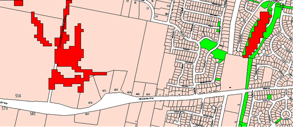
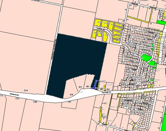
vegetation around the site. There is a naturally occurring Box Gum Grassy
Woodland (BGGW) on the western side of the site (see map below) that is
noteworthy and of some significance, deserving of conservation. A number of
vulnerable species are likely to utilise this vegetation for connectivity
purposes to link to areas of greater, more significant biomass to the west and
south of the subject site. The conservation of that vegetation remnant is
important for that reason, but the proposed development has no impact in that
respect. The scattered over mature eucalypts on the site are significant for
seed banking purposes and also as waypoints for migrating immature avian
species.
The proposed development has no
impact in terms of the supporting vegetation and therefore a detailed
supporting assessment so as to complete the seven part assessment of
significance as called up by the Act is not necessary.
The LEP also has provisions that
are additional and separate to the Act that apply in areas mapped under the LEP
as an Environmentally Sensitive Area (ESA). In this case the attached LEP
map extract demonstrates that whist parts of the lot are considered
an ESA, the part of the lot where the proposed development is to be sited
is not a sensitive area and has only limited connectivity to those areas. The
various dams and waterways on the site are not considered overly sensitive, and
as explained above do not support species that in themselves are protected
under the TSC or EP&A Act. Whilst it is acknowledged that rare species may
frequent the site, it is unlikely that they have a critical dependence on the
site, even applying the Department guidelines of local occurrence and local
conservation. It is considered the threat posed by the proposed development is
minor. It is further noted that the proposed development does not constitute a
Key Threatening Process (KTP) under the abovementioned OEH guidelines.
There is no significant risk arising
under either the Assessment of Significance prescribed by Section 5A, or
under the local LEP controls.
PROVISIONS OF ANY ENVIRONMENTAL
PLANNING INSTRUMENT s79C(1)(a)(i)
Orange Local Environmental Plan 2011
Part 1 - Preliminary
This part of the plan is largely administrative in nature
and has minimal implications for the proposal.
Clause 1.2 - Aims of Plan
The broad aims of the LEP are
set out under subclause 2. Those relevant to the application are as follows:
(a) to encourage development which complements
and enhances the unique character of Orange as a major regional centre boasting
a diverse economy and offering an attractive regional lifestyle,
(b) to provide for a range of development
opportunities that contribute to the social, economic and environmental
resources of Orange in a way that allows the needs of present and future
generations to be met by implementing the principles of ecologically
sustainable development,
(f) to recognise and manage valued
environmental heritage, landscape and scenic features of Orange.
The application is considered to be consistent with aims (a)
and (b) as listed above. In relation to aim (f), it is considered that the
proposal will have a significant impact upon the landscape and scenic features
of the western ridgeline of Ploughmans Valley. A detailed assessment of the
likely impacts of the development and in particular the impact that the
development will have on the landscape and scenic features of the City has been
provided below under the heading “Likely Impacts of the Development”.
Clause 1.6 - Consent Authority
This clause establishes that, subject to the Act, Council is
the consent authority for applications made under the LEP.
Clause 1.9A - Suspension of
Covenants, Agreements and Instruments
This clause provides that covenants, agreements and other
instruments which seek to restrict the carrying out of development do not apply
with the following exceptions.
· covenants imposed
or required by Council
· prescribed
instruments under Section 183A of the Crown Lands Act 1989
· any conservation
agreement under the National Parks and Wildlife Act 1974
· any trust
agreement under the Nature Conservation Trust Act 2001
· any property
vegetation plan under the Native Vegetation Act 2003
· any biobanking
agreement under Part 7A of the Threatened Species Conservation Act 1995
· any planning
agreement under Division 6 of Part 4 of the Environmental Planning and
Assessment Act 1979.
The subject site does not appear
to be affected by any of the above. The subject allotment is burdened by an
electricity easement. The proposed development will not have a detrimental
effect on the easement.
Mapping
The subject site is identified
on the LEP maps in the following manner:
|
Land Zoning Map:
|
Land zoned R5 Large Lot Residential
|
|
Lot Size Map:
|
Minimum Lot Size 2ha
|
|
Heritage Map:
|
Not a heritage item or conservation
area.
|
|
Height of Buildings Map:
|
No building height limit
|
|
Floor Space Ratio Map:
|
No floor space limit
|
|
Terrestrial Biodiversity Map:
|
Biodiversity sensitivity on the
site
|
|
Groundwater Vulnerability Map:
|
Ground water vulnerable
|
|
Drinking Water Catchment Map:
|
Not located within the drinking
water catchment
|
|
Watercourse Map:
|
Not within or affecting a defined
watercourse
|
|
Urban Release Area Map:
|
Not within an urban release area
|
|
Obstacle Limitation Surface Map:
|
No restriction on building siting
or construction
|
|
Additional Permitted Uses Map:
|
No additional permitted use applies
|
Those matters that are considered
to be of relevance to the development application are addressed in detail in
the body of this report.
Part 2 -
Permitted or Prohibited Development
Land Use Zones
The subject site is zoned R5 Large Lot Residential. The
proposed development is defined as a Telecommunications Facility under OLEP
2011. Pursuant to OLEP 2011 a telecommunications facility means:
(a) any
part of the infrastructure of a telecommunications network, or
(b) any
line, cable, optical fibre, fibre access node, interconnect point equipment,
apparatus, tower, mast, antenna, dish, tunnel, duct, hole, pit, pole or other
structure in connection with a telecommunications network, or
(c) any
other thing used in or in connection with a telecommunications network.
Telecommunications Facilities are not specifically
listed as permissible in the R5 Large Lot Residential zone under OLEP 2011 and
are thus prohibited. However, State Environmental Planning Policy
(Infrastructure) applies to the State and under Clause 116 development for the
purposes of telecommunications facilities may be carried out by any person with
consent on any land. The SEPP overrides the provisions of Orange LEP 2011
and therefore has the effect of rendering the proposed development permissible
on any land with the consent of Council.
In accordance with Clause 115(3) of SEPP (Infrastructure),
Council in determining this matter must take into consideration any guidelines
concerning site selection, design, construction or operating principles for
telecommunications facilities that are issued by the Director-General for the
purposes of this clause and published in the Gazette.
This provision has the effect of imposing any assessment
guidelines imposed by the Director General (Department Of Planning). The
Department has a design guideline, entitled "NSW Telecommunications
Facilities Guideline Including Broadband" which applies in this case.
A detailed assessment of how the development responds to
these guidelines has been provided below under the heading of "State
Environmental Planning Policies".
Clause 2.3 of
OLEP 2011 references the Objectives for each zone in OLEP 2011. These
objectives for land zoned R5 Large Lot Residential are as follows:
· To
provide residential housing in a rural setting while preserving, and minimising
impacts on, environmentally sensitive locations and scenic quality.
· To
ensure that large residential lots do not hinder the proper and orderly
development of urban areas in the future.
· To
ensure that development in the area does not unreasonably increase the demand
for public services or public facilities.
· To
minimise conflict between land uses within this zone and land uses within
adjoining zones.
· To
provide for student housing in close proximity to the Charles Sturt University.
· To
ensure development is ordered in such a way as to maximise public transport
patronage, and encourage walking and cycling, in close proximity to settlement.
· To
ensure development along the Southern Link Road has an alternative access.
The objectives of the zone are not considered to be of
relevance to the proposed development.
Part 3 -
Exempt and Complying Development
Telstra is a licenced telecommunications carrier and is
required to operate under the provisions of the Telecommunications Act 1997
and the telecommunications Code of Practice 1997. The 1997 Act and Telecommunications
(Low-impact Facilities) Determination 1997 (as amended) establish the
criteria for ‘low impact’ telecommunications facilities. The
proposed development is not defined as a ‘’low-impact
facility” under the Telecommunications Act and is therefore subject to
the provisions of the NSW Environmental Planning and Assessment Act
1979 and, accordingly, the provisions of Orange Local Environmental Plan
2011.
The application is not exempt or complying development.
Part 4 - Principal Development
Standards
Not relevant to the application.
Part 5 - Miscellaneous
Provisions
5.9 - Preservation of Trees
or Vegetation
This clause seeks to maintain and
preserve the amenity of the area, including biodiversity values, through the
preservation of trees and other vegetation.
(3) A person must not ringbark,
cut down, top, lop, remove, injure or wilfully destroy any tree or other
vegetation to which any such development control plan applies without the
authority conferred by:
(a) development consent, or
(b) a permit granted by the
Council.
The construction of the
telecommunications facility makes use of an existing cleared paddock and no
clearing of any significant trees or vegetation is required to facilitate the
proposed development.
Part 6 -
Urban Release Area
Not relevant to the application. The subject site is not
located in an Urban Release Area.
Part 7 -
Additional Local Provisions
7.1 - Earthworks
This clause establishes a range
of matters that must be considered prior to granting development consent for
any application involving earthworks, such as:
(a) the likely disruption of, or any
detrimental effect on, existing drainage patterns and soil stability in the
locality of the development
(b) the effect of the development on the
likely future use or redevelopment of the land
(c) the quality of the fill or the soil to be
excavated, or both
(d) the effect of the development on the
existing and likely amenity of adjoining properties
(e) the source of any fill material and the
destination of any excavated material
(f) the likelihood of disturbing relics
(g) the proximity to and potential for adverse
impacts on any waterway, drinking water catchment or environmentally sensitive
area
(h) any measures proposed to minimise or
mitigate the impacts referred to in paragraph (g).
The proposed earthworks will
consist of site testing, excavation and construction of foundations. The
proposed earthworks will not involve the removal of any trees with the subject
land already highly disturbed from past farming practices. The proposed
development is not expected to have a detrimental effect on the water catchment
area.
7.6 -
Groundwater Vulnerability
This clause seeks to protect
hydrological functions of groundwater systems and protect resources from both
depletion and contamination. Orange has a high water table and large areas of
the LGA, including the subject site, are identified with “Groundwater
Vulnerability” on the Groundwater Vulnerability Map. This requires that
Council consider:
(a) whether or not the development (including
any onsite storage or disposal of solid or liquid waste and chemicals) is
likely to cause any groundwater contamination or have any adverse effect on
groundwater dependent ecosystems, and
(b) the cumulative impact (including the
impact on nearby groundwater extraction for potable water supply or stock water
supply) of the development and any other existing development on groundwater.
Furthermore consent may not be granted unless Council is satisfied that:
(a) the development is designed, sited and
will be managed to avoid any significant adverse environmental impact, or
(b) if that impact cannot be reasonably
avoided - the development is designed, sited and will be managed to minimise
that impact,
(c) if that impact cannot be minimised - the
development will be managed to mitigate that impact.
The proposal is not anticipated
to involve the discharge of toxic or noxious substances and is therefore
unlikely to contaminate the groundwater or related ecosystems. The proposal
does not involve extraction of groundwater and will therefore not contribute to
groundwater depletion.
DESIGNATED DEVELOPMENT
The proposed development is not designated development.
STATE ENVIRONMENTAL PLANNING
POLICIES
State Environmental Planning Policy (Infrastructure) 2007
("the SEPP") applies to the subject development.
Clause 2 - Aim of Policy
The aim of this policy is to facilitate the effective
delivery of infrastructure across the state by:
(a) improving
regulatory certainty and efficiency through a consistent planning regime for
infrastructure and the provision of services, and
(b) providing
greater flexibility in the location of infrastructure and service facilities,
and
(c) allowing
for efficient development, redevelopment or disposal of surplus government
owned land, and
(d) identifying
the environmental assessment category into which different types of
infrastructure and services development fall (including identifying certain
development of minimal environmental impact as exempt development), and
(e) identifying
matters to be considered in the assessment of development adjacent to
particular types of infrastructure development, and
(f) providing
for consultation with relevant public authorities about certain development
during the assessment process or prior to development commencing.
The development is not inconsistent with the aims of the
SEPP.
Clause 115 - Development
Permitted with Consent
(1) Development
for the purposes of telecommunications facilities, other than development in
clause 114 or development that is exempt development under clause 20 or
116, may be carried out by any person with consent on any land.
The SEPP has the effect of rendering the proposed
development permissible on any land with the consent of Council.
(3) Before
determining a development application for development to which this clause
applies, the consent authority must take into consideration any guidelines
concerning site selection, design, construction or operating principles for
telecommunications facilities that are issued by the Director-General for the
purposes of this clause and published in the Gazette.
This provision has the effect of imposing any assessment
guidelines imposed by the Director General (Department Of Planning). The
relevant guideline applicable in NSW for the consideration of development of
this type is entitled "NSW Telecommunications Facilities Guideline
Including Broadband".
The guideline has the effect under clause 1.6 of applying as
a design tool in all zones of an LEP.
Section 2.2 of the policy sets up the design principles that
should be followed. The guidelines are organised under "Principles"
headings. Many of the principles are not relevant because they relate to fully
urbanised landscapes. In this case the landscape and setting are not fully
urbanised. Detailed consideration of how the development fits into the
landscape will however remain an important element for consideration under the
guidelines. The ridge upon which the structure is proposed forms the skyline to
large areas of the City.
Those principles that are called up in the policy and which
are relevant to the assessment of visual impact are set out below:
Principle 1 - Design and Siting
to Minimise Visual Impact
· As
far as practical, a telecommunications facility that is to be mounted on an
existing building or structure should be integrated with the design and
appearance of the building or structure.
The applicant has advised that the area was analysed using
desktop and onsite investigations during the site selection process. The
applicant has indicated that when investigating sites the preference for
selection is firstly for colocation on existing infrastructure, secondly low
impact facilities (as defined by the Telecommunications (Low impact Facilities Determination
1997) and lastly “greenfield sites”. Four candidate sites were
investigated in the context of the above. These include:
· Candidate A: 454
The Escort Way, Orange (proposed site)
· Candidate B: 448
The Escort Way, Orange
· Candidate C: Lot 1
DP 581736 Gorman Road, Orange
· Candidate D: 7
Borrodell Drive, Orange
These candidate sites are shown
in the attached aerial photo:
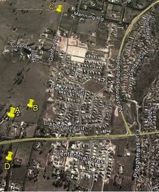
Candidate A: 454 The Escort Way, Orange (proposed site)
The applicant advises that this site provided the radio
coverage required of a facility in this area. The site has no design or
construction constraints. The property owner was willing to enter into a land
tenure agreement with Telstra.
Candidate B: 448 The Escort
Way, Orange
The applicant advises that this site provided the radio
coverage required of a facility in this area. The site was discounted as the
property owner was unwilling to enter into a land tenure agreement with
Telstra.
Candidate C: Lot 1 DP 581736
Gorman Road, Orange
The site was discounted as the property owner was unwilling
to enter into a land tenure agreement with Telstra. The applicant has advised
that the proposed facility in this location was not able to meet the radio
coverage objectives for this site without utilising a heightened tower structure.
Candidate D: 7 Borrodell Drive,
Orange
The site was discounted as the property owner was unwilling
to enter into a land tenure agreement with Telstra. The site would require
extensive earthworks in order to construct a graded access track. The applicant
has advised that the proposed facility in this location was not able to meet
the radio coverage objectives for this site without utilising a heightened
tower structure.
· The visual
impact of telecommunications facilities should be minimised, visual clutter is
to be reduced
As a new structure designed to meet technical
specifications, there appear to be few opportunities to modify or reduce the
intrusive nature of the monopole and the array to be placed on top of the pole.
· Where
telecommunications facilities protrude from a building or structure and are
predominantly backgrounded against the sky, the facility and their support
mounts should be either the same as the prevailing colour of the host building
or structure, or a neutral colour such as grey should be used.
The proposed telecommunications facility is a stand-alone
structure. The proposed structure will protrude above the ridgeline when viewed
from a large area of the City and from The Escort Way. A detailed assessment of
the visual impacts of the development has been provided below under the heading
“Likely impacts of the Development”. It is considered appropriate
in this case to impose a condition requiring the structure to be painted a
“shale grey” colour as suggested. A condition to that effect is
included.
· Ancillary
facilities associated with the telecommunications facility should be screened
or housed, using the same colour as the prevailing background to reduce its
visibility, including the use of existing vegetation where available, or new
landscaping where possible and practical.
In this case the ground based structures will be located
immediately around the base of the structure. The applicant has submitted a
landscape plan in support of the proposal. It is considered that the proposed
landscaping at maturity will adequately screen the ancillary structures.
Attached is a condition in relation to this matter.
· A
telecommunications facility should be located and designed to respond
appropriately to its rural landscape setting.
In this case the setting behind (to the west) of the site
dictates the character and setting of the structure. As discussed above the
facility will project above the skyline, and whilst some landscaping exists
along the ridge, the development is proposed to be located on a relatively
exposed part of the ridge. Landscaping requirements are considered essential to
this proposal, and are discussed in more detail elsewhere in this report.
· A
telecommunications facility located on, or adjacent to, a State or local
heritage item or within a heritage conservation area, should be sited and
designed with external colours, finishes and scale sympathetic to those of the
heritage item or conservation area.
Council’s records indicate that subject site is not
located within a heritage conservation area and is not located adjacent to
listed State or Local heritage items.
· "A
telecommunication facility should be located and designed so as to respond
appropriately to its landscape setting".
A detailed assessment of the visual impact of the
development and its impact on the landscape setting has been provided below
under the heading “Likely Impacts of the Development’.
Principle 2 - Colocation
As indicated in the above discussion, colocation was not
considered a practical option.
Principle 3 - Health Standards
The applicant has submitted technical specifications and
discussion in their Statement of Environmental Effects, attesting that the
proposed structure when in operation will comply with relevant health
standards, particularly relating to electromagnetic emissions standards.
Whilst there are currently wide-ranging and contentious
views on the health impacts associated with electromagnetic energy (EME), with
large volumes of discourse related to the study, there is currently no
definitive evidence or conclusive findings one way or another of the effects of
EME on humans. Council is therefore largely reliant on the studies of
recognised health organisations and the submitted report on the summary of
Estimated RF (radiofrequency) EME (electromagnetic energy) in determining
the likely health impacts associated with the development.
The Australian Government’s Australian Radiation
Protection and Nuclear Safety Agency cite the World Health Organisation’s
advice stating:
None of the
recent reviews have concluded that exposure to RF fields from mobile phones and
their base stations cause any adverse health consequences” (ARPANSA).
Furthermore, the ARPANSA suggests:
the balance of evidence does
not indicate a risk to the health of people, including children, living in the
vicinity of base stations where exposure levels are only small fractions of the
ARPANSA standard.
A report titled Summary of Estimated RF and EME Levels
Around The Proposed Wireless Base Station…’ indicates:
RF EME levels have been
estimated from the proposed antennas at 354 Cadia Road, Springside. The maximum
cumulative EME level at 1.5m above ground level and 274.1m from the antennas is
estimated to be 0.026% of the ARPANSA public exposure limits.
As mentioned above, Council is largely reliant on the
reports submitted in the application and studies of recognised health agencies
in determining the likely health impacts associated with the development.
In light of the above, it is considered that the development
is not likely to result in adverse health impacts as a result of human
exposure.
Principle 4 - Minimise
Disturbance
This principle is mainly concerned with the impact that the
development may have on other telecommunication facilities in the locality,
particularly those relating to airport operations. It is considered unlikely
that the proposed structure will have any significant impact in this regard.
PROVISIONS OF ANY DRAFT
ENVIRONMENTAL PLANNING INSTRUMENT THAT HAS BEEN PLACED ON EXHIBITION
s79C(1)(a)(ii)
Council is not aware of any draft Environmental Planning
Instruments that have been placed on public exhibition that affect the proposed
development.
PROVISIONS OF ANY DEVELOPMENT
CONTROL PLAN s79C(1)(a)(iii)
Development Control Plan 2004
Development Control Plan 2004 (“the DCP”)
applies to the subject land (Part 0LEP 2011, Part 6 Rural Development).
An assessment of the proposed development against the relevant Planning
Outcomes will be undertaken below.
Pursuant to Planning Outcome 0.2-1
Interim Planning Outcomes - Conversion of Zones:
· Throughout this
Plan, any reference to a zone in Orange LEP 2000 is to be taken to be a
reference to the corresponding zone(s) in the zone conversion table.
The corresponding zone to zone
1(c) Rural Residential (Orange LEP 2000) is zone R5 Large Lot Residential
(Orange LEP 2011). As such, Orange DCP 2004 - Chapter 6 - Rural Development
represents the corresponding set of controls for consideration. The proposed
development is not inconsistent with any provisions under this section of the
DCP.
Pursuant to Planning Outcome 0.4-1
Interim Planning Outcomes – Scenic Areas:
· Development
blends into the landscape through the use of appropriate siting, design,
external materials and colours, retention of trees including remnant
vegetation, establishing of new trees, and enhancing the skyline when viewed
either from the urban area of Orange or from public places in the vicinity of
the land.
While Telstra’s proposed facility will introduce a new
vertical element in the skyline, it should be viewed in conjunction with other
elements in the surrounding area and within the ‘Scenic Area’
itself. The applicant submits that these elements range from power and street
lighting poles in the near and immediate vicinity, to existing
telecommunications facilities in the distance. It can be suitably argued that
these vertical elements, considered essential infrastructure, are commonplace
within today’s landscapes, be it in the urban built environment, rural
settings, or the growing outskirts of townships such as Orange.
Following an evaluation of the documentation submitted in
support of the development application, it is understood that the proposed
facility has been sited as far back from The Escort Way (Forbes Road) as is
practically and technically feasible. Council is advised that while this
location is near the crest of the land marked as ‘Scenic Area’, it
allows the facility to be the smallest possible structure to achieve the required
coverage objectives of a site in this area. The applicant argues that the
proposed facility’s visual impact is further lessened by the existing
vegetation that is found surrounding the site location. The applicant’s
submission is accompanied by a detailed landscape plan. Telstra’s
proposal involves the establishment of a number of additional trees and shrubs
that will assist to screen the lower portion of the proposed facility. The
external colours and materials used to finish the proposed facility can also be
suited to blend into the landscape. Attached to the draft Notice are conditions
of consent that address these issues.
Whilst the assessment has highlighted that the proposed
development will have a significant visual impact when viewed from surrounding
residential properties and while travelling in both directions along The Escort
Way, the proposal is considered acceptable in this case subject to the
implementation of several recommended conditions of consent. Having said this,
given the significance of the western ridgeline of the City and the fact that
the proposed structure will be readily viewed from a number of residential
properties and road corridors in the general locality, it would be open for
Council to form an alternative view should the visual impact of the proposed
development be considered unacceptable.
PROVISIONS PRESCRIBED BY THE
REGULATIONS s79C(1)(a)(iv)
The proposed development is not inconsistent with the
provisions prescribed by the regulations.
THE LIKELY IMPACTS OF THE
DEVELOPMENT s79C(1)(b)
Context and Setting
Council is advised that Telstra is required by law to
carefully consider many factors before deciding on the location and the design
of a base station. It is understood that these factors include:
· service objectives
(radio coverage requirements)
· physical
characteristics of the site - such as height and terrain
· ability to connect
with the rest of the network
· planning
constraints such as zonings
· colocation
opportunities
· minimising public
exposure to EME
· cost factors
· the ability to
obtain a suitable lease
· proximity to
community sensitive locations and
· minimising the
visual impact on the existing environment.
As demand grows on mobile telecommunications networks, the
applicant advises that additional investment is required to match capacity to
demand. In the case of the service provided by Telstra to Orange, Council is
advised that investments have been made to increase the capacity of surrounding
facilities and install additional facilities, including those at Beech
Crescent, Calare, and at the Duntryleague Golf Club on Woodward Street. Telstra
has also been able to utilise additional radio channels, sectorisation or cell
splitting and spreading the load over all the different frequency bands that
are available to Telstra under its Telecommunications Carrier Licence. The
applicant advises that the proposed development represents the next step to
providing vital infrastructure that will facilitate enhanced services to
customers, providing improved coverage to areas that are currently experiencing
limited reception.
The facility is proposed to be sited on a privately owned
large lot residential allotment approximately midway along the eastern boundary
of the lot at 454 The Escort Way. The subject land provides some screening
utilising existing vegetation on the lot. A landscape plan has been submitted
in support of the subject development. This additional landscaping will, over
time, provide a level of screening for the lower section of the monopole and
the equipment at ground level.
Design
Whilst it is not uncommon for telecommunications facilities
to be sited in close proximity to residential development, Telstra has
acknowledged that the facility needs to be sensitive to its environment.
The applicant advises that taking advantage of local
topography has allowed the use of a 40m structure in this location,
thereby avoiding the need to install a lattice type structure or taller
monopole which would represent a significantly less desirable visual outcome.
Council is advised that the 40m high monopole is the minimum height required
for the facility to project over the trees to the surrounding area and provide
the level of coverage necessary to make a sustainable contribution to coverage
and service issues.
In order to reduce the long term visual impact of the
proposed development it is recommended in the event that Council is of the view
to support the proposed development, that the structure be painted in a
“shale grey” colour and the applicant be required to implement the
landscape plan submitted in support of the proposed development.
Council’s Urban Design Advisor has also recommended that this colour be
utilised. The equipment shelter will not be visible externally due to existing
private and public vegetation in the surrounding area. The landscape concept
plan submitted incorporates eleven Populus Canadensis evergreen trees and ten
Pittosporum James Stirling located around the proposed structure, which will at
maturity screen the lower section of the tower. The proposed trees will have a
mature height of approximately 20m. The attached Notice of Approval contains
conditions in relation to these matters.
The applicant submits that the development will have an
acceptable visual impact and that the facility will provide vital
infrastructure that will provide enhanced services to customers, providing
improved coverage to areas that are currently experiencing limited reception.
Visual Impacts
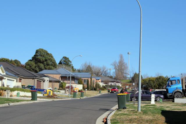
The proposed structure is located on the western ridgeline
of Ploughmans Valley within the scenic protection area as defined by
Council’s Development Control Plan. The subject land comprises large lot
residential and is located adjacent to residential areas within the Ploughmans
Valley. The ridgeline that forms just to the west of the subject land comprises
the backdrop to large parts of the City including Westlea, Belair and parts to
the north of those areas. Landscape elements are concentrated to the south but
further north are mostly devoid of landscape elements.
The proposed development is likely to result in various
levels of visual impact given its location in relation to residential areas to
the north, east and south and the height of the proposed monopole (41.3m). Visual
impact is often a significant issue with respect to the installation of mobile
phone base stations. In order to provide adequate clearance above buildings,
trees and the topography of the land it is virtually impossible for these
facilities to be completely hidden.
The subject land provides some low level screening utilising
existing vegetation on the lot. A landscape plan has been submitted in support
of the subject development. The proposed landscaping will, over time, provide a
level of screening of the lower section of the monopole and the equipment at
ground level.
The applicant submits that the proposed location of the
telecommunications tower provides for maximum separation distance between the
facility and the majority of residential development. The applicant advises
that the siting of the proposed structure any further west would not meet the
radio coverage objectives for the site. It is understood that the height of the
proposed monopole is the minimum required height to adequately meet the
objectives of a site in this location. Council staff requested the applicant to
consider what opportunity there was for establishing the development on
alternative sites and whether or not it was possible to reduce the overall
height of the structure. The applicant has since advised Council that they were
unable to secure legal tenure over the alternative sites identified during the
site selection process and that a lower facility would not provide the
‘relief’ to surrounding sites.
A detailed assessment of the likely impacts of the structure
has been undertaken by staff to determine whether or not the development is
acceptable in this location. To this end some commentary on the likely visual
impact of the development from certain vantage points around the City is
provided below.
Adjoining rural residential
lots to the east and west both contain dwellings with some screening
opportunities from existing vegetation onsite. An evaluation of the site
indicates that dwellings in the immediate vicinity of the subject site are
oriented generally away from the proposed facility. However, as Council would
be aware the surrounding area is currently within a transitional phase of
development and opportunity for additional dwellings to be established within
proximity to the facility in the near future. The following extract from the
applicant's Statement of Environmental Effects depicts the context of the
existing surrounding area:
Surrounding
area (source - applicants Statement of Environmental Effects)
Due to existing public and private vegetation, as well as
the additional landscaping proposed (a row of eleven Evergreen Poplars, and a row of ten James Stirling surrounding
the facility) the applicant submits that the upper portion of the facility only
will be exposed intermittently in all directions surrounding the facility.
Council staff met with representatives from Aurecon and
Telstra to discuss matters in relation to the likely visual impact of the
proposal. A tower platform was raised and lifted to a height of 40m to roughly
depict the proposed telecommunications facility, and provide an indication of
the height required. A number of vantage points were visited by both Council
staff and the applicant, with photomontages being created to assist in this
assessment. This exercise was undertaken to accurately determine height and
location of the proposed development, to overcome difficulties in relying on
photomontages and to avoid criticism that questions the legitimacy of the photomontages.
The applicant has since provided further analysis of the
visual impact of the development from various vantage points and provided
additional photomontages of the proposed development for Council’s
consideration. The additional photomontages have been taken with a 50mm focal
length lens. However it is understood that with the sensor size of the cameras
used by the applicant and Council staff that the correct focal length that
represents the human field of view and focal length is actually 32mm.
Notwithstanding this these photomontages are considered to present a greater
sense of impact than what would have been presented with a focal length of
32mm.
Land to the
north of the facility is currently vacant land. Given the undulating nature of the land the proposed facility is likely to be seen from
along Silverdown Way some
550m from site. Due to distance and separation
the facility is not likely to be a bulky structure when viewed from this
vantage point. The applicant submits that the facility will be further mitigated by existing vertical structures
in the area including electricity poles, existing telecommunications lattice
towers in the distance and mature vegetation.


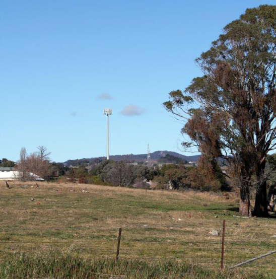
View
towards the proposed site location from Silverdown Way
(north
of proposed site location)
(source
- applicant's Statement of Environmental Effects)
When viewed from further north over
1km from the proposed site location, it is considered that the facility will
have limited visual impact. The applicant argues that whilst the top half of
the facility will be visible it will not be a dominant feature of the landscape
on the basis that it will appear as only a thin protrusion into the skyline.
The applicant further argues that views from the north would also encompass
existing telecommunications facilities at Nashdale and Mount Canobolas, as well
as existing vertical protrusions such as lighting and electricity poles.
When viewed from the northeast
and east in the predominately residential areas of Calare, the proposed
facility is considered to be more visible. The applicant submits that the
visual impacts of the development from this area will be mitigated through the
existing mature vegetation in the area surrounding the proposed site location
and the implementation of the proposed landscaping. Views of the facility from
the immediate south will be limited due to the elevation of the road reserve
along the northern boundary of The Escort Way. The applicant submits that
vegetation along this reserve will also aid to a degree in partly obscuring the
facility from view.
When viewed from the east and west at distances beyond 1km,
the facility will be visible to the greatest degree due to the topography of
the surrounding land. The proposed structure will be located on the western
ridgeline of Ploughmans Valley, which forms the natural backdrop to parts of
the City mentioned above. Whilst there are some landscape elements located on
the ridge to the south of the subject site there are very few landscape
features north of the site. The proposed tower will protrude well above the
skyline when viewed from various vantage points along The Escort Way when
travelling east and west of the subject site, the residential areas to the
north, east and south and from the rural areas to the north, south and west.
The western ridgeline has been identified as a significant
visual backdrop to the City and any element that protrudes above the ridgeline
has the potential to affect the visual amenity of this locality. The applicant
has consistently argued that the visual impact of the development will be
mitigated by existing and proposed landscaping and the fact that there are
other vertical elements such as electricity and lighting poles in this locality.
Whilst this may be the case, it
is obvious that by the nature of this facility being a precisely defined 41.3m
high vertical element located on the western ridgeline to a large area of the
City that the tower structure will create a significant visual impact from
parts of the City. As would be expected the significance of the visual impact
would diminish the further the viewer is away from the tower. However, it needs
to be acknowledged that the visual impact of the tower structure will be
significant from the areas in close proximity to the tower, particularly from
the adjoining rural residential properties (see submissions below).


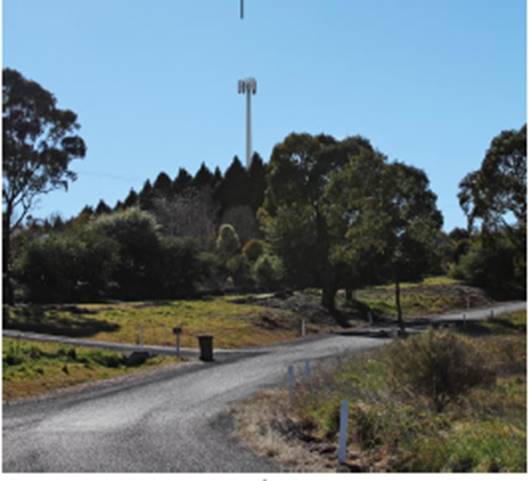
Figure
5.11 View towards proposed site location from Forbes Road
(approximately
1.1km east of proposed site location)
(source
- applicant's Statement of Environmental Effects)
The applicant submits that a photomontage of the
proposed facility as seen from Riawena Oval on Kooronga Avenue, demonstrates
that while the upper portion of the monopole will be visible, the lower
sections are completely shrouded. This argument is acknowledged and it is
agreed that the visual impact of the development from this vantage point is
reduced given the separation distance that exists between the oval and the
subject site. The facility will not be visually significant from these distant
areas.


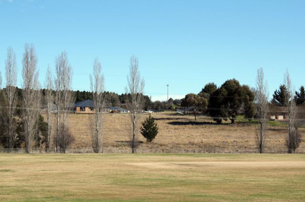
View
towards proposed site location from across Riawena Oval on Kooronga Avenue
(approximately
1.1km south-east of proposed site location)
(source
– Council staff)
Whilst the facility will have a visual presence within
the surrounding area when viewed from the west at varying degrees, it is
considered that the impact will be less given the semi-rural nature of the
land. The topography is undulating further west of the proposal, and with the
presence of mature vegetation in the landscape along The Escort Way it is
expected that the visual impact of the proposed facility from that vantage
point will be minimal.


View
towards proposed site location from service road off Escort Way
(approximately
300m west of proposed site location)
(source
- applicants Statement of Environmental Effects)
The predominant land use directly east of the proposed site
is residential development. The development when viewed from Lisbon Circuit as
shown below (approximately 400m east of the proposed site location) will have
the greatest impact. The immediate adjoining neighbours will experience the
greatest visual impact. There is no hiding a structure of this type in the
location proposed. The implementation of landscaping and controls over the
colour of the proposed structure are the only practical measures that can be
implemented which will, over time, lessen the visual impact of the facility to
a degree. The proposed development when viewed from these vantage points will
nonetheless have a significant visual impact.
Again, the applicant submits that the degree of visual
impact will be mitigated by existing vegetation and the topography of the land.
Further, the applicant argues that this view corridor towards the facility from
these areas is not the predominant view direction from nearby properties.
Whilst this may be the case, it is reasonable to also argue that the western
ridgeline of Ploughmans Valley forms an important landscape feature for the
City as evidenced by the scenic protection provisions contained within
Council’s DCP, and is therefore worthy of protection from development
that may impact upon the scenic qualities of the locality.
There is no doubting that the
facility will be readily viewed from those properties to the immediate east of
the subject site. Development of this type, however, is fast becoming a typical
element within urban environments as the demand for better and more efficient
mobile phone coverage grows. Council therefore, in its consideration of this
matter balance the visual impact of the proposed development against the demand
and need for such infrastructure within the City in this location. Whilst other
sites were initially investigated, Council has been advised by the applicant
that Telstra was unsuccessful in obtaining the required legal tenure from those
property owners whose land was of initial interest.


View
towards proposed site location from Lisbon Circuit
(approximately
500m east of proposed site location)
(source
- applicant's Statement of Environmental Effects)
In summary, the development is
proposed to be located on what is considered to be a significant ridgeline
forming a backdrop to parts of the City. Having said this, the site is
considered to be acceptable in this case subject to the implementation of several
recommended conditions of consent. However, as discussed previously within this
report, given the significance of the western ridgeline of the City and the
fact that the development will be highly visible from many areas in the
surrounding locality, it would be open for Council to form an alternative view
should the visual impact of the development in this location be considered
unacceptable. Should Council form the view that the development will have an
unacceptable impact, particularly in relation to the impact that will be
experienced by those property owners in the immediate vicinity of the
development, it would be necessary to refuse the subject development.
Noise Impacts
The majority of noise and vibration emissions associated
with the proposed facility will be limited to the construction phase. There
will be some low level noise from the ongoing operation of the air conditioning
equipment associated with the equipment units. As outlined within the
applicant's SoEE, the noise emanating from the outdoor cabinet air conditioning
system is at a comparable level to a domestic air conditioning installation,
and will generally accord with the background noise levels prescribed by
Australian Standard AS1055.
Traffic Impacts
Access to the telecommunications facility will be via the
existing access serving the subject site. After the construction period the
only traffic generated by the base station will be that associated with
maintenance vehicles. Accordingly, the facility will only generate one visit
per year for the maintenance, with the facility being vacant for the rest of
the year. The traffic generation will therefore be minimal and not sufficient
to create any adverse impacts.
Social and Economic Impacts
The applicant has advised that the proposed development will
facilitate the provision of vital infrastructure so as to improve mobile phone
coverage to areas that are currently experiencing limited reception within
Orange. The wider social and economic benefits of the proposal will result in a
positive impact for the City.
THE SUITABILITY OF THE SITE
s79C(1)(c)
The subject site is located within the scenic protection
area as defined under the provisions of DCP 2004. Such provisions
previously were included in Orange LEP 2000 but because Council were unable to
incorporate them into Orange LEP 2011 because of the Standard Instrument
provisions it was decided by Council to include them into the DCP. The
inclusion of these provisions in the DCP does reflect the importance that
Council gives to planning within the scenic protection areas. This particular
ridgeline forms a visual backdrop from parts of the urban environment of
Orange. The surrounding locality comprises predominantly residential
development to the immediate east and mostly undeveloped large lot residential
land to the west. This proposal therefore has the ability to influence the
visual amenity of many parts of the City well beyond the immediate area.
The assessment of the proposal has highlighted the fact that
the proposed development will have a visual impact upon the immediate
surrounding residential locality. Council in determining the suitability of the
subject site will need to balance the visual impact of the proposed development
against the demand and need for such infrastructure within the City.
Infrastructure of this type is fast becoming a common element within urban
environments. Whilst other sites were initially investigated, Council has been
advised by the applicant that Telstra was unsuccessful in obtaining the
required tenure from those property owners whose land was of initial interest.
Whilst the development is proposed to be located on what is
considered to be a significant ridgeline forming a backdrop to parts of the
City, the site is considered to be acceptable in this case subject to the
implementation of several conditions of consent. However, as discussed
previously within this report, given the significance of the western ridgeline
of the City and the fact that the development will be seen from many vantage
points in the surrounding locality, it would be open for Council to form an
alternative view should the visual impact of the development in this location
be considered unacceptable. Should Council form the view that the development
will have an unacceptable impact it may wish to refuse the development.
ANY SUBMISSIONS MADE IN
ACCORDANCE WITH THE ACT s79C(1)(d)
The proposed development is not defined as advertised
development under the provisions of the LEP, however given the nature of and
locality of the development the application was advertised for a period of 14
days. At the end of that period two submissions had been received objecting to
the proposed development.
In summary, the objections are expressing opposition to the
visual impact that the proposed telecommunications facility will have on the
surrounding amenity. The specific issues raised by Submissions 1 and 2 (being
the owners of the same property located at 448 The Escort Way which immediately
adjoins the subject site) are summarised and commented upon as follows:
· The visual
impact on the surrounding rural amenity.
The submissions raise strong objection to the establishment
of a 40m high monopole on the western ridgeline of Ploughmans Valley. The
submissions indicate that the proposed development will have a significant
visual impact upon large areas of western Orange and, in particular, their
property at 448 The Escort Way. The submitters question why a structure of this
type can be located within this area given that the area is subject to planning
controls that seek to protect the western ridgeline of the City.
Under the former planning provisions contained within Orange
LEP 2000 the subject land was subject to scenic protection planning controls.
At the Direction of the Department of Planning such controls were not allowed
to be carried through with the adoption of Orange LEP 2011. Rather, the
Department insisted that such controls be included within a DCP. Given
that a DCP is not defined as a formal Environmental Planning Instrument, the
determinative weight given to matters within a DCP is less than if such
provisions remained within the LEP.
The immediate adjoining neighbours will experience the
greatest visual impact. There is no hiding a structure of this type in the
location proposed. The implementation of landscaping and controls over the
colour of the proposed structure may serve to reduce the impact of the
development to a degree from distant locations but will do little to reduce the
visual impact when viewed from those properties immediately adjoining and
adjacent to the subject site. The proposed development when viewed from the
adjoining property will have a significant visual impact.
The issue of visual impact of the proposed development has
been further addressed under the “Visual Impacts” section under
“Likely Impacts of the Development s79C(1)(b)”.
· Devaluation
of property.
The submission received in
relation to this issue included no evidence to suggest that the proposed
development would have a negative impact upon the resale value of property. In
any event, the resale value of adjoining and adjacent properties as a result of
this development proceeding is not a relevant planning consideration under the
provisions of Section 79C of the Environmental Planning and Assessment
Act 1979.
· Traffic
impacts.
The issue of traffic impact of the proposed development has
been outlined under the “Traffic Impacts” section under
“Likely Impacts of the Development s79C(1)(b)”.
· The tower would
impact upon the flight path of flying foxes and the migration of Black Duck,
Ibis Snipe and other migratory birds.
The submission received in relation to this issue has
included no evidence to suggest that the proposed development would have a
negative impact upon endangered animals. An assessment of whether there is
likely to be a significant effect on threatened species, populations or
ecological communities or their habitats has been undertaken above under the
heading “Part 5A Assessment”.
PUBLIC INTEREST
s79C(1)(e)
The proposed development is considered to be of some public
interest. In a localised sense there are significant adverse visual impacts,
which have been discussed in some detail in this report. Conversely there are
public benefits to the wider community (which should be considered a public
interest) relating to improved telecommunications coverage.
The public interest in this case is considered a central
issue. On the one hand there are serious but localised adverse visual impacts.
On the other hand there are benefits to the wider community in terms of
enhanced communications.
The proposal is not inconsistent with
any relevant policy statements, planning studies, guidelines, etc that have not
been considered in this assessment.
SUMMARY
The proposed development is permissible with the consent of
Council. The proposed development complies with the relevant aims, objectives
and provisions of both the Orange LEP and SEPP (Infrastructure). A section
79C assessment of the development indicates that the development will have a
significant visual impact. The implementation of landscaping and controls over
the colour of the proposed structure may serve to reduce the impact of the
development to a degree from distant locations, but will do little to reduce
the visual impact when viewed from those properties adjoining and near the
subject site as well as large areas of the City and the travelling public along
the Escort Way.
Infrastructure of this type is fast becoming a common
element within urban environments. Council will therefore need to determine the
application having regard to the overall visual impact that the structure will
have on surrounding land against the overall public benefit that may result
from facilitating improved mobile phone coverage in this locality.
Attached is a draft Notice of Approval outlining a range of
conditions considered appropriate to ensure that the development proceeds in an
acceptable manner.
It is recommended that Council supports the development.
COMMENTS
The requirements of the Environmental Health and Building
Surveyor and the Engineering Development Manager are included in the attached
Notice of Approval.
Attachments
1 Notice
of Approval, D15/2961⇩
2 Plans,
D15/1763⇩
3 Submissions,
D15/2960⇩
Sustainable Development Committee
3 March 2015
2.2 Development
Application DA 181/2014(1) - 454 The Escort Way
Attachment 1 Notice
of Approval
|

|
ORANGE
CITY COUNCIL
Development
Application No DA
181/2014(1)
NA15/2961 Container
PR18313
|
NOTICE OF DETERMINATION
OF A DEVELOPMENT
APPLICATION
issued under the Environmental
Planning and Assessment Act 1979
Section 81(1)
|
Development
Application
|
|
|
Applicant Name:
|
Telstra
|
|
Applicant Address:
|
C/-
Aurecon
PO Box 538
NEUTRAL
BAY NSW 2089
|
|
Owner’s Name:
|
Mr JA and
Mrs AM Spencer
|
|
Land to Be Developed:
|
Lot 100 DP
1035863 - 454 The Escort Way, Orange
|
|
Proposed Development:
|
Telecommunications
Facility (mobile phone base station with 40m high monopole and equipment
shelter)
|
|
|
|
|
Building
Code of Australia
building classification:
|
As
determined by Certifier
|
|
|
|
|
Determination
|
|
|
Made On:
|
3 March
2015
|
|
Determination:
|
CONSENT
GRANTED SUBJECT TO CONDITIONS DESCRIBED BELOW:
|
|
|
|
|
Consent to
Operate From:
|
4 March
2015
|
|
Consent to
Lapse On:
|
4 March
2020
|
Terms of Approval
The reasons for the imposition of
conditions are:
(1) To ensure a quality
urban design for the development which complements the surrounding environment.
(2) To maintain
neighbourhood amenity and character.
(3) To ensure compliance
with relevant statutory requirements.
(4) To provide adequate
public health and safety measures.
(5) To prevent the proposed
development having a detrimental effect on adjoining land uses.
(6) To minimise the impact
of development on the environment.
Conditions
(1) The
development must be carried out in accordance with:
(a) Plan/s
numbered N109786 Sheet No S1 Index; N109786 Sheet No S3 Index
(b) statements
of environmental effects or other similar associated documents that form part
of the approval
as amended
in accordance with any conditions of this consent.
(2) All building work must
be carried out in accordance with the provisions of the Building Code of
Australia.
|
PRIOR TO THE ISSUE OF
A CONSTRUCTION CERTIFICATE
|
(3) The Council must, prior
to the release of the Construction Certificate, be given a report:
(1) Showing
compliance with any relevant site and height requirements specified by the
Civil Aviation Regulations 1988 and the Airports (Protection of Airspace)
Regulations 1996 of the Commonwealth, and
(2) Showing
that it does not penetrate any obstacle limitation Surface Plan that has been
prepared by the operator of an aerodrome or airport operating within 30km of
the proposed development and reported to the Civil Aviation Safety Authority
Australia.
(4) A
Construction Certificate application is required to be submitted to, and issued
by, Council/Accredited Certifier prior to any excavation or building works
being carried out on site.
|
DURING
CONSTRUCTION/SITEWORKS
|
(5) Any adjustments to
existing utility services that are made necessary by this development
proceeding are to be at the full cost of the developer.
|
PRIOR TO THE ISSUE OF
AN OCCUPATION CERTIFICATE
|
(6) Landscaping
shall be installed in accordance with the approved plans and shall be
permanently maintained to the satisfaction of Council's Manager Development
Assessments.
(7) No
person is to use or occupy the building or alteration that is the subject of
this approval without the prior issuing of an Occupation Certificate.
(8) All
of the foregoing conditions are to be at the full cost of the developer and to
the requirements and standards of the Orange City Council Development and
Subdivision Code, unless specifically stated otherwise. All work required by
the foregoing conditions is to be completed prior to the issuing of an
Occupation Certificate, unless stated otherwise.
|
MATTERS FOR THE
ONGOING PERFORMANCE AND OPERATION OF THE DEVELOPMENT
|
(9) The monopole and
associated headframe shall be finished in a “shale grey” colour and
be maintained in perpetuity.
Other Approvals
(1) Local
Government Act 1993 approvals granted under section 68.
Nil
(2) General
terms of other approvals integrated as part of this consent.
Nil
Right of Appeal
If
you are dissatisfied with this decision, section 97 of Environmental
Planning and Assessment Act 1979 gives you the right to appeal to the Land
and Environment Court within 6 months after the date on which you receive this
notice.
*
Section 97 of the Environmental Planning and Assessment Act 1979 does not apply
to the determination of a development application for State significant
development or local designated development that has been the subject of a
Commission of Inquiry.
|
Disability Discrimination Act
1992:
|
This application has been assessed in
accordance with the Environmental Planning and Assessment Act 1979. No
guarantee is given that the proposal complies with the Disability
Discrimination Act 1992.
The applicant/owner is responsible to
ensure compliance with this and other anti-discrimination legislation.
The Disability Discrimination Act
covers disabilities not catered for in the minimum standards called up in the
Building Code of Australia which references AS1428.1 - "Design for
Access and Mobility". AS1428 Parts 2, 3 and 4 provides the most
comprehensive technical guidance under the Disability Discrimination Act
currently available in Australia.
|
|
|
|
|
Disclaimer - S88B Restrictions on the Use of Land:
|
The applicant should note that there
could be covenants in favour of persons other than Council restricting what
may be built or done upon the subject land. The applicant is advised to check
the position before commencing any work.
|
|
|
|
|
Signed:
|
On behalf of the consent authority ORANGE
CITY COUNCIL
|
|
Signature:
|
|
|
Name:
|
ALLAN RENIKE - MANAGER DEVELOPMENT
ASSESSMENTS
|
|
Date:
|
4 March 2015
|
Sustainable
Development Committee
3 March 2015
2.2 Development
Application DA 181/2014(1) - 454 The Escort Way
Attachment 2 Plans
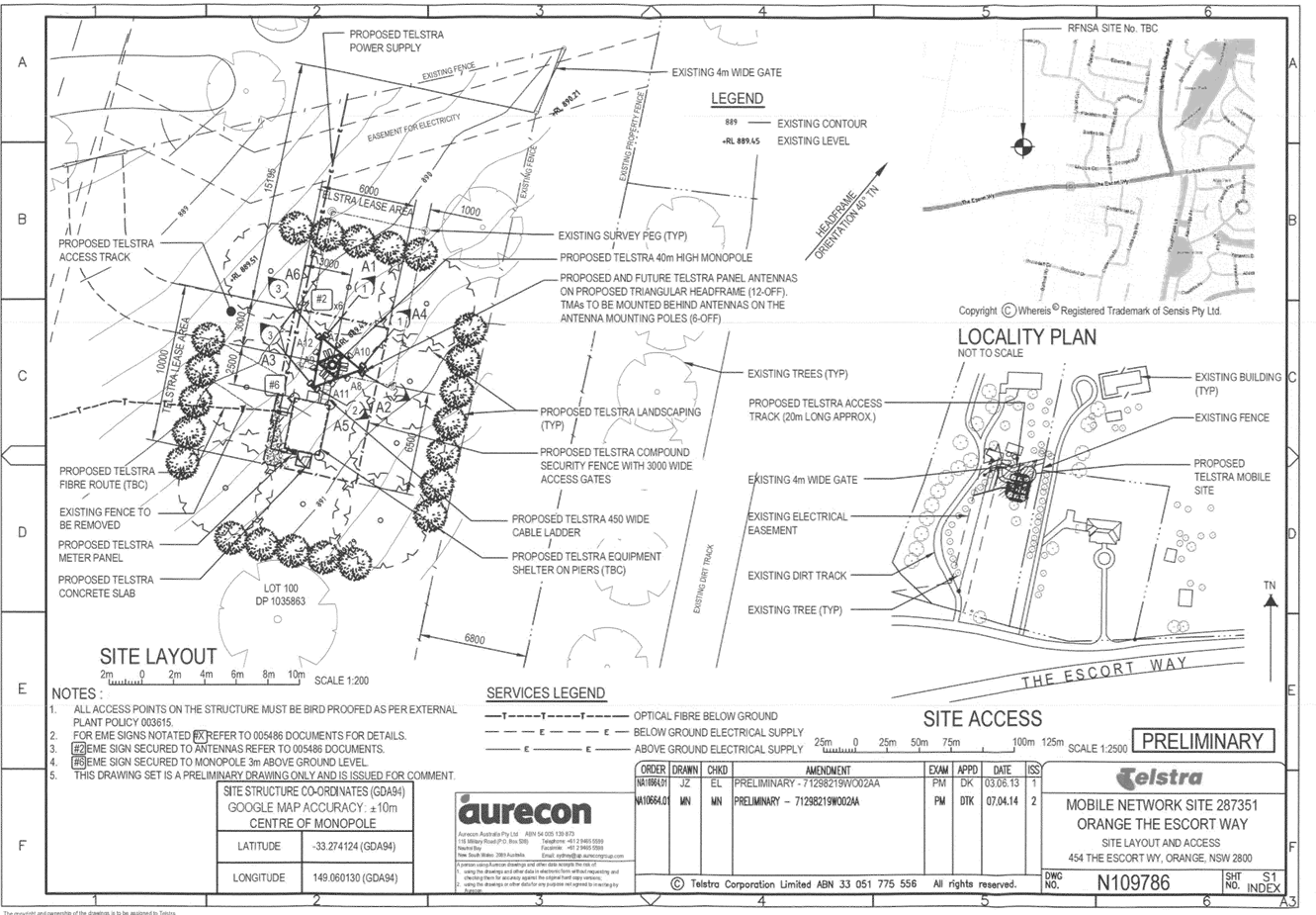
Sustainable Development Committee
3 March 2015
2.2 Development
Application DA 181/2014(1) - 454 The Escort Way
Attachment 3 Submissions

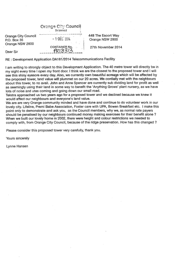
2.3 Development
Application DA 290/2014(1) - 2 Elizabeth Street
TRIM
REFERENCE: 2015/454
AUTHOR: Andrew
Crump, Town Planner
EXECUTIVE Summary
Council's consent is sought for the construction of a
residential flat building on land described as Lot 1 DP 377484, known as 2 Elizabeth
Street, Orange. The development comprises four two bedroom units and one three
bedroom unit.
The design of the development is unique to the Orange area
given the proposed “under croft” parking area; which is essentially
underground or in this instance, part underground parking. The underground
parking coupled with the topography of the land results in the building
presenting at effective 1.5 storey scale in the front elevation, two storey in
scale within the northern elevation and part of the eastern and western
elevations. This results in potential privacy issues, increases the bulk of the
built form and results in a development that is not consistent with the
character of area. The subject lot is a corner allotment, which presents a
number of compromising elements within the design.
The development has the potential to unreasonably impact
upon the character of the area and detract from the amenity of the locality.
This is due to the bulk of the building resultant from the under croft parking,
the visual appearance of the building with minimal articulation in the front
elevation, the minimal setback to Moad Street and extensive visual privacy
impacts that need to be ameliorated with a number of conditions of
consent.
Whilst the development is recommended for approval; given
the extensive deficiencies identified with the design of the development, Council
would have sufficient grounds to refuse the development.
Link To Delivery/OPerational Plan
The recommendation in this report relates to the
Delivery/Operational Plan strategy “13.4 Our Environment
– Monitor and enforce regulations relating to City amenity”.
Financial Implications
Nil
Policy and Governance Implications
Nil
|
Recommendation
That Council grants consent to development application
DA 290/2014(1) for Residential Flat Building at Lot 1 DP 377484 - 2
Elizabeth Street, Orange pursuant to the conditions of consent in the
attached Notice of Approval.
|
further considerations
Consideration has been given to the
recommendation’s impact on Council’s service delivery; image and
reputation; political; environmental; health and safety; employees;
stakeholders and project management; and no further implications or risks have
been identified.
SUPPORTING INFORMATION
THE APPLICATION
Council's consent is sought for the construction of a residential
flat building on land described as Lot 1 DP 377484, known as 2 Elizabeth
Street, Orange. The development comprises four two bedroom units and one three
bedroom unit.
THE PROPOSAL
The subject land is located on the north- eastern corner of
the intersection of Elizabeth and Moad Streets. The proposal involves the
construction of a residential flat building consisting of four two bedroom
units and one three bedroom unit. Parking is provided in the form of under
croft parking spaces with access to the under croft parking provided in the
south-eastern corner of the site, along with a separate attached single garage.
MATTERS FOR CONSIDERATION
Section 5A Assessment
In the administration of sections 78A, 79B, 79C, 111 and
112, the provisions of Section 5A must be taken into account for every
development application, in deciding whether there is likely to be a
significant effect on threatened species, populations or ecological communities
or their habitats. This section includes a requirement to consider any adopted
assessment guidelines, which means assessment guidelines issued and in force
under section 94A of the Threatened Species Conservation Act 1995.
Assessment guidelines are in force (see DECC-W “Threatened Species
Assessment Guidelines - The Assessment of Significance”) which requires
consent authority to adopt the precautionary principle in its assessment.
In this instance, site inspection reveals that the subject
property has no biodiversity or habitat value.
Section 79C
Section 79C of the Environmental Planning and Assessment
Act 1979 requires Council to consider various matters, of which those
pertaining to the application are listed below.
PROVISIONS OF ANY ENVIRONMENTAL
PLANNING INSTRUMENT s79C(1)(a)(i)
Orange Local Environmental Plan 2011
Part 1 - Preliminary
Clause 1.2 - Aims of Plan
The broad aims of the LEP are
set out under subclause 2. Those relevant to the application are as follows:
(a) to encourage development which complements
and enhances the unique character of Orange as a major regional centre boasting
a diverse economy and offering an attractive regional lifestyle,
(e) to provide a range of housing choices in
planned urban and rural locations to meet population growth
Aims (a) and (e) as listed above, are of relevance to the
assessment of the application. The application is not inconsistent with the
relevant aims.
Clause 1.6 - Consent Authority
This clause establishes that, subject to the Act, Council is
the consent authority for applications made under the LEP.
Clause 1.9A - Suspension of
Covenants, Agreements and Instruments
This clause provides that covenants, agreements and other
instruments which seek to restrict the carrying out of development do not apply
with the following exceptions.
· covenants imposed
or required by Council
· prescribed
instruments under Section 183A of the Crown Lands Act 1989
· any conservation
agreement under the National Parks and Wildlife Act 1974
· any trust
agreement under the Nature Conservation Trust Act 2001
· any property
vegetation plan under the Native Vegetation Act 2003
· any biobanking
agreement under Part 7A of the Threatened Species Conservation Act 1995
· any planning
agreement under Division 6 of Part 4 of the Environmental Planning and
Assessment Act 1979.
Council staff are not aware of the title of the subject
property being affected by any of the above. A sewer line traverses the eastern
part of the site. This will have to be altered to construct the under croft
parking area. Council’s Technical Services Division raises no objection
to this.
Mapping
The subject site is identified
on the LEP maps in the following manner:
|
Land Zoning Map:
|
Land zoned R1 General Residential
|
|
Lot Size Map:
|
No Minimum Lot Size
|
|
Heritage Map:
|
Not a heritage item or conservation
area
|
|
Height of Buildings Map:
|
No building height limit
|
|
Floor Space Ratio Map:
|
No floor space limit
|
|
Terrestrial Biodiversity Map:
|
No biodiversity sensitivity on the
site
|
|
Groundwater Vulnerability Map:
|
Ground water vulnerable
|
|
Drinking Water Catchment Map:
|
Not within the drinking water
catchment
|
|
Watercourse Map:
|
Not within or affecting a defined
watercourse
|
|
Urban Release Area Map:
|
Not within an urban release area
|
|
Obstacle Limitation Surface Map:
|
No restriction on building siting
or construction
|
|
Additional Permitted Uses Map:
|
No additional permitted use applies
|
Those matters that are of
relevance are addressed in detail in the body of this report.
Part 2 - Permitted
or Prohibited Development
Land Use Zones
The subject site is located within the R1 General
Residential zone. The proposed development is defined as a residential flat
building under OLEP 2011. Pursuant to the dictionary contain within OLEP 2011 a
residential flat building means:
a building
containing 3 or more dwellings, but does not include an attached dwelling or
multi dwelling housing.
Residential flat buildings are
permissible with consent in the R1 General Residential zone with the consent of
Council.
Clause 2.3 of
LEP 2011 references the Objectives for each zone in LEP 2011. These
objectives for land zoned R1 – General Residential are as follows:
1 - Objectives of the R1 General Residential Zone
· To
provide for the housing needs of the community.
· To
provide for a variety of housing types and densities.
· To enable
other land uses that provide facilities or services to meet the day to day
needs of residents.
· To ensure
development is ordered in such a way as to maximise public transport patronage
and encourage walking and cycling in close proximity to settlement.
· To ensure
that development along the Southern Link Road has an alternative access.
In relation to the first objective, the proposed development
would act to provide additional housing stock within the City. In relation to
the second objective, the proposed dwellings will provide a variation of
housing type and density for the City. In relation to the third objective, the
proposed development has no effect. In relation to the fourth objective, the
subject site is within close proximity to routes used by public transport and
is also in close proximity to shops and services. In relation to the last
objective, the proposed development has no effect.
The proposed development is not inconsistent with the
objectives of the zone.
Part 3 -
Exempt and Complying Development
The application is not exempt or complying development.
Part 4 -
Principal Development Standards
Clause 4.1B - Minimum Lot
Sizes for Dual Occupancy, Multi Dwelling Housing and Residential Flat Buildings
Despite the name of this clause,
there are no standards within this clause relevant to the proposal. The
development is not inconsistent with the above clause.
Part 7 -
Additional Local Provisions
7.1 - Earthworks
This clause establishes a range
of matters that must be considered prior to granting development consent for
any application involving earthworks, such as:
(a) the likely disruption of, or any
detrimental effect on, existing drainage patterns and soil stability in the
locality of the development
(b) the effect of the development on the
likely future use or redevelopment of the land
(c) the quality of the fill or the soil to be
excavated, or both
(d) the effect of the development on the
existing and likely amenity of adjoining properties
(e) the source of any fill material and the
destination of any excavated material
(f) the likelihood of disturbing relics
(g) the proximity to and potential for adverse
impacts on any waterway, drinking water catchment or environmentally sensitive
area
(h) any measures proposed to minimise or
mitigate the impacts referred to in paragraph (g).
The earthworks proposed in the
application are extensive to facilitate the under croft parking; in the order
of 1.4m along the southern portion of the parking area and reducing down to
0.6m along the northern part of the basement. Notwithstanding this, the extent
of disruption to the drainage of the site is considered to be minor and will
not detrimentally affect adjoining properties or receiving waterways.
The extent of the earthworks
will not materially affect the potential future use or redevelopment of the
site that may occur at the end of the proposed development's lifespan.
The site is not known to be
contaminated, nor is the site known to contain any Aboriginal, European or
archaeological relics. Previous known uses of the site do not suggest that any
relics are likely to be uncovered. However, conditions are imposed to ensure
that should site works uncover a potential relic or artefact, works will be
halted to enable proper investigation by relevant authorities and the proponent
required to seek relevant permits to either destroy or relocate the findings.
The earthworks will be
appropriately supported onsite and the change in ground level is not
substantial. Therefore the effect on the amenity of adjoining properties is
considered to be minor.
The site is not in proximity to
any waterway, drinking water catchment or sensitive area. Conditions are
imposed to require a sediment control plan, including silt traps and other
protective measures, to ensure that loose dirt and sediment does not escape the
site boundaries.
7.2 - Flood
Planning
This clause applies to land
identified on the Flood Planning Map as a Flood Planning Area and requires
that, before any consent is issued, Council must be satisfied that the
proposal:
(a) is compatible with the flood hazard of the
land, and
(b) is not likely to significantly adversely
affect flood behaviour resulting in detrimental increases in the potential
flood affectation of other development or properties, and
(c) incorporates appropriate measures to
manage risk to life from flood, and
(d) is not likely to significantly adversely
affect the environment or cause avoidable erosion, siltation, destruction of
riparian vegetation or a reduction in the stability of river banks or
watercourses, and
(e) is not likely to result in unsustainable
social and economic costs to the community as a consequence of flooding.
The subject land is not
identified on the flood planning maps as being subject to flood related
development controls. Notwithstanding this, the land contains an extensive
overland flowpath traversing the eastern quarter of the site. A condition is
attached that requires an amendment to the design of the access handle. The
amendment will affectively provide a hump in the driveway to reduce the flow of
water into the under croft parking area and allow the flow of water to continue
on within the street system.
7.3 -
Stormwater Management
This clause applies to all
industrial, commercial and residential zones and requires that Council be
satisfied that the proposal:
(a) is designed to maximise the use of water
permeable surfaces on the land having regard to the soil characteristics
affecting onsite infiltration of water
(b) includes, where practical, onsite
stormwater retention for use as an alternative supply to mains water,
groundwater or river water; and
(c) avoids any significant impacts of
stormwater runoff on adjoining downstream properties, native bushland and
receiving waters, or if that impact cannot be reasonably avoided, minimises and
mitigates the impact.
Council Technical Services Division
advises that:
the
applicant’s proposed stormwater detention basin will have minimal effect
on the catchment as much of the property is located within the flood zone. A
monetary contribution towards the provision of stormwater
detention/improvements in the local catchment is preferred. A condition is
attached to this affect.
7.6 -
Groundwater Vulnerability
This clause seeks to protect
hydrological functions of groundwater systems and protect resources from both
depletion and contamination. Orange has a high water table and large areas of
the LGA, including the subject site, are identified with “Groundwater
Vulnerability” on the Groundwater Vulnerability Map. This requires that
Council consider:
(a) whether or not the development (including
any onsite storage or disposal of solid or liquid waste and chemicals) is
likely to cause any groundwater contamination or have any adverse effect on
groundwater dependent ecosystems, and
(b) the cumulative impact (including the
impact on nearby groundwater extraction for potable water supply or stock water
supply) of the development and any other existing development on groundwater.
Furthermore, consent may not be granted unless Council is satisfied that:
(a) the development is designed, sited and
will be managed to avoid any significant adverse environmental impact, or
(b) if that impact cannot be reasonably
avoided - the development is designed, sited and will be managed to minimise
that impact,
(c) if that impact cannot be minimised - the
development will be managed to mitigate that impact.
The proposal is not anticipated
to involve the discharge of toxic or noxious substances and is therefore
unlikely to contaminate the groundwater or related ecosystems. The proposal
does not involve extraction of groundwater and will therefore not contribute to
groundwater depletion. The design and siting of the proposal avoids impacts on
groundwater and is therefore considered acceptable.
STATE ENVIRONMENTAL PLANNING
POLICIES
State Environmental Planning Policy (Building Sustainability
Index BASIX) applies to the subject development. The applicant has submitted a
BASIX certificate in support of the development which demonstrates compliance
with the state Government Water and Thermal Efficiency targets. The application
is consistent with the SEPP.
State Environmental Planning Policy 55 - Remediation of Land
is applicable to the development. The subject land has a long history of being
used for residential purposes, and as such there is little to suggest that the
land may be contaminated. As such, the continued use of the land for
residential purposes is considered acceptable.
PROVISIONS OF ANY DRAFT
ENVIRONMENTAL PLANNING INSTRUMENT THAT HAS BEEN PLACED ON EXHIBITION
s79C(1)(a)(ii)
There are no draft environmental planning instruments that
apply to the subject land or proposed development.
PROVISIONS OF ANY DEVELOPMENT
CONTROL PLAN s79C(1)(a)(iii)
Development Control Plan 2004
Development Control Plan 2004 (“the DCP”)
applies to the subject land (Part 0 - LEP 2011 and Part - 7
Development in Residential Areas). An assessment of the proposed
development against the relevant Planning Outcomes will be undertaken below.
Pursuant to Planning Outcome 0.2-1 Interim Planning Outcomes
- Conversion of Zones:
· Throughout this
Plan, any reference to a zone in Orange LEP 2000 is to be taken to be a
reference to the corresponding zone(s) in the zone conversion table.
The corresponding zone to zone 2(a) Urban Residential
(Orange LEP 2000) is zone R1 General Residential (Orange LEP 2011). As
such, Orange DCP 2004-07 - Development in Residential Areas is relevant
to this proposal. The provisions of Part 7 are considered below.
Part 7 - Design Elements for
Residential Development
The DCP sets the following Planning Outcomes in regard to
Urban Residential Development.
Neighbourhood Character
The DCP sets the following Planning Outcomes in regard to
Neighbourhood Character:
· Site layout and
building design enables the:
- creation of attractive
residential environments with clear character and identity
- use of site features such as
views, aspect, existing vegetation and landmarks
· Buildings are
designed to complement the relevant features and built form that are identified
as part of the desired neighbourhood character.
· The streetscape
is designed to encourage pedestrian access and use.
The character and identity of an area is defined by the
combination of particular characteristics and qualities of the individual
locality. Ideally, the design of infill development should be influenced by the
established character of the area. This should be achieved through building
designs that maintain a theme commensurate with the setting in terms of grain
size, scale, setbacks, consistent use of materials, etc that is evident within
the locality.
The character of the area is typically single storey
detached dwellings of modest scale at the site frontage. There are two examples
evident within the vicinity that are not typical of this built form or
development pattern, those being a circa 1980s dual occupancy (single storey
and detached) and a recent NSW Department of Housing development. In terms of
the NSW Department of Housing development opposite the site, whilst
consisting of a greater density than what is observed and considered typical of
the area; appropriate design principles have resulted in the development
presenting satisfactorily within the street.
The single storey and modest scale at the street frontage,
coupled with extensive architectural detailing and visual relief results in a
development that is complementary to the features and built form evident within
the desired neighbourhood character.
The applicant is drawing on these two examples (the dual
occupancy to the east and NSW Department of Housing development opposite)
to suggest that the area is going through a transitional state away from the
aforementioned character of the area.
The applicant states:
The surrounding locality is
characterised by typically single dwelling developments on standard dwelling
lots, the notable exception being the Department of Housing (DoH) development
to the south west and a dual occupancy development to the east fronting Nunns
Avenue. The DoH development is of significantly higher density than surrounding
development, featuring 10 dwellings within a 3,200 square metre lot. This
development has resulted in some transition of the historical (single dwelling)
character of the area.
It is difficult to sustain the notion that the area is
characterised as transitional in character relying on only two residential
developments in the locality. This is particularly so given that the scale of
dual occupancy (being detached dwellings at a single storey scale and open
style frontages) presents for all intents and purposes as two single dwellings
on separate lots. Aside from the identified DoH development, there is little to
suggest that the proposed development is consistent with a transitioning
character of a greater density.
It is considered that the proposal is not complementary to
the relevant features and built form, including the scale and setbacks that are
typical of the pattern of development and are identified as part of the desired
neighbourhood character. Consequently, there are sufficient grounds to refuse
the development.
Building Appearance
The DCP sets the following Planning Outcomes in regard to
Building Appearance:
· The building
design, detailing and finishes relate to the desired neighbourhood character,
complement the residential scale of the area, and add visual interest to the
street.
· The frontages
of buildings and their entries face the street.
· Garages and car
parks are sited and designed so that they do not dominate the street frontage.
The building presents to the street in a rectilinear form
with minimal articulation or visual relief in all elevations. The roof will
take the form of a skillion style roof with expressed rafters. A single lean-to
garage is proposed in the north-western corner attached to Unit 1. The
under croft parking, although below the floor level of the building, has the
effect of raising the overall wall height of the building. This in turn
directly results in the building presenting at a greater height and scale than
is typical of the scale and appearance of dwellings in the area, and is not
complementary to the character of the area established above.
A mixed use of external materials is proposed comprising
render and metal cladding, and masonry to the basement level.
Whilst not typical of the character of the area, and more
commonly adopted on institutional style buildings such as schools and
hospitals, the selected materials and finishes are generally acceptable within
the context and setting. Notwithstanding this, a condition is attached to the
Notice of Approval to ensure that the selected materials are acceptable.
Setbacks
The DCP sets the following Planning Outcomes in regard to
Setbacks:
· Street setbacks
contribute to the desired neighbourhood character, assist with the integration
of new development and make efficient use of the site.
· Street setbacks
create an appropriate scale for the street considering all other streetscape
components.
A large amount of dialogue occurred between Council staff
and the applicant’s planning consultant prior to lodgement, much of which
centred around which frontage was the primary frontage, and leading on from
that, what the required setback is under the DCP for the development.
The DCP requires that setbacks
of new buildings in established residential areas be defined by the setbacks of
development on adjoining land. The applicant submits that the primary setback
is taken to be Moad Street and therefore the setback is established by the
secondary setback of 1 Elizabeth Street and southernmost corner of the skewed
dwelling at 1 Nunns Avenue.
The proposal has adopted a varied
front setback to Moad Street of between 3m and 4.5m, relying on the 3m
setback of the adjacent property at 1 Nunns Avenue. Council has a record of a
survey of this property which indicates the setback to actually be 3.905m
rather than the suggested 3m purported by the applicant. Given the angled
siting of 1 Nunns Avenue, the setback is not as obvious as it ordinarily would
be if the dwelling was square to Moad Street at that same setback. This has the
effect of giving the feeling of a greater setback than the incorrect 3m setback
suggested by the applicant. The average setback of this dwelling is about 6.6m.
Therefore, the proposal not only projects forward of the point of the adjoining
building by 0.9m, given the presentation of the dwelling at 1 Nunns Avenue, the
encroachment will appear even greater.
Notwithstanding the guidelines that requires a setback
relative to adjoining development which has been relied upon by the applicant,
the fact that the design utilises the long boundary of the site fronting Moad
Street and is a single building around 45m in length is at odds with the vast majority
of setbacks in the immediate area.
The recommendation of Council’s Heritage and Urban
Design Consultant to articulate the entrances of the dwellings to make the
building present to the street more appropriately would conflict with the
already minimal setback. The presentation of a development and how it
integrates within the streetscape should not be compromised by maximising
development of a site. The design of the development is disappointing given the
minimal setback and poor presentation to the street. The design of the
development responds only to maximising the development potential at the cost
of maintaining the integrity of the streetscape. This is a key consideration in
the determination of the application.
Fences and Walls
The DCP sets the following Planning Outcome in regard to
fences and walls:
· Front fences and
walls:
- assist in highlighting
entrances and creating a sense of identity within the streetscape.
- are constructed of materials
compatible with associated housing and with fences visible from the site that
positively contribute to the streetscape
- provide for facilities in
the street frontage area such as mail boxes.
The applicant is proposing a solid 1.5m fence to the
secondary boundary to provide visual privacy to the open space of Unit 1. This
is truncated at the corner to improve sightlines for vehicles negotiating the
intersection of Moad and Elizabeth Streets and to connect with the front fence.
The front fence along the Moad Street frontage is proposed
at an overall height of 1.2m, comprising a masonry base to a height of 600mm
and evenly spaced masonry posts to a height of 1.2m. Picket infill panels are
proposed between the masonry posts and on top of the masonry bases at 600mm.
Vegetation is proposed behind the picket sections to help soften the fence. The
applicant is proposing two entry arbours incorporated into the controlled
access gates. Council staff requested further justification outlining the
purpose of the proposed arbour/archways. The applicant responded with the
following:
The proposed arbour/archways
serve to define the access point in line with the principles contained in the
Crime Prevention through Environmental Design guidelines and provide effective
access control and territorial reinforcement. The use of this style of entrance
is common throughout Orange and is representative of the character of the
broader residential landscape.
Council staff still question the purpose of these elements
of the proposed fence other than adding to the overall scale of the fence at
the street frontage, and disagree with the comments above in that these types
of arbours or archways are not common in the area. To this end, it is
recommended that they be deleted from the proposal. A condition is attached to
this effect.
Pedestrian access from Moad Street to Units 2-5 is coherent
and obvious as one access is centred between Units 2 and 3 and another access
between Units 4 and 5. Access to Unit 1 from Moad Street is less obvious
as there is no access in front of Unit 1. This raises doubt as to the primary
frontage of Unit 1 as vehicular and pedestrian access is more clearly defined
within Moad Street. This then raises the question as to which is the primary
frontage of Unit 1. If the primary frontage is to be taken where the most
obvious front access is to be taken, then this would mean that the private open
space is forward of the front building line. To ensure that the Unit 1 frontage
addresses Moad Street rather than Elizabeth Street, an additional gate is
required in front of Unit 1. A condition is attached to this effect.
Internal fences will be required to delineate private open
space between each unit. Relevant conditions are attached.
The applicant has submitted a second set of the same plans
with additional detail relating to the fencing and landscaping notated on them
for explanatory purposes. These plans are considered supplementary to the
detailed drawings previously submitted by the applicant. The notations on these
plans are hand-drawn and serve the intended purposes; however, it will be
necessary for fully resolve detailed drawings to be submitted and approved
reflecting the intentions of the hand notated drawings prior to the issue of a
Construction Certificate. The hand notations supersede the relevant elements of
the computerised drawings.
Visual Bulk
The DCP sets the following Planning Outcome in regard to
Visual Bulk:
· Built form
accords with the desired neighbourhood character of the area with:
- side and rear setbacks
progressively increased to reduce bulk and overshadowing
- site coverage that retains
the relatively low density landscaped character of residential areas
- building form and siting
that relates to landform, with minimal land shaping (cut and fill)
- building height at the
street frontage that maintains a comparable scale with the predominant adjacent
development form
- building to the boundary
where appropriate.
In consideration of the DCP Guidelines, the proposal is
considered to be satisfactory, although the single building 45m in length is
inconsistent with the visual bulk in the area.
The DCP requires dwellings to be contained
within the prescribed envelopes generated by planes projected at 45o
over the site commencing 2.5m above existing ground level from each side and
rear boundary. The development will be contained within these planes and
is considered acceptable.
Site Coverage
The building footprint totals 509m2 and the
subject land totals 1147m2. As such the development equates to a
site coverage of 44.4%. Hence the development is consistent with the 50%
requirement for developments of this type.
Notwithstanding this, the above is distorted as the parking
area is not included in the above calculations as it ordinarily would be for a
development that had at-grade parking in the form of attached garages, for
example. As a guide, the average dual occupancy occurs on 800m2,
resulting in a single dwelling on 400m2 if later subdivided. For
this development, based on the area of the existing lot being 1147m2,
an average area of only 229.4m2 can be allocated per unit. This
demonstrates an over development of the site when compared to the average dual
occupancy development.
Walls and Boundaries
The DCP sets the following Planning Outcome in regard to
Walls and Boundaries:
· Building to the
boundary is undertaken to provide for efficient use of the site taking into
account:
- the privacy of neighbouring
dwellings and private open space
- the access to daylight
reaching adjoining properties
- the impact of boundary walls
on neighbours.
The building is sited to achieve the aim of fitting five
units on the site and provides the minimum standard of residential amenity as a
result of the extent of development. Additionally, whilst the development
complies with the above (with the imposition of privacy treatment), it could
easily be argued that the development represents an over development of the
site and Council needs to consider this in its determination.
Daylight and Sunlight
The DCP sets the following Planning Outcome in regard to
Daylight and Sunlight:
· Buildings are
sited and designed to ensure:
- daylight to habitable rooms
in adjacent dwellings is not significantly reduced
- overshadowing of
neighbouring secluded open spaces or main living area windows is not
significantly increased
- consideration of
Council’s Energy Efficiency Code.
Shadow diagrams have been prepared in support of the
proposed development. In consideration of the DCP Guidelines, the proposal is
considered to be satisfactory as outlined below:
Overshadowing of Dwellings
According to the DCP Guidelines and Council’s Energy
Efficiency Code, sunlight to at least 75% of north-facing living area
windows within the development and on adjoining land is to be provided for a
minimum of four hours on 21 June; or not further reduced than existing where
already less.
The development is consistent with the above planning
outcomes. Sunlight will be available to all north facing windows within the
development and on adjoining land.
Overshadowing of Private Open
Space
According to the DCP Guidelines and Council’s Energy
Smart Homes Code, sunlight is to be available to at least 40% of required open
space for dwellings within the development and on neighbouring properties for
at least three hours between 9am and 3pm.
Whilst the development benefits from north orientated
private open space, due to the configuration of the POS areas of Units 2-5
being rectilinear in shape with short north-south axes, the northern boundary
fence extensively overshadows the open space of Units 2‑5.
Notwithstanding this, the development complies with the relevant guidelines.
Views
The DCP sets the following Planning Outcomes in regard to
Views:
· Building form
and design allow for residents from adjacent properties to share prominent
views where possible.
· Views including
vistas of heritage items or landmarks are not substantially affected by the
bulk and scale of the new development.
The subject site is not within an important view corridor.
The proposed dwellings will not unreasonably diminish views for other
properties in the vicinity. No heritage items are visible from adjoining
properties.
Visual Privacy
The DCP sets the following Planning Outcome in regard to
Visual Privacy:
· Direct
overlooking of principal living areas and private open spaces of other
dwellings is minimised firstly by:
- building siting and layout
- location of windows and
balconies
and
secondly by:
- design of windows or use of
screening devices and landscaping.
Due to the elevated floor levels as a result of the under
croft parking, visual privacy becomes a critical issue given the potential to unreasonably
impact upon the adjoining property to the north as well as the private open
space of properties of adjoining units internally within the development.
The applicant originally proposed two rungs of fixed louvers
along the windows in question that had the potential to overlook the adjoining
property. The louvers initially proposed were situated at the eye level of an
average person at seating level, and an average person at standing level. This
was not considered a suitable option as it left a large portion of window
exposed between these points. As such, Council staff wrote to the applicant
requesting further consideration of more suitable methods of protecting
privacy.
The applicant responded to this request via amended plans
that showed translucent fill applied to the glazing to a height of 1.6m.
Council staff again wrote to the applicant advising that this also was not
acceptable as it had a greater potential to deteriorate over time or be peeled
off.
The applicant responded to this by stating:
We consider that there are two
valid options to respond to this [Council staff request for additional
information]; both of which are amenable to the client. Option 1 involves the
use of windows with integrated translucent film that cannot be removed. Option
2 involves the adoption of permanent louvres. Both options could be to a
minimum height of 1.7m. We consider that this matter can be addressed via a
condition of consent. As the final appearance would be determined at detailed
design stage we would seek that the condition be worded to enable either
option, thereby providing flexibility in the final approach.
The Land and Environment Court has
established the following planning principle in relation to the treatment of
visual privacy impact.
Apart from adequate
separation, the most effective way to protect privacy is by the skewed
arrangement of windows and the use of devices such as fixed louvres, high
and/or deep sills and planter boxes. The use of obscure glass and privacy
screens, while sometimes being the only solution, is less desirable.
In light of the above planning
principle, it is considered that the most desirable option is the imposition of
a condition that requires fixed louvers installed on all north facing glazing
between finished floor level and 1.7m above finished floor level rather than
allowing the requested flexibility.
The potential for impacts also exists when occupants
traverse the landing and stairs between the internal and external spaces of
each respective unit. The likelihood of occupants congregating on the landings
is low due to their size, however the potential of unacceptable impacts exists
and should be mitigated. The only practical way of mitigating this impact is to
attach privacy screening to the outer edge of the external stairs for half the
extent of the stairs and privacy screening to the outer edge of the other half
of the landing. Privacy screening to the full extent of the stairs will result
in a large screen and the fencing will begin to protect adjoining property approximately
halfway down the stairs. This is explained diagrammatically below:
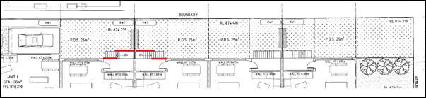
Diagrammatic
explanation of privacy screening treatment to stairs and landing
on
Units 2 and 3
The red lines represent the extent of screening. The
screening should measure 1.7m above the finished floor level of the landing.
This is to be repeated on Units 4 and 5 also. This requirement will reduce the
available solar access to windows behind the privacy screening. However, the
screening is considered necessary to mitigate an unacceptable impact upon the
adjoining residence. This further highlights another deficiency in the design
of the development.
Acoustic Privacy
The DCP sets the following Planning Outcome in regard to
Acoustic Privacy:
· Site layout and
building design:
- protect habitable rooms from
excessively high levels of external noise
- minimise the entry of
external noise to private open space for dwellings close to major noise sources
- minimise transmission of
sound through a building to affect other dwellings.
In consideration of the DCP Guidelines the proposal is
considered to be satisfactory. The site is located in an area where ambient
noise levels are expected to be low due to the predominant residential land use
pattern.
Security
The DCP sets the following Planning Outcomes in regard to
Security:
· The site layout
enhances personal safety and minimises the potential for crime, vandalism and
fear.
· The design of
dwellings enables residents to survey streets, communal areas and approaches to
dwelling entrances.
The siting and design of the residential
flat building is appropriate to maintain safety and minimise the potential for
crime, vandalism and fear for residents. Habitable room windows will address
public roads, thereby providing opportunities for natural surveillance. The
proposed landscaping and fencing will not restrict sightlines to public areas
and will provide territorial reinforcement and delineate public and private
spaces. Internal site access will be available from the under croft parking area
and proposed fencing will provide territorial reinforcement and delineation of
public and private areas. Remote gates and garage access is also proposed to
further enhance security of the development.
Circulation and Design
The DCP sets the following Planning Outcome in regard to
Circulation and Design:
· Accessways and
parking areas are designed to manage stormwater.
· Accessways,
driveways and open parking areas are suitably landscaped to enhance amenity
while providing security and accessibility to residents and visitors.
· The site layout
allows people with a disability to travel to and within the site between car
parks, buildings and communal open space.
Unit 1 will have separate access from Elizabeth Street, with
a reverse manoeuvre required for egress, which is acceptable. The remaining
four units will rely on parking within the under croft parking spaces which
gain access from Moad Street on the eastern side of the building. The under
croft area provides six off-street spaces.
The spaces comply with the relevant Australian Standard in
terms of isle widths and dimensions of the spaces. Notwithstanding this,
manoeuvring within the under croft space will be constrained given the space
available and it is unlikely that vehicles will be able to enter each spaces in
one turning movement, and exit each space in not more than two turning
movements as required by the DCP. Council needs to ensure that the development
will be practical and usable for the end user. Otherwise occupants may prefer
to park on the street if the spaces are too difficult to negotiate.
For this reason a condition is attached that requires the
six spaces in the under croft area to be widened and detail to be provided
showing how the development can comply with the maximum vehicle movement
requirements for entering and exiting each space.
Additionally, the first two spaces will be the most
difficult to negotiate. As such, it is recommended that these be allocated as
the visitor spaces as they will be used less frequently than the occupants of
the building. Relevant conditions are attached in this regard.
Car Parking
The DCP sets the following Planning Outcomes in regard to
Car Parking:
· Parking
facilities are provided, designed and located to:
- enable the efficient and
convenient use of car spaces and accessways within the site
- reduce the visual dominance
of car parking areas and accessways.
· Car parking is
provided with regard to the:
- the number and size of
proposed dwellings
- requirements of people with
limited mobility or disabilities.
The development consists of one x three bedroom unit and
four x two bedroom units. The DCP requires parking at the rate of 1.5
spaces per three or more bedroom units, plus 1.2 spaces per two bedroom
units, plus 0.2 spaces per unit for visitor parking. As such, the development
requires 7.3 off-street parking spaces to be provided. The development provides
8 spaces, 6 spaces in the under croft parking area including 2 designated
visitor spaces, plus 1 separate garage space adjacent to Unit 1 and one tandem
space in front of the single garage.
The development is considered appropriate in terms of
parking.
The development was initially proposed with a sliding gate
across the vehicular access to the under croft parking at the site frontage.
Council staff requested that this aspect of the design be revisited as it was
impractical for visitors to gain access to the site, with no opportunity to
practically provide an intercom system wholly within the subject land for visitors
to enter the under croft space where the visitors parking is proposed to be
located.
The applicant responded by deleting the auto sliding gate,
providing a waiting space at the bottom of the access ramp and providing an
intercom on the eastern boundary (driver’s side of vehicle). Although the
vehicles of visitors will need to merge to the wrong side of the driveway to
access the intercom system, given the small volume of traffic likely to be
generated by the development, the width of the driveway and the addition of an
informal waiting area, this arrangement is considered satisfactory.
Private Open Space
The DCP sets the following Planning Outcomes in regard to
Private Open Space:
· Private open
space is clearly defined for private use.
· Private open
space areas are of a size, shape and slope to suit the reasonable requirements
of residents including some outdoor recreational needs and service functions.
· Private open
space is:
– capable
of being an extension of the dwelling for outdoor living, entertainment and
recreation
– accessible
from a living area of the dwelling
– located
to take advantage of outlooks; and to reduce adverse impacts of overshadowing
or privacy from adjoining buildings
– Orientated
to optimise year round use.
The following table outlines the minimum requirement in
terms of area of private open space.
|
Units
|
Living Area (ex.
Garage, porches, patios etc)
|
Private Open
Space Required by DCP
|
Private Open
Space Provided
|
|
1
|
133m²
|
66.5m²
|
Greater than 66.5m2
|
|
2 -5
|
94m²
|
47m²
|
45.94m²
|
The private open space associated
with Unit 1 complies in terms of the guidelines, and provided the issue of
addressing the primary frontage of Unit 1 by way of an additional access gate
as discussed above is resolved, the open space will be provided behind the
front building line and provides an area of the required dimensions.
The southernmost area of open
space associated with Unit 1 will be forward of the building alignment given
the applicant’s argument that Unit 1 addresses Moad Street. Additionally,
the 1.2m open style fence proposed along the front boundary and the
truncated corner will not provide adequate privacy to the open space area.
As such, to address these two
issues conditions are attached that require fencing as per the below diagram.
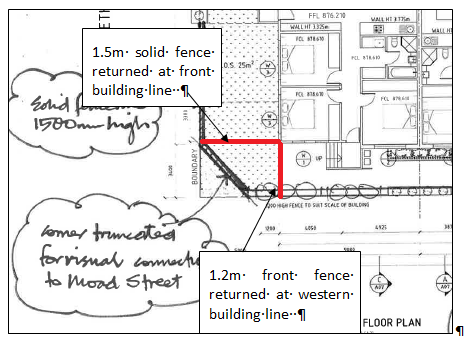
Diagram showing
fencing requirements
Private open space associated with
Units 2-5 appears to be deficient by approximately 1m² from the level
of private open space required under the guidelines. This is only a minor
departure from the guidelines and the allocated open space for these units
would comply with the planning outcomes. The open space is provided at ground
level, is behind the main building line and will provide reasonable amenity to
the future occupants of the units.
As mentioned above, the adjoining units have the potential
to overlook not only the adjoining property but also the POS areas of the other
units. This will be addressed by the requirement for fixed louvres to the north
facing glazing and patio areas.
The applicant has adequately demonstrated
compliance with the Planning Outcomes for private open space.
Open Space
and Landscaping
The DCP sets the following Planning Outcomes in regard to
Open Space and Landscaping:
· The site layout
provides open space and landscaped areas which:
– contribute
to the character of the development by providing buildings in a landscaped
setting
– provide
for a range of uses and activities including stormwater management
– allow
cost effective management.
· The landscape
design specifies landscape themes consistent with the desired neighbourhood
character; vegetation types and location, paving and lighting provided for
access and security.
· Major existing
trees are retained and protected in a viable condition whenever practicable
through appropriate siting of buildings, accessways and parking areas.
· Paving is
applied sparingly and integrated in the landscape design.
A landscape plan has been submitted in support of the
proposal, which includes plant species that will provide reasonable integration
of the residential flat building. Extensive plantings within the frontage will
assist in softening the overall design, but not to the extent that it would
mitigate the impacts to the amenity of the area as detailed throughout this
report. No degree of landscaping would ameliorate the merit issues identified
in this report.
Additional landscaping can be
provided in the south-western corner of the site on the street side of the
fencing that returns to the south-western corner of the building as shown
below. A condition is attached in this regard.
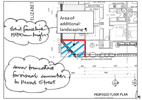
Diagram showing
location of additional required landscaping
Stormwater
The DCP sets the following Planning Outcomes in regard to
Stormwater:
· On-site
drainage systems are designed to consider:
– downstream
capacity and need for on-site retention, detention and re-use
– scope
for on-site infiltration of water
– safety
and convenience of pedestrians and vehicles
– overland
flow paths.
· Provision is
made for on-site drainage which does not cause damage or nuisance flows to
adjoining properties.
Relevant conditions of consent are attached to the Notice of
Approval in relation to stormwater management of the site. As mentioned above,
an amendment is required to the driveway within the main access such that the
flow of water into the under croft parking area is reduced. This is to be
achieved by altering the gradient of the accessway, effectively providing a
hump that would restrict or reduce the flow of overland stormwater into the
site and allow the water to continue within the street stormwater system.
Erosion and Sedimentation
The DCP sets the following Planning Outcome in regard to
Erosion and Sedimentation:
· Measures
implemented during construction to ensure that the landform is stabilised and
erosion is controlled.
An erosion and sediment control plan will be required to be
prepared as part of the engineering design plans for the development. Attached
is a condition of consent addressing this issue.
DEVELOPMENT CONTRIBUTIONS PLAN
2012
The development has been assessed pursuant to Orange
Development Contributions Plan 2012. The following table itemises the
contributions payable for the development. A condition is attached to
reflect the following requirements.
The payment of $27,825.36 is to be made to
Council in accordance with section 94 of the Act and the Orange Development
Contributions Plan 2012 (Remainder of LGA) towards the provision of the
following public facilities:
|
Open
Space and Recreation
|
@
$2,699.11 x 4 additional 2 bed dwellings
|
10,796.44
|
|
Community
and Cultural
|
@
$460.42 x 4 additional 2 bed dwellings
|
1,841.68
|
|
Roads
and Cycleways
|
@
$3,335.76 x 4 additional 2 be dwellings
|
13,343.04
|
|
Stormwater
Drainage
|
@
$258.43 x 4 additional 2 bed dwellings
|
1,033.72
|
|
Local
Area Facilities
|
|
--
|
|
Plan
Preparation & Administration
|
@
$202.62 x 4 additional 2 bed dwellings
|
810.48
|
|
TOTAL:
|
|
$27,825.36
|
The contribution will be indexed
quarterly in accordance with the Orange Development Contributions Plan 2012
(Remainder of LGA).
Section 64 Water and Sewer
Headworks Charges
Section 64 water and sewer headwork charges are also
applicable to the proposal. Such charges are calculated at the time of release
of a Construction Certificate for the proposed development. Attached are draft
conditions requiring the payment of the required contributions prior to the
issue of a Construction Certificate.
PROVISIONS PRESCRIBED BY THE
REGULATIONS s79C(1)(a)(iv)
The development is not inconsistent with the provisions
prescribed by the regulations.
THE LIKELY IMPACTS OF THE
DEVELOPMENT s79C(1)(b)
Context and Setting
The subject land is located within an established
residential area where the predominate pattern of development comprises single
storey dwellings of modest scale with front setbacks complementary to the urban
context. The one exception to the established character of the area evident in
the locality is observed opposite the site where the Department of Housing
recently completed a project which is described as an appropriate example of a
design at a greater density that responds to the context and setting. This was
self-approved by DoH.
Aside from the example sited opposite the site, the
development the subject of this application is not complementary to the setting
of the locality and makes little effort to relate to the urban context. The
massing of the building resultant from the under croft parking and the linear
form, coupled with the minimal setback of 3m being 0.9m forward of the
dwelling to the east, will result in a development that unreasonably detracts
from the amenity of the area. The dwelling to the east is placed at an angle to
the Moad Street frontage. The minimum setback is 3.9m but the average setback
is approximately 6.6m.
Urban Design
Council staff sought the advice of Council’s Heritage
and Urban Design consultant in relation to the urban design of the development.
Council’s consultant provided the following advice:
Urban Design Commentary
|
Design Criteria
|
Existing Context
|
Proposal
|
|
Character
|
Contemporary single storey
suburban dwellings with front and rear gardens and open site frontages. Newer
development has attached single storey development with enclosed site
fencing. Street trees in the roadside verge to some streets.
|
Multiple single storey building
with 5 dwellings in a block east west across the site using a contemporary
skillion roof pitched down to Moad Street and up to the north. Site levels
used to provide parking under building via south eastern access off Moad
Street. Skillion roofs articulated into five planes to model roof form. Floor
level raised nominally 1m above Natural ground level along Moad Street to
achieve parking below.
|
|
Scale
|
Single storey dwellings with
pitched roofs. A two storey approval exists in the vicinity.
|
Use of parking below and
skillion roofs increases building height to nominal 5500mm in comparison with
3500-4000mm for surrounding dwellings. Raised decks and terraces to north
side due to design issues lead to increased scale and overlooking. Increased
ceiling height to north side internal living spaces produce dominant glazing
and height to northern elevations. Additional shading devices,
verandahs/pergolas may be required for compliance or for future retro-fitting
by occupiers
|
|
Form
|
Domestic dwellings with typical
rectilinear forms, extended front fenestration broken by front porches and
verandahs. Heights are consistent and respond to terrain
|
The form proposed is unlike
others in the streetscape or vicinity. The skillion roofs are not consistent
with either hipped or gabled roofs. The roofs have been divided into five separate
planes to model the length of the single built form. The street elevation
steps inwards twice at entrances and models the street elevation
|
|
Siting
|
Dwellings run east west with
frontages to Elizabeth Street. On Moad Street dwellings follow similar
pattern with frontages to Street and forms occupy front portion with rear
yards to north parts of blocks.
Moad Street curb altered to
direct traffic flow around Maxwell Avenue leaving triangular verge in front
of subject site. Minimal planting with feature trees to lawns.
|
The siting responds to the brief
to accommodate the five dwellings and low level parking on to the linear
site. Open space for recreation and suburban landscaped character is that
which remains in contrast to the traditional dwellings in the vicinity.
Planting is shown in elements which appear to protrude into the street verge
on Moad Street otherwise the planting indications appear nominal and not
functional. The built form and fenestration take advantage of the northern
orientation and illustrates extensive northern glazing and water tanks are
located in the rear yards. Basement parking is located in part excavated
area.
|
|
Materials and Colour
|
Generally brick external walls
with dark grey steel roofs and feature fencing to contemporary dwellings and
earlier houses with pale sheet cladding, feature chimneys and lighter grey
roofs, open gardens without fencing
|
External walls are finished in
render and metal cladding while the basement is clad in some form of masonry.
The fenestration to Moad Street is generally traditional in vertical
proportions while the north elevation is linear. The rafters are expressed
beneath the skillion eaves of the steel roofing. The Moad Street elevation
utilises both render and metal cladding to provide a variation
|
|
Detailing
|
Earlier dwellings include hipped
roofs with some brick chimneys, contrasting window framing and feature porch
and verandahs. Contemporary dwellings use gabled roof features, dark
brickwork and elaborate fencing in brick and panel infill
|
The skillion roofs use expressed
rafters. There are no signs of flues, vents or rooflights. Expressed shading
in the form of an awning appears on the west elevation only. A skillion or
lean-to garage is attached to the north west corner of the building of
Elizabeth Street. The dwelling entries have contemporary doors and all
require stairs for the front entry and rear access to yards.
|
Conclusions
The proposal makes minimal concession to the setting and
local character and adopts a simple inexpensive design language used on
industrial and school buildings in the form of skillion roofs and metal
cladding. The scheme responds well to the northern orientation using extensive
glazing and double height space to living areas. However this causes immediate
impacts for the vicinity in terms of scale and overlooking while also not fully
addressing summer and winter conditions.
In specific terms of urban design the following issues
are not yet adequately addressed:
· Building height to
the northern portion
· Insufficient planting
for privacy, to complement the setting and passive environment
· Insufficient
detailing for defining dwelling character and specifically the building entries
and the boundary entry points.
· Insufficient material
articulation on the Moad Street façade for complementing the setting
· Insufficient
articulation to the perimeter fencing and entries for complementing the setting
Recommendations
The following are for consideration in addressing the
issues raised above:
· Venting rooflights to
the double height living spaces will assist environmentally and model the
roofscape
· Replace the rendered
walls to the exteriors with materials which give greater colour, texture and
character to complement the surroundings
· Provide Articulation
to the fencing to complement the setting and to create interest at the dwelling
entrances
· Articulate the
entrances to each dwelling with porches or verandahs to articulate the steps
and entries into key elements
· Develop an approach
to sunshading structures for the north, east and west elevations which responds
to solar needs and articulates the building elevations
· Produce a landscape
plan which documents planting types and a dominant soft landscape complementing
the setting
· Reduce the building
height by 1m by increasing the excavation, using alternate roof forms or
similar
· Assist Council in
developing a landscape design for the triangular verge space in the road
reserve to model the streetscape and improve the setting.
The above advice was provided to
the applicant to consider incorporating into the design. The below table
incorporates both the response from the applicant and comments from Council
staff.
|
Heritage
Recommendations
|
Response
from Applicant
|
Council
Staff Response
|
|
· Venting rooflights
to the double height living spaces will assist environmentally and model the
roofscape.
|
We consider these issues are
more logically addresses as an element of detailed design and could be
addressed via conditions of consent.
|
Noted and relevant conditions
attached.
|
|
· Replace the
rendered walls to the exteriors with materials which give greater colour,
texture and character to complement the surroundings.
|
We
are of the view that there are sufficient range of render finishes that would
provide an adequate range of colour, texture and character to complement the
surroundings. We anticipate that further detail on these finishes could be
addressed via conditions of consent and details supplied prior to release of
CC. However, should it be necessary prior to determination of DA it would be
provided on request under separate cover.
|
Conditions are attached that
require details of the external finishes and materials to be submitted.
|
|
· Provide
Articulation to the fencing to complement the setting and to create interest
at the dwelling entrances.
|
Landscaping planter boxes
adequately articulate the fence and further refinement is considered
necessary – refer drawings A07 – A09.
|
Noted
|
|
· Articulate the
entrances to each dwelling with porches or verandahs to articulate the steps
and entries into key elements.
|
We consider these issues are
more logically addresses as an issue of detailed design and could be
addressed via conditions of consent, with detail supplied prior to the
release of CC. However, should it be necessary prior to determination of DA
it would be provided on request under separate cover.
|
Despite the offer to submit a
design under separate cover, the applicant has not proposed this as part of
the application at this stage. Attaching conditions requiring this level of
detail becomes cumbersome and can result in Council being removed from the
assessment of this important aspect of the design if a Private Certifier is
engaged to issue the construction certificate.
Regardless of this, it is noted that requiring the
addition of articulated entryways or porches to the front elevation would
result in the development encroaching further upon the front setback.
This confliction clearly highlights the deficiencies in
the design of the development.
|
|
· Develop an approach
to sunshading structures for the north, east and west elevations which
responds to solar needs and articulates the building elevations.
|
We consider these issues are
more logically addresses as an issue of detailed design and could be
addressed via conditions of consent, with detail supplied prior to the
release of CC. However, should it be necessary prior to determination of DA
it would be provided on request under separate cover.
|
This recommendation for shading to
the north facing windows could conflict with Council solar access
requirements.
Notwithstanding this, it is considered in the Orange
climate that sun shading could be incorporated into the design, particularly
to the western elevation to shade the harsher summer afternoon sun. Doing so
would also assist in providing some visual interest to the western elevation
within Moad Street.
Despite the fact that Council could be removed from the
design of this aspect of the development, shade treatment to the western
windows will benefit the design of the building. As such, a condition is
attached to this affect.
|
|
· Produce a landscape
plan which documents planting types and a dominant soft landscape
complementing the setting.
|
This is provided – refer
Drawings A07 – A09.
|
Noted
|
|
· Reduce the building
height by 1m by increasing the excavation, using alternate roof forms or
similar.
|
This recommendation fails to
account for the adoption of the Council supplied finished floor level to
ensure that development is above the overland water flow levels. Increasing
excavation is therefore not an option. Given the need to adopt this level,
the use of a shallow pitched roof is justified to ensure overall height does
not become excessive and inconsistent with heights in the surrounding
locality. No change to the roof plan is therefore proposed.
|
Should Council consider it
appropriate to require an alternate roof form, it would be necessary to
attach an appropriate condition.
|
|
· Assist Council in
developing a landscape design for the triangular verge space in the road
reserve to model the streetscape and improve the setting.
|
The applicant has no objection
to participate in a Council led improvement of this area, We would be happy
to integrate our landscaping design plan with this area. We would take
Council’s advice on how this is best achieved.
|
The applicant’s agreement to
this is noted, but is considered overly complex in planning terms to achieve.
The applicant would have to agree to a form of planning agreement for this to
occur, with over all benefit to the public being very minor.
|
Traffic Impacts
The capacity of the road network in the vicinity of the site
is sufficient to accommodate additional localised traffic generated by the
development. Council’s Technical Services Division advises that the
proposed driveway will be appropriately sited so as to prevent vehicle
conflicts. As previously indicated, the proposed parking and manoeuvring
arrangements will ensure that vehicles enter and leave the under croft parking
in a forward direction.
Cumulative Impacts
The proposed development will not reduce the open space or
solar access to neighbouring properties; and similarly, the site layout and
building design will provide a reasonable standard of residential amenity for
the proposed dwellings in terms of open space and solar access.
Despite this, as outlined above, the development presents a
number of deficiencies in the design which are likely to result in unacceptable
cumulative impacts in the locality. This is primarily a result of the
accumulation of the following deficiencies in the design of the development:
· the development is
contrary to the desired neighbourhood character of the area
· the appearance of
the development is inconsistent with the context and setting of the locality,
is incompatible with the scale of built form in the area and provides limited
visual interest to the street
· under croft
parking directly results in an increase in the bulk and mass of the building
· the nominated
front setback of the development and the orientation of the building maximise
the available area of development, but show little concession given to the
adjoining context and have the potential to detrimentally impact upon the
amenity of the area
· visual privacy
impacts that need to be addressed with the fixed louvring system.
The aggregate cumulative effect of the above points will
result in an unsatisfactory development. Council would have sufficient grounds
to refuse the development.
Environmental Impacts
The subject land has been recently subdivided and works have
been undertaken to create a residential site. As a result, significant
vegetation, threatened species or ecological endangered communities or their
habitats are unlikely. The proposed development will not impact upon the
locality in terms of environmental impacts.
Existing and Future Amenity of
the Neighbourhood
As mentioned above, the development has the potential to
impact upon the immediate adjoining property to the north by way of privacy
impacts. These impacts have been addressed via the imposition of a condition
that requires fixed louvers to be attached to all north facing glazing between
finished floor level and a height of 1.7m above finished floor level. The
development will not directly impact upon any other immediately adjoining
properties.
The development, however, does have the potential to
unreasonably impact upon the wider area for the reasons articulated in this
report; namely, inconsistencies with the character of the area, inconsistency
with the context and setting of the area and inconsistencies with setback
requirements.
If Council is of the view that there is sufficient merit to
refuse the application based on the above listed reasons, a Notice of Refusal
will need to be tabled for Council’s consideration at the next available
meeting.
Soil Erosion
Provided that adequate measures are implemented during the
construction phase, the proposed development would not generate adverse impacts
in terms of soil erosion. Attached are recommended conditions of consent
addressing this issue.
Waste Collection
As the development does not involve subdivision, waste
services can be shared across the site and managed by residents. The
application provides for screening of two bins within the front setback, and
whilst it is not appropriate to store bins in this fashion, there is limited opportunity
to practically store the bins in any other arrangement.
Council’s Manager Waste Services and Technical Support
provides advice that garbage collection can occur from within Elizabeth street
for Unit 1 and in Moad Street for the remaining units. Additionally, two or
three organic bins can be shared amongst the residents and be stored in the
under croft parking until collection days.
Waste collection and storage are considered acceptable.
THE SUITABILITY OF THE SITE
s79C(1)(c)
Servicing
Council’s Technical Services Division advises that all
utility services are available to the site and adequate for the proposal. The
proposed development will be connected to Council’s sewer, town water and
stormwater reticulations in accordance with normal requirements. Power,
telephone and natural gas services will be connected to the units in accordance
with the requirements of the relevant supply authority. Attached is a condition
of consent addressing this issue.
Physical Attributes
The subject site is considered to be suitable for the
proposed development for the purposes of a residential flat building. The
subject land is subject to an overland flowpath which the applicant and
Technical Services staff have discussed prior to lodging the application, with
minimum finished floor levels agreed to. Council’s Technical Services
Division has attached a condition that requires an amendment of the access of
the under croft parking such that stormwater is prevented from inundating the
under croft space. Council staff are not aware of any other physical attributes
within the site that would unreasonably constrain the development.
ANY SUBMISSIONS MADE IN
ACCORDANCE WITH THE ACT s79C(1)(d)
The proposed development is defined as "advertised
development" under the provisions of the LEP. The application was
advertised for the prescribed period of 14 days and at the end of that period
one submission was received. The submission primarily raises concerns relating
to privacy and states:
It is acknowledged that the
elevated building may be a result of groundwater vulnerability identified under
Orange LEP 2011. However, then subsequently raised height of the building
results in the living area windows of four dwellings directly overlooking the
adjoining LAHC property. This will result in a loss of privacy, despite
the provision of louvres as indicated on the applicants submitted plans and
documentation, in lieu of redesigning the building to be more contextually
compatible, and to better respond to the impediments of the site, it is
considered reasonable that Council consider screening on the property
boundary to further mitigate the loss of privacy to the adjoining dwelling.
In relation to the above comments, the elevated building is
a result of the desire to provide the parking below the floor level of the
building rather than relating to ground water vulnerability. The loss of
privacy correctly identified and a legitimate concern of the adjoining property
owner is a direct result of the location of parking and the elevated floor
levels.
Council staff acknowledge the concerns of the submitter and
have attached an appropriate condition to mitigate the likely visual privacy
impacts. The request of the submitter to further protect privacy by screening
at the property boundary is impractical given the elevated floor level. To
achieve any real protection, the screening would need to extend above 3m from
finished ground level. The relevant condition that requires fixed louvers to
the relevant glazing will achieve a reasonable planning outcome. Additional
treatment is required to the external rear landings and stairs for Units 2-5.
The legitimate concerns of the submitter further highlight
the deficiencies in the design of the development.
PUBLIC INTEREST
s79C(1)(e)
The proposed development is considered to be of minor
interest to the wider public due to the relatively localised nature of
potential impacts.
SUMMARY
The proposed development is permissible with the consent of
Council. The proposed development is considered to be inconsistent in terms of
compatibility with the established character of the area, presents
unsatisfactorily in terms of setbacks and will present unacceptable privacy
impacts which need to be addressed via conditions of consent.
The site coverage of the proposal is only 44%, which is well
within the 50% requirement of the DCP. However, this is achieved by the
provision of undercover parking. As outlined above, the resultant increase in
height of the building presents a number of these unsatisfactory outcomes. One
of the major deficiencies of the proposal is the minimal setback from Moad
Street of only 3.0m which the applicants attempt to justify by the reliance on
the minimum setback of the adjacent dwelling to the east. The average setback
of this dwelling is 6.6m. The predominate character of this neighbourhood is
single dwellings with generous setbacks and generous ratios of building and
space between those buildings that set a low density residential character. The
reliance by the applicant to use the adjoining dwelling to establish the
setback and the nearby Department of Housing development to establish
neighbourhood character and the like, do not justify a development that
proposes a built form which includes a building width of 45m fronting Moad Street
which is contrary to the established neighbourhood character.
Whilst the development complies with all other relevant
aims, objectives and provisions of the LEP, given the development is
likely to unreasonably impact upon the character of the neighbourhood and
detract from the amenity of locality; Council, should it be of the view that
the development is unacceptable as proposed, would have sufficient grounds to
refuse the development. Attached is a draft Notice of Approval outlining a
range of conditions considered appropriate to ensure that the impacts resultant
from the development are reduced as far as possible.
COMMENTS
The requirements of the Environmental Health and Building
Surveyor and the Engineering Development Manager are included in the attached
Notice of Approval.
Attachments
1 Notice
of Approval, D15/4692⇩
2 Plans,
D15/4691⇩
3 Submission,
D15/4608⇩
Sustainable Development Committee
3 March 2015
2.3 Development
Application DA 290/2014(1) - 2 Elizabeth Street
Attachment 1 Notice
of Approval
|

|
ORANGE
CITY COUNCIL
Development
Application No DA
290/2014(1)
NA15/ Container
PR3720
|
NOTICE OF DETERMINATION
OF A DEVELOPMENT
APPLICATION
issued under the Environmental
Planning and Assessment Act 1979
Section 81(1)
|
Development
Application
|
|
|
Applicant Name:
|
Dolly's Construction
Pty Ltd
|
|
Applicant Address:
|
C/-
Geolyse
PO Box
1963
ORANGE
NSW 2800
|
|
Owner’s Name:
|
Dolly's
Construction Pty Ltd
|
|
Land to Be Developed:
|
Lot 1 DP
377484 - 2 Elizabeth Street, Orange
|
|
Proposed Development:
|
Residential
Flat Building
|
|
|
|
|
Building
Code of Australia
building classification:
|
As
determined by Certifier
|
|
|
|
|
Determination
|
|
|
Made On:
|
3 March
2015
|
|
Determination:
|
CONSENT
GRANTED SUBJECT TO CONDITIONS DESCRIBED BELOW:
|
|
|
|
|
Consent to
Operate From:
|
4 March
2015
|
|
Consent to
Lapse On:
|
4 March
2020
|
Terms of Approval
The reasons for the imposition of
conditions are:
(1) To ensure a quality
urban design for the development which complements the surrounding environment.
(2) To maintain
neighbourhood amenity and character.
(3) To ensure compliance
with relevant statutory requirements.
(4) To provide adequate
public health and safety measures.
(5) Because the development
will require the provision of, or increase the demand for, public amenities and
services.
(6) To ensure the utility
services are available to the site and adequate for the development.
(7) To prevent the proposed
development having a detrimental effect on adjoining land uses.
(8) To minimise the impact
of development on the environment.
Conditions
(1) The
development must be carried out in accordance with:
(a) Plan/s
numbered Plans
drawn by Geolyse Architecture dated 16.12.2014 - sheets A01 - A16 - all
revision D (16 sheets)
Additional
supplementary set of revision D plans submitted 12.02.2015 showing hand notated
detail including 2 additional plans identified as SK-01 and SK-02. Dated
22.012015 (9 sheets)
Note:
The hand notated details of the supplementary plans supersede the computerised
drawings only to the effect of the notations shown on those plans; and all 25
sheets should be considered as one bundle of drawings
(b) statements
of environmental effects or other similar associated documents that form part
of the approval
as amended
in accordance with any conditions of this consent.
(2) All building work must
be carried out in accordance with the provisions of the Building Code of
Australia.
(3) A sign is to be erected
in a prominent position on any site on which building work, subdivision work or
demolition work is being carried out:
a. showing
the name, address and telephone number of the principal certifying authority
for the work, and
b. showing
the name of the principal contractor (if any) for any building work and a
telephone number on which that person may be contacted outside working hours,
and
c. stating
that unauthorised entry to the site is prohibited.
Any such sign is to be maintained while the
building work, subdivision work or demolition work is being carried out.
(4) In the case
of residential building work for which the Home Building Act 1989
requires there to be a contract of insurance in force in accordance with Part 6
of the Act, evidence that such a contract of insurance is in force is to be
provided to the Principal Certifying Authority before any building work
authorised to be carried out by the consent commences.
(5) Residential building
work within the meaning of the Home Building Act 1989 must
not be carried out unless the principal certifying authority for the
development to which the work relates (not being the council) has given the
council written notice of the following information:
a in the
case of work for which a principal contractor is required to be appointed:
1 the name
of the licence number of the principal contractor, and
2 the name
of the insurer by which the work is insured under Part 6 of that Act,
b in the
case of work to be done by an owner-builder:
1 the name
of the owner-builder, and
2 if the
owner-builder is required to hold an owner-builder permit under that Act, the
number of the owner-builder permit.
If arrangements for doing the residential
building work are changed while the work is in progress so that the information
under this condition becomes out of date, further work must not be carried out
unless the principal certifying authority for the development to which the work
relates (not being the council) has given the council written notice of the
updated information.
(6) Where any excavation
work on the site extends below the level of the base of the footings of a
building on adjoining land, the person having the benefit of the development
consent must, at the person’s own expense:
a protect
and support the adjoining premises from possible damage from the excavation,
and
b where
necessary, underpin the adjoining premises to prevent any such damage.
Note: This
condition does not apply if the person having the benefit of the development
consent owns the adjoining land or the owner of the adjoining land has given
consent in writing to that condition not applying.
|
PRIOR TO THE ISSUE OF
A CONSTRUCTION CERTIFICATE
|
(7) The payment of $27,825.36
is to be made to Council in accordance with section 94 of the Act and the
Orange Development Contributions Plan 2012 (Remainder of LGA) towards the
provision of the following public facilities:
|
Open Space and
Recreation
|
@ $2,699.11 x 4
additional 2 bed dwellings
|
10,796.44
|
|
Community and
Cultural
|
@ $460.42 x 4
additional 2 bed dwellings
|
1,841.68
|
|
Roads and Cycleways
|
@ $3,335.76 x 4
additional 2 be dwellings
|
13,343.04
|
|
Stormwater Drainage
|
@ $258.43 x 4
additional 2 bed dwellings
|
1,033.72
|
|
Local Area Facilities
|
|
--
|
|
Plan Preparation
& Administration
|
@ $202.62 x 4
additional 2 bed dwellings
|
810.48
|
|
TOTAL:
|
|
$27,825.36
|
The contribution will be indexed quarterly in
accordance with the Orange Development Contributions Plan 2012 (Remainder of
LGA). This Plan can be inspected at the Orange Civic Centre, Byng Street,
Orange.
(8) Full details of
external colours and finishes of external materials are to be submitted and
approved by Councils Manager Development Assessments prior to the issue of a
Construction Certificate.
(9) The arch ways/arbours
within the front fence over the access gates shall be deleted from the
proposal. Also, an additional pedestrian access gate in the same style as the
other two proposed gates shall be included in the front fence and be centrally
located in front of unit 1. Plans showing this amended detail shall be
submitted to, and approved by, Council’s Manager Development Assessments
prior to the issue of a construction certificate.
(10) Privacy screening shall
be attached to the rear landing and stairs for units 2 to 5. For units 2 and 4
the privacy screening shall be installed on the edge of the landing starting at
the westernmost corner adjacent to the external door and extend for half the
length of the landing. A further screen shall be attached to the outer edge of
the stairs starting at the top of the stairs and extend along the outer edge of
the stairs for half the length of the stairs. All screens shall be a minimum
height of 1.7m above finished floor level.
For
units 3 and 5 the privacy screening shall be installed on the edge of the
landing starting at the easternmost corner adjacent to the external door and
extend for half the length of the landing. A further screen shall be attached
to the outer edge of the stairs starting at the top of the stairs and extend
along the outer edge of the stairs for half the length of the stairs. All
screens shall be a minimum height of 1.7m above finished floor level.
Details
of the privacy screen shall be submitted to and approved by the Manager
Development Assessments prior to the issue of a construction certificate.
(11) Fixed louvers shall be
installed on all north facing windows for the full extent of the window up to a
height of 1.7m above finished floor level and remain attached to the building
in perpetuity. The louvers shall be designed in a manner that will allow solar
access into the building and will prevent visual penetration through the window
to the adjoining property to the north and adjoining private open space
internally within the development. Plans showing this detailed shall be
submitted to and approved by the Manager Development Assessments prior to the
issue of a construction certificate.
Note: The
translucent film shown on the submitted plans is not approved under this
consent.
(12) Additional landscaping
shall be provided in the south western corner of the site on the street side of
the returned fencing. A mix of small shrubs and ground covers shall be provided
within the subject landscape bed. An amended landscape plan showing this detail
shall be submitted to and approved by Council’s Manager Development
Assessments prior to the issue of a construction certificate.
(13) Venting roof lights
shall be provided to the double height living spaces. Details of the venting
roof lights shall be submitted to and approved by Council’s Manager
Development Assessments prior to the issue of a construction certificate.
(14) A porch shall be
provided over the external door and westernmost window within the western
elevation to provide shading to the window and additional articulation and
visual relief to the western elevation. The porch shall reflect the pitch of
the main roofline and be consistent with the style of the proposed building.
Details of the porch shall be submitted to and approved by Council’s
Manager Development Assessments prior to the issue of a construction
certificate.
(15) The
two visitor spaces in the under croft area shall be relocated to be the two
easternmost spaces within the under croft area and be appropriately identified
as visitor spaces.
(16) All
six off-street parking spaces in the under croft area shall be widened to allow
vehicles to enter each space in a single turning movement and exit each space
in not more than two turning movements. Details showing how this is achieved
using industry recognised swept path software shall be submitted to and
approved by the Manager Development Assessments prior to the issue of a
construction certificate.
(17) A 1.8m high fence shall
be provided around the northern and eastern boundaries ceasing at the front
building alignment of the building on each respective boundary. Fencing
shall be provided to the front and secondary boundaries in accordance with the
approved plans excepting the truncated corner in the south west corner of the
site. Instead of the truncated corner, the fence along the southern boundary
shall cease in line with the south western corner of the building and return to
join the south western corner of the building at 1.2m in height. The solid 1.5m
fence in Elizabeth Street shall not project south of the south western corner of
the building and shall return to the south western corner of the
building. A 1.5m high fence shall be provided along the shared
boundaries of each of the private open space areas of each unit. The height of
the fence shall be measured from the highest finished ground level adjacent to
each part of that fence.
Amended
plans showing this detail shall be submitted to and approved by Council’s
Manager Development Assessments prior to the issue of a construction
certificate.
Note: Where any
existing fencing at the perimeter of the site is to be retained, any additional
fencing must be in similar materials and colours, or complementary colours, to
the existing fencing, and shall be erected prior to the issuing of the
Occupation Certificate, to the satisfaction of Council’s Manager
Development Assessments.
(18) A
Construction Certificate application is required to be submitted to, and issued
by, Council/Accredited Certifier prior to any excavation or building works
being carried out on site.
(19) An
approval under Section 68 of the Local Government Act is to be sought from
Orange City Council, as the Water and Sewer Authority, for water, sewer and
stormwater connection. Details concerning the proposed backflow prevention
between the nominated water tank supply and the potable system is to be
provided. No plumbing and drainage is to commence until approval is granted.
(20) Engineering plans,
showing details of all proposed work and adhering to any engineering conditions
of development consent, are to be submitted to, and approved by, Orange City
Council or an Accredited Certifier (Categories B1, C3, C4, C6) prior to the
issuing of a Construction Certificate.
(21) A water and soil
erosion control plan is to be submitted to Orange City Council or an Accredited
Certifier (Categories B1, C3, C4, C6) for approval prior to the issuing of a
Construction Certificate. The control plan is to be in accordance with the
Orange City Council Development and Subdivision Code and the Landcom, Managing
Urban Stormwater; Soils and Construction Handbook.
(22) A payment of $2,867.50
shall be paid to Council, prior to the issuing of a Construction Certificate,
for the construction of an off-site stormwater retention basin. Payments are
indexed in accordance with Councils Management Plan current at the time of
issue of a Construction Certificate.
(23) Engineering plans
providing complete details of the proposed driveway and car-parking areas is to
be submitted to Orange City Council or an Accredited Certifier (Categories B1, C3,
C4, C6) upon application for a Construction Certificate. These plans are to
provide details of levels, cross falls of all pavements, proposed sealing
materials and proposed drainage works and be in accordance with the Orange City
Council Development and Subdivision Code.
The
basement carpark is to be constructed to prevent the ingress of floodwater up
to RL 875.70 AHD.
(24) Stormwater from the
site is to be piped to the adjacent stormwater drainage system. Engineering
plans of this drainage system are to be approved by Orange City Council or by
an Accredited Certifier (Categories B1, C3, C4, C6) prior to the issuing of a
Construction Certificate.
(25) The existing
150mm-diameter sewer main is to be terminated at the northern property boundary
with a maintenance shaft. Orange City Council or an Accredited Certifier
(Categories B1, C3, C4, C6), prior to issuing a Construction Certificate, is to
approve engineering plans for this sewerage system.
(26) Payment of
contributions for water, sewer and drainage works is required to be made
at the contribution rate applicable at the time that the payment is made.
The contributions are based on 2.66 ETs for water supply headworks and 2.66 ETs
for sewerage headworks. A Certificate of Compliance, from Orange City
Council in accordance with the Water Management Act 2000, will be issued
upon payment of the contributions.
This Certificate of Compliance is to be
submitted to the Principal Certifying Authority prior to the issuing of a
Construction Certificate.
|
PRIOR TO WORKS
COMMENCING
|
(27) A
temporary onsite toilet is to be provided and must remain throughout the
project or until an alternative facility meeting Council’s requirements
is available onsite.
(28) The
location and depth of the sewer junction/connection to Council’s sewerage
system is to be determined to ensure adequate fall to the sewer is available.
(29) Soil erosion control
measures shall be implemented on the site.
|
DURING
CONSTRUCTION/SITEWORKS
|
(30) If Aboriginal objects,
relics, or other historical items or the like are located during development
works, all works in the area of the identified object, relic or item shall
cease, and the NSW Office of Environment and Heritage, and representatives from
the Orange LALC shall be notified. Where required, further archaeological
investigation shall be undertaken. Development works in the area of the find(s)
may recommence if and when outlined by the management strategy, developed in
consultation with and approved by the OEH.
(31) All
construction/demolition work on the site is to be carried out between the hours
of 7.00 am and 6.00 pm Monday to Friday inclusive, 7.00 am to
5.00 pm Saturdays and 8.00 am to 5.00 pm on Sundays and Public
Holidays. Written approval must be obtained from the General Manager of Orange
City Council to vary these hours.
(32) All
construction works are to be strictly in accordance with the Reduced Levels
(RLs) as shown on the approved plans.
(33) All
materials onsite or being delivered to the site are to be contained within the
site. The requirements of the Protection of the Environment Operations Act
1997 are to be complied with when placing/stockpiling loose material or
when disposing of waste products or during any other activities likely to
pollute drains or watercourses.
(34) No
obstruction is to be caused to pedestrian use of Council's footpath or to
vehicular use of any public roadway during construction. These areas are to be
maintained in a safe condition at all times.
(35) Any adjustments to
existing utility services that are made necessary by this development
proceeding are to be at the full cost of the developer.
(36) The
provisions and requirements of the Orange City Council Development and
Subdivision Code are to be applied to this application and all work constructed
within the development is to be in accordance with that Code.
The developer is to be entirely responsible for
the provision of water, sewerage and drainage facilities capable of servicing
the development from Council’s existing infrastructure. The developer is
to be responsible for gaining access over adjoining land for services where
necessary and easements are to be created about all water, sewer and drainage
mains within and outside the lots they serve.
(37) All driveway and
parking areas are to be sealed with bitumen, hot mix or concrete and are to be
designed for all expected loading conditions (provided however that the minimum
pavement depth for gravel and flush seal roadways is 200mm) and be in accordance
with the Orange City Council Development and Subdivision Code.
(38) Heavy-duty concrete
kerb and gutter laybacks and footpath crossings are to be constructed for the
entrances to the proposed development. The location and construction of the
laybacks and footpath crossings are to be as required by the Orange City
Council Development and Subdivision Code.
|
PRIOR TO THE ISSUE OF
AN OCCUPATION CERTIFICATE
|
(39) Fencing
shall be installed in accordance with the approved plans prior to the issue of
an occupation certificate.
(40) Off-street car parking
shall be provided upon the site in accordance with the approved plans, the
provisions of Development Control Plan 2004, and be constructed in accordance
with the requirements of Council's Development and Subdivision Code prior to
the issue of an Occupation Certificate.
(41) Landscaping
shall be installed in accordance with the approved plans and shall be
permanently maintained.
(42) No
person is to use or occupy the building or alteration that is the subject of
this approval without the prior issuing of an Occupation Certificate.
(43) Where
Orange City Council is not the Principal Certifying Authority, a final
inspection of water connection, sewer and stormwater drainage shall be
undertaken by Orange City Council and a Final Notice of Inspection issued,
prior to the issue of either an interim or a final Occupation Certificate.
(44) Certification from
Orange City Council is required to be submitted to the Principal Certifying
Authority prior to the issue of an Occupation Certificate stating that all
works relating to connection of the development to Council assets, works on
Public Land, stormwater, sewer and water reticulation mains and footpaths have
been carried out in accordance with the Orange City Council Development and
Subdivision Code and the foregoing conditions.
(45) All
of the foregoing conditions are to be at the full cost of the developer and to
the requirements and standards of the Orange City Council Development and
Subdivision Code, unless specifically stated otherwise. All work required by
the foregoing conditions is to be completed prior to the issuing of an
Occupation Certificate, unless stated otherwise.
Other Approvals
(1) Local
Government Act 1993 approvals granted under section 68.
Nil
(2) General
terms of other approvals integrated as part of this consent.
Nil
Right of Appeal
If
you are dissatisfied with this decision, section 97 of Environmental
Planning and Assessment Act 1979 gives you the right to appeal to the Land
and Environment Court within 6 months after the date on which you receive this
notice.
*
Section 97 of the Environmental Planning and Assessment Act 1979 does not apply
to the determination of a development application for State significant
development or local designated development that has been the subject of a
Commission of Inquiry.
|
Disability Discrimination Act
1992:
|
This application has been assessed in
accordance with the Environmental Planning and Assessment Act 1979. No
guarantee is given that the proposal complies with the Disability
Discrimination Act 1992.
The applicant/owner is responsible to
ensure compliance with this and other anti-discrimination legislation.
The Disability Discrimination Act
covers disabilities not catered for in the minimum standards called up in the
Building Code of Australia which references AS1428.1 - "Design for
Access and Mobility". AS1428 Parts 2, 3 and 4 provides the most
comprehensive technical guidance under the Disability Discrimination Act
currently available in Australia.
|
|
|
|
Disclaimer - S88B Restrictions on the Use of Land:
|
The applicant should note that there
could be covenants in favour of persons other than Council restricting what
may be built or done upon the subject land. The applicant is advised to check
the position before commencing any work.
|
|
|
|
|
Signed:
|
On behalf of the consent authority ORANGE
CITY COUNCIL
|
|
Signature:
|
|
|
Name:
|
ALLAN RENIKE - MANAGER DEVELOPMENT
ASSESSMENTS
|
|
Date:
|
4 March 2015
|
Sustainable
Development Committee
3 March 2015
2.3 Development
Application DA 290/2014(1) - 2 Elizabeth Street
Attachment 2 Plans
Sustainable Development Committee
3 March 2015
2.3 Development
Application DA 290/2014(1) - 2 Elizabeth Street
Attachment 3 Submission
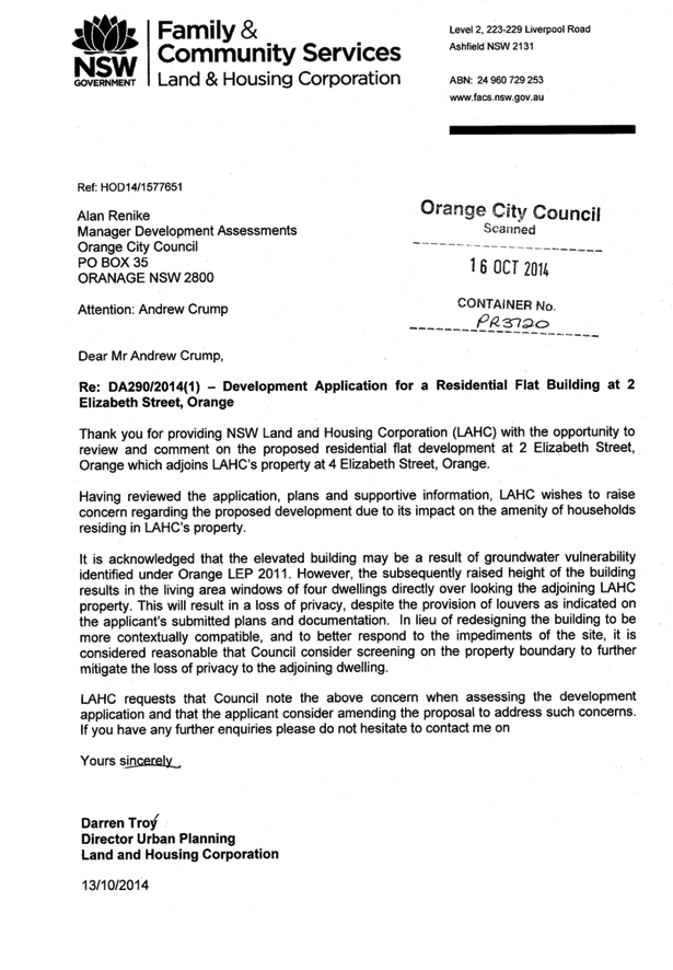
2.4 Development
Application DA 348/2014(1) - 21 and 23-25 Peisley Street
TRIM
REFERENCE: 2015/291
AUTHOR: Paul
Johnston, Planning Team Leader
EXECUTIVE Summary
The proposal seeks development consent for the following:
· Proposed Change of
Use - the existing industrial building at the site frontage has development
consent for a motor showroom (pursuant to DA 439/2002 approved on 5
March 2003) but requires development consent for current use.
· New Industrial
Buildings - The proposal involves demolition of the existing shed adjacent to
the rear (western) boundary and construction of three industrial buildings
adjacent to the southern and western boundaries of the site.
A Section 79C assessment of the development indicates that
the development is acceptable. Attached is a Notice of Approval for
Council’s consideration.
It is recommended that Council supports the subject
proposal.
Link To Delivery/OPerational Plan
The recommendation in this report relates to the
Delivery/Operational Plan strategy “13.4 Our Environment
– Monitor and enforce regulations relating to City amenity”.
Financial Implications
Nil
Policy and Governance Implications
Nil
|
Recommendation
That Council consents to development application DA
348/2014(1) for Warehouse or Distribution Centre, Hardware and Building
Supplies, General Industry, Vehicle Sales or Hire Premises, Vehicle Repair Station
and Advertisement at Lot 16 Sec 11 DP 6662 and Lot 52 DP 541772
– 21 and 23-25 Peisley Street, Orange pursuant to the conditions of
consent in the attached Notice of Approval.
|
further considerations
Consideration has been given to the
recommendation’s impact on Council’s service delivery; image and
reputation; political; environmental; health and safety; employees;
stakeholders and project management; and no further implications or risks have
been identified.
SUPPORTING INFORMATION
THE APPLICATION/PROPOSAL
The development relates to industrial land at 21 and 23-25
Peisley Street, Orange. The proposal seeks development consent for the
following:
Proposed Change of Use
The existing industrial building at the site frontage has
development consent for a motor showroom (pursuant to DA 439/2002
approved on 5 March 2003). This building is currently occupied by Hertz Rentals
and Pedders Suspension.
In order to formalise the use of the building by the current
tenants, the proposal involves change of building use to part vehicle sales
or hire premises (for Hertz Rentals) and part vehicle repair station
(for Pedders Suspension).
The submitted plans show that Hertz will utilise the
showroom component of the building at the site frontage, as depicted on Sheet
7. Hire vehicles are proposed to be stored on the grassed area between the dual
site accesses. The showroom will be utilised for office and administration
functions associated with the business.
Hours of operation for Hertz will be 8am to 5pm Monday to
Friday, 8.30am to 1pm Saturdays and by appointment on Sundays. Two staff will
be in attendance at any one time.
The proposal also seeks consent to formalise an
advertisement for Hertz. The proposed advertising will comprise a flush wall
sign on the eastern (Peisley Street) façade of the showroom, sited on
the fascia above the shopfront glazing. The proposed sign will have dimensions
of 10.7m x 0.6m. Advertising content will comprise the business name,
activities and phone number.
The workshop component of the existing building will be used
as a vehicle repair station for Orange Wheel Alignment Specialists and Pedders
Suspension. Typical business activities will involve wheel alignments,
suspension fitting and repairs, and associated activities.
Hours of operation will be 7am to 7pm Monday to Friday and
8am to 1pm Saturdays. Approximately 4-5 staff will be in attendance at any one time.
Business identification signage is also proposed. The
proposed signage will comprise a flush wall sign on the eastern façade
of the workshop building addressing Peisley Street, with dimensions of 2.5m x
5.0m. Advertising content will comprise the business name and logo. The
proposed signage will replace an existing unapproved Hertz sign in this
location and is exempt development.
New Industrial Buildings
The proposal involves demolition of an existing shed
adjacent to the rear (western) boundary and construction of three industrial
buildings adjacent to the southern and western boundaries of the site.
The new buildings will have total gross floor area of
2,626.7m2 and contain five separate tenancies. Proposed Tenancy 1
will comprise a warehouse and distribution centre, with Tenancy 2
to be used for hardware and building supplies. Consent is sought for use
of Tenancies 3-5 for general industry. Tenants have not been
secured for the individual tenancies at this time.
MATTERS FOR CONSIDERATION
Section 5A Assessment
In the administration of sections 78A, 79B, 79C, 111 and
112, the provisions of Section 5A must be taken into account for every
development application in deciding whether there is likely to be a significant
effect on threatened species, populations or ecological communities or their
habitats. This section includes a requirement to consider any adopted
assessment guidelines, which means assessment guidelines issued and in force
under section 94A of the Threatened Species Conservation Act 1995.
Assessment guidelines are in force (see DECC-W “Threatened Species
Assessment Guidelines - The Assessment of Significance”) which requires
consent authority to adopt the precautionary principle in its assessment.
In this instance, site inspection reveals that the subject
property has no biodiversity or habitat value.
Section 79C
Section 79C of the Environmental Planning and Assessment
Act 1979 requires Council to consider various matters, of which those
pertaining to the application are listed below.
PROVISIONS OF ANY ENVIRONMENTAL
PLANNING INSTRUMENT s79C(1)(a)(i)
Orange Local Environmental Plan 2011
Part 1 - Preliminary
Clause 1.2 - Aims of Plan
The
broad aims of the LEP are set out under subclause 2. Those relevant to the
application are as follows:
(a) to encourage development which complements
and enhances the unique character of Orange as a major regional centre boasting
a diverse economy and offering an attractive regional lifestyle,
(b) to provide for a range of development
opportunities that contribute to the social, economic and environmental
resources of Orange in a way that allows present and future generations to meet
their needs by implementing the principles for ecologically sustainable
development,
(f) to recognise and manage valued
environmental heritage, landscape and scenic features of Orange.
In consideration of aim (a), there are no aspects of the
proposal that detract from the character of Orange as a major regional centre.
In consideration of aim (b), the proposal would have a
neutral to positive effect in terms of the social, economic and environmental
resources of the City.
In consideration of aim (f), there are no aspects of the
proposal that would adversely affect the value of heritage, landscape and
scenic features of the City.
Clause 1.6 - Consent Authority
This clause establishes that, subject to the Act, Council is
the consent authority for applications made under the LEP.
Clause 1.9A - Suspension of
Covenants, Agreements and Instruments
This clause provides that covenants, agreements and other
instruments which seek to restrict the carrying out of development do not apply
with the following exceptions.
· covenants imposed
or required by Council
· prescribed
instruments under Section 183A of the Crown Lands Act 1989
· any conservation
agreement under the National Parks and Wildlife Act 1974
· any trust
agreement under the Nature Conservation Trust Act 2001
· any property
vegetation plan under the Native Vegetation Act 2003
· any biobanking
agreement under Part 7A of the Threatened Species Conservation Act 1995
· any
planning agreement under Division 6 of Part 4 of the Environmental Planning
and Assessment Act 1979.
Council staff are not aware of the
title of the subject property being affected by any of the above.
Mapping
The subject site is identified
on the LEP maps in the following manner:
|
Land Zoning Map:
|
Land zoned INI General Industrial
|
|
Lot Size Map:
|
Minimum Lot Size 1000m2
|
|
Heritage Map:
|
Not a heritage item or conservation
area
|
|
Height of Buildings Map:
|
No building height limit
|
|
Floor Space Ratio Map:
|
No floor space limit
|
|
Terrestrial Biodiversity Map:
|
No biodiversity sensitivity on the
site
|
|
Groundwater Vulnerability Map:
|
Ground water vulnerable
|
|
Drinking Water Catchment Map:
|
Not within the drinking water catchment
|
|
Watercourse Map:
|
Not within or affecting a defined
watercourse
|
|
Urban Release Area Map:
|
Not within an urban release area
|
|
Obstacle Limitation Surface Map:
|
No restriction on building siting
or construction
|
|
Additional Permitted Uses Map:
|
No additional permitted use applies
|
Those matters that are of
relevance are addressed in detail in the body of this report.
Part 2 - Permitted or
Prohibited Development
Land
Use Zones
The subject site is located within the IN1 General
Industrial zone. Pursuant to Orange LEP 2011, the proposed development is
defined as general industry, hardware and building supplies, vehicle repair
station, vehicle sales or hire premises and a warehouse or distribution centre.
Each of the above described land uses are defined under the LEP Dictionary
as follows:
general
industry means a building or place
(other than a heavy industry or light industry) that is used to carry out an
industrial activity.
hardware
and building supplies means a building
or place the principal purpose of which is the sale or hire of goods or
materials, such as household fixtures, timber, tools, paint, wallpaper,
plumbing supplies and the like, that are used in the construction and
maintenance of buildings and adjacent outdoor areas.
vehicle repair station means a building or
place used for the purpose of carrying out repairs to, or the selling and
fitting of accessories to, vehicles or agricultural machinery, but does not
include a vehicle body repair workshop or vehicle sales or hire premises.
vehicle sales or hire premises means a building or
place used for the display, sale or hire of motor vehicles, caravans, boats,
trailers, agricultural machinery and the like, whether or not accessories are
sold or displayed there.
warehouse
or distribution centre means a
building or place used mainly or exclusively for storing or handling items
(whether goods or materials) pending their sale, but from which no retail sales
are made.
advertisement has
the same meaning as in the Act.
Note. The
term is defined as a sign, notice, device or representation in the nature of an
advertisement visible from any public place or public reserve or from any
navigable water.
signage means any
sign, notice, device, representation or advertisement that advertises or
promotes any goods, services or events and any structure or vessel that is
principally designed for, or that is used for, the display of signage, and
includes any of the following:
(a) an advertising structure,
(b) a building identification sign,
(c) a business identification sign.
but does not include a traffic
sign or traffic control facilities.
In accordance with the Land Use Table in Part 2 of the LEP,
the proposed development is permitted with consent in the IN1 zone.
Clause
2.3 of LEP 2011 references the Land Use
Table and Objectives for each zone in LEP 2011. These objectives for
land zoned INI General Industrial are as follows:
· To provide a
wide range of industrial and warehouse land uses.
· To encourage
employment opportunities.
· To minimise any
adverse effect of industry on other land uses.
· To support and
protect industrial land for industrial uses.
· To ensure
development along the Southern Link Road has an alternative access.
The proposal is considered to be consistent with the objectives
of the zone.
Clause 2.7 - Demolition
Requires Development Consent
The proposal involves demolition of the existing shed
adjacent the rear (western) boundary and the applicant is seeking the consent
of council. The demolition works proposed will have no significant impact on
adjoining lands, streetscape or public realm.
Part 3 - Exempt and Complying Development
The application is not exempt or complying development.
Part 7 - Additional Local Provisions
7.1
- Earthworks
This
clause establishes a range of matters that must be considered prior to granting
development consent for any application involving earthworks, such as:
(a) the likely disruption of, or any
detrimental effect on, existing drainage patterns and soil stability in the
locality of the development
(b) the effect of the development on the
likely future use or redevelopment of the land
(c) the quality of the fill or the soil to be
excavated, or both
(d) the effect of the development on the
existing and likely amenity of adjoining properties
(e) the source of any fill material and the
destination of any excavated material
(f) the likelihood of disturbing relics
(g) the proximity to and potential for adverse
impacts on any waterway, drinking water catchment or environmentally sensitive
area
(h) any measures proposed to minimise or
mitigate the impacts referred to in paragraph (g).
The site slopes around 2.5m from
front to rear. The earthworks proposed in the application are limited to the
extent of cutting and filling required for the proposed building or structure
although the submitted plans do not show this detail. The extent of disruption
to the drainage of the site is considered to be minor and will not
detrimentally affect adjoining properties or receiving waterways.
The extent of the earthworks
will not materially affect the potential future use or redevelopment of the
site that may occur at the end of the proposed development's lifespan.
The earthworks will be
appropriately supported onsite and the change in ground level is not
substantial. Therefore the effect on the amenity of adjoining properties is
considered to be minor.
The site is not known to contain
any Aboriginal, European or archaeological relics. Previous known uses of the
site do not suggest that any relics are likely to be uncovered.
The site is not in proximity to
any waterway, drinking water catchment or sensitive area. Conditions are
imposed to require a sediment control plan, including silt traps and other
protective measures, to ensure that loose dirt and sediment does not escape the
site boundaries.
7.3 - Stormwater Management
This clause applies to all
industrial, commercial and residential zones and requires that Council be
satisfied that the proposal:
(a) is designed to maximise the use of water
permeable surfaces on the land having regard to the soil characteristics
affecting onsite infiltration of water
(b) includes, where practical, onsite stormwater
retention for use as an alternative supply to mains water, groundwater or river
water; and
(c) avoids any significant impacts of
stormwater runoff on adjoining downstream properties, native bushland and
receiving waters, or if that impact cannot be reasonably avoided, minimises and
mitigates the impact.
Council’s Technical;
Services Depart advise that the site can be suitably drained. The attached
Notice of Approval contains a condition of consent requiring the applicant to
design the development such that post development runoff levels will not exceed
the predevelopment levels.
7.6 - Groundwater Vulnerability
This
clause seeks to protect hydrological functions of groundwater systems and
protect resources from both depletion and contamination. Orange has a high
water table and large areas of the LGA, including the subject site, are
identified with “Groundwater Vulnerability” on the Groundwater
Vulnerability Map. This requires that Council consider:
(a) whether or not the development (including
any onsite storage or disposal of solid or liquid waste and chemicals) is
likely to cause any groundwater contamination or have any adverse effect on
groundwater dependent ecosystems, and
(b) the cumulative impact (including the
impact on nearby groundwater extraction for potable water supply or stock water
supply) of the development and any other existing development on groundwater.
Furthermore consent may not be granted unless Council is satisfied that:
(a) the development is designed, sited and
will be managed to avoid any significant adverse environmental impact, or
(b) if that impact cannot be reasonably
avoided - the development is designed, sited and will be managed to minimise
that impact,
(c) if that impact cannot be minimised - the
development will be managed to mitigate that impact.
The proposal is not anticipated
to involve the discharge of toxic or noxious substances and is therefore
unlikely to contaminate the groundwater or related ecosystems. The proposal
does not involve extraction of groundwater and will therefore not contribute to
groundwater depletion.
Clause 7.11 - Essential
Services
In accordance with the requirements of Clause 7.11,
development consent must not be granted to development unless the consent
authority is satisfied that any of the following services that are essential
for the proposed development are available or that adequate arrangements have
been made to make them available when required:
(a) the
supply of water,
(b) the
supply of electricity,
(c) the
disposal and management of sewage,
(d) storm
water drainage or on-site conservation,
(e) suitable
road access.
The applicant has advised that the subject land and premises
are connected to available urban utilities. Council’s Technical Services
Division advises that any adjustment or augmentation of existing service
connections will be required to be undertaken in accordance with the
requirements of the relevant supply authority.
STATE ENVIRONMENTAL PLANNING
POLICIES
State Environmental Planning Policy Infrastructure 2007
The proposed development is not traffic generating
development pursuant to Clause 104 and Schedule 3 of SEPP Infrastructure
2007. In this regard:
· Pursuant to Column
2, the capacity of the proposed development is below the threshold of 20,000m2
for industry with access to any road.
· Pursuant to Column
3, the capacity of the proposed development is below the threshold of 5,000m2
for industry with access to a classified road (ie Peisley Street).
As such, the development is not considered to be traffic
generating and consultation with Roads and Maritime Services was not required.
State Environmental Planning
Policy 64 - Advertising and Signage
State Environmental Planning Policy 64 - Advertising and
Signage applies to the subject development. The applicant is proposing the
following signage:
· A flush wall sign
on the eastern (Peisley Street) façade of the Hertz showroom. The
proposed sign will be sited on the fascia above the shopfront glazing and have
dimensions of 10.7m x 0.6m. Advertising content will comprise the business
name, activities and phone number.
· Business
identification signage on the eastern (Peisley Street) façade of the
Orange Wheel Alignment Specialists and Pedders Suspension workshop. The
proposed signage will comprise a flush wall comprising dimensions of 2.5m x
5.0m. Advertising content will comprise the business name and logo.
3 - Aims, Objectives etc
(1) This Policy aims:
(a) to ensure that signage
(including advertising):
(i) is compatible with the
desired amenity and visual character of an area, and
(ii) provides effective
communication in suitable locations, and
(iii) is of high quality design and
finish, and
(b) to regulate signage (but not
content) under Part 4 of the Act, and
(c) to provide time-limited
consents for the display of certain advertisements, and
(d) to regulate the display of
advertisements in transport corridors, and
(e) to ensure that public
benefits may be derived from advertising in and adjacent to transport corridors.
(2) This Policy does not
regulate the content of signage and does not require consent for a change in
the content of signage.
The subject signage is consistent with the aims, objectives
etc. listed above.
4 - Definitions
Pursuant to clause 4 the proposed signage consists of
advertisements to which Part 3 of the SEPP relates, and business
identification signage. The definition of signage as outlined above under
OLEP 2011 consideration includes business identification signage.
The Hertz signage as described
above is considered to be an advertisement for which Part 3 of the SEPP
applies due to a telephone number of the business being displayed thereon. The
proposed Pedders sign will replace an existing Hertz sign in this location.
This is considered to be a business identification sign and will satisfy the
exempt development requirements therefore not requiring any formal approval. A
detailed assessment of the proposed signage against the assessment criteria
contained within SEPP 64 is provided below.
6 - Signage
to Which this Policy applies
(1) This
Policy applies to all signage:
(a) that,
under another environmental planning instrument that applies to the signage,
can be displayed with or without development consent, and
(b) is
visible from any public place or public reserve,
except
as provided by this Policy.
(2) This
Policy does not apply to signage that, or the display of which, is exempt
development under an environmental planning instrument that applies to it, or
that is exempt development under this Policy.
Development consent is sought for the proposed signage.
Signage to Which Part 3 of the SEPP Relates
11 - Requirement for Consent
Clause 11 states:
A
person must not display an advertisement, except with the consent of the
consent authority or except as otherwise provided by this Policy.
The applicant is applying for consent through this
application.
13 - Matters for Consideration
(1) A
consent authority (other than in a case to which subclause (2) applies) must
not grant consent to an application to display an advertisement to which this
Policy applies unless the advertisement or the advertising structure, as the
case requires:
(a) is
consistent with the objectives of this Policy as set out in clause 3 (1) (a),
and
(b) has
been assessed by the consent authority in accordance with the assessment
criteria in Schedule 1 and the consent authority is satisfied that the proposal
is acceptable in terms of its impacts, and
(c) satisfies
any other relevant requirements of this Policy.
A detailed assessment of the proposed signage against the
assessment criteria contained within Schedule 1 of the SEPP is provided below.
14 - Duration of
Consents
(1) A
consent granted under this Part ceases to be in force:
(a) on
the expiration of 15 years after the date on which the consent becomes
effective and operates in accordance with section 83 of the Act, or
(b) if
a lesser period is specified by the consent authority, on the expiration of the
lesser period.
A condition is attached in this regard.
19 Advertising
Display Area Greater than 45 Square Metres
The consent authority
must not grant consent to the display of an advertisement with an advertising
display area greater than 45 square metres unless:
(a) a development control plan is
in force that has been prepared on the basis of an advertising design analysis
for the relevant area or precinct, or
(b) in the case of the display of
an advertisement on transport corridor land, the consent authority is satisfied
that the advertisement is consistent with the Guidelines.
The proposed signage is below 45m² in area.
Schedule 1 Assessment
Character of the Area
· Is
the proposal compatible with the existing or desired future character of the
area or locality in which it is proposed to be located?
· Is
the proposal consistent with a particular theme for outdoor advertising in the
area or locality?
Advertising along the Peisley Street precinct comprises a
mix of pylon/pole signs at site frontages and flush wall and fascia signs on
the buildings. The proposed signage will be consistent with
the theme for outdoor advertising and will complement the visual character of
this commercial and industrial precinct.
2 - Special Areas
· Does
the proposal detract from the amenity or visual quality of any environmentally
sensitive areas, heritage areas, natural or other conservation areas, open
space areas, waterways, rural landscapes or residential areas?
The subject site does not contain or adjoin a special area.
The proposed signage will not detract from the amenity or visual quality of any
environmentally sensitive areas, natural areas, open space areas, waterways,
rural landscapes or residential areas.
Given that the site is not located within a special area,
advertising content is not restricted to business identification or building
identification only. There are no planning objections to the proposed signage.
3 - Views and Vistas
· Does
the proposal obscure or compromise important views?
· Does
the proposal dominate the skyline and reduce the quality of vistas?
· Does
the proposal respect the viewing rights of other advertisers?
The proposed signage is positioned in a manner that will not
obscure views or compromise viewing rights of other advertisers or businesses
in the precinct.
4 - Streetscape, Setting or Landscape
· Is
the scale, proportion and form of the proposal appropriate for the streetscape,
setting or landscape?
· Does
the proposal contribute to the visual interest of the streetscape, setting or
landscape?
· Does
the proposal reduce clutter by rationalising and simplifying existing
advertising?
· Does
the proposal screen unsightliness?
· Does
the proposal protrude above buildings, structures or tree canopies in the area
or locality?
· Does
the proposal require ongoing vegetation management?
The site is contained within an established business and
industrial area. The advertisement in the form proposed will generally
complement the streetscape and setting. Overall it is considered that the
signage proposal will add visual interest within the street.
5 - Site and Building
· Is
the proposal compatible with the scale, proportion and other characteristics of
the site or building, or both, on which the proposed signage is to be located?
· Does
the proposal respect important features of the site or building, or both?
· Does
the proposal show innovation and imagination in its relationship to the site or
building, or both?
The proposed signage will be generally compatible with the
scale, proportions and other characteristics of the subject building and remain
consistent with the theme of signage in the area. The wall sign is proposed to
be affixed to the building facade and despite its size will not dominate the
building which has relatively large elevations that present to Peisley Street.
The advertisement is considered to be of an acceptable size in compliance with
the requirements of the SEPP. Further, the sign will not protrude above the
eaves, extend over a window or opening, or obscure architectural building
elements.
The proposed signage reasonably depicts the corporate scheme
for Hertz. Corporate signage is not an unexpected element in industrial and
business precincts. No signage is proposed on the new buildings.
6 - Associated Devices and Logos with Advertisements
and Advertising Structures
· Have
any safety devices, platforms, lighting devices or logos been designed as an
integral part of the signage or structure on which it is to be displayed?
The signage does not include any safety devices, platforms,
lighting devices or logos that form an integral part of the signage or
structure on which it is to be displayed.
7- Illumination
· Would
illumination result in unacceptable glare?
· Would
illumination affect safety for pedestrians, vehicles or aircraft?
· Would
illumination detract from the amenity of any residence or other form of
accommodation?
· Can
the intensity of the illumination be adjusted, if necessary?
· Is
the illumination subject to a curfew?
The applicant advises that the proposed wall signs may be
illuminated. There are no objections to the illumination of the subject
signage. The proposed illumination of signage in this location will be will
have minimal visual impacts in the context of the adjacent industrial premises
and public street lighting. Ancillary light fittings will be shielded or
mounted in a position to minimise glare to adjoining properties and public
areas. Attached is a condition addressing this matter.
8 - Safety
· Would
the proposal reduce the safety for any public road?
· Would
the proposal reduce the safety for pedestrians or bicyclists?
· Would
the proposal reduce the safety for pedestrians, particularly children, by
obscuring sightlines from public areas?
The subject signage will be appropriately sited such that it
will not cause safety issues for vehicles, cyclists or pedestrians.
PROVISIONS OF ANY DRAFT
ENVIRONMENTAL PLANNING INSTRUMENT THAT HAS BEEN PLACED ON EXHIBITION
s79C(1)(a)(ii)
There are no draft environmental planning instruments that
apply to the subject land or proposed development.
DESIGNATED DEVELOPMENT
The proposed development is not designated development.
PROVISIONS OF ANY DEVELOPMENT
CONTROL PLAN s79C(1)(a)(iii)
Development Control Plan 2004
Development Control Plan 2004 (“the DCP”)
applies to the subject land (Part 9 - Development within the Industry and
Employment Zone). An assessment of the proposed development against the
relevant Planning Outcomes will be undertaken below.
Pursuant to Planning Outcome 0.2-1 Interim Planning Outcomes
- Conversion of Zones:
· Throughout this
Plan, any reference to a zone in Orange LEP 2000 is to be taken to be a
reference to the corresponding zone(s) in the zone conversion table.
The corresponding zone to zone 4 Industry and Employment
(Orange LEP 2000) is zone IN1 General Industrial (Orange LEP 2011). As
such, Orange DCP 2004 - Chapter 9 -Development within the Industry and
Employment Zone is relevant to this proposal. The DCP sets the
following Planning Outcomes for Industrial Site Development.
· Buildings are
setback a minimum of 10 metres from front boundaries (5 metres to a secondary
boundary on a corner lot) for lots greater than 1000m2 or 5 metres
for lots less than 1,000m2 or otherwise to a setback consistent with
existing setbacks in established areas.
The subject land comprises an area in excess of 1,000m2
and therefore the applicable setback requirement in this case is 10m. There is
no proposal to alter the front setback for the existing industrial building.
Building 1 is proposed to be sited 17m from the Peisley Street frontage of the
land, in compliance with the DCP requirements. An adequate area is proposed to
be provided between the building and the front boundary for parking spaces and
landscaping.
· Buildings cover
up to 50% of the site area (excluding the area of accessways for battleaxe
lots)
The submitted plans show that the
existing building and proposed buildings will comprise a total building
footprint area of 3,444.2m2. Based on the site area of 7,861m2
the development will have a site coverage of 43.8% in compliance with DCP
requirements.
· Landscaping is
provided along boundaries fronting roads including trees with an expected
mature height at least comparable to the height of buildings on the site. All
sites contain an element of landscaping…
The proposal does not seek to alter existing plantings
adjacent to the existing industrial building. The submitted plans show that
landscaping will be provided along the Peisley Street frontage adjacent to the
new buildings within a minimum landscape bed of 4.6m in width. The
proposed landscaping will incorporate plantings that are commensurate with the
height of the proposed buildings as well as plantings that offer some screening
at an intermediate level. It is considered that the proposed landscaping at
maturity will provide adequate visual relief to the proposed building and site
generally. Additional landscaping is recommended directly in front of the Hertz
rental business. The submitted plans show a car display area in the front
setback area. Opportunity exists to provide a 3.5m wide landscape bed in front
of the display area consistent with the approach to landscaping along the
frontage of the southern part of the subject site. Attached is a condition of
consent requiring an amended landscape plan addressing this matter.
· Architectural
features are provided to the front building façade to provide relief
using such elements as verandahs, display windows, indented walls etc.
In order to provide some visual relief and integration of
the front building façade within the street the applicant has proposed
the following building elements:
· shopfront glazing
with verandah treatment
· modern parapet
design.
The verandah is proposed to be only 1.4m in depth and is
considered to be a token effort to provide architectural features to the
Peisley Street façade of the building. It is considered that to provide
meaningful relief to the otherwise simplistic façade that the verandah
should be widened to be at least 2.4m. This can be achieved by reducing the
vehicle aisle width of the adjacent car parking area at the frontage of the
site and reducing the length of proposed Building 1. Condition of consent to
this effect is attached to the Notice of Approval.
· External
materials consist of non-reflective materials.
External finishes for the proposed building are depicted on
the submitted elevation drawings. The selected finishes will be non-reflective
as encouraged by the DCP.
· Adequate
parking and onsite manoeuvring is provided.
The proposed development is
subject to the provisions of Orange DCP 2004 - Chapter 15 - Car Parking.
The proposed development will generate a car parking requirement of
55.13 spaces as outlined in the tabled below:
|
Tenancy
|
Land
Use
|
Car
Parking Requirement
|
GFA
|
Car
Parking Spaces Required
|
|
Hertz
|
Vehicle
sales or hire premises
|
1 space/40m2
|
215m²
|
5.4
|
|
Pedders
|
Vehicle
repair station
|
3 spaces/workbay
|
485m²
4
workbays
|
12
|
|
1
|
Warehouse
and distribution centre
|
1 space/50m2 GFA
|
659m²
|
13.18
|
|
2
|
Hardware
and building supplies
|
1 space/50m2 GFA
|
513.3m²
|
10.3
|
|
3
|
General
industry
|
1 space/100m2 GFA
|
513m²
|
5.13
|
|
4
|
General
industry
|
1 space/100m2 GFA
|
456.4m²
|
4.56
|
|
5
|
General
industry
|
1 space/100m2 GFA
|
456.4m²
|
4.56
|
|
TOTAL
|
|
|
|
55.13
|
The applicant submits that the
business activities of Hertz are more typical of a business premises than a
motor showroom. By its very nature, demand for car parking for this aspect of
the development is considered to be less than for a typical motor showroom. The
applicant has advised Council that the Orange Hertz business operates
approximately 45 hire cars and that it would be necessary to store a
maximum of six to eight vehicles within the site at any one time. Council is
further advised that the typical operation of the business is that the rental
cars are on the road, or at the airport, or on the site. The applicant submits
that vehicle turnover is very high to the extent that there is almost a
shortage in cars for hire.
It is understood from the applicant’s submission that
there are only a few occasions when it would be necessary to store ten to
twelve vehicles within the site at any one time (usually over the Christmas/New
Year period). The cars that need to be stored on the site can be contained
within the grassed display area at the front (approximately six to eight cars)
or within the building itself (six to eight cars). Given the availability of
the shed space and the display area at the front of the site to park rental
vehicles, it is recommended that the car parking rate applicable to a business
premises be used as a guide to assess this aspect of the proposed development.
The car parking requirement for a warehouse or distribution
centre under the DCP is one space per 100m² of GFA. Whilst a specific
tenant is not known at this stage, the applicant has offered a higher parking
requirement than would ordinarily be required for development of this type. The
applicant has assessed this aspect of the development based on the bulk retail
rate of one space per 50m². There are no objections to the application of
this rate in this circumstance.
The submitted plans show that a total of 56 onsite car
parking spaces (including five spaces for disabled persons) will be
provided for the development, in compliance with the DCP. There is an
emerging practice for workers to park on Peisley Street. It is important that
all vehicles associated with a business park onsite so as to not interfere with
the flow of traffic along Peisley Street, which is a main road of significant
importance. In view of this a condition has been attached that requires all
vehicles associated with the business to park on the site, including
workers’ vehicles.
The applicant has provided a turn path analysis in support
of the proposal. The turn path analysis demonstrates that the site layout and
building design will accommodate the forward ingress, egress and manoeuvring of
a 19m semi-trailer. The internal driveway system will provide for onsite
passing of vehicles. All vehicles likely to be associated with the site are
able to enter and exit in a forward direction. The submitted plans also
demonstrate that a large rigid truck (12.5m) will be able to reverse into the
warehouse section of each tenancy in the proposed buildings if required, and
leave in a forward direction to exit the facility. There are no planning
objections to the proposed parking and manoeuvring arrangements.
· Advertising
involves business identification signs within the front façade and/or by
pole sign comparable to the relative height of the main building on the site
Matters in relation to signage have been addressed above
under the heading “State Environmental Planning Policy 64 - Advertising
and Signage”. A separate development application will be required for any
signage associated with Tenancies 1-5 that is not defined as exempt
development.
· Security
fencing is located or designed in a manner that does not dominate the visual
setting of the area
Existing palisade fencing on the front boundary to Peisley
Street will be retained, together with security fencing on side boundaries.
PROVISIONS PRESCRIBED BY THE
REGULATIONS s79C(1)(a)(iv)
The proposed development is not inconsistent with any
provisions prescribed by the Regulations.
THE LIKELY IMPACTS OF THE
DEVELOPMENT s79C(1)(b)
Traffic Impacts
The potential for traffic impacts relates mainly to the
capacity of the local road network to accommodate an increase in traffic levels
and the ability for vehicles to enter, exit and use the site without disruption
to traffic flow along Peisley Street. The proposed development is not defined
as traffic generating development under the SEPP (Infrastructure).
The subject land is an existing industrial site. The site,
whilst underdeveloped at this time, has a certain level of traffic already
attributed to it due to its present use by Hertz and Pedders. There are no
aspects of the road network that would indicate it would not be able to
accommodate traffic generated by the proposed development. Carriageway widths,
trafficable lanes, and intersection controls within Peisley Street appear
satisfactory to carry traffic associated with this precinct.
Whilst there is no proposal to alter the existing access
arrangements that currently serve the site Council’s Technical Services
Department advise that heavy duty concrete crossings will be required to be
constructed for the entrances.
A turn path analysis submitted in support of the development
demonstrates that the site layout and building design will accommodate the
forward ingress, egress and manoeuvring of a 19.0m semi-trailer. The submitted
plans also demonstrate that a large rigid truck (12.5m) will be able to
reverse into the warehouse section of each tenancy in the proposed buildings if
required, and leave in a forward direction to exit the facility. There are no
planning objections to the proposed parking and manoeuvring arrangements. All
vehicles associated with the site will be able to enter and exit the site in a
forward direction.
Sufficient onsite car parking will be provided to meet the
parking requirements associated with the existing uses and the proposed
development.
Visual Amenity
The proposed buildings will be of comparable bulk, scale and
height with industrial premises on adjoining sites to the north and south, and
indeed in this streetscape. The proposed building design however has limited
architectural features and it is recommended in this case that the proposed
verandah be widened to provide meaningful relief to the street. It is
considered that to provide meaningful relief to the otherwise simplistic
façade that the verandah should be widened to be at least 2.4m. As
discussed above, this can be achieved by reducing the vehicle aisle width of
the adjacent car parking area at the frontage of the site and reducing the length
of proposed Building 1. The proposed materials, revised verandah treatment and
shopfront glazing will facilitate a commercial appearance when viewed from
Peisley Street which is considered to be complimentary to the built form in
this precinct. Condition of consent addressing matters in relation to the size
of the verandah is attached to the Notice of Approval.
The proposed landscaping will assist to a degree in
screening and softening the visual impact of the development. Landscaping in
front of proposed building No 1 along the site frontage is considered to be
acceptable and in compliance with the DCP. Tree selection includes species that
are commensurate with the height of proposed Building 1.
As discussed above, additional landscaping is recommended
directly in front of the Hertz rental business. The submitted plans show a car
display area in the front setback area. Opportunity exists to provide a 3.5m
wide landscape bed in front of the display area consistent with the approach to
landscaping along the frontage of the southern part of the subject site.
Attached is a condition of consent requiring an amended landscape plan
addressing this matter.
Subject to the implementation of the recommended conditions
of consent, the visual impacts of the development will be acceptable.
Noise
Generally, the ambient noise levels of the locality would be
typical of an industrial situation. Sources of background noise can be mostly
attributed to traffic along the road network and from activity on other
industrial sites within the precinct. The applicant submits that the following
measures may serve to mitigate potential noise impacts:
· The site is
well separated from dwellings. The nearest residential neighbourhood is some
400 metres to the north of the site in Gardiner Road and Peisley Street.
· The concrete
tilt panel construction for the proposed building offers noise attenuation
qualities.
· Manufacturing/workshop
activities associated with Tenancies 3-5 will be confined entirely within the
building.
· The workshop
openings address the internal vehicle areas to the east and north and therefore
not directly towards the adjacent (albeit industrial) land uses to the west.
· Manufacturing/workshop
activities associated with Tenancies 3-5 will operate during the daytime period
when background noise levels are typically higher.
· Council may
impose a condition to limit the hours of operation for the development to
7.00am to 10.00pm (i.e. no operation involving potential noise-making
activities within the night time period 10.00pm to 7.00am as defined by the NSW
Industrial Noise Policy unless an acoustic assessment is undertaken to assess
potential noise impacts).
The anticipated noise impact from the development is considered
to be acceptable. The attached Notice of Approval includes conditions which
limit noise generation from the subject site and places controls on the hours
of operation.
Waste Management
The applicant advises that waste management
for the site will entail the following:
· storage in bins for recycling or for disposal via Council’s
normal service
· material unable to be recycled or disposed of via Orange City
Council’s waste management depot may be stored in appropriate receptacles
for collection by approved contractors for disposal or recycling elsewhere
· should a future use generate liquid trade waste, the operator will
be required to enter into a trade waste agreement with Council
No specific detail of where storage bins for each tenancy
will be located on the site has been submitted with the application. Attached
is a condition of consent that requires the preparation of a Waste Management
Plan for site. A condition is also attached that prohibits storage of waste
containers on parking spaces and driveways.
Social and Economic Impacts
The proposed development has the potential to generate
positive social and economic effects. The proposal has the potential to
increase the supply of, and expand choices of industrial premises within the
City of Orange and increase employment opportunities both during the
construction period and, more importantly, once the proposed tenancies are
operational.
THE SUITABILITY OF THE SITE
s79C(1)(c)
There are no aspects of the site to indicate that it is not
suitable for the proposed development. The proposed development will be
connected to the existing sewer, town water and stormwater mains in accordance
with Council’s normal requirements. The slope of the land allows drainage
to sewer and stormwater infrastructure without the need for additional
easements. Power, gas and telecommunication services are available. The
extension of these services for the proposed development would be to the
requirements of the relevant supply authorities.
ANY SUBMISSIONS MADE IN
ACCORDANCE WITH THE ACT s79C(1)(d)
The proposed development is not defined as advertised
development under the provisions of the LEP, and as such no formal exhibition
of the application was required. No submissions have been received in relation
to this application.
PUBLIC INTEREST
s79C(1)(e)
The proposed development is considered to be of minor
interest to the wider public due to the relatively localised nature of
potential impacts. The proposal is not inconsistent with any relevant policy
statements, planning studies, guidelines etc that have not been considered in
this assessment.
SUMMARY
The proposed development is permissible with the consent of
Council. The proposed development complies with the relevant aims, objectives
and provisions of the LEP. A section 79C assessment of the
development indicates that the development is acceptable in this instance.
Attached is a draft Notice of Approval outlining a range of conditions
considered appropriate to ensure that the development proceeds in an acceptable
manner.
COMMENTS
The requirements of the Environmental Health and Building
Surveyor and the Engineering Development Section are included in the attached
Notice of Approval.
Attachments
1 Notice
of Approval, D15/4393⇩
2 Plans,
D15/4017⇩
Sustainable Development Committee
3 March 2015
2.4 Development
Application DA 348/2014(1) - 21 and 23-25 Peisley Street
Attachment 1 Notice
of Approval
|

|
ORANGE
CITY COUNCIL
Development
Application No DA
348/2014(1)
NA15/ Container
PR9635
|
NOTICE OF DETERMINATION
OF A DEVELOPMENT APPLICATION
issued under the Environmental
Planning and Assessment Act 1979
Section 81(1)
|
Development
Application
|
|
|
Applicant Name:
|
Mr FC
Brooking
|
|
Applicant Address:
|
C/- Peter
Basha Planning & Development
PO Box
1827
ORANGE
NSW 2800
|
|
Owner’s Name:
|
Mr FC
Brooking and Fred & May Pty Ltd
|
|
Land to Be Developed:
|
Lot 16 SEC
11 DP 6662 and Lot 52 DP 541772 - 21 and 23-25 Peisley Street, Orange
|
|
Proposed Development:
|
Warehouse
or Distribution Centre, Hardware and Building Supplies, General Industry, Vehicle
Repair Station, Vehicle Sales or Hire Premises, and Signage
|
|
|
|
|
Building
Code of Australia
building classification:
|
As
determined by Certifier
|
|
|
|
|
Determination
|
|
|
Made On:
|
3 March
2015
|
|
Determination:
|
CONSENT
GRANTED SUBJECT TO CONDITIONS DESCRIBED BELOW:
|
|
|
|
|
Consent to
Operate From:
|
4 March
2015
|
|
Consent to
Lapse On:
|
4 March
2020
|
Terms of Approval
The reasons for the imposition of
conditions are:
(1) To ensure a quality
urban design for the development which complements the surrounding environment.
(2) To maintain
neighbourhood amenity and character.
(3) To ensure compliance
with relevant statutory requirements.
(4) To provide adequate
public health and safety measures.
(5) Because the development
will require the provision of, or increase the demand for, public amenities and
services.
(6) To ensure the utility
services are available to the site and adequate for the development.
(7) To prevent the proposed
development having a detrimental effect on adjoining land uses.
(8) To minimise the impact
of development on the environment.
Conditions
(1) The
development must be carried out in accordance with:
(a) Plans by Peter Basha
Planning & Development: 14063DA (sheets 1 and 2);
Plans
by HRP Design Pty Ltd: BROK09DA (sheets 1-7)
(b) statements
of environmental effects or other similar associated documents that form part
of the approval
as amended
in accordance with any conditions of this consent.
(2) All building work must
be carried out in accordance with the provisions of the Building Code of
Australia.
(3) A sign is to be erected
in a prominent position on any site on which building work, subdivision work or
demolition work is being carried out:
a. showing
the name, address and telephone number of the principal certifying authority
for the work, and
b. showing
the name of the principal contractor (if any) for any building work and a
telephone number on which that person may be contacted outside working hours,
and
c. stating
that unauthorised entry to the site is prohibited.
Any such sign is to be maintained while the
building work, subdivision work or demolition work is being carried out.
(4) Where any excavation
work on the site extends below the level of the base of the footings of a
building on adjoining land, the person having the benefit of the development
consent must, at the person’s own expense:
a protect
and support the adjoining premises from possible damage from the excavation,
and
b where
necessary, underpin the adjoining premises to prevent any such damage.
Note: This
condition does not apply if the person having the benefit of the development
consent owns the adjoining land or the owner of the adjoining land has given
consent in writing to that condition not applying.
|
PRIOR TO THE ISSUE OF
A CONSTRUCTION CERTIFICATE
|
(5) Landscaping of the site
shall incorporate a 3.5m wide landscaped area along the frontage of the site
immediately in front of the proposed vehicle display area for the Hertz vehicle
sales or hire premises. The landscaping shall include a mix of trees and
understorey plantings similar to that proposed for the landscaping in front of
Building 1. The proposed trees shall at maturity have a comparable height to
the height of the buildings in existence on the subject site. An amended
detailed plan showing landscaping shall be submitted to and approved by
Councils Manager Development Assessments prior to the issue of a
Construction Certificate.
(6) The
applicant shall submit amended plans with a Construction Certificate
application indicating a verandah width of 2.4m on the façade of
proposed Building 1. The increase width of the verandah may be achieved by
reducing the width of the aisle within the carpark and shortening proposed
Building 1. The width of the aisle shall comply with the requirements of AS
2890.1:2004.
(7) A
Waste management plan shall shall be submitted to and approved by Councils Manager
Development Assessments prior to the issue of a Construction Certificate.
The Waste Management Plan shall show the location of all waste storage
facilities within the site.
(8) A
Construction Certificate application is required to be submitted to, and issued
by, Council/Accredited Certifier prior to any excavation or building works
being carried out on site.
(9) An
approval under Section 68 of the Local Government Act is to be sought from
Orange City Council, as the Water and Sewer Authority, for water, sewer and
stormwater connection. No plumbing and drainage is to commence until approval
is granted.
(10) A
Fire Safety Schedule specifying the fire-safety measures (both current and/or
proposed) to be implemented in the building is to be submitted with the
Construction Certificate application, in accordance with Part 9 Clause 168 of
the Environmental Planning and Assessment Regulation 2000.
(11) Prior to the issue of a
Construction Certificate for the construction of the buildings, the applicant
is to provide proof of lodgement of consolidation from Land and Property
Information for the proposed consolidation of the two allotments known as Lot
52 DP541772 and Lot 16 DP6662.
(12) Engineering plans
providing complete details of the proposed driveway and car-parking areas is to
be submitted to Orange City Council or an Accredited Certifier (Categories B1,
C3, C4, C6) upon application for a Construction Certificate. These plans are to
provide details of levels, cross falls of all pavements, proposed sealing
materials and proposed drainage works and be in accordance with the Orange City
Council Development and Subdivision Code.
(13) A water and soil
erosion control plan is to be submitted to Orange City Council or an Accredited
Certifier (Categories B1, C3, C4, C6) for approval prior to the issuing of a
Construction Certificate. The control plan is to be in accordance with the
Orange City Council Development and Subdivision Code and the Landcom, Managing
Urban Stormwater; Soils and Construction Handbook.
(14) The
development’s stormwater design is to include stormwater retention within
the development, designed to limit peak outflows from the land to the
pre-existing natural outflows up to the 100 year ARI frequency, with sufficient
allowance in overflow spillway design capacity to safely pass flows of lower
frequency (that is, a rarer event) without damage to downstream developments.
Where appropriate, the spillway design capacity is to be determined in
accordance with the requirements of the Dam Safety Committee.
The design of the detention storage is to be
undertaken using the ILSAX rainfall-runoff hydrologic model or an approved
equivalent capable of assessing runoff volumes and their temporal distribution
as well as peak flow rates. The model is to be used to calculate the flow rates
for the existing and post-development conditions. The developed flows are to be
routed through the proposed storage within the model so that the outflows
obtained are no greater than the flows obtained for the pre-existing natural
flows. A report detailing the results of the analysis, which includes:
· catchment
plan showing sub-catchments under existing and developed conditions;
· schematic
diagram of the catchment model showing sub areas and linkages;
· tabulation
detailing the elevation, storage volume and discharge relationships; and
· tabulation
for the range of frequencies analysed, the inflows, outflows and peak storage
levels for both existing and developed conditions;
together with copies of the data files for the
model and engineering design plans of the required drainage system are to be
submitted and approved by Orange City Council or an Accredited Certifier
(Categories B1, C3, C4, C6) prior to the issue a Construction Certificate.
(15) Backflow Prevention
Devices are to be installed to AS3500 and in accordance with Orange City
Council Backflow Protection Guidelines. Details of the Backflow Prevention
Devices are to be submitted to Orange City Council prior to the issuing of a
Construction Certificate.
|
PRIOR TO WORKS
COMMENCING
|
(16) A
temporary onsite toilet is to be provided and must remain throughout the
project or until an alternative facility meeting Council’s requirements
is available onsite.
(17) The
location and depth of the sewer junction/connection to Council’s sewerage
system is to be determined to ensure adequate fall to the sewer is available.
(18) Soil erosion control
measures shall be implemented on the site.
|
DURING
CONSTRUCTION/SITEWORKS
|
(19) All
construction/demolition work on the site is to be carried out between the hours
of 7.00 am and 6.00 pm Monday to Friday inclusive, 7.00 am to
5.00 pm Saturdays and 8.00 am to 5.00 pm on Sundays and Public
Holidays. Written approval must be obtained from the General Manager of Orange
City Council to vary these hours.
(20) All
materials onsite or being delivered to the site are to be contained within the
site. The requirements of the Protection of the Environment Operations Act
1997 are to be complied with when placing/stockpiling loose material or
when disposing of waste products or during any other activities likely to
pollute drains or watercourses.
(21) A
Registered Surveyor’s certificate identifying the location of the
building on the site must be submitted to the Principal Certifying Authority
prior to the pouring of the slab or footings.
(22) Any adjustments to
existing utility services that are made necessary by this development
proceeding are to be at the full cost of the developer.
(23) The
provisions and requirements of the Orange City Council Development and
Subdivision Code are to be applied to this application and all work constructed
within the development is to be in accordance with that Code.
The developer is to be entirely responsible for
the provision of water, sewerage and drainage facilities capable of servicing
the development from Council’s existing infrastructure. The developer is
to be responsible for gaining access over adjoining land for services where
necessary and easements are to be created about all water, sewer and drainage
mains within and outside the lots they serve.
(24) All driveway and
parking areas are to be sealed with bitumen, hot mix or concrete and are to be
designed for all expected loading conditions (provided however that the minimum
pavement depth for gravel and flush seal roadways is 200mm) and be in
accordance with the Orange City Council Development and Subdivision Code.
The
car parking and vehicle manoeuvring areas may be constructed in stages as
follows:
Stage 1 – area
generally defined as parking spaces 1 to 35 and adjacent manoeuvring areas
contained between the buildings. The remaining vehicle manoeuvring area is to
consist of gravel hardstand as a minimum standard;
Stage 2 – area
generally defined as parking spaces 36 to 42 and adjacent manoeuvring areas.
The remaining vehicle manoeuvring area is to consist of gravel hardstand as a
minimum standard;
Stage 3 - area
generally defined as parking spaces 43 to 56 and remaining manoeuvring area.
(25) The existing kerb and
gutter layback that is not proposed to be used is to be replaced with standard
concrete kerb and gutter and the footpath area reinstated to the requirements
of the Orange City Council Development and Subdivision Code.
(26) Heavy-duty concrete
kerb and gutter laybacks and footpath crossings are to be constructed for the
entrances to the proposed development as part of stage 1. The construction of
the laybacks and footpath crossings are to be as required by the Orange City
Council Development and Subdivision Code.
(27) The existing 150mm
diameter sewer main that crosses the site is to be accurately located. Where
the main is positioned under any proposed building work, measures are to be
taken in accordance with Orange City Council Policy - Building over and/or adjacent
to sewers ST009.
(28) The existing water and
sewerage services serving Lots 16 and 52 are to be consolidated into single
sewer and water connections serving the consolidated allotment. Where existing
connections are not proposed to be used as part of this development, are to be
sealed off at their respective Council mains.
(29) All parking areas are
to have hard standing all-weather surfaces and be in accordance with the Orange
City Council Development and Subdivision Code.
|
PRIOR TO THE ISSUE OF
AN OCCUPATION CERTIFICATE
|
(30) Off-street car parking
spaces shall be provided upon the site in accordance with the approved plans,
the provisions of Development Control Plan 2004, and be constructed in
accordance with the requirements of Council's Development and Subdivision Code prior
to the issue of an Occupation Certificate.
(31) Landscaping
shall be installed in accordance with the approved plans.
(32) The hours of operation
shall be limited to 7.00am to 7.00pm Monday to Friday and 8.00am to 1.00pm
Saturdays.
(33) All signage attached to
the front security fence addressing Peisley Street shall be removed prior to
the issue of an Occupation Certificate.
(34) No
person is to use or occupy the building or alteration that is the subject of
this approval without the prior issuing of an Occupation Certificate.
(35) The
owner of the building/s must cause the Council to be given a Final Fire Safety
Certificate on completion of the building in relation to essential fire or
other safety measures included in the schedule attached to this approval.
(36) Where
Orange City Council is not the Principal Certifying Authority, a final
inspection of water connection, sewer and stormwater drainage shall be
undertaken by Orange City Council and a Final Notice of Inspection issued,
prior to the issue of either an interim or a final Occupation Certificate.
(37) An easement, to drain
sewage and to provide Council access for maintenance of sewerage works, a
minimum of 2.0 metres wide is to be created over the proposed sewerage works.
Evidence that the easement has been registered is to be submitted to the
Principal Certifying Authority prior to issuing of an Occupation Certificate.
(38) A Certificate of
Compliance, from a Qualified Engineer, stating that the stormwater retention
basin complies with the approved engineering plans is to be submitted to the
Principal Certifying Authority prior to the issuing of an Occupation
Certificate.
(39) Certification from
Orange City Council is required to be submitted to the Principal Certifying
Authority prior to the issue of an Occupation Certificate stating that all
works relating to connection of the development to Council assets, works on
Public Land, stormwater, sewer and water reticulation mains and footpaths have
been carried out in accordance with the Orange City Council Development and
Subdivision Code and the foregoing conditions.
(40) Prior to the issue of
either an interim or final occupation certificate for stage 1 evidence shall be
provided to demonstrate that the plan of subdivision to consolidate Lots 16 DP
6662 and Lot 52 DP 541772 has been lodged with NSW Land and Property
Information.
(41) All
of the foregoing conditions are to be at the full cost of the developer and to
the requirements and standards of the Orange City Council Development and
Subdivision Code, unless specifically stated otherwise. All work required by
the foregoing conditions is to be completed prior to the issuing of an
Occupation Certificate, unless stated otherwise.
|
MATTERS FOR THE
ONGOING PERFORMANCE AND OPERATION OF THE DEVELOPMENT
|
(42) The “Hertz”
signage to which Part 3 of State Environmental Planning Policy (Advertising and
Signage) applies shall be limited to a period of not more than 15 years. The
applicant shall either remove the subject sign following the expiration of 15
years from the date of this notice or alternatively seek further development
consent.
(43) All
vehicles including workers vehicles associated with any business carried out on
the site shall park on the subject land.
(44) The storage of waste
containers on parking spaces and driveways is prohibited.
(45) Landscaping
shall
be permanently maintained to the satisfaction of Council's Manager Development
Assessments.
(46) Emitted
noise shall not exceed 5dB(A) above background sound level measured at the
nearest affected residence.
(47) The
owner is required to provide to Council and to the NSW Fire Commissioner an
Annual Fire Safety Statement in respect of the fire-safety measures, as
required by Clause 177 of the Environmental Planning and Assessment
Regulation 2000.
Other Approvals
(1) Local
Government Act 1993 approvals granted under section 68.
Nil
(2) General
terms of other approvals integrated as part of this consent.
Nil
Right of Appeal
If
you are dissatisfied with this decision, section 97 of Environmental
Planning and Assessment Act 1979 gives you the right to appeal to the Land
and Environment Court within 6 months after the date on which you receive this
notice.
*
Section 97 of the Environmental Planning and Assessment Act 1979 does not apply
to the determination of a development application for State significant
development or local designated development that has been the subject of a
Commission of Inquiry.
|
Disability Discrimination Act
1992:
|
This application has been assessed in
accordance with the Environmental Planning and Assessment Act 1979. No
guarantee is given that the proposal complies with the Disability
Discrimination Act 1992.
The applicant/owner is responsible to
ensure compliance with this and other anti-discrimination legislation.
The Disability Discrimination Act
covers disabilities not catered for in the minimum standards called up in the
Building Code of Australia which references AS1428.1 - "Design for
Access and Mobility". AS1428 Parts 2, 3 and 4 provides the most
comprehensive technical guidance under the Disability Discrimination Act
currently available in Australia.
|
|
|
|
|
Disclaimer - S88B Restrictions on the Use of Land:
|
The applicant should note that there
could be covenants in favour of persons other than Council restricting what
may be built or done upon the subject land. The applicant is advised to check
the position before commencing any work.
|
|
|
|
|
Signed:
|
On behalf of the consent authority ORANGE
CITY COUNCIL
|
|
Signature:
|
|
|
Name:
|
ALLAN RENIKE - MANAGER DEVELOPMENT
ASSESSMENTS
|
|
Date:
|
4 March 2015
|
Sustainable
Development Committee
3 March 2015
2.4 Development
Application DA 348/2014(1) - 21 and 23-25 Peisley Street
Attachment 2 Plans
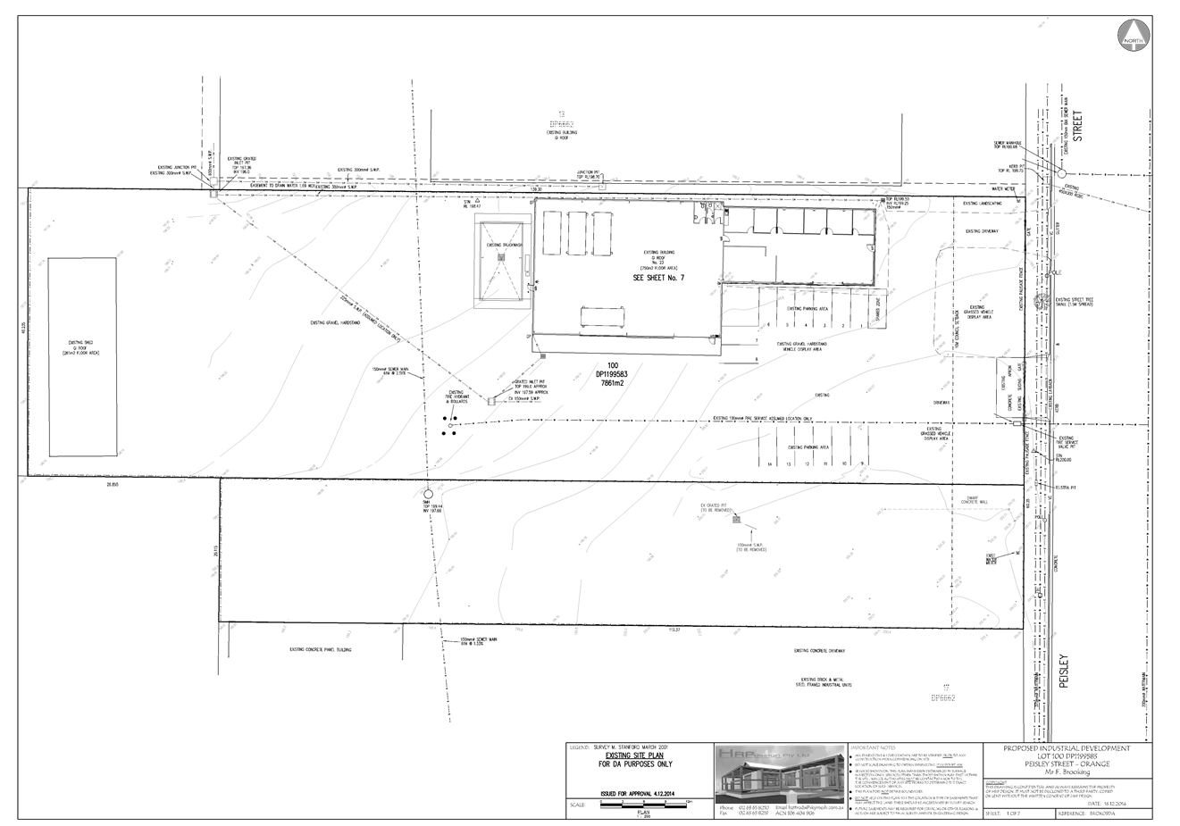
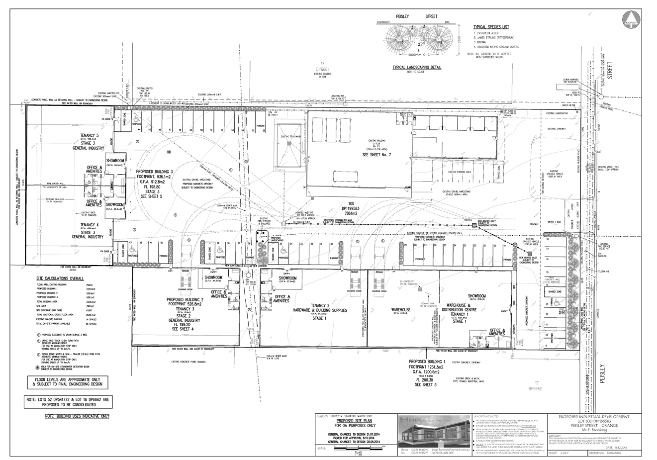
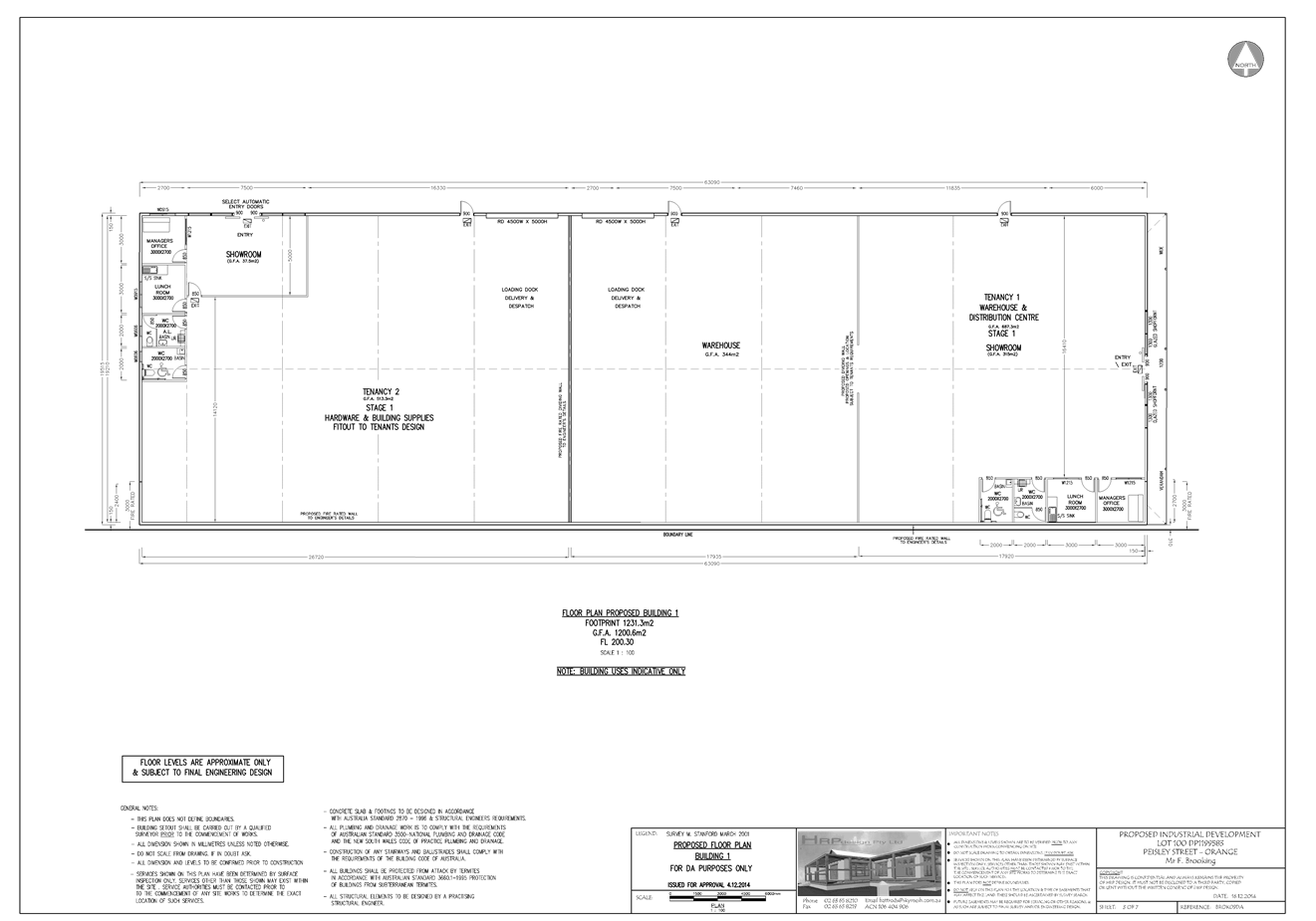
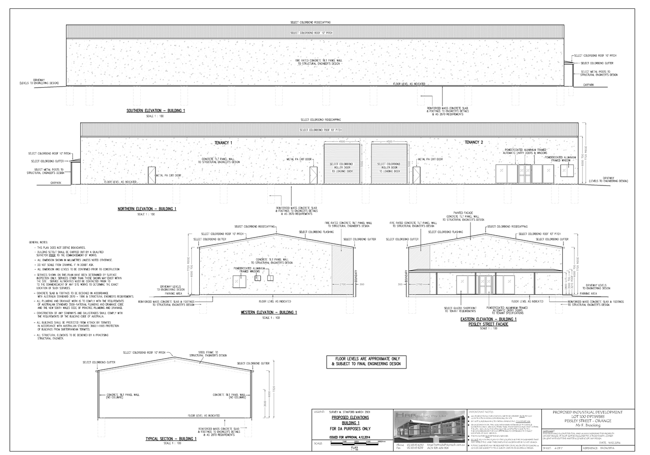
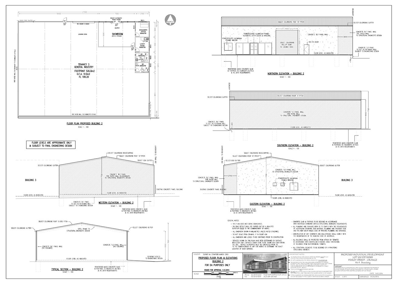
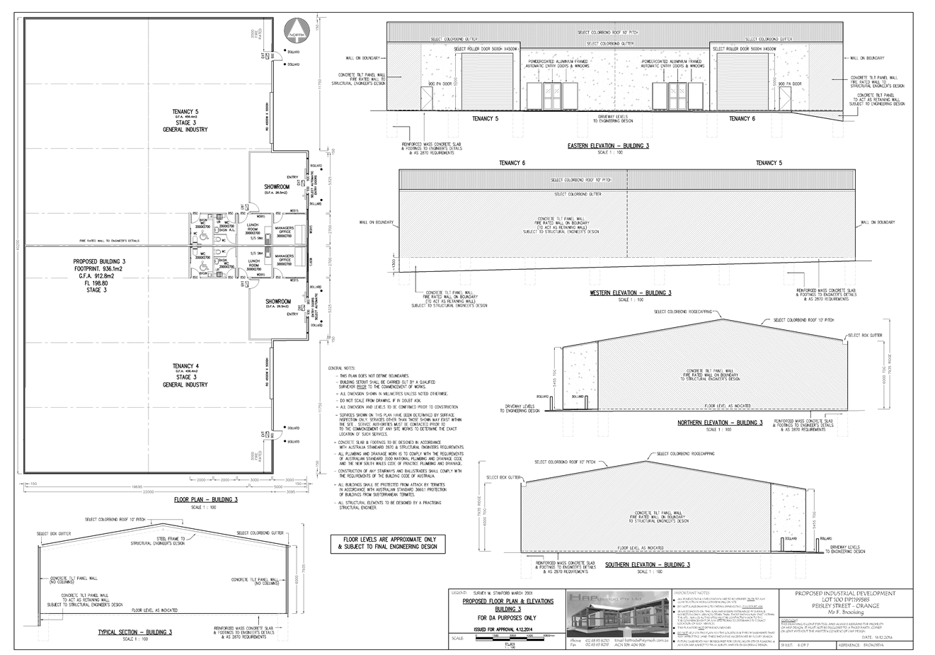
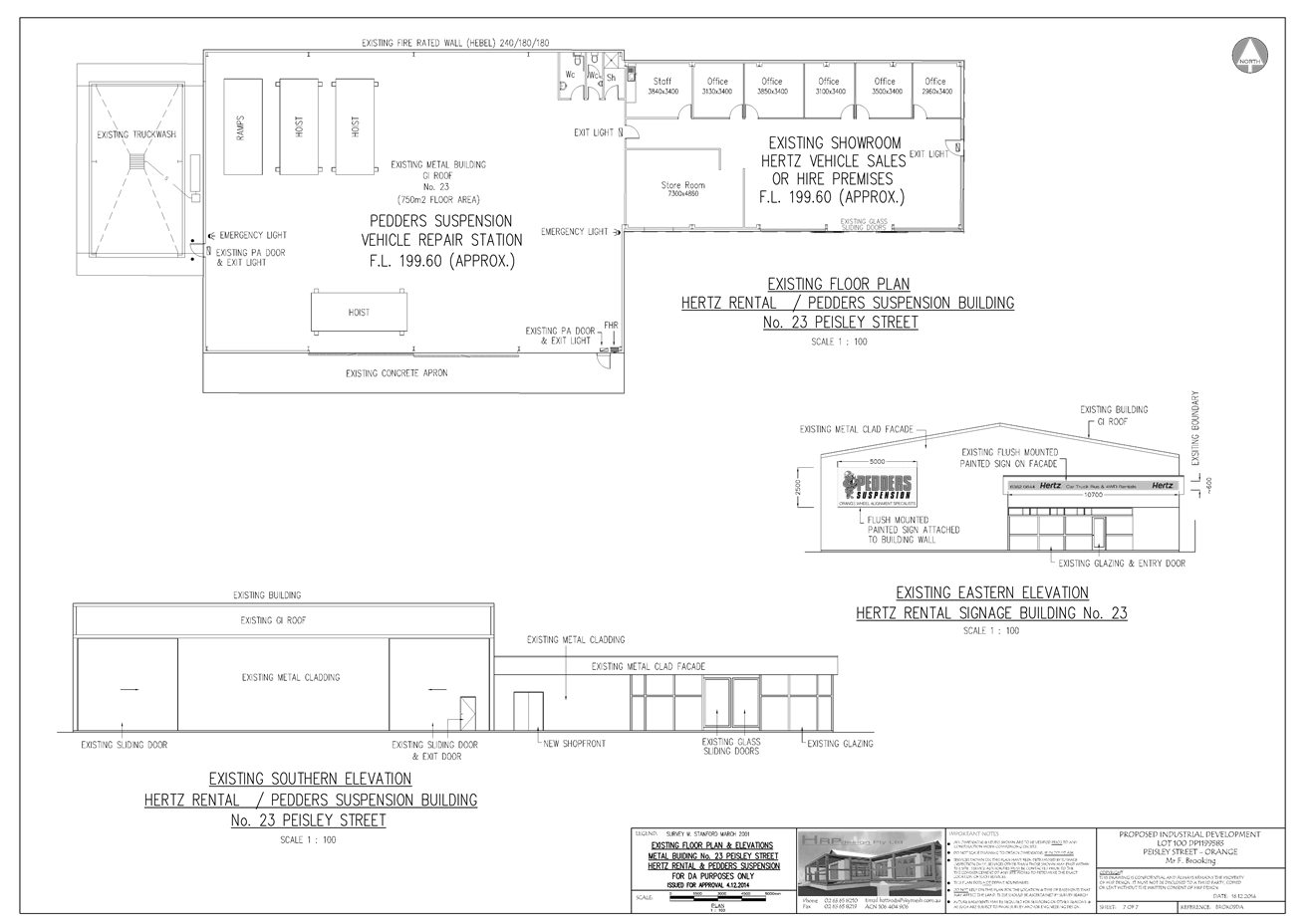
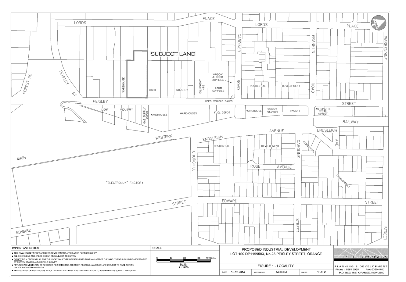
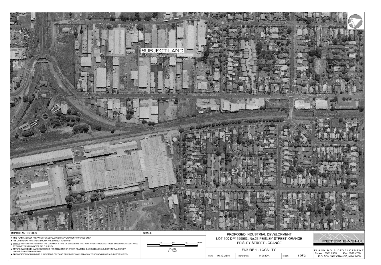
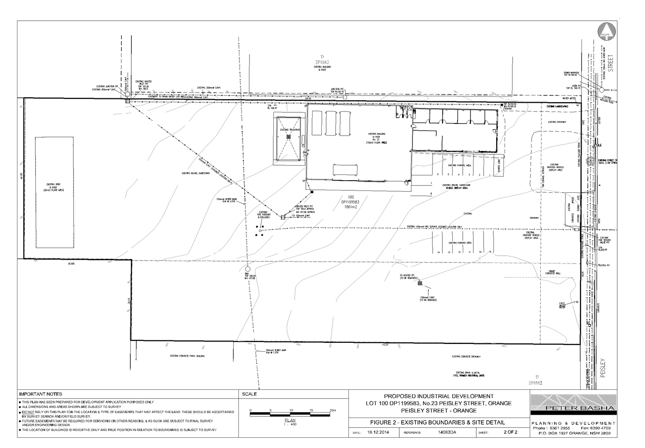
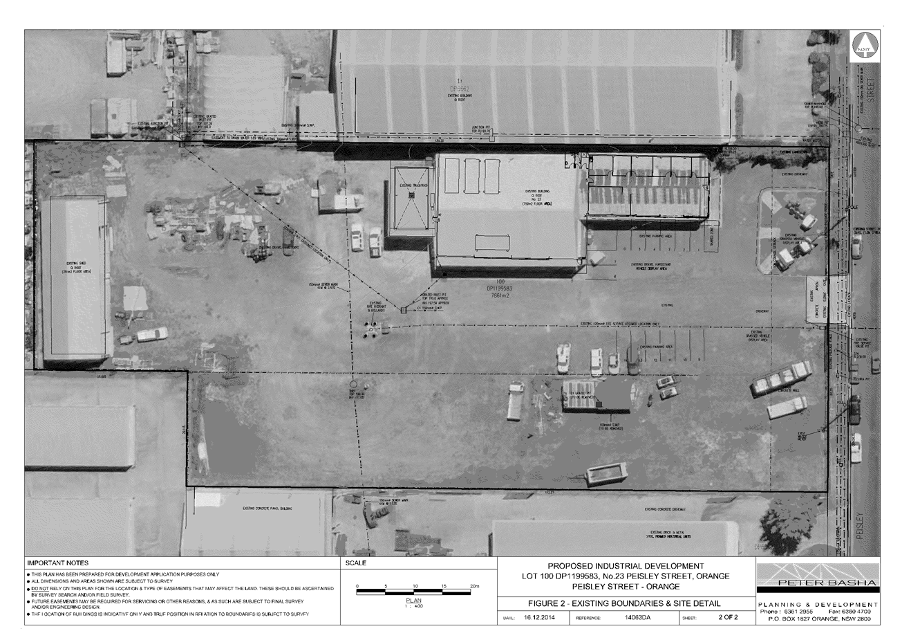
2.5 Development
Application DA 369/2014(1) - 2 Japonica Place
TRIM
REFERENCE: 2015/398
AUTHOR: Kelly
Walker, Town Planner
EXECUTIVE Summary
Council's consent is sought for the construction of a dual
occupancy on the vacant site at Lot 187 DP 1201168, known as 2 Japonica
Place, Orange. The single storey dwellings will contain two-three bedrooms, two
bathrooms, open plan living, kitchen and dining areas, a separate living room
and attached double garage.
The proposal also involves a two lot Torrens subdivision of
the land. The proposed lots are defined as "Cottage Lots" (350-500m2)
under Orange Development Control Plan (DCP) 2004. Proposed Lot 1 will
have primary frontage and access off Japonica Place and secondary frontage to
Botanic Way. Proposed Lot 2 will have frontage and access to Botanic Way.
The following assessment raises concerns in relation to
adverse daylighting and overshadowing impacts. The slope of the site and the
alteration to the existing levels to create building pads for each dwelling
results in Dwelling 2 being 1.53m higher than Dwelling 1. The orientation
and siting of the dwellings close to one another will result in the principal
living and outdoor areas of Dwelling 1 being ‘boxed in’ without
adequate sunlight.
Also Dwelling 1 has insufficient setback from the street,
and as no eave has been provided along the northern elevation, it has a
discordant design that impacts on the streetscape.
It is noted that the submitted drawings and shadow diagrams
are incorrect in terms of scales and dimensions, and the impacts are greater
than they show. These impacts demonstrate that the proposed dual occupancy is
an over-development for this site. Should Council consider these impacts to be
unacceptable, then Council should refuse the application.
Nevertheless, attached is a draft Notice of Approval which includes a range of
conditions to ensure that the development operates in a responsible manner and
impacts are minimised as far as possible.
Link To Delivery/OPerational Plan
The recommendation in this report relates to the
Delivery/Operational Plan strategy “13.4 Our Environment
– Monitor and enforce regulations relating to City amenity”.
Financial Implications
Nil
Policy and Governance Implications
Nil
|
Recommendation
That Council consents to
development application DA 369/2014(1)
for Dual Occupancy and Subdivision (two lot residential) at Lot 187 DP
1201168 - 2 Japonica Place, Orange, pursuant
to the conditions of consent in the attached Notice of Approval.
|
further considerations
Consideration has been given to the
recommendation’s impact on Council’s service delivery; image and
reputation; political; environmental; health and safety; employees;
stakeholders and project management; and no further implications or risks have
been identified.
SUPPORTING INFORMATION
THE APPLICATION
Council's consent is sought for the construction of two
dwellings as a dual occupancy and a two lot subdivision at Lot 187 DP 1201168 -
2 Japonica Place, Orange, as described in the proposal below.
THE PROPOSAL
The proposal involves
construction of two dwellings as a dual occupancy and a two lot subdivision.
The proposal can be summarised in the following table:
|
STAGE
1
|
STAGE
2
|
|
|
Dual
Occupancy
|
Subdivision
|
|
|
Dwelling
|
Gross Floor Area
|
Description
|
Lot
|
Area
|
|
1
|
160.4m²
|
2 bedroom dwelling
|
1
|
416.6²
|
|
2
|
168.7m²
|
3 bedroom dwelling
|
2
|
388.3²
|
|
|
|
|
|
|
Dwellings
The single storey dwellings will contain two-three bedrooms,
two bathrooms, open plan living, kitchen and dining areas, a separate living
room, and attached double garage. External finishes include brick walls,
Colorbond roof sheeting, aluminium windows and panel lift garage doors.
Landscaping will be provided to the street frontages, and Colorbond and timber
paling fencing will be used.
Torrens Subdivision
The applicant is proposing a two lot Torrens subdivision
"Cottage Lots" (350-500m2). Proposed Lot 1 will have
primary frontage and access off Japonica Place and secondary frontage to
Botanic Way. Proposed Lot 2 will have frontage and access to Botanic Way.
MATTERS FOR CONSIDERATION
Section 5A Assessment
In the administration of sections 78A, 79B, 79C, 111 and
112, the provisions of Section 5A must be taken into account for every
development application, in deciding whether there is likely to be a
significant effect on threatened species, populations or ecological communities
or their habitats. This section includes a requirement to consider any adopted
assessment guidelines, which means assessment guidelines issued and in force
under section 94A of the Threatened Species Conservation Act 1995.
Assessment guidelines are in force (see DECC-W “Threatened Species
Assessment Guidelines - The Assessment of Significance”) which requires
consent authority to adopt the precautionary principle in its assessment.
In this instance, site inspection reveals that the subject
property has no biodiversity or habitat value.
Section 79C
Section 79C of the Environmental Planning and Assessment
Act 1979 requires Council to consider various matters, of which those
pertaining to the application are listed below.
PROVISIONS OF ANY ENVIRONMENTAL
PLANNING INSTRUMENT s79C(1)(a)(i)
Orange Local Environmental Plan 2011
Part 1 - Preliminary
Clause 1.2 - Aims of Plan
The
broad aims of the LEP are set out under subclause 2. Those relevant to the
application are as follows:
(a) to encourage development which complements
and enhances the unique character of Orange as a major regional centre boasting
a diverse economy and offering an attractive regional lifestyle,
(b) to provide for a range of development
opportunities that contribute to the social, economic and environmental
resources of Orange in a way that allows present and future generations to meet
their needs by implementing the principles for ecologically sustainable
development,
(e) to provide a range of housing choices in
planned urban and rural locations to meet population growth,
The application is considered to be consistent with the
relevant aims of the LEP 2011.
Clause 1.6 - Consent Authority
This clause establishes that, subject to the Act, Council is
the consent authority for applications made under the LEP.
Clause 1.9A - Suspension of
Covenants, Agreements and Instruments
This clause provides that covenants, agreements and other
instruments which seek to restrict the carrying out of development do not apply
with the following exceptions:
· covenants imposed
or required by Council
· prescribed
instruments under Section 183A of the Crown Lands Act 1989
· any conservation
agreement under the National Parks and Wildlife Act 1974
· any trust
agreement under the Nature Conservation Trust Act 2001
· any property
vegetation plan under the Native Vegetation Act 2003
· any biobanking
agreement under Part 7A of the Threatened Species Conservation Act 1995
· any planning
agreement under Division 6 of Part 4 of the Environmental Planning and
Assessment Act 1979.
The subject land contains easements in the form of sewer
drains; however, the proposed development will not affect the continued
operation of those easements. Council staff are not aware of the title of the
subject property being affected by any of the other restrictions above.
Mapping
The subject site is identified
on the LEP maps in the following manner:
|
Land Zoning Map:
|
Land zoned R1 General Residential
|
|
Lot Size Map:
|
No Minimum Lot Size
|
|
Heritage Map:
|
Not a heritage item or conservation
area
|
|
Height of Buildings Map:
|
No building height limit
|
|
Floor Space Ratio Map:
|
No floor space limit
|
|
Terrestrial Biodiversity Map:
|
No biodiversity sensitivity on the
site
|
|
Groundwater Vulnerability Map:
|
Ground water vulnerable
|
|
Drinking Water Catchment Map:
|
Not within the drinking water
catchment
|
|
Watercourse Map:
|
Not within or affecting a defined
watercourse
|
|
Urban Release Area Map:
|
Not within an urban release area
|
|
Obstacle Limitation Surface Map:
|
No restriction on building siting
or construction
|
|
Additional Permitted Uses Map:
|
No additional permitted use applies
|
Those matters that are of
relevance are addressed in detail in the body of this report.
Part 2 - Permitted or Prohibited Development
Land
Use Zones
The subject site is located within the R1 General
Residential zone. The proposed development is defined as a dual occupancy and
subdivision under OLEP 2011. A dual occupancy (detached) means:
two detached dwellings on one
lot of land, but does not include a secondary dwelling.
Pursuant to section 4B of the
Environmental Planning and Assessment Act subdivision of land means:
the division of land into two
or more parts that, after the division, would be obviously adapted for separate
occupation, use or disposition.
Dual occupancies and subdivision
are permissible in the R1 General Residential zone with the consent of Council.
This application is seeking consent.
Clause
2.3 of LEP 2011 references the Objectives
for each zone in LEP 2011. The objectives for land zoned R1 General
Residential are as follows:
· To
provide for the housing needs of the community.
· To
provide for a variety of housing types and densities.
· To
enable other land uses that provide facilities or services to meet the day to
day needs of residents.
· To
ensure development is ordered in such a way as to maximise public transport
patronage and encourage walking and cycling in close proximity to settlement.
· To
ensure that development along the Southern Link Road has an alternative access.
The proposed development would act to provide additional
housing stock and variation in housing types and density within the City. The
subject site is within close proximity to routes used by public transport and
is also in close proximity to shops and services. The proposed development is
consistent with the objectives of the zone.
Clause 2.6 - Subdivision -
Consent Requirements
Application has been made for the subdivision of the subject
land. Clause 2.6 of OLEP 2011 permits the subdivision of the subject land
only with development consent.
Part 4 - Principal Development Standards
Clause 4.1B - Minimum Lot
Sizes for Dual Occupancy, Multi Dwelling Housing and Residential Flat Buildings
This clause establishes the
minimum lot size required for dual occupancies and multi dwelling housing in
the R1, R2 and R3 zones. The proposed dual occupancy is situated on land within
the R1 General Residential zone, and this clause requires the site to have a
minimum area of 800m2.
The subject land is 804.9m2
and therefore consistent with this clause.
Part 7 - Additional Local Provisions
7.1
- Earthworks
This
clause establishes a range of matters that must be considered prior to granting
development consent for any application involving earthworks, such as:
(a) the likely disruption of, or any
detrimental effect on, existing drainage patterns and soil stability in the
locality of the development
(b) the effect of the development on the
likely future use or redevelopment of the land
(c) the quality of the fill or the soil to be
excavated, or both
(d) the effect of the development on the
existing and likely amenity of adjoining properties
(e) the source of any fill material and the
destination of any excavated material
(f) the likelihood of disturbing relics
(g) the proximity to and potential for adverse
impacts on any waterway, drinking water catchment or environmentally sensitive
area
(h) any measures proposed to minimise or
mitigate the impacts referred to in paragraph (g).
The earthworks proposed in the
application are limited to the extent of cutting and filling required for the
dwellings. The extent of disruption to the drainage of the site is considered
to be relatively minor and will not detrimentally affect adjoining properties
or receiving waterways.
The extent of the earthworks
will not materially affect the potential future use or redevelopment of the
site that may occur at the end of the proposed development's lifespan. The site
is not in proximity to any waterway, drinking water catchment or sensitive
area. Conditions may be imposed to require a sediment control plan, including
silt traps and other protective measures, to ensure that loose dirt and
sediment does not escape the site boundaries.
The site is not known to be
contaminated, nor is the site known to contain any Aboriginal, European or
archaeological relics. Previous known uses of the site do not suggest that any
relics are likely to be uncovered.
The earthworks can be
appropriately supported onsite, however the change in levels and resulting
finished floor levels of dwellings is considered to impact on the visual
amenity and overshadowing of adjoining properties. This issue is addressed in
detail in Development Control Plan 2004 Part 7 - Design Elements for
Residential Development.
7.3 - Stormwater Management
This clause applies to all
industrial, commercial and residential zones and requires that Council be
satisfied that the proposal:
(a) is designed to maximise the use of water
permeable surfaces on the land having regard to the soil characteristics
affecting onsite infiltration of water
(b) includes, where practical, onsite
stormwater retention for use as an alternative supply to mains water,
groundwater or river water; and
(c) avoids any significant impacts of
stormwater runoff on adjoining downstream properties, native bushland and
receiving waters, or if that impact cannot be reasonably avoided, minimises and
mitigates the impact.
The
proposal has been designed to include permeable surfaces and will be connected
to the existing stormwater mains. It is therefore considered that the post
development runoff levels will be acceptable.
7.6 - Groundwater Vulnerability
This
clause seeks to protect hydrological functions of groundwater systems and
protect resources from both depletion and contamination. Orange has a high
water table and large areas of the LGA, including the subject site, are
identified with “Groundwater Vulnerability” on the Groundwater
Vulnerability Map. This requires that Council consider:
(a) whether or not the development (including
any onsite storage or disposal of solid or liquid waste and chemicals) is
likely to cause any groundwater contamination or have any adverse effect on
groundwater dependent ecosystems, and
(b) the cumulative impact (including the
impact on nearby groundwater extraction for potable water supply or stock water
supply) of the development and any other existing development on groundwater.
Furthermore consent may not be
granted unless Council is satisfied that:
(a) the development is designed, sited and
will be managed to avoid any significant adverse environmental impact, or
(b) if that impact cannot be reasonably
avoided - the development is designed, sited and will be managed to minimise
that impact,
(c) if that impact cannot be minimised - the
development will be managed to mitigate that impact.
The proposal is not anticipated
to involve the discharge of toxic or noxious substances and is therefore
unlikely to contaminate the groundwater or related ecosystems. The proposal
does not involve extraction of groundwater and will therefore not contribute to
groundwater depletion. The design and siting of the proposal avoids impacts on
groundwater and is therefore considered acceptable.
STATE ENVIRONMENTAL PLANNING
POLICIES
State Environmental Planning Policy (Building Sustainability
Index BASIX) applies to the subject development. The applicant has submitted a
BASIX certificate in support of the development which demonstrates compliance
with the State Government Water and Thermal efficiency targets. The application
is consistent with the SEPP.
PROVISIONS OF ANY DRAFT
ENVIRONMENTAL PLANNING INSTRUMENT THAT HAS BEEN PLACED ON EXHIBITION
s79C(1)(a)(ii)
There are no draft environmental planning instruments that
apply to the subject land or proposed development.
PROVISIONS OF ANY DEVELOPMENT
CONTROL PLAN s79C(1)(a)(iii)
Development Control Plan 2004
Development Control Plan 2004 (“the DCP”)
applies to the subject land (Part 7 - Development in Residential Areas).
An assessment of the proposed development against the relevant Planning
Outcomes will be undertaken below.
Pursuant to Planning Outcome 0.2-1 Interim Planning Outcomes
- Conversion of Zones:
· Throughout this
Plan, any reference to a zone in Orange LEP 2000 is to be taken to be a
reference to the corresponding zone(s) in the zone conversion table.
The corresponding zone to zone 2(a) Urban Residential
(Orange LEP 2000) is zone R1 General Residential (Orange LEP 2011). As
such, Orange DCP 2004-07 - Development in Residential Areas is relevant
to this proposal. The provisions of Part 7 are considered below.
PART 7 - RESIDENTIAL
SUBDIVISION
The DCP sets the following (applicable) Planning Outcomes in
regard to urban residential subdivision.
· Lots are
orientated to optimise energy-efficient principles.
The proposed lots will have a north-west to south-east
orientation. The proposed development complies with the requirements of BASIX
and has a ABSA Building Energy Efficiency Certificate. In particular, living
room windows face north and east for solar access, private open space is
orientated to the north, rooms all have natural light, and landscaping will
have low water demand. That said, the slope of the site and required cut and
fill will result in both dwellings being overshadowed by their boundary
retaining walls and fences, and Dwelling 2 will overshadow Dwelling 1. This is
covered in detail in Part 7 - Design Elements for Residential Development.
· Lots below
500m2 indicate a mandatory side setback to provide for solar access and
privacy.
The proposal involves Torrens
subdivision of the subject land to create the following parcels:
|
Proposed
Lot
|
Site
Area
|
|
1
|
416.6m²
|
|
2
|
388.3m²
|
The proposed lots are defined as
"Cottage Lots" (350-500m2) pursuant to DCP 2004.
Sufficient daylighting cannot be provided to the living rooms and private open
space areas, and a detailed assessment of solar access and privacy for each lot
has been carried out below under the heading Part 7 - Design Elements for
Residential Development.
· Lots are fully
serviced and have direct frontage and access to a public road.
The proposed lots will be fully serviced and have direct
frontage and access to Japonica Place or Botanic Way. Council’s Technical
Services Division has raised no objections to the planned development and has
attached relevant conditions in relation to servicing of the site.
· Design
and construction complies with the Orange Development and Subdivision Code.
The subdivision design and construction will be required to
comply with the Orange Development and Subdivision Code. A condition of consent
is required to ensure compliance.
PART 7 - DESIGN ELEMENTS FOR
RESIDENTIAL DEVELOPMENT
The DCP sets out Planning Outcomes in regard to Urban
Residential Development, which are addressed in detail below. It is noted that
submitted plans and diagrams are incorrect in terms of scale and dimensions,
and this matter is discussed in the relevant sections below.
Neighbourhood Character
The DCP sets the following Planning Outcomes in regard to
Neighbourhood Character:
· Site
layout and building design enables the:
- creation of attractive
residential environments with clear character and identity
- use of site features
such as views, aspect, existing vegetation and landmarks
· Buildings
are designed to complement the relevant features and built form that are
identified as part of the desired neighbourhood character.
· The
streetscape is designed to encourage pedestrian access and use.
It is considered that the proposal will be reasonably
consistent with the pattern of development that will characterise the
“Northwest Orange” residential neighbourhood once all of the vacant
blocks are developed, that being contemporary, single storey detached dwellings
at the site frontage. The proposal will provide for a continuation of
residential land use, albeit in a more compact form. Whilst the scale of the
proposed dwellings is slightly smaller than typical residential development in
the Gardens Estate area, they will appropriately relate to recently consented
to dwellings in nearby streets. The proposed landscaping will provide
integration of the dwellings in the developing streetscape and improve the
visual impact of hardstand vehicle areas. The character and identity of the
development are influenced by the building design, which maintains a common
theme and consistent use of materials.
Building Appearance
The DCP sets the following Planning Outcomes in regard to
Building Appearance:
· The building
design, detailing and finishes relate to the desired neighbourhood character,
complement the residential scale of the area, and add visual interest to the
street.
· The frontages
of buildings and their entries face the street.
· Garages and car
parks are sited and designed so that they do not dominate the street frontage.
The external finishes are considered appropriate in this
neighbourhood. The building design and detailing will complement dwellings
recently consented to, and currently being constructed in this locality.
Proposed Dwelling 1 will address Japonica Place, with kitchen, living room and
bedroom windows facing the street, and landscaping in the front garden on both
the Japonica Place and Botanic Way frontages. The attached double garage for
Dwelling 1 will be set back slightly behind the main front dwelling
façade, which is satisfactory. However the northern (side) elevation of
the garage does not have an eave, which results in a design which is discordant
with the dwelling and future neighbouring dwellings.
Proposed Dwelling 2 will address Botanic Way, with living
room and bedroom windows facing the street, and landscaping in the front
garden. The attached double garage for Dwelling 2 will not be set back
behind the main front dwelling façade, which is contrary to
DCP requirements. However, when both dwellings are viewed in context of
one another and the curve of the street is taken into account, the garage of
Dwelling 2 is set behind the side building line of Dwelling 1 and in line
with the stepping design of the front building line of Dwelling 2. Both
garages will comprise less than 50% of the dwellings’ frontages, in
compliance with the DCP requirements.
Setbacks
The DCP sets the following Planning Outcomes in regard to
Setbacks:
· Street setbacks
contribute to the desired neighbourhood character, assist with the integration
of new development and make efficient use of the site.
· Street setbacks
create an appropriate scale for the street considering all other streetscape
components.
The dimensions of the setbacks shown on the submitted plans
are incorrect, and the plans were not submitted printed to scale. When measured
off the scaled drawings, proposed Dwelling 1 will have a front setback
from Japonica Place of 4.1m from the front porch, and 4.4m to the main
frontage, with the attached garage set back 5.4m. The DCP guidelines
specify a minimum setback of 4.5m for new dwellings, and once all the dwellings
in the street are completed, Dwelling 1 will be closer to the street, and
as such will have adverse visual impacts on the streetscape and neighbourhood
character. The secondary setbacks to Botanic Way are considered
satisfactory.
Proposed Dwelling 2 will have a front setback of 5.2m from
the front porch and 4.95m to the closest point on the front façade. As
established above, the garage is forward of the building line with a setback
of 5.6m. The proposed front setbacks are considered satisfactory for
Dwelling 2.
It is considered that the development is inconsistent with
the planning outcomes for setbacks, and a condition of consent is attached
which requires an amended design with Dwelling 1 set back at least 4.5m to
comply with the development standards.
Fences and Walls
The DCP sets the following Planning Outcome in regard to
fences and walls:
· Front fences
and walls:
– assist
in highlighting entrances and creating a sense of identity within the
streetscape.
– are
constructed of materials compatible with associated housing and with fences
visible from the site that positively contribute to the streetscape
– provide
for facilities in the street frontage area such as mail boxes.
The applicant is proposing retaining walls around each of
the dwellings and fences of 1.8m. No detail has been given as to exact
location of these fences, but it is assumed that fences of this height are not
proposed at the frontages, as fences set forward of the front building line
will be inconsistent with DCP guidelines. A condition of consent is required to
ensure no fences are placed forward of the building lines.
Visual Bulk
The DCP sets the following Planning Outcome in regard to
Visual Bulk:
· Built form
accords with the desired neighbourhood character of the area with:
- side and rear setbacks
progressively increased to reduce bulk and overshadowing
- site coverage that retains
the relatively low density landscaped character of residential areas
- building form and siting
that relates to landform, with minimal land shaping (cut and fill)
- building height at the
street frontage that maintains a comparable scale with the predominant adjacent
development form
- building to the boundary
where appropriate.
The proposed dual occupancy will be single storey, which is
consistent with the emerging development form of residential development in the
locality. The total site area is 804.9m2, with a total building
area footprint of 362.6m2; which gives a site coverage of 45%. This
complies with the 50% maximum site coverage requirement in the DCP. However,
the site slopes 4m from north to south and will require cut and fill and
retaining walls surrounding Dwelling 1 to achieve the building platforms
required for the slab design of the dwellings. This slope, coupled with the
orientation of the site and dwellings, will result in the floor level of
Dwelling 2 being 1.53m higher than the floor level of Dwelling 1.
The DCP requires dwellings to be contained
within the prescribed envelopes generated by planes projected at 45o
over the site commencing 2.5m above existing ground level from each side and
rear boundary. The development will not be contained within these planes
as Dwelling 2 is located too near the western and northern boundaries. The
applicant justifies this encroachment by stating that it will not have an
impact as it is only the eaves and gutters that do not comply. When taking into
account the alteration to existing site levels and the resulting difference in
floor levels between the dwellings, it is considered that this non-compliance
will create adverse visual dominance impacts to dwelling 1.
The planning outcome requires that side setbacks are
progressively increased to reduce bulk and overshadowing. However, the entire
length of the side elevation of Dwelling 2 is set very close to the
boundary with Dwelling 1, and with a much higher ground and floor level. It is
considered that the building form and siting of the dwellings do not relate to
the landform of the site, and that more than minor cut and fill is required to
obtain the building pads for each dwelling. Furthermore, the retaining
walls and fences will also create adverse visual bulk and overshadowing
impacts, which are discussed in more detail in Walls and Boundaries and Daylight
and Sunlight below.
This issue was discussed with Council’s Development
Engineers as to whether floor levels and ground level could be amended; that
is, to reduce the difference in levels between the dwellings to achieve
compliance and reduce the adverse impacts. However, the proposed levels for
Dwelling 2 achieve natural drainage to the street, and if this dwelling was to
be lowered an interlot drain would need to be provided on the lot with a 2m
easement running through Lot 1.
This would require a complete redesign of Lot 1, including
setting Dwelling 1 away from its northern boundary and a revised layout
and footprint of the dwelling to comply with front and side setbacks whilst
maintaining sufficient private outdoor space and landscaping to the frontage.
In its current form, the proposed dual occupancy is considered to be an
overdevelopment of the site.
Walls and Boundaries
The DCP sets the following Planning Outcome in regard to
Walls and Boundaries:
· Building to the
boundary is undertaken to provide for efficient use of the site taking into
account:
- the privacy of neighbouring
dwellings and private open space
- the access to daylight
reaching adjoining properties
- the impact of boundary walls
on neighbours.
The retaining wall on the boundary between Dwellings 1 and 2
is between 0.9 and 1.1m in height and will have a 1.8m Colorbond fence sitting
on top of it, giving a total height of between 2.7 and 2.9m. When considering
the visual bulk envelope being 2.5m projecting 45o,
the fence being up to 2.9m in height on the boundary represents a significant
encroachment on Dwelling 1. This high fence will be the outlook from the living
room windows and private open space areas of Dwelling 1, creating a
‘boxed in’ feeling, which is not considered acceptable. Dwelling 2
will also have a poor outlook of its own fence on top of a retaining wall.
Dwelling 2 will sit higher than the neighbouring site to the north, however due
to the site orientation, it is unlikely to impact upon the future neighbouring
dwelling.
It is considered that the proposed dual occupancy is
inconsistent with the planning outcomes for walls and boundaries, and will
create visual bulk and overshadowing impacts to both dwellings. The suggestion
earlier to alter levels would minimise the impacts to Dwelling 1, but would be
unlikely to improve the outlook for Dwelling 2 due to the slope of the
land.
Daylight and Sunlight
The DCP sets the following Planning Outcome in regard to
Daylight and Sunlight:
· Buildings are
sited and designed to ensure:
- daylight to habitable rooms
in adjacent dwellings is not significantly reduced
- overshadowing of
neighbouring secluded open spaces or main living area windows is not
significantly increased
- consideration of
Council’s Energy Efficiency Code.
Overshadowing of Dwellings
According to the DCP Guidelines and Council’s Energy
Efficiency Code, sunlight to at least 75% of north-facing living area
windows within the development and on adjoining land is to be provided for a
minimum of four hours on 21 June; or not further reduced than existing where
already less.
The applicant has submitted shadow diagrams, however they do
not demonstrate whether the development will comply with the above planning
outcome. Based on the slope of the site, and the orientation and layout of the
dwellings, Dwelling 1 is unlikely to receive much sunlight, and Dwelling 2 will
only receive some midday sunlight to its living room windows.
Overshadowing of Private Open
Space
In order to provide open space that the occupant can use and
enjoy, the DCP requires sunlight to be available to at least 40% of the main
area of open space for both dwellings within the development and on
neighbouring properties for at least three hours between 9am and 3pm.
The submitted shadowing diagrams are inaccurate as they do not allow for the
change in slope, ridgelines of the dwellings, and retaining walls and boundary
fences, therefore they do not provide the correct shadow lengths. This is
magnified by scale errors on the drawings. Dwelling 1 will not
comply with the guidelines, and compliance for Dwelling 2 is unlikely.
As a result of not being able to comply with the guidelines
for daylight and sunlight to living areas and private open space areas, there
will be significant overshadowing impacts to both dwellings, particularly for
Dwelling 1 which will be ‘boxed in’ as discussed previously in this
report. While alteration of levels would help to provide more sunlight and
daylight to Dwelling 1, it would be unlikely to improve light levels for
Dwelling 2.
Views
The DCP sets the following Planning Outcomes in regard to
Views:
· Building form
and design allow for residents from adjacent properties to share prominent
views where possible.
· Views including
vistas of heritage items or landmarks are not substantially affected by the
bulk and scale of the new development.
The subject site is not within an important view corridor,
however it does have views toward Mount Canobolas to the southwest. Due to the
slope of the land and the siting of the dwellings, these views will be shared
with each dwelling and with other dwellings.
Visual Privacy
The DCP sets the following Planning Outcome in regard to
Visual Privacy:
· Direct
overlooking of principal living areas and private open spaces of other
dwellings is minimised firstly by:
- building siting and layout
- location of windows and
balconies
and secondly by:
- design of windows or use of
screening devices and landscaping.
Due to the slope of the land and the proposed cut and fill
to facilitate the dwellings on level sites, there is the potential for visual
privacy impacts between Dwelling 1 and Dwelling 2. It is
considered that perimeter fencing will assist in minimising privacy impacts
between the dwellings.
Acoustic Privacy
The DCP sets the following Planning Outcome in regard to
Acoustic Privacy:
· Site layout and
building design:
- protect habitable rooms from
excessively high levels of external noise
- minimise the entry of
external noise to private open space for dwellings close to major noise sources
- minimise transmission of
sound through a building to affect other dwellings.
In consideration of the DCP Guidelines the proposal is
considered to be satisfactory. The site is located in an area where ambient
noise levels are expected to be low due to the predominant residential land use
pattern. The dwellings are detached, thus limiting the potential for sound
penetration between them.
It is noted that the site adjoins Hill Street, which is a
major connector road that links the established urban area to the south with
the developing area in the Waratah precinct. The Council reserve between Hill
Street and the site will create some separation to Dwelling 2, and the
boundary fencing will help to reduce noise levels to its bedrooms. As discussed
with Council’s Manager Building and Environment, this is considered
acceptable.
Security
The DCP sets the following Planning Outcomes in regard to
Security:
· The site layout
enhances personal safety and minimises the potential for crime, vandalism and
fear.
· The design of
dwellings enables residents to survey streets, communal areas and approaches to
dwelling entrances.
The siting and design of both dwellings are
appropriate to maintain safety and minimise the potential for crime, vandalism
and fear for residents. Habitable room windows will address public roads,
thereby providing opportunities for natural surveillance. The proposed
landscaping and fencing will not restrict sightlines, will provide territorial
reinforcement and delineate public and private spaces. Internal access to the
dwellings will be available through the garages.
Circulation and Design
The DCP sets the following Planning Outcome in regard to
Circulation and Design:
· Accessways and
parking areas are designed to manage stormwater.
· Accessways,
driveways and open parking areas are suitably landscaped to enhance amenity
while providing security and accessibility to residents and visitors.
· The site layout
allows people with a disability to travel to and within the site between car
parks, buildings and communal open space.
Dwellings 1 and 2 have direct street frontages to Japonica
Place and Botanic Way respectively. Separate access will be provided to the
proposed lots via vehicle crossings and driveways. The proposed driveways are
well separated from the intersections of Japonica Place, Botanic Way and Hill
Street. Reverse egress will be required for both dwellings, consistent with
vehicle manoeuvring arrangements for single dwellings throughout the City.
Car Parking
The DCP sets the following Planning Outcomes in regard to
Car Parking:
· Parking
facilities are provided, designed and located to:
- enable the efficient and
convenient use of car spaces and accessways within the site
- reduce the visual dominance
of car parking areas and accessways.
· Car parking is
provided with regard to the:
- the number and size of
proposed dwellings
- requirements of people with
limited mobility or disabilities.
In consideration of the DCP Guidelines, the proposal is
considered to be satisfactory. According to the car parking table in the DCP,
the development generates a parking requirement of 2.7 off-street spaces (based
on 1.2 spaces for each two bedroom dwelling and 1.5 spaces for each three
bedroom dwelling).
The submitted plans show provision for eight off-street
parking spaces in the form of an attached double garage for each dwelling and
two tandem spaces in front of the garage of each dwelling.
Private Open Space
The DCP sets the following Planning Outcomes in regard to
Private Open Space:
· Private open
space is clearly defined for private use.
· Private open
space areas are of a size, shape and slope to suit the reasonable requirements
of residents including some outdoor recreational needs and service functions.
· Private open
space is:
– capable
of being an extension of the dwelling for outdoor living, entertainment and
recreation
– accessible
from a living area of the dwelling
– located
to take advantage of outlooks; and to reduce adverse impacts of overshadowing
or privacy from adjoining buildings
– Orientated
to optimise year round use.
The following table
demonstrates that each of the proposed dwellings is provided with open space
that complies with the minimum requirement in terms of area.
|
Dwelling
|
Living Area
(excluding garage, porches, etc)
|
Private Open
Space Required by DCP
|
Private
Open Space Provided
|
Compliance
|
|
1
|
123.69m²
|
61.8m²
|
64.6m²
|
yes
|
|
2
|
135.01m²
|
67.5m²
|
66.5m²
|
yes
|
All private open space is provided
behind the front building line. The site plan confirms that the private open
space for each residential unit will have a minimum dimension of 3m and
the yards are able to provide an area of at least 5m x 5m orientated to the
north, consistent with the requirements of the DCP. The
internal living area for each dwelling will connect to its respective area of
private open space via glass sliding doors. However, as noted previously in
this report, there will be significant overshadowing impacts to the private
open space area of Dwelling 1, and overshadowing impacts to the private open
space area of Dwelling 2 are likely. The slope, required cut and fill and
boundary retaining walls and fences will result in a poor outlook for both
dwellings, particularly Dwelling 1.
Open Space
and Landscaping
The DCP sets the following Planning Outcomes in regard to
Open Space and Landscaping:
· The site layout
provides open space and landscaped areas which:
– contribute
to the character of the development by providing buildings in a landscaped
setting
– provide
for a range of uses and activities including stormwater management
– allow
cost effective management.
· The landscape
design specifies landscape themes consistent with the desired neighbourhood
character; vegetation types and location, paving and lighting provided for
access and security.
· Major existing
trees are retained and protected in a viable condition whenever practicable
through appropriate siting of buildings, accessways and parking areas.
· Paving is
applied sparingly and integrated in the landscape design.
An acceptable landscape plan has been submitted in support
of the proposal, which includes plant species that will provide integration of
the dwellings and driveways within the site. The proposed landscaping will
include species that are considered to be suitable to the Orange area, in
particular native shrubs and groundcovers, as well as hedging and trees.
Stormwater
The DCP sets the following Planning Outcomes in regard to
Stormwater:
· On-site
drainage systems are designed to consider:
– downstream
capacity and need for on-site retention, detention and re-use
– scope
for on-site infiltration of water
– safety
and convenience of pedestrians and vehicles
– overland
flow paths.
· Provision is
made for on-site drainage which does not cause damage or nuisance flows to
adjoining properties.
Relevant conditions of consent are attached to the notice in
relation to stormwater management of the site.
Erosion and Sedimentation
The DCP sets the following Planning Outcome in regard to
Erosion and Sedimentation:
· Measures
implemented during construction to ensure that the landform is stabilised and
erosion is controlled.
Cut and fill is proposed on the site, and as such an erosion
and sediment control plan will be required to be prepared as part of the
engineering design plans for the development. Attached is a condition of
consent addressing this issue.
DEVELOPMENT CONTRIBUTIONS PLAN
2012
Section 94 Development Contributions
The development has been assessed pursuant to Orange
Development Contributions Plan 2012. The following table itemises the
contributions payable for the proposed development. The development includes a
new three bedroom dwelling and new two bedroom dwelling, and the lot has a
credit for one three bedroom dwelling. As such the contribution is calculated
on the basis of one new two-bed dwelling.
It is noted that Dwelling 1 contains a media room that has
the potential to be converted into a bedroom. If this room were to be used as a
bedroom, it would generate additional contributions. A condition has been
placed on the consent prohibiting the use of the media room as a bedroom
without modification of this consent.
The payment of $10,463.39 is to
be made to Council in accordance with section 94 of the Act and the Orange
Development Contributions Plan 2012 (North West Orange Urban Release Area)
towards the provision of the following public facilities:
|
Open Space and Recreation
|
@ $2,693.71 x 1 additional 2 bed dwelling
|
2,693.71
|
|
Community and Cultural
|
@ $459.50 x 1 additional 2 bed dwelling
|
459.50
|
|
Roads and Cycleways
|
@ $3,329.11 x 1 additional 2 bed dwelling
|
3,329.11
|
|
Stormwater Drainage
|
@ $257.90 x 1 additional 2 bed dwelling
|
257.90
|
|
Local Area Facilities
|
@ $3,418.42 x 1 additional 2 bed dwelling
|
3,418.42
|
|
Plan Preparation and Administration
|
@ $304.75 x 1 additional 2 bed dwelling
|
304.75
|
|
TOTAL:
|
|
$10,463.39
|
The contribution will be indexed
quarterly in accordance with the Orange Development Contributions Plan 2012
(North West Orange Urban Release Area).
Section 64 Water and Sewer
Headworks Charges
Section 64 water and sewer headwork charges are also
applicable to the proposal. Such charges are calculated at the time of release
of a Construction Certificate for the proposed dual occupancy development.
Attached are draft conditions requiring the payment of the required
contributions prior to the issue of a Construction Certificate.
PROVISIONS PRESCRIBED BY THE
REGULATIONS s79C(1)(a)(iv)
The development is not inconsistent with the provisions
prescribed by the regulations.
THE LIKELY IMPACTS OF THE
DEVELOPMENT s79C(1)(b)
Neighbourhood Amenity
The proposed development will provide for a continuation of
residential landuse, albeit in a more compact form, and will complement the
function of the neighbourhood. The lack of eaves on the northern elevation of
Dwelling 1, as well as its lack of setback from the street, will create a
discordant design, which will have adverse impacts on the streetscape and
neighbourhood amenity. A condition of consent is required to ensure that front
setbacks comply for Dwelling 1 so to retain a reasonable standard of
residential amenity in terms of building appearance and neighbourhood
character.
Visual Impacts
It its current form, the proposed dual occupancy will have
adverse visual impacts on the streetscape. In particular, Dwelling 1 is set too
close to the street, not maintaining minimum setbacks, and Dwelling 2 is 1.53m
higher than Dwelling 1, which makes it over dominant and causes poor
outlook, visual bulk and overshadowing impacts. Retaining walls and fences also
cause adverse visual bulk and overshadowing impacts to both dwellings. Furthermore,
the lack of eaves on the northern elevation of Dwelling 1 will impact on
the visual appearance from the street.
It is considered that the condition of consent to ensure
that front setbacks comply for Dwelling 1 will improve visual amenity to the
streetscape. However, most of the visual bulk impacts and the
overshadowing impacts cannot be minimised unless a redesign of the proposal is
undertaken to change the siting of the dwellings, the ground and floor levels,
and drainage arrangements.
Traffic Impacts
The capacity of the road network in the vicinity of the site
is sufficient to accommodate additional localised traffic generated by the
development. As considered above, proposed parking and manoeuvring arrangements
will ensure that vehicles enter and leave the site in a forward direction.
Environmental Impacts
The subject land has been recently subdivided and works have
been undertaken to create a residential site. As a result, significant
vegetation, threatened species or ecological endangered communities or their
habitats are unlikely. The proposed development will not impact upon the
locality in terms of environmental impacts.
Soil Erosion
Provided that adequate measures are implemented during the
construction phase, the proposed development would not generate adverse impacts
in terms of soil erosion. Attached are recommended conditions of consent
addressing this issue.
Cumulative Impacts
The proposal is considered to be unsatisfactory in terms of
cumulative impact. The siting and design of the proposed dwellings, in
particular the lack of setback and lack of eaves on the side elevation of
Dwelling 1, will impact on the streetscape. This is a prominent corner site
where the dwellings will be visible from three streets, and due to the slope of
the site and estate, they will be highly visible from the surrounding area.
THE SUITABILITY OF THE SITE
s79C(1)(c)
Servicing
Council’s Technical Services Division advises that all
utility services are available to the site and adequate for the proposal. The
proposed development will be connected to Council’s sewer, town water and
stormwater reticulations in accordance with normal requirements. Power, telephone
and natural gas services will be connected to the dwellings in accordance with
the requirements of the relevant supply authority. Attached is a condition of
consent addressing this issue.
Physical Attributes
In its current form, the subject site is not considered to
be suitable for the proposed development. In particular, the slope of the site
constrains the development, and the extent of cut and fill required to create
building pads for a dual occupancy results in non‑compliance with
numerous guidelines in the DCP, which in turn causes adverse visual bulk,
outlook and overshadowing impacts for the streetscape, the subject dwellings,
and neighbouring properties.
ANY SUBMISSIONS MADE IN
ACCORDANCE WITH THE ACT s79C(1)(d)
The proposed development is defined as "advertised
development" under the provisions of the LEP. The application was
advertised for the prescribed period of 14 days and at the end of that period
no submissions were received.
PUBLIC INTEREST
s79C(1)(e)
The proposed development is considered to be of minor
interest to the wider public due to the relatively localised nature of
potential impacts. The proposal is not inconsistent with any relevant policy
statements, planning studies, guidelines etc that have not been considered in
this assessment.
SUMMARY
The proposed development is permissible with the consent of
Council. The proposed development complies with the relevant aims, objectives
and provisions of the LEP. A section 79C assessment of the
development indicates that the development is not acceptable in this instance. Should Council find the impacts to the subject dwellings,
neighbouring properties, and the streetscape to be adverse, then Council should
refuse the application.
Attached is a draft Notice of Approval outlining a range of
conditions to ensure that the development proceeds in an acceptable manner, as
well as conditions which attempt to render the development more suitable and
have less of an impact on neighbouring properties and the neighbourhood.
COMMENTS
The requirements of the Environmental Health and Building
Surveyor and the Engineering Development Manager are included in the attached
Notice of Approval.
Attachments
1 Notice
of Approval, D15/4460⇩
2 Plans,
D15/3874⇩
Sustainable Development Committee
3 March 2015
2.5 Development
Application DA 369/2014(1) - 2 Japonica Place
Attachment 1 Notice
of Approval
|

|
ORANGE
CITY COUNCIL
Development
Application No DA
369/2014(1)
NA15/ Container
PR26697
|
NOTICE OF DETERMINATION
OF A DEVELOPMENT
APPLICATION
issued under the Environmental
Planning and Assessment Act 1979
Section 81(1)
|
Development
Application
|
|
|
Applicant Name:
|
Mr I Zhang
|
|
Applicant Address:
|
C/- Peter
Basha Planning & Development
PO Box
1827
ORANGE
NSW 2800
|
|
Owner’s Name:
|
Dinkum
Exporting and Importing Pty Limited
|
|
Land to Be Developed:
|
Lot 187 DP
1201168 - 2 Japonica Place, Orange
|
|
Proposed Development:
|
Dual
Occupancy and Subdivision (two lot residential)
|
|
|
|
|
Building
Code of Australia
building classification:
|
As
determined by Certifier
|
|
|
|
|
Determination
|
|
|
Made On:
|
3 March
2015
|
|
Determination:
|
CONSENT
GRANTED SUBJECT TO CONDITIONS DESCRIBED BELOW:
|
|
|
|
|
Consent to
Operate From:
|
4 March
2015
|
|
Consent to
Lapse On:
|
4 March
2020
|
Terms of Approval
The reasons for the imposition of
conditions are:
(1) To
ensure a quality urban design for the development which complements the
surrounding environment.
(2) To
maintain neighbourhood amenity and character.
(3) To
ensure compliance with relevant statutory requirements.
(4) To
provide adequate public health and safety measures.
(5) Because
the development will require the provision of, or increase the demand for
public amenities and services.
(6) To ensure the utility
services are available to the site and adequate for the development.
(7) To
prevent the proposed development having a detrimental effect on adjoining land
uses.
(8) To
minimise the impact of development on the environment.
Conditions
(1) The
development must be carried out in accordance with:
(a) Plans by Peter Basha,
reference 14067DA, dated 29.10.2014 (4 sheets)
Drawings
by designs@m reference 14-010, drawing numbers DA01-12, dated September 2014
(b) statements
of environmental effects or other similar associated documents that form part
of the approval
as amended
in accordance with any conditions of this consent.
(2) All building work must
be carried out in accordance with the provisions of the Building Code of
Australia.
(3) A sign is to be erected
in a prominent position on any site on which building work, subdivision work or
demolition work is being carried out:
a. showing
the name, address and telephone number of the principal certifying authority
for the work, and
b. showing
the name of the principal contractor (if any) for any building work and a telephone
number on which that person may be contacted outside working hours, and
c. stating
that unauthorised entry to the site is prohibited.
Any such sign is to be maintained while the
building work, subdivision work or demolition work is being carried out.
(4) In the case
of residential building work for which the Home Building Act 1989
requires there to be a contract of insurance in force in accordance with Part 6
of the Act, evidence that such a contract of insurance is in force is to be
provided to the Principal Certifying Authority before any building work
authorised to be carried out by the consent commences.
(5) Residential building
work within the meaning of the Home Building Act 1989 must
not be carried out unless the principal certifying authority for the
development to which the work relates (not being the council) has given the
council written notice of the following information:
a in the
case of work for which a principal contractor is required to be appointed:
1 the name
of the licence number of the principal contractor, and
2 the name
of the insurer by which the work is insured under Part 6 of that Act,
b in the
case of work to be done by an owner-builder:
1 the name
of the owner-builder, and
2 if the
owner-builder is required to hold an owner-builder permit under that Act, the
number of the owner-builder permit.
If arrangements for doing the residential
building work are changed while the work is in progress so that the information
under this condition becomes out of date, further work must not be carried out
unless the principal certifying authority for the development to which the work
relates (not being the council) has given the council written notice of the
updated information.
(6) Where any excavation
work on the site extends below the level of the base of the footings of a
building on adjoining land, the person having the benefit of the development
consent must, at the person’s own expense:
a protect
and support the adjoining premises from possible damage from the excavation, and
b where
necessary, underpin the adjoining premises to prevent any such damage.
Note: This
condition does not apply if the person having the benefit of the development
consent owns the adjoining land or the owner of the adjoining land has given
consent in writing to that condition not applying.
DUAL OCCUPANCY
|
PRIOR TO THE ISSUE OF
A CONSTRUCTION CERTIFICATE
|
(7) Full details of an
amended design in compliance with Development Control Plan development
standards for front setbacks for Dwelling 1 shall be submitted to, and approved
by, Council’s Manager Development Assessments prior to the issuing of a
Construction Certificate. It is noted that submitted drawings were not
printed to scale, and some of the dimensions stated are incorrect, please show
correct details on your amended drawings.
(8) The payment of
$10,463.39 is to be made to Council in accordance with section 94 of the Act
and the Orange Development Contributions Plan 2012 North West Orange Urban
Release area towards the provision of the following public facilities:
|
Open Space and
Recreation
|
@ $2,693.71 x 1
additional 2 bed dwelling
|
2,693.71
|
|
Community and
Cultural
|
@ $459.50 x 1
additional 2 bed dwelling
|
459.50
|
|
Roads and Cycleways
|
@ $3,329.11 x 1
additional 2 bed dwelling
|
3,329.11
|
|
Stormwater Drainage
|
@ $257.90 x 1
additional 2 bed dwelling
|
257.90
|
|
Local Area Facilities
|
@ $3,418.42 x 1
additional 2 bed dwelling
|
3,418.42
|
|
Plan Preparation and
Administration
|
@ $304.75 x 1
additional 2 bed dwelling
|
304.75
|
|
TOTAL:
|
|
$10,463.39
|
The contribution will be indexed quarterly in
accordance with the Orange Development Contributions Plan 2012 (North West
Orange Urban Release Area). This Plan can be inspected at the Orange Civic
Centre, Byng Street, Orange.
(9) Full details of the
location and finishes of retaining walls and fences shall be submitted to, and
approved by, Council’s Manager Development Assessments prior to the
issuing of a Construction Certificate. No fencing is permitted in the
front garden areas, and must be behind the building lines of the dwelling.
(10) A
Construction Certificate application is required to be submitted to, and issued
by, Council/Accredited Certifier prior to any excavation or building works
being carried out on site.
(11) An
approval under Section 68 of the Local Government Act is to be sought from
Orange City Council, as the Water and Sewer Authority, for water, sewer and
stormwater connection. No plumbing and drainage is to commence until approval
is granted.
(12) Engineering plans,
showing details of all proposed work and adhering to any engineering conditions
of development consent, are to be submitted to, and approved by, Orange City
Council or an Accredited Certifier (Categories B1, C3, C4, C6) prior to the
issuing of a Construction Certificate.
(13) A water and soil
erosion control plan is to be submitted to Orange City Council or an Accredited
Certifier (Categories B1, C3, C4, C6) for approval prior to the issuing of a
Construction Certificate. The control plan is to be in accordance with the Orange
City Council Development and Subdivision Code and the Landcom, Managing Urban
Stormwater; Soils and Construction Handbook.
(14) A 150mm-diameter sewer
main is to be constructed from Council’s existing main to serve Dwelling
2. Orange City Council, prior to issuing a Construction Certificate, is to
approve engineering plans for this sewerage system.
(15) Payment of
contributions for water, sewer and drainage works is required to be made
at the contribution rate applicable at the time that the payment is made. The
contributions are based on 2/3 ET for water supply headworks and 2/3 ET for
sewerage headworks. A Certificate of Compliance, from Orange City Council in accordance
with the Water Management Act 2000, will be issued upon payment of the
contributions. This Certificate of Compliance is to be submitted to the
Principal Certifying Authority prior to the issuing of a Construction
Certificate.
(16) All stormwater from
Dwelling 2 is to be collected and piped to the kerb and gutter along the
frontage of Botanic Way. Yard areas for Dwelling 2 shall be shaped to achieve
natural drainage to Botanic Way. The junction pit in the driveway of Dwelling 2
shall be replaced with a heavy duty trafficable lid. Orange City Council or an
Accredited Certifier (Categories B1, C3, C4, C6), prior to the issuing a
Construction Certificate, is to approve engineering plans for this stormwater
system.
|
PRIOR TO WORKS
COMMENCING
|
(17) A
temporary onsite toilet is to be provided and must remain throughout the
project or until an alternative facility meeting Council’s requirements
is available onsite.
(18) The
location and depth of the sewer junction/connection to Council’s sewerage
system is to be determined to ensure adequate fall to the sewer is available.
(19) Soil erosion control
measures shall be implemented on the site.
|
DURING
CONSTRUCTION/SITEWORKS
|
(20) All
construction/demolition work on the site is to be carried out between the hours
of 7.00 am and 6.00 pm Monday to Friday inclusive, 7.00 am to
5.00 pm Saturdays and 8.00 am to 5.00 pm on Sundays and Public
Holidays. Written approval must be obtained from the General Manager of Orange
City Council to vary these hours.
(21) All
materials onsite or being delivered to the site are to be contained within the
site. The requirements of the Protection of the Environment Operations Act
1997 are to be complied with when placing/stockpiling loose material or
when disposing of waste products or during any other activities likely to
pollute drains or watercourses.
(22) Any adjustments to
existing utility services that are made necessary by this development
proceeding are to be at the full cost of the developer.
(23) The
provisions and requirements of the Orange City Council Development and
Subdivision Code are to be applied to this application and all work constructed
within the development is to be in accordance with that Code.
The developer is to be entirely responsible for
the provision of water, sewerage and drainage facilities capable of servicing
the development from Council’s existing infrastructure. The developer is
to be responsible for gaining access over adjoining land for services where
necessary and easements are to be created about all water, sewer and drainage
mains within and outside the lots they serve.
(24) Heavy-duty concrete
kerb and gutter laybacks and footpath crossings are to be constructed for the
entrances to the proposed development. The location and construction of the
laybacks and footpath crossings are to be as required by the Orange City
Council Development and Subdivision Code.
(25) Dual water and sewerage
reticulation is to be provided to each dwelling in accordance with the Orange
City Council Development and Subdivision Code.
(26) All services
are to be contained within the allotment that they serve.
|
PRIOR TO THE ISSUE OF
AN OCCUPATION CERTIFICATE
|
(27) Landscaping
shall be installed in accordance with the approved plans and shall be
permanently maintained to the satisfaction of Council's Manager Development
Assessments.
(28) Fencing
shall be installed in accordance with the approved plans and shall be
permanently maintained to the satisfaction of Council's Manager Development
Assessments.
(29) No
person is to use or occupy the building or alteration that is the subject of
this approval without the prior issuing of an Occupation Certificate.
(30) Where
Orange City Council is not the Principal Certifying Authority, a final
inspection of water connection, sewer and stormwater drainage shall be
undertaken by Orange City Council and a Final Notice of Inspection issued,
prior to the issue of either an interim or a final Occupation Certificate.
(31) Certification from
Orange City Council is required to be submitted to the Principal Certifying
Authority prior to the issue of an Occupation Certificate stating that all
works relating to connection of the development to Council assets, works on
Public Land, stormwater, sewer and water reticulation mains and footpaths have
been carried out in accordance with the Orange City Council Development and
Subdivision Code and the foregoing conditions.
(32) Commitments
listed in each relevant BASIX Certificate relating to the development must be
fulfilled and certified by the installer prior to the issue of an Occupation
Certificate.
(33) Finished
ground levels are to be graded away from the buildings and adjoining properties
and must achieve natural drainage. The concentrated flows are to be dispersed
down slope or collected and discharged to the stormwater drainage system.
(34) Prior to the issuing of
the Occupation Certificate, the media room must be built as shown on the
approved plans, and shall be permanently maintained in that way to the
satisfaction of Councils Manager Development Assessments. Conversion of
rooms into additional bedrooms is not permitted.
(35) All
of the foregoing conditions are to be at the full cost of the developer and to
the requirements and standards of the Orange City Council Development and
Subdivision Code, unless specifically stated otherwise. All work required by
the foregoing conditions is to be completed prior to the issuing of an
Occupation or Subdivision Certificate, unless stated otherwise.
TWO LOT SUBDIVISION
|
DURING
CONSTRUCTION/SITEWORKS
|
(36) Any adjustments to
existing utility services that are made necessary by this development
proceeding are to be at the full cost of the developer.
(37) The
provisions and requirements of the Orange City Council Development and
Subdivision Code are to be applied to this application and all work constructed
within the development is to be in accordance with that Code.
The developer is to be entirely responsible for
the provision of water, sewerage and drainage facilities capable of servicing
all the lots from Council’s existing infrastructure. The developer is to
be responsible for gaining access over adjoining land for services where
necessary and easements are to be created about all water, sewer and drainage
mains within and outside the lots they serve.
|
PRIOR TO THE ISSUE OF
A SUBDIVISION CERTIFICATE
|
(38) Application shall be
made for a Subdivision Certificate under Section 109(C)(1)(d) of the Act.
(39) Prior to the
issuing of the Subdivision Certificate, a Surveyor’s Certificate or
written statement is to be provided to the Principal Certifying Authority,
stating that the buildings within the boundaries of the proposed Lot 1 and 2
comply in respect to the distances of walls from boundaries.
(40) Certification from Essential
Energy, stating that electricity and street lighting systems comply with
Essential Energy’s Networks Division Customer Connection Policy NP11.1,
is to be submitted to the Principal Certifying Authority prior to the issuing
of a Subdivision Certificate.
(41) An easement to drain
sewage and to provide Council access for maintenance of sewerage works a
minimum of 2.0 metres wide is to be created over the proposed sewerage works.
The Principal Certifying Authority is to certify that the easement is in accordance
with the Orange City Council Development and Subdivision Code prior to the
issuing of a Subdivision Certificate.
(42) All services are to be
contained within the allotment that they serve. A Statement of Compliance, from
a Registered Surveyor, is to be submitted to the Principal Certifying Authority
prior to the issuing of a Subdivision Certificate.
(43) All conditions of
development as required by this development consent as it relates to the
erection of the dual occupancy are to be completed prior to the issuing of a
Subdivision Certificate.
(44) All
of the foregoing conditions are to be at the full cost of the developer and to
the requirements and standards of the Orange City Council Development and
Subdivision Code, unless specifically stated otherwise. All work required by
the foregoing conditions is to be completed prior to the issuing of an
Occupation or Subdivision Certificate, unless stated otherwise.
Other Approvals
(1) Local
Government Act 1993 approvals granted under section 68.
Nil
(2) General
terms of other approvals integrated as part of this consent.
Nil
Right of Appeal
If
you are dissatisfied with this decision, section 97 of Environmental
Planning and Assessment Act 1979 gives you the right to appeal to the Land
and Environment Court within 6 months after the date on which you receive this
notice.
*
Section 97 of the Environmental Planning and Assessment Act 1979 does not apply
to the determination of a development application for State significant
development or local designated development that has been the subject of a
Commission of Inquiry.
|
Disability Discrimination Act
1992:
|
This application has been assessed in
accordance with the Environmental Planning and Assessment Act 1979. No
guarantee is given that the proposal complies with the Disability
Discrimination Act 1992.
The applicant/owner is responsible to
ensure compliance with this and other anti-discrimination legislation.
The Disability Discrimination Act
covers disabilities not catered for in the minimum standards called up in the
Building Code of Australia which references AS1428.1 - "Design for
Access and Mobility". AS1428 Parts 2, 3 and 4 provides the most
comprehensive technical guidance under the Disability Discrimination Act
currently available in Australia.
|
|
|
|
|
Disclaimer - S88B Restrictions on the Use of Land:
|
The applicant should note that there
could be covenants in favour of persons other than Council restricting what
may be built or done upon the subject land. The applicant is advised to check
the position before commencing any work.
|
|
|
|
|
Signed:
|
On behalf of the consent authority ORANGE
CITY COUNCIL
|
|
Signature:
|
|
|
Name:
|
ALLAN RENIKE - MANAGER DEVELOPMENT
ASSESSMENTS
|
|
Date:
|
4 March 2015
|
Sustainable
Development Committee
3 March 2015
2.5 Development
Application DA 369/2014(1) - 2 Japonica Place
Attachment 2 Plans

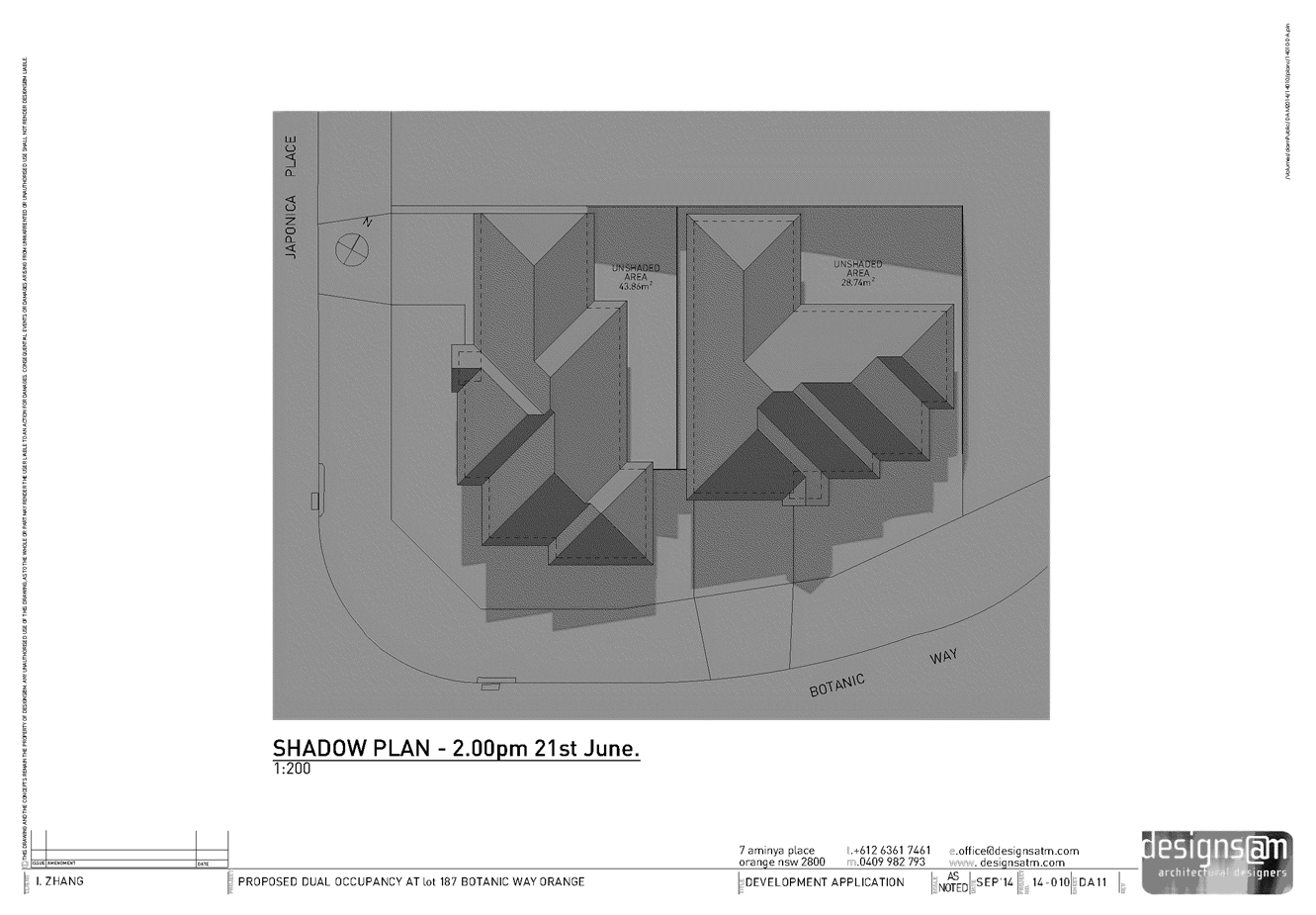
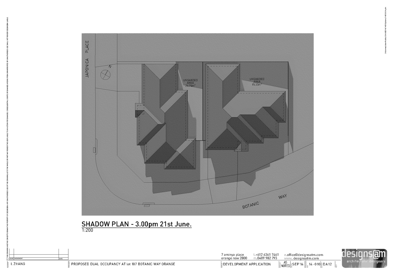
2.6 Development
Application DA 18/2015(1) - 302-304 Summer Street
TRIM
REFERENCE: 2015/455
AUTHOR: Andrew
Crump, Town Planner
EXECUTIVE Summary
Council's consent is sought to establish a food and drink
premises on land described as Lot 12 DP 582844, known as 302-304 Summer
Street, Orange.
NSW Police Canobolas LAC provided comment to the affect
that: NSW Police Force through the Canobolas Local Area Command strongly
objects to the granting of the above application to trade past midnight [bolding
is their emphasis]. This is discussed in further detail below under the heading
social impacts. This report recommends that a condition be attached consistent
with the recommendation of the Canobolas LAC to limit the hours of operation.
The report is recommended for approval.
Link To Delivery/OPerational Plan
The recommendation in this report relates to the
Delivery/Operational Plan strategy “13.4 Our Environment
– Monitor and enforce regulations relating to City amenity”.
Financial Implications
Nil
Policy and Governance Implications
Nil
|
Recommendation
That Council consents to development application DA
18/2015(1) for Food and Drink Premises (fitout and internal stairs) at
Lot 12 DP 582844 - 302-304 Summer Street, Orange pursuant to the conditions
of consent in the attached Notice of Approval.
|
further considerations
Consideration has been given to the
recommendation’s impact on Council’s service delivery; image and
reputation; political; environmental; health and safety; employees;
stakeholders and project management; and no further implications or risks have
been identified.
SUPPORTING INFORMATION
THE APPLICATION
Council's consent is sought to establish a food and drink
premises on land described as Lot 12 DP 582844, known as 302-304 Summer
Street, Orange.
THE PROPOSAL
The development will involve the installation of a
commercial kitchen and the provision of approximately 5 tables and 15-20
chairs, with opportunity for take away food to be provided. In addition to
this, the applicant is proposing to install new stairs leading to the shop top
housing above.
The applicant is proposing to operate the business from 10am
to 10pm Monday to Wednesday and Sunday, and 10am to 3am Thursday to Saturday.
MATTERS FOR CONSIDERATION
Section 5A Assessment
In the administration of sections 78A, 79B, 79C, 111 and
112, the provisions of Section 5A must be taken into account for every
development application in deciding whether there is likely to be a significant
effect on threatened species, populations or ecological communities or their
habitats. This section includes a requirement to consider any adopted
assessment guidelines, which means assessment guidelines issued and in force
under section 94A of the Threatened Species Conservation Act 1995.
Assessment guidelines are in force (see DECC-W “Threatened Species
Assessment Guidelines - The Assessment of Significance”) which requires
consent authority to adopt the precautionary principle in its assessment.
In this instance, site inspection reveals that the subject
property has no biodiversity or habitat value.
Section 79C
Section 79C of the Environmental Planning and Assessment
Act 1979 requires Council to consider various matters, of which those
pertaining to the application are listed below.
PROVISIONS OF ANY ENVIRONMENTAL
PLANNING INSTRUMENT s79C(1)(a)(i)
Orange Local Environmental Plan 2011
Part 1 - Preliminary
Clause 1.2 - Aims of Plan
The broad aims of the LEP are
set out under subclause 2. Those relevant to the application are as follows:
(a) to encourage development which complements
and enhances the unique character of Orange as a major regional centre boasting
a diverse economy and offering an attractive regional lifestyle,
(b) to provide for a range of development
opportunities that contribute to the social, economic and environmental
resources of Orange in a way that allows present and future generations to meet
their needs by implementing the principles for ecologically sustainable
development,
(f) to recognise and manage valued
environmental heritage, landscape and scenic features of Orange.
The application is considered to be consistent with aims
(a), (b) and (f) as listed above.
Clause 1.6 - Consent Authority
This clause establishes that, subject to the Act, Council is
the consent authority for applications made under the LEP.
Clause 1.9A - Suspension of
Covenants, Agreements and Instruments
This clause provides that covenants, agreements and other
instruments which seek to restrict the carrying out of development do not apply
with the following exceptions.
· covenants imposed
or required by Council
· prescribed
instruments under Section 183A of the Crown Lands Act 1989
· any conservation
agreement under the National Parks and Wildlife Act 1974
· any trust
agreement under the Nature Conservation Trust Act 2001
· any property
vegetation plan under the Native Vegetation Act 2003
· any biobanking
agreement under Part 7A of the Threatened Species Conservation Act 1995
· any planning
agreement under Division 6 of Part 4 of the Environmental Planning and
Assessment Act 1979.
Council staff are not aware of the title of the subject
property being affected by any of the above.
Mapping
The subject site is identified
on the LEP maps in the following manner:
|
Land Zoning Map:
|
Land zoned B3 Commercial Core
|
|
Lot Size Map:
|
No Minimum Lot Size
|
|
Heritage Map:
|
Heritage conservation area
|
|
Height of Buildings Map:
|
Building height limit 16m
|
|
Floor Space Ratio Map:
|
Floor space limit 2.0:1
|
|
Terrestrial Biodiversity Map:
|
No biodiversity sensitivity on the
site
|
|
Groundwater Vulnerability Map:
|
Ground water vulnerable
|
|
Drinking Water Catchment Map:
|
Not within the drinking water
catchment
|
|
Watercourse Map:
|
Not within or affecting a defined
watercourse
|
|
Urban Release Area Map:
|
Not within an urban release area
|
|
Obstacle Limitation Surface Map:
|
No restriction on building siting
or construction
|
|
Additional Permitted Uses Map:
|
No additional permitted use applies
|
Those matters that are of
relevance are addressed in detail in the body of this report.
Part 2 -
Permitted or Prohibited Development
Land Use Zones
The subject site is located within the B3 Commercial Core
zone. The proposed development is defined as a food and drink premises under
OLEP 2011 which means:
premises that are used for the
preparation and retail sale of food or drink (or both) for immediate
consumption on or off the premises, and includes any of the following:
(a) a
restaurant or cafe,
(b) take
away food and drink premises,
(c) a
pub,
(d) a
small bar.
Note. Food
and drink premises are a type of retail premises - see the definition of
that term in this Dictionary.
Food and drink premises are permissible in the B3 Commercial
Core zone with the consent of Council.
Clause 2.3 of
LEP 2011 references the Land Use Table and Objectives for each zone in
LEP 2011. These objectives for land zoned B3 Commercial Core are as
follows:
1 - Objectives of the B3 Commercial Core Zone
· To
provide a wide range of retail, business, office, entertainment, community and
other suitable land uses that serve the needs of the local and wider community.
· To
encourage appropriate employment opportunities in accessible locations.
· To
maximise public transport patronage and encourage walking and cycling.
· To
promote development that contributes to the role of the Orange CBD as the
primary retail and business centre in the City and region.
The development is not
inconsistent with the objectives of the zone.
Part 3 -
Exempt and Complying Development
The application is not exempt or complying development.
Part 4 -
Principal Development Standards
Clause 4.3 - Height of
Buildings
The proposal involves no change
to the exterior of the building.
Clause 4.4
- Floor Space Ratio
The proposal involves no change
to the floor area of the existing building.
Part 5 -
Miscellaneous Provisions
5.10 - Heritage Conservation
The subject land is located within the Central Heritage
Conservation Area and heritage principles apply to the application.
(1) Objectives
The
objectives of this clause are as follows:
(a) to
conserve the environmental heritage of Orange,
(b) to
conserve the heritage significance of heritage items and heritage conservation
areas, including associated fabric, settings and views,
(c) to
conserve archaeological sites,
(d) to
conserve Aboriginal objects and Aboriginal places of heritage significance.
The applicant submits that no changes are proposed to the
exterior of the building. It is unclear from the plans where the duct of the
extraction system is proposed to exit the building. It would be unacceptable
for this to occur on the front façade of the building as it would impact
upon the heritage façade of the building and create an unacceptable
precedent if Council were to agree to allow industrial style ducting on the
exterior of a building in the central conservation area and be visible in the
high profile Summer Street precinct.
To this end, it is appropriate given the lack of clarity to
attach a condition that restricts the exhaust duct from being attached and/or
visible from the front of the building. The condition also requires details of
the location of the exhaust duct prior to the issue of a Construction
Certificate.
Aside from the issue of the exhaust duct, the development
will otherwise result in an acceptable outcome in terms of heritage principles.
Part 6 -
Urban Release Area
Not relevant to the application. The subject site is not
located in an Urban Release Area.
Part 7 -
Additional Local Provisions
7.2 - Flood Planning
This clause applies to land
identified on the Flood Planning Map as a Flood Planning Area and requires
that, before any consent is issued, Council must be satisfied that the
proposal:
(a) is compatible with the flood hazard of the
land, and
(b) is not likely to significantly adversely
affect flood behaviour resulting in detrimental increases in the potential
flood affectation of other development or properties, and
(c) incorporates appropriate measures to
manage risk to life from flood, and
(d) is not likely to significantly adversely
affect the environment or cause avoidable erosion, siltation, destruction of
riparian vegetation or a reduction in the stability of river banks or
watercourses, and
(e) is not likely to result in unsustainable
social and economic costs to the community as a consequence of flooding.
The land is located in a Flood
Planning Area under the LEP. Notwithstanding this, the applicant is not
proposing to alter the existing situation, and as such Council’s
Technical Services Division advises of no objections.
7.3 -
Stormwater Management
This clause applies to all
industrial, commercial and residential zones and requires that Council be
satisfied that the proposal:
(a) is designed to maximise the use of water
permeable surfaces on the land having regard to the soil characteristics
affecting onsite infiltration of water
(b) includes, where practical, onsite
stormwater retention for use as an alternative supply to mains water,
groundwater or river water; and
(c) avoids any significant impacts of
stormwater runoff on adjoining downstream properties, native bushland and
receiving waters, or if that impact cannot be reasonably avoided, minimises and
mitigates the impact.
Existing stormwater arrangements
will be maintained.
7.6 -
Groundwater Vulnerability
This clause seeks to protect
hydrological functions of groundwater systems and protect resources from both
depletion and contamination. Orange has a high water table and large areas of
the LGA, including the subject site, are identified with “Groundwater
Vulnerability” on the Groundwater Vulnerability Map. This requires that
Council consider:
(a) whether or not the development (including
any onsite storage or disposal of solid or liquid waste and chemicals) is
likely to cause any groundwater contamination or have any adverse effect on
groundwater dependent ecosystems, and
(b) the cumulative impact (including the
impact on nearby groundwater extraction for potable water supply or stock water
supply) of the development and any other existing development on groundwater.
Furthermore, consent may not be granted unless Council is satisfied that:
(a) the development is designed, sited and
will be managed to avoid any significant adverse environmental impact, or
(b) if that impact cannot be reasonably
avoided - the development is designed, sited and will be managed to minimise
that impact,
(c) if that impact cannot be minimised - the
development will be managed to mitigate that impact.
The proposal is not anticipated
to involve the discharge of toxic or noxious substances and is therefore
unlikely to contaminate the groundwater or related ecosystems. The proposal
does not involve extraction of groundwater and will therefore not contribute to
groundwater depletion. The design and siting of the proposal avoids impacts on
groundwater and is therefore considered acceptable.
STATE ENVIRONMENTAL PLANNING
POLICIES
State Environmental Planning Policy 55 - Remediation of
Land
State Environmental Planning Policy 55 - Remediation of Land
applies to the subject development. Council is required to consider whether the
subject land is contaminated, and if it is found to be contaminated, whether or
not it is acceptable in the contaminated state.
The subject land has a long history being used for
commercial purposes and has no history of previous uses that would suggest the
subject land may be contaminated. As such, the development is considered
acceptable in terms of contamination.
PROVISIONS OF ANY DRAFT
ENVIRONMENTAL PLANNING INSTRUMENT THAT HAS BEEN PLACED ON EXHIBITION
s79C(1)(a)(ii)
There are no draft environmental planning instruments that
apply to the subject land or proposed development.
PROVISIONS
OF ANY DEVELOPMENT CONTROL PLAN s79C(1)(a)(iii)
Development Control Plan 2004
Development Control Plan 2004 (“the DCP”)
applies to the subject land (Chapter 0 - LEP 2011, Chapter 8 -
Development in Business Zones, Chapter 14 - Heritage, Chapter 15 - Car
Parking). An assessment of the proposed development against the relevant
Planning Outcomes will be undertaken below.
Pursuant to Planning Outcome 0.2-1 Interim Planning Outcomes
- Conversion of Zones:
· Throughout this
Plan, any reference to a zone in Orange LEP 2000 is to be taken to be a
reference to the corresponding zone(s) in the zone conversion table.
The corresponding zone to zone 3a Regional Centre Zone
(Orange LEP 2000) is zone B3 Commercial Core zone (Orange LEP 2011). As
such, Orange DCP 2004 – Chapter 8 - Development in Business Zones
is of primary relevance to this proposal. The provisions of Chapter 8
and other relevant chapters are considered below.
Planning Outcomes - Central
Business District
· Urban design demonstrates
a clear reference to the CBD Strategic Action Plan.
The development is not inconsistent with the CBD Strategic
Action Plan.
· Provision of
adequate fire-safety measures and facilities for disabled persons (according to
the BCA) are addressed at the application stage (relevant for all development
but particularly important where converting residential buildings for business
use).
Relevant conditions are attached.
· Land use
complements the role of the CBD as a regional centre for commerce and services.
The development represents a continuation of a commercial
use. The development will not jeopardise the primacy of the CBD.
· Car parking is
provided to meet demand either as on-site parking areas or through
contributions towards public parking in and adjacent to the CBD.
Car parking is addressed below under the heading
“Chapter 15 - Car Parking”.
· Advertising
comprise business identification signs in accordance with SEPP 64.
The applicant is not proposing any signage.
· Loading areas
are provided for developments requiring access by large trucks in a manner that
doesn’t reduce active frontages for important pedestrian pathways.
In this regard the applicant submits:
We do not
envisage the parking of large trucks at the front of the site with typical
small retail deliveries to occur using existing parking at the front and side
of the property.
There is the ability to provide vehicular access at the rear
of the premises. However, Council staff accept the above submission. Access is
available from the Council car park at the rear of the site but the subject
land does not enjoy any legal form of access over Council’s land. This
arrangement should not be taken to be the granting of any legal right of
access.
· Where possible,
new buildings or external alterations in the CBD include an element of
landscaping.
Not applicable.
Chapter 15 - Car Parking
The subject tenancy recently received approval as a business
premises for the use of a bank. Prior to this, the land has a long history of
being used for retail purposes, most recently as a delicatessen and prior to
that as a tobacconist. This development represents a combination of a
café and/or restaurant and take away food and drink premises, which for
all intents and purposes (the take away component) operate similarly to a shop
which requires the same parking rate of previous uses and for a restaurant a
parking rate of 1 space per 40m2 applies which is a lesser
requirement.
Given the previous retail uses of the land, it is considered
that the proposed use as a food and drink premises will not generate a net
increase in the demand for parking.
The development is considered acceptable in terms of
parking.
PROVISIONS PRESCRIBED BY THE
REGULATIONS s79C(1)(a)(iv)
Demolition of a Building (clause 92)
The proposal does not involve the demolition of a building.
Fire Safety Considerations
(clause 93)
The proposal involves a change of building use for an
existing building. Relevant conditions are attached.
Buildings to be Upgraded
(clause 94)
Upgrading of the building will be required to ensure that
the existing building is brought into partial or total conformity with the
Building Code of Australia. Relevant conditions are attached.
THE LIKELY IMPACTS OF THE
DEVELOPMENT s79C(1)(b)
Traffic Impacts
The development is not likely to result in any unreasonable
traffic impacts in the locality. The development is consistent with
Council’s parking requirements.
Visual Impacts
The applicant submits that no changes to the exterior of the
building are proposed. Notwithstanding this submission, the plans appear to
show the extraction system exiting the building within the front façade
at the secondary storey. This will result in unacceptable visual impacts and
impinge on the significance of the central conservation area. Council has
consistently not allowed this to occur. As such, a condition is attached that
restricts the extraction system from being attached and/or being visible when
viewing the front exterior of the building.
Environmental Impacts
The subject land is located within a well-established
commercial precinct. There is zero chance of the development resulting in any
environmental impacts.
Waste Storage and Collection
The applicant has submitted a plan showing a large mobile
garbage bin in the rear of the site that can be serviced from the adjoining
Council car park. The applicant submits that the bin is intended to be shared
by the operator of the business and the resident of the shop top housing to
reduce the number of bins for the tenancy. The applicant submits that the bin
will be kept clear of vehicular and pedestrian access for the site.
The applicant will be required to engage a waste contractor
for the collection of waste. The waste storage and collection is considered
acceptable.
It should be noted, as indicated above, whilst access is
available to the rear of the site from the adjoining Council car park, the
subject land is not benefited by any legal right of access over the Council
land; and agreeing to this agreement should not be construed as to be the granting
of such a right.
Social Impacts
The applicant is proposing the hours of operation to be 10am
to 10pm Monday to Wednesday and Sundays, and 10am to 3am Thursday to Saturday.
It is the latter that has the potential to result in unacceptable social impacts
within the main street, with intoxicated patrons leaving licenced venues and
conducting in anti-social behaviour.
NSW Police through the Canobolas Local Area Command,
provided comment in relation to the development (full submission attached).
Their submission concludes with the following:
In conclusion, Police attached
to the Canobolas Local Area Command are strongly opposed to the granting of
this development consent past midnight. The reason for the objection are
outlined in detail above and summarised as follows:
Orange has a high percentage
of Alcohol Related Crime committed in the CBD by people who are deemed to be
well to seriously affected by alcohol.
Alcohol Related Crime is
occurring at peak periods after midnight on Thursday, Friday and Saturday nights.
The main Alcohol Related Crimes are assaults and malicious damages. This is the
time police object to the Development Consent being granted
The main strategy for reducing
Alcohol Related Crime in Orange is the removal of patrons from the CBD quickly
and efficiently. Allowing a Late Night Food Outlet to operate in the immediate
vicinity of two late trading licensed venues will encourage people to
congregate within the CBD.
One of these late trading
licensed venues is currently scheduled as a Level 2 Premises for NSW. Both late
trading licensed venues employ security staff and have lock out times
commencing at 1.30am. Both premises do not use glass after midnight. These are
strategies employed to reduce Alcohol Related Crime within the premises. This
development application does not even touch on management of Alcohol Related
Crime instead citing only economic benefits.
The Development Application
does not adequately deal with the amenity of the neighbourhood.
If Orange City Council is
inclined to grant this application Canobolas Local Area Command Police
respectfully request the following conditions be considered for inclusion on
the Consent:
1. If the premises is to operate after midnight then at
least one (1) uniformed licensed security officer be employed from 10pm until
30 minutes past close time to monitor the behaviour of patrons and prevent any
violent and/or anti-social behaviour both within the premises and in the
vicinity of the premises (50 meters in all directions).
2. CCTV
systems to be maintained on the premises. The CCTV system must comply with the
following requirements:
a) it
must operate continuously from opening time until one hour after closing
b) it
must record in digital format at a minimum of six frames per second,
c) any
recorded image must specify the time and date of the image,
d) the
system’s cameras must cover:
• all
entry and exit points of the premises
• the
footpath immediately adjacent to the premises
• all
publicly accessible areas (other than toilets) on the premises.
The
proprietor must:
a) ensure
the CCTV system is in an operable condition at all times
b) keep
all CCTV recordings for at least 30 days,
c) ensure
the system is accessible by at least one staff member at all times it is
operating, and
d) provide
any recordings to police within 24 hours of being requested to do.
3. The proprietor is to ensure
that waste/litter emanating from the premises is cleared within a 50 meter
radius at all times.
4. The proprietor is to ensure that no alcohol is to be taken in to the
premises at any time.
5. If the premises is to operate
after midnight then the proprietor is to ensure that any fixtures or fittings
including tables and chairs are permanently secured to the floor or walls to
prevent them being used as a weapon or object that could cause injury to a
person.
6. If the premises is to operate
after midnight then the proprietor is to become an active member of the Orange
Liquor Accord and attend all Accord meetings each calendar year.
7. If the premises is to operate
after midnight then the applicant is to develop a Management Plan for the
premises including an Alcohol Management Plan incorporating the management of
intoxicated & violent patrons, and a Security Management Plan incorporating
management of waiting patrons and dispersal of patrons after sale which is to
be approved by Canobolas Local Area Commander prior to Development Consent
being fully granted.
8. If the premises is requesting
to utilize the footpath for outdoor dining than any such furniture or other
structures be removed after midnight.
On any given Friday or
Saturday night the majority of police attention is taken up with patrolling
Licensed Premises. The addition of another Late Night Food Outlet will require
additional police attention to prevent Alcohol Related Crime, diverting an
already scarce resource away from the rest of the community.
Council staff have supported the
objection of the proposed hours of operation, restricting the premises to not
be allowed to trade past midnight on Thursday, Friday and Saturdays. This is
consistent with the open hours of a recently approved food and drink premises
located at 240-242 Summer Street.
It is worth noting that an existing food and drink premises
at 146 Summer Street operates until 3.00am or later. It is understood that this
premises operates under a historic consent. An argument could be mounted that
the addition of a second such premises within the CBD may assist in diluting
any existing anti-social behaviour that may occur at this premises.
This is considered to be a difficult decision for Council as
the potential for anti-social behaviour is actually generated by nearby liquor
outlets rather than a premises of this type.
The application is silent on whether there are intentions to
apply for a liquor licence.
Should Council be of the view to allow the applicant to
trade as per submitted in the application (ie until 3am), it will be necessary
for the above conditions to be attached as conditions of consent. Council may
also wish to attach a condition relating to a trial period should the later
trading hours be agreed to. The condition should limit the later trading to a
period of not more than 12 months. The trial period would give Council the
ability to review the operations of the development at the end of the trial
period.
It is worth noting that the applicant is not seeking consent
for footpath dining as part of this application. The last condition is not
relevant and would be considered for any future application for footpath
dining.
Economic Impacts
The development has the potential to result in positive
economic impacts through the potential for employment generation and provide
for additional competition within the food industry within the City.
THE SUITABILITY OF THE SITE
s79C(1)(c)
The subject land will continue to be used for commercial
purposes.
ANY SUBMISSIONS MADE IN
ACCORDANCE WITH THE ACT s79C(1)(d)
The proposed development is not defined as advertised
development under the provisions of the LEP and, as such, no formal exhibition
of the application was required. No submissions have been received in relation
to this application.
PUBLIC INTEREST
s79C(1)(e)
Alcohol related anti-social behaviour is considered to be of
significant public interest. Despite the fact that these types of premises are
not the direct cause of alcohol related anti-social behaviour in the CBD, these
types of businesses do benefit from patrons leaving licenced premises in the
early hours of Friday to Sunday mornings and as a result, can at times, attract
such behaviour. For this reason, the development was referred to NSW Police for
comment; and the significant public interest is primarily the reason this
report has opted to adopt the position of the NSW Police.
The proposal is not inconsistent with any relevant policy
statements, planning studies, guidelines etc that have not been considered in
this assessment.
SUMMARY
The proposed development is permissible with the consent of
Council. The proposed development complies with the relevant aims, objectives
and provisions of the LEP. A section 79C assessment of the
development indicates that the development is acceptable with the imposition of
a condition that restricts the hours of operation of the business to not later
than 12.00am to address the potential for adverse social impacts within the
CBD. Attached is a draft Notice of Approval outlining a range of conditions
considered appropriate to ensure that the development proceeds in an acceptable
manner.
COMMENTS
The requirements of the Environmental Health and Building
Surveyor and the Engineering Development Section are included in the attached
Notice of Approval.
Attachments
1 Notice
of Approval, D15/4452⇩
2 Plans,
D15/4295⇩
3 Submission,
D15/4446⇩
Sustainable Development Committee
3 March 2015
2.6 Development
Application DA 18/2015(1) - 302-304 Summer Street
Attachment 1 Notice
of Approval
|

|
ORANGE
CITY COUNCIL
Development
Application No DA
18/2015(1)
NA15/ Container
PR11551
|
NOTICE OF DETERMINATION
OF A DEVELOPMENT
APPLICATION
issued under the Environmental
Planning and Assessment Act 1979
Section 81(1)
|
Development
Application
|
|
|
Applicant Name:
|
Mr N Baig
|
|
Applicant Address:
|
303 Summer
Street
ORANGE
NSW 2800
|
|
Owner’s Name:
|
Mr EWK and
Mrs SK Ko
|
|
Land to Be Developed:
|
Lot 12 DP
582844 - 302-304 Summer Street, Orange
|
|
Proposed Development:
|
Food and
Drink Premises (fitout and internal stairs)
|
|
|
|
|
Building
Code of Australia
building classification:
|
Class 4
and Class 6
|
|
|
|
|
Determination
|
|
|
Made On:
|
3 March
2015
|
|
Determination:
|
CONSENT
GRANTED SUBJECT TO CONDITIONS DESCRIBED BELOW:
|
|
|
|
|
Consent to
Operate From:
|
4 March
2015
|
|
Consent to
Lapse On:
|
4 March
2020
|
Terms of Approval
The reasons for the imposition of
conditions are:
(1) To ensure compliance
with relevant statutory requirements.
(2) To provide adequate
public health and safety measures.
(3) To ensure a quality
urban design for the development which complements the surrounding environment.
(4) To maintain
neighbourhood amenity and character.
(5) To ensure the utility
services are available to the site and adequate for the development.
(6) To prevent the proposed
development having a detrimental effect on adjoining land uses.
(7) To minimise the impact
of development on the environment.
Conditions
(1) The
development must be carried out in accordance with:
(a) Plans
by Saunders and Staniforth Property and Planning Consultants - dated 2.02.2015
- Reference: 304 Summer - sheets 1 to 4 (including aerials) (5 sheets)
(b) statements
of environmental effects or other similar associated documents that form part
of the approval
as amended
in accordance with any conditions of this consent.
(2) All building work must
be carried out in accordance with the provisions of the Building Code of
Australia.
(3) A sign is to be erected
in a prominent position on any site on which building work, subdivision work or
demolition work is being carried out:
a. showing
the name, address and telephone number of the principal certifying authority
for the work, and
b. showing
the name of the principal contractor (if any) for any building work and a
telephone number on which that person may be contacted outside working hours,
and
c. stating
that unauthorised entry to the site is prohibited.
Any such sign is to be maintained while the
building work, subdivision work or demolition work is being carried out.
|
PRIOR TO THE ISSUE OF
A CONSTRUCTION CERTIFICATE
|
(4) A
Construction Certificate application is required to be submitted to, and issued
by, Council/Accredited Certifier prior to any excavation or building works
being carried out on site.
(5) No
exhaust/extraction ducting or the like shall be attached to, and / or be
visible on the front façade of the building. Details shall be submitted
for approval showing the extraction / exhaust system prior to the issue of a
construction certificate.
(6) A
Fire Safety Schedule specifying the fire-safety measures (both current and/or
proposed) to be implemented in the building is to be submitted with the
Construction Certificate application, in accordance with Part 9 Clause 168 of
the Environmental Planning and Assessment Regulation 2000.
(7) Detailed
plans and specification are to be provided specifying the proposed fit-out of
the food preparation and storage areas in accordance with the requirements of
Australian Standard 4674-2004 "Design and construction and fit-out of food
premises" and Standard 3.2.3 "Food Premises and Equipment" of
the Australian New Zealand Food Standards Code.
(8) Prior to the issue of a
Construction Certificate, details are to be submitted to Council of how the
recommendations in the Upgrading Strategy in Part 6 of the BCA Logic Fire Audit
and BCA Assessment Report (Ref. 105736-r1 dated 19 November 2014) will be
implemented in the building.
(9) A Liquid
Trade Waste Application is to be submitted to Orange City Council prior to the
issuing of a Construction (or Occupation) Certificate. The application is to be
in accordance with Orange City Council’s Liquid Trade Waste Policy.
Engineering plans submitted as part of the application are to show details of
all proposed liquid trade waste pre-treatment systems and their connection to
sewer.
Where applicable, the applicant is to
enter into a Liquid Trade Waste Service Agreement with Orange City Council in
accordance with the Orange City Council Liquid Trade Waste Policy.
|
DURING CONSTRUCTION/SITEWORKS
|
(10) All
construction/demolition work on the site is to be carried out between the hours
of 7.00 am and 6.00 pm Monday to Friday inclusive, 7.00 am to
5.00 pm Saturdays and 8.00 am to 5.00 pm on Sundays and Public
Holidays. Written approval must be obtained from the General Manager of Orange
City Council to vary these hours.
|
During
construction/siteworks (cont)
|
(11) Where Orange
City Council is appointed as the Principal Certifying Authority, the following
inspections will be required to be carried out by Council:
- at
commencement of building work
- frame
inspection
- internal
sewer/sanitary drainage
- hot
and cold water plumbing
- final
inspection
Should any of the above mandatory
inspections not be carried out by Council, an Occupation Certificate will not
be issued on the complete structure.
(12) All
materials onsite or being delivered to the site are to be contained within the
site. The requirements of the Protection of the Environment Operations Act
1997 are to be complied with when placing/stockpiling loose material or
when disposing of waste products or during any other activities likely to
pollute drains or watercourses.
(13) Storage
of materials including stockpiles is not permitted on the public footpath area
or roadway unless a hoarding is provided and approval granted.
(14) Any adjustments to
existing utility services that are made necessary by this development
proceeding are to be at the full cost of the developer.
(15) The provisions
and requirements of the Orange City Council Development and Subdivision Code
are to be applied to this application and all work constructed within the
development is to be in accordance with that Code.
The developer is to be entirely responsible for
the provision of water, sewerage and drainage facilities capable of servicing
all the lots from Council’s existing infrastructure. The developer is to
be responsible for gaining access over adjoining land for services where
necessary and easements are to be created about all water, sewer and drainage
mains within and outside the lots they serve.
|
PRIOR TO THE ISSUE OF
AN OCCUPATION CERTIFICATE
|
(16) No
person is to use or occupy the building or alteration that is the subject of
this approval without the prior issuing of an Occupation Certificate.
(17) The
owner of the building/s must cause the Council to be given a Final Fire Safety
Certificate on completion of the building in relation to essential fire or
other safety measures included in the schedule attached to this approval.
(18) All
of the foregoing conditions are to be at the full cost of the developer and to
the requirements and standards of the Orange City Council Development and
Subdivision Code, unless specifically stated otherwise. All work required by
the foregoing conditions is to be completed prior to the issuing of an
Occupation Certificate, unless stated otherwise.
|
MATTERS FOR THE
ONGOING PERFORMANCE AND OPERATION OF THE DEVELOPMENT
|
(19) Without the prior
approval of Council, the hours of operation of the premises shall not exceed
10.00am to 10.00pm Sunday to Wednesday inclusive and 10.00am to 12.00am
Thursday to Saturday inclusive.
(20) No sandwich
boards or the like are to be placed on Council's footpath.
(21) The
owner is required to provide to Council and to the NSW Fire Commissioner an
Annual Fire Safety Statement in respect of the fire-safety measures, as
required by Clause 177 of the Environmental Planning and Assessment Regulation
2000.
(1) All signage other than
signage that is consistent with the Exempt and Complying Codes SEPP will
require the consent of Council.
(2) Application under the Local
Government Act and the Roads Act (through the Exempt and Complying
Development Code SEPP) shall be made for the placement of any outdoor dining
facilities.
(3) The
rear access to the site shall not be taken to be the granting of a right of
access and Council may restrict such access in the future.
Other Approvals
(1) Local
Government Act 1993 approvals granted under section 68.
Water
and sewer
(2) General
terms of other approvals integrated as part of this consent.
(1) All
plumbing and drainage (water supply, sanitary plumbing and drainage, stormwater
drainage and hot water supply) is to comply with the Local Government
(Water, Sewerage and Drainage) Regulation 1998, the Plumbing Code of
Australia 2012 - Plumbing & Drainage and Australian
Standard AS3500 - National Plumbing and Drainage Code. Such work is to be
installed by a licensed plumber and is to be inspected and approved by Council
prior to concealment.
(2) Hot
water shall be stored at a minimum of 60OC and be delivered to all
sanitary fixtures used for personal hygiene (bathrooms/ensuites) at a
temperature not exceeding 50oC. Where tempering valves are
installed, a sign is to be permanently fixed on the hot water heater adjacent
to the tempering valve (clearly visible) indicating:
“A tempering valve has been
installed to prevent scalding. This valve is to be renewed at intervals as
recommended by the manufacturer.”
Right of Appeal
If
you are dissatisfied with this decision, section 97 of Environmental Planning
and Assessment Act 1979 gives you the right to appeal to the Land and
Environment Court within 6 months after the date on which you receive this
notice.
*
Section 97 of the Environmental Planning and Assessment Act 1979 does not apply
to the determination of a development application for State significant
development or local designated development that has been the subject of a
Commission of Inquiry.
|
Disability Discrimination Act
1992:
|
This application has been assessed in
accordance with the Environmental Planning and Assessment Act 1979. No
guarantee is given that the proposal complies with the Disability
Discrimination Act 1992.
The applicant/owner is responsible to
ensure compliance with this and other anti-discrimination legislation.
The Disability Discrimination Act
covers disabilities not catered for in the minimum standards called up in the
Building Code of Australia which references AS1428.1 - "Design for
Access and Mobility". AS1428 Parts 2, 3 and 4 provides the most
comprehensive technical guidance under the Disability Discrimination Act
currently available in Australia.
|
|
|
|
|
Disclaimer - S88B Restrictions on the Use of Land:
|
The applicant should note that there
could be covenants in favour of persons other than Council restricting what
may be built or done upon the subject land. The applicant is advised to check
the position before commencing any work.
|
|
|
|
|
Signed:
|
On behalf of the consent authority ORANGE
CITY COUNCIL
|
|
Signature:
|
|
|
Name:
|
ALLAN RENIKE - MANAGER DEVELOPMENT ASSESSMENTS
|
|
Date:
|
4 March 2015
|
Sustainable
Development Committee
3 March 2015
2.6 Development
Application DA 18/2015(1) - 302-304 Summer Street
Attachment 2 Plans
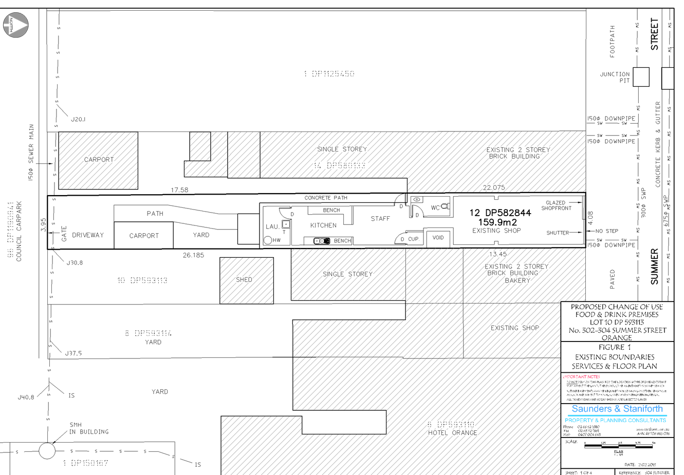
Sustainable Development Committee
3 March 2015
2.6 Development
Application DA 18/2015(1) - 302-304 Summer Street
Attachment 3 Submission
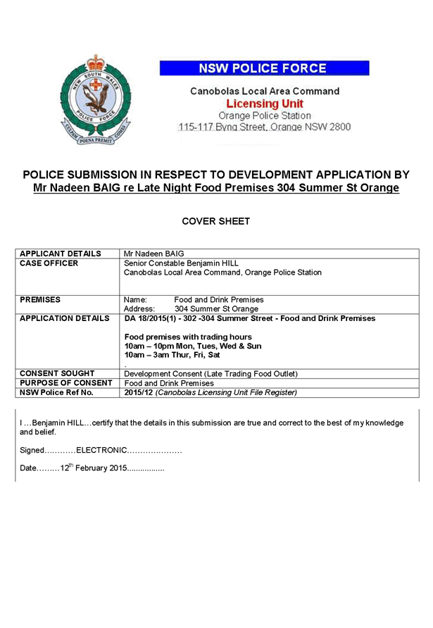
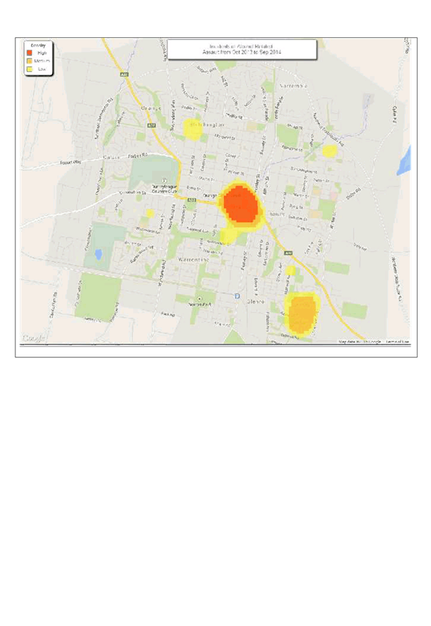
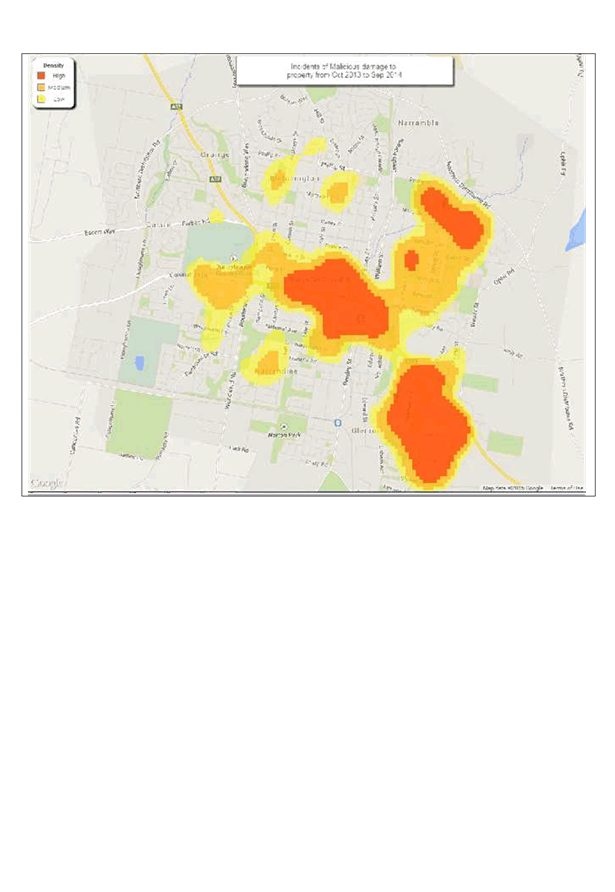
2.7 Planning
Proposal - North Orange Shopping Centre Expansion
TRIM
REFERENCE: 2015/146
AUTHOR: Craig
Mortell, Senior Planner
EXECUTIVE Summary
Council is in receipt of a planning proposal from City Plan
Services, on behalf of SCA Property Group, relating to Lot 700 DP 1171441,
known as 9 Telopea Way.
The southern portion of 9 Telopea Way is zoned B2 Local
Centre and has already been developed as the North Orange shopping centre,
comprising a Woolworths supermarket, several specialty shops and the associated
car parking area.
The proposal relates to the northern residual portion of the
lot which is zoned R1 General Residential and is currently vacant. The
proposal seeks to convert the northern area to the B2 Local Centre zone to
enable an expansion of the existing shopping centre.
This report also has regard for the future role of land on
the eastern side of Telopea Way, known as Lot 111 DP 1194964, which was the
subject of a previous planning proposal from Garfield Road Holdings Pty Limited
(GRH) for a service station and restaurant rezoning given the cumulative
effects of both proposals.
Link To Delivery/OPerational Plan
The recommendation in this report relates to the
Delivery/Operational Plan strategy “11.1 Our Economy
– Encourage the growth of local business, support emerging industry
sectors and attract new investment to Orange”.
Financial Implications
Nil
Policy and Governance Implications
Nil
|
Recommendation
1 That
Council support a Planning Proposal at 9 Telopea Way to rezone the northern portion
of Lot 700 DP 1171441 to B2 Local Centre and extend the Floor Space Ratio map
to apply a rate of 0.192:1 across the entire site, representing an additional
2500m2 of floor space.
2 That
Council undertakes a master planning exercise for Telopea Way, encompassing
Lot 700 DP 1171441 and Lot 111 DP 1194964 to resolve appropriate land
uses, traffic solutions and urban design of the North Orange shopping
precinct.
3 That
Council seeks a Gateway Determination from the Department of Planning and
Environment consistent with the above and then undertake public exhibition
for a period of 28 days prior to reporting back to Council.
|
further considerations
The recommendation of this report has been
assessed against Council’s other key risk categories and the following
comments are provided:
|
|
|
|
Environmental
|
The expansion of an out of centre
commercial precinct needs to be balanced against the objective of maintaining
a strong and robust central business district. Additionally, the site is
accessed through an intersection that has already been the subject of
significant community concern. Accordingly, traffic mitigation strategies
need to be considered for any additional development in this location. These
issues are discussed in the body of the report.
|
SUPPORTING INFORMATION
The proponent is SCA Property Group, which was established
by Woolworths as a landlord for a number of its owned shopping centres in
October 2012. Woolworths transferred ownership of the shopping centres to SCA
and then transferred SCA to Woolworths shareholders (an in-specie
distribution).
SCA is listed on the ASX and according to the SCA Property
Group website “Woolworths has no ownership interest in SCA Property Group
following its listing”.
SCA Property Group, as landowner of 9 Telopea Way, are
seeking to expand the North Orange shopping centre to enable a second full line
supermarket, several additional specialty shops and a potential
mini-supermarket.
A conceptual site plan has been included in the proposal to
illustrate how such an expansion could be designed. However, the ultimate
design of any expansion would be the subject of a future development
application, which could involve various changes to the concept presented. The
value of the conceptual plan is therefore to illustrate the overall scale of
the expansion and affirm that a workable design is possible on the site
(subject to rezoning).
SCA contend that expansion of the centre is justified on the
basis of a growing population base in North Orange. The proposal includes an
economic impact assessment and a traffic report by the proponent to seek to
address the most significant issues relating to the site and locality.
This report also has regard for the future role of land on
the eastern side of Telopea Way, known as Lot 111 DP 1194964, which was the
subject of a previous planning proposal from Garfield Road Holdings Pty Limited
(GRH) for a service station and restaurant rezoning. Council rejected that
proposal and GRH have subsequently sought to have Council’s decision
overturned by the Joint Regional Planning Panel (JRPP).
SCA and GRH are unrelated entities and each proposal needs
to be considered on its individual merits. However the cumulative effects of
each proposal are influenced by the other and therefore become relevant
considerations. It is in this context that the GRH proposal is discussed.
Location Context
Telopea Way is a short north-south cul-de-sac connecting at
its southern end with the Northern Distributor Road (NDR). A short distance
north of this intersection is an eastern connection to Farrell Road providing a
link through to the surrounding residential area. The proximity of development
in the area has resulted in significant traffic volumes. Additionally, some
motorists have reported the configuration of the two intersections and the
associated lights to be difficult.
The existing North Orange shopping centre comprises a full
line Woolworths supermarket, liquor outlet and specialty shops. The total floor
space is consistent with the floor space ratio map established to reflect the
recommendations of the Business Centres Review Strategy. A key focus of the
strategy was to establish an appropriate scale for the centre, balancing the
needs of the local population in North Orange against preserving the trading
performance and role of the Orange CBD. The potential for further expansion of
the centre was noted in the strategy predicated upon the population base
growing as supply of residential zone land in North Orange was taken up.
Subsequently, approval has been granted for a McDonalds
outlet at the corner of Telopea Way, Farrell Road and the NDR. A Planning
Proposal for a restaurant and petrol station on land directly opposite this
site was rejected by Council on a range of factors; principally compatibility
with adjoining residential land to the east, proximity to established and
approved child care centres, and traffic at the Telopea Way, Farrell Road and
NDR intersections. The proponent Garfield Road Holdings Pty Limited (GRH)
subsequently sought to have Councils decision overturned by the State
government by applying to the Department of Planning via the Western Region
JRPP to have their proposal for a rezoning re-examined.
Despite Council staff representations the JRPP determined
that the matter could proceed to the gateway process. The Department of
Planning and Environment are therefore acting as the relevant planning
authority for processing of the proposal. At this time the Department are yet
to place the proposal on formal public exhibition.
The subject land is on the western side of Telopea Way and
differs to the rejected site on the eastern side of Telopea Way by virtue of
being separated from the residential properties and child care centre. In
addition, Council staff are investigating a potential road connection to the
west that would link the northern end of Telopea Way to an as yet unconstructed
section of Diamond Drive. This connection would provide a valuable relief route
to ease congestion at the NDR intersection.
Given the above history of development on and around Telopea
Way and the continued growth of North Orange, there is considered to be scope
for some level of expansion. Community concern relating to traffic in this area
is considerable. It may therefore be reasonable to consider a master-planning
exercise for the precinct, rather than waiting for individual developments to
emerge in an uncoordinated fashion. A master plan would logically include the
existing shopping centre and McDonalds sites, land on both sides of Telopea Way
(representing this planning proposal and the previously rejected planning
proposal) as well as the link route from the northern end of Telopea Way to
Diamond Drive.
A master plan would allow Council, in consultation with
landowners and the nearby community, to establish a range of development
options for each side of Telopea Way and confirm a long term response to the
current traffic concerns. A master plan would also enhance Council’s
position with respect to the rejected planning proposal on the eastern side of
Telopea Way by demonstrating to the JRPP a viable and reasonable vision for
that land.
Economic case
Council engaged an independent consultant, Leyshon
Consulting, to peer review the economic impact assessment. Leyshon has
previously been engaged by Council to prepare the Business Centres Review
Strategy (BCRS) and the 2010 update of that strategy. The BCRS was instrumental
in determining that an out of centre shopping precinct in North Orange was
appropriate and identifying the appropriate scale for the centre, both in terms
of meeting the needs of local residents and also protecting the overall trading
performance of the CBD.
Leyshon’s review of the economic case is attached to
this report. The main findings can be summarised as not supporting the extent
of floor space being sought in the short term, but recognising that there may
be a case for some additional floor space. Leyshon considers that the extent of
impact upon the CBD would: “fall within an acceptable range in
percentage terms”; but raises the question of: “whether
suburban centres in Orange require, or should have, two full line
supermarkets?”
Leyshon’s
perspective on this policy question is then provided as:
“If
answered in the affirmative it can be expected that supermarket-based spending
directed to the CBD would fall considerably. There would also be a significantly
reduced need for North Orange residents to make supermarket-based shopping trip
to the CBD as they would have the two largest Coles and Woolworths stores in
the City of Orange available locally.
The
significance of this issue cannot be understated given that supermarkets capture
slightly more than 30% of every retail spending dollar in Australia, are
visited on an increasingly regular basis by shoppers, and provide vital support
for associated specialty shops.”
CBD implications
Since the opening of the North Orange shopping centre, the
occupancy rate of commercial premises in the CBD has not appreciably changed.
The level of vacant premises pre and post North Orange opening is anecdotally
consistent. This does not mean that trading performance or profitability of CBD
businesses has been unaffected.
Doubtless some have seen a portion of their trade lost,
however such effects are difficult to distinguish from other causal factors
such as the transition of the Cadia East mine from construction to operational
phases, and more general or macro-economic conditions.
What this demonstrates is the success of the previous
approach - allowing a limited scale of out-of-centre shopping carefully balanced
against the need to maintain a strong and vibrant core. This has ensured that
Orange continues to provide a centre of regional trading significance which in
turn draws trade from surrounding communities. The successful performance of
the CBD has therefore remained an important source of local employment
opportunities.
As articulated by Leyshon, the current North Orange centre
has not had a major impact upon the performance of the CBD. This is due to a
combination of the limited scale of the centre and the modest range of products
and services available, both factors which result in North Orange residents
continuing to venture into the CBD on a regular basis. Excessive expansion of
North Orange would reduce the frequency of CBD trips undertaken by North Orange
residents.
As the extent of this CBD impact is not certain, the
precautionary principle would suggest that a more modest expansion be
contemplated.
The significance and role of the CBD as the primary trading
centre in the central west should not be taken for granted. Should the CBD
performance decline or even just stagnate there is potential for the outer
edges of the catchment (e.g. Blayney, Molong, Canowindra and the like) to begin
to look towards other regional centres for their higher order shopping.
The eastern edges of the catchment may turn more towards
Bathurst, with the north‑western edges potentially looking towards Dubbo,
albeit at a greater distance. It is likely that any such changes in shopping
patterns would initially be small and difficult to measure. However, settlement
patterns in Australia since the 1960s have been known to exhibit a very high
level of “primacy” compared to other developed nations.
In this context, primacy refers to the tendency for
population, trade and development to concentrate in one location or city where
all higher order activities for the region occur, and for surrounding
population centres to be diminished in scale, providing only lower order goods
and services. Primacy occurs around the developed world, but is particularly
pronounced in Australia.
In our local context the Orange-Bathurst combination stands
out as an exception to the primacy norm in that while being in close proximity,
neither centre has significantly outshone the other. This should not be interpreted
to mean that the primacy effect does not apply to Orange, simply that both
centres have managed to keep pace with each other.
Accordingly, Council needs to balance the short term desire
to provide enhanced facilities for residents of North Orange with the long term
strategic interest of preserving and enhancing the trading performance and role
of the CBD.
Traffic Implications
The proponent supplied a traffic review in support of the
proposal. It should be noted that their review was prepared on the basis of the
additional supermarket floor space (total 4,800m2) and the
additional specialty retail area (1500m2), but excluded the
“future retail” area of 1400m2. The traffic review also
limited its calculations to the short to mid-term horizon, despite
acknowledging that the long term demand would be higher. Finally, the traffic
review notes that Council has identified an east-west link road between the
northern end of Telopea Way and William Maker Drive as part of the preferred
solution to the local traffic concerns. Additional elements of the traffic
solution include a slip lane into Farrell Road from Telopea Way.
The intent
of the relief link is to provide a relief route for local traffic so that
residents to the north and west will be able to avoid the NDR intersection.
Accordingly, should the proposal be supported SCA would be required to
contribute a reasonable apportionment of costs for the traffic solution
including the relief link road and slip lane. The financial contribution
required would be determined once full costings of the relief road and slip
lane are determined and would become the subject of a Voluntary Planning
Agreement between Council and the developer. The proponent (SCA) has been
advised of the need for the relief road and slip lane and have acknowledged
that their proposal would add to the need for the roadworks involved.
In the long term, when the area is fully developed the
proposal is anticipated to generate an additional 800 vehicles per hour
(two-way) in the weekday afternoon peak hour. Assuming an even distribution
during the peak period, this equates to an additional movement every 4.5
seconds. In the short to medium term the proponent argues that traffic
generation during the peak hour would be in the order of 450 vehicles per hour
(two-way), or an additional movement every 8 seconds, assuming even
distribution during the peak.
Planning controls
Land Use Zone
The proposal seeks to change the zone applied to the
northern portion of the site from R1 General Residential to B2 Local Centre,
consistent with the remainder of the shopping centre site to the south.
The adjoining land to the north and west is zoned RE1 Public
Recreation, while land to the east comprises R1 General Residential land on the
other side of Telopea Way.
It is considered that the proposal does not raise any
particular interface issues or land use conflicts with the surrounding lands.
The neighbouring residential land is separated by the Telopea Way reserve,
which serves to provide a modest buffer; whereas the northern and western
neighbouring lands, being recreation lands, are not considered to be sensitive
receptors. Interface issues can therefore be appropriately managed through the
usual development application processes.
Floor Space Ratio Controls
The existing shopping centre is subject to a floor space
ratio control. This was imposed to ensure that the scale of the centre would be
consistent with the Urban Centres Review Strategy. The proponents are seeking
an FSR of 0.2:1 over the site, which is a marginal increase over the current
0.19:1 affecting the existing B2 zoned land.
Leyshon’s review of the economic argument indicates
that providing 2,500m2 of floor space for the expansion of the
existing Woolworths and additional specialty shops, but not supporting the
further 4000m2 needed for the additional supermarket, may represent
an appropriate level of expansion at this time. This translates to a total
floor space of 7500m2 over a site of 39055m2, an FSR
of 0.192:1 for the entirety of the site.
DCP
Master Plan
Given the history of the area and the current level of
traffic and other concerns should Council wish to support the proposal it is
recommended that the Telopea Way precinct become the subject to a Master Plan
within the DCP prior to any Development Applications being accepted. The
precinct would logically include the proponents land, the undeveloped land on
the eastern side of Telopea Way, the intersections of Telopea Way, Farrell Road
and the NDR and the link route across the Waratahs land to William Maker Drive.
The intent of the Master Plan would be to guide future
development of the area such that the appropriate range of land uses and design
requirements be identified for each side of Telopea Way. This would seek to
ensure that land use conflicts do not arise with the residential properties and
child care centres to the east, while recognising the future role of Telopea
Way itself as the focal point of North Orange to accommodate a reasonable
degree of density. Appropriate urban form design requirements would also ensure
an attractive and welcoming streetscape is delivered.
The cost of preparing the DCP Master Plan would be a matter
for negotiation with the proponent, bearing in mind that the study area would
extend beyond the immediate boundaries of their site and address existing local
issues as well as the consequences of their development.
Planning Proposal Process
Should Council decide to proceed with the proposal, either
as requested by the proponent or as modified in accordance with the details
above, the processes involved are summarised as follows:
· Undertake the
master planning exercise for the precinct.
· Prepare draft LEP
maps for the zoning and floor space ratio changes.
· Submit the above
to the Department of Planning and Environment for the Gateway Review.
· Upon receipt of
the Gateway Determination, undertake such studies or further works as may be
required.
· Commence the
formal consultation phase as required by the Gateway Determination. This will
most likely involve consultation with Government departments and agencies, as
well as a minimum 28 day public exhibition phase.
· Analyse and report
back to Council on the results of consultation and public exhibition. This may
involve changes to the concept to accommodate the concerns raised during
exhibition and consultation.
· Upon Council
adoption, submit the final proposal to Parliamentary Counsel via the Department
of Planning and Environment, requesting a formal opinion and gazettal of the
LEP component of the plan. The master plan component would be incorporated into
the Orange Development Control Plan at the same time.
Conclusion
Examination of a request for a Planning Proposal and review
of the economic case provided has indicated that the continued growth of North
Orange may now justify a modest expansion of the current shopping centre. The
site is directly across the road from a previous request that was rejected by
Council over concerns relating to the proximity of child care centres,
adjoining residential properties and traffic issues.
The rejected proposal is currently before the Western Region
Joint Regional Planning Panel, having successfully appealed against
Council’s rejection.
This proposal is situated on the western side of Telopea
Way, providing a more definitive separation buffer to the more sensitive land
uses in the east, and staff are investigating potential relief routes to
connect the northern end of Telopea Way with Diamond Drive to the west.
The current proposal is seen to have some merit, albeit that
a peer review of the economic case has indicated that a more modest expansion
than that requested is likely to meet the short to medium term needs of North
Orange residents without unduly impacting upon the trading performance and role
of the main CBD.
Accordingly, it is recommended to proceed with a modified
version of the planning proposal at this stage. The proponent would have the
opportunity during the exhibition phase to make further representations
regarding the extent of floor space that should be permitted.
Attachments
1 Draft
Planning Proposal, D15/4505⇩
2 Proponents'
Planning Proposal North Orange, D15/4507⇩
3 Appendix
1 - Letter from Orange City Council, D15/4509⇩
4 Appendix
2 - Indicative Concept Plan, D15/4511⇩
5 Appendix
3 - Economic Impact Assessment, D15/4513⇩
6 Appendix
4 - Traffic Review Report, D15/4515⇩
7 Appendix
5 Deposited Plan, D15/4517⇩
8 Leyshon
Consulting North Orange Advice, D15/4519⇩
9 Potential
Link Road Corridor , D15/4891⇩
Sustainable Development Committee
3 March 2015
2.7 Planning
Proposal - North Orange Shopping Centre Expansion
Attachment 1 Draft
Planning Proposal
Planning Proposal – Orange Local Environmental Plan 2011
– Amendment 8
Introduction
The purpose of this document is to describe a planning proposal for an
amendment of the Orange Local Environmental Plan 2011, to be known as amendment
8. The preparation of a planning proposal is the first step in preparing an LEP
(or an amendment to an LEP).
Note: Throughout the course of preparing the proposed LEP, the planning
proposal evolves. This is particularly the case for complex proposals in which
the initial gateway determination will confirm the technical studies and
consultation required to justify the proposal.
As the studies and consultation are undertaken, relevant parts of the
planning proposal will be updated, amended and embellished. Therefore,
particularly when viewed at an early stage, the level of detail in a planning
proposal may appear to be limited in one or more respects.
This planning proposal has been prepared in accordance with the
Department of Planning and Infrastructure’s document A guide to
preparing planning proposals and is comprised of four parts;
Part 1 Objectives and Intended
Outcomes
This part comprises a brief statement outlining the objectives and
intended outcomes of the proposed amendment.
Part 2 Explanation of the Provisions
This part comprises a plain English explanation of the provisions and
changes that are to be included in the amendment.
Part 3 Justification
This part establishes the justification for the objectives, outcomes and
provisions and the process for their implementation.
Part 4 Community Consultation
This part details the level and methods of community consultation that is
to be undertaken on the planning proposal.
Part 5 Project Timeline
This part consists of a table that sets out the key project milestones
and anticipated commencement and completion dates for each milestone. The dates
shown are indicative only and subject to review as the project progresses.
Part 1 Objectives
and Intended Outcomes
The objectives of this planning
proposal are:
To amend the minimum land zoning map and floor space ratio map to enable
an expansion of the North Orange shopping centre.
Part 2 Explanation
of the Provisions
Amendment of the Land Zoning Map in
accordance with the proposed Land Zoning Map shown at attachment 1
Amendment of the Floor Space Ratio
Map in accordance with the proposed Floor Space Ratio Map shown at attachment 2
Part 3
Justification
Section A –
Need for the planning proposal
1. Is
the planning proposal a result of any strategic study or report?
Yes.
The proponent has submitted an
economic case for the expansion of the shopping centre. This has been peer
reviewed and compared to the Business Centres Review strategy, finding that a
moderate expansion of the shopping centre is now warranted given the continued
expansion and growth of the North Orange population base.
2. Is
the planning proposal the best means of achieving the objectives or intended
outcomes, or is there a better way?
The planning proposal is the best known means of achieving
the intended outcomes. In reaching this conclusion alternative sites have
previously been rejected by Council due to land use conflicts that are not
apparent on the current proposal.
3. Is
there a net community benefit?
Yes. The result of the planning proposal will provide greater
employment and access to a broader range of facilities for the growing population
base. This will in turn reduce traffic congestion in the CBD.
Section B –
Relationship to strategic planning framework
4. Is
the planning proposal consistent with the objectives and actions contained
within the applicable regional or sub-regional strategy?
Not relevant – no applicable sub-regional strategy.
5. Is
the planning proposal consistent with the local council’s Community
Strategic Plan, or other local strategic plan?
Yes.
6. Is
the planning proposal consistent with applicable state environmental planning
policies?
Yes.
7. Is
the planning proposal consistent with applicable Ministerial Directions (s.117
directions)?
Yes.
Section C –
Environmental, social and economic impact
8. Is
there any likelihood that critical habitat or threatened species, populations
or ecological communities, or their habitats, will be adversely affected as a
result of the proposal?
No. The sites selected for Amendment
8 have been chosen to avoid conflicts with ecologically sensitive lands. The
land concerned has been heavily disturbed and cleared through previous
agricultural practices.
9. Are
there any other likely environmental effects as a result of the planning
proposal and how are they proposed to be managed?
None envisaged.
10. How
has the planning proposal adequately addressed any social and economic effects?
The fundamental intention of the
proposal will provide direct economic benefits to the local community, both in
terms of employment opportunities and improved shopping options.
Section D –
State and Commonwealth interests
11. Is
there adequate public infrastructure for the planning proposal?
Yes. The proposal is to be considered in conjunction with the
establishment of a link road at the northern end of Telopea Way heading
westwards to connect with an as yet unconstructed section of Diamond Drive.
This link road will provide significant relief to the congestion currently
evident at the intersections of Telopea Way, Farrell Road and the NDR.
12. What
are the views of State and Commonwealth public authorities consulted in
accordance with the gateway determination?
Not applicable, the planning proposal
is at the pre-gateway stage. It is anticipated that the project will involve
consultations with:
RMS and Dept of Planning and
Environment,
Part 4 Community
Consultation
Community consultation will be
undertaken in accordance with the requirements of the gateway determination. It
is anticipated that this proposal will not be deemed to be a low impact
proposal. Accordingly an exhibition period of 28 days is expected.
This will commence by giving notice
of the public exhibition of the planning proposal via:
· an advertisement in the Central Western Daily;
· a notification on the Orange City Council website www.orange.nsw.gov.au; and
· written advice direct to adjoining landowners.
All forms of the notice shall
include:
· a brief description of the objectives and intended outcomes
of the planning proposal;
· an indication of the land affected by the planning proposal;
· the location and dates where the planning proposal may be
inspected;
· the contact name and address at Orange City Council where
submissions may be directed; and
· the closing date of the submission process.
During the exhibition period, the
following materials will be made freely available for public inspection:
· The planning proposal, in the form approved for community
consultation by the Director-General of Planning;
· The gateway determination; and
· All studies and supporting material relied upon by the
planning proposal.
Following the exhibition period, a report will be prepared analysing any
submissions received and making recommendations as to any appropriate changes
or adjustments to the planning proposal, for the consideration of Orange City
Council.
Where contact details have been provided all persons and organisations
making a submission will be advised of the date and time of the relevant
council (or committee) meeting where the report is to be considered, and
subsequently advised of the determination.
Part 5 Project Timeline
The following table provides an
overview of the intended project timeline for this Planning Proposal.
|
Project stage
|
Commencement
|
Completion
|
|
Gateway Determination
|
March 2015
|
March 2015
|
|
Government Agency consultation
|
April 2015
|
April 2015
|
|
Public Exhibition Period
|
April 2015
|
April 2015
|
|
Public Hearing
|
as per the Gateway Determination
|
|
Consideration of Submissions
|
May 2015
|
May 2015
|
|
Consideration of post exhibition proposals
(Report to Council)
|
June 2015 SDC meeting
|
|
Seeking and obtaining legal opinion from
Parliamentary Counsels Office
|
Mid June 2015
|
July 2015
|
|
Submission to the Department of Planning and
Infrastructure to finalise
|
Dependent on PCO
|
|
Anticipated date the plan will be forwarded to the
Department for notification
|
Dependent on PCO
|
Sustainable
Development Committee
3 March 2015
2.7 Planning
Proposal - North Orange Shopping Centre Expansion
Attachment 2 Proponents'
Planning Proposal North Orange
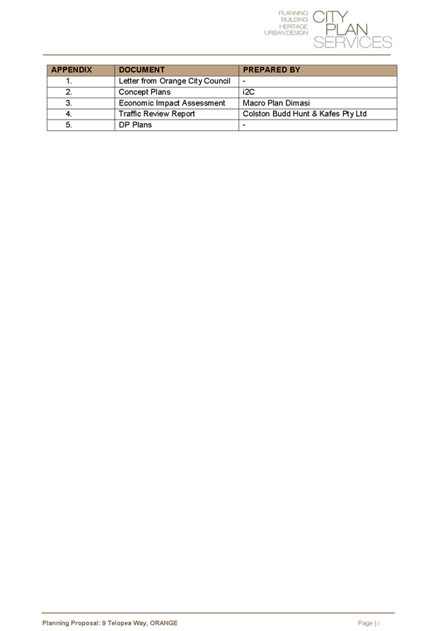
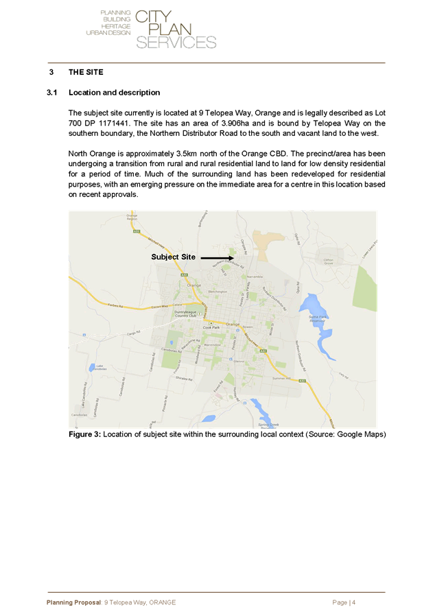
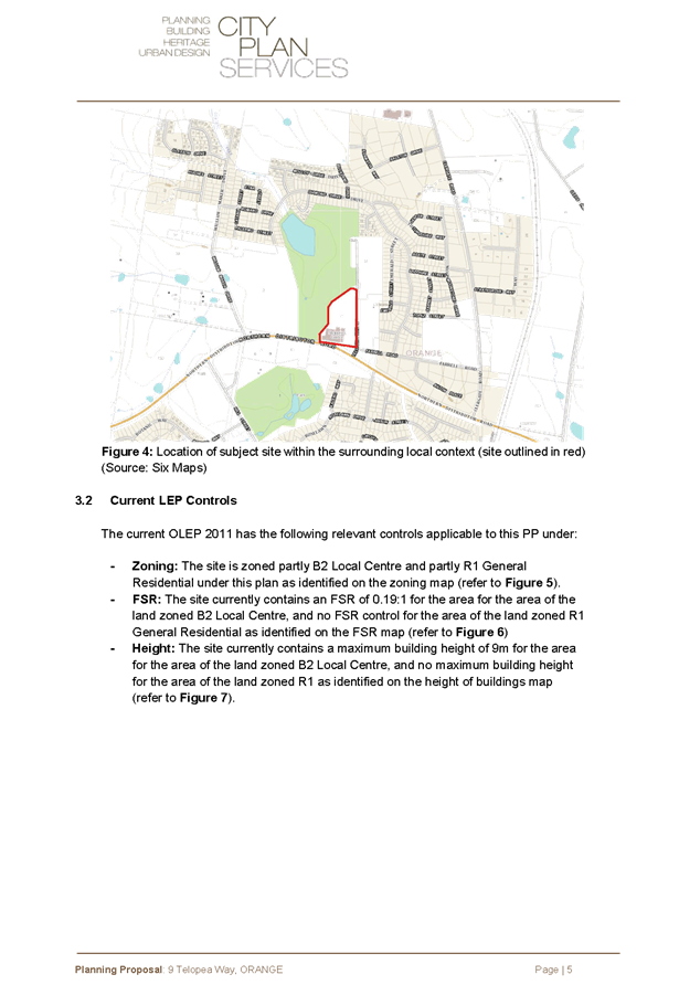
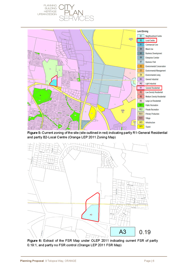
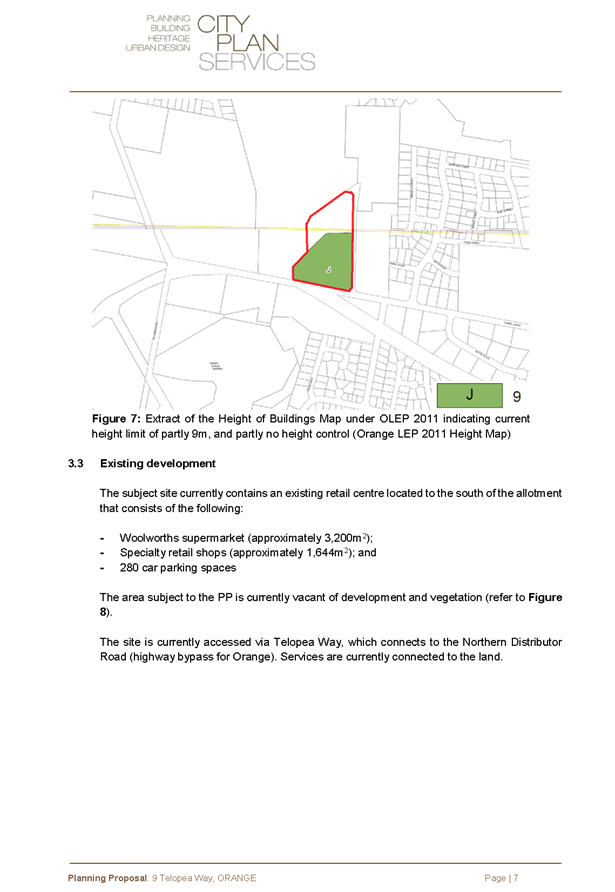
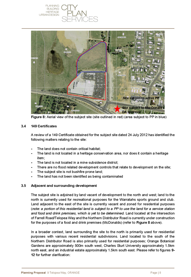
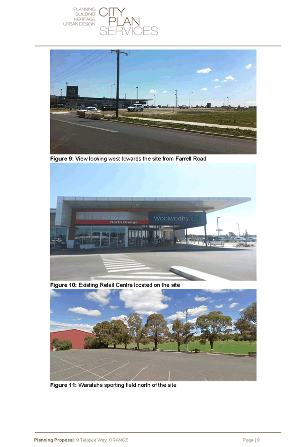
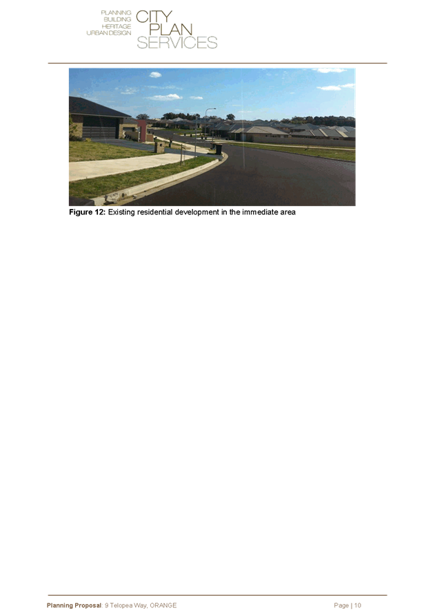
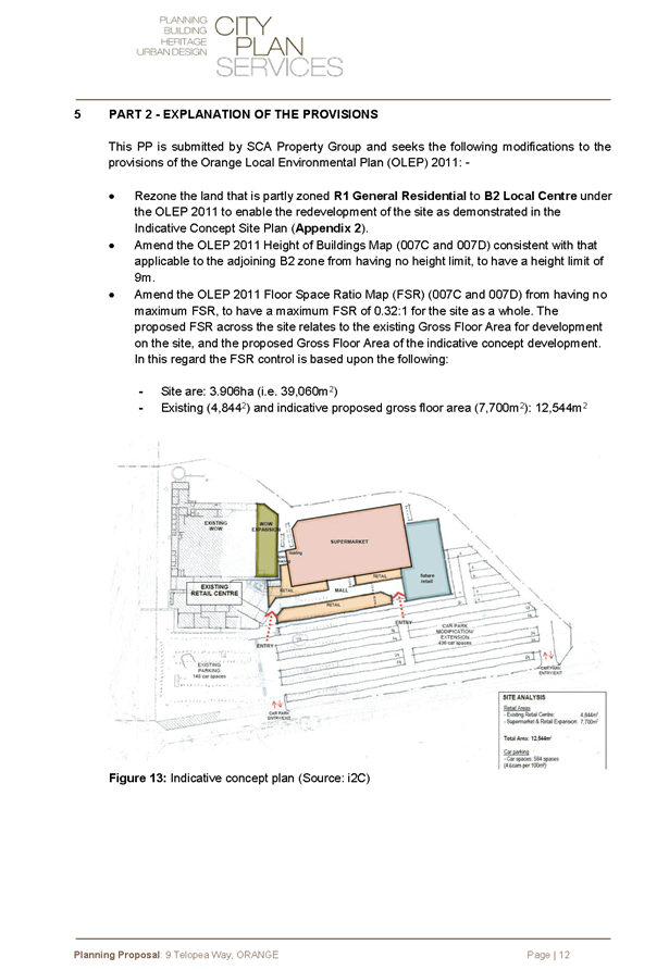
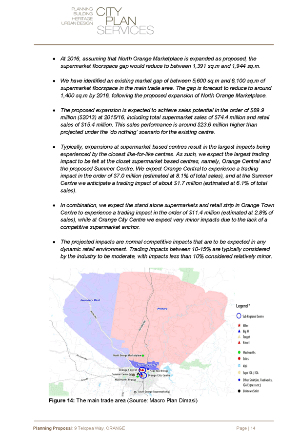
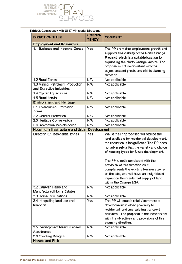
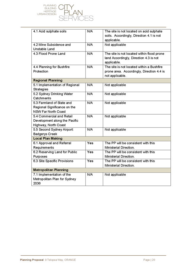
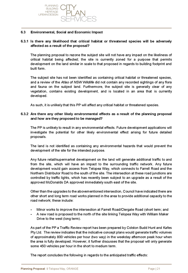
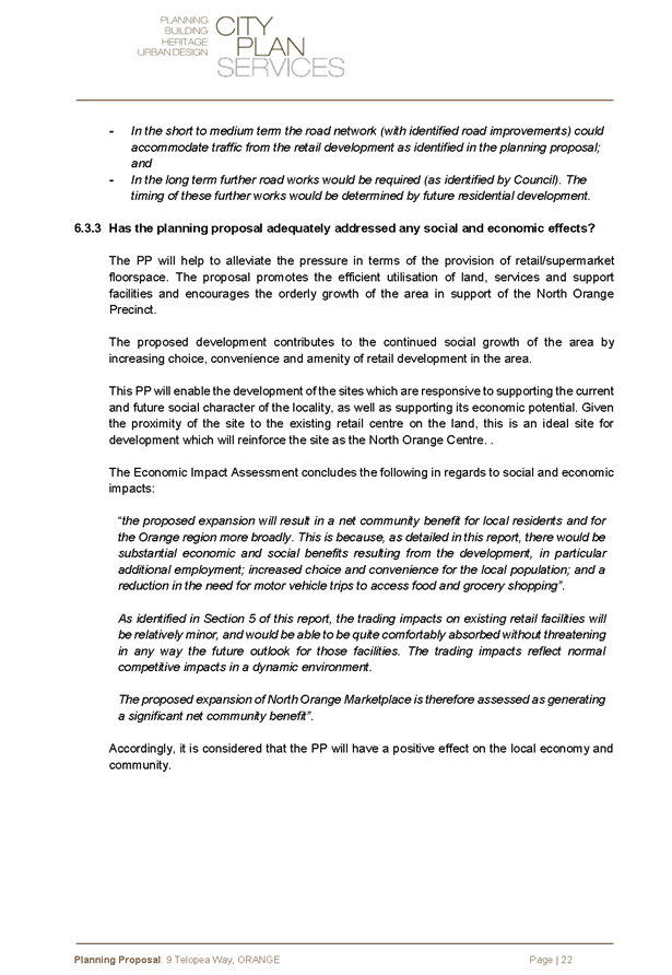
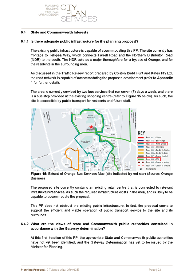


Sustainable
Development Committee
3 March 2015
2.7 Planning
Proposal - North Orange Shopping Centre Expansion
Attachment 3 Appendix
1 - Letter from Orange City Council

Sustainable
Development Committee
3 March 2015
2.7 Planning
Proposal - North Orange Shopping Centre Expansion
Attachment 4 Appendix
2 - Indicative Concept Plan
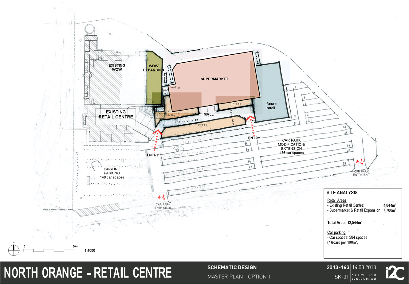
Sustainable
Development Committee
3 March 2015
2.7 Planning
Proposal - North Orange Shopping Centre Expansion
Attachment 5 Appendix
3 - Economic Impact Assessment
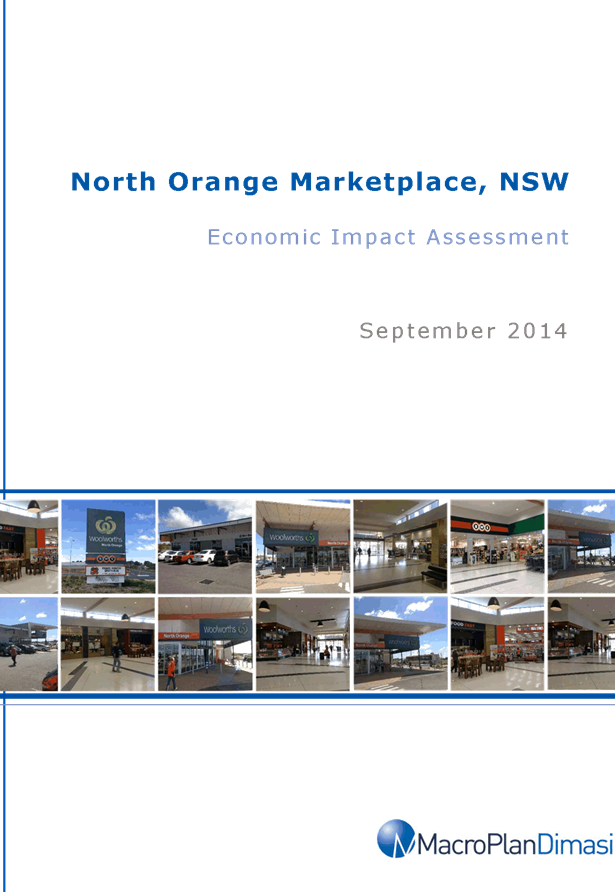


Sustainable Development Committee
3 March 2015
2.7 Planning
Proposal - North Orange Shopping Centre Expansion
Attachment 6 Appendix
4 - Traffic Review Report
Sustainable
Development Committee
3 March 2015
2.7 Planning
Proposal - North Orange Shopping Centre Expansion
Attachment 7 Appendix
5 Deposited Plan
Sustainable Development Committee
3 March 2015
2.7 Planning
Proposal - North Orange Shopping Centre Expansion
Attachment 8 Leyshon
Consulting North Orange Advice


Sustainable
Development Committee
3 March 2015
2.7 Planning
Proposal - North Orange Shopping Centre Expansion
Attachment 9 Potential
Link Road Corridor
2.8 Rezoning
of Lot 43 DP 255071 30 Leewood Drive Orange
TRIM
REFERENCE: 2015/462
AUTHOR: Kathy
Woolley, Director Corporate and Commercial Services
EXECUTIVE Summary
Council has been approached by
a business to convert a small park to an area for car parking in the Leewood
Estate. There is parking congestion in the area. If Council resolves to
undertake the conversion, Orange Local Environmental Plan - Amendment 10 for
a spot rezoning of Lot 43 DP 255071 from RE1 Public Recreation to IN1 General
Industrial is required. The map below provides its location.
Link To Delivery/OPerational Plan
The recommendation in this report relates to the
Delivery/Operational Plan strategy “1.2 Our City -
Information and advice provided for the decision-making process will be
succinct, reasoned, accurate, timely and balanced”.
Financial Implications
A financial arrangement to lease the site will provide an
income stream. The works have been estimated at $270,000.
Policy and Governance Implications
Nil
|
Recommendation
1 That
Council prepare and submit to the NSW Department of Planning and Environment
a formal planning proposal for a Gateway Determination to enable the rezoning
of Lot 43 DP 255071 from RE1 Public Recreation to IN1 General Industrial and
that the land be re-classified as Operational;
2 That
the necessary materials be prepared as determined by the Gateway
Determination process and exhibition of materials be undertaken;
3 That
a public hearing be conducted in accordance with the legislative
requirements.
|
further considerations
Consideration has been given to the
recommendation’s impact on Council’s service delivery; image and
reputation; political; environmental; health and safety; employees;
stakeholders and project management; and no further implications or risks have
been identified.
SUPPORTING INFORMATION
An inquiry has been received seeking Council’s
consideration of converting the open space to a car park to alleviate on street
parking congestion.
Conversion of the site (Catto Park) to a car park would
enable the creation of off street car parking.
The land is situated within the Leewood Industrial Estate
and is surrounded by industrial developments. Due to its location, context and
small size it is considered to have negligible recreational, ecological or
social value.
There are no State Environmental Planning Policies of direct
relevance to the proposal. Section 117 Ministerial Directions under the
Environmental Planning and Assessment Act 1979 includes Direction 1.1 Business
and Industrial Zones. This direction has the following objectives, to:
(a) encourage
employment growth in suitable locations,
(b) protect employment
land in business and industrial zones, and
(c) support the viability of identified
strategic centres.
The direction requires that relevant planning proposals
must:
(a) give effect to the
objectives of this direction,
(b) retain the areas
and locations of existing business and industrial zones,
(c) not reduce the
total potential floor space area for employment uses and related public
services in business
zones,
(d) not reduce the
total potential floor space area for industrial uses in industrial zones, and
(e) ensure that
proposed new employment areas are in accordance with a strategy that is
approved by the Director-General of the
Department of Planning.
The proposal is considered to be entirely consistent with
both the objectives and requirements of the Direction.
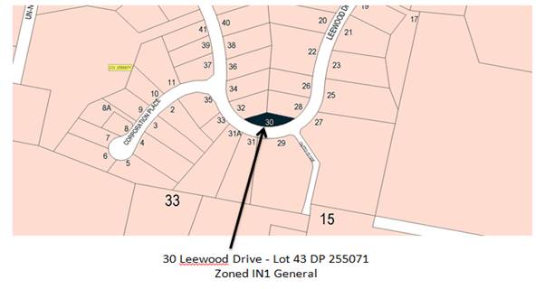
Attachments
1 Proposed
Reclassification Site - Lot 43 DP 255071 - 30 Leewood Drive Orange,
D15/4930⇩
Sustainable Development Committee
3 March 2015
2.8 Rezoning
of Lot 43 DP 255071 30 Leewood Drive Orange
Attachment 1 Proposed
Reclassification Site - Lot 43 DP 255071 - 30 Leewood Drive Orange