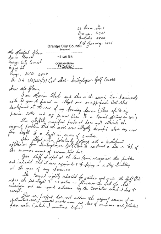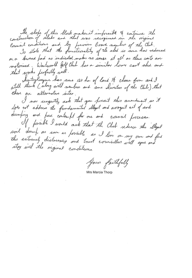
ORANGE CITY COUNCIL
Sustainable Development
Committee
Agenda
3 February 2015
Notice
is hereby given, in accordance with the provisions of the Local Government Act
1993 that a Sustainable Development
Committee meeting
of ORANGE CITY COUNCIL will be held in the Council Chamber, Civic Centre, Byng Street, Orange on Tuesday,
3 February 2015.
Garry
Styles
General Manager
For apologies please
contact David Waddell on 6393 8261.
Sustainable Development Committee 3
February 2015
1 Introduction
1.1 Apologies
and Leave of Absence
1.2 Declarations
of Interest
The
provisions of Chapter 14 of the Local Government Act, 1993 (the Act)
regulate the way in which Councillors and designated staff of Council conduct
themselves to ensure that there is no conflict between their private interests
and their public role.
The
Act prescribes that where a member of Council (or a Committee of Council) has a
direct or indirect financial (pecuniary) interest in a matter to be considered
at a meeting of the Council (or Committee), that interest must be disclosed as
soon as practicable after the start of the meeting and the reasons given for declaring
such interest.
As
members are aware, the provisions of the Local Government Act restrict any
member who has declared a pecuniary interest in any matter from participating
in the discussion or voting on that matter, and requires that member to vacate
the Chamber.
Council’s Code of Conduct provides that if members
have a non-pecuniary conflict of interest, the nature of the conflict must be
disclosed. The Code of Conduct also provides for a number of ways in which a
member may manage non pecuniary conflicts of interest.
|
Recommendation
It is recommended that Committee Members now disclose any
conflicts of interest in matters under consideration by the Sustainable
Development Committee at this meeting.
|
2 General
Reports
2.1 Items
Approved Under the Delegated Authority of Council
TRIM
REFERENCE: 2015/190
AUTHOR: Allan
Renike, Manager Development Assessments
EXECUTIVE Summary
Following is a list of development
applications approved by the General Manager under the delegated authority of
Council.
Link To Delivery/OPerational Plan
The recommendation in this report relates to the
Delivery/Operational Plan strategy “13.4 Our Environment
– Monitor and enforce regulations relating to City amenity”.
Financial Implications
Nil
Policy and Governance Implications
Nil
|
Recommendation
That the information provided in the
report by the Manager Development Assessments on Items Approved Under the
Delegated Authority of Council be acknowledged.
|
further considerations
Consideration has been given to the
recommendation’s impact on Council’s service delivery; image and
reputation; political; environmental; health and safety; employees; stakeholders
and project management; and no further implications or risks have been
identified.
SUPPORTING INFORMATION
|
Reference:
|
DA 180/2014(1)
|
Determination
Date
|
16 December 2014
|
|
PR Number
|
PR26474
|
|
Applicant/s:
|
Mr D Bouffler
|
|
Owner/s:
|
Mr DW Bouffler
|
|
Location:
|
Lot 310 DP 1192977 - 33 Emmaville Street, Orange
|
|
Proposal:
|
Dwelling, subdivision (two lot residential) and
dwelling
|
|
Value:
|
$350,000
|
|
Reference:
|
DA 312/2014(1)
|
Determination
Date
|
16 December 2014
|
|
PR Number
|
PR3458
|
|
Applicant/s:
|
Mr J Levi
|
|
Owner/s:
|
Mr JA and Mrs RS Levi
|
|
Location:
|
Lot 7 Sec 7 DP 5265 - 71 Dalton Street, Orange
|
|
Proposal:
|
Medical centre (alterations and additions to existing
building)
|
|
Value:
|
$500,000
|
|
Reference:
|
DA 328/2014(1)
|
Determination
Date
|
8 December 2014
|
|
PR Number
|
PR16902
|
|
Applicant/s:
|
Mr IL and Mrs DM Berryman
|
|
Owner/s:
|
Mr IL and Mrs DM Berryman
|
|
Location:
|
Lot 60 DP 875321 - 13-15 Peisley Street, Orange
|
|
Proposal:
|
Demolition (existing sheds), subdivision (three lot
industrial) and general industry
|
|
Value:
|
$300,000
|
|
Reference:
|
DA 332/2014(1)
|
Determination
Date
|
2 December 2014
|
|
PR Number
|
PR26746
|
|
Applicant/s:
|
Mr M Mustac
|
|
Owner/s:
|
Eastern Developments (NSW) Pty Ltd
|
|
Location:
|
Lot 314 DP 1201019 - 14 Dimboola Way, Orange
|
|
Proposal:
|
Dual occupancy and subdivision (two lot residential)
|
|
Value:
|
$360,000
|
|
Reference:
|
DA 333/2014(1)
|
Determination
Date
|
22 December 2014
|
|
PR Number
|
PR11502
|
|
Applicant/s:
|
Mrs M and Mr TJ Nagle
|
|
Owner/s:
|
Mr CLC and Mrs YM Powell
|
|
Location:
|
Lot 4 DP 711877 - 187 Summer Street, Orange
|
|
Proposal:
|
Retail premises (shop)
|
|
Value:
|
$10,000
|
|
Reference:
|
DA 334/2014(1)
|
Determination
Date
|
11 December 2014
|
|
PR Number
|
PR14312
|
|
Applicant/s:
|
Mr H Brown
|
|
Owner/s:
|
Mr H Brown
|
|
Location:
|
Lot 71 DP 832376 - 22-24 Leewood Drive, Orange
|
|
Proposal:
|
Industry (alterations and additions to existing shed)
|
|
Value:
|
$40,000
|
|
Reference:
|
DA 346/2014(1)
|
Determination
Date
|
12 December 2014
|
|
PR Number
|
PR15494
|
|
Applicant/s:
|
Tony Leahey Motor Group Pty Ltd
|
|
Owner/s:
|
Mr AR and Mrs LJ Leahey
|
|
Location:
|
Lot 574 DP 836044 - 25 Cameron Place, Orange
|
|
Proposal:
|
Vehicle repair station,
vehicle sales or hire premises (extension of existing servicing building and
workshop) and demolition (two existing buildings)
|
|
Value:
|
$800,000
|
|
Reference:
|
DA 367/2014(1)
|
Determination
Date
|
22 December 2014
|
|
PR Number
|
PR26771
|
|
Applicant/s:
|
Mr S and Mrs AA Atkinson
|
|
Owner/s:
|
Mr SJ and Mrs AA Atkinson
|
|
Location:
|
Lot 7 DP 1202010 - 3 Jazz Place, Orange
|
|
Proposal:
|
Dual occupancy and subdivision (two lot residential)
|
|
Value:
|
$475,000
|
|
Reference:
|
DA 373/2014(1)
|
Determination
Date
|
16 December 2014
|
|
PR Number
|
PR14163
|
|
Applicant/s:
|
Mr IJ Parker
|
|
Owner/s:
|
Erolwren Pty Ltd
|
|
Location:
|
Lot 102
DP 562456, Lot 1 DP 392443, Lots 1 and 2 DP 213505 -
85-107
Glenroi Avenue, Orange
|
|
Proposal:
|
Subdivision (three lots) (consolidation and boundary
adjustment)
|
|
Value:
|
$0
|
|
Reference:
|
DA 379/2014(1)
|
Determination
Date
|
13 January 2015
|
|
PR Number
|
PR3
|
|
Applicant/s:
|
Mr E Zell
|
|
Owner/s:
|
Mrs SA Zell
|
|
Location:
|
Lot 3 DP 568571 - 23 Beasley Road, Lucknow
|
|
Proposal:
|
Subdivision (two lot residential) and dwelling house
|
|
Value:
|
$150,000
|
|
Reference:
|
DA 386/2014(1)
|
Determination
Date
|
8 January 2015
|
|
PR Number
|
PR17472
|
|
Applicant/s:
|
Sentinel Orange Homemaker Pty Ltd
|
|
Owner/s:
|
Sentinel Orange Homemaker Pty Ltd
|
|
Location:
|
Lot 5 DP 270204 - Unit 7, Orange Grove Homemakers Centre -
Mitchell Highway, Orange
|
|
Proposal:
|
Bulky goods premises
|
|
Value:
|
$100,000
|
|
Reference:
|
DA 411/2014(1)
|
Determination
Date
|
20 January 2015
|
|
PR Number
|
PR1961
|
|
Applicant/s:
|
Mr G Tanos
|
|
Owner/s:
|
Central Development Enterprises Pty Limited
|
|
Location:
|
Lot 50 DP 576317 – 113 Byng Street, Orange
|
|
Proposal:
|
Restaurant or café (alterations and additions)
|
|
Value:
|
$5,000
|
TOTAL
NET* VALUE OF ALL DEVELOPMENTS APPROVED IN THIS PERIOD: $3,090,000
*
Net value relates to the value of modifications. If modifications are
the same value as the original DA, then nil is added. If there is a plus/minus
difference, this difference is added or taken out.
2.2 Development
Application DA 181/2014(1) - 454 The Escort Way
TRIM
REFERENCE: 2015/192
AUTHOR: Paul
Johnston, Planning Team Leader
EXECUTIVE Summary
Council’s consent is sought to construct a
telecommunications facility, described by the applicant as a new mobile phone
base station, at 454 The Escort Way, Orange. The proposed structure is located
on the western ridgeline of Ploughmans Valley within the scenic protection area
as defined by Council’s Development Control Plan.
A section 79C assessment of the proposed development has
been undertaken by Council staff. It is considered that the proposed
development will have a significant visual impact upon the immediate
surrounding residential locality. The proposal is, however, considered
acceptable in this case subject to the implementation of several recommended
conditions of consent. Having said this, given the significance of the western
ridgeline of the City it would be open for Council to form an alternative view
should the visual impact of the development in this location be considered
unacceptable.
Link To Delivery/OPerational Plan
The recommendation in this report relates to the
Delivery/Operational Plan strategy “13.4 Our Environment
– Monitor and enforce regulations relating to City amenity”.
Financial Implications
Nil
Policy and Governance Implications
Nil
|
Recommendation
That Council
approves development application DA 181/2014(1) for Telecommunications Facility (mobile phone
base station with 40m high monopole and equipment shelter) at
Lot 100 DP 1035863 - 454 The Escort Way, Orange
pursuant to the conditions of consent in the attached Notice of Approval.
|
further considerations
Consideration has been given to the
recommendation’s impact on Council’s service delivery; image and
reputation; political; environmental; health and safety; employees;
stakeholders and project management; and no further implications or risks have
been identified.
SUPPORTING INFORMATION
THE APPLICATION
Council’s consent is sought to construct a
telecommunications facility (mobile phone base station) at 454 The Escort Way,
Orange, being Lot 100 in DP 1035863.
THE PROPOSAL
Telstra propose to install a new mobile phone base station
at 454 The Escort Way, Orange. The applicant has summarised the proposal as
follows:
· installation of a
new 40m high monopole with a triangular head frame mounted at a centreline
elevation of 40m
· six panel antennas
(2.6m long) mounted on the headframe at the centreline elevation of 40m, giving
a total elevation of 41.3m
· six future panel
antennas (2.6m long) mounted on the headframe at a centreline elevation 40m,
giving a total elevation of 41.3m
· installation of
six remote radio units and nine tower mounted amplifiers in proximity to the
antennas
· one equipment
shelter 2.28 (width) x 3.28m (length) x 2.95m (height) with associated piers
located at the base of the monopole
· ancillary cabling
and cable ladder and
· landscaping.
The proposal will be incorporated into the existing network
via existing fibre optic cable.
Once operational, the facility will function on a
continuously unstaffed basis and will typically only require maintenance works
once a year.
The proposed development will comprise the installation of a
41.3m high monopole fitted with antennas and equipment housing. The radio
equipment is proposed to be housed within a shelter which will be located in
close proximity to the base of the monopole. The surrounding locality comprises
predominantly residential development to the immediate east and undeveloped
large lot residential land to the west.
Council received two written submissions in regards to the
proposed telecommunications facility. Council’s responses to both
submissions are detailed within the report.
TELECOMMUNICATIONS ACT 1997
Telstra is a licenced telecommunications carrier and is
required to operate under the provisions of the Telecommunications Act 1997
and the Telecommunications Code of Practice 1997.
The 1997 Act and Telecommunications (Low-impact
Facilities) Determination 1997 (as amended) establish the criteria for
‘low impact’ telecommunications facilities. The proposed
development is not defined as a ‘’low-impact facility” under
the Telecommunications Act and is therefore subject to the provisions of
the NSW Environmental Planning and Assessment Act 1979 and,
accordingly, the provisions of Orange Local Environmental Plan 2011.
The Telecommunications Code of Practice 1997 sets out
the design, planning and installation requirements for carriers to ensure that
the installation of facilities is in accordance with industry “best
practice”. The applicant advises that the design and siting of the
proposed communications facility has been undertaken in accordance with
Section 3 (Planning and Siting) of the Australian Standard , Siting of
Radio Communications Facilities (AS3516.2).
MATTERS FOR CONSIDERATION
Section 79C of the Environmental Planning and Assessment
Act 1979 requires Council to consider various matters, of which those
pertaining to the application are listed below.
Section 5A Assessment
In the administration of sections 78A, 79B, 79C, 111 and
112, the provisions of Section 5A must be taken into account for every
development application in deciding whether there is likely to be a significant
effect on threatened species, populations or ecological communities or their
habitats. This section includes a requirement to consider any adopted
assessment guidelines, which means assessment guidelines issued and in force
under section 94A of the Threatened Species Conservation Act 1995.
Assessment guidelines are in force (see DECC-W “Threatened Species
Assessment Guidelines - The Assessment of Significance”) which requires
consent authority to adopt the precautionary principle in its assessment.
The subject property provides
some habitat suitable for certain threatened or endangered species on a limited
basis. However, with the exception of the Regent Honeyeater (for which this
site is not suitable), there are no fauna species above the category of
vulnerable that occur in this locality. The tests listed in the Assessment of
Significance only apply to Threatened, Endangered or Critically Endangered
Species as they appear in the NPWS Wildlife Atlas. Species listed as vulnerable
or below have importance when assessing the value of vegetation communities, but
are not individually protected themselves under the seven part test provisions.
In this case the vegetation on
the subject land (but not the site of the proposed facility) is characterised
by a number of over mature Eucalypts, but more significantly by planted
vegetation around the site. There is a naturally occurring Box Gum Grassy
Woodland (BGGW) on the western side of the site (see map below) that is
noteworthy and of some significance, deserving of conservation. A number of
vulnerable species are likely to utilise this vegetation for connectivity
purposes to link to areas of greater, more significant biomass to the west and
south of the subject site. The conservation of that vegetation remnant is
important for that reason, but the proposed development has no impact in that
respect. The scattered over mature eucalypts on the site are significant for
seed banking purposes and also as waypoints for migrating immature avian
species.
The proposed development has no
impact in terms of the supporting vegetation and therefore a detailed
supporting assessment so as to complete the seven part assessment of
significance as called up by the Act is not necessary.
The LEP also has provisions that
are additional and separate to the Act that apply in areas mapped under the LEP
as an Environmentally Sensitive Area (ESA). In this case the attached LEP
map extract demonstrates that whist parts of the lot are considered
an ESA, the part of the lot where the proposed development is to be sited
is not a sensitive area and has only limited connectivity to those areas. The
various dams and waterways on the site are not considered overly sensitive, and
as explained above do not support species that in themselves are protected
under the TSC or EP&A Act. Whilst it is acknowledged that rare species may
frequent the site, it is unlikely that they have a critical dependence on the
site, even applying the Department guidelines of local occurrence and local
conservation. It is considered the threat posed by the proposed development is
minor. It is further noted that the proposed development does not constitute a
Key Threatening Process (KTP) under the abovementioned OEH guidelines.
There is no significant risk arising
under either the Assessment of Significance prescribed by Section 5A, or
under the local LEP controls.
PROVISIONS OF ANY ENVIRONMENTAL
PLANNING INSTRUMENT s79C(1)(a)(i)
Orange Local Environmental Plan 2011
Part 1 - Preliminary
This part of the plan is largely administrative in nature
and has minimal implications for the proposal.
Clause 1.2 - Aims of Plan
The broad aims of the LEP are
set out under subclause 2. Those relevant to the application are as follows:
(a) to encourage development which complements
and enhances the unique character of Orange as a major regional centre boasting
a diverse economy and offering an attractive regional lifestyle,
(b) to provide for a range of development
opportunities that contribute to the social, economic and environmental
resources of Orange in a way that allows the needs of present and future
generations to be met by implementing the principles of ecologically
sustainable development,
(f) to recognise and manage valued
environmental heritage, landscape and scenic features of Orange.
The application is considered to be consistent with aims (a)
and (b) as listed above. In relation to aim (f), it is considered that the
proposal will have a significant impact upon the landscape and scenic features
of the western ridgeline of Ploughmans Valley. A detailed assessment of the
likely impacts of the development and in particular the impact that the
development will have on the landscape and scenic features of the City has been
provided below under the heading “Likely Impacts of the
Development”.
Clause 1.6 - Consent Authority
This clause establishes that, subject to the Act, Council is
the consent authority for applications made under the LEP.
Clause 1.9A - Suspension of
Covenants, Agreements and Instruments
This clause provides that covenants, agreements and other
instruments which seek to restrict the carrying out of development do not apply
with the following exceptions.
· covenants imposed
or required by Council
· prescribed
instruments under Section 183A of the Crown Lands Act 1989
· any conservation
agreement under the National Parks and Wildlife Act 1974
· any trust
agreement under the Nature Conservation Trust Act 2001
· any property
vegetation plan under the Native Vegetation Act 2003
· any biobanking
agreement under Part 7A of the Threatened Species Conservation Act 1995
· any planning
agreement under Division 6 of Part 4 of the Environmental Planning and
Assessment Act 1979.
The subject site does not appear
to be affected by any of the above. The subject allotment is burdened by an
electricity easement. The proposed development will not have a detrimental
effect on the easement.
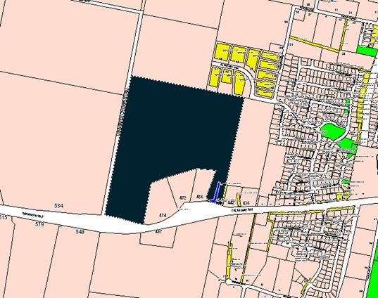
Mapping
The subject site is identified
on the LEP maps in the following manner:
|
Land Zoning Map:
|
Land zoned R5 Large Lot Residential
|
|
Lot Size Map:
|
Minimum Lot Size 2ha
|
|
Heritage Map:
|
Not a heritage item or conservation
area.
|
|
Height of Buildings Map:
|
No building height limit
|
|
Floor Space Ratio Map:
|
No floor space limit
|
|
Terrestrial Biodiversity Map:
|
Biodiversity sensitivity on the
site
|
|
Groundwater Vulnerability Map:
|
Ground water vulnerable
|
|
Drinking Water Catchment Map:
|
Not located within the drinking
water catchment
|
|
Watercourse Map:
|
Not within or affecting a defined
watercourse
|
|
Urban Release Area Map:
|
Not within an urban release area
|
|
Obstacle Limitation Surface Map:
|
No restriction on building siting
or construction
|
|
Additional Permitted Uses Map:
|
No additional permitted use applies
|
Those matters that are considered
to be of relevance to the development application are addressed in detail in
the body of this report.
Part 2 -
Permitted or Prohibited Development
Land Use Zones
The subject site is zoned R5 Large Lot Residential. The
proposed development is defined as a Telecommunications Facility under OLEP
2011. Pursuant to OLEP 2011 a telecommunications facility means:
(a) any
part of the infrastructure of a telecommunications network, or
(b) any
line, cable, optical fibre, fibre access node, interconnect point equipment,
apparatus, tower, mast, antenna, dish, tunnel, duct, hole, pit, pole or other
structure in connection with a telecommunications network, or
(c) any
other thing used in or in connection with a telecommunications network.
Telecommunications Facilities are not specifically
listed as permissible in the R5 Large Lot Residential zone under OLEP 2011 and
are thus prohibited. However, State Environmental Planning Policy
(Infrastructure) applies to the State and under Clause 116 development for the
purposes of telecommunications facilities may be carried out by any person with
consent on any land. The SEPP overrides the provisions of Orange LEP 2011
and therefore has the effect of rendering the proposed development permissible
on any land with the consent of Council.
In accordance with Clause 115(3) of SEPP (Infrastructure),
Council in determining this matter must take into consideration any guidelines
concerning site selection, design, construction or operating principles for
telecommunications facilities that are issued by the Director-General for the
purposes of this clause and published in the Gazette.
This provision has the effect of imposing any assessment
guidelines imposed by the Director General (Department Of Planning). The
Department has a design guideline, entitled "NSW Telecommunications
Facilities Guideline Including Broadband" which applies in this case.
A detailed assessment of how the development responds to
these guidelines has been provided below under the heading of "State
Environmental Planning Policies".
Clause 2.3 of
OLEP 2011 references the Objectives for each zone in OLEP 2011. These
objectives for land zoned R5 Large Lot Residential are as follows:
· To
provide residential housing in a rural setting while preserving, and minimising
impacts on, environmentally sensitive locations and scenic quality.
· To
ensure that large residential lots do not hinder the proper and orderly
development of urban areas in the future.
· To
ensure that development in the area does not unreasonably increase the demand
for public services or public facilities.
· To
minimise conflict between land uses within this zone and land uses within
adjoining zones.
· To
provide for student housing in close proximity to the Charles Sturt University.
· To
ensure development is ordered in such a way as to maximise public transport
patronage, and encourage walking and cycling, in close proximity to settlement.
· To
ensure development along the Southern Link Road has an alternative access.
The objectives of the zone are not considered to be of
relevance to the proposed development.
Part 3 -
Exempt and Complying Development
Telstra is a licenced telecommunications carrier and is
required to operate under the provisions of the Telecommunications Act 1997
and the telecommunications Code of Practice 1997. The 1997 Act and Telecommunications
(Low-impact Facilities) Determination 1997 (as amended) establish the
criteria for ‘low impact’ telecommunications facilities. The
proposed development is not defined as a ‘’low-impact facility”
under the Telecommunications Act and is therefore subject to the provisions of
the NSW Environmental Planning and Assessment Act 1979 and,
accordingly, the provisions of Orange Local Environmental Plan 2011.
The application is not exempt or complying development.
Part 4 - Principal Development
Standards
Not relevant to the application.
Part 5 - Miscellaneous
Provisions
5.9 - Preservation of Trees
or Vegetation
This clause seeks to maintain and
preserve the amenity of the area, including biodiversity values, through the
preservation of trees and other vegetation.
(3) A person must not ringbark,
cut down, top, lop, remove, injure or wilfully destroy any tree or other
vegetation to which any such development control plan applies without the
authority conferred by:
(a) development consent, or
(b) a permit granted by the
Council.
The construction of the
telecommunications facility makes use of an existing cleared paddock and no
clearing of any significant trees or vegetation is required to facilitate the
proposed development.
Part 6 -
Urban Release Area
Not relevant to the application. The subject site is not
located in an Urban Release Area.
Part 7 -
Additional Local Provisions
7.1 - Earthworks
This clause establishes a range
of matters that must be considered prior to granting development consent for
any application involving earthworks, such as:
(a) the likely disruption of, or any
detrimental effect on, existing drainage patterns and soil stability in the
locality of the development
(b) the effect of the development on the
likely future use or redevelopment of the land
(c) the quality of the fill or the soil to be
excavated, or both
(d) the effect of the development on the
existing and likely amenity of adjoining properties
(e) the source of any fill material and the
destination of any excavated material
(f) the likelihood of disturbing relics
(g) the proximity to and potential for adverse
impacts on any waterway, drinking water catchment or environmentally sensitive
area
(h) any measures proposed to minimise or
mitigate the impacts referred to in paragraph (g).
The proposed earthworks will
consist of site testing, excavation and construction of foundations. The
proposed earthworks will not involve the removal of any trees with the subject
land already highly disturbed from past farming practices. The proposed
development is not expected to have a detrimental effect on the water catchment
area.
7.6 -
Groundwater Vulnerability
This clause seeks to protect
hydrological functions of groundwater systems and protect resources from both
depletion and contamination. Orange has a high water table and large areas of
the LGA, including the subject site, are identified with “Groundwater
Vulnerability” on the Groundwater Vulnerability Map. This requires that
Council consider:
(a) whether or not the development (including
any onsite storage or disposal of solid or liquid waste and chemicals) is
likely to cause any groundwater contamination or have any adverse effect on
groundwater dependent ecosystems, and
(b) the cumulative impact (including the
impact on nearby groundwater extraction for potable water supply or stock water
supply) of the development and any other existing development on groundwater.
Furthermore consent may not be granted unless Council is satisfied that:
(a) the development is designed, sited and
will be managed to avoid any significant adverse environmental impact, or
(b) if that impact cannot be reasonably
avoided - the development is designed, sited and will be managed to minimise
that impact,
(c) if that impact cannot be minimised - the
development will be managed to mitigate that impact.
The proposal is not anticipated
to involve the discharge of toxic or noxious substances and is therefore
unlikely to contaminate the groundwater or related ecosystems. The proposal
does not involve extraction of groundwater and will therefore not contribute to
groundwater depletion.
DESIGNATED DEVELOPMENT
The proposed development is not designated development.
STATE ENVIRONMENTAL PLANNING
POLICIES
State Environmental Planning Policy (Infrastructure) 2007
("the SEPP") applies to the subject development.
Clause 2 - Aim of Policy
The aim of this policy is to facilitate the effective
delivery of infrastructure across the state by:
(a) improving
regulatory certainty and efficiency through a consistent planning regime for
infrastructure and the provision of services, and
(b) providing
greater flexibility in the location of infrastructure and service facilities,
and
(c) allowing
for efficient development, redevelopment or disposal of surplus government
owned land, and
(d) identifying
the environmental assessment category into which different types of
infrastructure and services development fall (including identifying certain
development of minimal environmental impact as exempt development), and
(e) identifying
matters to be considered in the assessment of development adjacent to
particular types of infrastructure development, and
(f) providing
for consultation with relevant public authorities about certain development
during the assessment process or prior to development commencing.
The development is not inconsistent with the aims of the
SEPP.
Clause 115 - Development
Permitted with Consent
(1) Development
for the purposes of telecommunications facilities, other than development in
clause 114 or development that is exempt development under clause 20 or
116, may be carried out by any person with consent on any land.
The SEPP has the effect of rendering the proposed
development permissible on any land with the consent of Council.
(3) Before
determining a development application for development to which this clause
applies, the consent authority must take into consideration any guidelines
concerning site selection, design, construction or operating principles for
telecommunications facilities that are issued by the Director-General for the
purposes of this clause and published in the Gazette.
This provision has the effect of imposing any assessment
guidelines imposed by the Director General (Department Of Planning). The
relevant guideline applicable in NSW for the consideration of development of
this type is entitled "NSW Telecommunications Facilities Guideline
Including Broadband".
The guideline has the effect under clause 1.6 of applying as
a design tool in all zones of an LEP.
Section 2.2 of the policy sets up the design principles that
should be followed. The guidelines are organised under "Principles"
headings. Many of the principles are not relevant because they relate to fully
urbanised landscapes. In this case the landscape and setting are not fully
urbanised. Detailed consideration of how the development fits into the
landscape will however remain an important element for consideration under the
guidelines. The ridge upon which the structure is proposed forms the skyline to
large areas of the City.
Those principles that are called up in the policy and which
are relevant to the assessment of visual impact are set out below:
Principle 1 - Design and Siting
to Minimise Visual Impact
· As
far as practical, a telecommunications facility that is to be mounted on an
existing building or structure should be integrated with the design and
appearance of the building or structure.
The applicant has advised that the area was analysed using
desktop and onsite investigations during the site selection process. The
applicant has indicated that when investigating sites the preference for
selection is firstly for colocation on existing infrastructure, secondly low
impact facilities (as defined by the Telecommunications (Low impact Facilities
Determination 1997) and lastly “greenfield sites”. Four candidate
sites were investigated in the context of the above. These include:
· Candidate A: 454
The Escort Way, Orange (proposed site)
· Candidate B: 448
The Escort Way, Orange
· Candidate C: Lot 1
DP 581736 Gorman Road, Orange
· Candidate D: 7
Borrodell Drive, Orange
These candidate sites are shown
in the attached aerial photo:
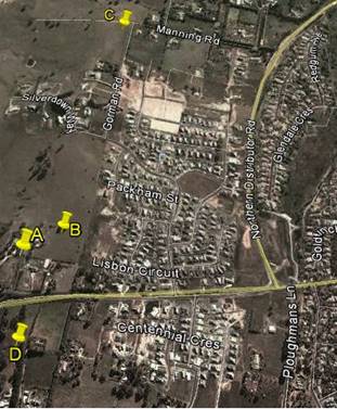
Candidate A: 454 The Escort Way, Orange (proposed site)
The applicant advises that this site provided the radio
coverage required of a facility in this area. The site has no design or
construction constraints. The property owner was willing to enter into a land
tenure agreement with Telstra.
Candidate B: 448 The Escort
Way, Orange
The applicant advises that this site provided the radio
coverage required of a facility in this area. The site was discounted as the
property owner was unwilling to enter into a land tenure agreement with
Telstra.
Candidate C: Lot 1 DP 581736
Gorman Road, Orange
The site was discounted as the property owner was unwilling
to enter into a land tenure agreement with Telstra. The applicant has advised
that the proposed facility in this location was not able to meet the radio
coverage objectives for this site without utilising a heightened tower
structure.
Candidate D: 7 Borrodell Drive,
Orange
The site was discounted as the property owner was unwilling
to enter into a land tenure agreement with Telstra. The site would require
extensive earthworks in order to construct a graded access track. The applicant
has advised that the proposed facility in this location was not able to meet
the radio coverage objectives for this site without utilising a heightened
tower structure.
· The visual
impact of telecommunications facilities should be minimised, visual clutter is
to be reduced
As a new structure designed to meet technical
specifications, there appear to be few opportunities to modify or reduce the
intrusive nature of the monopole and the array to be placed on top of the pole.
· Where
telecommunications facilities protrude from a building or structure and are
predominantly backgrounded against the sky, the facility and their support
mounts should be either the same as the prevailing colour of the host building
or structure, or a neutral colour such as grey should be used.
The proposed telecommunications facility is a stand-alone
structure. The proposed structure will protrude above the ridgeline when viewed
from a large area of the City and from The Escort Way. A detailed assessment of
the visual impacts of the development has been provided below under the heading
“Likely impacts of the Development”. It is considered appropriate
in this case to impose a condition requiring the structure to be painted a
“shale grey” colour as suggested. A condition to that effect is
included.
· Ancillary
facilities associated with the telecommunications facility should be screened
or housed, using the same colour as the prevailing background to reduce its
visibility, including the use of existing vegetation where available, or new
landscaping where possible and practical.
In this case the ground based structures will be located
immediately around the base of the structure. The applicant has submitted a
landscape plan in support of the proposal. It is considered that the proposed
landscaping at maturity will adequately screen the ancillary structures.
Attached is a condition in relation to this matter.
· A
telecommunications facility should be located and designed to respond
appropriately to its rural landscape setting.
In this case the setting behind (to the west) of the site
dictates the character and setting of the structure. As discussed above the
facility will project above the skyline, and whilst some landscaping exists
along the ridge, the development is proposed to be located on a relatively
exposed part of the ridge. Landscaping requirements are considered essential to
this proposal, and are discussed in more detail elsewhere in this report.
· A
telecommunications facility located on, or adjacent to, a State or local
heritage item or within a heritage conservation area, should be sited and
designed with external colours, finishes and scale sympathetic to those of the
heritage item or conservation area.
Council’s records indicate that subject site is not
located within a heritage conservation area and is not located adjacent to
listed State or Local heritage items.
· "A
telecommunication facility should be located and designed so as to respond
appropriately to its landscape setting".
A detailed assessment of the visual impact of the
development and its impact on the landscape setting has been provided below
under the heading “Likely Impacts of the Development’.
Principle 2 - Colocation
As indicated in the above discussion, colocation was not
considered a practical option.
Principle 3 - Health Standards
The applicant has submitted technical specifications and
discussion in their Statement of Environmental Effects, attesting that the
proposed structure when in operation will comply with relevant health standards,
particularly relating to electromagnetic emissions standards.
Whilst there are currently wide-ranging and contentious
views on the health impacts associated with electromagnetic energy (EME), with
large volumes of discourse related to the study, there is currently no
definitive evidence or conclusive findings one way or another of the effects of
EME on humans. Council is therefore largely reliant on the studies of
recognised health organisations and the submitted report on the summary of
Estimated RF (radiofrequency) EME (electromagnetic energy) in determining
the likely health impacts associated with the development.
The Australian Government’s Australian Radiation
Protection and Nuclear Safety Agency cite the World Health Organisation’s
advice stating:
None of the
recent reviews have concluded that exposure to RF fields from mobile phones and
their base stations cause any adverse health consequences” (ARPANSA).
Furthermore, the ARPANSA suggests:
the balance of evidence does
not indicate a risk to the health of people, including children, living in the
vicinity of base stations where exposure levels are only small fractions of the
ARPANSA standard.
A report titled Summary of Estimated RF and EME Levels
Around The Proposed Wireless Base Station…’ indicates:
RF EME levels have been
estimated from the proposed antennas at 354 Cadia Road, Springside. The maximum
cumulative EME level at 1.5m above ground level and 274.1m from the antennas is
estimated to be 0.026% of the ARPANSA public exposure limits.
As mentioned above, Council is largely reliant on the
reports submitted in the application and studies of recognised health agencies
in determining the likely health impacts associated with the development.
In light of the above, it is considered that the development
is not likely to result in adverse health impacts as a result of human
exposure.
Principle 4 - Minimise
Disturbance
This principle is mainly concerned with the impact that the
development may have on other telecommunication facilities in the locality,
particularly those relating to airport operations. It is considered unlikely
that the proposed structure will have any significant impact in this regard.
PROVISIONS OF ANY DRAFT
ENVIRONMENTAL PLANNING INSTRUMENT THAT HAS BEEN PLACED ON EXHIBITION s79C(1)(a)(ii)
Council is not aware of any draft Environmental Planning
Instruments that have been placed on public exhibition that affect the proposed
development.
PROVISIONS OF ANY DEVELOPMENT
CONTROL PLAN s79C(1)(a)(iii)
Development Control Plan 2004
Development Control Plan 2004 (“the DCP”)
applies to the subject land (Part 0LEP 2011, Part 6 Rural Development).
An assessment of the proposed development against the relevant Planning
Outcomes will be undertaken below.
Pursuant to Planning Outcome 0.2-1
Interim Planning Outcomes - Conversion of Zones:
· Throughout this
Plan, any reference to a zone in Orange LEP 2000 is to be taken to be a
reference to the corresponding zone(s) in the zone conversion table.
The corresponding zone to zone
1(c) Rural Residential (Orange LEP 2000) is zone R5 Large Lot Residential
(Orange LEP 2011). As such, Orange DCP 2004 - Chapter 6 - Rural Development
represents the corresponding set of controls for consideration. The proposed
development is not inconsistent with any provisions under this section of the
DCP.
Pursuant to Planning Outcome 0.4-1
Interim Planning Outcomes – Scenic Areas:
· Development
blends into the landscape through the use of appropriate siting, design,
external materials and colours, retention of trees including remnant
vegetation, establishing of new trees, and enhancing the skyline when viewed
either from the urban area of Orange or from public places in the vicinity of
the land.
While Telstra’s proposed facility will introduce a new
vertical element in the skyline, it should be viewed in conjunction with other
elements in the surrounding area and within the ‘Scenic Area’
itself. The applicant submits that these elements range from power and street
lighting poles in the near and immediate vicinity, to existing
telecommunications facilities in the distance. It can be suitably argued that
these vertical elements, considered essential infrastructure, are commonplace
within today’s landscapes, be it in the urban built environment, rural
settings, or the growing outskirts of townships such as Orange.
Following an evaluation of the documentation submitted in
support of the development application, it is understood that the proposed
facility has been sited as far back from The Escort Way (Forbes Road) as is
practically and technically feasible. Council is advised that while this
location is near the crest of the land marked as ‘Scenic Area’, it
allows the facility to be the smallest possible structure to achieve the required
coverage objectives of a site in this area. The applicant argues that the
proposed facility’s visual impact is further lessened by the existing
vegetation that is found surrounding the site location. The applicant’s
submission is accompanied by a detailed landscape plan. Telstra’s
proposal involves the establishment of a number of additional trees and shrubs
that will assist to screen the lower portion of the proposed facility. The
external colours and materials used to finish the proposed facility can also be
suited to blend into the landscape. Attached to the draft Notice are conditions
of consent that address these issues.
Whilst the assessment has highlighted that the proposed
development will have a significant visual impact when viewed from surrounding
residential properties and while travelling in both directions along The Escort
Way, the proposal is considered acceptable in this case subject to the
implementation of several recommended conditions of consent. Having said this,
given the significance of the western ridgeline of the City and the fact that
the proposed structure will be readily viewed from a number of residential
properties and road corridors in the general locality, it would be open for
Council to form an alternative view should the visual impact of the proposed
development be considered unacceptable.
PROVISIONS PRESCRIBED BY THE
REGULATIONS s79C(1)(a)(iv)
The proposed development is not inconsistent with the
provisions prescribed by the regulations.
THE LIKELY IMPACTS OF THE
DEVELOPMENT s79C(1)(b)
Context and Setting
Council is advised that Telstra is required by law to
carefully consider many factors before deciding on the location and the design
of a base station. It is understood that these factors include:
· service objectives
(radio coverage requirements)
· physical
characteristics of the site - such as height and terrain
· ability to connect
with the rest of the network
· planning
constraints such as zonings
· colocation
opportunities
· minimising public
exposure to EME
· cost factors
· the ability to
obtain a suitable lease
· proximity to
community sensitive locations and
· minimising the
visual impact on the existing environment.
As demand grows on mobile telecommunications networks, the
applicant advises that additional investment is required to match capacity to
demand. In the case of the service provided by Telstra to Orange, Council is
advised that investments have been made to increase the capacity of surrounding
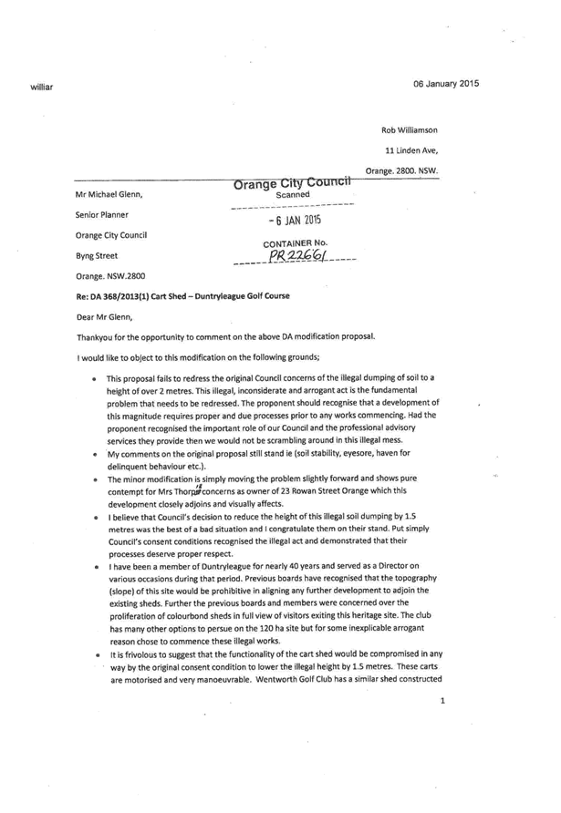
facilities and install additional facilities, including those at Beech
Crescent, Calare, and at the Duntryleague Golf Club on Woodward Street. Telstra
has also been able to utilise additional radio channels, sectorisation or cell
splitting and spreading the load over all the different frequency bands that
are available to Telstra under its Telecommunications Carrier Licence. The
applicant advises that the proposed development represents the next step to
providing vital infrastructure that will facilitate enhanced services to customers,
providing improved coverage to areas that are currently experiencing limited
reception.
The facility is proposed to be sited on a privately owned
large lot residential allotment approximately midway along the eastern boundary
of the lot at 454 The Escort Way. The subject land provides some screening
utilising existing vegetation on the lot. A landscape plan has been submitted
in support of the subject development. This additional landscaping will, over
time, provide a level of screening for the lower section of the monopole and
the equipment at ground level.
Design
Whilst it is not uncommon for telecommunications facilities
to be sited in close proximity to residential development, Telstra has
acknowledged that the facility needs to be sensitive to its environment.
The applicant advises that taking advantage of local
topography has allowed the use of a 40m structure in this location,
thereby avoiding the need to install a lattice type structure or taller
monopole which would represent a significantly less desirable visual outcome.
Council is advised that the 40m high monopole is the minimum height required
for the facility to project over the trees to the surrounding area and provide
the level of coverage necessary to make a sustainable contribution to coverage
and service issues.
In order to reduce the long term visual impact of the
proposed development it is recommended in the event that Council is of the view
to support the proposed development, that the structure be painted in a
“shale grey” colour and the applicant be required to implement the
landscape plan submitted in support of the proposed development.
Council’s Urban Design Advisor has also recommended that this colour be
utilised. The equipment shelter will not be visible externally due to existing
private and public vegetation in the surrounding area. The landscape concept
plan submitted incorporates eleven Populus Canadensis evergreen trees and ten
Pittosporum James Stirling located around the proposed structure, which will at
maturity screen the lower section of the tower. The proposed trees will have a
mature height of approximately 20m. The attached Notice of Approval contains
conditions in relation to these matters.
The applicant submits that the development will have an
acceptable visual impact and that the facility will provide vital
infrastructure that will provide enhanced services to customers, providing
improved coverage to areas that are currently experiencing limited reception.
Visual Impacts
The proposed structure is located on the western ridgeline
of Ploughmans Valley within the scenic protection area as defined by
Council’s Development Control Plan. The subject land comprises large lot
residential and is located adjacent to residential areas within the Ploughmans
Valley. The ridgeline that forms just to the west of the subject land comprises
the backdrop to large parts of the City including Westlea, Belair and parts to
the north of those areas. Landscape elements are concentrated to the south but
further north are mostly devoid of landscape elements.
The proposed development is likely to result in various
levels of visual impact given its location in relation to residential areas to
the north, east and south and the height of the proposed monopole (41.3m). Visual
impact is often a significant issue with respect to the installation of mobile
phone base stations. In order to provide adequate clearance above buildings,
trees and the topography of the land it is virtually impossible for these
facilities to be completely hidden.
The subject land provides some low level screening utilising
existing vegetation on the lot. A landscape plan has been submitted in support
of the subject development. The proposed landscaping will, over time, provide a
level of screening of the lower section of the monopole and the equipment at
ground level.
The applicant submits that the proposed location of the
telecommunications tower provides for maximum separation distance between the
facility and the majority of residential development. The applicant advises
that the siting of the proposed structure any further west would not meet the
radio coverage objectives for the site. It is understood that the height of the
proposed monopole is the minimum required height to adequately meet the
objectives of a site in this location. Council staff requested the applicant to
consider what opportunity there was for establishing the development on
alternative sites and whether or not it was possible to reduce the overall
height of the structure. The applicant has since advised Council that they were
unable to secure legal tenure over the alternative sites identified during the
site selection process and that a lower facility would not provide the
‘relief’ to surrounding sites.
A detailed assessment of the likely impacts of the structure
has been undertaken by staff to determine whether or not the development is
acceptable in this location. To this end some commentary on the likely visual
impact of the development from certain vantage points around the City is provided
below.
Adjoining rural residential
lots to the east and west both contain dwellings with some screening
opportunities from existing vegetation onsite. An evaluation of the site
indicates that dwellings in the immediate vicinity of the subject site are oriented
generally away from the proposed facility. However, as Council would be aware
the surrounding area is currently within a transitional phase of development
and opportunity for additional dwellings to be established within proximity to
the facility in the near future. The following extract from the applicant's
Statement of Environmental Effects depicts the context of the existing
surrounding area:
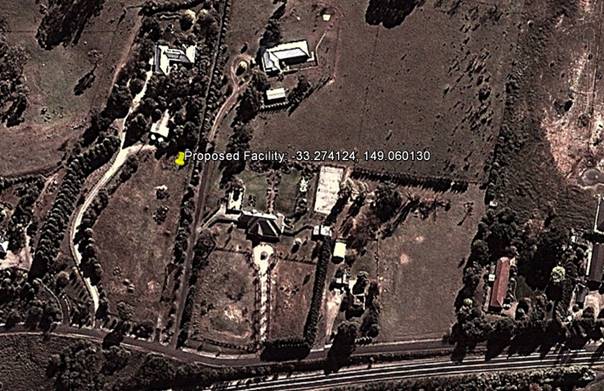
Surrounding
area (source - applicants Statement of Environmental Effects)
Due to existing public and private vegetation, as well as
the additional landscaping proposed (a row of eleven Evergreen Poplars, and a row of ten James Stirling surrounding
the facility) the applicant submits that the upper portion of the facility only
will be exposed intermittently in all directions surrounding the facility.
Council staff met with representatives from Aurecon and
Telstra to discuss matters in relation to the likely visual impact of the
proposal. A tower platform was raised and lifted to a height of 40m to roughly
depict the proposed telecommunications facility, and provide an indication of
the height required. A number of vantage points were visited by both Council
staff and the applicant, with photomontages being created to assist in this
assessment. This exercise was undertaken to accurately determine height and
location of the proposed development, to overcome difficulties in relying on
photomontages and to avoid criticism that questions the legitimacy of the
photomontages.
The applicant has since provided further analysis of the
visual impact of the development from various vantage points and provided
additional photomontages of the proposed development for Council’s
consideration. The additional photomontages have been taken with a 50mm focal
length lens. However it is understood that with the sensor size of the cameras
used by the applicant and Council staff that the correct focal length that
represents the human field of view and focal length is actually 32mm.
Notwithstanding this these photomontages are considered to present a greater
sense of impact than what would have been presented with a focal length of
32mm.
Land to the
north of the facility is currently vacant land. Given the undulating nature of the land the proposed facility is likely to be seen from
along Silverdown Way some
550m from site. Due to distance and separation
the facility is not likely to be a bulky structure when viewed from this
vantage point. The applicant submits that the facility will be further mitigated by existing vertical structures in
the area including electricity poles, existing telecommunications lattice
towers in the distance and mature vegetation.


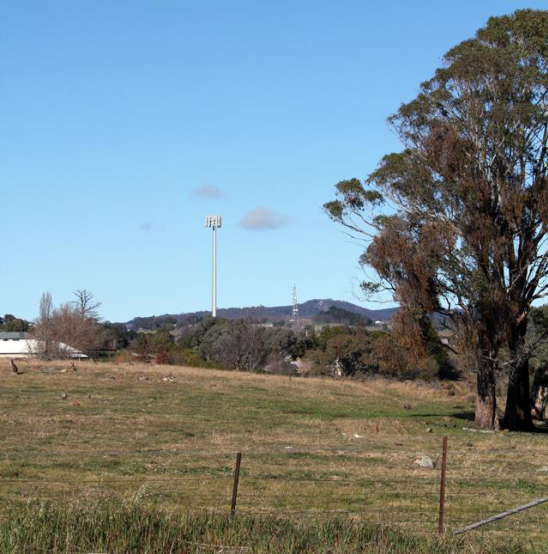
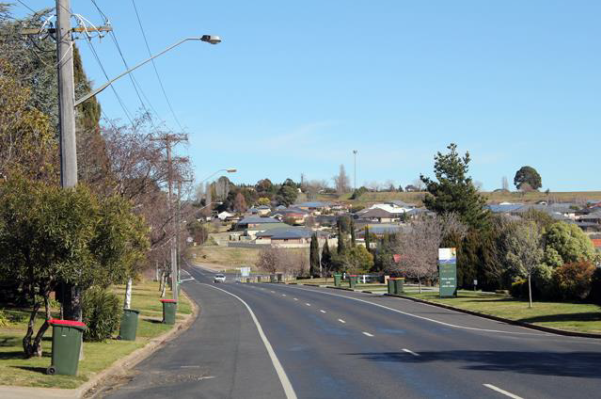
View
towards the proposed site location from Silverdown Way
(north
of proposed site location)
(source
- applicant's Statement of Environmental Effects)
When viewed from further north over
1km from the proposed site location, it is considered that the facility will
have limited visual impact. The applicant argues that whilst the top half of
the facility will be visible it will not be a dominant feature of the landscape
on the basis that it will appear as only a thin protrusion into the skyline.
The applicant further argues that views from the north would also encompass
existing telecommunications facilities at Nashdale and Mount Canobolas, as well
as existing vertical protrusions such as lighting and electricity poles.
When viewed from the northeast
and east in the predominately residential areas of Calare, the proposed
facility is considered to be more visible. The applicant submits that the
visual impacts of the development from this area will be mitigated through the
existing mature vegetation in the area surrounding the proposed site location
and the implementation of the proposed landscaping. Views of the facility from
the immediate south will be limited due to the elevation of the road reserve
along the northern boundary of The Escort Way. The applicant submits that
vegetation along this reserve will also aid to a degree in partly obscuring the
facility from view.
When viewed from the east and west at distances beyond 1km,
the facility will be visible to the greatest degree due to the topography of
the surrounding land. The proposed structure will be located on the western
ridgeline of Ploughmans Valley, which forms the natural backdrop to parts of
the City mentioned above. Whilst there are some landscape elements located on
the ridge to the south of the subject site there are very few landscape
features north of the site. The proposed tower will protrude well above the
skyline when viewed from various vantage points along The Escort Way when
travelling east and west of the subject site, the residential areas to the
north, east and south and from the rural areas to the north, south and west.
The western ridgeline has been identified as a significant
visual backdrop to the City and any element that protrudes above the ridgeline
has the potential to affect the visual amenity of this locality. The applicant
has consistently argued that the visual impact of the development will be
mitigated by existing and proposed landscaping and the fact that there are
other vertical elements such as electricity and lighting poles in this
locality.
Whilst this may be the case, it
is obvious that by the nature of this facility being a precisely defined 41.3m
high vertical element located on the western ridgeline to a large area of the
City that the tower structure will create a significant visual impact from
parts of the City. As would be expected the significance of the visual impact
would diminish the further the viewer is away from the tower. However, it needs
to be acknowledged that the visual impact of the tower structure will be
significant from the areas in close proximity to the tower, particularly from
the adjoining rural residential properties (see submissions below).


Figure
5.11 View towards proposed site location from Forbes Road
(approximately
1.1km east of proposed site location)
(source
- applicant's Statement of Environmental Effects)
The applicant submits that a photomontage of the
proposed facility as seen from Riawena Oval on Kooronga Avenue demonstrates
that while the upper portion of the monopole will be visible, the lower
sections are completely shrouded. This argument is acknowledged and it is
agreed that the visual impact of the development from this vantage point is
reduced given the separation distance that exists between the oval and the
subject site. The facility will not be visually significant from these distant
areas.


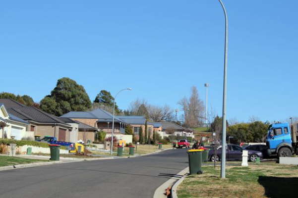
View
towards proposed site location from across Riawena Oval on Kooronga Avenue
(approximately
1.1km south-east of proposed site location)
(source
– Council staff)
Whilst the facility will have a visual presence within
the surrounding area when viewed from the west at varying degrees, it is
considered that the impact will be less given the semi-rural nature of the
land. The topography is undulating further west of the proposal, and with the
presence of mature vegetation in the landscape along The Escort Way it is
expected that the visual impact of the proposed facility from that vantage
point will be minimal.


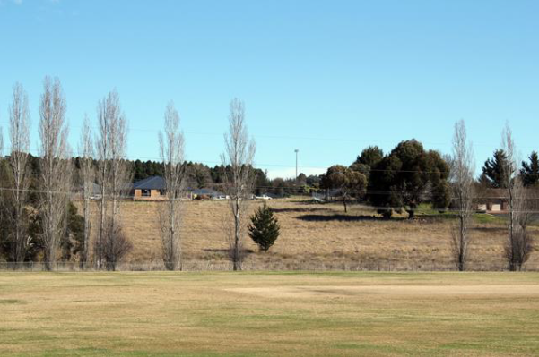
View
towards proposed site location from service road off Escort Way
(approximately
300m west of proposed site location)
(source
- applicants Statement of Environmental Effects)
The predominant land use directly east of the proposed site
is residential development. The development when viewed from Lisbon Circuit as
shown below (approximately 400m east of the proposed site location) will have
the greatest impact. The immediate adjoining neighbours will experience the
greatest visual impact. There is no hiding a structure of this type in the
location proposed. The implementation of landscaping and controls over the
colour of the proposed structure are the only practical measures that can be
implemented which will, over time, lessen the visual impact of the facility to
a degree. The proposed development when viewed from these vantage points will
nonetheless have a significant visual impact.
Again, the applicant submits that the degree of visual
impact will be mitigated by existing vegetation and the topography of the land.
Further, the applicant argues that this view corridor towards the facility from
these areas is not the predominant view direction from nearby properties. Whilst
this may be the case, it is reasonable to also argue that the western ridgeline
of Ploughmans Valley forms an important landscape feature for the City as
evidenced by the scenic protection provisions contained within Council’s
DCP, and is therefore worthy of protection from development that may impact
upon the scenic qualities of the locality.
There is no doubting that the
facility will be readily viewed from those properties to the immediate east of
the subject site. Development of this type, however, is fast becoming a typical
element within urban environments as the demand for better and more efficient
mobile phone coverage grows. Council therefore, in its consideration of this
matter balance the visual impact of the proposed development against the demand
and need for such infrastructure within the City in this location. Whilst other
sites were initially investigated, Council has been advised by the applicant
that Telstra was unsuccessful in obtaining the required legal tenure from those
property owners whose land was of initial interest.


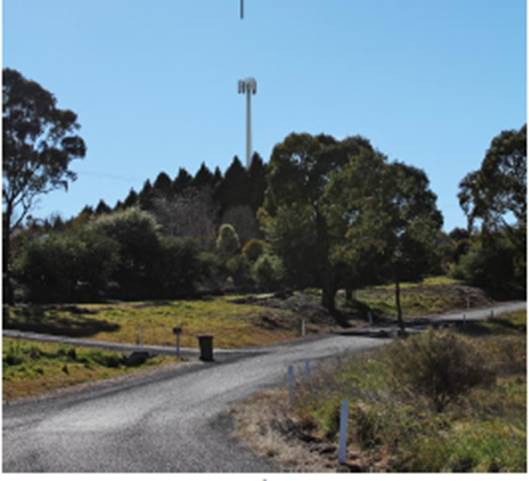
View
towards proposed site location from Lisbon Circuit
(approximately
500m east of proposed site location)
(source
- applicant's Statement of Environmental Effects)
In summary, the development is
proposed to be located on what is considered to be a significant ridgeline
forming a backdrop to parts of the City. Having said this, the site is
considered to be acceptable in this case subject to the implementation of
several recommended conditions of consent. However, as discussed previously
within this report, given the significance of the western ridgeline of the City
and the fact that the development will be highly visible from many areas in the
surrounding locality, it would be open for Council to form an alternative view
should the visual impact of the development in this location be considered
unacceptable. Should Council form the view that the development will have an
unacceptable impact, particularly in relation to the impact that will be
experienced by those property owners in the immediate vicinity of the
development, it would be necessary to refuse the subject development.
Noise Impacts
The majority of noise and vibration emissions associated
with the proposed facility will be limited to the construction phase. There
will be some low level noise from the ongoing operation of the air conditioning
equipment associated with the equipment units. As outlined within the
applicant's SoEE, the noise emanating from the outdoor cabinet air conditioning
system is at a comparable level to a domestic air conditioning installation,
and will generally accord with the background noise levels prescribed by
Australian Standard AS1055.
Traffic Impacts
Access to the telecommunications facility will be via the
existing access serving the subject site. After the construction period the
only traffic generated by the base station will be that associated with
maintenance vehicles. Accordingly, the facility will only generate one visit
per year for the maintenance, with the facility being vacant for the rest of
the year. The traffic generation will therefore be minimal and not sufficient
to create any adverse impacts.
Social and Economic Impacts
The applicant has advised that the proposed development will
facilitate the provision of vital infrastructure so as to improve mobile phone
coverage to areas that are currently experiencing limited reception within
Orange. The wider social and economic benefits of the proposal will result in a
positive impact for the City.
THE SUITABILITY OF THE SITE
s79C(1)(c)
The subject site is located within the scenic protection
area as defined under the provisions of DCP 2004. Such provisions
previously were included in Orange LEP 2000 but because Council were unable to
incorporate them into Orange LEP 2011 because of the Standard Instrument
provisions it was decided by Council to include them into the DCP. The
inclusion of these provisions in the DCP does reflect the importance that
Council gives to planning within the scenic protection areas. This particular
ridgeline forms a visual backdrop from parts of the urban environment of
Orange. The surrounding locality comprises predominantly residential
development to the immediate east and mostly undeveloped large lot residential
land to the west. This proposal therefore has the ability to influence the
visual amenity of many parts of the City well beyond the immediate area.
The assessment of the proposal has highlighted the fact that
the proposed development will have a visual impact upon the immediate
surrounding residential locality. Council in determining the suitability of the
subject site will need to balance the visual impact of the proposed development
against the demand and need for such infrastructure within the City. Infrastructure
of this type is fast becoming a common element within urban environments.
Whilst other sites were initially investigated, Council has been advised by the
applicant that Telstra was unsuccessful in obtaining the required tenure from
those property owners whose land was of initial interest.
Whilst the development is proposed to be located on what is
considered to be a significant ridgeline forming a backdrop to parts of the
City, the site is considered to be acceptable in this case subject to the implementation
of several conditions of consent. However, as discussed previously within this
report, given the significance of the western ridgeline of the City and the
fact that the development will be seen from many vantage points in the
surrounding locality, it would be open for Council to form an alternative view
should the visual impact of the development in this location be considered
unacceptable. Should Council form the view that the development will have an
unacceptable impact it may wish to refuse the development.
ANY SUBMISSIONS MADE IN
ACCORDANCE WITH THE ACT s79C(1)(d)
The proposed development is not defined as advertised
development under the provisions of the LEP, however given the nature of and
locality of the development the application was advertised for a period of 14
days. At the end of that period two submissions had been received objecting to
the proposed development.
In summary, the objections are expressing opposition to the
visual impact that the proposed telecommunications facility will have on the
surrounding amenity. The specific issues raised by Submissions 1 and 2 (being
the owners of the same property located at 448 The Escort Way which immediately
adjoins the subject site) are summarised and commented upon as follows:
· The visual
impact on the surrounding rural amenity.
The submissions raise strong objection to the establishment
of a 40m high monopole on the western ridgeline of Ploughmans Valley. The
submissions indicate that the proposed development will have a significant visual
impact upon large areas of western Orange and, in particular, their property at
448 The Escort Way. The submitters question why a structure of this type can be
located within this area given that the area is subject to planning controls
that seek to protect the western ridgeline of the City.
Under the former planning provisions contained within Orange
LEP 2000 the subject land was subject to scenic protection planning controls.
At the Direction of the Department of Planning such controls were not allowed
to be carried through with the adoption of Orange LEP 2011. Rather, the
Department insisted that such controls be included within a DCP. Given
that a DCP is not defined as a formal Environmental Planning Instrument, the
determinative weight given to matters within a DCP is less than if such
provisions remained within the LEP.
The immediate adjoining neighbours will experience the
greatest visual impact. There is no hiding a structure of this type in the
location proposed. The implementation of landscaping and controls over the
colour of the proposed structure may serve to reduce the impact of the
development to a degree from distant locations but will do little to reduce the
visual impact when viewed from those properties immediately adjoining and
adjacent to the subject site. The proposed development when viewed from the
adjoining property will have a significant visual impact.
The issue of visual impact of the proposed development has
been further addressed under the “Visual Impacts” section under
“Likely Impacts of the Development s79C(1)(b)”.
· Devaluation
of property.
The submission received in
relation to this issue included no evidence to suggest that the proposed
development would have a negative impact upon the resale value of property. In
any event, the resale value of adjoining and adjacent properties as a result of
this development proceeding is not a relevant planning consideration under the
provisions of Section 79C of the Environmental Planning and Assessment
Act 1979.
· Traffic
impacts.
The issue of traffic impact of the proposed development has
been outlined under the “Traffic Impacts” section under
“Likely Impacts of the Development s79C(1)(b)”.
· The tower would
impact upon the flight path of flying foxes and the migration of Black Duck,
Ibis Snipe and other migratory birds.
The submission received in relation to this issue has
included no evidence to suggest that the proposed development would have a
negative impact upon endangered animals. An assessment of whether there is
likely to be a significant effect on threatened species, populations or
ecological communities or their habitats has been undertaken above under the
heading “Part 5A Assessment”.
PUBLIC INTEREST
s79C(1)(e)
The proposed development is considered to be of some public
interest. In a localised sense there are significant adverse visual impacts,
which have been discussed in some detail in this report. Conversely there are
public benefits to the wider community (which should be considered a public
interest) relating to improved telecommunications coverage.
The public interest in this case is considered a central
issue. On the one hand there are serious but localised adverse visual impacts.
On the other hand there are benefits to the wider community in terms of
enhanced communications.
The proposal is not inconsistent with
any relevant policy statements, planning studies, guidelines, etc that have not
been considered in this assessment.
SUMMARY
The proposed development is permissible with the consent of
Council. The proposed development complies with the relevant aims, objectives
and provisions of both the Orange LEP and SEPP (Infrastructure). A section
79C assessment of the development indicates that the development will have a
significant visual impact. The implementation of landscaping and controls over
the colour of the proposed structure may serve to reduce the impact of the
development to a degree from distant locations, but will do little to reduce
the visual impact when viewed from those properties adjoining and near the
subject site as well as large areas of the City and the travelling public along
the Escort Way.
Infrastructure of this type is fast becoming a common
element within urban environments. Council will therefore need to determine the
application having regard to the overall visual impact that the structure will
have on surrounding land against the overall public benefit that may result
from facilitating improved mobile phone coverage in this locality.
Attached is a draft Notice of Approval outlining a range of
conditions considered appropriate to ensure that the development proceeds in an
acceptable manner.
It is recommended that Council supports the development.
COMMENTS
The requirements of the Environmental Health and Building
Surveyor and the Engineering Development Manager are included in the attached
Notice of Approval.
Attachments
1 Notice
of Approval, D15/1958⇩
2 Plans,
D15/2122⇩
3 Submissions,
D15/1764⇩
Sustainable Development Committee
3 February 2015
2.2 Development
Application DA 181/2014(1) - 454 The Escort Way
Attachment 1 Notice
of Approval
|

|
ORANGE
CITY COUNCIL
Development
Application No DA
181/2014(1)
NA15/1958 Container
PR18313
|
NOTICE OF DETERMINATION
OF A DEVELOPMENT
APPLICATION
issued under the Environmental
Planning and Assessment Act 1979
Section 81(1)
|
Development
Application
|
|
|
Applicant Name:
|
Telstra
|
|
Applicant Address:
|
C/-
Aurecon
PO Box 538
NEUTRAL
BAY NSW 2089
|
|
Owner’s Name:
|
Mr JA and
Mrs AM Spencer
|
|
Land to Be Developed:
|
Lot 100 DP
1035863 - 454 The Escort Way, Orange
|
|
Proposed Development:
|
Telecommunications
Facility (mobile phone base station with 40m high monopole and equipment
shelter)
|
|
|
|
|
Building
Code of Australia
building classification:
|
As
determined by Certifier
|
|
|
|
|
Determination
|
|
|
Made On:
|
3 February
2015
|
|
Determination:
|
CONSENT
GRANTED SUBJECT TO CONDITIONS DESCRIBED BELOW:
|
|
|
|
|
Consent to
Operate From:
|
4 February
2015
|
|
Consent to
Lapse On:
|
4 February
2020
|
Terms of Approval
The reasons for the imposition of
conditions are:
(1) To ensure a quality
urban design for the development which complements the surrounding environment.
(2) To maintain
neighbourhood amenity and character.
(3) To ensure compliance
with relevant statutory requirements.
(4) To provide adequate
public health and safety measures.
(5) To prevent the proposed
development having a detrimental effect on adjoining land uses.
(6) To minimise the impact
of development on the environment.
Conditions
(1) The
development must be carried out in accordance with:
(a) Plan/s
numbered N109786 Sheet No S1 Index; N109786 Sheet No S3 Index
(b) statements
of environmental effects or other similar associated documents that form part
of the approval
as amended
in accordance with any conditions of this consent.
(2) All building work must
be carried out in accordance with the provisions of the Building Code of
Australia.
|
PRIOR TO THE ISSUE OF
A CONSTRUCTION CERTIFICATE
|
(3) The Council must, prior
to the release of the Construction Certificate, be given a report:
(1) Showing
compliance with any relevant site and height requirements specified by the
Civil Aviation Regulations 1988 and the Airports (Protection of Airspace)
Regulations 1996 of the Commonwealth, and
(2) Showing
that it does not penetrate any obstacle limitation Surface Plan that has been
prepared by the operator of an aerodrome or airport operating within 30km of
the proposed development and reported to the Civil Aviation Safety Authority
Australia.
(4) A
Construction Certificate application is required to be submitted to, and issued
by, Council/Accredited Certifier prior to any excavation or building works
being carried out on site.
|
DURING
CONSTRUCTION/SITEWORKS
|
(5) Any adjustments to
existing utility services that are made necessary by this development
proceeding are to be at the full cost of the developer.
|
PRIOR TO THE ISSUE OF
AN OCCUPATION CERTIFICATE
|
(6) Landscaping
shall be installed in accordance with the approved plans and shall be
permanently maintained to the satisfaction of Council's Manager Development
Assessments.
(7) No
person is to use or occupy the building or alteration that is the subject of
this approval without the prior issuing of an Occupation Certificate.
(8) All
of the foregoing conditions are to be at the full cost of the developer and to
the requirements and standards of the Orange City Council Development and
Subdivision Code, unless specifically stated otherwise. All work required by
the foregoing conditions is to be completed prior to the issuing of an
Occupation Certificate, unless stated otherwise.
|
MATTERS FOR THE
ONGOING PERFORMANCE AND OPERATION OF THE DEVELOPMENT
|
(9) The monopole and
associated headframe shall be finished in a “shale grey” colour and
be maintained in perpetuity.
Other Approvals
(1) Local
Government Act 1993 approvals granted under section 68.
Nil
(2) General
terms of other approvals integrated as part of this consent.
Nil
Right of Appeal
If
you are dissatisfied with this decision, section 97 of Environmental
Planning and Assessment Act 1979 gives you the right to appeal to the Land
and Environment Court within 6 months after the date on which you receive this
notice.
*
Section 97 of the Environmental Planning and Assessment Act 1979 does not apply
to the determination of a development application for State significant
development or local designated development that has been the subject of a
Commission of Inquiry.
|
Disability Discrimination Act
1992:
|
This application has been assessed in
accordance with the Environmental Planning and Assessment Act 1979. No
guarantee is given that the proposal complies with the Disability
Discrimination Act 1992.
The applicant/owner is responsible to
ensure compliance with this and other anti-discrimination legislation.
The Disability Discrimination Act
covers disabilities not catered for in the minimum standards called up in the
Building Code of Australia which references AS1428.1 - "Design for
Access and Mobility". AS1428 Parts 2, 3 and 4 provides the most
comprehensive technical guidance under the Disability Discrimination Act
currently available in Australia.
|
|
|
|
|
Disclaimer - S88B Restrictions on the Use of Land:
|
The applicant should note that there
could be covenants in favour of persons other than Council restricting what
may be built or done upon the subject land. The applicant is advised to check
the position before commencing any work.
|
|
|
|
|
Signed:
|
On behalf of the consent authority ORANGE
CITY COUNCIL
|
|
Signature:
|
|
|
Name:
|
ALLAN RENIKE - MANAGER DEVELOPMENT
ASSESSMENTS
|
|
Date:
|
4 February 2015
|
Sustainable
Development Committee
3 February 2015
2.2 Development
Application DA 181/2014(1) - 454 The Escort Way
Attachment 2 Plans
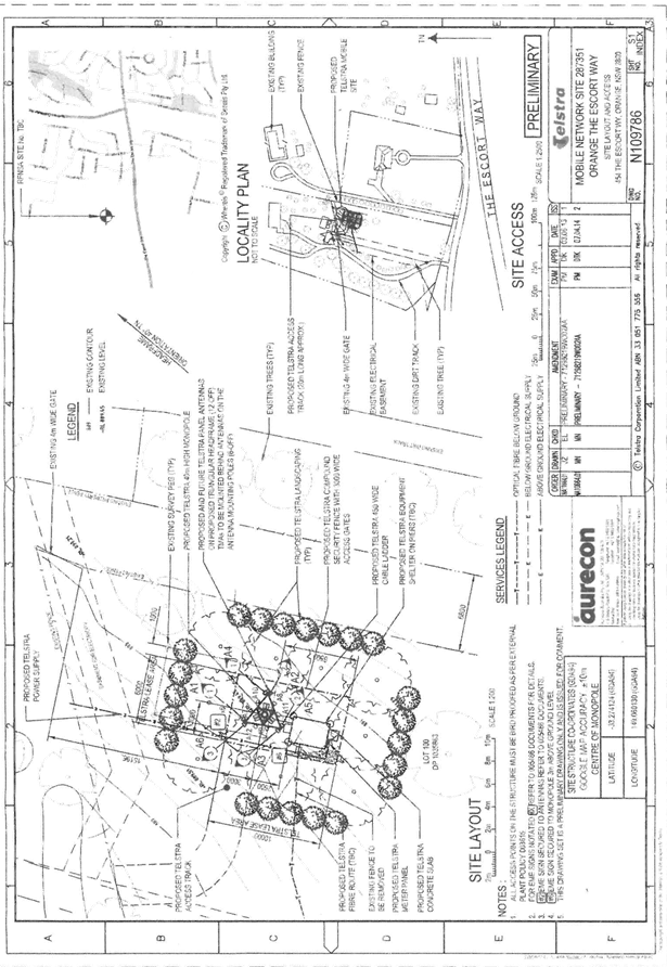
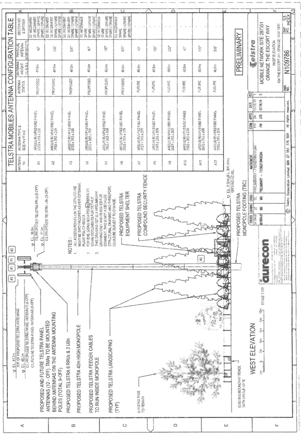
Sustainable
Development Committee
3 February 2015
2.2 Development
Application DA 181/2014(1) - 454 The Escort Way
Attachment 3 Submissions
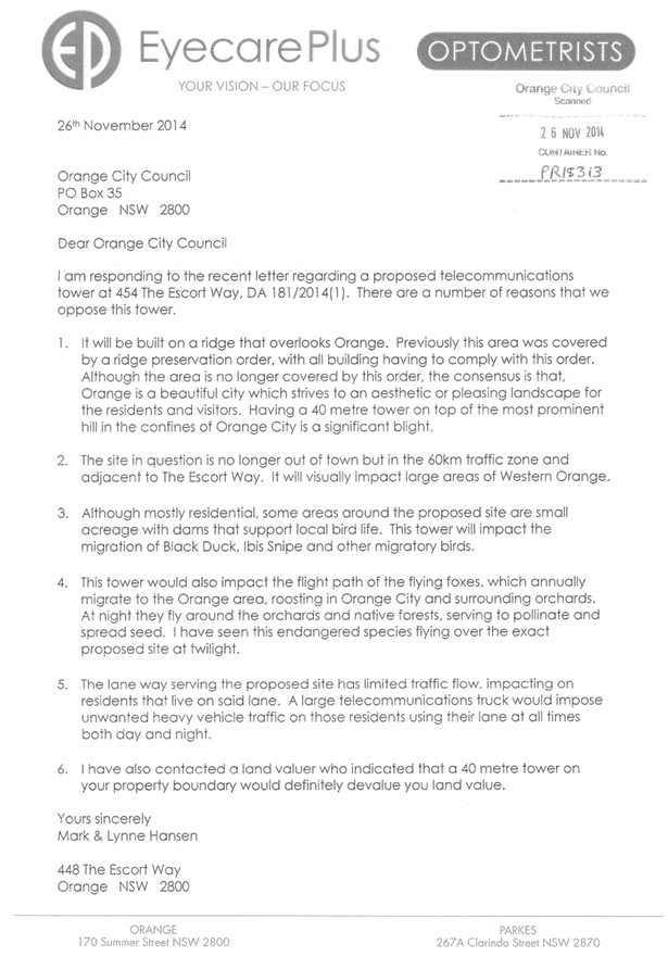
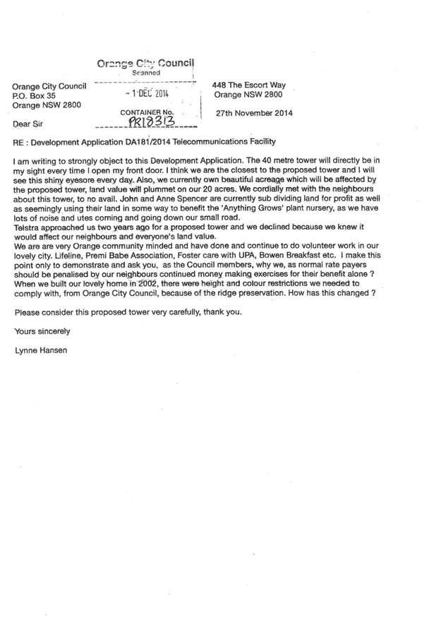
2.3 Development
Application DA 353/2014(1) - 1635 Forest Road
TRIM
REFERENCE: 2015/174
AUTHOR: Michael
Glenn, Senior Planner
EXECUTIVE Summary
Council's consent is sought for the construction of a new
mobile phone base station at 1635 Forest Road, Orange behind the Wangarang
Industries buildings at the rear boundary of the property. The construction
incorporates a number of aspects, but most significantly includes a 40m high
monopole. It is considered that the pole has some visual impacts.
A section 79C assessment of the proposed development has
been undertaken by Council staff. Whilst the assessment acknowledges the
adverse visual effects this facility generates, in this case the immediate
visual impacts are considered relatively acceptable. The impact on surrounding
residential amenity is considered limited due to the masking effect of existing
vegetation located on the northern side of the Southern Distributor Road and
the buildings and landscaping fronting Forest Road. To the west and south
existing mature landscaping will also limit the visual impacts of the tower. It
is impossible to completely eliminate the visual impacts, and it should also be
acknowledged that even under the most optimistic of assessments, the adverse
impacts on scenic quality need to be acknowledged. However in this instance the
adverse effects are considered to be acceptable.
Link To Delivery/OPerational Plan
The recommendation in this report relates to the
Delivery/Operational Plan strategy “13.4 Our Environment
– Monitor and enforce regulations relating to City amenity”.
Financial Implications
Nil
Policy and Governance Implications
Nil
|
Recommendation
That Council consents to development application DA
353/2014(1) for Telecommunications Facility (mobile phone base station
with 40m high monopole and equipment shelter) at Lot 150 DP 750401 - 1635
Forest Road, Orange pursuant to the conditions of consent in the attached
Notice of Approval.
|
further considerations
Consideration has been given to the
recommendation’s impact on Council’s service delivery; image and
reputation; political; environmental; health and safety; employees;
stakeholders and project management; and no further implications or risks have
been identified.
SUPPORTING INFORMATION
THE APPLICATION
Council's consent is sought for mobile phone base station
with 40m high monopole and equipment shelter at Lot 150 DP 750401 - 1635 Forest
Road, Orange.
THE PROPOSAL
The proposal involves the installation of a new mobile phone
base station at 1635 Forest Road, Orange, being the Wangarang industries site.
Telstra proposes to install a 40m high monopole with a triangular headframe. A
new equipment shelter would also be installed adjacent to the base of the
monopole.
The Telstra proposal comprises the following:
· installation of a
new 40m high monopole with a triangular head frame mounted at a centreline
elevation of 40m
· installation of
six panel antennas (2.53m long) mounted on the headframe at a centreline
elevation of 40m, total elevation 41.3m
· installation of
six panel antennas (2.53m long) for future use, mounted on the headframe at a
centreline elevation of 40m, total elevation 41.3m
· installation of
six remote radio units (RRUs) and nine tower mounted amplifiers (TMA’s)
below antennas
· installation of
six remote radio units (RRUs) for future use below antennas
· one equipment
shelter 2.28m (width) x 3.28m (length) x 2.95m (height), with associated piers
located at the base of the monopole
· ancillary cabling
and cable ladder
· proposed access
track to the site location.
The proposed facility will be incorporated into the existing
network via fibre optic cable connecting to the existing telecommunications
conduits running down Forest Rd.
The proposed development is defined as a telecommunications
facility pursuant to Orange Local Environmental Plan 2011 (OLEP11). OLEP 2011
permits the erection of these facilities in the IN2 Light Industrial land
zoning applicable to the site, and it is considered that the industrial zoning
and relative isolation render this site a better option than land closer to
more residential zones or within more important scenic locations. The proposed
development is also permitted development through the provisions of State
Environmental Planning Policy (Infrastructure) 2007.
Council received one written submission in regards to the
proposed telecommunications facility. Council’s response to the
submission is detailed within the report. Council sought a response from the
proponent in relation to the submission received, which is from a State
Government agency. This is also discussed in the body of the report,
MATTERS FOR CONSIDERATION
Telecommunications Act 1997
Telstra is a licenced telecommunications carrier and is
required to operate under the provisions of the Telecommunications Act 1997
and the Telecommunications Code of Practice 1997.
The 1997 Act and Telecommunications (Low-impact Facilities)
Determination 1997 (as amended) establish the criteria for ‘low
impact’ telecommunications facilities. The proposed development is not
defined as a ‘’low-impact facility” under the
Telecommunications Act and is therefore subject to the provisions of the NSW Environmental
Planning and Assessment Act 1979 and, accordingly, the provisions of Orange
Local Environmental Plan 2011.
The Telecommunications Code of Practice 1997 sets out
the design, planning and installation requirements for carriers to ensure that
the installation of facilities is in accordance with industry “best
practice”. The applicant advises that the design and siting of the
proposed communications facility has been taken in accordance with
Section 3 (Planning and Siting) of the Australian Standard, Siting of
Radio Communications Facilities. (AS3516.2)
Section 5A Assessment
In the administration of sections 78A, 79B, 79C, 111 and
112, the provisions of Section 5A must be taken into account for every
development application in deciding whether there is likely to be a significant
effect on threatened species, populations or ecological communities or their
habitats. This section includes a requirement to consider any adopted
assessment guidelines, which means assessment guidelines issued and in force
under section 94A of the Threatened Species Conservation Act 1995.
Assessment guidelines are in force (see DECC-W “Threatened Species
Assessment Guidelines - The Assessment of Significance”) which requires
consent authority to adopt the precautionary principle in its assessment.
The proposed development will have a small effect in terms
of the matters for consideration under the seven part test. The land is not
identified as high biodiversity value in Council's LEP mapping layer (which is
also confirmed by site inspection). However, it has dense landscaping
(including mature native species on the TAFE site behind it) that offers some
reinforcing biomass to a mapped Environmentally Sensitive Area (ESA) on the
western side of the TAFE, generally within the Rifle Range site. This area of
ESA has high value and importance because of its size, condition and
connectivity to other surviving remnants of the locality. As a high value
element of surviving native bushland it is currently under considerable threat
due to development pressures emerging around it. The elements of landscaping
that surround it, such as the TAFE landscaping serve, as biomass enhancers and
wildlife corridors to the core high value bushland in the vicinity.
In this case the access track
and clearing that may arise as a result of the construction are not considered
significant threats to surrounding ESAs. The proposed development does not pose
a serious risk to connectivity per se. Landscape details will be required, and
in order to avoid risks from the use and propagation of weed species in
landscaping, including trees classified as weeds (OEH have identified more than
30 tree species regularly used in landscaping that are a serious risk to native
bushland areas, of which, about seven are used regularly in the Orange LGA for
landscaping purposes), such details will need to be submitted to Council prior
to implementation.
A condition of consent to that
effect is included in the attached notice of approval. It is considered that,
subject to the implementation of a suitable landscape plan, the net overall
effect arising from this development in terms of biodiversity threats and
benefits is relatively neutral.
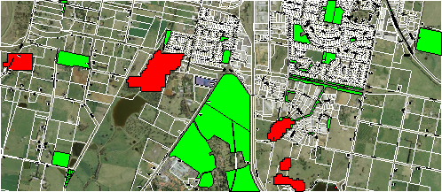
ESA Mapping
provided by CMAs and incorporated into Orange LEP-2011.
The value of these ESAs is
enhanced by a number of corridors that themselves are not listed as
significant, but are significant because of the connectivity value they
provide.
Section 5A requires the application of an Assessment of
Significance (a seven part test) to ascertain the likelihood of significant
adverse effect arising from a development, action or activity, including
secondary or likely flow-on effects that may arise. In this case it is
considered that the site itself has no major biodiversity value. However, as
also indicated above, mismanagement of the site (in terms of inappropriate
landscaping) is a potential Key Threatening Process for the nearby ESA, which
needs to be considered in the assessment.
The subject property is not
listed as having high risk of bushfire and does not have any natural
watercourses on the site.
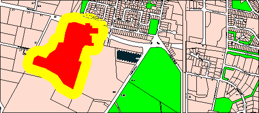
Bushfire hazard
mapping for the locality
The site is not included in the
OEH register of Aboriginal sites (AHIMS) and is not thought likely from the
previous land uses topography and physical characteristics to have a likelihood
of Aboriginal heritage or archaeology existing on the site.
Section 79C
Section 79C of the Environmental Planning and Assessment
Act 1979 requires Council to consider various matters, of which those
pertaining to the application are listed below.
PROVISIONS OF ANY ENVIRONMENTAL
PLANNING INSTRUMENT s79C(1)(a)(i)
Orange Local Environmental Plan 2011
Part 1 - Preliminary
Clause 1.2 - Aims of Plan
The broad aims of the LEP are
set out under subclause 2. Those relevant to the application are as follows:
(a) to encourage development which complements
and enhances the unique character of Orange as a major regional centre boasting
a diverse economy and offering an attractive regional lifestyle,
(b) to provide for a range of development
opportunities that contribute to the social, economic and environmental
resources of Orange in a way that allows present and future generations to meet
their needs by implementing the principles for ecologically sustainable
development,
(c) to conserve and enhance the water
resources on which Orange depends, particularly water supply catchments,
(d) to manage rural land as an environmental
resource that provides economic and social benefits for Orange,
(e) to provide a range of housing choices in
planned urban and rural locations to meet population growth,
(f) to recognise and manage valued
environmental heritage, landscape and scenic features of Orange.
In relation to (a), it is noted that the subject property is
located within a light industrial zone. However, the height and form of the
proposed structure are likely to have significant impacts on the visual amenity
and character of the City. In relation to (b), the application is considered to
be consistent with the LEP.
In relation to (c), (d) and (e),
the proposed development would have no impact.
In relation to (f), it is considered that the proposal will
have some impact upon the landscape and scenic features of the southern areas
of Orange. In particular, the proposed development would be visible from and
impact on views for the existing residential development located to the north
and northeast; and also have some impact for the new release areas in Shiralee
and the Part 3(a) rezoning to the west and south. The tower would have its most
significant impact from Forest Road. The subject site is not located within a
scenic protection area as defined under the provisions of Development Control
Plan 2004 and is not in close proximity to any residential areas. Slight
glimpses are also possible from Anson Street. Further from the site, the
proposed development will be visible from many points in the City and will
influence or change views of Mount Canobolas from many parts of Orange.
There is a low spine ridge running roughly north to south
and slightly to the west of the site. This ridge provides some diminution of
the more distant visual impacts arising from the proposed development. This
proposal therefore has some ability to influence the visual amenity of many
parts of the City well beyond the immediate area.
In order to reduce the long term visual impact of the
proposed development the attached consent includes a condition for extensive
landscaping around the base of the monopole The function of this development as
a transmitter and receiver of electromagnetic (EM) wave communications
prevents landscaping that would fully mask the visual impacts of the monopole
(since EM can only travel as a line of sight wave), however dense landscaping
at the base of the pole can reduce the impacts of the supporting structure.
There is no doubting that the proposed structure will be
significantly visible from other parts of the City. In certain light conditions
the structure would appear more visually intrusive (such as early mornings or
before sunset), as witnessed with similar existing structures in the city.
However, mobile base stations such as these are integral to providing phone
services that many people and businesses find indispensable. They are
unattractive and intrusive structures, but are essential to providing critical
services for modern living. On this basis they are an emerging feature of the
landscape and part of the urban form, the question then being is if the
dis-benefits arising outweigh the benefits. The general phrasing of the
legislation underpinning these facilities suggest that Council's ability to
give greater weight to the visual effects is less than the need to provide the
infrastructure. However there may be instances where Council and the community
form the view that the location and design of such structures are not
appropriate.
Clause 1.6 - Consent Authority
This clause establishes that, subject to the Act, Council is
the consent authority for applications made under the LEP.
Clause 1.9A - Suspension of
Covenants, Agreements and Instruments
This clause provides that covenants, agreements and other
instruments which seek to restrict the carrying out of development do not apply
with the following exceptions.
· covenants imposed
or required by Council
· prescribed
instruments under Section 183A of the Crown Lands Act 1989
· any conservation
agreement under the National Parks and Wildlife Act 1974
· any trust
agreement under the Nature Conservation Trust Act 2001
· any property
vegetation plan under the Native Vegetation Act 2003
· any biobanking
agreement under Part 7A of the Threatened Species Conservation Act 1995
· any planning
agreement under Division 6 of Part 4 of the Environmental Planning and
Assessment Act 1979.
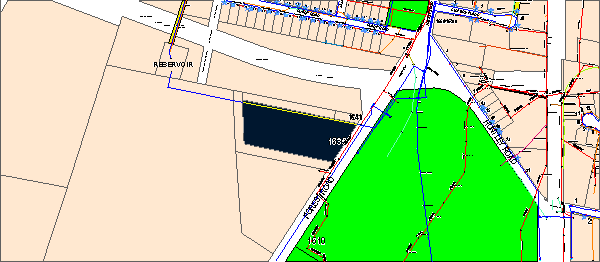
Council staff are not aware of the
title of the subject property being affected by any of the above. There is a
water main running parallel to and close to the northern boundary of the site,
however this line is not protected by an easement. It would not be affected by
the proposed development.
Mapping
The subject site is identified
on the LEP maps in the following manner:
|
Land Zoning Map:
|
Land zoned IN-2 Light Industrial
|
|
Lot Size Map:
|
Minimum Lot Size 100ha
|
|
Heritage Map:
|
Not a heritage item or conservation
area
|
|
Height of Buildings Map:
|
No building height limit
|
|
Floor Space Ratio Map:
|
No floor space limit
|
|
Terrestrial Biodiversity Map:
|
No biodiversity sensitivity on the
site
|
|
Groundwater Vulnerability Map:
|
ground water vulnerable
|
|
Drinking Water Catchment Map:
|
Not within the drinking water
catchment
|
|
Watercourse Map:
|
Not within or affecting a defined
watercourse
|
|
Urban Release Area Map:
|
Not within an urban release area
|
|
Obstacle Limitation Surface Map:
|
No restriction on building siting
or construction
|
|
Additional Permitted Uses Map:
|
No additional permitted use applies
|
Those matters that are of
relevance are addressed in detail in the body of this report.
Part 2 -
Permitted or Prohibited Development
Land Use Zones
The subject site is zoned Light
Industrial IN2. The proposed development is defined as a telecommunications
facility under OLEP 2011. The IN2 land use table is structured so as to allow
any defined land use not specifically listed as prohibited development. Item 3
(Matters Permitted with Consent) of the land use table allows any use not
otherwise listed in items 2 (Permitted without Consent), or 4 (Prohibited
Development). Telecommunications facilities are not specifically listed in
either items 2 or 4, and therefore they are a land use permitted with consent
under item 2 of the land use table.
Additionally, it is noted that telecommunications facilities
are permissible with consent under the provisions of the SEPP
(Infrastructure) 2007 as discussed below.
Pursuant to OLEP 2011 a telecommunications facility
means:
(a) any
part of the infrastructure of a telecommunications network, or
(b) any
line, cable, optical fibre, fibre access node, interconnect point equipment,
apparatus, tower, mast, antenna, dish, tunnel, duct, hole, pit, pole or other
structure in connection with a telecommunications network, or
(c) any
other thing used in or in connection with a telecommunications network.
Clause 2.3 of
LEP 2011 references the Land Use Table and Objectives for each zone in
LEP 2011. These objectives for land zoned IN2 Light Industrial are as
follows:
· To
provide a wide range of light industrial, warehouse and related land uses.
· To
encourage employment opportunities and to support the viability of centres.
· To
minimise any adverse effect of industry on other land uses.
· To
enable other land uses that provide facilities or services to meet the day to
day needs of workers in the area.
· To
support and protect industrial land for industrial uses.
The development is not adverse
to the zone objectives.
Part 3 -
Exempt and Complying Development
Telstra is a licenced telecommunications carrier and is
required to operate under the provisions of the Telecommunications Act 1997
and the Telecommunications Code of Practice 1997. The 1997 Act and Telecommunications
(Low-impact Facilities) Determination 1997 (as amended) establish the
criteria for ‘low impact’ telecommunications facilities. The
proposed development is not defined as a ‘’low-impact
facility” under the Telecommunications Act and is therefore
subject to the provisions of the NSW Environmental Planning and
Assessment Act 1979 and, accordingly, the provisions of Orange Local
Environmental Plan 2011.
The application is not exempt or complying development.
Part 7 -
Additional Local Provisions
7.1 - Earthworks
This clause establishes a range
of matters that must be considered prior to granting development consent for
any application involving earthworks, such as:
(a) the likely disruption of, or any
detrimental effect on, existing drainage patterns and soil stability in the
locality of the development
(b) the effect of the development on the
likely future use or redevelopment of the land
(c) the quality of the fill or the soil to be
excavated, or both
(d) the effect of the development on the
existing and likely amenity of adjoining properties
(e) the source of any fill material and the
destination of any excavated material
(f) the likelihood of disturbing relics
(g) the proximity to and potential for adverse
impacts on any waterway, drinking water catchment or environmentally sensitive
area
(h) any measures proposed to minimise or
mitigate the impacts referred to in paragraph (g).
The proposed earthworks will
consist of site testing, excavation and construction of foundations. The
proposed earthworks are considered minimal and unlikely to have any significant
impacts.
7.3 -
Stormwater Management
This clause applies to all
industrial, commercial and residential zones and requires that Council be
satisfied that the proposal:
(a) is designed to maximise the use of water
permeable surfaces on the land having regard to the soil characteristics
affecting onsite infiltration of water
(b) includes, where practical, onsite
stormwater retention for use as an alternative supply to mains water,
groundwater or river water; and
(c) avoids any significant impacts of
stormwater runoff on adjoining downstream properties, native bushland and
receiving waters, or if that impact cannot be reasonably avoided, minimises and
mitigates the impact.
The proposal will have little or
no impact on surface runoff to or from the site.
7.6 -
Groundwater Vulnerability
This clause seeks to protect
hydrological functions of groundwater systems and protect resources from both
depletion and contamination. Orange has a high water table and large areas of
the LGA, including the subject site, are identified with “Groundwater
Vulnerability” on the Groundwater Vulnerability Map. This requires that
Council consider:
(a) whether or not the development (including
any onsite storage or disposal of solid or liquid waste and chemicals) is
likely to cause any groundwater contamination or have any adverse effect on
groundwater dependent ecosystems, and
(b) the cumulative impact (including the
impact on nearby groundwater extraction for potable water supply or stock water
supply) of the development and any other existing development on groundwater.
Furthermore consent may not be granted unless Council is satisfied that:
(a) the development is designed, sited and
will be managed to avoid any significant adverse environmental impact, or
(b) if that impact cannot be reasonably
avoided - the development is designed, sited and will be managed to minimise
that impact,
(c) if that impact cannot be minimised - the
development will be managed to mitigate that impact.
The proposal is not anticipated
to involve the discharge of toxic or noxious substances and is therefore
unlikely to contaminate the groundwater or related ecosystems. The proposal
does not involve extraction of groundwater and will therefore not contribute to
groundwater depletion.
DESIGNATED DEVELOPMENT
The proposed development is not
designated development.
STATE ENVIRONMENTAL PLANNING
POLICIES
State Environmental Planning Policy (Infrastructure) 2007
("the I-SEPP") applies to the subject development. In this case,
telecommunications facilities are permissible with consent under OLEP 2011.
However the SEPP has some additional provisions relating to design criteria
that need to be considered in the assessment.
Clause 2 - Aim of Policy
The aim of this policy is to facilitate the effective
delivery of infrastructure across the state by:
(a) improving
regulatory certainty and efficiency through a consistent planning regime for
infrastructure and the provision of services, and
(b) providing
greater flexibility in the location of infrastructure and service facilities,
and
(c) allowing
for efficient development, redevelopment or disposal of surplus government
owned land, and
(d) identifying
the environmental assessment category into which different types of
infrastructure and services development fall (including identifying certain
development of minimal environmental impact as exempt development), and
(e) identifying
matters to be considered in the assessment of development adjacent to
particular types of infrastructure development, and
(f) providing
for consultation with relevant public authorities about certain development
during the assessment process or prior to development commencing.
The development is not inconsistent with the aims of the
SEPP.
Clause 8 - Relationship to
Other Environmental Planning Instruments
The SEPP has precedence over the LEP (and most other
environmental planning instruments), to the extent of any inconsistency between
the two instruments. In effect this means that where an LEP does not permit a
telecommunication facility in that zone, the ISEPP works to override that
prohibition and make the development permissible. However the SEPP still serves
to operate even in this situation (where the proposed development is
permissible in this zone under the LEP), and applies assessment guidelines that
may be called up by the ISEPP.
Clause 115 - Development
Permitted with Consent
(1) Development
for the purposes of telecommunications facilities, other than development in
clause 114 or development that is exempt development under clause 20 or 116,
may be carried out by any person with consent on any land.
The SEPP has the effect of rendering the proposed
development permissible on any land with the consent of Council.
(3) Before
determining a development application for development to which this clause
applies, the consent authority must take into consideration any guidelines
concerning site selection, design, construction or operating principles for
telecommunications facilities that are issued by the Director-General for the
purposes of this clause and published in the Gazette.
This provision has the effect of imposing any assessment
guidelines imposed by the Director General (Department Of Planning). NSW has a
design guideline, entitled "NSW Telecommunications Facilities Guideline
Including Broadband". The guideline has the effect under its clause
1.6 of applying as a design tool in all zones of an LEP.
Section 2.2 of the policy sets up the design principles that
should be followed. The guidelines are organised under "Principles"
headings. Many of the principles are not relevant because they relate to fully
urbanised landscapes. In this case, the landscape and setting are not fully urbanised,
which makes the impacts of landscaping the most important element to consider.
For this particular site there are also some iconic views to the southwest of
the site, which also need to be considered under the guidelines.
In terms of the detailed assessment under these guidelines,
it is considered more appropriate to place such detailed analysis under the
heading of "Likely Impacts" of this report.
PROVISIONS OF ANY DRAFT
ENVIRONMENTAL PLANNING INSTRUMENT THAT HAS BEEN PLACED ON EXHIBITION
s79C(1)(a)(ii)
There are no draft environmental planning instruments that
apply to the subject land or proposed development.
PROVISIONS OF ANY DEVELOPMENT
CONTROL PLAN s79C(1)(a)(iii)
Development Control Plan 2004
Development Control Plan 2004 (“the DCP”)
applies to the subject land (Part 9). An assessment of the proposed
development against the relevant Planning Outcomes will be undertaken below.
Pursuant to Planning Outcome 0.2-1 Interim Planning Outcomes
- Conversion of Zones:
· Throughout this
Plan, any reference to a zone in Orange LEP 2000 is to be taken to be a
reference to the corresponding zone(s) in the zone conversion table.
The corresponding zone to zone 4 (Industry and Employment
Zone (Orange LEP 2000) is zone IN2 Light Industrial (Orange LEP 2011). As such,
Orange DCP 2004 – Chapter 9 (Development in the Industry and
Employment Zone) is nominally relevant to this proposal.
Whilst the DCP has nominal applicability for all development
in the IN2 zone, in this case the provisions of the DCP are not relevant to the
proposal. Its provisions are not geared to assessment of telecommunication
facilities. It is considered more appropriate to assess the impacts of the
proposed structure as a general matter under the "Likely Impacts of the
Development".
PROVISIONS PRESCRIBED BY THE
REGULATIONS s79C(1)(a)(iv)
Demolition of a Building (clause 92)
The proposal does not involve the demolition of a building.
Fire Safety Considerations
(clause 93)
The proposal does not involve a change of building use for
an existing building.
Buildings to be Upgraded
(clause 94)
The proposal does not involve the rebuilding, alteration,
enlargement or extension of an existing building.
THE LIKELY IMPACTS OF THE
DEVELOPMENT s79C(1)(b)
NSW Telecommunications Facilities Guidelines
These guidelines are applicable to the assessment as a
result of being called up by clause 115(3) of the ISEPP. As previously
stated, the guidelines are clearly concerned with minimising visual impacts.
Unfortunately, many of the provisions made with regard to masking the obvious
deleterious visual effects relate to or can only apply to fully urban
situations. There are, however, some provisions that relate to non-urban or
rural situations, such as exist on this site. There are also provisions
designed to minimise and protect iconic views, of which the views of Mt
Canobolas to the southwest have to be included.
Those principles that are called up in the policy and which
are relevant to the assessment are set out below.
Principle 1 - Design and Siting
to Minimise Visual Impact
· As
far as practical, a telecommunications facility that is to be mounted on an
existing building or structure should be integrated with the design and
appearance of the building or structure.
The applicant investigated four
colocation options for colocation of the facility. These are shown in the
attached aerial photo:
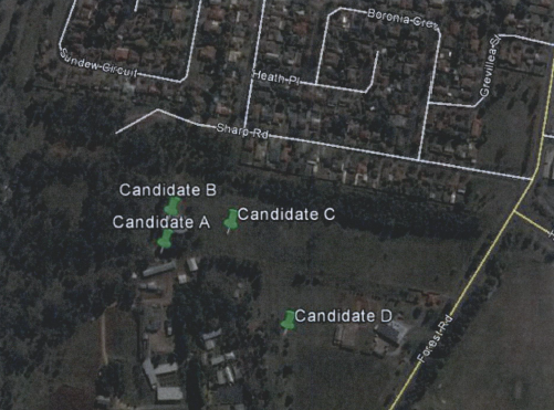
Each of these sites was
investigated by the applicant and rejected, as summarised below:
Option A: TAFE Western
Institute
A suitable location, however TAFE are not willing to agree
to a tenure agreement.
Option B - Water Reservoir off
Sharp Road
The structure does not offer sufficient height to meet
coverage requirements. Monopole extension on top of the water tank possible,
but more likely to affect residential development to the north.
Option C - Lot 223 and 224 via
Sharp Road
Owners of this site are unwilling to enter an agreement for
the structure on their land.
Option D - 1635 Forest Road
The subject site that is subject of the current assessment.
However the proposal is not a co‑location option. It is a new structure
of relatively high visual impact. Its advantages are that the owner is willing
to enter a leasing agreement with Telstra and it has relative isolation from
other development in the locality.
· The visual
impact of telecommunications facilities should be minimised, visual clutter is
to be reduced
As a new structure designed to meet technical
specifications, there appear to be few opportunities to modify or reduce the
intrusive nature of the monopole and the array to be placed on top of the pole.
· Where
telecommunications facilities protrude from a building or structure and are
predominantly backgrounded against the sky, the facility and their support
mounts should be either the same as the prevailing colour of the host building
or structure, or a neutral colour such as grey should be used.
The monopole is a stand-alone
structure; however it also will have a backdrop of the sky when viewed from
many parts of the city particularly from Forest Road. It is considered appropriate
to impose a condition requiring the structure to be painted a neutral grey
colour as suggested. A condition to that effect is included.
· Ancillary
facilities associated with the telecommunications facility should be screened
or housed, using the same colour as the prevailing background to reduce its
visibility, including the use of existing vegetation where available, or new
landscaping where possible and practical.
In this case the ground based structures should be coloured
a predominantly green colour that matches the hues located to the west of them.
Again, a condition is included to that effect.
· A
telecommunications facility should be located and designed to respond
appropriately to its rural landscape setting.
In this case the setting behind (to the west) of the site
dictates the character and setting of the structure. This landscaping is
essentially a semi-native landscape with predominantly native species
incorporated (many of them associated with BGGW type vegetation). Landscaping
requirements are considered essential to this proposal, and are discussed in
more detail elsewhere in this report.
· A
telecommunications facility located on, or adjacent to, a State or local
heritage item or within a heritage conservation area, should be sited and
designed with external colours, finishes and scale sympathetic to those of the
heritage item or conservation area.
A state listed heritage item (the Bloomfield Hospital site),
and a locally significant item (the airfield markings on the Sir Jack Brabham
Park playing fields site) are located within relatively close proximity of the
site. It is considered that these sites are sufficiently removed from the site
as to not suffer any excessive adverse impacts.
· "A
telecommunication facility should be located and designed so as to respond
appropriately to its landscape setting".
In this case the setting of the site is generally low
density industrial development and open space with a strong flavour of native
bushland accentuated by the native plantings evident in the backdrop
landscaping on the TAFE site and in the area generally.
It is considered appropriate as an outcome that landscaping
be provided with an expected mature height at least 50% of the height of the
proposed structure (ie in this case 20m). In this case, it is impossible to
achieve landscaping of the same height as the monopole (ie 41m), however
landscape buffers of approximately 20m height with species selection compatible
and able to blend with the native landscaping further to the west is readily
achievable and a desirable outcome. The landscaping plan to be effective needs
to be a comprehensive plan, incorporating ground covers, mid-storey and top
cover, and for the over storey trees, utilising planting stock with a minimum
pot size of 25l. The applicant has not provided any landscaping in their
proposed development, however conditions to achieve the above outcome are
included in the notice of approval. It is not considered unreasonable to have
landscaping expectations of that magnitude.
To have any effect on the visual intrusion generated by the
proposed structure, a landscape width aimed at achieving the abovementioned
outcomes is considered highly desirable. This means allowing for trees with a
mature height of around 20m, a depth of landscaping capable of achieving a
blended appearance, and species selection that augments and reinforces the
natural native based landscaping behind the site, rather than acting in
conflict with it.
To achieve a reasonable landscaped outcome, the bed width
will need to accommodate trees with a spread of at least 10m, and accommodate
at least a double row of plantings of these large trees. This suggests a
minimum landscaped area of around 400m² and a bed width of around 20m to
achieve effective screening. It is readily accepted that landscaping cannot
eliminate all of the adverse visual effects that the proposed development is
likely to cause, however it will reduce them.
The plans submitted with the application indicate a level of
landscaping graphically, however the applicant explains that such illustrative
licence on the plans is depicting vegetation from the adjoining property. This
is inconsistent with site inspections, which show a separation from the
landscaping on the western side of at least 20m. The applicant in various post
lodgement communications with assessment staff has suggested limited single row
landscaping more of a shrub and low scale type that is considered inadequate
for this site. They are not opposed to the imposition of conditions that require
a greater level of landscaping to be provided.
The following series of photos
demonstrate the visual characteristics of the site.


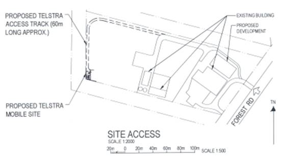


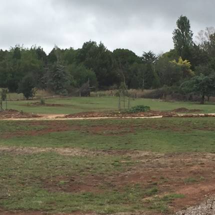
(1) Photo taken
from behind the Wangarang Industries main building
This photo shows the predominantly native vegetation
landscaping of the TAFE site. There is a 30m setback for this vegetation to the
boundary of the development site.


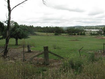
(2) View from the
TAFE site looking northeast
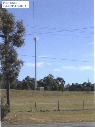
(3)
Applicant’s photomontage of appearance of monopole
viewed
from Forest Road
It is considered that in order to
blend in with the existing native landscaping evident on the TAFE site behind
the monopole, and as previously indicated to avoid risk of invasive
infestations of nearby high value ESAs, species selection needs to of native
origin commonly associated with the BGGW. A condition to that effect is
included in the attached consent.
Principle 2 - Colocation
As indicated in the above discussion, colocation was
considered for at least one of the alternative sites, but does not appear
practical according to the applicant.
Principle 3 - Health Standards
The applicant has submitted technical specifications and
discussion in their Statement of Environmental Effects attesting that the
proposed structure when in operation will comply with relevant health
standards, particularly relating to electromagnetic emissions standards.
Whilst there are currently wide-ranging and contentious
views on the health impacts associated with electromagnetic energy (EME), with
large volumes of discourse related to the study, there is currently no
definitive evidence or conclusive findings one way or another of the effects of
EME on humans. Council is therefore largely reliant on the studies of
recognised health organisations and the submitted report on the summary of
Estimated RF (radiofrequency) EME (electromagnetic energy) in determining
the likely health impacts associated with the development.
The Australian Government’s Australian Radiation
Protection and Nuclear Safety Agency cite the World Health Organisation’s
advice stating:
None of the
recent reviews have concluded that exposure to RF fields from mobile phones and
their base stations cause any adverse health consequences” (ARPANSA).
Furthermore, the ARPANSA suggests:
the balance of evidence does
not indicate a risk to the health of people, including children, living in the
vicinity of base stations where exposure levels are only small fractions of the
ARPANSA standard.
A report titled Summary of Estimated RF and EME Levels
Around The Proposed Wireless Base Station…’ indicate:
RF EME levels have been
estimated from the proposed antennas at 354 Cadia Road, Springside. The maximum
cumulative EME level at 1.5m above ground level and 274.1m from the
antennas is estimated to be 0.026% of the ARPANSA public exposure limits.
As mentioned above, Council is largely reliant on the
reports submitted in the application and studies of recognised health agencies
in determining the likely health impacts associated with the development.
In light of the above, it is considered that the development
is not likely to result in adverse health impacts as a result of human
exposure.
Principle 4 - Minimise
Disturbance
This principle in its details is mainly concerned with
interference with other telecommunication, particularly those relating to
airport operations. It is considered unlikely the proposed structure will have
any significant impact in this regard.
Other View lines
The visual impacts from the
principal viewing points of the site have been included in the submission to
Council and are shown in the following photographic impressions.
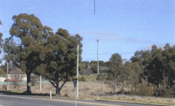
View from the
northeast near the intersection of Huntly Road and Forest Road
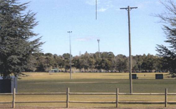
View from the east
(shot
taken on the western (distant) side of Sir Jack Brabham Park)
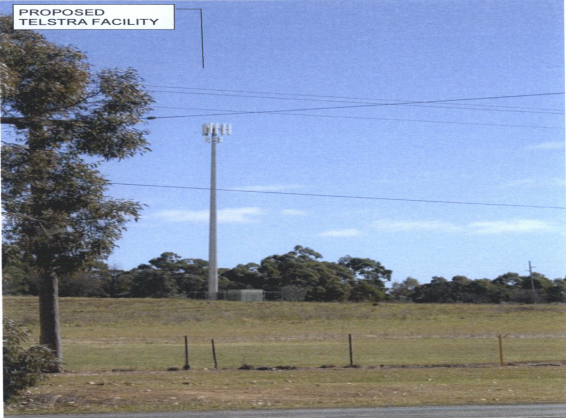
View from the
southwest (shot taken from Forest Road)

View taken from
the car park of TAFE Western
located
on the western side of the proposed development
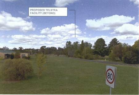
View east towards
the site location
(shot
taken from corner of Cecil Road and Park Street
approximately
1km west of the site)

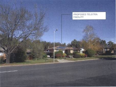
Typical view from
the residential areas to the north
(shot
was taken from Sharp Road)
The abovementioned visual analysis
indicates some significant visual impacts. Landscaping around the base of the
structure will reduce visual impacts to the east, particularly from Forest Road
and Sir Jack Brabham Park.
Overall Visual Impact Analysis
The proposed development can be described in its most basic
terms as a high 40m pole, plus the height of the array to be placed at its
apex, creating an overall height of 41.3m above ground level. The ground level
on which it is erected is already elevated relative to its general
surroundings, except to the west, which will create an impression of even
greater height and impact. Of particular relevance is the backdrop that will
accentuate the silhouette of the tower.
Inherently, the function of the monopole as a transmitter
and receiving device, makes it essential the structure have a high visibility
and line of sight to surrounding development. There are some options to mask
the structure in urban environments, but these options generally aren’t applied
to stand alone monopoles erected in rural or non-urban settings.
The visual impacts of the structure are considered
significant, and poor in their integration with surrounding development. The
tower necessarily will be highly visible and intrusive to the landscape. These
are all aspects of the design that are cause for concern. The ability to mask
or limit these impacts are limited, involving a high level of dense and high
landscaping and selection of colours. These are admittedly inadequate, but offsetting
the obvious adverse visual impacts of the tower are the benefits arising from
enhanced telecommunication coverage.
Noise Impacts
The majority of noise and vibration emissions associated
with the proposed facility will be limited to the construction phase. There
will be some low level noise from the ongoing operation of the air conditioning
equipment associated with the equipment units. As outlined within the
applicant's SoEE, the noise emanating from the outdoor cabinet air conditioning
system is at a comparable level to a domestic air conditioning installation,
and will generally accord with the background noise levels prescribed by
Australian Standard AS1055.
Traffic Impacts
Access to the telecommunications facility will be via the
existing access serving the subject site. After the construction period the
only traffic generated by the base station will be that associated with
maintenance vehicles. Accordingly, the facility will only generate one visit
per year for maintenance, with the facility being vacant for the rest of the
year. The traffic generation will therefore be minimal and not sufficient to
create any adverse impacts.
Protection of Airspace
A government circular (139-08(0)) – Reporting of
Tall Structures; has been issued by the Civil Aviation Safety Authority
(CASA) in 2005 that recommends for structures of this height to be the
subject of the following conditions (these conditions are also recommended in
the Department of Planning guidelines)
"Prior to the release of a construction certificate,
a report must be submitted to Council that certifies and shows evidence of
consultation with the Civil Aviation Authority (CASA) has taken place and that
also demonstrates compliance with height requirements specified by CASA
Regulations 1988 and the Airports (Protection of Airspace Regulations 1996) of
the Commonwealth"
"Prior to the release of a construction certificate
a report must be submitted to Council that demonstrates the structure does not
penetrate any obstacle limitation surface shown on any relevant Obstacle
Limitation Surface Plan that has been prepared by any operator of an aerodrome
(in this case also an operator of helicopter landing facilities, including the
nearby Base Hospital) within 30km of the proposed development (in this case,
Council will require such consultations to demonstrate that consideration has
included consideration of the Orange Airport, the Orange Base Hospital
emergency helicopter arrangements and any other rotary wing operations being
undertaken within the specified radius on a regular basis)."
These conditions are included in the attached Notice Of
Approval.
Social and Economic Impacts
Council is advised that the proposed development will
facilitate the provision of vital infrastructure so as to improve mobile phone
coverage to areas that are currently experiencing limited reception within
Orange. The wider social and economic benefits of the proposal will result in a
positive impact for the City.
THE SUITABILITY OF THE SITE
s79C(1)(c)
The assessment of the proposal has highlighted the fact that
the proposed development will have a visual impact. Council in determining the
suitability of the proposed development will need to balance the visual impact
of the proposed development against the demand and need for such infrastructure
within the City. Infrastructure of this type is considered essential to modern
lifestyles, and in many respects the visual impacts need to be accepted to
achieve satisfactory outcomes in other respects (such as better internet and
mobile phone coverage). One important question to be answered is whether the
proposed site tends to magnify the adverse effects likely to arise, or remain
about the same as could be expected from other options. The foregoing analysis
suggests that the site has some advantages (principally its relative isolation,
particularly with respect to residential development).
Whilst the development can be somewhat mitigated by
landscaping, this cannot eliminate the adverse visual effects completely. The
upper parts of the array must, necessarily, remain fully visible, which in turn
has inevitable adverse general visual effects, and in this case will have an
adverse effect on significant views of Mt Canobolas to the southwest of the
site.
This report recommends approval on the basis the proposed
structure is permissible on the land and the site is relatively removed from
surrounding current development. It would be open for Council to form an
alternative view should the visual impact of the development in this location
be considered unacceptable.
ANY SUBMISSIONS MADE IN
ACCORDANCE WITH THE ACT s79C(1)(d)
The proposed development is not defined as advertised
development under the provisions of the LEP, however given the type and
locality of the development the application was notified to adjoining owners
for a period of 14 days. At the end of that period one submission had been
received objecting to the proposed development.
The objection is from the administrators of TAFE Western to
the immediate west of the site. They have lodged a non-specific objection to
the proposal, summarised in the following extract from their submission:
"The Department of
Education adopts a policy of prudent avoidance in relation to the installation
of mobile telecommunications facilities within TAFE colleges. The department
has a preference for a distance of at least 500m from the boundary of the
department's property and I am therefore requesting the location of the tower
be reconsidered.”
There are no reasons given in the correspondence submitted
outlining the reasons for this position. The submission does not specify that
their opposition arises from health concerns, visual intrusion or any other
reason, other than it is contrary to their policy on this issue.
It is apparent in the applicant’s submission they have
considered alternative sites, including the objectors’ site. The
Department of Education's internal policy has no statutory weight in terms of
undertaking a merits based assessment under Section 79C of the Act. It is
considered that significant levels of screening between the active teaching
areas of the TAFE and the proposed development are achieved by the
existing landscape buffers around the TAFE.
PUBLIC INTEREST
s79C(1)(e)
The proposed development is considered to be of some public
interest. In a localised sense there are significant adverse visual impacts,
which have been discussed in some detail in this report. Conversely there are
public benefits to the wider community (which should be considered a public
interest) relating to improved telecommunications coverage.
The public interest in this case is considered a central
issue. On the one hand there are serious but localised adverse visual impacts.
On the other hand there are benefits to the wider community in terms of
enhanced communications.
The proposal is not inconsistent with any relevant policy
statements, planning studies, guidelines, etc that have not been considered in
this assessment.
SUMMARY
The proposed development is permissible under the LEP with
the consent of Council, and there are provisions with regard to the SEPP
(Infrastructure) that are also applicable to the proposed development. The
proposed development complies with the relevant aims, objectives and provisions
of the LEP. A section 79C assessment of the development indicates that the
development is acceptable in this instance, though the dis-benefits have also
been noted. Attached is a draft Notice of Approval outlining a range of
conditions considered appropriate to ensure that the development proceeds in an
acceptable manner.
COMMENTS
The requirements of the Environmental Health and Building
Surveyor and the Engineering Development Section are included in the attached
Notice of Approval.
Attachments
1 Notice
of Approval, D15/1933⇩
2 Submission,
D15/1648⇩
3 Plans,
D15/1727⇩
Sustainable Development Committee
3 February 2015
2.3 Development
Application DA 353/2014(1) - 1635 Forest Road
Attachment 1 Notice
of Approval
|

|
ORANGE
CITY COUNCIL
Development
Application No DA
353/2014(1)
NA15/ Container
PR4069
|
NOTICE OF DETERMINATION
OF A DEVELOPMENT
APPLICATION
issued under the Environmental
Planning and Assessment Act 1979
Section 81(1)
|
Development
Application
|
|
|
Applicant Name:
|
Aurecon
for Telstra
|
|
Applicant Address:
|
Attention:
Vanessa Davies
PO Box 538
NEUTRAL
BAY NSW 2089
|
|
Owner’s Name:
|
Wangarang
Industries
|
|
Land to Be Developed:
|
Lot 150 DP
750401 - 1635 Forest Road, Orange
|
|
Proposed Development:
|
Telecommunications
Facility (mobile phone base station with 40m high monopole and equipment
shelter)
|
|
|
|
|
Building
Code of Australia
building classification:
|
To be
determined by the PCA
|
|
|
|
|
Determination
|
|
|
Made On:
|
3 February
2015
|
|
Determination:
|
CONSENT
GRANTED SUBJECT TO CONDITIONS DESCRIBED BELOW:
|
|
|
|
|
Consent to
Operate From:
|
4 February
2015
|
|
Consent to
Lapse On:
|
4 February
2020
|
Terms of Approval
The reasons for the imposition of conditions
are:
(1) To ensure compliance
with relevant statutory requirements.
(2) To provide adequate
public health and safety measures.
(3) To ensure a quality
urban design for the development which complements the surrounding environment.
(4) To maintain
neighbourhood amenity and character.
(5) To prevent the proposed
development having a detrimental effect on adjoining land uses.
(6) To minimise the impact
of development on the environment.
Conditions
(1) The
development must be carried out in accordance with:
(a) Plan/s
numbered Drawings Numbered N109784, sheets S1 and S3 dated 24.03.2014, drawn By
Aurecon (2 sheets)
(b) statements
of environmental effects or other similar associated documents that form part
of the approval
as amended
in accordance with any conditions of this consent.
(2) All building work must
be carried out in accordance with the provisions of the Building Code of
Australia.
(3) A sign is to be erected
in a prominent position on any site on which building work, subdivision work or
demolition work is being carried out:
a. showing
the name, address and telephone number of the principal certifying authority
for the work, and
b. showing
the name of the principal contractor (if any) for any building work and a
telephone number on which that person may be contacted outside working hours,
and
c. stating
that unauthorised entry to the site is prohibited.
Any such sign is to be maintained while the
building work, subdivision work or demolition work is being carried out.
|
PRIOR TO THE ISSUE OF
A CONSTRUCTION CERTIFICATE
|
(4) The tower shall be
finished in a neutral grey and the equipment shelter in a blending grey green
colour to match surrounding vegetation. Details of these colours shall be
submitted and approved by Councils Manager Development Assessments prior to
the issue of a Construction Certificate.
(5) A detailed plan showing
landscaping shall be submitted to and approved by Councils Manager Development
Assessments prior to the issue of a Construction Certificate.
The plan shall achieve a landscape outcome that
blends the vegetation to the species located further to the west of the site,
incorporating native species associated with the Box Gum Grassy Woodland and
including top cover over storey species with an expected mature height of 18m
minimum. A minimum buffer distance from the tower of 20m is
required at ground level with comprehensive species selection to achieve
effective ground cover, mid storey and top cover on maturity that blends the
landscape to its surroundings, and provides screening and relief to the
structures from surrounding areas.
(6) A
Construction Certificate application is required to be submitted to, and issued
by, Council/Accredited Certifier prior to any excavation or building works
being carried out on site.
(7) A
report must be submitted to Council that certifies and shows evidence of
consultation with the Civil Aviation Authority (CASA) has taken place and that
also demonstrates compliance with height requirements specified by CASA
Regulations 1988 and the Airports (Protection of Airspace Regulations 1996) of
the Commonwealth"
The
report must demonstrates the structure does not penetrate any obstacle
limitation surface shown on any relevant Obstacle Limitation Surface Plan that
has been prepared by any operator of an aerodrome (in this case also an
operator of helicopter landing facilities, including the nearby Base Hospital)
within 30km of the proposed development (in this case, Council will require
such consultations to demonstrate that consideration has included consideration
of the Orange Airport, the Orange Base Hospital emergency helicopter
arrangements and any other rotary wing operations being undertaken within the
specified radius on a regular basis).
|
PRIOR TO WORKS
COMMENCING
|
(8) A
temporary onsite toilet is to be provided and must remain throughout the
project or until an alternative facility meeting Council’s requirements
is available onsite.
(9) Soil erosion control
measures shall be implemented on the site.
|
DURING
CONSTRUCTION/SITEWORKS
|
(10) All
construction/demolition work on the site is to be carried out between the hours
of 7.00 am and 6.00 pm Monday to Friday inclusive, 7.00 am to
5.00 pm Saturdays and 8.00 am to 5.00 pm on Sundays and Public
Holidays. Written approval must be obtained from the General Manager of Orange
City Council to vary these hours.
(11) A
Registered Surveyor’s certificate identifying the location of the
building on the site must be submitted to the Principal Certifying Authority
prior to the pouring of the slab or footings.
(12) All
materials onsite or being delivered to the site are to be contained within the
site. The requirements of the Protection of the Environment Operations Act
1997 are to be complied with when placing/stockpiling loose material or
when disposing of waste products or during any other activities likely to
pollute drains or watercourses.
(13) Storage
of materials including stockpiles is not permitted on the public footpath area
or roadway unless a hoarding is provided and approval granted.
(14) Any adjustments to
existing utility services that are made necessary by this development
proceeding are to be at the full cost of the developer.
|
PRIOR TO THE ISSUE OF
AN OCCUPATION CERTIFICATE
|
(15) Landscaping
shall be installed in accordance with the approved plans and shall be
permanently maintained to the satisfaction of Council's Manager Development
Assessments.
(16) No
person is to use or occupy the building or alteration that is the subject of
this approval without the prior issuing of an Occupation Certificate.
(17) All
of the foregoing conditions are to be at the full cost of the developer and to
the requirements and standards of the Orange City Council Development and
Subdivision Code, unless specifically stated otherwise. All work required by
the foregoing conditions is to be completed prior to the issuing of an
Occupation Certificate, unless stated otherwise.
Other Approvals
(1) Local
Government Act 1993 approvals granted under section 68.
Nil
(2) General
terms of other approvals integrated as part of this consent.
Nil
Right of Appeal
If
you are dissatisfied with this decision, section 97 of Environmental
Planning and Assessment Act 1979 gives you the right to appeal to the Land
and Environment Court within 6 months after the date on which you receive this
notice.
*
Section 97 of the Environmental Planning and Assessment Act 1979 does not apply
to the determination of a development application for State significant
development or local designated development that has been the subject of a
Commission of Inquiry.
|
Disability Discrimination Act
1992:
|
This application has been assessed in
accordance with the Environmental Planning and Assessment Act 1979. No
guarantee is given that the proposal complies with the Disability
Discrimination Act 1992.
The applicant/owner is responsible to
ensure compliance with this and other anti-discrimination legislation.
The Disability Discrimination Act
covers disabilities not catered for in the minimum standards called up in the
Building Code of Australia which references AS1428.1 - "Design for
Access and Mobility". AS1428 Parts 2, 3 and 4 provides the most
comprehensive technical guidance under the Disability Discrimination Act
currently available in Australia.
|
|
|
|
|
Disclaimer - S88B Restrictions on the Use of Land:
|
The applicant should note that there
could be covenants in favour of persons other than Council restricting what
may be built or done upon the subject land. The applicant is advised to check
the position before commencing any work.
|
|
|
|
|
Signed:
|
On behalf of the consent authority ORANGE
CITY COUNCIL
|
|
Signature:
|
|
|
Name:
|
ALLAN RENIKE – MANAGER
DEVELOPMENT ASSESSMENTS
|
|
Date:
|
4 February 2015
|
Sustainable
Development Committee
3 February 2015
2.3 Development
Application DA 353/2014(1) - 1635 Forest Road
Attachment 2 Submission
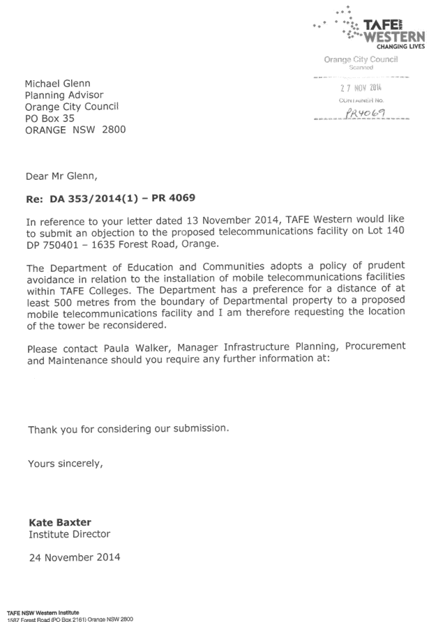
Sustainable
Development Committee
3 February 2015
2.3 Development
Application DA 353/2014(1) - 1635 Forest Road
Attachment 3 Plans
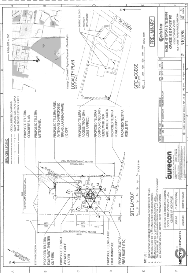
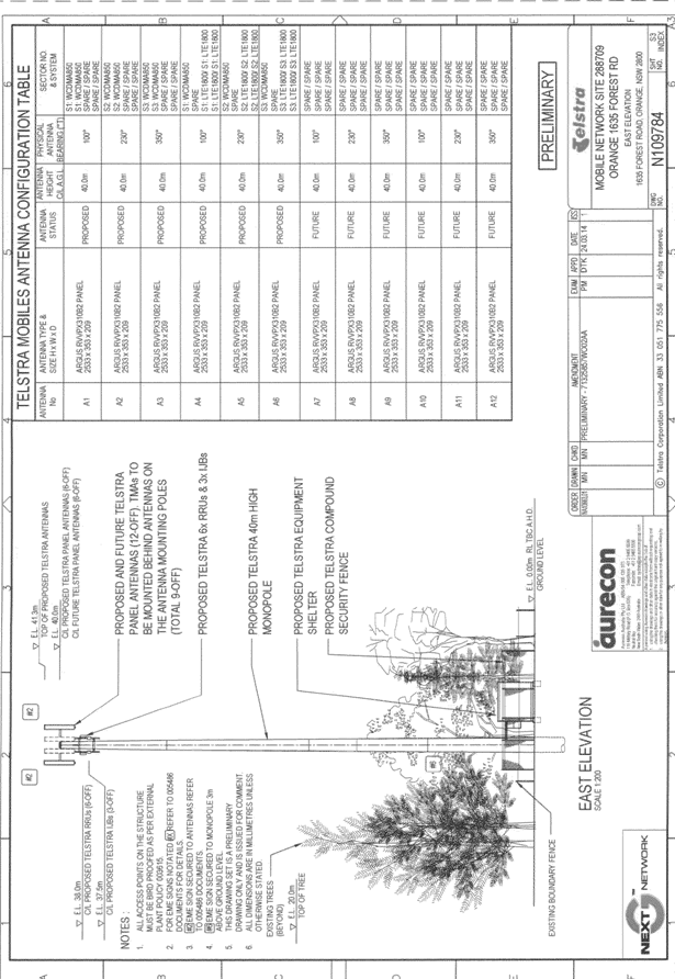
2.4 Development
Application DA 355/2014(2) - 72 Hill Street
TRIM
REFERENCE: 2015/175
AUTHOR: Andrew
Crump, Town Planner
EXECUTIVE Summary
Application has been made to modify development consent DA 355/2014(1)
which relates to the De Russie Suites motel at 72 Hill Street Orange. The
original application sought consent to remove the existing swimming pool and
replace it with an additional one bedroom unit to be used as a bridal suite.
This generated a net increase in the demand for parking of one space under the
requirements of the DCP. As there was no ability to provide the additional
space onsite Council staff applied the provisions of the Orange Development
Contributions Plan and levied a contribution in lieu of the physical space.
The applicant is now seeking to have the condition relating
to parking contributions for the amount of $13,594.51 removed from the consent.
Council staff are of the view, as they were at the time of the assessment of
the original application, that there is limited justification in allowing a
concession for the required space and not apply a contribution. As such, it is
recommended that Council not support the application to modify the consent and
a Notice of Refusal is attached accordingly. Should Council agree with this
recommendation, the original consent including the condition relating to
parking contributions continues to apply to the land as the applicable consent.
It is recommended that Council refuse the application to
modify the consent relating to DA 355/2014(1).
Link To Delivery/OPerational Plan
The recommendation in this report relates to the
Delivery/Operational Plan strategy “13.4 Our Environment
– Monitor and enforce regulations relating to City amenity”.
Financial Implications
In accordance with Council’s Development Contributions
Plan, in circumstances where the physical provision of parking onsite
applicable to the development is unable to be provided, a contribution in lieu
of the physical provision of parking is required to be paid. Should Council
agree to support the application and not charge the contribution, doing so
would be inconsistent with Council’s Contributions Plan and place a
financial burden upon Council to provide the equivalent financial contribution
to cover the shortfall of parking as public spaces. Council would have to
identify $13,594.51 to fund this which given the deficit budget position will
need to be identified and reallocated from other projects.
Policy and Governance Implications
Nil
|
Recommendation
That Council
refuses the application to modify consent DA 355/2014(2) for Hotel or Motel Accommodation
(alterations and additions) at Lot 100 DP 1103216 - 72 Hill
Street, Orange pursuant to the
reasons outlined in the attached Notice of Refusal.
|
further considerations
Consideration has been given to the
recommendation’s impact on Council’s service delivery; image and
reputation; political; environmental; health and safety; employees;
stakeholders and project management; and no further implications or risks have
been identified.
SUPPORTING INFORMATION
THE APPLICATION/THE PROPOSAL
Application has been made to modify development consent DA 355/2014(1).
The applicant is seeking to have a condition removed from the consent that
relates to the requirement to pay a contribution for the amount of $13,594.51
in lieu of the provision of a physical space for the additional unit.
MATTERS FOR CONSIDERATION
Section 96(1A) of the Environmental
Planning and Assessment Act 1979 (EPAA) states:
A consent authority may…modify the consent if:
(a) it is satisfied that the proposed
modification is of minimal environmental impact, and
(b) it is satisfied that the development to which
the consent as modified relates is substantially the same development as the
development for which the consent was originally granted and before that
consent as originally granted was modified (if at all), and
(c) it has notified the application in accordance
with:
(i) the regulations, if the
regulations so require, or
(ii) a development control plan, if the
consent authority is a council that has made a development control plan under
section 72 that requires the notification or advertising of applications for
modification of a development consent, and
(d) it has considered any submissions made
concerning the proposed modification within any period prescribed by the
regulations or provided by the development control plan, as the case may be.
Pursuant to section 96(3) of the EPAA 1979:
In determining an application for
modification of a consent under this section, the consent authority must take
into consideration such of the matters referred to in section 79C(1) as are of
relevance to the development the subject of the application.
The development is considered substantially
the same development for which development consent was originally granted and the
relevant matters are considered below.
PROVISIONS OF ANY ENVIRONMENTAL
PLANNING INSTRUMENT s79C(1)(a)(i)
Orange Local Environmental Plan 2011
The initial development was approved under the provisions of
Orange LEP 2011. The subject land is zoned B3 Commercial Core. The proposed
development is defined as hotel or motel accommodation under OLEP 2011,
which is permitted with consent in this zone.
Pursuant to the dictionary
contained within LEP 2011, the following definition relates:
a building or place (whether
or not licensed premises under the Liquor Act 2007) that provides temporary or
short-term accommodation on a commercial basis and that:
(a) comprises
rooms or self-contained suites, and
(b) may
provide meals to guests or the general public and facilities for the parking of
guests’ vehicles,
but does not include
backpackers’ accommodation, a boarding house, bed and breakfast
accommodation or farm stay accommodation.
The proposed development (relating to car parking
requirements) remains ancillary to the principal land use approved in the
original consent. It is considered that the overall land use of the site does
not alter as a result of the proposed modification of consent. The proposed development remains permissible
subject to receiving the development consent of Council.
The matters pertaining to the LEP have previously been
considered in the assessment of the original application. The development as
modified does not alter any of the proposed development's basic fundamentals,
and as such further assessment of the development as modified under the LEP is
not required.
PROVISIONS OF ANY DEVELOPMENT
CONTROL PLAN s79C(1)(a)(iii)
Development Control Plan 2004
Development Control Plan 2004 (“the DCP”)
applies to the subject land. The relevant planning outcomes were considered as
part of the assessment of the original development application. An assessment
of the proposed development against the relevant Planning Outcomes that affect
the proposal to modify the consent will be undertaken below.
Pursuant to Planning Outcome 0.2-1 Interim Planning Outcomes
- Conversion of Zones:
· Throughout this Plan,
any reference to a Zone in Orange LEP 2000 is to be taken to be a reference to
the corresponding zone(s) in the zone conversion table.
The corresponding zone to zone 3a (Orange LEP 2000) is zone
B3 Commercial Core (Orange LEP 2011). As the application relates only to
parking, chapter 15 - Car Parking is the sole chapter of relevance to the
assessment of this application.
Part 15 - Car Parking
Background
When the motel was originally approved in 2006, the
development generated the need for 25 spaces, at which time 24 were proposed to
be provided. Conditional consent was granted with a condition therein requiring
three spaces to be deleted as they were deemed unsatisfactory and as such a
contribution was levied in lieu of the four spaces not provided onsite (one for
the space not provided onsite in the proposal and three for the spaces that
were to be deleted). The applicant later sought to modify that consent,
justifying that two of the three spaces required to be deleted were
satisfactory. Council agreed to this, reducing the required contributions
levied to the equivalent of two spaces. As such, with the provision of 23
spaces onsite and the contributions paid for two spaces; 25 spaces are recognised
for the development, which satisfied Council’s parking requirement.
As indicated above and in the previous assessment, the
additional unit creates a net increase in the demand for parking of one space.
As such, Council’s Development Contribution Plan requires a contribution
to be levied where a physical space cannot be provided onsite. As there is no
ability to provide a space onsite, a condition was attached to the previous
consent (being DA 355/2014(1)) that required a contribution to be paid.
The applicant now seeks to have that condition removed and
presents the following to support the argument that contributions should not be
levied:
The DCP states
:
Adequate off-street parking is
required to supplement on-street parking and thereby maintain the existing levels
of service and safety of the road network. It is recognised that even
where off-street parking is provided, on-street parking will still
occur in designated areas.
On-street parking can also provide
pedestrians with a feeling of safety from passing
traffic by creating a barrier between the footpath and passing
traffic. Parking requirements set out in section 15.4
below reflect the peak-parking demand anticipated. In
certain circumstances, such as with small extensions to existing developments, consideration might be given to reducing the on-site parking required because of the availability
of convenient on-street parking. The onus
is on the applicant to prove that such a concession is appropriate, with a report submitted by a qualified town planner or traffic engineer.
Any issues associated with parking assessment
associated with the rationalisation of the main office or retail areas will be assessed as part of the application under a GFA (Gross floor area)
approach.
|
BUSINESS OR RETAIL ACTIVITIES
|
|
|
Office or business premises including banks
|
1 space per 40m2 GFA
|
|
Bulk Retail
|
1 Space per 50sqm
GFA
|
|
Shops and Shopping center
|
0-10,000m2 GLFA
|
No additional parking is considered warranted by the proposed use given
the ample availability for parking at the western section of Summer Street and Hill Street and additional public parking at the rear of
the premises, particularly during its busiest
times after 6pm.
We have observed the eastern parking
area on site - 3 spaces are never used day or night and therefore
are ideal for use for the proposed motel unit. This is considered suitable grounds for practical concession
in this instance given the collected
peak data below.
Onsite parking data has been
monitored as follows throughout December
|
Main Carport [sic](21)
|
15/12
|
17/12
|
20/12
|
22/12
|
23/12
|
|
7pm
|
17
|
21
|
18
|
20
|
18
|
|
3pm
|
5
|
4
|
3
|
6
|
3
|
|
7pm
|
20
|
21
|
18
|
17
|
19
|
|
Rear Carport [sic] (3) (Adjacent to new unit)
|
0
|
1
|
0
|
1
|
0
|
The above demonstrates that the main car park is not
fully utilised during peak periods. The rear car park is only occasionally used
by a staff member and is situated
next to the proposed unit
(existing pool).
The owner has
advised that 30% of business are Rex passengers
that utilise taxi's therefore parking
needs are less than one space per room.
This observation is supported by the above parking levels.
The DCP section on
Off Street Parking relates to peak demand and
the ability to recognise parking in the locality.
Whilst there may be opportunity to park in the
Little Summer Street car park and on the street in Hill Street, the focus of
our consideration relates to actual
demand in peak periods and the availability of three unused
parking spaces immediately adjacent to the subject proposed motel unit (currently pool building).
On this basis the 'nexus' between parking demand
and utilising public parking in the vicinity is not appropriate given the
availability of parking within the property based on peak parking demand. We therefore submit that a contribution cannot be justified based on the availability of parking on
site.
Further the
applicant has raised the previous Council decision to waive parking and allow
for overlap allowances between the Quest Apartment project in the interests of tourism development in the City. It is requested that the single space contribution be waived in a
similar light. This however is a
separate consideration to the excess supply available on site discussed above.
The
following is provided in response the applicant’s comments above:
In relation to the comments made
regarding the content of the DCP, whilst it is correct that the DCP states the
following:
In certain circumstances, such as with small extensions
to existing developments, consideration might be given to reducing the on-site
parking required because of the availability of convenient on-street parking.
In this circumstance, the
development is not considered a small extension as the development results in a
requirement of an additional car parking space. Also, Council has previously
agreed to a reduced number of the required physical spaces for the site and
levied a contribution accordingly. Therefore the demand on on-street parking in
the vicinity of the site is already higher than it ordinarily would be; not
charging a contribution would further exacerbate the demand and place
additional demand on Council to provide the shortfall of parking as public
spaces. Council has already provided a public car park (the Little Summer
Street Car Park) immediately to the rear of the subject premises (to which a
pedestrian gate has been provided), therefore Council is able to recoup the
funds spent in providing that car park.
In relation to the above survey of
parking, the underutilisation shown in the sample provided can be attributed to
two factors. Firstly, the location of the three easternmost spaces may be
unknown to guests as they are located to the rear of the property with a
separate access required to access them; or are difficult or impractical to get
to and from certain rooms within the facility and therefore not used by guests.
Secondly, the survey does not recognise those guests, manager or staff that may
be parked on the street at the time of the survey, thereby distorting the
actual demand of the development at that point in time. As such, the above
survey does not adequately support the claim that the development has a lower
parking demand than required by the DCP.
In relation to the point regarding
30% of guests travel by aircraft, the DCP provisions are based on the RTA (now
RMS) Guidelines to Traffic Generating Development of which the rate of
provisions contained in those guidelines were established based on surveys and
empirical research that accounts for these types of occurrences. The parking
requirements would also allow for situations that may arise where guests have
two cars for one room for example. In order for Council to recognise this as a
concession in the parking requirements for this type of development, it would
be necessary to amend the DCP to allow this. This is not recommended as it
would place the DCP at odds with the RTA Guidelines.
In relation to the comments made
regarding the Quest development, this is simply incorrect as the requirements
for parking associated with that development were not waived. A certain number
were intended to be provided within a basement within the site and a certain
number of spaces were to be provided on the adjoining Summer Centre land via a
legal agreement as the Summer Centre development had a surplus of parking.
As can be demonstrated above,
there are limited grounds to allow a concession and not apply a contribution.
Doing so would jeopardise the integrity of Council’s contributions plan
and set a dangerous precedent for similar developments in the future.
PROVISIONS PRESCRIBED BY THE
REGULATIONS s79C(1)(a)(iv)
The proposed development is not inconstant with any provisions
prescribed by Regulation.
THE LIKELY IMPACTS OF THE
DEVELOPMENT s79C(1)(b)
An assessment of the relevant impacts associated with the
development was considered as part of the initial assessment of the development
application. The potential impacts of the development as modified are
identified below.
Environmental Impacts
Should Council agree to support the application to modify
the consent and in doing so not charge a contribution, the shortage in parking
onsite will be shifted to elsewhere within the CBD without the ability to
recoup the cost associated with the additional demand.
THE SUITABILITY OF THE SITE
s79C(1)(c)
Council has previously determined that the site is suitable
for the proposed development There are no aspects of the site to indicate that
it would be unsuitable to accommodate the modified development.
ANY SUBMISSIONS MADE IN
ACCORDANCE WITH THE ACT s79C(1)(d)
The proposed development is not defined as advertised
development under the provisions of the LEP, and as such no formal exhibition
of the application was required. No submissions have been received in relation
to this application.
PUBLIC INTEREST
s79C(1)(e)
The proposed development is considered to be of minor
interest to the wider public due to the relatively localised nature of
potential impacts.
SUMMARY
The proposed modification is inconsistent
with Council’s Development Control Plan and Council’s Development
Contributions Plan. As such the application is recommended for refusal.
COMMENTS
There were no requirements of the Environmental Health and
Building Surveyor and the Engineering Development Section relevant to the
proposal.
Attachments
1 Notice
of Refusal, D15/1781⇩
Sustainable Development Committee
3 February 2015
2.4 Development
Application DA 355/2014(2) - 72 Hill Street
Attachment 1 Notice
of Refusal
|

|
ORANGE
CITY COUNCIL
Development
Application No DA
355/2014(2)
NA15/1781 Container
PR21874
|
NOTICE OF DETERMINATION
OF A MODIFICATION
OF A DEVELOPMENT
APPLICATION
issued under the Environmental
Planning and Assessment Act 1979
Section 81(1)
|
Development Application
|
|
|
Applicant Name:
|
Mrs JL Player & Mr D Player
|
|
Applicant Address:
|
72 Hill
Street
ORANGE NSW
2800
|
|
Land to Be Developed:
|
Lot 100 DP 1103216 - 72 Hill Street,
Orange
|
|
Proposed Development:
|
Hotel or Motel Accommodation (alterations and
additions)
|
|
|
|
|
Building Code of Australia
Building Classification:
|
As determined by Certifier
|
|
Determination
|
|
|
Made On:
|
3 February 2015
|
|
Determination:
|
APPLICATION REFUSED
|
|
|
|
|
Reason(s) for Refusal:
|
1 The
application to modify development consent DA 355/2014(1) is inconsistent
with Chapter 15 of Council’s Development Control Plan 2004.
2 The
application to modify development consent DA 355/2014(1) is inconsistent
with Council’s Development Contributions Plan 2012.
|
|
|
The consent previously granted continues to
have affect without amendments.
|
|
Right of Appeal:
|
Applicant:
If
you are dissatisfied with this decision, Section 97 of Environmental
Planning and Assessment Act 1979 gives you the right to appeal to the
Land and Environment Court within 6 months after the date on which you
receive this notice.
*
Section 97 of the Environmental Planning and Assessment Act, 1979 does not
apply to the determination of a development application for State significant
development or local designated development that has been the subject of a
Commission of Inquiry.
Objector:
The
Environmental
Planning and Assessment Act 1979 does not give a right of appeal against this
determination to an objector.
|
|
|
|
|
Signed:
|
On behalf of the consent authority:
|
|
Signature:
|
|
|
Name:
|
ALLAN RENIKE - MANAGER DEVELOPMENT
ASSESSMENTS
|
|
Date:
|
4 February 2015
|
2.5 Development
Application DA 368/2014(2) - Duntryleague - Lot 16 Woodward Street
TRIM
REFERENCE: 2015/151
AUTHOR: Kelly
Walker, Town Planner
EXECUTIVE Summary
The applicant seeks to modify development consent DA
368/2013(1) for the erection of a golf cart shed at Duntryleague. It is
proposed to remove a condition that requires plans to be submitted to reduce
the overall height of the development by 1.5m, so to keep the shed at the
original level, but reduce the footprint.
The approved footprint was 21.8m x 7.6m, and it is now
proposed to reduce the footprint to 18.25m x 7.6m, thus increasing the
setback from the rear southern boundary from 6.6m to 10.2m. The increased
setback aims to lessen the visual impact to neighbouring properties, while
retaining the original building platform and building height. However this
proposal does not address the matter of the fill that has been placed in this
location to create a building pad for the shed, which is causing adverse
impacts to neighbouring properties.
It is recommended that Council approve the application to
modify the consent, but to require the removal of the fill on the southern side
of the site that is not required for the shed’s building platform and its
immediate surrounds, as well as provide landscaping to screen the shed from
neighbouring properties.
Link To Delivery/OPerational Plan
The recommendation in this report relates to the
Delivery/Operational Plan strategy “13.4 Our Environment
– Monitor and enforce regulations relating to City amenity”.
Financial Implications
Nil
Policy and Governance Implications
Nil
|
Recommendation
That Council modifies
development consent DA 368/2013(2)
for Recreation Facility (outdoor) (ancillary storage facility) at Lot
16 DP 1120534 - Woodward Street, Orange
pursuant to the conditions of consent in the attached modified Notice of
Approval.
|
further considerations
Consideration has been given to the
recommendation’s impact on Council’s service delivery; image and
reputation; political; environmental; health and safety; employees;
stakeholders and project management; and no further implications or risks have
been identified.
SUPPORTING INFORMATION
BACKGROUND
This application was first considered by the Sustainable Development
Committee at its meeting on 1 July 2014, with a recommendation for approval,
subject to conditions requiring landscaping to screen the shed from neighbours,
and erosion control to stabilise the fill. It was resolved that a site
inspection for Councillors be undertaken. This inspection was carried out
on 12 July 2014.
The application was reconsidered at the Sustainable
Development Committee meeting on 5 August 2014, where it was resolved to
approve the proposal subject to an additional condition to reduce the height of
the development by 1.5m, thereby reducing much of the unlawful fill, and
improving views and outlook from neighbouring properties.
THE APPLICATION
This application seeks to modify DA 368/2013(1) for the erection of a golf cart storage shed at Duntryleague, at Lot 16 DP 1120534 - Woodward
Street, Orange. It is proposed to remove condition (14) as
required by the SDC as follows:
(4) Plans
submitted with the Construction Certificate shall be amended to the
satisfaction of the Manager Development Assessments that reduce the overall
height of the development by 1.5m.
The applicant justifies the deletion of the condition on the
following grounds:
· they do not wish
to undertake earthworks as the alteration to ground levels will reduce the
functionality of vehicle manoeuvring in and out of the shed
· the reduction of
height will lessen the cohesiveness of built form comprised of the existing two
golf cart sheds and
· views from the
adjacent dwellings will not be improved by reducing the height.
A revised proposal has been put to Council as set out below.
THE PROPOSAL
The proposal involves the construction of a golf cart shed
immediately adjacent to the existing sheds. The approved footprint was
21.8m x 7.6m, with a wall height of 2.4m and ridge height of
3.2m. It is now proposed to reduce the footprint to 18.25m x 7.6m, thus
increasing the setback from the rear southern boundary to 10.2m. Approved plans
show that this setback was originally 6.6m. As with the original application,
the golf cart shed will be of steel frame construction with Colorbond wall and
roof sheeting, a roller door for vehicular access and personal access doors on
the front and rear. It will match the two existing sheds in this
location.
MATTERS FOR CONSIDERATION
Section 96(1A) of the Environmental
Planning and Assessment Act 1979 (EPAA) states:
A consent authority may…modify the consent if:
(a) it is satisfied that the proposed
modification is of minimal environmental impact, and
(b) it is satisfied that the development to
which the consent as modified relates is substantially the same development as
the development for which the consent was originally granted and before that
consent as originally granted was modified (if at all), and
(c) it has notified the application in
accordance with:
(i) the regulations, if the
regulations so require, or
(ii) a development control plan, if the
consent authority is a council that has made a development control plan under
section 72 that requires the notification or advertising of applications for
modification of a development consent, and
(d) it has considered any submissions made
concerning the proposed modification within any period prescribed by the
regulations or provided by the development control plan, as the case may be.
Pursuant to
section 96(3) of the EPAA 1979:
In determining an application for
modification of a consent under this section, the consent authority must take
into consideration such of the matters referred to in section 79C(1) as are of
relevance to the development the subject of the application.
The development is considered to be substantially
the same development for which development consent was originally granted. The relevant matters are considered below.
PROVISIONS OF ANY ENVIRONMENTAL
PLANNING INSTRUMENT s79C(1)(a)(i)
Orange Local Environmental Plan 2011
The initial development was approved under the provisions of
Orange Local Environmental Plan 2011. The subject land is zoned RE2 Private
Recreation. The proposed development is defined as a "recreation facility
(outdoor)" under OLEP 2011, which means:
Recreation facility (outdoor)
means a building or place (other than a recreation area) used predominantly for
outdoor recreation, whether or not operated for the purposes of gain, including
a golf course, golf driving range, mini-golf centre, tennis court, paint-ball
centre, lawn bowling green, outdoor swimming pool, equestrian centre, skate
board ramp, go-kart track, rifle range, water-ski centre or any other building
or place of a like character used for outdoor recreation (including any
ancillary buildings), but does not include an entertainment facility or a
recreation facility (major).
The proposed development is permitted with consent in the
RE2 Zone.
Part 5.10 - Heritage
Conservation
Duntryleague is heritage listed, including the mansion,
gateway, gatekeeper's lodge, entry avenue and stables (but excludes the golf
course layout), with State significance pursuant to the LEP and as a
historical landscape on the State Heritage Register. As set out in the original
application, the proposed development is considered to be minor in its likely
impacts and generally not contrary to the Heritage Objectives of this clause.
INTEGRATED DEVELOPMENT
The original development was integrated development with
Heritage NSW, however co‑approval is not required for this modification.
The original conditions from Heritage NSW will still apply, as modified by
this application.
PROVISIONS OF ANY DEVELOPMENT
CONTROL PLAN s79C(1)(a)(iii)
Development Control Plan 2004
Development Control Plan 2004 (“the DCP”)
applies to the subject land. The development as modified will not alter the
previous assessment. The development as modified remains consistent with the
relevant planning outcomes of DCP 2004.
PROVISIONS PRESCRIBED BY THE
REGULATIONS s79C(1)(a)(iv)
The proposed development is not inconsistent with any
provisions prescribed by the Regulations.
THE LIKELY IMPACTS OF THE
DEVELOPMENT s79C(1)(b)
An assessment of the relevant impacts associated with the
development was considered as part of the initial assessment of the development
application. The potential impacts of the modified proposal are considered
below.
Visual Impacts
Council in its consideration of the original application was
mindful of the concerns raised by the objectors in relation to the loss of views
and outlook from neighbouring properties, as well as the visual impact of the
combined bulk of the existing fill and the proposed shed. The condition to
reduce the overall height of the development by 1.5m sought to minimise these
impacts, and reflected the objections put forward by the adjoining landowners.
The applicant justifies retaining the height of the building
platform and proposed building height by reducing the shed footprint and
increasing the setback from the neighbouring property to the south-west. It was
considered that the impacts of the approved shed at a reduced height would be
very minor, limited to loss of outlook and change in view, which would be
improved by the use of screening landscaping between the shed and neighbouring
properties. It is considered that the impacts of the modified proposal
would be similar to the approved development. The reduced footprint and
increased setback ensures that there will be no loss of daylight or sunlight to
neighbours, and the minor loss of outlook and altered view can still be
improved by screening the shed by landscaping.
While this proposal will
improve the impact of the visual bulk caused by the building, it does not
consider the increased height of ground level as a result of the fill. The fill
used to create the building platform, which was placed without Council’s
approval, also impacts on neighbouring properties. In particular, the
fill has been placed very close to the neighbouring property to the south-west,
and is high with a steep edge, creating adverse visual bulk impacts (see Figure
1).
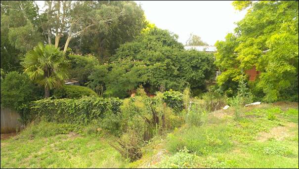
Figure 1: Extensive fill at
south-western boundary, directly adjacent to neighbouring property at 23 Rowan
Street.
This has also been raised as a matter of concern by
Council’s Development Engineers and by objections have been received from
neighbouring properties. As it is proposed to reduce the building footprint,
the extent of the fill can also be reduced and setback from the neighbouring
property to the south-west, therefore minimising the visual impact through the
improvement of outlook. Accordingly, new conditions of consent are
recommended to excavate the areas of the building platform (fill) not required
for the shed, particularly at the site boundaries, which will reduce the visual
bulk as well as to stabilise the soil so that runoff will not impact on
neighbouring properties, which is addressed in further detail below. Good
standards of landscaping between the shed and the south-eastern and
south-western boundaries of the site are still required to provide screening of
the building and its platform from neighbouring properties.
Soil Erosion and Stormwater
The fill used to create the
building platform is loose and has been located very near to the south-western
boundary (see Figure 2). As it has a steep gradient and it has not been
stabilised, there is a very high risk that this will shift and move across the
boundary into the neighbouring property. A recent site visit shows evidence that
erosion is occurring. Stormwater runoff is also likely to move into the
neighbouring property. Given that it is proposed to reduce the building
footprint of the shed, it is recommended that a condition of consent be imposed
which reduces the extent of the fill, as well as stabilises it. Council’s
Development Engineers recommend that it be excavated back to 2m from the shed
walls, with a 1 in 4 gradient, which will move it further from neighbouring
properties as well as stabilise the loose fill.
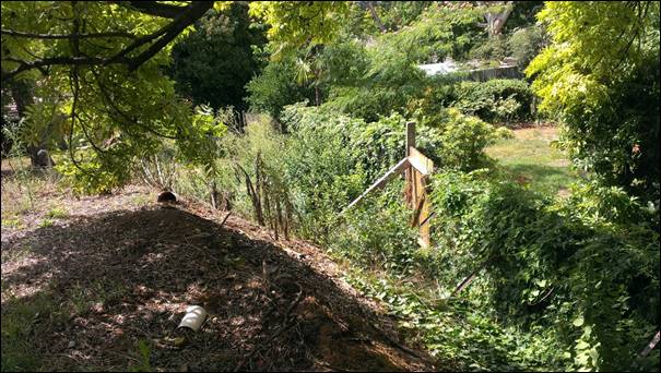
Figure 2: Unstable and steep fill at south-western
boundary, directly adjacent to neighbouring property at 23 Rowan Street.
THE SUITABILITY OF THE SITE
s79C(1)(c)
Council has previously determined that the site is suitable
for the proposed development subject to conditions to address visual impacts
from the fill on the site. Amendments to conditions are required to address the
impacts as set out above. There are no other aspects of the site to indicate
that it would be unsuitable to accommodate the modified development.
ANY SUBMISSIONS MADE IN
ACCORDANCE WITH THE ACT s79C(1)(d)
The proposed development is not defined as "advertised
development" under the provisions of the LEP, however adjacent neighbours
were notified of the application. Two submissions were received from adjoining
owners, who both also made submissions in regards to the original application.
These submissions raise the following relevant issues:
- The
proposal fails to address the impact of the fill.
- The
proposal fails to address obstruction of view, reduction of sun and loss of
outlook.
These matters have been addressed in the assessment above,
and conditions are included to reduce the bulk of the fill as well as stabilise
it, and provide screening landscaping to minimise impacts to these and other
neighbouring residential properties.
PUBLIC INTEREST
s79C(1)(e)
The proposed development is considered to be of minor
interest to the wider public due to the relatively localised nature of
potential impacts.
SUMMARY
The proposed application as modified is
permissible with the consent of Council. The proposed development complies with
the relevant aims, objectives and provisions of Orange LEP 2011 (as
amended) and DCP 2004. The application to modify the consent is consistent with
the provisions of section 96(1A) of the Environmental
Planning and Assessment Act 1979. A
section 79C assessment of the proposal indicates that the development is
acceptable with additional conditions. A modified Notice of Approval is
attached.
Should the Council not accept the modified
application subject to the recommendation and conditions set out in this report
and the attached notice, then the Council should refuse the application.
COMMENTS
The requirements of the Environmental Health and Building
Surveyor and the Engineering Development Section are included in the attached modified
Notice of Approval.
Attachments
1 Notice
of Approval, D15/1715⇩
2 Plans,
D15/2114⇩
3 Submissions,
D15/1031⇩
Sustainable Development Committee
3 February 2015
2.5 Development
Application DA 368/2014(2) - Duntryleague - Lot 16 Woodward Street
Attachment 1 Notice
of Approval
|

|
ORANGE
CITY COUNCIL
Development
Application No DA
368/2013(2)
NA15/1715 Container
PR22661
|
OTICE OF DETERMINATION
OF A DEVELOPMENT
APPLICATION
(AS MODIFIED)
issued under the Environmental
Planning and Assessment Act 1979
Section 81(1)
|
Development
Application
|
|
|
Applicant Name:
|
Orange
Golf Club trading as Duntryleague
|
|
Applicant Address:
|
C/- Peter
Basha Planning & Development
PO Box
1827
ORANGE
NSW 2800
|
|
Owner’s Name:
|
Orange
Golf Club Limited
|
|
Land to Be Developed:
|
Lot 16 DP
1120534 - Woodward Street, Orange
|
|
Proposed Development:
|
Recreation
Facility (outdoor) (ancillary storage facility)
|
|
|
|
|
Building
Code of Australia
building classification:
|
As
determined by Certifier
|
|
|
|
|
Determination
|
|
|
Made On:
|
3 February
2015
|
|
Determination:
|
CONSENT
GRANTED SUBJECT TO CONDITIONS DESCRIBED BELOW:
|
|
|
|
|
Consent to
Operate From:
|
6 August
2014
|
|
Consent to
Lapse On:
|
6 August
2019
|
Terms of Approval
The reasons for the imposition of
conditions are:
(1) To ensure a quality
urban design for the development which complements the surrounding environment.
(2) To maintain
neighbourhood amenity and character.
(3) To ensure compliance
with relevant statutory requirements.
(4) To provide adequate
public health and safety measures.
(5) To ensure the utility
services are available to the site and adequate for the development.
(6) To prevent the proposed
development having a detrimental effect on adjoining land uses.
(7) To minimise the impact
of development on the environment.
Conditions
(1) The
development must be carried out in accordance with:
(a) Amending plans by Peter Basha,
numbered 04118D7 dated 27.11.2014 (5 sheets)
(b) statements
of environmental effects or other similar associated documents that form part
of the approval
as amended
in accordance with any conditions of this consent.
(2) All building work must
be carried out in accordance with the provisions of the Building Code of
Australia.
(3) A sign is to be erected
in a prominent position on any site on which building work, subdivision work or
demolition work is being carried out:
a. showing
the name, address and telephone number of the principal certifying authority
for the work, and
b. showing
the name of the principal contractor (if any) for any building work and a
telephone number on which that person may be contacted outside working hours,
and
c. stating
that unauthorised entry to the site is prohibited.
Any such sign is to be maintained while the
building work, subdivision work or demolition work is being carried out.
|
PRIOR TO THE ISSUE OF
A CONSTRUCTION CERTIFICATE
|
(4) Excavation
is required of the existing fill that is not essential to the building platform
needed for the shed, as modified by this consent. A detailed plan showing
excavation and stabilisation of the existing fill to 2m from the shed walls,
with a gradient of 1 in 4 shall be submitted to and approved by Councils
Manager Development Assessments prior to the issue of a Construction
Certificate.
(5) A motion activated
security lighting, booted and directed so as to not shine directly on any
surrounding residence is required.
(6) Full details of
external colours and finishes of external materials are to be submitted and
approved by Councils Manager Development Assessments prior to the issue of a
Construction Certificate.
(7) A detailed plan showing
landscaping to screen the development from neighbouring residential properties
to the east, south and south-west, as well as provide stabilisation of the
batter shall be submitted to and approved by Councils Manager Development Assessments
prior to the issue of a Construction Certificate.
(8) A
Construction Certificate application is required to be submitted to, and issued
by, Council/Accredited Certifier prior to any excavation or building works
being carried out on site.
(9) A
Fire Safety Schedule specifying the fire-safety measures (both current and/or
proposed) to be implemented in the building is to be submitted with the
Construction Certificate application, in accordance with Part 9 Clause 168 of
the Environmental Planning and Assessment Regulation 2000.
(10) Plans
and specifications are to be provided indicating all details in relation to the
energy efficiency of the building in accordance with Section J (Energy
Efficiency) of the Building Code of Australia.
|
PRIOR TO WORKS COMMENCING
|
(11) A
temporary onsite toilet is to be provided and must remain throughout the
project or until an alternative facility meeting Council’s requirements
is available onsite.
(12) Soil erosion control
measures shall be implemented on the site.
|
DURING
CONSTRUCTION/SITEWORKS
|
(13) All
construction/demolition work on the site is to be carried out between the hours
of 7.00 am and 6.00 pm Monday to Friday inclusive, 7.00 am to
5.00 pm Saturdays and 8.00 am to 5.00 pm on Sundays and Public Holidays.
Written approval must be obtained from the General Manager of Orange City
Council to vary these hours.
(14) All
plumbing and drainage (stormwater drainage) is to comply with the Local
Government (Water, Sewerage and Drainage) Regulation 1998, the NSW Code
of Practice - Plumbing & Drainage and Australian Standard AS3500 -
National Plumbing and Drainage Code. Such work is to be installed by a licensed
plumber and is to be inspected and approved by Council prior to concealment.
(15) Any adjustments to
existing utility services that are made necessary by this development
proceeding are to be at the full cost of the developer.
|
PRIOR TO THE ISSUE OF
AN OCCUPATION CERTIFICATE
|
(16) Landscaping
shall be installed in accordance with the approved plans and shall be
permanently maintained to the satisfaction of Council's Manager Development
Assessments.
(17) No
person is to use or occupy the building or alteration that is the subject of
this approval without the prior issuing of an Occupation Certificate.
(18) The
owner of the building/s must cause the Council to be given a Final Fire Safety
Certificate on completion of the building in relation to essential fire or
other safety measures included in the schedule attached to this approval.
(19) All
of the foregoing conditions are to be at the full cost of the developer and to
the requirements and standards of the Orange City Council Development and
Subdivision Code, unless specifically stated otherwise. All work required by
the foregoing conditions is to be completed prior to the issuing of an
Occupation Certificate, unless stated otherwise.
|
INTEGRATED
DEVELOPMENT – CO-APPROVAL CONDITIONS
|
(20) All
work must be carried out in accordance with the following documents (except
where amended by conditions below);
(a) Development
Application Report for Proposed Car Shed Orange Golf Club – Duntryleague
prepared by Peter Basha Planning and Development in November 2013; and
amended Modification Application Report prepared by Peter Basha dated December
2014
(b) Location
Plan Drawing No. 04118DA dated 7/11/2013 prepared by Peter Basha Planning and
Development; and amended plans by Peter Basha, numbered
04118D7 dated 27.11.2014 (5 sheets)
(c) Architectural
Drawing Proposed Floor Plan and Elevations No. 04118DA dated 7/11/2013 prepared
by Peter Basha Planning and Development; and amended plans by Peter Basha,
numbered 04118D7 dated 27.11.2014 (5 sheets)
(d) Email
from Peter Basha dated 12/02/2014 detailing proposed excavation works and
modifications to existing driveway.
Archaeology:
(21) All
excavation works at the site are to be monitored by an archaeologist. At the
Section 60 stage, the applicant is to nominate a suitably qualified and
experienced excavation director with experience on State Heritage Register
sites.
(22) The
Applicant must ensure that the approved Excavation Director takes adequate
steps to record in detail relics, structures and features discovered on the
site during the archaeological works in accordance with current best practice.
This work must be undertaken in accordance with relevant Heritage Council
guidelines.
(23) The
Applicant must ensure that a report on the archaeological fieldwork is written
by the approved Excavation Director to publication standard, within one (1)
year of the completion of the field based archaeological activity unless an
extension of time or other variation is approved by the Heritage Council of NSW
in accordance with section 144 or 65A of the Heritage Act, 1977.
(24) The
Applicant must ensure that if substantial intact archaeological deposits and/or
State significant relics are discovered, work must cease in the affected
area(s) and the Heritage Council of NSW must be notified. Additional assessment
and approval may be required prior to works continuing in the affected area(s)
based on the nature of the discovery.
(25) Should
any Aboriginal ‘objects’ be uncovered by the work, excavation or
disturbance of the area is to stop immediately. The Excavation Director must
inform the Office of Environment and Heritage in accordance with Section 89A of
the National Parks and Wildlife Act, 1974 (as amended). Works affecting
Aboriginal ‘objects’ on the site must not continue until the Office
of Environment and Heritage has been informed. Aboriginal ‘objects’
must be managed in accordance with the National Parks and Wildlife Act, 1974.
Compliance:
(26) An
application under section 60 of the NSW Heritage Act must be submitted and
approved by the NSW Heritage Council prior to work commencing.
Other Approvals
(1) Local
Government Act 1993 approvals granted under section 68.
Stormwater
(2) General
terms of other approvals integrated as part of this consent.
Nil
Right of Appeal
If
you are dissatisfied with this decision, section 97 of Environmental
Planning and Assessment Act 1979 gives you the right to appeal to the Land
and Environment Court within 6 months after the date on which you receive this
notice.
*
Section 97 of the Environmental Planning and Assessment Act 1979 does not apply
to the determination of a development application for State significant
development or local designated development that has been the subject of a
Commission of Inquiry.
|
Disability Discrimination Act
1992:
|
This application has been assessed in
accordance with the Environmental Planning and Assessment Act 1979. No
guarantee is given that the proposal complies with the Disability
Discrimination Act 1992.
The applicant/owner is responsible to
ensure compliance with this and other anti-discrimination legislation.
The Disability Discrimination Act
covers disabilities not catered for in the minimum standards called up in the
Building Code of Australia which references AS1428.1 - "Design for
Access and Mobility". AS1428 Parts 2, 3 and 4 provides the most
comprehensive technical guidance under the Disability Discrimination Act
currently available in Australia.
|
|
|
|
|
Disclaimer - S88B Restrictions on the Use of Land:
|
The applicant should note that there
could be covenants in favour of persons other than Council restricting what
may be built or done upon the subject land. The applicant is advised to check
the position before commencing any work.
|
|
|
|
|
Signed:
|
On behalf of the consent authority ORANGE
CITY COUNCIL
|
|
Signature:
|
|
|
Name:
|
ALLAN RENIKE - MANAGER DEVELOPMENT
ASSESSMENTS
|
|
Date:
|
4 February 2015
|
Sustainable
Development Committee
3 February 2015
2.5 Development
Application DA 368/2014(2) - Duntryleague - Lot 16 Woodward Street
Attachment 2 Plans
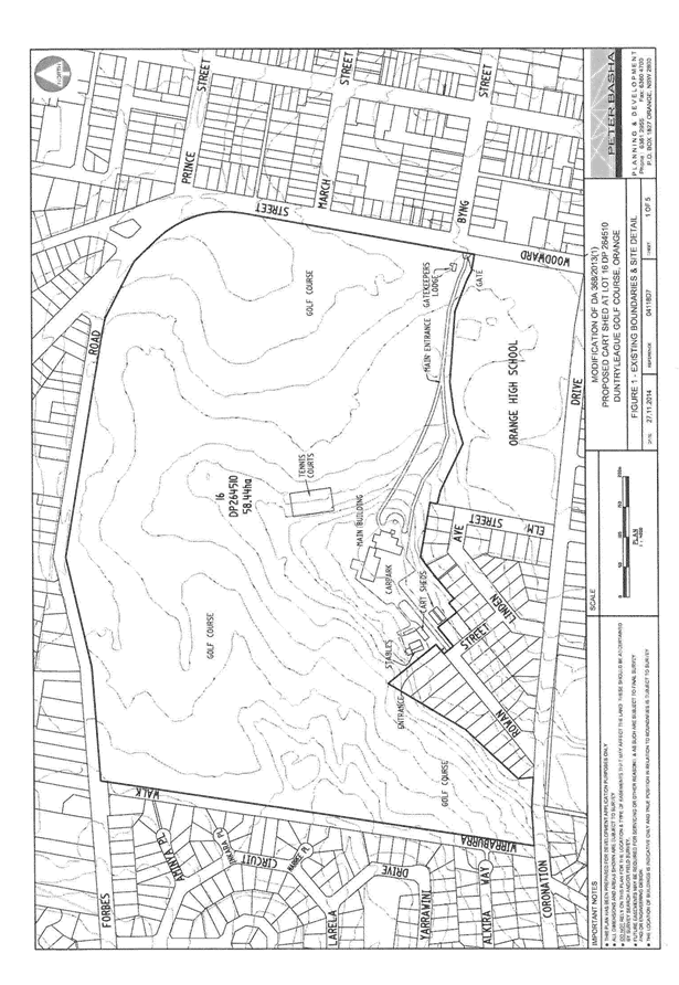
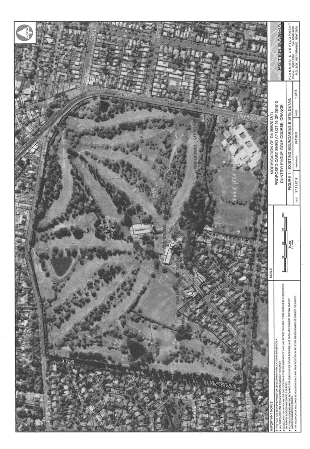
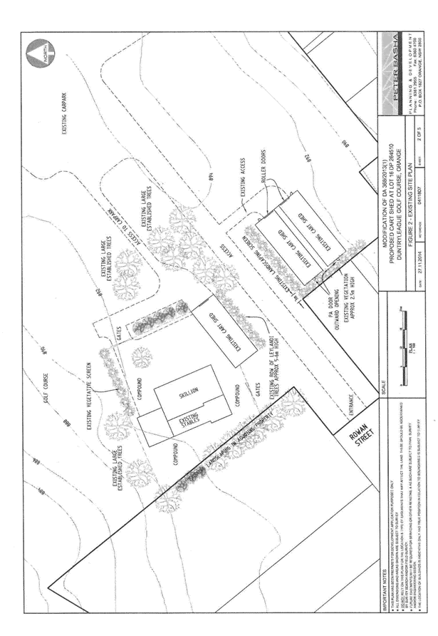
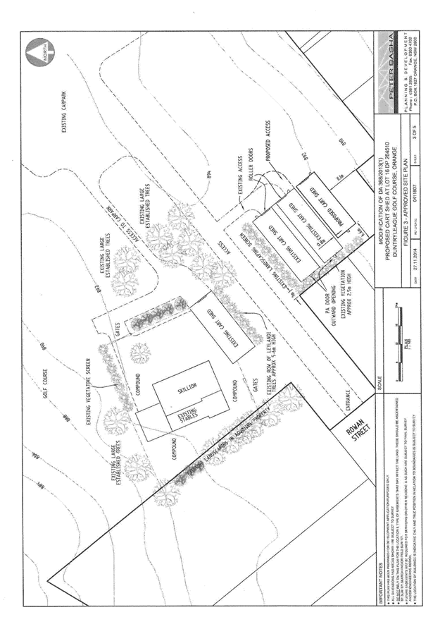
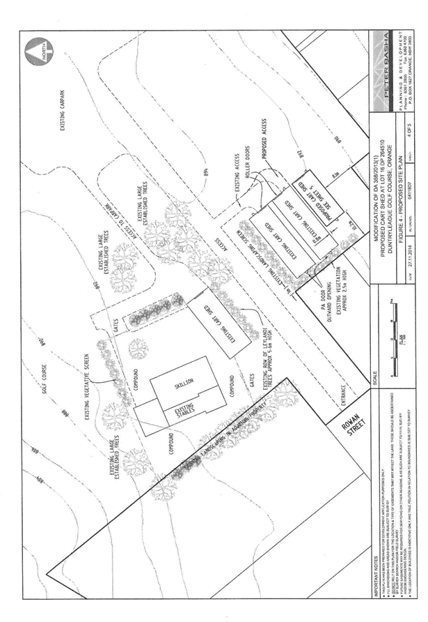
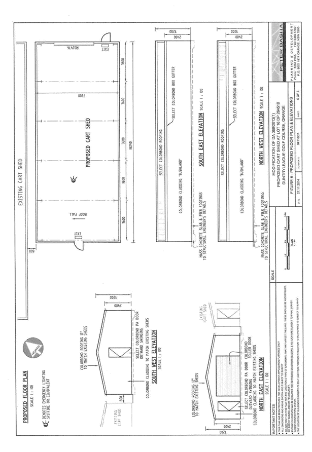
Sustainable
Development Committee
3 February 2015
2.5 Development
Application DA 368/2014(2) - Duntryleague - Lot 16 Woodward Street
Attachment 3 Submissions