ANNEXURE 1. INTERM FLOOD PLANNING AREAS AND LEVELS
Planning and Development Committee
Agenda
2 July 2019
Notice is hereby given, in accordance with the provisions of the Local Government Act 1993 that a Planning and Development Committee meeting of ORANGE CITY COUNCIL will be held in the Council Chamber, Civic Centre, Byng Street, Orange on Tuesday, 2 July 2019.
David Waddell
Acting General Manager
For apologies please contact Administration on 6393 8218.
Planning and Development Committee 2 July 2019
2.1 Items Approved Under the Delegated Authority of Council
2.2 Amendment to Development Control Plan in relation to flooding
1 Introduction
1.1 Declaration of pecuniary interests, significant non-pecuniary interests and less than significant non-pecuniary interests
The provisions of Chapter 14 of the Local Government Act, 1993 (the Act) regulate the way in which Councillors and designated staff of Council conduct themselves to ensure that there is no conflict between their private interests and their public role.
The Act prescribes that where a member of Council (or a Committee of Council) has a direct or indirect financial (pecuniary) interest in a matter to be considered at a meeting of the Council (or Committee), that interest must be disclosed as soon as practicable after the start of the meeting and the reasons given for declaring such interest.
As members are aware, the provisions of the Local Government Act restrict any member who has declared a pecuniary interest in any matter from participating in the discussion or voting on that matter, and requires that member to vacate the Chamber.
Council’s Code of Conduct provides that if members have a non-pecuniary conflict of interest, the nature of the conflict must be disclosed. The Code of Conduct also provides for a number of ways in which a member may manage non pecuniary conflicts of interest.
|
Recommendation It is recommended that Committee Members now disclose any conflicts of interest in matters under consideration by the Planning and Development Committee at this meeting. |
RECORD NUMBER: 2019/1117
AUTHOR: Paul Johnston, Manager Development Assessments
EXECUTIVE Summary
Following is a list of development applications approved under the delegated authority of Council.
Link To Delivery/OPerational Plan
The recommendation in this report relates to the Delivery/Operational Plan strategy “7.1 Preserve - Engage with the community to develop plans for growth and development that value the local environment”.
Financial Implications
Nil
Policy and Governance Implications
Nil
|
That Council resolves to acknowledge the information provided in the report by the Manager Development Assessments on Items Approved Under the Delegated Authority of Council. |
further considerations
Consideration has been given to the recommendation’s impact on Council’s service delivery; image and reputation; political; environmental; health and safety; employees; stakeholders and project management; and no further implications or risks have been identified.
|
Reference: |
DA 369/2007(2) |
Determination Date |
19 June 2019 |
|
PR Number |
PR15982 |
||
|
Applicant/s: |
Mr HC and Mrs PJ Smith |
||
|
Owner/s: |
Mr HC and Mrs PJ Smith |
||
|
Location: |
Lot 12 DP 845959 - Icely Road, Orange |
||
|
Proposal: |
Modification of development consent - subdivision (5 lot rural) - The modification involves relocation of the building envelope in Lot 4 to the western boundary |
||
|
Value: |
$0 (being the same as the original development) |
||
|
Reference: |
DA 242/2017(3) |
Determination Date |
18 June 2019 |
|
PR Number |
PR11580 |
||
|
Applicant/s: |
CPRAM Investments |
||
|
Owner/s: |
Alceon Group Pty Limited |
||
|
Location: |
Lot 564 DP 776383 – 212-220 Summer Street and Post Office Lane, Orange (now described as Lot 1 DP 1246899) (MYER) |
||
|
Proposal: |
Modification of development consent – demolition (ground, first and second floors, and roof of existing retail tenancy), and commercial premises (alterations and additions including elevated outdoor dining area). The modification will simply reduce the size of the elevated deck in Post Office Lane, specifically the ramp at the rear of the deck will now tuck up back in on itself rather than extend further down the laneway. |
||
|
Value: |
$12,081,304 (being the same value as the original development) |
||
|
Reference: |
DA 303/2017(2) |
Determination Date |
19 June 2019 |
|
PR Number |
PR27554 |
||
|
Applicant/s: |
Mr NJ Farrell |
||
|
Owner/s: |
Orange City Council and Mr PN, Mrs JF, and Mr NJ Farrell |
||
|
Location: |
Lot 808 DP 1240445; Lot 201 DP 1227253; Lot 402 DP 1232601, and Lot 2 DP 738478 – Astill Drive, 12A and 363 Phillip Street, Orange |
||
|
Proposal: |
Modification of development consent - resource recovery facility (composting). The modification involved moving a composting pile and shed to a levelled platform area, providing a covered unloading area on the northern side of the work shed and altering the internal layouts of the work shed. |
||
|
Value: |
$360,000 (being $60,000 more than the original development) |
||
|
Reference: |
DA 138/2018(2) |
Determination Date |
29 May 2019 |
|
PR Number |
PR27649 |
||
|
Applicant/s: |
Mr I Zhang |
||
|
Owner/s: |
Dinkum Exporting and Importing Pty Limited |
||
|
Location: |
Lot 211 DP 1229307 – 9 Lily Place, Orange |
||
|
Proposal: |
Modification of development consent – multi dwelling housing (15 dwellings), subdivision (2 Torrens lots, 6 community lots, and 9 community lots). The modification seeks to delete condition number 14, which requires an onsite stormwater detention system to be included in the subject site for that part of the land that relates to future dwellings 1 to 7. |
||
|
Value: |
$1,800,000 (being the same value as the previous development) |
||
|
Reference: |
DA 432/2018(1) |
Determination Date |
14 June 2019 |
|
PR Number |
PR6420 |
||
|
Applicant/s: |
Hi Tech Homes Pty Limited |
||
|
Owner/s: |
Mrs DL Nikitin |
||
|
Location: |
Lot 169 DP 260088 - 37 Kurim Avenue, Orange |
||
|
Proposal: |
Dual Occupancy (constructed as a movable dwelling) |
||
|
Value: |
$106,465 |
||
|
Reference: |
DA 206/2018(2) |
Determination Date |
30 May 2019 |
|
PR Number |
PR12746 |
||
|
Applicant/s: |
Landorange Partnership |
||
|
Owner/s: |
Fenlor Group Pty Limited and Charms Developments Pty Limited |
||
|
Location: |
Lots 92, 93 and 95 DP 750401 – 124, 136 and 148 Shiralee Road |
||
|
Proposal: |
Modification of development consent - subdivision (102 lots comprising 101 residential lots and 1 open space lot) and demolition (dwellings x 2 and outbuildings). The modification involves an amendment to Condition 11 of the development consent in relation to stormwater discharge from the site. |
||
|
Value: |
$0 (being the same value as the previous development) |
||
|
Reference: |
DA 41/2019(1) |
Determination Date |
31 May 2019 |
|
PR Number |
PR28009 |
||
|
Applicant/s: |
Orange Christian Ministry Centre |
||
|
Owner/s: |
Christian Ministry Centre |
||
|
Location: |
Lot 200 DP 1241114 - 560 Cecil Road, Orange |
||
|
Proposal: |
Mixed use development (proposed dual occupancy involving change of use to create one new dwelling, and a replacement carport)(existing place of public worship) |
||
|
Value: |
$30,000 |
||
|
Reference: |
DA 51/2019(1) |
Determination Date |
5 June 2019 |
|
PR Number |
PR20524 |
||
|
Applicant/s: |
Mr MP and Mrs LM Molloy |
||
|
Owner/s: |
Mr MP and Mrs LM Molloy |
||
|
Location: |
Lot 100 DP 1092868 – 360 Phoenix Mine Road, Huntley |
||
|
Proposal: |
Water storage facility (continued use of existing dams), earthworks (stabilisation of surrounds), farm building and water tanks |
||
|
Value: |
$190,000 |
||
|
Reference: |
DA 62/2019(1) |
Determination Date |
29 May 2019 |
|
PR Number |
PR23984 |
||
|
Applicant/s: |
Mr WD McDonald |
||
|
Owner/s: |
Messrs IG and GC and RK and WD McDonald |
||
|
Location: |
Lot 51 DP 1146556, Lot 2 DP 155991, Lot 1 Sec 36 DP 758817, Lot 2 DP 1180945 – 53 Sampson Street and 4 Hamer Street, Orange |
||
|
Proposal: |
Subdivision (consolidation/boundary adjustment (three lots into two lots)) |
||
|
Value: |
$0 |
||
|
Reference: |
DA85/2019(1) |
Determination Date |
21 May 2019 |
|
PR Number |
PR27972 |
||
|
Applicant/s: |
Mr C Marjoram and Ms FC Morello |
||
|
Owner/s: |
Mr CC Marjoram and Ms FC Morello |
||
|
Location: |
Lot 234 DP 1238394 CA 5284 DP 1238394 – 40 Stevenson Way, Orange |
||
|
Proposal: |
Dual occupancy, outbuilding (shed) and rainwater tank (72,000L) and subdivision (two lot Torrens) |
||
|
Value: |
$800,000 |
||
|
Reference: |
DA87/2019(1) |
Determination Date |
30 May 2019 |
|
PR Number |
PR27083 |
||
|
Applicant/s: |
Future Build CPD |
||
|
Owner/s: |
Mr JK and Mrs CL Harvey |
||
|
Location: |
Lot 133 DP 1207360 – 104 Dean Drive, Orange |
||
|
Proposal: |
Dwelling, attached garage, detached garage and secondary dwelling, rainwater tank (22,000L), swimming pool (inground) and fencing (pool fencing) |
||
|
Value: |
$566,390 |
||
|
Reference: |
DA 92/2019(1) |
Determination Date |
16 May 2019 |
|
PR Number |
PR26464 |
||
|
Applicant/s: |
Kynuna Pty Ltd |
||
|
Owner/s: |
Orange City Council |
||
|
Location: |
Lot 200 DP 1195298 –Airport Terminal – 136 Aerodrome Road, Huntley |
||
|
Proposal: |
Airport (alterations and additions to erect a hangar) |
||
|
Value: |
$65,000 |
||
|
Reference: |
DA 111/2019(1) |
Determination Date |
22 May 2019 |
|
PR Number |
PR15698 |
||
|
Applicant/s: |
Newcrest Mining Ltd |
||
|
Owner/s: |
Orange City Council |
||
|
Location: |
Lot 3 DP 844802 – 6 Astill Drive, Orange |
||
|
Proposal: |
Research facility (car park) |
||
|
Value: |
$45,000 |
||
|
Reference: |
DA 112/2019(1) |
Determination Date |
19 June 2019 |
|
PR Number |
PR6885 |
||
|
Applicant/s: |
Essential Energy |
||
|
Owner/s: |
Essential Energy |
||
|
Location: |
Lot 62 DP 635440 – 15-41 Lords Place, Orange |
||
|
Proposal: |
Depot (storage shed and onsite pavement modification) |
||
|
Value: |
$168,300 |
||
|
Reference: |
DA 127/2019(1) |
Determination Date |
22 May 2019 |
|
PR Number |
PR11586 |
||
|
Applicant/s: |
Woodland Shopfitting |
||
|
Owner/s: |
Mrs T and Mr TS and Ms KM Rossi and Mrs K Selmes |
||
|
Location: |
Lot 1 DP 67426 – 207 Anson Street, Orange |
||
|
Proposal: |
Shop (new shopfront) |
||
|
Value: |
$25,640 |
||
|
Reference: |
DA 128/2019(1) |
Determination Date |
12 June 2019 |
|
PR Number |
PR27314 |
||
|
Applicant/s: |
Mr J Saran |
||
|
Owner/s: |
Saran Homes Pty Ltd |
||
|
Location: |
Lot 403 DP 1220844 – 6 Connemara Drive, Orange |
||
|
Proposal: |
Subdivision (two lot residential) |
||
|
Value: |
$0 |
||
|
Reference: |
DA 139/2019(1) |
Determination Date |
31 May 2019 |
|
PR Number |
PR20437 |
||
|
Applicant/s: |
DCLD Investments Pty Ltd |
||
|
Owner/s: |
DCLD Investments Pty Ltd |
||
|
Location: |
Lot 2 DP 1085646 – 260 Clergate Road, Orange |
||
|
Proposal: |
Extractive industry (Pad 1) |
||
|
Value: |
$100,000 |
||
|
Reference: |
DA 169/2019(1) |
Determination Date |
19 June 2019 |
|
PR Number |
PR6191 |
||
|
Applicant/s: |
Mr KW Cochrane |
||
|
Owner/s: |
Mr KW and Mrs HL Cochrane |
||
|
Location: |
Lot A DP 373068 – 35 Kite Street, Orange |
||
|
Proposal: |
Works to tree (removal or pruning) |
||
|
Value: |
$0 |
||
TOTAL NET* VALUE OF ALL DEVELOPMENTS APPROVED UNDER DELEGATED AUTHORITY IN THIS PERIOD: $2,096,795.00
* Net value relates to the value of modifications. If modifications are the same value as the original DA, then nil is added. If there is a plus/minus difference, this difference is added or taken out.
RECORD NUMBER: 2019/1266
AUTHOR: Craig Mortell, Senior Planner
EXECUTIVE Summary
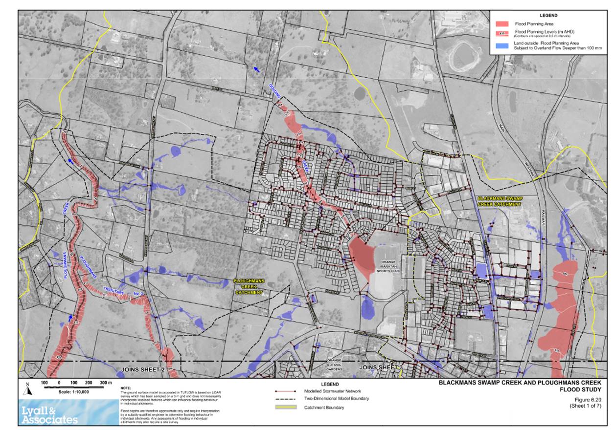
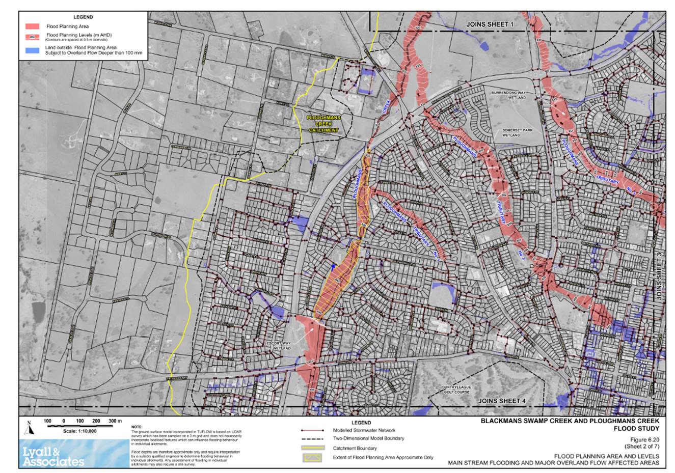
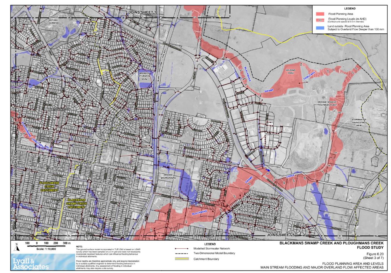
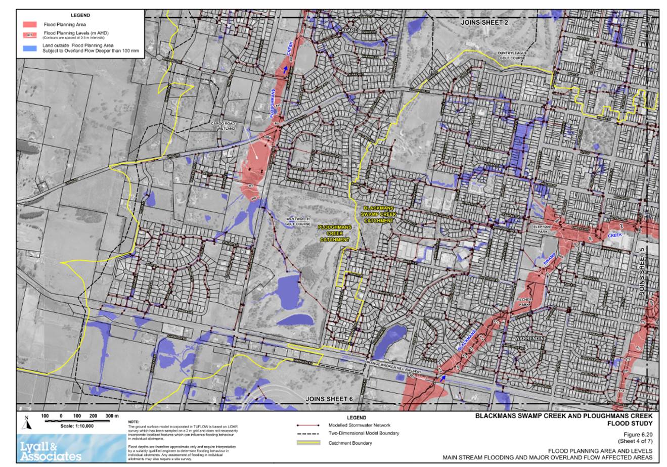
Council has recently undertaken an extensive review and update of flooding risks across the city, in the form of the Blackmans Swamp and Ploughman’s Creek Flood Study. This work has previously been reported to Council and is due to be publicly exhibited soon. However the flood study itself does not constitute flood planning controls.
The current framework for flood planning controls consists of clause 7.2 of the LEP and the Flood Planning Map in the LEP. Due to the need to prepare planning proposals and seek gateway determinations from the Department of Planning and Environment LEP maps are not automatically updated when flood studies are produced or updated.
As such there arises the potential for a mismatch to occur whenever the flood study is updated, between the new flooding knowledge and the existing planning controls.
The Housekeeping amendment to the LEP, previously reported to Council, has already foreshadowed a change to this approach. That change will see the LEP continue to require assessment of flooding risks but will then reference the DCP to determine which land is affected. In turn the DCP will reference the latest version of the flood study. As a consequence once this framework is in place planning certificates will always be based on the most recent and most accurate information adopted by Council.
This report advises of Draft DCP provisions that are intended to provide the vital connection between the LEP and the flood study. The intention is to be able to place all three documents (flood study, LEP amendment and DCP amendment) on exhibition concurrently.
Link To Delivery/OPerational Plan
The recommendation in this report relates to the Delivery/Operational Plan strategy “8.2 Preserve - Develop and promote initiatives to reduce water, energy and waste in consultation with the community”.
Financial Implications
Nil
Policy and Governance Implications
Council has a statutory obligation to provide formal advice in relation to flooding controls on section 10.7 Planning Certificates (formerly section 149 certificates) which form part of the property conveyancing process. Information on planning certificates also affect insurance policies, access to finance, as well as influencing the design and siting of developments.
Legally, a 10.7(2) certificate can only advise if the property is subject to planning controls or not, whereas a 10.7(5) can elaborate with any other information Council deems relevant. Consequently any discrepancy between the adopted flood study and flood controls in the LEP and DCP can only be clarified in the 10.7(5) version of the planning certificate, which are the minority of certificates issued.
|
That Council resolves: 1. To place the attached draft DCP Chapter as an amendment on exhibition, for 28 days concurrently with the flood study and LEP Housekeeping amendment.
2. That upon adoption, the draft DCP be known as chapter 4A Flood Affected Land.
3. That, in order to avoid duplication, the exhibition include a proposed repeal of section 5.3 of the Phillip Street DCP, which relates to flooding. |
further considerations
The recommendation of this report has been assessed against Council’s other key risk categories and the following comments are provided:
|
|
|
|
|
Image and Reputation |
Provision of accurate and timely advice in relation to flooding risks is required to sustain the community’s faith in the planning system. |
|
|
Environmental |
Council has a statutory obligation to provide accurate advice on s.10.7 planning certificates that in turn assist private landowners in relation to property development decisions. |
|
SUPPORTING INFORMATION
Council has recently undertaken an extensive review and update of flooding risks across the city. This work includes both riverine and overland flooding of land which has previously been reported to Council and is due to be publicly exhibited soon. The flood study has a direct bearing on the planning advice provided by staff both generally and in terms of section 10.7 planning certificates. Due to the regulated nature of advice provided on planning certificates, formerly known as section 149’s, it is important to ensure that the LEP and DCP framework correctly reflect the latest flooding knowledge available to Council.
The current framework for flood planning controls consists of clause 7.2 of the LEP and the Flood Planning Map in the LEP. LEP maps can only be amended through a formal planning proposal, which in turn require a gateway determination prior to being able to exhibit draft changes. This creates the potential for a mismatch to occur whenever the flood study is updated.
People relying upon the information in a 10.7(2) planning certificate, which are the majority of planning certificates issued, may not be readily aware of the flood study. As such any discrepancy between the latest flooding knowledge available to Council and the formal flooding advice provided by Council on planning certificates could generate complaints in relation to development potential, insurance and financing of properties.
The Housekeeping amendment to the LEP, previously reported to Council, has already foreshadowed a change to this approach. That change involves removal of the flood mapping from the LEP and adjusting the clause to instead reference flooding controls in the DCP, which in turn would automatically reference the latest version of the flood study. As a consequence once this framework is in place planning certificates will always be based on the most recent and most accurate information adopted by Council.
The draft DCP provisions are attached to this report. The maps within the DCP are adopted from the flood study directly as Annexure 1. This allows Council to update the flood maps in the DCP concurrently with any future update to the flood study. Beyond this the draft DCP:
· Section 1.2 establishes several objectives in relation to flooding,
· Annexure 2 groups all land uses into 7 categories of development
· Annexure 3 assigns ‘Flood Response Levels’ via a matrix for affected categories of development to guide the appropriate design responses, and
· Annexure 3 Based on the assigned flood response level details what response is required to comply at each response level.
1 Draft DCP Chapter for Flood Affected Land, D19/38782⇩
Planning and Development Committee 2 July 2019
Attachment 1 Draft DCP Chapter for Flood Affected Land
This chapter of the Development Control Plan (DCP) was prepared to provide specific development controls to guide development of flood affected land within Orange.
The DCP incorporates the findings of the Blackmans Swamp and Ploughman’s Creek Flood Study and the procedures set out in the NSW Floodplain Management Manual.
1.1 What does the plan do?
The plan provides information and guidelines to assist people with mind to develop or use land affected by potential flooding within Orange. Development may include, without limitation:
· building construction;
· alterations and additions to existing developments;
· filling land;
· establishing a business;
· subdividing land;
· minor development such as Carports and Garages; and
· permit merit based assessment of development upon an allotment where it can be demonstrated that the development site is above the 1% AEP (100 year ARI).
1.2 Objectives
This chapter of the DCP aims to:
a) To minimise the potential impact of development and other activity upon the aesthetic, recreational and ecological value of the waterway corridors.
b) Increase public awareness of the hazard and extent of land affected by all potential floods, including floods greater than the Adopted Flood and to ensure essential services and land uses are planned in recognition of all potential floods.
c) Inform the community of Council’s policy for the use and development of flood prone land.
d) Reduce the risk to human life and damage to property caused by flooding through controlling development on land affected by potential floods.
e) Provide detailed controls for the assessment of applications lodged in accordance with the Environmental Planning and Assessment Act 1979 on land affected by potential floods.
f) Provide different guidelines, for the use and development of land subject to all potential floods in the floodplain, which reflect the probability of the flood occurring and the potential hazard within different areas.
g) Apply a “merits-based approach” to all development decisions which takes account of social, economic and ecological as well as flooding considerations.
h) To control development and other activity within each of the individual floodplains within the LGA having regard to the characteristics and level of information available for each of the floodplains.
i) Deal equitably and consistently with applications for development on land affected by potential floods, in accordance with the principles contained in the Flood Plan Management Manual 2008 issued by the NSW Government.
j) To provide controls for the assessment of applications on land affected by potential floods in accordance with the provisions of Orange LEP 2011 (as amended).
1.3 Will the plan affect my property?
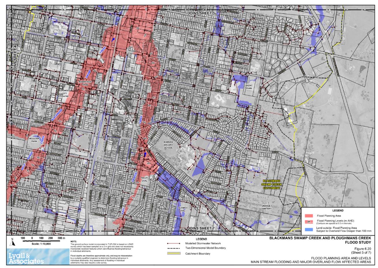
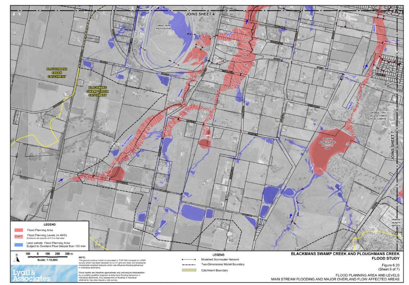
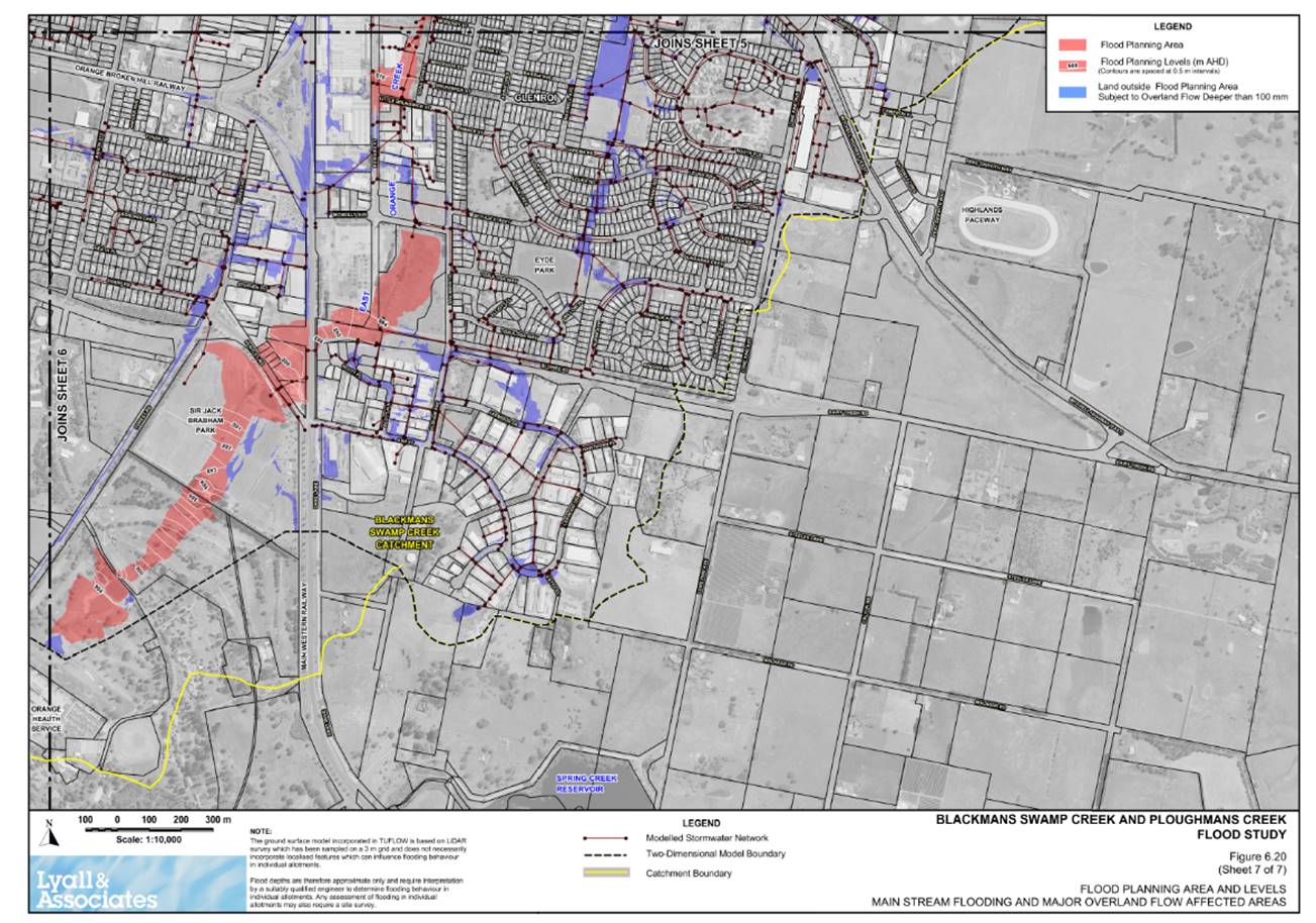
The DCP applies to all development on land in Orange that is shown mapped in Annexure 1.0 as either Interim Flood Planning Area or subject to overland flow deeper than 100mm.
2.0 HOW TO USE THIS PLAN
The DCP provides flood related criterion for determining development applications. The criteria recognise that different controls apply to different land uses and levels of potential flood inundation or hazard.
3.0 WHAT ARE THE CRITERIA FOR DETERMINING APPLICATIONS?
3.1 General
The criteria for determining applications for proposals potentially affected by flooding are structured in recognition that different controls are applicable to different land uses and levels of potential flood inundation and hazard.
3.2 Land use categories
7 land use categories have been adopted and are listed in Annexure 2.0
3.3 What controls apply to proposed residential developments?
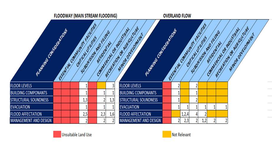
The development controls apply to all flood prone land (that is to the PMF flood). The type of controls has been graded relative to the severity and frequency of potential floods, having regard to the two following applicable categories:
· Floodway – Shown in red on the Interim Flood Planning Areas and Levels Main Stream Flooding and Overland Flow affected Areas Maps shown in Annexure 1.0
· Overland Flow – Shown in blue on the Interim Flood Planning Areas and Levels Main Stream Flooding and Overland Flow affected Areas Maps shown in Annexure 1.0
· Annexure 3.0 outlines the flood response levels relevant to the land use category identified in annexure 2.0.
· Annexure 3.0 Development control table establishes the design responses required for each flood response level identified.
3.4 What if my allotment is partially in the Floodway or Overland Flow?
Any proposed development on that land shall be subject to a merits based assessment with respect to the proposed developments location and impact on flood affectation.
3.5 Fencing
Any proposed fencing is to be shown on the plans accompanying a development application and the likely effect of such fencing on flood behaviour is to be assessed by a suitably qualified engineer.
All fencing panels (including Colourbond, galvanised, timber, wire and brush) to be either:
a) removable so that panels can be laid flat; or
b) horizontally hinged where a portion of at least 1.2m high is capable of swinging open to allow floodwater to pass, or
c) Raised as to allow floodwaters to flow beneath
Fencing may be required to comply with a type and siting criteria as prescribed by Council.
3.6 Other Uses and works
All other development, building or other works within any of the categories that require Council’s consent will be considered on their merits. In consideration of such applications Council must determine that the proposed development is in compliance with the objectives of this policy.
3.7 Other documents which may need to be read in conjunction with this plan:
· Orange Local Environmental Plan 2011;
· Relevant Council policies, development control plans and specifications;
· Blackmans Swamp and Ploughman’s Creek Flood Study;
· NSW Government Floodplain Management Manual;
· Environmental Protection Authority Guidelines on Sediment and Erosion Control;
· Environmental Protection Authority Guidelines on on-site effluent disposal.
3.8 What Information Do You Have to Submit to Council?
In order to obtain the approval of Council you must lodge a Development Application in accordance with the Environmental Planning and Assessment Act 1979.
The application must be accompanied by:
· A site plan showing the location of proposed works or structures,
· Contour lines of the site to enable assessment of likely flood behaviour
· Materials proposed to be used in the development,
· Proposed finished floor levels,
· The location and proposed height of all electrical and critical utilities.
4.0 DESCRIPTION OF TERMS
Definitions of terms used in the DCP are provided as follows:
|
Term |
Description |
|
Australia Height Datum (AHD) |
A common National plain of level corresponding approximately to mean sea level. |
|
Design floor level |
The floor level specified in this policy which applies to the relevant land use type and the location and existing ground level of the site. |
|
Designated flood
|
The flood adopted for planning purposes relative to the sensitivity of different land uses and the flood risk, as specified by Annexure 1.0. |
|
Designated flood level |
Represents the maximum level of water reached measured as a height above Australian Height datum during a designated flood. |
|
Flood awareness |
An appreciation of the likely effects of flooding and knowledge of the relevant flood warning and evacuation procedures. |
|
Flood compatible building components |
A combination of measures incorporated in the design and/or construction and alteration of individual buildings or structures subject to flooding, and the use of flood compatible materials for the reduction or elimination of flood damage as indicated in the Floodplain Development Manual |
|
Flood compatible materials |
Those materials used in building which are resistant to damage when inundated. A list of flood compatible materials is attached in Annexure 4.0. |
|
Flood evacuation strategy |
The proposed strategy for the evacuation of areas during periods of flood as specified within any policy of Council, the Floodplain Management Plan, by advises from the State Emergency Services (SES) or as determined in the assessment of individual proposals. |
|
Flood liable land |
The area of land which is subject to inundation by floods up to and including the 1% AEP. |
|
Flood planning level |
A level as defined in a flood management study for the purposes of setting flood related control applicable to a particular use of the land. |
|
Floodplain |
An area of land that is subject to inundation by the probable maximum flood or an extreme flood event. |
|
Floodway |
An area of land as defined in a flood study which constitutes the main flood path of floodwaters and in which flood hazard conditions occur, as distinctly identified and shown in red on Interim Flood Planning Areas. |
|
Flood hazard |
The potential risk to life and potential damage caused by flooding. |
|
Flood prone land |
land susceptible to inundation by the maximum flood PMF or an appropriate extreme flood event. |
|
Freeboard
|
A factor of safety usually expressed as a height above the designated flood. Freeboard tends to compensate for factors such as wave action, localised hydraulic effects and the like. |
|
Habitable floor area |
Refers to a room (other than a Garage, Shed, bathroom, laundry, W.C. or the like) that is constructed or adapted for domestic living such as a lounge room, dining room, rumpus room, kitchen, bedroom. |
|
Overland Flow |
An area of land as defined in a flood study which constitutes secondary flood path of floodwaters and in which flood hazard conditions occur, as distinctly identified and shown in blue on Interim Flood Planning Areas and Overland Flow affected Areas Maps |
|
Reliable access during a flood |
The ability for people to safely evacuate an area subject to imminent flooding within effective warning time ad without a need to travel through areas where water depths increase. |
|
Interim Designated Flood Event |
Flood event based on historical information which allows the provisions of an Environmental Planning instrument to be implemented until such time as a floodplain management plan has been adopted for an area, the Interim Designated Flood Event determines the extent of flood liable land in the interim period. |
|
Probable maximum flood (PMF) |
The largest flood that could conceivably occur at a particular location. |
ANNEXURE 2.0 LAND USE CATEGORIES
1. Essential Community Facilities
Place of Assembly or Public Buildings that may provide an important contribution to the notification and evacuation of the community during flood events.
2. Critical Utilities
Generating works, Utility Installations that may cause pollution of waterways during flooding are essential to evacuation during periods of flood or if affected during flood events would unreasonably affect the ability of the community to return to normal activities after the flood events.
3. Subdivision and Filling
Subdivision of land involving the creation of new allotments for any particular purpose (excludes boundary adjustments), earthworks or filling operations covering 100m2 or more than 0.3m deep.
4. Residential
Boarding house; Caravan Park; Dwelling house; Home industry; Home occupation; Housing for aged or disabled persons; Professional consulting rooms; Public utility undertakings (other than critical utilities); Recreation Establishment; Tourist facilities; Residential flat building and Utility installation undertaking (other than critical utilities).
5. Commercial or industrial
Bulk Store; Car repair stations; Club; Commercial Premises (other than where referred to elsewhere); Education establishment; General Store; Health care professional; Hotel; Industry; Institution; Junk yard; Liquid fuel depot; Motel; Motor showroom; Place of Assembly (other than essential community facilities); Place of Public worship; Public building (other than essential community facilities); Refreshment Room; road transport terminal; Rural industry; Saw mill; Service station; Shop; Transport terminal; Warehouse.
6. Recreation or Agricultural
Recreation Facility; Agriculture; Animal boarding establishment; Retail nursery; Recreation area; Roadside stall; and Stock and Sale Yard;
7. Minor Development
a) in the case of residential development:
I. an addition to an existing dwelling of not more than 15% or 30m2 (whichever is the lesser) of the habitable floor area which existed at the date of this policy; or
II. the construction of an outbuilding, with walls that may impede the flood path, with a maximum floor area of 45m2.No more than 50% of the Lot size can be developed.
III. (iii)carports, awnings or similar structures that do not contain walls
b) In the case of shops & offices.
I. New shops with a total floor area less than 50m2; or
II. change of use which involves no building.
c) In the case of other development an addition to existing premises of not more than 15% of the floor area which existed at the date of commencement of this policy.
d) In the case of an allotment partially affected by flood liable zones new development where survey information is provided supporting the location of the development as outside the defined 1% AEP flood level.
ANNEXURE 3.0 PRESCRIPTIVE DEVELOPMENT CONTROLS – FLOOD RESPONSE LEVELS
|
|
Flood Response Level |
Flood Response Controls |
|
Floor Level
|
1 |
Habitable floor levels to be equal to or greater than the Adopted Flood level plus 0.5m freeboard |
|
2 |
Habitable floor levels to be equal to or greater than the Adopted Flood level plus 0.15m freeboard |
|
|
3 |
Floor levels to be as close to the Adopted Flood level as practical & no lower than any existing floor level. |
|
|
Building Components & Method |
1 |
All structures to have flood compatible building and components below the Adopted Flood Level |
|
Structural Soundness
|
1 |
Engineers report to certify that any structure can withstand the forces of floodwater, debris & buoyancy up to and including the Adopted Flood |
|
2 |
Applicant to demonstrate that any structure can withstand the forces of floodwater, debris & buoyancy up to and including the Adopted Flood |
|
|
3 |
Geotechnical Engineers report required to specify appropriate filling/earthworks & the means of protecting batters against scouring/erosion |
|
|
Evacuation
|
1 |
The development is to be consistent with any relevant flood evacuation strategy. |
|
Flood Affectation
|
1 |
Engineers report required to certify that the development will not increase flood affection elsewhere |
|
2 |
Development shall not block the conveyance of flood waters across the floodway or Overland flow. |
|
|
3 |
Filling of land up to 0.5m above Adopted Flood level permitted provided this does not result in any significant effect on the conveyance of flood waters. |
|
|
4 |
Filling of a maximum of a 1/3 of allotment up to 0.3m above the Adopted Rood level permitted provided this does not result in any significant effect on the conveyance of flood waters or flood levels |
|
|
5 |
Filling of a maximum of a 1/4 of allotment up to 0.5m above the Adopted Flood level permitted provided this does not result in any significant effect on the conveyance of flood waters. |
|
|
6 |
No filling |
|
|
Management and Design
|
1 |
Applicant to demonstrate that area is available to store goods above the Adopted Flood plus 0.5m freeboard |
|
2 |
No external storage of materials below the design floor level which may cause pollution or be potentially hazardous during any flood |
|
|
3 |
Applicant to demonstrate the at potential development as a consequence of a subdivision proposal can be undertaken in accordance with this Plan |
ANNEXURE 4.0 FLOOD COMPATABLE MATERIALS
|
Building Component |
Floor Compatible Material |
|
|
Flooring and Sub-floor Structure |
ü concrete slab-on-ground monolith construction ü suspension reinforced concrete slab. |
ü T&G flooring and timber joists (for minor extensions) |
|
Floor Covering |
ü clay tiles ü concrete, precast or in situ ü concrete tiles ü epoxy, formed-in-place ü mastic flooring, formed-in-place |
ü rubber sheets or tiles with chemical-set adhesives ü silicon floors formed-in-place ü vinyl sheets or tiles with chemical-set adhesive ü ceramic tiles, fixed with mortar or chemical-set adhesive ü asphalt tiles, fixed with water resistant adhesive |
|
Wall Structure |
ü solid brickwork, blockwork, reinforced, concrete or mass concretes |
ü Gal metal and timber frame (for minor extensions) |
|
Roofing Structure (for situations where the relevant flood level is above the ceiling) |
ü reinforced concrete construction ü galvanised metal construction |
|
|
Doors |
ü solid panel with water proof adhesives ü flush door with marine ply filled with closed cell foam |
ü painted metal construction ü aluminium or galvanised steel frame |
|
Wall And Ceiling Linings |
ü fibro-cement board ü brick, face or glazed ü clay tile glazed in waterproof mortar ü concrete ü concrete block |
ü steel with waterproof applications ü stone, natural solid or veneer, waterproof grout ü glass blocks ü glass ü plastic sheeting or wall with waterproof adhesive |
|
Insulation Windows |
ü foam (closed cell types) ü aluminium frame with stainless steel rollers or similar corrosion and water resistant material |
ü Gal metal and timber windows (for minor extensions) |
|
Nails, Bolts, Hinges and Fittings |
ü Brass, nylon or stainless steel ü Removable pin hinges |
ü Hot dipped galvanised steel wire nails or similar |