Planning and Development
Committee
Agenda
7 November 2018
Notice is hereby given, in
accordance with the provisions of the Local Government Act 1993 that a Planning and Development Committee meeting of ORANGE CITY COUNCIL
will be held in the Council Chamber,
Civic Centre, Byng Street, Orange on Wednesday, 7 November
2018.
Garry
Styles
General Manager
For apologies please
contact Administration on 6393 8218.
1 Introduction
1.1 Declaration
of pecuniary interests, significant non-pecuniary interests and less than
significant non-pecuniary interests
The
provisions of Chapter 14 of the Local Government Act, 1993 (the Act)
regulate the way in which Councillors and designated staff of Council conduct
themselves to ensure that there is no conflict between their private interests
and their public role.
The
Act prescribes that where a member of Council (or a Committee of Council) has a
direct or indirect financial (pecuniary) interest in a matter to be considered
at a meeting of the Council (or Committee), that interest must be disclosed as
soon as practicable after the start of the meeting and the reasons given for
declaring such interest.
As
members are aware, the provisions of the Local Government Act restrict any
member who has declared a pecuniary interest in any matter from participating
in the discussion or voting on that matter, and requires that member to vacate
the Chamber.
Council’s Code of Conduct provides that if members
have a non-pecuniary conflict of interest, the nature of the conflict must be
disclosed. The Code of Conduct also provides for a number of ways in which a
member may manage non pecuniary conflicts of interest.
|
Recommendation
It is recommended that Committee Members now disclose any
conflicts of interest in matters under consideration by the Planning and
Development Committee at this meeting.
|
2 General
Reports
2.1 Items
Approved Under the Delegated Authority of Council
RECORD
NUMBER: 2018/2445
AUTHOR: Paul
Johnston, Manager Development Assessments
EXECUTIVE Summary
Following is a list of development applications approved
under the delegated authority of Council.
Link To Delivery/OPerational Plan
The recommendation in this report relates to the
Delivery/Operational Plan strategy “7.1 Preserve - Engage with the
community to develop plans for growth and development that value the local
environment”.
Financial Implications
Nil
Policy and Governance Implications
Nil
|
Recommendation
That Council resolves to acknowledge the information
provided in the report by the Manager Development Assessments on Items
Approved Under the Delegated Authority of Council.
|
further considerations
Consideration has been given to the recommendation’s
impact on Council’s service delivery; image and reputation; political;
environmental; health and safety; employees; stakeholders and project
management; and no further implications or risks have been identified.
SUPPORTING INFORMATION
|
Reference:
|
DA 113/2007(3)
|
Determination Date
|
5 October 2018
|
|
PR Number
|
PR6918
|
|
Applicant/s:
|
Kelly’s Rugby Hotel
|
|
Owner/s:
|
Rugby Properties Pty Limited
|
|
Location:
|
Lot 50 DP 817766 – 133 Lords
Place, Orange
|
|
Proposal:
|
Modification of development consent
- hotel (alterations and additions to existing hotel). The modification seeks
to regularise the installation of windows/enclosure of part of the first
floor verandah of the pub.
|
|
Value:
|
$280,000
(being the same value as the original development)
|
|
Reference:
|
DA 274/2014(2)
|
Determination Date
|
27 September 2018
|
|
PR Number
|
PR22640
|
|
Applicant/s:
|
Fawcett Ridge Pty Ltd
|
|
Owner/s:
|
Fawcett Ridge Pty Limited
|
|
Location:
|
Lot 502 DP 1122616 – 30-44
Edward Street
|
|
Proposal:
|
Modification of development consent
– recreation facility (indoor) and business identification sign. The
modification seeks to reduce the number of onsite car parking spaces required
from 82 to 63.
|
|
Value:
|
$100,000
(being the same value as the original development)
|
|
Reference:
|
DA 148/2017(2)
|
Determination Date
|
9 October 2018
|
|
PR Number
|
PR25975
|
|
Applicant/s:
|
|
|
Owner/s:
|
Mrs WL Finlay
|
|
Location:
|
Lot 103 DP 1180866 – 5
Trappit Place, Orange
|
|
Proposal:
|
Modification of development consent
– wholesale supplies
|
|
Value:
|
$680,000
(being the same value as the original development)
|
|
Reference:
|
DA 247/2017(2)
|
Determination Date
|
5 October 2018
|
|
PR Number
|
PR13530
|
|
Applicant/s:
|
Allied Group Pty Ltd
|
|
Owner/s:
|
Mr C Tseris
|
|
Location:
|
Lots 30 and 31 DP 246174, and Lot
33 DP 1055815 – Tarawell Crescent and Margaret Road, Orange
|
|
Proposal:
|
Modification of development consent
– subdivision (30 lot residential). The modification involves
increasing the lot yield by one, to 30 lots. The current approved development
comprises 29 lots.
|
|
Value:
|
$0 (being
the same value as the original development)
|
|
Reference:
|
DA 74/2018(2)
|
Determination Date
|
24 September 2018
|
|
PR Number
|
PR27835
|
|
Applicant/s:
|
Designs@m
|
|
Owner/s:
|
Mr RI and Mrs SE Kirkby
|
|
Location:
|
Lot 524 DP 1233683 – 29
Buckland Drive, Orange
|
|
Proposal:
|
Modification of development consent
- dual occupancy and subdivision (two lot residential). The modification
involves alterations to openings for the front (south) façade of
Dwelling 1, with frontage to Young Street.
|
|
Value:
|
$420,000
(being the same value as the original development)
|
|
Reference:
|
DA 132/2018(2)
|
Determination Date
|
3 October 2018
|
|
PR Number
|
PR7466
|
|
Applicant/s:
|
Mrs PL McDonell
|
|
Owner/s:
|
Mrs PL McDonell
|
|
Location:
|
Lot 1 DP 150197 – 107 March
Street, Orange
|
|
Proposal:
|
Modification of development consent
- dwelling alterations and additions and demolition (garage and tree
removal). The modification involves deleting a condition relating to window
frame materials, deleting a condition requiring a dilapidation report of the
adjoining property, and amending the approved exterior material of both the
existing cottage and the extension from painted brickwork to face brick.
|
|
Value:
|
$475,000
(being the same value as the original development)
|
|
Reference:
|
DA 184/2018(1)
|
Determination Date
|
20 September 2018
|
|
PR Number
|
PR11480
|
|
Applicant/s:
|
MCHP Architects Pty Ltd
|
|
Owner/s:
|
Trustees Roman Catholic Church
|
|
Location:
|
Lot 2 DP 518890, Lot 2 DP 71369, Lot 11 DP 1136660 and Lot 1 DP 909617
– 87-91 Summer Street, Orange
|
|
Proposal:
|
Service station (removal of existing underground tanks and dispensers,
installation of new underground tanks and dispensers, and façade
upgrade), category 1 remediation and business identification signage
|
|
Value:
|
$900,000
|
|
Reference:
|
DA 200/2018(1)
|
Determination Date
|
26 September 2018
|
|
PR Number
|
PR11392
|
|
Applicant/s:
|
Uniplan Group Pty Ltd
|
|
Owner/s:
|
Mr GJ Griffith and Ms SH Chrystall
|
|
Location:
|
Lots 238 and 239 DP 750387 –
285 Orchard Road, Springside
|
|
Proposal:
|
Secondary dwelling
|
|
Value:
|
$207,000
|
|
Reference:
|
DA 207/2018(1)
|
Determination Date
|
3 October 2018
|
|
PR Number
|
PR3554
|
|
Applicant/s:
|
PCR Building Services
|
|
Owner/s:
|
Ecclesall Pty Ltd
|
|
Location:
|
Lot 1 DP 783183 – 31 Dora
Street, Orange
|
|
Proposal:
|
Dwelling (reconstruction of ornate
parapet) and heritage interpretation signage
|
|
Value:
|
$39,000
|
|
Reference:
|
DA 222/2018(1)
|
Determination Date
|
17 October 2018
|
|
PR Number
|
PR2991
|
|
Applicant/s:
|
Azor Industries
|
|
Owner/s:
|
Azor Industries Pty Limited
|
|
Location:
|
Lot 78 DP 792268 – 3
Corporation Place, Orange
|
|
Proposal:
|
Industrial (additions and alterations)(new
storage shed)
|
|
Value:
|
$165,000
|
|
Reference:
|
DA 260/2018(1)
|
Determination Date
|
15 October 2018
|
|
PR Number
|
PR18576
|
|
Applicant/s:
|
Future Build CPD
|
|
Owner/s:
|
Mr GW and Mrs SA Delaney
|
|
Location:
|
Lot 200 DP 1042614 – 583
Huntley Road, Huntley
|
|
Proposal:
|
Dual occupancy
(attached)(alterations and additions to existing dwelling and additional
dwelling)
|
|
Value:
|
$474,650
|
|
Reference:
|
DA 267/2018(1)
|
Determination Date
|
3 October 2018
|
|
PR Number
|
PR11573
|
|
Applicant/s:
|
Commonwealth Bank of Australia
|
|
Owner/s:
|
Numite Pty Limited
|
|
Location:
|
Lot 1 DP 708311 – 244-246
Summer Street, Orange
|
|
Proposal:
|
Office premises (alterations and
additions)
|
|
Value:
|
$17,500
|
|
Reference:
|
DA 269/2018(1)
|
Determination Date
|
19 October 2018
|
|
PR Number
|
PR27945
|
|
Applicant/s:
|
Mr IY Zhang
|
|
Owner/s:
|
Mrs JM Zhang
|
|
Location:
|
Lot 2071 DP 1245489 – 27
William Maker Drive and 1 Stevenson Way, Orange
|
|
Proposal:
|
Multi dwelling housing (four
dwellings) and subdivision (four lot Torrens)
|
|
Value:
|
$500,000
|
|
Reference:
|
DA 279/2018(1)
|
Determination Date
|
28 September 2018
|
|
PR Number
|
PR27954
|
|
Applicant/s:
|
Mr D Bouffler
|
|
Owner/s:
|
Mr DW Bouffler
|
|
Location:
|
Lot 216 DP 1238394 – 17
Stevenson Way, Orange
|
|
Proposal:
|
Dwelling house, subdivision (two
lot residential) and dwelling house
|
|
Value:
|
$440,000
|
|
Reference:
|
DA 299/2018(1)
|
Determination Date
|
27 September 2018
|
|
PR Number
|
PR22640
|
|
Applicant/s:
|
Fawcett Ridge Pty Ltd
|
|
Owner/s:
|
Fawcett Ridge Pty Limited
|
|
Location:
|
Lot 502 DP 1122616 – 30-44
Edward Street, Orange
|
|
Proposal:
|
Change of use from vehicle sales or
hire premises to depot
|
|
Value:
|
$0
|
|
Reference:
|
DA 314/2018(1)
|
Determination Date
|
17 October 2018
|
|
PR Number
|
PR25500
|
|
Applicant/s:
|
Mr B and Mrs LA Parianos
|
|
Owner/s:
|
Mr BA and Mrs LA Parianos
|
|
Location:
|
Lot 161 DP 1168341 – 135-137 Kite
Street, Orange
|
|
Proposal:
|
Commercial premises (alterations
and additions)
|
|
Value:
|
$110,000
|
|
Reference:
|
DA 324/2018(1)
|
Determination Date
|
21 September 2018
|
|
PR Number
|
PR6234
|
|
Applicant/s:
|
Source Architects Pty Ltd
|
|
Owner/s:
|
Petrinovic Family Pty Limited
|
|
Location:
|
Lot 1 Sec 46 DP 758817 –
1-7/122-124 Kite Street, Orange
|
|
Proposal:
|
Partial change of use from public
administration building to office premises
|
|
Value:
|
$50,000
|
|
Reference:
|
DA 328/2018(1)
|
Determination Date
|
19 October 2018
|
|
PR Number
|
PR772
|
|
Applicant/s:
|
i2C Architects
|
|
Owner/s:
|
NNG Pty Limited
|
|
Location:
|
Lot 1 DP 606873 – 226 Anson
Street, Orange
|
|
Proposal:
|
Shop (alterations and additions to
create basement storage)
|
|
Value:
|
$250,000
|
TOTAL NET* VALUE OF ALL
DEVELOPMENTS APPROVED IN THIS PERIOD: $3,153,150.00
*
Net value relates to the value of modifications. If modifications are
the same value as the original DA, then nil is added. If there is a plus/minus
difference, this difference is added or taken out.
2.2 Development
Application DA 405/2017(2) - 241 Ploughmans Lane.
RECORD
NUMBER: 2018/2720
AUTHOR: Summer
Commins, Senior Planner
EXECUTIVE Summary
|
Application
lodged
|
15
August 2018
|
|
Applicant/s
|
Orange
Evangelical Church Incorporated
|
|
Owner/s
|
Orange
Evangelical Church Incorporated
|
|
Land
description
|
Lot 9 DP
746439 - 241 Ploughmans Lane, Orange
|
|
Proposed
land use
|
Place of
Public Worship and Business Identification Sign
|
|
Value of
proposed development
|
$3,000,000
|
Council's consent is sought to modify development consent DA
405/2017(1) for proposed place of public worship and business identification
sign at Lot 9 DP 746439 – 241 Ploughmans Lane, Orange (refer
locality below).
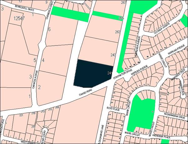
Figure 1 - locality plan
The original development was approved by the Planning and
Development Committee at its meeting on 1 May 2018.
The approved development involves:
· new site access
via the road reserve to the west of the site, including intersection
construction at Cargo Road and new public road;
· construction of a
purpose-built church building with floor area of 967m²;
· construction of
two (2) onsite car parks containing 112 spaces;
· conversion of the
existing dwelling house to ancillary church offices;
· infilling of dams
over the site; and
· operating hours of
8am to 7pm Monday to Thursday, 8am to 10pm Friday and Saturday, and 9am to 7pm
Sunday.
The approved site plan and building design are depicted
below.
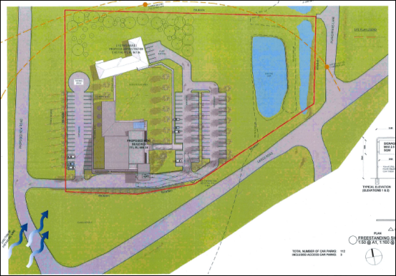
Figure 2 – approved site layout
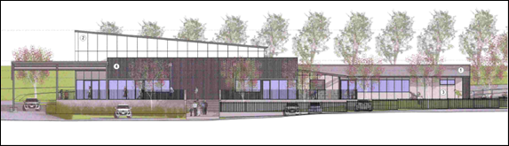
Figure 3 – approved church building (east
elevation)
Modification of the approved development is now proposed.
The modified proposal seeks to amend conditions of consent to enable:
- construction
approval for offsite roadworks to be obtained separate to construction approval
for the church building (various conditions);
- ancillary
office use of the existing dwelling prior to use and occupation of the place of
worship (Condition 42);
- operating
hours of 7am to 10pm Sunday, and 8am to 10pm Monday to Saturday (Condition 50);
and
- clarification
of the requirements associated with the acoustic assessment, acoustic
commissioning report and operational noise emissions (various conditions).
The proposal comprises advertised development. At the
completion of the public notice and exhibition period, one (1) submission was
received. The issues raised in the submission relate to amenity impacts
associated with interim office use and extended hours of operation.
A Section 4.15 assessment of the proposal indicates that the
modified development is partly acceptable. No objection is raised to separate
construction of road works, extension to hours of operation, and clarification
on operational acoustic requirements. Proposed interim office-use is not
permitted on the subject land zoning and is not supported.
An amended Notice of Approval is
attached. The applicant has proposed amended wording to various conditions.
Council officers have revised the conditions where appropriate to satisfy the
intent of the proposed modification where supported.
RECENT LEGISLATIVE CHANGES
On 1 March 2018 the Environmental Planning and Assessment
Act 1979 was substantially amended. The most immediate change involves the
restructuring and renumbering of the Act, with other more substantive
changes to be phased in over time. However, for some applications (particularly
where an application was lodged prior to the changes coming into effect) the
supporting documentation may still reference the previous numbering regime. In
the drafting of this report the content and substance of the supporting
material has been considered irrespective of which legislative references were
used.
DECISION FRAMEWORK
Development in Orange is governed by two key documents
Orange Local Environment Plan 2011 and Orange Development Control Plan 2004. In
addition the Infill Guidelines are used to guide development, particularly in
the heritage conservation areas and around heritage items.
Orange Local Environment Plan 2011 – The
provisions of the LEP must be considered by the Council in determining the
application. LEPs govern the types of development that are permissible or
prohibited in different parts of the City and also provide some assessment
criteria in specific circumstances. Uses are either permissible or not. The
objectives of each zoning and indeed the aims of the LEP itself are also to be
considered and can be used to guide decision making around appropriateness of
development.
Orange Development Control Plan 2004 – the DCP
provides guidelines for development. In general it is a performance based
document rather than prescriptive in nature. For each planning element there
are often guidelines used. These guidelines indicate ways of achieving the
planning outcomes. It is thus recognised that there may also be other solutions
of merit. All design solutions are considered on merit by planning and building
staff. Applications should clearly demonstrate how the planning outcomes are
being met where alternative design solutions are proposed. The DCP enables
developers and architects to use design to achieve the planning outcomes in
alternative ways.
DIRECTOR’S COMMENT
This modification involves changes to approved hours, some
engineering requirements and the requested use of the dwelling for an office.
Staff have brokered a compromise in relation to hours of operation that is
consistent with Council’s position on other places of worship in
residential areas. Engineering conditions are supported. The use of the
dwelling as an office is not permissible under OLEP 2011.
Link To Delivery/OPerational Plan
The recommendation in this report relates to the
Delivery/Operational Plan strategy “10.1 Preserve -
Engage with the community to ensure plans for growth and development are
respectful of our heritage”.
Financial Implications
Nil
Policy and Governance Implications
Nil
|
Recommendation
That Council resolves to
issue modified development consent DA 405/2017(1) for Place of Public Worship and Business
Identification Sign at Lot 9 DP 746439 - 241 Ploughmans Lane,
Orange pursuant to the conditions of consent in the
attached modified Notice of Approval.
|
further considerations
Consideration has been given to the
recommendation’s impact on Council’s service delivery; image and
reputation; political; environmental; health and safety; employees;
stakeholders and project management; and no further implications or risks have
been identified.
SUPPORTING INFORMATION
THE PROPOSAL
The modified proposal seeks to amend conditions of consent
to enable:
- construction
approval for offsite roadworks to be obtained separate to construction approval
for the church building (various conditions);
- ancillary
office use of the existing dwelling prior to use and occupation of the place of
worship (Condition 42);
- operating
hours of 7am to 10pm Sunday, and 8am to 10pm Monday to Saturday (Condition 50);
and
- clarification
of the requirements associated with the acoustic assessment, acoustic
commissioning report and operational noise emissions (various conditions).
The proponent for the modified development has requested
specific wording for revised and additional conditions (refer Appendix B in the
attached supporting information).
MATTERS FOR CONSIDERATION
Environmental Planning and Assessment
Act 1979
Section 4.55(2) Modification of
Consents- Generally
Pursuant to this section:
(2) A consent authority
may, on application being made by the applicant or any other person entitled to
act on a consent granted by the consent authority and subject to and in
accordance with the regulations, modify the consent if:
(a) it is satisfied that
the development to which the consent as modified relates is substantially the
same development as the development for which consent was originally granted
and before that consent as originally granted was modified (if at all), and
(b) it has consulted with
the relevant Minister, public authority or approval body (within the meaning of
Division 4.8) in respect of a condition imposed as a requirement of a
concurrence to the consent or in accordance with the general terms of an
approval proposed to be granted by the approval body and that Minister,
authority or body has not, within 21 days after being consulted, objected to
the modification of that consent, and
(c) it has notified the application
in accordance with:
(i) the regulations, if the
regulations so require, or
(ii) a
development control plan, if the consent authority is a council that has made a
development control plan that requires the notification or advertising of
applications for modification of a development consent, and
(d) it has considered any
submissions made concerning the proposed modification within the period
prescribed by the regulations or provided by the development control plan, as
the case may be.
Subsections (1) and (1A) do not apply to such a
modification.
(3) In determining an
application for modification of a consent under this section, the consent
authority must take into consideration such of the matters referred to in
section 4.15 (1) as are of relevance to the development the subject of the
application. The consent authority must also take into consideration the
reasons given by the consent authority for the grant of the consent that is
sought to be modified.
In
consideration of the requirements of Sections 4.55(2) and (3):
· The development as
modified is substantially the same as the development for which the consent was
originally granted.
· The development as
modified does not effect a condition imposed as a requirement of concurrence by
a Minister, public authority or approval body.
· The modified
development comprises advertised development pursuant to Clause 119 of the
Environmental Planning and Assessment Regulation 2000. Public notice and
exhibition of the modified development was undertaken.
· One (1) submission
was received in response to public notice and exhibition of the modified
development. The issues raised in the submission are outlined in the following
sections of this report.
· The relevant
matters under Section 4.5(1) are addressed in the following sections of this
report.
Section 1.7 - Application of Part
7 of the Biodiversity Conservation Act 2016 and Part 7A of the Fisheries
Management Act 1994
Pursuant to this section:
This Act has
effect subject to the provisions of Part 7 of the Biodiversity Conservation Act
2016 and Part 7A of the Fisheries Management Act 1994 that relate to the
operation of this Act in connection with the terrestrial and aquatic
environment
In consideration of this section,
the proposed modified development does not alter the previous assessment.
PROVISIONS OF ANY ENVIRONMENTAL
PLANNING INSTRUMENT s4.15(1)(a)(i)
Orange Local Environmental Plan 2011
The original development was
assessed pursuant to Orange LEP 2011. The subject land is identified on the LEP
maps as follows:
|
Land
Zoning Map:
|
Land
zoned R2 Low Density Residential
|
|
Lot
Size Map:
|
Minimum
lot size 850m2 – 2000m2
|
|
Heritage
Map:
|
Not
a heritage item or conservation area
|
|
Height
of Buildings Map:
|
No
building height limit
|
|
Floor
Space Ratio Map:
|
No
floor space limit
|
|
Terrestrial
Biodiversity Map:
|
No
biodiversity sensitivity on the site
|
|
Groundwater
Vulnerability Map:
|
Groundwater
vulnerable
|
|
Drinking
Water Catchment Map:
|
Not
within the drinking water catchment
|
|
Watercourse
Map:
|
Land
contains a defined watercourse (Ploughmans Creek)
|
|
Urban
Release Area Map:
|
Not
within an urban release area
|
|
Obstacle
Limitation Surface Map:
|
No
restriction on building siting or construction
|
|
Additional
Permitted Uses Map:
|
No
additional permitted use applies
|
|
Flood
Planning Map:
|
Land
within a flood planning area (adjacent to watercourse)
|
The proposed modified development does not alter the
previous assessment under that Plan.
State Environmental Planning
Policy 55 - Remediation of Land
SEPP 55 was applicable to the original development. The
modified development does not alter the previous assessment under the SEPP.
State Environmental Planning
Policy 64 – Advertising and Signage
SEPP 64 was applicable to the original development. The
modified proposal does not relate to approved signage, nor alter the previous
assessment under the SEPP.
State Environmental Planning Policy (Infrastructure) 2007
The ISEPP was applicable to the original development
(Division 17 Roads and Traffic). The modified proposal does not alter the previous
assessment under the SEPP.
PROVISIONS OF ANY DRAFT
ENVIRONMENTAL PLANNING INSTRUMENT THAT HAS BEEN PLACED ON EXHIBITION
4.15(1)(a)(ii)
There are no draft environmental planning instruments that
apply to the subject land or proposed modified development.
DESIGNATED DEVELOPMENT
The modified development is not designated development.
INTEGRATED DEVELOPMENT
The original development comprised Integrated Development
pursuant to Section 4.46 of the EPAA 1979.
A Controlled Activity approval was granted by DPI Water
(under Section 91 of the Water Management Act 2000) for works
adjacent to Ploughmans Creek. The modified development does not relate to works
relating to the Controlled Activity approval.
RMS concurrence was required and granted for intersection
works on Cargo Road (under Section 138 of the Roads Act 1993). The
modified development partly relates to separate offsite road construction, but
will not alter intersection works contained in the original approval.
PROVISIONS OF ANY DEVELOPMENT
CONTROL PLAN s4.15(1)(a)(iii)
Development Control Plan 2004
The original development was assessed pursuant to the
following chapters in DCP 2004:
· Chapter 0 - Transitional Provisions
· Chapter 2 - Natural Resource Management
· Chapter 3 - General Considerations
· Chapter 4 - Special Environmental Considerations
· Chapter 5 - General Considerations for Zones and
Development
· Chapter 7 - Development in Residential Areas
· Chapter 14 - Advertising
· Chapter 15 - Car parking.
The
proposed modified development remains generally consistent with the previous
assessment under the DCP.
PROVISIONS PRESCRIBED BY THE
REGULATIONS s4.15(1)(a)(iv)
The modified development is not inconsistent with any
provision prescribed by Regulation.
THE LIKELY IMPACTS OF THE
DEVELOPMENT s4.15(1)(b)
The impacts of the modified proposal are consistent with
those considered for the original development, except as provided below.
Construction Approval
The modified proposal seeks to allow the commencement of
offsite road works prior to issue of a Construction Certificate for the church
building. The proponent has requested that various conditions be amended
(Conditions 4, 5, 6, 7, 8, 10, 16, 17 and 19) and new conditions added
(Conditions 3a, 3b and 3c) to reflect this arrangement.
Council’s Development Engineer raises no objection to
the intent of this aspect of the modification. Conditions 32 and 33 will be
amended (in lieu of the proponent’s alternative conditions) to allow for
offsite road works to occur independent of the onsite works required for the
church building.
Office Use
The modified proposal seeks to amend Condition 42 in
relation to occupation of the buildings. Condition 42 states:
(42) No person is to use or occupy the building or
alteration that is the subject of this approval without the prior issuing of an
Occupation Certificate.
It is proposed to modify this condition to allow office use
of the converted dwelling prior to issue of an Occupation Certificate for the
place of worship. The proponent requests that Condition 42 state:
(42) No person is to use or occupy the approved place
of worship without the issuing of an Occupation Certificate. This
condition does not preclude the use of the existing dwelling or the purposes of
offices prior to issue of an Occupation Certificate for the place of worship
building.
The approved church office is ancillary to and associated
with the place of worship. The proposed amended condition will allow use of the
subject land for offices prior to occupation and operation of the place of
worship. Prior to construction of the place of workshop (for an indeterminate
period), the landuse will actually comprise ‘office premises.’
Office premises are not permitted in the R2 Low Density Residential zone pursuant
to Orange LEP 2011. This aspect of the proposed modification cannot be
supported.
Hours of Operation
The modified proposal seeks to amend Condition 50 relating
to hours of operation. Condition 50 states:
(50) The hours of
operation of the development shall not exceed the following, without the prior
approval of Council:
- 8am to 7pm
Monday to Thursday
- 8am to 10pm
Friday and Saturday
- 9am to 7pm
Sunday.
Illumination of the building
and parking areas shall not occur outside of the approved hours of operation.
The modified proposal seeks to amend Condition 50 as
follows:
(50) The hours of operation of the development shall not
exceed the following, without the prior approval of Council:
a) 8 am to 10 pm Monday to Thursday
i In relation to
(a), between 8pm and 10pm, Monday to Thursday, no more than 40 persons may be
on site.
ii (a)(i) does not apply
up to six times per year.
b) 8am to 10 pm Friday and Saturday
c) 7 am to 10 pm Sunday.
i In relation to
(c), between 9pm and 10pm, Sunday, no more than 20 persons may be on site.
Illumination
of the building and parking areas shall not occur outside of the approved hours
of operation.
The proposed hours of operation
are considered to be reasonable due to the following:
· An acoustic report
was submitted in support of the modified development (GUZ Box Design + Audio
dated 13 August 2018). The report concludes that noise generated by the
development (from both within the building and external areas) will satisfy the
adopted noise management levels during daytime (7am to 6pm) and evening (6pm to
10pm) periods pursuant to the Noise Policy for Industry (2017). Council’s
Manager Building and Environment concurs with the findings of the amended
acoustic report.
· Conditions
relating to acoustic measures are included on the Notice of Approval to ensure
that the proposed development will comply with the Noise Policy for
Industry (2017), the recommendations of the submitted acoustic report and
operational noise emissions.
· The proposed
operating hours are reasonably consistent with other places of worship in
residential zones. The places of worship at 46 Moonstone Drive
(DA 286/2014(1)) and 211 Cargo Road (DA 274/2009(2)) involve general use
of the sites between 6am and 8.30pm, albeit with smaller congregations.
· A proposed 10.00pm
finishing time for the modified proposal is considered reasonable due to the
larger interface with opposing dwellings than is available at Moonstone Drive
and Cargo Road. Limits on persons onsite during the evening periods on
Monday-Thursday and Sunday will assist to lessen any potential impact on
residential amenity for neighbours (by reason of vehicle movements, people
congregating in the carpark, light spill etc).
· Notwithstanding
the ‘cover-all’ hours of operation proposed, the proponent advises
that the place of worship will rarely operate to these hours. Indeed, the
longstanding and existing operation of the subject church elsewhere in the City
does not involve the proposed operating hours. In this regard, the proponent
advises:
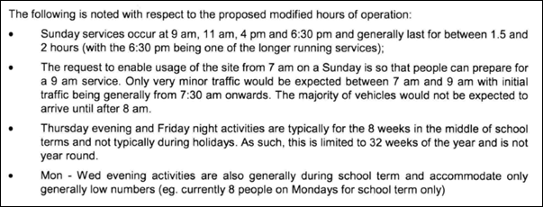
· The amended
condition is considered reasonable to enable preparation for worship services,
undertaking of services and clean up etc to be carried out. Full congregations
will not be onsite for the entire duration of approved hours of operation.
· With regard to the
operation of other places of worship in residential zones, Council has not
received any complaints from residents adjoining places of worship. In
Council’s experience, places of worship are indeed a complementary
landuse and do not impact on residential amenity nearby to the site.
Condition 50 will be amended as proposed.
Acoustic Matters
Acoustic Assessment
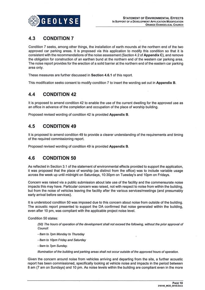
The modified proposal seeks to amend Condition 7 in relation
to hard landscaping (earth mounding) requirements. Condition 7 states in part:
(7) A detailed landscape plan, compiled by a
suitably qualified landscape architect shall be submitted for approval of
Council’s Manager City Presentation prior to issue of a Construction
Certificate. The landscape plan shall incorporate the following particulars:
· Hard and soft landscaping including earth mounding to the northern
end of each parking area
It is proposed that a solid barrier be provided at the
northern end of the eastern car park only, in lieu of the earth mounding
referred to in Condition 7. The modified proposal is consistent with the
requirements of the revised noise assessment (Guz Box Design + Audio,
13 August 2018. The proponent requests that Condition 7 state (in part) as
follows:
(7) A detailed landscape plan, compiled by a
suitably qualified landscape architect shall be submitted for approval of
Council’s Manager City Presentation prior to issue of a Construction
Certificate. The landscape plan shall incorporate the following particulars:
· Hard and soft landscaping to the northern end of each parking area
and a minimum 1.5m high sold acoustic barrier to the northern end of the
eastern car parking area.
No objection is raised to amending Condition 7. Condition 7
will be amended on the modified Notice of Approval. It is noted that Condition
19 will also be amended to reference the updated acoustic assessment submitted
with the modified proposal.
Commissioning Report
The modified proposal seeks to amend Condition 49 relating
to the acoustic Commissioning Report.
Condition 49 states:
(49) The
applicant shall obtain a Commissioning Report from an appropriately qualified
and experienced acoustic consultant which assesses actual noise emissions from
all operations of the development within 3 months of the issue of an Occupation
Certificate. Where the report requires additional noise attenuation works to be
carried out, these works shall be undertaken within 28 days from the date of
the Commissioning Report.
The proponent submits that the condition should be amended
to allow the report to be completed within such time frame ‘as agreed
by Council’s Manager Development Assessments.’
Council’s Manager Building and Environment raises no
objection to amending Condition 49 as generally proposed as it will allow
the Commissioning Report to be undertaken when the place of worship is properly
operational. This approach is consistent with Council’s recent practice
for other non-residential uses in residential/sensitive areas.
Condition 49 will be amended as follows:
(49) The
applicant shall obtain a Commissioning Report from an appropriately qualified
and experienced acoustic consultant which assesses actual noise emissions from
all operations of the development within 3 months of the issue of an Occupation
Certificate or as otherwise agreed in writing by Council (but not more than
six (6) months after occupation). Where the report requires
additional noise attenuation works to be carried out, these works shall be
undertaken within 28 days from the date of the Commissioning Report.
Operational Noise Emissions
The modified proposal seeks to amend Condition 59 relating
to operational noise emissions. Condition 59 states:
(59) Emitted
noise shall not exceed 5dB(A) above background sound level measured at the
nearest affected residence.
The proponent submits that the
condition is ‘imprecise’ and ‘requires a more
specific and enforceable parameter.’ The proponent requests that
Condition 59 state as follows:
(59) Emitted noise shall not exceed 5dB(A)LAEQ15min
above background sound level measured at the most effected point on or
within an adjoining residential property.
Council’s Manager Building
and Environment raises no objection to the amended condition. Condition 59
will be amended on the modified Notice of Approval.
Construction Approval
The modified proposal seeks to amend various conditions to
clarify that further engineering and construction approval required in the
Notice of Approval relates to the place of worship and not the offsite
road works (Conditions 4, 5, 6, 7, 8, 10, 16, 17, 19, 48 and 49).
It is unnecessary to amend the Notice of Approval in this
regard. References to submission requirements prior to the issue of a
Construction Certificate apply to either offsite roadworks or onsite
building and site works. Relevant conditions will apply to the appropriate
component of the development, as determined by the Certifier.
THE SUITABILITY OF THE SITE
s4.15(1)(c)
There are no aspects of the site that are considered
unsuitable for the proposed modified development.
ANY SUBMISSIONS MADE IN
ACCORDANCE WITH THE ACT s4.15(1)(d)
The proposed development is defined as "advertised
development" under the Regulations. The application was advertised for the
prescribed period of 14 days and at the end of that period one (1) submission
was received.
The submission expressed concerns that the modified
development would adversely impact on residential amenity for the adjoining
dwelling to the north by reason of:
· alternative
fencing treatment on the common boundary;
· office use of the
site;
· intensified access
via Ploughmans Lane; and
· extended hours of
operation.
In consideration of these matters:
- The
modified proposal does not relate to perimeter fencing. Agreed fencing
arrangements between the adjoining owners will not be altered by the modified
development. Onsite earth mounding at the northern end of the eastern carpark
will be amended to a 1.5m high solid acoustic barrier. This barrier, together
with solid perimeter fencing, will suitably manage potential noise and light
spill from the car park.
- As
outlined, office premises are not permitted in the R2 Low Density Residential
zone. Use of the existing dwelling for the approved church office will only
occur in conjunction with occupation and operation of the place of worship.
- The
modified proposal will not alter approved access arrangements.
Condition 56 states that “site access via Ploughmans Lane is
prohibited, other than in conjunction with a dwelling. All access to the site
associated with the development shall be via the new road.”
- As
outlined above, Condition 50 will be amended to extend the hours of operation
for the place of worship. The applicant has suitably demonstrated through an
additional acoustic assessment report that the revised hours are reasonable so
as to enable the place of worship to operate as generally intended, without
adversely impacting on residential amenity nearby to the site.
PUBLIC INTEREST
s4.15(1)(e)
The proposal is not inconsistent with any relevant policy
statements, planning studies, guidelines etc that have not been considered in
this assessment.
SUMMARY
The proposed development is permissible with the consent of
Council. The proposed development complies with the relevant aims, objectives
and provisions of Orange LEP 2011 (as amended) and DCP
2004. A section 4.15 assessment of the development indicates that
the development is acceptable in this instance. Attached is a draft Notice of
Approval outlining a range of conditions considered appropriate to ensure that
the development proceeds in an acceptable manner.
COMMENTS
The requirements of the Environmental Health and Building
Surveyor and the Engineering Development Section are included in the attached
modified Notice of Approval.
Attachments
1 Modified
Notice of Approval, D18/58293⇩
2 Supporting
Information, D18/57588⇩
3 Submission,
D18/58156⇩
Planning
and Development Committee
7 November 2018
2.2 Development
Application DA 405/2017(2) - 241 Ploughmans Lane.
Attachment 1 Modified Notice of Approval
|

|
ORANGE
CITY COUNCIL
Development
Application No DA
405/2017(2)
NA18/ Container
PR10141
|
NOTICE OF DETERMINATION
OF A DEVELOPMENT
APPLICATION
(AS MODIFIED)
issued under the Environmental
Planning and Assessment Act 1979
Section 4.18
|
Development
Application
|
|
|
Applicant Name:
|
Orange
Evangelical Church Incorporated
|
|
Applicant Address:
|
C/-
Geolyse
PO Box
1963
ORANGE
NSW 2800
|
|
Owner’s Name:
|
Orange
Evangelical Church Incorporated
|
|
Land to Be Developed:
|
Lot 9 DP
746439 - 241 Ploughmans Lane, Orange
|
|
Proposed Development:
|
Place of
Public Worship and Business Identification Sign
|
|
|
|
|
Building
Code of Australia
building
classification:
|
To be
determined by certifier (Class 9b)
|
|
|
|
|
Determination
made under
Section 4.16
|
|
|
Made On:
|
7 November
2018
|
|
Determination:
|
CONSENT
GRANTED SUBJECT TO CONDITIONS DESCRIBED BELOW:
|
|
|
|
|
Consent to
Operate From:
|
2 May 2018
|
|
Consent to
Lapse On:
|
2 May 2023
|
Terms of Approval
The reasons for the imposition of
conditions are:
(1) To ensure a quality
urban design for the development which complements the surrounding environment.
(2) To maintain
neighbourhood amenity and character.
(3) To ensure compliance
with relevant statutory requirements.
(4) To provide adequate
public health and safety measures.
(5) Because the development
will require the provision of, or increase the demand for, public amenities and
services.
(6) To ensure the utility
services are available to the site and adequate for the development.
(7) To minimise the impact
of development on the environment.
Conditions
(1) The
development must be carried out in accordance with:
(a) Drawings
by Geolyse. Project No. 216145, Set 02E. Sheets A002, A003, A004, A005, A006,
A007, A008, C001 (8 sheets)
(b) statements
of environmental effects or other similar associated documents that form part
of the approval
(c) General
Terms of Approval issued by the Department of Primary Industries (Water)
(Reference Number IDAS1103024) (attached).
as amended in
accordance with any conditions of this consent.
(2) All building work must
be carried out in accordance with the provisions of the Building Code of
Australia.
(3) A sign is to be erected
in a prominent position on any site on which building work, subdivision work or
demolition work is being carried out:
(a) showing
the name, address and telephone number of the principal certifying authority
for the work, and
(b) showing
the name of the principal contractor (if any) for any building work and a
telephone number on which that person may be contacted outside working hours,
and
(c) stating
that unauthorised entry to the site is prohibited.
Any such sign is to be maintained while the
building work, subdivision work or demolition work is being carried out.
|
PRIOR TO THE ISSUE OF
A CONSTRUCTION CERTIFICATE
|
(4) A Controlled Activity Approval
under the Water Management Act 2000 shall be obtained from NSW Department of
Primary Industries (Water) and submitted to Council prior to issue of a
construction certificate.
(5) Full
details of external colours and finishes of external materials shall be
submitted to and approved by Council’s Manager Development Assessments
prior to issue of a Construction Certificate.
(6) Full details of
proposed perimeter fencing shall be submitted to and approved by
Council’s Manager Development Assessments prior to issue of a
Construction Certificate. Fencing shall be consistent with the Guidelines
for Fences and Walls in Ploughmans Valley, pursuant to Orange Development
Control Plan 2004 (PO7.7-5).
(7) A
detailed landscape plan, compiled by a suitably qualified landscape architect
shall be submitted for approval of Council’s Manager City Presentation
prior to issue of a Construction Certificate. The landscape plan shall
incorporate the following particulars:
· a detailed plant
schedule identifying low maintenance ground covers through to specimen trees
with mature height commensurate to the building
· plantings to
the site perimeter
· plantings to
the Cargo Road frontage consistent with Guidelines for Setbacks in Ploughmans
Valley, pursuant to Orange Development Control Plan 2004 (PO7.7-4).
· plantings to
onsite car parking areas, particularly the most-western carpark at the site
frontage to the new road
· hard and
soft landscaping to the northern end of each parking area and a minimum 1.5m
high solid acoustic barrier to the northern end of the eastern car parking
area.
(8) The fitout of the food
preparation and storage areas are to be installed in accordance with the
requirements of Australian Standard 4674-2004 “Design and construction
and fit-out of food premises” and Standard 3.2.3 “Food Premises and
Equipment” of the Australian New Zealand Food Standards Code. Prior to
the issue of the Construction Certificate, details of the fit-out of the
kitchen are to be submitted to Council/accredited certifier for approval.
(9) An
approval under Section 68 of the Local Government Act is to be sought
from Orange City Council, as the Water and Sewer Authority, for alterations to
water and sewer. No plumbing and drainage is to commence until approval is
granted.
(10) Engineering plans,
showing details of all proposed work and adhering to any engineering conditions
of development consent, are to be submitted to, and approved by, Orange City
Council or an Accredited Certifier (Categories B1, C3, C4, C6) prior to the
issuing of a Construction Certificate.
(11) A water and soil
erosion control plan is to be submitted to Orange City Council or an Accredited
Certifier (Categories B1, C3, C4, C6) for approval prior to the issuing of a
Construction Certificate. The control plan is to be in accordance with the
Orange City Council Development and Subdivision Code and the Landcom, Managing
Urban Stormwater; Soils and Construction Handbook.
(12) The
development’s stormwater design is to include stormwater detention within
the development, designed to limit peak outflows from the land to the
pre-existing natural outflows up to the 100 year ARI frequency, with sufficient
allowance in overflow spillway design capacity to safely pass flows of lower
frequency (that is, a rarer event) without damage to downstream developments.
Where appropriate, the spillway design capacity is to be determined in
accordance with the requirements of the Dam Safety Committee.
The design of the detention storage is to be
undertaken using the ILSAX/DRAINS rainfall-runoff hydrologic model or an
approved equivalent capable of assessing runoff volumes and their temporal
distribution as well as peak flow rates. The model is to be used to calculate
the flow rates for the existing and post-development conditions. The developed
flows are to be routed through the proposed storage within the model so that
the outflows obtained are no greater than the flows obtained for the
pre-existing natural flows. A report detailing the results of the analysis,
which includes:
· catchment
plan showing sub-catchments under existing and developed conditions
· schematic
diagram of the catchment model showing sub areas and linkages
· tabulation
detailing the elevation, storage volume and discharge relationships
· tabulation
for the range of frequencies analysed, the inflows, outflows and peak storage
levels for both existing and developed conditions
together with copies of the data files for the
model and engineering design plans of the required drainage system are to be
submitted to Orange City Council upon application for a Construction
Certificate.
(13) Engineering plans
providing complete details of the proposed driveway and car parking areas are
to be submitted to Orange City Council or an Accredited Certifier (Categories
B1, C3, C4, C6) upon application for a Construction Certificate. These plans
are to provide details of levels, cross falls of all pavements, proposed
sealing materials and proposed drainage works and are to be in accordance with
Orange City Council Development and Subdivision Code.
(14) Stormwater from the
site is to be piped to the adjacent watercourse, where it is to be discharged
through a standard headwall with appropriate scour protection, or alternatively
into Councils piped stormwater drainage system on Cargo Road. Engineering plans
of this required drainage system are to be approved by Orange City Council or
by an Accredited Certifier (Categories B1, C3, C4, C6).
(15) A 150mm-diameter sewer
main is to be constructed from Council’s existing main to serve the
proposed development. Prior to a Construction Certificate being issued
engineering plans for this sewerage system are to be submitted to and approved
by Orange City Council.
(16) A Liquid
Trade Waste Application is to be submitted to Orange City Council prior to the
issuing of a Construction (or Occupation) Certificate. The application is
to be in accordance with Orange City Council’s Liquid Trade Waste
Policy. Engineering plans submitted as part of the application are to
show details of all proposed liquid trade waste pre-treatment systems and their
connection to sewer.
Where applicable, the applicant is to
enter into a Liquid Trade Waste Service Agreement with Orange City Council in
accordance with the Orange City Council Liquid Trade Waste Policy.
(17) Payment of
contributions for water, sewer and drainage works is required to be made
at the contribution rate applicable at the time that the payment is made.
The contributions are based on 3 ETs for water supply headworks and 4 ETs for
sewerage headworks. A Certificate of Compliance, from Orange City Council
in accordance with the Water Management Act 2000, will be issued upon
payment of the contributions.
This Certificate of Compliance is to be
submitted to the Principal Certifying Authority prior to the issuing of a
Construction Certificate.
(18) The applicant shall
provide the Principal Certifying Authority and Council with a report from a
qualified Acoustic Consultant that certifies that all mechanical services and
equipment proposed to be installed within the development will comply with the
noise goals identified in the Environmental Noise Assessment Report by Guz Box
Design + Audio Report dated 29 March 2017 and the NSW Noise Policy for
Industry.
(19) Prior
to issue of a Construction Certificate for the place of worship building, plans of the development
shall be amended to include the design, construction and operation requirements
recommended within the Environmental Noise Assessment Report by Guz Box Design
+ Audio Reports dated 29 March 2017 and 13 August 2018.
|
PRIOR TO WORKS
COMMENCING
|
(20) A
Construction Certificate application is required to be submitted to, and issued
by Council/Accredited Certifier prior to any excavation or building works being
carried out onsite.
(21) A
temporary onsite toilet is to be provided and must remain throughout the
project or until an alternative facility meeting Council’s requirements
is available onsite.
(22) Soil erosion control
measures shall be implemented on the site.
|
DURING CONSTRUCTION/SITEWORKS
|
(23) If Aboriginal objects,
relics, or other historical items or the like are located during development
works, all works in the area of the identified object, relic or item shall
cease, and the NSW Office of Environment and Heritage (OEH), and
representatives from the Orange Local Aboriginal Land Council shall be
notified. Where required, further archaeological investigation shall be
undertaken. Development works in the area of the find(s) may recommence if and
when outlined by the management strategy, developed in consultation with and
approved by the OEH.
(24) Clean fill shall be
utilised for all site earthworks.
(25) All
construction/demolition work on the site is to be carried out between the hours
of 7.00 am and 6.00 pm Monday to Friday inclusive, 7.00 am to
5.00 pm Saturdays and 8.00 am to 5.00 pm Sundays and Public
Holidays. Written approval must be obtained from the General Manager of Orange
City Council to vary these hours.
(26) A
Registered Surveyor’s certificate identifying the location of the
building on the site must be submitted to the Principal Certifying Authority.
(27) All
construction works are to be strictly in accordance with the Reduced Levels
(RLs) as shown on the approved plans.
(28) All
materials on site or being delivered to the site are to be contained within the
site. The requirements of the Protection of the Environment Operations Act
1997 are to be complied with when placing/stockpiling loose material or
when disposing of waste products or during any other activities likely to
pollute drains or watercourses.
(29) The
fit-out of the food preparation and storage areas are to be installed in
accordance with the requirements of Food Safety Standard 3.2.3 "Food
Premises and Equipment" of the Australian New Zealand Food Standards Code
and Australian Standard 4674-2004 "Design and construction and fit-out of
food premises".
(30) Any adjustments to
existing utility services that are made necessary by this development
proceeding are to be at the full cost of the developer.
(31) The
provisions and requirements of the Orange City Council Development and
Subdivision Code are to be applied to this application and all work constructed
within the development is to be in accordance with that Code.
The developer is to be entirely responsible for
the provision of water, sewerage and drainage facilities capable of servicing
the development from Council’s existing infrastructure. The developer is
to be responsible for gaining access over adjoining land for services where
necessary and easements are to be created about all water, sewer and drainage
mains within and outside the lots they serve.
(32) A road is to be
constructed from Cargo Road to the proposed entrance to the development.
Construction work is to be to full urban road standard (9.0m wide kerb face to
kerb face) in accordance with the Orange City Council Development and
Subdivision Code and Geolyse plans numbered 216145 (as amended and
approved by Orange City Council) or alternatively, arrangement is made for
Orange City Council to construct the works on behalf of the applicant.
(33) Half road width is to
be constructed for the full frontage of the proposed development immediately
north of the access driveway into the carpark in accordance with Geolyse plans
numbered 216145 (as amended and approved by Orange City Council) or
alternatively, arrangement is made for Orange City Council to construct the
works on behalf of the applicant. This work is to include road pavement and
pavement surfacing to the centreline, kerb and gutter construction and
earth-formed footpath on the development side of the road. Boxing out and
pavement construction of the roadway on the opposite side of the development is
to also be carried out.
(34) The
existing residence is to be connected to the proposed reticulated sewer. The
contents of the existing septic tank are to be removed by a licensed contractor
for disposal into Council’s sewer system. The septic tank is to be
excavated and disposed of at a licensed landfill and the absorption trench is
to be drained and the voids limed and backfilled with clean compacted material.
Evidence of such work is to be provided
to the Principal Certifying Authority prior to the issuing of an Occupation
Certificate.
(35) The following Roads and
Maritime Services conditions are to be satisfied as part of the development:
· Prior to the issuance
of an occupation certificate, a Channelised Right (CHR) turn treatment in
accordance with Austroads Guide to Road Design, is to be provided in Cargo Road
(MR237) at its intersection with the proposed public road. The intersection
works are to be designed and constructed for a 60km/h speed zone and be able to
accommodate the largest vehicle accessing the intersection.
· Safe Intersection Sight
Distance (SISD) requirements outlined in Austroads Guide to Road Design Part 4A
and relevant Roads and Maritime supplements is to be provided in both
directions at the vehicular access point servicing the proposed development and
at the intersection of the proposed public road and Cargo Road.
· No direct access to the
site from Cargo Road is permitted.
· Adequate turning
circles, storage room and vertical clearances are to be provided in the site
for the largest type of vehicle that will visit the site during construction
and operation.
· All activities
including loading and unloading of goods associated with the development are to
be carried out on site in the dedicated areas.
· Outdoor Signage is to
be in accordance with the Department of Planning and Environment’s
Transport Corridor Outdoor Advertising and Signage Guidelines 2017, is not to
flash, move or be objectionably glaring or luminous.
|
PRIOR TO THE ISSUE OF
AN OCCUPATION CERTIFICATE
|
(36) Onsite vehicle parking
shall be provided on the land consistent with the approved plan, and in
accordance with Council’s Development and Subdivision Code, prior to
issue of an occupation certificate.
(37) Landscaping
shall be installed in accordance with the approved plans and shall be
permanently maintained to the satisfaction of Council's Manager Development
Assessments.
(38) Perimeter fencing shall
be established on the land consistent with the approved plan.
(39) External colours and
finishes for the completed building shall be consistent with the approved
schedule.
(40) There shall be no
congregations on the site, prior to issue of an occupation certificate.
(41) Occupation
certificate/s for the development may be issued prior to completion of filling
works of the dam at the Ploughmans Lane frontage. A temporary fence shall
be installed and maintained to the dam perimeter until filling works are completed
to the satisfaction of Council’s Manager Development Assessments.
Fencing details shall be consistent with approved perimeter fencing.
(42) No
person is to use or occupy the building or alteration that is the subject of
this approval without the prior issuing of an Occupation Certificate.
(43) Finished
ground levels are to be graded away from the buildings and adjoining properties
and must achieve natural drainage. The concentrated flows are to be dispersed
down slope or collected and discharged to the stormwater drainage system.
(44) The
owner of the building/s must cause the Council to be given a Final Fire Safety
Certificate on completion of the building in relation to essential fire or
other safety measures included in the schedule attached to this approval.
(45) Where
Orange City Council is not the Principal Certifying Authority, a final
inspection of water connection, sewer and stormwater drainage shall be
undertaken by Orange City Council and a Final Notice of Inspection issued,
prior to the issue of either an interim or a final Occupation Certificate.
(46) A Certificate of
Compliance, from a Qualified Engineer, stating that the stormwater detention
basin complies with the approved engineering plans is to be submitted to the
Principal Certifying Authority prior to the issuing of an Occupation
Certificate.
(47) Certification from
Orange City Council is required to be submitted to the Principal Certifying
Authority prior to the issue of an Occupation Certificate stating that all
works relating to connection of the development to Council assets, works on
public land, works on public roads, stormwater, sewer and water reticulation
mains and footpaths have been carried out in accordance with the Orange City
Council Development and Subdivision Code and the foregoing conditions, and that
Council will take ownership of the infrastructure assets.
(48) All
of the foregoing conditions are to be at the full cost of the developer and to
the requirements and standards of the Orange City Council Development and
Subdivision Code, unless specifically stated otherwise. All work required by
the foregoing conditions is to be completed prior to the issuing of an
Occupation Certificate, unless stated otherwise.
|
MATTERS FOR THE
ONGOING PERFORMANCE AND OPERATION OF THE DEVELOPMENT
|
(49) The applicant shall
obtain a Commissioning Report from an appropriately qualified and
experienced acoustic consultant which assesses actual noise emissions from all
operations of the development within 3 months of the issue of an Occupation
Certificate or as otherwise agreed in writing by Council (but not more than six
(6) months after occupation. Where the report requires additional noise
attenuation works to be carried out, these works shall be undertaken within 28
days from the date of the Commissioning Report.
(50) The
hours of operation of the development shall not exceed the following, without
the prior approval of Council:
(a) 8am
to 10pm Monday to Thursday
(i) in
relation to (a), between 8pm and 10pm, Monday to Thursday, no more than 40
persons may be on site.
(ii) (a)(i)
does not apply up to six times per year.
(b) 8am
to 10pm Friday and Saturday
(c) 7am
to 10pm Sunday.
(i) In
relation to (c), between 9pm and 10pm, Sunday, no more than 20 persons may be
on site.
Illumination of the
building and parking areas shall not occur outside of the approved hours of
operation.
(51) The kitchen and
break-out space / café shall be ancillary to the place of public
worship. Further development consent is required for separate commercial use of
the kitchen and break-out space / café.
(52) Outdoor lighting shall
be sited and designed to comply with Australian Standard 4282-1997 Control
of the obtrusive effects of outdoor lighting. Ancillary light
fittings installed to the exterior of the buildings and within the parking
areas shall be shielded or mounted in a position to minimise glare to adjoining
properties.
(53) Worship and pastoral
activities shall be wholly located within the approved buildings and outdoor
play areas. Congregational activities shall not occur on the northern
side of the administration building.
(54) The approved pylon sign
shall have a maximum height of 2m, with signage panels to be of suitable
proportions.
Advertising content to the pylon sign shall
comprise “business identification” as defined in Orange Local
Environmental Plan 2011:
‘Business
identification sign’ means a sign:
(a) that
indicates:
(i) the
name of the person or business, and
(ii) the
nature of the business carried on by the person at the premises or place at
which the sign is displayed, and
(b) that
may include the address of the premises or place and a logo or other symbol
that identifies the business,
but that
does not contain any advertising relating to a person who does not carry on business
at the premises or place.
The approved pylon sign shall be consistent
with Transport Corridor Outdoor Advertising and Signage Guidelines (NSW
Department of Environment and Planning 2017) (refer conditions from Roads and
Maritime Services).
Illumination of the
approved pylon sign is not permitted.
(55) A separate development
application shall be submitted to and approved by Council prior to the erection
of any additional advertising structures or signs of a type that do not meet
the exempt development provisions of State Environmental Planning Policy
(Exempt and Complying Development Codes) 2008.
(56) Site access via
Ploughmans Lane is prohibited, other than in conjunction with a
dwelling. All access to the site associated with the development shall
be via the new road.
(57) Amplifiers shall not to
be used outside of the building at any time.
(58) Conditions
from Roads and Maritime Services:
1 Adequate
turning circles, storage room and vertical clearances are to be provided on the
site for the largest type of vehicle that will visit the site during
construction and operation.
2 All
activities including loading and unloading of good associated with the
development are to be carried out onsite in the dedicated areas.
3 Outdoor
signage is to be in accordance with the Department of Planning and
Environment’s Transport Corridor Outdoor Advertising and Signage
Guidelines 2017, is not to flash, move or be objectionably glaring or luminous.
(59) Emitted
noise shall not exceed 5dB(A)AEQ15min above background sound level
measured at the most affected point on or within an adjoining residential
property boundary.
(60) The
owner is required to provide to Council and to the NSW Fire Commissioner an
Annual Fire Safety Statement in respect of the fire-safety measures, as
required by Clause 177 of the Environmental Planning and Assessment
Regulation 2000.
Other Approvals
(1) Local
Government Act 1993 approvals granted under Section 68.
Nil
(2) General
terms of other approvals integrated as part of this consent.
The development shall be carried out in
accordance with the General Terms of Approval issued by the Department of
Primary Industries (Water) (Reference Number IDAS1103024) (attached).
Right of Appeal
If you are dissatisfied with this
decision, Section 8.7 of the Environmental Planning and Assessment
Act 1979 gives you the right to appeal to the Land and Environment
Court. Pursuant to Section 8.10, an applicant may only appeal within 6 months
after the date the decision is notified.
|
Disability Discrimination Act
1992:
|
This application has been assessed in
accordance with the Environmental Planning and Assessment Act 1979. No
guarantee is given that the proposal complies with the Disability
Discrimination Act 1992.
The applicant/owner is responsible to
ensure compliance with this and other anti-discrimination legislation.
The Disability Discrimination Act
covers disabilities not catered for in the minimum standards called up in the
Building Code of Australia which references AS1428.1 - "Design for
Access and Mobility". AS1428 Parts 2, 3 and 4 provides the most
comprehensive technical guidance under the Disability Discrimination Act
currently available in Australia.
|
|
|
|
|
Disclaimer - S88B of the Conveyancing Act 1919
- Restrictions on the Use of Land:
|
The applicant should note that there
could be covenants in favour of persons other than Council restricting what
may be built or done upon the subject land. The applicant is advised to check
the position before commencing any work.
|
|
|
|
|
Signed:
|
On behalf of the consent authority ORANGE
CITY COUNCIL
|
|
Signature:
|
|
|
Name:
|
PAUL JOHNSTON - MANAGER DEVELOPMENT
ASSESSMENTS
|
|
Date:
|
8 November 2018
|
Planning and Development Committee
7 November 2018
2.2 Development
Application DA 405/2017(2) - 241 Ploughmans Lane.
Attachment 2 Supporting Information
Planning and Development Committee
7 November 2018
2.2 Development
Application DA 405/2017(2) - 241 Ploughmans Lane.
Attachment 3 Submission

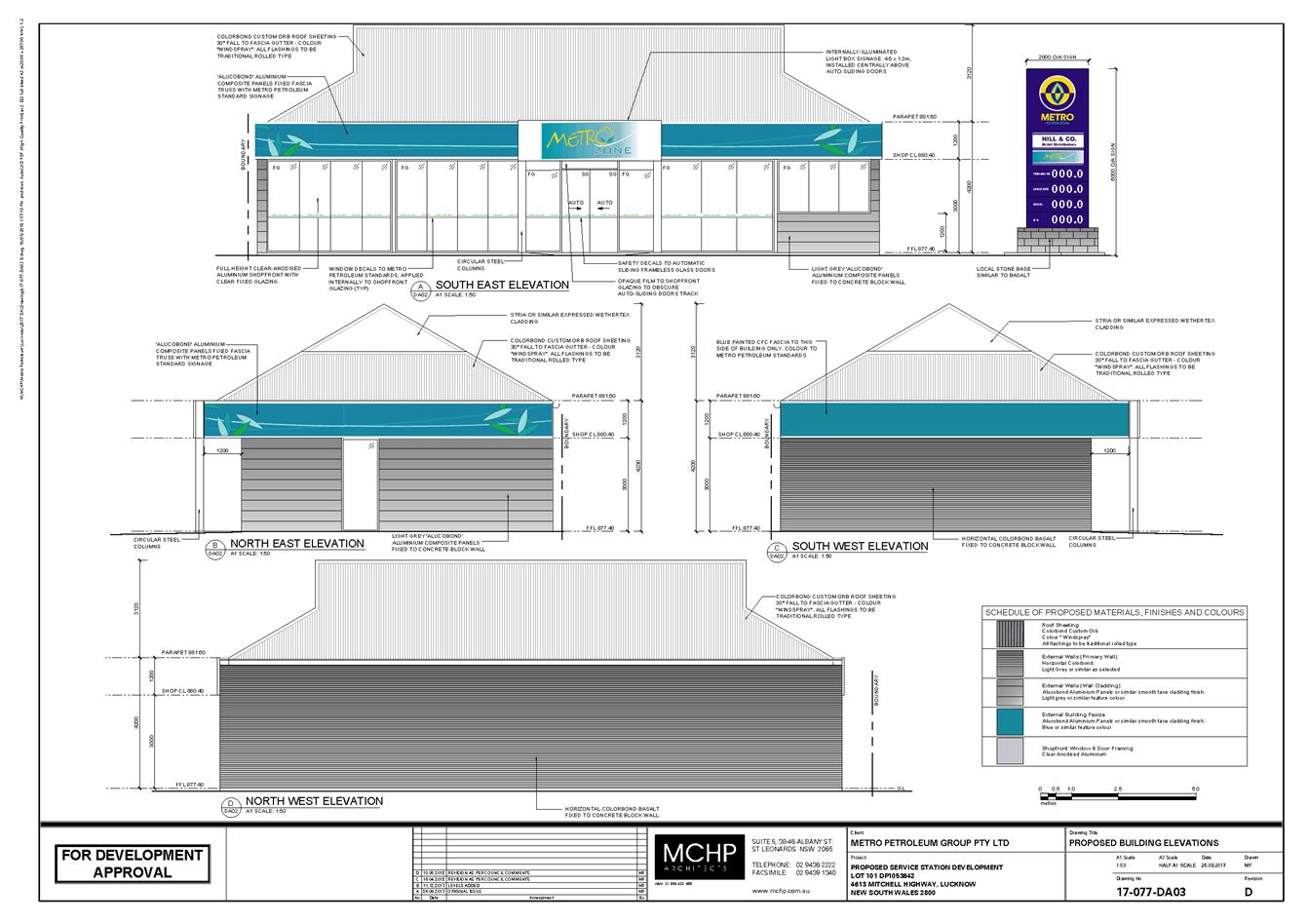
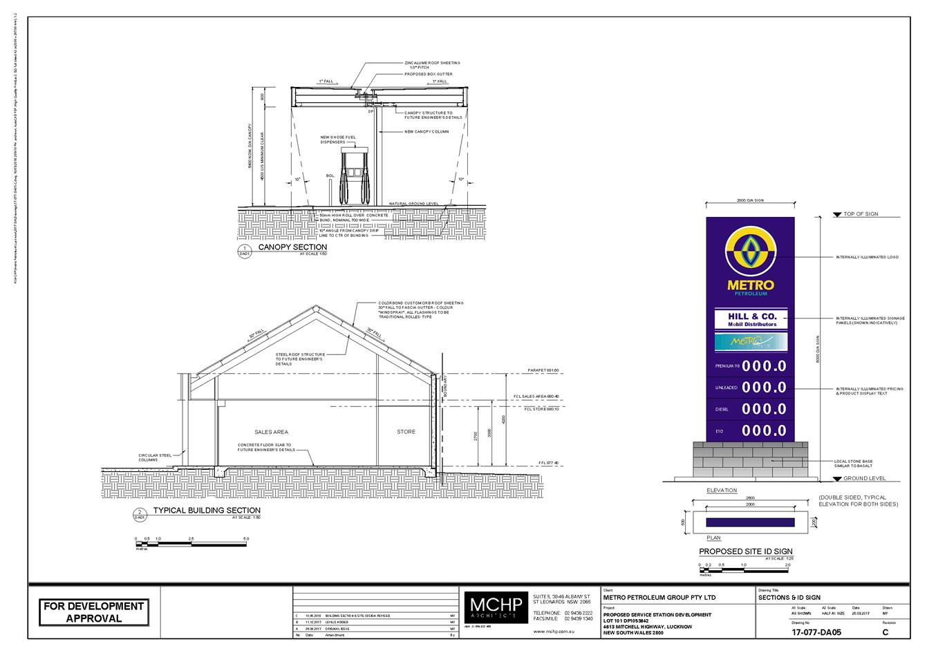
2.3 Development
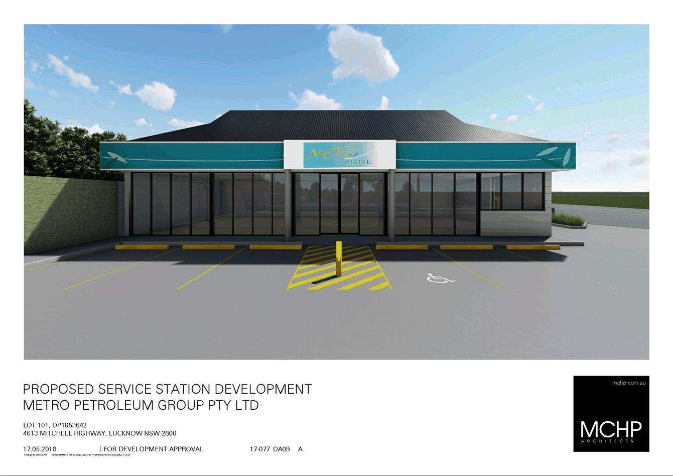
Application DA 33/2018(1) - 4613 Mitchell Highway, Lucknow
RECORD
NUMBER: 2018/2630
AUTHOR: Michael
Glenn, Senior Planner
EXECUTIVE Summary
|
Application
lodged
|
12
February 2018
|
|
Applicant/s
|
Brothers
Three Pty Ltd
|
|
Owner/s
|
Brothers
Three Pty Ltd
|
|
Land
description
|
Lot 101
DP 1053642 - 4613 Mitchell Highway, Lucknow
|
|
Proposed
land use
|
Demolition
(existing service station), Service Station (includes sales building, fuel
dispensing canopy, underground fuel tanks, 24/7 operation), and Business and
Site Identification Signs
|
|
Value of
proposed development
|
$1,395,000
|
This matter was deferred from the Planning and Development
Committee meeting of 17 October 2018 to allow further investigation of the
vehicular access arrangements and the implications of the RMS concurrence requirements
on surrounding landowners. The results of the investigation reveal no
significant impact on access/egress for any adjoining landowner to the
development site.
Council's consent is sought for the demolition of an
existing service station and construction of a service station with small
convenience store and signs on the subject property. The application is seeking
approval to operate on a 24 hour basis. The application has been referred
to Council because unresolved submissions have been received for the
application.
This application has been delayed because amendments were
required to address RMS issues, and also to address heritage and
streetscape considerations. The subject property is located on a classified
road, requiring the concurrence of the RMS for the proposal. The RMS has now
provided its concurrence, subject to a vehicle size limit of 12.5m
(equating to a large rigid vehicle) for vehicles other than the delivery
vehicle.
The amended proposal lacks effective landscaping, and there
are also potential conflicts between pedestrians using the footway and vehicles
that tend to park on a concreted verge outside the property. It is reasonable
to require the removal of this concreted verge (which does not meet
Council’s footpath standards and has not been constructed by Council),
and replace it with a footpath that does meet Council’s standards; as
well as provide handrails along the boundary and a landscape strip at the edge
of the verge, which steps down in a cutting to the level of the highway. The
landscaping will assist in maintaining the village character and improving
amenity adjacent to the site.
The application involves the removal of the existing
underground fuel storage tanks and their replacement with new tanks. Whilst
soil testing conducted to this point shows no signs of broad scale
contamination of the site, further tests will be required upon removal of the
existing tanks to determine if contaminants have coagulated underneath them.
In the event that such testing reveals contamination levels
that exceed the relevant guidelines (UPSS guidelines), Category 1
remediation (ie remediation that requires further development consent) will be
required. This arises due to the environmental sensitivity affecting the
subject site, a product of the high water table and the location of the site
within a heritage conservation area and the water supply catchment. A condition
to address this issue is included in the consent.
Submissions have raised a number of concerns which in
general remain wholly or partially unresolved. Some of the issues can be
addressed with conditions. The most important issue of concern to the local
residents are the proposed 24 hours of operation. The applicant has
submitted a noise report that suggests a twenty four operation would be
acceptable from a noise amenity point of view, but has not addressed light
glare or how the proposed 24 hour operation might affect the general village
character. It is considered that a twenty four hour operation has a high
probability of causing significant nuisance to the local residents, and will
have difficulty meeting or reinforcing the objectives of the village zone,
where mixed residential and commercial land uses can intermingle and where the
commercial activities must be sufficiently low impact as to achieve reasonable
co-existence. It is considered that 24 hour operation would not be
reinforcing of that objective. The applicant has by late submission indicated
that they would be prepared to accept a limit in the hours running from 5am to
12 midnight, but for the current proposal, the configuration remains a 24 hour
operation (they have not formally amended the proposal to reflect their revised
hours). It is on the basis of a 24 hour operation that this assessment is
carried out. However for either of the applicants suggested hours, the impacts
on character and amenity is considered to be excessive. As a result, the
consent includes a restriction on the hours to 7am to 10pm, seven days per week
(which essentially relate to a daytime use).
It is recommended that Council supports the subject proposal
subject to the conditions included in the attached Notice of Determination.
Figure 1 - locality plan
RECENT LEGISLATIVE CHANGES
On 1 March 2018 the Environmental Planning and Assessment
Act 1979 was substantially amended. The most immediate change involves the
restructuring and renumbering of the Act, with other more substantive
changes to be phased in over time. However, for some applications (particularly
where an application was lodged prior to the changes coming into effect) the
supporting documentation may still reference the previous numbering regime. In
the drafting of this report the content and substance of the supporting
material has been considered irrespective of which legislative references were
used.
DECISION FRAMEWORK
Development in Orange is governed by two key documents
Orange Local Environment Plan 2011 and Orange Development Control Plan 2004. In
addition the Infill Guidelines are used to guide development, particularly in
the heritage conservation areas and around heritage items.
Orange Local Environment Plan 2011 – The
provisions of the LEP must be considered by the Council in determining the
application. LEPs govern the types of development that are permissible or
prohibited in different parts of the City and also provide some assessment
criteria in specific circumstances. Uses are either permissible or not. The
objectives of each zoning and indeed the aims of the LEP itself are also to be
considered and can be used to guide decision making around appropriateness of
development.
Orange Development Control Plan 2004 – the DCP
provides guidelines for development. In general it is a performance based
document rather than prescriptive in nature. For each planning element there
are often guidelines used. These guidelines indicate ways of achieving the
planning outcomes. It is thus recognised that there may also be other solutions
of merit. All design solutions are considered on merit by planning and building
staff. Applications should clearly demonstrate how the planning outcomes are
being met where alternative design solutions are proposed. The DCP enables
developers and architects to use design to achieve the planning outcomes in
alternative ways.
DIRECTOR’S COMMENT
This development application sees the revamp of the existing
service station in Lucknow. Staff and the Heritage Advisor have worked with the
applicant to lift the building design. Notwithstanding, access issues have been
a concern throughout and are of concern to the neighbouring property owners.
Staff do not support a 24 hour operation as the Village zoning mandates that
development needs to enhance and maintain the unique village character of
Lucknow and Spring Hill. The current operation is not 24 hours. The
recommendation is to allow a 7am to 10pm opening regime.
Link To Delivery/OPerational Plan
The recommendation in this report relates to the
Delivery/Operational Plan strategy “10.1 Preserve -
Engage with the community to ensure plans for growth and development are
respectful of our heritage”.
Financial Implications
Nil
Policy and Governance Implications
Nil
|
Recommendation
That Council resolves to issue a consent to development
application DA 33/2018(1) for Demolition (existing service station), Service
Station (includes sales building, fuel dispensing canopy, underground fuel
tanks), and Business and Site Identification Signs at Lot 101
DP 1053642 - 4613 Mitchell Highway, Lucknow pursuant to the conditions
of consent in the attached Notice of Approval.
|
further considerations
Consideration has been given to the
recommendation’s impact on Council’s service delivery; image and
reputation; political; environmental; health and safety; employees;
stakeholders and project management; and no further implications or risks have
been identified.
SUPPORTING INFORMATION
THE APPLICATION/PROPOSAL
Council's consent is sought for the demolition of the
existing service station including the removal of tanks and associated
infrastructure and the construction and operation of a replacement service
station with neighbourhood shop. Business identification signage is also
proposed. The applicant proposes to operate the facility on a 24 hour basis. To
facilitate the development on a level site, it is proposed to undertake some
site regrading and construct retaining walls.
MATTERS FOR CONSIDERATION
Section 1.7 - Application of
Part 7 of the Biodiversity Conservation Act 2016 and Part 7A of the
Fisheries Management Act 1994
Development Applications lodged prior to 25 February 2018
Section 1.7 of the EP&A Act 1979 identifies that Part 7
of the Biodiversity Conservation Act 2016 and Part 7A of the Fisheries
Management Act 1994 have effect in connection with terrestrial and aquatic
environments.
Notwithstanding, Section 28 of the Biodiversity
Conservation (Savings and Transitional) Regulation 2017 states that the
former planning provisions continue to apply to the determination of a pending
planning application, being an application for planning approval made before
the commencement of the new Act but not determined before that commencement.
The relevant provisions are set out at Part 5A of the historical version of the
EP&A Act 1979 dated 24 August 2017.
Having regard to the relevant provisions and based on an
inspection of the subject property, it is considered that the proposed
development is not likely to have a significant effect on any threatened
species, populations or ecological communities or their habitats.
Section 4.15
Section 4.15 of the Environmental Planning and Assessment
Act 1979 requires Council to consider various matters, of which those
pertaining to the application are listed below.
PROVISIONS OF ANY ENVIRONMENTAL
PLANNING INSTRUMENT s4.15(1)(a)(i)
Orange Local Environmental Plan 2011
Part 1 - Preliminary
Clause 1.2 - Aims of Plan
The broad aims of the LEP are
set out under subclause 2. Those relevant to the application are as follows:
(a) to encourage development which complements
and enhances the unique character of Orange as a major regional centre boasting
a diverse economy and offering an attractive regional lifestyle,
(b) to provide for a range of development
opportunities that contribute to the social, economic and environmental
resources of Orange in a way that allows present and future generations to meet
their needs by implementing the principles for ecologically sustainable
development,
(c) to conserve and enhance the water
resources on which Orange depends, particularly water supply catchments,
(f) to recognise and manage valued
environmental heritage, landscape and scenic features of Orange.
The application is considered to be consistent with aims (b)
and (c) as listed above. With respect to (a), changes are required as
recommended by conditions in the consent to ensure the DA has outcomes that are
sympathetic to the achievement of reasonable character. This matter is
discussed in detail later in this report. With regard to (f), conditions are
included regarding the architectural detail, protection of landscape , signage
impact and certain other issues that will result in the responsible management
of the environmental, heritage and scenic landscape setting of the development.
Clause 1.6 - Consent Authority
This clause establishes that, subject to the Act, Council is
the consent authority for applications made under the LEP.
Clause 1.7 - Mapping
The subject site is identified
on the LEP maps in the following manner:
|
Land Zoning Map:
|
Land zoned RU5 Village
|
|
Lot Size Map:
|
Minimum Lot Size 1,000m2
|
|
Heritage Map:
|
Located in a heritage conservation
area
|
|
Height of Buildings Map:
|
No building height limit
|
|
Floor Space Ratio Map:
|
No floor space limit
|
|
Terrestrial Biodiversity Map:
|
No biodiversity sensitivity on the
site
|
|
Groundwater Vulnerability Map:
|
Groundwater vulnerable
|
|
Drinking Water Catchment Map:
|
Within a drinking water catchment
|
|
Watercourse Map:
|
Not within or affecting a defined
watercourse
|
|
Urban Release Area Map:
|
Not within an urban release area
|
|
Obstacle Limitation Surface Map:
|
No restriction on building siting
or construction
|
|
Additional Permitted Uses Map:
|
No additional permitted use applies
|
|
Flood Planning Map:
|
Not within/within a flood planning
area
|
Those matters that are of relevance are addressed in detail
in the body of this report.
Clause 1.9A - Suspension of
Covenants, Agreements and Instruments
This clause provides that covenants, agreements and other
instruments which seek to restrict the carrying out of development do not apply
with the following exceptions.
· covenants imposed
or required by Council
· prescribed
instruments under Section 183A of the Crown Lands Act 1989
· any conservation
agreement under the National Parks and Wildlife Act 1974
· any trust
agreement under the Nature Conservation Trust Act 2001
· any property
vegetation plan under the Native Vegetation Act 2003
· any biobanking
agreement under Part 7A of the Threatened Species Conservation Act 1995
· any planning
agreement under Division 6 of Part 4 of the Environmental Planning and
Assessment Act 1979.
Council staff are not aware of the title of the subject
property being affected by any of the above.
Part 2 -
Permitted or Prohibited Development
Clause 2.1 - Land Use Zones
and Clause 2.3 - Zone Objectives and Land Use Table
The subject site is located within the RU5 Village zone. The
proposed development is defined as a Service Station under OLEP 2011 and is
permitted with consent for this zone. This application is seeking consent.
“Service Station” is defined under the LEP as
“a
building or place used for the sale by retail of fuels and lubricants for motor
vehicles, whether or not the building or place is also used for any one or more
of the following:
(a) the ancillary sale by retail of spare parts
and accessories for motor vehicles,
(b) the cleaning of motor vehicles,
(c) installation of accessories,
(d) inspecting, repairing and servicing of
motor vehicles (other than body building, panel beating, spray painting, or
chassis restoration),
(e) the ancillary retail selling or hiring of
general merchandise or services or both.
Clause 2.3 of LEP 2011
references the Land Use Table and Objectives for each zone in LEP 2011.
These objectives for land zoned RU5 Village are as follows:
1 -
Objectives of the RU5 Village Zone
· To provide for a
range of land uses, services and facilities that are associated with a rural
village.
· To enhance and
maintain the unique village character of Lucknow and Spring Hill.
In general, the proposed
development is considered to be consistent to the zone objectives. However, the
proposed 24 hour operation would, if carried out, create land use conflicts
with other existing permissible land uses, namely the residential development
within the village. The village zone contains a fairly wide range of
permissible land uses, but this does not mean that inherent conflicts should be
left unconsidered. Whilst the subject development is located on the Mitchell
Highway the 24 hour operation of a development is considered to be inconsistent
with the general village character of Lucknow. Hence, as alluded to elsewhere
in this report it is recommended that the hours of operation be limited to
7.00am to 10.00pm to be more in keeping with the village character in this
case.
Clause 2.7 - Demolition
Requires Development Consent
This clause triggers the need for development consent in
relation to a building or work. This requirement does not apply to any
demolition that is defined as exempt development.
The proposal involves demolition and the applicant is
seeking the consent of council. The demolition works proposed will have no
significant impact on adjoining lands, streetscape or public realm.
Part 3 -
Exempt and Complying Development
The application is not exempt or complying development.
Part 4 -
Principal Development Standards
Clause 4.1 - Minimum
Subdivision Lot Size
There is a minimum lot size
applicable to the subject property, however this control is only relevant to
applications involving subdivision. Subdivision does not form part of the
subject application.
Part 5 -
Miscellaneous Provisions
5.10 - Heritage Conservation
The subject property is located within the Lucknow Heritage
Conservation Area. The original submitted plans called for a flat roofed modern
style building with canopy, as well as standard corporate signage.
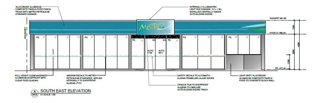
Figure 2 - preliminary south-eastern elevation
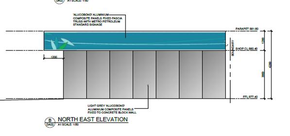
Figure 3 - preliminary north-eastern elevation
The initial plans were referred to Council’s Heritage
Advisor who provided a generally negative response:
The issues raised in the DCP
to the design of new development – Design of new development should
complement heritage character. This can be achieved in three ways:
· Restoration works
that return the building to its original form and style.
· Respectful Design: A
“low key design approach where heritage building forms, proportions and
materials are applied but reproduction of decorative work and detailing is
avoided the design should demonstrate that it is a contemporary building whilst
respecting the surrounding heritage setting.
· Interpretative
Design: Forms and proportions that relate to but do not reproduce heritage
features. Good modern architecture is favoured that fits in to the heritage
setting
Comment: The
proposal is a standard flat roofed building with glazing to the south eastern
elevation on the hardstand forecourt and a solid light grey clad wall to the
other predominant elevation to the road (the NE elevation). The fascia’s
surrounding the roof are standard corporate colours and graphics. The roof is
zincalume steel which is not supported in conservation areas. There are no
indications on the drawings that the heritage design principals in the form of
respectful design or Interpretative design.
Issues: The
following checklist is the analytical process established under the key
reference document (“Design In context’) and should guide the
preferred form of development in this location.
· Character: While
recent lack of guidance means very limited character, the ethos is traditional
and heritage related with pitched roofs and traditional box built forms with
pitched roofs. Several post buildings utilised skillion roofs. There are
variable setbacks to accord with vehicle related uses.
· Scale: Single storey
buildings with heights that come from traditional roofs
· Form: traditional
forms which are often extended either as extrusions or pavilions.
· Siting: the core area
has closer setbacks near the roads while residential land has garden setbacks.
· Materials and Colour:
There is a predominance of light weight cladding to the core earlier buildings
such as timber and tin/steel and later structures in masonry. Generally the
colours are lighter as opposed to dark. Tree planting relates to larger trees
left over from earlier residential uses and larger lots while commercial uses
have generally seen them removed.
· Detailing:
Traditional detailing predominates including verandahs awnings and chimneys
There are no flat roofed
buildings in the vicinity. The similar buildings such as the skin shop have
skillion roofs while the Fat Ladies and the adjoining hotel have traditional
pitched roofs.
The Lucknow Strategy developed
in 2014 as the Lucknow Scoping Study provides the following guidance for future
development and public works:
1 New
buildings are to be fine grained and relate to the scale of the existing built
forms
2 A
sample palette of contemporary materials and forms includes iron, stone
recycled timber and muted colours with hipped roofs and verandahs
Recommendations
The applicant submitted
amended plans 29 May 2018, along with a written response in support, which are
now the subject of this assessment:
1 The
fuelling canopy be provided with a hipped pitched roof with 25 deg pitch slope
clad in colourbond windspray or basalt and set above the line of the proposed
fascias.
2 The
fascias shall be horizontal metallic colourbond Astro or similar without the
Metro corporate colour
3 The
Metro Corporate sign panel shown on the SE Elevation shall be mounted on a
framed element to interpret a verandah in a contemporary style with a pair of
circular steel columns
4 The
cladding to the NE elevation is run horizontally to interpret the local
vernacular
5 A
full height window is to be inserted into the NE elevation between the
cigarette display and office doors
6 The
Service building/Convenience store be provided with a similar hipped 25
degree pitched roof
7 All
perimeter fencing to be traditional cyclone open mesh type and not colourbond
or solid fencing to allow the landscape to be expressed and visually dominate
the surrounds
8 All
concrete hardstand is to be through coloured using oxide to achieve a dark grey
equal to CCS stallion
9 The
concrete blockwork on the convenience store shall be clad in horizontal
colourbond basalt and not painted to reflect the local vernacular.
10 The
site ID sign shall be limited to a maximum height of 5400mm (planners note:
it has been submitted as a 6m high structure) or equal to the height of the
fuelling canopy to ensure the sign element does not visually dominate the
setting and affect other business identification elements, signs and graphics.
The base of the sign shall be clad in local stone similar to basalt to the
level of the bottom price indicator and replacing the ATM graphic which is redundant.
11 A
professionally prepared landscape plan is required to specify the planting to
the SW side and northern corner.
12 All
lighting in the soffit of the fuelling canopy and the convenience building is
to be fully recessed to reduce glare
13 Although
internally illuminated graphics are not supported in conservation areas,
subject to agreement with the above, the internal signage components for signs
under this application will be acceptable (planners note; the applicant did
not fully accept all of the heritage advisers recommendations).
Council’s Heritage Advisor provided the following
conceptual sketches which were passed on to the applicant prior to the
submission of their response.

Figure 4 - heritage recommended amendments
The applicant submitted amended plans on 22 May 2018 which
adopted some of the changes sought by the Heritage Advisor and provided
additional information in support of varying, or not applying other elements of
the initial advice. These amended plans are now the subject of this detailed
assessment.
The applicant submitted the following response to the
itemised issues raised by the Heritage Advisor:
Issue 1: “This
request was deemed unreasonable and addressed by a previous email (sent
04/04/2018) where it was advised that a proposed pitched roof would not be seen
when close by on the Mitchell Highway due to the difference in levels and the
original proposal would suffice in this instance without disrupting the local
character that is trying to be achieved within the Lucknow Scoping Study. On
Council’s follow up email on 03/05/2018 it was advised that this would be
acceptable provided the sales building signage was modified to not disrupt the
form of the proposed pitched roof. This is reflected on the revised Architectural
drawings accompanying this application and addressed further below”.
The applicant’s position is accepted; however the
refusal to provide a canopy with pitched roof has implications on the
assessment of heights for the proposed pylon sign.
Issue 2: “As
discussed in a previous response (sent 04/04/2018) it was seen as an
unreasonable request to remove Metro corporate colours which are featured
throughout all of their service stations Australia wide. We do not believe the
request to remove Metro branding would enhance the local character and would
make navigation more difficult. It is also believed that the inclusion of the
Metro petroleum corporate colours would not detract from the preferred
streetscape the Lucknow Scoping Study is trying to promote.
The Heritage Advisor comments were revised and amended as a
result of this submission and further negotiations with the applicant.
Issue 3:
“This element has been included on the updated Architectural drawings
accompanying this application and provides a sympathetic entry statement and
allows for a good visual navigation element as well as staying in keeping with
the local character the Lucknow Scoping Study has alluded to”.
The Heritage Advisor and the applicant’s architect
have reached agreement with respect to this issue.
Issue 4:
“The proposed façade treatment has been amended to show a
horizontal treatment as requested by Council. The exact nature of this cladding
will form part of a future Construction Certificate application”.
A precautionary condition that ensures this amendment is
implemented is included in the consent.
Issue 5: The
requested full height glazing has been included on the updated Architectural
drawings accompanying this application. Security issues will be looked at as
part of a future Construction Certificate application.
A condition ensuring that this element is included in the
building is attached to the consent.
Issue 6:
“As addressed in previous correspondence (sent 04/04/2018) and also shown
on the updated elevation drawings & 3D views accompanying this application
the service building has been modified to show a Dutch gable roof that is in
keeping with the local character and is sympathetic to the Lucknow Scoping
Study. Council’s follow up email on 03/05/2018 stated the roof pitch
needs to be 30 degrees which is now reflected on the amended Architectural
drawings accompanying this application”.
There is agreement between the two experts on this issue. A
condition specifying a 30 degree pitch is included in the consent.
Issue 7: “The
request of Council for an open mesh fence was deemed as not acoustically
suitable due to potential noise source disturbances for neighbouring
residences. An Acoustic report was undertaken by Rodney Stevens Acoustics and
it was deemed that a 1.8m high solid fence is required for noise attenuation to
neighbouring residences instead of an open mesh fence as requested by Council.
The Acoustic report has been submitted as part of this application.
Council’s follow up email on 03/05/2018 declares that if a block wall is
required, it needs to be planted with a creeper plant specified by the
Landscape Architect. This is depicted on the Landscape Plans accompanying this
application”.
The applicant’s position is accepted, however to
achieve some level of restraint in the visual presentation of the site, it is
considered appropriate to require the fencing that faces into the site to be
“Shale Grey” to tie-in better with the canopy and other elements of
the development.
Issue 8:
“As stated in our previous response (sent 04/04/2018) the addition of the
dark grey oxide would be an unreasonable request due to the elevated nature of
the fuelling area, making the area unobservable to all but those using the
facility. The non-oxide concrete will still form a more formal approach to the
fuelling area that will not only enhance the current look but will also be
supportive of the Lucknow Scoping Study. Council’s follow up email on
03/05/2018 deemed this as acceptable”.
The applicant’s response is accepted on the proviso
that the perimeter fencing is finished in a suitably sympathetic colour.
Issue 9: As
depicted on the revised elevation drawings accompanying this application, the
concrete block walls have been amended to show a horizontal Colorbond
‘basalt’ treatment as requested by Council.
Conditions are included in the consent to ensure this
outcome
Issue 10: The
site ID element will remain at 6m in height with the ATM signage removed and
base of sign clad in local stone as part of the amended drawings accompanying
this application. As depicted on the 3D views accompanying this application,
the site ID sign doesn’t visually dominate the site. Council’s
response email on 03/05/2018 deems this solution acceptable.
There is a large sign erected at the boundary of the
property which is approximately 8m high. This sign has no approval from Council
and should not be given a great deal of weight in the assessment as a result.
The subject land is zoned RU5 Village, which is a mixed use zone but one
in which residential development is the dominant land use. The subject property
is located within a designated Heritage Conservation Area.
Council’s DCP 2004 contains chapters with controls
applicable within the Lucknow village, and further a separate chapter with
controls and guidelines for appropriate signage and includes provisions for
advertising with possible effects on residential areas. With respect to the
controls on signage, DCP 2004 (Chapter 14) the following provisions are
applicable:
a) Freestanding
or pylon signs relate to the height of associated buildings in
b) Freestanding
signs in residential areas are at a personal scale (i.e. about 2m high or less)
within a landscaped setting.
Signs within a residential context have further generally
been required to be set back to the building line. The character assessments by
the applicant have not taken these underlying character and land use
observations into account in their signage assessments.
The building heights are considered the more appropriate
surrogate measure to apply in determining the correct sign height. The
convenience store proposes a wall height of 4.2m and is immediately
set behind the proposed sign, whilst the awning proposes a height of 5.4m
but is closer to the street frontage than the store. The proposed pylon sign is
forward of these structures by approximately 4m (from the front of the
convenience store) and 2m (from the front of the awning). It is not practicable
to set the pylon sign further back because of the obstruction caused by the
existing adjoining building to the west of the site.
With a height of 6m and a zero setback from the front
boundary, it can be expected that the sign would be out of scale with the
buildings nearby.
In his initial advice Council’s Heritage Advisor
recommended a height comparable to the proposed awning. Under the circumstances
this would appear the more appropriate standard to apply. It would result in a
10% reduction in height for the sign compared to what the applicant wants, but
should pull the massing and scale of the sign back to a bulk and height that
relates to the associated buildings. Attached is a condition of consent
addressing this issue.
Issue 11:
“A professional landscape design has been undertaken by Taylor Brammer
and is included with this application. It specifies the planting to the SW
& SE boundaries and northern corner. The design enables an easily
maintained natural element to the project. Council’s follow up email on
03/05/2018 declares that if a block wall is required, it needs to be planted
with a creeper plant specified by the Landscape Architect. This is depicted on
the Landscape Plans accompanying this application”.
The applicant has submitted a landscaping plan, but the
densities, planting areas and plant selections are inadequate and/or inappropriate.
The consulting landscape designer is known to have landscaping experience, but
this particular plan is unsuited to the site conditions. The principal
plantings are centred on six trees, of the following species:
Backhousia citriodora (common names lemon myrtle, lemon scented myrtle, lemon scented
ironwood): Two specimens proposed. A cultivated
ornamental plant theoretically capable of a mature height of 6m, but in
practice more usually 3m. It can be grown from tropical to warm temperate
climates, and may handle cooler districts provided it can be protected from
frost when young. It is unsuitable to the local growing conditions because of
this.
Backhousia myrtifolia (common names include carrol, carrol ironwood, neverbreak, ironwood or
grey myrtle, Australian lancewood and Cinnamon myrtle): Two specimens proposed. This specimen is a
rainforest tree species which grows in subtropical rainforests of Eastern
Australia and is known to reach a mature height of over 30m. It is unsuitable
for this site because the species is not frost tolerant and the expected height
cannot be supported on such a small sized lot.
Melaleuca leucadendra, (common names weeping paperbark, long-leaved paperbark or white
paperbark): Two specimens are proposed. This is
widespread in northern Australia, South East Asia and New Guinea. It is a tree
with an expected mature height in excess of 20 m. Although it will withstand some frost, it is not recommended for
cold areas such as mountainous regions or Tasmania. It will grow well in most
other areas.
Clearly the species selection is
inappropriate. Further, it is considered appropriate for a landscaping strip to
be installed in the currently concreted verge area to a bed width not less than
1.5m and incorporating tree plantings that are suited to local climate and
growing conditions, and able to achieve a minimum height of 4m. This landscape
strip shall be provided on the southern side of the pavement, just above the
cutting that steps down to the Mitchel Highway. Attached is a recommended
condition of consent addressing this issue.
Issue 12: All
lighting within the fuel canopy will be fully recessed to reduce glare as
stated in our email response (sent 04/04/2018).
Noted. Conditions to ensure compliance are included in the
consent.
Issue 13: The
majority of requests of Council have been updated on our drawings accompanying
this application and although there is a small amount of internally illuminated
signage we believe they work well within the desires of Council and the Lucknow
Scoping Study in providing easily navigable streetscape and also easily
recognised landmark to the entry of Lucknow.
On planning grounds, it is considered the applicant’s
discussion so as to allow internal illumination whilst the business is trading
is reasonable. However, at times when the business is not trading it is
considered appropriate to require internal lighting, except that needed for
security and safety purposes, to be switched off during the overnight period. A
condition relating to the ongoing performance standards is included to ensure
compliance with this outcome.
Heritage Advisor’s Final
Advice (received 1 June 2018)
“I
have reviewed the current revised drawings and agree on the conditional
approach as they have met or negotiated all of the issues and recommendations
made.
On the conditions, you may be
wise still to write in some of the items which have been agreed but are not
specified on the drawings:
· All blockwork walls
are to be fully concealed on all exposed surfaces by planting in the form of a
creeper specified by the landscape consultant with appropriate planting media,
watering and the means of adhering to the subject walls;
· All lighting to the
soffit of the fuelling canopy is to be fully recessed from the soffit surface;
· The soffit to the
fuelling canopy is to be equal to the Colorbond standard custom orb profile in
Shale Grey
· The colour of the
gable infills is to be Windspray”
The supplementary advice by the Heritage Advisor reinforces
certain issues, but does not eliminate the original concerns. Conditions are
included to address these final heritage matters. In addition to these formal
responses, the Heritage Advisor is strongly supportive of additional
landscaping along the frontage.
Part 7 -
Additional Local Provisions
7.1 - Earthworks
This clause establishes a range
of matters that must be considered prior to granting development consent for
any application involving earthworks, such as:
(a) the likely disruption of, or any detrimental
effect on, existing drainage patterns and soil stability in the locality of the
development
(b) the effect of the development on the
likely future use or redevelopment of the land
(c) the quality of the fill or the soil to be
excavated, or both
(d) the effect of the development on the
existing and likely amenity of adjoining properties
(e) the source of any fill material and the
destination of any excavated material
(f) the likelihood of disturbing relics
(g) the proximity to and potential for adverse
impacts on any waterway, drinking water catchment or environmentally sensitive
area
(h) any measures proposed to minimise or
mitigate the impacts referred to in paragraph (g).
The earthworks proposed within
the application are considered ancillary to the principle development. There
are significant earthworks proposed along the southern shared boundary, with an
existing sloped batter to be replaced by a retaining wall
approximately 1.3m high. Removal of the batter will require excavations at
the base of the batter to approximately 3m past its present position to allow
the retaining wall to be installed at the boundary. This will require
conditions to address the structural adequacy of the retaining wall, as well as
ensuring that such works minimise the damage to the adjoining (southern)
neighbour’s landscaping.
The proposed earthworks also
envisage the removal of the existing underground storage tanks. Other
earthworks proposed in the application relate primarily to the grading and
filling of the site to provide a more level area for vehicles to utilise the
development. The extent of cut/fill required is approximately 300-500mm. The
extent of earthworks and the degree of disruption to the drainage of the site
are considered to be minor and will not detrimentally affect adjoining
properties or receiving waterways.
The site is not known to contain
any Aboriginal objects, or European or archaeological relics. Previous known
uses of the site do not suggest that any object or relics are likely to be
uncovered. The site is not in proximity to any waterway, drinking water
catchment or sensitive area. Notwithstanding this, conditions are imposed that
require a sediment control plan, including silt traps and other protective
measures, to ensure that loose dirt and sediment do not escape the site
boundaries.
7.3 -
Stormwater Management
This clause applies to all
industrial, commercial and residential zones and requires that Council be
satisfied that the proposal:
(a) is designed to maximise the use of water
permeable surfaces on the land having regard to the soil characteristics
affecting onsite infiltration of water
(b) includes, where practical, onsite
stormwater retention for use as an alternative supply to mains water,
groundwater or river water; and
(c) avoids any significant impacts of
stormwater runoff on adjoining downstream properties, native bushland and
receiving waters, or if that impact cannot be reasonably avoided, minimises and
mitigates the impact.
Council’s Technical
Services Division has assessed the development in regards to stormwater.
Relevant conditions are attached to ensure that the post-development run-off
levels do not exceed pre-development levels.
7.6 -
Groundwater Vulnerability
This clause seeks to protect
hydrological functions of groundwater systems and protect resources from both
depletion and contamination. Orange has a high water table and large areas of
the LGA, including the subject site, are identified with “Groundwater
Vulnerability” on the Groundwater Vulnerability Map. This requires that
Council consider:
(a) whether or not the development (including
any onsite storage or disposal of solid or liquid waste and chemicals) is
likely to cause any groundwater contamination or have any adverse effect on
groundwater dependent ecosystems, and
(b) the cumulative impact (including the
impact on nearby groundwater extraction for potable water supply or stock water
supply) of the development and any other existing development on groundwater.
Furthermore consent may not be granted unless Council is satisfied that:
(a) the development is designed, sited and
will be managed to avoid any significant adverse environmental impact, or
(b) if that impact cannot be reasonably
avoided - the development is designed, sited and will be managed to minimise
that impact,
(c) if that impact cannot be minimised - the
development will be managed to mitigate that impact.
The proposal is not anticipated
to involve the discharge of toxic or noxious substances and is therefore
unlikely to contaminate the groundwater or related ecosystems. The proposal
does not involve extraction of groundwater and will therefore not contribute to
groundwater depletion. The design and siting of the proposal avoids impacts on
groundwater and is therefore considered acceptable.
7.7 - Drinking Water
Catchments
(1) The
objective of this clause is to protect drinking water catchments by minimising
the adverse impacts of development on the quality and quantity of water
entering drinking water storages.
(2) This
clause applies to land identified as “Drinking water” on the Drinking
Water Catchment Map.
(3) Before
determining a development application for development on land to which this
clause applies, the consent authority must consider whether or not the
development is likely to have any adverse impact on the quality and quantity of
water entering the drinking water storage, having regard to:
(a) the
distance between the development and any waterway that feeds into the drinking
water storage, and
(b) the
onsite use, storage and disposal of any chemicals on the land, and
(c) the
treatment, storage and disposal of waste water and solid waste generated or
used by the development.
(4) Development
consent must not be granted to development on land to which this clause applies
unless the consent authority is satisfied that:
(a) the
development is designed, sited and will be managed to avoid any significant
adverse impact on water quality and flows, or
(b) if
that impact cannot be reasonably avoided - the development is designed, sited
and will be managed to minimise that impact, or
(c) if
that impact cannot be minimised - the development will be managed to mitigate
that impact.
The subject property is located within the City water supply
catchment, and the discharge or release of contaminated or unsafe runoff to the
catchment tributaries of the town water supply is a matter for concern since
the site is relatively close to such water supply watercourses. It is
considered that the risks posed by contaminants, particulates or bacterial
water can be managed by standard erosion and sediment control, and water
quality control measures, and that such risks as may arise are not excessive.
It is considered that the effects arising from the proposed development do not
pose a significant risk to public health if contained in the manner set out in
the application and the attached consent.
STATE ENVIRONMENTAL PLANNING
POLICIES
State Environmental Planning Policy 55 - Remediation of
Land
State Environmental Planning Policy 55 - Remediation of Land
(SEPP 55) is applicable. Pursuant to Clause 7 Contamination
and remediation to be considered in determining development application:
(1) A consent authority must
not consent to the carrying out of any development on land unless:
(a) it
has considered whether the land is contaminated, and
(b) if the land is contaminated, it is
satisfied that the land is suitable in its contaminated state (or will be
suitable, after remediation) for the purpose for which the development is
proposed to be carried out, and
(c) if the land requires remediation to be made
suitable for the purpose for which the development is proposed to be carried
out, it is satisfied that the land will be remediated before the land is used
for that purpose.
Under Clause 7 of the SEPP, Council must consider whether
the land is contaminated and if the land requires any form of remediation to
render it suitable for the purpose for which it is proposed to be used. The
previous land uses must be considered, along with any visible or tangible evidence
on the site.
The subject property has for many years been used as a
service station and convenience store (it is believed that this use extends
back to 1947), which acts as a trigger for a preliminary contamination
assessment under Council’s draft remediation strategy. The structure of
Council's contamination strategy can be found in the quick reference guide
produced by Contamination Central at the time of the adoption of the draft
policy, and should be used in the assessment of the preliminary site investigation,
which the applicant has completed and submitted as part of the application. The
submitted report is by NEO Consulting).
There is a flowchart that sets out the procedures when
receiving new development applications.
This flow chart is reproduced
below:
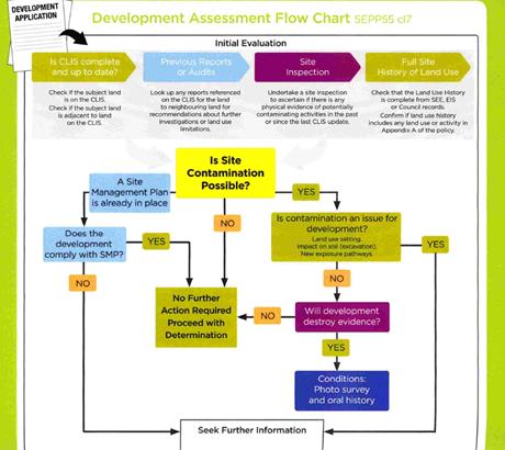
Figure 5 - development assessment flowchart
Initial Evaluation - matters for consideration
Figure 6 - determining if the property is on the
Contaminated Lands Information System (CLIS)
The subject land is not on
Council’s local CLIS (contaminated lands register). It is not recorded on
the EPA register as being contaminated. The Consultant is silent on whether the
site is on a contamination register.

Figure 7 - checking previous reports
There are no reports on the CLIS
relevant to this matter. The consultant’s report does not mention any
reports or notations on adjoining land.
Figure 8 - site inspections
Site inspections have been carried out by both staff and the
applicant’s consultant. Potential sources of
contamination on the site were identified as the forecourt and the fuel fill
spill box. Petroleum hydrocarbon contamination is possible in delivery,
storage and dispensing of fuel and oil products, spills and overflows at
refilling, and leakage of underground storage tanks due to corrosion and
leakages of feeder lines due to pipe work failures. Contamination is possible
from fuel spills and overflows at the time of refilling and pump dispensing.
Potential contaminants include:
· unleaded petrol -
detected by laboratory analysis of TRH (C6-C40) and BTEX
· leaded petrol -
detected by laboratory analysis of lead TRH (C6-C40) and BTEX
· diesel - detected
by laboratory analysis of TRH (C10-C40) and naphthalene
· movement of
contaminants is possible in the groundwater or underground electricity,
stormwater, sewer and telephone services conduits.
Preliminary test results undertaken by the consultant do not
show any significant signs of site contamination, however it is noted that at
the underground storage tanks have not been removed, rendering it impossible
for the consultant to have tested under the tanks (where contamination hotspots
most usually occur).
To address this shortcoming in the available information, a
condition requiring further soil testing following removal of the tanks with
the results being submitted to Council. In the event that contamination is
found post removal of the tanks it will be necessary to stop work and seek
further consent for Category 1 Remediation given the location of the
development within a heritage conservation area.

Figure 9 - site history
A complete site history is unavailable.
The site has been used as a small service station with
convenience store for many years. The known development history is not fully
known but does include the following:
On 3 August 1989 and application to upgrade and modify the
existing service station was refused. In the report to Council at the time the
site was described as having been used as a service station since at least
1947. It had been proposed to increase the size of the building and also to
increase the number of fuel dispensing points. The application was refused on
the grounds of inadequate parking on the site. There was no mention of possible
contamination of the site at that time.
DA 02/044, an application to modify the subdivision
boundaries, was approved. No mention of possible site contamination was
included in the assessment.
Service stations are included in appendix A as a potential
contaminating land use.
Analytical Results Summary
Soil analytical results are summarized and compared to the
relevant assessment criteria in the consultant’s report as follows:
The reported concentration of
Benzene was less than the laboratory LOR (limit of reporting –detection
limit) to which was less than the adopted assessment criteria. Toluene - The
reported concentration of Toluene was less than the laboratory LOR (limit of
reporting –detection limit) to which was less than the adopted assessment
criteria.
Ethylbenzene - The reported
concentration of Ethylbenzene was less than the laboratory LOR (limit of
reporting –detection limit) to which was less than the adopted assessment
criteria.
Xylene (total) - The reported
concentration of Xylene (total) was less than the laboratory LOR (limit of
reporting –detection limit) to which was less than the adopted assessment
criteria.
TPH (C6-C10) Less BTEX (F1) -
The reported concentration of TPH (C6-C10) Less BTEX (F1) was 110mg/kg, to
which was less than the adopted assessment criteria.
TPH (>C10-C16) Less
Naphthalene (F2) - The reported concentration of TPH (>C10-C16) Less
Naphthalene (F2) was 100mg/kg, to which was less than the adopted assessment
criteria.
TPH (>C16-C34)(F3) - The
reported concentration of TPH (>C16-C34) was less than the laboratory LOR
(limit of reporting –detection limit) to which was less than the adopted
assessment criteria.
TPH (>C34-C40)(F4) - The
reported concentration of TPH (>C34-C40) was less than the laboratory LOR
(limit of reporting –detection limit) to which was less than the adopted
assessment criteria.
Naphthalene - The reported
concentration of Naphthalene was less than the laboratory LOR (limit of
reporting –detection limit) to which was less than the adopted assessment
criteria.
Lead - The reported
concentration of Lead was less than the laboratory LOR (limit of reporting
–detection limit) to which was less than the adopted assessment criteria.
Total PAHs - The reported concentration of Total PAHs was less than the
laboratory LOR (limit of reporting –detection limit) to which was less
than the adopted assessment criteria.
Field observations and
analytical results indicate that there was no hydrocarbon impact in soil at the
site from sample locations above the adopted assessment guidelines
Conclusion on the need to
submit an Environmental Site Assessment
The preliminary site assessment under the Council draft
guidelines indicates a need for an ESA. The applicant has responded to
this by submitting a report that generally complies to the Contaminated
Lands Assessment Guidelines. However, this assessment does not include the
area beneath the underground storage tanks.
A condition is included requiring that further testing is
required following the removal of those tanks. In the event that no
contamination is detected under the tanks, a validation report is required to
be submitted to Council. In the event that contamination levels are found in
the soils under the tanks, further work on the development would need to stop
pending the processing of an application for Category 1 remediation (remediation
requiring further consent), followed only then by a further validation report.
In the event that no contamination is revealed after the tank removal, the
applicant can proceed simply to validation of the site.
State Environmental Planning
Policy 33 - Hazardous and Offensive Development
This policy seeks to ensure that the consent authority has
sufficient information to assess whether a development is potentially hazardous
or offensive, and to impose conditions to reduce or minimise any adverse impacts.
The policy sets out the definition of a ‘potentially hazardous
industry’ as follows:
a development for the purposes
of any industry which, if the development were to operate without employing any
measures (including, for example, isolation from existing or likely future
development on other land) to reduce or minimise its impact in the locality or
on the existing or likely future development on other land, would pose a
significant risk in relation to the locality:
(a) to
human health, life or property, or
(b) to
the biophysical environment,
and includes a hazardous
industry and a hazardous storage establishment.
Guidelines titled Applying SEPP 33 Development Application
Guidelines and Multi Level Risk Assessment Guidelines are particularly relevant
to this application, among others. The applicant has prepared a Multi-Level
Risk Assessment and PHA in accordance with these guidelines which concludes
that the proposed development is within the risk thresholds set by the
supporting guidelines.
The multi risk assessment’s principal recommendation
is that all equipment to be installed on the site be installed strictly in
accordance with the manufacturer’s specifications. The following
conditions are included in the consent as a result of that recommendation:
· All
equipment must be installed to manufacturer’s recommendations and must
comply with all the relevant standards listed within.
· Specific
safety features of the site, as set out in the submitted Preliminary Hazard
Analysis (PHA) submitted with the Development Application shall be adhered to
strictly at all times. The applicant shall ensure that safety procedures are
well posted on the site and shall further ensure that all staff are adequately
inducted as to correct safety procedures and protocols as set out in the PHA.
· Prior
to the issuing of an Occupational Certificate, the Applicant shall submit to
Council documentation demonstrating that the following plans and systems have
been developed and implemented:
(a) TRANSPORT OF HAZARDOUS MATERIALS
Arrangements
covering the transport of hazardous materials including details of routes to be
used for the movement of vehicles carrying hazardous materials to or from the
development. The routes selected shall be consistent with the Department of
Planning’s Hazardous Industry Planning Advisory Paper No. 11, ‘Route
Selection’. Suitable routes identified in the study shall be used except
where departures are necessary for local deliveries or emergencies.
(b) EMERGENCY PLAN
A
comprehensive Emergency Plan and detailed emergency procedures for the
development. The plan shall be consistent with the Department of
Planning’s Hazardous Industry Planning Advisory Paper No. 1, ‘Emergency
Planning’.
(c) SAFETY MANAGEMENT SYSTEM
A
comprehensive Safety Management System, covering all on-site operations and
associated transport activities involving hazardous materials. The Safety
Management System shall be consistent with the Department of Planning’s
Hazardous Industry Planning Advisory Paper No. 9, ‘Safety
Management’.
Assessment Guidelines Appendix
6 - Ongoing Acceptability
The guidelines state:
"If, following the
assessment of a PHA and other considerations, Council considers that the
proposal can proceed, it should consider imposing relevant hazards-related
conditions as recommended by the Department. This condition will help ensure
the ongoing safety of a potential development."
Not all of the recommended conditions are considered
relevant to this situation. It is recommended that the following condition be
included to address this issue.
· Twelve
(12) months after the commencement of operations of the development, and every
three (3) years thereafter, the Applicant shall carry out a comprehensive
Hazard Audit of the proposed development consistent with the Department of Planning’s
Hazardous Industry Planning Advisory Paper No. 5, ‘Hazard Audit
Guidelines’. The audit shall be carried out by a qualified person or
team, independent of the development. Compliance documentation shall be
submitted to the Council within 28 days from the date of the audit.
State Environmental Planning
Policy (Infrastructure) 2007
Development In Or Adjacent To Road Corridors And Road
Reservations
The provisions of the SEPP place a requirement to obtain RMS
concurrence to this proposal. This was done early in the process, but there
were difficulties in getting the RMS to agree to the proposal until changes
were made to the access and vehicle queuing arrangements, and restrictions were
placed on the size of vehicles fuelling from the site.
By letter dated 28 August 2018, the RMS has granted
conditional concurrence to the proposed development. The conditions are
included in the draft Notice. RMS preamble in their concurrence letter notes
the following main points:
“I refer to an email
from Craig Ridgewell from MCHP Architects on 10 August 2018 referring amended
plans (Reference 17-077-DA07 and 17-077-DA08) to Roads and Maritime Services
and Council for comment. Reference is also made to Roads and Maritime’s
previous submission in relation to this proposal dated 19 June 2018 and a
telephone conversation between Roads and Maritime’s Andrew McIntyre and
Council’s Michael Glenn on 27 August 2018.
Roads and Maritime notes the
amended plans show left and right turn treatments on the Mitchell Highway servicing
the site and, includes an undertaking by the proponent to restrict access to
the site to vehicles 12.5m and below (with one exception, the 19 metre tanker
required to refill storage tanks).
Following review of the
amended plans, Roads and Maritime, pursuant to clause 104 of State
Environmental Planning Policy (Infrastructure) 2007, does not object to the
proposed development and provides the following recommendations for
Council’s consideration”:
(the recommendations have been included as conditions in the
consent)
The solution settled upon by the RMS has raised concern with
some nearby and surrounding landowners. Council’s Director Technical
Services requested that RMS further advise on the implications of the painted
median strip on the ease of access into both the eastern and western
neighbours. To address or clarify these concerns, the following questions were
raised to the RMS, with the indicated responses provided:
i) Vehicles
crossing painted islands to access the Goldfields Tavern and private residence
adjoining the service station (see attached plan with vehicle turns shown) Is
this a legal manoeuvre?
RMS response
“Yes, I am advised these are legal manoeuvres. (see
also extract below from RMS website regarding driving over painted
islands)”
 Figure 10 - broken lines around painted medians allow queuing and right
turns
Figure 10 - broken lines around painted medians allow queuing and right
turns
into the median area - solid lines prohibit this
manoeuvre
ii) Does
the RMS have any objection to vehicles turning right when exiting the service
station? (as shown in Figure 11)
RMS response
“No, we don't. Whilst not ideal, it was determined
that the right turning movements out of the development will be low and
therefore, we are accepting of the development providing right turns
out”.
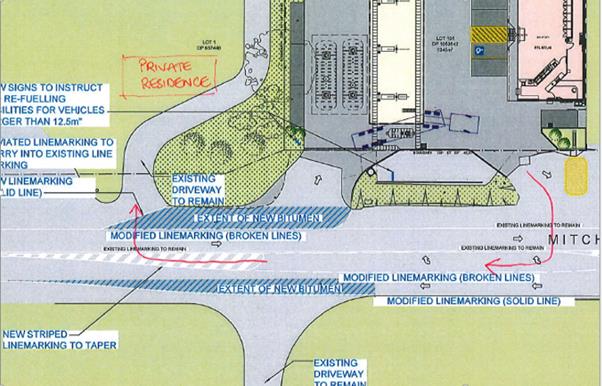
Figure 11 - right turns out of the service station and
the adjoining residence
are permissible across the painted median
iii) Does
the RMS formally approve the roadworks plan as part of the Construction
Certificate approvals process? (This is to ensure that the full extent of
pavement widening etc is noted on the final approved engineering plans).
RMS response
“Yes, as per our letter the applicant will need to
enter into a Works Authorisation Deed with RMS”.
State Environmental Planning
Policy 64 - Advertising and Signage
State Environmental Planning Policy 64 - Advertising and
Signage (SEPP 64) is applicable and states in part:
3 Aims,
Objectives etc
(1) This
Policy aims:
(a) to
ensure that signage (including advertising):
(i) is
compatible with the desired amenity and visual character of an area, and
(ii) provides
effective communication in suitable locations, and
(iii) is
of high quality design and finish, and
(8) Granting
of Consent to Signage
A consent authority must not
grant development consent to an application to display signage unless the
consent authority is satisfied:
(a) that
the signage is consistent with the objectives of this Policy as set out in
clause 3 (1) (a), and
(b) that
the signage the subject of the application satisfies the assessment criteria
specified in Schedule 1.
1 -
Character of the Area
· Is
the proposal compatible with the existing or desired future character of the
area or locality in which it is proposed to be located?
· Is
the proposal consistent with a particular theme for outdoor advertising in the
area or locality?
2 - Special Areas
· Does the
proposal detract from the amenity or visual quality of any environmentally
sensitive areas, heritage areas, natural or other conservation areas, open
space areas, waterways, rural landscapes or residential areas?
3 - Views and Vistas
· Does the
proposal obscure or compromise important views?
· Does the
proposal dominate the skyline and reduce the quality of vistas?
· Does the
proposal respect the viewing rights of other advertisers?
4 - Streetscape, Setting or Landscape
· Is the scale,
proportion and form of the proposal appropriate for the streetscape, setting or
landscape?
· Does the
proposal contribute to the visual interest of the streetscape, setting or
landscape?
· Does the
proposal reduce clutter by rationalising and simplifying existing advertising?
· Does the
proposal screen unsightliness?
· Does the
proposal protrude above buildings, structures or tree canopies in the area or
locality?
· Does the
proposal require ongoing vegetation management?
5 - Site and Building
· Is the proposal
compatible with the scale, proportion and other characteristics of the site or
building, or both, on which the proposed signage is to be located?
· Does the
proposal respect important features of the site or building, or both?
· Does the
proposal show innovation and imagination in its relationship to the site or
building, or both?
6 - Associated Devices and
Logos With Advertisements and Advertising Structures
· Have any safety
devices, platforms, lighting devices or logos been designed as an integral part
of the signage or structure on which it is to be displayed?
7 - Illumination
· Would
illumination result in unacceptable glare?
· Would
illumination affect safety for pedestrians, vehicles or aircraft?
· Would illumination
detract from the amenity of any residence or other form of accommodation?
· Can the
intensity of the illumination be adjusted, if necessary?
· Is the
illumination subject to a curfew?
8 - Safety
· Would the
proposal reduce the safety for any public road?
· Would the
proposal reduce the safety for pedestrians or bicyclists?
· Would the
proposal reduce the safety for pedestrians, particularly children, by obscuring
sightlines from public areas?
The proposed signage for the site is limited to two business
identification signs, one being a pylon sign at the front of the site with a
proposed height of 6m and a zero setback from the frontage, and the other being
a flush-mounted wall sign (with some modification following the advice of
Council’s Heritage Advisor). Lucknow is zoned RU5 Village, which is a
mixed use zone intended and geared towards small scale development, with
linkages to rural lands that surround the village. It is neither a
fully-fledged commercial precinct nor a fully urban residential precinct.
Council’s DCP 2004 includes some character observations in
Chapter 7 (Residential Development) for the village of Lucknow, and
Chapter 13 (Outdoor Advertising) that provide some guidance on what
signage can be considered appropriate, taking into account location, heights
and messaging. It is significant and worthwhile to take into consideration the
heritage status of the village as well.
There are competing demands applicable to this site in terms
of land use patterns and objectives or preferred outcomes. Such competing
demands do not suggest or enable a more or less free-hand in signage outcomes.
Compromises are needed to try and serve the competing demands of commercial
exposure, residential amenity, and scale and heritage, with safety also a matter
for consideration. On the one hand the pylon sign is located within a part of
the village identified as predominantly commercial in character; but on the
other hand the site is bounded on two sides by residential development. There
are competing outcomes applicable to each of these “zones”. In the
residential the emphasis is on achieving signage that is at a “human
scale”, suggesting sign height limits of 2m and setbacks of at least
the building line for the signs. However in this case given the semi-commercial
nature of the precinct it is considered appropriate in these circumstances to
limit the pylon sign to 5.4m in height being a height comparable to the
height of the building.
The following diagrams show the
imagery of the signage as proposed, and then with a maximum height of 5.4m and
a setback closer to the shop:
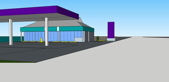
Figure 12 - proposed 6m height
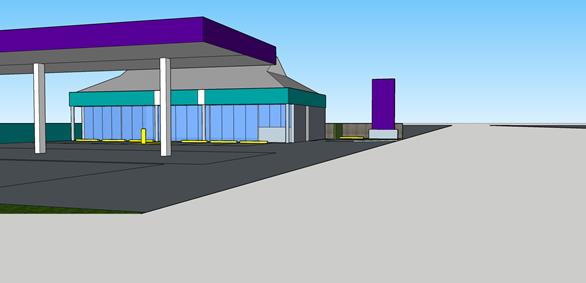
Figure 13 -5.4m recommended height
The signs are proposed to be illuminated, which is generally
considered acceptable in this case provided the illumination is constructed in
a fully recessed receptacle and is switched off when the service station is not
open.
Conditions are included that limit the height of the pylon
sign to 5.4m, and require the sign illumination to be switched off outside the
working hours of the service station.
PROVISIONS OF ANY DRAFT
ENVIRONMENTAL PLANNING INSTRUMENT THAT HAS BEEN PLACED ON EXHIBITION
4.15(1)(a)(ii)
There are no draft environmental planning instruments that
apply to the subject land or proposed development.
DESIGNATED DEVELOPMENT
The proposed development is not designated development.
INTEGRATED DEVELOPMENT
The proposed development is not integrated development.
PROVISIONS OF ANY DEVELOPMENT
CONTROL PLAN s4.15(1)(a)(iii)
Development Control Plan 2004
Development Control Plan 2004 (“the DCP”)
applies to the subject land. An assessment of the proposed development against
the relevant Planning Outcomes will be undertaken below.
Pursuant to Planning Outcome 0.2-1 Interim Planning Outcomes
- Conversion of Zones:
· Throughout this
Plan, any reference to a zone in Orange LEP 2000 is to be taken to be a
reference to the corresponding zone(s) in the zone conversion table.
The corresponding zone to zone 2v (Village) (Orange LEP
2000) is zone RU5 Village (Orange LEP 2011). As such, Orange DCP 2004
–Chapter 7 is relevant to this proposal. Chapters 12, 13, 14
and 15 are also applicable to the assessment.
CHAPTER 7 - DEVELOPMENT IN
RESIDENTIAL AREAS
Shops and
Businesses in the Urban Residential Zone
The LEP provides for a range of
non-residential activities to be carried out in the Urban Residential zone (it
is considered the RU-5 Village zone has a certain equivalency to standard
residential zones for the purposes of DCP assessment) provided that the
development complements the residential character and amenity of the area.
Shops and businesses that are permissible in the RU5 zone are listed in the
zoning table applicable to the zone. Business premises permitted in residential
areas are restricted to neighbourhood-shopping centres in the City. In the case
of the Lucknow village there is no neighbourhood shopping area, however the DCP
notes that existing businesses are located within a limited part of the
village, essentially the area adjacent to the highway at the western end of the
village.
The DCP states that new commercial
development in residential areas should aim to provide for the
convenience-shopping needs of residents of the locality and should be located
within or in association with existing neighbourhood-shopping areas.
Neighbourhood-shopping centres should complement the predominantly residential
character.
Planning
Outcomes
· Development complements the scale of residential development in the
area and the predominant heights and form of residential development in the
vicinity.
The heights of the building are comparable to surrounding
development. The height of the proposed pylon sign as submitted is slightly
more than that of the canopy, which is the highest structure otherwise
proposed.
· Business premises are located in neighbourhood business areas,
existing prior to Orange LEP 2000.
There is no neighbourhood shop area within the village zone,
but the DCP discussion identifies the north-western end of the properties
facing the Mitchell Highway as the area of the village where commercial
development has tended to occur. The proposed development would be located
within this area on a site that is already being used as a service station.
· Neighbourhood-business centres are small scale to serve the needs of
the residents of the locality. Neighbourhood-business centres have a maximum
commercial floor space of 1,000m² for the combined area of adjoining or
adjacent shops and businesses, whether or not the premises are on the same land
or adjacent to or in close proximity to each other.
The proposed development can be expected to provide services
and goods likely to satisfy the local community needs, but also can be expected
to rely on passing trade. Such reliance can be expected to lead to an elevated
amount of commercial activity for the site. It is considered that such elevated
levels of activity are acceptable within the day and early evenings, but would
be likely to lead to land use conflicts with the adjacent residential
development if permitted to operate in the overnight time slot. Attached is a
condition of consent limiting the development to 10.00pm. The adjoining
neighbour has indicated a preference for the development to be limited in terms
of operating hours to 7.00am to 8.00pm.
· New neighbourhood business centres are located at or near collector
intersections, with the buildings addressing the street frontage and rear
parking to provide quality urban design.
Not relevant to this application.
· Onsite parking is provided according to Section 15.4 of this Plan.
Refer to the appropriate assessment contained elsewhere in
this report.
· Advertising signage is limited to exempt development (ie, sign with
a maximum area of 1 square metre) for home businesses or businesses in
converted dwelling houses.
This planning outcome is not relevant in this case given
that the development does not comprise a home business or a business in
converted dwelling houses. Attached is a condition of consent limiting the
height of the pylon sign such that the signage will be sufficiently less
intrusive as to be considered compatible with the surroundings.
· Advertising signage in neighbourhood centres is not intrusive to the
character of the residential locality. No more than 15% of the street
façade elevation area of premises in a neighbourhood centre involves
signage.
The revised signage scheme complies with this guideline.
Development in
the Village of Lucknow
Village
Character
The village has a number of areas with
distinct characteristics that combine to make up the character of Lucknow.
Urban development on the north-eastern side of the Mitchell Highway centred on
a round hill comprises school and church buildings, with associated residences
on relatively small lots. Commercial development is centrally located fronting
the Highway. Land affected by former mining activity is situated on the fringes
of the village and on steeper slopes. Residential development on larger lots is
located southwest of the Highway, on Beasley and Phoenix Mine Roads, and on
Chapel Hill Lane.
The DCP recommends that commercial
development continue to centre on the Mitchell Highway and Beasley Road
intersection. New development should reflect the historic character and form of
the village.
Planning Outcomes
· Development proposals involving new buildings or works on or near
land identified as being subject to former mine activity include sufficient
information to demonstrate to Council’s satisfaction that the land is
suitable for the development. Particular attention is given to the location of
former mine shafts, shallow drives, mine spoil or mining relics. A geotechnical
professional prepares the information.
The applicant has provided limited information to suitably
demonstrate that the site is suitable for development based on previous mining
activity. Notwithstanding, Council staff have carried out an assessment of the
location of former mine shafts in the general locality together with a review
of assessments carried out on land that immediately adjoins the subject
property. Applications for development on nearby properties (numbers 9, 11 15
and 19 Chapel Hill lane, all located to the rear of the site) have included
geotechnical assessments assessing the risks for mine subsidence and soil
contamination, and all have concluded that the risks as very low.
The applicant has submitted a contamination report
establishing that no significant levels of contamination exist on the site.
Based on the fact that the neighbouring sites are similar in terms of location
and site conditions as the subject property it is considered the site is
appropriate for the proposed development. The intent of these provisions is to
minimise the risk of subsidence due to construction over former mine workings.
There is always some risk of subsidence and mine working contamination for any
development within the village. To minimise the risks from mine subsidence and
contamination on new construction precautionary conditions have been
recommended in the consent. The applicant will be required to submit a
geotechnical report prior to the issue of a Construction Certificate to confirm
that the site is suitable.
· A professionally-prepared report identifying that the land is
suitable for development after being investigated for potential land
contamination is submitted with a development application for development
involving works that will disturb the land.
An Environmental Site Assessment (ESA) has been submitted
indicating no substantial contamination on the site. However, this ESA does not
include appropriate assessment of the area immediately beneath the underground
storage tanks. A condition of consent has been included in the attached Notice
to address this issue.
· Commercial development is located within the established business
core of the Village centred on the Mitchell Highway/Phoenix Mine Road
intersection. Buildings and associated signage are designed to relate to the
traditional mining character of the Village to reinforce the mining history of
the Village.
The site on which the proposed development is to be located
is within the “commercial precinct” of the village. The specifics
of the submitted design are not ideal, being essentially a compromise between
broad brush heritage and streetscape considerations aiming to soften and
control massing and bulk on the one hand; whilst on the other hand permitting a
scale of commercialisation of the site that will be viable and functional. The
height of signage has been limited to 5.4m.
· Mining relics on land subject to development proposals are
identified, interpreted and conserved.
There are no mining relics on the land.
· Mine spoil areas remain undisturbed except for works associated with
stabilising the area to prevent erosion.
There are no mine spoil areas on this site.
· Heritage mine sites are made available for the interpretation of the
Village’s mining history. Such development includes professional
interpretation and conservation of the site.
The subject property is not an identified heritage site
within the village precinct.
· Residential lots have a minimum area of 1,000m2. Larger areas are
created on land affected by former mining activity to permit an adequate area
for development removed from disturbed sites.
The subject site is less than 1,000m2 but is also
not a residential use.
· Residential buildings are designed to relate to traditional building
forms of the Village.
Not relevant to this application
· The development is serviced by the public sewerage and water
reticulation system, taking into account the planned capacity of these systems.
Council’s Environmental Health and Building Surveyor
has reviewed the application and has raised no objection to the connection of
the site to either Council’s reticulated water supply or the reticulated
sewage system.
CHAPTER 12 - RURAL ENVIRONMENT
PROTECTION ZONE
Water-Catchment Considerations
Whilst the land is zoned RU5 Village it is none the less
located within the drinking water catchment for the City. Water supply
catchments are areas that provide for public water supplies to service urban
centres. The water catchment planning provisions apply the precautionary
principle of Ecologically Sustainable Development through a
“prudent-avoidance” approach. This approach includes provisions to
reduce the chance of serious environmental problems, even where it is not certain
when or if such problems will occur
There are no aspects of the proposed development where
likely adverse impacts on water quality within the catchment are likely to
arise. Conditions are included for such items as trade waste and stormwater
management that should lessen the impacts on surface runoff quality to an
acceptable limit.
CHAPTER 13 - HERITAGE
Consideration of Heritage Character
The unique and significant character of the village is
enhanced by the extent of the remaining aboveground mine shaft structures -
particularly the steel head frames of the Wentworth Main and Reform sites,
which are rare survivors both within the region and the state, and give the
village a striking historic immediacy, accessible to all because of their
prominent location on the main road.
The historic significance of the village is enhanced by the
degree to which it has retained elements of its early layout (particularly the
road network) and various early buildings it has retained, which provide
evidence of early residential and associated activities. Several individual
buildings are of high historic and aesthetic significance (including
“Mamhead” and the Anglican Church) while others are valuable
representative examples of early building styles, and provide evidence of early
development patterns in the village. The historic and aesthetic significance of
many early dwellings in the village has been adversely affected by later
alterations and loss of fabric, as well as a more general loss of
early/appropriate architectural context.
The aesthetic significance of the village arises in large
measure from its attractive siting on the Frederick's Valley Creek, surrounded
by low, rolling hills, and the open, largely undeveloped, character of this
setting. The simple linear character of the village itself, with its defined
entry points, generally low scale development and remaining early structures,
assists in maintaining the important early village identity and character,
although this has been notably eroded and adversely impacted upon in recent
years by inappropriate alterations to early buildings and unsympathetic new
developments.
The proposed development is considered an adequate design
response. The proposal, now with a pitched roof and with slightly more
restrained signage scheme, can be expected to at least not demean or challenge
the desirable or valuable character that defines the Lucknow Heritage
Conservation area. The new development cannot be described as significantly
reinforcing of the village character, but it is sufficiently restrained and
limited as to be considered suitable on heritage grounds to the locality.
The imposition of landscaping conditions, the limits placed
on signage (particularly height), and the detail changes specified by the
Heritage Advisor (including the pitched roof for the store component) provide
adequate mitigation to an otherwise uninspired design response to the heritage
challenges of the locality. It is considered fair to describe the more modern
changes to the Lucknow village architecture as not particularly sensitive to
the heritage values of the village, and the current proposal is a continuation
of that trend. However, in the case of this proposal, it is considered that
sufficient respect and deference is worked into the design as to render its
impacts acceptable.
CHAPTER 14 - ADVERTISING
Chapter 14 of the DCP contains the following requirements:
“Controls for advertising seek to ensure that,
where advertising is directed towards or across public places (including roads
and public areas such as parks) to attract the attention of the public, then
the advertising should complement the character of that area. Advertisements
should be designed to relate to the land or building. While advertisers may
wish signs to stand out, in order that signs complement the character of
Lucknow they should fit within the built and landscape environment. It is
recognised that business should be able to present their activity to the public
in an appropriate manner. Business Identification Signs serve this function
Signs should complement the scale of associated
buildings. For signs attached to buildings, the signs should not extend beyond
the outline of a building when viewed at the front elevation. Pylon or
free-standing signs in business areas should have a height consistent with the
height of the main building on the site. In residential areas, free-standing
signs should be located in a landscaped garden setting and should be at a
personal scale (i.e., generally less than 2 metres in height). Proliferation of
signs should be avoided since they detract from the character of the area and
provide confusion for the travelling public”.
Planning Outcomes
· The location,
size, colour and design of advertisement complement the character of the
locality.
The character of the locality is mixed. To the north and
west the predominant character is commercial. It is considered that in terms of
location, size (and height) and design the proposed signs are compatible with
the commercial surroundings. However, there is also a predominantly residential
style of development to the south and east of the site, and in this regard the
signs are not at a scale or of a design that sufficiently respects that
residential scale or character if viewed solely in the context of residential
development. However, the applicable zoning does not restrict development to
just residential development. The village zone permits a range of mixed uses;
and further the DCP identifies that part of the village where the proposed
development is to be located as predominantly a commercial precinct. On that
basis the signs are satisfactory subject to adoption of the recommended
condition of consent.
· Advertisements
on buildings fit within the envelope of the building.
The flush wall sign is consistent with this planning
outcome.
· Freestanding
pole or pylon signs relate to the height of associated buildings in business
and industrial areas.
As proposed the pylon sign would not relate to the height of
the structures proposed for the site. However, a reduction in the height of the
pylon sign of 600mm (10%) required by condition of consent will result in the
sign conforming more to the planning outcome.
· Freestanding
signs in residential areas are at a personal scale (i.e., about 2-metres high
or less) within a landscaped setting.
The proposed signs do not comply with this planning outcome,
and the applicant has not submitted any basis to support the variation to the
DCP that is needed. However, in this case a limited sign inventory and
restrained signage scheme can be justified on the basis that the signs are
within the commercial precinct of the village, and the impacts on the
neighbouring residential lots are about the same as the existing unapproved
signs on the site.
CHAPTER 15 – OFF-STREET
PARKING
The exiting development has no statutory requirement to
provide parking as no consent is known to exist for the building erected
thereon. There is no formal parking area provided onsite, however the
configuration of the site does allow off-street parking for the existing
activities on the site. There is a gravelled area at the rear of the existing
shop with dimensions to accommodate five vehicles. The existing shop has a
floor area of 114 m2.
Service stations under the DCP have the following car
parking rates applied to them:
3 spaces for each work bay
plus 1 space per 25m² of gross floor area of shop, convenience store or
payment area
For the proposed development there are no work bays
proposed. The proposed convenience store has 186m2 of gross floor
area, representing a net increase in floor area (compared to the existing shop)
of 72m2.
Adding the previous car parking provision (five spaces) to
the requirements arising from the net increase in gross floor area (72m2),
the net requirement for parking is 7.88 spaces (rounded to eight).
The plans submitted with the application show eight onsite
spaces being provided, which is considered sufficient to meet the demands of
the site.
An alternative method for calculating parking, disregarding
existing floor areas and existing (estimated) parking provision would simply be
to calculate the parking requirements of the new development, without regard to
the floor areas and parking provision of the existing situation. This method
yields a requirement for 7.44 off street spaces (again rounded up to eight
spaces).
The proposed development complies with the off-street
parking requirements of Council’s DCP.
Problems arise, however, for larger sized vehicles. To
address this the RMS requirements include a prohibition on the fuelling of vehicles
larger than 12.5m (the size limit set for a large rigid vehicle). Mitchell
Highway permits vehicles up to 26m semi-articulated vehicles. Further, it is
noted that the delivery vehicle to provide fuel to the site is 19m.
Arrangements in the access and egress geometry make it possible for the
delivery vehicle to deliver fuel safely to the site, however the site is
considered too small to accommodate trucks to receive fuel larger than the
limits specified by the RMS.
INFILL GUIDELINES
The Orange Local Government Area has a number of items and
areas of heritage significance (including the whole of Lucknow village)
pursuant to Orange Local Environmental Plan (OEP) 2011. These areas are
generally valued by the community.
The Burra Charter includes in Article 8 in its section on
"Setting":
"Conservation requires
the retention of an appropriate visual setting and other relationships that
contribute to the cultural significance of the place. New construction,
demolition, intrusions or other changes which would adversely affect the
setting or relationships are not appropriate"
Good quality and sensitive design of infill development in
heritage areas is of paramount importance in retaining the historic character
of precincts within Lucknow. An important aspect of good design is designing in
context and having regard to the site and its surroundings, with particular
consideration to the surrounding built form and significant landscaping.
What is Infill Development?
The NSW Heritage Office and the Royal Australian Institute
of Architects NSW 2005 publication Design in Context defines infill as:
A new building in an
established and valued historic context. Good infill is building that is
sympathetic to the surrounding buildings and historic context and creates new
structures that enhance and complement the existing urban, suburban or rural
character.
Purpose of the Guideline
Commercial infill takes advantage of premier business
locations whilst contributing to active and vibrant streetscapes.
Council’s Development Control Plan 2004 currently requires development to
complement and relate to the relevant features and built form within existing
streetscapes.
Infill should complement and enhance the local character by
relating to the predominant scale, massing, colours and materials of the area.
This does not mean that a developer must recreate the buildings nearby; it is
acceptable to relate to the above factors with a contemporary design, and this
has been expressed through the aims of the guideline.
Prescriptive numerical standards can often be
counterintuitive in the sense that they reduce flexibility and can stifle a
creative design that would otherwise satisfy the fundamental objects and
performance criteria of the applicable provisions through an alternate design
solution. Accordingly, the guidelines do not present numerical standards to
control development in a heritage context per se.
Objectives of Infill Design
· Retention of
appropriate visual setting (Article 8 Burra Charter).
· To ensure new
buildings respond to and enhance the character and appearance of the
streetscapes of the Heritage Conservation Areas.
· To ensure
contributory heritage items retain their prominence and are not dominated by
new development within a Heritage Conservation Area and do not compromise the
heritage values of the existing area.
· To ensure new
buildings do not adversely affect the significance, character or appearance of
the Heritage Conservation Area or heritage items.
· To allow for
reasonable change within a Heritage Conservation Area while ensuring all other
heritage objectives are met.
· To ensure new
development facilitates the retention of significant vegetation that
contributes to the tree canopy, especially within the Central Orange Heritage
Conservation Area.
The proposed development is consistent with the commercial
character of the village, but is less consistent with the residential design
objectives of the guidelines. The subject property is located just inside the
commercial precinct of the village; however it is acknowledged that residential
development adjoins the site to the east and south
Principle of Infill Development
“The guidelines emphasise the context of a place
and respond to it. Consideration should be given to the nature of adjoining and
surrounding heritage items and places, significant vegetation (on the site and
adjoining the site) and the overall significance and character of the heritage
area where it is located.
New development within a conservation area should not
have to replicate the existing built form, but should be compatible and enhance
the existing streetscape. Contemporary designs may be acceptable provided the
design relates to the assessment criteria”.
The proposed development is essentially a contemporary
design with mitigating elements introduced or required by condition into the
design, thereby adhering to the principals of the Infill Guidelines.
PROVISIONS PRESCRIBED BY THE
REGULATIONS s4.15(1)(a)(iv)
Demolition of a Building (clause 92)
A condition is attached requiring the demolition to be
carried out in accordance with Australian Standard AS2601 - 1991: The
Demolition of Structures.
Fire Safety Considerations
(clause 93)
The proposal does not involve a change of building use for
an existing building.
Buildings to be Upgraded
(clause 94)
The proposal does not involve the rebuilding, alteration,
enlargement or extension of an existing building.
BASIX Commitments (clause 97A)
BASIX is not applicable to the proposed development. A
Section J energy efficiency statement will be required with the Construction
Certificate application.
THE LIKELY IMPACTS OF THE
DEVELOPMENT s4.15(1)(b)
The proposed development has likely impacts in the following
subject areas:
· hours of
operation;
· risks from
naturally occurring asbestos
· traffic and
loading;
· hazardous goods;
· noise;
· impacts on
character;
· heritage;
· changes to site
levels; and
· heritage.
Conditions are included in the attached consent to address
each of these issues, which have previously been mentioned and commented upon
in this report (with the exception of naturally occurring asbestos
contamination).
Naturally Occurring Asbestos
Figure 14 (below shows that the subject property is within a
mapped area where naturally occurring asbestos can occur in development where
soil disturbance is proposed.
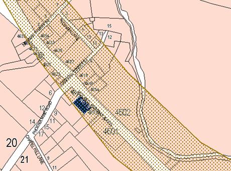
Figure 14 - potential asbestos affection mapping
Council mapping system also records that naturally occurring
asbestos events have been discovered within a 500m radius of the site.
The information available to Council is predictive only. It
does not necessarily follow that naturally occurring asbestos will be found on
this site, just that the soil conditions and previous survey mapping suggest a
strong possibility. It is considered appropriate in this situation to apply the
precautionary principle and impose the following condition to the consent:
The site is located within an area identified as
containing serpentinite rock formations, which can contain chrysotile, a
naturally occurring asbestos. Therefore the applicant or person with management
or control of the site shall ensure that a written plan (an Asbestos
Management Plan) for the site is prepared in accordance with the provisions
of the Work Health and Safety Act 2011 and Work Health and Safety
Regulation 2011.
To assist applicants with developing an Asbestos
Management Plan, applicants are encouraged to access the ‘Asbestos
Management Plan for Orange City Council 2014’, which is available on
Council’s website: www.orange.nsw.gov.au
.
Attached to the Notice is a recommended condition of consent
addressing this issue.
THE SUITABILITY OF THE SITE
s4.15(1)(c)
The site is currently used for the purposes of a service
station. The site is considered suitable for the proposed use. It will be
necessary to undertake further contamination testing once the underground
storage tanks are removed, and this may trigger a need for further Category 1
remediation if contamination is found. However, even in this eventuality, the
site can be considered suitable for the proposed development.
The site is located on the interface between the residential
and commercial areas of the village. To achieve a degree of compatibility with
the village character, conditions that limit the hours of operation, the height
of the pylon sign, the times that the premises may be illuminated, the styles
and finishes of the building and landscape treatments to be applied are imposed
as conditions in the consent.
ANY SUBMISSIONS MADE IN
ACCORDANCE WITH THE ACT s4.15(1)(d)
The proposed development is defined as "advertised
development" under the provisions of the LEP. The application was
advertised on two occasions for the prescribed period of 14 days. Two
exhibitions were necessary because the application underwent some significant
amendments in May 2018. At the conclusion of the two exhibitions, seven
submissions had been received from the nearby and surrounding residents.
A summary of the objections raised, and the brief responses
thereto are set out as follows:
Mr and Mrs Peter Campbell (two submissions)
· Object to the
24 hour operation
As discussed in the body of this
report the 24 hour operation of the development is not considered acceptable in
this locality. The applicant has amended the application to operate from 5.00am
to 12.00pm. However given the character of the surrounding locality, the
location of the adjoining residential development and the objectives of the RU5
Village zoning it is recommended that the hours of operation be limited to
7.00am to 10.00pm to align with the evening night time noise criteria.
Conditions are included that limit the hours of operation to 7am to 10pm.
· Odour
The objection relates vapours
emitted from the vent pipes of the underground tanks and the odour impacts
these vapours have on the residential amenity of the neighbouring residence.
The objector notes that there are existing vent pipes for the existing tanks
which are already causing odour nuisances from the emissions.
Enquiries with the Environment
Protection Authority reveal that in comparison to the existing equipment
installation on the site, which is essentially obsolete technology with regards
to vapour management, there are now heightened industry standards relative to
the standard of equipment already installed on the site that should lead to
improved vapour venting (and hence odour control) for the subject property.
· Fencing on the
eastern boundary should be at least 2m in height constructed in sound
attenuating material.
The applicant, in relation to
border fencing has indicated agreement to the construction of 1.8m high
fencing (albeit as Colorbond fencing). The submitted noise report suggests no
significant impacts for surrounding properties. 1.8m high fencing is considered
to be acceptable in this case, however the material more likely to be
compatible is considered to be timber lapped and capped. A condition of consent
to this effect is included in the notice and reflects essentially a compromise
between the expectations of the objector and the responses of the applicant.
· The objector
requests that kerb and gutter be provided along the frontages where roadworks
are required.
This is considered reasonable in
the circumstances and a condition is included to this effect in the Notice of
Determination.
GB Heinrich
· Objects to the
24 hour operation
As discussed above a condition of consent has been included
that limits the hours of operation to 7am to 10pm.
· 19m vehicles
not suitable for the site
Consistent with the requirements of
the RMS conditions of consent have been recommended in the attached notice of
determination that limit the maximum size of vehicles to 12.5m. A 19m long
vehicle is only permitted on the site to service the subject development.
· No provision
for pedestrian footway
Conditions are included in the consent requiring the removal
of the non-approved concrete slab at the front of the property (which tends to
be used for unauthorised verge parking), with properly constructed footpath and
verge landscaping as well as physical barriers to be installed to prevent the
parking of vehicles on the verge.
· There is no right
turn capability travelling east
The amended plans, following input from the RMS, resulted in
a right capability as well as a slip lane on the southern (westbound) side of
the Mitchell Highway. Attached a range of conditions required by RMS to deal with
access arrangements onto and off the highway.
A and K Anlezark
· Concerned that
the retaining wall proposed along the southern side of the subject land will
result in the loss of landscaping from that neighbours property
The submitted plans show the installation
of a retaining wall along the southern boundary to replace an existing batter.
The batter encroaches approximately 3m to the north of the shared
boundary, tapering down to approximately zero at the top of the bank. The
installation of the retaining wall will require the removal of some spoil so as
to allow the back boundary to be squared off, and if not carried out carefully
this work could result in the demolition or killing of vegetation that would
otherwise require consent for removal, and which if lost is likely to cause
harm to the southern neighbour.
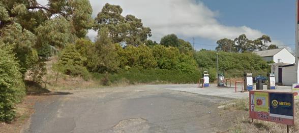
Figure 15 - landscaping of southern neighbour
To address this issue the following condition is included in
the consent:
Prior to the issue of a
Construction Certificate
Structural details, certified
by an engineer are required for the retaining wall to be installed along the
southern boundary. A tree management plan is also required to be submitted
outlining the details of the retaining wall construction, and including tree
protection measures and harm minimisation measures that conform to the
Australian Standards that apply to this situation, including AS 4970 –
Protection Of Trees on Development sites.
Natalee Selwood (two
submissions)
· The Assessment
and Traffic and Parking Implication section of the DA does not deal in full of
the implications of the traffic in the area. It does not mention that there is
no safe access into or out of the site
This submission was made in relation to the original plans
submitted for consideration. The amended plans have addressed the traffic and
access issues and have received concurrence from RMS, subject to conditions.
· Pedestrian
Access
Conditions are included to address the issue of pedestrian
access.
· Contrary to the
village residential character
The village has a significant heritage character, and a
mixed residential and commercial precinct. The subject property is located on
the boundary separating the mainly residential parts of the village from the
mainly commercial parts.
It is considered appropriate, in the interests of
maintaining a village character and reflecting the mixed use zoning provisions
of the village zone, to apply conditions that prevent the full 24 hour
operation of the development. To this end it is recommended that the development
be limited to 7.00am to 10.00pm.
· The proposed
development is a visual eyesore and fails to take into account the historic
significance of the village
The proposed development is infill development, with aspects
in the design that are not ideal to the surroundings in which they are to be
placed. Conversely, changes have been incorporated into the amended plans
following consultation with Council’s Heritage adviser and conditions are
contained in the consent that will reduce these impacts.
Under the circumstances it would be a negative step to
insist on a mock heritage solution. The amended plans and the suite of
conditions included in the consent aim to contain interpretations of the
dominant character of the village, whilst at the same time taking steps to
minimise the dominance that the proposed development might otherwise possess.
Gai Fardell (second
exhibition period only)
· Objects to the
24 hour operation
As discussed above a condition of consent has been included
in the Notice of Determination that limits the hours of operation to 7am to
10.00pm.
· Traffic Safety
See comments above.
PUBLIC INTEREST
s4.15(1)(e)
The proposed development is considered to be of minor
interest to the wider public due to the relatively localised nature of
potential impacts. The proposal is not inconsistent with any relevant policy
statements, planning studies, guidelines etc that have not been considered in
this assessment.
SUMMARY
The proposed development is permissible with the consent of
Council. The proposed development complies with the relevant aims, objectives
and provisions of Orange LEP 2011 (as amended) and DCP
2004. The RMS have recommended a suite of conditions to ensure that
access/egress from the site is acceptable. A section 4.15 assessment of
the development indicates that the development is acceptable in this instance.
Attached is a draft Notice of Approval outlining a range of conditions
considered appropriate to ensure that the development proceeds in an acceptable
manner.
COMMENTS
The requirements of the Environmental Health and Building
Surveyor and the Engineering Development Section are included in the attached
Notice of Approval.
Attachments
1 Notice
of Approval, D18/58099⇩
2 Plans,
D18/57564⇩
3 Submissions,
D18/57569⇩
Planning
and Development Committee
7 November 2018
2.3 Development
Application DA 33/2018(1) - 4613 Mitchell Highway, Lucknow
Attachment 1 Notice of Approval
|

|
ORANGE
CITY COUNCIL
Development
Application No DA
33/2018(1)
NA18/ Container
PR18810
|
NOTICE OF DETERMINATION
OF A DEVELOPMENT
APPLICATION
issued under the Environmental
Planning and Assessment Act 1979
Section 4.18
|
Development
Application
|
|
|
Applicant Name:
|
Brothers
Three Pty Ltd
|
|
Applicant Address:
|
C/- MCHP
Architects Pty Ltd
Suite 5,
46 Albany Street
ST
LEONARDS NSW 2065
|
|
Owner’s Name:
|
Brothers
Three Pty Ltd
|
|
Land to Be Developed:
|
Lot 101 DP
1053642 - 4613 Mitchell Highway, Lucknow
|
|
Proposed Development:
|
Demolition
(existing service station), Service Station (includes sales building, fuel
dispensing canopy, underground fuel tanks), and Business and Site
Identification Signs
|
|
|
|
|
Building
Code of Australia
building
classification:
|
To be
determined by the PC
|
|
|
|
|
Determination
made under
Section 4.16
|
|
|
Made On:
|
7 November
2018
|
|
Determination:
|
CONSENT GRANTED
SUBJECT TO CONDITIONS DESCRIBED BELOW:
|
|
|
|
|
Consent to
Operate From:
|
8 November
2018
|
|
Consent to
Lapse On:
|
8 November
2023
|
Terms of Approval
The reasons for the imposition of
conditions are:
(1) To ensure a quality
urban design for the development which complements the surrounding environment.
(2) To maintain
neighbourhood amenity and character.
(3) To ensure compliance
with relevant statutory requirements.
(4) To provide adequate
public health and safety measures.
(5) Because the development
will require the provision of, or increase the demand for, public amenities and
services.
(6) To ensure the utility
services are available to the site and adequate for the development.
(7) To prevent the proposed
development having a detrimental effect on adjoining land uses.
(8) To minimise the impact
of development on the environment.
Conditions
(1) The
development must be carried out in accordance with:
(a) Plans
by MCHP Architects:
DA02(REVB), DA03 (REV D), DA05 (REV C)
dated 26.08.2017;
DA07 (REV B) DA08 (REV B), DA09 (REV A)
dated 17-05-2018;
DA07 (REV B – Roadworks sketch), DA08
(REV A – Roadworks Context Plan)
dated 3.08.2018 (8 sheets)
(b) statements
of environmental effects or other similar associated documents that form part
of the approval
as amended
in accordance with any conditions of this consent.
(2) All building work must
be carried out in accordance with the provisions of the Building Code of
Australia.
(3) A sign is to be erected
in a prominent position on any site on which building work, subdivision work or
demolition work is being carried out:
(a) showing
the name, address and telephone number of the principal certifying authority
for the work, and
(b) showing
the name of the principal contractor (if any) for any building work and a
telephone number on which that person may be contacted outside working hours,
and
(c) stating
that unauthorised entry to the site is prohibited.
Any such sign is to be maintained while the
building work, subdivision work or demolition work is being carried out.
(4) Where any excavation
work on the site extends below the level of the base of the footings of a
building on adjoining land, the person having the benefit of the development
consent must, at the person’s own expense:
(a) protect
and support the adjoining premises from possible damage from the excavation,
and
(b) where
necessary, underpin the adjoining premises to prevent any such damage.
Note: This
condition does not apply if the person having the benefit of the development
consent owns the adjoining land or the owner of the adjoining land has given
consent in writing to this condition not applying.
|
PRIOR TO THE ISSUE OF
A CONSTRUCTION CERTIFICATE
|
(5) Full details of
external colours and finishes of external materials are to be submitted and
approved by Councils Manager Development Assessments prior to the issue of a
Construction Certificate.
(6) A
geotechnical report shall be submitted and approved by Council’s Manager
Development Assessments, that certifies that the site is not at risk from mine
subsidence and that the site is suitable for the development having regard to
mine subsidence.
(7) Structural
details, certified by an engineer are required for the retaining wall to be
installed along the southern boundary. A tree management plan is also required
to be submitted outlining the details of the retaining wall construction, and
including tree protection measures and harm minimisation measures that conform
to the Australian Standards that apply to this situation, including AS 4970
– Protection Of Trees on Development sites.
(8) Amended plans are
required that are to the satisfaction of the Manager Development Assessments,
incorporating the following features:
· All blockwork walls are
to be fully concealed on all exposed surfaces by planting in the form of a
creeper specified by the landscape consultant with appropriate planting media,
watering and the means of adhering to the subject walls.
· All lighting to the
soffit of the fuelling canopy is to be fully recessed from the soffit surface.
· The soffit to the
fuelling canopy is to be equal to the Colorbond standard custom orb profile in
“Shale Grey”. The fencing on the side facing the development around
the perimeter shall also be finished in “Shale Grey” or
“Windspray”.
· The cladding to the
north-eastern elevation is run horizontally to interpret the local vernacular.
· A full height window is
to be inserted into the north-eastern elevation between the cigarette display
and office doors.
· The building be
provided with a similar hipped 30 degree pitched roof.
· The colour of the gable
infills is to be “Windspray”.
· The concrete blockwork
on the convenience store shall be clad in horizontal Colorbond
“Basalt” and not painted to reflect the local vernacular.
· The site identification
sign shall be limited to a maximum height of 5.4m above existing ground levels
to ensure the sign element relates to the maximum height of the structures to
be erected on the site and does not visually dominate the setting and affect
other business identification elements, signs and graphics. The base of the
sign shall be clad in local stone similar to basalt to the level of the bottom
price indicator and replacing the ATM graphic which is redundant.
· A revised
landscape plan is required that incorporates species suited to the local
climate (in particular are frost tolerant), and which have mature heights
suited to the growth plots to be provided. Existing species selection in the
submitted plans are inappropriate. Further, the landscaping plans shall be
amended to incorporate a landscaping strip in the two access driveways to the
site to a minimum width of 1.5m (with the landscaping plan showing the existing
unauthorised concrete pad in the Council verge area being removed). Plant
selection shall incorporate native species capable of achieving a mature height
of not less than 4m. This landscape strip shall be provided in the verge area
on the southern side of the footpath construction elsewhere required by this
consent.
(9) An
approval under Section 68 of the Local Government Act is to be sought
from Orange City Council, as the Water and Sewer Authority, for alterations to
water and sewer. No plumbing and drainage is to commence until approval is
granted.
(10) The
applicant is to submit a waste management plan that describes the nature of
wastes to be removed, the wastes to be recycled and the destination of all
wastes. All wastes from the demolition and construction phases of this project
are to be deposited at a licensed or approved waste disposal site.
(11) Engineering plans providing
complete details of the proposed driveway and car parking areas are to be
submitted to Orange City Council or an Accredited Certifier (Categories B1, C3,
C4, C6) upon application for a Construction Certificate. These plans are to
provide details of levels, cross falls of all pavements, proposed sealing
materials, proposed drainage works, line marking and signage and are to be in
accordance with Orange City Council Development and Subdivision Code.
The plans shall detail the removal of the
concrete slab between the two driveways and this area reinstated as public
footpath. All signage shall be located within the site boundaries.
(12) Engineering plans,
showing details of all proposed work and adhering to any engineering conditions
of development consent, are to be submitted to, and approved by, Orange City
Council or an Accredited Certifier (Categories B1, C3, C4, C6) prior to the
issuing of a Construction Certificate.
Engineering plans shall include a road pavement
design for widening works and all Roads and Maritime Services requirements as
follows:
· “No
Entry” (R2-4) signs are to be provided on the land at each side of the
exit driveway. The signs are to face the Mitchell Highway to advise motorists
not to enter the site from the Mitchell Highway via the exit driveway.
· “No
Entry” (R2-4) signs are to be erected on the land on each side of the
entry driveway. The signs are to face the site to advise motorists not to exit
onto the Mitchell Highway via the entry driveway.
· Prior to
occupation of the development, signage on the site facing the Mitchell Highway
is to be installed displaying “NO FUELING OF VEHICLES OVER 12.5 METRES
LONG”.
· Adequate
turning circles, storage room and vertical clearance are to be provided within
the site for the largest type of vehicle (19 metre fuel tanker) that will visit
the site operation.
· All
activities including loading and unloading of goods associated with the
development are to be carried out on site in the dedicated areas.
· Landscaping,
signage and fencing are not to impede sight lines of traffic within or when
passing, entering or departing from the site. Safe Intersection Sight Distance
(SISD) requirements outlined in Austroads Guide to Road Design Part 4A
is to be provided in both directions at the intersection of driveways and the
Mitchell Highway.
· Prior to
the occupation of the site, a Channelised Right (Short) [CHR(s)] turn lane
generally in accordance with Figure 7.7 Part 4A Austroads Guide to Road
Design 2017 and relevant Roads and Maritime supplements, is to be provided
in the Mitchell Highway at its intersection with the site entry. The
intersection works are to be designed and constructed for a 60km/h speed zone
and be able to accommodate the largest vehicle accessing the site.
· Prior to
occupation of the site, a Basic Left (BAL) turn treatment as shown in Figure
8.2 Part 4A of the Austroads Guide to Road Design 2017 is to be provided
at the intersection of site access and the Mitchell Highway. The BAL facility
will also need to be sealed and built for a 60km/h environment.
· A formal
agreement in the form of a Works Authorisation Deed (WAD) will be required
between the developer and Roads and Maritime for the developer to undertake
“private financing and construction” of any works on the Mitchell
Highway. This agreement is necessary for works in which Roads and Maritime has
a statutory interest. A WAD is to be executed prior to issuance of a
Construction Certificate.
· Prior to
the commencement of construction works, the proponent is to contact Roads and
Maritime’s Field Traffic Manager to determine if a Road Occupancy Licence
(ROL) is required. In the event that an ROL is required, the proponent is to
obtain the ROL prior to works commencing within three (3) metres of the travel
lanes on the Mitchell Highway.
· All
entry/exit points onto/from the Mitchell Highway, internal vehicular
manoeuvring, parking and loading areas are to be constructed, sealed and
maintained generally in accordance with submitted plans reference no.17-077-DA07
and 17-077-DA08 prior to the issuance of an Occupation Certificate.
· Signage is
to be in accordance with the Department of Planning and Environment’s Transport
Corridor Outdoor Advertising and Signage Guidelines 2017, is not to flash,
move or be objectionably glaring or luminous.
(13) All stormwater from the
site is to be collected and piped to a stormwater treatment system. The design
and construction of the stormwater treatment system for the subject land shall
ensure that the quality of stormwater leaving the developed site achieves the
following stormwater quality targets:
· 90% reduction in the
post development average annual gross pollutant (>5 millimetres) load.
· 85% reduction in the
post development mean annual load of Total Suspended Solids (TSS);
· 65% reduction in the
post development mean annual load of Total Phosphorus (TP);
· 45% reduction in the
post development mean annual load of Total Nitrogen loads (TN);
· No observable
Hydrocarbons present in stormwater discharge (<10ppm).
Orange City Council is to approve engineering
plans for this stormwater system prior to the issuing of a Construction
Certificate. The applicant shall undertake comprehensive water quality
modelling on for the site, using an accredited assessment tool (recommended
using Music™ or other approved assessment tool) and shall include copies
of the electronic data files. Treated stormwater shall be piped to the existing
roadside inlet pit that shall be reconstructed as a surcharge pit with a grated
inlet.
(14) Payment of
contributions for water, sewer and drainage works is required to be made
at the contribution rate applicable at the time that the payment is made. The
contributions are based on 0.6 ETs for water supply headworks and 0.9 ETs for
sewerage headworks. A Certificate of Compliance, from Orange City Council in
accordance with the Water Management Act 2000, will be issued upon
payment of the contributions.
This Certificate of Compliance is to be
submitted to the Principal Certifying Authority prior to the issuing of a
Construction Certificate.
(15) A water and soil
erosion control plan is to be submitted to Orange City Council or an Accredited
Certifier (Categories B1, C3, C4, C6) for approval prior to the issuing of a
Construction Certificate. The control plan is to be in accordance with the
Orange City Council Development and Subdivision Code and the Landcom, Managing
Urban Stormwater; Soils and Construction Handbook.
(16) Backflow Prevention
Devices are to be installed to AS3500 and in accordance with Orange City
Council Backflow Protection Guidelines. Details of the Backflow Prevention
Devices are to be submitted to Orange City Council prior to the issuing of a
Construction Certificate.
|
PRIOR TO WORKS
COMMENCING
|
(17) A
Construction Certificate application is required to be submitted to, and issued
by Council/Accredited Certifier prior to any excavation or building works being
carried out onsite.
(18) A
temporary onsite toilet is to be provided and must remain throughout the
project or until an alternative facility meeting Council’s requirements
is available onsite.
(19) Soil erosion control
measures shall be implemented on the site.
|
DURING
CONSTRUCTION/SITEWORKS
|
(20) All
construction/demolition work on the site is to be carried out between the hours
of 7.00 am and 6.00 pm Monday to Friday inclusive, 7.00 am to
5.00 pm Saturdays and 8.00 am to 5.00 pm Sundays and Public
Holidays. Written approval must be obtained from the General Manager of Orange
City Council to vary these hours.
(21) After
removal of the underground storage tanks (USTs) from the site, work shall stop
until it has been determined that the area under the USTs is free from
contamination. Further soil testing for the ground under the USTs shall be
completed, with the results also submitted to Council’s Manager
Development Assessments. In the event that contamination under the tanks is
discovered, work shall cease and further development consent shall be sought
for that remediation (note that the remediation of this land must be completed
as a Category 1 remediation under State Environmental Planning Policy 55
– Remediation of Land, which is remediation that requires development
consent. Work on the site may only recommence on submission and acceptance by
Council of the validation report for the related Remediation action Plan.
(22) A
Registered Surveyor’s certificate identifying the location of the
building on the site must be submitted to the Principal Certifying Authority.
(23) All
construction works are to be strictly in accordance with the Reduced Levels
(RLs) as shown on the approved plans.
(24) All
materials onsite or being delivered to the site are to be contained within the
site. The requirements of the Protection of the Environment Operations Act
1997 are to be complied with when placing/stockpiling loose material or
when disposing of waste products or during any other activities likely to
pollute drains or watercourses.
(25) Building demolition is
to be carried out in accordance with Australian Standard 2601:2001 - The
Demolition of Structures and the requirements of Safe Work NSW.
(26) Asbestos
containing building materials must be removed in accordance with the provisions
of the Work Health and Safety Act 2011 and any guidelines or Codes of
Practice published by Safe Work NSW, and disposed of at a licenced landfill in accordance
with the requirements of the NSW EPA.
(27) Any adjustments to
existing utility services that are made necessary by this development
proceeding are to be at the full cost of the developer.
(28) The
provisions and requirements of the Orange City Council Development and
Subdivision Code are to be applied to this application and all work constructed
within the development is to be in accordance with that Code.
The developer is to be entirely responsible for
the provision of water, sewerage and drainage facilities capable of servicing
the development from Council’s existing infrastructure. The developer is
to be responsible for gaining access over adjoining land for services where
necessary and easements are to be created about all water, sewer and drainage
mains within and outside the lots they serve.
(29) All driveway and
parking areas are to be sealed with bitumen, hot mix or concrete and are to be
designed for all expected loading conditions (provided however that the minimum
pavement depth for gravel and flush seal roadways is 200mm) and be in
accordance with the Orange City Council Development and Subdivision Code.
(30) Heavy-duty concrete
kerb and gutter laybacks and footpath crossings are to be constructed for the
entrances to the proposed development. The location and construction of the
laybacks and footpath crossings shall accommodate the turn path of a 19m
articulated vehicle. The driveway shall be constructed to the standards stated
in the Orange City Council Development and Subdivision Code.
(31) A 1.2m wide concrete
pathway shall be constructed between the 2 driveways on the property frontage.
Pram ramps shall be installed where the path intersects with kerb. The footpath
shall be constructed to the standards stated in the Orange City Council
Development and Subdivision Code.
(32) All services
are to be contained within the allotment that they serve.
(33) The
site is
located within an area identified as containing serpentinite rock formations,
which can contain chrysotile, a naturally occurring asbestos. Therefore the
applicant or person with management or control of the site shall ensure that a
written plan (an Asbestos Management Plan) for the site is
prepared in accordance with the provisions of the Work Health and Safety
Act 2011 and Work Health and Safety Regulation 2011. To
assist applicants with developing an Asbestos Management Plan, applicants are
encouraged to access the ‘Asbestos Management Plan for Orange City
Council 2014’, which is available on Council’s website:
www.orange.nsw.gov.au
(34) Road widening is to be
constructed for the proposed development to the requirements of Roads and
Maritime Services. This work shall include full depth road pavement, pavement
surfacing and line marking for any new lanes or widened shoulders. The work
shall include kerb and gutter construction and an earth-formed footpath on the
development side of the road for the full frontage of the development and the
full length of the left turn lane into the development.
|
PRIOR TO THE ISSUE OF
AN OCCUPATION CERTIFICATE
|
(35) All
equipment must be installed to manufacturer’s recommendations and must
comply with all the relevant standards listed within.
(36) Prior
to the issuing of an Occupational Certificate, the Applicant shall submit to
Council documentation demonstrating that the following plans and systems have
been developed and implemented:
(a) TRANSPORT
OF HAZARDOUS MATERIALS
Arrangements covering
the transport of hazardous materials including details of routes to be used for
the movement of vehicles carrying hazardous materials to or from the
development. The routes selected shall be consistent with the Department of
Planning’s Hazardous Industry Planning Advisory Paper No. 11, ‘Route
Selection’. Suitable routes identified in the study shall be used except
where departures are necessary for local deliveries or emergencies.
(b) EMERGENCY
PLAN
A comprehensive
Emergency Plan and detailed emergency procedures for the development. The plan
shall be consistent with the Department of Planning’s Hazardous Industry
Planning Advisory Paper No. 1, ‘Emergency Planning’.
(c) SAFETY
MANAGEMENT SYSTEM
A comprehensive Safety
Management System, covering all on-site operations and associated transport
activities involving hazardous materials. The Safety Management System shall be
consistent with the Department of Planning’s Hazardous Industry Planning
Advisory Paper No. 9, ‘Safety Management’.
(37) Landscaping
shall be installed in accordance with the approved plans and shall be
permanently maintained to the satisfaction of Council's Manager Development
Assessments.
(38) A
total of 8 off-street
car parking spaces shall be provided upon the site in accordance with the
approved plans, the provisions of Development Control Plan 2004, and be
constructed in accordance with the requirements of Council's Development and
Subdivision Code prior to the issue of an Occupation Certificate.
(39) 1.8m
high hardwood timber fencing, lapped and capped shall be provided along the
shared eastern boundary of the subject property.
(40) No
person is to use or occupy the building or alteration that is the subject of
this approval without the prior issuing of an Occupation Certificate.
(41) The
owner of the building/s must cause the Council to be given a Final Fire Safety
Certificate on completion of the building in relation to essential fire or
other safety measures included in the schedule attached to this approval.
(42) Where
Orange City Council is not the Principal Certifying Authority, a final
inspection of water connection, sewer and stormwater drainage shall be
undertaken by Orange City Council and a Final Notice of Inspection issued,
prior to the issue of either an interim or a final Occupation Certificate.
(43) A Certificate of
Compliance, from a Qualified Engineer, stating that the stormwater treatment
system complies with the approved engineering plans is to be submitted to the
Principal Certifying Authority prior to the issuing of an Occupation
Certificate.
(44) Certification from
Orange City Council is required to be submitted to the Principal Certifying
Authority prior to the issue of an Occupation Certificate stating that all
works relating to connection of the development to Council assets, works on
public land, works on public roads, stormwater, sewer and water reticulation
mains and footpaths have been carried out in accordance with the Orange City
Council Development and Subdivision Code and the foregoing conditions, and that
Council will take ownership of the infrastructure assets.
(45) Certification of the
installation and commissioning of testable Backflow Prevention Devices shall be
submitted to Orange City Council by a plumber with backflow qualifications
prior to the issue of an Occupation Certificate.
(46) All
of the foregoing conditions are to be at the full cost of the developer and to
the requirements and standards of the Orange City Council Development and
Subdivision Code, unless specifically stated otherwise. All work required by
the foregoing conditions is to be completed prior to the issuing of an Occupation
Certificate, unless stated otherwise.
|
MATTERS FOR THE
ONGOING PERFORMANCE AND OPERATION OF THE DEVELOPMENT
|
(47) Twelve months after the
commencement of operations of the proposed development and every three years
thereafter, the Applicant shall carry out a comprehensive Hazard Audit of the
proposed development consistent with the Department of Planning’s Hazardous
Industry Planning Advisory Paper No. 5, ‘Hazard Audit Guidelines’.
The audit shall be carried out by a qualified person or team, independent of
the development. Compliance documentation shall be submitted to the Council
within 28 days from the date of the audit.
(48) Specific
safety features of the site, as set out in the submitted Preliminary Hazard
Analysis (PHA) submitted with the Development Application shall be adhered to
strictly at all times. The applicant shall ensure that safety procedures are
well posted on the site and shall further ensure that all staff are adequately
inducted as to correct safety procedures and protocols as set out in the PHA.
(49) Internal
and external illumination (including signage) of the service station is
permitted only during the approved hours of operation. Outside of the approved
hours, all lighting, except that needed for security and safety purposes shall
be switched off.
(50) The hours of
operation of the premises shall not exceed 7am to 10pm seven days per week.
(51) No sandwich
boards or the like are to be placed on Council's footpath.
(52) A separate development
application shall be submitted to and approved by Council prior to the erection
of any advertising structures (including business identification signs) or
signs of a type that do not meet the exempt development provisions of Orange
Local Environmental Plan 2000 (amended) and Development Control Plan 2004.
(53) Emitted
noise shall not exceed 5dB(A) above background sound level measured at the
nearest affected residence.
(54) Any
ancillary light fittings fitted to the exterior of the building are to be
shielded or mounted in a position to minimise glare to adjoining properties.
(55) The
owner is required to provide to Council and to the NSW Fire Commissioner an
Annual Fire Safety Statement in respect of the fire-safety measures, as
required by Clause 177 of the Environmental Planning and Assessment
Regulation 2000.
(56) Copies of
maintenance records for servicing of the approved stormwater treatment system
shall be forwarded to Council on 1 December annually.
(57) POST-STARTUP COMPLIANCE
REPORT
Three months after the
commencement of operation of the development, the Applicant shall submit to
Council, a report verifying that:
(a) transport
routes specified under this consent (generated by the HIPAPS requirements) are
being followed;
(b) the
Emergency Plan required under this consent and generated by the HIPAPs
requirements are effectively in place and that at least one emergency exercise
has been conducted; and
(c) the
Safety Management System required under this consent and brought out by the
HIPAPs requirements have been fully implemented and that records required by
the system are being kept.
(58) HAZARD AUDIT
Twelve months after the
commencement of operations of the proposed development and every three years
thereafter, or at such intervals as Council may agree, the Applicant shall
carry out a comprehensive Hazard Audit of the proposed development and within
one month of each audit submit a report to Council.
The audits shall be
carried out at the Applicant’s expense by a qualified person or team,
independent of the development, prior to commencement of each audit and shall
be consistent with the Department of Planning’s Hazardous Industry
Planning Advisory Paper No. 5, ‘Hazard Audit Guidelines’.
The audit shall be
carried out by a qualified person or team, independent of the development.
Other Approvals
(1) Local
Government Act 1993 approvals granted under section 68.
Nil
(2) General
terms of other approvals integrated as part of this consent.
Nil
Right of Appeal
If you are dissatisfied with this
decision, Section 8.7 of the Environmental Planning and Assessment Act 1979
gives you the right to appeal to the Land and Environment Court. Pursuant to
Section 8.10, an applicant may only appeal within 6 months after the date the
decision is notified.
|
Disability Discrimination Act
1992:
|
This application has been assessed in
accordance with the Environmental Planning and Assessment Act 1979. No
guarantee is given that the proposal complies with the Disability
Discrimination Act 1992.
The applicant/owner is responsible to
ensure compliance with this and other anti-discrimination legislation.
The Disability Discrimination Act
covers disabilities not catered for in the minimum standards called up in the
Building Code of Australia which references AS1428.1 - "Design for
Access and Mobility". AS1428 Parts 2, 3 and 4 provides the most
comprehensive technical guidance under the Disability Discrimination Act
currently available in Australia.
|
|
|
|
|
Disclaimer - S88B of the Conveyancing
Act 1919 - Restrictions on the Use of Land:
|
The applicant should note that there
could be covenants in favour of persons other than Council restricting what
may be built or done upon the subject land. The applicant is advised to check
the position before commencing any work.
|
|
|
|
|
Signed:
|
On behalf of the consent authority ORANGE
CITY COUNCIL
|
|
Signature:
|
|
|
Name:
|
PAUL JOHNSTON - MANAGER DEVELOPMENT
ASSESSMENTS
|
|
Date:
|
8 November 2018
|
Planning and Development Committee
7 November 2018
2.3 Development
Application DA 33/2018(1) - 4613 Mitchell Highway, Lucknow
Attachment 2 Plans
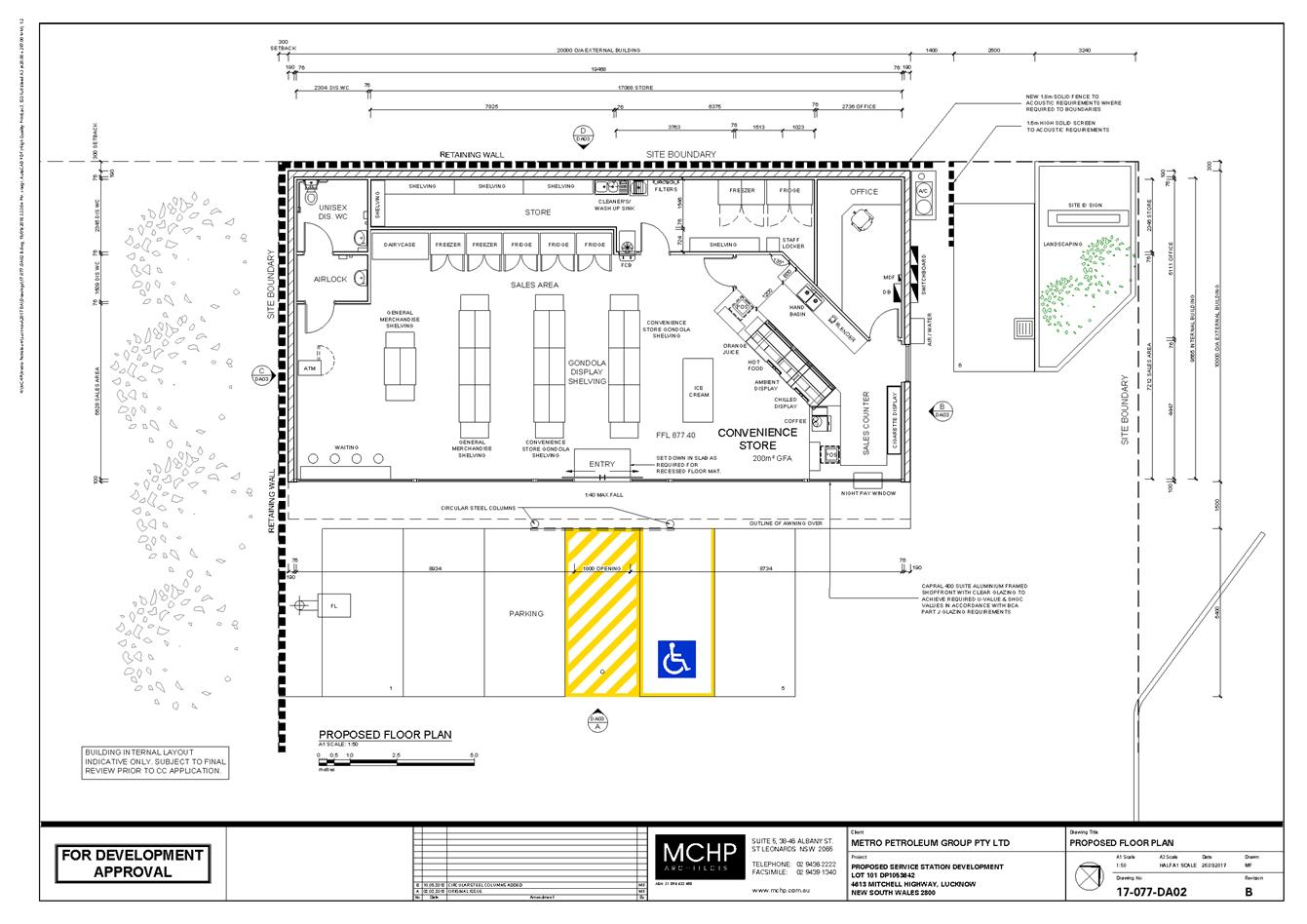
Planning
and Development Committee
7 November 2018
2.3 Development
Application DA 33/2018(1) - 4613 Mitchell Highway, Lucknow
Attachment 3 Submissions

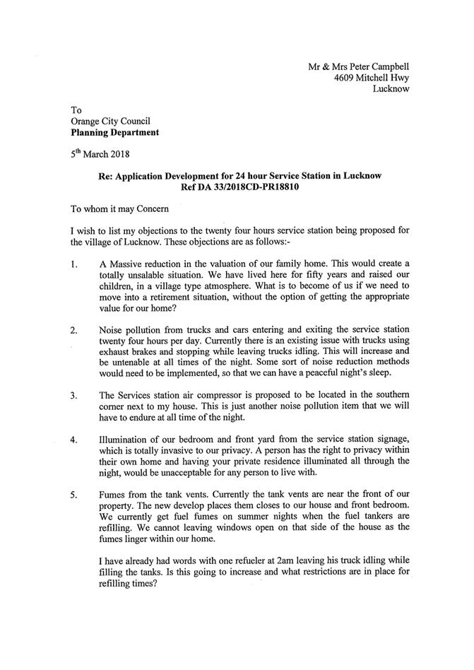
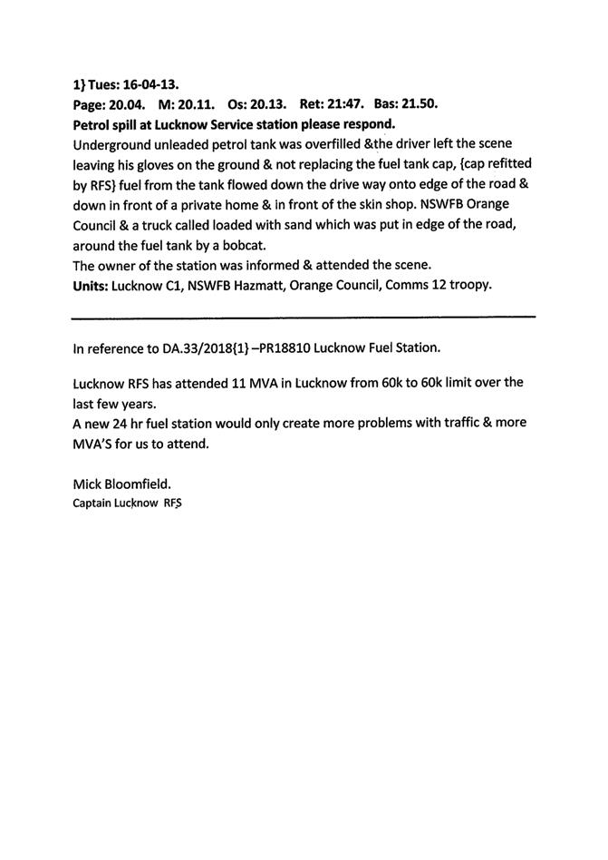
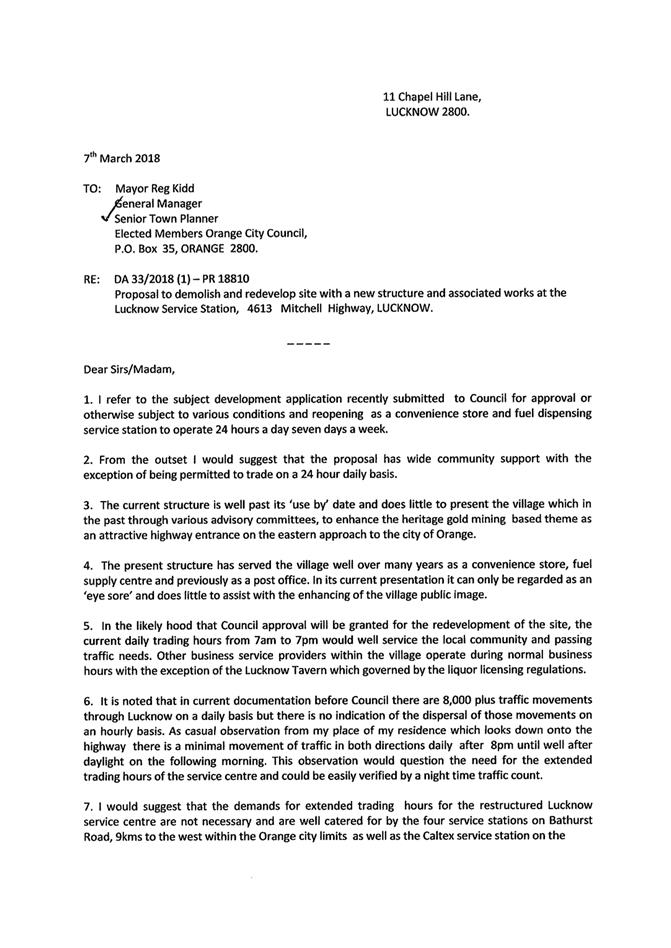
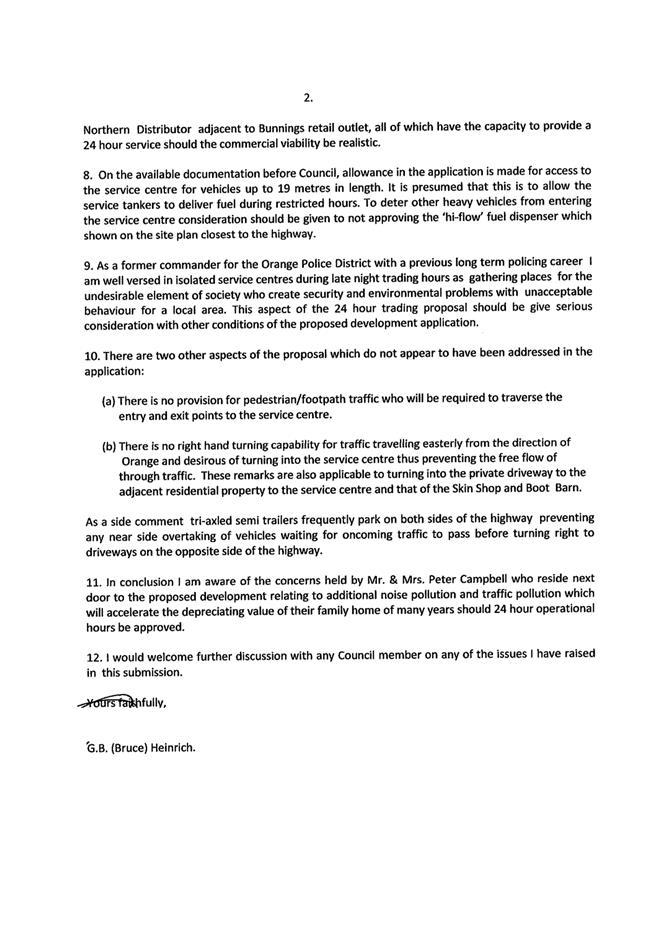
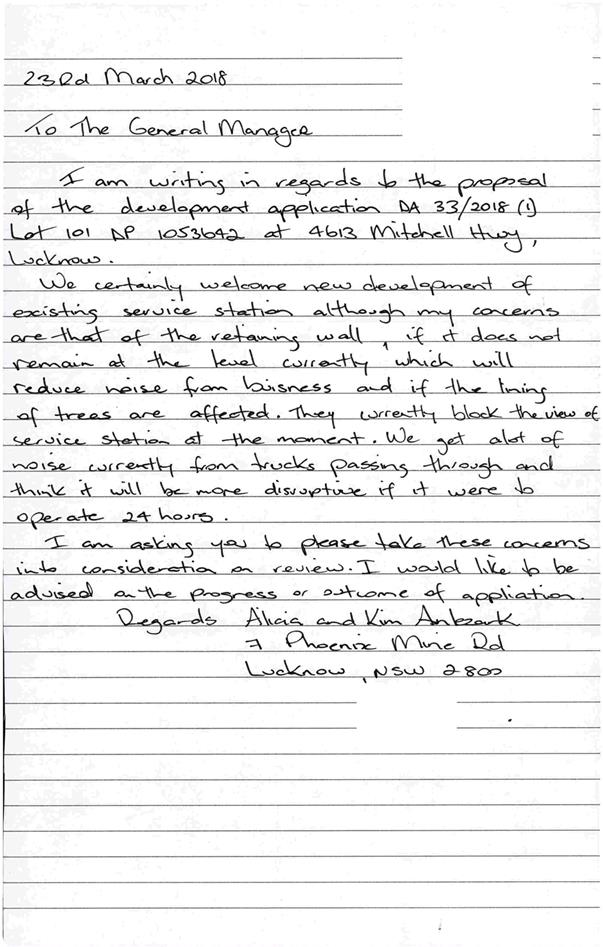
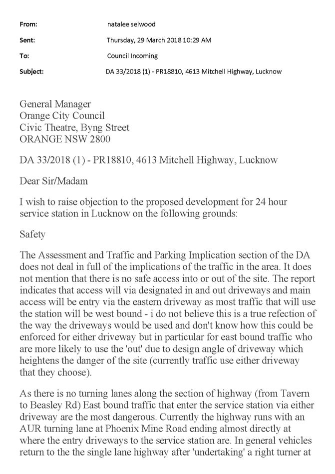
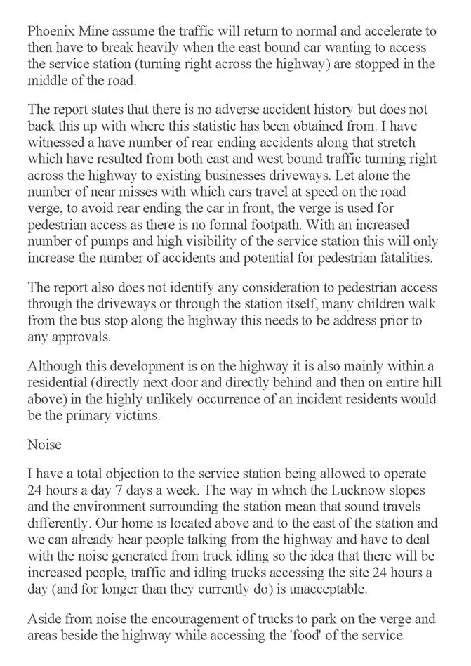
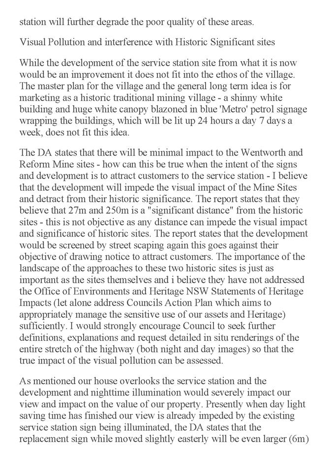


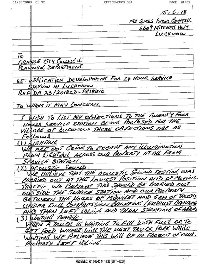
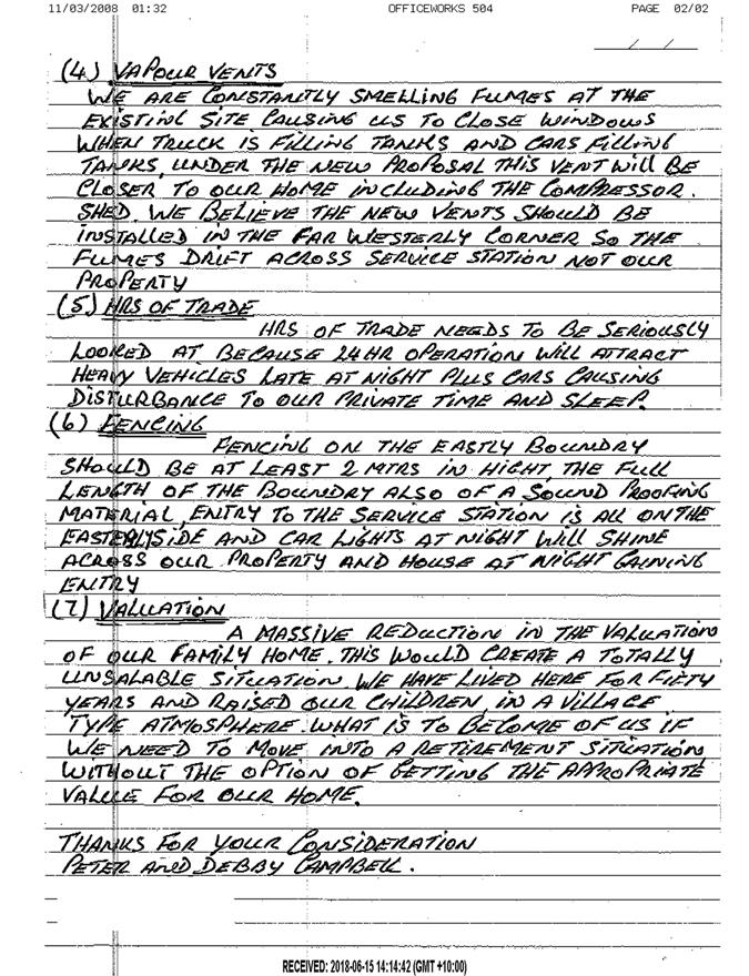
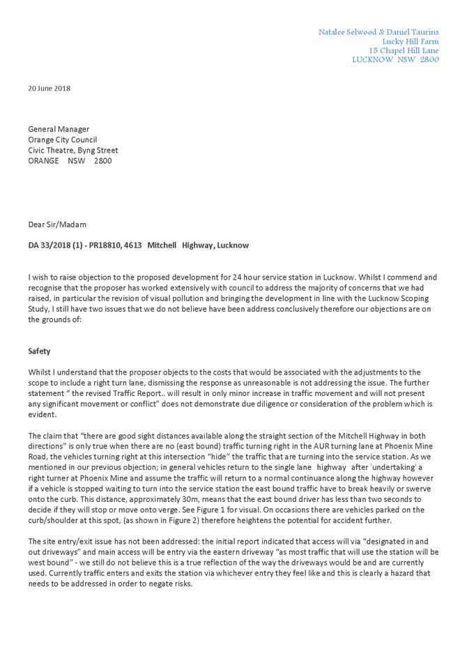
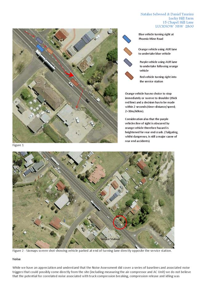
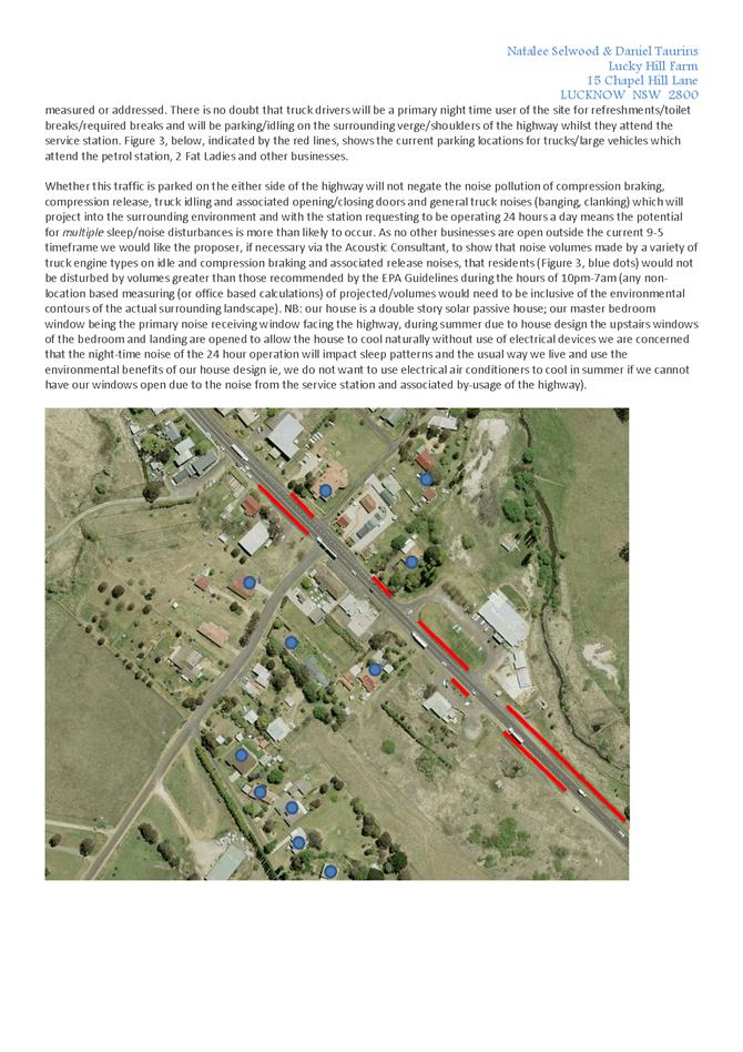
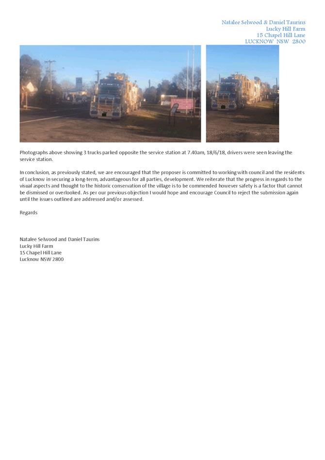
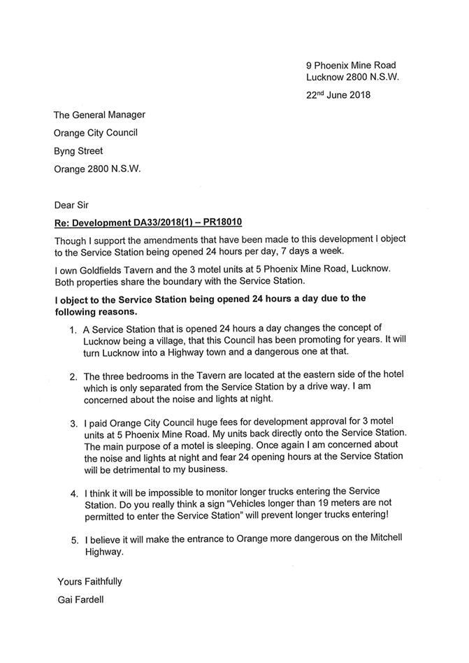
2.4 Development
Application DA 335/2018(1) - 185-193 Bathurst Road
RECORD
NUMBER: 2018/2674
AUTHOR: Ella
Wilkinson, Senior Planner
EXECUTIVE Summary
|
Application
lodged
|
18
September 2018
|
|
Applicant/s
|
Mrs MJ
Boardman
|
|
Owner/s
|
Mr AR
and Mrs LJ Leahey
|
|
Land
description
|
Lot 102
DP 842161 – 185-193 Bathurst Road, Orange
|
|
Proposed
land use
|
Demolition
(existing building and ancillary structures)
|
|
Value of
proposed development
|
$75,000
|
Council's consent is sought for the demolition of the
existing building and ancillary structures on Lot 102 DP 842161 – 185-193
Bathurst Road, Orange. The site was formally occupied by Prime and Southern
Cross Austereo.

Figure 1 - locality plan
RECENT LEGISLATIVE CHANGES
On 1 March 2018 the Environmental Planning and Assessment
Act 1979 was substantially amended. The most immediate change involves the
restructuring and renumbering of the Act, with other more substantive
changes to be phased in over time. However, for some applications (particularly
where an application was lodged prior to the changes coming into effect) the
supporting documentation may still reference the previous numbering regime. In
the drafting of this report the content and substance of the supporting
material has been considered irrespective of which legislative references were
used.
DECISION FRAMEWORK
Development in Orange is governed by two key documents
Orange Local Environment Plan 2011 and Orange Development Control Plan 2004. In
addition the Infill Guidelines are used to guide development, particularly in
the heritage conservation areas and around heritage items.
Orange Local Environment Plan 2011 – The
provisions of the LEP must be considered by the Council in determining the
application. LEPs govern the types of development that are permissible or
prohibited in different parts of the City and also provide some assessment
criteria in specific circumstances. Uses are either permissible or not. The
objectives of each zoning and indeed the aims of the LEP itself are also to be
considered and can be used to guide decision making around appropriateness of
development.
Orange Development Control Plan 2004 – the DCP
provides guidelines for development. In general it is a performance based
document rather than prescriptive in nature. For each planning element there
are often guidelines used. These guidelines indicate ways of achieving the
planning outcomes. It is thus recognised that there may also be other solutions
of merit. All design solutions are considered on merit by planning and building
staff. Applications should clearly demonstrate how the planning outcomes are
being met where alternative design solutions are proposed. The DCP enables
developers and architects to use design to achieve the planning outcomes in
alternative ways.
DIRECTOR’S COMMENT
This development application is for the demolition of the
old Prime 7 building. Several trees will be kept and conditions of consent have
been added to ensure that the site is kept well presented until such time as a
future use is determined.
Link To Delivery/OPerational Plan
The recommendation in this report relates to the
Delivery/Operational Plan strategy “10.1 Preserve -
Engage with the community to ensure plans for growth and development are
respectful of our heritage”.
Financial Implications
Nil
Policy and Governance Implications
Nil
|
Recommendation
That Council resolves to
issue consent to development application DA 335/2018(1) for Demolition (existing building and ancillary
structures) at Lot 102 DP 842161 - 185-193 Bathurst Road, Orange pursuant to the conditions of consent in the attached
Notice of Approval.
|
further considerations
Consideration has been given to the
recommendation’s impact on Council’s service delivery; image and
reputation; political; environmental; health and safety; employees;
stakeholders and project management; and no further implications or risks have
been identified.
SUPPORTING INFORMATION
THE APPLICATION
Council's consent is sought requesting consent for the
demolition of the existing building and ancillary structures on Lot 102
DP842161 – 185-193 Bathurst Road, Orange. The site was formally occupied
by Prime and Southern Cross Austereo.
THE PROPOSAL
The proposal outlines that the demolition is required as the
building has been vandalised with internal damage sustained, including the
stripping of copper wires. The power has been disconnected to reduce any hazard
associated with the associated vandalism.
The application outlines that the demolition of the building
is a first stage in the redevelopment of the site. The subject site and
neighbouring site (Lot 103 DP 842161 (229‑249 Lone Pine Avenue)
are jointly owned. The intention is to redevelop and subdivide both lots for
redevelopment.
The subject site is not located within a Heritage
Conservation Area, but is located to the northwest of Heritage Item I352
– The Lone Pine Memorial, a prominent memorial established at the
location by the Orange sub-branch of the RSL in 1934.
The proposal was initially lodged requesting the removal a
number of trees, including various species such as eucalypts and elm trees.
However, the request to remove this vegetation has been removed as part of this
application and will be assessed as part of a future application, when a future
use and development are the site is known.
Some vegetation will be removed as part of the proposal,
however this is limited to smaller trees and shrubs that are not covered by the
provisions outlined on page 0.4 of Orange Development Control Plan 2004 (the
DCP). This is discussed in greater detail in the following report.
Figures 2-19 included below show the perimeter of the
building and ancillary structures that are proposed to be demolished; and trees
(that have grown up around the building and rely on the building for structural
integrity, but do not require consent for removal) that are proposed to be
removed.
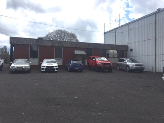
Figure 2 – northern elevation of existing
building
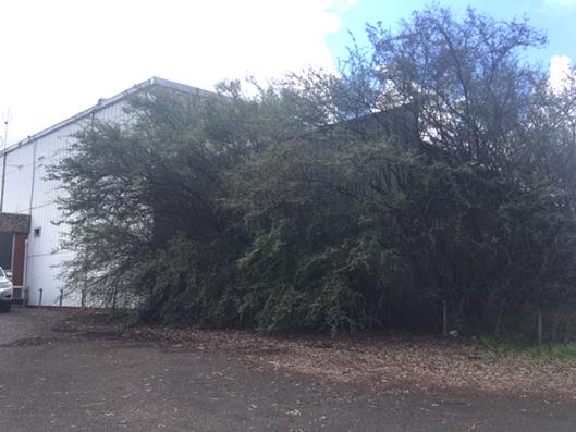
Figure 3 - northern elevation of existing building
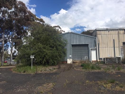
Figure 4 - western elevation of existing building
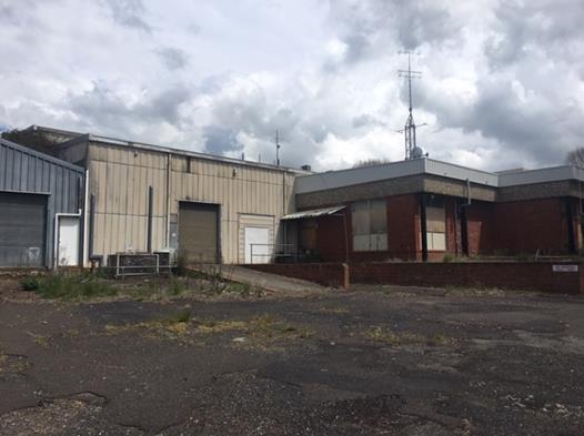
Figure 5 - western elevation of existing building
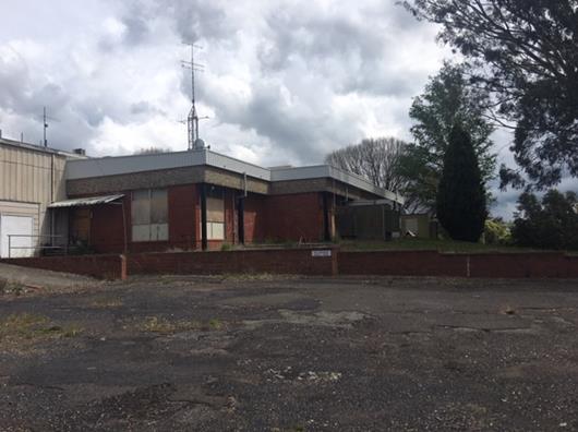
Figure 6 - western elevation of existing building
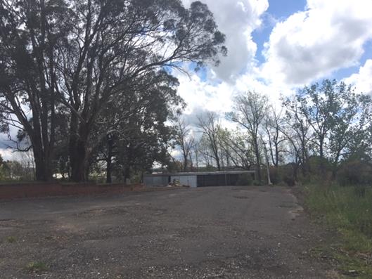
Figure 7 - ancillary shed structure
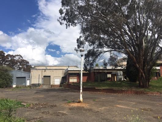
Figure 8 - western elevation of existing building
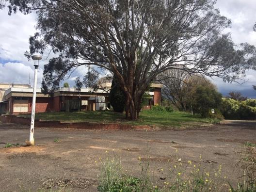
Figure 9 - western elevation of existing building
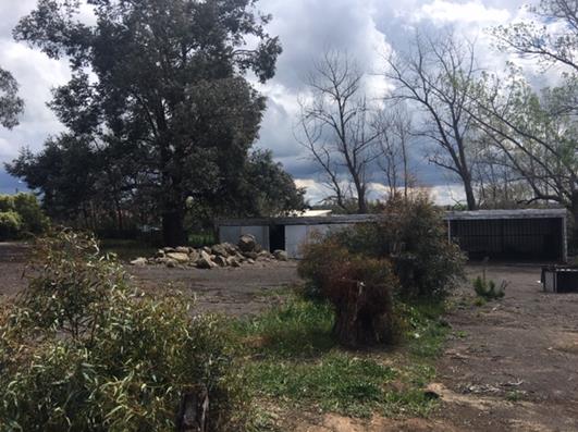
Figure 10 - ancillary shed structure
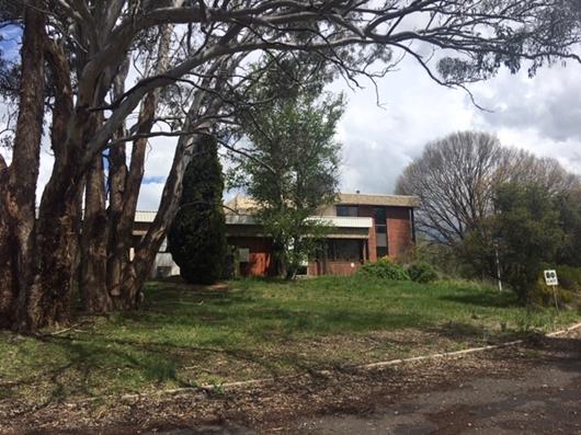
Figure 11 - western elevation of existing building
Figure 12 - ancillary shed structure
Figure 13 - western elevation of existing building
Figure 14 – south-western corner of existing
building
Figure 15 - southern elevation of the building
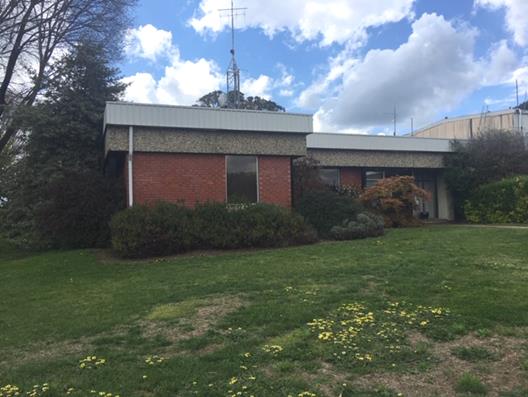
Figure 16 - eastern elevation of the building
Figure 17 - eastern elevation of the building
Figure 18 - eastern elevation of the building
Figure 19 - eastern elevation of the building
MATTERS FOR
CONSIDERATION
Section 1.7 - Application of
Part 7 of the Biodiversity Conservation Act 2016 and Part 7A of the
Fisheries Management Act 1994
Development Applications lodged on or after 25 February
2018
Section 1.7 of the EP&A Act 1979 identifies that Part 7
of the Biodiversity Conservation Act 2016 and Part 7A of the Fisheries
Management Act 1994 have effect in connection with terrestrial and aquatic
environments.
Having regard to the relevant provisions and based on an
inspection of the subject property, it is considered that the proposed
development is not likely to significantly affect a threatened species.
In this instance, site inspection reveals that the subject
property is characterised by a number of mature plantings. The initial request
included the removal of these trees. However, this request has been removed
from the application, and tree removal will need to be assessed as part of a
future development application on the site following further certainty in
regard to the future use and development on the site. As such a Biodiversity
Development Assessment Report is not required in this instance. Further
assessment against the provisions of Part 7 of the Biodiversity Conservation
Act 2016 will be required for any future development application on the
site.
Section 4.15
Section 4.15 of the Environmental Planning and Assessment
Act 1979 requires Council to consider various matters, of which those
pertaining to the application are listed below.
PROVISIONS OF ANY ENVIRONMENTAL
PLANNING INSTRUMENT s4.15(1)(a)(i)
Orange Local Environmental Plan 2011
Part 1 - Preliminary
Clause 1.2 - Aims of Plan
The
broad aims of the LEP are set out under subclause 2. Those relevant to the application
are as follows:
(a) to encourage development which complements
and enhances the unique character of Orange as a major regional centre boasting
a diverse economy and offering an attractive regional lifestyle,
(b) to provide for a range of development
opportunities that contribute to the social, economic and environmental
resources of Orange in a way that allows present and future generations to meet
their needs by implementing the principles for ecologically sustainable
development,
(c) to conserve and enhance the water
resources on which Orange depends, particularly water supply catchments,
(f) to recognise and manage valued
environmental heritage, landscape and scenic features of Orange.
The application is considered to be broadly consistent with
the aims outlined above.
Clause 1.6 - Consent Authority
This clause establishes that, subject to the Act, Council is
the consent authority for applications made under the LEP.
Clause 1.7 - Mapping
The subject site is identified
on the LEP maps in the following manner:
|
Land Zoning Map:
|
Land zoned B5 Business Development
|
|
Lot Size Map:
|
No Minimum Lot Size
|
|
Heritage Map:
|
Not a heritage item or conservation
area
|
|
Height of Buildings Map:
|
No building height limit
|
|
Floor Space Ratio Map:
|
No floor space limit
|
|
Terrestrial Biodiversity Map:
|
No biodiversity sensitivity on the
site
|
|
Groundwater Vulnerability Map:
|
Groundwater vulnerable
|
|
Drinking Water Catchment Map:
|
Not within the drinking water
catchment
|
|
Watercourse Map:
|
Not within or affecting a defined
watercourse
|
|
Urban Release Area Map:
|
Not within an urban release area
|
|
Obstacle Limitation Surface Map:
|
No restriction on building siting
or construction
|
|
Additional Permitted Uses Map:
|
No additional permitted use applies
|
|
Flood Planning Map:
|
Not within a flood planning area
|
Those matters that are of relevance are addressed in detail
in the body of this report.
Clause 1.9A - Suspension of
Covenants, Agreements and Instruments
This clause provides that covenants, agreements and other
instruments which seek to restrict the carrying out of development do not apply
with the following exceptions.
· covenants imposed
or required by Council
· prescribed
instruments under Section 183A of the Crown Lands Act 1989
· any conservation
agreement under the National Parks and Wildlife Act 1974
· any trust
agreement under the Nature Conservation Trust Act 2001
· any property
vegetation plan under the Native Vegetation Act 2003
· any biobanking
agreement under Part 7A of the Threatened Species Conservation Act 1995
· any planning
agreement under Division 6 of Part 4 of the Environmental Planning and
Assessment Act 1979.
Council staff are not aware of the title of the subject
property being affected by any of the above.
Part 2 - Permitted or Prohibited
Development
Clause 2.1 - Land Use Zones and Clause
2.3 - Zone Objectives and Land Use Table
The subject site is located within the B5 Business
Development zone. The proposed development is
defined as “demolition” under OLEP 2011 and is permitted
with consent. This application is seeking consent.
Clause 2.3 of LEP 2011 references the Land Use
Table and Objectives for each zone in LEP 2011. The objective for land
zoned B5 Business Development is as follows:
1 – Objectives of the
B5 Business Development zone
· To enable a mix of business and warehouse uses, and
bulky goods premises that require a large floor area, in locations that are
close to, and that support the viability of, centres.
The proposed demolition of the
building will facilitate a number of redevelopment options into the future. The
site is located in a high profile location at the entrance to the City. The
existing building is dilapidated and is unlikely to be reused in its current
state. To this end the demolition of the building is considered to be
consistent with the overall objectives of the zone.
Uses permitted with consent in the B5 Business Development
zone include: centre-based child care facilities; funeral homes;
garden centres; hardware and building supplies; home industries; hotel or motel
accommodation; kiosks; landscaping material supplies; neighbourhood shops; passenger
transport facilities; respite day care centres; roads; rural supplies;
self-storage units; shop top housing; signage; specialised retail premises;
take away food and drink premises; timber yards; vehicle sales or hire
premises; warehouse or distribution centres; any other development not
specified in item 2 or 4.
Clause 2.6 - Subdivision -
Consent Requirements
The provisions of clause 2.6 are not applicable to this
application.
Clause 2.7 - Demolition
Requires Development Consent
This clause triggers the need for development consent in
relation to a building or work. This requirement does not apply to any
demolition that is defined as exempt development.
The proposal involves demolition and the applicant is
seeking the consent of Council. A referral was provided to Council’s
Environmental, Health and Building Surveyor. The referral outlined that the
demolition works proposed will have no significant impact on adjoining lands,
streetscape or public realm. Conditions have been imposed in respect of hours
of operation, dust suppression and the need to investigate for, and
appropriately manage the presence of, any materials containing asbestos.
The hours of operation are also considered to be appropriate
to manage noise impacts to residential properties located to the west, south
and east of the subject site.
Clause 2.8 - Temporary Use of
Land
The provisions of clause 2.8 are not applicable to this
application.
Part 3 - Exempt and
Complying Development
The application is not exempt or complying development.
Part 4 - Principal
Development Standards
Clause 4.1 - Minimum
Subdivision Lot Size
The provisions of clause 4.1 are not applicable to this
application.
Clause 4.1AA -
Minimum Subdivision Lot Size for Community Title Schemes
The provisions of clause 4.1AA are not applicable to this
application.
Clause 4.1B - Minimum
Lot Sizes for Dual Occupancy, Multi Dwelling Housing and Residential Flat
Buildings
The provisions of clause 4.1B are not applicable to this
application.
Clause 4.2 - Rural
Subdivision
The provisions of clause 4.2 are not applicable to this
application.
Clause 4.2A -
Erection of Dwelling Houses on Land in Certain Rural and Environmental
Protection Zones
The provisions of clause 4.2A are not applicable to this
application.
Clause 4.2B - Strata
Subdivisions in Certain Rural Zones
The provisions of clause 4.2B are not applicable to this
application.
Clause 4.3 - Height
of Buildings
The provisions of clause 4.3 are not applicable to this
application.
Clause 4.4 - Floor Space
Ratio
The provisions of clause 4.4 are not applicable to this
application.
Clause 4.6 -
Exceptions to Development Standards
The provisions of clause 4.6 are not applicable to this
application.
Part 5 -
Miscellaneous Provisions
Clause 5.1 - Relevant
Acquisition Authority
The provisions of clause 5.1 are not applicable to this
application.
Clause 5.4 - Controls
Relating to Miscellaneous Permissible Uses
The provisions of clause 5.4 are not applicable to this
application.
5.10 - Heritage
Conservation
The provisions of clause 5.10 are not applicable to the
proposal as the subject site is not located within the bounds of a Heritage
Conservation Area or listed as an item of Heritage Significance in Schedule 5
of Orange LEP 2011.
The proximity of Heritage Item I352
– The Lone Pine Memorial to the proposed demolition has been considered
under the Provisions of any Development Control Plan s4.15(1)(a)(iii)
section of this report.
Part 6 - Urban
Release Area
The provisions of Part 6 are not applicable to this application
as the subject site is not located within an identified Urban Release Area.
Part 7 - Additional
Local Provisions
7.1 - Earthworks
This clause establishes a range of
matters that must be considered prior to granting development consent for any application
involving earthworks, such as:
(a) the likely disruption of, or any
detrimental effect on, existing drainage patterns and soil stability in the
locality of the development
(b) the effect of the development on the
likely future use or redevelopment of the land
(c) the quality of the fill or the soil to be
excavated, or both
(d) the effect of the development on the
existing and likely amenity of adjoining properties
(e) the source of any fill material and the
destination of any excavated material
(f) the likelihood of disturbing relics
(g) the proximity to and potential for adverse
impacts on any waterway, drinking water catchment or environmentally sensitive
area
(h) any measures proposed to minimise or
mitigate the impacts referred to in paragraph (g).
In consideration of
the matters outlined above, the following comments are made in relation to the
proposal.
The existing drainage
patterns and soil stability are not envisaged to be detrimentally effected by
the proposal. Mature vegetation is proposed to be retained as part of the
proposal, which will mitigate any impacts on soil stability. Drainage will not
be largely impacted as the proposal involves only the demolition of the
existing building and ancillary structures at this stage. Therefore, the extent
of disruption to the drainage of the site is considered to be minor and will
not detrimentally affect adjoining properties or receiving waterways.
The extent of the
earthworks will not materially affect the potential future use or redevelopment
of the site that may occur at the end of the proposed development's lifespan.
Further, the proposed demolition of the building and ancillary structures will
likely result in a positive effect for the likely future use or redevelopment
of the land as the owner of the subject site also holds ownership over the
adjoining lot to the northeast. The intention of this proposal is to demolish
the existing building and ancillary structures on the subject site to
demonstrate the overall potential of both sites to potential buyers.
The site is not known
to be contaminated. A waste management plan has been included as supporting
documentation to the proposal. The waste management plan was reviewed by
Council’s Environmental Health and Building Surveyor who was satisfied
that waste will be disposed of in a satisfactory manner. Further, the building
proposed to be demolished is located over 50m from nearby buildings, resulting
in a minimal impact to neighbouring properties.
The site is not known
to contain any Aboriginal, European or archaeological relics. Previous known
uses of the site do not suggest that any relics are likely to be uncovered.
However, conditions have been imposed to ensure that should site works uncover
a potential relic or artefact, works will be halted to enable proper
investigation by relevant authorities and the proponent required to seek
relevant permits to either destroy or relocate the findings.
The site is not in
proximity to any waterway, drinking water catchment or sensitive area.
Conditions have been imposed requiring soil erosion control measures to be
implemented onsite.
7.2 - Flood Planning
The provisions of clause 7.2 are not applicable to this application.
7.3 - Stormwater
Management
The provisions of clause 7.3 are not applicable to this
application.
7.4 - Terrestrial
Biodiversity
The provisions of clause 7.4 are not applicable to this
application.
7.5 - Riparian Land
and Watercourses
The provisions of clause 7.5 are not applicable to this
application.
7.6 - Groundwater
Vulnerability
This clause seeks to protect
hydrological functions of groundwater systems and protect resources from both
depletion and contamination. Orange has a high water table and large areas of
the LGA, including the subject site, are identified with “Groundwater
Vulnerability” on the Groundwater Vulnerability Map. This requires that
Council consider:
(a) whether or not the development (including
any onsite storage or disposal of solid or liquid waste and chemicals) is
likely to cause any groundwater contamination or have any adverse effect on
groundwater dependent ecosystems, and
(b) the cumulative impact (including the
impact on nearby groundwater extraction for potable water supply or stock water
supply) of the development and any other existing development on groundwater.
Furthermore consent may not be granted unless Council is satisfied that:
(a) the development is designed, sited and
will be managed to avoid any significant adverse environmental impact, or
(b) if that impact cannot be reasonably
avoided - the development is designed, sited and will be managed to minimise
that impact,
(c) if that impact cannot be minimised - the
development will be managed to mitigate that impact.
The proposal is not
anticipated to involve the discharge of toxic or noxious substances and is
therefore unlikely to contaminate the groundwater or related ecosystems. The
proposal does not involve extraction of groundwater and will therefore not
contribute to groundwater depletion. The design and siting of the proposal
avoids impacts on groundwater and is therefore considered acceptable.
7.7 - Drinking Water
Catchments
The provisions of clause 7.7 are not applicable to this
application.
7.9 - Airspace Operations
The provisions of clause 7.9 are not applicable to this
application.
Clause 7.11 - Essential
Services
Clause 7.11 applies and states:
Development
consent must not be granted to development unless the consent authority is
satisfied that any of the following services that are essential for the
proposed development are available or that adequate arrangements have been made
to make them available when required:
(a) the supply of water,
(b) the supply of electricity,
(c) the disposal and management of sewage,
(d) storm water drainage or on-site
conservation,
(e) suitable road access.
In consideration of this clause, all utility services are
available to the land and adequate for the proposal.
Notwithstanding the above, the proposal outlines that the
electricity supply to the building has been disconnected due to safety
concerns. As the proposal involves the demolition of the existing building and
ancillary structures, it is not considered that the supply of electricity is
necessary to complete the proposed works. However, any future application for
redevelopment should consider the access to electricity and ensure that power
is reconnected.
STATE ENVIRONMENTAL PLANNING
POLICIES
State Environmental Planning Policy 55 - Remediation of
Land
State Environmental Planning Policy 55 - Remediation of
Land (SEPP 55) is applicable. Pursuant to Clause 7 Contamination
and remediation to be considered in determining development application:
(1) A consent authority must
not consent to the carrying out of any development on land unless:
(a) it
has considered whether the land is contaminated, and
(b) if the land is contaminated, it is
satisfied that the land is suitable in its contaminated state (or will be
suitable, after remediation) for the purpose for which the development is
proposed to be carried out, and
(c) if the land requires remediation to be made
suitable for the purpose for which the development is proposed to be carried
out, it is satisfied that the land will be remediated before the land is used
for that purpose.
Assessing the requirements outlined above, it
is considered that the subject site is highly unlikely to be contaminated.
According to a previous planning report prepared for a development application
finalised in 1996, the site has been used for approximately 35 years
for media services. The 1996 report outlines a request to rezone the land to
accommodate commercial uses. Neither uses are listed in Table 1
of Managing Land Contamination Planning Guidelines SEPP 55 –
Remediation of Land.
In January 2018, the Department of
Planning and Environment released an Explanation of Intended Effect and draft
Guidelines outlining the intent to review SEPP 55. The draft Guidelines
state that when undertaking an initial evaluation of contamination, a planning
authority should consider whether there is any known or potential contamination
on nearby or neighbouring properties, or in nearby groundwater, and whether
that contamination needs to be considered in the assessment and decision making
process.
There are two properties surrounding the site that are
identified as being potentially contaminated on Council’s contamination
register. As outlined in Figure 20, neither of the identified sites immediately
adjoins the subject site. Both potentially contaminated sites are located on
the opposite side of the road to the subject site. The site itself is not
identified as being potentially contaminated.
Therefore, it is considered that the potential for
contamination on the site is low. However, a condition of consent has been
included requiring works to cease immediately onsite if an unexpected find
occurs.
Figure 20 – location of subject site in relation
to surrounding potentially contaminated sites
State Environmental Planning
Policy (Infrastructure) 2007
SEPP (Infrastructure) 2007 is applicable to the application,
in particular clause 101, which outlines the requirements for a consent
authority granting consent to development on land that has frontage to a
classified road. The consent authority must not grant consent unless it is
satisfied that:
(a) where
practicable and safe, vehicular access to the land is provided by a road other
than the classified road, and
(b) the
safety, efficiency and ongoing operation of the classified road will not be adversely
affected by the development as a result of:
(i) the
design of the vehicular access to the land, or
(ii) the
emission of smoke or dust from the development, or
(iii) the
nature, volume or frequency of vehicles using the classified road to gain access
to the land, and
(c) the
development is of a type that is not sensitive to traffic noise or vehicle
emissions, or is appropriately located and designed, or includes measures, to
ameliorate potential traffic noise or vehicle emissions within the site of the
development arising from the adjacent classified road.
Bathurst road is zone SP2 Infrastructure and is a classified
road. The proposal is considered to be consistent with the provisions of the
SEPP (Infrastructure) 2007 as:
· The existing vehicular
access to the site is provided via:
- Lone
Pine Avenue through a two way driveway;
- two
single lane driveways onto the site from Bathurst Road.
· The existing vehicular
access arrangements are not proposed to change as part of this proposal.
Currently, the two single lane driveways from Bathurst Road are left hand turn
only. A right hand turn across Bathurst Road is not permissible to access
either driveway. Any future development application on the site that proposes
to utilise the existing access from Bathurst Road may be required to request
RMS concurrence.
· The emission of dust
from the proposed demolition will be required to be managed in accordance with Australian
Standard 2601:2001 – The Demolition of Structures and the
requirements of Safe Work NSW as required by conditions included in the
consent. Further, a condition of consent has been included requiring that all
three existing concrete footpath crossings shall be maintained, including a
minimum of 20m of bitumen driveway within the site associated with each
footpath crossing, to mitigate dust or debris being dragged onto the road from
the subject site.
· It is not considered
that the nature, volume or frequency of vehicles using the classified road to
gain access to the land as a result of the proposed demolition will be greater
than that previously generated by the approved uses. Any future use on site
will be reconsidered as part of a future development application.
· The proposed demolition
is of a type that is not sensitive to traffic noise or vehicle emissions at
this stage. The impacts of the classified road on any future use onsite will be
considered as part of a future development application.
State Environmental Planning
Policy (Vegetation in Non-Rural Areas) 2017
Whilst the proponent has withdrawn the request for consent
to remove various trees on site, State Environmental Planning Policy
(Vegetation in Non-Rural Areas) 2017 remains applicable to the subject
development as the proposal requests consent to demolish the existing building
and ancillary structures onsite. Some vegetation has grown up around the
existing building, and a site visit with Council’s Manager City
Presentation indicated that this vegetation may be structurally reliant on the
building. Further, due to the proximity of this vegetation it would be
difficult to demolish the building without causing an impact on some of this
vegetation.
Part 3 of the SEPP applies to vegetation in any non-rural
area of the State that is declared by a development control plan to be vegetation
that Council can issue a permit to a landholder to be cleared. Clause 26 of the
SEPP (Vegetation in Non-Rural Areas) 2017 outlines that a development
control plan (DCP) that is in force on the commencement of this Policy can
establish the process, such as requiring a permit or development consent, for
the clearing of vegetation.
Chapter 0 Transitional Provisions of Orange DCP 2004 (the
DCP) prescribes the kinds of trees and other vegetation that are subject to
Clause 10 of the SEPP (Vegetation in Non-Rural Areas) 2017. The vegetation
that would be impacted by the proposed demolition is not of a size or species
that would trigger the requirements outlined in these provisions.
However, given the large number of vegetation that exists
onsite, and despite the proponent withdrawing the request for consent to remove
some trees that are subject to the provisions of Chapter 0 of the DCP, a
condition has been included that outlines vegetation removal may only be
carried out in line with the provisions of Chapter 0 of the DCP. Any
proposed removal of vegetation that is covered by the provisions of Chapter 0
will need an additional development consent. No approval for the removal of
vegetation covered by the provisions of Chapter 0 has been given as part of
this proposal.
It is therefore considered that the requirements of the SEPP
(Vegetation in Non-Rural Areas) 2017 have been met and the proposal is
consistent with the provisions as outlined in the Policy and the DCP, provided
the demolition is carried out in line with the conditions of consent.
PROVISIONS OF ANY DRAFT
ENVIRONMENTAL PLANNING INSTRUMENT THAT HAS BEEN PLACED ON EXHIBITION 4.15(1)(a)(ii)
There are no draft environmental planning instruments that
apply to the subject land or proposed development.
DESIGNATED DEVELOPMENT
The proposed development is not designated development.
INTEGRATED DEVELOPMENT
The proposed development is not integrated development.
PROVISIONS OF ANY DEVELOPMENT
CONTROL PLAN s4.15(1)(a)(iii)
Development Control Plan 2004
Development Control Plan 2004 (“the DCP”)
applies to the subject land (Part 8). An assessment of the proposed
development against the relevant Planning Outcomes will be undertaken below.
Pursuant to Planning Outcome 0.2-1 Interim Planning Outcomes
- Conversion of Zones:
· Throughout this
Plan, any reference to a zone in Orange LEP 2000 is to be taken to be a
reference to the corresponding zone(s) in the zone conversion table.
The corresponding zone to zone 3(b) Business Services (Orange
LEP 2000) is zone B5 Business Development (Orange LEP 2011). As such, Orange
DCP 2004 – Chapter 8 is relevant to this proposal. The provisions of
Part 8 are considered below.
PO 8.2-1 Planning Outcomes -
Business Services Areas
· Applications
clearly demonstrate that the development will not detract from the role of the
CBD as a regional centre.
The proposal requests consent to demolish the existing
building and ancillary structures on the site. This proposal does not request
consent to construct a new building or development on the site at this stage.
As such, the proposal cannot be assessed against this provision as it is
unknown at this stage what use/s will be supported onsite and how this will
impact the role of the CBD as a regional centre.
A future development application for development on the site
will be required to address this provision.
· Provision of
adequate fire-safety measures and facilities for disabled persons (according to
the BCA) is addressed at the application stage (relevant for all development
but particularly important where converting residential buildings for business
use).
The proposal requests consent to demolish the existing
building and ancillary structures on the site. This proposal does not request
consent to construct a new building or development on the site at this stage.
As such, the proposal cannot be assessed against this provision as no physical
building is proposed that is required to take these requirements into account.
A future development application for development on the site
will be required to address this provision.
· Heritage
streetscapes are conserved and enhanced through adaptive reuse of heritage
buildings, restrained advertising and landscaped gardens.
The proposal is not located in a Heritage Conservation Area,
but is located to the northwest of Heritage Item I352 – The Lone Pine
Memorial, a prominent memorial established at the location by the Orange
sub-branch of the RSL in 1934. The Lone Pine Memorial is located on the eastern
corner of Lone Pine Avenue and Bathurst Road, the corner directly opposite the
subject site.
The proposal to demolish the existing structures onsite is
considered to have a neutral impact on the Heritage Item and its curtilage.
This is because the demolition of the existing building and ancillary
structures is proposed to occur approximately 70m from the heritage item. A
setback of approximately 40m is provided to the corner of Lone Pine Avenue and
Bathurst Road. There is no proposed change to this existing setback at this
stage.
Further, the retention of the vegetation at this stage, with
removal deferred until a time when it is known what will replace the existing
building, will retain the existing park-like setting within the location and
retain the existing character presenting to the heritage item.
The view to the Heritage Item from the front of the existing
building that is proposed to be demolished is included as Figure 21. The impact
of future development on the site will be required to be assessed for any
future development applications.

Figure 21 - view to the Lone Pine Memorial (shown
within the red square)
from the eastern elevation of subject site
(façade of the building)
· Areas on the
main roads into and out of Orange (such as Molong Road and Bathurst Road)
provide a high level of architectural design to enhance the visual character of
the City entrances.
As previously mentioned, the proposal is requesting consent
to demolish the existing building and ancillary structures on the subject site.
Further, the proposal is not requesting consent to demolish existing vegetation
requiring consent. Therefore at this stage, the proposal does not require
assessment against this provision as no development is proposed onsite.
A future development application for development on the site
will be required to address this provision.
· All sites
contain an element of landscaping. Landscaping provided is of a bulk, scale and
height relative to buildings nearest the front property boundary so as to
provide beautification and visual relief to the built form proposed or existing
on the site. The depth of the landscaped bed at the site frontage is sufficient
to accommodate a spread of plantings that meet the abovementioned outcomes but,
where practicable, a minimum depth of 3m is provided. Plantings are designed to
provide shade for parking areas, to break up large areas of bitumen, to enhance
building preservation and to screen against noise.
As previously mentioned, the proponent withdrew the request
for the removal of vegetation requiring consent as part of this proposal. This
proposal will only involve the demolition of the existing buildings and
ancillary structures. The only vegetation that will be impacted by the proposal
will be vegetation that is not covered by the provisions of Chapter 0 of
the DCP. It is considered that existing vegetation will remain largely the
same as what currently exists onsite, with only minor changes. However, the
demolition of the building and ancillary structures will leave part of the site
vacant for a period prior to the sale of the land. Given the prominence of the
site to the Mitchell Highway and location of the site at the Gateway of the
City of Orange, it is considered that post demolition, disturbed soil should be
hydromulched to promote a grass coverage within the area of the demolition
works. It is also considered that vegetation should be adequately maintained on
the site until such time as a new development application is lodged to develop
the land. This will have two benefits:
· hydroseeding (or
equivalent) vacant sections of the site post demolition will reduce erosion and
potential dust impacts to neighbouring properties; and
· maintaining the
existing vegetation until a use and development is proposed on the site will
retain the existing park-like setting on a strategic Gateway site.
PPROVISIONS PRESCRIBED BY THE
REGULATIONS s4.15(1)(a)(iv)
Demolition of a Building (clause 92)
The proposal involves the demolition of the existing
building and ancillary structures. A condition is attached requiring the
demolition to be carried out in accordance with Australian Standard AS2601 -
1991: The Demolition of Structures.
Fire Safety Considerations
(clause 93)
The proposal does not involve a change of building use for
an existing building.
Buildings to be Upgraded
(clause 94)
The proposal does not involve the rebuilding, alteration,
enlargement or extension of an existing building.
BASIX Commitments (clause 97A)
BASIX is not applicable to the proposed development.
THE LIKELY IMPACTS OF THE
DEVELOPMENT s4.15(1)(b)
Environmental Impacts
The proposed development is not envisaged to have any major
environmental impacts, particularly as the proponent has removed a previous
request to demolish existing mature vegetation. Conditions of consent have been
included to mitigate dust and noise from the proposed demolition and to manage
soil erosion.
The impact to the Heritage Item located to the southeast of
the subject site is considered to be neutral, as the existing park-like setting
within the location is proposed to be retained as part of this proposal. As
such, the existing surrounding character of the heritage item remains largely
unchanged.
Social Impacts
The proposal is considered to have a positive social impact
as the proposed demolition of the building will remove the possibility for
break-ins and theft at the abandoned building. The demolition of the building
will demonstrate the potential of the site to future occupants and provide
space for appropriate development of a Gateway site.
Economic Impacts
As previously mentioned, the site has remained unoccupied
for a number of years. During this time the building has become dilapidated and
has been subject to a number of break-ins and theft, including the stripping of
copper wire. The building is not a heritage item or located within a Heritage
Conservation Area. The site is, however, located on a very prominent site along
the main route into the City from the east. Therefore, it is considered that
the potential economic impacts on the site are positive as the demolition of
the existing building will demonstrate the potential of the subject site and
the adjoining site in a strategic Gateway location.
THE SUITABILITY OF THE SITE
s4.15(1)(c)
The site is suitable for the proposed development as it is a
dilapidated building which is currently unoccupied, and has been unoccupied
since the relocation of the previous use on the site. The subject site is not a
listed heritage item or situated within a Heritage Conservation Area. The site
is zoned B5 Business Development and the proposed demolition of the building
onsite would provide additional land to support further uses on a strategic
Gateway site.
ANY SUBMISSIONS MADE IN
ACCORDANCE WITH THE ACT s4.15(1)(d)
The proposed development is not defined as advertised
development under the provisions of the LEP, and as such no formal exhibition
of the application was required. No submissions have been received in relation
to this application.
PUBLIC INTEREST s4.15(1)(e)
The proposed development is considered to be of minor
interest to the wider public due to the relatively localised nature of
potential impacts. The proposal is not inconsistent with any relevant policy
statements, planning studies, guidelines etc that have not been considered in
this assessment.
SUMMARY
The proposed development is permissible with the consent of
Council. The proposed development complies with the relevant aims, objectives
and provisions of Orange LEP 2011 (as amended) and DCP
2004. A section 4.15 assessment of the development indicates that
the development is acceptable in this instance. Attached is a draft Notice of
Approval outlining a range of conditions considered appropriate to ensure that
the development proceeds in an acceptable manner.
COMMENTS
The requirements of the Environmental Health and Building
Surveyor and the Engineering Development Section are included in the attached
Notice of Approval.
Attachments
1 Notice
of Approval, D18/58067⇩
2 Plans,
D18/57536⇩
Planning
and Development Committee
7 November 2018
2.4 Development
Application DA 335/2018(1) - 185-193 Bathurst Road
Attachment 1 Notice of Approval
|
|
ORANGE
CITY COUNCIL
Development
Application No DA
335/2018(1)
NA18/ Container
PR15902
|
NOTICE OF DETERMINATION
OF A DEVELOPMENT
APPLICATION
issued under the Environmental
Planning and Assessment Act 1979
Section 4.18
|
Development
Application
|
|
|
Applicant Name:
|
Mrs M J
Boardman
|
|
Applicant Address:
|
38
Goldfinch Way
ORANGE
NSW 2800
|
|
Owner’s Name:
|
Mr AR and
Mrs LJ Leahey
|
|
Land to Be Developed:
|
Lot 102 DP
842161 - 185-193 Bathurst Road, Orange
|
|
Proposed Development:
|
Demolition
(existing building and ancillary structures)
|
|
|
|
|
Building
Code of Australia
building
classification:
|
Not
applicable
|
|
|
|
|
Determination
made under
Section 4.16
|
|
|
Made On:
|
7 November
2018
|
|
Determination:
|
CONSENT
GRANTED SUBJECT TO CONDITIONS DESCRIBED BELOW:
|
|
|
|
|
Consent to
Operate From:
|
8 November
2018
|
|
Consent to
Lapse On:
|
8 November
2023
|
Terms of Approval
The reasons for the imposition of conditions
are:
(1) To ensure a quality
urban design for the development which complements the surrounding environment.
(2) To maintain
neighbourhood amenity and character.
(3) To ensure compliance
with relevant statutory requirements.
(4) To provide adequate
public health and safety measures.
(5) To ensure the utility
services are available to the site and adequate for the development.
(6) To prevent the proposed
development having a detrimental effect on adjoining land uses.
(7) To minimise the impact
of development on the environment.
Conditions
(1) The
development must be carried out in accordance with:
(a) Plan/s
- two unnumbered plans (2 sheets)
(b) statements
of environmental effects or other similar associated documents that form part
of the approval
as amended
in accordance with any conditions of this consent.
(2) A sign is to be erected
in a prominent position on any site on which building work, subdivision work or
demolition work is being carried out:
(a) showing
the name, address and telephone number of the principal certifying authority
for the work, and
(b) showing
the name of the principal contractor (if any) for any building work and a
telephone number on which that person may be contacted outside working hours,
and
(c) stating
that unauthorised entry to the site is prohibited.
Any such sign is to be maintained while the
building work, subdivision work or demolition work is being carried out.
|
PRIOR TO WORKS
COMMENCING
|
(3) A
temporary onsite toilet is to be provided and must remain throughout the
project or until an alternative facility meeting Council’s requirements
is available onsite.
(4) Soil erosion control
measures shall be implemented on the site.
|
DURING
CONSTRUCTION/SITEWORKS
|
(5) In the event
of an unexpected find during works such as (but not limited to) the presence of
undocumented waste, odorous or stained soil, asbestos, structures such as
underground storage tanks, slabs, or any contaminated or suspect material, all
work on site must cease immediately. The beneficiary of the consent must
discuss with Council the appropriate process that should be followed therein.
Works on site must not resume unless the express permission of the Director
Development Services is obtained in writing.
(6) If any unexpected find
in relation to Aboriginal objects, relics, or other historical items or the
like are located during the removal and rehabilitation of the soil, including
stump grinding and removal of saw dust generated from the stump grinding process,
all works will be required to cease and the Office of Environment and Heritage
and representatives from the Orange Local Aboriginal Land Council shall be
notified. Where required, further archaeological investigation shall be
undertaken. Development works in the area of the find(s) may recommence if and
when outlined by the management strategy developed in consultation with and
approved by the OEH.
(7) Removal
of vegetation on site shall be limited to only that vegetation that is affected
by the demolition and is located in the immediate proximity to the building.
The removal of this vegetation may only be carried out in line with the
provisions of Chapter 0 of the Orange Development Control Plan and State
Environmental Planning Policy (Vegetation in Non-Rural Areas) 2017. Any
proposed removal of vegetation that is covered by the provisions of Chapter 0
and State Environmental Planning Policy (Vegetation in Non-Rural Areas) 2017
will require an additional development consent.
(8) All
construction/demolition work on the site is to be carried out between the hours
of 7.00 am and 6.00 pm Monday to Friday inclusive, 7.00 am to
5.00 pm Saturdays and 8.00 am to 5.00 pm Sundays and Public
Holidays. Written approval must be obtained from the General Manager of Orange
City Council to vary these hours.
(9) Building demolition is
to be carried out in accordance with Australian Standard 2601:2001 - The
Demolition of Structures and the requirements of Safe Work NSW.
(10) Asbestos
containing building materials must be removed in accordance with the provisions
of the Work Health and Safety Act 2011 and any
guidelines or Codes of Practice published by Safe Work NSW, and disposed of at
a licenced landfill in accordance with the requirements of the NSW EPA.
(11) Any adjustments to
existing utility services that are made necessary by this development
proceeding are to be at the full cost of the developer.
(12) The existing water and
sewerage services to the building are to be sealed off at their respective
Council mains.
(13) The three (3) existing
concrete footpath crossings shall be maintained including a minimum of 20m of
bitumen driveway within the site associated with each footpath crossing.
(14) All
of the foregoing conditions are to be at the full cost of the developer and to
the requirements and standards of the Orange City Council Development and
Subdivision Code, unless specifically stated otherwise. All work required by
the foregoing conditions is to be completed prior to the issuing of an
Occupation Certificate, unless stated otherwise.
|
MATTERS FOR THE
ONGOING PERFORMANCE AND OPERATION OF THE DEVELOPMENT
|
(15) Disturbed
soil is to be hydroseeded (or equivalent) following demolition of the building
and ancillary structures to promote grass coverage on the site. Hydroseeding
(orequivalent is to be undertaken with a cool climate turf mix and include:
(a) fertiliser;
(b) an
appropriate polymer binder (eg Terra Control); and
(c) appropriate
mulch (eg sugar cane straw) for seed protection.
The site is to be maintained to the
satisfaction of Council’s Manager City Presentation, including vegetation
maintenance and ongoing hydroseeding, as required, until such time as a
development application for the future development and use is received by
Orange City Council.
(1) The
condition requiring that hydroseeding (or equivalent) be undertaken on
disturbed soil post demolition, and the maintenance of vegetation and ongoing
hydroseeding (or equivalent), as required, has been requested to:
(a) reduce
erosion and potential dust impacts to neighbouring properties while the site
remains vacant;
(b) retain
the existing park-like setting presenting to the Mitchell Highway at a
strategic Gateway site until a future development and use is proposed on the
site.
Other Approvals
(1) Local
Government Act 1993 approvals granted under section 68.
Nil
(2) General
terms of other approvals integrated as part of this consent.
Nil
Right of Appeal
If you are dissatisfied with this
decision, Section 8.7 of the Environmental Planning and Assessment
Act 1979 gives you the right to appeal to the Land and Environment
Court. Pursuant to Section 8.10, an applicant may only appeal within 6 months
after the date the decision is notified.
|
Disability Discrimination Act
1992:
|
This application has been assessed in
accordance with the Environmental Planning and Assessment Act 1979. No
guarantee is given that the proposal complies with the Disability
Discrimination Act 1992.
The applicant/owner is responsible to
ensure compliance with this and other anti-discrimination legislation.
The Disability Discrimination Act
covers disabilities not catered for in the minimum standards called up in the
Building Code of Australia which references AS1428.1 - "Design for
Access and Mobility". AS1428 Parts 2, 3 and 4 provides the most
comprehensive technical guidance under the Disability Discrimination Act
currently available in Australia.
|
|
|
|
|
Disclaimer - S88B of the Conveyancing
Act 1919 - Restrictions on the Use of Land:
|
The applicant should note that there
could be covenants in favour of persons other than Council restricting what
may be built or done upon the subject land. The applicant is advised to check
the position before commencing any work.
|
|
|
|
|
Signed:
|
On behalf of the consent authority ORANGE
CITY COUNCIL
|
|
Signature:
|
|
|
Name:
|
PAUL JOHNSTON - MANAGER DEVELOPMENT ASSESSMENTS
|
|
Date:
|
8 November 2018
|
Planning and Development Committee
7 November 2018
2.4 Development
Application DA 335/2018(1) - 185-193 Bathurst Road
Attachment 2 Plans