Planning and Development
Committee
Agenda
4 September 2018
Notice is hereby given, in
accordance with the provisions of the Local Government Act 1993 that a Planning and Development Committee meeting of ORANGE CITY COUNCIL
will be held in the Council Chamber,
Civic Centre, Byng Street, Orange on Tuesday, 4 September
2018.
Garry
Styles
General Manager
For apologies please
contact Administration on 6393 8218.
1 Introduction
1.1 Declaration
of pecuniary interests, significant non-pecuniary interests and less than
significant non-pecuniary interests
The
provisions of Chapter 14 of the Local Government Act, 1993 (the Act)
regulate the way in which Councillors and designated staff of Council conduct
themselves to ensure that there is no conflict between their private interests
and their public role.
The
Act prescribes that where a member of Council (or a Committee of Council) has a
direct or indirect financial (pecuniary) interest in a matter to be considered
at a meeting of the Council (or Committee), that interest must be disclosed as
soon as practicable after the start of the meeting and the reasons given for
declaring such interest.
As
members are aware, the provisions of the Local Government Act restrict any
member who has declared a pecuniary interest in any matter from participating
in the discussion or voting on that matter, and requires that member to vacate
the Chamber.
Council’s Code of Conduct provides that if members
have a non-pecuniary conflict of interest, the nature of the conflict must be
disclosed. The Code of Conduct also provides for a number of ways in which a
member may manage non pecuniary conflicts of interest.
|
Recommendation
It is recommended that Committee Members now disclose any
conflicts of interest in matters under consideration by the Planning and
Development Committee at this meeting.
|
2 General
Reports
2.1 Items
Approved Under the Delegated Authority of Council
RECORD
NUMBER: 2018/2062
AUTHOR: Paul
Johnston, Manager Development Assessments
EXECUTIVE Summary
Following is a list of development applications approved
under the delegated authority of Council.
Link To Delivery/OPerational Plan
The recommendation in this report relates to the
Delivery/Operational Plan strategy “7.1 Preserve - Engage with the
community to develop plans for growth and development that value the local
environment”.
Financial Implications
Nil
Policy and Governance Implications
Nil
|
Recommendation
That the information provided in the report by the
Manager Development Assessments on Items Approved Under the Delegated
Authority of Council be acknowledged.
|
further considerations
Consideration has been given to the recommendation’s
impact on Council’s service delivery; image and reputation; political;
environmental; health and safety; employees; stakeholders and project
management; and no further implications or risks have been identified.
SUPPORTING INFORMATION
|
Reference:
|
DA 18/2015(2)
|
Determination Date
|
25 July 2018
|
|
PR Number
|
PR11551
|
|
Applicant/s:
|
Mr N Baig
|
|
Owner/s:
|
Ali Husain Pty Limited
|
|
Location:
|
Lot 12 DP 582844 – 302-304
Summer Street, Orange
|
|
Proposal:
|
Modification of development consent
– food and drink premises (fitout and internal stairs). The modification
alters Condition (19) of the current consent to allow trading to 3am on
Friday mornings through to Sunday mornings inclusive. Council has previously
modified the consent to allow trading to 3am on a temporary basis and that
temporary period has now lapsed.
|
|
Value:
|
$50,000 (being the same value as
the original development)
|
|
Reference:
|
DA 196/2018(1)
|
Determination Date
|
14 August 2018
|
|
PR Number
|
PR28002
|
|
Applicant/s:
|
Contemporary Homes Pty Ltd
|
|
Owner/s:
|
Divlist Pty Limited and Mikell Investments
Pty Ltd
|
|
Location:
|
Lot 106 DP 1240393 – 16
Jasper Street, Orange
|
|
Proposal:
|
Dual occupancy and subdivision (two
lot residential)
|
|
Value:
|
$440,000
|
|
Reference:
|
DA 201/2018(1)
|
Determination Date
|
13 August 2018
|
|
PR Number
|
PR21524
|
|
Applicant/s:
|
Catholic Healthcare Limited
|
|
Owner/s:
|
Catholic Healthcare Limited
|
|
Location:
|
Lot 11 DP 1101831 – 85-89
Clinton Street, Orange
|
|
Proposal:
|
Community facility (change of use)
|
|
Value:
|
$13,000
|
|
Reference:
|
DA 215/2018(1)
|
Determination Date
|
3 August 2018
|
|
PR Number
|
PR18416
|
|
Applicant/s:
|
Newlyn Canobolas Pty Ltd
|
|
Owner/s:
|
Newlyn Canobolas Pty Ltd
|
|
Location:
|
Lot 101 DP 1037341 – 60 Lords
Place, Orange
|
|
Proposal:
|
General industry (additions to
existing industrial building)
|
|
Value:
|
$20,000
|
TOTAL NET* VALUE OF ALL
DEVELOPMENTS APPROVED IN THIS PERIOD: $473,000
*
Net value relates to the value of modifications. If modifications are
the same value as the original DA, then nil is added. If there is a plus/minus
difference, this difference is added or taken out.
2.2 Additions
to Orange Local Environment Plan 2011 - Orange as a Food and Wine Town
RECORD
NUMBER: 2018/1927
AUTHOR: David
Waddell, Director Development Services
EXECUTIVE Summary
On 27 July 2018 the Department of
Planning and Environment made the following amendments to the Standard
Instrument LEP:
· a new definition
of ‘artisan food and drink industry’ (exhibited as ‘artisan
premises’) has been introduced to provide clarity for the growing artisan
and craft food and drink industry;
· an amended definition of ‘garden
centre’ to clarify the mix of uses that better reflect the contemporary
garden centre format.
This report focuses on the ‘artisan
food and drink industry’.
Boutique, craft or artisan food and drink products are
increasingly popular among consumers who want an alternative to
mass-manufactured offerings. Craft and locally produced goods support
industries such as tourism and hospitality, as well as providing local
employment (Department of Planning & Environment) The new land use term
will provide clarity for the growing artisan and craft food and drink industry such
as microbreweries or cheese makers by establishing a new definition that
reflects the nature of these uses. Feedback from Local Government and industry
has raised concern that the current land use definitions do not adequately encompass
the growing artisan manufacturing industry. This was creating an environment
where the inconsistent application of multiple landuses was occurring across
Local Governments.
Demand for the new land use definition is linked to the
emergence of changes in community expectations where customers are
knowledgeable and passionate about products and seek a unique experience linked
to the producer. In the same way that customers travel to wine regions to taste
wine, artisan producers require areas where they can make and sell their
products and offer customers an experience while tasting or testing the
product.
Orange City Council staff have had several approaches,
particularly around microbreweries wanting to enter the CBD or surrounds rather
than industrial zones, which have been lost.
‘Artisan food and drink industry’ will now be
permitted wherever ‘light industry’ is permitted. Within Orange
this currently includes the following zones:
· RU5 Village
(Lucknow/Spring Hill)
· B6 Enterprise
Corridor (Endsleigh Avenue/William Street)
· B7 Business Park
(Leeds Parade)
· IN1 General
Industry and
· IN2 Light
Industry.
Councils can also amend local planning controls to permit
‘artisan food and drink industry’ in additional zones if
considered appropriate.
It is the opinion of staff, informed by the criterion of
previous enquiries, that these uses are potentially suited to the following
zones, with appropriate planning controls:
· B3 Commercial Core
(CBD)
· B2 Local Centre
(North Orange) and
· B4 Mixed Use
(Peisley Street for example).
· B1 Neighbourhood
Centre
The changes to the Standard Instrument LEP will allow
artisan producers to also offer complementary services such as a restaurant,
tours, workshops or tastings. Retail floor area is limited by a new provision in
clause 5.4 of the Standard Instrument LEP.
Link To Delivery/OPerational Plan
The recommendation in this report relates to the
Delivery/Operational Plan strategy “7.1 Preserve -
Engage with the community to develop plans for growth and development that value
the local environment”.
Financial Implications
Nil
Policy and Governance Implications
The Development Services Division will prepare a planning
proposal and push through a rezoning to allow the uses proposed. This will in
turn amend Orange LEP 2011.
|
Recommendation
1 That
Council delegate to staff the preparation of a Planning Proposal to add
‘Artisan food and drink industry’ to more commercial zones in
Orange and for it to be put through the Gateway process and on to public
exhibition.
2 That
staff prepare appropriate environmental controls in relation to scale,
traffic, odours, noise and waste for inclusion in the Planning Proposal.
|
further considerations
Consideration has been given to the
recommendation’s impact on Council’s service delivery; image and
reputation; political; environmental; health and safety; employees;
stakeholders and project management; and no further implications or risks have
been identified.
SUPPORTING INFORMATION
According to the DPE Circular, the NSW retail sector is dynamic
and highly competitive. With constantly evolving consumer preferences and
technology continuing to transform traditional retail, the NSW planning system
must be able to adapt.
The NSW Department of Planning and Environment exhibited five
strategic amendments to retail land uses from 3 April 2018 to 18 May 2018. The
proposed definition amendments aimed to provide consistency, efficiency and
clarity to the NSW planning system for retail, and include:
· a new definition
for ‘artisan food and drink industry’
· a revised
definition for ‘garden centre’ (not addressed in this report).
A new definition of ‘artisan food and drink
industry’ has been introduced in the Standard Instrument (Local
Environmental Plans) Order 2006 (SI LEP Order) to provide clarity for the
growing artisan and craft food and drink industry.
The new land use term requires that, as well the manufacture
of boutique, artisan or craft food or drink, at least one of the following
services must be included:
· retail sales
· a café or
restaurant
· tours
· workshops and
tastings.
Purpose of the Amendment
Boutique, craft or artisan food and drink products are
increasingly popular among consumers who want an alternative to
mass-manufactured offerings. Craft and locally produced goods command a price
premium and support industries such as tourism and hospitality, and provide
local employment.
The new land use term will provide clarity for the growing
artisan and craft food and drink industry such as microbreweries or cheese
makers by establishing a new definition that reflects the nature of these uses.
Need for the Change
Feedback from Local Government and industry has raised
concern that the current land use definitions do not adequately encompass the
growing artisan manufacturing industry. This was creating an environment where
the inconsistent application of multiple landuses was occurring across Local
Governments.
Demand for the new land use definition is linked to the
emergence of changes in community expectations where customers are
knowledgeable and passionate about products and seek a unique experience linked
to the producer. In the same way that customers travel to wine regions to taste
wine, artisan producers require areas where they can make and sell their
products and offer customers an experience while tasting or testing the
product.
In recent years Council has fielded several enquiries from
prospective artisan style developments, attracted to the growing brand of
Orange as a food and wine destination. The viability of such ventures often
depends on being able to trade directly from the production site, with
distribution networks to off-site retailers providing only a supplementary or
supporting role.
The artisan business model can be thought of as a ‘low
volume/high margin - compete on quality’ approach. This differs from the
traditional production model of ‘high volume/low margin - compete on
price’ approach. In the latter, onsite sales are either absent entirely
or provide only an incidental level of trade, and the focus is on building the
distribution network to grow market share. The artisan business model, however,
is heavily focussed on the customer experience, and therefore often seeks
locations that have a high level of pedestrian attraction, such as the CBD.
New ‘Artisan Food and
Drink Industry’ Definition
The new definition of ‘artisan food and drink
industry’ is:
artisan food and drink
industry means a building or place the principal purpose of which is the making
or manufacture of boutique, artisan or craft food or drink products only. It
must also include at least one of the following:
(a) a
retail area for the sale of the products,
(b) a
restaurant or cafe,
(c) facilities
for holding tastings, tours or workshops.
Note.
See clause 5.4 for controls in
industrial or rural zones relating to the retail floor area of an artisan food
and drink industry.
Land Use Permissibility
‘Artisan food and drink industry’ is a subset of
the ‘light industry’ land use and is permissible wherever
‘light industry’ is permissible in Local Environmental Plans and
certain other Environmental Planning Instruments. Within Orange this includes
the following zones:
· RU5 Village
· B6 Enterprise
Corridor
· B7 Business Park
· IN1 General
Industry and
· IN2 Light
Industry.
For zones in which ‘light industry’ is not a
mandatory permissible use, local councils will continue to have the opportunity
to identify areas where ‘artisan food and drink industries’ are
appropriate, in consultation with their community.
Amendments were also made to the following State
Environmental Planning Policy:
· State
Environmental Planning Policy (Exempt and Complying Development Codes) 2008
(Codes SEPP) - artisan food and drink industries will be excluded from the term
‘light industry’ in the Codes SEPP, so that development for the
purpose of an artisan food and drink industry cannot be undertaken using the
exempt or complying development pathways;
Principal Purpose
The principal purpose of an ‘artisan food or drink
industry’ must be the carrying out of an industrial activity involving
the manufacture of boutique, craft or artisan food or drink.
Restriction on Gross Floor Area
for Retail Sales
The retail sales component of an ‘artisan food and
drink industry’ in industrial and rural zones is controlled through a new
provision in clause 5.4 of the SI LEP Order.
The new provision has a default retail floor space
restriction of 20% of the gross floor area or 400m², whichever is the
lesser. This appears to be an appropriate level for industrial zones as it
retains the focus on production. However, if the use is to be permitted in
the CBD a higher percentage limit of 40% that reflects the CBD focus on
retail and consumption is considered appropriate.
Environmental Controls
Councils can also amend local planning controls to permit
‘artisan food and drink industry’ in additional zones if
considered appropriate. It is the opinion of staff that these uses are suited
to at least the following zones, with appropriate planning controls:
· B3 Commercial Core
(CBD)
· B2 Local Centre
(North Orange) and
· B4 Mixed Use
(Peisley Street).
· B1 Neighbourhood
Centre
There are numerous examples in Sydney and other cities where
microbreweries and the like coexist in a CBD location. If Orange is to grow as
a food and drink destination then these uses need to be centrally located.
There are, however, interface issues that need to be controlled such as scale,
traffic, odours, noise and more. Staff will work on these controls in the
various zones as part of the preparation of the Planning Proposal.
2.3 Development
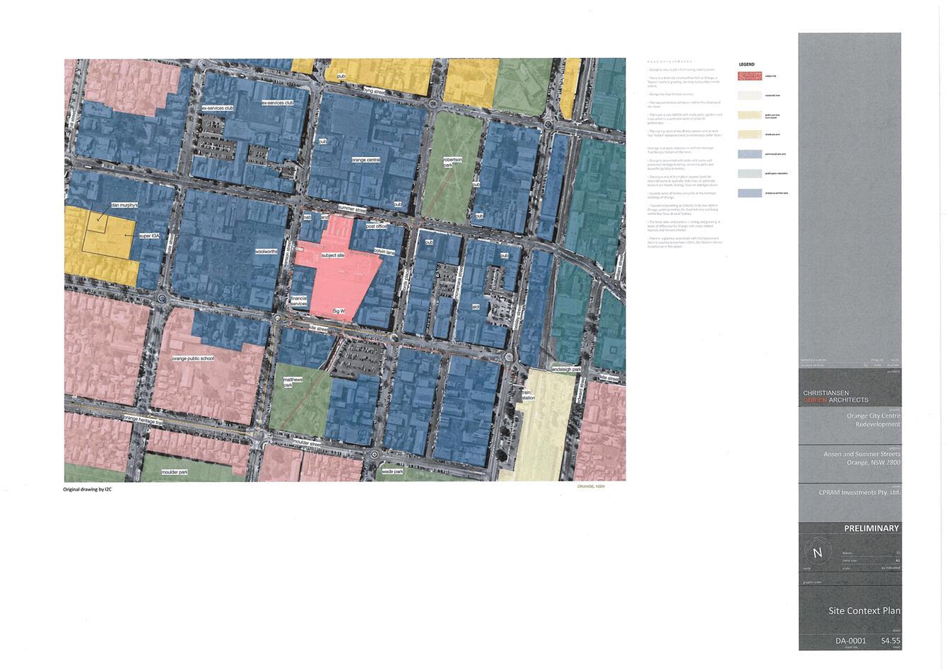
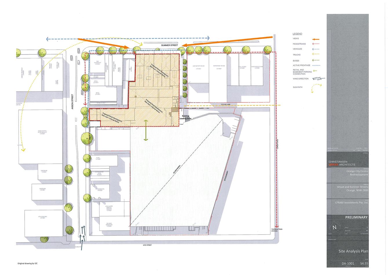
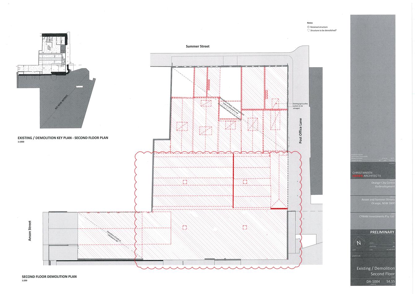
Application DA 242/2017(2) - 212-220 Summer Street and Post Office Lane
RECORD
NUMBER: 2018/2148
AUTHOR: Andrew
Crump, Senior Planner
EXECUTIVE Summary
|
Application
lodged
|
9 July
2018
|
|
Applicant/s
|
Alceon
Group Pty Limited
|
|
Owner/s
|
Alceon
Group Pty Limited
|
|
Land
description
|
Lot 564
DP 776383 - 212-220 Summer Street Orange and Post Office Lane
|
|
Proposed
land use
|
Demolition
(ground, first and second floors, and roof of existing retail tenancy), and
Commercial Premises (alterations and additions including elevated outdoor
dining area)
|
|
Value of
proposed development
|
$12,081,304
|
Application has been made to modify development consent DA
242/2017(1) relating to the former Myer building. The consent essentially
involves a reconfiguration of approved tenancies. Primarily the applicant is
seeking to delete the major tenancy and replace with additional smaller
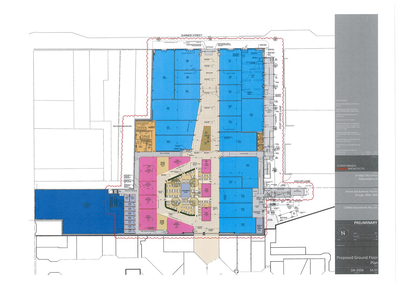
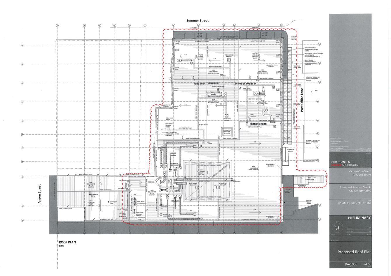
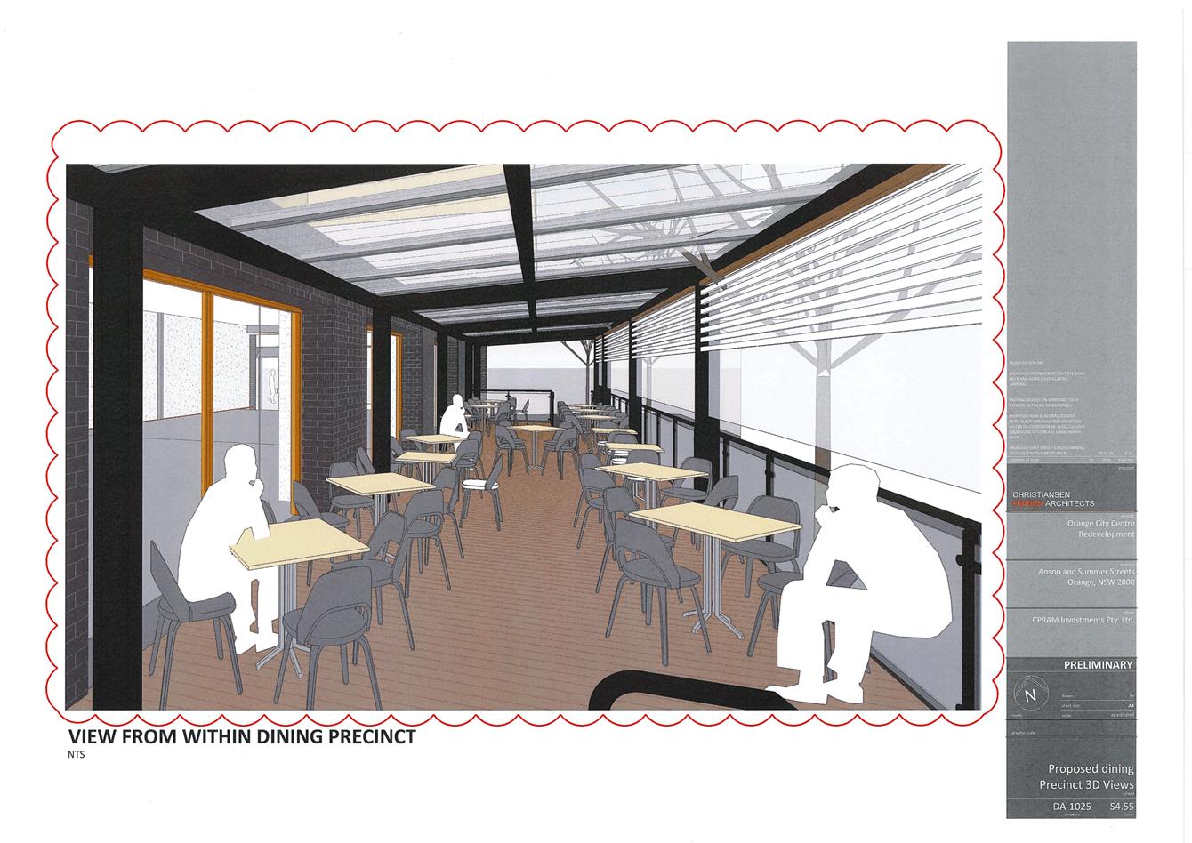
tenancies and a food court (refer to Figures 1 and 2 below). It is also
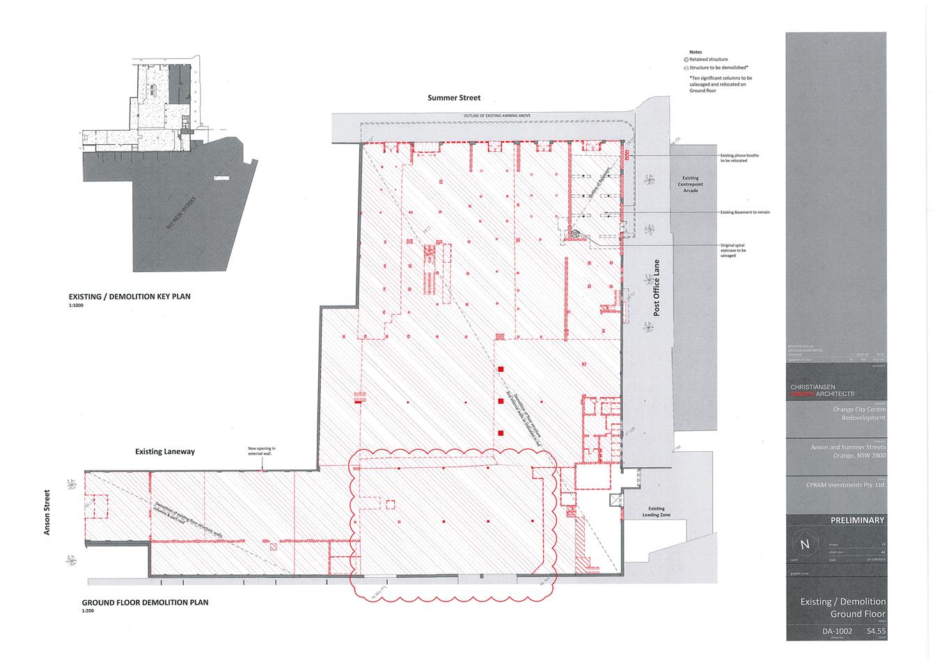
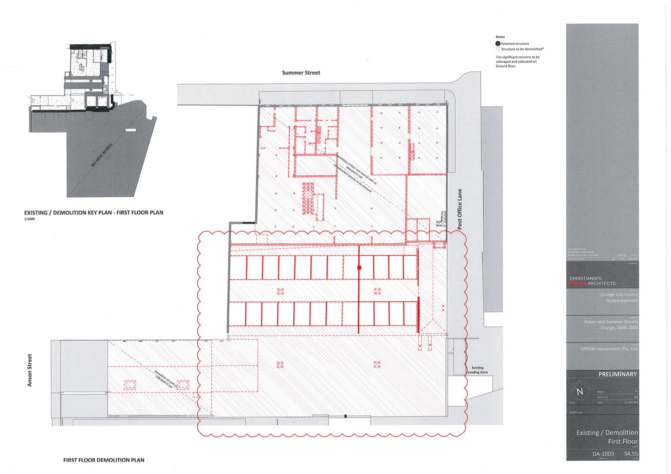
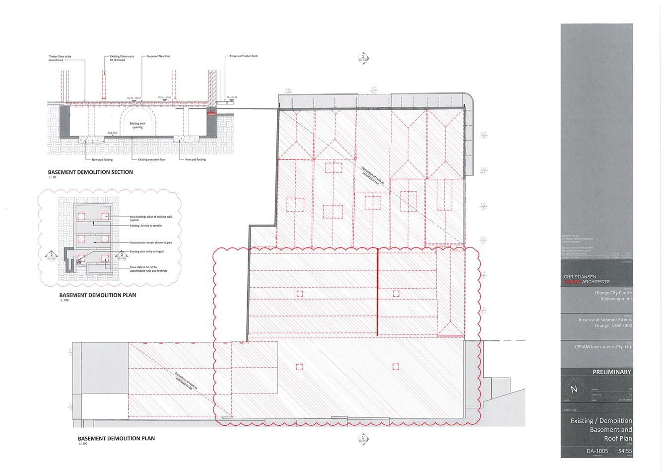
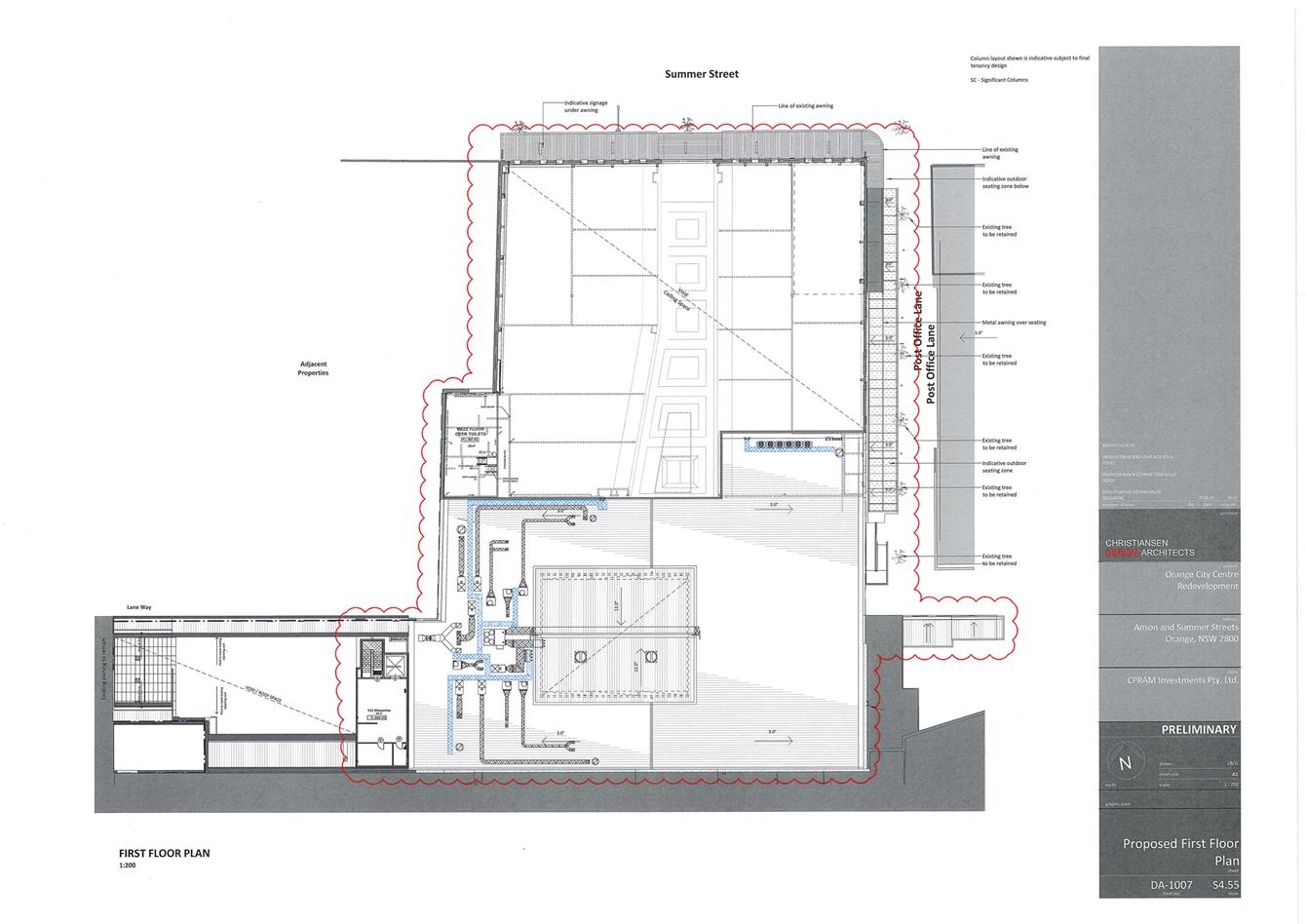
proposed to demolish the existing roof over the location of the food court and
replace with a butterfly shaped roof with skylights.
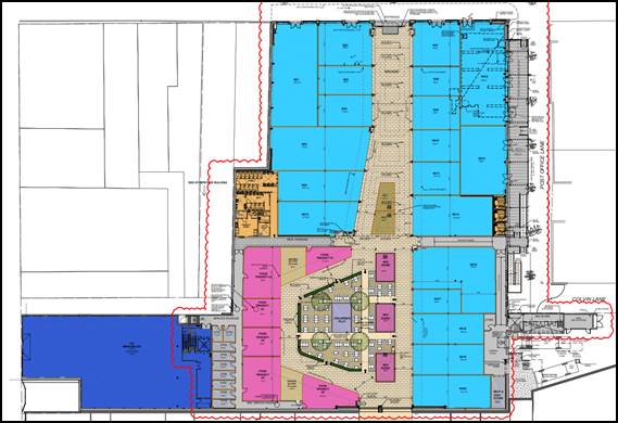
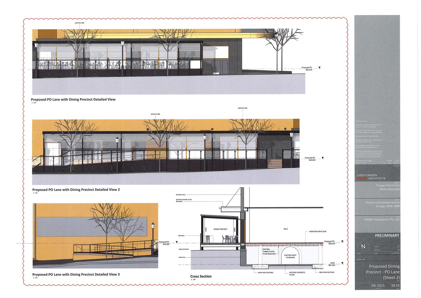
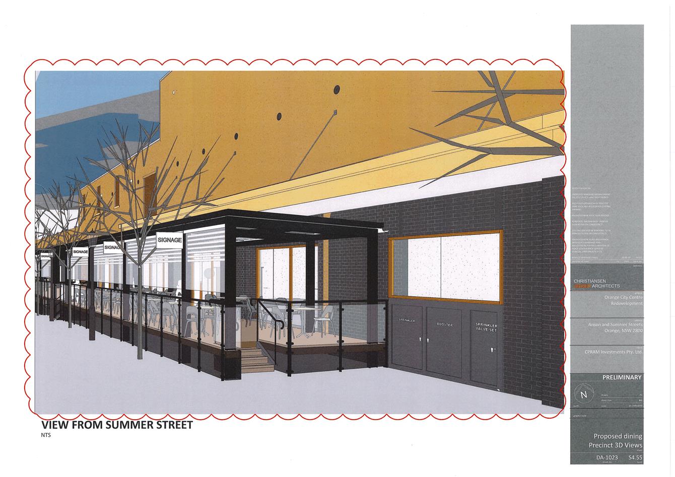
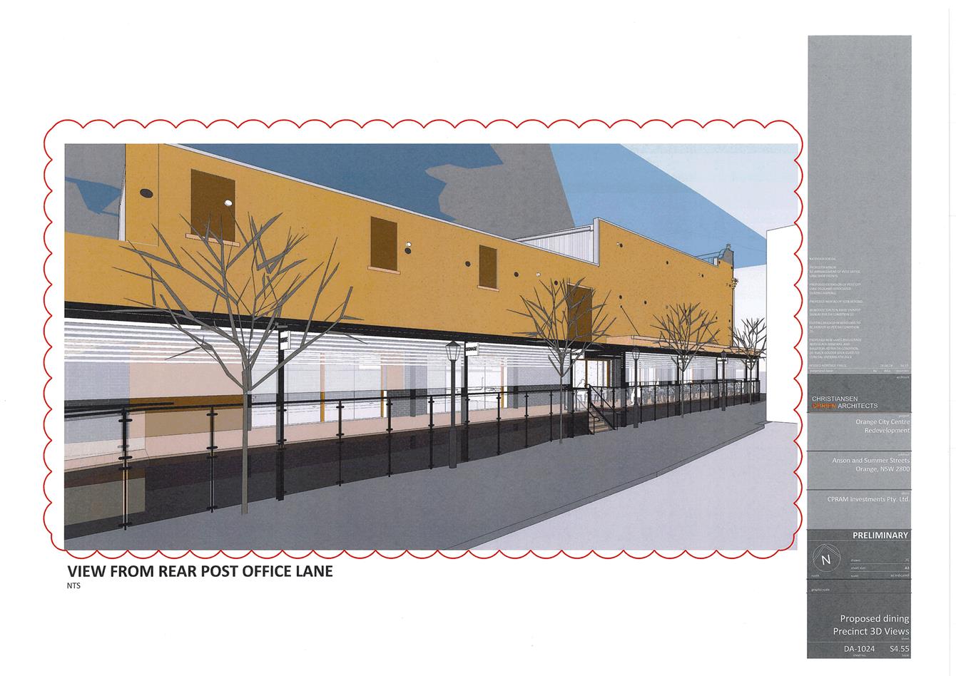
Figure 1: proposed tenancy layout
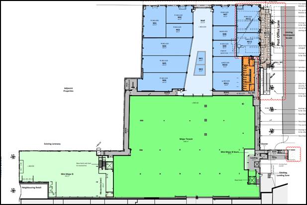
Figure 2: approved tenancy layout
Also observable in the above modified tenancy layout is the
change to the shopfronts to Post Office Lane and an increase in the size of the
outdoor dining/covered deck in the laneway, as well as a reconfiguration of the
approved northern (smaller) tenancies and the addition of the main switch room
in the loading dock.
As a consequence of the internal changes, the amenities and
back-of-house service corridors are proposed to be adjusted also.
The applicant is also seeking to have certain conditions
revised as part of this modification. Other matters detailed as conditions of
consent on the issued approval (such as the design of the internal mall space,
the design of the structure in the laneway and the reinstated façade
elements) are intended to be addressed separately as part of the issuance of a
Construction Certificate; and as such those conditions remain in place and only
those that have been explicitly sought to be modified are modified as detailed
below, or where the proposed layout necessitates an adjustment to a condition,
those changes are made also and commentary is provided within the report below.
A Section 4.15 assessment of the development indicates that
the development as modified is acceptable. Attached is an amended Notice of
Approval for Council’s consideration.
It is recommended that Council supports the subject
proposal.
RECENT LEGISLATIVE CHANGES
On 1 March 2018 the Environmental Planning and Assessment
Act 1979 was substantially amended. The most immediate change involves the
restructuring and renumbering of the Act, with other more substantive
changes to be phased in over time. However, for some applications (particularly
where an application was lodged prior to the changes coming into effect) the
supporting documentation may still reference the previous numbering regime. In
the drafting of this report the content and substance of the supporting
material has been considered irrespective of which legislative references were
used.
DECISION FRAMEWORK
Development in Orange is governed by two key documents
Orange Local Environment Plan 2011 and Orange Development Control Plan 2004. In
addition the Infill Guidelines are used to guide development, particularly in
the heritage conservation areas and around heritage items.
Orange Local Environment Plan 2011 – The
provisions of the LEP must be considered by the Council in determining the
application. LEPs govern the types of development that are permissible or
prohibited in different parts of the City and also provide some assessment
criteria in specific circumstances. Uses are either permissible or not. The
objectives of each zoning and indeed the aims of the LEP itself are also to be
considered and can be used to guide decision making around appropriateness of
development.
Orange Development Control Plan 2004 – the DCP
provides guidelines for development. In general it is a performance based
document rather than prescriptive in nature. For each planning element there
are often guidelines used. These guidelines indicate ways of achieving the
planning outcomes. It is thus recognised that there may also be other solutions
of merit. All design solutions are considered on merit by planning and building
staff. Applications should clearly demonstrate how the planning outcomes are
being met where alternative design solutions are proposed. The DCP enables
developers and architects to use design to achieve the planning outcomes in
alternative ways.
DIRECTOR’S COMMENTS
This modification to the consent involves conversion of
previously allocated major retail space to a food court and smaller retail
tenancies, as well as providing a thoroughfare through the centre. Changes are
also proposed to Post Office Lane and various conditions of consent. It is
supported on planning grounds by staff. It is not for Council to determine the
composition of retail tenancies within a zoned retail space.
Link To Delivery/OPerational Plan
The recommendation in this report relates to the
Delivery/Operational Plan strategy “10.1 Preserve -
Engage with the community to ensure plans for growth and development are
respectful of our heritage”.
Financial Implications
Nil
Policy and Governance Implications
Nil
|
Recommendation
That Council modifies development
consent DA 242/2017(1) for Demolition
(ground, first and second floors, and roof of existing retail tenancy), and
Commercial Premises (alterations and additions including elevated outdoor
dining area) at Lot 564 DP 776383 – 212‑220
Summer Street and Post Office Lane, Orange pursuant
to the conditions of consent in the attached modified Notice of Approval.
|
further considerations
Consideration has been given to the
recommendation’s impact on Council’s service delivery; image and
reputation; political; environmental; health and safety; employees;
stakeholders and project management; and no further implications or risks have
been identified.
SUPPORTING INFORMATION
THE APPLICATION/PROPOSAL
Application has been made to modify development consent
DA 242/2017(1). The application to modify the consent involves the
following:
· Deletion of the major
tenancy and replacement with additional smaller tenancies and a series of food
and drink premises in a food court type arrangement.
· Creation of a service
corridor and storage areas to the west of the food court.
· Reconfiguration of
tenancies at the front of the building (Summer Street side).
· Amendments to the Post
Office Lane interface, including additional shopfronts to the laneway and
additional seating, along with modification to the approved ramp and extension
to the cover awning/structure over the seating area.
· New non-habitable
mezzanine floor over the new toilets to allow for plant and services.
· Demolition of the
central portion of roof (roof over the area of the deleted major tenancy - now
the food court) and replacement with a new ‘butterfly’ and skylight
over the food court.
· Alteration of fire
egress pathway.
· Amendments to conditions
(1), (4), (24), (27) and (29).
· Relocation of the main
switch room to within the loading dock area.
Request to amend Conditions of
Consent
Condition (1)
Condition (1) relates to the stamped approved plans. The
applicant is seeking to have certain plan references deleted or amended.
Council’s standard practice is to list the previous plans followed by
listing the amending plans. This will be the practice adopted for the modified
consent.
Condition (4)
Condition (4) relates to the security shutter at the front
(Summer Street) entrance. It was not stated by the applicant at the time of the
original application that the roller shutter was only to be activated in the
event of a fire as part of the fire engineering of the building. Accordingly,
Council staff found that the shutter was unnecessary and would result in an
unsatisfactory intrusion upon an important streetscape (on the understanding
that the shutter would be activated outside of opening hours). The following
condition was therefore attached:
(4) This
consent does not provide approval for the proposed security roller shutter
located above the central entrance to the mall space from Summer Street,
accordingly it shall be deleted from the proposal is only to be activated in
fire mode.
Based upon information provided under this application to
modify the consent, it is proposed by the applicant to amend the condition as
follows (existing text to be deleted struck-out and new text shown bold):
(4) This
consent does not provide approval for The proposed security roller shutter
located above the central entrance to the mall space from Summer Street, accordingly
it shall be deleted from the proposal is only to be activated in fire
mode.
The reason
provided by the applicant for the proposed condition is as follows:
The amendment to condition 4
is to ensure compliance with the Building Code of Australia requirement and to
ensure the safety of occupants and the building in a fire event. The roller
shutter will only be used in the event of a fire. See also annotation on
Drawing DA-1006.
Council staff raise no objection to amending the subject
condition based on the above information. It should be noted that the condition
will be moved to the “Matters Ongoing” section of the approval, and
a slight rewording of the proposed condition will occur to align with Council’s
standard wording for conditions.
Condition (24)
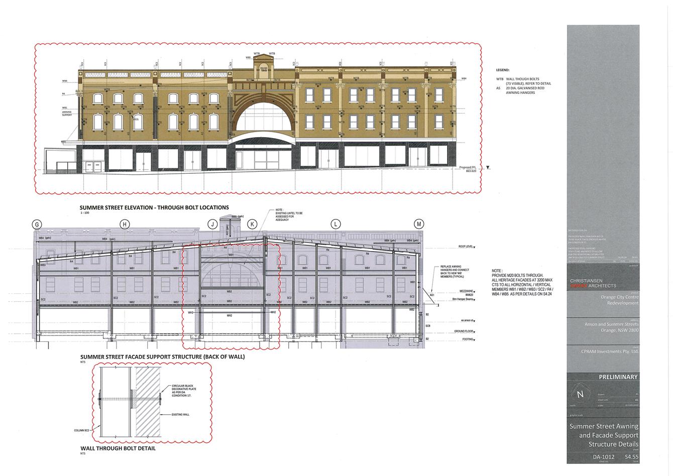
Condition (24) relates to the location of the fire booster
and sprinkler valve.
The relevant condition states:
(24) The
proposed location of the fire hydrant booster system and the fire sprinkler
booster system in Post Office lane is not approved. The fire hydrant booster
system and the fire sprinkler booster system shall be wholly located within the
subject building. If the fire hydrant booster system and the fire sprinkler
booster system is relocated on the Summer Street façade, it shall be
located within the western portion of the Summer Street façade. The
external façade elements concealing the fire rated walls shall comprise
the traditional black colour backed glass and the traditional bronze Modclad
shopfront framing matching the same shopfront cladding required for the Summer
Street heritage elevation. The fire hydrant booster system and the fire
sprinkler booster system shall be designed in a manner that does not alter or
affect the integrity of the existing awning over the Council footpath. The fire
hydrant booster system and the fire sprinkler booster system shall be enclosed
in an enclosure that is coloured black to match the surrounding colour backed
glass. Plans shall be amended prior to the issue of a Construction Certificate.
The applicant is seeking an alternative location for the
fire booster and fire sprinkler valve assembly to that which was required by
the above condition. The applicant is now seeking this infrastructure to be
located at the north-eastern corner of the building, with shopfront glazing
above in both elevations (shown in the below figure within the blue box). The
assembly will be located behind dark coloured cabinets, and shopfront glazing
will be treated in the same manner as the other shopfronts, ie modclad framing.
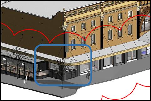
Figure 3: proposed location of fire booster and
sprinkler valve assembly
The applicant originally proposed this infrastructure
integrated into the design of the structure in the laneway. Council staff did
not consider this to be an appropriate location for a number of reasons;
principally that the infrastructure enclosed the public space and the principle
of placing private infrastructure with no net public benefit on public land not
being appropriate.
As part of the dialogue that occurred during the assessment
of the original application, the applicant provided two alternative locations.
One at the western end of the northern elevation and the other where it is
proposed now - at the north-eastern corner of the building.
The north-eastern corner option was discounted at the time
as it resulted in only a very small amount of shopfront for the front tenancy
(on the corner), and it was proposed in a way whereby it resulted in
unacceptable visual impacts within the streetscape.
The two above-mentioned negative outcomes have now been
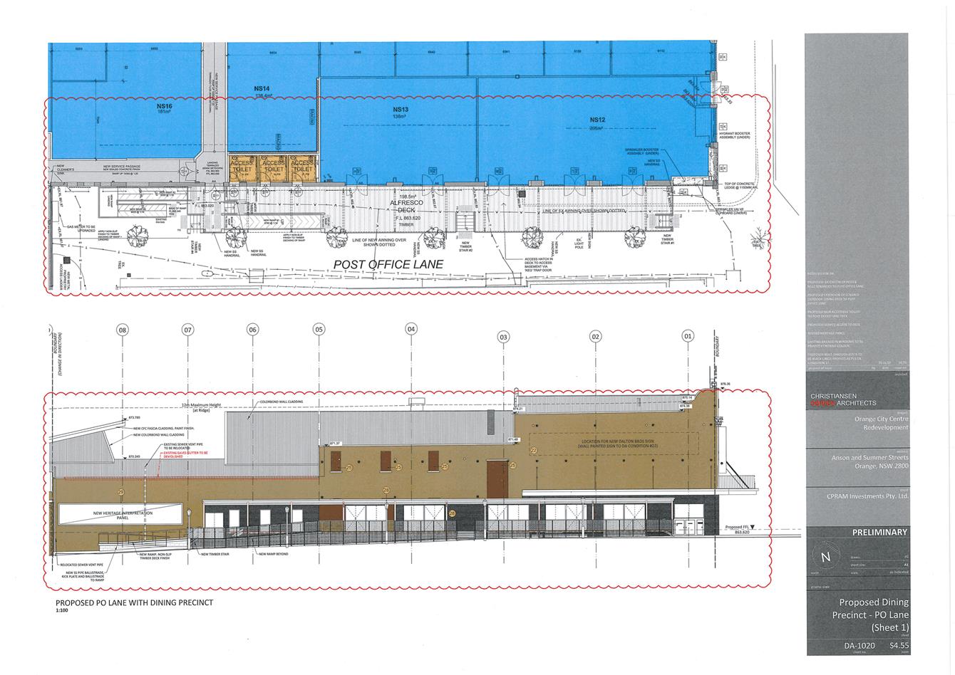
resolved. The adjustment of the front tenancies means that tenancy NS12 on the
corner has much more shopfront exposure to the laneway, even with the
infrastructure located on the corner in Post Office Lane. Additionally, the
design intent is far more positive now, with the shopfront glazing above the
cabinet, dark coloured cabinets and the modclad framing around the shopfront
glazing consistent with the remainder of shopfronts. Sections of the proposed
assemblies are shown below in figure 4.
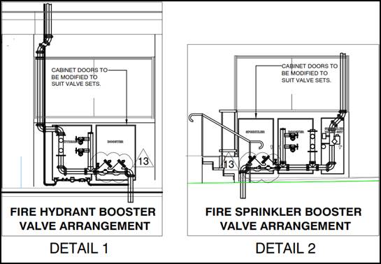
Figure 4: sections of fire hydrant booster and fire
sprinkler booster valves
Notwithstanding the above, a
condition is attached to ensure that the design intent is carried through to
the final construction. The intent of the condition is to ensure that the
openings and shopfront glazing are provided above the cabinets. The condition
stipulates that solid fire walls are not permitted; and if fire walls are
required to achieve compliance with the necessary standard it will be necessary
to seek an alternative location for the infrastructure via a subsequent
modification application. The condition also stipulates the material to be used
for the shopfront framing (which is to be consistent with the other shopfronts
within the respective elevation), and also deals with concealment of the
vertically arranged pipework above the cabinets. Lastly, the condition
stipulates the colour of the cabinets that will house the fire hydrant booster
valve and fire sprinkler valve assemblies.
With the above described condition
imposed, the proposed location of the above referenced fire safety
infrastructure will be satisfactory from a heritage point of view.
Condition (27)
Condition (27) relates to the reinstatement of the original
monitor roof-light. The condition currently states:
(27) The
main roof-light has been rated as highly significant and shall be reinstated
after sympathetic adaptation to meet current structural requirements as the
major focal point highlighting the proposed mall and centrepiece of the
development. The location of the roof-light within the roof shall be above the
central mall space between NK2 and the entrance to the Major tenancy.
The use of face brick on the
interior walls and piers in the public and retail areas of the building is not
approved. The interior walls and piers of the mall space shall comprise a
suitable combination of salvaged and new traditional pressed metal.
Modclad bronze finished
framing system is to be utilised throughout for the shopfront framing. The 12
identified cast iron salvaged columns, and associated piers, bulkheads and
pressed metal ceilings identified by the Heritage Consultant, are to be
installed on each side of the mall in a layout capable of accommodating the contemporary
retail shopfronts and suitable lighting. The elevations of the columns and the
ceilings of the mall are to be designed using traditional extended boxed piers
above the columns to meet the soffit, with traditional horizontal bulkheads to
link each pair of columns with the general cladding using suitable salvaged and
contemporary pressed metal reflecting and interpreting the former interior
details.
The existing tessellated
tiles (recently uncovered) within the building at the original entrance in Summer
Street shall be investigated and re-used within the development where
practicable.
Detailed plans and
specifications showing the above requirements are to be submitted to and
approved by Council’s Manager Development Assessments and Council’s
Heritage Advisor prior to the issue of a Construction Certificate.
The applicant is seeking to have the first paragraph of the
condition amended in the following way (deleted text struck out new words in
bold text):
The main roof-light has
been rated as highly significant and shall be reinstated after sympathetic
adaptation to meet current structural requirements as the major focal point
highlighting the proposed mall and centrepiece of the development.
The location of the roof-light within the roof shall be above the central mall
space between NS14 and NS15 NK2 and the entrance to the Major tenancy...
The author of the heritage impact statements submits that:
the rewording responds to
further investigation into the feasibility of reconstructing one of the existing
rooflights into the approved mall space. The building currently contains seven
rooflights, all detailed and finished in a similar way, however each of a
different configuration. The intention is to construct the new skylight within
the proportions of the approved Mall to match the existing roof lights, and
also where possible to clad the interior of the roof light in salvaged
material.
The proposed wording of the above condition has the effect
of only specifying the location of a roof-light and removes any connection to
the original roof-light, which was the main intent of the original condition
and does not require the proposed roof-light to be designed in a manner that
reproduces one of the existing roof-lights. The wording of the proposed
condition could result in any type of roof-light structure being installed and
a Private Certifier signing off on it.
Council staff accept that a reconstruction in a historically
accurate manner of one of the existing roof-lights is acceptable. However, to
ensure that this occurs in an acceptable manner, Council staff recommended
alternative wording to Council’s previously imposed condition. As such
Council staff recommend that the condition be worded as follows:
At least one of the original
roof-lights shall be reconstructed* in a historically accurate manner within
the new roof above the central mall space between NS14 and NS15. The design of
the reconstructed roof-light shall be determined by undertaking a survey and
preparation of detailed drawings of the selected existing roof-light to be
reconstructed. The reconstructed roof-light shall be clearly shown on the roof
plan, reflected ceiling plan along with a cross section plan of the roof-light
and shall be submitted to Council’s Manager Development Assessments for
approval prior to the issue of a Construction Certificate. As part of
the required approval process evidence shall be provided that demonstrates the
reconstructed roof-light is a historically accurate reconstruction of one of
the existing roof lights. Specifications and drawings shall also be provided
clearly showing the extent of the original salvaged fabric that will be used as
part of the reconstructed roof-light, the extent of the new materials and
details and the extent of any new elements such as structure and lighting.
*for the
avoidance of doubt the Burra Charter defines reconstruction as returning a place [in this case, the roof-light is taken to be a reference to
a place] to a known earlier state and is
distinguished from restoration by the introduction of new material.
The use of face brick on the
interior walls and piers in the public and retail areas of the building is not
approved. The interior walls and piers of the mall space shall comprise a
suitable combination of salvaged and new traditional pressed metal.
Modclad bronze finished
framing system is to be utilised throughout for the shopfront framing. The 12
identified cast iron salvaged columns, and associated piers, bulkheads and
pressed metal ceilings identified by the Heritage Consultant, are to be
installed on each side of the mall in a layout capable of accommodating the
contemporary retail shopfronts and suitable lighting. The elevations of the
columns and the ceilings of the mall are to be designed using traditional extended
boxed piers above the columns to meet the soffit, with traditional horizontal
bulkheads to link each pair of columns with the general cladding using suitable
salvaged and contemporary pressed metal reflecting and interpreting the former
interior details.
The existing tessellated tiles
(recently uncovered) within the building at the original entrance in Summer
Street shall be investigated and re-used within the development where
practicable.
Detailed plans and
specifications showing the above requirements are to be submitted to and
approved by Council’s Manager Development Assessments and Council’s
Heritage Advisor prior to the issue of a Construction Certificate.
Condition (29)
Condition (29) states:
(29) Three additional heritage interpretation display
windows are to be provided within the east (Post Office Lane) elevation. They
are to be located in the wall adjacent to the access ramp to the Post Office
Lane structure at the southern side of the structure.
The condition had the effect of requiring six display
windows (for heritage interpretation purposes) in total. As part of ongoing
negotiations, the applicant’s heritage consultant and Councils Heritage
Advisor have agreed upon an alternative display window design which effectively
consolidates the six windows in a much larger single window. It is considered
that the single larger window will provide opportunity for a much more
meaningful interpretation display. As such, there is no objection to deleting
the required condition.
The condition requiring a heritage interpretation plan to be
prepared and implemented remains imposed; however it has been adjusted slightly
to reflect the now single display window.
Additionally, there is a condition under the “Matters
Ongoing” section of the approval regarding the use of the display window
for heritage purposes only, and precluding general advertising from within the
window. As with the above referenced condition, the subject condition
references windows (plural), and the condition has been amended to reflect the
single window.
MATTERS FOR CONSIDERATION
Section 1.7 - Application of
Part 7 of the Biodiversity Conservation Act 2016 and Part 7A of the
Fisheries Management Act 1994
Development Applications lodged on or after 25 February
2018
Section 1.7 of the EP&A Act 1979 identifies that Part 7
of the Biodiversity Conservation Act 2016 and Part 7A of the Fisheries
Management Act 1994 have effect in connection with terrestrial and aquatic
environments.
Having regard to the relevant provisions and based on an
inspection of the subject property, it is considered that the proposed
development is not likely to significantly affect a threatened species.
A Biodiversity Development Assessment Report is not required
in this instance.
In this instance, site inspection reveals that the subject
property has no biodiversity or habitat value.
Section 4.55
Modification of Consents - Generally
Section 4.55 (2) of the Environmental
Planning and Assessment Act 1979 states:
A consent authority may…modify the consent if:
(a) it is satisfied that the development to
which the consent as modified relates is substantially the same development as
the development for which consent was originally granted and before that
consent as originally granted was modified (if at all), and
(b) it has consulted with the relevant
Minister, public authority or approval body (within the meaning of Division
4.8) in respect of a condition imposed as a requirement of a concurrence to the
consent or in accordance with the general terms of an approval proposed to be
granted by the approval body and that Minister, authority or body has not,
within 21 days after being consulted, objected to the modification of that
consent, and
(c) it has notified the application in
accordance with:
(i) the regulations, if the regulations
so require, or
(ii) a development control plan, if the consent
authority is a council that has made a development control plan that requires
the notification or advertising of applications for modification of a
development consent, and
(d) it has considered any submissions made
concerning the proposed modification within the period prescribed by the
regulations or provided by the development control plan, as the case may be.
Subsections (1) and (1A) do not apply to
such a modification.
In repose to sub-clause (a), Council staff
are satisfied that the development as modified is substantially the same
development as the development for which consent was originally granted.
The applicant has provided the following
qualitative and quantitative analysis of the development as modified against
the original approval.
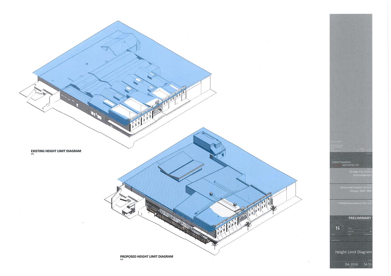
· There is no change to the height of or floor space of the built
form;
· The approved use of the shopping centre as a commercial premises
remains unchanged;
· The overall bulk and scale of the building envelope remains the
same, albeit there is a change to a portion of the roof form over the proposed
food court. However, this is internalised on the site and is below the 12m
building height plane as demonstrated in DA-1014;
· There will be no change to the approved hours of or any operational
matters;
· The increase of food and beverage tenancies does not bring rise to
any adverse noise or traffic and parking impacts as they are not considered
destination tenancies;
· The arrangement and operation of the site remains unchanged in terms
of access, parking and the like;
· The overall design quality and integrity of the building reflects
the existing approval, particularly as the proposed changes relate primarily to
the changes to the layout of the retail centre, refinement of the Post Office
Lane arrangement and design detail;
· There is no change in materials or fundamental changes to the
external design or appearance. There are some minor changes to Post Office Lane
including a minor extension to the awning, movement of the ramp and
consolidation of a heritage interpretation panel.
· The proposal does not raise any inconsistencies with the conditions
of consent and all consent conditions (with the exception of four minor changes
to conditions) remain able to be satisfied.
· The structural and buildability solution is unchanged from the
original consent and was the subject of detailed consideration and assessment.
· The heritage significance of the site as approved in the consent
remains, primarily through the retention of the two facades. Any amendments are
deemed acceptable by the project heritage consultant.
· The traffic and parking impacts of the development is unchanged.
Overall the
substance of the development has not changed and accordingly the proposal is
substantially the same as approved under DA 242/2017.
Council staff accept the above analysis and
the proposed modified development is considered to be substantially the same
development as the development for which consent was
originally granted.
Pursuant to
section 4.55(3) of the EPAA 1979:
In determining an application for
modification of a consent under this section, the consent authority must take
into consideration such of the matters referred to in section 4.15(1) as
are of relevance to the development the subject of the application.
The relevant matters are considered below.
A section 4.15(1) evaluation is provided
below.
Section 4.15
Section 4.15 of the Environmental Planning and Assessment
Act 1979 requires Council to consider various matters, of which those
pertaining to the application are listed below.
PROVISIONS OF ANY ENVIRONMENTAL
PLANNING INSTRUMENT s4.15(1)(a)(i)
Orange Local Environmental Plan 2011
The initial development was approved under the provisions of
Orange LEP 2011, which remains the principle planning instrument applying to
the land. The subject land is zoned B3 Commercial Core. The proposed
development is defined as a commercial premises. The
development remains consistent with the aims of the plan and the objectives of
the zone. The development remains consistent with the previous assessment of
the relevant LEP clauses (ie height of buildings, FSR etc), however
it is necessary to undertake an assessment of the development against clause
5.10 - Heritage Conservation. An assessment of the development against clause
5.10 is provided below.
5.10 - Heritage
Conservation
(1) Objectives
The
objectives of this clause are as follows:
(a) to
conserve the environmental heritage of Orange,
(b) to
conserve the heritage significance of heritage items and heritage conservation
areas, including associated fabric, settings and views,
(c) to
conserve archaeological sites,
(d) to
conserve Aboriginal objects and Aboriginal places of heritage significance.
The development
as modified is not inconsistent with the objectives of the clause.
(2) Requirement
for Consent
Development
consent is required for any of the following:
(a) demolishing
or moving any of the following or altering the exterior of any of the following
(including, in the case of a building, making changes to its detail, fabric, finish
or appearance):
(i) a
heritage item,
(ii) an
Aboriginal object,
(iii) a
building, work, relic or tree within a heritage conservation area,
(b) altering
a heritage item that is a building by making structural changes to its interior
or by making changes to anything inside the item that is specified in Schedule
5 in relation to the item,
(c) disturbing
or excavating an archaeological site while knowing, or having reasonable cause
to suspect, that the disturbance or excavation will or is likely to result in a
relic being discovered, exposed, moved, damaged or destroyed,
(e) erecting
a building on land:
(i) on
which a heritage item is located or that is within a heritage conservation
area, or
(ii) on
which an Aboriginal object is located or that is within an Aboriginal place of
heritage significance,
The development as modified includes works as described
above. As such, consent is required.
(3) When
Consent Not Required
However,
development consent under this clause is not required if:
(a) the
applicant has notified the consent authority of the proposed development and
the consent authority has advised the applicant in writing before any work is
carried out that it is satisfied that the proposed development:
(i) is
of a minor nature or is for the maintenance of the heritage item, Aboriginal
object, Aboriginal place of heritage significance or archaeological site or a
building, work, relic, tree or place within the heritage conservation area, and
(ii) would
not adversely affect the heritage significance of the heritage item, Aboriginal
object, Aboriginal place, archaeological site or heritage conservation area, or
(b) the
development is in a cemetery or burial ground and the proposed development:
(i) is
the creation of a new grave or monument, or excavation or disturbance of land
for the purpose of conserving or repairing monuments or grave markers, and
(ii) would
not cause disturbance to human remains, relics, Aboriginal objects in the form
of grave goods, or to an Aboriginal place of heritage significance, or
(c) the
development is limited to the removal of a tree or other vegetation that the
Council is satisfied is a risk to human life or property, or
(d) the
development is exempt development.
The development is not considered minor, nor does it relate
to maintenance of the heritage item. As such consent is required.
(4) Effect
of Proposed Development on Heritage Significance
The
consent authority must, before granting consent under this clause in respect of
a heritage item or heritage conservation area, consider the effect of the
proposed development on the heritage significance of the item or area
concerned. This subclause applies regardless of whether a heritage management
document is prepared under subclause (5) or a heritage conservation
management plan is submitted under subclause (6).
The development as modified will not give rise to any
unacceptable impacts upon the heritage significance of the item, adjoining
items or the Conservation area. The main external elements that are being
modified that have the potential to result in an impact upon the heritage
significance include the relocated essential fire protection infrastructure,
the extended outdoor structure in Post Office Lane and the demolition of the
existing roof and construction of a new butterfly shaped roof over the food
court. An assessment of these three elements is undertaken below.
Relocated
fire protection infrastructure
An assessment of the proposed fire protection infrastructure
is undertaken above, and relevant conditions are attached to ensure that what
is constructed reflects what is proposed in the approved plans. Council staff
hold concerns that it may be necessary to require fire rated walls above the
booster and sprinkler valves in lieu of the proposed shopfront glazing as shown
on the submitted plans, which would result in unacceptable heritage impacts.
Accordingly, the relevant condition is worded in way whereby this is to be
avoided. Additional conditions are attached to ensure that the shopfront
glazing is consistent with the other shopfronts at the front of the site and
the cabinets containing the infrastructure are a dark grey colour.
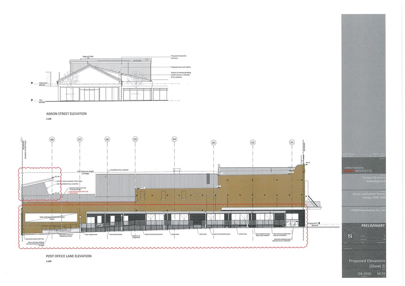
Extended
structure in Post Office Lane
A condition was imposed at the time of the original consent
that dealt with the design and presentation of the structure in Post Office
Lane. The condition remains in place, but additional requirements are added to
address the additional detail presented on the plans submitted with this
application to modify the consent. The additional elements of the condition
relate to the balustrade and the sunshade louvres on the outside of the
structure.
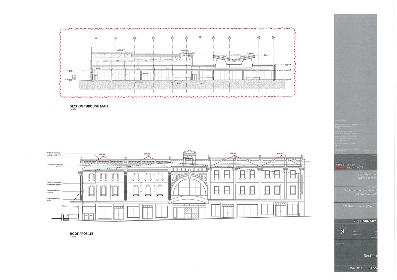
Demolition
of roof and construction of new ‘Butterfly’ shaped roof over the
food court
The existing roof to be demolished was identified as being
within a part of the building that had little to neutral heritage significance.
As such there is no objection to the proposed demolition of that portion of the
building. The new butterfly shaped roof is centrally positioned within the
footprint of the building, and such will not be easily viewed from any public
place. The new roof design will result in a wall projection within the roof
form. To ensure that this presents acceptably and to mitigate the new roof
form, a condition is recommended requiring that all new roof cladding material
be a dark grey colour, and all wall projections within the roof form be the
same colour as the roof cladding material and be a standing seam or similar
product.
The proposed changes to the roof are considered acceptable.
(5) Heritage
Assessment
The
consent authority may, before granting consent to any development:
(a) on
land on which a heritage item is located, or
(b) on
land that is within a heritage conservation area, or
(c) on
land that is within the vicinity of land referred to in paragraph (a) or (b),
require
a heritage management document to be prepared that assesses the extent to which
the carrying out of the proposed development would affect the heritage
significance of the heritage item or heritage conservation area concerned.
A heritage impacts statement has been submitted in support
of the proposed modification and is acceptable.
(6) Heritage
Conservation Management Plans
The
consent authority may require, after considering the heritage significance of a
heritage item and the extent of change proposed to it, the submission of a
heritage conservation management plan before granting consent under this
clause.
A conservation management plan was not required under the
original consent. There are no changes proposed under this application to
modify the consent that would require a CMP to be prepared at this stage.
(7) Archaeological
Sites
The
consent authority must, before granting consent under this clause to the
carrying out of development on an archaeological site (other than land listed
on the State Heritage Register or to which an interim heritage order under the Heritage
Act 1977 applies):
(a) notify
the Heritage Council of its intention to grant consent, and
(b) take
into consideration any response received from the Heritage Council within 28
days after the notice is sent.
The site is not a known archaeological site. Notwithstanding
this, Council’s standard precautionary condition relating to unexpected
finds of objects or artifacts remains imposed.
(8) Aboriginal
Places of Heritage Significance
The
consent authority must, before granting consent under this clause to the
carrying out of development in an Aboriginal place of heritage significance:
(a) consider
the effect of the proposed development on the heritage significance of the
place and any Aboriginal object known or reasonably likely to be located at the
place by means of an adequate investigation and assessment (which may involve
consideration of a heritage impact statement), and
(b) notify
the local Aboriginal communities, in writing or in such other manner as may be
appropriate, about the application and take into consideration any response
received within 28 days after the notice is sent.
The site is not a known Aboriginal Place of Heritage
Significance. Notwithstanding this, Council’s standard
precautionary condition relating to unexpected finds of objects or artifacts
remains imposed.
STATE ENVIRONMENTAL PLANNING
POLICIES
Stata Environmental Planning Policy (Infrastructure)
The application to modify the consent was referred to the
RMS pursuant to clause 104 of the SEPP (Infrastructure). The RMS responded
with no objections to the proposed modification.
The application was referred to Essential Energy pursuant to
clause 45 of the SEPP (Infrastructure). Essential Energy raised no
objections to the modification and reiterated their previous general
requirements, which are already attached to the consent.
PROVISIONS OF ANY DRAFT
ENVIRONMENTAL PLANNING INSTRUMENT THAT HAS BEEN PLACED ON EXHIBITION
4.15(1)(a)(ii)
There are no draft environmental planning instruments that
apply to the subject land or proposed development.
DESIGNATED DEVELOPMENT
The proposed development is not designated development.
INTEGRATED DEVELOPMENT
The proposed development is not integrated development.
PROVISIONS OF ANY DEVELOPMENT
CONTROL PLAN s4.15(1)(a)(iii)
Development Control Plan 2004
Development Control Plan 2004 (“the DCP”)
applies to the subject land (Chapter 0 - OLEP 2011, Chapter 8 -
Development in Business Zones, Chapter 13 - Heritage and Chapter 15
- Car Parking). An assessment of the proposed development against the
relevant Planning Outcomes will be undertaken below.
Pursuant to Planning Outcome 0.2-1 Interim Planning Outcomes
- Conversion of Zones:
· Throughout this
Plan, any reference to a zone in Orange LEP 2000 is to be taken to be a
reference to the corresponding zone(s) in the zone conversion table.
The corresponding zone to zone 3a Regional Centre (Orange
LEP 2000) is zone B3 Commercial Core (Orange LEP 2011). As such, Orange
DCP 2004 - Chapter 8 - Development in Business Zones is the chapter of
primary relevance to this proposal in addition to the other chapters listed
above.
CHAPTER 8 - DEVELOPMENT IN
BUSINESS ZONES
Planning Outcomes - Central Business District
· Buildings have
a high level of urban design to contribute to the regional status of the
City’s Central Business District with attention given to façade
features, external materials, colour and advertising.
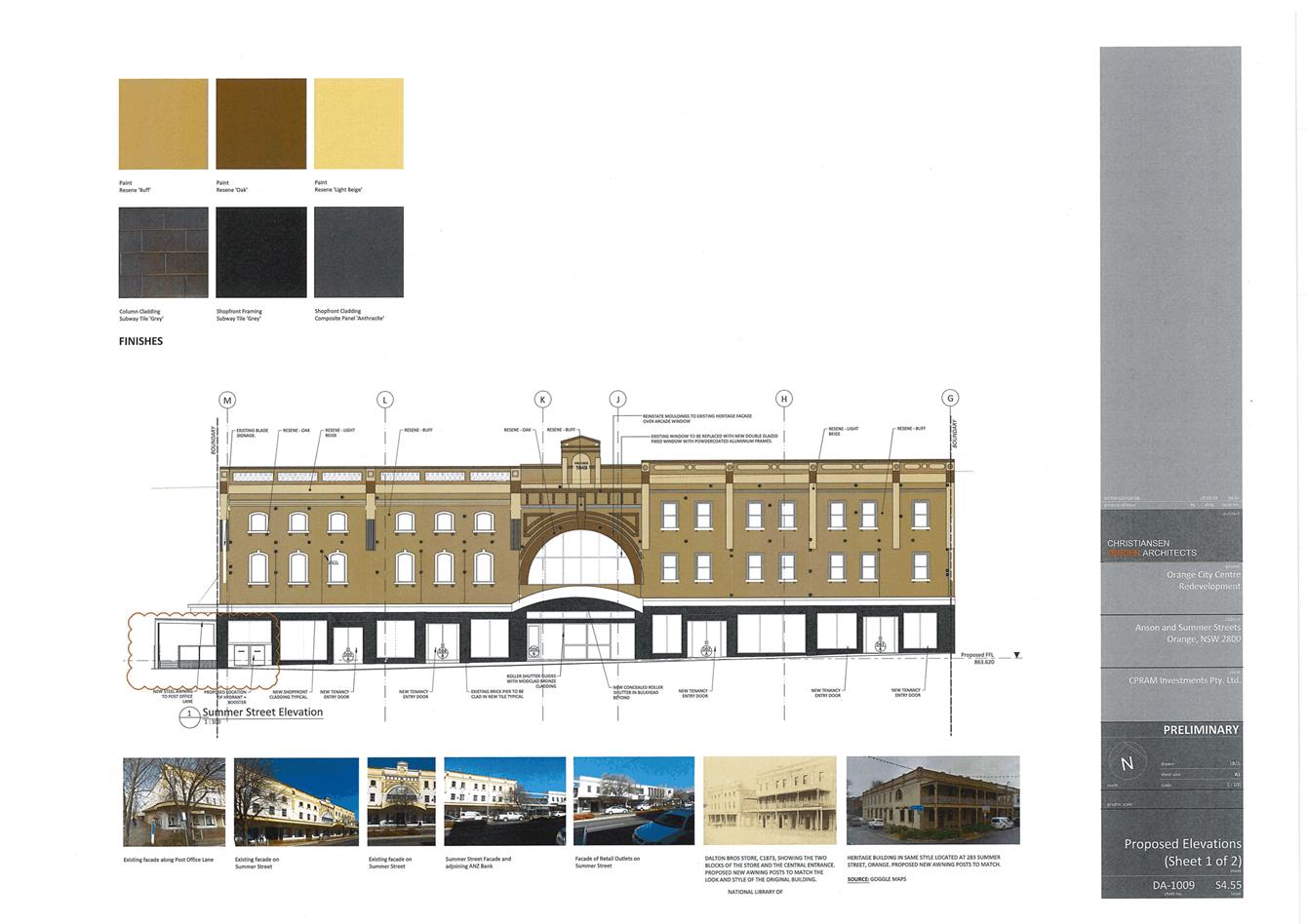
The above planning outcome was addressed in detail under the
original assessment. In that assessment Council staff imposed detailed
conditions around the reinstatement of important heritage fabric that had
previously been removed from the Summer Street façade. The condition
remains imposed which the applicant needs to address prior to the issuance of a
Construction Certificate. However, the submitted plans demonstrate the detailed
work the applicant has done thus far in meeting the terms of the condition. As
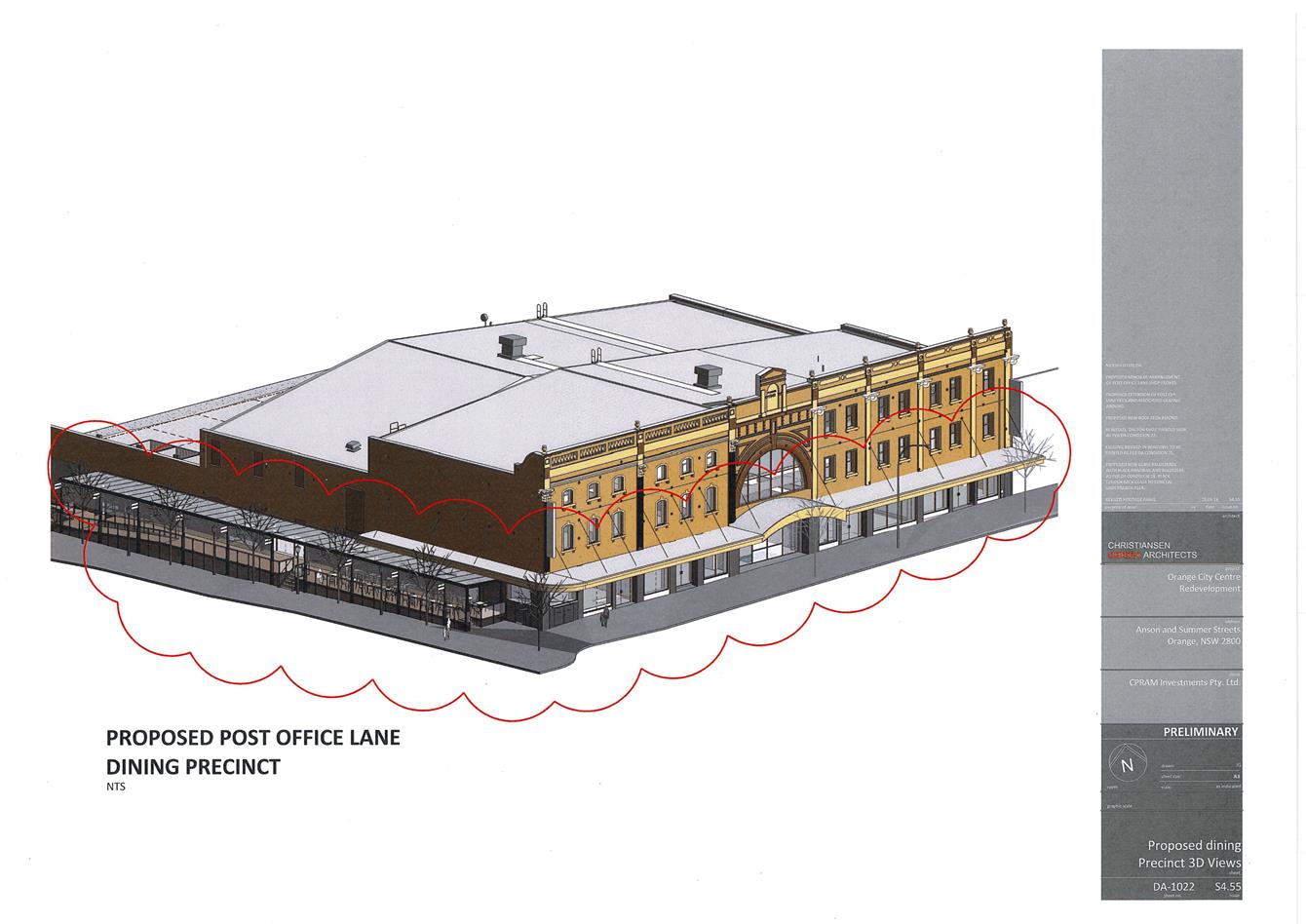
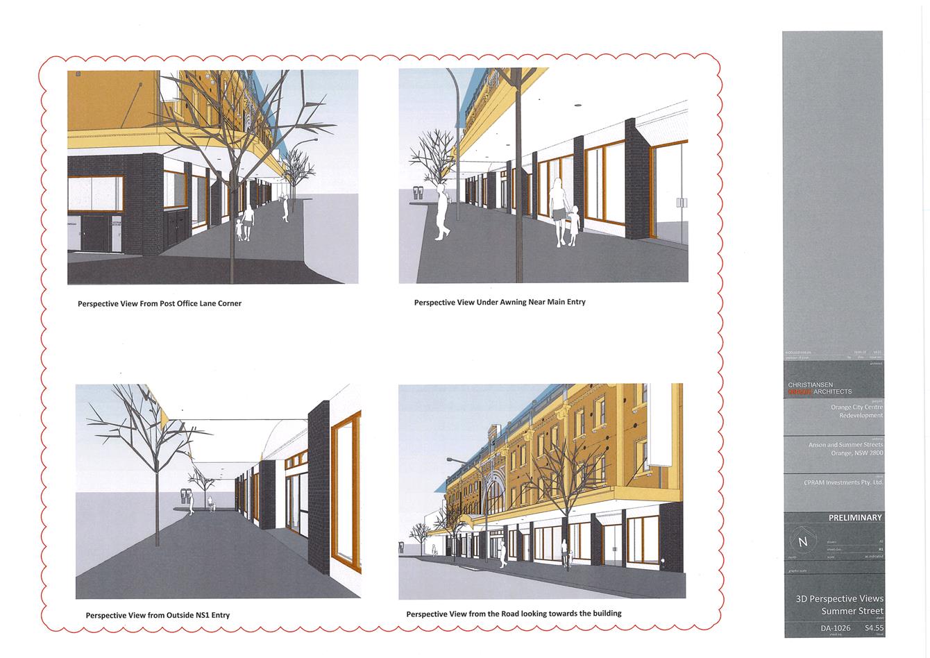
can be seen in the below figure, the development will result in a substantial
improvement of the building’s presentation within the street and will be
a significant achievement for all parties concerned.
Figure 5: 3D render of proposed development
· Urban design
demonstrates a clear reference to the CBD Strategic Action Plan.
An assessment of the development’s compliance with the
CBD Strategic Action Plan was undertaken as part of the assessment of the
original application. The development as modified will not fundamentally alter
the urban design outcomes achieved under the original approval; if anything
they have been improved through the altered common mall space which connects
directly with the rest of the City Centre, and the increased activation within
Post Office Lane is viewed as an improvement.
The development as modified remains consistent with the
objectives outlined in the CBD Strategic Action Plan.
· Provision of
adequate fire-safety measures and facilities for disabled persons (according to
the BCA) are addressed at the application stage (relevant for all development
but particularly important where converting residential buildings for business
use).
This was addressed in detail is the original assessment.
· Land use
complements the role of the CBD as a regional centre for commerce and services.
This was addressed as part of the original assessment of the
application. The development as modified is commensurate in terms of land-use
with the original approval. As such, the development as modified will continue
to compliment the role of the CBD as a regional centre.
The proposed development is considered by Council staff to
contribute positively to the function of the CBD and will strengthen the
role of the CBD as a regional centre.
· The
reinstatement of verandahs on posts over footpaths is encouraged.
This was addressed in detail in the original assessment. The
development as modified does not affect that previous assessment.
· Car parking is
provided to meet demand either as on-site parking areas or through
contributions towards public parking in and adjacent to the CBD.
Car parking is addressed below under the heading
“Chapter 15 - Car Parking”.
· Advertising
comprise business identification signs in accordance with SEPP 64
No advertising is proposed as part of this application. A
relevant condition is attached to reinforce this.
· Loading areas
are provided for developments requiring access by large trucks in a manner that
doesn’t reduce active frontages for important pedestrian pathways.
As mentioned below, the applicant is now proposing the main
switch room adjacent to the existing loading dock. The applicant has provided
swept paths demonstrating that the proposed structure does not impede the
operation of the loading dock. Council’s Technical Services Division has
not raised objection to the structure.
· Where possible,
new buildings or external alterations in the CBD include an element of
landscaping.
This was addressed under the original application. The
development as modified does not involve landscaping, nor is any recommended.
CHAPTER 13 - HERITAGE
Planning Outcomes - Heritage Development
· Development
relates to the significant features of heritage buildings on or near the site,
as reflected in inventory sheets.
· Development
conforms with recognised conservation principles.
· Conservation
Management Plans are prepared for development having a significant effect on
heritage sites.
A detailed assessment of the impact upon the heritage
significance against recognised heritage conservation principles has been
undertaken above under the heading “5.10 ‑ Heritage
Conservation”.
CHAPTER 15 - CAR PARKING
Council’s DCP requires parking for shops and shopping
centres in the CBD at the rate of 4.1 spaces per 100m² of gross
leasable floor area (GLFA).
Development consent was granted on 16 July 1985 for the
construction of the City Centre. In that assessment, the entire centre
(including Grace Bros, the occupier of the tenancy the subject of this
application at that time) required 432 car parking spaces onsite. In later
amendments, the number of physical spaces was reduced to 421 and monetary
contributions were paid at that time for the equivalent of eight spaces.
Various amendments have occurred within the shopping centre
over time, with parking considered at the time of each assessment. As such, the
site is compliant for parking under the existing situation.
As was the case under the original application, the
reduction in gross leasable floor area results in a reduction in the parking
demand for the overall shopping centre. The application to modify the consent
further reduces the amount of leasable gross floor area owing to the food court
area and additional common mall space. The site would be further in credit in
terms of parking demand as a result of the proposed modified development.
The development is therefore considered satisfactory in
regard to parking.
INFILL GUIDELINES
As mentioned above, the development as modified is not
inconsistent with Council’s infill guidelines. The development
essentially remains unchanged in terms of character, siting, and scale and
form. Existing conditions that required the reinstatement of original
façade elements, the internal design of the mall space, the
reinstatement of the painted wall sign etc, all remain and will be
addressed as part of the issuance of the Construction Certificate.
The demolition of the existing roof (previously retained
under the original approval) and replacement with the complex butterfly profile
roof will have limited impacts in terms of character, and scale and form. The proposed
butterfly shaped portion of the roof over the food court is centrally located
or, in other words, well set back from all sides of the building. As such, it
will not be overly visible from any public place, and will not be visible from
Summer Street.
The previously imposed condition relating to the design of
the Post Office Lane structure has been augmented to include certain balustrade
requirements as required by Council’s Heritage Advisor.
Fundamentally, the development as modified is considered
acceptable in terms of Council’s Infill Guidelines.
SECTION 64 WATER AND SEWER
HEADWORKS CHARGES
Under the approved layout Council’s Technical Services
Division advised that as a result of the reduced retail floor area, the land
benefited from 2 equivalent tenements (ETs) credits for water and sewer which
were able to be utilised if future uses were of a type that generated section
64 charges over and above those that apply at the moment. An Advisory Note was
attached instructing of such.
Based on the proposed design which anticipates a number of
food tenancies, the above referenced water and sewer equivalent tenement credit
is effectively absorbed and a demand of 1.4 ETs for both water and sewer is
created, and therefore charges are required. A new condition is attached in
this regard.
The Advisory Note has been deleted and a new condition
inserted requiring the water and sewer charges to be paid prior to the issue of
a Construction Certificate.
Any future development applications that involve food and
drink premises will be assessed separately at the time of a DA for first use
and fitout.
This assessment of the food premises within the food court
only relates to Section 64 water and sewer headworks; separate development
applications will still be required for all first use and fitouts for all
tenancies.
PROVISIONS PRESCRIBED BY THE
REGULATIONS s4.15(1)(a)(iv)
The development as modified is not inconsistent with the
provisions prescribed by the regulations.
THE LIKELY IMPACTS OF THE
DEVELOPMENT s4.15(1)(b)
Context and Setting
The subject land is described as an integral keystone in the
functionality of the CBD for its connectivity to a major shopping centre
and other parts of the CBD. The building is also a very visually prominent
building in the streetscape due to its size, appearance and general character.
The development as modified will not materially alter the functionality of the
building. If anything, the revised internal configuration of tenancies improves
the common circulation space as it now connects directly with the existing
circulation paths within the City Centre, as opposed to the previous layout
which meant the major tenancy (now deleted) acted as a thoroughfare from Summer
Street to the existing City Centre. The lengthened structure in Post Office
Lane is a consequence of the reshuffle of smaller tenancies and allows almost a
doubling of shopfronts to the laneway. As mentioned throughout the report,
Council staff consider the activation of Post Office Lane to be positive.
As a side note, Council staff are in negotiations (separate
to the DA process) with the applicant to install improved lighting within the
laneway to enhance the amenity and ambiance of the laneway. The idea of
lighting within the laneway would be modelled on similar laneways in Sydney and
Melbourne.
The development as modified remains appropriate in the
context and setting.
Heritage Impacts
Heritage considerations are addressed above. The development
as modified is not likely to result in any unacceptable heritage impacts.
Traffic, Parking and Access
The development as modified is unlikely to result in impacts
relating to traffic, parking and access. The existing traffic movement and
access points remain unchanged. Council’s Technical Service Division
raised some concern in relation to the structure housing the main switch room
within the loading dock area and the impact it may have on manoeuvring of
vehicles within the loading dock area.
The applicant subsequently provided Council with swept paths
demonstrating that an 8.8m and a 12.5m vehicle are able to negotiate the
site. Thus the proposed main switch room is acceptable and will not impact on
the operation of the existing loading dock.
The proposed modifications will have a neutral effect on the
previously approved parking arrangements; and as mentioned above the increase
in the amount of common mall space will further reduce the car parking demands
generated by the development.
THE SUITABILITY OF THE SITE
s4.15(1)(c)
The site remains suitable for the proposed modified development.
ANY SUBMISSIONS MADE IN
ACCORDANCE WITH THE ACT s4.15(1)(d)
The proposed development is defined as "advertised
development" under the provisions of the Environmental Planning and
Assessment Regulations. The application was advertised for the prescribed
period of 14 days, and at the end of that period four submissions were
received.
Submission 1 - resident of 39
Kenna Street
The submission raises objection to the use of the “old
Myer building” as a food court. The author of the submission further states
that Council needs a department store rather than additional “eating
places”.
Council staff comment
The NSW Planning system does not allow a consent authority
to control the amount of a particular land-use within the City, nor does it
provide for a consent authority to insist on a particular land-use being
developed on private land. The proposed food premises are a permissible
land-use within the commercial zone. The consent provides for commercial
premises, it will be necessary for development applications to be lodged for
the first use and fitout of each tenancy.
Submission 2 - anonymous
Submission 2 raises similar contentions to Submission 1,
purporting the number of cafes within Orange to be 64 or more and that the
building should be used to attack a big retailer such as JB Hifi.
The submission acknowledges Council undertaking to
revitalise the CBD and states that the building could be a centrepiece within
the CBD. The submission also notes that Post Office Lane is looking brighter
since the murals have been installed.
Council Staff comment
Similar to the comments made in response to Submission 1,
Council does not have a mechanism to control the saturation of a particular
land-use in a particular part of the City; nor can Council dictate the type of
land-use a developer develops on private land.
In relation to the comments about the revitalisation and the
subject building being a focal point of the CBD, Council staff are confident
that the outcomes achieved under the initial approval (such as the reinstated
façade elements and the large historic painted wall sign) will go a long
way to ensuring that the building is major focal point and a key contributor to
the visual enhancement of this part of the CBD.
The comments regarding the painted wall murals in the
laneway are noted, and Council staff are confident that the proposal to provide
outdoor dining space in Post Office Lane will foster further activation, place
making opportunities within the laneway and improve the overall social capital
of the public space.
Submission 3 - resident of 243
March Street
The author in the first half of the submission objects to
the proposed development and passes some irrelevant judgements on the
applicant. In the second part of the submission the author objects to the use
of the laneway. The author states that the use of the laneway for eating areas
is now superfluous as the previous constraints have been overcome due to the
now proposed food court. The author states that all of the food areas in Post
Office Lane should be deleted, further stating that to do so would allow the
display windows to be more visible.
Council Staff Comment
The comments in the first paragraph of the submission do not
relate to an objection on planning grounds. The applicant of any DA has the
legal right to modify a development consent as many times as they so choose,
provided the development remains substantially the same development for which
consent was originally granted. The comment from the author of the submission
that “… Council should not be put to the expense of working on
continued DAs” is irrelevant.
In relation to the comments around the use of the laneway,
as was the position held by Council staff during the initial assessment, the
activation of the laneway through the proposed use under a lease arrangement
with Council is considered a positive contribution to the public space. The
area will undergo a dramatic revitalisation and will become a part of the City
that is a meeting place and a place that is used by the public.
It should also be noted (which was very clear in the initial
report by Council staff) that one of the main reasons for the structure within
Post Office Lane was to protect the important heritage fabric associated with
the basement below street level in the north-eastern corner of the site.
Deleting the outdoor eating area would require a complete redesign of those
tenancies effected.
Submission 4 - resident of 21
Lawson Crescent
The submission essentially provides a useful discussion
directly related to the proposed amendments of previously imposed conditions.
The author of the submission suggests that altering conditions (1) and (4)
(plan numbers and roller shutter) will have no effect on heritage impact. The
author suggests that condition (24) (location of fire booster and sprinkler
valve) will result in some intrusive streetscape impacts but accepts the
proposed location as a reasonable compromise based on the level of significance
of the building where the infrastructure is proposed.
The author also makes comment in relation to
condition (27) (relating to the reinstated monitor roof-light), suggesting
that if it is found that the roof-light is not capable of reinstatement, than
it ought to be reconstructed in a way that replicates rather than reflects (as
written within SoEE) the original fabric. The author also makes comment in
relation to the consolidation of the six required heritage display windows
(condition (29)) into a large singe window, stating that the amended approach
is a “significant improvement and is welcomed”.
Council staff comment
The submitter’s comments in relation to conditions
(1), (4), (24) and (29) are noted and do not require a response.
In relation to the comments made around condition (27) and
the monitor roof-light, it is Council’s intention for this fabric to be
reinstated in a historically accurate and authentic way. Council’s
assessment of the proposed changes to condition (27) are considered above and
the concerns of the submitter are addressed in the above assessment.
PUBLIC INTEREST
s4.15(1)(e)
The proposed development is considered to be of moderate
interest to the wider public due to the prominent location within the CBD, the
use of public space and the previous public attention the development has
received. Notwithstanding this, the proposed development to modify the consent
will result in only localised potential impacts. The proposal is not
inconsistent with any relevant policy statements, planning studies, guidelines
etc that have not been considered in this assessment.
SUMMARY
The development as modified is permissible with the consent
of Council. The development as modified complies with the relevant aims,
objectives and provisions of Orange LEP 2011 (as amended)
and DCP 2004. The assessment has been carried out in a manner that is
consistent with the requirements of the Environmental Planning and Assessment
Act 1979 and its associated Regulations. A section 4.15 assessment of the
development indicates that the development is acceptable. Attached is a draft amended
Notice of Approval outlining a range of conditions considered appropriate to
ensure that the development as modified proceeds in an acceptable manner.
COMMENTS
The requirements of the Environmental Health and Building
Surveyor and the Engineering Development Section are included in the attached
amended Notice of Approval.
Attachments
1 Notice
of Approval, D18/44468⇩
2 Plans,
D18/44400⇩
3 Submissions,
D18/44379⇩
Planning
and Development Committee
4 September 2018
2.3 Development
Application DA 242/2017(2) - 212-220 Summer Street and Post Office Lane
Attachment 1 Notice of Approval
|

|
ORANGE
CITY COUNCIL
Development
Application No DA
242/2017(2)
NA18/xxx Container
PR11580
|
NOTICE OF DETERMINATION
OF A DEVELOPMENT
APPLICATION
issued under the Environmental
Planning and Assessment Act 1979
Section 4.18
|
Development
Application
|
|
|
Applicant Name:
|
Alceon
Group Pty Limited
|
|
Applicant Address:
|
C/- URBIS
Pty Ltd
Level 23,
Tower 2, 201 Sussex Street
SYDNEY
NSW 2000
|
|
Owner’s Name:
|
Alceon
Group Pty Limited and Orange City Council
|
|
Land to Be Developed:
|
Lot 564 DP
776383 - 212-220 Summer Street and Post Office Lane, Orange
|
|
Proposed Development:
|
Demolition
(ground, first and second floors, and roof of existing retail tenancy), and
Commercial Premises (alterations and additions including elevated outdoor
dining area)
|
|
|
|
|
Building
Code of Australia
building
classification:
|
To be
determined by the Private Certifier
|
|
|
|
|
Determination
made under
Section 4.16
|
|
|
Made On:
|
4
September 2018
|
|
Determination:
|
CONSENT
GRANTED SUBJECT TO CONDITIONS DESCRIBED BELOW:
|
|
|
|
|
Consent to
Operate From:
|
28 March
2018
|
|
Consent to
Lapse On:
|
28 March
2023
|
Terms of Approval
The reasons for the imposition of
conditions are:
(1) To ensure a quality
urban design for the development which complements the surrounding environment.
(2) To maintain
neighbourhood amenity and character.
(3) To ensure compliance
with relevant statutory requirements.
(4) To provide adequate
public health and safety measures.
(5) To ensure the utility
services are available to the site and adequate for the development.
(6) To prevent the proposed
development having a detrimental effect on adjoining land uses.
(7) To minimise the impact
of development on the environment.
Conditions
(1) The
development must be carried out in accordance with:
(a) Plans by
Alleanza Architecture – project number 16319 – sheet numbers:
DA-0001
– issue 2 – dated 4 May 2017
DA-1001
– issue 2 – dated 4 May 2017
DA-1002
– issue 4 – dated 1 December 2017
DA-1003
– issue 5 – dated 1 December 2017
DA-1004
– issue 4 – dated 22 May 2017
DA-1005
– issue 7 – dated 1 December 2017
DA-1006
– issue 10 – dated 1 December 2017
DA-1007
– issue 4 – dated 11 October 2017
DA-1008
– issue 5 – dated 11 October 2017
DA-1009
– issue 6 – dated 1 December 2017
DA-1010
– issue 10 – dated 1 December 2017
DA-1011
– issue 8 – dated 1 December 2017
DA-1012
– issue 4 – dated 1 December 2017
DA-1013
– issue 3 – dated 1 December 2017
DA-1014
– issue 3 – dated 1 December 2017
DA-1020
– issue 4 – dated 1 December 2017
DA-1021
– issue 4 – dated 1 December 2017
DA-1022
– issue 5 – dated 1 December 2017
DA-1023
– issue 4 – dated 1 December 2017
DA-1024
– issue 4 – dated 1 December 2017
DA-1025
– issue 4 – dated 1 December 2017
DA-1026
– issue 2 – dated 1 December 2017
Amending plans: Plans
by Christiansen O’Brien Architects:
DA-0000 - Issue S4.55 – dated 28
June 2018
DA-0001 - Issue S4.55 – dated 28
June 2018
DA-1001 - Issue S4.55 – dated 28
June 2018
DA-1002 - Issue S4.55 – dated 28
June 2018
DA-1003 - Issue S4.55 – dated 28
June 2018
DA-1004 - Issue S4.55 – dated 28
June 2018
DA-1005 - Issue S4.55 – dated 28
June 2018
DA-1006 - Issue S4.55 – dated 28
June 2018
DA-1007 - Issue S4.55 – dated 28
June 2018
DA-1008 - Issue S4.55 – dated 28
June 2018
DA-1009 - Issue S4.55 – dated 28
June 2018
DA-1010 - Issue S4.55 – dated 28
June 2018
DA-1011 - Issue S4.55 – dated 28
June 2018
DA-1012 - Issue S4.55 – dated 28
June 2018
DA-1013 - Issue S4.55 – dated 28
June 2018
DA-1014 - Issue S4.55 – dated 28
June 2018
DA-1020 - Issue S4.55 – dated 28
June 2018
DA-1021 - Issue S4.55 – dated 28
June 2018
DA-1022 - Issue S4.55 – dated 28
June 2018
DA-1023 - Issue S4.55 – dated 28
June 2018
DA-1024 - Issue S4.55 – dated 28
June 2018
DA-1025 - Issue S4.55 – dated 28
June 2018
DA-1026 - Issue S4.55 – dated 28
June 2018
(b) statements
of environmental effects or other similar associated documents that form part
of the approval
(2) Separate development
applications are to be made for the first use and fitouts of individual
tenancies created under this consent.
(3) This consent does not
provide approval for the erection of signage unless such signage is consistent
with the exempt provisions of State Environmental Planning Policy (Exempt and
Complying Development Codes). Separate development consent will be required for
all signage that does not meet the abovementioned exempt provisions.
(4) (condition moved to
“Matters for the Ongoing Performance and Operation of the Development:
section below)
(5) This
consent does not provide approval for the proposed under awning posts in Summer
Street, accordingly the posts shall be deleted from the proposal.
(6) This
consent does not provide approval of the planter boxes within Post Office Lane,
accordingly the planter boxes shall be deleted from the proposal.
(7) All building work must
be carried out in accordance with the provisions of the Building Code of
Australia.
(8) A sign is to be erected
in a prominent position on any site on which building work, subdivision work or
demolition work is being carried out:
(a) showing
the name, address and telephone number of the principal certifying authority
for the work, and
(b) showing
the name of the principal contractor (if any) for any building work and a
telephone number on which that person may be contacted outside working hours,
and
(c) stating
that unauthorised entry to the site is prohibited.
Any such sign is to be maintained while the
building work, subdivision work or demolition work is being carried out.
(9) Where any excavation
work on the site extends below the level of the base of the footings of a
building on adjoining land, the person having the benefit of the development
consent must, at the person’s own expense:
(a) protect
and support the adjoining premises from possible damage from the excavation,
and
(b) where
necessary, underpin the adjoining premises to prevent any such damage.
Note: This
condition does not apply if the person having the benefit of the development
consent owns the adjoining land or the owner of the adjoining land has given
consent in writing to this condition not applying.
|
PRIOR TO THE ISSUE OF
A CONSTRUCTION CERTIFICATE
|
(10) Eight
Victorian period style urns shall be reinstated on top of the parapet directly
above the respective pilasters. The type of urns selected shall be based on
reference to the historic photograph contained in ‘Orange and District
Illustrated’ Flynn and Leggo 1928 pg. 204. Details of the urns shall
be submitted to, and approved by Council’s Manager Development
Assessments and Council’s Heritage Advisor prior to the issue of a
Construction Certificate.
(11) The
eight pilasters within the northern façade (Summer Street façade)
shall be reinstated where previously removed above the suspended awning. The
lengthened/reinstated pilasters shall replicate the design and materials shown
in the historic photograph contained in ‘Orange and District
Illustrated’ Flynn and Leggo 1928 pg. 204. Details of the
lengthened/reinstated pilasters shall be submitted to, and approved by
Council’s Manager Development Assessments and Council’s Heritage
Advisor prior to the issue of a construction Certificate.
(12) Eight
pilaster capitals within the northern façade (Summer Street
façade) shall be reinstated where previously removed. The reinstated
pilaster capitals shall be based on reference to the historic photograph
contained in ‘Orange and District Illustrated’ Flynn and
Leggo 1928 pg. 204. Details of the pilaster capitals shall be submitted, to and
approved by Council’s Manager Development Assessments and Council’s
Heritage Advisor prior to the issue of a Construction Certificate.
(13) The
six (previously) arched windows that relate to the first floor to the east of
the central arch (directly above the suspended awning) within the northern
façade (Summer Street façade) shall be reinstated (including the
decorative rendered moulding surrounds) where previously removed. The details
of the reinstated arched windows on the first floor to the east of the central
arch shall be designed based on reference to the historic photograph contained
in ‘Orange and District Illustrated’ Flynn and Leggo 1928
pg. 204. Details of the subject windows shall be submitted to, and approved by
Council’s Manager Development Assessments and Council’s Heritage
Advisor prior to the issue of a Construction Certificate.
(14) The
seven double hung windows that relate to the first floor (directly above the
suspended awning) to the west of the central arch within the northern
façade (Summer Street façade) shall be reinstated, including the
decorative rendered mounding surrounds. The details of the reinstated windows
on the first floor to the west of the central arch shall be designed based on
reference to the historic photograph contained in ‘Orange and District
Illustrated’ Flynn and Leggo 1928 pg. 204. Details of the subject windows
shall be submitted to, and approved by Council’s Manager Development
Assessments and Council’s Heritage Advisor prior to the issue of a
Construction Certificate.
(15) The
main central vaulted (arched) glazing within the northern façade (Summer
Street façade) above the main central entrance shall be reinstated. The
details of the reinstated main central vaulted (arched) glazing above the
central entrance shall be designed based on reference to the historic
photograph contained in ‘Orange and District Illustrated’
Flynn and Leggo 1928 pg. 204. Details of the subject glazing shall be submitted
to and approved by Council’s Manager Development Assessments and
Council’s Heritage Advisor prior to the issue of a Construction
Certificate.
(16) The
three uppermost windows in the western end of the northern (Summer Street)
façade shall have new glazing installed that will be translucent to a
level that is sufficient to obscure the frame of the portal structure behind.
This detail shall be clearly shown on the plans submitted with the application
for a construction certificate.
(17) The
proposed 150mm square through-bolt wall plates in the northern (Summer Street)
façade and eastern (Post Office Lane) façade shall be replaced
with black coloured circular expressed steel bracket anchor plates. Details of
the wall plate shall be clearly shown on the plans submitted with an
application for a construction certificate.
(18) The positioning of the
proposed pad footings located in the significant basement/cellar shall be
relocated or adjusted in a way that ensures the pad footings do not impact
upon, or cause damage to, the existing internal masonry walls within the
basement/cellar. Amended plans showing the revised location of the subject
footings shall be submitted with the application for a Construction
Certificate.
(19) The new shopfronts
within Summer Street and Post Office Lane shall be constructed using
‘Modclad’ bronze finished framing system. This detail shall be
clearly shown on the plans submitted with the application for a Construction
Certificate.
(20) A
heritage interpretation plan shall be prepared for the subject site by a
suitably qualified heritage consultant in accordance with NSW Heritage Council
guidelines and standard heritage practices. The heritage interpretation plan
shall provide such things as murals, memory boards, displays within the Post
Office Lane display windows, interpretation signs relating to salvaged
fabric etc. The interpretation plan shall include the allowance for
occasional future access (by appointment only) of the basement/cellar. The
heritage interpretation plan shall be submitted to Council’s Manager
Development Assessments for approval prior to the issue of a Construction
Certificate.
(21) In
addition to the heritage interpretation plan, the ground floor above the
basement /cellar shall include a clear transparent section of floor above the
basement of at least 4m2 in size and the basement shall be suitably
illuminated from within the basement to allow the basement to be viewed from
above. This is to occur within NS12. This detail shall be clearly shown on the
plans submitted with an application for a construction certificate.
(22) A large painted wall
sign interpreting the previous “Dalton Brothers” painted wall sign
located on the upper portion of the eastern (Post Office Lane) façade
shall be painted onto the building. The details of the painted wall sign shall
be based on reference to historic photographs of the subject sign contained in ‘Orange
and District Illustrated’ 1928, Flynn and Leggo. Details of the
painted wall sign, including the size, livery, colour, font, location etc,
shall be submitted to Council’s Manager Development Assessments prior to
the issue of a Construction Certificate. The painted wall sign shall be applied
to the building using traditional techniques by suitably qualified and skilled
tradespeople.
(23) A
construction management plan shall be submitted to, and be approved by the
Principal Certifying Authority prior to the issue of a Construction Certificate.
The plan shall address such things as parking of construction worker vehicles,
delivery arrangements, crane lift or concrete boom locations, dust mitigation,
noise and vibration mitigation, rubbish and waste removal, complaints
handling etc. The plan shall be adhered to for the duration of the
demolition/construction phase of the development.
(24) The
fire hydrant booster system and the fire sprinkler booster system shall be
wholly located within the subject building. The façade elements above the
fire hydrant booster system and the fire sprinkler booster system shall consist
of openings with shopfront glazing as shown on the submitted plans, with
traditional bronze Modclad shopfront framing matching the same shopfront
cladding required for the Summer Street heritage elevation. A solid fire wall
above the respective fire hydrant booster system and the fire sprinkler booster
system is prohibited; if a solid fire wall is required to achieve the required
standard, than an alternative location for the fire hydrant booster system and
the fire sprinkler booster system shall be sought via an application to modify
the consent. The fire hydrant booster system and the fire sprinkler booster
system shall be designed in a manner that does not alter or affect the
integrity of the existing awning over the Council footpath. The fire hydrant
booster system and the fire sprinkler booster system shall be enclosed in an
enclosure that is coloured black to match the surrounding approved subway tile.
The vertical pipework above the cabinets feeding the water supply within the
building shall be concealed within, or adjacent to the structural column in the
north-eastern corner of the building in a way whereby the pipework is not
visible through the shopfront glazing. Plans showing the above detail shall be
submitted to Council’s Manager Development Assessments for approval
prior to the issue of a Construction Certificate.
(25) The
original openings (since bricked up / enclosed) within the earliest portion of
the east (Post Office Lane) elevation shall be accurately identified. Once
identified, a mechanism for interpreting the openings shall be devised either
by removing the paint where the opening once was to expose unpainted brick work
or recessing the brickwork in the location of the opening. The method of
interpreting the openings should be determined by a suitably qualified heritage
consultant. Details as to the preferred way of interpreting the former openings
shall be submitted to and approved by Council’s Manager Development
Assessments and Council’s Heritage Advisor prior to the issue of a
Construction Certificate.
(26) A
revised plan that shows the proposed external paint scheme adopting the same
proposed colours shall be prepared that also incorporates the required
façade reinstatements (vaulted window, reinstated windows, pilasters,
pilaster capitals and urns) and shows appropriate colours of those elements
also. Details shall be submitted to and approved by Council’s Manager
Development Assessments and Councils Heritage Advisor prior to the issue of a
Construction Certificate.
(27) At least one of the
original roof-lights shall be reconstructed* in a historically accurate manner
within the new roof above the central mall space between NS14 and NS15. The
design of the reconstructed roof-light shall be determined by undertaking a
survey and preparation of detailed drawings of the selected existing roof-light
to be reconstructed. The reconstructed roof-light shall be clearly shown on the
roof plan, reflected ceiling plan along with a cross section plan of the
roof-light and shall be submitted to Council’s Manager Development
Assessments for approval prior to the issue of a Construction Certificate. As
part of the required approval process evidence shall be provided that
demonstrates the reconstructed roof-light is a historically accurate
reconstruction of one of the existing roof lights. Specifications and drawings
shall also be provided clearly showing the extent of the original salvaged
fabric that will be used as part of the reconstructed roof-light, the extent of
the new materials and details and the extent of any new elements such as
structure and lighting.
*for the avoidance of
doubt the Burra Charter defines reconstruction as returning a place [in
this case, the roof-light is taken to be a reference to a place] to a known
earlier state and is distinguished from restoration by the
introduction of new material.
The use of face brick on the interior walls and
piers in the public and retail areas of the building is not approved. The
interior walls and piers of the mall space shall comprise a suitable
combination of salvaged and new traditional pressed metal.
Modclad bronze finished framing system is to be
utilised throughout for the shopfront framing. The 12 identified cast iron
salvaged columns, and associated piers, bulkheads and pressed metal ceilings
identified by the Heritage Consultant, are to be installed on each side of the
mall in a layout capable of accommodating the contemporary retail shopfronts
and suitable lighting. The elevations of the columns and the ceilings of the
mall are to be designed using traditional extended boxed piers above the
columns to meet the soffit, with traditional horizontal bulkheads to link each
pair of columns with the general cladding using suitable salvaged and
contemporary pressed metal reflecting and interpreting the former interior
details.
The existing tessellated tiles (recently
uncovered) within the building at the original entrance in Summer Street shall
be investigated and re-used within the development where practicable.
Detailed plans and specifications showing the
above requirements are to be submitted to and approved by Council’s
Manager Development Assessments and Council’s Heritage Advisor prior to
the issue of a Construction Certificate.
(28) The
applicant shall submit amended drawings to Council’s Manager Development
Assessments for approval that shows the outdoor dining pavilion to be located
within Post Office Lane comprising an expressed black painted steel frame structure
with black colour back traditional glass to conceal the deck down to the ground
level, clear glass for the balustrades and a laminated grey tinted glass canopy
with a decorative frosted interlayer. The louvres on the outside face of the
structure above the balustrade shall be powder coated aluminium finished similar or
equal to Dulux Eternity Star Pearl or Silver kinetic Pearl. Final
details and finishes of the steel and glass structure shall be noted on the
plans to be submitted with the application for a Construction Certificate. A
Construction Certificate must not be issued until such time that details of the
final building materials and finishes of the pavilion have been approved by
Council’s Manager Developments Assessments.
(29) A
heritage interpretation display window shall be provided within the east (Post
Office Lane) elevation. The window shall be located in the wall adjacent to the
access ramp to the Post Office Lane structure at the southern side of the
structure.
(30) The two original timber
goods pulleys shall be salvaged and relocated to a prominent location within
the development site (internally
within the building) in
a way whereby their integrity is maintained and they can be appropriately
interpreted. The items shall be situated as close as practicable to their
original locations. Display as isolated objects is not considered a suitable
form of interpretation and would be considered unacceptable. Plans showing the
location of the two subject pulleys shall be submitted to and approved by
Council’s Manager Development Assessments and Council’s Heritage
Advisor prior to the issue of a Construction Certificate.
(31) The
spiral staircase salvaged from the basement/cellar shall be relocated within a
prominent location within the development site in a way whereby its integrity
is maintained and it can be appropriately interpreted. The staircase shall be
installed over two levels – ie between ground level and a small mezzanine
level or similar. The item shall be situated as close as practicable to its
original location (ie within tenancy NS12). The staircase shall be
accessible by arrangement so that future understanding can be further
developed. Display as an isolated object is not considered a suitable form of
interpretation and would be considered unacceptable. Plans showing the location
of the subject staircase shall be submitted to and approved by Council’s
Manager Development Assessments and Council’s Heritage Advisor prior to
the issue of a Construction Certificate.
(32) An
approval under Section 68 of the Local Government Act is to be sought
from Orange City Council, as the Water and Sewer Authority, for alterations to
water and sewer. No plumbing and drainage is to commence until approval is
granted.
(33) Prior
to the issue of a Construction Certificate, the applicant is to obtain an
approval under Section 68 of the Local Government Act for the
temporary closure of any footpath or roadway. A pedestrian/vehicle
management plan is to accompany the application. Details are to be provided of
the protective hoardings, fences and lighting that are to be used during
demolition, excavation and building works in accordance with the requirements
of the Occupational Health & Safety Act 2000, Australian
Standard AS3798-1996 (Guidelines on Earthworks for Commercial and Residential
Developments) and the WorkCover Authority.
Note: On corner
properties particular attention is to be given to the provision of adequate
sight distances.
(34) A
survey to determine the existence of any hazardous materials on the site is to
be provided. Suitable arrangements are to be made to dispose of, or remediate
any identified hazardous materials - including the notification of authorities
and/or the obtaining of any required permits. Particular care and attention is
to be paid to the disposal of any waste containing asbestos material.
(35) The
existing sewer manhole located within the vicinity of Food Tenancy 03 shall be
relocated wholly within the proposed service passage, raised to floor level and
installed with a gas tight lid. Any new sewer manholes required as part of the
sewer main diversion works shall also be located wholly within a service
passage area, raised to floor level and installed with a gas tight lid.
Engineering plans for modifications to the sewer main and manhole are to be
submitted to Orange City Council for approval prior to issuing a Construction
Certificate.
(36) Backflow Prevention
Devices are to be installed to AS3500 and in accordance with Orange City
Council Backflow Protection Guidelines. Details of the Backflow Prevention
Devices are to be submitted to Orange City Council prior to the issuing of a
Construction Certificate.
(37) The existing water main
and water services located within Post Office Lane shall be relocated clear of
the proposed alfresco dining area and associated ramp. Engineering plans for
modifications to the water main are to be submitted to Orange City Council for
approval prior to issuing a Construction Certificate.
(37A) All new
roof cladding to be installed upon the building shall be dark grey equal to
Colorbond basalt or similar. The Colorbond wall cladding shown on the approved
(amending) plans within the roof form shall be Colorbond basalt or similar in a
standing seem or similar product. The plans submitted with an application for a
construction certificate shall clearly show the above required material.
(37B) A Liquid
Trade Waste Application is to be submitted to Orange City Council prior to the
issuing of a Construction Certificate. The application is to be in accordance
with Orange City Council’s Liquid Trade Waste Policy. Engineering plans
submitted as part of the application are to show details of all proposed liquid
trade waste pre-treatment systems and their connection to sewer.
Where applicable, the applicant is to
enter into a Liquid Trade Waste Service Agreement with Orange City Council in
accordance with the Orange City Council Liquid Trade Waste Policy.
(37C) Payment of
contributions for water, sewer and drainage works is required to be made at the
contribution rate applicable at the time that the payment is made. The
contributions are based on 1.4 ETs for water supply headworks and 1.4 ETs
for sewerage headworks. A Certificate of Compliance, from Orange City Council
in accordance with the Water Management Act 2000, will be issued upon payment
of the contributions.
This Certificate of Compliance is to be
submitted to the Principal Certifying Authority prior to the issuing of a
Construction Certificate.
|
PRIOR TO WORKS
COMMENCING
|
(38) A
Construction Certificate application is required to be submitted to, and issued
by Council/Accredited Certifier prior to any excavation or building works being
carried out onsite.
(39) A
temporary onsite toilet is to be provided and must remain throughout the
project or until an alternative facility meeting Council’s requirements
is available onsite.
(40) A
dilapidation report prepared by a suitably qualified engineer is to be
submitted to Council addressing the current condition of the buildings that are
adjoining the development site, and also the existing building that is to
remain as part of this development.
This condition shall not apply in the
event that access is refused by those property owners.
(41) The
beneficiary of the consent shall complete a ‘Dial Before You Dig’
search of land within Post Office Lane and accurately locate ALL services
within the location of the proposed Post Office Lane structure prior to works
commencing. Should any existing services require augmentation, relocation, or the
like; the proponent shall contact the relevant service provider directly to
discuss the required works. Any adjustments to existing services is at the full
cost of the proponent.
|
DURING
CONSTRUCTION/SITEWORKS
|
(42) If
Aboriginal objects, relics, or other historical items are located during
development works, all works in the area of the identified object, relic or
item shall cease, and the NSW Office of Environment and Heritage (OEH),
representatives from the Orange Local Aboriginal Land Council and Orange City
Council shall be notified. Where required, further archaeological investigation
shall be undertaken. Development works in the area of the find(s) may
recommence if and when outlined by the management strategy, developed in
consultation with and approved by the OEH or otherwise advised.
(43) In
the event of an unexpected find during works such as (but not limited to) the
presence of undocumented waste, odorous or stained soil, asbestos, structures
such as underground storage tanks, slabs, or any contaminated or suspect
material, all work on site must cease immediately. The beneficiary of the
consent must discuss with Council the appropriate process that should be
followed therein. Works on site must not resume unless the express permission
of the Director Development Services, Orange City Council is obtained in
writing.
(44) The applicant shall
upgrade the heritage white way lighting system within the awning of the
building (under awning lights) and incorporate it into the electrical supply of
the building. Lighting of the shop front and adjacent footpath area shall
meet a minimum design standard of P8 lighting category as per AS/NZS
1158.3.1:2005. The new light fittings within the awning shall match the
existing style or alternatively, be appropriately recessed LED downlights.
(45) Large
prints of earlier photographs of the subject building shall be affixed to the
hoarding within Summer Street and Post Office Lane for the duration that the
hoarding is in place. A separate approval from Council for the proposed
hoarding is required under the Local Government Act.
(46) All
construction/demolition work on the site is to be carried out between the hours
of 7.00 am and 6.00 pm Monday to Friday inclusive, 7.00 am to
5.00 pm Saturdays and 8.00 am to 5.00 pm Sundays and Public
Holidays. Written approval must be obtained from the General Manager of Orange
City Council to vary these hours.
(47) All
materials onsite or being delivered to the site are to be contained within the
site. The requirements of the Protection of the Environment Operations Act
1997 are to be complied with when placing/stockpiling loose material or
when disposing of waste products or during any other activities likely to
pollute drains or watercourses.
(48) Building
demolition is to be carried out in accordance with Australian Standard
2601:2001 - The Demolition of Structures and the requirements of Safe Work NSW.
(49) Asbestos
containing building materials must be removed in accordance with the provisions
of the Work Health and Safety Act 2011 and any guidelines or Codes
of Practice published by Safe Work NSW, and disposed of at a licenced landfill
in accordance with the requirements of the NSW EPA.
(50) The existing
heritage white way lighting (under awning lights) that are located in the
awning of the building are currently connected to the street lighting grid that
operates throughout the night. The applicant shall ensure that this lighting
system is retained and not disconnected during works, unless alternative
temporary lighting is provided over the Council footpath and also Post Office
Lane. Such measures are to be maintained until such time as these lights are
replaced with an upgraded lighting system required by this consent.
Any works involving the awning attached
to the building and/or Council’s under awning lights, may only be
undertaken following consultation with Council’s Electrician (telephone
(02) 6393 8000).
(51) Any adjustments to
existing utility services that are made necessary by this development
proceeding are to be at the full cost of the developer.
(52) The
provisions and requirements of the Orange City Council Development and
Subdivision Code are to be applied to this application and all work constructed
within the development is to be in accordance with that Code.
The developer is to be entirely responsible for
the provision of water, sewerage and drainage facilities capable of servicing
the development from Council’s existing infrastructure. The developer is
to be responsible for gaining access over adjoining land for services where
necessary and easements are to be created about all water, sewer and drainage
mains within and outside the lots they serve.
(53) The existing 150mm
diameter sewer main that crosses the site is to be accurately located. Where the
main is positioned under any proposed building work, measures are to be taken
in accordance with Orange City Council Policy - Building over and/or adjacent
to sewers ST009.
|
PRIOR TO THE ISSUE OF
AN OCCUPATION CERTIFICATE
|
(54) All
works required under conditions (10), (11), (12), (13), (14), (15), (16), (17),
(22), (25) and (29) shall be completed prior to the issue of an Occupation
Certificate.
(55) A pedestrian management
plan shall be prepared for the existing loading area. The pedestrian management
plan shall provide appropriate measures that ensure the safety of pedestrians
in the vicinity of the loading area during times of loading and unloading of
vehicles and the reversing manoeuvre of vehicles entering or exiting the
loading area. Measures shall include such practices as temporary barricading
and someone on the ground directing the movement of pedestrians. The pedestrian
management plan shall be submitted to the Principal Certifying Authority for
approval prior to the issue of an Occupation Certificate. Once approved the
plan shall be implemented for the duration of the development.
(56) An
archival recording of the building is to be undertaken for the development in
accordance with the guidelines and standards prepared by the NSW Heritage Division
and Council's "Guidelines for Photographic Recording of Heritage
Buildings and Sites". The building shall be photographically recorded
and surveyed during selective periods of both demolition and construction
phases such that any significant elements that are discovered during the
demolition and construction phases can be recorded. The archival photographs
that have been recorded since Myer vacated must be included in the final
document. Additionally, the archival record shall include a professionally
prepared oral history related to former staff employed at the subject premises
and members of the community. Input into the oral history should be obtained
from members of the Orange and District Historical Society.
(57) No
person is to use or occupy the building or alteration that is the subject of
this approval without the prior issuing of an Occupation Certificate.
(58) The
owner of the building/s must cause the Council to be given a Final Fire Safety
Certificate on completion of the building in relation to essential fire or
other safety measures included in the schedule attached to this approval.
(59) Where
Orange City Council is not the Principal Certifying Authority, a final
inspection of water connection, sewer and stormwater drainage shall be undertaken
by Orange City Council and a Final Notice of Inspection issued, prior to the
issue of either an interim or a final Occupation Certificate.
(60) Certification from
Orange City Council is required to be submitted to the Principal Certifying
Authority prior to the issue of an Occupation Certificate stating that all
works relating to connection of the development to Council assets, works on
public land, works on public roads, stormwater, sewer and water reticulation
mains and footpaths have been carried out in accordance with the Orange City
Council Development and Subdivision Code and the foregoing conditions, and that
Council will take ownership of the infrastructure assets.
(61) Certificates for
testable Backflow Prevention Devices are to be submitted to Orange City Council
by a plumber with backflow qualifications prior to the issue of an Occupation
Certificate.
(62) All
of the foregoing conditions are to be at the full cost of the developer and to
the requirements and standards of the Orange City Council Development and
Subdivision Code, unless specifically stated otherwise. All work required by
the foregoing conditions is to be completed prior to the issuing of an
Occupation Certificate, unless stated otherwise.
|
MATTERS FOR THE
ONGOING PERFORMANCE AND OPERATION OF THE DEVELOPMENT
|
(63) The
heritage display window in Post Office Lane shall be used only for the purposes
of heritage interpretation. The heritage display window shall NOT be used for
the purposes of displaying advertising or the promotion of goods, or the like
at any time.
(64) The under awning
lighting of the building shall operate daily between dusk and dawn.
(65) The
owner is required to provide to Council and to the NSW Fire Commissioner an
Annual Fire Safety Statement in respect of the fire-safety measures, as
required by Clause 177 of the Environmental Planning and Assessment
Regulation 2000.
(66) The security roller
shutter located above the central entrance to the mall space from Summer Street
shall only be activated in fire mode (i.e. when the fire alarm is activated)
and remain in the up position at all other times.
(1) If
the proposed development changes, there may be potential safety risks and it is
recommended that Essential Energy is consulted for further comment.
(2) Any
existing encumbrances in favour of Essential Energy (or its predecessors) noted
on the title of the above property should be complied with.
(3) Prior
to any demolition works being carried out, any existing electrical
infrastructure that is connected will need to be disconnected. Refer to
Essential Energy’s Contestable Works Team for requirements.
(4) Satisfactory
arrangements are to be made with Essential Energy for the provision of power to
the development. It is the Applicant’s responsibility to make the
appropriate application with Essential Energy for the supply of electricity to
the development, which may include the payment of fees and contributions.
(5) In
addition, Essential Energy’s records indicate there is electricity
infrastructure located within the property and within close proximity to the
property. Any activities within these locations must be undertaken in
accordance with the latest industry guideline currently known as ISSC 20
Guideline for the Management of Activities within Electricity Easements and
Close to Infrastructure.
(6) Prior
to carrying out any works, a “Dial Before You Dig” enquiry should
be undertaken in accordance with the requirements of Part 5E (Protection of
Underground Electricity Power Lines) of the Electricity Supply Act 1995
(NSW).
(7) Given
there is electricity infrastructure in the area, it is the responsibility of
the person/s completing any works around powerlines to understand their safety
responsibilities. SafeWork NSW (www.safework.nsw.gov.au) has publications that
provide guidance when working close to electricity infrastructure. These
include the Code of Practice – Work near Underground Assets.
(8) (deleted)
Other Approvals
(1) Local
Government Act 1993 approvals granted under section 68.
Nil
(2) General
terms of other approvals integrated as part of this consent.
Nil
Right of Appeal
If you are dissatisfied with this
decision, Section 8.7 of the Environmental Planning and Assessment
Act 1979 gives you the right to appeal to the Land and Environment
Court. Pursuant to Section 8.10, an applicant may only appeal within 6 months
after the date the decision is notified.
|
Disability Discrimination Act
1992:
|
This application has been assessed in
accordance with the Environmental Planning and Assessment Act 1979. No
guarantee is given that the proposal complies with the Disability
Discrimination Act 1992.
The applicant/owner is responsible to
ensure compliance with this and other anti-discrimination legislation.
The Disability Discrimination Act
covers disabilities not catered for in the minimum standards called up in the
Building Code of Australia which references AS1428.1 - "Design for
Access and Mobility". AS1428 Parts 2, 3 and 4 provides the most
comprehensive technical guidance under the Disability Discrimination Act
currently available in Australia.
|
|
|
|
|
Disclaimer - S88B of the Conveyancing
Act 1919 - Restrictions on the Use of Land:
|
The applicant should note that there
could be covenants in favour of persons other than Council restricting what
may be built or done upon the subject land. The applicant is advised to check
the position before commencing any work.
|
|
|
|
|
Signed:
|
On behalf of the consent authority ORANGE
CITY COUNCIL
|
|
Signature:
|
|
|
Name:
|
PAUL JOHNSTON - MANAGER DEVELOPMENT
ASSESSMENTS
|
|
Date:
|
5 September 2018
|
Planning and Development Committee
4 September 2018
2.3 Development
Application DA 242/2017(2) - 212-220 Summer Street and Post Office Lane
Attachment 2 Plans
Planning
and Development Committee
4 September 2018
2.3 Development
Application DA 242/2017(2) - 212-220 Summer Street and Post Office Lane
Attachment 3 Submissions
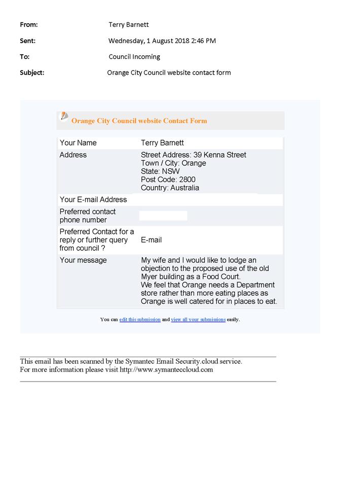
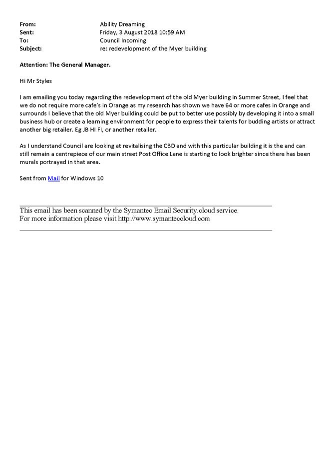
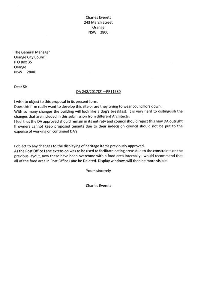
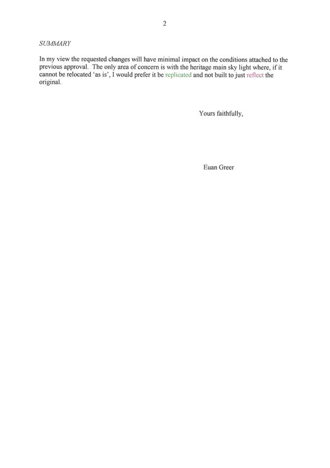
2.4 Development
Application DA 178/2018(1) - 386 Molong Road and Lot 6 Northern Distributor
Road
RECORD
NUMBER: 2018/1893
AUTHOR: Michael
Glenn, Senior Planner
EXECUTIVE Summary
|
Application
lodged
|
28 May
2018
|
|
Applicant/s
|
Mr G
Thornberry
|
|
Owner/s
|
Mr GJ
Thornberry
|
|
Land
description
|
Lot 81
DP 1202584 - 386 Molong Road and
Lot 6 DP
1065578 - Northern Distributor Road, Orange
|
|
Proposed
land use
|
Subdivision
(103 lots - comprising 96 residential lots, 6 open space lots and 1
residue lot)
|
|
Value of
proposed development
|
Not
applicable
|
Council's consent is sought for a subdivision of the subject
land into 103 lots, comprising 6 open space lots and 96 residential lots
ranging in size from 389m2 to 6,178m2, and a residual lot
of 15,600m2. There are two lots in the subdivision that, on the
basis of their lot size and configuration, are intended as unit sites (proposed
Lots 114 and 117).
Like all development
applications, applications for subdivision must be assessed against the heads
of consideration listed under Section 4.15 of the Act. For subdivisions this
should include an assessment of land capability and permissibility of the
future uses. The assessment of the proposed subdivision must assess the
environmental constraints, infrastructure needs, zoning restrictions of the
future uses (in a general sense) and make provision for infrastructure as
required. The consent can only relate to the site itself, however
infrastructure required on surrounding land can be required (and constructed)
with the agreement of those surrounding landowners (however, such agreement
does not form part of the consent).
The principal environmental
issues for consideration in this application are:
1 The
noise and odour impacts between the proposed subdivision and the sewer pump
station located at the northern extremity of the site, and the security in the
tenure of this structure and the infrastructure, as well as the arrangements
for access to that piece of infrastructure;
2 The
noise impacts on the subdivision arising from the Northern Distributor Road
(NDR) and Molong Road;
3 The
protection of the riparian corridors and ensuring that such corridors have
sufficient width and ongoing management. These constraints require the setting
aside of land and its ongoing conservation and management as per Department Of
Primary Industries (Water) (DPI-Water) requirements; and
4 Possible
aboriginal heritage on the site. This will, among other responses, require that
the trees on the site be investigated as to whether any scar trees exist among
the mix.
One particular element of this application necessitates a
comment from the broader strategic perspective of Council as a planning
authority, as a manager of public land and provider of public open space.
This relates to the proposed large amount of open space
associated with the two watercourses which traverse the land in question and
proposals put forward by the developer. On the one hand there are large areas
of the site constrained by riparian corridors to the extent of requiring
35,848m2 of corridors. However, Council’s section 7.11
acquisitions plan only provides for a maximum of 6,000m2 to be
acquired with compensation to provide pedestrian and cycle access through the
site. The remainder of this land can either be retained in private ownership,
or be dedicated to Council at no cost. Because the land is environmentally sensitive
and is in generally poor condition, conditions are imposed that require some
rehabilitation as an offset to the environmental risks posed by the proposed
development. Conditions are imposed that require a minimum of 6,000m2
to be provided to Council with appropriate compensation (and excluding the OSD
basin). For the remaining land within the riparian corridors the land may be
optionally dedicated to Council (for open space and environmental purposes) or
be retained in private ownership, but subject to a plan of management that aims
for consistency in the uses allowable under the zones that apply to the land,
as well as no significant adverse environmental effect.
It is noted that the site includes an onsite detention
basin. Compensation for this infrastructure under the Open Space Acquisitions
Plan is not applicable as such infrastructure is not classified as open space.
This piece of infrastructure is within the riparian zone of a waterway
classified as Sensitive Waterway (under the LEP) and Key Fish Habitat (under
the Fisheries Management Act 1994). As a result of these environmental
constraints, it is considered necessary to require the proponent to develop
this infrastructure as a constructed wetland or wet detention basin.
It is further noted that a noise buffer adjacent to the
Northern Distributor Road is provided for in the section 7.11 acquisitions
plan, but the amount of land for which compensation is applicable is limited to
a maximum of 3,000m2. This limit is separate to, and in addition to
the 6,000m2 applicable to the riparian corridors (mentioned
above). The submitted plans show a total of 8,762m2 of buffer land
being set aside for noise buffering. Council is in the position of only
offering compensation for a maximum of 3,000m2. The remainder will
necessarily need to be dedicated to Council at no cost, or as is the case for
the riparian corridors, require the preparation of a Plan of Management to
ensure their continued functionality as open space corridors and noise buffer.
Land not suitable within the development site directly as
residential land (due to its environmental constraints and/or zoning) must have
an alternative use envisioned and provided for within any consent issued by
Council. Land excluded directly from use as residential land inevitably will
tend to devolve to open space purposes.
The acquisitions plan (for open space) does not include any
provisions to cover the Somerset Creek riparian corridor (the waterway that
passes under the NDR). To an extent, the broad principals of the acquisitions
plan have not been reflected in the infrastructure provided.
The open space network being developed in the adjoining
Ribbon Gums Estate and the provision of an underpass adjacent to the creek and
passing under the Northern Distributor Road suggests clear intent to develop
Somerset Creek as a pedestrian and cycleway link to the remaining network. The
riparian corridor of Somerset Creek is zoned RE1 Public Recreation to
reflect these physical constraints and community aspirations
Conversely, the amount of open space for public and Council
purposes is properly identified in the Development Contributions Plan. The
additional open space proposed in this application is currently deemed in the
Council adopted long range planning policies as not required for public and
Council purposes, and can be held for conservation purposes privately as is
vast amounts of land in NSW and in Orange.
Given the surplus nature of the land to the developer and
the surplus nature of the land for public and Council purposes, it is held that
were it is offered, it ought to be acquired by Council only to the extent
allowed for under the contributions masterplan, and that any land in excess of
that maximum set by the DCP should be at no compensation, like any other parcel
of land not required by Council for a specific planning purpose under the Environmental
Planning and Assessment Act that a landowner wishes to divest.
It is recommended that Council supports the subject proposal
subject to the conditions attached.
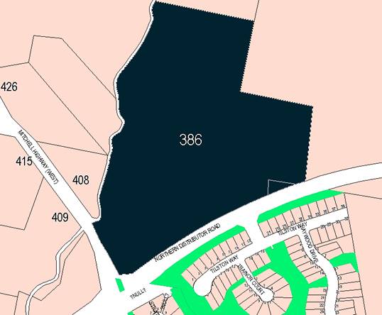
Figure 1: locality plan
RECENT LEGISLATIVE CHANGES
On 1 March 2018 the Environmental Planning and Assessment
Act 1979 was substantially amended. The most immediate change involves the
restructuring and renumbering of the Act, with other more substantive
changes to be phased in over time. However, for some applications (particularly
where an application was lodged prior to the changes coming into effect) the
supporting documentation may still reference the previous numbering regime. In
the drafting of this report the content and substance of the supporting
material has been considered irrespective of which legislative references were
used.
DECISION FRAMEWORK
Development in Orange is governed by two key documents
Orange Local Environment Plan 2011 and Orange Development Control Plan 2004. In
addition the Infill Guidelines are used to guide development, particularly in
the heritage conservation areas and around heritage items.
Environmental Planning & Assessment Act 1979
- The operation of the Act since March 2018 has also been amended so as to
make it mandatory to consider the provisions of Part 7 of the Biodiversity
Conservation Act 2016 and Part 7A of the Fisheries Management
Act 1994. The Act has many facets; most importantly it sets out the
legislative framework and matters for consideration in the merit assessment of
development applications. These matters are listed broadly under Section 4.15
of the Act, and are mandatory matters to consider in the determination of
development proposals.
Orange Local Environment Plan 2011 – The
provisions of the LEP must be considered by the Council in determining the
application. LEPs govern the types of development that are permissible or
prohibited in different parts of the City and also provide some assessment criteria
in specific circumstances. Uses are either permissible or not. The objectives
of each zoning and indeed the aims of the LEP itself are also to be considered
and can be used to guide decision making around appropriateness of development.
Orange Development Control Plan 2004 – the DCP
provides guidelines for development. In general it is a performance based
document rather than prescriptive in nature. For each planning element there
are often guidelines used. These guidelines indicate ways of achieving the
planning outcomes. It is thus recognised that there may also be other solutions
of merit. All design solutions are considered on merit by planning and building
staff. Applications should clearly demonstrate how the planning outcomes are
being met where alternative design solutions are proposed. The DCP enables
developers and architects to use design to achieve the planning outcomes in
alternative ways.
2017 Orange Development Contributions Plan - sets out
the applicable contribution rates for new lots approved, and the applicable
compensation rates for land acquisitions. For the subject site it includes an
open space masterplan, specifying the amount of space (in square metres) that
may be subject to compensation. A proportion of the open space is reserved for
the NDR buffer, the remainder is set aside for the riparian corridors.
DIRECTOR’S COMMENT
This land package has historically gained subdivision
approval for lots in the order of 1,000m². In response to a market
need for a mixture of lot sizes, the applicant has sought a rezoning supported
by Council to move to a new lot size mix and subdivision layout. The
subdivision has been designed around constraints including the creek systems in
place and the Northern Distributor Road and Molong Road. The application is
supported by staff subject to consent conditions that respond to concerns
around tree loss, waterway quality and habitat protection.
Link To Delivery/OPerational Plan
The recommendation in this report relates to the
Delivery/Operational Plan strategy “10.1 Preserve -
Engage with the community to ensure plans for growth and development are
respectful of our heritage”.
Financial Implications
Nil
Policy and Governance Implications
Nil
|
Recommendation
That Council consents to development application DA
178/2018(1) for Subdivision (103 lots - comprising 96 residential
lots, 6 open space lots and 1 residue lot) at Lot 81 DP 1202584
- 386 Molong Road and Lot 6 DP 1065578 - Northern Distributor Road, Orange
pursuant to the conditions of consent in the attached Notice of Approval.
|
further considerations
Consideration has been given to the
recommendation’s impact on Council’s service delivery; image and
reputation; political; environmental; health and safety; employees;
stakeholders and project management; and no further implications or risks have
been identified.
SUPPORTING INFORMATION
THE APPLICATION/PROPOSAL
Council's consent is sought for a subdivision of the subject
land into 103 lots, comprising 6 open space lots and 96 residential lots
ranging in size from 389m2 to 6178m2 with a residual lot
of 15,600m2. The basic layout of the subdivision is shown in Figure
2 below:
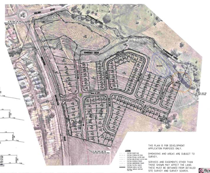
Figure 2: proposed subdivision
It is also proposed to establish easements on which the
sewer pump station is to be located. Easements across the creek are proposed to
facilitate access to the development lot (Lot 61). No direct access from a
road to Lot 61 is proposed. The proposed subdivision is to be provided with a
single vehicular point off the NDR.
MATTERS FOR CONSIDERATION
The Relevant Objectives
The proposed development as configured is an appropriate
response to the demands of the various zone objectives of the LEP.
The riparian corridors with their (mostly) E2 (Environmental
Conservation) zoning have objectives that seek to:
protect, manage and restore areas of high
ecological, scientific, cultural or aesthetic values, and prevent development
that could destroy, damage or otherwise have an adverse effect on those values.
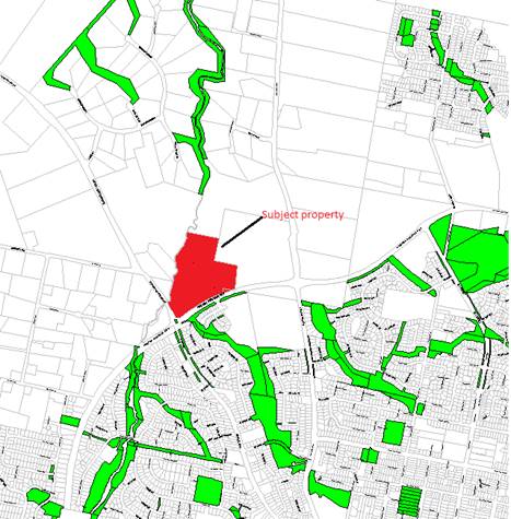
Figure 3 - the subject property and the developing
open space corridor network
to the north and south of the site
The principal environmental issues for consideration in this
application are:
1 The
noise and odour impacts between the proposed subdivision and the sewer pump
station located at the northern extremity of the site, and the security in the
tenure of this structure and the infrastructure, as well as the arrangements
for access to that piece of infrastructure
2 The
noise impacts arising from the NDR and Molong Road
3 The
protection of the riparian corridor that will require the setting aside of land
and its ongoing conservation and management as per DPI Water (formerly NSW
Office of Water) requirements.
Council needs to consider in its determination whether the
condition of the riparian corridor as it currently exists is capable of
absorbing the key threatening processes presented by the subdivision, or
whether some level of rehabilitation will be required to avoid further
deterioration of the environment.
With regards to the R1 (General Residential) zone the
stated objectives of the zone are:
· To provide for the housing needs of the community.
· To provide for a variety of housing types and densities.
· To enable other land uses that provide facilities or services to meet
the day to day needs of residents.
· To ensure development is ordered in such a way as to maximise public
transport patronage and encourage walking and cycling in close proximity to
settlement.
· To
ensure that development along the Southern Link Road has an alternative access.
Section 1.7 - Application of Part
7 of the Biodiversity Conservation Act 2016 and Part 7A of the Fisheries
Management Act 1994
Development Applications lodged on or after 25 February
2018
Section 1.7 of the EP&A Act 1979 identifies that Part 7
of the Biodiversity Conservation Act 2016 and Part 7A of the Fisheries
Management Act 1994 have effect in connection with terrestrial and aquatic
environments.
The subject site contains both terrestrial and riparian
biodiversity and therefore is subject to detailed assessment under both the
Biodiversity conservation Act and also the Fisheries management act 1994.
Biodiversity Conservation Act 2016 -
(Assessment and Approval Under the Planning Act)
The key test of the new Act as it applies to this
application can be found at Sections 7.2 and 7.3.
Section 7.2 - Development or activity “likely to significantly affect
threatened species”
A three part test is applicable under this section and is
addressed as follows:
(a) it is likely to significantly affect
threatened species or ecological communities, or their habitats, according to
the test in section 7.3
The applicant has submitted supporting
information in their submission to Council indicating that the tree stands on
the site, whilst old growth and of appropriate species, are part of a generally
isolated tree stand. Further these stands are not considered viable, and lack
many of the structural elements of a Box Gum Grassy Woodland. There is some
value in retaining some of the stand from an urban bushland perspective,
primarily as a means of providing transitory shelter for juvenile species as
they migrate away from other, larger bushland stands in the area that provide
nursery and feeding opportunities for new hatchlings.
This issue was visited during the assessment
of the last application of this site (DA 217/2014 for a 61 lot residential
subdivision). At the time of determination of that application Council was
advised:
In this case, the terrestrial
elements of the site have some isolated tree stands associated with the Box Gum
Grassy Woodland; however, the vegetation does not constitute a viable vegetation
community and lacks connectivity. There are a total of 13 over-mature native
species trees on the site outside the riparian areas of the site. These tree
stands offer some habitat value as seed banks but do not fill the criteria or
even have potential to fill the criteria of being a viable woodland area or
vegetated corridor to other more substantial vegetation communities nearby.
(b) the development exceeds the biodiversity
offsets scheme threshold if the biodiversity offsets scheme applies to the impacts
of the development on biodiversity values
The Biodiversity Offsets Scheme (or BOS)
threshold is an area test. If the area to be cleared, or otherwise affected
exceeds an area provided for in the Regulations (which for this site
is 2.0ha) the offsets scheme is triggered by the development. There is not
2ha of clearing contained in the subject application.
(c) it is carried out in a declared area of
outstanding biodiversity value.
Areas of Outstanding Biodiversity Value (OBVs) are shown on
mapping layers prepared, or being prepared by OEH. They are broadly equivalent
to the Critical Habitat declarations of the previous legislation. The subject
site is not an OBV.
Section 7.3 - Test for
determining whether proposed development or activity is likely to significantly
affect threatened species or ecological communities, or their habitats
(a) in the case of a threatened species,
whether the proposed development or activity is likely to have an adverse
effect on the life cycle of the species such that a viable local population of
the species is likely to be placed at risk of extinction,
The site has no known threatened species on
the site, and in any event is considered unlikely to be able support a viable
population of threatened species likely to develop on the site at some point in
the future. The relative lack of connectivity of this site to surrounding
bushland areas limits its ability to act in support of other bushland areas.
(b) in the case of an endangered ecological
community or critically endangered ecological community, whether the proposed
development or activity:
(i) is likely to have an adverse effect
on the extent of the ecological community such that its local occurrence is
likely to be placed at risk of extinction, or
(ii) is likely to substantially and adversely
modify the composition of the ecological community such that its local
occurrence is likely to be placed at risk of extinction,
As elsewhere stated in this report, it is
considered the development site does not contain a viable BGGW EEC. It is
accepted that the site does contain component elements of such EECs, and
that from that standpoint the conservation of the remnant stands of timber on
the site would be broadly beneficial (also, given the visual prominence of this
timber stand, its conservation from an aesthetic standpoint is also
supportable).
(c) in relation to the habitat of a threatened
species or ecological community:
(i) the extent to which habitat is likely
to be removed or modified as a result of the proposed development or activity,
and
(ii) whether an area of habitat is likely to
become fragmented or isolated from other areas of habitat as a result of the
proposed development or activity, and
(iii) the importance of the habitat to be removed,
modified, fragmented or isolated to the long-term survival of the species or
ecological community in the locality,
It is considered that under the worst
circumstances, the proposed development (or development that can logically be
assumed or expected to occur after the subdivision) could result in the loss of
up to nine terrestrial trees. The loss of these trees is an adverse effect in
the sense that habitat generally would be diminished, there are also scenic
benefits to be derived from the conservation of the small amounts of terrestrial
biodiversity that exists on the site.
(d) whether the proposed development or
activity is likely to have an adverse effect on any declared area of
outstanding biodiversity value (either directly or indirectly),
The subject site is not located within any
declared areas of outstanding biodiversity.
(e) whether the proposed development or
activity is or is part of a key threatening process or is likely to increase
the impact of a key threatening process.
The proposed development as submitted envisages some
clearing of native vegetation which of itself is identified as a Key
Threatening Process (KTP) under OEH guidelines. However, the applicant is
agreeable to the retention of some of the old growth vegetation and replacement
for those trees to be removed. Such arrangements in this case (due to the
relative isolation of the terrestrial vegetation) is considered a satisfactory
offset, such that no significant impact would arise as a result of the removals
that are implied in the proposed subdivision.
Fisheries Management Act
1994 - Part 7A (Threatened Species Conservation) (FMA)
The objectives of this Part are as follows:
(a) to conserve biological diversity of fish
and marine vegetation and promote ecologically sustainable development and
activities,
(b) to prevent the extinction and promote the
recovery of threatened species, populations and ecological communities of fish
and marine vegetation,
(c) to protect the critical habitat of those
threatened species, populations and ecological communities that are endangered,
(d) to eliminate or manage certain processes
that threaten the survival or evolutionary development of threatened species,
populations and ecological communities of fish and marine vegetation,
(e) to ensure that the impact of any action
affecting threatened species, populations and ecological communities of fish
and marine vegetation is properly assessed,
(f) to encourage the conservation of
threatened species, populations and ecological communities of fish and marine
vegetation by the adoption of measures involving co-operative management.
Council’s mapping layers classify the land in the
following terms:
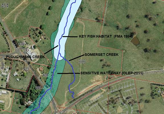
Figure 4:- key fish habitats and sensitive waterways
Where Key Fish Habitats are extant, Council must also have
regard to conservation objectives of the FMA. Ploughmans Creek is identified as
a Sensitive Waterway and is subject to assessment under Sensitive Waterways
provisions contained in the LEP. Somerset Creek is not protected as either
a Sensitive Waterway or as Key Fish Habitat, although it is obvious that the
water quality of Somerset Creek will have an impact on Ploughmans Creek
downstream of the junction of the two waterbodies.
Whilst derived from allied legislation (specifically the Water
Management Act 2000 or WMA), the applicable riparian corridors (which
vary according to the stream order classification) are relevant in broad terms
to the success or adequacy of stream conservation. The higher the stream
ordering of the waterway under the WMA (derived from the Strahler method of
stream classification) the wider the required riparian corridor.
Stream Ordering and Riparian
Corridors
The site is traversed by two separate waterbodies
(Ploughmans and Somerset Creeks) that merge into a single higher order stream
after this merge of the two streams (still known as Ploughmans Creek downstream
of the junction).
Stream ordering is important because it affects the width of
the riparian corridor adjacent and also impacts on the significance of streams
as potential fisheries. The order ranking of a stream determines whether that
stream is subject to the controlled activity provisions of the Water
Management Act 2000. A 3rd Order stream or above requires a controlled
activity permit and this, in turn, requires co-approval from the Department Of
Primary Industries (Water) pursuant to the Integrated Development provisions of
the Act. It is further noted that a development site affected by Key Fish
Habitats (such as the subject property) is subject to Integrated Development Assessment
by NSW Fisheries.
A stream provided with a
complying riparian corridor should in most situations be considered as
adequately protected in most development situations. Since 2012 stream ordering
has been codified under the Strahler method, which essentially counts
tributaries to establish the stream order being assessed, and includes the
vegetation corridor (or VRZ). The width of the VRZ should be measured from
the top of the highest bank on both sides of the watercourse.
|
Watercourse
type
|
VRZ
width
(each side of watercourse)
|
Total
RC width
|
|
1st order
|
10
m
|
20m + channel width
|
|
2nd order
|
20m
|
40m + channel width
|
|
3rd Order
|
30m
|
60m + channel width
|
|
4th Order or greater
|
40m
|
80m + channel width
|
Figure 5: recommended riparian corridor (RC) widths
The riparian corridor (RC)
consists of the channel which comprises the bed and banks of the watercourse
(to the highest bank) and the vegetated riparian zone (VRZ) adjoining the
channel.

Figure 6:- the riparian corridor
The subject property has, on the basis of Strahler, a
Category 2 stream (being the more eastern water body that runs into Ploughmans
Creek. Ploughmans Creek is a Category 3 stream below the junction.
The new regulations make the primary determinant of stream
order the responsibility of DPI Water. In this regard, the advice of DPI
water (in 2015) for this site was as follows:
I refer to your enquiry
regarding the Office of Water's determination of what order stream Ploughmans
creek is on the subject development site. I have had a brief look and attached
a map which identifies the stream order in accordance with the Strahler Stream
Ordering System that the Office of Water uses.
You will note that Ploughmans
Creek on the southern boundary is a 2nd order, once the unnamed 2nd order creek
drops into Ploughmans Creek opposite Lot 208//1018862, it becomes a 3rd order.
A 20 m buffer from the high
bank of the creek is required for the 2nd order and a 30 m buffer from the high
bank of the creek for the 3rd order in accordance with the attached Office of Water
guidelines for riparian corridors. There is some flexibility to vary the
setbacks in some cases however this will of course have to also be in line with
council's requirements.
These comments relate to establishing an appropriate
riparian corridor based on the Department’s guidelines. Any activities
within the riparian zone of a prescribed stream (of which Ploughmans Creek is
one) triggers a need for a "controlled activity" assessment, and
hence for this application an Integrated Development assessment. For the
purposes of the environmental assessment of the proposal, the provision of
complying riparian buffers in the proposal is indicative of adequate
environmental protections. However, the riparian zones on the site are heavily
degraded, due in part to an absence of riparian vegetation. It is considered
appropriate that as a central element of the recovery of this locality, the
applicant be required to prepare an appropriate landscape plan for the riparian
zone. Given that these areas will also function as open space and pedestrian
links to the rest of Council’s open space corridors (located to both the
north and south of the site), it is further considered appropriate to impose a
requirement for the landscape recovery plan to include provision for a 1.8m wide
walking path to Council’s specification.
Key Threatening Processes
(KTPs) for Riparian Land
A riparian corridor forms a transition zone between the
land, also known as the terrestrial environment, and the river or watercourse
or aquatic environment. Riparian corridors perform a range of important
environmental functions such as:
· providing bed and
bank stability and reducing bank and channel erosion
· protecting water
quality by trapping sediment, nutrients and other contaminants
· providing
diversity of habitat for terrestrial, riparian and aquatic plants (flora) and
animals (fauna)
· providing
connectivity between wildlife habitats
· conveying flood
flows and controlling the direction of flood flows
· providing an
interface or buffer between developments and waterways
· providing passive
recreational uses.
The protection, restoration or rehabilitation of vegetated
riparian corridors is important for maintaining or improving the water quality,
stability (or geomorphic form) and ecological functions of a watercourse. It
also has implications under the Fisheries Management Act and the
protection of waterways as fish or aquatic habitats. It is further noted that
the controlled activity aspects of the proposed development trigger a need for
a co-approval from DPI Water. The co-approval conditions provided by DPI Water
already address many of the potential harmful impacts that could arise from the
subdivision.
Subdivision is identified of itself to incorporate Key
Threatening Processes (KTPs), and the existing riparian corridors are unlikely
to be sufficient to address those increased threats. The KTPs that can be
attributed to the subdivision include the following:
· weed infestation
· fragmentation and
lack of connectivity
· feral predation
and feral infestation (such as Willow and European Carp)
· changes to stream
hydraulics (either inundation or water deprivation)
· nutrient control
and biological oxygen demand (BOD)
· water quality,
particularly turbidity, but also toxic pollution from sprays, insecticides and
the like
· erosion arising
from concentration of flows.
The subject creek is known as a potential platypus habitat,
and according to advice provided by officers of the Local Land Service (LLS),
this riparian system could be expected to provide habitat for the following if
its environmental health was restored to acceptable levels:
· Trout Cod
· Macquarie Perch
· Silver Perch
· Eel Tailed Catfish
· Purple Spotted
Gudgeon
LLS advise that in their opinion: "the proposal
would be likely to involve increased pressure/threats on the waterway
(increased area of imperviousness etc)”. LLS suggests that the
water balance and flow regime be maintained at pre-development levels through
keeping water in the landscape. This will also avoid erosion and sediment
issues. This will require development that uses “water sensitive urban
design principles". These suggestions are already incorporated in the DPI
Water co-approval General Terms Of Approval and certain conditions recommended
by Council's Technical Services Division.
Appropriate responses to the potential KTPs posed by the
proposed subdivision are considered to be adequately addressed in the
co-approval conditions provided by DPI Water.
Condition Responses to
Environmental Constraints and Opportunities
The above analysis leads to the draft consent containing the
following conditions:
PRIOR
TO THE ISSUE OF A CONSTRUCTION CERTIFICATE
(x) The submission
of a comprehensive landscape plan that is to the satisfaction of the Manager
Development Assessments that incorporates the following elements:
· A comprehensive landscaping plan to screen the area
around the pump station.
· The submission of a landscaping plan incorporating
appropriate levels of earth mounding, native species selection, weed matting or
weed suppression measures, plant density is to be submitted to Council for the
noise buffer areas adjacent to the Northern Distributor Road and Molong Road
(shown on the approved plans as Lots 164, 165 and 166). Plantings along the
buffers are required to be generally native species except the corridor
adjacent to Molong Road which shall be a species consistent with the Precinct
Plans for landscaping in the vicinity of the roundabout intersecting the
Northern Distributor Road and Molong Road.
· The submission of a comprehensive landscape recovery
plan for the riparian corridors affecting the site, incorporating concrete
pathways (which will be completed by Council, other works in the plan will be
carried out by the applicant). Species selection shall be appropriate native
species and at a density that is to the satisfaction of the Manager City
Presentation.
(x) A plan of
management for the riparian corridors adjacent to Ploughmans Creek and
consistent with the E2 and RE1 zoning shall be prepared to the
satisfaction of the Director Development Services and the Director Technical
Services, establishing this area as an area of open space (accessible to the
general public and maintained to a standard that satisfies council requirements
for open space) and providing details on flood mitigation and ongoing
management of this land. Alternatively, the land may be dedicated to Council at
no charge to enable Council management for public purposes
PRIOR TO WORKS COMMENCING
(x) A minimum of
three trees shall be retained and conserved on the open space Lots 141 and
164, which shall be modified in size and shape where necessary so that the
property boundaries of these lots are not closer than 2m from the trees to be
protected.
Trees
to be removed from proposed Lots 145, 146, 147, 152 and 153 can be removed
under this approval. The remnants of those trees shall be placed within the open
space and/or riparian lots in a location that is to the satisfaction of the
Manager City Presentation (Orange City Council). Replacements shall be planted
(for the trees to be removed) at the rate of 5 replacements for each tree to be
removed within the open space lot (or alternatively, native ground and
midstorey covers at the rate of 35m² of dense plantings per tree to be
removed). Replacement tree plantings shall be at a density not exceeding 1 tree
per 35m² of available space.
(xx) Tree Protection zones are
to be established for the existing over mature trees to be retained on the
site, complying with the
requirements of Australian Standard. No approval is granted for the removal of
these trees under this consent.
ONGOING PERFORMANCE
(x) Landscaping
required under this consent shall be fully maintained by the developer for a
minimum period of two years after the issue of the subdivision certificate (if
the land is transferred to Council’s control) or permanently if the land
on which the landscaping is to be installed is retained in private ownership.
The plan of management required under condition (xx) of this consent shall
provide details on watering, weeding and replacement regimes to be carried out
during the maintenance period.
Aboriginal Heritage
A search using the Aboriginal Heritage Information
Management System (AHIMS) does not reveal any evidence of known aboriginal
heritage or artifacts on the site. There is no obvious evidence of Aboriginal
archaeology on the site after the completion of a site inspection by staff. The
applicant’s statement of environmental effects does not identify any
likely sources of aboriginal heritage on the site. Notwithstanding, as a
greenfields site it is considered appropriate to impose precautionary conditions
placing a responsibility on the client to stop work and seek the necessary
section 90 (National Parks and Wildlife Act) Permits if such
evidence is uncovered during the site preparation phases. The recommended
condition to address this issue is:
(x) If Aboriginal
objects, relics or other historical items or the like are located during
development works, all works in the area of the identified object, relic or
item shall cease and the NSW Office of Environment and Heritage (OEH), and
representatives from the Orange Local Aboriginal Land Council shall be
notified. Where required, further archaeological investigation shall be
undertaken. Development works in the area of the find(s) may recommence if and
when outlined by the management strategy, developed in consultation with and
approved by the OEH.
This provision already applies under that legislation;
however, such provision can appropriately be applied as a condition of consent
for clarity. Further, as one local Aboriginal group has made a claim that one
of the existing trees is a scar tree, it is considered appropriate to impose a
condition to address this possibility as well. The recommended condition to
address this issue is:
(x) An
archaeological report is required prior to the removal of any trees from the
site to determine if any trees contain evidence of Aboriginal heritage. In the
event that Aboriginal heritage is found on the site, the applicant shall seek
the necessary permits to destroy the artifact pursuant to the provisions of
section 90 of the National Parks and Wildlife Act 1974, or submit an
amended plan that avoids the need to remove the artifact.
Section 4.15
Section 4.15 of the Environmental Planning and Assessment
Act 1979 requires Council to consider various matters, of which those
pertaining to the application are listed below.
PROVISIONS OF ANY ENVIRONMENTAL
PLANNING INSTRUMENT s4.15(1)(a)(i)
Orange Local Environmental Plan
2011
Part 1 - Preliminary
Clause 1.2 - Aims of Plan
The broad aims of the LEP are
set out under subclause 2. Those relevant to the application are as follows:
(a) to
encourage development which complements and enhances the unique character of
Orange as a major regional centre boasting a diverse economy and offering an
attractive regional lifestyle,
(b) to
provide for a range of development opportunities that contribute to the social,
economic and environmental resources of Orange in a way that allows present and
future generations to meet their needs by implementing the principles for
ecologically sustainable development,
(c) to
conserve and enhance the water resources on which Orange depends, particularly
water supply catchments,
(d) to
manage rural land as an environmental resource that provides economic and
social benefits for Orange,
(e) to
provide a range of housing choices in planned urban and rural locations to meet
population growth,
(f) to
recognise and manage valued environmental heritage, landscape and scenic
features of Orange.
In relation to (a), the proposed
development will detract from or decrease the rural character of the locality,
but will be consistent with and increase the residential character of the more
urban areas nearby. The subject property is zoned R1 General Residential and E2 Environmental
Conservation along the riparian corridor adjacent to Ploughmans Creek.
Adjoining land to the north is substantially zoned rural, whilst land to the
east, south and west is zoned residential. On the basis of zoning, the lot
sizes and layout appear to be appropriate development for the site.
In acknowledgement of the competing demands
of residential and rural residential character affecting the subject site, it
is considered appropriate to impose a range of conditions aimed at achieving a better
relationship with these competing characters. In summary, the conditions will:
1 Require all subdivision
fencing adjoining rural land (to the north) to be rural style fencing (post and
wire, no barbed wire).
2 Impose a Section 88B
Restriction-as-to-User under the Conveyancing Act 1919 requiring
such rural fencing to be retained and maintained, and prohibiting the
replacement of such fencing except with like materials and the approval of
Council and the adjoining owner (as per the general principals of the Dividing
Fences Act).
With regard to (b), the proposed
development does increase the stock of housing lots that, in some perspective,
adds to the development opportunities of the City. Adding to the housing stock
increases the potential for population growth that, in turn, suggests that the
needs of the workforce will be met.
With regard to (c), the proposed
development would not have any significant effect on the resources of the
Orange City water supply.
With regard to (d), it is acknowledged that
the current use of the site is mostly for grazing. Such activities have a
limited contribution to the local economy, whilst the proximity of farming land
close to the suburban areas of the City provides a degree of ambience and
amenity for those properties. Conversion of the land to residential lots will
subtract that land from the agricultural stock of land and make some areas
closer to the City less connected to the rural surroundings of the City. Such
effects are accepted as part of the normal expansion and increase in
residential land stocks for the City.
With regard to (e), the proposed
development does not include housing; however, it does increase the supply of
residential allotments. This will produce the conditions needed to provide
additional housing opportunities.
With regard to
(f), it is recognised that the changes in zoning that occurred under
LEP 2011 will result in some adverse effects on the surrounding landscape.
However, within the context of the general provisions, the zoning, the other objectives
of the LEP and the recognised primary view corridors and the like, it is
considered that this is appropriate development for the site.
Clause 1.6 - Consent Authority
This clause establishes that, subject to the Act, Council is
the consent authority for applications made under the LEP.
Clause 1.7 - Mapping
The subject site is identified
on the LEP maps in the following manner:
|
Land Zoning Map:
|
Land
zoned R1 General Residential, Public Recreation RE1 and E2 Environmental
Conservation
|
|
Lot Size Map:
|
Minimum
Lot Size part 250 m2 and part 500 m2
|
|
Heritage Map:
|
Not a
heritage item or conservation area
|
|
Height of Buildings Map:
|
No
building height limit
|
|
Floor Space Ratio Map:
|
No floor
space limit
|
|
Terrestrial Biodiversity Map:
|
Some high
biodiversity sensitivity on the site
|
|
Groundwater Vulnerability Map:
|
Ground
water vulnerable
|
|
Drinking Water Catchment Map:
|
Not
within the drinking water catchment
|
|
Watercourse Map:
|
within
or affecting a defined watercourse
Listed
sensitive waterway
|
|
Urban Release Area Map:
|
Not
within an Urban Release Area
|
|
Obstacle Limitation Surface Map:
|
No
restriction on building siting or construction
|
|
Additional Permitted Uses Map:
|
No
additional permitted use applies
|
Those matters that are of relevance are addressed in detail
in the body of this report.
Clause 1.9A - Suspension of
Covenants, Agreements and Instruments
This clause provides that covenants, agreements and other
instruments which seek to restrict the carrying out of development do not apply
with the following exceptions.
· covenants imposed
or required by Council
· prescribed
instruments under Section 183A of the Crown Lands Act 1989
· any conservation
agreement under the National Parks and Wildlife Act 1974
· any trust
agreement under the Nature Conservation Trust Act 2001
· any property
vegetation plan under the Native Vegetation Act 2003
· any biobanking
agreement under Part 7A of the Threatened Species Conservation Act 1995
· any planning
agreement under Division 6 of Part 4 of the Environmental Planning and
Assessment Act 1979.
Council staff are not aware of the title of the subject
property being affected by any of the above easements. There is, however, sewer
related infrastructure (sewer mains and sewer pump station) constructed on the
site. The application includes proposed easements for the existing sewer mains
and sewer pump station on the site.
Figure 7: utilities mapping
Part 2 -
Permitted or Prohibited Development
Clause 2.1 -
Land Use Zones and Clause 2.3 - Zone Objectives and Land Use Table
Figure 8: extract of zoning Map 1
The subject site is principally located within the R1
General Residential zone. The Ploughmans Creek riparian zone is zoned E2
Environmental Management, whilst the Somerset Creek riparian corridor is zoned
RE1 Public Recreation. The creek bed of Ploughmans Creek (to the top of the
bank) is zoned RE1 Public Recreation, but in general this land is not part of
the subject property. The creek itself does not form part of the subject
property but its riparian zones do.
The proposed development is defined as a subdivision under
OLEP 2011. Subdivision of land under LEP 2011 has the same meaning as
defined in the Act. Pursuant to clause 4B of the Environmental Planning and
Assessment Act, subdivision of land means:
the division of land into two
or more parts that, after the division, would be obviously adapted for separate
occupation, use or disposition.
Subdivision of land is permissible in all the zones
affecting the subject site (R1, RE1 and E2). Consent for subdivision is
being sought as required under Clause 2.6.
Clause 2.3 of
LEP 2011 references the Land Use Table and Objectives for each zone in
LEP 2011. These objectives for zones applicable to the subject property
are listed and commented upon as follows:
1 -
Objectives of the R1 General Residential Zone
· To provide for the
housing needs of the community.
· To provide for a
variety of housing types and densities.
· To enable other land
uses that provide facilities or services to meet the day to day needs of
residents.
· To ensure development
is ordered in such a way as to maximise public transport patronage and
encourage walking and cycling in close proximity to settlement.
· To ensure that development
along the Southern Link Road has an alternative access.
In relation to the first and second objectives, the proposed
development would provide additional lots on land on which housing stock within
the City can be provided. It will provide these additional lots at a scale
consistent with typical low and medium density development. In terms of lot
yield and lot sizes, the proposed subdivision is consistent with the relevant
controls. In relation to the third objective, the proposed subdivision would
not impede the provision of other land to provide facilities and services
should such a need ever arise in the future. In relation to the fourth
objective, the subject site is within close proximity to routes used by public
transport.
Further, the configuration of the proposed development with
open space along the creek lines is consistent with the zone objectives in that
it would facilitate the provision of walking and cycling opportunities to,
through and from the site. In relation to the last objective, the proposed
development has no effect. The proposed development is not inconsistent with
the objectives of the zone.
2 -
Objectives of the E2 Environmental Conservation Zone
· To
protect, manage and restore areas of high ecological, scientific, cultural or
aesthetic values.
· To
prevent development that could destroy, damage or otherwise have an adverse
effect on those values.
The E2 Environmental
Conservation zone has a limited range of permissible land uses, which reflects
the physical constraints that often affect such land. In urban situations the
range of uses that are permissible are effectively restricting such land to
public open space activities in most cases.
Achievement of the objectives
contained in the first dot point is the responsibility of the landowner.
With regard to the second dot
point, it is considered that as private land the range of permissible uses is
limited in an urban context. It cannot, for example, be used as a component of
residential development. As land in private ownership, but with no viable or
realistic purpose, it is considered highly likely that the land might not be
managed or maintained responsibly. This part of the riparian corridor land not
purchased under the S94 plan shall either be dedicated to Council or
alternatively incorporated into the residual Lot 139 and developed in
accordance with a plan of management that is to the satisfaction of the
Director Development Services and consistent with the E2 zoning.
3 -
Objectives of the RE1 Public Recreation Zone
· To enable land to be
used for public open space or recreational purposes.
· To provide a range of
recreational settings and activities and compatible land uses.
· To protect and
enhance the natural environment for recreational purposes.
· To ensure development
is ordered in such a way as to maximise public transport patronage and
encourage walking and cycling in close proximity to settlement.
· To ensure development
along the Southern Link Road has alternative access.
The land to which this zoning relates
is principally the riparian corridor of Somerset Creek, and the intent of this
zoning on this part of the site is self evident, in that it is intended to
extend the open space and walking/cycling path links for the direct benefit of
the proposed subdivision. The benefits, or needs for such extensions to the
open space network should be cost neutral to Council as the need for such
extension arises solely as a result of the demands generated by the subject
development. It is considered possible to achieve the core objectives of the
RE1 Public Recreation Land regardless of whether the land is retained in
private ownership, or passed to the public authority.
Clause 2.6 - Subdivision -
Consent Requirements
This clause triggers the need for development consent for
the subdivision of land.
Part 4 -
Principal Development Standards
Clause 4.1 - Minimum
Subdivision Lot Size
This clause requires the
subdivision of land to be equal to or greater than the size nominated for the
land under the Minimum Lot Size Map.
In relation to this site, the
map nominates two lot size restrictions, as shown in the following LEP mapping
extract:
Figure 9: Minimum Lot Size Map
The proposed subdivision meets
the minimum standards specified in the LEP with regards to lot sizes.
Part 5 -
Miscellaneous Provisions
5.10 - Heritage Conservation
There is no heritage significance on the site from the point
of view of European heritage. Although there is no known Aboriginal or
archaeological significance recorded in AHIMS for this site, one of the local
Aboriginal traditional owners is of the belief that a scar tree might exist on
the site, and further claims that inadequate investigation into Aboriginal
heritage on the site has been carried out.
(8) Aboriginal
Places of Heritage Significance
The consent authority must, before granting consent under
this clause to the carrying out of development in an Aboriginal place of
heritage significance:
(a) consider
the effect of the proposed development on the heritage significance of the
place and any Aboriginal object known or reasonably likely to be located at the
place by means of an adequate investigation and assessment (which may involve
consideration of a heritage impact statement), and
(b) notify
the local Aboriginal communities, in writing or in such other manner as may be
appropriate, about the application and take into consideration any response
received within 28 days after the notice is sent.
The AHIMS search failed to reveal any evidence of aboriginal
heritage on this site. Neither has physical inspection revealed any such
evidence. Notwithstanding there is a claim made following the exhibition of
this application by one of the traditional owners that such conclusions are
based on inadequate background research. To address this claim, it is
considered appropriate to require that a report be prepared prior to the issue
of a Construction Certificate to investigate further the existence of
Aboriginal heritage on the site.
Part 7 -
Additional Local Provisions
7.1 - Earthworks
This clause establishes a range
of matters that must be considered prior to granting development consent for
any application involving earthworks, such as:
(a) the likely disruption of, or any
detrimental effect on, existing drainage patterns and soil stability in the
locality of the development
(b) the effect of the development on the
likely future use or redevelopment of the land
(c) the quality of the fill or the soil to be
excavated, or both
(d) the effect of the development on the
existing and likely amenity of adjoining properties
(e) the source of any fill material and the
destination of any excavated material
(f) the likelihood of disturbing relics
(g) the proximity to and potential for adverse
impacts on any waterway, drinking water catchment or environmentally sensitive
area
(h) any measures proposed to minimise or
mitigate the impacts referred to in paragraph (g).
The earthworks of the proposed development are limited to
the extent of cutting and filling required for the construction of roads and
the construction of stormwater management systems. The extent of disruption to
the drainage of the site is considered to have a potential significant effect
on the creek system due to adverse effect on the quality of runoff. Conditions
are included to address the issue of erosion and sediment control and the
quality of the runoff from the site. The proposed development is defined as
Integrated Development under the Water Management Act 2000 and the
Fisheries Management Act 1994. Council has sought advice from DPI Water and
NSW Fisheries which are the relevant co-approval agencies. The co-approval
agencies have both indicated in their responses to Council that they do not
have any objections to the proposed development. The respective co-approval
requirements are attached and the General Terms of Approval are incorporated
into the consent.
The likely extent of the earthworks will not materially
affect the potential future use or redevelopment of the site that may occur at
the end of the proposed development’s lifespan. The site is not known to
be contaminated. As discussed above the site is not known to contain any
Aboriginal, European or archaeological relics. Previous known uses of the site
do not suggest that any relics are likely to be uncovered.
7.2 - Flood
Planning
This clause applies to land
identified on the Flood Planning Map as a Flood Planning Area and requires
that, before any consent is issued, Council must be satisfied that the
proposal:
(a) is
compatible with the flood hazard of the land, and
(b) is
not likely to significantly adversely affect flood behaviour resulting in
detrimental increases in the potential flood affectation of other development
or properties, and
(c) incorporates
appropriate measures to manage risk to life from flood, and
(d) is
not likely to significantly adversely affect the environment or cause avoidable
erosion, siltation, destruction of riparian vegetation or a reduction in the
stability of river banks or watercourses, and
(e) is
not likely to result in unsustainable social and economic costs to the
community as a consequence of flooding.
The site is not identified as
being affected by flood hazard on the Flood Hazard Mapping layer of the LEP;
however, the site is nevertheless known to contain some level of hazard from
flood near the creek areas of the site (which has been further confirmed by
flood studies undertaken by the applicant during the recent rezoning process
and submitted in the supporting information of this application). The findings
of this study are reflected in the subdivision planning as shown on the
submitted plans, which sets aside those areas of the site likely to be
inundated by flood.
7.3 -
Stormwater Management
This clause applies to all
industrial, commercial and residential zones and requires that Council be
satisfied that the proposal:
(a) is designed to maximise the use of water
permeable surfaces on the land having regard to the soil characteristics
affecting onsite infiltration of water
(b) includes, where practical, onsite
stormwater retention for use as an alternative supply to mains water,
groundwater or river water; and
(c) avoids any significant impacts of
stormwater runoff on adjoining downstream properties, native bushland and
receiving waters, or if that impact cannot be reasonably avoided, minimises and
mitigates the impact.
With regard to (a) and (b), the proposed development is for
subdivision of an existing two lot holding into various sized residential lots.
The future development of the lots will likely consist of standard residential
housing, with some multi dwelling houses also fed into the mix. Council has
controls with respect to site coverage that will ensure that extensive parts of
each allotment will have permeable spaces suitable for some onsite absorption
of stormwater, however it is highly likely that future development will require
some offsite stormwater discharges into the nearby creek systems. To prevent
excessive storm surges, an onsite detention basin is proposed as part of the
supporting infrastructure for the development. The stormwater management system
will be designed to accommodate best practice water quality standards and water
sensitive urban design principles. It is not anticipated that the proposed
development will lead to future development unsuited to the capabilities of
either onsite detention or the stormwater reticulation system.
With regard to (c), there will
be some impacts arising with stormwater runoff for water quantity and water
quality. Quantities can be expected to rise as hard surfaces like roads are
installed. Flow rates into the creek system will need to be controlled to
within certain specified limits to avoid events such as flash flooding during
peak events. With regard to water quality, it is both possible and appropriate
to require the onsite detention basin to be designed and constructed as a
wetland or wet detention basin, incorporating reed bed filtration to maximise
the quality of surface runoff. A condition requiring this outcome is included
in the consent.
Council’s Assistant
Development Engineer (ADE) advises that the stormwater management system will
incorporate Gross Pollutant Traps (GPTs) to capture litter that has entered the
stormwater system. Nutrient and particulate control is to be partially managed
by natural settling in the detention basin, and the development of the OSD
basin as a constructed wetland or wet detention basin will make it possible for
natural reed filtration of waste water runoff.
7.4 -
Terrestrial Biodiversity
This clause seeks to maintain
terrestrial biodiversity and requires that consent must not be issued unless
the application demonstrates whether or not the proposal:
(a) is likely to have any adverse impact on
the condition, ecological value and significance of the fauna and flora on the
land
(b) is likely to have any adverse impact on
the importance of the vegetation on the land to the habitat and survival of
native fauna
(c) has any potential to fragment, disturb or
diminish the biodiversity structure, function and composition of the land, and
(d) is likely to have any adverse impact on
the habitat elements providing connectivity on the land.
Additionally this clause
prevents consent being granted unless Council is satisfied that:
(a) the development is designed, sited and
will be managed to avoid any significant adverse environmental impact, or
(b) if that impact cannot be reasonably
avoided - the development is designed, sited and will be managed to minimise
that impact, or
(c) if that impact cannot be minimised - the
development will be managed to mitigate that impact.
This clause is only applicable
to those parts of the site marked in red on the LEP mapping layers, but is
generally applicable to all native species listed as “protected”.
This is a quite different classification to the “threatened”,
“vulnerable” and “endangered” threat classifications
contained in the OEH Threatened Species Guidelines. The OEH guidelines are
applicable across the stage, but only to species (and EECs) recorded as
threatened or endangered in those guidelines; whilst the LEP clause applies to
virtually all native species but only within those areas of the LEP that are
mapped as affected by the clause (the so called “red blobs”).
The subject site is affected by
this clause, to the extent shown in the Figure 10 below:
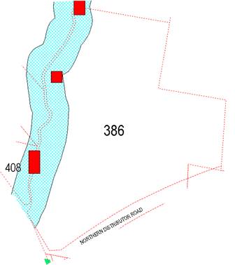
Figure 10: Terrestrial Biodiversity map
As can be seen, the affected
areas on the site are wholly located within the Sensitive Waterways area that
will be subject to a comprehensive rehabilitation plan. This is considered
sufficient to ensure the ongoing conservation of any remaining habitat value on
the site.
7.5 -
Riparian Land and Watercourses
This clause seeks to preserve
both water quality and riparian ecological health. The clause applies to land
identified as a “Sensitive Waterway” on the Watercourse Map which
is applicable to the entire length of ploughman s creek that abuts the subject
land along its western side. Council must consider whether or not the proposal:
(a) is likely to have any adverse impact on
the following:
(i) the water quality and flows within a watercourse
(ii) aquatic and riparian species, habitats and
ecosystems of the watercourse
(iii) the stability of the bed and banks of the
watercourse
(iv) the free passage of fish and other aquatic organisms
within or along the watercourse
(v) any future rehabilitation of the watercourse and
its riparian areas, and
(b) is likely to increase water extraction
from the watercourse.
Additionally, consent may not be granted until Council is satisfied that:
(a) the development is designed, sited and
will be managed to avoid any significant adverse environmental impact, or
(b) if that impact cannot be reasonably
avoided - the development is designed, sited and will be managed to minimise
that impact, or
(c) if that impact cannot be minimised - the
development will be managed to mitigate that impact.
The proposal has been designed
to incorporate appropriate riparian corridors to allow mitigation of the
impacts as outlined above. In the event that the riparian corridors are
retained as private land it will be necessary to link the open space lots to a
parent lot for the purposes of care, control and management. The most logical
lot for this amalgamation is considered to be the large development lot that is
proposed.
7.6 -
Groundwater Vulnerability
This clause seeks to protect
hydrological functions of groundwater systems and protect resources from both
depletion and contamination. Orange has a high water table and large areas of
the LGA, including the subject site, are identified with “Groundwater
Vulnerability” on the Groundwater Vulnerability Map. This requires that
Council consider:
(a) whether or not the development (including
any onsite storage or disposal of solid or liquid waste and chemicals) is
likely to cause any groundwater contamination or have any adverse effect on
groundwater dependent ecosystems, and
(b) the cumulative impact (including the
impact on nearby groundwater extraction for potable water supply or stock water
supply) of the development and any other existing development on groundwater.
Furthermore consent may not be granted unless Council is satisfied that:
(a) the development is designed, sited and
will be managed to avoid any significant adverse environmental impact, or
(b) if that impact cannot be reasonably
avoided - the development is designed, sited and will be managed to minimise
that impact,
(c) if that impact cannot be minimised - the
development will be managed to mitigate that impact.
The proposal is not anticipated
to involve the discharge of toxic or noxious substances and is therefore
unlikely to contaminate the groundwater or related ecosystems. The proposal
does not involve extraction of groundwater and will therefore not contribute to
groundwater depletion. The design and siting of the proposal avoids impacts on
groundwater and is therefore considered acceptable.
Clause 7.11 - Essential
Services
Clause 7.11 applies and states:
Development
consent must not be granted to development unless the consent authority is
satisfied that any of the following services that are essential for the
proposed development are available or that adequate arrangements have been made
to make them available when required:
(a) the supply of water,
(b) the supply of electricity,
(c) the disposal and management of sewage,
(d) storm water drainage or on-site
conservation,
(e) suitable road access.
In consideration of this clause, all utility services are
available to the land and adequate for the proposal.
STATE ENVIRONMENTAL PLANNING
POLICIES
State Environmental Planning Policy 55 Remediation of
Land
State Environmental Planning Policy 55 - Remediation of
Land (SEPP 55) requires that a consent authority must not consent to the
carrying out of development of land unless it has considered whether the land
is contaminated, is satisfied that the land is suitable in its contaminated
state for the development that is proposed, and if the land requires
remediation to be made suitable for the proposed development it is satisfied
that the land will be remediated before the land is used for that purpose.
Furthermore, SEPP 55 requires that before determining an
application to carry out development that would involve a change of use of land
(specified in subclause 4), the consent authority must consider a
preliminary investigation of the land concerned.
A search of records and available data suggests that the
subject property has existed as grazing land since at least 1950. There are no
signs of the site having been used for intensive plant agriculture, and no
signs of sheep dips or spray drum disposal on the site. On this basis, the
risks from contamination are considered to be virtually nil.
However, notwithstanding the above assessment it is
recommended that a condition be attached to the Notice of Determination
requiring soil sampling for analysing chemical residue to be undertaken for the
residential allotments in a manner and frequency as determined by an
appropriately qualified and experienced consultant, giving consideration to
specific uses and onsite characteristics of the site. The results of the
testing will be required to be provided to the Principal Certifying Authority
and are to demonstrate that the land is suitable for residential use prior to
the issue of a Subdivision Certificate.
PROVISIONS OF ANY DRAFT
ENVIRONMENTAL PLANNING INSTRUMENT THAT HAS BEEN PLACED ON EXHIBITION
4.15(1)(a)(ii)
There are no draft environmental planning instruments that
apply to the subject land or proposed development.
DESIGNATED DEVELOPMENT
The proposed development is not designated development.
INTEGRATED DEVELOPMENT
In this case the proposed development is Integrated
Development under the provisions of the Environmental Planning and
Assessment Act 1979. In this case, co-approvals are required from
DPI Water and DPI Fisheries.
Division 4.8 sets out the requirements for Integrated
Development. The Act contains a schedule of allied legislation wherein if an
approval or permit is required from another agency (referred to in the
legislation as a co-approval body) an applicant can nominate the development to
be processed as Integrated Development, and the consent issued by Council (the
Consent Authority) must include any “General Terms of
Approval” (GTAs). Time limits apply to the co-approval bodies as to
how long they have to provide their GTAs to Council.
In this case, the GTAs have been provided and are
incorporated into the consent for both co-approval bodies. They are
incorporated into the consent as is required under the legislation.
Council’s consent and the conditions being recommended in the Council
assessment are not contrary to the Integrated Development assessments
undertaken by the co-approval agencies.
PROVISIONS OF ANY DEVELOPMENT
CONTROL PLAN s4.15(1)(a)(iii)
Development Control Plan 2004
Development Control Plan 2004 (“the DCP”)
applies to the subject land (Part 7). An assessment of the proposed
development against the relevant Planning Outcomes will be undertaken below.
Pursuant to Planning Outcome 0.2-1 Interim Planning Outcomes
- Conversion of Zones:
· Throughout this
Plan, any reference to a zone in Orange LEP 2000 is to be taken to be a
reference to the corresponding zone(s) in the zone conversion table.
The subject property was
initially zoned R2 Low Density Residential under Orange LEP 2011. An amendment
to OLEP 2011 was however gazetted in 2018 which rezoned the land to be part
R1 General Residential, part E2 Environmental Management and part
RE1 Public Recreation. The equivalent zones of LEP 2000 to those now
applied to the subject site are listed below:
|
LEP 2000
|
LEP 2011
|
Applicable DCP Chapters
|
|
Zone 2(a) – Urban Residential
|
R1 General Residential
|
2, 3 and 7
|
|
Zone (7) Water Supply Catchment
|
E2 Environmental Conservation
|
2, 3 and 4
|
|
Zone (6) Open Space &
Recreation
|
RE1 Public Recreation
|
2, 3 and 11
|
PO 0.4-11 (Transport Routes) and PO 10.3-1 (Development Near
Major Roads) are also applicable to the whole development.
CHAPTER 0 - INTERIM PROVISIONS
PO 0.4-11 - Transport Routes
· Development
blends into the landscape through the use of appropriate siting, design,
external materials and colours, retention of trees including remnant
vegetation, establishing of new trees, and enhancing the skyline when viewed
either from the urban area of Orange or from public places in the vicinity of
the land.
It is considered that the retention of some of the existing
trees on the site will have a small mitigating effect on the landscape. The
implementation of a viable recovery plan for the riparian corridors and the
landscaping along the transport lines will further help the future development
of the site to “blend in”.
CHAPTER 2 - NATURAL RESOURCE
MANAGEMENT
PO 2.1-1 - Stormwater Quality
· Development is
carried out in a manner that does not contribute to downstream erosion or
sedimentation of waterways.
It is possible to design and install stormwater management and
water quality systems in the post consent design phase. The development
application establishes that satisfactory stormwater management solutions can
be achieved for this site.
· Development
complies with the Water and Soil Erosion Control requirements of the
Development and Subdivision Code.
Council’s Technical Services Division is satisfied
that compliant water, soil and erosion control can be provided for the
development.
· Onsite
detention is carried out in accordance with the Development and Subdivision
Code for all developments comprising buildings with a site coverage greater
than 50m2 or where site coverage exceeds the “percentage
impervious” level listed in the Code applicable to that development.
The development of the onsite detention basin as a
“wet detention system” or “constructed wetland” has
environmental advantages that are possible to implement on this site. Given the
classification of the waterway to which the basin will be connected has a high
environmental value, it has obvious benefits from a water sensitive urban
design and water quality management perspective, as well as inherent
environmental bonuses to require the onsite detention system to be constructed
as either a wet detention basin or constructed wetland, with reed planting and
other natural filtration systems built into the basin for maximum environmental
benefit. Council’s Technical Services Division has no objection to this
approach.
· Where
onsite detention is not appropriate, contributions are made towards retarding basins
and/or GPTs and associated drainage under the Contribution Plan that applies to
the land.
Some gross pollutant traps (GPTS) and on-site detention
basins are to be provided on the site itself. It is feasible to do this for
this proposal. The Notice of Approval includes relevant conditions to manage
stormwater.
· Development
in the vicinity of natural watercourses is positioned away from the waterway
and includes measures to minimise the impact of the development on the waterway
such as the establishment of creekside buffer zones and planting of native
trees in a manner that enhances streambank stability.
Measures generally conforming to the requirements of this
outcome are included as conditions of consent.
PO 2.1-2 – Groundwater Quality
· Development
applications for development (excluding dwelling houses) that proposes to
extract groundwater or involve on-site wastewater disposal identify potential
risks to, and management of, groundwater resources
As indicated within this report, the proposed development
incorporates complying buffers to the waterways that traverse the site. The
proposed development incorporates an onsite detention basin that will also
serve as a constructed waterway (or wet detention basin) to maximise the
environmental benefits of surface runoff and apply the best water quality
standards possible.
· Development
is carried out in a manner that does not adversely affect groundwater resources
There are no aspects of the proposed development likely to
adversely affect groundwater quality.
· Development
considered by Council to have the potential to significantly affect groundwater
quality incorporates a monitoring program and provides test results from a
NATA-accredited laboratory to Council for review and for inclusion in the City
SoE Reports.
The proposed development is considered to pose a very low
risk to groundwater quality.
· Development
that requires or proposes the use of groundwater demonstrates that the
groundwater extraction will meet the requirements of DLWC, where necessary.
Not relevant to the submitted proposal.
PO 2.2-1 - Soil Resource
Management
· Development
complies with the Water and Soil Erosion Control requirements of the
Development and Subdivision Code.
The proposed development as submitted
appears to be generally consistent with the standards and outcomes of the
Subdivision Code. Conditions are included in the consent that aim to ensure
this as a certain outcome for the development.
· Sites
affected by soil degradation are restored in accordance with management strategies
to be submitted with development proposals.
The site is not suffering or listed as suffering from soil
degradation.
· Agricultural
practices apply conservation farming techniques particularly within the water
supply catchments and in areas susceptible to significant erosion hazard.
Not relevant to this application.
· A
geotechnical investigation is carried out by a NATA-accredited laboratory that
identifies and classifies all new residential lots for dwelling houses in
accordance with AS 2870-1996 Residential Slabs and Footings Construction
A condition requiring soil testing that will include soil
classification to meet this requirement is included in the consent.
PO 2.3-1 - Vegetation
Management
· Compliance with
the Native Vegetation Conservation Act 1997.
The Native Vegetation Conservation Act 1997 has been
replaced by the Biodiversity Conservation Act 2016. The proposed
development has been assessed against the tests contained in the new
legislation, and subject to conditions is considered to conform to those
legislative requirements.
· Development
is designed and constructed in a way that minimises the impact on existing
vegetation.
It is considered that, subject to some detail changes which
are being imposed as conditions in the consent, the proposed development
complies with this Planning Outcome.
· Particular
attention is given to the effect of rural or urban residential release
development on existing vegetation and scenic areas.
It is acknowledged that greenfields development tends to have
a greater effect on vegetation and scenic areas around the City edges than
infill development, and over recent years strong efforts have been made to
mitigate such effects where significant vegetation may be affected. In this
case there are only isolated vegetation stands on the site, but it is
acknowledged that the riparian corridor should be viewed as a valuable resource
that urgently requires conservation and revegetation. Conditions are included
that will require revegetation of the riparian corridors by the applicant.
With respect to the terrestrial biodiversity on the site, it
is noted that whilst some of the trees are able to be conserved, the majority
will need to be removed. This is accepted in this case as the tree stands on
the site are isolated and are generally not in good health. Conditions are
included that will require their replacement at a rate of five replacements for
every tree removed.
· Development
applications indicate on plans the location of all significant trees affected
by or in the vicinity of development.
The submitted plans include an ortho-photo indicating the
position of trees on the site. This plan does not show which ones should be
considered as significant, but the plan, when viewed in the context of a site
inspection, provides enough detail on which to base an adequate assessment of
significance.
· Applications
demonstrate to Council’s satisfaction that all practical measures have
been made to retain trees that contribute to and embellish the Orange
landscape.
The application as submitted does not adequately demonstrate
that all practical measures have been pursued to conserve trees on this site.
However, conditions are embedded into the consent (that the applicant has
broadly agreed to) that will result in the retention of a greater number of
trees; and additionally, where trees are removed, replacements at the rate of
five for each one removed. The determination of the
application as currently recommended would result in the loss of 10 trees from
the site, and the retention of 3, with five replacements for each tree to be
removed. The consent also requires the design and implementation of a
comprehensive rehabilitation plan for the riparian zones as well.
PO
2.4-1 - Flora and Fauna Management
· Where there is a likely impact of development on native
habitats, that impact is addressed in the development
application.
As indicated above, the likely impacts of the development on
the biodiversity values of the site are incorporated and addressed in the
conditions of consent.
· A
Species Impact Statement is prepared for development that is likely to
significantly affect habitats of threatened species. The statement is submitted
with a development application and indicates how threatened species will be
managed with the development.
Species Impact Statements are no longer
relevant under the revised State legislation that underpins biodiversity
management. Were the proposal being assessed under the previous legislation
applicable to biodiversity, it would not require an SIS as the overall impacts
can be managed without a further in-depth study.
· Development
affecting all or part of significant water bodies or remnant woodland areas
with the potential to comprise habitats of threatened species incorporates the
protection and conservation of these areas where deemed reasonable by Council.
There are conditions embedded into the consent to reflect
this planning outcome.
· Threatened
species, populations and ecological communities are managed in conjunction with
development in accordance with the Threatened Species Conservation Act (TSA).
The TSA is no longer relevant. It has been replaced by the Biodiversity
Conservation Act 2016 for terrestrial biodiversity, whilst the FMA
1994 continues to be the relevant assessment tool for riparian systems.
CHAPTER 3 - GENERAL
CONSIDERATIONS
PO3.1-1 - Cumulative Impacts
· Applications
for Development demonstrate how the development relates to the character and
use of land in the vicinity.
There is a mixed character for
the locality. General residential development exists to the south and land of a
similar zoning to the subject land exists to the east and west of the site.
Land to the north is rural in character. The creek lines at the western end of
the site are a significant element of the landscape.
The minimum lot sizes applicable
to this land are 250m2 and 500m2. The proposed
development is compliant with that standard. It follows that future development
on these sites is likely to be consistent with the objectives of the zone and
compatible with the densities and built form already evident to the south of
the site.
In relation to the lower density
development located to the north of the site (2ha minimum lot sizes), the
zoning of the site makes it inherent that future development will be of a
different density to the rural land that adjoins the site. There will always be
a certain level of disconnectedness between these two zones. It is considered
that the proposed subdivision layout is likely to lead to development typical
of the R1 zone and that such development will, to a degree, be mismatched with
the rural or large lot land that adjoins it. However, such conflict is not
likely to be more than, or unusual for such a zone interface.
An important issue to consider
is the style of fencing to apply to the site boundaries and important public
spaces within the site. It is considered that Colorbond fencing in this
situation has little or no value in containing stock and has little connection
to the former rural character of the site. It is noted that the site is located
at an important entry junction to the City, visible from both Molong Road and
the NDR. The adjoining land to the north and west is zoned R5 Large Lot
Residential, with extensive grazing still evident on several of the neighbouring
properties.
To address these various
concerns, it is considered that planning restrictions on the styles of fencing
are necessary. It is considered appropriate to impose the following conditions:
PRIOR TO THE ISSUE OF A SUBDIVISION
CERTIFICATE
(x) New
Rural fencing consistent with the standards contained in Orange DCP 2004
shall be installed along the northern boundaries of Lots 158, 159, 160, 161,
162, 163, 235, 236, 237, 238, 239 and 240; and the eastern boundaries of
Lots 143, 150, 156, 157, 158, 203, 204, 205, 231, 232, 233, 234 and 240.
The residue lot (Lot139) may only be fenced with rural fencing. A restriction
as to User under the NSW Conveyancing Act 1919 shall be placed on the titles of
each of the above identified lots indicating that the rural fencing along the
dividing boundary can only be replaced with same until such time that the
adjoining land is developed for residential purposes.
(x) A Restriction
as to User under the NSW Conveyancing Act 1919 shall be placed on the titles of
Proposed lots 107, 108, 114, 115, 219, 224 and 239 requiring all fencing along
the boundary of those allotments where it adjoins the riparian corridor to be
lapped and capped timber hardwood fencing.
(x) Prior to the
issue of a subdivision certificate the applicant shall construct lapped and
capped hardwood timber fencing with a minimum height of 1.8m and consistent
with the recommendations of the Blackett Acoustic Consultant Report
Number BA13802A Version A along the rear property boundary of proposed lots 101-107
inclusive and 139, 140, 142 and 143.
The proposed subdivision is
intended to lead to further residential development, similar in scale and
density to the existing development that exists to the south of the site. This
suggests no change to the development patterns already occurring in the
locality.
From the juxtaposition of the
rural land to the north, the likely further development of the subject land as
residential development will lead to erosion of rural landscapes and character.
Given that the subdivision is consistent with zoning standards that are
applicable; this is considered an acceptable change. In terms of environmental
impacts, the direct impacts on issues such as water quality, biodiversity and
scenic quality are all considered to be acceptable.
· Water
conservation measures are implemented.
The opportunities for water
conservation within this subdivision are limited, however the size and shape of
the lots do not preclude or inhibit future initiatives by householders as new
dwellings are constructed.
In addition, Orange City Council
favours a centralised water re-use scheme for surface runoff. Under the scheme,
water is collected and given limited cleaning treatment before being returned
to the householders for use on gardens and for non-potable purposes. The
proposed subdivision will be connected to that scheme (although not for water
collection), with some of the works needed in that scheme being completed as
part of this subdivision.
PO 3.2-1 - Scenic Landscape and
Urban Areas
· Development
incorporates landscaping that enhances the landscaped setting of the locality.
There is no provision for
landscaping on the lots at this stage. It is impractical to require landscaping
on the lots prior to the development for those lots being known.
With regard to street tree
planting, Council's contributions plans will levy funds needed for on-street
landscaping. Section 7.11 contributions for landscaping and open space will not
extend to the revegetation of the riparian corridors in this case.
CHAPTER 4 - SPECIAL
ENVIRONMENTAL CONSIDERATIONS
PO4.1-1 - Sewage Disposal
Conditions are included requiring the provision of
reticulated sewer throughout the new subdivision. Further protection of
existing infrastructure assets (ie the pump station) is also addressed in the
conditions of approval.
PO 4.4-1 - Contaminated Land
The land is considered unlikely to be contaminated.
Notwithstanding, conditions are included requiring a full soil analysis to be
undertaken prior to the release of the Subdivision Certificate.
PO 4.3-1 - Planning Outcomes -
Land Shaping
· Applications
include details on existing and proposed landform, watercourses and vegetation.
The proposed development as submitted does not include
details on the extent of cut and fill to be undertaken. The site has an
undulating land form with low to moderate slope. In terms of land form and
slope it is considered to have similarities to the southern neighbour, now
known as "Ribbon Gums" estate.
It can be expected that the works needed to carry out the
subdivision will be considerable. Roads, sewer and water infrastructure will
need to be constructed, and parts of the site will need to be levelled and
filled. The consent will require implementation of erosion and sediment control
measures and the design of a stormwater management system. These elements of
the subdivision can all be expected to significantly alter the landform of the
site.
In regards to land shaping, nearly all forms of residential
subdivision require extensive land shaping to render the land suitable for
standard residential development. Further, such changes will affect drainage
patterns and the scenic appearance of a locality in fairly dramatic ways.
It does not follow, however, that such changes are
prohibitively adverse in their overall effect, and such effects need to be
weighed against the benefits of releasing further land for residential growth.
In this regard, it is considered that the subject application is a satisfactory
solution. The anticipated earthworks are expected to be significant, with
scenic appearance and character expected to change substantially. However, such
changes will not generate a significant or exceptional change to amenity or
have a significant adverse effect on visual character.
· Applications
are accompanied by a soil erosion control plan prior to and upon commencement
of the work.
The application as submitted does not include an erosion and
sediment control (ESC) plan. However, in common with other recent similar
subdivision applications, conditions are included in the consent to address
this issue.
· Landfilling
comprises inert material only and does not include putrescible waste vegetation
or other material that may decompose.
There are no details with regard to this planning outcome.
It appears that the planning outcome seeks to avoid the placing of decomposing
organic matter as part of any landfill on new subdivisions.
· Landfill is
compacted to the required standard and evidence of compaction rates are
provided upon completion of the work, or otherwise as directed by Council.
This issue can be more appropriately assessed during the
construction phase of the subdivision.
CHAPTER 7 - DEVELOPMENT IN
RESIDENTIAL AREAS
General
In the preamble of this chapter it is stated that the
emphasis of the planning outcomes for residential development is for new
development to positively contribute to the highly-valued character of the
City. Achieving this requires that development recognises and addresses the
features of each area, as well as the constraints and opportunities that arise
for the site. This is particularly true for new subdivisions.
Subdivision Lot Sizes
The submitted plans indicate that the predominant lot sizes
are in the range of 395m² to 800m². Lots between 350m²
and 500m² are classified as “cottage lots” in the DCP.
For cottage lot classification the DCP recommends that the lots:
….. indicate mandatory
side building lines. Buildings constructed on the land are required to have an
external wall situated on or adjacent to that line. Such building lines should
be on the southern-most or western-most side boundary to optimise solar access.
The proposed lots between 350m² and 500m² should
have indicative plans that demonstrate compliance is achievable. The submission
does not include indicative plans with a complying setback incorporated.
Several of the proposed lots (Lots 121 to 124) are unlikely to be
capable of accommodating larger sized dwellings due to the poor width-to-depth
ratio in the lot shape and orientation. It is considered that development with
complying setbacks, open space and solar access will be possible, but some of
the lots (particularly those mentioned above) will need to accept smaller
dwellings as the final development in order to comply.
Dual Occupancy and Unit Sites
The DCP includes a requirement to identify at subdivision
lots to be used for dual occupancy (and unit) sites as a matter for
consideration. Whilst the applicant has not specifically identified any dual
occupancy sites it should be acknowledged that the master plan that supported
the rezoning of the land sort to provide the smaller lots in a planned manner
to accommodate for that part of the market.
The submitted plans show two sites with enough area to allow
substantial unit developments to occur. Development of these properties will be
the subject of separate applications into the future. In theory any lot with
site areas of 800m2 or greater have the potential for dual occupancy
development. However having said this those lots adjacent to the NDR which
exceed 800m² have been deliberately designed to be larger to achieve a
reasonable buffer to address noise impacts from the NDR. It is unlikely that
Council would be in a position to support more intensive development within
these lots given the proximity of the lots to the NDR. As discussed later
in this report in order to address noise impacts it will be necessary for
future property owners to submit an acoustic report with each application
demonstrating compliance with the Industrial Noise Policy.
On a separate but related matter it is considered important
that Council has some control over the density of development within those lots
adjacent to the NDR into the future. In addition to the requirement for an
acoustic report for each dwelling it is further recommended that limited
building envelopes be placed on the titles of proposed lots 101-107 inclusive
and lots 139,140,142 and 143 to limit the placement of buildings within these
lots.
PO7.2-1 - Planning Outcomes for
Urban Residential Subdivision
· Subdivision
layouts in areas zoned Urban Residential prior to this plan are generally in
accordance with the applicable plan maps in Appendix 1.
There is no applicable master plan to this site. However as
part of the recent rezoning from R2 to R1, the applicant submitted concept
plans for the future subdivision of the site. These were generally accepted,
and it is noted that the plans now before Council under this development
application are generally consistent with the rezoning concept plans.
· Lots are
orientated to optimise energy-efficiency principles.
The energy efficiency principles of the DCP relate to
orientation of boundaries along north‑south and east-west axes so as to
encourage solar design of houses. Lots with frontages that face east or west
are recommended to be wider in the DCP guidelines.
The proposed layout is relatively neutral with regard to the
energy efficiency guidelines. Lots have a variety of sizes and orientations,
but those with frontages facing east and west are somewhat wider, which assists
in achieving better solar access for future development. All of the lots are
quite large, which will also assist in achieving good levels of solar access.
· New roads are
planned according to modified grid layouts with restrained use of cul-de-sac
roads in new developments according to the UDAS Urban Form principles for
Orange.
The proposed layout is consistent with this planning outcome
· Local open
space is provided along creek corridors to create open space linkages for
environmental conservation and social interaction. Release areas removed from
creeks provide for open-space links incorporating substantial stands of native
vegetation.
The proposed development as submitted to Council is
consistent with this planning outcome in that adequate areas are set aside in
the proposal to protect riparian areas. A likely outcome of this development
application is that the riparian corridors will effectively be grafted into the
open space network.
As discussed above, however, Council can only offer
compensation on a very limited basis. It is possible that the E2 and RE1 land
that comprises the riparian corridors may be dedicated to Council, since the
only practical outcome for this land is as public recreation and/or environment
management purposes, neither of which will be attractive to private ownership.
· Up to 25% of
new subdivisions comprise small lots in dispersed locations.
There are a mix of lot sizes included in this proposed
development, from as low as 395m² though to lots exceeding
800m². The proposed development is consistent with this outcome.
· Lots are fully
serviced and have direct frontage/access to a public road.
The lots proposed in this subdivision will be fully serviced
with water, sewer and electricity before release of the Subdivision
Certificate. Similarly, release of the Subdivision Certificate will be deferred
pending the completion of roads and, where appropriate, kerb and gutter and
footpaths within the subdivision. Access to piped gas is also feasible, but not
an impediment to the release of the Subdivision Certificate.
· Design and
construction complies with the Orange Development and Subdivision Code.
The proposed development is consistent with the Code.
· Corner lots
provide for a house to front one street.
The corner lots of the proposed subdivision can be developed
in the manner specified under this outcome.
· Battleaxe lots
provide an adequate accessway width for the number of dwellings proposed to be
served in order to allow for vehicle and pedestrian access and location of
services.
There are no battleaxe allotments proposed in this
application.
· Lots proposed
to be used specifically for dual occupancy or units in new residential areas
are identified on development application plans to inform prospective
purchasers of the mixed residential form of the area and measures are outlined
on how prospective residents are to be informed of these identified sites prior
to purchasing land.
None of the lots shown in the plans have been identified for
dual occupancy or units, although it is considered obvious that at least two of
the lots have been laid out with future unit developments in mind. It will be
necessary to assess such applications as and when they arise. A more detailed
assessment of this issue has been provided above.
Subdivision Layout
The DCP includes the above matter as a head of consideration
and has some discussion contained therein. However, the specific planning
outcomes have been addressed above. Additional discussion are included in the
preamble of the DCP that are worthy of note in this particular assessment and
retain relevance as a general discussion matter under the DCP.
The Department of Planning's Urban Design Advisory Service
Publication on Urban Form uses Orange as a case study and concludes that:
…the city is well
contained within a multiple of the original square mile grid and no significant
subdivision has occurred along the roads into the city.
Major subdivisions have occurred around the periphery of the
City, including developments abutting major arterial roads entering the City.
The subject proposal is an example of residential development on the fringe of
the City limits. There are issues such as isolation from amenities and services
(including open space). For the fringe outer areas of the City containing these
new subdivisions, the design approach has, up to this point, been to provide
pedestrian linkages to improve amenity and connectivity to these outer
localities.
The Urban Design Guidelines identify the following issues
for future development (of which, the subject application is an example):
· The open space
system along the creek lines are the most important features of the City's
identity.
This issue is previously discussed in the Planning Outcomes
for PO7.2-1.
The underpass under the NDR has been designed and
constructed so that a pathway and/or cycleway can be provided under the road,
thereby providing a continuation of the pathway and open space already
provided.
Pedestrian access to the Somerset Park Creek system has
obvious social and amenity advantages but is becoming increasingly expensive to
provide and maintain. The riparian land that traverses this land forms a
logical and beneficial link between the existing networks and likely future
residential development on the northern side of the NDR. The pathway/cycleway
construction in the underpass would enable connection to the Somerset Park
Creek system that is proposed under this application.
CHAPTER 10 - SPECIAL USES AND
ROAD ZONES
PO 10.3-1 - Development Near Major Roads
· Development on
land fronting a major road or distributor road provides for quality design on
the highway and/or distributor road through landscaping, building setbacks
façade design external colours and siting
There is sufficient buffer space provided along the NDR and
Molong Road so as to make it possible for good quality development to be
applied.
· Residential
buildings address noise impacts from adjacent roads to provide reasonable
separation between the roads and residential land
Noise issues are addressed under the heading “Likely Impacts”.
CHAPTER 11 - LAND USED FOR OPEN
SPACE AND RECREATION
PO 11.2-1 - Open Space Acquisition
· Land that is
within the Open Space zone as public open space is acquired according to the
land acquisition principles.
There is a limited acquisitions plan applicable to this
site, outlining schematically the acquisition in terms of both spatial
distribution and also in terms of the amounts to be dedicated. Further, the DCP
states: “most land adjacent to creeks will be dedicated with the
development of associated land for residential development”.
The proposed development indicates generally appropriate
riparian buffers that logically should be dedicated to Council, but Council
cannot demand such land to be dedicated when adequate compensation for that
land is not available. It may transpire that the applicant dedicates the
riparian corridors to Council, but such dedication should be on the basis of
the land being relatively cost neutral.
Complicating the issue somewhat is the fact that Somerset
Creek is now zoned RE1 Public Recreation. Whilst land zoned for this
purpose can be held in private ownership the uses to which that land may be
used must be consistent with the zone.
PO11.3-1 - Use of Public Open
Space Land
· Land is used in
accordance with the relevant adopted Plan of Management
A condition is included requiring the preparation of a
suitable Plan of Management should the land remain in private ownership after
subdivision. In the event that it is passed to Council ownership it will be
necessary for Council to undertake this exercise.
DEVELOPMENT CONTRIBUTIONS
Riparian Land and NDR Corridor Land
The Contributions Plan includes a conceptual acquisitions
plan for the subject property. The plan divides the open space acquisition into
those areas adjacent to Ploughmans Creek, and a separate allocation for noise
buffering adjacent to the NDR and Molong Road. Area limits on what may be
compensated are applicable, being a maximum of 6,000m2 for part of
the riparian corridor adjacent to Ploughmans Creek and 3,000m2 for
part of the road noise buffers adjacent to the NDR and Molong Road. Further,
these separate areas under the plan are subject to differing compensation
rates, being $35 per square metre for the (Ploughmans Creek) required land
and $10 per square metre for the noise buffer land. The plan makes no
allowance for the Somerset Creek riparian corridor or the “pocket
park”; and no compensation is applicable for the onsite detention basin
area or the sewer pump station.
The plan is unusual in that it prescribes or makes allowance
for compensation for some of the land that forms the riparian corridors to
ensure pedestrian and cycle access is provided. Generally, unless specifically
included in the acquisitions plan for compensation, land that is within a riparian
corridor is not subject to compensation. However, in this case the land is
included in the compensation package and therefore some compensation is
applicable.
The proposed development sets aside 35,848m2 for
riparian (which the applicant is obligated to provide under separate
legislation) and 8,762m2 for noise buffer land (physical constraints
due to noise dictate that this amount of land be set aside, but not all of that
land can be compensated). Additionally, two small pocket parks intended to
provide recreation areas and partly protect some of the terrestrial
biodiversity on the site comprising areas of 1,122m2 and 903m²
are also proposed. These areas are zoned R1 General Residential and not subject
to compensation as it is not included in the acquisitions plan.
The land forming the roadside
noise buffers is zoned R1 General Residential, however the potential of this
land for residential development is heavily constrained by noise.
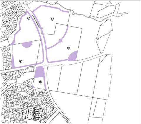
Figure 11: schematic acquisitions plan
The Contributions Plan covers a number of capital works
programs, including footpath and cycleways construction, but not landscaping or
environmental rehabilitation. Where rehabilitation work is required (such as
for the subject application) this has to be achieved by application specific
conditions.
The land to which the proposed subdivision relates has two
starting allotments, but one is inappropriately located and too small to be
considered as having any credit value. The proposed development proposes the
creation of 97 lots suitable for residential purposes. Other lots for open
space purposes (including the “pocket parks”, the OSD basins, the
sewer pump station and the various open space lots) are excluded from the
contributions calculations). Compensation for the positioning of the pump
station has been previously agreed to and paid. The resulting net yield from
the proposed subdivision is 96 additional lots.
Pursuant to Orange Development Contributions Plan 2017, the
following contributions have been levied for the subject development and are
attached as a condition of consent.
The payment of contributions as
per the following shall be made to Council in accordance with Section 7.11 of
the Act and Orange Development Contributions Plan 2017 (development in
North West Urban Release Area) towards the provision of the following public
facilities:
|
Open Space and Recreation
|
@ $3,922.87 x 96 additional lots
|
$376,595.52
|
|
Community and Cultural
|
@ $1,137.63 x 96 additional lots
|
$109,212.48
|
|
Roads and Cycleways
|
@ $5,178.06 x 96 additional lots
|
$497,093.76
|
|
Local Area Facilities
|
@ $6,372.57 x 96 additional lots
|
$611,766.72
|
|
Plan Preparation and Administration
|
@ $498.35 x 96 additional lots
|
$47,841.60
|
|
Subtotals
|
|
$1,642,510.08
|
|
Compensation for Internal Open
Space
|
@ $10 per m2 x 3,000m2
@ $35 per m2 x 6,000m2
|
-30,000.00
-210,000.00
|
|
TOTAL (subtotal less compensation):
|
|
$1,402,510.08
|
The contribution will be indexed quarterly in accordance
with the Orange Development Contributions Plan 2017 (development in North West
Urban Release Area).
With regard to open space contributions, the contributions
levied for this application will provide funding for an extensive and ambitious
program of projects. There are no funds available for acquisitions that do no
form part of the acquisition plan.
Section 64 Water and Sewer
Headwork Charges
Section 64 water and sewer headwork charges are also
applicable to the proposal. Such charges are calculated at the time of a
Subdivision Certificate for the proposed development. Attached are draft
conditions requiring the payment of the required contribution prior to the
issue of a Subdivision Certificate.
PROVISIONS PRESCRIBED BY THE
REGULATIONS s79C(1)(a)(iv)
The development is not inconsistent with the provisions
prescribed by the regulations
THE LIKELY IMPACTS OF THE
DEVELOPMENT s4.15(1)(b)
Traffic
The capacity of the road network in the vicinity of the site
is sufficient to accommodate additional localised traffic generated by the
development, or the likely additional traffic that future developments on the
subdivided lots are likely to generate. Council’s Technical Services
Division advises that the proposed road layout is satisfactory, allows
adjoining land to be developed and is generally in accordance with the DCP.
Conditions are considered necessary and are included in the
attached consent preventing access for the individual lots directly onto either
the NDR or Molong Road.
Noise
There are two possible areas of noise conflict for the use
of the site as a residential estate. Noise arises from the adjacent NDR and a
further noise source arises from the operation of the sewer pump station
located on the northern part of the site.
Noise Considerations from NDR
The applicant has undertaken a noise assessment as part of
the submission to Council. This assessment has been referred to Council's
Manager Building and Environment and he has advised as follows:
I have undertaken a review of the 2013 Study of
Thornberry’s land and also Council’s NDR noise check (Leeds Pde
& Anson St areas)
|
|
Thornberry 2013
|
Council 2013
|
Road Noise Policy Target
|
|
Daytime LAeq,15hr
(7am – 10pm)
|
59
|
58-63
|
60
|
|
Night time LAeq,9hr (10pm
– 7am)
|
54
|
58-52
|
55
|
The Council study includes
projections of traffic growth of 1.1% to 2028 which is standard growth.
As road noise is measured
differently to normal environmental noise (ie over 9-15 hours, not 15 minutes)
it actually takes a large increase in volumes to increase measured noise.
The assumptions in the 2013
study are similar to the 2015 Council study of the NDR, albeit from another
site (but I would suggest a busier site)
As was identified in the 2013
study, without attenuation measures there would be some exceedance of the noise
targets in the Road Noise Policy. This is not surprising and it is considered
that typical noise attenuation measures such as architectural treatments and
noise barriers should be sufficient to meet the noise criteria.
Future Development
Applications for dwellings on the site would need to include a detailed
acoustic assessment to investigate and determine the exact attenuation
requirements.
This is a very conservative
approach to noise management on this site, as the 2013 Study submitted with the
application passes on the requirement for an assessment on all buildings in the
subdivision, not just the first two rows of houses which are likely from
experience to be the only ones that would require treatment. However, as this
is what has been proposed by the applicant and it will provide good
‘insurance’ to the future occupants and also Council’s NDR, I
have no objection to the proposal.
It is recommended that a
condition of consent be applied to the development that requires the
restriction of land through an 88b instrument that requires the detailed
investigation of required attenuation measures prior to the approval of any
house in the subdivision (as has been recommended in the Acoustic Assessment
Report by Blackett Acoustics Report BA13802A dated September 2013):
(x) A Section 88B Restriction-as-to-User shall be imposed
on all Lots within the subdivision. The section 88B restriction to user shall
be written to favour Orange City Council and shall be included with the
documents for the subdivision certificate. The restriction to user shall impose
a requirement for any future dwelling house application on those lots to be
provided with a Noise Assessment Report that would detail the design and
location requirements for a dwelling house on the aforementioned allotments so
as to comply with the relevant noise standards applicable at the time of lodgement
of that application. The restriction as to user shall utilise plain English
wording and have as its primary aim that future owners be aware there may be
restrictions on these allotments in terms of location, height and building
materials of houses, and provide protection from the noise effects of the
Northern Distributor Road.
Sewer Pump Station
There is a sewer pump station located in the northern corner
of the site. Whilst the land to which the infrastructure exists is likely to be
dedicated to Council allowance has been made for this asset by the inclusion of
a requirement to establish an easement that allows for its retention. Access to
the Council asset will be via one of the internal roads within the subdivision.
At the present time the right of that structure to be on the site does not
appear to be protected by any formal easement, although there is some form of
understanding as to its continued location on the site.
Councils Technical Services Division advises that it is
intended to eventually relocate the pump station, however for the moment it
would be preferred if the pump station were retained on the site.
It is considered that the following issues arise from the
operation of the pump station
Noise
Council's Manager Building and Environment has provided the
following comment:
A noise report dated 6 July
2012 was submitted with the Development Application for this subdivision. The
noise report can be only used as a guide and may not represent actual noise
levels from the sewer pump station. The reason for this is the type of
emergency generator proposed to be used was unknown during the assessment and
therefore the report highlighted the need for further acoustic reporting by the
pump station operator once this is known (Council is the operator of the pump
station). This therefore represents a slight risk to the operator of the pump
station that assumptions only have been made and they will be required to
ensure they achieve compliance with those assumptions once a specific generator
is selected.
Assessment of general
operation of the pump station noise was also considered with the
consultant’s noise report. The report assumed a background noise of
32dB(A), which is considered reasonable for this area. Therefore a noise goal
of 37dB(A) applies to the pump station. The SLR Report identifies the 37dB(A)
contour extends 80-100m from the station if no noise mitigation works are
carried out on the pump station.
Following the installation of
mitigation measures, the SLR Report predicts that the 37 dB(A) contour would be
reduced to a minor part of the three closest residential allotments (the
equivalent lots for the current application being Lots 224, 225, 238
and 239). Provided dwellings are not located within the 37dB(A) contour
without mitigation, I have no objection to the proposed subdivision.
Attached to the draft Notice of
Determination is a condition of consent addressing this issue.
Odour Assessment of Sewer Pump
Station
Review of the SLR Odour Impact Assessment dated 12 July 2012
has been undertaken. The report predicts that the maximum odour criterion would
not be exceeded provided that mitigation works are undertaken to the pump
station. It is of interest to note that the whole of the proposed residential
subdivision will be the subject of some odour from the pump station. There is a
risk to the pump station operator (Council) that, should any variance to the
predicted odour levels occur (exceedance), odour complaints would arise.
It is recommended that a condition of consent be applied to
the development that requires the remediation works identified in the SLR
report to be undertaken prior to the commencement of the construction of any
residential development on Lots 28-43 and Lot 57. Specifically these works
are to include:
· sealing of the wet
well cover;
· sealing of the
concrete channel housing electrical cables to the pump house; and
· installation of
buffers (vegetated) between residences and the pump station.
This work will necessarily need to be undertaken by Council.
An alternative does exist for the pump station to be removed or relocated away
from the site. Two conditions are considered necessary to address the issue.
The first prevents the issue of Subdivision Certificates for the affected lots
until the recommended works have been completed. The second condition withholds
the release of the subdivision for Lots 36 and 37 until the pump station has
been relocated.
Cumulative Impacts
The proliferation of low density residential development on
the fringe of the City is a reflection of the urban growth of Orange, which is
currently being achieved by an expansion of residential land into the
surrounding lower density rural and non-urban land. A continuation of
greenfield residential subdivisions satisfies the market demand but is likely
to result in community isolation from transport facilities and services due to
the increase in distance from employment areas and the CBD. Because of the
distances, a continuation on motor vehicle reliance is likely to be reinforced
by developments such as the subject application.
On the other hand, the development of a new estate creates
opportunities for home ownership, improves housing stock quality from an
aesthetic point of view and promotes economic activity in the building
industry.
THE SUITABILITY OF THE SITE
s4.15(1)(c)
The subject property has one significant natural feature,
being the waterways that cross the site. These are adequately allowed for in
the subdivision design.
The subject property will be significantly reliant on motor
vehicles for access to most facilities and amenities, and this should be seen
as a negative to the overall amenity and ambience that the site will generate.
To achieve satisfactory levels of amenity it is considered highly desirable to
provide pedestrian linkages to the open space network.
ANY SUBMISSIONS MADE IN
ACCORDANCE WITH THE ACT s4.15(1)(d)
The proposed development is defined as "advertised
development" by reason of the Integrated Development provisions of the
Act. The application was advertised for the prescribed period of 30 days, and
at the end of that period the following submissions had been received:
J Riach - Molong Road
· I do not want
people accessing the Agrestic Grocer site via the proposed walkway.
The objector is not the owner of the agrestic Grocer site,
however he does live on an adjoining site.
There is a landscape concept plan (not forming part of the
current proposal but forming part of the supporting documentation for the
rezoning of the subject land) that shows potential for crossings and linkages
of Ploughmans Creek. However, the proposed development does not specifically
incorporate this provision, and it is noted that were such connections to be
provided in the future, they would not specifically affect the objector’s
land.
Very little (if any) weight can be given to the objection as
the proposal to provide a creek crossing to the “Totally Local”
site is a concept only.
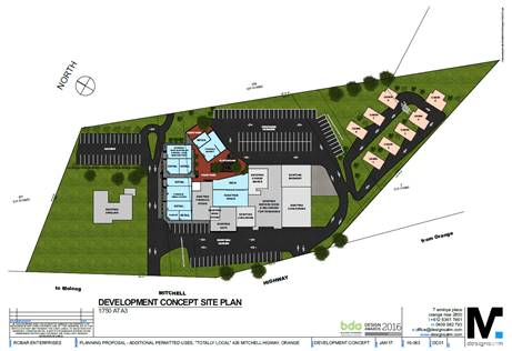
Figure 12: Agrestic Grocer concept plan
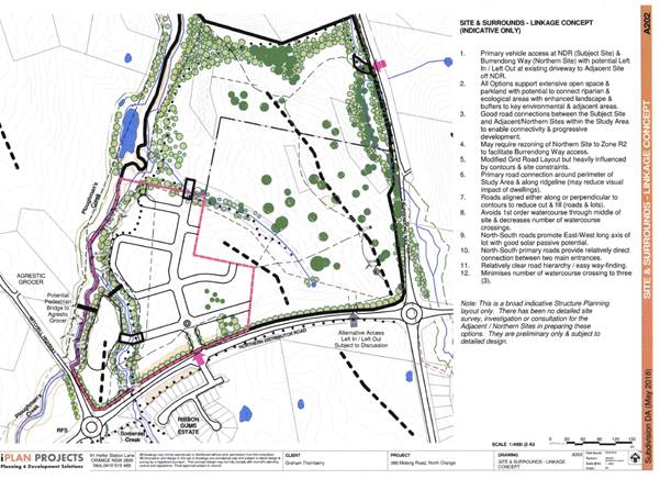
Figure 13: linkage concept plan (indicative only)
submitted in support of the DA
· The development
must include security fencing (not just stock fencing) to prevent public access
onto adjoining land.
The DCP contains provisions with respect to rural fencing on
the shared northern and eastern boundaries. Fencing on the shared boundary with
the NDR was not required for the Ribbon Gums estate and given the similar
situation arising for this development, no requirement for fencing on this site
along the NDR or Molong Road boundaries is considered necessary. Fencing is
however required at the rear of those allotments that back onto the NDR.
For the shared boundary with those properties located to the
west and northwest, including this objector, it is noted that the majority of
the shared boundary will become part of the riparian corridor. It will be
necessary for this land to be adequately fenced for both security and safety
reasons. This will be investigated further once the landscaping and plans of
management are worked out. In the past, for other landowners adjoining the
riparian corridors in northwest Orange, it has been the landowner’s
responsibility to fence their shared boundaries as appropriate.
· Pollution of
the creek
The stormwater and surface runoff coming from the proposed
development will include onsite detention including a constructed wetland or
wet detention basin with reed banks installed and gross pollutant traps that
will manage pollutants entering the creek to an acceptable standard. At the
present time, as essentially rural land, there are few controls regarding the
preservation of water quality. Conditions are recommended.
Nick King - Environmentally
concerned Citizens Of Orange (ECCO)
· Open space
-Supports the concepts of the Pocket Park and riparian corridors. Would prefer
a constructed wetland in lieu of the OSD basin. Does not support the relative
lack of larger open space areas within the subdivision and notes the relative
isolation of the site to other such facilities within Orange.
The submission by ECCO has some merit, however the
initiatives they suggest would place significant pressure on Council finances,
for which no master planning has been done. There are special circumstances to
support the setting aside of the riparian corridors, but no such special
circumstances can be advanced to support the provision of additional
recreational space within the new subdivision. The open space and recreational
spaces provided in the Orange district are dictated and planned according to
the provisions contained in the acquisitions component of the Contributions
Plan. It is further noted that Orange residents do enjoy a high rate of open
space per head of population compared to State averages.
· Tree retention
- ECCO notes and supports the proposed tree retention but also point out that
the submission is vague and non-specific as to how this might be achieved.
The conditions of consent are intended to address this
shortcoming, by specifying the numbers of trees to be retained and requiring
more specificity in the final plans before sign‑off of the Subdivision
Certificate.
Wellington Valley Wiradjuri
Aboriginal Corporation
· Wants a more
extensive investigation of Aboriginal cultural heritage on the site
Searches of the OEH database (AHIMS) fail to reveal any
recorded items of Aboriginal heritage or known sites in the locality. One claim
made by this group is that there are scar trees on the site, however physical
inspection of the visible trees fails to reveal evidence that they are present,
and the estimated age of the trees (80-120 years) is such that they have only a
very low probability of being scar trees.
Notwithstanding, two conditions are included requiring a
further report to be submitted on this issue, and if any positive results arise
from that investigation, for the prescribed processes contained in the NPWS act
1974 to be followed. This is understood to include a level of consultation with
local indigenous groups.
Orange Region Water Security
Alliance
· Should consider
the initiatives contained in recent NSW legislation.
The submission references “Greener Places”,
“Better Place Built” and “Local Character”. The
proposed development would not act in a manner contrary to these draft policies.
· DA is deficient
in open space tree preservation, riparian protection lot density and pedestrian
connectivity.
These issues have some validity and conditions are included
to address them in the consent.
The submission includes an extensive list of suggested
policy changes that, whilst having merit, cannot be considered as direct
objections to the current proposal. The current proposal must be assessed
against those standards that are applicable at this time. The development needs
to comply with those standards, or have conditions imposed that will result in
compliance.
Cyril Smith
This long submission to Council makes the following
observations:
· Defer the
proposal until other agencies have a reasonable time to make a comment.
The referral process to government co-approval bodies is
codified in the Integrated Development Assessment legislation. There are
prescribed referral times and processes, which Council has exceeded. The
co-approval agencies are able to impose their own conditions that must be
included in the consent, and would have the effect of overriding any Council
conditions if the Council conditions acted in such a way as to contravene the
General Terms of Approval issued by these government bodies.
· I feel that
this proposal can achieve a more liveable residential area with a unique
character with some further discussions.
The objector wants to apply draft guidelines and guidelines
not currently adopted and/or not applicable to this site. It is infeasible to
do this.
PUBLIC INTEREST
s4.15(1)(e)
The proposed development is considered to be of minor
interest to the wider public due to the relatively localised nature of
potential impacts. The proposal is not inconsistent with any relevant policy
statements, planning studies, guidelines etc that have not been considered in
this assessment.
SUMMARY
The proposed development is permissible with the consent of
Council. The proposed development complies with the relevant aims, objectives
and provisions of Orange LEP 2011 (as amended) and DCP 2004.
A section 4.15 assessment of the development indicates that the
development is acceptable in this instance. Attached is a draft Notice of
Approval outlining a range of conditions considered appropriate to ensure that
the development proceeds in an acceptable manner.
COMMENTS
The requirements of the Environmental Health and Building
Surveyor and the Engineering Development Section are included in the attached
Notice of Approval.
Attachments
1 Notice
of Approval, D18/44242⇩
2 Plans,
D18/44143⇩
3 Submissions,
D18/44134⇩
Planning
and Development Committee
4 September 2018
2.4 Development
Application DA 178/2018(1) - 386 Molong Road and Lot 6 Northern Distributor
Road
Attachment 1 Notice of Approval
|

|
ORANGE
CITY COUNCIL
Development
Application No DA
178/2018(1)
NA18/ Container
PR26723
|
NOTICE OF DETERMINATION
OF A DEVELOPMENT
APPLICATION
issued under the Environmental
Planning and Assessment Act 1979
Section 4.18
|
Development
Application
|
|
|
Applicant Name:
|
Mr G Thornberry
|
|
Applicant Address:
|
C/- Roger
Heath
PO Box
2501
ORANGE
NSW 2800
|
|
Owner’s Name:
|
Mr GJ
Thornberry
|
|
Land to Be Developed:
|
Lot 81 DP
1202584 - 386 Molong Road and Lot 6 DP 1065578 - Northern Distributor Road,
Orange
|
|
Proposed Development:
|
Subdivision
(103 lots - comprising 96 residential lots, 6 open space lots and
1 residue lot)
|
|
|
|
|
Building
Code of Australia
building
classification:
|
Not
applicable
|
|
|
|
|
Determination
made under
Section 4.16
|
|
|
Made On:
|
4
September 2018
|
|
Determination:
|
CONSENT
GRANTED SUBJECT TO CONDITIONS DESCRIBED BELOW:
|
|
|
|
|
Consent to
Operate From:
|
5
September 2018
|
|
Consent to
Lapse On:
|
5
September 2023
|
Terms of Approval
The reasons for the imposition of
conditions are:
(1) To ensure a quality
urban design for the development which complements the surrounding environment.
(2) To maintain
neighbourhood amenity and character.
(3) To ensure compliance
with relevant statutory requirements.
(4) To provide adequate
public health and safety measures.
(5) Because the development
will require the provision of, or increase the demand for, public amenities and
services.
(6) To ensure the utility
services are available to the site and adequate for the development.
(7) To prevent the proposed
development having a detrimental effect on adjoining land uses.
(8) To minimise the impact
of development on the environment.
Conditions
(1) The
development must be carried out in accordance with:
(a) Plans
by Heath Consulting numbered 07_066 sheets DA01, DA02, DA03, DA04, DA05, DA06,
DA07, DA08, DA09 Rev A, dated May 2018 (9 sheets)
(b) statements
of environmental effects or other similar associated documents that form part
of the approval
as amended
in accordance with any conditions of this consent.
(2) A sign is to be erected
in a prominent position on any site on which building work, subdivision work or
demolition work is being carried out:
(a) showing
the name, address and telephone number of the principal certifying authority
for the work, and
(b) showing
the name of the principal contractor (if any) for any building work and a
telephone number on which that person may be contacted outside working hours,
and
(c) stating
that unauthorised entry to the site is prohibited.
Any such sign is to be maintained while the
building work, subdivision work or demolition work is being carried out.
|
PRIOR TO THE ISSUE OF
A CONSTRUCTION CERTIFICATE
|
(3) An amended design shall
be submitted and approved by Council that incorporates a constructed wetland or
wet detention basin, incorporating extensive wetlands reed beds and natural
water filtration species. The size and capacities of the detention basin shall
be amended as required to accommodate this change from the submitted design
(4) A comprehensive
landscape plan shall be submitted and be approved by Council’s Manager
Development Assessments that incorporates the following elements;
· Screening the area
around the pump station.
· Landscaping
incorporating appropriate levels of earth mounding, native species selection,
weed matting or weed suppression measures, plant density is to be submitted to
Council for the noise buffer areas adjacent to Northern Distributor Road and
Molong Roads (shown on the approved plans as Lots 164, 165 and 166). Plantings
along the buffers are required to be generally native species except the
corridor adjacent to Molong Road which shall be a species consistent with the
Precinct Plans held by Council for landscaping in the vicinity of the
roundabout intersecting the Northern Distributor Road and Molong Road.
(5) A
landscape recovery plan for the riparian corridors affecting the site shall be
submitted to and be approved by Council’s Manager City Presentations. The
landscape recovery plan shall provide for landscaping within the riparian
corridor and incorporate concrete pathways (which will be completed by Council,
other works in the plan will be carried out by the applicant). Species
selection shall be appropriate native species and at a density that is to the
satisfaction of the Manager City Presentation.
(6) A plan of management
for the riparian corridors adjacent to Ploughmans Creek and consistent with
the E2 and RE1 zoning shall be prepared to the satisfaction of the
Director Development Services and the Director Technical Services, establishing
this area as an area of open space (accessible to the general public and
maintained to a standard that satisfies Council requirements for open space)
and providing details on flood mitigation and ongoing management of this land.
Alternatively, the land may be dedicated to Council at no charge to enable
Council management for public purposes. Earthworks which impact on behaviour of flood
flows may require a Floodworks Approval. The proponent should make contact with
Water NSW (who administer these types of approvals) to determine approval
requirements.
(7) The street lighting
system shall comprise LED lighting and be designed having regard to the
lighting controls contained within the Shiralee DCP (used as a guide in this
instance). The applicant shall submit details of the street lighting system for
approval prior to the issue of a Construction Certificate.
(8) An archaeological
report is required prior to the removal of any trees from the site to determine
if any trees contain evidence of aboriginal heritage. In the event that
aboriginal heritage is found on the site, the applicant shall seek the
necessary permits to destroy the artefact pursuant to the provisions of
section 90 of the National Parks and Wildlife Act 1974, or submit an
amended plan that avoids the need to remove the artifact
(9) Engineering plans,
showing details of all proposed work and adhering to any engineering conditions
of development consent, are to be submitted to, and approved by, Orange City
Council or an Accredited Certifier (Categories B1, C3, C4, C6) prior to the
issuing of a Construction Certificate.
(10) A water and soil
erosion control plan is to be submitted to Orange City Council or an Accredited
Certifier (Categories B1, C3, C4, C6) for approval prior to the issuing of a
Construction Certificate. The control plan is to be in accordance with the
Orange City Council Development and Subdivision Code and the Landcom, Managing
Urban Stormwater; Soils and Construction Handbook.
(11) The
development’s stormwater design is to include stormwater detention within
the development, designed to limit peak outflows from the land to the
pre-existing natural outflows up to the 100 year ARI frequency, with sufficient
allowance in overflow spillway design capacity to safely pass flows of lower
frequency (that is, a rarer event) without damage to downstream developments.
Where appropriate, the spillway design capacity is to be determined in
accordance with the requirements of the Dam Safety Committee.
The design of the detention storage is to be
undertaken using the ILSAX/DRAINS rainfall-runoff hydrologic model or an
approved equivalent capable of assessing runoff volumes and their temporal
distribution as well as peak flow rates. The model is to be used to calculate
the flow rates for the existing and post-development conditions. The developed
flows are to be routed through the proposed storage within the model so that
the outflows obtained are no greater than the flows obtained for the
pre-existing natural flows. A report detailing the results of the analysis,
which includes:
· catchment
plan showing sub-catchments under existing and developed conditions;
· schematic
diagram of the catchment model showing sub areas and linkages;
· tabulation
detailing the elevation, storage volume and discharge relationships; and
· tabulation
for the range of frequencies analysed, the inflows, outflows and peak storage
levels for both existing and developed conditions;
together with copies of the data files for the
model and engineering design plans of the required drainage system are to be
submitted to Orange City Council upon application for a Construction
Certificate.
(12) Proposed
lots are to be provided with interlot stormwater drainage, including those lots
abutting public land, where the surface of the entire lot cannot be drained to
the kerb and gutter at the lot frontage. A grated concrete stormwater pit is to
be constructed within each lot provided with interlot stormwater drainage.
Engineering plans for this drainage system are to be approved by Orange City
Council or an Accredited Certifier (Categories B1, C3, C4, C6) prior to the
issuing of a Construction Certificate.
(13) Stormwater from the
site is to be piped to the adjacent watercourse, where it is to be discharged
through a standard headwall with appropriate scour protection and energy
dissipater. Engineering plans of this required drainage system are to be
approved by Orange City Council or by an Accredited Certifier (Categories B1,
C3, C4, C6). Evidence
of a Controlled Activity Approval from NRAR for work within 40 metres of the
watercourse is
to be provided prior to the issuing of a Construction Certificate. Note: the
engineering plans required by Council will need to be submitted to Department of Industry - Natural Resources Access
Regulator to support the CAA application.
(14) A 150mm-diameter sewer
main is to be constructed from Council’s existing mains to serve the
proposed lots and the existing sewer rising main shall be relocated. Prior to a
Construction Certificate being issued engineering plans for the sewerage system
are to be submitted to and approved by Orange City Council.
(15) A water reticulation
analysis is to be carried out by Orange City Council on any proposed water
reticulation system for the development. Engineering plans are to be submitted
to and approved by Orange City Council prior to the issue of a Construction
Certificate.
The reticulation system is to be designed to
supply a peak instantaneous demand by gravity of 0.15 L/s/tenement at a
minimum residual head of 200kPa.
(16) All stormwater from the
site is to be collected and piped to a stormwater treatment system located
within the site.
The design and construction of the stormwater
treatment system for the subject land shall ensure that the quality of
stormwater leaving the developed site shall achieve the following stormwater
quality targets:
· 90% reduction in the
post development average annual gross pollutant (>5 millimetres) load.
· 85% reduction in the
post development mean annual load of Total Suspended Solids (TSS);
· 65% reduction in the
post development mean annual load of Total Phosphorus (TP);
· 45% reduction in the
post development mean annual load of Total Nitrogen loads (TN).
The stormwater treatment system design shall be
submitted to Orange City Council for approval by Councils Director –
Technical Services. The design shall be undertaken using an accredited
assessment tool (Music™ or other approved assessment tool) and shall
include the abovementioned key indicators and copies of the electronic data
files.
(17) Engineering plans
providing complete details of the proposed intersection with the Northern
Distributor Road shall be submitted to Orange City Council upon application for
a Construction Certificate. These plans are to provide details of levels, cross
falls of all pavements, sealing materials, drainage works, line marking and
signage and are to be in accordance with Orange City Council Development and
Subdivision Code. Engineering plans for the intersection are to be approved
by Orange City Council prior to the issuing of a Construction Certificate.
|
PRIOR TO
WORKS COMMENCING
|
(18) Tree Protection zones
are to be established for the existing over mature trees located on
Lots 141 and 164 complying with the requirements of AS 4970 –
Protection Of trees On Development Sites. No approval is granted for the
removal of these trees under this consent.
(19) A
temporary onsite toilet is to be provided and must remain throughout the
project or until an alternative facility meeting Council’s requirements
is available onsite.
(20) Soil erosion control
measures shall be implemented on the site.
|
DURING
CONSTRUCTION/SITEWORKS
|
(21) A minimum of three
trees shall be retained and conserved on the open space Lot 141 and 164,
which shall be modified in size and shape where necessary, so that the property
boundaries of this lots are not closer than 2m from the trees to be protected.
Trees to be removed from proposed Lots 145,
146, 147, 152 and 153 can be removed under this approval. The remnants of those
trees shall be placed within the open space and/or riparian lots in a location
that is to the satisfaction of the Manager City Presentation (Orange City
Council). Replacements shall be planted (for the trees to be removed), at the
rate of 5 replacements for each tree to be removed within the open space lot
(or alternatively, native ground and midstorey covers at the rate of 35m²
of dense plantings per tree to be removed). Replacement tree plantings shall be
at a density not exceeding 1 tree per 35m² of available space.
(22) All
construction/demolition work on the site is to be carried out between the hours
of 7.00 am and 6.00 pm Monday to Friday inclusive, 7.00 am to
5.00 pm Saturdays and 8.00 am to 5.00 pm Sundays and Public
Holidays. Written approval must be obtained from the General Manager of Orange
City Council to vary these hours.
(23) All
materials onsite or being delivered to the site are to be contained within the
site. The requirements of the Protection of the Environment Operations Act
1997 are to be complied with when placing/stockpiling loose material or
when disposing of waste products or during any other activities likely to pollute
drains or watercourses.
(24) Any adjustments to
existing utility services that are made necessary by this development
proceeding are to be at the full cost of the developer.
(25) The
provisions and requirements of the Orange City Council Development and
Subdivision Code are to be applied to this application and all work constructed
within the development is to be in accordance with that Code.
The developer is to be entirely responsible for
the provision of water, sewerage and drainage facilities capable of servicing
all the lots from Council’s existing infrastructure. The developer is to
be responsible for gaining access over adjoining land for services where
necessary and easements are to be created about all water, sewer and drainage
mains within and outside the lots they serve.
(26) Concrete footpaths, a
minimum of 1.2 metres wide, are to be constructed on one side of all through
streets and in cul-de-sacs where a pathway or public reserve is located at the
cul-de-sac bowl.
Construction work is to be to the requirements
and standards of the Orange City Council Development and Subdivision Code.
(27) All proposed
residential lots adjacent to Somerset Creek, Ploughmans Creek and any drainage
control lot shall have a minimum freeboard above the 1-in-100-year flood level
in accordance with the Orange City Council Development and Subdivision Code and
the Floodplain Risk Management Plan.
(28) Dual water and sewerage
reticulation is to be provided to every lot in the proposed residential
subdivision in accordance with the Orange City Council Development and
Subdivision Code.
(29) Water and sewer
services, including mains construction, sewer pumping station noise and odour
abatement works, easements and all associated materials and works, are to be
provided for the development at the cost of the developer.
(30) Council requires
elastic rebound deflection testing carried out on road base material prior to
the placement of any asphalt to determine maximum deflection in accordance with
RMS Test Method T160 utilising the Benkelman Beam or equivalent.
(31) A temporary turning
circle shall be provided at the termination of the 20m wide road providing
access to Lot 164.
|
PRIOR TO THE ISSUE OF
A SUBDIVISION CERTIFICATE
|
(32) New Rural fencing
consistent with the standards contained in Orange DCP 2004 shall be
installed along the northern boundaries of Lots 158, 159, 160, 161, 162, 163,
235, 236, 237, 238, 239 and 240; and the eastern boundaries of Lots 143,
150, 156, 157, 158, 203, 204, 205, 231, 232, 233, 234 and 240. A Restriction as
to User under the NSW Conveyancing Act 1919 shall be placed on the titles of
each of the above identified lots indicating that the rural fencing along the
dividing boundary can only be replaced with same until such time that the
adjoining land is developed for residential purposes.
(33) A Restriction as to
User under the NSW Conveyancing Act 1919 shall be placed on the titles of
Proposed lots 107, 108, 114, 115, 219, 224 and 239 requiring all fencing along
the boundary of those allotments where it adjoins the riparian corridor to be
lapped and capped timber hardwood fencing.
(34) Prior
to the issue of a Subdivision Certificate the applicant shall construct lapped
and capped hardwood timber fencing with a minimum height of 1.8m and consistent
with the recommendations of the Blackett Acoustic Consultant Report
Number BA13802A Version A along the rear property boundary of proposed lots
101-107 inclusive and 139, 140, 142 and 143.
(35) Building
envelopes applied as Restrictions as to user under the NSW Conveyancing Act
1919, written with Council as having the power to alter or remove the
restriction, shall be applied to lots 101 – 107 (inclusive) and lots
139,140, 142 and 143, as shown on the approved subdivision plan, prior to the
issue of a subdivision certificate. The building envelopes must be located a
minimum of;
· 10m from the southern
boundary, and
· 4.5m from all street
frontages, and
· 0.9m from side
boundaries with other residential lots, and
· 2.0m from side
boundaries with public open space lots (141 & 166)
The maximum area of each building envelope must
not exceed 350m2. The restriction shall not permit the erection of
buildings outside of the building envelope. Council is to be nominated as the
benefitted party.
(36) Lots 204. 205, 214,
215, 216, 217, 218, 219, 224, 225, 226, 227, 228, 229, 231, 232, 233, 234, 235,
236, 237, 238 and 239, as depicted on the Drawing Number 07066-DA02 prepared by
Heath Consulting dated May 2018 and submitted with the application shall not be
released until and unless all mitigation recommendations as set out in the
report titled "Appendix B -N01 Odour Assessment by SLR (referenced Report
Number 610.11488, dated July 2012) have been fully implemented to the
satisfaction of Council's Manager Development Assessments who shall also be
advised accordingly.
(37) A noise goal of 37dB(A)
applies to lots affected by noise from the pump station. To be suitable for
dwelling construction, mitigation of background noise levels to below 37dB(A)
is required. The release of a subdivision certificate for those allotments
within the 37dB(A) contour generated from the pump station will not be issued
until all measures to mitigate noise from the pump station have been
implemented and a further noise report by a qualified Acoustics engineer has
been provided corroborating the target noise levels have been achieved to the
satisfaction of the Manager Building and Environment.
(38) The payment of
contributions as per the following shall be made to Council in accordance with
Section 7.11 of the Act and Orange Development Contributions
Plan 2017 (development in North West Urban Release Area) towards the
provision of the following public facilities:
|
Open Space and Recreation
|
@ $3,922.87 x 96 additional lots
|
$376,595.52
|
|
Community and Cultural
|
@ $1,137.63 x 96 additional lots
|
$109,212.48
|
|
Roads and Cycleways
|
@ $5,178.06 x 96 additional lots
|
$497,093.76
|
|
Local Area Facilities
|
@ $6,372.57 x 96 additional lots
|
$611,766.72
|
|
Plan Preparation and Administration
|
@ $498.35 x 96 additional lots
|
$47,841.60
|
|
Subtotals
|
|
$1,642,510.08
|
|
Compensation for Internal Open Space
|
@ $10 per m2 x 3,000m2
@ $35 per m2 x 6,000m2
|
-30,000.00
-210,000.00
|
|
TOTAL (subtotal less compensation):
|
|
$1,402,510.08
|
The contribution will be indexed quarterly in
accordance with the Orange Development Contributions Plan 2017 (development in
North West Urban Release Area).
With regard to open space contributions, the
contributions levied for this application will provide funding for an extensive
and ambitious program of projects. There are no funds available for
acquisitions that do no form part of the acquisition plan
(39) Soil
sampling for analysing chemical residue is to be carried out within the
proposed Lots in a manner and frequency as determined by an appropriately
qualified and experienced consultant giving consideration to previous specific
uses and on-site characteristics of the site. A NATA registered laboratory
is to carry out such testing. Reference is to be made to the Contaminated
Land Management Act 1997 and State Environmental Planning Policy No 55
- “Remediation of Land”. The results of the testing are to be provided
to the Principal Certifying Authority and are to demonstrate that the land is
suitable for residential use, to enable a Subdivision Certificate to be issued.
(40) Application shall be
made for a Subdivision Certificate under Section 6.3(1)(d) of the Act.
(41) Payment of
contributions for water, sewer and drainage works is required to be made
at the contribution rate applicable at the time that the payment is made. The
contributions are based on 96 ETs for water supply headworks and 96 ETs for sewerage
headworks. A Certificate of Compliance, from Orange City Council in accordance
with the Water Management Act 2000, will be issued upon payment of the
contributions.
This Certificate of Compliance is to be
submitted to the Principal Certifying Authority prior to the issuing of a
Subdivision Certificate.
(42) Evidence from a
registered NATA laboratory is to be submitted prior to the issuing of a
Subdivision Certificate stating that the filling of all dams and low-lying
areas has been carried out in accordance with Australian Standard 3798-2007.
(43) Application is to be
made to Telstra/NBN for infrastructure to be made available to each individual
lot within the development. Either a Telecommunications Infrastructure
Provisioning Confirmation or Certificate of Practical Completion is to be
submitted to the Principal Certifying Authority confirming that the specified
lots have been declared ready for service prior to the issue of a Subdivision
Certificate.
(44) A Notice of Arrangement
from Essential Energy stating arrangements have been made for the provision of
electricity supply to the development, is to be submitted to the Principal
Certifying Authority prior to the issue of a Subdivision Certificate.
(45) A
Restriction-as-to-User under section 88B of the NSW Conveyancing Act
1919 shall be registered on the Deed of Title on Lots 101 to 107, and 139, 140,
142 and 143 where vehicular access is to be denied to the Northern Distributor
Road and Lot 164 where vehicular access is to be denied to the Northern
Distributor Road and Mitchell Highway.
(46) An easement to drain
sewage and to provide Council access for maintenance of sewerage works a
minimum of 2.0 metres wide is to be created over the proposed sewerage works.
The Principal Certifying Authority is to certify that the easement is in
accordance with the Orange City Council Development and Subdivision Code prior
to the issuing of a Subdivision Certificate.
(47) All services are to be
contained within the allotment that they serve. A Statement of Compliance, from
a Registered Surveyor, is to be submitted to the Principal Certifying Authority
prior to the issuing of a Subdivision Certificate.
(48) A Certificate of
Compliance, from a Qualified Engineer, stating that the stormwater detention
basin comply with the approved engineering plans is to be submitted to the
Principal Certifying Authority prior to the issuing of a Subdivision
Certificate.
(49) A
Maintenance Security Deposit, in accordance with the provisions and
requirements of the Orange City Council Development and Subdivision Code, is to
be provided to Orange City Council prior to the issuing of a Subdivision
Certificate.
A Certificate of Compliance, from Orange
City Council, certifying that the maintenance security deposit has been paid,
is to be submitted to the Principal Certifying Authority prior to the issuing
of a Subdivision Certificate.
(50) Where
stormwater crosses land outside the lot it favours, an easement to drain water
is to be created over the works. A Restriction-as-to-User under section 88B of
the NSW Conveyancing Act 1919 is to be created on the title of the
proposed Lots requiring that no structures are to be placed on the site, or
landscaping or site works carried out on the site, in a manner that affects the
continued operation of the interlot drainage system. The minimum width of the
easement is to be as required in the Orange City Council Development and
Subdivision Code.
(51) Prior to the issuing of
a Subdivision Certificate, a Road Naming Application form is to be completed
and submitted with a plan of the whole development defining the stage being
released - including future road extensions.
(52) Certification from
Orange City Council is required to be submitted to the Principal Certifying
Authority prior to the issue of a Subdivision Certificate stating that all
works relating to connection of the development to Council assets, works on
public land, works on public roads, stormwater, sewer and water reticulation
mains and footpaths have been carried out in accordance with the Orange City
Council Development and Subdivision Code and the foregoing conditions, and that
Council will take ownership of the infrastructure assets.
(53) A
subdivision Certificate with respect to Proposed Lot 239 shall not be released unless:
· the sewer pump station
has been removed; or
· satisfactory mitigation
works have been undertaken to the sewer pump station to reduce background noise
levels to below 37dB(A); or
· a
Restriction as to user pursuant to Section 88B of the NSW Conveyancing Act 1919
is imposed on the title of Lot 239 preventing use for residential purposes until
the target noise level has been achieved to the satisfaction of Council.
(54) A
Restriction-as-to-User under section 88B of the NSW Conveyancing Act 1919
shall be created on the title of proposed Lot 164 which states that:
Proposed Lot 164 may not be subdivided or
further developed and may not be used for residential purposes unless the
following works are carried out to the satisfaction of Orange City Council:
· All infrastructure
services (water, sewer, stormwater drainage, gas, electricity, phone lines) as
required by the Orange City Council Development and Subdivision Code are
provided to Lot 164; and
· The developer of
proposed Lot 164 is responsible for gaining access over adjoining land for
services as necessary. Easements are to be created about all service mains
within and outside the lots they serve; and
· Contributions are paid
as required by the development contributions plan applicable at the time of
development and Water and Sewer charges as required by Orange City Council in
accordance with Division 5 of Part 2 of Chapter 6 of the Water Management act
2000; and
· The 20.0m wide access
road is fully constructed over Somerset Creek in accordance with the Orange
City Council Development and Subdivision Code.
(55) All landscaping
requirements specified in the stamped approved plans shall be fully implemented
to the satisfaction of Council’s Manager Development Assessments prior to
the release of the Subdivision Certificate
(56) All
of the foregoing conditions are to be at the full cost of the developer and to
the requirements and standards of the Orange City Council Development and
Subdivision Code, unless specifically stated otherwise. All work required by
the foregoing conditions is to be completed prior to the issuing of a
Subdivision Certificate, unless stated otherwise.
|
MATTERS FOR THE
ONGOING PERFORMANCE AND OPERATION OF THE DEVELOPMENT
|
(57) Landscaping required
under this consent shall be fully maintained by the developer for a minimum period
of two years after the issue of the Subdivision Certificate (if the land is
transferred to Council’s control) or permanently if the land on which the
landscaping is to be installed is retained in private ownership. The plan of
management required under condition (5) of this consent shall provide details
on watering, weeding and replacement regimes to be carried out during the
maintenance period.
(58) If Aboriginal objects,
relics or other historical items or the like are located during development works,
all works in the area of the identified object, relic or item shall cease and
the NSW Office of Environmental Heritage (OEH), and representatives from the
Orange Local Aboriginal Land Council shall be notified. Where required, further
archaeological investigation shall be undertaken. Development works in the area
of the find(s) may recommence if and when outlined by the management strategy,
developed in consultation with and approved by the OEH.
(59) An easement in favour
of Orange City Council over the sewer pump station infrastructure on the land
shall be shown on the plan of subdivision. The terms of the easement shall be
in accordance with Deed of Agreement dated 19 March 2015 between the owner of
the land and Orange City Council.
|
GENERAL TERMS OF
APPROVAL FROM THE DEPARTMENT OF PRIMARY INDUSTRIES – FISHERIES
|
· A permit under s.201 of
the Fisheries Management Act 1994 for dredging and reclamation works
associated with construction of proposed stormwater outlet structure in
Ploughmans Creek must be obtained prior to commencement of the works at the
site, unless the work has been authorised under the Crown Lands Act 1989
or an authority (e.g. Controlled Activity Approval) is obtained under the Water
Management Act 2000 from DPI Water.
· Any construction works
are carried out in accordance with all applicable requirements of The Blue
Book: “Managing Urban Stormwater: Soils and Construction” (4th
Edition Landcom, 2004).
|
GENERAL TERMS OF APPROVAL FROM THE DEPARTMENT
OF INDUSTRY - NATURAL RESOURCES ACCESS REGULATOR
|
|
Design of works and structures
|
|
GT0009-00010
|
Before
commencing any proposed controlled activity on waterfront land, an
application must be submitted to Natural Resources Access Regulator, and
obtained, for a controlled activity approval under the Water Management Act
2000.
|
|
GT0019-00003
|
Any
proposed excavation on waterfront land must be undertaken in accordance with
a plan submitted as part of a controlled activity approval, to be approved by
Natural Resources Access Regulator.
|
|
Erosion and
sediment controls
|
|
GT0014-00007
|
A. The
consent holder must ensure that any proposed materials or cleared vegetation,
which may: i. obstruct water flow, or ii. wash into the water body, or iii.
cause damage to river banks, are not stored on waterfront land, unless in
accordance with a plan held by Natural Resources Access Regulator as part of
a controlled activity approval. B. When the carrying out of the controlled
activity has been completed, surplus materials must be removed from
waterfront land.
|
|
Plans,
standards and guidelines
|
|
GT0002-00460
|
A. This
General Terms of Approval (GTA) only applies to the proposed controlled
activity described in the plans and associated documents found in Schedule 1,
relating to Development Application 1782018 provided by Council to Natural
Resources Access Regulator. B. Any amendments or modifications to the
proposed controlled activity may render the GTA invalid. If the proposed
controlled activity is amended or modified, Natural Resources Access
Regulator, Dubbo Office, must be notified in writing to determine if any
variations to the GTA will be required.
|
|
GT0005-00205
|
A. The
application for a controlled activity approval must include the following
plan(s):- site plan, map and/or surveys; riparian corridor map (amended to
show correct stream order and buffer widths); detailed plans for detention
basin and outlet structures; Stormwater Management Plan; Erosion and Sediment
Control Plan; Vegetation Management Plan; and, Works Schedule. B. The plan(s)
must be prepared in accordance with Natural Resources Access Regulator's
guidelines located on the website
www.industry.nsw.gov.au/water/licensing-trade/approvals/controlled-activities.
|
|
GT0010-00006
|
All
documents submitted to Natural Resources Access Regulator as part of an
application
for a controlled activity approval must be prepared by a suitably qualified
person.
|
|
GT0016-00003
|
The
consent holder must inform Natural Resources Access Regulator in writing when
any proposed controlled activity carried out under a controlled activity
approval has been completed.
|
Other Approvals
(1) Local
Government Act 1993 approvals granted under section 68.
Nil
(2) General
terms of other approvals integrated as part of this consent.
Nil
Right of Appeal
If you are dissatisfied with this
decision, Section 8.7 of the Environmental Planning and Assessment
Act 1979 gives you the right to appeal to the Land and Environment
Court. Pursuant to Section 8.10, an applicant may only appeal within 6 months
after the date the decision is notified.
|
Disability Discrimination Act
1992:
|
This application has been assessed in
accordance with the Environmental Planning and Assessment Act 1979. No
guarantee is given that the proposal complies with the Disability Discrimination
Act 1992.
The applicant/owner is responsible to
ensure compliance with this and other anti-discrimination legislation.
The Disability Discrimination Act
covers disabilities not catered for in the minimum standards called up in the
Building Code of Australia which references AS1428.1 - "Design for
Access and Mobility". AS1428 Parts 2, 3 and 4 provides the most
comprehensive technical guidance under the Disability Discrimination Act
currently available in Australia.
|
|
|
|
|
Disclaimer - S88B of the Conveyancing Act 1919
- Restrictions on the Use of Land:
|
The applicant should note that there
could be covenants in favour of persons other than Council restricting what
may be built or done upon the subject land. The applicant is advised to check
the position before commencing any work.
|
|
|
|
|
Signed:
|
On behalf of the consent authority ORANGE
CITY COUNCIL
|
|
Signature:
|
|
|
Name:
|
PAUL JOHNSTON - MANAGER DEVELOPMENT
ASSESSMENTS
|
|
Date:
|
5 September 2018
|
Planning and Development Committee
4 September 2018
2.4 Development
Application DA 178/2018(1) - 386 Molong Road and Lot 6 Northern Distributor
Road
Attachment 2 Plans
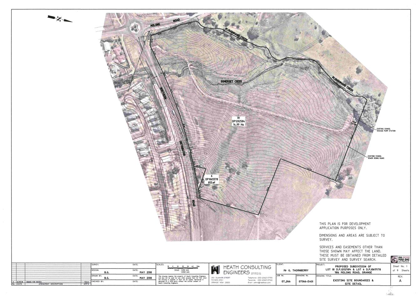
Planning
and Development Committee
4 September 2018
2.4 Development
Application DA 178/2018(1) - 386 Molong Road and Lot 6 Northern Distributor
Road
Attachment 3 Submissions
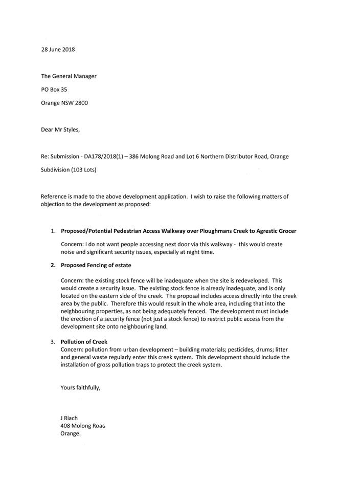
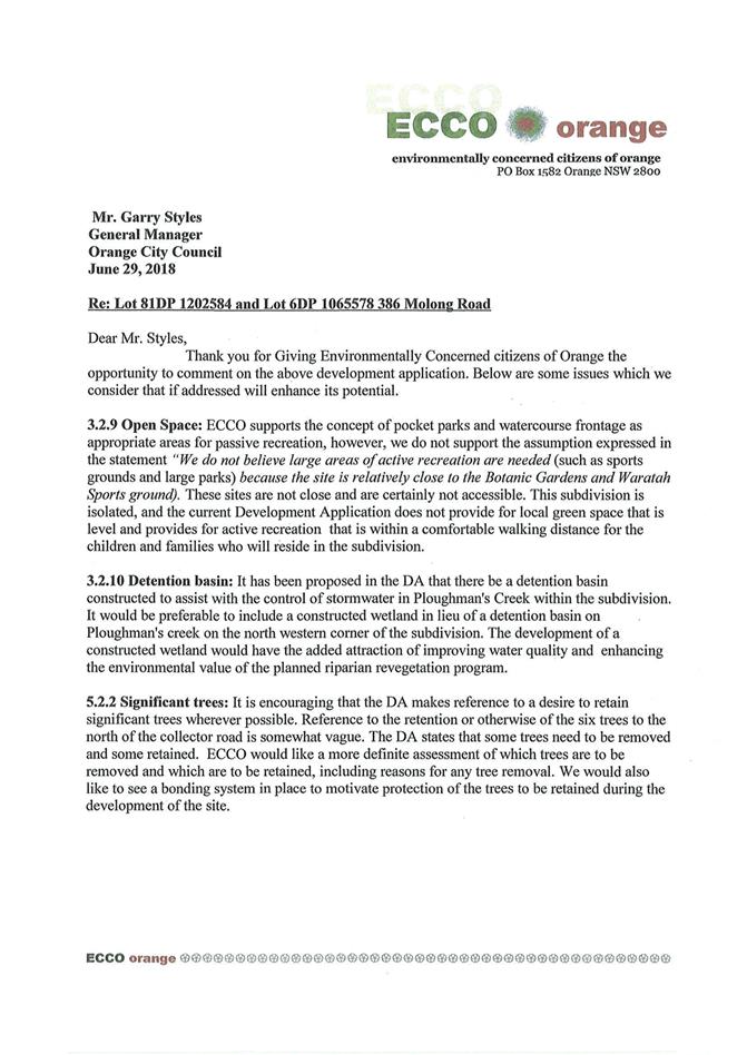
2.5 Development
Application DA 206/2018(1) - 124, 136 and 148 Shiralee Road
RECORD
NUMBER: 2018/2147
AUTHOR: Summer
Commins, Senior Planner
EXECUTIVE Summary
|
Application
lodged
|
8 June
2018
|
|
Applicant/s
|
Landorange
Partnership
|
|
Owner/s
|
Mr RS
and Mrs NR Burns,
Fenlor
Group Limited & Charms Development Pty Ltd
and Mr KR and Mrs JA Kramer
|
|
Land
description
|
Lots 92,
93 and 95 DP 750401 – 124, 136 & 148 Shiralee Road, Orange
|
|
Proposed
land use
|
Subdivision
(104 lots - comprising 103 residential lots and 1 open space lot) and
Demolition (dwellings x two and outbuildings)
|
|
Value of
proposed development
|
$0
|
Council's consent is sought for urban residential
subdivision of land in the developing Shiralee urban village. The proposal
relates to three existing rural-residential parcels described as Lots 92, 93
and 95 DP 75041, and known as 124, 136 and 148 Shiralee Road (refer Locality at
Figure 1 below). The proposal involves subdivision of the three existing
parcels to create 103 residential lots and 1 open space lot.
The residential lots will range in area between 310m²
and 2,714m². The lots will be fully serviced to a residential standard
with sewer, water, stormwater drainage, electricity, gas (subject to
availability) and telecommunications. Rifle Range Road and Shiralee Road will be
upgraded at the frontage of the proposed lots. Four (4) new roads will be
constructed to service the proposed lots. Approval is also sought for the
demolition of two existing dwellings and sheds on 124 and 136 Shiralee Road;
and a shed on 148 Shiralee Road.
The existing dwelling at 148 Shiralee Road is a listed Local
heritage item. The dwelling will be retained; however, it is considered that
the proposed subdivision layout will have adverse effect on the significance of
the heritage dwelling. The subdivision layout nearby to the dwelling will be
slightly modified via conditions of consent to reduce the number of residential
allotments by two to minimise the impacts. Future subdivision in the vicinity
of the dwelling will be subject to separate approval and heritage
consideration. The proponent is amenable to this arrangement.
The subject property is located within the developing
Shiralee urban village. Development in the precinct is subject to the
provisions contained in the Shiralee Development Control Plan 2015
(Shiralee DCP) and Shiralee Masterplan. The proposed subdivision generally
accords with the Shiralee DCP and Masterplan, notwithstanding some minor
variations. Departure from the Shiralee DCP is minor and within reasonable
limit. The proposed subdivision is considered to be consistent with the aims
and principles of the plan.
The proposed development comprises ‘advertised
development’ pursuant to Orange Development Control Plan (DCP) 2004.
Three (3) submissions were received at the close of the public notice and
exhibition period. The issues raised have been addressed by conditions of
consent.
The proposal has been evaluated pursuant to Section 4.15 of
the Environmental Planning and Assessment Act 1979 and is considered to
be suitable. Approval of the application is recommended, subject to conditions
of consent in the attached Notice of Approval.
Figure 1: locality plan
RECENT LEGISLATIVE CHANGES
On 1 March 2018 the Environmental Planning and Assessment
Act 1979 was substantially amended. The most immediate change involves the
restructuring and renumbering of the Act, with other more substantive
changes to be phased in over time. However, for some applications (particularly
where an application was lodged prior to the changes coming into effect) the
supporting documentation may still reference the previous numbering regime. In
the drafting of this report the content and substance of the supporting
material has been considered irrespective of which legislative references were
used.
DECISION FRAMEWORK
Development in Orange is governed by two key documents
Orange Local Environment Plan 2011 and Orange Development Control Plan 2004. In
addition the Infill Guidelines are used to guide development, particularly in
the heritage conservation areas and around heritage items.
Orange Local Environment Plan 2011 – The
provisions of the LEP must be considered by the Council in determining the
application. LEPs govern the types of development that are permissible or
prohibited in different parts of the City and also provide some assessment
criteria in specific circumstances. Uses are either permissible or not. The
objectives of each zoning and indeed the aims of the LEP itself are also to be
considered and can be used to guide decision making around appropriateness of
development.
Orange Development Control Plan 2004 – the DCP
provides guidelines for development. In general it is a performance based
document rather than prescriptive in nature. For each planning element there are
often guidelines used. These guidelines indicate ways of achieving the planning
outcomes. It is thus recognised that there may also be other solutions of
merit. All design solutions are considered on merit by planning and building
staff. Applications should clearly demonstrate how the planning outcomes are
being met where alternative design solutions are proposed. The DCP enables
developers and architects to use design to achieve the planning outcomes in
alternative ways.
DIRECTOR’S COMMENT
This development application is a significant one within the
Shiralee urban village and largely adheres to the intent of the Masterplan in
the opinion of staff. Neighbours have been consulted via the notification and
advertisement of the DA, and amendments have been made to the consent to
largely accommodate their concerns. This development will add significantly and
in a planned way to the housing stock in Orange.
Link To Delivery/OPerational Plan
The recommendation in this report relates to the
Delivery/Operational Plan strategy “10.1 Preserve -
Engage with the community to ensure plans for growth and development are
respectful of our heritage”.
Financial Implications
Nil
Policy and Governance Implications
Nil
|
Recommendation
That Council consents to
development application DA 206/2018(1)
for Subdivision (102 lots - comprising 101 residential lots and 1
open space lot) and Demolition (dwellings x two and outbuildings) at
Lots 92, 93 and 95 DP 750401 – 124, 136 and 148 Shiralee
Road, Orange, pursuant to the conditions of consent
in the attached Notice of Approval.
|
further considerations
Consideration has been given to the
recommendation’s impact on Council’s service delivery; image and
reputation; political; environmental; health and safety; employees;
stakeholders and project management; and no further implications or risks have
been identified.
SUPPORTING INFORMATION
THE PROPOSAL
Council's consent is sought for urban residential
subdivision of land at 124, 136 and 148 Shiralee Road. The proposal
involves staged subdivision of three existing parcels to create
103 residential lots and 1 open space lot.
The proposed residential lots will comprise a mix of
Compact, Medium, Standard and Large lots, as described in the Shiralee DCP. The
residential lots will range in area between 310m²
and 2,714m². The lots will be fully serviced to a residential
standard with sewer, water, stormwater drainage, electricity, gas (subject to
availability) and telecommunications.
Shiralee Road will be upgraded to Collector Road standard at
the frontage of the development site. Rifle Range Road will be upgraded to a
Local Street standard at this site frontage. Four (4) new internal Local
Streets will be constructed to service the proposed lots. Each proposed lot
will have direct frontage and access to an existing or proposed public road.
Approval is also sought for the demolition of two existing
dwellings and sheds on 124 and 136 Shiralee Road; and a shed on
148 Shiralee Road. The dwelling on the latter parcel will be retained.
The proposed subdivision layout
is depicted below (refer Figure 2).
Figure 2: proposed subdivision layout
MATTERS FOR CONSIDERATION
Section 1.7 - Application of
Part 7 of the Biodiversity Conservation Act 2016 and Part 7A of the
Fisheries Management Act 1994
Section 1.7 of the EP&A Act 1979 identifies that Part 7
of the Biodiversity Conservation Act 2016 and Part 7A of the Fisheries
Management Act 1994 have effect in connection with terrestrial and aquatic
environments.
Having regard to the relevant provisions and based on an
inspection of the subject property, it is considered that the proposed
development is unlikely to significantly affect a threatened species. It is
evident that the parcels have been highly modified by past agricultural
practices and are unlikely to contain significant habitat or biodiversity
value.
A Biodiversity Development Assessment Report is not required
in support of the proposal.
Section 4.15
Section 4.15 of the Environmental Planning and Assessment
Act 1979 requires Council to consider various matters, of which those
pertaining to the application are listed below.
PROVISIONS OF ANY ENVIRONMENTAL
PLANNING INSTRUMENT s4.15(1)(a)(i)
Orange Local Environmental Plan 2011
Part 1 - Preliminary
Clause 1.2 - Aims of Plan
The
particular aims of the LEP relevant to the application include:
(a) to encourage development which complements
and enhances the unique character of Orange as a major regional centre boasting
a diverse economy and offering an attractive regional lifestyle,
(b) to provide for a range of development
opportunities that contribute to the social, economic and environmental
resources of Orange in a way that allows present and future generations to meet
their needs by implementing the principles for ecologically sustainable development,
(e) to provide a range of housing choices in
planned urban and rural locations to meet population growth,
(f) to recognise and manage valued
environmental heritage, landscape and scenic features of Orange.
The application is considered to be consistent with the
above aims, as outlined in this report.
Clause 1.6 - Consent Authority
Clause 1.6 is applicable and states:
The consent authority
for the purposes of this Plan is (subject to the Act) the Council.
Clause 1.7 - Mapping
The subject site is identified
on the LEP maps in the following manner:
|
Land Zoning Map:
|
R1 General Residential; B1
Neighbourhood Centre; and RE1 Public Recreation
|
|
Lot Size Map:
|
Minimum lot size 200m2
(B); 400m2 (F); and 700m2 (Q)
|
|
Heritage Map:
|
A Local heritage item (I285 -
Dwelling)
|
|
Height of Buildings Map:
|
No building height limit
|
|
Floor Space Ratio Map:
|
No floor space limit
|
|
Terrestrial Biodiversity Map:
|
No biodiversity sensitivity on the
site
|
|
Groundwater Vulnerability Map:
|
Groundwater vulnerable
|
|
Drinking Water Catchment Map:
|
Not within the drinking water
catchment
|
|
Watercourse Map:
|
Not within or affecting a defined
watercourse
|
|
Urban Release Area Map:
|
Not within an urban release area
|
|
Obstacle Limitation Surface Map:
|
No restriction on building siting
or construction
|
|
Additional Permitted Uses Map:
|
No additional permitted use applies
|
|
Flood Planning Map:
|
Not within a flood planning area
|
Those matters that are of relevance are addressed in detail
in the body of this report.
Clause 1.9A - Suspension of
Covenants, Agreements and Instruments
Clause 1.9A is applicable and states in part:
(1) For the purpose of
enabling development on land in any zone to be carried out in accordance with
this Plan or with a consent granted under the Act, any agreement, covenant or
other similar instrument that restricts the carrying out of that development
does not apply to the extent necessary to serve that purpose.
(2) This clause does not apply:
(a) to a covenant imposed by the Council or that the Council requires to be
imposed, or
(b) to any prescribed instrument within the
meaning of section 183A of the Crown Lands Act 1989, or
(c) to any conservation agreement within the
meaning of the National Parks and Wildlife Act 1974, or
(d) to any Trust agreement within the meaning
of the Nature Conservation Trust Act 2001, or
(e) to any property vegetation plan within the
meaning of the Native Vegetation Act 2003, or
(f) to any biobanking agreement within
the meaning of Part 7A of the Threatened Species Conservation Act 1995, or
(g) to
any planning agreement within the meaning of Division 6 of Part 4 of the Act.
Council staff are not aware of the title of the subject
property being affected by any of the foregoing covenants, instruments,
agreements or plans.
Part 2 - Permitted or Prohibited Development
Clause
2.1 Land Use Zones
The development site is zoned R1
General Residential, B1 Neighbourhood Centre and RE1 Public Recreation
(refer Figure 3):
Figure 3: Zoning Map - Orange LEP 2011
The proposed development is defined as
“subdivision” and “demolition.”
Pursuant to Section 6.2 of the Environmental Planning and
Assessment Act 1979:
Subdivision of land means the
division of land into two or more parts that, after the division, would be
obviously adapted for separate occupation, use or disposition.
Subdivision of land is permitted with consent pursuant to
Clause 2.6 (refer below).
Pursuant to Section 1.5 of the
EPAA 1979, development includes:
(e) the
demolition of a building or work.
Demolition is permitted with consent pursuant to Clause 2.7
(refer below).
Clause 2.3 - Zone Objectives
The
objectives for land zoned R1 General Residential are:
· To provide for the
housing needs of the community.
· To provide for a
variety of housing types and densities.
· To enable other land
uses that provide facilities or services to meet the day to day needs of
residents.
· To ensure development
is ordered in such a way as to maximise public transport patronage and
encourage walking and cycling in close proximity to settlement.
· To ensure that
development along the Southern Link Road has an alternative access.
The proposed development is
consistent with the relevant R1 zone objectives. The proposal involves the
creation of a mix of residential lots that will enable development of a variety
of housing types and densities.
The objectives
for land zoned B1 Neighbourhood Centre are:
· To provide a range of
retail, business, entertainment and community uses that service the needs of
people who live in, work in and visit the local area.
· To encourage
employment opportunities in accessible locations.
· To maximise public
transport patronage and encourage walking and cycling.
· To ensure that
retail, business and community uses in North Orange and South Orange will not
detract from the role of the CBD as the primary business centre within the
City.
The B1 zone objectives do not relevantly relate to the
proposed subdivision.
The objectives for land zoned RE1
Public Recreation are:
· To enable land to be
used for public open space or recreational purposes.
· To provide a range of
recreational settings and activities and compatible landuses.
· To protect and
enhance the natural environment for recreational purposes.
· To ensure development
is ordered in such a way as to maximise public transport patronage and
encourage walking and cycling in close proximity to settlement.
· To ensure that
development along the Southern Link Road has an alternative access.
The proposed subdivision involves the creation of an open
space lot within land zoned RE1. The development will provide land for
open space or recreational purposes, consistent with the RE1 zone
objectives.
Clause 2.6 - Subdivision -
Consent Requirements
Clause 2.6 is applicable and states:
(1) Land
to which this Plan applies may be subdivided but only with development consent.
Consent is sought for Torrens subdivision of the subject
land in accordance with this clause.
Clause 2.7 - Demolition
Requires Development Consent
Clause 2.7 applies and states:
The demolition of a building
or work may be carried out only with development consent.
The proposal involves demolition of dwellings and
outbuildings over the development site in accordance with this clause.
Part 3 - Exempt and Complying Development
The application is not exempt or complying development.
Part 4 - Principal Development Standards
Clause
4.1 - Minimum Subdivision Lot Size
Clause
4.1 is applicable and states in part:
(3) The size
of any lot resulting from a subdivision of land to which this clause applies is
not to be less than the minimum size shown on the Lot Size Map in relation to that land.
Pursuant
to the Lot Size Map (refer below), the development site is subject to three
minimum lot sizes:
· 200m2 in those areas identified as Minimum Lot
Size B
· 400m2 in those areas identified as Minimum Lot
Size F
· 700m2 in those areas identified as Minimum Lot
Size Q
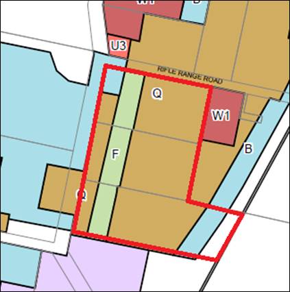
Figure 4: Minimum Lot Size Map - Orange LEP 2011
The
lots proposed in the subdivision comply with the prescribed minimum lot sizes
in Clause 4.1.
Part 5 - Miscellaneous Provisions
Clause
5.10 Heritage Conservation
The development site contains a Local heritage item, namely
I285 Dwelling at 148 Shiralee Road. The dwelling is to be retained,
however demolition of an outbuilding on this parcel is proposed.
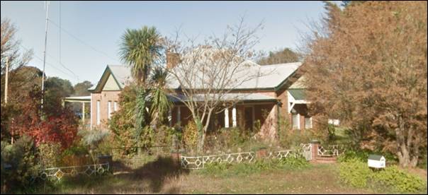
Figure 5: -
heritage item at 148 Shiralee Road
The
Orange Heritage Inventory provides the following Statement of Significance for
the dwelling:
The large brick Inter-War residence retains the original
character including the distinctive roof form, projecting gables and verandah
and complements the streetscape.
Pursuant
to Clause 5.10(4):
The consent authority must,
before granting consent under this clause in respect of a heritage item or
heritage conservation area, consider the effect of the proposed development on
the heritage significance of the item or area concerned. This subclause applies
regardless of whether a heritage management document is prepared under
subclause (5) or a heritage conservation management plan is submitted
under subclause (6).
The
proposed subdivision layout adjacent to the heritage item is shown below (refer
Figure 6). The item will be excised on a parcel of 760m2.
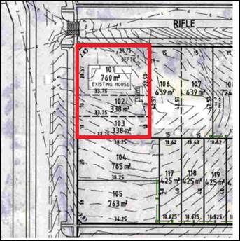
Figure 6: proposed subdivision
layout over heritage item
The
proposed Shiralee DCP Masterplan provides for a subdivision layout as depicted
below (refer Figures 7 and 8).
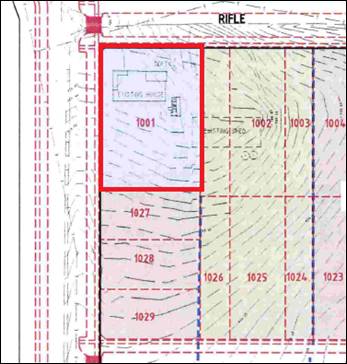
Figure 7: Shiralee DCP Masterplan subdivision layout
(prepared by applicant)
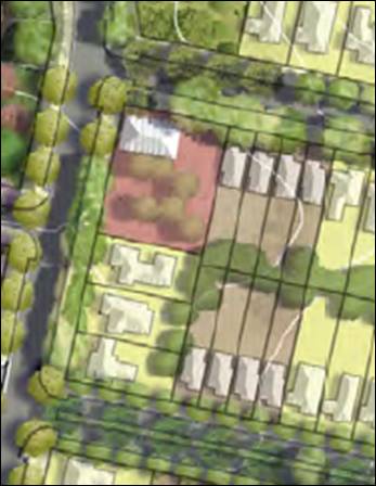
Figure 8: Shiralee DCP Masterplan
subdivision layout
It is
noted that the Shiralee DCP Masterplan (at Part 2.0 Desired Future Character)
seeks to:
· Conserve and protect historic items and their settings; and
· Conserve, maintain and enhance existing views and vistas to
buildings and places of historic and aesthetic significance.
As
shown above, the proposed lot layout is contrary to the DCP Masterplan layout
above, which provides for a generous curtilage for the heritage item.
Furthermore, the lot layout does not accord with the Shiralee Structure Plan
which provides for a Mixed Use Village Centre over this site. It is noted,
however, that the proposed lot sizes adjacent to the heritage item comply with
the minimum lot sizes under Orange LEP 2011 (ie 200m2 in this
location).
In the
form proposed it is considered that the subdivision layout may have adverse
effect on the significance of the heritage item due to the following:
· The curtilage to the south is considered inadequate to
provide reasonable visual separation between the heritage dwelling and future adjoining
dwellings.
· The existing landscaped setting associated with the
heritage dwelling will be affected.
· Views of the dwelling may be impacted when travelling north
along Shiralee Road due to the proposed proximity of future dwellings on
proposed Lots 102 and 103.
· Civil and construction works may impact on the integrity of
the dwelling.
· The appreciation of the heritage dwelling in the developing
urban setting may be eroded.
The DA
is silent in respect of the impact of the development on the significance of
the heritage item. Based on the foregoing assessment by Council officers and in
the absence of counter consideration by the proponent, a condition is included
on the attached Notice of Approval that development consent is not
granted for proposed Lots 102 and 103. Future subdivision of the land adjacent
to the heritage item may be considered at future DA stage in conjunction
with detailed heritage assessment. The proponent is amenable to this
arrangement.
Part 6 - Urban Release Area
Not relevant to the application. The subject site is not
located in an Urban Release Area.
Part 7 - Additional Local
Provisions
Clause
7.1 - Earthworks
Clause
7.1 is applicable and states in part:
(3) Before granting development
consent for earthworks, the consent authority must consider the following
matters:
(a) the likely disruption of, or
any detrimental effect on, existing drainage patterns and soil stability in the
locality of the development,
(b) the effect of the
development on the likely future use or redevelopment of the land,
(c) the quality of the fill or the
soil to be excavated, or both,
(d) the effect of the
development on the existing and likely amenity of adjoining properties,
(e) the source of any fill material and
the destination of any excavated material,
(f) the likelihood of disturbing
relics,
(g) the proximity to and
potential for adverse impacts on any waterway, drinking water catchment or
environmentally sensitive area,
(h) any measures proposed to
minimise or mitigate the impacts referred to in paragraph (g).
Earthworks
will be required in conjunction with civil and construction works required to
create the proposed lots. It is considered that the required earthworks
are unlikely to disrupt or have a detrimental effect on the existing drainage
patterns and soil stability of the area, nor detrimentally affect a future use
or redevelopment of the land, nor detrimentally affect the amenity of adjoining
properties, nor disturb any relics.
Clause 7.3 - Stormwater Management
Clause 7.3 is applicable. This
clause states in part:
(3) Development
consent must not be granted to development on land to which this clause applies
unless the consent authority is satisfied that the development:
(a) is
designed to maximise the use of water permeable surfaces on the land having
regard to the soil characteristics affecting on-site infiltration of water, and
(b) includes,
where practical, on-site stormwater retention for use as an alternative supply
to mains water, groundwater or river water, and
(c) avoids
any significant impacts of stormwater runoff on adjoining downstream
properties, native bushland and receiving waters, or if that impact cannot be
reasonably avoided, minimises and mitigates the impact.
In consideration of Clause 7.3,
Council’s Development Engineer has advised:
The
applicant will be required to contribute to the provision of an off-site
stormwater detention system for the development (through Section 94
Contributions). Drainage for Stages 3 and 4 may require drainage easements over
adjoining land prior to the commencement of works. A stormwater detention basin
will be located immediately to the south and the development is required to
discharge stormwater to this point.
Clause 7.6 - Groundwater Vulnerability
The
subject land is identified as Groundwater Vulnerable on the Groundwater
Vulnerability Map and Clause 7.6 applies. This clause states in part:
(3) Before determining a
development application for development on land to which this clause applies,
the consent authority must consider:
(a) whether
or not the development (including any onsite storage or disposal of solid or
liquid waste and chemicals) is likely to cause any groundwater contamination or
have any adverse effect on groundwater dependent ecosystems, and
In consideration of Clause 7.6,
the proposed development is unlikely to cause groundwater contamination or
effect groundwater dependent ecosystems. Urban residential subdivision does not
involve processes or activities that would impact on groundwater resources. The
subject lands will be serviced by reticulated sewer, as required by conditions
of consent.
Clause 7.11 - Essential Services
Clause
7.11 is applicable. This clause states:
Development consent must not be granted to development
unless the consent authority is satisfied that any of the following services
that are essential for the proposed development are available or that adequate
arrangements have been made to make them available when required:
(a) the
supply of water
(b) the
supply of electricity
(c) the
disposal and management of sewage
(d) storm
water drainage or on-site conservation
(e) suitable
road access.
In
consideration of this clause, the listed utility services are available to the
land and adequate for the proposed subdivision. Conditions
are included on the attached Notice of Approval requiring extension,
augmentation and/or upgrading of urban utility services to the standards
required to service the proposed urban lots.
STATE ENVIRONMENTAL PLANNING
POLICIES
State Environmental Planning Policy 55 - Remediation of
Land
State Environmental Planning Policy 55 - Remediation of Land
(SEPP 55) is applicable and states in part:
Clause 7 Contamination and
remediation to be considered in determining development application:
(1) A consent authority must
not consent to the carrying out of any development on land unless:
(a) it
has considered whether the land is contaminated, and
(b) if the land is contaminated, it is
satisfied that the land is suitable in its contaminated state (or will be
suitable, after remediation) for the purpose for which the development is
proposed to be carried out, and
(c) if the land requires remediation to be made
suitable for the purpose for which the development is proposed to be carried
out, it is satisfied that the land will be remediated before the land is used
for that purpose.
In consideration of the requirements of SEPP 55, the subject
land has been used for a Table 1 purpose (ie agriculture/orcharding) to
the Contaminated Land Planning Guidelines. A Preliminary Geotechnical and
Contamination Investigation was submitted in support of the proposal
(Envirowest Consulting February 2018). The investigation provides the following
contamination conclusions and recommendations:
The investigation area
[development site] has previously been an orchard. The majority of trees have
been removed and the investigation area is currently a rural-residential
landuse.
The levels of all substances
analysed in the soil samples were not detected or at environmental background
levels, and below the adopted residential landuse thresholds. Additional
contamination testing… is required to validate the proposed change of use
to residential.
Lot 93 consisted of what is
expected to be a packing shed and pickers hut. A number of orchard trees were
located to the east of the packing shed. Trees that were located to the west of
the shed have been removed. The pickers hut appears to be of Asbestos
Containing Material construction. Most of the pesticide mixing for the orchard
is expected to have occurred in this area. A spray unit was identified adjacent
to the packing shed.
Based on the findings of the Contamination investigation, a
condition is included on the attached Notice of Approval requiring
contamination clearance for the proposed lots prior to the issue of a
Subdivision Certificate.
PROVISIONS OF ANY DRAFT
ENVIRONMENTAL PLANNING INSTRUMENT THAT HAS BEEN PLACED ON EXHIBITION
4.15(1)(a)(ii)
There are no draft environmental planning instruments that
apply to the subject land or proposed development.
DESIGNATED DEVELOPMENT
The proposed development is not designated development.
INTEGRATED DEVELOPMENT
The proposed development is not integrated development.
PROVISIONS OF ANY DEVELOPMENT
CONTROL PLAN s4.15(1)(a)(iii)
Orange Development Control Plan 2004
Orange DCP 2004 is applies to the subject land. Chapters of
the DCP relevant to the proposed subdivision include:
· Chapter 2 -
Natural Resource Management
· Chapter 3 -
General Considerations
· Chapter 4 -
Special Environmental Considerations
· Chapter 5 - General
Considerations for Zones and Development.
The relevant matters were considered in the foregoing
assessment under Orange LEP 2011. The proposal will satisfy the relevant
planning outcomes and guidelines contained in DCP 2004.
SHIRALEE DEVELOPMENT CONTROL
PLAN 2015
Shiralee DCP is applicable to the proposal. The objectives
of the DCP are:
· To guide the
urban expansion of Shiralee, south of the existing Orange urban area
· To promote a
high quality urban environment with a diversity of housing and recreational
opportunities
· To encourage
alternative modes of transport and healthy lifestyles
· To reduce
traffic congestion by providing for the day to day needs of residents within
the precinct.
As outlined in the following assessment of relevant controls,
the proposed subdivision will reasonably satisfy the objectives of the Shiralee
DCP. Part 1.8 Exceptional Circumstances allows some variation to the
plan, provided that the proposal meets or exceeds the listed aims and
principles. It is accepted that minor variations to the Masterplan will result
as development proceeds in the urban village.
2.0 Desired Future Character
2.4 Subdivision
Controls:
· All subdivision
applications are to be accompanied by a preliminary investigation to identify
any past or present uses that have potential to contaminate the land and a
preliminary assessment of any known contamination. If the results are positive,
or if Council so directs, the application is to undertake a more detailed
investigation.
As outlined in the foregoing sections of this report,
preliminary contamination investigation was undertaken in support of the
proposed subdivision. The investigation determined that substances detected
were below the adopted residential landuse thresholds. Notwithstanding, additional
contamination testing is required to validate the proposed change of use to
residential. A condition is included on the attached Notice of Approval
requiring contamination clearance for the proposed lots prior to issue of a
Subdivision Certificate.
· Subdivision is
to be consistent generally in accordance with the Masterplan design and intent
per the DCP. Legislative requirements and DCP written controls take precedence
over the Masterplan.
The Shiralee Masterplan for the development sites is
depicted below (refer Figure 9).
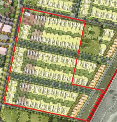
Figure 9: Shiralee Masterplan Area F
The proposed subdivision layout in
relation to the Masterplan is shown below (refer Figure 10).
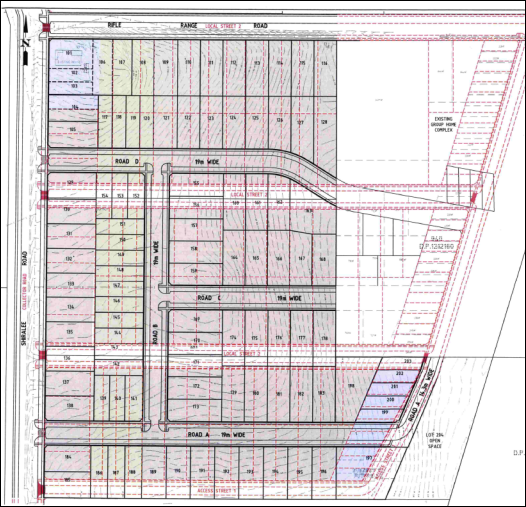
Figure 10:
proposed subdivision layout in relation to Masterplan layout
The proposed subdivision layout generally accords with the
Masterplan in respect of lot size, shape and orientation. The proposal departs
from the Masterplan as follows:
· Road D curves to
the south in order to provide connection to and practical future subdivision of
the adjoining eastern parcel. Land to the immediate east of the subject land
has been recently developed for a group home by the NSW Department of Family
and Community Services contrary to advice provided by Council.
· Road B is included
to provide a north-south link between proposed Roads A and D.
· Road A is wholly
located within the proposed subdivision and residential lots adjoin the
southern boundary of the development site. As a matter arising, the proposed
layout will result in Standard Lots in the proposed subdivision opposing Large
Lots and open space lots on the adjoining land to the south. Fencing treatment
should provide an appropriate visual and functional transition between
densities. A condition is included on the attached Notice of Approval requiring
an 88B Instrument to be created on the titles of lots adjacent to the
southern boundary requiring rural fencing to be erected and maintained.
· Additional lots
are proposed adjacent to the heritage dwelling at the corner of Shiralee Road
and Rifle Range Road. As outlined above, the proposed layout in the vicinity of
the item is considered to adversely impact on the significance of the heritage
item and is not supported at this time.
Council’s Development Engineer advises that ‘the
proposed road layout is satisfactory; the variation to the road layout has been
discussed between the applicant and Council’s Technical Services.’ The
proposed internal roads will not impact on road connections with adjoining
lands and are considered to be appropriate.
· Lot sizes are
to be consistent with or greater than the adopted minimum lot size for the land
under the LEP zoning map.
As
outlined in the foregoing sections of this report, the development site is
subject to three minimum lot sizes: 200m2, 400m2 and 700m2.
The proposed lots comply with the prescribed
minimum lot sizes on the LEP Lot Size Map.
· Where an
oversized lot is proposed (substantially greater than the adopted minimum lot
size), plans are to nominate a building envelope.
Proposed Lots 128 and 163 comprise Standard Lots but exceed
the adopted minimum lot size of 850m2 (Lot 128 has an area of 992m2
and Lot 163 comprises a site area of 1,092m2). Building
envelopes for the lots are not nominated on the proposed subdivision plan. A
condition is included on the attached Notice of Approval requiring building
envelopes to be included on the final plan.
The proposed subdivision incorporates a Large Lot - proposed
Lot 197 with an area of 1,831m2. This parcel is a development
lot which may be the subject of separate application for multi-dwelling housing
and community title subdivision. It is considered that a building envelope is
not required on the subject development lot.
· Building
envelopes on oversized lots are to be positioned in a manner that clearly enables
future subdivision of the lot to a pattern consistent with the masterplan
layout and adopted minimum lot size for the land.
Refer assessment above.
· Except for
corner lots and where indicated otherwise on the Large Lot Classification
Table, all residential lots are to have a width to depth ratio of between 1:4
and 1:2.75 with the shorter boundary being the street frontage.
· Residential
corner lots are to have greater width with a ratio of between 1:3.25 and 1:2.5
to allow more opportunity for the subsequent dwelling to address both
frontages.
A DCP Ratio Compliance Table was submitted in support of the
proposal. The table demonstrates that 37% of the proposed lots comply with the
ratios prescribed in the DCP. The proponent submits, however, that the proposed
lots do not generally match the typical lot dimensions nominated for the
particular DCP lot typologies. On this basis, compliance with the prescribed
width-to-depth ratios will be more difficult to achieve.
The proposed lots are sited to achieve a north-south or
east-west long orientation which will maximise solar design opportunities.
Furthermore, the proposed lots will allow appropriate presentation of future
dwellings on the lots to public roads. The intent of the width-to-depth ratio
is thereby satisfied.
· Roads
identified for Bus Routes:
- Intersections
where the bus route turns are to be designed to accommodate full size coaches.
- At
nominated bus stop locations the road reserve is to be increased by an addition
of 0.5m to allow for passenger congregation and future street furniture. The
front building setbacks of affected lots may be reduced by 0.25m to help
preserve the pattern and rhythm of development.
Council’s Development Engineer advises that the
proposed road layout is satisfactory and generally in accordance with the
Shiralee DCP.
2.5 Lot Typologies
Controls:
· Lot typologies
and minimum sizes are to be consistent with the Masterplan, DCP and LEP zoning
maps.
An extract of the Shiralee Structure Plan and Housing
Densities Map is shown below (refer Figure 11). The structure plan
provides for a mix of Standard, Medium and Compact Lots over the subject
land, together with a Mixed Use Village Centre at the corner of Shiralee
and Rifle Range Roads.
Figure 11: Shiralee Structure Plan and Housing
Densities
The proposed subdivision layout
lot typologies in relation to the Structure Plan is depicted below (refer
Figure 12).
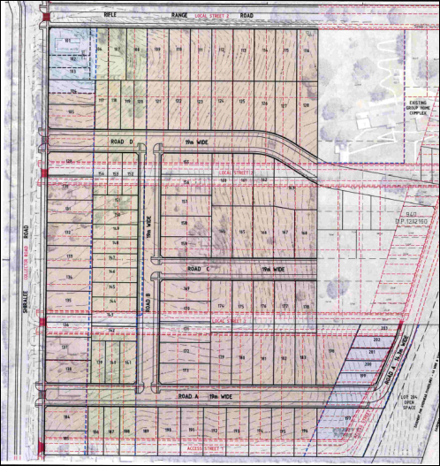
Figure 12:
proposed subdivision layout lot typologies in relation to Masterplan layout
As demonstrated above, the
proposed lot typologies accord with the Structure Plan, except for the
following departures:
· The layout
includes one Large Lot (Lot 197 with an area of 1,831m2) in the
south‑eastern corner of the development site. This parcel is a
development lot which may be the subject of separate application for
multi-dwelling housing and community subdivision. The Large Lot/development lot
is considered to be well‑located for future multi-dwelling housing
adjacent to Compact Lots to the north and Large Lots and open space to the
south and east. The proposed Large Lot satisfies the intent for same prescribed
in the DCP, and is considered a reasonable departure from the DCP Masterplan
and Structure Plan.
· Residential lots
are proposed in the nominated Mixed Use Village Centre at the corner of
Shiralee and Rifle Range Roads. As outlined previously, the lot layout is
considered to adversely affect the significance of the heritage dwelling on the
land, and is contrary to the intended commercial use of this part of the site.
The proposed lot sizes are
consistent with the lot ranges prescribed for Standard, Medium and Compact Lots
as follows:
|
Lot Typology
|
Required Lot Size Range
|
Proposed Lot Range
|
Lots in Subdivision
|
|
Standard Lots
|
700-850m2
|
700-812m2
|
67
|
|
Medium Lots
|
400-550m2
|
408-520m2
|
23
|
|
Compact
|
200-350m2
|
310-338m2
|
7
|
|
Oversized Lots*
|
|
|
5
|
*Oversized lots were
considered in the foregoing assessment
· Any subdivision
which creates more than three lots must not have any oversized lots. Oversized
lots are lots that do not fit within the designated categories.
As outlined in the foregoing assessment, proposed Lots 128
and 163 comprise Standard Lots but exceed the adopted minimum lot size of 850m2
(Lot 128 has an area of 992m2 and Lot 163 comprises a site area
of 1,092m2).
The oversized lots are a consequence of the need to vary the
proposed internal road layout (Road D) to accommodate road connections to,
and future subdivision of the adjoining land to the east, known as 22 Rifle
Range Road. This land has been recently developed for a group home by the NSW
Department of Family and Community Services. The modified road layout and
oversized Lots 128 and 163 will allow for future subdivision of part
22 Rifle Range Road, generally in accordance with the Shiralee DCP and
Masterplan. There is no objection to the oversized lots and the departure to
the DCP as a consequence. Building envelopes for Lots 128 and 163
will be shown on the final plan, sited to ensure a high standard of residential
amenity for the subject and adjoining lots in the subdivision.
· Specific
requirements for large lots within the Precinct are to be consistent with
Large Lot Classification Diagram and Large Lot Classification Table.
As outlined previously, the proposed subdivision layout
includes one Large Lot, which represents a departure from the Shiralee DCP and
Masterplan for the development site. As such, the DCP Large Lot Classification
Diagram and Table does not contain requirements for this proposal. Proposed
Large Lot 197 is a development lot which may be the subject of separate
application for multi-dwelling housing and community subdivision. The Large
Lot/ development lot is considered well-located for future multi-dwelling
housing adjacent to compact lots to the north and public open space to the
south and east.
· Where
subdivision involves the creation of a lot greater than the maximum for the lot
typology, a building envelope is to be established on the title of the new lot
[consistent with prescribed dimensions].
As considered in the foregoing assessment, a condition is
included on the attached Notice of Approval requiring building envelopes to be
shown on proposed oversized Lots 128 and 163, consistent with DCP
prescribed dimensions.
· The building envelope
is to be positioned consistent with the front and rear setbacks otherwise
specified for the lot typology in this DCP.
A condition is included on the attached Notice of Approval
requiring the building envelopes on proposed oversized Lots 128 and 163 to be
sited consistent with DCP prescribed setbacks for Standard Lot typology.
· All lots must
have a direct street frontage to ensure good access and property amenity.
All proposed lots will have direct street frontage and
access to an existing or proposed public road.
· Corner lots are
to achieve high quality street frontages on the primary and secondary street.
The proposed subdivision layout is considered suitable to
achieve high quality street frontage to primary and secondary boundaries.
· All compact,
medium and standard lots need to achieve a solar orientation where the long
axis of the lot is:
- For
north-south oriented lots between 20o west of north of 30o
east or north, or
- For
east-west oriented lots between 20o north of east or 30o
south of east.
The proposed lots will comply with the requirements for
solar orientation.
3.0 Local Infrastructure
3.1 Infrastructure Provisions
Controls:
· Clause 7.11 of
Orange LEP 2011 establishes that development is required to be provided with
essential services…
· Provision of
essential local infrastructure is at the developers cost and in line with the
Shiralee Development Contributions Plan
· The design and
placement of local infrastructure is to be in accordance with the relevant
authorities requirements
· All power lines
are to be located underground
As outlined in the foregoing assessment, utility services
are available to the land and adequate for the proposed subdivision, subject to
extension, augmentation, upgrading and developer contributions. Conditions are
included on the attached Notice of Approval to satisfy the requirements of Part
3.1.
3.2 Ground Levels and
Excavation
Controls:
· Cut and fill is
to be minimised with cut materials used onsite as either fill for buildings or
used to even out landforms.
· Any cut is to
be supported by a retaining wall or battered at a gradient of less than 1:4,
provided that gradient is achievable entirely within the site boundaries.
· The design of
any retaining wall greater than 600mm must be accompanied by a statement from
an engineer attesting that the design is fit for purpose.
· Excavation for
the purposes of development must not exceed a maximum depth measured from
ground level (existing) of:
- If
located not more than 2m from any boundary:1m
- If
located more than 2m from any boundary: 2m
· Notwithstanding
the above, excavation must not be more than 1m below ground level (existing) if
the land is within 40m of a waterbody (natural)…
· Filling, for
the purpose of erecting a dwelling must not exceed 1m above ground level
(existing).
· All excavation
and/or filling that exceeds 600mm in depth/height must be contained by either:
- A
retaining wall or other form of structural support that does not extend more
than 1.5m from:
o External walls of the dwelling
house,
o Decking connected to the dwelling
house, or
o Principal private open space of
the dwelling house,
o An unprotected sloping embankment
or batter that does not extend from the dwelling house, decking or principal
private open space by more than 3m, in which case the toe of the embankment or
batter must be more than 1m away from a side or rear boundary.
· To facilitate
assessment detailed engineering plans for retaining walls are to be supplied
where the wall is intended to retain more than 600mm or more of material.
Note: for this clause “Principal Private Open Space” means
courtyard space of up to 30m2 that is located behind the main building
alignment and is in close proximity to the living and entertaining spaces of
the dwelling house.
Earthworks
will be required in conjunction with civil and construction works required to
create the proposed lots and new and upgraded roads. The extent of excavation
and filling will be determined at engineering design stage. Notwithstanding, it
is considered that the required earthworks are unlikely to disrupt or
have a detrimental effect on the existing drainage patterns and soil stability
of the area, nor detrimentally affect a future use or redevelopment of the
land, nor detrimentally affect the amenity of adjoining properties, nor or
disturb any relics.
3.3 Public
Domain
Controls:
· Land identified
for the RE1 Public Recreation Zone is to be dedicated to Council as public open
space upon subdivision of the parent lot.
· Compensation
for the dedicated land is to be in accordance with the relevant Section 94
Development Contribution Plan.
Proposed open space Lot 204 will be
dedicated to Council at registration of the parent parcel, with appropriate
compensation consistent with the Shiralee Development Contributions Plan.
· Footpath dining
in the Village Centre is encouraged, although access on the footpath must be
maintained and consideration must be given to access for the vision impaired
and those in wheelchairs.
· Outdoor dining
furniture and signage must be approved by Orange City Council and provide a
positive visual aesthetic to the streetscape.
The proposed subdivision does not
relate to built form within a Village Centre, and the above controls are not
applicable.
· Ensure
reasonable pedestrian/wheelchair/pram crossing ability is designed into the
road and median to ensure access into the heart of the village.
The proposed subdivision does not
relate to built form within a Village Centre. Bike paths and footpaths will be
provided across the subdivision. Council’s Development Engineer is
satisfied with the proposed road layout.
3.4 Staging
Controls:
· The Rifle Range
Exclusion Zone may not be subdivided or otherwise developed until the rifle
range has been decommissioned…
· The Hawke Dam
Lane exclusion zone may not be subdivided or otherwise developed until the dam
has been decommissioned…
The development site is not located
within the Rifle Range or Hawke Dam Lane exclusion zones.
3.5 Lighting
Controls:
· All lights are
to use energy efficient LED luminaries or equivalent…
· Street lighting
is to be designed to meet the current Australian Standards AS / NZS 1158 series
· Enhanced levels
of lighting are to be installed at major recreation pedestrian / cycle link
crossings and at pedestrian crossings
· Street trees
and street lights are to be staggered so that footpaths maintain sufficient
light levels.
Conditions are included on the attached Notice of Approval
to satisfy the above controls relating to lighting across the subdivision.
5.0 Residential Buildings
Part 5 contains provisions for dwellings, including:
· Building form
and layout;
· Building
typology, design and dwelling mix;
· Solar access;
· Reflectivity;
· Privacy; and
· Universal
design.
In order to ensure residential development on the proposed
lots consistent with the Shiralee DCP, a condition is included on the
attached Notice of Approval requiring registration of an 88B
Restriction-as-to-User for each residential lot, requiring development consistent
with the Part 5 DCP standards.
7.0
Public Domain
7.1 Passive and Active Recreation Network
Controls:
· Open spaces and
streets facing open spaces must be provided according to the Masterplan
The proposed subdivision layout includes an open space lot
(Lot 204) to the southeast of the development site, consistent with the
Shiralee DCP and Masterplan.
· Where a
property adjoins a park or other public space that is not a street or road, any
residential development of that property:
- Must
provide at least two windows from habitable rooms to face the public space. The
windows are to be a minimum 2.5m² in size
- May
not place the side or rear walls of sheds and outbuildings any closer than 2.5m
from the boundary with the public space
· Properties
adjoining a public park or other public space are encouraged to include a
pedestrian gate along the boundary.
Proposed Lot 197 will comprise an oversized/development lot
and adjoin open space Lot 204. Multi-dwelling housing on Lot 197 will be
the subject of separate development application and approval. Compliance with
the above controls will be considered at that stage.
7.2 Landscape
Controls:
· Open spaces and
streets facing open spaces must be provided according to the Masterplan
· Eco link
streets are to have an understory planting layer of native species including
shrubs, groundcovers and grasses of maximum mature height of 1.5m with planting
plans to be submitted for approval by Council.
· Streets with
medians are to have an understory planting layer of species responding to the
tree planting within the median, including shrubs, groundcovers and grasses of
generally maximum mature height of 1.5m and of 1m within 5m of an intersection.
· Footpath verges
within residential areas are to be planted with cool climate turf species, as
approved by Council.
· Footpath verges
and tree planting zones within the village centre, may be planted with robust
groundcover and grass species in keeping with a high quality street environment
and as approved by Council.
· A developer
shall construct all footpaths, turf all verges and provide all road
infrastructure planting prior to sale of building blocks.
· Orange City
Council will plant all street trees.
· Maximum verge
cross-fall from property boundary to kerb is to be 2%.
· Longitudinal
gradient of verge is to match the gradient of the adjacent kerb. Retaining
walls are to be provided along property boundaries accordingly.
A landscaping plan was not submitted in support of the
proposed subdivision. Conditions are included on the attached Notice of
Approval requiring preparation and implementation of a landscaping plan
consistent with the requirements of Part 7.2.
7.4 Street Tree Strategy
Controls:
· A minimum of
one tree per lot for compact lots, two trees for standard lots and three trees
for larger lots, at even spacings along the street.
· Street tree
plantings are to be consistent with the Street Tree Strategy Diagram, Species
List and Planting Detail and as approved by Council.
· Residential
street verges are t be turfed with Council approved species except where
Council requires groundcover planting.
A landscaping plan was not submitted in support of the
proposed development. Conditions are included on the attached Notice of
Approval requiring preparation and implementation of a landscaping plan
incorporating street trees consistent with the requirements of Part 7.4.
8.0 Environmental Management
8.3 Stormwater and Water Sensitive Urban Design (WSUD)
Controls:
· A comprehensive
site-wide WSUD strategy is implemented for Shiralee.
· Streets and
public spaces incorporate best practice WSUD elements including swales, rain
gardens and detention/retention basins.
· WSUD elements
are to incorporate native planting.
The proposed subdivision may be designed to comply with the
above controls. Conditions are included on the attached Notice of Approval to
satisfy the requirements of Part 8.3.
9.0 Movement Networks
9.2 Pedestrian and Bicycle Network and Associated
Facilities
Controls:
· A comprehensive
site-wide WSUD strategy is implemented for Shiralee.
· A cycle network
is to be implemented in accordance with Figure 64. Cycle Network and be
designed in accordance with Austroads Standards and RMS Guidelines.
· Footpaths to be
provided on both sides of the street consistent with the street sections in
Appendix C.
· Safe road
crossings (e.g. marked crossings) are to be provided according to 9.4 Street
Network Access Controls. Also refer indicative intersection treatments, Figures
75 and 76.
· Universal
access to be provided throughout the precinct in accordance to AS.1428.1.
· On-road cycle
routes are to be clearly line marked and sign posted.
· Any development
that is assessed as requiring an on-site parking area or at least 5 spaces
shall also be required to provide bicycle parking.
· Bicycle parking
is to be provided at the ratio of 1 bicycle space per 15 car parking spaces (or
part thereof).
· All bicycle
spaces are to be provided with a fixed rack or other feature to facilitate
chain locking the bicycle.
· Bicycle spaces
are to be positioned so as to avoid conflict with car and service vehicle
circulation.
· Bicycle spaces
are to be clearly delineated from other parking areas by means of lane marking
and/or signage.
The proposed subdivision may be designed to comply with the
above controls. Conditions are included on the attached Notice of Approval to
satisfy the requirements of Part 9.2.
9.3 Public Transport Network
Controls:
· Bus routes and
stops are to be positioned in accordance with Figure 67 - Bus Network.
· All bus stops must
have a shelter that includes: seating with arm rests and lighting.
· Bus shelters
are to be positioned on either side of the street at all stops indicated on
Figure 67 - Bus Network.
· Pedestrian
crossings must be provided within 30m of all stops.
· Continuous
accessible paving must be provided from the shelter to pedestrian crossing.21.
Shiralee Road is identified as a primary bus route in the
Shiralee DCP and Masterplan. Council’s Development Engineer is satisfied
with the proposed road layout. Conditions are included on the attached Notice
of Approval in relation to upgrading of Shiralee Road at the frontage of the
development site.
9.4 Street Network and Access
Controls:
· Other than
where specified in the Masterplan there are to be no cul-de-sacs or no‑thru
roads.
· Where new roads
are aligned along existing property boundaries the first property to develop is
to include stage one of the shared road including any central median reserve.
· All streets
indicated on the Masterplan are to be designed and constructed in accordance
with the relevant street typology diagram.
· Intersections
are to be designed to maximise ease of movement for pedestrians and cyclists
and to slow vehicular traffic. Indicative intersection treatments for four way
and ‘T’ intersections are shown in Figure 75 and 76. Indicative
Intersection Treatments.
· Traffic calming
measures will be implemented in suitable locations to reduce vehicle speeds.
Traffic calming measures include passive measures such as intersection
narrowing, minimising width of road pavements, designation of slow speed
streets and use of rumble strips at pedestrian crossing points and
intersections.
· The principles
of water sensitive urban design are to be incorporated in the road network for
any new streets.
· Driveway
crossovers are to be a maximum of 3m wide and are not to be constructed within
6m of an intersection. Crossover pavement is to match the adjacent footpath
material.
· Garages and
carports on corner lots are to be accessed from the longer street frontage and
the crossover is to be aligned adjacent to the boundary furthest from the
intersection.
· Marked
Crossings, Refuge Islands and/or traffic signals are to be provided at street
intersections on:
- Collector
Streets
- the
Southern Feeder Road, and
- Intersections
of the ‘off road shared cycle and pedestrian path’.
· Two stage
roads:
- On
development of the first stage of a two stage road, the design shall include a
buffer strip alongside the neighbours existing boundary. This strip is to be
created as a Torrens lot and vested with Council to ensure Council can maintain
control over access arrangements.
- On development of the second stage of a two stage road, Council will convert the buffer strip from a lot to a
road reserve to enable the construction of turning bays as part of the
development.
The
following comments are provided in consideration of the proposed street network
across the subdivision:
- The proposed subdivision road
layout does not comprise cul-de-sacs or no-thru roads.
- The proposal does not involve
shared roads along property boundaries. All proposed roads will be wholly
located within the development site. It is noted that the Shiralee Masterplan
aligns proposed Road A along the southern boundary, with road construction
required to be shared by the proponent and the adjoining owner to the south.
The proposed departure from the DCP is of benefit to the adjoining property
owner, with construction of Road A to be the full responsibility of the
proponent. The adjoining landowner to the south raised no objection to the
proposed road location.
· As discussed above road No Road D curves to the
south in order to provide connection to and practical future subdivision of the
adjoining eastern parcel. Land to the immediate east of the subject land has
been recently developed for a group home by the NSW Department of Family and
Community Services contrary to advice provided by Council.
- The proposed internal roads will
be designed and constructed consistent with the Shiralee DCP and Masterplan
controls. Council’s Development Engineer advises that ‘the
proposed road layout is satisfactory and generally in accordance with the
Shiralee DCP.’
- Conditions
are included on the attached Notice of Approval to satisfy the requirements of
Part 9.4.
9.5 Traffic Management
Controls:
· Other than
where specified in the Masterplan there are to be no cul-de-sacs or no‑thru
roads.
· Key
intersections shown on the management plan are to be designed to
Council’s requirements.
· Intersections
along nominated bus routes are to be designed to accommodate the turning arc of
coach buses.
· Marked
crossings, refuge islands and/or traffic signals are to be provided at street
intersections on: Collector streets, the Southern Feeder Road and intersections
of the off road shared cycle and pedestrian path. This will improve pedestrian
and bicycle safety.
· All streets
except for Collectors and the Southern Feeder Road are to have a maximum 40km
per hour speed limit.
· All street
kerbs are to be upright not roll kerbs. Broken upright kerbs should be used
where required for WSUD function.
As
outlined in the foregoing sections of this report, Council’s Development
Engineer advises that ‘the proposed road layout is satisfactory and
generally in accordance with the Shiralee DCP.’ The variations to
the road layout have been discussed above and are supported. Conditions
are included on the attached Notice of Approval to satisfy the design
requirements of Part 9.5.
SECTION 7.11 - DEVELOPMENT
CONTRIBUTIONS
In accordance with Section 7.11
of the Environmental Planning and Assessment Act 1979 and Orange
Development Contributions Plan 2017 (Shiralee Release Area) a contribution
towards the provision of the following public facilities is required:
|
Open
Space and Recreation
|
@
$2,682.73 x 98 additional lots
|
262,907.54
|
|
Community
and Cultural
|
@
$777.99 x 98 additional lots
|
76,243.02
|
|
Roads
and Traffic Management
|
@
$3,541.12 x 98 additional lots
|
347,029.76
|
|
Local
Area Facilities
|
@
$12,415.64 x 98 additional lots
|
1,216,732.72
|
|
Plan
Preparation & Administration
|
@
$582.52 x 98 additional lots
|
57,086.96
|
|
Subtotal
|
|
1,960,000
|
|
Less
compensation for open space
|
@$30 x
4617.5m2
|
-138,525
|
|
TOTAL
|
|
$1,821,475
|
Compensation for proposed open space has been provided for
in the above calculations. The contribution will be indexed quarterly in
accordance with the Orange Development Contributions Plan 2017 (Shiralee
Release Area). A condition is included on the attached Notice of Approval
requiring payment of the contributions prior to issue of a Subdivision
Certificate.
SECTION 64 (LOCAL GOVERNMENTT
ACT) - WATER AND SEWER HEADWORKS CHARGES
Section 64 water and sewer headworks charges are also
applicable to the proposal. Such charges are calculated at the time of release
of a Subdivision Certificate for the development. Conditions are included on
the attached Notice of Approval to this effect.
PROVISIONS PRESCRIBED BY THE
REGULATIONS s4.15(1)(a)(iv)
Demolition of a Building (clause 92)
The proposal involves demolition of existing dwellings and
outbuildings over the site. Conditions are included on the attached Notice of
Approval requiring demolition consistent with applicable standards, and
appropriate waste management.
Fire Safety Considerations
(clause 93)
The proposal does not involve a change of building use for
an existing building.
Council’s Environmental Health and Building Inspector
has included a condition on the attached Notice of Approval requiring that
remaining buildings within the proposed lots satisfy the Building Code of
Australia in relation to distances of walls from boundaries.
Buildings to be Upgraded
(clause 94)
The proposal does not involve the rebuilding, alteration,
enlargement or extension of an existing building.
BASIX Commitments (clause 97A)
BASIX is not applicable to the proposed subdivision.
THE LIKELY IMPACTS OF THE
DEVELOPMENT s4.15(1)(b)
The likely impacts of the development have been considered
in the foregoing assessment under Orange LEP 2011, Orange DCP 2004 and Shiralee
DCP 2015. The assessment demonstrates that while the proposed subdivision
departs somewhat from the specific development controls of the Shiralee DCP, it
is generally in accordance with the intent of the document. It is considered
that the likely impacts of the proposed development are acceptable and can be
adequately managed via conditions of consent in the attached Notice of
Approval.
THE SUITABILITY OF THE SITE
s4.15(1)(c)
The foregoing assessment demonstrates that the subject land
is suitable for the proposed development:
· The development
site is contained within the developing Shiralee urban village.
· The proposed
subdivision is a permitted landuse in the zones.
· The proposed lots
are of appropriate area and dimensions for future residential development,
consistent with the Shiralee DCP and Masterplan (subject to further DA).
· All utility
services are available and adequate subject to augmentation, extension and
upgrading.
· The local road
network is suitable subject to upgrading of existing roads and new roads.
· The land is not
subject to known natural hazards.
· The contamination
status of the land is below adopted residential landuse thresholds.
· The site has no
particular environmental values.
· The European and
indigenous values of the land will not be impacted.
ANY SUBMISSIONS MADE IN
ACCORDANCE WITH THE ACT s4.15(1)(d)
The proposed development does not comprise advertised
development pursuant to DCP 2004-5.3. Notwithstanding, public notice and
exhibition of the application was undertaken as the proposal is considered to
be of interest to the community. At the completion of the exhibition period (29
June – 13 July 2018), three submissions had been received. The issues
raised in the submissions are outlined below.
Submission from NSW Department
of Industry - Crown Lands and Water Division
The Department raised no objection to the proposed
development, subject to the following:
· Development
drainage, overflow or contaminated waste shall not negatively impact on Crown
Land.
· Materials shall
not be dumped or stored on Crown land.
· Pollution control
measures be provided for the duration of the works; the control measures shall
not be located on Crown land.
· The works shall
not contribute to the spread of noxious weeds.
· Soil and erosion
controls shall be installed.
· The Department
shall be advised of sedimentation events that flow onto Crown land.
· The consent of the
Crown will be required for the installation of infrastructure required for the
subdivision on Crown land, and appropriate easements negotiated.
Conditions are included on the attached Notice of Approval
to address the concerns of the Department of Industry. It is noted that the
submission from Crown Land was made as landowner of adjoining property. Crown
Land concurrence is not required for the proposed development.
In relation to the last dot point,
the proponent has advised that favourable negotiations are underway with NSW Department of Industry – Crown Lands and Water
Division in relation to the required sewer easement through adjoining Crown
land to service the proposed subdivision.
Submission from Wellington
Valley Wiradjuri Aboriginal Corporation (WVWAC)
The submission from WVWAC expressed: ‘severe
concerns and objections’ to the proposed development. It is submitted
that: ‘the development area… has multiple Registered Aboriginal
sites within it including “The Springs” and the “Rifle
Range” which is some of the area used to originally relocate Aboriginal
People from all over as a Resettlement Site…’ The submission
requested that further investigation be undertaken to identify archaeological
deposits over the site.
The Springs and Rifle Range are located nearby to the
development site, but are not located on the site. An Aboriginal Heritage
Information Management System (AHIMS) search was undertaken over the
development site. The search identified that no Aboriginal sites or places are
recorded or have been declared on or near the subject land. On this basis, the
site is not known to have particular Aboriginal cultural heritage. A condition
is included on the attached Notice of Approval requiring works to cease and
investigation be undertaken should objects or relics be identified during
construction.
Submission from Mr Peter
Sharkey, 55 Rifle Range Road
The submission from Mr Sharkey expressed concerns in
relation to construction activities being undertaken on Sundays, and the
impacts of the proposal on groundwater.
A condition is included on the attached Notice of Approval
limiting construction work to Monday to Saturday (inclusive) during daytime
hours. As outlined in this report, the proposal will be connected to
reticulated sewer and stormwater and will not adversely impact on groundwater
resources.
PUBLIC INTEREST
s4.15(1)(e)
The proposal is not inconsistent with any relevant policy
statements, planning studies, guidelines etc that have not been considered in
this assessment.
SUMMARY
The proposed development is permissible with the consent of
Council. The proposed development complies with the relevant aims, objectives
and provisions of Orange LEP 2011 (as amended), DCP 2004
and Shiralee DCP 2015. A section 4.15 assessment of the development
indicates that the development is acceptable in this instance. Attached is a
draft Notice of Approval outlining a range of conditions considered appropriate
to ensure that the development proceeds in an acceptable manner.
COMMENTS
The requirements of the Environmental Health and Building
Surveyor and the Engineering Development Section are included in the attached
Notice of Approval.
Attachments
1 Notice
of Approval, D18/44440⇩
2 Plans,
IC18/11229⇩
3 Submissions,
D18/43973⇩
Planning
and Development Committee
4 September 2018
2.5 Development
Application DA 206/2018(1) - 124, 136 and 148 Shiralee Road
Attachment 1 Notice of Approval
|
|
ORANGE
CITY COUNCIL
Development
Application No DA
206/2018(1)
NA18/ Container
PR12746
|
NOTICE OF DETERMINATION
OF A DEVELOPMENT
APPLICATION
issued under the Environmental
Planning and Assessment Act 1979
Section 4.18
|
Development
Application
|
|
|
Applicant Name:
|
Landorange
Partnership
|
|
Applicant Address:
|
1
Borrodell Drive
ORANGE
NSW 2800
|
|
Owner’s Name:
|
Mr RS and Mrs NR
Burns,
Fenlor Group Limited
& Charms Development Pty Ltd and
Mr KR and Mrs JA
Kramer
|
|
Land to Be Developed:
|
Lots 92,
93 and 95 DP 750401 – 124, 136 and 148 Shiralee Road, Orange
|
|
Proposed Development:
|
Subdivision
(102 lots - comprising 101 residential lots and 1 open space lot) and
Demolition (dwellings x two and outbuildings)
|
|
|
|
|
Building
Code of Australia
building
classification:
|
Not
applicable
|
|
|
|
|
Determination
made under
Section 4.16
|
|
|
Made On:
|
4
September 2018
|
|
Determination:
|
CONSENT
GRANTED SUBJECT TO CONDITIONS DESCRIBED BELOW:
|
|
|
|
|
Consent to
Operate From:
|
5
September 2018
|
|
Consent to
Lapse On:
|
5
September 2023
|
Terms of Approval
The reasons for the imposition of
conditions are:
(1) To ensure a quality
urban design for the development which complements the surrounding environment.
(2) To maintain
neighbourhood amenity and character.
(3) To ensure compliance with
relevant statutory requirements.
(4) Because the development
will require the provision of, or increase the demand for, public amenities and
services.
(5) To ensure the utility
services are available to the site and adequate for the development.
(6) To prevent the proposed
development having a detrimental effect on adjoining land uses.
(7) To minimise the impact
of development on the environment.
Conditions
(1) The
development must be carried out in accordance with:
(a) Plan/s
numbered Drawings by Health Consulting Engineers - Job No 18_022 –
Drawing Nos: 18022-DA04 (Rev A), 18022-DA04A (Rev A), 18022-DA05 (Rev A),
18022‑DA05A (Rev A), 18022-DA06 (Rev A) (5 sheets)
(b) statements
of environmental effects or other similar associated documents that form part
of the approval
as amended
in accordance with any conditions of this consent.
(2) Development consent is not
granted for proposed Lots 102 and 103. Further subdivision in the vicinity of
the listed Heritage Item shall be subject to separate development consent and
heritage impact assessment.
(3) A sign is to be erected
in a prominent position on any site on which building work, subdivision work or
demolition work is being carried out:
(a) showing
the name, address and telephone number of the principal certifying authority
for the work, and
(b) showing
the name of the principal contractor (if any) for any building work and a
telephone number on which that person may be contacted outside working hours,
and
(c) stating
that unauthorised entry to the site is prohibited.
Any such sign is to be maintained while the
building work, subdivision work or demolition work is being carried out.
(4) Where any excavation
work on the site extends below the level of the base of the footings of a
building on adjoining land, the person having the benefit of the development
consent must, at the person’s own expense:
(a) protect
and support the adjoining premises from possible damage from the excavation,
and
(b) where
necessary, underpin the adjoining premises to prevent any such damage.
Note: This
condition does not apply if the person having the benefit of the development
consent owns the adjoining land or the owner of the adjoining land has given
consent in writing to this condition not applying.
|
PRIOR TO THE ISSUE OF
A CONSTRUCTION CERTIFICATE
|
(5) A detailed landscaping
plan shall be submitted for approval of Council’s Manager Development
Assessments prior to issue of a Construction Certificate. The landscaping plan
shall be consistent with Part 7.2 Landscape and Part 7.4 Street Tree Strategy
of Shiralee Development Control Plan 2015.
(6) The street lighting
system shall comprise LED lighting and be consistent with Part 3.5 Lighting of Shiralee Development
Control Plan 2015. Details
of the street lighting system shall be submitted for approval prior to the
issue of a Construction Certificate.
(7) The
applicant is to submit a waste management plan that describes the nature of
wastes to be removed, the wastes to be recycled and the destination of all
wastes. All wastes from the demolition and construction phases of this project
are to be deposited at a licensed or approved waste disposal site.
(8) Engineering plans,
showing details of all proposed work and adhering to any engineering conditions
of development consent, are to be submitted to, and approved by, Orange City
Council or an Accredited Certifier (Categories B1, C3, C4, C6) prior to the
issuing of a Construction Certificate.
(9) A water and soil
erosion control plan is to be submitted to Orange City Council or an Accredited
Certifier (Categories B1, C3, C4, C6) for approval prior to the issuing of a
Construction Certificate. The control plan is to be in accordance with the
Orange City Council Development and Subdivision Code and the Landcom, Managing
Urban Stormwater; Soils and Construction Handbook.
(10) Proposed
lots are to be provided with interlot stormwater drainage, including those lots
abutting public land, where the surface of the entire lot cannot be drained to
the kerb and gutter at the lot frontage. A grated concrete stormwater pit is to
be constructed within each lot provided with interlot stormwater drainage.
Engineering plans for this drainage system are to be approved by Orange City
Council or an Accredited Certifier (Categories B1, C3, C4, C6) prior to the
issuing of a Construction Certificate.
(11) Stormwater from the
site is to be piped to the location of the future stormwater detention basin,
where it is to be discharged through a standard headwall with appropriate scour
protection and at a level to suit the future basin. Engineering plans of this
required drainage system are to be approved by Orange City Council or by an
Accredited Certifier (Categories B1, C3, C4, C6) and a licence from the
Department of Planning Infrastructure and Natural Resources for any work within
40 metres of a watercourse is to be submitted prior to the issuing of a
Construction Certificate.
(12) A minimum
150mm-diameter sewer main is to be constructed from Council’s existing
main to serve the proposed lots. Prior to a Construction Certificate being
issued engineering plans for this sewerage system are to be submitted to and
approved by Orange City Council.
(13) A water reticulation
analysis is to be carried out by Orange City Council on any proposed water
reticulation system for the development. Engineering plans are to be submitted
to and approved by Orange City Council prior to the issue of a Construction
Certificate.
The reticulation system is to be designed to
supply a peak instantaneous demand by gravity of 0.15 L/s/tenement at a
minimum residual head of 200kPa.
(14) Prior to the issue of a
Construction Certificate evidence of the registration of any required easements
and rights of way over adjoining properties for the provision of services and
access shall be provided to the Principal Certifier.
|
PRIOR TO WORKS
COMMENCING
|
(15) A
Construction Certificate application is required to be submitted to, and issued
by Council/Accredited Certifier prior to any excavation or building works being
carried out onsite.
(16) Soil erosion control measures
shall be implemented on the site.
|
DURING
CONSTRUCTION/SITEWORKS
|
(17) If Aboriginal objects,
relics, or other historical items or the like are located during development
works, all works in the area of the identified object, relic or item shall
cease, and the NSW Office of Environment and Heritage (OEH), and
representatives from the Orange Local Aboriginal Land Council shall be
notified. Where required, further archaeological investigation shall be
undertaken. Development works in the area of the find(s) may recommence if and
when outlined by the management strategy, developed in consultation with and
approved by the OEH.
(18) All
construction/demolition work on the site is to be carried out between the hours
of 7.00 am and 6.00 pm Monday to Friday inclusive and 7.00 am to
5.00 pm Saturdays. Written approval must be obtained from the General
Manager of Orange City Council to vary these hours.
(19) All
materials onsite or being delivered to the site are to be contained within the
site. The requirements of the Protection of the Environment Operations Act
1997 are to be complied with when placing/stockpiling loose material or
when disposing of waste products or during any other activities likely to
pollute drains or watercourses.
(20) Asbestos
containing building materials must be removed in accordance with the provisions
of the Work Health and Safety Act 2011 and any guidelines or Codes
of Practice published by Safe Work NSW, and disposed of at a licenced landfill
in accordance with the requirements of the NSW EPA.
(21) Building demolition is
to be carried out in accordance with Australian Standard 2601:2001 - The
Demolition of Structures and the requirements of Safe Work NSW.
(22) Any adjustments to
existing
utility services that are made necessary by this development proceeding are to
be at the full cost of the developer.
(23) The
provisions and requirements of the Orange City Council Development and
Subdivision Code are to be applied to this application and all work constructed
within the development is to be in accordance with that Code.
The developer is to be entirely responsible for
the provision of water, sewerage and drainage facilities capable of servicing
all the lots from Council’s existing infrastructure. The developer is to
be responsible for gaining access over adjoining land for services where
necessary and easements are to be created about all water, sewer and drainage
mains within and outside the lots they serve.
(24) Rifle Range Road shall
be constructed as half road width for the full frontage of the proposed
development as part of stage 4. This work shall include road pavement and
pavement surfacing to the centreline, kerb and gutter construction and
earth-formed footpath on the development side of the road. Boxing out and
pavement construction of the roadway on the opposite side of the development
shall also be carried out. The 7.2m verge on Rifle Range Road shall be
constructed on the development side of the road in accordance with Council
drawing TP00040 (as amended).
Shiralee Road shall be constructed as part road
width for the full frontage of the proposed development. This work shall include
an earth-formed footpath on the development side of the road to suit the future
road levels. Works are to be generally in accordance with Council drawing
R00446 (as amended). Individual properties shall be provided with temporary
bitumen sealed gravel driveways to suit the future road levels should Shiralee
Road construction be delayed. Shiralee Road shall be constructed to Rifle Range
Road as part of stage 4.
Roads A, B, C and D shall be constructed as a
19.0m Local Street 2, and Road A shall be constructed as a 15.5m Park Edge
Street where it adjoins Lot 204. Roads A and D construction shall include paved
thresholds at the intersections with Shiralee Road. All roads shall be
constructed full width and designed in accordance with Council drawing TP00040
(as amended).
(25) A heavy-duty concrete
kerb and gutter layback and footpath crossing is to be constructed for the
existing dwelling on proposed Lot 101 as part of stage 4. The driveway is to be
shown on the plan submitted with the Construction Certificate application. The
works are to be carried out to the requirements of the Orange City Council
Development and Subdivision Code.
(26) Concrete pathways are
to be constructed to the widths and standards stated in the Orange City Council
Development and Subdivision Code, the Shiralee DCP and Council drawing TP00040
(as amended).
(27) All proposed
residential lots adjacent to overland stormwater flow paths shall have a
minimum freeboard above the 1-in-100-year flood level in accordance with the
Orange City Council Development and Subdivision Code and the Floodplain Risk
Management Plan.
(28) Water and sewerage
reticulation is to be provided to every lot in the proposed residential
subdivision in accordance with the Orange City Council Development and Subdivision
Code.
(29) Water and sewer
services, including mains construction, pumping station construction, easements
and all associated materials and works, are to be provided for the development
at the full cost of the developer.
(30) Council requires elastic
rebound deflection testing carried out on road base material prior to the
placement of any asphalt to determine maximum deflection in accordance with RMS
Test Method T160 utilising the Benkelman Beam or equivalent.
(31) A temporary gravel
turning circle shall be provided at the termination of each stage of the
subdivision.
|
PRIOR TO THE ISSUE OF
A SUBDIVISION CERTIFICATE
|
(32) In accordance with
Section 7.11 of the Environmental Planning and Assessment Act 1979 and Orange
Development Contributions Plan 2017 (Shiralee Release Area) a contribution
towards the provision of the following public facilities is required:
|
Open Space and
Recreation
|
@ $2,682.73 x 98
additional lots
|
262,907.54
|
|
Community and
Cultural
|
@ $777.99 x 98
additional lots
|
76,243.02
|
|
Roads and Traffic
Management
|
@ $3,541.12 x 98
additional lots
|
347,029.76
|
|
Local Area Facilities
|
@ $12,415.64 x 98
additional lots
|
1,216,732.72
|
|
Plan Preparation
& Administration
|
@ $582.52 x 98
additional lots
|
57,086.96
|
|
Subtotal
|
|
1,960,000
|
|
Less compensation for
open space
|
@$30 x 4617.5m²
|
-138,525
|
|
TOTAL
|
|
$1,821,475
|
The contribution will be indexed quarterly in
accordance with the Orange Development Contributions Plan 2017 (Shiralee
Release Area).
(33) Soil
sampling for analysing chemical residue is to be carried out within the
proposed Lots in a manner and frequency as determined by an appropriately
qualified and experienced consultant giving consideration to previous specific
uses and on-site characteristics of the site. A NATA registered laboratory
is to carry out such testing. Reference is to be made to the Contaminated
Land Management Act 1997 and State Environmental Planning Policy No 55
- “Remediation of Land”. The results of the testing are to be provided
to the Principal Certifying Authority and are to demonstrate that the land is
suitable for residential use, to enable a Subdivision Certificate to be issued.
(34) The applicant shall
erect rural style fencing, consistent with the Rural Fencing Guidelines, as
described in Part 6.5 of Orange Development Control Plan 2004 along the rear
boundary of Lots 185-196 (inclusive). A Restriction-as-to-User under section
88B of the Conveyancing Act 1919 shall be registered on the titles of
proposed Lots 185-196 (inclusive) adjacent to the southern boundary of the
development site, specifying that the rural style fencing may only be replaced
with same, consistent with the Rural Fencing Guidelines, as described in Part
6.5 of Orange Development Control Plan 2004.
(35) A
Restriction-as-to-User under Section 88B of the NSW Conveyancing Act 1919 shall
applied to each of the approved lots for all stages of the development to
reflect the requirements of the Shiralee Masterplan as it relates to building
setbacks and garage presentation of future buildings. Building setbacks for
future development of the approved lots shall comply to the requirements of the
Shiralee DCP (Appendix B) for Lot typology that is applicable to that
lot. Garages may not occupy more than 50% of the building frontages.
The terms of this restriction are to be submitted to the Manager Development
Assessments for approval prior to the issue of a Subdivision Certificate.
(36) The
maximum site coverage ratios allowed for each type of lot under the Shiralee
Masterplan are:
· 60% for compact lots
· 45% for medium lots
· 35% for standard lots
A Restriction-as-to-User under Section 88B of
the NSW Conveyancing Act 1919 consistent with the above shall be applied
to each of the approved lots for all stages of the development to reflect these
requirements of the Shiralee Masterplan.
(37) Building envelopes
shall be shown on the final subdivision plan for proposed Lots 128 and 163. The
envelopes shall be sited consistent with the prescribed setbacks for Standard
Lot typology in the Shiralee Development Control Plan 2015.
(38) Landscaping shall be
completed in accordance with the approved landscape plan and maintained in good
condition delivered as such prior to release of the Subdivision Certificate.
Thereafter, landscaping is required to be maintained in good order during the
construction period for buildings at all times by the future landowners and
their builders.
(39) Prior to the
issuing of the Subdivision Certificate, a Surveyor’s Certificate or
written statement is to be provided to the Principal Certifying Authority,
stating that any remaining buildings within the boundaries of the proposed lots
comply with the Building Code of Australia in respect to the distances of walls
from boundaries.
(40) Application shall be
made for a Subdivision Certificate under Section 6.3(1)(d) of the Act.
(41) Payment of
contributions for water, sewer and drainage works is required to be made
at the contribution rate applicable at the time that the payment is made. The
contributions are based on 101 ETs for water supply headworks and 101 ETs for
sewerage headworks in light of the requirements of Condition 2 of this consent.
A Certificate of Compliance, from Orange City Council in accordance with the Water
Management Act 2000, will be issued upon payment of the contributions.
This Certificate of Compliance is to be
submitted to the Principal Certifying Authority prior to the issuing of a
Subdivision Certificate.
(42) Evidence from a
registered NATA laboratory is to be submitted prior to the issuing of a
Subdivision Certificate stating that the filling of all dams and low-lying
areas has been carried out in accordance with Australian Standard 3798-2007.
(43) Application is to be
made to Telstra/NBN for infrastructure to be made available to each individual
lot within the development. Either a Telecommunications Infrastructure
Provisioning Confirmation or Certificate of Practical Completion is to be
submitted to the Principal Certifying Authority confirming that the specified
lots have been declared ready for service prior to the issue of a Subdivision
Certificate.
(44) A Notice of Arrangement
from Essential Energy stating arrangements have been made for the provision of
electricity supply to the development, is to be submitted to the Principal
Certifying Authority prior to the issue of a Subdivision Certificate.
(45) An easement to drain
sewage and to provide Council access for maintenance of sewerage works a
minimum of 2.0 metres wide is to be created over the proposed sewerage works.
The Principal Certifying Authority is to certify that the easement is in
accordance with the Orange City Council Development and Subdivision Code prior
to the issuing of a Subdivision Certificate.
(46) All services are to be
contained within the allotment that they serve. A Statement of Compliance, from
a Registered Surveyor, is to be submitted to the Principal Certifying Authority
prior to the issuing of a Subdivision Certificate.
(47) A
Maintenance Security Deposit, in accordance with the provisions and
requirements of the Orange City Council Development and Subdivision Code, is to
be provided to Orange City Council prior to the issuing of a Subdivision
Certificate.
A Certificate of Compliance, from Orange
City Council, certifying that the maintenance security deposit has been paid,
is to be submitted to the Principal Certifying Authority prior to the issuing
of a Subdivision Certificate.
(48) The existing
dwelling on proposed Lot 101 shall be connected to the sewer prior to the issue
of a Subdivision Certificate for stage 3.
The contents of the existing septic
tanks on Lot 92 DP 750401, Lot 93 DP 750401 and Lot 95 DP 750401 are to be
removed by a licensed contractor for disposal into Council’s sewer
system. The septic tanks shall be excavated and disposed of at a licensed
landfill and the absorption trench is to be drained and the voids limed and
backfilled with clean compacted material.
Evidence of such work is to be provided
to the Principal Certifying Authority prior to the issuing of a Subdivision
Certificate for stage 1 (Lots 93 and 95), and stage 3 (Lot 92).
(49) Where
stormwater crosses land outside the lot it favours, an easement to drain water
is to be created over the works. A Restriction-as-to-User under section 88B of
the NSW Conveyancing Act 1919 is to be created on the title of the
burdened Lot requiring that no structures are to be placed on the site, or
landscaping or site works carried out on the site, in a manner that affects the
continued operation of the interlot drainage system. The minimum width of the
easement is to be as required in the Orange City Council Development and
Subdivision Code.
(50) Prior to the issuing of
a Subdivision Certificate, a Road Naming Application form is to be completed
and submitted with a plan of the whole development defining the stage being
released - including future road extensions.
(51) Certification from
Orange City Council is required to be submitted to the Principal Certifying
Authority prior to the issue of a Subdivision Certificate stating that all
works relating to connection of the development to Council assets, works on
public land, works on public roads, stormwater, sewer and water reticulation
mains and footpaths have been carried out in accordance with the Orange City
Council Development and Subdivision Code and the foregoing conditions, and that
Council will take ownership of the infrastructure assets.
(52) All
of the foregoing conditions are to be at the full cost of the developer and to
the requirements and standards of the Orange City Council Development and
Subdivision Code, unless specifically stated otherwise. All work required by
the foregoing conditions is to be completed prior to the issuing of a
Subdivision Certificate, unless stated otherwise.
Other Approvals
(1) Local
Government Act 1993 approvals granted under section 68.
Nil
(2) General
terms of other approvals integrated as part of this consent.
Nil
Right of Appeal
If you are dissatisfied with this
decision, Section 8.7 of the Environmental Planning and Assessment
Act 1979 gives you the right to appeal to the Land and Environment
Court. Pursuant to Section 8.10, an applicant may only appeal within 6 months
after the date the decision is notified.
|
Disability Discrimination Act
1992:
|
This application has been assessed in
accordance with the Environmental Planning and Assessment Act 1979. No
guarantee is given that the proposal complies with the Disability
Discrimination Act 1992.
The applicant/owner is responsible to
ensure compliance with this and other anti-discrimination legislation.
The Disability Discrimination Act
covers disabilities not catered for in the minimum standards called up in the
Building Code of Australia which references AS1428.1 - "Design for
Access and Mobility". AS1428 Parts 2, 3 and 4 provides the most
comprehensive technical guidance under the Disability Discrimination Act
currently available in Australia.
|
|
|
|
|
Disclaimer - S88B of the Conveyancing Act 1919
- Restrictions on the Use of Land:
|
The applicant should note that there
could be covenants in favour of persons other than Council restricting what
may be built or done upon the subject land. The applicant is advised to check
the position before commencing any work.
|
|
|
|
|
Signed:
|
On behalf of the consent authority ORANGE
CITY COUNCIL
|
|
Signature:
|
|
|
Name:
|
PAUL JOHNSTON - MANAGER DEVELOPMENT
ASSESSMENTS
|
|
Date:
|
5 September 2018
|
Planning and Development Committee
4 September 2018
2.5 Development
Application DA 206/2018(1) - 124, 136 and 148 Shiralee Road
Attachment 2 Plans
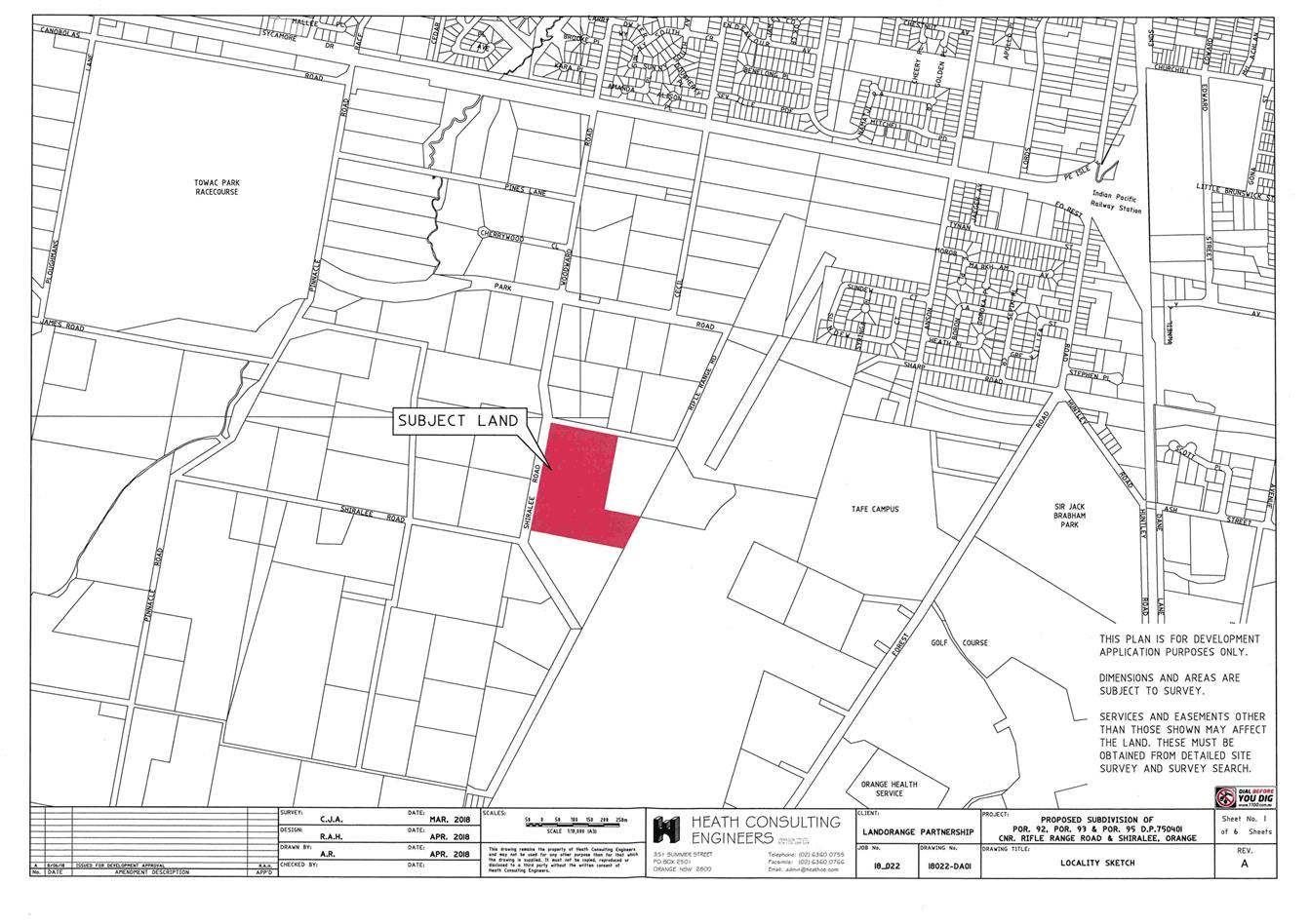
Planning
and Development Committee
4 September 2018
2.5 Development
Application DA 206/2018(1) - 124, 136 and 148 Shiralee Road
Attachment 3 Submissions