
ORANGE CITY COUNCIL
Ordinary Council Meeting
Agenda
3 October 2017
Notice
is hereby given, in accordance with the provisions of the Local Government Act
1993 that a Ordinary meeting of ORANGE CITY COUNCIL
will be held in the Council Chamber,
Civic Centre, Byng Street, Orange on Tuesday, 3 October 2017 commencing
at 7.00pm.
Garry
Styles
General Manager
For apologies please
contact Michelle Catlin on 6393 8246.
1 Introduction
I would like to acknowledge the Wiradjuri people who are the
Traditional Custodians of the Land. I would also like to pay respect to the
Elders both past and present of the Wiradjuri Nation and extend that respect to
other Aboriginal Australians who are present.
The
provisions of Chapter 14 of the Local Government Act, 1993 (the Act)
regulate the way in which Councillors and designated staff of Council conduct
themselves to ensure that there is no conflict between their private interests
and their public role.
The
Act prescribes that where a member of Council (or a Committee of Council) has a
direct or indirect financial (pecuniary) interest in a matter to be considered
at a meeting of the Council (or Committee), that interest must be disclosed as
soon as practicable after the start of the meeting and the reasons given for declaring
such interest.
As
members are aware, the provisions of the Local Government Act restrict any
member who has declared a pecuniary interest in any matter from participating
in the discussion or voting on that matter, and requires that member to vacate
the Chamber.
Council’s Code of Conduct provides that if members
have a non-pecuniary conflict of interest, the nature of the conflict must be
disclosed. The Code of Conduct also provides for a number of ways in which a
member may manage non pecuniary conflicts of interest.
|
Recommendation
It is recommended that Councillors now disclose any
conflicts of interest in matters under consideration by the Council at this
meeting.
|
2 Mayoral
Minutes
Nil
3 Confirmation of
Minutes of Previous Meeting
|
RECOMMENDATION
That the Minutes of the Ordinary
Meeting of Orange City Council held on 26 September 2017 (copies of which
were circulated to all members) be and are hereby confirmed as a true and
accurate records of the proceedings of the Council meeting held on 26
September 2017.
|
Attachments
1 Minutes
of the Ordinary Meeting of Orange City Council held on 26 September 2017
ORANGE CITY COUNCIL
MINUTES OF THE
Ordinary Council Meeting
HELD IN Council Chamber, Civic Centre, Byng Street, Orange
ON 26 September 2017
COMMENCING AT 7.00 pm
1 Introduction
Cr R Kidd (Mayor), Cr K Duffy, Cr J
Hamling, Cr J McRae, Cr T
Mileto, Cr S Munro, Cr S Nugent, Cr M Previtera, Cr S
Romano, Cr G Taylor, Cr R Turner, Cr J Whitton
General Manager, Manager Building
and Environment, Works Manager, Manager Administration and Governance, Manager
Corporate and Community Relations
Nil
|
RESOLVED
- 17/415 Cr
G Taylor/Cr S Munro
That the Media be
permitted to record and livestream the Council Meeting.
|
1.2 ACKNOWLEDGEMENT OF COUNTRY
1.3 Declaration of pecuniary interests, significant non-pecuniary interests and less
than significant non-pecuniary interests
Nil
2 Mayoral
Minutes
Nil
3 Confirmation
of Minutes of Previous Meeting
|
RESOLVED
- 17/416 Cr
J Hamling/Cr S Munro
That the Minutes of the
Ordinary Meeting of Orange City Council held on 5 September 2017 (copies of
which were circulated to all members) be and are hereby confirmed as a true
and accurate record of the proceedings of the Council meeting held on 5
September 2017.
|
4 Notices
of Motion/Notices of Rescission
Nil
5 General
Reports
5.1 Oath
or Affirmation of Office by Councillors
TRIM Reference: 2017/1813
|
|
RESOLVED - 17/417 Cr
J Hamling/Cr S Munro
That each Councillor take the oath or affirmation of
office.
|
The following Councillors took the
Oath of Office of Council:
Cr Jeff Whitton
Cr Glenn Taylor
Cr Tony Mileto
Cr Sam Romano
Cr Mario Previtera
Cr Reg Kidd
The following Councillors took the
Affirmation of Office of Council:
Cr Stephen Nugent
Cr Joanne McRae
Cr Kevin Duffy
Cr Russell Turner
Cr Scott Munro
Cr Jason Hamling
5.2 Election
of Deputy Mayor
TRIM Reference: 2017/1812
|
|
RESOLVED - 17/418 Cr
S Nugent/Cr J Whitton
That
Council elect a Deputy Mayor for the 2017/18 period.
|
|
RESOLVED - 17/419 Cr
J Whitton/Cr S Munro
That the method of voting for
the election of Deputy Mayor be ordinary ballot.
|
|
RESOLVED
- 17/420 Cr
S Munro/Cr S Nugent
That the General Manager,
acting as Returning Officer, conduct the election for the Deputy Mayor.
|
The General
Manager advised that nominations for Deputy Mayor had been received from
Councillors:
-
Joanne McRae
-
Jason Hamling
-
Glenn Taylor
-
Kevin Duffy
-
Tony Mileto
-
Scott Munro
All Councillors accepted their
nomination.
Following the first round of voting,
Cr Duffy was excluded.
Following the second round of voting,
Cr Munro was excluded.
Following the third round of voting,
Cr Hamling was excluded.
Following the fourth round of voting,
Cr Mileto was excluded.
Following the fifth round of voting,
Cr Taylor and Cr McRae were tied. On being drawn by lot, Cr McRae was declared
elected Deputy Mayor.
5.3 Dates
for Meetings of Council
TRIM Reference: 2017/1810
|
|
RESOLVED - 17/421 Cr
R Turner/Cr S Munro
That Council confirm it will continue to hold meetings in accordance
with the Code of Meeting Practice, as follows:
1 An
ordinary meeting of Council be held on the first Tuesday of the month at 7pm.
2 Ordinary
Policy Committees be held on the first Tuesday of each month as part of a
Council Meeting to commence at 7pm, to be enacted once the Committee
structure is resolved and Committee chairpersons have been elected by
Council.
3 A
public forum be scheduled, where required, at the commencement of the Council
meeting of the first Tuesday of each month.
4 An
ordinary Council Meeting be held on the third Tuesday of each month
commencing at 7pm.
5 Councillor
briefings be held on the second Tuesday of each month if required, commencing
at 6pm.
|
|
QUESTION
TAKEN ON NOTICE
A
report was requested on the possibility of conducting Council Meetings in
other areas of Orange.
|
|
QUESTION
TAKEN ON NOTICE
Cr Turner requested a report
on the arrangements in place for the operation of the Ophir Road Resource
Recovery Centre, particularly in relation to the procedures used by staff and
contractors for the operation of the weighbridge and the Recovery Shop.
|
6 Closed
Meeting
Nil
The Meeting
Closed at 7.55 PM
This is
Page Number 4 and the Final Page of the Minutes of the Ordinary Meeting of
Orange City Council held on 26 September 2017.
5 General
Reports
5.1 Statement of
Investments - August 2017
TRIM
REFERENCE: 2017/1956
AUTHOR: Brock
Gannon, Financial Accounting Officer
EXECUTIVE Summary
The purpose of this report is to provide a statement of
Council’s investments held as at 31 August 2017.
Link To Delivery/OPerational Plan
The recommendation in this report relates to the
Delivery/Operational Plan strategy “1.2 Our City -
Information and advice provided for the decision-making process will be
succinct, reasoned, accurate, timely and balanced”.
Financial Implications
Nil
Policy and Governance Implications
Nil
|
Recommendation
1 That Council receives
the Statement of Investments as at 31 August 2017.
2 That
Council receives and adopts the certification of the Responsible Accounting
Officer.
|
further considerations
Consideration has been given to the
recommendation’s impact on Council’s service delivery; image and
reputation; political; environmental; health and safety; employees;
stakeholders and project management; and no further implications or risks have
been identified.
SUPPORTING INFORMATION
Section 212(1) of the Local Government (General) Regulation
2005 requires that a written report be presented each month at an ordinary meeting
of Council detailing all money that Council has invested under Section 625 of
the Local Government Act 1993.
As at 31 August 2017, the investments held by Council
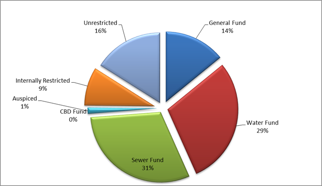
totalled $118,301,314.84 and is attributed to the following funds.
|
|
31/08/2017
|
31/07/2017
|
|
General
Fund
|
47,671,254.41
|
45,403,491.76
|
|
Sewer
Local Fund
|
36,061,133.37
|
34,993,667.69
|
|
Water
Supply Local Fund
|
34,568,927.06
|
34,832,350.91
|
|
Orange
CBD Special Rate
|
|
|
|
118,301,314.84
|
115,229,510.36
|

A reconciliation of Council’s investment portfolio
provides a summary of the purposes for which Council’s investments are
being held.
|
Externally
Restricted
|
31/08/2017
|
31/07/2017
|
|
General
Fund
|
16,676,884.73
|
15,985,828.81
|
|
Water
Fund
|
34,568,927.06
|
34,832,350.91
|
|
Sewer
Fund
|
36,061,133.37
|
34,993,667.69
|
|
Auspiced
|
1,622,805.39
|
1,622,805.39
|
|
Internally
Restricted
|
10,406,658.79
|
9,501,484.57
|
|
Unrestricted
|
18,964,905.50
|
18,293,372.99
|
|
118,301,314.84
|
115,229,510.36
|
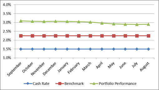
Portfolio Performance
Council’s current Long Term Financial Plan establishes
the benchmark for Council’s interest on investments at “75 basis
points above the current cash rate”. The cash rate as at 31 August 2017
remained at 1.50%. The annualised average interest rate of Council’s
investment portfolio at the same reporting date was 2.90% (weighted average
2.86%) which continues to exceed Council’s benchmark i.e. the cash rate
of 1.50% plus 0.75% (or 75 basis points).
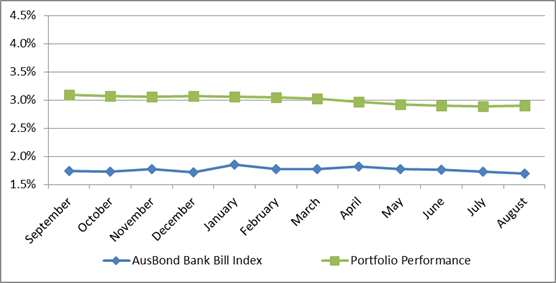
Council has also utilised the AusBond Bank Bill Index to provide
a further benchmark focused towards long term investments. As at 31 August
2017, the AusBond rate was 1.69%. The annualised average interest rate of
Council’s investment portfolio at the same reporting date was 2.90%.
Council’s adopted Investment Policy establishes limits
in relation to the maturity terms of Council’s investments as well as the
credit ratings of the institutions with whom Council can invest.
The following tables provide a dissection of Council’s
investment portfolio as required by Council’s Investment Policy. The
Policy identifies the maximum amount that can be held in a variety of
investment products or with institutions based on their respective credit
ratings.
Table 1 and Table 2 show the percentage held by Council
(holdings) and the additional amount that Council could hold (capacity) for
each respective category in accordance with limits as established by
Council’s Policy.
Table 1:
Maturity – Term Limits
|
Term
to Maturity Allocation
|
Maximum
|
Holding
|
Capacity
|
|
0 - 3
Months
|
100.00%
|
8.85%
|
91.15%
|
|
3 - 12
Months
|
100.00%
|
62.66%
|
37.34%
|
|
1 - 2
Years
|
70.00%
|
9.05%
|
60.95%
|
|
2 - 5
Years
|
50.00%
|
19.43%
|
30.57%
|
|
5+ Years
|
25.00%
|
0.00%
|
25.00%
|
Table 2: Credit Rating Limits
|
|
Maximum
|
Holding
|
Capacity
|
|
AAA
|
100.00%
|
0.00%
|
100.00%
|
|
AA
|
100.00%
|
16.64%
|
83.36%
|
|
A
|
60.00%
|
46.17%
|
13.83%
|
|
BBB
& NR
|
40.00%
|
37.19%
|
2.81%
|
|
Below
BBB
|
0.00%
|
0.00%
|
0.00%
|
It should be noted that the amounts presented in this report
will be audited as part of the preparation of Council’s General Purpose
Financial Statements for the 2016/17 year and may be subject to change.
Certification by Responsible Accounting Officer
I, Jason Cooke, hereby certify that all investments have
been made in accordance with Section 625 of the Local Government Act 1993,
Clause 212 of the Local Government (General) Regulation 2005 and
Council’s Investment Policy.
5.2 Recording
Council Meetings
TRIM
REFERENCE: 2017/1988
AUTHOR: Michelle
Catlin, Manager Administration and Governance
EXECUTIVE Summary
At its meeting held on 18 July 2017, Council resolved:
|
TRIM Reference: 2017/1487
|
|
RESOLVED - 17/324 Cr
J Davis/Cr J Hamling
That a report be provided to the first meeting of the
next Council in relation to the possible audio and visual recording of
Council Meetings.
|
Following recent discussions on this matter with Mayor Kidd,
this report recommends Council implement a system of recording the audio of
Council Meetings to assist in the preparation of minutes.
Link To Delivery/OPerational Plan
The recommendation in this report relates to the
Delivery/Operational Plan strategy “1.2 Our City -
Information and advice provided for the decision-making process will be
succinct, reasoned, accurate, timely and balanced”.
Financial Implications
To install a recording device to work in conjunction with
the current microphone system will cost in the order of $1000 and can be met
from within the existing budget.
Policy and Governance Implications
A decision to record Council Meetings will require an
amendment to the Code of Meeting Practice, which will include a public
exhibition period and time for submissions to be received. In the meantime,
Council could resolve at the commencement of each meeting to allow for the
meeting to be recorded internally for minute taking purposes.
For Council’s information, the Office of Local
Government (OLG) are currently finalising a draft Model Code of Meeting
Practice. Staff of the OLG have recently verbally advised that the draft Model
Code of Meeting Practice will include provisions around the webcasting of
Council Meetings.
While the webcasting of meetings is not proposed to be
mandatory, the OLG have confirmed that the Model Code will include provisions
for webcasting as a mechanism for increased accountability.
The OLG has advised the Model Code of Meeting Practice will
be drafted and sent to councils for consultation in the coming months.
|
Recommendation
That Council record Council Meetings and Policy
Committee Meetings held in the Council Chamber for internal purposes only,
subject to:
1 Appropriate
changes being adopted to Council’s Code of Meeting Practice, following
the required public exhibition process and associated reporting to Council.
2 The
agenda for Council Meetings commencing with an announcement from the
Chairperson that the meeting is being recorded.
3 Appropriate
signage being installed in the Council Chamber to remind speakers of the
recording of the meeting.
|
further considerations
The recommendation of this report has been
assessed against Council’s other key risk categories and the following
comments are provided:
|
Service
delivery
|
Recording the audio of Council
Meetings will assist in the preparation of minutes and checking of any detail
that may be required. Care will need to be taken to ensure that any speaker
(Councillor, staff or member of the public) is aware of that the meeting is
being recorded.
|
SUPPORTING INFORMATION
The Local Government (General) Regulation 2005 states
(section 273) that a person may use a tape recorder to record the proceedings
of a meeting of Council or a Committee of Council only with the authority of
Council or the Committee. This requirement is also reflected in Council’s
Code of Meeting Practice. It is Council’s current practice to resolve to
allow media to record meetings.
If Council supports the recording of Council Meetings,
appropriate changes would need to be made to the Code of Meeting Practice.
The issue of recording meetings has been considered by
Council several times since 2010, however to date Council has not made the
decision to commence recording. Many Councils across the state record and
webcast/livestream Council Meetings, and while this report seeks approval to
commence audio recording only, Council could consider livestreaming in the
future if demand exists.
Risk of breach of privacy or defamation
Recording meetings for internal purposes only (ie to assist
in the preparation of minutes) does not increase the risk of a breach of
privacy or defamation higher than the level of risk that exists now. Should
Council wish to make the recordings publicly available, or livestream the
audio/visual of meetings, then further consideration of the risks would be
required. It is considered, however, that measures can be put in place to mitigate
these risks.
It will be important to ensure that any speaker at a Council
Meeting is made aware of the recording of the meeting.
Council’s insurers have advised they have no concerns
with either the recording or livestreaming of Council Meetings, and that the
recording of Council Meetings will be noted on Council’s policy.
Access and retention of recordings
It is proposed that recordings be retained in accordance
with the General Disposal Authority issued by NSW State Records. This framework
recommends that recordings be kept for three months after the last action,
which is interpreted as the Council’s resolution of the confirmation of
the minutes of the meeting.
Access to the recordings is proposed to be limited to the
Mayor, General Manager and relevant Council staff only (as determined by
General Manager) for the purpose of checking minutes.
Given the purpose of recording is to assist in the
preparation of minutes, it is not proposed to make the recordings publicly
available.
It should be noted that the minutes of the Council Meeting will
remain the official record of the proceedings of the meeting.
5.3 Development
Application - DA 259/2017(1) - 129-131 Byng Street
TRIM
REFERENCE: 2017/2001
AUTHOR: Andrew
Crump, Senior Planner
EXECUTIVE Summary
|
Application
lodged
|
17 July
2017
|
|
Applicant/s
|
Saran
Holdings Pty Ltd
|
|
Owner/s
|
Saran
Holdings Pty Ltd
|
|
Land
description
|
Lot 3 DP
150391 - 129-131 Byng Street ORANGE
|
|
Proposed
land use
|
Office
Premises (change of use from pub, alterations and additions to existing
building, and verandah reinstatement) and Demolition (ancillary buildings and
tree removal)
|
|
Value of
proposed development
|
$1,900,000
|
Council's consent is sought for the change of use of the
existing pub to office premises. It is also proposed to provide additional
floor area with the construction of a new contemporary style addition to the
west of the site. The proposed new building will be two storeys with part
under-croft parking in the North-West corner of the site. The application also
involves the reinstatement/reconstruction of the C.1870s verandah and
refurbishment of the former pub.
The critical issue to the assessment of the application
relates to heritage conservation matters, street scape compatibility and car
parking demand.
The development is expected to make a positive contribution
to the central business district and result in a development that is congruous
with the significant heritage items in the vicinity, as well as the central
heritage conservation area. Additionally, the provision of onsite parking will
result in a development that is satisfactory in terms car parking.
The development is consistent with Council’s relevant
planning provisions, and accordingly is recommended for approval.
DECISION FRAMEWORK
Development in Orange is governed by two key documents,
being the Orange Local Environment Plan 2011 (LEP) and the Orange Development
Control Plan 2004 (DCP). In addition, the Infill Guidelines are used to guide
development, particularly in the heritage conservation areas and around
heritage items.
Orange Local Environment Plan 2011 – the LEP
should be considered by Council to be a definitive document. LEPs govern the
types of development that are permissible or prohibited in different parts of
the City, and also provide some assessment criteria in specific circumstances.
Uses are either permissible or not - there are no grey areas in terms of
permissibility. The objectives of each zoning and indeed the aims of the LEP
itself are, however, open to interpretation and can be used to guide decision
making around appropriateness of development.
Orange Development Control Plan 2004 – the DCP
guides development. In general it is a performance based document rather than
prescriptive in nature - its purpose is to guide development. The Land and
Environment Court tends to view it as such. In each area of interest there are
often guidelines used. These guidelines indicate ways of achieving the planning
outcomes. It is thus recognised that there may also be other solutions of
merit. All design solutions are considered on merit by planning and building
staff. Applications should clearly demonstrate how the planning outcomes are
being met where alternative design solutions are proposed. One can see that the
DCP gives leeway for developers and architects to use design to achieve the
outcome in other ways if they can. Stating that DCP guidelines are
inflexible can be misleading.
This development application is an excellent example of
conversion of an historic building into a contemporary use and fits well within
Council’s principle planning controls.
Link To Delivery/OPerational Plan
The recommendation in this report relates to the
Delivery/Operational Plan strategy “13.4 Our Environment
– Monitor and enforce regulations relating to City amenity”.
Financial Implications
Nil
Policy and Governance Implications
Nil
|
Recommendation
That Council consents to
development application DA 259/2017(1)
for Office Premises (change of use from pub, alterations and additions to
existing building, and verandah reinstatement) and Demolition (ancillary
buildings and tree removal) at Lot 3 DP 150391 - 129-131 Byng
Street, Orange pursuant to the conditions of
consent in the attached Notice of Approval.
|
further considerations
Consideration has been given to the recommendation’s
impact on Council’s service delivery; image and reputation; political;
environmental; health and safety; employees; stakeholders and project
management; and no further implications or risks have been identified.
SUPPORTING INFORMATION
THE APPLICATION/PROPOSAL
Council's consent is sought for the change of use of the
existing pub to office premises and undertake alterations and additions to the
existing building on land described as Lot 3 DP 150391, known as
129–131 Byng Street, Orange.
The proposal involves:
· Refurbishment of the
existing building over both ground and first floors to provide open plan office
space. Existing walls to be removed will retain bulkheads to interpret the
historic building layout.
· Refurbishment of the
exterior of the existing building comprising new paint scheme, 1 set of
existing doors on ground floor south elevation to be retained, restored and
fixed in place, remaining doors to have reinstated windows as per the original
C. 1987 building, provision of new openings on first floor to provide access to
new verandah, new galvanised corrugated iron roof to existing building,
reinstatement of traditional terracotta chimney pots.
· Contemporary two storey
building to the western side of the site linked to the existing building via a
glazed link at first floor level. The new buildings first floor will extend
over the on-site parking in the north-western corner of the site providing some
under-croft parking spaces.
· Traditional verandah
reinstatement.
· Provision of 22 on-site
parking spaces (partly open, partly under-croft) gaining access from a newly
created access in Lords Place, with the existing Byng Street access being
closed.
· Removal of a number of
trees within the site.
· Removal of ancillary
buildings and later rear additions.
· Provisions of
landscaping and auto sliding gate to Lords Place vehicle access.
BACKGROUND
Earlier in the year Council staff agreed to a very specific
list of works that could be carried out to the building by the owner without
the need for development consent pursuant to Clause 5.10(3) of Orange LEP 2011.
Such works included removing; carpets, wood panelling and bar on the ground
floor. Also, non-original skirting boards and architraves were agreed to be
removed (provided sectioned were retained for the purposes of making suitable
reproductions). General interior cosmetic works such as painting, new carpets
and the like were also agreed to.
These works were agreed to on the basis that the works were
minor and would not adversely impact the significance of the conservation area
– noting the subject land is not a nominated heritage item.
The owner commenced these works and it became apparent that
the structural integrity of the building was unsound, to the extent that there
was a possibility of failure of the exterior walls.
It was found that the junction of exterior brickwork at the
foundations had suffered severe water damage and were extremely brittle. Also,
the foundations upon which exterior brickwork sat consisted of rotted hardwood
timber resting on a gravel/earthen base.
On the first floor, it was noted that interior walls
comprised a simple timber frame, wrapped in chicken wire and rendered with
modern sand and cement render. These walls comprised considerable weight and
were not supported directly below on the ground floor, save for a single post
and beam which had obvious visible signs of deflection. It is estimated that
this structural arrangement was installed at some point in the second half of
the 20th century.
The roof structure was noted to not meet current engineering
standards.
The owner of the premises took immediate action to underpin
the exterior walls (ground floor) of the northern section of the building and
replace the ground floor with a new reinforced concrete slab. The owner also
removed several internal dividing walls on the first floor to reduce the load
on the aforementioned post and beam.
These works were not authorised by Council.
Council staff commenced investigations of the premises and
it was agreed that the remaining necessary remedial works could be carried out
under a separate emergency orders process issued by Council staff.
These works have since been completed.
It is noted that the internal stairs were removed outside of
the orders process.
Accordingly, the initial slab/underpinning of the northern
section of the ground floor and removal of several first-floor walls; along
with the removal of the internal stairs occurred without consent. Council staff
will pursue this matter as a separate process to the assessment of the
development application before Council.
The submitted plans reflect the current building condition
(i.e. post the recent works).
MATTERS FOR CONSIDERATION
Section 5A Assessment
In the administration of Sections 78A, 79B, 79C, 111 and
112, the provisions of Section 5A must be taken into account for every
development application in deciding whether there is likely to be a significant
effect on threatened species, populations or ecological communities or their
habitats. This section includes a requirement to consider any adopted
assessment guidelines, which means assessment guidelines issued and in force
under Section 94A of the Threatened Species Conservation Act 1995.
Assessment guidelines are in force (see DECC-W “Threatened Species
Assessment Guidelines - The Assessment of Significance”) which requires
consent authority to adopt the precautionary principle in its assessment.
In this instance, site inspection reveals that the subject
property has no biodiversity or habitat value.
Section 79C
Section 79C of the Environmental Planning and Assessment
Act 1979 requires Council to consider various matters, of which those
pertaining to the application are listed below.
PROVISIONS OF ANY ENVIRONMENTAL
PLANNING INSTRUMENT s79C(1)(a)(i)
Orange Local Environmental Plan 2011
Part 1 - Preliminary
Clause 1.2 - Aims of Plan
The
broad aims of the LEP are set out under subclause 2. Those relevant to the
application are as follows:
(a) to encourage development which complements
and enhances the unique character of Orange as a major regional centre boasting
a diverse economy and offering an attractive regional lifestyle,
(b) to provide for a range of development
opportunities that contribute to the social, economic and environmental
resources of Orange in a way that allows present and future generations to meet
their needs by implementing the principles for ecologically sustainable
development,
(f) to recognise and manage valued
environmental heritage, landscape and scenic features of Orange.
The application is considered to be consistent with aims
(a), (b) and (f) as listed above.
Clause 1.6 - Consent Authority
This clause establishes that, subject to the Act, Council is
the consent authority for applications made under the LEP.
Clause 1.9A - Suspension of
Covenants, Agreements and Instruments
This clause provides that covenants, agreements and other
instruments which seek to restrict the carrying out of development do not apply
with the following exceptions:
· covenants imposed
or required by Council
· prescribed
instruments under Section 183A of the Crown Lands Act 1989
· any conservation
agreement under the National Parks and Wildlife Act 1974
· any trust
agreement under the Nature Conservation Trust Act 2001
· any property
vegetation plan under the Native Vegetation Act 2003
· any biobanking
agreement under Part 7A of the Threatened Species Conservation Act 1995
· any planning
agreement under Division 6 of Part 4 of the Environmental Planning and
Assessment Act 1979.
Council staff are not aware of the title of the subject
property being affected by any of the above.
Mapping
The subject site is identified
on the LEP maps in the following manner:
|
Land Zoning Map:
|
Land zoned B4 Mixed Use
|
|
Lot Size Map:
|
No Minimum Lot Size
|
|
Heritage Map:
|
Not a heritage item – but
within conservation area
|
|
Height of Buildings Map:
|
Building height limit 12m
|
|
Floor Space Ratio Map:
|
Floor space limit 1.0:1
|
|
Terrestrial Biodiversity Map:
|
No biodiversity sensitivity on the
site
|
|
Groundwater Vulnerability Map:
|
Ground water vulnerable
|
|
Drinking Water Catchment Map:
|
Not within the drinking water
catchment
|
|
Watercourse Map:
|
Not within or affecting a defined
watercourse
|
|
Urban Release Area Map:
|
Not within an urban release area
|
|
Obstacle Limitation Surface Map:
|
No restriction on building siting
or construction
|
|
Additional Permitted Uses Map:
|
No additional permitted use applies
|
Those matters that are of relevance are addressed in detail
in the body of this report.
Part 2 - Permitted or
Prohibited Development
Land Use Zones
The subject site is located within the B4 Mixed Use zone.
The proposed development is defined as an office premises under OLEP 2011 which
means:
a building or place used for
the purpose of administrative, clerical, technical, professional or similar
activities that do not include dealing with members of the public at the
building or place on a direct and regular basis, except where such dealing is a
minor activity (by appointment) that is ancillary to the main purpose for which
the building or place is used.
Office premises are permissible with development consent in
the B4 Mixed Use zone.
Clause 2.3 of LEP 2011
references the Objectives for each zone in LEP 2011. These objectives for
land zoned B4 Mixed Use zone are as follows:
· To provide a
mixture of compatible land uses.
· To integrate
suitable business, office, residential, retail and other development in
accessible locations so as to maximise public transport patronage and encourage
walking and cycling.
· To promote,
where possible, the retention and reuse of heritage items as well as the
retention of established buildings that contribute positively to the heritage
or cultural values of the land in the zone.
· To
promote development that supports the role of Orange CBD as the primary retail
and business centre in the region.
The development is not inconsistent
with the objectives of the B4 mixed use zone. The new office use will continue
the longstanding commercial use of the land and will not be incompatible with
surrounding land uses.
The development with the inclusion of the
reinstated verandah will retain and enhance a prominent corner building within
an important precinct in the CBD.
Clause 2.7 - Demolition
Requires Development Consent
This clause triggers the need for development consent in
relation to a building or work. This requirement does not apply to any
demolition that is defined as exempt development.
Part 3 - Exempt and Complying
Development
The application is not exempt or complying development.
Part 4 - Principal Development
Standards
Clause 4.3 - Height of Buildings
This clause limits
the height of buildings (HoB) on land identified on the Height of Buildings
Map. The subject land is identified on the Map as having a HoB limit of 12m.
The maximum height of the new building is approximately 8m and is therefore well
below the required height limit.
Clause 4.4 - Floor
Space Ratio
This clause limits
the floor space ratio (FSR) permitted on land identified on the Floor Space
Ratio Map. (Clause 4.5 is associated with this clause and establishes the rules
for calculating the site area and FSR of any proposal).
The subject land is
identified on the Map as having an FSR of 1.0:1. The site area has been
calculated under Clause 4.5 as 1553.95m2, meaning the site may have
up to 1553.95m2 of floor space. The proposal, minus the exclusions
detailed in clause 4.5, has been calculated as having a gross floor area of
1416.5m2 (0.91:1) and is therefore consistent with the FSR
requirements.
Part 5 -
Miscellaneous
Provisions
5.10 - Heritage Conservation
The subject land is not a listed heritage item pursuant to Schedule
5 of Orange LEP 2011. The subject land is, however located within the Central
Heritage Conservation Area. The subject land is also in close proximity to a
number of key heritage items, namely; Orange Court House, Robertson Park and
261 Lords Place (as shown below in Image 1 as Items I3, I54 and I116
respectively. The below image also shows red hatching relating to the heritage
conservation area, and the subject land is shown in blue outline).
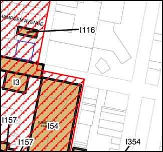
Figure 1 – Heritage Context map (subject land –
blue outline
red hatching showing the Heritage Conservation Area
brown areas showing heritage items)
The relevant Heritage Inventory sheet provides the following
statement of significance for the land:
One of the earlier brick
buildings in Orange and home to John Peisley, the licensed premises retains the
key building form, complements the streetscape and contributes to the
Conservation Area.
(1) Objectives
The
objectives of this clause are as follows:
(a) to
conserve the environmental heritage of Orange,
(b) to
conserve the heritage significance of heritage items and heritage conservation
areas, including associated fabric, settings and views,
(c) to
conserve archaeological sites,
(d) to
conserve Aboriginal objects and Aboriginal places of heritage significance.
The development is not
fundamentally contrary to the objects of the clause. As mentioned in detail
below, there are some contentions, inter alia, around the selected materials
used to construct the reinstated verandah. Council staff have attached a
condition requiring the verandah be constructed entirely of timber materials
for the reasons outlined below. There are also conditions relating to the
exterior paint scheme, restoration of one set of original doors relating to the
pub use, and conditions requiring an interpretation plan to be prepared and
completed.
With the imposition of these
important conditions of consent, the development is considered satisfactory in
terms of its consistency with the above objectives of the clause.
(2) Requirement
for Consent
Development
consent is required for any of the following:
(a) demolishing
or moving any of the following or altering the exterior of any of the following
(including, in the case of a building, making changes to its detail, fabric,
finish or appearance):
(i) a
heritage item,
(ii) an
Aboriginal object,
(iii) a
building, work, relic or tree within a heritage conservation area,
(e) erecting
a building on land:
(i) on
which a heritage item is located or that is within a heritage conservation
area, or
(ii) on
which an Aboriginal object is located or that is within an Aboriginal place of
heritage significance,
The development involves
demolition of ancillary buildings, trees and alterations to the exterior of an
existing building; and the erections of a new building. As such, development
consent is required under this clause which the applicant has sought through
the lodgement of the subject development application.
(4) Effect
of Proposed Development on Heritage Significance
The
consent authority must, before granting consent under this clause in respect of
a heritage item or heritage conservation area, consider the effect of the
proposed development on the heritage significance of the item or area
concerned. This subclause applies regardless of whether a heritage management
document is prepared under subclause (5) or a heritage conservation management
plan is submitted under subclause (6).
The subject land comprises a prominent two storey brick
building constructed sometime around the 1850s – possibly one of the
earliest brick buildings within the city. The building was originally built by
John Peisley as a corner store and was converted to the Railway Hotel in 1873,
then became the Belmore Hotel in 1879, and then converted to the name many know
it as today – the Carrington Club Hotel C.1886.
The original 1850s building was extended in both street
frontages - to the west in Byng Street and to the north in Lords Place
(newer section in Lords Place identifiable as the portion of building currently
face brick (unpainted).
The original corner store building did not comprise a
verandah; but one was constructed around the same time as the use was changed
to a pub (C. 1870s).
The key elements in the assessment of the developments
effect on heritage significance relate to the following:
Refurbishment of existing
building
The development involves a refurbishment of the ground and
first floors of the existing building to provide an open plan office design.
There are no objections to this on heritage grounds. Significant fabric such as
fire places will be retained (noting the above comments around the removal of
the original stairs), and bulkheads will be installed where internal walls have
been removed, thus allowing the previous floor plan to be interpreted into the
future.
New two storey extension
There are no objections to the proposed additions to the
west of the site. This element of the proposal is assessed in detail below
under the infill guidelines assessment criteria.
Reinstated verandah
The application involves the reinstatement/reconstruction of
a verandah with occupiable first floor space. The verandah reinstatement is
generally supported by Council staff and encouraged by Council’s DCP and
infill guidelines.
The materials for the verandah comprise steel components for
the posts, roof supports, roof cladding, bearers and balustrade, and timber to
be used for joists, decking, roof battens and decorative accent pieces.
With reference to original photographs of the historic pub
use; the proposed verandah relates to the same portion of the building as the
original verandah did and shares the same rhythm of post position and retains
similar proportions.
In terms of selected materials and in particular the use of
steel components, Council’s Heritage Advisor has recommended that in
order to obtain the most historically accurate reinstatement/reconstruction of
the verandah, and therefore the most appropriate in terms of heritage conservation;
only identical fabric (in this case timber) as was originally used should be
used for the reinstatement. In other words, the proposed steel elements are not
appropriate for this particular traditional verandah reinstatement. The
recommendation of Council’s Heritage Advisor is supported by
Council’s Infill Guideline and the Burra Charter.
It is important to note the difference between sympathetic
additions versus historically accurate reinstate/reconstruction. It is standard
practice from a heritage conservation perspective for new development occurring
in a heritage setting to, whilst maintaining appropriate siting, form, etc.
adopt a design methodology that results in a visual distinction between old and
new. This is to ensure future generations can easily interpret those parts of
the building that are original from more recent additions. This development
successfully achieves this principle for the new addition to the west of the
site and the design rationale is supported.
In terms of a reinstatement/reconstruction of an element of
a building that once existed but has since been removed or destroyed, the best
practice is to rely on evidence (photographs, oral history etc.) to ensure the
reinstatement is historically accurate in terms of position, size, form and
materiality. In the absence of reliable evidence, a modern interpretation of
the subject building element may be appropriate. In this case, historic photos
of the original verandah are available for reference and should be relied upon
to guide the design of the reinstated verandah.
Council staff wrote to the applicant outlining the concerns
with using steel components within the verandah reinstatement. The applicant
responded with the following:
In regard to
the steel and timber elements on the proposed reconstructed verandah, it is
our client’s preference to construct the verandah with powder coated
steel posts and framing based on the following:
· Timber
verandah posts and framing are not favoured due to ongoing maintenance
requirements. Steel has been selected and is considered a sympathetic solution.
The posts will be of a generous dimension so as to appear substantial and
robust. They will be provided with rounded edges and once they are painted,
they will appear similar to timber. We are aware of other reconstructed
verandahs in Orange that have used steel posts (for example Kelly’s
Hotel).
· From a structural
engineering point of view, the applicant advises that a steel structure is less
reliant on the support of the building compared to timber.
· The applicant is
prepared to consider timber in lieu of steel bearers to the first floor. Thus,
in most views, timber will be evident.
· The applicant advises
that it will be difficult to source timber posts that are considered suitable
for this project.
Council staff are not in agreement with the above
contentions.
The maintenance argument is acknowledged, however for a
building of this age a detailed maintenance schedule is essential to ensure its
longevity and as such, maintenance of a new timber verandah would become a
small part of the ongoing maintenance of the building at some point in the
future. Also, Council offers a heritage grant for maintenance of heritage
buildings which the owner could apply for in the future for maintenance.
It is also noted that the example cited, Kelly’s Rugby
Hotel, is not considered a comparable example as support of their position.
Kelly’s Rugby Hotel is not located in a heritage conservation area and at
the time Council considered the verandah addition, the land was not a heritage
item (it has since been listed as a heritage item, notwithstanding the
materials used in the verandah, but primarily for the buildings social and
historical value). An appropriate example in support of Council’s
position is the Parkview Hotel which comprises a reinstated traditional timber
verandah.
In response to the applicant contention that from
a structural engineering point of view, the applicant advises that a steel structure is less reliant on the support of the building compared
to timber. In order for Council staff to accept
this contention, it would be necessary to provide detailed evidence from
a structural engineer that the existing building is not capable of supporting a
timber structure. Such detail has not been furnished to Council.
The applicant concession on the bearer
material is appreciated.
It is understood from the experiences of
Council’s Heritage Advisors dealing with similar verandah reinstatements,
that sourcing appropriate timber products such as cypress, hardwood or glulam
has not been problematic.
As such, the foregoing assessment concludes that the steel
elements are considered an inappropriate material in this context. A condition
is therefore attached requiring the verandah structure, including decking and
balustrade (excluding roof cladding and small components such as fixings and
brackets) to be constructed using timber components only.
Interpretation
Strategy
During extensive pre-DA discussions, it was recommended that
an interpretation strategy be prepared with the assistance of the Orange
Historical Society as part of the redevelopment of the site. The applicant has
responded with notes on the plans, suggesting a heritage wall within the foyer
of the original building.
This is appreciated and considered to be a good starting
point. Other types of appropriate interpretation could comprise brass plaques
installed on the exterior walls of the original building, and reinstatement of
one of the previous historic signs such as “W. Pullbrook” from
C1870s (shown below).
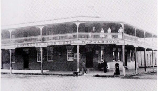
Figure 2 - William Pulbrook’s Carrington Club
Hotel C. 1901
Photo Courtesy E. Greer and R. Bartlett (2017)
A condition is attached requiring
an interpretation strategy to be prepared prior to the issue of a Construction
Certificate, and a further condition requiring the strategy to be implemented
prior to the issue of a final Occupation Certificate.
(5) Heritage
assessment
The
consent authority may, before granting consent to any development:
(a) on
land on which a heritage item is located, or
(b) on
land that is within a heritage conservation area, or
(c) on
land that is within the vicinity of land referred to in paragraph (a) or (b),
require
a heritage management document to be prepared that assesses the extent to which
the carrying out of the proposed development would affect the heritage
significance of the heritage item or heritage conservation area concerned.
The applicant has prepared a Heritage Impact Statement in
accordance with NSW OEH guidelines which is considered acceptable for the
purposes of the above clause.
(6) Heritage
Conservation Management Plans
The
consent authority may require, after considering the heritage significance of a
heritage item and the extent of change proposed to it, the submission of a
heritage conservation management plan before granting consent under this
clause.
Not applicable. The land is not
currently identified as a heritage item pursuant to Schedule 5 of the LEP
2011.
(7) Archaeological
Sites
The
consent authority must, before granting consent under this clause to the
carrying out of development on an archaeological site (other than land listed
on the State Heritage Register or to which an interim heritage order under the Heritage Act 1977
applies):
(a) notify
the Heritage Council of its intention to grant consent, and
(b) take
into consideration any response received from the Heritage Council within 28
days after the notice is sent.
The site is not a known
archaeological site. Notwithstanding this, a precautionary condition is
attached which sets out a procedure necessary to be followed in the event that
an Aboriginal object or European relic is identified.
(8) Aboriginal
Places of Heritage Significance
The
consent authority must, before granting consent under this clause to the
carrying out of development in an Aboriginal place of heritage significance:
(a) consider
the effect of the proposed development on the heritage significance of the
place and any Aboriginal object known or reasonably likely to be located at the
place by means of an adequate investigation and assessment (which may involve
consideration of a heritage impact statement), and
(b) notify
the local Aboriginal communities, in writing or in such other manner as may be
appropriate, about the application and take into consideration any response
received within 28 days after the notice is sent.
The land is not
a known Aboriginal Place of Heritage Significance.
(9) Demolition
of Nominated State Heritage Items
The
consent authority must, before granting consent under this clause for the
demolition of a nominated State heritage item:
(a) notify
the Heritage Council about the application, and
(b) take
into consideration any response received from the Heritage Council within
28 days after the notice is sent.
The land does not contain a Nominated State Heritage Item.
Part 6 - Urban Release Area
Not relevant to the application. The subject site is not
located in an Urban Release Area.
Part 7 - Additional Local Provisions
7.1 - Earthworks
This clause establishes a range of
matters that must be considered prior to granting development consent for any
application involving earthworks, such as:
(a) the likely disruption of, or any
detrimental effect on, existing drainage patterns and soil stability in the
locality of the development
(b) the effect of the development on the
likely future use or redevelopment of the land
(c) the quality of the fill or the soil to be
excavated, or both
(d) the effect of the development on the
existing and likely amenity of adjoining properties
(e) the source of any fill material and the
destination of any excavated material
(f) the likelihood of disturbing relics
(g) the proximity to and potential for adverse
impacts on any waterway, drinking water catchment or environmentally sensitive
area
(h) any measures proposed to minimise or
mitigate the impacts referred to in paragraph (g).
The earthworks
proposed in the application are limited to the extent of cutting the site along
the western boundary in order for the finished floor levels to work. The extent
of disruption to the drainage of the site is considered to be minor and will
not detrimentally affect adjoining properties or receiving waterways.
The extent of the
earthworks will not materially affect the potential future use or redevelopment
of the site that may occur at the end of the proposed development's lifespan.
The site is not known
to be contaminated, however a precautionary conditions is attached which
outlines the protocol to be followed in the unlikely event of encountering
contamination. Excavated materials are to be reused onsite as far as possible
and conditions are imposed to require that surplus materials will be disposed
of to an appropriate destination.
The earthworks will
be appropriately supported onsite and the change in ground level is not
substantial. Therefore, the effect on the amenity of adjoining properties is
considered to be minor.
The site is not known
to contain any Aboriginal objects, European or Archaeological relics. Due to
the historical uses of the land it is possible that relics may be present.
Accordingly, a precautionary condition is imposed to ensure that should site
works uncover a potential object, relic or artefact; works will be halted to
enable proper investigation by relevant authorities and the proponent required
to seek relevant permits to either destroy or relocate the findings.
The site is not in
proximity to any waterway, drinking water catchment or sensitive area.
Conditions are imposed to require a sediment control plan, including silt traps
and other protective measures, to ensure that loose dirt and sediment does not
escape the site boundaries.
7.2 - Flood Planning
This clause applies to land identified
on the Flood Planning Map as a Flood Planning Area and requires that, before
any consent is issued, Council must be satisfied that the proposal:
(a) is compatible with the flood hazard of the
land, and
(b) is not likely to significantly adversely
affect flood behaviour resulting in detrimental increases in the potential
flood affectation of other development or properties, and
(c) incorporates appropriate measures to
manage risk to life from flood, and
(d) is not likely to significantly adversely
affect the environment or cause avoidable erosion, siltation, destruction of
riparian vegetation or a reduction in the stability of river banks or
watercourses, and
(e) is not likely to result in unsustainable
social and economic costs to the community as a consequence of flooding.
The subject land is affected by the
flood planning map. As such, flood related development controls apply. The
applicant has nominated a finished floor level (FFL) of the new building as
861.215. The nominated finished floor level is above the 1% Annual Exceedance
Probability and is considered acceptable. There is no requirement to alter the
FFL of the existing building.
7.3 - Stormwater Management
This clause applies
to all industrial, commercial and residential zones and requires that Council
be satisfied that the proposal:
(a) is designed to maximise the use of water
permeable surfaces on the land having regard to the soil characteristics
affecting onsite infiltration of water
(b) includes, where practical, onsite
stormwater retention for use as an alternative supply to mains water,
groundwater or river water; and
(c) avoids any significant impacts of
stormwater runoff on adjoining downstream properties, native bushland and
receiving waters, or if that impact cannot be reasonably avoided, minimises and
mitigates the impact.
The development involves additional
impervious surfaces with the additional roof area of the new building. As such,
it is essential that the engineering design results in post‑development
stormwater levels that are equal to or less than pre-development levels.
Council’s Technical Services have attached conditions of consent in this
regard.
7.6 - Groundwater Vulnerability
This clause seeks to protect
hydrological functions of groundwater systems and protect resources from both
depletion and contamination. Orange has a high water table and large areas of
the LGA, including the subject site, are identified with “Groundwater
Vulnerability” on the Groundwater Vulnerability Map. This requires that
Council consider:
(a) whether or not the development (including
any onsite storage or disposal of solid or liquid waste and chemicals) is
likely to cause any groundwater contamination or have any adverse effect on
groundwater dependent ecosystems, and
(b) the cumulative impact (including the
impact on nearby groundwater extraction for potable water supply or stock water
supply) of the development and any other existing development on groundwater.
Furthermore consent may not be granted unless Council is satisfied that:
(a) the development is designed, sited and
will be managed to avoid any significant adverse environmental impact, or
(b) if that impact cannot be reasonably
avoided - the development is designed, sited and will be managed to minimise
that impact,
(c) if that impact cannot be minimised - the
development will be managed to mitigate that impact.
The proposal is not
anticipated to involve the discharge of toxic or noxious substances and is
therefore unlikely to contaminate the groundwater or related ecosystems. The
proposal does not involve extraction of groundwater and will therefore not
contribute to groundwater depletion. The design and siting of the proposal
avoids impacts on groundwater and is therefore considered acceptable.
STATE ENVIRONMENTAL PLANNING
POLICIES
State Environmental Planning Policy 55 –
Remediation of Land
State Environmental Planning Policy 55 - Remediation of Land
(SEPP 55) requires that a consent authority must not consent to the carrying
out of development of land unless it has considered whether the land is
contaminated; is satisfied that the land is suitable in its contaminated state
for the development that is proposed; if the land requires remediation to be
made suitable for the proposed development; it is satisfied that the land will
be remediated before the land is used for that purpose.
Furthermore, SEPP 55 requires that before determining an
application for consent to carry out development that would involve a change of
use on any of the land specified in subclause (4), the consent authority
must consider a report specifying findings of a preliminary investigation of
the land concerned.
Given that the land has longstanding commercial uses of the
land from the initial corner store to the more recent pub use, the likelihood
of a previous use that could have resulted in contamination on the land is
minimal. Accordingly, the development is considered satisfactory.
Notwithstanding this, a precautionary condition is attached which outlines the
protocol to be followed in the unlikely event that contamination is
encountered.
State Environmental Planning Policy (Infrastructure)
State Environmental Planning Policy (Infrastructure) is
applicable to the proposed development, specifically Clauses 45.
With respect to Cluse 45, a referral was sent to Essential
Energy for comment as per the aforementioned clause. Essential Energy responded
indicating no objection to the application, but outlined several standard requirements
which are applied as advisory notes.
PROVISIONS OF ANY DRAFT
ENVIRONMENTAL PLANNING INSTRUMENT THAT HAS BEEN PLACED ON EXHIBITION
s79C(1)(a)(ii)
There are no draft environmental planning instruments that
apply to the subject land or proposed development.
DESIGNATED DEVELOPMENT
The proposed development is not designated development.
PROVISIONS OF ANY DEVELOPMENT
CONTROL PLAN s79C(1)(a)(iii)
Development Control Plan 2004
Development Control Plan 2004 (“the DCP”)
applies to the subject land (Chapters 0 – Transitional Provisions, 2
– Natural Resource Management, 3 – General Considerations, 8
– Development in Business zones, 13 – Heritage and 15 – Car
Parking). An assessment of the proposed development against the relevant
Planning Outcomes will be undertaken below.
Pursuant to Planning Outcome 0.2-1 Interim Planning Outcomes
- Conversion of Zones:
· Throughout this
Plan, any reference to a zone in Orange LEP 2000 is to be taken to be a
reference to the corresponding zone(s) in the zone conversion table.
The corresponding zone to zone 3(b) Business Services
(Orange LEP 2000) is zone B4 Mixed Use zone (Orange LEP 2011). As such, Orange
DCP 2004 – Chapter 8 Development in Business Zones is the chapter of
primary relevance to this proposal. The provisions of Chapter 8 and other
relevant chapters are considered below.
Chapter 2 - Natural Resource
Management
Chapter 2 - Natural Resource Management provides planning
outcomes for stormwater and groundwater quality, soil resource management,
vegetation management and flora/fauna management; all of which have been
considered above under the heading Orange LEP 2011 (stormwater,
groundwater), Section 5A of the Act and/or likely impacts below.
Chapter 3 - General
Considerations
Chapter 3 provides planning outcomes of a general nature.
Those of relevance to this assessment relate to cumulative impacts and urban
areas. These are both addressed elsewhere within this report.
Chapter 8 - Business Services
Areas
· Applications
clearly demonstrate that the development will not detract from the role of the
CBD as a regional centre.
The
use of the land as an office premises in a peripheral CBD location will have a
neutral effect on the CBD. The core CBD is retained for primary retail
functions. The development is consistent with the above planning outcome.
· Provision of
adequate fire-safety measures and facilities for disabled persons (according to
the BCA) is addressed at the application stage (relevant for all development
but particularly important where converting residential buildings for business
use).
Relevant
conditions are attached in this regard.
· Heritage
streetscapes are conserved and enhanced through adaptive reuse of heritage
buildings, restrained advertising and landscaped gardens.
An
assessment of heritage conservation has been undertaken above.
No
signage is proposed and conditions are attached in relation to landscaping.
· Areas on the
main roads into and out of Orange (such as Molong Road and Bathurst Road)
provide a high level of architectural design to enhance the visual character of
the City entrances.
Not
applicable – the subject land is not located on a main road.
Notwithstanding this, the development presents a sophisticated design approach
that. by and large, responds positively in the context and setting.
· All sites
contain an element of landscaping. Landscaping provided is of a bulk, scale and
height relative to buildings nearest the front property boundary so as to
provide beautification and visual relief to the built form proposed or existing
on the site. The depth of the landscape bed at the site frontage is sufficient
to accommodate the spread of plantings that meet the abovementioned outcomes
but, where practicable, a minimum depth of 3m is provided. Plantings are
designed to provide shade for parking areas, to break up large areas of bitumen,
to enhance building preservation and to screen against noise.
The application is supported by
a basic landscape schematic which nominates several trees in strategic
locations, including a tree in front of the new building in Byng Street, a tree
in the central courtyard and three trees along the northern boundary. The
landscape scheme does not nominate tree species, and as such a condition is
attached requiring a detailed landscape plan be prepared nominating the
selected tree species appropriate for their location.
Additionally, the condition
requires prostrate landscaping to be installed between the eastern boundary and
parking space 1. A further condition is attached that requires the landscape to
be installed prior to the issue of a final occupation certificate.
Chapter 13 – Heritage
Heritage considerations have been addressed in detail above
under the heading Clause 5.10 of Orange LEP and below under the Infill Guidelines.
Both the foregoing and following assessments of the developments effect on the
heritage significance of the locality confirm the development is acceptable.
Chapter 15 – Car Parking
The requirements for onsite parking as provided by the DCP
are essential to ensure new development does not result in an unacceptable
environmental impact in the locality as a result of an undersupply in parking.
In the event the requisite physical spaces cannot be practically provided on
the land, Council has the ability to levy a monetary contribution in lieu of
the physical parking space as part of Council’s Section 94 plan. Such car
parking spaces would be provided by Council in select locations on a strategic
needs basis.
To assess this development’s car parking demand, it is
necessary to establish the net increase in demand based on the proposed use and
current approved use of the land.
Proposed Use – Office
Premises
The DCP requires onsite parking for office premises to be
provided at the rate of 1 space per 40m2 of Gross
Floor Area (GFA).
The submitted plans indicate that the total GFA of the
development is 1416.5m2.
Accordingly, the development generates a demand of 35.4
on-site spaces.
Current Use – Pub
The DCP requires onsite parking for hotels inside the CBD at
the rate of 1 space per 25m2 of bar, restaurant or gaming
area.
Additionally, the current use incorporates hotel
accommodation in the form of 16 rooms (first floor) and a two bedroom
manager’s residence on the ground floor.
The use of the land as a pub commenced C1873, well before
planning schemes existed and well before cars existed. As such, it is very
unlikely that any onsite parking was required as part of the pub use. It is
also likely that the upstairs accommodation was also provided around this time,
again no onsite parking would have been required for this use.
It is noted five lockable parking spaces exist at the rear
of the site. It is likely that these spaces were built more out of a desire to
provide lockable onsite parking than under any previous planning consents that
required the five spaces be provided.
Accordingly, it is considered
that the land benefits from the following historic parking credits associated
with the land.
|
Parking
assessment of existing use
|
|
Component
|
Area/units
|
DCP Parking Rate
|
Required Spaces
|
|
Bar/restaurant/gaming
|
186m2
|
1 space /25m2
|
7.44
|
|
Accommodation
|
16 rooms
|
1 space / room
|
16
|
|
Licensees residence
|
2 bedroom flat
|
1.2 space/2 beds
|
1.2
|
|
Total
|
24.64
|
Net Increase in Demand = net
increase in demand – current approved use (including any required spaces
on the land)
Proposed use =
35.4 spaces
-
Existing
use = 24.64 spaces
+
Existing
spaces = 5
=
Net
increase = 15.76
The submitted plans show the provision of 22 onsite parking
spaces. Therefore, the development provides a surplus of required spaces. The
development is considered acceptable in regards to onsite parking.
Notwithstanding the credits that
apply to the land and the theoretic compliance with Council parking provisions,
it is essential to ensure the development will not result in an unacceptable
environmental impact in the locality based on parking provisions. This further
assessment is undertaken below under the likely impacts section.
INFILL GUIDELINES
Council’s Infill Guidelines have
been prepared to provide an assessment framework for developments located in
heritage settings to ensure good quality and sensitive design outcomes. The
framework is structured to guide development in heritage settings under five
key heads of consideration, namely:
· Character
· Scale and
form
· Siting
· Materials
and Colour
· Detailing
The subject land is located within the Central Heritage
Conservation Area and is in the vicinity of several heritage items such as; Orange
Court House; Robertson Park and 261 Lords Place. Accordingly, the Infill Guidelines
apply to the assessment of this application.
The following provides an assessment against the assessment
criteria.
Character
The character of the locality is described as an important
precinct. The area comprises the Court House to the south, Robertson Park
diagonally opposite the site to the south east, the civic quarter to the east,
and a contiguous row of period dwellings to the north.
The subject land is located on the periphery of the CBD and
is a prominent and important corner site, mostly as a result of its proximity
to the abovementioned key sites, but also as it bookends the row of single
storey dwellings that make up the remainder of the development pattern of Lords
Place.
The character of Byng Street comprises a mix of commercial
architectural styles, from small converted later Victorian cottages, to more
recent examples of commercial building types. The northern side of Byng Street
comprises a varied front building alignment and inconsistent built form and
scale of buildings.
The proposed development with the reinstated verandah, refurbished
original building and contemporary additions will further reinforce the
existing building’s prominence within the street. The development will
result in an existing gap in the Byng Street streetscape filled with
appropriate built form, resulting in a development that strengthens and
enhances the existing character of this important precinct within the city.
Scale and form
The scale and form of the development has been strongly
influenced by the surrounding context and the heritage characteristics of the
area. The new building adopts a sympathetic and subordinate scale in comparison
to the existing historic building on the land, allowing the existing building
to remain the dominant building within the site and retaining views of the former
pub from select vantage points in Byng Street. This has been achieved whilst
carefully balancing the scale of the new building with the scale of the
development of adjoining development to the west.
The form of the new building, particularly with reference to
the Byng Street elevation, adopts a contemporary rectilinear form, with
recessed elements at ground level to allow for the slope of the land and
provide a transitional setback at (ground level) between the former pub and
adjoining building to the west. The first floor extends out towards
Byng Street past the ground, in reference to the traditional zero setback
of commercial buildings evident with the former pub and buildings further west
in Byng Street. This is again achieved whilst being cognisant of the hierarchy
of important buildings within the site.
In terms of the scale of the new building within the Lords
Place elevation, whilst at two storeys in height, a greater setback is adopted
in this part of the site so as to relate more appropriately to the adjoining
development pattern of single storey former dwellings with generous front
setbacks.
The form of the new building in the northern portion of the
site adopts a complex roof form, which results in a small hip roof that is
intended to interpret a traditional hip roof evident in the surrounding former
dwelling. This at the same time reduces the bulk of the two storey high
building form by breaking the top part of the wall into two elements. The bulk
of this elevation is also lessened through the use of a mix of materials in the
vertical plane.
The design rationale adopted for the development has
resulted in a design that is cognisant of the important relationship the new
building has with the historic building on the land, as well as the importance
of acknowledging the built form of the adjoining land. Accordingly, the
development is satisfactory in terms of scale and form.
Siting
The siting of buildings within this part of Byng Street is
varied. Whilst the majority of buildings on the northern side of Byng Street
are positioned on the street, the adjoining building to the west has an
approximate front setback of 6m.
The design has responded to this anomaly in the setback
pattern in the street by siting the ground floor in line with the adjoining
land. However, given the rise in Byng Street to the west, the ground floor will
only be partially above street level and will be softened landscaping at the
street frontage.
The first floor projects out over the ground floor towards
the street to recognise the prevailing setback pattern within the street, but
respects the important former pub by being recessed behind the front building
line of the former pub. The siting of the first floor will provide a visually
comfortable transition between the former pub and the adjoining building with
the greater setback.
The development pattern within Lords Place is entirely
different to that in Byng Street and the design rationale has appropriately
responded to this. The western side of Lords Place, save for the former pub,
comprise single storey period dwellings (some are former dwellings adaptively
reused for offices or medical use, and some continue to be used as dwellings)
with generous landscaped setbacks.
The design responds to the prevailing development pattern by
providing a generous setback within Lords Place.
The siting of the existing building will remain unchanged.
The trees within the site nominated as being removed are not
considered to have a high level of visual amenity, and as such there are no objections
to their removal provided that suitable replacements are incorporated.
The submitted plans show provision of three trees along the
northern boundary and a single tree within the front setback area within Byng
Street. The tree within the Byng Street setback will be a key feature of
the street frontage and will help integrate the development within the street.
However, the species and mature height need to be carefully considered to
ensure the tree fits in the envelope available with the new buildings first
floor projecting towards Byng Street. Conditions are attached in regards to the
replacement trees.
Materials and Colour
The applicant has provided a materials board which is
generally acceptable. The design incorporates a mix is materials including:
· Pre-finished
cladding – smooth finish grey
· Honed designer
block – grey
· Paint finished FC
walls – yellow
· Designer block
– dark grey
· Masonry cladding
· Galvanised
corrugated roof sheeting
· Mashman terracotta
chimney pots
· Paint finish
– various colours
· Timber and steel
verandah
The materials selection are acceptable except for the
materials selected for the verandah reinstatement as outlined above and the
selected paint scheme.
In terms of the exterior paint scheme which relates to the former
pub building, certain principles behind the paint scheme are appreciated such
as the lighter colour of the later addition to the north in Lords Place. This
will delineate the two stages of the buildings history. However, in terms of
the selected colours, Council’s Heritage Advisor has provided a list of
suggested colours which are considered more appropriate in the context and
setting, advising the selected colour pallet is a combination of grey and off
white, rather than a traditional heritage colour palette.
The applicant has indicated that they would accept a
condition requiring the provision of a final paint scheme for approval prior to
the issue of a construction certificate. However, to ensure certainty within
the condition, the condition specifies the paint colours recommended by Council
Heritage Advisor.
Detailing
The proposed detailing is generally acceptable, except for
the conditions in relation to material used in the construction of the
reinstated verandah.
Further conditions are attached to ensure services provided
to the underside of the under‑croft parking area roof are suitably
screened. Also, the bin enclosure is required to be suitably screened from view
within the street.
PROVISIONS PRESCRIBED BY THE
REGULATIONS s79C(1)(a)(iv)
Demolition of a Building (clause 92)
The proposal involves the demolition of an existing five bay
covered parking area and small lean-to type buildings at the rear of the
existing pub. A condition is attached requiring the demolition to be carried
out in accordance with Australian Standard AS2601 - 1991: The Demolition of
Structures.
Fire Safety Considerations
(clause 93)
The proposal involves a change of building use for an
existing building. Council is satisfied that the fire protection and structural
capacity of the building are appropriate for the proposed new building use.
Relevant conditions are attached.
Buildings to be Upgraded
(clause 94)
Upgrading of the building will be required to ensure the
existing building is brought into partial or total conformity with the Building
Code of Australia. Conditions are attached in relation to the required
upgrading works.
THE LIKELY IMPACTS OF THE
DEVELOPMENT s79C(1)(b)
Context and Setting
The subject land is located on a prominent corner site in
proximity to significant heritage items and opposite the civic quarter. The
development pattern comprises a mix of two or more storeys within Byng Street
and single storey period dwellings (some adaptively re-used for commercial
purposes) within Lords Places. It is noted that large buildings such as the
rear of the Police station and Metropolitan Hotel are visible in the background
of the dwellings when viewed from Lords Place and Hampden Avenue. In other two
storey buildings at the boundary are not atypical in this commercial precinct.
The foregoing and following assessment concludes that the
development is not incompatible with its context and setting.
Access, Traffic and Parking
The development is considered acceptable in terms of access
and traffic. The revised access arrangements with new access in Lords Place has
not generated any objections. The access point is sufficiently sited from the
roundabout so as to not cause conflict. Traffic generated by the development is
not expected to be significant and can easily be catered for by the existing
surrounding road network.
It is noted that Council’s Technical Service Division
have attached a condition that requires deletion of the automated sliding gate
at the boundary. This is due to insufficient space available for a vehicle to
be entirely off the road/footpath while the gate opens.
Council staff presented these concerns to the applicant
offering a possible solution to reposition the gate further within the site
sited between parking spaces 2 and 3. This would allow a vehicle to wait wholly
within the subject land to wait for the gate to open without impacting on Lords
Place or the adjacent footpath.
The applicant responded with an assurance that the gate
would be programmed to open at 6am and close at 6pm (in other words open before
staff arrived and close once staff have left).
This arrangement has not been accepted by Council’s
Technical Services Division and the condition remains imposed.
In terms of parking provisions the development is considered
acceptable. With consideration of the historic parking credits the development
provides an oversupply. If the parking credits did not apply, the development
provides 70% of the requisite physical parking spaces required under the DCP.
An environmental impact could occur in circumstances where
the percentage of actual physical spaces provided onsite is much lower than
70%, but the balance is met by a previous use that provides for a large credit
of spaces. This is not the case in this circumstance as the applicant has
provided over and above the required amount.
On this basis the provision of physical spaces provided
onsite is such that the development is unlikely to result in an unacceptable
environmental impact.
It is noted that the proposed new driveway in Lords Place will
result in the loss of at least 2 on street car parking spaces. This arrangement
is considered acceptable in this case given that closure of the driveway in
Byng Street will provide opportunity for a corresponding number of replacement
car parks in the locality.
Public Domain (street trees)
The development will make a positive contribution to the
public domain. The removal of the trees within the site adjacent to the
existing Byng Street entrance will allow the street in Byng Street to grow
without competition.
The street tree in Lords Place will require judicious
pruning of certain branches to allow practical vehicular access to the site.
The application was referred to Council’s Manager City Presentation
prior to lodgement, at which time no objections were conveyed and recommended
the imposition of conditions relating to the protection of street trees.
The development is considered acceptable in terms of the effect
on the public domain.
Heritage Impacts
Impacts upon the significance of the heritage conservation
area and heritage items in the vicinity of the subject land have been
considered in detail above.
Noise impacts
Council’s Environmental Health and Building Surveyor
has not raised any concerns in regards to noise impacts, specifically the air
conditioning units which are nominated on the plans in enclosures well
separated from the boundaries. Additionally, the expected hours of operation of
the office premises are such that it is not likely to create any noise impacts
upon the adjoining land to the north from car movements within the subject
land.
Adjoining amenity
In terms of the developments’ impact on the adjoining
property to the west, the impact will be immaterial. The adjoining building is
a two storey commercial building built on the boundary.
In terms of the developments’ impact to the adjoining
property to the north; the impacts on this property will be within acceptable
limits. The adjoining property to the north recently sought approval to be used
for the purposes of office premises and serviced apartment; and although the
building appears like a dwelling, the building is a commercial property and
less sensitive to things like privacy, overshadowing and bulk.
Notwithstanding this, the design of the development with the
generous setback to the street, complex roof form providing a hip roof (through
the north elevation), articulation and mixed materials in the north elevation,
will mean the impacts upon the adjoining building to the north will be within
acceptable levels.
It should also be noted for completeness that there will be
limited privacy impacts – the only impact arises from the internal
balcony which is well separated from the northern boundary; and no
overshadowing impacts as the subject land is to the south of the adjoining
former dwelling with the new development only shadowing the roadway.
The development is therefore considered acceptable in terms
of impacts upon the amenity of adjoining land.
Environmental impacts
The subject land does not comprise any native vegetation
within the land and as such is considered acceptable.
Safety, Security and Crime
Prevention
The design of the development is acceptable in terms of
safety, security and crime prevention. The design will allow reasonable causal
surveillance of the public and private areas. The access points to the building
are in appropriate locations to allow safe entry/exit from the building with
limited unlit or secluded areas within the site to allow unwelcome people
within the site to hide.
Social Impacts
The development is likely to have a neutral effect on the
social cohesion of the city. There are no aspects of the development that would
lead to unacceptable social impacts.
Economic Impacts
The development will present a boost to the economy through
job create and economic stimulation during the construction phase.
Post-construction the development has the potential to
create jobs related to the office use.
There are no aspects of the development that would result in
unacceptable economic impacts in the locality.
Construction Impacts
The construction phase of the development has the potential
to create short-term impacts associated with parking of construction worker
vehicles, deliveries to site etc. These impacts are unavoidable for a
construction of this size in an urbane environment, but whilst they are
unavoidable they are only short-term for the duration of the construction
phase. Notwithstanding this, given the context and setting of the development
site, the construction impacts need to be carefully managed and as such a
condition is attached that requires a construction management plan to be
prepared that addresses such things as parking of construction workers, site deliveries,
dust mitigation etc.
Cumulative Impacts
Cumulative impacts of a development can arise under four
typical scenarios, namely:
· time crowded
effects where individual impacts occur so close in time that the initial impact
is not dispersed before the proceeding occurs
· space crowded
where impacts are felt because they occur so close in space they have a
tendency to overlap
· nibbling effects
occur where small, often minor impacts, act together to erode the environmental
condition of a locality and
· synergistic
effects, where a mix of heterogeneous impacts interact such that the combined
impacts are greater than the sum of the separate effects.
The construction phase of the development could potentially
create one or more of the above scenarios, however appropriate conditions are
attached to ensure the development occurs in a satisfactory manner.
The development is not expected to result in any of the
above scenarios. This is due to the design, operation and relevant conditions
of consent.
THE SUITABILITY OF THE SITE
s79C(1)(c)
The proposed development continues the longstanding
commercial use of the land and will continue to be an appropriate fit in the
locality.
There are no site attributes such as natural, physical or
technological hazards that would unreasonably constrain the development from
occurring in a satisfactory manner.
The site is thus, considered suitable for the proposed
development.
ANY SUBMISSIONS MADE IN ACCORDANCE
WITH THE ACT s79C(1)(d)
The proposed development is defined as "advertised
development" under the provisions of the LEP. The application was
advertised for the prescribed period of 14 days and at the end of that period
one submission was received.
The submission does not raise any specific objection to the
proposal, but does provide a detailed history of the site (including photos)
which Council staff will use to update the relevant heritage inventory sheet
for the property.
The submission does question the heritage status of the
land, suggesting the land (and the building upon the land), in the
submitter’s opinion, would meet the relevant criteria to warrant being
identified as an individual heritage item.
The reasons why the property is
not a heritage item are not entirely clear, it is perhaps the case that it was
overlooked and if the case, Council staff will look to list the property as
part of any future review of heritage items within the city.
PUBLIC INTEREST
s79C(1)(e)
The proposed development is considered to be of minor
interest to the wider public due to the relatively localised nature of
potential impacts. The proposal is not inconsistent with any relevant policy
statements, planning studies, guidelines etc that have not been considered in
this assessment.
SUMMARY
The proposed development is permissible with the consent of
Council. The proposed development complies with the relevant aims, objectives
and provisions of the LEP. A Section 79C assessment of the development
indicates that the development is acceptable in this instance. Attached is a
draft Notice of Approval outlining a range of conditions considered appropriate
to ensure that the development proceeds in an acceptable manner.
COMMENTS
The requirements of the Environmental Health and Building
Surveyor and the Engineering Development Section are included in the attached
Notice of Approval.
Attachments
1 Notice
of Approval, D17/55477⇩
2 Plans,
D17/54103⇩
3 Submission,
D17/54422⇩
Council Meeting
3 October 2017
5.3 Development
Application - DA 259/2017(1) - 129-131 Byng Street
Attachment 1 Notice
of Approval
|

|
ORANGE
CITY COUNCIL
Development
Application No DA
259/2017(1)
NA17/ Container
PR1974
|
NOTICE OF DETERMINATION
OF A DEVELOPMENT
APPLICATION
issued under the Environmental
Planning and Assessment Act 1979
Section 81(1)
|
Development
Application
|
|
|
Applicant Name:
|
Saran
Holdings Pty Ltd
|
|
Applicant Address:
|
C/- Peter
Basha Planning and Development
PO Box
1827
ORANGE
NSW 2800
|
|
Owner’s Name:
|
Saran
Holdings Pty Ltd
|
|
Land to Be Developed:
|
Lot 3 DP
150391 - 129-131 Byng Street, Orange
|
|
Proposed Development:
|
Office
Premises (change of use from pub, alterations and additions to existing
building, and verandah reinstatement) and Demolition (ancillary buildings and
tree removal)
|
|
|
|
|
Building
Code of Australia
building
classification:
|
To be
determined by the PCA
|
|
|
|
|
Determination
|
|
|
Made On:
|
3 October
2017
|
|
Determination:
|
CONSENT
GRANTED SUBJECT TO CONDITIONS DESCRIBED BELOW:
|
|
|
|
|
Consent to
Operate From:
|
4 October
2017
|
|
Consent to
Lapse On:
|
4 October
2022
|
Terms of Approval
The reasons for the imposition of
conditions are:
(1) To ensure a quality
urban design for the development which complements the surrounding environment.
(2) To maintain
neighbourhood amenity and character.
(3) To ensure compliance
with relevant statutory requirements.
(4) To provide adequate
public health and safety measures.
(5) To ensure the utility
services are available to the site and adequate for the development.
(6) To prevent the proposed
development having a detrimental effect on adjoining land uses.
(7) To minimise the impact
of development on the environment.
Conditions
(1) The
development must be carried out in accordance with:
(a) Plans by Peter Basha Planning
and Development Reference 17015DA dated 10 July 2017 sheets 1 to 3 (5 sheets)
Plans by Havenhand
Mather Architects Planners Job no. 1704 dated 22 August 2017 DA.01 –
DA.14 (inclusive); CS.01 – CS.03 (inclusive); materials board (17 sheets
and 1 materials board).
(b) Statement
of environmental effects or other similar associated documents that form part
of the approval
as amended
in accordance with any conditions of this consent.
(2) All building work must
be carried out in accordance with the provisions of the Building Code of
Australia.
(3) A sign is to be erected
in a prominent position on any site on which building work, subdivision work or
demolition work is being carried out:
(a) showing
the name, address and telephone number of the principal certifying authority
for the work, and
(b) showing
the name of the principal contractor (if any) for any building work and a
telephone number on which that person may be contacted outside working hours,
and
(c) stating
that unauthorised entry to the site is prohibited.
Any such sign is to be maintained while the
building work, subdivision work or demolition work is being carried out.
(4) Where any excavation
work on the site extends below the level of the base of the footings of a
building on adjoining land, the person having the benefit of the development
consent must, at the person’s own expense:
(a) protect
and support the adjoining premises from possible damage from the excavation,
and
(b) where
necessary, underpin the adjoining premises to prevent any such damage.
Note: This
condition does not apply if the person having the benefit of the development
consent owns the adjoining land or the owner of the adjoining land has given
consent in writing to this condition not applying.
|
PRIOR TO THE ISSUE OF
A CONSTRUCTION CERTIFICATE
|
(5) All structural members
and finishes of the reinstated/reconstructed verandah (including posts, frame,
flooring, balustrade, facia, post corner brackets and decorative features)
shall be a constructed entirely of timber. Architectural plans shall be
amended to detail the timber verandah prior to the issue of a Construction
Certificate.
(6) The exterior paint
scheme of the former pub building and reinstated verandah shall consist of the
following colours:
· Walls (identified as
“D” and “K” on plans CS.01 and CS.03) – Dulux
‘Portland Stone’
· Walls (identified as
“J” on CS.03) – Dulux ‘Narrow Neck’
· Window sills –
Dulux ‘Brownstone’
· Windows – Dulux
‘Wine Cellar’
· Verandah posts and
beams (identified as “I” on plan CS.03) –– Dulux
‘Regency white’
· Verandah brackets, skirts
and trim moulds – Dulux ‘Wine cellar’
· Verandah top handrail -
Wine Cellar
· Verandah top beam and
fascia – Dulux ‘Regency White’ to match the posts.
The Exterior Finishes Plans CS.01 – CS.03
shall be amended to reflect the above changes and be submitted to, and approved
by, Council’s Manager Development Assessments prior to the issue of a
Construction Certificate.
(7) The
following details shall be incorporated into the design of the development.
Plans clearly showing the below details shall be submitted to, and be approved
by, Council’s Manager Development Assessments prior to the issue of a
construction certificate:
· For the north elevation
and east elevation of the north-west wing, a screening detail shall be provided
sufficient to fully conceal any plumbing or services beneath the slab.
· Bin and plant
enclosures at ground level are to be minimum 1500mm high with vertical slats in
Dulux Brownstone or equal.
· The roofing and
stormwater goods are to be heritage galvanised steel and should utilise rolled
flashings, smooth unperforated quad gutters with circular downpipes.
· Mashman capped
terra-cotta chimney pots are to be fitted to all chimneys.
(8) A heritage
Interpretation Plan shall be prepared for the site and shall be submitted to,
and be approved by, Council’s Manager Development Assessments prior to
the issue of a construction certificate. The plan should include such things as
the heritage wall in the foyer, brass heritage plaques on the exterior wall of
the former pub and reinstatement of some historic signage on the reinstated
verandah or restored ground level door. The plan shall be development in
accordance with NSW Office of Environment and Heritage guidelines and with
assistance from the Orange Historical Society.
(9) A
detailed landscape plan shall be submitted to and be approved by
Council’s Manager Development Assessments. The plan shall nominate tree
species for the five new trees shown on the approved plans. The selected tree
species need to be appropriate for their respective locations taking into
account orientation, proximity to building or boundaries, etc. The plan shall
also show the provision of a garden bed with prostrate planting to the area
between the front boundary (Lords Place) and on-site car parking space 1.
(10) A
construction management plan shall be submitted to, and be approved by
Council’s Manager Development Assessments prior to the issue of a
Construction Certificate. The plan shall address such things as parking of
construction worker vehicles, delivery arrangements, crane lift or concrete
boom locations, dust mitigation, noise and vibration mitigation, rubbish and
waste removal, complaints handling, etc. The plan shall be adhered to for the
duration of the construction phase of the development.
(11) An
approval under Section 68 of the Local Government Act is to be sought
from Orange City Council, as the Water and Sewer Authority, for water, sewer
and stormwater connection. No plumbing and drainage is to commence until
approval is granted.
(12) Council/Accredited
Certifier is to be provided with a Fire Safety Upgrade Report prepared by a
suitably qualified person. The report is to specify upgrade works proposed in
order to bring the existing building into compliance with the Building Code of
Australia. Where the report recommends the use of an alternative fire
engineered solution, specific design details must be provided to Council/Accredited
Certifier with the report. Please note that an alternative solution must be
carried out by a certified Fire Engineer.
(13) The
applicant is to submit a waste management plan that describes the nature of
wastes to be removed, the wastes to be recycled and the destination of all
wastes. All wastes from the demolition and construction phases of this project
are to be deposited at a licensed or approved waste disposal site.
(14) Engineering plans
providing complete details of the proposed driveway and car parking areas are
to be submitted to Orange City Council or an Accredited Certifier (Categories
B1, C3, C4, C6) upon application for a Construction Certificate. These plans
are to provide details of levels, cross falls of all pavements, proposed sealing
materials and proposed drainage works and are to be in accordance with Orange
City Council Development and Subdivision Code.
(15) All stormwater from the
site is to be collected and piped to the existing piped drainage system in Byng
Street or Lords Place. Prior to a Construction Certificate being issued
engineering plans for this work are to be submitted to and approved by Orange
City Council.
(16) The existing
150mm-diameter sewer main is to be reconstructed from the manhole located at
259 Lords Place to the manhole located in the roadway of Byng Street. Prior to a
Construction Certificate being issued engineering plans for this work are to be
submitted to and approved by Orange City Council.
(17) Prior to the issue of a
Construction Certificate the applicant shall pay Orange City Council to
undertake the following works:
· Reconstruct the
existing 150mm diameter sewer line located under the proposed building from the
manhole located at 259 Lords Place to the manhole located in the roadway of Byng
Street; and
· Decommission the
existing sewer manhole under the proposed building; and
· Construct a new sewer
junction clear of the proposed building.
Evidence of payment for
the above works will be required to be submitted to the Principal Certifying
Authority prior to the issue of a Construction Certificate.
(18) A water and soil
erosion control plan is to be submitted to Orange City Council or an Accredited
Certifier (Categories B1, C3, C4, C6) for approval prior to the issuing of a
Construction Certificate. The control plan is to be in accordance with the
Orange City Council Development and Subdivision Code and the Landcom, Managing
Urban Stormwater; Soils and Construction Handbook.
(19) Prior to the issue of a
Construction Certificate the plans shall be amended to delete the sliding gate
located on the Lords Place driveway.
|
PRIOR TO WORKS
COMMENCING
|
(20) A
Construction Certificate application is required to be submitted to, and issued
by Council/Accredited Certifier prior to any excavation or building works being
carried out onsite.
(21) A
temporary onsite toilet is to be provided and must remain throughout the
project or until an alternative facility meeting Council’s requirements
is available onsite.
(22) A
dilapidation report prepared by a suitably qualified engineer is to be
submitted to Council addressing the current condition of the buildings that are
adjoining the development site, and also the existing building that is to
remain as part of this development.
(23) Soil erosion control measures
shall be implemented on the site.
|
DURING
CONSTRUCTION/SITEWORKS
|
(24) Tree Protection Zones
(TPZ) in accordance with AS4970 – 2009 shall be installed around the
street trees in front of the subject land in both Byng Street and Lords Place.
Such measures shall include, but not be limited to, tree trunk protection in
accordance with the applicable standard and temporary fencing, as a minimum,
around the Structural Root Zone (SRZ) of the respective tree.
The establishment of the TPZs shall be undertaken
in consultation with Council’s Manager City Presentation.
(25) Should
either street trees within the frontage of the subject land require pruning
work to enable the development, the work shall firstly be approved by
Council’s Manager City Presentation and upon approval be undertaken by
Council’s Tree Care team. The beneficiary of the consent shall be
responsible for all costs associated with the pruning work. At no point shall
construction workers or other personnel undertake pruning of the street trees.
(26) If
Aboriginal objects, relics, or other historical items or the like are located
during development works, all works in the area of the identified object, relic
or item shall cease, and the NSW Office of Environment and Heritage (OEH), and
representatives from the Orange Local Aboriginal Land Council shall be notified.
Where required, further archaeological investigation shall be undertaken.
Development works in the area of the find(s) may recommence if and when
outlined by the management strategy, developed in consultation with and
approved by the OEH.
(27) In the event of an
unexpected find during works such as (but not limited to) the presence of
undocumented waste, odorous or stained soil, asbestos, structures such as
underground storage tanks, slabs, or any contaminated or suspect material, all
work on site must cease immediately. The beneficiary of the consent must
discuss with Council the appropriate process that should be followed therein.
Works on site must not resume unless the express permission of the Director
Development Services is obtained in writing.
(28) The retained ground
floor external Byng Street door set shall be restored and retained in place.
(29) Any surplus excavated
material shall be disposed of at an approved location.
(30) All
construction/demolition work on the site is to be carried out between the hours
of 7.00 am and 6.00 pm Monday to Friday inclusive, 7.00 am to
5.00 pm Saturdays and 8.00 am to 5.00 pm Sundays and Public
Holidays. Written approval must be obtained from the General Manager of Orange
City Council to vary these hours.
(31) A
Registered Surveyor’s certificate identifying the location of the
building on the site must be submitted to the Principal Certifying Authority.
(32) All
construction works are to be strictly in accordance with the Reduced Levels
(RLs) as shown on the approved plans.
(33) All
materials on site or being delivered to the site are to be contained within the
site. The requirements of the Protection of the Environment Operations Act
1997 are to be complied with when placing/stockpiling loose material or
when disposing of waste products or during any other activities likely to
pollute drains or watercourses.
(34) Building demolition is
to be carried out in accordance with Australian Standard 2601:2001 - The
Demolition of Structures and the requirements of Safe Work NSW.
(35) Asbestos
containing building materials must be removed in accordance with the provisions
of the Work Health and Safety Act 2011 and any guidelines or Codes
of Practice published by Safe Work NSW, and disposed of at a licenced landfill
in accordance with the requirements of the NSW EPA.
(36) Any adjustments to
existing utility services that are made necessary by this development
proceeding are to be at the full cost of the developer.
(37) The
provisions and requirements of the Orange City Council Development and
Subdivision Code are to be applied to this application and all work constructed
within the development is to be in accordance with that Code.
The developer is to be entirely responsible for
the provision of water, sewerage and drainage facilities capable of servicing
the development from Council’s existing infrastructure. The developer is
to be responsible for gaining access over adjoining land for services where
necessary and easements are to be created about all water, sewer and drainage
mains within and outside the lots they serve.
(38) A 6.0m wide heavy-duty
concrete kerb and gutter layback and footpath crossing is to be constructed in
the position shown on the plan submitted with the Construction Certificate application.
The works are to be carried out to the requirements of the Orange City Council
Development and Subdivision Code.
(39) The existing Byng
Street kerb and gutter layback that is not proposed to be used is to be
replaced with standard concrete kerb and gutter and the adjacent footpath area
re‑graded to the shape and level requirements of footpaths in the Orange
City Council Development and Subdivision Code.
(40) The existing water and
sewerage services, where they are not proposed to be used as part of this
development, are to be sealed off at their respective Council mains.
(41) The existing 150mm
diameter sewer main that crosses the site is to be accurately located. Where
the main is positioned under any proposed building work, measures are to be
taken in accordance with Orange City Council Policy - Building over and/or
adjacent to sewers ST009.
|
PRIOR TO THE ISSUE OF
AN OCCUPATION CERTIFICATE
|
(42) A
total of 22 off-street car parking spaces shall be provided upon the site in
accordance with the approved plans, the provisions of Development Control Plan
2004, and be constructed in accordance with the requirements of Council's
Development and Subdivision Code prior to the issue of an Occupation
Certificate.
(43) Landscaping
shall be installed in accordance with the approved plans and shall be
permanently maintained to the satisfaction of Council's Manager Development
Assessments.
(44) The
heritage interpretation plan shall be fully implemented prior to the issue of a
final occupation certificate.
(45) No
person is to use or occupy the building or alteration that is the subject of
this approval without the prior issuing of an Occupation Certificate.
(46) The
owner of the building/s must cause the Council to be given a Final Fire Safety
Certificate on completion of the building in relation to essential fire or
other safety measures included in the schedule attached to this approval.
(47) Where
Orange City Council is not the Principal Certifying Authority, a final
inspection of water connection, sewer and stormwater drainage shall be
undertaken by Orange City Council and a Final Notice of Inspection issued,
prior to the issue of either an interim or a final Occupation Certificate.
(48) An easement, to drain
sewage and to provide Council access for maintenance of sewerage works, a
minimum of 2.0 metres wide is to be created over the proposed sewerage works.
Evidence that the easement has been registered is to be submitted to the
Principal Certifying Authority prior to issuing of an Occupation Certificate.
(49) Certification from
Orange City Council is required to be submitted to the Principal Certifying
Authority prior to the issue of an Occupation Certificate stating that all
works relating to connection of the development to Council assets, works on
public land, works on public roads, stormwater, sewer and water reticulation
mains and footpaths have been carried out in accordance with the Orange City
Council Development and Subdivision Code and the foregoing conditions, and that
Council will take ownership of the infrastructure assets.
(50) All
of the foregoing conditions are to be at the full cost of the developer and to
the requirements and standards of the Orange City Council Development and
Subdivision Code, unless specifically stated otherwise. All work required by
the foregoing conditions is to be completed prior to the issuing of an
Occupation Certificate, unless stated otherwise.
|
MATTERS FOR THE
ONGOING PERFORMANCE AND OPERATION OF THE DEVELOPMENT
|
(51) Emitted
noise shall not exceed 5dB(A) above background sound level measured at the
nearest affected residence.
(52) Any
ancillary light fittings fitted to the exterior of the building are to be
shielded or mounted in a position to minimise glare to adjoining properties.
(53) The
owner is required to provide to Council and to the NSW Fire Commissioner an
Annual Fire Safety Statement in respect of the fire-safety measures, as required
by Clause 177 of the Environmental Planning and Assessment Regulation 2000.
ADVISORY
NOTES – ESSENTIAL ENERGY
(1) Any
existing encumbrances in favour of Essential Energy (or its predecessors) noted
on the title of the above property are complied with.
Council
ensures that satisfactory arrangements have been made with Essential Energy for
the provision of power to the development. It is the Applicant’s
responsibility to make the appropriate application with Essential Energy for
the supply of electricity to the development, which may include the payment of
fees and contributions.
Essential Energy’s records indicate there
is electricity infrastructure located within close proximity of the property.
Any activities within this location must be undertaken in accordance with the
latest industry guideline currently known as ISSC 20 Guideline for the
Management of Activities within Electricity Easements and Close to
Infrastructure.
Prior to carrying out any works, a “Dial
Before You Dig” enquiry must be undertaken in accordance with the
requirements of Part 5E (Protection of Underground Electricity Power Lines) of
the Electricity Supply Act 1995 (NSW).
Given there is electricity infrastructure in
the area, it is the responsibility of the person/s completing any works around
powerlines to understand their safety responsibilities. SafeWork NSW (www.safework.nsw.gov.au) has publications that
provide guidance when working close to electricity infrastructure. These
include the Code of Practice – Work near Overhead Powerlines.
Other Approvals
(1) Local
Government Act 1993 approvals granted under Section 68.
Nil
(2) General
terms of other approvals integrated as part of this consent.
Nil
Right of Appeal
If
you are dissatisfied with this decision, Section 97 of Environmental
Planning and Assessment Act 1979 gives you the right to appeal to the Land
and Environment Court within 6 months after the date on which you receive this
notice.
*
Section 97 of the Environmental Planning and Assessment Act 1979 does not apply
to the determination of a development application for State significant
development or local designated development that has been the subject of a
Commission of Inquiry.
|
Disability Discrimination Act
1992:
|
This application has been assessed in
accordance with the Environmental Planning and Assessment Act 1979. No
guarantee is given that the proposal complies with the Disability
Discrimination Act 1992.
The applicant/owner is responsible to
ensure compliance with this and other anti-discrimination legislation.
The Disability Discrimination Act
covers disabilities not catered for in the minimum standards called up in the
Building Code of Australia which references AS1428.1 - "Design for
Access and Mobility". AS1428 Parts 2, 3 and 4 provides the most
comprehensive technical guidance under the Disability Discrimination Act
currently available in Australia.
|
|
|
|
|
Disclaimer - S88B Restrictions on the Use of Land:
|
The applicant should note that there
could be covenants in favour of persons other than Council restricting what
may be built or done upon the subject land. The applicant is advised to check
the position before commencing any work.
|
|
|
|
|
Signed:
|
On behalf of the consent authority ORANGE
CITY COUNCIL
|
|
Signature:
|
|
|
Name:
|
PAUL JOHNSTON - MANAGER DEVELOPMENT
ASSESSMENTS
|
|
Date:
|
4 October 2017
|
Council
Meeting
3 October 2017
5.3 Development
Application - DA 259/2017(1) - 129-131 Byng Street
Attachment 2 Plans
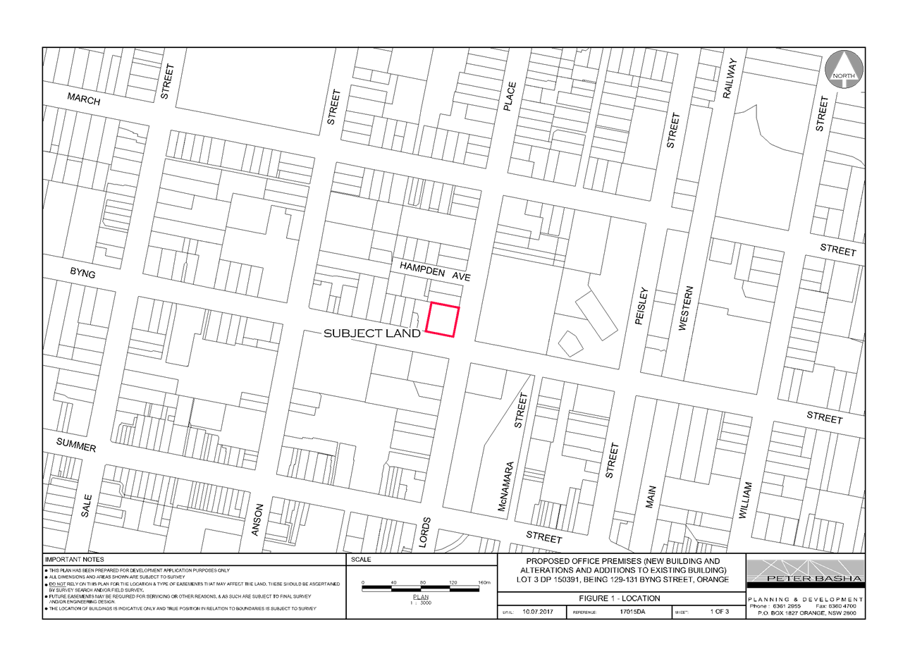
Council Meeting
3 October 2017
5.3 Development
Application - DA 259/2017(1) - 129-131 Byng Street
Attachment 2 Plans
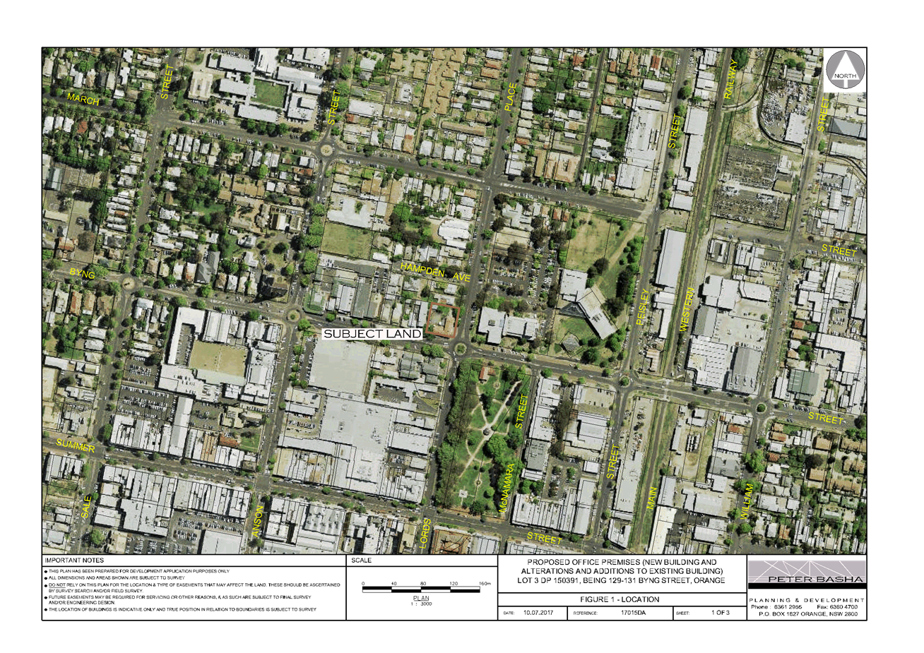
Council Meeting
3 October 2017
5.3 Development
Application - DA 259/2017(1) - 129-131 Byng Street
Attachment 2 Plans
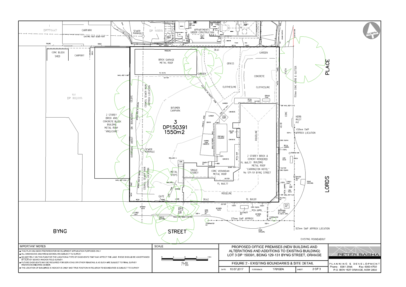
Council Meeting
3 October 2017
5.3 Development
Application - DA 259/2017(1) - 129-131 Byng Street
Attachment 2 Plans
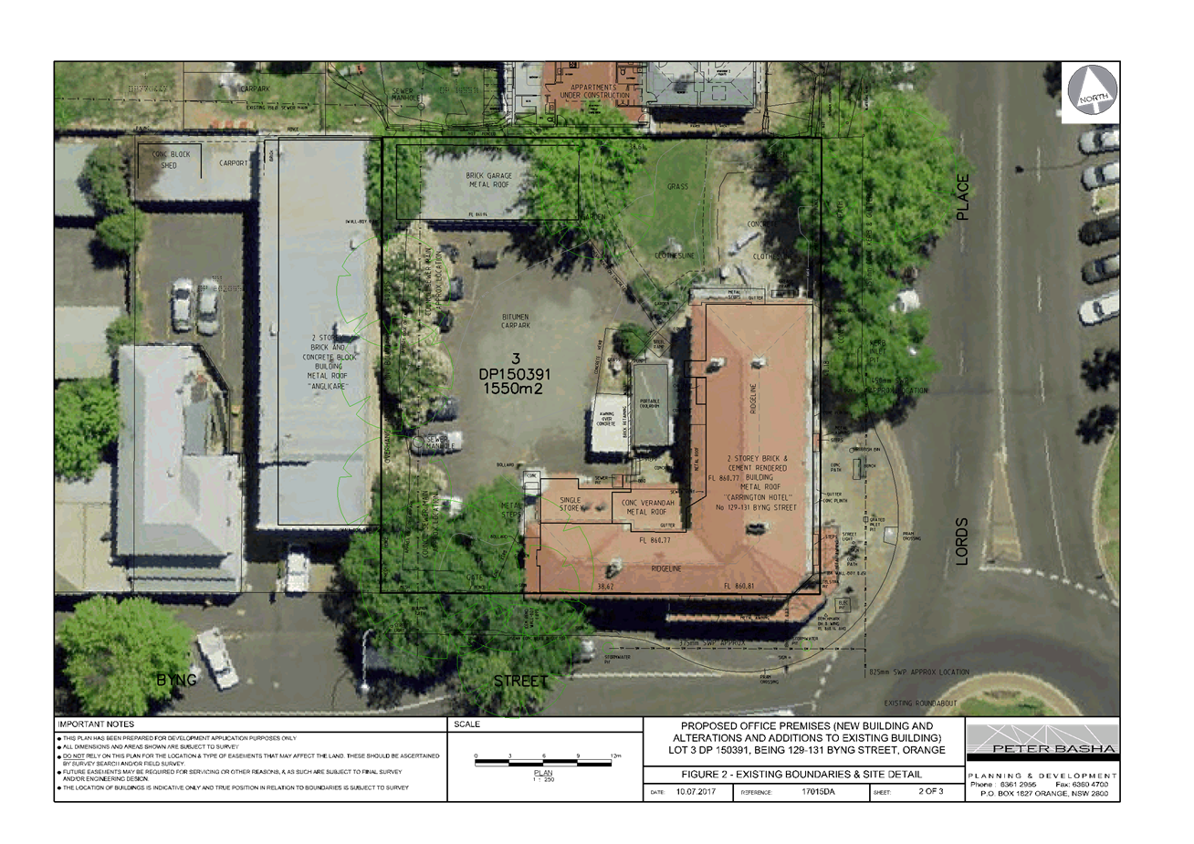
Council Meeting
3 October 2017
5.3 Development
Application - DA 259/2017(1) - 129-131 Byng Street
Attachment 2 Plans
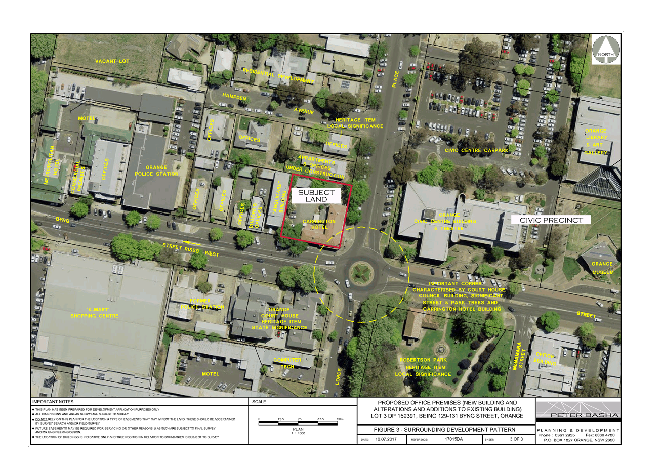
Council Meeting
3 October 2017
5.3 Development
Application - DA 259/2017(1) - 129-131 Byng Street
Attachment 2 Plans
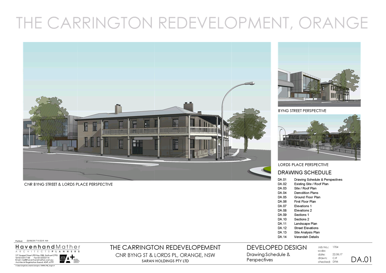
Council Meeting
3 October 2017
5.3 Development
Application - DA 259/2017(1) - 129-131 Byng Street
Attachment 2 Plans
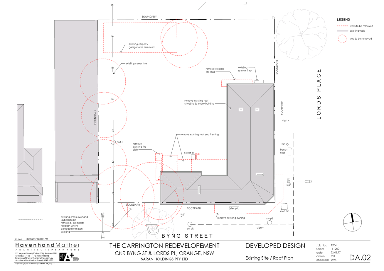
Council Meeting
3 October 2017
5.3 Development
Application - DA 259/2017(1) - 129-131 Byng Street
Attachment 2 Plans
Council Meeting
3 October 2017
5.3 Development
Application - DA 259/2017(1) - 129-131 Byng Street
Attachment 2 Plans
Council Meeting
3 October 2017
5.3 Development
Application - DA 259/2017(1) - 129-131 Byng Street
Attachment 2 Plans
Council Meeting
3 October 2017
5.3 Development
Application - DA 259/2017(1) - 129-131 Byng Street
Attachment 2 Plans
Council Meeting
3 October 2017
5.3 Development
Application - DA 259/2017(1) - 129-131 Byng Street
Attachment 2 Plans
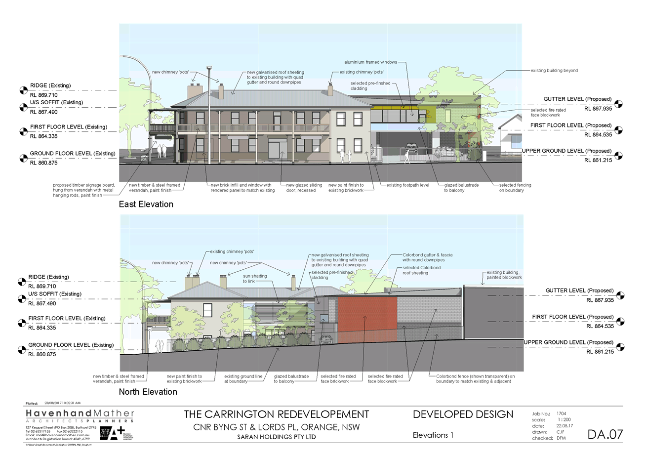
Council Meeting
3 October 2017
5.3 Development
Application - DA 259/2017(1) - 129-131 Byng Street
Attachment 2 Plans
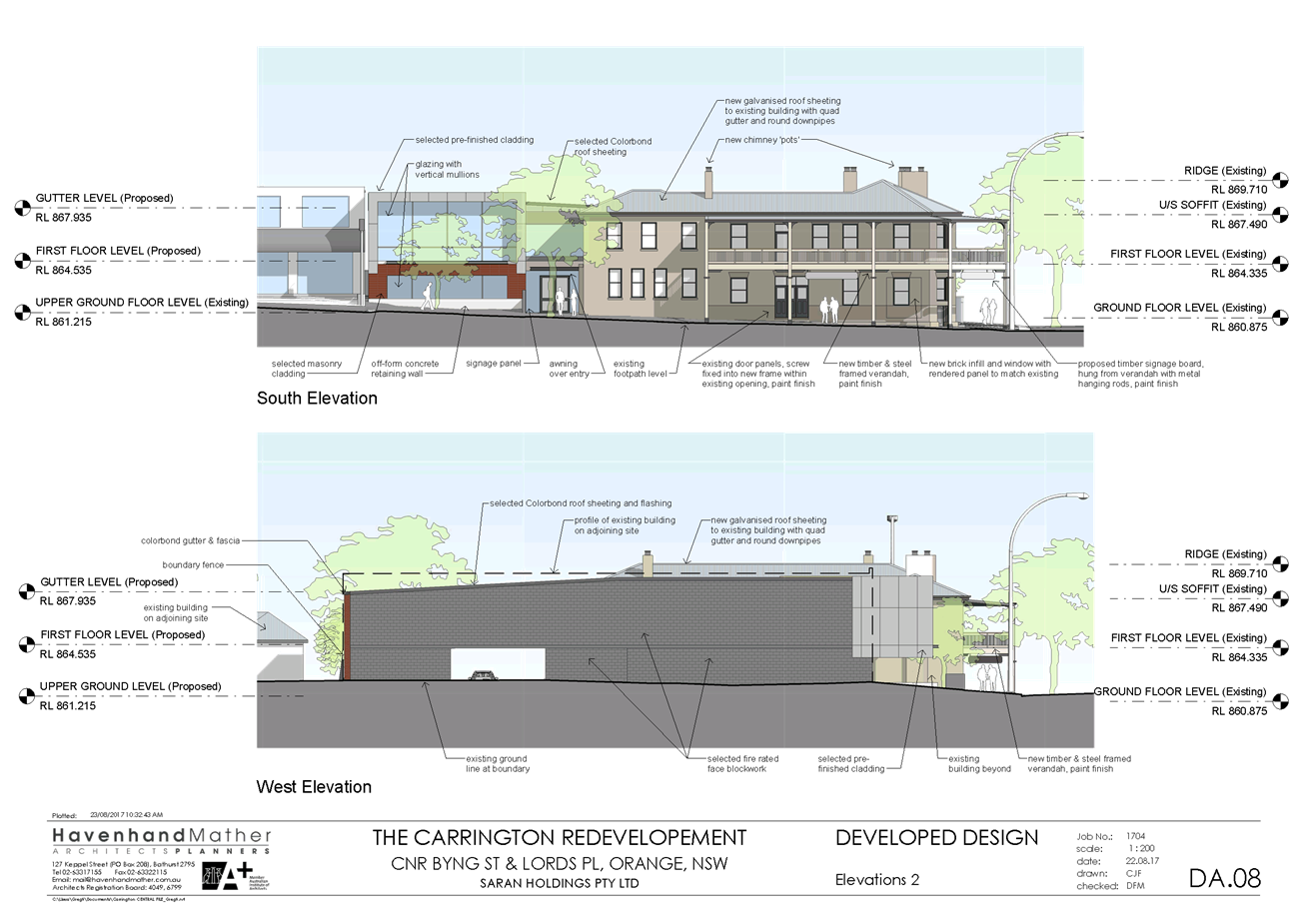
Council Meeting
3 October 2017
5.3 Development
Application - DA 259/2017(1) - 129-131 Byng Street
Attachment 2 Plans
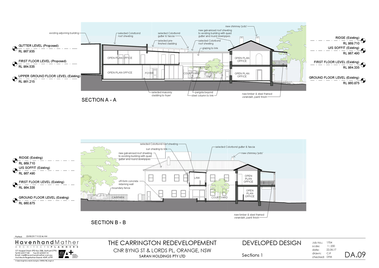
Council Meeting
3 October 2017
5.3 Development
Application - DA 259/2017(1) - 129-131 Byng Street
Attachment 2 Plans
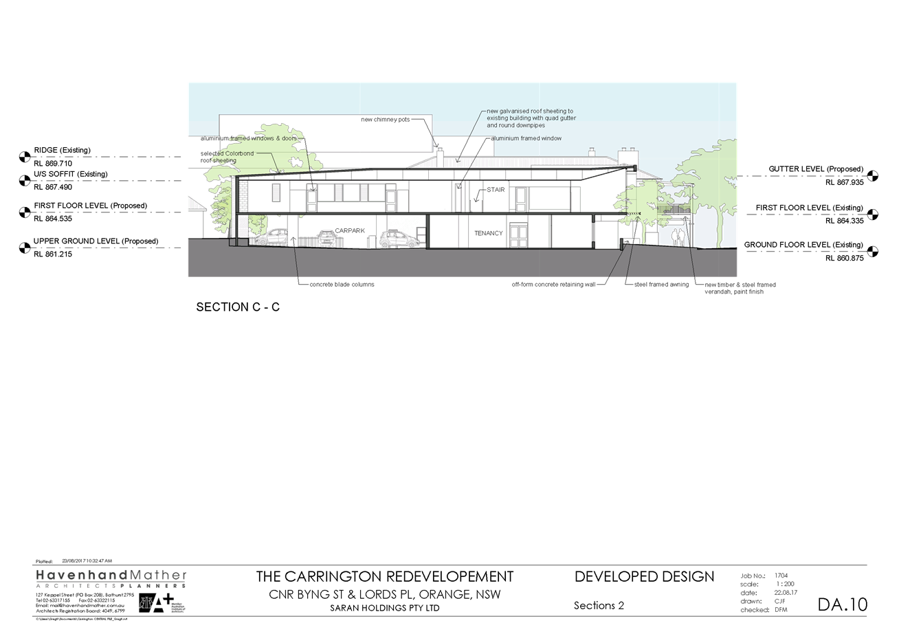
Council Meeting
3 October 2017
5.3 Development
Application - DA 259/2017(1) - 129-131 Byng Street
Attachment 2 Plans
Council Meeting
3 October 2017
5.3 Development
Application - DA 259/2017(1) - 129-131 Byng Street
Attachment 2 Plans
Council Meeting
3 October 2017
5.3 Development
Application - DA 259/2017(1) - 129-131 Byng Street
Attachment 2 Plans
Council Meeting
3 October 2017
5.3 Development
Application - DA 259/2017(1) - 129-131 Byng Street
Attachment 2 Plans
Council Meeting
3 October 2017
5.3 Development
Application - DA 259/2017(1) - 129-131 Byng Street
Attachment 2 Plans
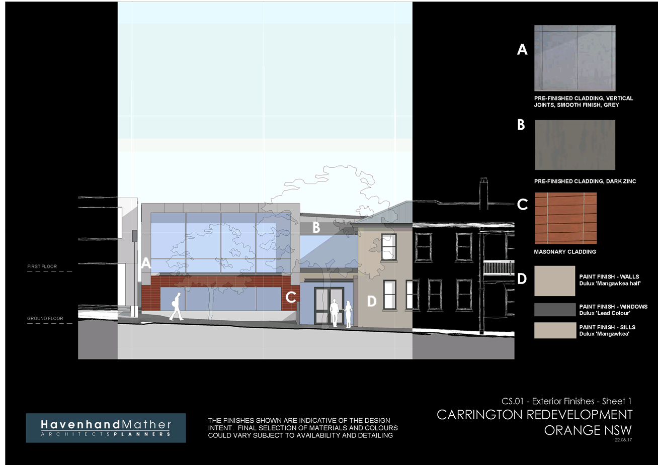
Council Meeting
3 October 2017
5.3 Development
Application - DA 259/2017(1) - 129-131 Byng Street
Attachment 2 Plans
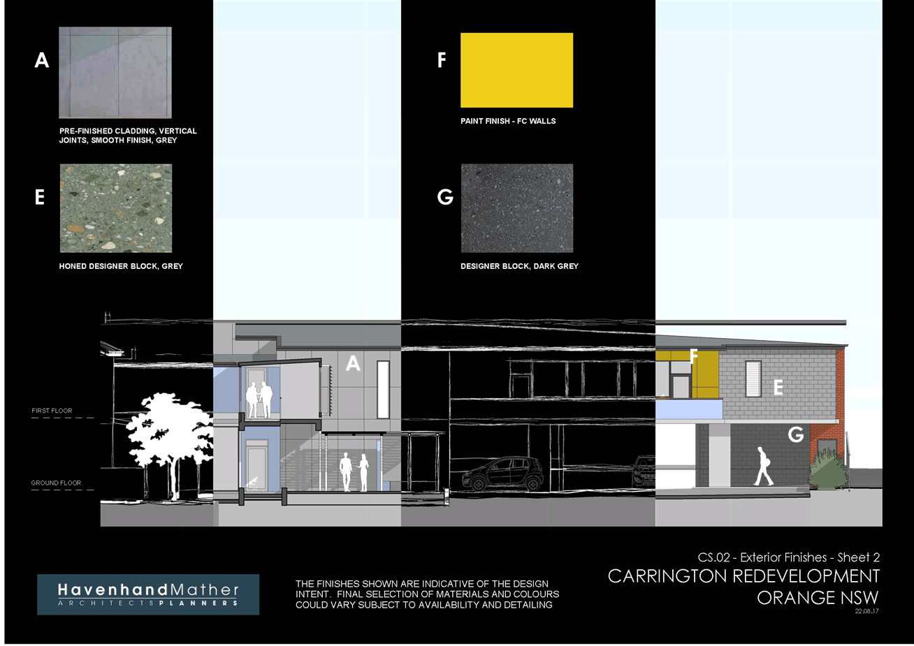
Council Meeting
3 October 2017
5.3 Development
Application - DA 259/2017(1) - 129-131 Byng Street
Attachment 2 Plans
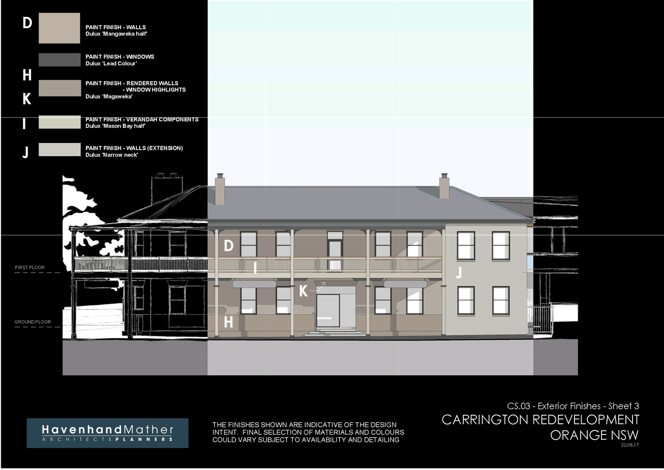
Council Meeting
3 October 2017
5.3 Development
Application - DA 259/2017(1) - 129-131 Byng Street
Attachment 3 Submission
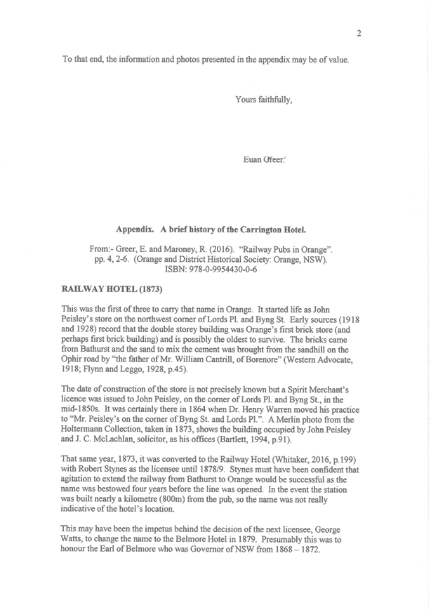
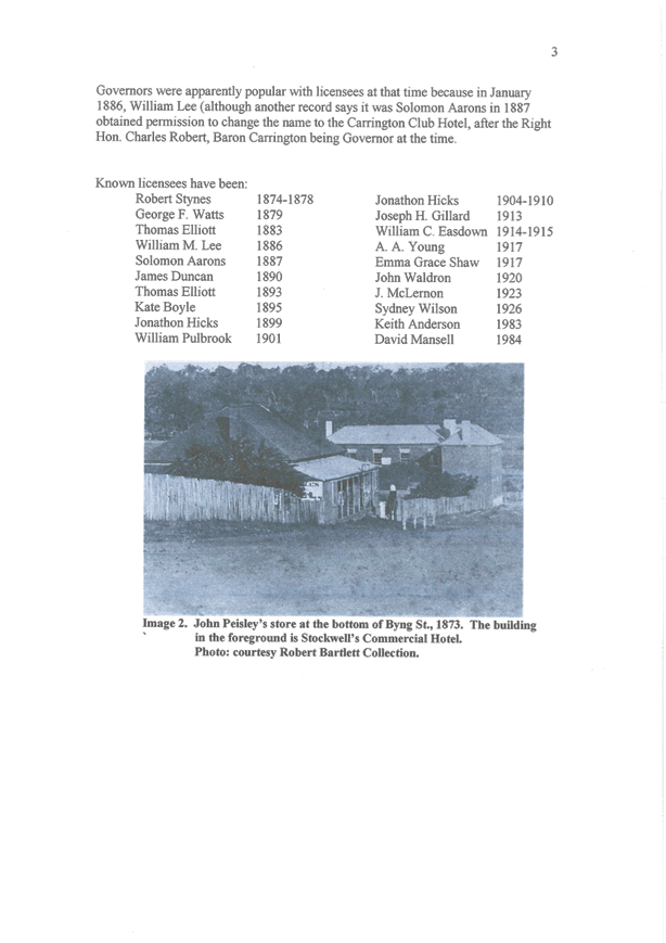
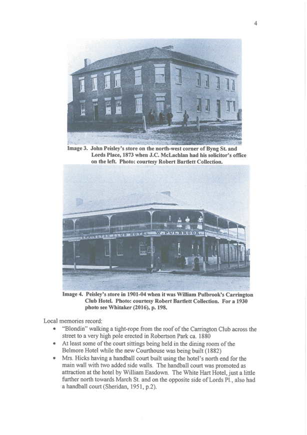
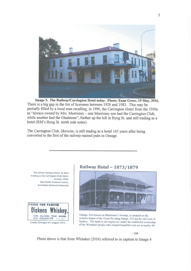
5.4 Development
Application - DA 299/2017(1) - 59-67 Bathurst Road
TRIM
REFERENCE: 2017/2002
AUTHOR: Summer
Commins, Senior Planner
EXECUTIVE Summary
|
Application
lodged
|
17
August 2017
|
|
Applicant/s
|
Kinross
Wolaroi School
|
|
Owner/s
|
The
Uniting Church in Australia Property Trust (NSW)
|
|
Land
description
|
Lot 30
DP 1190518 - 59-67 Bathurst Road, Orange
|
|
Proposed
land use
|
School
(new building for classrooms and support facilities; site works)
|
|
Value of
proposed development
|
$2,400,000
|
Council's consent is sought for proposed school (new
building for classrooms and support facilities; and site works) at Kinross
Wolaroi School (KWS), located at 59-67 Bathurst Road, Orange.
The proposal involves construction of a two-storey building
containing classrooms and support facilities, and associated site works. The
proposed building will be located to the north-west of existing preparatory
school buildings, towards the Allenby Road site frontage. The proposal includes
the relocation of the existing cricket nets to allow for the construction of
the two-storey building.
The proposed development comprises ‘advertised
development’ pursuant to Orange Development Control Plan (DCP) 2004-5.3.
Public notice and exhibition of the application was undertaken, and two
submissions were received. The issues raised in the submissions relate to the
impacts of construction works on the structural integrity of nearby dwellings.
The subject land contains a Local heritage item, namely “Wolaroi”
former mansion, pursuant to Orange Local Environmental Plan (LEP) 2011. The
proposed development will not have adverse impact on the significance of the
heritage item.
The proposal does not contravene the applicable planning
provisions applying to the subject land and particular landuse. Impacts of the
development are considered to be within reasonable limit, consistent with
applicable State and Local standards, and addressed by appropriate conditions
of development consent. Approval of the application is recommended.
DECISION FRAMEWORK
Development in Orange is governed by two key documents
Orange Local Environment Plan 2011 and Orange Development Control Plan 2004. In
addition the Infill Guidelines are used to guide development, particularly in
the heritage conservation areas and around heritage items.
Orange Local Environment Plan 2011 – the LEP
should be considered by Council to be a definitive document. LEPs govern the
types of development that are permissible or prohibited in different parts of
the City and also provide some assessment criteria in specific circumstances.
Uses are either permissible or not - there are no grey areas in terms of
permissibility. The objectives of each zoning and indeed the aims of the LEP
itself are, however, open to interpretation and can be used to guide decision
making around appropriateness of development.
Orange Development Control Plan 2004 – the DCP
guides development. In general it is a performance based document rather than
prescriptive in nature - its purpose is to guide development. The Land and
Environment Court tends to view it as such. In each area of interest there are
often guidelines used. These guidelines indicate ways of achieving the planning
outcomes. It is thus recognised that there may also be other solutions of
merit. All design solutions are considered on merit by planning and building
staff. Applications should clearly demonstrate how the planning outcomes are
being met where alternative design solutions are proposed. So one can see that
the DCP gives leeway for developers and architects to use design to achieve the
outcome in other ways if they can. Stating that DCP guidelines are
inflexible can be misleading.
The planning report demonstrates that the proposed
development is consistent with Council’s adopted planning controls for
this locality. It is recommended that Council supports the development.
Link To Delivery/OPerational Plan
The recommendation in this report relates to the
Delivery/Operational Plan strategy “13.4 Our Environment
– Monitor and enforce regulations relating to City amenity”.
Financial Implications
Nil
Policy and Governance Implications
Nil
|
Recommendation
That Council consents to
development application DA 299/2017(1)
for School (new building for classrooms and support facilities; site
works) at Lot 30 DP 1190518 – 59‑67 Bathurst
Road, Orange pursuant to the conditions of consent
in the attached Notice of Approval.
|
further considerations
Consideration has been given to the
recommendation’s impact on Council’s service delivery; image and
reputation; political; environmental; health and safety; employees; stakeholders
and project management; and no further implications or risks have been
identified.
SUPPORTING INFORMATION
THE PROPOSAL
The proposal involves construction of a new building on the
campus of Kinross Wolaroi School, located at 59-67 Bathurst Road, Orange.
The proposed building will be located to the north-west of
existing preparatory school buildings and west of existing sports fields, as
depicted below.

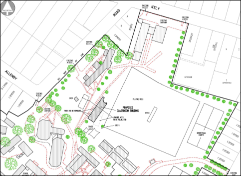
Figure 1 – location of proposed building
The building will be two-storey, with a footprint of 36m
long x 12m wide and a ridge height of 9.5m. The proposed development has a
substantial setback to Allenby Road. The proposed building will be contemporary
in design and detailing with rectangular form, hipped roof profile, extensive
glazing, verandah decoration and mix of external finishes. Ground floor
accommodation will comprise three classrooms, staff rooms, office/meeting room,
communications room, amenities and storeroom. Five classrooms will be located on
the first floor.
The building design is depicted below.
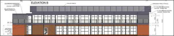
Figure 2 – west elevation
Council is advised that the proposal does not involve any
increase in enrolment capacity. The proposed development will enable existing
facilities to be refurbished and used for other educational purposes within the
current capacity of the school.
MATTERS FOR CONSIDERATION
Section 5A Assessment
In the administration of sections 78A, 79B, 79C, 111 and
112, the provisions of Section 5A must be taken into account for every
development application in deciding whether there is likely to be a significant
effect on threatened species, populations or ecological communities or their
habitats.
In consideration of Section 5A,
the subject land is not identified as “biodiversity sensitivity” on
the Orange LEP 2011 Terrestrial Biodiversity Map. The development
site for the proposed building is located on the edge of existing playing
fields, and excepting immature specimen trees, comprises vacant cleared land.
Significant vegetation, threatened species or ecological endangered communities
or their habitats are unlikely to be present on the land.
Section 79C
Section 79C of the Environmental Planning and Assessment
Act 1979 requires Council to consider various matters, of which those
pertaining to the application are listed below.
PROVISIONS OF ANY ENVIRONMENTAL
PLANNING INSTRUMENT s79C(1)(a)(i)
Orange Local Environmental Plan 2011
Part 1 - Preliminary
Clause 1.2 - Aims of Plan
The
broad aims of the LEP are set out under subclause 2. Those relevant to the
application are as follows:
(a) to encourage development which complements
and enhances the unique character of Orange as a major regional centre boasting
a diverse economy and offering an attractive regional lifestyle,
(b) to provide for a range of development
opportunities that contribute to the social, economic and environmental
resources of Orange in a way that allows present and future generations to meet
their needs by implementing the principles for ecologically sustainable
development,
(f) to recognise and manage valued
environmental heritage, landscape and scenic features of Orange.
The application is considered to be consistent with the
above objectives, as outlined in this report.
Clause 1.6 - Consent Authority
This clause establishes that, subject to the Act, Council is
the consent authority for applications made under the LEP.
Clause 1.9A - Suspension of
Covenants, Agreements and Instruments
This clause provides that covenants, agreements and other
instruments which seek to restrict the carrying out of development do not apply
with the following exceptions:
· covenants imposed
or required by Council
· prescribed
instruments under Section 183A of the Crown Lands Act 1989
· any conservation
agreement under the National Parks and Wildlife Act 1974
· any trust
agreement under the Nature Conservation Trust Act 2001
· any property
vegetation plan under the Native Vegetation Act 2003
· any biobanking
agreement under Part 7A of the Threatened Species Conservation Act 1995
· any planning
agreement under Division 6 of Part 4 of the Environmental Planning and
Assessment Act 1979.
Council staff are not aware of the title of the subject
property being affected by any of the above.
Mapping
The subject site is identified
on the LEP maps in the following manner:
|
Land Zoning Map:
|
Land zoned R1 General Residential
|
|
Lot Size Map:
|
No minimum lot size
|
|
Heritage Map:
|
Local heritage item
|
|
Height of Buildings Map:
|
No building height limit
|
|
Floor Space Ratio Map:
|
No floor space limit
|
|
Terrestrial Biodiversity Map:
|
No biodiversity sensitivity on the site
|
|
Groundwater Vulnerability Map:
|
Ground water vulnerable
|
|
Drinking Water Catchment Map:
|
Not within the drinking water catchment
|
|
Watercourse Map:
|
Not within or affecting a
defined watercourse
|
|
Urban Release Area Map:
|
Not within an urban release area
|
|
Obstacle Limitation Surface Map:
|
No restriction on building siting or construction
|
|
Additional Permitted Uses Map:
|
No additional permitted use applies
|
|
Flood Planning Map:
|
Not a flood planning area
|
Those matters that are of relevance are addressed in detail
in the body of this report.
Part 2 - Permitted or Prohibited
Development
Clause 2.1 Land Use Zones
The subject site is located within the R1 General
Residential zone. The proposed development is defined as “educational
establishment (school)” under OLEP 2011. Pursuant to the Dictionary:
Educational
establishment means a building or place used for education (including
teaching), being:
(a) a
school, or
(b) a tertiary institution,
including a university or a TAFE establishment, that provides formal education
and is constituted by or under
Educational establishments (including schools) are a
permitted landuse in the R1 General Residential zone, pursuant to Clause 35 of Part
4 of State Environmental Planning Policy (SEPP) (Educational Establishments and
Child Care Facilities) 2017.
Clause 2.3 Zone Objectives and
Land Use Table
The objectives for land zoned R1 General Residential are as
follows:
· To provide for
the housing needs of the community.
· To provide for
a variety of housing types and densities.
· To enable other
land uses that provide facilities or services to meet the day to day needs of
residents.
· To ensure
development is ordered in such a way as to maximise public transport patronage
and encourage walking and cycling in close proximity to settlement.
· To ensure that
development along the Southern Link Road has an alternative access.
The proposed development is not
contrary to the relevant R1 zone objectives. The proposal is ancillary to the
existing and longstanding school use of the site and is a permitted landuse.
Part 3 Exempt and Complying
Development
The application is not exempt or complying development.
Part 4 Principal Development Standards
The Part 4 Principal Development
Standards do not relate to the subject land or proposed development.
Part 5 Miscellaneous Provisions
Clause
5.9 - Preservation of Trees or Vegetation
Clause
5.9 is applicable. This clause states in part:
(3) A person must not
ringbark, cut down, top, lop, remove, injure or willfully destroy any tree or
other vegetation to which any such development control plan applies without the
authority conferred by:
(a) development consent, or
(b) a permit granted by the
Council
In
consideration of Clause 5.9, the proposed development will necessitate removal
of four (4) prescribed trees from the site. Council’s Manager City
Presentation raised no objection to tree removal as proposed, as the trees are
‘immature specimens;’ further, replacement planting will not
be required as ‘the school has a sound philosophy and there are many
young trees across the site.’
5.10 Heritage Conservation
The subject land contains a Local heritage item, namely “Wolaroi”
former mansion (Item I9). As such, Clause 5.10(4) is applicable and states:
(4) Effect
of Proposed Development on Heritage Significance
The
consent authority must, before granting consent under this clause in respect of
a heritage item or heritage conservation area, consider the effect of the
proposed development on the heritage significance of the item or area
concerned. This subclause applies regardless of whether a heritage management
document is prepared under subclause (5) or a heritage conservation management
plan is submitted under subclause (6).
The Orange Heritage Inventory
provides the following Statement of Significance for Wolaroi:
“A substantial original
Victorian period Italianate style brick residence with elaborate brick and cast
iron details and additions set within a mature landscape incorporating many
cultural plantings, the adaptations over successive generations for private
school use complement the original architecture and contribute to the
significance of the site as an item of State heritage significance in relation
to architecture and education”.
It is considered that the proposed development will not
adversely impact on the significance of the heritage item due to the following:
· The mansion will
be retained in its current form. The proposed development does not involve
works to the building, its curtilage, landscape setting or entrance driveway.
The landmark character of the heritage item will not be impacted by the
proposal.
· There is
nil-negligible spatial and visual relationship between the mansion and proposed
development. The proposed building will be sited some 200m from the heritage
item, with intervening development comprised of numerous school buildings of
varying architectural styles and eras.
· The proposed
building design and detailing will reasonably complement more recent buildings
on the school campus, and contribute to a harmonious and cohesive setting.
· The proposed
building is readily identifiable as new work, and will provide for
interpretation and appreciation of the mansion.
· The development
site is unlikely to contain archaeological items or deposits associated with
the heritage item. The site for the proposed building is well removed from the
mansion, and has been subject to previous extensive earthworks associated with
construction of the playing fields and drainage works.
· The proposed
development will have nil impact on significant views of the heritage item. The
main driveway will be retained in its current form, with no impact on the sense
of arrival at the mansion. Views of the item from the development site are
already obstructed by intervening development of other school buildings. The
development site is lower in elevation than the heritage item; the proposed
building will not dominate the mansion in terms of height.
· The proposed tree
removal will comprise the loss of non-contributory landscaping, with nil impact
on the overall site landscape setting.
· The proposal
involves an intensification of the existing and longstanding educational use of
the land, upon which the heritage significance of the site is partly derived.
The proposed development was reviewed by Council’s
Heritage Advisor. No objection was raised to the proposal on heritage
conservation grounds.
Part 6 Urban Release Area
Not relevant to the application. The subject site is not
located in an Urban Release Area.
Part 7 - Additional Local Provisions
7.1 Earthworks
Clause 7.1 applies. This clause states
in part:
(3) Before granting
development consent for earthworks, the consent authority must consider the
following matters:
(a) The likely disruption
of, or any detrimental effect on, existing drainage patterns and soil stability
in the locality of the development
(b) The effect of the
development on the likely future use or redevelopment of the land
(c) The quality of the fill
or the soil to be excavated, or both
(d) The effect of the
development on the existing and likely amenity of adjoining properties
(e) The source of any fill
material and the destination of any excavated material
(f) The likelihood of
disturbing relics
(g) The proximity to and
potential for adverse impacts on any waterway, drinking water catchment or
environmentally sensitive area
(h) Any measures proposed
to minimise or mitigate the impacts referred to in paragraph (g).
In consideration of this clause, the
proposal is suitable. Site works will be required for the proposed building and associated
stormwater management (refer Clause 7.3 below). The earthworks will be
supported onsite and the change in ground level will be insubstantial.
Alterations to drainage and stormwater flows will be contained within the site
and will not detrimentally adjoining properties. Conditions are recommended in
relation to stormwater management and sediment and erosion control during
construction.
7.3 Stormwater
Management
Clause 7.3 is
applicable. This clause states in part:
(3) Development
consent must not be granted to development on land to which this clause applies
unless the consent authority is satisfied that the development:
(a) is
designed to maximise the use of water permeable surfaces on the land having
regard to the soil characteristics affecting on-site infiltration of water
(b) includes,
where practical, on-site stormwater retention for use as an alternative supply
to mains water, groundwater or river water
(c) avoids
any significant impacts of stormwater runoff on adjoining downstream
properties, native bushland and receiving waters, or if that impact cannot be
reasonably avoided, minimises and mitigates the impact.
Council’s Development Engineer
advises:
“The proposed building is
located adjacent to a major overland flow path from a stormwater detention
basin as well as a minor overland flow path from the adjacent playing fields. Site
works are required to contain and direct stormwater flows and control the top
water level of the flows where they converge adjacent to the building.”
Conditions are recommended in relation
to stormwater management (retention works and finished floor levels) to address
overland flows and achieve compliance with Clause 7.3.
Clause 7.6 Groundwater
Vulnerable
The subject land is identified as
Groundwater Vulnerable on the Groundwater Vulnerability Map. Clause 7.6
applies. This clause states in part:
(3) Before
determining a development application for development on land to which this
clause applies, the consent authority must consider:
(a) whether or not the development (including
any onsite storage or disposal of solid or liquid waste and chemicals) is
likely to cause any groundwater contamination or have any adverse effect on
groundwater dependent ecosystems, and
(b) the cumulative impact (including the
impact on nearby groundwater extraction for potable water supply or stock water
supply) of the development and any other existing development on groundwater.
In consideration of
Clause 7.6, the proposal is considered to be acceptable. The proposed school
building will not involve processes or activities that would impact on
groundwater resources.
Clause 7.11 Essential Services
Clause 7.11 is applicable and states:
Development
consent must not be granted to development unless the consent authority is
satisfied that any of the following services that are essential for the
proposed development are available or that adequate arrangements have been made
to make them available when required:
(a) the
supply of water
(b) the
supply of electricity
(c) the
disposal and management of sewage
(d) storm
water drainage or on-site conservation
(e) suitable
road access.
In consideration of this clause, all
utility services are available to the land and adequate for the proposed
building:
· the subject land
is connected to reticulated water supply
· electricity and
telecommunications are available to the land
· the site is
connected to Council’s reticulated sewerage system
· subject to
augmentation, stormwater management for the subject land is suitable
· the proposal will
not alter existing site accesses via Bathurst Road, Cox Avenue and Allenby
Road.
STATE ENVIRONMENTAL PLANNING
POLICIES
State Environmental Planning Policy No. 55 Remediation of
Land
The proposed development is consistent with the relevant provisions
of SEPP No. 55 Remediation of Land:
· It is unlikely
that the subject land is contaminated, pursuant to Clause 7(1) Contamination
and remediation to be considered in determining development application. The
development site has longstanding ancillary educational use; is not located
within an investigation area; and is not known to have been used for a purpose
listed in Table 1 to the contaminated land planning guidelines. The site of the
proposed building is on the fringe of a sports field. Site inspection does not
suggest any evidence of soil contamination. Preliminary contamination
investigation as a precursor to potential site remediation is considered
unnecessary for the proposed development.
· The proposal does
not involve a change of use for educational purposes (Clause 7(4)), but rather
an intensification of the existing educational use of the land. A detailed
contamination investigation is not required for the proposed development.
State Environmental Planning
Policy (Infrastructure) 2007
The proposed development is consistent with the relevant
provisions of SEPP (Infrastructure) 2007:
· The proposal will
have nil impact on the safety, efficiency and ongoing operation of Bathurst
Road (being a classified road) pursuant to Clause 101 Development with frontage
to a classified road. The development will not alter existing vehicular access
arrangements to the site via Bathurst Road, Cox Avenue and Allenby Road.
State Environmental Planning Policy (Educational
Establishments and Child Care Facilities) 2017
The proposed development is consistent with the relevant
provision of SEPP (Educational Establishments and Child Care Facilities) 2017:
· The proposed
development is defined as a “school” pursuant to Clause 5
Interpretation.
· The proposal is not
‘specified development’ pursuant to Clause 13 Consultation with
public authorities other than councils. Consultation with Roads and Maritime
Services (RMS) (ie. the ‘specified authority’) is not required as
the proposal does not involve additional students; additional car parking
spaces; alteration to existing accesses; new accesses; or excavation adjacent
to the classified road [Bathurst Road] (Clause 13(3)).
· Development for
the purpose of a school is permitted with consent on the subject land, pursuant
to Clause 35 Schools- development permitted with consent.
· The proposal
satisfies the design principles established in Schedule 4
(Clause 35(6)(a):
Principle 1 –
context, built form and landscape
- The
proposed building will reasonably relate to and be contained within the school
buildings group.
- The
proposed building design and detailing will reasonably complement more recent
buildings on the school campus, and contribute to a harmonious and cohesive
setting.
- The
site is not located within a scenic protection area. The proposed tree removal
relates to non-contributory and immature specimens and will have negligible
impact on the landscape setting of the campus.
Principle 2 –
sustainable, efficient and durable
- The
proposed building incorporate energy efficiency influences in the design.
Principle 3 –
accessible and inclusive
- The
proposed building will connect with the existing school buildings group via
pedestrian pathways.
- The
proposed building will be accessible to and contain facilities for people with
differing needs and capabilities.
- The
proposal does not involve community use of the building; notwithstanding, other
existing facilities on the KWS campus are shared with the community for certain
activities outside of school hours.
Principle 4 – health
and safety
- Crime
prevention measures are included in the building design and siting.
- The
proposal will not alter existing site operational arrangements in relation to
access and security.
Principle 5 –
amenity
- The
proposed building will provide ‘pleasant and engaging spaces’ for
students and staff.
- The
new classrooms have been designed for provide ideal learning environments with
generous natural light and outlook; appropriate room size; visual and acoustic
privacy; and updated and integrated technologies for media, data and
communications.
- The
development will not impact on residential amenity for nearby dwellings (in
relation to visual and acoustic privacy, solar access and visual impacts). The
proposed building will be contained within the subject land, and is well-removed
(some 90m) from the nearest adjoining dwellings on Allenby Road.
Principle 6 – whole
of life, flexible and adaptive
- The
proposal involves purpose-built classroom and staff facilities that may be
easily adapted for associated uses.
- The
development will enable existing facilities within the school site to be
refurbished and used for other educational purposes.
Principle 7 –
aesthetics
- The
proposal will be located internal to the site and will not contribute to the
streetscape built form in Allenby Road.
- The
building will relate to existing improvements on the school site in terms of
footprint, massing and design.
· The development
does not involve community use of the proposed new building (Clause 35(6)(b).
· The proposal is
not exempt development pursuant to Clause 38 Existing schools- exempt
development. Development consent is required and sought for the proposed
development.
· The proposed
development is not complying development pursuant to Clause 39 Existing
schools- complying development. Development consent is required and sought for
the proposed development.
· The proposal is
not ‘traffic-generating’ development in accordance with Clause 57
Traffic-generating development. The proposal does not involve additional
students. Consultation with RMS is not required.
PROVISIONS OF ANY DRAFT
ENVIRONMENTAL PLANNING INSTRUMENT THAT HAS BEEN PLACED ON EXHIBITION
s79C(1)(a)(ii)
There are no draft environmental planning instruments that
apply to the subject land or proposed development.
DESIGNATED DEVELOPMENT
The proposed development is not designated development.
INTEGRATED DEVELOPMENT
The proposed development is not integrated development.
PROVISIONS OF ANY DEVELOPMENT CONTROL
PLAN s79C(1)(a)(iii)
Development Control Plan 2004
DCP 2004-00 Transitional Provisions – Tree
Preservation
The
proposed development will necessitate removal of four (4) prescribed trees from
the site. Council’s Manager City Presentation raised no objection to tree
removal as proposed; and does not require replacement planting due to the
suitability of the landscape setting. Further assessment of this issue has been
provided elsewhere in the report.
DCP 2004-7 Development in
Residential Zones
The Part 7 Planning Outcomes are not relevant to the
proposed development.
DCP 2004-13 Heritage
As outlined previously, the proposal will not adversely
impact on the significance of the Local heritage item on the subject land.
DCP 2004-15 Car Parking
Pursuant to DCP 2004, the minimum onsite parking requirement
for schools is 1 space for every 2 employees and 1 space per 10 students
over 17 years of age. Council has been advised that the proposal does not
involve any alteration to staff and students numbers. On this basis additional
parking will not be required for the proposed development.
INFILL GUIDELINES
The proposed development is consistent with the relevant
criteria contained in Council’s Infill Guidelines:
· The proposed
building will have nil impact on the character of the streetscape, being
located some 70m from the Allenby Road site frontage.
· The development
will be visually and spatially removed from the heritage item on the subject
land, and will have nil impacts on its significance.
· The proposed
building design and siting will reasonably complement nearby buildings on the
school campus, and contribute to a harmonious and cohesive setting.
PROVISIONS PRESCRIBED BY THE
REGULATIONS s79C(1)(a)(iv)
The proposed development is not inconsistent with any
provision prescribed by the Regulations.
THE LIKELY IMPACTS OF THE
DEVELOPMENT s79C(1)(b)
Heritage Significance
As outlined in this report, the proposal will not have
adverse impact on the significance of the Local heritage item on the subject
land.
Visual Impacts
The proposed building will have acceptable visual impacts
within the subject land and neighbourhood due to the following:
· The building will
be contained within the site and setback some 70m from the Allenby Road
frontage. The development will neither complement nor detract from any defined
streetscape building form in Allenby Road. The building will generate minimal
visual impact on the streetscape.
· The siting of the
proposed building will be reasonably contained within the building group
associated with the preparatory school.
· The proposed
building design will integrate with other more recent buildings in the vicinity
of the development site, and achieve a harmonious and cohesive school setting.
· The proposed
building form, scale and finish will reflect newer buildings on the site. The
pitched roof, gable ends and colour schemes (dark roof and earth-red tone
walls) reflect a common architectural theme.
· The proposed
building design will not be imposing or bulky. The long elevations will be
broken by extensive glazing and mixed wall finishes; verandah will add
interest.
· The loss of
non-contributory landscaping will have negligible impact on the landscape
setting. Existing landscaping at the Allenby Road frontage will filter views of
the new building from this frontage.
Traffic Matters
The proposal will not alter existing traffic arrangements
for the subject land:
· The siting of the
proposed building will not conflict with existing onsite vehicle areas.
· The proposal will
not necessitate alteration to existing site accesses nor additional accesses.
· The proposed
building will be generally contained within the existing school building group,
and accessible via existing site accesses. Traffic arrangements in Allenby Road
(being the nearest frontage) are unlikely to be altered.
Residential Amenity
The proposed development will not impact on residential
amenity for dwellings adjoining the KWS site, over and above the existing
situation. The proposed building will be contained within the subject land, and
well-removed (some 90m) from the nearest adjoining dwellings on Allenby Road.
The proposed building will not unreasonably impact on visual or acoustic
privacy or solar access for nearby dwellings.
Waste Management
Operational waste associated with the proposed building will
be addressed via existing waste management arrangements that service the
school. Conditions are recommended requiring preparation and implementation of
a waste management plan for construction waste.
Construction Impacts
Construction impacts will be addressed as follows:
· The bulk of
construction works will be undertaken during the school holiday period.
· The building will
be comprised of prefabricated modules, which will reduce the construction
period.
· The development
site is removed from active zones within the school campus.
· Construction
fencing will be established around the site to prevent unauthorised access.
· Separate access
routes for construction staff and vehicles and students will be delineated with
fencing/barricades.
· A designated
parking area will be provided for construction vehicles.
· Onsite
construction waste management will be undertaken (consistent with conditional
waste management plan).
· Construction
activities will be confined to standard work hours (as required by condition).
· On-street traffic
control measures will be implemented when required.
Crime Prevention
The proposed building is considered suitable in relation to
surveillance, access control, territorial enforcement and space management.
Crime prevention measures include extensive glazing of building elevations to
provide expansive sightlines over the site; external lighting; appropriate
landscape design (existing); fencing and controlled entry gates to the school
site perimeter (existing); security lighting and alarm systems (existing);
building maintenance and site beautification (ongoing).
Environmental Impacts
The subject land is contained within an urbanised area and
has longstanding educational use. The development site for the proposed
building and relocated cricket nets is located on the edge of existing playing
fields, and excepting immature specimen trees, comprises vacant cleared land.
Significant vegetation, threatened species or ecological endangered communities
or their habitats are unlikely to be present on the land. The site is not in
proximity to any waterway, drinking water catchment or sensitive area. Sediment
control measures, as required by conditions, will prevent loose dirt and
sediment escaping the site and polluting downstream waterways. The development
will have an immaterial effect on the natural environment.
Social and Economic Impacts
The proposal is ancillary to the longstanding educational
use of the site, and will enhance educational facilities and resources for the
school and the City, generally. The proposal will complement and enhance the
role of Orange as a major regional business and service centre.
Headworks Charges
The proposal does not involve any increase in existing
enrolments at the school (the student population is presently capped at 1,200
students), and consequently water and sewer headworks charges are not
applicable to the proposal pursuant to the Water Management Act 2000.
Headworks contributions will apply to any increase in student numbers. An
Advisory Note is attached to this effect.
THE SUITABILITY OF THE SITE
s79C(1)(c)
The subject land is suitable for the development due to the
following:
· Schools are a
permitted landuse in the R1 zone.
· The proposal is
ancillary to the longstanding educational use of the site.
· The development
site for the proposed building is removed from onsite vehicles areas and
adjoining dwellings.
· The development
site will reasonably integrate with the existing school buildings group.
· The proposed
building is visually and spatially removed from the heritage item on the
subject land.
· Existing site
access arrangements are suitable and will not be impacted.
· The topography of
the development site will not constrain the proposal, with minor earthworks and
drainage works required.
· All utility
services are available and adequate.
· The site is not
subject to natural hazards.
· The subject land
has no particular biodiversity or habitat value
· The site is not in
proximity to any waterway, drinking water catchment or sensitive area.
ANY SUBMISSIONS MADE IN
ACCORDANCE WITH THE ACT s79C(1)(d)
The proposed development is defined as "advertised
development" pursuant to DCP 2004‑5.3. Details of the public
notice and exhibition period are as follows:
Advertisement in Orange
City Life: Thursday,
24 August 2017
Public notice (letters to
adjoining owners): Monday, 21 August 2017
Exhibition period: Friday,
25 August – Friday, 8 September 2017 (15 days)
Submissions received: Two
The public submissions received
relate to the impacts of construction on nearby dwellings. It is alleged that
structural damage was caused to adjoining dwellings during construction of the
KWS boarding house on Allenby Road (DA 54/2013(1) approved 4 June 2013).
Attached to the Notice are conditions addressing matters
pertaining to construction times and the like. Provided construction works are
consistent with the applicable standards and guidelines (as conditioned),
adverse construction impacts on adjoining properties are considered unlikely.
It is Council’s practice to require submission of a
dilapidation report for buildings in close proximity to or adjoining a proposed
development, where there is potential for that development to affect the
structural integrity of nearby buildings. In the context of the current
proposal, the proposed building is located some 90m from the nearest adjoining
dwellings on Allenby Road. Council’s Manager Building and Environment
advises that this separation is reasonable to contain construction impacts
within the site, and a dilapidation report for nearby dwellings is not
required.
An Advisory Note will be attached to the development consent
to the effect that the developer may wish to undertake dilapidation reports for
nearby dwellings to inform potential civil matters that may arise in the
future.
PUBLIC INTEREST
s79C(1)(e)
The proposal is not inconsistent with any relevant policy
statements, planning studies, guidelines etc that have not been considered in
this assessment. The proposal will enhance educational facilities and resources
for the school and City, generally, and is considered to be in the public
interest.
SUMMARY
The proposal involving both the relocation of the cricket
nets and the construction of the new two storey classroom building does not
contravene the applicable planning provisions applying to the subject land and
particular landuse. A Section 79C assessment of the proposal indicates that the
development is acceptable. Impacts of the development are considered to be
within reasonable limit, consistent with applicable State and Local standards,
and addressed by appropriate conditions of development consent. Approval of the
application is recommended. A draft Notice of Approval is attached.
COMMENTS
The requirements of the Environmental Health and Building Surveyor
and the Engineering Development Section are included in the attached Notice of
Approval.
Attachments
1 Notice
of Approval, D17/55703⇩
2 Plans,
D17/54474⇩
3 Submissions,
D17/54610⇩
Council Meeting
3 October 2017
5.4 Development
Application - DA 299/2017(1) - 59-67 Bathurst Road
Attachment 1 Notice
of Approval
|

|
ORANGE
CITY COUNCIL
Development
Application No DA
299/2017(1)
NA17/ Container
PR26308
|
NOTICE OF DETERMINATION
OF A DEVELOPMENT
APPLICATION
issued under the Environmental
Planning and Assessment Act 1979
Section 81(1)
|
Development
Application
|
|
|
Applicant Name:
|
Kinross
Wolaroi School
|
|
Applicant Address:
|
C/- Peter
Basha Planning & Development
PO Box
1827
ORANGE
NSW 2800
|
|
Owner’s Name:
|
The
Uniting Church in Australia Property Trust (NSW)
|
|
Land to Be Developed:
|
Lot 30 DP
1190518 - 59-67 Bathurst Road, Orange
|
|
Proposed Development:
|
School
(new building for classrooms and support facilities; siteworks)
|
|
|
|
|
Building
Code of Australia
building
classification:
|
To be
determined by the PCA
|
|
|
|
|
Determination
|
|
|
Made On:
|
3 October
2017
|
|
Determination:
|
CONSENT
GRANTED SUBJECT TO CONDITIONS DESCRIBED BELOW:
|
|
|
|
|
Consent to
Operate From:
|
4 October
2017
|
|
Consent to
Lapse On:
|
4 October
2022
|
Terms of Approval
The reasons for the imposition of
conditions are:
(1) To ensure a quality
urban design for the development which complements the surrounding environment.
(2) To ensure compliance
with relevant statutory requirements.
(3) To ensure the utility
services are available to the site and adequate for the development.
(4) To prevent the proposed
development having a detrimental effect on adjoining land uses.
(5) To minimise the impact
of development on the environment.
Conditions
(1) The
development must be carried out in accordance with:
(a) Drawing by Peter Basha
Planning & Development Ref. 17049DA, Figure 3 (9.8.2017)(1 sheet).
Drawings by KLMS Australia, Job No. 2363, Dwg Nos. 2363-A1(M), 2363-A2(G),
2363-A3 (3 sheets)
(b) statements
of environmental effects or other similar associated documents that form part
of the approval
as amended
in accordance with any conditions of this consent.
(2) All building work must
be carried out in accordance with the provisions of the Building Code of
Australia.
(3) A sign is to be erected
in a prominent position on any site on which building work, subdivision work or
demolition work is being carried out:
(a) showing
the name, address and telephone number of the principal certifying authority
for the work, and
(b) showing
the name of the principal contractor (if any) for any building work and a
telephone number on which that person may be contacted outside working hours,
and
(c) stating
that unauthorised entry to the site is prohibited.
Any such sign is to be maintained while the
building work, subdivision work or demolition work is being carried out.
|
PRIOR TO THE ISSUE OF
A CONSTRUCTION CERTIFICATE
|
(4) An
approval under Section 68 of the Local Government Act is to be sought
from Orange City Council, as the Water and Sewer Authority, for water, sewer
and stormwater connection. No plumbing and drainage is to commence until
approval is granted.
(5) The
applicant is to submit a waste management plan that describes the nature of
wastes to be removed, the wastes to be recycled and the destination of all
wastes. All wastes from the demolition and construction phases of this project
are to be deposited at a licensed or approved waste disposal site.
(6) Engineering
plans detailing works to contain and direct surface stormwater flows are to be
submitted to Orange City Council for approval prior to the issuing of a
Construction Certificate. The engineering plans shall address the following:
· Stormwater entering the
school site from the Cox Avenue exit driveway in a 1% AEP event is to be
diverted to the existing detention basin.
· Stormwater adjacent to
the proposed building is to be directed towards the existing overland flowpath
from the detention basin.
· The concrete footpath
crossing the overland flowpath is to be adjusted to allow the flowpath levels
to be reduced such that the proposed floor level achieves satisfactory
freeboard from the overland flowpath. Satisfactory freeboard to be a minimum of
500mm or as proved through engineering judgement.
(7) The
finished ground floor level of the proposed building shall be at or above RL
877.70 on Australian Height Datum.
|
PRIOR TO WORKS
COMMENCING
|
(8) A
Construction Certificate application is required to be submitted to, and issued
by Council/Accredited Certifier prior to any excavation or building works being
carried out onsite.
(9) A
temporary onsite toilet is to be provided and must remain throughout the
project or until an alternative facility meeting Council’s requirements
is available onsite.
(10) Soil erosion control
measures shall be implemented on the site.
|
DURING
CONSTRUCTION/SITEWORKS
|
(11) All
construction/demolition work on the site is to be carried out between the hours
of 7.00 am and 6.00 pm Monday to Friday inclusive, 7.00 am to
5.00 pm Saturdays and 8.00 am to 5.00 pm Sundays and Public
Holidays. Written approval must be obtained from the General Manager of Orange
City Council to vary these hours.
(12) All
materials on site or being delivered to the site are to be contained within the
site. The requirements of the Protection of the Environment Operations Act
1997 are to be complied with when placing/stockpiling loose material or
when disposing of waste products or during any other activities likely to
pollute drains or watercourses.
(13) Any adjustments to
existing utility services that are made necessary by this development
proceeding are to be at the full cost of the developer.
(14) The
provisions and requirements of the Orange City Council Development and
Subdivision Code are to be applied to this application and all work constructed
within the development is to be in accordance with that Code.
The developer is to be entirely responsible for
the provision of water, sewerage and drainage facilities capable of servicing
the development from Council’s existing infrastructure. The developer is
to be responsible for gaining access over adjoining land for services where
necessary and easements are to be created about all water, sewer and drainage
mains within and outside the lots they serve.
(15) All
construction works are to be strictly in accordance with the Reduced Levels
(RLs) as shown on the approved plans.
|
PRIOR TO THE ISSUE OF
AN OCCUPATION CERTIFICATE
|
(16) No
person is to use or occupy the building or alteration that is the subject of
this approval without the prior issuing of an Occupation Certificate.
(17) The
owner of the building/s must cause the Council to be given a Final Fire Safety
Certificate on completion of the building in relation to essential fire or
other safety measures included in the schedule attached to this approval.
(18) Where
Orange City Council is not the Principal Certifying Authority, a final
inspection of water connection, sewer and stormwater drainage shall be undertaken
by Orange City Council and a Final Notice of Inspection issued, prior to the
issue of either an interim or a final Occupation Certificate.
(19) A Certificate of
Compliance and works-as-executed plan from a registered surveyor, stating that
the stormwater surface drainage complies with the approved engineering plans is
to be submitted to the Principal Certifying Authority prior to the issuing of
an Occupation Certificate.
(20) Certification from
Orange City Council is required to be submitted to the Principal Certifying
Authority prior to the issue of an Occupation Certificate stating that all
works relating to connection of the development to Council assets, works on
public land, works on public roads, stormwater, sewer and water reticulation mains
and footpaths have been carried out in accordance with the Orange City Council
Development and Subdivision Code and the foregoing conditions, and that Council
will take ownership of the infrastructure assets.
(21) All
of the foregoing conditions are to be at the full cost of the developer and to
the requirements and standards of the Orange City Council Development and
Subdivision Code, unless specifically stated otherwise. All work required by
the foregoing conditions is to be completed prior to the issuing of an
Occupation Certificate, unless stated otherwise.
|
MATTERS FOR THE
ONGOING PERFORMANCE AND OPERATION OF THE DEVELOPMENT
|
(22) The
owner is required to provide to Council and to the NSW Fire Commissioner an
Annual Fire Safety Statement in respect of the fire-safety measures, as
required by Clause 177 of the Environmental Planning and Assessment
Regulation 2000.
(1) The developer may
choose to undertake dilapidation reports for nearby dwellings on adjoining
lands, to inform potential civil matters that may arise associated with
construction of the proposed building.
(2) The school student
population is limited to 1,200 students before additional water and sewer
headworks charges apply. Any increase in student numbers over 1,200 will
require payment
of contributions for water, sewer and drainage works to be made at the
contribution rate applicable at the time. The contributions are based on 0.030
ETs for water supply headworks and 0.050 ETs for sewerage headworks per
student. A Certificate of Compliance, from Orange City Council in accordance
with the Water Management Act 2000, will be issued upon payment of the
contributions.
Other Approvals
(1) Local
Government Act 1993 approvals granted under Section 68.
Nil
(2) General
terms of other approvals integrated as part of this consent.
Nil
Right of Appeal
If
you are dissatisfied with this decision, Section 97 of Environmental
Planning and Assessment Act 1979 gives you the right to appeal to the Land
and Environment Court within 6 months after the date on which you receive this
notice.
*
Section 97 of the Environmental Planning and Assessment Act 1979 does not apply
to the determination of a development application for State significant
development or local designated development that has been the subject of a
Commission of Inquiry.
|
Disability Discrimination Act
1992:
|
This application has been assessed in
accordance with the Environmental Planning and Assessment Act 1979. No
guarantee is given that the proposal complies with the Disability
Discrimination Act 1992.
The applicant/owner is responsible to ensure
compliance with this and other anti-discrimination legislation.
The Disability Discrimination Act
covers disabilities not catered for in the minimum standards called up in the
Building Code of Australia which references AS1428.1 - "Design for Access
and Mobility". AS1428 Parts 2, 3 and 4 provides the most comprehensive
technical guidance under the Disability Discrimination Act currently
available in Australia.
|
|
|
|
|
Disclaimer - S88B Restrictions on the Use of Land:
|
The applicant should note that there
could be covenants in favour of persons other than Council restricting what
may be built or done upon the subject land. The applicant is advised to check
the position before commencing any work.
|
|
|
|
|
Signed:
|
On behalf of the consent authority ORANGE
CITY COUNCIL
|
|
Signature:
|
|
|
Name:
|
PAUL JOHNSTON - MANAGER DEVELOPMENT
ASSESSMENTS
|
|
Date:
|
4 October 2017
|
Council
Meeting
3 October 2017
5.4 Development
Application - DA 299/2017(1) - 59-67 Bathurst Road
Attachment 2 Plans
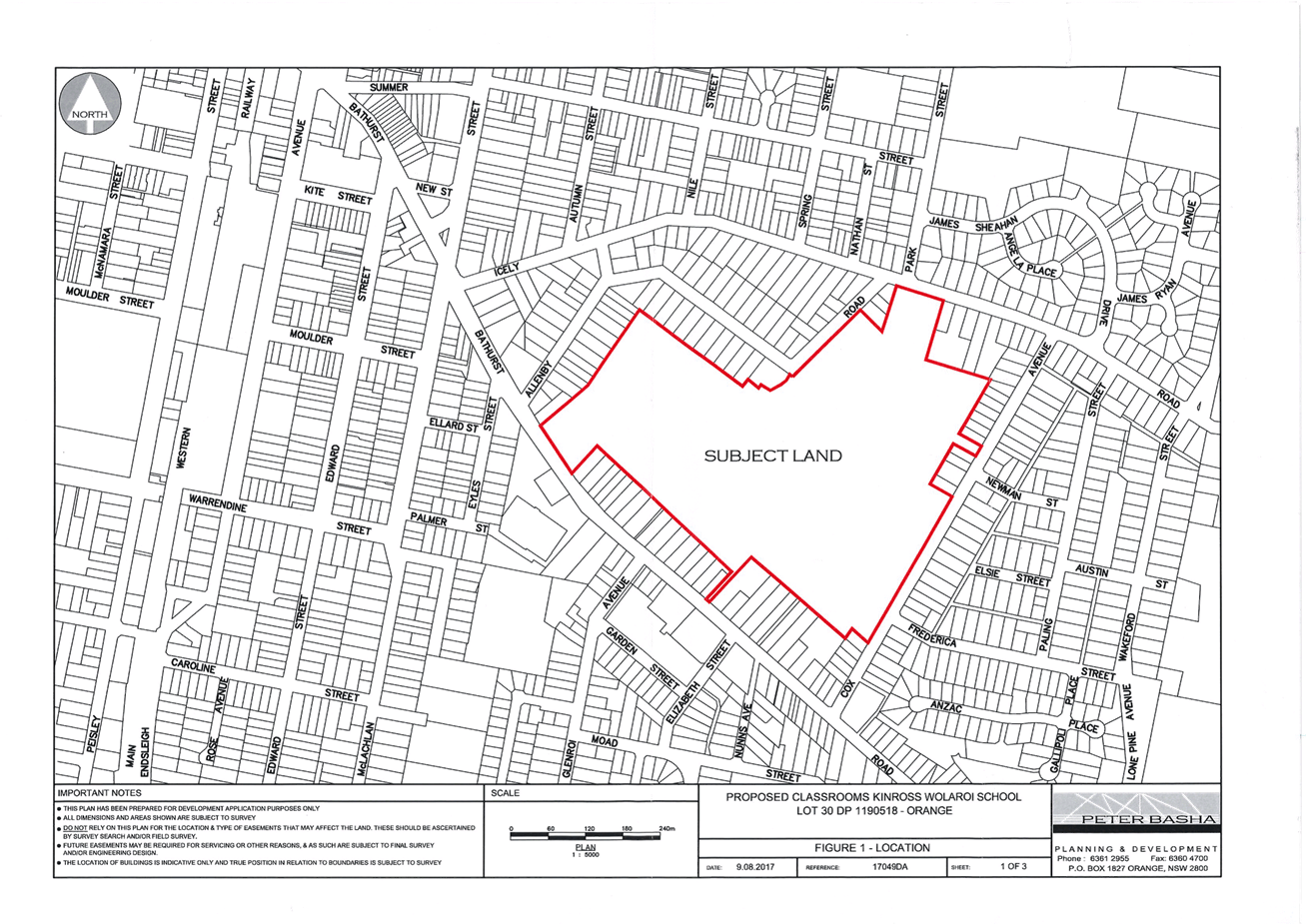
Council Meeting
3 October 2017
5.4 Development
Application - DA 299/2017(1) - 59-67 Bathurst Road
Attachment 2 Plans
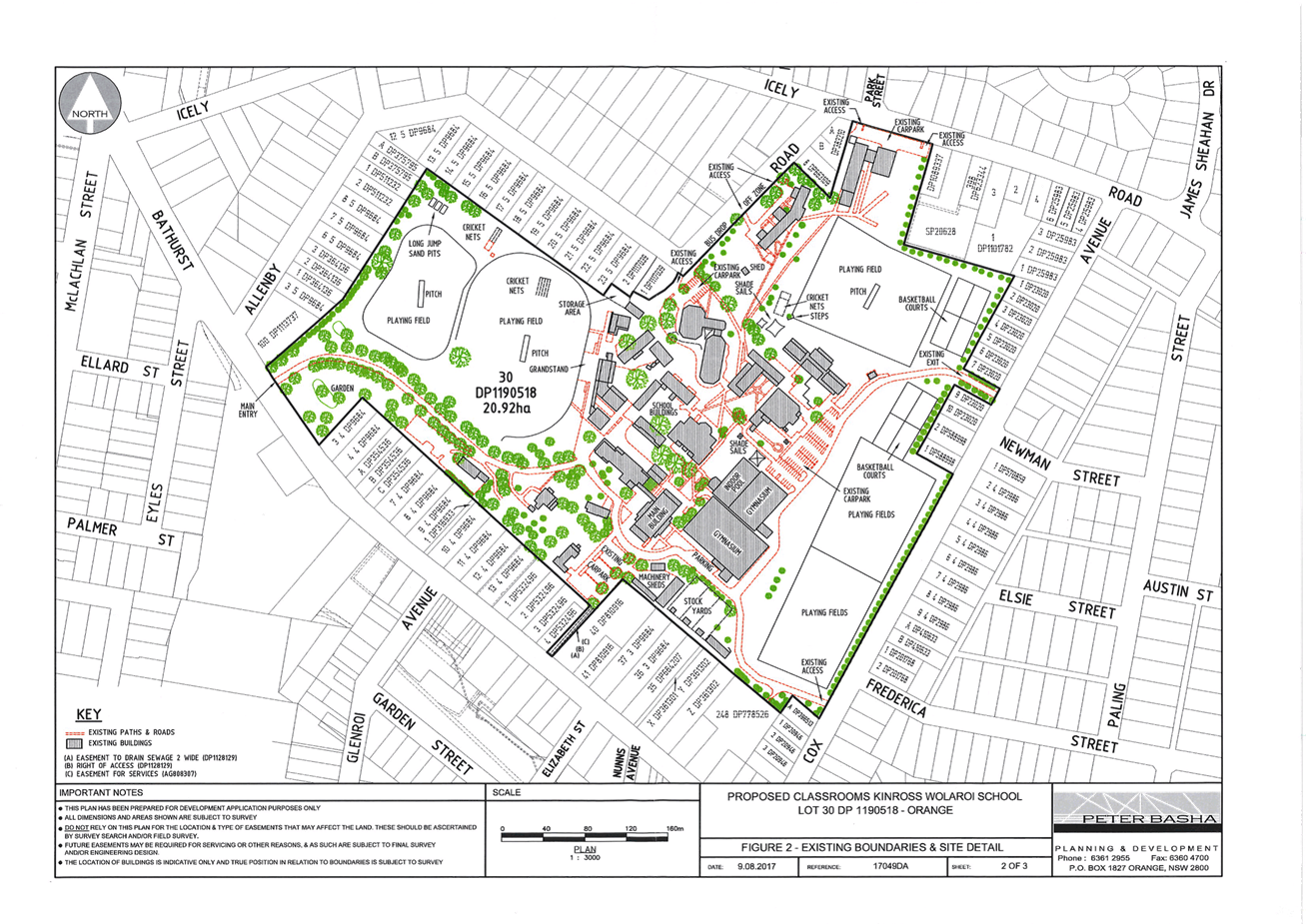
Council Meeting
3 October 2017
5.4 Development
Application - DA 299/2017(1) - 59-67 Bathurst Road
Attachment 2 Plans
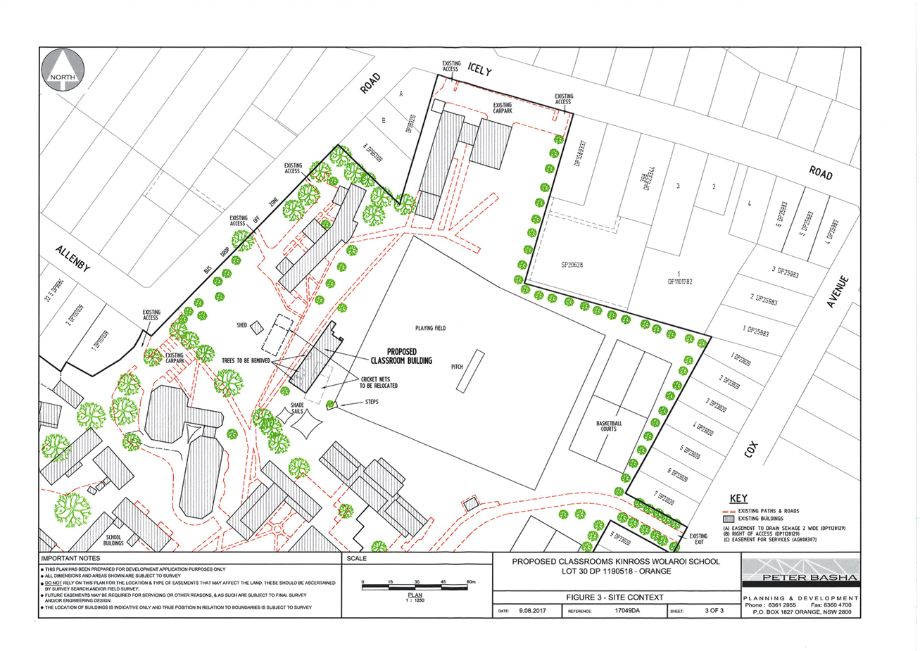
Council Meeting
3 October 2017
5.4 Development
Application - DA 299/2017(1) - 59-67 Bathurst Road
Attachment 2 Plans
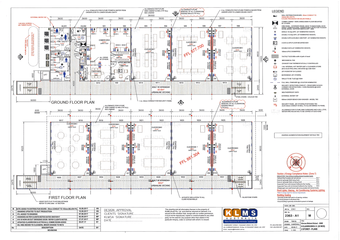
Council Meeting
3 October 2017
5.4 Development
Application - DA 299/2017(1) - 59-67 Bathurst Road
Attachment 2 Plans
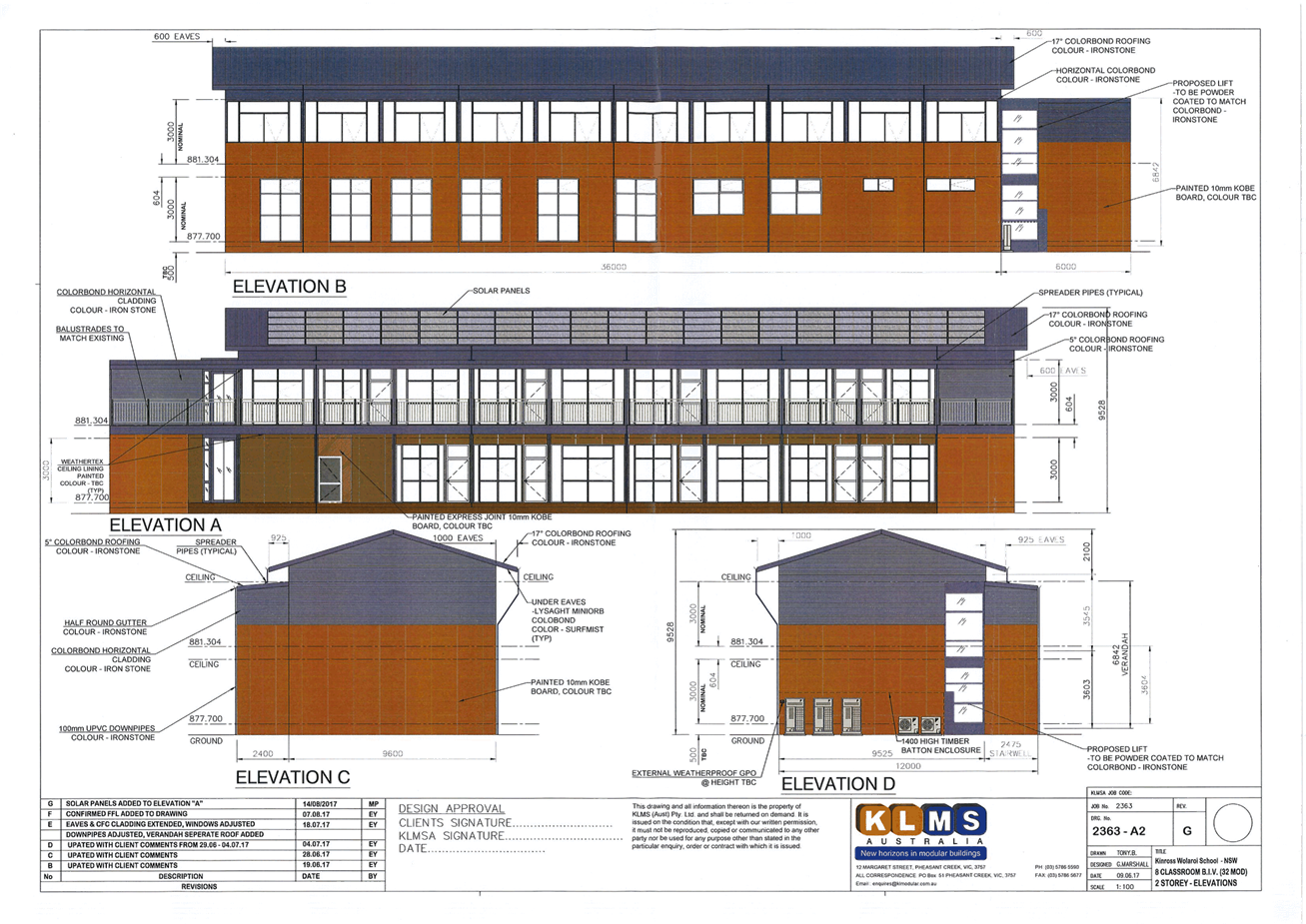
Council Meeting
3 October 2017
5.4 Development
Application - DA 299/2017(1) - 59-67 Bathurst Road
Attachment 2 Plans
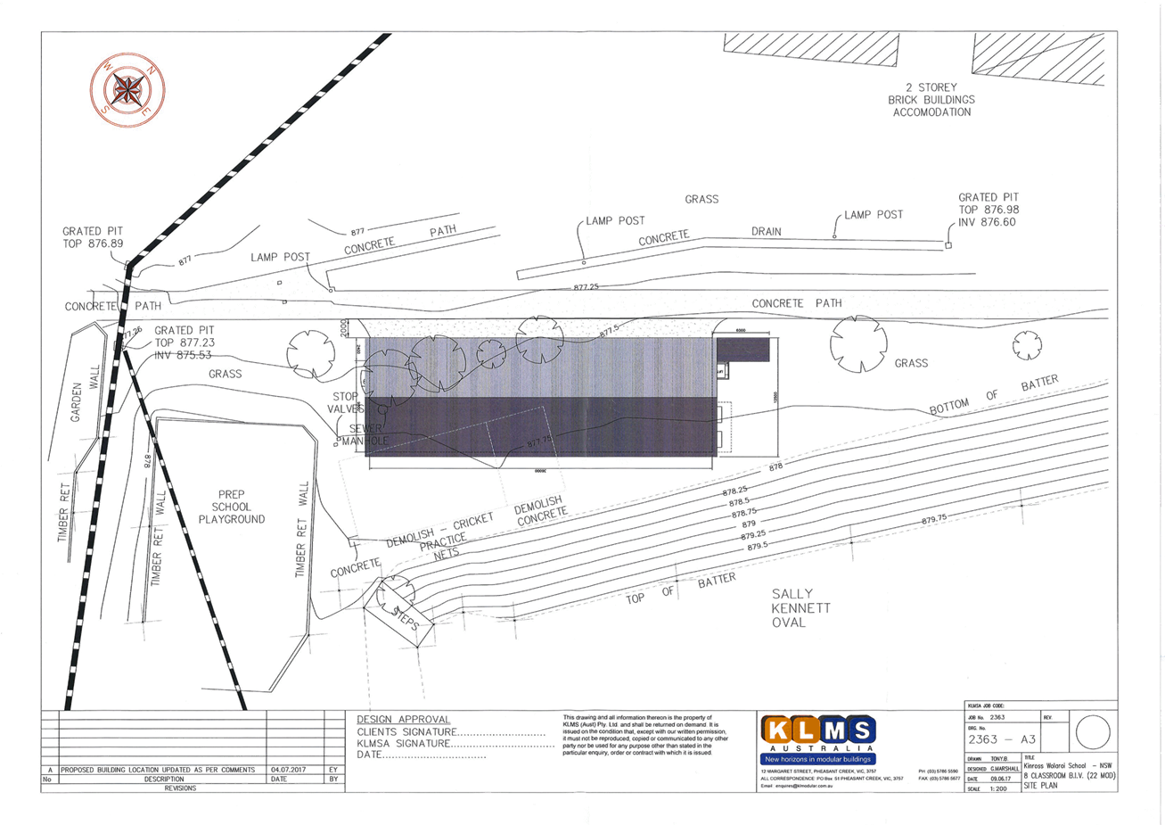
Council Meeting
3 October 2017
5.4 Development
Application - DA 299/2017(1) - 59-67 Bathurst Road
Attachment 3 Submissions
5.5 Additions
to Register of Fees and Charges
TRIM
REFERENCE: 2017/1959
AUTHOR: Michelle
Catlin, Manager Administration and Governance
EXECUTIVE Summary
At the Council Meeting held on 1 August 2017, Council
considered additional fees and charges relating to private works and to hire
fees of the Clover Hill Function Centre at the Orange Botanic Gardens. Council
resolved to place these additions on public exhibition which ended on 6
September 2017. No submissions were received during this exhibition period.
The amendments are therefore recommended to Council for
adoption.
Link To Delivery/OPerational Plan
The recommendation in this report relates to the
Delivery/Operational Plan strategy “1.3 Our City -
Ensure a robust framework that supports the community’s and
Council’s current and evolving activities, services and functions”.
Financial Implications
Nil
Policy and Governance Implications
Nil
|
Recommendation
That the following additions to the fees and charges be
adopted:
a Clover Hill
Function Centre
|
User
|
Fee ex GST
|
Fee Inc GST
|
|
Orange
City Council
|
no charge for all categories
|
|
Monday
to Friday (Function Room only)
|
|
Community
Groups – not for profit
|
|
|
|
Per
hour
|
$10
|
$12
|
|
5+
hours per day
|
$50
|
$55
|
|
Cleaning
fee
|
$100
|
$110
|
|
For
Profit Organisation
|
|
|
|
Per
hour
|
$20
|
$22
|
|
5+
hours per day
|
$100
|
$110
|
|
Cleaning
fee
|
$100
|
$110
|
|
Private
Hire – Non-commercial
|
|
|
|
Per
hour
|
$10
|
$12
|
|
5+
hours per day
|
$50
|
$55
|
|
Cleaning
fee
|
$100
|
$110
|
|
Private
Hire – Commercial
|
|
|
|
Per
hour
|
$20
|
$22
|
|
5+
hours per day
|
$100
|
$110
|
|
Cleaning
fee
|
$100
|
$110
|
|
Monday
to Friday (Use of Kitchen and Function Room)
|
|
Community
Groups – not for profit
|
|
|
|
Per
hour
|
$10
|
$12
|
|
5+
hours per day
|
$50
|
$55
|
|
Cleaning
fee
|
$100
|
$110
|
|
For
Profit Organisation
|
|
|
|
Per
hour
|
$20
|
$22
|
|
5+
hours per day
|
$100
|
$110
|
|
Cleaning
fee
|
$100
|
$110
|
|
Private
Hire – Non-commercial
|
|
|
|
Per
hour
|
$10
|
$12
|
|
5+
hours per day
|
$50
|
$55
|
|
Cleaning
fee
|
$100
|
$110
|
|
Private
Hire – Commercial
|
|
|
|
Per
hour
|
$20
|
$22
|
|
5+
hours per day
|
$100
|
$110
|
|
Cleaning
fee
|
$100
|
$110
|
|
Weekend
Hire (Function Room Only)
|
|
Community
Groups – not for profit
|
|
|
|
Hire
|
$250
|
$275
|
|
Security
bond
|
$250
|
$275
|
|
Cleaning
fee
|
$100
|
$110
|
|
For Profit
Organisation
|
|
|
|
Hire
|
$500
|
$550
|
|
Security
bond
|
$500
|
$550
|
|
Cleaning
fee
|
$100
|
$110
|
|
Private
Hire – Non-commercial
|
|
|
|
Hire
|
$250
|
$275
|
|
Security
bond
|
$250
|
$275
|
|
Cleaning
fee
|
$100
|
$110
|
|
Private
Hire – Commercial
|
|
|
|
Hire
|
$500
|
$550
|
|
Security
bond
|
$500
|
$550
|
|
Cleaning
fee
|
$100
|
$110
|
|
Weekend
Hire (Kitchen and Function Room)
|
|
Community
Groups – not for profit
|
|
|
|
Hire
|
$500
|
$550
|
|
Cleaning
fee
|
$200
|
$220
|
|
Security
bond
|
$250
|
$275
|
|
For
Profit Organisation
|
|
|
|
Hire
|
$750
|
$825
|
|
Cleaning
fee
|
$200
|
$220
|
|
Security
bond
|
$500
|
$550
|
|
Private
Hire – Non Commercial
|
|
|
|
Hire
|
$500
|
$550
|
|
Cleaning
fee
|
$200
|
$220
|
|
Security
bond
|
$250
|
$275
|
|
Private
Hire – Commercial
|
|
|
|
Hire
|
$750
|
$825
|
|
Cleaning
fee
|
$200
|
$220
|
|
Security
bond
|
$500
|
$550
|
|
|
|
|
|
B Private Works Management
|
Name
|
2017/18
|
|
Government Grant Roads and
Maritime Services (RMS) works on-cost on labour
|
36.90%
|
|
On-cost on labour wages
|
40%
|
|
On-cost on plant hire charges
|
30%
|
|
On-cost on material charges
|
10%
|
|
Administration on-cost of total
account including above on-cost
|
20%
|
|
further considerations
Consideration has been given to the
recommendation’s impact on Council’s service delivery; image and
reputation; political; environmental; health and safety; employees;
stakeholders and project management; and no further implications or risks have
been identified.
SUPPORTING INFORMATION
As Council was advised on 1 August, the bookings and
management of the Clover Hill Function Centre at the Orange Botanic Gardens has
reverted to Council staff. A framework of fees and charges is therefore
required to be adopted.
The fees in relation to private works management are
required to be resolved to clarify a formatting error in the Fees and Charges.
Following exhibition of these
proposed fees, and no public submissions, the fees are recommended for
adoption. Council must set all fees by resolution.
5.6 National
Local Roads and Transport Congress 2017
TRIM
REFERENCE: 2017/1927
AUTHOR: Catherine
Thomas, Executive Support Manager
EXECUTIVE Summary
The National Local Roads and Transport Congress will be held
in Albany, Western Australia from 6-8 November 2017. This Congress is hosted by
the Australian Local Government Association (ALGA). Traditionally the
Chairperson of the Infrastructure Policy Committee and relevant staff have
attended the conference.
Link To Delivery/OPerational Plan
The recommendation in this report relates to the
Delivery/Operational Plan strategy “14.1 Our Environment
– Design and construct new infrastructure assets as specified with the
Asset Management Plan to agreed levels of service”.
Financial Implications
The costs of the conference and associated accommodation are
provided for in the current Delivery/Operational Plan. Registration fees are
$990 per delegate with flights, accommodation and transfer fees or car
hire additional.
Policy and Governance Implications
In accordance with Council’s Strategic Policy ST020 Councillors
– Payment of Expenses and Provision of Facilities, Council will meet the
cost of registration, accommodation and travel expenses for those Councillors
attending the Congress. If a partner/spouse attends all expenses are to be
covered by the Councillor.
|
Recommendation
That Council resolve an attendee for the National
Local Roads and Transport Congress to be held in Albany, WA on 6-8 November
2017.
|
further considerations
Consideration has been given to the
recommendation’s impact on Council’s service delivery; image and
reputation; political; environmental; health and safety; employees;
stakeholders and project management; and no further implications or risks have
been identified.
SUPPORTING INFORMATION
The Congress is an opportunity for councils to come together
as a united force to develop and refine a coherent national case for improved
investment in Local Government roads as well as in other transport
infrastructure for which Local Government is responsible that impacts on our
community. The Congress is the only national Local Government event devoted
entirely to roads and transport.
The Congress program features key Ministers and federal
politicians as well as a range of experts relating to the theme and of interest
to Local Government. Each year the Congress moves location, rotating through
the states around Australia to a different regional city.
This year’s Congress, themed “Shaping
Transport’s Future”, will focus on discussion between all levels of
government on how roads and transport systems are managed and funded. Please
see attached the information brochure and Congress program together with a precis
of the keynote speakers.
The Congress will present an opportunity for delegates from
local government to put forward ideas and projects to demonstrate the strong
need for Commonwealth funding in this arena. It will also assist ALGA in making
the strongest case for Local Government roads and transport funding ahead of
the 2018/19 Federal Budget.
Attachments
1 National
Local Roads & Transport Congress 2017 - Information Brochure and Program,
D17/50458⇩
Council Meeting
3 October 2017
5.6 National
Local Roads and Transport Congress 2017
Attachment 1 National
Local Roads & Transport Congress 2017 - Information Brochure and Program

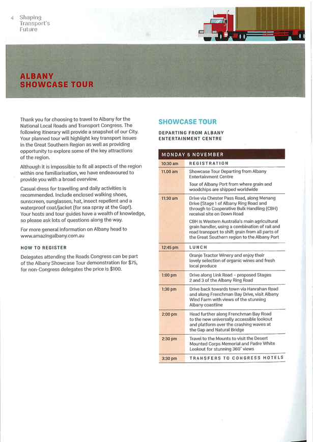
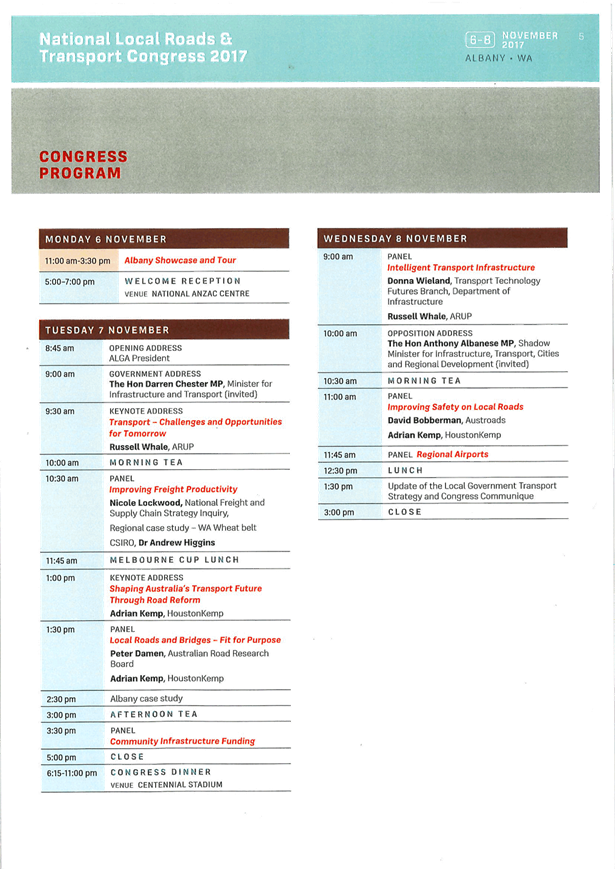
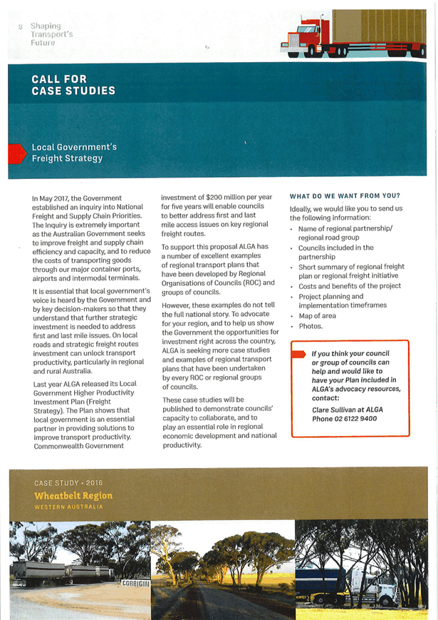

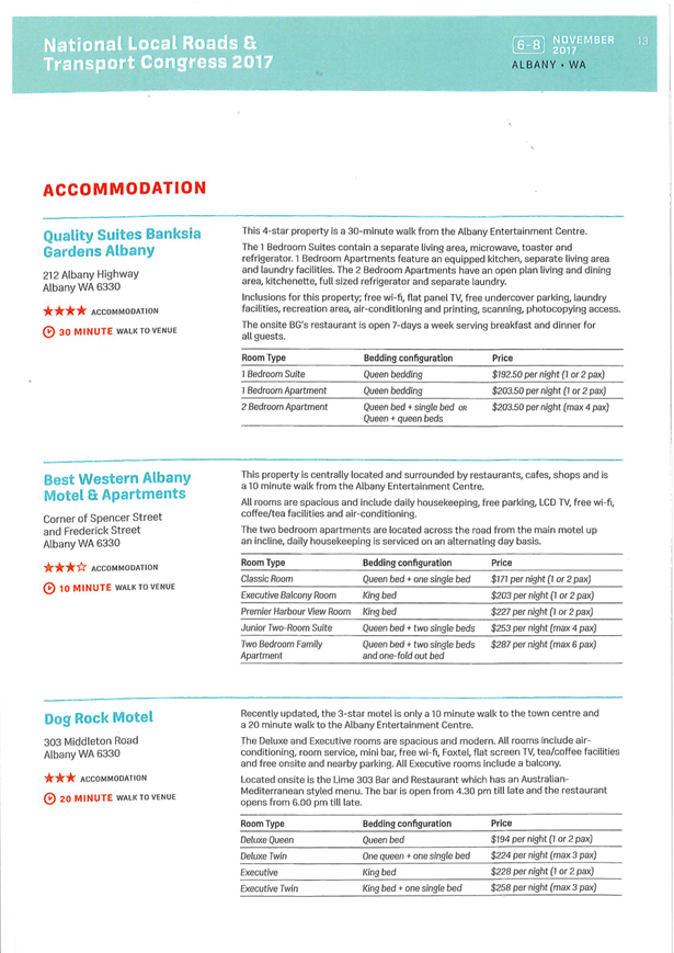
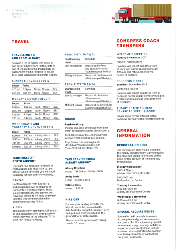
5.7 Stronger
Country Communities Fund
TRIM
REFERENCE: 2017/2057
AUTHOR: Nick
Redmond, Manager Corporate and Community Relations
EXECUTIVE Summary
Orange City Council has been allocated $1.9 million under
the Stronger Country Communities Fund (SCC). The SCC has been established by
the NSW Government to help deliver local infrastructure projects to regional communities.
“The purpose of the fund is to provide the kind of
infrastructure that improves the lives of local residents — from
park-lands to health centres and community halls. This fund will also help
regional communities across NSW continue to attract new residents and
visitors.”
The
government will fund $950,000 worth of projects in the first year of the
program, and $950,000 in the second year.
The
projects submitted total $3.6 million.
The SCC is one of a number of NSW Government funding
opportunities available. Others include Resources for Regions, Regional
Cultural Fund, Connecting County Communities and Growing Local Economies.
This report seeks to finalise a short list of projects to
submit to the NSW Government by the funding deadline on 18 October.
Link To Delivery/OPerational Plan
The recommendation in this report relates to the
Delivery/Operational Plan strategy “1.3 Our City -
Ensure a robust framework that supports the community’s and
Council’s current and evolving activities, services and functions”.
Financial Implications
The Council financial contributions listed in the body of
this report are for amounts already included in the Delivery/Operational Plan.
Operational and maintenance costs in some cases will be a carried by the
applicant to the fund such as the hockey field resurfacing and the domestic
violence crisis centre. However, there will be ongoing operational and
maintenance costs to Council for other projects such as Sir Jack Brabham new
amenities and the proposed new toilets.
It should also be noted that projects to date have only been
tested through quotes and quantity surveyor estimates as per the NSW Government
requirements. The projects will need to go through a further procurement
process which could include tenders. In these cases the estimates may vary.
Policy and Governance Implications
Nil
|
Recommendation
That Council determine the projects to be submitted to
the Stronger Country Communities fund.
|
further considerations
Consideration has been given to the
recommendation’s impact on Council’s service delivery; image and
reputation; political; environmental; health and safety; employees;
stakeholders and project management; and no further implications or risks have
been identified.
SUPPORTING INFORMATION
Council undertook a two part consultation process in
identifying projects for possible funding under the Stronger Country
Communities Fund.
The first stage sought nominations from the community for
funding. Council ran this process through the Orange Your Say online
consultation portal.
The eligibility requirement was to provide at least two
quotes in their application or one quote and one estimate from a quantity
surveyor or equivalent.
The projects also had:
“To ensure projects make a significant contribution
to improving local communities, the NSW Government is seeking projects of at
least $100,000 and typically in the range of $250,000 to $1 million per
project. Larger projects will be considered where there is significant
financial co-contribution. Applications will be called for on an annual basis over
the next two years. Councils will be assigned a time frame during which they
can apply. Projects submitted should be able to commence within a 12-month time
period and ideally be complete within two years of funding approval.”
The NSW Government’s eligibility requirements and the
tight timeframe meant a number of projects put forward did not get through the
first stage.
The community projects that did meet the threshold
requirements were then added to projects identified by Council.
These nine projects were then exhibited using the Your Say
site
The projects were:
· Under awning lighting in Central Business District
(CBD)
Project Description
The CBD of Orange is currently lit by an ageing system of
under-awning lighting. The proposal is to install a new system of pole-mounted
street lights to illuminate street and footpaths in Orange’s main
shopping precinct.
Total cost: $900,000 SCC
funds required: $700,000
Proponent: Orange City Council (Council funds $200,000)
· Footpaths including Active Travel Plan
Project Description
The proposal is an expansion of the footpaths
program.
The expanded program gives consideration to asset management
plans and the Active Travel Plan, which aims to make walking and bike riding a
more attractive option for getting around the city.
The new footpaths would be in addition to those already
identified in the 2017/18 budget.
The proposed additions include: Winter Street (Thomas
Brosnan to Icely), March Street (Spring to Dalton and Nile to Spring) Anson
Street (Matthews to Heatherbrae and Coombes to the Northern Distributor Roads)
and McNamara Street (Kite to Moulder).
Total cost: $640,000 SCC
funds required: $320,000
Proponent: Orange City Council (Council funds $320,000)
· Domestic Violence Crisis centre for women and children
Project Description
The proposal is to construct a
purpose-built crisis centre for women and children experiencing domestic
violence. The centre would include short-term high security beds,
self-contained units for more independence and eventually transitional housing.
Total cost: $1.77 million SCC
funds required: $670,000
Proponent: Housing Plus
· Sir Jack Brabham new amenities facilities (Stage 1)
Project Description
The Sir Jack Brabham Park sportsgrounds hosts a broad cross
section of sports, including softball, football (soccer), cricket and school
sport. The existing amenity buildings are located on the eastern and western
side of the 21 hectare sportsground.
The proposal is to construct a new amenities building near
the Forest Road softball diamonds to the south of the park. Facilities will
include accessible toilets, change rooms, showers and storage.
The proposal also includes a children’s playground
Total cost: $610,000
SCC funds required: $550,000
Proponent: Orange City Council (Council funds $60,000)
· Wade Park lighting
Project Description
In recent years Wade Park has undergone a number upgrades
including a new playing surface and LED scoreboard. The next priority is
lighting. The field lighting is in need of an upgrade to meet the requirements
of local and regional sporting competitions conducted at the venue, including
cricket, rugby league, rugby union, football and AFL. The lighting upgrade
would significantly improve the current lighting standard to ensure player
safety as well as providing improved experience for spectators.
Total cost: $240,000 SCC
funds required: $100,000
Proponent: Orange City Council (Council funds $140,000)
· Upgrades for Rotary Park and Somerset Parks
Project Description
The project aims to enhance the
community facilities at two of Orange's parks. This includes the installation
of a picnic shelter with table and seating, a BBQ and toilets at both Rotary
Park (on Mt Lindsay off Dalton Street) and Somerset Park (on the wetland area
between Molong Road and Burrendong Way). It also includes the construction of a
shade sail over the playground equipment at Somerset Park.
Total cost: $400,000
SCC funds required: $400,000
Proponent: Rotary Club of Orange
· Robertson Park toilet
Project Description
Robertson Park is a high-profile park in the centre of
Orange, which hosts a number of community events and festivals each year
including Anzac & Remembrance Day, FOOD Week and Wine Festival
night-markets as well as serving day-to-day as a passive recreation space for
shoppers and tourists. The proposal is to construct public toilet facilities in
Robertson Park alongside the existing CWA rooms.
Total cost: $270,000 SCC
funds required: $220,000
Proponent: Orange City Council (Council funds $50,000)
· Re-Surface a hockey playing field
Project Description
The project is to upgrade the playing surface of a hockey
field (known as the ‘Smith Field) at the Orange Hockey Centre. Currently
the field is a sand-based artificial turf field that is nearing the end of its
useful life. The club intends to replace the playing surface with a new water
based synthetic turf, installing the necessary infrastructure to be able to
water the field.
Total cost: $749,000 SCC
funds requested: $374,500
Proponent: Orange Hockey Club Inc
· Child-safe play area and car parking
Project Description
The proposal is to replace on-site parking at the Orange
Presbyterian Church on-site car parking areas with a landscaped area. The
church proposes to remove the hardstand areas and remediate the soil and adjust
the ground levels to provide soft landscaped lawn and trees as a safe area for
play. The church also proposes to provide a layout of 50 car spaces (including four
disabled spaces) to the south of the site.
Total cost: $290,000
SCC funds required: $290,000
Proponent: Orange Presbyterian Church
These projects were on exhibition for 10 days to 26
September.
669 people have visited the Stronger Country Communities
project on Orange City Council’s Your Say Orange website.
Of those, 314 people have contributed to the survey. The
survey asks people to select the three projects they believe should be
prioritised for funding.
The top projects were:
· The re-surfacing
of a hockey field with 182 votes
· A domestic
violence crisis centre for women and children with 160 votes
· A toilet for
Robertson Park with 90 votes.
All participants have registered as living within the Orange
region, as far as Forest reefs, Spring Hill and Lewis Ponds, to name a few.
The entirety of the consultation results can be found on the
following page.
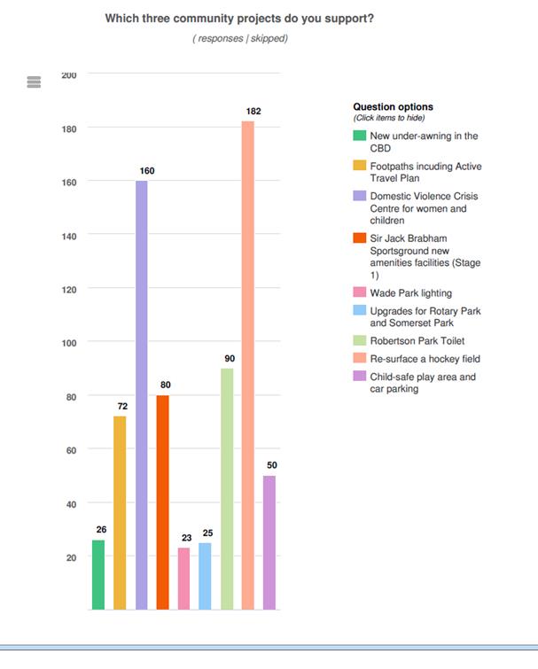
A project summary is as follows:
|
Applicant
|
Project
|
Project
costs
|
Funds
requested
|
Quotes
supplied
|
Located
on open public space
|
Cost
to Council
|
|
Orange City Council
|
CBD lighting upgrade
|
$900,000
|
$700,000
|
Yes
|
Yes
|
$200,000 plus ongoing operation and maintenance
|
|
Orange City Council
|
Expanded footpaths program
|
$640,000
|
$320,000
|
Yes
|
Yes
|
$320,000 plus ongoing operation and maintenance
|
|
Housing Plus
|
DV Crisis centre for women and children
|
$1.77M
|
$670,000
|
Yes
|
No
|
Assistance to date
|
|
Orange City Council
|
New amenities block Sir Jack Brabham
|
$610,000
|
$550,000
|
Yes
|
Yes
|
$50,000 plus ongoing operation and maintenance
|
|
Orange City Council
|
Wade Park lighting upgrade
|
$240,000
|
$100,000
|
Yes
|
Yes
|
$140,000 plus ongoing operation and maintenance
|
|
Rotary Club of Orange
|
Enhancing Rotary Park and Somerset Park
|
$400,000
|
$400,000
|
Yes
|
Yes
|
Connection to sewer plus ongoing operation and maintenance
|
|
Orange City Council
|
Toilet block Robertson Park
|
$270,000
|
$220,000
|
Yes
|
Yes
|
$50,000 plus ongoing operation and maintenance
|
|
Orange Hockey
|
Re-surface Hockey Field
|
$749,000
|
$374,500
|
Yes
|
No
|
Nil
|
|
Orange Presbyterian Church
|
Child safe landscaping and car parking
|
$290,000
|
$290,000
|
Yes
|
No
|
Nil
|
The deadline for submissions to the NSW Government is 18
October. The NSW Government will then have a commercial survey firm conduct online
random surveys within the LGA (at least 100 people) to ask them if they like
projects and rank them.
The NSW Government will review the survey and make a final
determination.
6 Closed Meeting
- See Closed Agenda
The General Manager will advise the Council if any written
submissions have been received relating to any item advertised for
consideration by a closed meeting of Orange City Council.
The Mayor will extend an invitation to any member of the
public present at the meeting to make a representation to Council as to whether
the meeting should be closed for a particular item.