2.2 Development
Application DA 150/2015(1) - Tenancy 5 - Summer Centre - Lot 1 Summer Street
TRIM
REFERENCE: 2015/1320
AUTHOR: Andrew
Crump, Senior Planner
EXECUTIVE Summary
|
Application
lodged
|
11 May
2015
|
|
Applicant/s
|
Mr SI
Munro
|
|
Owner/s
|
Australian
Executor Trustees Limited
|
|
Land
description
|
Lot 1 DP
1181850 - Tenancy 5 - Summer Centre - Summer Street, Orange
|
|
Proposed
land use
|
Shop
(fitout of a new butchery)
|
|
Value of
proposed development
|
$20,000
|
Council's consent is sought for
the fitout of a butcher shop within an existing tenancy within the Summer
Centre Shopping Centre. The land is described as Lot 1 DP 1181850, known as
Tenancy 5 - Summer Centre - Summer Street, Orange. The development is consistent
with Council’s planning provisions and is recommended for approval.
In accordance with Council’s resolution of 3 September
2013, as this development application is lodged by a Councillor, it is
presented to the Sustainable Development Committee for determination.
Link To Delivery/OPerational Plan
The recommendation in this report relates to the
Delivery/Operational Plan strategy “13.4 Our Environment
– Monitor and enforce regulations relating to City amenity”.
Financial Implications
Nil
Policy and Governance Implications
Nil
|
Recommendation
That Council consents to
development application DA 150/2015(1)
for Shop (fitout of a new butchery) at Lot 1 DP 1181850 -
Tenancy 5 - Summer Centre - Summer Street, Orange
pursuant to the conditions of consent in the attached Notice of Approval.
|
further considerations
Consideration has been given to the
recommendation’s impact on Council’s service delivery; image and
reputation; political; environmental; health and safety; employees;
stakeholders and project management; and no further implications or risks have
been identified.
SUPPORTING INFORMATION
THE APPLICATION
Council's consent is sought for
the fitout of a butcher shop within an existing tenancy within the Summer Centre
Shopping Centre. The land is described as Lot 1 DP 1181850, known as
Tenancy 5 - Summer Centre - Summer Street, Orange.
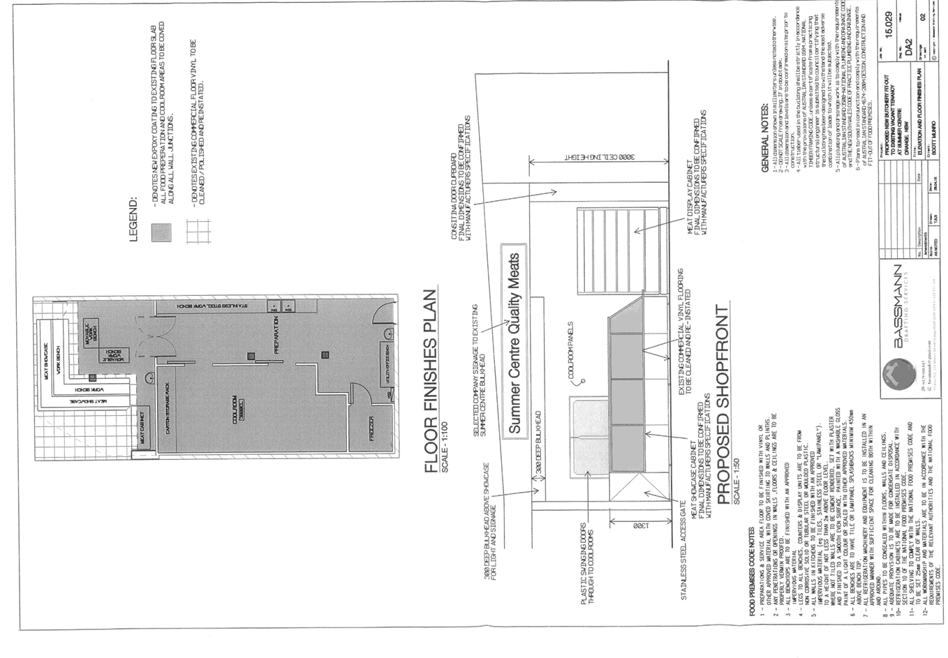
THE PROPOSAL
The proposal involves the installation of a coolroom,
freezer, preparation area, hand wash sinks, meat cabinets and counter areas.
The proposal also involves the installation of signage above the entrance to
the tenancy.
MATTERS FOR CONSIDERATION
Section 5A Assessment
In the administration of sections 78A, 79B, 79C, 111 and
112, the provisions of Section 5A must be taken into account for every
development application in deciding whether there is likely to be a significant
effect on threatened species, populations or ecological communities or their
habitats. This section includes a requirement to consider any adopted assessment
guidelines, which means assessment guidelines issued and in force under
section 94A of the Threatened Species Conservation Act 1995.
Assessment guidelines are in force (see DECC-W “Threatened Species
Assessment Guidelines - The Assessment of Significance”) which requires
consent authority to adopt the precautionary principle in its assessment.
In this instance, site inspection reveals that the subject
property has no biodiversity or habitat value.
Section 79C
Section 79C of the Environmental Planning and Assessment
Act 1979 requires Council to consider various matters, of which those
pertaining to the application are listed below.
PROVISIONS OF ANY ENVIRONMENTAL
PLANNING INSTRUMENT s79C(1)(a)(i)
Orange Local Environmental Plan 2011
Part 1 - Preliminary
Clause 1.2 - Aims of Plan
The
broad aims of the LEP are set out under subclause 2. Those relevant to the
application are as follows:
(a) to encourage development which complements
and enhances the unique character of Orange as a major regional centre boasting
a diverse economy and offering an attractive regional lifestyle,
(b) to provide for a range of development
opportunities that contribute to the social, economic and environmental
resources of Orange in a way that allows present and future generations to meet
their needs by implementing the principles for ecologically sustainable
development,
(f) to recognise and manage valued
environmental heritage, landscape and scenic features of Orange.
The application is considered to be consistent with aims (a),
(b) and (f) listed above.
Clause 1.6 - Consent Authority
This clause establishes that, subject to the Act, Council is
the consent authority for applications made under the LEP.
Clause 1.9A - Suspension of
Covenants, Agreements and Instruments
This clause provides that covenants, agreements and other
instruments which seek to restrict the carrying out of development do not apply
with the following exceptions.
· covenants imposed
or required by Council
· prescribed
instruments under Section 183A of the Crown Lands Act 1989
· any conservation
agreement under the National Parks and Wildlife Act 1974
· any trust
agreement under the Nature Conservation Trust Act 2001
· any property
vegetation plan under the Native Vegetation Act 2003
· any biobanking
agreement under Part 7A of the Threatened Species Conservation Act 1995
· any planning
agreement under Division 6 of Part 4 of the Environmental Planning and
Assessment Act 1979.
Council staff are not aware of the title of the subject
property being affected by any of the above.
Mapping
The subject site is identified
on the LEP maps in the following manner:
|
Land Zoning Map:
|
Land zoned Part B3 Commercial Core
and Part B4 Mixed Use
|
|
Lot Size Map:
|
No Minimum Lot Size
|
|
Heritage Map:
|
Located in Central Heritage conservation
area
|
|
Height of Buildings Map:
|
Building height limit part 12m and
part 9m
|
|
Floor Space Ratio Map:
|
Floor space limit Part 1.5:1 and
part 0.5:1
|
|
Terrestrial Biodiversity Map:
|
No biodiversity sensitivity on the
site
|
|
Groundwater Vulnerability Map:
|
Ground water vulnerable
|
|
Drinking Water Catchment Map:
|
Not within the drinking water
catchment
|
|
Watercourse Map:
|
Not within or affecting a defined
watercourse
|
|
Urban Release Area Map:
|
Not within an urban release area
|
|
Obstacle Limitation Surface Map:
|
No restriction on building siting
or construction
|
|
Additional Permitted Uses Map:
|
No additional permitted use applies
|
Those matters that are of
relevance are addressed in detail in the body of this report.
Part 2 - Permitted or
Prohibited Development
Land Use Zones
The subject site is located within the B3 Commercial Core and
B4 Mixed Use zones. The proposed development is defined as a “shop”
under OLEP 2011 which means:
premises that sell merchandise
such as groceries, personal care products, clothing, music, homewares,
stationery, electrical goods or the like or that hire any such merchandise, and
includes a neighbourhood shop, but does not include food and drink premises or
restricted premises.
Shops are a permissible land use within the B3 Commercial Core
and B4 Mixed Use zones with the consent of Council.
Clause 2.3 of LEP 2011
references the Objectives for each zone in LEP 2011. These objectives for
land zoned B3 Commercial Core and B4 Mixed Use are as follows:
1 - Objectives of the
B3
Commercial Core zone
· To
provide a wide range of retail, business, office, entertainment, community and
other suitable land uses that serve the needs of the local and wider community.
· To
encourage appropriate employment opportunities in accessible locations.
· To
maximise public transport patronage and encourage walking and cycling.
· To
promote development that contributes to the role of the Orange CBD as the
primary retail and business centre in the City and region.
The development is not inconsistent with the objectives of
the B3 Commercial Core zone.
1 - Objectives of the
B4
Mixed Use zone
· To
provide a mixture of compatible land uses.
· To
integrate suitable business, office, residential, retail and other development
in accessible locations so as to maximise public transport patronage and
encourage walking and cycling.
· To
promote, where possible, the retention and reuse of heritage items as well as
the retention of established buildings that contribute positively to the
heritage or cultural values of the land in the zone.
· To
promote development that supports the role of Orange CBD as the primary retail
and business centre in the region.
The development is not inconsistent with the objectives of
the B4 Mixed Use zone.
Part 3 - Exempt and
Complying Development
The application is not exempt or complying development.
Part 5 -
Miscellaneous Provisions
5.10 - Heritage Conservation
The subject land is located in the Central Heritage
Conservation Area.
(1) Objectives
The
objectives of this clause are as follows:
(a) to
conserve the environmental heritage of Orange,
(b) to
conserve the heritage significance of heritage items and heritage conservation
areas, including associated fabric, settings and views,
(c) to
conserve archaeological sites,
(d) to
conserve Aboriginal objects and Aboriginal places of heritage significance.
The proposed fitout is situated within a tenancy within an
existing commercial building, with no alterations to the exterior of the
building proposed. As such, the development will have no material impacts upon
the significance of the heritage conservation area.
Part 7 - Additional
Local Provisions
7.3 - Stormwater
Management
This clause applies
to all industrial, commercial and residential zones and requires that Council
be satisfied that the proposal:
(a) is designed to maximise the use of water
permeable surfaces on the land having regard to the soil characteristics
affecting onsite infiltration of water
(b) includes, where practical, onsite
stormwater retention for use as an alternative supply to mains water,
groundwater or river water; and
(c) avoids any significant impacts of
stormwater runoff on adjoining downstream properties, native bushland and
receiving waters, or if that impact cannot be reasonably avoided, minimises and
mitigates the impact.
The development will
not alter existing stormwater arrangements.
7.6 - Groundwater Vulnerability
This clause seeks to
protect hydrological functions of groundwater systems and protect resources
from both depletion and contamination. Orange has a high water table and large
areas of the LGA, including the subject site, are identified with
“Groundwater Vulnerability” on the Groundwater Vulnerability Map.
This requires that Council consider:
(a) whether or not the development (including
any onsite storage or disposal of solid or liquid waste and chemicals) is
likely to cause any groundwater contamination or have any adverse effect on
groundwater dependent ecosystems, and
(b) the cumulative impact (including the
impact on nearby groundwater extraction for potable water supply or stock water
supply) of the development and any other existing development on groundwater.
Furthermore consent may not be granted unless Council is satisfied that:
(a) the development is designed, sited and
will be managed to avoid any significant adverse environmental impact, or
(b) if that impact cannot be reasonably
avoided - the development is designed, sited and will be managed to minimise
that impact,
(c) if that impact cannot be minimised - the
development will be managed to mitigate that impact.
The proposal is not
anticipated to involve the discharge of toxic or noxious substances and is
therefore unlikely to contaminate the groundwater or related ecosystems. The proposal
does not involve extraction of groundwater and will therefore not contribute to
groundwater depletion.
STATE ENVIRONMENTAL PLANNING
POLICIES
There are no State Environmental Planning Policies that
apply to the subject development.
PROVISIONS OF ANY DRAFT
ENVIRONMENTAL PLANNING INSTRUMENT THAT HAS BEEN PLACED ON EXHIBITION
s79C(1)(a)(ii)
There are no draft environmental planning instruments that
apply to the subject land or proposed development.
DESIGNATED DEVELOPMENT
The proposed development is not designated development.
PROVISIONS OF ANY DEVELOPMENT
CONTROL PLAN s79C(1)(a)(iii)
Development Control Plan 2004
Development Control Plan 2004
(“the DCP”) applies to the subject land (Part 0 - Local
Environmental Plan 2011, Part 8 - Development in Business Zones and
Part 15 - Car Parking).
Part 0 - Local Environmental
Plan 2011
Part 0 of DCP 2004 establishes
which chapters of the DCP are applicable in instances of new zonings under LEP
2011. This is pertinent given the subject land's new zoning, being B3 Commercial
Core and B4 Mixed Use. Part 0 provides that Part 8 of Orange DCP 2004 is
applicable to these zones.
Part 8 -
Development in Business Zones
The development is not
inconsistent with the CBD Strategic Action Plan. The proposed development will
complement the CBD and provide additional choice and variety of meat products
for residents within Orange.
Car parking is addressed below.
Loading and unloading
arrangements are to be made through the designated loading area during the hours
required under DA 21/2010(4). There are no objections to the loading/ unloading
arrangements.
The only signage proposed as
part of the application is located internally within the shopping centre and
does not require consent.
Part 15 -
Car Parking
Car parking was addressed under the original consent
(DA 21/2010(4)). Under that assessment the rate of 4.1 spaces per 100m2
was applied. The proposed use will not alter that previous assessment.
The development is satisfactory in terms of parking.
PROVISIONS PRESCRIBED BY THE REGULATIONS
s79C(1)(a)(iv)
The development is consistent with the provisions prescribed
by the Regulations.
THE LIKELY IMPACTS OF THE
DEVELOPMENT s79C(1)(b)
Traffic and Access Impacts
The development will be
adequately serviced by the existing public road network. Access and parking
arrangements are adequate for the proposal. It is considered that the
development will not present any adverse impacts in terms of traffic or access
in this instance.
Visual
Impacts
The development is wholly
located within an existing shopping centre. As such, the development is not
likely to present any impacts to the visual amenity of the surrounding commercial
or residential precincts.
Cumulative
Impacts
Council needs to be satisfied
that a development will not present any cumulative impacts to the locality. The
likely cumulative impacts associated with the shopping centre were addressed as
part of the original consent. As mentioned above, the car parking requirements
for this development will not present an unreasonable increase in the demand
for parking over and above the original approval for the shopping centre.
Therefore, the development will not cause a cumulative impact through a net
increase in the demand for parking in this instance. It is considered that the
development will have negligible cumulative impacts upon the locality.
Noise
Impacts
The development will present a
degree of noise associated with the construction phase for the fitout of the premises.
A condition is attached requiring construction times to be limited to
acceptable hours.
In regards to the ongoing
operation of the use of the land as a shop, the applicant submits that trading
hours will comprise the following:
8am - 6pm Monday – Saturday inclusive with extended trading to
8pm on Thursdays and 9am - 4pm Sundays.
Council staff raise no
objections to these times.
Deliveries
and Loading Dock
The original consent relating to
DA 21/2010(4) placed a condition on the development for deliveries to use
the designated loading dock between the hours of 7am to 6pm Monday to Saturday,
and 8pm to 6pm Sundays and Public Holidays. It is therefore appropriate to
attach a condition in this regard.
Social and
Economic Impacts
The development is likely to
present positive social and economic impacts. The development will facilitate
the establishment of a new business and increase the opportunity for employment
within the City of Orange.
THE SUITABILITY OF THE SITE
s79C(1)(c)
The subject land is suitable for the development. Required
services are available and adequate for the development. There are no physical
features that may constrain the development. The land is not subject to known
technological or natural hazards.
ANY SUBMISSIONS MADE IN ACCORDANCE
WITH THE ACT s79C(1)(d)
The proposed development is not defined as advertised
development under the provisions of the LEP, and as such no formal exhibition
of the application was required. No submissions have been received in relation
to this application.
PUBLIC INTEREST
s79C(1)(e)
The proposed development is considered to be of minor
interest to the wider public due to the relatively localised nature of
potential impacts. The proposal is not inconsistent with any relevant policy
statements, planning studies, guidelines etc that have not been considered in
this assessment.
SUMMARY
The proposed development is permissible with the consent of
Council. The proposed development complies with the relevant aims, objectives
and provisions of the LEP. A section 79C assessment of the
development indicates that the development is acceptable in this instance.
Attached is a draft Notice of Approval outlining a range of conditions
considered appropriate to ensure that the development proceeds in an acceptable
manner.
COMMENTS
The requirements of the Environmental Health and Building
Surveyor and the Engineering Development Section are included in the attached
Notice of Approval.
Attachments
1 Notice
of Approval, D15/15252⇩
2 Plans,
D15/14994⇩
2.3 Development
Application DA 203/2013(1) - 235 and 237 Leeds Parade
TRIM
REFERENCE: 2015/1322
AUTHOR: Paul
Johnston, Planning Team Leader
EXECUTIVE Summary
|
Application
lodged
|
1 July 2013
|
|
Applicant/s
|
Bunnings
Properties Pty Ltd
|
|
Owner/s
|
Bunnings
Properties Pty Ltd
|
|
Land
description
|
Lot 3 DP 1185665 and Lot 8 DP 7214
- 235 and 237 Leeds Parade, Orange
|
|
Proposed
land use
|
Hardware and Building Supplies
(construction of new store), Subdivision (consolidation of land), Demolition
(existing dwelling and associated outbuildings), Signage and Subdivision (two
lot industrial)
|
|
Value of
proposed development
|
$16,500,000
|
Council's consent is sought for
construction of a hardware and building supplies store for Bunnings, demolition
of existing dwelling and associated outbuildings, signage, subdivision
(consolidation of land), and subdivision (two lot industrial) on land described
as Lot 3 DP 1185665 and Lot 8 DP 7214, known as 235 and 237
Leeds Parade, Orange.
The site the subject of this development application is
located to the northeast of the developed urban area of Orange. The site is
bounded to the south by the Northern Distributor Road (NDR), to the east by
Leeds Parade and to the west by the Main Western Railway Line. The site has an
overall area of 8.58 hectares.
In order to create the development site the applicant will
be required to consolidate the subject land into a single allotment. Following
consolidation of the land the applicant proposes to erect a Bunnings hardware
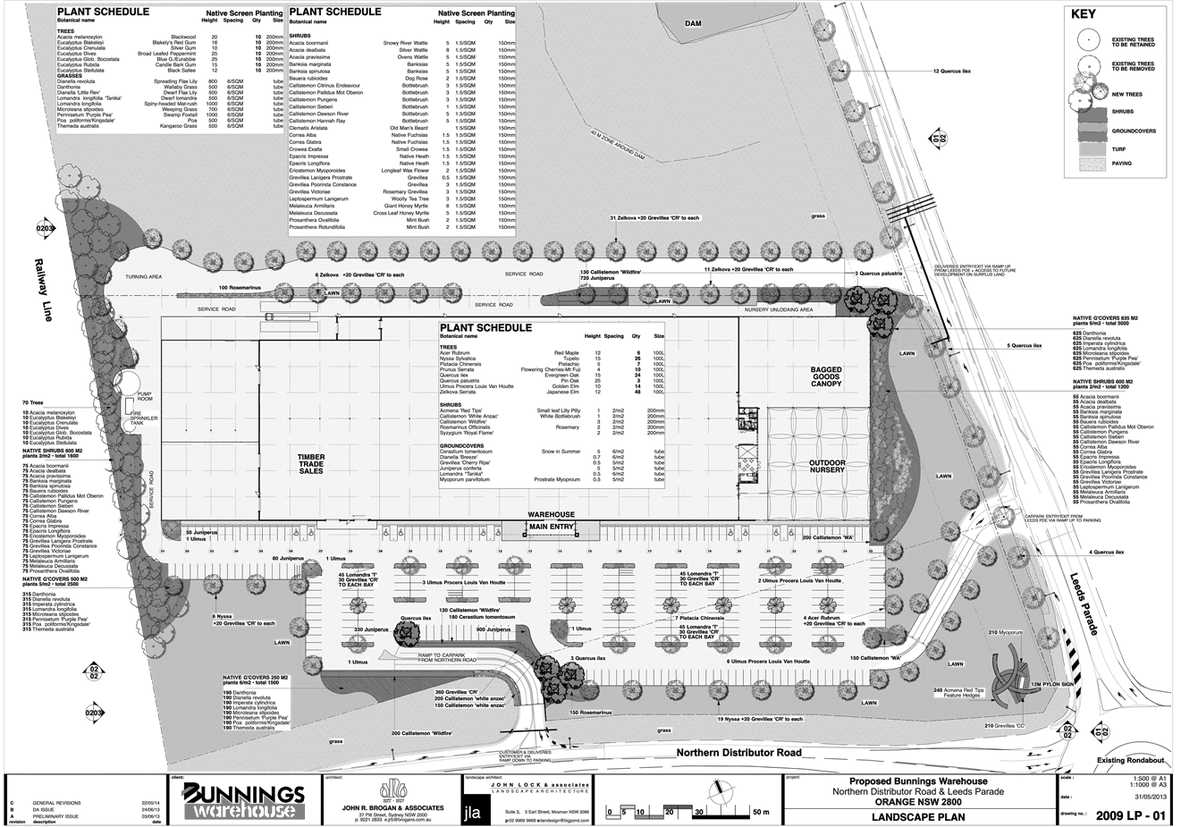
and building supplies store which will include the following:
· 9,150m²
warehouse offering for sale goods or materials relating to the construction and
maintenance of buildings and related outdoor areas
· 1,655m²
bagged goods area
· 1,395m²
outdoor nursery
· 2,635m²
timber trade sales
· 1,200m²
bulk trade area
· 920m²
building materials and landscape yard
· 60m²
café for customers providing approximately 20 seats
· establishment
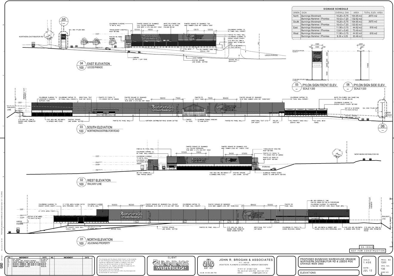
of advertising signage. Signage will comprise painted wall signs on four
elevations of the building and one pylon sign adjacent to the NDR. The
proposed pylon sign comprises dimensions 12m high and 4.3m wide, with a sign
face that is 4m x 4.5m. This sign is proposed to be illuminated by top mounted,
downward facing lights.
· car
park
Council is advised that the proposed hours of operation of
the store would be:
· weekdays:
6am - 10pm
· Saturdays,
Sundays and Public Holidays: 6am - 7pm
It is anticipated that the development will employ
approximately 160 full time/part time staff in conjunction with the proposed
operation.
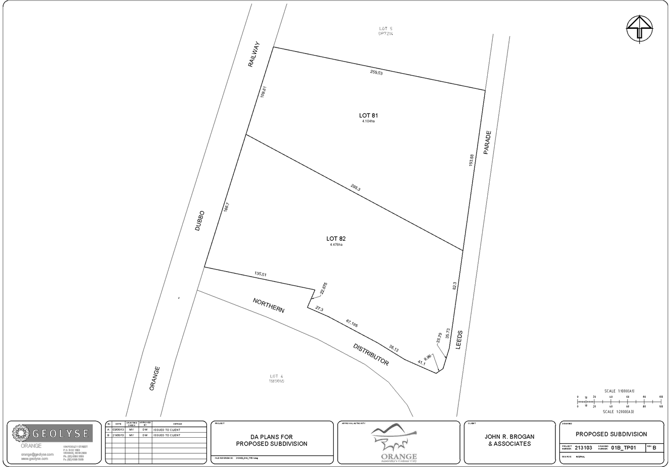
The applicant has also sought consent for a two lot
industrial subdivision of the land. Proposed lot 81 will be vacant comprising
an area of 4.1 hectares. Proposed lot 82 will contain the Bunnings store and
comprise an area of 4.47 hectares.
The main issues for consideration relate to parking, visual
bulk, setbacks and height of the proposed pylon signage. A section 79(C)
assessment of the proposed development indicates that the development is
acceptable with the exception of the proposed height of the pylon sign. It is
recommended that the height of the proposed pylon sign be reduced in height
such that it is no higher than 8m.
It is recommended that Council supports the proposed
development subject to the conditions in the attached Notice of Approval.
Link To Delivery/OPerational Plan
The recommendation in this report relates to the
Delivery/Operational Plan strategy “13.4 Our Environment
– Monitor and enforce regulations relating to City amenity”.
Financial Implications
Nil
Policy and Governance Implications
Nil
|
Recommendation
That Council consents to development application DA
203/2013(1) for Hardware and Building Supplies (construction of new
store), Subdivision (consolidation of land), Demolition (existing dwelling
and associated outbuildings), Signage and Subdivision (two lot industrial)
at Lot 3 DP 1185665 and Lot 8 DP 7214 - 235 and 237 Leeds Parade, Orange
pursuant to the conditions of consent in the attached Notice of Approval.
|
further considerations
Consideration has been given to the
recommendation’s impact on Council’s service delivery; image and
reputation; political; environmental; health and safety; employees;
stakeholders and project management; and no further implications or risks have
been identified.
SUPPORTING INFORMATION
THE APPLICATION
Council's consent is sought for construction of a hardware
and building supplies store for Bunnings, subdivision (consolidation of land),
demolition of existing dwelling and associated outbuildings, signage and a two
lot industrial subdivision on land described as Lot 3 DP 1185665 and
Lot 8 DP 7214 - 235 and 237 Leeds Parade, Orange.
THE PROPOSAL
The subject site located on land described as Lot 3 DP
1185665 and Lot 8 DP 7214 – 235 and 237 Leeds Parade being
situated on the north western corner of the Northern Distributor Road and Leeds
Parade. The site currently occupied by a dwelling. The proposed development
involves the following:
· consolidation of
land described as Lot 3 DP 1185665 and Lot 8 DP 7214 into a single allotment of
land.
· development of a
hardware and building supplies store including the following:
- 9,150m²
warehouse offering for sale goods or materials relating to the construction and
maintenance of buildings and related outdoor areas
- 1,655m²
bagged goods area
- 1,395m²
outdoor nursery
- 2,635m²
timber trade sales
- 1,200m²
bulk trade area
- 920m²
building materials and landscape yard and
- 60m²
café for customers providing approximately 20 seats
- car park
· a
two lot subdivision of the land as follows:
|
Proposed
Lot
|
Proposed
Size
|
Proposed
Use
|
|
81
|
4.1
hectares
|
Vacant
development lot
|
|
82
|
4.47
hectares
|
Hardware
and building supplies
|
|
TOTAL
|
8.57
hectares
|
|
Access to the northern lot
(proposed Lot 81) will be via a proposed accessway to be built from Leeds
Parade. This road would also benefit from a right of carriageway in favour of
Lot 82 to enable use by delivery vehicles visiting the Bunnings store. The
residue lot would be provided with connections to necessary services.
· advertising: wall
signage is proposed on all four elevations, as depicted on John R Brogan &
Associates Drawing 130_P4. This signage is proposed to be painted directly onto
the wall and would be formed of the company’s name and slogan.
A pylon sign is proposed to be erected adjacent to the NDR. The size of
the pylon sign comprises dimensions 12m high and 4.3m wide, with a sign face
that is 4m x 4m. This sign is proposed to be illuminated by top
mounted, downward facing lights
· hours of operation
of the store would be:
weekdays:
6am–10pm
Saturdays,
Sundays and Public Holidays: 6am-7pm
· approximately 160
full time/part time staff would be employed in conjunction with the proposed
operation.
MATTERS FOR CONSIDERATION
Section 5A Assessment
In the administration of sections 78A, 79B, 79C, 111 and
112, the provisions of Section 5A must be taken into account for every
development application, in deciding whether there is likely to be a
significant effect on threatened species, populations or ecological communities
or their habitats. This section includes a requirement to consider any adopted
assessment guidelines, which means assessment guidelines issued and in force
under section 94A of the Threatened Species Conservation Act 1995.
Assessment guidelines are in force (see DECC-W “Threatened Species
Assessment Guidelines - The Assessment of Significance”) which requires
consent authority to adopt the precautionary principle in its assessment.
In this instance, site inspection reveals that the subject
property has no biodiversity or habitat value.
Section 79C
Section 79C of the Environmental Planning and Assessment
Act 1979 requires Council to consider various matters, of which those
pertaining to the application are listed below.
Integrated Development
The proposed development is classified as Integrated
Development by virtue of the following:
· proposed road
widening and development of the northern access are within 40m of the onsite
waterway, therefore triggering a requirement for a controlled activity approval
and the integrated development process.
Council is in receipt of the General terms of Approval from
the NSW Office of Water. The requirements of that department have been
incorporated into the attached Notice of Approval.
PROVISIONS OF ANY ENVIRONMENTAL
PLANNING INSTRUMENT s79C(1)(a)(i)
Orange Local Environmental Plan 2011
Part 1 - Preliminary
This part of the plan is largely administrative in nature
and has minimal implications for the proposal.
Clause 1.2 - Aims of Plan
The broad aims of the LEP are
set out under subclause 2. Those relevant to the application are as follows:
(a) to encourage development which complements
and enhances the unique character of Orange as a major regional centre boasting
a diverse economy and offering an attractive regional lifestyle,
(b) to provide for a range of development
opportunities that contribute to the social, economic and environmental
resources of Orange in a way that allows present and future generations to meet
their needs by implementing the principles for ecologically sustainable
development,
(c) to conserve and enhance the water
resources on which Orange depends, particularly water supply catchments,
The application is considered to be consistent with the
relevant aims of LEP 2011.
Clause 1.6 - Consent Authority
This clause establishes that, subject to the Act, Council is
the consent authority for applications made under the LEP.
Clause 1.9A - Suspension of
Covenants, Agreements and Instruments
This clause provides that covenants, agreements and other
instruments which seek to restrict the carrying out of development do not apply
with the following exceptions.
· covenants
imposed or required by Council
· prescribed
instruments under Section 183A of the Crown Lands Act 1989
· any
conservation agreement under the National Parks and Wildlife Act 1974
· any
trust agreement under the Nature Conservation Trust Act 2001
· any
property vegetation plan under the Native Vegetation Act 2003
· any
biobanking agreement under Part 7A of the Threatened Species Conservation
Act 1995
· any planning
agreement under Division 6 of Part 4 of the Environmental Planning and
Assessment Act 1979.
The subject land is affected by an
existing Essential Energy 66,000 volt power line which traverses the western
boundary of the subject land. The applicant has furnished Council with a copy
of a letter from Essential Energy dated 5 May 2015 which outlines the specific
requirements of Essential Energy in response to the proposed development.
Essential Energy has indicated that they require the creation of an appropriate
easement with respect to this power line as part of the consolidation of the
land to which this application relates. Essential Energy has indicated in the
letter dated 5 May 2015 that they agree in principle to support a reduced width
easement in order to accommodate the proposed development subject to certain
works being undertaken. Attached to the draft Notice of Approval is a condition
of consent which requires the applicant to obtain the relevant certification from
Essential Energy prior to the issue of a Subdivision Certificate for the
consolidation of the land. Consolidation of the land is required to be
undertaken prior to the issue of an interim Occupation Certificate for the
proposed building.
Council is not aware that the land
being affected by any other of the above covenants, agreements and other
instruments which seek to restrict the carrying out of development.
Mapping
The subject site is identified
on the LEP maps in the following manner:
|
Land Zoning Map:
|
Land zoned IN1 General Industrial
|
|
Lot Size Map:
|
Minimum Lot Size 2000m2
|
|
Heritage Map:
|
Not a heritage item or conservation
area
|
|
Height of Buildings Map:
|
No building height limit
|
|
Floor Space Ratio Map:
|
No floor space limit
|
|
Terrestrial Biodiversity Map:
|
No biodiversity sensitivity on the
site
|
|
Groundwater Vulnerability Map:
|
Ground water vulnerable
|
|
Drinking Water Catchment Map:
|
Not within the drinking water
catchment
|
|
Watercourse Map:
|
Not within or affecting a defined watercourse
|
|
Urban Release Area Map:
|
Not within an urban release area
|
|
Obstacle Limitation Surface Map:
|
No restriction on building siting
or construction
|
|
Additional Permitted Uses Map:
|
No additional permitted use applies
|
Those matters that are considered
to be of relevance have been addressed in detail in the body of this report.
Part 2 -
Permitted or Prohibited Development
Land Use Zones
The subject site is located within the IN1 General
Industrial zone. The proposed development is defined as “hardware and
building supplies”, “signage” and “subdivision”
under the provisions of Orange LEP 2011.
Pursuant to the LEP 2011
Dictionary, the following definitions relate:
Hardware
and building supplies means a building or place the principal purpose of
which is the sale or hire of goods or materials, such as household fixtures,
timber, tools, paint, wallpaper, plumbing supplies and the like, that are used
in the construction and maintenance of buildings and adjacent outdoor areas.
Signage means any sign,
notice, device, representation or advertisement that advertises or promotes any
goods, services or events and any structure or vessel that is principally
designed for, or that is used for, the display of signage, and includes any of
the following:
(a) an
advertising structure,
(b) a
building identification sign,
(c) a
business identification sign,
but does
not include a traffic sign or traffic control facilities.
Pursuant to section 4B of the Environmental Planning and
Assessment Act subdivision of land means:
the division
of land into two or more parts that, after the division, would be obviously
adapted for separate occupation, use or disposition.
The proposed development is
permissible subject to receiving the development consent of Council.
Clause 2.3 of LEP 2011 references the Land Use Table
and Objectives for each zone in LEP 2011. These objectives for land zoned
IN1 General Industrial are as follows:
1 - Objectives of the IN1 General Industrial Zone
· To
provide a wide range of industrial and warehouse land uses.
· To
encourage employment opportunities.
· To
minimise any adverse effect of industry on other land uses.
· To
support and protect industrial land for industrial uses.
· To
ensure development along the Southern Link Road has an alternative access.
Whilst the development is not an industrial or warehouse
use, hardware and building supplies premises is a permissible use. The proposed
development is consistent with the objectives of the IN1 zone. In this regard
the proposal is considered to represent an employment generating development
that is appropriately located in an industrial area.
7.1 -
Earthworks
This clause establishes a range
of matters that must be considered prior to granting development consent for
any application involving earthworks, such as:
(a) the likely disruption of, or any
detrimental effect on, existing drainage patterns and soil stability in the
locality of the development
(b) the effect of the development on the
likely future use or redevelopment of the land
(c) the quality of the fill or the soil to be
excavated, or both
(d) the effect of the development on the
existing and likely amenity of adjoining properties
(e) the source of any fill material and the
destination of any excavated material
(f) the likelihood of disturbing relics
(g) the proximity to and potential for adverse
impacts on any waterway, drinking water catchment or environmentally sensitive
area
(h) any measures proposed to minimise or mitigate
the impacts referred to in paragraph (g).
The earthworks proposed are considered to be significant. The
proposed development will require cut and fill to achieve the proposed finished
floor level. The natural ground levels within proposed Lot 82 range from
approximately 888.29m AHD to 874.09m AHD. The proposed floor level is
883m AHD. Excess fill is proposed to be placed on the northern extent of
the site. The applicant advises that any excess fill would be disposed of at an
appropriate waste management facility.
The extent of the earthworks
will not materially affect the potential future use or redevelopment of the
site that may occur at the end of the proposed development's lifespan. The
extent of disruption to the drainage of the site is considered to be minor and
will not detrimentally affect adjoining properties or receiving waterways. The
proposed development is integrated development and the NSW Office of Water has
issued General Terms of Approval which addresses issues associated with the
discharge of stormwater to the adjoining creek system.
The submitted plans show that
the earthworks will be appropriately supported onsite, and whilst the change in
ground level is reasonably significant to support the development, it is not
considered to be unreasonable given the scale of the development. Therefore the
effect on the amenity of adjoining properties is considered to be minor.
The site is not known to be
contaminated.
The site is not known to contain
any Aboriginal, European or archaeological relics. Previous known uses of the
site do not suggest that any relics are likely to be uncovered. However, a
condition has been imposed to ensure that should site works uncover a potential
relic or artefact, works will be halted to enable proper investigation by
relevant authorities and the proponent required to seek relevant permits to
either destroy or relocate the findings.
The proposed development is
located in proximity to a prescribed stream which flows directly into
Council’s stormwater harvesting infrastructure. Attached to the Notice of
Approval are conditions that specifically relate to stormwater management of
the site. Council’s Subdivision and Development Code specifies the need
for stormwater retention to be provided so as to ensure that post-development
flows are no greater than pre-development flows. The General Terms of Approval
from the NSW Office of Water specify that the stormwater system incorporates
measures to ensure that stormwater leaving the site has been appropriately
treated. The applicant will be required to submit a detailed engineering plan
for approval of both Orange City Council and the NSW Office of Water prior to
the issue of a Construction Certificate.
7.3 -
Stormwater Management
This clause applies to all
industrial, commercial and residential zones and requires that Council be
satisfied that the proposal:
(a) is designed to maximise the use of water
permeable surfaces on the land having regard to the soil characteristics
affecting onsite infiltration of water
(b) includes, where practical, onsite
stormwater retention for use as an alternative supply to mains water,
groundwater or river water; and
(c) avoids any significant impacts of
stormwater runoff on adjoining downstream properties, native bushland and
receiving waters, or if that impact cannot be reasonably avoided, minimises and
mitigates the impact.
The proposed development is
defined as Integrated Development under the provisions of the Environmental
Planning and Assessment Act 1979 given the proximity of the development
site to a prescribed stream. The NSW Office of Water has provided General Terms
of Approval in support of the proposed development. The General Terms of
Approval together with the requirements of Council’s Subdivision and
Development Code will ensure that the development is undertaken in a
responsible manner, hence limiting the potential for any adverse impacts on
Council’s stormwater harvesting infrastructure which is directly
downstream of the planned development.
7.6 -
Groundwater Vulnerability
This clause seeks to protect
hydrological functions of groundwater systems and protect resources from both
depletion and contamination. Orange has a high water table and large areas of
the LGA, including the subject site, are identified with “Groundwater
Vulnerability” on the Groundwater Vulnerability Map. This requires that
Council consider:
(a) whether or not the development (including
any onsite storage or disposal of solid or liquid waste and chemicals) is
likely to cause any groundwater contamination or have any adverse effect on
groundwater dependent ecosystems, and
(b) the cumulative impact (including the
impact on nearby groundwater extraction for potable water supply or stock water
supply) of the development and any other existing development on groundwater.
Furthermore consent may not be granted unless Council is satisfied that:
(a) the development is designed, sited and
will be managed to avoid any significant adverse environmental impact, or
(b) if that impact cannot be reasonably
avoided - the development is designed, sited and will be managed to minimise
that impact,
(c) if that impact cannot be minimised - the
development will be managed to mitigate that impact.
The proposal is not anticipated
to involve the discharge of toxic or noxious substances and is therefore
unlikely to contaminate the groundwater or related ecosystems. Given the
requirements contained within the General Terms of Approval issued by NSW
Office of Water, Council can be satisfied that appropriate controls will be put
in place to ensure that the development is designed and managed to avoid
significant adverse environmental impact. The proposal does not involve
extraction of groundwater and will therefore not contribute to groundwater
depletion.
STATE ENVIRONMENTAL PLANNING
POLICIES
State Environmental Planning Policy 55 - Remediation of
land
State Environmental Planning Policy 55 - Remediation of Land
is relevant to the proposal.
Clause 7 of the SEPP provides:
7 Contamination
and remediation to be considered in determining development application
(1) A
consent authority must not consent to the carrying out of any development on
land unless:
(a) it
has considered whether the land is contaminated, and
(b) if
the land is contaminated, it is satisfied that the land is suitable in its
contaminated state (or will be suitable, after remediation) for the purpose for
which the development is proposed to be carried out, and
(c) if
the land requires remediation to be made suitable for the purpose for which the
development is proposed to be carried out, it is satisfied that the land will
be remediated before the land is used for that purpose.
A Preliminary Contamination Investigation (PCI),
prepared by Envirowest Consulting was submitted in support of the proposed
development. Council is advised that site investigations included a site
walkover, desktop study and soil sampling of the subject land. The Envirowest
Consulting report suggests that the levels of all soil samples collected
contained analytes less than the commercial/industrial land-use threshold. The
report further indicates that the land in its current state is suitable for the
proposed development and that additional investigations are not warranted
unless the site changes to a more sensitive land use. Section 11.5 of the
report recommends precautions to be undertaken when removing stockpiles on the
site that may contain asbestos.
Based on the findings Envirowest Consulting report, the site
is considered to be suitable for the proposed land use. Attached is a condition
of consent in relation to the removal of stockpiles onsite that may contain
asbestos.
State Environmental Planning
Policy 64 - Advertising and Signage
State Environmental Planning
Policy 64 - Advertising and Signage applies to the subject development.
The following signs are proposed on the land:
· Business
identification signage - painted wall signage on the northern, southern,
eastern and western elevations displaying the business name “Bunnings
Warehouse”. The subject business identification signs will have the
following dimensions:
- eastern
elevation (11.9 wide x 3.75m high)
- western elevation
(11.9 wide x 3.75m high)
- northern
elevation (18.2m wide x5.75m high)
- southern
elevation (18.2m wide x5.75m high)
· Business
identification signage - painted wall signage on the northern, southern,
eastern and western elevations displaying the Bunnings Warehouse logo and the
positioning statement “lowest prices are just the beginning”.
The signs will have the following dimensions:
- eastern
elevation (13.62m wide x 5.25 high)
- western
elevation (9.40m wide x 3.25 high)
- northern
elevation (18.40m wide x 7.4m high)
- southern
elevation (18.40m wide x 7.4m high)
· Bunnings pylon
sign - internally illuminated and centrally located adjacent to the NDR displaying
the Bunnings Warehouse logo and the positioning statement “lowest
prices are just the beginning”.
The applicant submits that the proposed signage is defined
as business identification signage under the provisions of the SEPP, and as
such Part 3 of the SEPP does not apply. Council staff in determining whether or
not the proposed signage could be defined as business identification signage
sought legal advice from Crennan Legal.
Council staff are cognisant of the decision of the NSW
Supreme Court, Court of Appeal in “Bunnings v Auburn” where
it was held that signage identical in its content and similar in its proposed
locations and dimensions was, as to part, caught within Part 3 of the SEPP.
Consideration of the proposal under Part 3 of the SEPP requires additional
consideration of issues in relation to the size and height of signage, which
the proposal does not comply with. Such provisions also enact a requirement to
formally advertise any signage that exceeded 20m in size or with a height
exceeding 8m.
Crennan Legal, having regard to the Court of Appeal and
without suggesting that the decision in the Court of Appeal was in any way
incorrect or that the decision would not be followed, was of the opinion that
now, ten years later, contemporary perceptions are likely to establish the
proposed signage as “business identification signs “and therefore
the signs would be exempt from the application of Part 3 of SEPP 64.
The proposed signage has been assessed against the Schedule
1 Assessment Criteria below.
Clause 3 - Aims, objectives,
etc
The development relates to and is consistent with the aims
as follows:
(1) This
policy aims:
(a) to
ensure that signage (including advertising):
(i) is
compatible with the desired amenity and visual character of an area, and
(ii) provides
effective communication in suitable locations, and
(iii) is
of high quality design and finish.
(2) This Policy does not regulate the content
of signage and does not require consent for a change in the content of signage.
The applicant submits that signage proposed to be displayed
on the subject land will relate to the proposed use of the land and will be
compatible with the existing and desired future character of the locality. The
subject site is located within an emerging industrial area adjacent to the NDR.
Whilst the proposed building is large in dimension, the size of the proposed
signage on the building is considered to be proportionate giving consideration
to the proposed building scale, setbacks and the proposed siting of the building
at a lower level than the NDR.
The height of the proposed pylon sign, however, is not
supported by Council staff. The submitted plans show that the proposed pylon
sign will have a height of 12m, which is considered to be inconsistent with the
character of other signage along the NDR. Due to the topographical
features of the road system east, west and south of the subject site, the
height of the proposed pylon sign is considered to be excessive. Council has in
the recent past required pylon signage for similar developments (namely
McDonalds and Woolworths) to have a height of no greater than 6m so as to
ensure that signage did not dominate the visual corridor of the NDR, whilst at
the same time providing good opportunity to convey the relevant message. Signage
on the approved Highway Service Centre directly opposite the subject land and
orientated towards the roundabout at the intersection of the Northern
Distributor Road and Leeds Parade has also been limited to 6m. Issues in
relation to the proposed signage, and in particular the height of the proposed
pylon sign and its appropriateness, have been further discussed below.
Clause 4 - Definitions
The proposed signage can be defined as business
identification signage pursuant to clause 4 of the SEPP.
signage means all signs,
notices, devices, representations and advertisements that advertise or promote
any goods services or events and any structure or vessel that is principally
designed for, or that is used for, the display of signage and includes:
(a) building
identification signs, and
(b) business
identification signs, and
(c) advertisements
to which Part 3 applies,
but does not include traffic
signs or traffic control facilities.
business identification sign
means
a sign:
(a) that
indicates:
(i) the
name of the person, and
(ii) the
business carried on by the person,
at the premises or place at
which the sign is displayed, and
(b) that
may include the address of the premises or place and a logo or other symbol
that identifies the business,
but that does not include any
advertising relating to a person who does not carry on business at the premises
or place.
As discussed above, the correct characterisation of the
proposed signage is business identification under the provisions of the SEPP.
Such signage is not subject to the provisions of Part 3 of the SEPP.
Clause 6 - Signage to Which
this Policy Applies
(1) This policy applies to all
signage:
(a) That,
under another environmental planning instrument that applies to the signage,
can be displayed with or without development consent, and
(b) is
visible from any public place or public reserve, except as provided by this
policy.
The signage requires development consent under the land use
table provisions of Orange LEP 2011 for land zoned IN1. Signage includes
business identification signage.
Clause 8 - Granting of Consent
to Signage
A consent authority must not grant development consent to
an application to display signage unless the consent authority is satisfied:
(a) that
the signage is consistent with the objectives of this policy as set out in
clause 3(1)(a), and
(b) that
the signage the subject of the application satisfies the assessment criteria
specified in schedule 1.
The submitted plans show that all proposed signage content
will relate to the use of the subject land. The proposed signage will be
located within the subject land and has been designed and displayed so as to
effectively convey to passers-by the nature of use of the subject land. The
applicant advises that the proposed signage is expected to provide effective
communication in a suitable location.
As briefly discussed above, Council staff have expressed
concern regarding the height of the proposed pylon sign. This element of the
signage proposal is considered to be inconsistent with the character of the
locality and is therefore not consistent with the objectives of Clause 3(1)(a)
of the State policy.
A detailed assessment of the proposed signage against the
Assessment Criteria contained within Schedule 1 of the SEPP has been provided
below.
Schedule 1 - Assessment
Criteria
Character of the Area
· Is the proposal compatible with the existing or desired future
character of the area or locality in which it is proposed to be located?
The applicant submits that signage proposed to be displayed
on the subject land will relate to the proposed use of the land and will be
compatible with the existing and desired future character of the locality. The
subject site is located within an emerging industrial area adjacent to the NDR.
Whilst the proposed building is large in dimension, the size of the proposed
signage on the building is considered to be proportionate giving consideration
to the proposed building scale, setbacks and the proposed siting of the
building at a lower level than the NDR.
The height of the proposed pylon sign is not supported by
Council staff. The submitted plans show that the proposed pylon sign will have
a height of 12m. The applicants were requested to reduce the height of the sign
but declined to do so. Due to the topographical features of the road system
east, west and south of the subject site, the height of the proposed pylon sign
is considered to be excessive. A view corridor assessment carried out along the
road system to the east, west and south of the land does not justify the need
for a sign above the 6m height. The applicant submits that the proposed
building is largely hidden from view when approaching from the west and set
back into the landscape when approaching from the southeast, and that a pylon
sign sited near the corner of Leeds Parade will be an effective way to
reasonably advertise the business and provide drivers with adequate information
when using the NDR. The applicant argues that a 6m high pylon would add
clutter to the streetscape and would not effectively inform drivers of the
business. Further, the applicant submits that the proposed 12m high pylon sign
enables a clear message to be communicated to drivers clear of the existing
traffic management signage along the NDR. Council staff do not agree with these
assumptions.
The submitted plans show that the respective height of the
building is 11.5m. The proposed height of the building façade is
RL894.40 and the proposed maximum height of the pylon sign is RL894.40. It is
argued by the applicant that the height of the proposed pylon sign is
consistent with the DCP provision of PO 9.3-1 Planning Outcomes given that the
height of the proposed sign is consistent with the height of the proposed
building on the subject land.
Council’s Technical Services Division advises that the
AHD of the road pavement on the roundabout adjacent to the location of the sign
is 882.7. This appears to be reasonably consistent with the RL of 882.4 for the
ground level shown at the base of the sign on the submitted plans. Whilst it is
acknowledged that the height of the proposed sign is comparable to the relative
height of the building, the sign is at least 72m from the south‑eastern
corner of the building, therefore it is argued that the relationship between
the sign and the building is somewhat diminished. It is considered that drivers
of vehicles when travelling along the NDR and Leeds Parade will view the
building about the same time as they would see the sign, although this would be
about 100m less when viewed from the west.
The influencing character of this locality is the Northern
Distributor Road (NDR). The NDR is located within rural, residential,
business and industrial zoned areas of the City. There is a distinct lack of
signage along the NDR. Within the business areas adjacent to the NDR
(ie Woolworths, McDonalds and the proposed highway service centre site
located opposite the subject site) the height of the pylon signs are minimal.
The height of signage for each of these businesses was successfully negotiated
with the developers at that time. Adjacent to the Narrambla Business Park
signage facing the NDR is of a secondary nature, with principal signage facing
the internal road system of that estate.
The subject site is a separate site to the above mentioned
industrial estate and has frontage to the NDR of approximately 290m. The
view corridor of a 12m high sign from the east, west and south is calculated to
be about 530m, 500m and 700m respectively. Due to the topography of the
landform in the area it can be argued that the view corridor of a sign at
around 6-8m would be not much less than this.
It is interesting to note that at the existing Bunnings
development along Bathurst Road there is no pylon sign. The only sign at the
frontage of the site is a sign of modest proportions about 2.5m in height which
is an entry sign. It is also interesting to note that from a survey of other
Bunnings stores in major regional centres and metropolitan centres there is a
distinct lack of pylon signs. It would appear that the corporate approach tends
to rely on the scale of buildings and signage affixed to them to advertise the
business.
If the subject sign is to be erected to enable the drivers
of vehicles to identify the site and then plan to enter the site, it is
considered that the fact that drivers travelling from the east and south will
firstly need to negotiate the roundabout at the intersection of the NDR
and Leeds Parade would give drivers sufficient time to plan to enter the site.
When approaching the roundabout they will be able to see the Bunnings building
around the same time in which they first site the sign and would need to slow
down and possibly stop to negotiate the roundabout, meaning that drivers will
have sufficient time to identify the site and plan to enter the site as equally
effectively if the sign were to have a height of 6m.
It is intended to provide a dedicated entry lane into the
site from the NDR for vehicles travelling from the west, and as the proposed
building will be visible from the western side of the bridge over the railway
(which is only around 100m less than the point when a 12m high sign would
be visible), there will be adequate distance for a driver to identify the
development and plan to enter the site even if the height of the sign were to
be reduced to 6m. As indicated above, it is considered that a 12m high
sign is unnecessary as opposed to a 6m high sign for way-finding purposes
and is considered to be totally incompatible with the existing and desired
future character of the area and to the NDR. Approval for a 12m high sign
will set a precedent for the erection of future signage adjacent to
the NDR and elsewhere in the City.
The land to the southeast of the intersection of the NDR and
Leeds Parade opposite the location of the proposed pylon sign is zoned R1
General Residential. Parts of this area are elevated above the site of the
proposed sign. It is considered that a 12m high sign will also detract from the
desired future character of this locality and will be inappropriate adjacent to
and in close proximity to this future residential area.
· Does the
proposal detract from the amenity or visual quality of any environmentally
sensitive areas, heritage areas, natural or other conservation areas, open
space areas, waterways, rural landscapes or residential areas?
The locality does not include any environmentally sensitive
areas, heritage areas, natural or other conservation areas, open space areas,
rural landscapes or residential areas that are considered likely to be
negatively affected as a result of display of the proposed signage on the
subject land.
Whilst the proposed signage on the building is large in
dimension, it remains commensurate with the overall scale of the building
itself and is therefore supported. As discussed above, it is recommended that
the proposed pylon sign be reduced in height so as to reduce its visual impact
and protect the general amenity of the NDR road corridor.
Views and
Vistas
· Does the
proposal obscure or compromise important views?
· Does the
proposal dominate the skyline and reduce the quality of vistas?
· Does the
proposal respect the viewing rights of other advertisers?
Signage proposed on the subject building is not expected to
obscure or compromise important views or vistas, dominate the skyline, or have
any significant negative impact on the viewing rights of other advertisers.
However, the proposed pylon sign at 12m high has the potential to dominate the
skyline, especially when viewed when travelling west along the NDR. The
applicant argues that the proposed pylon sign is to be developed on the same
finished level as the building on the subject land, with a typically consistent
height by comparison to the proposed building. As discussed above, it is
considered to be an unusual situation in this instance given the substantial
scale of the proposed building and the separating distance of 72m between the
building and the subject sign. A requirement to reduce the height of the
proposed pylon sign to 6m would ensure that the sign was of an appropriate
scale in the context of the surrounding locality, would not detrimentally
impact on views or vistas and be consistent with Councils approach with other
approved development along the NDR and highway in recent years.
Streetscape,
Setting or Landscape
· Is the scale,
proportion and form of the proposal appropriate for the streetscape, setting or
landscape?
· Does the
proposal contribute to the visual interest of the streetscape, setting or
landscape?
· Does the
proposal protrude above buildings, structures or tree canopies in the area or
locality?
· Does the
proposal require ongoing vegetation management?
The proposed development of the subject land will change the
current amenity of the streetscape and provide a development with high exposure
to the NDR. The proposed signage on the building is considered to be
appropriate for the streetscape, setting and landscape, particularly having
regard to the scale of surrounding development.
The proposed height of the pylon sign has the potential to
have an adverse visual impact upon the NDR road corridor. The proposed height
of the sign is considered to be excessive. A requirement to reduce the height
of the proposed pylon sign to 6m would ensure that the sign was of an
appropriate scale in the context of the surrounding locality and the NDR and
would not detrimentally impact on the streetscape.
The proposed signage will not protrude above any buildings,
structures or trees and will not require vegetation management.
Site and
Building
· Is the proposal
compatible with the scale, proportion and other characteristics of the site or
building, or both, on which the proposed signage is to be located?
· Does the
proposal respect important features of the site, or building, or both?
· Does the
proposal show innovation and imagination in its relationship to the site or
building, or both?
Signage proposed on the subject
building will complement the scale of the development. As discussed above, the
height of the proposed pylon sign whilst of a similar height and complementary
scale to the building is considered to be excessive and will tend to dominate
the NDR road corridor. It is recommended that the height of the proposed pylon
sign be reduced in scale. There are no objections to the scale of signage
proposed on the building itself.
Associated Devices and Logos With Advertisements and
Advertising Structures
· Have
any safety devices, platforms, lighting devices or logos been designed as an
integral part of the signage or structure on which it is to be displayed?
No safety devices, platforms, lighting devices or logos have
been designed as an integral part of the signage.
Illumination
· Would
illumination result in unacceptable glare?
· Would
illumination affect safety for pedestrians, vehicles or aircraft?
· Would
illumination detract from the amenity of any residence or other form of
accommodation?
· Can
the intensity of the illumination be adjusted, if necessary?
· Is
the illumination subject to a curfew?
The applicant advises that signage
proposed on the subject land, including the pylon sign, would be illuminated
generally during trading hours and shortly thereafter. It is not expected that
the proposed signage would be illuminated so as to result in unacceptable
glare, affect safety for pedestrians, vehicles or aircraft, or detract from the
amenity of any residence or other form of accommodation.
Whilst the proposed signage will be readily viewed when
travelling along the NDR, it is not envisaged that the proposed illuminated
signage will reduce the safety of the road.
State Environmental Planning
Policy (Infrastructure) 2007
Clause 104 of the State Environmental Planning Policy
(Infrastructure) 2007 (ISEPP) relates to traffic generating developments.
The proposal involves a commercial development with an
overall floor area exceeding 10,000m² and containing a capacity to
park more than 200 vehicles. On this basis the development is captured within
the provisions of Clause 104, and therefore results in a referral to Roads and
Maritime Services.
Council is in receipt of formal advice from the RMS
regarding this matter. The requirements of RMS have been evaluated by
Council’s Technical Services Department and have been incorporated into a
condition of development consent. An assessment of the traffic impacts
associated with the proposal has been undertaken below under the heading
“Traffic Impacts”.
The SEPP (Infrastructure) also includes provisions in
clauses 85 and 86 that apply to development applications adjacent to rail
corridors. The proposed development is on land that is immediately adjacent to
the Main Western Railway Line. An assessment of the development as against the
provisions of Clause 86 of the SEPP is provided below.
86 - Excavation In, Above or
Adjacent to Rail Corridors
Clause 86 of the SEPP states:
(1) This
clause applies to development (other than development to which clause 88
applies) that involves the penetration of ground to a depth of at least 2m
below ground level (existing) on the land:
(a) within
or above a rail corridor, or
(b) within
25m (measured horizontally) of a rail corridor, or
(c) within
25m (measured horizontally) of the ground directly above an underground rail
corridor.
Council is required to give written notice of the proposal to
the chief executive officer of the rail authority for the rail corridor, and
take into consideration any response to the notice that is received and any
guidelines issued by the Director-General for the purposes of this clause and
published in the Gazette. Council must not grant consent to development to
which this clause applies without the concurrence of the chief executive
officer of the rail authority for the rail corridor to which the development
application relates, unless that rail authority is ARTC.
In deciding whether to provide concurrence, the chief
executive officer must take into account:
(a) the
potential effects of the development (whether alone or cumulatively with other
development or proposed development) on:
(i) the
safety or structural integrity of existing or proposed rail infrastructure
facilities in the rail corridor, and
(ii) the
safe and effective operation of existing or proposed rail infrastructure
facilities in the rail corridor, and
(b) what
measures are proposed, or could reasonably be taken, to avoid or minimise those
potential effects.
Council is in receipt of advice from the Chief Financial
Officer from John Holland Rail Pty Ltd who has been appointed to manage the
Country Regional Network of railway. The submitted plans show that the proposed
development involves the penetration of ground within 25m of the rail corridor,
therefore clause 86 of the SEPP applies. John Holland Rail Pty Ltd has provided
advice to Council with respect to this matter which includes the following:
· Requests that
Council require the submission of a geotechnical assessment which considers the
impact of the development on the stability of the rail corridor.
· Requests that
Council impose a condition requiring 1.8m high chain wire security fencing to
be erected along the rail corridor to prevent unauthorised entry.
· Council ensures
that no additional stormwater flows are directed towards the rail corridor and
that all wastewater is treated and disposed of.
The NSW Department of Planning Guidelines for Development
Near Rail Corridors and Busy Roads include sample Rail Corridor conditions.
Recommended conditions of consent to address issues raised by the rail
authority in relation to development within and adjacent to the rail corridor
have been included in the attached Notice of Determination.
PROVISIONS OF ANY DRAFT
ENVIRONMENTAL PLANNING INSTRUMENT THAT HAS BEEN PLACED ON EXHIBITION
s79C(1)(a)(ii)
There are no draft environmental planning instruments that
apply to the subject land or proposed development.
PROVISIONS OF ANY DEVELOPMENT
CONTROL PLAN s79C(1)(a)(iii)
Development Control Plan 2004
Orange Development Control Plan
2004 ("the DCP") is applicable to this proposal (Part 0 -
Interim Provisions and Part 9 - Development in the Industry and
Employment Zone). Also of relevance are Sections 2, 3, 4, 5, 10, 14 and 15
of the DCP.
An assessment of the proposed development against the
relevant Planning Outcomes is undertaken below.
Pursuant to Planning Outcome 0.2-1 Interim Planning Outcomes
– Conversion of Zones:
· Throughout this
Plan, any reference to a Zone in Orange LEP 2000 is to be taken to be a
reference to the corresponding zone(s) in the zone conversion table.
The corresponding zone to zone 4 Industry and Employment
(Orange LEP 2000) is zone IN1 General Industrial (Orange LEP 2011).
The DCP sets the following planning outcomes for development within the
Industry and Employment Zone (Chapter 9 - Development in the Industry and
Employment Zone):
Part 9 - Development in the
Industry and Employment Zone
· Buildings are set
back a minimum of 10m from front boundaries (5m to a secondary boundary on a
corner lot) for lots greater than 1000m2 or 5m for lots less
than 1,000m2 or otherwise to a setback consistent with existing
setbacks in established areas.
The site has an overall area of 8.58ha and has frontages to
the NDR and Leeds Parade. The site is bound to the west by the Main Western
Railway Line. Council’s DCP requires a minimum setback of 10m from the
front boundary and 5m to a secondary boundary. Given the scale of the proposed
building Council requested the applicant to consider what opportunity there was
to have a greater setback to Leeds Parade. In response the applicant has agreed
to alter the position of the building on the site. The minimum building setback
ranges between 15.8m and 39.8m, thus providing an average setback to Leeds
Parade of 27.8m. The setback of the development to the NDR exceeds 10m and
easily satisfies the requirements of the DCP. The proposed setbacks comply with
the DCP planning outcomes. Adequate area is available between the building and
front boundary to establish landscaping.
· Buildings cover
up to 50% of the site area (excluding the area of accessways for battleaxe
lots).
The proposed building will comprise a total building area of
16,955m2. Based on the site area of 8.58ha, the development will
have a site coverage of 19.7%. The site coverage of the proposed development
following the eventual subdivision of the land will be 37.9%. As such,
the development is compliant with the DCP in this regard.
· Landscaping is
provided along boundaries fronting roads including trees with an expected
mature height at least comparable to the height of buildings on the site.
· External
materials consist of non-reflective materials.
A landscape concept plan has been submitted in support of
the proposal. The proposed landscaping scheme proposes a mix of mature trees,
understorey plantings and groundcovers. The landscape plan has been assessed by
Council’s City Presentations Manager who has expressed some concerns
regarding species selection proposed for the Orange climatic conditions. The
Manager of City Presentations has made several recommendations regarding
species selection and the desired treatment of landscaping that ought to be
provided along the Northern Distributor Road frontage of the property.
In order to provide continuity with Leeds Parade south of
the NDR, it is recommended that Quercus palustris (Pin Oaks) be planted
along the Leeds Parade frontage of the Bunnings development. Further, it is recommended
that the applicant be required to plant trees along the NDR frontage in the
area labelled on the landscape plan as ‘grass’. Council’s
Manager City Presentation has recommended that the species to be planted here
shall be Pistacia chinensis (Chinese Pistachio) at 10m centres, matching
the planting on the southern side of the NDR between the Leeds Parade
roundabout and the railway bridge.
Attached is a condition of consent which requires a detailed
landscape plan to be prepared in consultation with the Manager City
Presentation and submitted to the Manager Development Assessments for approval
prior to the issue of a Construction Certificate. The landscaping will be
required to be designed to incorporate the above recommendations so as to
provide visual relief to the proposed building and hardstand areas and match
certain landscaping already provided along the NDR.
The proposal is considered satisfactory in terms of this
planning outcome.
· Architectural
features are provided to the front building façade to provide relief
using such elements as verandahs, display windows, indented walls etc.
The proposal involves the construction
of a large hardware and building supplies store. The design is typical of the
style of Bunnings developments. The proposed building will include the
following elements:
· 9,150m²
warehouse offering for sale goods or materials relating to the construction and
maintenance of buildings and related outdoor areas
· 1,655m²
bagged goods area
· 1,395m²
outdoor nursery
· 2,635m² timber
trade sales
· 1,200m² bulk
trade area
· 920m²
building materials and landscape yard and
· 60m²
café for customers providing approximately 20 seats.
The building is large in dimension. The
proposed building will be located with primary frontage to the NDR. The
southern elevation of the building incorporates a central gable end entrance
structure which incorporates several windows. Whilst this element is relatively
small in the context of the scale of the development, it nonetheless provides
some visual relief to the southern elevation. The applicant has proposed a mix
of non-reflective building materials, including the use of concrete tilt panels
and Colorbond wall sheeting, to break up the visual appearance of the building.
The proposed building materials and colours
are consistent with the traditional colour scheme for Bunning developments. The
proposed colour scheme is considered to be aesthetically pleasing and will
assist in softening the appearance of the building when viewed from the NDR. A
detailed amended landscape plan will be required to be submitted for approval
prior to the issue of a Construction Certificate. The landscaping at maturity
will assist with the visual integration of development and ensure that the
development is aesthetically pleasing when viewed from the NDR.
· Advertising
involves business identification signs within the front façade and/or by
pole sign comparable to the relative height of the main building on the site
A detailed assessment of signage has been undertaken above
under the heading “State Environmental Planning Policy 64 –
Advertising and Signage”.
Parking
· Adequate
parking and onsite manoeuvring is provided.
The DCP does not specify a specific car parking requirement
for a hardware and building supplies development. Council has, however,
traditionally applied a rate of 1 space per 50m² of gross floor area
(GFA) for bulk retail type development, to which the proposal is similar. The
development has an overall developed floor area of
approximately 17,345m². Based on a rate of 1 space per 50m² of
GFA, the development generates a demand for 347 off-street car parking
spaces. The submitted plans show that provision has been made for a total of
330 spaces. The development on this basis would have a shortfall of 17 off-street
car parking spaces.
The application has been accompanied by parking assessment
prepared by Transport and Traffic Planning Associates - Transportation, Traffic
and Design Consultants. The car parking report references a study sponsored by
the RMS involving an assessment of the parking provision associated with six
similar size and scale Bunnings stores across NSW. The results of the above
study revealed that car parking provision rates for stores of this scale ranged
between 1.17 spaces per 100m² and 2.39 spaces per 100m².
The proposed development comprises a GFA of 17,345m2
and includes 330 parking spaces, which equates to 1 space per 52.4m2.
The applicant submits that the provision of parking at this rate will be
adequate to support the development (particularly given the significant areas
used for storage), and is more or less consistent with Council’s parking
requirements. The proposed parking arrangements include 10 designated spaces
for disabled drivers, while cars with trailers will be able to park in tandem
spaces. Given the nature and scale of the proposed development, it is
considered reasonable to support the proposed parking arrangements for the
subject development.
The submitted plans show that site layout and building
design will accommodate the manoeuvring of a 19m semi-trailer/low loader.
Sufficient manoeuvring area will be available adjacent to all car parking
spaces to facilitate functional reversing, onsite turning and forward direction
egress to the NDR and Leeds Parade. The internal driveway system will also
provide for onsite passing of vehicles. All vehicles will be required to enter
and exit the site in a forward direction.
Stage 2 - Subdivision
Stage 2 of the proposed
development involves a two lot subdivision of land. Development Control Plan
2004 (“the DCP”) is relevant in the consideration of the proposed
subdivision (Part 9.2 - Subdivision in Industrial Zone). A summary
of the proposed subdivision is as follows:
|
Proposed
Lot
|
Proposed
Size
|
Proposed
Use
|
|
81
|
4.1
hectares
|
Vacant development
lot
|
|
82
|
4.47
hectares
|
Hardware
and building supplies
|
|
TOTAL
|
8.57
hectares
|
|
The relevant Planning Outcomes for
Industrial Subdivision include:
· The subdivision
provides for a range of lot sizes consistent with the existing or proposed
character of the industrial locality.
· Lots have a
regular shape to facilitate the establishment of large, open industrial
buildings.
The LEP prescribes a minimum lot size of 2000m². The
proposed development will comply with the minimum requirements of the DCP.
Proposed Lot 82 will contain the proposed Bunnings development and proposed Lot
81 will comprise vacant land intended for future industrial development. The
proposed lots will comprise suitable areas and dimensions to accommodate a
range of industrial land uses. There are no objections to the proposed size and
shape of the allotments.
· The subdivision
is designed and constructed according to the Orange City Development and
Subdivision Code.
Access to the northern lot (proposed Lot 81) will be via a
proposed accessway to be built from Leeds Parade. This road would also benefit
from a right of carriageway in favour of Lot 82 to enable use by delivery
vehicles vising the Bunnings store. The residue lot would be provided with
connections to necessary services. The proposed subdivision will be required to
be constructed in accordance with the provisions and requirements of the Orange
City Council Development and Subdivision Code, with road, kerb, gutter and
associated drainage structures. Conditions are attached in relation to the
intersection upgrade and road construction requirements.
· The land is
adequately serviced for industrial development.
All utility services are available to the development parcel
and adequate for the subdivision. The developer will be entirely responsible
for the provision of water, sewerage and drainage facilities from
Council’s existing infrastructure capable of servicing the proposed lots.
Conditions are attached in relation to the provision of all utility services to
the subdivision.
PROVISIONS PRESCRIBED BY THE
REGULATIONS s79C(1)(a)(iv)
The proposed development is not inconsistent with any
provisions prescribed by the Regulations. Matters in relation to fire safety
and disabled access have been addressed through conditions of consent.
THE LIKELY IMPACTS OF THE
DEVELOPMENT s79C(1)(b)
Context and Setting
The subject land is located within a setting that is
currently undergoing a transition from traditional primary production
(predominantly grazing), to a more commercial and industrially orientated area.
This transition has been influenced by the development of the NDR, which
provides a road link around the northern side of Orange and the zoning of the
land.
The Narrambla Industrial Park is located to the east and
southeast of the site and is accessed from the NDR. The estate consists of
a range of industrial land uses. The siting of the NDR has a strong
influence on the character of the locality. Traffic travelling to and from the
west of Orange makes use of the distributor road to avoid the busier centre of
town. The recent development of the Finemores transport depot and the North
Orange shopping centre have also resulted in significant use of this road by
heavy and light vehicles alike. Additional residential subdivision, both
approved and under development within the Waratah estate, will eventually add
additional traffic volumes along the NDR.
The scale and character of proposed development in the
locality is varied, with low density residential dwellings to the west and
southwest, and large scale industrial buildings to the east. Adjacent sites to
the north and south are largely undeveloped and continue their historical
grazing use. Land adjoining and adjacent to the subject site comprises several
different zones under Orange LEP 2011 including IN1 General Industrial and IN2
Light Industrial to the north, SP3 Tourist to the east, B7 Business Park to the
east/northeast and R1 General Residential to the south east.
The proposed development is considered to be compatible with
current and future adjacent land uses.
Traffic Impacts
The potential for traffic impacts relates mainly to the
capacity of the local road network to accommodate the increase in traffic
levels, and the ability for vehicles to enter, exit and use the site without
disruption to traffic flow along Leeds Parade and the NDR.
An Assessment of Traffic and Parking Implications (TPI)
prepared by Transport and Traffic Planning and Associates was submitted in
support of the proposed development. The existing traffic environment for the
site is heavily influenced by the frontages to the NDR and Leeds Parade.
The NDR carries both localised traffic moving in and around the City as well as
traffic bypassing the urban core of Orange. The North Orange shopping centre is
located to the west of the site and contributes a high volume of traffic to the
NDR. Also in the locality of the shopping centre are the Waratahs Sports
Complex and growth areas of residential development.
Access to the site is proposed to be provided via three
separate access points. Two separate site access points are proposed via Leeds
Parade, with the northernmost of the two access points for delivery vehicles
only but also providing access to the residue lot to the north. The southern
Leeds Parade access point is envisaged to be the primary means of access for
vehicles and would involve road widening works to Leeds Parade so as to provide
channelised turning lanes for both north and south bound vehicles.
A third access point is proposed to be provided via the NDR
with a channelised left turn lane (CHL) for east bound vehicles, and a
left turn exit only lane also for east bound vehicles. In order to minimise
disturbance to the flow of traffic on the NDR, no access or egress would be
provided for west bound traffic from this access point.
Road works would be required to provide the above access
points and they will be located with adequate separation from the adjacent
intersection and in locations with good available sight distances.
The traffic study submitted in
support of the development predicts traffic generation associated with the
proposed development by reference to other regional similar scale Bunnings
stores, together with reference to the Draft RMS Guide to Traffic Generating
Development. The results of the survey of similar scale Bunnings stores
reveal the following traffic generation data:
|
Peak
Traffic Generation
|
|
|
Weekday
4-5pm
|
Saturday
Midday
|
|
|
In
|
Out
|
Total
|
In
|
Out
|
Total
|
|
Tamworth
|
124
|
165
|
289
|
186
|
201
|
387
|
|
Bathurst
|
74
|
88
|
162
|
111
|
107
|
218
|
|
Coffs Harbour
|
108
|
104
|
212*
|
202
|
180
|
382*
|
Source: Assessment of
Traffic and Parking Implications
*The existing Coffs Harbour
store has a total GFA of 8,523m² indicating PM peak - 2.5 vtph/100m253
and WE peak – 4.5 vtph/100m²
Council is advised that the RMS is in the process of
updating their Guide to Traffic Generating Developments which includes
data in relation to Large Format Hardware stores, providing traffic generation
information per 100m² of GFA as follows:
|
Table 5.2
– Traffic Generation per 100 square metres of GFA
|
|
AM Peak Hour
|
1.09 vtph per 100m²
|
|
PM Peak Hour
|
1.99 vtph per 100m²
|
|
Weekend Peak Hour
|
4.28 vtph per 100m²
|
Source: Draft RMS Guide to
Traffic Generating Developments
The traffic consultant advises that a pertinent traffic
generation characteristic for large format hardware stores is that as floor
area increases, traffic generation decreases as a proportion of floor area. The
traffic assessment submitted in support of the development estimates that
traffic generation rates for the proposed development, given the large size of
the development, would be in the order of 1.8 vtph per 100m² for the
weekday PM peak hour and 3.5 vtph at midday on the weekend. Application of
these rates to the proposed development would indicate the peak traffic
generation as follows:
|
Weekday
pm
|
Weekend
Midday
|
|
In
|
Out
|
Total
|
In
|
Out
|
Total
|
|
130
|
180
|
310
|
300
|
300
|
600
|
The traffic assessment submitted
in support of the development indicates that the SIDRA modelling of the
Leeds Parade/Northern Distributor Road based on the above traffic generation
levels confirms that a satisfactory performance can be achieved.
The capacity of the road network in this locality is
considered to be sufficient to accommodate traffic generation as a result of
the proposed development. As previously considered (see “DCP
2004”), proposed parking and manoeuvring arrangements comply with the
provisions of the DCP. Council’s Technical Services Division has negotiated
the access requirements for the proposed development with the applicant.
Attached are relevant conditions of consent specifying the standard of road
construction required for the proposed development.
Visual Amenity/Streetscape
The subject site is located within a new industrial
precinct. The potential for this proposal to cause adverse visual impacts
relates to its prominence (bulk, scale and height) and building design and the
height of the proposed pylon sign. Whilst the building is large in dimension,
the form and proposed external finishes are typical of those found in an
industrial precinct. The building design provides for a typical industrial
façade to the street. The building is relatively well set back from the
street boundary, and due to its acceptable site coverage and height, will not
appear as an overdevelopment. The establishment of landscaping at the front of
the site will assist in softening the visual impact of the building,
particularly when viewed from the NDR and Leeds Parade.
The proposed delivery areas have been separated from the
public areas and have been designed to accommodate the required size delivery
vehicles. The car park is proposed to be constructed at the front of the
development site so as to enable the public to readily access the building.
This is considered to be an acceptable design outcome as it increases the
building setback.
Based on the above assessment, the proposed development is
considered to be of an acceptable design for an industrial area despite limited
architectural features and articulation. The development will not have an
adverse impact on the visual amenity of the precinct. As
discussed above, it is recommended that the height of the proposed pylon sign
be reduced to have a maximum height of 6m in order to lessen the visual impact.
Matters in relation to signage have been addressed above under the heading
“State Environmental Planning Policy No 64 - Advertising and
Signage”.
Water
A natural drainage line (appearing on topographic maps) is
located in the north-eastern corner of the site which feeds into an onsite dam.
The proposed development includes construction work within 40m of a prescribed
stream and is therefore defined as Integrated Development under the provisions
of the Environmental Planning and Assessment Act 1979. In
accordance with the requirements of the legislation, the application was
required to be formally advertised and Council sought formal advice from the
NSW Office of Water. Council is in receipt of advice from the NSW Office of Water
indicating that a controlled activity licence will be required to be obtained
prior to works commencing. The NSW Office of Water has issued General Terms of
Approval for the proposed works. Council may therefore determine the
application. The General Terms of Approval have been incorporated in to the
attached Notice of Approval.
Air Quality
Aside from impacts associated with the construction phase of
the development, it is not anticipated that the continued operation of the
development as proposed would have any ongoing detrimental impacts to the air
and microclimate of the locality. The statement identifies a series of controls
that would be implemented during construction to ensure that construction
impacts are appropriately controlled. These measures would be contained within
a Construction Management Plan to be submitted to and approved by Council prior
to the commencement of any site works. Attached is a condition of consent to
this effect.
Flora and Fauna
The application was accompanied by an Ecological Assessment
of the site. The applicant advises that the proposed development would result
in the removal of approximately 5.2ha of mixed grassland representing
suboptimal foraging habitat of three wetland bird species (Great Egret, Painted
Snipe and Australian Painted Snipe). The study found that the proposed
development is unlikely to have a detrimental impact on local populations of
threatened species or the environment subject to the implementation of assumed
controls listed in the Ecological Assessment.
Waste
Management
The applicant advises that all waste resulting from the
demolition of the existing buildings onsite would be disposed of at an
appropriately licensed waste facility. Attached is a condition of consent
addressing waste management issues in relation to the demolition of the
dwelling.
The applicant advises that the proposed development, once
completed, would generate mainly solid wastes, consisting predominantly of
recyclable packaging. This waste material will be compacted and contained in
bins within the envelope of the building. Any waste that cannot be recycled or
re-used on site will be placed in bulk waste facilities for collection and
disposal by a waste contractor, in accordance with Council’s
requirements.
The waste products likely to be generated by the proposed
development are not expected to cause any detrimental impact on the natural
environment and will be disposed of in an environmentally responsible manner.
Stormwater
A Stormwater Management Plan (SMP) prepared by C&M Consulting
Engineers for the site has been prepared to support this development
application. As discussed above, the proposed development is defined as
Integrated Development under the provisions of the Environmental Planning
and Assessment Act 1979 and requires formal approval from the NSW Office of
Water. The NSW Office of Water has issued General Terms of Approval for the
proposed development. The General Terms of Approval have been incorporated into
the attached Notice of Approval.
The SMP notes that the site is relatively steep, with a
general fall to the east. Levels at the site range from RL873.5 to RL888.2
(AHD). The focus of the SMP is the long term impacts of the development. The
applicant advises that short term impacts to stormwater will be addressed by
sediment and erosion control measures enacted in relation to the Construction
Certificate applications.
The drainage system proposed for the development features
the following elements:
· a pipe network
system to collect minor storm runoff from roof and car park areas
· an onsite
detention (OSD) storage basin with orifice control
· rainwater
harvesting and retention systems
· overland flowpaths
to carry major storms through the site.
Council’s Technical Services Division advises that
stormwater retention will be required for the development. Attached is a
condition of consent addressing matters in relation to stormwater management of
the site. In addition to the stormwater retention requirements, the applicant
advises that rainwater would be harvested onsite in a 45,000 litre rainwater
tank and re-used for watering plants in the nursery area and for toilet
flushing. Excess irrigation waters from the nursery area are proposed to be
captured onsite, filtered and re‑used for external irrigation of landscaping.
Water quality is proposed to be
controlled (in the long term) onsite via a range of water control measures to
be applied onsite. The following extract from the SMP outlines the proposed
measures to maintain water quality:
|
Water
Quality Control Measures
|
|
Measures
|
Descriptions
|
|
EnviroPods
|
· EnviroPod is a catch
basin insert installed in inlet pits. It is effective in removing trash,
debris, and other pollutants from runoff.
· EnviroPods proposed
for the project uses a 200 micron filter system. These filters will be
installed in every surface inlet pit in the project.
|
|
Hydrodynamic Separator –
Silt, Oil & Hydrocarbon
Arrestor
|
· Hydrodynamic Separator
- silt, oil & hydrocarbon arrestor proposed for the development is the
HumeCeptor STC-3 & STC-9
· The device has been
chosen for its ability to remove fine sediment, oils and hydrocarbons.
|
|
Rainwater Tank
|
· Rainwater tanks are effective
in the removal of pollutant loads at source. The pollutant removal process is
by harvesting runoff for reuse, thereby limiting the nutrients discharging to
the waterways.
· The tanks also reduce
stormwater runoff quantity and flooding.
· 45kL of rainwater
storage will be provided for the development.
|
|
StormFilter
|
· StormFilter is
a proprietary device containing multiple cartridge units in a single system
thereby suitable for larger catchments
· One of the advantages
of using StormFilter is that the cartridges come with various
filtration media available to target site-specific pollutants
· Each cartridge
consists of Perlite/Zeolite media
|
Source: C&M Consulting
Engineers Stormwater Management Plan
Implementation of the above described treatment measures
together with addressing any requirements from the NSW Office of Water will
minimise any detrimental effect on the quality of stormwater running off from
the site.
Energy
The applicant advises that the building will be designed and
constructed to ensure compliance with Section J of the Building Code of
Australia. Attached is a condition of consent requiring compliance with the
BCA.
Noise Impacts
An acoustic assessment prepared by Wilkinson Murray was
submitted in support of the subject development. The noise assessment included
an assessment of noise from fixed mechanical plant, patrons, traffic and
activities associated with the delivery of goods.
Background noise monitoring was used to establish the
existing noise levels, from which project specific noise criteria were derived.
The consultant advises that this criteria was developed using the EPA’s
Noise Guide for Local Government.
The noise assessment has determined that:
· compliance with
established site specific noise criteria will be achieved at all residential
receivers
· compliance with
the established sleep disturbance screening criterion has been determined at
all residential receivers and
· compliance with
traffic noise criteria was established at existing residences.
Attached is a condition of consent specifying the noise
limits for the proposed development.
Crime Prevention
The guidelines prepared by the NSW Department of Urban
Affairs and Planning (DUAP 2001) identify four Crime Prevention Through
Environmental Design (CPTED) principles to be considered in development
applications to ensure that developments do not create or exacerbate crime
risk. These principles are discussed below in relation to the proposed
development and include: surveillance, access control, territorial reinforcement,
and space management.
The proposed development has been designed to address the
above principles as follows:
Surveillance
The subject site is currently used for grazing purposes,
with a single dwelling located on existing Lot 8. The proposed development
would increase the level of people visiting the site and therefore increase the
amount of natural surveillance in the area. The applicant proposes the
establishment of security lighting around the development to increase the level
of surveillance for the building. The large car park area in the front setback
of the site will provide good casual surveillance opportunities when travelling
along the NDR.
Access Control
The front of the site would be open and not restricted in
terms of access. It is considered that this is acceptable given the nature of
this area. The side and rear areas of the development are proposed to be fenced
or walled to ensure that access is only permitted during operational hours.
These areas of the site are not proposed to be open to the public and will be
restricted to staff or service personnel only. The nature of the site with two
road frontages will assist in maintaining good casual surveillance.
Territorial Reinforcement
The applicant advises that the proposed development would
include landscaping and the site would be maintained to convey an image of
ownership.
Space Management
The applicant advises that the proposed development would be
kept clean and graffiti/ vandalism would be removed to ensure the area is well
used and maintained.
Social Impact
It is not anticipated that the proposal would have any
detrimental social impacts to people’s way of life, their culture or
their community.
Economic Impact
The development is likely to represent a significant
positive economic impact on the locality both in terms of the construction
investment and the nature of the development, being that it has the potential
to create flow-on activity for other construction and manufacturing businesses.
The business is also likely to generate additional visitors to the Narrambla
Business Park, and therefore could also provide a positive impact to the
locality.
Council is advised that the new store will be larger than
the existing store on the Mitchell Highway, but will not have any different
aspects to the existing store. The existing and new store both have the general
hardware and home improvement floor area, a trade section, plant nursery and
small cafe. The applicant advises that the additional floor area allows for a
greater range of existing product and more floor stock.
The subject site is not a part of a homemaker centre or any
other type of bulky goods retail centre. In this regard, the proposed
development would not pose any significant impact on the Orange CBD. As both
stores provide a similar range of products, it is not envisaged that the
economic impact of the proposed development would be significantly different to
the existing store.
Closure of the existing store, however, to accommodate the
proposed store will have an initial negative impact on the existing Orange
Gateway precinct. Whilst this negative impact is unavoidable in this
circumstance, it will nonetheless present an opportunity for an alternate bulky
good business to establish itself within the existing premises over time.
Construction Impacts
Construction activities have the potential to generate
adverse impacts through construction traffic noise, air quality, surface water
and land degradation, and dust. In this regard, the Statement of Environmental
Effects submitted in support of the proposal has identified the following
mitigation measures to ameliorate any adverse impacts:
· Preparation of
an Erosion and Sediment Control Plan prior to construction and implementation
of the Plan throughout all phases of construction activity;
· The adoption of
appropriate soil erosion control measures. This would include techniques such
as minimising the area of disturbance at any given time, diverting clean runoff
away from disturbed areas, treatment of dirty runoff using sediment traps and
filters installed to engineering design standards and rehabilitating disturbed
areas as soon as practicable following construction;
· All plant and
equipment would be operated and maintained in accordance with the
manufacturer’s specifications;
· Works would be
undertaken in accordance with the standard daytime hours recommended by the
Environment Protection Authority: that is, 0700-1800 Monday to Friday and
0800-1300 on Saturday, with no works on Sunday or Public Holidays. Any
variation to these hours would first be negotiated in consultation with
adjoining landowners; and
· Undertake
strategic watering as required and stabilise exposed surfaces with a vegetative
cover as soon as is practicable.
The proposed development will require cut and fill to
achieve the proposed finished floor level. The natural ground levels within
proposed Lot 82 range from approximately 888.29m AHD to 874.09m AHD.
The proposed floor level is 883m AHD. Excess fill is proposed to be placed
on the northern extent of the site. The applicant advises that any excess fill
would be disposed of at an appropriate waste management facility. The Statement
of Environmental Effects submitted in support of the proposed development has
identified the following specific mitigation measures which can be implemented
to ameliorate any potential impacts:
· Haulage traffic
would avoid residential areas and school zones where possible;
· A traffic
management plan could be prepared to specifically address the haulage route,
expected tonnage and vehicle sizes as part of the construction documentation;
and
· Erosion and
sediment control measures including dust suppressants would be utilised where
necessary as set out in C&M Consulting Engineers Drawings DA701 and
DA702.
Attached is a condition of consent requiring the applicant
to submit a construction management plan for the approval of the Manager
Development Assessments prior to works commencing. The construction management
plan shall include the above mitigation measures.
THE
SUITABILITY OF THE SITE s79C(1)(c)
Physical Attributes
In terms of its physical attributes the site is considered
to be suitable for the development. The proposed development is considered to
be compatible with the surrounding industrial development and does not
adversely impact on nearby residential areas. The adjacent road network is of a
capacity that is designed to accommodate traffic associated with the nearby
industrial estate. The site topography will not unduly constrain future
building or operation of the development. The size of the land facilitates the
use of the land for hardware and building supply sales, while the onsite
characteristics are conducive to the proposed development.
The applicant submits that the proposed development is
suitably located due to the following:
· It is unlikely
to be affected by any activities on adjacent sites;
· It would not
create any unmanageable transport demands; and
· It can be
adequately serviced by existing and nearby infrastructure.
The development site is not subject to any significant risk
and there are no known European or indigenous heritage items located on or near
the site.
The proposal is unlikely to impact on any endangered or
threatened flora, fauna, ecological communities or habitat as the site has been
extensively disturbed.
Utility
Services
The site is serviced by sewer, water, electricity and
telecommunications. Gas services are located approximately 500m to the north of
the site. Existing connections will need to be augmented to provide sufficient
supply to both proposed lots and to support the proposed development.
The existing dwelling is connected to an 11kV line from the
NDR and another 11kV line runs northerly through the eastern part of site. A
higher voltage line runs within the western boundary. Council is in receipt of
advice from Essential Energy who has indicated no objections to the eastern
power line (a main feeder line) being either realigned or put underground in
order to facilitate the development. This work would be undertaken in
conjunction with works to install a pad mounted substation.
Council’s Technical Services Division advises that
sewer and water services are located within Leeds Parade, enabling connection
to the development. Connection works would be at the full cost of the
developer.
Attached to the Notice of Approval is a series of conditions
addressing servicing requirements for the development.
Natural Hazards
At present the site is largely unutilised, with the
exception of the dwelling in the south-western corner of the northern portion
of the site. As discussed above under the heading “Orange LEP
2011”, the site is located within an area of groundwater vulnerability.
The applicant advises that a detailed geotechnical assessment of the site identified
soils that were typically moist to wet (plastic limit) to drilling depths,
indicating seasonal shallow groundwater.
A review of available mapping indicates that the site is
located to the northwest of a known outcrop of naturally occurring asbestos
(NOA). A detailed geotechnical assessment, including the drilling of 105 auger
holes across the site, did not reveal any instances of NOA.
The site is not identified as being located within a flood
or bush fire prone area. Council is advised that the site is not known to
contain any instances of salinity or acid sulphate soils. It is not anticipated
that the proposed development would have any significant detrimental impacts on
local land resources. The site is considered to be appropriate for the development
proposed.
ANY
SUBMISSIONS MADE IN ACCORDANCE WITH THE ACT
s79C(1)(d)
The proposed development is defined as
advertised development by virtue of the Integrated Development provisions
contained within the Environmental Planning and Assessment Act and
associated Regulations. In accordance with the legislative requirements, the
proposal was formally advertised for a period of 30 days. Council’s
records indicate that no formal submissions from the general public were
received.
Council is, however, in response of a
submission from the NSW Office of Water. The submission received contains the
General Terms of Approval for the proposed development. The General Terms of
Approval have been incorporated into the attached Notice of Approval.
PUBLIC INTEREST s79C(1)(e)
The proposed development is considered to be of minor
interest to the wider public due to the relatively localised nature of
potential impacts.
SUMMARY
The proposed development is permissible with the consent of
Council. The proposed development complies with the relevant aims, objectives
and provisions of the LEP. A section 79C assessment of the
development indicates that the development is acceptable in this instance.
Attached is a draft Notice of Approval outlining a range of conditions considered
appropriate to ensure that the development proceeds in an acceptable manner.
COMMENTS
The requirements of the Environmental Health and Building
Surveyor and the Manager Engineering Services are included in the attached
Notice of Approval.
Attachments
1 Notice
of Approval, D15/15258⇩
2 Plans,
D15/14987⇩
Sustainable Development Committee
2 June 2015
2.3 Development
Application DA 203/2013(1) - 235 and 237 Leeds Parade
Attachment 1 Notice
of Approval
|

|
ORANGE
CITY COUNCIL
Development
Application No DA
203/2013(1)
NA15/ Container
PR6596
|
NOTICE OF DETERMINATION
OF A DEVELOPMENT
APPLICATION
issued under the Environmental
Planning and Assessment Act 1979
Section 81(1)
|
Development
Application
|
|
|
Applicant Name:
|
Bunnings
Properties Pty Ltd
|
|
Applicant Address:
|
11 Shirley
Street
ROSEHILL
NSW 2142
|
|
Owner’s Name:
|
Bunnings
Properties Pty Ltd
|
|
Land to Be Developed:
|
Lot 3 DP
1185665 and Lot 8 DP 7214 - 235 and 237 Leeds Parade, Orange
|
|
Proposed Development:
|
Hardware
and Building Supplies (construction of new store), Subdivision (consolidation
of land), Demolition (existing dwelling and associated outbuildings), Signage
and Subdivision (two lot industrial)
|
|
|
|
|
Building
Code of Australia
building classification:
|
As
determined by Certifier
|
|
|
|
|
Determination
|
|
|
Made On:
|
2 June
2015
|
|
Determination:
|
CONSENT
GRANTED SUBJECT TO CONDITIONS DESCRIBED BELOW:
|
|
|
|
|
Consent to
Operate From:
|
3 June
2015
|
|
Consent to
Lapse On:
|
3 June
2020
|
Terms of Approval
The reasons for the imposition of
conditions are:
(1) To ensure a quality
urban design for the development which complements the surrounding environment.
(2) To maintain
neighbourhood amenity and character.
(3) To ensure compliance
with relevant statutory requirements.
(4) To provide adequate
public health and safety measures.
(5) Because the development
will require the provision of, or increase the demand for, public amenities and
services.
(6) To ensure the utility
services are available to the site and adequate for the development.
(7) To prevent the proposed
development having a detrimental effect on adjoining land uses.
(8) To minimise the impact
of development on the environment.
Conditions
(1) The
development must be carried out in accordance with:
(a) Plans
numbered: 1311
Drawing No 100 Amendment E; 1311 Drawing No 30 Amendment G; 1311 Drawing 130
Amendment No E; 01B_TO01 Rev B; 2009 LP- 01;
(b) statements
of environmental effects or other similar associated documents that form part
of the approval
as amended
in accordance with any conditions of this consent.
(2) All building work must
be carried out in accordance with the provisions of the Building Code of
Australia.
(3) A sign is to be erected
in a prominent position on any site on which building work, subdivision work or
demolition work is being carried out:
a. showing
the name, address and telephone number of the principal certifying authority
for the work, and
b. showing
the name of the principal contractor (if any) for any building work and a
telephone number on which that person may be contacted outside working hours,
and
c. stating
that unauthorised entry to the site is prohibited.
Any such sign is to be maintained while the
building work, subdivision work or demolition work is being carried out.
(4) Where any excavation
work on the site extends below the level of the base of the footings of a
building on adjoining land, the person having the benefit of the development
consent must, at the person’s own expense:
a protect
and support the adjoining premises from possible damage from the excavation,
and
b where
necessary, underpin the adjoining premises to prevent any such damage.
Note: This condition
does not apply if the person having the benefit of the development consent owns
the adjoining land or the owner of the adjoining land has given consent in
writing to that condition not applying.
Part 1 - DEMOLITION,
CONSOLIDATION, NEW COMMERCIAL BUILDING
|
PRIOR TO THE ISSUE OF
A CONSTRUCTION CERTIFICATE
|
(5) A Construction
Management Plan shall be prepared and submitted for the approval of
Council’s Manager of Development Assessments prior to the issue of a
Construction Certificate. The Construction Management Plan shall include
details of how the proposed mitigation measures outlined in the Statement of
Environmental Effects accompanying the development application will be
implemented and managed during construction.
(6) The proposed pylon sign
shall have a maximum height of 6m. The applicant shall submit amended plans
with an application for a construction certificate.
(7) Details of any fencing
proposed along the property boundaries of the site shall be submitted to
Council’s Manager of Development Assessments for approval. A 1.8m high
chain wire security fence shall be provided along the western boundary of the
property to restrict unauthorised access to the Rail Corridor.
(8) The
development must be designed and constructed in accordance with the
requirements of any relevant Australian Standard and or guideline relating to
the construction of development within 25m of a rail corridor. Prior to the
issue of a Construction Certificate the applicant is to provide the Rail
Authority (John Holland Pty Ltd) with a report from a structural engineer
demonstrating that the structural design of the development will not have an
adverse impact upon the rail corridor. The Principal Certifying Authority shall
not issue the Construction Certificate until it has received written
confirmation from the relevant Rail Authority confirming that the design has
been prepared to its satisfaction.
(9) Drainage
from the development must be adequately disposed of/managed and not allowed to
be discharged into the rail corridor unless prior approval is obtained from the
Rail Authority. Rain water from the roof must not be projected and/or fall into
the rail corridor and must be piped down the face of the building which faces
the rail corridor. The Principal Certifying Authority shall not issue the
Construction Certificate until it is satisfied that this condition has been
complied with and drainage systems designed to ensure compliance with this
condition have been indicated on the construction and drainage drawings.
(10) An
amended detailed landscape plan shall be submitted to the Manager of
Development Assessments for approval prior to the issue of a Construction
Certificate. The amended landscape plan shall be prepared in consultation with
Council’s Manager of City Presentations and shall include a review of
species selection for the proposed development to ensure species are
appropriate for Orange climatic conditions. In order to provide continuity with
Leeds Parade south of the Northern Distributor Road the Landscape Plan shall be
altered to include Quercus Palustris (Pin Oaks) being provided
along the Leeds Parade frontage of the development. Further the Landscape
Plan shall be altered to include Pistacia Chinensis (Chinese Pistachio)
tree plantings at 10m centres along the NDR frontage in the area labelled on
the Landscape Plan as “grass” matching the plantings on the
southern side of the Northern Distributor Road between the Leeds Parade
roundabout and the railway bridge.
(11) A
Construction Certificate application is required to be submitted to, and issued
by, Council/Accredited Certifier prior to any excavation or building works
being carried out on site.
(12) An
approval under Section 68 of the Local Government Act shall be sought from
Orange City Council, as the Water and Sewer Authority, for water, sewer and
stormwater connection. Details concerning the proposed backflow prevention
between the nominated water tank supply and the potable system is to be
provided. No plumbing and drainage is to commence until approval is granted.
(13) A
Waste Management Plan shall be submitted to, and approved by Council/Accredited
Certifier, prior to the issuing of a Construction Certificate.
(14) Engineering plans,
showing details of all proposed work and adhering to any relevant engineering
conditions of development consent, are to be submitted to, and approved by,
Orange City Council prior to the issuing of a Construction Certificate.
(15) A water and soil
erosion control plan shall be submitted to Orange City Council for approval
prior to the issuing of a Construction Certificate. The soil and erosion
control plan is to be in accordance with the Orange City Council Development
and Subdivision Code and the Landcom, Managing Urban Stormwater; Soils and
Construction Handbook.
(16) The
development’s stormwater design is to include stormwater retention within
the development, designed to limit peak outflows from the land to the
pre-existing natural outflows up to the 100 year ARI frequency, with sufficient
allowance in overflow spillway design capacity to safely pass flows of lower
frequency (that is, a rarer event) without damage to downstream property. Where
appropriate, the spillway design capacity is to be determined in accordance
with the requirements of the Dam Safety Committee.
The design of the detention storage is to be
undertaken using the ILSAX rainfall-runoff hydrologic model or an approved
equivalent capable of assessing runoff volumes and their temporal distribution
as well as peak flow rates. The model is to be used to calculate the flow rates
for the existing and post-development conditions. The developed flows are to be
routed through the proposed storage within the model so that the outflows
obtained are no greater than the flows obtained for the pre-existing natural
flows.
A report detailing the results of the analysis,
which includes:
· catchment
plan showing sub-catchments under existing and developed conditions;
· schematic
diagram of the catchment model showing sub areas and linkages;
· tabulation
detailing the elevation, storage volume and discharge relationships; and
· tabulation
for the range of frequencies analysed, the inflows, outflows and peak storage
levels for both existing and developed conditions;
together with copies of the data files for the
model and engineering design plans of the required drainage system are to be
submitted and approved by Orange City Council prior to the issue a Construction
Certificate.
(17) A 150mm-diameter sewer
main is to be constructed from Council’s existing 375mm diameter main in
Leeds Parade to serve the proposed development. Engineering plans are to be
submitted to, and approved by Orange City Council, prior to the issue a
Construction Certificate.
(18) The existing
septic tank associated with the existing dwelling is to be accurately located
and indicated on the submitted engineering plans. The septic tank shall be
excavated and disposed of at a licensed landfill and the absorption trench is
to be drained and the voids limed and backfilled with clean compacted material.
(19) Leeds Parade is to be
reconstructed from the Northern Distributor Road roundabout to the northern
boundary of Lot 8 DP 7214 in accordance with Orange City Councils Leeds Parade
road widening concept plans (drawing number R426) and Roads and Maritime
Service requirements. Engineering plans, showing all details of the proposed
works including location of the vehicle access and traffic management works,
are to be submitted to Orange City Council for approval prior to the issuing of
a Construction Certificate.
Advisory note: The applicant may
engage Orange City Council to undertake the works on its behalf in accordance
with the agreement reached in email correspondence between Orange City Council
and Bunnings dated 21 November 2014.
(20) Application is to be
made for a Construction Certificate for works associated with the proposed
vehicle access onto the Northern Distributor Road (NDR). Engineering plans,
showing details of the proposed location of the vehicle access and traffic
management works, are to be submitted to Orange City Council for approval prior
to the issuing of a Construction Certificate.
The entrance/exit to the development off the
NDR is to be constructed in accordance with the Roads and Maritime Service
(RMS) Guidelines for Intersections at Grade “BAL”, the requirements
of the Orange City Council Development and Subdivision Code and RMS
requirements.
(condition (20) continued over the page)
(20) (cont)
The design is to include a barrier island
constructed along the centreline of the NDR for the full length of the BAL
intersection treatment, the installation of street lighting for the
intersection to the relevant Australian Standard (V4), and a road pavement
depth and construction the same as the existing NDR road pavement for all works
within the road reserve.
Traffic control plans shall permit two way
access for vehicles using the NDR during construction.
Access to the NDR is not permitted until an
Occupation Certificate has been issued for the development.
(21) The Roads and Maritime
Services (RMS) requirements for the development are:
· The intersection of
Service Road and Leeds Parade shall be designed to accommodate the simultaneous
passing of two 25 metre articulated vehicles;
· All service and
delivery access to and egress from the site shall be from the northern Leeds
Parade access (Service Road). Signage shall be installed advising motorists of light and
heavy/delivery/service entry and exit points;
· All traffic movements
into and out of the development are to be in a forward direction;
· Suitable line markings
shall be provided in the design for the car park, loading and vehicular
manoeuvring areas. A hold line will also need to be included at the heavy
vehicle exit onto Leeds Parade and centrelines provided at the car park access
points;
· Safe Intersection Sight
Distance (SISD) shall be provided at each access to the public road network;
· No Right Turn [R2-6R]
signs are to be provided facing traffic entering the Northern Distributor Road
from the car park area;
· ‘Give Way to
Pedestrian’ [R2-10] and ‘Watch for Bicycles’ [G9-57] signs
are to be provided facing traffic entering Leeds Parade;
· Safe Intersection Sight
Distance (SISD) shall be provided and maintained at each access to the public
road network. For a 70km/h speed zone SISD is 151 metres and for a 80km/h speed
zone SISD is 181 metres;
· All car parking spaces
shall be clearly indicated, defined and shall conform to the dimensions
outlined in AS 2890 and AS 2890.6;
· Adequate turning
circles, storage room and vertical clearance needs to be provided on-site for
the largest type of vehicle that would visit the site during construction or
operation (this is understood to be a 25 metre articulated vehicle);
· All activities
including loading and unloading of goods associated with the development are to
be carried out on site in the dedicated areas;
· Landscaping, signage
and fencing are not to impede sight lines of traffic within or when passing,
entering or departing from the site;
· Advertising signage is
to be contained within the site so that it does not create a hazard or nuisance
to road users on public roads;
· Advertising signage is
not to replicate any regulatory signage or give direction to traffic;
· Provide end of trip
facilities for bicycle riders and pedestrians (including bicycle parking racks
and lockers).
(22) The existing water main
in Leeds Parade is to be relocated to the footpath reserve as part of the Leeds
Parade road works. Orange City Council is to approve engineering plans for this
work prior to the issue of a Construction Certificate.
(23) Engineering plans
providing complete details of the proposed driveway and car parking areas are
to be submitted to Orange City Council or an Accredited Certifier (Categories
B1, C3, C4, C6) upon application for a Construction Certificate. These plans
are to provide details of levels, cross falls of all pavements, proposed sealing
materials and proposed drainage works and are to be in accordance with Orange
City Council Development and Subdivision Code.
(24) A Liquid
Trade Waste Application is to be submitted to Orange City Council prior to the
issuing of a Construction Certificate. The application is to be in
accordance with Orange City Council’s Liquid Trade Waste Policy.
Engineering plans submitted as part of the application are to show details of
all proposed liquid trade waste pre-treatment systems and their connection to
sewer.
Where applicable, the applicant is to
enter into a Liquid Trade Waste Service Agreement with Orange City Council in
accordance with the Orange City Council Liquid Trade Waste Policy.
(25) Payment of
contributions for water, sewer and drainage works is required to be made
at the contribution rate applicable at the time that the payment is made.
The contributions are based on 1 ET for water supply headworks and 1 ET for
Leeds Parade water upgrade. A Certificate of Compliance, from Orange City
Council in accordance with the Water Management Act 2000, will be issued
upon payment of the contributions.
This Certificate of Compliance is to be
submitted to the Principal Certifying Authority prior to the issuing of a
Construction Certificate.
(26) All stormwater from the
site is to be collected and piped to a stormwater treatment system to ensure
that no contamination leaves the subject land. The design and construction of
the stormwater management system for the subject land shall ensure that the
quality of stormwater leaving the developed site shall be equal to or better
than predevelopment outflows from urban development. The criteria for
assessment shall include the following pollutant load removal targets as
follows:
· 85% removal of Total
Suspended Solids;
· 65% removal of Total
Phosphorus;
· 45% removal of Total
Nitrogen loads;
· 90% removal of Gross
Pollutant Loads.
Orange
City Council is to approve engineering plans for this stormwater system prior
to the issuing of a Construction Certificate. The applicant shall undertake
comprehensive water quality modelling on for the site, using an accredited
assessment tool (recommended using Music™ or other approved assessment
tool) and shall include copies of the electronic data files. Modelling shall be
undertaken for both pre and post development scenarios.
(27) Backflow Prevention
Devices are to be installed to AS3500 Plumbing and Drainage and in accordance
with Orange City Council Backflow Protection Guidelines. Details of the
Backflow Prevention Devices are to be submitted to Orange City Council prior to
the issuing of a Construction Certificate.
|
PRIOR TO WORKS
COMMENCING
|
(28) A
temporary onsite toilet is to be provided and must remain throughout the
project or until an alternative facility meeting Council’s requirements
is available onsite.
(29) The
disconnection of the water supply and sewer connections at their respective
mains is to be carried out by Orange City Council. Please note that a fee
(described in Orange City Council Management Plan) is required to be paid prior
to the disconnection being carried out.
(30) Soil erosion control
measures shall be implemented on the site in accordance with the approved
plans.
|
DURING
CONSTRUCTION/SITEWORKS
|
(31) The
site is located within an area identified that may contain serpentinite rock
formations, which can contain chrysotile, a naturally occurring asbestos.
Therefore the applicant or person with management or control of the site shall
ensure that a written plan (an Asbestos Management Plan) for the
site is prepared in accordance with the provisions of the Work Health and
Safety Act 2011 and Work Health and Safety Regulation 2011.
To assist applicants with developing an
Asbestos Management Plan, applicants are encouraged to access the “Asbestos
Management Plan for Orange City Council” 2014, which is available on
Council’s website: www.orange.nsw.gov.au.
(32) If Aboriginal objects,
relics, or other historical items or the like are located during development works,
all works in the area of the identified object, relic or item shall cease, and
the NSW Office of Environment and Heritage, and representatives from the Orange
LALC shall be notified. Where required, further archaeological investigation
shall be undertaken. Development works in the area of the find(s) may
recommence if and when outlined by the management strategy, developed in
consultation with and approved by the OEH.
(33) All
construction/demolition work on the site is to be carried out between the hours
of 7.00 am and 6.00 pm Monday to Friday inclusive, 7.00 am to
5.00 pm Saturdays and 8.00 am to 5.00 pm on Sundays and Public
Holidays. Written approval must be obtained from the General Manager of Orange
City Council to vary these hours.
(34) Building
demolition is to be carried out in accordance with Australian
Standard 2601:2001 - The Demolition of Structures and the requirements
of the NSW WorkCover Authority.
(35) Asbestos
cement sheeting must be removed in accordance with the requirements of the
WorkCover Authority.
(36) Prior
to the commencement of construction works the contents of the existing septic
tank are to be removed by a licensed contractor for disposal into
Council’s sewer system. The septic tank is to be excavated and disposed
of at a licensed landfill and the absorption trench is to be drained and the
voids limed and backfilled with clean compacted material.
Evidence of such work is to be provided
to the Principal Certifying Authority.
(37) Any adjustments to
existing utility services that are made necessary by this development
proceeding are to be at the full cost of the developer.
(38) The
provisions and requirements of the Orange City Council Development and
Subdivision Code are to be applied to this development and all work constructed
within the development is to be in accordance with that Code.
The developer is to be entirely responsible for
the provision of water, sewerage and drainage facilities capable of servicing
the development from Council’s existing infrastructure. The developer is
to be responsible for gaining access over adjoining land for services where
necessary and easements are to be created about all water, sewer and drainage
mains within and outside the lots they serve.
(39) All driveway and
parking areas are to be sealed with bitumen, hot mix or concrete and are to be
designed for all expected loading conditions (provided however that the minimum
pavement depth for gravel and flush seal roadways is 200mm) and be in
accordance with the Orange City Council Development and Subdivision Code.
(40) Heavy-duty concrete
kerb and gutter laybacks and footpath crossings are to be constructed for the
entrances to the proposed development in Leeds Parade. The location and
construction of the laybacks and footpath crossings are to be as required by
the Orange City Council Development and Subdivision Code.
(41) The
existing Leeds Parade bike
path is to be re-constructed to the widths and standards stated in the Orange
City Council Development and Subdivision Code. The bike path is to be located a
minimum of 1.0m clear of the turning lane kerb.
(42) The existing water
service connection to the dwelling is to be sealed off at the Council water
main.
(43) The existing power
poles in Leeds Parade are to be relocated to accommodate all road and
engineering works.
|
PRIOR TO THE ISSUE OF
AN OCCUPATION CERTIFICATE
|
(44) Off-street car parking
spaces shall be provided upon the site in accordance with the approved plans
and the provisions of Development Control Plan 2004, and shall be constructed
in accordance with the requirements of Council's Development and Subdivision Code
prior to the issue of an Occupation Certificate.
(45) The
applicant shall consolidate the subject land into a single allotment prior to
the issue of an Occupation Certificate. The applicant shall provide evidence
that the plan of consolidation has been registered with Land and Property
Information.
(46) An easement over the
existing 66,000 volt power line that traverses the site shall be registered on
the title of the subject land. The applicant shall furnish Council with written
certification prior to the issue of a subdivision certificate from Essential
Energy indicating that all works required to be undertaken to support a reduced
width easement as outlined in the letter from Essential Energy dated 5 May 2015
submitted in support of the development application has been undertaken. Any
adjustments to existing utility services that are made necessary by this
development proceeding shall be at the full cost of the developer.
(47) Landscaping
shall be installed in accordance with the approved plans and shall be
permanently maintained to the satisfaction of Council's Manager Development
Assessments.
(48) Fencing
of the development shall be carried out in accordance with the approved plans.
(49) No
person is to use or occupy the building or alteration that is the subject of
this approval without the prior issuing of an Occupation Certificate.
(50) The
owner of the building/s must cause the Council to be given a Final Fire Safety
Certificate on completion of the building in relation to essential fire or other
safety measures included in the schedule attached to this approval.
(51) Certification
from Orange City Council, stating that liquid trade waste measures implemented
comply with Orange City Council’s Liquid Trade Waste approval, is to be
submitted to the Principal Certifying Authority prior to the issuing of an
Occupation Certificate.
(52) Where
Orange City Council is not the Principal Certifying Authority, a final
inspection of water connection, sewer and stormwater drainage shall be
undertaken by Orange City Council and a Final Notice of Inspection issued,
prior to the issue of either an interim or a final Occupation Certificate.
(53) A Certificate of
Compliance, from a Qualified Engineer, stating that the stormwater retention
basin complies with the approved engineering plans is to be submitted to the
Principal Certifying Authority prior to the issuing of an Occupation
Certificate.
(54) Certification from
Orange City Council is required to be submitted to the Principal Certifying
Authority prior to the issue of an Occupation Certificate stating that all
works relating to connection of the development to Council assets, works on
Public Land, roads, stormwater, sewer and water reticulation mains and
footpaths have been carried out in accordance with the Orange City Council
Development and Subdivision Code and the foregoing conditions.
(55) Certificates for
testable Backflow Prevention Devices are to be submitted to Orange City Council
by a plumber with backflow qualifications prior to the issue of an Occupation
Certificate.
(56) Prior to the issue of
an Occupation Certificate Leeds Parade is to be widened 5.0m along the eastern
boundary of Lot 8 DP 7214 and Lot 2 DP 1061385 and dedicated as public road at
no cost to Council.
|
PRIOR TO THE ISSUE OF
A SUBDIVISION CERTIFICATE
|
(57) Application shall be
made for a Subdivision Certificate under Section 109(C)(1)(d) of the Act.
(58) Certification from
Essential Energy, stating that electricity and street lighting systems comply
with Essential Energy’s Networks Division Customer Connection Policy
NP11.1, is to be submitted to the Principal Certifying Authority prior to the
issuing of a Subdivision Certificate.
(59) An easement to drain
sewage and to provide Council access for maintenance of sewerage works a
minimum of 2.0 metres wide is to be created over the proposed sewerage works.
The Principal Certifying Authority is to certify that the easement is in
accordance with the Orange City Council Development and Subdivision Code prior
to the issuing of a Subdivision Certificate.
(60) All services are to be
contained within the allotment that they serve. A Statement of Compliance, from
a Registered Surveyor, is to be submitted to the Principal Certifying Authority
prior to the issuing of a Subdivision Certificate.
(61) All
of the foregoing conditions are to be at the full cost of the developer and to
the requirements and standards of the Orange City Council Development and
Subdivision Code, unless specifically stated otherwise. All work required by
the foregoing conditions is to be completed prior to the issuing of an
Occupation or Subdivision Certificate, unless stated otherwise.
|
MATTERS FOR THE
ONGOING PERFORMANCE AND OPERATION OF THE DEVELOPMENT
|
(62) The hours of operation
shall be 6.00am - 10.00pm Monday to Friday and 6.00am to 7.00pm Saturdays,
Sundays and public holidays.
(63) Landscaping
of the site shall be maintained in perpetuity to the satisfaction of the
Manager Development Assessments.
(64) Emitted
noise shall not exceed 5dB(A) above background sound level measured at the
nearest affected residence.
(65) Any
ancillary light fittings fitted to the exterior of the building are to be
shielded or mounted in a position to minimise glare to adjoining properties.
(66) The
owner is required to provide to Council and to the NSW Fire Commissioner an
Annual Fire Safety Statement in respect of the fire-safety measures, as
required by Clause 177 of the Environmental Planning and Assessment
Regulation 2000.
Part 2 - TWO LOT SUBDIVISION
|
PRIOR TO THE ISSUE OF
A CONSTRUCTION CERTIFICATE
|
(67) Engineering plans,
showing details of all proposed work and adhering to any engineering conditions
of development consent, are to be submitted to, and approved by, Orange City
Council prior to the issuing of a Construction Certificate.
(68) A water and soil
erosion control plan is to be submitted to Orange City Council or an Accredited
Certifier (Categories B1, C3, C4, C6) for approval prior to the issuing of a
Construction Certificate. The control plan is to be in accordance with the
Orange City Council Development and Subdivision Code and the Landcom, Managing
Urban Stormwater; Soils and Construction Handbook.
(69) A 150mm-diameter sewer
main is to be constructed from Council’s existing main to serve proposed
Lot 81. Orange City Council, prior to issuing a Construction Certificate, is to
approve engineering plans for this sewerage system.
|
DURING
CONSTRUCTION/SITEWORKS
|
(70) Any adjustments to
existing utility services that are made necessary by this development
proceeding are to be at the full cost of the developer.
(71) The
provisions and requirements of the Orange City Council Development and
Subdivision Code are to be applied to this application and all work constructed
within the development is to be in accordance with that Code.
The developer is to be entirely responsible for
the provision of water, sewerage and drainage facilities capable of servicing
the lots from Council’s existing infrastructure. The developer is to be
responsible for gaining access over adjoining land for services where necessary
and easements are to be created about all water, sewer and drainage mains
within and outside the lots they serve.
|
PRIOR TO THE ISSUE OF
A SUBDIVISION CERTIFICATE
|
(72) Application shall be
made for a Subdivision Certificate under Section 109(C)(1)(d) of the Act.
(73) Prior to the
issuing of the Subdivision Certificate, a Surveyor’s Certificate or
written statement is to be provided to the Principal Certifying Authority,
stating that the buildings within the boundaries of the proposed lots comply in
respect to the distances of walls from boundaries.
(74) Certification from
Telstra, stating that telecommunication systems comply with Australian
Standards, is to be submitted to the Principal Certifying Authority prior to
the issuing of a Subdivision Certificate.
(75) Certification from
Essential Energy, stating that electricity and street lighting systems comply
with Essential Energy’s Networks Division Customer Connection Policy NP11.1,
is to be submitted to the Principal Certifying Authority prior to the issuing
of a Subdivision Certificate.
(76) An easement to drain
sewage and to provide Council access for maintenance of sewerage works a
minimum of 2.0 metres wide is to be created over the proposed sewerage works.
The Principal Certifying Authority is to certify that the easement is in
accordance with the Orange City Council Development and Subdivision Code prior
to the issuing of a Subdivision Certificate.
(77) All services are to be
contained within the allotment that they serve. A Statement of Compliance, from
a Registered Surveyor, is to be submitted to the Principal Certifying Authority
prior to the issuing of a Subdivision Certificate.
(78) Where
stormwater crosses land outside the lot it favours, an easement to drain water
is to be created over the works. A Restriction-as-to-User under section 88B of
the NSW Conveyancing Act 1979 is to be created on the title of the
proposed lots requiring that no structures are to be placed on the site, or
landscaping or site works carried out on the site, in a manner that affects the
continued operation of the interlot drainage system. The minimum width of the
easement is to be as required in the Orange City Council Development and
Subdivision Code.
(79) A reciprocal right of
way is to be established over the common driveway serving Lots 81 and 82 prior
to the issuing of a Subdivision Certificate.
(80) All engineering
conditions of development as required by this development consent as it relates
to the servicing of the commercial building are to be completed prior to the
issuing of a Subdivision Certificate.
(81) All
of the foregoing conditions are to be at the full cost of the developer and to
the requirements and standards of the Orange City Council Development and
Subdivision Code, unless specifically stated otherwise. All work required by
the foregoing conditions is to be completed prior to the issuing of an
Occupation or Subdivision Certificate, unless stated otherwise.
(1) Consent
given to build in close proximity to the allotment boundary is in no way to be
construed as permission to build on, or encroach over, the allotment boundary.
Your attention is directed to the provisions of the Dividing Fences Act,
which gives certain rights to adjoining owners, including use of the common
boundary. In the absence of the structure standing well clear of the common
boundary, it is recommended that you make yourself aware of your legal
position. This may necessitate a survey to identify the allotment boundary.
GENERAL
TERMS OF APPROVAL FROM THE NSW DEPARTMENT OF PRIMARY INDUSTRIES –
OFFICE OF WATER
|
Number
|
Condition
|
|
Plans, standards and guidelines
|
|
1
|
These General Terms of Approval (GTA) only
apply to the controlled activities described in the plans and associated
documentation relating to and provided by Council:
(i) Site
plan, map and/or surveys
Any amendments or modifications to the
proposed controlled activities may render these GTA invalid. If the proposed
controlled activities are amended or modified the NSW Office of Water must be
notified to determine if any variations to these GTA will be required.
|
|
2
|
Prior to the commencement of any controlled
activity (works) on waterfront land, the consent holder must obtain a
Controlled Activity Approval (CAA) under the Water Management Act from the
NSW Office of Water. Waterfront land for the purposes of this DA is land and
material in or within 40 metres of the top of the bank or shore of the river
identified.
|
|
3
|
The consent holder must prepare or commission
the preparation of:
(i) Works
Schedule
(ii) Erosion
and Sediment Control Plan
(iii) Soil
and Water Management Plan
|
|
Plans, standards and guidelines
|
|
4
|
All plans must be prepared by a suitably
qualified person and submitted to the NSW Office of Water for approval prior
to any controlled activity commencing. The following plans must be prepared
in accordance with the NSW Office of Water's guidelines located at:
www.water.nsw.gov.au/
water-Licensing/Approvals/default.aspx
(i) Outlet
structures
(ii) Watercourse
crossings
|
|
5
|
The consent holder must (i) carry out any
controlled activity in accordance with approved plans and (ii) construct
and/or implement any controlled activity by or under the direct supervision
of a suitably qualified professional and (iii) when required, provide a
certificate of completion to the NSW Office of Water.
|
|
Rehabilitation and maintenance
|
|
6
|
The consent holder must carry out a
maintenance period of two (2) years after practical completion of all
controlled activities, rehabilitation and vegetation management in accordance
with a plan approved by the NSW Office of Water.
|
|
7
|
The consent holder must reinstate waterfront
land affected by the carrying out of any controlled activity in accordance
with a plan or design approved by the NSW Office of Water.
|
|
Reporting requirements
|
|
8
|
The consent holder must use a suitably
qualified person to monitor the progress, completion, performance of works,
rehabilitation and maintenance and report to the NSW Office of Water as
required.
|
|
9-11
|
N/A
|
|
Bridge, causeway, culverts, and crossing
|
|
12
|
The consent holder must ensure that the
construction of any bridge, causeway, culvert or crossing does not result in
erosion, obstruction of flow, destabilisation or damage to the bed or banks
of the river or waterfront land, other than in accordance with a plan
approved by the NSW Office of Water.
|
|
13
|
The consent holder must ensure that any
bridge, causeway, culvert or crossing does not obstruct water flow and
direction, is the same width as the river or sufficiently wide to maintain
water circulation, with no significant water level difference between either
side of the structure other than in accordance with a plan approved by the
NSW Office of Water.
|
|
Disposal
|
|
14
|
The consent holder must ensure that no
materials or cleared vegetation that may (i) obstruct flow, (ii) wash into
the water body, or (iii) cause damage to river banks; are left on waterfront
land other than in accordance with a plan approved by the NSW Office of
Water.
|
|
Drainage and Stormwater
|
|
15
|
The consent holder is to ensure that all
drainage works (i) capture and convey runoffs, discharges and flood flows to
low flow water level in accordance with a plan approved by the NSW Office of
Water; and (ii) do not obstruct the flow of water other than in accordance
with a plan approved by the NSW Office of Water.
|
|
16
|
The consent holder must stabilise drain
discharge points to prevent erosion in accordance with a plan approved by the
NSW Office of Water.
|
|
Plans, standards and guidelines
|
|
Erosion control
|
|
17
|
The consent holder must establish all erosion
and sediment control works and water diversion structures in accordance with
a plan approved by the NSW Office of Water. These works and structures
must be inspected and maintained throughout the working period and must not
be removed until the site has been fully stabilised.
|
|
18-19
|
N/A
|
|
Maintaining river
|
|
20
|
The consent holder must ensure that (i) river
diversion, realignment or alteration does not result from any controlled
activity work and (ii) bank control or protection works maintain the existing
river hydraulic and geomorphic functions, and (iii) bed control structures do
not result in river degradation other than in accordance with a plan approved
by the NSW Office of Water.
|
|
21 -27
|
N/A
|
|
END OF CONDITIONS
|
Other Approvals
(1) Local
Government Act 1993 approvals granted under section 68.
Nil
(2) General
terms of other approvals integrated as part of this consent.
Nil
Right of Appeal
If
you are dissatisfied with this decision, section 97 of Environmental
Planning and Assessment Act 1979 gives you the right to appeal to the Land
and Environment Court within 6 months after the date on which you receive this
notice.
*
Section 97 of the Environmental Planning and Assessment Act 1979 does not apply
to the determination of a development application for State significant
development or local designated development that has been the subject of a
Commission of Inquiry.
|
Disability Discrimination Act
1992:
|
This application has been assessed in
accordance with the Environmental Planning and Assessment Act 1979. No
guarantee is given that the proposal complies with the Disability
Discrimination Act 1992.
The applicant/owner is responsible to
ensure compliance with this and other anti-discrimination legislation.
The Disability Discrimination Act
covers disabilities not catered for in the minimum standards called up in the
Building Code of Australia which references AS1428.1 - "Design for
Access and Mobility". AS1428 Parts 2, 3 and 4 provides the most
comprehensive technical guidance under the Disability Discrimination Act
currently available in Australia.
|
|
|
|
|
Disclaimer - S88B Restrictions on the Use of Land:
|
The applicant should note that there
could be covenants in favour of persons other than Council restricting what
may be built or done upon the subject land. The applicant is advised to check
the position before commencing any work.
|
|
|
|
|
Signed:
|
On behalf of the consent authority ORANGE
CITY COUNCIL
|
|
Signature:
|
|
|
Name:
|
ALLAN RENIKE - MANAGER DEVELOPMENT
ASSESSMENTS
|
|
Date:
|
3 June 2015
|