ORANGE CITY COUNCIL
Sustainable Development
Committee
Agenda
7 April 2015
Notice
is hereby given, in accordance with the provisions of the Local Government Act
1993 that a Sustainable Development
Committee meeting
of ORANGE CITY COUNCIL will be held in the Council Chamber, Civic Centre, Byng Street, Orange on Tuesday,
7 April 2015.
Garry
Styles
General Manager
For apologies please
contact David Waddell on 6393 8261.
Sustainable Development Committee 7
April 2015
1 Introduction
1.1 Apologies
and Leave of Absence
1.2 Declaration
of pecuniary interests, significant non-pecuniary interests and less than
significant non-pecuniary interests
The
provisions of Chapter 14 of the Local Government Act, 1993 (the Act)
regulate the way in which Councillors and designated staff of Council conduct
themselves to ensure that there is no conflict between their private interests
and their public role.
The
Act prescribes that where a member of Council (or a Committee of Council) has a
direct or indirect financial (pecuniary) interest in a matter to be considered
at a meeting of the Council (or Committee), that interest must be disclosed as
soon as practicable after the start of the meeting and the reasons given for
declaring such interest.
As
members are aware, the provisions of the Local Government Act restrict any
member who has declared a pecuniary interest in any matter from participating
in the discussion or voting on that matter, and requires that member to vacate
the Chamber.
Council’s Code of Conduct provides that if members
have a non-pecuniary conflict of interest, the nature of the conflict must be
disclosed. The Code of Conduct also provides for a number of ways in which a
member may manage non pecuniary conflicts of interest.
|
Recommendation
It is recommended that Committee Members now disclose any
conflicts of interest in matters under consideration by the Sustainable
Development Committee at this meeting.
|
2 General
Reports
2.1 Items
Approved Under the Delegated Authority of Council
TRIM
REFERENCE: 2015/478
AUTHOR: Allan
Renike, Manager Development Assessments
EXECUTIVE Summary
Following is a list of development
applications approved by the General Manager under the delegated authority of
Council.
Link To Delivery/OPerational Plan
The recommendation in this report relates to the
Delivery/Operational Plan strategy “13.4 Our Environment
– Monitor and enforce regulations relating to City amenity”.
Financial Implications
Nil
Policy and Governance Implications
Nil
|
Recommendation
That the information provided in the
report by the Manager Development Assessments on Items Approved Under the
Delegated Authority of Council be acknowledged.
|
further considerations
Consideration has been given to the
recommendation’s impact on Council’s service delivery; image and
reputation; political; environmental; health and safety; employees;
stakeholders and project management; and no further implications or risks have
been identified.
SUPPORTING INFORMATION
|
Reference:
|
DA 393/2013(2)
|
Determination
Date
|
20 March 2015
|
|
PR Number
|
PRPR26181
|
|
Applicant/s:
|
Lot 112 DP 1188122 – 21 Glasson Drive, Orange
|
|
Owner/s:
|
Willowdene Constructions Pty Ltd
|
|
Location:
|
Mr GJ and Mrs KL Stevenson
|
|
Proposal:
|
Modification
of development consent DA 393/2013(1) for dwelling house, subdivision (two
lot residential) and dwelling house. The modification involves relocating the
boundary fence for Dwelling 1, regularising the landing at the back door
(which was constructed larger than originally approved) and a reducing the
landscaping on the Hughes Street frontage.
|
|
Value:
|
$400,000 (which is the same value as the original development)
|
|
Reference:
|
DA 18/2014(2)
|
Determination
Date
|
5 March 2015
|
|
PR Number
|
PR18085
|
|
Applicant/s:
|
Sentinel Orange Homemaker Pty Ltd
|
|
Owner/s:
|
Sentinel Orange Homemaker Pty Ltd
|
|
Location:
|
Lot 6 DP 270204 – Mitchell Highway, Orange
|
|
Proposal:
|
Modification
of development consent DA 18/2014(1) for bulky goods premises, and take away
food and drink premises. The modification involves reducing the overall
height of the building and staging the construction of the development.
|
|
Value:
|
$5,000,000 (which is the same value as the original development)
|
|
Reference:
|
DA 152/2014(2)
|
Determination
Date
|
9 March 2015
|
|
PR Number
|
PR26185
|
|
Applicant/s:
|
Ms S Bassett
|
|
Owner/s:
|
The Uniting Church in Australia Property Trust (NSW)
|
|
Location:
|
Lot 100 DP 1185280 – 27 Summer Street, Orange
|
|
Proposal:
|
Residential
care facility (alterations and additions), solar energy system, business
identification signage and demolition. The modification involves:
· minor amendments to gross floor area/footprint and reduction of
total landscaped area
· amendments to the covered walkway
· minor addition to the “sacred space” room
· changing to the roof of the porte cochere from flat to sloped
· relocation of “highlight roofs” and a fire door, and
minor shift in the location of some of the vertical windows in the western
façade
· increase to the extent of solar panels
|
|
Value:
|
$18,646,100 (which is the same value as the original development)
|
|
Reference:
|
DA 386/2014(2)
|
Determination
Date
|
20 February 2015
|
|
PR Number
|
PR17472
|
|
Applicant/s:
|
Sentinel Orange Homemaker Pty Ltd
|
|
Owner/s:
|
Sentinel Orange Homemaker Pty Ltd
|
|
Location:
|
Lot 5 DP 270204 – Unit 7, Orange Grove Homemakers Centre
– Mitchell Highway, Orange
|
|
Proposal:
|
Modification
of DA 386/2014(1) for bulky goods premises. The modification involves the
excision of a loading area, the installation of a loading door on the rear elevation
of the building, and installation of sliding doors on the front elevation to
replace manual doors
|
|
Value:
|
$100,000 (which is the same value as the original development)
|
|
Reference:
|
DA 122/2014(1)
|
Determination
Date
|
24 February 2015
|
|
PR Number
|
PR23904
|
|
Applicant/s:
|
Mark Edwards of Landworks Funds Management Pty Ltd
|
|
Owner/s:
|
Landworks Funds Management Pty Ltd
|
|
Location:
|
Lot 101 DP 1147159 – 3 William Maker Drive, Orange
|
|
Proposal:
|
Subdivision
(43 lot residential)
|
|
Value:
|
$0
|
|
Reference:
|
DA 162/2014(1)
|
Determination
Date
|
18 February 2015
|
|
PR Number
|
PR1936
|
|
Applicant/s:
|
Mr JJ Norris
|
|
Owner/s:
|
Mr JJ Norris
|
|
Location:
|
Lot B DP 152339 – 47 Byng Street, Orange
|
|
Proposal:
|
Restaurant
or café (alterations and additions to an existing garage)
|
|
Value:
|
$20,000
|
|
Reference:
|
DA 249/2014(1)
|
Determination
Date
|
16 December 2014
|
|
PR Number
|
PR26333
|
|
Applicant/s:
|
Dr DE and Mrs TN Davies
|
|
Owner/s:
|
Mr DE and Mrs TN Davies
|
|
Location:
|
Lots 201 and 202 DP 1190831 – 5 and 7 McNamara Street,
Orange
|
|
Proposal:
|
Medical centre (extension to Orange
Dermatology), medical centre (pathology collection rooms and laboratory) and
office premises
|
|
Value:
|
$600,000
|
|
Reference:
|
DA 396/2014(1)
|
Determination
Date
|
24 February 2015
|
|
PR Number
|
PR26607
|
|
Applicant/s:
|
Beechwood Homes Constructions Pty Ltd
|
|
Owner/s:
|
Beechwood Homes Constructions Pty Ltd
|
|
Location:
|
Lot 30 DP 1200262 – 22 Grace Rise, Orange
|
|
Proposal:
|
Exhibition home and business identification sign
|
|
Value:
|
$242,000
|
|
Reference:
|
DA 397/2014(1)
|
Determination
Date
|
24 February 2015
|
|
PR Number
|
PR26605
|
|
Applicant/s:
|
Beechwood Homes Constructions Pty Ltd
|
|
Owner/s:
|
Beechwood Homes Constructions Pty Ltd
|
|
Location:
|
Lot 28 DP 1200262 – 4 The Snowy Way, Orange
|
|
Proposal:
|
Exhibition
home
|
|
Value:
|
$280,000
|
|
Reference:
|
DA 398/2014(1)
|
Determination
Date
|
24 February 2015
|
|
PR Number
|
PR26606
|
|
Applicant/s:
|
Beechwood Homes Constructions Pty Ltd
|
|
Owner/s:
|
Beechwood Homes Constructions Pty Ltd
|
|
Location:
|
Lot 29 DP 1200262 – 6 The Snowy Way, Orange
|
|
Proposal:
|
Exhibition
home
|
|
Value:
|
$240,000
|
|
Reference:
|
DA 404/2014(1)
|
Determination
Date
|
20 March 2015
|
|
PR Number
|
PR4927
|
|
Applicant/s:
|
Mr RA Cummins
|
|
Owner/s:
|
Tipperary Investment Holdings Pty Ltd
|
|
Location:
|
Lot 1 DP 770447 – 1 Hampden Avenue, Orange
|
|
Proposal:
|
Office
premises (new two storey building)
|
|
Value:
|
$500,000
|
|
Reference:
|
DA 412/2014(1)
|
Determination
Date
|
6 March 2015
|
|
PR Number
|
PR6946
|
|
Applicant/s:
|
Ms J Milne
|
|
Owner/s:
|
Mrs JM Milne
|
|
Location:
|
Lot 11 DP 225883 – 237 Lords Place, Orange
|
|
Proposal:
|
Medical
centre and signage
|
|
Value:
|
$200,000
|
|
Reference:
|
DA 12/2015(1)
|
Determination
Date
|
20 February 2015
|
|
PR Number
|
PR18675
|
|
Applicant/s:
|
Mr D and Mrs SE Duffy
|
|
Owner/s:
|
Sturgeon & Flowers Pty Ltd
|
|
Location:
|
Lot 12 DP 1047837 – Unit 2, 185-191 Byng Street, Orange
|
|
Proposal:
|
Recreation
facility (indoor) (dance studio)
|
|
Value:
|
$0
|
|
Reference:
|
DA 33/2015(1)
|
Determination
Date
|
23 February 2015
|
|
PR Number
|
PR18973
|
|
Applicant/s:
|
Mr RD and Mrs CG Jordan
|
|
Owner/s:
|
Mr RD and Mrs CG Jordan
|
|
Location:
|
Lot 4 DP 1059681 – 4 Rutherford Place, Orange
|
|
Proposal:
|
Subdivision
(two lot residential)
|
|
Value:
|
$0
|
|
Reference:
|
DA 36/2015(1)
|
Determination
Date
|
26 February 2015
|
|
PR Number
|
PR26750
|
|
Applicant/s:
|
Mr M Mustac
|
|
Owner/s:
|
Eastern Developments (NSW) Pty Ltd
|
|
Location:
|
Lot 318 DP 1201019 – 17 Dimboola Way, Orange
|
|
Proposal:
|
Subdivision
(two lot residential)
|
|
Value:
|
$0
|
|
Reference:
|
DA 56/2015(1)
|
Determination
Date
|
2 March 2015
|
|
PR Number
|
PR16158
|
|
Applicant/s:
|
Mr PC Mueller
|
|
Owner/s:
|
Mr PC Mueller
|
|
Location:
|
Lot 1072 DP 850289 – 240 Peisley Street, Orange
|
|
Proposal:
|
Signage
|
|
Value:
|
$500
|
|
Reference:
|
DA 57/2015(1)
|
Determination
Date
|
23 March 2015
|
|
PR Number
|
PR15347
|
|
Applicant/s:
|
Orange Theatre Company
|
|
Owner/s:
|
Orange City Council
|
|
Location:
|
Lot 182 DP 623231 – Margaret Street, Orange
|
|
Proposal:
|
Depot
(storage shed)
|
|
Value:
|
$110,000
|
|
Reference:
|
DA 59/2015(1)
|
Determination
Date
|
4 March 2015
|
|
PR Number
|
PR17472
|
|
Applicant/s:
|
Ms K Nicholl
|
|
Owner/s:
|
Sentinel Orange Homemaker Pty Ltd
|
|
Location:
|
Lot 5 DP 270204 – Unit 7, Orange Grove Homemakers Centre
– Mitchell Highway, Orange
|
|
Proposal:
|
Business
identification signage
|
|
Value:
|
$6,000
|
|
Reference:
|
DA 69/2015(1)
|
Determination
Date
|
23 March 2015
|
|
PR Number
|
PR8204
|
|
Applicant/s:
|
Fast Track Property Investment
|
|
Owner/s:
|
Mr DA Sills
|
|
Location:
|
Lot 1 DP 111996 – 238 McLachlan Street, Orange
|
|
Proposal:
|
Subdivision
(two lot residential)
|
|
Value:
|
$0
|
|
Reference:
|
DA 79/2015(1)
|
Determination
Date
|
20 March 2015
|
|
PR Number
|
PR16717
|
|
Applicant/s:
|
Mr SG Jenner
|
|
Owner/s:
|
L A Wardrobes Pty Ltd
|
|
Location:
|
Lot 22 DP 876039 – Unit 4 – 7 Scott Place, Orange
|
|
Proposal:
|
Vehicle
repair station
|
|
Value:
|
$0
|
|
Reference:
|
DA 84/2015(1)
|
Determination
Date
|
19 March 2015
|
|
PR Number
|
PR11580
|
|
Applicant/s:
|
Checkpoint Building Surveyors
|
|
Owner/s:
|
Alceon Group Pty Ltd
|
|
Location:
|
Lot 564 DP 776383 – Tenancy 18A, Orange City Centre, 212-220
Summer Street, Orange
|
|
Proposal:
|
Shop
(fitout of an internal shopping centre tenancy)
|
|
Value:
|
$65,000
|
TOTAL
NET* VALUE OF ALL DEVELOPMENTS APPROVED IN THIS PERIOD: $2,263,500
*
Net value relates to the value of modifications. If modifications are
the same value as the original DA, then nil is added. If there is a plus/minus
difference, this difference is added or taken out.
2.2 Development
Application DA 181/2014(1) - 454 The Escort Way
TRIM
REFERENCE: 2015/833
AUTHOR: Paul
Johnston, Planning Team Leader
EXECUTIVE Summary
|
Application
lodged
|
30
June 2014
|
|
Applicant/s
|
Telstra
C/-
Aurecon, Po Box 538, Neutral Bay NSW 2089
|
|
Owner/s
|
Mr
JA and Mrs AM Spencer
454
The Escort Way, Orange NSW 2800
|
|
Land
description
|
Lot
100 DP 1035863 – 454 The Escort Way, Orange
|
|
Proposed
land use
|
Telecommunications
Facility (mobile phone base station with 40m high monopole and equipment
shelter)
|
|
Value
of proposed development
|
$200,000
|
Council’s consent is
sought to construct a telecommunications facility, described by the applicant
as a new mobile phone base station, at 454 The Escort Way, Orange. This matter
was initially considered by Council at the Sustainable Development Committee
(SDC) meeting held on 3 February 2015. The committee at that meeting deferred
consideration of the subject application to allow Councillors an opportunity to
view the proposed site location.
A site visit to the proposed
location was undertaken on 12 February 2015. This site visit was attended by
the Mayor, a number of Councillors, local nearby and adjoining residents,
Council Planning staff, and the consultant acting on behalf of Telstra.
Following consideration of the issues raised at the onsite meeting, the
applicant requested that the matter be deferred from consideration at the March
meeting of the SDC to allow suitable time and opportunity to investigate
alternative locations for the proposed development.
It is understood that a further
meeting between the applicant, the land owner and adjoining residents was
undertaken to investigate possible revised site locations. The applicant has
advised that an alternative site location was subsequently agreed upon between
the three directly adjoining neighbours and the existing land owners. The
revised site location is within the area discussed during the onsite meeting,
and is roughly 60m off the southern property boundary and 50m off the eastern
property boundary.
The revised site location
ensures that the proposed facility will not be in the direct line of sight to
neighbouring residents, will not have a substantially altered visual impact from
the surrounding area (when compared to the original proposed site location),
and provides for a compromise location that is more in consideration with the
local residents’ preferences, while ensuring Telstra’s radio
frequency coverage objectives are met. A detailed analysis of the visual impact
from the revised site location has been provided below under the heading
“Likely Impacts of the Development”.
A section 79C assessment of the proposed development has
been undertaken by Council staff. It is considered that the proposed
development will have a significant visual impact upon the immediate
surrounding residential locality.
The proposal is, however, considered acceptable in this case
subject to the implementation of several recommended conditions of consent.
Having said this, given the significance of the western ridgeline of the City
it would be open for Council to form an alternative view should the visual
impact of the development in this location be considered unacceptable.
Link To Delivery/OPerational Plan
The recommendation in this report relates to the
Delivery/Operational Plan strategy “13.4 Our Environment
– Monitor and enforce regulations relating to City amenity”.
Financial Implications
Nil
Policy and Governance Implications
Nil
|
Recommendation
That Council approves development
application DA 181/2014(1) for Telecommunications
Facility (mobile phone base station with 40m high monopole and equipment
shelter) at Lot 100 DP 1035863 - 454 The Escort Way, Orange pursuant to the conditions of consent in the attached Notice of
Approval.
|
further considerations
Consideration has been given to the
recommendation’s impact on Council’s service delivery; image and
reputation; political; environmental; health and safety; employees;
stakeholders and project management; and no further implications or risks have
been identified.
SUPPORTING INFORMATION
THE APPLICATION
Council’s consent is
sought to construct a telecommunications facility (mobile phone base station)
at 454 The Escort Way, Orange, being Lot 100 in DP 1035863. The initial
proposal was tabled for consideration at the SDC meeting held on 3 February
2015. Council at that meeting deferred consideration of the subject application
to allow Councillors an opportunity to view the proposed site location.
A site visit to the proposed
location was undertaken on 12 February 2015. This site visit was attended by
the Mayor, a number of Councillors, local nearby and adjoining residents,
Council Planning staff, and the consultant acting on behalf of Telstra.
Following consideration of the issues raised at the onsite meeting, the
applicant requested that the matter be deferred from consideration at the March
meeting of the SDC to allow suitable time and opportunity to investigate
alternative locations for the proposed development.
Council is now in receipt of an
amended proposal. The revised site location for the subject development remains
on the same parcel of land and is proposed to be located approximately 60m off
the southern property boundary and 50m off the eastern property boundary (see
attached plans).
THE PROPOSAL
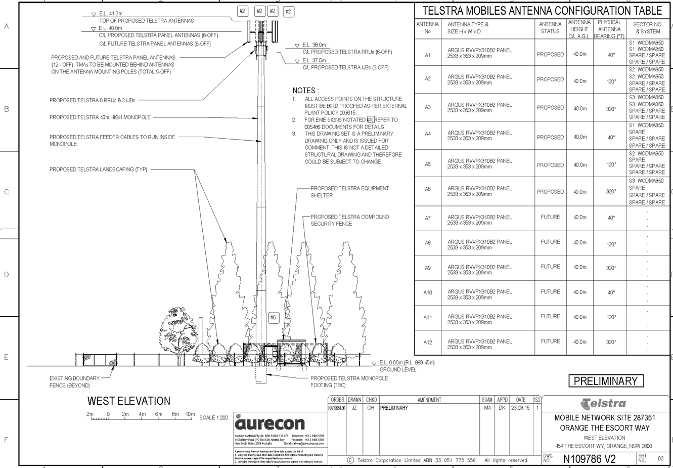
Telstra propose to install a new mobile phone base station
at 454 The Escort Way, Orange. The applicant has summarised the proposal as
follows:
· installation of a
new 40m high monopole with a triangular head frame mounted at a centreline
elevation of 40m
· six panel antennas
(2.6m long) mounted on the headframe at the centreline elevation of 40m, giving
a total elevation of 41.3m
· six future panel
antennas (2.6m long) mounted on the headframe at a centreline elevation 40m,
giving a total elevation of 41.3m
· installation of
six remote radio units and nine tower mounted amplifiers in proximity to the
antennas
· one equipment
shelter 2.28 (width) x 3.28m (length) x 2.95m (height) with associated piers
located at the base of the monopole
· ancillary cabling
and cable ladder and
· landscaping.
The proposal will be incorporated into the existing network
via existing fibre optic cable.
Once operational, the facility will function on a
continuously unstaffed basis and will typically only require maintenance works
once a year.
The revised site for the proposed development is situated
approximately 60m off the southern property boundary and 50m off the eastern
property boundary (see attached plans).
TELECOMMUNICATIONS ACT 1997
Telstra is a licenced telecommunications carrier and is
required to operate under the provisions of the Telecommunications Act 1997
and the Telecommunications Code of Practice 1997.
The 1997 Act and Telecommunications (Low-impact
Facilities) Determination 1997 (as amended) establish the criteria for
‘low impact’ telecommunications facilities. The proposed
development is not defined as a ‘’low-impact facility” under
the Telecommunications Act and is therefore subject to the provisions of
the NSW Environmental Planning and Assessment Act 1979 and,
accordingly, the provisions of Orange Local Environmental Plan 2011.
The Telecommunications Code of Practice 1997 sets out
the design, planning and installation requirements for carriers to ensure that
the installation of facilities is in accordance with industry “best
practice”. The applicant advises that the design and siting of the
proposed communications facility has been undertaken in accordance with
Section 3 (Planning and Siting) of the Australian Standard , Siting of
Radio Communications Facilities (AS3516.2).
MATTERS FOR CONSIDERATION
Section 79C of the Environmental Planning and Assessment
Act 1979 requires Council to consider various matters, of which those
pertaining to the application are listed below.
Section 5A Assessment
In the administration of sections 78A, 79B, 79C, 111 and
112, the provisions of Section 5A must be taken into account for every
development application in deciding whether there is likely to be a significant
effect on threatened species, populations or ecological communities or their
habitats. This section includes a requirement to consider any adopted
assessment guidelines, which means assessment guidelines issued and in force
under section 94A of the Threatened Species Conservation Act 1995.
Assessment guidelines are in force (see DECC-W “Threatened Species
Assessment Guidelines - The Assessment of Significance”) which requires
consent authority to adopt the precautionary principle in its assessment.
The subject property provides
some habitat suitable for certain threatened or endangered species on a limited
basis. However, with the exception of the Regent Honeyeater (for which this
site is not suitable), there are no fauna species above the category of
vulnerable that occur in this locality. The tests listed in the Assessment of
Significance only apply to Threatened, Endangered or Critically Endangered
Species as they appear in the NPWS Wildlife Atlas. Species listed as vulnerable
or below have importance when assessing the value of vegetation communities,
but are not individually protected themselves under the seven part test
provisions.
In this case the vegetation on
the subject land (but not the site of the proposed facility) is characterised
by a number of over mature Eucalypts, but more significantly by planted
vegetation around the site. There is a naturally occurring Box Gum Grassy
Woodland (BGGW) on the western side of the site (see map below) that is
noteworthy and of some significance, deserving of conservation. A number of
vulnerable species are likely to utilise this vegetation for connectivity
purposes to link to areas of greater, more significant biomass to the west and
south of the subject site.
The conservation of that
vegetation remnant is important for that reason, but the proposed development
has no impact in that respect. The scattered over mature eucalypts on the site
are significant for seed banking purposes and also as waypoints for migrating
immature avian species.
The proposed development has no
impact in terms of the supporting vegetation and therefore a detailed
supporting assessment so as to complete the seven part assessment of
significance as called up by the Act is not necessary.
The LEP also has provisions that
are additional and separate to the Act that apply in areas mapped under the LEP
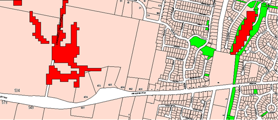
as an Environmentally Sensitive Area (ESA). In this case the attached LEP
map extract demonstrates that whist parts of the lot are considered
an ESA, the part of the lot where the proposed development is to be sited
is not a sensitive area and has only limited connectivity to those areas. The
various dams and waterways on the site are not considered overly sensitive, and
as explained above do not support species that in themselves are protected
under the TSC or EP&A Act. Whilst it is acknowledged that rare species may
frequent the site, it is unlikely that they have a critical dependence on the
site, even applying the Department guidelines of local occurrence and local
conservation. It is considered the threat posed by the proposed development is
minor. It is further noted that the proposed development does not constitute a
Key Threatening Process (KTP) under the abovementioned OEH guidelines.
There is no significant risk arising under either the
Assessment of Significance prescribed by Section 5A, or under the local
LEP controls.
PROVISIONS OF ANY ENVIRONMENTAL
PLANNING INSTRUMENT s79C(1)(a)(i)
Orange Local Environmental Plan 2011
Part 1 - Preliminary
This part of the plan is largely administrative in nature
and has minimal implications for the proposal.
Clause 1.2 - Aims of Plan
The broad aims of the LEP are
set out under subclause 2. Those relevant to the application are as follows:
(a) to encourage development which complements
and enhances the unique character of Orange as a major regional centre boasting
a diverse economy and offering an attractive regional lifestyle,
(b) to provide for a range of development
opportunities that contribute to the social, economic and environmental
resources of Orange in a way that allows the needs of present and future
generations to be met by implementing the principles of ecologically
sustainable development,
(f) to recognise and manage valued
environmental heritage, landscape and scenic features of Orange.
The application is considered to be consistent with aims (a)
and (b) as listed above. In relation to aim (f), it is considered that the
proposal will have a significant impact upon the landscape and scenic features
of the western ridgeline of Ploughmans Valley. A detailed assessment of the
likely impacts of the development and in particular the impact that the
development will have on the landscape and scenic features of the City has been
provided below under the heading “Likely Impacts of the
Development”.
Clause 1.6 - Consent Authority
This clause establishes that, subject to the Act, Council is
the consent authority for applications made under the LEP.
Clause 1.9A - Suspension of
Covenants, Agreements and Instruments
This clause provides that covenants, agreements and other
instruments which seek to restrict the carrying out of development do not apply
with the following exceptions.
· covenants imposed
or required by Council
· prescribed
instruments under Section 183A of the Crown Lands Act 1989
· any conservation
agreement under the National Parks and Wildlife Act 1974
· any trust
agreement under the Nature Conservation Trust Act 2001
· any property
vegetation plan under the Native Vegetation Act 2003
· any biobanking
agreement under Part 7A of the Threatened Species Conservation Act 1995
· any
planning agreement under Division 6 of Part 4 of the Environmental Planning
and Assessment Act 1979.

The subject site does not appear
to be affected by any of the above. The subject allotment is, however, burdened
by an electricity easement. The applicant has confirmed that the
current electricity line and easement will remain in place at this time and
will not be impacted upon by the proposed development. The applicant has
advised that there is a separate proposal to reconstruct the subject
electricity supply underground.
The revised tower location is located
approximately 17m from the existing overhead power line, and will reside
entirely outside the existing electrical easement. The proposed
development will not have a detrimental effect on the easement.
Mapping
The subject site is identified
on the LEP maps in the following manner:
|
Land Zoning Map:
|
Land zoned R5 Large Lot Residential
|
|
Lot Size Map:
|
Minimum Lot Size 2ha
|
|
Heritage Map:
|
Not a heritage item or conservation
area.
|
|
Height of Buildings Map:
|
No building height limit
|
|
Floor Space Ratio Map:
|
No floor space limit
|
|
Terrestrial Biodiversity Map:
|
Biodiversity sensitivity on the
site
|
|
Groundwater Vulnerability Map:
|
Ground water vulnerable
|
|
Drinking Water Catchment Map:
|
Not located within the drinking
water catchment
|
|
Watercourse Map:
|
Not within or affecting a defined
watercourse
|
|
Urban Release Area Map:
|
Not within an urban release area
|
|
Obstacle Limitation Surface Map:
|
No restriction on building siting
or construction
|
|
Additional Permitted Uses Map:
|
No additional permitted use applies
|
Those matters that are considered
to be of relevance to the development application are addressed in detail in
the body of this report.
Part 2 -
Permitted or Prohibited Development
Land Use Zones
The subject site is zoned R5 Large Lot Residential. The
proposed development is defined as a Telecommunications Facility under OLEP
2011. Pursuant to OLEP 2011 a telecommunications facility means:
(a) any
part of the infrastructure of a telecommunications network, or
(b) any
line, cable, optical fibre, fibre access node, interconnect point equipment,
apparatus, tower, mast, antenna, dish, tunnel, duct, hole, pit, pole or other
structure in connection with a telecommunications network, or
(c) any
other thing used in or in connection with a telecommunications network.
Telecommunications Facilities are not specifically
listed as permissible in the R5 Large Lot Residential zone under OLEP 2011 and
are thus prohibited. However, State Environmental Planning Policy
(Infrastructure) applies to the State and under Clause 116 development for the
purposes of telecommunications facilities may be carried out by any person with
consent on any land. The SEPP overrides the provisions of Orange LEP 2011
and therefore has the effect of rendering the proposed development permissible
on any land with the consent of Council.
In accordance with Clause 115(3) of SEPP (Infrastructure),
Council in determining this matter must take into consideration any guidelines
concerning site selection, design, construction or operating principles for
telecommunications facilities that are issued by the Director-General for the
purposes of this clause and published in the Gazette.
This provision has the effect of imposing any assessment
guidelines imposed by the Director General (Department Of Planning). The
Department has a design guideline, entitled "NSW Telecommunications
Facilities Guideline Including Broadband" which applies in this case.
A detailed assessment of how the development responds to
these guidelines has been provided below under the heading of "State
Environmental Planning Policies".
Clause 2.3 of
OLEP 2011 references the Objectives for each zone in OLEP 2011. These
objectives for land zoned R5 Large Lot Residential are as follows:
· To
provide residential housing in a rural setting while preserving, and minimising
impacts on, environmentally sensitive locations and scenic quality.
· To
ensure that large residential lots do not hinder the proper and orderly
development of urban areas in the future.
· To
ensure that development in the area does not unreasonably increase the demand
for public services or public facilities.
· To
minimise conflict between land uses within this zone and land uses within
adjoining zones.
· To
provide for student housing in close proximity to the Charles Sturt University.
· To
ensure development is ordered in such a way as to maximise public transport
patronage, and encourage walking and cycling, in close proximity to settlement.
· To
ensure development along the Southern Link Road has an alternative access.
The objectives of the zone are not considered to be of
relevance to the proposed development.
Part 3 -
Exempt and Complying Development
Telstra is a licenced telecommunications carrier and is
required to operate under the provisions of the Telecommunications Act 1997
and the telecommunications Code of Practice 1997. The 1997 Act and Telecommunications
(Low-impact Facilities) Determination 1997 (as amended) establish the
criteria for ‘low impact’ telecommunications facilities. The
proposed development is not defined as a ‘’low-impact
facility” under the Telecommunications Act and is therefore subject to
the provisions of the NSW Environmental Planning and Assessment Act
1979 and, accordingly, the provisions of Orange Local Environmental Plan
2011.
The application is not exempt or complying development.
Part 4 - Principal Development
Standards
Not relevant to the application.
Part 5 - Miscellaneous
Provisions
5.9 - Preservation of Trees
or Vegetation
This clause seeks to maintain and
preserve the amenity of the area, including biodiversity values, through the
preservation of trees and other vegetation.
(3) A person must not ringbark,
cut down, top, lop, remove, injure or wilfully destroy any tree or other
vegetation to which any such development control plan applies without the
authority conferred by:
(a) development consent, or
(b) a permit granted by the
Council.
The construction of the
telecommunications facility makes use of an existing cleared paddock and no
clearing of any significant trees or vegetation is required to facilitate the
proposed development.
Part 6 -
Urban Release Area
Not relevant to the application. The subject site is not
located in an Urban Release Area.
Part 7 -
Additional Local Provisions
7.1 - Earthworks
This clause establishes a range
of matters that must be considered prior to granting development consent for
any application involving earthworks, such as:
(a) the likely disruption of, or any
detrimental effect on, existing drainage patterns and soil stability in the
locality of the development
(b) the effect of the development on the
likely future use or redevelopment of the land
(c) the quality of the fill or the soil to be
excavated, or both
(d) the effect of the development on the
existing and likely amenity of adjoining properties
(e) the source of any fill material and the
destination of any excavated material
(f) the likelihood of disturbing relics
(g) the proximity to and potential for adverse
impacts on any waterway, drinking water catchment or environmentally sensitive
area
(h) any measures proposed to minimise or
mitigate the impacts referred to in paragraph (g).
The proposed earthworks will
consist of site testing, excavation and construction of foundations. The
proposed earthworks will not involve the removal of any trees with the subject
land already highly disturbed from past farming practices. The proposed
development is not expected to have a detrimental effect on the water catchment
area.
7.6 -
Groundwater Vulnerability
This clause seeks to protect
hydrological functions of groundwater systems and protect resources from both
depletion and contamination. Orange has a high water table and large areas of
the LGA, including the subject site, are identified with “Groundwater
Vulnerability” on the Groundwater Vulnerability Map. This requires that
Council consider:
(a) whether or not the development (including
any onsite storage or disposal of solid or liquid waste and chemicals) is
likely to cause any groundwater contamination or have any adverse effect on
groundwater dependent ecosystems, and
(b) the cumulative impact (including the
impact on nearby groundwater extraction for potable water supply or stock water
supply) of the development and any other existing development on groundwater.
Furthermore consent may not be granted unless Council is satisfied that:
(a) the development is designed, sited and
will be managed to avoid any significant adverse environmental impact, or
(b) if that impact cannot be reasonably
avoided - the development is designed, sited and will be managed to minimise
that impact,
(c) if that impact cannot be minimised - the
development will be managed to mitigate that impact.
The proposal is not anticipated
to involve the discharge of toxic or noxious substances and is therefore
unlikely to contaminate the groundwater or related ecosystems. The proposal
does not involve extraction of groundwater and will therefore not contribute to
groundwater depletion.
DESIGNATED DEVELOPMENT
The proposed development is not designated development.
STATE ENVIRONMENTAL PLANNING
POLICIES
State Environmental Planning Policy (Infrastructure) 2007
("the SEPP") applies to the subject development.
Clause 2 - Aim of Policy
The aim of this policy is to facilitate the effective
delivery of infrastructure across the state by:
(a) improving
regulatory certainty and efficiency through a consistent planning regime for
infrastructure and the provision of services, and
(b) providing
greater flexibility in the location of infrastructure and service facilities,
and
(c) allowing
for efficient development, redevelopment or disposal of surplus government
owned land, and
(d) identifying
the environmental assessment category into which different types of
infrastructure and services development fall (including identifying certain
development of minimal environmental impact as exempt development), and
(e) identifying
matters to be considered in the assessment of development adjacent to
particular types of infrastructure development, and
(f) providing
for consultation with relevant public authorities about certain development
during the assessment process or prior to development commencing.
The development is not inconsistent with the aims of the
SEPP.
Clause 115 - Development
Permitted with Consent
(1) Development
for the purposes of telecommunications facilities, other than development in
clause 114 or development that is exempt development under clause 20 or
116, may be carried out by any person with consent on any land.
The SEPP has the effect of rendering the proposed
development permissible on any land with the consent of Council.
(3) Before
determining a development application for development to which this clause
applies, the consent authority must take into consideration any guidelines
concerning site selection, design, construction or operating principles for
telecommunications facilities that are issued by the Director-General for the
purposes of this clause and published in the Gazette.
This provision has the effect of imposing any assessment
guidelines imposed by the Director General (Department Of Planning). The
relevant guideline applicable in NSW for the consideration of development of
this type is entitled "NSW Telecommunications Facilities Guideline
Including Broadband".
The guideline has the effect under clause 1.6 of applying as
a design tool in all zones of an LEP.
Section 2.2 of the policy sets up the design principles that
should be followed. The guidelines are organised under "Principles"
headings. Many of the principles are not relevant because they relate to fully
urbanised landscapes. In this case the landscape and setting are not fully
urbanised. Detailed consideration of how the development fits into the
landscape will however remain an important element for consideration under the
guidelines. The ridge upon which the structure is proposed forms the skyline to
large areas of the City.
Those principles that are called up in the policy and which
are relevant to the assessment of visual impact are set out below:
Principle 1 - Design and Siting
to Minimise Visual Impact
· As
far as practical, a telecommunications facility that is to be mounted on an
existing building or structure should be integrated with the design and
appearance of the building or structure.
The applicant has advised that the area was analysed using
desktop and onsite investigations during the site selection process. The
applicant has indicated that when investigating sites the preference for
selection is firstly for colocation on existing infrastructure, secondly low
impact facilities (as defined by the Telecommunications (Low impact Facilities
Determination 1997) and lastly “greenfield sites”. Four candidate
sites were investigated in the context of the above.
These include:
· Candidate A: 454
The Escort Way, Orange (proposed site)
· Candidate B: 448
The Escort Way, Orange
· Candidate C: Lot 1
DP 581736 Gorman Road, Orange
· Candidate D: 7
Borrodell Drive, Orange
These candidate sites are shown
in the attached aerial photo:
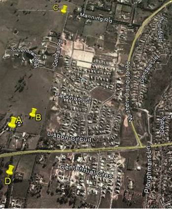
Candidate A: 454 The Escort
Way, Orange (proposed site)
The applicant advises that this site provided the radio
coverage required of a facility in this area. The revised site has no design or
construction constraints. The property owner was willing to enter into a land
tenure agreement with Telstra.
Candidate B: 448 The Escort
Way, Orange
The applicant advises that this site provided the radio
coverage required of a facility in this area. The site was discounted as the
property owner was unwilling to enter into a land tenure agreement with
Telstra.
Candidate C: Lot 1 DP 581736
Gorman Road, Orange
The site was discounted as the property owner was unwilling
to enter into a land tenure agreement with Telstra. The applicant has advised
that the proposed facility in this location was not able to meet the radio
coverage objectives for this site without utilising a heightened tower
structure.
Candidate D: 7 Borrodell Drive,
Orange
The site was discounted as the property owner was unwilling
to enter into a land tenure agreement with Telstra. The site would require
extensive earthworks in order to construct a graded access track. The applicant
has advised that the proposed facility in this location was not able to meet
the radio coverage objectives for this site without utilising a heightened
tower structure.
· The visual
impact of telecommunications facilities should be minimised, visual clutter is
to be reduced
As a new structure designed to meet technical
specifications, there appear to be few opportunities to modify or reduce the
intrusive nature of the monopole and the array to be placed on top of the pole.
· Where
telecommunications facilities protrude from a building or structure and are
predominantly backgrounded against the sky, the facility and their support
mounts should be either the same as the prevailing colour of the host building
or structure, or a neutral colour such as grey should be used.
The proposed telecommunications facility is a stand-alone
structure. The proposed structure will protrude above the ridgeline when viewed
from a large area of the City and from The Escort Way. A detailed assessment of
the visual impacts of the development has been provided below under the heading
“Likely impacts of the Development”. It is considered appropriate
in this case to impose a condition requiring the structure to be painted a
“shale grey” colour as suggested. A condition to that effect is
included.
· Ancillary
facilities associated with the telecommunications facility should be screened
or housed, using the same colour as the prevailing background to reduce its
visibility, including the use of existing vegetation where available, or new
landscaping where possible and practical.
In this case the ground based structures will be located
immediately around the base of the structure. The applicant has submitted a
landscape plan in support of the proposal. It is considered that the proposed
landscaping at maturity will adequately screen the ancillary structures.
Attached is a condition in relation to this matter.
· A
telecommunications facility should be located and designed to respond
appropriately to its rural landscape setting.
In this case the setting behind (to the west) of the site dictates
the character and setting of the structure. As discussed above the facility
will project above the skyline, and whilst some landscaping exists along the
ridge, the development is proposed to be located on a relatively exposed part
of the ridge. Landscaping requirements are considered essential to this
proposal, and are discussed in more detail elsewhere in this report.
· A
telecommunications facility located on, or adjacent to, a State or local
heritage item or within a heritage conservation area, should be sited and
designed with external colours, finishes and scale sympathetic to those of the
heritage item or conservation area.
Council’s records indicate that subject site is not
located within a heritage conservation area and is not located adjacent to
listed State or Local heritage items.
· A
telecommunication facility should be located and designed so as to respond
appropriately to its landscape setting.
A detailed assessment of the visual impact of the
development and its impact on the landscape setting has been provided below
under the heading “Likely Impacts of the Development’.
Principle 2 - Colocation
As indicated in the above discussion, colocation was not
considered a practical option.
Principle 3 - Health Standards
The applicant has submitted technical specifications and
discussion in their Statement of Environmental Effects, attesting that the
proposed structure when in operation will comply with relevant health
standards, particularly relating to electromagnetic emissions standards.
Whilst there are currently wide-ranging and contentious
views on the health impacts associated with electromagnetic energy (EME), with
large volumes of discourse related to the study, there is currently no
definitive evidence or conclusive findings one way or another of the effects of
EME on humans. Council is therefore largely reliant on the studies of
recognised health organisations and the submitted report on the summary of
Estimated RF (radiofrequency) EME (electromagnetic energy) in determining
the likely health impacts associated with the development.
The Australian Government’s Australian Radiation
Protection and Nuclear Safety Agency cite the World Health Organisation’s
advice stating:
None of the
recent reviews have concluded that exposure to RF fields from mobile phones and
their base stations cause any adverse health consequences” (ARPANSA).
Furthermore, the ARPANSA suggests:
the balance of evidence does
not indicate a risk to the health of people, including children, living in the
vicinity of base stations where exposure levels are only small fractions of the
ARPANSA standard.
A report titled Summary of Estimated RF and EME Levels
Around The Proposed Wireless Base Station…’ indicates:
RF EME levels have been
estimated from the proposed antennas at 354 Cadia Road, Springside. The maximum
cumulative EME level at 1.5m above ground level and 274.1m from the antennas is
estimated to be 0.026% of the ARPANSA public exposure limits.
As mentioned above, Council is
largely reliant on the reports submitted in the application and studies of
recognised health agencies in determining the likely health impacts associated
with the development.
In light of the above, it is considered that the development
is not likely to result in adverse health impacts as a result of human
exposure.
Principle 4 - Minimise
Disturbance
This principle is mainly concerned with the impact that the
development may have on other telecommunication facilities in the locality,
particularly those relating to airport operations. It is considered unlikely
that the proposed structure will have any significant impact in this regard.
PROVISIONS OF ANY DRAFT
ENVIRONMENTAL PLANNING INSTRUMENT THAT HAS BEEN PLACED ON EXHIBITION
s79C(1)(a)(ii)
Council is not aware of any draft Environmental Planning Instruments
that have been placed on public exhibition that affect the proposed
development.
PROVISIONS OF ANY DEVELOPMENT
CONTROL PLAN s79C(1)(a)(iii)
Development Control Plan 2004
Development Control Plan 2004 (“the DCP”)
applies to the subject land (Part 0LEP 2011, Part 6 Rural Development).
An assessment of the proposed development against the relevant Planning
Outcomes will be undertaken below.
Pursuant to Planning Outcome 0.2-1
Interim Planning Outcomes - Conversion of Zones:
· Throughout this
Plan, any reference to a zone in Orange LEP 2000 is to be taken to be a
reference to the corresponding zone(s) in the zone conversion table.
The corresponding zone to zone
1(c) Rural Residential (Orange LEP 2000) is zone R5 Large Lot Residential
(Orange LEP 2011). As such, Orange DCP 2004 - Chapter 6 - Rural Development
represents the corresponding set of controls for consideration. The proposed
development is not inconsistent with any provisions under this section of the
DCP.
Pursuant to Planning Outcome 0.4-1
Interim Planning Outcomes – Scenic Areas:
· Development
blends into the landscape through the use of appropriate siting, design,
external materials and colours, retention of trees including remnant
vegetation, establishing of new trees, and enhancing the skyline when viewed
either from the urban area of Orange or from public places in the vicinity of
the land.
While Telstra’s proposed facility will introduce a new
vertical element in the skyline, it should be viewed in conjunction with other
elements in the surrounding area and within the ‘Scenic Area’
itself. The applicant submits that these elements range from power and street
lighting poles in the near and immediate vicinity, to existing
telecommunications facilities in the distance. It can be suitably argued that
these vertical elements, considered essential infrastructure, are commonplace
within today’s landscapes, be it in the urban built environment, rural
settings, or the growing outskirts of townships such as Orange.
Following the onsite inspection on 12 February 2015 the
applicant lodged an amended proposal for Council’s consideration. The
applicant has advised that an alternative site location was agreed upon between
the three directly affected adjoining neighbours and the existing land owners.
The revised site location is within the area discussed as being a possible
alternative site during the onsite meeting, and is approximately 60m off the
southern property boundary and 50m off the eastern property boundary.
Council is advised that while this location is near the
crest of the land marked as ‘Scenic Area’, it allows the facility
to be the smallest possible structure to achieve the required coverage
objectives of a site in this area. The applicant argues that the proposed
facility’s visual impact is further lessened by the existing vegetation
that is found surrounding the site location.
The applicant’s submission is accompanied by a
detailed landscape plan. Telstra’s proposal involves the establishment of
a number of additional trees and shrubs that will assist to screen the lower
portion of the proposed facility. The external colours and materials used to
finish the proposed facility can also be suited to blend into the landscape.
Attached to the draft Notice are conditions of consent that address these
issues.
Whilst the assessment has highlighted that the proposed
development will have a significant visual impact when viewed from surrounding
residential properties and while travelling in both directions along The Escort
Way, the proposal is considered acceptable in this case subject to the
implementation of several recommended conditions of consent. Having said this,
given the significance of the western ridgeline of the City and the fact that
the proposed structure will be readily viewed from a number of residential
properties and road corridors in the general locality, it would be open for
Council to form an alternative view should the visual impact of the proposed
development be considered unacceptable.
PROVISIONS PRESCRIBED BY THE
REGULATIONS s79C(1)(a)(iv)
The proposed development is not inconsistent with the
provisions prescribed by the regulations.
THE LIKELY IMPACTS OF THE
DEVELOPMENT s79C(1)(b)
Context and Setting
Council is advised that Telstra is required by law to
carefully consider many factors before deciding on the location and the design
of a base station. It is understood that these factors include:
· service objectives
(radio coverage requirements)
· physical
characteristics of the site - such as height and terrain
· ability to connect
with the rest of the network
· planning
constraints such as zonings
· colocation
opportunities
· minimising public
exposure to EME
· cost factors
· the ability to
obtain a suitable lease
· proximity to
community sensitive locations and
· minimising the visual
impact on the existing environment.
As demand grows on mobile telecommunications networks, the
applicant advises that additional investment is required to match capacity to
demand. In the case of the service provided by Telstra to Orange, Council is
advised that investments have been made to increase the capacity of surrounding
facilities and install additional facilities, including those at Beech
Crescent, Calare, and at the Duntryleague Golf Club on Woodward Street. Telstra
has also been able to utilise additional radio channels, sectorisation or cell
splitting and spreading the load over all the different frequency bands that
are available to Telstra under its Telecommunications Carrier Licence.
The applicant advises that the proposed development
represents the next step to providing vital infrastructure that will facilitate
enhanced services to customers, providing improved coverage to areas that are
currently experiencing limited reception.
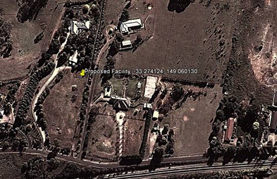
The facility is proposed to be sited on a privately owned
large lot residential allotment approximately 60m off the southern property
boundary and 50m off the eastern property boundary (see attached plans) of the
lot at 454 The Escort Way. The subject land provides some screening utilising
existing vegetation on the lot. A landscape plan has been submitted in support
of the subject development. This additional landscaping will, over time,
provide a level of screening for the lower section of the monopole and the
equipment at ground level.
Design
Whilst it is not uncommon for telecommunications facilities
to be sited in close proximity to residential development, Telstra has
acknowledged that the facility needs to be sensitive to its environment.
The applicant advises that taking advantage of local
topography has allowed the use of a 40m structure in this location,
thereby avoiding the need to install a lattice type structure or taller
monopole which would represent a significantly less desirable visual outcome.
Council is advised that the 40m high monopole is the minimum height required
for the facility to project over the trees to the surrounding area and provide
the level of coverage necessary to make a sustainable contribution to coverage
and service issues.
In order to reduce the long term visual impact of the
proposed development it is recommended in the event that Council is of the view
to support the proposed development, that the structure be painted in a
“shale grey” colour and the applicant be required to implement the
landscape plan submitted in support of the proposed development.
Council’s Urban Design Advisor has also recommended that this colour be
utilised. The equipment shelter will not be visible externally due to existing
private and public vegetation in the surrounding area. The landscape concept
plan submitted incorporates eleven Populus Canadensis evergreen trees and ten
Pittosporum James Stirling located around the proposed structure, which will at
maturity screen the lower section of the tower. The proposed trees will have a
mature height of approximately 20m. The attached Notice of Approval contains
conditions in relation to these matters.
The applicant submits that the development will have an
acceptable visual impact and that the facility will provide vital
infrastructure that will provide enhanced services to customers, providing
improved coverage to areas that are currently experiencing limited reception.
Visual Impacts
The proposed structure is located on the western ridgeline
of Ploughmans Valley within the scenic protection area as defined by
Council’s Development Control Plan. The subject land comprises large lot
residential and is located adjacent to residential areas within the Ploughmans
Valley. The ridgeline that forms just to the west of the subject land comprises
the backdrop to large parts of the City including Westlea, Belair and parts to
the north of those areas. Landscape elements are concentrated to the south but
further north are mostly devoid of landscape elements.
The proposed development is likely to result in various levels
of visual impact given its location in relation to residential areas to the
north, east and south and the height of the proposed monopole (41.3m). Visual
impact is often a significant issue with respect to the installation of mobile
phone base stations. In order to provide adequate clearance above buildings,
trees and the topography of the land it is virtually impossible for these
facilities to be completely hidden.
The subject land provides some
low level screening utilising existing vegetation on the lot. A landscape plan
has been submitted in support of the subject development. The proposed
landscaping will, over time, provide a level of screening of the lower section
of the monopole and the equipment at ground level.
The applicant submits that the proposed location of the
telecommunications tower provides for maximum separation distance between the
facility and the majority of residential development nearby.
The revised site location ensures that the proposed facility
will not be in the direct line of sight to neighbouring residents, will not
have a substantially altered visual impact from the surrounding area (when
compared to the original proposed site location), and provides for a
compromised location that is more in consideration with the local residents’
preferences, while ensuring Telstra’s radio frequency coverage objectives
are met.
The applicant advises that the siting of the proposed
structure any further west would not meet the radio coverage objectives for the
site. It is understood that the height of the proposed monopole is the minimum
required height to adequately meet the objectives of a site in this location.
Council staff in initial deliberations on this matter
requested the applicant to consider what opportunity there was for establishing
the development on alternative sites and whether or not it was possible to
reduce the overall height of the structure. The applicant advised Council that
they were unable to secure legal tenure over the alternative sites identified
during the site selection process and that a lower facility would not provide
the ‘relief’ to surrounding sites.
A detailed assessment of the
likely impacts of the structure in the amended location has been undertaken by
staff to determine whether or not the development is acceptable in this
location. To this end some commentary on the likely visual impact of the
development from certain vantage points around the City is provided below.
Adjoining rural residential lots
to the east and west both contain dwellings with some screening opportunities
from existing vegetation onsite. An evaluation of the site indicates that
dwellings in the immediate vicinity of the subject site are oriented generally
away from the proposed facility. However, as Council would be aware the surrounding
area is currently within a transitional phase of development and opportunity
for additional dwellings to be established within proximity to the facility in
the near future.
The
following extract from the applicant's Statement of Environmental Effects
depicts the context of the existing surrounding area:
Surrounding
area (source - applicant’s Statement of Environmental Effects)
Due to existing public and
private vegetation, as well as the additional landscaping proposed (a row of
eleven Evergreen Poplars, and a row of ten James Stirling surrounding the
facility) the applicant submits that the upper portion of the facility only
will be exposed intermittently in all directions surrounding the facility.
Council staff met with
representatives from Aurecon and Telstra to discuss matters in relation to the
likely visual impact of the proposal. A tower platform was initially raised and
lifted to a height of 40m to roughly depict the proposed telecommunications
facility, and provide an indication of the height required. A number of vantage
points were visited by both Council staff and the applicant, with photomontages
being created to assist in this assessment. This exercise was undertaken to
accurately determine height and location of the proposed development, to
overcome difficulties in relying on photomontages and to avoid criticism that
questions the legitimacy of the photomontages.
Since that initial assessment
the applicant has amended the proposal such that the proposed structure is now
located approximately 60m off the southern property boundary and 50m off the
eastern property boundary. The applicant has provided an amended analysis of
the visual impact of the development from various vantage points and provided
additional photomontages of the proposed development for Council’s
consideration. Additional photomontages have been taken with a 50mm focal
length lens. However it is understood that with the sensor size of the cameras
used by the applicant and Council staff that the correct focal length that
represents the human field of view and focal length is actually 32mm.
Notwithstanding this these photomontages are considered to present a greater
sense of impact than what would have been presented with a focal length
of 32mm.
Land to the north of the facility is currently vacant land.
Given the undulating nature of the land the proposed facility is likely to be
seen from along Silverdown Way some 550m from site. Due to distance and
separation the facility is not likely to be a bulky structure when viewed from
this vantage point. The applicant submits that the facility will be further
mitigated by existing vertical structures in the area including electricity
poles, existing telecommunications lattice towers in the distance and mature
vegetation.
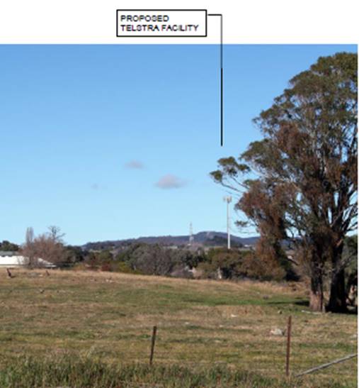
View
towards the proposed site location from Silverdown Way
(north
of proposed site location)
(source
- applicant's Statement of Environmental Effects)
When viewed from further north over
1km from the proposed site location, it is considered that the facility will
have limited visual impact. The applicant argues that whilst the top half of
the facility will be visible it will not be a dominant feature of the landscape
on the basis that it will appear as only a thin protrusion into the skyline.
The applicant further argues that views from the north would also encompass
existing telecommunications facilities at Nashdale and Mount Canobolas, as well
as existing vertical protrusions such as lighting and electricity poles.
When viewed from the northeast and
east in the predominately residential areas of Calare, the proposed facility is
considered to be more visible. The applicant submits that the visual impacts of
the development from this area will be mitigated through the existing mature
vegetation in the area surrounding the proposed site location and the
implementation of the proposed landscaping. Views of the facility from the
immediate south will be limited due to the elevation of the road reserve along
the northern boundary of The Escort Way. The applicant submits that vegetation
along this reserve will also aid to a degree in partly obscuring the facility
from view.
When viewed from the east and west at distances beyond 1km,
the facility will be visible to the greatest degree due to the topography of the
surrounding land. The proposed structure will be located on the western
ridgeline of Ploughmans Valley, which forms the natural backdrop to parts of
the City mentioned above. Whilst there are some landscape elements located on
the ridge to the south of the subject site there are very few landscape
features north of the site. The proposed tower will protrude well above the
skyline when viewed from various vantage points along The Escort Way when
travelling east and west of the subject site, the residential areas to the
north, east and south and from the rural areas to the north, south and west.
The western ridgeline has been identified as a significant
visual backdrop to the City and any element that protrudes above the ridgeline
has the potential to affect the visual amenity of this locality. The applicant
has consistently argued that the visual impact of the development will be
mitigated by existing and proposed landscaping and the fact that there are
other vertical elements such as electricity and lighting poles in this
locality.
Whilst this may be the case, it
is obvious that by the nature of this facility being a precisely defined 41.3m
high vertical element located on the western ridgeline to a large area of the
City that the tower structure will create a significant visual impact from
parts of the City. As would be expected the significance of the visual impact
would diminish the further the viewer is away from the tower. However, it needs
to be acknowledged that the visual impact of the tower structure will be
significant from the areas in close proximity to the tower, particularly from
the adjoining rural residential properties (see submissions below).
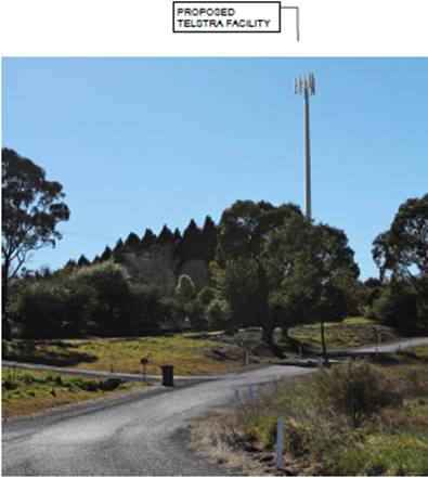
View
towards proposed site location from Forbes Road
(approximately
1.1km east of proposed site location)
(source
- applicant's Statement of Environmental Effects)
The applicant submits that a photomontage of the
proposed facility as seen from Riawena Oval on Kooronga Avenue demonstrates
that while the upper portion of the monopole will be visible, the lower
sections are completely shrouded. This argument is acknowledged and it is
agreed that the visual impact of the development from this vantage point is
reduced given the separation distance that exists between the oval and the
subject site. The facility will not be visually significant from these distant
areas.
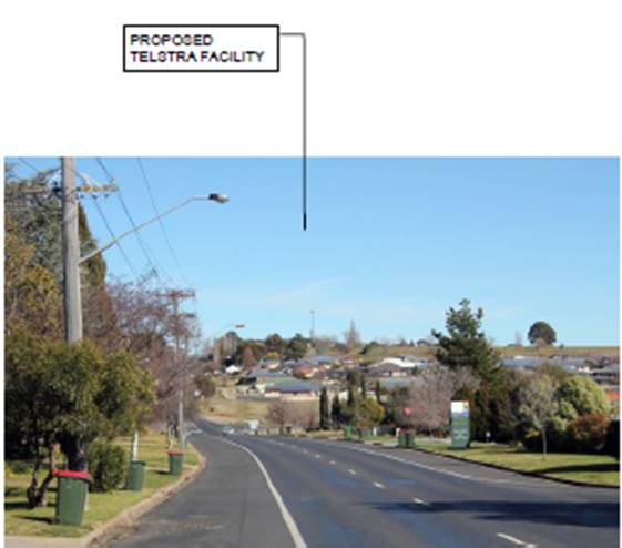
View
towards proposed site location from across Riawena Oval on Kooronga Avenue
(approximately
1.1km south-east of proposed site location)
(source
– Council staff)
Whilst the facility will have a visual presence within the
surrounding area when viewed from the west at varying degrees, it is considered
that the impact will be less given the semi-rural nature of the land. The
topography is undulating further west of the proposal, and with the presence of
mature vegetation in the landscape along The Escort Way it is expected that the
visual impact of the proposed facility from that vantage point will be minimal.
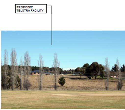
View
towards proposed site location from service road off Escort Way
(approximately
300m west of proposed site location)
(source
- applicants Statement of Environmental Effects)
The predominant land use directly east of the proposed site
is residential development. The development when viewed from Lisbon Circuit as
shown below (approximately 400m east of the proposed site location) will have
the greatest impact. The immediate adjoining neighbours will experience the
greatest visual impact. There is no hiding a structure of this type in the location
proposed. The implementation of landscaping and controls over the colour of the
proposed structure are the only practical measures that can be implemented
which will, over time, lessen the visual impact of the facility to a degree.
The proposed development when viewed from these vantage points will nonetheless
have a significant visual impact.
Again, the applicant submits that the degree of visual
impact will be mitigated by existing vegetation and the topography of the land.
Further, the applicant argues that this view corridor towards the facility from
these areas is not the predominant view direction from nearby properties.
Whilst this may be the case, it is reasonable to also argue that the western
ridgeline of Ploughmans Valley forms an important landscape feature for the
City as evidenced by the scenic protection provisions contained within
Council’s DCP, and is therefore worthy of protection from development
that may impact upon the scenic qualities of the locality.
There is no doubting that the
facility will be readily viewed from those properties to the immediate east of
the subject site. Development of this type, however, is fast becoming a typical
element within urban environments as the demand for better and more efficient
mobile phone coverage grows. Council therefore, in its consideration of this
matter balance the visual impact of the proposed development against the demand
and need for such infrastructure within the City in this location. Whilst other
sites were initially investigated, Council has been advised by the applicant
that Telstra was unsuccessful in obtaining the required legal tenure from those
property owners whose land was of initial interest.
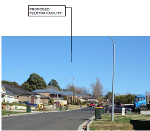
View
towards proposed site location from Lisbon Circuit
(approximately
500m east of proposed site location)
(source
- applicant's Statement of Environmental Effects)
In summary, the development is
proposed to be located on what is considered to be a significant ridgeline
forming a backdrop to parts of the City. Having said this, the site is
considered to be acceptable in this case subject to the implementation of
several recommended conditions of consent. However, as discussed previously
within this report, given the significance of the western ridgeline of the City
and the fact that the development will be highly visible from many areas in the
surrounding locality, it would be open for Council to form an alternative view
should the visual impact of the development in this location be considered
unacceptable. Should Council form the view that the development will have an
unacceptable impact, particularly in relation to the impact that will be
experienced by those property owners in the immediate vicinity of the
development, it would be necessary to refuse the subject development.
Noise Impacts
The majority of noise and vibration emissions associated
with the proposed facility will be limited to the construction phase. There
will be some low level noise from the ongoing operation of the air conditioning
equipment associated with the equipment units. As outlined within the
applicant's SoEE, the noise emanating from the outdoor cabinet air conditioning
system is at a comparable level to a domestic air conditioning installation,
and will generally accord with the background noise levels prescribed by
Australian Standard AS1055.
Traffic Impacts
Access to the telecommunications facility will be via the
existing access serving the subject site. After the construction period the
only traffic generated by the base station will be that associated with
maintenance vehicles. Accordingly, the facility will only generate one visit
per year for the maintenance, with the facility being vacant for the rest of
the year. The traffic generation will therefore be minimal and not sufficient
to create any adverse impacts.
Social and Economic Impacts
The applicant has advised that the proposed development will
facilitate the provision of vital infrastructure so as to improve mobile phone
coverage to areas that are currently experiencing limited reception within
Orange. The wider social and economic benefits of the proposal will result in a
positive impact for the City.
THE SUITABILITY OF THE SITE
s79C(1)(c)
The subject site is located within the scenic protection
area as defined under the provisions of DCP 2004. Such provisions
previously were included in Orange LEP 2000 but because Council were unable to
incorporate them into Orange LEP 2011 because of the Standard Instrument
provisions it was decided by Council to include them into the DCP. The inclusion
of these provisions in the DCP does reflect the importance that Council gives
to planning within the scenic protection areas. This particular ridgeline forms
a visual backdrop from parts of the urban environment of Orange. The
surrounding locality comprises predominantly residential development to the
immediate east and mostly undeveloped large lot residential land to the west.
This proposal therefore has the ability to influence the visual amenity of many
parts of the City well beyond the immediate area.
A section 79C assessment of the amended proposal has been
undertaken by Council staff. It is considered that the proposed development
will have a significant visual impact upon the immediate surrounding
residential locality. The proposal is, however, considered acceptable in this
case subject to the implementation of several recommended conditions of
consent. Having said this, given the significance of the western ridgeline of
the City it would be open for Council to form an alternative view should the visual
impact of the development in this location be considered unacceptable.
The
assessment of the proposal has highlighted the fact that the proposed
development will have a visual impact upon the immediate surrounding
residential locality. Council in determining the suitability of the subject
site will need to balance the visual impact of the proposed development against
the demand and need for such infrastructure within the City. Infrastructure of
this type is fast becoming a common element within urban environments. Whilst
other sites were initially investigated, Council has been advised by the
applicant that Telstra was unsuccessful in obtaining the required tenure from
those property owners whose land was of initial interest. As discussed in the
body of this report the location of the proposed facility has been adjusted
internally within the site to address initial concerns raised by adjoining
residents.
ANY SUBMISSIONS MADE IN
ACCORDANCE WITH THE ACT s79C(1)(d)
The proposed development is not defined as advertised
development under the provisions of the LEP, however given the nature of and
locality of the development the application was initially advertised for a
period of 14 days. At the end of the initial exhibition period two submissions
had been received objecting to the proposed development. Following receipt of
the amended proposal, Council staff arranged for the application to be re‑notified
to those persons who were initially given notice of the subject development for
an additional period of seven days.
Comment from the Initial
Exhibition Period
In summary, the objections expressed opposition to the
visual impact that the proposed telecommunications facility will have on the
surrounding amenity. The specific issues raised by Submissions 1 and 2 (being
the owners of the same property located at 448 The Escort Way which immediately
adjoins the subject site) are summarised and commented upon as follows:
· The visual
impact on the surrounding rural amenity.
The submissions raise strong objection to the establishment
of a 40m high monopole on the western ridgeline of Ploughmans Valley. The
submissions indicate that the proposed development will have a significant
visual impact upon large areas of western Orange and, in particular, their
property at 448 The Escort Way. The submitters question why a structure of this
type can be located within this area given that the area is subject to planning
controls that seek to protect the western ridgeline of the City.
Under the former planning provisions contained within Orange
LEP 2000 the subject land was subject to scenic protection planning controls.
At the Direction of the Department of Planning such controls were not allowed
to be carried through with the adoption of Orange LEP 2011. Rather, the
Department insisted that such controls be included within a DCP. Given
that a DCP is not defined as a formal Environmental Planning Instrument, the
determinative weight given to matters within a DCP is less than if such
provisions remained within the LEP.
The immediate adjoining neighbours will experience the
greatest visual impact. There is no hiding a structure of this type in the
location proposed. The implementation of landscaping and controls over the
colour of the proposed structure may serve to reduce the impact of the
development to a degree from distant locations but will do little to reduce the
visual impact when viewed from those properties immediately adjoining and
adjacent to the subject site. The proposed development when viewed from the
adjoining property will have a significant visual impact.
The issue of visual impact of the proposed development has
been further addressed under the “Visual Impacts” section under
“Likely Impacts of the Development s79C(1)(b)”.
· Devaluation
of property.
The submission received in
relation to this issue included no evidence to suggest that the proposed
development would have a negative impact upon the resale value of property. In
any event, the resale value of adjoining and adjacent properties as a result of
this development proceeding is not a relevant planning consideration under the
provisions of Section 79C of the Environmental Planning and Assessment
Act 1979.
· Traffic
impacts.
The issue of traffic impact of the proposed development has
been outlined under the “Traffic Impacts” section under
“Likely Impacts of the Development s79C(1)(b)”.
· The tower would
impact upon the flight path of flying foxes and the migration of Black Duck,
Ibis Snipe and other migratory birds.
The submission received in relation to this issue has
included no evidence to suggest that the proposed development would have a
negative impact upon endangered animals. An assessment of whether there is
likely to be a significant effect on threatened species, populations or
ecological communities or their habitats has been undertaken above under the
heading “Part 5A Assessment”.
Comment from the Second
Exhibition Period
Following completion of the
re-notification of the application Council received no written
submissions. The revised site location ensures that the proposed facility
will not be in the direct line of sight to neighbouring residents, will not
have a substantially altered visual impact from the surrounding area (when
compared to the original proposed site location), and provides for a
compromised location that is more in consideration with the local
residents’ preferences, while ensuring Telstra’s radio frequency
coverage objectives are met. A detailed analysis of the visual impact from the
revised site location has been provided above under the heading “Likely
Impacts of the Development”.
Notwithstanding this it is considered that the proposed
development will have a significant visual impact upon the immediate
surrounding residential locality. The proposal is, however, considered
acceptable in this case subject to the implementation of several recommended
conditions of consent. Having said this, given the significance of the western
ridgeline of the City it would be open for Council to form an alternative view
should the visual impact of the development in this location be considered
unacceptable.
PUBLIC INTEREST
s79C(1)(e)
The proposed development is considered to be of some public
interest. In a localised sense there are significant adverse visual impacts,
which have been discussed in some detail in this report. Conversely there are
public benefits to the wider community (which should be considered a public
interest) relating to improved telecommunications coverage.
The public interest in this case is considered a central
issue. On the one hand there are serious but localised adverse visual impacts.
On the other hand there are benefits to the wider community in terms of
enhanced communications.
The proposal is not inconsistent with any relevant policy
statements, planning studies, guidelines, etc that have not been considered in
this assessment.
SUMMARY
The proposed development is permissible with the consent of
Council. The applicant and owner of the land have liaised with the three
immediately affected adjoining neighbours to gain a consensus on a suitable
site within the development site for this facility. Whilst Council staff have
not been directly involved in such deliberations with adjoining residents,
Council’s records indicate that no objections have been lodged with respect
to the revised location of the development.
The proposed development complies with the relevant aims,
objectives and provisions of both the Orange LEP and SEPP
(Infrastructure). A section 79C assessment of the development indicates that
the development will have a significant visual impact. The implementation of
landscaping and controls over the colour of the proposed structure may serve to
reduce the impact of the development to a degree from distant locations, but
will do little to reduce the visual impact when viewed from those properties
adjoining and near the subject site as well as large areas of the City and the
travelling public along the Escort Way.
Infrastructure of this type is fast becoming a common
element within urban environments. Council will therefore need to determine the
application having regard to the overall visual impact that the structure will
have on surrounding land against the overall public benefit that may result
from facilitating improved mobile phone coverage in this locality.
Attached is a draft Notice of Approval outlining a range of
conditions considered appropriate to ensure that the development proceeds in an
acceptable manner.
It is recommended that Council supports the development.
COMMENTS
The requirements of the Environmental Health and Building
Surveyor and the Engineering Development Manager are included in the attached
Notice of Approval.
Attachments
1 Notice
of Approval, D15/7893⇩
2 Plans,
D15/8245⇩
3 Submissions,
D15/8247⇩
Sustainable Development Committee
7 April 2015
2.2 Development
Application DA 181/2014(1) - 454 The Escort Way
Attachment 1 Notice
of Approval
|

|
ORANGE
CITY COUNCIL
Development
Application No DA
181/2014(1)
D15/7893 Container
PR18313
|
NOTICE OF DETERMINATION
OF A DEVELOPMENT
APPLICATION
issued under the Environmental
Planning and Assessment Act 1979
Section 81(1)
|
Development
Application
|
|
|
Applicant Name:
|
Telstra
|
|
Applicant Address:
|
C/-
Aurecon
PO Box 538
NEUTRAL
BAY NSW 2089
|
|
Owner’s Name:
|
Mr JA and
Mrs AM Spencer
|
|
Land to Be Developed:
|
Lot 100 DP
1035863 - 454 The Escort Way, Orange
|
|
Proposed Development:
|
Telecommunications
Facility (mobile phone base station with 40m high monopole and equipment
shelter)
|
|
|
|
|
Building
Code of Australia
building classification:
|
As
determined by Certifier
|
|
|
|
|
Determination
|
|
|
Made On:
|
7 April
2015
|
|
Determination:
|
CONSENT
GRANTED SUBJECT TO CONDITIONS DESCRIBED BELOW:
|
|
|
|
|
Consent to
Operate From:
|
8 April
2015
|
|
Consent to
Lapse On:
|
8 April
2020
|
Terms of Approval
The reasons for the imposition of
conditions are:
(1) To ensure a quality
urban design for the development which complements the surrounding environment.
(2) To maintain
neighbourhood amenity and character.
(3) To ensure compliance
with relevant statutory requirements.
(4) To provide adequate
public health and safety measures.
(5) To prevent the proposed
development having a detrimental effect on adjoining land uses.
(6) To minimise the impact
of development on the environment.
Conditions
(1) The
development must be carried out in accordance with:
(a) Plan/s
numbered N109786 V2 Sheet No 01; N109786 V2 Sheet No 02
(b) statements
of environmental effects or other similar associated documents that form part
of the approval
as amended
in accordance with any conditions of this consent.
(2) All building work must
be carried out in accordance with the provisions of the Building Code of
Australia.
|
PRIOR TO THE ISSUE OF
A CONSTRUCTION CERTIFICATE
|
(3) The Council must, prior
to the release of the Construction Certificate, be given a report:
(1) Showing
compliance with any relevant site and height requirements specified by the
Civil Aviation Regulations 1988 and the Airports (Protection of Airspace)
Regulations 1996 of the Commonwealth, and
(2) Showing
that it does not penetrate any obstacle limitation Surface Plan that has been
prepared by the operator of an aerodrome or airport operating within 30km of
the proposed development and reported to the Civil Aviation Safety Authority
Australia.
(4) A
Construction Certificate application is required to be submitted to, and issued
by, Council/Accredited Certifier prior to any excavation or building works
being carried out on site.
|
DURING
CONSTRUCTION/SITEWORKS
|
(5) Any adjustments to
existing utility services that are made necessary by this development
proceeding are to be at the full cost of the developer.
|
PRIOR TO THE ISSUE OF
AN OCCUPATION CERTIFICATE
|
(6) Landscaping
shall be installed in accordance with the approved plans and shall be
permanently maintained to the satisfaction of Council's Manager Development
Assessments.
(7) No
person is to use or occupy the building or alteration that is the subject of
this approval without the prior issuing of an Occupation Certificate.
(8) All
of the foregoing conditions are to be at the full cost of the developer and to
the requirements and standards of the Orange City Council Development and
Subdivision Code, unless specifically stated otherwise. All work required by
the foregoing conditions is to be completed prior to the issuing of an
Occupation Certificate, unless stated otherwise.
|
MATTERS FOR THE
ONGOING PERFORMANCE AND OPERATION OF THE DEVELOPMENT
|
(9) The monopole and
associated headframe shall be finished in a “shale grey” colour and
be maintained in perpetuity.
Other Approvals
(1) Local
Government Act 1993 approvals granted under section 68.
Nil
(2) General
terms of other approvals integrated as part of this consent.
Nil
Right of Appeal
If
you are dissatisfied with this decision, section 97 of Environmental
Planning and Assessment Act 1979 gives you the right to appeal to the Land
and Environment Court within 6 months after the date on which you receive this
notice.
*
Section 97 of the Environmental Planning and Assessment Act 1979 does not apply
to the determination of a development application for State significant
development or local designated development that has been the subject of a
Commission of Inquiry.
|
Disability Discrimination Act
1992:
|
This application has been assessed in
accordance with the Environmental Planning and Assessment Act 1979. No
guarantee is given that the proposal complies with the Disability
Discrimination Act 1992.
The applicant/owner is responsible to
ensure compliance with this and other anti-discrimination legislation.
The Disability Discrimination Act
covers disabilities not catered for in the minimum standards called up in the
Building Code of Australia which references AS1428.1 - "Design for
Access and Mobility". AS1428 Parts 2, 3 and 4 provides the most
comprehensive technical guidance under the Disability Discrimination Act
currently available in Australia.
|
|
|
|
|
Disclaimer - S88B Restrictions on the Use of Land:
|
The applicant should note that there
could be covenants in favour of persons other than Council restricting what
may be built or done upon the subject land. The applicant is advised to check
the position before commencing any work.
|
|
|
|
|
Signed:
|
On behalf of the consent authority ORANGE
CITY COUNCIL
|
|
Signature:
|
|
|
Name:
|
ALLAN RENIKE - MANAGER DEVELOPMENT
ASSESSMENTS
|
|
Date:
|
8 April 2015
|
Sustainable
Development Committee
7 April 2015
2.2 Development
Application DA 181/2014(1) - 454 The Escort Way
Attachment 2 Plans
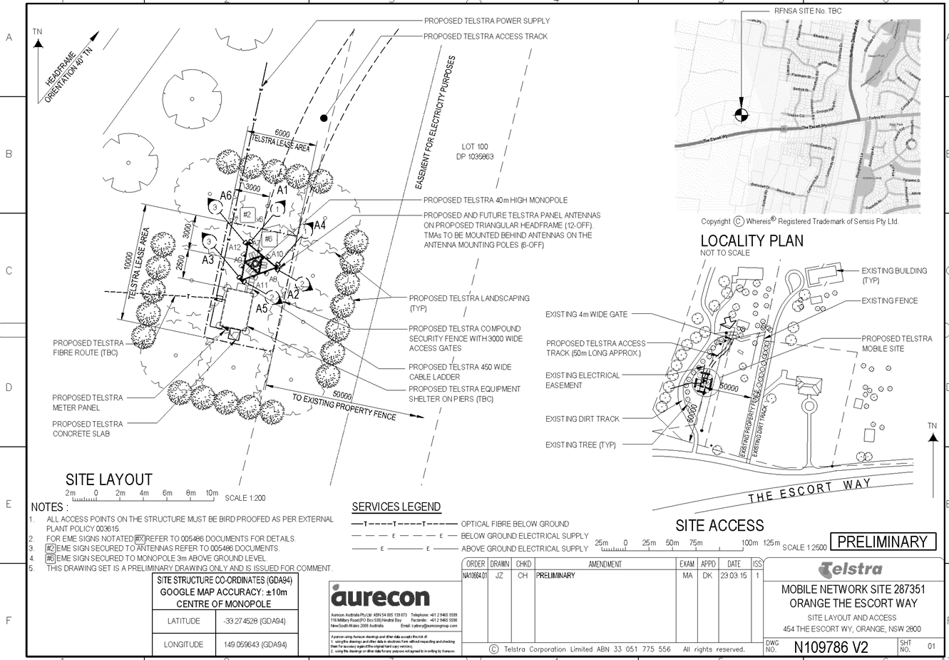
Sustainable Development Committee
7 April 2015
2.2 Development
Application DA 181/2014(1) - 454 The Escort Way
Attachment 3 Submissions

2.3 Development
Application DA 45/2015(1) - 45 Valencia Drive
TRIM
REFERENCE: 2015/788
AUTHOR: Kelly
Walker, Town Planner
EXECUTIVE Summary
|
Application
lodged
|
18
February 2015
|
|
Applicant/s
|
Mr D
Purvis
C/-
GHD Pty Ltd, PO Box 950, ORANGE NSW 2800
|
|
Owner/s
|
Mr
SJ and Mrs AA Atkinson
PO
Box 8063, ORANGE EAST NSW 2800
|
|
Land
description
|
Lot
4 DP 1202010 - 45 Valencia Drive, Orange
|
|
Proposed
land use
|
Dual
Occupancy and Subdivision (two lot residential)
|
|
Value
of proposed development
|
$420,000
|
Council's consent is sought for a dual occupancy and two lot
residential subdivision at Lot 4
DP 1202010, known as 45 Valencia Drive, Orange. Stage one involves
the construction of two single storey dwellings on the existing vacant lot as a
dual occupancy. One dwelling will contain four bedrooms, and the other will
contain three bedrooms. Both dwellings contain two bathrooms, laundry, open
plan living and kitchen, separate lounge, and attached double garage.
The second stage of the proposal involves a two lot Torrens
subdivision, where both proposed lots will have frontage and access off
Valencia Drive. Lot 4A is proposed at 650m2, and Lot 4B is
proposed at 600m2.
As the proposal involves the subdivision of a dual
occupancy, it must meet the requirements of Clause 4.1C of Orange LEP
2011, which allows exceptions to minimum lot sizes in this area and zone
provided the site is identified on the LEP Minimum Lot Size Map as having a
minimum lot size of 850m2. This site is unusual in that it is
identified as having both 2,000m2 and 850m2 minimum lot
size standards, with the boundary between the two minimum lot size standards
running approximately half way through the lot. As such, the applicant has
submitted justification to overcome this development standard irregularity
under Clause 4.6 of the LEP.
Council staff consider this contravention to be acceptable
as the intention of the two different lot size standards in this area was to
ensure larger lots backing onto the Northern Distributor Road (NDR), and
smaller lots on the western side of Valencia Drive. The LEP mapping has an
anomaly where the boundary between the different lot size minimums does not
follow the exact course of Valencia Drive. Most of the existing lots on the
western side of Valencia Drive are less than 2,000m2, including the
subject site. The development is consistent with the objectives for development
within the R2 zone, and with the residential development and subdivision
guidelines as set out in the DCP.
Link To Delivery/OPerational Plan
The recommendation in this report relates to the
Delivery/Operational Plan strategy “13.4 Our Environment
– Monitor and enforce regulations relating to City amenity”.
Financial Implications
Nil
Policy and Governance Implications
Nil
|
Recommendation
1 That Council
grants consent to development application DA 45/2015(1) for Dual Occupancy and Subdivision (two lot
residential) at Lot 4 DP 1202010 - 45 Valencia Drive, Orange pursuant to the conditions of consent in the attached
Notice of Approval.
2 That Council grant
such consent under the provisions of Clause 4.6 - Exceptions to Development
Standards of Orange Local Environmental Plan 2011 relating to a variation of
development standards of Clause 4.1.
|
further considerations
Consideration has been given to the
recommendation’s impact on Council’s service delivery; image and
reputation; political; environmental; health and safety; employees;
stakeholders and project management; and no further implications or risks have
been identified.
SUPPORTING INFORMATION
THE APPLICATION
Council's consent is sought for the construction of two
dwellings as a dual occupancy and a two lot subdivision, one on each resulting
lot, at Lot 4 DP 1202010, known as
45 Valencia Drive, Orange as described in the proposal below.
THE PROPOSAL
The proposal can be summarised
in the following table:
|
Stage 1
|
Stage 2
|
|
Dual Occupancy
|
Subdivision
|
|
Dwelling
|
Gross Floor Area
|
Description
|
Lot
|
Area
|
|
1
|
220.5m²
|
four bedroom dwelling
|
4A
|
650m²
|
|
2
|
198.0m²
|
three bedroom dwelling
|
4B
|
600m²
|
Dual Occupancy - Dwellings
The two single storey dwellings will each contain three or
four bedrooms, two bathrooms, open plan living, kitchen and dining areas, a
laundry and an attached double garage. External finishes include brick walls
with some rendering of the front elevation, Colorbond roofing and fascia,
aluminium windows and panel lift garage doors. Landscaping will be provided to
the street frontages, panel lift garage doors, and Colorbond fencing on the
side and rear elevations.
Torrens Subdivision
The applicant is proposing a two lot Torrens subdivision.
Proposed Lot 4A will be 650m², and proposed Lot 4B will be
600m², and both will have direct frontage to, and access off Valencia
Drive.
MATTERS FOR CONSIDERATION
Section 5A Assessment
In the administration of sections 78A, 79B, 79C, 111 and
112, the provisions of Section 5A must be taken into account for every
development application, in deciding whether there is likely to be a
significant effect on threatened species, populations or ecological communities
or their habitats. This section includes a requirement to consider any adopted
assessment guidelines, which means assessment guidelines issued and in force
under section 94A of the Threatened Species Conservation Act 1995.
Assessment guidelines are in force (see DECC-W “Threatened Species
Assessment Guidelines - The Assessment of Significance”) which requires
consent authority to adopt the precautionary principle in its assessment.
In this instance, site inspection reveals that the subject
property has no biodiversity or habitat value.
Section 79C
Section 79C of the Environmental Planning and Assessment
Act 1979 requires Council to consider various matters, of which those
pertaining to the application are listed below.
PROVISIONS OF ANY ENVIRONMENTAL
PLANNING INSTRUMENT s79C(1)(a)(i)
Orange Local Environmental Plan 2011
Part 1 - Preliminary
Clause 1.2 - Aims of Plan
The
broad aims of the LEP are set out under subclause 2. Those relevant to the
application are as follows:
(a) to encourage development which complements
and enhances the unique character of Orange as a major regional centre boasting
a diverse economy and offering an attractive regional lifestyle,
(b) to provide for a range of development
opportunities that contribute to the social, economic and environmental
resources of Orange in a way that allows present and future generations to meet
their needs by implementing the principles for ecologically sustainable
development,
(e) to provide a range of housing choices in
planned urban and rural locations to meet population growth.
The application is considered to be reasonably consistent
with the relevant aims of LEP 2011.
Clause 1.6 - Consent Authority
This clause establishes that, subject to the Act, Council is
the consent authority for applications made under the LEP.
Clause 1.9A - Suspension of
Covenants, Agreements and Instruments
This clause provides that covenants, agreements and other
instruments which seek to restrict the carrying out of development do not apply
with the following exceptions.
· covenants imposed
or required by Council
· prescribed
instruments under Section 183A of the Crown Lands Act 1989
· any conservation
agreement under the National Parks and Wildlife Act 1974
· any trust
agreement under the Nature Conservation Trust Act 2001
· any property
vegetation plan under the Native Vegetation Act 2003
· any biobanking
agreement under Part 7A of the Threatened Species Conservation Act 1995
· any planning
agreement under Division 6 of Part 4 of the Environmental Planning and
Assessment Act 1979.
The subject land contains a drainage easement in the
north-western corner of the site, however the proposed development will not
affect the continued operation of that easement. There is also an old covenant on
the southern boundary of the site, which refers to the transferrers not having
to contribute to dividing fencing. This will not be affected as the proposal
includes provision of a new boundary fence. Council staff are not aware of the
title of the subject property being affected by any of the above.
Mapping
The subject site is identified
on the LEP maps in the following manner:
|
Land Zoning Map:
|
Land zoned R2 Low Density
Residential
|
|
Lot Size Map:
|
Minimum Lot Size 2000m2 at
front of site, 850m2 at rear of the site
|
|
Heritage Map:
|
Not a heritage item or conservation
area
|
|
Height of Buildings Map:
|
No building height limit
|
|
Floor Space Ratio Map:
|
No floor space limit
|
|
Terrestrial Biodiversity Map:
|
No biodiversity sensitivity on the
site
|
|
Groundwater Vulnerability Map:
|
Ground water vulnerable
|
|
Drinking Water Catchment Map:
|
Not within the drinking water
catchment
|
|
Watercourse Map:
|
Not within or affecting a defined
watercourse
|
|
Urban Release Area Map:
|
Not within an urban release area
|
|
Obstacle Limitation Surface Map:
|
No restriction on building siting
or construction
|
|
Additional Permitted Uses Map:
|
No additional permitted use applies
|
Those matters that are of
relevance are addressed in detail in the body of this report.
Part 2 - Permitted or Prohibited Development
Land
Use Zones
The subject site is located within the R2 Low Density
Residential zone. The proposed development is defined as a dual occupancy and
subdivision under OLEP 2011. Pursuant to the dictionary contain within OLEP
2011 a dual occupancy (detached) means:
two detached dwellings on one
lot of land, but does not include a secondary dwelling.
Pursuant to section 4B of the Environmental Planning and
Assessment Act subdivision of land means:
the division
of land into two or more parts that, after the division, would be obviously
adapted for separate occupation, use or disposition.
Dual occupancies and subdivision are permissible in the R2
General Residential zone with the consent of Council.
Clause 2.3 of LEP 2011
references the Objectives for each zone in LEP 2011. These objectives for
land zoned R2 – Low Density Residential are as follows:
• To provide for the housing
needs of the community within a low density residential environment.
• To enable other land uses
that provide facilities or services to meet the day to day needs of residents.
• To ensure development is
ordered in such a way as to maximise public transport patronage and encourage
walking and cycling in close proximity to settlement.
• To ensure that development
along the Southern Link Road has an alternative access.
The proposed development would act to provide additional
housing stock and will provide a variation of housing type and density for the
City. The subject site is within close proximity to routes used by public
transport. The proposed development is consistent with the objectives of the
zone.
Clause 2.6 - Subdivision -
Consent Requirements
Application has been made for the subdivision of the subject
land. Clause 2.6 of OLEP 2011 permits the subdivision of the subject land
only with development consent.
Part 3 - Exempt and Complying Development
The application is not exempt or complying development.
Part 4 - Principal Development Standards
Clause
4.1 - Minimum Subdivision Lot Size
This
clause requires the size of any lot resulting from a subdivision of land to be
equal to or greater than the size nominated for the land under the Minimum Lot
Size Map.
In
relation to this site, the map nominates two minimum lot sizes. The eastern
half of the site is within the 2,000m² minimum lot size area, and
the western half is within the 850m² minimum lot size area. The
smallest lot proposed by the application is 600m², which is below these
minimum lot sizes and therefore inconsistent with this clause. However, the
application is seeking consent under Clause 4.1.C which has exceptions to minimum lot sizes for certain residential development,
which is addressed below.
Clause 4.1C - Exceptions to Minimum Lot Sizes for Certain
Residential Development
This clause applies to land in
Ploughmans Valley that is both:
(a) within zone R2 Low Density
Residential, and
(b) identified on the Lot Size Map
as having a minimum lot size of 850m2.
Development consent may be granted
for the subdivision of land to which this clause applies if a dual occupancy is
lawfully erected on the land, and the area of each resulting lot will not be
less than 600m2 for a dual occupancy (detached).
As noted above, the Minimum Lot
Size Map nominates two different minimum sizes for the subject site, being both
2,000m² and 850m², therefore the
proposal development does not strictly meet the requirements to that part of
the land that is subject to the 2000m2 lot size requirement. The
application seeks an exception to this development standard under Clause 4.6 of
the LEP, which is addressed below.
Clause 4.6 - Exceptions to Development Standards
This clause allows development consent to be granted for
development which contravenes a development standard imposed by the LEP. It requires
a written request from the applicant that seeks to justify the contravention by
demonstrating:
(a) that
compliance with the development standard is unreasonable or unnecessary in the
circumstances of the case, and
(b) that
there are sufficient environmental planning grounds to justify contravening the
development standard.
The applicant justifies that compliance with the standard is
unreasonable and unnecessary in the circumstances because:
· sites fronting
major roads generally have larger lot sizes (2,000m²) to provide visual
and acoustic separation from the road, and there are examples of smaller lots
(600m² or less) on the opposite side of the road as in this case;
· there is land
identified on the LEP maps fronting the Northern Distributor Road (NDR)
which has the ability to be subdivided as low as 600m²;
· the site is
elevated from the NDR, so noise and visual impacts are negligible, and the site
is buffered by the larger lots adjacent to the NDR; and
· the existing streetscape
is made up of lots smaller than 2,000m² on the western side of Valencia
Drive.
The applicant also states that there are sufficient planning
grounds to justify the contravention with the development standard, where the
proposal is consistent with the zone’s objectives.
Relevantly, the applicable objectives of clause 4.1A –
Minimum Subdivision lot size are:
(a) to
ensure that new subdivisions reflect existing lot sizes and patterns in the
surrounding locality,
(b) to
ensure that lot sizes have a practical and efficient layout to meet intended
use.
It is considered that the contravention is acceptable in
this case as the proposed development is consistent with the objectives of the
minimum lot size standard as intended in the LEP and in the DCP, despite
the anomaly in the Minimum Lot Size Map. The intention of the two different lot
sizes in this area was to ensure larger lots backing onto the NDR and
smaller lots on the western side of Valencia Drive. The LEP mapping has an
anomaly, where the boundary between the different lot size minimums does not
follow the exact course of Valencia Drive. The site is sufficiently separated
from the NDR to be acceptable for a dual occupancy as allowed by Clause 4.1C of
the LEP. Furthermore the development is consistent with the objectives for
development within the R2 zone.
On this basis Council can be satisfied that the development
is not antipathetic to the relevant objections of clause 4.1 to the extent that
approval of the application will not undermine the minimum lot size provisions
relating to Ploughmans Valley, nor will it create a situation where the lots
are impractical or inefficient for the intended residential purposes.
Therefore, compliance with the applicable development standard would be
unreasonable or unnecessary in the circumstance and the variation of the
development standard should be supported.
Clause 4.6 of the LEP requires
Council to obtain concurrence from the Director General of the Department of
Planning and Infrastructure, unless the subject variation is within the scope
of delegations issued to Council by the Director General. Council is in receipt
of an email from the Regional Department of Planning with regards to a similar
proposal (DA 346/2012(1) - 1 Elberta Street) advising that Council has
delegation to determine applications of this type and that the concurrence of
the Director General of the Department of Planning and Infrastructure is not
required.
Part 7 - Additional Local Provisions
7.1
- Earthworks
This
clause establishes a range of matters that must be considered prior to granting
development consent for any application involving earthworks, such as:
(a) the likely disruption of, or any
detrimental effect on, existing drainage patterns and soil stability in the
locality of the development
(b) the effect of the development on the
likely future use or redevelopment of the land
(c) the quality of the fill or the soil to be
excavated, or both
(d) the effect of the development on the
existing and likely amenity of adjoining properties
(e) the source of any fill material and the
destination of any excavated material
(f) the likelihood of disturbing relics
(g) the proximity to and potential for adverse
impacts on any waterway, drinking water catchment or environmentally sensitive
area
(h) any measures proposed to minimise or
mitigate the impacts referred to in paragraph (g).
The earthworks proposed in the
application are limited to the extent of cutting and filling required for the
dwellings. The extent of disruption to the drainage of the site is considered
to be relatively minor and will not detrimentally affect adjoining properties
or receiving waterways.
The extent of the earthworks
will not materially affect the potential future use or redevelopment of the
site that may occur at the end of the proposed development's lifespan.
The site is not known to be
contaminated, nor is the site known to contain any Aboriginal, European or
archaeological relics. Previous known uses of the site do not suggest that any
relics are likely to be uncovered. However, conditions are imposed to ensure
that should site works uncover a potential relic or artefact, works will be
halted to enable proper investigation by relevant authorities and the proponent
required to seek relevant permits to either destroy or relocate the findings.
The earthworks will be
appropriately supported onsite and the change in ground level is not
substantial. Therefore the effect on the amenity of adjoining properties is
considered to be minor.
The site is not in proximity to
any waterway, drinking water catchment or sensitive area. Conditions are
imposed to require a sediment control plan, including silt traps and other
protective measures, to ensure that loose dirt and sediment does not escape the
site boundaries.
7.3 - Stormwater Management
This clause applies to all
industrial, commercial and residential zones and requires that Council be
satisfied that the proposal:
(a) is designed to maximise the use of water
permeable surfaces on the land having regard to the soil characteristics affecting
onsite infiltration of water
(b) includes, where practical, onsite
stormwater retention for use as an alternative supply to mains water,
groundwater or river water; and
(c) avoids any significant impacts of
stormwater runoff on adjoining downstream properties, native bushland and
receiving waters, or if that impact cannot be reasonably avoided, minimises and
mitigates the impact.
The
proposal has been designed to include permeable surfaces and will be connected
to the existing stormwater mains. It is therefore considered that the post
development runoff levels will be acceptable.
7.6 - Groundwater Vulnerability
This
clause seeks to protect hydrological functions of groundwater systems and
protect resources from both depletion and contamination. Orange has a high
water table and large areas of the LGA, including the subject site, are
identified with “Groundwater Vulnerability” on the Groundwater
Vulnerability Map. This requires that Council consider:
(a) whether or not the development (including
any onsite storage or disposal of solid or liquid waste and chemicals) is
likely to cause any groundwater contamination or have any adverse effect on
groundwater dependent ecosystems, and
(b) the cumulative impact (including the
impact on nearby groundwater extraction for potable water supply or stock water
supply) of the development and any other existing development on groundwater.
Furthermore consent may not be granted unless Council is satisfied that:
(a) the development is designed, sited and
will be managed to avoid any significant adverse environmental impact, or
(b) if that impact cannot be reasonably
avoided - the development is designed, sited and will be managed to minimise
that impact,
(c) if that impact cannot be minimised - the
development will be managed to mitigate that impact.
The proposal is not anticipated
to involve the discharge of toxic or noxious substances and is therefore
unlikely to contaminate the groundwater or related ecosystems. The proposal
does not involve extraction of groundwater and will therefore not contribute to
groundwater depletion. The design and siting of the proposal avoids impacts on
groundwater and is therefore considered acceptable.
STATE ENVIRONMENTAL PLANNING
POLICIES
State Environmental Planning Policy (Building Sustainability
Index BASIX) applies to the subject development. The applicant has submitted a
BASIX certificate in support of the development which demonstrates compliance
with the State Government Water and Thermal efficiency targets. The application
is consistent with the SEPP.
PROVISIONS OF ANY DRAFT
ENVIRONMENTAL PLANNING INSTRUMENT THAT HAS BEEN PLACED ON EXHIBITION
s79C(1)(a)(ii)
There are no draft environmental planning instruments that
apply to the subject land or proposed development.
PROVISIONS OF ANY DEVELOPMENT
CONTROL PLAN s79C(1)(a)(iii)
Development Control Plan 2004
Development Control Plan 2004 (“the DCP”)
applies to the subject land (Part 0 – LEP 2011 and Part -
7 Development in Residential Areas). An assessment of the proposed
development against the relevant Planning Outcomes will be undertaken below.
Pursuant to Planning Outcome 0.2-1 Interim Planning Outcomes
- Conversion of Zones:
· Throughout this
Plan, any reference to a zone in Orange LEP 2000 is to be taken to be a
reference to the corresponding zone(s) in the zone conversion table.
The corresponding zone to zone 2(a) Urban Residential
(Orange LEP 2000) is zone R2 Low Density Residential (Orange LEP 2011). As
such, Orange DCP 2004-07 - Development in Residential Areas is relevant
to this proposal. The provisions of Part 7 are considered below.
Part 7 - Design Elements for
Residential Development
The DCP sets the following Planning Outcomes in regard to
Urban Residential Development for the dual occupancy.
Neighbourhood Character
The DCP sets the following Planning Outcomes in regard to
Neighbourhood Character:
· Site
layout and building design enables the:
- creation of attractive
residential environments with clear character and identity
- use of site features
such as views, aspect, existing vegetation and landmarks
· Buildings
are designed to complement the relevant features and built form that are
identified as part of the desired neighbourhood character.
· The
streetscape is designed to encourage pedestrian access and use.
The character and identity of the development are influenced
by building design that maintains a common theme and consistent use of
materials. It is considered that the proposal will complement the pattern of
development that characterises the “Ploughmans Valley” residential
neighbourhood, that being contemporary, single storey detached dwellings at the
site frontage. The proposal will provide for a continuation of residential land
use, albeit in a more compact form. Whilst the scale of the proposed dwellings
is slightly smaller than typical residential development in this area, the
building design and detailing will appropriately relate to the finishes of
recently established dwellings in nearby streets. The proposed landscaping will
provide integration of the dwellings in the developing streetscape and improve
the visual impact of hardstand vehicle areas.
Building Appearance
The DCP sets the following Planning Outcomes in regard to
Building Appearance:
· The building
design, detailing and finishes relate to the desired neighbourhood character,
complement the residential scale of the area, and add visual interest to the
street.
· The frontages of
buildings and their entries face the street.
· Garages and car
parks are sited and designed so that they do not dominate the street frontage.
The external finishes are considered appropriate in this
neighbourhood. The building design and detailing will complement recent
dwellings constructed in this locality. Both dwellings will address the street,
with a stepped façade, vertical windows and a front porch. The attached
double garages will be set back slightly behind the main front façades
of each dwelling, which is satisfactory. The garages will comprise less than
50% of the dwellings’ frontages, in compliance with the DCP requirements.
Setbacks
The DCP sets the following Planning Outcomes in regard to
Setbacks:
· Street setbacks
contribute to the desired neighbourhood character, assist with the integration
of new development and make efficient use of the site.
· Street setbacks
create an appropriate scale for the street considering all other streetscape
components.
Proposed Dwelling 1 will have a front setback of at least
7.5m, with the attached garage being set back at least 6.0m. Proposed Dwelling
2 will have a front setback of at least 8.4m, and a garage setback of at
least 5.1m. The garages are setback from the main front façades, however
are closer to the street when measured as the street is on an angle running
north-northwest. The proposed front setbacks are considered satisfactory.
Visual Bulk
The DCP sets the following Planning Outcome in regard to
Visual Bulk:
· Built form
accords with the desired neighbourhood character of the area with:
- side and rear setbacks
progressively increased to reduce bulk and overshadowing
- site coverage that retains
the relatively low density landscaped character of residential areas
- building form and siting
that relates to landform, with minimal land shaping (cut and fill)
- building height at the
street frontage that maintains a comparable scale with the predominant adjacent
development form
- building to the boundary
where appropriate.
As a dual occupancy, the
dwellings will have a site coverage of 37.1%, which is consistent with the 50%
site coverage requirement set out in the DCP. Once the site is subdivided in
Stage 2 of the proposed development, they will become single dwellings,
which allows for 60% coverage. Dwelling 1 also proposes a rear garden
shed, which has been included in the calculations. As shown in the table below,
compliance can also be achieved when they become single dwellings.
|
Dwelling
|
Footprint
|
Site
Area
|
Site
Coverage
|
|
1
|
247.5m²
|
650m²
|
38%
|
|
2
|
216.4m²
|
600m²
|
36%
|
The DCP requires dwellings
to be contained within the prescribed envelopes generated by planes projected
at 45o over the site commencing 2.5m above existing ground
level from each side and rear boundary. The development is sufficiently
set back from the side and rear boundaries, and as such will be contained
within these planes and is considered acceptable.
Walls and Boundaries
The DCP sets the following Planning Outcome in regard to
Walls and Boundaries:
· Building to the
boundary is undertaken to provide for efficient use of the site taking into
account:
- the privacy of neighbouring
dwellings and private open space
- the access to daylight
reaching adjoining properties
- the impact of boundary walls
on neighbours.
Dwelling 1 will be built 0.9m off the southern side boundary
as set out in the DCP guidelines, and all other boundary setbacks are
greater than this, ensuring sufficient privacy and daylighting to neighbouring
properties.
Daylight and Sunlight
The DCP sets the following Planning Outcome in regard to
Daylight and Sunlight:
· Buildings are
sited and designed to ensure:
- daylight to habitable rooms
in adjacent dwellings is not significantly reduced
- overshadowing of neighbouring
secluded open spaces or main living area windows is not significantly increased
- consideration of
Council’s Energy Efficiency Code.
Shadow diagrams have been prepared in support of the
proposed development. In consideration of the DCP Guidelines, the proposal is
considered to be satisfactory as outlined below:
Overshadowing of Dwellings
According to the DCP Guidelines and Council’s Energy
Efficiency Code, sunlight to at least 75% of north-facing living area
windows within the development and on adjoining land is to be provided for a
minimum of four hours on 21 June; or not further reduced than existing where
already less.
Submitted shadow diagrams show that sufficient daylighting
can be achieved to northern windows between 10am and 2pm for both Dwellings 1
and 2.
Overshadowing of Private Open
Space
In order to provide open space that occupants can use and
enjoy, the DCP requires sunlight to be available to at least 40% of the main
area of open space for both dwellings within the development and on
neighbouring properties for at least three hours between 9am and 3pm.
The submitted shadow diagrams demonstrate that sufficient
daylighting will be available to the areas of private open space on the subject
site and on neighbouring sites.
Given the siting and layout of the dwellings on the lots,
there will not be any daylighting impacts on neighbouring dwellings.
Views
The DCP sets the following Planning Outcomes in regard to
Views:
· Building form
and design allow for residents from adjacent properties to share prominent
views where possible.
· Views including
vistas of heritage items or landmarks are not substantially affected by the
bulk and scale of the new development.
The subject site is not within an important view corridor.
The proposed dwellings will not unreasonably diminish views for other
properties in the vicinity.
Visual Privacy
The DCP sets the following Planning Outcome in regard to
Visual Privacy:
· Direct
overlooking of principal living areas and private open spaces of other dwellings
is minimised firstly by:
- building siting and layout
- location of windows and
balconies
and
secondly by:
- design of windows or use of
screening devices and landscaping.
The submitted plans show that the placement, orientation and
size of windows for each dwelling are such that the potential to overlook other
dwellings is minimal. The dwellings have been offset from one another to
maximise visual privacy between them, and perimeter fencing will be installed
to maintain privacy to internal and external habitable spaces. Landscaping is
proposed near the front entrance for both dwellings.
Acoustic Privacy
The DCP sets the following Planning Outcome in regard to
Acoustic Privacy:
· Site layout and
building design:
- protect habitable rooms from
excessively high levels of external noise
- minimise the entry of
external noise to private open space for dwellings close to major noise sources
- minimise transmission of
sound through a building to affect other dwellings.
In consideration of the DCP Guidelines the proposal is
considered to be satisfactory. The site is located in an area where ambient
noise levels are expected to be low due to the predominant residential land use
pattern. The dwellings are detached, thus limiting the potential for sound
penetration between them.
It is noted that the development is located near to the
Northern Distributor Road, however there will not be any adverse noise impacts
to the dwellings due to sufficient separation distance from the road and the
existing sound abatement measures in place.
Security
The DCP sets the following Planning Outcomes in regard to
Security:
· The site layout
enhances personal safety and minimises the potential for crime, vandalism and
fear.
· The design of
dwellings enables residents to survey streets, communal areas and approaches to
dwelling entrances.
The siting and design of both dwellings is
appropriate to maintain safety and minimise the potential for crime, vandalism
and fear for residents. Habitable room windows will address public roads,
thereby providing opportunities for natural surveillance. The proposed
landscaping and fencing will not restrict sightlines to public areas and will
provide territorial reinforcement and delineate public and private spaces.
Internal access to the dwellings will be available through the garages.
Circulation and Design
The DCP sets the following Planning Outcome in regard to
Circulation and Design:
· Accessways and
parking areas are designed to manage stormwater.
· Accessways,
driveways and open parking areas are suitably landscaped to enhance amenity
while providing security and accessibility to residents and visitors.
· The site layout
allows people with a disability to travel to and within the site between car
parks, buildings and communal open space.
Both Dwellings 1 and 2 have direct street frontages to
Valencia Drive. Separate access will be provided to the proposed lots via
vehicle crossings and driveways. The proposed driveways are well separated from
the intersection with Gala Crescent and Mariposa Street. Reverse egress will be
required for both dwellings, consistent with vehicle manoeuvring arrangements
for single dwellings throughout the City.
Car Parking
The DCP sets the following Planning Outcomes in regard to
Car Parking:
· Parking
facilities are provided, designed and located to:
- enable the efficient and
convenient use of car spaces and accessways within the site
- reduce the visual dominance
of car parking areas and accessways.
· Car parking is
provided with regard to the:
- the number and size of
proposed dwellings
- requirements of people with
limited mobility or disabilities.
In consideration of the DCP Guidelines, the proposal is
considered to be satisfactory. According to the car parking table in the DCP,
the development generates a parking requirement of three off-street spaces
(based on 1.5 spaces for each three or more bedroom dwelling).
The submitted plans show provision for eight off-street
parking spaces in the form of an attached double garage for each dwelling and
two tandem spaces in front of the garage of each dwelling. There are no
objections to the proposed parking arrangements.
Private Open Space
The DCP sets the following Planning Outcomes in regard to
Private Open Space:
· Private open
space is clearly defined for private use.
· Private open
space areas are of a size, shape and slope to suit the reasonable requirements
of residents including some outdoor recreational needs and service functions.
· Private open
space is:
– capable
of being an extension of the dwelling for outdoor living, entertainment and
recreation
– accessible
from a living area of the dwelling
– located
to take advantage of outlooks; and to reduce adverse impacts of overshadowing
or privacy from adjoining buildings
– Orientated
to optimise year round use.
The following table
demonstrates that each of the proposed dwellings is provided with open space
that complies with the minimum requirement in terms of area.
|
Dwelling
|
Living
Area (ex. Garage, porches, patios etc)
|
Private
Open Space Required by DCP
|
Private
Open Space Provided
|
|
1
|
186.28m²
|
93.14m²
|
235.4m2
|
|
2
|
163.78m²
|
81.89m²
|
195.6m2
|
All private open space is provided
behind the front building line. The site plan confirms that the private open
space for each residential unit will have a minimum dimension of 3m and the
yards are able to provide an area of at least 5m x 5m with access to northern
sun, consistent with the requirements of the DCP. The internal
living area for each dwelling will connect to its respective area of private
open space via glass sliding doors that open out onto an alfresco area. Each
private open space area will be enclosed by 1.8m high fencing.
The applicant has adequately demonstrated
compliance with the Planning Outcomes for private open space.
Open Space
and Landscaping
The DCP sets the following Planning Outcomes in regard to
Open Space and Landscaping:
· The site layout
provides open space and landscaped areas which:
– contribute
to the character of the development by providing buildings in a landscaped
setting
– provide
for a range of uses and activities including stormwater management
– allow
cost effective management.
· The landscape
design specifies landscape themes consistent with the desired neighbourhood
character; vegetation types and location, paving and lighting provided for
access and security.
· Major existing
trees are retained and protected in a viable condition whenever practicable
through appropriate siting of buildings, accessways and parking areas.
· Paving is
applied sparingly and integrated in the landscape design.
A landscape plan has been submitted in support of the
proposal, which includes plant species that will provide integration of the
dwellings and driveways within the site. The proposed landscaping will include
species that are considered to be suitable to the Orange area, in particular
native shrubs and groundcovers, as well as trees. The development is consistent
with the above planning outcome.
Stormwater
The DCP sets the following Planning Outcomes in regard to
Stormwater:
· On-site
drainage systems are designed to consider:
– downstream
capacity and need for on-site retention, detention and re-use
– scope
for on-site infiltration of water
– safety
and convenience of pedestrians and vehicles
– overland
flow paths.
· Provision is
made for on-site drainage which does not cause damage or nuisance flows to
adjoining properties.
Relevant conditions of consent are attached to the notice in
relation to stormwater management of the site.
Erosion and Sedimentation
The DCP sets the following Planning Outcome in regard to
Erosion and Sedimentation:
· Measures
implemented during construction to ensure that the landform is stabilised and
erosion is controlled.
An erosion and sediment control plan will be required to be
prepared as part of the engineering design plans for the development. Attached
is a condition of consent addressing this issue.
Subdivision
The DCP sets the following (applicable) Planning Outcomes in
regard to residential subdivision in Ploughmans Valley:
· Subdivision
design and construction complies with the Orange Development and Subdivision
Code.
The subdivision design and construction will be required to
comply with the Orange Development and Subdivision Code. Attached is a
condition of consent addressing this issue.
· The allotment
layout provides a high standard of residential amenity:
– In
Area 2 lots have a minimum size of 850m2.
The proposed lots are 650m² and 600m² in area
respectively, which are under the 850m² minimum requirement; however,
the lot sizes meet the exception to this as set out in the LEP as
addressed earlier in this report. There is also a clause within the DCP which states
that:
Dual occupancy development
within Ploughmans Valley may be subdivided, upon completion of building works,
to create two separate allotments with areas less than 850m2.
· The allotment
layout maximises energy-efficiency principles.
The proposed lots can achieve sufficient daylight to windows
and areas of private open space, and BASIX Certificates have been provided for
each dwelling.
· Subdivision
design retains significant landscape features and minimises disturbance to
natural vegetation, landform and over-flow paths.
· Stormwater
runoff from the site is consistent with pre-development stormwater patterns.
· Drainage
systems are designed to consider catchment and downstream capacities, on-site
retention and reuse and overland-flow paths.
The current site is vacant and requires only minimal cut and
fill to construct the two dwellings. By subdivision stage this site will be
considered highly altered. Vegetation and overland flowpaths were considered
during the original subdivision of the area. Conditions of consent will ensure
that stormwater drainage will be appropriate for the area.
· All utility
services are provided to the proposed lots.
Council’s Technical Services Division advises that all
utility services are available to the site and adequate for the proposal. The
proposed development will be connected to Council’s sewer, town water and
stormwater reticulations in accordance with normal requirements. Power,
telephone and natural gas services will be connected to the dwellings in
accordance with the requirements of the relevant supply authority. Attached is
a condition of consent addressing this issue.
· Lots are fully
serviced and have direct frontage and access to a public road.
The proposed lots will each have direct street frontage and
legal and practical access to Valencia Drive. Separate access will be provided
to the proposed lots via vehicle crossings and driveways. Council’s Technical
Services Division has advised of no objections to the proposed access
arrangements.
DEVELOPMENT CONTRIBUTIONS PLAN
2012
Section 94 Development Contributions
The development has been assessed pursuant to Orange
Development Contributions Plan 2012. The following table itemises the
contributions payable for the development. A condition is attached to
reflect the following requirements. The development includes a new four bedroom
dwelling and new three bedroom dwelling, and the lot has a credit for one three
bedroom dwelling. As such, the contribution is calculated on the basis of one
new four bedroom dwelling, which is considered as a ‘three or more
bedroom dwelling’.
The payment of $18,647.70 is to
be made to Council in accordance with section 94 of the Act and Orange
Development Contributions Plan 2012 (Ploughmans Valley) towards the provision
of the following public facilities:
|
Open Space and Recreation
|
@ $4,639.08 x 1 additional 3+ bedroom dwelling
|
4,639.08
|
|
Community and Cultural
|
@ $791.34 x 1 additional
3+ bedroom dwelling
|
791.34
|
|
Roads and Cycleways
|
@ $5,733.33 x 1 additional 3+ bedroom dwelling
|
5,733.33
|
|
Stormwater Drainage
|
@ $444.19 x 1 additional 3+ bedroom dwelling
|
444.19
|
|
Local Area Facilities
|
@ $6,496.63 x 1 additional 3+ bedroom dwelling
|
6,496.63
|
|
Plan Preparation & Administration
|
@ $543.13 x 1 additional 3+ bedroom dwelling
|
543.13
|
|
TOTAL:
|
|
$18,647.70
|
The contribution will be indexed
quarterly in accordance with the Orange Development Contributions Plan 2012
(Ploughmans Valley).
Section 64 Water and Sewer
Headworks Charges
Section 64 water and sewer headwork charges are also
applicable to the proposal. Such charges are calculated at the time of release
of a Construction Certificate for the proposed dual occupancy development. Attached
are draft conditions requiring the payment of the required contributions prior
to the issue of a Construction Certificate.
PROVISIONS PRESCRIBED BY THE
REGULATIONS s79C(1)(a)(iv)
The development is not inconsistent with the provisions
prescribed by the regulations.
THE LIKELY IMPACTS OF THE
DEVELOPMENT s79C(1)(b)
Traffic Impacts
The capacity of the road network in the vicinity of the site
is sufficient to accommodate additional localised traffic generated by the
development. As previously considered (see “DCP 2004”),
proposed parking and manoeuvring arrangements are acceptable.
Neighbourhood Amenity
The proposed dwellings will provide and retain a reasonable
standard of residential amenity for the proposed dwellings and development on
adjoining lands in respect of solar access, privacy, etc. The proposed
development will provide for a continuation of residential land use, albeit in
a more compact form, and will not alter the function of the neighbourhood. The
development will not have adverse impacts on neighbourhood amenity.
Cumulative Impacts
The proposal is considered to be satisfactory in terms of
cumulative impact. The proposal will maintain the pattern of single storey
detached dwellings that characterises this streetscape. The building design and
detailing for the proposed dwellings will generally complement the style of
adjoining established dwellings. The proposal provides for a continuation of
residential land use, albeit in a more compact form.
The proposed development will not reduce the open space,
solar access or privacy afforded to neighbouring properties. Similarly, the
site layout and building design will provide a reasonable standard of
residential amenity for the proposed dwellings in terms of open space,
daylighting and privacy.
Environmental Impacts
The subject land has been recently subdivided and works have
been undertaken to create a residential site. As a result, significant
vegetation, threatened species or ecological endangered communities or their
habitats are unlikely. The proposed development will not impact upon the
locality in terms of environmental impacts.
Soil Erosion and Stormwater
Provided that adequate measures are implemented during the
construction phase, the proposed development would not generate adverse impacts
in terms of soil erosion and stormwater. Attached are recommended conditions of
consent addressing this issue.
THE SUITABILITY OF THE SITE
s79C(1)(c)
Servicing
Council’s Technical Services Division advises that all
utility services are available to the site and adequate for the proposal. The
proposed development will be connected to Council’s sewer, town water and
stormwater reticulations in accordance with normal requirements. Power,
telephone and natural gas services will be connected to the dwellings in
accordance with the requirements of the relevant supply authority. Attached is
a condition of consent addressing this issue.
Physical Attributes
The subject site is considered to be suitable for the
proposed development. There are no physical attributes within the site that
would unreasonably constrain the development.
ANY SUBMISSIONS MADE IN
ACCORDANCE WITH THE ACT s79C(1)(d)
The proposed development is defined as "advertised
development" under the provisions of the LEP. The application was
advertised for the prescribed period of 14 days and at the end of that period
no submissions were received.
PUBLIC INTEREST
s79C(1)(e)
The proposed development is considered to be in the public
interest because it is consistent with the objectives of the subdivision and
residential development standards, as well as the objectives for the R2 zone.
It is considered to be of minor interest to the wider public due to the
relatively localised nature of potential impacts.
SUMMARY
The proposed development is permissible with the consent of
Council. The proposed development complies with the relevant aims, objectives
and provisions of the LEP. A section 79C assessment of the
development indicates that the development is acceptable in this instance.
Attached is a draft Notice of Approval outlining a range of conditions
considered appropriate to ensure that the development proceeds in an acceptable
manner.
COMMENTS
The requirements of the Environmental Health and Building
Surveyor and the Engineering Development Manager are included in the attached
Notice of Approval.
Attachments
1 Notice
of Approval, D15/8400⇩
2 Plans,
D15/7628⇩
Sustainable Development Committee
7 April 2015
2.3 Development
Application DA 45/2015(1) - 45 Valencia Drive
Attachment 1 Notice
of Approval
|

|
ORANGE
CITY COUNCIL
Development
Application No DA
45/2015(1)
NA15/ Container
PR26768
|
NOTICE OF DETERMINATION
OF A DEVELOPMENT
APPLICATION
issued under the Environmental
Planning and Assessment Act 1979
Section 81(1)
|
Development
Application
|
|
|
Applicant Name:
|
Mr D
Purvis
|
|
Applicant Address:
|
C/- GHD
Pty Ltd
PO Box 950
ORANGE
NSW 2800
|
|
Owner’s Name:
|
Mr DW and
Mrs NS Purvis
|
|
Land to Be Developed:
|
Lot 4 DP
1202010 - 45 Valencia Drive, Orange
|
|
Proposed Development:
|
Dual
Occupancy and Subdivision (two lot residential)
|
|
|
|
|
Building
Code of Australia
building classification:
|
To be
determined by the PCA
|
|
|
|
|
Determination
|
|
|
Made On:
|
7 April
2015
|
|
Determination:
|
CONSENT
GRANTED SUBJECT TO CONDITIONS DESCRIBED BELOW:
|
|
|
|
|
Consent to
Operate From:
|
8 April
2015
|
|
Consent to
Lapse On:
|
8 April
2020
|
Terms of Approval
The reasons for the imposition of
conditions are:
(1) To ensure compliance
with relevant statutory requirements.
(2) To provide adequate
public health and safety measures.
(3) To ensure a quality
urban design for the development which complements the surrounding environment.
(4) To maintain
neighbourhood amenity and character.
(5) Because the development
will require the provision of, or increase the demand for, public amenities and
services.
(6) To ensure the utility
services are available to the site and adequate for the development.
(7) To prevent the proposed
development having a detrimental effect on adjoining land uses.
(8) To minimise the impact
of development on the environment.
Conditions
(1) The
development must be carried out in accordance with:
(a) Drawings
by Bassmann Drafting Services, dated 18.09.2014, 13 sheets
numbered: - DA1, DA3, DA5, DA6, DA 12 and DA13 Issue C; DA2, DA4,
DA7-DA11 Issue D
(b) statements
of environmental effects or other similar associated documents that form part
of the approval
as amended
in accordance with any conditions of this consent.
(2) All building work must
be carried out in accordance with the provisions of the Building Code of
Australia.
(3) A sign is to be erected
in a prominent position on any site on which building work, subdivision work or
demolition work is being carried out:
a. showing
the name, address and telephone number of the principal certifying authority
for the work, and
b. showing
the name of the principal contractor (if any) for any building work and a
telephone number on which that person may be contacted outside working hours,
and
c. stating
that unauthorised entry to the site is prohibited.
Any such sign is to be maintained while the
building work, subdivision work or demolition work is being carried out.
(4) In the case
of residential building work for which the Home Building Act 1989
requires there to be a contract of insurance in force in accordance with Part 6
of the Act, evidence that such a contract of insurance is in force is to be
provided to the Principal Certifying Authority before any building work
authorised to be carried out by the consent commences.
(5) Residential building
work within the meaning of the Home Building Act 1989 must
not be carried out unless the principal certifying authority for the
development to which the work relates (not being the council) has given the
council written notice of the following information:
a in the
case of work for which a principal contractor is required to be appointed:
1 the name
of the licence number of the principal contractor, and
2 the name
of the insurer by which the work is insured under Part 6 of that Act,
b in the
case of work to be done by an owner-builder:
1 the name
of the owner-builder, and
2 if the
owner-builder is required to hold an owner-builder permit under that Act, the
number of the owner-builder permit.
If arrangements for doing the residential
building work are changed while the work is in progress so that the information
under this condition becomes out of date, further work must not be carried out
unless the principal certifying authority for the development to which the work
relates (not being the council) has given the council written notice of the
updated information.
(6) Where any excavation
work on the site extends below the level of the base of the footings of a
building on adjoining land, the person having the benefit of the development
consent must, at the person’s own expense:
a protect
and support the adjoining premises from possible damage from the excavation,
and
b where
necessary, underpin the adjoining premises to prevent any such damage.
Note: This
condition does not apply if the person having the benefit of the development
consent owns the adjoining land or the owner of the adjoining land has given
consent in writing to that condition not applying.
DUAL OCCUPANCY
|
PRIOR TO THE ISSUE OF
A CONSTRUCTION CERTIFICATE
|
(7) The payment of
$18,647.70 is to be made to Council in accordance with section 94 of the Act
and the Orange Development Contributions Plan 2012 (Ploughmans Valley) towards
the provision of the following public facilities:
|
Open Space and
Recreation
|
@ $4,639.08 x 1
additional 3+ bedroom dwelling
|
4,639.08
|
|
Community and
Cultural
|
@ $791.34 x 1 additional 3+
bedroom dwelling
|
791.34
|
|
Roads and Cycleways
|
@ $5,733.33 x 1
additional 3+ bedroom dwelling
|
5,733.33
|
|
Stormwater Drainage
|
@ $444.19 x 1
additional 3+ bedroom dwelling
|
444.19
|
|
Local Area Facilities
|
@ $6,496.63 x 1
additional 3+ bedroom dwelling
|
6,496.63
|
|
Plan Preparation
& Administration
|
@ $543.13 x 1
additional 3+ bedroom dwelling
|
543.13
|
|
TOTAL:
|
|
$18,647.70
|
The contribution will be indexed quarterly in accordance
with the Orange Development Contributions Plan 2012 (Ploughmans Valley), and
may be inspected at the Orange Civic Centre, Byng Street, Orange.
(8) A
Construction Certificate application is required to be submitted to, and issued
by, Council/Accredited Certifier prior to any excavation or building works
being carried out on site.
(9) An
approval under Section 68 of the Local Government Act is to be sought from
Orange City Council, as the Water and Sewer Authority, for water, sewer and
stormwater connection. Details concerning the proposed backflow prevention
between the nominated water tank supply and the potable system is to be
provided. No plumbing and drainage is to commence until approval is granted.
(10) Engineering plans,
showing details of all proposed work and adhering to any engineering conditions
of development consent, are to be submitted to, and approved by, Orange City
Council or an Accredited Certifier (Categories B1, C3, C4, C6) prior to the
issuing of a Construction Certificate.
(11) A water and soil
erosion control plan is to be submitted to Orange City Council or an Accredited
Certifier (Categories B1, C3, C4, C6) for approval prior to the issuing of a
Construction Certificate. The control plan is to be in accordance with the Orange
City Council Development and Subdivision Code and the Landcom, Managing Urban
Stormwater; Soils and Construction Handbook.
(12) A 150mm-diameter sewer
junction is to be constructed from Council’s existing main to serve the
proposed dwelling 1. Orange City Council, prior to issuing a Construction
Certificate, is to approve engineering plans for this sewerage system.
(13) Payment of
contributions for water, sewer and drainage works is required to be made
at the contribution rate applicable at the time that the payment is made.
The contributions are based on 1 ET for water supply headworks and 1 ET for
sewerage headworks. A Certificate of Compliance, from Orange City Council
in accordance with the Water Management Act 2000, will be issued upon
payment of the contributions.
This Certificate of Compliance is to be
submitted to the Principal Certifying Authority prior to the issuing of a
Construction Certificate.
|
PRIOR TO WORKS COMMENCING
|
(14) A
temporary onsite toilet is to be provided and must remain throughout the
project or until an alternative facility meeting Council’s requirements
is available onsite.
(15) Soil erosion control
measures shall be implemented on the site.
|
DURING
CONSTRUCTION/SITEWORKS
|
(16) All
construction/demolition work on the site is to be carried out between the hours
of 7.00 am and 6.00 pm Monday to Friday inclusive, 7.00 am to
5.00 pm Saturdays and 8.00 am to 5.00 pm on Sundays and Public
Holidays. Written approval must be obtained from the General Manager of Orange
City Council to vary these hours.
(17) A
Registered Surveyor’s certificate identifying the location of the
building on the site must be submitted to the Principal Certifying Authority prior
to the pouring of the slab or footings.
(18) All
materials onsite or being delivered to the site are to be contained within the
site. The requirements of the Protection of the Environment Operations Act
1997 are to be complied with when placing/stockpiling loose material or
when disposing of waste products or during any other activities likely to
pollute drains or watercourses.
(19) Storage
of materials including stockpiles is not permitted on the public footpath area
or roadway unless a hoarding is provided and approval granted.
(20) Any adjustments to
existing utility services that are made necessary by this development
proceeding are to be at the full cost of the developer.
(21) The
provisions and requirements of the Orange City Council Development and
Subdivision Code are to be applied to this application and all work constructed
within the development is to be in accordance with that Code.
The developer is to be entirely responsible for
the provision of water, sewerage and drainage facilities capable of servicing
the development from Council’s existing infrastructure. The developer is
to be responsible for gaining access over adjoining land for services where
necessary and easements are to be created about all water, sewer and drainage
mains within and outside the lots they serve.
(22) All driveway and
parking areas are to be sealed with bitumen, hot mix or concrete and are to be
designed for all expected loading conditions (provided however that the minimum
pavement depth for gravel and flush seal roadways is 200mm) and be in
accordance with the Orange City Council Development and Subdivision Code.
(23) Heavy-duty concrete
kerb and gutter laybacks and footpath crossings are to be constructed for the
entrances to the proposed development. The location and construction of the
laybacks and footpath crossings are to be as required by the Orange City
Council Development and Subdivision Code.
(24) Dual water and sewerage
reticulation is to be provided to every lot in the proposed residential
subdivision in accordance with the Orange City Council Development and
Subdivision Code.
|
PRIOR TO THE ISSUE OF
AN OCCUPATION CERTIFICATE
|
(25) Landscaping
shall be installed in accordance with the approved plans and shall be
permanently maintained to the satisfaction of Council's Manager Development
Assessments.
(26) No
person is to use or occupy the building or alteration that is the subject of
this approval without the prior issuing of an Occupation Certificate.
(27) Where
Orange City Council is not the Principal Certifying Authority, a final
inspection of water connection, sewer and stormwater drainage shall be
undertaken by Orange City Council and a Final Notice of Inspection issued,
prior to the issue of either an interim or a final Occupation Certificate.
(28) Certification from
Orange City Council is required to be submitted to the Principal Certifying
Authority prior to the issue of an Occupation Certificate stating that all
works relating to connection of the development to Council assets, works on
Public Land, stormwater, sewer and water reticulation mains and footpaths have
been carried out in accordance with the Orange City Council Development and
Subdivision Code and the foregoing conditions.
(29) All
of the foregoing conditions are to be at the full cost of the developer and to
the requirements and standards of the Orange City Council Development and
Subdivision Code, unless specifically stated otherwise. All work required by
the foregoing conditions is to be completed prior to the issuing of an
Occupation or Subdivision Certificate, unless stated otherwise.
TWO LOT SUBDIVISION
|
DURING
CONSTRUCTION/SITEWORKS
|
(30) Any adjustments to
existing utility services that are made necessary by this development
proceeding are to be at the full cost of the developer.
|
PRIOR TO THE ISSUE OF
A SUBDIVISION CERTIFICATE
|
(31) Application shall be
made for a Subdivision Certificate under Section 109(C)(1)(d) of the Act.
(32) Prior to the
issuing of the Subdivision Certificate, a Surveyor’s Certificate or
written statement is to be provided to the Principal Certifying Authority,
stating that the buildings within the boundaries of the proposed Lots 4A and 4B
comply in respect to the distances of walls from boundaries.
(33) Prior to the
issuing of the Subdivision Certificate, a written statement is to be provided
to the Principal Certifying Authority stating that the existing wastewater
disposal system/sewer connection, stormwater disposal and water supply are all
fully contained within the boundaries of the proposed Lots 4A and 4B.
(34) Certification from
Essential Energy, stating that electricity and street lighting systems comply
with Essential Energy’s Networks Division Customer Connection Policy
NP11.1, is to be submitted to the Principal Certifying Authority prior to the
issuing of a Subdivision Certificate.
(35) An easement to drain
sewage and to provide Council access for maintenance of sewerage works a
minimum of 2.0 metres wide is to be created over the proposed sewerage works.
The Principal Certifying Authority is to certify that the easement is in
accordance with the Orange City Council Development and Subdivision Code prior
to the issuing of a Subdivision Certificate.
(36) All services are to be
contained within the allotment that they serve. A Statement of Compliance, from
a Registered Surveyor, is to be submitted to the Principal Certifying Authority
prior to the issuing of a Subdivision Certificate.
(37) Where
stormwater crosses land outside the lot it favours, an easement to drain water
is to be created over the works. A Restriction-as-to-User under section 88B of
the NSW Conveyancing Act 1979 is to be created on the title of the
proposed lots requiring that no structures are to be placed on the site, or
landscaping or site works carried out on the site, in a manner that affects the
continued operation of the interlot drainage system. The minimum width of the
easement is to be as required in the Orange City Council Development and
Subdivision Code.
(38) All
of the foregoing conditions are to be at the full cost of the developer and to
the requirements and standards of the Orange City Council Development and
Subdivision Code, unless specifically stated otherwise. All work required by
the foregoing conditions is to be completed prior to the issuing of an
Occupation or Subdivision Certificate, unless stated otherwise.
Other Approvals
(1) Local
Government Act 1993 approvals granted under section 68.
Nil
(2) General
terms of other approvals integrated as part of this consent.
Nil
Right of Appeal
If
you are dissatisfied with this decision, section 97 of Environmental
Planning and Assessment Act 1979 gives you the right to appeal to the Land
and Environment Court within 6 months after the date on which you receive this
notice.
*
Section 97 of the Environmental Planning and Assessment Act 1979 does not apply
to the determination of a development application for State significant
development or local designated development that has been the subject of a
Commission of Inquiry.
|
Disability Discrimination Act
1992:
|
This application has been assessed in
accordance with the Environmental Planning and Assessment Act 1979. No
guarantee is given that the proposal complies with the Disability
Discrimination Act 1992.
The applicant/owner is responsible to
ensure compliance with this and other anti-discrimination legislation.
The Disability Discrimination Act
covers disabilities not catered for in the minimum standards called up in the
Building Code of Australia which references AS1428.1 - "Design for
Access and Mobility". AS1428 Parts 2, 3 and 4 provides the most
comprehensive technical guidance under the Disability Discrimination Act
currently available in Australia.
|
|
|
|
|
Disclaimer - S88B Restrictions on the Use of Land:
|
The applicant should note that there
could be covenants in favour of persons other than Council restricting what
may be built or done upon the subject land. The applicant is advised to check
the position before commencing any work.
|
|
|
|
|
Signed:
|
On behalf of the consent authority ORANGE
CITY COUNCIL
|
|
Signature:
|
|
|
Name:
|
ALLAN RENIKE - MANAGER DEVELOPMENT
ASSESSMENTS
|
|
Date:
|
8 April 2015
|
Sustainable
Development Committee
7 April 2015
2.3 Development
Application DA 45/2015(1) - 45 Valencia Drive
Attachment 2 Plans
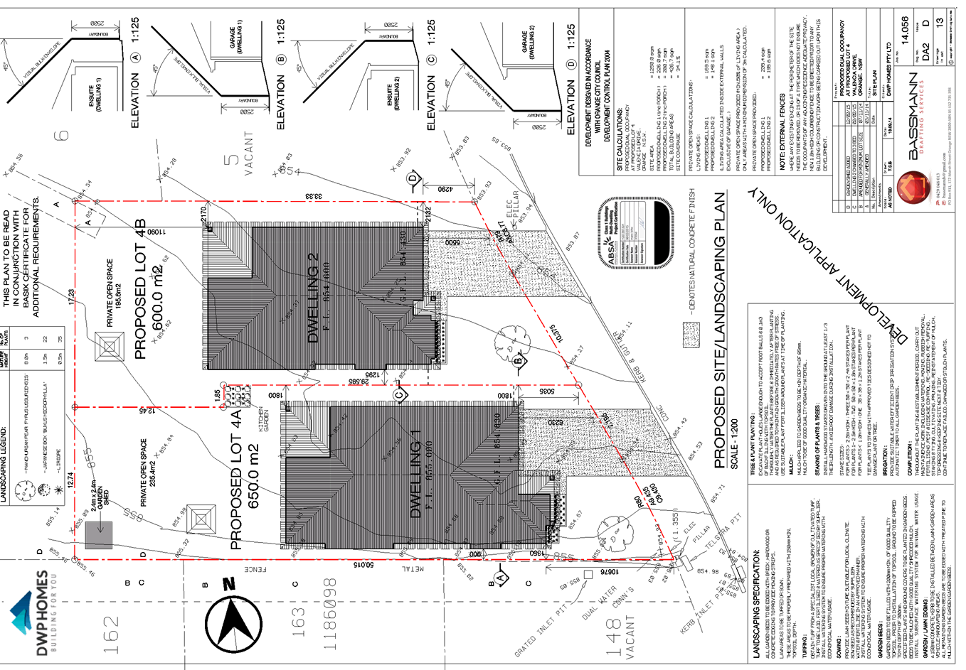
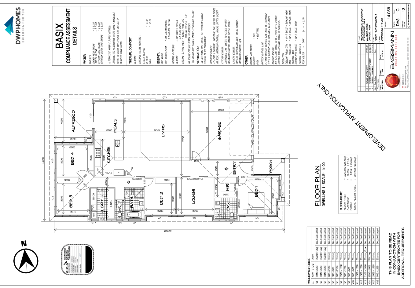
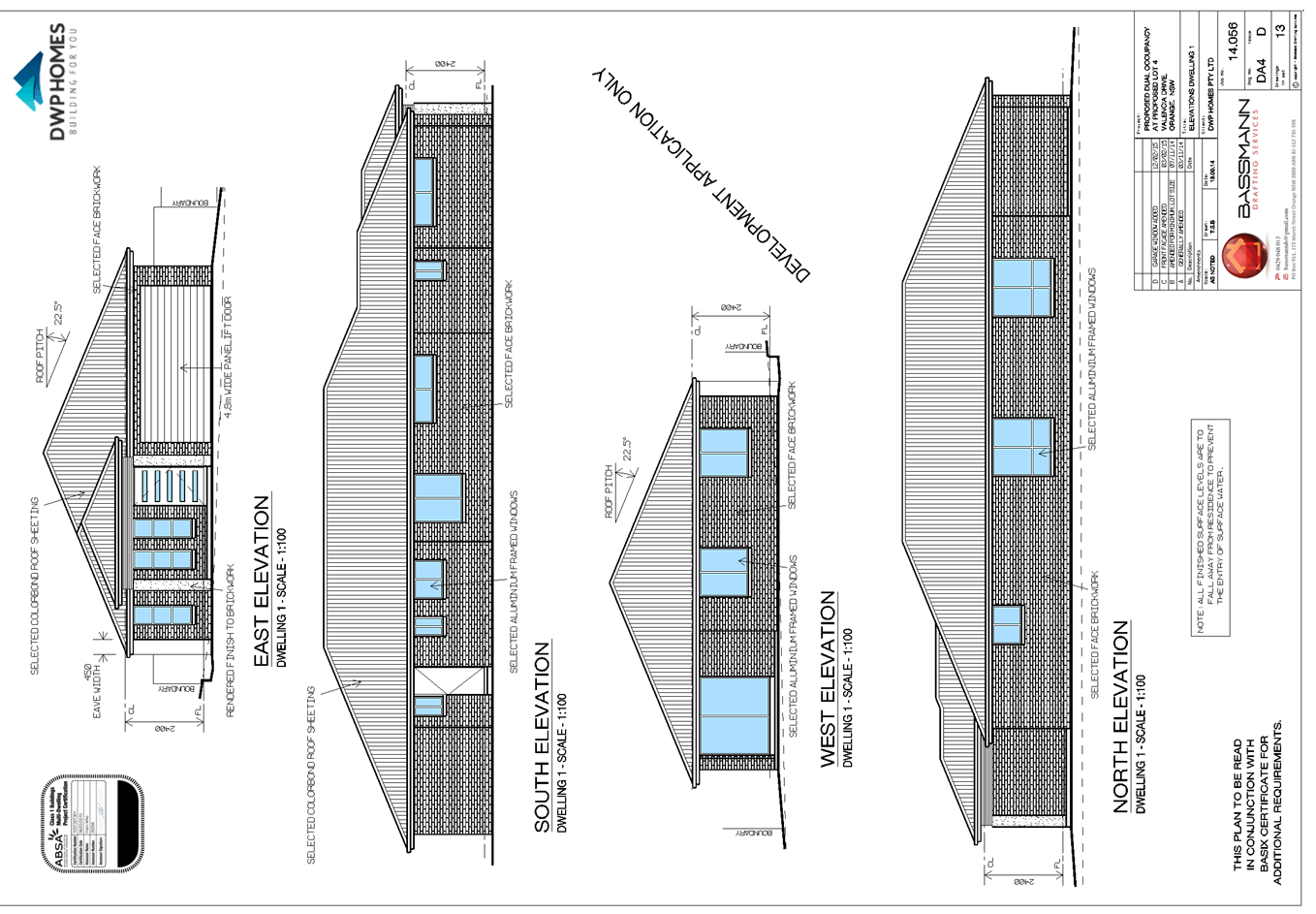
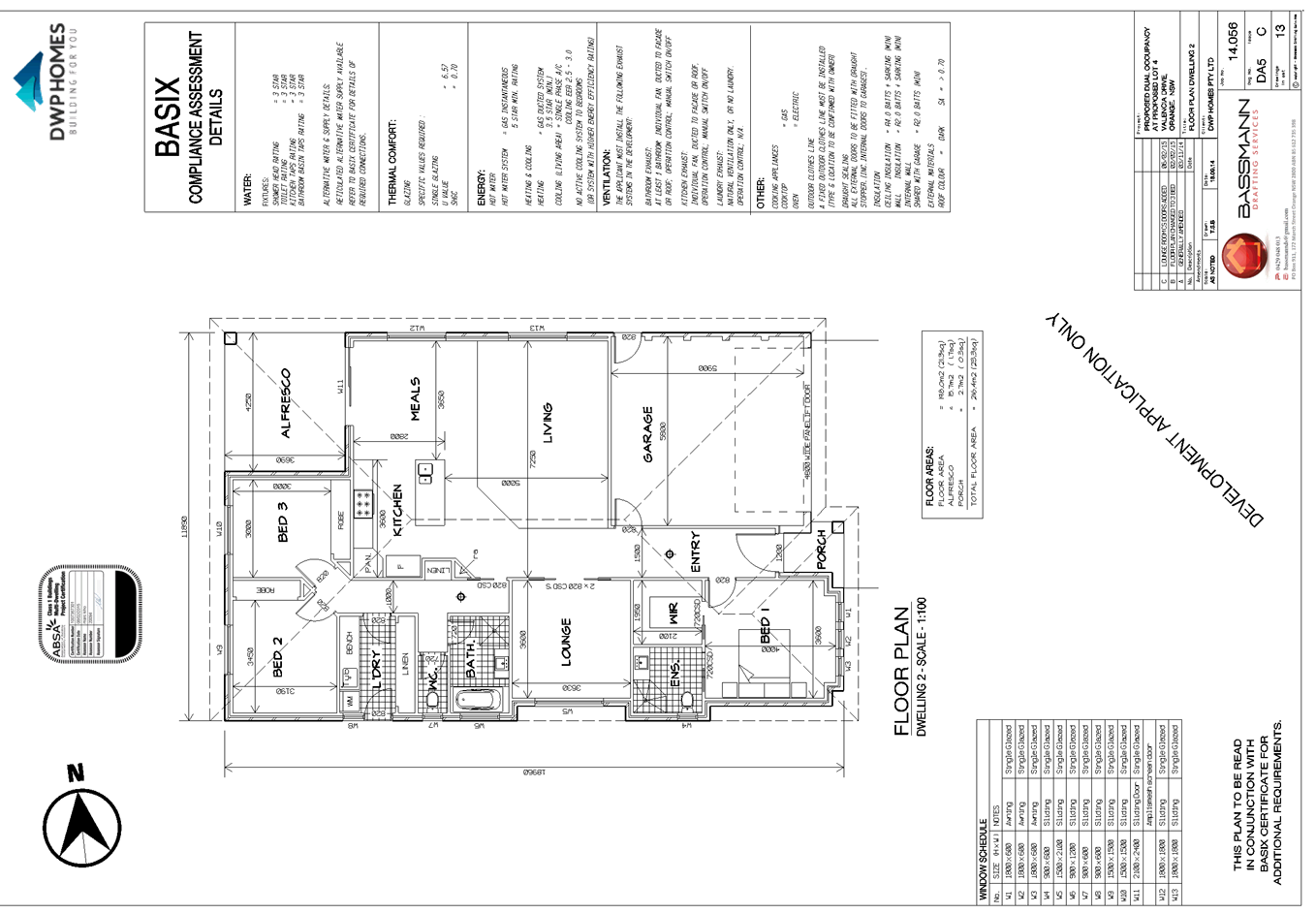
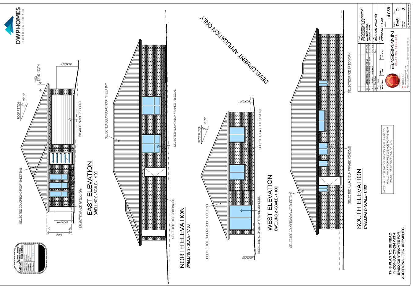
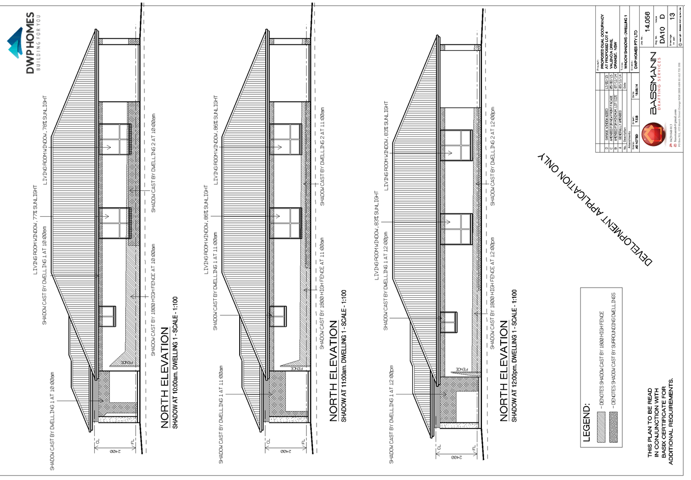
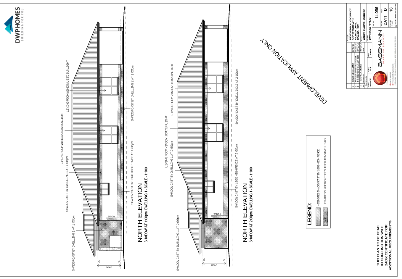
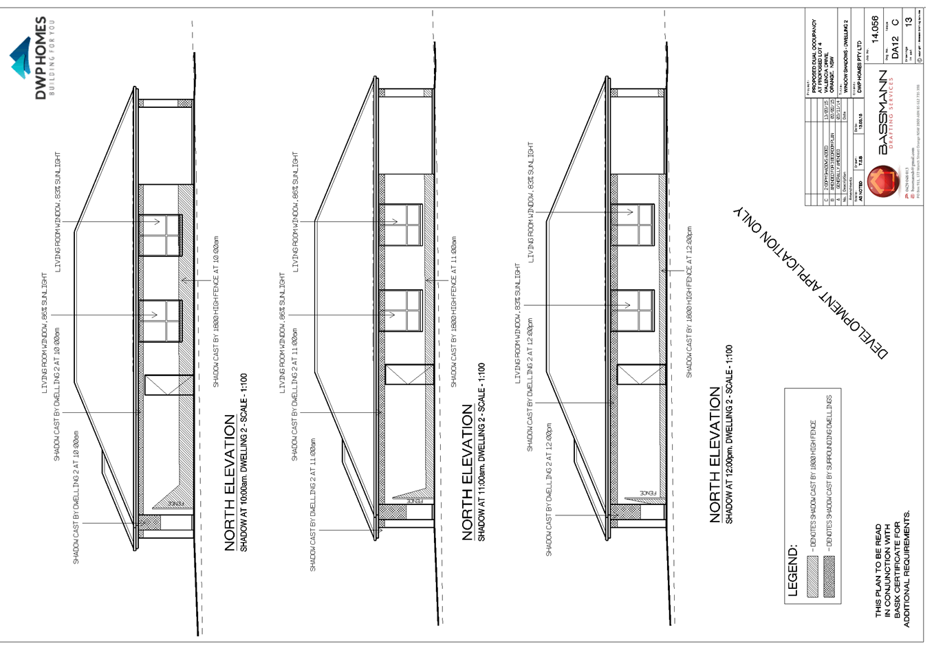
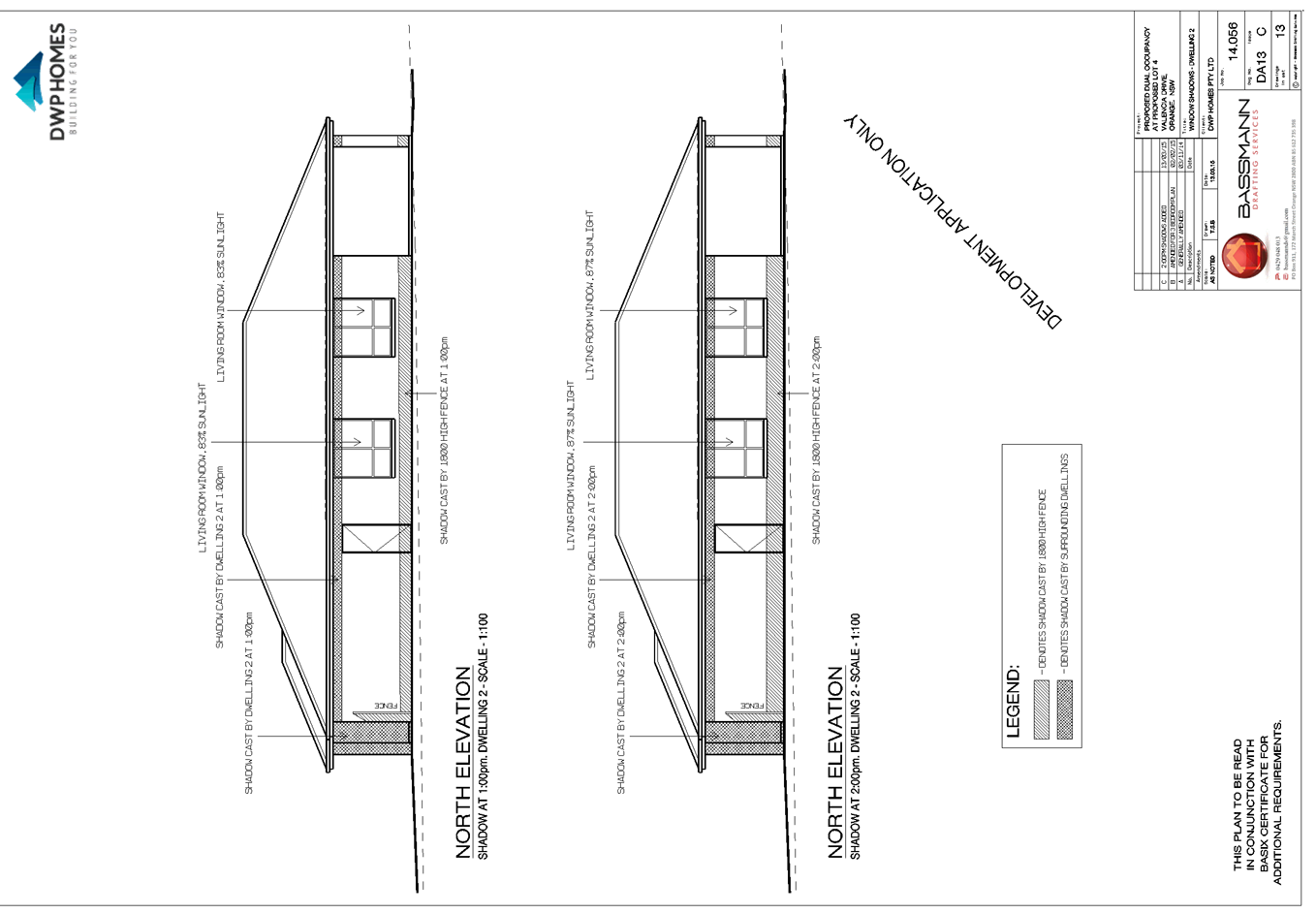
2.4 Development
Application DA 42/2015(1) - 389 Molong Road
TRIM
REFERENCE: 2015/823
AUTHOR: Michael
Glenn, Senior Planner
EXECUTIVE Summary
|
Application
lodged
|
17
February 2015
|
|
Applicant/s
|
Orange
City Council
|
|
Owner/s
|
Orange
City Council
|
|
Land
description
|
Lot
20 DP 1076334 - 389 Molong Road, Orange
|
|
Proposed
land use
|
Emergency
Services Facility (alterations and additions)
|
|
Value
of proposed development
|
$140,000
|
Council's consent is sought for an extension of the existing
building, to be used as an emergency services facility by the Rural Fire
Service at 389 Molong Road. The application is recommended for approval.
Link To Delivery/OPerational Plan
The recommendation in this report relates to the
Delivery/Operational Plan strategy “13.4 Our Environment
– Monitor and enforce regulations relating to City amenity”.
Financial Implications
Nil
Policy and Governance Implications
Nil
|
Recommendation
That Council consents to development application DA
42/2015(1) for Emergency Services Facility (alterations and additions)
at Lot 20 DP 1076334 - 389 Molong Road, Orange pursuant to the conditions of
consent in the attached Notice of Approval.
|
further considerations
Consideration has been given to the
recommendation’s impact on Council’s service delivery; image and
reputation; political; environmental; health and safety; employees;
stakeholders and project management; and no further implications or risks have
been identified.
SUPPORTING INFORMATION
THE APPLICATION
Council's consent is sought for alterations and additions to
an emergency services facility used by the Rural Fire Service at Lot 20 DP 1076334
- 389 Molong Road, Orange.
THE PROPOSAL
The proposal involves the addition of a new four bay shed to
the west of the existing shed. This shed will be connected to the existing
shed. The shed is proposed to be constructed of Colorbond materials with green
exterior and four vehicle sized roller shutters. In terms of external
appearance the proposed structure would be similar to the existing shed.
The proposal also includes the addition of a training room
that is to be placed at the front of the station along the southern boundary. This
element of the proposed building will be 8m x 4m. This area will
be constructed in green Colorbond. The proposed development incorporates
landscaping to soften the impact on what is considered to be a major entrance
point to the City at the north western corner of the intersection of the
Mitchell Highway and the Northern Distributor Road.
MATTERS FOR CONSIDERATION
Section 5A Assessment
In the administration of sections 78A, 79B, 79C, 111 and
112, the provisions of Section 5A must be taken into account for every
development application in deciding whether there is likely to be a significant
effect on threatened species, populations or ecological communities or their
habitats. This section includes a requirement to consider any adopted
assessment guidelines, which means assessment guidelines issued and in force
under section 94A of the Threatened Species Conservation Act 1995.
Assessment guidelines are in force (see DECC-W “Threatened Species
Assessment Guidelines - The Assessment of Significance”) which requires
consent authority to adopt the precautionary principle in its assessment.
The subject property does not have high inherent
biodiversity value, however parts of the site are located or affected by the
riparian zone for Ploughman's Creek. The Ploughman's Creek constructed wetlands
are located nearby to the south (but are upstream of the development), whilst
there are isolated pockets of significant vegetation within the creek system
itself, including on or adjacent to this site. Ploughman's Creek north of
Molong Road is a prescribed stream under the Fisheries Management Act
and likely to trigger a need for an integrated development assessment under
that legislation. North of Molong Road, the stream is also a Category 3 stream,
which also triggers a needs for integrated assessment under the Controlled Activity
provisions of the Water Management Act 2000 (integrated development
provisions are circumvented in this case because the proposed development is
being undertaken by a Public Authority, however this does not obviate or avoid
the implications the integrated development provisions infer).
The building contained in this proposed development does not
have any significant effect in terms of biodiversity impacts.
The landscaping that is proposed is cause for some concern
as it incorporates a proportion of non-native species within or close to the
riparian zone. Of particular concern is the selection of 5 x taxodium
distichum (Swamp Cypress) close to the waterway north of the proposed shed.
This species is large on maturity and from available data (no information was
provided in the submission regarding species characteristics) appears to be
prolific in its ability to propagate, particularly in riparian environments.
To assist in the assessment, advice was sought from Council’s
Wetlands Team Leader. She advises:
My concerns are that plantings
adjacent or near a waterway need to be thoroughly thought through with concerns
such as seed germination rates , tannin release from vegetative matter
particularly from deciduous species and changes to the hydrology within a site
considered before planting goes ahead. Reading through the documentation
on this species there is uncertainty as to whether this would happen but I do
agree with the (Project Support Officer Salinity & Water Quality
Alliance) that precaution is a must. I know that Ploughman’s Creek
is regarded as a significant waterway due to its location which I think is
classified as the commencement of the Barwon Darling Catchment flowing from
Ploughman’s to the Bell River and then onto the Macquarie River.
Another concern that I have is if we are to go ahead with this
design will the plantings of exotics have any negative outcome for future
funding which is strongly aimed at local endemic species as a must in
rehabilitation or restoration projects especially riparian zones that have a
great capacity to increase weed species throughout our landscape. I hope that
this helps as I agree with you and your aim to carry out the right approach to
planting in riparian zones.
Given the above comments and concerns, it is not considered
appropriate to utilise Swamp Cypress from an environmental standpoint. A
condition is included that requires these species to be replaced in the
landscape plan with a native species of similar height and appearance, but not
deciduous.
In this instance, subject to the conditions outlined above,
there would be no significant impacts arising from the proposed development on
the biodiversity values of the locality.
Section 79C
Section 79C of the Environmental Planning and Assessment
Act 1979 requires Council to consider various matters, of which those
pertaining to the application are listed below.
PROVISIONS OF ANY ENVIRONMENTAL
PLANNING INSTRUMENT s79C(1)(a)(i)
Orange Local Environmental Plan 2011
Part 1 - Preliminary
Clause 1.2 - Aims of Plan
The broad aims of the LEP are
set out under subclause 2. Those relevant to the application are as follows:
(a) to encourage development which complements
and enhances the unique character of Orange as a major regional centre boasting
a diverse economy and offering an attractive regional lifestyle,
(b) to provide for a range of development
opportunities that contribute to the social, economic and environmental
resources of Orange in a way that allows present and future generations to meet
their needs by implementing the principles for ecologically sustainable
development,
(c) to conserve and enhance the water
resources on which Orange depends, particularly water supply catchments,
In relation to (a), the proposed development is on a
prominent entry point of the City with a high degree of visibility. The
proposed structure is of unremarkable design, with materials not considered
particularly attractive. These are considered to be detrimental to the image
and character of the City. However to an extent, the setbacks from the road and
the landscaping that is proposed will to a degree mitigate the adverse visual
impacts of the building works. It is also considered that to a very limited
extent the placement of the shed behind the existing building will lessen or
limit the visual intrusion of this building. No landscaping has been provided
on the site since the construction of the existing building which is of
concern. It is considered important that landscaping be provided on the site under
this proposal. Attached is a condition of consent requiring landscaping to be
established prior to the issue of an occupation certificate.
In relation to (b) the provision of emergency services such
as a fire service of an adequate capacity is considered an essential pre-cursor
to the development of social, economic and environmental resources of the City.
In relation to (c), it needs to be acknowledged that the
proposed development is located within close proximity of a prescribed stream
that, except for certain provisions in the Water Management Act Regulation
(specifically clause 38 of the Water Management Act Regulations states
that: a public authority is exempt from section 91E (1) of the Act in
relation to all controlled activities that it carries out in, on or under
waterfront land) would normally need a co-approval from NSW Office of
Water. Section 91E is the trigger that requires integrated development
assessment for developments within a riparian zone of a prescribed stream. Such
an exemption does not remove the environmental consideration of development on
a riparian zone, but it does remove the need for co-approval from the NSW
Office of Water.
Clause 1.6 - Consent Authority
This clause establishes that, subject to the Act, Council is
the consent authority for applications made under the LEP.
Clause 1.9A - Suspension of
Covenants, Agreements and Instruments
This clause provides that covenants, agreements and other
instruments which seek to restrict the carrying out of development do not apply
with the following exceptions.
· covenants imposed
or required by Council
· prescribed
instruments under Section 183A of the Crown Lands Act 1989
· any conservation
agreement under the National Parks and Wildlife Act 1974
· any trust
agreement under the Nature Conservation Trust Act 2001
· any property
vegetation plan under the Native Vegetation Act 2003
· any biobanking
agreement under Part 7A of the Threatened Species Conservation Act 1995
· any planning
agreement under Division 6 of Part 4 of the Environmental Planning and
Assessment Act 1979.
Council staff are not aware of
the title of the subject property being affected by any of the above.
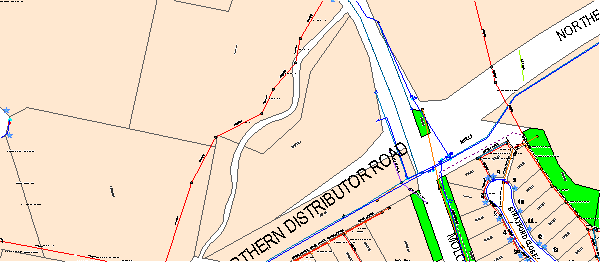
Mapping
The subject site is identified
on the LEP maps in the following manner:
|
Land Zoning Map:
|
Land zoned R5 Large Lot Residential
|
|
Lot Size Map:
|
Minimum Lot Size 20000m2
|
|
Heritage Map:
|
Not a heritage item or conservation
area
|
|
Height of Buildings Map:
|
No building height limit
|
|
Floor Space Ratio Map:
|
No floor space limit
|
|
Terrestrial Biodiversity Map:
|
No biodiversity sensitivity on the
site
|
|
Groundwater Vulnerability Map:
|
ground water vulnerable
|
|
Drinking Water Catchment Map:
|
Not within the drinking water
catchment
|
|
Watercourse Map:
|
within and/or affecting a defined watercourse
|
|
Urban Release Area Map:
|
Not within an urban release area
|
|
Obstacle Limitation Surface Map:
|
No restriction on building siting
or construction
|
|
Additional Permitted Uses Map:
|
No additional permitted use applies
|
Those matters that are of relevance are addressed in detail
in the body of this report.
Part 2 - Permitted or
Prohibited Development
Land Use Zones
As indicated in the
following map extracts, the subject property has more than one zone affecting
the site due to the irregular shape of the block and the mis-correlation to
zone boundaries.
The lot shape, as shown in the most recent registered survey
(dated August 2004, and drawn principally to excise that land required for the
corner splay for the Northern Distributor Road/Mitchell Highway intersection)
incorporates the Ploughman's Creek drainage line (which previously was not part
of the registered lot).
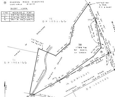
Note that the subject
property straddles Ploughman's creek.
The zoning extract from the relevant map layer of OLEP 2011
is as follows:
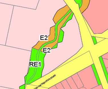
Comparing the zoning
extract to the registered lot plan, the conclusion is that the subject property
is zoned part R5 Large Lot Residential and part RE1 Public Open Space. It is
considered that there is no E2 Environmental Conservation zoned land affecting
the subject property.
In summary, the subject site is located within the R5 Large
Lot Residential and RE1 (Public Recreation) zones. The proposed
development is defined as an “emergency services facility” under
OLEP 2011. The proposed development is not permissible under the provisions of
the LEP for either of these zones.
However, development for the purpose of an emergency
services facility may be carried out with consent by or on behalf of the NSW
Rural Fire Service on land zoned R5 Large Lot Residential or RE1 ((Public
Recreation). This should not be viewed as overriding the LEP since, at the
introduction of the new Standard Instrument (of which OLEP 2011 is an example),
the Department of Planning made it very clear that it did not want duplication
in the lists of permissible uses between instruments.
By application of the
SEPP (Infrastructure) 2007, the proposed development is permissible in both
zones affecting the subject property.
Clause 2.3 of LEP 2011
references the Land Use Table and Objectives for each zone in LEP 2011.
These objectives for land zoned R5 Large Lot Residential are as follows:
1 - Objectives of the R5 Large Lot Residential Zone
· To
ensure that large residential lots do not hinder the proper and orderly
development of urban areas in the future.
· To
ensure that development in the area does not unreasonably increase the demand
for public services or public facilities.
· To
minimise conflict between land uses within this zone and land uses within
adjoining zones.
· To
ensure development is ordered in such a way as to maximise public transport
patronage, and encourage walking and cycling, in close proximity to settlement.
In relation to the first dot
point, there are no plans at the present time to change the density or minimum
lots sizes for this site. Regardless, as a site accommodating an emergency services
facility, such considerations are not really relevant.
With regard to the second dot
point, the proposed development will serve to actually increase the ability to
provide an emergency service considered vital to the benefit and safety of the
general community.
In relation to the third dot
point, there is theoretically potential for conflict between the proposed use
and more general residential development that may occur in the R5 zone. However,
the specifics of this site suggest that such risk is minimal. The site is
relatively isolated and removed from current and future residential development,
and its relatively infrequent use further suggests that imposts on residential
amenity would be rare or occasional.
In relation to the fourth dot
point, the opportunities for public transport to this facility are limited,
however the need for access to public transport to and from a facility of this
type is considered to be very low. There is not a need for the general public
to attend this facility and volunteer firefighters are likely to use private
motor vehicles to get to and from the site.
2 - Objectives of the RE1 Public Open Space Zone
· To
enable land to be used for public open space or recreational purposes.
· To
provide a range of recreational settings and activities and compatible land
uses.
· To
protect and enhance the natural environment for recreational purposes.
· To
ensure development is ordered in such a way as to maximise public transport
patronage and encourage walking and cycling in close proximity to settlement.
With regard to the first, third
and fourth dot points, the proposed development is inconsistent with the zone
objectives. It cannot be considered development that in any way is associated
with recreational or open space land use. With regard to the second dot point,
it can be argued that the overall use of the site, incorporating as it does
large areas of unused outdoor space and good levels of landscaping, might be
considered allied or incidental land uses that complement the second open space
zoning of the site and its purpose as public open space.
Part 7 - Additional
Local Provisions
7.1 - Earthworks
This clause
establishes a range of matters that must be considered prior to granting
development consent for any application involving earthworks, such as:
(a) the likely disruption of, or any
detrimental effect on, existing drainage patterns and soil stability in the
locality of the development
(b) the effect of the development on the
likely future use or redevelopment of the land
(c) the quality of the fill or the soil to be
excavated, or both
(d) the effect of the development on the
existing and likely amenity of adjoining properties
(e) the source of any fill material and the
destination of any excavated material
(f) the likelihood of disturbing relics
(g) the proximity to and potential for adverse
impacts on any waterway, drinking water catchment or environmentally sensitive
area
(h) any measures proposed to minimise or
mitigate the impacts referred to in paragraph (g).
The earthworks
proposed in the application are limited to the extent of cutting and filling
required for the proposed building or structure. The extent of disruption to
the drainage of the site is considered to be minor and will not detrimentally
affect adjoining properties or receiving waterways, subject to effective
installation of erosion and sediment control measures.
The extent of the
earthworks will not materially affect the potential future use or redevelopment
of the site that may occur at the end of the proposed development's lifespan.
The site is not known
to be contaminated. The earthworks will be appropriately supported onsite and
the change in ground level is not substantial. Therefore the effect on the
amenity of adjoining properties is considered to be minor.
The site is not known
to contain any Aboriginal, European or archaeological relics. Previous known
uses of the site do not suggest that any relics are likely to be uncovered.
The site is in
proximity to a prescribed waterway, but not a City drinking water catchment.
Conditions are included in the consent that require a sediment control plan,
including silt traps and other protective measures, to ensure that loose dirt
and sediment does not escape the site boundaries.
7.2 - Flood Planning
This clause applies
to:
(a) land
identified as “Flood planning area” on the Flood Planning Map, and
(b) other
land at or below the flood planning level
The subject property is not shown as a Flood Planning Area on
Councils LEP flooding maps , however it is affected to a limited extent by
overland flowpaths (a limited form of flooding threat) as shown in the attached
map extract:
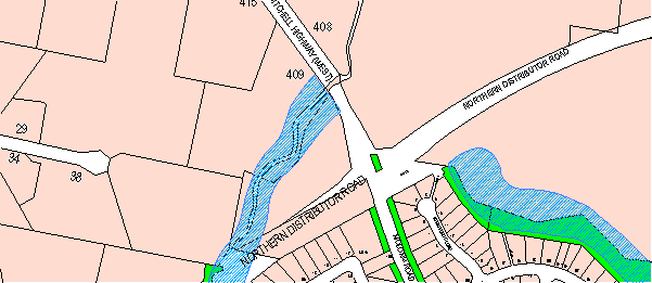
Such affectation is
an appropriate trigger for consideration under (b) above.
Before any consent is
issued, Council must be satisfied that the proposal:
(a) is compatible with the flood hazard of the
land, and
(b) is not likely to significantly adversely
affect flood behaviour resulting in detrimental increases in the potential
flood affectation of other development or properties, and
(c) incorporates appropriate measures to
manage risk to life from flood, and
(d) is not likely to significantly adversely
affect the environment or cause avoidable erosion, siltation, destruction of
riparian vegetation or a reduction in the stability of river banks or
watercourses, and
(e) is not likely to result in unsustainable
social and economic costs to the community as a consequence of flooding.
In relation to (a),
the proposed building would be located outside the overland flowpath,
suggesting minimal risk. In relation to (b), the proposed development is
unlikely to significantly affect flood behaviour, and will not result in
increased affectation of other properties or development. In relation to (c)
the proposed development does not inherently pose any elevated risk to
increased flooding. In relation to (d), conditions are included to minimise
erosion and sedimentation arising from the proposed development. In relation
to (e) the proposed development has no obvious elements likely to result
in unsustainable
social and economic costs to the community due to flooding.
In this regard, the
proposed development is unlikely to change flooding regimes on or off the site,
and would be unlikely to cause or contribute to erosion, siltation or reduce
riparian vegetation, and is therefore unlikely to create a cost burden on the
community.
7.3 - Stormwater
Management
This clause applies
to all industrial, commercial and residential zones and requires that Council
be satisfied that the proposal:
(a) is designed to maximise the use of water
permeable surfaces on the land having regard to the soil characteristics
affecting onsite infiltration of water
(b) includes, where practical, onsite
stormwater retention for use as an alternative supply to mains water, groundwater
or river water; and
(c) avoids any significant impacts of
stormwater runoff on adjoining downstream properties, native bushland and
receiving waters, or if that impact cannot be reasonably avoided, minimises and
mitigates the impact.
The proposal will not
significantly affect runoff rates from the subject property and runoff can be
managed in such a way as to restrict post development discharge rates to the
same as pre-development flows.
7.4 - Terrestrial
Biodiversity
This clause seeks to
maintain terrestrial biodiversity and requires that consent must not be issued
unless the application demonstrates whether or not the proposal:
(a) is likely to have any adverse impact on
the condition, ecological value and significance of the fauna and flora on the
land
(b) is likely to have any adverse impact on
the importance of the vegetation on the land to the habitat and survival of
native fauna
(c) has any potential to fragment, disturb or
diminish the biodiversity structure, function and composition of the land, and
(d) is likely to have any adverse impact on
the habitat elements providing connectivity on the land.
Additionally this clause
prevents consent being granted unless Council is satisfied that:
(a) the development is designed, sited and
will be managed to avoid any significant adverse environmental impact, or
(b) if that impact cannot be reasonably
avoided - the development is designed, sited and will be managed to minimise
that impact, or
(c) if that impact cannot be minimised - the
development will be managed to mitigate that impact.
The subject property has no
onsite biodiversity of significant value, however there are some isolated
patches here and there along the creek line. The landscaping plan that was
submitted with the application incorporates some species that are considered
inappropriate. To address this, a condition is included in the consent that
requires more appropriate species selection along the creek boundary closest to
the creek.
7.5 - Riparian Land
and Watercourses
This clause seeks to
preserve both water quality and riparian ecological health. The clause applies
to land identified as a “Sensitive Waterway” on the Watercourse
Map. The subject land contains such a waterway and therefore Council must
consider whether or not the proposal:
(a) is likely to have any adverse impact on
the following:
(i) the water quality and flows within a
watercourse
(ii) aquatic and riparian species, habitats
and ecosystems of the watercourse
(iii) the stability of the bed and banks of the watercourse
(iv) the free passage of fish and other aquatic
organisms within or along the watercourse
(v) any future rehabilitation of the
watercourse and its riparian areas, and
(b) is
likely to increase water extraction from the watercourse.
Additionally, consent
may not be granted until Council is satisfied that:
(a) the development is designed, sited and
will be managed to avoid any significant adverse environmental impact, or
(b) if that impact cannot be reasonably
avoided - the development is designed, sited and will be managed to minimise
that impact, or
(c) if that impact cannot be minimised - the
development will be managed to mitigate that impact.
While the subject site does
contain a sensitive waterway, the proposal has been designed to site the building
in excess of 30m from the waterway. Using the NSW Office of Water's stream
classification system as a guideline (the Strahler method) the nearby stream is
a Category 2 waterway, with a prescribed riparian corridor of 20m from the
top of the bank of the stream. It is difficult in this instance to precisely
define the top of the bank, however it is considered that the stream bank (such
as it is) is further than 20m.
There is a reasonable separation
distance to manage the post development runoff. Additionally, stormwater
retention will be required for this development and will further reduce
potential risk to the watercourse.
Overall, while there will always
remain a risk to the waterway under extreme circumstances such as record storms
and the like, it is considered that the risk of adverse impact can be
appropriately managed to an acceptable level.
7.6 - Groundwater
Vulnerability
This clause seeks to
protect hydrological functions of groundwater systems and protect resources
from both depletion and contamination. Orange has a high water table and large
areas of the LGA, including the subject site, are identified with
“Groundwater Vulnerability” on the Groundwater Vulnerability Map.
This requires that Council consider:
(a) whether or not the development (including
any onsite storage or disposal of solid or liquid waste and chemicals) is
likely to cause any groundwater contamination or have any adverse effect on
groundwater dependent ecosystems, and
(b) the cumulative impact (including the
impact on nearby groundwater extraction for potable water supply or stock water
supply) of the development and any other existing development on groundwater.
Furthermore consent may not be granted unless Council is satisfied that:
(a) the development is designed, sited and
will be managed to avoid any significant adverse environmental impact, or
(b) if that impact cannot be reasonably
avoided - the development is designed, sited and will be managed to minimise
that impact,
(c) if that impact cannot be minimised - the
development will be managed to mitigate that impact.
The proposal is not
anticipated to involve the discharge of toxic or noxious substances and is
therefore unlikely to contaminate the groundwater or related ecosystems. The
proposal does not involve extraction of groundwater and will therefore not
contribute to groundwater depletion. The design and siting of the proposal
avoids impacts on groundwater and is therefore considered acceptable.
STATE ENVIRONMENTAL PLANNING
POLICIES
State Environmental Planning Policy (Infrastructure) 2007
(the "SEPP") applies to the subject development. As an "emergency
services facility", special provisions are applicable in the SEPP that
serve to give permissibility to the proposed use and provide controls in the
assessment application.
The aims of this Policy are to facilitate the effective
delivery of infrastructure across the State by:
(a) improving
regulatory certainty and efficiency through a consistent planning regime for
infrastructure and the provision of services, and
(b) providing
greater flexibility in the location of infrastructure and service facilities,
and
(c) allowing
for the efficient development, redevelopment or disposal of surplus government
owned land, and
(d) identifying
the environmental assessment category into which different types of
infrastructure and services development fall (including identifying certain
development of minimal environmental impact as exempt development), and
(e) identifying
matters to be considered in the assessment of development adjacent to
particular types of infrastructure development, and
(f) providing
for consultation with relevant public authorities about certain development
during the assessment process or prior to development commencing.
The proposed development is considered to be not inconsistent
with the aims of the policy.
Clause 8 of the policy sets out the relationship between the
policy and other environmental planning instruments (EPIs). For OLEP 2011, the
relationship is that if there is an inconsistency between the SEPP and the LEP,
whether made before or after the commencement of this Policy, this Policy
prevails to the extent of the inconsistency.
Clause 47 of the SEPP has the effect of making an emergency
services facility permissible with consent.
PROVISIONS OF ANY DRAFT
ENVIRONMENTAL PLANNING INSTRUMENT THAT HAS BEEN PLACED ON EXHIBITION
s79C(1)(a)(ii)
There are no draft environmental planning instruments that
apply to the subject land or proposed development.
DESIGNATED DEVELOPMENT
The proposed development is not designated development.
PROVISIONS OF ANY DEVELOPMENT
CONTROL PLAN s79C(1)(a)(iii)
Development Control Plan 2004
Development Control Plan 2004 (“the DCP”)
applies to the subject land. An assessment of the proposed development against
the relevant Planning Outcomes will be undertaken below.
Pursuant to Planning Outcome 0.2-1
Interim Planning Outcomes - Conversion of Zones:
· Throughout this
Plan, any reference to a zone in Orange LEP 2000 is to be taken to be a
reference to the corresponding zone(s) in the zone conversion table.
That part of the site now zoned R5 Large Lot Residential was
previously zoned 1(c) Rural Residential under the previous LEP. These two zones
are equivalent to each other. The land now zoned RE1 Public Recreation was
previously zoned 6 (Open Space and Recreation) which are also zones that are
equivalent to each other.
As such, for the R5 Large Lot Residential the most
appropriate chapters for consideration are Chapters 6 (Rural Development) and
Chapter 7 (Residential Development). Both these chapters are principally
concerned with development types other than emergency services facilities. The
issues principally relevant are those guidelines relating to visual bulk and
parking.
With regard to the RE1 affectation, Chapter 11 of th e DCP
is the relevant chapter for consideration of the development insofar as it
relates to the RE1 land. There are no elements of this chapter of the DCP that
are relevant to the proposed development.
Visual Bulk
The subject site is located in a prominent entry point of
the City, and the building proposed, when considered in conjunction with the
existing structure will be of substantial bulk and visual presence and finished
in materials and colours likely to detract from the amenity and character of
the area. The existing building is skinned in "Mist Green" Colorbond,
which is badly faded and quite visually prominent in its effect. It will not be
possible to exactly colour match this finish in the new extension. Given that
the Mist Green finish is not a colour that diminishes the visual impact of the
building, this major upgrade of the building should be taken as an opportunity
to change direction in the finishes and specify a colour less obtrusive. In
this regard, the Council heritage architect has advised that the most
appropriate colour selection in the Colorbond range to achieve this blending in
effect is "Wind Spray", a silver-grey colour similar to dulled
galvanised iron. A condition to that effect is included in the attached Notice
of Approval.
Landscaping is included in the proposed development, and
from the standpoint of visual masking, generally considered to be satisfactory.
A condition is included requiring slight amendment of the landscaping plan for
environmental reasons (already discussed in this report); however such changes
will not detract from the purpose of the landscaping as a screening element.
Car Parking
The applicant has submitted a letter stating that the new
extension would be used as a vehicle storage shed for vehicles currently stored
in the open at the RFS facility in South Orange. Once constructed the building
may or may not be used for this purpose.
The RFS has access to the whole of the site, and in the past
volunteers and others attending the site have tended to park informally on the
grassed areas. There is no objection to this, and one is led to the conclusion
that the additional building contained in this proposed development, whilst
likely to increase demand for parking to an unspecified extent, can still be
accommodated in this informal fashion after the completion of the proposed
development.
However, there are a number of issues associated with
parking that need to be addressed by appropriate conditions in the consent. These
issues of concern are discussed below.
1 Vehicle
access onto and off the site other than via the designated access drive. The
following photographic image demonstrates that such access is occurring from
the Northern Distributor Road and that such access is an unsafe practice).
Unauthorised entry from the Northern Distributor Road
2 Protection
and delineation of the landscaped areas of the site to prevent or discourage
damage and compaction to these areas.
3 Prevent
vehicles associated with the use being parked roadside in either the NDR or
Molong Road.
Conditions are included in the attached approval that
address these issues
PROVISIONS PRESCRIBED BY THE REGULATIONS
s79C(1)(a)(iv)
Demolition of a Building (clause 92)
The proposal does not involve the demolition of a building.
Fire Safety Considerations
(clause 93)
The proposal does not involve a change of building use for
an existing building.
Buildings to be Upgraded
(clause 94)
Upgrading of the building will be required to ensure that
the existing building is brought into partial or total conformity with the
Building Code of Australia. Conditions are attached in relation to the required
upgrading works.
THE LIKELY IMPACTS OF THE
DEVELOPMENT s79C(1)(b)
Traffic Impacts
It is considered that the existing access via Molong Road is
satisfactory in terms of its ability to allow the safe entry and exit to and
from the property. The unauthorised entry from the NDR is not a safe means of
access to and from the site. A condition of consent is included in the attached
consent that excludes any access other than from the approved access point.
Visual Impacts
The proposed development involves the construction of a large
building which is considered already to have adverse visual effects due to the
nature of the construction and the absence of any significant screening. It is
considered appropriate given the prominence of the location to impose a
condition requiring details of external colours and finishes.
As to colours, the obvious choice is to simply match the
existing shed colour, however this does have a number of adverse aspects. It
will not be possible to fully colour match the existing material because it is
10 years old and significantly faded compared to the new equivalent material
"Mist Green". This colour as a building choice was a popular colour
in the 80's and 90's because it was assumed to be a colour that would
"blend in" with the landscape. However, experience shows this to not
be the case at all. A better, more landscape compatible colour would be a
"Monument Grey" or "Wind Spray". It is conceded, however,
that colour choice in this case is a lesser problem to the building form and general
finish.
The building will be placed on a longitudinal orientation,
which will make the building more visible from Molong Road to the northeast and
when travelling north and south along the Northern Distributor Road. It is
considered that the visual impact of the building when viewed from the
properties to the west of the site is reduced to a degree by the existing riparian
vegetation and the fact that the building sits below the finished surface level
of the Northern Distributor Road.
Both the existing building and proposed extension have (or
will have) adverse impacts on City presentation and streetscape. This would be
not a big problem in a less prominent location, but the site is a prominent
entry point to the City, and in many ways gives a poor impression of the City's
cultural depth. It is an essential emergency service, and the RFS funds
are quite limited (these facts are acknowledged); but as an element of the
landscape, the existing building and the proposed extension present poorly. As
indicated previously landscaping has not been provided on the site since the
construction of the existing building and the current visual appearance of the
development highlights the need to effectively landscape the site. The main
saving grace for this building is the setback from the boundary, particularly
the Molong Road side of the site. Further, the site coverage is very small,
allowing significant landscaping elements to be considered.
The proposed development incorporates a landscape plan,
which to a degree will lessen the visual impact of the building. It is
important that the landscaping be installed promptly, nurtured during its
initial establishment period (approximately two years from the date of
planting) and protected (particularly from vehicles moving around the site) so
that it does achieve its screening purpose. Conditions are included aimed at
achieving those outcomes.
Environmental Impacts
The environmental impacts of the proposed development are
considered to be very minor. There is a minor level of concern with regard to
one of the non-native species adjacent to the riparian zone. As previously
stated, this can be addressed as a condition of consent.
THE SUITABILITY OF THE SITE
s79C(1)(c)
The site is considered suitable for the proposed development
ANY SUBMISSIONS MADE IN
ACCORDANCE WITH THE ACT s79C(1)(d)
The proposed development is not defined as advertised
development under the provisions of the LEP, and as such no formal exhibition
of the application was required. No submissions have been received in relation
to this application.
PUBLIC INTEREST
s79C(1)(e)
The proposed development is considered to be of minor
interest to the wider public due to the relatively localised nature of
potential impacts. The proposal is not inconsistent with any relevant policy
statements, planning studies, guidelines, etc that have not been considered in
this assessment.
SUMMARY
The proposed development is permissible with the consent of
Council. The proposed development complies with the relevant aims, objectives
and provisions of the LEP. A section 79C assessment of the
development indicates that the development is acceptable in this instance.
Attached is a draft Notice of Approval outlining a range of conditions
considered appropriate to ensure that the development proceeds in an acceptable
manner.
COMMENTS
The requirements of the Environmental Health and Building
Surveyor and the Engineering Development Section are included in the attached
Notice of Approval.
Attachments
1 Notice
of Approval, D15/8406⇩
2 Plans,
D15/7820⇩
Sustainable Development Committee
7 April 2015
2.4 Development
Application DA 42/2015(1) - 389 Molong Road
Attachment 1 Notice
of Approval
|

|
ORANGE
CITY COUNCIL
Development
Application No DA
42/2015(1)
NA15/ Container
PR20001
|
NOTICE OF DETERMINATION
OF A DEVELOPMENT APPLICATION
issued under the Environmental
Planning and Assessment Act 1979
Section 81(1)
|
Development
Application
|
|
|
Applicant Name:
|
Orange
City Council
|
|
Applicant Address:
|
(Attention
Kelvin Gardiner)
PO Box 35
ORANGE
NSW 2800
|
|
Owner’s Name:
|
Orange City
Council
|
|
Land to Be Developed:
|
Lot 20 DP
1076334 - 389 Molong Road, Orange
|
|
Proposed Development:
|
Emergency
Services Facility (alterations and additions)
|
|
|
|
|
Building
Code of Australia
building classification:
|
Class 5
and Class 7
|
|
|
|
|
Determination
|
|
|
Made On:
|
7 April
2015
|
|
Determination:
|
CONSENT
GRANTED SUBJECT TO CONDITIONS DESCRIBED BELOW:
|
|
|
|
|
Consent to
Operate From:
|
8 April
2015
|
|
Consent to
Lapse On:
|
8 April
2020
|
Terms of Approval
The reasons for the imposition of
conditions are:
(1) To ensure a quality
urban design for the development which complements the surrounding environment.
(2) To maintain
neighbourhood amenity and character.
(3) To ensure compliance
with relevant statutory requirements.
(4) To provide adequate public
health and safety measures.
(5) Because the development
will require the provision of, or increase the demand for, public amenities and
services.
(6) To ensure the utility
services are available to the site and adequate for the development.
(7) To prevent the proposed
development having a detrimental effect on adjoining land uses.
(8) To minimise the impact
of development on the environment.
Conditions
(1) The
development must be carried out in accordance with:
(a) Plan/s
numbered Undated, unreferenced plan sheets submitted with the application (6
sheets)
(b) statements
of environmental effects or other similar associated documents that form part
of the approval
as amended
in accordance with any conditions of this consent.
(2) All building work must
be carried out in accordance with the provisions of the Building Code of
Australia.
(3) A sign is to be erected
in a prominent position on any site on which building work, subdivision work or
demolition work is being carried out:
a. showing
the name, address and telephone number of the principal certifying authority
for the work, and
b. showing
the name of the principal contractor (if any) for any building work and a
telephone number on which that person may be contacted outside working hours,
and
c. stating
that unauthorised entry to the site is prohibited.
Any such sign is to be maintained while the
building work, subdivision work or demolition work is being carried out.
|
PRIOR TO THE ISSUE OF
A CONSTRUCTION CERTIFICATE
|
(4) Full details of
external colours and finishes of external materials are to be submitted and
approved by Councils Manager Development Assessments prior to the issue of a
Construction Certificate.
(5) An amended landscaping
plan is required that replaces the Swamp Cypress species included in the plan
with a replacement riparian species of native origin. This amended plan shall
be submitted and approved by Council's Manager Development Assessments prior to
the issue of a Construction Certificate.
(6) A
Construction Certificate application is required to be submitted to, and issued
by, Council/Accredited Certifier prior to any excavation or building works
being carried out on site.
(7) A
Fire Safety Schedule specifying the fire-safety measures (both current and/or
proposed) to be implemented in the building is to be submitted with the
Construction Certificate application, in accordance with Part 9 Clause 168 of
the Environmental Planning and Assessment Regulation 2000.
(8) Plans
and specifications are to be provided indicating all details in relation to the
energy efficiency of the building in accordance with Section J (Energy
Efficiency) of the Building Code of Australia.
(9) Engineering plans
providing complete details of the proposed manoeuvring areas in front of the
proposed building shall be submitted to Orange City Council or an Accredited
Certifier (Categories B1, C3, C4, C6) upon application for a Construction
Certificate. These plans are to provide details of levels, cross falls of all
pavements, proposed sealing materials and proposed drainage works and are to be
in accordance with Orange City Council Development and Subdivision Code.
(10) All stormwater from the
site is to be collected and piped to the existing drainage system on site.
Orange City Council or an Accredited Certifier (Categories B1, C3, C4, C6),
prior to issuing a Construction Certificate, is to approve engineering plans
for this drainage system.
(11) A water and soil
erosion control plan is to be submitted to Orange City Council or an Accredited
Certifier (Categories B1, C3, C4, C6) for approval prior to the issuing of a
Construction Certificate. The control plan is to be in accordance with the
Orange City Council Development and Subdivision Code and the Landcom, Managing
Urban Stormwater; Soils and Construction Handbook.
|
PRIOR TO WORKS
COMMENCING
|
(12) A
temporary onsite toilet is to be provided and must remain throughout the
project or until an alternative facility meeting Council’s requirements
is available onsite.
(13) Soil erosion control
measures shall be implemented on the site.
|
DURING
CONSTRUCTION/SITEWORKS
|
(14) All
construction/demolition work on the site is to be carried out between the hours
of 7.00 am and 6.00 pm Monday to Friday inclusive, 7.00 am to
5.00 pm Saturdays and 8.00 am to 5.00 pm on Sundays and Public
Holidays. Written approval must be obtained from the General Manager of Orange
City Council to vary these hours.
(15) Where Orange
City Council is appointed as the Principal Certifying Authority, the following
inspections will be required to be carried out by Council:
- footing
reinforcement, prior to the pouring of concrete
- slab
reinforcement, prior to the pouring of concrete
- frame
inspection
- final
inspection
Should any of the above mandatory
inspections not be carried out by Council, an Occupation Certificate will not
be issued on the complete structure.
(16) Any adjustments to
existing utility services that are made necessary by this development
proceeding are to be at the full cost of the developer.
(17) The
provisions and requirements of the Orange City Council Development and
Subdivision Code are to be applied to this application and all work constructed
within the development is to be in accordance with that Code.
The developer is to be entirely responsible for
the provision of water, sewerage and drainage facilities capable of servicing
all the lots from Council’s existing infrastructure. The developer is to
be responsible for gaining access over adjoining land for services where
necessary and easements are to be created about all water, sewer and drainage
mains within and outside the lots they serve.
(18) All manoeuvring areas
in front of the proposed building shall be sealed with bitumen, hot mix or
concrete and are to be designed for all expected loading conditions (provided
however that the minimum pavement depth for gravel and flush seal roadways is
200mm) and be in accordance with the Orange City Council Development and Subdivision
Code.
|
PRIOR TO THE ISSUE OF
AN OCCUPATION CERTIFICATE
|
(19) Appropriate control
devices that prevent regular unauthorised access by vehicles onto or over the
designated landscape beds is to be provided. Such control devices can include
fencing or rock armouring. A design sketch is to be submitted showing the
details of the required protection, prior to the carrying out of the work. The
work shall be undertaken prior to issue of an Occupation Certificate.
(20) No
person is to use or occupy the building or alteration that is the subject of
this approval without the prior issuing of an Occupation Certificate.
(21) Finished
ground levels are to be graded away from the buildings and adjoining properties
and must achieve natural drainage. The concentrated flows are to be dispersed
down slope or collected and discharged to the stormwater drainage system.
(22) Commitments
listed in the Section J Report - “Energy Efficiency” must be
fulfilled and certified by the installer prior to the issue of an Occupation
Certificate.
(23) A final inspection of
water, sewer and stormwater drainage shall be carried out by Orange City Council
prior to the issue of either an Interim or Final Occupation Certificate.
(24) Certification from
Orange City Council is required to be submitted to the Principal Certifying
Authority prior to the issue of an Occupation Certificate stating that all works
relating to connection of the development to Council assets, works on Public
Land, stormwater, sewer and water reticulation mains and footpaths have been
carried out in accordance with the Orange City Council Development and
Subdivision Code and the foregoing conditions.
(25) All
of the foregoing conditions are to be at the full cost of the developer and to
the requirements and standards of the Orange City Council Development and
Subdivision Code, unless specifically stated otherwise. All work required by
the foregoing conditions is to be completed prior to the issuing of an
Occupation Certificate, unless stated otherwise.
(26) Landscaping
shall be established in accordance with the stamped approved plans prior to the
issue of an Occupation Certificate.
|
MATTERS FOR THE
ONGOING PERFORMANCE AND OPERATION OF THE DEVELOPMENT
|
(27) Vehicular access onto
and off the site shall be limited at all times, for all vehicles attending the
site, to the approved access point from Molong Road
Operators
of the facility shall ensure that all current members, and all future members
are advised of this restriction as part of their training and induction
processes.
In
the event that unauthorised access from points other than the approved access drive
continues, on written direction from Council, fencing or other control devices
shall be installed at the full cost of the occupant within 60 days of such
direction being given. A design detail for such devices shall be submitted and
that is to the satisfaction of Council prior to the carrying out of such work.
(28) Vehicles attending this
site shall not be parked outside the site, in particular, no parking is
permitted in the verge areas of the Northern Distributor or Molong Road
(29) The
owner is required to provide to Council and to the NSW Fire Commissioner an
Annual Fire Safety Statement in respect of the fire-safety measures, as
required by Clause 177 of the Environmental Planning and Assessment
Regulation 2000.
Other Approvals
(1) Local
Government Act 1993 approvals granted under section 68.
Nil
(2) General
terms of other approvals integrated as part of this consent.
(1) All
plumbing and drainage (water supply, sanitary plumbing and drainage, stormwater
drainage and hot water supply) is to comply with the Local Government
(Water, Sewerage and Drainage) Regulation 1998, the Plumbing Code of
Australia 2012 - Plumbing & Drainage and Australian
Standard AS3500 - National Plumbing and Drainage Code. Such work is to be
installed by a licensed plumber and is to be inspected and approved by Council
prior to concealment.
(2) Convey
all stormwater a minimum of 3m clear of any building, boundaries and human
waste water treatment disposal areas.
Right of Appeal
If
you are dissatisfied with this decision, section 97 of Environmental
Planning and Assessment Act 1979 gives you the right to appeal to the Land
and Environment Court within 6 months after the date on which you receive this
notice.
*
Section 97 of the Environmental Planning and Assessment Act 1979 does not apply
to the determination of a development application for State significant
development or local designated development that has been the subject of a
Commission of Inquiry.
|
Disability Discrimination Act
1992:
|
This application has been assessed in
accordance with the Environmental Planning and Assessment Act 1979. No
guarantee is given that the proposal complies with the Disability
Discrimination Act 1992.
The applicant/owner is responsible to
ensure compliance with this and other anti-discrimination legislation.
The Disability Discrimination Act
covers disabilities not catered for in the minimum standards called up in the
Building Code of Australia which references AS1428.1 - "Design for
Access and Mobility". AS1428 Parts 2, 3 and 4 provides the most
comprehensive technical guidance under the Disability Discrimination Act
currently available in Australia.
|
|
|
|
|
Disclaimer - S88B Restrictions on the Use of Land:
|
The applicant should note that there
could be covenants in favour of persons other than Council restricting what
may be built or done upon the subject land. The applicant is advised to check
the position before commencing any work.
|
|
|
|
|
Signed:
|
On behalf of the consent authority ORANGE
CITY COUNCIL
|
|
Signature:
|
|
|
Name:
|
ALLAN RENIKE - MANAGER DEVELOPMENT
ASSESSMENTS
|
|
Date:
|
8 April 2015
|
Sustainable
Development Committee
7 April 2015
2.4 Development
Application DA 42/2015(1) - 389 Molong Road
Attachment 2 Plans
2.5 Development
Application DA 63/2015(1) - Camp Gallipoli - Wade Park - Lords Place
TRIM
REFERENCE: 2015/857
AUTHOR: Andrew
Crump, Senior Planner
EXECUTIVE Summary
|
Application
lodged
|
2
March 2015
|
|
Applicant/s
|
Orange
City Council
|
|
Owner/s
|
Trade
and Investment, Crown Lands , PO Box 2185
Dangar,
NSW 2309
|
|
Land
description
|
Lot
701 DP 1001618 - Wade Park - Lords Place, Orange
|
|
Proposed
land use
|
Camping
Ground (temporary use - Camp Gallipoli)
|
|
Value
of proposed development
|
$10,000
|
Council's consent is sought to host a temporary camping
ground for the Camp Gallipoli function on land described as Lot 701 DP 1001618
known as Wade Park, Lords Place, Orange.
The applicant submits that the purpose of Camp Gallipoli:
is to provide an opportunity
for our youth to support ANZAC Day as participants rather than spectators.
Participants will be required to purchase tickets for the
event and bring along with them a sleeping device such as a sleeping bag or
swag, and camp out within the oval. Numbers expected for the event will be
between 1000 and 1500 participants.
The applicant submits the run sheet for the event will be as
follows:
· 6.00pm
start with introductions
· 2
x 45 minutes sets of music/story telling
· screening
of Gallipoli movie
· lights out at
10.00pm.
· lights
on at 4.45am for dawn service.
Toilets and food vans will be provided for the event as
shown on the submitted plan.
Parking for the event will be limited to the surrounding
streets and there is sufficient capacity to cater for the event. No vehicles
will be permitted on the site.
Noise controls/curfews have been imposed to ensure the event
does not temporarily impact on adjoining properties.
The event is viewed as making a positive contribution to the
social and cultural fabric of the City. There is not expected to be any
unreasonable environmental impacts as a result of the temporary use of the land
and the development is recommended for approval.
It is noted that at the time of preparing the report
owner’s consent from Crown Lands had not yet been obtained and Council
will be further advised of this matter at the meeting.
Link To Delivery/OPerational Plan
The recommendation in this report relates to the
Delivery/Operational Plan strategy “13.4 Our Environment
– Monitor and enforce regulations relating to City amenity”.
Financial Implications
Nil
Policy and Governance Implications
Nil
|
Recommendation
That Council consents to
development application DA 63/2015(1)
for Camping Ground (temporary use - Camp Gallipoli) at Lot 701 DP
1001618 - Wade Park - Lords Place, Orange
pursuant to the conditions of consent in the attached Notice of Approval.
|
further considerations
Consideration has been given to the
recommendation’s impact on Council’s service delivery; image and
reputation; political; environmental; health and safety; employees;
stakeholders and project management; and no further implications or risks have
been identified.
SUPPORTING INFORMATION
THE APPLICATION
Council's consent is sought to host a temporary camping
ground for the Camp Gallipoli function on land described as Lot 701 DP 1001618
known as Wade Park, Lords Place, Orange.
THE PROPOSAL
The proposal involves camping out under the stars at Wade
Park and conducting various ANZAC related activities such as storey telling and
a screening of Gallipoli the movie. The activities will conclude at 10pm at
which point the lights will be turned off and people will sleep on the oval in
sleeping bags and swags.
Participants will then be woken for the dawn service at
4.45am to either walk to the Orange Cenotaph or watch the Sydney dawn service
on the big screen at the oval.
The event will conclude at 9am on Anzac Day.
MATTERS FOR CONSIDERATION
Section 5A Assessment
In the administration of sections 78A, 79B, 79C, 111 and
112, the provisions of Section 5A must be taken into account for every
development application in deciding whether there is likely to be a significant
effect on threatened species, populations or ecological communities or their
habitats. This section includes a requirement to consider any adopted assessment
guidelines, which means assessment guidelines issued and in force under
section 94A of the Threatened Species Conservation Act 1995.
Assessment guidelines are in force (see DECC-W “Threatened Species
Assessment Guidelines - The Assessment of Significance”) which requires
consent authority to adopt the precautionary principle in its assessment.
In this instance, site inspection reveals that the subject
property has no biodiversity or habitat value.
Section 79C
Section 79C of the Environmental Planning and Assessment
Act 1979 requires Council to consider various matters, of which those
pertaining to the application are listed below.
Local Government (Manufactured
Home Estates, Caravan Parks, Camping Grounds and Moveable Dwellings) Regulation
2005
The above referenced Local Government Regulation sets out
minimum requirements and the requirement for approval under the Local
Government Act for permanent camping grounds; and although technically
relevant to this proposal, given the temporary nature of the proposal it is not
necessary to assess the development against those provisions. The applicant is
seeking approval under section 68 of the Local Government Act for the
temporary event.
PROVISIONS OF ANY ENVIRONMENTAL
PLANNING INSTRUMENT s79C(1)(a)(i)
Orange Local Environmental Plan 2011
Part 1 - Preliminary
Clause 1.2 - Aims of Plan
The
broad aims of the LEP are set out under subclause 2. Those relevant to the
application are as follows:
(a) to encourage development which complements
and enhances the unique character of Orange as a major regional centre boasting
a diverse economy and offering an attractive regional lifestyle,
(b) to provide for a range of development
opportunities that contribute to the social, economic and environmental
resources of Orange in a way that allows present and future generations to meet
their needs by implementing the principles for ecologically sustainable
development,
(f) to recognise and manage valued
environmental heritage, landscape and scenic features of Orange.
The application is considered to be consistent with aims
(a), (b) and (f) as listed above.
Clause 1.6 - Consent Authority
This clause establishes that, subject to the Act, Council is
the consent authority for applications made under the LEP.
Clause 1.9A - Suspension of
Covenants, Agreements and Instruments
This clause provides that covenants, agreements and other
instruments which seek to restrict the carrying out of development do not apply
with the following exceptions.
· covenants imposed
or required by Council
· prescribed
instruments under Section 183A of the Crown Lands Act 1989
· any conservation
agreement under the National Parks and Wildlife Act 1974
· any trust
agreement under the Nature Conservation Trust Act 2001
· any property
vegetation plan under the Native Vegetation Act 2003
· any biobanking
agreement under Part 7A of the Threatened Species Conservation Act 1995
· any planning
agreement under Division 6 of Part 4 of the Environmental Planning and
Assessment Act 1979.
Council staff are not aware of the title of the subject
property being affected by any of the above.
Mapping
The subject site is identified
on the LEP maps in the following manner:
|
Land Zoning Map:
|
Land zoned RE2 Private Recreational
|
|
Lot Size Map:
|
No Minimum Lot Size
|
|
Heritage Map:
|
heritage item
|
|
Height of Buildings Map:
|
No building height limit
|
|
Floor Space Ratio Map:
|
No floor space limit
|
|
Terrestrial Biodiversity Map:
|
No biodiversity sensitivity on the
site
|
|
Groundwater Vulnerability Map:
|
Ground water vulnerable
|
|
Drinking Water Catchment Map:
|
Not within the drinking water
catchment
|
|
Watercourse Map:
|
Not within or affecting a defined
watercourse
|
|
Urban Release Area Map:
|
Not within an urban release area
|
|
Obstacle Limitation Surface Map:
|
No restriction on building siting
or construction
|
|
Additional Permitted Uses Map:
|
No additional permitted use applies
|
Those matters that are of
relevance are addressed in detail in the body of this report.
Part 2 - Permitted or Prohibited
Development
Land Use Zones
The subject site is located within the RE2 Private
Recreation zone. The proposed development is defined as a “camping
ground” which under OLEP 2011 means:
an area of land that has
access to communal amenities and on which campervans or tents, annexes or other
similar portable and lightweight temporary shelters are, or are to be,
installed, erected or placed for short term use, but does not include a caravan
park.
The applicant submits that the camping ground will only be
used for sleeping bags and swags. Tents, annexes or the like are not permitted
to be erected on the oval for the event. Nonetheless, camping grounds are
permitted with consent in the RE2 Private Recreation zone.
Clause 2.3 of LEP 2011 references the Land Use
Table and Objectives for each zone in LEP 2011. These objectives for land
zoned RE2 Private Recreational are as follows:
1 - Objectives of the RE2 Private
Recreational Zone
· To enable land to be used for private
open space or recreational purposes.
· To provide a range of recreational
settings and activities and compatible land uses.
· To protect and enhance the natural
environment for recreational purposes.
· To ensure development is ordered in
such a way as to maximise public transport patronage and encourage walking and
cycling in close proximity to settlement.
· To ensure development along the
Southern Link Road has alternative access.
The development is not
antipathetic to the objectives of the zone.
Clause 2.8 - Temporary Use of Land
This clause enables Council to provide consent for the
temporary use of land if the use does not compromise future development of the
land, or have detrimental economic, social, amenity or environmental effects on
the land. Such temporary uses must be limited to no more than 52 days (whether
or not consecutive) in any 12 month period.
In considering a temporary use
under this clause Council must be satisfied that:
· the temporary use
will not prejudice the subsequent development of the land in accordance with
the LEP, and
· the temporary use
will not adversely impact on any adjoining land or the amenity of the
neighbourhood, and
· the temporary use and
location of any structures involved will not adversely impact on environmental
attributes or features, or increase the risk of natural hazards affecting the
land, and
· that at the end of
the temporary use period, the land will as far as practicable, be restored to
the condition it was previously in.
The proposal seeks to use the site for a one-off, overnight
camping ground in connection with the nationwide Camp Gallipoli event. The
applicant has committed to limiting this use to a one-off event. The use is not
considered to compromise the future use and development of the land for other
purposes consistent with the LEP and zone objectives.
The temporary use can be undertaken without detriment to the
neighbourhood, adjoining lands, environmental attributes, features and values
of the land; and does not elevate the risk of natural hazards in the area. The
applicant has committed to restoring the site to its current condition upon
cessation of the temporary use.
Part 3 - Exempt and Complying
Development
The application is not exempt or complying development. The
application is seeking development consent.
Part 5 - Miscellaneous Provisions
5.10 - Heritage Conservation
Wade Park is identified as a heritage item.
(1) Objectives
The
objectives of this clause are as follows:
(a) to
conserve the environmental heritage of Orange,
(b) to
conserve the heritage significance of heritage items and heritage conservation
areas, including associated fabric, settings and views,
(c) to
conserve archaeological sites,
(d) to
conserve Aboriginal objects and Aboriginal places of heritage significance.
The development will have zero effect
on the significance of the heritage item. The development is considered
acceptable in this regard.
Part 6 - Urban Release Area
Not relevant to the application. The subject site is not
located in an Urban Release Area.
7.2 - Flood Planning
This clause applies to land identified
on the Flood Planning Map as a Flood Planning Area and requires that, before
any consent is issued, Council must be satisfied that the proposal:
(a) is compatible with the flood hazard of the
land, and
(b) is not likely to significantly adversely
affect flood behaviour resulting in detrimental increases in the potential
flood affectation of other development or properties, and
(c) incorporates appropriate measures to manage
risk to life from flood, and
(d) is not likely to significantly adversely
affect the environment or cause avoidable erosion, siltation, destruction of
riparian vegetation or a reduction in the stability of river banks or
watercourses, and
(e) is not likely to result in unsustainable
social and economic costs to the community as a consequence of flooding.
The subject land is located within the
flood planning area by virtue of the freeboard criteria. Notwithstanding this,
given the nature of the temporary event with participants sleeping under the
stars, in the unfortunate event of inclement weather it is likely the event
would be cancelled.
7.6 - Groundwater Vulnerability
This clause seeks to protect
hydrological functions of groundwater systems and protect resources from both
depletion and contamination. Orange has a high water table and large areas of
the LGA, including the subject site, are identified with “Groundwater
Vulnerability” on the Groundwater Vulnerability Map. This requires that
Council consider:
(a) whether or not the development (including
any onsite storage or disposal of solid or liquid waste and chemicals) is
likely to cause any groundwater contamination or have any adverse effect on
groundwater dependent ecosystems, and
(b) the cumulative impact (including the
impact on nearby groundwater extraction for potable water supply or stock water
supply) of the development and any other existing development on groundwater.
Furthermore consent may not be granted unless Council is satisfied that:
(a) the development is designed, sited and
will be managed to avoid any significant adverse environmental impact, or
(b) if that impact cannot be reasonably
avoided - the development is designed, sited and will be managed to minimise
that impact,
(c) if that impact cannot be minimised - the
development will be managed to mitigate that impact.
The proposal is not
anticipated to involve the discharge of toxic or noxious substances and is
therefore unlikely to contaminate the groundwater or related ecosystems. The
proposal does not involve extraction of groundwater and will therefore not
contribute to groundwater depletion.
STATE ENVIRONMENTAL PLANNING POLICIES
There are no State Environmental Planning Policies
applicable to the development.
PROVISIONS OF ANY DRAFT
ENVIRONMENTAL PLANNING INSTRUMENT THAT HAS BEEN PLACED ON EXHIBITION
s79C(1)(a)(ii)
There are no draft environmental planning instruments that
apply to the subject land or proposed development.
DESIGNATED DEVELOPMENT
The proposed development is not designated development.
PROVISIONS OF ANY DEVELOPMENT
CONTROL PLAN s79C(1)(a)(iii)
Development Control Plan 2004
Development Control Plan 2004 (“the DCP”)
applies to the subject land (Chapter 3 - General Considerations and
Chapter 11 - Land Used for Open Space and Recreation). An assessment of the
proposed development against the relevant Planning Outcomes will be undertaken
below.
Chapter 0 - Orange LEP 2011
Pursuant to Planning Outcome 0.2-1 Interim Planning Outcomes
- Conversion of Zones:
· Throughout this
Plan, any reference to a zone in Orange LEP 2000 is to be taken to be a
reference to the corresponding zone(s) in the zone conversion table.
The corresponding zone to zone 6 (Orange LEP 2000) is zone
RE2 Private Recreation (Orange LEP 2011). As such, Orange DCP 2004 - Chapter
11 is of primary relevance to this proposal and the relevant provisions are
considered below.
Chapter 3 - General
Considerations
Planning Outcomes - Temporary
Use Of Land
· The
land used for temporary use is provided with all necessary services to meet the
anticipated demand. Applications demonstrate to Council’s satisfaction
that arrangements have been made for the provision of all necessary services
including water supply, public amenities, car-parking facilities and electricity
at the operator’s cost.
The development will achieve the
above planning outcome. Toilets will be provided for the development and
parking will occur within the surrounding streets.
· Public-liability
insurance is obtained by the operator for a minimum cover of $10 million
dollars or greater amount if determined necessary by Council for the temporary
use of public land, places or roads.
A condition is not considered
warranted in relation to public liability insurance as Council is undertaking
the event.
· The
approval of Council is obtained for any temporary road closures required in
association with the use. The operator is responsible for all costs associated
with any road closures.
The applicant has not indicated
that road closures will be necessary. The volume of traffic at 5am when
the participants are moving to the cenotaph will not warrant any road closures.
· All
approvals under the section 68 of the Local Government Act 1993 are granted for
temporary use of Community land.
Section 68 approval under the Local
Government Act is required for the camping ground, which forms part of this
approval.
· Applications
for temporary development in the vicinity of residential areas demonstrate that
the amenity of the area will not be adversely affected by intrusion from noise,
night lighting or traffic.
These are addressed below under the heading “Likely
Impacts of the Development”.
Planning
Outcomes - Use of Public Open Space Land
· Land is used in
accordance with the relevant adopted plan of management.
The development is not inconsistent with the relevant Plan
of Management for Wade Park.
PROVISIONS PRESCRIBED BY THE
REGULATIONS s79C(1)(a)(iv)
The development is not inconsistent with the provisions
prescribed by the regulations.
THE LIKELY IMPACTS OF THE
DEVELOPMENT s79C(1)(b)
Noise Impacts
Council’s Environmental Health and Building Surveyor
advises of no objection to the development in relation to noise impacts. The
applicant submits that all amplified sound will be switched off no later 10pm.
Moreover, when participants are woken at 4.45am there will be no amplified
noise at this time either, with information conveyed to the participants
through messages displayed on the big screen.
Relevant conditions are attached to the consent to ensure
the event occurs in an acceptable manner.
Neighbourhood Amenity and Light
Spill
The main lights will be turned off no later than 10pm and
then will be reilluminated at 4.45am for people to move to the Dawn
Service. Staff raise no objections to this. A condition is attached in relation
to any lighting provided in addition to the existing lighting that it must be
shielded so as to not cause nuisance to adjoining properties.
Traffic Impacts
Vehicles will be restricted from entering the site, with vehicles
required to park on the surrounding street network. This is considered
acceptable based on the time that vehicles will be parked (ie outside of
business hours) the availability of area to park within close proximity to Wade
Park and the short term/one-off nature of the development.
Toilet Facilities
A condition is attached to the consent that requires an
appropriate amount of toilet facilities. The Federal/Australian Emergency
Management Series which provides suggested numbers of toilets for temporary
events has been provided to the applicant. A condition is attached referencing
this document in relation to the required number of toilets.
Waste
The applicant will be required to provide a suitable amount
of bins for the event and to charge someone with the responsibility of
monitoring them to ensure they do not overflow with rubbish during the event.
THE SUITABILITY OF THE SITE
s79C(1)(c)
The site is considered suitable for the proposed
development. Council staff are not aware of any natural or technological
constraints that would unreasonably constrain the development form occurring.
ANY SUBMISSIONS MADE IN
ACCORDANCE WITH THE ACT s79C(1)(d)
The proposed development is not defined as advertised
development under the provisions of the LEP, and as such no formal exhibition
of the application was required. Notwithstanding this, the application was
notified to adjoining properties for 14 days. At the end of the exhibition
period no submissions had been received.
PUBLIC INTEREST
s79C(1)(e)
The proposed development is considered to be of significant
interest to the wider public due to the public participation, social and
cultural connections the public would have with the event. Regardless of the
likely public interest, the proposal is not inconsistent with any relevant
policy statements, planning studies, guidelines etc that have not been
considered in this assessment.
SUMMARY
The proposed development is permissible with the consent of
Council. The proposed development complies with the relevant aims, objectives
and provisions of the LEP. A section 79C assessment of the
development indicates that the development is acceptable in this instance.
Attached is a draft Notice of Approval outlining a range of conditions
considered appropriate to ensure that the development proceeds in an acceptable
manner.
COMMENTS
The requirements of the Environmental Health and Building
Surveyor and the Engineering Development Section are included in the attached
Notice of Approval.
Attachments
1 Notice
of Approval, D15/8412⇩
2 Plan,
D15/8179⇩
Sustainable Development Committee
7 April 2015
2.5 Development
Application DA 63/2015(1) - Camp Gallipoli - Wade Park - Lords Place
Attachment 1 Notice
of Approval
|
|
ORANGE
CITY COUNCIL
Development
Application No DA
63/2015(1)
NA15/ Container
PR7095
|
NOTICE OF DETERMINATION
OF A DEVELOPMENT
APPLICATION
issued under the Environmental
Planning and Assessment Act 1979
Section 81(1)
|
Development
Application
|
|
|
Applicant Name:
|
Orange
City Council
|
|
Applicant Address:
|
(Attention
Scott Maunder)
PO Box 35
ORANGE
NSW 2800
|
|
Owner’s Name:
|
Orange
City Council
|
|
Land to Be Developed:
|
Lot 701 DP
1001618 - Wade Park - Lords Place, Orange
|
|
Proposed Development:
|
Camping
Ground (temporary use - Camp Gallipoli)
|
|
|
|
|
Building
Code of Australia
building classification:
|
Not
applicable
|
|
|
|
|
Determination
|
|
|
Made On:
|
7 April
2015
|
|
Determination:
|
CONSENT
GRANTED SUBJECT TO CONDITIONS DESCRIBED BELOW:
|
|
|
|
|
Consent to
Operate From:
|
8 April
2015
|
|
Consent to
Lapse On:
|
8 April
2020
|
Terms of Approval
The reasons for the imposition of
conditions are:
(1) To ensure compliance
with relevant statutory requirements.
(2) To provide adequate
public health and safety measures.
(3) To maintain
neighbourhood amenity and character.
(4) To prevent the proposed
development having a detrimental effect on adjoining land uses.
(5) To minimise the impact
of development on the environment.
Conditions
(1) The
development must be carried out in accordance with:
(a) Plan/s
- one unnumbered site plan (1 sheet)
(b) statements
of environmental effects or other similar associated documents that form part
of the approval
as amended
in accordance with any conditions of this consent.
|
PRIOR TO WORKS
COMMENCING
|
(2) The applicant shall
ensure that suitable arrangements are in place for the collection of any waste
or recyclable materials likely to be generated as a result of the use of the
site. Additionally, measures shall be implemented to ensure adequate
arrangements continue during the event.
(3) The applicant shall
ensure that suitable arrangements are in place for the provision of male and
female amenities facilities to cater for the likely number of participants
expected for the event. The Federal/Australian Emergency Management Series for
major events shall be used as a guide to calculate the number of toilets
required.
|
DURING
CONSTRUCTION/SITEWORKS
|
(4) Any adjustments to
existing utility services that are made necessary by this development
proceeding are to be at the full cost of the developer.
(5) All
of the foregoing conditions are to be at the full cost of the developer and to
the requirements and standards of the Orange City Council Development and
Subdivision Code, unless specifically stated otherwise. All work required by
the foregoing conditions is to be completed prior to the issuing of an
Occupation Certificate, unless stated otherwise.
|
MATTERS FOR THE
ONGOING PERFORMANCE AND OPERATION OF THE DEVELOPMENT
|
(6) Any lighting associated
with the event, in addition to existing lighting on the subject land, shall be
sufficiently shielded or orientated such that it will cause no nuisance to
adjoining residential properties.
(7) Emitted
noise shall not exceed 5dB(A) above background sound level measured at the
nearest affected residence.
Other Approvals
(1) Local
Government Act 1993 approvals granted under section 68.
Approval
granted to operate a Camping Ground.
(2) General
terms of other approvals integrated as part of this consent.
Nil
Right of Appeal
If
you are dissatisfied with this decision, section 97 of Environmental
Planning and Assessment Act 1979 gives you the right to appeal to the Land
and Environment Court within 6 months after the date on which you receive this
notice.
*
Section 97 of the Environmental Planning and Assessment Act 1979 does not apply
to the determination of a development application for State significant
development or local designated development that has been the subject of a
Commission of Inquiry.
|
Disability Discrimination Act
1992:
|
This application has been assessed in
accordance with the Environmental Planning and Assessment Act 1979. No
guarantee is given that the proposal complies with the Disability Discrimination
Act 1992.
The applicant/owner is responsible to
ensure compliance with this and other anti-discrimination legislation.
The Disability Discrimination Act
covers disabilities not catered for in the minimum standards called up in the
Building Code of Australia which references AS1428.1 - "Design for
Access and Mobility". AS1428 Parts 2, 3 and 4 provides the most
comprehensive technical guidance under the Disability Discrimination Act
currently available in Australia.
|
|
|
|
|
Disclaimer - S88B Restrictions on the Use of Land:
|
The applicant should note that there
could be covenants in favour of persons other than Council restricting what
may be built or done upon the subject land. The applicant is advised to check
the position before commencing any work.
|
|
|
|
|
Signed:
|
On behalf of the consent authority ORANGE
CITY COUNCIL
|
|
Signature:
|
|
|
Name:
|
ALLAN RENIKE - MANAGER DEVELOPMENT
ASSESSMENTS
|
|
Date:
|
8 April 2015
|
Sustainable
Development Committee
7 April 2015
2.5 Development
Application DA 63/2015(1) - Camp Gallipoli - Wade Park - Lords Place
Attachment 2 Plan
2.6 JRPP
Planning Proposal for Rezoning to B2 Local Centre Telopea Way North Orange
TRIM
REFERENCE: 2015/835
AUTHOR: David
Waddell, Director Development Services
EXECUTIVE Summary
PlanningNSW staff in Dubbo have advised that the exhibition
of the North Orange Planning Proposal for land on the corner of Telopea Way and
Farrell road (aka KFC/Service station) will be extended to April 13 2015.
In addition a ‘drop-in’ session was held on
March 30 at Waratahs 2-5 pm to provide information to the public.
It is of note that the JRPP will decide this matter later in
the year. It is also of note that due to the Gateway determination the
proposal now involves rezoning to B2 Local Centre (which would allow a wide
range of commercial uses) which is the same as the current Woolworths site
across the road. Previously the applicant sought an Additional Permitted
Use (APU) which would have seen Service station/fast food uses added to the
Residential zone on that lot only.
Council’s previous
resolution was:
|
RESOLVED – 13/430 Cr
Kidd/Cr Gander
|
|
1 That Council
note the contents of this report and associated supporting material.
2 That Council
determine to reject the rezoning request for the corner of Farrell Road and
Telopea Way on the following grounds:
a Rezoning of the site is beyond the
commercial needs of north Orange as identified in adopted Council strategies.
b Two alternative
sites at Leeds Parade and the Northern Distributor Road have already been
zoned for highway service centres of the scale envisaged.
|
Council made vigorous submission to the earlier public
hearing on 20 February 2014.
Link To Delivery/OPerational Plan
The recommendation in this report relates to the
Delivery/Operational Plan strategy “1.1 Our City -
Provide easily obtainable information on the legal responsibilities of
Councillors, Council staff and the community”.
Financial Implications
Nil
Policy and Governance Implications
Nil
|
Recommendation
That
1 Council
strongly request a public hearing be held in the process of the Joint
Regional Planning Panel determining the proposed re-zoning of the corner at
Telopea and Farrell Road to full B2 Local Centre zoning.
2 The
report on the Joint Regional Planning Panel – Planning Proposal for
re-zoning to B2 Local Centre – Telopea Way North Orange be noted.
|
further considerations
Consideration has been given to the
recommendation’s impact on Council’s service delivery; image and
reputation; political; environmental; health and safety; employees; stakeholders
and project management; and no further implications or risks have been
identified.
SUPPORTING INFORMATION
PlanningNSW staff in Dubbo have advised that the exhibition
of the North Orange Planning Proposal for land on the corner of Telopea Way and
Farrell road (aka KFC/Service station) will be extended to April 13 2015.
In addition a ‘drop-in’ session was held on
March 30 at Waratahs 2-5 pm to provide information to the public.
It is of note that the JRPP will decide this matter later
in the year. It is also of note that due to the Gateway determination the
proposal now involves rezoning to B2 Local Centre (which would allow a wide
range of commercial uses) which is the same as the current Woolworths site
across the road. Previously the applicant sought an Additional Permitted
Use (APU) which would have seen Service station/fast food uses added to the
Residential zone on that lot only.
Council’s previous
resolution was:
|
RESOLVED – 13/430 Cr
Kidd/Cr Gander
|
|
1 That Council
note the contents of this report and associated supporting material.
2 That Council
determine to reject the rezoning request for the corner of Farrell Road and
Telopea Way on the following grounds:
a Rezoning of the site is beyond the
commercial needs of north Orange as identified in adopted Council strategies.
b Two alternative
sites at Leeds Parade and the Northern Distributor Road have already been
zoned for highway service centres of the scale envisaged.
|
Council made vigorous submission to the earlier public
hearing on 20 February 2014.
Council will remember that the proposal involves the use of
the site on the corner of Telopea Way and Farrell Road for the purposes of a
fast food premises and service station, which are not permissible uses under
the R1 zoning in OLEP 2011. The proposal would see the site rezoned to B2
Local Centre, effectively the same as the North Orange Woolworths site. It is
notable that this would then also allow myriad commercial uses.
In short, the Gateway team at the Department has resolved
that the planning proposal should proceed to public exhibition and
consultation.
Council's opposition to the proposal has resulted in the
JRPP being appointed the Relevant Planning Authority, as is the right of the
applicant to seek consideration from a higher planning authority.
At this stage the department of planning has not confirmed
that a public hearing will be held as a step in the determination process.
Council had anticipated that a public hearing would be an essential step in
such a controversial local development. As such it is considered that Council
ought resolve to seek a public hearing on the matter.
Staff will again be making submission to the JRPP on the
planning proposal, opposing the proposal on strategic planning grounds as well
as local issues such as inappropriateness of the site given the relevantly
zoned SP3 sites on the Northern Distributor Road that are available for such
purposes.