ORANGE CITY COUNCIL
Ordinary Council Meeting
item under separate cover
17 February 2015
TRIM REFERENCE: 2015/314
AUTHOR: Craig Mortell, Senior Planner
EXECUTIVE Summary
This report outlines a significant and long term opportunity for the development of a new style of industrial and business precinct around the Orange airport. The proposal would build on the area’s natural and man-made attributes, particularly extensive areas of flat land, key infrastructure and locational advantage to regional road, rail and air links, as well as maintaining critical environmental assets such as remnant vegetation and key drainage lines to identify a unique and far-reaching opportunity for the city. This precinct could become a major economic driver for the region, addressing the need for future employment lands well into the future as a logical extension of the increased level of potential economic activity associated with the expansion of the Orange airport, whist achieving this in harmony with the surrounding rural residential environment.
In order to diligently examine this opportunity and provide for extensive community consultation on this opportunity, the first phase of the process is for Council to lodge a Planning Proposal with the Dept. of Planning and Infrastructure. This report seeks Council’s endorsement to develop this Planning Proposal
Link To Delivery/OPerational Plan
The recommendation in this report relates to the Delivery/Operational Plan strategy “11.1 Our Economy – Encourage the growth of local business, support emerging industry sectors and attract new investment to Orange”.
Financial Implications
Nil
Policy and Governance Implications
Nil
|
That 1 Council submit the attached Planning Proposal to the Department of Planning and Environment for Gateway Determination. 2 Council staff undertake such studies or works as may be identified in the Gateway Determination. 3 Council undertake government agency consultation and public exhibition as may be identified in the Gateway Determination. 4 Post exhibition, a report to Council be provided for further consideration. |
further considerations
Consideration has been given to the recommendation’s impact on Council’s service delivery; image and reputation; political; environmental; health and safety; employees; stakeholders and project management; and no further implications or risks have been identified.
SUPPORTING INFORMATION
The successful take up of industrial land within existing industrial estates is ongoing. The available supply is sufficient for the short term. However, given the timeframes involved in bringing new industrial land to market and to ensure that the local economy is appropriately catered for over a longer horizon, Council needs to identify a suitable location for additional industrial and related business development.
The identification and supply of industrial land within the Orange LGA has been guided by the Blayney Cabonne Orange Sub-Regional Rural and Industrial Land Use Strategy (the strategy). This was adopted by Council in 2008.
The strategy recognised that existing industrial estates such as Leewood, Clergate and Narrambla were reaching completion at the time the strategy was being prepared. As an interim measure the strategy recommended and expansion of Narrambla towards the Clergate estate. This was implemented and has proven popular, no doubt aided by the proximity of the Northern Distributor Road.
The strategy also suggested that land to the north of Clergate (up to the Cabonne Shire boundary) could be investigated to also provide an expansion area subject to infrastructure requirements. This area was identified as land unit SAB within the strategy.
While SAB remains an option for industrial expansion, it has also been suggested that SAB could be suited to an alternative future urban role. Notwithstanding the recent work in bringing the Shiralee area into the urban supply, sound planning practice must always keep the very long term needs in mind to ensure that short to medium term decisions do not unduly constrain the future of the city.
As an example in the very long term, the area just north of SAB (within Cabonne Shire) may have potential as a future satellite suburb. This is due to the land form having more moderate slopes, being situated clear of water catchments and on less valuable land (from an agricultural perspective). In that scenario it could help to redirect urban growth away from more agriculturally valuable lands in the south and keep the CBD in the approximate geographic centre of the urban footprint.
Clearly such potential will need substantial further investigation over the next decade or so before it could be actively considered for rezoning. Naturally, other alternatives may emerge in the interval. However, the potential of land north of SAB does suggest that the role of SAB itself should re-examined. Rather than an industrial role it may be preferable to consider SAB as providing a transition between the Clergate industrial area and the future potential to its north.
If SAB is not pursued for industrial development the question then becomes where to provide for industrial expansion in the short to medium term. In addressing this question the Vision and Guiding Principles of the strategy should be considered. The vision of the strategy was identified as:
Vision for rural and industrial development in the Sub-Region
Economic development and growth within the Sub-Region is managed within sustainable resource management principles, and the following are achieved:
· A sustainable and productive agricultural industry;
· Balanced economic development and settlement;
· Preservation of natural resources and cultural assets; and
· Ecologically sustainable development.
Among the Guiding Principles in the strategy are:
Economy
· Developing a diverse and sustainable industrial and agricultural base:
o Ensure agriculture carries on into the future as a significant, environmentally and economically sustainable industry with the capacity to capitalise on opportunities for intensification and diversification.
o Ensure that adequate opportunities are provided for industrial activities that will provide employment opportunities for the community.
o Promote and facilitate local communities to stimulate and act on local ideas for business.
o Ensure that opportunities for future mining, conservation, nature-based tourism and recreation within non-urban areas not suitable for agriculture or other rural land uses are protected.
o Encourage the development of a mining industry including downstream processing opportunities.
o Encourage further development of a significant and sustainable tourism industry that promotes the unique characteristics of the Sub-Region.
· Provide a spatial development strategy that supports existing centres:
o Establish a settlement hierarchy that supports existing infrastructure and services, commercial and retail business at the local and regional levels.
o Ensure planning provisions support and promote sustainable employment, industrial lands and specialised centres.
Infrastructure
· Supporting rural and industrial growth and development:
o Ensure the road network of the Sub-Region is adequate to meet the needs of residents, visitors and industry.
o Provide adequate air services to meet the Sub-Region and industry needs.
o Provide a reliable and competitively priced power supply to meet the current and future needs of the Sub-Region.
o Provide affordable and equitable telecommunications services to the Sub-Region.
o Ensure an adequate supply of water to meet the current and future needs of the Sub-Region
o Ensure the appropriate treatment and disposal of solid waste and wastewater.
Consistent with the Guiding principles for infrastructure, Council has recently been pursuing expansion of the Orange Airport and investing significantly in roadwork, terminal upgrades and is planning to extend the runway to accommodate jets. This represents a substantial investment of public funds (local, state and federal) to boost the function and role of a key piece of regional infrastructure.
With the proximity of the rail line and road connections linking the airport to the City and surrounding communities, development of a business and industrial estate on lands surrounding the airport offers considerable synergies. The attached draft Planning Proposal outlines the merits of concept in more detail. From an overall perspective locating an industrial estate at the airport is seen to be consistent with the vision and guiding principles of the strategy shown above, such as:
· providing opportunities for industrial activities that will provide employment opportunities to the community.
· facilitating local communities, particularly Spring Hill, to act on local ideas for business.
· Supporting existing centres within the context of the local hierarchy, notably the opportunity for flow on business into the village of Spring Hill, which would have the opportunity to provide commercial support functions to the airport and industrial estate workforce.
· Supporting and enhancing the operational efficiency, effectiveness and range of functions and services of the Airport. Further securing the role of the airport for the Sub-Region.
Establishing a business and industrial estate in conjunction with the Orange airport is seen to be a logical and strategically sound option that, while not specifically identified in the strategy, is considered to be entirely consistent with the vision and guiding principles upon which the strategy was formulated. The concept also provides an opportunity for Orange to demonstrate a capability to look beyond the immediate urban footprint of the City by fostering and enhancing smaller settlements such as Spring Hill.
1 Draft Planning Proposal, D15/3150⇩
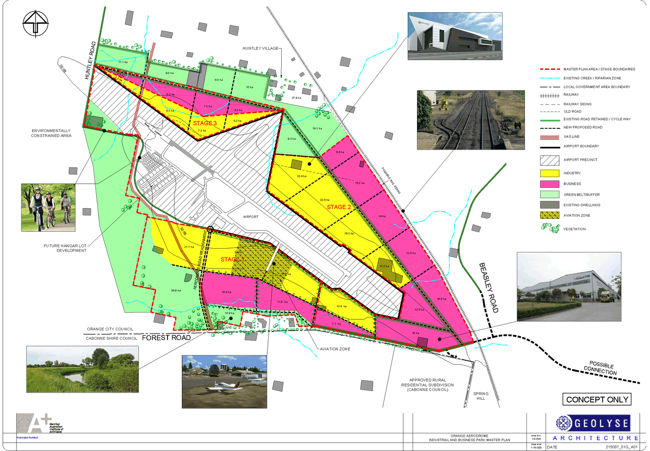
2 Concept Plan, D15/4401⇩
Council Meeting 17 February 2015
5.9 Planning Proposal - Orange Airport Industrial Estate
Attachment 1 Draft Planning Proposal
Saturday, XX Month to Monday, XX Month 2015
Optional emblematic photo or concept drawing
Proposal to Amend Orange Local Environmental Plan 2011
Amendment 9 “Airport Estate”
WHAT IS ON EXHIBITION?
Orange City Council proposes to amend the Orange Local Environmental Plan 2011 to allow for the creation of an industrial and employment estate on lands in proximity to the Orange Airport. This document and the associated maps and reports listed below comprise the formal Planning Proposal. The exhibition period is the opportunity for interested members of the public to review the proposal and provide any feedback they wish. All written submissions will be considered and presented to Council before final decisions are made.
EXHIBITION MATERIALS
The planning proposal is comprised of the following documents:
|
Planning Proposal (this document) Draft Land Zone Map Draft Minimum Lot Size Map Gateway Determination (When received) |
WHERE CAN I SEE IT?
The exhibition materials can be inspected by any interested person during business hours at Orange City Council Civic Centre, ground floor, 135 Byng Street (Cnr of Lords Place), Orange. All materials are also available on Councils website www.orange.nsw.gov.au under the “Planning & Development” section.
SUBMISSIONS
Written comments on the draft amendments are welcome. All submissions received by Council will be considered before final decisions are made. Any submission received may be made publicly available and may include the name(s), address, signature and contact details provided.
All submissions are to be received by close of business Monday XX Month YEAR.
Submissions on the proposal can be sent to:
General Manager
Orange City Council
P.O. Box 35
Orange NSW 2800
Attention: Craig Mortell – Senior Town Planner
Alternatively submissions may also be emailed to Council@orange.nsw.gov.au
For further information please contact, Senior Planner Craig Mortell, on (02) 6393 8000
The following pages contain information required by the Department of Planning’s Guide to Preparing a Planning Proposal. The information is unavoidably technical, as it seeks to address a range of legislative requirements. Clarification may be sought from Councils planning staff during the exhibition period.
Planning Proposal – Orange Local Environmental Plan 2011 – Amendment 9
Introduction
The purpose of this document is to describe a planning proposal for an amendment of the Orange Local Environmental Plan (LEP) 2011, to be known as amendment 9. The preparation of a planning proposal is the first step in preparing an LEP (or an amendment to an LEP).
Note: Throughout the course of preparing the proposed LEP, the planning proposal evolves. This is particularly the case for complex proposals in which the initial gateway determination will confirm the technical studies and consultation required to justify the proposal.
As the studies and consultation are undertaken, relevant parts of the planning proposal will be updated, amended and embellished. Therefore, particularly when viewed at an early stage, the level of detail in a planning proposal may appear to be limited in one or more respects.
This planning proposal has been prepared in accordance with the Department of Planning and Infrastructure’s document A guide to preparing planning proposals and is comprised of four parts;
Part 1 Objectives and Intended Outcomes
This part comprises a brief statement outlining the objectives and intended outcomes of the proposed amendment.
Part 2 Explanation of the Provisions
This part comprises a plain English explanation of the provisions and changes that are to be included in the amendment.
Part 3 Justification
This part establishes the justification for the objectives, outcomes and provisions and the process for their implementation.
Part 4 Community Consultation
This part details the level and methods of community consultation that is to be undertaken on the planning proposal.
Part 5 Project Timeline
This part consists of a table that sets out the key project milestones and anticipated commencement and completion dates for each milestone. The dates shown are indicative only and subject to review as the project progresses.
Part 1 Objectives and Intended Outcomes
The objectives of this planning proposal are:
To identify serviceable land for further employment and industrial growth, providing opportunities to strengthen and diversify the local and regional economy, and
To ensure the continued safe and efficient operation of Orange Airport, recognising the regional significance of the Airport to the residents of Orange and surrounding communities and the potential for expansion, and
To amend the minimum lot size map and the land zoning map to provide for industrial subdivision potential in proximity to key transport corridors and infrastructure.
Part 2 Explanation of the Provisions
|
Item No. |
Description |
Proposed Change |
|
1 |
Plain English |
Amendment of the Land Zone Map in accordance with the proposed Draft Land Zone Map shown at attachment 1 |
|
2 |
Plain English
|
Amendment of the Minimum Lot Size Map in accordance with the proposed Draft Minimum Lot Size Map shown at attachment 2 |
Part 3 Justification
Section A – Need for the planning proposal
1. Is the planning proposal a result of any strategic study or report?
The 2008 Blayney, Orange, Cabonne Subregional Rural and Industrial Land Use Strategy reviewed the Narrambla, Leewood and Clergate industrial areas. Narrambla and Leewood, first planned for in the 1970s were nearing completion at the time, while Clergate was intended for larger and heavier forms of industry. While the strategy identified some expansion of Narrambla and Clergate industrial areas, the subsequent 7 years has largely seen this additional supply taken up.
The remaining expansion area identified by the strategy as “SAB” to the north of Clergate industrial area up to the Cabonne shire boundary (approximately 122ha) needs further consideration, particularly in terms of the potential residential interface to the east, cross LGA issues with Cabonne to the north and being divided by the railway line through the centre.
It is also considered that SAB may have other alternative uses. The topography of land in SAB and the part of Cabonne Shire adjoining this site is relatively less undulating than land to the south of SAB. Consequently a wide range of possible development scenarios are possible and should be further investigated before any final decision on SAB is made. In short zoning SAB for industrial purposes now would seem to limit options for the area immediately to the north in Cabonne Shire.
Given the above and the need to provide additional employment lands in Orange, other alternatives have been investigated. It is considered that adaptive reuse of the Electrolux site in Edward Street and development of the nearby former saleyards site, both of which are already zoned industrial, will provide a modest level of infill supply for the short term.
Beyond this it is considered that a future industrial estate needs to be located clear of existing residential and lifestyle estates and should be situated in proximity to appropriate infrastructure and transport linkages. The most apparent suitable land that can be readily serviced is the area around the Orange airport.
Airports and industrial estates are widely regarded as mutually compatible. Both are noise generators that benefit from being separated from more sensitive land uses. Industrial estates tend towards low-rise forms. While large industrial sheds, with substantial spans, may result in an overall height greater than other single storey forms, with appropriate master-planning they nonetheless remain compatible with airport obstacle limitation surfaces in that they typically do not expand vertically.
Additionally, modern airports serve a diverse range of functions beyond basic passenger and freight services. Charter flights, flying schools, aerial spraying, rescue services, aircraft service and maintenance and aerial photography are some examples. Each function in turn generates demand for support functions such as car rental, flight kitchens and the like. Beyond this many businesses are attracted to airports and airports often generate spin-off industries, however many of these take several years to develop.
As the Orange airport is also in proximity to the railway line and the nearby village of Spring Hill; it is therefore considered to have considerable strategic potential that is at present largely untapped. Combined with an emerging need to increase the supply of industrial land in Orange the proposal is considered to have substantial strategic merit.
2. Is the planning proposal the best means of achieving the objectives or intended outcomes, or is there a better way?
The planning proposal is the best known means of achieving the intended outcomes.
In reaching this conclusion the following matters were considered:
· Other industrial estates in Orange have been largely built out, creating the need to identify a new area for future growth and expansion.
· Other potential industrial expansion areas are considered to have potential for other functions suggesting further investigation is required before activating those sites.
· The Orange airport is a highly strategic asset whose potential to generate and support industrial and employment functions has not yet been tapped.
3. Is there a net community benefit?
Yes.
The planning proposal will result in substantial employment opportunities and land for continued growth of the industrial sector of the local and regional economy. Proximity to the airport will promote ancillary and support services that may enhance the efficiency and performance of the airport.
Proximity to both the airport and railway, as well as the planned improved road connection to the Mitchell Highway will facilitate further growth in the logistics sector.
The nearby village of Spring Hill can be expected to derive economic benefits and is suitably zoned to allow for supporting services (such as catering to the workforce’s lunch breaks and incidental shopping) to be established and prosper.
The proposal therefore provides both direct employment opportunities and will contribute towards diversifying the local and regional economy. It is considered that such benefits greatly outweigh any potential detriment arising from increased local traffic flows and noise generation.
Section B – Relationship to strategic planning framework
4. Is the planning proposal consistent with the objectives and actions contained within the applicable regional or sub-regional strategy?
Yes.
The vision and guiding principles of the Blayney, Orange, Cabonne Subregional Rural and Industrial Land Use Strategy (2008) are outlined in section 4.1 of the strategy, which states:
|
Vision for rural and industrial development in the Sub-Region Economic development and growth within the Sub-Region is managed within sustainable resource management principles, and the following are achieved: · A sustainable and productive agricultural industry; · Balanced economic development and settlement; · Preservation of natural resources and cultural assets; and · Ecologically sustainable development. |
The above vision is then expanded into a series of guiding principles in section 4.2 of the strategy. In terms of the economy the guiding principles are stated as being:
|
· Developing a diverse and sustainable industrial and agricultural base: o Ensure agriculture carries on into the future as a significant, environmentally and economically sustainable industry with the capacity to capitalise on opportunities for intensification and diversification. o Ensure that adequate opportunities are provided for industrial activities that will provide employment opportunities for the community. o Promote and facilitate local communities to stimulate and act on local ideas for business. o Ensure that opportunities for future mining, conservation, nature-based tourism and recreation within non-urban areas not suitable for agriculture or other rural land uses are protected. o Encourage the development of a mining industry including downstream processing opportunities. o Encourage further development of a significant and sustainable tourism industry that promotes the unique characteristics of the Sub-Region. · Provide a spatial development strategy that supports existing centres: o Establish a settlement hierarchy that supports existing infrastructure and services, commercial and retail business at the local and regional levels. o Ensure planning provisions support and promote sustainable employment, industrial lands and specialised centres. |
The Planning Proposal will provide for additional industrial land, bringing with it associated employment opportunities. The presence of the airport is a constraint on various other forms of development but is of clear and direct benefit to various forms of industrial activity. This is consistent with the desire for a diversified economy and rational use of land.
While the subject land is presently used for agriculture, this would be equally true of any alternative site that may be available within the Local Government Area. Preserving agricultural lands needs to be balanced against the principle of ensuring adequate opportunities for industrial activities. As such, site selection criteria would logically involve minimising the impact upon agriculture while maximising the benefit to industry.
In this regard the subject land is already constrained by the presence and operations of the airport whereas other agricultural lands are not. Likewise, the airport and railway present added benefits to industrial developments that are not available at other potential sites.
Consequently, the planning proposal is considered to be the best available option to satisfy the competing principles and objectives of the Sub-Regional strategy in a balanced manner.
5. Is the planning proposal consistent with the local council’s Community Strategic Plan, or other local strategic plan?
Yes.
The Orange Community Strategic Plan 2014-2024 includes an economic vision that
“The Orange community will plan and grow an innovative, diverse and balanced economy while protecting the character of the City and the region”
Furthermore, objective 11 is to
“Encourage a strong, multifaceted economy and stimulate interactions within the business community and between business and Council”
The strategies relating to objective 11 include:
· Encourage the growth of local business, support emerging industry sectors and attract new investment to Orange.
· Foster partnerships and encourage development across a range of industry clusters
The planning proposal will directly support emerging industry, particularly as related to air transport and logistics. This will result in considerable new investment in Orange. The proposal will also encourage the emergence of an air services related industry cluster, with the potential to enhance Orange’s role as a regional economic centre.
6. Is the planning proposal consistent with applicable state environmental planning policies?
There are no State Environmental Planning Policies (SEPPs) directly relevant to the proposal. The following SEPPs were nonetheless examined for possible implications.
· SEPP 33 Hazardous and Offensive Development
· SEPP (Exempt and Complying Development Codes) 2008
· SEPP (Infrastructure) 2007
· SEPP (Rural Lands) 2008
SEPP 33 sets out requirements for certain forms of development at the Development Application (DA) stage. Since this planning proposal will enable industrial development it is possible that a SEPP 33 related DA could eventuate. Such a DA would be subject to the requirements of the SEPP and there is no basis to pre-suppose that such applications would be unable to comply with the SEPP.
SEPP (exempt and complying development codes) establishes requirements and conditions for a range of minor development to be undertaken in various contexts. This includes Part 5 for commercial and industrial alterations, and Part 5A commercial and industrial (new buildings and additions). This proposal involves rezoning land for industrial purposes. As such the provisions of Part 5 and 5A of the SEPP will become applicable to the land involved. It is considered that developments consistent with Part 5 and 5A of the SEPP pose negligible environmental concern.
SEPP (Infrastructure) includes provisions to facilitate air transport facilities, railways and rail infrastructure facilities and development in rail corridors and a variety of other forms of infrastructure. Additionally the SEPP establishes that DAs for freight terminals and intermodal facilities require referral to the RMS. The Planning Proposal does not directly trigger any of these provisions, however as rezoning for industrial purposes is could eventuate. Such DAs would be subject to the relevant requirements and provisions of the SEPP and there is no basis to pre-suppose that such applications would be unable to comply with SEPP requirements.
SEPP (Rural Lands) seeks to control and limit fragmentation and alienation of productive agricultural lands. The Planning Proposal is not directly captured by the provisions of the SEPP however, as detailed in section 4, the site has been selected partly in recognition of the existence of the airport which is considered to constrain the range and extent of primary production possible on the land. Given the need to expand the supply of industrial land it is considered that any option would result in a minor reduction in agricultural land, but that when balanced against the economic and employment benefits to the community and region the Planning Proposal involved and the land is in proximity to both an airport and railway line it is possible that relevant DAs
is consistent with the Rural Planning Principles of section 7 of the SEPP, especially:
“(d) in planning for rural lands, to balance the social, economic and environmental interests of the community”
7. Is the planning proposal consistent with applicable Ministerial Directions (s.117 directions)?
Yes.
Direction 1.1 Business and Industrial Zones applies whenever a Planning Proposal will affect land within an existing or proposed business or industrial zone. In such cases Council must:
· Give effect to the objectives of the direction, which are to encourage employment growth in suitable locations, protect employment lands in business and industrial zones, and support the viability of identified strategic centres,
· Retain the areas and locations of existing business and industrial zones,
· Not reduce the total potential floor space area for employment uses and related public services in business zones,
· Not reduce the total potential floor space area for industrial uses in industrial zones, and
· Ensure that proposed new employment areas are in accordance with a strategy that is approved by the Director-General of the Department of Planning.
The Planning Proposal seeks to establish new industrial and business zones in close proximity to and surrounding the Orange airport. This is considered to be wholly consistent with the objectives of the direction. The Planning Proposal retains all existing business and industrial zones and does not affect potential floor space within them.
It is noted that the direction allows for minor inconsistency with the direction where the Planning Proposal is nonetheless consistent with a relevant regional or sub-regional strategy. The areas identified in the Blayney Cabonne Orange Sub-Regional Rural and Industrial Land Use Strategy for industrial estates have been largely developed. Take up of industrial land has exceeded the rate anticipated in the strategy, necessitating identification of additional land. Site selection for the Planning Proposal has been subject to the criteria and principles established in the strategy.
Council therefore supports the Planning Proposal on the grounds of being consistent and compatible with the adopted strategic approach and the intrinsic merit of co-locating and industrial estate in proximity to a regional airport.
Direction 1.5 Rural Lands applies to any Planning Proposal that will affect land within an existing or proposed rural or environment protection zone, or where the minimum lot size of such zones is proposed.
The Direction requires that such Planning Proposals must be consistent with the rural planning principles listed in SEPP (Rural Lands) 2008. This matter has been addressed in section 6 of this Planning Proposal and is considered to be satisfactory.
Direction 3.5 Development Near Licensed Aerodromes applies whenever a planning proposal seeks to create, alter or remove a zone or provision relating to land in the vicinity of a licensed aerodrome. The direction requires that Council must
· Consult with the Department of the Commonwealth responsible for licensed aerodromes (i.e. CASA)
· Take into consideration the Obstacle Limitation Surface (OLS)
· For land affected by the OLS prepare appropriate development standards, such as height limits and allow with consent development types that are compatible with the operation of an aerodrome
· Obtain permission from the Commonwealth Department if the Planning Proposal proposes to allow development that may encroach upon the OLS (such permission must be obtained prior to community consultation).
· Not rezone land for residential purposes, or for schools, hospitals, churches, theatres, hotels, motels, offices or public buildings where the airports ANEF noise rating is above particular thresholds.
Consultation with CASA will be undertaken prior to formal community consultation. The Planning Proposal will also incorporate a masterplan for the area into the Orange DCP. This will include provisions to ensure protection of the Obstacle Limitation Surface and other airport operational requirements. Additionally, the Planning Proposal does not seek to allow sensitive forms of development within the ANEF affected lands.
Direction 6.1 Approval and Referral Requirements applies to all Planning proposals and requires that Council must:
· Avoid or minimise provisions that would require concurrence, consultation or referral to a Minister or public authority, unless the Minister or relevant authority have approved of such provisions.
· Not identify development as designated development unless the Director-General of Planning is satisfied that the development is likely to have a significant impact on the environment and approval of the Director-General has been obtained.
The planning proposal does not create any referral, concurrence or consultation requirements and has not nominated any new forms of designated development.
Section C – Environmental, social and economic impact
8. Is there any likelihood that critical habitat or threatened species, populations or ecological communities, or their habitats, will be adversely affected as a result of the proposal?
No.
The land involved in the Planning Proposal has been chosen in part to avoid conflicts with ecologically sensitive lands. The site is not identified as containing or comprising biologically sensitive land.
9. Are there any other likely environmental effects as a result of the planning proposal and how are they proposed to be managed?
Noise generation from future industrial land uses. Development Control Plan provisions will include noise mitigation requirements. Additionally the conceptual master plan of subdivision is designed to provide a transition between the noisiest uses in the core and less intensive uses toward the edges. Suitable buffers will also be master planned to provide a passive means of noise mitigation.
10. How has the planning proposal adequately addressed any social and economic effects?
Yes.
Social and economic effects are considered to be broadly positive. Traffic and noise generation do not encroach into residential areas and the proposal will lead to significant employment opportunities.
Section D – State and Commonwealth interests
11. Is there adequate public infrastructure for the planning proposal?
It is anticipated that there will be a need to extend reticulated services to the area to cater for the proposal. The proposal will also directly lead to upgrading of local roads connecting the Airport to the City and Mitchell Highway. Such upgrades will directly benefit the operation of the Airport, ensuring an efficient use of public resources.
12. What are the views of State and Commonwealth public authorities consulted in accordance with the gateway determination?
Not applicable, the planning proposal is at the pre-gateway stage.
Part 4 Community Consultation
Community consultation will be undertaken in accordance with the requirements of the gateway determination. It is anticipated that this proposal will not be deemed to be a low impact proposal. Accordingly an exhibition period of 28 days is expected.
This will commence by giving notice of the public exhibition of the planning proposal via:
· an advertisement in the Central Western Daily;
· a notification on the Orange City Council website www.orange.nsw.gov.au; and
· written advice direct to adjoining landowners.
All forms of the notice shall include:
· a brief description of the objectives and intended outcomes of the planning proposal;
· an indication of the land affected by the planning proposal;
· the location and dates where the planning proposal may be inspected;
· the contact name and address at Orange City Council where submissions may be directed; and
· the closing date of the submission process.
During the exhibition period, the following materials will be made freely available for public inspection:
· The planning proposal, in the form approved for community consultation by the Director-General of Planning;
· The gateway determination; and
· All studies and supporting material relied upon by the planning proposal.
Following the exhibition period, a report will be prepared analysing any submissions received and making recommendations as to any appropriate changes or adjustments to the planning proposal, for the consideration of Orange City Council.
Where contact details have been provided all persons and organisations making a submission will be advised of the date and time of the relevant council (or committee) meeting where the report is to be considered, and subsequently advised of the determination.
Part 5 Project Timeline
The following table provides an overview of the intended project timeline for this Planning Proposal.
|
Project stage |
Commencement |
Completion |
|
Gateway Determination |
March 2015 |
March 2015 |
|
Government Agency consultation |
Late March 2015 |
Late April 2015 |
|
Public Exhibition Period |
May 2015 |
June 2015 |
|
Public Hearing |
As per Gateway Determination |
|
|
Consideration of Submissions |
Late June 2015 |
Mid July 2015 |
|
Consideration of post exhibition proposals (Report to Council) |
August 2015 |
|
|
Seeking and obtaining legal opinion from Parliamentary Counsels Office |
Late August |
Dependent on PCO |
|
Submission to the Department of Planning and Infrastructure to finalise |
PCO opinion + 1 week |
|
|
Anticipated date the plan will be forwarded to the Department for notification |
Dependent on PCO |
|