Planning and Development
Committee
Agenda
4 May 2021
Notice is hereby given, in
accordance with the provisions of the Local Government Act 1993 that a Planning and Development Committee meeting of ORANGE CITY COUNCIL
will be held in the Council Chamber,
Civic Centre, Byng Street, Orange on Tuesday, 4 May
2021.
David
Waddell
Chief Executive Officer
For apologies please
contact Administration on 6393 8218.
1 Introduction
1.1 Declaration
of pecuniary interests, significant non-pecuniary interests and less than
significant non-pecuniary interests
The
provisions of Chapter 14 of the Local Government Act, 1993 (the Act)
regulate the way in which Councillors and designated staff of Council conduct
themselves to ensure that there is no conflict between their private interests
and their public role.
The
Act prescribes that where a member of Council (or a Committee of Council) has a
direct or indirect financial (pecuniary) interest in a matter to be considered
at a meeting of the Council (or Committee), that interest must be disclosed as
soon as practicable after the start of the meeting and the reasons given for
declaring such interest.
As
members are aware, the provisions of the Local Government Act restrict any
member who has declared a pecuniary interest in any matter from participating
in the discussion or voting on that matter, and requires that member to vacate
the Chamber.
Council’s Code of Conduct provides that if members
have a non-pecuniary conflict of interest, the nature of the conflict must be
disclosed. The Code of Conduct also provides for a number of ways in which a
member may manage non pecuniary conflicts of interest.
|
Recommendation
It is recommended that Committee Members now disclose any
conflicts of interest in matters under consideration by the Planning and
Development Committee at this meeting.
|
2 General
Reports
2.1 Items
Approved Under the Delegated Authority of Council
RECORD
NUMBER: 2021/597
AUTHOR: Paul
Johnston, Manager Development Assessments
EXECUTIVE Summary
Following is a list of more
significant development applications approved by the Chief Executive Officer
under the delegated authority of Council. Not included in this list are
residential scale development applications that have also been determined by
staff under the delegated authority of Council (see last paragraph of this
report for those figures).
Link To Delivery/OPerational Plan
The recommendation in this report
relates to the Delivery/Operational Plan strategy “7.1 Preserve - Engage
with the community to develop plans for growth and development that value the
local environment”.
Financial Implications
Nil
Policy and Governance Implications
Nil
|
Recommendation
That Council resolves to
acknowledge the information provided in the report by the Manager Development
Assessments on Items Approved Under the Delegated Authority of Council.
|
further considerations
Consideration has been given to the recommendation’s
impact on Council’s service delivery; image and reputation; political;
environmental; health and safety; employees; stakeholders and project
management; and no further implications or risks have been identified.
|
Reference:
|
DA
59/2020(2)
|
Determination
Date:
|
20
April 2021
|
|
PR
Number
|
PR27939
|
|
Applicant/s:
|
T
& S Flowers Pty Ltd
|
|
Owner/s:
|
Flowers
Funds Management Pty Ltd
|
|
Location:
|
Lot
222 DP 1239110 - 194A March Street, Orange
|
|
Proposal:
|
Modification
of development consent - multi dwelling housing (five dwellings) and
subdivision (six lot community title). The modified proposal involved:
· minor alterations to external finishes and glazing
· negligible increase in site coverage, and
· amended elevation and landscape drawings to
discharge the requirements of Conditions 9 and 10.
|
|
Value:
|
Not Applicable
|
|
Reference:
|
DA
345/2020(1)
|
Determination
Date:
|
18
March 2021
|
|
PR
Number
|
PR22661
|
|
Applicant/s:
|
Orange
Golf Club
|
|
Owner/s:
|
Orange
Golf Club Limited (Duntryleague)
|
|
Location:
|
Lot
16 DP 1120534 - Woodward Street, Orange
|
|
Proposal:
|
Recreation
facility (outdoor) (drainage swale)
|
|
Value:
|
$2,000
|
|
Reference:
|
DA
426/2020(1)
|
Determination
Date:
|
8
April 2021
|
|
PR
Number
|
PR24007
|
|
Applicant/s:
|
Mrs
P Singla
|
|
Owner/s:
|
Mrs
P Singla
|
|
Location:
|
Lot
12 DP 1147595 - 19 Scott Place, Orange
|
|
Proposal:
|
General
industry (industrial units) and subdivision (strata)
|
|
Value:
|
$500,000
|
|
Reference:
|
DA
476/2020(1)
|
Determination
Date:
|
4
March 2021
|
|
PR
Number
|
PR18521
|
|
Applicant/s:
|
PW
Studio
|
|
Owner/s:
|
Fitz's
Land Co Pty Ltd
|
|
Location:
|
Lot
100 DP 1040962 - 234 Canobolas Road, Canobolas
|
|
Proposal:
|
Farm
stay accommodation (x 2 buildings) and associated services
|
|
Value:
|
$500,000
|
|
Reference:
|
DA
508/2020(1)
|
Determination
Date:
|
11
March 2021
|
|
PR
Number
|
PR3884
|
|
Applicant/s:
|
Junci
Properties Pty Limited
|
|
Owner/s:
|
Junci
Properties Pty Limited
|
|
Location:
|
Lot
18 Sec 8A DP 979858, Lot 51 DP 574066 – 56‑58 Endsleigh Avenue,
Orange
|
|
Proposal:
|
Subdivision
(three lot residential), multi dwelling housing (three dwellings) and
subdivision (four lot Community title)
|
|
Value:
|
$690,000
|
|
Reference:
|
DA
8/2021(1)
|
Determination
Date:
|
18
March 2021
|
|
PR
Number
|
PR34
|
|
Applicant/s:
|
NR
Design Company
|
|
Owner/s:
|
Francis
Hope Investment Pty Ltd
|
|
Location:
|
Lot
1 DP 946330, 4646 Mitchell Highway, Lucknow
|
|
Proposal:
|
Category
1 remediation, dwelling, detached garage, swimming pool (inground) and
fencing (pool fencing)
|
|
Value:
|
$550,000
|
|
Reference:
|
DA
17/2021(1)
|
Determination
Date:
|
30
March 2021
|
|
PR
Number
|
PR28591
|
|
Applicant/s:
|
Gregory
J Coleman Pty Ltd
|
|
Owner/s:
|
Gregory
J Coleman Pty Ltd
|
|
Location:
|
Lot
134 DP1260733, 126 Shiralee Road, Orange
|
|
Proposal:
|
Exhibition
home (change of use from dwelling house), business identification sign and
fencing (front boundary fence)
|
|
Value:
|
$345,000
|
|
Reference:
|
DA
18/2021(1)
|
Determination
Date:
|
31
March 2021
|
|
PR
Number
|
PR25746
|
|
Applicant/s:
|
Anglican
Schools Corporation
|
|
Owner/s:
|
Anglican
Schools Corporation
|
|
Location:
|
Lot
100 DP 1174806 and Lot 71 DP 1004166 – 7 Murphy Lane and 48 Hewitt
Close, Orange
|
|
Proposal:
|
Subdivision
(boundary adjustment) and school (proposed agricultural learning centre shed)
|
|
Value:
|
$150,000
|
|
Reference:
|
DA
34/2021(1)
|
Determination
Date:
|
22
March 2021
|
|
PR
Number
|
PR12749
|
|
Applicant/s:
|
Rathla
Pty Ltd
|
|
Owner/s:
|
Rathla
Pty Ltd
|
|
Location:
|
Lot
2 DP558405, 100 Shiralee Road, Orange
|
|
Proposal:
|
Agricultural
produce industry (alterations and additions to existing winery)
|
|
Value:
|
$120,000
|
|
Reference:
|
DA
45/2021(1)
|
Determination
Date:
|
31
March 2021
|
|
PR
Number
|
PR27858
|
|
Applicant/s:
|
Voerman
& Ratsep
|
|
Owner/s:
|
Housing
Plus
|
|
Location:
|
Lot
99 DP 1234441 - 7 Emerald Street, Orange
|
|
Proposal:
|
Subdivision
(19 lot Community title)
|
|
Value:
|
Not
applicable
|
|
Reference:
|
DA
56/2021(1)
|
Determination
Date:
|
31
March 2021
|
|
PR
Number
|
PR7563
|
|
Applicant/s:
|
Fitness
Perfection
|
|
Owner/s:
|
Vinsente
Pty Ltd
|
|
Location:
|
Lot
21 DP 520743 - 166 March Street, Orange
|
|
Proposal:
|
Recreation
facility (indoor) (alterations and additions to existing building)
|
|
Value:
|
$4,000
|
|
Reference:
|
DA
57/2021(1)
|
Determination
Date:
|
26
March 2021
|
|
PR
Number
|
PR27199
|
|
Applicant/s:
|
ROC Construction
and Development
|
|
Owner/s:
|
Mr
AR Wald
|
|
Location:
|
Lot
410 DP 1213663 – 27 Hughes Street, Orange
|
|
Proposal:
|
Secondary
dwelling
|
|
Value:
|
$207,000
|
|
Reference:
|
DA
57/2021(2)
|
Determination
Date:
|
20
April 2021
|
|
PR
Number
|
PR27199
|
|
Applicant/s:
|
Miss
L J Hibbert
|
|
Owner/s:
|
Mr A
R Wald
|
|
Location:
|
Lot
410 DP 1213663 - 27 Hughes Street, Orange
|
|
Proposal:
|
Modification
of development consent - secondary dwelling. The proposed amendment to
the development consent DA 57/2021(1) sought to delete Conditions 7 and 8,
removing the requirement of Council Contributions (Section 7.11 and
Section 64 headwork charges) to be paid prior to the release of a
Construction Certificate.
|
|
Value:
|
Not
applicable
|
|
Reference:
|
DA
58/2021(1)
|
Determination
Date:
|
31
March 2021
|
|
PR
Number
|
PR6196
|
|
Applicant/s:
|
Maven
Dental Group Pty Ltd
|
|
Owner/s:
|
51
Kite Street Pty Ltd
|
|
Location:
|
Lot
A DP 154906 - 51 Kite Street, Orange
|
|
Proposal:
|
Business
identification sign
|
|
Value:
|
$285
|
|
Reference:
|
DA
59/2021(1)
|
Determination
Date:
|
14
April 2021
|
|
PR
Number
|
PR2807
|
|
Applicant/s:
|
MAAS
Group Properties Westwinds Pty Limited
|
|
Owner/s:
|
MAAS
Group Properties Westwinds Pty Limited
|
|
Location:
|
Lot
118 DP1267568, 31 Westerly Drive, Orange
|
|
Proposal:
|
Exhibition
home, business identification sign and fencing
|
|
Value:
|
$280,000
|
|
Reference:
|
DA
76/2021(1)
|
Determination
Date:
|
23
March 2021
|
|
PR
Number
|
PR11400
|
|
Applicant/s:
|
Mr S
Rollin
|
|
Owner/s:
|
Mr
GS and Mrs SR Rollin
|
|
Location:
|
Lot
1 DP173254, 1060 Pinnacle Road, Orange
|
|
Proposal:
|
Farm
stay accommodation
|
|
Value:
|
$980,000
|
|
Reference:
|
DA
84/2021(1)
|
Determination
Date:
|
31
March 2021
|
|
PR
Number
|
PR19433
|
|
Applicant/s:
|
Mr M
Swiatkiwsky
|
|
Owner/s:
|
Don’t
Tell Jo Pty Ltd
|
|
Location:
|
Lot
104 DP 1067744 CA: 4299 - 5 Ralston Drive, Orange
|
|
Proposal:
|
General
Industry (change of use - coffee roastery)
|
|
Value:
|
$15,000
|
TOTAL NET* VALUE OF
DEVELOPMENTS APPROVED BY THE CEO UNDER DELEGATED AUTHORITY IN THIS PERIOD: $4,343,285.00
* Net
value relates to the value of modifications. If modifications are the same
value as the original DA, then nil is added. If there is a plus/minus
difference, this difference is added or taken out.
Additionally, since the
April 2021 meeting report periods (25 March to 21 April 2021), another
38 development applications were determined under delegated authority by
other Council staff with a combined value of $6,921,403.
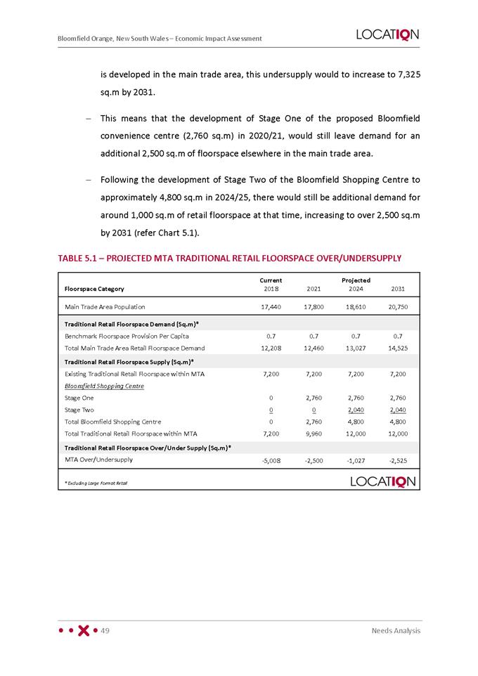
2.2 Development
Application DA 339/2020(1) - 3 and 5 Curran Street
RECORD
NUMBER: 2021/812
AUTHOR: David
Paine, Senior Planner
EXECUTIVE
Summary
|
Application
lodged
|
8
September 2020
|
|
Applicant/s
|
Mr S F
Lumby
|
|
Owner/s
|
Messrs
MS Kidd and SF Lumby
|
|
Land
description
|
Lots E
and F DP 18925 – 3 and 5 Curran Street, Orange
|
|
Proposed
land use
|
Boarding
House (change of use) and Alterations and Additions
|
|
Value of
proposed development
|
$700,000
|
The application is seeking consent
for a change of use from residential units to a Boarding House and alterations
and additions at 3 and 5 Curran Street, Orange. The proposal includes the
demolition of the existing car carport, conversion of existing flats into
boarding rooms, and alterations and additions to include a new two storey
building.
The proposed development will have
a total of 15 rooms including an onsite manager’s room, seven (7) car
parking spaces, three (3) motor cycle parking spaces, and a communal room. All
boarding rooms will be self-contained and include kitchenette and bathroom
facilities. The proposed development has been assessed under State
Environmental Planning Policy (Affordable Rental Housing) 2009.
The overall design of the subject
building has changed since the plans were initially lodged with Council. The
original plans submitted with the development application received significant
feedback from Council’s Heritage Consultant and have been amended a
number of times to address outstanding issues.
The proposed development comprises
‘advertised development’, pursuant to Orange Development Control
Plan (DCP) 2004. Eleven (11) submissions were received at the close of the
public notice and exhibition period.
The proposal has been evaluated pursuant to Section 4.15 of the
Environmental Planning and Assessment Act 1979 and is considered to be
suitable. Approval of the application is recommended, subject to conditions of
consent in the attached Notice of Approval.
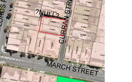
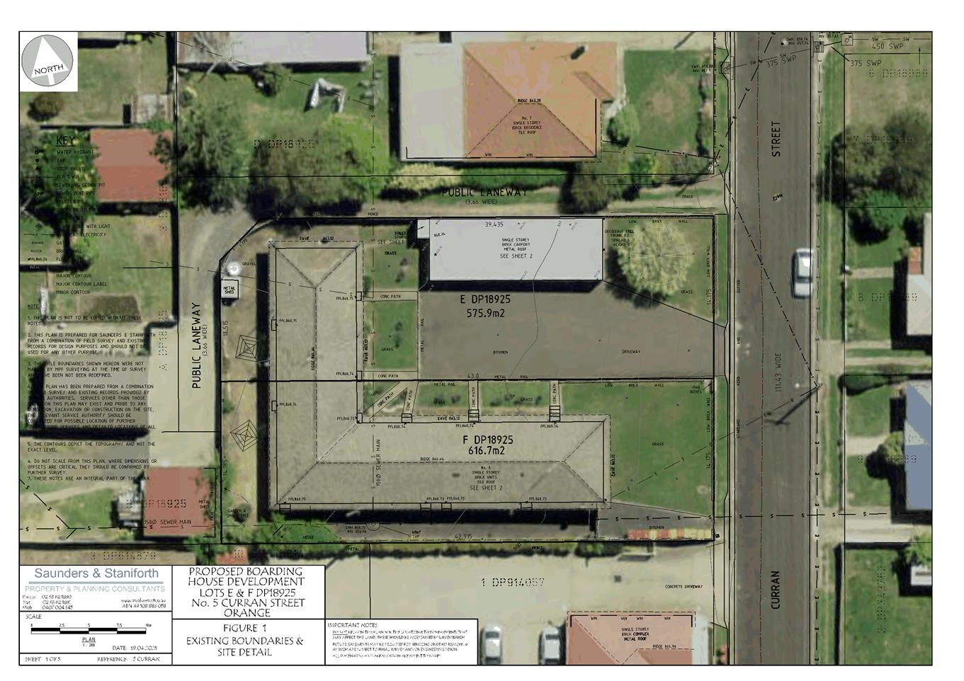
Figure 1 - locality plan and site context
DECISION FRAMEWORK
The proposed development will be
assessed under State Environmental Planning Policy (Affordable Rental Housing)
2009.
Development in Orange is governed
by two key documents Orange Local Environment Plan 2011 and Orange Development
Control Plan 2004. In addition the Infill Guidelines are used to guide
development, particularly in the heritage conservation areas and around
heritage items.
Orange Local Environment Plan
2011 – The provisions of the LEP must be considered by the Council in
determining the application. LEPs govern the types of development that are
permissible or prohibited in different parts of the City and also provide some
assessment criteria in specific circumstances. Uses are either permissible or
not. The objectives of each zoning and indeed the aims of the LEP itself are
also to be considered and can be used to guide decision making around
appropriateness of development.
Orange Development Control Plan
2004 – the DCP provides guidelines for development. In general it is
a performance based document rather than prescriptive in nature. For each
planning element there are often guidelines used. These guidelines indicate
ways of achieving the planning outcomes. It is thus recognised that there may
also be other solutions of merit. All design solutions are considered on merit
by planning and building staff. Applications should clearly demonstrate how the
planning outcomes are being met where alternative design solutions are
proposed. The DCP enables developers and architects to use design to achieve
the planning outcomes in alternative ways.
DIRECTOR’S COMMENT
This application pertains to
alterations and additions to the existing flat building to make a 15 room
boarding house with a Managers residence. With the site being within the R1
Residential Zone the State Environmental Planning Policy (Affordable Rental
Housing) 2009 (‘SEPP’) applies and affectively overrides a
number of local controls and restricts refusal options.
The applicant has amended the design
substantially to provide better outcomes, particularly in terms of streetscape
and character. From experience with other boarding houses within the
City, parking is one of the main issues, as the SEPP requires significantly
less parking that the Orange DCP. Technically this proposal falls one parking
space short. However as the removal of an existing driveway will increase
street parking by one space, the overall impact on the surrounding environment
can be argued as being close to the same. Whilst parking is one matter
under which Council can refuse a boarding house to which the SEPP applies, in
this case the development is considered to achieve enough compliance with the
SEPP and DCP to not warrant a refusal.
The recommendation of Approval is
supported.
Link To Delivery/OPerational Plan
The recommendation in this report
relates to the Delivery/Operational Plan strategy “10.1 Preserve - Engage
with the community to ensure plans for growth and development are respectful of
our heritage”.
Financial Implications
Nil
Policy and Governance Implications
Nil
|
Recommendation
That
Council consents to development application DA 339/2020(1) for Boarding House (change of use) and Alterations
and Additions at Lots E and F DP 18925 – 3 and 5 Curran
Street, Orange pursuant to the conditions of
consent in the attached Notice of Approval.
|
further considerations
Consideration has been given to the recommendation’s
impact on Council’s service delivery; image and reputation; political;
environmental; health and safety; employees; stakeholders and project management;
and no further implications or risks have been identified.
SUPPORTING INFORMATION
That Council consents to
development application DA 339/2020(1)
for Boarding House (change of use) and Alterations and Additions at Lots
E and F DP 18925 – 3 and 5 Curran Street, Orange pursuant to the conditions of consent in the attached
Notice of Approval.
THE PROPOSAL
The application is seeking consent for a change of use from
residential units to a Boarding House and alterations and additions at 3 and 5
Curran Street, Orange. The proposal includes the demolition of the existing car
carport, conversion of existing flats into boarding rooms, and alterations and
additions to include a new two storey building.
The proposed development will have a total of 15 rooms,
including an onsite manager’s room, seven (7) car parking spaces, three
(3) motor cycle parking spaces, and a communal room. All boarding rooms will be
self-contained and include kitchenette and bathroom facilities. The proposed
development has been assessed under State Environmental Planning Policy
(Affordable Rental Housing) 2009.
The overall design of the subject
building has evolved since the plans were initially lodged with Council. The
original plans submitted with the development application received significant
feedback from Council’s staff and also Heritage Consultant and have been
amended a number of times to address outstanding issues.
The proposal will be on land
described as Lot E and F, DP 18925, being 3 and 5 Curran Street, Orange.
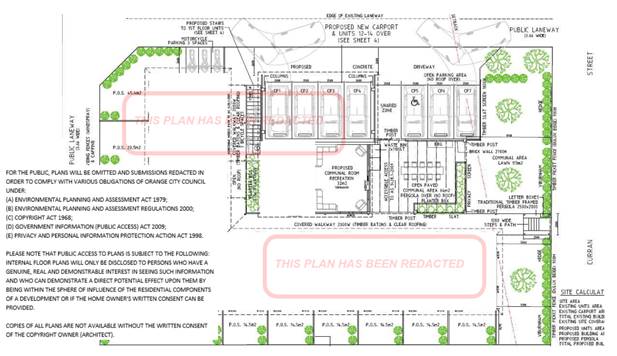
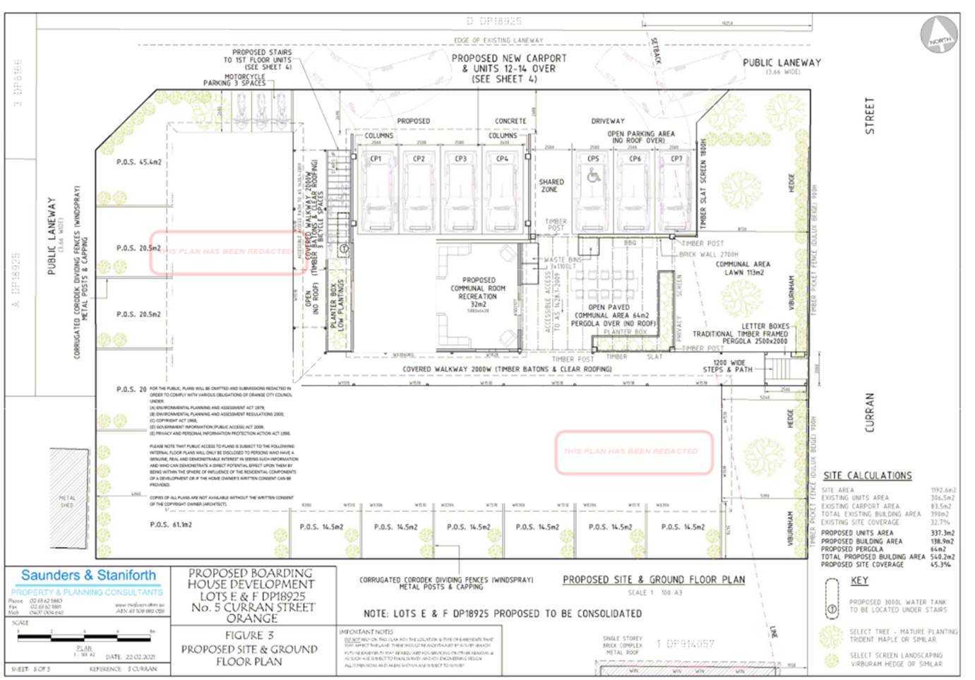
Figure 2 – proposed site layout
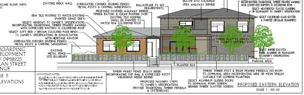
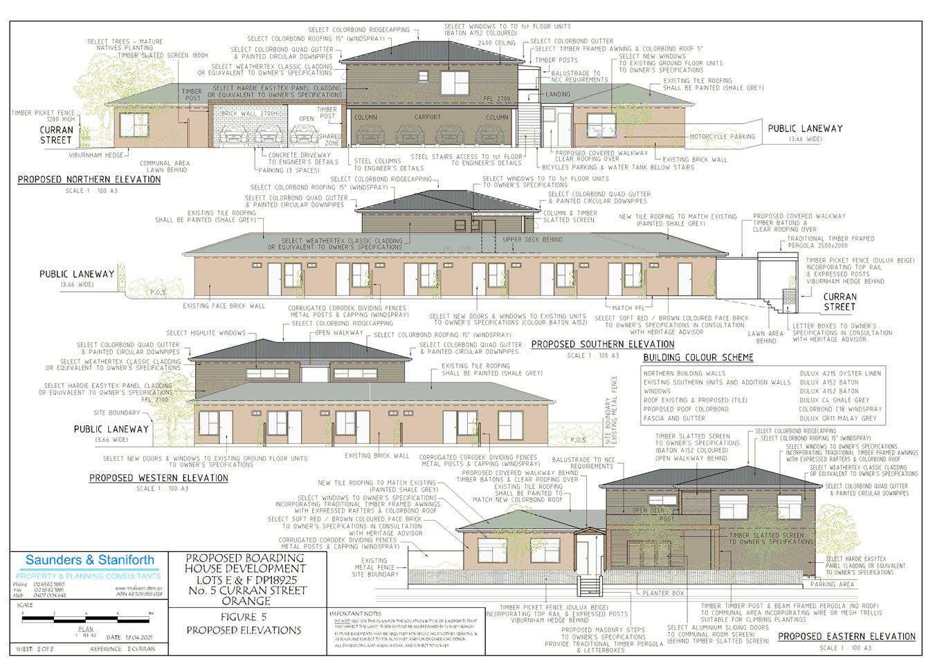
Figure 3 - front elevation facing Curran Street
MATTERS FOR CONSIDERATION
Section 1.7 - Application of
Part 7 of the Biodiversity Conservation Act 2016 and Part 7A of the
Fisheries Management Act 1994
The subject land is contained within the residential area of
Orange and is not identified as being biodiversity sensitive. The natural state
of the site and surrounding area has been highly modified by the urban landuse
patterns.
Based on the foregoing
consideration, a BDAR assessment is not required and the proposal suitably
satisfies the relevant matters at Clause 1.7 EPAA 1979.
Section 4.15
Section 4.15 of the Environmental Planning and Assessment
Act 1979 requires Council to consider various matters, of which those
pertaining to the application are listed below.
PROVISIONS OF ANY ENVIRONMENTAL
PLANNING INSTRUMENT s4.15(1)(a)(i)
Orange Local Environmental Plan
2011
Part 1 - Preliminary
Clause 1.2 - Aims of Plan
The
broad aims of the LEP are set out under Subclause 2. Those relevant to the
application are as follows:
(a) to
encourage development which complements and enhances the unique character of
Orange as a major regional centre boasting a diverse economy and offering an
attractive regional lifestyle,
(b) to
provide for a range of development opportunities that contribute to the social,
economic and environmental resources of Orange in a way that allows present and
future generations to meet their needs by implementing the principles for
ecologically sustainable development,
(e) to
provide a range of housing choices in planned urban and rural locations to meet
population growth,
(f) to
recognise and manage valued environmental heritage, landscape and scenic
features of Orange.
The
application is considered to be consistent with the aims (a), (b), (e) and (f).
The development adds to the variety of housing types in the locality and
allows for additional population within close proximity to the commercial
centre of Orange.
Clause 1.6 - Consent Authority
This clause establishes that, subject to the Act, Council is
the consent authority for applications made under the LEP.
Clause 1.7 - Mapping
The subject site is identified
on the LEP maps in the following manner:
|
Land Zoning Map:
|
Land zoned R1 General Residential
|
|
Lot Size Map:
|
No Minimum Lot Size
|
|
Heritage Map:
|
Heritage Conservation Area
|
|
Height of Buildings Map:
|
No building height limit
|
|
Floor Space Ratio Map:
|
No floor space limit
|
|
Terrestrial Biodiversity Map:
|
No biodiversity sensitivity on the
site
|
|
Groundwater Vulnerability Map:
|
Groundwater vulnerable
|
|
Drinking Water Catchment Map:
|
Not within the drinking water
catchment
|
|
Watercourse Map:
|
Not within or affecting a defined
watercourse
|
|
Urban Release Area Map:
|
Not within an urban release area
|
|
Obstacle Limitation Surface Map:
|
No restriction on building siting
or construction
|
|
Additional Permitted Uses Map:
|
No additional permitted use applies
|
|
Flood Planning Map:
|
Not within a flood planning area
|
Those matters that are of relevance are addressed in detail
in the body of this report.
Clause 1.9A - Suspension of
Covenants, Agreements and Instruments
This clause provides that covenants, agreements and other
instruments which seek to restrict the carrying out of development do not apply
with the following exceptions.
(a) to
a covenant imposed by the Council or that the Council requires to be imposed,
or
(b) to
any relevant instrument under Section 13.4 of the Crown Land Management Act
2016, or
(c) to
any conservation agreement under the National Parks and Wildlife Act 1974, or
(d) to
any Trust agreement under the Nature Conservation Trust Act 2001, or
(e) to
any property vegetation plan under the Native Vegetation Act 2003, or
(f) to
any biobanking agreement under Part 7A of the Threatened Species Conservation
Act 1995, or
(g) to
any planning agreement under Subdivision 2 of Division 7.1 of the Environmental
Planning and Assessment Act 1979.
Council staff are not aware of the title of the subject
property being affected by any of the above.
Part 2 - Permitted or Prohibited Development
The subject site is located within the R1 General
Residential zone. The proposed development is defined as
“demolition” (carport), and “boarding houses.”
Pursuant to the LEP Dictionary:
Boarding
house means a building that:
(a) is
wholly or partly let in lodgings, and
(b) provides
lodgers with a principal place of residence for 3 months or more, and
(c) may
have shared facilities, such as a communal living room, bathroom, kitchen or
laundry, and
(d) has
rooms, some or all of which may have private kitchen and bathroom facilities,
that accommodate one or more lodgers.
Boarding houses are permitted with consent in the R1 General
Residential zone.
Pursuant to the LEP Dictionary:
Demolish, in relation to a heritage item or an Aboriginal object,
or a building, work, relic or tree within a heritage conservation area, means
wholly or partly destroy, dismantle or deface the heritage item, Aboriginal
object or building, work, relic or tree.
Demolition (car port) is permitted with consent pursuant to
Clause 2.7 (see below).
Clause 2.3 - Zone Objectives
The
objectives for land zoned R1 General Residential are as follows:
· To provide for
the housing needs of the community.
· To provide for
a variety of housing types and densities.
· To enable other
land uses that provide facilities or services to meet the day to day needs of
residents.
· To ensure
development is ordered in such a way as to maximise public transport patronage
and encourage walking and cycling in close proximity to settlement.
· To ensure that
development along the Southern Link Road has an alternative access.
The proposal is consistent with
the relevant zone objectives as considered below:
- The
proposal will provide a rental housing option to supplement housing needs in
the community.
- The
proposed boarding houses will contribute to the variety of housing types and
densities in the neighbourhood.
- The
subject land is located in close proximity to the CBD and accessible via public
transport.
Clause 2.7 - Demolition
Requires Development Consent
This clause triggers the need for
development consent in relation to a building or work. This requirement
does not apply to any demolition that is defined as exempt development.
The proposal involves demolition of a
carport and minor internal demolition works. The demolition works proposed
will have no significant impact on adjoining lands, streetscape or public
realm. Conditions will be imposed in respect of hours of operation, dust
suppression and the need to investigate for, and appropriate manage the
presence of, any materials containing asbestos.
Part 3 - Exempt and Complying Development
The application is not exempt or complying development.
Part 4 - Principal Development Standards
The application is not relevant to the standards of Part 4
of the LEP.
Part 5 - Miscellaneous Provisions
5.10 - Heritage Conservation
Clause 5.10 is applicable and states in part:
(4) The
consent authority must, before granting consent under this clause in respect of
a heritage item or heritage conservation area, consider the effect of the
proposed development on the heritage significance of the item or area
concerned. This subclause applies regardless of whether a heritage management
document is prepared under Subclause (5) or a heritage conservation management
plan is submitted under Subclause (6).
The subject land is located in the East Orange Heritage
Conservation Area (HCA).
As
noted earlier, the applicant has been working closely with Council’s
Heritage Adviser over the last couple of months to reach an agreement on the
overall design of the building. The following section contains a summary
of the detailed discussion that has occurred between the applicant, Council’s
Heritage Advisor and planning staff.
Heritage Advisor’s recommendations
Character
The traditional buildings in
the setting have vertically proportioned window with pitched roofs including
hips and gables set within short front gardens.
The proposal has deep front setting
with single and two stories which merge through the use of the attached
skillion while the side elevation include an array of exposed vehicles in the
car park.
The deep front lawns are
good for the amenity but inconsistent with the traditional setting while the
large bin enclosure is uncharacteristic of the setting.
Applicant’s response
The existing 1940/50’s
unit design is somewhat dated and as advised by Council’s Heritage
Advisor, presents an opportunity to prevent some positive character features
such as window proportions, window awning and traditional fencing facing the
street. The applicant has worked closely with planning staff and the Heritage
Advisor to consider building scale and dimensions, character, colour setbacks
fence and landscape to present an improvement to the current scenario.
Planning Officer’s
response
The initial design has changed a number of times since the
application was first lodged with Council. The final design has addressed the
significant issue of character with a reduction of area on the first floor. The
reduction in the first floor area has changed the built form which makes it
more compatible in terms of character with the surrounding heritage
conservation area.
Heritage Advisor’s
recommendations
Setbacks
The setback to the front of the building should be
modified so that the building face is nominally at the centre point of the
setback to the two adjoining properties. This will increase the setback shown
and increase the front garden to provide a suitable setting for the new
building form while remaining recessive in the streetscape but more appropriate
ion the streetscape due to the new element, garden and details.
The other setbacks are suitable.
Applicant’s response
The plans have been amended to address the above
concerns.
Planning Officer’s response
The amended design will ensure that the development is
consistent with the surrounding streetscape. Council’s Heritage Adviser
has concluded that:
· the front
setbacks for the single and two storey elements are appropriate for the
streetscape and for the conservation area.
Heritage Advisor’s
recommendations
Scale
The modified roof forms and the external character are
sufficient to modulate the two storey height of the central element.
A minor change is to increase the level of the painted
Panel cladding on this element so that it is marginally above the ridge line of
the of the lower roofs and nominally at the sill line of the first floor
windows. This will reduce the apparent height.
The pergola is to be modified to provide a traditional
timber post and beam structure as per that illustrated in Getting the Details
Right, (GTDR) pp.117. SS wires or mesh is to be specified by the Landscape
Architect to ensure that the structure will be suitable for climbing plants.
The new car port roof is to be a skillion structure which
contacts the building at the sill level.
A traditional framed skillion roof with verandah posts is
to be provided to shelter and add scale to the rear first floor landing at the
top of the stair.
Applicant’s response
There is no roof on any carport. The north elevation has
been misinterpreted and relates to the pergola beams. The other changes have
been incorporated into the amended plans.
Planning Officer’s
response
The amended plans have addressed the issue of scale which is
a significant issue within the heritage conservation area. The initial plans
submitted to Council contained a larger first floor area (refer to Figure 4
below). This was a concern given that most of the surrounding dwellings are
single storey. The amended design submitted in response to the concerns
raised has increased the footprint on the ground floor and reduced the overall
bulk and scale of the first floor (refer to Figure 5 below). Council’s
Heritage Advisor has reviewed the amended proposal and concluded that:
· the building
with the first floor includes three units, a covered walkway and open deck with
access via rear stairs. The building has a hipped roof and the walls include
two types of wall cladding which reduce the apparent bulk and scale.
It is considered that the final
amended design has adequately addressed the issue of scale.
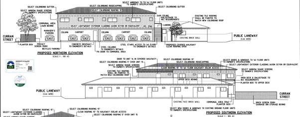
Figure 4 - design as initially submitted to Council
(North and South elevation)

Figure 5 - revised North and South elevation
Heritage Advisor’s
recommendations
Materials
As it will not be possible to match the existing face
brick with new brick, it is recommended that an alternate softer coloured brick
is sourced which is closer to the red/brown on the heritage buildings in the
vicinity. An intervening vertical window or solid sheet panel is to be
introduced to the walls to separate the two face bricks.
The front picket fence is to be a timber picket fence
with top rail and expressed posts in appropriate colours.
The vertical slatted first floor screen is to be vertical
slats in a timber stain/paint colour to match the window colour.
Applicant’s response
An intervening vertical window or solid sheet panel is to
be introduced to the walls to separate the two face bricks. This has been done on
the amended plans.
The existing building has painted brick. The amended
plans have included an updated material selection.
Planning Officer’s response
Noted. The selection of materials is considered adequate and
has addressed the initial concerns raised by Council’s Heritage Advisor.
Heritage Advisor’s
recommendations
Colour
A set of external colours and swatches is to be provided
for all the proposed materials and painted surfaces.
The roofing is to be Shale Grey or Windspray and not
Surfmist which is white.
The existing tiled roofing is to be painted Windspray and
not a colour to match the other roof in order to break down the bulk and scale
of the proposal.
A warm timber colour is to be selected for the windows
such as Beige, Baton or Paperbark.
Hannah Red is to be reconsidered for more traditional
red-brown colour for the existing work being painted.
Applicant’s response
Refer to amended plans and the updated colour scheme.
Planning Officer’s response
The revised colour selection and the use of material as
marked in the amended plans is considered to have adequately addressed
Council’s Heritage Advisor concerns.
Heritage Advisor’s
recommendations
Details
The traditional awnings are to be timber framed with
expressed rafters and matching Colorbond rooves.
Smooth quad unperforated gutters
and painted circular downpipes are required.
The covered walkway is to utilise timber slats or battens
beneath the translucent roof sheeting.
A traditional timber pergola element is to be provided
over the front steps and to accommodate the letterboxes, with details as per
the pergola above.
A timber picket/slatted screen to 1800mm high is to be
provided at the demarcation of the front garden and the car park and mot-r
cycle paring to screen these from the garden and street.
General fencing between the units and to the boundaries
is to be Corodeck in Windspray corrugated metal with appropriate posts and
capping.
Applicant’s response
We have incorporated changes into the amended design.
Planning Officer’s response
The detailing provided on the amended plans is considered to
have adequately addressed Council’s Heritage Adviser concerns.
Heritage Advisor’s
recommendations
Landscape
A planting layout with species is to be presented
prepared by a professional landscape architect to ensure the appropriate
species and mature heights are utilised.
Applicant’s response
Additional information
has been provided using client’s local horticultural knowledge including
species and mature heights.
Planning Officer’s response
Noted. A condition will be included in the notice of
determination requiring a final detailed landscape plan to be submitted to the
satisfaction of the Manager of Development prior to the release of the
Construction Certificate.
Planning Officer’s concluding comments
The
proposed development has undergone a number of design changes since the initial
design was lodged with Council.
The
amended plans have addressed issues raised by Council’s Heritage Advisor
and, overall the proposal is considered a reasonable design on a constrained
site within the Heritage Conservation Area.
Part 6 - Urban Release Area
Not relevant to the application. The subject site is not
located in an Urban Release Area.
Part 7 - Additional Local Provisions
7.1
- Earthworks
This
clause establishes a range of matters that must be considered prior to granting
development consent for any application involving earthworks, such as:
(a) the likely disruption of, or any
detrimental effect on, existing drainage patterns and soil stability in the locality
of the development
(b) the effect of the development on the
likely future use or redevelopment of the land
(c) the quality of the fill or the soil to be
excavated, or both
(d) the effect of the development on the
existing and likely amenity of adjoining properties
(e) the source of any fill material and the
destination of any excavated material
(f) the likelihood of disturbing relics
(g) the proximity to and potential for adverse
impacts on any waterway, drinking water catchment or environmentally sensitive
area
(h) any measures proposed to minimise or
mitigate the impacts referred to in Paragraph (g).
In
consideration of this clause, the proposal is deemed suitable. The development
will necessitate minor earthworks for the new building and car parking areas.
Disruption to drainage is considered to be minor and will not detrimentally
affect adjoining properties or receiving waterways. Should the application be
approved, conditions would be imposed in relation to sediment and erosion
control during construction.
7.3 - Stormwater Management
This clause applies to all
industrial, commercial and residential zones and requires that Council be satisfied
that the proposal:
(a) is designed to maximise the use of water
permeable surfaces on the land having regard to the soil characteristics
affecting onsite infiltration of water
(b) includes, where practical, onsite
stormwater retention for use as an alternative supply to mains water,
groundwater or river water; and
(c) avoids any significant impacts of
stormwater runoff on adjoining downstream properties, native bushland and
receiving waters, or if that impact cannot be reasonably avoided, minimises and
mitigates the impact.
The proposal has been designed
to include permeable surfaces and includes onsite retention of stormwater
through the use of rainwater tanks. It is therefore considered that the post
development runoff levels will not exceed the predevelopment levels.
7.6 - Groundwater Vulnerability
This
clause seeks to protect hydrological functions of groundwater systems and
protect resources from both depletion and contamination. Orange has a high
water table and large areas of the LGA, including the subject site, are
identified with “Groundwater Vulnerability” on the Groundwater
Vulnerability Map. This requires that Council consider:
(a) whether or not the development (including
any onsite storage or disposal of solid or liquid waste and chemicals) is
likely to cause any groundwater contamination or have any adverse effect on
groundwater dependent ecosystems, and
(b) the cumulative impact (including the
impact on nearby groundwater extraction for potable water supply or stock water
supply) of the development and any other existing development on groundwater.
Furthermore, consent may not be granted unless Council is satisfied that:
(a) the development is designed, sited and
will be managed to avoid any significant adverse environmental impact, or
(b) if that impact cannot be reasonably
avoided - the development is designed, sited and will be managed to minimise
that impact,
(c) if that impact cannot be minimised - the
development will be managed to mitigate that impact.
The proposal is not anticipated
to involve the discharge of toxic or noxious substances and is therefore
unlikely to contaminate the groundwater or related ecosystems. The proposal
does not involve extraction of groundwater and will therefore not contribute to
groundwater depletion. The design and siting of the proposal avoids impacts on
groundwater and is therefore considered acceptable.
Clause 7.11 - Essential Services
Clause 7.11 applies and states:
Development consent must not be
granted to development unless the consent authority is satisfied that any of
the following services that are essential for the proposed development are
available or that adequate arrangements have been made to make them available
when required:
(a) the
supply of water,
(b) the
supply of electricity,
(c) the
disposal and management of sewage,
(d) storm
water drainage or onsite conservation,
(e) suitable
road access.
In consideration of this clause, all utility services are
available to the land and adequate for the proposal.
STATE ENVIRONMENTAL PLANNING
POLICIES
State Environmental Planning
Policy No 55 – Remediation of Land (SEPP 55)
This policy applies to the
proposed development and contains planning controls for the remediation of
contaminated land.
SEPP 55 requires that prior to
granting consent to the carrying out of any development on land, the consent
authority is required to give consideration as to whether the land is contaminated
and, if the land is contaminated, whether the land is suitable for the purpose
of the development or whether remediation is required.
The subject
land is currently being used for residential purposes and Council’s
records do not identify any past contaminating activities on the site. The
proposal is considered to be acceptable having regard to this policy.
STATE ENVIRONMENTAL PLANNING
POLICY (Building Sustainability Index: BASIX) 2004
(BASIX SEPP)
A BASIX Certificate was lodged
with the application, demonstrating that the development can achieve the water
and energy reduction targets of this policy. A condition of consent has been
recommended, requiring that the development be carried out in accordance with
the BASIX Certificate.
STATE ENVIRONMENTAL PLANNING
POLICY (Affordable Rental Housing) 2009
(SEPP ARH)
SEPP
ARH contains provisions that a consent authority is required to take into
consideration when assessing a proposed development for the purpose of a
boarding house. An assessment of the development under the key
requirements of SEPP ARH is provided in the table below:
|
Clause
|
Control
|
Proposal
|
Compliance
|
|
26
|
This Division applies to land
within any of the following land use zones or within a land use zone that is
equivalent to any of those zones:
a) Zone
R1 General Residential,
b) Zone
R2 Low Density Residential,
c) Zone
R3 Medium Density Residential
d) Zone
R4 High Density Residential,
e) Zone
B1 Neighbourhood Centre,
f) Zone
B2 Local Centre,
g) Zone
B4 Mixed Use.
|
The site of the proposed development
is located in the R1 General Residential zone and therefore Division 3
of SEPP ARH applies to the site.
|
Yes
|
|
27
|
27 Development to which Division
applies
This Division applies to
development, on land to which this Division applies, for the purposes of
boarding houses.
|
Division 3 of SEPP ARH applies to
the proposed boarding house development.
|
Yes
|
STANDARDS THAT CANNOT BE USED TO REFUSE CONSENT
There are certain controls in the SEPP that if met must not be
used to refuse a development application. These requirements are discussed
below:
|
Clause
|
Control
|
Proposal
|
Compliance
|
|
29(1)(a)
|
FSR: maximum FSR for any form of
residential development permitted on the land
|
Not applicable, as there is no
floor space limit for the subject land pursuant to OLEP 2011 Floor Space
Ratio Map.
|
Not applicable
|
|
29(2)(a)
|
Building height: maximum building
height permitted on the land
|
Not applicable, as there is no
building height limit on the OLEP 2011 Height of Buildings Map.
|
Not applicable
|
|
29(2)(b)
|
Landscape area: landscape treatment
of the front setback is compatible with the streetscape
|
The area within the front setback
is proposed to be landscaped which is consistent with the streetscape.
|
Yes
|
|
29(2)(c)
|
Solar access: communal living room
to receive 3 hours direct sunlight between 9am and 3pm
|
The
SEPP requires at least one communal living room to receive at least three
hours of direct sunlight between 9am and 3pm in midwinter. The communal
living space does not comply with the requirement. However, this is a
merit based assessment and is considered acceptable given that most of the
boarding rooms have access to their own private space areas with many of the
areas receiving access to natural sunlight.
The
applicant has submitted overshadowing diagrams which demonstrate that, whilst
the communal room do not technically comply with the above requirements, the
communal BBQ area receives an adequate level of direct sunlight. There is
also sufficient area within the front setback area which has been designed to
be used as a recreational space that receives direct sunlight for future
residents of the boarding house.
|
No
|
|
29(2)(d)
|
Private open space: minimum 20m2 and with 3m
dimension for lodgers; and minimum 8m2 and 2.5m dimension for
manager
|
The proposal includes a communal room (32m2)
and a large open style communal/BBQ private open space area (64m2)
in compliance with the requirements of the SEPP.
In addition it should be noted that that most of the
ground floor units have good access to private open space (Units 1 to 11).
The private open space for these units range in size from 14m2 to
61m2. The only unit on the ground floor that does not have access
to their own private open space is Unit 12. The units on the first floor
(Units 13, 14 and 15) have access to a communal open space area in the form
of an open deck (20.8m2). The Managers unit has a private open
space area which comprises 45m².
The level of residential amenity for the future residents
is considered to be adequate for this form of development (boarding house ie
short term accommodation).
|
Yes
|
|
29(2)(e)
|
Parking - In the case of development not carried out on
behalf of a social housing provider at least 0.5 parking spaces for each room
and 1 space for manager is provided
|
The SEPP requires 0.5 spaces per bedroom and one (1)
space per employee (manager). The development comprises
14 boarding rooms and a managers unit.
The proposal therefore requires
eight (8) car parking spaces to be provided. The submitted plans show the
provision of seven (7) car parking spaces including 1 disabled space which
has an expanded shared zone. The development is therefore non-compliant with
this requirement of the SEPP.
Where a technical non-compliance with the SEPP occurs it
is open for Council to carry a merit based assessment of the issue. A merit
based consideration of car parking requirements for the development is
discussed below under the heading “Car Parking”.
|
No
|
|
29(2)(f)
|
Accommodation size: 16m2 excluding kitchen and
bathroom facilities
|
Each boarding room exceeds 16m2, excluding
kitchen and bathrooms facilities.
|
Yes
|
|
29(3)
|
A boarding house may have kitchen or bathroom facilities in
each boarding room but is not required to have those facilities in any
boarding room
|
Each boarding room has kitchen and bathroom facilities.
|
Yes
|
|
29(4)
|
A consent authority may consent to development to which
this Division applies whether or not the development complies with the
standards set out in Clauses 1 and 2
|
It is open for Council to carry out a merit based
assessment of any non-compliance specified above and consent to such
development.
|
|
|
29(5)
|
Social housing provider does not include a registered
community housing provider unless the registered community housing provider
is a registered entity within the meaning of the Australian charities and not
for profit commission Act 2012 of the Commonwealth s
|
The applicant for the development is not a registered
social housing provider.
|
Not applicable
|
|
|
|
|
|
· The
proposal complies with the prescribed Clause 30 Standards for boarding
houses:
|
Clause
|
Control
|
Proposal
|
Compliance
|
|
30(1)(a)
|
A communal living room is required
for 5+ boarding rooms
|
The proposal includes a shared
communal living room (32m2) along with a communal BBQ area (64m2).
|
Yes
|
|
30(1)(b)
|
Boarding rooms to have maximum GFA
(excluding kitchen and bathroom) of 25m2
|
The boarding rooms will comprise a
maximum GFA of 21.14m2 (excluding kitchen and bathroom).
|
Yes
|
|
30(1)(c)
|
Occupancy is limited to 2 adult
lodgers
|
Each boarding room will accommodate
a maximum of two adult lodgers.
|
Yes
|
|
30(1)(d)
|
Bathroom and kitchen facilities are
available for lodgers
|
Each boarding room will be self‑contained
with bathroom and kitchen facilities.
|
Yes
|
|
30(1)(e)
|
Manager’s room required for
boarding house with 20+ lodgers
|
The boarding houses will
accommodate a maximum of 30 lodgers (ie. 2 adult lodgers per 15 rooms). A
manager’s room is provided in Unit 11.
|
Yes
|
|
30(1)(f)
|
Repealed
|
Noted.
|
Not applicable
|
|
30(1)(g)
|
In commercial zones, residential
purposes not permitted on ground floor
|
This control is not applicable as
the subject land is located in the R1 General Residential Zone.
|
Not applicable
|
|
30(1)(h)
|
1 bicycle space and 1 motorcycle
space required for every 5 boarding rooms
|
2.8 (ie 3) bicycle and motorcycle
parking spaces are required based on 15 boarding rooms. Four (4) bicycle
spaces and three (3) motorcycle spaces will be provided onsite.
|
Yes
|
|
30A
|
A consent authority must not
consent to development to which this Division applies unless it has taken
into consideration whether the design of the development is compatible with
the character of the local area.
|
The overall scale, density, and nature
of the building is compatible with the surrounding character of the area and
meets this provision of SEPP ARH. Detailed matters in relation to character
have been addressed in the body of the report. Council’s Heritage
adviser has confirmed his support for the building design.
|
Yes
|
PROVISIONS OF ANY DRAFT
ENVIRONMENTAL PLANNING INSTRUMENT THAT HAS BEEN PLACED ON EXHIBITION
4.15(1)(a)(ii)
Draft State
Environmental Planning Policy (Housing Diversity) 2020
Between 29 July and 9 September 2020, the Department of
Planning exhibited a proposed new ‘Housing Diversity SEPP’. The
Explanation of Intended Effects (EIE) outlines the expected changes which
included:
· The introduction
of new definitions for build-to-rent housing, student housing and co-living.
· Amend some
state-level provisions, particularly for boarding house and seniors housing
development.
· Amend some
state-level provisions to support social housing developments by NSW Land and
Housing Corporation, and
· Consolidate three
SEPPs into one. These being the Affordable Rental Housing SEPP, Housing for
Seniors and People with a Disability SEPP, and SEPP 70 – Affordable
Housing (Revised Schemes).
The current application was lodged 9 September 2020,
coinciding with the end of the SEPP exhibition. Accordingly, while the draft
SEPP does not have determinative weight in this application it is a requirement
under section 4.15(1)(a)(ii) to consider the provisions of the SEPP as the SEPP
had been the subject of public consultation at the time of lodgement of the
application.
Introduction of new definitions is not material to this
application as the application is not seeking consent for one of the new forms
of development. Equally as the proposal is not by or on behalf of the NSW Land
and Housing Corporation those matters are also not relevant to the application.
Changes to state-level provisions as they relate to Boarding Houses are
materially relevant to the application and need to be considered.
With respect to Boarding House developments the EIE intends
to amend the provisions to:
· remove the
requirement for boarding houses to be mandated within the R2 –
Low Density Residential zone
· amend the floor
space ratio (FSR) bonus for boarding house development to a standard 20%
· include a
requirement for affordability of boarding house developments.
The intention to no longer mandate
boarding houses in the R2 zone is noted but as this test is applied at the time
of lodgement it cannot preclude the development.
Currently the Affordable Rental Housing SEPP sets the floor
space ratio (FSR) in relation to boarding houses as equal to any existing FSR
plus 0.5:1 if the current FSR is 2.5:1 or less, or 20% of the existing FSR in
any other case. In effect this gave a larger percentage bonus to developments
where the existing FSR was below 2.5:1 and could result in a fairly dramatic
change in density compared to other development in such areas. For example if
an area had an FSR of 0.3:1 the current SEPP provisions would allow this to
become 0.8:1 more than doubling other built form in the area. The proposed
changes will limit the bonus to 20% in all cases, meaning that in the example
stated an FSR of 0.3:1 would only be increased to 0.36:1 allowing such boarding
houses to be slightly larger than surrounding development but not
overpoweringly so.
The EIE also includes an intention to require boarding house
development to be 100% affordable. Boarding house provisions were introduced by
the ARHSEPP in 2009 and intended to provide for both traditional boarding
houses as well as ‘new generation’ boarding houses with
self-contained rooms in a compact and affordable form. It was expected that
‘new generation’ boarding rooms would be more affordable than other
similar residential development in the same area, due to their small size and
shared facilities.
In response to on-going concerns regarding boarding house
developments, the Department worked with a group of councils during July and
August 2019, to prepare advice to the Minister on issues associated with the
boarding house provisions of the ARHSEPP. The EIE sets out the proposed changes
to the Boarding House definition as:
Existing definition
boarding house
means a building that:
(a) is
wholly or partly let in lodgings, and
(b) provides
lodgers with a principal place of residence for 3 months or more, and
(c) may
have shared facilities, such as a communal living room, bathroom, kitchen or
laundry, and
(d) has
rooms, some or all of which may have private kitchen and bathroom facilities,
that accommodate one or more lodgers,
but does not include
backpackers’ accommodation, a group home, hotel or motel accommodation,
seniors housing or a serviced apartment. Note. Boarding houses are a type of
residential accommodation—see the definition of that term in this Dictionary.
Proposed definition
boarding house means an affordable
rental building that:
(a) provides
lodgers with a principal place of residence for three months or more, and
(b) is
managed by a registered not-for-profit community housing provider (CHP), and
(c) has
some shared facilities, such as a communal living room, bathroom, kitchen or
laundry, and
(d) has
rooms, some or all of which may have private kitchen and bathroom facilities,
that accommodate one or two adult lodgers,
but does not include
backpackers’ accommodation, a group home, hotel or motel accommodation,
seniors housing or a serviced apartment. Note. Boarding houses are a type of
residential accommodation.
The key difference is the requirement for the development to
be managed by a not-for-profit community housing provider. It must be noted
that the above changes to the SEPP and definitions have not yet taken effect
and as such the status of the application not being a Community Housing
provider (CHP) was not a material consideration at the time of lodgement.
Accordingly Council is required to determine the application on the basis of
the existing definition. The fact that the State has signalled an intention to
change the planning system to limit this form of development to CHP’s in
future does not retrospectively prohibit the current application before
council.
Draft Orange Local
Environmental Plan 2011 (Amendment 26)
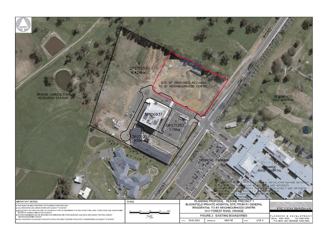
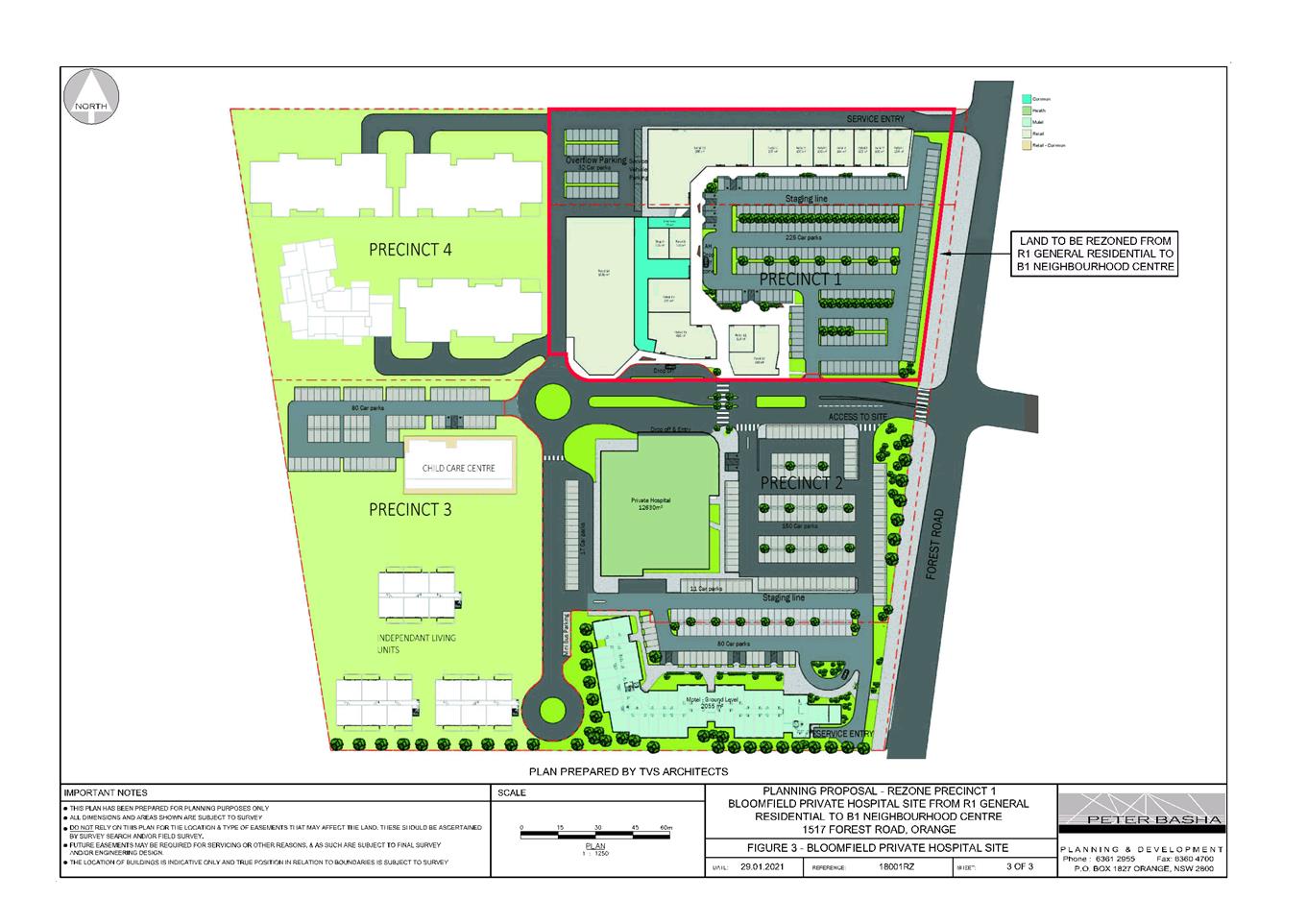
Draft Orange LEP 2011 Amendment 26
will be re-exhibited (December 2020-January 2021). The Draft plan relates to
land at 1517 Forest Road, being the private health precinct. The revised
proposal involves amendments to the (Concept) approved commercial use of the
land, including commercial floor area restrictions and rezoning to
B1 Neighbourhood Centre. The Draft Plan has no effect for the proposed
development.
Draft
State Environmental Planning Policy - Remediation of Land
Draft Remediation of Land SEPP is
applicable. The Draft SEPP requires in part that consideration be given to
potential contamination on nearby or neighbouring properties and groundwater.
The adjoining lands have longstanding commercial use and are unlikely to be
contaminated, with nil effect for the proposed development.
DESIGNATED DEVELOPMENT
The proposed development is not designated development.
INTEGRATED DEVELOPMENT
The proposed development is not integrated development.
PROVISIONS OF ANY DEVELOPMENT
CONTROL PLAN s4.15(1)(a)(iii)
Development Control Plan 2004
The following Chapter 7 Planning Outcomes are considered as
a guide in the assessment of the proposal:
Neighbourhood Character
The DCP sets the following Planning Outcomes in regard to
Neighbourhood Character:
· site layout and
building design enables the:
- creation
of attractive residential environments with clear character and identity
- use
of site features such as views, aspect, existing vegetation and landmarks.
· buildings are
designed to complement the relevant features and built form that are identified
as part of the desired neighbourhood character
· the
streetscape is designed to encourage pedestrian access and use.
As discussed in the heritage
assessment above, the amended building design for the proposed boarding houses
is considered to be compatible with the character of the local conservation
area.
In terms of neighbourhood function, the proposed development
will provide for a continuation of residential land use albeit in a more
compact form and will not adversely alter the function of the neighbourhood. The
proposal will provide a rental housing option to supplement housing needs in
the community, and contribute to the variety of housing types and densities in
the neighbourhood.
Building
Appearance
The DCP sets the following Planning Outcomes in regard to
Building Appearance:
· the building
design, detailing and finishes relate to the desired neighbourhood character,
complement the residential scale of the area, and add visual interest to the
street
· the frontages
of buildings and their entries face the street
· garages
and car parks are sited and designed so that they do not dominate the street
frontage.
As outlined previously in this report, the building design
and detailing for the proposed boarding houses are compatible with the
character of the local area in respect of built form, massing, site coverage,
streetscape presentation, setbacks, design and finishes. Council’s
Heritage Advisor evaluated the most recent set of plans and advised that the
design is now acceptable.
Heritage
The DCP sets the following Planning Outcomes in regard to
Heritage:
· heritage
buildings and structures are efficiently re-used
· new development
complements and enhances the significance of a heritage item or place of
heritage significance listed in the Orange Heritage Study
· significant
landscape features are retained including original period fences and period
gardens.
As considered in the heritage assessment above, it is
considered that the proposed development will complement the conservation
heritage area.
Setbacks
The DCP sets the following Planning Outcomes in regard to
Setbacks:
· street setbacks
contribute to the desired neighbourhood character, assist with the integration
of new development and make efficient use of the site
· street setbacks
create an appropriate scale for the street considering all other streetscape
components.
The proposed setbacks for the development are considered to
be acceptable in the context of surrounding buildings in the street.
 The
building setbacks will vary from 5.1m for the single storey section of the
proposed building to 16.8m for the double storey section of the building from
Curran Street. The upper storey will be set back 2.6m from the public
lane to the north and 14m from the public lane to the west (Refer to Figure 6
below).
The
building setbacks will vary from 5.1m for the single storey section of the
proposed building to 16.8m for the double storey section of the building from
Curran Street. The upper storey will be set back 2.6m from the public
lane to the north and 14m from the public lane to the west (Refer to Figure 6
below).
Figure 6 - proposed First Floor plans indicating setbacks
from Curran Street and Public Lane
Front Fences and Walls
The DCP sets the following Planning
Outcomes in regard to Fences and Walls:
· Front fences
and walls:
- assist in highlighting entrances and
creating a sense of identity within the streetscape
- are constructed of materials
compatible with associated housing and with fences visible from the site that
positively contribute to the streetscape
- provide for facilities in the street
frontage area such as mail boxes.
The proposal includes a new timber
picket front fence and a new wide path and stairs into the property from Curran
Street. There is no objections to the type and style of fencing
proposed.
Visual Bulk
The DCP sets the following Planning
Outcome in regard to Visual Bulk:
· Built form
accords with the desired neighbourhood character of the area with:
- side and rear setbacks progressively
increased to reduce bulk and overshadowing
- site coverage that retains the
relatively low density landscaped character of residential areas
- building form and siting that relates
to landform, with minimal land shaping (cut and fill)
- building height at the street frontage
that maintains a comparable scale with the predominant adjacent development
form
- building to the boundary where appropriate.
The visual
bulk for the proposed development will be compatible with the built form in
this precinct, and will not have encroachment impacts on the streetscape or
adjoining dwellings:
o Side and rear setbacks will exceed
typical residential setbacks.
o Site coverage for the development
will comprise some 41%, and not exceed the maximum site cover for residential
development (ie. 50% for multi dwelling housing).
o The buildings will be contained
within the DCP-prescribed visual bulk envelope plane.
Council’s heritage adviser
has indicated that the amended building design is acceptable in terms of bulk
and scale.
Walls and Boundaries
The DCP sets the following Planning
Outcome in regard to Walls and Boundaries:
· Building to the
boundary is undertaken to provide for efficient use of the site taking into
account:
- the privacy of neighbouring dwellings
and private open space
- the access to daylight reaching
adjoining properties
- the impact of boundary walls on
neighbours.
The proposal does not involve the construction of buildings
on the boundary.
Daylight and Sunlight
The DCP sets the following Planning
Outcome in regard to Daylight and Sunlight:
· Buildings are
sited and designed to ensure:
- daylight to habitable rooms in
adjacent dwellings is not significantly reduced
- overshadowing of neighbouring secluded
open spaces or main living area windows is not significantly increased
- consideration of Council’s
Energy Efficiency Code.
The SEPP provides sunlight
assessment criteria to consider in relation to the communal living room. The
SEPP requires at least one communal living room to receive at least three hours
of direct sunlight between 9am and 3pm in midwinter. The communal living space
does not comply with the requirement. Whilst the design of the proposed
communal area is not technically compliant with the requirements of SEPP
(Affordable Rental Housing) 2009 it is open for Council to consider on merit
the overall suitability of the design. To this end the overall design is
considered acceptable. The design incorporates a communal outdoor BBQ area and
communal lawn areas adjacent to the communal living area. This space has been designed
to be used as a recreational space that has effective access to sunlight and
will on balance achieve good outcomes in terms of general amenity for users.
Further, it should be noted that
whilst not required most of the boarding rooms have direct access to their own
private space areas with many of the areas receiving access to natural
sunlight.
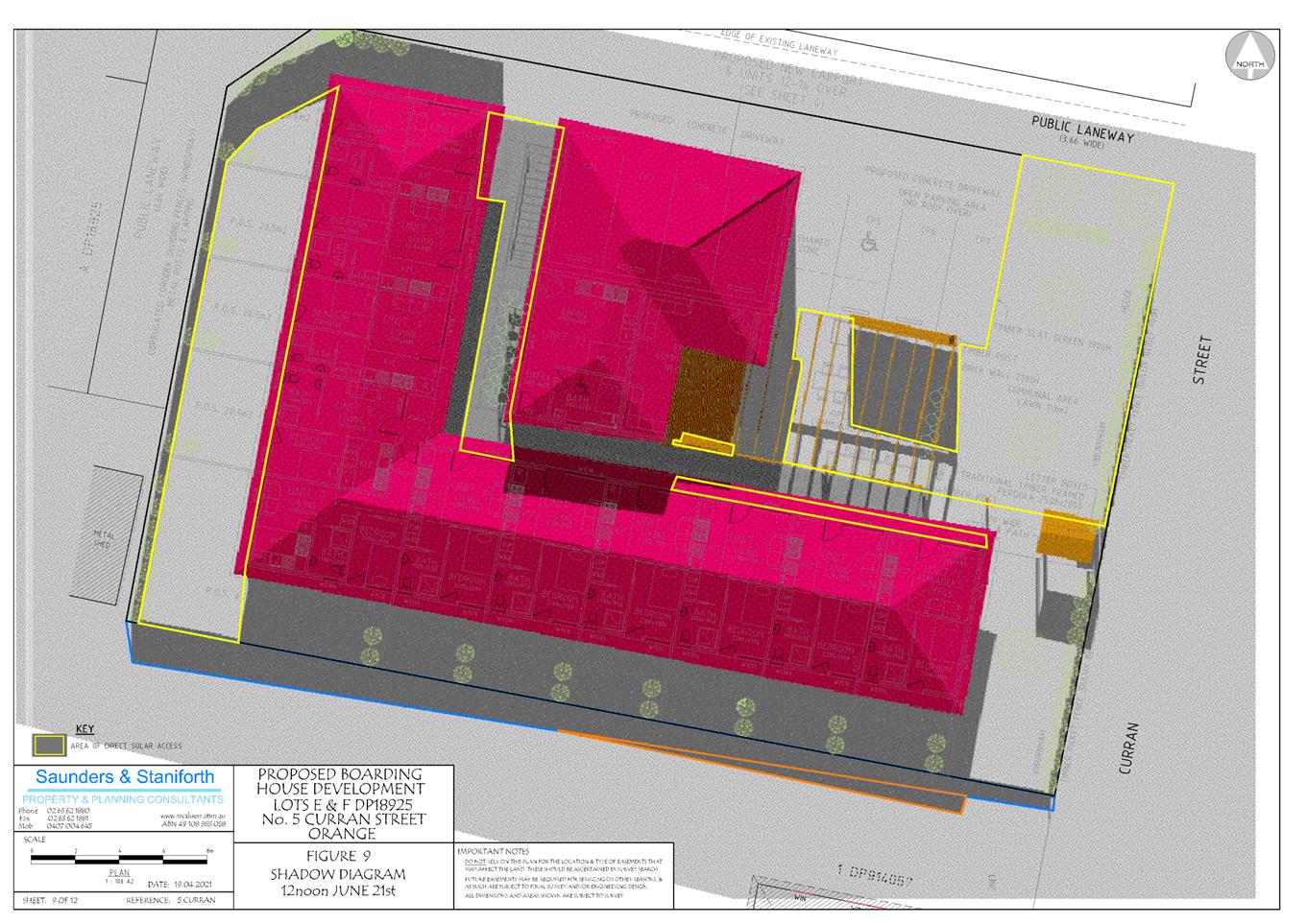
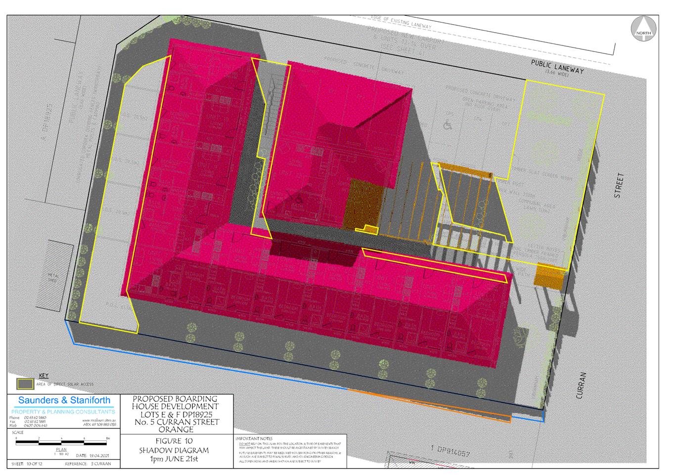
Further, shadow diagrams have been
submitted in support of the proposal. As demonstrated, the proposed
development will not adversely impact on solar access to the building to the
south of the site which is used for commercial use. Sunlight to habitable
spaces of the adjoining dwelling will comply with the DCP-prescribed
guidelines.
Views
The DCP sets the following Planning
Outcomes in regard to Views:
· building form
and design allow for residents from adjacent properties to share prominent
views where possible
· views including
vistas of heritage items or landmarks are not substantially affected by the
bulk and scale of the new development.
The subject site is not within an important view corridor.
Notwithstanding, the proposed buildings will not unreasonably diminish views
for other properties in the vicinity, based on building height and finished
floor levels.
Visual Privacy
The DCP sets the following Planning
Outcome in regard to Visual Privacy:
· direct
overlooking of principal living areas and private open spaces of other
dwellings is minimised firstly by:
- building
siting and layout
- location
of windows and balconies
and secondly by:
- design
of windows or use of screening devices and landscaping.
The proposed site layout and
building design will provide reasonable visual privacy for the proposed
development and adjoining dwellings. While the issue of privacy was raised in
public submission privacy impacts from the proposed development are unlikely to
be significant given the following reasons:
· Whilst the upper
deck contains an open deck, the area is well set back from neighbouring
properties.
· The units on the
ground floor (Units 1 to 7) face south onto the driveway of the adjoining
business.
· The units on the
ground floor (Units 8 to 11) on the western side of the site face onto a public
laneway. Access to their private open space is via a bedroom and is not
directly accessible from the living area. Whist privacy impacts from these
units is not considered a significant issue a condition has been included to
provide additional landscaping along the western boundary.
· The
upper level of the boarding house (Units 13, 14 and 15) contain a couple of
bedroom windows on the southern and northern elevation. The southern elevation
of the first floor only contains a bathroom windows and whilst the northern
elevation of the first floor contains a large window for Unit 14 and a couple
of bathroom windows, it is expected that there would be limited impact on adjoining
neighbours given the limited use of these rooms.
Acoustic Privacy
The DCP sets the following Planning Outcome in regard to
Acoustic Privacy:
· site layout and
building design:
- protect
habitable rooms from excessively high levels of external noise
- minimise
the entry of external noise to private open space for dwellings close to major
noise sources
- minimise
transmission of sound through a building to affect other dwellings.
Access to the proposed car parking
spaces is via the public laneway off Curran Street. Directly opposite the
public laneway is a dwelling located at No 7 Curran Street. This single
storey dwelling contains a number of bedroom windows directly adjacent to the
laneway.
It is noted that the location of the
proposed car parking spaces adjacent to the existing dwelling may have some
acoustic and lighting impacts on the residents. The resident did put in a
public submission requesting the ‘installation of a new 1.8m timber fence
along their southern boundary to minimise potential impacts of vehicle noise
and lights on neighbouring residences’.
The applicant has agreed to this
request to construct a 1.8m timber lap and capped fence. The construction
of the 1.8m timber lapped and capped fence along the southern boundary of No 7
Curran Street should minimise the potential impact of the development on the
existing residents. Attached is a condition to this effect.
Security
The DCP sets the following Planning Outcomes in regard to
Security:
· the site layout
enhances personal safety and minimises the potential for crime, vandalism and
fear
· the design of
dwellings enables residents to survey streets, communal areas and approaches to
dwelling entrances.
It is recognised
that effective design can assist to reduce crime opportunities.
According to the NSW Department of Planning publication ‘Crime Prevention
and Assessment of Development Applications (2001)’, crime prevention
through environmental design (CPTED) seeks to influence the design of building
and places so as to:
· increase the
perception of risk to criminals by increasing the possibility of detection,
challenge and capture
· increase the
effort required to commit crime by increasing the time energy or resources
which need to be expended
· reduce the
potential reward of crime by minimising, removing or concealing ‘crime
benefits’
· remove conditions
that create confusion about required norms of behaviour.
More specifically, CPTED involves the following principles:
· surveillance
· assess control
· territorial
reinforcement
· space management.
An
address of each of the CPTED principles is provided below.
Surveillance
The
guidelines states that good surveillance means that people can see what other
are doing. People feel safe in public areas when they can be easily seen
and interact with others.
The
proposed development is considered satisfactory in this regard due to the
following:
· The proposed
development provides for passive surveillance of the street and communal areas
· The car parking
areas, pathways and entrances will be illuminated
· CCTV will be
installed within the site at the request of NSW Police (and this has been
included in the conditions )
· Landscaping will
be provided in a manner to minimise the potential for concealment.
Access Control
The
guidelines suggest that physical and symbolic barriers can be used to attract,
channel or restrict movement of people. They minimise opportunities for
crime and increase the efforts required to commit crime.
The
proposed development is considered satisfactory in this regard due to the
following:
· The pathways and
pedestrian routes channel people to the front and entrance to the building.
· The proposed
fencing clearly delineates the go and no-go zones with the development.
· The inclusion of
the communal open space area at the front of the building provides good access
control by the existing tenants.
· The proposal
includes an on-site manager.
Territorial Reinforcement
Territorial
reinforcement can be achieved through design that encourages people to gather
in public space and to feel some responsibility for its use and condition.
The
proposed development is considered satisfactory in this regard principally due
to the proposed boarding house which has been designed to balance safety and
security by providing a large communal BBQ area at the front to the building.
Space Management
Space
management strategies include activity coordination, site cleanliness, and the
rapid repair of vandalism, graffiti and general decay of building/s and
surrounding area/s.
In this
regard, the proposal development is considered satisfactory as it will be
maintained in accordance with the draft plan of management which addresses the
specific issues of cleanliness and general maintenance.
As alluded to above NSW Police NSW
Police have evaluated the application and have requested that the applicant
install and maintain CCTV for all public accessible areas. In order to
reduce the crime risks associated with the proposal, a condition is included
recommending the installation of CCTV.
Circulation
and Design
The DCP sets the following Planning Outcome in regard to
Circulation and Design:
· accessways and
parking areas are designed to manage stormwater
· accessways,
driveways and open parking areas are suitably landscaped to enhance amenity
while providing security and accessibility to residents and visitors
· the site layout
allows people with a disability to travel to and within the site between car
parks, buildings and communal open space.
Access
to the car parking is via the public lane to the north of the site. The public
lane is to be upgraded in accordance with Council specifications. This will
require the laneway to be constructed to a 6.0m wide (variable width) from Curran
Street kerb and gutter for the full length of the northern property boundary
adjoining the laneway. Council’s Engineers have indicated that the
upgraded laneway has adequate space for vehicles to enter the site and leave in
a forward direction.
Car Parking
The DCP sets the following Planning Outcomes in regard to
Car Parking:
· parking
facilities are provided, designed and located to:
- enable
the efficient and convenient use of car spaces and accessways within the site
- reduce
the visual dominance of car parking areas and accessways.
· car parking is
provided with regard to the:
- the
number and size of proposed dwellings
- requirements
of people with limited mobility or disabilities.
Council’s DCP would ordinarily require the provision
of one (1) car parking space per bedroom. If assessed under these provisions
the development would have a car parking shortfall of eight (8) spaces.
Having said this, car parking for the development is
required to be assessed against the requirements of SEPP (Affordable Rental
Housing) 2009 (Clause 29(2)(e)). In the case where the development is not
operated by a social housing provider the SEPP specifically requires 0.5 spaces
per boarding room and one (1) space per employee (manager).
The development comprises 14 boarding
rooms and a managers unit and therefore will generate a demand for 8 car
parking spaces to be provided. The submitted plans show the provision of seven
(7) car parking spaces including 1 disabled space which has an expanded shared
zone. The development is non-compliant with this requirement of the SEPP
by one (1) space.
Where a technical non-compliance with the SEPP occurs it is
open for Council to carry out a merit based assessment of the parking
shortfall. The applicant has requested that Council support the proposed
shortfall of parking in this case based on the following justification:
The SEPP has been based on
case studies that show that public transport and a range of tenancy needs are
well below one space per unit. The SEPP requirements of 7.5 spaces show we
are 0.5 space close to compliance and considered reasonable in the overall
scheme of reuse of an existing building with onsite design challenges.
As discussed above the Council staff
assessment revealed that the development has an actual shortfall of 1 space as
opposed to 0.5 of a space as alluded to above. In any event it is difficult to
provide 0.5 of a car parking space and accordingly the space would ordinarily
be rounded up to be 1 space consistent with Council’s usual approach in
such circumstances. In terms of the non-compliance with the car parking
requirements under the Affordable Rental Housing SEPP is considered acceptable
for the following reasons:
· The variation is
considered relatively minor when assessed against the requirements of the SEPP
which ordinarily prevail where there is a discrepancy between standards. The
provisions of the SEPP recognise that this type of development typically has a
lower demand for car parking than other residential styles of development. The
lower demand is partly attributed to the fact that the development is located
on the fringe of the CBD with easy pedestrian access to shopping facilities and
various modes of public transport hence potentially reducing the demand for a
vehicle. Further this style of development is typically designed for short term
rental opportunities for people who may only need to reside in the area for a
short period of time (ie fly in fly out workers).
· The re-development
of the site will remove the existing vehicle cross over which is located in the
middle of the site. The site has a long frontage (28m) on Curran Street
and whilst Curran Street is relatively narrow, it could be argued that an
additional space within the street frontage can be made available by reinstating
the kerb and formally closing the access in this case.
· On street parking
is suitably removed from intersections and has reasonable sight lines along
Curran Street to the north and site.
Private Open Space
The DCP sets the following Planning Outcomes in regard to
Private Open Space:
· private open
space is clearly defined for private use
· private open
space areas are of a size, shape and slope to suit the reasonable requirements
of residents including some outdoor recreational needs and service functions
· private open
space is:
- capable
of being an extension of the dwelling for outdoor living, entertainment and
recreation
- accessible
from a living area of the dwelling
- located
to take advantage of outlooks; and to reduce adverse impacts of overshadowing
or privacy from adjoining buildings
- Orientated
to optimise year round use.
As outlined previously, private open space will be provided
for the development and is generally in compliance with SEPP (Affordable Rental
Housing) 2009 (Clause 29(2)(d)). While the SEPP only requires open space for
shared use by lodgers and a private area for managers, the proposal involves
private open space for most of the rooms. Most of the proposed boarding rooms
will have a private and directly accessible courtyard.
Open Space and Landscaping
The DCP sets the following Planning Outcomes in regard to
Open Space and Landscaping:
· the site layout
provides open space and landscaped areas which:
- contribute
to the character of the development by providing buildings in a landscaped
setting
- provide
for a range of uses and activities including stormwater management
- allow
cost effective management.
· the landscape
design specifies landscape themes consistent with the desired neighbourhood
character; vegetation types and location, paving and lighting provided for
access and security
· major existing
trees are retained and protected in a viable condition whenever practicable
through appropriate siting of buildings, accessways and parking areas
· paving is
applied sparingly and integrated in the landscape design.
A concept landscape plan has been submitted in support of
the proposal. A number of conditions have been included in the notice of
determination to ensure that landscaping is carried out in accordance with the
concept plan.
Stormwater
The DCP sets the following Planning Outcomes in regard to
Stormwater:
· onsite drainage
systems are designed to consider:
- downstream
capacity and need for onsite retention, detention and re-use
- scope
for onsite infiltration of water
- safety
and convenience of pedestrians and vehicles
- overland
flow paths.
· provision is
made for onsite drainage which does not cause damage or nuisance flows to
adjoining properties.
The proposal has been designed to include some permeable
surfaces to continue to absorb surface waters. A condition of consent is
recommended to ensure that stormwater is adequately connected to the
reticulated stormwater system provided to the site during the construction
phase of development.
Erosion
and Sedimentation
The DCP sets the following Planning Outcome in regard to
Erosion and Sedimentation:
· measures
implemented during construction to ensure that the landform is stabilised and
erosion is controlled.
Should the application be
approved, conditions would be imposed in relation to sediment and erosion
control during construction.
INFILL GUIDELINES
The issues of heritage impacts have been addressed above.
The amended design has demonstrated there will be no significant impacts on the
adjoining Heritage conservation area.
DEVELOPMENT CONTRIBUTIONS
Orange Development Contributions Plan 2017
Orange Development
Contributions Plan provides for the levying of development contributions for residential
accommodation (including boarding houses). Based on 15 boarding rooms
less 6 credits for the existing residential units in the LGA contributions
area, development contributions are applicable as follows:
|
Open Space and Recreation
|
Nine additional one (1) bedroom
boarding rooms @ $1,747.86
|
15,730.74
|
|
Community and Cultural
|
Nine additional one (1) bedroom
boarding rooms @ $506.88
|
4,561.92
|
|
Roads and Traffic Management
|
Nine additional one (1) bedroom
boarding rooms @ $2,573.86
|
23,164.74
|
|
Plan Preparation and Administration
|
Nine additional one (1) bedroom
boarding rooms @ $136.87
|
1,231.83
|
|
TOTAL:
|
|
$44,689.23
|
It is recommended that a condition
be imposed requiring payment of contributions (applicable to the LGA
contributions area) prior to issue of a Construction Certificate for the
proposed development.
WATER AND SEWER HEADWORKS CHARGES
Section 64 water and sewer headwork
charges are applicable to the proposed development. The contributions for
water, sewer and drainage works are based on 0.33 water ET and
0.5 sewer ET per boarding room, pursuant to the NSW Water Directorate
Guidelines. It is recommended that a condition be imposed requiring payment of
contributions (applicable to the LGA contributions area) prior to issue of a
Construction Certificate for the proposed development.
PROVISIONS PRESCRIBED BY THE
REGULATIONS s4.15(1)(a)(iv)
Demolition of a Building (clause
92)
The proposal demolition works is
considered acceptable subject to a number of conditions.
Fire Safety Considerations (clause 93)
Each boarding room will be
considered a separate fire compartment. Details to achieve compliance with the
BCA in this respect will be required with a Construction Certificate
application. Should the application be approved, conditions would be recommended
in relation to this matter.
Buildings to be Upgraded (clause 94)
Upgrading of the building will be
required to ensure the existing building is brought into partial or total
conformity with the Building Code of Australia. Conditions are attached in
relation to the required upgrading works.
BASIX Commitments (clause 97A)
A BASIX Certificate has been
submitted in support of the proposed development which demonstrates compliance
with the above policy.
THE LIKELY IMPACTS OF THE
DEVELOPMENT s4.15(1)(b)
Impacts on Conservation Area
As considered in the heritage
assessment above, the building design for the proposed boarding houses is
considered to be compatible with the character of the local area. It is
considered that the proposed building design will not have an adverse effect on
the significance of this setting in the East Orange HCA.
Visual Impacts
As outlined in the foregoing
assessment, the visual impacts of the proposal are considered acceptable.
Visual impacts associated with siting, massing and landscaping are considered
to be within reasonable limit, subject to mitigation conditions should the
application be approved.
Residential Amenity
A reasonable standard of
residential amenity will be provided to lodgers of the proposed boarding house.
In various design considerations, the development exceeds the prescribed
controls contained within the SEPP (Affordable Rental Housing) 2009.
Suitable justification for non-compliance with the Affordable Rental Housing
has been provided and is considered acceptable. Impacts of the
development on the amenity of adjoining dwellings (in terms of acoustic
privacy, visual privacy, solar access and visual bulk) are considered to be
within reasonable limit, subject to mitigation conditions should the
application be approved.
Social and Economic Impacts
The proposal will have direct positive social impacts, in
providing a form of accommodation that adds to the variety of housing types in
the locality. The proposal is also likely to have broad positive economic and
social impacts in that it will create additional employment opportunities
during the construction period, support the demand for local services and
facilities, increase social activity and street activation in and around Curran
Street.
Having regard to the surrounding area, it is considered that
the proposed development is adequate in terms of the character of the area and
satisfactorily responds to the attributes of the site, with its bulk and scale
being satisfactory in the context of locality.
The character, bulk and scale of the proposed development
have been discussed in this report, in the context of SEPP ARH Boarding House
provisions, OLEP 2011, and DCP controls. The proposal is considered to be
acceptable in this regard.
Waste Management
Demolition and waste management will be subject to
conditions recommended to be included in any development consent to be issued.
 A Waste
Management Plan has been provided with the application. The proposal provides a
storage area for three (3) bulk storage of bins (refer to Figure 7 below). The
bulk storage bins will be wheeled out by either the contractor or manager to
the kerb for collection and back to a dedicated storage area within the site
when empty.
A Waste
Management Plan has been provided with the application. The proposal provides a
storage area for three (3) bulk storage of bins (refer to Figure 7 below). The
bulk storage bins will be wheeled out by either the contractor or manager to
the kerb for collection and back to a dedicated storage area within the site
when empty.
Figure 7 - waste bin storage area
Conditions are recommended requiring the applicant to notify
Council’s waste contractor JR Richards of the arrangement for the
collection of the bins, and that the collection of waste is to be in accordance
with Council’s service agreement. The applicant has confirmed that wasted
generated by 15 x one (1) bedroom units would require the waste contractor to
either visit the site twice a week or upon request by the onsite manager.
Based on the submitted information
and the recommended conditions, the proposal is considered to be acceptable.
Anti-Social Behaviour and Crime
Consideration above has been given to the principles of Crime
Prevention through Environmental Design in the proposed site layout and
building design. The application has been referred to the Local Area
Command. The NSW Police have recommended a condition be imposed in
relation to surveillance with the installation of CCTV.
A number of submissions raised concerns about the potential
negative social impact of the proposed boarding house. A condition of consent
is recommended for a draft plan of management to be submitted prior to the
release of the Construction Certificate. The plan of management and a
number of other conditions have been recommended to ensure that the proposed
facility is managed to minimise any potential impact on adjoining residents.
Neighbourhood Character
In respect of the built form (and as previously considered),
the building design and detailing for the proposed boarding houses are
compatible with the character of the local area in respect of form, massing,
site coverage, streetscape presentation, setbacks, design and finishes.
In terms of neighbourhood function, the proposed development
will provide for a continuation of residential landuse and will not alter the
function of the neighbourhood. The proposal will provide a rental housing
option to supplement housing needs in the community, and contribute to the
variety of housing types and densities in the neighbourhood.
Traffic Matters
The proposal has the potential to impact upon traffic in the
locality. Curran Street is relatively narrow and currently serves a range of
residential properties in this precinct. The site is currently developed
for the purposes of multi-dwelling housing and the new development seeks to
introduce an additional nine 1 bedroom boarding units.
The car parking for the development is required to be
considered against the requirements of the Affordable Rental Housing SEPP which
prescribes a significantly lower parking requirement than other residential
styles of development. These provisions provide a reasonable gauge and some
context to the likely traffic generation envisaged for such development.
Having said this it is recognised that such development has
the theoretical potential for a greater parking demand to be generated. However
as discussed previously the parking provisions under the SEPP recognise that
this style of accommodation is aimed at providing affordable housing
opportunities in close proximity to the CBD where the reliance on the need for
a motor vehicle is reduced. The lower demand is partly attributed to the fact
that the development is located on the fringe of the CBD with easy pedestrian
access to shopping facilities and various modes of public transport.
Council’s Technical Service Department have evaluated
the application and have advised that they the proposed development is
satisfactory in terms of traffic impacts. The traffic impacts are considered to
be acceptable in this case due to the following:
· The capacity of
the local road network is sufficient to accommodate additional localised
traffic generated by the boarding house.
· Onsite vehicle
parking spaces are generally consistent with the requirements of the
SEPP (Affordable Rental Housing) 2009.(See discussion in report).
· The car park
layout and design will comply with AS 2890.1-2004 - Off-street car parking.
THE SUITABILITY OF THE SITE
S4.15
The subject land is suitable for the development due to the
following:
· boarding houses
are a permitted land use in the R1 Residential zone
· the site is of
sufficient area and dimensions to accommodate the proposed development
· the site has direct frontage and access to Curran Street
and the public lane to the immediate north of the property
· onsite vehicle
parking will be provided
· the site topography
will not unreasonably constrain the development nor generate unreasonable
offsite impacts
· there is no known
contamination on the land
· the subject land
is located within close proximity to the Central Business District, and is
accessible via public transport
· all utility
services are available and adequate subject to augmentation
· the subject land
has no biodiversity or habitat value.
ANY SUBMISSIONS MADE IN
ACCORDANCE WITH THE ACT s4.15(1)(d)
The proposed development is defined as "advertised
development" pursuant to Community Participation Plan. The application was
advertised for the prescribed period, and at the end of that period eleven (11)
submissions had been received. The issues raised in the submissions are
considered below.
The key issues raised within
the submissions have been discussed previously in this report. The following
table provides a summary of the issues raised and a response to those issues.
|
Issue
|
Comment
|
|
Bulk and scale
|
Bulk and scale considerations have been addressed in this
report and are considered acceptable.
|
|
The proposal should be classified as a hotel and should be
located within a commercial area and not in a residential area.
|
Boarding houses are a classified land use and are
permitted in the R1 General Residential Zone (being the zoning of the subject
land) pursuant to Orange LEP 2011 and SEPP (Affordable Rental Housing) 2009.
As outlined in this report, the proposal will reasonably integrate in the
neighbourhood in respect of built form and function.
|
|
Traffic and use of the public lane
|
As outlined in this report, onsite vehicle parking
resources are generally consistent with the requirements of SEPP (Affordable
Rental Housing) 2009. Overflow on-street parking is available along the front
of the site in Curran Street. Council’s Development Engineer has raised
no objection to the use of the laneway. The public lane is to be
upgraded via a condition of consent in accordance with Council
specifications. This will require the laneway to be constructed to a 6.0m
wide (variable width) from Curran Street kerb and gutter for the full length
of the northern property boundary adjoining the laneway.
|
|
Pedestrian Safety
|
The proposal enables all vehicles to enter and leave the
site in a forward direction via the public lane. The proposal includes a
pedestrian access from Curran Street. The development is not expected to have
any significant impact on pedestrian safety given that it is likely to be a
low speed environment.
|
|
Noise from the construction phase
|
Concerns have been raised that the proposal will impact on
the nearby residents during the construction phase. It is acknowledged that
there may be some short term noise impact during the construction phase. A
number of conditions have been placed on the consent to ensure that any
potential impacts are minimised during construction.
|
|
Property Valuation
|
The proposal will not have
significant adverse impact on the amenity of the adjoining premises or the
neighbourhood generally and, accordingly, is not likely to detract from
current market values.
The impact of a development of
the value of adjoining properties is not a valid consideration in the
assessment of a development application pursuant to Section 4.15 of the
Environmental Planning and Assessment Act 1979.
|
|
Fire Safety
|
The issue of fire safety has been considered by
Council’s Senior Building Surveyor and is deemed acceptable subject to
a number of conditions.
|
|
Future Occupants
|
The applicant intends that
the boarding houses will be occupied by professionals. The intended lodgers
of the boarding house is not a matter for Council in consideration of the
proposal. Council does not have the ability to impose conditions of consent
(nor enforce such conditions) placing limitations on lodgers. It is concurred
that ongoing occupation of the boarding houses may not be by
professionals. However, this is not a planning matter.
|
|
Plan of management
|
A condition has been included in the draft conditions
requiring a plan of management to be prepared and submitted prior to the release
of the Construction Certificate (CC).
|
|
Visual privacy
|
As discussed in this report, it is considered that the
proposal does not generate a significant impact on the adjoining properties,
in terms of privacy and overlooking.
|
|
Conflict of interest -
|
There is no conflict of interest. The applicant is
entitled to submit the application and have it considered by Council.
|
|
Amenity of surrounding area and future tenants
|
The boarding house provides individual private open space
areas and one communal living room on the ground floor along with a large
communal BBQ area. This is consistent with the prescribed provisions of the
SEPP ARH and will allow the tenants to have the options of using private or
communal space, which allows acceptable amenity for the future residents.
It is considered that the amenity of the adjoining
properties will not be impacted as the development has been designed to
provide setbacks to neighbouring residents.
|
|
Solar access and overshadowing
|
The overshadowing of adjoining buildings and the
surrounding area is considered to be minimal and deemed acceptable.
|
|
Character
|
The character, suitability of the proposal have been
discussed in this report, in the context of the SEPP ARH, OLEP 2011 and DCP
controls.
|
|
Car parking
|
Parking considerations have been addressed in this report.
|
|
Traffic generation
|
Traffic considerations have been addressed in this report.
|
|
Overdevelopment of the site
|
The site is zoned Residential and boarding houses are
permitted land use in this zone.
For reasons given in this report, it is considered that
the subject site is suitable for the proposed development.
|
|
Communal rooms
|
The proposed development provides one communal room along
with a couple of outdoor communal areas, which complies with the provisions
of SEPP ARH.
|
|
Concerns about the size of vehicles and indicates that
many miners often have large 4 x 4.
|
The dimension of the provided car parking spaces and
turning circles comply with the Australian Standard.
|
|
Heritage conservation area
|
For reasons given in this report it is considered that the
development will not have a significant impact on the heritage conservation
area. The amended proposal was supported by Council’s Heritage
Advisor.
|
|
The width of the laneway and concerns about the width of
Curran Street
|
The proposal complies with the parking provisions
contained within the SEPP ARH. While Curran Street is a narrow street, the
proposed development is not expected to have a significant impact on the
existing road network. The increase in residential density is not expected to
have a significant impact on pedestrian safety given the speed limit in and
around the development site.
|
|
Setbacks
|
As discussed in this report, the proposal is considered to
be acceptable having regard to the impacts on the adjoining land.
|
|
The application should be referred to NSW Police and any
recommendations should be incorporated in the development
|
The application was referred to NSW Police and their
recommendations for CCTV have been incorporated into the draft conditions.
|
|
Potential noise impacts from 15 air conditioning units
|
The proposal does not include the installation of
additional air-conditioning units. Any potential noise generated by future
air condition units would need to comply with relevant legislation in terms
of noise generation. Attached is a condition of consent addressing this
issue.
|
|
Anti-social problems including increased ‘arguments
crime, theft, littering and noise’.
|
Consideration above has
been given to the principles of Crime Prevention through Environmental
Design in the proposed site layout and building design. The
application has been referred to the Local Area Command. The NSW Police
have recommended a condition be imposed in relation to surveillance with the installation of CCTV.
In
addition a condition of consent is recommended for a Draft Plan of Management
to be submitted prior to the release of the Construction Certificate. A
number of other conditions have been recommended to ensure that the proposed
facility is managed to minimise any potential impact on adjoining residents.
|
|
Management issues
|
A condition is recommended to be placed on the consent for
a Plan of Management to be submitted prior to the release of the Construction
Certificate, to address appropriate conduct and effective management and
operation of the boarding house.
The provisions of SEPP ARH require an onsite manager which
should ensure that the day to day operation of the boarding house is
effectively managed.
|
PUBLIC INTEREST
s4.15(1)(e)
The proposed development is in the public interest in terms
of providing additional and affordable rental housing to the Orange Local
Government Area.
The development is in the public interest and will allow for
the orderly and economic development of the site.
SUMMARY
The proposed development is permissible with the consent of
Council. The proposed development complies with the relevant aims, objectives
and provisions of Orange LEP 2011 (as amended), SEPP (Affordable Rental
Housing) 2009 and DCP 2004. A Section 4.15 assessment of the
development indicates that the development is acceptable in this instance.
Attached is a draft Notice of Approval outlining a range of conditions
considered appropriate to ensure that the development proceeds in an acceptable
manner.
COMMENTS
The requirements of the Environmental Health and Building
Surveyor and the Engineering Development Section are included in the attached
Notice of Approval.
Attachments
1 Notice
of Approval, D21/23124⇩
2 Plans,
D21/22962⇩
3 Submissions,
D21/11042⇩
Attachment 1 Notice
of Approval
|
 
|
ORANGE CITY COUNCIL
Development
Application No DA
339/2020(1)
NA21/ Container
PR14036
|
NOTICE OF DETERMINATION
OF A DEVELOPMENT
APPLICATION
issued under the Environmental
Planning and Assessment Act 1979
Section 4.18
|
Development
Application
|
|
|
Applicant
Name:
|
Mr SF Lumby
|
|
Applicant
Address:
|
C/- Saunders and
Staniforth
2/204-206 Lords Place
ORANGE
NSW 2800
|
|
Owner’s
Name:
|
Messrs M S Kidd and S
F Lumby
|
|
Land
to Be Developed:
|
Lots E and F DP 18925
– 3 and 5 Curran Street, Orange
|
|
Proposed
Development:
|
Boarding House
(change of use) and Alterations and Additions
|
|
|
|
|
Building Code of
Australia
building
classification:
|
Class to be
determined by the PC
|
|
|
|
|
Determination made
under
Section 4.16
|
|
|
Made
On:
|
4 May 2021
|
|
Determination:
|
CONSENT GRANTED
SUBJECT TO CONDITIONS DESCRIBED BELOW:
|
|
|
|
|
Consent to Operate
From:
|
5 May 2021
|
|
Consent to Lapse On:
|
5 May 2026
|
Terms
of Approval
The
reasons for the imposition of conditions are:
(1) To ensure a quality
urban design for the development which complements the surrounding environment.
(2) To maintain
neighbourhood amenity and character.
(3) To ensure compliance
with relevant statutory requirements.
(4) Because the development
will require the provision of, or increase the demand for, public amenities and
services.
(5) To ensure the utility
services are available to the site and adequate for the development.
(6) To prevent the proposed
development having a detrimental effect on adjoining land uses.
(7) To minimise the impact
of development on the environment.
Conditions
(1) The development must be
carried out in accordance with:
(a) Plans
prepared
by Saunders and Staniforth. Sheets 3 to 12, dated 22/02/21 and 19/04/2021
Reference: 5 Curran
(b) statements
of environmental effects or other similar associated documents that form part
of the approval
as amended in
accordance with any conditions of this consent.
(2) All building work must
be carried out in accordance with the provisions of the Building Code of
Australia.
(3) A sign is to be erected
in a prominent position on any site on which building work, subdivision work or
demolition work is being carried out:
(a) showing
the name, address and telephone number of the principal certifying authority
for the work, and
(b) showing
the name of the principal contractor (if any) for any building work and a
telephone number on which that person may be contacted outside working hours,
and
(c) stating
that unauthorised entry to the site is prohibited.
Any such sign is to be maintained while the
building work, subdivision work or demolition work is being carried out.
(4) In
the case of residential building work for which the Home Building Act 1989
requires there to be a contract of insurance in force in accordance with Part 6
of the Act, evidence that such a contract of insurance is in force is to be
provided to the Principal Certifying Authority before any building work
authorised to be carried out by the consent commences.
(5) Residential
building work within the meaning of the Home Building Act 1989 must not
be carried out unless the principal certifying authority for the development to
which the work relates (not being the council) has given the council written
notice of the following information:
(a) in
the case of work for which a principal contractor is required to be appointed:
(i) the
name and the licence number of the principal contractor, and
(ii) the
name of the insurer by which the work is insured under Part 6 of that Act,
(b) in
the case of work to be done by an owner-builder:
(i) the
name of the owner-builder, and
(ii) if
the owner-builder is required to hold an owner-builder permit under that Act,
the number of the owner-builder permit.
If arrangements for doing the residential
building work are changed while the work is in progress so that the information
under this condition becomes out of date, further work must not be carried out
unless the principal certifying authority for the development to which the work
relates (not being the council) has given the council written notice of the
updated information.
(6) Where any excavation
work on the site extends below the level of the base of the footings of a
building on adjoining land, the person having the benefit of the development
consent must, at the person’s own expense:
(a) protect
and support the adjoining premises from possible damage from the excavation,
and
(b) where
necessary, underpin the adjoining premises to prevent any such damage.
Note: This
condition does not apply if the person having the benefit of the development
consent owns the adjoining land or the owner of the adjoining land has given
consent in writing to this condition not applying.
(7) The
proposed development shall be carried out in accordance with the approved BASIX
Certificate.
|
PRIOR TO THE ISSUE OF A CONSTRUCTION
CERTIFICATE
|
(8) Full details of
external colours and finishes of external materials are to be submitted and
approved by Councils Manager Development Assessments prior to the issue of a
Construction Certificate.
(9) A detailed plan showing
landscaping is to be submitted to, and approved by, Council’s Manager
Development Assessments prior to the issuing of a Construction Certificate.
The landscape plan shall be amended to include additional planting of
taller growing trees and/ or shrubs along the western boundary.
(10) In accordance with Section 7.11 of
the Environmental Planning and Assessment Act 1979 and Orange Development
Contributions Plan 2017 (Remainder of the Local Government Area) a contribution
towards the provision of the following public facilities is required:
|
Open Space and Recreation
|
Nine additional one (1) bedroom boarding
rooms @ 1,747.86
|
15,730.74
|
|
Community and Cultural
|
Nine additional one (1) bedroom boarding
rooms @ 506.88
|
4,561.92
|
|
Roads and Traffic Management
|
Nine additional one (1) bedroom boarding
rooms @ 2,573.86
|
23,164.74
|
|
Plan Preparation and Administration
|
Nine additional one (1) bedroom boarding
rooms @ 136.87
|
1,231.83
|
|
TOTAL:
|
|
$44,689.23
|
The contribution will be indexed quarterly in
accordance with the Orange Development Contributions Plan 2017
(11) NSW Police require the
installation of CCTV on all public and communal areas. Details of the
proposed CCTV system shall be shown on the plans to accompany the Construction
Certificate application.
(12) Prior to the release of the Construction Certificate the
applicant shall prepare and submit an operational Plan of Management for the
boarding house. The Operational Plan of Management shall address the
following as a minimum:
(a) Maintenance
and fire safety in the building.
(b) Measures to
ensure that guest numbers do not exceed those specified by Condition 47.
(c) Measures to
minimise unreasonable impact to the habitable areas of adjoining premises.
(d) Proposed
staffing arrangements, including location and contact details of the site
manager.
(e) Prominent
display of appropriate house rules eg guest behaviour, activities and noise,
visitor policy, operating hours of outdoor communal areas, use of alcohol
and/or drugs.
(f) Waste
minimisation and recycling including the collection and cleaning of bulk waste
bins.
(g) Professional
cleaning details and vermin control (as a minimum, shared facilities such as
kitchens and bathrooms shall be cleaned to a professional standard at least
once a week).
(h) Safety and
security measures for all residents may include but not be limited to such
things as: Internal signage indicating the property caretaker or manager and
contact number, emergency contact numbers for essential services such as fire,
ambulance, police, and utilities such as gas, electricity, plumbing, and
installation of perimeter lighting, appropriate fencing and secure gates.
(i) Record
keeping requirements eg receipts for tariffs and fees charged.
(j) Arrangements
for establishing and managing tenancy agreements.
(k) Residents
rights to service providers and advocates.
(l) Power
of entry for monitoring purposes.
(m) Complaint handily
procedures.
(13) An
approval under Section 68 of the Local Government Act is to be sought
from Orange City Council, as the Water and Sewer Authority, for alterations to
water and sewer. No plumbing and drainage is to commence until approval is
granted.
(14) The applicant is to
submit a waste management plan that describes the nature of wastes to be
removed, the wastes to be recycled and the destination of all wastes. All
wastes from the demolition and construction phases of this project are to be
deposited at a licensed or approved waste disposal site.
(15) Prior
to the issue of a Construction Certificate, evidence shall be submitted to
Council of the lodgement of plans with Land & Property Information to
consolidate Lots E and F DP 18925 into one
parcel.
(16) Engineering plans
providing complete details of the proposed car parking areas and roadworks in
the laneway are to be submitted to Orange City Council or an Accredited
Certifier (Categories B1, C3, C4, C6) upon application for a Construction
Certificate. These plans are to provide details of levels, cross falls of all
pavements, proposed sealing materials and proposed drainage works and are to be
in accordance with Orange City Council Development and Subdivision Code.
The laneway shall be constructed to a 6.0m wide
(and variable width) urban standard public road from Curran Street kerb and
gutter for the full length of the northern property boundary adjoining the
laneway.
(17) A new sewer junction
shall be constructed on Councils sewer main adjacent to the Curran Street
frontage to serve the proposed development. The 2 existing sewer junctions
shall be abandoned and capped off at the main. Prior to a Construction
Certificate being issued engineering plans for this sewerage system are to be
submitted to and approved by Orange City Council.
(18) Payment
of contributions for water, sewer and drainage works is required to be made
at the contribution rate applicable at the time that the payment is made.
The contributions are based on 2.55 ETs for water supply headworks and 4.50 ETs
for sewerage headworks. A Certificate of Compliance, from Orange City
Council in accordance with the Water Management Act 2000, will be issued
upon payment of the contributions.
This Certificate of Compliance is to be
submitted to the Principal Certifying Authority prior to the issuing of a
Construction Certificate.
(19) The development’s
stormwater design is to include stormwater detention within the development,
designed to limit peak outflows from the land to the pre-existing natural
outflows up to the 100 year ARI frequency, with sufficient allowance in
overflow spillway design capacity to safely pass flows of lower frequency (that
is, a rarer event) without damage to downstream developments. Where
appropriate, the spillway design capacity is to be determined in accordance
with the requirements of the Dam Safety Committee.
The design of the detention storage is to be
undertaken using the ILSAX/DRAINS rainfall-runoff hydrologic model or an
approved equivalent capable of assessing runoff volumes and their temporal
distribution as well as peak flow rates. The model is to be used to calculate
the flow rates for the existing and post-development conditions. The developed
flows are to be routed through the proposed storage within the model so that
the outflows obtained are no greater than the flows obtained for the
pre-existing natural flows. A report detailing the results of the analysis,
which includes:
· catchment plan showing
sub-catchments under existing and developed conditions;
· schematic diagram of
the catchment model showing sub areas and linkages;
· tabulation detailing
the elevation, storage volume and discharge relationships; and
· tabulation for the
range of frequencies analysed, the inflows, outflows and peak storage levels for
both existing and developed conditions;
together with copies of the data files for the
model and engineering design plans of the required drainage system are to be
submitted to Orange City Council upon application for a Construction
Certificate.
(20) A
Road Opening Permit in accordance with Section 138 of the Roads Act 1993
must be approved by Council prior to a Construction Certificate being issued
or any intrusive works being carried out within the public road or footpath
reserve.
|
PRIOR TO WORKS COMMENCING
|
(21) A
Construction Certificate application is required to be submitted to, and issued
by Council/Accredited Certifier prior to any excavation or building works being
carried out onsite.
(22) A
temporary onsite toilet is to be provided and must remain throughout the
project or until an alternative facility meeting Council’s requirements
is available onsite.
(23) Soil
erosion control measures shall be implemented on the site.
|
DURING CONSTRUCTION/SITEWORKS
|
(24) All
construction/demolition work on the site is to be carried out between the hours
of 7.00 am and 6.00 pm Monday to Friday inclusive, 7.00 am to
5.00 pm Saturdays and 8.00 am to 5.00 pm Sundays and Public
Holidays. Written approval must be obtained from the General Manager of Orange City
Council to vary these hours.
(25) All materials on site
or being delivered to the site are to be contained within the site. The
requirements of the Protection of the Environment Operations Act 1997
are to be complied with when placing/stockpiling loose material or when
disposing of waste products or during any other activities likely to pollute
drains or watercourses.
(26) Building demolition is
to be carried out in accordance with Australian Standard 2601:2001 –
The Demolition of Structures and the requirements of Safe Work NSW.
(27) Asbestos containing
building materials must be removed in accordance with the provisions of the Work
Health and Safety Act 2011 and any guidelines or Codes of Practice
published by Safe Work NSW, and disposed of at a licenced landfill in
accordance with the requirements of the NSW EPA.
(28) Any adjustments to
existing utility services that are made necessary by this development proceeding
are to be at the full cost of the developer.
(29) The provisions and
requirements of the Orange City Council Development and Subdivision Code are to
be applied to this application and all work constructed within the development
is to be in accordance with that Code.
The developer is to be entirely responsible for
the provision of water, sewerage and drainage facilities capable of servicing
the development from Council’s existing infrastructure. The developer is
to be responsible for gaining access over adjoining land for services where
necessary and easements are to be created about all water, sewer and drainage
mains within and outside the lots they serve.
(30) All vehicle parking
areas are to be sealed with bitumen, hot mix or concrete and are to be designed
for all expected loading conditions (provided however that the minimum pavement
depth for gravel and flush seal roadways is 200mm) and be in accordance with
the Orange City Council Development and Subdivision Code.
(31) The existing kerb and
gutter layback that is not proposed to be used is to be replaced with standard
concrete kerb and gutter and the adjacent footpath area re‑graded to the
shape and level requirements of footpaths in the Orange City Council
Development and Subdivision Code.
(32) The water and sewerage
services to the existing building, where they are not proposed to be used as
part of this development, are to be sealed off at their respective Council
mains.
|
PRIOR TO THE ISSUE OF AN OCCUPATION
CERTIFICATE
|
(33) No
person is to use or occupy the building or alteration that is the subject of
this approval without the prior issuing of an Occupation Certificate.
(34) The
owner of the building/s must cause the Council to be given a Final Fire Safety
Certificate on completion of the building in relation to essential fire or
other safety measures included in the schedule attached to this approval.
(35) Where
Orange City Council is not the Principal Certifying Authority, a final
inspection of water connection, sewer and stormwater drainage shall be
undertaken by Orange City Council and a Final Notice of Inspection issued,
prior to the issue of either an interim or a final Occupation Certificate.
(36) Prior
to the issue of an Occupation Certificate, evidence shall be submitted to
Council of the registration of plans with Land & Property Information to
consolidate Lots E and F DP 18925 into one
parcel.
(37) A Certificate of
Compliance, from a Qualified Engineer, stating that the stormwater detention
basin complies with the approved engineering plans is to be submitted to the
Principal Certifying Authority prior to the issuing of an Occupation
Certificate.
(38) Landscaping shall be
installed in accordance with the amended and approved landscaping plan, and
shall be permanently maintained to the satisfaction of Council's Manager
Development Assessments.
(39) Prior to the issue of
an Occupation Certificate the existing laneway shall be widened by 2.34m from
the Curran Street boundary to the NE corner of unit 11 and dedicated as Public
Road at no cost to Orange City Council.
(40) Certification from
Orange City Council is required to be submitted to the Principal Certifying
Authority prior to the issue of an Occupation Certificate stating that all
works relating to connection of the development to Council assets, works on
public land, works on public roads, stormwater, sewer and water reticulation
mains and footpaths have been carried out in accordance with the Orange City
Council Development and Subdivision Code and the foregoing conditions, and that
Council will take ownership of the infrastructure assets.
(41) A
Road Opening Permit Certificate of Compliance is to be issued for the works by
Council prior to any Occupation/Final Certificate being issued for the
development.
(42) All
of the foregoing conditions are to be at the full cost of the developer and to
the requirements and standards of the Orange City Council Development and
Subdivision Code, unless specifically stated otherwise. All work required by
the foregoing conditions is to be completed prior to the issuing of an
Occupation Certificate, unless stated otherwise.
(43) Prior
to the release of the Occupation Certificate the proponent shall enter into a
service agreement with Council’s waste contractor for the collection of
garbage, recycling and organic waste in association in association with the
proposed boarding house. The waste service agreement shall not be amended
or deleted without the agreement of Orange City Council.
(44) The
applicant shall provide a 1.8m high lapped and capped hardwood timber fence
along the southern boundary of the property at 7 Curran Street in conjunction
with the lane upgrading requirements of this consent to address privacy and
amenity impacts on the residence adjoining the laneway. The fencing shall not
extend forward of the street setback of the dwelling.
|
MATTERS FOR THE ONGOING PERFORMANCE AND
OPERATION OF THE DEVELOPMENT
|
(45) The onsite management
shall be responsibility for the operation, administration, cleanliness and fire
safety of the premises, including compliance with the approved Plan of
Management.
(46) The collection of waste
from the boarding house shall be in accordance with the service agreement with
Council’s waste contractor required by Condition (43) of this consent.
(47) The boarding house
shall have a maximum of two boarders per boarding room (total of 30 boarders
including the boarding house manager).
(48) The boarding house
manager shall be provided with a designated room and car parking space
onsite. Contact details of the boarding house manager, including a mobile
phone number, shall be available to the public by way of signage near the
entrance of the boarding house. The contact details shall be kept up to
date at all times.
(49) The use and occupation
of the premises, including all plant and equipment installed thereon, is not to
give rise to any offensive noise, as defined under the Protection of the
Environment Operations Act 1997 (NSW).
Should Council consider offensive noise has
emanated from the premises, the owner/occupier of the premises will be required
to submit an acoustic assessment prepared by a suitably qualified acoustical
consultant recommending appropriate acoustic measures necessary to ensure
future compliance with this condition and will be required to implement such
measures within a nominated period. Furthermore, written certification
from the said consultant confirming the recommended acoustic measures have been
satisfactorily implemented will be required to be submitted to Council prior to
the expiration of the nominated period.
(50) The
owner is required to provide to Council and to the NSW Fire Commissioner an
Annual Fire Safety Statement in respect of the fire-safety measures, as
required by Clause 177 of the Environmental Planning and Assessment
Regulation 2000.
(51) The
carport is not to be enclosed on any elevation (including enclosure by the
installation of roller doors) without separate development consent.
(52) The
development shall comply with the requirement of NSW Police for the
installation of CCTV on all public and communal areas. The installation of
lighting to support the CCTV in the hours of darkness. The CCTV should be
digitally recorded and viewable on site. The CCTV recordings should be kept for
a minimum of 28 days. Signage should be erected to signify public and private
areas and a site plan near the Managers office to prevent excuse making
opportunities.
(53) The
proposed boarding house development being operated in accordance with the
definition of a 'boarding house' contained in the State Environmental Planning
Policy (Affordable Rental Housing) 2009) being:
'a building:
(a) that is
wholly or partly let in lodgings, and
(b) that provides
lodgers with a principal place of residence for 3 months or more, and
(c) that
may have shared facilities, such as a communal living room, bathroom, kitchen
or laundry, and
(d) that
has rooms, some or all of which may have private kitchen and bathroom
facilities, that accommodate one or more ledgers, but does not include backpackers'
accommodation, a group home a serviced apartment, seniors housing or hotel or
motel accommodation.'
Other
Approvals
(1) Local
Government Act 1993 approvals granted under Section 68.
Nil
(2) General
terms of other approvals integrated as part of this consent.
Nil
Right
of Appeal
If you are dissatisfied with this decision,
Section 8.7 of the Environmental Planning and Assessment Act 1979
gives you the right to appeal to the Land and Environment Court. Pursuant to
Section 8.10, an applicant may only appeal within 6 months after the date the
decision is notified.
|
Disability
Discrimination Act 1992:
|
This application has been assessed in
accordance with the Environmental Planning and Assessment Act 1979. No
guarantee is given that the proposal complies with the Disability
Discrimination Act 1992.
The applicant/owner is responsible to ensure
compliance with this and other anti-discrimination legislation.
The Disability Discrimination Act
covers disabilities not catered for in the minimum standards called up in the
Building Code of Australia which references AS1428.1 - "Design for
Access and Mobility". AS1428 Parts 2, 3 and 4 provides the most
comprehensive technical guidance under the Disability Discrimination Act
currently available in Australia.
|
|
|
|
|
Disclaimer
- S88B of the Conveyancing Act 1919 - Restrictions on the Use of
Land:
|
The applicant should note that there could be
covenants in favour of persons other than Council restricting what may be
built or done upon the subject land. The applicant is advised to check the
position before commencing any work.
|
|
|
|
|
Signed:
|
On behalf of the consent authority ORANGE
CITY COUNCIL
|
|
Signature:
|
|
|
Name:
|
PAUL JOHNSTON - MANAGER DEVELOPMENT
ASSESSMENTS
|
|
Date:
|
5 May 2021
|
Planning and Development Committee
4 May 2021
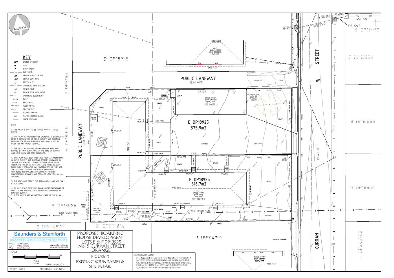
Planning
and Development Committee
4 May 2021
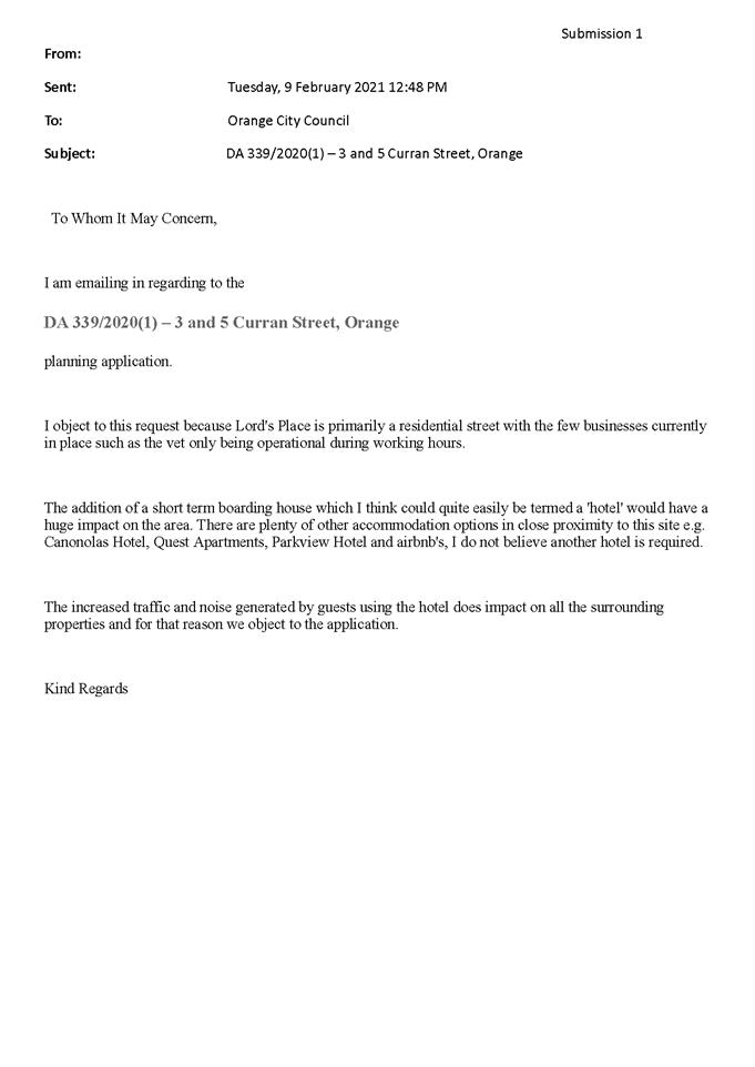


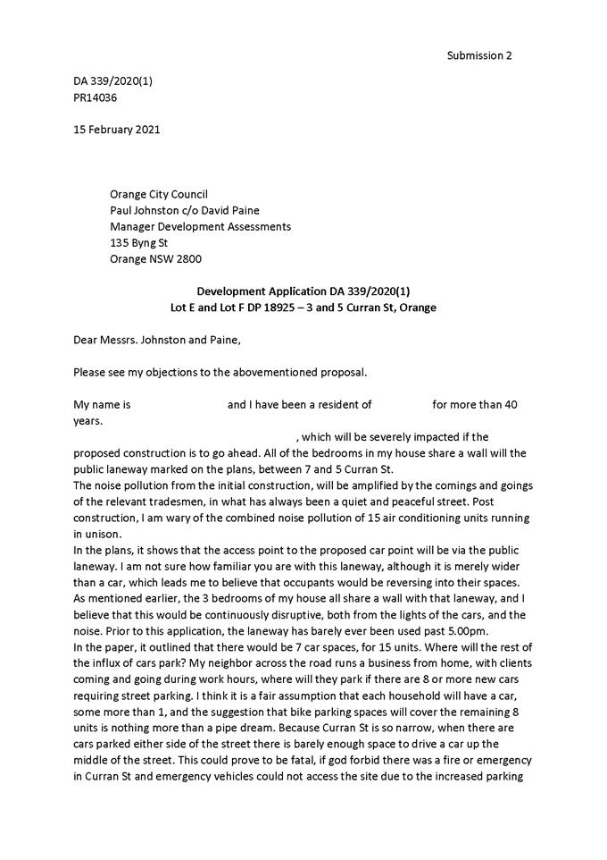
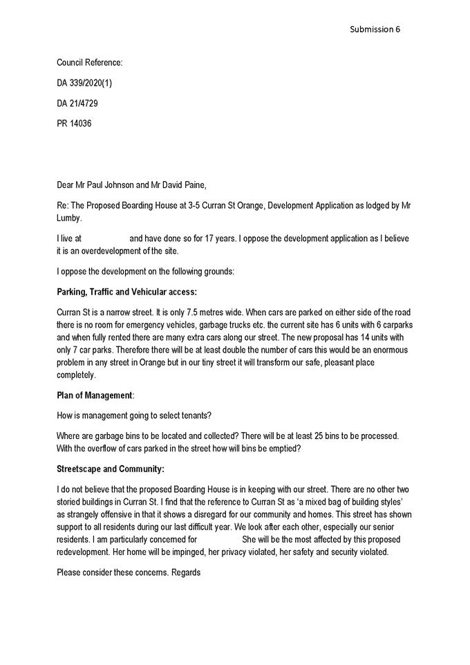
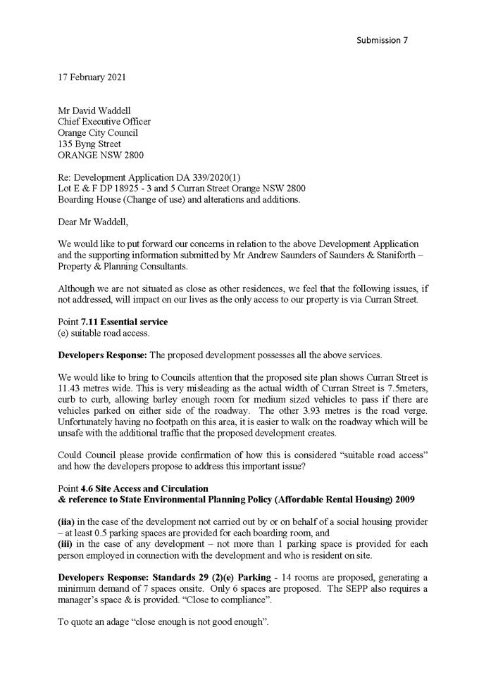


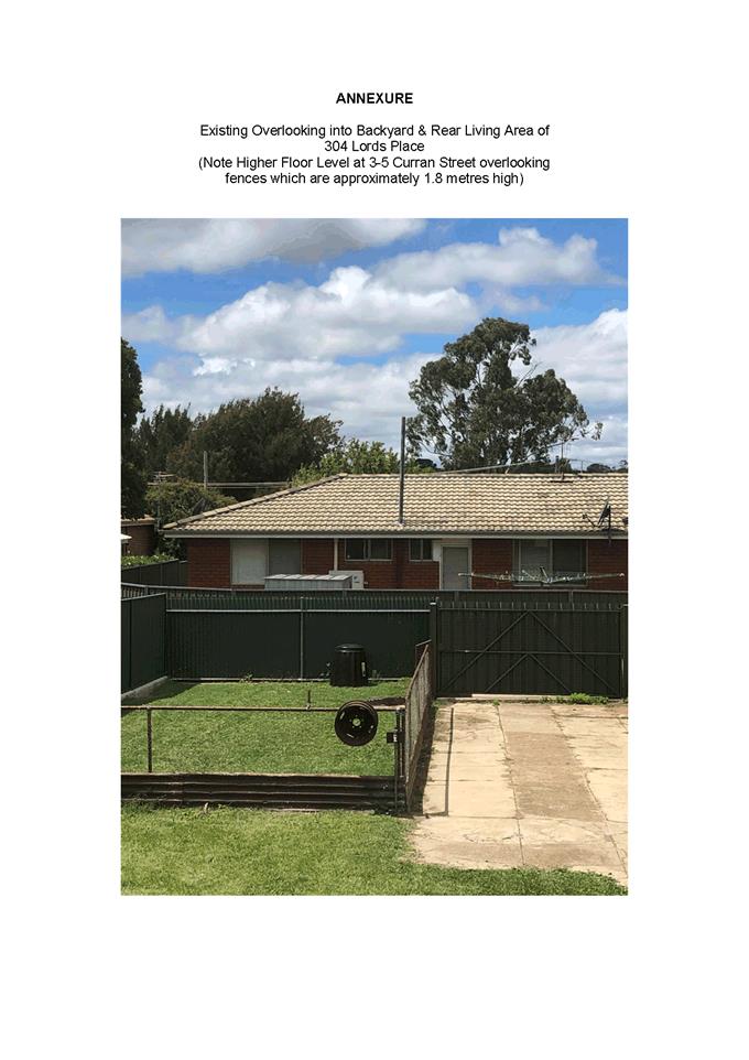
2.3 Development
Application DA 444/2020(1) - 1521 Forest Road
RECORD
NUMBER: 2021/813
AUTHOR: Summer
Commins, Senior Planner
EXECUTIVE
Summary
|
Application
lodged
|
18
November 2020
Amended
proposal submitted 5 March 2021
|
|
Applicant/s
|
James
Richmark Pty Ltd
|
|
Owner/s
|
Community
Association - Deposited Plan 271257
|
|
Land
description
|
Lots 1
and 4 DP 271257 - 1521 Forest Road, Orange
|
|
Proposed
land use
|
Centre-based
Child Care Facility
|
|
Value of
proposed development
|
$4,000,000.00
|
Council's consent is sought for
proposed centre-based child care facility at the Bloomfield Medical
Centre site, located at 1521 Forest Road, Orange.
The proposal involves construction
of a purpose-built facility for use as a child care centre; and associated site
works including vehicle areas, external play space, fencing and landscaping.
The facility will have capacity for 155 children aged between 0-5 years,
and operate between the hours of 6am to 8pm Monday to Friday.
The proposal comprises advertised
development pursuant to Council’s Community Participation Plan 2019. No
submissions were received.
Notable planning matters for this
application include:
· The approval
history of the Bloomfield Medical Centre site, and the implications for the
proposed development.
· The suitability of
the proposed land use within the Bloomfield Medical Centre site.
· The
proposal’s compliance with the Child Care Planning Guideline.
· The impacts of the
proposal on local traffic arrangements.
As outlined in this report, the proposed development is
considered to reasonably satisfy the Local and State planning controls that
apply to the subject and particular land use. Impacts of the development will
be within acceptable limit, subject to mitigation conditions. Approval of the
application is recommended.

Figure 1 - locality plan
DECISION FRAMEWORK
Development in Orange is governed by two key documents
Orange Local Environment Plan 2011 and Orange Development Control Plan 2004. In
addition the Infill Guidelines are used to guide development, particularly in
the heritage conservation areas and around heritage items.
Orange Local Environment Plan 2011 – The
provisions of the LEP must be considered by the Council in determining the
application. LEPs govern the types of development that are permissible or
prohibited in different parts of the City and also provide some assessment
criteria in specific circumstances. Uses are either permissible or not. The
objectives of each zoning and indeed the aims of the LEP itself are also to be
considered and can be used to guide decision making around appropriateness of
development.
Orange Development Control Plan 2004 – the DCP
provides guidelines for development. In general it is a performance based
document rather than prescriptive in nature. For each planning element there
are often guidelines used. These guidelines indicate ways of achieving the
planning outcomes. It is thus recognised that there may also be other solutions
of merit. All design solutions are considered on merit by planning and building
staff. Applications should clearly demonstrate how the planning outcomes are
being met where alternative design solutions are proposed. The DCP enables
developers and architects to use design to achieve the planning outcomes in
alternative ways.
DIRECTOR’S COMMENT
The key planning issues for
consideration of the development relate to the suitability of the proposed land
use within the Bloomfield Medical Centre site, the proposal’s compliance
with the Child Care Planning Guideline and the overall impact of the
development on traffic and parking in the locality. The Bloomfield Medical Centre site is subject to a Voluntary Planning
Agreement in conjunction with the original Part 3A Concept Approval.
The Concept Approval for the site was recently required to be surrendered
so as to facilitate the consideration of the current LEP amendment before
Council. Following the surrender of the Concept Approval, the planning
agreement remains active for only Precincts 1 and 2 and no longer applies to
development within what was previously known as Precincts 3 and 4 (subject
land). The planning agreement initially addressed in part matters in relation
to water and sewer headwork charges for development within precincts 3 and
4. In the absence of the planning agreement the headwork charges for
water and sewer will now need be dealt with via a specific condition of
consent. I support the staff planning assessment. It is recommended that
Council consents to the proposed development.
Link To Delivery/OPerational Plan
The recommendation in this report relates to the
Delivery/Operational Plan strategy “10.1 Preserve - Engage with the
community to ensure plans for growth and development are respectful of our
heritage”.
Financial Implications
Nil
Policy and Governance Implications
Nil
|
Recommendation
That
Council consents to development application DA 444/2020(1) for Centre-based Child Care Facility at Lot 1 DP
271257 - 1521 Forest Road, Orange, pursuant
to the conditions of consent in the attached Notice of Approval.
|
further considerations
Consideration has been given to the
recommendation’s impact on Council’s service delivery; image and reputation;
political; environmental; health and safety; employees; stakeholders and
project management; and no further implications or risks have been identified.
SUPPORTING INFORMATION
The approval history relating to
the Bloomfield Medical Centre site is summarised as follows:
· The Bloomfield
Medical Centre site is the subject of Major Project Concept Approval
(MP07_0072), granted by the NSW Minister for Planning in 2008.
· The site
masterplan for the approved Concept comprises four precincts as follows
(see Figure 2):
- Precinct
1: health facilities (pathology, medical imaging, medical suites) and
retail (convenience store, hairdresser, takeaway food and drink premises)
- Precinct
2: private hospital and medi-motel
- Precinct
3: child care centre (100 places) and residential purposes (7,500m2
GFA or 59 x two bedroom apartments)
- Precinct
4: residential purposes (17,000m2 GFA or 157 x two bedroom
apartments)
Figure 2 – Major Project Concept Approval
· Project Approvals
have subsequently been granted for developments within Precincts 1 and 2
(MP 08_0232 (as modified) and MP 08_0232 (as modified) respectively).
Construction of the private hospital and medi-motel in Precinct 2 is
proceeding/nearing completion.
· Major Project
Concept Approval (MP07_0072) has been voluntarily surrendered.
· The surrender of
the Concept Approval does not result in the surrender of the Project Approvals
that relate to Precincts 1 and 2. The approved developments in Precincts 1
and 2 remain in place.
· The surrender of
the Concept Approval removes the development concept that was approved for
Precincts 3 and 4. Future development within former Precincts 3 and 4 are
subject to Local and State planning controls.
· The proposal
involves development of a centre-based child care facility within former
Precinct 3- as was originally approved in the Concept Approval.
THE PROPOSAL
Council’s consent is sought
for proposed centre-based child care facility at the Bloomfield Medical
Centre precinct at 1521 Forest Road, Orange.
The development site is described as Lot 1 (Community
Property) and Lot 4 in DP 271257. The proposed building will be constructed on
Lot 4, with proposed car parking areas to be located on Community Lot 1, as
depicted below.
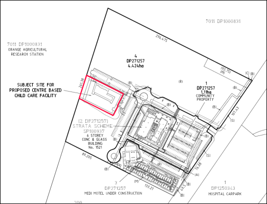
Figure 3 – subject land: Lots 1 and 4 DP 271257
Proposed Building
The proposed building will be
sited immediately to the West (rear) of the tower health services building; and
North-West of the hotel building (see below).

Figure 4 – site context/location
The proposed building will
comprise a single-storey structure of contemporary commercial design and scale.
The building will contain:
· Entry
foyer with reception area and office.
· Kitchen,
dining room and laundry.
· Staff
room and amenities.
· Nine
age group-specific playrooms with adjacent bathrooms, stores and sleeping
rooms.
The proposed floor plan is depicted below (see Figure 5).
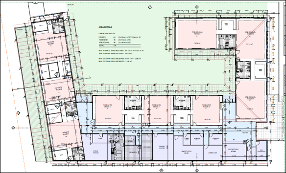
Figure 5 – proposed Floor Plan
External finishes will comprise:
· Smooth-faced
blockwork to main and base walls.
· Lightweight
coloured panels to upper walls.
· Aluminium
window frames in anodised finish or powder coated in primary colours.
· Colorbond
roof sheeting.
· Steel
posts, balustrades and fencing.
Elevation drawings are depicted below (see Figure 6).

Figure 6 – North and East elevations
Proposed Site Works
The proposal involves various site works including:
· Construction
of on-grade car parking areas with a total of 115 spaces, to the North and East
of the proposed building.
· Establishment
of internal and North-facing playground with associated elements (soft-fall,
equipment, landscaping and seating).
· Landscaping
to the Eastern frontage and site perimeter.
· Construction
of paths, paving and fencing.
· Service
extensions and connections.
The proposed site layout is
depicted below.
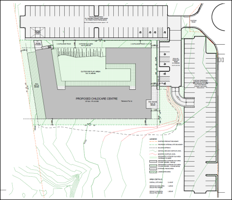
Figure 7 – proposed site layout
Operation
The proposed child care facility will have capacity for 155
children and 27 staff members. The facility will operate between the hours of
6am to 8pm Monday to Friday.
MATTERS FOR CONSIDERATION UNDER
THE ENVIRONMETNAL PLANNING AND ASSESSMENT ACT 1979
Section 1.7 Application of Part 7
of the Biodiversity Conservation Act 2016 and Part 7A of the Fisheries
Management Act 1994
Pursuant to Clause 1.7:
This
Act has effect subject to the provisions of Part 7 of the Biodiversity Conservation Act 2016 and Part 7A of the Fisheries Management Act 1994 that relate to the operation of this Act in connection
with the terrestrial and aquatic environment.
In consideration of this section, the proposed development
is not likely to significantly affect a threatened species.
· The subject and
adjoining lands are not identified as biodiversity sensitive on the Orange LEP
2011 Terrestrial Biodiversity Map.
· The site is not a
dedicated area of outstanding biodiversity value.
· The proposal does
not involve clearing above thresholds prescribed by regulation.
· The land is a
highly disturbed urban environment. The development is unlikely to give rise to
significant impact upon any endangered ecologically communities, threatened
species or their habitat.
Based on the foregoing consideration, a Biodiversity
Assessment Report is not required, and the proposal suitably satisfies the
relevant matters at Clause 1.7.
Section 4.15 Evaluation
Provisions of any Environmental Planning Instrument
S4.15(1)(a)(i)
Orange Local Environmental Plan 2011
Part 1 – Preliminary
Clause 1.2 Aims of Plan
The
particular aims of the LEP relevant to the proposal include:
(a) to encourage development which complements
and enhances the unique character of Orange as a major regional centre boasting
a diverse economy and offering an attractive regional lifestyle,
(b) to provide for a range of development
opportunities that contribute to the social, economic and environmental
resources of Orange in a way that allows present and future generations to meet
their needs by implementing the principles for ecologically sustainable
development,
(f) to recognise and manage valued
environmental heritage, landscape and scenic features of Orange.
The application is considered to be consistent with the
above-listed Aims, as outlined in this report.
Clause 1.6 Consent Authority
Clause 1.6 is applicable and states:
The consent authority for the purposes of this Plan is
(subject to the Act) the Council.
Clause 1.7 Mapping
The subject site is identified
on the LEP maps in the following manner:
|
Land Zoning Map:
|
Land zoned R1 General Residential
|
|
Lot Size Map:
|
No minimum lot size
|
|
Heritage Map:
|
Not a heritage item or conservation
area; adjacent to a heritage item
|
|
Height of Buildings Map:
|
No building height limit
|
|
Floor Space Ratio Map:
|
No floor space limit
|
|
Terrestrial Biodiversity Map:
|
No biodiversity sensitivity on the
site
|
|
Groundwater Vulnerability Map:
|
Groundwater vulnerable
|
|
Drinking Water Catchment Map:
|
Not within the drinking water
catchment
|
|
Watercourse Map:
|
Not within or affecting a defined
watercourse
|
|
Urban Release Area Map:
|
Not within an urban release area
|
|
Obstacle Limitation Surface Map:
|
No restriction on building siting
or construction
|
|
Additional Permitted Uses Map:
|
No additional permitted use applies
|
|
Flood Planning Map:
|
Partly within a flood planning area
|
Those matters that are of relevance are addressed in detail
in the body of this report.
Clause 1.9A Suspension of
Covenants, Agreements and Instruments
Clause 1.9A is applicable and
states in part:
(1) For the purpose of enabling
development on land in any zone to be carried out in accordance with this Plan
or with a consent granted under the Act, any agreement, covenant or other
similar instrument that restricts the carrying out of that development does not
apply to the extent necessary to serve that purpose.
(2) This
clause does not apply:
(a) to a covenant
imposed by the Council or that the Council requires to be imposed, or
(b) to
any prescribed instrument within the meaning of Section 183A of the Crown Lands Act 1989, or
(c) to
any conservation agreement within the meaning of the National Parks and Wildlife Act 1974, or
(d) to
any Trust agreement within the meaning of the Nature
Conservation Trust Act 2001, or
(e) to
any property vegetation plan within the meaning of the Native Vegetation Act 2003, or
(f) to
any biobanking agreement within the meaning of Part 7A of the Threatened Species Conservation Act 1995, or
(g) to
any planning agreement within the meaning of Division 6 of Part 4 of the Act.
In
consideration of this clause, Council staff are not aware of the title of the
subject property being affected by any of the above.
Part 2 – Permitted or Prohibited Development
Clause 2.1 Land Use Zones
The
subject land is zoned R1 General Residential.
The
proposal is defined as centre-based child care facility.
The
proposal is permitted with consent in the R1 zone.
Clause 2.3 Zone Objectives and Land Use Table
The objectives of the R1 General
Residential zone are:
· To
provide for the housing needs of the community.
· To
provide for a variety of housing types and densities.
· To
enable other land uses that provide facilities or services to meet the day to
day needs of residents.
· To
ensure development is ordered in such a way as to maximise public transport
patronage and encourage walking and cycling in close proximity to settlement.
· To
ensure that development along the Southern Link Road has an alternative access.
The proposal will be consistent
with the relevant zone objectives. The proposed centre‑based child care
facility will provide a long-day child care service that will be utilised by
staff of the adjacent health services facilities, and residents in the
developing Shiralee subdivision. Centre-based child care facilities are a
permitted and complementary land use in the R1 zone.
Part 3 – Exempt and Complying Development
The application is not exempt or
complying development.
Part 4 – Principal Development Standards
The Part 4 Development Standards do not apply to the
subject land or proposed development.
Part 5 – Miscellaneous Provisions
Clause
5.10 – Heritage Conservation
The subject land is located adjacent to a State-listed
heritage item: Item 21- Bloomfield Hospital “Nymagee Lodge”
including landscape features, entry gateway, Elm Avenue and grounds).
Clause
5.10 is applicable and states in part:
(4) The consent
authority must, before granting consent under this clause in respect of a
heritage item or heritage conservation area, consider the effect of the
proposed development on the heritage significance of the item or area
concerned.
In
consideration of this clause, the proposed development will not have adverse
impact on the significance of the nearby listed item. There will be nil spatial
and visual relationship between the heritage item and proposed child care
facility, due to separation attributed to distance and development within the
intervening area.
Part 6
– Urban Release Area
Not relevant to the application. The subject site is not
located in an Urban Release Area.
Part 7 – Additional Local Provisions
Clause
7.3 Stormwater Management
Clause 7.3 is applicable. This
clause states in part:
(3) Development
consent must not be granted to development on land to which this clause applies
unless the consent authority is satisfied that the development:
(a) is
designed to maximise the use of water permeable surfaces on the land having
regard to the soil characteristics affecting onsite infiltration of water, and
(b) includes,
where practical, onsite stormwater retention for use as an alternative supply
to mains water, groundwater or river water, and
(c) avoids
any significant impacts of stormwater runoff on adjoining downstream
properties, native bushland and receiving waters, or if that impact cannot be
reasonably avoided, minimises and mitigates the impact.
Conditions relating to stormwater management will be imposed
to satisfy the requirements of Clause 7.3.
Clause 7.6 Groundwater
Vulnerability
The
subject land is identified as ‘Groundwater Vulnerable’ on the Groundwater
Vulnerability Map. Clause 7.6 applies. This clause states in part:
(3) Before
determining a development application for development on land to which this
clause applies, the consent authority must consider:
(a) whether or not the development (including
any onsite storage or disposal of solid or liquid waste and chemicals) is
likely to cause any groundwater contamination or have any adverse effect on
groundwater dependent ecosystems, and
(b) the cumulative impact (including the
impact on nearby groundwater extraction for potable water supply or stock water
supply) of the development and any other existing development on groundwater.
There are no aspects of the
proposed development that will impact on groundwater and related ecosystems,
pursuant to Clause 7.6.
Clause 7.11 Essential Services
Clause 7.11 applies and states:
Development consent must not be
granted to development unless the consent authority is satisfied that any of
the following services that are essential for the proposed development are
available or that adequate arrangements have been made to make them available
when required:
(a) the
supply of water,
(b) the
supply of electricity,
(c) the
disposal and management of sewage,
(d) storm
water drainage or onsite conservation,
(e) suitable
road access.
In
consideration of this clause, the above-listed utility services are available
to the land and adequate for the proposal.
State Environmental Planning
Policy (Infrastructure) 2007
Division 17 Roads and Traffic
Section 101 Development with frontage to a classified
road
Section 101 is applicable and states in part:
(2) The consent authority must not
grant consent to development on land that has a frontage to a classified road
unless it is satisfied that-
(a) where practicable and safe,
vehicular access to the land is provided by a road other than the classified
road, and
(b) the safety, efficiency and
ongoing operation of the classified road will not be adversely affected by the
development as a result of-
(i) the design of the vehicular
access to the land, or
(ii) the emission of smoke or dust from
the development, or
(iii) the nature, volume
or frequency of vehicles using the classified road to gain access to the land,
and
(c) the development is of a type
that is not sensitive to traffic noise or vehicle emissions, or is
appropriately located and designed, or includes measures, to ameliorate
potential traffic noise or vehicle emissions within the site of the development
arising from the adjacent classified road.
Road access to the Bloomfield Medical Centre site is via
Forest Road (a State classified road) and a four-way signalised intersection.
The internal road system on the site (within Community
Property Lot 1) comprises Federation Avenue, which extends in a Westerly
direction from Forest Road to a central roundabout; and Albury Way, which
extends from the roundabout to the South. Albury Way provides vehicular access
to the rear health services tower building, the medi-motel and the proposed
child care centre (see Figure 8).

Figure 8 – internal road layout
The siting and design of the Forest Road access; the nature,
volume and frequency of vehicles using the access; and the effects of traffic
noise and vehicle emissions within the site were considered for the Major
Project Approval. The proposed child care facility will not alter the approved
arrangements.
The proposed development site does not have frontage to a
classified road. No works are proposed within the classified road. The proposed
development will not be contrary to any matter at Clause 101.
Section 104 Traffic Generating Development
Section 104 is applicable and states in part:
(3) Before
determining a development application for development to which this clause applies,
the consent authority must-
(a) give
written notice of the application to TfNSW within 7 days after the application
is made, and
The proposal is not a listed traffic generating land use in
Schedule 3. TfNSW does not have a referral role in the application.
Notwithstanding this, the following advice was provided by
TfNSW for ‘consideration by the consent authority:’
The consent authority should
consider requiring a revised Traffic Impact Assessment for the proposed child
care centre that incorporates:
- The
childcare traffic against a baseline scenario that includes all other as-built
and currently approved (but not yet built) developments in the precinct.
- Revised
analysis based on current real-world data, noting the signalised intersection
and surrounding sites have development significantly since the desktop review
prepared in 2018.
- Include
modelling or sensitivity analysis of the trip distribution assumptions…
- The
2018 traffic report appears to have only included limited modelling of future
network efficiency performance, with a focus on the signalised intersection on
Forest Road (eg. using SIDRA). Modelling should include the baseline,
post-development and post development + 10 years scenarios.
Council’s Manager Engineering Services (MES) has
reviewed the TfNSW recommendations. He considers that a revised Traffic Impact
Assessment is not required for the proposal. The (surrendered) Concept
Approval for the precinct accepted that the site would ultimately be developed
for a hospital, motel, retail facilities, aged care housing and child care
centre. The signalised intersection with Forest Road was required and designed
to cater for the completed development of the precinct. As such, it is
considered that the capacity of the local road network will be suitable to
accommodate traffic generated by the proposed child care facility.
MES does consider it appropriate, however, that a
SIDRA performance analysis be undertaken in conjunction with the proposed
development. A SIDRA analysis will review the Forest Road/Federation Avenue
intersection capacity, performance, level of service and timing calculations
(ie. phasing of traffic lights). A Condition will be imposed requiring a SIDRA
analysis be undertaken for baseline, post-development and post-development
+10 years scenarios (as suggested by TfNSW).
State Environmental Planning
Policy 55 Remediation of Land
SEPP 55 is applicable and states in part:
(1) A
consent authority must not consent to the carrying out of any development on
land unless (a) it has considered whether the land is contaminated.
(2) Before
determining an application for consent to carry out development that would
involve a change of use on any of the land specified in Subclause (4), the
consent authority must consider a report specifying the findings of a
preliminary investigation of the land concerned carried out in accordance with
the contaminated land planning guidelines.
(4) The
land concerned is:
to the extent to
which it is proposed to carry out development on it for residential,
educational, recreational or child care purposes, or for the purposes of a
hospital- land:
(i) in
relation to which there is no knowledge (or incomplete knowledge) as to whether
development for a purpose referred to in Table 1 to the contaminated land
planning guidelines has been carried out, and
(ii) on
which it would have been lawful to carry out such development during any period
in respect of which there is no knowledge (or incomplete knowledge).
The
proposal involves use of the subject land for a centre-based child care
facility. Pursuant to Clauses 2 and 4, contamination
clearance was given for the subject land in conjunction with the Concept
Approval. Further contamination investigation will not be required for the
proposed child care facility. The subject land is suitable in its current form
for the proposed development. A condition will be imposed requiring
implementation of ‘unexpected finds’ procedure during construction
works.
State Environmental Planning
Policy (Educational Establishments and Child Care Facilities) 2017
SEPP (Educational Establishments and Child Care Facilities)
2017 is applicable. The relevant provisions of the SEPP are considered below.
Clause 5 – Interpretation
The proposed development is defined as a “centre-based
child care facility” pursuant to Clause 5.
Clause 22 – Centre-based child care facility
– concurrence of Regulatory Authority required for certain development
Indoor unencumbered floor space will comply with
Regulation 107 of the Education and Care Services National Regulations
pursuant to Clause 22. Indoor floor space of 503.75m2 is
required (based on 3.25m2 x 155 children) and 516.13m2
provided over nine playrooms.
Outdoor unencumbered space requirements will comply
with Regulation 108 of the Education and Care Services National
Regulations, pursuant to Clause 22. Outdoor play space of 1,085m2
is required (based on 7m2 x 155 children) and 1,100m2 provided.
Based on spaces compliance above, concurrence of the
Regulatory Authority for NSW under the Children (Education and Care Services)
National Law (NSW) is not required for the proposed development.
Clause 23 – Centre-based child care facility
– matters for consideration by consent authorities
The proposed development complies with the applicable
provisions of the Child Care Planning Guideline (Department of Planning and
Environment 2017) pursuant to Clause 23, as demonstrated below.
CHILD CARE PLANNING GUIDELINE
Part 2 – Design Quality Principles
Principle 1 – Context
The proposed child care facility is a permitted and
complementary land use for the precinct. The site is well-located to attract
facility users from the nearby employment and residential lands. The development
site is located adjacent to the transport route and accessible via public
transport.
Principle 2 – Built Form
The proposed building design and detailing will relate to
the contemporary commercial built form on the subject land.
Principle 3 – Adaptive
Learning Spaces
The proposal will provide purpose-built indoor learning
spaces that are ‘fit-for-purpose, enjoyable and easy to use.’
Principle 4 –
Sustainability
The proposed building will incorporate energy efficient
influences in the design.
Principle 5 – Landscape
The proposed landscape design concept for the child care
facility is supported by Council’s Manager City Presentation.
Principle 6 – Amenity
A high standard of amenity will be provided for users of the
child care facility. Indoor and outdoor play spaces will be efficient and
functional with generous natural light, ventilation and outlook. Residential
amenity will be maintained for residents of the aged care facility to the
South.
Principle 7 – Safety
The proposed development will satisfy the principles of Crime
Prevention through Environmental Design.
Part 3 – Matters for
Consideration
3.1 – Site Selection and Location
Objective: to ensure that appropriate zone conditions are
assessed when selecting a site.
Noise
Residents of the nearby aged care facility on the adjoining
Southern parcel at 1503 Forest Road are unlikely to be impacted by noise
emissions associated with the development due to the following:
· There will be a
generous separation between the uses (some 100+m).
· Outdoor play
spaces will be oriented to the North, and away from the aged care facility.
· Outdoor play
spaces will be contained within the U-shaped building, which will act as an
acoustic barrier.
· The proposal will
not result in new traffic paths nearby the aged care facility.
· New parking areas
will not directly oppose the aged care facility.
· Daytime operation
of the child care facility will preclude after-hours noise nuisance.
There are no other residential
receivers within the vicinity of the proposed child care facility. The motel on
the health precinct site would be constructed with noise attenuation measures
appropriate to the use. Council’s Environmental Health Officer is
satisfied that noise emissions associated with development will comply with relevant
criteria.
Privacy
The proposed site layout and building design will provide
acceptable visual privacy for residents of the nearby aged care facility.
Indoor and outdoor play spaces will be orientated to the North and West, and
away from the aged care facility. New parking areas will not oppose the aged
care facility. The spatial separation between the buildings and associated
outdoor areas will be generous to prevent overlooking.
Odour
The garage enclosure for the proposed child care facility
will be located adjacent to the Northern on-grade carpark, at the Western end.
The enclosure will be well-removed from nearby residents. Odour impacts are not
anticipated.
Lighting
Based on the long-day operation of
the proposed facility, car park lighting (and other external lighting) will be
required. A Condition is imposed requiring outdoor
lighting to comply with AS 4282:1997 Control of the obtrusive effects of
outdoor lighting.
Traffic Matters
Traffic Generation
The Bloomfield Medical Centre site has been subject to
various traffic and parking studies in support of the (surrendered) Concept
Approval and Project Approvals for Precincts 1 and 2. Traffic analysis of the
proposals has always recognised that the precinct would accommodate a 100 place
child care facility.
It is acknowledged that the proposal involves an additional
55 places than previously contemplated. Notwithstanding this, the arising
traffic impacts associated with the increased scale are considered to be
largely neutral and not contrary to the assessed arrangements. Council’s
Technical Services’ engineers concur that ‘the proposed increase
in the capacity of the child care facility does not generate traffic beyond the
volumes that have been assessed to date.’
The most recent traffic assessment (Traffic and Parking
Assessment Report by Terrific Pty Ltd (December 2018)) provides as follows:
The main traffic implications
of the proposed development concern the ability of traffic that it generates to
access the site via the new Forest Road traffic signals serving the site and
Base Hospital. The ability of this intersection to accommodate the projected
post-development traffic demand can be assessed using the SIDRA traffic
model…
This finding remains relevant to the current proposal. As
outlined above, Council’s MES has recommended updated SIDRA analysis be
undertaken for the Forest Road/Federation Avenue intersection, to review intersection
capacity, performance, level of service and timing calculations (ie. phasing of
traffic lights).
A Condition will be imposed requiring
a SIDRA analysis be undertaken for baseline, post‑development and
post-development +10 years scenarios (as suggested by TfNSW).
Internal Traffic
Arrangements
The child care facility will be serviced by internal roads.
The proposed site layout of building and parking areas will suitably integrate
with existing internal roads and other improvements on the Bloomfield Medical
Centre site. The development layout will largely accord with the masterplan
contained in the surrendered Concept Approval (see Figure 9 below), which
continues to provide a framework for development of the precinct.
Car Parking and Manoeuvring
As outlined in the following
sections of this report, onsite car parking will be provided for the proposed
child care centre in excess of the DCP controls. The car parking areas will
comply with AS 2890.1-2004.

Figure 9 – Concept Approval site masterplan
Objective: To
ensure that the site selected for a proposed child care facility is suitable
for the use
It is considered that the subject land will be suitable for
use as a centre-based child care facility due to the following:
· The proposed
development is a permitted and complementary land use for the precinct.
· The development
site is not subject to environmental risks such as flooding, landslip or
bushfires.
· As outlined above,
the site is free from contaminants and suitable for child care use.
· Lot size,
configuration, dimensions and frontage are suitable for the proposed child care
facility.
· The development
site does not share a boundary with residential properties. The interface
between the development and nearby aged care facility is considered
satisfactory (as considered above).
· There are no
incompatible social activities and users in the vicinity of the development
site.
Objective: To ensure
that sites for child care facilities are appropriately located
The proposed development is a complementary land use in the
Bloomfield Medical Centre site. A child care facility has long been
foreshadowed as a compatible land use for the precinct. The site is
well-located to attract facility users from nearby employment lands.
The development site is serviced by public transport.
Objective: To
ensure that sites for child care facilities do not incur risks from
environmental, health or safety hazards
The subject land is not in proximity to landuses with
arising adverse environmental conditions prescribed in the Guideline. The site
does not contain any known environmental hazard or risk. The site is free from
contamination and suitable for child care use.
3.2 - Local Character,
Streetscape and the Public Domain Interface
Objective: To
ensure that the child care facility is compatible with the local character and
surrounding streetscape
The proposed building will be located at the rear of the
tower health services building and will not have a streetscape presence at
Forest Road. Notwithstanding this, the proposed building design and detailing
will complement the emerging contemporary built form on the subject land. The
building will address the internal road network, and new car parking areas will
integrate with existing vehicle areas. Landscaping to the building frontage
(East façade) and car park perimeter will provide site beautification
and integration of the development in the precinct.
Objective: To ensure
clear delineation between the child care facility and public spaces
Landscaping and fencing associated with the child care
facility will establish a transition between the facility and other uses on the
Bloomfield Medical Centre site. The building will address internal road Albury
Way and the Northern carpark. Generous glazing will ensure passive surveillance
and connectivity with the public domain.
Objective: To
ensure that front fences and retaining walls respond to and complement the
context and character of the area and do not dominate the public domain
The Northern playground will be enclosed by 2.1m high
palisade fencing adjacent to the carpark. The rear (West) and side (South)
boundaries of the development site will comprise 1.2m high palisade fencing.
Open-style fencing will provide a connectivity between the child care facility
and other improvements on the Bloomfield Medical Centre site; while
establishing an effective transition between child care spaces and the public
domain.
3.3 - Building Orientation,
Envelope and Design
Objective: To
respond to the streetscape and site, while optimising solar access and
opportunities for shade
As outlined previously, the development will provide
acceptable visual and acoustic privacy for the nearby aged care facility. The
proposal will not result in unreasonable overshadowing of adjoining land.
Eight of the nine learning rooms and the outdoor play area
will have access to Northern and Eastern sunlight. The proposed landscape
design will incorporate shade trees along the Western boundary.
Objective: To
ensure that the scale of the child care facility is compatible with adjoining
development and the impact on adjoining buildings is minimised
The proposed child care facility will take a single-storey
form, and relate to the massing and footprint of the nearby aged care facility
and motel. Arising adverse impacts associated with the interface of the
proposed and existing buildings are not anticipated.
Objective: To
ensure that setbacks from the boundary of a child care facility are consistent
with the predominant development within the immediate context
Proposed setbacks from external boundaries and internal
community lots will be suitable for efficient use of the site.
Objective: To
ensure that the built form, articulation and scale of development relates to
its context and buildings are well designed to contribute to an area’s
character
The proposed building design and detailing will complement
the emerging contemporary built form on the subject land.
Objective: To ensure
that buildings are designed to create safe environments for all users
Crime prevention measures are included in the site layout
and building design. The proposed development was referred to the Crime
Prevention Officer at Central West Police District. The Crime Prevention
Officer raised no objection to the proposal and did not provide specific
recommendations/conditions of consent.
Objective: To
ensure that child care facilities are designed to be accessible by all
potential users
The proposed child care facility will be designed to comply
with the requirements of the National Construction Code; the Disability (Access
to Premises – Buildings) Standards 2010; and the Disability
Discrimination Act 1992.
3.4 - Landscaping
Objective: To provide landscape
design that contributes to the streetscape and amenity
Council’s Manager City Presentation supports the
proposed landscape design concept for the site, excepting a conditional species
substitution. Landscaping will contribute to the amenity of the centre and
setting. Perimeter plantings to the Northern carpark will soften the hardstand
expanse.
3.5 - Visual
and Acoustic Privacy
Objective: To protect the privacy and security
of children attending the facility
The proposed U-shaped building footprint with internal
outdoor playground will limit the exposure of the playground to the public
domain. Site landscaping will assist to disrupt direct views from the Northern
carpark to the playground. Views into the playrooms from parking areas and
internal roads will similarly be disrupted by shade trees adjacent to glazing.
Objective: To minimise
impacts on privacy of adjoining properties
As considered above, the proposal will not have adverse
impacts on visual privacy for the nearby aged care facility, being the nearest
residential land use.
Objective: To
minimise the impact of child care facilities on the acoustic privacy of
neighbouring residential developments
As considered above, the proposal will not have adverse
impacts on acoustic privacy for the nearby aged care facility, being the
nearest residential land use.
3.6 - Noise and Air Pollution
Objective: To
ensure that outside noise levels on the facility are minimised to accepted
levels
The subject site is not located in the vicinity of noise
generating infrastructure or landuses prescribed in the Guideline. The child
care facility will be removed from traffic noise along Forest Road, due to the
separation from the road and the siting of the health services tower and motel
in the intervening area.
Objective: To
ensure air quality is acceptable where child care facilities are proposed close
to external sources of air pollution such as major roads and industrial
development
The subject site is not located in the vicinity of a major
road or industrial development.
3.7 - Hours of Operation
Objective: To
minimise the impact of the child care facility on the amenity of neighbouring
residential developments
Proposed hours of operation for the child care facility are
6am to 8pm Monday to Friday. The operating hours are appropriate given the
non-residential setting within the Bloomfield Medical Centre site. Arising
impacts associated with the proposed hours of operation will be negligible in
this setting. It is intended that the centre will be utilised by staff of the
adjoining employment lands, and long day operation is a reasonable expectation.
A Condition will be imposed to formalise the operating hours.
3.8 - Traffic, Parking and Pedestrian
Circulation
Objective: To
provide parking that satisfies the needs of users and demand generated by the
centre
Pursuant to DCP 2004, onsite
parking is to be provided for child care centres at a rate of
one (1) space per four children. The proposed centre will provide
155 child care places, with 39 parking spaces required.
A total of 39 parking spaces will
be provided for the development, comprising 33 dedicated spaces in the Northern
carpark; and six (6) spaces in the drop-off zone carpark to the East. Car park
design will be consistent with AS 2890.1 Off street car parking.
It is noted that the development
involves construction of a total of 115 parking spaces, comprising 55 spaces in
the Northern carpark (with 33 dedicated to the child care centre); six (6)
spaces in the drop off zone to the East; and upgrading of 54 spaces in an
existing temporary carpark to the East. The location of car parking areas will
integrate with existing vehicle areas over the site and the surrendered
masterplan.
Objective: To
provide vehicle access from the street in a safe environment that does not
disrupt traffic flows
Vehicle access to the proposed child care facility will be
via internal roads on the Bloomfield Medical Centre site. Appropriate
connections to the Northern and Eastern carparks will be provided via
Federation Way and Albury Way.
Objective: To provide a safe
and connected environment for pedestrians both on and around the site
The proposed development will adopt the following design
solutions:
· Car parking
layouts that will allow vehicles to enter and exit the site in a forward
direction.
· Fencing to
separate vehicle areas from outdoor play spaces.
· Provision of an
accessible parking spaces.
· Concrete footpath
to the building entrance via the Eastern carpark.
Part 4 - Applying the National
Regulations to Development Proposals
The proposed development will satisfy the National
Regulations:
· Regulation 104 -
Fencing or barrier that encloses outdoor spaces
· Regulation 106 -
Laundry and hygiene facilities
· Regulation 107 -
Unencumbered indoor space
· Regulation 108 -
Unencumbered outdoor space
· Regulation 109 -
Toilet and hygiene facilities
· Regulation 110 -
Ventilation and natural light
· Regulation 111 -
Administrative space
· Regulation 112 -
Nappy change facilities
· Regulation 113 -
Outdoor space - natural environment
· Regulation 114 -
Outdoor space - shade
· Regulation 115 -
Premises designed to facilitate supervision
A condition is imposed requiring a
compliance schedule to be included on the Construction Certificate drawings.
Clause 26 - Centre-based
child care facility - development control plans
DCP 2004 does not contain prescribed provisions for
centre-based child care facilities (including operational or management plans;
the demonstrated need for child care services; proximity to other facilities;
design considerations, etc.). Notwithstanding, such provisions would not apply
to the proposed development pursuant to Clause 26.
Provisions of any Draft
Environmental Planning Instrument that has been placed on Exhibition
4.15(1)(a)(ii)
Draft Orange Local
Environmental Plan 2011 (Amendment 26)
Draft Orange LEP 2011 Amendment 26
has recently completed public exhibition. The Draft plan relates to land the
subject of this development application, ie. the Bloomfield Medical Centre site
at 1521 Forest Road.
The revised proposal involves
amendments to the approved commercial use of the land, including (in part)
commercial floor area restrictions; and rezoning to B1 Neighbourhood
Centre.
The proposed development is not
contrary to any matter contained in the Draft Plan. The proposal does not
involve commercial (retail) land use and centre-based child care facilities
remain permissible with development consent.
Draft Orange Local Environmental Plan 2011 (Amendment 27)
Draft Orange LEP 2011 Amendment 27 has recently completed
public exhibition and is awaiting preparation of a development control plan.
The Draft Plan relates to land at 1 Leewood Drive and has no effect for
the proposed development.
State Environmental
Planning Policy Draft Remediation of Land
The Draft Remediation of Land SEPP is applicable. The Draft
SEPP requires in part that consideration be given to potential contamination on
nearby or neighbouring properties and groundwater. Land adjoining the site is
not identified or considered to be contaminated. The contamination status of
neighbouring residential lands will not impact on the proposed development.
Draft State Environmental Planning Policy
Educational Establishments and Child Care Facilities
The Draft Education SEPP is currently on public exhibition.
The Draft Plan proposes in part to introduce
provisions to prevent child care centres within close proximity of each other
in low density residential zones (R2). A separation distance of 200m between
child care centres is being considered. The amendment seeks to address concerns
raised about amenity impacts, such as noise and traffic, arising from
child-care centres being in close proximity to one another.
The
subject land is zoned R1 General Residential. The proposal will not be contrary
to any matter in the Draft Plan.
DESIGNATED DEVELOPMENT
The proposed development is not designated development.
INTEGRATED DEVELOPMENT
The proposed development is not integrated development.
Provisions of any
Development Control Plan S4.15(1)(a)(iii)
Development Control Plan 2004
DCP 2004 - 0 Transport Routes
The DCP Planning Outcomes for Transport Routes include:
· The development
provides a high standard of visual appeal to motorists, cyclists and
pedestrians as well as adjoining property owners.
· The visual
appearance of the development, including any signage, lighting or other
ancillary element must not generate a distraction to motorists.
· Any signage
must not be animated whether by movement or flashing lights.
· Where land has
more than one street frontage, the street with the lower volume of traffic is
to provide the principal access to the development…
· Where access is
provided onto an arterial road, distributor road or major collector road, the
access point must have appropriate safe sight distances…
· Where onsite
customer parking is provided that is not immediately visible from public road,
clear and unimpeded directional signage must be displayed.
· Where the
proposal is residential, or another noise sensitive form, appropriate noise
mitigation measures to limit the development from traffic noise must be
demonstrated.
In consideration of the above Planning Outcomes:
- The
Bloomfield Medical Centre site has frontage and access to Forest Road, however,
the proposed development is serviced by internal private roads.
- The
proposed child care facility will be located at the rear of the tower health
services building and will not be visible from the Forest Road transport route.
Notwithstanding this, the proposed building design and detailing will complement
the emerging contemporary built form on the subject land.
- There
are no aspects of the proposal that would generate a distraction to motorists.
- The
proposal does not involve signage for the proposed child care facility.
Separate consent will be required for signage, and the impacts on the transport
route considered at that time.
- The
proposed development will not alter existing access arrangements to the subject
land via Forest Road and internal Federation Way. The site does not have
secondary frontage to another public road.
- Existing
and proposed car parking areas on the subject land are visible from
Forest Road and Federation Way.
- The
proposed child care facility will be sufficiently removed from Forest Road and
will not be sensitive to traffic noise along the transport route.
DCP 2004 – 2 Natural
Resource Management
The relevant matters in this part were considered in the
foregoing assessment under Orange LEP 2011.
DCP 2004 – 3 General
Considerations
The relevant matters in this part were considered in the
foregoing assessment under Orange LEP 2011.
DCP 2004 - 5 General
Considerations for Zones and Development
The relevant matters in Part 5 are addressed in the
following sections of this report (refer Any Submissions).
DCP 2004 - 15 Car Parking
The relevant matters in Part 15 were considered in the
foregoing assessment under Child Care Planning Guideline. Car
parking for the proposed child care facility will comply with the controls in
Part 15.
DCP 2004 – 7 Development
in Residential Zones
Part 7 applies to land zoned R1 General Residential,
however, the controls generally apply to residential land use. The controls in
Part 7 do not relevantly relate to a child care facility within an emerging
health services precinct.
DEVELOPMENT CONTRIBUTIONS
Section 64 Local Government Act 1993
Development contributions for water, sewer and drainage
works are applicable to the proposed development. Contributions are calculated
as follows:
Water: 155 children x
0.06 ETs = 9.3 ETs
Sewer: 155 children x
0.1 ETs = 15.5 ETs
Conditions will imposed
requiring payment of additional applicable headworks development contributions.
As a matter arising, the
Bloomfield Medical Centre site is subject to a Voluntary Planning Agreement in
conjunction with the Concept Approval. Notwithstanding that the Concept
Approval has been surrendered, the terms of the Planning Agreement have
commenced as they relate to operative Project Approvals in Precincts 1 and 2.
Legal advice was obtained
during assessment of the proposal development. As the Concept Approval was
surrendered, the terms of the Planning Agreement relating to Precincts 3 and 4
(which are not subject to Project Approvals) are effectively null and void.
Provisions Prescribed by the
Regulations S4.15(1)(a)(iv)
Council’s Building Certifier advises that the proposed
development will not be contrary to any matter prescribed by Regulation.
The Likely Impacts Of The
Development S4.15(1)(b)
The impacts of the proposed development have been considered
in the foregoing sections of this report and include:
· Setting and
context
- public domain
- land use
- interface
- presentation.
· Visual impacts
- neighbourhood
character
- streetscape
presentation
- building design
and detailing
- landscape
character.
· Neighbourhood amenity
- acoustic privacy
- visual privacy
- solar access
- external
lighting
- crime prevention
- odour emissions
- hours of
operation.
· Operational
amenity
- acoustic privacy
- visual privacy
- solar access
- safety and
security
- traffic
arrangements
- functional
learning spaces.
· Traffic matters
- site access and
internal roadways
- onsite
manoeuvring
- car parking
- traffic
generation
- network
capacity.
· Environmental
impacts
- waste management
- sediment and
erosion control
- biodiversity
- groundwater
- stormwater
management
- cultural values
- contamination.
It is considered that the impacts of the proposed
development will be within reasonable limit. Conditions are included on the
attached Notice of Approval to mitigate and manage arising impacts.
The Suitability Of The Site
S4.15(1)(c)
The subject land is suitable for the development due to the
following:
· The proposal is
permitted on the subject land zoning.
· The site is in
proximity to employment lands and transport routes.
· The local road
network has sufficient capacity to accommodate additional traffic volumes.
· Onsite vehicle
arrangements are suitable.
· There is no known
contamination on the land.
· All utility
services are available and adequate.
· The site is not
subject to natural hazards.
· The subject land
has no particular environmental values.
· The site is not
known to contain any Aboriginal, European or archaeological relics.
Any Submissions Made In
Accordance With The Act S4.15(1)(d)
The proposal comprises advertised development pursuant to
Council’s Community Participation Plan 2019. At the completion of the
written and public exhibition period, no submissions had been received.
Public Interest
S4.15(1)(e)
The proposal is not inconsistent with any relevant policy
statements, planning studies, guidelines etc that have not been considered in
this assessment. The proposed development is associated with ongoing and
complementary expansion of the health services precinct and is considered to be
in the public interest.
SUMMARY
The proposal involves development of a centre-based child
care facility on the Bloomfield Medical Centre site, located at 1521 Forest
Road, Orange. The site has long been foreshadowed for child care use, pursuant
to the now surrendered Concept Approval relating to the private health
precinct. No submissions have been received in relation to the application. It
is assessed that the proposed development will reasonably satisfy the Local and
State planning controls that apply to the subject and particular land use.
Impacts of the development will be within acceptable limit, subject to
mitigation conditions. Approval of the application is recommended.
COMMENTS
The requirements of the following experts are included in
the attached Notice of Approval:
· Environmental
Health and Building Inspector
· Assistant
Development Engineer
· Environmental
Health Officer
· Manager City
Presentation
· Heritage Advisor
· Senior Planner
– Development Assessment
Attachments
1 Notice
of Approval, D21/23064⇩
2 Plans,
D21/22959⇩
Planning
and Development Committee
4 May 2021
Attachment 1 Notice
of Approval
|

|
ORANGE CITY COUNCIL
Development
Application No DA
444/2020(1)
NA21/ Container
PR28631
|
NOTICE OF DETERMINATION
OF A DEVELOPMENT
APPLICATION
issued under the Environmental
Planning and Assessment Act 1979
Section 4.18
|
Development
Application
|
|
|
Applicant
Name:
|
James Richmark Pty
Ltd
|
|
Applicant
Address:
|
C/- Peter Basha
Planning & Development
PO Box 1827
ORANGE
NSW 2800
|
|
Owner’s
Name:
|
Community Association
- Deposited Plan 271257
|
|
Land
to Be Developed:
|
Lots 1 and 4 DP
271257 - 1521 Forest Road, Orange
|
|
Proposed
Development:
|
Centre-based Child
Care Facility
|
|
|
|
|
Building Code of
Australia
building
classification:
|
Class to be
determined by the PC
|
|
|
|
|
Determination made
under
Section 4.16
|
|
|
Made
On:
|
4 May 2021
|
|
Determination:
|
CONSENT GRANTED
SUBJECT TO CONDITIONS DESCRIBED BELOW:
|
|
|
|
|
Consent to Operate
From:
|
5 May 2021
|
|
Consent to Lapse On:
|
5 May 2026
|
Terms
of Approval
The reasons for the imposition of conditions
are:
(1) To maintain
neighbourhood amenity and character.
(2) To ensure compliance
with relevant statutory requirements.
(3) Because the development
will require the provision of, or increase the demand for, public amenities and
services.
(4) To ensure the utility
services are available to the site and adequate for the development.
(5) To prevent the proposed
development having a detrimental effect on adjoining land uses.
(6) To minimise the impact
of development on the environment.
Conditions
(1) The development must be
carried out in accordance with:
(a) Plans
numbered: Drawing
by Peter Basha Planning and Development
Figure 3, Ref. 20074DA
dated 26.02.2021 (1 sheet)
Drawings by Tallowwood
Dwg. Nos. DA.01(P5);
DA.02(P5); DA.03(P3); DA.05(P3); DA.06(P3); DA.07(P3); DA.08(P2)
(7 sheets)
Drawings by Nicholas
Bray Architects
Dwg. Nos. L1-L5 Rev C,
dated 18/2/21 (5 sheets)
(b) statements
of environmental effects or other similar associated documents that form part
of the approval
as amended in
accordance with any conditions of this consent.
(2) All building work must
be carried out in accordance with the provisions of the Building Code of Australia.
(3) A sign is to be erected
in a prominent position on any site on which building work, subdivision work or
demolition work is being carried out:
(a) showing
the name, address and telephone number of the principal certifying authority
for the work, and
(b) showing
the name of the principal contractor (if any) for any building work and a
telephone number on which that person may be contacted outside working hours,
and
(c) stating
that unauthorised entry to the site is prohibited.
Any such sign is to be maintained while the
building work, subdivision work or demolition work is being carried out.
(4) Where any excavation
work on the site extends below the level of the base of the footings of a
building on adjoining land, the person having the benefit of the development
consent must, at the person’s own expense:
(a) protect
and support the adjoining premises from possible damage from the excavation,
and
(b) where
necessary, underpin the adjoining premises to prevent any such damage.
Note: This condition
does not apply if the person having the benefit of the development consent owns
the adjoining land or the owner of the adjoining land has given consent in
writing to this condition not applying.
|
PRIOR TO THE ISSUE OF A CONSTRUCTION
CERTIFICATE
|
(5) Compliance with the requirements of Education and Care
Services National Regulations shall be demonstrated on the detailed
construction drawings (including a compliance schedule format) submitted with
the application for a Construction Certificate.
(6) An
approval under Section 68 of the Local Government Act is to be sought
from Orange City Council, as the Water and Sewer Authority, for alterations to
water and sewer. No plumbing and drainage is to commence until approval is
granted.
(7) The applicant is to
submit a waste management plan that describes the nature of wastes to be
removed, the wastes to be recycled and the destination of all wastes. All
wastes from the demolition and construction phases of this project are to be
deposited at a licensed or approved waste disposal site.
(8) Engineering plans,
showing details of all proposed work and adhering to any engineering conditions
of development consent, are to be submitted to, and approved by, Orange City
Council or an Accredited Certifier (Categories B1, C3, C4, C6) prior to the
issuing of a Construction Certificate.
(9) A water and soil
erosion control plan is to be submitted to Orange City Council or an Accredited
Certifier (Categories B1, C3, C4, C6) for approval prior to the issuing of a
Construction Certificate. The control plan is to be in accordance with the
Orange City Council Development and Subdivision Code and the Landcom, Managing
Urban Stormwater; Soils and Construction Handbook.
(10) The development’s
stormwater design is to include stormwater detention within the development,
designed to limit peak outflows from the land to the pre-existing natural
outflows up to the 100 year ARI frequency, with sufficient allowance in
overflow spillway design capacity to safely pass flows of lower frequency (that
is, a rarer event) without damage to downstream developments. Where
appropriate, the spillway design capacity is to be determined in accordance
with the requirements of the Dam Safety Committee.
The design of the detention storage is to be undertaken
using the ILSAX/DRAINS rainfall-runoff hydrologic model or an approved
equivalent capable of assessing runoff volumes and their temporal distribution
as well as peak flow rates. The model is to be used to calculate the flow rates
for the existing and post-development conditions. The developed flows are to be
routed through the proposed storage within the model so that the outflows
obtained are no greater than the flows obtained for the pre-existing natural
flows. A report detailing the results of the analysis, which includes:
· catchment plan showing
sub-catchments under existing and developed conditions;
· schematic diagram of
the catchment model showing sub areas and linkages;
· tabulation detailing
the elevation, storage volume and discharge relationships; and
· tabulation for the
range of frequencies analysed, the inflows, outflows and peak storage levels
for both existing and developed conditions;
together with copies of the data files for the
model and engineering design plans of the required drainage system are to be
submitted to Orange City Council upon application for a Construction
Certificate.
(11) Stormwater from the
detention basin is to be piped to the adjacent watercourse, where it is to be
discharged through a wide spreader with appropriate scour protection. The
proposed design is to replicate the existing natural drainage system in terms
of outflow volumes and dispersed flow.
Engineering plans of this required drainage
system(s) are to be approved by Orange City Council or by an Accredited
Certifier (Categories B1, C3, C4, C6) prior to the issuing of a Construction
Certificate. A licence from the NSW Office of Water is required for work
within 40 metres of any defined watercourse.
(12) A Liquid Trade Waste
Application is to be submitted to Orange City Council prior to the issuing of a
Construction Certificate. The application is to be in accordance with
Orange City Council’s Liquid Trade Waste Policy. Engineering plans
submitted as part of the application are to show details of all proposed liquid
trade waste pre-treatment systems and their connection to sewer.
Where applicable, the applicant is to enter
into a Liquid Trade Waste Service Agreement with Orange City Council in
accordance with the Orange City Council Liquid Trade Waste Policy.
(13) Payment
of contributions for water, sewer and drainage works is required to be made
at the contribution rate applicable at the time that the payment is made.
The contributions are based on 9.3 ETs for water supply headworks and 15.5 ETs
for sewerage headworks. A Certificate of Compliance, from Orange City
Council in accordance with the Water Management Act 2000, will be issued
upon payment of the contributions.
This Certificate of Compliance is to be
submitted to the Principal Certifying Authority prior to the issuing of a
Construction Certificate.
(14) Water and sewer mains
servicing the proposed development from the existing water and sewer
infrastructure within the community property shall be constructed as private
mains constructed to Australian Standard AS/NZS 3500.
(15) Engineering plans
providing complete details of the parking and manoeuvring areas are to be
submitted to the Principal Certifier upon application for a Construction
Certificate. The carpark shall be line marked and dimensioned in accordance
with AS 2890.1 (Off-street car parking). The plans shall also provide
details of levels, cross falls of all pavements, proposed sealing materials and
proposed drainage works and be in accordance with the Orange City Council
Development and Subdivision Code.
|
PRIOR TO WORKS COMMENCING
|
(16) A
Construction Certificate application is required to be submitted to, and issued
by Council/Accredited Certifier prior to any excavation or building works being
carried out onsite.
(17) A
temporary onsite toilet is to be provided and must remain throughout the
project or until an alternative facility meeting Council’s requirements
is available onsite.
(18) Soil
erosion control measures shall be implemented on the site.
|
DURING CONSTRUCTION/SITEWORKS
|
(19) In the event of an unexpected find during works such as
(but not limited to) the presence of undocumented waste, odorous or stained
soil, asbestos, structures such as underground storage tanks, slabs, or any
contaminated or suspect material, all work on site must cease immediately. The
beneficiary of the consent must discuss with Council the appropriate process
that should be followed therein. Works on site must not resume unless the
express permission of the Director Development Services is obtained in writing.
(20) All
construction/demolition work on the site is to be carried out between the hours
of 7.00 am and 6.00 pm Monday to Friday inclusive, 7.00 am to
5.00 pm Saturdays and 8.00 am to 5.00 pm Sundays and Public
Holidays. Written approval must be obtained from the General Manager of Orange
City Council to vary these hours.
(21) A
Registered Surveyor’s certificate identifying the location of the
building on the site must be submitted to the Principal Certifying Authority.
(22) All materials on site
or being delivered to the site are to be contained within the site. The
requirements of the Protection of the Environment Operations Act 1997
are to be complied with when placing/stockpiling loose material or when
disposing of waste products or during any other activities likely to pollute
drains or watercourses.
(23) Any adjustments to
existing utility services that are made necessary by this development
proceeding are to be at the full cost of the developer.
(24) The provisions and
requirements of the Orange City Council Development and Subdivision Code are to
be applied to this application and all work constructed within the development
is to be in accordance with that Code.
The developer is to be entirely responsible for
the provision of water, sewerage and drainage facilities capable of servicing
the development from Council’s existing infrastructure. The developer is
to be responsible for gaining access over adjoining land for services where
necessary and easements are to be created about all water, sewer and drainage
mains within and outside the lots they serve.
(25) All driveway and
parking areas are to be sealed with bitumen, hot mix or concrete and are to be designed
for all expected loading conditions (provided however that the minimum pavement
depth for gravel and flush seal roadways is 200mm) and be in accordance with
the Orange City Council Development and Subdivision Code.
(26) Water and sewer
services, including mains construction, pumping station construction, easements
and all associated materials and works, are to be provided for the development
at the cost of the developer.
(27) All services are to be
contained within the allotment that they serve.
|
PRIOR TO THE ISSUE OF AN OCCUPATION
CERTIFICATE
|
(28) Landscaping
shall be installed in accordance with the approved landscape plan and
incorporating the following amendment:
· Yunnan/Chinese Poplar (Populus
yunnanensis) to be substituted with climate-suitable deciduous tree
Landscaping shall be
permanently maintained to the satisfaction of Council's Manager City
Presentation.
(29) Car parking spaces
shall be provided upon the site in accordance with the approved plans and be
constructed in accordance with the requirements of Council's Development and
Subdivision Code prior to the issue of an Occupation Certificate.
(30) No
person is to use or occupy the building or alteration that is the subject of
this approval without the prior issuing of an Occupation Certificate.
(31) The
owner of the building/s must cause the Council to be given a Final Fire Safety
Certificate on completion of the building in relation to essential fire or
other safety measures included in the schedule attached to this approval.
(32) Where
Orange City Council is not the Principal Certifying Authority, a final
inspection of water connection, sewer and stormwater drainage shall be
undertaken by Orange City Council and a Final Notice of Inspection issued,
prior to the issue of either an interim or a final Occupation Certificate.
(33) A Certificate of
Compliance, from a Qualified Engineer, stating that the stormwater detention
basin complies with the approved engineering plans is to be submitted to the
Principal Certifying Authority prior to the issuing of an Occupation
Certificate.
(34) Certification from
Orange City Council is required to be submitted to the Principal Certifying
Authority prior to the issue of an Occupation Certificate stating that all
works relating to connection of the development to Council assets, works on
public land, works on public roads, stormwater, sewer and water reticulation
mains and footpaths have been carried out in accordance with the Orange City
Council Development and Subdivision Code and the foregoing conditions.
(35) Prior to issue of a Occupation
Certificate the applicant shall provide a SIDRA analysis of the Forest Road
signalised intersection using current traffic data for the baseline modelling,
and include post development and post development +10 year scenarios. The
analysis shall be in accordance with Austroads AGTM12:ITAs for Developments,
relevant RMS Supplements to Austroads, and the RTA Guide to Traffic Generating
Developments (2002) as applicable.
(36) All
of the foregoing conditions are to be at the full cost of the developer and to
the requirements and standards of the Orange City Council Development and
Subdivision Code, unless specifically stated otherwise. All work required by
the foregoing conditions is to be completed prior to the issuing of an
Occupation Certificate, unless stated otherwise.
|
MATTERS FOR THE ONGOING PERFORMANCE AND
OPERATION OF THE DEVELOPMENT
|
(37) Hours
of operation of the child care facility shall be between the hours of 6.00am
and 8.00pm, Monday to Friday.
(38) A
separate development application shall be submitted to and approved by Council
prior to the erection of any advertising structures or signs of a type that do
not meet the exempt development provisions of State Environmental Planning
Policy (Exempt and Complying Development Codes) 2008.
(39) Exterior
lighting shall be sited and designed to comply with Australian Standard AS
4282-1997 Control of the obtrusive effects of outdoor lighting.
(40) Waste
bins for the development shall be stored in the onsite bin store shown on the
approved plans. These bins shall be screened from view at all times. Waste
pickup from the site shall be in accordance with an approved private service
agreement for the proposed development.
The bin store shall be maintained in a clean
and tidy condition at all times, in order to prevent odour nuisance.
(41) The
owner is required to provide to Council and to the NSW Fire Commissioner an
Annual Fire Safety Statement in respect of the fire-safety measures, as
required by Clause 177 of the Environmental Planning and Assessment
Regulation 2000.
Other
Approvals
(1) Local
Government Act 1993 approvals granted under Section 68.
Nil
(2) General
terms of other approvals integrated as part of this consent.
Nil
Right
of Appeal
If you are dissatisfied with this decision,
Section 8.7 of the Environmental Planning and Assessment Act 1979
gives you the right to appeal to the Land and Environment Court. Pursuant to
Section 8.10, an applicant may only appeal within 6 months after the date the
decision is notified.
|
Disability
Discrimination Act 1992:
|
This application has been assessed in
accordance with the Environmental Planning and Assessment Act 1979. No
guarantee is given that the proposal complies with the Disability Discrimination
Act 1992.
The
applicant/owner is responsible to ensure compliance with this and other
anti-discrimination legislation.
The
Disability Discrimination Act covers disabilities not catered for in
the minimum standards called up in the Building Code of Australia which
references AS1428.1 - "Design for Access and Mobility". AS1428
Parts 2, 3 and 4 provides the most comprehensive technical guidance under the
Disability Discrimination Act currently available in Australia.
|
|
|
|
|
Disclaimer
- S88B of the Conveyancing Act 1919 - Restrictions on the Use of
Land:
|
The applicant should note that there could be
covenants in favour of persons other than Council restricting what may be
built or done upon the subject land. The applicant is advised to check the
position before commencing any work.
|
|
|
|
|
Signed:
|
On behalf of the consent authority ORANGE
CITY COUNCIL
|
|
Signature:
|
|
|
Name:
|
PAUL JOHNSTON - MANAGER DEVELOPMENT
ASSESSMENTS
|
|
Date:
|
5 May 2021
|
Planning and Development Committee
4 May 2021
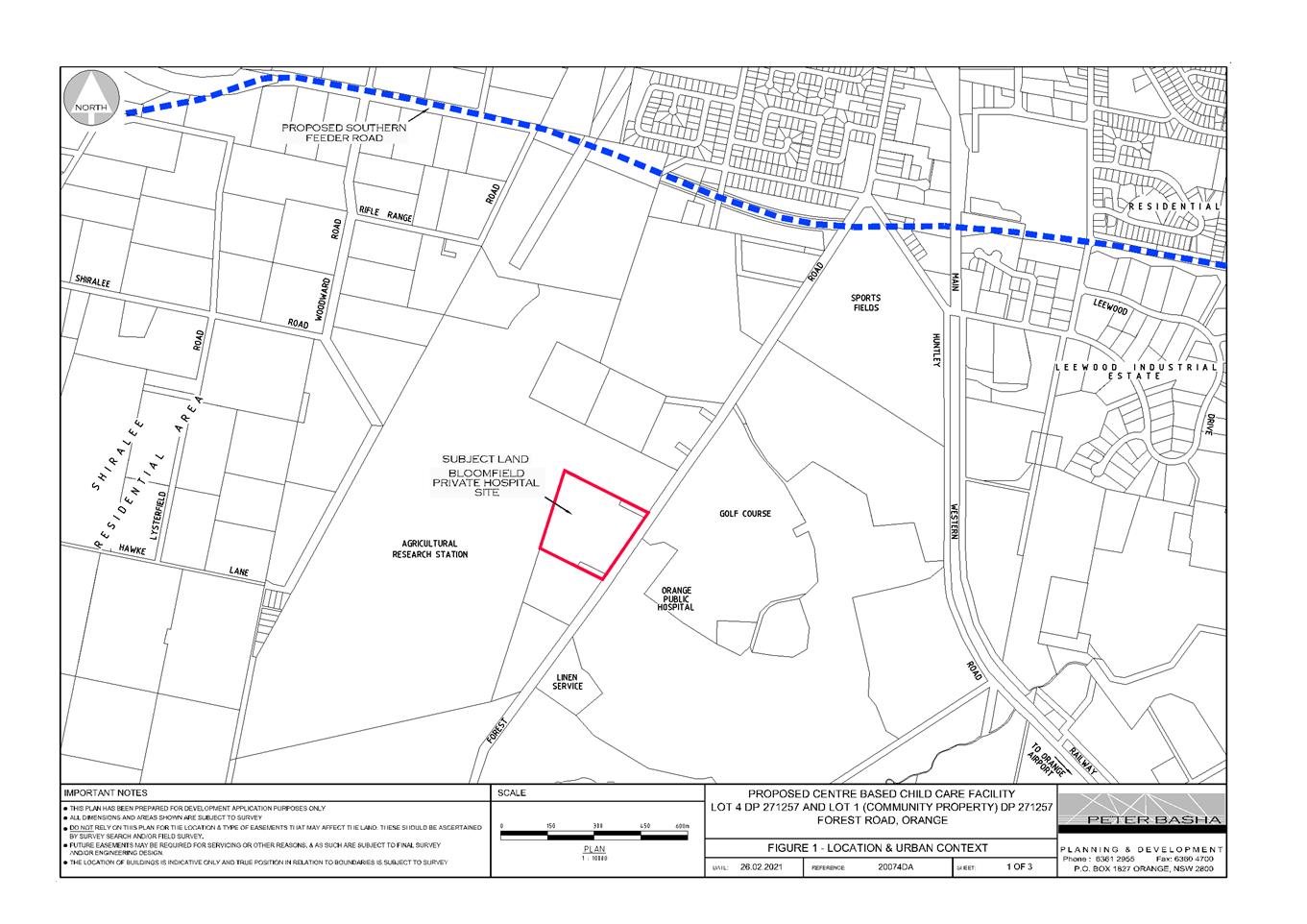
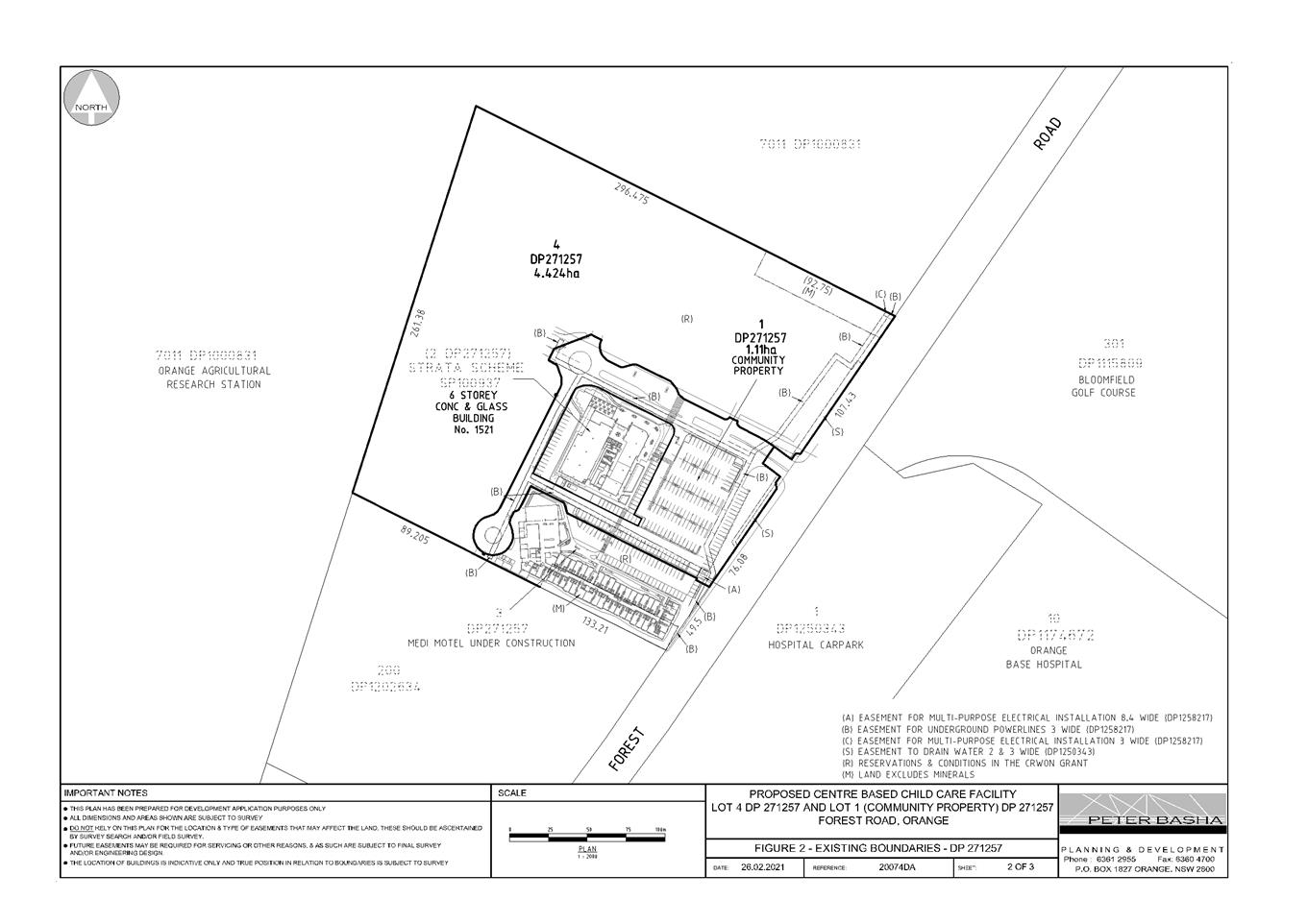
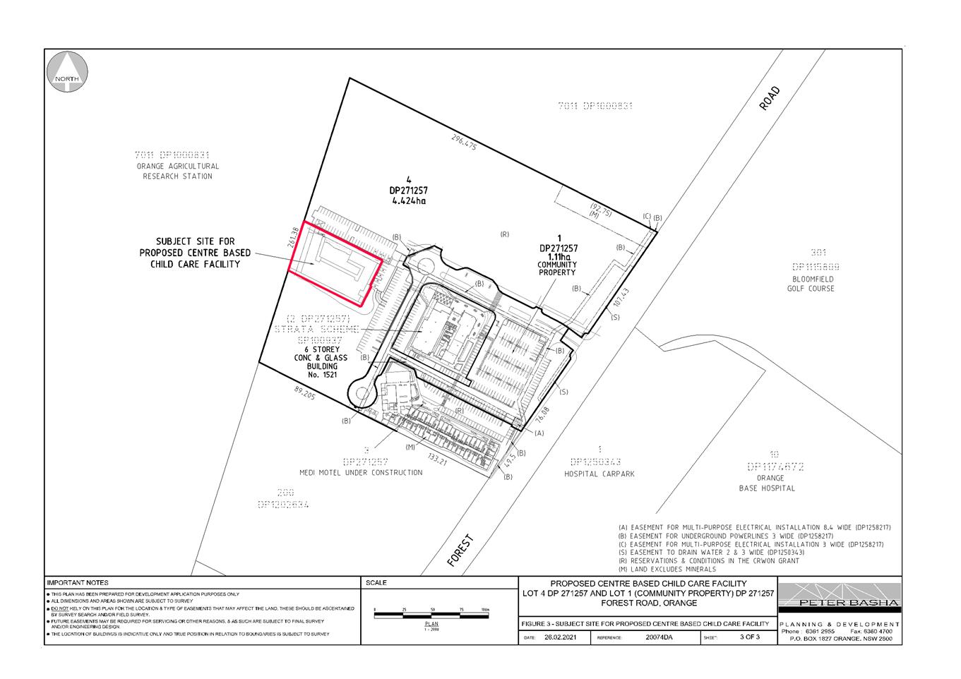
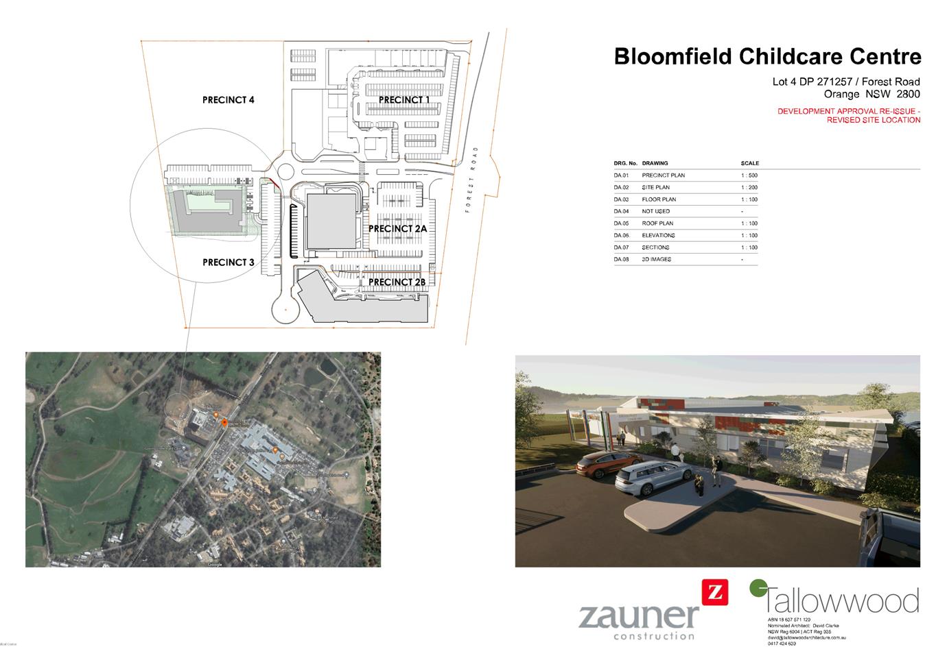
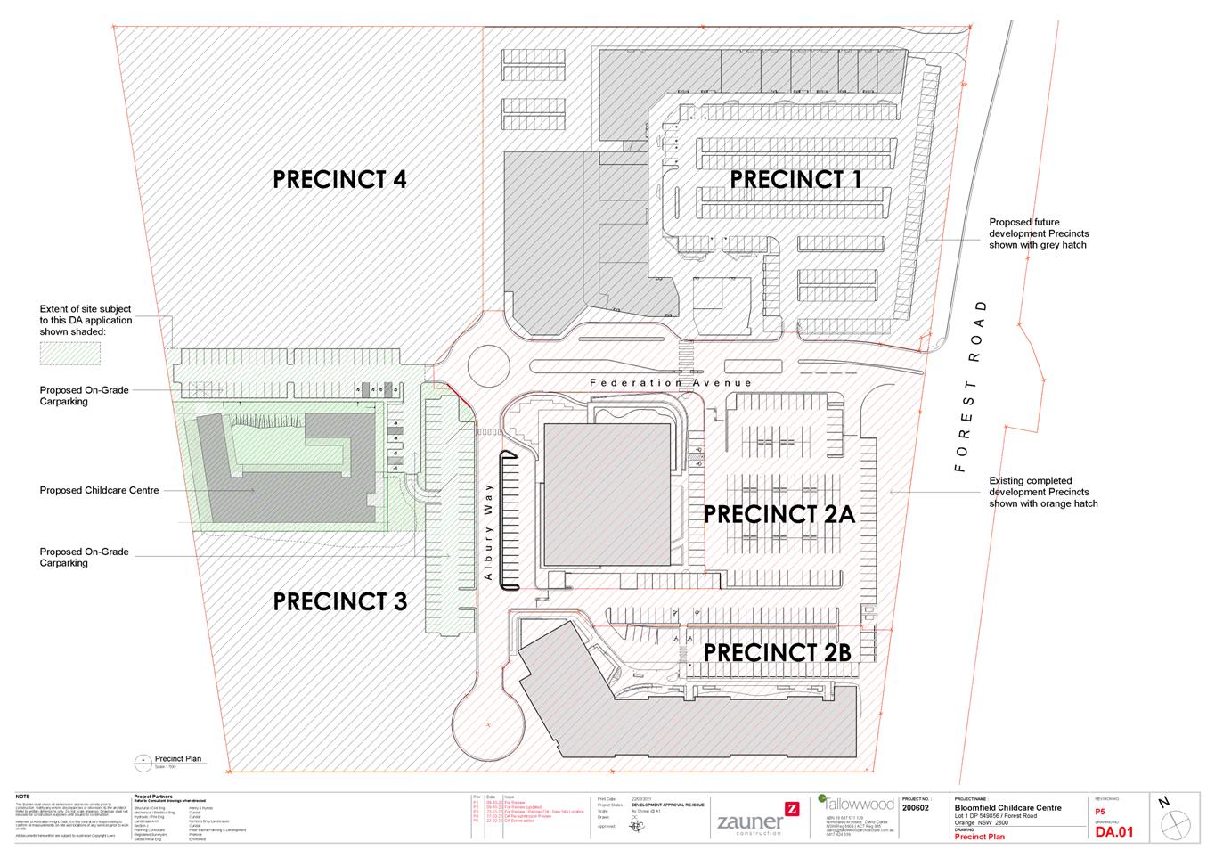
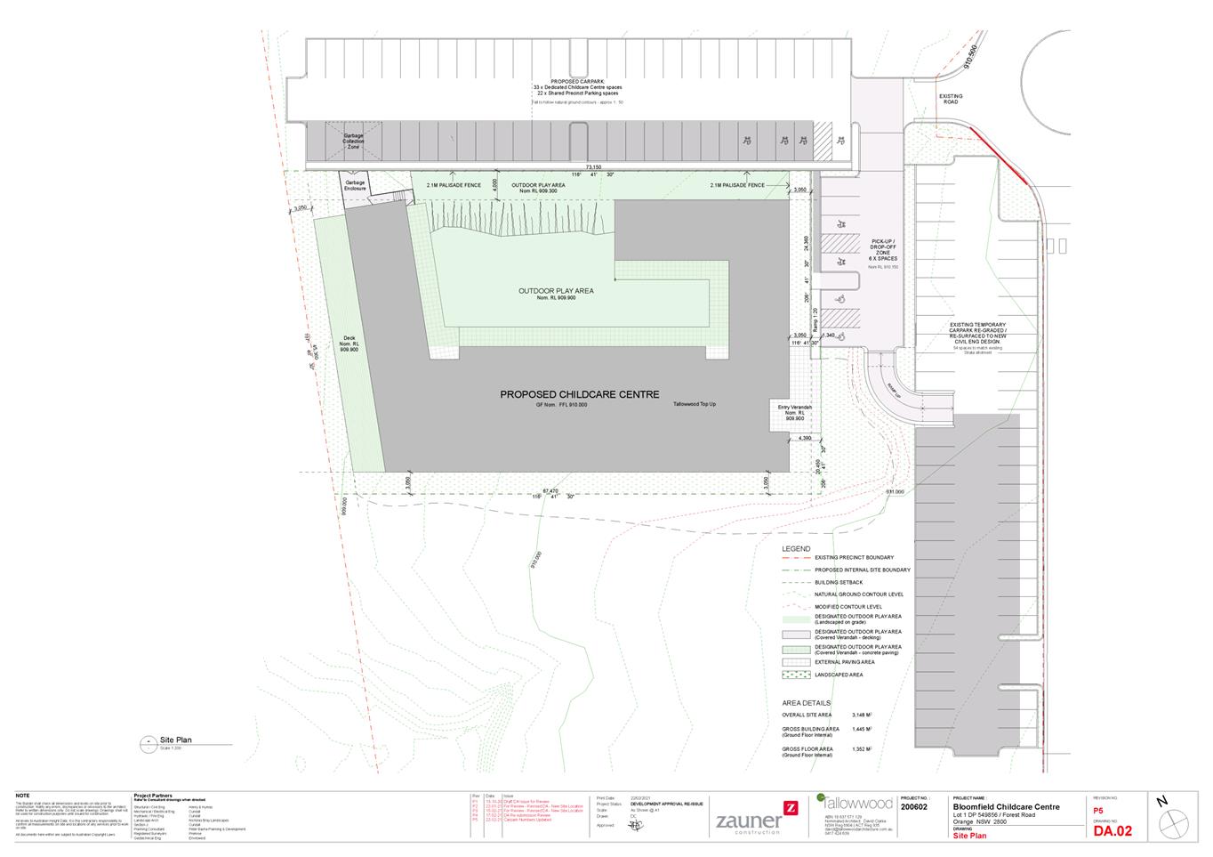

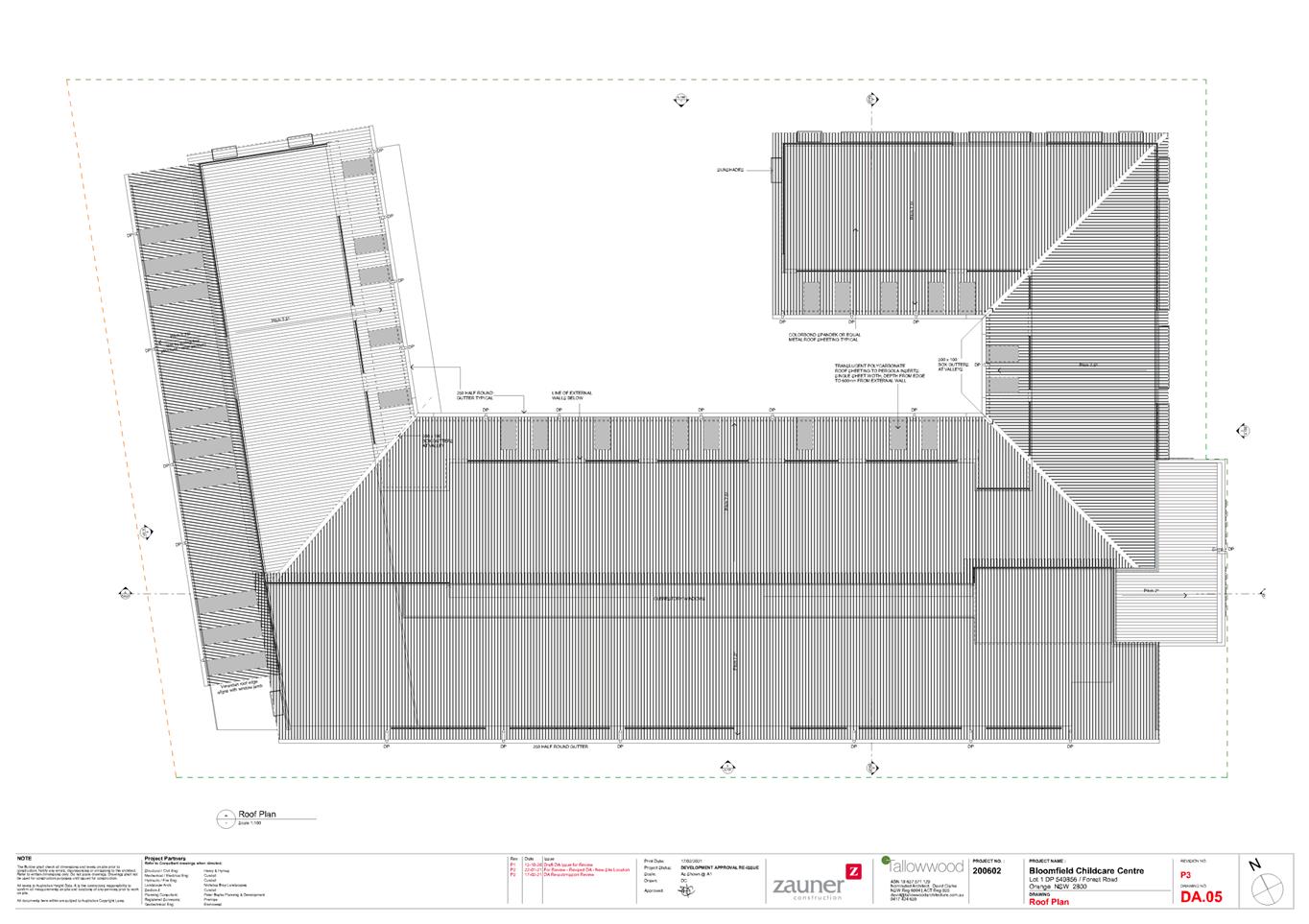
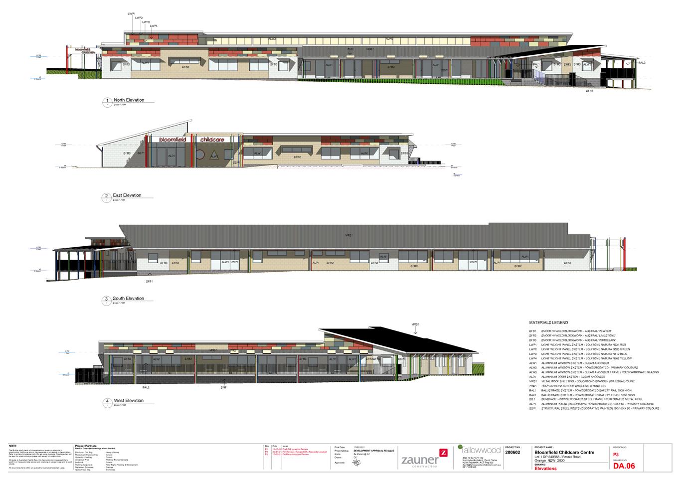
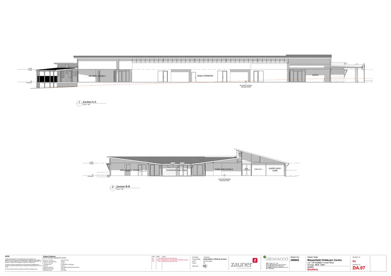

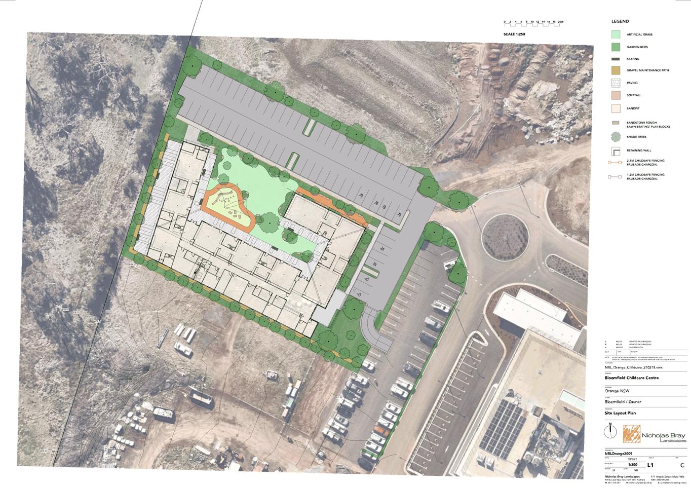

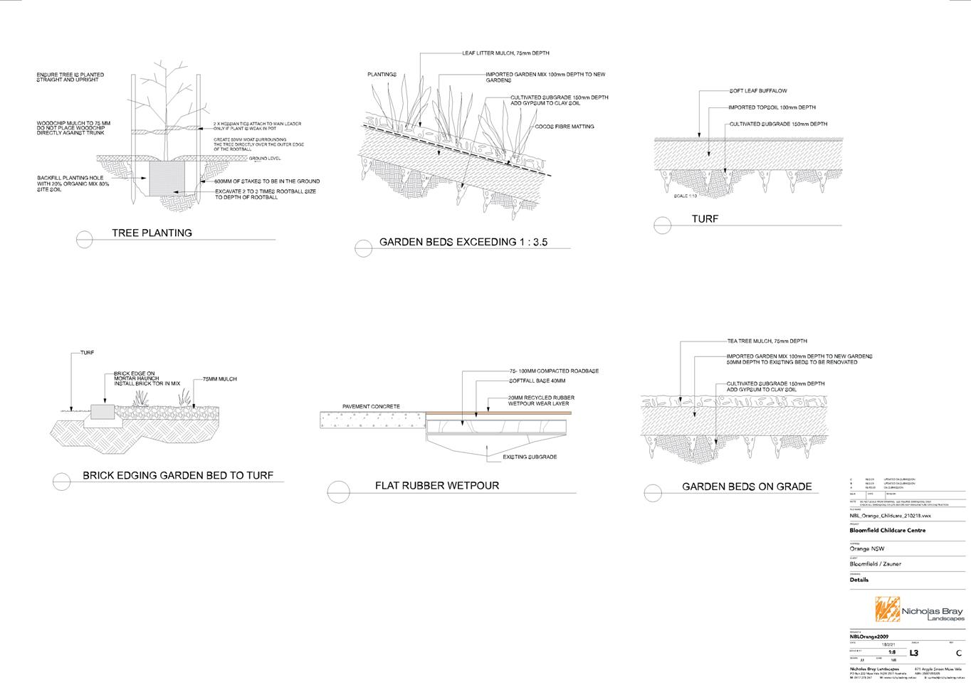
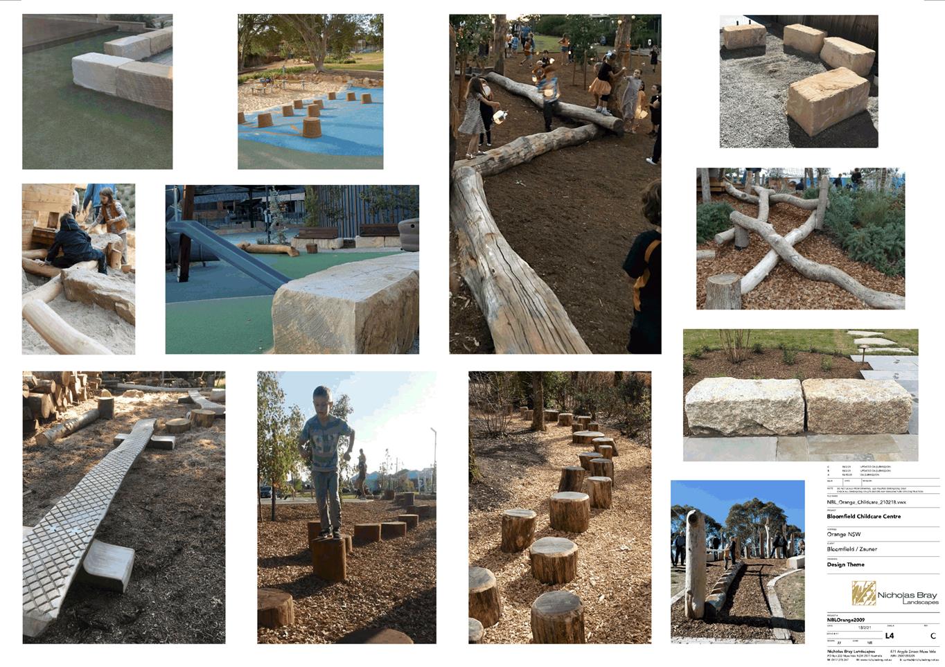
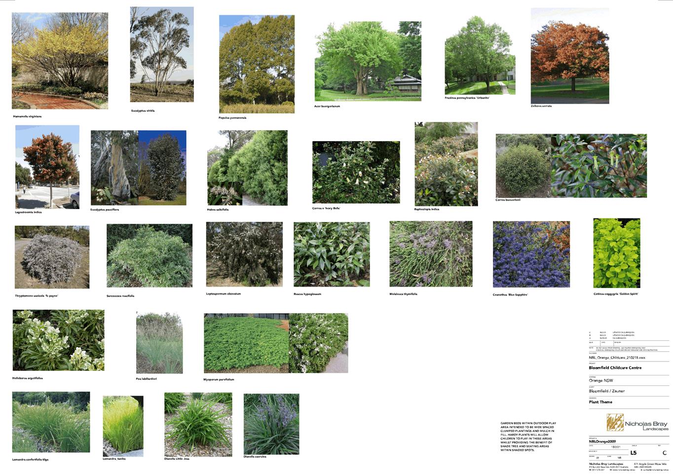
2.4 Orange
Local Environmental Plan - Amendment 26 - 1521 Forest Road Retail Precinct -
Post Re-Exhibition Report
RECORD
NUMBER: 2021/843
AUTHOR: Craig
Mortell, Senior Planner
EXECUTIVE Summary
At the Council meeting of 17 September 2020 Council
considered a post exhibition report on a planning proposal relating to the
Forest Road Retail Precinct. At that time Council resolved:
That the matter be deferred to
allow discussions with the proponent on reducing the scale of the rezoning.
Subsequently the proponent amended the planning proposal by
a reduction in the extent of retail floor space and changing the zone being
sought to a lower order zone. The Department of Planning, Industry and
Environment (DPIE) advised that the change in zone being sought would require a
revised gateway determination.
Council reviewed the changes at the 3 November 2020 Planning
and Development Committee meeting and the revised gateway determination was received
23 December 2020 and further advice from DPIE on 19 February 2021 confirmed
that condition 1 of the gateway (both original and revised) had been satisfied
enabling the matter to proceed to exhibition. Public exhibition was conducted
from Saturday 27 February 2021 to Monday 29 March 2021.
A total of 2 submissions were received during this latest
round of exhibition as compared to 8 submissions received during the original
exhibition period. Council may recall the focus of submissions from the original
exhibition related to potential impacts on the trading performance of the CBD.
While all original submitters were directly notified of the
re-exhibition the reduced number of submissions received this time around does
not necessarily reflect an acceptance of the revised planning proposal.
Link To Delivery/OPerational Plan
The recommendation in this report relates to the
Delivery/Operational Plan strategy “7.1 Preserve - Engage with the
community to develop plans for growth and development that value the local
environment”.
Financial Implications
Nil
Policy and Governance Implications
Nil
|
Recommendation
That Council resolves:
1 That
Council note the contents of this report and resolve to support the amendment
to Orange Local Environmental Plan 2011 as exhibited.
2 That
Council advise the proponent of the need to draft formal LEP maps in
accordance with the exhibited materials, at the proponents cost.
|
further considerations
Consideration has been given to the recommendation’s
impact on Council’s service delivery; image and reputation; political;
environmental; health and safety; employees; stakeholders and project
management; and no further implications or risks have been identified.
SUPPORTING INFORMATION
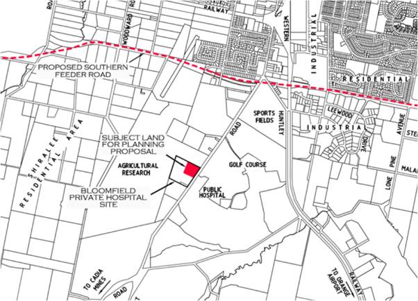
Figure 1 – subject site
At the Council meeting of 17 September 2020 Council
considered a post exhibition report on a planning proposal relating to the
Forest Road Retail Precinct. At that time Council resolved:
That the matter be deferred to
allow discussions with the proponent on reducing the scale of the rezoning.
Subsequently staff met with the proponent and their
consultants to discuss the concerns expressed at the Council meeting and in the
various submissions that were received. The proponent offered to amend the
planning proposal by a reduction in the extent of retail floor space and
converting the proposal seek a B1 Neighbourhood Centre zone instead of the B2
Local Centre zone originally requested. Advice from the Department of Planning,
Industry and Environment (DPIE) indicated that the change in zone being sought
would require a revised gateway determination.
The revised proposal was presented to Council at the 3
November 2020 Planning and Development Committee meeting which resolved to seek
a revised gateway determination and then conduct a re-exhibition of the
proposal.
The revised gateway determination was received 23 December
2020 and further advice from DPIE on 19 February 2021 confirmed that condition
1 of the gateway (both original and revised) had been satisfied enabling the matter
to proceed to exhibition. Public exhibition was conducted from Saturday 27
February 2021 to Monday 29 March 2021. A total of 2 submissions were received
during this latest round of exhibition as compared to 8 submissions received
during the original exhibition period.
Submission 1
Current CBD trading performance
Vacancy rate of shops has not improved over the past year
with no significant anchor tenants or majors coming to town.
Comment:
The period identified in the
submission correlates to an abnormal period in the broader economy with Covid
related lockdowns, travel restrictions and social distancing requirements. It
would seem pessimistic to base future planning decisions on a continuation of
the past year and that as vaccination numbers increase it is likely that a new
post-pandemic normal will take shape in the coming year or so. While Council
cannot predict how the new economic landscape will settle the fundamentals of a
growing population and diversifying economy do suggest a positive future for
Orange and in turn the trading performance of the CBD.
Council investment through
Future City
The Future City plan is focussed on
the CBD and represents a significant investment of ratepayer funds into
sustaining and elevating the trading performance of the CBD. Fragmentation of
retail activity beyond the CBD would appear to undermine this intent.
Comment:
The CBD focus of Future City does not
suggest or require that out-of-centre development should be rejected. Core
higher order uses should be retained within the CBD while allowing lower order
uses beyond the CBD can help to reduce traffic and parking congestion.
The emerging activity to both the
north and south of the city centre is acknowledged within Future City itself.
The Future City plan seeks to make the CBD more welcoming particularly to
pedestrians. The current proposal would allow for health precinct workers, as
well as visitors to the hospitals, to meet some of their needs without
venturing into the CBD and this could take some pressure off the current levels
of congestion.
Future City is a framework to guide
Councils commitment to support and enhance the CBD as the important regional
trading centre that it is. Numerous benefits flow to the local community from
success of the CBD, primarily in accessing higher order goods and services that
would otherwise not be sustainable by the local population alone. The focus
should therefore be in preserving the ‘role’ of the CBD for the
highest order functions, as well as encouraging people to linger in the CBD,
rather than blocking logical development in other areas.
In this regard, Council should
consider whether the incidental shopping of the health precinct workers and
hospital visitors is required within the CBD to sustain those higher order
functions.
Existing and planned retail
areas sufficient
The broader Orange population is
already well served by existing supermarkets and retail outlets and the
Shiralee masterplan includes a retail precinct of a similar scale.
Comment:
In absolute terms Orange is well
served by supermarkets and retail outlets. The accessibility of these
facilities however varies across the city. Those living or working in close
proximity to the CBD are better served than those further out. This situation
promotes private vehicle use leading to increased demand for parking. As this
increases congestion becomes a factor that in turn limits the trading
performance of the CBD. If anything the recent Covid experience has highlighted
the substitutability of bricks and mortar retailing with online shopping and it
may be anticipated that traffic and parking congestion could tip the balance in
peoples shopping patterns.
Traffic congestion
Traffic congestion on Forest Road /
hospital precinct and future sporting facilities is stated as a concern.
Comment:
Traffic congestion in the area is a
concern, but it should be noted that the proposal is of a low scale and
intended to primarily service the existing health precinct workforce and
hospital visitors. This population are already in the area and as such would
not represent additional traffic volumes along Anson Street or Peisley Street.
Some additional localised movements within Forest Road may occur but this has
already been reviewed via the traffic assessment report.
Submission 2
Economic Impact Analysis
– Location IQ
The submission notes that the
economic impact analysis (EIA) by Location IQ was prepared in relation to the
larger original proposal which involved a B2 zone and greater floorspace.
The EIA has not been adjusted to deal specifically with the reduced scale and
zone change now being proposed. The submission notes that B1 Neighbourhood
Centres would typically be within a residential neighbourhood and therefore has
a different qualitative aspect compared to a B2 oriented proposal.
Comment:
It is acknowledged that the B1 zone
is being employed in an unusual manner. However the B1 zone is not exclusively
intended to service residential populations and is also designed to provide for
a local area workforce. In the context of Forest Road the workforce consists of
both the public and private hospitals, which in turn is bolstered by both
patients and visitor populations. Over time the resident population will
increase, both in Shiralee and potentially in the DPI Bloomfield lands to the
west of this site (currently zoned for 550 residential lots) although the
timing and delivery of residential development on the DPI site is uncertain.
B1 Neighbourhood Centre zone
The submission states that geographic
catchments supporting retail development are typically skewed by the
‘home domain of direction flow’. Essentially when seeking goods and
services people are more inclined to travel further in the direction of their
work. In most cases this will be towards the city centre. As such catchments
are generally not circular but will instead resemble more of a comet-orbit
shape. The geographic area of a catchment will therefore tend to bulge away
from higher order centres.
The submission notes there is very
little residential neighbourhood in the immediate vicinity to support the
centre, and what population there is being located to the northern end of the
catchment with good connections to the CBD. The remainder of the catchment
being sparsely populated rural and agricultural lands to the south of the city.
The submission argues that there is
insufficient resident population to support the proposal. While supermarket
chains can endure an initial poor market conditions pending growth, specialty
shops tend to fail in such cases.
Comment:
Population catchments do exhibit a
geographic bias in the manner outlined in the submission. If the proposal were
a typical B1 Neighbourhood Centre predicated on serving a resident population
the viability of such a centre would be impacted. However most other B1 zones
are not in close proximity to significant sources of employment and will
typically have a minimal local workforce to service. The context of Forest
Road, with both a significant local workforce and high visitation numbers, will
to some degree counter the minimal resident population. Overall, this is likely
to affect the type of supporting specialty retail that will succeed or fail and
future retailers will need to consider if their offering is a good fit for the
composition of workforce and visitors.
The discussion on the retail
catchment definition would suggest that the impact upon CBD trading performance
would be reduced, at least in terms of shopping patterns of residents.
Conversely the workforce and hospital visitor populations were to travel into
the CBD less frequently. The effect is likely to be less pronounced for higher
order goods and services which are unlikely to be available within the proposed
retail precinct.
Potential for growth to support
the centre
The submission argues that if
viability of the centre is predicated on increasing the geographic catchment
then it may not be properly characterised as a ‘Neighbourhood’
centre. It notes that much of the surrounding lands and zones do not support
population growth and that Shiralee is both disconnected from the site and has
its own B1 precinct.
Neighbouring residential unit
potential of around 214 two-bedroom units (presumed to be a reference to the
adjoining aged care facility) are noted but due to their intended occupants are
unlikely to provide much support to the retail facilities proposed in this
amendment. The Southern Orange Industrial and Freight Activation Precinct is
discussed along with the Life Sciences Precinct which the submission notes have
limited connection to the subject site and raises various urban design
concerns.
The submission then characterises the
proposal as a car-centric proposal and argues that most people, once driving,
would proceed to the CBD for a greater range of goods and services as well as
likely better prices.
Comment:
It is noted that the potential for
residential growth in the immediate area is limited. Primarily comprising
Shiralee and the R2 Low Density residential land on the DPI site to the west.
The DPI site was rezoned approximately 11 years ago with a concept plan of some
550 residential lots. At the time Council staff sought the inclusion of a link
road across the DPI site connecting Shiralee with Forest Road. If the DPI site
develops as envisaged 11 years ago then both that population and much of
eastern Shiralee would have reasonable access to Forest Road, otherwise the
Shiralee population would need to first travel north to the Southern Feeder
Road and then across. In the latter case the CBD would likely have stronger
pull and draw shoppers to it rather than Forest Road. Additionally Shiralee
itself has an area of B1 zoned land central to the Shiralee masterplan.
However it must be noted that the B1
Neighbourhood Centre Zone is not exclusively intended to service a residential
neighbourhood. Where a workforce is isolated from a CBD or other retail area,
traffic generation may be elevated due to workers needing to commute by vehicle
for incidental purchases throughout the day, with a peak during the lunchtime period.
This in turn has potential to impact on traffic congestion between the site and
the CBD as well as place additional burden on CBD parking facilities. Traffic
and parking congestion in the CBD may in turn lead to shoppers seeking other
alternatives such as the North Orange Shopping Centre in Telopea Way.
Turning back to the submissions
concern for the viability of the B1 zone being proposed it is considered that
existing CBD congestion is likely to encourage local workforce and hospital
visitors to consider accessing the site for smaller incidental purchases, while
the higher order goods and services will continue to be sought in the main CBD.
Where a worker / visitor is seeking the former then it is unlikely that a minor
cost saving in the CBD would negate the time and convenience of the subject
site.
Existing B1 zone approvals
The submission compares and contrasts
the B1 zone in Shiralee with the proposal and also contrasts the nature of the
original B2 proposal as well as the mix of retail provided under the original
Part 3A approval. The submission asserts that “given the focus of the
development has changed, the justification must also change from health to
neighbourhood. Again the main problem is that there is no neighbourhood”.
Comment:
The nomenclature of a zone does not
materially affect the shopping and travel patterns of a population. Therefore
the argument that the health justification must be abandoned due to the change
in zone being sought is not supported. The existence of the local workforce and
hospital visitors will continue regardless of which zone is considered.
Leveraging Existing B1 Zone
Approvals
The submission is critical of the
design of the proposal, noting that the centre will not be consistent with
typical B1 zone developments. Being located behind a car park and not directly
fronting the street the centre will have limited if any walkability, which is
attributed to the lack of nearby residential development. As such the proposal
is vulnerable to the propensity for people, once in the car, to drive past
minor sites to access more comprehensive offerings in larger centres.
Comment:
The configuration and urban design
outcomes of the proposal would be assessed further at the development
application stage. Notwithstanding this the eventual development is likely to
be accessed primarily via the car parking area forward of the built form and
therefore the walkability concerns are relevant. However as noted by the
submission there are few residential properties within a typical waking
distance. As stated previously the concept is primarily related to servicing
the local workforce and hospital visitor needs rather than typical residential
needs as may be expected in other B1 zones.
The Revised Planning Proposal
(RPP)
The submission seeks to interrogate
the conceptual plan provided in the original planning proposal and ascertain
where the reduced extent of retail floorspace will be provided. The submission
estimates the amount of potential floorspace within the built form as
approximately 5,151m2 and notes that this is substantially greater
than the 1,791m2 of retail space being sought.
A range of technical and design
related matters are raised such as servicing areas, waste collection areas,
frontages, street access and the like - most of which would be further
evaluated during the development assessment process where potential impacts
(such as privacy, overshadowing, streetscape and the like) of such matters
would be resolved.
The submission notes that the
economic impact assessment (by Location IQ) and the Traffic Assessment (by
Terraffic Pty Ltd) have not been amended from the original versions supplied
when the proposal was seeking a B2 zone and more retail floorspace.
The submission then lists 5 problems
related to:
1. Geographical
catchment
2. Small
resident population
3. Economic
Impact Assessment relevance
4. Timing
of catchment growth
5. Quality
and relevance of information provided to Council
Comment:
It must be noted that the 1,791m2
figure relates to retail uses only. Other uses permitted within the B1 zone are
not subject to this limit and therefore any surplus built form can be dedicated
to these other uses. Non-retail uses permitted in the B1 zone include:
Boarding houses; Business premises; Centre-based child care
facilities; Community facilities; Dwelling houses; Electricity generating
works; Environmental facilities; Home-based child care; Home businesses; Home
industries; Information and education facilities; Medical centres; Office
premises; Oyster aquaculture; Places of public worship; Recreation areas;
Recreation facilities (indoor); Recreation facilities (outdoor); Respite day
care centres; Roads; Secondary dwellings; Seniors housing; Shop top housing;
Signage; Tank-based aquaculture; Veterinary hospitals; Water supply systems
The viability of each of these uses will vary but it is
considered that the residue floorspace can reasonably be put towards one or
more of the above.
The fact that the revised planning
proposal has relied upon the original Economic Impact Assessment and Traffic
Assessment is perhaps not ideal but these documents do serve to show the
capacity of the site, and road network, to accommodate a larger scale of
development than that now proposed. As such the reduced scale and significance
of the proposal would be regarded to have a lesser impact on either the
economic or traffic environments.
The changed character of the
proposal, from a B2 Local Centre Zone to a B1 Neighbourhood Centre Zone, has
been cited by the submission as materially changing the nature of the proposal
before Council. However the submission then focusses upon the residential
catchment to the near total exclusion of the workforce population. Having done
so the critique then presumes that the sites viability would be dependent
wholly upon a substantial geographic increase in resident catchment –
which would encompass residential areas unlikely to seek out the subject site.
This unduly skews the evaluation of
the sites viability towards residential patronage only and ignores the full
context of the site which is proximate to a large and established workforce
which along with the hospital visitor population would be likely to utilise the
facilities proposed.
Fundamentally, it may be implied
(although it is never clearly stated in the submission) that the submission is
concerned with a potential economic impact on the trading performance of the
CBD more so than the viability of the subject site itself. Presumably, if the
site struggles to be naturally viable the landowner may later seek to press
Council to allow a greater range, diversity and scale of commercial activity on
the site, which if allowed may result in a more prominent site capable of
drawing more trade away from the CBD.
This view is partly informed by the
responses to the original exhibition of the proposal when it was seeking a B2
zone and increased retail floor space, compared to the current B1 proposal
where all submissions, excluding the crown lands submission, referenced impacts
on the CBD arising from a full line supermarket.
Attachments
1 DPIE
letter to Council - Revised Gateway Condition 1 satisfied, D21/23479⇩
2 Original
Gateway Determination, D21/23482⇩
3 Alteration
of Gateway Determination from NSW Planning Industry and Environment, D21/23155⇩
4 Updated
Planning Proposal - 1 Feb 2021, D21/23484⇩
5 Planning
Proposal Annexure A - proponents Site Master Plan, D21/6066⇩
6 Planning
Proposal Annexure B - proponents Economic Assessment, D21/6067⇩
7 Planning
Proposal Annexure C - proponents Traffic Assessment, D21/6068⇩
8 Planning
Proposal Annexure D - proponents Land Plans, D21/6069⇩
9 Planning
Proposal Annexure E - proponents Draft LEP maps, D21/6071⇩
10 copy
of Post Exhibition Report of CCL 15 September 2020 Orange LEP Amendment 26 -
Forest Road Retail Precinct, D20/65515⇩
11 Pre-original
exhibition: Review of Economic Impact Assessment (Leyshon 1), D19/9219⇩
12 Post-original
exhibition: Orange Retail Economic Analysis and Advice (Leyshon 2), D20/54426⇩
13 Submissions,
D21/23130⇩
Planning
and Development Committee
4 May 2021
Attachment 1 DPIE
letter to Council - Revised Gateway Condition 1 satisfied
Planning
and Development Committee
4 May 2021
Attachment 2 Original
Gateway Determination
Planning and Development Committee
4 May 2021
Attachment 3 Alteration
of Gateway Determination from NSW Planning Industry and Environment
Planning and Development Committee
4 May 2021
Attachment 4 Updated
Planning Proposal - 1 Feb 2021
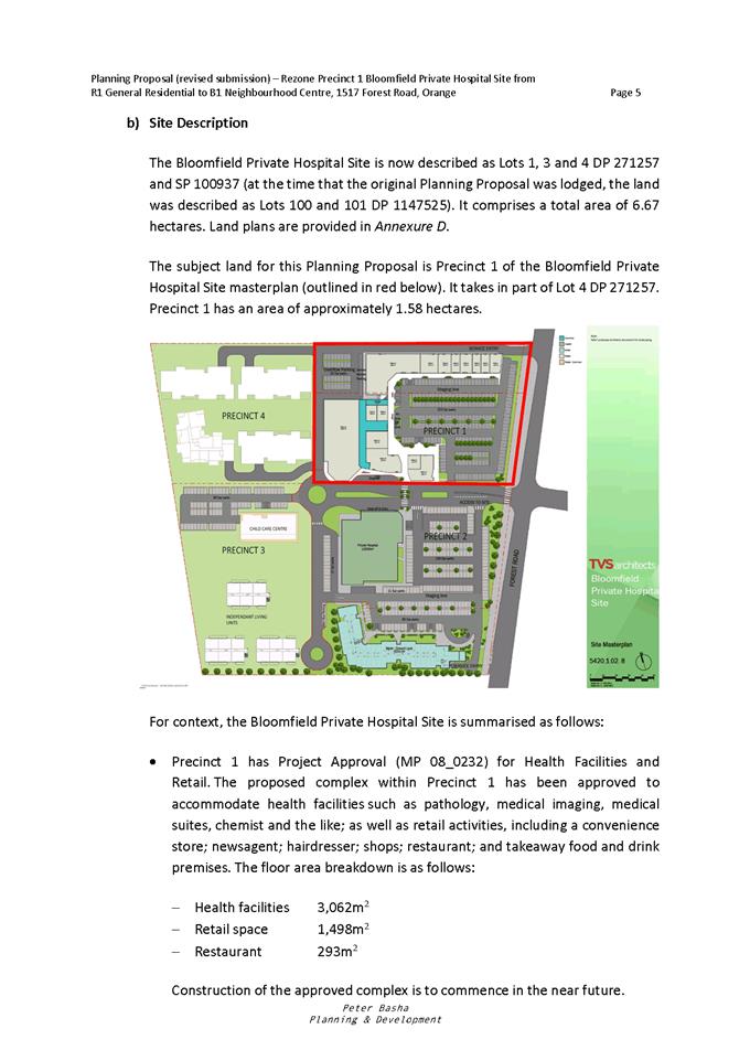
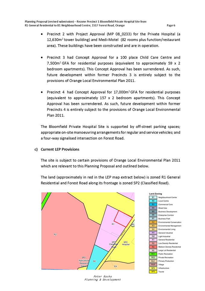
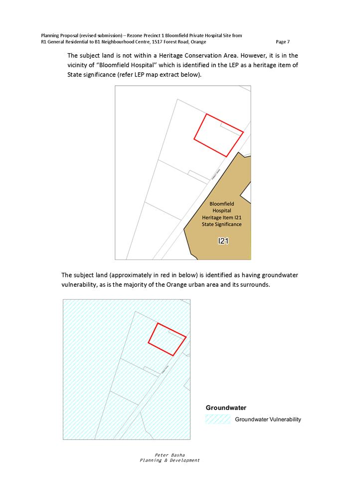
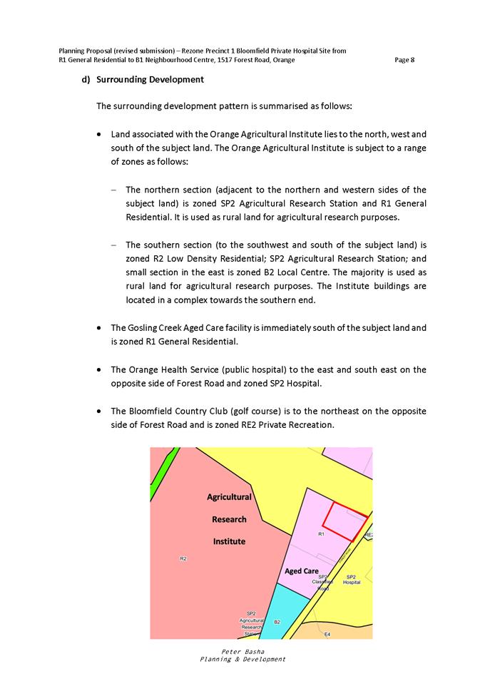
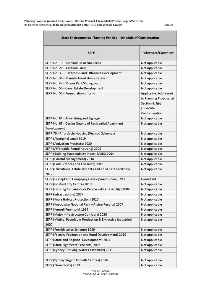
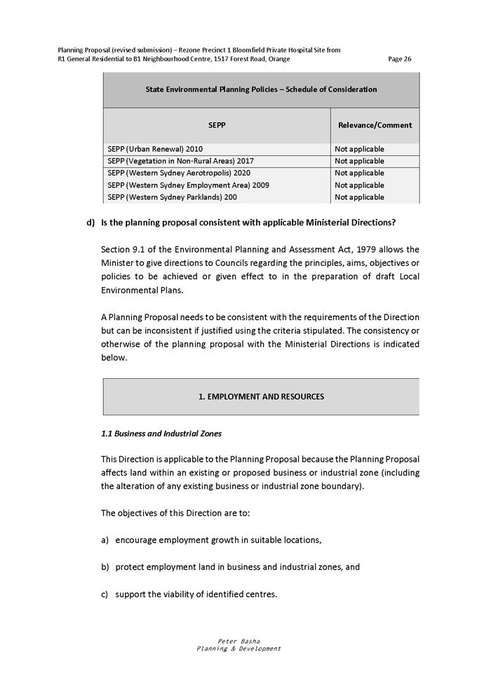
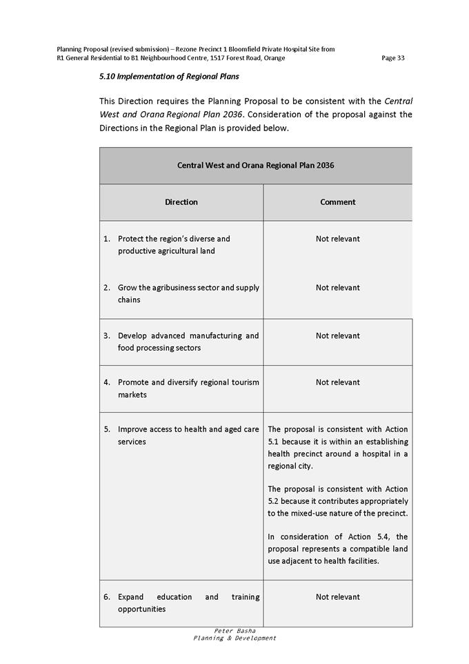
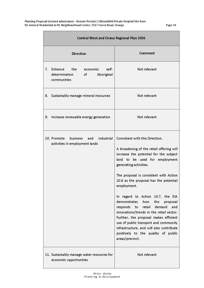
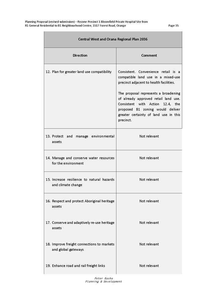
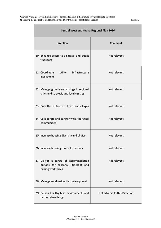
Planning and Development Committee
4 May 2021
Attachment 5 Planning
Proposal Annexure A - proponents Site Master Plan
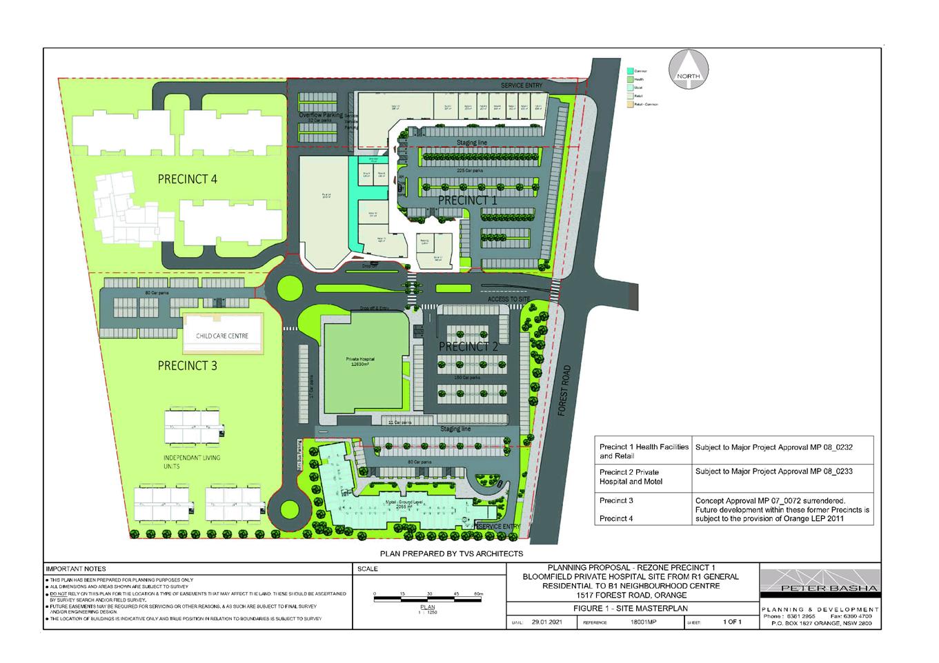
Planning
and Development Committee
4 May 2021
Attachment 6 Planning
Proposal Annexure B - proponents Economic Assessment

Planning and Development Committee
4 May 2021
Attachment 7 Planning
Proposal Annexure C - proponents Traffic Assessment
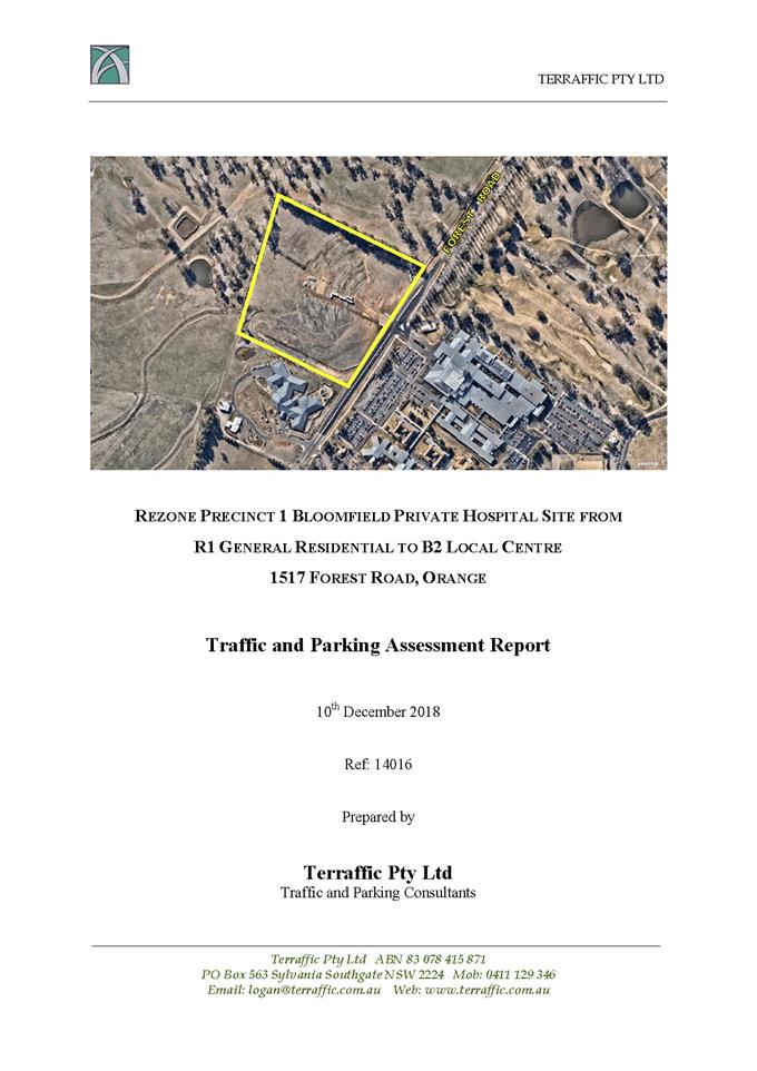
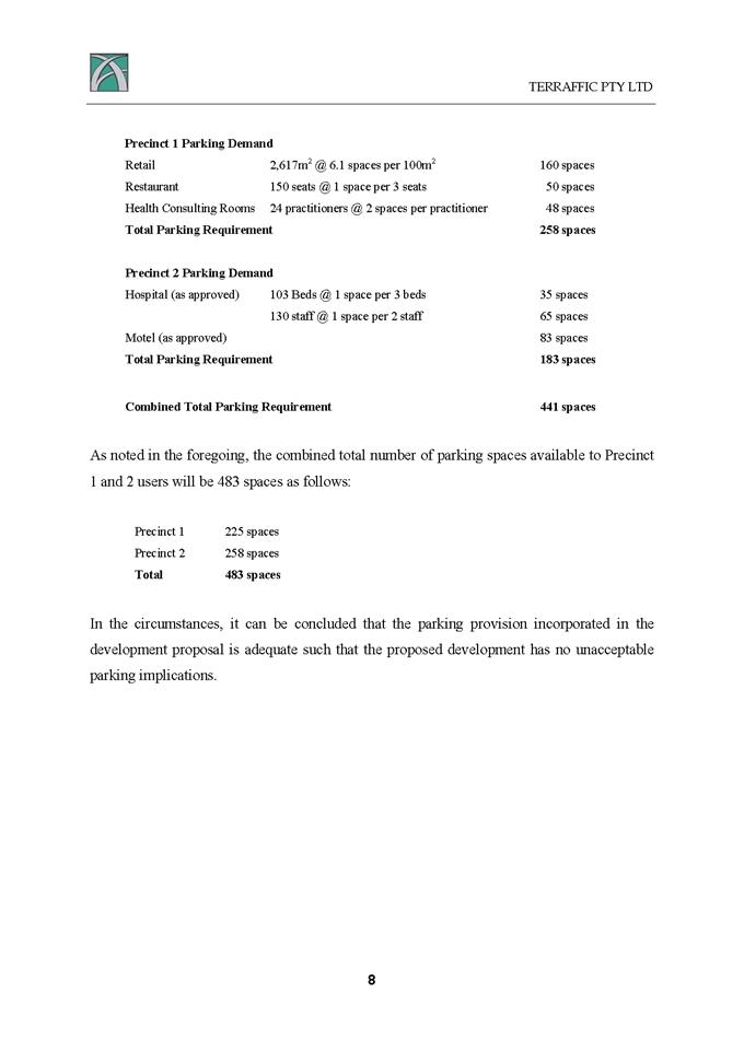
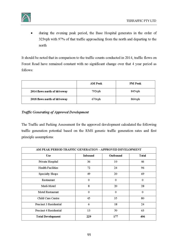
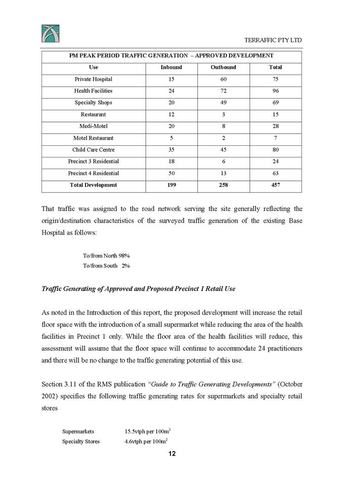
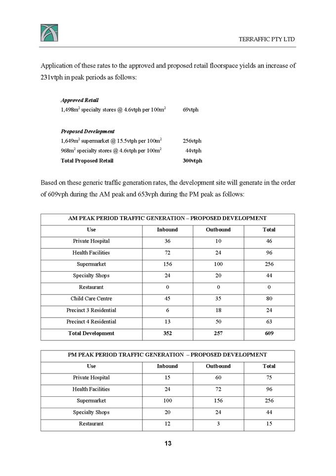
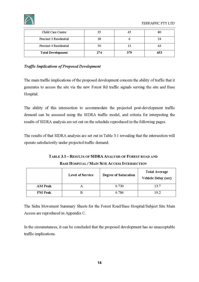
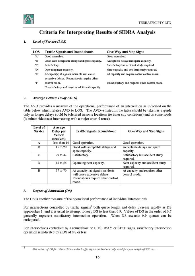
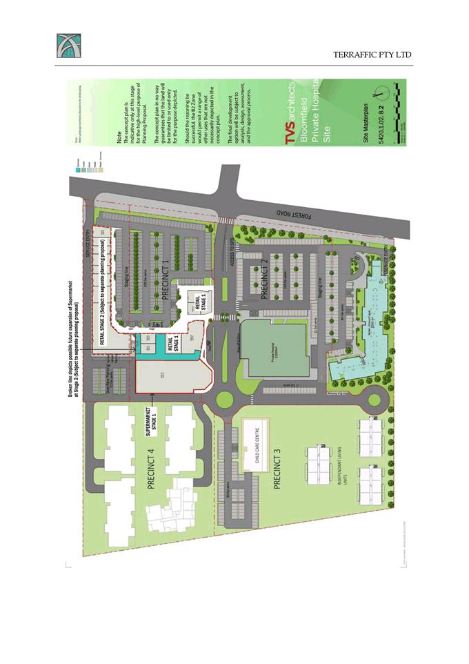
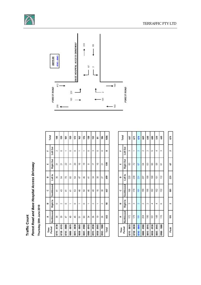
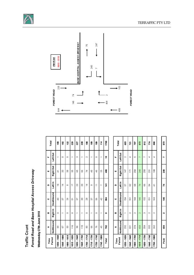
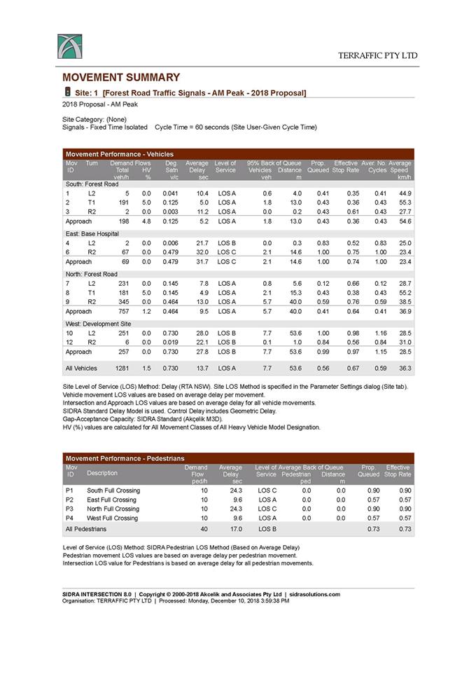
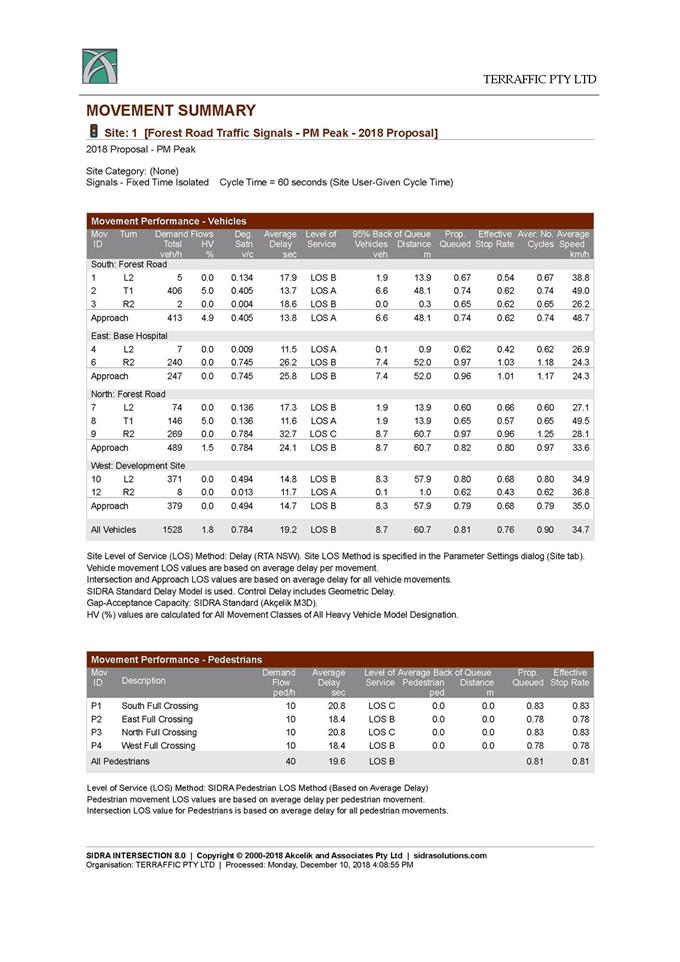
Planning and Development Committee
4 May 2021
Attachment 8 Planning
Proposal Annexure D - proponents Land Plans
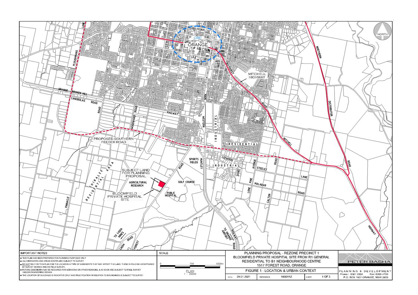
Planning
and Development Committee
4 May 2021
Attachment 9 Planning
Proposal Annexure E - proponents Draft LEP maps
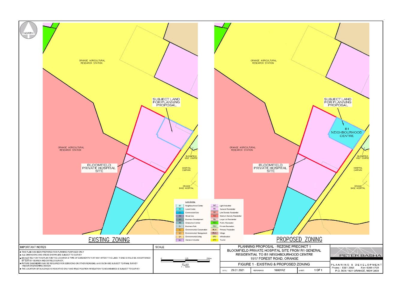
Planning
and Development Committee
4 May 2021
Attachment 10 copy of Post
Exhibition Report of CCL 15 September 2020 Orange LEP Amendment 26 - Forest
Road Retail Precinct
Planning and Development Committee
4 May 2021
Attachment 11 Pre-original
exhibition: Review of Economic Impact Assessment (Leyshon 1)
Planning and Development Committee
4 May 2021
Attachment 12 Post-original
exhibition: Orange Retail Economic Analysis and Advice (Leyshon 2)
Planning and Development Committee
4 May 2021
Attachment 13 Submissions