ORANGE CITY COUNCIL
Planning and Development Committee
Attachments - 2.2 to 2.10
Enclosed Items
4 December 2018
ORANGE CITY COUNCIL
Planning and Development Committee
Attachments - 2.2 to 2.10
Enclosed Items
4 December 2018
Planning and Development Committee 4 December 2018
TABLE OF CONTENTS
ITEM SUBJECT PAGE NO
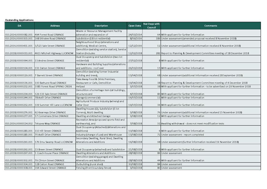
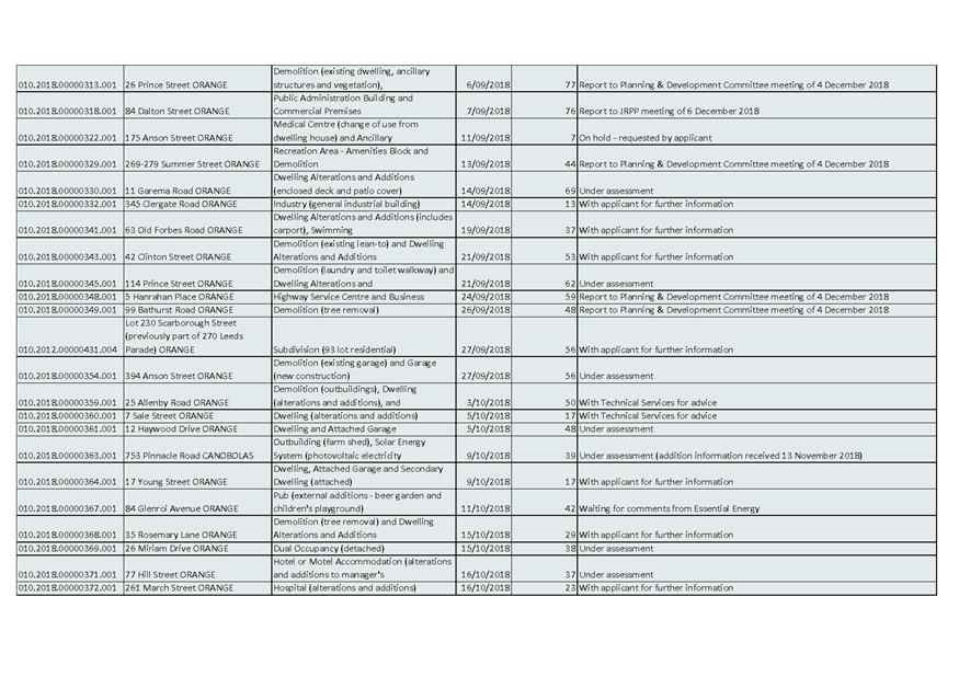
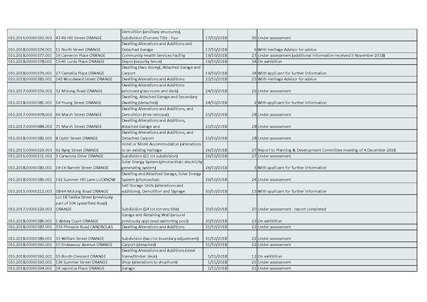
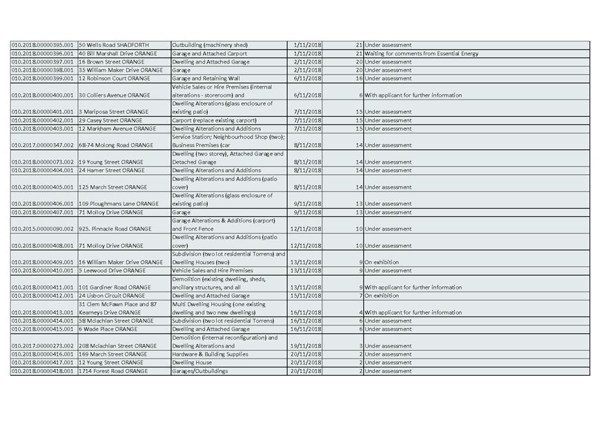
2.2 Outstanding Development Applications
Attachment 1 Outstanding Development Applications as at 21 November 2018 3
2.3 Enforcement Policy
Attachment 1 Draft Enforcement Policy.............................................................. 7
2.4 Orange Local Environmental Plan 2011 - Planning Proposal for an Administrative Amendment
Attachment 1 Planning Proposal - LEP Amendment 24..................................... 45
2.5 Development Application DA 329/2015(3) - 62 Byng Street and 77 Hill Street
Attachment 1 Modified Notice of Approval..................................................... 106
Attachment 2 Plan............................................................................................ 125
Attachment 3 Submissions................................................................................ 127
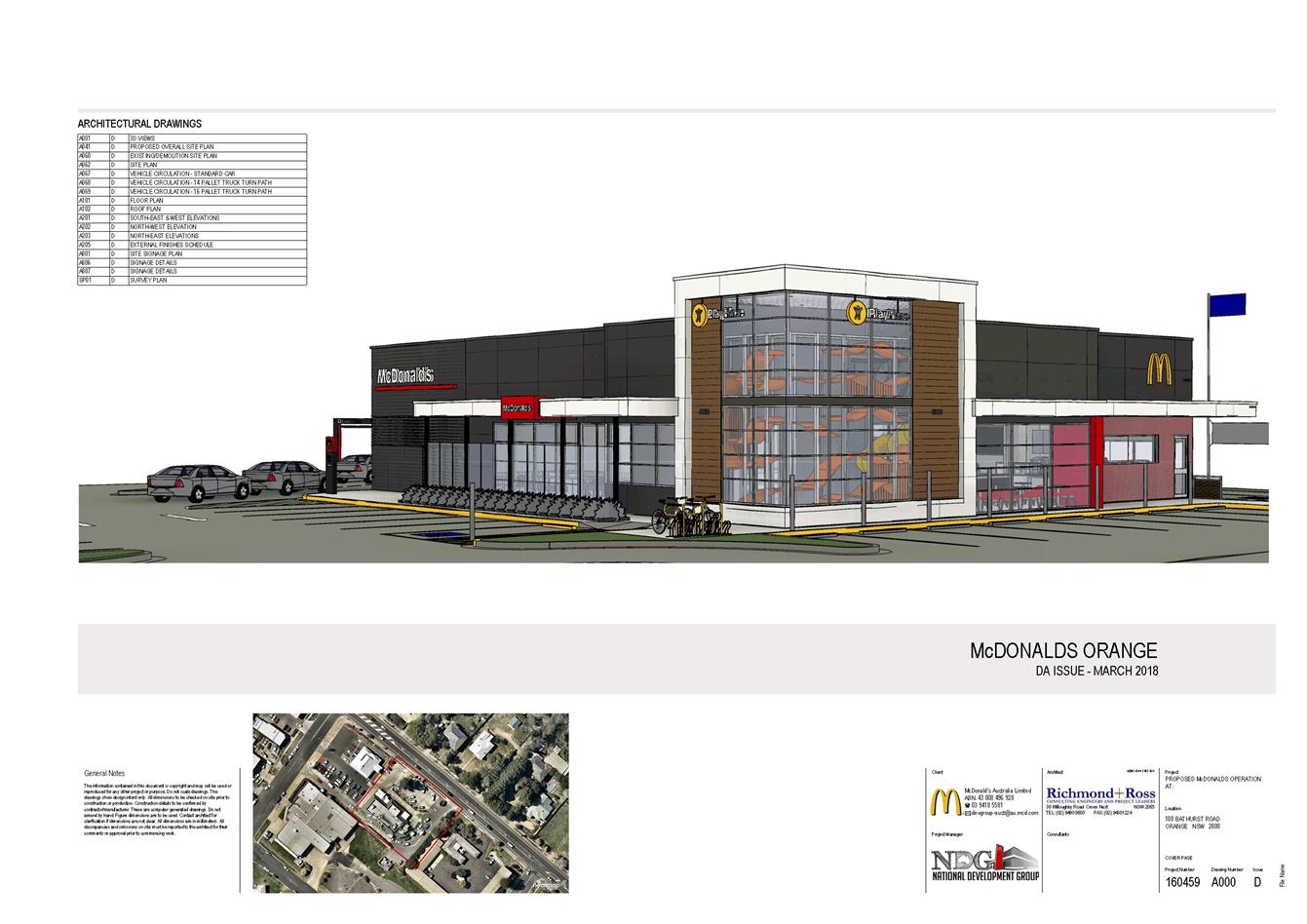
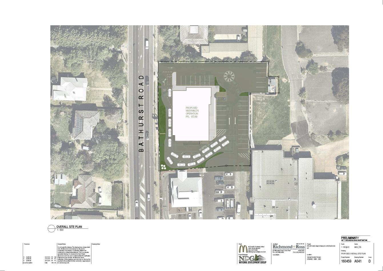
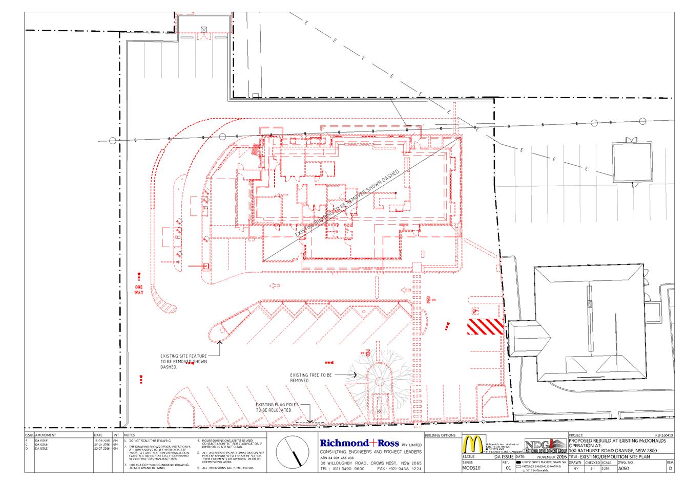
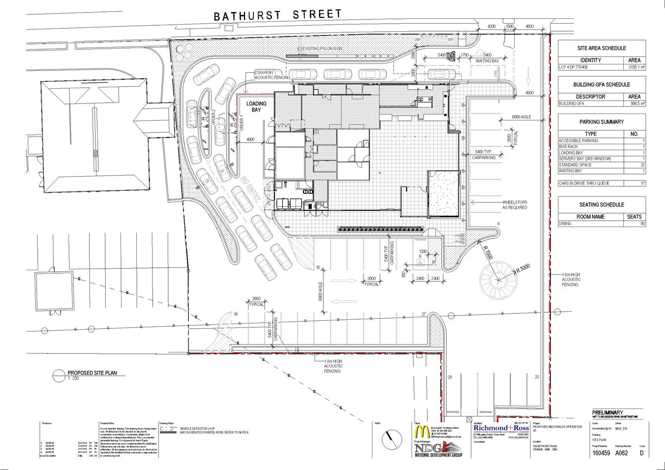
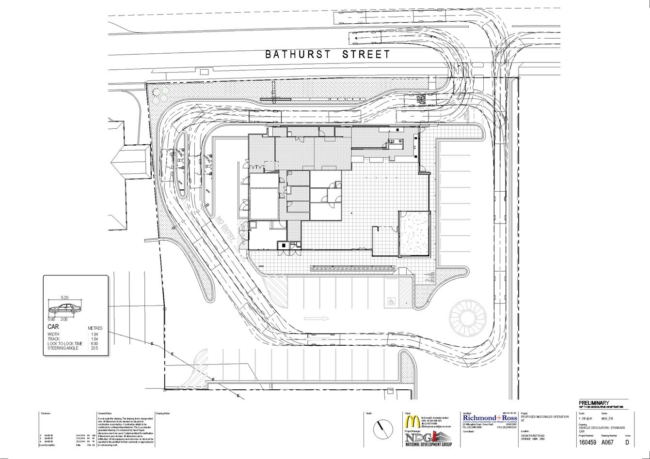
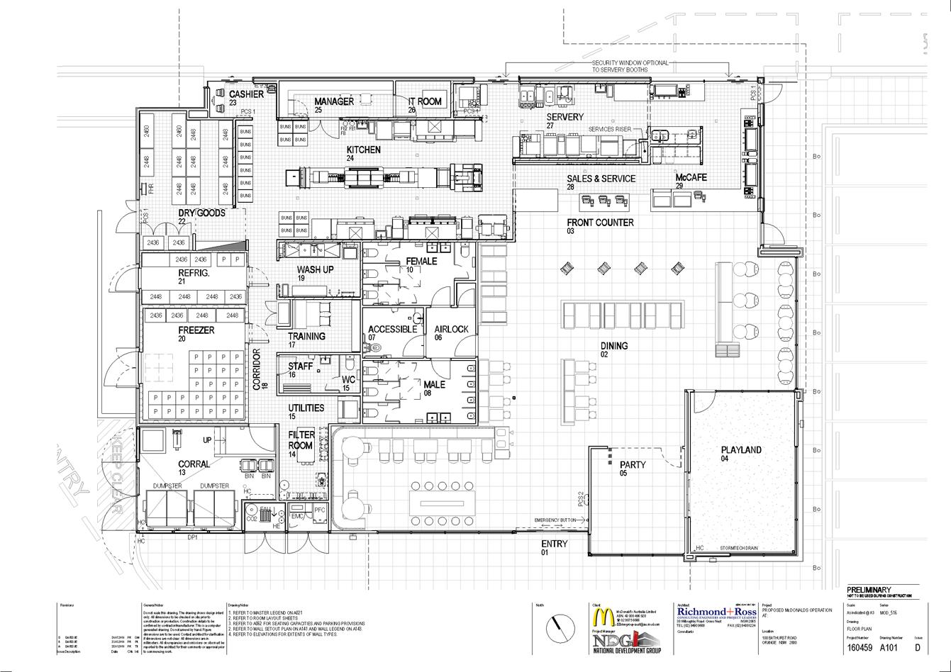
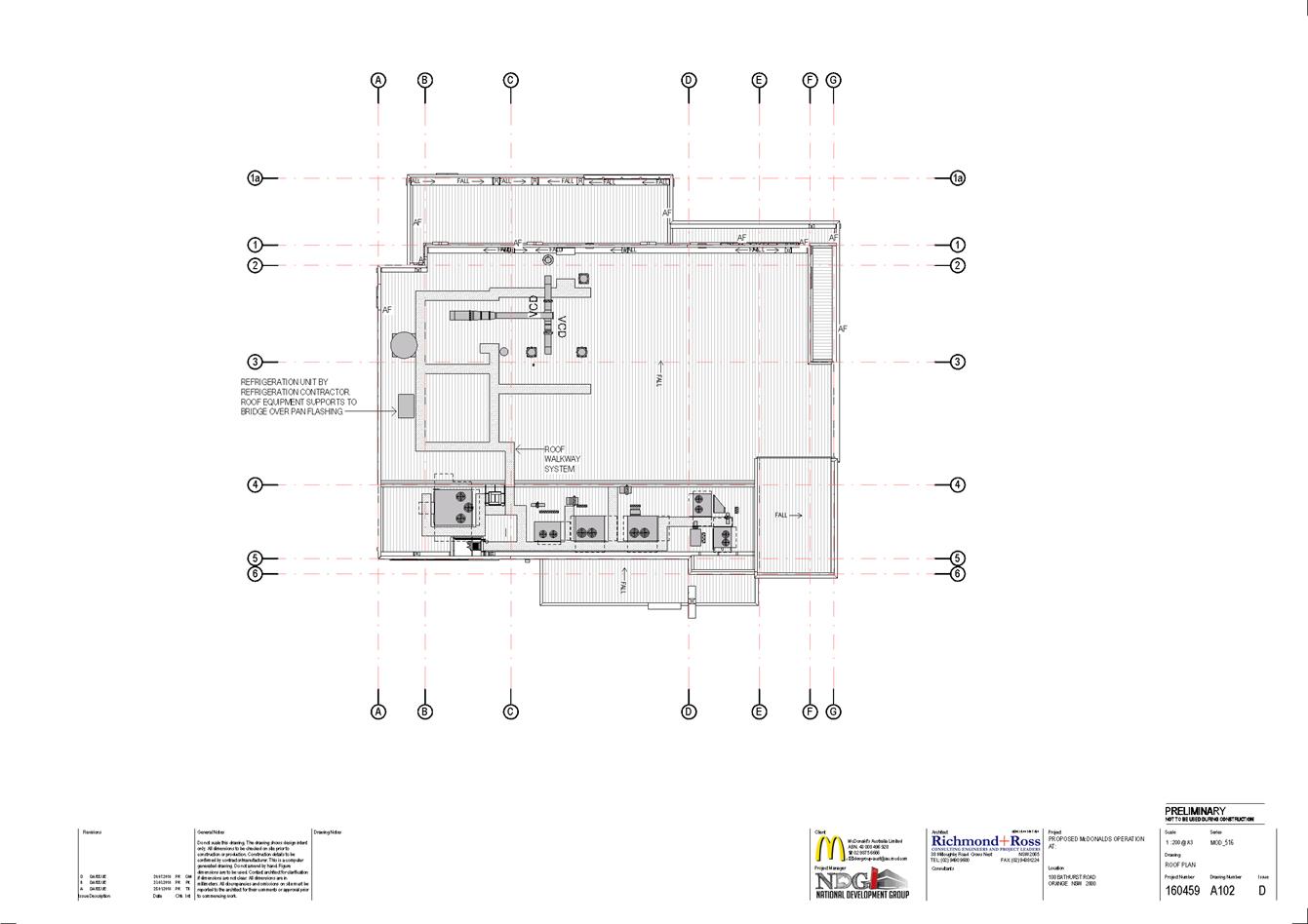
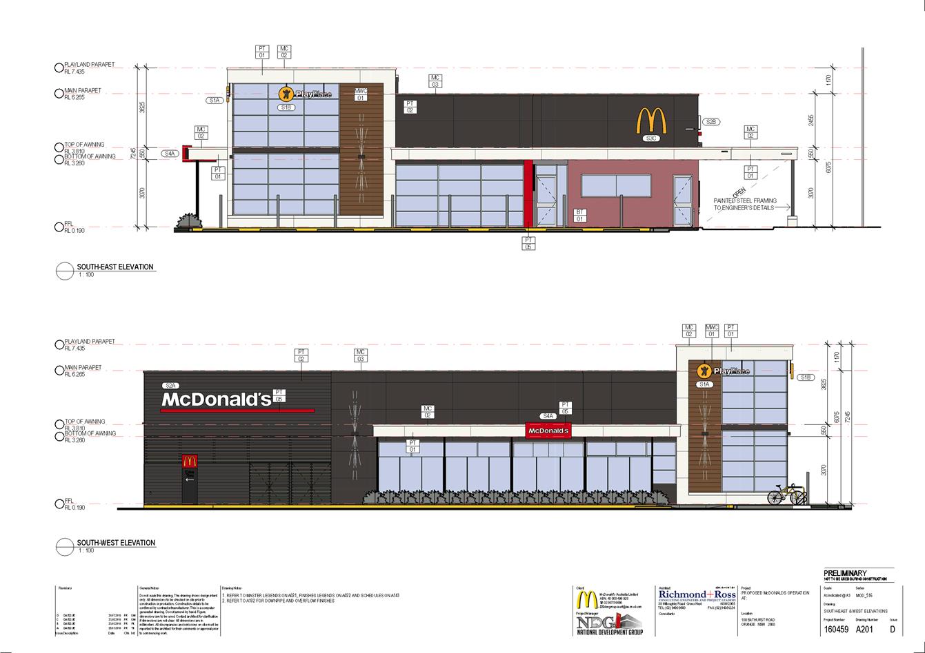
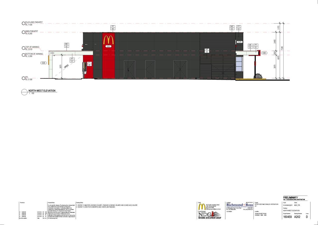
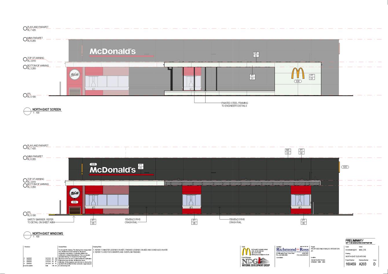
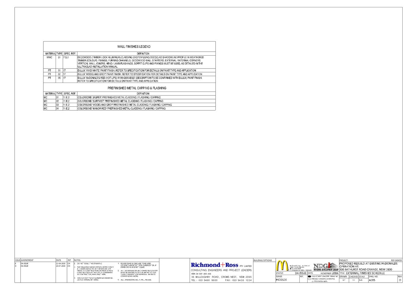
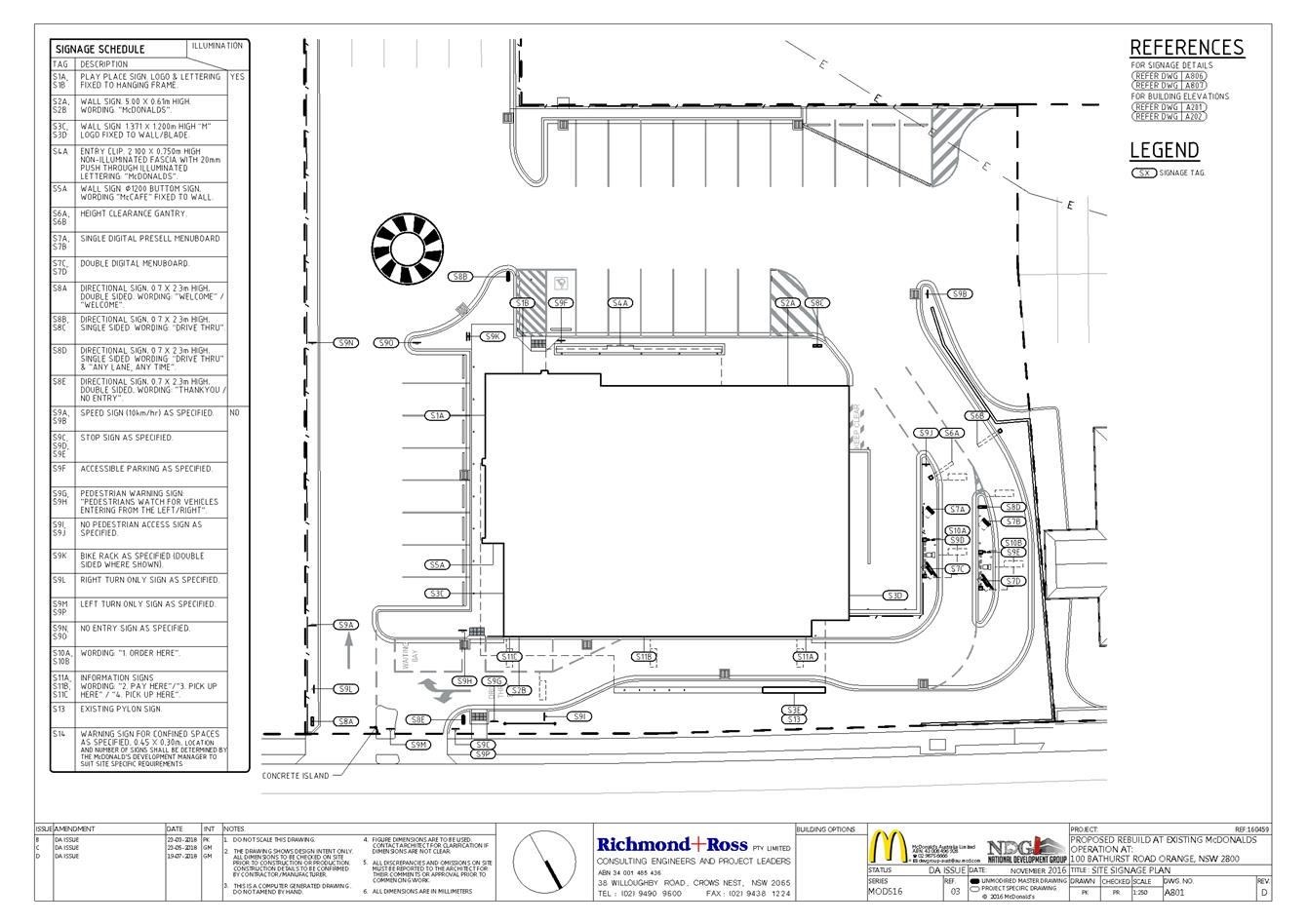
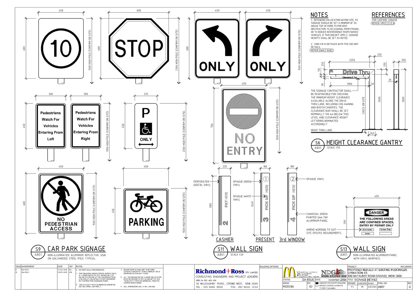
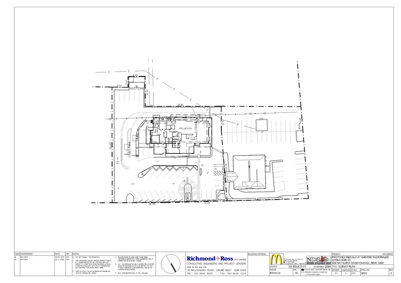
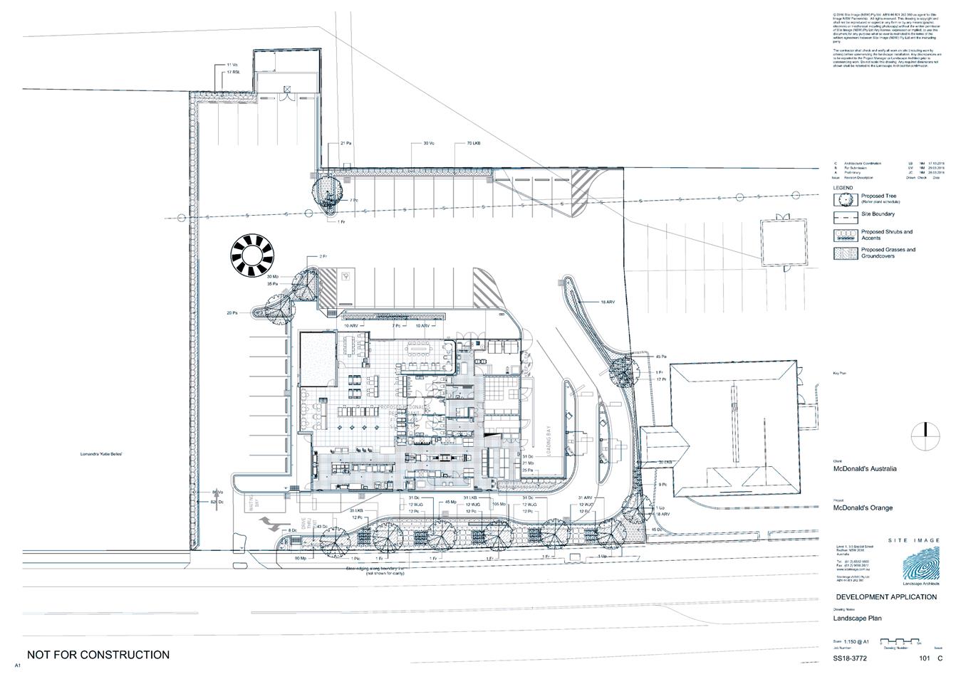
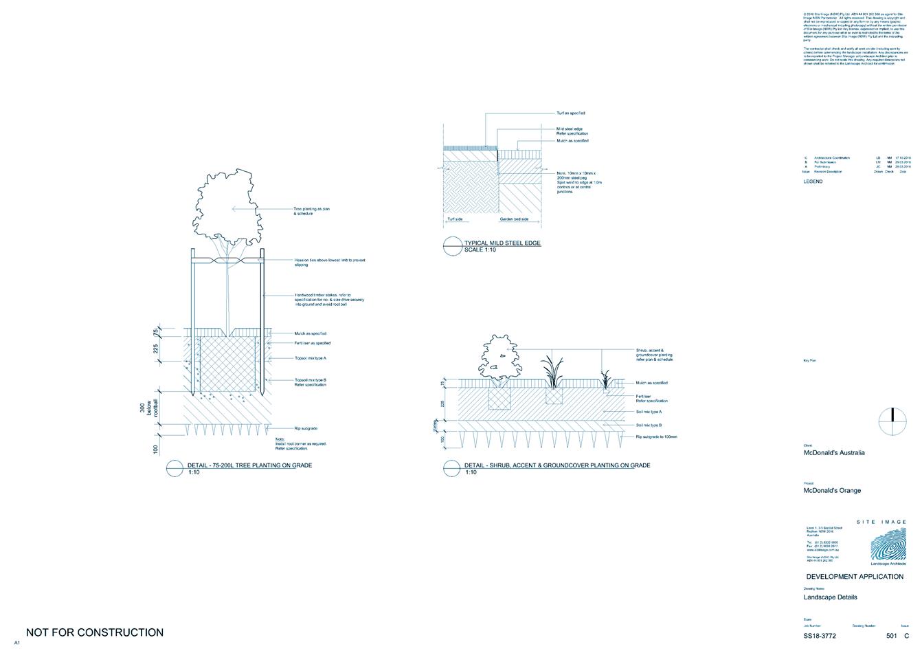
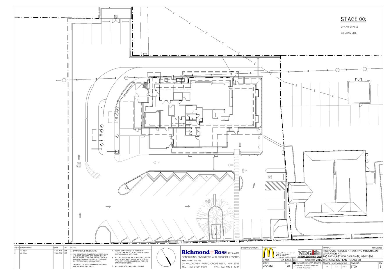
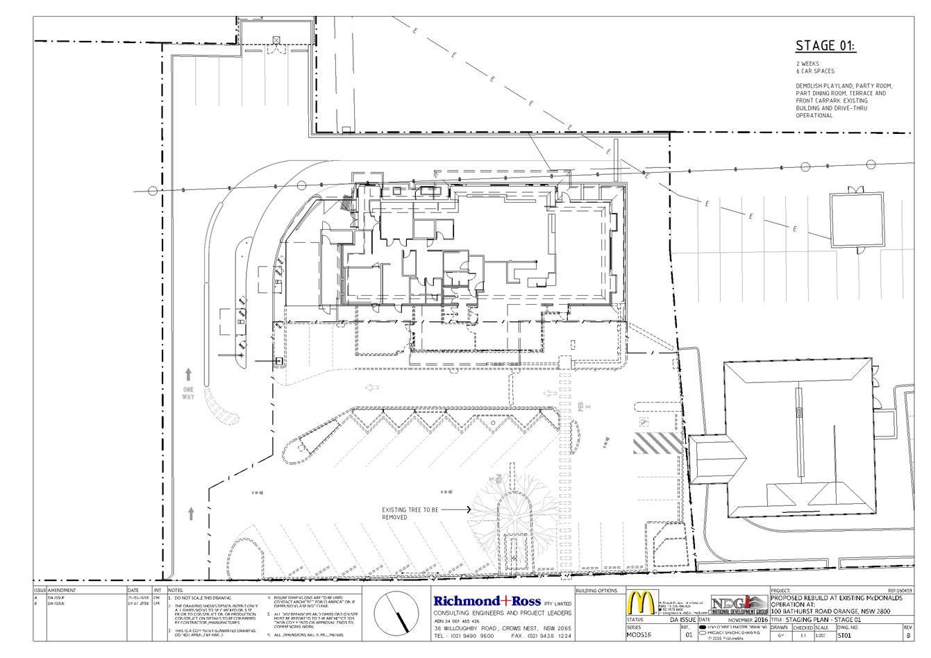
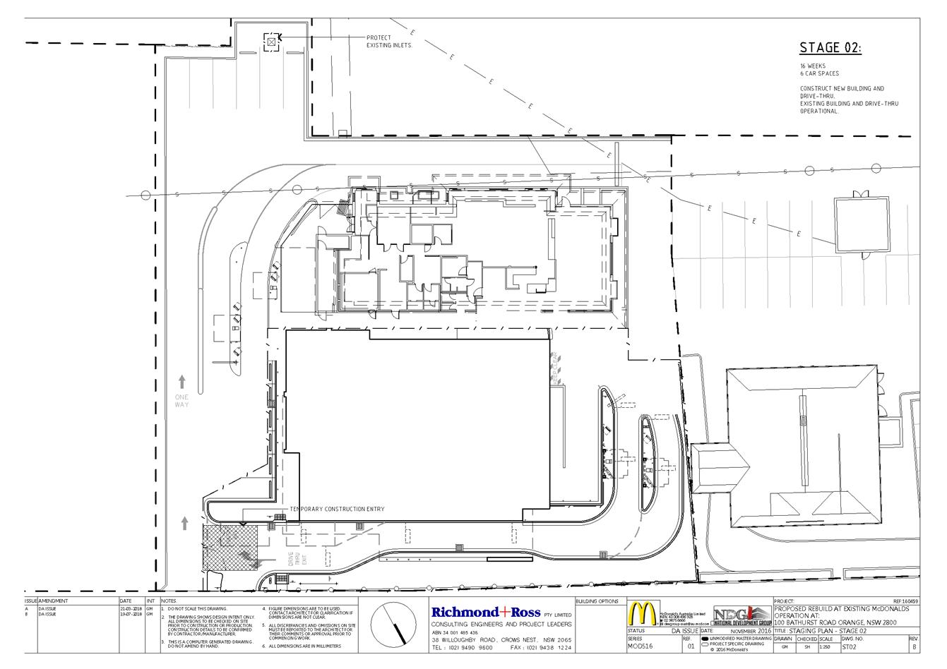
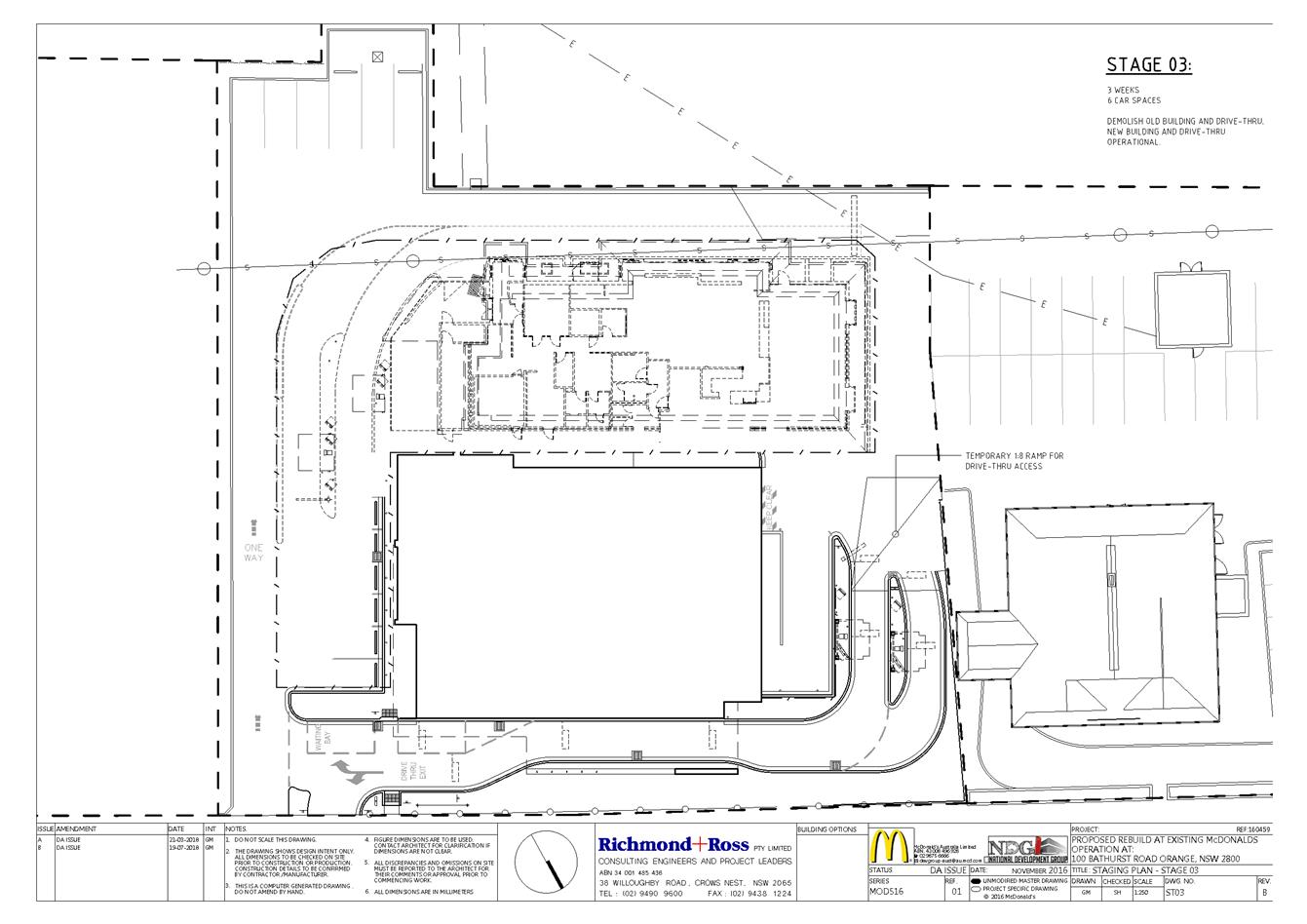
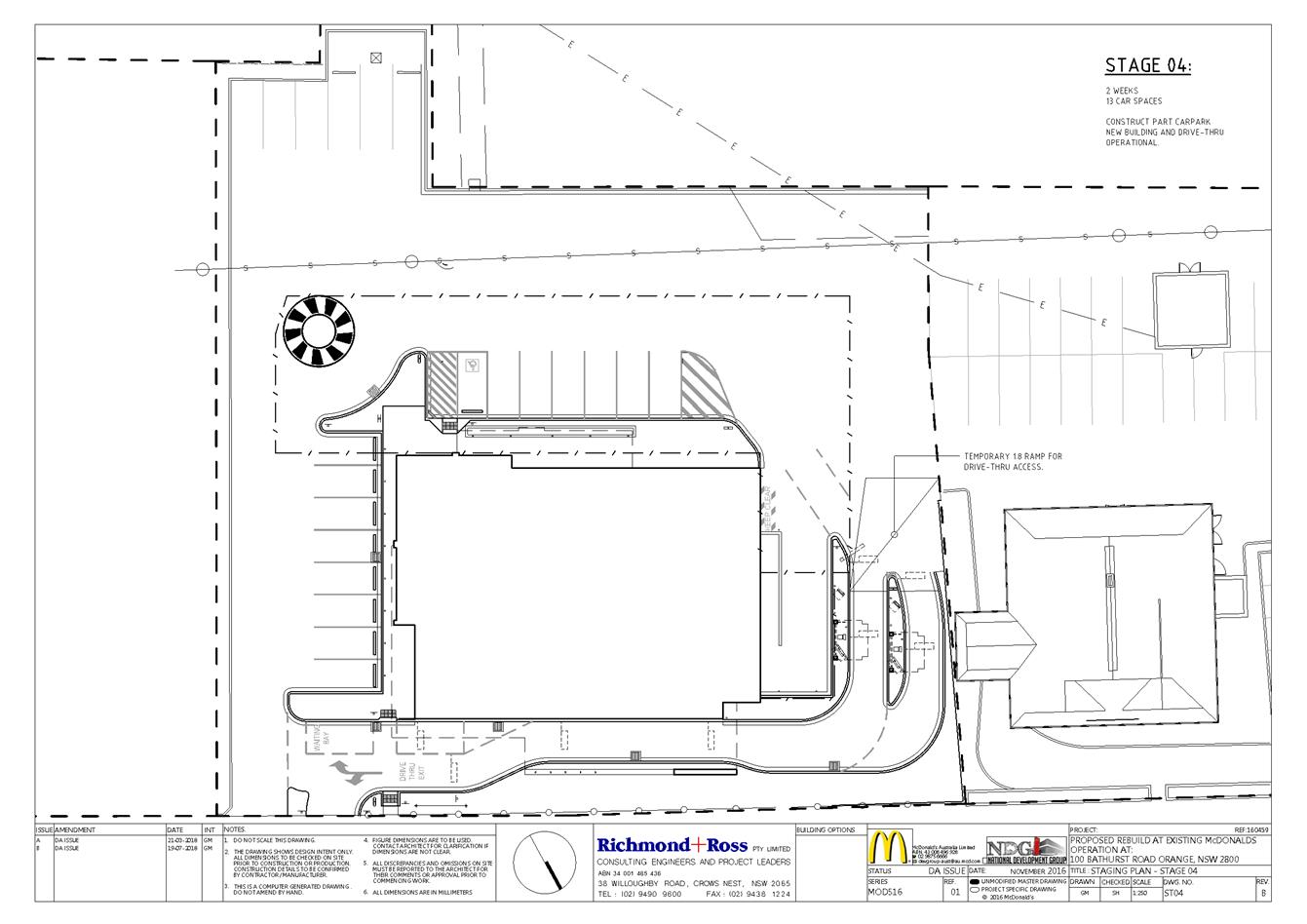
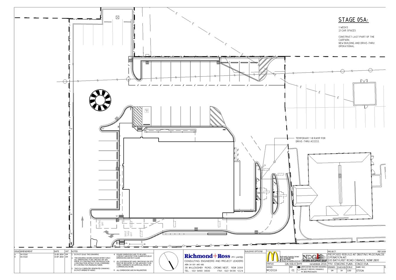
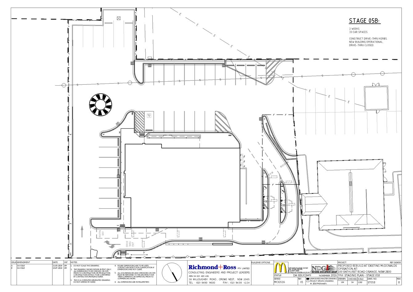
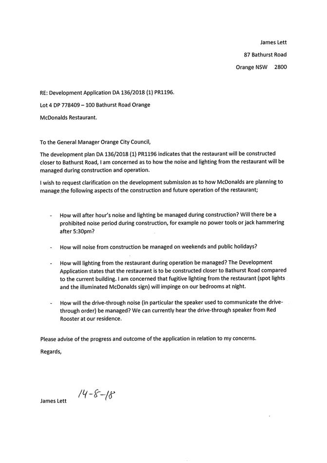
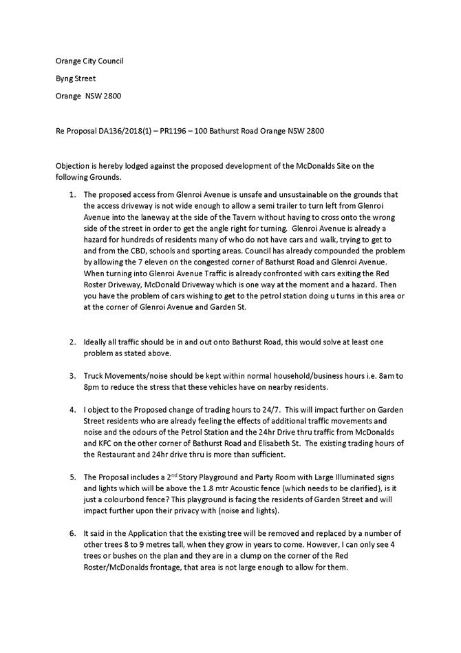
2.6 Development Application DA 136/2018(1) - 100 Bathurst Road
Attachment 1 Notice of Approval..................................................................... 141
Attachment 2 Plans........................................................................................... 151
Attachment 3 Submissions................................................................................ 205
PART 2
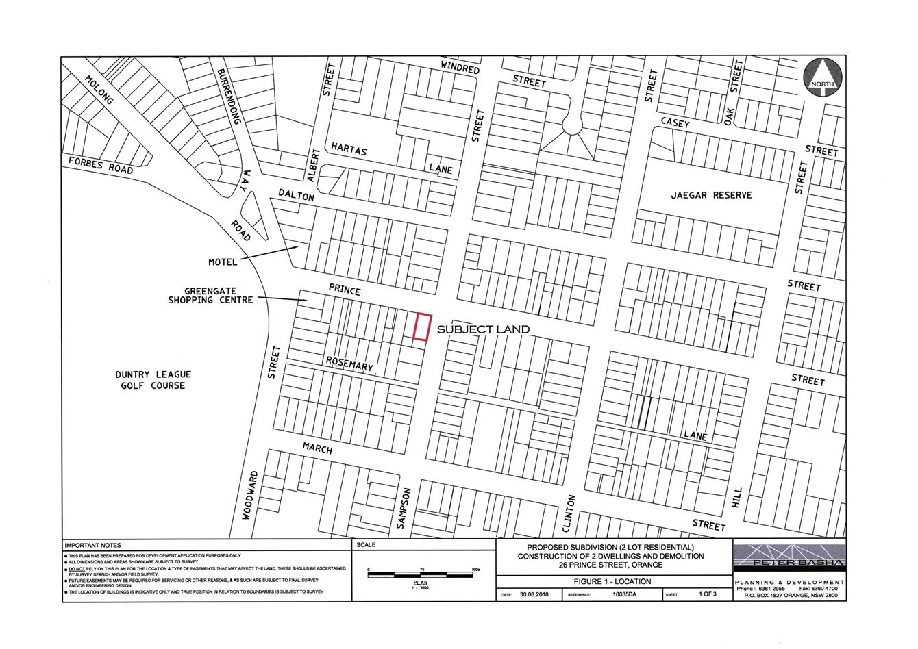
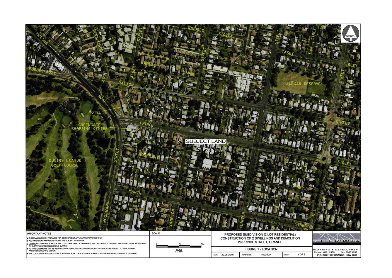
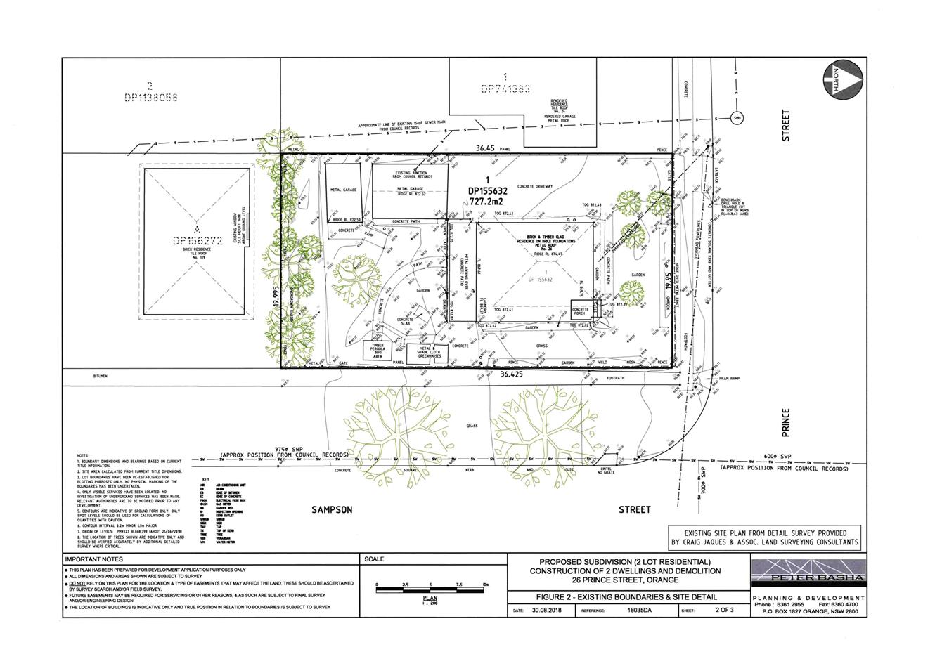
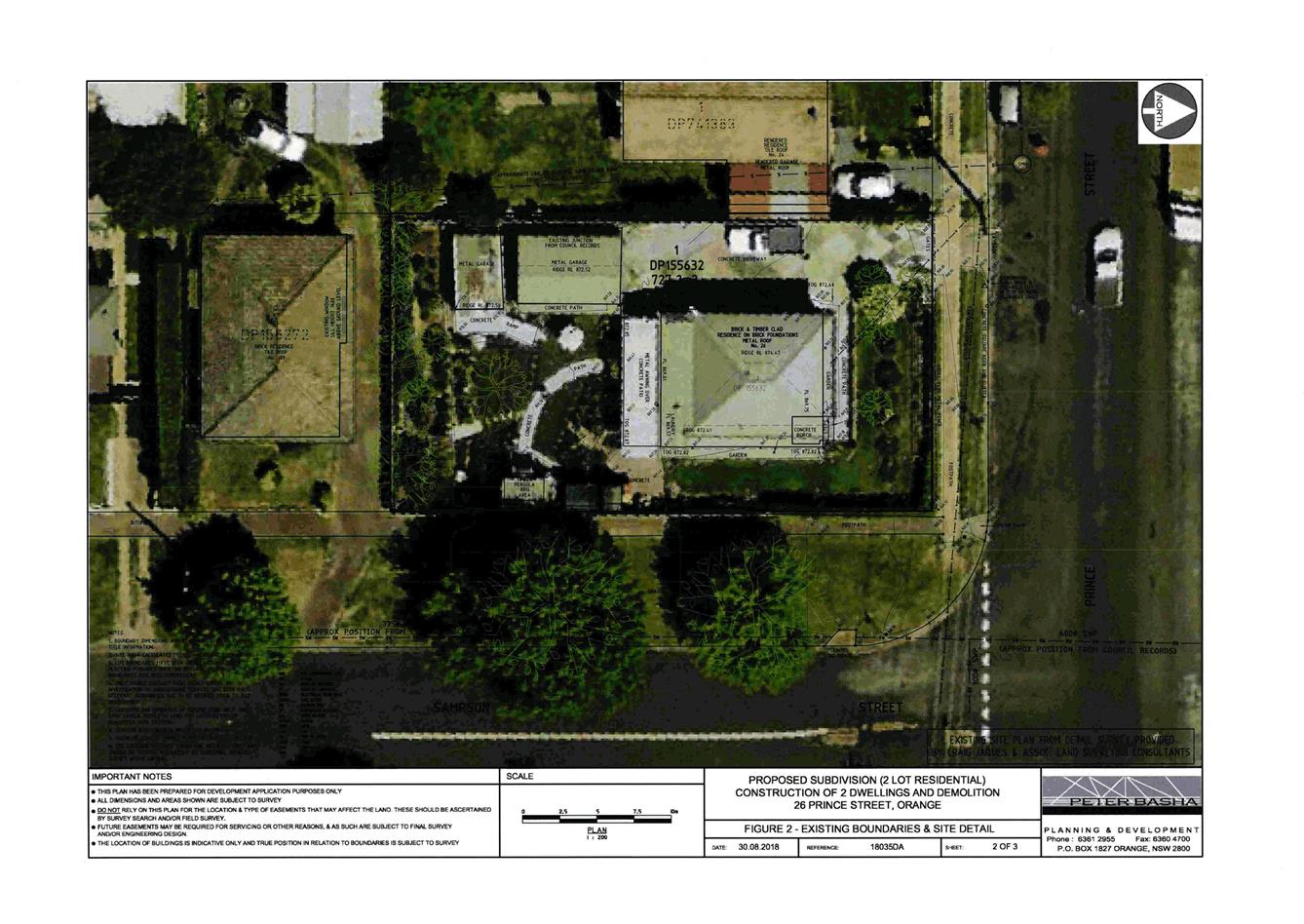
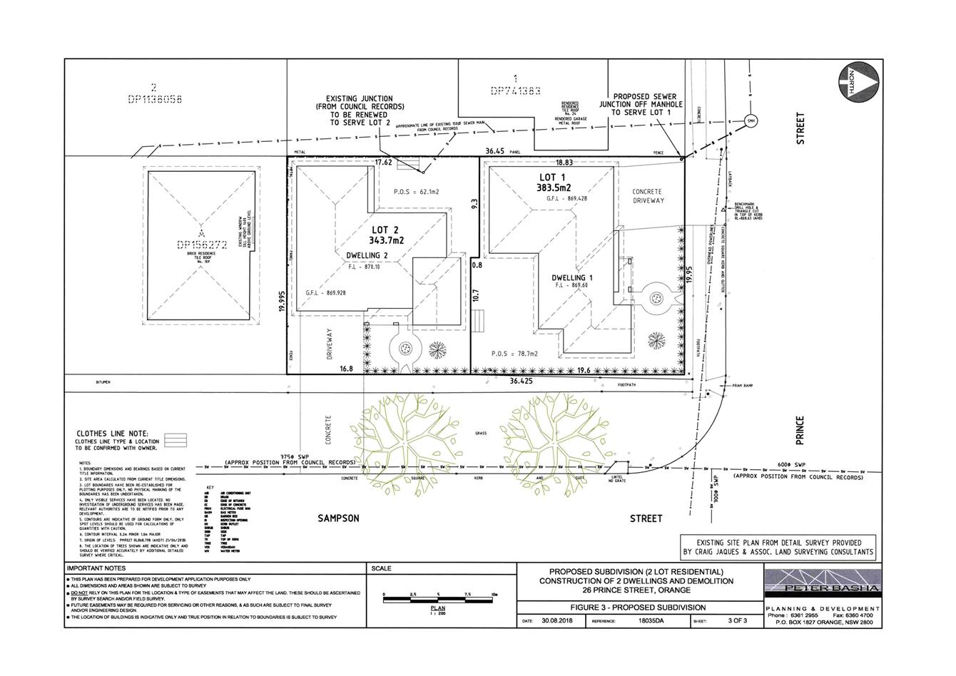
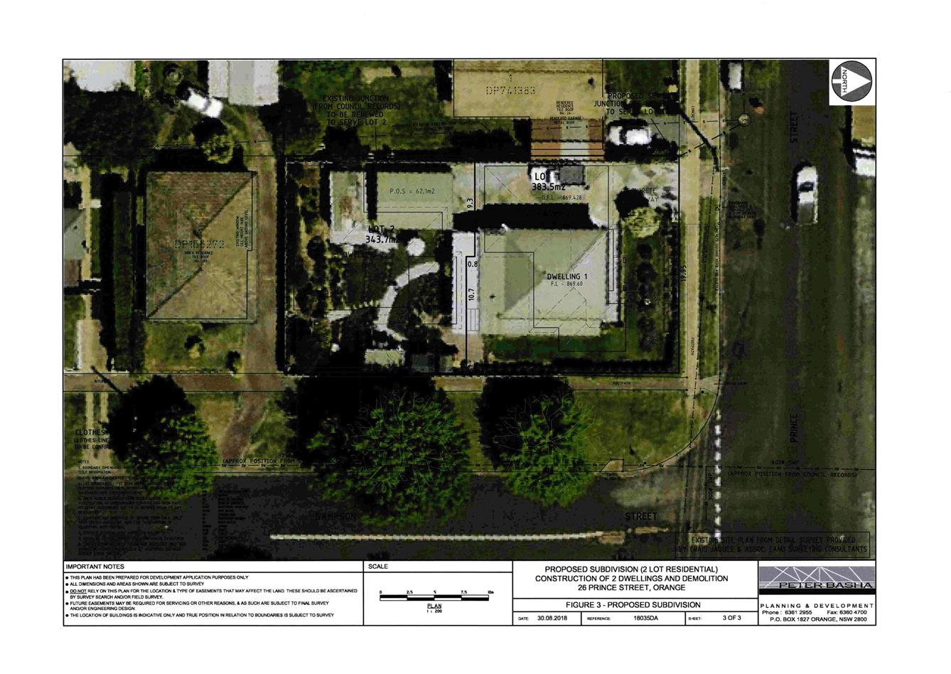
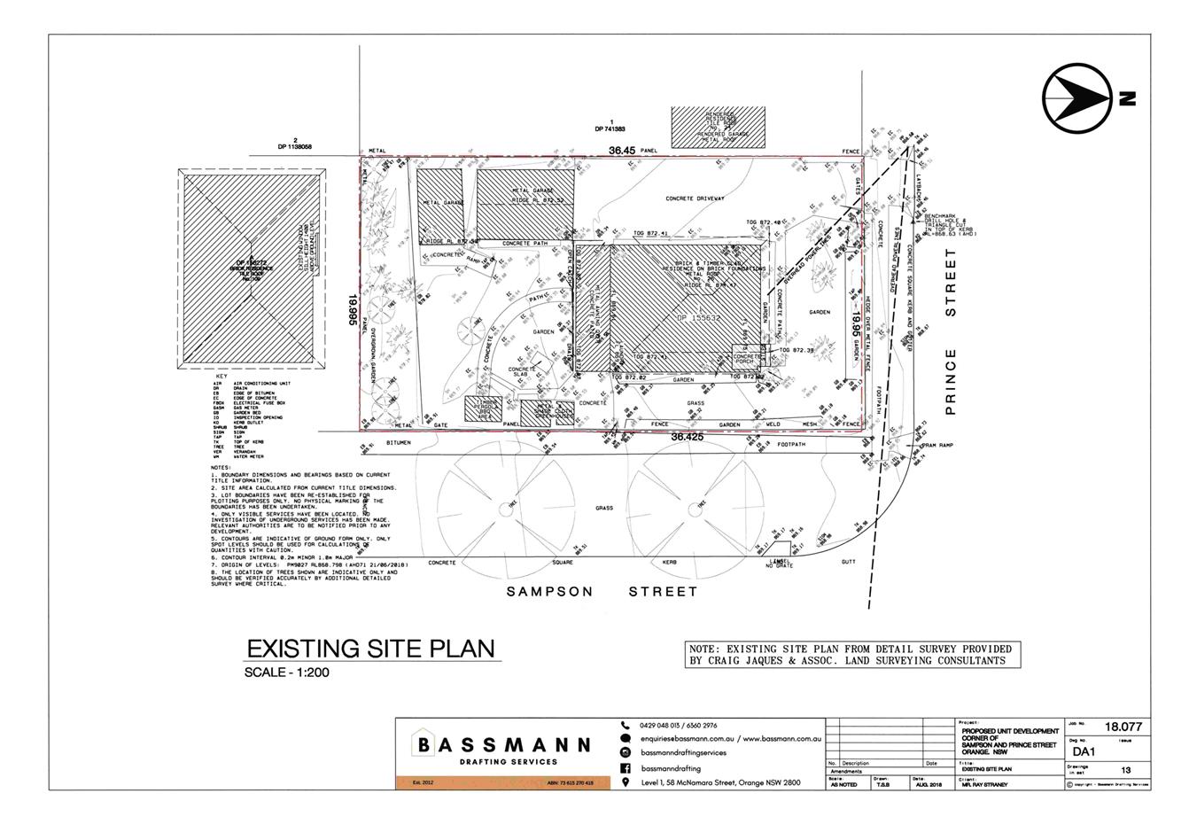
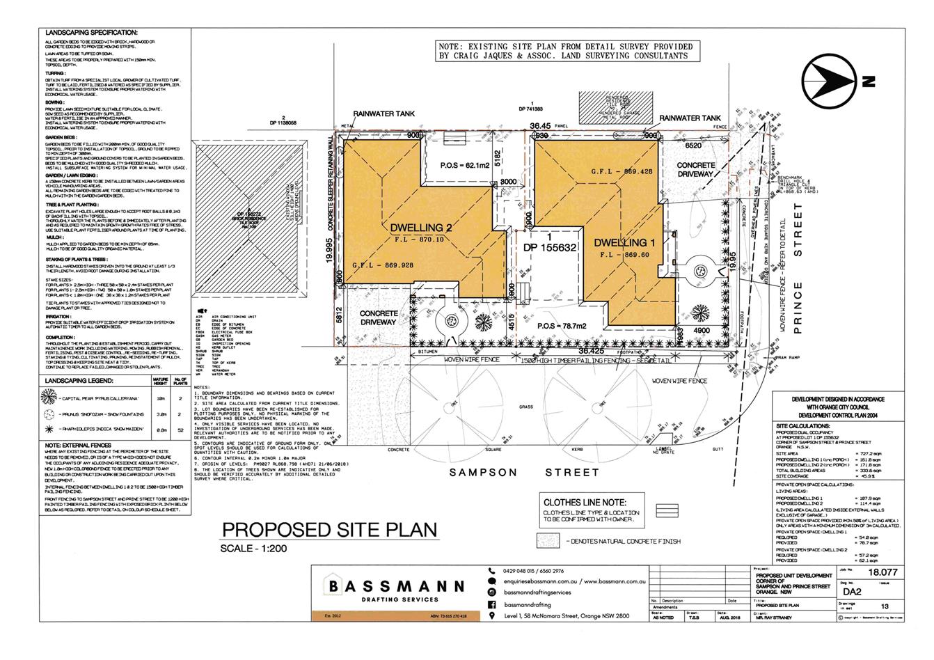
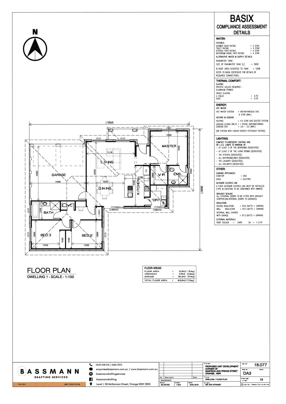
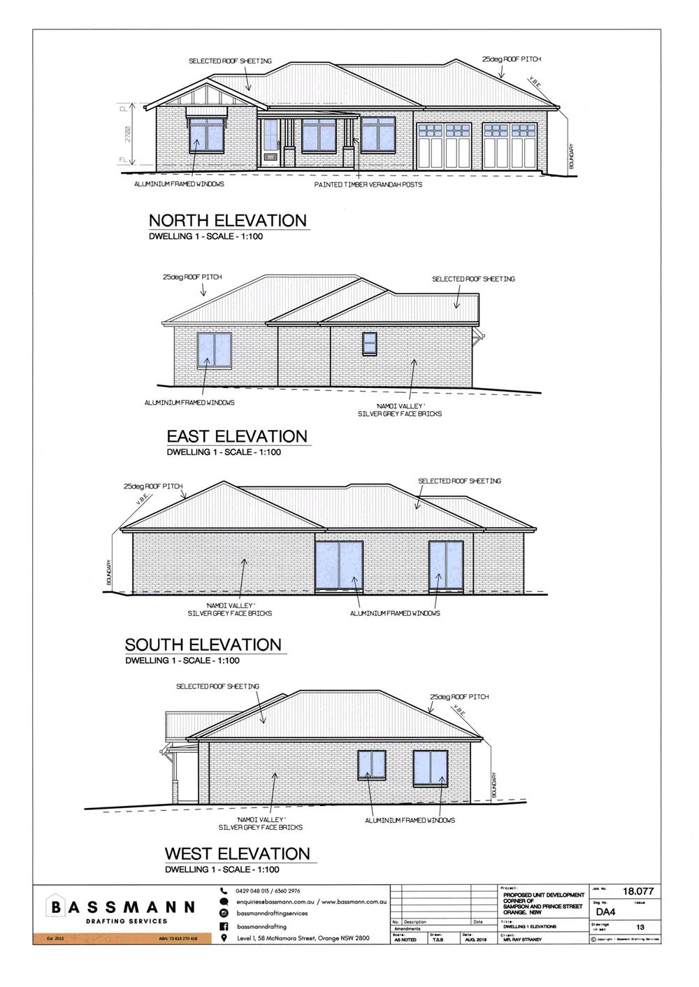
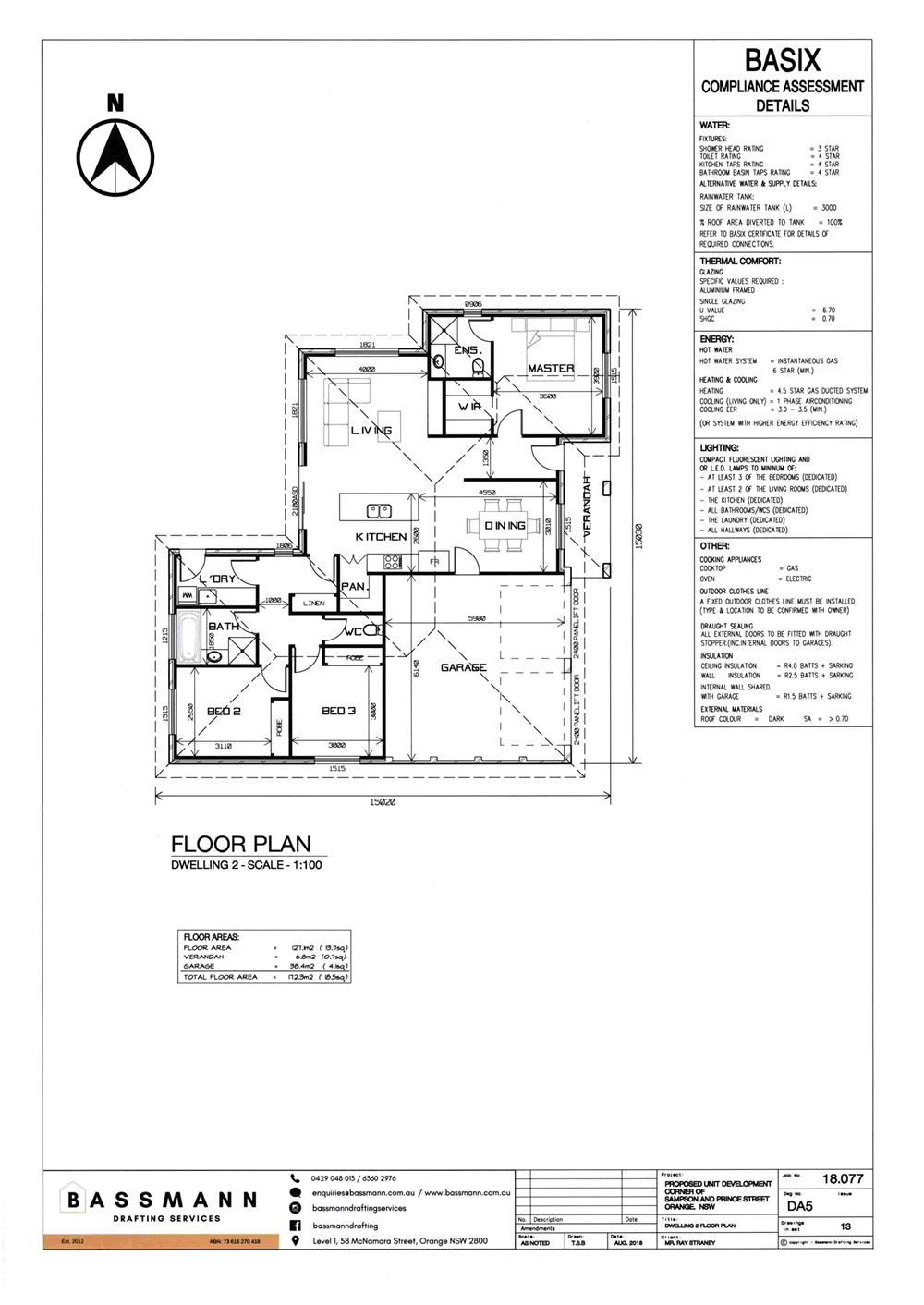
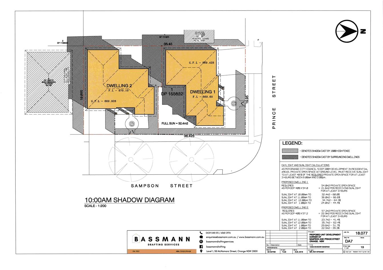
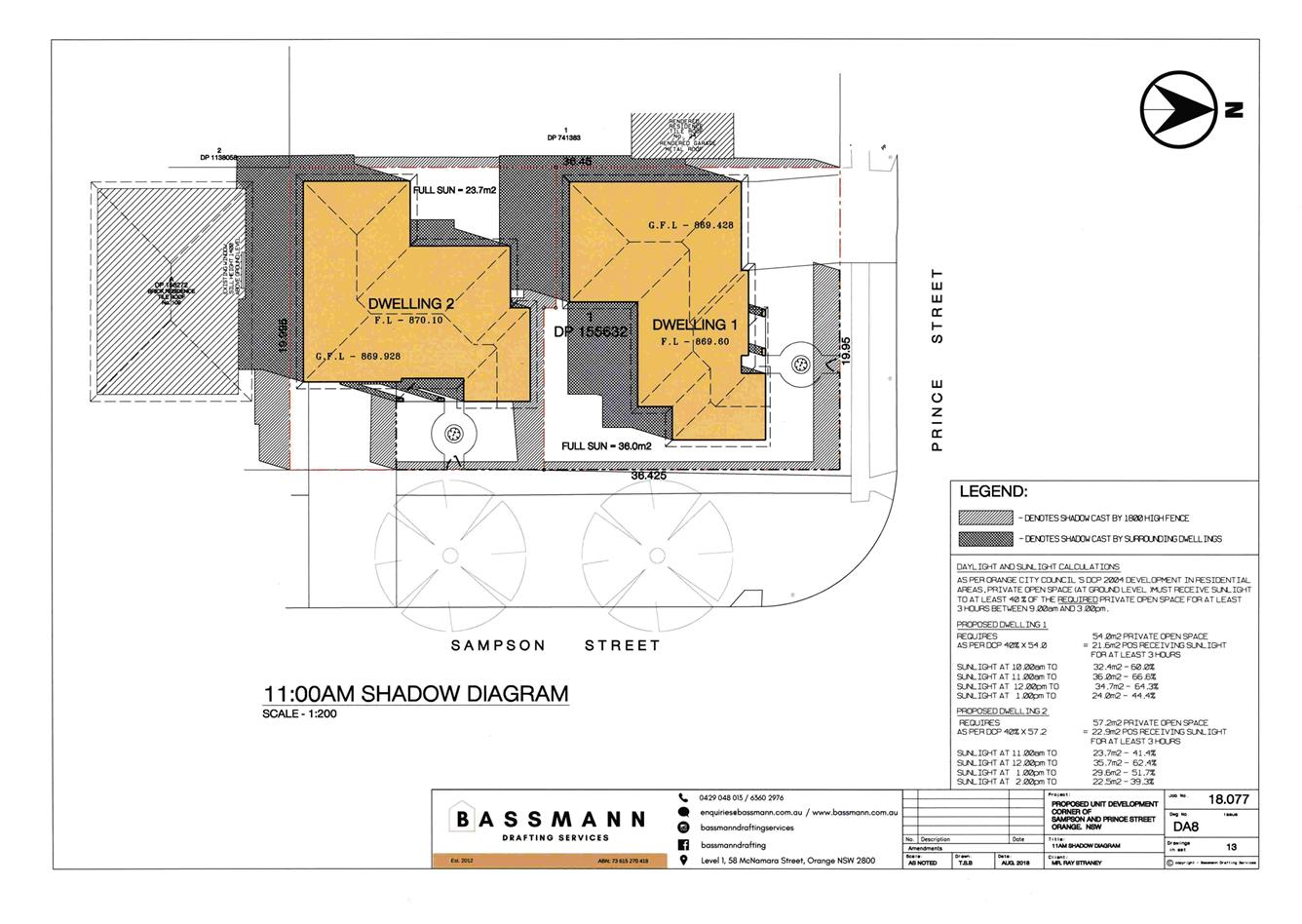
2.7 Development Application DA 313/2018(1) - 26 Prince Street
Attachment 1 Notice of Approval......................................................................... 3
Attachment 2 Plans............................................................................................. 13
2.8 Development Application DA 349/2018(1) - 59-67 and 99 Bathurst Road
Attachment 1 Notice of Approval....................................................................... 45
Attachment 2 Plan.............................................................................................. 49
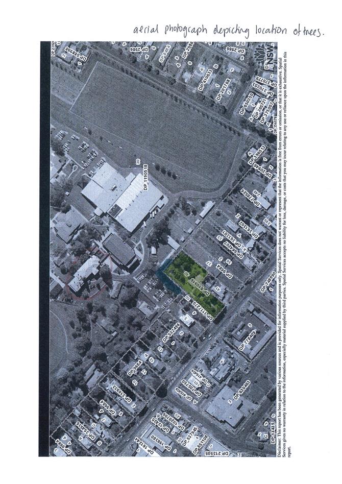
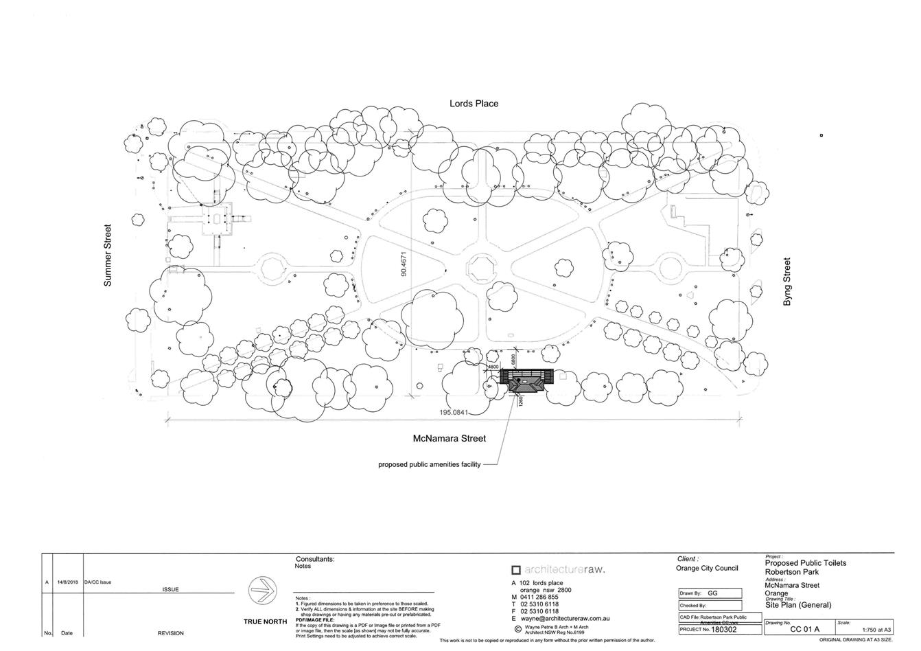
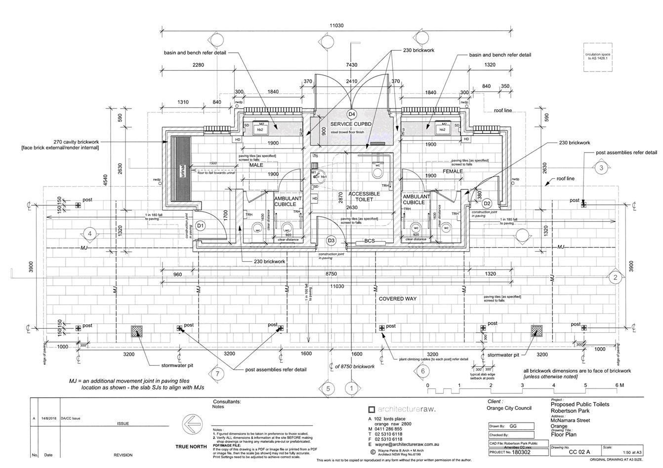
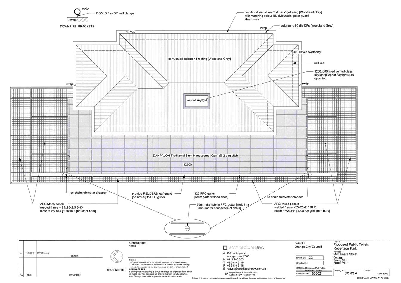
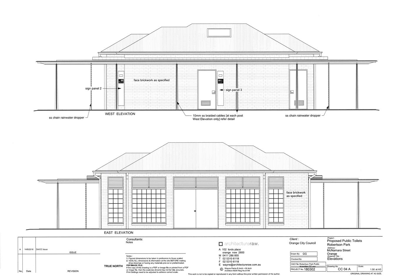
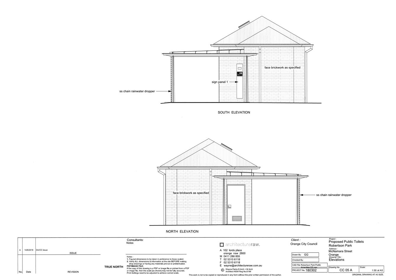
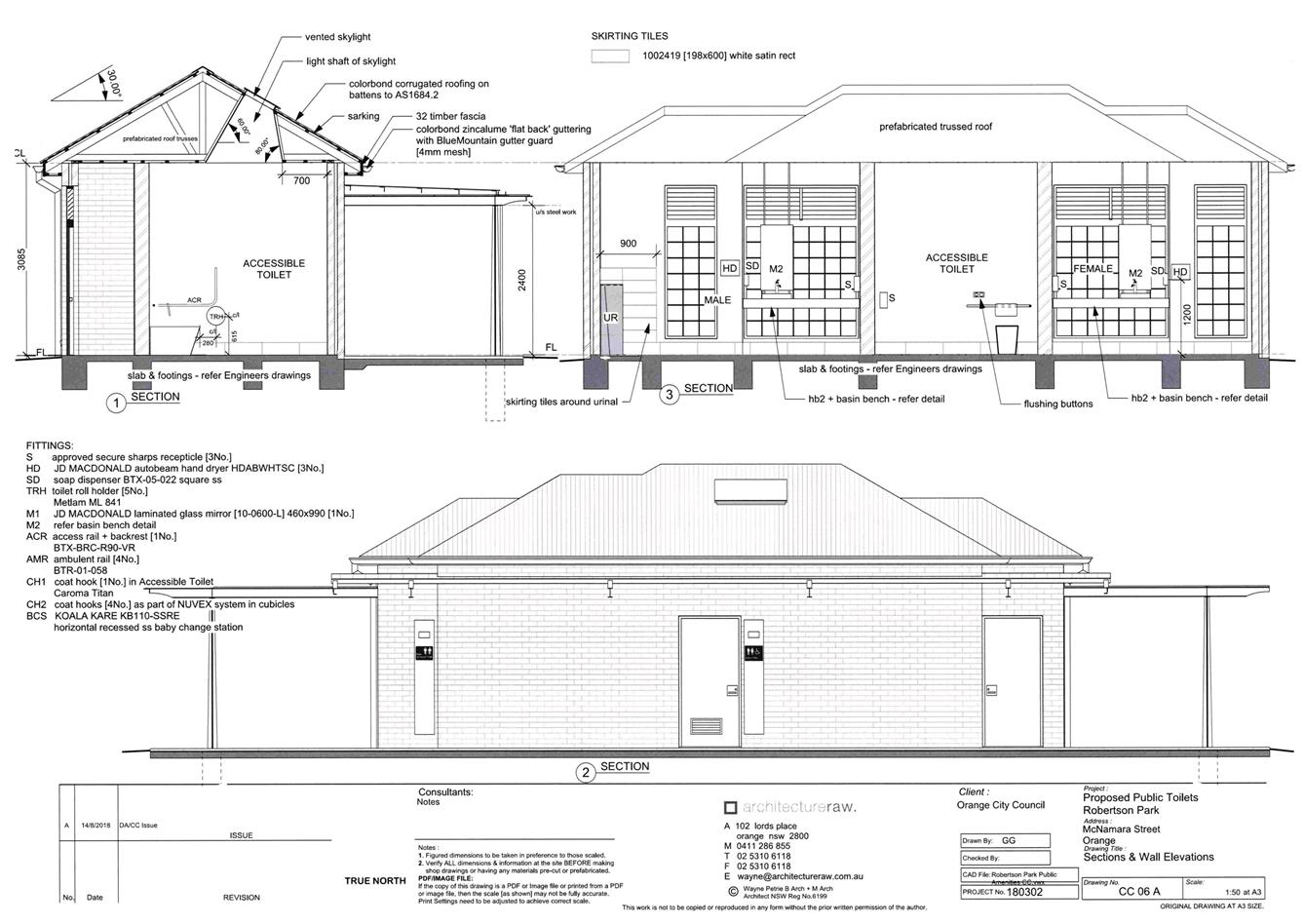
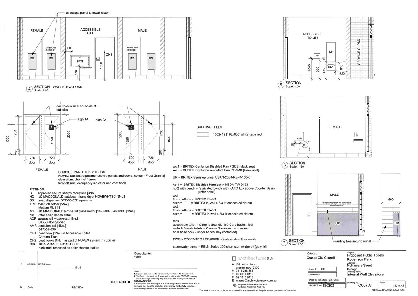
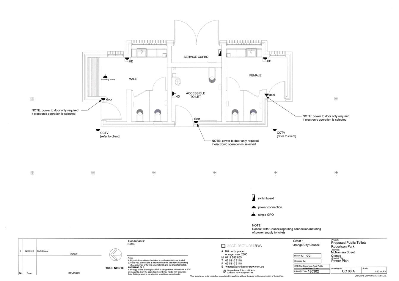
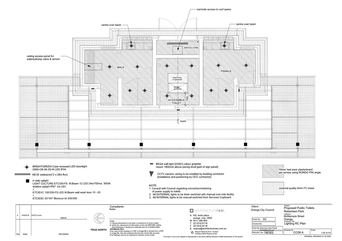
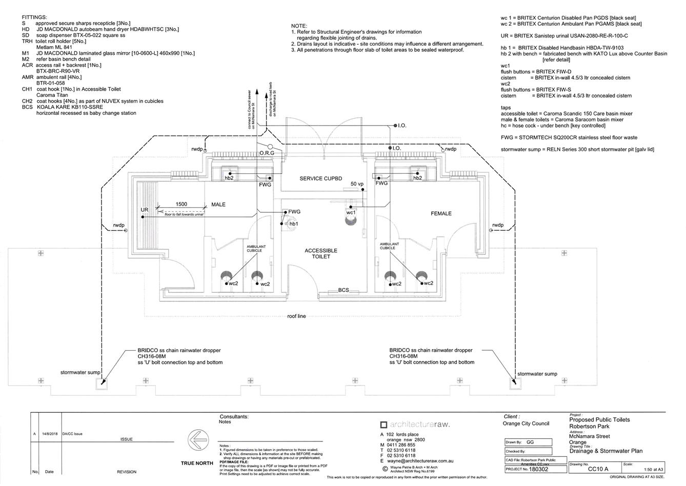
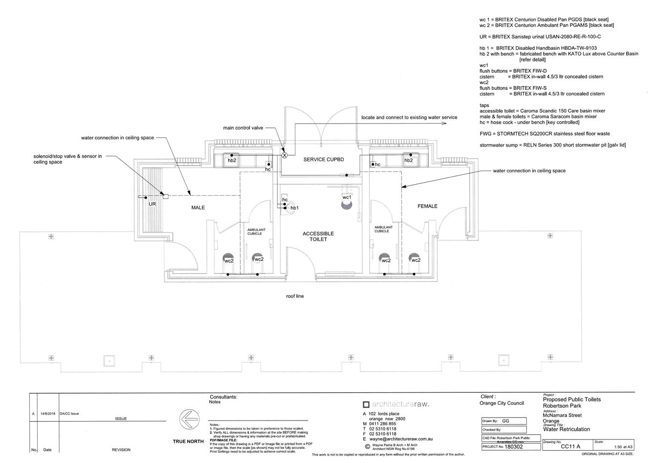
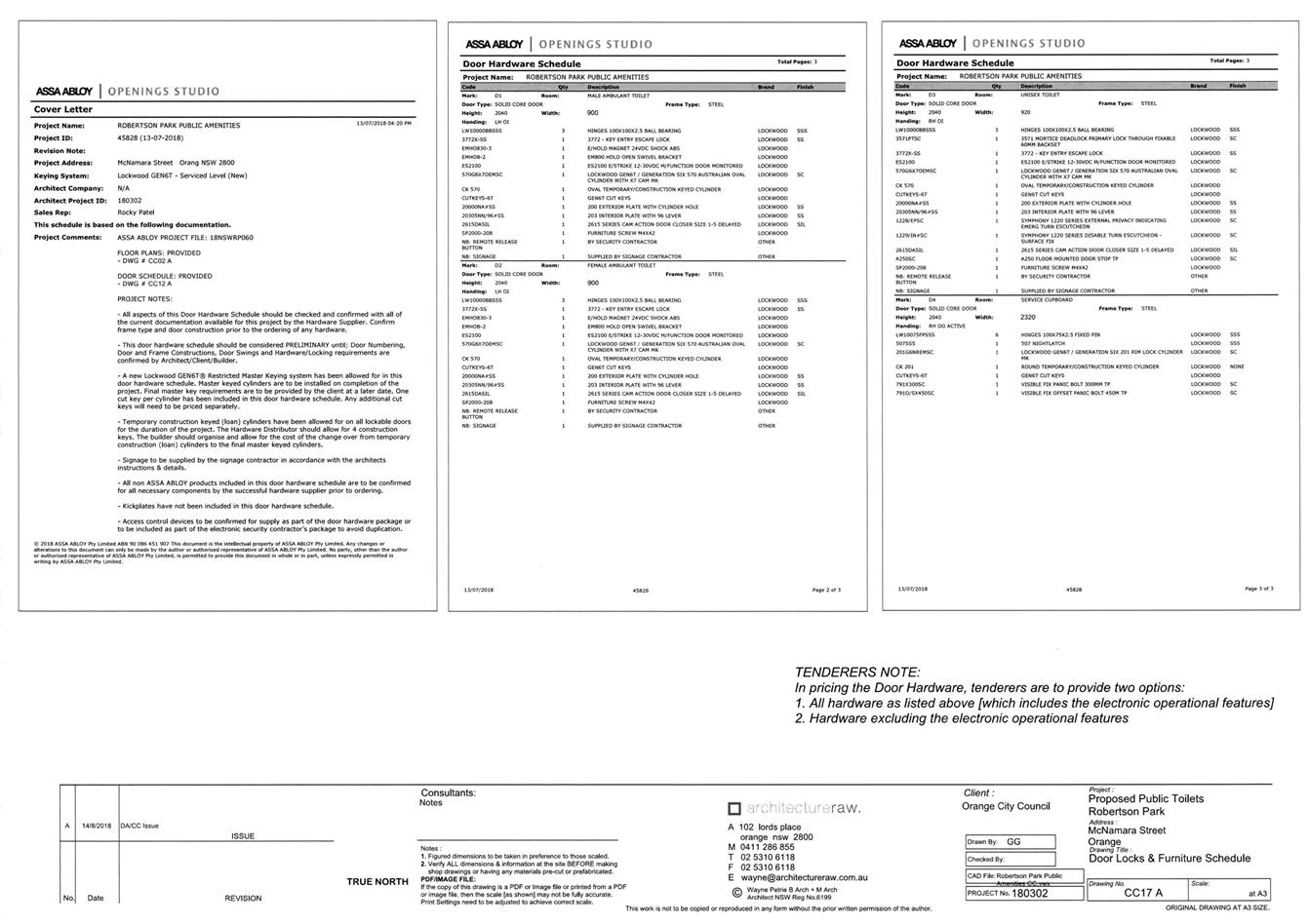
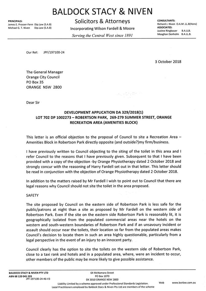
2.9 Development Application DA 329/2018(1) - 269-279 Summer Street (Robertson Park)
Attachment 1 Notice of Approval....................................................................... 50
Attachment 2 Plans............................................................................................. 55
Attachment 3 Submissions.................................................................................. 89
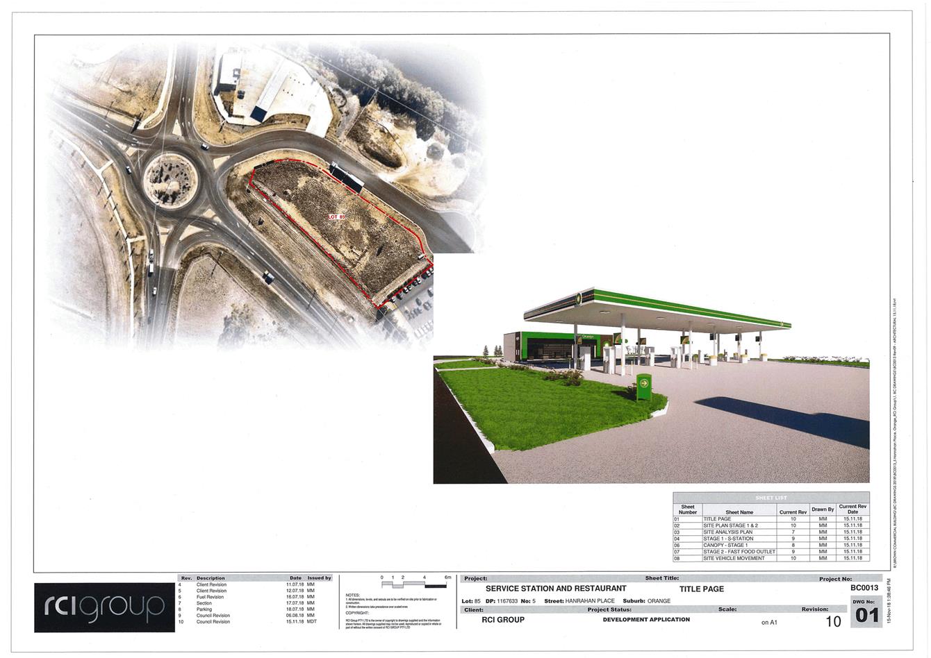
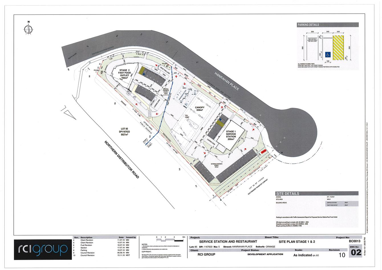
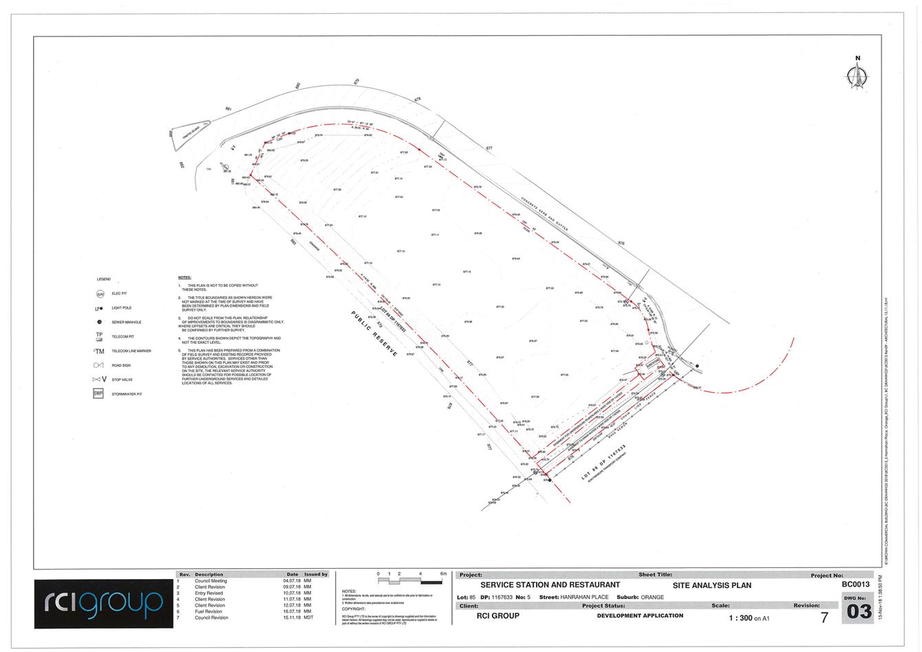
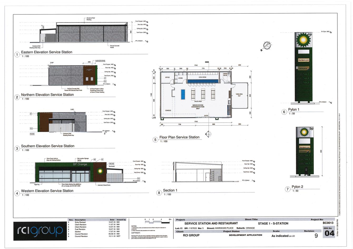
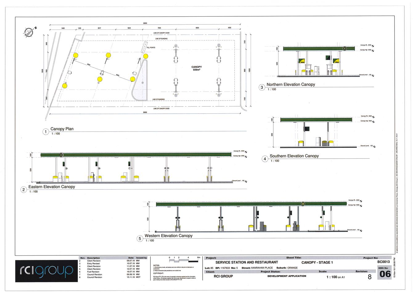
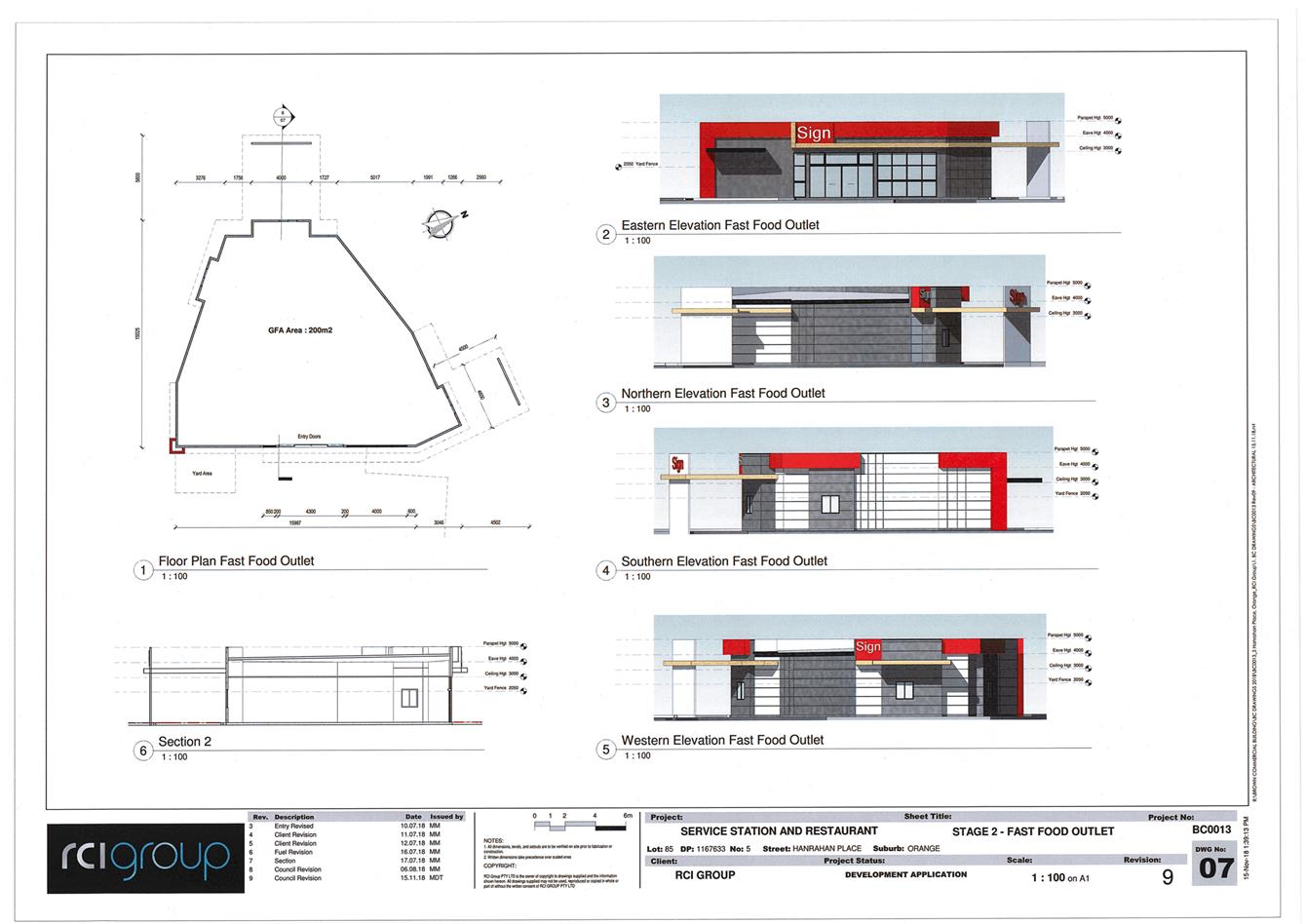
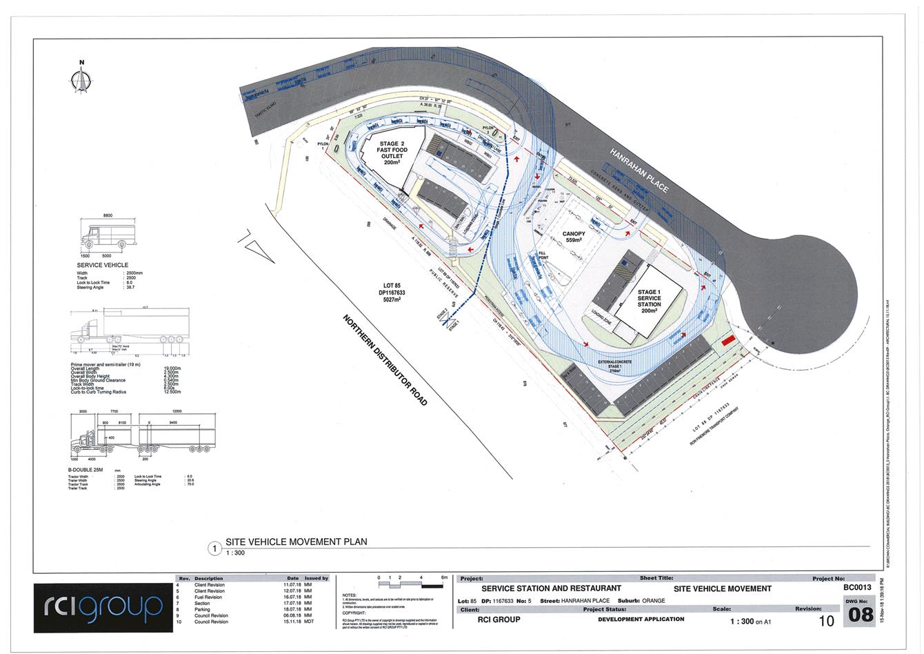
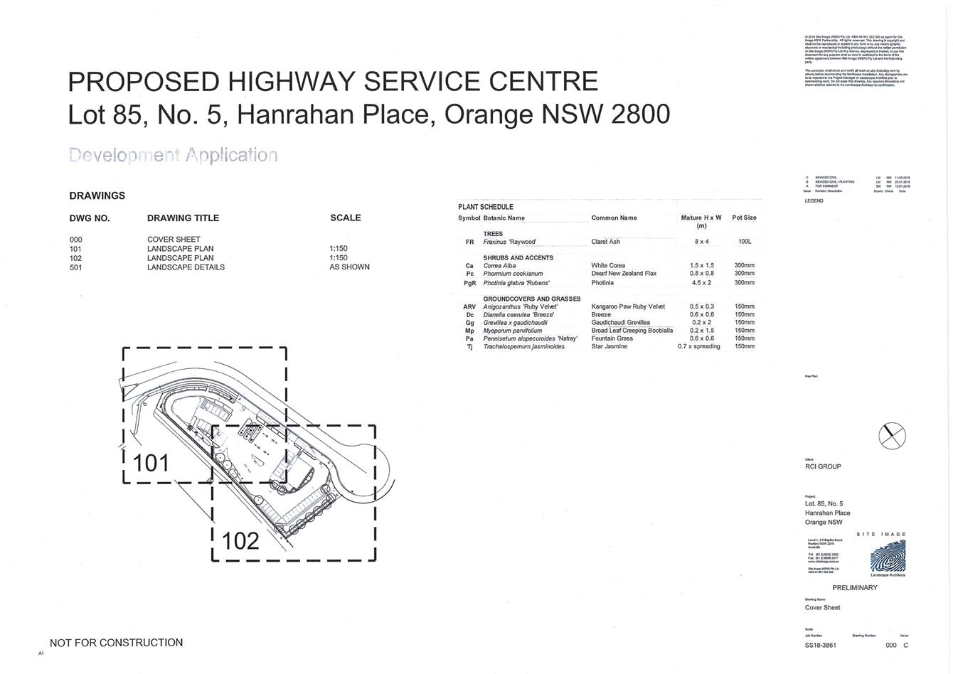
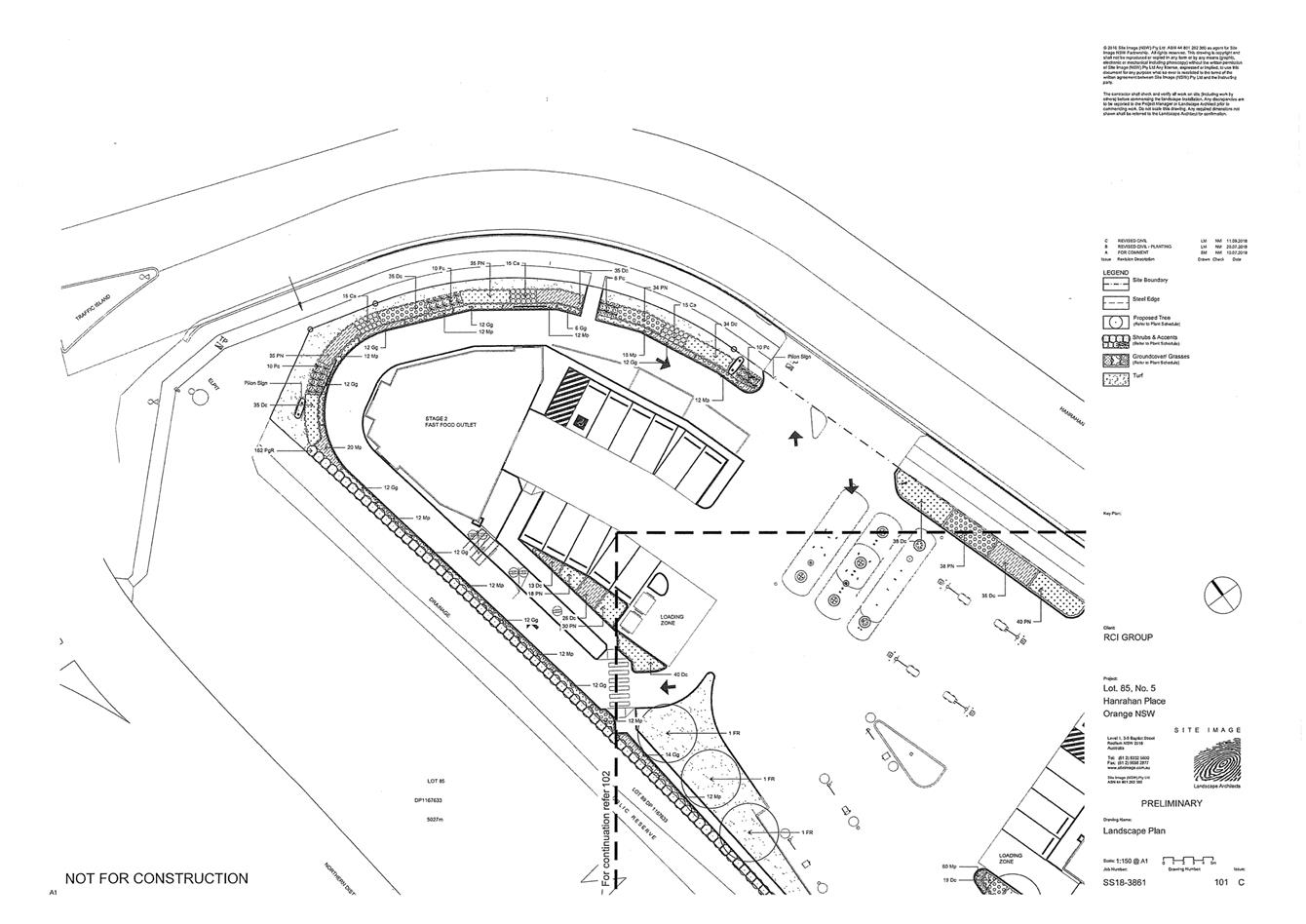
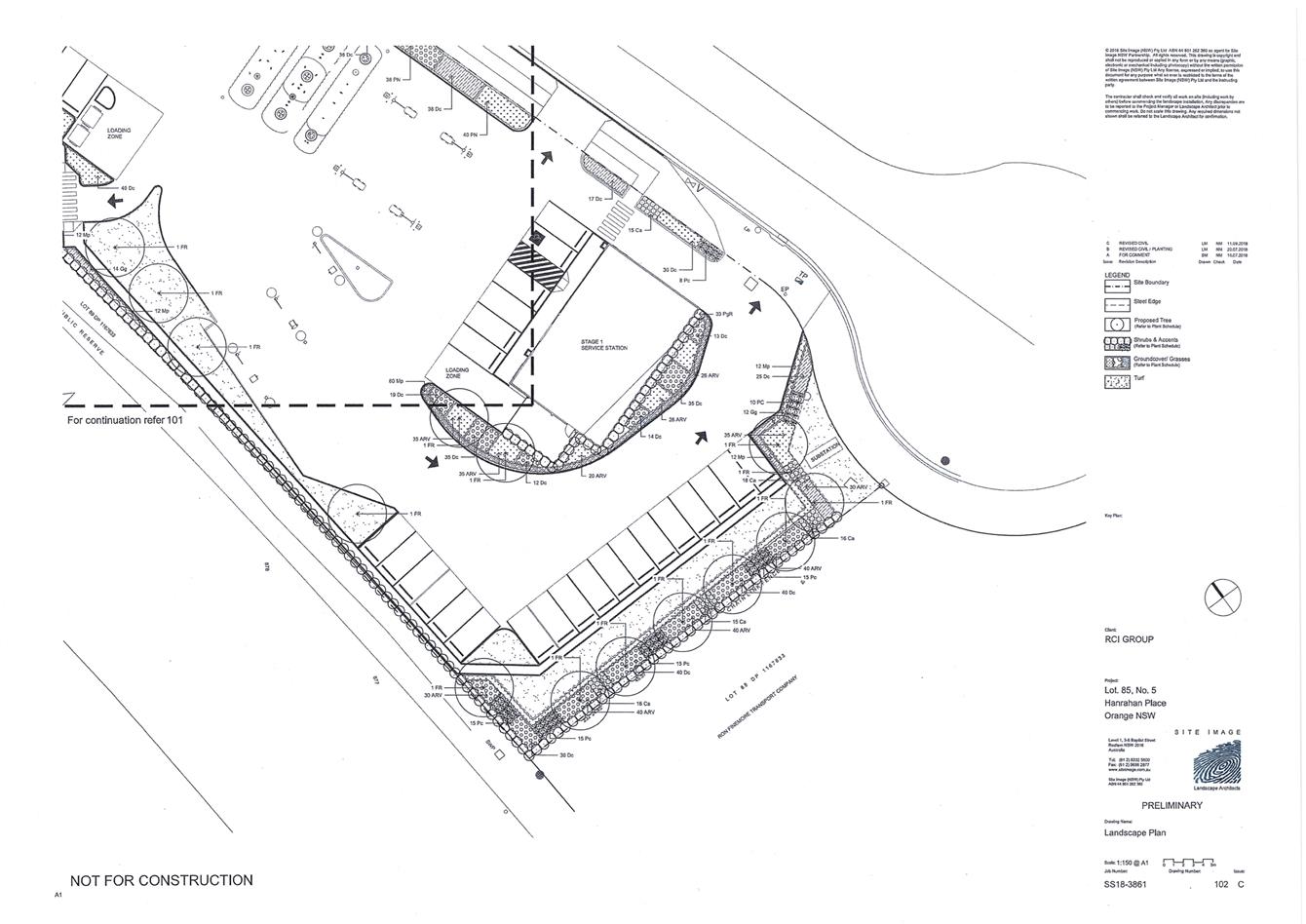
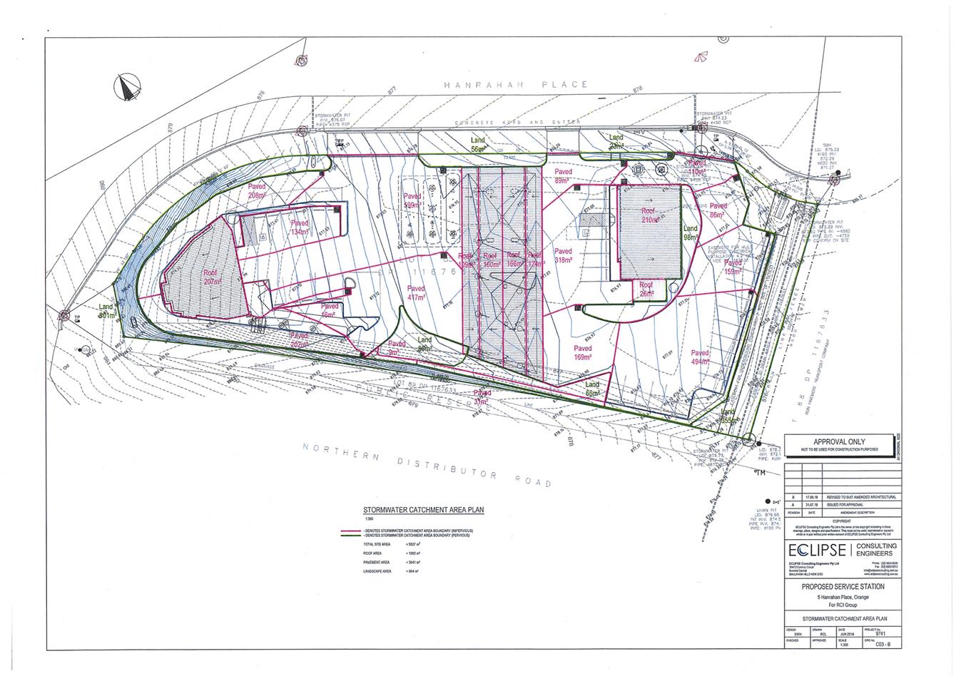
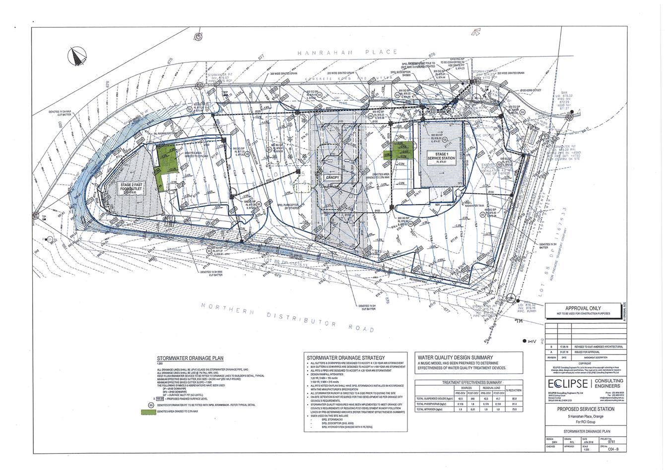
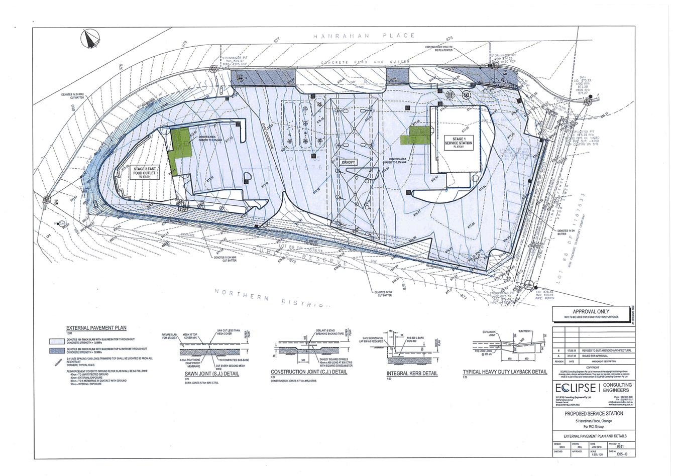
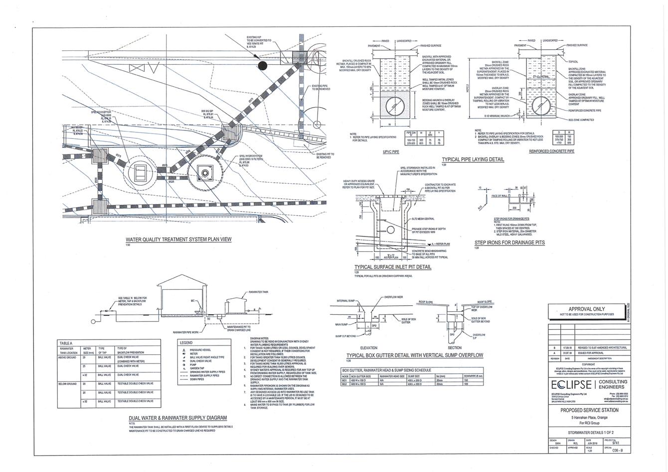
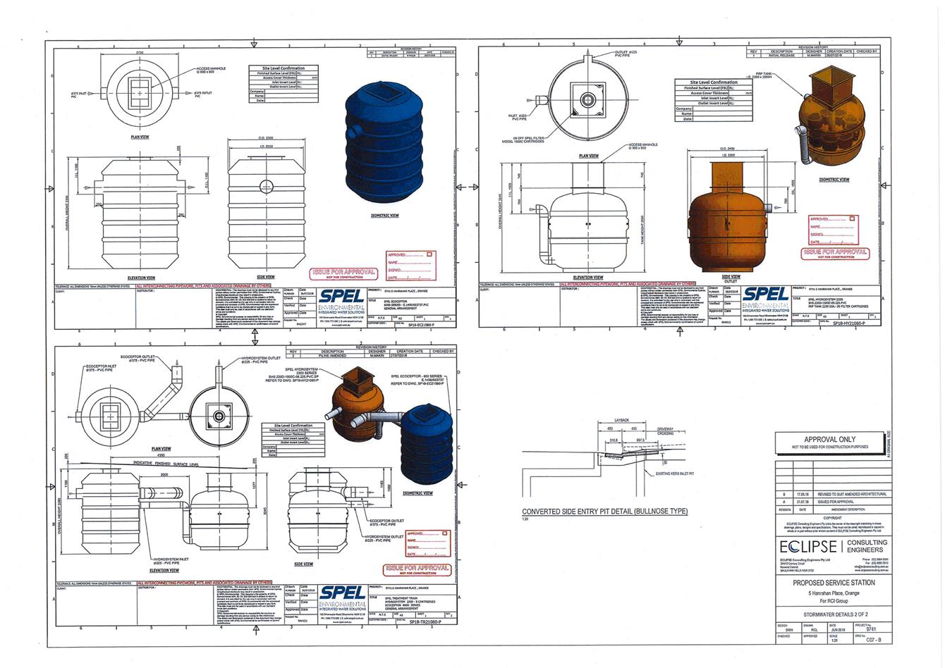
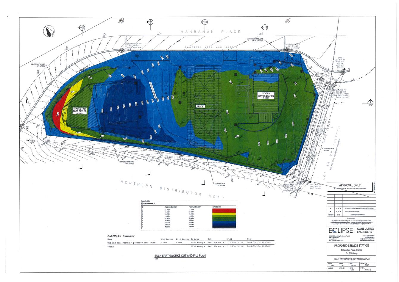
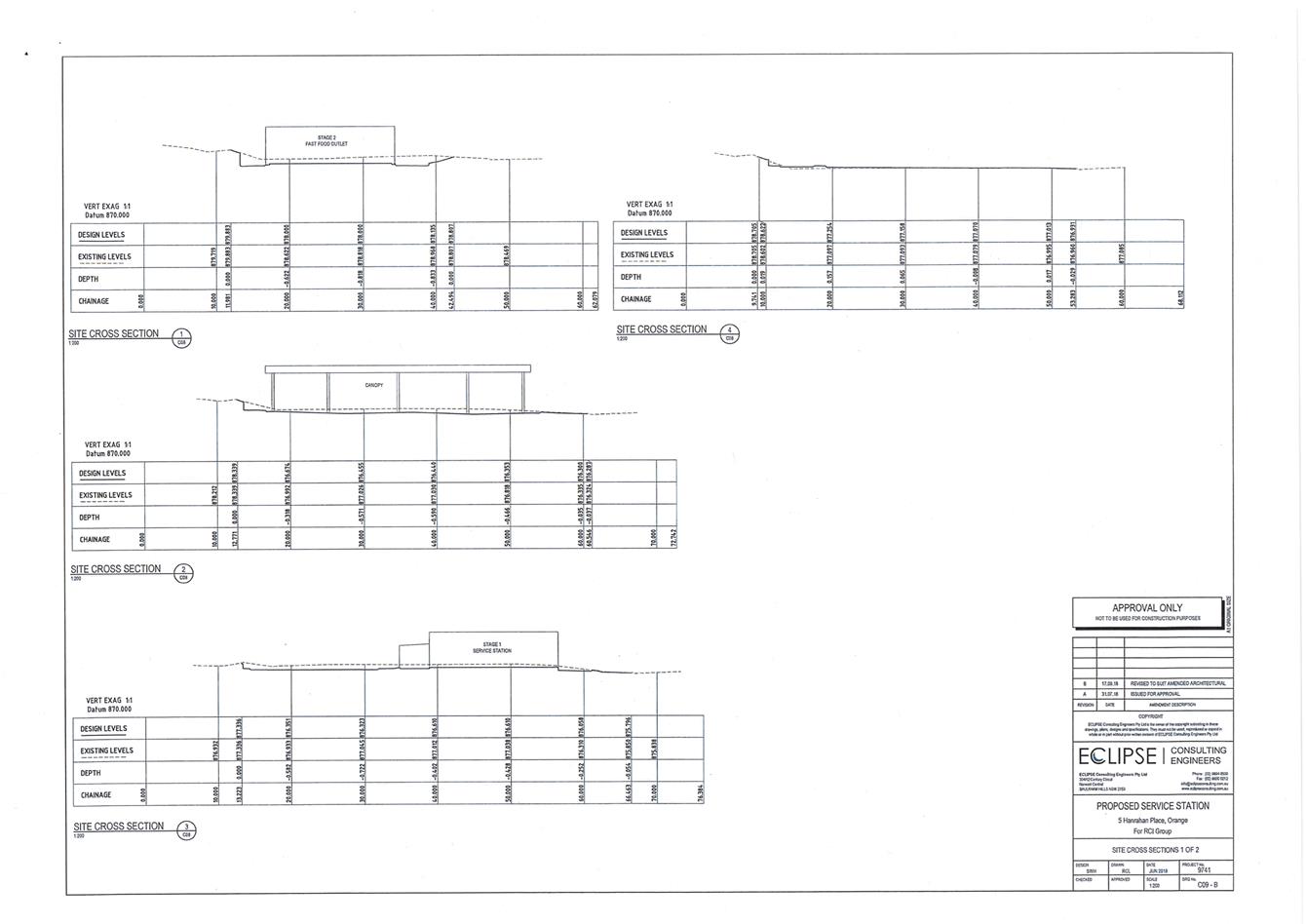
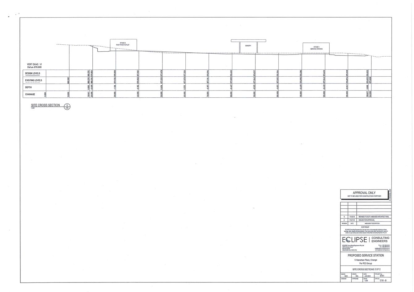
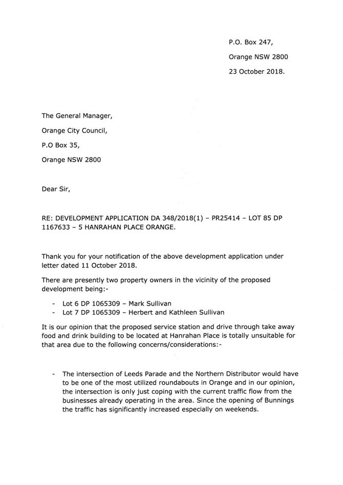
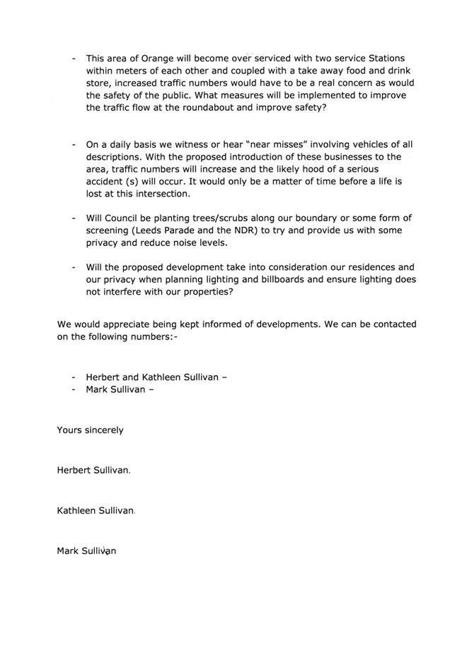
2.10 Development Application DA 348/2018(1) - 5 Hanrahan Place
Attachment 1 Notice of Approval..................................................................... 120
Attachment 2 Plans........................................................................................... 133
Attachment 3 Submission................................................................................. 177
Planning and Development Committee 4 December 2018
2.2 Outstanding Development Applications
Attachment 1 Outstanding Development Applications as at 21 November 2018
2.3 Enforcement Policy
Attachment 1 Draft Enforcement Policy
Enforcement Policy
Orange City Council
1. Introduction
2. Purpose and scope
3. Organisational approach
4. Definitions
5. Policy objectives
6. Application
7. Compliance and enforcement principles
8. Responsibility
9. Responding to concerns about unlawful activity
10. Investigating alleged unlawful activity
11. Taking enforcement action
12. Options for dealing with confirmed cases of unlawful activity
13. Taking legal action
14. Shared enforcement responsibilities
15. Role of Council where there is a private certifier
16. Role of councillors in enforcement
17. Delegations
18. Approval
19. Review
Appendix A Taking enforcement action
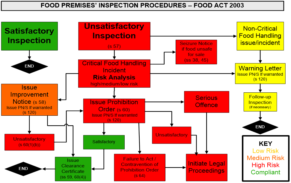
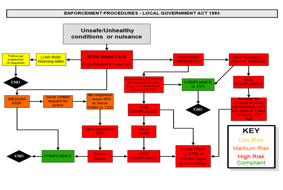
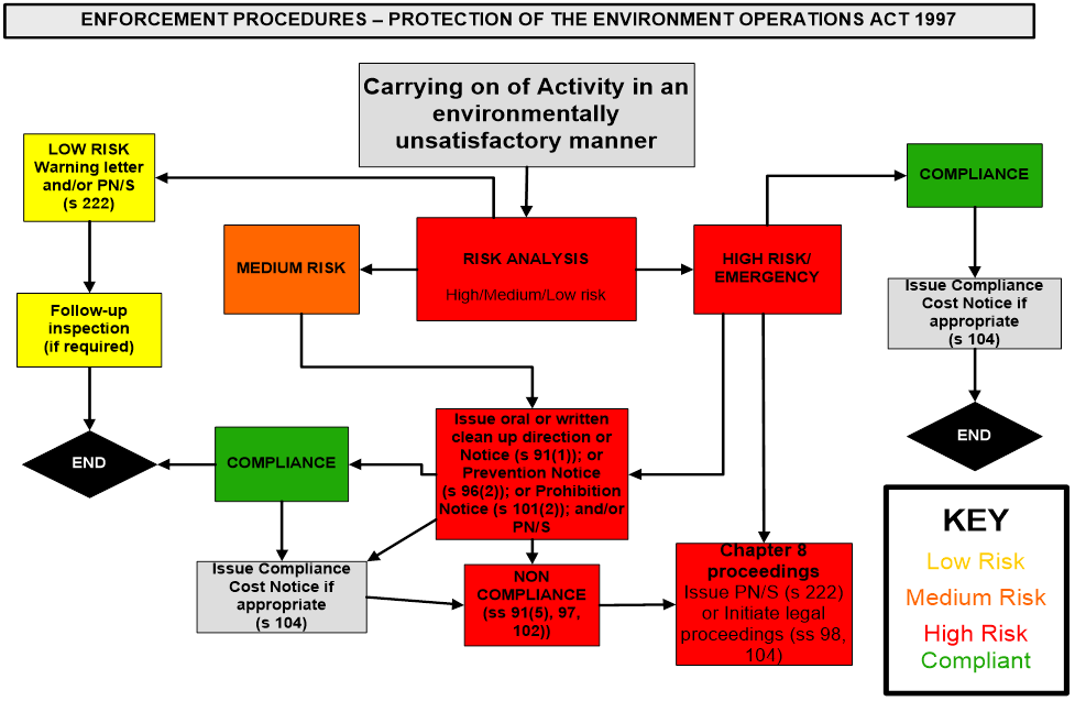
Appendix B Specific enforcement guidelines for certain regulatory activities
Appendix C Offences with prior warning
Appendix D Offences without prior warning
Appendix E Enforcement procedures
1.
1. Introduction
1.1 This Enforcement Policy (Policy) provides an overview of Orange City Council’s (Council) policy objectives, regulatory responsibilities and enforcement actions that can be taken by Council. The Policy also includes specific processes and procedures that provide guidance to those carrying out enforcement actions.
1.2 Council is involved in a broad range of regulatory activities, including but not limited to:
1.2.1 Local Government Act 1993 (LG Act),
1.2.2 Environmental Planning and Assessment Act 1979 (EP&A Act);
1.2.3 Protection of the Environment Operations Act 1997 (POEO Act)
1.2.4 Food Act 2003;
1.2.5 Public Health Act 2010; and
1.2.6 Companion Animals Act 1998.
1.3 The Policy helps Council staff act promptly, consistently and effectively in response to allegations of unlawful activity. The Policy reflects the need for a transparent decision making process and for enforcement actions to be carried out in an efficient, fair and consistent manner having regard to all the circumstances.
1.4 This Policy updates Council’s draft Enforcement Policy dated July 2010. The Policy reflects the updated NSW Ombudsman’s Model Compliance and Enforcement Model Policy (December 2015) and other key policy documents including the NSW Department of Planning and Environment’s Prosecution Guidelines (May 2016) and NSW Environment Protection Authority’s (EPA) Prosecution Guidelines (March 2013).
2. Purpose and scope
2.1 This Policy provides information for Council staff and the community about Council’s position on compliance and enforcement matters in the Orange local government area.
2.2 The purpose of this Policy is to:
2.2.1 enable the Council to acknowledge its obligation under section 8A of the LG Act to ensure that its regulatory powers are carried out fairly, ethically and without bias;
2.2.2 provide transparency in decision making and to facilitate a proportional approach to compliance and enforcement;
2.2.3 provide a proactive policy statement regarding the enforcement of compliance with legislation and/or condition/s of development consent;
2.2.4 foster prompt, consistent and effective action by the Council in response to allegations of unlawful activity while ensuring that the principles of procedural fairness are adhered to; and
2.2.5 set out how the Council balances its responsibilities for ensuring compliance with expected standards of conduct while also ensuring best possible value for residents and ratepayers in the use of Council funds. This Policy outlines matters to be considered at the various stages of the enforcement process.
2.3 In certain circumstances Council may have shared enforcement responsibilities with other regulatory authorities such as the NSW EPA and SafeWork NSW. This Policy sets out a collaborative and cooperative approach to such matters. Advice and guidance is also provided on the role of Council in building and construction compliance matters where there is a private certifier, and the role of councillors in enforcement.
2.4 Responsible Council staff are not limited by this Policy in their use of discretion and the exercise of official functions. The full circumstances and facts of each case need to be considered when determining whether any enforcement action should be taken by Council.
3. Organisational approach
3.1 Compliance and enforcement is important:
3.1.1 to prevent or minimise harm to health, welfare, safety, property or the environment;
3.1.2 to improve the safety and amenity of the City’s residents and visitors to the area;
3.1.3 for the collective good, the welfare of the community or the public interest;
3.1.4 to promote social policies (for example to preserve or protect the environment or assets of heritage significance);
3.1.5 to manage risks;
3.1.6 to uphold social order;
3.1.7 to meet the expectations of the community;
3.1.8 to encourage reports about possible unlawful activity from the community;
3.1.9 to make the regulated community aware of their legal obligations and how to comply; and
3.1.10 details of any other relevant strategic planning.
3.2 The objects section of the legislation that Council administers can specify the nature of the harm that is being addressed and explicitly state the regulatory purposes of the legislation. These objects should be considered when carrying out enforcement actions.
3.3 Under section 8A of the LG Act councils are obliged to ensure that in the exercise of their functions, relevantly:
3.3.1 councils should provide strong and effective representation, leadership, planning and decision-making;
3.3.2 councils should carry out functions in a way that provides the best possible value for residents and ratepayers;
3.3.3 councils should plan strategically, using the integrated planning and reporting framework, for the provision of effective and efficient services and regulation to meet the diverse needs of the local community;
3.3.4 councils should apply the integrated planning and reporting framework in carrying out their functions so as to achieve desired outcomes and continuous improvements;
3.3.5 councils should work co-operatively with other councils and the State government to achieve desired outcomes for the local community;
3.3.6 councils should manage lands and other assets so that current and future local community needs can be met in an affordable way; and
3.3.7 councils should act fairly, ethically and without bias in the interests of the local community.
4. Definitions
|
Meaning |
|
|
Complaint |
A complaint is an expression of dissatisfaction made about a Councillor or Council services, staff or the handling of a complaint, where a response or resolution is explicitly or implicitly expected or legally required.
For the purposes of this Policy, a complaint does not include: § a report alleging unlawful activity (see definition below); § a request for information about a Council policy or procedure; § a request for an explanation of actions taken by Council; or § a request for internal review of a Council decision; § a customer service request |
|
Enforcement |
Actions taken in response to serious or deliberate contraventions of laws.
|
|
Regulation |
Using a variety of tools and strategies to influence and change behaviour to achieve the objectives of an Act, Regulation or other statutory instrument administered by Council.
|
|
Report alleging unlawful activity
|
An expression of concern or a request for service in relation to alleged unlawful activity, where a response or resolution is explicitly or implicitly expected or legally required.
|
|
Unlawful activity
|
Any activity or work that has been or is being carried out contrary to the below and/or failure to take required action in order to be compliant with: § terms or conditions of a development consent, approval, permit or licence; § an environmental planning instrument that regulates the activities or work that can be carried out on particular land; § a legislative provision regulating a particular activity or work; or § a required development consent, approval, permission or licence. |
5. Policy objectives
5.1 The intent of this Policy is to establish clear guidelines and protocols for Council staff in the management of Council’s regulatory activities.
5.2 It provides guidance on:
5.2.1 responding to reports alleging unlawful activity;
5.2.2 assessing whether reports alleging unlawful activity require investigation;
5.2.3 deciding on whether enforcement action is warranted;
5.2.4 options for dealing with confirmed cases of unlawful activity;
5.2.5 taking legal action; and
5.2.6 implementing shared enforcement responsibilities.
5.3 The Policy also provides advice and guidance on:
5.3.1 the role of the Principal Certifying Authority; and
5.3.2 the role of councillors in enforcement.
6. Application
6.1 This Policy applies to regulatory activities within Council’s area of responsibility including, but not limited to:
6.1.1 development and building control;
6.1.2 pollution control;
6.1.3 environmental health;
6.1.4 public health and safety;
6.1.5 noxious weeds;
6.1.6 water and sewer;
6.1.7 septic systems;
6.1.8 control over animals;
6.1.9 food safety;
6.1.10 fire safety;
6.1.11 parking; and
6.1.12 tree preservation;
6.1.13 assets of heritage significance.
7. Compliance and enforcement principles
7.1 The following principles underpin Council actions relating to compliance and enforcement:
Principle: Accountable and transparent
7.1.1 acting in the best interests of public health and safety and in the best interests of the environment;
7.1.2 ensuring accountability for decisions to take or not take action;
7.1.3 acting fairly and impartially and without bias or unlawful discrimination;
7.1.4 providing information about compliance and enforcement priorities and reasons for decisions to improve understanding and certainty by the regulated community;
7.1.5 ensuring decisions are transparent, particularly when there is a departure from this Policy;
7.1.6 acting on any complaints or concerns about the conduct of compliance officers in accordance with Council’s Complaint Management Policy [ST016] and procedures advising people and organisations subject to enforcement action of any avenues available to seek an internal or external review of a decision;
Principle: Consistent
7.1.7 ensuring compliance and enforcement action is implemented consistently;
7.1.8 encouraging reports about possible unlawful activity by acting reasonably in response to the circumstances and facts of each matter;
Principle: Proportional
7.1.9 ensuring the level of enforcement action is proportionate to the level of risk and seriousness of the breach;
7.1.10 making cost-effective decisions about enforcement action;
7.1.11 taking action to address harm and deter future unlawful activity;
Principle: Timely
7.1.12 ensuring responses to reports alleging unlawful activity, and decision making and action in relation to those is timely.
8. Responsibility
8.1 Council receives information about alleged unlawful activity from members of the public, other government agencies and Council officers following inspections.
8.2 All Council staff who deal with reports alleging unlawful activity are responsible for implementing this Policy. Council staff are also responsible for ensuring that any other possible unlawful activity identified as a result of an inspection, proactive enforcement or other activity is brought to the attention of the appropriate Divisional Director of Council.
8.3 Council staff are required to:
8.3.1 treat all relevant parties with courtesy and respect;
8.3.2 communicate with all relevant parties and provide feedback on the progress of an investigation and any reasons for delay without compromising the integrity of the investigation;
8.3.3 make full and proper records in relation to the assessment and investigation of reports alleging unlawful activity, including reasons for any decisions;
8.3.4 inform all relevant parties of reasons for decisions;
8.3.5 ensure the outcomes of investigations demonstrate that adequate and appropriate action was taken and/or is proposed to be taken in response to a report of alleged unlawful activity; and
8.3.6 provide information to all relevant parties about any avenues to seek an internal or external review of a decision.
8.4 All reports alleging unlawful activity are to be entered into Council’s Customer Request Management System and actioned in a timely manner by the appropriate business unit in accordance with Council’s Customer Service Obligation Policy [ST021]. Council’s Customer Request Management System identifies:
8.4.1 responsibilities of those recording reports;
8.4.2 reasonable response time requirements and type of response;
8.4.3 reasonable timeframes in which actions need to be completed;
8.4.4 what information should be provided to the individual;
8.4.5 how information should be provided to the individual – [e.g. over the phone or in writing, with approval of general manager or team leader]; and
8.4.6 when such information should be provided to the individual.
8.5 Council’s action on reports alleging unlawful activity will be instigated within the following time frames:
8.5.1 Urgent and life threatening matters will be actioned as soon as possible following receipt of the report. Unsafe building works, unsafe pool fencing, dangerous awnings, collapsed building/wall, serious pollution, food safety issues, imminent damage to assets of heritage significance and public health and safety matters will be dealt with on the day of the receipt of a complaint.
8.5.2 General compliance matters will be dealt with on a priority basis having regard to the relative seriousness of the matter. These include works not in accordance with consent or construction without consent, illegal use, noise and food complaints.
8.5.3 Nuisance matters will be actioned in accordance with available resources; examples include domestic noise matters, minor non-compliance such as overgrown land or other matters in which there are no likely immediate health or safety implications.
8.6 Only Council staff with appropriate delegations from the General Manager can undertake investigations or compliance and enforcement action in relation to this Policy.
9. Responding to concerns about unlawful activity
How reports alleging unlawful activity will be dealt with by Council
9.1 Council will record and assess every report alleging unlawful activity.
9.2 Council will respond to every report unless the person raising the matter has indicated they do not wish to receive a response about Council’s handling of the matter, or the report is anonymous.
9.3 Generally speaking, Council’s objectives when dealing with reports alleging unlawful activity are to:
9.3.1 maintain the collective good and welfare of the community;
9.3.2 prevent or minimise harm to health, welfare, safety, property or the environment;
9.3.3 consider the broader public interest having regard to Council’s priorities and any resource limitations; and
9.3.4 consider the report fairly and impartially.
9.4 Not all reports will be investigated. A preliminary assessment of all matters will be made to determine the priority for a response, and whether investigation or other action is required.
9.5 An investigation of alleged unlawful activity may take a significant amount of time to complete, particularly where the issues are complex. If Council decides to investigate, staff will give the person who reported the alleged unlawful activity feedback on the progress of the investigation, and any reasons for delay. That person cannot expect to be given details about every aspect of the investigation or information that would compromise the integrity of the investigation.
9.6 Decisions about what action should be taken by Council are made at the Council’s discretion. This means the objective is that reports alleging unlawful activity will be resolved to the satisfaction of Council, not necessarily the person raising the matter. Council will generally try to resolve matters as quickly and informally as possible where this will lead to a satisfactory outcome so as to avoid unnecessary costs of taking formal action.
9.7 Council staff will endeavour to manage the expectations of people who report alleged unlawful activity, and in particular explain that in the absence of sufficient evidence of unlawful activity, Council may be unable to take further action. Council does not have unlimited resources and powers to deal with reports alleging unlawful activity. If Council is unable to fully investigate or take action on a matter because it is restricted by any legal or resource limitations this will be explained to the person.
9.8 While there are certain statutory requirements that must be met in relation to notices and orders Council staff will endeavour that all explanatory communications are made in plain English and explain any technical language that the law requires to be used.
Confidentiality of people who report allegations of unlawful activity
9.9 A person who reports allegations of unlawful activity should not expect that their identity will remain confidential from the subject of their report in all circumstances. Council may have to disclose information that identifies a person in the following cases:
9.9.1 the disclosure is necessary to investigate the matter;
9.9.2 their identity has already been disclosed to the subject of their report directly or in a publicly available document;
9.9.3 the person was consulted following receipt of a Government Information (Public Access) Act 2009 application and did not object to the disclosure;
9.9.4 the person consents in writing to their identity being disclosed;
9.9.5 the disclosure is required to comply with principles of procedural fairness; and
9.9.6 the matter proceeds to court.
9.10 Council will take seriously any concerns a person may have about their physical safety being endangered as a result of making a report. However, this may limit Council’s ability to investigate the matter.
What Council expects from people who report allegations of unlawful activity
9.11 Council expects a person who reports allegations of unlawful activity will cooperate and act in good faith in respect of any investigations conducted by Council. This includes:
9.11.1 providing a clear description of the problem (and the resolution sought, if relevant);
9.11.2 giving all available and relevant information to Council, including any new information about the alleged activity that may become known to the person following the making of their report;
9.11.3 not giving any information that is intentionally misleading or wrong;
9.11.4 cooperating with Council’s inquiries and giving timely responses to questions and requests for information;
9.11.5 treating Council’s staff with courtesy and respect; and
9.11.6 allowing the investigation to be completed without prematurely taking the matter to other agencies unless referred to by Council.
9.12 If these expectations of the reporting person are not met, Council may need to set limits or conditions on the continuation of the investigation or may need to restrict any further communications with the person.
9.13 Any unreasonable conduct will be dealt with in accordance with the principles of Council’s Code of Conduct [ST010] and the NSW Ombudsman’s Managing Unreasonable Complainant Conduct Manual 2012.
What parties can expect from Council staff
9.14 A person who reports alleged unlawful activity, as well as individuals or businesses that are subject to investigation and any enforcement action, can expect that Council staff will:
9.14.1 treat them with courtesy and respect;
9.14.2 advise them of the outcome of Council’s investigation of the alleged unlawful activity, including explanation of the reasons why that outcome was considered to be reasonable in the circumstances;
9.14.3 clearly explain decisions in plain English;
9.14.4 provide information about any relevant internal and external appeal processes that may be available; and
9.14.5 carefully assess any new information provided by any party after a decision has been made and advise whether further action will be taken.
9.15 Any disclose of information is subject to the overriding obligations of Council in relation to legal professional privilege, the Government Information (Public Access) Act 2009 and the Privacy and Personal Information Protection Act 1998.
Complaints about Council’s enforcement actions
9.16 Any complaints about Council’s handling of reports alleging unlawful activity will be recorded separately and handled in accordance with Council’s Complaints Management Policy and procedures.
9.17 Where a person or organisation subject to enforcement action merely disputes Council’s decision to take enforcement against them, they will be directed to make representations in accordance with any relevant internal and external appeal processes.
9.18 Council staff will act on any complaints about the conduct of compliance officers in accordance with Council’s Complaints Management Policy and procedures.
9.19 Anonymous reports will be recorded and assessed in accordance with the above requirements. However, because it is not possible to seek clarification or additional information about a matter, it may be more difficult to evaluate the allegations and therefore these reports are less likely to lead to investigation.
Unlawful activity outside business hours
9.20 Unlawful activity can occur outside business hours. In particular, Council may receive reports about matters such as dogs, offensive noise and failure to comply with limitations on hours of operation during nights and weekends.
9.21 Due to resource and operational capability restraints on Council, investigations into alleged unlawful activity outside business hours will be assessed on the basis of risk of harm to health, welfare, safety, property or the environment or whether it is otherwise in the public interest to take such action.
Neighbour disputes
9.22 Council will at times receive reports from parties involved in neighbour disputes seeking Council’s involvement. When a dispute between two neighbours is a civil matter, Council will often have no authority to resolve the issue in dispute. Some reports will raise several matters, some of which will require Council’s involvement and some of which will be personal to the parties.
9.23 Council staff will thoroughly assess such reports to determine whether there is evidence of any possible unlawful activity requiring action by Council. Care will be taken to explain which aspects of a report Council can deal with and which cannot be dealt with and why. Where possible, parties will be provided with information or referred to services and resources about how to resolve neighbour disputes such as LawAccess NSW, Community Justice Centres or private mediation.
9.24 It is possible that one party will provide further information about a matter which changes Council’s decision about whether it will become involved. In such circumstances, Council staff will carefully consider the matter before taking action and document reasons for the new decision. The parties will be advised about the reasons Council has changed its position on a matter. Council staff will not change a decision about whether or not Council should be involved purely as a response to the conduct of an individual such as persistent demands or threats.
10. Investigating alleged unlawful activity
10.1 Not all reports alleging unlawful activity will warrant investigation. A preliminary assessment of all matters will be made to determine whether investigation or other action is required. Council will prioritise matters on the basis of risk to public safety, human health, the environment and risk to assets of heritage significance.
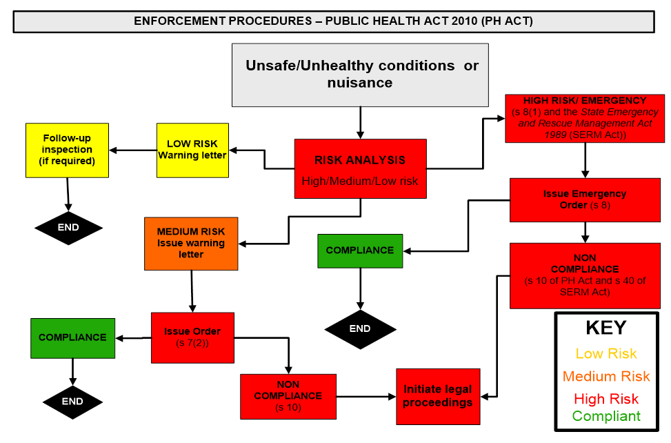
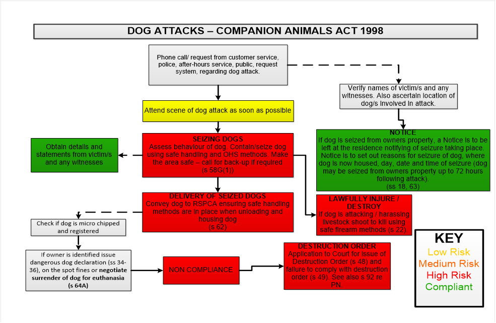
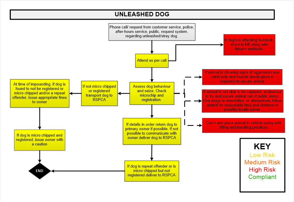
10.2 Council uses a risk based category system which identifies high, medium and low risks for common unlawful activities in order to prioritise enforcement action. This assists Council with managing expectations and the allocation of its resources. Appendix E includes flow charts of Council’s decision making for common unlawful activities. The flowcharts identify the actions taken by Council when the risks of the unlawful activity have been identified as high, medium and low risk.
10.3 If there is insufficient information in the report to undertake a preliminary assessment, further information may need to be sought from the person who made the report or an inspection undertaken.
Circumstances where no action will be taken
10.4 Council will take no further action if, following a preliminary assessment, it is identified that:
10.4.1 Council does not have jurisdiction to investigate or is not the appropriate authority to take action on the issues raised. Where there is another appropriate authority or course of action, council may bring the matter to the attention of the authority or provide information and contact details to the person reporting the incident. For example SafeWork NSW for workplace safety matters and the NSW EPA for possible environmental offences and Community Justice Centres NSW for personal disputes;
10.4.2 the report relates substantially to a matter previously determined by Council and no new or compelling information is presented which would cause Council to change its earlier decision. In this case, Council staff will acknowledge the report and advise that no further action will be taken as no new information had been provided (other than where the person has previously been advised they would receive no further response);
10.4.3 the allegations relate to a lawful activity (for example, where there is an existing approval or the activity is permissible without Council approval or consent being required);
10.4.4 the report is not supported with evidence or appears to have no substance; and
10.4.5 the relevant Council manager, director or the general manager determines that investigation or other action would have an unreasonable impact on resources and/or is unlikely to achieve an outcome sufficient to justify the expenditure of resources.
Relevant factors guiding decisions as to whether to take action
10.5 When deciding whether to investigate, Council will consider a range of factors including whether:
10.5.1 the activity is having a significant detrimental effect on the environment or assets of heritage significance, or it constitutes a risk to public safety or human health;
10.5.2 the report is premature as it relates to some unfinished aspect of work that is still in progress;
10.5.3 the activity or work is permissible with or without permission;
10.5.4 all conditions of consent are being complied with;
10.5.5 much time has elapsed since the events the subject of the report took place;
10.5.6 another authority is a more appropriate agency to investigate and deal with the matter;
10.5.7 it appears there is a pattern of conduct or evidence of a possible wide spread problem;
10.5.8 the person or organisation reported has been the subject of previous reports;
10.5.9 the report raises matters of special significance in terms of the Council’s existing priorities;
10.5.10 there are significant resource implications in relation to an investigation and any subsequent enforcement action; and
10.5.11 it is in the public interest to investigate the report.
10.6 The above are factors for Council to consider and weigh in making a determination. Council staff are not limited in their use of discretion by these considerations and may decide to investigate based on these and other factors.
10.7 The objective of the processes council staff use when investigating incidents of alleged unlawful activity is to:
10.7.1 determine the cause of the incident;
10.7.2 determine if there has been a contravention of law, policy or standards;
10.7.3 gather evidence to the required standard to support any required enforcement action; and
10.7.4 determine any necessary action to mitigate the possibility of reoccurrence of similar incidents.
10.8 Any decision not to investigate an allegation of unlawful activity will be recorded and the reasons for that decision clearly stated.
11. Taking enforcement action
11.1 When deciding whether to take enforcement action in relation to a confirmed case of unlawful activity, Council will consider the full circumstances and facts of the matter and the public interest. The following common considerations will assist Council staff in determining the most appropriate response in the public interest. A further explanation of the considerations below is provided in Appendix A.
Considerations about the alleged offence and impact
11.2 Council will consider:
11.2.1 the nature, extent and severity of the unlawful activity, including whether the activity is continuing;
11.2.2 the harm or potential harm to the environment, assets of heritage significance, public health, safety or amenity caused by the unlawful activity;
11.2.3 the seriousness of the breach, including whether the breach is merely technical, inconsequential or minor in nature; and
11.2.4 the time period that has lapsed since the date of the unlawful activity.
Considerations about the alleged offender
11.3 Council will consider:
11.3.1 any prior warnings, instructions, advice that was issued to the person or organisation reported or previous enforcement action taken against them;
11.3.2 whether the offence was committed with intent;
11.3.3 whether the person or organisation reported has been proactive in the resolution of the matter and assisted with any Council requirements and instructions;
11.3.4 any mitigating or aggravating circumstances demonstrated by the alleged offender; and
11.3.5 any particular circumstances of hardship affecting the person or organisation reported.
Considerations about the impact of any enforcement action
11.4 Council will consider:
11.4.1 the need to deter any future unlawful activity;
11.4.2 whether an educative approach would be more appropriate than a punitive approach in resolving the matter;
11.4.3 the prospect of success if the proposed enforcement action was challenged in court;
11.4.4 the costs and benefits of taking formal enforcement action as opposed to taking informal or no action;
11.4.5 what action would be proportionate and reasonable in response to the unlawful activity; and
11.4.6 whether Council is prevented from taking action based on earlier advice given, i.e. whether an estoppel situation has been created.
Considerations about the potential for remedy
11.5 Council will consider:
11.5.1 whether the breach can be easily remedied;
11.5.2 whether it is likely consent would have been given for the activity if it had been sought;
11.5.3 whether there is a draft planning instrument on exhibition that would make the unauthorised use legal;
Legal or technical issues
11.6 Where legal and/or technical issues are in question, Council staff will consider whether legal advice or professional advice from duly qualified staff or other experts should be obtained and considered. Council may also require the person subject to possible enforcement action to obtain professional advice in relation to issues of concern to Council for assessment as to whether further action is required.
Requirements of Council staff considering enforcement action
11.7 Prior to taking enforcement action, Council staff will take into account the above considerations as well as the evidence gathered during their investigation. Council staff must act impartially, be mindful of their obligations under Council’s Code of Conduct and not act as a decision-maker in relation to any matter in which they have a personal interest. Enforcement action will not be taken (or not taken) purely as a response to the conduct of an individual such as persistent demands or threats.
11.8 Council staff are required to maintain records about decision-making processes in relation to reports alleging unlawful activity and any enforcement action, as well as records of interactions with relevant parties. Council staff will at all times adhere to Council’s internal approval processes prior to the commencement of any enforcement action
11.9 Council staff will take steps to ensure that any enforcement action is taken against the correct person or organisation. Where there are multiple possible parties to an alleged unlawful activity, it will generally not be appropriate to take enforcement action against every person who may be liable for the alleged unlawful activity. In such circumstances, Council staff will be guided by legal advice in determining the appropriate person/s to pursue.
11.10 In addition to this Policy, Council may also adopt guidelines for Council staff about specific types of regulatory activity and the circumstances in which enforcement action will or will not be taken. Appendix B provides specific guidelines for Council staff for unauthorised building works. Council may prepare further guidelines for other areas of regulatory activity.
11.11 The guidelines prepared by Council are intended to be used as a guide only, and therefore may be departed from by Council staff at any time. The full circumstances and facts of each case will be considered.
Procedural fairness
11.12 Council will ensure that the principles of procedural fairness are adhered to prior to a decision being made about enforcement action. The following principles will be addressed and implemented by the Council:
11.12.1 Whoever is the subject of concern will know all the allegations in relation to their action;
11.12.2 All parties to the alleged unlawful activity will have the right to be heard;
11.12.3 All relevant submissions and evidence will be considered;
11.12.4 Matters which are not relevant will not be taken into account;
11.12.5 The person reporting the alleged unlawful activity will not determine the matter; and
11.12.6 The decision-maker will be fair and just.
12. Options for dealing with confirmed cases of unlawful activity
12.1 Council will try to use the quickest and most informal option to deal with unlawful activity wherever possible unless:
12.1.1 there is little likelihood of compliance with such options;
12.1.2 the unlawful activity is part of a pattern of conduct and formal action is appropriate in the circumstances.
12.2 Council staff will use discretion to determine the most appropriate response to confirmed cases of unlawful activity and may take more than one approach.
12.3 Any enforcement action taken by Council will depend on the full circumstances and facts of each case, with any decision being made on the merits.
12.4 At all times, Council’s key concerns are:
12.4.1 to prevent or minimise harm to health, welfare, safety, property, assets of heritage significance, or the environment; and
12.4.2 to influence behaviour change for the common good and on behalf of the community.
12.5 Council has a range of enforcement options available to it. The following enforcement options to be considered by Council are ordered to reflect an escalation in response that is proportionate to the level of risk, the seriousness of the confirmed breach or the need for a deterrent.
Level of risk: very low
12.5.1 take no action on the basis of a lack of evidence or some other appropriate reason;
12.5.2 provision of information/advice on how to be compliant;
Level of risk: low
12.5.3 negotiating with the person to obtain voluntary undertakings or an agreement to address the issues of concern;
12.5.4 issuing a verbal/written warning, a formal caution or a show cause letter;
Level of risk: Medium
12.5.5 issuing a letter requiring work to be done or activity to cease in lieu of more formal action;
Level of risk: High
12.5.6 issuing a penalty notice;
12.5.7 issuing a notice of intention to serve an order or notice under relevant legislation, and then serving an order or notice if appropriate (for example, under ss. 124-128 of the LG Act, s. 9.39 of the EP&A Act, and Pts 4.2-4.4 and 8.6, and Schedule 5 of the POEO Act);
12.5.8 carrying out the works specified in an order at the cost of the person served with the order (s. 678 LG Act).
Level of risk: Very High
12.5.9 seeking an injunction through the courts to prevent future or continuing unlawful activity;
12.5.10 issuing an order under relevant legislation in an emergency (for example, Schedule 5, items 5(3) and 6(2)(c) of the EP&A Act);
12.5.11 commence civil proceedings in the Land and Environment Court for an order to remedy or restrain a breach of the relevant Act or Regulation (s. 673 LG Act; s. 9.45 EP&A Act); and
12.5.12 commence criminal proceedings for an offence against the relevant Act or Regulation (s. 691 LG Act, ss. 9.37, 9.50 EP&A Act, Chapter 5 POEO Act).
12.6 Appendix C lists the offences where prior warning (verbal or written) is likely to be given to the offender/s before any enforcement action (in the form of the service of an order or notice or penalty notice or court action) is taken.
12.7 Appendix D lists the offences where no prior warning is likely to be given to the offender/s before any enforcement action is taken.
Following up enforcement action
12.8 All enforcement action will be reviewed and monitored to ensure compliance with any undertakings given by the subject of enforcement action or advice, directions or orders issued by Council. Reports alleging continuing unlawful activity will be assessed and further action may be taken if necessary. If the unlawful activity has ceased or the work has been rectified, the matter will be resubmitted for follow up action to ensure compliance outcomes are met. Should initial enforcement action be found to have been ineffective, Council staff will consider other enforcement options.
13. Taking legal action
13.1 Council and its delegated staff will consider the following in deciding whether to commence criminal or civil proceedings:
13.1.1 whether there is sufficient evidence to establish a case to the required standard of proof;
13.1.2 whether there is a reasonable prospect of success before a court; and
13.1.3 whether the public interest warrants legal action being pursued.
Whether there is sufficient evidence to establish a case to the required standard of proof
13.2 Council considers the decision to take legal action a serious matter, and as such will only initiate and continue proceedings once it has been established that there is admissible, substantial and reliable evidence to the required standard of proof and the public interest warrants legal action being pursued.
13.3 The basic requirement of any criminal prosecution is that the available evidence establishes a prima facie case. The prosecutor is required to prove the elements of the offence beyond reasonable doubt.
13.4 In civil enforcement proceedings, Council will require sufficient evidence to satisfy the court that an actual or threatened breach has occurred on the balance of probabilities.
Whether there is a reasonable prospect of success before a court
13.5 Given the expense of legal action Council will not take legal action unless there is a reasonable prospect of success before a court. In making this assessment, Council staff will consider various matters including the availability, competence and credibility of witnesses, the admissibility of the evidence, all possible defences, and any other factors which could affect the likelihood of a successful outcome.
Whether the public interest requires legal action be pursued
13.6 The principal consideration in deciding whether to commence legal proceedings is whether to do so is in the public interest. In making this determination, the same factors to be considered when taking enforcement action apply (See Section 11, Taking enforcement action).
13.7 The following considerations relate more specifically to the decision to commence legal proceedings and will assist Council and its delegated staff in making this determination:
13.7.1 the availability of any alternatives to legal action;
13.7.2 whether an urgent resolution is required (court proceedings may take some time);
13.7.3 the possible length and expense of court proceedings;
13.7.4 any possible counter-productive outcomes of court proceedings;
13.7.5 what the effective sentencing options are available to the court in the event of conviction; and
13.7.6 whether the proceedings or the consequences of any resulting conviction would be unduly harsh or oppressive.
Time within which to commence proceedings
13.8 Council staff must be aware of legislative time limits (limitation periods) in which enforcement proceedings must be commenced. Sometimes legal action will be statute barred despite good evidence that unlawful activity has occurred.
13.9 Limitation periods vary for criminal and civil enforcement actions. Council staff will consider the relevant limitation periods in the relevant legislation administered by Council.
14. Shared enforcement responsibilities
14.1 Some reports will raise matters involving shared regulatory responsibilities between Council and other authorities including the NSW EPA, the NSW Police Force, Liquor & Gaming NSW, NSW Fair Trading, NSW Food Authority and Department of Industry (Crown Lands).
14.2 Council recognises that collaboration and cooperation between authorities to address issues of shared regulatory responsibility is the best approach. To this end, where there are shared legislative responsibilities, Council staff will liaise with relevant authorities to establish:
14.2.1 which authority will take the leading role on any joint investigation;
14.2.2 which activities each authority will carry out;
14.2.3 responsibilities for updating an individual where relevant; and
14.2.4 protocols for exchanging confidential information between the relevant authorities.
14.3 Council will reasonably endeavour to respond to requests for information or assistance on joint regulatory matters in a timely manner.
15. Role of Council where there is a private certifier
15.1 Council retains its regulatory role and enforcement powers where a private certifier has been appointed the Principal Certifying Authority (PCA). However, if a private certifier is appointed the PCA, it is not Council’s responsibility to ensure building and construction compliance.
15.2 Private certifiers have limited enforcement powers as the PCA. Private certifiers have the power to issue a notice of intention to issue an order to the owner or builder to comply with the conditions of consent or rectify any breaches. A copy of any notice of intention issued by a private certifier must be provided to Council for assessment as to whether Council will enforce the notice by issuing an order.
15.3 Council and private certifiers will work together to resolve any issues when they arise to achieve compliance with the development consent or complying development certificate. Council staff will take steps to ensure individuals are clear about which agency performs which role.
16. Role of councillors in enforcement
16.1 Decision making relating to the investigation of reports alleging unlawful activity and taking enforcement action is the responsibility of appropriately authorised Council staff or the Council itself.
16.2 Individual councillors do not have the right to direct Council staff in their day-to-day activities. Councillors can help individuals who raise concerns with them by satisfying themselves that Council’s policies are being carried out correctly, however they cannot deviate from Council’s policies in order to satisfy that individual’s concerns.
16.3 The general manager may present certain decisions to be ratified by Council if this is necessary or desirable, and the councillors may also have the right to call for a report about particular issues at a Council meeting.
17. Delegations
17.1 Delegations conferred on staff to initiate various levels of enforcement action are set out in the relevant Council officer’s delegations, all officers having appropriate delegations are authorised to undertake appropriate enforcement action.
17.2 Council officers have delegations under the following legislation:
17.2.1 Australian Road Rules;
17.2.2 Roads Act 1993;
17.2.3 Impounding Act 1993;
17.2.4 Companion Animals Act 1998;
17.2.5 Food Act 2003;
17.2.6 Public Health Act 1991;
17.2.7 Swimming Pools Act 1992;
17.2.8 Noxious Weeds Act 1993;
17.2.9 Rural Fires Act 1997;
17.2.10 Contaminated Land Management Act 1997;
17.2.11 Environmental Planning and Assessment Act 1979;
17.2.12 Local Government Act 1993; and
17.2.13 Protection of the Environment Operations Act 1997, and the various Regulations made there under.
17.3 Council staff delegations for taking action under this Policy are included in Council’s Delegation Register
18. Approval
18.1 This Policy was approved by Council on [Council to insert date].
19. Review
19.1 This Policy is to be reviewed every five years.
1.1 When deciding whether to take enforcement action in relation to a confirmed case of unlawful activity, Council will consider all the circumstances of the matter. The section below is intended to assist staff by providing a further explanation of matters to be taken into consideration when deciding whether to take enforcement action.
Considerations about the alleged offence and impact
1.2 Considerations include:
1.2.1 the nature, extent and severity of the unlawful activity including whether the activity continued;
1.2.2 the harm or potential harm to the environment, assets of heritage significance, public health, safety or amenity caused by the unlawful activity;
1.2.3 the seriousness of the breach, including whether the breach is merely technical, inconsequential or minor in nature;
1.2.4 the costs and benefits of taking formal enforcement action as opposed to taking informal or no action; and
1.2.5 the time period that has lapsed since the date of the unlawful activity.
1.3 Consideration should be given to the nature, extent and severity of any actual or potential impact of the unlawful activity. If there is actual or potential detriment to the natural or built environment, to the health or safety of residents or the amenity of an area, this would normally warrant a decision to take action to remedy or restrain the breach. It is also important to consider whether the unlawful activity is ongoing or has ceased.
1.4 Consideration should be given to whether the likely costs and benefits of any enforcement action is justifiable where breaches result in no material impacts upon any other party or the health, safety and amenity of the environment and community. A breach of a technical, inconsequential or minor nature, in the absence of any other aggravating factor, will generally not warrant a decision to take action to remedy or restrain the breach.
1.5 Legislation may provide time limits in which to commence proceedings and take enforcement action, and sometimes prosecution will be statute barred despite good evidence that unlawful activity has taken place. Carefully consider any such statutory time periods for taking action or obtain advice if necessary.
1.6 In addition, consideration should be given to the time at which the offence or breach occurred and the ‘reasonableness’ of taking enforcement action if a significant time has lapsed since the time of the offence or breach.
Considerations about the alleged offender
1.7 Considerations include:
1.7.1 any prior warnings, instructions, advice that was issued to the person or organisation reported or previous enforcement action taken against them;
1.7.2 whether the offence was committed with intent;
1.7.3 whether the person or organisation reported has been proactive in the resolution of the matter and assisted with any Council requirements and instructions;
1.7.4 any mitigating or aggravating circumstances demonstrated by the subject of the report; and
1.7.5 any particular circumstances of hardship affecting the person or organisation reported.
1.8 Consideration should be given to the previous history of the offender. If prior warnings, instructions or advice have been issued to the person or organisation reported and were not followed, a more formal (and/or punitive) enforcement approach may be more appropriate.
1.9 Consideration should be given to whether the offence was committed deliberately, recklessly or with gross negligence. Cases of this nature may more appropriately result in prosecution. Where an offence was committed as a result of an accident or genuine mistake, providing education and guidance or a formal warning may be more suitable in achieving desired outcomes.
1.10 Where the offender has been proactive in the resolution of the matter and has assisted Council in the resolution of the matter, it may be that the public interest would not be best served by prosecuting the offender, especially if the offending conduct or work has been rectified. If the offender has demonstrated a lack of contrition and is uncooperative with the investigation or mediation, a prosecution or monetary penalty would appear more appropriate.
1.11 Consideration should be given to any genuine mitigating circumstances of the offender such as age, physical or mental health, disability and any financial hardship of the offender resulting in an inability to pay.
Considerations about the impact of the enforcement action
1.12 Considerations include:
1.12.1 the need to deter any future unlawful activity;
1.12.2 whether an educative approach be more appropriate than a punitive approach in resolving the matter;
1.12.3 the prospect of success if the proposed enforcement action was challenged in court;
1.12.4 the costs and benefits of taking formal enforcement action as opposed to taking informal or no action;
1.12.5 what action would be proportionate and reasonable in response to the unlawful activity; and
1.12.6 whether the Council has created an estoppel situation.
1.13 Consideration should be given to the deterrent effect, both on the offender and others. Prosecutions, because of their great stigma if a conviction is secured, may be appropriate even for minor unlawful activity where it is likely to result in a greater level of overall deterrence.
1.14 When deciding whether to take an educative approach or enforcement approach, consideration should be given to the following matters:
1.14.1 the reasonable likelihood that the person may have known or should have known the relevant requirements or rules;
1.14.2 the level of contrition shown by the responsible person;
1.14.3 whether the parties have previously been advised of the regulatory requirements or provisions;
1.14.4 whether or not any previous warnings or instructions have been provided; and
1.14.5 the apparent level of intent shown by the responsible person.
1.15 It may not be appropriate to take enforcement action if the chances of success, in the event of an appeal or hearing, are unlikely. In such situations, you would need to identify the causes of that likelihood and address them in the particular case or as a general issue.
1.16 Consideration should be given to what is reasonable in the particular circumstances that apply. This includes a reasonable proportionality between the ends to be achieved and the means used to achieve them.
1.17 Consideration is to be given to what is reasonable in the circumstances and ensure the action is not disproportionate to the level of harm or damage arising from the breach.
1.18 Legal proceedings are expensive. When doing a cost-benefit analysis, costs and benefits should be assessed broadly and indirect costs and benefits should also be considered.
1.19 Estoppel is a legal rule which prevents a person from later denying something which may have previously been relied on, and acted upon by another person.
1.20 Consideration should be given to whether the actions of Council have created a reasonable expectation that no enforcement action would be taken.
Considerations about the potential for remedy
1.21 Considerations include:
1.21.1 whether the breach can be easily remedied;
1.21.2 whether it is likely consent would have been given for the activity if it had been sought; and
1.21.3 whether there is a draft planning instrument on exhibition that would make the unauthorised use legal.
1.22 If there is evidence of a significant issue of unlawful activity and that matter can be easily remedied by some action on the part of the person the subject of the report, there is a less compelling case for enforcement action, depending on the other circumstances of the case such as the conduct of the offender.
1.23 If retrospective approval is possible, it may be reasonable to allow an opportunity to obtain this prior to taking other enforcement action. In some cases, compliance by informal means may be the most efficient way to resolve the matter and other enforcement action may not be necessary.
1.24 This needs to be balanced with other considerations such as the public interest in enforcing the law.
Unauthorised building works
Scope of Council’s role
1.1 Council’s role as a regulatory authority is to protect public health and safety. Council is also responsible for certification and compliance with building standards and fire safety requirements. Council deals with reports alleging unlawful activity and takes action where appropriate.
1.2 Council’s officers are authorised to inspect premises and structures for compliance with the legislation.
1.3 Structural and other work to a property and some uses of buildings for activities may require Council approval.
Relevant legislation and standards
1.4 Relevant legislation and standards include:
1.4.1 Local Government Act 1993;
1.4.2 Building Professionals Act 2005;
1.4.3 Environmental Planning and Assessment Act 1979;
1.4.4 Protection of the Environment Operations Act 1997;
1.4.5 National Construction Code – Volumes 1, 2 and 3 (includes the Building Code of Australia);
1.4.6 National Plumbing Code:
1.4.7 State Environmental Planning Policy (Exempt and Complying Development Codes) 2008; and
1.4.8 Orange Local Environmental Plan 2011.
What action may be taken on confirmed cases of unlawful activity?
1.5 Council assesses allegations of unlawful activity in accordance with its compliance and enforcement policy.
1.6 Some examples of how Council staff may decide to act in particular circumstances are outlined below. The examples are not exhaustive and are intended as a guide only.
1.7 Enforcement option: Warning
1.8 Enforcement option: Penalty notice
1.9 Enforcement option: Notice of intention to issue an order
1.10 Enforcement option: Emergency order (without notice)
1.11 Enforcement option: Injunction
1.12 The following offences may result in a prior written warning being given to the person/s before any enforcement action in the form of the service of an order or notice or penalty infringement notice or court action is undertaken.
1.12.1 Annual Fire Safety Statement- non submission by owner;
1.12.2 Advertising signs without approval or creating unsightly conditions;
1.12.3 Air pollution – smoky chimney;
1.12.4 Barking / Roaming dog, unregistered dog;
1.12.5 Development / Activity without consent or not in accordance with a condition/s of consent;
1.12.6 Minor development or old unauthorised development;
1.12.7 Minor breach of consent condition/s;
1.12.8 Erosion & sediment control matters (owner/builder – sediment fences and similar offences, minor environmental offences);
1.12.9 Fire hazard of a less serious nature;
1.12.10 Food safety/hygiene matters of a less serious nature;
1.12.11 Obstruction of public place / road (minor matters);
1.12.12 Residential swimming pool issue not serious (e.g. resuscitation chart not provided); and
1.12.13 Revocation of an approval (e.g. footpath dining/ place of public entertainment).
1.13 In relation to noise pollution:
1.13.1 Air conditioner (s 45(b));*
1.13.2 Musical instrument and sound equipment (s 57(b));*
1.13.3 Power tools (s 51(1)(b));*
1.13.4 Motor vehicle on residential premises (s 8B);*
1.13.5 Use of refrigeration equipment fitted to motor vehicle (s 9B);*
1.13.6 Intruder alarm; and
1.13.7 Non-compliance with an Order/Notice/Direction- work partly done or other mitigating circumstances.
* Mandatory warning required under the Protection of the Environment Operation (Noise Control) Regulation 2017.
1.14 Note that the above list of offences is an indication only and any offences not listed will be considered on their individual merits and by reference to Council’s relevant statutory obligations and powers.
1.15 The following offences may result in no prior warning being given to the person/s before any enforcement action in the form of the service of an order or notice or penalty infringement notice or court action is undertaken:
1.15.1 Dangerous Dog Order / Attacking Dog / Restricted Dog;
1.15.2 Nuisance Dog Order;
1.15.3 Dangerous building / awning;
1.15.4 Dangerous waterhole;
1.15.5 Littering;
1.15.6 Deposit litter from vehicle;
1.15.7 Deposit litter / Dumped Rubbish;
1.15.8 Pollution Incident – Failure to notify;
1.15.9 Noise pollution generally after prescribed mandatory warning;
1.15.10 Noise abatement direction;
1.15.11 Pollute Waters;
1.15.12 Environmental damage of a significant nature;
1.15.13 Significant damage to or destruction of assets of heritage significance;
1.15.14 Erosion & sediment control matters;
1.15.15 Development not in accordance with consent / risk to health and safety / bush fire protection / notice of intention issued by PCA;*
1.15.16 Development without consent – unsatisfactory explanation / no explanation repeat offender / prohibited development / risk to health and safety or environment;*
1.15.17 Not comply with condition of development consent/approval to operate;*
1.15.18 Dilapidated building;
1.15.19 Fire hazard threatening an asset;
1.15.20 Food safety matters of a serious nature;
1.15.21 Failure to pay Clean Up / Prevention Notice fee;
1.15.22 Failure to comply with order / notice / cease use of premises / failure to comply with order regarding development consent / demolish remove unlawful building / threatening life / public safety / environment / amenity protection/ fence land / keeping of birds and animals/ remove object from public place / contravene noise control notice/ noise pollution;
1.15.23 Obstruction of road / public place involving safety;
1.15.24 Obstruction / intimidation/ assault of a Council officer;
1.15.25 Parking offences;
1.15.26 Swimming Pool fencing / gates / open; and
1.15.27 Street Trading without consent / approval.
*Only considered in an emergency (see Schedule 5 of the EP&A Act).
1.16 Note that the above list of offences is an indication only and any offences not listed will be considered on their individual merits and by reference to Council’s relevant statutory obligations and powers.
2.4 Orange Local Environmental Plan 2011 - Planning Proposal for an Administrative Amendment
Attachment 1 Planning Proposal - LEP Amendment 24
|
|
 http://armidaleregional.nsw.gov.au/
Planning Proposal No. 24 – Orange LEP 2011 Administrative Amendment
December 2018
Orange City Council
135 Byng Street, Orange
NSW 2800
P 02 6393 8000
E council@orange.nsw.gov.au
TABLE OF CONTENTS
|
Heading |
Page |
|
|
|
|
INTRODUCTION |
1 |
|
PART 1 – OBJECTIVES OR INTENDED OUTCOMES |
1 |
|
PART 2 – EXPLANATION OF PROVISIONS |
1 |
|
PART 3 – JUSTIFICATION |
2 |
|
SECTION A: Need for the planning proposal |
2 |
|
Q1. Is the planning proposal a result of any strategic study or report? Q2. Is the planning proposal the best means of achieving the objectives or intended outcomes, or is there a better way? |
2
3 |
|
SECTION B: Relationship to strategic planning framework |
3 |
|
Q3. Is the planning proposal consistent with the objectives and actions of the applicable regional, sub-regional or district plan or strategy (including any exhibited draft plans or strategies)? Q4. Is the planning proposal consistent with a Council’s local strategy or other local strategic plan? Q5. Is the planning proposal consistent with applicable State Environmental Planning Policies? Q6. Is the planning proposal consistent with applicable Ministerial Directions (section 9.1 Directions)? |
3
8
9
9 |
|
SECTION C: Environmental, social, and economic impacts |
9 |
|
Q7. Is there any likelihood that critical habitat or threatened species, populations or ecological communities, or their habitats, will be adversely affected as a result of the proposal? Q8. Are there any other likely environmental effects as a result of the planning proposal and how are they proposed to be managed? Q9. Has the planning proposal adequately addressed any social and economic effects? |
9
10
12 |
|
SECTION D: State and Commonwealth interests |
13 |
|
Q.10 Is there adequate public infrastructure for the planning proposal? Q.11 What are the views of State and Commonwealth Public Authorities consulted in accordance with the gateway determination? |
13
13 |
|
PART 4 – MAPPING |
14 |
|
PART 5 – COMMUNITY CONSULTATION |
14 |
|
PART 6 – PROJECT TIMELINE |
15 |
|
|
|
|
ATTACHMENTS |
|
|
Attachment 1. Amendment to Schedule 5 Environmental Heritage |
|
|
Attachment 2. Amendment to LEP maps to rectify cadastre changes |
|
|
Attachment 3. Amendment to Schedule 2 Exempt Development |
|
|
Attachment 4. Amendment to Flood planning controls |
|
|
Attachment 5a. Adoption of Combined Local Map 1 Sheet 12 to complete the water catchment boundary |
|
|
Attachment 5b. Amend Combined Local Map 1 Sheets 9, 10 and 15 to update the airport Obstacle Limitation Surface |
|
|
Attachment 6a. Amend clause 4.1C in relation to multi dwelling housing in Ploughmans Valley |
|
|
Attachment 6b. Amend clause 4.2 to include Zone E3 Environmental Management. |
|
|
Attachment 6c. Adopt a new clause in relation to split-zoned and split-sized land |
|
|
Attachment 6d. Adopt a new clause in relation to small scale café’s in residential areas and amend clause 5.4 to limit the floor space area for such development. |
|
|
Attachment 7a. Minor rezoning of residue industrial land at Narrambla |
|
|
Attachment 7b. Minor adjustment to land use zones along the Teamsters Walkway |
|
|
Attachment 7c. Amending the SP2 zone applying to the Rural Fire Services site in Forest Road |
|
|
Attachment 7d. Minor rezoning of part of 1 Barrett Street to convert surplus industrial land to residential. |
|
|
Attachment 7e. Minor rezoning to change the designation of Jack Brabham Park from Private Recreation to Public Recreation |
|
|
Attachment 7f. Minor rezoning of the Orange Function Centre on Bathurst Road |
|
|
Attachment 7g. Minor rezoning to extend the B3 zone eastwards on the northen side of Summer Street to William Street and create a B4 zone on the eastern side of William Street between Bathurst Road and Byng Street. |
|
|
Attachment 7h. Minor adjustment to the land use zone and minimum lot size maps in Shiralee to reflect the layout of approved subdivisions. |
|
|
Attachment 7i. Minor rezoning of neighbourhood shops in East Orange, to better recognise the current use of the land around the East Orange Post Office |
|
|
Attachment 7j. Minor amendment to the minimum lot size in relation to land intended for a future caravan park on the eastern edge of the city. |
|
|
Attachment 7k. Minor adjustment to the water catchment boundary and zoning map in relation to land at Shadforth |
|
|
Attachment 8. Creation of an Additional Permitted Use in relation to a dwelling entitlement at 120 Calton Road |
|
|
Attachment 9. Applicable State Environmental Planning Policies |
|
|
Attachment 10. Applicable Ministerial Directions (Section 9.1 Directions) |
|
|
|
|
Orange City Council, as the planning proposal authority, has prepared this Planning Proposal to amend Orange Local Environmental Plan 2011 (‘the LEP’). The Planning Proposal has been prepared in accordance with Division 3.4 of the Environmental Planning and Assessment Act 1979 (‘EP&A Act 1979’), A Guide to Preparing Planning Proposals and A Guide to Preparing Local Environmental Plans (August, 2016) issued by the NSW Department of Planning & Environment (‘DPE’).
The Planning Proposal is primarily an administrative housekeeping exercise, seeking to correct a number of anomalies and update the instrument to respond to emerging issues and trends encountered by Council over the past several years.
A number of very minor spot rezonings have also been identified along with one additional permitted use to rectify an unintended consequence of the adoption of Orange LEP 2011.
Further commentary on these matters can be found throughout this report, including under Part 3 Sections B, C, and D.
PART 1 – OBJECTIVES OR INTENDED OUTCOMES
The objectives of this planning proposal are to
· Rectify a series of anomalies that have been identified over time.
· Expand upon the range of exempt development that may be undertaken within the Orange LGA.
· Amend the approach to flood planning controls to automatically link the LEP with the most recent and up-to-date floodplain risk management plan when adopted by Council.
· Adopt a missing water catchment map tile to ensure the water catchment area is fully identified.
· Amend the Combined Local Map 1 in terms of the airport Obstacle Limitation Surface in view of the runway extension.
· Amend clause 4.1C to remove ambiguity in relation to multi-dwelling housing in Ploughmans Valley.
· Amend clause 4.2 to add Zone E3 Environmental Management to the list of zones that the clause applies to in order to facilitate the transfer of rural land between primary producers without creating additional dwelling entitlements.
· Adopt a clause to enable subdivision of land in situations where an LEP amendment results in a lot being subjected to more than one land use zone (split-zoned) or where a lot is subjected to more than one minimum lot size (split-sized) so that the overall intent of the LEP can be delivered in an orderly fashion.
· Adopt a clause to facilitate the orderly management of land by allowing boundary adjustments between two lots that are already below the minimum lot size, without creating new or additional dwelling entitlements.
· Adopt a clause that enables small scale café’s and residential areas subject to a floor space size limitation under clause 5.4, in recognition of and in order to support the importance of the food sector of Orange.
PART 2 - EXPLANATION OF PROVISIONS
The objective of this planning proposal will be achieved by
· Correct several anomalies that have been identified in the Heritage map and Schedule 5 Environmental Heritage as outlined in Attachment 1.
· Amend all LEP maps to update the cadastre used and properly align the values of each map and tile with the cadastral property boundaries where relevant as outlined in Attachment 2
· Create several new entries to Schedule 2 Exempt Development as shown in Attachment 3 in order to enable certain benign and minor forms of development to occur. Additionally to enable land in the E3 Environmental Management zone to access certain forms of exempt development currently permitted in the RU1 zone under the State Environmental Planning Policy (Exempt and Complying Development Codes) 2008.
· Amendment to the approach to flood control planning as outlined in Attachment 4 to align with new and updated floodplain risk management plans.
· Adoption of a missing map tile for Combined Local Map 1 sheet 12 as shown in Attachment 5a.
· Amendment of Combined Local Map 1 sheets 9, 10 and 15 as shown in Attachment 5b to reflect changes to the Orange Airport Obstacle Limitation Surface area
· Amend clause 4.1C as shown in attachment 6a to remove an ambiguity concerning multi-dwelling housing in Ploughmans Valley.
· Amend clause 4.2 as shown in attachment 6b to include the E3 Environmental Management zone in the list of zones to which the clause applies. This will facilitate the transfer of non-residential rural land holdings between primary producers.
· Adoption of a new clause as shown in attachment 6c to enable subdivision of split-zoned or split-sized land so that the intent of the LEP can be more fully delivered without establishing additional dwelling entitlements in rural areas.
· Adoption of a new clause as shown in attachment 6d to allow boundary adjustments in cases where both properties are already below the minimum lot size, without creating additional dwelling entitlements.
· Adoption of a new clause as shown in attachment 6e to enable small scale café’s in residential areas, without enabling larger chain restaurants that would have undue impacts upon the local amenity.
PART 3 - JUSTIFICATION
Section A. Need for the planning proposal
Q1. Is the planning proposal a result of any strategic study or report?
The planning proposal is not the direct result of any strategic study or report. The planning proposal results from and responds to the emergence of a range of issues over several years and is in recognition of the Department of Planning and Environments guidance to review the performance of LEPs on a regular basis.
Q2. Is the planning proposal the best means of achieving the objectives or intended outcomes, or is there a better way?
Due to the administrative nature of the planning proposal it covers a diverse mix of issues. In many cases, such as misdescriptions in the heritage schedule or errors in certain maps, the only possible response is to amend the LEP. In other situations alternative approaches have been considered and ultimately rejected on the grounds of practicality or efficiency.
Section B. Relationship to strategic planning framework
Q3. Is the planning proposal consistent with the objectives and actions of the applicable regional, sub-regional or district plan or strategy (including any exhibited draft plans or strategies)?
The Central West and Orana Regional Plan 2036 (June, 2017) by DPE (‘CWO Regional Plan’) will guide the NSW Government’s land use planning priorities and decisions in the region up to 2036. The CWO Regional Plan provides an overarching framework to guide subsequent and more detailed land use plans, development proposals and infrastructure funding decisions and is accompanied by an Implementation Plan.
The goals of the CWO Regional Plan are:
· The most diverse regional economy in NSW
· A stronger, healthier environment and diverse heritage
· Quality freight, transport and infrastructure networks
· Dynamic, vibrant and healthy communities
For each goal, the CWO Regional Plan identifies directions and associated actions to assist in achieving the goal.
Table 1 below summarises the directions of the CWO Regional Plan, provides comment on the directions and actions of the Plan that are directly relevant to the Planning Proposal, and indicates whether the Proposal is considered to be consistent or inconsistent with the Plan.
|
Table 1. Central West and Orana Regional Plan |
||
|
Goal 1: The most diverse regional economy in NSW |
Planning Proposal response – is the Proposal consistent with the Strategy? |
|
|
DIRECTIONS & APPLICABLE ACTIONS |
TIMEFRAME OF IMPLEMENTAT-ION |
COMMENTS |
|
D1: Protect the region’s diverse and productive agricultural land 1.2: Protect important agricultural land from land use conflict and fragmentation, and manage the interface between important agricultural lands and other land uses. |
Ongoing |
The Planning Proposal is considered to be consistent with the intent of this Direction. The Planning Proposal seeks to facilitate the ability for primary producers to manage their holdings and improve the ability to transfer land between farms without creating new dwelling entitlements or further fragmenting productive land. |
|
D3: Develop advanced manufacturing and food processing sectors. A3.4: Develop a food and fibre strategy for the Central West, reflecting the opportunities identified in Regional Development Australia Central West’s Value Adding to Agriculture in Central West NSW study. |
Immediate |
The Planning Proposal is considered to be consistent with the intent of this Direction. The proposal seeks to allow small scale cafes in residential areas and also adjusts the extent of the B3 Commercial Core and B4 Mixed Use zones to the east of the railway line. These changes would support the intent and direction of a food and fibre strategy.
|
|
D10: Promote business and industrial activities in employment lands. A10.1: Encourage the sustainable development of industrial and employment land to maximise infrastructure and connect to the existing freight network. A10.2: Use local environmental plans to promote the development of specialised industry clusters and the co-location of related industries. A10.6: Accommodate future commercial and retail activity in existing commercial centres, unless there is a demonstrated need or social and economic benefits to locating this activity elsewhere. |
Ongoing |
The Planning Proposal is considered to be consistent with the intent of this Direction. The Planning Proposal rezones some land on the eastern side of the railway line from B6 Enterprise Corridor to a mix of B3 Commerical Core and B4 Mixed use. The proposed zoning pattern better reflects the actual on the ground use of premises in this location as well as providing, through the use of B4, a transition between commercial and residential land. Additionally the Planning proposal seeks to provide a B1 Neighbourhood Centre zone to some existing shops and post office in East Orange, again this better reflects the use of the premises on the ground and further promotes employment into the future. The B1 zone will also enable and better provide for a minor expansion of the East Orange post office, which needs space to adapt its operations due to the changing nature of the post and parcel delivery industry.
|
|
D12: Plan for greater land use compatibility. A12.4: Amend planning controls to deliver greater certainty of land use. |
Ongoing
|
The Planning Proposal is considered to be consistent with the intent of this Direction. The minor rezonings within this planning proposal are generally intended to reflect the actual use of premises and properties. |
|
Goal 2: A stronger, healthier environment and diverse heritage |
Planning Proposal response – is the Proposal consistent with the Strategy? |
|
|
DIRECTIONS & APPLICABLE ACTIONS |
TIMEFRAME OF IMPLEMENTAT-ION |
COMMENTS |
|
D15: Increase resilience to natural hazards and climate change. A15.5: Implement the requirements of the NSW Floodplain Development Manual by updating flood studies and floodplain risk management plans. |
Ongoing
|
The Planning Proposal is considered to be consistent with the intent of this Direction. The Planning Proposal seeks to amend the planning controls to align with updating of Councils floodplain risk management study and plans. |
|
D17: Conserve and adaptively re-use heritage assets. A17.2: Prepare, review and update heritage studies in consultation with the wider community to recognise and conserve heritage assets and items, and include appropriate local planning controls |
Ongoing
|
The Planning Proposal is considered to be consistent with the intent of this Direction. The planning proposal seeks to correct a number of identified errors and misdescriptions in the Heritage Map and Schedule 5 Environmental Heritage. |
|
Goal 4: Dynamic Vibrant and Healthy Communities |
Planning Proposal response – is the Proposal consistent with the Strategy? |
|
|
DIRECTIONS & APPLICABLE ACTIONS |
TIMEFRAME OF IMPLEMENTAT-ION |
COMMENTS |
|
D22: Manage growth and change in regional cities and strategic and local centres A22.2: Reinforce the role, function and relationship between regional cities and strategic centres in local housing strategies. |
Ongoing |
The Planning Proposal is considered to be consistent with the intent of this Direction. The Planning Proposal adjusts the commercial zoning pattern in the CBD and around the East Orange post office. These minor adaptations will further reinforce the role of the respective locations within the context of Orange’s commercial centres. |
Q4. Is the planning proposal consistent with a Council’s local strategy or other local strategic plan?
The Blayney, Cabonne, Orange Rural and Industrial Land Use Strategy (July, 2008) by GHD (‘BCORILUS’) was prepared for Blayney, Cabonne, and Orange City councils. The Strategy outlines key land use policies and principles for the three council areas in relation to rural and industrial land, and provided the planning context for the preparation of the Standard LEP Instruments for each local government area. The Strategy, which has a timeframe up to 2038, was adopted by the three councils and endorsed by the Director-General of the Department of Planning & Infrastructure.
The Planning Proposal is considered to be consistent with the current strategy. One minor rezoning involves part of 1 Barrett Street Orange being rezoned from IN1 General Industrial to R1 General Residential. This land is located at the rear (southern) end of the property behind the existing industrial shed and due to the lot configuration is not of practical use to the industrial site. Rezoning of this section will facilitate the orderly development of the neighbouring residential land. The loss of industrial land represented by this section of 1 Barrett Street will not impact upon the supply of industrial land as it is too small to be practically used for industrial purposes.
Although not formally endorsed by DPE, Council has endorsed the Strategic Commercial and Industrial Review (April 1, 2014) by RedeConsult. This Review outlined key trends and points of interest in commercial and industrial spaces and uses for Orange city. Pertinent to this Planning Proposal is the conclusion that there is adequate retail floor space in the commercial zones of Orange, but that the size/configuration of the CBD favoured smaller shop footprints and layouts. Respondents in the Review indicated that more investment into business areas and more education opportunities for commercial/retail staff would assist in strengthening the retail fabric of Orange. Expansion of the B3 Commercial Core zone over the railway into East Orange recognises the current use of this land for a mixture of shops and offices.
Q5. Is the planning proposal consistent with applicable State Environmental Planning Policies?
Yes. See Attachment 9 for more details.
Q6. Is the planning proposal consistent with applicable Ministerial Directions (section 9.1 Directions)?
On the whole, yes. Refer to Attachment 10.
Section C. Environmental, social, and economic impacts
Q7. Is there any likelihood that critical habitat or threatened species, populations or ecological communities, or their habitats, will be adversely affected as a result of the proposal?
It is considered unlikely that critical habitats or threatened species/populations/ecological communities will be adversely affected as a result of the Planning Proposal.
Q8. Are there any other likely environmental effects as a result of the planning proposal and how are they proposed to be managed?
Groundwater
Orange has a high water table and large areas of the LGA are identified as groundwater vulnerable in the Groundwater Vulnerability Map of the LEP. None of the rezonings, new or amended clauses, new exempt development provisions or other matters in the Planning Proposal are considered to materially effect groundwater.
Flooding
Parts of the Orange LGA are flood affected, due to Ploughmans Creek, Blackmans Swamp Creek, and their tributaries. Council is in the process of undertaking a new Floodplain Risk Management Study and Plan. This Planning Proposal will enable the LEP to respond dynamically to future flood mapping updates without the need for formal LEP amendments.
See further comments under Ministerial Direction 4.3 in Attachment 10.
Q9. Has the planning proposal adequately addressed any social and economic effects?
European and Aboriginal Heritage
The Planning Proposal is likely to have a negligible-to-positive impact on heritage items and conservation areas. A number of mapping and schedule errors have been identified and will be rectified by the Planning Proposal.
See comments under Ministerial Direction 2.3 of Attachment 10.
Employment
The Planning Proposal is likely to have a positive impact on employment opportunities.
Refer to Ministerial Direction 1.1 of Attachment 10.
Residential Growth
The Planning Proposal is likely to have a negligible but beneficial effect on residential growth. One additional permitted use for a dwelling in relation to 120 Calton Road, and a minor rezoning of part of 1 Barrett Street to facilitate the residential development of adjacent land to the west will enable some infill residential development.
Refer to Ministerial Direction 3.1 of Attachment 10.
Retail Centres
The Planning Proposal will reinforce the primacy of the Orange CBD as the key retail and commercial centre for the Orange region and surrounds. The Planning Proposal will extend the B3 Commercial Core zone eastwards into current B6 Enterprise Corridor land. This better reflects the pattern of existing development in this area. Additionally the Planning Proposal seeks to rezone the East Orange Post Office and adjacent shops in East Orange to B1 Nieghbourhood Centre to better reflect their role within the Orange hierarchy of commercial centres as well as facilitating a minor expansion of the post office so that it can adapt to the changing nature of the post and parcel industry.
Refer to Attachment 7g and 7i for more details.
Section D. State and Commonwealth interests
Q.10 Is there adequate public infrastructure for the planning proposal?
Utilities
Existing urban zones are equipped with adequate utilities (water, sewer, electricity, stormwater, NBN infrastructure). Water/sewer headworks charges may apply to proposed development, and this would be levied at the development application stage.
Public Transport
The commercial zones of Orange are serviced by buses that capture public transport users from residential areas of Orange and surrounds (including Molong, Lucknow, and Bathurst). The planning proposal is not anticipated to unduly impact on the operation of transport services.
Roads
The Planning Proposal is likely to have a negligible-to-minimal impact on roads.
Waste Management and Recycling Services
The Planning Proposal is unlikely to create significant impacts on the provision of waste management and recycling services.
Emergency Services Provision
The Planning Proposal is unlikely to generate significant demand on the existing emergency services network. The proposal seeks to clarify the role of part of the SP2 zone on Forest Road to reflect the use of the site by the NSW Rural Fire Service.
Q.11 What are the views of State and Commonwealth Public Authorities consulted in accordance with the gateway determination?
Preliminary views of State or Commonwealth public authorities have not been obtained prior to preparing this Planning Proposal. Having regard to the Ministerial Directions and overall scope of the Planning Proposal, no recommendations are made as to agencies that should be consulted in connection with progressing the Proposal. The Gateway Determination may stipulate additional consultation requirements in the planning proposal process.
PART 4 – MAPPING
The planning proposal seeks to amend the LEP maps in a number of ways. This includes:
· Rectification of a cadastre misalignment across the LGA resulting from an update of the standard used by the NSW government.
· Amendment of the Heritage map to correct several errors in the mapping of existing heritage items.
· Repeal of the current flood planning map so that the LEPs flood controls can dynamically respond to changes in the Floodplain Risk Management Plan as it evolves over time, rather than creating a delay between updates of the FRMP and consequential updates of the LEP.
· Amendment of the Minimum Lot Size map in relation to a future caravan park site
· Amendment to the Zoning Map in relation to a range of minor rezoning items
· Amendment to the Additional Permitted Uses Map in relation to a dwelling entitlement issue at 120 Calton Road
· Amendment of Combined Local Map 1 in relation to a missing tile (12) that contains part of the water catchment boundary as well as amendment of tiles 9, 10 and 15 in relation the Airport Obstacle Limitation Surface which needs to be updated given the extension of the airport runway.
PART 5 – COMMUNITY CONSULTATION
Community consultation will be undertaken in accordance with the requirements of the Gateway Determination. It is, however, anticipated that an exhibition period of 28 days will be required per the default in Schedule 1 of EP&A Act 1979.
Consultation will commence by giving notice of the Planning Proposal via:
• an advertisement in the Central Western Daily,
• a notification on the Orange City Council website (www.orange.nsw.gov.au), and
• social media.
All forms of the notice will include:
• a brief description of the objectives and intended outcomes of the Planning Proposal,
• an indication of the land affected by the Planning Proposal,
• the location and dates where the Planning Proposal may be inspected,
• the contact name and address at Orange City Council where submissions may be directed, and
• the closing date of the submission process.
During the exhibition period, the following materials will be made freely available for public inspection:
• the Planning Proposal, in the form approved for community consultation by DPE,
• the Gateway Determination, and
• any studies and supporting material relied upon by the Planning Proposal.
Following the exhibition period, a report will be prepared analysing any submissions received and making recommendations as to any appropriate changes or adjustments to the Planning Proposal, for the consideration of Orange City Council.
Where contact details have been provided, all persons and organisations making a submission will be advised of the date and time of the relevant Council (or committee) meeting where the report is to be considered, and subsequently advised of the determination.
PART 6 – PROJECT TIMELINE
The anticipated project timeline for completion of the Planning Proposal is outlined in Table 2.
Table 2. Project timeline
|
Project stage |
Commencement |
Completion |
|
Gateway Determination |
Late 2018 |
|
|
Government Agency consultation |
Jan 2019 |
Jan 2019 |
|
Public Exhibition Period |
Dec 2018 |
Jan 2019 |
|
Public Hearing |
Not anticipated to be required |
|
|
Consideration of Submissions |
Feb 2019 |
Feb 2019 |
|
Consideration of post exhibition proposals (Report to Council) |
March 2019 |
|
|
Seeking and obtaining legal opinion from Parliamentary Counsels Office |
March and April 2019 |
March and April 2019 |
|
Submission to DPE to finalise |
April 2019 |
|
|
Anticipated date Council will make the plan (if delegated) |
May 2019 |
|
|
Anticipated date Council will forward to DPE for notification |
May 2019 |
|
Attachment 1 Heritage corrections
Schedule 5 Environmental Heritage of the LEP provides the formal particulars, address and title, of properties affected by state and local heritage listings. This schedule is a form of cross referencing for the heritage maps of the LEP that visually identify where heritage items and conservation areas are located.
Over time some technical errors have been identified, due in part to the extensive number of items that were added to the schedule under Amendment 1 and in some cases due to title particulars changing as a result of subdivision or street renumbering.
The following table outlines a range of issues that have been identified in relation to existing heritage items and one heritage conservation area. In some cases the item has been listed in Schedule 5 but is not reflected in the heritage map, in others an item on the map has either not been listed or has been mis-described in the schedule. This has potential to confuse the public and open the door for debate on the heritage significance of the relevant item. The response column details the proposed course of action to rectify these issues.
|
Property Affected |
Issue |
Response |
|
26 Caroline Street |
Heritage Item I268 is shown on the maps but not listed in the schedule |
Listing to be added to the schedule |
|
34 Telopea Way “Emmaville Cottage” |
Emmaville Cottage has been relocated |
Existing site to be removed from the schedule and map |
|
106 and 106A Franklin Road |
Heritage Item I75 straddles both lots, but 106A Franklin Road was not mapped |
106A Franklin Road to be mapped as part of heritage Item I75 |
|
154 Peisley Street |
The Geolyse building has been included within the mapping of the railway station – it should be mapped and listed as separate item to reflect that it is legally and functionally a different property |
Listing to be added to the schedule and mapped independently of the railway station |
|
65 Dalton Street |
The property is listed as Item I89 covering two lots but has not been mapped as such |
Heritage map to be updated with Item I89 shown on both relevant lots |
|
Summer Street |
Brass footpath inlays in the pavement of Summer Street, mapped as Byng Street road reserve |
Heritage map to be updated removing the item from Byng Street and mapped onto the Summer Street road reserve |
|
26 Kinghorne Lane |
Shown as heritage Item I282 on the map but has not been listed in the schedule |
Add entry to schedule for Item I282. |
|
170, 172 and 174 Moulder Street |
Three properties mapped as heritage Item I110 but not listed in the schedule |
Add entry to schedule for Item I110 |
|
166 Edward Street |
Now part of 85-89 McLachlan Street. The heritage conservation area was originally mapped to include cottages in Edward Street. This property was converted to parking area for a motor dealership. The legacy heritage conservation area status may hinder future (re)development of the motor dealership in McLachlan Street |
Amend the extent of Heritage Conservation Area C3 to exclude the entirety of the motor dealership |
|
Former Ambulance Station |
Currently mapped as a heritage item but the schedule description relates to the adjoining property |
Amend the schedule entry for Item I254 to relate to the former Ambulance station |
|
3 Spring Street, Spring Hill |
Schedule lists Lot 2 Section 8 DP 758921, however the correct property is Lot 3 Section 8 DP 758921 |
Amend the schedule entry for Item I303 to be Lot 3 |
|
282-294 Summer Street |
Item I158 is listed as 286 Summer Street and should be 282 Summer Street Item I159 is listed as 288-294 Summer Street and should be 286-294 Summer Street |
Amend listing in schedule with correct street address and lot/DP numbers |
|
107 Prince Street |
Currently listed in the schedule but has not been properly mapped |
Amend heritage map to include the item |
Drafting recommendation:
In schedule 5:
for item I308 “Emmaville”, omit the item.
for item I158 omit the address and insert instead “282 Summer Street”
for item I159 omit the address and insert instead “286-294 Summer Street”
for item I303 omit the property description and insert instead “Lot 3 Section 8 DP 758921”
Add the following entries, in appropriate order, to schedule 5 Environmental Heritage:
|
Suburb |
Item Name |
Address |
Property Description |
Significance |
Item No |
|
Orange |
Geolyse Building |
154 Peisley Street |
Lot 200 DP 1231431 |
Local |
I365 |
|
Orange |
Former Ambulance Station |
291 Anson Street |
Lot 1 DP 758817* |
Local |
I366 |
|
Orange |
House |
26 Caroline Street |
Lot 13 DP 16510 |
Local |
I268 |
|
Orange |
Terrace cottages |
170-174 Moulder Street |
Lots A, B & C DP 152958 |
Local |
I110 |
|
Huntley |
House |
26 Kinghorne Lane |
Lot 101 DP 1092868 |
Local |
I282 |
* The former ambulance station is currently the subject of a subdivision application to facilitate redevelopment of the adjacent land (the former hospital site). As such the property is expected to have slightly adjusted boundaries and become known as Lot 502 in the subdivision of lots 1 & 2 Section 4 DP 758817. The Final version of this planning proposal will be updated to reflect the Lot and DP numbers prior to gazettal.
Add the following entries, in appropriate order, to Part 1 of Schedule 5 Environmental Heritage:
|
Suburb |
Item Name |
Significance |
Item No |
|
Glenroi |
Duration Cottages Heritage Conservation Area |
Local |
C6 |
Attachment 2 Cadastre update
As the earth is not perfectly spherical, cadastral information is typically mapped, or projected, onto a ‘geoid’ which is a slightly deformed sphere, intended to reflect bulges and depressions in the overall shape of the earth. Changes to the adopted geoide therefore alter the 2 dimensional representation of land when drawn or mapped but do not alter physical boundaries or dimensions in the real world.
Periodically the State government reviews and updates the legal cadastre based on the latest and most accurate geoide. Spatial data that is prepared before such a change will therefore not align properly with spatial data prepared after the geoide change. Most of the LEP maps were prepared in 2010 prior to the most recent Geoide/Cadastre changes.
It is proposed to update all maps to reflect the most current cadastre used by the lands office. This adjustment does not involve any material change to the zone or other classification of land and is required to facilitate the orderly administration of the LEP, enabling the various map layers to be integrated more efficiently in Councils internal GIS system to enhance administration of the LEP.
Mapping recommendation
That all map tiles of all LEP maps be updated to the current cadastre, with no change to the intended content of the maps other than those changes detailed elsewhere in this planning proposal.
Attachment 3 Local Exempt Development provisions
Development services receive a range of enquiries for relatively minor works and projects that, while relatively benign, are either not addressed (or not sufficiently covered) by the State Environmental Planning Policy for exempt and complying development. The standard template LEP allows councils to add to the State provisions by creating local exempt and complying listings in schedules 2 and 3 respectively. Many councils have opted to rely on the SEPP provisions alone or with very few additions while some councils have adopted a wide range of additional exempt and complying provisions.
The following proposed listings have been sourced from either a review of other councils LEPs and/or in response to local enquiries for relatively minor projects. Each listing includes development standards that if exceeded would still require a development application to be considered.
Signage—general requirements
(1) Must be non-moving.
(2) Must relate to the lawful use of the building (except for temporary signs or tourist information or directional signs).
(3) Must not be detrimental to the character and functioning of the building.
(4) Must not cover mechanical ventilation inlet or outlet vents.
(5) Must not be externally illuminated.
(6) Must not be animated or flashing.
(7) Must not involve audible elements such as speakers, radios, p.a. systems or the like.
(8) Must not be internally illuminated unless located on land in Zone B2 Local Centre, B3 Commercial Core, B5 Business Development, B6 Enterprise Corridor or IN1 General Industrial zones, or on business or industrial premises in Zone RU5 Village.
Current Schedule 2 signage listings, other than internal signs, will be amended to include a requirement to comply with “Signage – General requirements” by amending the entries as follows:
Amend Advertising signage (business identification signs in Zone IN1 and Zone IN2)
Insert as (1)(e) the phrase “Must meet the general requirements for signage.”
Insert as (2)(d) the phrase “Must meet the general requirements for signage.”
Insert as (3)(c) the phrase “Must meet the general requirements for signage.”
Amend Advertising signage (other signs)
Insert as (2)(c) the phrase “Must meet the general requirements for signage.”
Signage—A-framed signs on private land
A-framed signs on private land must comply with the following:
(1) Must meet the general requirements for signage.
(2) Must be on land on which lawful commercial/industrial activity is being conducted,
(3) Only 1 per property,
(4) Must be contained within the property boundaries
(5) Maximum display area (on each side)—0.5m²,
(6) Must not obstruct access to the land or any adjacent land,
(7) Must be secured, stable and anchored against wind gusts,
(8) Must not require construction work,
(9) Must be removed at the close of business each day.
Signage (sports field advertising)
(1) Relates to signage associated with a public sports field or public sports ground that faces towards the sports ground, sports field or playing surface and that does not primarily address a public road.
(2) Must meet the general requirements for signage.
(3) Must be located on the playing field surface or facing the playing area on the inside of a fence around the playing surface, spectator stands or scoreboards.
(a) Maximum height when located on a perimeter fence enclosing the sports field —1.2m or the height the fence, whichever is lower.
(b) When located on spectator stands, scoreboards or other buildings and structures associated with the sports field, must be located on the elevation that faces the sports field or playing surface.
(4) Must provide information about sponsors, or products of sponsors, of teams or organisations using the sporting facility.
Signage—sponsorship signs (corporate sponsorship of a community or sporting use)
(1) Must meet the general requirements for signage.
(2) Maximum height—6m.
(3) Must not include commercial advertising apart from the name or logo of any event sponsors.
(4) Must be located and oriented to be predominantly visible to spectators within the site rather than to the general public externally.
(5) Must not obstruct the sight line of vehicular traffic.
(6) Must not be located on land on which there is a heritage item.
Bee Keeping in RU1, RU5, R1, R2, R5, E2, E3 and E4 zones
(1) Maximum number of hives per lot:
(a) For lots below 1,000m² – 1 hive
(b) For lots between 1,000m² and 4,000m² – 2 hives
(c) For lots between 4,000m² and 20,000m² – 5 hives
(d) For lots above 20,000m² – no limitation
(2) Hives must be located more than 15m from the nearest dwelling or swimming pool.
(3) Hives must be located more than 50m from any school, hospital, centre-based child care facility or public facility.
(4) In R1, R2 and RU5 zones, any property boundary fence located within 5m of the hive(s) must have a height of at least 1.8m
(5) An appropriate water source must be located as close as practicable to the hive(s), which must be closer than the nearest dwelling or swimming pool.
(6) Hives must be owned by a person registered under the Apiaries Act 1985.
(7) A docile strain of bees must be kept in all hives.
(8) Water must be provided for the bees on the property on which the hives are located.
(9) Bee hives must not be located in the front yard on land in the R1 General Residential zone, R2 Low Density Residential Zone, RU5 Village Zone or the R5 Large Lot Residential Zone.
Change of use - exhibition home to dwelling
(1) Current use must be a lawful use and must not be an existing use within the meaning of section 4.65 of the Act.
(2) New use must be permissible in the land use zone in which it is carried out.
(3) Must not involve any building alterations or additions that are not a type of exempt development.
(4) The size of the lot must not be less than the minimum size shown on the Lot Size Map in relation to that land.
(5) Must have at least 1 off-street car parking space.
Emergency services facilities
(1) Must be for the use of the NSW Rural Fire Service.
(2) Must have obtained all required approvals.
(3) Must not be constructed or installed on or in a heritage item, heritage conservation area, land on which an Aboriginal item is located or land at or below the flood planning level (within the meaning of clause 7.2).
(4) Must be located on land in Zone RU1 Primary Production or Zone E3 Environmental Management.
(5) Must not have an area of more than 140m².
(6) Must not exceed a height of 5m above ground level (existing).
(7) Must be located at a distance of at least 20m from the primary road frontage and at least 10m from any other lot boundary.
(8) Must not be constructed or installed within 50m of a dwelling.
(9) Must be located at least 50m from any natural waterbody.
(10) To the extent it is comprised of metal components—must be constructed of low reflective materials and designed and constructed in accordance with a professional engineer’s specifications.
(11) If it is located on bush fire prone land—must be constructed in accordance with Planning for Bush Fire Protection (ISBN 0 9751033 2 6) prepared by the NSW Rural Fire Service in co-operation with the Department of Planning in 2006.
Balconies, decks, patios, pergolas, terraces and verandahs on large lots
The construction or installation of a balcony, deck, patio, pergola, terrace or verandah (whether free standing or attached to the ground floor level of a building, or roofed or unroofed) is exempt development if it satisfies the following:
(1) Is situated on a lot in the R1, R2, R3, R5, RU1, RU5, E3 or E4 zones, and
(2) The lot is a minimum of 2,000m² in area, and
(3) Not be constructed or installed on or in a heritage item or a draft heritage item, and
(4) Not be constructed or installed on bushfire prone land or land on which an asset protection zone has been required as a condition of any development consent, and
(5) The development must:
(a) have an area of not more than 100m², and
(b) not cause the total floor area of all such structures on the lot to be more than 25% of the ground floor area of the dwelling on the lot, and
(c) not have an enclosing wall higher than 1.4m above the deck/floor level, and
(d) not involve removal of any tree with a trunk/stem diameter greater than 300mm at breast height (1.4m above ground level), and
(e) if the dwelling is less than 8m setback from any road frontage be located behind the building line, and
(f) be located at a distance from each lot boundary of at least 15m, and
(g) to the extent it is comprised of metal components—be constructed of low reflective, factory pre-coloured materials, and
(h) if it is a roofed structure attached to a dwelling—not extend above the roof gutter line of the dwelling, and
(i) the deck/floor surface must be no higher than 1.0m at its highest point above ground level (existing), and
(j) if it is connected to a fascia—be connected in accordance with a professional engineer’s specifications, and
(k) be constructed or installed so that any roofwater is disposed of into an existing stormwater drainage system, and
(l) not interfere with the functioning of existing drainage fixtures or flow paths, and
(m) if it is located on bush fire prone land be constructed of non-combustible material, and
(n) if it is constructed or installed in a heritage conservation area or a draft heritage conservation area—be located behind the building line of any road frontage.
Community use of Educational Establishments, Places of Public Worship and Centre-Based Child Care facilities
An educational establishment, place of public worship or centre-based child care facility (including the site and facilities) may also be used for the physical, social, cultural or intellectual development of the community, whether or not any such use is a commercial use of the land. Community and fundraising events open to the general public may only operate from 7.00am to 7.00pm Monday to Saturday, excluding public holidays.
Farm dams
(1) Must be on land within Zone RU1 Primary Production, Zone RU4 Primary Production Small Lots, E3 Environmental Management or Zone E4 Environmental Living.
(2) Must not contravene the Water Management Act 2000.
(3) Maximum embankment fill batter grades 1:2.5 (vertical:horizontal).
(4) Minimum distance from property boundary at closest point – 10m.
(5) Minimum fill embankment crest width – 3m
(6) Minimum height difference between the embankment crest level and the spillway level – 1m.
(7) Maximum fill embankment height, as measured from ground level (existing) immediately down slope of the embankment to the top of the embankment crest level – 3m.
(8) Trees must not be removed or damaged by dam construction.
(9) Maximum capacity of water storage – 3ML.
(10) Must not be constructed in a watercourse.
(11) Must not involve the removal of extractive material from the property on which the dam is constructed.
(12) On-site reuse of extracted material must not be placed in or within 10m of any watercourse.
Fences (Swimming pool safety fences)
If installed in accordance with the requirements of the Swimming Pools Act 1992 and the Swimming Pools Regulation 2008.
Hail Protection structure in zones RU1 and E3
Must be ancillary to agricultural use and consist of light construction (for example, poles, wire and mesh).
Subdivision
Must relate to land comprising a council public road proposed for closure under Division 3 of Part 4 of the Roads Act 1993.
Security grills, screens or shutters—commercial purposes
(1) Must not open onto a road reserve, public footpath or other public space.
(2) Must not be a roller shutter or roller door.
(3) If installed in ground floor retail or office premises—must be transparent grills or screens.
(4) Must be the same colour as the window frame or door frame to which it is attached.
(5) If installed on land at or below the flood planning level, must be located above natural ground level.
(6) Must be removable or retractable.
Re-stumping an existing building
(1) Existing floor height must not be altered except if the alterations result from floor levelling to rectify unevenness.
(2) Termite barriers must be maintained or installed in accordance with AS3660.2:2017 Termite Management – In and Around Existing Buildings and Structures.
(3) Must not involve alterations to existing plumbing and drainage works. Repairs to defective pipe work must be undertaken by a licensed plumber.
(4) If the building is a heritage item, part of a heritage conservation area or an archaeological site, the materials used must be the same as the existing stumps, bracing or any infill.
Scaffolding, hoardings and temporary construction site fences (being development to which State Environmental Planning Policy (Exempt and Complying Development Codes) 2008 does not apply)
(1) Must enclose the works area.
(2) The vertical height above footpath level of the structure being erected or demolished must be less than 4m.
(3) If it is a temporary construction site fence adjoining, or on, a public place, must be covered in chain wire mesh.
(4) Must be removed immediately after the purpose for which it was erected has finished and when no safety issue will arise from its removal.
Grain silos and grain bunkers in the E3 Environmental Management zone
(1) Must be used for the purpose of the storage of grain that has been produced on the landholding, and
(2) not constructed or installed on land shown the Obstacle Limitation Surface Map as being within the Obstacle Limitation Surface Building Siting and Construction area.
Temporary structures (other than temporary builders’ structures)
(1) Must be on land within Zone B1, Zone B2, Zone B4, Zone B5, Zone B6, Zone IN1, Zone IN2, Zone RE2 or Zone SP2.
(2) Must not remain erected more than 72 hours.
(3) Must be at least 6m from any public street.
(4) Must not be used for a recurring use or a use that would otherwise require development consent.
(5) Must be installed in accordance with the manufacturer’s specifications.
(6) Must not be used for commercial or industrial purposes.
(7) Changes or alterations to the surface and surrounding environment, where it is constructed or erected, must be superficial and temporary.
Demolition
(1) Must be the demolition of development that would be exempt development under this Schedule.
(2) Must comply with AS 2601:2001 The demolition of structures.
Tennis courts (private and non-commercial)
(1) Must be on a lot in the RU1, RU5, E3 or R5 zones with a site area greater than 1ha and associated with a dwelling house.
(2) Must not have lighting.
(3) Only 1 per property.
(4) Must not interfere with any approved on-site effluent disposal or treatment system.
(5) Maximum cut and fill—600mm.
(6) Must be located behind the front building line.
Truck parking areas (in Zones RU1, RU2, RU4, E3 and E4)
(1) Must be for a maximum of 2 trucks per property.
(2) May also be for associated plant transported by the trucks.
(3) Must be for trucks and associated plant owned or operated by the occupier of the property.
(4) Must not include the construction of a shed or earthworks to create the parking area.
(5) Must be at least 5m from each property boundary.
(6) Maximum area for parking and manoeuvring (excluding driveway)—200m²(to facilitate parking and manoeuvring in accordance with AS 2890.2—2002, Parking facilities—Off-street commercial vehicle facilities).
(7) Vehicular access and manoeuvring must be sealed.
(8) Must be screened from view from adjoining properties.
(9) Must not interfere with the functioning of existing drainage fixtures or flow paths or be located to obstruct, prevent use of or reduce the effective operation of any existing facilities, services or development on the site (such as on-site effluent disposal).
(10) Must not require the removal of any tree or native vegetation, unless that removal is undertaken in accordance with a permit or development consent.
Boundary adjustment in Zones RU1 and E3
(1) Must not create additional lots or increase the number of lots with a dwelling entitlement or increase the opportunity for additional dwellings, and
(2) Any lot that is already smaller than the minimum size specified by the minimum lot size map must not be reduced in area by more than 10%, and
(3) Must not result in any increased fire risk to existing buildings, and
(4) Any asset protection zone in relation to existing building(s) must be retained on the same lot as the building(s) concerned, and
(5) Must not adversely affect the provision of existing services on a lot, and
(6) Both resultant lots must have legal and practical access to the public road network, and
(7) Must not be carried out in relation to land on which a heritage item or draft heritage item is situated, and
Casual Leasing Areas
Temporary or seasonal retailing located within the enclosed circulation space of approved shopping centres are permitted without consent subject to the following:
(1) Each casual leasing area must not occupy more than 5m2 of floor space.
(2) A maximum of three casual leasing areas per shopping centre.
(3) Circulation space of a minimum 3m must be maintained on at least three out of four directions from the casual leasing area. i.e. the casual leasing are may “back onto” a wall or other permanent fixture.
(4) Casual leasing areas that by nature of their operation require queuing space may include cordon ropes or similar that extend beyond the casual leasing area provided such queues do not obstruct the minimum circulation space.
(5) Casual leasing areas, and any associated queueing lines, must not obstruct or hinder access to or egress from any approved permanent tenancy, emergency exit, fire escape, public restrooms, parent change rooms.
(6) Where casual leasing areas involve the sale and/or preparation of any food or beverage for public consumption:
a. Food Act requirements
b. Etc…
Significant amounts of rural land within the Orange LGA has been zoned E3 Environmental Management, principally due to being within the water catchment area of either Orange or Molong. This has had an unintended consequence of causing several forms of development that would be exempt development where the land zoned RU1 Primary Production, to require development consent. The following forms of development are exempt in the RU1 zone in the State Environmental Planning Policy (Exempt and Complying Development Codes) 2008 are recommended to be exempt development in the E3 zone, as they are unlikely to be detrimental to urban water supplies.
Treat E3 zone as an RU1 zone for the purposes of exempt development for the following types of exempt development.
Animal Shelters in the E3 zone
(1) Must meet the development standards of the State Environmental Planning Policy (Exempt and Complying Development Codes) 2008 that apply to animal shelters in the RU1 zone.
(2) Must not involve biodiversity sensitivity land identified on the Terrestrial Biodiversity Map, or land otherwise identified as environmentally sensitive land under this or any other environmental planning instrument.
Farm Buildings in the E3 zone
(1) Must meet the development standards of the State Environmental Planning Policy (Exempt and Complying Development Codes) 2008 that apply to farm buildings in the RU1 zone.
(2) Must not involve biodiversity sensitivity land identified on the Terrestrial Biodiversity Map, or land otherwise identified as environmentally sensitive land under this or any other environmental planning instrument.
Fowl and poultry houses in the E3 zone
(1) Must meet the development standards of the State Environmental Planning Policy (Exempt and Complying Development Codes) 2008 that apply to fowl and poultry houses in the RU1 zone.
(2) Must not involve biodiversity sensitivity land identified on the Terrestrial Biodiversity Map, or land otherwise identified as environmentally sensitive land under this or any other environmental planning instrument.
Rainwater tanks (below ground) in the E3 zone
(1) Must meet the development standards of the State Environmental Planning Policy (Exempt and Complying Development Codes) 2008 that apply to rainwater tanks (below ground) in the RU1 zone.
(2) Must not involve biodiversity sensitivity land identified on the Terrestrial Biodiversity Map, or land otherwise identified as environmentally sensitive land under this or any other environmental planning instrument.
Windmills in the E3 zone
(1) Must meet the development standards of the State Environmental Planning Policy (Exempt and Complying Development Codes) 2008 that apply to windmills in the RU1 zone.
(2) Must not involve biodiversity sensitivity land identified on the Terrestrial Biodiversity Map, or land otherwise identified as environmentally sensitive land under this or any other environmental planning instrument.
Fences in the E3 zone
(1) Must meet the development standards of the State Environmental Planning Policy (Exempt and Complying Development Codes) 2008 that apply to fences in the RU1 zone.
(2) Must not involve biodiversity sensitivity land identified on the Terrestrial Biodiversity Map, or land otherwise identified as environmentally sensitive land under this or any other environmental planning instrument.
Carports in the E3 zone
(1) Must meet the development standards of the State Environmental Planning Policy (Exempt and Complying Development Codes) 2008 that apply to carports in the RU1 zone.
(2) Must not involve biodiversity sensitivity land identified on the Terrestrial Biodiversity Map, or land otherwise identified as environmentally sensitive land under this or any other environmental planning instrument.
Cabanas, cubby houses, ferneries, garden sheds, gazebos and greenhouses in the E3 zone
(1) Must meet the development standards of the State Environmental Planning Policy (Exempt and Complying Development Codes) 2008 that apply to Cabanas, cubby houses, ferneries, garden sheds, gazebos and greenhouses in the RU1 zone.
(2) Must not involve biodiversity sensitivity land identified on the Terrestrial Biodiversity Map, or land otherwise identified as environmentally sensitive land under this or any other environmental planning instrument.
Attachment 4 flood control planning to align with new and updated floodplain risk management study and plans (FPRMS&P)
To implement the recommended approach set out in the FRMS&P, clause 7.2 of Orange LEP 2011 would require minor amendments, namely in regards the wording of sub clause (2) and (5).It is recommended that the following clause replaces the existing clause 7.2 of Orange LEP 2011:
7.2 Flood planning
(1) The objectives of this clause are as follows:
(a) to minimise the flood risk to life and property associated with the use of land,
(b) to allow development on land that is compatible with the land's flood hazard, taking into account projected changes as a result of climate change,
(c) to avoid significant adverse impacts on flood behaviour and the environment.
(2) This clause applies to land at or below the flood planning level.
(3) Development consent must not be granted for development on land to which this clause applies unless the consent authority is satisfied that the development:
(a) is compatible with the flood hazard of the land, and
(b) will not significantly adversely affect flood behaviour resulting in detrimental increases in the potential flood affectation of other development or properties, and
(c) incorporates appropriate measures to manage risk to life from flood, and
(d) will not significantly adversely affect the environment or cause avoidable erosion, siltation, destruction of riparian vegetation or a reduction in the stability of river banks or watercourses, and
(e) is not likely to result in unsustainable social and economic costs to the community as a consequence of flooding.
(4) A word or expression used in this clause has the same meaning as it has in the Floodplain Development Manual, unless it is otherwise defined in this Plan.”
(5) Within this clause:
Flood planning level means the level of a 1% AEP (annual exceedance probability) flood event plus 0.5 metre freeboard, or other freeboard as determined by any floodplain risk management plan adopted by the Council in accordance with the Floodplain Development Manual.
Floodplain Development Manual means Floodplain Development Manual (ISBN 0 7347 5476 0) published by the NSW Government in April 2005.
It is also recommended that a new floodplain risk management clause be added to Orange LEP 2011 as follows:
Floodplain risk management
(1) The objectives of this clause are as follows:
(a) in relation to development with particular evacuation or emergency response issues, to enable evacuation of land subject to flooding in events exceeding the flood planning level,
(b) to protect the operational capacity of emergency response facilities and critical infrastructure during extreme flood events.
(2) This clause applies to land which lies between the flood planning level and the level of the probable maximum flood, but does not apply to land at or below the flood planning level.
(3) Development consent must not be granted to development for the following purposes on land to which this clause applies unless the consent authority is satisfied that the development will not, in flood events exceeding the flood planning level, affect the safe occupation of, and evacuation from, the land:
(a) amusement centre
(b) camping ground
(c) caravan park
(d) child care centre
(e) commercial premises (including business premises and retail premises)
(f) community facility
(g) correctional centre
(h) eco-tourist facility
(i) educational establishment (including schools and tertiary institutions)
(j) emergency services facility
(k) entertainment facility
(l) extractive industry
(m) function centre
(n) health services facility
(o) industry
(p) mining
(q) place of public worship
(r) residential accommodation (including seniors housing)
(s) respite day care centre
(t) tourist and visitor accommodation
(u) waste or resource management facility
(4) A word or expression used in this clause has the same meaning as it has in the Floodplain Development Manual, unless it is otherwise defined in this Plan.”
(5) Within this clause probable maximum flood means the largest flood that could conceivably occur at a particular location, usually estimated from probable maximum precipitation.
Attachment 5a.
Adoption of Combined Local Map 1 Sheet 12 to complete the water catchment boundary.
Formal LEP mapping to be provided prior to public exhibition.
Attachment 5b Amend Combined Local Map 1 Sheets 9, 10 and 15 to update the airport Obstacle Limitation Surface
Review of maps:
6150_COM_CL1_015_020_20111129
To amend the Obstacle Limitation Surface – Formal LEP mapping to be provided prior to public exhibition.
Attachment 6a Amend clause 4.1C in relation to multi dwelling housing in Ploughmans Valley
Multi Dwelling Housing in Ploughmans Valley
The issue:
Clause 4.1C(2)(b)(ii) includes the phrase “multi dwelling housing” which may create a false impression of what the clause enables. In practice multi dwelling housing, which comprises three or more dwellings, is unlikely to be able to satisfy the DCP design requirements on lots of only 600 square metres and this form of development is more intensive than was intended for the Ploughman’s Valley area.
It is therefore proposed to delete the phrase from the clause.
Drafting recommendation:
Omit the phrase “or multi dwelling housing” as shown below:
4.1C Exceptions to minimum lot sizes for certain residential development
(1) This clause applies to land in Ploughmans Valley that is both:
(a) within Zone R2 Low Density Residential, and
(b) identified on the Lot Size Map as having a minimum lot size of 850 square metres.
(2) Despite any other provision of this Plan, development consent may be granted to the subdivision of land to which this clause applies if:
(a) a dual occupancy is lawfully erected on the land, and
(b) the area of each resulting lot will not be less than:
(i) 650 square metres for a dual occupancy (attached), or
(ii) 600 square metres
for a dual occupancy (detached) or multi
dwelling housing, and
(c) only one dwelling will be located on each lot resulting from the subdivision.
(3) Development consent may be granted to a single development application for consent to development of land to which this clause applies that involves both of the following:
(a) the subdivision of land into 2 or more lots,
(b) the erection of a dual occupancy (attached) or dual occupancy (detached) with a single dwelling on each lot resulting from the subdivision, if the size of each lot is equal to or greater than:
(i) 650 square metres for a dual occupancy (attached), or
(ii) 600 square metres for a dual occupancy (detached).
Attachment 6b Amend clause 4.2 to include Zone E3 Environmental Management.
The issue:
Clause 4.2 allows rural subdivision of any size that does not create a dwelling entitlement allowing farmers to adjust the size of their enterprise through trading land with other farmers, without creating dwelling entitlements. However, this clause does not apply to the E3 zone greatly restricting the amount of land within Orange that can benefit.
Drafting recommendation:
Insert “Zone E3 Environmental Management” into the list of zones the clause can apply to, as shown:
4.2 Rural subdivision
(1) The objective of this clause is to provide flexibility in the application of standards for subdivision in rural zones to allow land owners a greater chance to achieve the objectives for development in the relevant zone.
(2) This clause applies to the following rural zones:
(a) Zone RU1 Primary Production,
(b) Zone RU2 Rural Landscape,
(c) Zone RU4 Primary Production Small Lots,
(d) Zone RU6 Transition,
(e) Zone E3 Environmental Management.
Note. When this Plan was made it did not include Zone RU2 Rural Landscape, Zone RU4 Primary Production Small Lots or Zone RU6 Transition.
(3) Land in a zone to which this clause applies may, with development consent, be subdivided for the purpose of primary production to create a lot of a size that is less than the minimum size shown on the Lot Size Map in relation to that land.
(4) However, such a lot cannot be created if an existing dwelling would, as the result of the subdivision, be situated on the lot.
(5) A dwelling cannot be erected on such a lot.
Note. A dwelling includes a rural worker’s dwelling (see definition of that term in the Dictionary).
Attachment 6c Adopt a new clause in relation to the Subdivision of split-zoned or split-sized land.
The issue:
Amendments to the LEP can result in some parcels of land, particularly on the edge of project areas, being given two or more zones or lot sizes in order to deliver the intention of the relevant project. This raises a technical issue in that to subdivide land all resultant lots need to be compliant with the appropriate controls. However where land is partially within a project area the residue of land outside the project area may not meet the minimum lot size, obstructing the orderly attainment of the project. Additionally where land is subject to more than one zone it can create confusion as to what forms of development are permissible on the land and how such developments are to be designed and sited.
It is proposed to enable land in such situations to be subdivided consistent with the zone or lot size boundaries in order to reflect the intent of the LEP and facilitate more orderly management of land. It should be noted that this is not intended to create additional development potential, such as dwelling entitlements, over and above the existing situation.
Drafting recommendation:
4.2C Subdivision of split-zoned or split-sized land
(1) The objective of this clause is to enable subdivision of land that has two or more zones, or two or more minimum lot sizes, to facilitate the orderly and efficient use of land.
(2) This clause applies to land comprising a single lot of land that is:
(a) Affected by two or more land use zones regardless of the size of the lot, or
(b) Affected by two or more minimum lot size categories within the boundaries of the lot.
(3) Land to which this clause applies may, with consent, be subdivided consistent with the zone or minimum lot size boundaries, provided that:
(a) Each resultant lot must have legal and practical access to the local road network,
(b) No resultant lot will be split-zoned or split-sized,
(c) No additional dwelling entitlements are created,
(d) Where the parent lot has a dwelling entitlement, the plan of subdivision must nominate which resultant lot will preserve the dwelling entitlement, all other lots shall have no dwelling entitlement.
(e) In the event that no lot is nominated, all dwelling entitlements, other than existing dwellings, shall be deemed to be extinguished.
(f) All existing dwelling(s) or other buildings must be located a minimum of 900mm from any lot boundary,
(4) Lots created under this clause without a dwelling entitlement are to have an appropriate restriction as to user under section 88B created on the title confirming that the land does not benefit from any dwelling entitlement.
(5) In this clause:
(a) Split-zoned means a lot of land that is identified on the Land Zoning Map as being subject to more than one land use zone.
(b) Split-sized means a lot of land that is identified on the Lot Size Map as being subject to more than one minimum lot size.
(c) Dwelling entitlement means the ability for a lot of land to have a dwelling house, or other form of residential accommodation, permitted with consent under the provisions of this plan.
Attachment 6d Adopt a new clause in relation to small scale café’s in residential areas and amend clause 5.4 to limit the floor space area for such development.
Drafting recommendation:
7.13 Café’s in the R1 General Residential Zone
(1) The objective of this clause is to enable small scale café’s, that are designed, constructed and operated in a manner that respects and preserves the residential amenity of the area to be developed in the R1 General Residential Zone.
(2) This clause applies to development for the purposes of a Restaurant or Café in the R1 General Residential Zone.
(3) Despite any other provision of this plan land to which this clause applies may, with consent, be developed for the purpose of a Restaurant or Café subject to:
(a) The development may not comprise or contain a drive through service element, and
(b) The gross floor area of the development being limited to no more than 100m2, and
(c) All car parking requirements of the development, as determined under the relevant Development Control Plan, must be provided on site, and
(d) The development may only contain a single flush wall sign placed on the streetward oriented elevation of the building in a position that is logically consistent with the architectural elements of the building, and
(e) No illuminated or animated signage may be erected or installed that is visible from the public realm, and
(f) Any outdoor seating area must be located forward of the building alignment only, and
(g) The hours of operation being limited to 8:00am to 10:00pm Monday to Friday and 8:00am to 3:00pm on Saturdays and public holidays, and
(h) If the development is proposed in relation to a heritage item, a heritage impact statement from a suitably qualified heritage consultant or architect must be provided that:
(i) identifies which aspects or elements of the building provide heritage significance of the building, and
(ii) makes recommendations in relation to the preservation, maintenance and enhancement of the heritage values of the item.
Attachment 7a. Minor rezoning of residue industrial land at Narrambla
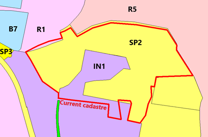
Residue Industrial land in Narrambla has, through previous subdivisions resulted in land that is split zoned between IN1 General Industrial and SP2 Infrastructure. The SP2 area is intended to provide a noise and odour buffer from the Sewage treatment plant resource recovery centre to the southeast and the residential lands to the north.
It is therefore proposed to adjust the IN1 and SP2 boundary to reflect the cadastre boundaries of the residue industrial land and the buffer land respectively.
Attachment 7b. Minor adjustment to land use zones along the Teamsters Walkway (Crinoline Street, Anson Street, Hargraves Crescent, Heatherbrae Parade through to Phillip Street)
The zone boundary between the RE1 Public Recreation zone of the Teamsters Walkway and neighbouring R1 General Residential properties has not adhered to the cadastral property boundaries, resulting in a number of residential properties appearing to be split zoned. The proposal is to amend the zone boundary to be consistent with the cadastre boundaries.
Formal LEP mapping to be provided prior to public exhibition.
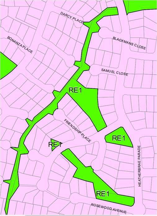
Attachment 7c. Amending the SP2 zone applying to the Rural Fire Services site in Forest Road.
The property at 1385 Forest Road, is already zoned SP2 however it requires a descriptive name added to the zone title. It is recommended that the zone be titled SP2 “Emergency Services Facility” as this would cater for the Rural Fire Service while also retaining the potential for other emergency service facilities to be co-located on the site – for example an SES facility or similar.
Formal LEP mapping to be provided prior to public exhibition.
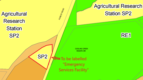
Attachment 7d. Minor rezoning of part of 1 Barrett Street to convert surplus industrial land to residential
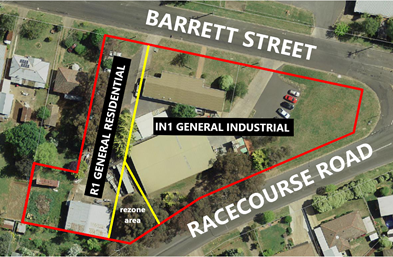
1 Barrett Street, on the corner of Racecourse Road is currently zoned IN1 General Industrial. It is bounded to the west by land zoned R1 General Residential. The neighbouring land to the west has been approved for residential units with the layout being designed to be able to absorb and utilise the some of the land at 1 Barrett Street subject to that portion of the site being rezoned to R1 General Residential.
This would enable the residential units to obtain direct access onto Racecourse Road. The part of 1 Barrett Street proposed is located to the rear of the existing industrial shed and is not accessible to, and is of no direct benefit, to the industrial use.
Accordingly it is proposed to rezone the area of land at the rear of 1 Barrett Street to R1 General Residential to facilitate the potential development of additional housing in this otherwise residential area.
Formal LEP mapping to be provided prior to public exhibition.
Attachment 7e. Minor rezoning to change the designation of Jack Brabham Park from Private Recreation to Public Recreation.
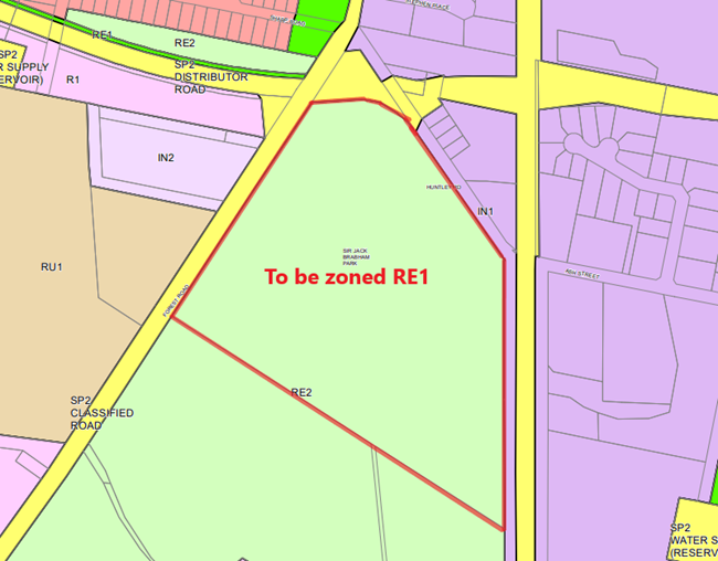
The land indicated above is currently zoned RE2 Private Recreation. This zone was adopted on the understanding that Zone RE1 Public Recreation was intended to be applied only to recreation land that had not limitations on public access and use at any time. Jack Brabham Park hosts a range of sporting events and fixtures during which the general public are restricted from crossing the playing field.
It is now understood that this distinction between RE1 and RE2 was not the intended effect. Given that Jack Brabham park is a public asset and intended to be generally available to the public without restriction it is now considered appropriate to rezone the land to RE1 Public Recreation.
Formal LEP mapping to be provided prior to public exhibition.
Attachment 7f. Minor rezoning of the Orange Function Centre on Bathurst Road
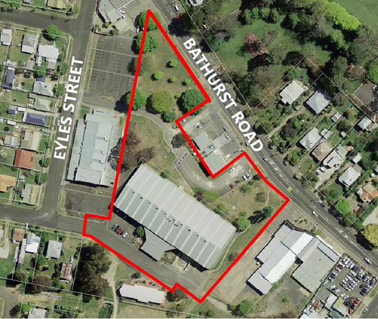
The land indicated above is currently zoned RE1 Public Recreation. The site is developed as a convention centre and is not practically used for recreation purposes. Rezoning of the land to B6 Enterprise Corridor would expand the range of potential uses for the site. Its location along Bathurst Road makes it highly suited to a range of commercial activities that require or benefit from prominent positioning in the road network. It is noted that he car parking are in Eyles Street is zoned R1 General Residential, this is not proposed to change as, although not a typical use of residential land, the car park provide a physical buffer between any future built form and the dwellings on the western side of Eyles Street, whereas neighbouring land to the east is already part of the B6 zone.
The property on Bathurst Road that is bounded by the subject site on three sides is also zoned B6, it is currently developed as a service station and operates 24 hours, the parking area to its east and access way to the southwest are within the subject site of this rezoning. Due to the fragmented nature of this site and the overlapping non-recreational uses of parking and accessways, the site is not considered to provide any significant recreational or ecological benefit.
Formal LEP mapping to be provided prior to public exhibition.
Attachment 7g. Minor rezoning to extend the B3 zone eastwards on the northen side of Summer Street to William Street and create a B4 zone on the eastern side of William Street between Bathurst Road and Byng Street
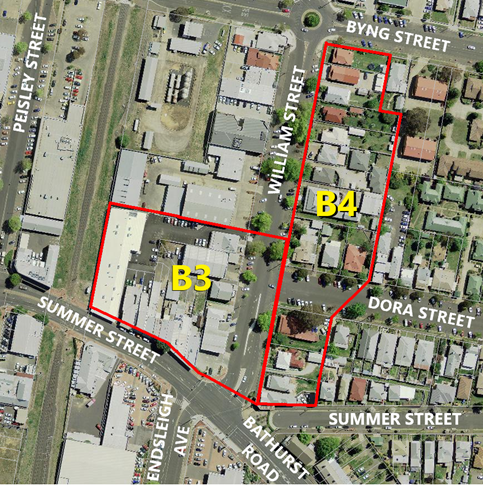
Both of the indicated areas are currently zoned B6 Enterprise Corridor, however only the service station on the corner of Summer Street and William Street could be regarded as consistent with the intention of a B6 zone.
The land indicated to be zoned B3 comprises a large office building adjacent to the railway corridor and a series of small shopfronts along Summer Street. A service station is located on the corner of Summer Street and William Street, north of this is the heritage listed Orange City Band Hall and a light industrial shed. The character of this section of Orange is consistent with the main part of the CBD to west (over the railway).
The area indicated to be zoned B4 comprises a mix of dwellings and non-residential uses in converted dwellings. This includes a veterinary hospital, health consulting rooms, professional offices. Rezoning this area to B4 will recognise the range of current uses and ensure that this land continues to serve as a buffer between commercial and residential land further to the east.
Formal LEP mapping to be provided prior to public exhibition.
Attachment 7h. Minor adjustment to the land use zone and minimum lot size maps in Shiralee to reflect the layout of approved subdivisions.
Formal LEP mapping to be provided prior to public exhibition.
Attachment 7i. Minor rezoning of neighbourhood shops in East Orange, to better recognise the current use of the land around the East Orange Post Office
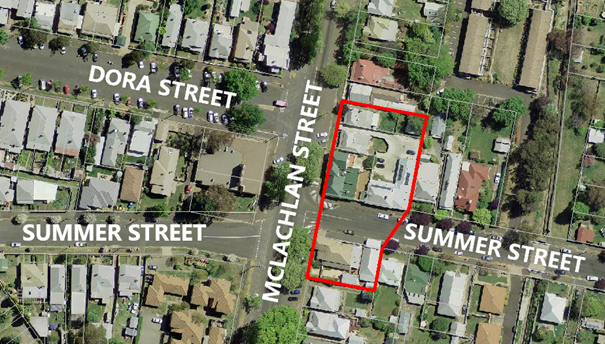
The land indicated is currently zoned R1 General Residential and comprises the East Orange Post Office, a denture clinic, a Café, a vacant former office premises and one dwelling (owned by the post office owner/operator).
Several approaches from the Post Office owner/operator seeking the ability to expand have been received over the last several years. They advise that the postal service is undergoing a structural adjustment in response to the rise of internet based communications and online retailing, the combined effect of which has been a significant decrease in traditional letters and a significant increase in the parcel and package delivery aspects of the business. As a consequence more storage and handling space is needed to store and sort parcels and packages.
Given the cluster of non-residential uses in this location it is considered appropriate to rezone the group as a whole rather than only the post office. Due to the limited ability in the neighbourhood to provide for any new off-street parking, already at a premium in the area, the extent of the zone is proposed to be limited to the current built form only. Most of the affected premises have already maximised their footprint to occupy almost of the lots. Therefore the rezoning is not expected to lead to an intensification of the area, but will instead allow the range of uses to evolve more readily in the future.
Formal LEP mapping to be provided prior to public exhibition.
Attachment 7j. Minor amendment to the minimum lot size in relation to land intended for a future caravan park on the eastern edge of the City
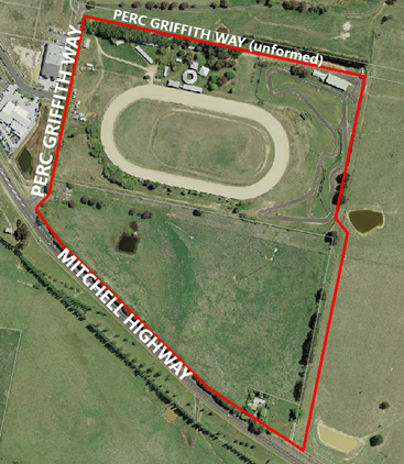
The area indicated has recently been rezoned to allow for a caravan park development. Recent consideration of a subdivision to facilitate this concept, by excising the go-kart track onto a separate allotment highlighted the fact that the southern section remains within a 100ha minimum lot size designation. That lot size was originally adopted while the land was rural, given the change in zone and intended future development it is proposed to remove the minimum lot size from the site, as is currently the case for the northern section of the site.
Formal LEP mapping to be provided prior to public exhibition.
Attachment 7k. Minor adjustment to the water catchment boundary and zoning map in relation to land at Shadforth

Lot 102 DP1079487, shown above, is currently split zoned between the E3 Environmental Management Zone and the RU1 Primary Production Zone. The zone boundary is intended to reflect the natural water catchment boundary. The current water catchment, and hence zone boundary was prepared using the best available information at the time.
The owner of this land has requested that the boundary be adjusted to facilitate the placement of a dwelling on the land. In support of this the above diagram has been prepared from a survey of the land to illustrate that the current zone boundary does not match the actual watershed alignment.
Formal LEP mapping to be provided prior to public exhibition.
Attachment 8. Creation of an Additional Permitted Use in relation to a dwelling entitlement at 120 Calton Road
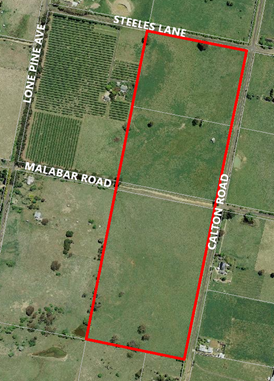
The subject land indicated above was originally an ‘existing holding’ within the meaning of clause 4.2A. When the new LEP was introduced in 2012 a sunset clause was introduced to bring existing holdings to an end, with applications needing to be lodged by 31 December 2012.
When Orange LEP 2011 was adopted in February of 2012 it sought to extinguish a range of ‘existing holding’ dwelling entitlements but provided affected landowners a period of time, expiring on 31 December 2012. A number of these landowners lodged Development Applications in the days leading up to the cut-off date. Several of these applications had issues with the level of documentation required but were ultimately resolved. The owner of 120 Calton Road lodged documentation; however, due to staff leave around the Christmas break the application was overlooked. Staff support this Additional Permitted Use.
It is therefore proposed to create an Additional Permitted Use listing for this property within Schedule 1 and the associated Additional Permitted Uses Map.
Formal LEP mapping to be provided prior to public exhibition.
Attachment 9. Applicable State Environmental Planning Policies
|
SEPP |
Consistent |
Comment
|
|
SEPP 55 - Remediation of Land
|
Yes |
SEPP No 55 aims to identify lands where potential contamination requires that land to be remediated prior to being developed, used, or zoned in a certain way. The Planning Proposal seeks to rezone a number of properties across the LGA.
The minor nature of the rezonings and the known histories of the sites involved do not indicate that there is, or would be likely to be, any contamination present. Notwithstanding this, the sites in question can be required to undertake formal investigation works as part of any future Development Applications.
Prior to any use or development occurring subject to a development application, land will need to be assessed against clause 7 of the SEPP. The Planning Proposal is considered to be consistent with – and not in contravention of – this SEPP. |
|
Exempt and Complying Development Codes 2008 |
|
The Planning Proposal seeks to include a number of local exempt development listings. These are either not covered by the SEPP or limited in terms of the zones where they apply. The proposed listings do not conflict with, or duplicate the SEPP
Therefore, the Planning Proposal is considered to be consistent with – and not in contravention of – this SEPP. |
Attachment 10. Applicable Ministerial Directions (section 9.1 Directions)
1 Employment and Resources
|
Direction |
Consistent? |
Comments |
|
1.1 Business and Industrial Zones |
Yes |
The Planning Proposal is consistent with this Direction. Direction 1.1 stipulates that Planning Proposals must: · give effect to the objectives of the Direction, · retain existing business and industrial zones, · not reduce total potential floor space for employment and related public services in business zones and industrial uses in industrial zones, and · ensure that proposed new employment areas are in accordance with a strategy that is approved by DPE. Rezoning of land adjacent to the CBD seeks to convert from one business zone B6 to a mix of two other business zones B3 and B4. The rezoning of land around the east orange post office technically adds a modest amount of supply, but in practice simply recognises the current range of commercial activities already in operation. The minor rezoning of IN1 land at the rear (southern end) of 1 Barrett street only involves a disused and inaccessible section of the lot to facilitate the orderly development of adjacent residential land to the west. The Proposal therefore responds satisfactorily to this Direction. |
2 Environment and Heritage
|
Direction |
Consistent? |
Comments |
|
2.3 Heritage Conservat-ion |
Yes |
The Planning Proposal is consistent with the objective of this Direction, it involves only the rectification of misdescriptions in Schedule 5 and correction of several mapping errors and anomolies. The only removal relates to Emmaville Cottage in North Orange (item I308) which was physically relocated the Orange Adventure Playgoround (Lot 20 DP 1076343) The Proposal therefore responds satisfactorily to this Direction. |
3 Housing, Infrastructure and Urban Development
|
Direction |
Consistent? |
Comments |
|
3.1 Residential Zones |
No – justified |
The Planning Proposal is consistent with the objectives of this Direction. No current residentially zoned land is to be changed. One very minor rezoning at the rear of 1 Barrett Street will technically add to the supply of R1 land. |
|
3.4 Integrating Land Use and Transport |
|
The Planning Proposal is consistent with this Direction. The Direction requires the planning authority to have regard to: · Improving Transport Choice – Guidelines for planning and development (August, 2001) by former NSW Department of Urban Affairs and Planning (DUAP), and · The Right Place for Business and Services – Planning Policy (August, 2001) by DUAP. Improving Transport Choice highlights the need to concentrate a mix of uses in centres, improve walkability and cyclability of urban areas, plan public transport to work with land use strategies, and design hubs in a way that they are to human-scale.
The Right Place for Business and Services outlines key objectives such as co-locating trip-generating activities in highly accessible areas, minimising car-dependence through limiting dispersed, inaccessible commercial development, ensuring public transport meaningfully connects to mixed use centres, protecting/maximising community investment in centres and dependent infrastructure, encouraging private and public investment into centres, and fostering growth, competition and innovation in centres.
The CBD expansion (into land that is already in a business zone) will enhance the ability of the CBD to provide a consolidated shopping and commercial precinct which is consistent with principles of minimising private vehicle usage by enabling one trip to serve as many purposes as possible. As a result of the Planning Proposal, car dependence will be reduced in Orange for leisure/retail/hospitality consumer trips. |
4 Hazard and Risk
|
Direction |
Consistent? |
Comments |
|
4.3 Flood Prone Land |
No – but justified |
The Planning Proposal is consistent with the objectives of this Direction, but not the terms of the Direction. Council is undertaking a Floodplain Risk Management Study and Plan, that reviews the current FRMP which only applies to the Blackmans Swamp Creek (roughly the eastern and central parts of the city and terminates at the rail corridor in the South) and the LEP currently only applies to riverine flooding and does not identify or respond to overland flooding from stormwater.
The new FRMP includes, for the first time, a detailed study and modelling of the Ploughmans Creek catchment (roughly the western parts of the city) as well as expanding the Blackmans Swamp Creek catchment southwards to encompass Shiralee and the Bloomfield areas. The new FRMP will also map overland flooding as well as riverine flooding.
The resultant maps within the new FRMP provide an improved and updated understanding of the extent of risk present. This document (intended to be publicly exhibited roughly in parralel to this planning proposal) will inform future engineering and remediation works, which over time are expected to reduce the extent of hazard. Council anticipates being able to update the FRMP on a rougly annual basis. As such the current LEP approach would almost always be behind the latest knowledge. Accordingly the proposal seeks to amend Clause 7.2 and introduce a new clause that will link the LEP to the current adopted FRMP, meaning that as soon as the FRMP is updated the LEP will automatically respond to the latest information
Therefore, the Planning Proposal will not result in development of flood prone land that is inconsistent with the Floodplain Development Manual 2005. The proposed changes are intended to ensure that flood planning controls will always remain as up-to-date as possible. Whenever additional flood studies are undertaken and adopted the planning controls will respond automatically to the new information. |
5 Regional Planning
|
Direction |
Consistent? |
Comments |
|
5.10 Implemen-tation of Regional Plans |
Yes |
The Planning Proposal is consistent with this Direction. The Central West and Orana Regional Plan 2036 has been consulted and comments made against that Regional Plan under Q3 of this proposal. The Planning Proposal was deemed to be consistent with relevant Directions and Actions of that Plan. |
6. Local Plan Making
|
Direction |
Consistent? |
Comments |
|
6.1 Approval and Referral Requirem-ents |
Yes |
The Planning Proposal is consistent with this Direction. The Planning Proposal does not propose to require concurrence for additional uses or situations. |
|
6.3 Site Specific Provisions |
Yes |
The Planning Proposal is consistent with this Direction. The Planning Proposal seeks to create an additional permitted use on land at 120 Calton Road, which is considered to be the best way to provide the owner with an equitable outcome given the history of this site as detailed in attachment 8 |
2.5 Development Application DA 329/2015(3) - 62 Byng Street and 77 Hill Street
Attachment 1 Modified Notice of Approval
|
|
ORANGE CITY COUNCIL
Development Application No DA 329/2015(3)
NA18/ Container PR2111 |
NOTICE OF DETERMINATION
OF A DEVELOPMENT APPLICATION
(AS MODIFIED)
issued under the Environmental Planning and Assessment Act 1979
Section 4.18
|
Development Application |
|
|
Applicant Name: |
Mayoh Architects Pty Ltd - PD Mayoh Pty Ltd |
|
Applicant Address: |
(Attention Melodie Kaplan) 60 Strathallen Avenue NORTHBRIDGE NSW 2063 |
|
Owner’s Name: |
Denoc Holdings Pty Ltd |
|
Land to Be Developed: |
66 Byng Street and 77 Hill Street, Orange |
|
Proposed Development: |
Alterations and extension to an existing heritage mansion to provide boutique hotel accommodation, conference room, kitchen and dining facilities, on-site car parking and landscaping |
|
|
|
|
Building Code of Australia building classification: |
To be determined by certifier |
|
|
|
|
Determination made under Section 4.16 |
Development consent was initially granted by the Land and Environment Court on 1 June 2017 – Appeal Number 2016/183468. |
|
Made On: |
4 December 2018 – Determination date of the modification application |
|
Determination: |
CONSENT GRANTED SUBJECT TO CONDITIONS DESCRIBED BELOW: |
|
|
|
|
Consent to Operate From: |
1 June 2017 |
|
Consent to Lapse On: |
1 June 2022 |
Terms of Approval
The reasons for the imposition of conditions are:
(1) To ensure a quality urban design for the development which complements the surrounding environment.
(2) To maintain neighbourhood amenity and character.
(3) To ensure compliance with relevant statutory requirements.
(4) To provide adequate public health and safety measures.
(5) Because the development will require the provision of, or increase the demand for, public amenities and services.
(6) To ensure the utility services are available to the site and adequate for the development.
(7) To prevent the proposed development having a detrimental effect on adjoining land uses.
(8) To minimise the impact of development on the environment.
SCHEDULE B – OPERATIONAL CONDITIONS
GENERAL CONDITIONS
(1) The development must be carried out in accordance with the following approved plans and documentation except where amended by another Condition of this consent (including a deferred commencement condition).
· Cover Sheet prepared by PD Mayoh Pty Ltd Drawing Nos. A001, Issue E dated 21 June 2017
· Tree Removal Plan prepared by PD Mayoh Pty Ltd Drawing No. A090, Issue C, dated 21 June 2017;
· Lower Ground Floor Plan prepared by PD Mayoh Pty Ltd, Drawing No. A100, Issue W, dated 21 June 2017;
· Site Plan and Ground Floor Plan prepared by PD Mayoh Pty Ltd Drawing No. A101, Issue X, dated 21 June 2017;
· First Floor Plan prepared by PD Mayoh Pty Ltd Drawing No. A102, Issue Q , dated 21 June 2017;
· Roof Plan prepared by PD Mayoh Pty Ltd Drawing No. A103, Issue K, dated 21 June 2017;
· East, West, North and South Elevations prepared by PD Mayoh Pty Ltd, Drawing No. A150, Issue I , dated 21 June 2017;
· Sections CC and DD prepared by PD Mayoh Pty Ltd Drawing No. 161, Issue E, dated 21 June 2017;
· Section EE prepared by PD Mayoh Pty Ltd, Drawing No. A162, Issue B, dated 21 June 2017;
· Section HH, prepared by PD Mayoh Pty Ltd Drawing No. A163, Issue C dated 21 June 2017
· Landscaping Concept Plans prepared by Christopher Nicholas Garden Design Issue 4 dated 21 June 2017;
· Acoustic Report prepared by Acoustic Logic, dated 20 June 2017
Amending plans by Mayoh Architects job No. 1444
Dawning nos.:
· S4.56_A090 Site Plan - Rev P6 Date 18 July 2018
· S4.56_A100 Lower Ground Floor Plan - Rev P10 Date 21 June 2018
· S4.56_A101a Ground Floor Plan – New Extension – Rev P11 Date 17 July 2018
· S4.56_A101b Ground Floor Plan Existing – Rev P14 Date 18 July 2018
· S4.56_A102a First Floor Plan – New Extension – Rev P10 Date 21 June 2018
· S4.56_A102b Frist Floor Plan - Existing – Rev P10 Date 21 June 2018
· S4.56_A103a Roof Plan – New Extension – Rev P4 Date 17 July 2018
· S4.56_A103b Roof Plan – Existing – Rev P3 Date 1 June 2018
· S4.56_A150 Elevations (E, W, N, S) – Rev P4 Date 17 July 2018
· S4.56_A160 Sections AA and BB – Rev P5 Date 17 July 2018
· S4.56_A211 Miscellaneous Details Sheet 2 – Rev P5 Date 17 July 2018
· S4.56_A212 Miscellaneous Details Sheet 3 – Rev P6 Date 18 July 2018
· S4.56_A214 Miscellaneous Details Sheet 5 – Rev P2 Date 18 July 2018
Amending plans by Mayoh Architects job No. 1444
Dawning nos.:
· A204 Privacy Louvre Detail Rev 1 Dated 25 October 2018
Where there is inconsistency between the above plans and a Condition of this Consent, the Condition is to prevail to the extent of any inconsistency.
|
PRESCRIBED CONDITIONS |
(2) All building work must be carried out in accordance with the provisions of the Building Code of Australia.
(3) A sign is to be erected in a prominent position on any site on which building work, subdivision work or demolition work is being carried out:
a. showing the name, address and telephone number of the principal certifying authority for the work, and
b. showing the name of the principal contractor (if any) for any building work and a telephone number on which that person may be contacted outside working hours, and
c. stating that unauthorised entry to the site is prohibited.
Any such sign is to be maintained while the building work, subdivision work or demolition work is being carried out.
(4) Where any excavation work on the site extends below the level of the base of the footings of a building on adjoining land, the person having the benefit of the development consent must, at the person’s own expense:
a. protect and support the adjoining premises from possible damage from the excavation, and
b. where necessary, underpin the adjoining premises to prevent any such damage.
Note: This condition does not apply if the person having the benefit of the development consent owns the adjoining land or the owner of the adjoining land has given consent in writing to that condition not applying.
|
PRIOR TO THE ISSUE OF A CONSTRUCTION CERTIFICATE |
(5) An interpretation plan must be submitted to, and be approved by, Council’s Manager Development Assessments prior to the issuing of a Construction Certificate. The interpretation plan must be consistent with the guidelines produced by the NSW Heritage Office and must be prepared for the property by an experienced heritage consultant. The interpretation plan must recommend interpretive devices both internal and extern al to the building and within the significant portions of the building sufficient to interpret the relevant aspects of its cultural heritage significance.
Where required, a separate development application must be lodged for any works associated with the installation of interpretation devices.
(6) The approved landscape plan is to be amended to replace the Hornbeam (Carpinus betulus ‘Pendula’ Pleached) with Carpinus betulus (Pleached) to ensure that the canopy formed does not impact on the use of the driveway or affect the neighbouring property through encroachment over the boundary. The approved landscape plan identifies Leightons Green Conifer (Cupressocyparis x leylandii) planted along the eastern boundary of the site. This plant obtains a mature height of over 10 metres and is likely overshadow properties along Hill Street. The Leightons Green Conifers to be planted along the eastern boundary are to be restricted to a maximum height of 5 metres to ensure that there is no overshadowing impact. The eastern boundary trees are not to be evergreen trees.
(7) An approval under Section 68 of the Local Government Act is to be obtained from Orange City Council, as the Water and Sewer Authority, for water, sewer and stormwater connection. No plumbing and drainage in connection with this development is to commence until approval is granted.
(8) Detailed plans and specification are to be submitted with an application for Construction Certificate specifying the proposed fit-out of the food preparation and storage areas in accordance with the requirements of Australian Standard 4674-2004 "Design and construction and fit-out of food premises" and Standard 3.2.3 "Food Premises and Equipment" of the Australian New Zealand Food Standards Code.
(9) Detailed plans and specification are to be submitted with an application for Construction Certificate that indicate all fire safety measures for the existing site and/or proposed building. The plans and specifications shall be designed by a suitably qualified person. The specification is to include all hydraulic calculations for any required hydrants, hose reels, fire water mains. Any modifications required to the existing house under this condition are to be approved by Orange City Council’s Heritage Advisor.
(10) The applicant shall provide the Principal Certifying Authority and Council with a report from a qualified Acoustic Consultant that confirms all mechanical equipment to be installed within the development will comply with the noise goals and the Management techniques proposed in the Noise Impact Assessment prepared by Acoustic Logic Revision 4 dated 20June 2017.
(11) Engineering plans providing complete details of the proposed footpath crossing, driveway and car-parking areas is to be submitted to Orange City Council or an Accredited Certifier (Categories B1, C3, C4, C6) and approved prior to the issue of a Construction Certificate.
These plans are to provide details of levels, cross falls of all pavements, proposed sealing materials and proposed drainage works and be in accordance with the Orange City Council Development and Subdivision Code.
(12) A raised concrete median is to be constructed in Byng Street to prevent in and out right turns. The concrete median is to extend 30m from the end of the existing roundabout traffic island. A double barrier line is to be painted on Byng Street from the end of the median extending 20m west. The concrete median is to be a minimum 600 millimetres wide and designed and constructed in accordance with Parts 3 and 4A of Austroads Guide to Road Design. The eastbound traffic lanes in Byng Street are to maintain their existing width.
Engineering plans, showing details of the raised concrete median, signage, linemarking and construction traffic control plan, are to be submitted to Orange City Council or an Accredited Certifier (Categories B1, C3, C4, C6) and approved prior to the issue of a Construction Certificate.
Separate approval under section 138 of the Roads Act 1993 will be required for work on public roads prior to any work being undertaken on or over a public road.
(13) A water and soil erosion control plan is to be submitted to Orange City Council or an Accredited Certifier (Categories B1, C3, C4, C6) for approval prior to the issuing of a Construction Certificate. The soil erosion control plan is to be in accordance with the Orange City Council Development and Subdivision Code and the Landcom, Managing Urban Stormwater; Soils and Construction Handbook.
(14) A Liquid Trade Waste Application is to be submitted for approval to Orange City Council prior to the issuing of a Construction Certificate. The application is to be in accordance with Orange City Council’s Liquid Trade Waste Policy. Engineering plans submitted as part of the application are to show details of all proposed liquid trade waste pre-treatment systems and their connection to sewer.
(15) Where applicable, the applicant is to enter into a Liquid Trade Waste Service Agreement with Orange City Council in accordance with the Orange City Council Liquid Trade Waste Policy.
(16) Payment of contributions for water, sewer and drainage works is required to be made at the contribution rate applicable at the time that the payment is made. The contributions are based on 6.1 ETs for water supply headworks and 9.4 ETs for sewerage headworks. A Certificate of Compliance, from Orange City Council in accordance with the Water Management Act 2000, will be issued upon payment of the contributions.
This Certificate of Compliance is to be submitted to the Principal Certifying Authority prior to the issuing of a Construction Certificate.
(17) Backflow Prevention Devices are to be installed to AS3500 and in accordance with Orange City Council Backflow Protection Guidelines. Details of the Backflow Prevention Devices are to be submitted to Orange City Council for approval prior to the issuing of a Construction Certificate.
(18) An acoustic report is to be prepared by a suitably qualified acoustical consultant and submitted to the Principal Certifying Authority demonstrating that the noise emission from the proposed mechanical plant will not exceed an Leq noise level of 5 dB above the L90 background noise level measured at the nearest affected residence.
(19) Compliance with Clause 3.2.4, Figure 3.2 and Figure 3.3 of AS2890.1 – 2004 in relation to sight lines to both pedestrians on the footpath and to vehicles approaching along Byng Street for drivers of vehicles emerging from the proposed driveway shall be certified by and experienced and qualified traffic engineer prior to the issue of a construction certificate. This will in particular require:
a. a 2m by 2.5m sight triangle to pedestrians for emerging vehicles provided at the widened gate location by an open fence form, low level landscaping (below 0.6m height) and at-grade paving and certification of adequate sight line for emerging drivers to pedestrians on the adjacent public footpath.
(20) The internal car park and access to the car park is to be certified by an experienced and certified traffic engineer to comply with AS2890.1-2004, AS2890.6-2009 and AS2890.2-2002 (relating to the Small Rigid Vehicle, being the maximum permitted service vehicle on- site other than fire appliance vehicles). Certification must confirm that the car park and access is fully compliant with the dimensional manoeuvring, gradient and travel height requirements of the design vehicles. The hydrant located between STAFF car parking space numbers 22 and 23 is to be confirmed as being flush with the parking pavement level such that those spaces can be lengthened to comply with Figure 2.5 of AS2890.1-2004.
(21) The hedge (Cherry Laurel (prunus laurocerasus)) at the front of the property on the northern boundary is to be retained. Removal of any part of the hedge may only occur to accommodate any new gate or fence that may be approved under the Conditions of this Consent.
(22) The Beech Tree to the north of the site is to be retained.
(23) The accessible path of travel between the disabled parking spaces and the foyer of the approved development is to be certified as acceptable by an accessibility expert.
(24) An acoustic report shall be prepared prior to the construction certificate that details how the alterations and additions are proposed to meet Part F5 of the Building Code of Australia, including, but not limited to:
(a) Acoustic separation of common walls and floors between sole occupancy units in accordance with Part F5.4 and F5.5 of the BCA.
(b) Acoustic separation of common floor/ceiling between sole occupancy units on the first floor and the ground floor of the existing residence in accordance with Part F5.4 of the BCA.
(c) Acoustic separation of internal services in accordance with Part F5.6 of the BCA.
(24A) A separate schedule of finishes, colours, swatches and materials is to be provided in a sample board to Orange City Council for the work approved under this consent. This includes a sample of the “Central Lobby Screen” in the proposed colour, no smaller than 600 x 600mm. The proposed external finishes are to be generally in accordance with the plan “External Finishes Legend Drawing” A 105 Revision H and the “Central Lobby Screen Detail” is to be generally in accordance with Appendix E to the Joint Heritage Report dated 21 April 2017 and filed in Land and Environment Court Proceedings 2016/183468 Denoc Holdings Pty Ltd v Orange City Council. The use of the ‘warm pale orange’ to render finishes is not appropriate. The proposed finishes, colours, materials and swatches are to be approved by Orange City Council prior to the issue of a Construction Certificate.
(24B) (deleted)
(24C) A notation must be provided on the plans submitted with a Construction Certificate confirming that all outdoor lighting has been designed and will be installed in accordance with Australian Standard AS 4282-1997 - Control of the Obtrusive Effects of Outdoor Lighting.
(24D) Louvre screens are to be fixed to the ground floor windows of guest rooms 1-12, and the upper level windows on the western elevation of the approved extension, except for the western glazing to the main entry foyer. The louvres/individual blades on the ground floor guest rooms shown on the approved plans as having a depth of 150mm shall be amended to have a minimum depth of 250mm.
The angle of the louvres attached to all required windows shall be positioned to prevent direct overlooking of the adjoining property at 60 Byng Street. Details of the louvres to all required windows on the western elevation of the approved extension shall be submitted to Council’s manager Development Assessments for approval prior to the issue of a Construction Certificate.
(24E) A screen is to be constructed and is to remain at the rear of the three easternmost spaces (car spaces 14, 15 and 16) in front (north) of the proposed landscaping to act as a barrier to light spill in addition to the boundary fencing and landscaping. This screen is to be in the form of a perforated metal screen to a height of 3 metres. The colour and material of the screen is to be provided to Orange City Council for approval prior to the issue of a Construction Certificate. Details of the screen are to be noted on the plans submitted with a Construction Certificate.
(24F) The “booster valve” or equivalent infrastructure shown on Plan A.101 is to be located outside of the Structural Root Zone (SRZ) of the Liquid Amber tree located towards the north eastern corner of 62 Byng Street. All excavation or trenching works associated with the installation of this infrastructure must be located outside of the SRZ of the Liquid Amber tree.
(24G) The original fireplaces, or an equivalent fireplace to be approved by Council’s Heritage Advisor, are to be reinstated in their original location within rooms 20 and 22.
(24H) Specifications are required for the glazing on the east and west elevations of the approved extension shown on Plan A.150. Glazing must be set inwards of the framing so as to modulate the bulk and minimise the apparent extent of glazing on each elevation. Glazing must rely on body tint or similar without any external reflective coating. The specifications for the glazing are required to be shown on the plans submitted with the Construction Certificate.
(24I) Full details of the restoration or rebuilding of the front fence and gate to 62 Byng Street must be submitted to Orange City Council prior to the issue of a Construction Certificate.
Details of the condition of the existing fence and gate must be provided to Council. Where it can be demonstrated to the satisfaction of Council’s Manager of Developments Assessments that the existing materials are incapable of restoration, the existing fence must be replaced by fence to match the original fence style of chain wire and timber posts, consistent with the heritage character of the subject property and Central Orange Heritage Conservation Area. The selected hedge plants behind the fence are to be advanced plants.
(24J) An amended stormwater design is to be submitted with the application for a Construction Certificate to include stormwater detention within the development, designed to limit peak outflows from the land to the pre-existing natural outflows up to the 100 year ARI frequency, with sufficient allowance in overflow spillway design capacity to safely pass flows of lower frequency (that is, a rarer event) without damage to downstream developments. Where appropriate, the spillway design capacity is to be determined in accordance with the requirements of the Dam Safety Committee.
The design of the detention storage is to be undertaken using the DRAINS rainfall-runoff hydrologic model or an approved equivalent capable of assessing runoff volumes and their temporal distribution as well as peak flow rates. The model is to be used to calculate the flow rates for the existing and post-development conditions. The developed flows are to be routed through the proposed storage within the model so that the outflows obtained are no greater than the flows obtained for the pre-existing natural flows. A report detailing the results of the analysis, which includes:
• catchment plan showing sub-catchments under existing and developed conditions;
• schematic diagram of the catchment model showing sub areas and linkages;
• tabulation detailing the elevation, storage volume and discharge relationships; and
• tabulation for the range of frequencies analysed, the inflows, outflows and peak storage levels for both existing and developed conditions;
together with copies of the data files for the model and engineering design plans of the required drainage system are to be submitted and approved by Orange City Council.
All stormwater from the site is to be collected and piped to Councils existing stormwater system in Hill Street. Engineering plans, showing details of the proposed stormwater drainage system, are to be submitted to, and approved by Orange City Council prior to the issue of a construction certificate.
The existing 150mm-diameter sewer main is to be relocated clear of the proposed building. Engineering plans, showing details of the proposed sewer main relocation works, are to be submitted to, and approved by Orange City Council prior to the issuing of a Construction Certificate.
Backflow Prevention Devices are to be installed to AS3500 and in accordance with Orange City Council Backflow Protection Guidelines. Details of the Backflow Prevention Devices are to be submitted to Orange City Council for approval prior to the issuing of a Construction Certificate.
(24K) (deleted)
(24L) The acoustic fence and acoustic screening shall be in accordance with the acoustic report by Acoustik report reference 1708.001 Report.3.
(24M) (deleted)
|
PRIOR TO WORKS COMMENCING |
(25) A Construction Certificate application is required to be submitted to, and issued by, Council/Accredited Certifier prior to any excavation or building works being carried out on site.
(26) A temporary onsite toilet is to be provided and must remain throughout the project or until an alternative facility meeting Council’s requirements is available onsite.
(27) Soil erosion control measures shall be implemented on the site.
(28) The applicant shall supply Orange City Council with a dilapidation report for the adjoining properties at 75, 79, 81, 85 and 87 Hill Street as well as 60 and 64 Byng Street, Orange which documents and photographs the conditions of buildings and improvements on those properties prior to commencement of works. A copy of the report must be provided to Council and the owners of the nominated properties. Council shall be provided with a list of owners to whom a copy of the report has been provided.
This condition shall not apply in the event that access is refused by those property owners.
(29) A Tree Protection Zone (TPZ) as detailed in AS 4970 – 2009 shall be established on the development site for each tree to be retained on the western side of 62 Byng Street and the eastern side of 60 Byng Street. The Tree Protection Zone shall be erected a minimum of 4.5 metres in radius from the centre of each tree along the western boundary fence of 62 Byng Street. The Tree Protection Zone must be connected to the western boundary fence of 62 Byng Street.
(30) A Tree Protection Zone (TPZ) as detailed in AS 4970 – 2009 shall be established around the Liquidambar tree in the North east corner of 62 Byng Street. The Tree Protection Zone shall be erected a minimum of 2.2 metres to the east of the tree, a minimum of 3.6m to the south, west and north of the tree.
Note: The trees affected by Condition (27) and (28) include the Liquidambar in the north east corner of 62 Byng Street, the Elm in the north west corner of 62 Byng Street, the Beech on western boundary of 62 Byng Street, the Box Elder on or immediately beyond western boundary of 62 Byng Street and the Elm (2) on or immediately beyond western boundary of 62 Byng Street.
|
DURING CONSTRUCTION/SITEWORKS |
(31) The applicant shall ensure that the Tree Protection zones for those trees identified to be retained are observed and maintained during construction.
(32) The entrance path, immediately to the west of the Liquidambar located in the north east corner of 62 Byng Street shall be constructed in such a way that it does not impact on the soft landscape zone existing within the TPZ. ie. porous pavement or a bridging of the Structural Root Zone shall be undertaken to minimise root damage. To ensure protection of the SRZ (SRZ = trees stability) no excavation or fill material shall be permitted within a radius of 2200mm of the centre of the tree’s trunk.
(33) All construction/demolition work on the site is to be carried out between the hours of 7.00 am and 6.00 pm Monday to Friday inclusive and 7.00 am to 5.00 pm Saturdays. Written approval must be obtained from the General Manager of Orange City Council to vary these hours.
(34) All materials onsite or being delivered to the site are to be contained within the site. The requirements of the Protection of the Environment Operations Act 1997 are to be complied with when placing/stockpiling loose material or when disposing of waste products or during any other activities likely to pollute drains or watercourses.
(35) Building demolition is to be carried out in accordance with Australian Standard 2601:2001 - The Demolition of Structures and the requirements of the NSW WorkCover Authority.
(36) Where asbestos material is removed or disturbed as a result of any proposed demolition, alterations or additions, all work must be carried out by a person licensed under Chapter 10 of the Occupational Health & Safety Regulation 2001 and undertaken in accordance with the requirements of clause 29 of the Protection of the Environment Operations (Waste) Regulation 2005. All asbestos to be removed must be disposed of at a tip recommended by the NSW Environment Protection Authority and under no circumstances shall it be reused or sold.
(37) The fit-out of the food preparation and storage areas are to be installed in accordance with the requirements of Food Safety Standard 3.2.3 "Food Premises and Equipment" of the Australian New Zealand Food Standards Code and Australian Standard 4674-2004 "Design and construction and fit-out of food premises".
(38) The provisions and requirements of the Orange City Council Development and Subdivision Code are to be applied to this application and all work constructed within the development is to be in accordance with that Code.
The developer is to be entirely responsible for the provision of water, sewerage and drainage facilities capable of servicing the development from Council’s existing infrastructure. The developer is to be responsible for gaining access over adjoining land for services where necessary and easements are to be created about all water, sewer and drainage mains within and outside the lots they serve.
(39) All driveway and parking areas are to be sealed with bitumen, hot mix, cobblestones, pavers or concrete and are to be designed for all expected loading conditions (provided however that the minimum pavement depth for gravel and flush seal roadways is 200mm) and be in accordance with the Orange City Council Development and Subdivision Code.
(40) All pruning works shall be undertaken to AS4373-2007 Pruning of amenity trees by a qualified arborist under the supervision of Council’s Manger City Presentation.
(41) A heavy-duty concrete kerb and gutter layback and footpath crossing is to be constructed for the entrance to the proposed development on Byng Street. The existing gutter bridge is to be removed and the bitumen footpath and roadway reinstated. The construction of the layback and footpath crossing are to be as required by the Orange City Council Development and Subdivision Code.
(42) The existing basalt (bluestone) kerb and gutter in Byng Street is to be retained . Where bluestone exists in the location of the proposed new driveway, the bluestone gutter is to be retained and incorporated into the new vehicular layback. Any kerb stones removed as a result of the works are to be firstly used as kerb stones in the areas of reinstated kerb and any leftover stones returned to Council.
(43) Any adjustments to existing utility services that are made necessary by this development proceeding are to be at the full cost of the developer.
(44) All floors of rooms 20, 21 and 22 within the existing dwelling are to be upgraded to achieve an airborne sound insulation of not less than 50 and impact sound insulation rating of not more than 62.
(45) Walls separating rooms 20, 21 and 22 from each other, a stairway, public corridor, public lobby or the like are to be upgraded achieve an airborne sound insulation of not less than 50 and extend to the underside of the roof, or to a ceiling that provides the sound insulation required for the wall.
(46) The wall separating the bathroom of room 21 from room 22 shall be upgraded to be discontinuous; and achieve an airborne sound insulation of not less than 50; and an impact sound insulation rating of not more than 62.
|
PRIOR TO THE ISSUE OF AN OCCUPATION CERTIFICATE |
(47) A 2m high lapped and capped hardwood timber fence must be constructed around the perimeter of the development, excluding the frontages to 62 Byng Street and 77 Hill Street, the common boundary to 75 Hill Street, the common boundary between 77 Hill Street and 60 Byng Street and the common boundary between 77 Hill Street and 79 Hill Street prior to the issue of an Occupation Certificate.
Along the common boundary between 77 Hill Street and 60 Byng Street, the existing fence must be retained. Along the eastern boundary of 62 Byng Street, the fence must taper to a maximum height of 1.8m forward of the front building line of the building at 64 Byng Street.
Along the western boundary of 62 Byng Street, the fence must taper to a maximum height of 1.8m forward of the front building line of the building at 62 Byng Street. The height of the fence must be taken from the highest Finished Surface Level adjacent to each part of that fence.
(48) A 2m high lapped and capped hard wood timber fence must be constructed along the common boundary of 75 Hill Street prior to the issue of an Occupation Certificate.
The fence must taper to maximum height of 1.2m where it is forward of the front building line of the building at 75 Hill Street.
The height of the fence must be taken from the highest finished ground level adjacent to each part of that fence.
The existing fence on the common boundary between 77 and 79 Hill Street is to be retained and is not to be modified as part of this approval.
(48A) A screen is to be constructed and is to remain at the rear of the three easternmost spaces (car spaces 14, 15 and 16) in front (north) of the proposed landscaping to act as a barrier to light spill in addition to the boundary fencing and landscaping. This screen is to be in the form of a perforated metal screen to a height of 3 metres.
(49) Landscaping must be planted prior to the issue of an Occupation Certificate, consistent with the approved amended landscape plan.
All trees to be planted must be semi mature and have a minimum pot size of at least 55 Litres.
(50) Works associated with the installation of interpretative devices recommended by the interpretation plan must be installed prior to the issue of an Occupation Certificate.
(52) A total of 27 off-street car parking spaces and one service bay are to be provided upon the site in accordance with approved plans and the provisions of Development Control Plan 2004. The parking spaces are to be constructed in accordance with the requirements of Council’s Development and Subdivision Code, prior to the issue of an Occupation Certificate.
(53) Prior to an Occupation Certificate being issued plans and/or details of the operation of the garbage collection, including a private service agreement with Orange City Council’s waste contractor, are to be submitted to and approved by the Orange City Council Waste Services Manager. This is to include a Waste Management Plan.
The plans and/or details of garbage collection and the private service agreement must provide for garbage to be stored in two skip bins located in an enclosure within the lower ground level undercroft. The private service agreement shall be written so as to obligate the waste contractor to service the development with a small truck with a tare weight of not more than 4.1 tonnes with the waste delivery vehicle to enter and leave the premises in a forward direction. The plans and/or details of garbage collection and private service agreement must specify that garbage collection shall be between the hours of 10am and 2pm Monday to Friday. Kerbside collection of waste is not permitted and garbage is to be collected a maximum of twice per week.
The waste management details are to specify maximum truck length, garbage bin lifting mechanism type, frequency of collection and prohibited hours of garbage and grease truck collection. Detail on how the grease trap and general waste will be collected, the time of day for collection and truck collection point must also be included.
Any agreement in relation to the waste management arrangements shall only be varied with the prior approval of the Director of Development Services and is to be complied with at all times.
(54) No person is to use or occupy Yallungah Mansion or its extension that are the subject of this approval without the prior issue of an Occupation Certificate.
(55) Finished ground levels are to be graded away from the buildings and adjoining properties and must achieve natural drainage. The concentrated flows are to be dispersed down slope or collected and discharged to the stormwater drainage system.
(56) Where Orange City Council is not the Principal Certifying Authority, a final inspection of water connection, sewer and stormwater drainage shall be undertaken by Orange City Council and a Final Notice of Inspection issued, prior to the issue of either an interim or a final Occupation Certificate.
(57) The owner of the building/s must cause the Council to be given a Final Fire Safety Certificate on completion of the building in relation to essential fire or other safety measures.
(58) (deleted)
(59) An easement, to drain sewage and to provide Council access for maintenance of sewerage works, a minimum of 2.0 metres wide is to be created over the 150mm diameter sewer main. Evidence that the easement has been registered is to be submitted to the Principal Certifying Authority prior to issuing of an Occupation Certificate.
(60) A Certificate of Compliance, from a Qualified Engineer, stating that the stormwater detention basin complies with the approved engineering plans is to be submitted to the Principal Certifying Authority prior to the issuing of an Occupation Certificate.
(61) Certification from Orange City Council is required to be submitted to the Principal Certifying Authority prior to the issue of an Occupation Certificate stating that all works relating to connection of the development to Council assets, works on Public Land, stormwater, sewer and water reticulation mains and footpaths have been carried out in accordance with the Orange City Council Development and Subdivision Code and the foregoing conditions.
(62) Where stormwater crosses land outside the lot it favours, an easement to drain water is to be created over the works. A Restriction-as-to-User under section 88B of the NSW Conveyancing Act 1979 is to be created on the title of the burdened lots requiring that no structures are to be placed on the site, or landscaping or site works carried out on the site, in a manner that affects the continued operation of the interlot drainage system. The minimum width of the easement is to be as required in the Orange City Council Development and Subdivision Code.
(63) All of the foregoing conditions are to be at the full cost of the developer and to the requirements and standards of the Orange City Council Development and Subdivision Code, unless specifically stated otherwise. All work required by the foregoing conditions is to be completed prior to the issuing of an Occupation Certificate, unless stated otherwise.
(64) Prior to the issuing of an Occupation Certificate Lot 3 Sec 21 DP 758817, Lot 4 DP 1085463 and Lot 1 DP 956418 shall be consolidated into one lot. Evidence must be submitted to the Principal Certifying Authority confirming that the applicable plan of consolidation has been registered by Land and Property Information.
(65) An additional handrail is to be provided above the existing timber handrail on the heritage stairs in the existing mansion. The additional handrail may be wood, brass or stainless steel material and is to be approved by Orange City Council. The new handrail can be supported off the existing handrail or off the side of the balustrade with appropriate brackets. The new handrail is to be located at a height of at least 865mm above the nosings of the stair and landing.
(66) The gaps in the stair balustrade are to be addressed by installing glass sheets on the outside of the balustrade, fixed to the existing balustrade by appropriate fittings. The height of the glazing is to be a minimum of 865mm above the nosing of the stairs and 1000mm above the floor level of the landing.
(66A) Prior to the issue of any occupation certificate, the common boundary fence between the development and the rear of 60 Byng Street shall be lapped on the development side of the existing fence using hardwood palings.
|
MATTERS FOR THE ONGOING PERFORMANCE AND OPERATION OF THE DEVELOPMENT |
(67) Access to all services and facilities within the hotel shall be limited to overnight stay guests only. The conference room, breakfast room and coffee bar are to be used by overnight stay hotel guests only. These areas are not permitted to be used by the general public. There is to be no advertisement for use of the conference room, breakfast room and coffee bar by the general public.
(68) The development shall be operated in accordance with the approved Operational Management Plan, Noise Management Plan and the Waste Management Plan.
(69) Waste collection from the development shall be carried out to the satisfaction of Council's Waste Services Manager and in accordance with the agreement entered into with the waste management contractor engaged to service the development and the Conditions of this Consent.
(70) Outdoor lighting must be in accordance with Australian Standard Control of the obtrusive effects of outdoor lighting – AS 4282-1997.
(71) Any ancillary light fittings fitted to the exterior of the building are to be shielded or mounted in a position to minimise glare to adjoining properties.
(72) The owner is required to provide to Council and to the NSW Fire Commissioner an Annual Fire Safety Statement in respect of the fire-safety measures, as required by Clause 177 of the Environmental Planning and Assessment Regulation 2000.
(73) The area of the site identified as “Formal Lawn High Tea” on Plan A.101 shall not be used for ‘high tea’ events and functions between the hours of 10.00pm and 7.00am. Any high tea events are to be restricted to attendance by overnight hotel guests only.
(74) All vehicle access to the land from Byng Street is to be left in/left out only. All vehicle movements to and from the land are to be in a forward direction.
(75) Gates located at the street frontage to Byng Street (relating to the vehicular entrance) must be permanently maintained in an open position with the gates orientated into the property. The gates associated with the electrical substation must remain closed at all times, except for when the electrical supply authority is conducting maintenance, repairs, upgrades or the like.
(76) Leq noise emission from the premises shall not exceed 5 dB above background noise level measured at the nearest affected residence. The operation of the development is to comply with the recommendations of the Noise Impact Assessment prepared by Acoustic Logic revision 4 dated 20 June 2017.
(77) There is to be a maximum of eight (8) staff on the site at any one time.
(78) The maximum permitted service vehicle on-site is a 6.4m long Small Rigid Vehicle in accordance with AS2890.2-2002.
(79) This consent does not permit any signage to be fixed to the heritage item or to be placed anywhere within the front setting of the house.
(80) No external face brickwork is to be painted, sealed or coated.
(81) No tourist coaches are permitted on the site.
(82) The use of the loading dock is to be limited to daytime hours (7am-6pm) only.
(83) (deleted
(84) Loading and delivery to the site is to be managed as follows:
(i) A small rigid vehicle will deliver food during normal operation hours (and not before 7am) at a maximum of twice per week.
(ii) Laundry delivery and pick up will occur every second day after 10am and no later than 5pm.
(iii) Garbage is to be collected a maximum of twice a week after 10am and before 6pm.
(iv) No delivery to the site is to occur on the weekend.
(85) The operation of the approved development is to be undertaken at all times in accordance with the approved Plan of Management (annexed to this consent and marked “A”) except where that plan is inconsistent with a condition of this Consent. The applicant shall provide Council with an Operational Management Plan to be submitted and approved by Council’s Manager of Development Assessment, relating to the hotel operations. The Operational Management Plan shall include measures to mitigate odours and fumes that could be emitted from the kitchen or waste storage area.
In particular, the operational management plan shall stipulate that the temporary bin on the western side of Yallungah is to be returned to the main bin enclosure at the rear of the facility at the same time as the kitchen closes each day. Additionally, odours within the enclosure at to be managed appropriately.
Any proposed amendments to the approved Plan of Management or Operational Management Plan are to be notified to and approved by Orange City Council.
(86) The Leightons Green Conifers to be planted along the eastern boundary are to be restricted to a maximum height of 5 metres to ensure that there is no overshadowing impact on adjoining properties.
(87) The temporary bin area adjacent to the kitchen on the western side of Yallungah shall not be used at any time between 10.00pm and 7.00am daily.
|
|
|
Right of Appeal
If you are dissatisfied with this decision, Section 8.7 of the Environmental Planning and Assessment Act 1979 gives you the right to appeal to the Land and Environment Court. Pursuant to Section 8.10, an applicant may only appeal within 6 months after the date the decision is notified.
|
Disability Discrimination Act 1992: |
This application has been assessed in accordance with the Environmental Planning and Assessment Act 1979. No guarantee is given that the proposal complies with the Disability Discrimination Act 1992.
The applicant/owner is responsible to ensure compliance with this and other anti-discrimination legislation.
The Disability Discrimination Act covers disabilities not catered for in the minimum standards called up in the Building Code of Australia which references AS1428.1 - "Design for Access and Mobility". AS1428 Parts 2, 3 and 4 provides the most comprehensive technical guidance under the Disability Discrimination Act currently available in Australia. |
|
|
|
|
Disclaimer - S88B of the Conveyancing Act 1919 - Restrictions on the Use of Land: |
The applicant should note that there could be covenants in favour of persons other than Council restricting what may be built or done upon the subject land. The applicant is advised to check the position before commencing any work. |
|
|
|
|
Signed: |
On behalf of the consent authority ORANGE CITY COUNCIL |
|
Signature: |
|
|
Name: |
PAUL JOHNSTON - MANAGER DEVELOPMENT ASSESSMENTS |
|
Date: |
4 December 2018 |
2.5 Development Application DA 329/2015(3) - 62 Byng Street and 77 Hill Street
Attachment 2 Plan
Planning and Development Committee 4 December 2018
2.5 Development Application DA 329/2015(3) - 62 Byng Street and 77 Hill Street
Attachment 3 Submissions
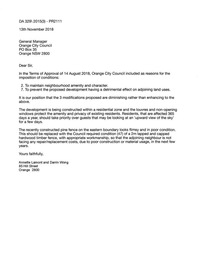

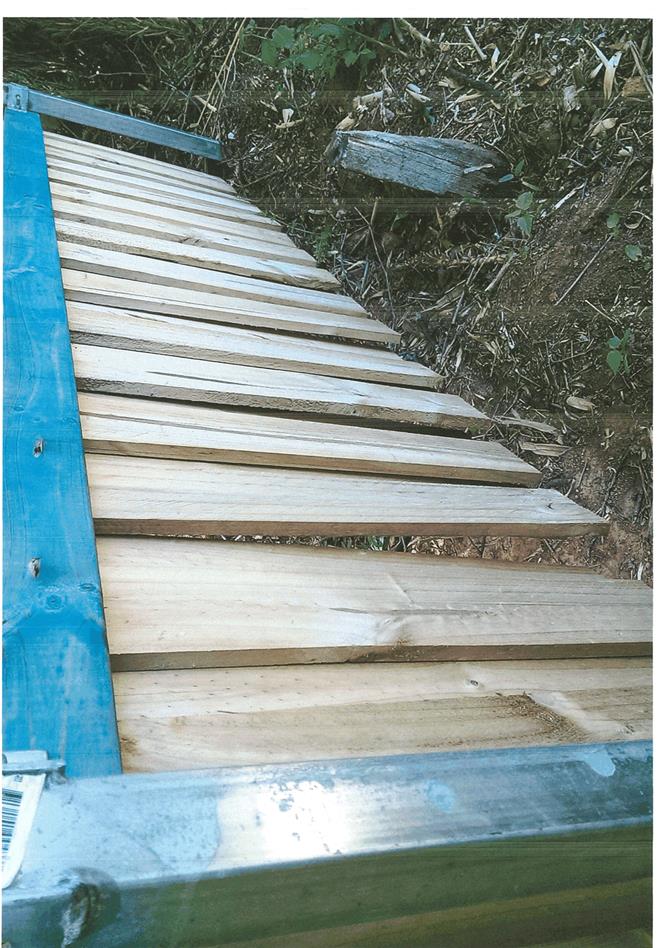


2.6 Development Application DA 136/2018(1) - 100 Bathurst Road
Attachment 1 Notice of Approval
|
|
ORANGE CITY COUNCIL
Development Application No DA 136/2018(1)
NA18/ Container PR1196 |
NOTICE OF DETERMINATION
OF A DEVELOPMENT APPLICATION
issued under the Environmental Planning and Assessment Act 1979
Section 4.18
|
Development Application |
|
|
Applicant Name: |
McDonald's Australia Limited |
|
Applicant Address: |
C/- KDC Pty Ltd Suite 2B, 125 Bull Street NEWCASTLE WEST NSW 2302 |
|
Owner’s Name: |
McDonalds Properties (Aust) Pty Limited |
|
Land to Be Developed: |
Lot 4 DP 778409 - 100 Bathurst Road, Orange |
|
Proposed Development: |
Take Away Food and Drink Premises, Restaurant or Cafe, Demolition (existing building and tree removal) and Business Identification Signage |
|
|
|
|
Building Code of Australia building classification: |
To be determined by the PC |
|
|
|
|
Determination made under Section 4.16 |
|
|
Made On: |
4 December 2018 |
|
Determination: |
CONSENT GRANTED SUBJECT TO CONDITIONS DESCRIBED BELOW: |
|
|
|
|
Consent to Operate From: |
5 December 2018 |
|
Consent to Lapse On: |
5 December 2023 |
Terms of Approval
The reasons for the imposition of conditions are:
(1) To ensure a quality urban design for the development which complements the surrounding environment.
(2) To maintain neighbourhood amenity and character.
(3) To ensure compliance with relevant statutory requirements.
(4) To provide adequate public health and safety measures.
(5) Because the development will require the provision of, or increase the demand for, public amenities and services.
(6) To ensure the utility services are available to the site and adequate for the development.
(7) To prevent the proposed development having a detrimental effect on adjoining land uses.
(8) To minimise the impact of development on the environment.
|
|
|
Conditions
(1) The development must be carried out in accordance with:
(a) Plans by Richmond ross – project number 160459 drawing numbers: A000 issue D; A001 issue D; A041 issue D; A060 issue D; A062 issue D; A067 issue D; A202 issue D; A203 issue D; A205 issue D; A801 issue D; A806 issue D; A807 issue D; SP01 issue D (17 sheets)
Landscape plans by Site image landscape architects job number SS18-3772 drawing numbers: 000 issue C; 101 issue C; 501 issue C (3 sheets)
Staging plans by Richmond Ross dated 19 July 2018; dwg no. ST00 Issue B; ST01 Issue B; ST02 Issue B; ST03 Issue B; ST04 issue B ST5A issue B; ST5b issue B (NB these plans are for the purposes of staging only)
(b) Statement of Environmental Effects or other similar associated documents including the Noise Assessment Report prepared by Muller Acoustic Consulting (Document ID MAC170570RP1V01) and accompanying addendum that form part of the approval
as amended in accordance with any conditions of this consent.
(2) The flag poles located at the front of the site do not form part of this application. Any changes to them will require separate approval.
|
PRESCRIBED CONDITIONS |
(3) All building work must be carried out in accordance with the provisions of the Building Code of Australia.
(4) A sign is to be erected in a prominent position on any site on which building work, subdivision work or demolition work is being carried out:
(a) showing the name, address and telephone number of the principal certifying authority for the work, and
(b) showing the name of the principal contractor (if any) for any building work and a telephone number on which that person may be contacted outside working hours, and
(c) stating that unauthorised entry to the site is prohibited.
Any such sign is to be maintained while the building work, subdivision work or demolition work is being carried out.
(5) Where any excavation work on the site extends below the level of the base of the footings of a building on adjoining land, the person having the benefit of the development consent must, at the person’s own expense:
(a) protect and support the adjoining premises from possible damage from the excavation, and
(b) where necessary, underpin the adjoining premises to prevent any such damage.
Note: This condition does not apply if the person having the benefit of the development consent owns the adjoining land or the owner of the adjoining land has given consent in writing to this condition not applying.
|
PRIOR TO THE ISSUE OF A CONSTRUCTION CERTIFICATE |
(6) Detailed plans and specifications are to be provided specifying the proposed fitout of the food preparation and storage areas in accordance with the requirements of Australian Standard 4674-2004 "Design and construction and fitout of food premises" and Standard 3.2.3 "Food Premises and Equipment" of the Australian New Zealand Food Standards Code.
(7) An approval under Section 68 of the Local Government Act is to be sought from Orange City Council, as the Water and Sewer Authority, for alterations to water and sewer. No plumbing and drainage is to commence until approval is granted.
(8) Engineering plans providing complete details of the proposed driveway and car parking areas are to be submitted to Orange City Council or an Accredited Certifier (Categories B1, C3, C4, C6) upon application for a Construction Certificate. These plans are to provide details of levels, cross falls of all pavements, sealing materials, drainage works, line marking and signage and are to be in accordance with Orange City Council Development and Subdivision Code.
The plans shall ensure that stormwater surface flows from a 1% EAP storm event entering the site from Lot 3 DP 630463 are unimpeded by any fencing along the boundary or kerbs or garden structures in the area of inundation of the carpark.
(9) A Liquid Trade Waste Application is to be submitted to Orange City Council prior to the issuing of a Construction Certificate. The application is to be in accordance with Orange City Council’s Liquid Trade Waste Policy. Engineering plans submitted as part of the application are to show details of all proposed liquid trade waste pre-treatment systems and their connection to sewer.
Where applicable, the applicant is to enter into a Liquid Trade Waste Service Agreement with Orange City Council in accordance with the Orange City Council Liquid Trade Waste Policy.
(10) Payment of contributions for water, sewer and drainage works is required to be made at the contribution rate applicable at the time that the payment is made. The contributions are based on 1.8 ETs for water supply headworks and 2.88 ETs for sewerage headworks. A Certificate of Compliance, from Orange City Council in accordance with the Water Management Act 2000, will be issued upon payment of the contributions.
This Certificate of Compliance is to be submitted to the Principal Certifying Authority prior to the issuing of a Construction Certificate.
(11) A water and soil erosion control plan is to be submitted to Orange City Council or an Accredited Certifier (Categories B1, C3, C4, C6) for approval prior to the issuing of a Construction Certificate. The control plan is to be in accordance with the Orange City Council Development and Subdivision Code and the Landcom, Managing Urban Stormwater; Soils and Construction Handbook.
(12) Backflow Prevention Devices are to be installed to AS3500 and in accordance with Orange City Council Backflow Protection Guidelines. Details of the Backflow Prevention Devices are to be submitted to Orange City Council prior to the issuing of a Construction Certificate.
(13) All stormwater from the site is to be collected and piped to a stormwater treatment system. The design and construction of the stormwater treatment system for the subject land shall ensure that the quality of stormwater leaving the developed site shall achieve the following stormwater quality targets:
· 90% reduction in the post development average annual gross pollutant (>5 millimetres) load.
· 85% reduction in the post development mean annual load of Total Suspended Solids (TSS);
· 65% reduction in the post development mean annual load of Total Phosphorus (TP);
· 45% reduction in the post development mean annual load of Total Nitrogen loads (TN);
Engineering plans for this stormwater treatment system shall be submitted to and approved by Orange City Council prior to the issuing of a Construction Certificate. The applicant shall undertake comprehensive water quality modelling on for the site, using an accredited assessment tool (recommended using Music™ or other approved assessment tool) and shall include copies of the electronic data files.
(14) Roads and Maritime Services conditions for the development are as follows and shall be incorporated into the Construction Certificate plans:
· Vehicular egress from the site onto Bathurst Road is to be restricted to left turn only. To control egress from the site onto Bathurst Road, a concrete island is to be constructed to enforce the left turn out only movement. Construction of the Bathurst Road driveway and concrete island will be subject to the developer and Roads and Maritime entering into a Works Authorisation Deed. The WAD is to be entered into prior to the commencement of demolition works.
· Size “A” “Left Only” (r2-14) signs are to be erected on the land on each side of the exit driveway to Bathurst Road. The signs are to face the site to advise motorists that all egress from the site to Bathurst Road is left turn only.
· Prior to the commencement of construction work, the proponent is to contact Roads and Maritime’s Field Traffic Manager on 1300 656 371 to determine if a Road Occupancy Licence (ROL) is required. In the event that an ROL is required, the proponent is to obtain the ROL prior to works commencing within three (3) metres of the travel lanes of Bathurst Road.
· Landscaping, signage and fencing is not to impede sight lines of traffic within or when passing, entering or departing from the site. Safe Intersection Sight Distance (SISD), in accordance with Austroads Guide to Road Design, is to be provided and maintained at the driveway intersection with Bathurst Road.
|
PRIOR TO WORKS COMMENCING |
(15) A Construction Certificate application is required to be submitted to, and issued by Council/Accredited Certifier prior to any excavation or building works being carried out onsite.
(16) A temporary onsite toilet is to be provided and must remain throughout the project or until an alternative facility meeting Council’s requirements is available onsite.
(17) Soil erosion control measures shall be implemented on the site.
(18) A dilapidation report prepared by a suitably qualified engineer is to be submitted to Council addressing the current condition of the buildings that are adjoining the development site.
(19) A Construction Management Plan (CMP) shall be prepared for the development. The CMP shall detail measures for addressing such things as; staff parking, directional signage, signage indicating drive-through only, loading and unloading arrangements for both the restaurant and the construction site, safety measures for stafe using the facility, etc. The CMP shall be prepared by a suitably qualified person and shall be submitted to and approved by the Principle Certifying Authority prior to works commencing on the site. The CMP shall be inforce for the entire demolition / construction phase.
|
DURING CONSTRUCTION/SITEWORKS |
(20) If Aboriginal objects, relics, or other historical items or the like are located during development works, all works in the area of the identified object, relic or item shall cease, and the NSW Office of Environment and Heritage (OEH), and representatives from the Orange Local Aboriginal Land Council shall be notified. Where required, further archaeological investigation shall be undertaken. Development works in the area of the find(s) may recommence if and when outlined by the management strategy, developed in consultation with and approved by the OEH.
(21) In the event of an unexpected find during works such as (but not limited to) the presence of undocumented waste, odorous or stained soil, asbestos, structures such as underground storage tanks, slabs, or any contaminated or suspect material, all work on site must cease immediately. The beneficiary of the consent must discuss with Council the appropriate process that should be followed therein. Works on site must not resume unless the express permission of the Director Development Services is obtained in writing.
(22) Once stage 1 of the development as detailed on plan ST01 Issue B commences (and under all other subsequent stages), all access to the existing restaurant (internally) by customers and/or the general public shall be prohibited.
Under stages 3, 4 and 5A of the development as detailed on plans ST03 Issue B and ST04 Issue B, all access to the new restaurant (internally) by customers and/or the general public shall be prohibited until such time as the car parking area is fully completed.
(23) Implement the noise management and mitigation measures, set out in Chapter 7 “Construction Recommendations” of the Noise Assessment Report prepared by Muller Acoustic Consulting (Document ID MAC170570RP1V01), prior to commencement of demolition/construction activities.
(24) All construction/demolition work on the site is to be carried out between the hours of 7.00 am and 6.00 pm Monday to Friday inclusive, 7.00 am to 5.00 pm Saturdays and 8.00 am to 5.00 pm Sundays and Public Holidays. Written approval must be obtained from the General Manager of Orange City Council to vary these hours.
(25) A Registered Surveyor’s certificate identifying the location of the building on the site must be submitted to the Principal Certifying Authority.
(26) All materials onsite or being delivered to the site are to be contained within the site. The requirements of the Protection of the Environment Operations Act 1997 are to be complied with when placing/stockpiling loose material or when disposing of waste products or during any other activities likely to pollute drains or watercourses.
(27) Building demolition is to be carried out in accordance with Australian Standard 2601:2001 - The Demolition of Structures and the requirements of Safe Work NSW.
(28) Asbestos containing building materials must be removed in accordance with the provisions of the Work Health and Safety Act 2011 and any guidelines or Codes of Practice published by Safe Work NSW, and disposed of at a licenced landfill in accordance with the requirements of the NSW EPA.
(29) Any adjustments to existing utility services that are made necessary by this development proceeding are to be at the full cost of the developer.
(30) The provisions and requirements of the Orange City Council Development and Subdivision Code are to be applied to this application and all work constructed within the development is to be in accordance with that Code.
The developer is to be entirely responsible for the provision of water, sewerage and drainage facilities capable of servicing the development from Council’s existing infrastructure. The developer is to be responsible for gaining access over adjoining land for services where necessary and easements are to be created about all water, sewer and drainage mains within and outside the lots they serve.
(31) All driveway and parking areas are to be sealed with bitumen, hot mix or concrete and are to be designed for all expected loading conditions (provided however that the minimum pavement depth for gravel and flush seal roadways is 200mm) and be in accordance with the Orange City Council Development and Subdivision Code.
(32) All construction works are to be strictly in accordance with the Reduced Levels (RLs) as shown on the approved plans.
|
PRIOR TO THE ISSUE OF AN OCCUPATION CERTIFICATE |
(33) All outdoor lighting, including illuminated signage shall be designed and installed in accordance with AS 4282 – 1997 Control of the obtrusive effects of outdoor lighting.
(34) A pedestrian crossing shall be installed across the drive-through lane linking with the Bathurst Road footpath prior to the issue of a Final Occupation Certificate.
(35) The car parking shall be provided upon the site in accordance with the staging plans. A total of 33 off-street car parking spaces shall be provided upon the site in accordance with the approved plans, the provisions of Development Control Plan 2004, and be constructed in accordance with the requirements of Council's Development and Subdivision Code prior to the issue of a Final Occupation Certificate.
(36) Landscaping shall be installed in accordance with the approved plans and shall be permanently maintained to the satisfaction of Council's Manager Development Assessments.
(37) A deliveries and waste collection plan of management shall be prepared for the development and implemented in perpetuity once the development is operational. The deliveries and waste collection plan of management shall outline such things as appropriate measures that ensure the safety of pedestrians in the vicinity of the loading area during times of loading and unloading of vehicles and the reversing manoeuvre of vehicles entering the loading area. Measures shall include such practices as temporary barricading and someone on the ground directing the movement of pedestrians. The pedestrian management plan shall be submitted to the Principal Certifying Authority for approval prior to the issue of an Occupation Certificate. Once approved the plan shall be implemented for the duration of the development.
(38) All entry/exit points onto/from the public road network, internal vehicular manoeuvring, parking and loading areas are to be constructed prior to the issuance of an Occupation Certificate for the development.
(39) The applicant shall provide Council with an Operational Management Plan. The Plan shall include measures to appropriately mitigate operational noise from the development (including noise from plant; patrons/pedestrians entering/leaving the site; noise from areas such as the play land area, waste collection times; delivery times; along with measures to mitigate odours and fumes that could be emitted from the kitchen or waste storage area.
(40) No person is to use or occupy the building or alteration that is the subject of this approval without the prior issuing of an Occupation Certificate.
(41) The owner of the building/s must cause the Council to be given a Final Fire Safety Certificate on completion of the building in relation to essential fire or other safety measures included in the schedule attached to this approval.
(42) Where Orange City Council is not the Principal Certifying Authority, a final inspection of water connection, sewer and stormwater drainage shall be undertaken by Orange City Council and a Final Notice of Inspection issued, prior to the issue of either an interim or a final Occupation Certificate.
(43) A Certificate of Compliance, from a Qualified Engineer, stating that the stormwater treatment system complies with the approved engineering plans is to be submitted to the Principal Certifying Authority prior to the issuing of an Occupation Certificate.
(44) Certification from Orange City Council is required to be submitted to the Principal Certifying Authority prior to the issue of an Occupation Certificate stating that all works relating to connection of the development to Council assets, works on public land, works on public roads, stormwater, sewer and water reticulation mains and footpaths have been carried out in accordance with the Orange City Council Development and Subdivision Code and the foregoing conditions, and that Council will take ownership of the infrastructure assets.
(45) Certificates for testable Backflow Prevention Devices are to be submitted to Orange City Council by a plumber with backflow qualifications prior to the issue of an Occupation Certificate.
(46) All of the foregoing conditions are to be at the full cost of the developer and to the requirements and standards of the Orange City Council Development and Subdivision Code, unless specifically stated otherwise. All work required by the foregoing conditions is to be completed prior to the issuing of an Occupation Certificate, unless stated otherwise.
|
MATTERS FOR THE ONGOING PERFORMANCE AND OPERATION OF THE DEVELOPMENT |
(47) Outdoor lighting must be in accordance with the Australian Standard 4282-1997 Control of the obtrusive effects of outdoor lighting.
(48) The development shall be carried out in accordance with the submitted plan of management prepared for McDonald’s Australia Limited dated July 2018 and the document title “McDonald’s Australia Limited Orange Waste Management” in perpetuity.
(49) All traffic movements into and out of the development shall be in a forward direction.
(50) All loading and unloading activities associated with the construction and operation of the proposed development is to occur on-site.
(51) An assessment of noise emissions from the premises is to be provided to Council within 3 months from the issue of any Occupation Certificate. This commissioning report is to indicate noise levels through the monitoring of noise emanating from the normal peak use of the premises and determine if any necessary noise mitigation measures are required. Any identified mitigation works shall be carried out within 1 month of the commissioning report, and the operation of the premises shall be carried out in accordance with any recommendations set out in the report.
(52) The development shall be operated in accordance with the approved Operational Management Plan.
(53) Any ancillary light fittings fitted to the exterior of the building are to be shielded or mounted in a position to minimise glare to adjoining properties.
(54) The owner is required to provide to Council and to the NSW Fire Commissioner an Annual Fire Safety Statement in respect of the fire-safety measures, as required by Clause 177 of the Environmental Planning and Assessment Regulation 2000.
(55) Copies of maintenance records for servicing of the stormwater treatment system shall be forwarded to Council on 1 December annually.
(56) The service/delivery vehicle shall be limited to a maximum length of a 14.5m (articulated). All vehicle movements entering and exiting the service vehicle driveway shall be in a forward direction.
ESSENTIAL ENERGY REQUIREMENTS FOR THE DEVELOPMENT
(1) If the proposed development changes, there may be potential safety risks and it is recommended that Essential Energy is consulted for further comment;
(2) Any existing encumbrances in favour of Essential Energy (or its predecessors) noted on the title of the above property should be complied with;
(3) If proposed construction is near or within the easement in electricity, Essential Energy should be notified;
(4) In addition, Essential Energy’s records indicate there is electricity infrastructure located within the property. Any activities within this location must be undertaken in accordance with the latest industry guideline currently known as ISSC 20 Guideline for the Management of Activities within Electricity Easements and Close to Infrastructure. Approval may be required from Essential Energy should activities within the property encroach on the electricity infrastructure.
(5) Prior to carrying out any works, a “Dial Before You Dig” enquiry should be undertaken in accordance with the requirements of Part 5E (Protection of Underground Electricity Power Lines) of the Electricity Supply Act 1995 (NSW).
(6) Given there is electricity infrastructure in the area, it is the responsibility of the person/s completing any works around powerlines to understand their safety responsibilities. SafeWork NSW (www.safework.nsw.gov.au) has publications that provide guidance when working close to electricity infrastructure. These include the Code of Practice – Work near Overhead Power Lines and Code of Practice – Work near Underground Assets.
|
|
|
Other Approvals
(1) Local Government Act 1993 approvals granted under section 68.
Nil
(2) General terms of other approvals integrated as part of this consent.
Nil
|
|
|
Right of Appeal
If you are dissatisfied with this decision, Section 8.7 of the Environmental Planning and Assessment Act 1979 gives you the right to appeal to the Land and Environment Court. Pursuant to Section 8.10, an applicant may only appeal within 6 months after the date the decision is notified.
|
Disability Discrimination Act 1992: |
This application has been assessed in accordance with the Environmental Planning and Assessment Act 1979. No guarantee is given that the proposal complies with the Disability Discrimination Act 1992.
The applicant/owner is responsible to ensure compliance with this and other anti-discrimination legislation.
The Disability Discrimination Act covers disabilities not catered for in the minimum standards called up in the Building Code of Australia which references AS1428.1 - "Design for Access and Mobility". AS1428 Parts 2, 3 and 4 provides the most comprehensive technical guidance under the Disability Discrimination Act currently available in Australia. |
|
|
|
|
Disclaimer - S88B of the Conveyancing Act 1919 - Restrictions on the Use of Land: |
The applicant should note that there could be covenants in favour of persons other than Council restricting what may be built or done upon the subject land. The applicant is advised to check the position before commencing any work. |
|
|
|
|
Signed: |
On behalf of the consent authority ORANGE CITY COUNCIL |
|
Signature: |
|
|
Name: |
PAUL JOHNSTON - MANAGER DEVELOPMENT ASSESSMENTS |
|
Date: |
5 December 2018 |
2.6 Development Application DA 136/2018(1) - 100 Bathurst Road
Attachment 2 Plans
Planning and Development Committee 4 December 2018
ITEM SUBJECT PAGE NO
2.7 Development Application DA 313/2018(1) - 26 Prince Street
Attachment 1 Notice of Approval......................................................................... 3
Attachment 2 Plans............................................................................................. 13
2.8 Development Application DA 349/2018(1) - 59-67 and 99 Bathurst Road
Attachment 1 Notice of Approval....................................................................... 45
Attachment 2 Plan.............................................................................................. 49
2.9 Development Application DA 329/2018(1) - 269-279 Summer Street (Robertson Park)
Attachment 1 Notice of Approval....................................................................... 50
Attachment 2 Plans............................................................................................. 55
Attachment 3 Submissions.................................................................................. 89
2.10 Development Application DA 348/2018(1) - 5 Hanrahan Place
Attachment 1 Notice of Approval..................................................................... 120
Attachment 2 Plans........................................................................................... 133
Attachment 3 Submission................................................................................. 177
Planning and Development Committee 4 December 2018
2.7 Development Application DA 313/2018(1) - 26 Prince Street
Attachment 1 Notice of Approval
|
|
ORANGE CITY COUNCIL
Development Application No DA 313/2018(1)
NA18/ Container PR10264 |
NOTICE OF DETERMINATION
OF A DEVELOPMENT APPLICATION
issued under the Environmental Planning and Assessment Act 1979
Section 4.18
|
Development Application |
|
|
Applicant Name: |
Straney Building Design |
|
Applicant Address: |
C/- Peter Basha Planning and Development PO Box 1827 ORANGE NSW 2800 |
|
Owner’s Name: |
Mr RP and Mrs AM Straney |
|
Land to Be Developed: |
Lot 1 Sec 33 DP 155632 - 26 Prince Street, Orange |
|
Proposed Development: |
Demolition (existing dwelling, ancillary structures and vegetation), Subdivision (two lot residential) and Dwelling Houses (construction of two new dwelling houses) |
|
|
|
|
Building Code of Australia building classification: |
To be determined by the PCA |
|
|
|
|
Determination made under Section 4.16 |
|
|
Made On: |
4 December 2018 |
|
Determination: |
CONSENT GRANTED SUBJECT TO CONDITIONS DESCRIBED BELOW: |
|
|
|
|
Consent to Operate From: |
5 December 2018 |
|
Consent to Lapse On: |
5 December 2023 |
Terms of Approval
The reasons for the imposition of conditions are:
(1) To ensure a quality urban design for the development which complements the surrounding environment.
(2) To maintain neighbourhood amenity and character.
(3) To ensure compliance with relevant statutory requirements.
(4) To provide adequate public health and safety measures.
(5) Because the development will require the provision of, or increase the demand for, public amenities and services.
(6) To ensure the utility services are available to the site and adequate for the development.
(7) To prevent the proposed development having a detrimental effect on adjoining land uses.
(8) To minimise the impact of development on the environment.
|
|
|
Conditions
(1) The development must be carried out in accordance with:
(a) Reference 18035DA Date 30.08.2018 Sheet 3 of 3,Reference 18035DA Date 30.08.2018 Sheet 3 of 3, Job No. 18.077, Dated Aug. 2018, Dwg No. DA2, Dwg No. DA3, Dwg No. DA4, Dwg No. DA5, Dwg No. DA6, Dwg No. DA7, Dwg No. DA8, Dwg No. DA9, Dwg No. DA10, Dwg No. DA11, Dwg No. DA12, Dwg No. 13 (14 sheets)
(b) statements of environmental effects or other similar associated documents that form part of the approval
as amended in accordance with any conditions of this consent.
|
PRESCRIBED CONDITIONS |
(2) All building work must be carried out in accordance with the provisions of the Building Code of Australia.
(3) A sign is to be erected in a prominent position on any site on which building work, subdivision work or demolition work is being carried out:
(a) showing the name, address and telephone number of the principal certifying authority for the work, and
(b) showing the name of the principal contractor (if any) for any building work and a telephone number on which that person may be contacted outside working hours, and
(c) stating that unauthorised entry to the site is prohibited.
Any such sign is to be maintained while the building work, subdivision work or demolition work is being carried out.
(4) In the case of residential building work for which the Home Building Act 1989 requires there to be a contract of insurance in force in accordance with Part 6 of the Act, evidence that such a contract of insurance is in force is to be provided to the Principal Certifying Authority before any building work authorised to be carried out by the consent commences.
(5) Residential building work within the meaning of the Home Building Act 1989 must not be carried out unless the principal certifying authority for the development to which the work relates (not being the council) has given the council written notice of the following information:
(a) in the case of work for which a principal contractor is required to be appointed:
(i) the name and the licence number of the principal contractor, and
(ii) the name of the insurer by which the work is insured under Part 6 of that Act,
(b) in the case of work to be done by an owner-builder:
(i) the name of the owner-builder, and
(ii) if the owner-builder is required to hold an owner-builder permit under that Act, the number of the owner-builder permit.
If arrangements for doing the residential building work are changed while the work is in progress so that the information under this condition becomes out of date, further work must not be carried out unless the principal certifying authority for the development to which the work relates (not being the council) has given the council written notice of the updated information.
(6) Where any excavation work on the site extends below the level of the base of the footings of a building on adjoining land, the person having the benefit of the development consent must, at the person’s own expense:
(a) protect and support the adjoining premises from possible damage from the excavation, and
(b) where necessary, underpin the adjoining premises to prevent any such damage.
Note: This condition does not apply if the person having the benefit of the development consent owns the adjoining land or the owner of the adjoining land has given consent in writing to this condition not applying.
DEMOLITION AND TWO LOT SUBDIVISION
|
PRIOR TO THE ISSUE OF A CONSTRUCTION CERTIFICATE |
(7) A 150mm-diameter sewer junction shall be constructed from Council’s existing main to serve each of the proposed lots. Prior to a Construction Certificate being issued engineering plans for this sewerage system are to be submitted to and approved by Orange City Council.
(8) Proposed Lot 2 shall be provided with interlot stormwater drainage where the surface of the entire lot cannot be drained to the kerb and gutter at the lot frontage. A grated concrete stormwater pit is to be constructed within each lot provided with interlot stormwater drainage. Engineering plans for this drainage system are to be approved by Orange City Council or an Accredited Certifier (Categories B1, C3, C4, C6) prior to the issuing of a Construction Certificate.
PRIOR TO WORKS COMMENCING |
(9) The applicant is to submit a waste management plan that describes the nature of wastes to be removed, the wastes to be recycled and the destination of all wastes. All wastes from the demolition and construction phases of this project are to be deposited at a licensed or approved waste disposal site.
(10) A temporary onsite toilet is to be provided and must remain throughout the project or until an alternative facility meeting Council’s requirements is available onsite.
(11) Soil erosion control measures shall be implemented on the site.
|
DURING CONSTRUCTION/SITEWORKS |
(12) If Aboriginal objects, relics, or other historical items or the like are located during development works, all works in the area of the identified object, relic or item shall cease, and the NSW Office of Environment and Heritage (OEH), and representatives from the Orange Local Aboriginal Land Council shall be notified. Where required, further archaeological investigation shall be undertaken. Development works in the area of the find(s) may recommence if and when outlined by the management strategy, developed in consultation with and approved by the OEH.
(13) In the event of an unexpected find during works such as (but not limited to) the presence of undocumented waste, odorous or stained soil, asbestos, structures such as underground storage tanks, slabs, or any contaminated or suspect material, all work on site must cease immediately. The beneficiary of the consent must discuss with Council the appropriate process that should be followed therein. Works on site must not resume unless the express permission of the Director Development Services is obtained in writing.
(14) The Box Elders (Acer negundo[s]) located on the Sampson Street frontage of the subject property shall have Tree Protection Fencing as per AS4970-2009 Protection of trees on development sites Section 4 – 4.3 Protective Fencing and works as per 4.2 Activities Restricted within the TPZ shall not be undertaken. Fencing shall be erected prior to site establishment and not impact on pedestrian access or vehicles on the roadway. Whilst it is not achievable to establish TPZ fencing at the specified distance with AS4970-2009; TPZ fencing shall be erected at a minimum of 3 metres from the centre of each tree’s trunk.
(15) All construction/demolition work on the site is to be carried out between the hours of 7.00 am and 6.00 pm Monday to Friday inclusive, 7.00 am to 5.00 pm Saturdays and 8.00 am to 5.00 pm Sundays and Public Holidays. Written approval must be obtained from the General Manager of Orange City Council to vary these hours.
(16) Building demolition is to be carried out in accordance with Australian Standard 2601:2001 - The Demolition of Structures and the requirements of Safe Work NSW.
(17) Asbestos containing building materials must be removed in accordance with the provisions of the Work Health and Safety Act 2011 and any guidelines or Codes of Practice published by Safe Work NSW, and disposed of at a licenced landfill in accordance with the requirements of the NSW EPA.
(18) Any adjustments to existing utility services that are made necessary by this development proceeding are to be at the full cost of the developer.
(19) The provisions and requirements of the Orange City Council Development and Subdivision Code are to be applied to this application and all work constructed within the development is to be in accordance with that Code.
The developer is to be entirely responsible for the provision of water, sewerage and drainage facilities capable of servicing all the lots from Council’s existing infrastructure. The developer is to be responsible for gaining access over adjoining land for services where necessary and easements are to be created about all water, sewer and drainage mains within and outside the lots they serve.
(20) The water and sewerage services to the existing building, where they are not proposed to be used as part of this development, are to be sealed off at their respective Council mains.
(21) A water service and sewer junction is to be provided within each lot in the proposed residential subdivision in accordance with the Orange City Council Development and Subdivision Code.
(22) All services are to be contained within the allotment that they serve.
|
PRIOR TO THE ISSUE OF A SUBDIVISION CERTIFICATE |
(23) The payment of $10,545.72 is to be made to Council in accordance with section 94 of the Act and the Orange Development Contributions Plan 2017 (Development in remainder of LGA) towards the provision of the following public facilities:
|
Open Space and Recreation |
1 additional lot @ $3,922.87 |
3,922.87 |
|
Community and Cultural |
1 additional lot @ $1,137.63 |
1,137.63 |
|
Roads and Traffic Management |
1 additional lot @ $5,178.06 |
5,178.06 |
|
Local Area Facilities |
1 additional lot @ $ - |
- |
|
Plan Preparation & Administration |
1 additional lot @ $307.16 |
307.16 |
|
TOTAL: |
|
$10,545.72 |
The contribution will be indexed quarterly in accordance with the Orange Development Contributions Plan 2017 (Development in remainder of LGA). This Plan can be inspected at the Orange Civic Centre, Byng Street, Orange.
(24) Application shall be made for a Subdivision Certificate under Section 6.3(1)(d) of the Act.
(25) Payment of contributions for water, sewer and drainage works is required to be made at the contribution rate applicable at the time that the payment is made. The contributions are based on 1.0 ETs for water supply headworks and 1.0 ETs for sewerage headworks. A Certificate of Compliance, from Orange City Council in accordance with the Water Management Act 2000, will be issued upon payment of the contributions.
This Certificate of Compliance is to be submitted to the Principal Certifying Authority prior to the issuing of a Subdivision Certificate.
(26) Application is to be made to Telstra/NBN for infrastructure to be made available to each individual lot within the development. Either a Telecommunications Infrastructure Provisioning Confirmation or Certificate of Practical Completion is to be submitted to the Principal Certifying Authority confirming that the specified lots have been declared ready for service prior to the issue of a Subdivision Certificate.
(27) A Notice of Arrangement from Essential Energy stating arrangements have been made for the provision of electricity supply to the development, is to be submitted to the Principal Certifying Authority prior to the issue of a Subdivision Certificate.
(28) All services are to be contained within the allotment that they serve. A Statement of Compliance, from a Registered Surveyor, is to be submitted to the Principal Certifying Authority prior to the issuing of a Subdivision Certificate.
(29) Where stormwater crosses land outside the lot it favours, an easement to drain water is to be created over the works. A Restriction-as-to-User under section 88B of the NSW Conveyancing Act 1979 is to be created on the title of the burdened Lot requiring that no structures are to be placed on the site, or landscaping or site works carried out on the site, in a manner that affects the continued operation of the interlot drainage system. The minimum width of the easement is to be as required in the Orange City Council Development and Subdivision Code.
(30) Certification from Orange City Council is required to be submitted to the Principal Certifying Authority prior to the issue of a Subdivision Certificate stating that all works relating to connection of the development to Council assets, works on public land, works on public roads, stormwater, sewer and water reticulation mains and footpaths have been carried out in accordance with the Orange City Council Development and Subdivision Code and the foregoing conditions, and that Council will take ownership of the infrastructure assets.
(31) All of the foregoing conditions are to be at the full cost of the developer and to the requirements and standards of the Orange City Council Development and Subdivision Code, unless specifically stated otherwise. All work required by the foregoing conditions is to be completed prior to the issuing of an Occupation or Subdivision Certificate, unless stated otherwise.
TWO DWELLINGS
|
PRIOR TO THE ISSUE OF A CONSTRUCTION CERTIFICATE |
(32) The following details shall be incorporated into the design of the development. Plans clearly showing the below details shall be submitted to, and approved by, Council’s Manager Development Assessments prior to the issue of a Construction Certificate for Dwelling 1 and Dwelling 2:
· Dwelling 1 is to be constructed with a lighter brick and lighter roof than Dwelling 2. Dwelling 1 is to be constructed from Namoi Silver Grey and Dwelling 2 be constructed from Namoi Federation Blue.
· All brick work below the level of finished floor level is to be a dark grey or black coloured brick on both Dwelling 1 and Dwelling 2.
· Timber windows are to be installed on the north elevation of Dwelling 1 and the east elevation of Dwelling 2.
· The colour of fence posts (including posts of the woven wire fence and paling fence) are to be matched to the colour of the verandah posts of both Dwelling 1 and Dwelling 2.
· Traditional rolled flashings and smooth quad gutters and circular downpipes are to be provided on both Dwelling 1 and Dwelling 2.
(33) The proposed site plan is to be amended prior to the issuing of a Construction Certificate. The amended site plan is to demonstrate:
· A reduced driveway width of 3m is to be accommodated within the road reserve for Dwelling 2. The amended driveway is to be aligned 1250mm off the southern boundary.
· The gradual increase in width of the driveway accommodated in front of the proposed garage for Dwelling 2, to the accommodate the double garage, after the eastern boundary line of Lot 2.
· Extension of the woven wire fence along the frontage of Dwelling 2, designed to be in keeping with the reduced driveway width for Dwelling 2.
The amended site plan is to be submitted to the Manager Development Services for approval prior to the issuing of a Construction Certificate for both dwellings.
(34) The landscaping plan is to be amended:
· to incorporate hedging along the eastern boundary fence line, commencing from behind the building line of Dwelling 1 and concluding at the shared internal fence between Dwelling 1 and Dwelling 2. The hedge is to be a species that is conducive to the climate and conditions, and is to grow to a maximum height of 2m; and
· to redesign the Rhaphiolepis Indica “Snow Maiden” plantings to complement the change in driveway width from the 3m width within the road reserve to the approximate 6m width proposed on site.
No other landscaping is to be amended on stamped plan DA2. The amended landscaping plan showing the requested amendment shall be submitted to and approved by Councils Manager Development Assessments prior to the issue of a Construction Certificate for Dwelling 1 and Dwelling 2.
(35) An approval under Section 68 of the Local Government Act is to be sought from Orange City Council, as the Water and Sewer Authority, for water, sewer and stormwater connection. No plumbing and drainage is to commence until approval is granted.
(36) Prior to the issue of a Construction Certificate evidence shall be provided to the Principal Certifying Authority that proposed Lots 1 and 2 have been registered with NSW Land and Property Information.
|
PRIOR TO WORKS COMMENCING |
(37) A separate Construction Certificate application for each dwelling is required to be submitted to, and be issued by Council/Accredited Certifier prior to any excavation or building works being carried out onsite.
(38) A temporary onsite toilet is to be provided and must remain throughout the project or until an alternative facility meeting Council’s requirements is available onsite.
(39) Soil erosion control measures shall be implemented on the site.
|
DURING CONSTRUCTION/SITEWORKS |
(40) If Aboriginal objects, relics, or other historical items or the like are located during development works, all works in the area of the identified object, relic or item shall cease, and the NSW Office of Environment and Heritage (OEH), and representatives from the Orange Local Aboriginal Land Council shall be notified. Where required, further archaeological investigation shall be undertaken. Development works in the area of the find(s) may recommence if and when outlined by the management strategy, developed in consultation with and approved by the OEH.
(41) In the event of an unexpected find during works such as (but not limited to) the presence of undocumented waste, odorous or stained soil, asbestos, structures such as underground storage tanks, slabs, or any contaminated or suspect material, all work on site must cease immediately. The beneficiary of the consent must discuss with Council the appropriate process that should be followed therein. Works on site must not resume unless the express permission of the Director Development Services is obtained in writing.
(42) The Box Elders (Acer negundo[s]) located on the Sampson Street frontage of the subject property shall have Tree Protection Fencing as per AS4970-2009 Protection of trees on development sites Section 4 – 4.3 Protective Fencing and works as per 4.2 Activities Restricted within the TPZ shall not be undertaken. Fencing shall be erected prior to site establishment and not impact on pedestrian access or vehicles on the roadway. Whilst it is not achievable to establish TPZ fencing at the specified distance with AS4970-2009; TPZ fencing shall be erected at a minimum of 3 metres from the centre of each tree’s trunk.
(43) All construction/demolition work on the site is to be carried out between the hours of 7.00 am and 6.00 pm Monday to Friday inclusive, 7.00 am to 5.00 pm Saturdays and 8.00 am to 5.00 pm Sundays and Public Holidays. Written approval must be obtained from the General Manager of Orange City Council to vary these hours.
(44) A Registered Surveyor’s certificate identifying the location of the building on the site must be submitted to the Principal Certifying Authority prior to the pouring of the slab or footings.
(45) All materials on site or being delivered to the site are to be contained within the site. The requirements of the Protection of the Environment Operations Act 1997 are to be complied with when placing/stockpiling loose material or when disposing of waste products or during any other activities likely to pollute drains or watercourses.
(46) Any adjustments to existing utility services that are made necessary by this development proceeding are to be at the full cost of the developer.
|
PRIOR TO THE ISSUE OF AN OCCUPATION CERTIFICATE |
(47) Landscaping shall be installed in accordance with the approved plans and shall be permanently maintained to the satisfaction of Council's Manager Development Assessments.
(48) Fencing is to be installed in line with the approved plans. Where damage occurs to the existing southern and western boundary fence, this is to be replaced using Colorbond fencing at 1.8m high in a matching tone. The maximum height of fences shall be measured from the highest finished ground level adjacent to each part of that fence.
(49) A total of seven off-street car parking spaces (four at Dwelling 1 and three at Dwelling 2) shall be provided upon the site in accordance with the approved plans, the provisions of Development Control Plan 2004, and be constructed in accordance with the requirements of Council's Development and Subdivision Code prior to the issue of an Occupation Certificate.
(50) No person is to use or occupy the building or alteration that is the subject of this approval without the prior issuing of an Occupation Certificate.
(51) Where Orange City Council is not the Principal Certifying Authority, a final inspection of water connection, sewer and stormwater drainage shall be undertaken by Orange City Council and a compliance certificate issued, prior to the issue of either an interim or a final Occupation Certificate.
(52) The cut and fill is to be retained and/or adequately battered and stabilised (within the allotment) prior to the issue of an Occupation Certificate.
(53) All of the foregoing conditions are to be at the full cost of the developer and to the requirements and standards of the Orange City Council Development and Subdivision Code, unless specifically stated otherwise. All work required by the foregoing conditions is to be completed prior to the issuing of an Occupation or Subdivision Certificate, unless stated otherwise.
ADVISORY NOTES |
(1) The condition requiring redesign of the site plan is in relation to the requirement for the redesign of the driveway for Dwelling 2, to ensure protection is afforded to the existing street tree adjacent to the proposed driveway.
(2) The condition requiring amendment of the landscaping plan is in relation to the requirement:
· for additional privacy afforded to the private open space of Dwelling 1; and
· to redesign the driveway for Dwelling 2, to accommodate a single lane driveway (maximum 3m) located 1250mm off the southern boundary, in the vehicle crossover within the road reserve, increasing to the wider approximately 6m driveway on the site, commencing after the eastern site boundary of Lot 2.
|
|
|
Other Approvals
(1) Local Government Act 1993 approvals granted under Section 68.
Nil
(2) General terms of other approvals integrated as part of this consent:
· As part of the subdivision, an easement/s are/is created for any existing electrical infrastructure. The easement/s is/are to be created using Essential Energy’s standard easement terms current at the time of registration of the plan of subdivision;
· If the proposed development changes, there may be potential safety risks and it is recommended that Essential Energy is consulted for further comment;
· Any existing encumbrances in favour of Essential Energy (or its predecessors) noted on the title of the above property should be complied with; and
· Council should ensure that a Notification of Arrangement (confirming satisfactory arrangements have been made for the provision of power) is issued by Essential Energy with respect to all proposed lots which will form part of the subdivision, prior to Council releasing the Subdivision Certificate. It is the Applicant’s responsibility to make the appropriate application with Essential Energy for the supply of electricity to the subdivision, which may include the payment of fees and contributions.
· In addition, Essential Energy’s records indicate there is electricity infrastructure located within the property. Any activities within this location must be undertaken in accordance with the latest industry guideline currently known as ISSC 20 Guideline for the Management of Activities within Electricity Easements and Close to Infrastructure.
· Prior to carrying out any works, a “Dial Before You Dig” enquiry should be undertaken in accordance with the requirements of Part 5E (Protection of Underground Electricity Power Lines) of the Electricity Supply Act 1995 (NSW).
· Given there is electricity infrastructure in the area, it is the responsibility of the person/s completing any works around powerlines to understand their safety responsibilities. SafeWork NSW (www.safework.nsw.gov.au) has publications that provide guidance when working close to electricity infrastructure. These include the Code of Practice – Work near Overhead Power Lines and Code of Practice – Work near Underground Assets.
|
|
|
Right of Appeal
If you are dissatisfied with this decision, Section 8.7 of the Environmental Planning and Assessment Act 1979 gives you the right to appeal to the Land and Environment Court. Pursuant to Section 8.10, an applicant may only appeal within 6 months after the date the decision is notified.
|
Disability Discrimination Act 1992: |
This application has been assessed in accordance with the Environmental Planning and Assessment Act 1979. No guarantee is given that the proposal complies with the Disability Discrimination Act 1992.
The applicant/owner is responsible to ensure compliance with this and other anti-discrimination legislation.
The Disability Discrimination Act covers disabilities not catered for in the minimum standards called up in the Building Code of Australia which references AS1428.1 - "Design for Access and Mobility". AS1428 Parts 2, 3 and 4 provides the most comprehensive technical guidance under the Disability Discrimination Act currently available in Australia. |
|
|
|
|
Disclaimer - S88B of the Conveyancing Act 1919 - Restrictions on the Use of Land: |
The applicant should note that there could be covenants in favour of persons other than Council restricting what may be built or done upon the subject land. The applicant is advised to check the position before commencing any work. |
|
|
|
|
Signed: |
On behalf of the consent authority ORANGE CITY COUNCIL |
|
Signature: |
|
|
Name: |
PAUL JOHNSTON - MANAGER DEVELOPMENT ASSESSMENTS |
|
Date: |
5 December 2018 |
2.7 Development Application DA 313/2018(1) - 26 Prince Street
Attachment 2 Plans
2.8 Development Application DA 349/2018(1) - 59-67 and 99 Bathurst Road
Attachment 1 Notice of Approval
|
|
ORANGE CITY COUNCIL
Development Application No DA 349/2018(1)
NA18/ Container PR13267 and PR26308 |
NOTICE OF DETERMINATION
OF A DEVELOPMENT APPLICATION
issued under the Environmental Planning and Assessment Act 1979
Section 4.18
|
Development Application |
|
|
Applicant Name: |
Mr G Barrett |
|
Applicant Address: |
Suite 12/ 55 Wheelers Lane DUBBO NSW 2800 |
|
Owner’s Name: |
Mr GC Barrett |
|
Land to Be Developed: |
Lot 40 DP 810916 and Lot 30 DP 1190518 - 99 Bathurst Road and 59‑67 Bathurst Road, Orange |
|
Proposed Development: |
Demolition (tree removal) |
|
|
|
|
Building Code of Australia building classification: |
Not applicable |
|
|
|
|
Determination made under Section 4.16 |
|
|
Made On: |
4 December 2018 |
|
Determination: |
CONSENT GRANTED SUBJECT TO CONDITIONS DESCRIBED BELOW: |
|
|
|
|
Consent to Operate From: |
5 December 2018 |
|
Consent to Lapse On: |
5 December 2023 |
Terms of Approval
The reasons for the imposition of conditions are:
(1) To ensure a quality urban design for the development which complements the surrounding environment.
(2) To maintain neighbourhood amenity and character.
(3) To ensure compliance with relevant statutory requirements.
(4) To provide adequate public health and safety measures.
(5) Because the development will require the provision of, or increase the demand for, public amenities and services.
(6) To ensure the utility services are available to the site and adequate for the development.
(7) To prevent the proposed development having a detrimental effect on adjoining land uses.
(8) To minimise the impact of development on the environment.
|
|
|
Conditions
(1) The development must be carried out in accordance with:
(a) unnumbered and undated - aerial photograph depicting location of trees (1 sheet)
(b) statements of environmental effects or other similar associated documents that form part of the approval
as amended in accordance with any conditions of this consent.
|
PRIOR TO WORKS COMMENCING |
(2) Prior to the removal of the thirteen English Elm trees, eleven trees on the common (western) boundary of Lot 40 DP810916, which is shared with Lot 30 DP1190518, and two trees on the common (northern) boundary of Lot 40 DP810916, which is shared with Lot 30 DP1190518, the common (western) boundary of Lot 40 DP810916, which is shared with Lot 30 DP1190518 is to be determined and agreed upon.
(3) Prior to the removal of the thirteen English Elm trees, eleven trees on the common (western) boundary of Lot 40 DP810916, which is shared with Lot 30 DP1190518, and two trees on the common (northern) boundary of Lot 40 DP810916, which is shared with Lot 30 DP1190518, a replacement species is to be chosen from one of the following species:
|
Common Name |
Botanical Name |
Spacing |
|
Red Ash |
Fraxinus pennsylvanica
|
6 metre centres |
|
White Ash |
Fraxinus americana
|
6 metre centres |
|
Chinese Elm |
Ulmus pavifolia |
6 metre centres |
|
Chinese Pistachio |
Pistacia chinensis |
4 metre centres |
The replacement species shall be agreed to between both landowners of Lot 40 DP810916 and Lot 30 DP1190518 and a landscaping plan shall be prepared and submitted to Council prior to the removal of the trees.
The landscaping plan is to be prepared and provided to the Manager City Presentations for review and approval. The landscaping plan is to take into account the new agreed boundary and demonstrate the planting location and appropriate planting centres to support a row of eight (minimum) trees, planted on the Kinross Wolaroi School side of the common (western) boundary between 99 Bathurst Road and Kinross Wolaroi School. The replacement trees at the time of planting are to have a minimum container size of 75 litres.
|
DURING CONSTRUCTION/SITEWORKS |
(4) Trees to be removed under this approval include thirteen trees, identified by the Tree Risk Assessment prepared by Agile Arbor (dated 31 May 2018), of which eleven trees are located on the common (western) boundary of Lot 40 DP810916, which is shared with Lot 30 DP1190518, and two trees located on the common (northern) boundary of Lot 40 DP810916, which is shared with Lot 30 DP1190518. Trees not given approval as part of this consent are not to be removed or damaged.
(5) Removal of trees is to be conducted in accordance with Australian Standard 4373-2007 – Pruning of Amenity Trees.
(6) During, and immediately following, the removal of the thirteen English Elm trees, the appropriate removal and rehabilitation of the soil is to be undertaken to provide suitable growing conditions for the new trees, including:
· stump grinding
· removal of saw dust generated from the stump grinding process
· soil amelioration.
(7) The replacement species are to be planted within six month of the removal of the English Elm trees and are to be planted in line with the approved landscape plan.
(8) The supply, installation and planting of the replacement trees is to be at the full cost of the owner of 99 Bathurst Road and undertaken in accordance with establish tree planting guidelines. (An example of established tree planting guidelines include the Shiralee Development Control Plan 2015 Page 57 Figure 55 - Orange City Council Tree Planting Detail).
(9) In the event of an unexpected find during works, such as (but not limited to), the presence of undocumented waste, odorous or stained soil, asbestos, structures such as underground storage tanks, slabs, or any contaminated or suspect material, all work on site must cease immediately. The beneficiary of the consent must discuss with Council the appropriate process that should be followed therein. Works on site must not resume unless the express permission of the Director Development Services is obtained in writing.
(10) If any unexpected find in relation to Aboriginal objects, relics, or other historical items or the like are located during the removal and rehabilitation of the soil, including stump grinding and removal of saw dust generated from the stump grinding process, all works will be required to cease and the Office of Environment and Heritage and representatives from the Orange Local Aboriginal Land Council shall be notified. Where required, further archaeological investigation shall be undertaken. Development works in the area of the find(s) may recommence if and when outlined by the management strategy developed in consultation with and approved by the OEH.
(11) All of the foregoing conditions are to be at the full cost of the developer and to the requirements and standards of the Orange City Council Development and Subdivision Code, unless specifically stated otherwise. All work required by the foregoing conditions is to be completed prior to the issuing of an Occupation Certificate, unless stated otherwise.
|
MATTERS FOR THE ONGOING PERFORMANCE AND OPERATION OF THE DEVELOPMENT |
(12) The trees are to be
maintained to the satisfaction of the Manager City Presentation,
including appropriate watering, fertilising and mulching by a qualified
horticulturalist. The trees have a minimum maintenance period of 24 months and
should any example become deceased during this period, it shall be replaced.
|
|
|
Other Approvals
(1) Local Government Act 1993 approvals granted under Section 68.
Nil
(2) General terms of other approvals integrated as part of this consent.
Nil
|
|
|
Right of Appeal
If you are dissatisfied with this decision, Section 8.7 of the Environmental Planning and Assessment Act 1979 gives you the right to appeal to the Land and Environment Court. Pursuant to Section 8.10, an applicant may only appeal within 6 months after the date the decision is notified.
|
Disability Discrimination Act 1992: |
This application has been assessed in accordance with the Environmental Planning and Assessment Act 1979. No guarantee is given that the proposal complies with the Disability Discrimination Act 1992.
The applicant/owner is responsible to ensure compliance with this and other anti-discrimination legislation.
The Disability Discrimination Act covers disabilities not catered for in the minimum standards called up in the Building Code of Australia which references AS1428.1 - "Design for Access and Mobility". AS1428 Parts 2, 3 and 4 provides the most comprehensive technical guidance under the Disability Discrimination Act currently available in Australia. |
|
|
|
|
Disclaimer - S88B of the Conveyancing Act 1919 - Restrictions on the Use of Land: |
The applicant should note that there could be covenants in favour of persons other than Council restricting what may be built or done upon the subject land. The applicant is advised to check the position before commencing any work. |
|
|
|
|
Signed: |
On behalf of the consent authority ORANGE CITY COUNCIL |
|
Signature: |
|
|
Name: |
PAUL JOHNSTON - MANAGER DEVELOPMENT ASSESSMENTS |
|
Date: |
5 December 2018 |
2.8 Development Application DA 349/2018(1) - 59-67 and 99 Bathurst Road
Attachment 2 Plan
Planning and Development Committee 4 December 2018
2.9 Development Application DA 329/2018(1) - 269-279 Summer Street (Robertson Park)
Attachment 1 Notice of Approval
|
|
ORANGE CITY COUNCIL
Development Application No DA 329/2018(1)
NA18/ Container PR17291 |
NOTICE OF DETERMINATION
OF A DEVELOPMENT APPLICATION
issued under the Environmental Planning and Assessment Act 1979
Section 4.18
|
Development Application |
|
|
Applicant Name: |
Orange City Council |
|
Applicant Address: |
Attention Mr S Maunder PO Box 35 ORANGE NSW 2800 |
|
Owner’s Name: |
Orange City Council |
|
Land to Be Developed: |
Lot 702 DP 1002273 - 269-279 Summer Street, Orange |
|
Proposed Development: |
Recreation Area - Amenities Block and Demolition (tree removal) |
|
|
|
|
Building Code of Australia building classification: |
Class 10a |
|
|
|
|
Determination made under Section 4.16 |
|
|
Made On: |
4 December 2018 |
|
Determination: |
CONSENT GRANTED SUBJECT TO CONDITIONS DESCRIBED BELOW: |
|
|
|
|
Consent to Operate From: |
5 December 2018 |
|
Consent to Lapse On: |
5 December 2023 |
Terms of Approval
The reasons for the imposition of conditions are:
(1) To ensure a quality urban design for the development which complements the surrounding environment.
(2) To maintain neighbourhood amenity and character.
(3) To ensure compliance with relevant statutory requirements.
(4) To provide adequate public health and safety measures.
(5) Because the development will require the provision of, or increase the demand for, public amenities and services.
(6) To ensure the utility services are available to the site and adequate for the development.
(7) To minimise the impact of development on the environment.
|
|
|
Conditions
(1) The development must be carried out in accordance with:
(a) CC 01A-17A, prepared by Architecture Raw, and dated 14/8/2018 (17 sheets); and Engineering plans numbered 32709-S.01A, S.02B, S.03A, and S.04B, prepared by Cook and Roe, and dated June 2018 (4 sheets)
(b) statements of environmental effects or other similar associated documents that form part of the approval
as amended in accordance with any conditions of this consent.
|
PRESCRIBED CONDITIONS |
(2) All building work must be carried out in accordance with the provisions of the Building Code of Australia.
(3) A sign is to be erected in a prominent position on any site on which building work, subdivision work or demolition work is being carried out:
(a) showing the name, address and telephone number of the principal certifying authority for the work, and
(b) showing the name of the principal contractor (if any) for any building work and a telephone number on which that person may be contacted outside working hours, and
(c) stating that unauthorised entry to the site is prohibited.
Any such sign is to be maintained while the building work, subdivision work or demolition work is being carried out.
|
PRIOR TO THE ISSUE OF A CONSTRUCTION CERTIFICATE |
(4) Prior to the issuing of a Construction Certificate revised plans shall be submitted to, and be approved by, Council’s Manager Development Assessments in regards to the following:
· the pergola is to wrap-around the whole of the building. The pergola can be reduced in overall projection width to achieve this, and
· full landscaping details of plantings to extend up the posts of the pergola and onto the pergola roof. Landscaping species and locations shall be designed to ensure adequate safety sightlines/surveillance, as well as easy maintenance, and
· full details of external lighting on the building and/or within the park surrounding the building. Lighting design and siting shall be in accordance with heritage and safety principles.
(5) Prior to the issuing of a Construction Certificate the plans shall be amended as follows:
· the building shall be constructed of flood compatible materials, and
· all electrical connections shall be located a minimum of 1.0m above natural ground level.
(6) Payment of contributions for water, sewer and drainage works is required to be made at the contribution rate applicable at the time that the payment is made. The contributions are based on 1.0 ETs for water supply headworks and 1.0 ETs for sewerage headworks. A Certificate of Compliance, from Orange City Council in accordance with the Water Management Act 2000, will be issued upon payment of the contributions.
This Certificate of Compliance is to be submitted to the Principal Certifying Authority prior to the issuing of a Construction Certificate.
|
PRIOR TO WORKS COMMENCING |
(7) Prior to works commencing, Tree Protection Zones (TPZs) in accordance with the relevant Australian Standard AS4970-2009 Protection of Trees On Development Sites shall be established around all individual trees within the vicinity of construction and earthworks to ensure that their health and vigour is not compromised by earthworks, plant, machinery or other construction facilities and activities.
The TPZs shall remain free of excavation, storage or stockpiling of materials, machinery/equipment, site sheds, etc.
These measures shall be implemented for the duration of the construction period, and shall be undertaken in consultation and following approval by Council’s Manager City Presentation.
(8) A temporary onsite toilet is to be provided and must remain throughout the project or until an alternative facility meeting Council’s requirements is available onsite.
(9) Soil erosion control measures shall be implemented on the site.
|
DURING CONSTRUCTION/SITEWORKS |
(10) If Aboriginal objects, relics, or other historical items or the like are located during development works, all works in the area of the identified object, relic or item shall cease, and the NSW Office of Environment and Heritage (OEH), and representatives from the Orange Local Aboriginal Land Council shall be notified. Where required, further archaeological investigation shall be undertaken. Development works in the area of the find(s) may recommence if and when outlined by the management strategy, developed in consultation with and approved by the OEH.
(11) All construction/demolition work on the site is to be carried out between the hours of 7.00 am and 6.00 pm Monday to Friday inclusive, 7.00 am to 5.00 pm Saturdays and 8.00 am to 5.00 pm Sundays and Public Holidays. Written approval must be obtained from the General Manager of Orange City Council to vary these hours.
(12) Where Orange City Council is appointed as the Principal Certifying Authority, the following inspections will be required to be carried out by Council:
- at commencement of building work
- footing reinforcement, prior to the pouring of concrete
- slab reinforcement, prior to the pouring of concrete
- frame inspection
- wet area waterproofing
- final inspection.
Should any of the above mandatory inspections not be carried out by Council, an Occupation Certificate will not be issued on the complete structure.
(13) A Registered Surveyor’s certificate identifying the location of the building on the site must be submitted to the Principal Certifying Authority.
(14) All materials on site or being delivered to the site are to be contained within the site. The requirements of the Protection of the Environment Operations Act 1997 are to be complied with when placing/stockpiling loose material or when disposing of waste products or during any other activities likely to pollute drains or watercourses.
(15) Any adjustments to existing utility services that are made necessary by this development proceeding are to be at the full cost of the developer.
|
PRIOR TO THE ISSUE OF AN OCCUPATION CERTIFICATE |
(16) Prior to the issuing of any Occupation Certificate, landscaping shall be installed in accordance with the revised approved plans and shall be permanently maintained to the satisfaction of Council's Manager Development Assessments.
(17) No person is to use or occupy the building or alteration that is the subject of this approval without the prior issuing of an Occupation Certificate.
(18) All of the foregoing conditions are to be at the full cost of the developer and to the requirements and standards of the Orange City Council Development and Subdivision Code, unless specifically stated otherwise. All work required by the foregoing conditions is to be completed prior to the issuing of an Occupation Certificate, unless stated otherwise.
|
|
|
Other Approvals
(1) Local Government Act 1993 approvals granted under Section 68.
Water, sewer and stormwater
(2) General terms of other approvals integrated as part of this consent.
(1) All plumbing and drainage (water supply, sanitary plumbing and drainage, stormwater drainage and hot water supply) is to comply with the Local Government (Water, Sewerage and Drainage) Regulation 1998, the Plumbing Code of Australia 2016 - Plumbing & Drainage and Australian Standard AS3500 - National Plumbing and Drainage Code. Such work is to be installed by a licensed plumber and is to be inspected and approved by Council prior to concealment.
(2) Orange City Council is the Water and Sewer Authority for the Orange City Council area. Therefore, all water and sewer works must be inspected by Council. These inspections CANNOT be carried out by a private certifier.
(3) The following inspections are required to be carried out by Council as the Water and Sewer Authority:
- internal sewer
- hot and cold water installation
- external sewer
- stormwater drainage
- final on water, sewer and stormwater drainage and Council services.
(4) Hot water shall be stored at a minimum of 60OC and be delivered to all sanitary fixtures used for personal hygiene (bathrooms/ensuites) at a temperature not exceeding 50oC. Where tempering valves are installed, a sign is to be permanently fixed on the hot water heater adjacent to the tempering valve (clearly visible) indicating:
“A tempering valve has been installed to prevent scalding. This valve is to be renewed at intervals as recommended by the manufacturer.”
(5) All stormwater is to be disposed of in a manner suitable to the site.
|
|
|
Right of Appeal
If you are dissatisfied with this decision, Section 8.7 of the Environmental Planning and Assessment Act 1979 gives you the right to appeal to the Land and Environment Court. Pursuant to Section 8.10, an applicant may only appeal within 6 months after the date the decision is notified.
|
Disability Discrimination Act 1992: |
This application has been assessed in accordance with the Environmental Planning and Assessment Act 1979. No guarantee is given that the proposal complies with the Disability Discrimination Act 1992.
The applicant/owner is responsible to ensure compliance with this and other anti-discrimination legislation.
The Disability Discrimination Act covers disabilities not catered for in the minimum standards called up in the Building Code of Australia which references AS1428.1 - "Design for Access and Mobility". AS1428 Parts 2, 3 and 4 provides the most comprehensive technical guidance under the Disability Discrimination Act currently available in Australia. |
|
|
|
|
Disclaimer - S88B of the Conveyancing Act 1919 - Restrictions on the Use of Land: |
The applicant should note that there could be covenants in favour of persons other than Council restricting what may be built or done upon the subject land. The applicant is advised to check the position before commencing any work. |
|
|
|
|
Signed: |
On behalf of the consent authority ORANGE CITY COUNCIL |
|
Signature: |
|
|
Name: |
PAUL JOHNSTON - MANAGER DEVELOPMENT ASSESSMENTS |
|
Date: |
5 December 2018 |
2.9 Development Application DA 329/2018(1) - 269-279 Summer Street (Robertson Park)
Attachment 2 Plans
Planning and Development Committee 4 December 2018
2.9 Development Application DA 329/2018(1) - 269-279 Summer Street (Robertson Park)
Attachment 3 Submissions


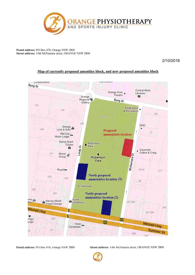
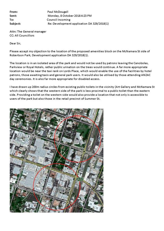
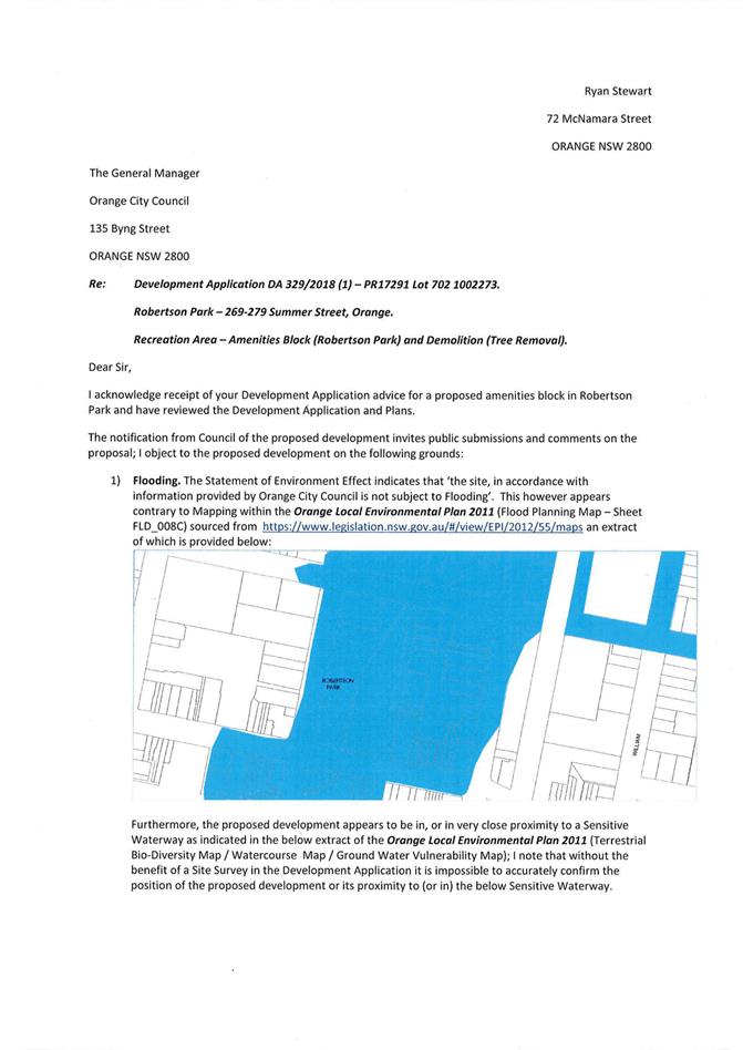
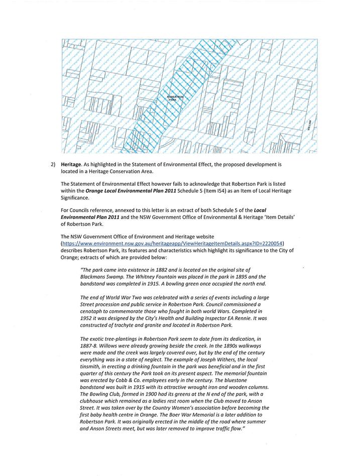
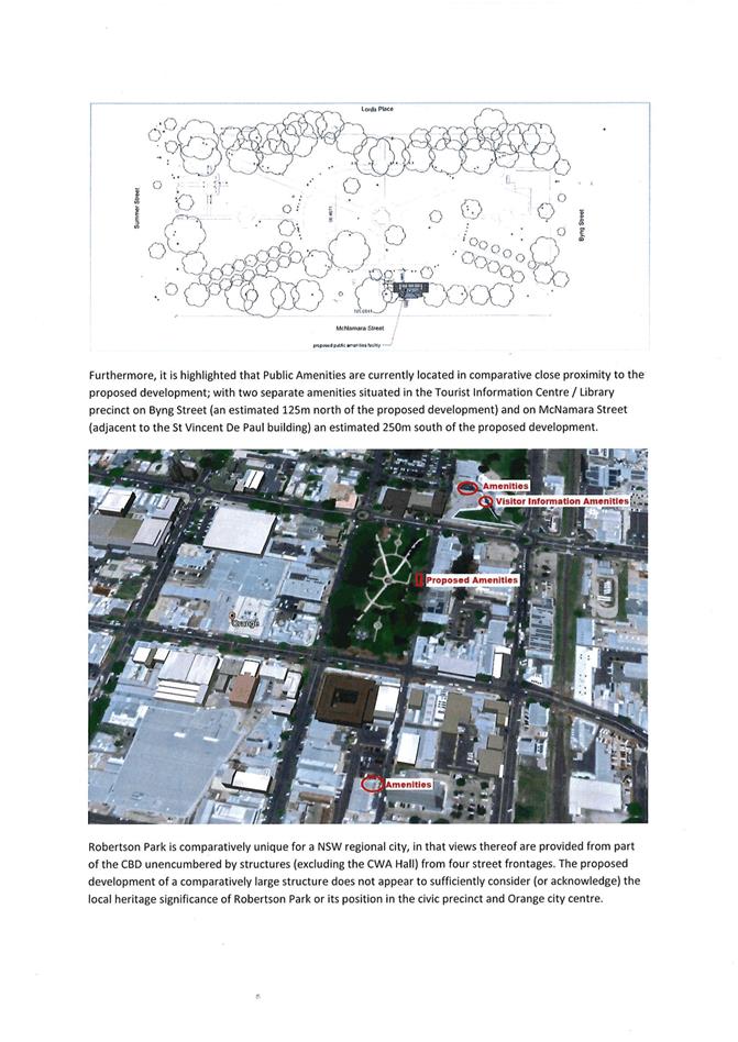
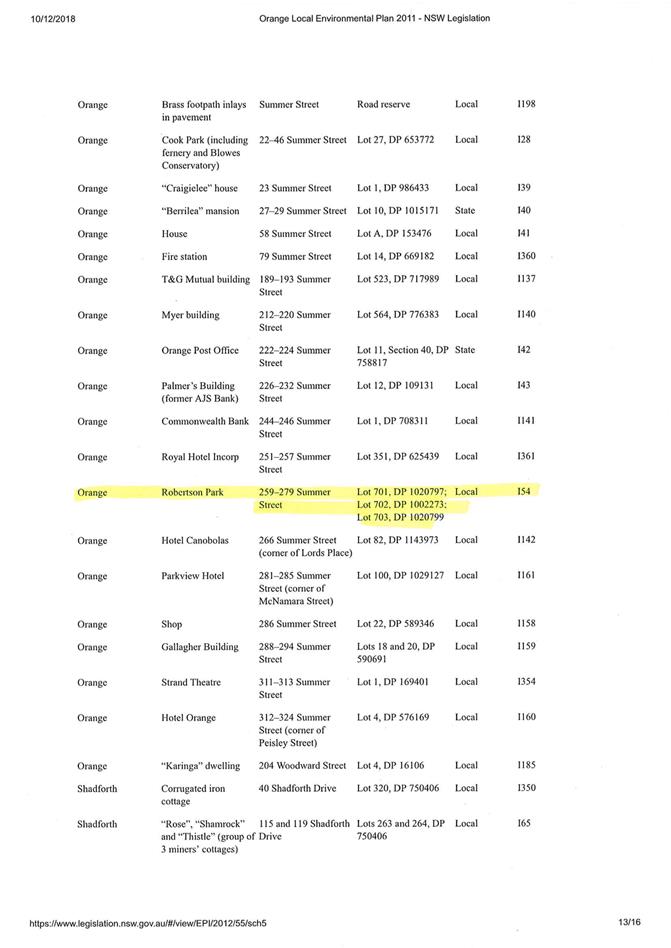
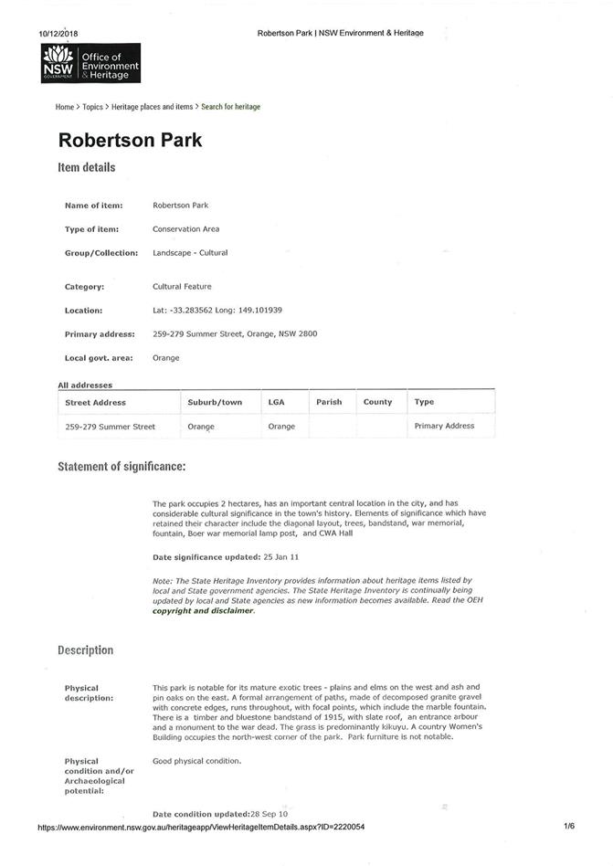

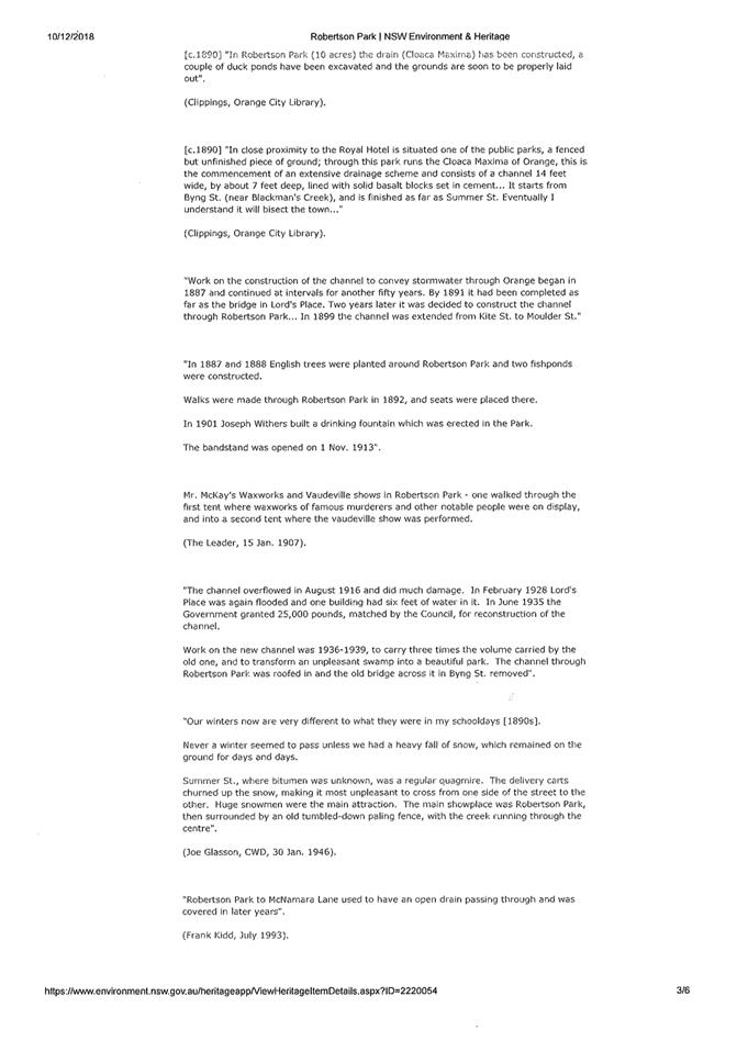
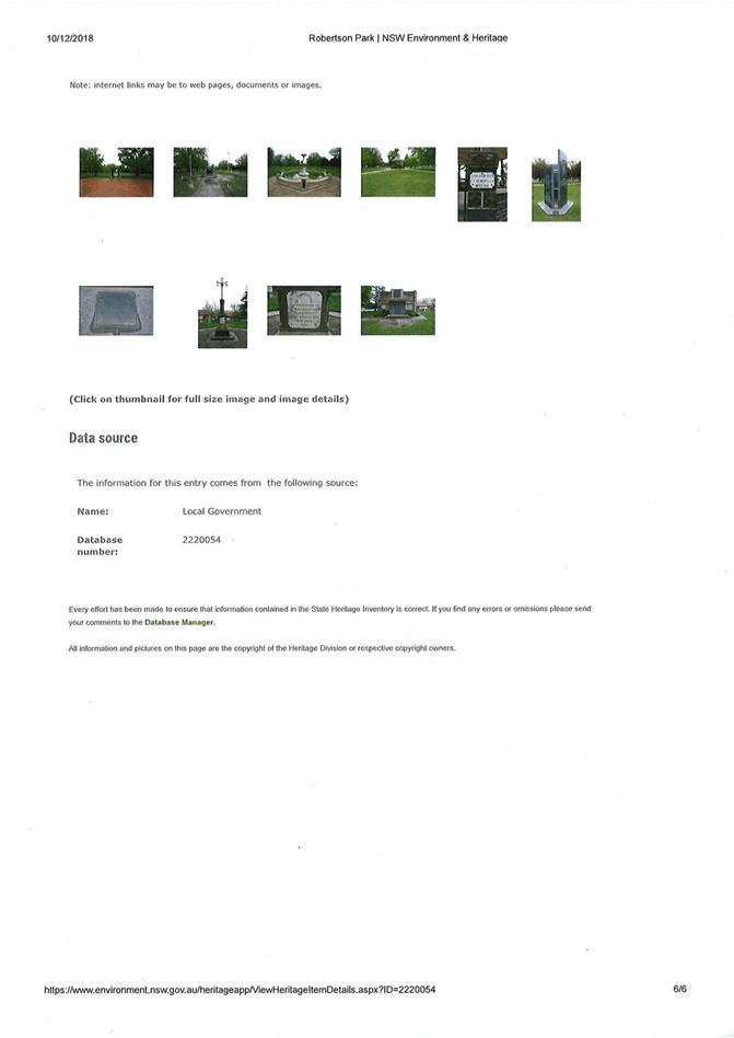
2.10 Development Application DA 348/2018(1) - 5 Hanrahan Place
Attachment 1 Notice of Approval
|
|
ORANGE CITY COUNCIL
Development Application No DA 348/2018(1)
NA18/ Container PR25414 |
NOTICE OF DETERMINATION
OF A DEVELOPMENT APPLICATION
issued under the Environmental Planning and Assessment Act 1979
Section 4.18
|
Development Application |
|
|
Applicant Name: |
RCI Group |
|
Applicant Address: |
5 Amy Close WYONG NSW 2259 |
|
Owner’s Name: |
Pearl Investment (Aust) Pty Ltd |
|
Land to Be Developed: |
Lot 85 DP 1167633 - 5 Hanrahan Place, Orange |
|
Proposed Development: |
Highway Service Centre and Business Identification Signage |
|
|
|
|
Building Code of Australia building classification: |
To be determined by the PC |
|
|
|
|
Determination made under Section 4.16 |
|
|
Made On: |
4 December 2018 |
|
Determination: |
CONSENT GRANTED SUBJECT TO CONDITIONS DESCRIBED BELOW: |
|
|
|
|
Consent to Operate From: |
5 December 2018 |
|
Consent to Lapse On: |
5 December 2023 |
Terms of Approval
The reasons for the imposition of conditions are:
(1) To ensure a quality urban design for the development which complements the surrounding environment.
(2) To maintain neighbourhood amenity and character.
(3) To ensure compliance with relevant statutory requirements.
(4) To provide adequate public health and safety measures.
(5) Because the development will require the provision of, or increase the demand for, public amenities and services.
(6) To ensure the utility services are available to the site and adequate for the development.
(7) To prevent the proposed development having a detrimental effect on adjoining land uses.
(8) To minimise the impact of development on the environment.
|
|
|
Conditions
(1) The development must be carried out in accordance with:
(a) Plans prepared by RCI Group and dated 15.11.18: BC0013 DWG Nos 01 Rev 10, 02 Rev 10, 03 Rev 7, 04 Rev 9, 06 Rev 8, 07 Rev 9, 08 Rev 10 (7 sheets);
Landscaping Plans prepared by prepared by Site Image Landscape Architects and dated 11.09.2018: SS18-3861 DWG Nos 000, 101, 102 and 501, Rev C;
Engineering Plans prepared by Eclipse Consulting Engineers and dated Jun 2018: 9741 DRW Nos C01-10-B; and
Dangerous Goods Site Layout Plan prepared by Myros Design and dated Jul 2018: 06182 DWG No 22800-F02 Issue A.
(b) statements of environmental effects or other similar associated documents that form part of the approval
as amended in accordance with any conditions of this consent.
|
PRESCRIBED CONDITIONS |
(2) All building work must be carried out in accordance with the provisions of the Building Code of Australia.
(3) A sign is to be erected in a prominent position on any site on which building work, subdivision work or demolition work is being carried out:
(a) showing the name, address and telephone number of the principal certifying authority for the work, and
(b) showing the name of the principal contractor (if any) for any building work and a telephone number on which that person may be contacted outside working hours, and
(c) stating that unauthorised entry to the site is prohibited.
Any such sign is to be maintained while the building work, subdivision work or demolition work is being carried out.
(4) In the case of residential building work for which the Home Building Act 1989 requires there to be a contract of insurance in force in accordance with Part 6 of the Act, evidence that such a contract of insurance is in force is to be provided to the Principal Certifying Authority before any building work authorised to be carried out by the consent commences.
(5) Residential building work within the meaning of the Home Building Act 1989 must not be carried out unless the principal certifying authority for the development to which the work relates (not being the council) has given the council written notice of the following information:
(a) in the case of work for which a principal contractor is required to be appointed:
(i) the name and the licence number of the principal contractor, and
(ii) the name of the insurer by which the work is insured under Part 6 of that Act,
(b) in the case of work to be done by an owner-builder:
(i) the name of the owner-builder, and
(ii) if the owner-builder is required to hold an owner-builder permit under that Act, the number of the owner-builder permit.
If arrangements for doing the residential building work are changed while the work is in progress so that the information under this condition becomes out of date, further work must not be carried out unless the principal certifying authority for the development to which the work relates (not being the council) has given the council written notice of the updated information.
SERVICE STATION
|
PRIOR TO THE ISSUE OF A CONSTRUCTION CERTIFICATE |
(6) Prior to the issuing of a Construction Certificate, plans shall be amended reducing the height of the proposed 8.63 metre pylon sign down to a maximum of 6.0 metres. The amended pylon sign shall be clearly shown on the plans submitted with an application for a Construction Certificate.
(7) Prior to the issue of the Construction Certificate, documentation showing compliance with the recommendations of Section 4 of the Noise Impact Assessment by Reverb Acoustics (Report No. 18-2219-R1 dated July 2018), with the exception that no roof-mounted plant is to be erected, is to be submitted to the Principal Certifying Authority.
(8) An approval under Section 68 of the Local Government Act is to be sought from Orange City Council, as the Water and Sewer Authority, for alterations to water and sewer. No plumbing and drainage is to commence until approval is granted.
(9) Detailed plans and specifications are to be provided specifying the proposed fitout of the food preparation and storage areas in accordance with the requirements of Australian Standard 4674-2004 "Design and construction and fitout of food premises" and Standard 3.2.3 "Food Premises and Equipment" of the Australian New Zealand Food Standards Code.
(10) The applicant is to submit a waste management plan that describes the nature of wastes to be removed, the wastes to be recycled and the destination of all wastes. All wastes from the demolition and construction phases of this project are to be deposited at a licensed or approved waste disposal site.
(11) Prior to the issue of the Construction Certificate, details showing how compliance will be achieved with Australian Standard AS1940-2004 “The storage and handling of flammable and combustible liquids”, including the provision of bunding and fire protection to the proposed storage tanks, are to be submitted to Council/accredited certifier for assessment.
(12) Engineering plans providing complete details of the proposed driveway and car parking areas are to be submitted to Orange City Council or an Accredited Certifier (Categories B1, C3, C4, C6) upon application for a Construction Certificate. These plans are to provide details of levels, cross falls of all pavements, proposed sealing materials, line marking, signage and proposed drainage works and are to be in accordance with Orange City Council Development and Subdivision Code.
(13) All stormwater from the site is to be collected and piped to the existing interlot drainage pit on site. All stormwater is to be directed to a stormwater treatment system to ensure that no contamination leaves the subject land.
The design of the stormwater treatment system shall ensure that the quality of stormwater leaving the developed site shall be equal to or better than predevelopment outflows. The criteria for assessment shall include the following key indicators: Total Phosphorus (μg.L-1), Total Nitrogen (μg.L-1), pH (lower and upper limits), Salinity (μS.cm-1), and Turbidity (NTU).
The stormwater treatment system design shall be submitted to Orange City Council for approval by Councils Director – Technical Services. The design shall be undertaken using an accredited assessment tool (Music™ or other approved assessment tool) and shall include the abovementioned key indicators and copies of the electronic data files. Modelling shall be undertaken for both pre and post development scenarios.
(14) The existing kerb inlet located on the eastern-most exit shall be modified to a heavy duty grated inlet. A new 2.4m kerb inlet is to be constructed on the uphill side of the exit driveway. Engineering plans for this drainage system are to be approved by Orange City Council prior to the issuing of a Construction Certificate.
(15) A Liquid Trade Waste Application is to be submitted to Orange City Council prior to the issuing of a Construction (or Occupation) Certificate. The application is to be in accordance with Orange City Council’s Liquid Trade Waste Policy. Engineering plans submitted as part of the application are to show details of all proposed liquid trade waste pre-treatment systems and their connection to sewer.
Where applicable, the applicant is to enter into a Liquid Trade Waste Service Agreement with Orange City Council in accordance with the Orange City Council Liquid Trade Waste Policy.
(16) Payment of contributions for water, sewer and drainage works is required to be made at the contribution rate applicable at the time that the payment is made. The contributions are based on 2.0 ETs for water supply headworks and 3.5 ETs for sewerage headworks for the Stage 1 service station. A Certificate of Compliance, from Orange City Council in accordance with the Water Management Act 2000, will be issued upon payment of the contributions.
This Certificate of Compliance is to be submitted to the Principal Certifying Authority prior to the issuing of a Construction Certificate.
(17) A water and soil erosion control plan is to be submitted to Orange City Council or an Accredited Certifier (Categories B1, C3, C4, C6) for approval prior to the issuing of a Construction Certificate. The control plan is to be in accordance with the Orange City Council Development and Subdivision Code and the Landcom, Managing Urban Stormwater; Soils and Construction Handbook.
(18) Backflow Prevention Devices are to be installed to AS3500 and in accordance with Orange City Council Backflow Protection Guidelines. Details of the Backflow Prevention Devices are to be submitted to Orange City Council prior to the issuing of a Construction Certificate.
|
PRIOR TO WORKS COMMENCING |
(19) Soil erosion control measures shall be implemented on the site.
(20) A Construction Certificate application is required to be submitted to, and issued by Council/Accredited Certifier prior to any excavation or building works being carried out onsite.
(21) A temporary onsite toilet is to be provided and must remain throughout the project or until an alternative facility meeting Council’s requirements is available onsite.
|
DURING CONSTRUCTION/SITEWORKS |
(22) The service station shall be designed and constructed in accordance with all relevant Regulations, Australian Standards, guidelines or similar relevant documents.
(23) All construction/demolition work on the site is to be carried out between the hours of 7.00 am and 6.00 pm Monday to Friday inclusive, 7.00 am to 5.00 pm Saturdays and 8.00 am to 5.00 pm Sundays and Public Holidays. Written approval must be obtained from the General Manager of Orange City Council to vary these hours.
(24) A Registered Surveyor’s certificate identifying the location of the building on the site must be submitted to the Principal Certifying Authority.
(25) All materials onsite or being delivered to the site are to be contained within the site. The requirements of the Protection of the Environment Operations Act 1997 are to be complied with when placing/stockpiling loose material or when disposing of waste products or during any other activities likely to pollute drains or watercourses.
(26) The site is located within an area identified as containing serpentinite rock formations, which can contain chrysotile, a naturally occurring asbestos. Therefore the applicant or person with management or control of the site shall ensure that a written plan (an Asbestos Management Plan) for the site is prepared in accordance with the provisions of the Work Health and Safety Act 2011 and Work Health and Safety Regulation 2011.
To assist applicants with developing an Asbestos Management Plan, applicants are encouraged to access the ‘Asbestos Management Plan for Orange City Council 2014’, which is available on Council’s website: www.orange.nsw.gov.au
(27) Any adjustments to existing utility services that are made necessary by this development proceeding are to be at the full cost of the developer.
(28) The provisions and requirements of the Orange City Council Development and Subdivision Code are to be applied to this application and all work constructed within the development is to be in accordance with that Code.
The developer is to be entirely responsible for the provision of water, sewerage and drainage facilities capable of servicing the development from Council’s existing infrastructure. The developer is to be responsible for gaining access over adjoining land for services where necessary and easements are to be created about all water, sewer and drainage mains within and outside the lots they serve.
(29) All driveway and parking areas are to be sealed with bitumen, hot mix or concrete and are to be designed for all expected loading conditions (provided however that the minimum pavement depth for gravel and flush seal roadways is 200mm) and be in accordance with the Orange City Council Development and Subdivision Code.
(30) Heavy-duty concrete kerb and gutter laybacks and footpath crossings are to be constructed for the entrances to the proposed development. The location and construction of the laybacks and footpath crossings are to be as required by the Orange City Council Development and Subdivision Code.
(31) A concrete footpath, a minimum of 1.2 metres wide, shall be constructed on the development side of Hanrahan Place from the existing roundabout to the pedestrian entrance to the service station. Construction work is to be to the requirements and standards of the Orange City Council Development and Subdivision Code.
|
PRIOR TO THE ISSUE OF AN OCCUPATION CERTIFICATE |
(32) A total of 23 off-street car parking spaces (Stage 1) shall be provided upon the site in accordance with the approved plans, and the provisions of Development Control Plan 2004, and shall be constructed in accordance with the requirements of Council's Development and Subdivision Code prior to the issue of an Occupation Certificate.
(33) Prior to the issuing of an Occupation Certificate (Stage 1), the following crime safety prevention requirements shall be installed on the site, and shall be maintained thereafter to the satisfaction of Council’s Manager Development Assessments:
- good quality CCTV shall be installed with multiple cameras positioned in locations that allow the capture of quality images, including the forecourt area, inside the store, to the rear of the building, and at the entry that faces out to capture a quality image of the customer’s face;
- CCTV must be able to be viewed by staff, preferably out of the view of the public;
- lighting shall be sufficient and placed in order to support images obtained from CCTV, as well as at entry and exit points, and light switches shall be located in a secure area;
- entry and exit points shall be clearly defined by signage;
- signage shall be placed at rear of the building to advise that CCTV is in operation; and
- way of travel markers shall be marked on the ground to ensure pedestrians and vehicles both have clear and safe passage.
(34) Prior to the issuing of an Occupation Certificate, landscaping shall be installed in accordance with the approved plans (Stage 1) and shall be permanently maintained to the satisfaction of Council's Manager Development Assessments.
(35) Prior to the issue of an Occupation Certificate, a report from a qualified acoustician is to be submitted to the Principal Certifying Authority confirming that the plant and equipment installed at the site complies with the predicted noise levels, and recommendations in Section 4, of the Noise Impact Assessment by Reverb Acoustics (report No. 18-2219-R1 dated July 2018). No roof-top plant is to be installed.
(36) No person is to use or occupy the building or alteration that is the subject of this approval without the prior issuing of an Occupation Certificate.
(37) The owner of the building/s must cause the Council to be given a Final Fire Safety Certificate on completion of the building in relation to essential fire or other safety measures included in the schedule attached to this approval.
(38) Where Orange City Council is not the Principal Certifying Authority, a final inspection of water connection, sewer and stormwater drainage shall be undertaken by Orange City Council and a Final Notice of Inspection issued, prior to the issue of either an interim or a final Occupation Certificate.
(39) Certification from Orange City Council is required to be submitted to the Principal Certifying Authority prior to the issue of an Occupation Certificate stating that all works relating to connection of the development to Council assets, works on public land, works on public roads, stormwater, sewer and water reticulation mains and footpaths have been carried out in accordance with the Orange City Council Development and Subdivision Code and the foregoing conditions, and that Council will take ownership of the infrastructure assets.
(40) A Certificate of Compliance, from a Qualified Engineer, stating that the stormwater treatment system complies with the approved engineering plans is to be submitted to Orange City Council prior to the issuing of an Occupation Certificate.
(41) Certificates for testable Backflow Prevention Devices are to be submitted to Orange City Council by a plumber with backflow qualifications prior to the issue of an Occupation Certificate.
(42) All of the foregoing conditions are to be at the full cost of the developer and to the requirements and standards of the Orange City Council Development and Subdivision Code, unless specifically stated otherwise. All work required by the foregoing conditions is to be completed prior to the issuing of an Occupation or Subdivision Certificate, unless stated otherwise.
|
MATTERS FOR THE ONGOING PERFORMANCE AND OPERATION OF THE DEVELOPMENT |
(43) Outdoor lighting and illuminated signage must be in accordance with the Australian Standard 4282-1997 Control of the obtrusive effects of outdoor lighting. All light fittings on the site, including lights fitted to the exterior of the building and canopy, and illuminated signage, are to be shielded or mounted in a position to minimise glare to adjoining properties and roads.
(44) The following crime safety prevention requirements shall be maintained on site at all times to the satisfaction of Council’s Manager Development Services:
- CCTV shall be recorded appropriately (preferably digital), kept for at least 28 days, and staff should be trained in using the system;
- CCTV must be able to be viewed by staff, preferably out of the view of the public;
- Promotional material shall not block surveillance in or out of the store area; and
- Waste bins shall be locked away or secured in a way that prevents them being moved or accessed without authorisation.
(45) The highway service centre is permitted to operate 24 hours a day, 7 days a week, with the following exceptions:
- Fuel tanker deliveries are restricted to day time periods 7am to 6pm
- Other deliveries may occur during the day and evening periods 7am to 10pm
- No deliveries or servicing are to occur at night time 10pm to 7am
- Waste collection is restricted to weekdays between 7am and 6pm
(46) The development shall be carried out in accordance with the recommendations set out in the Multi‑Level Risk Assessment and Preliminary Hazard Analysis (PHA), prepared by Myros Design, and dated 17 September 2018.
(47) The development shall be carried out in accordance with the recommendations set out in the Noise Impact Assessment by Reverb Acoustics (report No. 18-2219-R1 dated July 2018), with the exception that no roof-top plant may be erected. Emitted noise shall not exceed 5dB(A) above background sound level measured at the nearest affected residence.
(48) The owner is required to provide to Council and to the NSW Fire Commissioner an Annual Fire Safety Statement in respect of the fire-safety measures, as required by Clause 177 of the Environmental Planning and Assessment Regulation 2000.
(49) Copies of maintenance records for servicing of the stormwater treatment system shall be forwarded to Council on 1 December annually.
TAKEAWAY FOOD AND DRINK PREMISES
|
PRIOR TO THE ISSUE OF A CONSTRUCTION CERTIFICATE |
(50) Prior to the issue of the Construction Certificate, documentation showing compliance with the recommendations of Section 4 of the Noise Impact Assessment by Reverb Acoustics (Report No. 18-2219-R1 dated July 2018), with the exception that no roof-mounted plant is to be erected, is to be submitted to the Principal Certifying Authority.
(51) An approval under Section 68 of the Local Government Act is to be sought from Orange City Council, as the Water and Sewer Authority, for water, sewer and stormwater connection. No plumbing and drainage is to commence until approval is granted.
(52) Detailed plans and specifications are to be provided specifying the proposed fitout of the food preparation and storage areas in accordance with the requirements of Australian Standard 4674-2004 "Design and construction and fitout of food premises" and Standard 3.2.3 "Food Premises and Equipment" of the Australian New Zealand Food Standards Code.
(53) The applicant is to submit a waste management plan that describes the nature of wastes to be removed, the wastes to be recycled and the destination of all wastes. All wastes from the demolition and construction phases of this project are to be deposited at a licensed or approved waste disposal site.
(54) Engineering plans providing complete details of the proposed driveway and car parking areas are to be submitted to Orange City Council or an Accredited Certifier (Categories B1, C3, C4, C6) upon application for a Construction Certificate. These plans are to provide details of levels, cross falls of all pavements, proposed sealing materials, line marking, signage and proposed drainage works and are to be in accordance with Orange City Council Development and Subdivision Code.
(55) All stormwater from the site is to be collected and piped to the existing interlot drainage pit on site. All stormwater is to be directed to a stormwater treatment system to ensure that no contamination leaves the subject land.
The design of the stormwater treatment system shall ensure that the quality of stormwater leaving the developed site shall be equal to or better than predevelopment outflows. The criteria for assessment shall include the following key indicators: Total Phosphorus (μg.L-1), Total Nitrogen (μg.L-1), pH (lower and upper limits), Salinity (μS.cm-1), and Turbidity (NTU).
The stormwater treatment system design shall be submitted to Orange City Council for approval by Councils Director Technical Services. The design shall be undertaken using an accredited assessment tool (Music™ or other approved assessment tool) and shall include the abovementioned key indicators and copies of the electronic data files. Modelling shall be undertaken for both pre and post development scenarios.
(56) A Liquid Trade Waste Application is to be submitted to Orange City Council prior to the issuing of a Construction (or Occupation) Certificate. The application is to be in accordance with Orange City Council’s Liquid Trade Waste Policy. Engineering plans submitted as part of the application are to show details of all proposed liquid trade waste pre-treatment systems and their connection to sewer.
Where applicable, the applicant is to enter into a Liquid Trade Waste Service Agreement with Orange City Council in accordance with the Orange City Council Liquid Trade Waste Policy.
(57) Payment of contributions for water, sewer and drainage works is required to be made at the contribution rate applicable at the time that the payment is made. The contributions are based on 6.0 ETs for water supply headworks and 10.0 ETs for sewerage headworks for the Stage 2 fast food outlet. A Certificate of Compliance, from Orange City Council in accordance with the Water Management Act 2000, will be issued upon payment of the contributions.
This Certificate of Compliance is to be submitted to the Principal Certifying Authority prior to the issuing of a Construction Certificate.
(58) A water and soil erosion control plan is to be submitted to Orange City Council or an Accredited Certifier (Categories B1, C3, C4, C6) for approval prior to the issuing of a Construction Certificate. The control plan is to be in accordance with the Orange City Council Development and Subdivision Code and the Landcom, Managing Urban Stormwater; Soils and Construction Handbook.
(59) Backflow Prevention Devices are to be installed to AS3500 and in accordance with Orange City Council Backflow Protection Guidelines. Details of the Backflow Prevention Devices are to be submitted to Orange City Council prior to the issuing of a Construction Certificate.
|
PRIOR TO WORKS COMMENCING |
(60) Soil erosion control measures shall be implemented on the site.
(61) A Construction Certificate application is required to be submitted to, and issued by Council/Accredited Certifier prior to any excavation or building works being carried out onsite.
(62) A temporary onsite toilet is to be provided and must remain throughout the project or until an alternative facility meeting Council’s requirements is available onsite.
|
DURING CONSTRUCTION/SITEWORKS |
(63) All construction/demolition work on the site is to be carried out between the hours of 7.00 am and 6.00 pm Monday to Friday inclusive, 7.00 am to 5.00 pm Saturdays and 8.00 am to 5.00 pm Sundays and Public Holidays. Written approval must be obtained from the General Manager of Orange City Council to vary these hours.
(64) A Registered Surveyor’s certificate identifying the location of the building on the site must be submitted to the Principal Certifying Authority prior to the pouring of the slab or footings.
(65) All materials onsite or being delivered to the site are to be contained within the site. The requirements of the Protection of the Environment Operations Act 1997 are to be complied with when placing/stockpiling loose material or when disposing of waste products or during any other activities likely to pollute drains or watercourses.
(66) The site is located within an area identified as containing serpentinite rock formations, which can contain chrysotile, a naturally occurring asbestos. Therefore the applicant or person with management or control of the site shall ensure that a written plan (an Asbestos Management Plan) for the site is prepared in accordance with the provisions of the Work Health and Safety Act 2011 and Work Health and Safety Regulation 2011.
To assist applicants with developing an Asbestos Management Plan, applicants are encouraged to access the ‘Asbestos Management Plan for Orange City Council 2014’, which is available on Council’s website: www.orange.nsw.gov.au
(67) Any adjustments to existing utility services that are made necessary by this development proceeding are to be at the full cost of the developer.
(68) The provisions and requirements of the Orange City Council Development and Subdivision Code are to be applied to this application and all work constructed within the development is to be in accordance with that Code.
The developer is to be entirely responsible for the provision of water, sewerage and drainage facilities capable of servicing the development from Council’s existing infrastructure. The developer is to be responsible for gaining access over adjoining land for services where necessary and easements are to be created about all water, sewer and drainage mains within and outside the lots they serve.
(69) All driveway and parking areas are to be sealed with bitumen, hot mix or concrete and are to be designed for all expected loading conditions (provided however that the minimum pavement depth for gravel and flush seal roadways is 200mm) and be in accordance with the Orange City Council Development and Subdivision Code.
|
PRIOR TO THE ISSUE OF AN OCCUPATION CERTIFICATE |
(70) A total of 34 off-street car parking spaces shall be provided upon the site (Stages 1 & 2) in accordance with the approved plans, and the provisions of Development Control Plan 2004, and shall be constructed in accordance with the requirements of Council's Development and Subdivision Code prior to the issue of an Occupation Certificate.
(71) Prior to the issuing of an Occupation Certificate (Stage 2), the following crime safety prevention requirements shall be installed on the site, and shall be maintained thereafter to the satisfaction of Council’s Manager Development Assessments:
- good quality CCTV shall be installed with multiple cameras positioned in locations that allow the capture of quality images, including the drive-through area, inside the store, to the rear of the building, and at the entry that faces out to capture a quality image of the customer’s face;
- CCTV must be able to be viewed by staff, preferably out of the view of the public;
- lighting shall be sufficient and placed in order to support images obtained from CCTV, as well as at entry and exit points, and light switches shall be located in a secure area;
- entry and exit points shall be clearly defined by signage;
- signage shall be installed to advise that CCTV is in operation; and
- way of travel markers shall be marked on the ground to ensure pedestrians and vehicles both have clear and safe passage.
(72) Prior to the issuing of an Occupation Certificate, landscaping shall be installed in accordance with the approved plans (Stages 1 & 2) and shall be permanently maintained to the satisfaction of Council's Manager Development Assessments.
(73) Prior to the issue of an Occupation Certificate, a report from a qualified acoustician is to be submitted to the Principal Certifying Authority confirming that the plant and equipment installed at the site complies with the predicted noise levels, and recommendations in Section 4, of the Noise Impact Assessment by Reverb Acoustics (report No. 18-2219-R1 dated July 2018). No roof-top plant shall be installed.
(74) No person is to use or occupy the building or alteration that is the subject of this approval without the prior issuing of an Occupation Certificate.
(75) The owner of the building/s must cause the Council to be given a Final Fire Safety Certificate on completion of the building in relation to essential fire or other safety measures included in the schedule attached to this approval.
(76) Where Orange City Council is not the Principal Certifying Authority, a final inspection of water connection, sewer and stormwater drainage shall be undertaken by Orange City Council and a compliance certificate issued, prior to the issue of either an interim or a final Occupation Certificate.
(77) Certification from Orange City Council is required to be submitted to the Principal Certifying Authority prior to the issue of an Occupation Certificate stating that all works relating to connection of the development to Council assets, works on public land, works on public roads, stormwater, sewer and water reticulation mains and footpaths have been carried out in accordance with the Orange City Council Development and Subdivision Code and the foregoing conditions, and that Council will take ownership of the infrastructure assets.
(78) A Certificate of Compliance, from a Qualified Engineer, stating that the stormwater treatment system complies with the approved engineering plans is to be submitted to Orange City Council prior to the issuing of an Occupation Certificate.
(79) Certificates for testable Backflow Prevention Devices are to be submitted to Orange City Council by a plumber with backflow qualifications prior to the issue of an Occupation Certificate.
(80) All of the foregoing conditions are to be at the full cost of the developer and to the requirements and standards of the Orange City Council Development and Subdivision Code, unless specifically stated otherwise. All work required by the foregoing conditions is to be completed prior to the issuing of an Occupation or Subdivision Certificate, unless stated otherwise.
|
MATTERS FOR THE ONGOING PERFORMANCE AND OPERATION OF THE DEVELOPMENT |
(81) Outdoor lighting and illuminated signage must be in accordance with the Australian Standard 4282-1997 Control of the obtrusive effects of outdoor lighting. All light fittings on the site, including lights fitted to the exterior of the building and canopy, and illuminated signage, are to be shielded or mounted in a position to minimise glare to adjoining properties and roads.
(82) The following crime safety prevention requirements shall be maintained on site at all times to the satisfaction of Council’s Manager Development Services:
- CCTV shall be recorded appropriately (preferably digital), kept for at least 28 days, and staff should be trained in using the system;
- CCTV must be able to be viewed by staff, preferably out of the view of the public;
- Promotional material shall not block surveillance in or out of the store area; and
- Waste bins shall be locked away or secured in a way that prevents them being moved or accessed without authorisation.
(83) The highway service centre (service station and takeaway food and drink premises) is permitted to operate 24 hours a day, 7 days a week, with the following exceptions:
- Fuel tanker deliveries are restricted to day time periods 7am to 6pm
- Other deliveries may occur during the day and evening periods 7am to 10pm
- No deliveries or servicing are to occur at night time 10pm to 7am
- Waste collection is restricted to weekdays between 7am and 6pm
(84) The development shall be carried out in accordance with the recommendations set out in the Noise Impact Assessment by Reverb Acoustics (report No. 18-2219-R1 dated July 2018), with the exception that no roof-top plant may be erected. Emitted noise shall not exceed 5dB(A) above background sound level measured at the nearest affected residence.
(85) The owner is required to provide to Council and to the NSW Fire Commissioner an Annual Fire Safety Statement in respect of the fire-safety measures, as required by Clause 177 of the Environmental Planning and Assessment Regulation 2000.
(86) Copies of maintenance records for servicing of the stormwater treatment system shall be forwarded to Council on 1 December annually.
ESSENTIAL ENERGY REQUIREMENTS FOR THE DEVELOPMENT
(1) Any existing encumbrances in favour of Essential Energy (or its predecessors) noted on the title of the above property should be complied with.
(2) Prior to any works being carried out on site, the applicant must provide further information/evidence to Essential Energy as to the exact location of the fuel tanks. As part of that information, include the distances from the fuel tanks to any electrical infrastructure (overhead and/or underground) located within the property, within adjoining properties and the adjoining road reserve/s.
(3) Essential Energy has an existing easement in the location of the underground powerlines adjoining the padmount substation. Prior to any works being carried out, all landscaping plans must be submitted to Essential Energy for pre-approval as to the location of any planting, as well as the type of planting proposed.
(4) Essential Energy’s records indicate there is electricity infrastructure located within the property and within close proximity to the property. Any activities within these locations must be undertaken in accordance with the latest industry guideline currently known as ISSC 20 Guideline for the Management of Activities within Electricity Easements and Close to Infrastructure. Approval may be required from Essential Energy should activities within the property encroach on the electricity infrastructure.
(5) Essential Energy has an existing 11kV/LV padmount substation located on the property. Minimum separation/clearances, access and segregation for fire risk from the substation to any building, fence, planting, retaining walls and/or other development from the substation must be maintained at all times, in accordance with industry guideline currently known as ISSC 20 Guideline for the Management of Activities within Electricity Easements and Close to Infrastructure and Essential Energy’s policy CEOM7098 Distribution Underground Design Construction Manual.
(6) The proposed driveway access into the property from Hanrahan Place will pass over Essential Energy’s existing underground powerlines/cables. Such driveway access must be constructed in accordance with ISSC 20. Also, all underground powerlines/cables where any driveways will be installed will need to be conduited with additional conduits, required across driveways.
(7) The chain link fence proposed to be constructed between the boundary of this property and the adjoining Lot 88 DP1167633 must be constructed outside of Essential Energy’s easement for underground powerlines that adjoins the substation.
(8) Satisfactory arrangements must be made for the provision of power with Essential Energy with respect to the proposed development. It is the Applicant’s responsibility to make the appropriate application with Essential Energy for the supply of electricity to the development, which may include the payment of fees and contributions.
(9) Prior to carrying out any works on site, a “Dial Before You Dig” enquiry should be undertaken in accordance with the requirements of Part 5E (Protection of Underground Electricity Power Lines) of the Electricity Supply Act 1995 (NSW).
(10) Given there is electricity infrastructure in the area, it is the responsibility of the person/s completing any works around powerlines to understand their safety responsibilities. SafeWork NSW (www.safework.nsw.gov.au) has publications that provide guidance when working close to electricity infrastructure, including Code of Practice – Work near Overhead Power Lines and Code of Practice – Work near Underground Assets.
|
|
|
Other Approvals
(1) Local Government Act 1993 approvals granted under section 68.
Nil
(2) General terms of other approvals integrated as part of this consent.
Nil
|
|
|
Right of Appeal
If you are dissatisfied with this decision, Section 8.7 of the Environmental Planning and Assessment Act 1979 gives you the right to appeal to the Land and Environment Court. Pursuant to Section 8.10, an applicant may only appeal within 6 months after the date the decision is notified.
|
Disability Discrimination Act 1992: |
This application has been assessed in accordance with the Environmental Planning and Assessment Act 1979. No guarantee is given that the proposal complies with the Disability Discrimination Act 1992.
The applicant/owner is responsible to ensure compliance with this and other anti-discrimination legislation.
The Disability Discrimination Act covers disabilities not catered for in the minimum standards called up in the Building Code of Australia which references AS1428.1 - "Design for Access and Mobility". AS1428 Parts 2, 3 and 4 provides the most comprehensive technical guidance under the Disability Discrimination Act currently available in Australia. |
|
|
|
|
Disclaimer - S88B of the Conveyancing Act 1919 - Restrictions on the Use of Land: |
The applicant should note that there could be covenants in favour of persons other than Council restricting what may be built or done upon the subject land. The applicant is advised to check the position before commencing any work. |
|
|
|
|
Signed: |
On behalf of the consent authority ORANGE CITY COUNCIL |
|
Signature: |
|
|
Name: |
PAUL JOHNSTON - MANAGER DEVELOPMENT ASSESSMENTS |
|
Date: |
5 December 2018 |
2.10 Development Application DA 348/2018(1) - 5 Hanrahan Place
Attachment 2 Plans