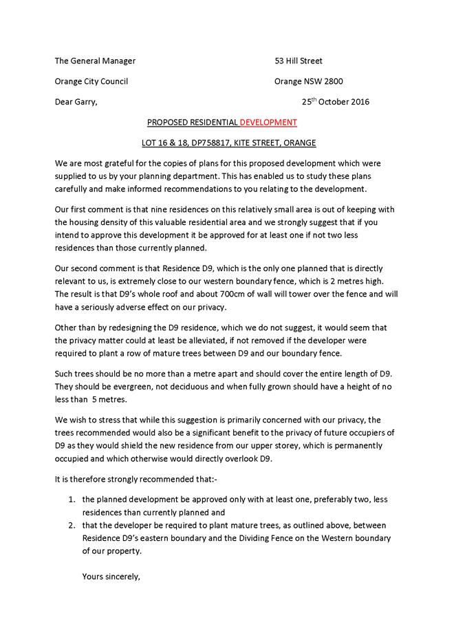
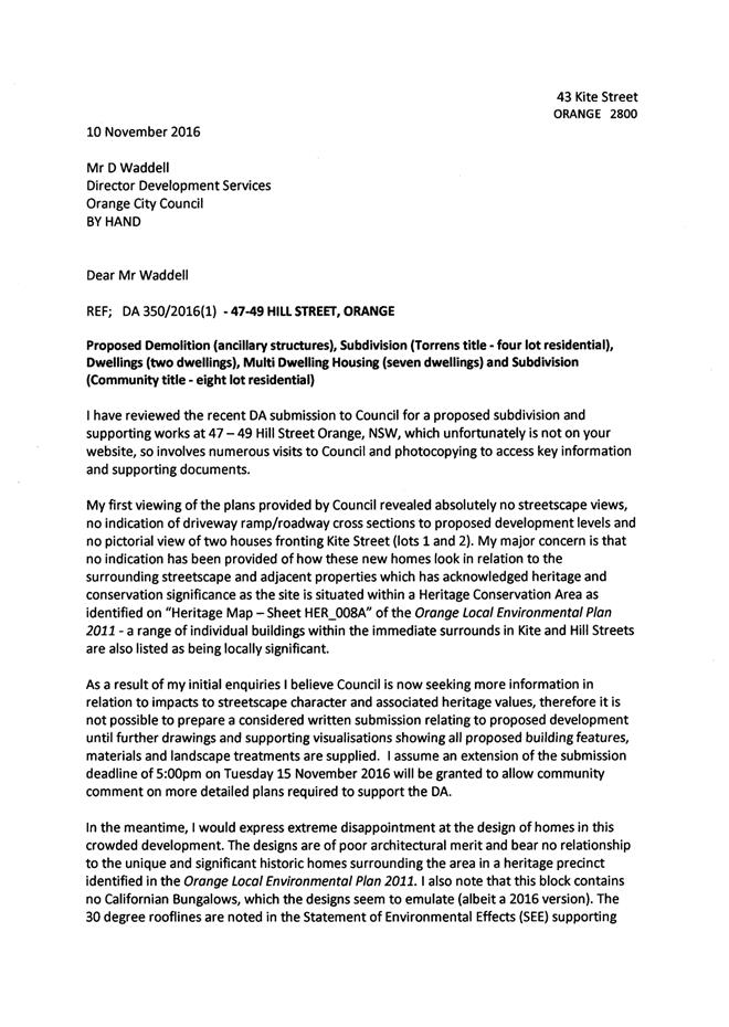
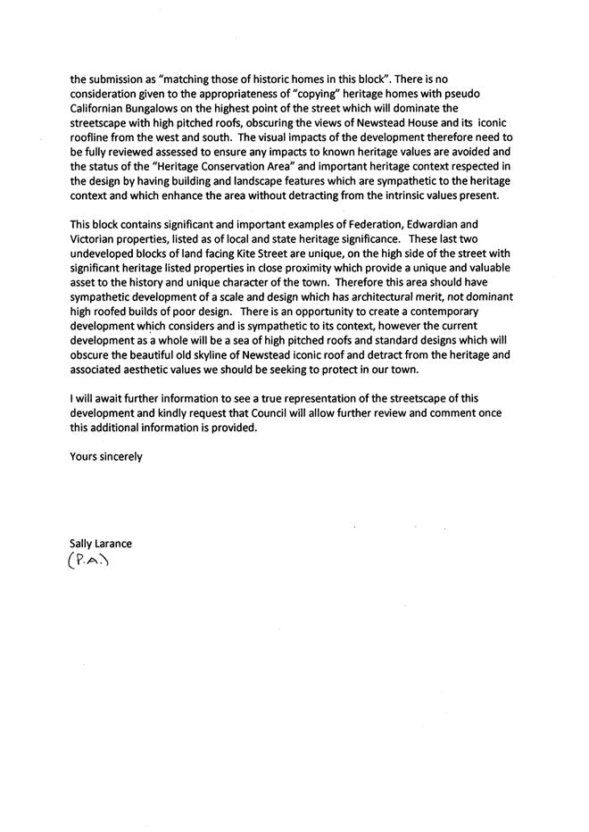
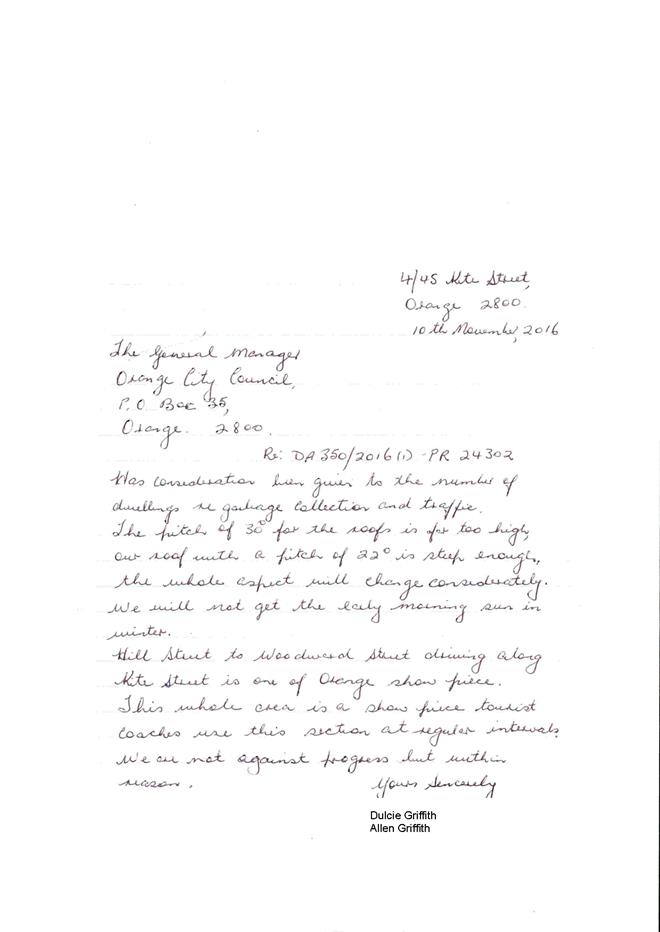
ORANGE CITY COUNCIL
Planning and Development Committee
Attachments
Items 2.7, 2.8, 2.9, 2.10, 2.11
14 August 2018
ORANGE CITY COUNCIL
Planning and Development Committee
Attachments
Items 2.7, 2.8, 2.9, 2.10, 2.11
14 August 2018
Planning and Development Committee 14 August 2018
ITEM SUBJECT PAGE NO
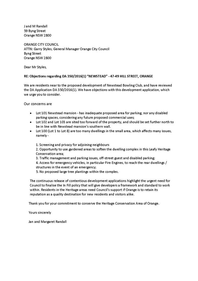
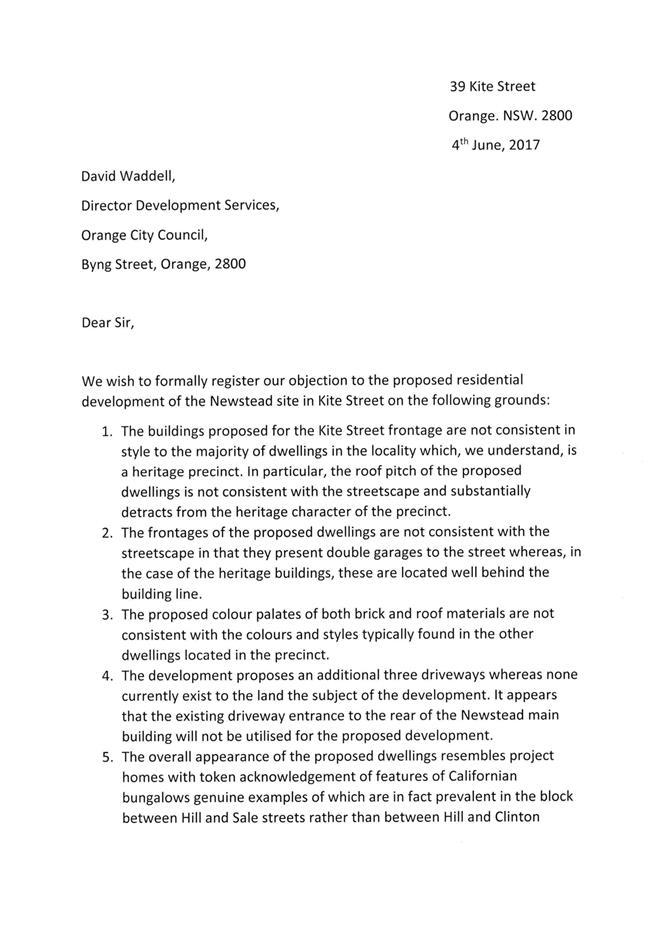
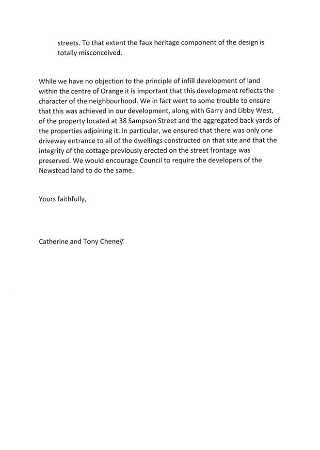
2.7 Development Application DA 350/2016(1) - 47-49 Hill Street
Attachment 1 Notice of Approval......................................................................... 3
Attachment 2 Plans............................................................................................. 17
Attachment 3 Submissions................................................................................ 131
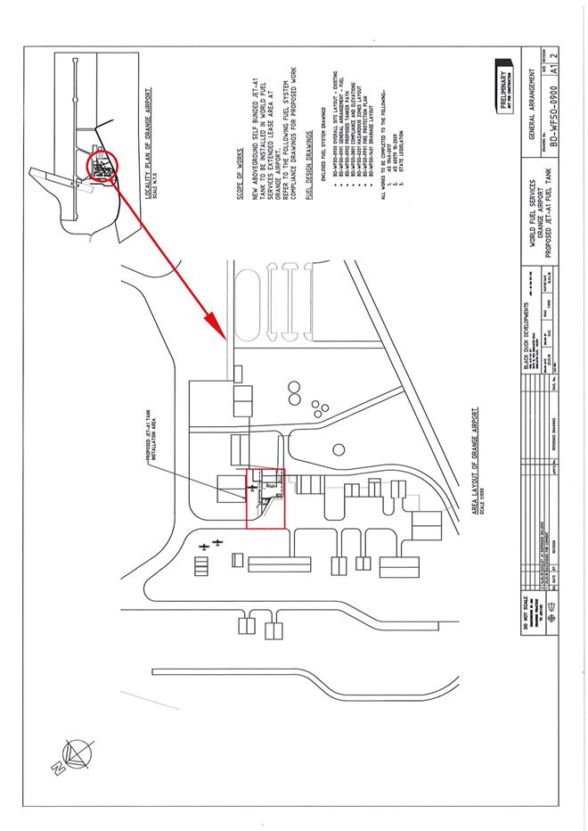
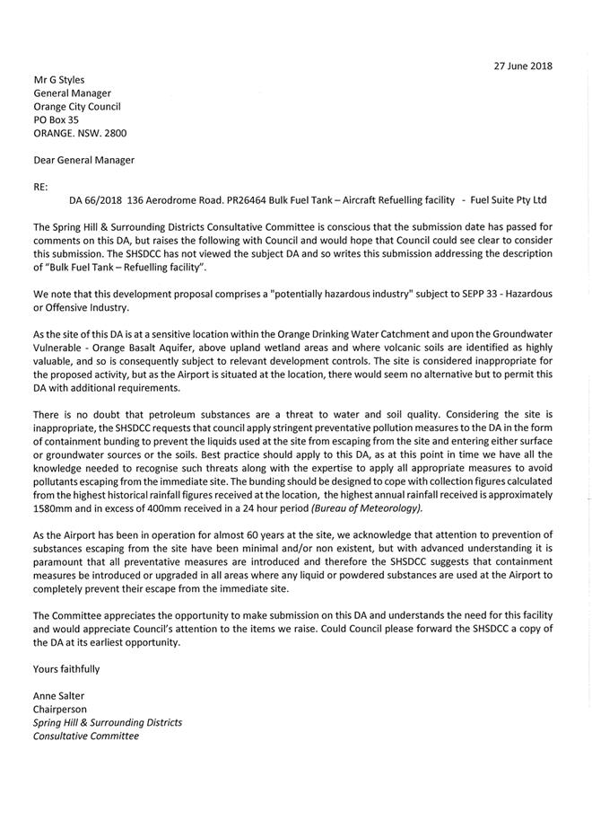
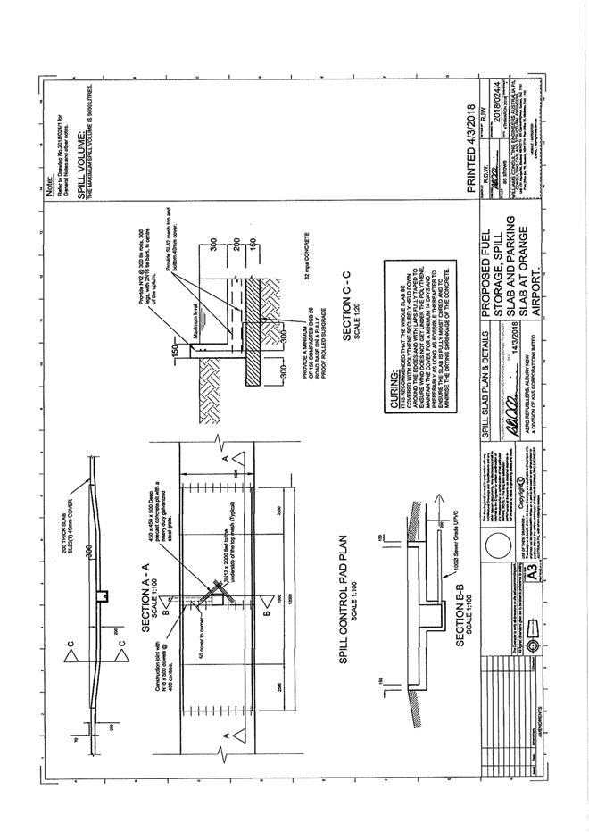
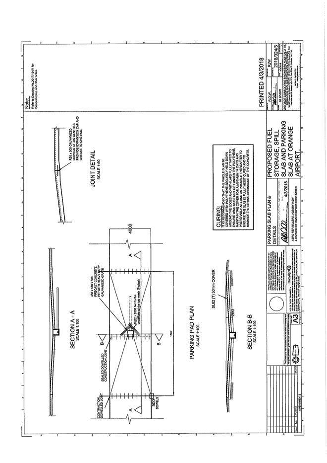
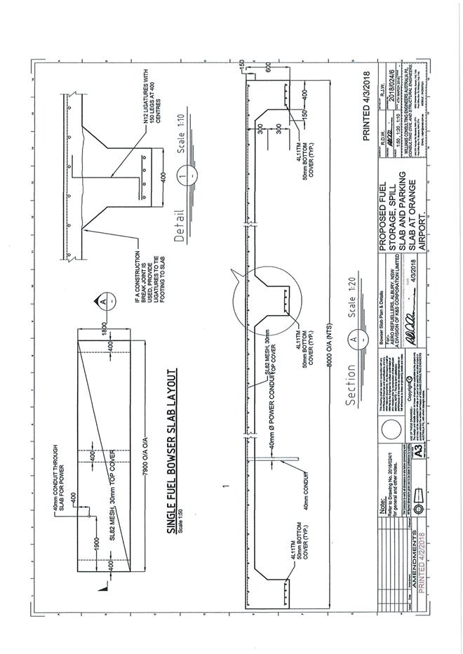
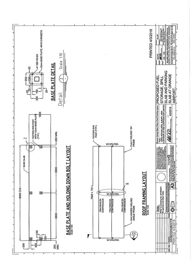
2.8 Development Application DA 66/2018(1) - 136 Aerodrome Road
Attachment 1 Notice of Approval..................................................................... 183
Attachment 2 Plans........................................................................................... 188
Attachment 3 Submission................................................................................. 195
2.9 Development Application DA 77/2018(1) - 136 Aerodrome Road
Attachment 1 Notice of Approval..................................................................... 196
Attachment 2 Plans........................................................................................... 203
2.10 Orange Local Environmental Plan 2011 - Amendment 17 'Towac Equine Precinct'
Attachment 1 Submissions................................................................................ 214
Attachment 2 Concept Plans............................................................................. 221
Attachment 3 Preliminary Contamination Investigation - Envirowest............. 237
Attachment 4 Proposed Amendments to Orange LEP 2011 written instrument 258
Attachment 5 Planning Proposal - supporting information.............................. 260
Attachment 6 Planning Proposal - formal draft............................................... 303
Attachment 7 Draft Development Control Plan - equine keeping provisions.. 316
Attachment 8 Preliminary Underpass Costing................................................. 322
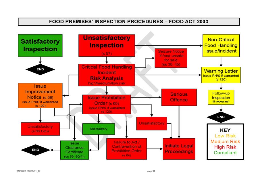
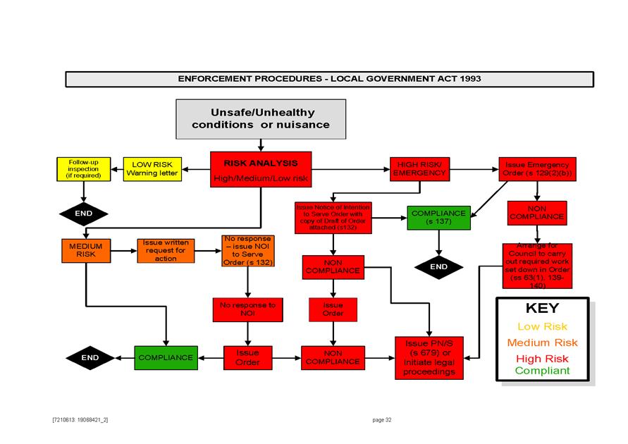
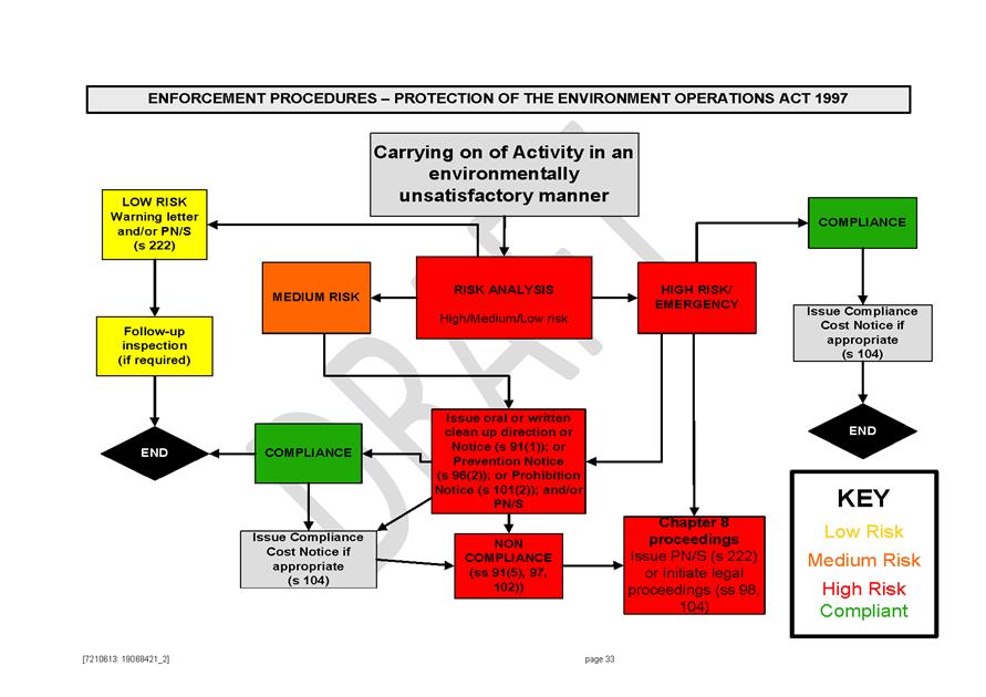
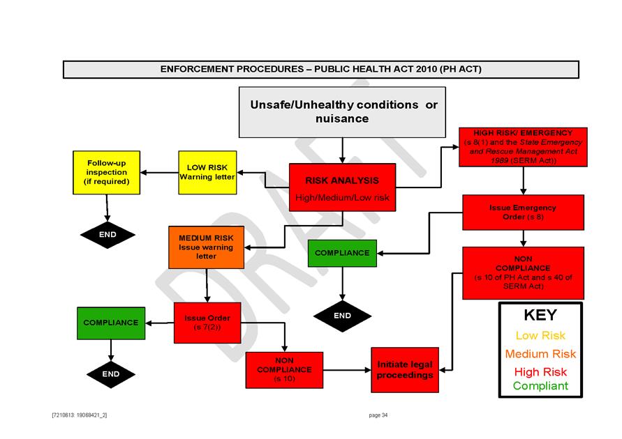
2.11 Draft Enforcement Policy
Attachment 1 Draft Enforcement Policy.......................................................... 323
Planning and Development Committee 14 August 2018
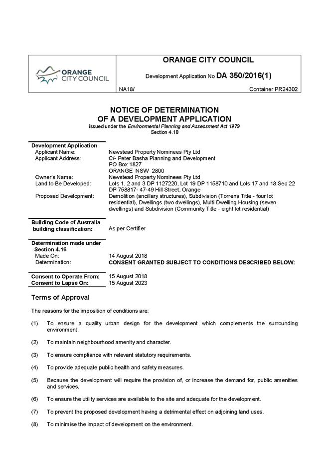
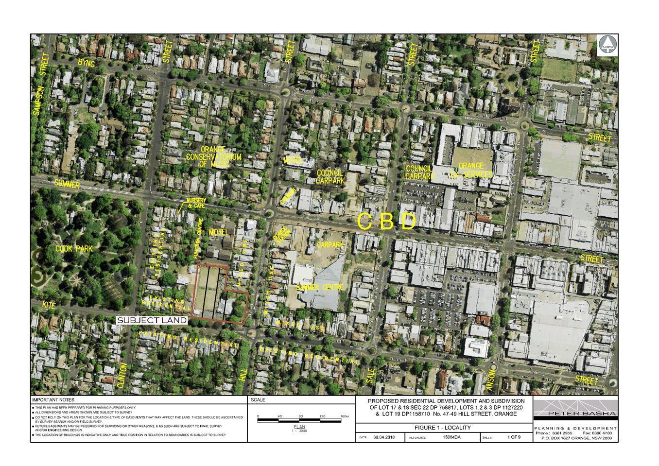
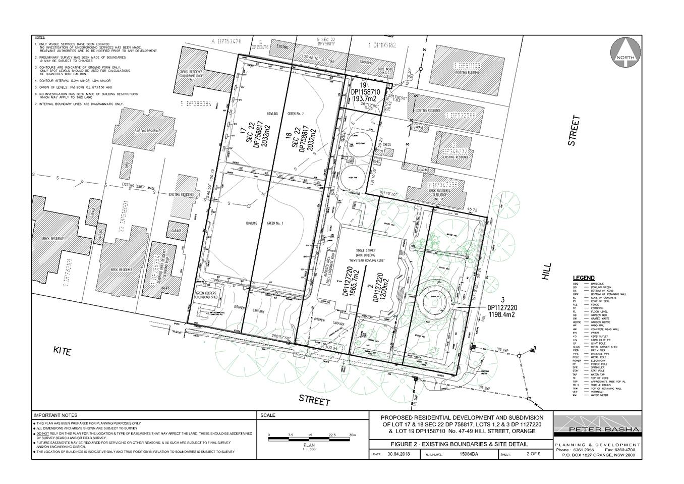
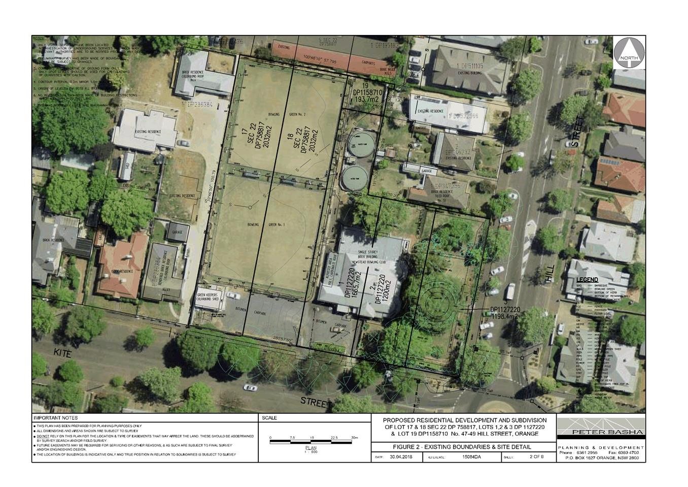
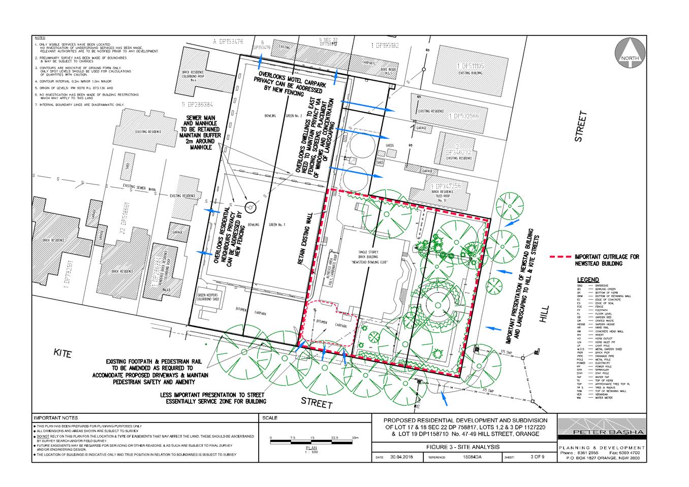
2.7 Development Application DA 350/2016(1) - 47-49 Hill Street
Attachment 1 Notice of Approval
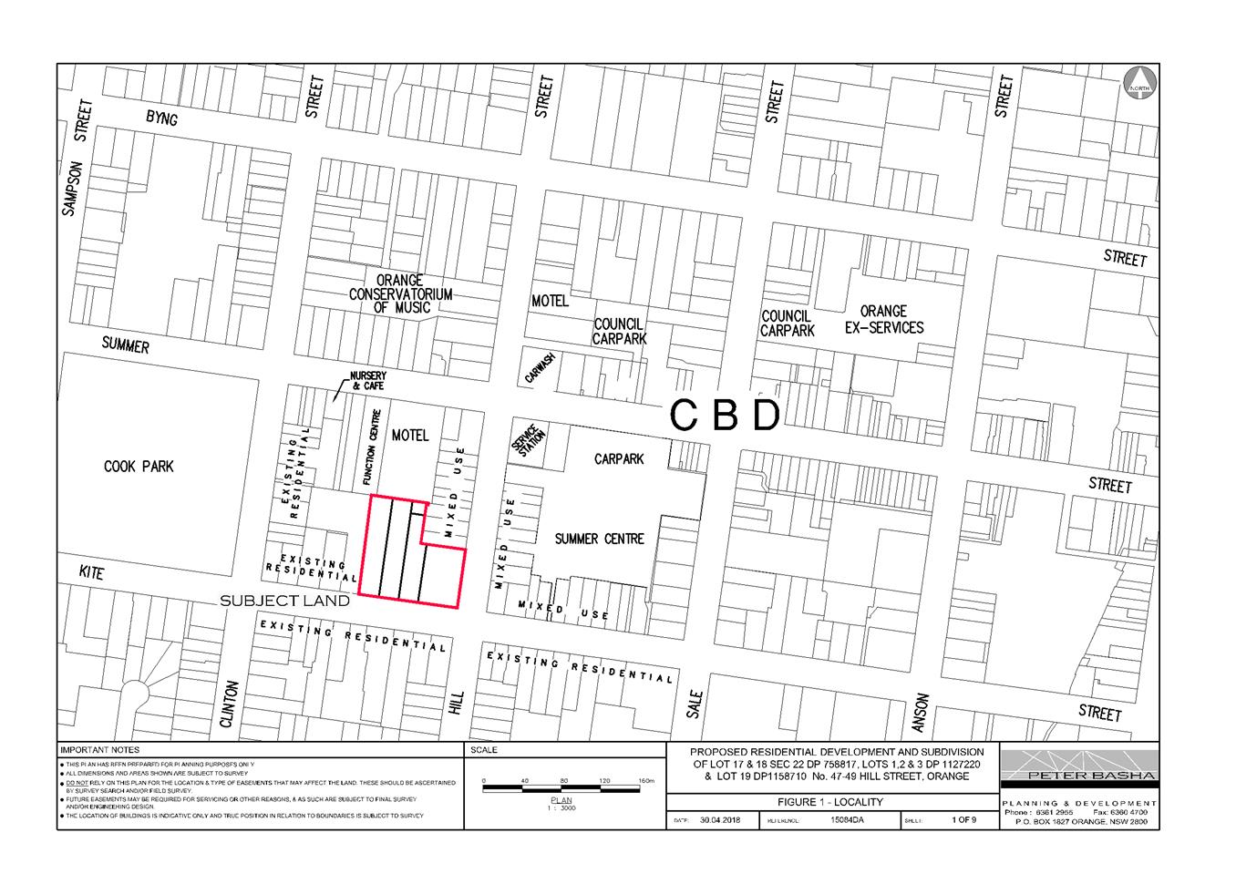
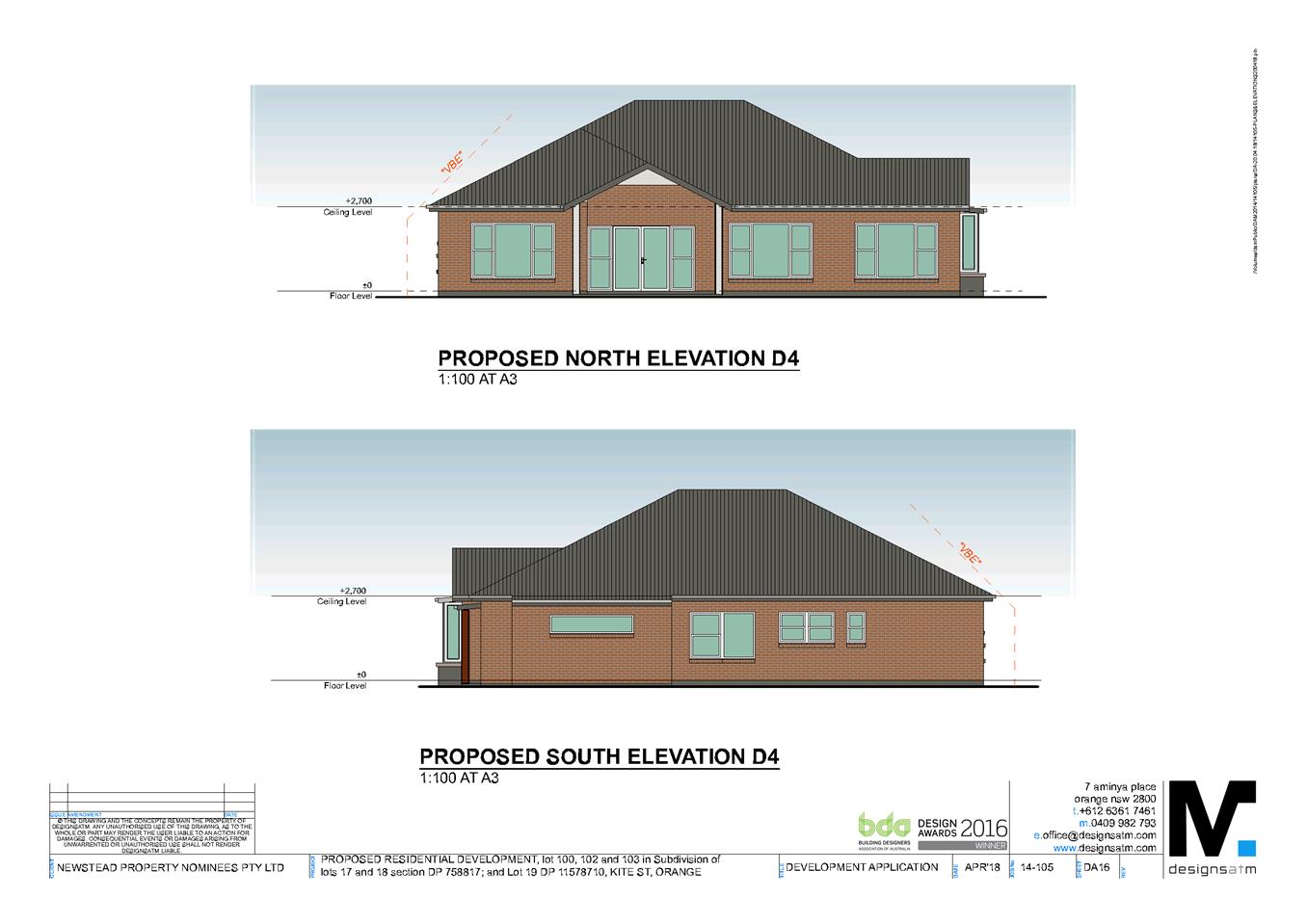
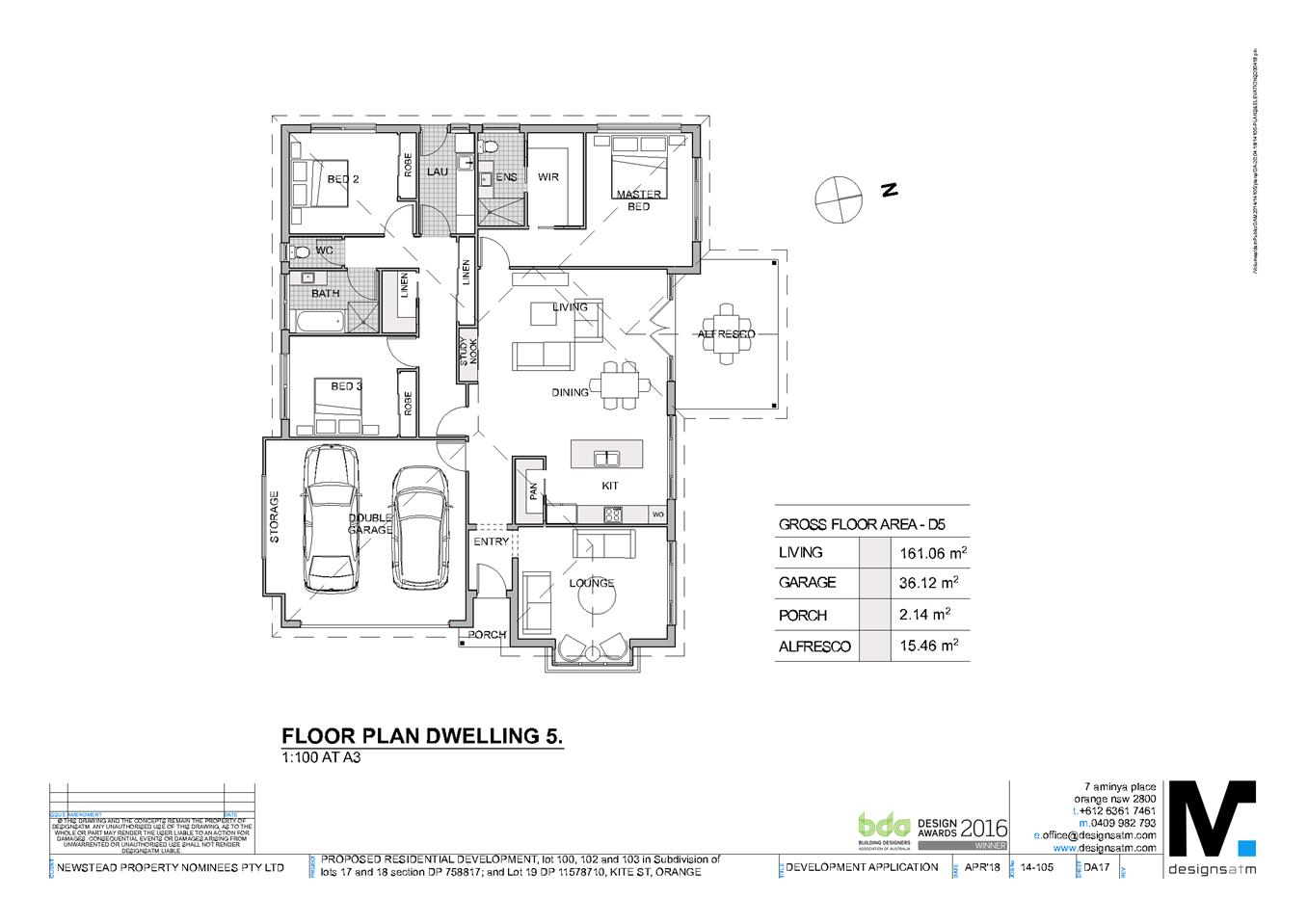
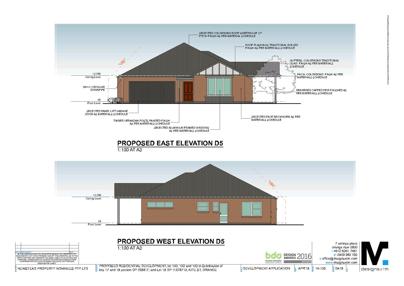
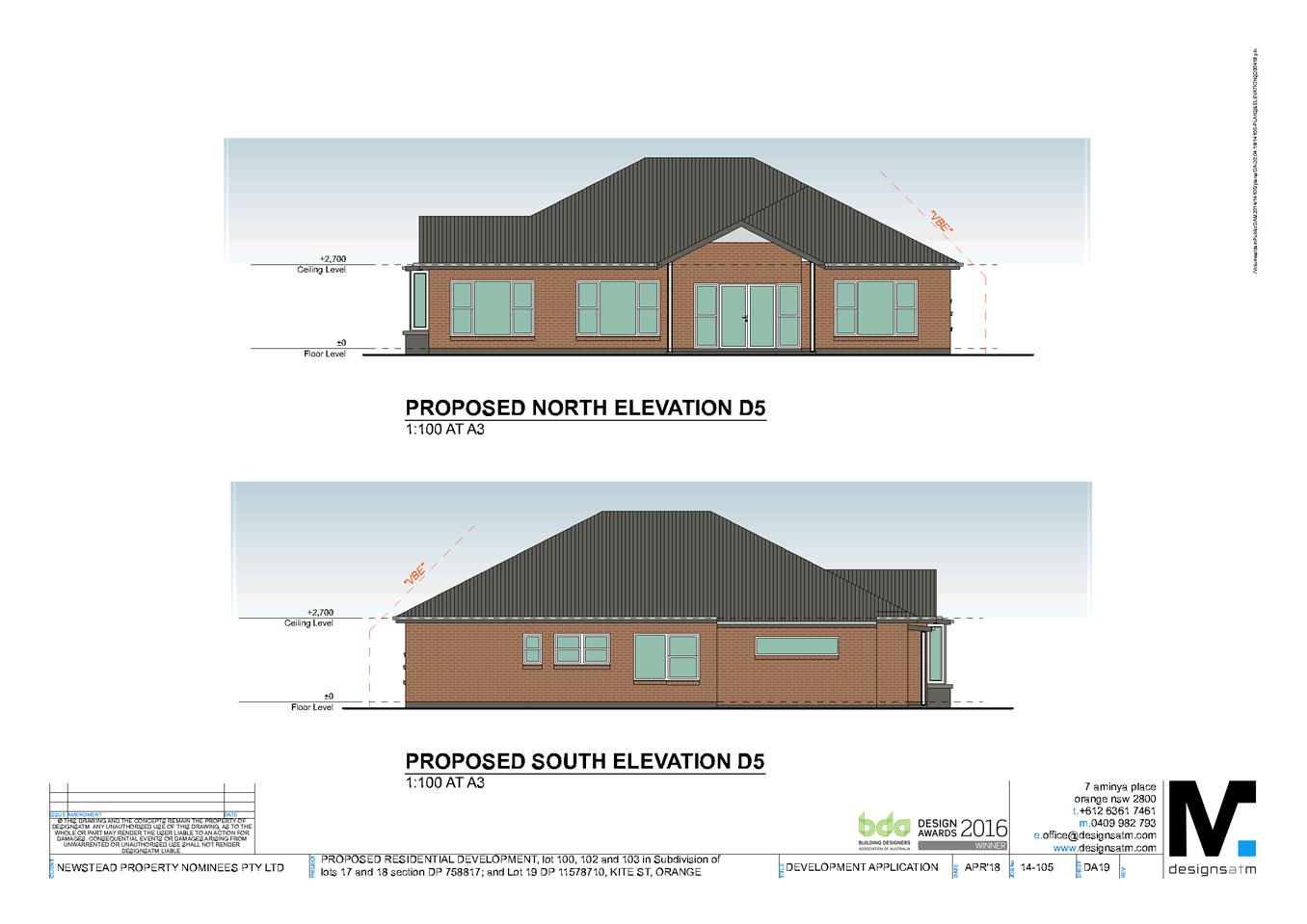
2.7 Development Application DA 350/2016(1) - 47-49 Hill Street
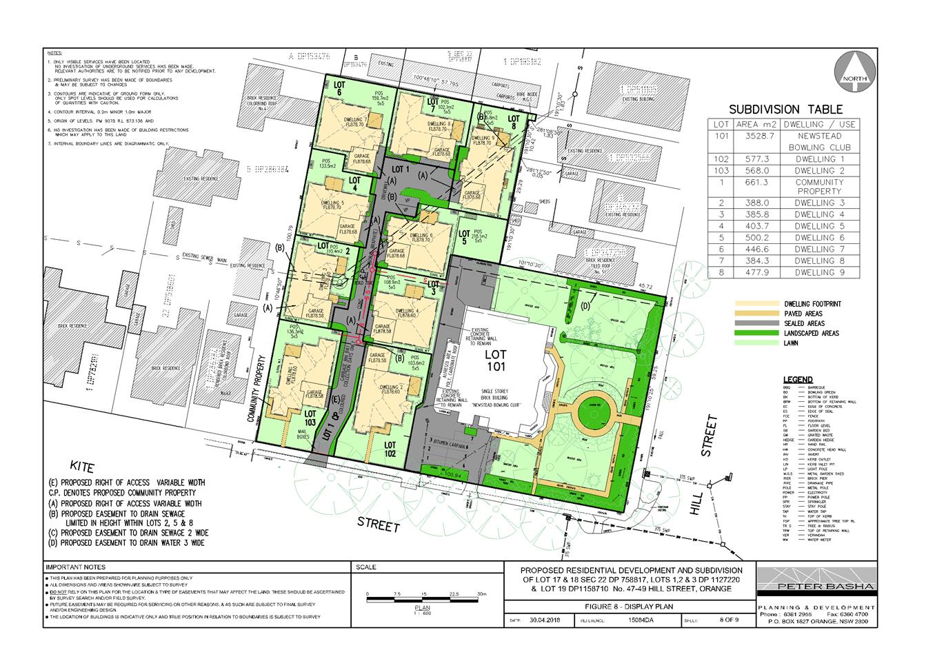
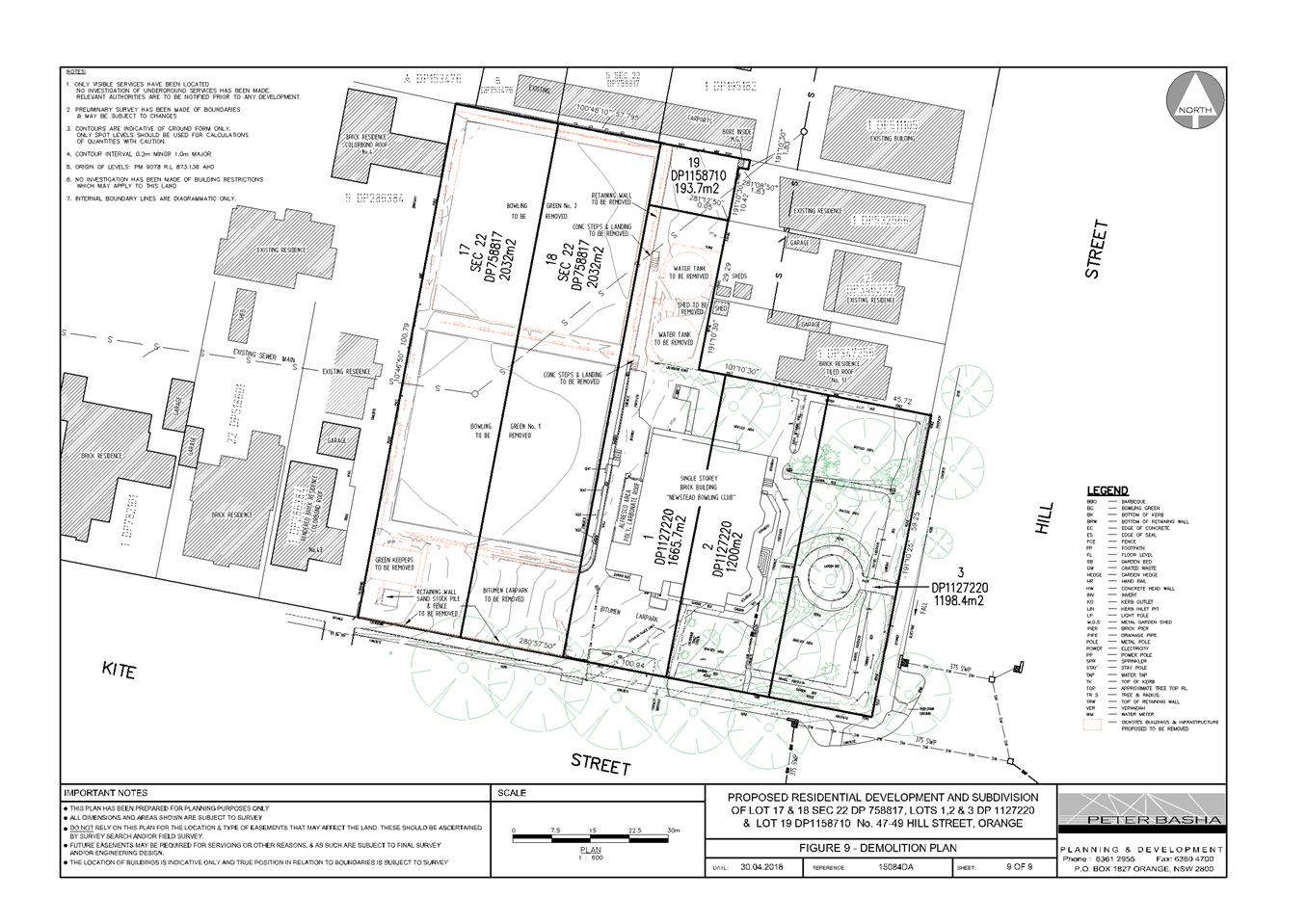
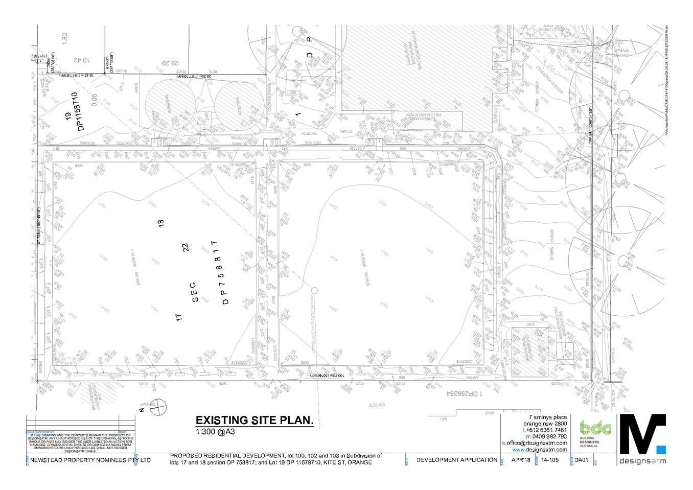
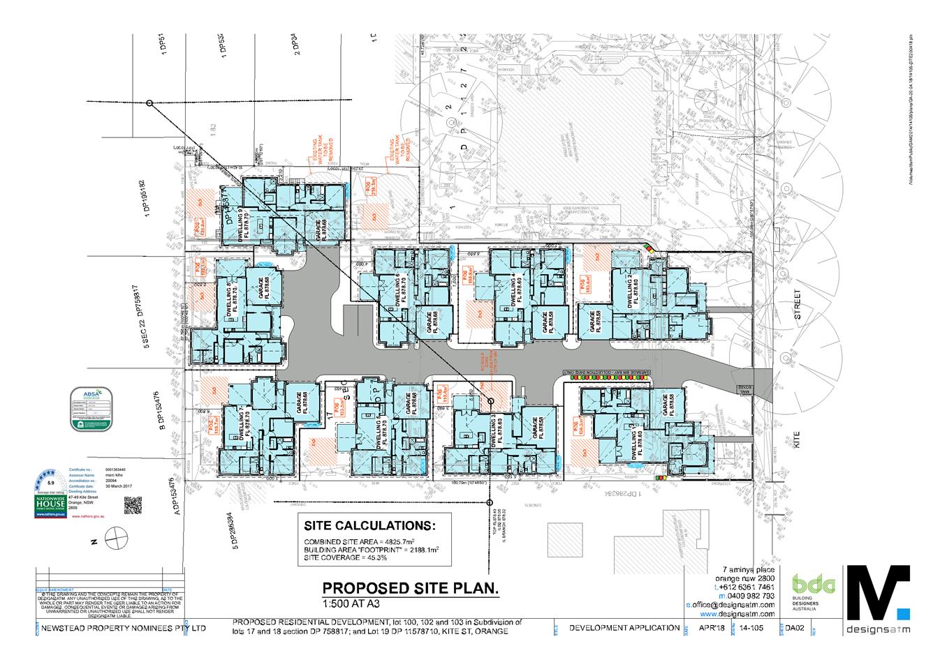
Attachment 2 Plans
Planning and Development Committee 14 August 2018
2.7 Development Application DA 350/2016(1) - 47-49 Hill Street
Attachment 3 Submissions


2.8 Development Application DA 66/2018(1) - 136 Aerodrome Road
Attachment 1 Notice of Approval
|
|
ORANGE CITY COUNCIL
Development Application No DA 66/2018(1)
NA18/ Container PR26464 |
NOTICE OF DETERMINATION
OF A DEVELOPMENT APPLICATION
issued under the Environmental Planning and Assessment Act 1979
Section 4.18
|
Development Application |
|
|
Applicant Name: |
Fuel Suite Pty Ltd |
|
Applicant Address: |
2 Victoria Grove HAWTHORN EAST VIC 3123 |
|
Owner’s Name: |
Orange City Council |
|
Land to Be Developed: |
LOT 200 DP 1195298 - Airport Terminal/136 Aerodrome Road, Huntley |
|
Proposed Development: |
Airport (bulk fuel tank and refuelling facility) |
|
|
|
|
Building Code of Australia building classification: |
To be determined by the PC |
|
|
|
|
Determination made under Section 4.16 |
|
|
Made On: |
14 August 2018 |
|
Determination: |
CONSENT GRANTED SUBJECT TO CONDITIONS DESCRIBED BELOW: |
|
|
|
|
Consent to Operate From: |
15 August 2018 |
|
Consent to Lapse On: |
15 August 2023 |
Terms of Approval
The reasons for the imposition of conditions are:
(1) To maintain neighbourhood amenity and character.
(2) To ensure compliance with relevant statutory requirements.
(3) To provide adequate public health and safety measures.
(4) To ensure the utility services are available to the site and adequate for the development.
(5) To prevent the proposed development having a detrimental effect on adjoining land uses.
(6) To minimise the impact of development on the environment.
|
|
|
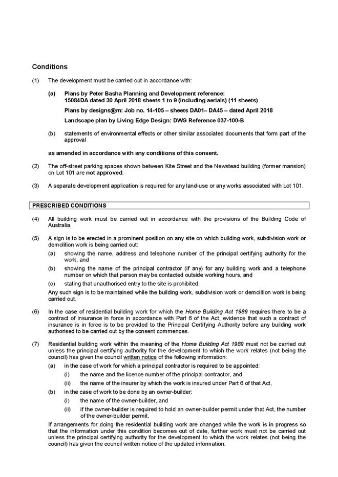
Conditions
(1) The development must be carried out in accordance with:
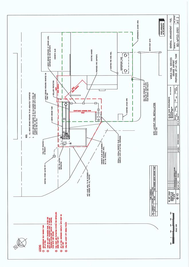
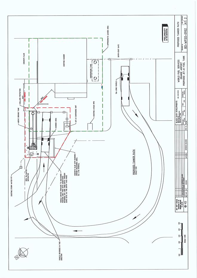
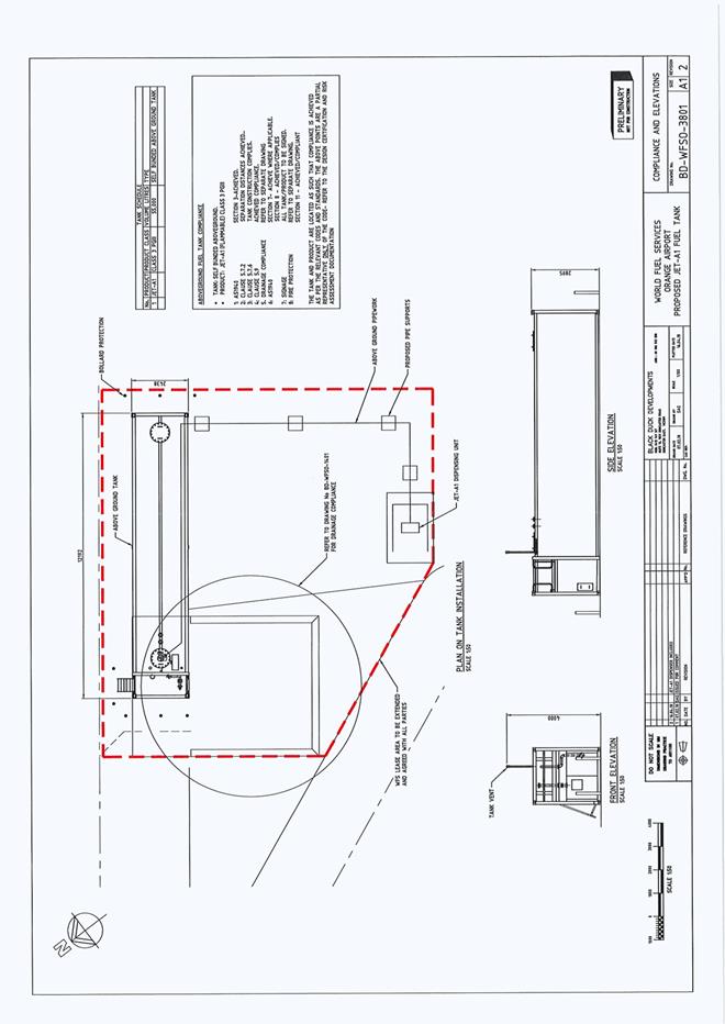
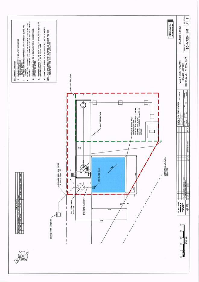
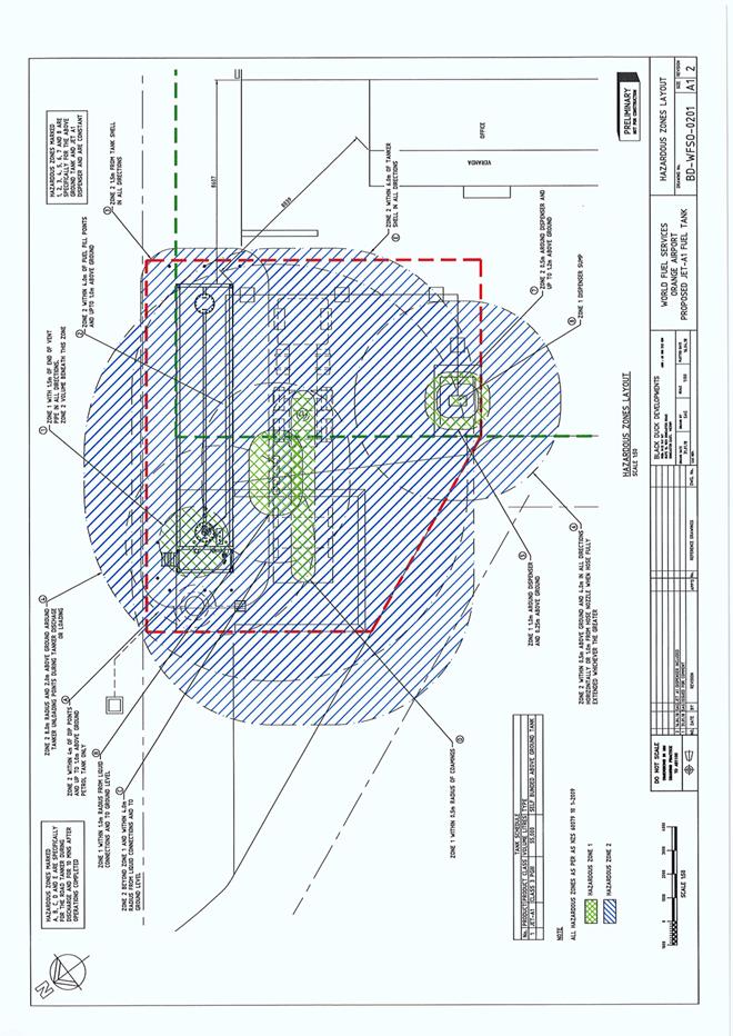
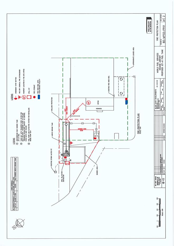
(a) BD-WFSO-0900 (Rev 2); 0901(Rev 2); 0902(Rev 2); 3801(Rev 2); 1401(Rev 2); 0201(Rev 2); FP01 (Rev 2) (7 sheets)
(b) statements of environmental effects or other similar associated documents that form part of the approval
as amended in accordance with any conditions of this consent.
|
PRESCRIBED CONDITIONS |
(2) All building work must be carried out in accordance with the provisions of the Building Code of Australia.
(3) A sign is to be erected in a prominent position on any site on which building work, subdivision work or demolition work is being carried out:
(a) showing the name, address and telephone number of the principal certifying authority for the work, and
(b) showing the name of the principal contractor (if any) for any building work and a telephone number on which that person may be contacted outside working hours, and
(c) stating that unauthorised entry to the site is prohibited.
Any such sign is to be maintained while the building work, subdivision work or demolition work is being carried out.
|
PRIOR TO THE ISSUE OF A CONSTRUCTION CERTIFICATE |
(4) Hazardous Industry Planning Advisor Paper No. 12 - Condition of Consent:
Pre-Construction
The applicant shall prepare the studies set out under subsections 4(a) to (d) (the pre-construction studies). Construction, other than preliminary works that are outside the scope of the hazard studies, shall not commence until study recommendations have been considered and, where appropriate, acted upon.
(a) FIRE SAFETY STUDY
A Fire Safety Study for the proposed development. This study shall cover the relevant aspects of the Department of Planning’s Hazardous Industry Planning Advisory Paper No. 2, ‘Fire Safety Study Guidelines’ and the NSW Government’s ‘Best Practice Guidelines for Contaminated Water Retention and Treatment Systems.’ The study shall meet the requirements of Fire and Rescue NSW.
(b) HAZARD AND OPERABILITY STUDY
A Hazard and Operability Study for the proposed development, chaired by an independent qualified person. The study shall be consistent with the Department of Planning’s Hazardous Industry Planning Advisory Paper No. 8 ‘HAZOP Guidelines.’
(c) FINAL HAZARD ANALYSIS
A Final Hazard Analysis of the proposed development, consistent with the Department of Planning’s Hazardous Industry Advisory Paper No. 6, ‘Hazard Analysis.’
(d) CONSTRUCTION SAFETY STUDY
A Construction Safety Study, consistent with the Department of Planning’s Hazardous Industry Planning Advisory Paper No. 7, ‘Construction Safety.’
(5) Prior to the issue of the Construction Certificate, details showing how compliance will be achieved with the Australian Standard AS1940-2017 “The storage and handling of flammable and combustible liquids”, including the provision of bunding, containing spills and fire protection to the proposed tanks are to be submitted to Council/accredited certifier for assessment.
(6) Prior to the issue of a Construction Certificate evidence shall be provided to the Principal Certifier that the proposed lease area extension as indicated on the approved plans has been agreed to and a lease granted by Orange City Council.
(7) All stormwater from the refuelling area is to be collected and piped to a stormwater treatment system. The design and construction of the stormwater treatment system shall ensure that the quality of stormwater leaving the site shall achieve the following stormwater quality targets:
· No observable Hydrocarbons present in stormwater discharge (<10ppm).
Orange City Council is to approve engineering plans for this stormwater treatment system prior to the issuing of a Construction Certificate. The applicant shall provide water quality modelling for the site, using an accredited assessment tool (recommended using Music™ or other approved assessment tool) and shall include copies of the electronic data files.
(8) Prior to the issue of a Construction Certificate the applicant shall apply for and receive approval from Orange City Council to access and undertake construction works on airside operating areas of Orange Airport.
|
PRIOR TO WORKS COMMENCING |
(9) Hazardous Industry Planning Advisor Paper No. 12 - Condition of Consent:
Pre-commissioning
Prior to commissioning, the Applicant shall develop and implement the plans and systems set out under subsections 9(a) – (c).
(a) TRANSPORT OF HAZARDOUS MATERIALS
Arrangements covering the transport of hazardous materials including details of routes to be used for the movement of vehicles carrying hazardous materials to or from the proposed development. The routes selected shall be consistent with the Department of Planning’s Hazardous Industry Planning Advisory Paper No. 11, ‘Route Selection.’ Suitable routes identified in the study shall be used except where departures are necessary for local deliveries or emergencies.
(b) EMERGENCY PLAN
A comprehensive Emergency Plan and detailed emergency procedures for the proposed development. The plan shall be consistent with the Department of Planning’s Hazardous Industry Planning Advisory Paper No. 1, ‘Emergency Planning.’
(c) SAFETY MANAGEMENT SYSTEM
A document setting out a comprehensive Safety Management System, covering all onsite operations and associated transport activities involving hazardous materials. The Safety Management System shall be consistent with the Department of Planning Hazardous Industry Planning Advisory Paper No. 9, ‘Safety Management.’
(10) A Construction Certificate application is required to be submitted to, and issued by Council/Accredited Certifier prior to any excavation or building works being carried out onsite.
(11) Soil erosion control measures shall be implemented on the site.
|
DURING CONSTRUCTION/SITEWORKS |
(12) All construction/demolition work on the site is to be carried out between the hours of 7.00 am and 6.00 pm Monday to Friday inclusive, 7.00 am to 5.00 pm Saturdays and 8.00 am to 5.00 pm Sundays and Public Holidays. Written approval must be obtained from the General Manager of Orange City Council to vary these hours.
(13) All materials on site or being delivered to the site are to be contained within the site. The requirements of the Protection of the Environment Operations Act 1997 are to be complied with when placing/stockpiling loose material or when disposing of waste products or during any other activities likely to pollute drains or watercourses.
(14) Any adjustments to existing utility services that are made necessary by this development proceeding are to be at the full cost of the developer.
(15) All services are to be contained within the approved lease area.
|
PRIOR TO THE ISSUE OF AN OCCUPATION CERTIFICATE |
(16) Hazardous Industry Planning Advisor Paper No. 12 - Condition of Consent:
Pre-Startup
PRE-STARTUP COMPLIANCE REPORT
The applicant shall submit to Council a report detailing compliance with Conditions 4 and 9 one month prior to the commencement of operation of the development.
(17) No person is to use or occupy the building or alteration that is the subject of this approval without the prior issuing of an Occupation Certificate.
(18) The owner of the building/s must cause the Council to be given a Final Fire Safety Certificate on completion of the building in relation to essential fire or other safety measures included in the schedule attached to this approval.
(19) A Certificate of Compliance, from a Qualified Engineer, stating that the stormwater treatment system complies with the approved engineering plans is to be submitted to the Principal Certifying Authority prior to the issuing of an Occupation Certificate.
(20) Certification from Orange City Council is required to be submitted to the Principal Certifying Authority prior to the issue of an Occupation Certificate stating that all works relating to connection of the development to Council assets, works on Council or public land, and stormwater have been carried out in accordance with the Orange City Council Development and Subdivision Code and the foregoing conditions.
(21) All of the foregoing conditions are to be at the full cost of the developer and to the requirements and standards of the Orange City Council Development and Subdivision Code, unless specifically stated otherwise. All work required by the foregoing conditions is to be completed prior to the issuing of an Occupation Certificate, unless stated otherwise.
|
MATTERS FOR THE ONGOING PERFORMANCE AND OPERATION OF THE DEVELOPMENT |
(22) Hazardous Industry Planning Advisor Paper No. 12 - Condition of Consent:
Ongoing
HAZARD AUDIT
Twelve months after the commencement of operations of the proposed development and every three years thereafter, the Applicant shall carry out a comprehensive Hazard Audit of the proposed development, consistent with the Department of Planning’s Hazardous Industry Planning Advisory Paper No. 5, ‘Hazard Audit Guidelines.’ The audit shall be carried out by a qualified person or team, independent of the development.
(23) The owner is required to provide to Council and to the NSW Fire Commissioner an Annual Fire Safety Statement in respect of the fire-safety measures, as required by Clause 177 of the Environmental Planning and Assessment Regulation 2000.
(24) The ongoing operation of the proposed fuel facility shall be in compliance with the requirements of the Work, Health and Safety Regulation 2001 at all times.
(25) Copies of maintenance records for servicing of the stormwater treatment system shall be forwarded to Council on 1 December annually.
|
|
|
Other Approvals
(1) Local Government Act 1993 approvals granted under Section 68.
Nil
(2) General terms of other approvals integrated as part of this consent.
Nil
|
|
|
Right of Appeal
If you are dissatisfied with this decision, Section 8.7 of the Environmental Planning and Assessment Act 1979 gives you the right to appeal to the Land and Environment Court. Pursuant to Section 8.10, an applicant may only appeal within 6 months after the date the decision is notified.
|
Disability Discrimination Act 1992: |
This application has been assessed in accordance with the Environmental Planning and Assessment Act 1979. No guarantee is given that the proposal complies with the Disability Discrimination Act 1992.
The applicant/owner is responsible to ensure compliance with this and other anti-discrimination legislation.
The Disability Discrimination Act covers disabilities not catered for in the minimum standards called up in the Building Code of Australia which references AS1428.1 - "Design for Access and Mobility". AS1428 Parts 2, 3 and 4 provides the most comprehensive technical guidance under the Disability Discrimination Act currently available in Australia. |
|
|
|
|
Disclaimer - S88B of the Conveyancing Act 1919 - Restrictions on the Use of Land: |
The applicant should note that there could be covenants in favour of persons other than Council restricting what may be built or done upon the subject land. The applicant is advised to check the position before commencing any work. |
|
|
|
|
Signed: |
On behalf of the consent authority ORANGE CITY COUNCIL |
|
Signature: |
|
|
Name: |
PAUL JOHNSTON - MANAGER DEVELOPMENT ASSESSMENTS |
|
Date: |
15 August 2018 |
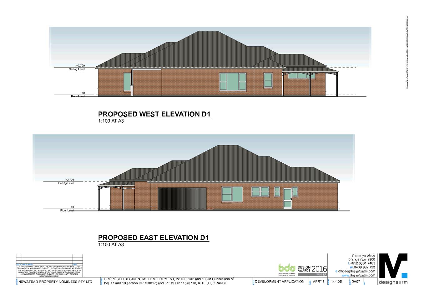
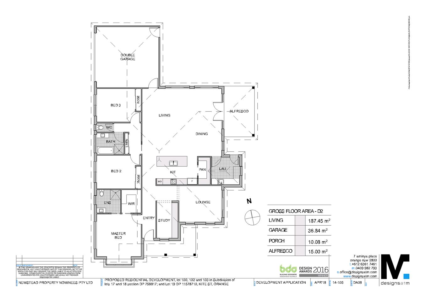
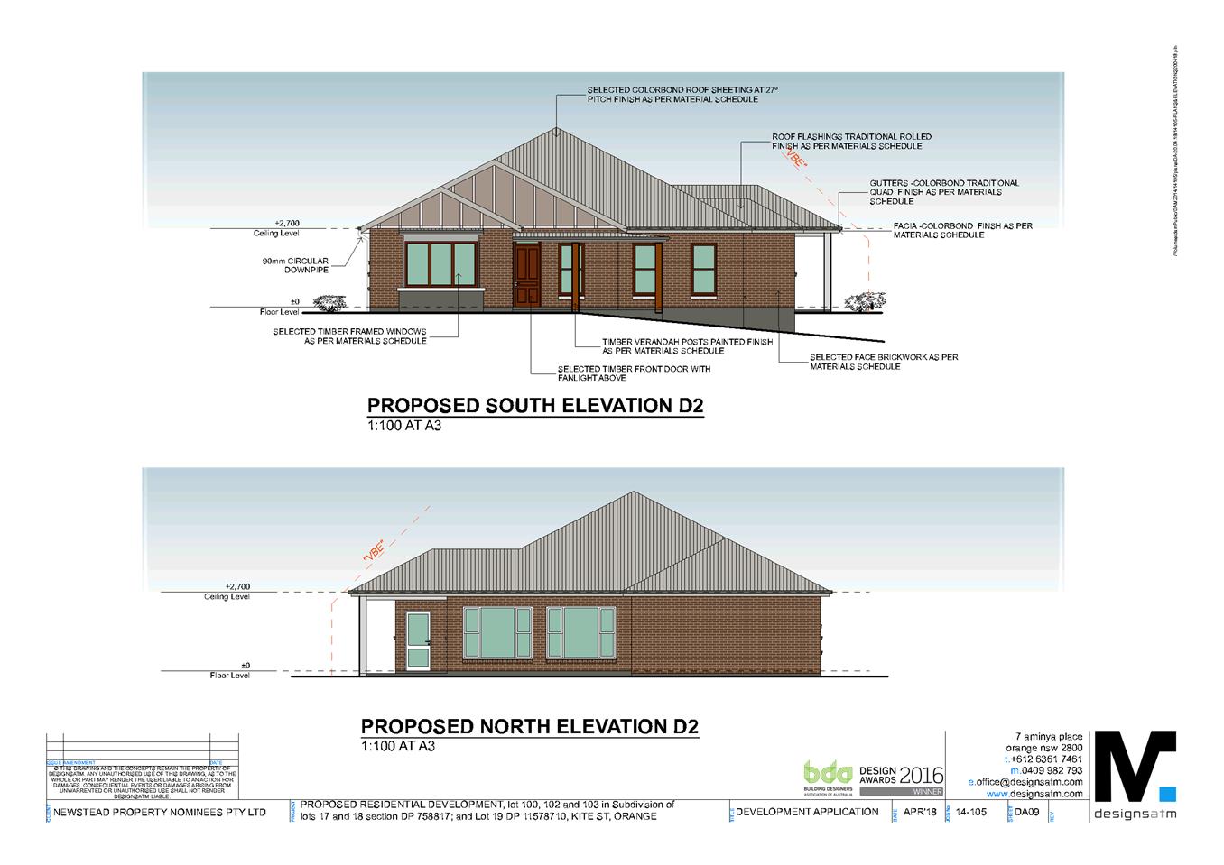
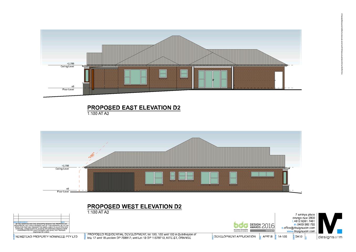
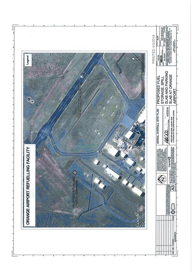
2.8 Development Application DA 66/2018(1) - 136 Aerodrome Road
Attachment 2 Plans
2.8 Development Application DA 66/2018(1) - 136 Aerodrome Road
Attachment 3 Submission
Planning and Development Committee 14 August 2018
2.9 Development Application DA 77/2018(1) - 136 Aerodrome Road
Attachment 1 Notice of Approval
|
|
ORANGE CITY COUNCIL
Development Application No DA 77/2018(1)
NA18/ Container PR26464 |
NOTICE OF DETERMINATION
OF A DEVELOPMENT APPLICATION
issued under the Environmental Planning and Assessment Act 1979
Section 4.18
|
Development Application |
|
|
Applicant Name: |
Aero Refuellers |
|
Applicant Address: |
PO Box 277 PADSTOW NSW 2211 |
|
Owner’s Name: |
Orange City Council |
|
Land to Be Developed: |
Lot 200 DP 1195298 - Airport Terminal/136 Aerodrome Road, Huntley |
|
Proposed Development: |
Airport (bulk fuel tanks (2) and refuelling facility) |
|
|
|
|
Building Code of Australia building classification: |
Class to be determined by the PCA |
|
|
|
|
Determination made under Section 4.16 |
|
|
Made On: |
14 August 2018 |
|
Determination: |
CONSENT GRANTED SUBJECT TO CONDITIONS DESCRIBED BELOW: |
|
|
|
|
Consent to Operate From: |
15 August 2018 |
|
Consent to Lapse On: |
15 August 2018 |
Terms of Approval
The reasons for the imposition of conditions are:
(1) To maintain neighbourhood amenity and character.
(2) To ensure compliance with relevant statutory requirements.
(3) To provide adequate public health and safety measures.
(4) To ensure the utility services are available to the site and adequate for the development.
(5) To prevent the proposed development having a detrimental effect on adjoining land uses.
(6) To minimise the impact of development on the environment.
|
|
|
Conditions
(1) The development must be carried out in accordance with:
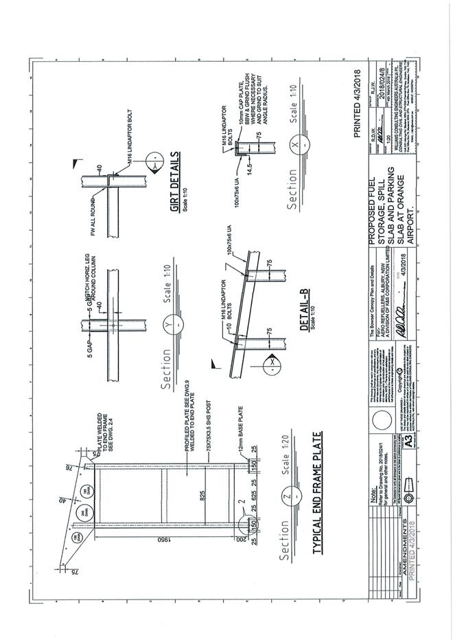
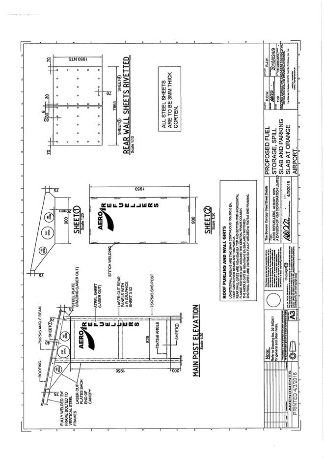
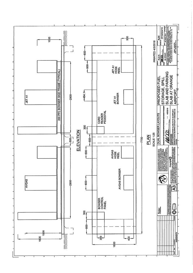
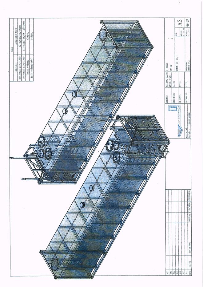
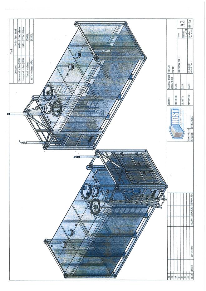
(a) Drawings by Williams Consulting Engineers Australia. Project Number 2018/024. Drawing Numbers 2018/024/1 – 2018/024/10 dated 4/3/2018 (10 sheets). Unnumbered drawings – Tank (2 sheets).
(b) statements of environmental effects or other similar associated documents that form part of the approval
as amended in accordance with any conditions of this consent.
|
PRESCRIBED CONDITIONS |
(2) All building work must be carried out in accordance with the provisions of the Building Code of Australia.
(3) A sign is to be erected in a prominent position on any site on which building work, subdivision work or demolition work is being carried out:
(a) showing the name, address and telephone number of the principal certifying authority for the work, and
(b) showing the name of the principal contractor (if any) for any building work and a telephone number on which that person may be contacted outside working hours, and
(c) stating that unauthorised entry to the site is prohibited.
Any such sign is to be maintained while the building work, subdivision work or demolition work is being carried out.
|
PRIOR TO THE ISSUE OF A CONSTRUCTION CERTIFICATE |
(4) Hazardous Industry Planning Advisor Paper No. 12 - Condition of Consent:
Pre-Construction
The applicant shall prepare the studies set out under subsections 4(a) to (d) (the pre-construction studies). Construction, other than preliminary works that are outside the scope of the hazard studies, shall not commence until study recommendations have been considered and, where appropriate, acted upon. The Applicant shall submit the studies to Council no later than one month prior to the commencement of construction of the proposed development (other than preliminary works), or within such further period as Council may agree.
(a) FIRE SAFETY STUDY
A Fire Safety Study for the proposed development. This study shall cover the relevant aspects of the Department of Planning’s Hazardous Industry Planning Advisory Paper No. 2, ‘Fire Safety Study Guidelines’ and the NSW Government’s ‘Best Practice Guidelines for Contaminated Water Retention and Treatment Systems.’ The study shall meet the requirements of Fire and Rescue NSW.
(b) HAZARD AND OPERABILITY STUDY
A Hazard and Operability Study for the proposed development, chaired by a qualified person, independent of the development. The study shall be consistent with the Department of Planning’s Hazardous Industry Planning Advisory Paper No. 8 ‘HAZOP Guidelines.’
(c) FINAL HAZARD ANALYSIS
A Final Hazard Analysis of the proposed development, consistent with the Department of Planning’s Hazardous Industry Advisory Paper No. 6, ‘Hazard Analysis.’
(d) CONSTRUCTION SAFETY STUDY
A Construction Safety Study, consistent with the Department of Planning’s Hazardous Industry Planning Advisory Paper No. 7, ‘Construction Safety.’
(5) Prior to the issue of the Construction Certificate, details showing how compliance will be achieved with the Australian Standard AS1940-2017 “The storage and handling of flammable and combustible liquids”, including the provision of bunding, containing spills and fire protection to the proposed tanks, are to be submitted to Council/accredited certifier for assessment.
(6) Engineering plans, showing details of all proposed work and adhering to any engineering conditions of development consent, are to be submitted to, and approved by, Orange City Council prior to the issuing of a Construction Certificate.
(7) The fuel facility location, refuelling apron, taxiway and access road configuration is to be generally in accordance with CASA requirements and clear of any runway obstacle limitation surface.
(8) All stormwater from the refuelling area is to be collected and piped to a stormwater treatment system. The design and construction of the stormwater treatment system shall ensure that the quality of stormwater leaving the site shall achieve the following stormwater quality targets:
· No observable Hydrocarbons present in stormwater discharge (<10ppm).
Orange City Council is to approve engineering plans for this stormwater treatment system prior to the issuing of a Construction Certificate. The applicant shall provide water quality modelling for the site, using an accredited assessment tool (recommended using Music™ or other approved assessment tool) and shall include copies of the electronic data files.
(9) Prior to the issue of a Construction Certificate the applicant shall apply for and receive approval from Orange City Council to access and undertake construction works on airside operating areas of Orange Airport.
(10) Prior to the issue of a Construction Certificate evidence shall be provided to the Principal Certifier that the proposed lease area as indicated on the approved plans has been agreed to and a lease granted by Orange City Council.
|
PRIOR TO WORKS COMMENCING |
(11) Hazardous Industry Planning Advisor Paper No. 12 - Condition of Consent:
Pre-commissioning
Prior to commissioning, the Applicant shall develop and implement the plans and systems set out under subsections 11(a) – (c). The Applicant shall submit to Council documentation describing the plans and systems no later than two months prior to the commencement of commissioning of the proposed development, or within such period as Council may agree.
(a) TRANSPORT OF HAZARDOUS MATERIALS
Arrangements covering the transport of hazardous materials including details of routes to be used for the movement of vehicles carrying hazardous materials to or from the proposed development. The routes selected shall be consistent with the Department of Planning’s Hazardous Industry Planning Advisory Paper No. 11, ‘Route Selection.’ Suitable routes identified in the study shall be used except where departures are necessary for local deliveries or emergencies.
(b) EMERGENCY PLAN
A comprehensive Emergency Plan and detailing emergency procedures for the proposed development. This plan shall include detailed procedures for the safety of all persons outside of the development who may be at risk from the development. The plan shall be consistent with the Department of Planning Hazardous Industry Planning Advisory Paper No. 1, ‘Emergency Planning.’
(11) HIPAP No. 12 Condition of Consent (cont)
(c) SAFETY MANAGEMENT SYSTEM
A document setting out a comprehensive Safety Management System, covering all onsite operations and associated transport activities involving hazardous materials. The document shall clearly specify all safety related procedures, responsibilities and policies, along with details of mechanisms for ensuring adherence to the procedures. The Safety Management System shall be consistent with the Department of Planning Hazardous Industry Planning Advisory Paper No. 9, ‘Safety Management.’ Records shall be kept onsite and shall be available for inspection by Council upon request.
(12) A Construction Certificate application is required to be submitted to, and issued by Council/Accredited Certifier prior to any excavation or building works being carried out onsite.
(13) Soil erosion control measures shall be implemented on the site.
|
DURING CONSTRUCTION/SITEWORKS |
(14) Construction of the development shall be consistent with:
· AS1940 ‘The storage and handling of flammable and combustible liquids’
· AIP CP26 ‘Design and operation of low pressure liquid hydrocarbon pipelines,’ and
· AIP 650 ‘Welded steel tanks for oil storage.
(15) All construction/demolition work on the site is to be carried out between the hours of 7.00 am and 6.00 pm Monday to Friday inclusive, 7.00 am to 5.00 pm Saturdays and 8.00 am to 5.00 pm Sundays and Public Holidays. Written approval must be obtained from the General Manager of Orange City Council to vary these hours.
(16) All materials on site or being delivered to the site are to be contained within the site. The requirements of the Protection of the Environment Operations Act 1997 are to be complied with when placing/stockpiling loose material or when disposing of waste products or during any other activities likely to pollute drains or watercourses.
(17) Any adjustments to existing utility services that are made necessary by this development proceeding are to be at the full cost of the developer.
(18) All taxiway, refuelling areas, and access roads are to be sealed with bitumen, hot mix or concrete and are to be designed for all expected loading conditions and be in accordance with the Orange City Council Development and Subdivision Code.
(19) All services, refuelling and access aprons, taxiways, drainage and associated materials and works, are to be provided for the development at the full cost of the developer.
(20) All services are to be contained within the approved lease area.
|
PRIOR TO THE ISSUE OF AN OCCUPATION CERTIFICATE |
(21) Hazardous Industry Planning Advisor Paper No. 12 - Condition of Consent:
Pre-Startup
PRE-STARTUP COMPLIANCE REPORT
One month prior to the commencement of operation of the development, the Applicant shall submit to Council, a report detailing compliance with conditions 4 and 11, including:
(a) Dates of study/plan/system completion, commencement of construction and commissioning; and
(b) Actions taken or proposed, to implement recommendations made in the studies/plans/systems; and
(c) Responses to each requirement imposed by Council under condition 29.
(22) No person is to use or occupy the building or alteration that is the subject of this approval without the prior issuing of an Occupation Certificate.
(23) The owner of the building/s must cause the Council to be given a Final Fire Safety Certificate on completion of the building in relation to essential fire or other safety measures included in the schedule attached to this approval.
(24) A Certificate of Compliance, from a Qualified Engineer, stating that the stormwater treatment system complies with the approved engineering plans is to be submitted to the Principal Certifying Authority prior to the issuing of an Occupation Certificate.
(25) Certification from Orange City Council is required to be submitted to the Principal Certifying Authority prior to the issue of an Occupation Certificate stating that all works relating to connection of the development to Council assets, works on Council or public land, and stormwater have been carried out in accordance with the Orange City Council Development and Subdivision Code and the foregoing conditions.
(26) All of the foregoing conditions are to be at the full cost of the developer and to the requirements and standards of the Orange City Council Development and Subdivision Code, unless specifically stated otherwise. All work required by the foregoing conditions is to be completed prior to the issuing of an Occupation Certificate, unless stated otherwise.
|
MATTERS FOR THE ONGOING PERFORMANCE AND OPERATION OF THE DEVELOPMENT |
(27) Hazardous Industry Planning Advisor Paper No. 12 - Condition of Consent:
Post-startup
POST-STARTUP COMPLIANCE REPORT
Three months after the commencement of operation of the development, the Applicant shall submit to Council, a report verifying that:
(a) Transport routes specified under condition 11 (a) are being followed;
(b) The Emergency Plan required under condition 11(b) is effectively in place and that at least one emergency exercise has been conducted; and
(c) The Safety Management System required under condition 11(c) has been fully implemented and that records required by the system are being kept.
(28) Hazardous Industry Planning Advisor Paper No. 12 - Condition of Consent:
Ongoing
HAZARD AUDIT
Twelve months after the commencement of operations of the proposed development and every three years thereafter, or at such intervals as Council may agree, the Applicant shall carry out a comprehensive Hazard Audit of the proposed development and within one month of each audit submit a report to Council.
The audits shall be carried out at the Applicant’s expense by a qualified person or team, independent of the development, prior to commencement of each audit and shall be consistent with the Department of Planning Hazardous Industry Planning Advisory Paper No. 5, ‘Hazard Audit Guidelines.’
(29) Hazardous Industry Planning Advisor Paper No. 12 - Condition of Consent:
Ongoing
FURTHER REQUIREMENTS
The Applicant shall comply with all reasonable requirements of Council in respect of the implementation of any measures arising from the reports submitted in respect of HIPAP conditions inclusive, with such time as Council may agree.
(30) Operation of the development shall be consistent with:
· AS1940 ‘The storage and handling of flammable and combustible liquids’
· AIP CP26 ‘Design and operation of low pressure liquid hydrocarbon pipelines,’ and
· AIP 650 ‘Welded streel tanks for oil storage.
(31) The owner is required to provide to Council and to the NSW Fire Commissioner an Annual Fire Safety Statement in respect of the fire-safety measures, as required by Clause 177 of the Environmental Planning and Assessment Regulation 2000.
(32) The ongoing operation of the proposed fuel facility shall be in compliance with the requirements of the Work, Health and Safety Regulation 2011 at all times.
(33) Copies of maintenance records for servicing of the stormwater treatment system shall be forwarded to Council on 1 December annually.
|
|
|
Other Approvals
(1) Local Government Act 1993 approvals granted under Section 68.
Nil
(2) General terms of other approvals integrated as part of this consent.
Nil
|
|
|
Right of Appeal
If you are dissatisfied with this decision, Section 8.7 of the Environmental Planning and Assessment Act 1979 gives you the right to appeal to the Land and Environment Court. Pursuant to Section 8.10, an applicant may only appeal within 6 months after the date the decision is notified.
|
Disability Discrimination Act 1992: |
This application has been assessed in accordance with the Environmental Planning and Assessment Act 1979. No guarantee is given that the proposal complies with the Disability Discrimination Act 1992.
The applicant/owner is responsible to ensure compliance with this and other anti-discrimination legislation.
The Disability Discrimination Act covers disabilities not catered for in the minimum standards called up in the Building Code of Australia which references AS1428.1 - "Design for Access and Mobility". AS1428 Parts 2, 3 and 4 provides the most comprehensive technical guidance under the Disability Discrimination Act currently available in Australia. |
|
|
|
|
Disclaimer - S88B of the Conveyancing Act 1919 - Restrictions on the Use of Land: |
The applicant should note that there could be covenants in favour of persons other than Council restricting what may be built or done upon the subject land. The applicant is advised to check the position before commencing any work. |
|
|
|
|
Signed: |
On behalf of the consent authority ORANGE CITY COUNCIL |
|
Signature: |
|
|
Name: |
PAUL JOHNSTON - MANAGER DEVELOPMENT ASSESSMENTS |
|
Date: |
15 August 2018 |
2.9 Development Application DA 77/2018(1) - 136 Aerodrome Road
Attachment 2 Plans
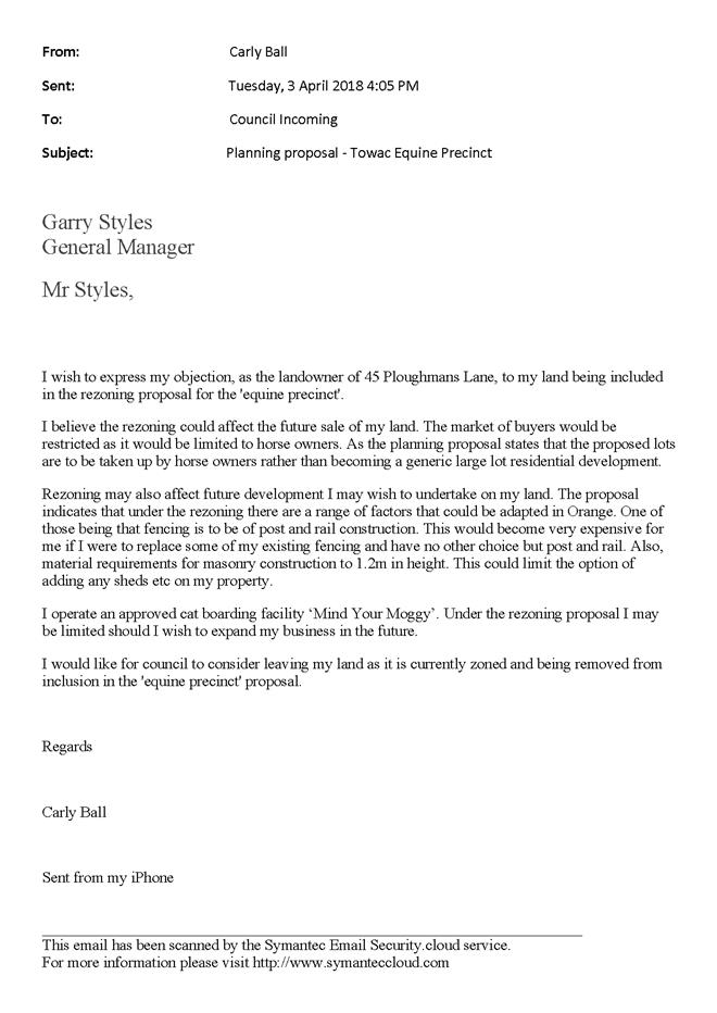
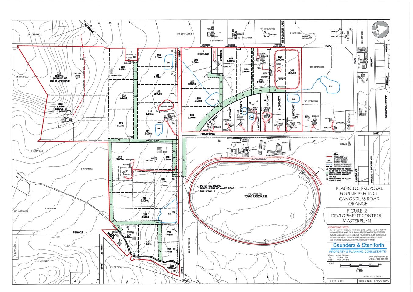
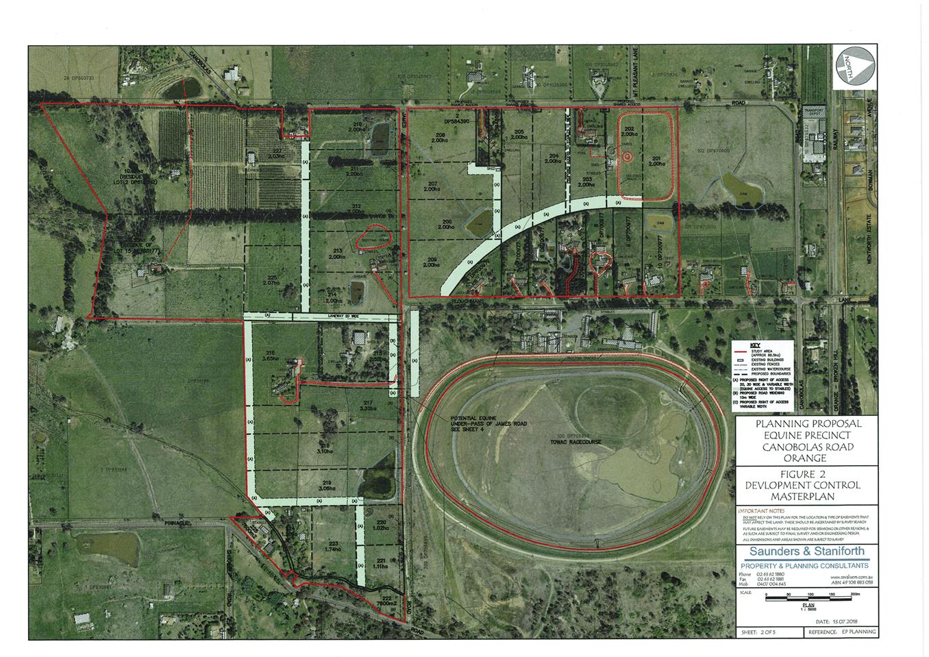
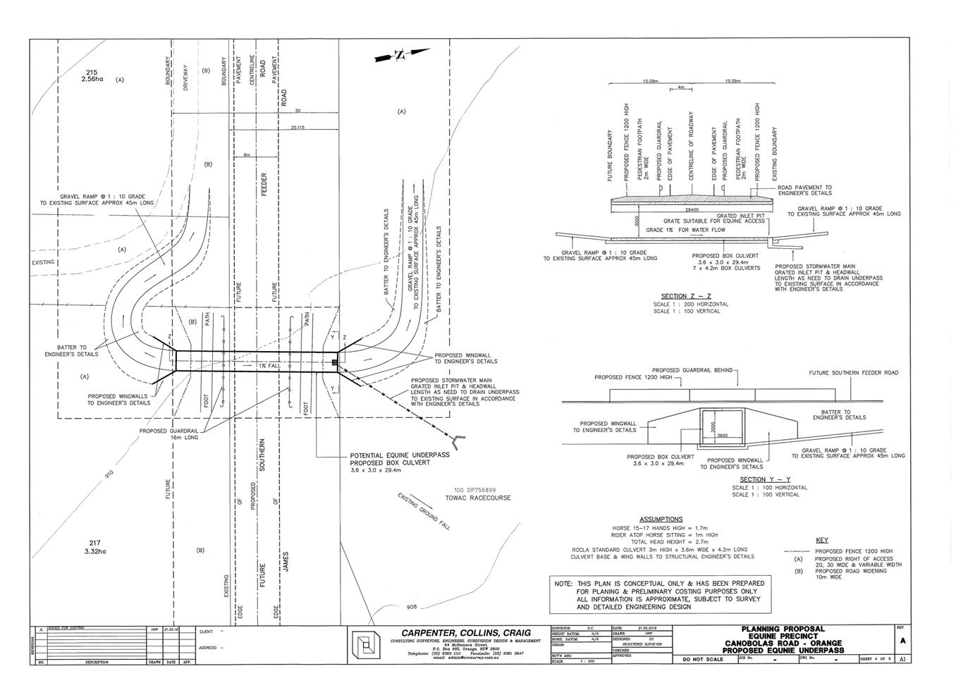
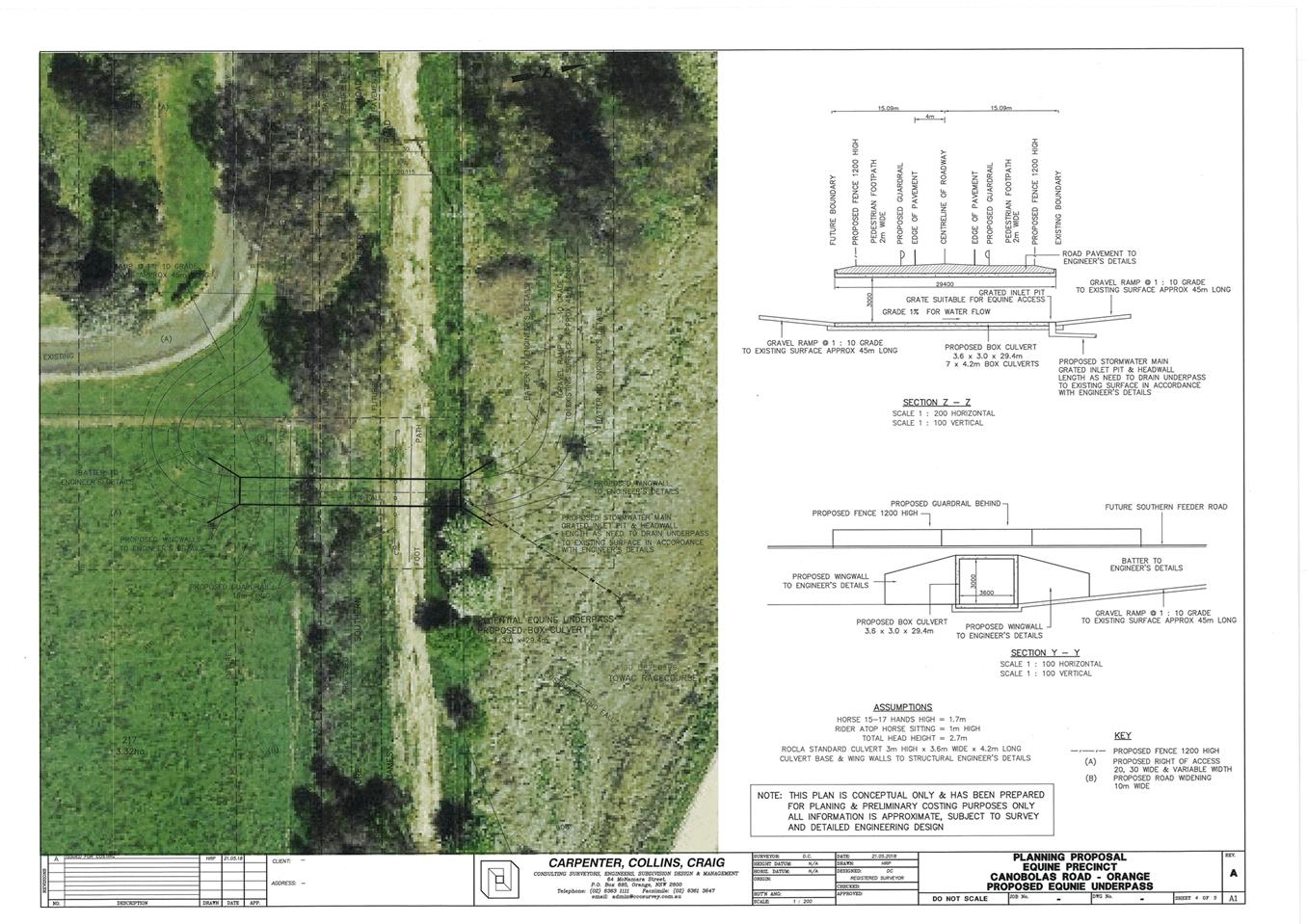
2.10 Orange Local Environmental Plan 2011 - Amendment 17 'Towac Equine Precinct'
Attachment 1 Submissions


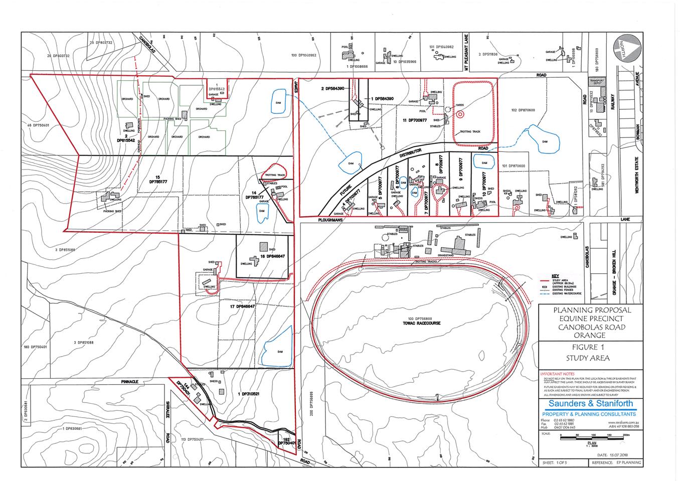
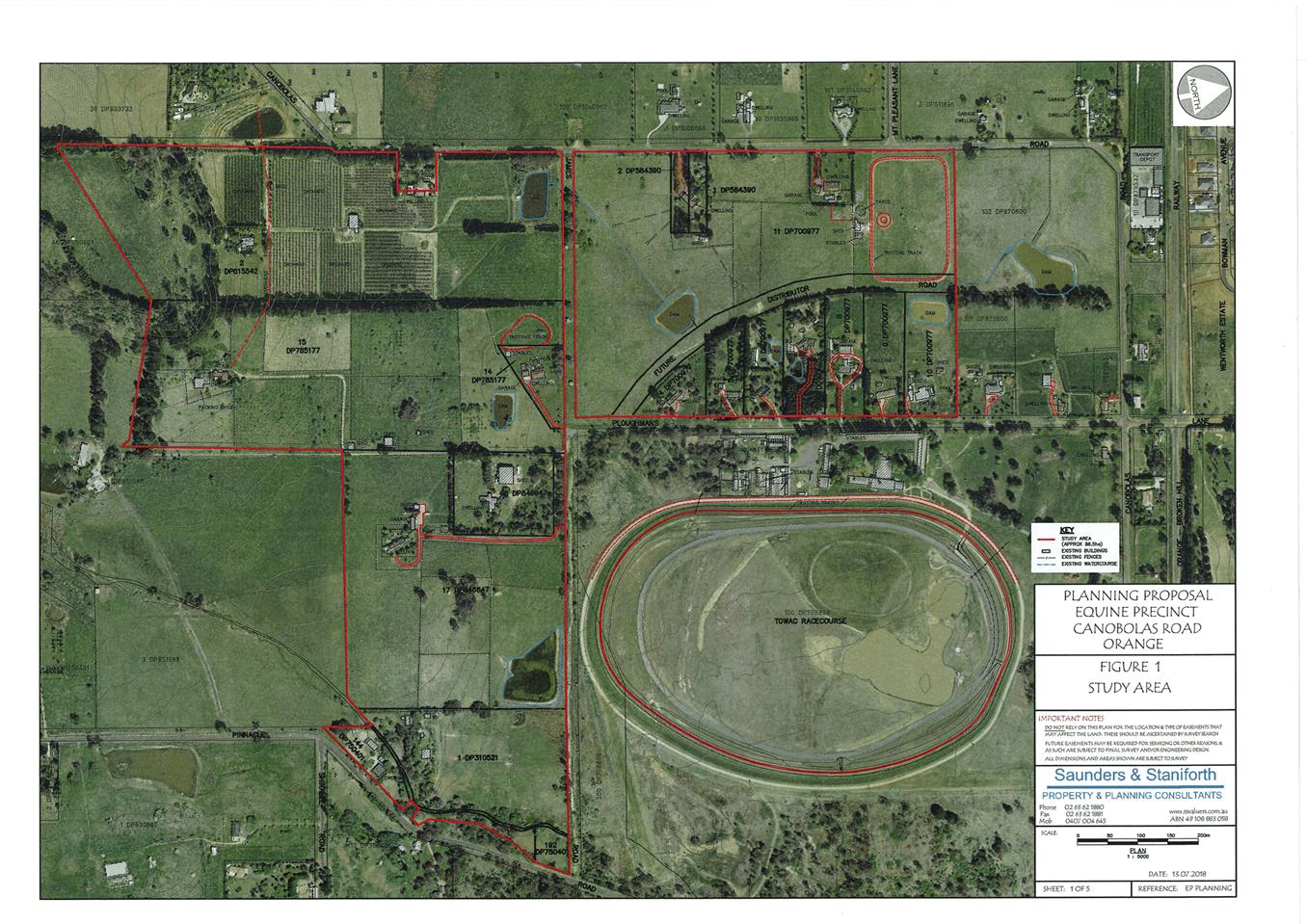
2.10 Orange Local Environmental Plan 2011 - Amendment 17 'Towac Equine Precinct'
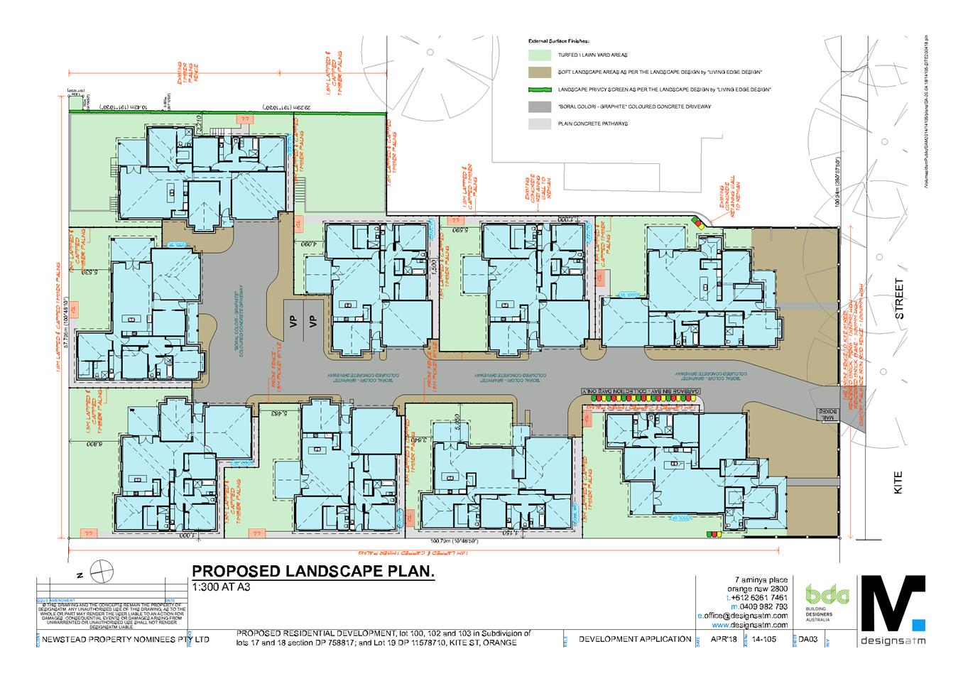
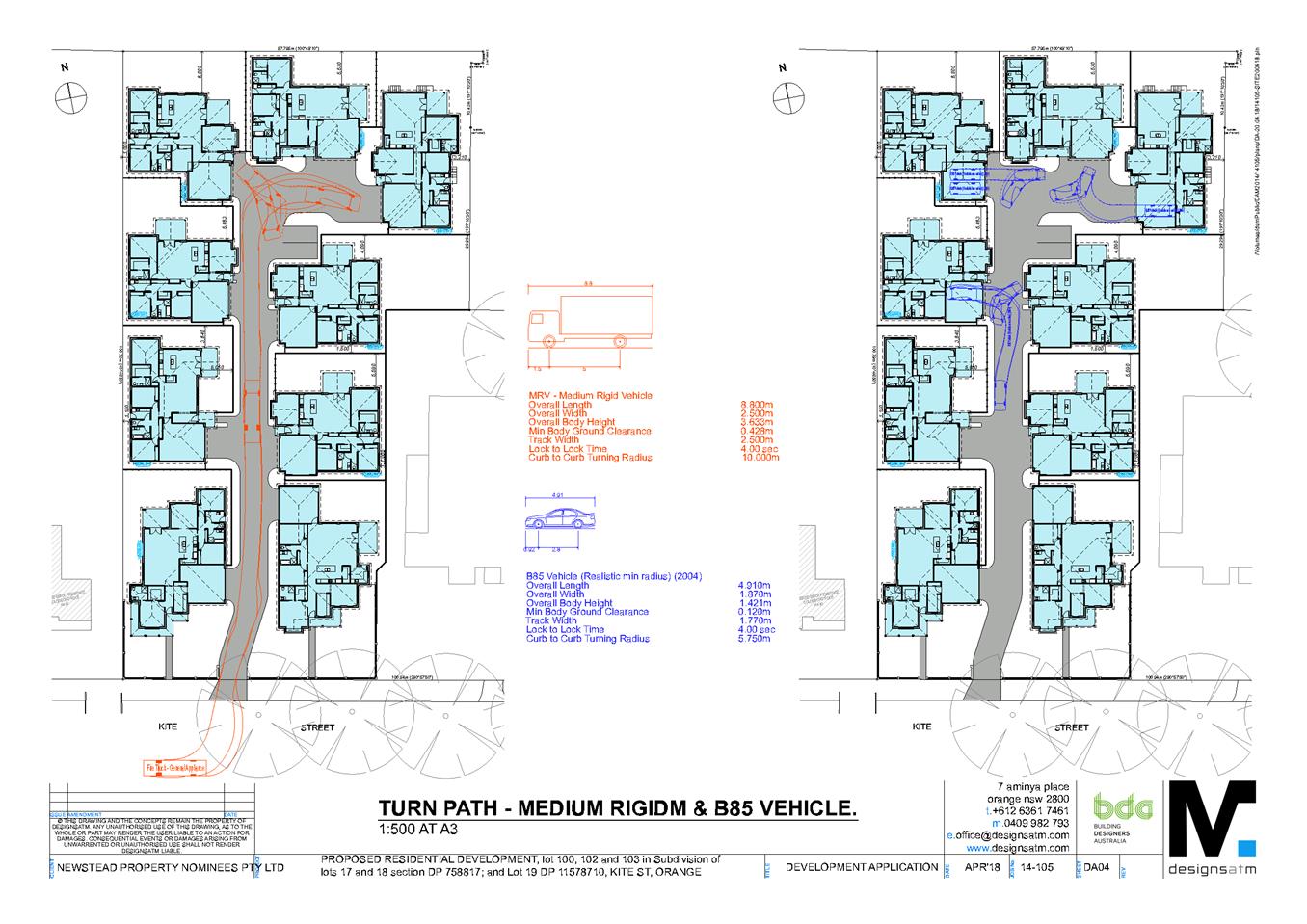
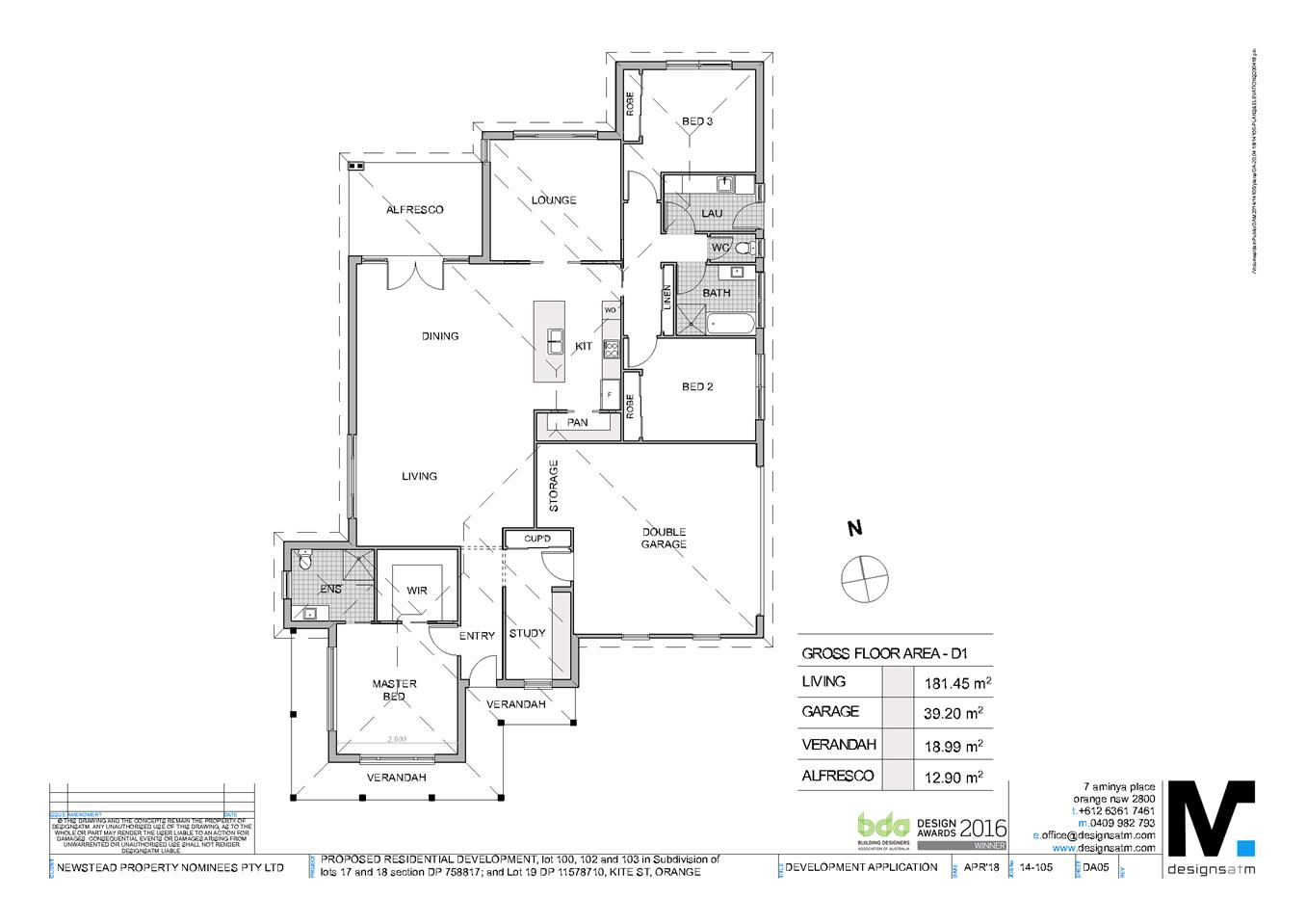
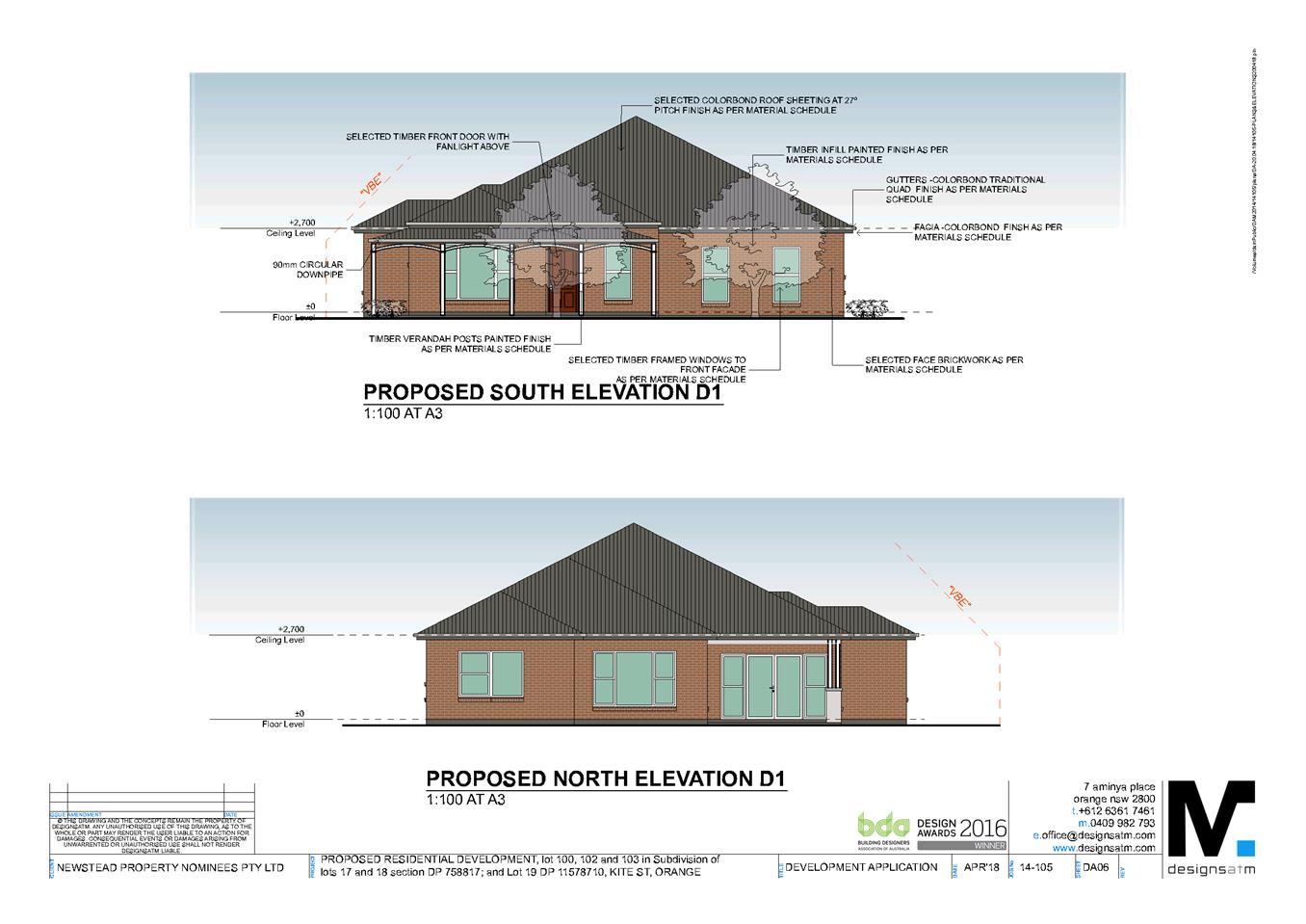
Attachment 2 Concept Plans
Planning and Development Committee 14 August 2018
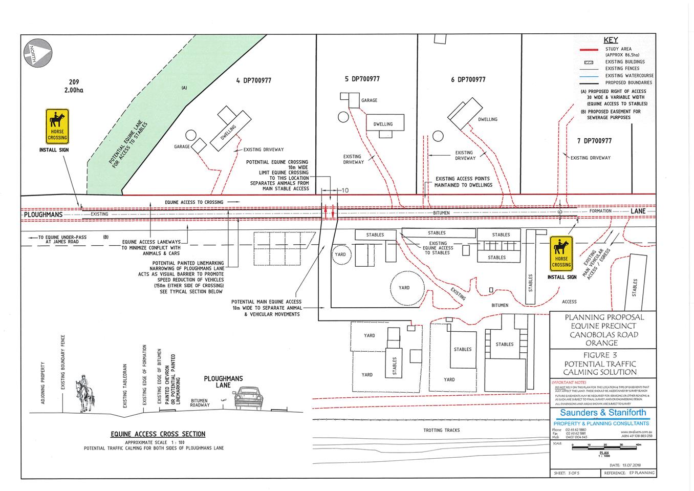
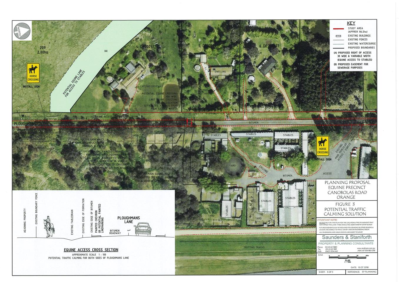
2.10 Orange Local Environmental Plan 2011 - Amendment 17 'Towac Equine Precinct'
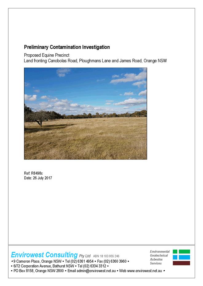
Attachment 3 Preliminary Contamination Investigation - Envirowest

2.10 Orange Local Environmental Plan 2011 - Amendment 17 'Towac Equine Precinct'
Attachment 4 Proposed Amendments to Orange LEP 2011 written instrument
Proposed Amendments to Orange LEP 2011
Land Use Table – inclusion of a new zone RU4 Primary Production Small Lots
Zone RU4 Primary Production Small Lots
1 Objectives of zone
• To enable sustainable primary industry and other compatible land uses.
• To encourage and promote diversity and employment opportunities in relation to primary industry enterprises, particularly those that require smaller lots or that are more intensive in nature.
• To minimise conflict between land uses within this zone and land uses within adjoining zones.
2 Permitted without consent
Home occupations
3 Permitted with consent
Agriculture; Animal boarding or training establishments; Bed and breakfast accommodation; Building identification signs; Business identification signs; Community facilities; Dwelling houses; Extensive Agriculture; Farm buildings; Farm stay accommodation; Home-based child care; Intensive plant agriculture; Plant nurseries; Recreation areas; Roads; Roadside stalls; Secondary dwellings; Veterinary hospitals
4 Prohibited
Any development not specified in item 2 or 3
Clauses – changes shown in red.
4.2 Rural subdivision
(1) The objective of this clause is to provide flexibility in the application of standards for subdivision in rural zones to allow land owners a greater chance to achieve the objectives for development in the relevant zone.
(2) This clause applies to the following rural zones:
(a) Zone RU1 Primary Production,
(b) Zone RU2 Rural Landscape,
(c) Zone RU4 Primary Production Small Lots,
(d) Zone RU6 Transition.
Note. When this Plan was made it did not include
Zone RU2 Rural Landscape, Zone RU4 Primary Production
Small Lots or Zone RU6 Transition.
(3) Land in a zone to which this clause applies may, with development consent, be subdivided for the purpose of primary production to create a lot of a size that is less than the minimum size shown on the Lot Size Map in relation to that land.
(4) However, such a lot cannot be created if an existing dwelling would, as the result of the subdivision, be situated on the lot.
(5) A dwelling cannot be erected on such a lot.
Note. A dwelling includes a rural worker’s dwelling (see definition of that term in the Dictionary).
4.1AA Minimum subdivision lot size for community title schemes
(1) The objectives of this clause are as follows:
(a) to ensure that land to which this clause applies is not fragmented by subdivisions that would create additional dwelling entitlements.
(2) This clause applies to a subdivision (being a subdivision that requires development consent) under the Community Land Development Act 1989 of land in any of the following zones:
(a) Zone RU1 Primary Production,
(b) E2 Environmental Conservation,
(c) E3 Environmental Management,
(d) E4 Environmental Living,
(e) Zone RU2 Rural Landscape,
(f) Zone RU4 Primary Production Small Lots,
but does not apply to a subdivision by the registration of a strata plan.
(3) The size of any lot resulting from a subdivision of land to which this clause applies (other than any lot comprising association property within the meaning of the Community Land Development Act 1989) is not to be less than the minimum size shown on the Lot Size Map in relation to that land.
(4) This clause applies despite clause 4.1.
2.10 Orange Local Environmental Plan 2011 - Amendment 17 'Towac Equine Precinct'
Attachment 5 Planning Proposal - supporting information
PLANNING PROPOSAL TO AMEND
Orange LEP 2011
To Permit an Equine Precinct
R5 Large Lot Residential adjacent to
Towac Park Racecourse
Various lots
Canobolas Road
ORANGE NSW 2800
Documents
1. Existing and proposed concept plans
2. Traffic diagrams
3. Consent letters: Draper, White & McMullen
Our Ref: Planning/2016/16-1256
1.0 OVERVIEW
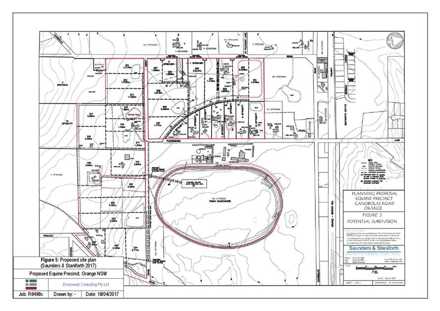
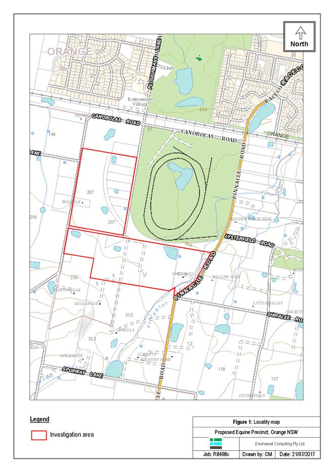
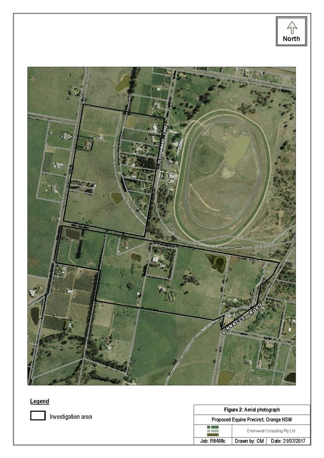
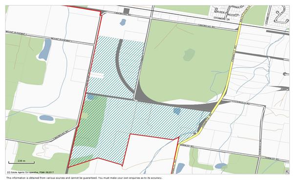
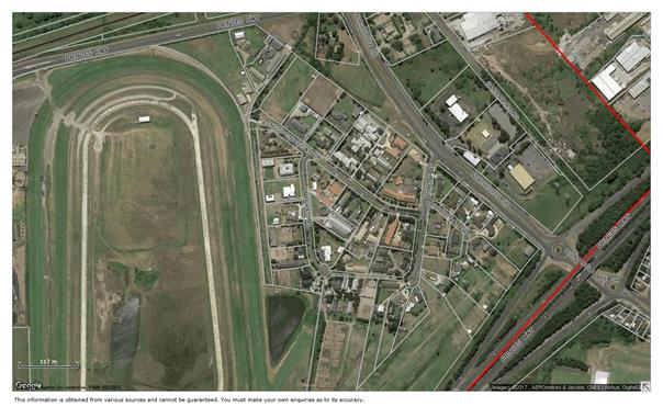
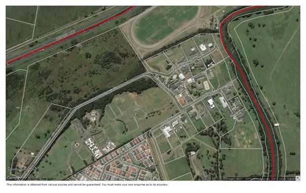
We have been engaged to present a Planning Proposal to Orange City Council for NSW Planning to investigate the merit of establishing an equine precinct upon a 37 hectare holding held under 12 owners fronting Ploughmans Lane South and Canobolas Road. The property is situated to the west of Towac Racecourse and has access to the racetrack via the previous Southern Distributor road reserve.
The study area is situated 4 kilometres southwest of Orange post office. The land is situated near various rural residential holdings, Wentworth Golf Club, Orange Buslines and the Orange-Broken Hill railway line.
We have undertaken preliminary discussions with Orange City Council’s planning staff regarding the proposal.
Council at this stage have not presented their preference or the form of the amendment to allow for Large Lot Residential or the additional use provisions for equine activity in conjunction with the Towac Racecourse. Our proposal relates to a rezoning to an R5 Large Lot Residential or an RU4 zone, similar to Kembla Grange. We envisage the Lot Size amendments to represent a mix of lot sizes from 1-2 hectares with a private sewer system to irrigate the centre of the racecourse. The lot yield proposed comprises 40 lots plus the Towac Racecourse area.
2.0 APPLICANT
The applicant is: Mr Brad Draper
207 Canobolas Road
ORANGE NSW 2800
Tania and Kelvin White
1 Ploughmans Lane
ORANGE NSW 2800
Patrick McMullen
5 Ploughmans Lane
ORANGE NSW 2800
Racing Orange Ltd
PO Box 964
ORANGE NSW 2800
3.0 SUBJECT LAND
3.1 Location and Land Description
The subject property is located on the south western corner of Canobolas Road and Ploughmans Lane and on the eastern side of Canobolas Road.
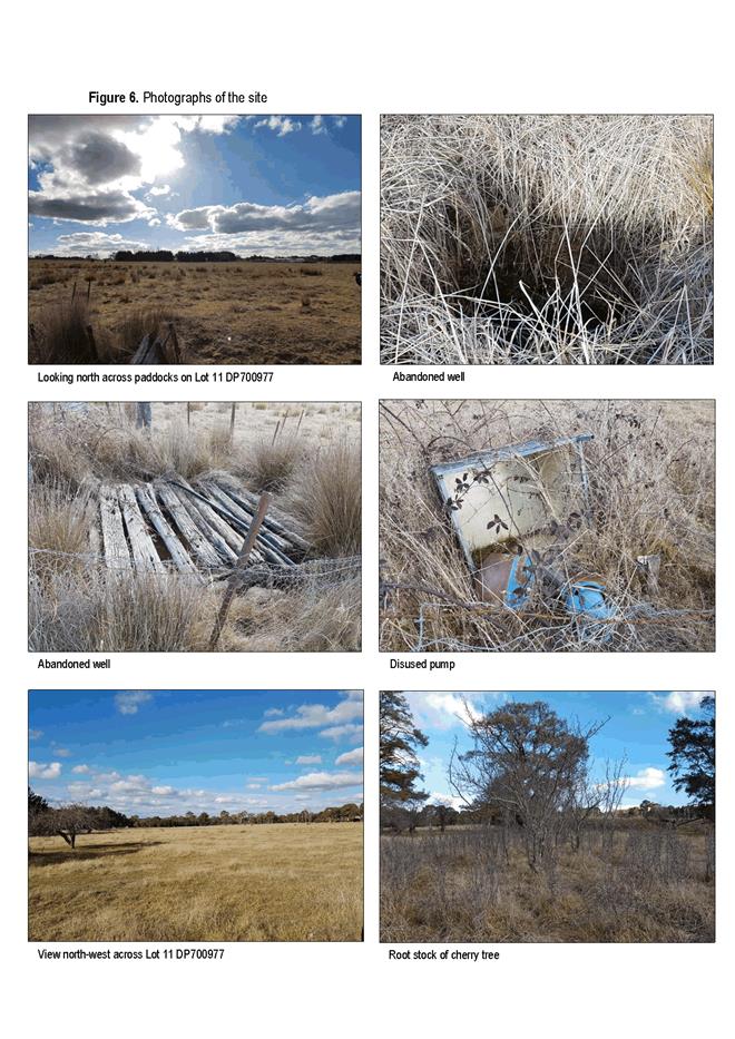
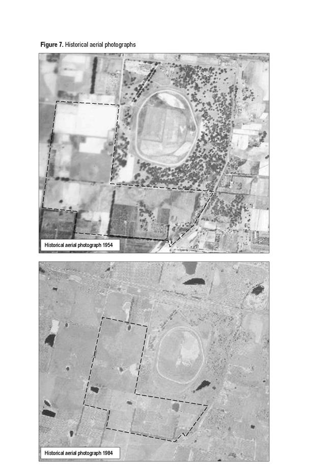
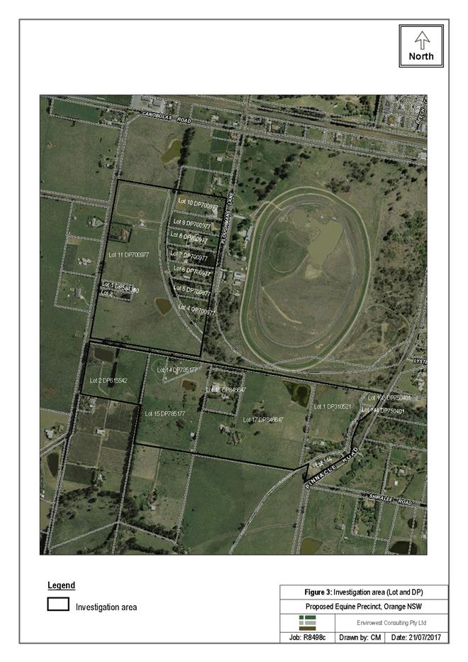
The study area comprises:
69 Ploughmans Lane – Lot 101 DP 870600
57 Ploughmans Lane – Lot 10 DP 700977
53 Ploughmans Lane – Lot 9 DP 700977
45 Ploughmans Lane - Lot 8 DP 700977
39 Ploughmans Lane - Lot 7 DP 700977
35 Ploughmans Lane - Lot 6 DP 700977
27 Ploughmans Lane - Lot 5 DP 700977
17 Ploughmans Lane – Lot 4 DP 700977
5 Ploughmans lane – Lot 15 DP785177
1 Ploughmans Lane – Lot 17 DP846647
113 Canobolas Road – lot 11 DP 700977
201 Canobolas Road – Lot 1 & 2 DP 584390
24 Canobolas Road – lot 2 DP615542
77 James Road – Lot 14 DP785177
16 James Road – Lot 16 DP846647
35 Pinnacle Road – Lot 1 DP310521
136 Pinnacle Road – Lot 192 & 144 DP750401
Towac Park Racecourse lot 100 & 200 DP 756899
![]()
![]()
![]()
![]()
![]()
![]()
![]()
![]()
![]()
![]()
4.0 PROPOSAL
The proposal incorporates a specialist equine precinct that encourages the establishment of rural residential holdings in support of training, breeding and horse management. A critical part of the concept relates to the management of such facilities and availability for horses to have access to the Towac Park race track facility.
It is envisaged that residents will have opportunities for stables, round yards, equestrian training areas and the like. Dwellings will allow on site management and is an integral part of equine management to be on site with exercise, veterinary needs and breeding management.
The following is an extract from the owners with a detailed description of the equine management large lot concept:
Lifestyle precincts are a growing sector allowing people of similar mindsets to enjoy and share their hobbies and way of life with likeminded neighbours.
Acreage subdivisions generally and more specifically those located close to the Central Business District in Orange, have always been well received by locals and out of town buyers. The latter tends to fall into two groups, those who are looking for a tree change and escape from the larger cities as well as persons downsizing from rural property and would like to be closer to the facilities available in town, however, still desire rural residential space and serenity.
While there are no specific statistics available on the equestrian set per se, it is relatively common knowledge that horsey people tend to come from the more affluent socio-economic groups and are generally prepared to expend more in order to maintain their standard of living.
There are already a number of successful equine precincts in Australia with particular note of those in and around the Kembla Grange Racecourse and along the Mornington Peninsula.
Orange has always had a diverse collection of interests covering a range of sports as well as wide selection of other activities. The region is experiencing significant growth in professional people that have come to the region to take advantage of the vast array on offer.
The ideal ‘equine precinct’ facility should have the following attributes;
· Acreage space to stable and ride horses
· Conveniently located to work (CBD)
· Conveniently located to multi-purpose equestrian facilities:
- Dressage
- Jumping
- Cross Country
- Leisure Riding
- Racing
This segment is quite prepared to outlay the necessary funds to procure the home they are after in a desirable location. They are busy people who are generally time poor, enjoy spending weekends with their family and are looking to minimise travel time to/from work for recreational purposes. Therefore the thought of having their horses close to hand and within close proximity to other equestrian facilities is extremely attractive. Keeping the animals fed, clean and maintained is a time consuming process and therefore the closer to home the better it is.
A specialised ‘equine zone’ within the Towac Park Precinct would allow many walks of life to enjoy a quality homes on manageable acreage. The convenience of using the nearby facilities where horses can be stabled and the family are able to enjoy more time together at all times without the need consider travelling to and from agistments.
Establishing an ‘equine precinct’ in the area outlined in the following map, will ensure we maximise the usage of a currently under-utilized facility and may realise a more profitable potential for Council and ratepayers alike.
It has been identified that the proposed land use is not permissible in the R5 Large Lot zone and submit that 1 - 2 hectare lots (with private sewer treatment with Towac Racecourse) would allow for the keeping of horses in holding yards and stables whilst having communal access to Towac Park. A similar scenario exists at Goulburn Racecourse with regard to waste water irrigation.
Supporting Horse Associated Data
We have undertaken a case study of a similar development associated with Kembla racecourse.
Similar 25 and 35 lot developments with access to either the Kembla Racecourse or have a suitable land use scenario to allow equine associated development.
These developments were mainly sold from 1987 to 2002 with steady demand.
The Kembla Grange precinct is identified under an RU4 Primary Production Small Lots zoning under Wollongong LEP 2009 with a mix of animal boarding and training establishments, farm stay accommodation and vet hospitals permissible, subject to Council’s development consent.
Orange Sales Analysis – Rural Residential
We have researched genuine (unrelated) vacant land sales as follows:
|
Rural Residential Sales Analysis |
||
|
|
Rural Residential Vacant Land |
Total Vacant Land Sales |
|
2014 |
11 |
212 |
|
2015 |
47 |
238 |
|
2016 |
34 |
204 |
|
2017 to April |
9 |
35 |
The analsyis each year shows a concentrated trend of a particular area. In 2014 the 11 vacant sales included 4 sales at Windera, 3 sales at Spring Hill and 1 vacant sale at Clifton Grove. This represents approx. 5% of the vacant land market.
In 2015, of the 47 sales, there were 4 sales at Clifton Grove, 3 sales at Windera and 31 sales in the Silverdown/Dean Drive/Spencer Lane precinct. This supports an upper end demand for vacant sales in a $275000 price bracket for 1 acre (4000sqm) lots and $380 000- $400 000 price level for 2 hectare lots. This represents 20% of the vacant land market.
In 2016, of the 34 rural residential lots sold, there were 4 lots sold at Clifton Grove. A further 23 lots were sold in the western precinct of Silverdown/Spencer and Connemara Drive. This represents 16% of total vacant land market sold.
The data in 2017 to April shows a further 9 lots or 25% of the market. Seven of the nine sales occurred in the Silverdown/Connemara west precinct.
With the supply of lots coming to an end in the Silverdown west area the supply versus demand in the Silverdown area will be exhausted. No further vacant rural residential lots in a designated precinct will be available with limited supply left at Clifton Grove, Mullion Creek or Windera.
The proposal provides for 34 equine focussed allotments. Based on our sales data this equates to 1-2 years supply of rural residential land. Lots sizes range from 1 to 3.6 hectares.
Further information has been provided by the racing industry that shows Orange only has smaller numbers due to the decrease in facilities or available stabling options. Currently only 7 Trainers in Orange with on average 8-10 Horses in the better weather months of Spring and Summer.
The real demand for this type of acreage is with the Performance Horses – Show jumping and Dressage etc. They are Professional people who work and have difficulty presently being able to find acreage near suitable facilities to work their horses. Therefore the need for such an area relates to horses used for dressage, kids ponies, endurance and show horses, stock horses and campdrafting. Local enquiries indicate there would be a supply in excess of 800 horses in mix of equine activities. The majority are situated in small hobby farms over 2 hectares or on larger holdings on agistment. Due to the shortage of areas, the current horse numbers are situated in the Towac, Springside, Mullion Creek, Millthorpe and Springhill localities.
Based on the limited supply of rural residential property generally, the selling rates shown plus the strong equine usage within 30 kilometres of Orange, together, illustrates a solid demand for an equine precinct that complements the racecourse and fulfils the wider community demand.
5.0 PLANNING REQUIREMENTS
In determining the application, Council is required to consider the relevant matters identified under section 79C(1) of the Environmental Planning and Assessment Act, 1979. This section forms the basis of our assessment below.
5.1 Provisions of Environmental Planning Instruments
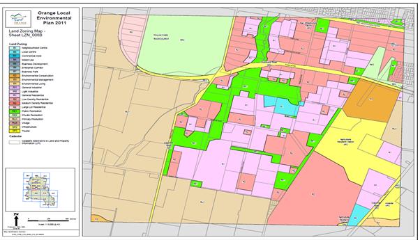
The subject land is currently zoned R5 Large Lot Residential and RU1 Primary Production as follows:
Zone RU1 Primary Production
1 Objectives of zone
• To encourage sustainable primary industry production by maintaining and enhancing the natural resource base.
• To encourage diversity in primary industry enterprises and systems appropriate for the area.
• To minimise the fragmentation and alienation of resource lands.
• To minimise conflict between land uses within this zone and land uses within adjoining zones.
• To promote the unique agricultural character of Orange and facilitate a variety of tourist and visitor accommodation land uses that are compatible with agriculture.
• To ensure that development along the Southern Link Road has an alternative access.
2 Permitted without consent
Environmental protection works; Extensive agriculture; Home-based child care; Home occupations; Viticulture
3 Permitted with consent
Agriculture; Airstrips; Animal boarding or training establishments; Bed and breakfast accommodation; Business identification signs; Cellar door premises; Community facilities; Dwelling houses; Eco-tourist facilities; Environmental facilities; Extractive industries; Farm buildings; Farm stay accommodation; Forestry; Helipads; Home businesses; Home industries; Information and education facilities; Intensive livestock agriculture; Intensive plant agriculture; Landscaping material supplies; Open cut mining; Recreation areas; Recreation facilities (major); Recreation facilities (outdoor); Roads; Roadside stalls; Rural industries; Secondary dwellings; Veterinary hospitals; Water supply systems
4 Prohibited
Any development not specified in item 2 or 3
Zone R5 Large Lot Residential
1 Objectives of zone
• To provide residential housing in a rural setting while preserving, and minimising impacts on, environmentally sensitive locations and scenic quality.
• To ensure that large residential lots do not hinder the proper and orderly development of urban areas in the future.
• To ensure that development in the area does not unreasonably increase the demand for public services or public facilities.
• To minimise conflict between land uses within this zone and land uses within adjoining zones.
• To provide for student housing in close proximity to the Charles Sturt University.
• To ensure development is ordered in such a way as to maximise public transport patronage, and encourage walking and cycling, in close proximity to settlement.
• To ensure development along the Southern Link Road has an alternative access.
2 Permitted without consent
Environmental protection works; Home-based child care; Home occupations
3 Permitted with consent
Animal boarding or training establishments; Bed and breakfast accommodation; Boarding houses; Building identification signs; Business identification signs; Child care centres; Community facilities; Crematoria; Dwelling houses; Environmental facilities; Exhibition homes; Home businesses; Home industries; Information and education facilities; Kiosks; Neighbourhood shops; Places of public worship; Recreation areas; Recreation facilities (indoor); Recreation facilities (outdoor); Respite day care centres; Roads; Veterinary hospitals; Water supply systems
4 Prohibited
Any development not specified in item 2 or 3
Under the current RU1 and R5 zoning an ‘animal boarding and training’ and ‘Recreation Facility (Outdoor)’ is a permissible use with consent.
An animal boarding or training establishment and recreation facility (outdoor) is defined by Orange LEP 2011 as:
animal boarding or training establishment means a building or place used for the breeding, boarding, training, keeping or caring of animals for commercial purposes (other than for the agistment of horses), and includes any associated riding school or ancillary veterinary hospital.
recreation facility (outdoor) means a building or place (other than a recreation area) used predominantly for outdoor recreation, whether or not operated for the purposes of gain, including a golf course, golf driving range, mini-golf centre, tennis court, paint-ball centre, lawn bowling green, outdoor swimming pool, equestrian centre, skate board ramp, go-kart track, rifle range, water-ski centre or any other building or place of a like character used for outdoor recreation (including any ancillary buildings), but does not include an entertainment facility or a recreation facility (major).
State Environmental Planning Policies
The SEPP Rural Lands applies. The land is not classed as State Significant Rural Land. The objectives of the SEPP are discussed below:
2 Aims of Policy
The aims of this Policy are as follows:
(a) to facilitate the orderly and economic use and development of rural lands for rural and related purposes,
(b) to identify the Rural Planning Principles and the Rural Subdivision Principles so as to assist in the proper management, development and protection of rural lands for the purpose of promoting the social, economic and environmental welfare of the State,
(c) to implement measures designed to reduce land use conflicts,
(d) to identify State significant agricultural land for the purpose of ensuring the ongoing viability of agriculture on that land, having regard to social, economic and environmental considerations,
(e) to amend provisions of other environmental planning instruments relating to concessional lots in rural subdivisions.
We consider the use of the land for an equine focussed land use in conjunction with the Towac Racecourse precinct allows an opportunity to promote equine activity as a form of agricultural agistment and other rural based activities such as vet services, training and rural based recreation.
We consider that the nature of the proposal to concentrate equine activity in a designated precinct allows for responsible management and reduced potential for land use conflicts. Equine activity can involve varied hours of operation and vehicle movements that are well suited in the locality.
On a broader agricultural perspective, the fragmented subdivision pattern of the proposal area and limited opportunity for intensive agriculture so close to Orange urban area results in minimal loss to NSW and Australia agricultural land resources.
The proposal does not involve the creation of any concessional lots though historically some lots exist in the precinct, supporting the need to consider rural residential development in the area.
5.2 Provisions of Draft Environmental Planning Instruments
There are no known draft regional, state or local environmental planning instruments that affect the subject property.
The new Central West and Orana Regional Plan 2036 is referred to later in our Planning Proposal.
5.3 LEP Options
Three main options have been discussed with Council staff regarding an appropriate planning strategy to enable consideration of an amendment to Orange LEP 2011 to provide the opportunity for an equine focussed rural residential precinct upon the subject land.
We have looked closely at the Kembla Grange example and propose an R5 Large Lot Residential zone as follows:
Zone R5 Large Lot Residential
1 Objectives of zone
• To provide residential housing in a rural setting while preserving, and minimising impacts on, environmentally sensitive locations and scenic quality.
• To ensure that large residential lots do not hinder the proper and orderly development of urban areas in the future.
• To ensure that development in the area does not unreasonably increase the demand for public services or public facilities.
• To minimise conflict between land uses within this zone and land uses within adjoining zones.
2 Permitted without consent
Home occupations
3 Permitted with consent
Animal boarding or training establishments; Bed and breakfast accommodation; Business identification signs; Child care centres; Community facilities; Dwelling houses; Exhibition homes; Farm buildings; Home-based child care; Places of public worship; Recreation areas; Respite day care centres; Roads; Roadside stalls
4 Prohibited
Any development not specified in item 2 or 3
· Option 1: Spot rezoning may be a consideration where the R5 Large Lot zone is extended as far as Canobolas Road.
· Option 2: Would relate to an alteration to the existing list of permitted uses within the existing R5 and RU1 zones to allow a specific use based equine associated use and supporting subdivision layout.
· Option 3: Change to an RU4 Primary Production – Small Lots zone similar to Kembla Grange.
· Option 4: Amendment to the permissible Lot Size Map with change to an R5 zoning.
We consider that the most appropriate option is Option 4 for the proposed equine precinct whereby the R5 zoning across the study area with a lot size of between 1 - 2 hectares with private sewer to a Towac Racecourse Treatment System. This would involve a Lot Size Map amendment.
This approach addresses the specific issues and the locational advantage in equine activity for this specific site without undermining the overall principles of the Local Environment Plan in terms of zoning strategies and long term strategy for the City as a whole identified in the Orange Sustainable Strategy (refer to Section B below).
5.4 Part 1 – Objectives or Intended Outcomes
To enable a site specific equine rural residential precinct upon the subject land adjacent to Towac Park Race Track.
The intended outcome is to allow an R5 zone that allows for serviced or unserviced large lot residential development with equine access to Towac Park.
5.5 Part 2 – Explanation of Provisions
The proposed outcome will be achieved by means of changing the zone from RU1 to R5 and the relevant lot size map. This is one alternative. A separate equine zone may also be an option or a specific clause that relates to a range of uses and lot sizes permissible in this specific precinct.
5.6 Justification – The Need
The proposal may be justified in terms of the need for a specific equine training and breeding precinct with managed access to Towac Park where minimal impact is likely is reasonable and practical from an economic, social and environmental perspective.
Section A – Need for the Planning Proposal
Question 1: Is the planning proposal a result of any strategy study or report?
The scale of the proposal does not warrant a detailed Planning Strategy rather a full description of the existing environment and the proposed description of the proposed use and associated impacts in the context of existing strategies for Orange.
Supply and Demand
The need is supported by the sales data in section 1 where a steady demand for rural residential land continues in Orange. This contrasts heavily with the demand at between 10 – 47 lots per annum. We consider the variation in lots sold relates more to land available rather than variations in demand remaining solid.
There is continued concern that there is minimal supply of vacant rural residential land as follows:
Clifton Grove 9 vacant lots all sold
Windera 5 vacant lots privately owned
Silverdown (2 Ha) 19 lots all sold. Agent advises that For Sale sign remains on site with 2 – 3 enquiries per week.
Silverdown (4000sqm) 12 vacant owned by developer. Connemara (2000sqm) lots only 11 left for sale of 37 lots.
Rossi Drive – 2 vacant lots privately owned.
Further information has been provided by the racing industry that shows Orange only has smaller numbers due to the decrease in facilities or available stabling options. Currently only 7 Trainers in Orange with on average 8-10 Horses in the better weather months of Spring and Summer.
The real demand for this type of acreage is with the Performance Horses – Show jumping and Dressage etc. They are Professional people who work and have difficulty presently being able to find acreage near suitable facilities to work their horses. Therefore the need for such an area relates to horses used for dressage, kids ponies, endurance and show horses, stock horses, camel racing and campdrafting. Local enquiries with clubs, show judges, vets and campdraft organisers indicate there would be a supply in excess of 1000 horses in a mix of equine activities.
Pony Club 300
Dressage 120
Endurance 75
Showhorses 75
Campdrafting 100
Pacers 50
Miscellaneous – old racehorses, pets etc 100
The majority are situated in small hobby farms over 2 hectares or on larger holdings on agistment. Due to the shortage of areas, the current horse numbers are situated in the Towac, Springside, Mullion Creek, Millthorpe and Spring Hill localities.
The promotion of this recreational sector also leads to a diversification of uses for Towac Racecourse for pony clubs, closure of Highland Paceway, tourism and event growth, growth in veterinarian, equine services, farriers and shared training facilities in a compatible precinct. Areas such as Silverdown are considered unsuitable with ‘urban mansions’ rather than semi rural pursuits such as equine activity, gardening, chickens, alpacas and the like not fitting into the character of this area. Therefore there is limited animal focussed area for early morning grooming, exercise etc without impacting on neighbours.
Based on the limited supply of rural residential property generally, the selling rates shown plus the strong equine activity within 30 kilometres of Orange, together, illustrate a solid demand for an equine precinct that complements the racecourse locality and fulfils a specific demand for rural residential land.
Question 2: Is the planning proposal the best means of achieving the objectives or intended outcomes, or is there a better way?
It is considered that the specific equine nature of the proposed rural residential land use is a planning challenge in a range of residential, rural and recreational zones. In this instance it is more appropriate to consider the merits of the location, the nature of the proposal and its likely impacts by means of an RU4 zone or similar that suits the specific nature of the proposed equine use. The compatibility of equine activity in the Silverdown estate is considered incompatible with substantial urban style dwellings, minimal rural outbuildings and sloping topography deemed an inappropriate character and land use for equine activity with early morning training, breeding problems, horse trucks and the like not in keeping with this Murphy’s Lane area.
The level topography and location close to Towac Racecourse is a highly desirable and logical option for equine activity.
Section B – Relationship to Strategic Planning Framework
Question 3: Is the planning proposal and actions of the applicable regional or sub-regional strategy (including the Sydney Metropolitan Strategy and exhibited draft strategies)?
The newly adopted Central West and Orana Regional Plan 2036 needs to be considered in reference to its objectives and strategies and the current planning proposal. However, not all parts of the region are projected to experience growth equally and as such the plan will identify strategies to ensure population sustainability and to manage population decline.
We have considered the context of the proposal and its relationship to the CWORP 2036:
CWORP 2036 Direction 4:
Promote and diversify regional tourism markets.
The region will market its urban, rural and natural areas to international tourists, particularly from Asia, and domestic visitors from Newcastle, Canberra and Sydney. Significant environmental tourism assets include the Blue Mountains, the Warrumbungle National Park (Australia’s only Dark Sky Park), Jenolan Caves in Oberon, Wellington Caves and the Macquarie Marshes.
These must be protected, enhanced and promoted to sustainably increase visitor numbers. Promoting eco-tourism, conference and sports tourism, agritourism, events and festivals, recreation (including recreational fishing) and Aboriginal cultural and historic heritage will benefit local towns, villages and existing food growers. Particularly as part of attracting off-peak seasonal visitors. Coordinated regional approaches to agritourism and food and wine tourism are already improving the resilience of individual businesses and rural communities. Access to international airports in Sydney, Brisbane, Canberra and Melbourne will underpin efforts to grow tourist numbers.
The Central West Regional Transport Plan (2013) includes actions to improve tourism-related transport services. The Country and Outback NSW Destination Network will develop and implement a new Destination Management Plan to support emerging tourism opportunities and develop visitor experiences and tourism products.
Actions
4.1 Align land use and tourism strategies with a Destination Management Plan for the Country and Outback NSW Destination Network.
4.2 Work with councils to improve tourism-related transport services.
4.3 Develop the region’s capacity to grow food and wine tourism.
4.4 Enable opportunities appropriate for tourism development and associated land uses in local environmental plans.
4.5 Target experiential tourism opportunities and develop tourism management frameworks to promote a variety of accommodation options.
4.6 Encourage tourism development in natural areas that support conservation outcomes.
The proposal supports tourism markets, promoting a good mix of equine events such as picnic Racing, TAB Racing events, Camel racing, Pony gymkhanas, and dressage events within a central precinct close to Orange urban area.
A designated precinct that is identifiable and marketable is consistent with the regions tourism objectives. The proposal also promotes an opportunity for diversification in the tourism base for Orange rather than the dominant food and wine sector. The proposal whilst an opportunity to promote a range of equine related tourism and recreation events does not present direct competition with other accommodation and tourism sectors such as food and wine.
The ‘bums on seats’ approach to tourism is also a positive scenario in terms of visitors arriving in Orange for say a pony event and still enjoying other tourism sectors whilst in the region such as restaurants and wine tasting. The proposal therefore supports tourism in a broader sense by promoting increased visitors to the region.
Experimental tourism can also be encouraged through the equine proposal with new events such as camel racing, polo and other new projects in the Towac precinct. The proposal will allow better management of horse related events, and the diversification of uses at the racecourse.
CWORP 2036 Direction 6:
Expand education and training opportunities.
As the Central West and Orana’s economy diversifies and its population changes, there will be demand for skilled labour in resources, energy, health and agribusiness. Tertiary education and training, including vocational training, will be crucial to overcome the shortage of skilled workers and meet future workforce demands. Education and training providers will need to partner with government and the private sector to address regional skills shortages and provide tailored regional training programs. For example, skills shortages in the health sector may be resolved through medical training in established university rural health schools, or through the co-location of health services and teaching and training facilities like the Charles Sturt University Dentistry and Nursing School in Dubbo.
The Orana and Central West Regional Development Australia Committee’s role as a certifying body for the Regional Skilled Migration Scheme will continue to allow employers in regional areas and those operating from centres with low population growth to recruit workers from overseas, or workers currently in Australia on temporary visas. Expanding tertiary education services and online access to education will increase access to services and sustain community wellbeing, particularly in smaller and isolated communities. The NSW Government is committed to delivering better community access to quality vocational education and training through technology improvements to support global competitiveness and innovation. The Department of Education is reviewing its approach to long-term asset and network planning, including opportunities for partnerships between schools and councils to pool resources and share costs and make the best use of community assets.
Actions
6.1 Work with stakeholders and the region’s education providers to identify opportunities to address skills shortages through tailored regional training programs.
6.2 Promote the development of education precincts around universities and other educational facilities to allow people to specialise in rural studies and to cater for international students.
6.3 Facilitate joint-venture opportunities for shared community and school facilities on school sites, including sporting fields, amenities, parking, community halls, child care, arts and library facilities.
A designated equine precinct allows the opportunity to promote educational opportunities through TAFE and universities in vet science and horse management courses such as farriers, jockey apprenticeships and the like in a concentrated precinct with greater variety of opportunities and associated skillsets with a good mix of experienced stakeholders .
CWORP 2036 Direction 12:
Plan for greater land use compatibility
Investment in rural and resource industries will underpin the Central West and Orana’s sustainable growth, productivity and prosperity. As this occurs, land use compatibility issues could arise. The potential for land use conflict increases if new housing encroaches on rural land and resource areas. This can increase management costs and limit the growth of rural and resource industries, especially in closely settled areas around Bathurst and Orange. The expansion of rural and resource industries can also affect established urban activities if not managed appropriately. Land use planning can provide greater certainty for investment in rural and resources industries by establishing clear parameters and transparent processes to support new development. A consistent planning approach can avoid fragmentation of productive agricultural land and identify suitable locations for new rural residential development. This approach will also limit potential impacts on areas of high environmental value, cultural and heritage assets and areas with rural landscape value. The planned separation of sensitive uses will allow diverse land uses to develop and support each other.
Actions
12.1 Conduct a pilot study with Central NSW Councils (CENTROC) to investigate practical on-ground mechanisms to help avoid land use conflict between intensive agricultural uses and other sensitive uses.
12.2 Identify and protect important agricultural land in local plans.
12.3 Create local strategies to limit urban and rural housing development in agricultural and extractive resource areas, industrial areas and transport corridors.
12.4 Amend planning controls to deliver greater certainty of land use.
12.5 Provide non-statutory guidance on appropriate and sympathetic land use in areas where land use conflicts occur.
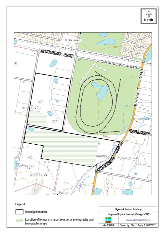
The proposal supports the above planning approaches by utilising a specific use in a compatible location without major affectation of surrounding agricultural uses, encourages logical resource management by clustering similar equine activity in the one location. The proposal allows a greater certainty and identification to the desired equine land use. The effect on the agricultural land bank is minimal with the subject proposal area already substantially altered into land areas less than 5-15 hectares with no direct intensive agriculture likely this close to Orange urban area. The wetter flat nature of the land also limits opportunities for viticulture and orcharding in the future.
CWORP Direction 28:
Manage rural residential development
Rural residential housing is a popular lifestyle housing option driven by the desire for a rural lifestyle, particularly close to regional cities and strategic centres, and in some cases, close to Sydney. In some areas, this type of development has been seen as a way to attract new residents and reverse or stabilise population decline, although economic development is a much stronger driver of population trends. Rural residential development can conflict with productive agricultural, industrial or resource lands. It may also increase pressure for new services outside existing settlements, with costs borne by councils and the broader community. Managing this development and its cumulative impacts will be essential as the regional economy diversifies and development pressure increases. A consistent planning approach is required to identify suitable locations for new rural residential development to avoid fragmentation of productive agricultural land, and protect high environmental value assets, cultural and heritage assets or areas with important rural landscape values. This type of development should not increase pressure on infrastructure and services, and should be located on land free from natural hazards.
Actions
28.1 Locate new rural residential areas:
• close to existing urban settlements to maximise the efficient use of existing infrastructure and services, including roads, water, sewer and waste services, and social and community infrastructure;
• to avoid and minimise the potential for land use conflicts with productive, zoned agricultural land and natural resources;
• to avoid areas of high environmental, cultural or heritage significance, regionally important agricultural land or areas affected by natural hazards.
28.2 Enable new rural residential development only where it has been identified in a local housing strategy prepared by Council and approved by the Department of Planning and Environment.
28.3 Manage land use conflict that can result from cumulative impacts of successive development decisions.
The supply and demand analysis undertaken illustrates a continued demand for rural residential lifestyle with 10-15% of vacant land being categorised as rural residential with a tightening of supply with the Brokenshaft precinct currently limited in the short term.
The equine proposal supports the above intent being close to existing infrastructure, promotes efficient resource (utilities) use and efficiency of transport links. Other community and social infrastructure are also in good proximity being situated on the urban fringe, close to the regional hospital, sportsfields, golf courses and within 2 kilometres of the CBD.
The location of Towac racecourse allows a good land use buffer to surrounding rural areas, promotes good environmental management, maintains existing native corridors along the southern edge of the precinct and is sympathetic to the existing landform. The proposal also protects the heritage and cultural character associated with the Towac racecourse, promotes its economic and tourism appeal and therefore protects its economic future.
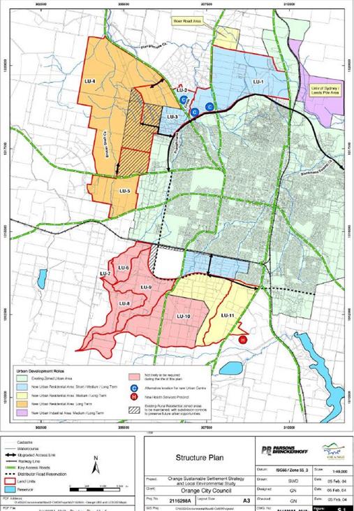
The proposal is considered to be consistent with the rural residential and rural use of LU-9 area, and the subject existing rural residential land between Towac Racetrack and the eastern side of Ploughmans Lane (shown hatched in the SS Strategy).
The proposal is considered to reduce land use conflict where equine activities involving early morning training activity or problems associated with dogs, mild horse odour and the like are not impacting on urban residents and also acts as a logical buffer to agricultural practices such as spraying and machinery noise.
Question 4: Is the planning proposal consistent with a Council’s local strategy or other local strategic plan?
The proposal is not inconsistent with any local planning strategy though is considered a logical planning approach given the zoning boundary using the old Distributor Road being irrelevant and the strategic advantage of utilising Towac Park.
Orange Sustainable Settlement Strategy
1.2 Strategy purpose and objectives
The purpose of the Sustainable Settlement Strategy is to provide Council with a strategic plan to manage growth and to provide strategic direction for urban and rural residential land release in the City.
The objectives of the Sustainable Settlement Strategy are to:
Undertake a strategic analysis into the supply and demand characteristics for urban and rural residential growth, investigating possible supply issues in land zoned for residential development that is yet to be developed;
Determine the infrastructure servicing constraints (in terms of provision, costs and sequencing) in the Sustainable Settlement Strategy study area;
Identify the appropriate direction and form for future growth in the City, including revisiting the role of the existing Rural Residential zoned land in the vicinity of Gorman Road and Murphys Lane; and the staging options for land release in the City.
3.1.5 Better Rural Residential Development Guidelines
These guidelines were produced by the then Department of Urban Affairs and Planning in 1998 to guide inland councils in preparing planning policies and making strategic land use decisions concerning new rural residential development. The guidelines provide a basis for determining which lands are appropriate for this development form. Based on the guidelines, rural residential development should be located: ƒ to minimise conflicts with other land uses which are important to the local economy (such as agriculture); ƒ where it will not unreasonably increase agricultural land values or reduce the size of agricultural land holdings; ƒ in areas free of hazard (such as areas affected by flooding, contamination, erosion and slip); ƒ in areas where effluent disposal will not lead to pollution of waterways or degradation of soil and vegetation; ƒ where it will not endanger threatened species or critical habitat; ƒ where people want to live convenient to facilities and services they need; ƒ acknowledging the capacity of the existing road network and utility services; and ƒ acknowledging social and service infrastructure capacity and the cost to council and the community of service provision. The guidelines have relevance in preparing strategies to accommodate future rural residential areas. Recommendations relating to new rural residential living opportunities are contained in Section 7.
4.2.4 Development in South Orange
Some submitters raised no objections to the future development of the southern part of the SSS study area;
high quality soil types in the area are considered suitable for intensive agriculture. The maintenance of minimum lot sizes is important to retain opportunities for new intensive agricultural pursuits;
maintaining viable agricultural activity in the area is important to the Orange economy and the community’s way of life. Adjacent rural uses could gradually be forced to vacate if these areas became used for urban or rural residential development; the rural residential development potential for this area should be based on its existing physical attributes, its visual qualities and proximity to protected areas at Mount Canobolas, and the existing fragmentation of land holdings. However some acknowledged that such low density development Sustainable Settlement Strategy and Local Environmental Study would preclude these areas from accommodating some of Orange’s urban growth and other areas would need to be found.
Some rural residential landowners felt that Council should maintain the amenity of existing rural residential areas;
Water supply (limited water pressure) is an issue in existing rural residential areas; a mixture of five acre (two hectare) and one acre (0.4 hectare) blocks would be appropriate in any rural residential development areas;
The interface between rural uses, the Agricultural Research Station, and new urban development needs to be investigated and controlled. Buffers would be needed to allow agriculture/horticulture/viticulture to continue;
The possibility of land contamination issues associated with existing and former orchards; and role of the proposed southern distributor road, and good access across the rail line needs to be considered and provided if urban areas are developed to the south.
Urban Fringe Rural Residential Areas
Conflicting values emerged during the community and agency consultation phase regarding the future use and development of rural residential precincts located immediately adjacent to the existing Urban Residential zoned areas. These areas include land which has already been subdivided into allotments of 2 to 3 hectares
in LU-3 and on land north of LU-10. Some felt that they had made significant personal investments in these areas to facilitate a semi-rural lifestyle and that this should be honoured/supported in future plans. Others saw that such a low intensity use of land on the fringe of Orange was wasteful, especially in recognition of the high scenic and agricultural values associated with the larger-lot rural land surrounding Orange and the need to develop land for urban purposes as efficiently as possible.
Any under-utilised land which is close to urban services and has physical characteristics which would render it suitable for urban development must be considered a valuable potential resource for future urban land demand of Orange.
In this context we recommend that Council review the potential for either urban or one acre (4,000 square metres) subdivision of land currently zoned for Rural Residential purposes in the south eastern part of LU-3 (the Ploughmans Creek catchment) and land immediately to the north of LU-10. Our investigations have indicated that it is possible to feasibly provide sewer and upgraded town water services to the areas.
The intent of the review would be to determine whether smaller allotment sizes are feasible in these areas having regard to physical constraints, ownership patterns and lot arrangements. At the broad level of this structure plan, we consider that the proximity of these sites to existing services and the need for Council to manage land as responsibly and efficiently as a scarce resource outweighs the rural residential amenity afforded by these areas and that other opportunities should be explored for rural residential development.
Response
The above comments in the SS Strategy identify the need to manage and value land suitable for smaller lot urban growth rather than using our land resource inefficiently.
In the context of the proposal area however we consider the rural residential use of the land can be supported to ensure existing rural residential development is not leapfrogged over the existing rural residential settlement pattern in Ploughmans Lane (shown hatched). Also the potential for urban land use conflict close to the racetrack will pose a problem and the ability for rural residential development to present a buffer function between the urban areas north of the railway line, orcharding further to the south west.
The comments above in the SS Strategy largely are critical of larger stands of land supply suitable for higher density urban development in areas such as LU-3 Ploughmans Creek and LU-10 & 11 (now part of Shiralee).
It is therefore submitted that the physical features of the land, its proximity to Towac Park racecourse and associated equine activity, Orange railway line as a logical land use boundary, and the potential for land use conflict near the racecourse all present a logical case to allow this area to be used for rural-residential rather than full urban development.
7.4.3 South West Orange areas
These areas (LU-6, LU-7, LU-8 and LU-9) are not likely to play a role in the urban development of Orange during the life of this plan because of their visual and agricultural land values and their relative remoteness from facilities and services.
Response
The above comment relates to the land units LU-6, 7, 8 and 9 combined. The LU-9 however in conjunction with Towac Park and the hatched area of rural residential land shown between the racecourse and Ploughmans Lane presents a separate opportunity being a fragmented area with minor agricultural merit, and is not remote from facilities and services as suggested above. We concur this is the case with LU-6, LU-7, LU-8 where facilities are becoming separate from the city’s facilities and services. The equine precinct in comparison will still allow for complementary development with regard to visual and agricultural land values.
7.5 North West versus South Orange
Attributes
In determining the direction for growth in the medium to long term, it is appropriate to compare the relative attributes of the areas under discussion.
North West Attributes
Agricultural land established as good land. Historic orchards have been displaced. Larger allotments than South.
Grassland and some open woodland.
Highly fragmented in parts although larger holdings as well. Mainly rural residential and rural. Horticulture and viticulture adjoining land uses to the west.
Hilly to undulating. Distinct rural views. Dissected Valley (Broken Shaft Creek) – different from traditional urban context in Orange.
Can be feasibly serviced through new reservoirs and new sewage treatment plant at bottom of Broken Shaft Creek.
More remote from CBD. New links to The Escort Way/Mitchell Highway required. Direct link to distributor road through existing rural residential area. In time, congestion could occur in north west part of Orange. Development in these areas
could benefit from northern distributor road construction.
More remote from CBD. Difficult to establish selfcontained area with services because of size. However, increased demand here could be
sufficient (together with LU-1 and LU-2) for discreet new business centre or services cluster.
Much of the area is physically/visually distinct from existing urban area. Landform is very different from Orange’s traditional grid on a plateau. Attainment of a sense of place is very much dependent on establishing a place with its own identity and functions. A critical mass of people is required for a centre/services cluster. Development of a new centre in the valley may frustrate either:
Continued primacy of the CBD; or
Establishment of a new centre in north/north west Orange close to radial and circumferential road links.
South Area Attributes
Tertiary basalt derived soils suitable for intensive
horticulture. More fragmented than North West.
Agricultural research station.
Some remnant woodland, particularly LU-11.
Highly fragmented in parts. Mainly rural
residential and institutional. Horticultural uses in
south and south west.
Hilly to undulating. Rural views toward Mt
Canobolas. Individual watercourse catchments
not as dominant as Broken Shaft Creek
catchment.
Can be feasibly serviced through new reservoirs
and new trunk main to Dalton Street (and
upgrade of existing sewage treatment plant).
Upgraded connections required across railway
(for LU-10). Relatively close to CBD. Portion of
distributor road could be constructed to meet local
access needs, LU-11 can benefit from public
transport services which would be provided to
hospital.
Relatively close to CBD services. Close to
hospital redevelopment.
Broken Hill railway forms a psychological barrier
to integration with Orange. The land is undulating
and slightly higher than the main urban area. It
provides a good opportunity for sustainable,
integrated urban extension. The land has poor
road connectivity between Bloomfield and
Pinnacle Road area.
Whilst the OSSS identifies a direction of long term rural use as a broader approach of LU-6, LU-7, LU-8 and LU-9, there are some inconsistencies in planning direction for this area. Council and NSW Planning view of rural use is further disjointed with the proposal area also identified in the early draft version of the Blayney Cabonne Orange Rural and Industrial Land Strategy (BCO) for industrial development but was removed prior to the final version being adopted in 2008. The combination of the OSSS and the BCO changes have left the future direction of this area uncertain and that Council needs to give some clear direction to the local landowners/community as to the appropriate vision for the area separately from the larger area of LU-6, LU-7 and LU-8, considered distinctly different in terms of rural use, existing fragmented lot sizes (hatched area) and proximity to the racecourse. LU-6 7 8 are more agriculturally based with orchards and vineyards, and more isolated in terms of access to facilities.
In terms of justification we consider that the rural and visual character are worth protecting, the opportunity to integrate with the racecourse area as a usable space is a logical opportunity given the need for equine areas that would be compatible with their surrounds. We have previously discussed the opportunity to promote an equine precinct from a regional tourism perspective.
The proposal also presents a good transitional land use between the railway line, racecourse and rural land further south and south west. The earlier industrial land approach does not respect the visual character of the precinct nor is it compatible with future residential activity in LU-10 and LU-11.
We therefore identify the following key points as critical in establishing the most appropriate use of the land:
· Minimises adverse rural/urban land use conflict.
· Acknowledges the fragmented non-agricultural merit of the land.
· Is sympathetic with the visual values of the area.
· Is considered a preferred option to urban residential in terms of compatibility with surrounding equine land use.
· Is considered highly compatible with the existing (hatched in OSSS) rural residential land use along Ploughmans Lane.
· Provides tourism and employment opportunities. eg Kembla Grange
· Acknowledges the current demand and lack of supply for rural residential land. Some new rural residential precincts (Silverdown – large urban rather than rural residential) are not suited to equine activity in terms of slope, character and land use conflict.
· Allows for a logical use for the abandoned original Southern Distributer route as an equine access laneway.
Question 5: Is the planning proposal consistent with applicable Ministerial Directions (s.117 directions)?
117 Directions by the Minister
(1) The Minister may direct a public authority or person having functions under this Act or an environmental planning instrument to exercise those functions at or within such times as are specified in the direction.
(2) In addition to any direction which may be given under subsection (1), the Minister may direct a council:
(a) to exercise its functions under Division 4 or 5 of Part 3 in relation to the preparation of a local environmental plan in accordance with such principles, not inconsistent with this Act, as are specified in the direction, and
(b) without limiting paragraph (a), to include in a planning proposal prepared by the council provisions which will achieve or give effect to such principles or such aims, objectives or policies, not inconsistent with this Act, as are specified in the direction, and
(c) to provide the Minister, in the manner and at the times specified in the direction, with reports, containing such information as the Minister may direct, on the council’s performance in relation to planning and development matters.
(2A) A direction under subsection (2):
(a) may be given to a particular council or to councils generally, and
(b) may require the inclusion in planning proposals of provisions to achieve or give effect to particular principles, aims, objectives or policies, and
(c) may require planning proposals to be strictly consistent or substantially consistent with the terms of the direction (or provide for the circumstances in which an inconsistency can be justified).
Any such direction may be given to councils generally by its publication in the Gazette or on a website maintained by the Department (or both).
(2B) A reference to a council in subsections (2) and (2A) includes a reference to a relevant planning authority under Division 4 of Part 3 that is not a council.
(3) A public authority or person to whom a direction is given under subsection (1) or (2) shall comply, and is hereby empowered to comply, with the direction in accordance with the terms of the direction.
(4) Before giving a direction under subsection (1) or (2), the Minister shall consult with the responsible Minister concerned.
(4A) Before giving a direction under subsection (2) (c), the Minister is to consult with the Local Government and Shires Association of New South Wales and any other industry organisation the Minister considers to be relevant, in relation to the information that the Minister is proposing to seek. This requirement is in addition to the requirement under subsection (4).
(5) A local environmental plan (or any planning proposal or purported plan) cannot in any court proceedings be challenged, reviewed, called into question, prevented from being made or otherwise affected on the basis of anything in a direction under subsection (1) or (2).
1. Employment and Resources
1.1 Business and Industrial Zones – Not Applicable in the zone
1.2 Rural Zones
Our submission illustrates that the Direction has been considered in terms of protecting agricultural land. The land largely relates to land that is substantially fragmented less than 20 hectares without water access for intensive agriculture. The location of the land also poses concerns regarding land use conflict close to Orange urban area. We consider that the small loss of rural land and the associated promotion of horse grazing, training and recreation are rural associated land uses promoting the rural sector through vet science, education and tourism of agricultural activity. Horse management, breeding and associated activity could be considered an agricultural pursuit in terms of supporting stock in a designated precinct.
1.3 Mining, Petroleum Production and Extractive Industries
The proposal does not prevent mining or extractive industries however in the context of the planning directions for South Orange and the close proximity to Orange urban area is it unlikely that a mining or quarry proposal would be able to achieve environmental compliance in such a developed locality.
1.4 Oyster Aquaculture – Not applicable
1.5 Rural Lands
(1) The objectives of this direction are to:
(a) protect the agricultural production value of rural land,
(b) facilitate the orderly and economic development of rural lands for rural and related purposes.
The merits regarding the limited agricultural utility of the proposal area have been discussed in detail. The key points of consideration relate to the fragmented nature of a specific land use area. The location of rural residential land along Ploughmans Lane already, potential for land use conflict and the economic promotion of Towac Racecourse are significant issues for the locality.
The proposal presents a linked rural activity that involves breeding, training, agistment and the like therefore enhances the opportunity for rural pursuits compared to a lower density agricultural pursuit such as general grazing. The land is not considered suitable for intensive agriculture with slightly lower lying soils not suitable for orcharding or viticulture.
We submit that whilst the rural land bank or rural zoned land will be marginally reduced, the agricultural viability and quality is questioned given the small lot size, highly settled nature of the locality and opportunity to promote a specific rural associated activity in conjunction with Towac Racecourse, presents sound planning principles in this environment and a minimal net loss given its proposed equine use.
The specific nature of equine activity also has substantial orderly and economic advantages in terms of orderly land use, reduced conflict and opportunities in terms of economic activity associated with equine investment. Locations such as Kembla Grange are self-supporting through increased equine support services, events, recreation and tourism. We consider therefore the proposal will be positive from an economic perspective and provide some planning direction to the locality.
2. Environment and Heritage
2.1 Environment Protection Zones – Not applicable with no sensitive areas present.
2.2 Coastal Protection – Not applicable
2.3 Heritage Conservation – not applicable though consider the heritage character of the main grandstand at Towac Racecourse may have some significance, we consider that the proposal for increase equine usage can only achieve the economic longevity and ability to maintain the facility with a broader range of equine activity and financial support.
2.4 Recreation Vehicle Areas – The area is not environmentally sensitive nor are recreational vehicles part of the proposal.
2.5 Application of E2 and E3 Zones and Environmental Overlays in Far North
Coast LEPs – Not applicable
3. Housing, Infrastructure and Urban Development
3.1 Residential Zones
Objectives
(1) The objectives of this direction are:
(a) to encourage a variety and choice of housing types to provide for existing and future housing needs,
(b) to make efficient use of existing infrastructure and services and ensure that new housing has appropriate access to infrastructure and services, and
(c) to minimise the impact of residential development on the environment and resource lands.
The proposal is consistent with this direction promoting a diversity of housing choice of rural residential land. This type of housing represents approximately 10-15 % of the current housing choice or vacant sales per annum. The location of the proposal area close to the City’s facilities and services is a positive feature. Higher density housing forms however is not considered compatible with potential land use conflict with agricultural activities or conflict with Towac Racecourse and associated equine activity.
The proposal therefore supports the objectives in terms of housing diversity, utilising infrastructure (including Towac Racecourse) whilst minimising impacts on natural resources and environmentally sensitive areas.
3.2 Caravan Parks and Manufactured Home Estates – The proposal does not involve this use and would be prohibited by exclusion in the Land Use table for the proposed R5 zone. The land identified as Crown Land is not affected by this Direction.
3.3 Home Occupations – The proposal is consistent providing the ability to work at home.
3.4 Integrating Land Use and Transport
The proposal is consistent with the Direction Objectives, promoting an efficient focal equine location. The Towac Park precinct is well situated close to Orange urban area therefore provides transport efficiencies compared to widespread horse activity that currently occurs. Orange, as a regional hub for a range of activities will continue to present good transport links for equine products, fuel, stock transport, feed and the like in a centralised location from a regional perspective.
3.5 Development Near Licensed Aerodromes – Not inconsistent
3.6 Shooting Ranges – Not inconsistent
4. Hazard and Risk
4.1 Acid Sulfate Soils – Not evident
4.2 Mine Subsidence and Unstable Land – Not evident
4.3 Flood Prone Land – Not applicable
4.4 Planning for Bushfire Protection – No obvious risk. Pasture management with horse grazing and continued slashing will address any risk potential.
5. Regional Planning
5.1 Implementation of Regional Strategies – This Direction relates to the South Coast and Sydney-Canberra Corridor.
5.2 Sydney Drinking Water Catchments – Not inconsistent
5.3 Farmland of State and Regional Significance on the NSW Far North Coast – Not applicable
5.4 Commercial and Retail Development along the Pacific Highway, North Coast
5.5 Development in the vicinity of Ellalong, Paxton and Millfield (Cessnock LGA)
(Revoked 18 June 2010)
5.6 Sydney to Canberra Corridor (Revoked 10 July 2008. See amended Direction
5.1)
5.7 Central Coast (Revoked 10 July 2008. See amended Direction 5.1)
5.8 Second Sydney Airport: Badgerys Creek – Not applicable
5.9 North West Rail Link Corridor Strategy – Not applicable
5.10 Implementation of Regional Plans
The proposal discusses the key objectives within the Central West and Orana Regional Plan 2036 that are relevant being Objectives 4, 6, 12 and 28. The proposal is consistent in this regard promoting tourism, education and employment opportunities. The proposal is also consistent by allowing good management of rural-residential development and promoting good land compatibility principles.
6. Local Plan Making
6.1 Approval and Referral Requirements – The proposal will be able to be managed with specific standards that allow the desired planning outcomes through an R5 Rural residential zone and supporting DCP planning controls for equine associated development.
6.2 Reserving Land for Public Purposes - The proposal allows the opportunity to utilise and promote a broader use of equine associated activity than just horse racing. Towac Park is already Reserved for Public Recreation therefore the proposal supports this Direction.
6.3 Site Specific Provisions 1 July 2009
The proposal allows for opportunities for good planning controls and principles for equine activity in a well planned designated area. This however is not highly restrictive to equine use only with a mix of small farm activities such as vegetable horticulture, chickens, gardening, alpacas etc all in keeping with the intended and typical land use activity in rural residential zones.
7. Metropolitan Planning
7.1 Implementation of A Plan for Growing Sydney – Not applicable
7.2 Implementation of Greater Macarthur Land Release Investigation - Not applicable
7.3 Parramatta Road Corridor Urban Transformation Strategy – Not applicable
7.4 Implementation of North West Priority Growth Area Land Use and Infrastructure Implementation Plan – Not applicable
Section C – Relationship to Strategic Planning Framework
Question 6: Is there any likelihood that critical habitat or threatened species, populations or ecological communities, or their habitats, will be adversely affected as a result of the proposal?
There are no adverse planning issues that relate to critical habitat, populations or ecological communities upon the subject land. The land is devoid of any significant native vegetation.
The proposal area is substantially altered by European settlement patterns resulting in broad acre land clearing. Further the proximity to an urban area has resulted in native fauna being driven out by foxes, dogs and cats. Any remnant eucalypts along the southern perimeter is limited and would not be considered a significant habitat for native species.
The existing settlement pattern of rural residential along Ploughmans Lane also promotes disturbance and impact of pets upon native populations. Areas of remnant vegetation closer to Mount Canobolas are more likely to present areas to promote and protect native habitat.
Question 7: Are there any other likely environmental effects as result of the planning proposal and how are they proposed to be managed?
Any likely environmental effects can be assessed at a more specific DA assessment stage. Matters such as traffic generation, effluent and stormwater management or occasional noise generation are considered negligible.
The number of lots proposed is considered relatively low and therefore consider that a mix of aerated septic systems can be managed on larger lots of 2 hectares or an opportunity to design a small standalone sewer system that can also irrigate the grazing areas inside the racecourse. Such a system could be suitably engineered and connected using the communal equine laneway as a logical sewer trunk line.
The opportunity for managed access and traffic management is considered minor in the context of very low traffic levels monitored. Also wide grassed verges and the concentration of crossover points into the racecourse will ensure that potential impacts between horses and traffic can be well managed. Side fencing along road carriageways could also assist in separation of horses and vehicles. We envisage that the limited distance of Ploughmans Lane and the location of future lots will result in horse traffic being in an east west direction rather than northward toward Canobolas Road or the Broken Hill railway line.
Question 8: Has the planning proposal adequately addressed any social and economic effects?
The current framework of the Orange urban fringe allows for very little economic and unplanned commercial activity.
The proposed resident based commercial activity is considered to be of a low key, low economic and minimal social impact on the immediate locality or broader scale of the Ploughmans Lane – Canobolas Road area. There are economic and transport efficiencies in providing rural residential development on the fringe of Orange with the added locational advantages for equine associated activity at Towac Park.
Section D – State and Commonwealth Interests
Question 9: Is there adequate public infrastructure for the planning proposal?
The proposed development has little reliance on public infrastructure with local use of water, power and telecommunication facilities.
Investigation with Council, possibly with reference to Shiralee Water and Sewer planning may be undertaken to investigate servicing options if lot sizes where to be lower than 2 hectares.
As stated previously however, a specific sewer treatment facility to service the increased lot yield in the proposal area will result in an efficient on site management engineering solution. This is the preferred approach rather than extending a sewer connection from the northern side of the Broken Hill railway for such a small isolated area of serviced allotments.
Water supply will be from rainwater tanks of a minimum 110 000 litres considered suitable for rural residential precincts.
Question 10: What are the views of State and Commonwealth public authorities consulted in accordance with the Gateway determination?
Reference to government authorities may relate to water resource management in the locality and DPI interest in the loss of a small area (less than 40 hectares) for primary production.
Consultation will occur as part of the gateway process.
5.7 Mapping
The attached plans indicate a likely subdivision layout that complements the intended communal access to Towac Park and also has regard to creek lines and eucalypt vegetation south of the racecourse. The lot yield may be applied to an LEP Lot Size Map with a with further DCP amendment to have regard to the outcomes for the location for equine land use.
5.8 Community Consultation
As part of the Gateway assessment appropriate public exhibition of the proposal will be applied for the prescribed period.
It is envisaged that the proposal will be advertised in the prescribed manner under the Gateway procedures.
5.9 Project Timeline
It is envisaged that the gateway process will take approx. 6-9 months for a project of this scale dependent on the grouping of the proposal with other LEP amendments.
5.10 Environmental Compatibility
It is considered based on the proposed use being compatible with both residential, rural residential and mixed use activities that the equine proposal would act as a transitional land use that provides integration between different types of land use such as residential, golf club, seniors living and Towac Park Race Course.
It is considered given the rural urban fringe location and the extent of land area under investigation that this site is compatible with the overall semi-rural mixed precinct being compatible in terms of environmental amenity in the locality.
5.11 Control of Stormwater Runoff from Site
The lay of the land angles towards Towac Park or at the southern end of Ploughmans Lane. Suitable engineering design incorporating retention assessment can be undertaken with detailed assessment of any subdivision works. Stormwater will then continue to flow east under Pinnacle Road.
5.12 Management of Waste
All solid waste from stables will be collected once a day or less depending the accommodating horses within a property. Waste will be kept on site as garden compost or alternatively sold at the farm gate in the typical manner. More intensive operations will require on site storage then delivery to Orange Waste Recovery Facility.
5.13 Contamination
The property does not to the best of our knowledge have any toxic soil issues and no toxic products are produced on the property. Normal 8 point analysis will occur to assess whether more detailed assessment or ‘hotspots’ are identified.
Envirowest Consulting are currently completing a SEPP 55 analysis of the locality for assessment by Council.
5.14 Other Studies
Other studies relating to minimal noise or environmental data collection are not considered justified given the low levels and low frequency of rural residential activity upon the land.
Local Traffic data does not exist however we have undertaken our own data collection attached as Annexure 2. For the lot yield proposed and the relatively low level of traffic flow reported, a detailed traffic study is not considered warranted.
Any other additional studies would be as required by Council or NSW Planning.
5.15 Application Management
We have been advised to submit this document as a Planning Proposal to investigate the best planning direction in terms of the type and approach of Local Environment Plan amendment that may be considered as part of the proposal.
Based on preliminary discussions it would appear that the most appropriate strategy would be to implement an extension of the R5 zone and amendment the lot size map to provide for allotments between 1 and 2 hectares as shown.
It is understood that a staggered application fee basis could be agreed with Council staff to ensure that appropriate funds are forwarded for the assessment of the proposed amendment.
5.16 Merit of Proposal
One of the objectives of the existing zoning is to provide for a range of land uses, services and facilities associated with a rural precinct.
The nature and characteristics of the proposal are well suited to a rural residential environment where the proposal allows for suitable development in a mixture of residential and rural residential uses.
The proposal is considered highly complementary to the use of Towac Valley and will provide a good opportunity for recreational opportunities whilst allowing for manageable multi-faceted use of Towac Park.
The proposal has merit from an environmental perspective in providing suitable distances from adjoining property and compatibility with surrounding development without adverse traffic or noise impact in a small settlement.
5.17 Utility Services
The site is surrounded by a mix of residential and rural residential land use and has good access to a range of utility services including water and septic reticulation, gas and communication infrastructure.
5.18 The Suitability of the Site for Development
It is submitted that the proposed use is well suited to a large lot environment with a mix of equine associated land uses.
The site presents no physical impediments to development of the site as a slightly sloping rural residential site utilising the abandoned road reserve as a link to Towac Park.
Access opportunities are easily available from Ploughmans Lane, Canobolas Road and directly to Towac Park, with entry and exit available from existing or logical access points similar to other properties in the locality.
5.19 The Public Interest
The proposed equine precinct is considered a specific opportunity for horse enthusiasts to operate in a concentrated area whilst improving the use of Towac Park in a coordinated and positive manner.
It is submitted that it is in the public interest socially and environmentally for the proposal to be considered on the subject land for the benefit of the broader community.
The proposal presents an opportunity to promote regional tourism, rural based education and good resource management on the fringe of Orange.
6.0 LIKELIHOOD OF SOIL CONTAMINATION
Historically the land has been used for general grazing with no history of contamination relating to fuel storage or farm pesticide usage.
It is envisaged that suitable assessment will occur as part of the DA assessment for subdivision by a qualified soil scientist such as Envirowest to undertake the required 8 point contamination test.
7.0 CONSEQUENCES OF NOT PROCEEDING
Should the proposed development not proceed, the alternative demand for a suitable mix of rural residential sites in the locality would need to be catered for elsewhere. The proposal enables a good standard of management practices in conjunction with the Towac Park facility.
Ecologically Sustainable Development
The Precautionary Principle
An assessment of all potential environmental interactions indicates no threat of serious or irreversible environmental damage. Suitable measures could be adopted to prevent environmental degradation if apparent and in particular, to ensure the protection of the local environment. Accordingly, the development would comply with the precautionary principle.
Inter-Generational Equity
The proposed development will not compromise the health, diversity or productivity of the environment for future generations and it does not require the use of resources that are, or are likely to be in short supply. At present there is a level of uncertainty as to the planning direction for landholders and the future use of the land and how it will relate to surrounding land, the existing rural residential lots along Ploughmans Lane and how it will be managed in the future with Towac Racecourse. In contrast the proposal presents an opportunity to identify the land as a specific land use precinct that enhances the use of the racecourse land and allows for the promotion of the equine industry as a valid, standalone land use and economic function.
Conservation of Biological Diversity and Ecological Integrity
The development will cause no significant reduction in habitat for threatened species of flora and fauna and has the ability to enhance the locality. Further design features and operational construction procedures will incorporate measures to specifically preserve biophysical assets, including air and water quality. Accordingly, biological diversity will not be jeopardised nor would ecological integrity be threatened.
Improved Valuation and Pricing of Environmental Resources
The ability to utilise the land with minimal impact on the general environment will result in an economic benefit to the locality. The resultant development upon completion will allow the area to be better utilised with enhanced sustainability. The proposal consolidates a valid industry in a manner that manages the demand and supply for rural residential land without adverse impact on agriculture and managing a specific land use that reduces land use conflict. The proposal also enhances the recreational and tourism utility of Towac Park and a manner identifies and promotes a desirable land use.
8.0 CONCLUSION
The proposal could be supported by Council on the following grounds:
· The proposal presents social, tourism, environmental and employment opportunities for the Towac precinct.
· Allows for good equine management facilities in serving NSW, Canberra and other regions for a specific need.
· The proposal is supported under the items of consideration specified under Section 79(c) of the Environmental Planning and Assessment Act, 1979.
· Minor environmental impact.
· Presents a justified and firmer planning direction for the land with the context of the CWORP 2036 and OSSS.
· Council’s ability to impose relevant conditions of consent relating to management, servicing and communal use of Towac Park at the subdivision or horse facility construction stage under a DCP.
We trust the above information satisfies Council’s requirements at this preliminary level.
We request that Council make a recommendation to proceed with an appropriate change to R5 zoning (in part) and amendment to the relevant Lot Size Map to allow 1 to 2 hectares as shown on the proposed layout.
Yours faithfully
SAUNDERS & STANIFORTH

ANDREW SAUNDERS
FAPI Certified Practising Valuer
B Urb Reg Plan
Ass Dip Bus (Val)
Registered Valuer No. 6330
2.10 Orange Local Environmental Plan 2011 - Amendment 17 'Towac Equine Precinct'
Attachment 6 Planning Proposal - formal draft
Proposal to Amend Orange Local Environmental Plan 2011
Amendment – “Towac Equine Estate”
WHAT IS ON EXHIBITION?
The proposal incorporates a specialist equine precinct that encourages the establishment of rural residential holdings in support of training, breeding and horse management. A critical part of the concept relates to the management of such facilities and availability for horses to have access to the Towac Park race track facility.
It is envisaged that residents will have opportunities for stables, round yards, equestrian training areas and the like. Dwellings will allow on site management and is an integral part of equine management to be on site with exercise, veterinary needs and breeding management.
EXHIBITION MATERIALS
The planning proposal is also comprised of the following supplemental documents:
|
Gateway Determination Draft LEP Map |
Supporting Planning Proposal Draft DCP Draft LEP |
|
WHERE CAN I SEE IT?
The exhibition materials can be inspected by any interested person during business hours at Orange City Council Civic Centre, ground floor, 135 Byng Street (Cnr of Lords Place), Orange. All materials are also available on Councils website www.orange.nsw.gov.au under the “Planning & Development” section.
SUBMISSIONS
Written comments on the draft amendments are welcome. All submissions received by Council will be considered before final decisions are made. Any submission received may be made publicly available and may include the name(s), address, signature and contact details provided.
All submissions are to be received by close of business Monday XXXXXX.
Submissions on the proposal can be sent to:
General Manager
Orange City Council
P.O. Box 35
Orange NSW 2800
Attention: Craig Mortell
Alternatively submissions may also be emailed to Council@orange.nsw.gov.au
For further information please contact Council on (02) 6393 8000
The following pages contain information required by the Department of Planning’s Guide to Preparing a Planning Proposal. The information is unavoidably technical, as it seeks to address a range of legislative requirements. Clarification may be sought from Councils planning staff during the exhibition period.
Equine Planning Proposal – Orange Local Environmental Plan 2011 – Amendment
Introduction
The purpose of this document is to describe a planning proposal for an amendment of the Orange Local Environmental Plan 2011, to be known as Equine LEP amendment. The preparation of a planning proposal is the first step in preparing an LEP (or an amendment to an LEP).
Note: Throughout the course of preparing the proposed LEP, the planning proposal evolves. This is particularly the case for complex proposals in which the initial gateway determination will confirm the technical studies and consultation required to justify the proposal.
As the studies and consultation are undertaken, relevant parts of the planning proposal will be updated, amended and embellished. Therefore, particularly when viewed at an early stage, the level of detail in a planning proposal may appear to be limited in one or more respects.
This planning proposal has been prepared in accordance with the Department of Planning and Infrastructure’s document A guide to preparing planning proposals and is comprised of four parts;
Part 1 Objectives and Intended Outcomes
This part comprises a brief statement outlining the objectives and intended outcomes of the proposed amendment.
Part 2 Explanation of the Provisions
This part comprises a plain English explanation of the provisions and changes that are to be included in the amendment.
Part 3 Justification
This part establishes the justification for the objectives, outcomes and provisions and the process for their implementation.
Part 4 Community Consultation
This part details the level and methods of community consultation that is to be undertaken on the planning proposal.
Part 5 Project Timeline
This part consists of a table that sets out the key project milestones and anticipated commencement and completion dates for each milestone. The dates shown are indicative only and subject to review as the project progresses.
Part 1 Objectives and Intended Outcomes
The objectives of this planning proposal are:
The proposal incorporates a specialist equine precinct that encourages the establishment of rural residential holdings in support of training, breeding and horse management. A critical part of the concept relates to the management of such facilities and availability for horses to have access to the Towac Park race track facility.
It is envisaged that residents will have opportunities for stables, round yards, equestrian training areas and the like. Dwellings will allow on site management and is an integral part of equine management to be on site with exercise, veterinary needs and breeding management.
The following is an extract from the owners with a detailed description of the equine management large lot concept:
Lifestyle precincts are a growing sector allowing people of similar mindsets to enjoy and share their hobbies and way of life with likeminded neighbours.
Acreage subdivisions generally and more specifically those located close to the Central Business District in Orange, have always been well received by locals and out of town buyers. The latter tends to fall into two groups, those who are looking for a tree change and escape from the larger cities as well as persons downsizing from rural property and would like to be closer to the facilities available in town, however, still desire rural residential space and serenity.
While there are no specific statistics available on the equestrian set per se, it is relatively common knowledge that horsey people tend to come from the more affluent socio-economic groups and are generally prepared to expend more in order to maintain their standard of living.
There are already a number of successful equine precincts in Australia with particular note of those in and around the Kembla Grange Racecourse and along the Mornington Peninsula.
Orange has always had a diverse collection of interests covering a range of sports as well as wide selection of other activities. The region is experiencing significant growth in professional people that have come to the region to take advantage of the vast array on offer.
The ideal ‘equine precinct’ facility should have the following attributes;
· Acreage space to stable and ride horses
· Conveniently located to work (CBD)
· Conveniently located to multi-purpose equestrian facilities:
- Dressage
- Jumping
- Cross Country
- Leisure Riding
- Racing
This segment is quite prepared to outlay the necessary funds to procure the home they are after in a desirable location. They are busy people who are generally time poor, enjoy spending weekends with their family and are looking to minimise travel time to/from work for recreational purposes. Therefore the thought of having their horses close to hand and within close proximity to other equestrian facilities is extremely attractive. Keeping the animals fed, clean and maintained is a time consuming process and therefore the closer to home the better it is.
A specialised ‘equine zone’ within the Towac Park Precinct would allow many walks of life to enjoy a quality homes on manageable acreage. The convenience of using the nearby facilities where horses can be stabled and the family are able to enjoy more time together at all times without the need consider travelling to and from agistments.
Establishing an ‘equine precinct’ in the area outlined in the following map, will ensure we maximise the usage of a currently under-utilized facility and may realise a more profitable potential for Council and ratepayers alike.
It has been identified that the proposed land use is not permissible in the R5 Large Lot zone and submit that 1 - 2 hectare lots (with private sewer treatment with Towac Racecourse) would allow for the keeping of horses in holding yards and stables whilst having communal access to Towac Park. A similar scenario exists at Goulburn Racecourse with regard to waste water irrigation.
To provide for a diversity of lifestyle options and housing opportunities at a mix of price points, within the capacity of existing and planned infrastructure, having regard to the need to protect and maintain productive agricultural lands and ecological values, and recognise the need for equine associated land uses close to Towac Park.
To amend the minimum lot size map to provide for additional rural residential development opportunities in proximity to the urban areas of Orange without compromising the long term urban expansion needs of the community, and
To amend the minimum lot size map and the land zoning map to provide for an RU4 Small Lots zone for additional equine based rural residential opportunities in proximity to existing and planned infrastructure close to Towac Park, and
To introduce a new provision permitting 2 hectare and some 1 hectsubdivision of dual occupancies below the minimum lot size on certain land in Ploughmans Valley, and
Part 2 Explanation of the Provisions
|
Item No. |
Description |
Proposed Change |
|
1 |
Plain English |
Amendment of the LEP Map in accordance with the proposed Equine DCP Map shown at attachment 1 |
|
2 |
Plain English
|
Amendment of the Equine DCP Map in accordance with the proposed Equine Map shown at attachment 2 |
|
3 |
Plain English
|
Insert “RU4 Land use” into list of land uses permitted without consent in zone (Land Use Tables)
Amend clauses 4.2 and 4.1AA regarding additional zone and subdivision of land in the RU4 zone.
|
Part 3 Justification
Section A – Need for the planning proposal
1. Is the planning proposal a result of any strategic study or report?
Yes. The Orange City Council Sustainable Settlement Strategy (SSS) and its May 2010 update identified land suitable for rural residential equine development. The Blayney, Orange, Cabonne subregional strategy identifies lands that are suitable for small rural lots.
The planning proposal is the result of a council resolution of 3 April 2018, which:
1 That Council give in principle support to the planning proposal, subject to:
· a preliminary design and costing of a horse underpass to convey horse riders to Towac Park without conflicting with future Southern Feeder Road traffic.
· a draft Development Control Plan masterplan being prepared containing specific equine controls and an indicative lot layout, with horse laneways and provisions relating to the construction of horse stables, exercise paddocks and animal welfare requirements.
2 That the Local Environmental Plan amendment be drafted on the basis of amending the land use zone and minimum lot size maps to reflect:
· rezoning the subject land to RU4 Primary Production Small Lots, excluding the residue land (to remain RU1 Primary Production).
· establishing a minimum lot size of 2ha for the subject land, excluding the residue land (to remain 100ha) and also establishing a minimum lot size of 1ha for the easternmost property (Lot 1 DP 310521).
3 That once the above matters are completed, the planning proposal be returned to Council for further consideration to determine whether the matter proceed to a Gateway determination.
2. Is the planning proposal the best means of achieving the objectives or intended outcomes, or is there a better way?
The planning proposal is the best known means of achieving the intended outcomes. The planning proposal will introduce a In reaching this conclusion the following alternative approaches were considered:
· Drafting a local clause to address equine associated land use. This was rejected on the grounds that further detail is needed at a DCP level.
· Amending the Orange LEP map to identify equine development. This was rejected on the grounds that the LEP relates to a wide range of land uses, not just equine development.
3. Is there a net community benefit?
Yes. The result of the planning proposal will provide greater opportunity for equine activity in a compatible land use precinct. Additionally, flexibility in rural residential land use will enable the land to respond to its best, highest order use within an equine associated context. This will also enhance the equine industry as a regional drawcard and the viability of this sector of the local economy.
Section B – Relationship to strategic planning framework
4. Is the planning proposal consistent with the objectives and actions contained within the applicable regional or sub-regional strategy?
Yes. The Blayney, Orange, Cabonne subregional strategy details the need to provide a mix of rural residential land and compatible semi rural activity.
5. Is the planning proposal consistent with the local council’s Community Strategic Plan, or other local strategic plan?
Yes. The Orange Community Strategic Plan allows for a broader mix of land use types and housing diversity.
6. Is the planning proposal consistent with applicable state environmental planning policies?
Yes. The SEPP Rural Lands applies. The land is not classed as State Significant Rural Land. The objectives of the SEPP are discussed below:
2 Aims of Policy
The aims of this Policy are as follows:
(a) to facilitate the orderly and economic use and development of rural lands for rural and related purposes,
(b) to identify the Rural Planning Principles and the Rural Subdivision Principles so as to assist in the proper management, development and protection of rural lands for the purpose of promoting the social, economic and environmental welfare of the State,
(c) to implement measures designed to reduce land use conflicts,
(d) to identify State significant agricultural land for the purpose of ensuring the ongoing viability of agriculture on that land, having regard to social, economic and environmental considerations,
(e) to amend provisions of other environmental planning instruments relating to concessional lots in rural subdivisions.
We consider the use of the land for an equine focussed land use in conjunction with the Towac Racecourse precinct allows an opportunity to promote equine activity as a form of agricultural agistment and other rural based activities such as vet services, training and rural based recreation.
We consider that the nature of the proposal to concentrate equine activity in a designated precinct allows for responsible management and reduced potential for land use conflicts. Equine activity can involve varied hours of operation and vehicle movements that are well suited in the locality.
On a broader agricultural perspective, the fragmented subdivision pattern of the proposal area and limited opportunity for intensive agriculture so close to Orange urban area results in minimal loss to NSW and Australia agricultural land resources.
The proposal does not involve the creation of any concessional lots though historically some lots exist in the precinct, supporting the need to consider rural residential development in the area.
7. Is the planning proposal consistent with applicable Ministerial Directions (s.117 directions)?
Yes. The planning proposal attached refers to specific requirements.
Section C – Environmental, social and economic impact
8. Is there any likelihood that critical habitat or threatened species, populations or ecological communities, or their habitats, will be adversely affected as a result of the proposal?
No. The sites selected for equine activity have been chosen to avoid conflicts with ecologically sensitive lands.
9. Are there any other likely environmental effects as a result of the planning proposal and how are they proposed to be managed?
None envisaged.
10. How has the planning proposal adequately addressed any social and economic effects?
Yes. The proposal report investigates the supply and demand for rural residential.
Refer to our land supply and demand analysis in our Planning Proposal submission.
Section D – State and Commonwealth interests
11. Is there adequate public infrastructure for the planning proposal?
Yes. Rural-residential subdivisions of 2ha and above do not require reticulated sewer and the existing road network in the vicinity of the selected sites are able to absorb the minor increase in traffic.
12. What are the views of State and Commonwealth public authorities consulted in accordance with the gateway determination?
Not applicable, the planning proposal is at the pre-gateway stage.
Part 4 Community Consultation
Community consultation will be undertaken in accordance with the requirements of the gateway determination. It is anticipated that this proposal will not be deemed to be a low impact proposal. Accordingly an exhibition period of 28 days is expected.
This will commence by giving notice of the public exhibition of the planning proposal via:
· an advertisement in the Central Western Daily;
· a notification on the Orange City Council website www.orange.nsw.gov.au; and
· written advice direct to adjoining landowners.
All forms of the notice shall include:
· a brief description of the objectives and intended outcomes of the planning proposal;
· an indication of the land affected by the planning proposal;
· the location and dates where the planning proposal may be inspected;
· the contact name and address at Orange City Council where submissions may be directed; and
· the closing date of the submission process.
During the exhibition period, the following materials will be made freely available for public inspection:
· The planning proposal, in the form approved for community consultation by the Director-General of Planning;
· The gateway determination; and
· All studies and supporting material relied upon by the planning proposal.
Following the exhibition period, a report will be prepared analysing any submissions received and making recommendations as to any appropriate changes or adjustments to the planning proposal, for the consideration of Orange City Council.
Where contact details have been provided all persons and organisations making a submission will be advised of the date and time of the relevant council (or committee) meeting where the report is to be considered, and subsequently advised of the determination.
The following table provides an overview of the intended project timeline for this Planning Proposal.
|
Project stage |
Commencement |
Completion |
|
Gateway Determination |
September 2018 |
|
|
Government Agency consultation |
October 2018 |
|
|
Public Exhibition Period |
October 2018 |
|
|
Public Hearing |
Not required (as per the Gateway Determination) |
|
|
Consideration of Submissions |
November 2018 |
|
|
Consideration of post exhibition proposals (Report to Council) |
December 2018 |
|
|
Seeking and obtaining legal opinion from Parliamentary Counsels Office |
December 2018 – January 2019 |
|
|
Submission to the Department of Planning and Infrastructure to finalise |
Dependent on PCO |
|
|
Anticipated date the plan will be forwarded to the Department for notification |
Dependent on PCO |
|
2.10 Orange Local Environmental Plan 2011 - Amendment 17 'Towac Equine Precinct'
Attachment 7 Draft Development Control Plan - equine keeping provisions
6.13 ANIMAL BOARDING OR TRAINING ESTABLISHMENTS
HORSE BREEDING OR TRAINING ESTABLISHMENTS
6.13.1 General
1. “Animal boarding or training establishment” means a building or place used for the breeding, boarding, training, keeping or caring of animals for commercial purposes (other than for the agistment of horses) and includes any associated riding school or ancillary veterinary hospital.”
2. This part of the DCP applies to all Animal Boarding or Training Establishments used for the purposes of keeping, breeding or training horses.
6.13.2 Minimum Site Area
Objective
(a) To permit horse breeding or training establishments upon certain sized rural and non-urban landholdings, to minimise potential land use conflicts with rural residential and other rural land uses in a particular locality.
Development Controls
1. The minimum site area for any horse breeding or training establishment shall be 2 hectares.
2. Notwithstanding this, the minimum site area for any horse breeding or training facility within the landholdings known as Lots 192 and 144, DP 750401, and lot 1 DP310621 bounded by James road and Pinnacle Road may be a minimum of 1 hectare provided the facility is operated by the occupants of each rural residential dwelling only, for their own private recreation purposes.
6.13.3 Maximum Number of Horses – Towac Equestrian
Estate
Objective
(a) To restrict the number of horses within any horse boarding, breeding or training establishment within the Towac Equestrian Estate, in order to maintain the amenity of the locality and in the interests of animal welfare.
Development Controls
1. The maximum number of horses for any animal boarding, breeding or training establishment within the Towac Equestrian Estate shall be restricted to a rate of not more than 1 horse per 2,000m2 of the site area. Veterinary hospitals may exceed this rate where the horses are kept on premises temporarily for treatment or examination.
6.13.4 Minimum Setback Requirements for Horse Stables & Shelters
Objective
(a) To ensure horse stables and shelters are appropriately setback from common property boundaries, in order to maintain the amenity and character of the surrounding locality.
Development Controls
1. Any horse stable or horse shelter shall be setback from property boundaries and adjoining land uses in accordance with Table 4 below.
Minimum Setback Requirements for Horse Stables & Shelters
Land Use Minimum Setback Requirement
|
Front Building Line Setback to Primary Road |
Behind the building line of the associated dwelling |
|
Secondary Road Frontage |
5 metres |
|
Side and Rear Building Line Setback |
5 metres |
|
Adjoining Dwelling not associated with the facility |
10 metres |
6.13.5 Horse Stable, Exercise Yard & Shelter Requirements
Objectives
(a) To ensure horse stables and shelters are well designed and constructed to provide suitable all weather protection for horses.
(b) To ensure horse stables and shelters are sympathetic to the rural landscape and the scenic environmental amenity of the locality.
(c) To ensure horse breeding and training establishments provide suitable exercise training yards.
Development Controls
1. Each horse should be provided with a suitable horse stable and exercise training yard.
2. The minimum size for any horse stable should be 3.7 metres wide and 3.7 metres deep. The height of any horse stable should be a minimum of 2.75 metres up to 3.4 metres, depending upon the height of the horse.
3. The roof of the stable shall provide all weather protection and should incorporate appropriate guttering and down pipes to convey stormwater into rainwater tanks and into appropriately designed stormwater drainage systems or drinking troughs.
4. The walls of the horse stable should be of a masonry construction for a height of at least 1.2 metres with either masonry or solid galvanised iron sheeting provided for the upper wall panelling. Any concrete masonry blocks should be reinforced with vertical steel rods and the cores filled with concrete. Some form of window or air passage between the roof and the walls is needed for cross-ventilation purposes.
5. The wall height shall range between 2.75 metres up to 3.4 metres high, depending upon the height of the intended horse. The external walls of the stable shall be appropriately sealed and waterproofed. The internal walls of the stable should be lined with plywood sheeting or rubber material to prevent injury to horses and to also protect the walls from pawing or kicking.
6. The doors of any horse stable shall be at least 1.2 metres wide and 2.4 metres high with no protrusions which may cause potential injury to the horse. Any latches to the doors should be strong and have no protrusions which may injure the horse.
7. The floor of any horse stable must be constructed of an impervious material which is graded towards the doorway to permit drainage and with no low spots where urine can collect.
8. A 100mm thick reinforced concrete slab is the preferred flooring method. Clean bedding such as straw or sawdust should be provided daily to prevent any foot or leg problems caused by the horse standing on concrete.
9. Feeders and water troughs should be raised to a height of 1.05 metres aboveground and placed within a corner of the stable. The feeders and water troughs should be smooth finished and free of any protrusions.
10. Any horse shelters shall be constructed to fulfil the same requirements as a horse stable regarding walls, floor and roofing but should be provided without any doors, in order to allow free passage of horses to / from the shelter, at all times.
11. The external finishes of any horse stable or horse stable shall be painted in a muted green, light brown or grey colour, in order to maintain the rural character of the surrounding locality.
6.13.6 Horse Paddocks
Objectives
(a) To ensure horse paddocks are of a sufficient size and are provided with appropriate feed and shade trees.
(b) To ensure horse paddocks are properly fenced (both internally and externally) to minimise any injury to horses and to encourage rotational grazing of the paddocks.
Development Controls
1. The minimum paddock size for each horse should be 2,000m2 with a preferable size of 1 hectare or more.
2. Any horse paddock must contain a horse shelter as well as shade trees.
3. Horse paddocks should be internally fenced, wherever possible to allow for the rotational use of the grazing area, in order to minimise any potential overgrazing.
4. Supplementary feed must be provided, where necessary.
5. Post and rail fencing for horse paddocks is preferred. The use of wire or barb wire is not recommended because of its tendency to cause injury to horses. Electric fences are suitable but should be supported with some type of sight barrier (eg a painted tin lid) attached to the electric wire, in order to improve the visibility of the electric fence.
6.13.7 Liquid & Solid Waste Collection and Treatment
Objective
(a) To ensure all horse boarding, breeding or training establishments have appropriate liquid and solid waste collection and treatment systems.
Development Controls
1. All liquid wastes are to be led to a settling pond area, prior to discharge into any watercourse, stormwater drainage system or Sydney Water Corporation sewerage system. The settling pond area shall have a minimum capacity of 1.5% of the total site area with a maximum depth of 1.2 metres. Any pond overflow shall meet the water quality criteria set out in the ANZECC guidelines for the particular receiving waterway.
2. All solid manure should be removed regularly and placed in a suitable waste storage bin. The solid waste storage bin should be a large metal bin with a flanged-fitting metal lid which is waterproof and prevents access to flies and / or vermin. This bin should be emptied and disinfected weekly.
3. The full details of the proposed liquid and solid waste treatment process including the settling pond area are to be submitted with the Development Application for an animal boarding or training establishment.
4. In the event that the proposal is ultimately supported, a condition of consent may be imposed requiring an appropriate water sampling program to be implemented to monitor the water quality of any waters discharging from the settling pond.
5. The sampling regime is likely to involve quarterly sampling and sampling after each heavy rainfall event.
The sampling of the water at a registered NATA laboratory should include the following parameters:-
(a) pH;
(b) Suspended solids;
(c) Dissolved Oxygen;
(d) Total Phosphorous;
(e) Ammonia;
(f) Total Nitrogen; and
(g) Faecal Coliforms.
6. The preparation of an annual environmental management plan may also be required for any approved horse boarding, breeding or training facility which outlines the performance of the settling pond bearing in mind the sampling regime.
6.13.8 Equine Precinct Subdivision
Objective
(a) To provide and preserve opportunities for the keeping of horses and related activities in a residential context within specific locations.
Development Controls
1. This section of the DCP applies to land within the Towac Equine Precinct, as defined in the Equine Precinct Map.
2. Subdivision of land within an Equine Precinct is to identify and include on all newly created lots a restriction as to user under Section 88B of the Conveyancing Act 1919 that:
a. Nominates an area of land within the lot suitable for the erection of a stable and exercise yard, sufficient for the keeping of at least 1 horse.
b. The area of land nominated must be consistent with the setbacks and other controls in this part of the DCP.
c. The area of land nominated is to be restricted so as to prevent the erection or maintenance of any buildings other than a horse stable and associated tack room.
3. Subdivision of land within an Equine Precinct shall be required to undertake post-and-rail fencing of the area nominated in the restriction as to user required above.
2.10 Orange Local Environmental Plan 2011 - Amendment 17 'Towac Equine Precinct'
Attachment 8 Preliminary Underpass Costing
Planning and Development Committee 14 August 2018
2.11 Draft Enforcement Policy
Attachment 1 Draft Enforcement Policy